An archaeological survey in the gulf of Keramos and on the northern shore of the Peninsula of...
18
XV. ARAŞTIRMA SONUÇLARI TOPLANTISI I. CİLT AYRI BASIM Vincenzo RUGGIERI AN ARCHAELOGICAL SURVEY IN THE GULF OF KERAMOS AND ON THE NORTHERN SHORE OF THE PENINSULA OF HALIKARNASSOS Kültür Bakanlığı Anıtlar ve Müzeler Genel Müdürlüğü Ankara/1998
-
Upload
pontificalorientalinstitute -
Category
Documents
-
view
0 -
download
0
Transcript of An archaeological survey in the gulf of Keramos and on the northern shore of the Peninsula of...

X V .
ARAŞTIRMA SONUÇLARI TOPLANTISI
I. CİLT
AYRI BASIM
Vincenzo RUGGIERI AN ARCHAELOGICAL SURVEY IN THE GULF OF KERAMOS
AND ON THE NORTHERN SHORE OF THE PENINSULA OF HALIKARNASSOS
Kültür Bakanlığı Anıtlar ve Müzeler Genel Müdürlüğü
Ankara/1998

AN ARCHAEOLOGICAL SURVEY IN THE GULF OF KERAMOS
AND ON THE NORTHERN SHORE OF THE PENINSULA OF HALIKARNASSOS
Vincenzo RUGGIERI*
In the survey carried out in the first two weeks of September 1996, our attention was first devoted to broadening the understanding of the territory already taken into consideration last year1, i. e. the coastal line stretching from Keramos (Ören) to Halikarnassos (Bodrum)2. If one were to keep a sharp look-out for Byzantine settlements along this coast-
* Prof. Dr. Vincenzo RUGGIERI, Pontifìcio Instituto Orientale Piazza S. Maria Maggiore, 7 00185 Roma/İTALYA
1 It is my pleasant duty to thank the General Director of the Monuments and Museums for permission to survey the territory herein described. The team was composed of: Dr F. Giordano, architect; Dr V. Diex, historian, R. Uberti and G. Gonnella surveyors, and myself. The ministry representative was Dr. M. Demir from the Ethnography and Geography Museum of Ankara: to him all our warm thanks for his assistence and help. Our guest has been Yrd. Doç. M. Yaşar Şimşek from the Gazi Univ. of Ankara: to him our friendly thanks for his support and assistence. The survey was made possible by the financial support received by Prof. C. Capizzi, Rome, and by the Pontifical Oriental Institute, Rome; a special word of thanks is due to the kindness of N. Odorici, DeniCar Milan, and M. Mori, Kodak Milan.
2 All references to the 1995 survey can be found in V. Ruggieri - F. Giordano, Una città bizantina sul sito cario di Alakışla, Ori entalia Christiana Periodica 62 (1996) 53-88; V. Ruggieri, An Archaeological Survey along the Coast of the Ceramicus Gulf, XIV Araştırma Sonuçlan Toplantısı, forthcoming Ankara 1997; for the present survey, cf V. Ruggieri - F. Giordano - Α. Zähl, La penisola di Alicamasso in età bizantina. Ia parte, forthcoming in О ri ent alia Christiana Periodica 1997.
201

line and track them as they occur and appear, and read them intelligently one after another, one would end up with a highly populated coastal string. This figure results, of course, from the maritime trade that flowed out along the coast, a vital trend which flourished mostly in the early Byzantine period. The major settlement of the coast remains the Late-antique city which lies on the site today called Al akışla3. We drew the entire urban plan of the site, and in order to realize how the city commu-nicated with the high inland plateau (it was of course much more easy for the city to use maritime routes to trade or communicate both with Halikarnassos and Keramos), we traced, where possible, the road-system along the mountainous chain and hill slopes aligned with the sea. Our last task was the complete mapping of all the small settlements scattered tho-rughout the bays, valleys and abrupt rocky promontories and hills. The results are summarized as follows.
The Byzantine city at Alakışla has not yet yielded the secret of its an-cient name. All the fragmented inscriptions, which are still to be seen on the walls of the mausoleum and of the baptistery, concern saints and prophets. By giving renewed attention to the mausoleum, new frescoes have been discovered. The intrados of the south arch, which presents a thick layer of smoke, has revealed another cycle of prophets; this evidence complements last year's discovery of the frescoes on the intrados of the northern arch. This new inspection has shown two tondos, of which one bears a name ending with PIAC4 (possibly the prophet Zacharias); fur-thermore, on the same wall there should have been a fresco representing St. George, for an inscription on the wall reads О АГІОС ГЕ[ПР]ПОС. To sum up the pictorial evidence of this building, one would then have on the intradoses of the arches a full cycle of prophets accompanied by
3 For the sake of terminological coherence, it is better to name the site according to the well-known toponomy set by past travellers and epigraphists (lately by Bean and Cook). Today the bay is also called Kisebükü. For the ancient and modem Turkish toponymy, see B. Li-mar. Türkiye'deki Tarihsel Adlar, istanbul 1993 s. v.; M. Orhan Bayrak, Türkiye Tarihi Yerler Kılavuzu, istanbul 19943, 485ti' for the coast, usuful is R. Heikell, Turkish Waters and Cyprus Pilot, St Ives, Huntington, 19934, 1401Ї.
4 One can tentatively think of ξά date in the early 6th cent, on the basis of the lettering. The shape of the "rho" turns up on a stone bearing a decree (?) by Anastasius; it was found on the beach of Aşağı Mazı.
202

mythological personifications (Eirene), while the walls had religious im-ages (St. Mark and St. George respectively as indicated by inscriptions to the north and to the south). The quarter where the mausoleum stands has been conventionally called "the harbour quarter". Since the sea-level has not formally changed, its plan has been carefully drawn by including even those buildings situated on the hillslope which overlooks the quarter from the east.
The Carian acropolis has also been studied (the date proposed by Bean and Cook, that is, 4th-5th cent, seems correct). Topping the central hill of the bay, the acropolis was enclosed by two different circuits of walls. The inner core, whose plan unfortunately cannot be reconstructed in all details, preserves a circular space that gave access to a vaulted tun-nel leading downward to the bottom of the hill in order to give access to water. A well-preserved cistern is attached to a bastion of the inner wall; it could be reached by a series of steps from the inner core. Although the buildings of the inner core cannot be rightly identified, we have ascer-tained the presence of terraces between the first and second circuit. If this is so, we have herewith the persistence of a kind of "urban" building technique quite frequently found in Caria5.
Two other settlements have been surveyed between Mazı and Alakışla, namely Aşağı Mazı (close to the sea)6 and Şeytan Körfezi. Al-though several fragments of Hellenistic and Roman pottery have been
5 We may estimate the highest point of the fortress situated at 23 m. For the sake of completeness is worth mentioning here the presence of another two Carian buildings: one on a hill to the north-west of Çökertme, and the other in an olive grove 2 km. west of Türkevieri. The typology is quite different, though the masonry looks the same. Carian sites also later housed the Byzantine churches on top of Tavşan Adası and on the slopes of Monastır Dağ (for these churches, see below). We hope to deal with these monuments elsewhere.
6 That Yukan Mazı was an ancient crossroad is gathered from an ancient track which diverges from the main road leading down to the sea. The modem road partly follows it, than diverges by snaking off over the hill. The ancient path, on the contrary, was steeper, but it followed largely the same hill-crest. Such a diversion from the ancient road also showed up near Kavaköyü. While the modern paved road lengthens its course along the hill, the ancient one goes down steadly and comfortably along one hill. It is said by way of convenience that the ancient tracks do follow, by and large, the Ottoman ones indicated by cisterns usually built on a flat ground.
203

found at Aşağı Mazı, that which remains on the ground is a large amount of blocks, altar pieces, fragments of marble slabs7. A Byzantine complex is however discernible on the ground by the sea. It must have been a large one, though what remains of it today is the central and southern part of a large basilica church (the south aisle touches the sea), a building, possibly a mausoleum (its shape resembles that of Torba, for it see be-low), and a series of vaulted rooms, aligned along the sea-shore8 As for the church, we offer the following dimensions concerning the south nave: 10 m.long, 2,70 m.wide, while the width of the apse measures 1,95 m. No figure can be offered for the central nave for there is no indication whatsoever of how and where the western and northern walls closed the inner core9. Şeytan Körfezi was during the early Byzantine period a commercial stati ο, a place to anchor and trade. Unfortunately only two monuments have been saved from the injury of time: a bath and a church with a tomb nearby. The bath had an L-shape figure and preserves 6 dif-ferent rooms of which only 4 retain their original vaulting with the fistu-lae system still in situ (the general dimensions of the building are 6,50 by 4 m.to the north, and 5 by 3,90 to the west). The church presents very poor masonry work without any décor or form of ornamentation (the dimensions are irregular: the central nave has 8,90 by 5 m., while the lateral ones measure 8,20 by 2,03 m.). That the church had to be thought of as linked to the static) may be inferred from the rooms adjoining the building to the north. One architectural feature, however, is worth notic-ing: since the church's aisles were divided by piers, these had their "inter-columnation" blocked by thin limestone slabs poorly hewn.
7 It is here that we found a piece of white stone bearing an inscription. It should have had 6 lines. Height: 0,77; length: 0, 39; width: 0,30; lettering 0,04. It reads: AYTOKRA/TOPOC / [KAI]CAPO / С [AN]AC/T[ACIOY....
8 One might infere that we are dealing here with a store-houses, typical requirements of a harbour. A similar architectural feature was ascertained at Alakışla along the shore of the main beach of the bay.
9 It goes far beyond the scope of this paper to complement the masonry of this church with that of the bath found in Çökertme (mistakenly called "Basilika" by E. Varrinlioğlu, Die Inschriften von Ker amos, [IK 30] Bonn 1986); on the bath at Çökertme, see the remarks which will follow on that of Torba. In either cases we are dealing with early Byzantine monuments, which means that a certain rich building programme was carried out along the coast.
204

The second part of our survey was spent in working along the north-ern shore of Halikarnassos Peninsula and touching upon the following modern sites: Torba, Monastır Dağ, Gölköy, Tavşan Adası10 and Gün-doğan Monastır. Our urgency in undertaking a survey along this coast was caused by the alarming touristic expansion which is encroaching on the archaeological sites.
The whole coast has been frequently surveyed in the past by recog-nized scholars (Newton, Paton and Myres11, Maiuri, Cousin, Bean and Cook, and recently Varinlioğlu and Radt) whose main interest was clas-sical topography and epigraphy: we borrowed from them most of what we know about the Carian and Lelegian sites of the Peninsula. In passing, we would like to stress the identification of Kary anda marked out by
10 It has been with pleasure that we have given permission to Prof. M. Andaloro (Viterbo Univ., Italy) and her students, to study the frescoes of the church. For the architectural features of the middle Byzantine period as well as for some initial comments on monuments of this area, cf V. Ruggieri, Byzantine Religious Architecture (582-867):Its History and Structural Elements, [Orientaba Christiana Analecta 237], Roma 1991; ID., L'architettura religiosa nell'Impero Bizantino, Rubbettino, Soveria Mannelli 1995.
11 Newton left the following remarks: "Gül is a village situated very near the sea. A small valley, richly wooded, but rather marshy, stretches inland from the sea. Here fever is prevalent. As we entered the valley, I noticed close to the sea two or three ruined tombs of the Roman or Byzantine period, containing tall vaulted chambers...In the valley near the sea are the ruins of a Byzantine village overgrown with bushwood... Retracing our steps along the shore, in the direction of Roumeli-köi, we came to one of the tall vaulted buildings which I had noticed on arriving. This stands on the shore, about the middle of the west side of the bay. A few feet higher from the shore is a Greek tomb cut in the rock, and belowr this some large blocks of blue limestone, with a Greek cornice and wreaths sculptured on them. They are built into a Byzantine wall, but probably formed the face of a tomb near this spot": A History of Discoveries, II, London 1862, 596-7. Some decades later, Paton and Myres had to point out the following: "this village [= Gölköy] is at some distance from the sea and the marsh from which it derives its name. Sir Charles Newton fixed Karyanda at Ghiöl, by which he means of course not this modem village, but the shore in the neighbourhood of the marsh. The remains near the shore are all of Roman or Byzantine date, and would not in themselves speak for the existence of a Hellenic town here: such remains being found in plainty in almost every bay along the coast, though nowhere so well preserved as here. But at the inland point marked Tombs' in the Admiralty Chart, and indicated also by Kiepert, on a ridge with a precipitous face southwards and eastwards towards Ghiöl village, and with a fairly steep slope northwards towards Rumbukiöi (Newton's Roumeliköi), is a well-preserved Karian fortified town of a considerable extent, with a partly demolished wall, and many terraces and houses foundations inside": Three Karian Sites: Telmissos, Karyanda, Taramptos, Journal of Hell. Studies 14 (1894) 376-7.
205

Bean and Cook on the site of the present village of Göl. The entry by Scylax (Καρύανδα νήσ^ Kai λιμήν) fits with the archaeological find-ings as well as with the geomorphology of the spot12.
An early Byzantine settlement should have been set up at Torba whose extention cannot be drawn with certainty. Of the extant monu-ments it is what is conventionally called the mausoleum that preserves most of its primitive shape and decoration. It is an absidal mono-aisled building whose eastern end presents a semicircular apse on the outside. Its outer dimensions are 15,50 by 6,82 m.; inside we have a width of 5,30 m.and a length of 6,30 m. The reduced inner volume is due to the in antis narthex which introduces into the building with a mosaic pavement. The inner core of building also had its own mosaic (badly devasted by pass-ers-by) decorated with geometrical patterns. Only the western part of it survives showing a similarity with patterns of meander and interlaced circles discovered also in churches at Knidos and lasos. Of the church it is the central apse that appears on the ground; it measured 6,60 m.of di-ameter and its external shape turns out to be polygonal13. However, from what one can gather by looking at the various sections of walls partly rising up here and there on the church's area, one ought to imagine the inner core of the church as having roughly 20 m.of width and more than 22 m.of length. The bath's state of conservation is quite bad: half-destroyed by the injury of time, it had two rows of rooms of which some preserve the marble revetment on the walls and a monochromatic mosaic pavement. Although the time has not yet come as to permit a delineated portrait of this part of coastal Caria, one can hardly deny that this terri-tory was endowed with considerable wealth in the late 5th-6th century.
A church of considerable size and beauty is still standing on top of Tavşan Adası: the building is surrounded by scattered remains of cisterns
12 Cf A. Philippson, Reisen und Forschungen im westlichen Kleinasien, Petermanns Mitt Ergänz. 183, V H , 1915,51-2.
13 This shape calls to mind the apses at Alakışla: here too the churches had polygonal apses on the outside. I have also been kindly informed by Dr M. Falla Castelfranchi that there is a church in Bargylia which shows the same polygonal feature.
206

and houses14. One might presume that the church belonged juridically ei-ther to the bishop of Halicarnassus, or possibly to that of Myndos. The church had three aisles and a basilica form. Its dimensions are the follow-ing: the length, excluding the narthex, measures 11,90 m.; the narthex stretches 3,05 m.to the west; the width of the central nave measures 5,90 m, while that of the lateral ones is reduced to 2,70 m. A series of three piers on either side divided the aisles and barrel vaults covered the entire structure. To the east, three semi-circular apses closed the church (the semi-domes of the apses show a highly trained technical hand, quite un-known in this area), while to the south, which faced a considerable stretch of level ground, a door opened up. To have a door opening to the south, and entailing two walled segments (at times concave) stretching out from the perimetral wall of the church is something I would like to take as a processional feature embodied in some churches located on coastal Caria. A marble cornice runs along in the main aisle, dividing the central volume into two separate spaces. It is worth mentioning that the profile as well as the quality of the marble resemble those of the marble cornice we found on the ground, attached to the apse of the mausoleum at Torba. That the church on Tavşan was frescoed is attested by full-standing figures in the south aisleJ 5 accompanied by devotional inscriptions. However it is some-how difficult to ascertain the extent to which the frescoes covered the inner walls of this building. Two panels can be safely read: the first, with two standing figures, represents John the Baptist and Christ Emmanuel; the second, with three standing saints offers a unique piece of Byzantine art. The saints are Ab[ga]ros, the king (as far as one can tell, this seems to be the earliest representation of this king of Edessa), Theodore and George,
14 The precinct of the Byzantine church is superimposed on an ancient Carian one. A similar feature will be noticed while dealing with the church on Monastır dağ (see below).Very little can be said à-propos of the monastic chapel on the slope of Gündoğan hill: reached by a pictoresque staircase, the chapel (3, 60 by 1, 80 m) could have had room enough for one or two monks. Remarkable is the frescoed ceiling completely covered by a thick layer of \vhitewash.
15 We cannot at the moment give a full account of the pictorial layers still discernible in the main apse (certainly two) and on the wall to the north-east of the central nave (certainly two, possibly three). On both jambs of the central apse we have respectively the Archangel Gabriel (to the south) and the Virgin Mary (to the south) painted over an earlier iconographie programme (it goes without saying that the late scene (end of the llth-early
• 12th cent.) shows the Annunciation.
207

the saintly warriors. Local limestone and marble were the building materi-als16 (pulvin capitals, marble slabs with crosses [possibly from a chancel barrier] and 3rd century Roman marble fragments). In view of a) the let-tering of the inscriptions, b) the style of the frescoes, c) the profile of the cornice; d) the Byzantine marble sculptures the church can be dated be-tween the end of the 6th and the beginning of the 7th century.
Another splendid building has come up to our investigation on the wooded slope of Monastır Dağ. Although mentioned at the end of last century by Paton and Myres, so far as one can say, no one has surveyed it. The church is superimposed on a Carian site. We have followed to a lim-ited extent the Carian walls whose disposition led us to visualize a fortress on this spot. The church can be rightly understood as being very similar to that on Tavşan Adası and as having slightly smaller dimensions. Here are the dimensions of this church: the central nave is 11.30 m.long, and 5,30 wide; the lateral ones have 11,30 m. of length and 2,30 (south) and 2,50 (north) of width; the narthex is 2,40 m.deep. This basilica church has its naves divided by stone-piers, as happened in Tavşan, and although the semi-domes of the apses do not present the skill in masonry already pointed out in Tavşan, quite the entire setting of the upper galleries is still standing. One last bit of information should be added to the present report: fragments of colourfull frescoes are still preserved on certain walls of this building (on the south jamb, on two piers and three intradoses of the piers): their nature is geometric.
To sum up the 1996 campaign, it seems evident that the coasts under investigation were very rich during the early Byzantine period in asmuch as they housed several settlements which, on the main, continued Carian, rather Roman, sites. From an artistic point of view, the frescoes preserved in the churches on Tavşan and Monastır Dağ, on one side, and, on the other, the frescoes saved in the baptistery and mausoleum at Alakışla have expanded the heritage and knowledge of Byzantine art and fresco tech-nique in south-west Asia Minor.
16 We have found some mosaic tesserae within the building, although one cannot say for certain where the mosaic is to be found.
208


о
Plan 2: Tavşan Adası, the church (after F. giordano)
210
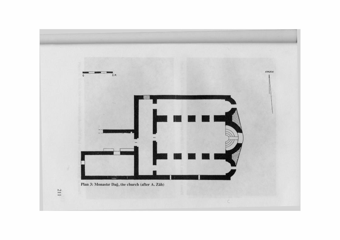

Photo 2: Şeytan Körfezi, the bath from south-west
212

Photo 3: Torba, the "mausoleum" from south-west
Photo 4: Torba, the mosaic with a kantharos
213

Photo 5: Torba, the mosaic, detail of the decoration
Photo 6: Torba, the bath, a room with mosaic and marble revetment
214

215

Photo 9: Tavşan Adası, the main fresco in the south nave
216

Photo 11: Monastır Dağ, the church, central nave with the apse
217