amendment in master plan for lahore division (the project ...
542
ENVIRONMENTAL IMPACT ASSESSMENT (EIA) REPORT AMENDMENT IN MASTER PLAN FOR LAHORE DIVISION (THE PROJECT) DISTRICTS LAHORE, KASUR, NANKANA SAHB & SHEIKHUPURA Haris Engineering & Management Consultant Pakistan (HEMC PAK)
-
Upload
khangminh22 -
Category
Documents
-
view
0 -
download
0
Transcript of amendment in master plan for lahore division (the project ...
ENVIRONMENTAL IMPACT ASSESSMENT (EIA) REPORT
AMENDMENT IN MASTER PLAN FOR LAHORE DIVISION (THE PROJECT)
DISTRICTS LAHORE, KASUR, NANKANA SAHB & SHEIKHUPURA
Haris Engineering & Management Consultant Pakistan
(HEMC PAK)

AMENDMENT IN MASTER PLAN FOR LAHORE DIVISION (THE PROJECT)
Districts Lahore, Kasur, Sheikhupura and Nankana Sahb
Environmental Impact Assessment (EIA) Report
Lahore Development Authority (LDA), Lahore

Amendment in Master Plan for Lahore Division (The Project) Environmental Impact Assessment (EIA) Report
Executive Summary
I
Executive Summary
The Lahore Development Authority (LDA) has envisaged to prepare a
comprehensive Master Plan for the whole Lahore Division which is hereinafter
referred to as “the Project Area”. The Project site is geographically located between
30°38’31.93”E to 32°03’37.99” and 73°17’37.86” to 74°42’05.83”. The site is
surrounded by the India in east, Gujranwala in the north, Faisalabad in the west and
Sahiwal & Pakpattan in the south. The project site is accessible through all major
Roads like Grand Trunk Road, Ring Road Multan Road, Ferozpur Road, Lahore-
Sheikhupura Road and Motorway-M2.
Lahore Development Authority (LDA), Government of the Punjab, has designated its
Metropolitan Planning Wing and Strategic Policy Unit with the task of preparation of
this Master Plan for future 20 years i.e. till year 2035. For this purpose,
Environmental Impact Assessment (EIA) study has been prepared in accordance
with the TOR’S given and as integral part for land use planning. It is added here that
the term “Master Plan for Lahore Division” is hereinafter referred to the Amendment
in Master Plan for Lahore Division (The Project).
The preparation and submission of an Environmental Impact Assessment (EIA)
report for any development project is a statutory obligation under Punjab
Environmental Protection Act, 1997 (PEPA, 1997) amended in 2012 in terms of
Section 12 of the Act. The current Project falls under Schedule- II of subsection H of
IEE/EIA Regulation as per section 12 of Environmental Protection Act and thus
requires Environmental Impact Assessment - EIA.
The approach adopted for carrying out the EIA study includes review of the available
data, analysis of collected data, establishing environmental baseline survey of the
project related to physical, ecological & social environment, impact identification and
suggesting mitigation measures and preparation of environmental and disaster
management plan.
1. POLICY, LEGAL AND ADMINISTRATIVE FRAMEWORK
The project will comply with all the national legislation relating to the environment as
specified in Punjab Environmental Protection Act (PEPA), 1997 Amended 2012. The

Amendment in Master Plan for Lahore Division (The Project) Environmental Impact Assessment (EIA) Report
Executive Summary
II
national legislations relating to the environment in Pakistan in order to obtain the
required regulatory clearances are listed below:
• The National Conservation Strategy, 1992
• Punjab Environmental Protection Act (PEPA) 1997 Amended 2012
• The Pakistan Environmental Protection Agency Regulations, 2000,
• The National Environment Policy, 2005
• The National Forest Policy, 2001
• National Environmental Quality Standards (NEQS) 2000
• The Forest Act. of 1930
• The Provincial Wildlife Act 1975
• Land Acquisition Act., 1894
• Climate Change Policy and Framework 2010
• Punjab Local Government Ordinance, 2001
• Punjab Local Government Act, 2013
• Lahore Development Authority Act, 1975
• LDA Land Use Rules, 2014
• LDA (Master Plan) Rules, 2014
• LDA Building and Zoning Regulations, 2007
• National Disaster Risk Reduction Policy 2013
• Convention on the Conservation of Migratory Species of Wild Animals (Bonn
Convention)
• Convention on International Trade in Endangered Species of Wild Fauna
and Flora (CITES)
The project also complies with World Bank safe guard policy and other provincial
and departmental applicable laws and regulations that includes Pakistan Explosives
Act 1884 and Pakistan Penal Code, 1860.
2. PROJECT DESCRIPTION
The Project is located in Lahore Division which is an administrative division of
Punjab Province, Pakistan and called the third tier of government. Lahore statistical
division contains the districts of Lahore, Nankana Sahib, Kasur, and Shekhupura.
The area of Lahore Division is about 11413.5 km² with the population of 14 million in
accordance with 1998 census. With average growth rate of 3.20, the current
population of Lahore division is estimated as 25 million. A projection is that by year
2035 there will be almost 50 million people living in the division. The unplanned
expansion of the Lahore division, competing land use and exponential population

Amendment in Master Plan for Lahore Division (The Project) Environmental Impact Assessment (EIA) Report
Executive Summary
III
growth with the rate upto 3.20 had put the burden on existing infrastructure causing
multiple problems like land use conflicts, traffic congestion, pollution, environmental
degradation, water degradation and social implications. Therefore, master planning
is required for the Lahore division in order for structured development with pragmatic
approach that can mainstream current industrial and residential development The
total area of Project that is estimated for master planning is about 348,565.38 Acres.
The master plan is designed up till 2035 with estimated total population growth of
Lahore division up to 50 million. The design population for the master plan of Lahore
division 2035 is about 24.72 million. There are total 48 proposed areas selected for
the master planning in Lahore Division out of 04 areas falls in Lahore District, 10
areas falls in Nankana District, 16 areas fall in Kasur District and 18 areas fall in
Shiekhpura District. The description of each of these existing and proposed project
areas with mapping are given in section 3.5
3. Analysis of Alternatives
The analysis has been carried out critically so as to justify the need of the Project.
Besides the economic viability, environmental and social soundness of the proposed
Project should also be considered when analyzing various alternatives. The various
alternatives considered during the conduct of the study are as under:
• No Project Option (NPO)
• Location alternatives
• Layout alternatives
• Design alternatives
Over the years various efforts were made for the preparation and implementation of
the master plans for the Lahore. However, the last plan Integrated Master Plan of
Lahore (IMPL) in 2004 up to 2021. Due to one reason or other this plan cannot
implemented in its true spirit.
Similarly from time to time various Outline Development Plans (ODPs), Agroville
Development Plans for areas around Lahore has been prepared. These includes
Bhai Phero Development Plan (1992-2017), Kahana Nau Development Plan (2000-
2025), Kot Radha Kishan Development Plan (1994), Nankana Sahib Infrastructure
in Selected Settlement Agroville Plan, Pattoki Infrastructure in Selected Settlement

Amendment in Master Plan for Lahore Division (The Project) Environmental Impact Assessment (EIA) Report
Executive Summary
IV
Agroville Plan, Raiwind Development Plan, Outline Sheikhupura Development Plan
etc. were prepared but cannot be implemented for reasons mentioned above.
Over the last few years the city has undergone some significant changes.
Implementation of major infrastructure projects such as Lahore Ring road, Metro Bus
Transit, Under Passes, Fly overs etc. has changed the characteristics of the Lahore
from old one. The IMPL is unable to cope with the present situation even if all the
resources are gathered to implement it. On account of this reality as the first phase
the IMPL was amended in 2014 and notified in 2015.
With the approval of LDA Master Plan Rules, 2014, along with the jurisdiction of LDA
extended over Lahore Division, this calls for immediate need to improve the quality
of life and ensure sustainable development for the subject area. Similarly, various
ODPs and Agroville plans of these areas need to be integrated in one Plan for the
whole division. This solution can be achieved through proper study and updating for
Master Plan of Lahore Division which will ensure proper and regular coordination of
all public agencies. In this regards, no project option will mean that the concerned
authority i.e. LDA takes no action and let the problems worsen.
4. ENVIRONMENTAL BASELINE CONDITIONS
Topography: The topography of the project area is generally plane sloping from
north-west to south-west. The general height of the Lahore division is about 190
meters above the sea level. River Ravi is flowing in the mid while River Satlej is
flowing on southern side towards Kasur just before the divisional boundary
Geology and Seismology: The project site is located in Punjab which is a vast plain
of alluvial material, deposited by Indus basin and its tributaries crossing the Punjab
Plain. The alluvial deposits underlying the site are deposited by the rivers.
The thickness of alluvial deposits in Lahore division is thought to be more than 300
m which are underlain by the basement rocks of the Indian shield. The alluvial
deposits mainly consist of sands, with intercalation of silt and clay layers of varying
thickness.
Soil: Subsurface Lithology is composed of Lean Clay/Silt/Silty/Sand/Poorly Graded
Sand with Silt up to maximum investigated depth of 30 m below NSL. The topmost

Amendment in Master Plan for Lahore Division (The Project) Environmental Impact Assessment (EIA) Report
Executive Summary
V
soil layer mostly comprises of Lean Clay in very soft to soft state. The thickness of
this layer is approximately 3.0 m below NSL. This cover is absent at places.
Climate: The coldest month is January in which the mean maximum temperature is
19.4 °C and the mean minimum temperature is 6.6 °C. June is the hottest month with
the mean maximum temperature near 39.8 °C and the mean minimum temperature
as 27.4 °C. The average annual rainfall during the last 20 years period from (1991-
2010) works out to be 55.25 mm.
Water Resources: Surface water in the Study Area of the Project is present in the
form of a rivers and canals. Surface water in the Study Area of the Project is present
in the form of a river and canals. The rivers are Ravi and Sutlej while canals are
Banbarwali Ravi Bedian Canal (BRB), Upper Chenab Canal, Qadirabad Balloki Link
Canal, Lahore Branch Canal Butcherkhana Distributory. The detail of surface water
and its analysis are given in detail in section 5.2.7
Hydrology: Lahore division is a part of Punjab Province of Pakistan. Geologically,
this area is a part of lower Indus Basin. Two main rivers pass from Lahore Division,
Ravi River and Sutlej River. The slope of the land in planned area is to the south-
west, which directs the rivers to flow in this path. Average slope of the area is
0.32m/km. The following link canals pass through our study area, Bambanwala Ravi
Bedian Link Canal, Qadirabad-Bulloki Link Canal, Balloki – Sulemanki Link, Lower
Bāri Doāb Canal, Upper Chenab Canal and Lower Chenab Canal
In addition, the following hydraulic structures lie inside our study area, Balloki
Barrage, BRB-Ravi Siphon. Furthermore, the planned areas have abundance of
water in the form of groundwater aquifer. The aquifer of Lahore District is broadly
viewed as a single contiguous, unconfined aquifer. The short term hydrology report
is attached as Annex-
Air Quality: At present, major sources of air pollution are industrial and mobile
sources. Other sources of ambient air pollution are the generators in industrial and
commercial units for alternative power supply sources. The overall quality of ambient
air at most of the location is good except particulate matter which is higher at road
sides. All samples taken at road side have found high values of PM.
Amendment in Master Plan for Lahore Division (The Project) Environmental Impact Assessment (EIA) Report
Executive Summary
VI
Noise Level: Number of sources of noise emission has been detected in the study
area. These sources are vehicular traffic i, operation of industrial activities, operation
of generators in commercial activities, operation of pumping & disposal stations
Noise levels were monitored at 08 locations in whole project boundary. The results
shows that the noise levels on all major roads are much higher than NEQS but the
noise levels are in compliance in villages and settlements
4.1. Natural and Biological Environment:
Flora and Fauna: The project sites had significantly higher biodiversity richness
which was 101 species of fauna and 148 species of flora. Fauna includes 70 species
of birds, 13 of mammals, 15 of reptiles and 3 of amphibians whereas there were 148
species of flora in the area. None of the native plant species are under threat as per
IUCN Red list but they are under serious threat locally as they have been
exterminated and replaced with other species. Same is the case with native fish
species that suffer from decline due to over exploitation, water pollution and
introduction of invasive species
Crops and Vegetables: A large number of vegetables are grown in the study area
that includes Phool Gobhi/cauliflower (Brassica oleracea Ver. Botrytis), Band Gobhi
(Brassica oleracea Ver. capitate) Turnip, Raddish (Raphanus sativus), Carrot
(Daucus carota), Bhindi, Tomato (Lycopersicum esculentum), Vegetable Marrow
(Cucurbita pepo), Baingan etc. Crops usually seeded in the area include Rice, Barley
(Hordeum vulgare), Jawar (Andropogan sorghum), Maize and Sugarcane along with
other fodder. Wheat crop was also identified.
4.2. Socio-Cultural Environment
Socio-economic features of project area that mainly focus on demography,
occupation, education, housing, health, family income, basic amenities, land use,
livestock, resettlement concerns, archaeology, shrines and mosques are presented
in section 5.6. The field surveys conducted in the Project Area and data collected
from the relevant agencies indicate that there is 1.2 million population in the project
area with total built up area 62689.74 acres. 135 villages/towns have been identified
in project area, out of which 16 villages/towns fall in Lahore District, 17
villages/towns fall in Tehsil Muridkey, Ferozewala and Sheikhupura of Sheikhupura

Amendment in Master Plan for Lahore Division (The Project) Environmental Impact Assessment (EIA) Report
Executive Summary
VII
District, 9 villages/towns fall in District Nanakana Sahib and remaining 91
villages/towns fall in District Kasur
5. Impacts and Mitigation
5.1. Positive Impacts
The major positive impacts of the project include-:
Sustainable use of available natural resources
Improvement in infrastructure and utility services
Improvement in health care, education, water supply and sewerage facilities
Lesser the migration from small cities towards big city due to improved
facilities
Increase the employment rate with livelihood as it involves development of
residential and industries areas, public administration, institutions and
infrastructure facilities.
Enhanced space for industrial sector and cluster of industry brings industrial
symbiosis
Increase in quality of life due to infrastructure and basic facilities.
Scenic beauty of area due to increase in green spaces and public parks
Positive impact on woman
5.2. Environmental Impacts during Planning Stage and Mitigation
Measures
5.2.1. Environmental Impacts during Planning Stage
Ground Water
The sole supply of water to the Lahore Division depends upon the abstraction of
groundwater. The rapid growth rate of population, progressive migration of people
from the nearby areas towards the city and the establishment of numerous industries
has resulted in rapid increase in water demand. Further increase in population uptill
2035 will result in decline in ground water aquifer with threat to deplete the ground
water resource. In accordance with recent study the depletion rate of ground water
for Lahore district is about 2.5-3.0 feet per year. Further proposed urbanization and
industrialization has the tendency to reduce the ground water recharge, as a
significant part of the land has become impermeable. The existence of saline
groundwater in the nearby areas of Raiwind and Kasur, in the south of Lahore, is a
potential threat to the aquifer under the Lahore city.

Amendment in Master Plan for Lahore Division (The Project) Environmental Impact Assessment (EIA) Report
Executive Summary
VIII
Surface Water Resources and Quality
Currently the entire wastewater from Lahore District is collected through a network of
14 main drains and discharged into the River Ravi without any treatment. The
wastewater from Nankana, Shiekhpura and part of Kasur districts are also finally
discharged in to the River Ravi. The waste water from southern part of Kasur district
is discharge in to River Sutlej. This wastewater is being discharged into the rivers
without any treatment and contains category of industrial, commercial and residential
wastewater. Due to non-availability of fresh water in River Ravi, the river is converted
in to sewage. With the potential to increase in population with development of
residential areas, housing schemes and industrial areas in districts of Lahore division
the pollution level and quantities of wastewater is likely to increase many folds which
may have direct negative impact on our surface water resource and indirectly; on
agriculture, ground water and human health.
Flood
The project sites include two rivers i.e. Ravi and Sutlej and number of canals and
drains so there is chance of flood hazard to occur at the project sites. According to
the PDMA-DRP, the River Ravi belongs to the category B flooding (medium Level
Flood). In Sutlej river, most of the flow is yielded by heavy monsoon rains. Following
settlements of project area have a potential risk of flooding in river Ravi for 100 years
return period in accordance with short term hydrological study attached as Appendix
III. The settlements include Bhai Pheru, Bucheki, Mandi Faizabad, Mor Khunda, and
Syed Wala can subjected to flooding. The settlement Ferozwala is under potential
threat of flooding due to Deg Nallah. The settlement Muredke is under potential
threat of flooding due to Nikki Deg Drian The map of flood prone areas are attached
as Annex III
Climate Change
Pakistan is rated among the top 10 most vulnerable countries to climate change. The
major concerns of climate change in reference to our project site areas are given as
under-;
Increased variability of Monsoon;
Projected recession of Glaciers threatening IRS Flows;

Amendment in Master Plan for Lahore Division (The Project) Environmental Impact Assessment (EIA) Report
Executive Summary
IX
Increased risks of Extreme Events (floods, droughts, cyclones, extreme high /
low temperatures etc.);
Severe water- and heat-stressed conditions in arid and semi-arid regions
leading to reduced agricultural productivity;
Increase in Deforestation; Loss of Biodiversity;
Health Risks
The major extreme climatic events in reference to our project areas are given as
under-:
Isolated hailstorm in and around urban area of Lahore in 2011
Urban Flooding in Lahore due to extreme rainfall of about 46.7 inches in
2013
Localized Cloud Burst rains causing urban flooding in Lahore (1996)
Large scale flooding in 1988 and 1992 in Lahore
History's worst drought during 1999 – 2002 in Lahore
Intense heat waves during 2003, 2005, 2007 and 2010 (53.7 °C) in Lahore
The climate change poses the serious threat in project areas if not mitigated or
without an adaptive capability for the extreme climatic events.
Land Resources
The LDA will require land acquisition for widening and improvement of the existing
roads, development of bypass roads for various existing town/villages etc,
development of inter town and villages roads, development of new main roads,
connecting roads, accessibility roads, sewerage systems including pumping stations,
disposal stations, treatment plants, development of recreational areas, public utilities,
buildings, administration buildings, toll stations and weighing stations
High Voltage Transmission Lines
The high voltage transmissions line are passing and planned to be passed from
some of the project areas. These transmissions line if not been buffered have variety
of health impacts on human. The short term health impacts include Headaches,
Fatigue, Anxiety, Insomnia, Prickling and/or burning skin, Rashes and Muscle pain.
The long term health impacts include risk of damaging DNA, risk of cancer, risk of
leukemia, risk of neurodegenerative disease and risk of miscarria.
Amendment in Master Plan for Lahore Division (The Project) Environmental Impact Assessment (EIA) Report
Executive Summary
X
Transportation
The big Cities mainly depend on transport system for their economic survival and
socio-environmental sustainability and the transport system has a direct impact on all
sectors of an economy. At present many infrastructure facilities such as under
passes, wide roads, bridges, signal free corridor etc. have been made in Lahore but
increasing population with traffic volume rapidly overburden these facilities and
vigorously worsen in future also. The situation will be in worst position if long-term
planning of transportation in master plan has not been done. The major impact would
be seen on our economy if high efficiency transport system will not be designed for
Lahore division.
Solid Waste
Solid waste generation rate on average in Lahore City is approximately 0.85 kg per
capita per day. Considering 50 Million population of Lahore Division, the total
municipal solid waste will be generated 20,000 tons/day. Municipal solid waste
produced from Lahore division if not managed properly, will cause aesthetic
problems and also produce odor along with the spread of many diseases. Similarly,
medical waste produced from medical facilities etc. if not properly managed and
disposed, it can result in injury by contaminated sharp material and infection with
Hepatitis B, C, and HIV etc.
5.2.2. Mitigation Measures during Planning Stage
Ground Water
LDA through WASA should take measures to control demand by reducing per
capita water availability by educating households to use water more wisely.
For long-term sustainability of drinking water supplies, the possibility of
supplementing groundwater supplies with surface water supplies should be
explored, wherever possible. For Lahore division, provision of surface water
supply from the River Ravi or BRBD, UCC, QB Link etc. canal system may be
considered after addressing quality concerns.
New housing societies should also be made aware of the problem and their
groundwater extraction quota should be fixed based on specified per capita
demand
Use high efficiency irrigation for agriculture use such as use drip irrigation
instead of flood irrigation
To increase recharge to groundwater, rainwater harvesting should be
encouraged in all new and old housing schemes and in areas proposed for

Amendment in Master Plan for Lahore Division (The Project) Environmental Impact Assessment (EIA) Report
Executive Summary
XI
the residential and industrial use. For this purpose, special recharge zones
may be developed to facilitate groundwater recharge
In order to promote the culture of water conservation, a metering system
should be introduced to charge water on a volumetric basis
Surface Water Resource and Quality
Water quality challenges need to be addressed in an integrated manner and
by adopting pollution prevention strategies by LDA along with other concerned
agencies like EPA.
Industries have to install wastewater treatment plant at source and should
discharge the water that meets the NEQS. If possible the water should be
recycled in to other processes or can be used for flushing and washing.
Strict compliance is needed from enforcement agency like EPA on
wastewater effluent NEQS from industries
Wastewater treatment plant should have installed on all the outfalls that falls
in to the river Ravi. For that recommendation of WWTP study for Ravi
Riverfront Urban Development Project should be followed.
Recommendations of River Ravi Commission should be followed, which
include development of constructed wetlands on drains before discharge into
the river Ravi and provision of septic tanks in new housings.
Flood
Channelization and modification of river area from only where there is chance
of flood hazard to occur.
Develop large retention ponds in between river and flood prone identified
areas. Water can be trapped in a retention pond and then released at a
controlled discharge to prevent flooding.
Dikes/Bund should be developed precise to the identified flood prone areas
along the side of the rivers in order to prevent the flood.
Climate Change
Pakistan developed the Climate Change Policy and Framework in 2010 by Ministry
of Climate Change. This policy and framework till yet not have been implemented
and we have still face challenges of climate change. In order to effective mitigation
and adaptation towards climate change, the Government has to implement the
climate change policy and its framework at sectorial, institutional and departmental
level on urgent basis.

Amendment in Master Plan for Lahore Division (The Project) Environmental Impact Assessment (EIA) Report
Executive Summary
XII
Land Resources
The land acquisition should be done in accordance with the land acquisition act 1897
and its amendments. Compensation against land, structure, disturbance allowance
should be provided to the affecties as per market price
High Voltage Transmission Lines
The National Transmission and Dispatch Company (NTDC) should share the plan
with Lahore Development Authority (LDA) for new transmission lines that are
proposed to pass from the project area. The LDA will mark the area in master plan
and adequate buffer zone at least 50 meters will be provided.
The LDA should also mark the area of already existing transmission lines that are
passing from the project area and adequate buffer zone along the transmission line
should be provided.
Transportation
The public transport should have been improved through inter and intra city
mass transit that can be faster, cheaper, and more relaxing. It also helps
minimize environmental damage caused by excessive car use.
Private cars on road should be discouraged by increasing parking fee and
vehicle tax on owners.
Improve bicycle and pedestrian facilities and programs.
Solid Waste
Currently in the City of Lahore LWMC is main responsible organization for
management of solid waste. Its jurisdiction needs to be increased in adjoining
area up to Lahore division Level and its coordination with local departments
needs enhanced.
Already landfill site present in Lahore at Mehmood Boti and one engineered
landfill site is present at lakhodair. The LWMC has already suggested landfill
sites and transfer stations in Lahore and Kasur region. The Landfill Sites for
other districts such as Nankana and Shiekhpura should also be studied and
develop and included in the master plan.
The municipal waste should be managed in accordance with waste
management hierarchy.
Care must be taken as not to mix medical waste with municipal waste.
Medical waste need to be segregated and collected in house in accordance
with the Hospital Waste Management Rules, 2005. The collected waste
should be given to LWMC for safe disposal in Landfill site after autoclaving.

Amendment in Master Plan for Lahore Division (The Project) Environmental Impact Assessment (EIA) Report
Executive Summary
XIII
Currently main disposal of hospital waste is through incineration which should
be stopped as incineration is now least preferred technology for hospital
waste management having problem of toxic air emissions.
5.3. Environmental Impacts during Development Stage and Mitigations
5.3.1. Environmental Impacts during Development Stage
Physical Environment
Major impacts on the physical environment include:
The contractors/LDA will require temporary acquisition of land for establishment of
Contractor’s camp and other facilities and disposal sites for safe disposal of surplus
construction and excavated spoil material. It is obvious that rental/leasing of land for
establishing of Contractor’s facilities will change the local land use pattern. However,
the change in land use will be temporary. Potential conflicts may emerge with the
landowners regarding the restoration of temporarily acquired areas for establishing
Contractor’s facilities, particularly those for borrow and spoil disposal areas. Borrow
pits and other landscape depressions, if left open, may prove hazardous to human
beings, livestock and wildlife. Moreover rain water ponding in open pits can be a
potential health hazard both for human beings and livestock due to the mosquito
breeding and the pollution caused by stagnation of the water. Soil erosion may
aggravate in the workshop areas as a result of improper runoff drawn from the
equipment washing-yards and improper management of construction activities in
hilly areas particularly in the vicinity of natural streams. Soil erosion may also occur
during the excavation of for roads, sewerage and water supply lines in addition to
quarry areas. The reduction in vegetative cover will reduce the binding capacity of
the soil and increase its susceptibility to erosion by the force of rainfall. Land may be
contaminated by the spillage of chemicals like fuels, solvents, oils, paints and other
construction chemicals and concrete.
Surface water resources may be contaminated by the spillage of fuel and chemicals
or by dumping of waste material and effluents generated by the kitchens and toilets
at the construction campsites. River, canals and nullahs may be contaminated with
chemicals, oil, lubricants, detergents, etc. through runoff from the construction area,
construction camp and equipment washing-yards.

Amendment in Master Plan for Lahore Division (The Project) Environmental Impact Assessment (EIA) Report
Executive Summary
XIV
Solid and liquid waste will be generated from construction camps and from
construction activities if not managed, it will pose threat to environment. If the waste
is allowed to be disposed in rivers/nullahs as well as on open areas, it will not only
cause litter and ast;hetic issues but will also cause contamination.
Due to the construction activities like excavation, clearing, leveling and compaction
with the use of machinery like batching plants, excavators, dump truck, Road
Rollers, Graders, Haul Trucks, cranes and other transport vehicles etc. Most of these
are using diesel engines that generate noise and exhaust emissions. Generally, the
above activity is generating particulate- matter (PM10), smoke, dust, CO and NOx in
the ambient air, which is deteriorating the air quality and resulting in impacts on
human health, fauna and flora.
During the implementation of the project a large amount of equipment and
construction plant will be utilized for construction of the works. The equipment would
include bulldozers, scrapers, excavators, compactors, trucks, large capacity
dumpers, graders, heavy duty cranes, concrete batching plants and stone crushers.
The operation and movement of such equipment will increase the noise and vibration
in the Project Area. The impact will be significant when compared to the without
project situation.
Ecological Environment
The main negative impacts expected from the implementation and construction of
this Master plan are; loss of agricultural land, loss of biodiversity, habitat loss and
fragmentation, water, noise, air and light pollutions and change in groundwater
recharge capacity. The detail Summary on Ecological Environment is given in
Ecological Study attached as Appendix I
Socio-Cultural Environment
Residential/ agricultural and commercial land may need to be acquired to
accommodate the proposed facilities. Similarly, some households may lose their
commercial and residential structures, and Government/public sector infrastructure
may be disrupted. Various religious and cultural properties like mosques and
graveyards by individuals may get disrupted and few parts of the selected sites.
During the construction stage, noise and dust problems will affect the health of

Amendment in Master Plan for Lahore Division (The Project) Environmental Impact Assessment (EIA) Report
Executive Summary
XV
locals. Similarly, general mobility of the locals will be disturbed during this stage of
the project. During the construction stage, squatters living along the nullah side and
roads may be affected. In this way, the business of the squatters will suffer.
Agricultural land, which is the main source of income of the people belonging to the
proposed areas, will be affected during the construction stage. Fire hazards may
increase in shopping complexes and parking areas. The arrival of affectees of
different projects under development plan to the proposed areas may create a
positive impact on the local business. However, this may become a threat to the
available natural resources including water, fire wood, etc.
Noise generated by the construction machinery during the construction of roads and
bridges is likely to affect the Project Area particularly the sensitive receptors like
schools, hospitals, nearby community. Particular impact is envisaged on the
community residing along the roads, which are either being widened or newly
proposed.
There are number of large scale orchards in the area and fruit trees are grown by the
people in large numbers along their agricultural fields. Therefore, the impact on
horticulture during construction phase will be significant.
Induction of a foreign Contractor may cause cultural issues with the local community
due to the unawareness of the local social norms and values. Similarly, the induction
of outside labor during construction activities may create social problems like social
movements, protests in the form of processions, etc.
As the Project activities are being carried out within the
residential/agricultural/commercial areas of the local community, as a result of it,
women activities in the field may be affected during the construction stage
particularly in case of semi urban and rural areas.
The induction of outside Contractor labour may create social and gender issues due
to the unawareness of local customs and norms. It may also cause hindrance to the
mobility of the local women. However, due to this increase in land will shift the trend
of the local from agriculture farming to selling of land for residential and commercial
purpose.

Amendment in Master Plan for Lahore Division (The Project) Environmental Impact Assessment (EIA) Report
Executive Summary
XVI
5.3.2. Mitigation Measures during Development Stage
Physical Environment
Land required for establishing contractor’s facilities including borrowing earth
material (if required) and dumping excess spoil will be leased directly from private
landowners by the Contractor. Rental terms will have to be negotiated to the
satisfaction of the landowners concerned. Supervisory Consultants will monitor the
process of restoration and ensure, through the terms of the construction contracts,
that landowners are compensated according to the terms of the lease agreements,
and the restoration actions agreed upon by the Contractors are duly carried out. The
photo-documentation of the existing land prior to temporary acquisition should also
be available, which will be beneficial to resolve the restoration conflicts between the
landowners and contractor. Construction camps and workshop will be located at a
minimum distance of 250 m from the existing plantations and settlements, etc. This
limit will be 500 m in case of batching plant. As far as possible, waste land or barren
land i.e. areas not under agricultural, residential or forestation will be used for borrow
material (if required) and setting up Project facilities. Good engineering practices will
help in controlling the soil erosion both at construction sites and in peripheral areas,
particularly in borrow and dumping areas and along the haul tracks. The Contractor
will be required to train its workforce in the storage and handling of materials like
furnace oil, diesel, petrol and chemicals, etc., that can potentially cause soil
contamination. The Contractor will be required to prepare training manual and
module for all the construction related activities along with the schedule of training
program and submit to the supervisory consultants for approval. Soil contamination
by asphalt and other obnoxious materials will be minimized by placing all the
containers in caissons or dumped into pits lined with impervious liners to avoid
contamination of soils/groundwater from leachates. Proper drainage facility will be
provided at the camp areas to avoid the water accumulation, which will minimize the
soil contamination. Proper solid waste management plan should be developed by the
Contractor and implemented to avoid the litter and any other waste problems.
Adequate number of solid waste containers should be placed within the camp area
and surroundings to ease in storage and collection/disposal of solid waste.
Availability of water for campsite facilities and construction purposes will be ensured
by the Contractor prior to the start of construction activities. The Contractor will seek

Amendment in Master Plan for Lahore Division (The Project) Environmental Impact Assessment (EIA) Report
Executive Summary
XVII
approval from the PMU and LDA/Local departments for use of the water resources
for construction purposes. The Contractor will prepare guidelines for the workers for
minimizing the wastage of water during the construction activities and at campsites.
Construction camps will be established in the area with adequate natural drainage
channels in order to facilitate flow of the treated effluents. The wastewater effluent
from the Contractor’s workshops and equipment washing-yards will be passed
through gravel/sand beds to remove oil/grease contaminants before discharging it
into surface water sources. Similarly, the wastewater effluent from the campsite will
be treated before its disposal into the surface water sources. A proper solid waste
management plan (including storage, collection, transportation and disposal) should
be developed to avoid contamination of the surface water resources. Batching plants
should be placed at least 1 KM from any surface water body present in the project
site. Water reuse and recycling strategy should be adopted on all batching plants.
During the construction activities it should be ensured that the paint or other
lubricants should not spilled into water channels.
A solid waste management plan should be made the responsibility of the
construction contractor to provide for the designation of appropriate waste storage
area on the site and a schedule for the timely collection and removal of construction
debris to an approved dump site. The organic waste produced during site clearing
should be mechanically mulched and composted at the site and used for
landscaping. Providing adequate number of camps/restrooms for the workmen and
waste baskets and dumpsters is essential to keep the construction site clean and
pest free. Contractor should instruct his work force not to throw solid waste here and
there, and common storage points should be made by the Contractor from where at
the end of the day contractor should transport the whole day’s solid waste to
designated disposal site.
Asphalt plants should be located at least 500 m downwind from the populated areas,
wildlife habitats, and Contractors’ camps, to minimize the impact of emissions.
Asphalt and concrete batching plants should be equipped with dust control
equipment such as fabric filters or wet scrubbers to reduce the level of particulate
emissions. Vehicles and other construction machinery should be properly tuned and
maintained, to avoid hazardous level of emissions. Where dust emissions are high,

Amendment in Master Plan for Lahore Division (The Project) Environmental Impact Assessment (EIA) Report
Executive Summary
XVIII
these will be reduced by a regular sprinkling of water for keeping the dust settled, at
least twice a day. In order to prevent environmental pollution, haul-trucks carrying,
earth, sand, aggregate and other materials will be kept covered with tarpaulin to help
contain the construction materials being transported within the body of each carrier
between the sites.
LDA in consultation with other concerned departments such as EPA, Punjab will set
up a system to monitor the noise levels in the Project Area near the construction
activities. For the construction machinery generating noise level in excess of that
prescribed in NEQS and WHO limits, Contractor will make arrangements to bring the
noise level within applicable limits (including proper tuning of vehicles and
mufflers/silencers). Movements of the trucks and other construction machinery
causing high noise levels must be restricted at night time to avoid disturbance to the
nearby locality. Truck drivers should be instructed not to play loud music at night and
stop use of horn. Proper noise barrier boundary walls will be built on asphalt/
concrete plants which come close to any locality. To protect sensitive receptors
including schools and hospitals from noise, thick tree plantation will be carried out
towards the roadside, where there is enough space available between the
boundaries of schools and roads.
Ecological Environment
Negative impacts on ecological environmental due to development of master plan
can be mitigated by; minimizing biodiversity loss by developing Green Infrastructure,
restoration of native vegetation on railroad and roadside verges and river and canal
banks, Identification and conservation of areas important for priority animal species,
planning for nature conservation through the restoration of ecological networks,
urban agriculture and kitchen gardening. The detail summary of mitigation of
negative impacts on ecological environment is given in Appendix I
Socio-Cultural Environment
Effective construction controls should be used by the Contractor to avoid
inconvenience to the locals due to noise, smoke and fugitive dust. Proper
arrangements in the form of alternative routes should be made to ensure that the
mobility of locals should not be disturbed. After consultation with the traffic police, a
proper traffic management plan should be prepared by the Contractor for mainroads

Amendment in Master Plan for Lahore Division (The Project) Environmental Impact Assessment (EIA) Report
Executive Summary
XIX
specifically in order to avoid accidents. The Contractor will take due care related to
the disposal of construction materials as well as solid waste disposal from the site,
so that the nearby communities will not suffer. The Contractor will take care of the
local communities water sources so that these should not be contaminated or
destroyed. Safety lookouts should be built to prevent people and vehicles from
passing at the time of heavy equipment operation area. Haul-trucks carrying
concrete, aggregate and sand fill materials will be kept covered with tarpaulin to help
contain construction materials being transported between the sites. In construction
camps, amenities of life including clean food, water and sanitation facilities should be
provided to these camps. The Contractor should arrange first aid boxes at camps.
During the construction, accessibility of vehicles to the workshops should be ensured
so that the business of shopkeepers will not be disturbed. Construction activities
should be carried out during the night time, as most of the markets are closed at
sunset. Affectees along with their children losing their agricultural land should be
given employment opportunities on preferential basis during the construction stage.
Similarly, in order to restore the livelihood of the people belonging to business and
agriculture residing in nearby areas a proposed site for Truck Stand should be given
labour opportunities during the construction stage. The main historical sites like
shrines should be avoided from damage by the widening of roads. Similarly, by
adopting protection measures, during construction, any negative impacts on cultural
and historical sites may be minimized. In this regard, it is recommended that the
Contractor should prepare a site specific management plan to avoid any damage to
the sites. The Contractor will warn the workers not to indulge in any theft activities
and if anyone would get involved in such type of activities, he will have to pay
penalty and would be handed over to the police. Similarly, at the time of employing,
the Contractor has to take care that the workers should be of good repute. The
Contractor’s camp will be properly fenced and the main gate will be locked at night
with a security guard to check prevent the theft issues from the community side. To
avoid the cultural issues, the Contractor will facilitate the local labor during the
construction activities. The Contractor will have to select the specific timings for the
construction activities so as to cause least disturbance to the local population,
particularly women, considering their peak movement hours. The Contractor will take
due care of the local community and the sensitivity towards the local customs and

Amendment in Master Plan for Lahore Division (The Project) Environmental Impact Assessment (EIA) Report
Executive Summary
XX
traditions will be encouraged. The Contractor will warn the staff strictly not to indulge
in any un-ethical activities and to obey the local norms and cultural restrictions
particularly with reference to women.
5.4. Environmental Impacts Resulting From Project Operation and
Mitigations
5.4.1. Environmental Impacts from Project Operation
Physical Environment
Due to the development of residential schemes and societies with same level of
standards and facilities like Lahore city the urbanization load on the city will be
relieved. This will lead to the new opportunities for the commercial areas. The
commercial markets will also develop which will share pressure on the existing
overloaded commercial market and areas in the city. Due to the operation of the
proposed roads and bridges along with extensions of the old ones will reduce the
vehicular load in the city and generally traffic conditions will get improve during the
operation stage. Due to the improved traffic conditions there will be a remarkable
reduction in traffic hazards. If cross-drainage structures are not adequately
maintained and cleaned, natural nullahs tend to become choked with debris and
eroded soil, adversely affecting the quality of the surface water in the Project Area.
The implementation of the proposed Master Plan land values will increase
considerable on proportional basis. The lands which are located near to the
proposed residential areas especially commercial sides will increase considerably.
This will be positive impact on the land owners. However, due to this increase in land
will shift the trend of the local from agriculture farming to selling of land for residential
and commercial purpose. The noise pollution will be lesser than the construction
phase. However, it will definitely be more than the pre-construction stage on account
of the increase in traffic on the newly constructed and widened roads. However, it is
expected that the resultant sound level will remain well within the NEQS limits. Due
to the operation of the parks and playgrounds, recreational activities among the
locals will increase. Operation of the bus terminals will help in the reduction of the
vehicular load in the city and overcome the haphazard condition in the old bus
terminals. Due to the construction of intercity bus terminals at the new locations,
traffic load in the city will be reduced to a large extent. During operation stage about

Amendment in Master Plan for Lahore Division (The Project) Environmental Impact Assessment (EIA) Report
Executive Summary
XXI
2500 cusec of wastewater will be generated from Lahore Division. This waste water
poses the threat to fresh water resource especially to River Ravi if not been treated.
Additionally it may deteriorate quality of downstream and may also be threat to the
local flora and fauna.
Ecological Environment
During operational phase the ecological impacts include urban development on
biodiversity, Change in land use pattern, Habitat degradation due to higher
pollutants, Habitat Fragmentation, Bird Collisions and strikes and Change in
groundwater recharge capacity.
Socio-Cultural Environment
Increased number of planned residential areas will be a positive impact regarding the
local business of the shopkeepers, tourist guides, hotels and food stalls. However,
this increased number of visitors may become a threat to the available natural
resources. This may also create uneasiness for the locals. Noise generated by the
vehicles will further increase, which will disturb the local communities, school staff
and students, etc. existing near the roads. Health problems on account of air
pollution may increase in the operation stage of the Project. There will be risk of fire
hazard on shopping plazas, bus terminals etc. Health issues may generate due to
the improper cleanliness of toilets at bus terminals, shopping complexes, public
parks and play grounds.
5.4.2. Mitigation Measures during Operational Stage
Physical Environment
• For the air and noise quality, a monitoring system will be established by
LDA/PMU and EPA to ensure that ambient air and noise levels are within
the permissible limits. To reduce the noise levels, if deemed necessary,
provision of thick tree plantation, noise barriers and double glazed windows
will be assessed as per site conditions for the sensitive receptors including
schools and hospitals. For the liquid waste problem, wastewater treatment
plant(s) should be constructed and before the disposal of wastewater into
the surface water body. In order to retrieve the aesthetic view of the area,
sufficient additional plantation of different trees will be carried out. In order to
avoid the soil contamination, a fully paved area should be designated for the

Amendment in Master Plan for Lahore Division (The Project) Environmental Impact Assessment (EIA) Report
Executive Summary
XXII
vehicles maintenance in each bus terminal/truck stand. Solid waste from the
incinerator, slaughter house, Mutton and fish market should be collected
properly and disposed of after proper recycling. It will be ensured by the
road/Highway Department that storm water drains and road drainage
system are periodically cleared to maintain the water flow.
Ecological Environment
To mitigate the operational impacts and for restoration of natural features; strategies
and implementation plan should be adopted fallowed as
Use of native species
EIA of all new developments
Groundwater recharge
Rain water harvesting
Pollution control by following NEQS
Solid waste management
Wastewater treatment plants
Urban agriculture and kitchen gardening
Farm mechanization for increased agricultural productivity
Tunnel Farming
Green roofs and walls
Policy Framework for green infrastructure
Biotope/habitat opportunity mapping and making ecological action plans for
individual cities.
Socio-Cultural Environment
In order to solve the accident problems, speed limit, sign boards and speed breakers
should be provided on roads. The visitors should be briefed about not
damaging/degrading the natural resources. Traffic police should ensure that the
vehicles are properly tuned up to minimize the air and noise pollution. Firefighting
arrangements should be provided in the operation stage for the shopping complexes
and parking plazas, and bus terminals, etc. Proper arrangement for the cleanliness
of the toilets and waiting rooms should be provided for the passengers at bus
terminals.

Amendment in Master Plan for Lahore Division (The Project) Environmental Impact Assessment (EIA) Report
Executive Summary
XXIII
6. Environmental Management and Monitoring Plan
(EMMP)
• In order to counter the significant negative impacts, a detailed EMMP has
been developed that includes the proposed mitigation measures against
the potential adverse impacts along with defining the roles and
responsibilities of each organization for management and monitoring of
impacts. The EMMP also outlines the monitoring requirements for
compliance and effects monitoring of the Project, communication and
documentation, site restoration and necessary training of the staff
required. If this EMMP is strictly enforced during each stage of the Project,
the level of negative impacts will be minimized or made negligible and
positive impacts will be enhanced.
• It is recommended that mitigation measures proposed in impacts and
mitigation chapter and EMMP should be adequately implemented at
design, construction and operation stages.
7. Stake Holders Consultation
Stakeholder’s consultation was done in order to have their view point about the
project. Twentyfive (25) comprehensive consultations including scoping sessions
and focus group discussions were held. In addition, a few consultations were also
held in the form of detailed interviews of individuals including men and women at
project area. The different stakeholders which are identified for the project includes
Water and Sanitation Agency (WASA), Forest Department, River Ravi Commission,
World Wildlife Fund (WWF), Lahore Waste Management Company (LWMC), Parks
and Horticulture Authority (PHA), Lahore Chamber of Commerce, Urban Unit
Punjab, Community residing in towns of Project Area, Industries and Small industrial
Associations in Project Area. The detail concerns of stakeholders are given in
Chapter- 8
8. Conclusion and Recommendation
The implementation of the proposed master plan project has overall positive impacts
during operational stage (after development) both to community and country as well.
By the development and implementation of the update IMP for the Lahore division,

Amendment in Master Plan for Lahore Division (The Project) Environmental Impact Assessment (EIA) Report
Executive Summary
XXIV
though there will be a relief for availability of planned facilities to the locals. The
project is very much needed in order to have orderly future urban growth which will
reduce pressure on our natural resources. Planed urban development has variety of
positive impacts including intact natural resource with urban development, Public
utilities and infrastructure facilities at their own places rather coming towards main
district (Lahore), enhanced green areas through housing and building control
guidelines, aesthetic uplifting, improved industrial sector and non-quantifiable socio
economic benefits.
There are some negative impacts during planning, construction-implementation and
operational phase of the project which can be mitigated as suggested in the report
and overall positive impacts overweigh these negative impacts.
Master Plan should check trends based on the past and present practices and
should device strong legislation for the implementation of the proposed land uses in
the Master Plan. In this regards, recommendation for the ineffective implementation
of the previous IMPL should be kept in the mind
After the detail environmental assessment, it is concluded that the project is
environmentally feasible at proposed site only if the mitigation measures suggested
in this EIA report are adopted during planning, construction and operational stages of
the project. The mitigations suggested in the report are sufficient to successfully
complete and run the project in an environment friendly manner.
Further, the key studies which need to be carried out at planning level and on later
stages are given as under-:
Climate Change Vulnerability Assessment
Ground Water Quality and Aquifer Assessment
Surface water Quality Assessment and its use
Hydrological Study and Modeling of River Ravi
Rainwater harvesting potential and implementation
Detail Socio- Economic Study of Project Areas
Social Impact Assessment

Amendment in Master Plan for Lahore Division (The Project) Environmental Impact Assessment (EIA) Report
Executive Summary
XXV
Transportation and Modeling Study
Action Areas Plans and Subject Plans for each sector of development should
also be prepared.

Amendment in Master Plan for Lahore Division (The Project) Environmental Impact Assessment (EIA) Report
Table of Contents
XXVI
Table of Contents
Executive Summary .................................................................................................... I
1. POLICY, LEGAL AND ADMINISTRATIVE FRAMEWORK ............................ I
2. PROJECT DESCRIPTION ............................................................................ II
3. Analysis of Alternatives ................................................................................ III
4. ENVIRONMENTAL BASELINE CONDITIONS ............................................ IV
4.1. Natural and Biological Environment: ...................................................... VI
4.2. Socio-Cultural Environment ................................................................... VI
5. Impacts and Mitigation ................................................................................ VII
5.1. Positive Impacts ................................................................................... VII
5.2. Environmental Impacts during Planning Stage and Mitigation Measures VII
5.3. Environmental Impacts during Development Stage and Mitigations .... XIII
5.4. Environmental Impacts Resulting From Project Operation and Mitigations ........................................................................................................ XX
6. Environmental Management and Monitoring Plan (EMMP) .................... XXIII
7. Stake Holders Consultation ..................................................................... XXIII
8. Conclusion and Recommendation .......................................................... XXIII
Table of Contents ................................................................................................. XXVI
List of Tables .................................................................................................... XXXVIII
List of Figures ..................................................................................................... XXXIX
CHAPTER1
INTRODUCTION .................................................................................... 1
1.1. PROJECT DETAIL & BACK GROUND OF PROJECT..................................... 1
1.2. NEED FOR THE ENVIRONMENTAL ASSESSMENT...................................... 4
1.3. PURPOSE OF THE STUDY ............................................................................. 5
1.4. OBJECTIVES OF EIA STUDY ......................................................................... 5
1.5. APPROACH ADOPTED TO CONDUCT THE STUDY ..................................... 6
1.5.1. Review of Available Data ........................................................................... 6
1.5.2. Delineation of Area of Project Influence or Study Area .............................. 6
1.5.3. Environmental Baseline Survey of the Project ........................................... 7
1.5.3.1. PHYSICAL ENVIRONMENT ............................................................... 7
1.5.3.2. ECOLOGICAL ENVIRONMENT .......................................................... 8
Amendment in Master Plan for Lahore Division (The Project) Environmental Impact Assessment (EIA) Report
Table of Contents
XXVII
1.5.3.3. SOCIAL AND CULTURAL ENVIRONMENT ....................................... 8
1.5.4. PUBLIC AND STAKEHOLDERS CONSULTATION .................................. 8
1.5.5. Analysis of Data ......................................................................................... 9
1.5.6. Screening of Potential Environmental Impacts and Mitigation Measures ... 9
1.5.7. Preparation of Environmental Management Plan (EMP) ........................... 9
1.6. STRUCTURE OF THE REPORT ..................................................................... 9
1.7. EIA STUDY TEAM ......................................................................................... 10
CHAPTER2
POLICY, LEGAL, AND ADMINISTRATIVE FRAMEWORK ................... 1
2.1. GENERAL ........................................................................................................ 1
2.2. NATIONAL POLICY FRAMEWORK ................................................................. 1
2.2.1. Pakistan Environment Protection Act, 1997 ............................................... 1
2.2.2. Punjab Environment Protection (Amendment) Act, 2012 ........................... 4
2.2.2.1. Pakistan Environment Protection (Review of IEE and EIA) Regulations, 2000 ............................................................................................... 5
2.2.2.2. Policy and procedure for the filing, review and approval of environment assessments .................................................................................. 6
2.2.2.3. Guidelines for the Preparation and Review of Environmental Reports, 1997 6
2.2.2.4. Guidelines for Public Consultation, 1997 ............................................. 7
2.2.2.5. Guidelines for Sensitive and Critical Areas, 1997................................ 8
2.2.2.6. Sectoral Guidelines for Environmental Reports ................................... 8
2.2.3. National Conservation Strategy ................................................................. 8
2.2.4. National Environment Policy 2005 ............................................................. 9
2.2.5. The National Forest Policy 2001 of Pakistan ............................................. 9
2.2.6. PAKISTAN ENVIRONMENTAL IMPACT ASSESSMENT PROCEDURES 10
2.2.7. NATIONAL ENVIRONMENTAL QUALITY STANDARDS (NEQS), 2000 11
2.2.8. National Climate Change Policy, 2012 ..................................................... 12
2.2.8.1. Framework for Implementation of Climate Change Policy (2014-2030) 13
2.2.9. Punjab Wildlife Protection, Preservation, Conservation and Management Act, 1974 .............................................................................................................. 14
2.2.10. International Treaties ............................................................................ 15
2.2.10.1. Convention on the Conservation of Migratory Species of Wild Animals (Bonn Convention) .............................................................................. 15

Amendment in Master Plan for Lahore Division (The Project) Environmental Impact Assessment (EIA) Report
Table of Contents
XXVIII
2.2.10.2. Convention on International Trade in Endangered Species of Wild Fauna and Flora (CITES) .................................................................................. 16
2.2.11. Local Government Laws ....................................................................... 18
2.2.11.1. Local Government: ......................................................................... 19
2.2.11.2. Punjab Local Government Ordinance, 2001 .................................. 19
2.2.11.3. Punjab Local Government Act, 2013 .............................................. 20
2.2.11.4. Lahore Development Authority Act, 1975 ....................................... 21
2.2.11.5. LDA Land Use Rules, 2014 ............................................................ 22
2.2.11.6. LDA (Master Plan) Rules, 2014 ..................................................... 23
2.2.11.7. LDA Building and Zoning Regulations, 2007 .................................. 24
2.2.11.8. Integrated Master Plan for Lahore (IMPL) - 2021 ........................... 25
2.2.12. Resettlement Laws ............................................................................... 26
2.2.12.1. Constitutional Provisions ................................................................ 26
2.2.12.2. Land Acquisition Act, 1894 ............................................................. 26
2.2.13. THE WORLD BANK REGULATIONS ................................................... 28
2.2.13.1. Provisions of Bank’s Safeguards Policies ...................................... 28
2.2.14. OTHER ENVIRONMENT RELATED STATUTES ................................ 30
2.2.14.1. Pakistan Explosives Act, 1884 ....................................................... 30
2.2.14.2. The Forest Act, 1927 ...................................................................... 30
2.2.14.3. Pakistan Penal Code, 1860 ............................................................ 30
2.2.14.4. National Disaster Risk Reduction Policy 2013 ............................... 30
CHAPTER3
PROJECT DESCRIPTION ................................................................... 31
3.1. GENERAL ...................................................................................................... 31
3.2. LOCATION OF THE PROJECT ..................................................................... 31
3.3. TOTAL AREA & DESIGN POPULATION OF THE PROJECT ....................... 32
3.4. DESCRIPTION OF PROJECT AREA-LAHORE DIVISION ............................ 32
3.4.1. LAHORE .................................................................................................. 32
3.4.2. NANKANA SAHIB .................................................................................... 33
3.4.3. KASUR .................................................................................................... 34
3.4.4. SHIEKHPURA.......................................................................................... 36
3.5. DESCRIPTION OF SITE PROJECT AREAS IN LAHORE DIVISION ............ 37
3.5.1. DISTRICT LAHORE ................................................................................. 37
3.5.1.1. PROJECT AREA (PA)-LHR-1- (FEROZPUR ROAD AND BRB CANAL) 37
3.5.1.2. PROJECT AREA Site-LHR-2 (Raiwind City) ..................................... 38

Amendment in Master Plan for Lahore Division (The Project) Environmental Impact Assessment (EIA) Report
Table of Contents
XXIX
3.5.1.3. PROJECT AREA Site-LHR-3 MULTAN ROAD ................................. 39
3.5.1.4. PROJECT AREA (PA)-LHR-4 (MULTAN ROAD, SUE ASAL ROAD, RAIWIND AND MANGA) ................................................................................... 40
3.5.2. DISTRICT NANKANA SAHIB .................................................................. 41
3.5.2.1. Project Area (PA)-NSB-01(Mandi Faizabad) ..................................... 41
3.5.2.2. Project Area (PA) -NSB-02 (Syed Wala) ........................................... 42
3.5.2.3. Project Area (PA)-NSB-03 (Bucheki) ................................................. 42
3.5.2.4. Project Area (PA)-NSB-04 (Nankana Sahib) ..................................... 43
3.5.2.5. Project Area -NSB-05 (Shahkot-I) ..................................................... 44
3.5.2.6. Project Area (PA)-NSB-06 (Sangla Hill) ............................................ 44
3.5.2.7. Project Area (PA) -NSB-07 (More Khunda) ....................................... 45
3.5.2.8. Project Area (PA)-NSB-08 (Shahkot-II) ............................................. 46
3.5.2.9. Project Area (PA)-NSB-09-(Warburton) ............................................ 46
3.5.2.10. Project Area Site-NSB-08 .............................................................. 47
3.5.3. DISTRICT KASUR ................................................................................... 48
3.5.3.1. Project Area (PA)-K-01 (Kasur) ......................................................... 48
3.5.3.2. Project Area (PA)-K-02 (Mustafabad) ................................................ 49
3.5.3.3. Project Area (PA)-K-03 (Industrial Estate) ......................................... 49
3.5.3.4. Project Area (PA)-K-04 (Khudian Khas) ............................................ 50
3.5.3.5. Project Area (PA)-K-05 (Rao Khan Wala) ......................................... 50
3.5.3.6. Project Area-K-06 (Raja jang) ........................................................... 51
3.5.3.7. Project Area (PA)-K-07 (Kot Radha Kishan) ..................................... 51
3.5.3.8. Project Area (PA)-K-08- (Changa Manga) ......................................... 52
3.5.3.9. Project Area (PA) -K-07- (Bhae Pheru) ............................................. 53
3.5.3.10. Project Area (PA)-K-9- (Jamber) .................................................... 53
3.5.3.11. Project Area (PA)-K-11 (Chunian) .................................................. 54
3.5.3.12. Project Area (PA)-K-12 (Allahabad) ............................................... 54
3.5.3.13. Project Area (PA)-K-13 (Kanganpur).............................................. 55
3.5.3.14. Project Area (PA)-K-14 (Pattoki) .................................................... 55
3.5.3.15. Project Area (PA)-K-15 (Talwandi) ................................................. 56
3.5.3.16. Project Area Site-K-11 ................................................................... 57
3.5.4. DISTRICT SHEIKHUPURA ..................................................................... 57
3.5.4.1. PA-SKP-1(Sheikhupura City) ............................................................ 57
3.5.4.2. Project Area (PA)-SKP-2- (Muridke) .................................................. 58
3.5.4.3. Project Area (PA)-SKP-3 (Ferozwala) ............................................... 59
3.5.4.4. Project Area (PA)-SKP-4 (Farooqabad) ............................................ 60
3.5.4.5. Project Area (PA)-SKP-5 (Narangmandi) .......................................... 61

Amendment in Master Plan for Lahore Division (The Project) Environmental Impact Assessment (EIA) Report
Table of Contents
XXX
3.5.4.6. Project Area (PA)-SKP-6- (Sharqpur) ................................................ 61
3.5.4.7. Project Area (PA)-SKP-7 (Safdarabad) ............................................. 62
3.5.4.8. Project Area (PA)-SKP-8(Bhiki) ......................................................... 62
3.5.4.9. Project Area (PA)-SKP-9 (Ferozwatwan) .......................................... 63
3.5.4.10. Project Area (PA)-SPA-10 (Manawala) .......................................... 64
3.5.4.11. Project Area (PA)-SKP-11 (KhanqahDogran) ................................ 64
3.5.4.12. Project Area (PA)-SKP-12 (JandialaSher Khan) ............................ 65
3.5.4.13. Project Area (PA)-SKP-13 (Jhabran) ............................................. 65
3.5.4.14. Project Area (PA)-SKP-14 (Jaranwala Road) ................................ 66
3.5.4.15. Project Area (PA)-SKP-15 (Lahore Muridke Road) ........................ 66
3.5.4.16. PA-SKP-16 (Lahore Sheikhupura Road) ........................................ 67
3.5.4.17. Site-SKP-15 ................................................................................... 68
3.5.4.18. Site-SKP-18 (Dhantpura) ............................................................... 68
3.6. INFRASTRUCTURE AND UTILITY SYSTEM REQUIREMENTS .................. 69
3.6.1. Electricity ................................................................................................. 69
3.6.2. Natural Gas Requirement ........................................................................ 69
3.6.3. Water Requirement .................................................................................. 69
3.6.4. Sewerage Requirement ........................................................................... 69
3.6.5. Solid Waste Management ........................................................................ 70
3.6.6. Road Network .......................................................................................... 70
3.7. PROJECT COMPLETION TIME .......................Error! Bookmark not defined.
CHAPTER4
ANALYSIS OF ALTERNATIVES ......................................................... 73
4.1. General ........................................................................................................... 73
4.2. No Project Option (NPO) ................................................................................ 73
4.3. Planning Efforts .............................................................................................. 74
4.3.1. Master Plan for Greater Lahore, 1966 ..................................................... 74
4.3.2. Lahore Urban Development and Traffic Study (LUDTS), 1980 ................ 76
4.3.3. Integrated Master Plan for Lahore (IMPL) -2021 ..................................... 78
4.4. Location Alternatives ...................................................................................... 82
4.5. Layout - Alternatives ....................................................................................... 83
4.5.1. Criteria ..................................................................................................... 83
4.5.2. Residential Areas ..................................................................................... 84
4.5.3. Industrial Areas ........................................................................................ 85
4.5.4. Transportation Facilities ........................................................................... 85

Amendment in Master Plan for Lahore Division (The Project) Environmental Impact Assessment (EIA) Report
Table of Contents
XXXI
4.5.5. Agriculture Areas ..................................................................................... 86
4.5.6. Future Development of the City ............................................................... 87
4.5.7. Recreational Facilities .............................................................................. 88
4.6. Design Alternatives ........................................................................................ 89
4.7. Conclusion ...................................................................................................... 89
CHAPTER5
DESCRIPTION OF BASELINE ENVIRONMENT ................................. 90
5.1. GENERAL ...................................................................................................... 90
5.2. PHYSICAL ENVIRONMENT .......................................................................... 90
5.2.1. Topography .............................................................................................. 90
5.2.2. Geology ................................................................................................... 90
5.2.3. Seismology .............................................................................................. 91
5.2.4. Soil ........................................................................................................... 91
5.2.5. Land Use ................................................................................................. 92
5.2.6. Climate ..................................................................................................... 93
5.2.7. Water Resources ..................................................................................... 96
5.2.7.1. Surface Water ................................................................................... 96
5.2.7.2. Ground Water .................................................................................... 97
5.2.8. Hydrology ................................................................................................. 97
5.3. Natural and Biological Environment ............................................................... 99
5.3.1.1. Flora and Fauna .............................................................................. 100
5.3.1.2. Vegetables ...................................................................................... 100
5.3.1.3. Crops and Fodder ........................................................................... 100
5.3.2.1. Wildlife Sanctuaries and Game Reservoirs ..................................... 100
5.3.2.2. Rare or Endangered Species .......................................................... 101
5.4. Air Quality ..................................................................................................... 101
5.5. Noise Levels ................................................................................................. 101
5.6. Socio Economic Environment ....................................................................... 102
5.6.1. Archaeological and Historical Monuments/Sites .................................... 112
CHAPTER6
SCREENING OF POTENTIAL ENVIRONMENTAL IMPACTS AND MITIGATION MEASURES ................................................................. 117
6.1. General ......................................................................................................... 117
6.2. Approach Adopted for Impacts Identification and Mitigation Measures ........ 117

Amendment in Master Plan for Lahore Division (The Project) Environmental Impact Assessment (EIA) Report
Table of Contents
XXXII
6.3. Positive Environmental Impacts Resulting from the Project Operation ......... 120
6.4. Environmental Impacts during Planning Stage and Mitigation Measures ..... 121
6.3.1.1. Groundwater Resources ................................................................. 121
6.3.1.2. Surface Water Resources and Quality ............................................ 122
6.3.1.3. Flood ............................................................................................... 123
6.3.1.4. Climate Change ............................................................................... 124
6.3.1.5. Land Resources .............................................................................. 125
6.3.1.6. High Voltage Transmission Lines .................................................... 125
6.3.1.7. Transportation ................................................................................. 125
6.3.1.8. Solid Waste ..................................................................................... 126
6.5. Mitigation Measures during Planning Stage ................................................. 126
6.4.1. Ground Water ........................................................................................ 126
6.4.3.1. Surface Water Resource and Quality .............................................. 128
6.4.3.2. Flood ............................................................................................... 129
6.4.3.3. Climate Change ............................................................................... 129
6.5.1.1. Land Resources .............................................................................. 130
6.5.1.2. High Voltage Transmission Lines .................................................... 130
6.5.1.3. Transportation ................................................................................. 130
The efficient transport system for Lahore Division should be designed and part of detail master plan. The traffic reduction and efficient transport strategy should be developed that mainly include-: .................................................................. 130
6.5.1.4. Solid Waste ..................................................................................... 131
6.6. Environmental Impacts during Development Stage and Mitigations ............. 131
6.5.1. Physical Environment ............................................................................ 131
6.5.1.5. Land Resources .............................................................................. 131
6.5.1.6. Water Resources ............................................................................. 133
6.5.1.7. Solid and Liquid Waste .................................................................... 133
6.5.1.8. Ambient Air Quality .......................................................................... 133
6.5.1.9. Noise Level ..................................................................................... 134
6.5.2. Ecological Environment ......................................................................... 134
6.5.3. Socio-Cultural Environment ................................................................... 135
6.5.3.1. Local Communities/Workforce......................................................... 135
6.5.3.2. Loss of Livelihood ............................................................................ 135
6.5.3.3. Disruption of Cultural and Historical Properties ............................... 136
6.5.3.4. Cultural Issues ................................................................................. 136
6.5.3.5. Gender Issues ................................................................................. 136
6.7. Mitigation Measures ..................................................................................... 136

Amendment in Master Plan for Lahore Division (The Project) Environmental Impact Assessment (EIA) Report
Table of Contents
XXXIII
6.6.1. Physical Environment ............................................................................ 136
6.6.1.1. Land Resources .............................................................................. 136
6.6.1.2. Water Resources ............................................................................. 139
6.6.1.3. Solid and Liquid Waste .................................................................... 140
6.6.1.4. Ambient Air Quality .......................................................................... 141
6.6.1.5. Noise Levels .................................................................................... 141
6.6.2. Ecological Environment ......................................................................... 142
6.6.3. Socio-Cultural Environment ................................................................... 142
6.6.3.1. Local Communities/Workforce......................................................... 142
6.6.3.2. Loss of Livelihood ............................................................................ 143
6.6.3.3. Disruption of Historical Properties ................................................... 144
6.6.3.4. Cultural Issues ................................................................................. 144
6.6.3.5. Gender Issues ................................................................................. 144
6.8. Environmental Impacts Resulting From Project Operation and Mitigations .. 145
6.7.1. Physical Environment ............................................................................ 145
6.7.2. Ecological Environment ......................................................................... 147
6.7.3. Socio-Cultural Environment ................................................................... 147
6.9. Mitigation Measures ..................................................................................... 148
6.8.1. Physical Environment ............................................................................ 148
6.8.2. Socio-Cultural Environment ................................................................... 149
CHAPTER7
ENVIRONMENTAL MANAGEMENT AND MONITORING PLAN ....... 150
7.1. General ......................................................................................................... 150
7.2. Structure of EMMP ....................................................................................... 151
7.3. Legislation, Guidelines and Environmental Standards ................................. 151
7.3.1. Effluents ................................................................................................. 151
7.3.2. Gaseous Emission ................................................................................. 152
7.3.3. Ambient Air Quality ................................................................................ 152
7.3.4. Noise ...................................................................................................... 152
7.3.5. Drinking Water ....................................................................................... 152
7.3.6. Disaster Management ............................................................................ 152
7.4. Roles and Responsibilities ........................................................................... 152
7.4.1. Lahore Development Authority (LDA) .................................................... 153
7.4.1.1. Planning and Design Stage ............................................................. 155
7.4.1.2. Pre-Construction Phase .................................................................. 156

Amendment in Master Plan for Lahore Division (The Project) Environmental Impact Assessment (EIA) Report
Table of Contents
XXXIV
7.4.1.3. Construction Phase ......................................................................... 157
7.4.1.4. Operation Stage .............................................................................. 157
7.4.2. Supervisory Consultants ........................................................................ 157
7.4.3. Contractor .............................................................................................. 159
7.4.4. PMU & District/ Local Government ........................................................ 159
7.4.5. National and Provincial Disaster Management Authority ....................... 160
7.4.6. Roles and Responsibilities ..................................................................... 162
7.4.7. EPA- Punjab .......................................................................................... 163
7.5. Environmental Mitigation Management Matrix .............................................. 164
7.6. Environmental Monitoring Program .............................................................. 165
7.6.1. Objectives .............................................................................................. 165
7.6.1.1. Activity Monitoring ........................................................................... 166
7.6.1.2. Effects Monitoring ............................................................................ 166
7.6.1.3. Physical Environment ...................................................................... 166
7.6.1.4. Ecological Environment ................................................................... 167
7.6.1.5. Socioeconomic Environment ........................................................... 167
7.6.1.6. Post-Project Monitoring ................................................................... 167
7.7. Communication and Documentation Plan .................................................... 171
7.7.1. Kick-off Meeting ..................................................................................... 171
7.7.2. Meetings and Reports ............................................................................ 171
7.7.3. Social Complaints Register .................................................................... 171
7.7.4. Change Record Register ....................................................................... 172
7.7.5. Non-Compliance Record Register ......................................................... 172
7.7.6. Final Monitoring Report .......................................................................... 172
7.7.7. Photographic Record ............................................................................. 172
7.8. Change Management Plan ........................................................................... 173
7.8.1. Additions to the EMMP .......................................................................... 173
7.8.2. Changes to the Operation ...................................................................... 173
7.8.2.1. First Order ....................................................................................... 173
7.8.2.2. Second Order .................................................................................. 174
7.8.2.3. Third Order ...................................................................................... 175
7.8.3. Disaster Management Plan .................................................................... 175
7.8.3.1. Flood ............................................................................................... 175
7.8.3.2. Earthquake ...................................................................................... 176
7.8.3.3. Out-Break of Diseases .................................................................... 178
7.8.3.4. Terrorist Activity ............................................................................... 179

Amendment in Master Plan for Lahore Division (The Project) Environmental Impact Assessment (EIA) Report
Table of Contents
XXXV
7.8.3.5. Fire .................................................................................................. 179
7.8.4. TRAFFIC MANAGEMENT PLAN (TMP) ................................................ 180
7.8.5. MATERIAL TRANSPORTATION PLAN (MTP) ...................................... 181
7.8.5.1. Material Transportation HSE Arrangements .................................... 181
7.8.5.2. Material Transportation Documentation .......................................... 181
7.8.6. Archaeological Chance Find Procedure ................................................. 182
7.8.6.1. Procedure ........................................................................................ 182
7.9. Training Program .......................................................................................... 183
7.9.1. Objectives .............................................................................................. 183
7.9.2. Roles and Responsibilities ..................................................................... 183
7.9.3. Training Log ........................................................................................... 184
7.9.4. Training Needs Assessment .................................................................. 184
7.9.5. Training Material .................................................................................... 184
7.10. Environmental Management and Monitoring Cost .................................... 185
7.10.1. Environmental Management Cost ...................................................... 185
7.10.2. Environmental Monitoring Cost ........................................................... 186
7.10.3. Training Cost ...................................................................................... 186
7.11. Mitigation Management Matrix (MMM) ...................................................... 186
CHAPTER8
STAKE HOLDERS CONSULTATION ................................................ 205
8.1. IDENTIFICATION OF STAKEHOLDERS ..................................................... 205
8.2. MAIN VIEWS AND CONCERNS OF THE STAKEHOLDERS ...................... 207
8.2.1. Views and Concerns of Lahore Waste Management Company ............. 207
8.2.2. Views and Concerns of Urban Unit Punjab ............................................ 207
8.2.3. Views and Concerns of Community Sultan Park- Muredke ................... 208
8.2.4. Views and Concerns of Community at Sach Soda Farooqabad ............ 208
8.2.5. Views and Concerns of Community at Mala Ram Lahore South East ... 208
8.2.6. Views and Concerns of Centaury Paper and Boad Mill – Industry- Kasur 208
8.2.7. Views and Concerns of Panther Tyres – Industry- Lahore Shiekhpura Road 208
8.2.8. Views and Concerns of Dr. Obaid UET Lahore ..................................... 209

Amendment in Master Plan for Lahore Division (The Project) Environmental Impact Assessment (EIA) Report
Table of Contents
XXXVI
CHAPTER9
CONCLUSIONS AND RECOMMENDATIONS ................................... 210
9.1. Conclusions and Recommendations ............................................................ 210
9.1.1. Ground Water ........................................................................................ 210
9.1.2. Surface Water Resources and Quality ................................................... 211
9.1.3. Flood ...................................................................................................... 211
9.1.4. Climate Change ..................................................................................... 212
9.1.5. Land Resources ..................................................................................... 212
9.1.6. High Voltage Transmission Lines........................................................... 212
9.1.7. Transportation ........................................................................................ 213
9.1.8. Solid Waste ............................................................................................ 213
APPENDICES .................................................................................... 216
Appendix-I .......................................................................................................... 217
Ecological Study Report ..................................................................................... 217
Appendix-II ......................................................................................................... 218
Environmental Monitoring Report ....................................................................... 218
Appendix-III ........................................................................................................ 219
Hydrological Study Report .................................................................................. 219
Appendix-IV ........................................................................................................ 220
Framework/ Guidelines for Strategic Environmental Assessment (SEA) ............ 220
ANNEXURES ..................................................................................... 221
Annex-I ............................................................................................................... 222
Map of Proposed Landfill Sites ........................................................................... 222
Annex-II .............................................................................................................. 223
Biodiversity Map of Project Site .......................................................................... 223
Annexure-III ........................................................................................................ 224
Map of Flood Prone Areas .................................................................................. 224
Annexure-IV ........................................................................................................ 225
Map of Environmental Locations ........................................................................ 225
Annexure-V ......................................................................................................... 226
Photo Log of Project Site .................................................................................... 226
Social Baseline Data and Public Consultation ................................................ 227
View of River Ravi ........................................................................................... 231
View of Rice Fields .......................................................................................... 233

Amendment in Master Plan for Lahore Division (The Project) Environmental Impact Assessment (EIA) Report
Table of Contents
XXXVII
Lakhu Der Proposed Landfill Site .................................................................... 233
Housing Societies in Project Site .................................................................... 234
View of Railway Track near Sheikhupura ........................................................ 234
Site Area Photographs .................................................................................... 235
Annexure-VI ........................................................................................................ 241
Environmental & Social Baseline Data Sheets ................................................... 241
Amendment in Master Plan for Lahore Division (The Project) Environmental Impact Assessment (EIA) Report
List of Tables
XXXVIII
List of Tables
Table 1 .1 EIA Study Team ...................................................................................... 10
Table 5 . 1 Existing Landuse Details of Project Areas .............................................. 93
Table 5 . 2 Proposed Landuse Details of Project Areas ........................................... 93
Table 5 .3 Surface Water Bodies in Project Areas ................................................... 96
Table 5 . 4 Detail of the Survey Villages ................................................................. 102
Table 5 . 5 Available Health Facilities..................................................................... 105
Table 5 . 6 Availability of Educational Facility ......................................................... 106
Table 5 . 7 Availability of Electricity ........................................................................ 107
Table 5 . 8 Availability of Natural Gas Facility ........................................................ 107
Table 5 . 9 Availability of Landline Telephone Facility ............................................ 108
Table 5 . 10 Availability of Transport Facility .......................................................... 109
Table 5 . 11 Types of Roads Available to Villages/Towns ...................................... 109
Table 5 . 12 Availability of Bank Facility ................................................................. 110
Table 5 . 13 Post Office Facility .............................................................................. 111
Table 5 . 14 Domestic Water Supply System ......................................................... 111
Table 5 . 15 Available Mosques in Project Area ..................................................... 112
Table 5 . 16 Graveyards in Project Area ................................................................ 113
Table 5 . 17 Shrines in Project Area ....................................................................... 113
Table 5 . 18 Irrigation System Usage in Project Area ............................................. 114
Table 7 .1Recommended Compliance Monitoring Protocol for Physical, Ecological
and Social Environment ......................................................................................... 168
Table 7 .2Recommended Effects Monitoring Protocol ........................................... 169
Table 7 .3 Training Program Material ..................................................................... 184
Table 7 .4 Environmental Management Plan for Lahore Master Plan Project ........ 187
Table 8 . 1 List of Scoping Sessions/Group Discussions carried out with the
Stakeholders .......................................................................................................... 206

Amendment in Master Plan for Lahore Division (The Project) Environmental Impact Assessment (EIA) Report
List of Figures
XXXIX
List of Figures
Figure 3 .1 Location of Project Area - Lahore Division ............................................. 31
Figure 3 .2 Location Map of District Lahore .............................................................. 33
Figure 3 .3 Location Map of District Nankana Sab ................................................... 34
Figure 3 .4 Location Map of District Kasur ............................................................... 35
Figure 3 .5 Location Map of District Sheikhupura ..................................................... 37
Figure 3 .6 Existing Situation Map and Proposed Plan of Ferozpur Road & BRB .... 38
Figure 3 .7 Existing Situation Map and Proposed Plan of Raiwind City ................... 39
Figure 3 .8 Existing Situation Map and Proposed Plan of Multan Road ................... 40
Figure 3 .9 Existing Situation Map and Proposed Plan of Sua-e-Asal Road, Raiwind
and Multan Road ...................................................................................................... 41
Figure 3 .10 Existing Situation Map and Proposed Project Area Master Plan of Mandi
Faizabad .................................................................................................................. 42
Figure 3 .11 Existing Situation Map and Proposed Project Area Master Plan of Syed
Wala ......................................................................................................................... 42
Figure 3 .12 Existing Situation Map and Proposed Project Area Master Plan of
Bucheki .................................................................................................................... 43
Figure 3 .13 Existing Situation Map and Proposed Project Area Master Plan of
Shahkot-I .................................................................................................................. 44
Figure 3 .14 Existing Situation Map and Proposed Project Area Master Plan of
Sangla Hill ................................................................................................................ 45
Figure 3 .15 Existing Situation Map and Proposed Project Area Master Plan of Mor
Khunda ..................................................................................................................... 46
Figure 3 .16 Existing Situation Map and Proposed Project Area Master Plan of
Shahkot-II ................................................................................................................. 46
Figure 3 .17 Existing Situation Map and Proposed Project Area Master Plan of
Warburton ................................................................................................................ 47
Figure 3 .18 Existing Situation Map and Proposed Project Area Master Plan of Site-
NSB-08 ..................................................................................................................... 48
Figure 3 .19 Existing Situation Map and Proposed Project Area Master Plan of Kasur
................................................................................................................................. 48
Figure 3 .20 Existing Situation Map and Proposed Project Area Master Plan of
Mustafabad .............................................................................................................. 49
Amendment in Master Plan for Lahore Division (The Project) Environmental Impact Assessment (EIA) Report
List of Figures
XL
Figure 3 .21 Existing Situation Map and Proposed Project Area Master Plan of Kasur
Industrial Estate ....................................................................................................... 50
Figure 3 .22 Existing Situation Map and Proposed Project Area Master Plan of
Khudian Khas ........................................................................................................... 50
Figure 3 .23 Existing Situation Map and Proposed Project Area Master Plan of Rao
Khan Wala ................................................................................................................ 51
Figure 3 .24 Existing Situation Map and Proposed Project Area Master Plan of Raja
Jang ......................................................................................................................... 51
Figure 3 .25 Existing Situation Map and Proposed Project Area Master Plan of Kot
Radha Kishan ........................................................................................................... 52
Figure 3 .26 Existing Situation Map and Proposed Project Area Master Plan of
Changa Manga ......................................................................................................... 52
Figure 3 .27 Existing Situation Map and Proposed Project Area Master Plan of Bhai
Pheru ........................................................................................................................ 53
Figure 3 .28 Existing Situation Map and Proposed Project Area Master Plan of
Jamber ..................................................................................................................... 54
Figure 3 .29 Existing Situation Map and Proposed Project Area Master Plan of
Chunian .................................................................................................................... 54
Figure 3 .30 Existing Situation Map and Proposed Project Area Master Plan of
Allahabad ................................................................................................................. 55
Figure 3 .31 Existing Situation Map and Proposed Project Area Master Plan of
Kanganpur ................................................................................................................ 55
Figure 3 .32 Existing Situation Map and Proposed Project Area Master Plan of
Pattoki ...................................................................................................................... 56
Figure 3 .33 Existing Situation Map and Proposed Project Area Master Plan of
Talwandi ................................................................................................................... 56
Figure 3 .34 Existing Situation Map and Proposed Project Area Master Plan of Site-
K-11 .......................................................................................................................... 57
Figure 3 .35 Existing Situation Map and Proposed Project Area Master Plan of
Sheikhupura City ...................................................................................................... 58
Figure 3 .36 Existing Situation Map and Proposed Project Area Master Plan of
Muridke .................................................................................................................... 59

Amendment in Master Plan for Lahore Division (The Project) Environmental Impact Assessment (EIA) Report
List of Figures
XLI
Figure 3 .37 Existing Situation Map and Proposed Project Area Master Plan of
Ferozwala ................................................................................................................. 60
Figure 3 .38 Existing Situation Map and Proposed Project Area Master Plan of
Farooqabad .............................................................................................................. 60
Figure 3 .39 Existing Situation Map and Proposed Project Area Master Plan of
Narang Mandi ........................................................................................................... 61
Figure 3 .40 Existing Situation Map and Proposed Project Area Master Plan of
Sharqpur .................................................................................................................. 62
Figure 3 .41 Existing Situation Map and Proposed Project Area Master Plan of
Safdarabad ............................................................................................................... 62
Figure 3 .42 Existing Situation Map and Proposed Project Area Master Plan of Bhikhi
................................................................................................................................. 63
Figure 3 .43 Existing Situation Map and Proposed Project Area Master Plan of
Ferozwatwan ............................................................................................................ 63
Figure 3 .44 Existing Situation Map and Proposed Project Area Master Plan of
Manawala ................................................................................................................. 64
Figure 3 .45 Existing Situation Map and Proposed Project Area Master Plan of
Khanqah Dogran ...................................................................................................... 65
Figure 3 .46 Existing Situation Map and Proposed Project Area Master Plan of
Jandiala Sher Khan .................................................................................................. 65
Figure 3 .47 Existing Situation Map and Proposed Project Area Master Plan of
Jhabran .................................................................................................................... 66
Figure 3 .48 Existing Situation Map and Proposed Project Area Master Plan of
Jaranwala Road ....................................................................................................... 66
Figure 3 .49 Existing Situation Map and Proposed Project Area Master Plan of
Lahore Muridke Road ............................................................................................... 67
Figure 3 .50 Existing Situation Map and Proposed Project Area Master Plan of
Lahore Sheikhupura Road ....................................................................................... 67
Figure 3 .51 Existing Situation Map and Proposed Project Area Master Plan of Site-
SKP-15 ..................................................................................................................... 68
Figure 3 .52 Proposed Project Area Master Plan of Dhantpura ............................... 69
Figure 3 .53 Existing Road Network Map of Lahore Division ................................... 71
Figure 3 .54 Proposed Road Network Map of Lahore Division ................................. 72

Amendment in Master Plan for Lahore Division (The Project) Environmental Impact Assessment (EIA) Report
List of Figures
XLII
Figure 4 .1 Master Plan for Greater Lahore, 1966 .................................................... 75
Figure 4 .2 Lahore Urban Development and Traffic Study, 1980 ............................. 77
Figure 4 .3 Integrated Master Plan for Lahore - 2021............................................... 79
Figure 5 .1Seismic Zone of Pakistan (Geological Survey of Pakistan) ..................... 91
Figure 5 .2 Existing Landuse Map of Lahore Division .............................................. 92
Figure 5 .5Temperature Data of Lahore Region (Data Source: Climatic Data
Processing Centre (CDPC), Pakistan Meteorological Department, Karachi) ........... 94
Figure 5 .6Average Rainfall of Lahore Region (Data Source: Climatic Data
Processing Centre (CDPC), Pakistan Meteorological Department, Karachi) ........... 94
Figure 5 .7Average Relative Humidity of Lahore Region (Data Source: Climatic Data
Processing Centre (CDPC), Pakistan Meteorological Department, Karachi) ........... 95
Figure 5 .8Average wind speed of Lahore Region (Data Source: Climatic Data
Processing Centre (CDPC), Pakistan Meteorological Department, Karachi) ........... 96
Figure 5 .9 Watershed of Punjab Province ............................................................... 98
Figure 7 .1 Organogram of Lahore Development Authority .................................... 155

Amendment in Master Plan for Lahore Division (The Project) Environmental Impact Assessment (EIA) Report
Chapter 1: INTRODUCTION
1
CHAPTER1
INTRODUCTION Subjective to the extension of Lahore Development Authority with its jurisdiction
expanded to the scope of Lahore Division, the Authority has decided to prepare a
comprehensive Master Plan for the whole Lahore Division which is hereinafter
referred to as “the Project Area”. The Project site is geographically located between
30°38’31.93”E to 32°03’37.99” and 73°17’37.86” to 74°42’05.83”. The site is
surrounded by the India in east, Gujranwala in the north, Faisalabad in the west and
Sahiwal & Pakpattan in the south. The project site is accessible through all major
roads like Grand Trunk Road, Ring Road Multan Road, Ferozpur Road, Lahore-
Sheikhupura Road and Motorway-M2.
Lahore Development Authority (LDA), Government of the Punjab, has designated its
Metropolitan Planning Wing with the task of preparation of this Master Plan for future
20 years i.e. till year 2035. For this purpose, Environmental Impact Assessment
(EIA) study has been prepared in accordance with the TOR’S given and as integral
part for land use planning.
1.1. PROJECT DETAIL & BACK GROUND OF
PROJECT
Lahore has a very unique and back dating history. The very first structure in this
region is the “Baradari of Kamran Mirza” which was built by the brother of Mughal
Emperor Humayun in 16th century across the river Ravi. At that time, whole of the
sub-continent was controlled by a central government housed in Delhi, which
decided to build a fort near River Ravi, called the Lahore Fort. In addition, a walled
city was also developed around the fort to house the people who moved here and
resided from then on.

Amendment in Master Plan for Lahore Division (The Project) Environmental Impact Assessment (EIA) Report
Chapter 1: INTRODUCTION
2
As the time passed on, the Walled City of Lahore Fort started growing and spread
out of walls of the city, and as we know of it now, is the second largest megalopolis
city of Pakistan and is provincial capital for Punjab Province. It had housed 5.143
million people as per 1998 census but its population has grown to some 9 million at
present, and Lahore is now considered to be one of the 35 largest cities of the world.
Lahore is not only a megalopolis city of Pakistan rather it serves as an economic hub
for the whole region. It supports the economy of the region with an annual GDP of
$40 billion (as of 2008). The contribution of Lahore to the national economy is
supposed to be around 13.2% and Lahore's GDP is projected to be $102 billion by
the year 2025, with a slightly higher growth rate of 5.6% per annum, as compared to
Karachi's 5.5%. In addition to its economic contributions, Lahore also serves as a
service hub for whole of the Punjab. It possesses the finest health facilities,
educational institutions, commercial centers, employment opportunities, industrial
areas, etc. in the whole province and enjoys the privilege of being the supreme city
in the whole region.
Despite the fact that Lahore owns innumerous pull factors to attract people from all
over the country, it yet suffers lack of proper planning for sustainable future. An
overview of the current development situation draws attention of every citizen to
ponder upon where the city is going to be. Lahore Division is located at heart of
Punjab province covering an area of about 14,687sq.km and serves as a service hub
for whole province but the development in this region, has taken an unforeseen and
unanticipated direction which is leading to exploitation of resources, and residents
are suffering from lack of basic services in some areas, which a metropolitan city and
neighboring units must have.
Before year 1975, Lahore Improvement Trust (LIT) was working for betterment of the
city which was later on reformed as Lahore Development Authority (LDA) under the
Lahore Development Authority Act, 1975. Both the LIT and the LDA were & are
entrusted with the task to prepare and implement a Master Plan for the area under
jurisdiction, and lead the region towards sustainable development. In 1966, the first
master plan for Lahore was prepared which was named as “Master Plan for Greater
Lahore, 1961” which guided the development of Lahore until 1980 when the second
plan called the “Lahore Urban Development & Traffic Study, 1980” was prepared and

Amendment in Master Plan for Lahore Division (The Project) Environmental Impact Assessment (EIA) Report
Chapter 1: INTRODUCTION
3
acted as a structure plan for Lahore for more than 10 years. Subsequently, other
plans including the “Transportation Study of Lahore, 1991”, “Integrated Master Plan
for Lahore, 2004”, and “Lahore Urban Transport Master Plan, 2012”. In addition,
multiple Outline Development Plans (ODPs) were also prepared which were & are
supposed to guide the development of smaller urban settlements in the Lahore
Division.
Out of the aforementioned master/ development plans, Integrated Master Plan for
Lahore (IMPL)-2021 and Lahore Urban Transport Master Plan, 2012, along with
some of the ODPs are still in force which are being used to achieve the targeted
future for Lahore Division. A glimpse over the current development situation of the
region shows that, to some extent, the currently inforce plans have however, failed to
cope up with the development needs of the region. Moreover, the enforcement
agencies had also not been able to implement the said plans, and Lahore has now
taken an unforeseen geographical shape. Lahore was expected to grow towards the
southern direction (between Multan Road and Ferozpur Road) uptill Raiwind, and the
area beyond Ferozpur Road in the east was declared as Agriculture Area, and
development was prohibited in this direction. However, in contradiction to the
anticipation of these plans, more urban growth has been observed in the eastern
direction across Ferozpur Road (in frozen/ prohibited area) during recent years.
Furthermore, it is also worth mentioning that Lahore’s development is also restricted
by River Ravi in north & west and BRB Canal in the east, which clearly suggests that
Lahore cannot grow beyond these limits until & unless such necessary measures are
taken to project development beyond these barriers. Moreover, due to the pull
factors of Lahore city, smaller urban settlements in surrounding areas are not finding
enough room for development as sustainable urban areas.
In light of the above referred grim situation, the Lahore Development Authority (LDA)
has decided to prepare an amendment in master plan for the whole Lahore Division
instead of just the Metropolitan Area. This plan is supposed to guide the future
development of all the urban area falling under the Lahore Division for future 20
years i.e. till year 2035 and objectives of this Master Plan are;

Amendment in Master Plan for Lahore Division (The Project) Environmental Impact Assessment (EIA) Report
Chapter 1: INTRODUCTION
4
• Future Development – To Guide the development of Lahore Region (Lahore
Division) for future 20 years
• Integration – All parts of the region to be integrated by making them self-
sufficient in future development
• Quality Living – To provide the residents with adequate quality of life and
hygienic environment
• Sustainability – To ensure resource optimization and preserve options for
future generations along with developments
1.2. NEED FOR THE ENVIRONMENTAL ASSESSMENT
The preparation and submission of an Environmental Impact Assessment (EIA)
report for any development project is a statutory obligation under Punjab
Environmental Protection Act, 1997 (PEPA, 1997) amended in 2012 in terms of
Section 12 of the Act which states as under:
No proponent of a project shall commence construction or operation unless he has
filed with the Provincial Agency, an initial environmental examination or where the
project is likely to cause an adverse environmental effect, an environmental impact
assessment, and has obtained from the Provincial Agency approval in respect
thereof.
The current Project falls under Schedule- II section H of subsection 1 (Land use
studies and urban plans-large cities) of IEE/EIA Regulation as per section 12 of
Environmental Protection Act and thus requires Environmental Impact Assessment-
EIA.
The Environmental Impact Assessment has been prepared during entire master
planning stage in order to obtain Environmental Approval /NOC from Environmental
Protection Agency EPA-Punjab. In accordance with the Punjab Environmental
Protection Act, distinct Environmental Impact Assessment and subsequent NOC
approval will be required for owners during construction stage of each of the project
such as roads, housings and industries etc. in accordance with the master plan.
It is worth mentioning here that for such master planning projects, the international
practices for conducting environmental assessments suggest that a Strategic

Amendment in Master Plan for Lahore Division (The Project) Environmental Impact Assessment (EIA) Report
Chapter 1: INTRODUCTION
5
Environmental Assessment (SEA) Study should be carried out for the Amendment in
the Master Plan for Lahore Division. For this purpose, the Framework/ Guidelines for
preparation of a Strategic Environmental Assessment (SEA) for this project have
been laid out at Appendix-IV.
1.3. PURPOSE OF THE STUDY
The purpose of the EIA study is to identify the possible beneficial and adverse
environmental impacts during the project planning and implementation as presently
envisaged and propose the applicable mitigation measures to be implemented in
order to minimize the negative impacts and preparation of Environmental
Management Plan (EMP).
This EIA report has been prepared keeping in view the following regulations and
guidelines:
• Pakistan Environmental Protection Act (PEPA), 1997.
• Pakistan Environmental Protection Agency Regulations, 2000 for review of
IEE and EIA.
• Pakistan Environmental Impact Assessment procedures, 2000.
1.4. OBJECTIVES OF EIA STUDY
The EIA document is intended to provide the decision‐makers and all stakeholders
with an understanding of the impacts during implementation of Lahore division
master plan. The assessment includes suggested efforts to avoid or minimize the
adverse effects and methods to enhance the positive effects.
The objectives of the EIA study are as follows:
• Investigate and record the existing social, economic, and environmental
conditions that correspond to the proposed location of the project prior to the
implementation.
• Describe the different aspects of the proposed project including the ground
water aquifer assessment, storm water drainage, flood prone areas,
wastewater collection and treatment, solid waste management, power
supply, access and internal road network.

Amendment in Master Plan for Lahore Division (The Project) Environmental Impact Assessment (EIA) Report
Chapter 1: INTRODUCTION
6
• Define and assess the potential beneficial and adverse impacts resulting
from the project.
• Propose mitigation measures in order to minimize the adverse effects and
enhance the beneficial effects.
• Prepare an Environmental Management and Monitoring Plan (EMMP) for
the project.
1.5. APPROACH ADOPTED TO CONDUCT THE
STUDY
Following approach and methodology has been adopted for conducting the EIA
studies:
1.5.1. Review of Available Data
A detailed review of the following available documents of the project was conducted:
• TOR’S.
• Detail Maps of the Project Sites
• Integrated Master Plan Lahore 2021
• Outline Development Plans
• Site Details
• Existing Situation and Proposed Plans
The basic objective of the review was to fully understand the Project and the extent
of the developmental activities. The review of studies helped to assess the nature
and extent of the impacts related to the planning and implementation of the proposed
project activities.
1.5.2. Delineation of Area of Project Influence or Study Area
Before proceeding to the environmental analysis of the project, it is imperative to
delineate the area of project influence. The project planning as well as
implementation may have a variety of direct and indirect impacts on the physical,
ecological and human resources of the Project Area and its surroundings. Even the
direct impacts may be of primary or secondary nature. Strictly speaking, the primary
impacts are directly related to the circumstances where land is to be acquired and

Amendment in Master Plan for Lahore Division (The Project) Environmental Impact Assessment (EIA) Report
Chapter 1: INTRODUCTION
7
the people are affected in so far as their physical displacement or relocation is
involved. Likewise, removal of vegetation cover during implementation of the project
may also be considered as a primary impact. On the other hand, secondary impacts
entail the direct impacts on physical, ecological and human resources arising from
the pollution caused by noise, vibrations, toxic emissions, spill overs, fugitive dust, or
consumption of natural resources, etc. As Lahore division is not planned, therefore,
the environmental impacts due to the land use conflicts are also significant. This
aspect has also been kept in mind while delineating the study area. The whole Study
Area Map in figure 1.1 for reference.
1.5.3. Environmental Baseline Survey of the Project
Prior to the start of the baseline environmental survey, a checklist was developed.
The major items, which were considered for physical, ecological and social
environment, are discussed in the subsequent paragraphs.
1.5.3.1. PHYSICAL ENVIRONMENT
For collecting information on the physical environment, the following main
parameters were considered:
a. Land Resources (that includes land use, soil composition, topography,
geology, contamination of soil and soil erosion, etc.)
b. Water Resources (that includes sub-surface and surface water and ground
water etc)
c. Climate (including temperature, rainfall, humidity, wind direction, etc.),
Ambient Air and Noise Quality
d. Existing solid waste and waste water management and effluents disposal
practices and storm water drainage
e. Other infrastructure (public and private)
To record the baseline conditions of the ambient air quality, noise levels, ground
water, stack emissions from industries and sewage water, Environmental monitoring
at different sites in the project area was carried out form EPA certified Third party

Amendment in Master Plan for Lahore Division (The Project) Environmental Impact Assessment (EIA) Report
Chapter 1: INTRODUCTION
8
Environmental Laboratory The map of Environmental Monitoring showing sampling
points at different locations of the proposed master plan is attached as Annex- I
1.5.3.2. ECOLOGICAL ENVIRONMENT
Under the ecological environment, the following main parameters were covered:
a. Flora (including vegetation cover of Project Area, trees, shrubs and grasses,
and their loss due to implementation of the project, etc.)
b. Fauna (including wildlife, avifauna, domestic animals, etc.)
c. Reserved Forests and Wildlife Sanctuaries in Project Area or its vicinity
d. Migratory birds (if any)
e. Endangered Species (both flora and fauna)
1.5.3.3. SOCIAL AND CULTURAL ENVIRONMENT
To assess the social and cultural baseline settings of the Study Area, social survey
was carried out to accomplish the following specific objectives:
a. To establish the socio-economic conditions.
b. To identify the potential disruption of private infrastructure (if any)
c. To identify poor and vulnerable groups and strategies to ensure that such
groups should get benefit from the Project.
d. To ensure adequate public/stakeholder consultations and their participation.
e. To identify the effects on available common resources of the community due
to the implementation of the Project.
1.5.4. PUBLIC AND STAKEHOLDERS CONSULTATION
In addition to recording the baseline conditions of the Project Area and awareness
about the project, public and stakeholders consultations were also carried out
including potential Project Affected Persons (PAPs); general population residing in
the Project Area; World Wild Life Fund (WWF), Environmental Protection
Department, Punjab, International Union for Conservation of Nature, Lahore

Amendment in Master Plan for Lahore Division (The Project) Environmental Impact Assessment (EIA) Report
Chapter 1: INTRODUCTION
9
Conservation Society, Civil Society, Lahore Waste Management Company, Water
and Sanitation Agency (WASA) and Local NGOS etc.
1.5.5. Analysis of Data
After collection of the physical, ecological and social environmental and social data
from both primary and secondary sources; a critical analysis was made to assess the
existing baseline conditions and potential impacts.
1.5.6. Screening of Potential Environmental Impacts and
Mitigation Measures
After thorough review of the field notes, collected data, extent of the proposed
project activities and detailed discussions with the stakeholders, the potential
impacts during planning and implementation stage of Project were assessed. Further
measures were proposed to mitigate the negative impacts and to enhance the
positive impacts. The potential impacts and mitigation measures were assessed
covering the following parameters:
• Environmental problems due to the Project location (i.e. location of different
components of the Project)
• Environmental problems related to design
• Environmental problems associated with the construction stage
• Environmental problems resulting from Project operation stage
1.5.7. Preparation of Environmental Management Plan (EMP)
An EMP depicting the mitigation measures and monitoring plan has also been
developed. Institutional capacity building of the Client has also been reviewed and
enhancement was proposed for the effective implementation of the EMP.
1.6. STRUCTURE OF THE REPORT
This document is structured as follow:
Chapter 1 provides an introduction to the report and project; Chapter 2 describes the
legislative and policy framework governing the project; Chapter 3 provides an overall
description of the project; Chapter 4 gives analyses of the various alternatives

Amendment in Master Plan for Lahore Division (The Project) Environmental Impact Assessment (EIA) Report
Chapter 1: INTRODUCTION
10
considered; Chapter 5 provides general environmental and social baseline
conditions of the project, Chapter 6 assesses the overall environmental impacts of
the project and recommends appropriate mitigation measures, Chapter 7 provides
an EMP, DMP and institutional arrangements Chapter 8 presents the concerns of
major stakeholders, Chapter 9 presents conclusions and recommendations.
Appendix-I contains Ecological Study Appendix II contains Environmental Monitoring
conducted by 3rd party Environmental Laboratory, Appendix III is the Short term
Hydrological Study
Annexure-I contains map for Landfill sites, Annex II contains biodiversity map,
AnnexIII is the map for flood prone areas, Annex IV map for Environmental
Monitoring Locations, Annex V Photo log of Project Site, and Annex VI contains
Environmental Social Baseline Survey Data Sheet.
1.7. EIA STUDY TEAM
A team of experienced professionals drawn from various disciplines and having
relevant experience of conducting Environmental and Social assessments
participates in the preparation of an Environmental Impact Assessment Report. The
study team collaborated during a comprehensive survey of the project site
discussions with the proponents and stakeholder’s, collection and analysis of data,
conducting surveys and spot analysis and preparation of the report in consultation
with specialists. Services of other experts were also availed on need basis and a
researcher compiled secondary physical and socio-economic data of the project
area. This Environmental Impact Assessment has been prepared by the following
core team:
Table 1 .1 EIA Study Team
Sr. No.
Name Position Held Qualifications
1 Aleem Butt Environmental Team Leader- EIA
M.phil Environmental Sciences (GCU), M.Sc Environmental Sciences (PU), NEBOSH, Lead Auditor
2 Mr. Schrique Principle Environmentalist
MSc Environmental Engineering, B.Sc Civil Engineering, M.Sc Software Engineering

Amendment in Master Plan for Lahore Division (The Project) Environmental Impact Assessment (EIA) Report
Chapter 1: INTRODUCTION
11
Sr. No.
Name Position Held Qualifications
3 Dr. Faiza Sharif Senior Ecologist Phd (Conservation Biology) GC University Lahore
4 Dr. Saleem Hydrology/ Hydraulic Specialist
Phd (Water Resources Engineering)
5 Mr. Umar Hayar
EIA Specialist M. Phil. Environmental Science (GCU Lahore).
6 Mr. Rashid Mahmood
Botanist M. Phil. Botany (GCU Lahore), PhD Scholar Environmental Science (GCU Lahore)
7 Ms. Sumbal Nazir
Zoologist M. Phil. Zoology (GCU Lahore), PhD Scholar Environmental Science (GCU Lahore)
8 Muhammad Asif
Development Scientist
M.Sc Development Sciences PU Lahore
9 Muhammad Habib Ahmad
Social Scientist M.Sc Sociology PU
10 Moaz Shakoor Assistant Environment
(BBA Hons) University of Lahore

Amendment in Master Plan for Lahore Division (The Project) Environmental Impact Assessment (EIA) Report
Chapter 2: POLICY, LEGAL, AND ADMINISTRATIVE FRAMEWORK
1
CHAPTER2
POLICY, LEGAL, AND ADMINISTRATIVE FRAMEWORK
2.1. GENERAL
This Chapter provides an overview of the official policy framework and legislation
that apply for controlling the environmental consequences of the Project
implementation and operation. The Project is expected to comply with all the
legislation related to the environmental aspects in vogue in Pakistan.
2.2. NATIONAL POLICY FRAMEWORK
Following elements of national policy framework are the most relevant to this project:
2.2.1. Pakistan Environment Protection Act, 1997
The PEPA provides for the protection, conservation, rehabilitation and improvement
of the environment, for prevention and control of pollution, and for the promotion of
sustainable development. It expanded on the environmental matters covered in the
earlier Pakistan Environment Protection Ordinance, 1983.
The PEPA envisages a Pakistan Environment Protection Council (PEPC) to be the
supreme policy-making body, supported by the Pakistan Environment Protection
Agency (“Pak-EPA”) and Provincial Environment Protection Agencies (“Provincial
EPAs”). The PEPC is mandated to approve national environmental policies within
the framework of a national conservation strategy as may be approved by the
Federal Government from time to time. The Pak-EPA and Provincial EPAs are
established to enforce National Environmental Quality Standards (“NEQS”) approved
by the PEPC as well as empowered to carry out their functions under the Act.
Provincial Sustainable Development Funds have been established to provide
financial assistance to suitable projects. Discharges or emissions in excess of the
NEQS established by the PEPC or other standards established by the PEPA have
been prohibited. The Federal Government has been empowered to levy a pollution

Amendment in Master Plan for Lahore Division (The Project) Environmental Impact Assessment (EIA) Report
Chapter 2: POLICY, LEGAL, AND ADMINISTRATIVE FRAMEWORK
2
charge on persons not complying with the NEQS. A two-stage environmental
screening process has been introduced for proposed projects involving the filing of
either an Initial Environmental Examination (“IEE”) or, for projects likely to cause an
adverse environmental effect, a comprehensive Environment Impact Assessment
(“EIA”).
Import of hazardous waste has been prohibited. Handling of hazardous substances
has been prohibited except under license. To ensure compliance with the NEQS, the
PEPA and Provincial EPAs have been empowered to direct that motor vehicles shall
install such pollution control devices or use such fuels or undergo such maintenance
or testing as may be prescribed. The PEPA and Provincial EPAs have been
empowered to issue the Environmental Protection Orders to deal with an actual or
potential adverse environmental effect in violation of the provisions of the 1997 Act.
Environmental Tribunals have been constituted with exclusive jurisdiction to try
serious offences under the 1997 Act. Minor offences relating to pollution by motor
vehicles, littering and waste disposal and violation of rules and regulations are to be
tried by Environmental Magistrates. An aggrieved person can file a complaint with
the Environmental Tribunal after giving 30-days notice to the PEPA or the Provincial
EPAs concerned.
Section 31 of the 1997 Act enables the Federal Government, by notification in the
Official Gazette, to make Rules for carrying out the purposes of the 1997 Act,
including Rules for implementing the provisions of international environmental
agreements specified in the Schedule of the 1997 Act. The PEPA enables the EPAs
to make Regulations, with the approval of the Federal Government, by notification in
the Official Gazette, that are consistent with the provisions of the 1997 Act and the
Rules made under it (Section 33).
The following Rules and Regulations have been notified to date:
• National Environmental Quality Standards (Self-Monitoring and Reporting by
Industries) Rules, 2001: to provide a mechanism for self-monitoring of
effluent and pollution discharge by industry;

Amendment in Master Plan for Lahore Division (The Project) Environmental Impact Assessment (EIA) Report
Chapter 2: POLICY, LEGAL, AND ADMINISTRATIVE FRAMEWORK
3
• Provincial Sustainable Development Fund (Procedure) Rules, 2001,
Provincial Sustainable Development Fund (Utilization) Rules, 2001: for the
filing, appraisal and approval of sustainable development project;
• Pollution Charge for Industry (Calculation and Collection) Rules, 2001: for
determining and collecting a pollution charge applied, ad volarem, to the
pollution level of an industry;
• Environmental Samples Rules, 2001: for the collection of environmental
samples for use as evidence before the Environmental Tribunal;
• Hospital Waste Management Rules, 2005: for the handling and disposal of
hospital waste;
• Environmental Tribunal Rules, 1999: for the establishment and operation of
Environment Tribunals;
• Pakistan Bio-safety Rules, 2005;
• Pakistan Environment Protection Agency (Review of IE andEIA
Regulations), 2000: for the procedure to be followed in the review and
approval of IEEs and EIAs; and
• Environmental Laboratories Certification Regulations, 2001: for the
certification of laboratories where environment samples can be tested.
• It is pointed out that PEPA provides a wide and comprehensive definition to
the term “environment” as under:
“environment” means:
a. air, water and land;
b. all layers of the atmosphere;
c. all organic and inorganic matter and living organisms;
d. the ecosystem and ecological relationships;
e. buildings, structure, roads, facilities and works;
f. all social and economic conditions affecting community life; and

Amendment in Master Plan for Lahore Division (The Project) Environmental Impact Assessment (EIA) Report
Chapter 2: POLICY, LEGAL, AND ADMINISTRATIVE FRAMEWORK
4
g. the inter-relationship between any of the factors specified in sub-
clauses (a) to (f)
It will be appreciated that the definition of “environment” includes, specifically,
buildings and social conditions.
2.2.2. Punjab Environment Protection (Amendment) Act, 2012
After the 18th Amendment, the responsibility to legislate on environment and
ecological matters became the sole domain of the Provincial Governments.
Statutes, however, remain in force until repealed or struck down. The Government
of Punjab, therefore, sought to “provincialize” the PEPA by amending its provisions
to reflect the decentralization. Thus, wherever the PEPA makes reference to the
Federal Government (as in the powers of the Federal Government to pass an order
or make an appointment), the reference was amended to read the Provincial
Government. In addition, the amount of some fines was increased. In all other
respects, the Punjab Environment Protection (Amendment) Act, 2012 is identical to
PEPA and the framework of regulation it creates. The Pakistan Environment
Protection Council is now the Punjab Environment Protection Council and when it
approves standards, these will be known as Punjab Environment Quality Standards
to replace the NEQs. A Punjab Environmental Protection Tribunal has been
established in Lahore that hears complaints filed by the EPA, Punjab or individuals
and appeals against orders of the EPA, Punjab. Appeals against final orders of the
Tribunal may be appealed before the Lahore High Court.
The Amendment Act gives the Provincial Government the power to make rules and
to authorize the making of regulations under PEPA. In copying the federal PEPA of
1997, the Amendment Act conferred onto the Government of Punjab additional
power to regulate by rules the international environmental agreements listed in the
Schedule to PEPA.
Under the amended PEPA, the following subsidiary legislation is in effect and of
relevant for the purposes of this report:

Amendment in Master Plan for Lahore Division (The Project) Environmental Impact Assessment (EIA) Report
Chapter 2: POLICY, LEGAL, AND ADMINISTRATIVE FRAMEWORK
5
2.2.2.1. Pakistan Environment Protection (Review of IEE and EIA)
Regulations, 2000
Under Section 12 of PEPA, all projects must obtain approval of their Initial
Environment Examinations (IEE) or, where the project is likely to cause an adverse
environment effect, approval of their Environment Impact Assessment (EIA). The
EIA approval process includes a statutory public hearing of comments on the EIA.
Contravention of Section 12 of PEPA is an offence. Under Section 12, the Federal
Government may make rules for the regulation of the IEE and EIA approval process.
The Pakistan Environment Protection Agency (Review of IEE and EIA) Regulations,
2000 (the “IEE/EIA Regulations”) provides such regulatory framework.
Under the IEE/EIA Rules, all projects listed in Schedule II thereto must submit an
EIA for approval to the relevant EPA. With respect to the components of Master
Plan of Lahore Division, The Project fall in Schedule II, Subsection ‘H’ as listed
below-:
H. Urban development and tourism
1. Land use studies and urban plans (large cities)
2. Large-scale tourism development projects with total cost more than
Rs.50 million
It may be noted that the PEPA gives definition to “adverse environment effect” as
meaning impairment of, or damage to, the environment and includes (a) impairment
of, or damage to, human health and safety or to biodiversity or property; (b) pollution;
and (c) any adverse environment effect as may be specified in regulations. The
master plan project comes in Land use studies and urban plans large city thus
require an EIA. Other components of the Project such as construction of roads,
buildings, industries, electric transmission, grids and sewage treatment required
separate EIA and approval from the provincial department i.e. Punjab EPA
The EPA has the authority to issue guidelines of general applicability and sectoral
guidelines for construction and operation of the project, following which an EIA or the
IEE must be filed in compliance with the guidelines as far as possible. The EPA will
inform the proponent of the status of the assessment or examination within ten days
of its filing “complete in all respects”, will further make an effort to complete the

Amendment in Master Plan for Lahore Division (The Project) Environmental Impact Assessment (EIA) Report
Chapter 2: POLICY, LEGAL, AND ADMINISTRATIVE FRAMEWORK
6
review within 45 days of the completed submission of an IEE and within 90 days of a
completed submission of an EIA. Review of the EIA must be done with public
participation. Following the approval or conditions imposed on the commencement of
the Project, the proponent must submit confirmation of compliance with the
measures and procedures mentioned within the decision of the examination or
assessment. The approval is deemed to valid through a period of three years.
The EPA may establish an Environment Assessment Advisory Committee to give
advice on all aspects of environmental assessments, guidelines and categorization
of Projects.
2.2.2.2. Policy and procedure for the filing, review and approval of
environment assessments
Part of a package of guidelines notified along with PEPA in 1997, this document
sets out the key policy and procedural requirements for environmental approval. It
contains a brief policy statement on the purpose of environmental assessment and
the goal of sustainable development, requires that environmental assessments be
integrated with feasibility studies, defines the jurisdiction of Federal and Provincial
EPAs and Planning & Development Departments, lists of the responsibilities of
proponents, and lists the duties of Responsible Authorities. It provides schedules of
proposals that require either an IEE or an EIA.
2.2.2.3. Guidelines for the Preparation and Review of Environmental
Reports, 1997
These Guidelines are a part of the PEPA and the Regulations and are confined to
general aspect of environment report preparation. They provide comprehensive
instructions on commencing an environment assessment, assessing impacts
(identification, analysis and prediction, baseline data, significance), mitigation and
impact management (and preparing environment management plan), reporting,
review and decision making (role, steps, remedial options, checks and balances),
monitoring and auditing (systematic follow up, purpose, effective data management)
and project management (inter-disciplinary teams, programming and budgeting).
Guidelines stipulate that the IEE should be undertaken at the pre-feasibility or, at the
latest, at the beginning of the feasibility stage; and that the EIA must be conducted

Amendment in Master Plan for Lahore Division (The Project) Environmental Impact Assessment (EIA) Report
Chapter 2: POLICY, LEGAL, AND ADMINISTRATIVE FRAMEWORK
7
during the feasibility stage and all the environmental work must be made available to
all those who are undertaking financial, economic and technical studies. The
jurisdiction of the Federal EPA is exercised over projects on federal land, military
projects, projects involving trans country impacts and in projects involving trans
province impacts where there is a prior agreement for federal jurisdiction or where
parties cannot reach a decision for the same.
The review of procedures, guidelines and categorizations is an ongoing process and
the Guidelines prescribe that the Director General of the EPA appoint an
Environmental Assessment Advisory Committee that will provide guidance in the
development of all aspects of the environment assessment.
An integral part of the environment assessment is conformity with the conditions set
in the environmental approval and the NEQS.
It is the responsibility of the proponents to use the environmental assessment to
explore alternative actions that may minimize the adverse environmental effects and
calculate the long and short-term implications of the proposed actions. As early as
possible within a project cycle, the proponents in consultation with other agencies
should assess in detail the possible environmental impact on the project. The
proponents must not undertake any construction prior to the EIA or IEE, and it is in
their own best interests to consult the Responsible Agency on all cases as soon as it
is possible. The proponents must follow the guidelines for preparation of review of
environmental reports 1997. It is furthermore the responsibility of the proponents to
obtain any information necessary for the preparation of the EIA/ IEE, assess in detail
the environmental impacts and consult and take into account comments by
agencies, community and the NGOs.
2.2.2.4. Guidelines for Public Consultation, 1997
These Guidelines, part of a package notified along with PEPA, covers consultation,
involvement and participation in the statutory public hearings of EIA required under
PEPA. It helps identify stakeholders and provides techniques for public consultation
(principles, levels of involvement, tools, building trust), consensus buildings and
dispute resolution and in facilitation involvement (including the poor, women, building
communities and NGO capacity).

Amendment in Master Plan for Lahore Division (The Project) Environmental Impact Assessment (EIA) Report
Chapter 2: POLICY, LEGAL, AND ADMINISTRATIVE FRAMEWORK
8
2.2.2.5. Guidelines for Sensitive and Critical Areas, 1997
The Guidelines identify officially notified protected areas in Pakistan, including critical
ecosystems, archaeological sites, etc., and present checklists for environmental
assessment procedures to be carried out within or near to such sites.
Environmentally sensitive areas include, among others, archaeological sites,
biosphere reserves and natural parks, and wildlife sanctuaries and preserves. It is
pointed out these Guidelines were prepared before the 18th Amendment but
continue in force until amended or repealed. Thus the discussion below includes
offices such as the Federal Director General Archeology, which no longer exists. In
such circumstances, the word “Federal” may be replaced by “Provincial” as the
context requires.
2.2.2.6. Sectoral Guidelines for Environmental Reports
Several guidelines, all notified as part of a package along with PEPA, include
guidelines for i) major thermal power stations, ii) major chemical and manufacturing
plants, iii) industrial estates, iv) major roads, v) sewerage and vi) oil and gas
exploration. These guidelines have been drafted following a format which specifies
guidance and requirements on i) a sector overview of the industry and processes; ii)
potential impacts on the environment; iii) mitigation measures; iv) monitoring and
reporting; v) management and training; and vi) a checklist of likely environmental
impacts and mitigation measures.
2.2.3. National Conservation Strategy
The Pakistan National Conservation Strategy (NCS), which was approved by the
federal cabinet in March 1992, is the principal policy document on environmental
issues in the country (IUCN, 1992).
The NCS outlines the country’s primary approach towards encouraging sustainable
development, conserving natural resources, and improving efficiency in the use and
management of resources. The NCS has 68 specific programs in 14 core areas in
which policy intervention is considered crucial for the preservation of Pakistan’s
natural and physical environment. The core areas that are relevant in the context of
the proposed project are pollution prevention and abatement, restoration of

Amendment in Master Plan for Lahore Division (The Project) Environmental Impact Assessment (EIA) Report
Chapter 2: POLICY, LEGAL, AND ADMINISTRATIVE FRAMEWORK
9
rangelands, increasing energy efficiency, conserving biodiversity, supporting forestry
and plantations, and the preservation of the cultural heritage.
2.2.4. National Environment Policy 2005
The national environmental policy 2005 aims to protect conserve and restore
Pakistan’s environment in order to improve quality of the life of citizens through
sustainable development. The main objectives of the policy are;
• Conservation, restoration and efficient management of the environmental
resources.
• Integration of the environmental considerations in policy making and
planning process.
• Capacity building of government agencies and other stakeholders at all
levels for the better environmental management.
• Meeting international obligations effectively in line with the national
aspirations.
• Creation of a demand for environment through mass awareness and
community mobilization.
2.2.5. The National Forest Policy 2001 of Pakistan
This policy covers the Renewable Natural Resources (RNR) of Pakistan i.e. Forests,
Watersheds, Rangelands, Wildlife, Biodiversity and their habitats. The policy seeks
to launch a process for eliminating the fundamental causes of the depletion of RNR
through the active participation of all the concerned agencies and stakeholders, to
realize the sustainable development of the resources. It is an umbrella policy
providing guidelines to the Federal Government, Provincial Governments and
territories for the management of their RNR. In consonance with it, the Provincial and
District Governments may devise their own policies in accordance with their
circumstances.
The goal of this policy is to foster the sustainable development of RNR of Pakistan,
for the maintenance and rehabilitation of its environment and the enhancement of

Amendment in Master Plan for Lahore Division (The Project) Environmental Impact Assessment (EIA) Report
Chapter 2: POLICY, LEGAL, AND ADMINISTRATIVE FRAMEWORK
10
the sustainable livelihoods of its rural masses especially women, children and other
deprived groups.
The elements of the policy shall be as follows:
• Reducing the impact of socio-economic causes.
• Population planning in critical eco-systems.
• Providing substitutes to firewood in the wooded mountains.
• Reducing poverty, poverty of opportunity, and powerlessness.
• Reducing political interference in the Forestry and Wildlife Departments.
• Renovating and invigorating the institutions of RNR.
• Supporting Local Governments in the sustainable development of their
RNR.
• Policies for fragile Eco-systems.
• Riverain forests.
• Irrigated Plantations.
• Preservation of relict and unique forests.
• Wildlife.
• Rangelands and desert eco-systems.
• Planting of trees and fodders on farmlands.
2.2.6. PAKISTAN ENVIRONMENTAL IMPACT ASSESSMENT
PROCEDURES
These guidelines are descriptive documents describing the format and content of
IEE/EIA reports to be submitted to Federal and Provincial EPA/EPD for obtaining
NOC. Following are the major areas, which are covered by these guidelines:

Amendment in Master Plan for Lahore Division (The Project) Environmental Impact Assessment (EIA) Report
Chapter 2: POLICY, LEGAL, AND ADMINISTRATIVE FRAMEWORK
11
• The Environmental Assessment report formation (scoping, type and
category of project, description of project, alternatives, site selection,
baseline data).
• Assessing impacts (identification, analysis and significance).
• Mitigation and impact management and preparing an environmental
management plan.
• Reporting (format, main features, shortcomings, other forms of
presentation).
• Review and decision making (role, steps, remedial options, checks and
balances).
• Monitoring and auditing (systematic follow up, effective data management).
• Project Management (inter-disciplinary teams, programming and budgeting).
2.2.7. NATIONAL ENVIRONMENTAL QUALITY STANDARDS
(NEQS), 2000
The NEQS 2000 specify the following standards:
• Maximum allowable concentration of pollutants (32 parameters) in municipal
and liquid industrial effluents discharged to inland waters, sewage treatment
facilities, and the sea (three separate sets of numbers)
• Maximum allowable concentration of pollutants (16 parameters) in gaseous
emissions from industrial sources
• Maximum allowable concentration of pollutants (03 parameters) in gaseous
emissions from vehicle exhaust.
• Maximum allowable concentration of pollutants (08 parameters) in ambient
air.
• Maximum allowable noise levels for different zones.

Amendment in Master Plan for Lahore Division (The Project) Environmental Impact Assessment (EIA) Report
Chapter 2: POLICY, LEGAL, AND ADMINISTRATIVE FRAMEWORK
12
These standards apply to the gaseous emissions and liquid effluents discharged by
industrial plants, batching plants, campsites and construction machinery. The
standards for vehicles will apply during the construction as well as operation phase
of the project. Standards for ambient air quality have been prescribed to preserve
clean air.
2.2.8. National Climate Change Policy, 2012
The National Climate Change Policy (NCCP) was adopted in 2012 and is the
country’s first climate change policy. The main climate-related threats recognized by
the NCCP are:
a. Considerable increase in frequency and intensity of extreme weather
events, coupled with erratic monsoon rains causing frequent and intense
floods and droughts;
b. Projected recession of Hindu Kush-Karakoram-Himalayan (HKH) glaciers
due to global warming and carbon soot deposits from trans-boundary
pollution sources, threatening water inflows into Indus River System;
c. Increased siltation of major dams caused by more frequent and intense
floods;
d. Increased temperature resulting in enhanced heat- and water-stressed
conditions, particularly in arid and semi-arid regions, leading to reduced
agricultural productivity;
e. Further decrease in already scanty forest cover from too rapid change in
climactic conditions to allow natural migration of adversely affected plant
species;
f. Increased intrusion of saline water in the Indus Delta, adversely affecting
coastal agriculture, mangroves and breeding grounds of fish;
g. Threat to coastal areas due to projected sea level rise and increased
cyclonic activity due to higher sea surface temperatures;
h. Increased stress between upper riparian and lower riparian regions on
sharing the water resources;

Amendment in Master Plan for Lahore Division (The Project) Environmental Impact Assessment (EIA) Report
Chapter 2: POLICY, LEGAL, AND ADMINISTRATIVE FRAMEWORK
13
i. Increased health risks and climate change induced migration.
The goal of the NCCP is to ensure that climate change is mainstreamed in the
economically important and vulnerable sectors of the economy and to steer Pakistan
towards low-carbon growth. With regards adaptation, the NCCP sets out policy
measures for water resources, agriculture and livestock, human health, forestry and
biodiversity, mountain areas, rangelands and pastures, arid areas, coastal and
marine ecosystems. With regards mitigation, the NCCP sets out policy measures
with regards energy, transport, agriculture and livestock, carbon sequestration and
forestry. It also proposes cross-sectoral policy measures for poverty, gender, town
planning and provides for capacity building and institutional strengthening.
2.2.8.1. Framework for Implementation of Climate Change Policy (2014-
2030)
As a follow-up to the National Climate Change Policy, 2012 the Climate Change
Division of the Government of Pakistan issued the Climate Change Implementation
Framework in November 2013. Under the Federal Government Rules of Business,
2012, the Climate Change Division of the Government of Pakistan is responsible for,
inter alia, “National policy, plans strategies and programs with regard to disaster
management, including environmental protection, preservation, pollution, ecology,
forestry, wildlife, biodiversity, climate change and desertification.” The Framework is
within the ambit of responsibilities of the Ministry of Climate Change and should
guide provincial and local state institutions in their actions.
The Framework was developed keeping in view the current and future anticipated
climate change threats to Pakistan various sectors. Accordingly, it sets out a
framework implementation schedule for adaptation and mitigation actions in, inter
alia, the water, forestry, disaster preparedness, vulnerable ecosystems and urban
planning sectors. The Framework prescribes specific actions within each sector that
match the requirement of stated objectives.
The Project Proponent should review the Framework to incorporate its stipulated
actions into the plans and proposals for the Lahore Division Master Plan Project.

Amendment in Master Plan for Lahore Division (The Project) Environmental Impact Assessment (EIA) Report
Chapter 2: POLICY, LEGAL, AND ADMINISTRATIVE FRAMEWORK
14
2.2.9. Punjab Wildlife Protection, Preservation, Conservation
and Management Act, 1974
Under the Punjab Wildlife Act, wild animal means any wild bird or animals specified
in the First, Second, Third or Fourth Schedule to the Act; game animal means any
wild animal specified in the First and Fourth Schedule to the Act; protected animal
means a wild animal specified in the Third Schedule to the Act; and unprotected
animals are those wild birds or animals specified in the Fourth Schedule to the Act.
The Government of Punjab may add or exclude wild animals from the Schedules to
the Act. No person may hunt a protected animal and hunting of game animals is
permitted under a permit issued under the Act. Snares and the use of hawks and
dogs etc. for coursing game animals is prohibited. Killing of any wild animals in
defense of life, prevention of damage to livestock is not an offence. Animals killed or
found dead, dying or caught otherwise than in accordance with the provisions of the
Act are presumed to be the property of the Government of Punjab. No person may
be in possession of a wild animal unless in possession of a certificate of lawful
possession issued by an authorized officer. No person may transfer to another any
animal specified in the Second Schedule without a valid certificate of lawful
possession. No person may export or import any wild animal or exotic species or
any trophy or meat specified in the Second Schedule without a permit issued under
the Act. No person may deal with wild animals or meat or trophies thereof unless in
possession of a valid license issued by an authorized officer. The Government may
declare any area to be a wildlife sanctuary, wildlife breeding farm, national park,
game reserve, Wildlife Park, zoological garden or zoo and safari park and private
game reserves, wildlife parks and safari parks. No person may hunt a wild animal
within a distance of one mile of a wildlife sanctuary. Hunting, trapping or killing wild
animals is prohibited in wildlife breeding farms, as is the act of teasing a wild animal.
Hunting is prohibited in a national park. The Government of Punjab may grant
permits for the hunting of specified numbers of game animals in a game reserve.
The hunting, trapping or killing of wild animals at a wildlife park, zoological garden or
zoo and safari park is prohibited such as is the teasing of wild animals.
Contraventions of the Act are punishable with imprisonment or fine or both of a term
of up to five years and a sum up to Rs. 30,000/-. And contraveners may have their
licenses suspended for a period of up to five years.

Amendment in Master Plan for Lahore Division (The Project) Environmental Impact Assessment (EIA) Report
Chapter 2: POLICY, LEGAL, AND ADMINISTRATIVE FRAMEWORK
15
2.2.10. International Treaties
2.2.10.1. Convention on the Conservation of Migratory Species of Wild
Animals (Bonn Convention)
The parties to the Convention acknowledge the importance of conserving migratory
species, and the need to pay special attention to species the conservation status of
which is unfavorable.
a. To avoid any migratory species becoming endangered, the parties must
endeavor:
b. to promote, cooperate in or support research relating to migratory species;
c. to provide immediate protection for migratory species included in Appendix
I; and
d. to conclude Agreements covering the conservation and management of
migratory species listed in Appendix II.
To protect endangered migratory species, the parties to the Convention will
endeavor:
a. to conserve or restore the habitats of endangered species;
b. to prevent, remove, compensate for or minimise the adverse effects of
activities or obstacles that impede the migration of the species; and
c. to the extent feasible and appropriate, to prevent, reduce or control factors
that are endangering or are likely to further endanger the species.
Range States of migratory species ("range" means areas of land or water that a
migratory species inhabits, crosses or overflies on its migration route) must prohibit
the taking of animals belonging to species listed in Appendix I, subject to certain
exceptions (taking for scientific purposes, or to enhance the propagation or survival
of the species). Such exceptions must be precise as to content and limited in space
and time, and should not operate to the disadvantage of the species.
The conservation and management of the species listed in Appendix II may require
international agreements. Guidelines for agreements:

Amendment in Master Plan for Lahore Division (The Project) Environmental Impact Assessment (EIA) Report
Chapter 2: POLICY, LEGAL, AND ADMINISTRATIVE FRAMEWORK
16
a. restore or maintain the migratory species concerned;
b. cover the whole of the range of the migratory species concerned;
c. be open to accession by all Range States, whether or not they are parties to
the Convention;
d. where feasible, concern several species.
The Bonn Convention was signed in 1979 and entered into force on 1 November
1983.
2.2.10.2. Convention on International Trade in Endangered Species of Wild
Fauna and Flora (CITES)
The purpose of CITES, as stated in the first paragraph of its preamble, is to protect
wild fauna and flora for current and future generations. Wild fauna and flora are
described as an irreplaceable part of the natural systems of the earth and as being
valuable from aesthetic, scientific, cultural, recreational and economic points of view.
CITES establishes international co-operation for the protection of certain species
from over-exploitation through international trade. The purpose of adopting the
convention was not only to avoid aggravation of an ecological problem, but also to
prevent a penalization of countries, in particular the US, with stricter ecological
legislation.
CITES classifies plants and animals according to three categories, or appendices,
based on how threatened they are. Appendix I lists species that are in danger of
extinction. It also prohibits outright the commercial trade of these plants and animals;
however, some may be transported internationally in extraordinary situations for
scientific or educational reasons.
Appendix II species are those that are not threatened with extinction but that might
suffer a serious decline in number if trade is not restricted; their trade is regulated by
permit. Appendix III species are protected in at least one country that is a CITES
member and that has petitioned others for help in controlling international trade in
that species.

Amendment in Master Plan for Lahore Division (The Project) Environmental Impact Assessment (EIA) Report
Chapter 2: POLICY, LEGAL, AND ADMINISTRATIVE FRAMEWORK
17
Appendix I, about 1200 species, are species that are threatened with extinction and
are or may be affected by trade. Commercial trade in wild-caught specimens of
these species is illegal (permitted only in exceptional licensed circumstances). Trade
of captive-bred animals or cultivated plants of Appendix I species are considered
Appendix II specimens, with concomitant requirements (see below and Article VII).
The Scientific Authority of the exporting country must make a non-detriment finding,
assuring that export of the individuals will not adversely affect the wild population.
Any trade in these species requires export and import permits. The Management
Authority of the exporting state is expected to check that an import permit has been
secured and that the importing state is able to care for the specimen adequately.
Notable animal species listed in Appendix I include the red panda, gorilla, the
chimpanzee species, tigers, Asiatic lion, leopards, Jaguar, Cheetah, Asian elephant
etc.
Appendix II, about 21,000 species, are species that are not necessarily threatened
with extinction, but may become so unless trade in specimens of such species is
subject to strict regulation in order to avoid utilization incompatible with the survival
of the species in the wild. In addition, Appendix II can include species similar in
appearance to species already listed in the Appendices. International trade in
specimens of Appendix II species may be authorized by the granting of an export
permit or re-export certificate. In practice, many hundreds of thousands of Appendix
II animals are traded annually. No import permit is necessary for these species under
CITES, although some Parties do require import permits as part of their stricter
domestic measures. A non-detriment finding and export permit are required by the
exporting Party. Examples of species listed on Appendix II are the great white shark,
American black bear etc.
Appendix III, about 170 species, are species that are listed after one member
country has asked other CITES Parties for assistance in controlling trade in a
species. The species are not necessarily threatened with extinction globally. In all
member countries, trade in these species is only permitted with an appropriate
export permit and a certificate of origin from the state of the member country who
has listed the species. Examples of species listed on Appendix III and the countries

Amendment in Master Plan for Lahore Division (The Project) Environmental Impact Assessment (EIA) Report
Chapter 2: POLICY, LEGAL, AND ADMINISTRATIVE FRAMEWORK
18
that listed them are the two-toed sloth by Costa Rica and Alligator Snapping Turtle
by the USA.
In addition to plants and animals and their parts, the Convention also restricts trade
in items made from such plants and animals, such as clothing, food, medicine, and
souvenirs. By 2009 more than 5,000 animal and 28,000 plant species had been
classified.
The CITES was signed on 3 march 1973 and entered into force on 1 July 1975
2.2.11. Local Government Laws
The Constitution of the Islamic Republic of Pakistan, 1973 is the basic legal
document of Pakistan setting out, inter alia, a two-tier federal system consisting of a
federal government of Pakistan and provincial governments. Local government is
mentioned in Article 32 of the Constitution as a Principle of Policy in the following
terms:
Promotion of Local Government Institutions: The State shall encourage Local
Government institutions composed of elected representatives of the areas
concerned and in such institutions special representation will be given to peasants,
workers and women.
Further, Article 37 of the Constitution enshrines another Principle of Policy related to
decentralization in the following terms:
Promotion of Social Justice and Eradication of Social Evils: The State shall
decentralize the Government Administration so as to facilitate expeditious disposal of
its business to meet the convenience and requirements of the public.
The 18th Amendment of 2010 has made a significant change in respect of the
powers of local governments to regulate land use in their local areas. Before the
18th Amendment, the Constitution envisaged government only at the Federal and
provincial levels. Local governments were obligations imposed on the provinces
through the Constitution’s Principles of Policy, a set of Constitutional policy
statements that are otherwise not justiciable. As such, the manner and form of local
governments was more or less the prerogative of the provincial government

Amendment in Master Plan for Lahore Division (The Project) Environmental Impact Assessment (EIA) Report
Chapter 2: POLICY, LEGAL, AND ADMINISTRATIVE FRAMEWORK
19
legislating on the subject. However, the 18th Amendment changes this position.
The newly inserted Article 140-A of the Constitution states:
2.2.11.1. Local Government:
a. Each Province shall, by law, establish a local government system and
devolve political, administrative and financial responsibility and authority to
the elected representatives of the local governments.
b. Elections to the local governments shall be held by the Election Commission
of Pakistan
As such, the local government system has been fully recognized as a third tier of
governments by the Constitution. Importantly, this amendment allows for the
recognition of a constitutional mandate of an elected local government system. Such
a mandate would be protected against encroachment through enforcement of
Fundamental Rights through the judiciary. This has not been the case before. In a
recent decision of the Lahore High Court, this mandate was judicially recognized and
the LDA was restrained from undertaking any further development activity –
something the Court held was the mandate of elected local governments – until local
governments elections were held and local governments were formed that could
evaluate and approve such development activity for themselves.
2.2.11.2. Punjab Local Government Ordinance, 2001
The Punjab Local Government Ordinance, 2001 (“PLGO”) aims to reconstruct and
regulate local governments in the Punjab. The PLGO applies to the whole of the
province of Punjab except for cantonment areas.
• The PLGO establishes local governments at the sub-provincial level. In
urban areas, from the bottom up, these levels are: Union Council, Town and
Districts and City Districts.
• In urban areas, land use and building control is practiced by Town Municipal
Administrations and by the District or City District Government. Section 54-
A of the PLGO gives the Town Municipal Administrations powers to, inter
alia:

Amendment in Master Plan for Lahore Division (The Project) Environmental Impact Assessment (EIA) Report
Chapter 2: POLICY, LEGAL, AND ADMINISTRATIVE FRAMEWORK
20
• prepare spatial plans for the Town in collaboration with the District
Government, including plans for land use, zoning and other functions for
which the Town Municipal Administrations are responsible;
• execute and manage development plans;
• exercise control over land use, land sub-division, land development and
zooming by public and private sectors for any purpose including recreation,
parks, entertainment within the spatial and master plan for the City District;
• provide, manage, operate, maintain and improve the municipal infrastructure
and services, including water supply and sewage and sewage treatment and
disposal, parks, playgrounds and open spaces etc.
Under Schedule 6 of the PLGO, concerned local government may provide, promote
or subsidize facilities for the recreation of the public; lay out and maintain
recreational gardens.
2.2.11.3. Punjab Local Government Act, 2013
The Punjab Local Government Act, 2013 aims to rationalize and reorganize the local
government system in the Punjab. It applies to the whole of Punjab except
cantonment areas and will take effect in such places at such times as the
Government of Punjab may notify. Till date, no notification in this regard has been
issued.
The Act establishes a Metropolitan Corporation for Lahore and Municipal
Corporations and Municipal Committees for such urban areas as the Government of
Punjab may notify. The Lahore Metropolitan Corporation and Municipal Committees
have broadly similar powers to, inter alia,
• approve spatial plans, master plans, zoning, land use plans including
classification and reclassification;
• implement rules and bye-laws governing land use, housing, markets,
zoning, environment, roads and public utilities etc.;

Amendment in Master Plan for Lahore Division (The Project) Environmental Impact Assessment (EIA) Report
Chapter 2: POLICY, LEGAL, AND ADMINISTRATIVE FRAMEWORK
21
• Exercise control over land use, land sub-division, land development and
zoning by public or private sectors for any purpose, including for recreation,
parks and entertainment etc.;
• water supply and control and development of water resources;
• sewage and sewage treatment and disposal;
• development and maintain museums, art galleries, libraries, community and
cultural centers; and
• conserve historical and cultural assets
2.2.11.4. Lahore Development Authority Act, 1975
The Lahore Development Authority Act, 1975 aims to provide for the constitution of
the LDA in order to provide a comprehensive system of metropolitan planning and
development in order to improve the quality of life in Lahore, establish an integrated
metropolitan and regional development approach and a continuing process of
planning and development, to ensure optimum utilization of resources etc.
The Act establishes the LDA and grants it wide powers to carry out planning and
development within the Lahore Division. The LDA is to prepare schemes for, inter
alia, recreation facilities and preservation of objects or places of historical importance
and execute the same after approval from the Government of Punjab.
The scope of the Act and, by extension, the jurisdiction of the LDA has been
increased by the LDA Amendment Act, 2012. Whereas previously the LDA
exercised jurisdiction within its “controlled area”, it now exercises control within the
entire Lahore Division.
The LDA Amendment Act also permits the LDA to enter into agreements with
persons for the purposes of preparing, establishing and developing housing and
other schemes, buildings, infrastructure, services etc. The LDA Amendment Act also
specifically allows the LDA to modify schemes prepared under the LDA Act through
classification, reclassification or redevelopment.
The LDA Amendment Act also now confers wide powers onto the LDA in regards of
control of the master plan of the Lahore Division. The Act now requires the LDA to

Amendment in Master Plan for Lahore Division (The Project) Environmental Impact Assessment (EIA) Report
Chapter 2: POLICY, LEGAL, AND ADMINISTRATIVE FRAMEWORK
22
exercise land use “in the prescribed manner”, namely in accordance with the LDA
Master Plan Rules and LDA Land Use Rules.
The amendment to the LDA Act now allows the LDA to acquire land and pay
compensation and provides its own statutory method of payment of compensation.
This means the LDA may dispense with the use of the Land Acquisition Act, 1894.
One of the newly introduced forms of compensation is by way of alternate land and
development sites or a combination of both. The Act also now provides for a Tribunal
that will hear objections related to the acquisition of land by the LDA. The LDA
Amendment Act thus provides an alternate remedy for the redress of grievances in
acquisition cases, which otherwise are a burden on the workload of the civil courts
and High Court of Lahore.
2.2.11.5. LDA Land Use Rules, 2014
The LDA Land Use Rules, 2014 are made under powers conferred onto the LDA by
the LDA Act, 1975. These Rules repeal the LDA Land Use (Classification,
Reclassification and Redevelopment) Rules, 2009, which in substance, scope and
nature were similar to the Punjab Land Use (Classification, Reclassification and
Redevelopment) Rules, 2009. These Rules can thus be looked upon as an
“upgrade” of earlier Rules, albeit only for the purposes of the LDA.
Similar to the Land Use Rules, the LDA Land Use Rules categorize areas within the
LDA’s Control Area as residential, commercial, industrial, institutional, mixed-use,
peri-urban, special development zone, agricultural and notified area. In addition, the
LDA may designate may specific the uses of various parcels of land falling under
special development zones. Land use in each land use classification shall either be
permitted or permissible and, if not either, prohibited. The Land Use Rules recognize
historically significant area if the same have been designated as a historically,
architecturally or archeologically significant area. The LDA is to ensure strict
compliance with the relevant provision of law regarding historically significant or
environmentally sensitive areas.
The Rules provides procedures for the notification of a land use classification map,
reclassification and redevelopment. The Rules prescribe a blanket prohibition on the
conversion of land use, whether through its own procedures or procedures found in

Amendment in Master Plan for Lahore Division (The Project) Environmental Impact Assessment (EIA) Report
Chapter 2: POLICY, LEGAL, AND ADMINISTRATIVE FRAMEWORK
23
the LDA (Master Plan) Rules, 2014 or the Punjab Land Use (Classification,
Reclassification and Redevelopment) Rules, 2009 unless a conversion fee is paid.
The Rules set out the rates of the conversion fees. Note that the Rules prescribe a
fee for the conversion of agricultural land to industrial, institutional or intercity
services.
The Rules also contain provisions for the “temporary commercialization of land or
property for a period of up to 10 years. Permission for temporary commercialization
may be granted by fulfilling a number of set conditions that include, inter alia, set
back, but not Floor-Area Ratios.
2.2.11.6. LDA (Master Plan) Rules, 2014
The Lahore Development Authority (Master Plan) Rules, 2014 are made under
powers conferred under the LDA Act. The Rules provide that the LDA shall, from
time to time prepare a master plan for the “area”. “Area” has been defined as the
Lahore Division “to which the LDA Act applies. The Rules prescribe the process by
which the LDA is to formulate master plans. However, till a new master plan is
formulated, Rule 13(1) states “Master Plan 2021 Lahore” along with its provisions
and amendments shall continue to be in force till the preparation of new master plan
by the LDA or any amendment by the LDA. The Rules also provide for a mechanism
by which master plans – including, presumably, Master Plan 2021 – may be
amended. Such mechanism provides for public consultation before an amendment
may be affected.
The Rules follow the land use classifications found in the Lahore Development
Authority Land Use Rules, 2014. Property developers are required to seek a No
Objection Certificate that their scheme is in compliance with the master plan.
The Rules provide that their provisions shall prevail in the event there is a conflict in
respect of permitted and permissible uses in the existing master plan or the Lahore
Development Authority Land Use (Classification, Reclassification and
Redevelopment) Rules, 2009 and the Rules also repeal the latter. The Rules also
exclude the applicability of the Punjab Land Use (Classification, Reclassification and
Redevelopment) Rules in the Lahore Division and state no other authority, except
the LDA, shall have jurisdiction to deal with the master plan in the Lahore Division.

Amendment in Master Plan for Lahore Division (The Project) Environmental Impact Assessment (EIA) Report
Chapter 2: POLICY, LEGAL, AND ADMINISTRATIVE FRAMEWORK
24
The effect of the Rules is to recognize Master Plan 2021 as the existing master plan
for the Lahore Division and to harmonize the land use rules operating therein. There
are only one set of land use rules applicable in Lahore Division at this time: the LDA
Land Use Rules.
2.2.11.7. LDA Building and Zoning Regulations, 2007
The LDA Building and Zoning Regulations, 2007 were issued in 2008. The LDA
Building and Zoning Regulations, 2007 were back-dated from the date they were
adopted by the LDA and not the date they were published in the official Gazette.
These Building and Zoning Regulations comprise of ten chapters. Chapter 1 sets
out common definitions as well as the zones these Building and Zoning Regulations
apply to. Chapter 1.2 differentiates between Residential Zones, Commercial Zones,
Industrial Zones and Special Area Zones. Special Area Zones include the Walled
City area or Historically Significant Areas as specified in the approved Master Plan or
schemes to be prepared by the LDA; flood plains as defined in the approved Master
Plan; and Environmentally Sensitive Areas including natural parks, wild life parks,
forests and water shed areas.
The Residential Zone is sub-divided into Approved Schemes, Established Built-Up
Areas and Predominantly Open Areas. The Commercial Zone is sub-divided into
plots of 6 kanals and above on roads at least eighty feet wide, Central Business
District, Main Civic and Commercial Centers, Neighborhood Commercial Areas,
Other Commercial Areas, Converted Plots and Predominantly Open Areas. The
Industrial Zone is sub-divided into Industrial Estate and Industrial Areas in Approved
Schemes, Industrial Zones in Established Built-up Areas and Industrial Zones in
Predominantly Open Areas.
Chapters 2, 3 and 4 provides for site requirements in Residential, Commercial and
Industrial Zones, respectively, and prescribe mandatory open areas, building height
and FAR, amongst other requirements in each of their sub-zones.
Chapter 5 provides for parking requirements and prescribes specifications for
parking space standards for various types of land-use. For example, one car space
is required for every 12000 square feet of covered area in apartment buildings and
hotels must provide one car space for every six rooms. The Chapter also prescribes

Amendment in Master Plan for Lahore Division (The Project) Environmental Impact Assessment (EIA) Report
Chapter 2: POLICY, LEGAL, AND ADMINISTRATIVE FRAMEWORK
25
general provisions such as parking standards, parking requirements, minimum floor
heights and maximum ramp angles in parking garages and parking areas.
Chapter 6 prescribes space and safety requirements. Chapter 6.1.4 provides for the
sub-division of plots in Approved Housing Schemes and in other areas.
Chapter 7 provides for the structural design of Multi-Storey Buildings and mobile-
phone antenna towers.
Chapter 8 provides for builders’ obligations on a building site. Chapter 9 continues
to provide the roles and responsibilities of builders, consultants, contractors and DAs
and the LDA. Chapter 10 outlines the procedure for the sanction of a building plan
by a DA or the LDAs.
2.2.11.8. Integrated Master Plan for Lahore (IMPL) - 2021
Master Plan 2021 is properly known as Integrated Master Plan for Lahore – 2021
and was prepared by the National Engineering Services Pakistan (Private) Limited
for the LDA and was approved by the Lahore District Council on 6 October 2004.
Vide Rule 13(1) of the LDA Master Plan Rules, the LDA has adopted Master Plan
2021 as the master plan for Lahore which shall continue in force until replaced or
amended.
Chapter 9.3.3 of Volume I of the Master Plan notes that Lahore has 59 monuments,
including Jehangir’s Tomb, Noor Jehan’s Tomb and Kamran’s Baradari. Chapter 12
lists the Existing Flood Protection Facilities of Lahore, and includes the Shahdara
Flood Protection Bund as protecting the site of Jehangir’s Tomb.
Chapter 18.2.7 of Volume II of the Master Plan notes the “Integrated Master Plan
should revive the potential of waterside recreation along River Ravi by providing
active and passive recreation along river banks. Chapter 19.6.8 lists proposed
public facilities including recreation. The Master Plan of Volume II has proposed
three parks along the river side to exploit the river’s recreational facilities. Chapter
22.3 of Volume II recreational facilities for Lahore, including three parks along the
river side.

Amendment in Master Plan for Lahore Division (The Project) Environmental Impact Assessment (EIA) Report
Chapter 2: POLICY, LEGAL, AND ADMINISTRATIVE FRAMEWORK
26
Chapter 25 of Volume II of the Master Plan sets out flood management and growth
possibilities across River Ravi and prescribes short and long-term plans in order to
plan and prepare for floods.
2.2.12. Resettlement Laws
2.2.12.1. Constitutional Provisions
Article 23 of the constitution of Pakistan establishes the right of every citizen to
acquire, hold and dispose his/her property in any part of Pakistan. Article 24 of the
constitution of Pakistan relating to the Protection of Property Rights is most
important, and has direct relevance to the project Affected people. Its first two
clauses are;
1) No person shall be compulsorily deprived of his property save in accordance
with law.
2) No property shall be compulsorily acquired or taken possession of save for
a public purpose, and save by the authority of law which provides for
compensation therefore and either fixes the amount of compensation or
specifies the principles on and the manner in which compensation is to be
determined and given.
2.2.12.2. Land Acquisition Act, 1894
The Land Acquisition Act 1894 is a “law for the acquisition of land needed for public
purposes and for companies and for determining the amount of compensation to be
paid on account of such acquisition”. The raison de etre of this piece of legislation is,
therefore, two-fold: firstly to fulfill the needs of government and companies for land
required by them for their projects, and secondly, to determine and pay
compensation to those private persons or bodies whose land is so acquired. The
exercise of the power of acquisition has been limited to public purposes.
This Act basically governs the acquisition of private properties for public purposes for
development projects in Pakistan. It comprises 55 Sections pertaining to: area
notifications and surveys; acquisition; compensation and apportionment of awards;
dispute resolution; penalties; and exemptions, but neither this nor any other law of
the land, covers resettlement and rehabilitation of persons in the manner as a

Amendment in Master Plan for Lahore Division (The Project) Environmental Impact Assessment (EIA) Report
Chapter 2: POLICY, LEGAL, AND ADMINISTRATIVE FRAMEWORK
27
mandatory process according to current perceptions and requirements of the
international financing agencies.
Some of the main provisions include:
• Section 4 deals with publication of preliminary notification and power for
conducting survey;
• Section 6 requires the Government makes a more formal declaration of
intent to acquire land;
• Section 7 necessitates the Land Commissioner to direct the Land
Acquisition Collector (LAC) to take order of the acquisition of the land;
• Section 8 requires the LAC to then direct the land to be marked out,
measured and planned;
• The LAC gives notice to all Affected Persons (AP) that the Government
intends to take possession of the land and if they have any claims for
compensation that should to be made to him at an appointed time;
• Section 10 delegates power to the LAC to record statements of APs in the
land or any part thereof as co-proprietor, sub-proprietor, mortgagee, and
tenant or otherwise;
• Section 11 enables the Collector to make enquiry into measurements, value
and claim and issue the final “award". Included is the land's marked area
and valuation of compensation;
• Section 16: When the LAC has made an award under Section 11, he will
then take possession and the land shall thereupon vest absolutely in the
Government, free from all encumbrances;
• In case of dissatisfaction with the award APs may request the LAC to refer
the case onward to the court for decision. This does not affect the taking
possession of the land;

Amendment in Master Plan for Lahore Division (The Project) Environmental Impact Assessment (EIA) Report
Chapter 2: POLICY, LEGAL, AND ADMINISTRATIVE FRAMEWORK
28
• The award of compensation for the owners for acquired land is determined
at its market value plus 15% in view of compulsory nature of the acquisition
for public purposes;
• Section 28 relates with determining compensation values and interest
premium for land acquisition;
• Section 31 provides that the LAC can, instead of awarding cash
compensation in respect of any land, make any arrangement with a person
having an interest in such land, including the grant of other lands in
exchange;
• Grievance redress is established through the formal land acquisition
process at a point in time or through appeals to the court
2.2.13. THE WORLD BANK REGULATIONS
2.2.13.1. Provisions of Bank’s Safeguards Policies
The following World Bank’s Safeguards have been triggered by the Project based on
the field investigations related to environment as well as social sectors.
Operational Policy-4.01
Operational Policy 4.01 identifies the general policy of the World Bank about the EIA,
lays down the procedures and guidelines for conducting EIA of the projects including
the aspects to be considered in EIA, public consultation and information disclosure
procedures
Operational Policy-4.04
Operational Policy 4.04 deals with the conservation of natural habitat. As the project
will pass through some forest areas, the project will have to adopt the guidelines of
this policy to mitigate the adverse impacts on natural habitat.
Operational Policy-4.11
This policy addresses physical cultural resources, which are defined as movable or
immovable objects, sites, structures, groups of structures, and natural features and
landscapes that have archaeological, paleontological, historical, architectural,
religious, aesthetic, or other cultural significance. Physical cultural resources may be

Amendment in Master Plan for Lahore Division (The Project) Environmental Impact Assessment (EIA) Report
Chapter 2: POLICY, LEGAL, AND ADMINISTRATIVE FRAMEWORK
29
located in urban or rural settings, and may be above or below ground, or under
water. Their cultural interest may be at the local, provincial or national level, or within
the international community.
The Bank assists countries to avoid or mitigate adverse impacts on physical cultural
resources from development projects that it finances. The impacts on physical
cultural resources resulting from project activities, including mitigating measures,
may not contravene either the borrowers national legislation, or its obligations under
relevant international environmental treaties and agreements.
During field survey no cultural/historical/archeological property was identified along
the Project Corridor. However, should any such property/chance find/artifact get
identified during implementation, the Contractor will stop work, protect the cultural
property, contact the relevant government department/ agency responsible and
handover the artifact/chance find, etc.
BP-17.50-Disclosure Policy
For meaningful consultations between the borrower and project-affected groups and
local NGOs on all Category A and B projects proposed for the World Bank financing,
the borrower provides relevant material in a timely manner prior to consultation and
in a form and language that are understandable and accessible to the groups being
consulted.
For a category A project, the borrower provides for the initial consultation a summary
of the proposed project’s objectives, description, and potential impacts; for
consultation after the draft EA reports is prepared, the borrower provides a summary
of the EA’s conclusions. In addition, for a Category A project, the borrower makes
the draft EA report available at a public place accessible to project-affected groups
and local NGOs.
In accordance with the Disclosure Policy of the World Bank, the Environmental and
Social Assessment (ESA) and Resettlement Plan (RP) will be disclosed at the info
shop and the Project sites, viz., Project Offices and Public Libraries. The Executive
Summary will be translated into Urdu will also be disclosed at the Project site where
it will be accessible to affectees.

Amendment in Master Plan for Lahore Division (The Project) Environmental Impact Assessment (EIA) Report
Chapter 2: POLICY, LEGAL, AND ADMINISTRATIVE FRAMEWORK
30
2.2.14. OTHER ENVIRONMENT RELATED STATUTES
This section outlines the other statutes apart from Pakistan Environmental Protection
Act, 1997, which are relevant to the project.
2.2.14.1. Pakistan Explosives Act, 1884
Under the Explosives Act, the project contractors are bound by regulations on
handling, transportation and using explosives during quarrying, blasting, and other
purposes.
2.2.14.2. The Forest Act, 1927
The Forest Act empowers provincial governments to prohibit the clearing of forest for
cultivation, grazing, hunting, removing forest produce; quarrying and felling, lopping
and toping of trees, branches in reserved or protected areas.
2.2.14.3. Pakistan Penal Code, 1860
The Pakistan Penal Code deals with offences where public or private property and/or
human lives are affected due to the intentional or accidental misconduct of an
individual or body of people. In the context of environment, the Penal Code
empowers the local authorities to control noise, noxious emissions and disposal of
effluents. The NEQS enforced by the EPAs supersede the application of this
legislation on industries and municipalities.
2.2.14.4. National Disaster Risk Reduction Policy 2013
This policy document introduces a proactive and anticipatory approach by laying
special emphasis on risk assessment, prevention, mitigation and preparedness, with
the aim of creating a resilient nation. The policy aims to reduce socio-economic
vulnerabilities to disaster in specific area as well as dealing with the environmental
and other hazards that trigger them.

Amendment in Master Plan for Lahore Division (The Project) Environmental Impact Assessment (EIA) Report
Chapter 3: PROJECT DESCRIPTION
31
CHAPTER3
PROJECT DESCRIPTION
3.1. GENERAL
This Chapter provides an overview of the project location, each site description and
proposed amendment components.
3.2. LOCATION OF THE PROJECT
The Project is located in Lahore Division. The project map is given in figure 1-1.
Figure 3 .1 Location of Project Area - Lahore Division

Amendment in Master Plan for Lahore Division (The Project) Environmental Impact Assessment (EIA) Report
Chapter 3: PROJECT DESCRIPTION
32
3.3. TOTAL AREA & DESIGN POPULATION OF THE
PROJECT
The total area of Project that is estimated for master planning is about 348,565
Acres. The master plan is designed up till 2035 with estimated total population
growth of Lahore division up to 50 million. The design population for the master plan
of Lahore division 2035 is about 24.72 million.
3.4. DESCRIPTION OF PROJECT AREA-LAHORE
DIVISION
Lahore Division is an administrative division of Punjab Province, Pakistan and called
the third tier of government. Lahore statistical division contains the districts of
Lahore, Nankana Sahib, Kasur, and Shekhupura. The area of Lahore Division is
about 11413.5 km² with the population of 14 million in accordance with 1998 census.
With average growth rate of 3.20, the current population of Lahore division is
estimated as 25 million. A projection is that by year 2035 there will be almost 50
million people living in the division. The unplanned expansion of the Lahore division,
competing land use and exponential population growth with the rate upto 3.20 had
put the burden on existing infrastructure causing multiple problems like land use
conflicts, traffic congestion, pollution, environmental degradation, water degradation
and social implications. Therefore, master planning is required for the Lahore
division in order for structured development with pragmatic approach that can
mainstream current industrial and residential development.
The description of the each district of Lahore division is given as under-:
3.4.1. LAHORE
Lahore district is the provincial capital of Punjab province Pakistan that contains two
tehsils i.e. Lahore Cantonment and Lahore City. The total area of Lahore is 1,772
square kilometres (684 sq mi). According to the 2013 census, the population was
12.2 million of which 81.17% were urban. In year 2000 the two tehsils of Lahore
were replaced with ten subdivisions called towns, which are Allama Iqbal, Aziz
Bhatti, Data Ganj Baksh, Gulberg, Nishtar, Lahore Cantonment, Ravi, Samanabad,
Shalimar, and Wagah. Lahore is bounded on the north and west by the Sheikhupura
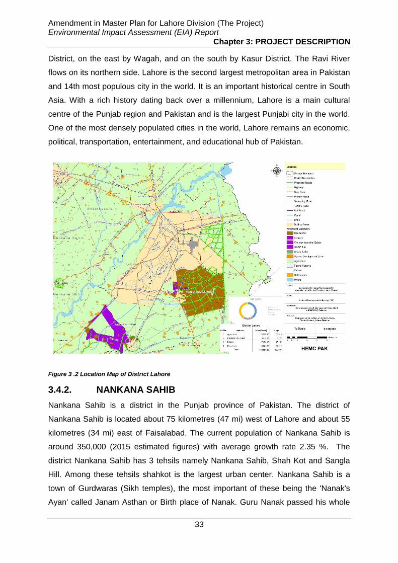
Amendment in Master Plan for Lahore Division (The Project) Environmental Impact Assessment (EIA) Report
Chapter 3: PROJECT DESCRIPTION
33
District, on the east by Wagah, and on the south by Kasur District. The Ravi River
flows on its northern side. Lahore is the second largest metropolitan area in Pakistan
and 14th most populous city in the world. It is an important historical centre in South
Asia. With a rich history dating back over a millennium, Lahore is a main cultural
centre of the Punjab region and Pakistan and is the largest Punjabi city in the world.
One of the most densely populated cities in the world, Lahore remains an economic,
political, transportation, entertainment, and educational hub of Pakistan.
Figure 3 .2 Location Map of District Lahore
3.4.2. NANKANA SAHIB
Nankana Sahib is a district in the Punjab province of Pakistan. The district of
Nankana Sahib is located about 75 kilometres (47 mi) west of Lahore and about 55
kilometres (34 mi) east of Faisalabad. The current population of Nankana Sahib is
around 350,000 (2015 estimated figures) with average growth rate 2.35 %. The
district Nankana Sahib has 3 tehsils namely Nankana Sahib, Shah Kot and Sangla
Hill. Among these tehsils shahkot is the largest urban center. Nankana Sahib is a
town of Gurdwaras (Sikh temples), the most important of these being the 'Nanak's
Ayan' called Janam Asthan or Birth place of Nanak. Guru Nanak passed his whole

Amendment in Master Plan for Lahore Division (The Project) Environmental Impact Assessment (EIA) Report
Chapter 3: PROJECT DESCRIPTION
34
childhood and young age in Nankana Sahib. Sikhs in all over the world are the
followers of Baba Guru Nanak Sahib. Nankhana Sahib is surrounded by 4 districts
i.e. Kasur, Shiekhpura, Faisalabad and Lahore. The district is linked with Kasur,
Lahore Shiekhpura and Faisalabad from GT road and M2 motor way. The district is
also the site for some ambitious development including new facilities for visiting
pilgrims, a modern hospital, international hotels, housing and planned international
airport.
Figure 3 .3 Location Map of District Nankana Sab
3.4.3. KASUR
Kasur is one of the districts in the province of Punjab, Pakistan It came into
existence on 1 July 1976. Earlier it was part of Lahore District. The district is
bounded by the Ravi River in the north-west and river Sutlej in the south-east.
Whereas the old course of Beas River bifurcates the district into two equal parts
locally known as Hither and Uthar or Mithan Majh. Both of the areas have a height
differential of approximately 5.5 meters. The natural surface elevation of the district
is 198 meters above the sea level, having a general slope from north-east to south-
west. Whereas the east and west ends of the district comprise the flood plains of the

Amendment in Master Plan for Lahore Division (The Project) Environmental Impact Assessment (EIA) Report
Chapter 3: PROJECT DESCRIPTION
35
rivers Satluj and Ravi, characterized by breaching of looping river Channels braided
around meander bars. Kasur district is attached with Lahore from east, attached with
Nankana Sahibfrom north, attached with Faisalabad from west and attached with
Okara and India from south. Kasur is connected with road network of ferozpur road
from Lahore and Gand Sighwala, Raiwind road from Raiwind and Depalpur road
from Depalpur. The Kasur city is adjacent to the border of Ganda Singh Wala. Kasur
has four tehsils namely Chunian, Qasu, Kot Radha Kishan and Pattoki. The district
capital is Kasur city, the birth city of the Sufi poet Bulleh Shah, well known in that
region as well as in the whole of Pakistan. The total area of the district is 4,796
square kilometres with estimated population 1.7 million (2015 estimates) and
average growth rate about 2.99 %. Kasur is the 20th most populous city of Pakistan.
The district is one of the major tourist attractions because of the famous guard
changing ceremony on Ganda Singh Wala border. The city is also the resting place
of Sufi poet Bulleh Shah. Kasur is famous for its very spicy fish, a sweet dish called
Andrassay, Falooda and Kasuri Methi.
Figure 3 .4 Location Map of District Kasur
Amendment in Master Plan for Lahore Division (The Project) Environmental Impact Assessment (EIA) Report
Chapter 3: PROJECT DESCRIPTION
36
3.4.4. SHIEKHPURA
Sheikhupura District is located about 35 km northwest of Lahore in Pakistan. It is
known for its historical places, and is commonly known locally as Qila Sheikhupura,
because of the fort in the city, constructed by the Mughal Emperor Jahangir. The
name of Sheikhupura is derived from a nickname of Prince Jahangir, who was
known as Sheikhu by his father King Akbar. The present city of Sheikhupura was
built by Mughal Emperor Jahangir in 1607. The district has 05 tehsils namely
Sheikhu Pura, Feroz Wala, Murid Ke, Sharaq Pur and Safdar Abad. Among them
Sheikhpura is the capital of Shiekhpura district. The shiekhpura district is the 16th
largest city of Pakistan and is bounded by Lahore to the east, Gujranwala to the
north, Hafizabad to the west and Nankana Sahib to the south. The area of
shiekhpura district is about 5960 km2 with estimated population of 1.3 million. The
district is commonly known for its worth-seeing historical places, industrial and
agriculture surroundings and one of the best export-quality rice. It also owns
Shakespeare of Punjabi poetry, famous sufi poet Waris Shah whose Heer is an
imperishable legend of divine love. The best attractive sites for visitors in shiekhpura
are Hiran Minar, Fort (Qila Sheikhupura), Company Bagh, Tomb of Shah Jamal,
Sacha Sodha, Shrine of Mian Sher Muhammad Sharaqpuri, Shrine of Syed Pir
Bahar Shahand Shrine of Syed Waras Ali Shah.

Amendment in Master Plan for Lahore Division (The Project) Environmental Impact Assessment (EIA) Report
Chapter 3: PROJECT DESCRIPTION
37
Figure 3 .5 Location Map of District Sheikhupura
3.5. DESCRIPTION OF SITE PROJECT AREAS IN
LAHORE DIVISION
There are total 48 proposed areas selected for the master planning in Lahore
Division out of 04 areas falls in Lahore District, 10 areas falls in Nankana District, 16
areas fall in Kasur District and 18 areas fall in Shiekhpura District. The description of
each of these existing and proposed project areas with mapping are given as under-:
3.5.1. DISTRICT LAHORE
Two project areas fall in district Lahore detail description of which is given as under-:
3.5.1.1. PROJECT AREA (PA)-LHR-1- (FEROZPUR ROAD AND BRB
CANAL)
Description of Project Area
In the West, area is bounded by Ferozepur Road starting from Chungi upto Hadyara
Drain and extends along with Hadyara Drain upto proposed structure plan road. The
boundary along structure plan intersects Defence Road joning Ferozepur Road at
Kahna Kacha stop upto village Julkey.

Amendment in Master Plan for Lahore Division (The Project) Environmental Impact Assessment (EIA) Report
Chapter 3: PROJECT DESCRIPTION
38
In South, area is bounded by a proposed structure plan road starting from Ferozepur
road near village Julkey upto BRB Canal.
In East, area is bounded by BRB canal starting from near Jahman upto Hadyara
Drain.
In North, area is bounded by Hadyara drain starting from BRB canal upto Bedian
Road, at North west Bedian Road staring from Hadyara Drain upto Ring Road at
Nawaz Sharif Interchange and Ring Road joining Kamahan Road starting from
Nawaz Sharif Interchange upto Ferozepur Road.
Proposed Project Area Master Plan
For Industrial Use: Area along Hudiara Drain with depth of 750 meters on both sides
from Ferozpur Road upto Saora village towards East and along charar draintowards
North incorporating existing industries is proposed for industrial use.
For Residential Use: Rest of the project Area is proposed for residential use.
Figure 3 .6 Existing Situation Map and Proposed Plan of Ferozpur Road & BRB
3.5.1.2. PROJECT AREA Site-LHR-2 (Raiwind City)
Description of Project Area
In the North, area bounded by LDA City boundary and 1st proposed structure road
(passing from Lake City, Bahria Town Sector-E) upto UBD Canal.
In the East, area bounded by Ferozpur road.
In the South, area bounded by Sua e Asal Road upto Raiwind, then along Southern
boundary of Raiwind City, Bhucke Manjha, Butcherkhana Distributary, Rakh Mudke,
Talib Sarai village upto Multan Road.

Amendment in Master Plan for Lahore Division (The Project) Environmental Impact Assessment (EIA) Report
Chapter 3: PROJECT DESCRIPTION
39
Figure 3 .7 Existing Situation Map and Proposed Plan of Raiwind City
Proposed Project Area Master Plan
For Residential Use: The area in the northern and south-western side has been
declared as residential area.
For Industrial Use: Area between Sunder Road & Manga Road has been declared as
Industrial Area.
For Agriculture Use: The vacant area across railway line in the east and south-east
has been kept as agriculture area.
3.5.1.3. PROJECT AREA Site-LHR-3 MULTAN ROAD
Description of Project Area
The area of this site extends on both sides of Multan Road starting from Manga in
the north and ends till northern boundary of Bhai Pheru in the south.
Proposed Project Area Master Plan
For Residential Use: The residential settlements falling within the site boundary,
have been kept residential.
For Industrial Use: Strip on both sides of Multan Road has been declared Industrial
Area.
For Agriculture Use: The area across the industrial strip on both sides of Multan
Road has been declared agriculture area.

Amendment in Master Plan for Lahore Division (The Project) Environmental Impact Assessment (EIA) Report
Chapter 3: PROJECT DESCRIPTION
40
Figure 3 .8 Existing Situation Map and Proposed Plan of Multan Road
3.5.1.4. PROJECT AREA (PA)-LHR-4 (MULTAN ROAD, SUE ASAL ROAD,
RAIWIND AND MANGA)
Description of Project Area
In the North, area bounded by LDA City boundary Lahore-Raiwind Road. In the East,
area extends across Railway Line. In the South, area extends to the southern
Railway Line and in the west, the area extends along Sunder Road & Manga Road.
Proposed Project Area Master Plan
For Residential Use: In the South, area along Railway line comprising Jodhudhire,
Jamalpura, Rakh Jadu Burhanpura, Chaju wala and Raiwind upto proposed
structure Road. In the West, area comprising of Manga, Samada, Sundar and
Shamkey Khan. In the South, the area adjacent to Chak No.65, Rakh Mudke, Rosa,
Talib Sarai, Chah Majhuwala, Sultanke, Mull, Bhai Kot, Nahla and Wara Kumharan.
For Industrial Use: In the South, area along Sundar-Raiwind Road (with an approx.
depth of 2.3 Km towards South) and Manga-Raiwind Road (with an approx. depth of
1.6 Km) on both sides. The Notified Industrial Areas remains intact.
For Agriculture Use: Area bounded by Ferozepur Road in East upto LDA City
Boundary in North running along 1st proposed structure road passing through Lake
City and Bahria Town Sector E upto UBD Canal. Along Sue e Asal Road in the
South, UBD Canal in the West and Sundar Road excluding industrial area. Area
bounded between Sundar-Raiwind Road, Manga-Raiwind Road and Multan Road by
excluding proposed Industrial Area.

Amendment in Master Plan for Lahore Division (The Project) Environmental Impact Assessment (EIA) Report
Chapter 3: PROJECT DESCRIPTION
41
Figure 3 .9 Existing Situation Map and Proposed Plan of Sua-e-Asal Road, Raiwind and Multan Road
3.5.2. DISTRICT NANKANA SAHIB
Nine project areas fall in district Nankana Sahib detail description of which is given
as under-:
3.5.2.1. Project Area (PA)-NSB-01(Mandi Faizabad)
Description of Project Area
In the North: About 1 km away from Jaranwala Road.
In the South: About 1.5 km on Mandi Faizabad-Nawan Kot Road till distributary.
In the East: 1 km before Mirzapur on Jaranwala Road.
In the West: Till Astana Aliya Rehan wala on Jaranwala Road
Proposed Project Area Master Plan
For Industrial Use: In the North East, area bounded by Lahore-Jarawala road,
Dhaokemandi (with the depth of approx. 0.8km) Project boundary.
For Residential Use: Area along Lahore Janrwala Road with a depth of approx. 1 km
on both sides.

Amendment in Master Plan for Lahore Division (The Project) Environmental Impact Assessment (EIA) Report
Chapter 3: PROJECT DESCRIPTION
42
Figure 3 .10 Existing Situation Map and Proposed Project Area Master Plan of Mandi Faizabad
3.5.2.2. Project Area (PA) -NSB-02 (Syed Wala)
Description of Project Area
In the North: About 600 Meters from Main Bazar Syed Wala on Jaranwala-Syed wala
Road.
In the South: Till Syed Wala-Barra Ghar-Bucheki Road.
In the East: About 2km away from Jaranwala-Syed Wala Road.
In the West: About 700 meters away from Jaranwala-Syed Wala Road
Proposed Project Area Master Plan
For Residential Use: Whole Project Area is proposed for Residential purpose
keeping in view existing trends.
Figure 3 .11 Existing Situation Map and Proposed Project Area Master Plan of Syed Wala
3.5.2.3. Project Area (PA)-NSB-03 (Bucheki)
Description of Project Area
In the North: Till Attari Ram Singh on Nankana Road

Amendment in Master Plan for Lahore Division (The Project) Environmental Impact Assessment (EIA) Report
Chapter 3: PROJECT DESCRIPTION
43
In the South: About 600 meters away from Bucheki bypass on Syed wala-Bara Ghar
Road.
In the East: About 2 km from Bucheki Bypass on Jaranwala-Lahore Road
In the West: Till District Nankana Sahib limits
Proposed Project Area Master Plan
For Industrial Use: In the North, area bounded by Lahore-Jaranawala road and
project boundary. In the South, small area along Bucheki Bypass and Bucheki road
with an approximate depth of 1.5 km on either side.
For Residential Use: In the West, area bounded by Nankana road and Bucheki
Bypass. In the South, area bounded by Lahore-jarawala road, Bucheki Bypass,
Bucheki road and project boundary
Figure 3 .12 Existing Situation Map and Proposed Project Area Master Plan of Bucheki
3.5.2.4. Project Area (PA)-NSB-04 (Nankana Sahib)
Description of Project Area
In the North: 1 km away from Manawala Bypass on Shahkot Road
In the South: About 300 meters away from Nankana Sahib on Mangtawala Road
In the East: About 300 meters from Nankana Sahib Bypass on Nankana-Warburton
Road
In the West: About 300 meters away from Manawala Bypass on Jaranwala Road
Proposed Project Area Master Plan
All the uses of ODP are retained as such.

Amendment in Master Plan for Lahore Division (The Project) Environmental Impact Assessment (EIA) Report
Chapter 3: PROJECT DESCRIPTION
44
3.5.2.5. Project Area -NSB-05 (Shahkot-I)
Description of Project Area
In the North: Till Chak # 82 Rasulpur Araian on Safdarabad-Shahkot Road
In the South: Till Shahkot Minor on Jaranwala Road
In the East: Till Crescent cotton Mills Shahkot on Lahore-Sheikhupura-Faisalabad
Road
In the West: Till Nankana Sahib District limits
Proposed Project Area Master Plan
For Residential Use: The land uses as mentioned in the ODP are retained as such,
however rest of the area from ODP boundary upto project boundary is proposed as
residential area.
Figure 3 .13 Existing Situation Map and Proposed Project Area Master Plan of Shahkot-I
3.5.2.6. Project Area (PA)-NSB-06 (Sangla Hill)
Description of Project Area
In the North: about 600 meters from Ahmad Town Scheme & till Bhulair on Bhulair
Road
In the South: Till TEVTA Building on Shahkot-Sangla Hill Road
In the East: about 2.5 km away from Railway Station along Railway line
In the West: Till Nankana Sahib District limits

Amendment in Master Plan for Lahore Division (The Project) Environmental Impact Assessment (EIA) Report
Chapter 3: PROJECT DESCRIPTION
45
Proposed Project Area Master Plan
For Residential Use: The land uses as mentioned in the ODP are retained as such,
however rest of the area from ODP boundary upto project boundary is proposed as
residential area.
Figure 3 .14 Existing Situation Map and Proposed Project Area Master Plan of Sangla Hill
3.5.2.7. Project Area (PA) -NSB-07 (More Khunda)
Description of Project Area
In the North: About 1.8 km from Lahore-Jaranwala Road
In the South: Till More Khunda Bypass on Bhai Pheru-Halla Road
In the East: Till Petrol Pump on Lahore-Jaranwala Road
In the West: Till More Khunda Bypass on Lahore Jaranwala Road
Proposed Project Area Master Plan
For Industrial Use: In the North East, area bounded by Lahore Jarawanala Road and
Project Boundary with the depth of Approx. 0.7km towards West.
In the South West, area along Lahore Jaranwala Road with a depth of 0.5Km on
both sides upto Guggian Gillan village towards East.
For Residential Use: Rest of the area is proposed as residential area.

Amendment in Master Plan for Lahore Division (The Project) Environmental Impact Assessment (EIA) Report
Chapter 3: PROJECT DESCRIPTION
46
Figure 3 .15 Existing Situation Map and Proposed Project Area Master Plan of Mor Khunda
3.5.2.8. Project Area (PA)-NSB-08 (Shahkot-II)
Description of Project Area
In the North: About 1.5 km from Lahore-Sheikhupura-Faisalabad Road
In the South: About 700 meters away from Lahore-Sheikhupura-Faisalabad Road
In the East: Till end of Crescent Cotton Mills
In the West: Till Shahkot Flour Mill
Proposed Project Area Master Plan
For Industrial Use: Whole Project Area is proposed as Industrial area.
Figure 3 .16 Existing Situation Map and Proposed Project Area Master Plan of Shahkot-II
3.5.2.9. Project Area (PA)-NSB-09-(Warburton)
Description of Project Area
Area of length about 1.5 km towards North West, from Railway station
Warburon.Area towards distributary Nanakana Sahib Warburton road in the South.

Amendment in Master Plan for Lahore Division (The Project) Environmental Impact Assessment (EIA) Report
Chapter 3: PROJECT DESCRIPTION
47
Proposed Project Area Master Plan
For Industrial Use: In the South East, area bounded by Nankana sahib warburton
Road (with a distance of approx. 1.5 Km from project boundary) and project
boundary.
In the South area along Nankana sahib warburton Road upto a distance of
approx.0.8 Km with a depth of approx. 0.3 km towards North West.
For Residential Use: Rest of the area is proposed for residential use.
Figure 3 .17 Existing Situation Map and Proposed Project Area Master Plan of Warburton
3.5.2.10. Project Area Site-NSB-08
Description of Project Area
The area of this site runs on both sides of Sheikhupura-Faisalabad Road adjacent to
the Site-NSB-10.
Proposed Project Area Master Plan
For Industrial Use: Whole of the project site has been declared as industrial area
except the existing built-up area.
For Residential Use: Existing built-up area has been kept for residential use.

Amendment in Master Plan for Lahore Division (The Project) Environmental Impact Assessment (EIA) Report
Chapter 3: PROJECT DESCRIPTION
48
Figure 3 .18 Existing Situation Map and Proposed Project Area Master Plan of Site-NSB-08
3.5.3. DISTRICT KASUR
Sixteen project areas fall in district Kasur detail description of which is given as
under-:
3.5.3.1. Project Area (PA)-K-01 (Kasur)
Description of Project Area
Boundary in the form of circle about 8 km diameter around the Kasur City
Proposed Project Area Master Plan
Residential Area is proposed in the South East and South West direction.
Landuse proposed as Sub Neighborhood Centre and Orchards in the existing ODP
of Kasur are proposed as Residential area.
Figure 3 .19 Existing Situation Map and Proposed Project Area Master Plan of Kasur

Amendment in Master Plan for Lahore Division (The Project) Environmental Impact Assessment (EIA) Report
Chapter 3: PROJECT DESCRIPTION
49
3.5.3.2. Project Area (PA)-K-02 (Mustafabad)
Description of Project Area
Boundary of about 2.9 km radius in the form of Semi Circle around the Mustafabad in
the western direction along Ferozpur road.
Proposed Project Area Master Plan
Industrial Area is proposed along the water bodies in the western direction along
Ferozpur road.
Residential Area is proposed in the western direction of Mustafabad.
Landuse proposed as Sub Neighborhood Centre and Orchards in the existing ODP
of Mustafabad are proposed as Residential area.
Figure 3 .20 Existing Situation Map and Proposed Project Area Master Plan of Mustafabad
3.5.3.3. Project Area (PA)-K-03 (Industrial Estate)
Description of Project Area
Boundary of about 2.7 km radius in the form of Semi Circle around the in the western
direction along Ferozpur road.
Proposed Project Area Master Plan
Industrial Area is proposed in the western direction along Ferozpur road.
Thehwadana Settlement is kept as Residential Area

Amendment in Master Plan for Lahore Division (The Project) Environmental Impact Assessment (EIA) Report
Chapter 3: PROJECT DESCRIPTION
50
Figure 3 .21 Existing Situation Map and Proposed Project Area Master Plan of Kasur Industrial Estate
3.5.3.4. Project Area (PA)-K-04 (Khudian Khas)
Description of Project Area
Boundary of about 2.3 km radius in the form of Semi Circle around the Khudian in
the north western direction.
Proposed Project Area Master Plan
Residential Area is proposed in the south western direction.
Landuse proposed as Educational Institute along railway line, Open Space along
railway line near Ahmed City, and Orchards in the existing ODP of Khudian Khas are
proposed as Residential area.
Figure 3 .22 Existing Situation Map and Proposed Project Area Master Plan of Khudian Khas
3.5.3.5. Project Area (PA)-K-05 (Rao Khan Wala)
Description of Project Area
Boundary in the form of circle about 1.6 km diameter around the Rao Khan Wala.

Amendment in Master Plan for Lahore Division (The Project) Environmental Impact Assessment (EIA) Report
Chapter 3: PROJECT DESCRIPTION
51
Proposed Project Area Master Plan
Residential Area is proposed in the form of circle about 1.6 km diameter around the
Rao Khan Wala.
Figure 3 .23 Existing Situation Map and Proposed Project Area Master Plan of Rao Khan Wala
3.5.3.6. Project Area-K-06 (Raja jang)
Description of Project Area
Boundary in the form of circle about 1.6 km diameter around the Raja Jang
Proposed Project Area Master Plan
Residential Area is proposed in the form of circle about 1.6 km diameter around the
Raja Jang
Figure 3 .24 Existing Situation Map and Proposed Project Area Master Plan of Raja Jang
3.5.3.7. Project Area (PA)-K-07 (Kot Radha Kishan)
Description of Project Area
Boundary in the form of circle about 3.8 km diameter around the Kot Radha Kishan

Amendment in Master Plan for Lahore Division (The Project) Environmental Impact Assessment (EIA) Report
Chapter 3: PROJECT DESCRIPTION
52
Proposed Project Area Master Plan
Residential Area is proposed sourrounding the existing built up area of Kot Radha
Kishan.
Landuse earmarked as Proposed Educational Institute along Bhae Pheru Kot Radha
Kishan Road, and Orchards in the existing ODP of Kot Radha Kishan are proposed
as Residential area.
Figure 3 .25 Existing Situation Map and Proposed Project Area Master Plan of Kot Radha Kishan
3.5.3.8. Project Area (PA)-K-08- (Changa Manga)
Description of Project Area
Boundary of about 1.5 km diameter in the form of Semi Circle around the Changa
Manga in the north western direction
Proposed Project Area Master Plan
Residential Area is proposed about 1.5 km diameter in the form of Semi Circle
around the Changa Manga in the north western direction.
Figure 3 .26 Existing Situation Map and Proposed Project Area Master Plan of Changa Manga

Amendment in Master Plan for Lahore Division (The Project) Environmental Impact Assessment (EIA) Report
Chapter 3: PROJECT DESCRIPTION
53
3.5.3.9. Project Area (PA) -K-07- (Bhae Pheru)
Description of Project Area
The area Bounded by Manga Mandi in the North. The area bounded by Chunian
Industrial Estate in the West & East. Area bounded by ODP boundary of Bhaepheru.
Proposed Project Area Master Plan
Industrial Area is proposed about 1 km in depth along Multan road on both sides
from Manga Mandi to ODP boundary of Bhae Pheru.
ODP uses of Bhae Pheru are intact as it is. The area of Chunian Industrial estate is
proposed as Agriculture Area
Figure 3 .27 Existing Situation Map and Proposed Project Area Master Plan of Bhai Pheru
3.5.3.10. Project Area (PA)-K-9- (Jamber)
Description of Project Area
Boundary of about 4.0 km diameter in the form of Semi Circle around the Jamber in
the north, east and south direction.
Proposed Project Area Master Plan
Industrial Area is proposed about 2492 acres from balloki sulemanki canal with a
depth of 4 km towards eastern side.
Residential Area is proposed about 1748 acre Balloki Sulemanki Link Canal with a
depth of 4km towards southern direction.

Amendment in Master Plan for Lahore Division (The Project) Environmental Impact Assessment (EIA) Report
Chapter 3: PROJECT DESCRIPTION
54
Figure 3 .28 Existing Situation Map and Proposed Project Area Master Plan of Jamber
3.5.3.11. Project Area (PA)-K-11 (Chunian)
Description of Project Area
Boundary in the form of circle about 6.5 km diameter around the Chunian
Proposed Project Area Master Plan
Residential Area is proposed in the form of circle in the north, south and western
direction.
Industrial Area is proposed in the eastern direction.
Landuse marked as Existing Orchards/Open Space and proposed Open Space in
the existing ODP of Chunian are proposed as Residential area.
Figure 3 .29 Existing Situation Map and Proposed Project Area Master Plan of Chunian
3.5.3.12. Project Area (PA)-K-12 (Allahabad)
Description of Project Area
Boundary in the form of circle having diameter about 3.75 km around Allahabad.

Amendment in Master Plan for Lahore Division (The Project) Environmental Impact Assessment (EIA) Report
Chapter 3: PROJECT DESCRIPTION
55
Proposed Project Area Master Plan
Residential Area is proposed in the form of circle having diameter about 3.75 km
around Allahabad.
Figure 3 .30 Existing Situation Map and Proposed Project Area Master Plan of Allahabad
3.5.3.13. Project Area (PA)-K-13 (Kanganpur)
Description of Project Area
Boundary of about 2.0 km diameter in the form of Semi Circle around the Kanganpur
in the north, west and south direction.
Proposed Project Area Master Plan
Residential Area is proposed about 2.0 km diameter in the form of Semi Circle
around the Kanganpur in the north, west and south direction.
Figure 3 .31 Existing Situation Map and Proposed Project Area Master Plan of Kanganpur
3.5.3.14. Project Area (PA)-K-14 (Pattoki)
Description of Project Area
Boundary in the form of circle having diameter about 6.5 km around Pattoki.

Amendment in Master Plan for Lahore Division (The Project) Environmental Impact Assessment (EIA) Report
Chapter 3: PROJECT DESCRIPTION
56
Proposed Project Area Master Plan
Residential Area is proposed about 3806 acres in the north, west & south direction.
Landuse earmarked as proposed Educational, Agriculture, Commercial and
Institutional cum offices in the existing ODP of Pattoki are proposed as Residential
area.
Figure 3 .32 Existing Situation Map and Proposed Project Area Master Plan of Pattoki
3.5.3.15. Project Area (PA)-K-15 (Talwandi)
Description of Project Area
Boundary in the form of circle having diameter about 2.3 km around Talwandi.
Proposed Project Area Master Plan
Residential Area is proposed in the form of circle having diameter about 2.3 km
around Talwandi.
Figure 3 .33 Existing Situation Map and Proposed Project Area Master Plan of Talwandi

Amendment in Master Plan for Lahore Division (The Project) Environmental Impact Assessment (EIA) Report
Chapter 3: PROJECT DESCRIPTION
57
3.5.3.16. Project Area Site-K-11
Description of Project Area
This project site is in the form of a circle along Multan Road and is located in north of
Jamber settlement.
Proposed Project Area Master Plan
The whole of the project site has been declared as industrial area except the existing
built-up area.
Figure 3 .34 Existing Situation Map and Proposed Project Area Master Plan of Site-K-11
3.5.4. DISTRICT SHEIKHUPURA
3.5.4.1. PA-SKP-1(Sheikhupura City)
Description of Project Area
In the North, area boundary align with the Lahore Islamabad Motorway M-2,
In the East, aligns with Tehsil boundary.
In the West,aligns with Kurlkey drain upto Jhaamkay settlement on both sides of
Sargodha road.
In the South,area running parallel along Sheikhupura Bypass Road.
Proposed Project Area Master Plan
For Residential Use: The area from tehsil limits in eastern side to western side till
Jhamkay settlement and northern side up to motorway except areas reserved for
green buffer and industrial use as residential. In southern direction area of about 2

Amendment in Master Plan for Lahore Division (The Project) Environmental Impact Assessment (EIA) Report
Chapter 3: PROJECT DESCRIPTION
58
km running parallel to existing ODP boundary of Sheikhupura as residential except
area reserved as industrial.
For Industrial Use: From tehsil limits in eastern direction till Sheikhu Garden Housing
Scheme as industrial, and till railway line in northern direction, and 1 Km away from
Lahore Sheikhupura Road. 500 m area from Bado Road on each side till 5km from
Lahore Sheikhupura Road as Industrial.
For Green Buffer: 250 m green buffer from Motorway in Northern direction and 100
m along Inter Change. Area surround by HiranMinarof about 3 km.
Figure 3 .35 Existing Situation Map and Proposed Project Area Master Plan of Sheikhupura City
3.5.4.2. Project Area (PA)-SKP-2- (Muridke)
Description of Project Area
In the North, area bounded by GT road & railway line near PSO rachna petrol
station.
In the South, area bounded by Lahore bypass near NHA office (near KSK Campus)
In the West, area bounded by DeghNullah&Canal and MuridkeDistributory& Village
KotHanif.
In the East, area bounded by Railway line, Chak no.44 road and KhudakiBasti
Scheme.
Proposed Project Area Master Plan
For Residential Area: The area from northern to southern direction except the area in
between railwayline and G.T. Road as residential.
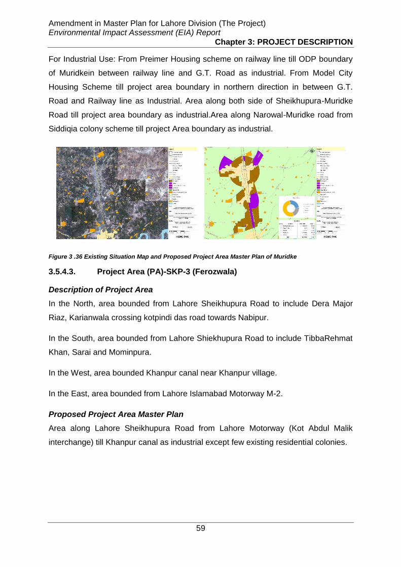
Amendment in Master Plan for Lahore Division (The Project) Environmental Impact Assessment (EIA) Report
Chapter 3: PROJECT DESCRIPTION
59
For Industrial Use: From Preimer Housing scheme on railway line till ODP boundary
of Muridkein between railway line and G.T. Road as industrial. From Model City
Housing Scheme till project area boundary in northern direction in between G.T.
Road and Railway line as Industrial. Area along both side of Sheikhupura-Muridke
Road till project area boundary as industrial.Area along Narowal-Muridke road from
Siddiqia colony scheme till project Area boundary as industrial.
Figure 3 .36 Existing Situation Map and Proposed Project Area Master Plan of Muridke
3.5.4.3. Project Area (PA)-SKP-3 (Ferozwala)
Description of Project Area
In the North, area bounded from Lahore Sheikhupura Road to include Dera Major
Riaz, Karianwala crossing kotpindi das road towards Nabipur.
In the South, area bounded from Lahore Shiekhupura Road to include TibbaRehmat
Khan, Sarai and Mominpura.
In the West, area bounded Khanpur canal near Khanpur village.
In the East, area bounded from Lahore Islamabad Motorway M-2.
Proposed Project Area Master Plan
Area along Lahore Sheikhupura Road from Lahore Motorway (Kot Abdul Malik
interchange) till Khanpur canal as industrial except few existing residential colonies.

Amendment in Master Plan for Lahore Division (The Project) Environmental Impact Assessment (EIA) Report
Chapter 3: PROJECT DESCRIPTION
60
Figure 3 .37 Existing Situation Map and Proposed Project Area Master Plan of Ferozwala
3.5.4.4. Project Area (PA)-SKP-4 (Farooqabad)
Description of Project Area
In the North, area bounded from Lahore Sargodha road towards Mureedke
settlement.
In the South, area bounded from Lahore Sargodha road to include NokharNawan
settlement.
In the West, area bounded by QadarabadBalloki link Canal.
In the East, area running parallel to the drain and crossing Lahore Sargodha road.
Proposed Project Area Master Plan
For Residential Use: All the area surrounded by existing ODP boundary of
Farooqabadfrom northern to southern direction till project area boundary as
residential.
Figure 3 .38 Existing Situation Map and Proposed Project Area Master Plan of Farooqabad

Amendment in Master Plan for Lahore Division (The Project) Environmental Impact Assessment (EIA) Report
Chapter 3: PROJECT DESCRIPTION
61
3.5.4.5. Project Area (PA)-SKP-5 (Narangmandi)
Description of Project Area
In the North, area bounded by Manawala settlement to Mayoun da Dera along
NarowalMuridke road.
In the SouthWest, area running parallel to Kala KhataiNarangmandiRoad from
Manawala settlement to Khun.
In the East, area bounded from Khun to Younas Park.
Proposed Project Area Master Plan
All the uses of ODP of NarangMandi are retained as such and some area has been
included other than ODP as residential in the North Eastern side
Figure 3 .39 Existing Situation Map and Proposed Project Area Master Plan of Narang Mandi
3.5.4.6. Project Area (PA)-SKP-6- (Sharqpur)
Description of Project Area
In the North West, area bounded bynaibhini towards distributary approximately 1 km
loop running parallel Jaranwala road in Sharaqpur.
In the South East, area bounded by Hafiz sidhi settlement and Ghareebaabad
settlement approximately 1 km loop running parallel Jaranwala road in Sharaqpur.
Proposed Project Area Master Plan
All the uses of ODP of Sharaqpur are retained as such, other than the landuses that
proposed as orchards in existing ODP are proposed as residential.

Amendment in Master Plan for Lahore Division (The Project) Environmental Impact Assessment (EIA) Report
Chapter 3: PROJECT DESCRIPTION
62
Figure 3 .40 Existing Situation Map and Proposed Project Area Master Plan of Sharqpur
3.5.4.7. Project Area (PA)-SKP-7 (Safdarabad)
Description of Project Area
Area bounded by approximately 1.5 km in circular form from Railway Station,
Safdarabad.
Proposed Project Area Master Plan
For Residential Use: Area bounded by approximately 1.5 km in circular form from
Railway Station, Safdarabad.
Figure 3 .41 Existing Situation Map and Proposed Project Area Master Plan of Safdarabad
3.5.4.8. Project Area (PA)-SKP-8(Bhiki)
Description of Project Area
Area running parallel about 1 km in depth from Kudalthi More to QadarabadBalloki
Link Canal along Lahore Sheikhupura- Faisalabad Road on both sides.
Proposed Project Area Master Plan
For Residential Use: From Rasool town till Khariawala village and area surround by
Bhikhi settlement as Residential.

Amendment in Master Plan for Lahore Division (The Project) Environmental Impact Assessment (EIA) Report
Chapter 3: PROJECT DESCRIPTION
63
For Industrial Use: All the remaining area (other than residential) from Kudalthi More
to QadarabdBalloki canal as industrial till project Area boundary.
Figure 3 .42 Existing Situation Map and Proposed Project Area Master Plan of Bhikhi
3.5.4.9. Project Area (PA)-SKP-9 (Ferozwatwan)
Description of Project Area
Area running parallel approximately 1.5 km in depth from QadarabadBalloki Link
Canal to TaaliChak along Lahore Sheikhupura- Faisalabad Road on both sides.
Proposed Project Area Master Plan
For Residential Use: About 500 m in depth on NawanKot settlement as residential.
About 1.5 km away from Sheikhupura-Faisalabad Road in northern direction and 1
km in southern direction as residential.
For Industrial Use: Rest of area other than residential use is industrial till project area
boundary from canal to TaaliChak.
Figure 3 .43 Existing Situation Map and Proposed Project Area Master Plan of Ferozwatwan

Amendment in Master Plan for Lahore Division (The Project) Environmental Impact Assessment (EIA) Report
Chapter 3: PROJECT DESCRIPTION
64
3.5.4.10. Project Area (PA)-SPA-10 (Manawala)
Description of Project Area
In the North, area running parallel about 1 km in depth along Lahore Sheikhupura
Faisalabad Road.
In the South, area bounded by Saimnullah.
In the West, area bounded by Iqbal Nagar to Saimnullah road.
In the East, area bounded by briks road and Saimnullah.
Proposed Project Area Master Plan
For Residential Use: The area marked as project area from northern to southern
direction till project area boundary as residential.
Figure 3 .44 Existing Situation Map and Proposed Project Area Master Plan of Manawala
3.5.4.11. Project Area (PA)-SKP-11 (KhanqahDogran)
Description of Project Area
The area is bounded about 1 km all around from the center of Khanqah Doran
Proposed Project Area Master Plan
For Residential Use: The area is bounded about 1 km all around from the center of
Khanqah Doran as residential except area reserved for industrial use within project
area boundary
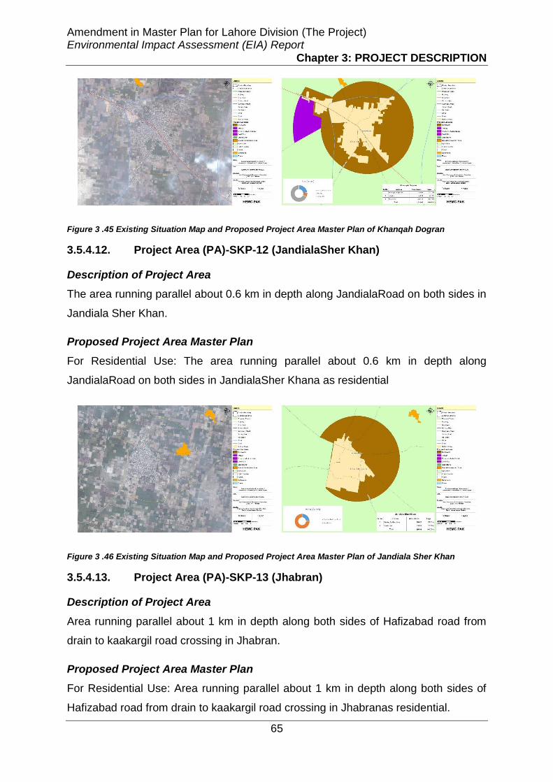
Amendment in Master Plan for Lahore Division (The Project) Environmental Impact Assessment (EIA) Report
Chapter 3: PROJECT DESCRIPTION
65
Figure 3 .45 Existing Situation Map and Proposed Project Area Master Plan of Khanqah Dogran
3.5.4.12. Project Area (PA)-SKP-12 (JandialaSher Khan)
Description of Project Area
The area running parallel about 0.6 km in depth along JandialaRoad on both sides in
Jandiala Sher Khan.
Proposed Project Area Master Plan
For Residential Use: The area running parallel about 0.6 km in depth along
JandialaRoad on both sides in JandialaSher Khana as residential
Figure 3 .46 Existing Situation Map and Proposed Project Area Master Plan of Jandiala Sher Khan
3.5.4.13. Project Area (PA)-SKP-13 (Jhabran)
Description of Project Area
Area running parallel about 1 km in depth along both sides of Hafizabad road from
drain to kaakargil road crossing in Jhabran.
Proposed Project Area Master Plan
For Residential Use: Area running parallel about 1 km in depth along both sides of
Hafizabad road from drain to kaakargil road crossing in Jhabranas residential.

Amendment in Master Plan for Lahore Division (The Project) Environmental Impact Assessment (EIA) Report
Chapter 3: PROJECT DESCRIPTION
66
Figure 3 .47 Existing Situation Map and Proposed Project Area Master Plan of Jhabran
3.5.4.14. Project Area (PA)-SKP-14 (Jaranwala Road)
Description of Project Area
Area running parallel about 1-2 km in depth along north western side of Jaranwala
road from Faizpur interchange to Dhamkey settlement.
Proposed Project Area Master Plan
For Residential Use: Area running parallel about 1-2 km in depth along North
Western side of Jaranwala road from Faizpur interchange to Dhamkey settlements
residential.
Figure 3 .48 Existing Situation Map and Proposed Project Area Master Plan of Jaranwala Road
3.5.4.15. Project Area (PA)-SKP-15 (Lahore Muridke Road)
Description of Project Area
Area running parallel to Lahore Muridke Road upto the built up area in the eastern
western side

Amendment in Master Plan for Lahore Division (The Project) Environmental Impact Assessment (EIA) Report
Chapter 3: PROJECT DESCRIPTION
67
Proposed Project Area Master Plan
For Residential Use: Area running parallel along eastern western side of Lahore
Muridke Road keeping in intact the existing industries (from Shadrah Morr to Lahore
bye-pass linking to Kala Shah Kaku Interchange)
Figure 3 .49 Existing Situation Map and Proposed Project Area Master Plan of Lahore Muridke Road
3.5.4.16. PA-SKP-16 (Lahore Sheikhupura Road)
Description of Project Area
Area running parallel about I Km in depth along Northern and southern side Build up
area of Lahore Sheikhupura Road upto Dosako Chowk and 1 km in depth along
Northern Side buildup area from Dosako Chowk to Kotabdul Malik Interchange
Proposed Project Area Master Plan
For Residential Use: Area running parallel along northern side buildup area of
Lahore Sheikhupura Road (from Shadrah Morr to Kot AbdulMalik Interchange).
Figure 3 .50 Existing Situation Map and Proposed Project Area Master Plan of Lahore Sheikhupura Road

Amendment in Master Plan for Lahore Division (The Project) Environmental Impact Assessment (EIA) Report
Chapter 3: PROJECT DESCRIPTION
68
3.5.4.17. Site-SKP-15
Description of Project Area
This site runs along both sides of Grand Trunk Road between Ferozwala in south
and Muridke in the north.
Proposed Project Area Master Plan
For Residential Use: The area on the western side and south-eastern side has been
declared as residential area.
For Industrial Use: The area on the eastern side has been proposed as industrial
area. Moreover, the land between the G.T. Road and the Railway Line has also been
declared as Industrial area.
Figure 3 .51 Existing Situation Map and Proposed Project Area Master Plan of Site-SKP-15
3.5.4.18. Site-SKP-18 (Dhantpura)
Description of Project Area
The site is in circular form near settlement Dhantpura and is located in east of
Farooqabad.
Proposed Project Area Master Plan
For Residential Use: The whole of the site area has been declared as residential
area.
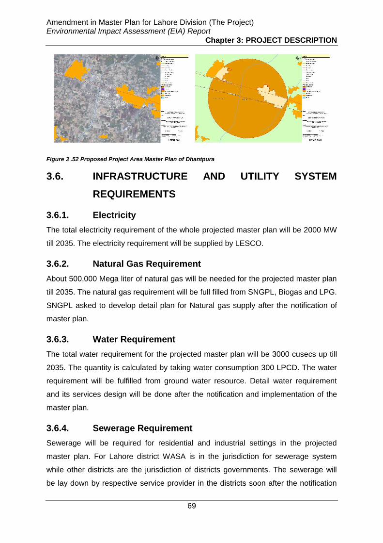
Amendment in Master Plan for Lahore Division (The Project) Environmental Impact Assessment (EIA) Report
Chapter 3: PROJECT DESCRIPTION
69
Figure 3 .52 Proposed Project Area Master Plan of Dhantpura
3.6. INFRASTRUCTURE AND UTILITY SYSTEM
REQUIREMENTS
3.6.1. Electricity
The total electricity requirement of the whole projected master plan will be 2000 MW
till 2035. The electricity requirement will be supplied by LESCO.
3.6.2. Natural Gas Requirement
About 500,000 Mega liter of natural gas will be needed for the projected master plan
till 2035. The natural gas requirement will be full filled from SNGPL, Biogas and LPG.
SNGPL asked to develop detail plan for Natural gas supply after the notification of
master plan.
3.6.3. Water Requirement
The total water requirement for the projected master plan will be 3000 cusecs up till
2035. The quantity is calculated by taking water consumption 300 LPCD. The water
requirement will be fulfilled from ground water resource. Detail water requirement
and its services design will be done after the notification and implementation of the
master plan.
3.6.4. Sewerage Requirement
Sewerage will be required for residential and industrial settings in the projected
master plan. For Lahore district WASA is in the jurisdiction for sewerage system
while other districts are the jurisdiction of districts governments. The sewerage will
be lay down by respective service provider in the districts soon after the notification

Amendment in Master Plan for Lahore Division (The Project) Environmental Impact Assessment (EIA) Report
Chapter 3: PROJECT DESCRIPTION
70
of the implementation of the projected areas in the master plan by Lahore
Development Authority. The Lahore Development Authority requested service
providers of respective districts to design detail plan of sewerage after the
notification of master plan. The industries and private housings should construct own
sewerage which then connected to the main sewerage line.
3.6.5. Solid Waste Management
Solid waste generation rate on average in Lahore City is approximately 0.85 kg per
capita per day. Considering the design population 24.72 Million of the master plan
2035, the total municipal solid waste will be generated 20,000 tons/day. The major
part of this waste is the residential. Types of solid waste from residential areas will
be the food wastes, paper, cardboard, plastics, textiles, leather, yard wastes, wood,
glass, tin cans, aluminum, other metals, ashes, street leaves, special wastes and
household hazardous waste. Commercial waste comes from stores, restaurants,
markets, and offices. Types of commercial waste are paper, cardboard, plastics,
wood, food waste, glass, metals and sometimes‐special wastes. The industrial waste
comes from industry and depends upon the type of industry. The management of
solid waste commercial and residential in Lahore district is the responsibility of
Lahore Waste Management Company (LWMC) while in other 3 districts (Shiekhpura,
Kasur and Nankana) the solid waste is collected by the district government. For
project areas of Lahore district LWMC will be the responsible for solid waste
management while in other districts the LWMC model will be replicate in district
governments for the better management of solid waste
3.6.6. Road Network
Lahore division is connected with well-established road network that comprised of
motorway, truck road, primary roads, secondary roads, local roads, streets and rural
roads. The roads that carries the intercity traffic and major volumes of sub urban
travel includes the GT Road both eastern and northern sections, Sheikhupura Road,
Jaranwala/ Sharaqpur Road, Multan Road, Raiwind Road, Ferozepur Road and M-2
motor way. Partially constructed Lahore Ring Road (LRR) with its operation loops in
west, north and eastern side of the city has improved accessibility for inter suburban
travel and regional traffic to the Lahore airport. . Provincial roads connect mainly
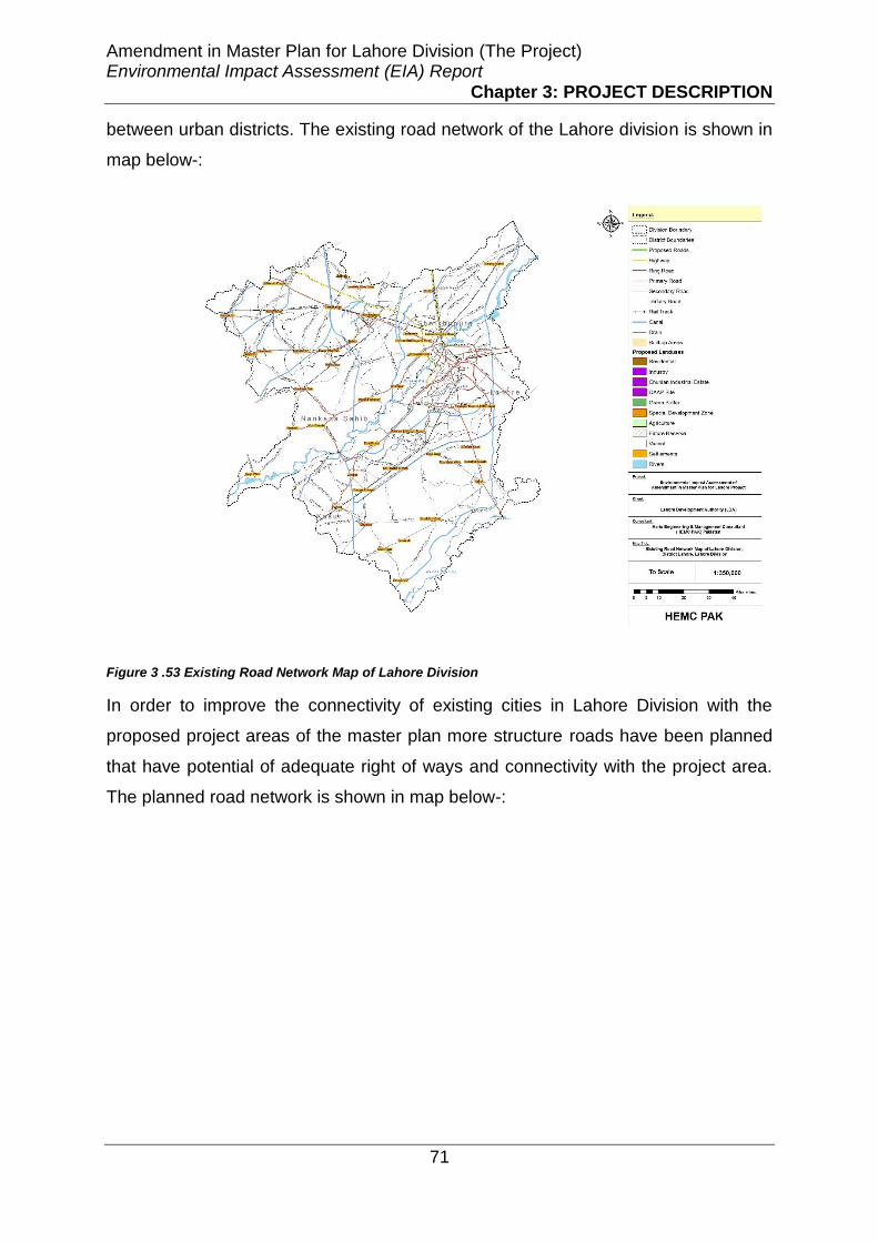
Amendment in Master Plan for Lahore Division (The Project) Environmental Impact Assessment (EIA) Report
Chapter 3: PROJECT DESCRIPTION
71
between urban districts. The existing road network of the Lahore division is shown in
map below-:
Figure 3 .53 Existing Road Network Map of Lahore Division
In order to improve the connectivity of existing cities in Lahore Division with the
proposed project areas of the master plan more structure roads have been planned
that have potential of adequate right of ways and connectivity with the project area.
The planned road network is shown in map below-:

Amendment in Master Plan for Lahore Division (The Project) Environmental Impact Assessment (EIA) Report
Chapter 3: PROJECT DESCRIPTION
72
Figure 3 .54 Proposed Road Network Map of Lahore Division

Amendment in Master Plan for Lahore Division (The Project) Environmental Impact Assessment (EIA) Report
Chapter 4: ANALYSIS OF ALTERNATIVES
73
CHAPTER4
ANALYSIS OF ALTERNATIVES
4.1. General
This chapter deals with an analytical overview of the different alternatives that have
been considered in the master planning stage. The analysis has been carried out
critically so as to justify the need of the Project. Besides the economic viability,
environmental and social soundness of the proposed Project should also be
considered when analyzing various alternatives. The various alternatives considered
during the conduct of the study are as under:
• No Project Option (NPO)
• Location alternatives
• Layout alternatives
• Design alternatives
4.2. No Project Option (NPO)
Lahore, the city of gardens is the provincial capital of Punjab. It is the second largest
city of Pakistan with a population over 7 million. It is enriched with cultural and
historical monuments and attracts thousands of visitors each year. Spatially it is
expanding towards southern and eastern sides. Lahore has been dynamic in its
physical as well as functional growth, but has usually developed in a piecemeal
fashion independently although planning was there. it took its present shape as a
result of three planning efforts which were exercised one after the other. All these
planning documents were formed to manage the rapidly changing character of the
city from industrial to service, trade and business hub.

Amendment in Master Plan for Lahore Division (The Project) Environmental Impact Assessment (EIA) Report
Chapter 4: ANALYSIS OF ALTERNATIVES
74
4.3. Planning Efforts
4.3.1. Master Plan for Greater Lahore, 1966
First planning effort for the master plan of Lahore started in 1960. On the
recommendation of Second Five Year Plan (1960-65) of the Government of
Pakistan, the preparation of Master Plan for Greater Lahore was started in 1961. For
this task a master plan committee was set up by the Punjab Government realizing
that neither the Lahore Municipal Corporation (LMC) nor the Lahore Improvement
Trust (LIT) was equipped to undertake this job.
The first plan was supposed to delineate the zoning and subdivision regulations;
development of new satellite towns and establishment of 24 km green belt
surrounding the whole city. It particularly focused upon the augmentation of
economic base of the present town and the need to create new industrial towns. A
very little effort was made to ensure the enforcement of this plan but the industrial
estates were developed at Kot Lakhpat, Chunian to the south and Kala Shah Kaku in
the north of the city. It was also reported that greenbelt around the city could not be
provided due to perpetual urbanization, development pressure and failure to create
self- sufficient industries. Figure 4-1 shows the map of the Master Plan for Greater
Lahore, 1966.
This plan preparation process took five years and was submitted to the Provincial
Government for vetting and approval in 1966. However, it was not until 1972 when
the Master Plan, after remain pending for more than six years due to administrative
bottlenecks and legal lacuna, was sanctioned by the Punjab Government. By the
time this Plan came into force on 1st September 1972, the circumstances had
changed and the data on which its proposals were based got outdated. Further,
unplanned development continued to take place in the areas proposed in the Master
Plan for planned development. So excessive delays in approval rendered the Master
Plan outdated by the time it was put into operation and this became the key reason
due to which this Plan could not taste the flavor of successful implementation.

Amendment in Master Plan for Lahore Division (The Project) Environmental Impact Assessment (EIA) Report
Chapter 4: ANALYSIS OF ALTERNATIVES
75
Figure 4 .1 Master Plan for Greater Lahore, 1966

Amendment in Master Plan for Lahore Division (The Project) Environmental Impact Assessment (EIA) Report
Chapter 4: ANALYSIS OF ALTERNATIVES
76
4.3.2. Lahore Urban Development and Traffic Study (LUDTS),
1980
The Lahore Urban Development and Traffic Study (LUDTS) was conducted as a joint
team of foreign and local consultants for LDA. The study was financed by a credit
from the International Development Agency (IDA), World Bank. The intention of this
urban planning study was to provide a structure plan or guiding framework to act as
a background for action programs in the metropolitan areas of Lahore for 20 years’
time horizon (1981-2000). The justification given for this ‘Structure Plan’ was that the
Master Plan -1966 was drafted on the basis of information collected almost a decade
earlier. This study declared the Master Plan as an inadequate document for rigid
adherence and implementation. Figure 4-2 shows the map of LUDTS.
The LUDTS was formed in 1980 and is important to note because of the active
participation of the Lahore Development Authority (LDA) in its preparation and
implementation. Moreover, it was prepared in a short time period based on land use
surveys and very little primary data. The plan itself had no legal status except as a
guiding document for the LDA. However, one of the main factors that contributed to
the fame of the LDA as a leading development authority was the implementation of
the Structure Plan-1980. The main focus was to prepare a structure plan for the
Lahore Metropolitan Area (LMA) for a time period of 20 years. This plan indicated the
development directions from south to southwest and some development was also
proposed across the river Ravi. The particular focus was on densification of built-up
areas, decentralization of existing centres and establishment of new centers. The
LDA has been successful to a great extent in controlling the development of private
housing schemes and ensuring the primary road network while applying the
proposals of the Structure Plan. The policies regarding densification and
development of old built up areas could not be pursued due to the lack of local plans
which could not be prepared.

Amendment in Master Plan for Lahore Division (The Project) Environmental Impact Assessment (EIA) Report
Chapter 4: ANALYSIS OF ALTERNATIVES
77
Figure 4 .2 Lahore Urban Development and Traffic Study, 1980

Amendment in Master Plan for Lahore Division (The Project) Environmental Impact Assessment (EIA) Report
Chapter 4: ANALYSIS OF ALTERNATIVES
78
4.3.3. Integrated Master Plan for Lahore (IMPL) -2021
As the Structure Plan 1980 was about to expire in 2000, the LDA decided to prepare
a new plan for Lahore, and this task was entrusted to NESPAK (a local consulting
firm). The first draft of the new Plan was completed in July 1998 and the consulting
firm submitted it under the title `Integrated Master Plan for Lahore-2021’ to LDA for
comments and review. The draft Plan received severe criticism on various accounts
not only from the concerned staff of LDA but also from technical experts, eminent
professionals and academicians. The consulting firm revised the Plan in the light of
numerous comments and submitted the revised version to LDA in November 2002.
During this process, the status of LDA and Local Government set up of Lahore
changed due to the implementation of the Devolution Plan of the military regime in
August 2001. A New City District Government (CDG) was set up in Lahore by
dividing the city into six towns, each governed by a Town Municipal Administration.
Initially, the Devolution Plan proposed merger of LDA in CDG but later, due to some
political pressures and vested interests, LDA remained as a separate entity of CDG
through LDA Ordinance 2002. Under this scenario, the new Master Plan had to be
thoroughly revised. But after few changes mainly in the proposed institutional set up,
it was approved by the Lahore District Council for implementation on October, 2004.
Figure 4-3 shows the IMPL map.

Amendment in Master Plan for Lahore Division (The Project) Environmental Impact Assessment (EIA) Report
Chapter 4: ANALYSIS OF ALTERNATIVES
79
Figure 4 .3 Integrated Master Plan for Lahore - 2021

Amendment in Master Plan for Lahore Division (The Project) Environmental Impact Assessment (EIA) Report
Chapter 4: ANALYSIS OF ALTERNATIVES
80
IMPL includes the most of Lahore district and Ferozewala Tehsil of Shekhupura
district and an adjacent area of the Kasur district. The preparation process of IMPL
includes data accumulation, processing, planning surveys, field visits and analytical
studies. A detailed land use survey was conducted in 2001-2002 of the study area.
The final draft of the plan was presented to the Project Steering Committee which
cleared it in June, 2004. The plan was finally approved by the Lahore District Council
on October 2004. The form and contents of the IMPL appears to be quite
comprehensive as compared to the previous two plans prepared for Lahore.
The IMPL is the first development plan which has been approved by the CDG
council after the implementation of devolution plan in Pakistan. The general
observation and the interviews with various stakeholders reveal that the IMPL
proposals have not been implemented in letter and spirit albeit it was approved by
the CDG Lahore. There could be many reasons for the lack of its implementation
and the main reasons include; the erroneous forecasts of various land uses,
inappropriate location of proposed land uses, irrational proposal for designation of
roads for commercialization, inadequate support of policy for infill and densification
and a lack of strategy for the financing of the proposed projects.
On the whole, IMPL document is relatively a comprehensive but there are areas
where there is a need to show special interest and reworking. First of all the plan
needs to have exclusive and focused strategy in orientation with more economic
consideration. Then there is a dire need to refine and revise the projections related
to population, employment and land use requirements. After this, to facilitate and
harmonize the urban development, a robust and detailed strategy must be included
as a part of the master plan. Along with this, the plan will benefit from a
comprehensive urban design assessment to generate more effective zoning and
subdivision regulations. In the end, zoning and subdivision regulations are required
to assess to foster a more enabling approach to urban development.
This has resulted in the intermixture of incompatible land-uses and numerous civic
problems including traffic hazards, traffic bottlenecks, lack of integrated community
facilities/service, public infrastructure, haphazard growth of planned and unplanned
private housing societies, illegal growth of cottage industries etc.

Amendment in Master Plan for Lahore Division (The Project) Environmental Impact Assessment (EIA) Report
Chapter 4: ANALYSIS OF ALTERNATIVES
81
In the IMPL sufficient arrears were proposed for the residential expansion, industrial,
commercial and institutional zones including public infrastructure in South. However,
the proposed city in reality expand in one direction due one or other reasons as
mentioned above. This created multifarious problems for the regulatory as well as
implanting authorities and agencies responsible for the provision of civic and utility
public infrastructure services. Side by side towards North, the city expansion took
place in shape of regular and irregular schemed and the DHA also extended it
various sectors beyond cantonment limits along Barki road, BRB canal, Hudiara
drain towards Kasur. In the proposed plan areas was also reserved for Chunian
industrial estate whereas about 20% of the estate is colonized in the last decade.
Industrial development largely took place in haphazard manner along Defence road,
Sundar road, Manga-Raiwind road and adjoining areas. Due to this unplanned
growth of industries and residential areas location proposed in the city municipal
limits the rich agriculture land has also been compromised.
These problems are likely to worsen with the passage of time because of
urbanization at rate of 7 % per annum, all parts of the city as well as division is
affected. The present state of living environment in the city is also result of non-
implementation of updated plans with respect of existing situation. The environment
as an overall is deteriorating and threatening the sustainable development. The
current issues are the lack of coordination of different control agencies with the city
and division. Non provision of police force and demolition machinery for timely
operation against illegal and unauthorized constructions.Weak and slow legal
proceedings/action against the defaulters.Disrespect of laws and regulation and
corruption.
Similarly from time to time various Outline Development Plans (ODPs), Agroville
Development Plans for areas around Lahore has been prepared. These includes
Bhai Phero Development Plan (1992-2017), Kahana Nau Development Plan (2000-
2025), Kot Radha Kishan Development Plan (1994), Nankana Sahib Infrastructure
in Selected Settlement Agroville Plan, Pattoki Infrastructure in Selected Settlement
Agroville Plan, Raiwind Development Plan, Outline Sheikhupura Development Plan
etc. were prepared but cannot be implemented for reasons mentioned above.

Amendment in Master Plan for Lahore Division (The Project) Environmental Impact Assessment (EIA) Report
Chapter 4: ANALYSIS OF ALTERNATIVES
82
Over the last few years the cirt has undergone some significant changes.
Implementation of major infrastructure projects such as Lahore Ring road, Metro Bus
Transit, Under Passes, Fly overs etc. has changed the characteristics of the Lahore
from old one. The IMPL is unable to cope with the present situation even if all the
resources are gathered to implement it.
On account of this reality as the first phase the IMPL was amended in 2014 and
notified in 2015. Figure 4-4 shows the amended IMPL phase-I.
With the approval of LDV Master Plan Rules, 2014 which provides the jurisdictions of
LDA over Lahore Division, this calls for immediate need to improve the quality of
environment and ensure the development of environmentally sustainable and health
city and division. Similarly, the various ODPs, Agroville Plans of these areas needs
to be integrated in one Plan for the whole division. This solution can be achieve
through proper study and updating for Master Plan of Lahore Division which will
ensure the proper and regular coordination of all building control agencies. In this
regards, no project option will mean that the concerned authority i.e. LDA takes no
action and let the problems worsen. Therefore, NPO is not a feasible option.
4.4. Location Alternatives
An urban area/city cannot be planned in isolation. This is particularly true in case of
Lahore, which being the provincial capital and a metropolis has a vast area of
influence from master planning point of view. With the creation of LDA, LMA was
delineated in May, 1975 and was later extended towards south in January, 1988
based on the growth trends in the southern corridor. Delineation of the LMA
boundary was affected for better development control and channelizing urban
growth. The previous IMPL has taken the district Lahore along with Ferozwala tehsil
and the adjacent rural areas of Kasur district as the study area which is based on the
LDA jurisdiction areas.
With the passage of time and the hurdles faced in the implementation of the IMP and
considering the need for additional land for housing, industrial and the current
agriculture practices the extent of the area to be considered for the planning of the
updated Master Plan needs to be redefined.

Amendment in Master Plan for Lahore Division (The Project) Environmental Impact Assessment (EIA) Report
Chapter 4: ANALYSIS OF ALTERNATIVES
83
Various options were available based on the land requirements for the future
demands for the residential, industrial, commercial, agriculture and public utilities.
Following criteria was developed to identify the most suitable areas for fulfill these
land needs:
i. Wherein possible, the land uses of built up areas in the existing Master Plan
Outline Development Plans and Agroville Development Plans Proposed in
past is kept intact.
ii. Future land uses are proposed for housing, industry and special
Development Zone on the basis of results of surveys and studies.
iii. Existing infrastructure and proposed, road network and other linages / bye
passes are proposed as per the need for integrated development and to
provide efficient transportation linkages and synergy.
iv. Land allocations for spatial growth in the form of concentric circles and
following compact growth principles.
Therefore, under the provision of LDA Act, 1975 and newly passed rules the LDA
Master Plan Rules, 2014 has extended the jurisdiction of the LDA from Lahore
districts with some adjoin areas to Lahore Division which is now the criteria for the
Project Area. Therefore this area includes the Lahore District, Kasur District,
Sheikhupura District and Nanakana Sahib District areas based on the above criteria.
Map showing the boundary limits of these districts is attached as Figure 4-5.
4.5. Layout - Alternatives
4.5.1. Criteria
Considering the rules master plan location criteria is based on following aspects:
• Vision for growth and development;
• Objectives containing demands of various segments of economy;
• Strategy for area development;
• Land use plan;

Amendment in Master Plan for Lahore Division (The Project) Environmental Impact Assessment (EIA) Report
Chapter 4: ANALYSIS OF ALTERNATIVES
84
• Peri-urban structure plan;
• Proposed projects and programs; and
• Proposed institutional arrangements and implementation framework.
Based on the above criteria the study revealed that in Lahore district and adjoining
areas large scale residential development has taken place along radial routes as
linear development as well as in surrounding areas in the shape of clusters, private
housing schemes and land sub-divisions to cater for the need of local residents and
labor force working in the adjoining areas. Similarly need for the ample spaces for
educational institutions, parks and industrial zones are also manifold. Hence these
were also considered for the layout. Therefore, the major parameters considered for
the layout are residential, commercial and agriculture along with allocation of
appropriate space for other infrastructural facilities.
Based on the study and analysis there sites namely Site-LHR-I, 2 and 3 are
proposed in Lahore district, fourteen sites namely Site-KR-01 to 14 are proposed in
Kasur district, fourteen sites namely Site-SHP-1 to 14 in Shakupura district and nine
sites namely Site-NSB-1 to 9 are prosed in Nankana Sahib district for the
amendment in IMPL. Map showing the district wise proposed areas are attached as
Figure 4-6.
4.5.2. Residential Areas
Lahore is the second largest city of Pakistan and its population is increasing at
alarming rate due to the urbanization and industrial development. Therefore,
proposed planned and affordable housing along with basis infrastructure services is
the key issues and one of the mega reason for the master planning. Hence a major
share of residential areas has been included in Lahore division master planning
exercise. Almost all the site of four districts forming Lahore division has provision for
the residential areas except the designated industrial estates. Map showing the
existing and proposed residential areas is shown in Figure 4-7.

Amendment in Master Plan for Lahore Division (The Project) Environmental Impact Assessment (EIA) Report
Chapter 4: ANALYSIS OF ALTERNATIVES
85
4.5.3. Industrial Areas
Considering the current status and development trends need for the industrial areas
cannot be avoided to keep the division in balance as well as support the country
economy.
The Punjab Board of Investment and Trade (PBIT) and Lahore Chamber of
Commerce and Industries (LCCI) has demanded for the provision of more industrial
areas to accommodate the existing as well as new proposed Industrial Projects to
invigorate economic performance of the region through enhanced employment
opportunities in Industrial Sector, attract more industrial projects and foreign
investment and to keep the residential areas free from the industrial areas by
allocated spaces at appropriate locations.
The Punjab Industrial Development and Management Company (PIDMEC) has also
launched some mega industrial Projects such as Quaid-e-Azam Apparel Park in
Sheikhupura and Sunder Industrial Estate need to be integrated through amendment
in the proposed unified Master Plan of Lahore Division.
Considering and conducting demand analysis in Lahore district industrial areas
provision is provided in Site 1, 2 and 3, in Kasur district site 2, 3, 9 and 10 have
provision of industrial areas, in Shahkhupura district sites 1, 2, 3, 5, 6, 8 and 9 have
provisions for industrial areas and in Nanakana Sahib district sites 1, 3 7, 8 and 9
have provision for the industrial areas. Map showing the location of the proposed or
adopted existing industrial areas are shown as Figure 4-8.
4.5.4. Transportation Facilities
Road functions are classified into five categories: main highways, primary,
secondary, tertiary and access roads. Main highways are the exit roads joining the
districts of Lahore, Kasur, Shekhupura and Nanakanan sahib.
Primary roads are mostly main roads of the city while secondary roads act as
connection between tertiary and primary roads and are constructed to reduce traffic
congestions on the primary roads. Tertiary roads are normally those roads present
inside proposed societies. To ease the traffic congestion problem in the City, primary
roads development and improvements are already been initiated upto the

Amendment in Master Plan for Lahore Division (The Project) Environmental Impact Assessment (EIA) Report
Chapter 4: ANALYSIS OF ALTERNATIVES
86
international standards and a comprehensive plan is already available which will be
integrated with this plan.
Other roads which are deemed necessary to improve the accessibility of the
proposed areas in line with the designated routes such as industrial area and
agricultures requires movement of heavy equipment will also be included or
proposed or a procedure will be laid down along with time lines etc.
The existing and proposed new inter-city and intra-city which are being proposed or
being implemented to improve the transportation such as orange line Project will
integrate and considered for the update Master Plan. Location of the existing road
infrastructure and proposed developments are shown as Figure 4-9.
4.5.5. Agriculture Areas
As per the law the concerned Authority shall notify the area falling outside the peri-
urban area as agriculture area based on the intended and existing uses.
Land use in agricultural area are (a) Permitted use: (i) crop; (ii) orchard; (iii) pasture
land; (iv) livestock such as dairy or poultry farm; (v) forest; (vi) nursery or a green
house, horticulture; (vii) tube well; (viii) existing rural settlement or village; (ix) place
of worship or prayer; (x) place of burial or cremation; (xi) corner shop; (xii) house
within and contiguous to rural settlement; and (xiii) farm house within the boundaries
of a farm if the minimum area of the farm is not less than 4 kanals. (b) Permissible
use: (i) agricultural machinery workshop; (ii) brick kiln, milk chilling and
pasteurization; (iii) basic health unit; (iv) animal husbandry clinic; (v) country club; (vi)
public or private recreational park; (vii) zoo or wildlife park: (viii) CNG station and
petrol pump; (ix) BTS tower; (x) community facility or public utility; (xi) Bus terminal
or truck stand (`C’ class bus terminal not less than 32 kanals in District Lahore and
not less than 8 kanals in other districts and `D’ class bus terminal not less than 4
kanals); (xii) fruit and vegetable market; (xiii) grain market; (xiv) cattle market; and
(xv) education and health institution.
Based on this the proposed and exiting areas for the agriculture were identified and
will be notified and concerned departments shall ensure strict compliance of the
relevant provisions of law regarding uses as described above. Map showing the
existing agri areas and adopted as agri areas is shown as Figure 4-10.

Amendment in Master Plan for Lahore Division (The Project) Environmental Impact Assessment (EIA) Report
Chapter 4: ANALYSIS OF ALTERNATIVES
87
4.5.6. Future Development of the City
Presently, Lahore has attained the status of being second biggest city of Pakistan
and the provincial capital of Punjab. Lahore Metropolitan Area (LMA) comprises
ofDistrict Lahore, Tehsil Ferozewala (District Sheikhupura) in the north and part of
Tehsil Kasur in the south. Growth of Lahore during 1961-1970 is remarkable and
specially when in 1966 a master plan was prepared to control the unplanned growth
of Lahore. Major development started after the formation of Lahore Development
Authority (LDA) in 1975.
After 1978, number of housing schemes like Awan Town, Campus Colony, Map
showing the Growth of LMA during Different Periods Canal View Cooperative
Housing Society, Hamid Park Housing Scheme (HS), Rehmanbad etc. got approval
from LDA. There was a boom of housing schemes in Lahore during the period 1981-
1990. As per the record of Lahore Development Authority (LDA), there are 140
housing schemes (both public and private) which got approval for the purpose of
planned housing development. Out of these 140 housing schemes, a sample of 15 is
taken. Each selected scheme contains a minimum of 1000 plots of different
categories.
Urbanization phenomenon occurred because of migration (Rural to Urban &
International) and natural increase. There is an astonishing thing that every year
600,000 - 700,000 people are arriving in the major cities from various parts of the
country, thus pushing up to the demand for houses, but construction is not picking up
at the required level. Natural increase is another factor which has also increased the
demand for housing in the country. Both these factors (natural increase and
migration) exerted a huge pressure and resultantly the population of Lahore
increases very rapidly. This rapid increase in population then ultimately increased
the demand of housing so as to accommodate the additional population within the
boundary of LMA.
According to 1998 census, the housing stock in LMA was 967,202 of which 77.62%
was in urban areas of LMA. More than 91% of the total stock was in District Lahore,
around 7% in District Seikhupura and around 2% in District Kasur areas.

Amendment in Master Plan for Lahore Division (The Project) Environmental Impact Assessment (EIA) Report
Chapter 4: ANALYSIS OF ALTERNATIVES
88
Land prices in the suburbs of Lahore- have manifold since 2001. Price of one Kanal
of land vary and ranges from 3.5 to about 4.0 million rupees. Similarly, 01 Kanal
house in areas like Defense, Gulberg, Model Town, Tech Society, Garden Town, etc.
are 1.2 - 2.5 Crore of rupees. These prices were less than a quarter from what are
now 2-3 years back. These values are diminishing hopes of middle class to own
property despite Government's assurances about resolving housing problems.
According to owners and property dealers, the rates increased when overseas
Pakistanis invested their assets in their homeland after the 9/11 incident.
According to LDA, Directorate of Katchi Abadis Local Government and Rural
Development, Government of Punjab, there are 308 Katchi Abadis in Lahore, out of
which LDA has developed 73 Katchi Abadis having a population of 163,000 to grant
the proprietary right. According to Asian Development Bank (ADB) Pakistan Urban
Sector Profile 1993, the urban population of Lahore living in Katchi Abadis and slum
areas was about 1.7 million or about 38% of the city population. After attaining the
proprietary rights the people prefer to stay in these slums and Katchi Abadies. The
reason behind this is the location of these areas. These areas are very close to the
main city area and mostly are situated near the down town area. Due to this
attraction the people are reluctant to leave the places and avoid constructing houses
in the new schemes situated far away from the city center
All these issues will be tackled in the updated plan by allocating appropriate lands
with designated uses as through notifications in the updated Plan.
4.5.7. Recreational Facilities
In normal condition, parks and open spaces will be used as recreational purposes.
Parks and open spaces are also helpful for evacuation purposes during emergencies
such as earthquakes, fire hazards, landslides etc. To meet this objective, to minimize
the traffic congestions in the city and outlet bottlenecks ample spaces and land will
be transformed into an urban and recreational parks.
In addition to this, new riverside parks along with footpaths are proposed at the
appropriate locations. Government offices, which were minimal in the whole city
have been proposed to shift in Government offices complex situated at new
allocated areas; therefore, their evacuated land will also be developed as parks and

Amendment in Master Plan for Lahore Division (The Project) Environmental Impact Assessment (EIA) Report
Chapter 4: ANALYSIS OF ALTERNATIVES
89
open spaces to serve as recreational sites as well as evacuation spaces in case of
any emergency.
4.6. Design Alternatives
As the design for subprojects has to be carried out at later stage, so different design
alternatives for each subproject will be carried out based on site conditions and best
alternative will be selected for implementation. For the Project design, National as
well as International design standards shall be adhered strictly. Another important
aspect for the Project design shall be its resistance to natural disasters such as
floods, earthquakes etc. Strict rules shall be enforced for the compliance of local
building codes, suitable for construction of buildings, which can resist an earthquake
like October 8, 2005. The design will be initiated parallel to the construction works in
order to save time.
4.7. Conclusion
Based on the pros and cons of different location alternatives and town layouts it may
be concluded that no other alternative such as site shifting of the whole of Lahore
city is suitable. However, best usage of the existing site, proposed town layouts,
improvement/rehabilitation of the existing facilities along with provision of all new
facilities, and new towns will be most viable solution and will maximize the
environmental, social and economic benefits with the minimum disturbance to the
area.

Amendment in Master Plan for Lahore Division (The Project) Environmental Impact Assessment (EIA) Report
Chapter 5: DESCRIPTION OF BASELINE ENVIRONMENT
90
CHAPTER5
DESCRIPTION OF BASELINE ENVIRONMENT
5.1. GENERAL
This chapter describes the baseline conditions, which cover the existing physical,
ecological, and socio-economic environment of the Project Area as well as the Study
Area. Information on these aspects has been derived from the desk study of
available data, field visits to the Project/Study Area and information obtained through
detailed consultation with the Government departments and other agencies.
5.2. PHYSICAL ENVIRONMENT
5.2.1. Topography
The topography of Lahore division is generally plane sloping from north-west to
south-west. The general height of the Lahore division is about 190 meters above the
sea level. River Ravi is flowing in the mid while River Satlej is flowing on southeren
side towards Kasur just before the divisional boundary. The division may be divided
into two parts, a low lying or riverine area along the two bordering rivers and upland,
away from the rivers. Number of canals and sewerage nauhllahs are also present in
the division. The topographic map of Lahore division is given as under-:
5.2.2. Geology
The project site is located in Punjab which is a vast plain of alluvial material,
deposited by Indus basin and its tributaries crossing the Punjab Plain. The alluvial
deposits underlying the site are deposited by the rivers.
The thickness of alluvial deposits in Lahore division is thought to be more than 300
m which are underlain by the basement rocks of the Indian shield. The alluvial
deposits mainly consist of sands, with intercalation of silt and clay layers of varying
thickness.

Amendment in Master Plan for Lahore Division (The Project) Environmental Impact Assessment (EIA) Report
Chapter 5: DESCRIPTION OF BASELINE ENVIRONMENT
91
5.2.3. Seismology
The project site falls in the Punjab plain which shows low to moderate level of
seismicity. The project region has also been subjected to severe shaking in the past
due to earthquakes in the Himalayas. The epicenters of low to moderate magnitude
earthquakes recorded in the Punjab Plain are associated with the subsurface
fractures in the basement rocks which are concealed by the thick alluvial deposits.
The known main active fault near Lahore is the Main Boundary Thrust (MBT) which
passes at a distance of about 180 km towards northeast along the Himalayan front.
Probabilistic seismic hazard assessment recently carried out for Lahore area as part
of the revision of seismic provisions of the Building Code of Pakistan shows that the
project area falls in Zone 2A. Seismic zone of Pakistan is shown in figure 5-1.
It is therefore recommended that the project structures should be designed to cater
the requirements of Zone 2A of Building Code of Pakistan (2007). Based on the
evaluation of tectonic setting and seismicity of the project region, it is recommended
that the important project structures should be designed to withstand a horizontal
peak ground acceleration of 0.15g with 10% probability of exceedance in 50 year.
Figure 5 .1Seismic Zone of Pakistan (Geological Survey of Pakistan)
5.2.4. Soil
Subsurface Lithology is composed of Lean Clay/Silt/Silty/Sand/Poorly Graded Sand
with Silt up to maximum investigated depth of 30 m below NSL. The topmost soil

Amendment in Master Plan for Lahore Division (The Project) Environmental Impact Assessment (EIA) Report
Chapter 5: DESCRIPTION OF BASELINE ENVIRONMENT
92
layer mostly comprises of Lean Clay in very soft to soft state. The thickness of this
layer is approximately 3.0 m below NSL. This cover is absent at places.
A 7.0 m thick layer of Silt/Silty/Sand/Poorly Graded sand with silt material in loose
state is present underneath the topmost layer. The water table in the area is shallow
in general having water logging and water pounding in some places. The minimum
depth of ground water table observed at site is about 1 meter but it varies from 3.0 to
70.0 meter below NSL.
The base soil of project areas may need to be improved with ground improvement
techniques for safe placement of foundations and structures.
5.2.5. Land Use
The land use map of the Lahore Division is given as under-:
Figure 5 .2 Existing Landuse Map of Lahore Division
The existing landuse details of the project areas are given as under;

Amendment in Master Plan for Lahore Division (The Project) Environmental Impact Assessment (EIA) Report
Chapter 5: DESCRIPTION OF BASELINE ENVIRONMENT
93
Table 5 . 1 Existing Landuse Details of Project Areas
Sr. No. Landuse Area (Acres) %age
1 Existing Builtup Area 62,689.74 17.99%
2 Proposed Agriculture 92,065.27 26.41%
3 Future Reserve 1,208.78 0.35%
4 Agriculture (To be affected) 192,601.58 55.26%
Total 348,565.38 100.00%
Additionally, the proposed landuse details of all the project sites are given in the
following table;
Table 5 . 2 Proposed Landuse Details of Project Areas
Sr. No. Landuse Area (Acres) %age
1 Agriculture 92,065.27 26.41%
2 Chunian Industrial Estate 232.97 0.07%
3 Existing Built-up Area 62,689.74 17.99%
4 Future Reserve 1,208.78 0.35%
5 Green Buffer 11.32 0.00%
6 Industry 56,519.84 16.21%
7 Residential 127,581.38 36.60%
8 Special Development Zone 7,254.94 2.08%
9 (Data Missing) 1,001.12 0.29%
Total 348,565.38 100.00%
5.2.6. Climate
Lahore has distinct seasons marked by wide variation in temperature. The coldest
month is January in which the mean maximum temperature is 19.4 °C and the mean
minimum temperature is 6.6 °C. June is the hottest month with the mean maximum
temperature near 39.8 °C and the mean minimum temperature as 27.4 °C. Mean
temperature of the region during the last 20 years (1991-2010) is given in Figure 5-2.

Amendment in Master Plan for Lahore Division (The Project) Environmental Impact Assessment (EIA) Report
Chapter 5: DESCRIPTION OF BASELINE ENVIRONMENT
94
Figure 5 .3Temperature Data of Lahore Region (Data Source: Climatic Data Processing Centre (CDPC), Pakistan Meteorological Department, Karachi)
The average annual rainfall during the last 20 years period from (1991-2010) works
out to be 55.25 mm. Nearly 70% of it received in the form of high intensity showers
during the monsoon (July, August, September) and the remaining in winter. The
yearly variations are considerable. The average monthly rainfall at Lahore during the
last 20 years (1991-2010) is also shown in Figure 5-3.
Figure 5 .4Average Rainfall of Lahore Region (Data Source: Climatic Data Processing Centre (CDPC), Pakistan Meteorological Department, Karachi)
Jan Feb Mar April May June July Aug Sep Oct Nov Dec
Avergae Maximum 19.4 22.1 27.2 34 38.7 39.8 35.9 34.9 34.8 32.7 27.4 21.7
Average Minimum 6.6 9.7 14.7 20.2 24.5 27.4 27 26.7 24.7 18.9 12.5 7.7
Average 13 15.9 20.95 27.1 31.6 33.6 31.45 30.8 29.75 25.8 19.95 14.7
0
5
10
15
20
25
30
35
40
45
Tem
pe
ratr
ue
C °
Temperature Data of Lahore
Jan Feb Mar Apr May June July Aug Sep Oct Nov Dec
Rain Fall (mm) 22.3 30.4 36.2 18.8 21.1 49 190.7 169.9 60.5 12.2 5.3 10.7
0
50
100
150
200
250
Mill
ime
ter
(mm
)
Average Rainfall

Amendment in Master Plan for Lahore Division (The Project) Environmental Impact Assessment (EIA) Report
Chapter 5: DESCRIPTION OF BASELINE ENVIRONMENT
95
The most humid period is in month of August with maximum average relative
humidity is 85.3 % and minimum average relative humidity 61.2 %. The average
relative humidity of Lahore region form last 20 years (1991-2010) recorded is shown
in Figure 5-4.
Figure 5 .5Average Relative Humidity of Lahore Region (Data Source: Climatic Data Processing Centre (CDPC), Pakistan Meteorological Department, Karachi)
During cold seasons of the year northern winds prevail and during hot seasons
southern winds. Monthly mean velocity of the wind (Knots) taken for the period 1991-
2010 are shown in Figure 5-5.
Jan Feb Mar April May Jun Jul Aug Sep Oct Nov Dec
at 00 UTC 85.5 79.5 74.3 61.1 52.9 60.9 80.5 85.3 81.9 79.2 83.3 85.9
at 12UTC 48.7 42.5 37.9 26.7 23.1 31.8 55.8 61.2 50.8 41.2 47 52.3
0
10
20
30
40
50
60
70
80
90
100
Pe
rce
nta
ge (
%)
Relative Humidity

Amendment in Master Plan for Lahore Division (The Project) Environmental Impact Assessment (EIA) Report
Chapter 5: DESCRIPTION OF BASELINE ENVIRONMENT
96
Figure 5 .6Average wind speed of Lahore Region (Data Source: Climatic Data Processing Centre (CDPC), Pakistan Meteorological Department, Karachi)
5.2.7. Water Resources
5.2.7.1. Surface Water
Surface water in the Study Area of the Project is present in the form of a river and
canals. The details are given in Table 5-1 -:
Table 5 .3 Surface Water Bodies in Project Areas
Rivers River Ravi
River Sutlej
Canals
Banbarwali Ravi Bedian Canal (BRB)
Upper Chenab Canal
Qadirabad Balloki Link Canal
Lahore Branch Canal
Butcherkhana Distributory
In order to access the quality of surface water, Environmental Sampling & Analysis
form 3rd party Environmental Laboratory has been carried out on rivers and canals.
The locations of sampling point are given in Annex-IV while results are given in
Appendix II
Jan Feb Mar April May Jun Jul Aug Sep Oct Nov Dec
at 00 UTC 0.5 1.0 1.3 1.6 1.6 1.7 1.6 1.1 0.7 0.5 0.3 0.3
at 12UTC 1.5 2.6 3.2 3.3 2.8 2.8 2.6 2.1 1.9 1 0.5 0.6
0.0
0.5
1.0
1.5
2.0
2.5
3.0
3.5K
no
ts
Wind Speed

Amendment in Master Plan for Lahore Division (The Project) Environmental Impact Assessment (EIA) Report
Chapter 5: DESCRIPTION OF BASELINE ENVIRONMENT
97
Surface water samples were tested for 37 parameters in accordance with PAK-
NEQS. The detail report is attached as Appendix II.
After detail analysis of surface water of canals and rivers, it is found out that only
river Ravi have found high in pollution load with contamination of heavy metals and
high organic matter.
5.2.7.2. Ground Water
Groundwater was encountered at around 1-70 m depth below the NSL as per
environmental surveys. Given a margin for seasonal fluctuations, the groundwater
may be considered to rise/fall beyond this depth by about 1 m. In order to check the
quality of ground water, 16 samples have been taken from whole division by 3rd
party Environmental Laboratory. The map of sampling groundwater is given as
Annex-IV. The detail report is attached as Appendix II.
After thorough analysis of ground water taken from different districts, it is found out
that samples taken from district Kasur and Lahore is unfit for drinking found high
TDS and contaminated with heavy metal and microbes. There is no microbiological,
chemical and toxic contamination found in samples that is taken from district
Nankana Sahib and district Shiekhpura and can be utilized for drinking purposes.
5.2.8. Hydrology
Lahore division is a part of Punjab Province of Pakistan. Geologically, this area is a
part of lower Indus Basin. The name “Punjab” itself is an indicative of healthy
presence and importance of rivers in this area. This word “Punajab” comes from
'punj-aab' meaning five rivers. The five rivers of Punjab were Sutlej, Bias, Ravi,
Jehlum and Chenab Rivers. It is to be noted here that Bias River have discontinued
to flow in Pakistan, as discussed later. This blessing has resulted in cultivation on
mast part of land in Punjab as well as in the study area.

Amendment in Master Plan for Lahore Division (The Project) Environmental Impact Assessment (EIA) Report
Chapter 5: DESCRIPTION OF BASELINE ENVIRONMENT
98
Figure 5 .7 Watershed of Punjab Province
Two main rivers pass from Lahore Division, Ravi River and Sutlej River. The slope of
the land in planned area is to the south-west, which directs the rivers to flow in this
path. Average slope of the area is 0.32m/km.
These rivers have a major contribution in glorious history of the study area. All the
"historical assets" of Lahore, including but not limited to Lahore Fort, Badshahi
Mosque and Kamran ki Baradari, were built adjacent to Ravi River.
As per the Indus basin treaty of 1960, six major rivers were divided among Pakistan
and India. As per the treaty, the rights of Eastern Rivers (Sutlej, Bias and Ravi) were
allocated to India, while the rights of Western Rivers (Chenab, Jehlum and Indus)
were reserved with Pakistan. Since the Indus basin treaty, India has completed
series of structures to store and divert water from upstream and use it for generation
of electricity and irrigation. These interventions have put a stop to ecological and
sustainable flows in these rivers, thereby depriving the downstream areas of
Pakistan, including Lahore Division from naturally available water for irrigation. Two
of the rivers, Ravi and Sutlej, allocated to India, still flows seasonally through the

Amendment in Master Plan for Lahore Division (The Project) Environmental Impact Assessment (EIA) Report
Chapter 5: DESCRIPTION OF BASELINE ENVIRONMENT
99
study area. While Bias River have discontinued to flow. The old bed of Bias River still
exists in Kasur. To meet the irrigation demands, Pakistan constructed multiple link
canals which divert water from western rivers to Eastern Rivers.
The following link canals pass through our study area:
a. Bambanwala Ravi Bedian Link Canal
b. Qadirabad-Bulloki Link Canal
c. Balloki – Sulemanki Link
d. Lower Bāri Doāb Canal
e. Upper Chenab Canal
f. Lower Chenab Canal
In addition, the following hydraulic structures lie inside our study area
a. Balloki Barrage
b. BRB-Ravi Siphon
Furthermore, the planned area have abundance of water in the form of groundwater
aquifer. The aquifer of Lahore District is broadly viewed as a single contiguous,
unconfined aquifer. The presence of alluvial soil, frequent flooding and excessive
rains in this region for hundreds of years have enriched this aquifer with abundance
of water.
Groundwater for drinking purposes is extracted from a depth of 120-200 metres (m).
It is pumped for irrigation, domestic, industrial and commercial purposes. Despite
presence of link canals, the famer falls short of water to irrigate crops. In order to
meet the demands, more than 10,000 tube wells have been installed for agricultural
purposes.
5.3. Natural and Biological Environment
Natural and biological environment account of the Project and Study Area is given in
detail in Ecological Study attached as Appendix I of the report. However summary of
the Ecological Study account for the baseline environment is given as under-:

Amendment in Master Plan for Lahore Division (The Project) Environmental Impact Assessment (EIA) Report
Chapter 5: DESCRIPTION OF BASELINE ENVIRONMENT
100
5.3.1.1. Flora and Fauna
The baseline ecological study was of 30 days in which tours of the area were
arranged to assess plant and animals in different times of the day present in different
habitats. After a vigorous literature review, certain criteria were established to
evaluate animal and plant species in different habitats. Keeping in view international
and national legislation, protection status of species found in all habitats was
determined. Significantly many birds and reptile species were found to be protected
as they were either under threat as per IUCN Red list or were protect under national
wildlife act. The project sites had significantly higher biodiversity richness which was
101 species of fauna and 148 species of flora. Fauna includes 70 species of birds,
13 of mammals, 15 of reptiles and 3 of amphibians whereas there were 148 species
of flora in the area. None of the native plant species are under threat as per IUCN
Red list but they are under serious threat locally as they have been exterminated and
replaced with other species. Same is the case with native fish species that suffer
from decline due to over exploitation, water pollution and introduction of invasive
species
The biodiversity map of project site is attached as Annex II
5.3.1.2. Vegetables
A large number of vegetables are grown in the study area. Some important of these
are Phool Gobhi/cauliflower (Brassica oleracea Ver. Botrytis), Band Gobhi (Brassica
oleracea Ver. capitate) Turnip, Raddish (Raphanus sativus), Carrot (Daucus carota),
Bhindi, Tomato (Lycopersicum esculentum), Vegetable Marrow (Cucurbita pepo),
Baingan etc.
5.3.1.3. Crops and Fodder
Crops usually seeded in the area include Rice, Barley (Hordeum vulgare), Jawar
(Andropogan sorghum), Maize and Sugarcane along with other fodder. Wheat crop
was also identified sown on the project site.
5.3.2.1. Wildlife Sanctuaries and Game Reservoirs
No wild life sanctuary or game reservoir is located in the vicinity of the project area.

Amendment in Master Plan for Lahore Division (The Project) Environmental Impact Assessment (EIA) Report
Chapter 5: DESCRIPTION OF BASELINE ENVIRONMENT
101
5.3.2.2. Rare or Endangered Species
Many birdsand reptile species of project areawere found to be protected as they
were either under threat as per IUCN Red list (1 bird and 2 reptile species) or were
protected under Punjab Wildlife Act (22 bird and 6 reptile species). One bird (Otus
bakkamoena) and 5 reptile species (Ptyas mucosa, Xenochrophis piscator, Varanus
bengalensis, Pangshura smithii and Lissemys punctata Adersoni) are protected
either under CITES appendix I, II or III. Two mammal species (Felis chausand
Herpestes mungo)are also protected under Punjab Wildlife Act. Among fish species
Mully (Wallago attu) is ‘near threatened’ in IUCN Red Data Lists but there are other
fish species like Rita rita (Ravi Khagga) that also suffer from serious threat and
decline due to over exploitation, water pollution and introduction of invasive species.
5.4. Air Quality
At present, major sources of air pollution are industrial and mobile sources. Other
sources of ambient air pollution are the generators in industrial and commercial units
for alternative power supply sources.
Ambient air quality was monitored in accordance with PAK-NEQS at 16 locations in
whole project site in order to access the overall air quality of project site. The map of
Air Quality monitoring is given in Annex-IV.
The ambient air monitoring was carried at identified locations for period of 24 hours
in accordance with the PAK-NEQS. The monitored parameters included Carbon
mono-oxide (CO), Nitrogen dioxide (NO2), Sulphur dioxide (SO2), Particulate Matter
(PM10) and Particulate Matter (PM2.5). The results of ambient air are given in
Appendix II
The overall quality of ambient air at most of the location is good except particulate
matter which is higher at road sides. All samples taken at road side have found high
values of PM.
5.5. Noise Levels
Number of sources of noise emission has been detected in the study area. These
sources are

Amendment in Master Plan for Lahore Division (The Project) Environmental Impact Assessment (EIA) Report
Chapter 5: DESCRIPTION OF BASELINE ENVIRONMENT
102
• Vehicular Traffic in Project Area
• Due to Operation of Industrial Activities
• Due to operation of Generators in Commercial Activities
• Due to operation of pumping & disposal stations
Noise levels were monitored at 16 locations in whole project boundary. The noise
monitoring map is given in Annex IV while results are attached as Appendix II
The results shows that the noise levels on all major roads are much higher than
NEQS but the noise levels are in compliance in villages and settlements
5.6. Socio Economic Environment
Socio-economic studies focus mainly on demography, occupation, education,
housing, health, family income and expenditure, basic amenities, land use, livestock,
resettlement concerns, industry, archaeology, tourism, land values, role of women
etc. The socio economic baseline data was collected from field surveys conducted
from November, 2015 to December, 2015 and previous secondary surveys.
Household and Population: The field surveys conducted in the Project Area and
data collected from the relevant agencies indicate that there is 1 million population in
the project area with total built up area 46,365.7 acres.
Villages/Towns in Project Area: 135 villages/towns have been identified in project
area, out of which 16 villages/towns fall in Lahore District, 17 villages fall in Tehsil
Muridkey, Ferozewala and Sheikhupura of Sheikhupura District, 9 villages/towns fall
in District Nanakana Sahib and remaining 91 villages/towns fall in District Kasur. The
detail of the survey villages/towns, and population is shown in table 5-9 below:-
Table 5 . 4 Detail of the Survey Villages
Sr. No.
DISTRICT TEHSIL/TOWN VILLAGE/
SETTLEMENT POPULATION
1. Lahore Lahore South East Keet 1300
Srach 2500
Badarpur 5000
Khano harni 4000
Mala Ram 2000
Saya Asal 2500

Amendment in Master Plan for Lahore Division (The Project) Environmental Impact Assessment (EIA) Report
Chapter 5: DESCRIPTION OF BASELINE ENVIRONMENT
103
Asal 2500
Jham 1250
Bado Ki 1250
Asal Suleman 1300
Khand 2500
Chak Bota 3000
Watna 1300
Geabaga 1600
Jalalpura 1350
Jodhath 3500
2. Sheikhupura Muridke 100000
Ferozwala Tetli 6000
Sekham 4000
Sheikhupura / Farooq Abad
Sachsoda 15000
Kot Sondo 10000
Paday 12000
Kamyarpura 13000
Bando ki 12000
Asoirky 10000
Warn 17000
Chanke 14000
Kange 12000
Kugar 16000
Butterh 13000
Chack 523 10000
Chack 560 10000
Sheikhupura / Nawan Kot
Nawan Kot 30000
Sheikhupura / Ferozwattwan
Ferozwattwan 30000
3. Kasur Pattoki / Pattoki Phatak
Mindian wala 3000
Purani Mandi Pattoki 2500
Fraz Colony 3500
Tor kot 2250
Adan 3400
Partab Garh 1600
Waan khara 1850
Doba Pind 3000
Fareeda Kot 4000
Narwaki 3400
Malan Wala 3300
Sachak Dholan 2400
Gheen 3200
Doaki 2700
Khrepar Sharif 3500
Ghanjian Wala 3600
Teeliann 4500
Muhammad Din Kot 3500
Bheedian 4500
Pattoki / Phool Nagar Road
Lambay Jageer 10000
Mega 4000
Kamorkal 5400
Auulakh 6700
Baloki 8000
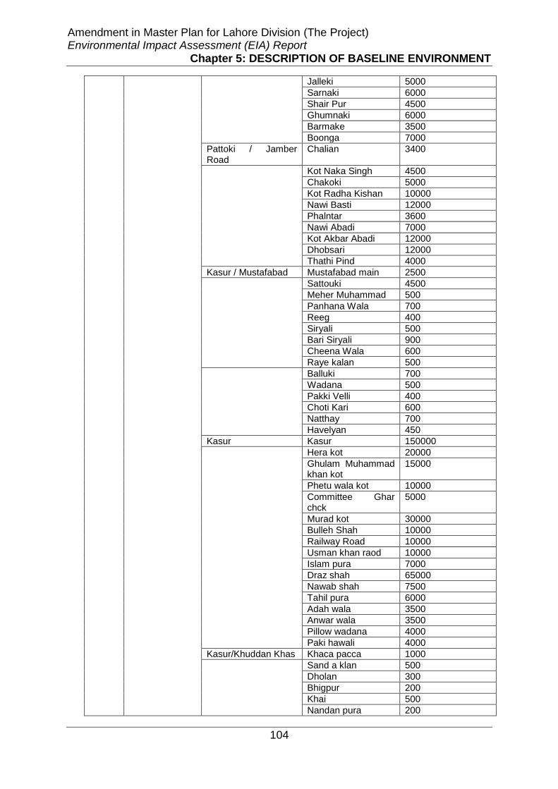
Amendment in Master Plan for Lahore Division (The Project) Environmental Impact Assessment (EIA) Report
Chapter 5: DESCRIPTION OF BASELINE ENVIRONMENT
104
Jalleki 5000
Sarnaki 6000
Shair Pur 4500
Ghumnaki 6000
Barmake 3500
Boonga 7000
Pattoki / Jamber Road
Chalian 3400
Kot Naka Singh 4500
Chakoki 5000
Kot Radha Kishan 10000
Nawi Basti 12000
Phalntar 3600
Nawi Abadi 7000
Kot Akbar Abadi 12000
Dhobsari 12000
Thathi Pind 4000
Kasur / Mustafabad Mustafabad main 2500
Sattouki 4500
Meher Muhammad 500
Panhana Wala 700
Reeg 400
Siryali 500
Bari Siryali 900
Cheena Wala 600
Raye kalan 500
Balluki 700
Wadana 500
Pakki Velli 400
Choti Kari 600
Natthay 700
Havelyan 450
Kasur Kasur 150000
Hera kot 20000
Ghulam Muhammad khan kot
15000
Phetu wala kot 10000
Committee Ghar chck
5000
Murad kot 30000
Bulleh Shah 10000
Railway Road 10000
Usman khan raod 10000
Islam pura 7000
Draz shah 65000
Nawab shah 7500
Tahil pura 6000
Adah wala 3500
Anwar wala 3500
Pillow wadana 4000
Paki hawali 4000
Kasur/Khuddan Khas Khaca pacca 1000
Sand a klan 500
Dholan 300
Bhigpur 200
Khai 500
Nandan pura 200

Amendment in Master Plan for Lahore Division (The Project) Environmental Impact Assessment (EIA) Report
Chapter 5: DESCRIPTION OF BASELINE ENVIRONMENT
105
Ding shan 700
Rait chala 400
Cher kot 700
Bgaban pura 900
Saad 300
Rakh wala 200
Nain wala 210
Said sad 230
Wiran gaggia 250
Noor pura 175
Todho wala 200
Fakeer wala 350
Doholy wala 170
4. Nankana Sahib Nankana Sahib Mandi Faizabad 2500
Syed Wala 2000
Bucheki 4000
Nankana Sahib 5500
More Khundal 3000
Warburton 4000
Shah Kot Shah kot-I 12000
Shah kot-II 1500
Sangla Hill Sangla Hill 7000
Total population 994085
Health: The survey indicates out of 135 villages there are 17 Private & Public
Hospitals and 10 basic health units in Project area, 120 private practitioners (not
qualified doctors but dispensers, quakes, etc) are practicing as health facility
provider in different villages.
Table 5 . 5 Available Health Facilities
Sr. No. Name of Facility No. of Health
Facility Percentage
%
1 Basic Health Unit (BHU) 10 7
2 Hospital 20 13
3 Private Practitioner 120 80
Total 150 100

Amendment in Master Plan for Lahore Division (The Project) Environmental Impact Assessment (EIA) Report
Chapter 5: DESCRIPTION OF BASELINE ENVIRONMENT
106
Education: Survey indicates that, out of 135 villages/towns 90 % villages/towns
have education facility from primary to higher secondary levels. There is one
Veterinary university present in the project area. In 10% villages, there is no
educational facility, even at primary school level. The parents have to send their
children to the nearest village where school is available. Girl’s schools are far less
than schools for boys in the project area. Therefore, it is difficult for the girls to
having access to educational institution. Traveling long distance to access the school
for girls is the main cause of illiteracy.
Table 5 . 6 Availability of Educational Facility
Education Facility Villages/Towns Percentage %
Not Available 13 10
Available 122 90
Total 135 100

Amendment in Master Plan for Lahore Division (The Project) Environmental Impact Assessment (EIA) Report
Chapter 5: DESCRIPTION OF BASELINE ENVIRONMENT
107
Electricity: It is evident from the survey results that 97% villages/towns have
electricity facility, whereas 3% villages do not have the facility of electricity. The
villages/towns, where electricity facility is not available, people use kerosene oil as a
source of light.
Table 5 . 7 Availability of Electricity
Electricity Villages/Towns Percentage %
Available 131 97
Not Available 04 03
Total 135 100
Natural Gas Supply: The survey reveals that only 27% villages/towns of the total
project area are enjoying the natural gas facility provided by government; while,
significant number of villages (73%) have to use wood or gas cylinders for fuel
purpose.
Table 5 . 8 Availability of Natural Gas Facility
Natural Gas Supply
Villages/Towns Percentage %
Available 37 27
Not Available 98 73
Total 135 100

Amendment in Master Plan for Lahore Division (The Project) Environmental Impact Assessment (EIA) Report
Chapter 5: DESCRIPTION OF BASELINE ENVIRONMENT
108
Telephone Facility: Most of the people use mobile telephone facility; however, the
availability of landline telephone facility in the surveyed villages indicates that 70%
villages have telephone facility and 30% villages do not have telephone facility. In
30% villages where telephone facility is not available, the only option is to use mobile
phones; however the signal strength is weak for mobile phones in these areas.
Table 5 . 9 Availability of Landline Telephone Facility
Telephone Villages/Towns Percentage %
Available 94 70
Not Available 41 30
Total 135 100
Transport: The survey results indicate that people of 58% villages have access on
public transport e.g. bus, van and Rickshaw (Chingchi) etc for traveling purpose. The
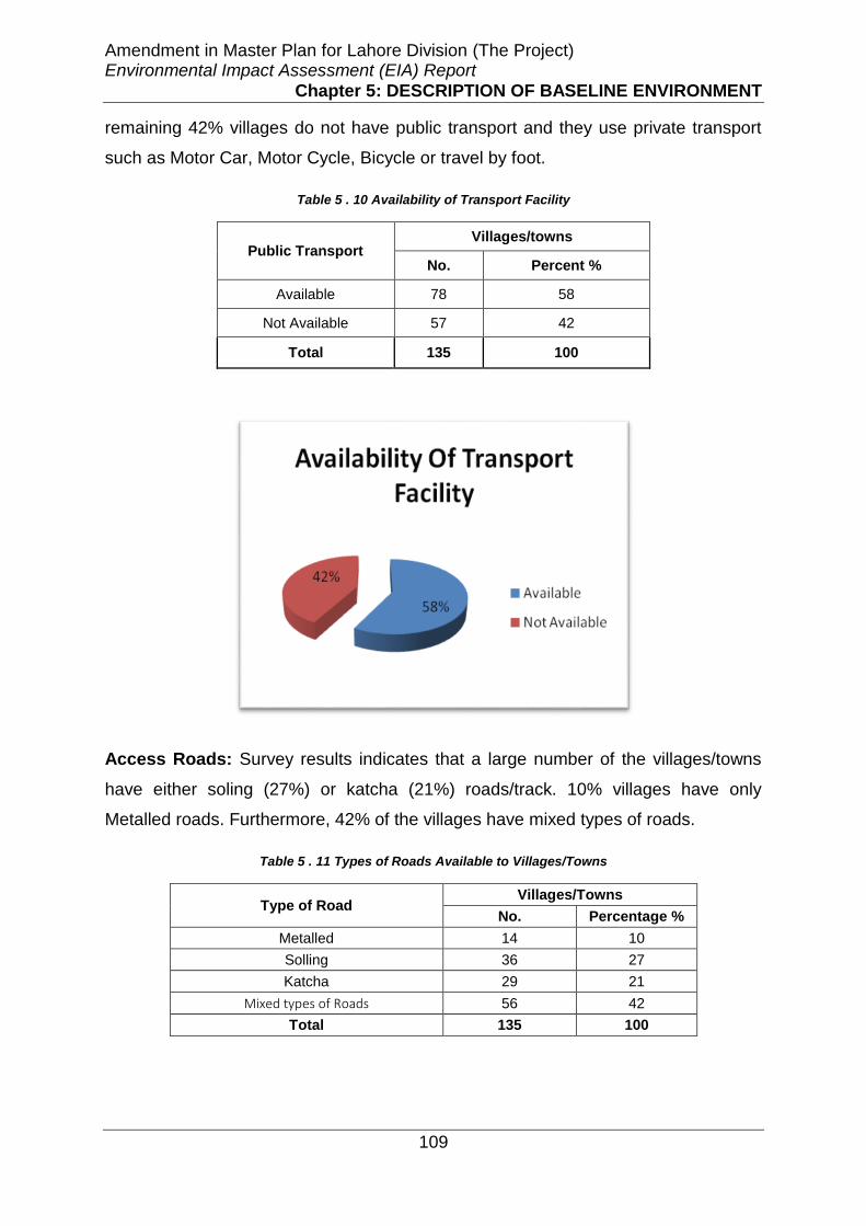
Amendment in Master Plan for Lahore Division (The Project) Environmental Impact Assessment (EIA) Report
Chapter 5: DESCRIPTION OF BASELINE ENVIRONMENT
109
remaining 42% villages do not have public transport and they use private transport
such as Motor Car, Motor Cycle, Bicycle or travel by foot.
Table 5 . 10 Availability of Transport Facility
Public Transport Villages/towns
No. Percent %
Available 78 58
Not Available 57 42
Total 135 100
Access Roads: Survey results indicates that a large number of the villages/towns
have either soling (27%) or katcha (21%) roads/track. 10% villages have only
Metalled roads. Furthermore, 42% of the villages have mixed types of roads.
Table 5 . 11 Types of Roads Available to Villages/Towns
Type of Road Villages/Towns
No. Percentage %
Metalled 14 10
Solling 36 27
Katcha 29 21
Mixed types of Roads 56 42
Total 135 100
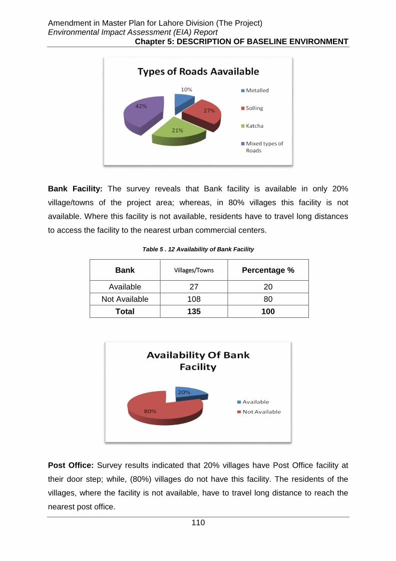
Amendment in Master Plan for Lahore Division (The Project) Environmental Impact Assessment (EIA) Report
Chapter 5: DESCRIPTION OF BASELINE ENVIRONMENT
110
Bank Facility: The survey reveals that Bank facility is available in only 20%
village/towns of the project area; whereas, in 80% villages this facility is not
available. Where this facility is not available, residents have to travel long distances
to access the facility to the nearest urban commercial centers.
Table 5 . 12 Availability of Bank Facility
Bank Villages/Towns Percentage %
Available 27 20
Not Available 108 80
Total 135 100
Post Office: Survey results indicated that 20% villages have Post Office facility at
their door step; while, (80%) villages do not have this facility. The residents of the
villages, where the facility is not available, have to travel long distance to reach the
nearest post office.

Amendment in Master Plan for Lahore Division (The Project) Environmental Impact Assessment (EIA) Report
Chapter 5: DESCRIPTION OF BASELINE ENVIRONMENT
111
Table 5 . 13 Post Office Facility
Post Office Villages/Towns Percentage %
Available 27 20
Not Available 108 80
Total 135 100
Domestic Water Supply: An easy access to potable / safe drinking water is one of
the basic human rights and needs. Survey indicates that the residents of the total
project area are deprived of tapped water supply system; only 2% people have this
facility. Most of the population of project area (94%) use both hand pumps and
electric motor pumps to extract ground water for domestic water usage. There are
only 4% of villages where extraction of ground water is being carried out only
through hand pumps.
Table 5 . 14 Domestic Water Supply System
Water Supply System Villages/ Towns Percentage %
Tapped Water Supply, Electric Motors and Hand Pumps
3 02
Electric Motors and Hand Pumps 127 94
Hand Pumps only 5 04
Total 135 100
20%
80%
Post Office Facility
Available
Not Available
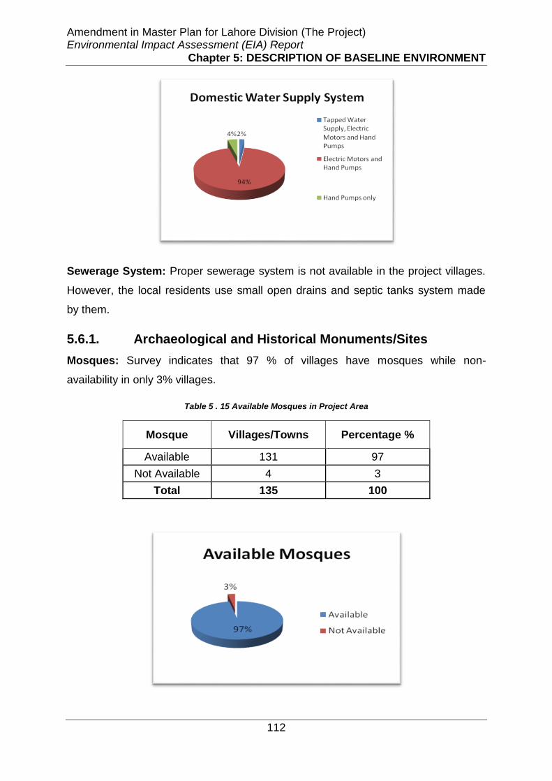
Amendment in Master Plan for Lahore Division (The Project) Environmental Impact Assessment (EIA) Report
Chapter 5: DESCRIPTION OF BASELINE ENVIRONMENT
112
Sewerage System: Proper sewerage system is not available in the project villages.
However, the local residents use small open drains and septic tanks system made
by them.
5.6.1. Archaeological and Historical Monuments/Sites
Mosques: Survey indicates that 97 % of villages have mosques while non-
availability in only 3% villages.
Table 5 . 15 Available Mosques in Project Area
Mosque Villages/Towns Percentage %
Available 131 97
Not Available 4 3
Total 135 100

Amendment in Master Plan for Lahore Division (The Project) Environmental Impact Assessment (EIA) Report
Chapter 5: DESCRIPTION OF BASELINE ENVIRONMENT
113
Graveyards: 90% villages have graveyard out of total 135 surveyed villages.
However, 10% villages do not have graveyards.
Table 5 . 16 Graveyards in Project Area
Graveyard Villages/Towns Percentage %
Available 121 90
Not Available 14 10
Total 135 100
Shrines: 75% villages have shrines whereas, 25% villages do not have shrines.
Table 5 . 17 Shrines in Project Area
Shrines Villages/Towns Percentage %
Available 101 75
Not Available 34 25
Total 135 100

Amendment in Master Plan for Lahore Division (The Project) Environmental Impact Assessment (EIA) Report
Chapter 5: DESCRIPTION OF BASELINE ENVIRONMENT
114
Irrigation System: Study revealed that 52% Villages/Towns depend upon tube well
(ground water) for irrigation purpose and 48% Villages/Towns use canal water for
their agriculture lands. Multiple Responses were recorded in each village due to
availability of more than one option.
Table 5 . 18 Irrigation System Usage in Project Area
Irrigation System Percent %
Canal 48
Tube well 52
Total 100
Housing Structures: Housing characteristics of the population indicate the living
condition and social well-being. Survey indicates that 93.6% of the houses of the
selected households in the Project Area are Pucca, while 2.4% are Katcha, and 4%
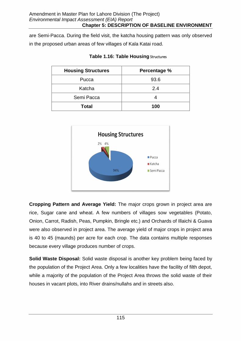
Amendment in Master Plan for Lahore Division (The Project) Environmental Impact Assessment (EIA) Report
Chapter 5: DESCRIPTION OF BASELINE ENVIRONMENT
115
are Semi-Pacca. During the field visit, the katcha housing pattern was only observed
in the proposed urban areas of few villages of Kala Katai road.
Table 1.16: Table Housing Structures
Housing Structures Percentage %
Pucca 93.6
Katcha 2.4
Semi Pacca 4
Total 100
Cropping Pattern and Average Yield: The major crops grown in project area are
rice, Sugar cane and wheat. A few numbers of villages sow vegetables (Potato,
Onion, Carrot, Radish, Peas, Pumpkin, Bringle etc.) and Orchards of Illaichi & Guava
were also observed in project area. The average yield of major crops in project area
is 40 to 45 (maunds) per acre for each crop. The data contains multiple responses
because every village produces number of crops.
Solid Waste Disposal: Solid waste disposal is another key problem being faced by
the population of the Project Area. Only a few localities have the facility of filth depot,
while a majority of the population of the Project Area throws the solid waste of their
houses in vacant plots, into River drains/nullahs and in streets also.

Amendment in Master Plan for Lahore Division (The Project) Environmental Impact Assessment (EIA) Report
Chapter 5: DESCRIPTION OF BASELINE ENVIRONMENT
116
Language Spoken: Main languages spoken in the Project Area is Punjabi. While
only few people speak Urdu due to it is the official language. Few Pashto speaking
people were also found and consulted in the Project Area.
Settlements Pattern: The settlement pattern of the Project Area has a mixed origin
i.e. urban, semi-urban and rural. Few areas of Lahore, Sheikupura, Kasur and
Nankana districts are urban or semi urban such as Farooqabad, Nawakot and
ferozwala etc. Large number of all types of industries small, medium and large scale
exist within and outside the project Area.
Sex Ratio: According to the survey 53 % population in the project area are male
while 47 % are the female
53%47%
Sex Ratio
Male
Female

Amendment in Master Plan for Lahore Division (The Project) Environmental Impact Assessment (EIA) Report
Chapter 6: SCREENING OF POTENTIAL ENVIRONMENTAL IMPACTS AND MITIGATION MEASURES
117
CHAPTER6
SCREENING OF POTENTIAL ENVIRONMENTAL IMPACTS AND MITIGATION MEASURES
6.1. General
This chapter identifies the identified potentially significant environmental and social
impacts which are likely to arise due to the proposed intervention on the physical,
ecological and socio-cultural environment of the Project Area as well as Study Area.
Proposed project has three main stages i.e. planning, implementation development
and operation.This chapter also identifies and suggests practically possible and
economically viable mitigation and remedial measures that will help to avoid, reduce
or compensate the identified potentially significant adverse environmental and social
impacts and enhancement of the potential benefits of the Master Plan.
6.2. Approach Adopted for Impacts Identification and
Mitigation Measures
The proposed Project is at the planning stage and topographic survey and detailed
design for all the proposed facilities has to be carried out at later stages. To identify
the potentially significant adverse environmental and social impacts checklists,
matrices and overlays were used.
Impact Identification
In this regards, initially checklist method was used to screen out the potentially
significant and insignificant impacts. Checklist was developed for physical, ecological
and socio-cultural environment by the experts keeping in view the type of existing
uses, future trends without proposed intervention and with proposed intervention
based on the critical parameters related to the land use and other infrastructure
utilities and facilities in the Project Area.

Amendment in Master Plan for Lahore Division (The Project) Environmental Impact Assessment (EIA) Report
Chapter 6: SCREENING OF POTENTIAL ENVIRONMENTAL IMPACTS AND MITIGATION MEASURES
118
After the initial screening of impacts through checklists, matrices were used to
evaluate the temporal based potentially significant environmental and social impacts
of the proposed Project. The Impact Evaluation Matrix was developed by placing
project activities along one axis (i.e. Y-axis), and on the other axis (i.e., X-axis) the
different environmental parameters likely to be affected by the proposed project
actions grouped into categories i.e. physical, ecological and socio-economic
environment. For the impact assessment, project impact evaluation matrix is used by
dividing the project action into different project phases i.e. planning, development
and operation.
In order to identify the spatial based (location based) impacts, overlays are used. An
overlay is based on a set of transparent maps each of which represents the spatial
distribution of environmental characteristics (for example land use changes from
agriculture to residential, floods etc.). Information for an array of variables is
collected for the standard geographical units within the Project Area and recorded in
a series of maps typically one for each parameter. These maps are overlaid to
produce a composite map. The resulting composite maps characterize the area’s
physical, ecological, socio-economic and other relevant characteristics relative to the
location of the proposed Project. Software used for the overlays are Arc View and
AUTOCAD. For the subject Project digitized available Google Earth Imageries and
ARC GIS was used to prepared overlay maps.
In addition to this, estimation through project stages was another tool which was
used to identify the impacts. For impact assessment, Lahore Division area under the
jurisdiction of the LDA was considered as Study Area due to the reasons that almost
all the project activities have to be carried out within this area. The Project Area is
the sites selected for the Master Planning within the Lahore Division. All in all there
are total 48 sites located in Lahore, Kasur, Sheikhupure and Nankanasahid districts.
Map of Study Area including the Project Area is shown in Figure 5-1.
Mitigation Measures
A three-step process of mitigation was adopted for the proposed Master Plan, based
on the hierarchy of elements into the stages of the EIA process when they are
typically applied. Generally, as project design becomes more detailed, the
opportunities for impact avoidance narrow and the concern are to minimize and
Amendment in Master Plan for Lahore Division (The Project) Environmental Impact Assessment (EIA) Report
Chapter 6: SCREENING OF POTENTIAL ENVIRONMENTAL IMPACTS AND MITIGATION MEASURES
119
compensate for unavoidable impacts. However, these distinctions are not rigid and
opportunities for creative mitigation should be sought at all stages of EIA and project
planning.
Impact avoidance.
This step is most effective when applied at an early stage of project planning. It can
be achieved by:
not undertaking certain projects or elements that could result in adverse
impacts;
avoiding areas that are environmentally sensitive; and
putting in place preventative measures to stop adverse impacts from
occurring, for example, change in alignment of the road to avoid resettlement
issues.
Impact minimization.
This step is usually taken during impact identification and prediction to limit or reduce
the degree, extent, magnitude, or duration of adverse impacts. It can be achieved by:
scaling down or relocating the proposal;
redesigning elements of the project; and
taking supplementary measures to manage the impacts.
Impact compensation.
This step is usually applied to remedy unavoidable residual adverse impacts. It can
be achieved by:
rehabilitation of the affected site or environment, for example, by habitat
enhancement and conservation of river riparian areas;
restoration of the affected site or environment to its previous state or better,
as typically required for mine sites, forestry roads and seismic lines; and
replacement of the same resource values at another location, for example, by
wetland engineering to provide an equivalent area to that lost to drainage or
infill.

Amendment in Master Plan for Lahore Division (The Project) Environmental Impact Assessment (EIA) Report
Chapter 6: SCREENING OF POTENTIAL ENVIRONMENTAL IMPACTS AND MITIGATION MEASURES
120
6.3. Positive Environmental Impacts Resulting from
the Project Operation
Following are the main positive impacts are envisaged due to the implementation of
the proposed projects under LDA;
• Master Planning will guide the land use trends of the Lahore Division in a
manner that will ensure the sustainable use of available natural resources
and utilities services.
• The infrastructure and utility services in the project areas is likely to become
better than at present due to implementation and development of master
plan.
• The migration from small city towards large city for better facilities will
become lesser having better and improved facilities in small city.
• The implementation of the master plan will increase the employment rate
with livelihood as it involves development of residential and industries
areas, public administration, institutions and infrastructure facilities.
• There will be more employment opportunities, health care and educational
facilities in all project areas due to the implementation of master plan.
• The implementation of master plan brings improvement in the industrial
sector due to enhance space given for the industry and increase in
industrial areas. The cluster of different type of industries in the industrial
area will bring industrial symbiosis.
• The implementation of proposed master plan will result in promoting healthy
environment in terms of the availability of safe and clean water, availability
of sanitation facilities, health and education facilities.
• By the implementation of master plan the quality of life will increase due to
the availability of basic facilities like health, education and road networks
at their door step.
Amendment in Master Plan for Lahore Division (The Project) Environmental Impact Assessment (EIA) Report
Chapter 6: SCREENING OF POTENTIAL ENVIRONMENTAL IMPACTS AND MITIGATION MEASURES
121
• The scenic beauty of the area may be improved in the operation phase due
to the public parks and play grounds.
• Public parks & play grounds will be a major source of entertainment and
recreation for the locals, which may decrease the tensions of the domestic
life of the people.
• Due to implementation of master plan the living standard of women in the
project area will increase due to the availability of basic facilities at their
door step like health, education and easy market accessibility that ultimate
helps woman to perform their daily house activities efficiently.
6.4. Environmental Impacts during Planning Stage
and Mitigation Measures
Following is the description of the potentially significant impacts envisaged during the
planning stage which includes all the activities before the implementation stage of
the project:
6.3.1.1. Groundwater Resources
Good quality potable water is a fundamental requirement for human health
and survival. Lahore and adjoin areas forming is the second largest city of
Pakistan. Its population is increasing at a rapid rate of 3.2 per cent per year.
In 1901 the population of Lahore was 0.203 million which, by 1990, has
increased to about 5 million. At present, the population is near more than 10
million.
Lahore district and city due to fast growth of population, poor town-planning
(non-compliance of laws and regulations as well as IMPL) and
industrialization are causing problems in supplying public services. Supply
and sustainability of clean water stands among the most crucial problems
related to proposed Master Planning.
The sole supply of water to the Lahore Division depends upon the abstraction
of groundwater. Potential rapid growth rate of population, progressive
migration of people from the nearby areas towards the city and the
establishment of numerous industries has resulted in rapid increase in water
demand.
The number of wells and, hence, the groundwater abstraction willbe on
increasing in accordance with the growth of population, housing schemes and
industrial zones.

Amendment in Master Plan for Lahore Division (The Project) Environmental Impact Assessment (EIA) Report
Chapter 6: SCREENING OF POTENTIAL ENVIRONMENTAL IMPACTS AND MITIGATION MEASURES
122
On the other hand, proposed urbanization and industrialization has the
tendency to reduce the ground water recharge, as a significant part of the
land has become impermeable.
With the increasing number of tubewells, the groundwater level, which used to
exists at about minimum encountered 4.5 m deep has already started
declining rapidly. A decline of 15.5 meters in water-table during 1960 to 1991
was noticed in Lahore City (Alam, 1996).At present, the water-table in the
central area of the city has gone down to 28 m from the surface level (WASA,
1999). In accordance with recent study the depletion rate of ground water for
Lahore district is about 2.5-3.0 feet per year.
The existence of saline groundwater in the nearby areas of Raiwind and
Kasur, in the south of Lahore, is a potential threat to the aquifer under the
Lahore city. There is a danger of deterioration of the aquifer water-quality if
the saline water finds a path to reach the city area due to the potential
increase in the abstraction by the proposed residential and industrial areas.
The flushing out of this saline water, if it once enters the aquifer, would then
be nearly impossible.
Development of water supplies to serve the local needs is particularly
challenging in adjoin areas of the Lahore such as Nankana, Kasur, Sheakupra
areas where natural conditions potential to cater the anticipated future
demands of the amount of groundwater resources available and aquifers
water resource development. As such, these areas should be identified for
potential project sponsors.
6.3.1.2. Surface Water Resources and Quality
Currently the entirewastewater from Lahore District is collected through
a network of 14 main drains and discharged into the River Ravi without
any treatment. The wastewater from Nankana, Shiekhpura and part of
Kasur districts are also finally discharged in to the River Ravi. The
waste water from southern part of Kasur district is discharge in to River
Sutlej. This wastewater has been discharge into the rivers without any
treatment and contains category of industrial, commercial and
residential wastewater. Due to non-availability of fresh water in River
Ravi, the river is converted in to sewage.
The high pollution load in river Ravi has created overall negative
impact on ground water as well as on agriculture which is being done
on adjacent to the river and where river water is directly used for
irrigation. Already some studies have been found high values of heavy
metals in crops that have been grown in adjacent to the river Ravi.

Amendment in Master Plan for Lahore Division (The Project) Environmental Impact Assessment (EIA) Report
Chapter 6: SCREENING OF POTENTIAL ENVIRONMENTAL IMPACTS AND MITIGATION MEASURES
123
With the potential to increase in the residential areas, housing schemes
and industrial areas in districts of Lahore division the pollution level and
quantities of wastewater is likely to increase many folds which may
have negative impact on agriculture, ground water and human health.
6.3.1.3. Flood
The project sites include two rivers i.e. Ravi and Sutlej and number of canals
and drains so there is chance of flood hazard to occur at the project sites.
According to the PDMA-DRP, the River Ravi belongs to the category B
flooding (medium Level Flood). Two categories of flood can occur in the
project area i.e. urban and riverine. The recent flood noted in River Ravi is at
Shahdara Gauging Station is 250,000 cusecs and considered as medium
flood level. This is the highest flood level noted in River Ravi after year 2000
as construction of Thein Dam on Indian side greatly reduces the flows in River
Ravi while the highest flood that observed in River Ravi is in 1988 which was
around 586,000 cusecs.
In Sutlej RiverMost of the flow is yielded by heavy monsoon rains. The
maximum recorded flood discharge occurred in 1955, when the river flowed at
nearly 600,000 cubic feet (17,000 cubic metres) per second. The risk of floods
has drastically reduced since construction of series of dams on Sutlej River on
Indian side.
Flood is considered as most drastic and re-occurring hazards in Pakistan.
Roughly 1.84 million people across Pakistan have been affected by floods
triggered by heavy monsoon rains. At least 346 people have been killed and
620 others have been injured in flood-related incidents, according to the latest
figures released by the National Disaster Management Authority (NDMA).
The most recent flood was occurred in current year of 2014 and considered
as one of the biggest flood in the history of Pakistan. According to the
National Disaster Management Authority (NDMA) almost 312 people have
died, with 2,275,000 affected and nearly 1.7 million acres (687,965 hectares)
of crops lost due to this recent flood. The most affected were in Punjab
Province and declared a state of emergency.
Following settlements of project area have a potential risk of flooding in river
Ravi for 100 years return period in accordance with short term hydrological
study attached as Appendix III. The settlements include Bhai Pheru, Bucheki,
Mandi Faizabad, Mor Khunda, and Syed Wala can subjected to flooding.
The settlement Ferozwala is under potential threat of flooding due to Deg
Nallah
. The settlement Muredke is under potential threat of flooding due to Nikki Deg
Drian
The map of flood prone areas are attached as Annex III

Amendment in Master Plan for Lahore Division (The Project) Environmental Impact Assessment (EIA) Report
Chapter 6: SCREENING OF POTENTIAL ENVIRONMENTAL IMPACTS AND MITIGATION MEASURES
124
The short term hydrological study which shows each river flow and each
project area analysis in accordance with flooding is attached as Appendix III
6.3.1.4. Climate Change
Pakistan is rated among the top 10 most vulnerable countries to climate change. The
government estimates that Pakistan has, collectively, suffered losses to the tune of
$20 billion due to the adverse and increasing effects of climate change.“Pakistan is
among the countries which are most vulnerable to climate change, and has a very
low technical and financial capacity to adapt to its adverse impacts in accordance
with one report submitted in November 2015 in National Assembly.
The major concerns of climate change in reference to our project site areas are
given as under-;
Increased variability of Monsoon;
Projected recession of Glaciers threatening IRS Flows;
Increased risks of Extreme Events (floods, droughts, cyclones, extreme high /
low temperatures etc.);
Severe water- and heat-stressed conditions in arid and semi-arid regions
leading to reduced agricultural productivity;
Increase in Deforestation; Loss of Biodiversity;
Health Risks
The major extreme climatic events in reference to our project areas are given as
under-:
Isolated hailstorm in and around urban area of Lahore in 2011
Urban Flooding in Lahore due to extreme rainfall of about 46.7 inches in
2013
Localized Cloud Burst rains causing urban flooding in Lahore (1996)
Large scale flooding in 1988 and 1992 in Lahore
History's worst drought during 1999 – 2002 in Lahore
Intense heat waves during 2003, 2005, 2007 and 2010 (53.7 °C) in Lahore
The climate change poses the serious threat in project areas if not mitigated or
without an adaptive capability for the extreme climatic events. Further detail Climate
Change Vulnerability Assessment of Lahore Division is required for detail analysis of
climate change with mitigation and adaptive strategies.

Amendment in Master Plan for Lahore Division (The Project) Environmental Impact Assessment (EIA) Report
Chapter 6: SCREENING OF POTENTIAL ENVIRONMENTAL IMPACTS AND MITIGATION MEASURES
125
6.3.1.5. Land Resources
The LDA will require land acquisition for:
• Widening and improvement of the existing roads
• Development of bypass roads for various existing town/villages etc.
• Development of inter town and villages roads,
• Development of new main roads, connecting roads, accessibility roads,
• Sewerage systems including pumping stations, disposal stations, treatment
plants.
• Development of recreational areas, public utilities, buildings, administration
buildings, toll stations, weighing stations
6.3.1.6. High Voltage Transmission Lines
The high voltage transmissions line are passing and planned to be passed form
some of the project areas. These transmissions line if not been buffered have variety
of health impacts on human. The short term health impacts include Headaches,
Fatigue, Anxiety, Insomnia, Prickling and/or burning skin, Rashes and Muscle pain.
The long term health impacts include risk of damaging DNA, risk of cancer, risk of
leukemia, risk of neurodegenerative disease and risk of miscarria.
6.3.1.7. Transportation
Today big Cities mainly depend on transport system for their economic survival and
socio-environmental sustainability and the transport system has a direct impact on all
sectors of an economy. The impacts of ill-planned transport system on human
environment include congestion, more energy consumption, pollution, traffic crashes,
wastes time, delay, decreases productivity and imposes costs on society. There has
been a major growth of traffic volume in Lahore over the past two decades due to
increase in urban population with a large number of vehicle owners and citizens who
transact businesses from one part of the city to another. At present many
infrastructure facilities such as under passes, wide roads, bridges, signal free
Amendment in Master Plan for Lahore Division (The Project) Environmental Impact Assessment (EIA) Report
Chapter 6: SCREENING OF POTENTIAL ENVIRONMENTAL IMPACTS AND MITIGATION MEASURES
126
corridor etc. have been made in Lahore but increasing traffic volume rapidly
overburden these facilities at present and vigorously worsen in future. Due to these
factors there will be worst position if long-term planning of transportation in master
plan has not been done. The major impact would be seen on our economy if high
efficiency transport system will not be designed for Lahore division.
6.3.1.8. Solid Waste
Solid waste generation rate on average in Lahore City is approximately 0.85 kg per
capita per day. Considering 50 Million population of Lahore Division, the total
municipal solid waste will be generated 20,000 tons/day. It is hard to estimate the
medical waste because the number and capacity of hospitals have not been
assessed. Municipal solid waste produced from Lahore division if not managed
properly, will cause aesthetic problems and also produce odor along with the spread
of many diseases. Similarly, medical waste produced from medical facilities etc. if
not properly managed and disposed, it can result in injury by contaminated sha;rp
material and infection with Hepatitis B, C, and HIV etc.
At present proper solid waste management and disposal system exists in Lahore
district that is done by LWMC. A proper management system is working day and
night in the city which collects solid waste from all areas and disposes it off at Land
fill sites marked by the government. Apart from that many energy projects like waste
to energy, bio gas production from organic waste, Compost projects and landfill gas
electricity from LWMC are in progress
6.5. Mitigation Measures during Planning Stage
6.4.1. Ground Water
LDA through WASA should take measures to control demand by reducing per
capita water availability by educating households to use water more wisely.
For long-term sustainability of drinking water supplies, the possibility of
supplementing groundwater supplies with surface water supplies should be
explored, wherever possible. For Lahore division, provision of surface water
supply from the River Ravi or BRBD, UCC, QB Link etc. canal system may be
considered after addressing quality concerns.
New housing societies should also be made aware of the problem and their
groundwater extraction quota should be fixed based on specified per capita
demand.

Amendment in Master Plan for Lahore Division (The Project) Environmental Impact Assessment (EIA) Report
Chapter 6: SCREENING OF POTENTIAL ENVIRONMENTAL IMPACTS AND MITIGATION MEASURES
127
New housings and business commercial units should use water efficiency
equipment’s. This can be achieved through incentive programs to
homeowners and businesses to encourage replacement of plumbing fixtures
and appliances with water-efficient models.
Use high efficiency irrigation for agriculture use such as use drip irrigation
instead of flood irrigation
To increase recharge to groundwater, rainwater harvesting should be
encouraged in all new and old housing schemes and in areas proposed for
the residential and industrial use. For this purpose, special recharge zones
may be developed to facilitate groundwater recharge. While doing so rights of
downstream water users must be protected. In this regard, after considering
the provision of IRSA use of Sutlej river water can be considered.
In order to promote the culture of water conservation, a metering system
should be introduced to charge water on a volumetric basis. This will help in
reducing water use, in the same way as is being done for electricity, gas and
other utilities.
Water should be treated as an economic good and its exploitation rights be
given through a proper permit system and compatible prices especially to the
industrial sector. At the same time, existing environmental laws need to be
implemented seriously.
An integrated water resource management approach should be adopted by
involving all stakeholders for the protection of water quality. The linkage
between research and development needs to be strengthened.
• The following actions may help in the management and mitigation of water-
related industrial risks in the context of Master Plan:
Companies need to be conscious of their water footprints (i.e. water
use and wastewater discharge) throughout their entire value chain,
including suppliers and product use.
Companies might assess their physical, reputational and regulatory
risks and seek to align the evaluation with the company’s energy and
climate risk assessment.

Amendment in Master Plan for Lahore Division (The Project) Environmental Impact Assessment (EIA) Report
Chapter 6: SCREENING OF POTENTIAL ENVIRONMENTAL IMPACTS AND MITIGATION MEASURES
128
Engage key stakeholders (e.g. communities, NGOs, government
bodies, suppliers and employees) as part of risk assessment, long-
term planning and implementation activities.
Industries can monitor their water resources and continue to develop
strategies to maintain their water reserves and adopt management
practices geared towards creating efficiency per unit of production. •
Industries can invest in treating wastewater at source and reuse it. This
will build up their reputation in society and help in avoiding future water
risks.
Zoning of industries concept should be introduce such as to promote
water conservation in the industrial sector, attention must be given to
water intensive sectors.
• It is therefore, imperative to assess the mechanism of groundwater-
replenishment, pollution-levels and pollution-sources, for sustainable
development and conservation of these resources as a part of this updated
Master Plan of Lahore Division.
6.4.3.1. Surface Water Resource and Quality
Water quality challenges need to be addressed in an integrated manner and by
adopting pollution prevention strategies by LDA along with other concerned agencies
like EPA. Water pollution can be reduced by eliminating contaminants at source
which is the most effective way to protect water quality. The prevention of pollution at
source is a cost effective solution as less money is required on waste handling,
storage, treatment, remediation, and regulatory monitoring. Industrial units need to
recycle wastewater generated from one process into other processes if it satisfies
water quality standards. Water quality solutions include:
Industries have to install wastewater treatment plant at source and should
discharge the water that meets the NEQS. If possible the water should be
recycled in to other processes or can be used for flushing and washing.
Strict compliance is needed from enforcement agency like EPA on
wastewater effluent NEQS from industries
Wastewater treatment plant should have install on all the outfalls or drains
that falls in to the river Ravi

Amendment in Master Plan for Lahore Division (The Project) Environmental Impact Assessment (EIA) Report
Chapter 6: SCREENING OF POTENTIAL ENVIRONMENTAL IMPACTS AND MITIGATION MEASURES
129
Recommendations of River Ravi Commission should be followed, which
include development of constructed wetlands on drains before discharge into
the river Ravi
Regular monitoring of water quality. For this purpose, capacity of institutions
(staff, laboratories, technologies, finances) should be enhanced.
Water quality rules and regulations should be enforced in order to prevent the
discharge of untreated effluents from industries and each municipality.
A sustainable pollution control strategy needs to be devised in order to reduce
wastewater volumes. This approach may include the segregation of
wastewater streams, process modification techniques and recycling and reuse
of wastewater.
Proper education and awareness campaigns about the importance of water-
quality need to be launched. Media and non-governmental organizations
(NGOs) can play a vital role in this aspect.
Intelligentsia/academia should be encouraged to conduct research on finding
indigenous low-cost water treatment solutions for the industry.
6.4.3.2. Flood
Flood prone areas can be managed by following engineering solutions-:
Channelization and modification of river area from only where there is chance
of flood hazard to occur.
Develop large retention ponds in between river and flood prone identified
areas. Water can be trapped in a retention pond and then released at a
controlled discharge to prevent flooding.
Dikes/Bund should be developed precise to the identified flood prone areas
along the side of the rivers in order to prevent the flood.
6.4.3.3. Climate Change
Climate change is a global phenomenon and none of the countries, whether
big or small, can fight the battle alone. Therefore, international bodies such as
Intergovernmental Panel on Climate Change (IPCC) have been established
which regularly monitor various aspects related to climate change such as the
patterns of carbon consumption, weather phenomena, climate-related
extremes and regional and global effects. Additionally, a greater part of

Amendment in Master Plan for Lahore Division (The Project) Environmental Impact Assessment (EIA) Report
Chapter 6: SCREENING OF POTENTIAL ENVIRONMENTAL IMPACTS AND MITIGATION MEASURES
130
responsibility lies on the individual countries as well. Many countries have
established indigenous bodies to assess the regional impacts of climate
change and to devise effective strategies to mitigate.In Pakistan Climate
Change Policy and Framework have been developed in 2010 by Ministry of
Climate Change. This policy and framework till yet not have been
implemented and we have still face challenges of climate change. In order to
effective mitigation and adaptation towards climate change, the Government
has to implement the climate changepolicy and its framework at sectorial,
institutional and departmental level on urgent basis.
Detail Climate change venerability assessment study is needed for Lahore
division
The infrastructure should be designed in respect to the extreme climatic
events in order to prevent urban flooding and urban heat island effect.
6.5.1.1. Land Resources
The land acquisition should be done in accordance with the land acquisition
act 1897 and its amendments. Compensation against land, structure,
disturbance allowance should be provided to the affecties as per market price.
6.5.1.2. High Voltage Transmission Lines
The National Transmission and Dispatch Company (NTDC) should share the plan
with Lahore Development Authority (LDA) for new transmission lines that are
proposed to pass from the project area. The LDA will mark the area in master plan
and adequate buffer zone at least 50 meters will be provided.
The LDA should also mark the area of already existing transmission lines that are
passing from the project area and adequate buffer zone along the transmission line
should be provided.
6.5.1.3. Transportation
The efficient transport system for Lahore Division should be designed and part of
detail master plan. The traffic reduction and efficient transport strategy should be
developed that mainly include-:
The public transport should have been improved through inter and intra city
mass transit that can be faster, cheaper, and more relaxing. It also helps
minimize environmental damage caused by excessive car use.
Private cars on road should be discouraged by increasing parking fee and
vehicle tax on owners.
Improve bicycle and pedestrian facilities and programs.

Amendment in Master Plan for Lahore Division (The Project) Environmental Impact Assessment (EIA) Report
Chapter 6: SCREENING OF POTENTIAL ENVIRONMENTAL IMPACTS AND MITIGATION MEASURES
131
6.5.1.4. Solid Waste
Currently in the City of Lahore LWMC is main responsible organization for
management of solid waste. Its jurisdiction needs to be increased in adjoining
area up to Lahore division Level and its coordination with local departments
needs enhanced.
Already landfill site present in Lahore at Mehmood Boti and one engineered
landfill site is present at lakhodair. The LWMC has already suggested landfill
sites and transfer stations in Lahore and Kasur region. The map of suggested
landfill sites and transfer stations are attached as Annex I
The Landfill Sites for other districts such as Nankana and Shiekhpura should
also be studied and develop and included in the master plan.
The municipal waste should be managed in accordance with waste
management hierarchy which is currently lacking in society and waste
management company.
Care must be taken as not to mix medical waste with municipal waste.
Medical waste need to be segregated and collected in house in accordance
with the Hospital Waste Management Rules, 2005. The LWMC has already
studied and plan out detail hospital waste management in Lahore district. The
collected waste should be given to LWMC for safe disposal in Landfill site
after autoclaving. Separate spaces have been given in Landfill for hospital
waste. Currently main disposal of hospital waste is through incineration which
should be stopped as incineration is now least preferred technology for
hospital waste management having problem of toxic air emissions.
6.6. Environmental Impacts during Development
Stage and Mitigations
6.5.1. Physical Environment
6.5.1.5. Land Resources
The contractors/LDA will require temporary acquisition of land for:
• Establishment of Contractor’s camp and other facilities.
• Disposal sites for safe disposal of surplus construction and excavated spoil
material.
• It is obvious that rental/leasing of land for establishing of Contractor’s
facilities will change the local land use pattern. However, the change in land
use will be temporary.

Amendment in Master Plan for Lahore Division (The Project) Environmental Impact Assessment (EIA) Report
Chapter 6: SCREENING OF POTENTIAL ENVIRONMENTAL IMPACTS AND MITIGATION MEASURES
132
• Potential conflicts may emerge with the landowners regarding the
restoration of temporarily acquired areas for establishing Contractor’s
facilities, particularly those for borrow and spoil disposal areas.
• Borrow pits and other landscape depressions, if left open, may prove
hazardous to human beings, livestock and wildlife. Moreover rain water
ponding in open pits can be a potential health hazard both for human beings
and livestock due to the mosquito breeding and the pollution caused by
stagnation of the water.
• Soil erosion may aggravate in the workshop areas as a result of improper
runoff drawn from the equipment washing-yards and improper management
of construction activities in hilly areas particularly in the vicinity of natural
streams. Soil erosion may also occur during the excavation of for roads,
sewerage and water supply lines in addition to quarry areas.
• The reduction in vegetative cover will reduce the binding capacity of the soil
and increase its susceptibility to erosion by the force of rainfall. The loss of
vegetative cover can increase propensity for landslides.
• Quarrying of rock from sandstone bed or picking of sand from the nullah
beds for use in the construction of masonry or gabion walls may lead to
destabilization of the slope and enhance land sliding.
• Scarified/scraped materials, if not disposed of properly, may contaminate
the soils.
• Land may be contaminated by the spillage of chemicals like fuels, solvents,
oils, paints and other construction chemicals and concrete. This normally
happens when these materials are transported in open or loosely capped
containers or by careless handling.
• The possible contamination of soil by oils and chemicals at campsites,
workshop areas, and equipment washing-yards may limit the future use of
land.
Amendment in Master Plan for Lahore Division (The Project) Environmental Impact Assessment (EIA) Report
Chapter 6: SCREENING OF POTENTIAL ENVIRONMENTAL IMPACTS AND MITIGATION MEASURES
133
• Potential conflicts may emerge with landowners regarding the restoration of
temporarily acquired areas for establishing contractor’s facilities, particularly
those for borrow and spoil disposal areas.
6.5.1.6. Water Resources
• Surface water resources may be contaminated by the spillage of fuel and
chemicals or by dumping of waste material and effluents generated by the
kitchens and toilets at the construction campsites.
• Natural streams and canals may be contaminated with chemicals, oil,
lubricants, detergents, etc. through runoff from the construction area,
construction camp and equipment washing-yards.
• Cutting of shrubs and trees will also accelerate the soil erosion, which will
cause the silting of natural streams.
• River, canals and nullahs may be contaminated with chemicals, oil,
lubricants, detergents, etc. through runoff from the construction area,
construction camp and equipment washing-yards.
• Sewage is generated from the construction camps. This may contaminate
surface and groundwater, if not disposed of properly.
6.5.1.7. Solid and Liquid Waste
Solid and liquid waste will be generated from construction camps and from
construction activities if not managed, it will pose threat to environment. If the waste
is allowed to be disposed in rivers/nullahs as well as on open areas, it will not only
cause litter and asthetic issues but will also cause contamination. Establishment of
construction camps will enhance the solid waste generation, which may cause
contamination. Nullahs may also be affected by chocking.
6.5.1.8. Ambient Air Quality
Due to the construction activities like excavation, clearing, leveling and
compaction with the use of machinery like batching plants, excavators,
dump truck, Road Rollers, Graders, Haul Trucks, cranes and other
transport vehicles etc. Most of these are using diesel engines that
generate noise and exhaust emissions. The possibility of exhaust
emissions increases when old vehicles/plants are utilized for the

Amendment in Master Plan for Lahore Division (The Project) Environmental Impact Assessment (EIA) Report
Chapter 6: SCREENING OF POTENTIAL ENVIRONMENTAL IMPACTS AND MITIGATION MEASURES
134
execution purposes. Generally, the above activity is generating
particulate- matter (PM10), smoke, dust, CO and NOx in the ambient
air, which is deteriorating the air quality and resulting in impacts on
human health, fauna and flora. The movement of heavy machinery and
vehicles on the dirt tracks is also causing fugitive dust emissions.
An air pollution source for this projects activities are unpaved roads.
Dust plumes behind vehicles moving along unpaved roads represent a
typical occurrence, since as the vehicle travels over an unpaved road,
the force of the wheels on the road surface causes pulverization of the
surface material. Particles are lifted and dropped from the rolling
wheels, and the road surface is exposed to strong air currents in
turbulent shear with the surface. The turbulent wake (behind the
vehicle) continues to act on the road surface after the vehicle has
passed (U.S. EPA, 1975). As an approximation, fugitive dust (dust
generated from unpaved roads is termed “fugitive dust” because it is
not discharged into the atmosphere in a confined-flow stream) from
unpaved roads can be considered to average about 75 lb per vehicle-
mile of travel (Hesketh and Cross, 1981). This dust would be a problem
for the surrounding communities and institutions. Fugitive dust is not
expected to be a problem for national monument as the fugitive dust
6.5.1.9. Noise Level
• During the implementation of the project a large amount of equipment and
construction plant will be utilized for construction of the works. The
equipment would include bulldozers, scrapers, excavators, compactors,
trucks, large capacity dumpers, graders, heavy duty cranes, concrete
batching plants and stone crushers. The operation and movement of such
equipment will increase the noise and vibration in the Project Area. The
impact will be significant when compared to the without project situation.
6.5.2. Ecological Environment
The potential impacts due to construction of proposed project activities on the
aquatic and terrestrial ecology of the area are given in detail in Appendix I-
Ecological Impact Study. However summary of main impacts are given as under-:
The main negative impacts expected from the implementation and construction of
this Master plan are; loss of agricultural land, loss of biodiversity, habitat loss and

Amendment in Master Plan for Lahore Division (The Project) Environmental Impact Assessment (EIA) Report
Chapter 6: SCREENING OF POTENTIAL ENVIRONMENTAL IMPACTS AND MITIGATION MEASURES
135
fragmentation, water, noise, air and light pollutions and change in groundwater
recharge capacity.
6.5.3. Socio-Cultural Environment
The main impacts envisaged during the construction stage of the projects under
master plan update are described below;
6.5.3.1. Local Communities/Workforce
• During the construction stage, noise and dust problems will affect the health
of the locals.
• Similarly, general mobility of the locals will be disturbed during this stage of
the project.
• Construction of the road as well as the widening of the nullahs may create
problems for the local residents as the drainage pattern may be disrupted.
Similarly, due to the disruption of the drainage pattern, local’s shortest way
to reach the main road will also be affected.
• During the construction stage, improper traffic management can create
problems of traffic flow and accidents on roads.
• Usage of the Community’s common resources like potable water, fuel wood,
etc. by the Contractor workforce may create conflicts between the
community and the Contractor.
• Improper arrangement of the disposal of construction materials may create
problems for the local residents during the construction stage of the project.
• Relocation/disturbance to the existing utilities like electric poles, telephone
poles, etc. may affect the routine life of the community.
• Slippage of the Contractor’s staff while working at nullals and canals may
occur.
6.5.3.2. Loss of Livelihood
• During the construction stage, the business of shopkeepers working in the
vicinity of the proposed projects may be affected due to the non-accessibility
of vehicles.

Amendment in Master Plan for Lahore Division (The Project) Environmental Impact Assessment (EIA) Report
Chapter 6: SCREENING OF POTENTIAL ENVIRONMENTAL IMPACTS AND MITIGATION MEASURES
136
• Agricultural land which is the main source of income of the people belonging
to the proposed residential and industrial zones, will be affected during the
construction stage.
• During the construction stage, the community will lose their livelihood as
they are doing jobs at this site.
6.5.3.3. Disruption of Cultural and Historical Properties
During the construction stage, a few parts of the cultural and archeological sites may
get affected by the widening of roads.
6.5.3.4. Cultural Issues
Induction of a foreign Contractor may cause cultural issues with the local community
due to the unawareness of the local social norms and values. Similarly, the induction
of outside labour during construction activities may create social problems like social
movements, protests in the form of processions, etc.
6.5.3.5. Gender Issues
• As the Project activities are being carried out within the
residential/agricultural/commercial areas of the local community, as a result
of it, women activities in the field may be affected during the construction
stage particularly in case of semi urban and rural areas.
• The induction of outside Contractor labour may create social and gender
issues due to the unawareness of local customs and norms. It may also
cause hindrance to the mobility of the local women.
6.7. Mitigation Measures
6.6.1. Physical Environment
6.6.1.1. Land Resources
• Land required for establishing contractor’s facilities including borrowing
earth material (if required) and dumping excess spoil will be leased directly
from private landowners by the Contractor. Rental terms will have to be
negotiated to the satisfaction of the landowners concerned. Supervisory
Consultants will monitor the process of restoration and ensure, through the

Amendment in Master Plan for Lahore Division (The Project) Environmental Impact Assessment (EIA) Report
Chapter 6: SCREENING OF POTENTIAL ENVIRONMENTAL IMPACTS AND MITIGATION MEASURES
137
terms of the construction contracts, that landowners are compensated
according to the terms of the lease agreements, and the restoration actions
agreed upon by the Contractors are duly carried out. The photo-
documentation of the existing land prior to temporary acquisition should also
be available, which will be beneficial to resolve the restoration conflicts
between the landowners and contractor.
• Construction camps and workshop will be located at a minimum distance of
250 m from the existing plantations and settlements, etc. This limit will be
500 m in case of batching plant.
• Prior to the commencement of construction activities, the Contractor will
submit a layout and location plan of the facilities to the Engineer-in-charge,
and LDA Project Management Unit (PMU), for its scrutiny and approval.
• As far as possible, waste land or barren land i.e. areas not under
agricultural, residential or forestation will be used for borrow material (if
required) and setting up Project facilities.
• Following protection measures should be adopted for slope stabilization;
Trimming down of the slopes
Provision of benches for safety of the cut faces
Provision of ditch type drain along the toe
Provision of small toe walls against highly dipping beds
Provision of chutes for dispersal of surface runoff
Drains will be constructed to prevent flooding on the carriageways and
surrounding areas in case of new roads.
• Good engineering practices will help in controlling the soil erosion both at
construction sites and in peripheral areas, particularly in borrow and
dumping areas and along the haul tracks. However, the following measures
will be adopted as per site conditions:
• Depending upon the side slopes, retaining walls will be provided for
ensuring the integrity of the road embankments against erosion especially in

Amendment in Master Plan for Lahore Division (The Project) Environmental Impact Assessment (EIA) Report
Chapter 6: SCREENING OF POTENTIAL ENVIRONMENTAL IMPACTS AND MITIGATION MEASURES
138
case of the flooding potential road in order to support the side slope, a
retaining wall will be necessary.
• For weak side slopes flood prone areas, vegetative cover will be provided to
check the erosion.
• The plantation for slope protection will be carried out, which will constitute
fast growing indigenous trees with deep root system for anchoring the soil
material and under growth of bushes and creeping grasses having capability
of developing mesh of shallow fibrous roots to protect the slope against
pitting from rain water.
• Main drainage courses should be lined to avoid soil erosion. Steep bed
slopes should be avoided.
• Barren lands or natural depressions should be used for dumping the
excavated spoil material ensuring that local drainage should not be
disturbed.
• All the lands to be identified for disposal of spoil may be acquired on
temporary basis on lease and after the needful, the land would be given
back to owner. It is desirable that the Contractor should carry out the
dumping in a systematic manner with stony material at the bottom and soil
material on the top (for at least one meter depth) and the area is properly
leveled so that the owner may bring this land into some economic use. This
will be an additional benefit of the Project to the local communities as there
is shortage of level land in the area for cultivation or otherwise.
• The Contractor will be required to train its workforce in the storage and
handling of materials like furnace oil, diesel, petrol and chemicals, etc., that
can potentially cause soil contamination. The Contractor will be required to
prepare training manual and module for all the construction related activities
along with the schedule of training program and submit to the supervisory
consultants for approval.
• Soil contamination by asphalt and other obnoxious materials will be
minimized by placing all the containers in caissons or dumped into pits lined

Amendment in Master Plan for Lahore Division (The Project) Environmental Impact Assessment (EIA) Report
Chapter 6: SCREENING OF POTENTIAL ENVIRONMENTAL IMPACTS AND MITIGATION MEASURES
139
with impervious liners to avoid contamination of soils/groundwater from
leachates.
• Proper drainage facility will be provided at the camp areas to avoid the
water accumulation, which will minimize the soil contamination.
• Proper solid waste management plan should be developed by the
Contractor and implemented to avoid the litter and any other waste
problems. Adequate number of solid waste containers should be placed
within the camp area and surroundings to ease in storage and
collection/disposal of solid waste.
6.6.1.2. Water Resources
• Availability of water for campsite facilities and construction purposes will be
ensured by the Contractor prior to the start of construction activities. The
Contractor will seek approval from the PMU and LDA/Local departments for
use of the water resources for construction purposes
• The Contractor will be required to liaise closely with the local communities to
ensure that any potential conflicts related to common resource utilization for
the Project purposes are resolved quickly.
• The Contractor will prepare guidelines for the workers for minimizing the
wastage of water during the construction activities and at campsites.
• Construction camps will be established in the area with adequate natural
drainage channels in order to facilitate flow of the treated effluents.
• The wastewater effluent from the Contractor’s workshops and equipment
washing-yards will be passed through gravel/sand beds to remove
oil/grease contaminants before discharging it into surface water sources.
Similarly, the wastewater effluent from the campsite will be treated before its
disposal into the surface water sources.
• Borrow pits and natural depressions with pre-laid impervious liners will be
used to dispose of scarified/scraped material, and then covered with soil.
• At appropriate locations, proper outfalls for the road side drains to divert
surface run-off from the carriageway, will be provided to prevent the flooding
of streams and nullahs.

Amendment in Master Plan for Lahore Division (The Project) Environmental Impact Assessment (EIA) Report
Chapter 6: SCREENING OF POTENTIAL ENVIRONMENTAL IMPACTS AND MITIGATION MEASURES
140
• A proper solid waste management plan (including storage, collection,
transportation and disposal) should be developed to avoid contamination of
the surface water resources.
• Batching plants should be placed at least 1 KM from any surface water body
present in the project site. Water reuse and recycling strategy should be
adopted on all batching plants
• During the construction activities it should be ensured that the paint or other
lubricants should not spilled into water channels.
6.6.1.3. Solid and Liquid Waste
• A site waste management plan should be made the responsibility of the
construction contractor to provide for the designation of appropriate waste
storage area on the site and a schedule for the timely collection and removal
of construction debris to an approved dump site.
• The organic waste produced during site clearing should be mechanically
mulched and composted at the site and used for landscaping.
• Providing adequate number of camps/restrooms for the workmen and waste
baskets and dumpsters is essential to keep the construction site clean and
pest free.
• Arrangements should be made for regular garbage collection and removal of
sewage from the construction site.
• Proper recycling techniques have to be followed for the recovery of
recyclable materials as this will not only reduce quantity of solid waste, but
will also provide suitable raw material for reuse.
• Proper disposal method (i.e. landfill) should be used keeping in view the
ground conditions and burning and dumping of solid waste into drains
should not be allowed.
• Contractor should instruct his work force not to throw solid waste here and
there, and common storage points should be made by the Contractor from

Amendment in Master Plan for Lahore Division (The Project) Environmental Impact Assessment (EIA) Report
Chapter 6: SCREENING OF POTENTIAL ENVIRONMENTAL IMPACTS AND MITIGATION MEASURES
141
where at the end of the day contractor should transport the whole day’s solid
waste to designated disposal site.
6.6.1.4. Ambient Air Quality
• The existing quarry sites will be used to borrow the aggregate materials.
• Asphalt plants should be located at least 500 m downwind from the
populated areas, wildlife habitats, and Contractors’ camps, to minimize the
impact of emissions.
• Asphalt and concrete batching plants should be equipped with dust control
equipment such as fabric filters or wet scrubbers to reduce the level of
particulate emissions.
• Vehicles and other construction machinery should be properly tuned and
maintained, to avoid hazardous level of emissions.
• The standards applicable to gaseous emissions generated by the
construction vehicles, equipment, and machinery will be enforced during the
construction of works.
• Where dust emissions are high, these will be reduced by a regular sprinkling
of water for keeping the dust settled, at least twice a day.
• In order to prevent environmental pollution, haul-trucks carrying, earth, sand,
aggregate and other materials will be kept covered with tarpaulin to help
contain the construction materials being transported within the body of each
carrier between the sites.
6.6.1.5. Noise Levels
• LDA in consultation with other concerned departments such as EPA, Punjab
will set up a system to monitor the noise levels in the Project Area near the
construction activities.
• LDA through PMU will facilitate the EPA in enforcing noise standards as
prescribed in the NEQS.
• For the construction machinery generating noise level in excess of that
prescribed in NEQS and WHO limits, Contractor will make arrangements to
Amendment in Master Plan for Lahore Division (The Project) Environmental Impact Assessment (EIA) Report
Chapter 6: SCREENING OF POTENTIAL ENVIRONMENTAL IMPACTS AND MITIGATION MEASURES
142
bring the noise level within applicable limits (including proper tuning of
vehicles and mufflers/silencers).
• Movements of the trucks and other construction machinery causing high
noise levels must be restricted at night time to avoid disturbance to the
nearby locality. Truck drivers should be instructed not to play loud music at
night and stop use of horn.
• Proper noise barrier boundary walls will be built on asphalt/ concrete plants
which come close to any locality.
• To protect sensitive receptors including schools and hospitals from noise,
thick tree plantation will be carried out towards the roadside, where there is
enough space available between the boundaries of schools and roads.
• In order to avoid the noise pollution in the congested areas as far as
possible Contractor should plan the construction activities in the off peak
hours.
6.6.2. Ecological Environment
The detail mitigation of negative impacts on ecological environment are given in
Appendix I. However summary of mitigation is given as under-:
Negative impacts on ecological environmental due to development of master plan
can be mitigated by; minimizing biodiversity loss by developing Green Infrastructure,
restoration of native vegetation on railroad and roadside verges and river and canal
banks, Identification and conservation of areas important for priority animal species,
planning for nature conservation through the restoration of ecological networks,
urban agriculture and kitchen gardening
6.6.3. Socio-Cultural Environment
6.6.3.1. Local Communities/Workforce
• Effective construction controls should be used by the Contractor to avoid
inconvenience to the locals due to noise, smoke and fugitive dust.
• Proper arrangements in the form of alternative routes should be made to
ensure that the mobility of locals should not be disturbed.

Amendment in Master Plan for Lahore Division (The Project) Environmental Impact Assessment (EIA) Report
Chapter 6: SCREENING OF POTENTIAL ENVIRONMENTAL IMPACTS AND MITIGATION MEASURES
143
• After consultation with the traffic police, a proper traffic management plan
should be prepared by the Contractor for mainroads specifically in order to
avoid accidents.
• The Contractor will take due care related to the disposal of construction
materials as well as solid waste disposal from the site, so that the nearby
communities will not suffer.
• The Contractor will take care of the local communities water sources so that
these should not be contaminated or destroyed.
• Safety lookouts should be built to prevent people and vehicles from passing
at the time of heavy equipment operation area.
• Haul-trucks carrying concrete, aggregate and sand fill materials will be kept
covered with tarpaulin to help contain construction materials being
transported between the sites.
• In construction camps, amenities of life including clean food, water and
sanitation facilities should be provided to these camps. The Contractor
should arrange first aid boxes at camps.
6.6.3.2. Loss of Livelihood
• During the construction, accessibility of vehicles to the workshops should be
ensured so that the business of shopkeepers will not be disturbed.
• Construction activities should be carried out during the night time, as most of
the markets are closed at sunset.
• Affectees along with their children losing their agricultural land should be
given employment opportunities on preferential basis during the construction
stage.
• Similarly, in order to restore the livelihood of the people belonging to
business and agriculture residing in nearby areas a proposed site for Truck
Stand should be given labour opportunities during the construction stage.

Amendment in Master Plan for Lahore Division (The Project) Environmental Impact Assessment (EIA) Report
Chapter 6: SCREENING OF POTENTIAL ENVIRONMENTAL IMPACTS AND MITIGATION MEASURES
144
6.6.3.3. Disruption of Historical Properties
• The main historical sites like shrines should be avoided from damage by the
widening of roads. Similarly, by adopting protection measures, during
construction, any negative impacts on cultural and historical sites may be
minimized. In this regard, it is recommended that the Contractor should
prepare a site specific management plan to avoid any damage to the sites.
6.6.3.4. Cultural Issues
• The Contractor will warn the workers not to indulge in any theft activities and
if anyone would get involved in such type of activities, he will have to pay
penalty and would be handed over to the police. Similarly, at the time of
employing, the Contractor has to take care that the workers should be of
good repute. The Contractor’s camp will be properly fenced and the main
gate will be locked at night with a security guard to check prevent the theft
issues from the community side.
• To avoid the cultural issues, the Contractor will facilitate the local labor
during the construction activities.
6.6.3.5. Gender Issues
• The Contractor will have to select the specific timings for the construction
activities so as to cause least disturbance to the local population, particularly
women, considering their peak movement hours.
• The Contractor will take due care of the local community and the sensitivity
towards the local customs and traditions will be encouraged.
• The Contractor will warn the staff strictly not to indulge in any un-ethical
activities and to obey the local norms and cultural restrictions particularly
with reference to women.

Amendment in Master Plan for Lahore Division (The Project) Environmental Impact Assessment (EIA) Report
Chapter 6: SCREENING OF POTENTIAL ENVIRONMENTAL IMPACTS AND MITIGATION MEASURES
145
6.8. Environmental Impacts Resulting From Project
Operation and Mitigations
6.7.1. Physical Environment
• Due to the development of residential schemes and societies with same
level of standards and facilities like Lahore city the urbanization load on the
city will be relieved.
• This will lead to the new opportunities for the commercial areas. The
commercial markets will also develop which will share pressure on the
existing overloaded commercial market and areas in the city.
• Due to the operation of the proposed roads and bridges along with
extensions of the old ones will reduce the vehicular load in the city and
generally traffic conditions will get improve during the operation stage.
• Due to the improved traffic conditions there will be a remarkable reduction in
traffic hazards.
• Construction of the new bridges will divert the city traffic load into the
relevant direction, which may help in the reduction of traffic congestion in the
city.
• Surface run-off from the impervious surface of the carriageway or slopes
can aggravate the drainage problems and can damage the road surface
during the operation stage.
• If cross-drainage structures are not adequately maintained and cleaned,
natural nullahs tend to become choked with debris and eroded soil,
adversely affecting the quality of the surface water in the Project Area.
• Land value is the value of a property including all its improvements and
upgrades. It is estimated in accordance to location, socioeconomics,
government regulations, desirability for residents as a place to live, vicinity
to schools parks and recreational facilities, roadway accessibility, and
distance to retail establishments. A parcel of land has a value based on
surrounding improvements the authority has made. The Master Plan is a

Amendment in Master Plan for Lahore Division (The Project) Environmental Impact Assessment (EIA) Report
Chapter 6: SCREENING OF POTENTIAL ENVIRONMENTAL IMPACTS AND MITIGATION MEASURES
146
comprehensive long term plan intended to guide growth and development of
Lahore Division. Therefore, with the implementation of the proposed Master
Plan land values will increase considerable on proportional basis. The lands
which are located near to the proposed residential areas especially
commercial sides will increase considerably. This will be positive impact on
the land owners. However, due to this increase in land will shift the trend of
the local from agriculture farming to selling of land for residential and
commercial purpose.
• The noise pollution will be lesser than the construction phase. However, it
will definitely be more than the pre-construction stage on account of the
increase in traffic on the newly constructed and widened roads. However, it
is expected that the resultant sound level will remain well within the NEQS
limits.
• Due to the operation of the parks and playgrounds, recreational activities
among the locals will increase.
• Operation of the bus terminals will help in the reduction of the vehicular load
in the city and overcome the haphazard condition in the old bus terminals.
• Due to the construction of intercity bus terminals at the new locations, traffic
load in the city will be reduced to a large extent.
• During the operation stage of all the projects, noise and air pollution
problems for the nearby residing community as well as for the area may
increase.
• Spillage of oil and other lubricants at Bus terminal and Truck stand will
contaminate the soil as well as the surface water resources.
• During the operation stage of the facilities, it is expected that about 20,000
tons per day of solid waste will be generated from Lahore division. Municipal
solid waste produced from Lahore Division if not managed properly, will
cause aesthetic problems and also produce odor along with the spread of
many diseases. Similarly, medical waste produced from medical facilities
etc. if not properly managed and disposed, it can result in injury by

Amendment in Master Plan for Lahore Division (The Project) Environmental Impact Assessment (EIA) Report
Chapter 6: SCREENING OF POTENTIAL ENVIRONMENTAL IMPACTS AND MITIGATION MEASURES
147
contaminated sharp material and infection with Hepatitis B, C, and HIV etc.
At present for the Lahore district, LWMC will be in charge for the
management of solid waste while district governments are responsible for
management of solid waste in others districts
• During operation stage about 2500 cusec of wastewater will be generated
from Lahore Division. This waste water poses the threat to fresh water
resource especially to River Ravi if not been treated. Additionally it may
deteriorate quality of downstream and may also be threat to the local flora
and fauna.
• About 3000 cusec of fresh water will be required; currently ground water is
used as fresh water resource in Lahore division. If same will be used, then it
will pose negative impact on our ground water resource. Already Lahore
district ground water is depleting at the rate of 2.5-3.0 feet per year.
6.7.2. Ecological Environment
The details Ecological Impacts and mitigation during operational stage are given in
Appendix I
6.7.3. Socio-Cultural Environment
• Increased number of planned residential areas will be a positive impact
regarding the local business of the shopkeepers, tourist guides, hotels and
food stalls. However, this increased number of visitors may become a threat
to the available natural resources. This may also create uneasiness for the
locals.
• Noise generated by the vehicles will further increase, which will disturb the
local communities, school staff and students, etc. existing near the roads.
• Health problems on account of air pollution may increase in the operation
stage of the Project.
• There will be risk of fire hazard on shopping plazas, bus terminals etc.
• Health issues may generate due to the improper cleanliness of toilets at bus
terminals, shopping complexes, public parks and play grounds.

Amendment in Master Plan for Lahore Division (The Project) Environmental Impact Assessment (EIA) Report
Chapter 6: SCREENING OF POTENTIAL ENVIRONMENTAL IMPACTS AND MITIGATION MEASURES
148
6.9. Mitigation Measures
6.8.1. Physical Environment
• For the air and noise quality, a monitoring system will be established by
LDA/PMU and EPA to ensure that ambient air and noise levels are within
the permissible limits.
• To reduce the noise levels, if deemed necessary, provision of thick tree
plantation, noise barriers and double glazed windows will be assessed as
per site conditions for the sensitive receptors including schools and
hospitals.
• In order to cater to the solid waste problems, the solid waste management
plan should be developed. The LWMC model should be replicated in other
districts of Lahore division as well.
• Medical Waste should be separated and collected, transport and disposed in
accordance with Punjab hospital waste management rules 2014. The
ultimate collection, transportation and disposal of medical waste should be
given to LWMC instead individual management. Strong monitoring system is
required for management of hospital waste.(Detail given in Chapter
Stakeholder consultation with LWMC).
• Already LWMC has identified new landfill sites in Kasur and Lahore districts
but for other districts new landfill sites should be identified. (Detail given in
Chapter Stakeholder consultation with LWMC).
• For the liquid waste problem, wastewater treatment plant(s) should be
constructed and before the disposal of wastewater into the surface water
body, it should be treated properly. (Detail already given in Planning
mitigations)
• For Groundwater usage, alternative options of using fresh water resource
like canal water and river water should be explored. (Detail Already given in
Planning mitigations)

Amendment in Master Plan for Lahore Division (The Project) Environmental Impact Assessment (EIA) Report
Chapter 6: SCREENING OF POTENTIAL ENVIRONMENTAL IMPACTS AND MITIGATION MEASURES
149
• In order to retrieve the aesthetic view of the area, sufficient additional
plantation of different trees will be carried out.
• In order to avoid the soil contamination, a fully paved area should be
designated for the vehicles maintenance in each bus terminal/truck stand.
• Solid waste from the incinerator, slaughter house, Mutton and fish market
should be collected properly and disposed of after proper recycling.
• In order to avoid air pollution generated by the incinerator, suitable pollution
control device should be used.
• It will be ensured by the road/Highway Department that storm water drains
and road drainage system are periodically cleared to maintain the water
flow.
6.8.2. Socio-Cultural Environment
• In order to solve the accident problems, speed limit, sign boards and speed
breakers should be provided on roads.
• The visitors should be briefed about not damaging/degrading the natural
resources.
• Traffic police should ensure that the vehicles are properly tuned up to
minimize the air and noise pollution.
• Firefighting arrangements should be provided in the operation stage for the
shopping complexes and parking plazas, and bus terminals, etc.
• Proper arrangement for the cleanliness of the toilets and waiting rooms
should be provided for the passengers at bus terminals.

Amendment in Master Plan for Lahore Division (The Project) Environmental Impact Assessment (EIA) Report
Chapter 7: ENVIRONMENTAL MANAGEMENT AND MONITORING PLAN
150
CHAPTER7
ENVIRONMENTAL MANAGEMENT AND MONITORING PLAN
The goal of the Environmental Management and Monitoring Plan (EMMP) is to
ensure that all the necessary mitigation measures are carried out to counter any
adverse environmental impacts and that enhancement of positive measures is used,
where feasible and practical. One of the aims of the monitoring plan is to actually
observe and analyze these impacts, thereby providing the information to help in the
modification of mitigation measures to reduce the risks and hazards associated with
these development activities.
7.1. General
For the effective implementation and management of the proposed mitigation
measures, it is necessary to develop an EMMP, which basically provides a
mechanism to address the potential impacts of the Project activities and to develop a
monitoring program in order to minimize the potential impacts during the design,
construction and operational stages of the Project. The EMMP has been prepared
with the objectives of:
• Outlining the mitigation measures required for avoiding or minimizing the
potential impacts assessed by EIA.
• Developing a monitoring mechanisms and identifying the requisite
monitoring parameters to confirm the effectiveness of the mitigation
measures recommended in the EIA.
• Defining roles and responsibilities of the Project proponent for the
implementation of EMMP and identifying areas, where these roles and
responsibilities can be shared with other parties involved in the execution
and monitoring of the Project.

Amendment in Master Plan for Lahore Division (The Project) Environmental Impact Assessment (EIA) Report
Chapter 7: ENVIRONMENTAL MANAGEMENT AND MONITORING PLAN
151
• Defining the requirements necessary for documenting compliance with the
EMMP and communicating it to all the concerned regulatory agencies.
• Prescribing the mechanisms with which consultation with stakeholders
during the Project will be maintained.
7.2. Structure of EMMP
The EMMP consists of the following sections:
• Legislation, Guidelines and Environmental Standards
• Organizational Structure and Roles and Responsibilities
• Mitigation Management Matrix (MMM)
• Environmental Monitoring Program
• Communication and Documentation Plan
• Change Management Plan
• Training Program
7.3. Legislation, Guidelines and Environmental
Standards
The main environmental legislation relevant to the Project are the Pakistan
Environmental Protection Act, 1997 (Amended 2012), EPA Regulations 2000, etc.
NEQS, laid down by Pak-EPA will be followed.
Details of all the applicable legislation and acts have been provided in Chapter-2 of
this document.
Following standards will be followed during the design, construction and operation
stages of the Project.
7.3.1. Effluents
The NEQS will be used for the effluents. The NEQS for industrial and municipal
effluents define the maximum allowable concentration of pollutants in effluents

Amendment in Master Plan for Lahore Division (The Project) Environmental Impact Assessment (EIA) Report
Chapter 7: ENVIRONMENTAL MANAGEMENT AND MONITORING PLAN
152
released into different types of receiving bodies. These standards will apply to all the
effluents from Project facilities.
7.3.2. Gaseous Emission
The NEQS for gaseous emissions define the maximum allowable concentration of
pollutants in gaseous emissions from the industries. This standard will apply to all
gaseous discharges from the Project facilities.
7.3.3. Ambient Air Quality
NEQS Ambient air quality standards should be used for the project in Appendix II
7.3.4. Noise
Standards for vehicle-generated noise are prescribed under the NEQS and will be
followed (Appendix II)
7.3.5. Drinking Water
Potable water quality standards also form part of the NEQS. However, WHO drinking
water quality guidelines will be used as reference point for determining drinking
water quality. These are outlined in Appendix II
7.3.6. Disaster Management
After the devastating impact of Earthquake 2005, National Disaster Management
Ordinance promulgated in Dec 2006 which was later on passed by the Parliament as
National Disaster Management Act-2010. The implementation of Disaster
Management Act, 2010 would be ensured by the National Disaster Management
Commission and Provincial Disaster Management Commission which was formed
under this act.
7.4. Roles and Responsibilities
The following organizations would be involved in the implementation of the proposed
Project:
• Lahore Development Authority (LDA) as the Project proponent and owner
of EMMP.

Amendment in Master Plan for Lahore Division (The Project) Environmental Impact Assessment (EIA) Report
Chapter 7: ENVIRONMENTAL MANAGEMENT AND MONITORING PLAN
153
• Supervisory Consultants (SC) at Construction Stage as the monitor of the
EMMP.
• Contractor (s) responsible for the implementation of the EMMP.
• Project Management Unit (PMU) will be responsible for the implementation
and monitoring of project activities.
• District/Local Government as Coordinating Agency and responsible for
compliance of the environmental legislations and standards.
• EPA, Punjab responsible for auditing to ensure compliance of
environmental legislation.
• National Disaster Management Authority (NDMA) its provincial and district
level departments
The roles and responsibilities of the above key players are described in the following
paragraphs:
7.4.1. Lahore Development Authority (LDA)
Lahore Development Authority (LDA) is responsible for new planned development in
Lahore, Punjab, Pakistan. It also regulates and issues permits for new construction
and housing projects, private houses, and commercial development. It also manages
Lahore's parks and green areas. The Punjab Legislative Assembly established the
Lahore Development Authority under the LDA Act of 1975. It had previously been
called the "Lahore Improvement Trust". It has three wings:
• Urban Development Wing
• Water and Sanitation Agency (WASA)
• Traffic Engineering and Planning Wing (TEPA)
The Project Proponent (i.e. LDA) along with district/local governments will be
responsible for ensuring the overall implementation of EMMP during the Planning,
Designing, Construction and Operation stages of the Project.
During the Construction stage of the Project, LDA will ensure that the Project
activities are being executed as per provisions of the EMMP and other applicable

Amendment in Master Plan for Lahore Division (The Project) Environmental Impact Assessment (EIA) Report
Chapter 7: ENVIRONMENTAL MANAGEMENT AND MONITORING PLAN
154
laws and regulations. It is proposed that an Environmental Officer (EO) supported by
one environment inspector and one social inspector should also be deployed by LDA
to ensure that design and implementation activities are being carried out as per
provisions of the EMMP. In addition to that, EO will also look after the upcoming
future projects. Organogram of LDA is attached as Figure 8.1.
During the operational stage, concerned departments will be responsible for the
implementation of mitigation measures and LDA will be responsible through EO for
monitoring of O&M activities being carried out by different departments to ensure
that they are in compliance with the EMMP.
Note: DG : Director General, ADG(H) : Additional Director General (Housing), DKA :
Director Kachi Abadi, DLD : Director Land Development, DEM : Director Estate
Management, DEM(QAT) : Director EM Quaid-e-Azam Town, DEM Ave : Director
Estate Management Avenue, PDIT : Project Director Information Technology, DCS :
Director Computer Service, DE : Director Enforcement, DHP : Director Hidden
Properties, D Law : Director Law , CTP : Chief Town Planner, DTP : Director Town
Planning , D Comm :Director Commercialization Arch : Director Architecture, D Rcry
: Director Recovery, CMP : Chief Metro Politian Planner, DMP : Director Metro
Politain Planning, D Rch :Director Recovery, CE : Chief Engineer , ACE : Add Chief
Engineer , DDHQ : Deputy Director Head Quarter , DR : Director Revenue , DB :
Director Building , DEME : Director , DP&D :Director Planning & Development, ADG
(HQ) : Additional Director General(Head Quater), DEdu : Director Education, DA
:Director Admin, DF : Director Finance, DPR :Director Public Relation, C&I : Co-
ordination & Implementation

Amendment in Master Plan for Lahore Division (The Project) Environmental Impact Assessment (EIA) Report
Chapter 7: ENVIRONMENTAL MANAGEMENT AND MONITORING PLAN
155
Figure 7 .1 Organogram of Lahore Development Authority
Specific responsibilities of LDA at all project stages are as follows:
7.4.1.1. Planning and Design Stage
EO will be responsible for:
• Ensuring that mitigation measures proposed at the planning and design
stages have been adequately incorporated in the design.
• Setting up systems for environmental management.
• Coordinating with different agencies including EPA-Punjab, LDA/PMU, and
district/local government responsible for compliance of environmental

Amendment in Master Plan for Lahore Division (The Project) Environmental Impact Assessment (EIA) Report
Chapter 7: ENVIRONMENTAL MANAGEMENT AND MONITORING PLAN
156
legislation. Liaison will also be maintained with local NGOs and community
based organizations (CBOs) that make observations regarding the
implementation of the Project components.
• Ensuring that the terms of reference for each Project Contractor
adequately cover the environmental and social issues and participate in
short listing, where appropriate.
• Ensuring that the Contractors develop and carry out environmental
implementation plans that are consistent with the EMMP.
• Supervising environmental assessments, and providing substantial inputs
and guidance.
• Having EIAs/ IEEs submitted for approval to the EPA, Punjab.
7.4.1.2. Pre-Construction Phase
EO and his staff will be responsible for:
• Verifying PAPs on the basis of specified legal documents.
• Verification of public facilities and the utilities needed to be relocated. In
the case of relocation of public utilities, ensure that alternative
arrangements have been carried out.
• Carrying out consultation and information dissemination campaign on the
compensation procedures, entitlement packages, and the proposed
resettlement sites.
• Verifying that proper traffic management plan has been provided in case of
rehabilitation of the existing roads.
• To assist in establishing a grievance redressal committee to ensure fair
and transparent resettlement processes.
• Ensuring that an adequate notice period is given to PAPs before shifting.
• Identifying major issues of conflict between PAPs and the
LDA/PMU/Contractors during the implementation of resettlement and
relocation activities.

Amendment in Master Plan for Lahore Division (The Project) Environmental Impact Assessment (EIA) Report
Chapter 7: ENVIRONMENTAL MANAGEMENT AND MONITORING PLAN
157
• Ensuring that the Contractor has carried out photo documentation of the
construction sites as well as areas selected for establishing construction
camp and other facilities like asphalt plant, etc. and copies of the same
have duly been received by LDA.
7.4.1.3. Construction Phase
EO and his staff will be responsible for:
• Liaison between Project staff of LDA, Supervision Consultant's (SC) staff
and PMU to monitor environmental compliance during construction.
• Supervising and providing technical support to the Project and operations
staff to help ensure compliance with the EMMP.
• Identifying any problems due to the restricted access during construction
and verifying whether ramps/diversions/alternative routes have been
provided, where ever required.
• Periodic review of community complaints register maintained by SC and
Contractor.
7.4.1.4. Operation Stage
• Coordinating with the operations staff working under different departments
including Municipal Committee, Heath, Education, Forest and other
relevant departments to monitor environmental compliance during the
operation of Project facilities.
• Reporting on the progress of environmental compliance to the EPA-
Punjab.
• Assessing the long-term environmental impact during the operation of the
Project facilities.
• Monitoring of tree plantation plan as per EMMP requirements to ensure
proper O&M of the plantation.
7.4.2. Supervisory Consultants
SC will be responsible for the following activities:

Amendment in Master Plan for Lahore Division (The Project) Environmental Impact Assessment (EIA) Report
Chapter 7: ENVIRONMENTAL MANAGEMENT AND MONITORING PLAN
158
• Supervising the Project's Contractor(s) and ensuring that all the
contractual obligations related to the design and construction, as well as
environmental and social compliance are met.
• Ensuring that day-to-day construction activities are carried out in an
environmentally sound and sustainable manner.
• Assisting the Project management for coordinating with officials,
community groups, government departments etc. on the environmental
issues and obtaining the necessary clearances from the regulatory
authorities.
• Monitoring of the environmental aspects of the Projects during
construction to ensure that the environmental requirements of the contract
and the mitigation measures proposed in the EMMP are implemented.
• Supervising contractor(s) and preparing environmental input for the
monthly progress report.
• Carryout environmental training activities for Contractor’(s) staff.
• Ensure that asphalt plants, construction camps and other facilities are
properly sited and installed in accordance with the contract.
• Determine the timing and exact locations of both baseline and routine air,
noise and water quality monitoring in accordance with the contract
provisions.
• Undertake critically important routine visual observations for construction,
waste disposal and overall environmental management practices by the
Contractor(s).
• Devise solutions to environmental issues as they arise. Development
Projects inevitably give rise to the problems of excessive dust, noise levels
and other impacts that are in some instances unavoidable. Good
construction supervision requires that every effort be made to minimize
these impacts. A team approach is essential. Circumstances may arise

Amendment in Master Plan for Lahore Division (The Project) Environmental Impact Assessment (EIA) Report
Chapter 7: ENVIRONMENTAL MANAGEMENT AND MONITORING PLAN
159
requiring creative solutions based on site specific conditions as they are
encountered.
• Check that the Contractor backfills the soil, compacts, and leaves the
ground in the original condition after excavation of pits for subsurface
investigations/borrow pits.
• Keep checks and controls so that the pollution of the land and water
resources due to the spills of lubricants, fuel, chemicals, and other wastes
does not take place.
• To see that the Contractor keeps the damages to the minimum while
making tracks for accessibility and that the damage is remedied properly.
• Monitor that the Contractor adjusts his working hours during the
construction activities in such a manner that it causes least inconvenience
to the local population.
• To keep the working site/camps tidy so as to avoid unhealthy impacts on
the work force.
7.4.3. Contractor
As referred earlier, implementation of the EMMP will be the sole responsibility of the
Contractor(s). All the environmental measures related with the construction activities
will be implemented by the Contractor and MMM. Contractor will depute a Manager,
Environment, Health and Safety (EHS), who will be responsible for implementation of
the EMMP. He will prepare a traffic management plan, effluent and solid waste
management plan and emergency response plan. In case the Contractor fails to
implement the mitigation measures, he will be responsible to pay penalty to be fixed
by a committee comprising EO-DAM, Environmental Specialist of PMU and
Supervisory Consultant (i.e. Resident Engineer). Supervisory Consultant will make
recommendation to deduct the amount of penalty from the invoice of the Contractor.
7.4.4. PMU & District/ Local Government
PMU under LDA is an entity responsible for the approval of Projects and
disbursement of funds for implementation of the Projects. In addition to this, PMU will

Amendment in Master Plan for Lahore Division (The Project) Environmental Impact Assessment (EIA) Report
Chapter 7: ENVIRONMENTAL MANAGEMENT AND MONITORING PLAN
160
be responsible for coordination between other concerned departments, authorities
and other relevant departments including local government.
To implement the updated Master Plan, LDA will establish PMU based at Lahore
with field offices at district locations and responsible for implementation, monitoring
and reporting of the project. In addition PMU is also responsible for release of funds
as per work done. Local departments are responsible for identification of Projects
through relevant line departments and to ensure implementation of the projects in a
sustainable and socially acceptable manner.
Local departments will also establish an environmental unit, which is responsible to
ensure the compliance of National Environmental Legislation and safeguards
policies of donor agencies. Environmental Specialist at local level will be responsible
for compliance of EMMP activities for the selected Project to be implemented under
this Project. He will visit the Project Area periodically and ensure the implementation
of the EMMP in its true spirit.
7.4.5. National and Provincial Disaster Management Authority
The National Disaster Management Authority (NDMA) is the focal point for
coordinating and facilitating the implementation of strategies and programs on
disaster risk reduction, response and recovery. Similarly, Disaster Management
Authorities has been established at provincial, regional, district and municipal levels.
NDMA provides technical guidance to national and provincial stakeholders about
formulation of plans, strategies and programs for disaster risk management. NDMA
is also working on capacity development of national, provincial and local
stakeholders in collaboration with PDMAs and DDMAs.
The NDMA has also developed National Disaster Risk Management Framework in
which nine priorities area has been identified. The framework is given as under-:
“Achieving sustainable social, economic and environmental development in Pakistan
through reducing risks and vulnerabilities, particularly those of the poor and
marginalized groups, and by effectively responding to and recovering from disaster
impact”.
Nine priority areas that have been identified within this framework include-:

Amendment in Master Plan for Lahore Division (The Project) Environmental Impact Assessment (EIA) Report
Chapter 7: ENVIRONMENTAL MANAGEMENT AND MONITORING PLAN
161
i. Institutional and legal arrangements for DRM
ii. Hazard and vulnerability assessment,
iii. Training, education and awareness,
iv. Disaster risk management planning,
v. Community and local level programming,
vi. Multi-hazard early warning system,
vii. Mainstreaming disaster risk reduction into development,
Provincial Disaster Management Authority was formed as result of National Disaster
Management Act, 2010. PDMA is the coordinating authority that provides a platform
for all provincial departments to formulate strategies, preparedness and response to
a disaster. In case of a disaster, PDMA not only oversees search, rescue and
evacuation of the affected people, but also takes concrete measures to provide
immediate relief, early recovery and long-term rehabilitation to them. In case of
emergencies, the PDMA works closely with District Governments to organize initial
and subsequent assessment of disaster affected areas, and determine the course of
action to ensure long-term rehabilitation of the affected population (DRP-2013)
PDMA has developed Disaster Response Plan (DRP) that clearly mentioned the
coordination mechanism between key provincial departments. The DRP provides
guidelines that must be followed in case of the disaster.
PDMA has also setup Command and Control center and High Frequency Radio
Network in order to coordinate disaster response. All departmental representatives
report to the 3C in case of a natural disaster. These departmental representatives
are subject experts and they furnish their advices to the Director General, PDMA to
help him plan the course of action in response to a disaster. All departments possess
equipment that can be mobilized and the PDMA’s job is to utilize the cumulative
resources of the Government of Punjab to respond to a disaster.
In case of the Lahore Division Master Plan Project the PDMA is the supreme
organization that formulates polices and strategies in order to prevent and reduce
the disaster. The District Disaster Management Authority DDMA and Tehsil Disaster
Management Authority TDMA will work in close coordination with PDMA and ensure
the implementation of Disaster Preparedness and Response Plan (DPRP).

Amendment in Master Plan for Lahore Division (The Project) Environmental Impact Assessment (EIA) Report
Chapter 7: ENVIRONMENTAL MANAGEMENT AND MONITORING PLAN
162
7.4.6. Roles and Responsibilities
The duties and responsibilities of PDMA, DDMA are given as under-:
PDMA
• Coordinate complete spectrum of disasters in the province/region,
Formulate provincial/regional disaster risk management plan,
• Continuously monitor hazards, risks and vulnerable conditions within the
province/region,
• Develop guidelines and standards for provincial/regional and local
stakeholders regarding their role in disaster risk management,
• Ensure preparation of disaster risk management plans by all districts,
• Coordinate implementation of provincial disaster risk management plan in
accordance with the National Framework
• Promote education, awareness and training on disaster risk reduction and
response,
• Provide necessary technical assistance and advice to local authorities for
carrying out their functions effectively,
• Coordinate emergency response in the event of a disaster, through the
Provincial/Regional Emergency Operations Centre (PEOC),
• Develop specific capabilities to manage threats that exist in the
province/region,
• Perform such other functions as may be assigned by the Provincial/Regional
Commission,
• Declaring State of Emergency
• Accessing and stabilizing the environment
DDMA
• Formulate district disaster risk management plan, based upon local risk
assessment, and coordinate its implementation
• Review development plans of government departments and provide
guidance on mainstreaming disaster risk reduction measures in these plans
• Continuously monitor hazards, risks and vulnerable conditions within the
district, municipality, or cantonment areas
• Prepare guidelines and standards for local stakeholders on disaster risk
reduction
• Conduct education, training and public awareness programs for local
officials, stakeholders and communities
• Encourage involvement of community groups in disaster risk reduction and
response by providing them necessary financial and technical assistance for
implementing community level initiatives

Amendment in Master Plan for Lahore Division (The Project) Environmental Impact Assessment (EIA) Report
Chapter 7: ENVIRONMENTAL MANAGEMENT AND MONITORING PLAN
163
• Examine construction in the area and if hazard safety standards have not
been followed, direct the relevant entities to secure compliance of such
standards,
• Invest in specific capabilities according the requirement to manage all types
of threats peculiar to local area
• Undertake appropriate preparedness measures at district level; e.g.
maintain an early warning system, identify buildings to be used as
evacuation sites, stockpile relief and rescue materials and identify
alternative means for emergency communications
• In the event of a disaster, organize emergency response through the District
Emergency Operations Centre (DEOC)
• Maintain linkages with the Provincial Disaster Management Authority and
the Relief Department, and perform such other functions as the Provincial
Authority may assign to it.
• Assessing emergency services, supplies and equipment
• Obtaining emergency services, supplies and equipment
• Ensuring the public safety during an emergency
• Training of Staff and awareness to Public as how to deal during emergency
situations
TDMA
• Give Awareness among public of different disasters and cope with it.
• Organizing Emergency Response and Relief
• Damage and Loss assessment in case of disaster
• Provide Emergency Services in collaboration with other departments and
DDMA in case of Disaster
Union Councils
• Demand to DDMA for availability of local resources needed for disaster
management
• Develop local policies and guidelines for vulnerability reduction.
7.4.7. EPA- Punjab
EPA-Punjab with representatives at district level is an environmental regulatory
agency and responsible for the preparation of environmental legislation and to
ensure their compliance. Being regulatory agency, EPA will ensure compliance of
PEPA, 1995 (Amended 2012) and NEQS applicable to the Project. For this purpose,
EPA representatives will make site visits as and when required or on the complaint
of any stakeholder.

Amendment in Master Plan for Lahore Division (The Project) Environmental Impact Assessment (EIA) Report
Chapter 7: ENVIRONMENTAL MANAGEMENT AND MONITORING PLAN
164
7.5. Environmental Mitigation Management Matrix
The environmental protection and enhancement are achieved in various ways.
These approaches should begin right at the developing stage, i.e. i) Project location,
ii) Design, specifications and tender/contract documents, iii) Construction activities
and iv) Post completion activities i.e. operation and maintenance stage. Appropriate
environmental management measures are required to be exercised in a cascade
order by the Project proponent at each stage of the Project. All the stages of the
Project have to be managed by adopting the proposed environmental mitigation
measures, where, besides engineering aspects, due importance is to be accorded to
mitigation measures which make a perfect blending with the surrounding ecosystem.
The key environmental and social issues, which have already been discussed in
impacts and mitigation chapter, are as under:
• Land acquisition, resettlement and relocation of private and public
infrastructure.
• Soil erosion and soil contamination at construction and operation stages.
• Contamination of water and air during the construction and operation
stages.
• Generation of noise by vehicles, machinery and equipment during the
construction stage.
• Accessibility to common resources during the construction stage, safety of
locals and work force as a result of accident hazards during the
construction and operation of the project.
• Traffic management during the construction stage.
• Waste disposal during the construction and operation stages.
• Cultural issues.
• Gender Issues.
MMM is provided at the end of this chapter, which establishes the linkages between
the environmental and social impacts, mitigation strategy and the agencies
responsible for execution. The MMM identifies the following:

Amendment in Master Plan for Lahore Division (The Project) Environmental Impact Assessment (EIA) Report
Chapter 7: ENVIRONMENTAL MANAGEMENT AND MONITORING PLAN
165
• The required mitigation measures recommended in EIA.
• The person/organization directly responsible for adhering to or executing
the required mitigation measures.
• The person/organization responsible for ensuring and monitoring
adherence to the mitigation measures.
• The parameters which will be monitored to ensure compliance with the
mitigation measures.
• The timing at which the mitigation or monitoring has to be carried out.
7.6. Environmental Monitoring Program
EMMP provides important information that allows more effective planning and
adaptive response based on the assessment of the effectiveness of mitigation
measures. This is extremely important in a development Project.
Environmental Monitoring is required to assess, whether the various mitigation
measures as suggested are effective in attaining the goals of environmental
protection. Without any environmental monitoring program, it is not possible to
determine, whether the environment is being protected or not and any modification
or further mitigation is required.
7.6.1. Objectives
The objectives of environmental monitoring will be as follows:
• To check compliance with the requirements of the EMMP by monitoring
activities of the Project Contractors, which will be called Activity
Monitoring.
• To monitor actual impacts of the Project Activities on physical, ecological
and socio-economic receptors of the Project Area so that any impacts not
anticipated in the EIA or impacts which exceed the levels anticipated in the
EIA, can be identified and appropriate mitigation measures adopted in
time. This objective will be achieved through effects monitoring.

Amendment in Master Plan for Lahore Division (The Project) Environmental Impact Assessment (EIA) Report
Chapter 7: ENVIRONMENTAL MANAGEMENT AND MONITORING PLAN
166
• To ascertain the residual impacts during the operation, post-Project
monitoring will be carried out.
To achieve these objectives the following monitoring program will be implemented.
7.6.1.1. Activity Monitoring
Activity monitoring will be carried out to ensure compliance with the requirements of
the EIA. Inspection will be done using checklists developed specifically for the
Project by the LDA, SC and the Contractors as per their roles and responsibilities.
Activity monitoring will be the responsibility of all organizations involved in the
implementation and operation i.e. DAM, SC and the Contractors and hence it will be
done at three levels.
• Activity Monitoring by the Contractor’s staff
• Activity Monitoring by SC field monitors
• Activity Monitoring by LDA/PMU.
EO of LDA will visit the Project activities regularly during the construction. SC will
supervise the monitoring through full time supervision. Any non-compliance
observed by SC will be recorded in non-compliance recording forms and discussed
during the environmental meetings. In addition, compliance monitoring protocol for
physical environment is given in Table 8.1.
7.6.1.2. Effects Monitoring
For Effects Monitoring, EO will be responsible to monitor the effects as described in
the monitoring requirements. Outline monitoring requirements have been
recommended in the EMMP; however, a detailed monitoring program will be
prepared by the EO of LDA/PMU. The monitoring program will describe in detail the
resources and methodology that will be adopted for the purpose of Effects
Monitoring. Effects monitoring will be carried out for the following parameters:
7.6.1.3. Physical Environment
This monitoring will be targeted at identifying the project impacts on:
• Soil
Amendment in Master Plan for Lahore Division (The Project) Environmental Impact Assessment (EIA) Report
Chapter 7: ENVIRONMENTAL MANAGEMENT AND MONITORING PLAN
167
• Water
• Ambient air and stacks
Effects monitoring protocol is provided in Table 8.2.
7.6.1.4. Ecological Environment
Effects on ecological environment will be monitored by LDA with the help of forest
department, who will conduct quarterly survey during construction and subsequently
during the operation of the Project. For the monitoring purpose, wildlife and flora
surveys will be conducted to determine the effects of different project activities on
wildlife and flora. A compliance register will also be maintained for the effects and
compliance monitoring.
7.6.1.5. Socioeconomic Environment
Effects on socio-economic environment will be monitored by conducting monthly
survey during construction and final post Project survey by EO. The survey will be
structured to ascertain the levels of impacts during the course of the project and the
implementation of mitigation measures prescribed in the EIA such as hiring of local
employees, payments of land compensation, health and safety of communities,
mobility of local women etc. The EO supported by social inspector will also verify the
maintenance of social complaints register by SC.
7.6.1.6. Post-Project Monitoring
After completion of the Construction, post-Project monitoring will be carried out. The
objective of this monitoring will be to determine the levels of residual impacts of the
Project on physical, ecological and socio-economic receptors of the Project Area.
The monitoring may be carried out within one month after the end of all activities in
the Project Area. The post-Project survey report will be submitted within two weeks
after completion of the survey. As part of the post-Project monitoring, field monitors
will also check restoration of sites restored at the time according to the requirements
of the EIA.

Amendment in Master Plan for Lahore Division (The Project) Environmental Impact Assessment (EIA) Report
Chapter 7: ENVIRONMENTAL MANAGEMENT AND MONITORING PLAN
168
Table 7 .1Recommended Compliance Monitoring Protocol for Physical, Ecological and Social Environment
Receptor Location Monitoring Mechanism Monitoring and Reporting Frequency
Soil Erosion Construction sites, camp sites, water quality (especially road, industrial site, residential sites)
Visual observations Daily during routine monitoring by activity monitors and reported on a weekly basis.
Water Quality
Points where effluents is being discharged into drains, nullahs, canals and river Surface drainage channels Concrete preparation plants Worker’s camp Disposal areas of earthfill or solid waste Fuel (Petrol. Oil and Grease) products storages Vehicle and machine repairing and servicing yards. Discharge points from Commercial and Residential Areas
Discrete grab sampling and laboratory testing of water samples.
Sampling and laboratory testing should be done on Monthly basis during the construction and biannually during the operational stage. Discharges from the construction sites should be tested for temperature, pH, turbidity and dissolved oxygen. Treated effluent discharges from the worker’s camp to be tested for BOD5. Outlet and drains from the mechanical repair units include testing for pH, turbidity, lead, hydrocarbons, and oil.
Dust Emissions Tracks along the earth roads. At communities close to the access roads.
Visual checks Weekly during routine monitoring by activity monitors and reported on a monthly basis during the construction period.
Noise Levels Camp sites, Selected locations along the access tracks Construction sites of health, education and commercial buildings. Sensitive receptors like schools, hospitals and community centers along the roads and commercial buildings during the operation stage
Noise meter Once prior to the start of construction and then on a monthly basis throughout the construction period. Quarterly during the operational stage.
Ambient Air and Stack Ambient air (w.r.t. proposed land use plan), Silencers of heavy machinery, trucks and other vehicles (especially on main, connecting and site way roads,. Stack monitoring from Asphalt Plants.
LANCOM-III emissions monitoring system. Monitoring of ambient air quality in ppb.
Monthly monitoring of air pollution parameters including PM, NOX, SOX, CO, Hydrocarbons during the construction period and biannually during the operation stage only for ambient air

Amendment in Master Plan for Lahore Division (The Project) Environmental Impact Assessment (EIA) Report
Chapter 7: ENVIRONMENTAL MANAGEMENT AND MONITORING PLAN
169
Receptor Location Monitoring Mechanism Monitoring and Reporting Frequency
Ecological Environment
Cutting of trees In all Project Area generally and at construction sites particularly during the construction stage and Project Area during the operation stage
Periodic visits at site to ensure that only those trees should be cut, which are demarcated for cutting. Surprise visits to campsite and to check the fire wood availability at camp. Regeneration rate and growth of new plants.
Weekly during routine monitoring and reported on monthly basis during the construction period and once a year monitoring and reporting during the operation period. Monthly Reporting during the construction stage and quarterly during operation.
Hunting of animals and birds
In all Project Area generally and at construction sites particularly
Periodic visits of Project Area and in consultation with community to get feed back on hunting by Contractor as well as outsiders
Monthly during routine monitoring and reported on monthly basis. Biannually during the operation period.
Socio-cultural Environment
Land acquisition and relocation of private and public infrastructure
Project Area Consultations with PAPs/stakeholders Monthly during land acquisition and relocation of infrastructure and reported on monthly basis.
Inconvenience to community
All around the Project Area Consultations with community to get feed back for inconvenience due to the construction activities to perform their daily routine chores.
Monthly reporting and monitoring during the construction period.
Table 7 .2Recommended Effects Monitoring Protocol
Receptor Location Monitoring Mechanism Monitoring and Reporting Frequency
Soil Erosion
Area of occurrence, Entire Project Area.
Standard soil erosion and conservation techniques to check severity of damage, loss of soil cover and protection measures to be adopted.
Prior to start of works. Monthly during the construction works Comprehensive report after completion of works. Monthly during the rainy months of July, August, December and January and monthly during the remaining year.

Amendment in Master Plan for Lahore Division (The Project) Environmental Impact Assessment (EIA) Report
Chapter 7: ENVIRONMENTAL MANAGEMENT AND MONITORING PLAN
170
Receptor Location Monitoring Mechanism Monitoring and Reporting Frequency
Water Quality
Sampling from the points located at a greater distance from the construction sites to ensure they show the influence on wider range of receiving body.
Sampling and laboratory testing of water samples from the receiving body.
Sampling and laboratory testing should be done on quarterly basis during the construction stage and biannually during the operation stage.
Air Quality Existing hotels premises, residential colonies, schools, hospitals, etc. along the roadsides In project areas at specified points
Ambient air quality monitoring in ppb. Quarterly air quality monitoring for NOX, SOX, CO, PM10 during the construction stage. Once a year during the operation stage.
Tree Cutting
Construction sites and near camp site at construction stage and plantation sites during the operation stage
Visual checking and consultations with locals Generation rate of new plantation
Monthly during construction and once a year during operation stage.

Amendment in Master Plan for Lahore Division (The Project) Environmental Impact Assessment (EIA) Report
Chapter 7: ENVIRONMENTAL MANAGEMENT AND MONITORING PLAN
171
7.7. Communication and Documentation Plan
7.7.1. Kick-off Meeting
A kick off meeting will take place at the main camp of the Contractor before the start
of construction. The purpose of the kick off meeting will be to demonstrate to the
regulator and monitors that all the requirements prior to the start of the individual
Project activities have been met and the LDA (through EO) and the concerned
department, SC, and contractor(s) are ready to start the Project as per the
requirements of the EIA/EMMP.
7.7.2. Meetings and Reports
Monthly meetings will be held during the construction stage. The meeting will be held
at the Contractor’s camp during construction. The purpose of the meeting will be to
discuss the conduct of the operation, non-compliances noted by SC/EO and their
remedial measures. The meeting will be chaired by the representative nominated by
LDA/PMU. The meeting will be recorded in the form of a Monthly Environmental
Report (MER) prepared by SC and will be submitted to DAM and PMU. The report
as a minimum will include:
• Summary of Project activities during the last month;
• SC monitors and Contractor’s environmental representatives present onsite;
• Summary of monitoring activities;
• Non-compliances observed and mitigation measures taken or required.
• Record of social complaints
• Record of change managements
• Record of water consumption
• Record of fuel consumption
7.7.3. Social Complaints Register
The SC will maintain a register of complaints received from the local communities
and measures taken to mitigate these concerns. SC will report the status of the

Amendment in Master Plan for Lahore Division (The Project) Environmental Impact Assessment (EIA) Report
Chapter 7: ENVIRONMENTAL MANAGEMENT AND MONITORING PLAN
172
complaints in his monthly report to the PMU and DAM, for information and further
action. Quarterly environmental report to be submitted to LDA/PMU will also reflect
the status of the social complaints.
7.7.4. Change Record Register
All changes to the EMMP or the Project will be handled through the Change
Management Plan provided in Section 8.8 of the EMMP.
7.7.5. Non-Compliance Record Register
The SC will maintain a non-compliance record register to record all non-compliances
observed during the construction activities. A copy of the register will be appended
with each MER.
7.7.6. Final Monitoring Report
A final monitoring report will be prepared by SC after the completion of the
construction activities at each site. The report should address the following:
• Introduction;
• Details of the Project Activities;
• Natural Resource Used by the Project;
• Record of Non-compliances;
• Recommendations for future Projects.
After thorough review, PMU will submit a final monitoring report to LDA/PMU, District
Departments and EPA-Punjab.
7.7.7. Photographic Record
SC will maintain a photographic record of all the areas to be used during the Project.
As a minimum the photographic record will include the photographs of residential
and commercial structures relocated/compensated, parking areas, access track,
camp sites, and activity monitoring of different categories during the construction
stage.
Amendment in Master Plan for Lahore Division (The Project) Environmental Impact Assessment (EIA) Report
Chapter 7: ENVIRONMENTAL MANAGEMENT AND MONITORING PLAN
173
7.8. Change Management Plan
The EIA for the proposed operation recognizes that changes in the operation or the
EMMP may be required during the operation and therefore provides a Change
Management Plan to manage such changes. The management of changes is
discussed under two separate headings, Additions to the EMMP and changes to the
Operation of the EMMP.
7.8.1. Additions to the EMMP
This EIA including EMMP have been developed based on the best possible
information available at the time of the EIA study. However as at the conducting of
EIA study, project is at master planning stage, so it is possible that during the
conduct of the proposed Project, additional mitigation measures based on the
findings of the environmental monitoring during construction and operation may have
to be included in the EMMP. In such cases following actions will be taken:
• A meeting will be held between LDA/PMU, SC and the concerned
Contractor. During the meeting, the proposed addition to the EMMP will be
discussed and agreed upon by all parties. Based on the discussion during
the meeting, a change report will be produced collectively, which will include
the additional EMMP clause and the reasons for the addition.
• The report will be signed by all parties and will be finalized at the site office.
A copy of the report will be sent to LDA/PMU, Contractor and SC head
offices. Prior to the start of activities as per changes made in EMMP,
approval will have to be taken from EPA, Punjab. All relevant Project
personnel will be given information of the addition. These additions will be
reported in the MER by SC. Copy of approved additions from EPA, Punjab
will be sent to LDA by PMU for their record.
7.8.2. Changes to the Operation
The change management system recognizes three orders of changes:
7.8.2.1. First Order
A first order change is one that leads to a significant departure from the Project
described or the impacts assessed in the EIA and consequently require a

Amendment in Master Plan for Lahore Division (The Project) Environmental Impact Assessment (EIA) Report
Chapter 7: ENVIRONMENTAL MANAGEMENT AND MONITORING PLAN
174
reassessment of the environmental impacts associated with the change. Action
required in this case will be that the environmental impacts of the proposed change
will be reassessed by EO and SC and sent to the EPA for approval.
Examples of such changes include:
Changes in the waste disposal methods such that contamination of the soil or water
in the protected areas may be anticipated. Deviations from the minimum
requirements for Effects Monitoring specified in the EMMP.
Changes in the documentation, communication, or stakeholder’s consultation
program such that the overall objective of documenting compliance with the EMMP
and its communication to LDA, PMU, SC and the Project Contractor(s) or interested
stakeholders at regular intervals is not being met.
7.8.2.2. Second Order
A second order change is one that does not result into change in the Project
description or impacts that are significantly different from those in the EIA.
Action required for such changes will be that EO will reassess the impact of the
activity on the environment and specify additional mitigation measures, if required,
and report the changes to the LDA through PMU.
Examples include:
Change in the location of Project components like parks, parking plazas, commercial
centers or any other important project components.
Increase in natural resource usage particularly water such that the increase can be
accommodated without having any effects on the natural resource or the local
communities, which are using that resource.
Increase in the area or change in levels of the camp sites or access track such that it
does not significantly change the assessment made in the EIA with regard to the
impacts on vegetation, wildlife and communities.
Changes in the waste disposal methods such that contamination of soil or water will
not occur.

Amendment in Master Plan for Lahore Division (The Project) Environmental Impact Assessment (EIA) Report
Chapter 7: ENVIRONMENTAL MANAGEMENT AND MONITORING PLAN
175
Changes in the documentation, communication, or stakeholder’s consultation
program such that the overall objective of documenting compliance with the EMMP
and its communication to LDA, PMU, SC and the Project Contractors or interested
stakeholders at regular intervals is being met.
7.8.2.3. Third Order
A third order change is one that does not result in impacts above those already
assessed in the EIA, rather these may be made on site to minimize the impact of an
activity such as re-alignment of a particular road section to avoid cutting of a tree,
relocation of construction camp sites to minimize clearing of vegetation etc. The only
action required for such changes will be to record the change in the Change Record
Register.
7.8.3. Disaster Management Plan
In this section each disaster that can occur in areas of Lahore division has been
discussed with its preventive and mitigation measures.
7.8.3.1. Flood
The project sites include two rivers i.e. Ravi and Sutlej and number of canals
and drains so there is chance of flood hazard to occur at the project sites.
According to the PDMA-DRP, the River Ravi belongs to the category B
flooding (medium Level Flood). Two categories of flood can occur in the
project area i.e. urban and riverine. The recent flood noted in River Ravi is at
Shahdara Gauging Station is 250,000 cusecs and considered as medium
flood level. This is the highest flood level noted in River Ravi after year 2000
as construction of Thein Dam on Indian side greatly reduces the flows in River
Ravi while the highest flood that observed in River Ravi is in 1988 which was
around 586,000 cusecs.
In Sutlej River Most of the flow is yielded by heavy monsoon rains. The
maximum recorded flood discharge occurred in 1955, when the river flowed at
nearly 600,000 cubic feet (17,000 cubic metres) per second. The risk of floods
has drastically reduced since construction of series of dams on Sutlej River on
Indian side.
Flood is considered as most drastic and re-occurring hazards in Pakistan.
Roughly 1.84 million people across Pakistan have been affected by floods
triggered by heavy monsoon rains. At least 346 people have been killed and
620 others have been injured in flood-related incidents, according to the latest
figures released by the National Disaster Management Authority (NDMA).

Amendment in Master Plan for Lahore Division (The Project) Environmental Impact Assessment (EIA) Report
Chapter 7: ENVIRONMENTAL MANAGEMENT AND MONITORING PLAN
176
The most recent flood was occurred in current year of 2014 and considered
as one of the biggest flood in the history of Pakistan. According to the
National Disaster Management Authority (NDMA) almost 312 people have
died, with 2,275,000 affected and nearly 1.7 million acres (687,965 hectares)
of crops lost due to this recent flood. The most affected were in Punjab
Province and declared a state of emergency.
Some of the areas proposed in the Master Plan are prone to floodfor which
mitigation are proposed in this report. Still if due to unusual event if flood
came thenfollowing mitigations will be adopted:-
Flood Warning Centre would analyze situation before 1 or 2 days in
accordance with the travelling time of flood with coordinating Pak-
Metrological Department, Irrigation Department, WAPDA, Indus water
commission and Police telecommunication (Head works and barrages) and
accordingly flood warning should announce and information should sent to
PDMA and related agencies.
When flood warning should announce PDMA would implement state of
emergency in the area and evacuation would be done in accordance with
DPRP.
DDMA, TDMA and DRC will do their responsibilities in accordance with DPRP
The peoples would ask to move at safer place and accordingly temporary
camps should be provided.
Rescue and Emergency activities in accordance with DPRP should start soon
after the flood hits the area. The objective of Rescue and Emergency activities
is to save life of each and every individual who not been moved to safer place
rather than property or valuables.
Temporary hospitals should be made at camp area. Ensure the supply of food
and portable water in the camps.
7.8.3.2. Earthquake
Earthquake is also an inevitable disaster lead to thousands of life loss and property
whenever it hits any part of world. Although the project area lies in moderate level of
seismicity still there are chances of earth quake to occur. The worst Earth quake in
the history of this region was in 1827 where almost thousands life was lost. The
Pakistan most deadly earthquake of 8th October 2005 also caused few casualties in
this area with a measurement of 7.6 on Rector Scale.
Whenever the earth quake comes there are very less chance of getting out of
earthquake because it comes with in no time. Earthquake may lead to certain other
hazards like Fire, Dust emissions storm and explosions.

Amendment in Master Plan for Lahore Division (The Project) Environmental Impact Assessment (EIA) Report
Chapter 7: ENVIRONMENTAL MANAGEMENT AND MONITORING PLAN
177
The most serious thing about the earth quake is that it cannot be predicted in
advance. But preventive measure and preparations should be done in order to
minimize the disastrous effects of earth quake.
The preventive measures for earth quake are given as under-:
• Incorporating earthquake resistant features in all low rise and high rise
buildings to be manufacture in new city accordance with buildings' codes,
guidelines, manuals and byelaws.
• Making all public utilities like water supply systems, communication
networks, electricity lines etc. earthquake-proof. Creating alternative
arrangements to reduce damages to infrastructure facilities
• Preparation of disaster related literature in local languages with dos and
don'ts for construction.
• Getting communities involved in the process of disaster mitigation through
education and awareness.
• Practice an extensive community program of mass drills for earthquake
damage reduction
• Inculcate basic know-how amongst school kids on earthquake dos and
donts along with safety drills.
• Awareness among public and school children to have precautionary
measures in event of Earthquake.
The measures that should be part of DPRP in event of an earth quake are given
below-:
• Maintenance of law and order, prevention of trespassing, looting etc.
• Evacuation of people.
• Recovery of dead bodies and their disposal.
• Medical care for the injured.
• Supply of food and drinking water.
• Temporary shelters like tents, metal sheds etc.
• Repairing lines of communication and information.
• Restoring transport routes.
• Quick assessment of destruction and demarcation of destroyed areas,
according to the grade of damage.
• Cordoning off severely damaged structures that are liable to collapse during
aftershocks.

Amendment in Master Plan for Lahore Division (The Project) Environmental Impact Assessment (EIA) Report
Chapter 7: ENVIRONMENTAL MANAGEMENT AND MONITORING PLAN
178
7.8.3.3. Out-Break of Diseases
Flood and Earth Quake after effects result in the outbreak of certain diseases. The
epidemic and communicable diseases also poses threat to global health. The
communicable and epidemic accounts for most of the reported death in the world
(WHO)
Lahore is also not safe form epidemic. Recent outbreak of dengue virus in 2011
takes about 200 lives and was most serious viral attack in Lahore. Other reported
communicable and epidemic that exists in Lahore is given below-:
Malaria, TB, Polio, Measles, Diphtheria, Pertussis, Tetanus, Hepatitis, AIDS, ARI,
Diarrhoeal Diseases, Typhoid, Meningitis, Hemorrhagic Fever, Dengue Fever,
Leishmaniasis, Rabies, Plague, Influenza, Bird Flu, SARS
In order to assess the disease incidence and prevalence, the prevention and control
of disease outbreaks require a thorough understanding of the environmental and
host factors, the transmission pattern and other characteristics of causative
organisms.
Government is already doing so much effort for control of epidemic and
communicable diseases. The health departments of Punjab in connections with other
departments and laboratories have launched many preventive and regulatory
programs in order to control of such epidemics and communicable diseases. The
major programs are given below-:
• Prevention and control of communicable diseases
• Prevention & control of epidemics
• Emergency Preparedness & Response.
• Maternal Neonatal and Child Health including Family Planning.
• Health Education & Nutrition Development
• Epidemic Forecasting
• Epidemic Control
• Epidemic Response
The preventive and control epidemic programs that already running by the health
department will remain as such for the master plan but also additional programs will
launched by DDMA and PDMA in connection with health department. Further DDMA

Amendment in Master Plan for Lahore Division (The Project) Environmental Impact Assessment (EIA) Report
Chapter 7: ENVIRONMENTAL MANAGEMENT AND MONITORING PLAN
179
will prepare detail DPRP in consultation with health department, EPA- Punjab and
other stakeholders for control outbreak of any epidemic and communicable diseases.
7.8.3.4. Terrorist Activity
Pakistan at present is facing the most unique, difficult and gruesome faces of
terrorism. No other country in the world is so deeply entangled in this problem as the
Pakistan of today. There are so many reasons for Terrorist Activities. One main
reason is American influence in Afghanistan in expression of “War against
Terrorism”. Another reason is the Tribal Taliban who supports Afghanistan and in
reaction of War against Terrorism they do terrorist activities in Pakistan.
The Lahore is also not saved from terrorist activities and in past there are so many
terrorist activities in form of bomb blasts, attacks on major buildings and attacks on
high profile peoples. So it is important to have a security plan for new city in order to
tackle this problem.
Security Plan should be made by LDA in consultation with Police department, Army,
PDMA, DDMA and TDMA. The security plan can be but not limited to the followings-:
1. Cameras should be placed in entire city which will be controlled by common
control room
2. Well communication system should be there between police and control
room
3. All vehicles that enter in to the city form major roads should check from
scanners.
4. Bomb disposal squad and emergency police should be active at all times
5. Special Checking of police in all hotels and guest houses and well
communication system should be placed between all hotels, guest houses
and police.
6. Guards will be placed at all important locations in entire city
Still with above preventive measures, if there is the event of bomb blast or any
terrorist activity then measures should be taken in accordance with DPRP.
7.8.3.5. Fire
Fire is also considering as most devastating hazard that can destroy objects and
buildings within span of time. Fire occurs at any place and virtuously due to the

Amendment in Master Plan for Lahore Division (The Project) Environmental Impact Assessment (EIA) Report
Chapter 7: ENVIRONMENTAL MANAGEMENT AND MONITORING PLAN
180
negligence of person. Some of the causes and common fire hazards are given as
under-:
• Kitchen fire due to cooking
• Overload of Electrical Systems, wiring connections etc.
• Combustibles materials near heat or flame
• Flammable Liquids solvents and Aerosols
• Battery Leaking
• Negligence in use of household appliances like ovens, dryers, cookers etc.
• Smoking inside cigarettes cigar etc.
• Overheating of Equipment’s like computers, TV etc.
The best way to protect from fire is the prevention techniques i.e. prevent the fire
from happening. The most effective way to do this is to eliminate or minimize all fire
hazards however if fire does occur then immediate steps should be taken to control
it, and prevent it from spreading. Fire prevention and controls which should be part of
DPRP is given below-:
• A Fire safety plan should be developed for the division by LDA in
coordination with Rescue department 112 and DDMA
• All high rise and commercial buildings that will construct in accordance with
Master Plan should obey fire safety codes as per building by laws
• Regular drills of fire safety awareness should be required by all occupants of
the buildings
• Regular Inspections of LDA to check that all buildings are in compliance with
fire safety codes and per building by laws. High fine should be imposed if
buildings found in violation.
7.8.4. TRAFFIC MANAGEMENT PLAN (TMP)
The map of current existing and proposed road network is provided in chapter-3,
Project Description. A comprehensive phase wise traffic and transportation
management plan needs to be developed by LDA through TEPA and other
concerned local department.
The traffic management and control should be completed before the development
phase. This can be done by LDA through the Design Consultant and SC in
consultation with Traffic Police Department prepared a comprehensive Traffic
Management Plan once the implementation of project has been confirmed. The

Amendment in Master Plan for Lahore Division (The Project) Environmental Impact Assessment (EIA) Report
Chapter 7: ENVIRONMENTAL MANAGEMENT AND MONITORING PLAN
181
traffic management plan is needed for smooth flow of traffic at all major roads during
the construction activities of the Project
7.8.5. MATERIAL TRANSPORTATION PLAN (MTP)
Material Transportation Plan is required to specify the routes for material
transportation for the development activities. These routes be developed is such a
way that there is minimum hindrance or disturbance to the local communities and
flow of normal traffic. This will also become part of Traffic Management Plan.
7.8.5.1. Material Transportation HSE Arrangements
• Transportation timings should preferably be at night time to minimize the
traffic conflicts.
• Filled trucks should be covered with tarpaulin to avoid fugitive dust and
should be visually inspected for proper loading, sealing and
decontamination.
• Bulk solid debris should be removed from the trucks with shovels and
implements before leaving the site. Where necessary, trucks should be
pressure washed before leaving the site. Pressure washing should only be
used if other methods do not work.
• Vehicles should have passed an annual inspection and carry the fitness
certificate.
• A summary chart representing the load and maps showing the proposed
route to the disposal facility will be accompanied by each truckload. In the
event of an accident involving the transported material, it will immediately be
notified to SC, LDA and Traffic Police.
• The truck drivers will be strictly instructed not to play music and do not use
horns at night time to minimize disturbances.
7.8.5.2. Material Transportation Documentation
• A field logbook will be maintained for the documentation. This logbook will
additionally serve to document observations, personnel onsite, equipment
arrival, and departure times, a truck exit inspection checklist and other
project information.
• Field logbooks will document where, when, how, and from whom any vital
project information is obtained. Logbook entries will be completed and
accurate enough to permit reconstruction of field activities. Logbooks will be
bound with consecutively numbered pages. Each page will be dated and the
time of entry notice. All entries will be legible, written in black ink, and signed

Amendment in Master Plan for Lahore Division (The Project) Environmental Impact Assessment (EIA) Report
Chapter 7: ENVIRONMENTAL MANAGEMENT AND MONITORING PLAN
182
by the individual making the entries. Language will be factual, objective, and
free of personal opinions or inappropriate terminology. If an error is made,
corrections will be made by crossing a line through the error and entering
the correct information. Correction will be dated and initialed. No entries will
be obliterated or otherwise rendered unreadable.
• Entries in the field logbook will include at a minimum the following for each
field work date:
• Site name and address
• Recorder’s name
• Time of site arrival/entry on site and time of site departure
• A summary of any onsite meetings
• Description of transport vehicle(s)
• Quantity of excavated soils in truckloads (approximate percentage of full
load)
• Names of waste transporters and proposed disposal facilities
• Quantity of import fill material in truckloads
• Levels of safety protection
The HSE officer of the Contractor will communicate HSE requirements and tailgate
safety meetings to all drivers and on-site workers. He will provide information related
to contaminant descriptions, and requirements for the containment and cleanup of an
accidental release along with basic safety requirements, name of personnel in
charge, contact information and a map and directions to the nearest hospital.
7.8.6. Archaeological Chance Find Procedure
The purpose of these guidelines is to address the possibility of archaeological
deposits, finds and features becoming exposed during earth excavation and ground
altering activities associated with the development and to provide procedures to
follow in the event of a chance archaeological find.
The objective of these procedures is to identify and promote the preservation and
recording of any archaeological material that may be discovered at the construction
site.
7.8.6.1. Procedure
During the Project development, all Contractors will be made aware of the presence
of an on Site In-Charge who will monitor earthmoving and excavation activities. The
following procedure is to be executed in the event that archaeological material is
discovered:

Amendment in Master Plan for Lahore Division (The Project) Environmental Impact Assessment (EIA) Report
Chapter 7: ENVIRONMENTAL MANAGEMENT AND MONITORING PLAN
183
All construction activity in the vicinity of the find/feature/site will cease immediately;
The discovered find/feature/site will be delineated;
Record the find location and all remains are to be left in place;
Secure the area to prevent any damage or loss of removable objects;
The on-site HSE In-charge will assess record and photograph the find/feature/site;
The on-site HSE In-charge will undertake the inspection process in accordance with all Project health and safety protocols;
The Project Manager will inform the concerned provisional department i.e. Archaeology and Tourism Department Punjab;
In consultation with the statutory authorities, the on-site in-charge and Archaeologist will determine the appropriate course of action to take;
Finds retrieval strategy: All investigation of archaeological soils will be undertaken by hand all finds, osteological remains and samples will be kept and submitted to the National Museum as required. In the event that any artefacts need to be conserved, the relevant licence (Licence to Alter) will be sought from the concerned authorities;
An on-site office and finds storage area will be provided, allowing storage of any artefacts or other archaeological material recovered during the monitoring process;
In the case of human remains, in addition to the above, the concerned authorities will be contacted and the guidelines for the treatment of human remains will be adhered to. If skeletal remains are identified, an osteo archaeologist will be made available to examine the remains;
Conservation: A conservator will be made available to the Project, if required;
The on-site archaeologist will complete a report on the findings; and
Once authorisation has been given by the responsible statutory authorities, the client will be informed when works can resume.
7.9. Training Program
Environmental training for construction period will form part of the environmental
management system. The training will be directed towards all personnel for general
environmental awareness as depicted in Table 8.3.
7.9.1. Objectives
The key objective of training program is to ensure that the requirements of the
EMMP are clearly understood and followed throughout the Project.
7.9.2. Roles and Responsibilities
EO will primarily be responsible for arranging environmental training to all the Project
personnel on potential environmental issues of the Project. Contractors will be
responsible to arrange training and ensure the presence of targeted staff. EO will
prepare a Project specific training manual for this purpose. Contractors on their part

Amendment in Master Plan for Lahore Division (The Project) Environmental Impact Assessment (EIA) Report
Chapter 7: ENVIRONMENTAL MANAGEMENT AND MONITORING PLAN
184
will be required to provide induction training/briefing to all their staff before the start
of any activity in the Project Area. This will be followed by training arranged by EO
to all the targeted staff.
7.9.3. Training Log
A training log will be maintained by EO. The training log will include;
• Topic
• Date, time and location
• Trainer
• Participants
7.9.4. Training Needs Assessment
In addition to the training specified in the training log special/ additional trainings will
be provided during the Project activity. The criteria to assess the need of training will
be based on the following:
• When a specified percentage of staff is newly inducted in the Project.
• When any non-compliance is repeatedly reported, refresher training will be
provided regarding that issue.
• Arrival of new Contractor/sub-contractor
• Start of any new process/activity
7.9.5. Training Material
EO will develop and prepare training material regarding the environmental
awareness, EIA and EMMP. Separate training material will be prepared for each
targeted staff and training program provided in Table 8.3 will be followed:
Table 7 .3 Training Program Material
Staff Contents Timing
Selected management staff of LDA/PMU, concerned departments, SC staff and the construction Contractor staff
Environmental sensitivity of the Project area Wildlife, vegetation issues and related mitigation EMMP communication, documentation and monitoring
Prior to the start of any major Project activity

Amendment in Master Plan for Lahore Division (The Project) Environmental Impact Assessment (EIA) Report
Chapter 7: ENVIRONMENTAL MANAGEMENT AND MONITORING PLAN
185
Staff Contents Timing
requirements Air and noise pollution control Waste disposal Traffic management Emergency response plan
Construction supervisors and survey crew
Environmental sensitivity of the Project Area Wildlife, vegetation & community issues and related mitigation EMMP communication, documentation and monitoring requirements. Good construction practices Preservation of flora and fauna Community relations Air and noise pollution control
Before the start of construction activities
Drivers Road safety Road restrictions Vehicle restrictions Waste disposal Defensive driving
Prior to the start of start of construction activities
Mechanics and Vehicle Repair Personnel
Environmental control of vehicles and equipment Waste disposal
Prior to the start of construction activities
Camp Staff Camp operation Waste disposal Water consumption House keeping
Prior to the start of construction activities
Restoration and Clean-up team Restoration requirements Prior to start of restoration activity
Training for the operation period will be planned by LDA in future.
7.10. Environmental Management and Monitoring Cost
7.10.1. Environmental Management Cost
The proposed Project is at planning stage, therefore, costing for land acquisition,
compensation and resettlement will be the sole responsibility of LDA and Revenue
Department and compensation will be paid as per LDA Strategy.
Environmental management cost related to the mitigation measures of
environmental parameters related to the location of camp site facilities, construction
activities, borrow materials, etc. will be the sole responsibility of the Contractor and
he will take care of cost implications as it will be a part of his contract agreement.

Amendment in Master Plan for Lahore Division (The Project) Environmental Impact Assessment (EIA) Report
Chapter 7: ENVIRONMENTAL MANAGEMENT AND MONITORING PLAN
186
Operation and Maintenance cost of the environmental mitigation infrastructure will be
borne by the LDA as well as the concerned departments responsible for operation
and maintenance of the relevant facilities.
7.10.2. Environmental Monitoring Cost
As the proposed project is at planning stage and no details of subprojects related
with topographic surveys, design, number of contractors, sub-contractors, camp
sites, etc. are available, so it is difficult to estimate the monitoring cost. However, as
environmental monitoring at pre-construction stage and other in-house monitoring to
be carried out by the Contractor(s), so it will be part of his contract agreement. SC
will supervise the monitoring activities.
Similarly, because at this stage, location of facilities like contractor’s camp, asphalt
plants, borrow areas, disposal pints, etc is not known, so cost for internal monitoring
by LDA staff/PMU cannot be estimated. However, cost for Internal Monitoring to be
carried out by the LDA staff/PMU will be allocated by the Project as per requirements
prescribed in Table 8.1 and 8.2.
7.10.3. Training Cost
The Project training will be imparted at different stages of the Project at different staff
levels. DAM will be mainly responsible for the arrangement of these trainings.
7.11. Mitigation Management Matrix (MMM)
Following is the Mitigation Management Matrix (MMM) for this project.

Amendment in Master Plan for Lahore Division (The Project) Environmental Impact Assessment (EIA) Report
Chapter 7: ENVIRONMENTAL MANAGEMENT AND MONITORING PLAN
187
DC: Design Consultants CC: Construction Contractor
LDA: Lahore Development Authority SC: Supervision Consultants
PMU: Project Management Unit CD: Concerned Department
Table 7 .4 Environmental Management Plan for Lahore Master Plan Project
Sr. #
Parameter Anticipated Impacts Mitigation Measures Responsibility
Execution Monitoring
A. Planning Stage
a. Physical Environment
1 Ground Water Resources
Proposed urbanization and industrialization has the tendency to reduce the ground water recharge, as a significant part of the land has become impermeable
With increasing water demand with increase in population the Lahore ground water level has been declining rapidly at the rate of 2.5-3.0 feet per year.
Existence of saline groundwater in the nearby areas of Raiwind and Kasur is a potential threat to the aquifer under the Lahore City.
Measures should be taken to control demand by reducing per capita water availability by using water efficient technologies
Housing societies should be made aware of the problem and their ground water extraction quota. Special recharge zones may be developed to facilitate ground water recharge.
Usage of high efficiency irrigation for agriculture use such as drip irrigation etc should be promoted
In order to promote the culture of water conservation, a mentoring system should be introduced to charge water on a volumetric basis.
An integrated water resources management approach should be adopted by involving all stakeholders.
Awareness campaigns and community mobilization should be
CC LDA/PMU

Amendment in Master Plan for Lahore Division (The Project) Environmental Impact Assessment (EIA) Report
Chapter 7: ENVIRONMENTAL MANAGEMENT AND MONITORING PLAN
188
regulated for water conservation and efficient usage.
2 Surface Water Resources and Quality
The high pollution load is River Ravi has created overall negative impact on ground water as well as on agriculture which is being done on adjacent to the river and where river water is directly used for irrigation.
With the potential to increase in the residential areas, housing schemes and industrial area, pollution level and quantities of wastewater is likely to increase many folds which may have negative impacts.
Water quality challenges need to be addressed in an integrated manner and by adopting pollution prevention strategies by LDA along with other concerned agencies like EPA.
Water pollution can be reduced by eliminating contaminants at source and should discharge the water that meets the NEQS.
Waste Water Treatment plant should have installed on all the outfalls or drains that falls in to River Ravi.
A sustainable pollution control strategy needs to be devised in order to reduce wastewater volumes.
Proper education and awareness campaigns about the importance of water quality need to be launched.
CC LDA/PMU
3 Flood
As project sites include two rivers i.e. Ravi and Sutlej and drains so there is chance of flood hazard to occur at the project site. The settlement which may subject to potential risk of flooding include Bhai Pheru, Bhucheki, Mandi Faizabad, Mor Khunda, Muridke and Syed Wala.
The settlement Ferozwala is under potential threat of flooding due to Deg Nallah.
Channelization and modification of River area from only where there is chance of flood hazard to occur.
Develop large retention ponds in between river and flood prone identified areas.
Dike/Bund should be developed precise to the identified flood porn areas along the side of the rivers in order to prevent flood.
DC LDA/PMU
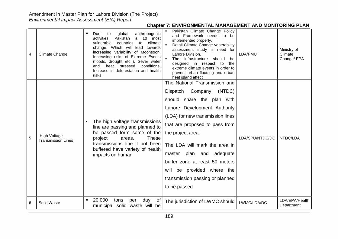
Amendment in Master Plan for Lahore Division (The Project) Environmental Impact Assessment (EIA) Report
Chapter 7: ENVIRONMENTAL MANAGEMENT AND MONITORING PLAN
189
4 Climate Change
Due to global anthropogenic activities, Pakistan is 10 most vulnerable countries to climate change. Which will lead towards increasing variability of Moonsoon, Increasing risks of Extreme Events (floods, drought etc..), Sever water and heat stressed conditions, Increase in deforestation and health risks.
Pakistan Climate Change Policy and Framework needs to be implemented properly.
Detail Climate Change venerability assessment study is need for Lahore Division.
The infrastructure should be designed in respect to the extreme climate events in order to prevent urban flooding and urban heat island effect
LDA/PMU Ministry of Climate Change/ EPA
5 High Voltage Transmission Lines
The high voltage transmissions line are passing and planned to be passed form some of the project areas. These transmissions line if not been buffered have variety of health impacts on human
The National Transmission and
Dispatch Company (NTDC)
should share the plan with
Lahore Development Authority
(LDA) for new transmission lines
that are proposed to pass from
the project area.
The LDA will mark the area in
master plan and adequate
buffer zone at least 50 meters
will be provided where the
transmission passing or planned
to be passed
LDA/SPU/NTDC/DC NTDC/LDA
6 Solid Waste 20,000 tons per day of
municipal solid waste will be The jurisdiction of LWMC should LWMC/LDA/DC
LDA/EPA/Health Department

Amendment in Master Plan for Lahore Division (The Project) Environmental Impact Assessment (EIA) Report
Chapter 7: ENVIRONMENTAL MANAGEMENT AND MONITORING PLAN
190
generated if not managed properly, will cause aesthetic problems and also produce odor along with the spread of many diseases. Similarly, medical waste produced from medical facilities etc. if not properly managed and disposed, it can result in injury by contaminated sha;rp material and infection with Hepatitis B, C, and HIV etc.
increase in other districts as
well. The LWMC has already
suggested landfill sites and
transfer stations in Lahore and
Kasur region. The Landfill Sites
for other districts such as
Nankana and Shiekhpura
should also be studied and
develop and included in the
master plan.
The municipal waste should be
managed in accordance with
waste management hierarchy
which is currently lacking in
society and waste management
company.
Medical waste need to be
segregated and collected in
house in accordance with the
Hospital Waste Management

Amendment in Master Plan for Lahore Division (The Project) Environmental Impact Assessment (EIA) Report
Chapter 7: ENVIRONMENTAL MANAGEMENT AND MONITORING PLAN
191
Rules, 2005 and management
given to LWMC. The
incineration of medical waste
should be stopped
6 Transportation
The major growth of traffic volume in Lahore due to increase in urban population with a large number of vehicle owners and relative small capacity of roads causing multiple of problems like congestion, more energy consumption, pollution, traffic crashes, wastes time, delay, decreases productivity and imposes costs on society.
The public transport should
have been improved through
inter and intra city mass
transit that can be faster,
cheaper, and more relaxing.
It also helps minimize
environmental damage
caused by excessive car
use.
Private cars on road should
be discouraged by
increasing parking fee and
vehicle tax on owners.
Improve bicycle and
pedestrian facilities and
programs.
TEPA/DC LDA

Amendment in Master Plan for Lahore Division (The Project) Environmental Impact Assessment (EIA) Report
Chapter 7: ENVIRONMENTAL MANAGEMENT AND MONITORING PLAN
192
b. Ecological Environment
1 Flora & Fauna
Various developmental activities will require clearing of vegetation and may threaten the existing fauna causing an adverse environmental impact.
DC LDA/PMU
In case of existing roads, if possible, widening should be carried out on both sides to minimize the cutting of trees.
A massive tree plantation programme shall be initiated, along the road, in public buildings and in proposed towns to compensate for the tree loss and to improve the existing landscape of the tract.
Restoration and Rehabilitation Projects should be initiated to overcome the adverse impacts on flora and fauna.
c. Socio-Cultural Environment
1 Land Acquisition
LDA will require land acquisition for different development related to the road infrastructure, public parks and public buildings etc.
Utmost efforts should be made to minimize the acquisition of land by reducing the width of proposed roads or by improving the condition of the existing roads instead of their widening.
For the acquisition of land, the affectees should be compensated as per Rules. Affectees should be either compensated on market value or they should be provided plots at proposed residential areas on equitable basis in case of disruption of their residential plots.
DC LDA/PMU

Amendment in Master Plan for Lahore Division (The Project) Environmental Impact Assessment (EIA) Report
Chapter 7: ENVIRONMENTAL MANAGEMENT AND MONITORING PLAN
193
B. Development Stage
a Physical Environment
1 Land Resources
The contractors will require temporary acquisition of land for:
Land required for establishing contractor’s facilities including borrowing earth material (if required) and dumping excess spoil will be leased directly from private landowners by the contractor.
CC SC/LDA
Establishment of Contractor’s camp and other facilities, disposal sites for safe disposal of surplus construction and excavated spoil material.
Construction camps and workshop will be located at a minimum distance of 250 m from existing plantation and settlements, etc. This limit will be 500 m in case of batching plant.
Potential conflicts may emerge with landowners regarding the restoration of temporarily acquired areas for establishing contractor’s facilities.
Prior to the commencement of construction activities, the contractor will submit a layout and location plan of the facilities to the Engineer-in-charge, LDA and PMU, for its scrutiny and approval.
Soil erosion may aggravate in the workshop areas as a result of improper runoff.
Main drainage courses should be lined to avoid soil erosion. Steep bed slopes should be avoided.

Amendment in Master Plan for Lahore Division (The Project) Environmental Impact Assessment (EIA) Report
Chapter 7: ENVIRONMENTAL MANAGEMENT AND MONITORING PLAN
194
Quarrying of stones from sandstone bed or picking from the nullah beds lead to destabilization of the slopes.
Barren lands or natural depressions should be used for dumping the excavated spoil material.
Scarified/scraped materials, if not disposed of properly, may contaminate soils.
All the lands to be identified for disposal of spoil may be acquired on temporary basis on lease after its needful, the land would be given back to owner.
The possible contamination of soil by oils and chemicals may limit the future use of land.
The contractor will be required to train its workforce in the storage and handling materials, like furnace oil, diesel, petrol and chemicals. The contractor will be required to prepare training manual and module for all the construction related activities.
Potential conflicts may emerge with landowners regarding the restoration of temporarily acquired areas for establishing contractor’s facilities, particularly those for borrow and spoil disposal areas.
Soil contamination by asphalt and other obnoxious material will be minimized by placing all containers in caissons or dumped into pits lined with impervious liners.
2 Water Resources
Surface water resources may be contaminated by spillage of fuel and chemical, or by dumping of waste material and effluents generated by the kitchens and toilets at construction campsites.
Availability of water for campsite facilities and construction purposes will be ensured by the Contractor prior to start of construction activities.
CC SC/LDA Natural streams and hill torrents may
be contaminated with chemicals, oil, lubricants, detergents, etc. through runoff.
The Contractors will be required to liaise closely with local communities to ensure that any potential conflicts related to common resource utilization for Project purposes are resolved quickly.
Soil erosion may occur at quarry The wastewater effluent from
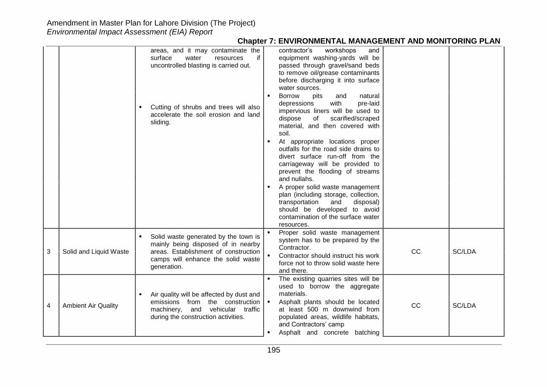
Amendment in Master Plan for Lahore Division (The Project) Environmental Impact Assessment (EIA) Report
Chapter 7: ENVIRONMENTAL MANAGEMENT AND MONITORING PLAN
195
areas, and it may contaminate the surface water resources if uncontrolled blasting is carried out.
contractor’s workshops and equipment washing-yards will be passed through gravel/sand beds to remove oil/grease contaminants before discharging it into surface water sources.
Cutting of shrubs and trees will also accelerate the soil erosion and land sliding.
Borrow pits and natural depressions with pre-laid impervious liners will be used to dispose of scarified/scraped material, and then covered with soil.
At appropriate locations proper outfalls for the road side drains to divert surface run-off from the carriageway will be provided to prevent the flooding of streams and nullahs.
A proper solid waste management plan (including storage, collection, transportation and disposal) should be developed to avoid contamination of the surface water resources.
3 Solid and Liquid Waste
Solid waste generated by the town is mainly being disposed of in nearby areas. Establishment of construction camps will enhance the solid waste generation.
Proper solid waste management system has to be prepared by the Contractor.
CC SC/LDA Contractor should instruct his work
force not to throw solid waste here and there.
4 Ambient Air Quality
Air quality will be affected by dust and emissions from the construction machinery, and vehicular traffic during the construction activities.
The existing quarries sites will be used to borrow the aggregate materials.
CC SC/LDA Asphalt plants should be located
at least 500 m downwind from populated areas, wildlife habitats, and Contractors’ camp
Asphalt and concrete batching

Amendment in Master Plan for Lahore Division (The Project) Environmental Impact Assessment (EIA) Report
Chapter 7: ENVIRONMENTAL MANAGEMENT AND MONITORING PLAN
196
plants should be equipped with dust control equipment such as fabric filters or wet scrubbers.
Vehicles and other construction machinery should be properly tuned and maintained.
Where dust emissions are high, will be reduced by a regular sprinkling of water.
5 Noise Level
Noise generated by the construction machinery during the construction to affect the Project Area particularly the sensitive receptors.
Thick tree plantation will be carried out towards the roadside, where there is enough space available between the boundaries of schools and roads.
CC SC/LDA Noise generated by the construction machinery during the construction of shopping complexes and Parking Plazas is likely to affect the sites situated in congested areas of the city.
In order to avoid the noise pollution in the congested areas as far as possible contractor should plan the construction activities in the off peak hours.
b Ecological Environment
1 Flora
Various developmental activities such as widening of existing roads, construction of new roads, public buildings, shopping complexes, bus and truck terminals and other community development projects will involve cutting and leveling of land, including removal of trees and vegetation from the project areas.
Efforts should be undertaken to keep the number of trees to be felled as minimum as possible.
CC SC/LDA
Cutting of large number of trees will also enhance soil erosion. Without the branches and leaves to break the velocity of downpour, the rain can quickly wash away the soil from even a gentle slope. Cutting down of trees also takes away the roots, which help in binding the soil together.
Along the roads to be widened or constructed, border line trees of the ROW on both sides shall be retained and if the trees are of suitable species.

Amendment in Master Plan for Lahore Division (The Project) Environmental Impact Assessment (EIA) Report
Chapter 7: ENVIRONMENTAL MANAGEMENT AND MONITORING PLAN
197
Establishment of contractor’s camp and warehouses for storage of equipment material shall involve clearing of vegetation from the area.
Similarly, in case of public buildings only those trees shall be felled, which come within the covered area of the proposed building plans.
During the construction activities, workers may use trees as firewood to fulfill the camp’s requirements.
In case of public parks, only the trees which are deformed, ugly or belonging to undesirable species shall be removed.
Camp sites shall be located in areas with minimum vegetation cover.
Gas cylinders should be provided by the Contractor for kitchen and heating requirements in the camps.
Avoiding dumping of dredged spoil in other ecological habitats adjacent to the site
Protection of other habitats with fences and barriers
Minimization of barging disturbance to wildlife
Restoration of native vegetation on
Railroad and Roadside verges and
river and canal banks
Identification and conservation of
areas important for priority animal
species
Strategic planning for nature
conservation through the
restoration of ecological networks
Urban agriculture and kitchen
gardening

Amendment in Master Plan for Lahore Division (The Project) Environmental Impact Assessment (EIA) Report
Chapter 7: ENVIRONMENTAL MANAGEMENT AND MONITORING PLAN
198
2 Fauna
On account of various construction activities such as operation of heavy earth moving machinery and the noise generated through it, the fauna living in the area shall be scared and tend to move to the adjoining areas.
There should be a clear order to the staff and labour to refrain from hunting, shooting or harassment of wildlife.
CC SC/LDA
Avifauna shall be disturbed both in the urban and rural area development projects and scared away due to disturbance of habitat.
Vehicular speed should be controlled.
Personnel and labour hired by the Contractor shall have the tendency to catch or shoot the birds and animals.
Construction activities should be avoided during the night to minimize impact on wild life.
Noise control measures should be
enforced during the construction phase.
Blasting and other noise generating activities will be avoided during the night and in thickly vegetated areas.
Camps will be located at least 500 m away from the thickly vegetated areas.
c. Socio-Culture Environment
1 Local Communities/Workforce
During the construction stage, noise and dust problems will affect the health of locals.
Effective construction controls should be used by the Contractor to avoid inconvenience to the locals due to noise, smoke and fugitive dust.
CC SC/LDA Similarly, general mobility of the
locals will be disturbed during this stage of the project.
Proper arrangements in the form of alternative routes should be made to ensure that mobility of locals should not be disturbed.
Construction of the road as well as the widening of the nullah may create problems for the local residents as the drainage pattern may disrupt. Similarly, due to the disruption of the
After consultation with the traffic police, a proper traffic management plan should be prepared roads specifically by the Contractor in order to avoid

Amendment in Master Plan for Lahore Division (The Project) Environmental Impact Assessment (EIA) Report
Chapter 7: ENVIRONMENTAL MANAGEMENT AND MONITORING PLAN
199
drainage pattern local’s shortest way to reach the Bank road will also affect.
accidents.
During the construction stage, improper traffic management can create problems of traffic flow and accidents on Domail-Chella Bandi and Bank roads.
The Contractor will take care of the local communities water sources so that these should be escaped from destruction.
Usage of the Community’s common resources like potable water, fuel wood, etc. by the Contractor workforce may create conflicts between the community and the Contractor.
The Contractor will take due care related to the disposal of construction material as well as solid waste disposal from the site.
Improper arrangement of the disposal of construction material may create problems for the local residents during the construction stage of the project.
Blasting should be avoided near the settlements, and if unavoidable, it should be carried out during the fixed hours (preferably during the mid-day). The timing will be made known to all the people within 500 m from the blasting site in all directions and prior to blasting thorough inspection should be conducted.
Blasting near residential area like Gulshan Colony, Chella-Bandi Neelum road may create problems for the locals.
Safety lookouts should be built to prevent people and vehicles from passing at the time of blasting.
Relocation/disturbance to existing utilities like electric poles, telephone poles, etc. may affect the routine life of the community.
The management and use of blasting materials should be in strict conformity with the safety requirements.
Accidents/incidents during the construction stage may occur to the workers and the local community.
Haul-trucks carrying concrete, aggregate and sand fill materials will be kept covered with tarpaulin.
Slippage of the Contractor’s staff while working at steep hill slopes may occur.
In construction camps, clean food, water and sanitation facilities should be provided and Contractor

Amendment in Master Plan for Lahore Division (The Project) Environmental Impact Assessment (EIA) Report
Chapter 7: ENVIRONMENTAL MANAGEMENT AND MONITORING PLAN
200
should arrange first aid boxes at camps.
2 Loss of Livelihood
During the construction stage, the business of shopkeepers working in the vicinity of proposed projects may be affected due to the non-accessibility of vehicles.
During construction, accessibility of vehicles to the workshops should be ensured so that the business of shopkeepers will not be disturbed.
CC SC/LDA
During the construction stage, squatters sitting along nullah side road may be affected. In this way, the business of the squatters will suffer a lot.
Construction activities should be carried out during night time, as most of the markets are closed at sunset.
Affectees along with their children losing their agricultural land should be given employment opportunities on preference basis during the construction stage of the development of satellite towns.
3 Disruption of Cultural and Historical Properties
During the construction stage, a few archeological/historical sites may get affected.
The construction/development activities near such sites should be avoided. Similarly, by adopting protection measures, during construction, any negative impacts on Fort may be minimized. In this regard, it is recommended that the Contractor should prepare a site specific management plan.
CC SC/LDA
4 Cultural Issues Induction of the foreign Contractor
and outside labour may cause cultural issues with the local community.
The Contractor will warn the workers not to involve in any theft activities otherwise they will be penalized. Similarly, at the time of employing, the Contractor has to take care that the workers should be of good repute. The Contractor camp will be properly fenced and the main gate will be locked at night with a security guard to check the theft issues from the
CC SC/LDA

Amendment in Master Plan for Lahore Division (The Project) Environmental Impact Assessment (EIA) Report
Chapter 7: ENVIRONMENTAL MANAGEMENT AND MONITORING PLAN
201
community side.
To avoid the cultural issues, the Contractor will facilitate the local labour during the construction activities.
5 Gender Issues
As the Project activities are being carried out within the residential/agricultural/commercial areas of the local community, as a result of it, women activities in the field may be affected during the construction stage particularly in case of satellite towns.
The Contractor will have to select the specific timings for the construction activities so as to cause least disturbance to the local population particularly women.
CC SC/LDA
The induction of outside Contractor labour may create social and gender issues due to the unawareness of local customs and norms. It may also cause hindrance to the mobility of the local women.
The Contractor will take due care of the local community and sensitivity towards local customs and traditions.
C Operation Stage
a Physical Environment
Surface run-off from the impervious surface of the carriageway or slopes can aggravate the drainage problem.
For air and noise quality, a monitoring system will be established by LDA to ensure that ambient air and noise levels are within permissible limits.
CD LDA
If cross-drainage structures are not adequately maintained and cleaned, natural nullahs tend to become choked.
In order to cater the solid waste problems waste bins should be placed at different places in the satellite town.
During the operation stage of all projects, noise and air pollution problems for the nearby residing community as well as for the area may increase.
Wastewater treatment plant(s) should be constructed.
Spillage of oil and other lubricants at bus terminal and truck stand will contaminate the soil as well as
In order to avoid the soil contamination, a fully paved area should be designated for vehicles

Amendment in Master Plan for Lahore Division (The Project) Environmental Impact Assessment (EIA) Report
Chapter 7: ENVIRONMENTAL MANAGEMENT AND MONITORING PLAN
202
surface water resources. maintenance in each bus terminal/truck stand.
During the operation stage of facilities, it is expected that more quantity of solid waste will be generated.
In order to avoid air pollution generated by the incinerator suitable pollution control device should be used.
It will be ensured by the LDA/Highway Department of roads/highways that storm water drains and road drainage system are periodically cleared to maintain water flow.
b Ecological Environment
1 Flora & Fauna
During operational phase; there may be
Impacts of urban development on
biodiversity
Change in land use pattern
Habitat degradation due to higher
pollutants
Habitat Fragmentation
Bird Collisions and strikes
Change in groundwater recharge
capacity
To mitigate the operational impacts and for restoration of natural features; strategies and implementation plan should be adopted fallowed as
Use of native species EIA of all new developments Groundwater recharge Rain water harvesting Pollution control by following
NEQS Solid waste management Wastewater treatment plants Urban agriculture and kitchen
gardening Farm mechanization for
increased agricultural productivity
Tunnel Farming Green roofs and walls Policy Framework for green
infrastructure Biotope/habitat opportunity
mapping and making ecological action plans for individual cities.
CD LDA

Amendment in Master Plan for Lahore Division (The Project) Environmental Impact Assessment (EIA) Report
Chapter 7: ENVIRONMENTAL MANAGEMENT AND MONITORING PLAN
203
3 Horticulture
As the fruit trees are in limited numbers, and mostly fruit is imported from other areas, there will be no significant impact of various development activities on fruit culture.
As the impacts are negligible on horticulture during the operation phase, no mitigation measures are required.
CD LDA
4 Fishery
Increased population of the city due to various housing projects and increased inflow of tourist, will add to pollution of the rivers, causing a negative impact on fishery.
People should be imparted knowledge, about hazards of pollution in the rivers and the resultant set back to fishery.
CD LDA
Sign boards should be setup at important places, especially near the bridges, on the two rivers, informing people to refrain from throwing the liter in the river.
Proper waste management techniques should be used instead of throwing the waste into rivers.
c. Socio-Cultural Environment
Increased number of visitors may become a threat to the available natural resources. This may also create uneasiness to the locals.
The visitors should be briefed about not distorting the natural resources.
CD DAM
Noise generated by vehicles will further increase which will disturb the local communities, school staff and students, etc. existing near roads.
Traffic police should ensure that vehicles are properly tuned up to minimize the air and noise pollution.
Fire hazards may increase in shopping complexes and parking areas.
Fire fighting arrangements should be provided in the operation stage of shopping complexes and
parking plazas and bus terminals, etc.
The arrival of affectees of different projects under LDA to the proposed areas may create a positive impact on the local business. However, this may become a threat to the available
To resolve any kind of disputes during operation stage between the affectees and people of planned areas, a committee may be organized consisting of

Amendment in Master Plan for Lahore Division (The Project) Environmental Impact Assessment (EIA) Report
Chapter 7: ENVIRONMENTAL MANAGEMENT AND MONITORING PLAN
204
natural resources including water, fire wood, etc.
representatives from areas, local administration and public representatives.
There may be some cultural conflicts due to the arrival of affectees of different projects under LDA to the proposed satellite towns. However, the diffusion of cultures may result in some sort of development in the form of language, dress, education, life style etc.
Proper arrangement of the cleanliness of toilets and waiting rooms should be provided for the passengers at bus terminals.

Amendment in Master Plan for Lahore Division (The Project) Environmental Impact Assessment (EIA) Report
Chapter 8: STAKEHOLDERS CONSULTATION
205
CHAPTER8
STAKE HOLDERS CONSULTATION Public & Stakeholders consultation is a systematic process, which provides an
opportunity for planners, citizens, managers and selected representatives to share
their experience, knowledge and concerns and perceptions about any proposed
development. The objectives of the public consultation for the proposed Project are
to:
• Share information with the stakeholders’ on the proposed Project works and
their expected impact on the socio-economic environment of the Study
Area.
• Understand the stakeholder’s concerns regarding the various aspects of the
Project, including the existing condition of the Study Area, upgrade
requirements, and the likely impacts of the construction related activities and
operation of the Project.
8.1. IDENTIFICATION OF STAKEHOLDERS
First setup for the stakeholder consultation is the identification of stakeholders. LDA
is the Project Proponent. The project has both primary as well as secondary
stakeholders. As per definition, stakeholder is an entity which is concerned with the
proposed project in any way. Direct stakeholders are those entities which are directly
concerned with the project.
The primary stakeholders include in the project are the affected households/persons
according to the loss of assets and conditions, Provincial Environmental Protection
Department and District level concerned departments whereas the secondary
stakeholders include the public and private agencies involved in the implementation
of the project.
Following is the list of major stakeholders of the Project:

Amendment in Master Plan for Lahore Division (The Project) Environmental Impact Assessment (EIA) Report
Chapter 8: STAKEHOLDERS CONSULTATION
206
• Water and Sanitation Agency (WASA)
• Environmental Protection Agency (EPA-Punjab)
• Forest Department
• River Ravi Commission
• World Wildlife Fund (WWF)
• Lahore Waste Management Company (LWMC)
• Parks and Horticulture Authority (PHA)
• Lahore Chamber of Commence
• Urban Unit Punjab
• Community residing in towns of Project Area
• Small industrial Associations in Project Area
Twenty Five (25) comprehensive consultations including scoping sessions and focus
group discussions were held. In addition, a few consultations were also held in the
form of detailed interviews of individuals including men and women at project area.
Table-9.1 provides the information about consultations carried out at different
locations with the community and government stakeholders including date, venue
and number of participants.
Table 8 . 1 List of Scoping Sessions/Group Discussions carried out with the Stakeholders
Sr. No.
Date Venue No. of
Participants
1 22-12-15 Community at Sultan Park- Muredke 07
2 22-12-15 Community at Sach Soda Farooqabad 10
3 22-12-15 Community at Feroz wattwan 04
4 28-12-15 Community at Mala Ram Lahore South East 05
5 29-12-15 Community at Hera Coat Kasur 03
6 04/1/16 Centaury Paper and Boad Mill – Industry- Kasur 03
7 04/1/16 Panther Tyres – Industry- Lahore Shiekhpura Road 03
8 1/1/16 Ahmad Rafy Alam – Advocate and Sectary RRC 01
9 19/1/16 Prof. Dr. Obaid- UET Lahore 01
10 18/1/16 Dr Nasir and team- Urban Unit Punjab 06
11 9/1/16 GM Operation Office – Lahore Waste Management Company
04
Amendment in Master Plan for Lahore Division (The Project) Environmental Impact Assessment (EIA) Report
Chapter 8: STAKEHOLDERS CONSULTATION
207
8.2. MAIN VIEWS AND CONCERNS OF THE
STAKEHOLDERS
During consultations, the people of the Study Area expressed their views and
concerns about the Project. Findings of the consultations and main views and
concerns about the Master Plan Lahore Division are summarized below:
8.2.1. Views and Concerns of Lahore Waste Management
Company
The Project was discussed with Asif Iqbal (GM-Operation-LWMC) the project briefing
was given to LWMC staff and some recommendations of EIA report related to solid
waste management and landfill sites was discussed. The GM operation LWMC
mentioned the following
• LWMC already investigated and studiedand proposedtwo new landfill sites
(other than Lakhodair and Mehmood Boti) in Lahore and one in Kasur.
These landfill sites should be marked on master plan.
• Regional landfill sites should be developed for Lahore Division with transfer
stations in districts.
• New landfill sites should be explored for Shiekhpura and Nankana District.
• Hospital Waste Management Study is also in process with advance
technology of disposing hospital waste through auto claving.
• Hospital Waste Management should be given to LWMC in consultation with
Health Department.
• Some projects from waste to energy, bio gas generation, electricity from
landfill gas, Compost from organic waste have already in operational phase
from which there will ultimate help in managing solid waste of cities.
The landfill sites and transfer station that LWMC has proposed has been marked on
map and attached as Annex I
8.2.2. Views and Concerns of Urban Unit Punjab
The Project was discussed and briefed to Dr. Nasir (Chairman Urban Unit) and his
team, who mentioned the following concerns.
• The per capita water requirement for master plan till 2035 should reduce
from 80 gallons per capita to 35 gallons per capita.

Amendment in Master Plan for Lahore Division (The Project) Environmental Impact Assessment (EIA) Report
Chapter 8: STAKEHOLDERS CONSULTATION
208
• The sewerage and drainage should be separated. The collected drain water
then used as ground water recharge and other purposes like gardening, car
washing and cleaning.
• Slum areas need to address in master plan with proper planning.
• Ground recharge should be done through rain water harvesting.
• Stick enforcement for the proposed urban plans should be ensured to stop
Urban Sprawl.
8.2.3. Views and Concerns of Community Sultan Park-
Muredke
• The project is very much beneficial as we could also have facility of
developed infrastructure like big city. With the implementation of master plan
Lahore division 2035 brings prosperity in our area.
8.2.4. Views and Concerns of Community at Sach Soda
Farooqabad
The project is good as we got the basic facilities, but Govt. should also look to
provide job opportunity to unemployed youth of this area
8.2.5. Views and Concerns of Community at Mala Ram Lahore
South East
The project is good as it will bring infrastructure in our area which ultimate
increase the price of our land.
8.2.6. Views and Concerns of Centaury Paper and Boad Mill –
Industry- Kasur
The project is good in terms of notified industrial area. The only concern is to
separate our industrial area with residential area with the buffer zone. The residential
area on back of our industry keeps on increasing and one day it will touch with our
boundary wall which then becomes problem to the industry and residencies as well
8.2.7. Views and Concerns of Panther Tyres – Industry- Lahore
Shiekhpura Road
The project is good but residential area should be separated from industrial area.
The Lahore-Shiekhpura road belongs to the industrial area but still at this road there
are approved housings. This practice should have been stopped.

Amendment in Master Plan for Lahore Division (The Project) Environmental Impact Assessment (EIA) Report
Chapter 8: STAKEHOLDERS CONSULTATION
209
8.2.8. Views and Concerns of Dr. Obaid UET Lahore
The master plan should be evaluated based upon the yield in agriculture fields. The
lower yield areas should be chosen for the development
The climate change impacts have been evaluated based upon temperature increase
from last 50 years.

Amendment in Master Plan for Lahore Division (The Project) Environmental Impact Assessment (EIA) Report
Chapter 9: CONCLUSIONS AND RECOMMENDATIONS
210
CHAPTER9
CONCLUSIONS AND RECOMMENDATIONS
9.1. Conclusions and Recommendations
EIA Study was conducted for the proposed Master Plan for Lahore Division, which
included field surveys, investigations, verification and possible quantification of
anticipated impacts together with their mitigation measures.
By the development and implementation of the Master Plan for the Lahore division,
though there will be a relief for availability of planned facilities to the locals. The
project is very much needed in order to have orderly future urban growth which will
reduce pressure on our natural resources. Planned urban development has variety
of positive impacts including intact natural resource with urban development, Public
utilities and infrastructure facilities at their own places rather coming towards main
district (Lahore), enhanced green areas through housing and building control
guidelines, aesthetic uplifting, improved industrial sector and non-quantifiable socio
economic benefits.
Apart from the positive impacts of the project, it will also generate some negative
impacts during the planning, implementation and operational stages. Most of
construction impacts are of temporary nature. These temporary impacts can be
avoided or mitigated by adopting suitable mitigation or remedial measures as
mentioned in this report. However, following are some major significant impacts that
require specific targeted mitigation measures.
9.1.1. Ground Water
The sole supply of water to the Lahore Division depends upon the abstraction of
groundwater. The use of ground water in residential commercial and industrial sector
with increase in population up till 2035 will result in decline in ground water aquifer
with threat to deplete the ground water resource. Further the paved surfaces will

Amendment in Master Plan for Lahore Division (The Project) Environmental Impact Assessment (EIA) Report
Chapter 9: CONCLUSIONS AND RECOMMENDATIONS
211
ultimate reduce the ground water recharge. The impact can be mitigated by reducing
per capita water availability by educating households to use water more wisely,
provision of surface water supply after treatment, water usage metering system,
efficient irrigation practices, rain water harvesting in residential, commercial and
industrial units and large lakes in parks to facilitate the ground water recharge.
9.1.2. Surface Water Resources and Quality
With the potential of increase in population with development of residential areas,
housing schemes and industrial areas in districts of Lahore division, the pollution
level and quantities of wastewater is likely to worsen manifolds which may have
direct negative impact on our surface water resource (River Ravi and Sutlej) and
indirectly on agriculture, ground water and human health. The river Ravi is already
converted in to the shape of sewage carrier due to large quantities of waste water
being received from urban area. The situation would become more intense if specific
solutions regarding waste water treatment are not executed. The impact can be
mitigated by adopting pollution prevention strategies by LDA along with other
concerned agencies like EPA. Industries have to install wastewater treatment plant
at source and should discharge the water that meets the NEQS being enforced by
the EPA, Wastewater treatment plant should be installed on all the outfalls or drains
that falls in to the river Ravi for that recommendations of River Ravi Commission
should be followed which include development of constructed wetlands on drains
before discharge into the river Ravi and provision of septic tanks in new housings,
the recommendation of WWTP study for Ravi Riverfront Urban Development Project
(RRUDP) should also be followed which include establishment of WWTP on all
major outfalls.
9.1.3. Flood
Following settlements of project area have a potential risk of flooding in river Ravi for
100 years return period in accordance with short term hydrological study attached as
Appendix III. The settlements including Bhai Pheru, Bucheki, Mandi Faizabad, Mor
Khunda, and Syed Wala may be subjected to flooding. The settlement Ferozwala is
under potential threat of flooding due to Deg Nallah. The settlement Muridke is under
potential threat of flooding due to Nikki Deg Drain. The flood hazard can be mitigated
by channelization and modification of river area from only where there is chance of

Amendment in Master Plan for Lahore Division (The Project) Environmental Impact Assessment (EIA) Report
Chapter 9: CONCLUSIONS AND RECOMMENDATIONS
212
flood hazard to occur, develop large retention ponds in between river and flood
prone identified areas which also facilitate ground water recharge and dikes/bund
should be developed precise to the identified flood prone areas along the side of the
rivers.
9.1.4. Climate Change
Pakistan is rated among the top 10 most vulnerable countries to climate change. The
major concerns of climate change in reference to our project site areas are increased
variability of Monsoon, increased risks of Extreme Events (floods, droughts,
cyclones, extreme high / low temperatures etc.), severe water- and heat-stressed
conditions in arid and semi-arid regions leading to reduced agricultural productivity,
Increase in Deforestation with Loss of Biodiversity and health risks. The climate
change poses the serious threat in project areas if not mitigated or without an
adaptive capability for the extreme climatic events. The impact can be mitigated by
implementation of Climate Change Policy and its Framework at sectorial, institutional
and departmental level on urgent basis. Detail Climate Change Vulnerability
Assessment related to the Lahore Division is also needed.
9.1.5. Land Resources
The LDA will require land acquisition for widening and improvement of the existing
roads, development of bypass roads for various existing town/villages etc,
development of inter town and villages roads, development of new main roads,
connecting roads, accessibility roads, sewerage systems including pumping stations,
disposal stations, treatment plants, development of recreational areas, public utilities,
buildings, administration buildings, toll stations and weighing stations. The land
acquisition should be done in accordance with the land acquisition act 1897 and its
amendments. Compensation against land, structure, disturbance allowance should
be provided to the affectees as per market price
9.1.6. High Voltage Transmission Lines
The high voltage transmissions line are passing and planned to be passed form
some of the project areas. These transmission lines if not been buffered, have
variety of health impacts on humans. The short term health impacts include
Headaches, Fatigue, Anxiety, Insomnia, Prickling and/or burning skin, Rashes and
Muscle pain. The long term health impacts include risk of damaging DNA, risk of

Amendment in Master Plan for Lahore Division (The Project) Environmental Impact Assessment (EIA) Report
Chapter 9: CONCLUSIONS AND RECOMMENDATIONS
213
cancer, risk of leukemia, risk of neurodegenerative disease and risk of miscarria. The
impact can be mitigated by providing adequate buffer zone of at least 50 meters from
High Voltage Transmission Line.
9.1.7. Transportation
The infrastructure facilities such as under passes, wide roads, bridges, signal free
corridor etc. have been made in Lahore but increasing population with traffic volume
rapidly overburden these facilities and vigorously worsen in future also. The situation
will be in worst position if long-term planning of transportation in master plan has not
been done. The major impact would be seen on our economy if high efficiency
transport system will not be designed for Lahore division. The impact can be
mitigated by utilizing and relaying on public transport that should have been
improved through inter and intra city mass transit, increasing parking fee to
discourage private cars and improve bicycle and pedestrian facilities and programs.
9.1.8. Solid Waste
About 20,000 tons/day of municipal solid waste will be generated from Lahore
division that if not managed properly will cause aesthetic problems and also produce
odor along with the spread of many diseases. Similarly, medical waste produced
from medical facilities etc. if not properly managed and disposed, it can result in
injury by contaminated sharp material and infection with Hepatitis B, C, and HIV etc.
The impact can be mitigated by increasing jurisdiction of Lahore Waste Management
Company from Lahore district up to Lahore divisional level. Develop regional based
landfill sites, adopting waste management hierarchy, not to mix medical waste with
municipal waste and medical waste need to be segregated separately in accordance
with the Hospital Waste Management Rules, 2005 and should be given to LWMC for
safe disposal in Landfill site after autoclaving. The incineration of medical waste
should have been stopped.
Apart from above other recommendation related to the planning and
implementations of master plan are given as under-:
Master Plan should check trends based on the past and present practices and
should device strong legislation for the implementation of the proposed land

Amendment in Master Plan for Lahore Division (The Project) Environmental Impact Assessment (EIA) Report
Chapter 9: CONCLUSIONS AND RECOMMENDATIONS
214
uses in the Master Plan. In this regards, recommendation for the ineffective
implementation of the previous IMPL should be kept in the mind.
Major loss by the implementation of this master plan is that of agricultural land
that will negatively impact food supply and can result in high prices of food
items from being supplied from distant places. This loss can just only in part
compensated by promoting urban agriculture and kitchen gardening. But this
will has to be incorporated in the developmental policy of the proposed project
at the planning stage. It is also recommended that for the compensation of the
lost agricultural land there is a need to increase agricultural production by
using modern technology and seeds of high yielding crop varieties. Farmers in
the area shall be provided assistance in getting loans for the purchase of farm
machinery and seeds.
Living roofs and walls are other options to adopt which are important
components of the sustainable urban design. The roof gardens provide
beautiful and pleasant environment to live and work, to help improve air
quality, especially in populated areas. Green roofs of buildings perform the
important functions of trapping dust, producing oxygen and providing cooling
affect in the hot summer months leading to energy conservation. They also
provide habitat for the urban biological diversity and are one of the ways to
ensure food security.
Habitats and species of conservation value shall be protected that include
many reptile and bird species. It is therefore important to set aside areas that
act as their breeding grounds or nesting habitats. It is strongly recommended
that areas along both banks of River Ravi and River Sutlej shall be acquired
and declared as buffer zones to protect the native wildlife from human
onslaughts and disturbance. In this regard help can be taken from experts of
Wildlife Department and WWF-P.
Native species restoration should be carried out to enhance biodiversity and
conservation in the area
Incentive for the locals involved in the agriculture activities should be given in
terms of facilities so that the shifting trend from agriculture to other business
should not take pace.

Amendment in Master Plan for Lahore Division (The Project) Environmental Impact Assessment (EIA) Report
Chapter 9: CONCLUSIONS AND RECOMMENDATIONS
215
Affectees along with their children losing their agricultural land and livelihood
should be given employment opportunities on preferential basis during the
construction stage and operational stage.
The vulnerable social groups including the women headed households,
widows, poor people, etc. losing their residences and agriculture land should
be given compensation on replacement cost basis and separate business
opportunity should be provided to them.
It is suggested that at policy level that local government should support the
use of alternate energy resources for the individual units such as housing
schemes, industrial states, use of solar lights for the street lights etc.
It is recommended that mitigation measures proposed in impacts and
mitigation chapter and EMMP should be adequately implemented at design,
construction and operation stages.
Recommendations of Ecological Study should also be followed during the
detail design, implementation and operation of the project
After the detail environmental assessment, it is concluded that the project is
environmentally feasible at proposed site only if the mitigation measures suggested
in this EIA report are adopted during planning, construction and operational stages of
the project. The mitigations suggested in the report are sufficient to successfully
complete and run the project in an environment friendly manner.
Further, the key studies which need to be carried out at planning level are given as
under;
Climate Change Vulnerability Assessment
Ground Water Quality and Aquifer Assessment
Surface water Quality Assessment and its use
Hydrological Study and Modeling of River Ravi
Rainwater harvesting potential and implementation
Detail Socio- Economic Study of Project Areas
Social Impact Assessment
Transportation and Modeling Study
Action Areas Plans and Subject Plans for each sector of development should
also be prepared

Amendment in Master Plan for Lahore Division (The Project) Environmental Impact Assessment (EIA) Report
Appendices
216
APPENDICES

Amendment in Master Plan for Lahore Division (The Project) Environmental Impact Assessment (EIA) Report
Appendices
217
Appendix-I
Ecological Study Report

MASTER PLAN FOR LAHORE DIVISION PROJECT Districts Lahore, Kasur, Sheikhupura & Nankana Sab
Ecological Study Report
Lahore Development Authority (LDA), Lahore.

Master Plan for Lahore Division Project Ecological Study Report
Acknowledgements
I
Acknowledgements
Help and support provided by the local community members and Departments
of Wildlife, Forest and Fisheries for conducting this ecological study is greatly
acknowledged. We are highly thankful to Mr. Waqas Ali, Lecturer, Department
of Wildlife, University of Veterinary and Animal Sciences, Lahore for his expert
advice in finalizing the lists of herpetofauna.

Master Plan for Lahore Division Project Ecological Study Report
Executive Summary
II
EXECUTIVE SUMMARY
Master Plan for Lahore Division includes districts of Lahore, Nankana Sahib,
Kasur, and Sheikhupura which referred to as “the Project Area”. Total Project
area includes forty eight different sites allocated in four districts. This project is
important in a way that urbanization is happening around the globe and in
such case if the same urban expansion is planned and organized it will result
in sustainable living approach. With world population forecast to increase
from 7 billion today to more than 9 billion by 2050, humanity’s urban footprint
will take up 1.5 million more square kilometers of land by 2030 at current
rates. Cities place tremendous strains on natural resources and the
environment. New ways of thinking about how to make cities more self-
sufficient and sustainable, along with advances in a wide range of
technologies and heightened environmental awareness is leading to a
reformulation of urban planning and development. In such scenario the
current project deals with the planning of expanding living areas sustainably.
This ecological study is carried-out as part of an Environmental Impact
Assessment (EIA) to gather ecological data of the said project. The proposal
may have an impact on the natural environment including existing fauna, flora
and their wild habitats. This assessment includes both aquatic and terrestrial
ecology of the study area. The guiding principle for this part of the EIA report
is to conserve major habitats of flora and fauna in the area. This section of the
report includes identification, prediction and evaluation of existing habitats,
flora and fauna. The baseline ecological study was of 30 days in which tours
of the area were arranged to assess plant and animals in different times of the
day present in different habitats. After a vigorous literature review, certain
criteria were established to evaluate animal and plant species in different
habitats. Keeping in view international and national legislation, protection
status of species found in all habitats was determined. This helped in
proposing conservation of respective habitats of protected species.
Significantly many birds and reptile species were found to be protected as
they were either under threat as per IUCN Red list (1 bird and 2 reptile
species) or were protected under Punjab Wildlife Act (22 bird and 6 reptile

Master Plan for Lahore Division Project Ecological Study Report
Executive Summary
III
species). One bird (Otus bakkamoena) and 5 reptile species (Ptyas mucosa,
Xenochrophis piscator, Varanus bengalensis, Pangshura smithii and
Lissemys punctata Adersoni) are protected either under CITES appendix I, II
or III. Two mammal species (Felis chaus and Herpestes mungo) are also
protected under Punjab Wildlife Act. Project sites had significantly higher
biodiversity richness which was 101 species of fauna and 146 species of flora.
Fauna includes 70 species of birds, 13 of mammals, 15 of reptiles and 3 of
amphibians. None of the native plant species are under threat as per IUCN
Red list but they are under serious threat locally as they have been
exterminated due to habitat loss, overuse or are replaced with other more
economically important species. Same is the case with native fish species
among that only Mully (Wallago attu) is ‘near threatened’ in IUCN Red Data
Lists but there are other fish species like Rita rita (Ravi Khagga) that also
suffer from serious threat and decline due to over exploitation, water pollution
and introduction of invasive species. The potential ecological impacts from the
project’s planning, implementation (construction and operation) were identified
and their possible mitigation measures are proposed for enactment of habitat
and species. The negative impacts expected from the implementation,
construction and operation of this Master plan are; loss of agricultural land,
loss of biodiversity, habitat loss and fragmentation, water, noise, air and light
pollutions and change in groundwater recharge capacity. The positive impacts
include increased economic activity, livelihood opportunities, reducing
pressure on other megacities like Lahore, better transportation, education,
healthcare, sewer and municipal water supply facilities, increased land and
property values and initiation of secondary development. Negative impacts of
this development can be mitigated by; minimizing biodiversity loss by
developing Green Infrastructure, restoration of native vegetation on railroad
and roadside verges and river and canal banks, Identification and
conservation of areas important for priority animal species, planning for nature
conservation through the restoration of ecological networks, urban agriculture
and kitchen gardening. It is strongly recommended from this ecological impact
assessment report that (i) the biodiversity should be conserved by protecting
species and their habitats (ii) secondly more green areas should be

Master Plan for Lahore Division Project Ecological Study Report
Executive Summary
IV
developed with native plants as a compensation of lost vegetation (iii) there
will be dire need to develop infrastructure and policies to reduce water, noise,
light and solid waste pollutions (iv) design ground water recharge and rain
water harvesting mechanisms and to (iv) promote urban agriculture for
assuring food security.

Master Plan for Lahore Division Project Ecological Study Report
Table of Contents
V
TABLE OF CONTENTS
Acknowledgements ........................................................................................... I EXECUTIVE SUMMARY ................................................................................. II TABLE OF CONTENTS .................................................................................. V
LIST OF FIGURES ...................................................................................... VIII LIST OF TABLES ........................................................................................... IX
CHAPTER 1 ..................................................................................................... 1
BACKGROUND & INTRODUCTION ............................................................... 1
1.1. Objectives of the Ecological Impact Assessment Study ......................... 3
1.2. Methodology to conduct Ecological Impact Assessment ........................ 3
1.3. Legislation and Guidelines ..................................................................... 3
1.3.1. International Legislations ................................................................. 4
1.3.1.1. Ramsar Convention .................................................................. 4
1.3.1.2. Bonn Convention ...................................................................... 4
1.3.1.3. Convention on Biological Diversity (CBD) ................................. 4
1.3.1.4. IUCN Red List of threatened species ........................................ 4
1.3.1.5. CITES ....................................................................................... 5
1.3.2. National Legislation, Acts and Rules ............................................... 5
1.4. Study Team ............................................................................................ 5
CHAPTER 2 ..................................................................................................... 6
OBSERVATIONS AND INTERPRETATIONS ................................................. 6
2.1. Ecological Baseline Study of the proposed project ................................ 6
2.1.1. Project Study Area ........................................................................... 6
2.1.2. Steps in Ecological baseline study .................................................. 6
2.1.2.1. Detail of different Habitats in the project area ........................... 6
2.1.2.2. Survey for the Floral Inventory and other details in the project area 9
2.1.2.3. Survey for inventory of faunal diversity in the project site ....... 18
2.1.3. Protection status of all Animals found in the area .......................... 34
2.2. Assessment of Ecological Impacts from the planning of new Development in the project area .................................................................... 36
2.2.1. Implementation and construction impacts ..................................... 37
2.2.1.1. Permanent loss of agricultural land/orchards .......................... 37
2.2.1.2. Removal of native vegetation and habitat loss ........................ 37
2.2.1.3. Effects of land conversion on rural communities ..................... 37
2.2.1.4. Habitat damage ....................................................................... 38
2.2.1.5. Wildlife disturbance and Noise pollution ................................. 38
2.2.1.6. Soil erosion ............................................................................. 38
2.2.2. Operational impacts ....................................................................... 38
2.2.2.1. Impacts of urban development on biodiversity ........................ 38
2.2.2.2. Change in land use pattern ..................................................... 39
2.2.2.3. Habitat degradation due to higher pollutants........................... 39
2.2.2.4. Habitat Fragmentation ............................................................ 40
2.2.2.5. Bird Collisions and strikes ....................................................... 40
2.2.2.6. Change in groundwater recharge capacity.............................. 41

Master Plan for Lahore Division Project Ecological Study Report
Table of Contents
VI
2.2.3. Social Impacts of urban growth due to new development and planning ...................................................................................................... 41
2.3. Mitigation Measures to lessen the impacts of development ................. 42
2.3.1. Impact avoiding/ minimizing .......................................................... 43
2.3.1.1. Minimizing biodiversity loss by developing Green Infrastructure 43
2.3.1.2. Green Infrastructure (GI) ......................................................... 43
2.3.1.3. Avoiding dumping of dredged spoil in other ecological habitats adjacent to the site: ................................................................................. 46
2.3.1.4. Protection of other habitats with fences and barriers: ............. 46
2.3.1.5. Minimization of barging disturbance to wildlife: ....................... 46
2.3.2. Restoration and Compensation ..................................................... 47
2.3.2.1. Trees Plantation close to schools and hospitals ..................... 47
2.3.2.2. Identification and conservation of areas important for priority animal species ........................................................................................ 47
2.3.2.3. Strategic planning for nature conservation through the restoration of ecological networks ........................................................... 48
2.3.2.4. Urban agriculture and kitchen gardening ................................ 48
2.3.3. Conclusion and Recommendations ............................................... 49
2.3.3.1. Use of native species .............................................................. 49
2.3.3.2. EIA of all new developments ................................................... 49
2.3.3.3. Groundwater recharge ............................................................ 49
2.3.3.4. Rain water harvesting ............................................................. 50
2.3.3.5. Pollution control by following NEQS ........................................ 50
2.3.3.6. Solid waste management ........................................................ 50
2.3.3.7. Wastewater treatment plants .................................................. 50
2.3.3.8. Urban agriculture and kitchen gardening ................................ 50
2.3.3.9. Farm mechanization for increased agricultural productivity .... 50
2.3.3.10. Tunnel Farming .................................................................... 51
2.3.3.11. Green roofs and walls .......................................................... 51
2.3.3.12. Policy Framework for green infrastructure (GI) .................... 51
2.3.3.13. Biotope/ habitat opportunity mapping and making ecological action plans for individual cities. ............................................................. 52
2.3.3.14. Disturbance to migratory species ......................................... 53
2.3.3.15. Habitat and species conservation ........................................ 54
2.3.3.16. Avoiding bird collision and strikes ........................................ 54
2.3.3.17. Restoration of native vegetation .......................................... 55
2.3.3.18. Reducing the effects of light pollution on biological diversity55
2.3.3.19. Reducing ecological footprint ............................................... 56
LITERATURE CONSULTED ......................................................................... 58
Roberts, T.J. (1991). The birds of Pakistan, regional studies and non-passeriformes. Oxford university press. ......................................................... 61
Roberts, T.J. (1992). The birds of Pakistan, passeriformes: Pittas to buntings. Oxford university press. ................................................................................. 61
APPENDICES ................................................................................................ 63
Appendix – I ............................................................................................... 64
CONVENTION ON INTERNATIONAL TRADE IN ENDANGERED SPECIES OF WILD FAUNA AND FLORA ................................................. 64
Appendix – II .............................................................................................. 68

Master Plan for Lahore Division Project Ecological Study Report
Table of Contents
VII
THE PUNJAB WILDLIFE (PROTECTION, PRESERVATION, CONSERVATION AND MANAGEMENT) (AMENDMENT) ACT, 2007 ...... 68
PLATES ......................................................................................................... 74
Plate 1 ............................................................................................................ 75
Plate 2 ............................................................................................................ 76
Plate 3 ............................................................................................................ 77
Plate 4 ............................................................................................................ 78
Plate 5 ............................................................................................................ 79
Plate 6 ............................................................................................................ 80
Plate 7 ............................................................................................................ 81
Plate 8 ............................................................................................................ 82
Plate 9 ............................................................................................................ 83
Plate 10 .......................................................................................................... 84
Plate 11 .......................................................................................................... 85
Plate 12 .......................................................................................................... 86
Plate 13 .......................................................................................................... 87
Plate 14 .......................................................................................................... 88

Master Plan for Lahore Division Project Ecological Study Report
List of Figures
VIII
LIST OF FIGURES
Figure 1 . 1 Relationship between society, urban technical system and
environment ..................................................................................................... 2
Figure 2 . 1 Birds of study area ...................................................................... 28
Figure 2 . 2 Birds of Study Area ..................................................................... 30
Figure 2 . 3 Birds of study area ...................................................................... 31
Figure 2 . 4 Birds of Study Area ..................................................................... 32
Figure 2 . 5 Mammals of Study Area .............................................................. 33
Figure 2 . 6 Reptiles of Study Area ................................................................ 34
Figure 2 . 7 Amphibians od Study Area ......................................................... 34
Figure 2 . 8 Impacts of Urban Development on Biodiversity .......................... 39
Figure 2 . 9 Pattern of Biodiversity loss and gain (Source: UNEP Global
Environment 1997) ......................................................................................... 43
Figure 2 . 10 Examples of green urban infrastructure .................................... 45
Figure 2 . 11 Examples of some of the green infrastructures present at the
study site ........................................................................................................ 46
Figure 2 . 12 The components of ecological networks (Town & Country
Planning Association 2012) ........................................................................... 48
Figure 2 . 13 Urban agriculture and kitchen gardening .................................. 49
Figure 2 . 14 Railroad and roadside vegetation provides excellent corridors for
the movement of biota and increase connectivity among landscape patches 53
Figure 2 . 15 Useful and other types of light from a light source
http://www.askaboutireland.ie/enfo/irelands-environment/noise/light/ ............ 56
Figure 2 . 16 Fixtures that enhance and reduce light pollution (Source:
http://victoria.rasc.ca/night-lighting/) ............................................................... 56

Master Plan for Lahore Division Project Ecological Study Report
List of Tables
IX
LIST OF TABLES
Table 1 . 1 The Ecological Study Team ........................................................... 5
Table 2 . 1 Species richness of fauna and flora of the habitat types in the
study area ........................................................................................................ 9
Table 2 . 2 List of plant species identified from different habitats ................... 11
Table 2 . 3 List of aquatic plant species identified from different habitats ...... 17
Table 2 . 4 Status of plant species recorded within the study area ................ 17
Table 2 . 5 Overall species richness of all plants recorded within the study
area ................................................................................................................ 18
Table 2 . 6 List of mammals recorded within the project area ........................ 20
Table 2 . 7 List of Bird species recorded within the project area .................... 20
Table 2 . 8 List of Reptile and Amphibian species recorded within the project
area ................................................................................................................ 25
Table 2 . 9 List of fish species found in the rivers of the project area............. 26
Table 2 . 10 Status of Mammals Species recorded within the Study Area ..... 35
Table 2 . 11 Status of Amphibian Species recorded within the Study Area ... 35
Table 2 . 12 Status of Reptile Species recorded within the Study Area ......... 35
Table 2 . 13 Status of Birds Species recorded within the Study Area ............ 36
Table 2 . 14 Impacts of urban growth due to new development and planning41
Table 2 . 15 Objectives of city ecological action plan ..................................... 53
Table 2 . 16 Detail of migratory birds in the project area shown in table below
....................................................................................................................... 53

Master Plan for Lahore Division Project Ecological Study Report
Chapter 1: Background & Introduction
1
CHAPTER 1
BACKGROUND & INTRODUCTION It is well said that “cities are ecosystems of people and infrastructure” with always
increasing population of Lahore, it has become an area which is “land starved” in
focusing future population. The current Lahore Division Master Plan is a project that
envisioned pressure of urbanization and future development in this area. There is
huge need to better plan and develop our urban areas; 50% of the world’s population
is considered urban and urban areas are increasing in their size, density and
number. A key problem in urban planning is that the rate of development far exceeds
the rate of research output and policy implementation, meaning that urban
development often ignores its full environmental impact.
Various concepts have been coined to describe how complex interactions can
impact on urban living as shown in Figure 1. The 'urban metabolism' refers to the
flows necessary to satisfy the needs of those living in cities. 'Grey infrastructure',
such as roads, metros, railways, buildings and utilities, determines a city's layout. Yet
without integrated urban planning, this urban 'engineering' generates soil sealing,
fragments natural systems, increases mobility and associated pollution, energy and
material consumption. ‘Green infrastructure’ is a way to work with nature to provide
social, ecological and economic benefits to the urban population such as air filtration,
temperature regulation, noise reduction, flood protection and recreational areas. The
high concentration of people and economic activities in cities cause environmental
pressures. Yet cities can be planned, designed, managed and governed in an
increasingly efficient way.

Master Plan for Lahore Division Project Ecological Study Report
Chapter 1: Background & Introduction
2
Figure 1 . 1 Relationship between society, urban technical system and environment
With half the world's population now living in urban regions, the future of cities is
arguably the most important social and environmental issue of the twenty-first
century. The design and planning of green spaces in cities has been central to urban
development since the beginning of civilization. Planning which will focus urban
ecology has a sustainable way to go. Keeping this in view, Ecological assessment of
the Lahore Division was carried-out which includes four Districts namely; Lahore,
Kasur, Sheikhupura and Nankana Sahb. The Project site is geographically located
between 30°38’31.93”E to 32°03’37.99” and 73°17’37.86” to 74°42’05.83”. This
ecological impact assessment was carried-out as part of Environmental Impact
Assessment (EIA) to gather ecological data of the Lahore Division Project that may
have impacts on the natural environment including existing fauna, flora and wildlife
habitats. This assessment includes both aquatic and terrestrial ecology of the study
area. The guiding principle for this part of the EIA report is to conserve major
habitats of flora and fauna in the planning and management of the area. This
chapter includes identification, description and evaluation of existing habitats of
study area (Fig. 1). The baseline ecological study was carried-out in 30 days and
included the assessment of different habitats in the project area and identification of
diversity of local flora and fauna. The potential ecological impacts from the project’s
planning and implementation were identified and possible mitigation measures are
proposed for enactment of habitat and species present at the study site.

Master Plan for Lahore Division Project Ecological Study Report
Chapter 1: Background & Introduction
3
1.1. Objectives of the Ecological Impact Assessment
Study
The objectives of this ecological study were to
• Identify important ecological habitats present within the proposed project
area
• Determine floral and faunal diversity of the proposed project site.
• Assess the potential impacts of the master plan of the proposed area on
the ecological resources.
• Provide practical mitigation measures to combat, minimize or avoid
impacts from the proposed master plan.
1.2. Methodology to conduct Ecological Impact
Assessment
The current study was carried-out in following steps:
i. Documentation of important ecological resources, i.e surveys were
conducted to gather data about habitat, flora and fauna in the region, in
addition to it, available literature (published reports, research papers etc.)
were searched and used in compiling ground observations.
ii. Evaluation of significance of ecological resources
iii. Prediction of ecological impacts on the resources due to project
development and
iv. Provision of mitigation measures which will reduce or minimize impacts
identified on ecological resources.
1.3. Legislation and Guidelines
This Ecological impact assessment was carried-out in consideration of national and
international legislations which Pakistan is abided by. The list of guidelines and
conventions is as follows:

Master Plan for Lahore Division Project Ecological Study Report
Chapter 1: Background & Introduction
4
1.3.1. International Legislations
Pakistan is signatory to many international conventions and treaties
1.3.1.1. Ramsar Convention
This is intergovernmental Convention on Wetlands of International Importance;
Pakistan is ratified to this convention on November 23, 1976. The main objective of
this convention is to conserve world’s wetlands and their resources.
1.3.1.2. Bonn Convention
Convention on the Conservation of migratory Species of Wild Animals, June 1979
and came into force in Pakistan in 1987. The main aim of this convention is to
conserve terrestrial, aquatic and avian migratory species throughout their range.
1.3.1.3. Convention on Biological Diversity (CBD)
Pakistan ratified to CBD in 1994; it recognizes the intrinsic value of biological
diversity and ecological, genetic, social, economic, cultural, educational, recreational,
and aesthetic values of biodiversity and its components.
1.3.1.4. IUCN Red List of threatened species
The International Union for Conservation of Nature and Natural resources (IUCN)
Red List of Threatened Species provides taxonomic, conservation status and
distribution information on plants, fungi and animals that have been globally
evaluated using the IUCN Red List Categories and Criteria. This system is designed
to determine the relative risk of extinction, and the main purpose of the IUCN Red
List is to catalogue and highlight those plants and animals that are facing a higher
risk of global extinction (i.e. those listed as Critically Endangered, Endangered and
Vulnerable). It also includes information on plants, fungi and animals that are
categorized as Extinct or Extinct in the Wild; on taxa that cannot be evaluated
because of insufficient information (i.e., are Data Deficient); and on plants, fungi and
animals that are either close to meeting the threatened thresholds or that would be
threatened were it not for an ongoing taxon-specific conservation programme (i.e.,
are Near Threatened).

Master Plan for Lahore Division Project Ecological Study Report
Chapter 1: Background & Introduction
5
1.3.1.5. CITES
The Convention on International Trade in Endangered Species of Wild Fauna and
Flora is an international agreement between governments. Its aim is to ensure that
international trade in specimens of wild animals and plants does not threaten their
survival. The species covered by CITES in the project area are listed in Appendix-1.
1.3.2. National Legislation, Acts and Rules
Following national laws and acts are in force in Pakistan for the protection of
Environment and biological diversity.
• Pakistan Forest Act 1927; Forest (Amended) act 2001
• Punjab Wildlife (Protection, Preservation, Conservation and Management)
(Amendment) Act, 2007. The detail of animals and birds protected under
the three schedules of this act is attached in Appendix-2.
• Pakistan Environmental Protection Act, 1997
• Pakistan National Conservation Strategy (1992)
• Biodiversity Action Plan (2000)
1.4. Study Team
The details of ecological study team members is as given below;
Table 1 . 1 The Ecological Study Team
Sr. No.
Name of the Member
Specialization Qualification
1 Dr. Faiza Sharif Conservation
Biologist/Restoration Ecologist
Ph. D. Botany (GCU Lahore)
2 Dr. Sumbal Nazir Zoologist Ph.D Environmental Science (GCU Lahore), M. Phil. Zoology (GCU Lahore).
3 Ms. Laila Shahzad
Environmentalist M. Phil. Environmental Science (GCU Lahore), PhD Scholar Environmental Science (LCWU Lahore)
4 Ms. Asma Mansoor
Ecologist BSc (Hons.) Environmental Science (GCU Lahore), MPhil. Student Environmental Science (GCU Lahore)

Master Plan for Lahore Division Project Ecological Study Report
Chapter 2: OBSERVATIONS AND INTERPRETATIONS
6
CHAPTER 2
OBSERVATIONS AND INTERPRETATIONS
This part deals with baseline study based on ecological assessment of habitats in
the project area.
2.1. Ecological Baseline Study of the proposed
project
2.1.1. Project Study Area
The area of Lahore Division is about 11413.5 km² with the population of 14 million in
accordance with 1998 population census. With average growth rate of 3.20, the
current population of Lahore division is estimated as 25 million. A projection is that
by year 2035 there will be almost 50 million people living in the division. The cited
area is diverse mix of agricultural land, settlements in the form of towns and villages,
orchards, rivers, canals, railway lines etc.
2.1.2. Steps in Ecological baseline study
The ecological baseline study was carried-out in three steps
a. identifying habitat types in the project area,
b. identifying species of flora and their protection status
c. identifying species of fauna and their protection status
2.1.2.1. Detail of different Habitats in the project area
Agriculture and Orchards
Out of many identified habitats, major area in the project sites was under Agriculture.
Most of the agriculture land will be plunged in new development. Current agricultural
area of the project site is 285,875 acres, most of that lies in Kasur (Bhai Pheru

Master Plan for Lahore Division Project Ecological Study Report
Chapter 2: OBSERVATIONS AND INTERPRETATIONS
7
21800 Acres, Kasur 11044 Acres and Pattoki 13353 Acres) and Lahore (Raiwind
and Multan road 46230 Acres) Districts. After the implementation of the proposed
Master Plan 192,602 acres (55.26%) of this productive agricultural land will be lost
causing a great threat to food security. Wheat and rice are the major staple crops of
the study area, while maize, sugarcane and seasonal vegetables are also cultivated.
The crops observed during the visit were wheat, potatoes, sugarcane, radish, onion,
carrot, spinach, mustard, clover etc. After agriculture the other prominent area in the
project site was Orchards, most of which are privately owned. According to the
master plan of the project site, most of these orchards will be converted in residential
areas in new development. There was significant number of orchards present in
study area. These orchards were mainly of Guava while a few of oranges and
mangoes were also sighted. Besides cultivation of croplands, orchard plantation is
common practice for commercial purposes. These orchards were also the habitat of
many birds, mammals and plant species. Common bird species were Streptopelia
tranquebarica, Acridotheres tristis, and Passer domesticus. Following species of
mammals were there ratus ratus, Mus musculus, and Suncus murinus. Some
grasses and herbs were also present there. Most common plant species were
Dalbergia sisso, Albizia lebbeck, Eucalyptus, Ficus religiosa and Acacia nilotica.
Railway/ roadside verges/ greenbelts
After agriculture and orchards, second category of habitat was railways, roadsides
and greenbelts. Some abundant species here were Melia azedarach, Dalbergia
sisso, Albizia lebbeck, Ficus religiosa, Populus euphratica, F. banglensis and Acacia
nilotica. It was observed that the pattern of vegetation changed when we move from
suburbs to urban residential areas. Suburbs /countryside were populated with native
species like Morus alba, Ricinus communis, Calotropis procera, Parkensonia spp,
Ficus spp, Dalbergia sissoo and A. nilotica etc. Whereas towards the urban
residential areas, species of horticultural importance as well as ornamental plants
were common like many plam species Ficus variegata, Jatropha hastata, Polyalthia
longifolia, Nerium oleander, Rosa indica, Bougainvillea spectabilis wild. On
roadsides and wastelands invasion of Leucaena leucocephala, Lantana camara and
Parthenium was observed.Among the invasive species Prosopis julifloa and
Parthenium hysterophorus were very common on railroad and roadside verges.

Master Plan for Lahore Division Project Ecological Study Report
Chapter 2: OBSERVATIONS AND INTERPRETATIONS
8
Residential/ Office areas
In this category of habitats included settlements, industrial areas and offices. The
commercial value was very high due to presence of many industries. It also includes
towns, villages with major settlements. Most of the industries have spacious well-
maintained green lawns. Ornamental plants and plants of horticultural importance
were also common in this habitat. Some fruit trees like Papaya, orange, banana,
guava, mango, jaman (Syzygium cumini) and lemon were common in this area.
Species of ornamental palms and trees were more abundant in this habitat type like
Cycas revoluta, Butia capitate, Caryota urens, Phoenix roebelenii, Phoenix
dactylifera, and Roystonea regia.
River/ Canal Banks
The banks of the river Ravi and river Sutlej are vegetated with tree species like
Dalbergia sissoo, Eucalyptus, Populus euphratica and Acacia nilotica where ever
riparian forests exist. Many grasses and sedges are common on the river bank as
Saccharum munja, S. spontaneum, Cyperus difformis and C. iria, Phragmites karka
etc.
River/ Ponds
In the project site, two important rivers are river Ravi and river Sutlej with six canals;
Bambanwala Ravi, Bedian Link Canal, Qadirabad-Bulloki Link Canal, Balloki –
Sulemanki Link, Lower Bāri Doāb Canal, Upper Chenab Canal and Lower Chenab
Canal. Ravi and Sutlej have considerable value for fishing, important fishes of the
two rivers were Thaila, Mori, Rohu, Singharee and Carp etc. The river Ravi is highly
polluted river of Punjab with untreated industrial and municipal waste ending up in it.
The situation is further worsened by dumping of municipal solid waste on its banks.
There were also wastewater ponds around villages and low lying waterlogged areas.
There are also few fish ponds in the area owned by the locals. There were four
exotic fish species identified in the project site; Ctenopharyngodon idella, Cyprinus
carpio, Hypopthalmichthys molitrix, and Hypophthalmichthys nobilis. Mnay birds,
amphibians and reptiles were observed around these aquatic habitats. The following
bird species were observed in ponds Egretta intermedia, Streptopelia tranquebarica,
Acridotheres tristis, Dicrurus macrocersus vieillot, Egretta garzetta, Corvus

Master Plan for Lahore Division Project Ecological Study Report
Chapter 2: OBSERVATIONS AND INTERPRETATIONS
9
splendens. Common fish species were Labeo rohita, Catla catla and Cirrhinus
mrigala. One Amphibian specie Euphlyctis cyanophlyctis was common there. From
the aquatic plants, Polygonum spp. and Potamogeton spp. were less common as
compared to abundant exotic species Eichhornia and Pistia.
From the proposed 48 project sites in Lahore Division, identified habitat types with
species richness of flora and fauna in each habitat are given in Table 1. A total of
148 plant species, 70 bird, 13 mammal, 15 reptile and 3 amphibian species are
reported from the study area.
Table 2 . 1 Species richness of fauna and flora of the habitat types in the study area
Habitat types Birds Mammals Reptiles Amphibians Plants
Agriculture and Orchards 61 13 10 2 89
Railway/Road sides/Green Belts
27 11 8 2 120
Residential/Offices 8 5 6 2 65
River/Canal Banks 38 13 6 3 50
River - - - - 4
Pond 28 - 5 1 4
Total species 70 13 15 3 146
2.1.2.2. Survey for the Floral Inventory and other details in the project
area
Plants species in the study area were surveyed by the team in the designated area
of the project. The Species richness of fauna and flora of the habitat types in the
study area surveys were carried out along the main and side roads of the proposed
area. . Plant species on the main and side roads, railway embankments, orchards,
grasslands and agricultural fields were carried out using 100 m long transects.
Samples of un-identified plants species were collected for the purpose of
identification which were then identified using Floras of Lahore, Punjab and Pakistan.
Help from eflora of Pakistan, IUCN’s red list and global invasive species database
websites was also taken. Number and types of trees, shrubs, and herbs were
recorded during the surveys and their IUCN status was noted afterwards. Few

Master Plan for Lahore Division Project Ecological Study Report
Chapter 2: OBSERVATIONS AND INTERPRETATIONS
10
common trees were shisham, kikar, peepal, beri, toot, derak, phulai etc. List of plant
species identified from different habitats is presented in Table-2.

Master Plan for Lahore Division Project Ecological Study Report
Chapter 2: OBSERVATIONS AND INTERPRETATIONS
11
Table 2 . 2 List of plant species identified from different habitats
SCIENTIFIC NAMES COMMON NAMES
ABUNDANCE CLASS IUCN STATUS A+O R/R. V/G. B R+O R /C. B
TREES
Acacia nilotica Egyptian Thorn/Kikar + + + + A Not Evaluated
Albizia lebbeck Rain Tree/ shreen + + + + A Not Evaluated
Alstonia scholaris White Cheesewood - + + - D Least Concern
Azadirachta indica Neem Tree + + + - B Not Evaluated
Bombax ceiba Cotton Tree/ sambal + + + - C Not Evaluated
Bauhinia variegate Kachnar - - + - E Least Concern
Carica papaya Papaya - - + - E Not Evaluated
Citrus sinensis Orange - - + - E Not Evaluated
Cupressus sempervirens Italian Cypress/Saru - - + - E Not Evaluated
Dalbergia sissoo Sissoo Tree + + + + A Not Evaluated
Erythrina suberosa Corky Coral Tree + + - - E Not Evaluated
Eucalyptus camaldulensis Red Gum + + + + A Not Evaluated
Ficus benghalensis Banyan Fig + + + - B Not Evaluated
Ficus religiosa Peepul Tree + + + + A Not Evaluated
Ficus variegata True Fig Shell - + + - C Not Evaluated
Jatropha hastata Spicy Jatropha - + + - E Not Evaluated
Leucaena leucocephala * White lead tree + + - - C Not Evaluated
Heterophragma quadriloculare Waras - + + - E Not Evaluated
Mangifera indica Mango + - + - C Data Deficient
Melia azedarach China Berry + + + + A Not Evaluated
Moulsari Bonsai Spanish Cherry - + + - B Not Evaluated
Morus alba White Mulberry + + + + B Not Evaluated
Morus nigra Black Mulberry + + + + C Not Evaluated

Master Plan for Lahore Division Project Ecological Study Report
Chapter 2: OBSERVATIONS AND INTERPRETATIONS
12
Pinus roxburghii Pine - - + - E Least Concern
Polyalthia longifolia Ashok - + + - D Not Evaluated
Populus euphratica Salt Poplar + + + + B Not Evaluated
Prosopis cineraria Jand - + + - E Not Evaluated
Prosopis juliflora* Mesquite + + + + A Not Evaluated
Psidium guajava Guava + - + - C Not Evaluated
Salvadora oleoides Peelu - + + - E Least Concern
Syzygium cumini Black Plum + + + + B Not Evaluated
Tamarix aphylla Athel Pine - + - - E Not Evaluated
Tamarix dioica Salt cedar - - - + E Not Evaluated
Terminalia arjuna Arjun Tree - + + - D Not Evaluated
Thuja occidentalis Mor Pankh - - + - E Least Concern
PALMS
Bismarkia nobilis Bismarck palm - + + - E Not Evaluated
Butia capitata Jelly Palm - - + - E Not Evaluated
Caryota urens Wine palm - - + - E Least Concern
Chamaedorea elegans Parlour Palm - - + - E Not Evaluated
Chamaerops humilis Fan Palm - - + - E Not Evaluated
Livistona chinensis Chinese Fan Palm - - + - E Not Evaluated
Musa paradisiaca Banana + - + - E Not Evaluated
Phoenix dactylifera Date Palm + + + - E Not Evaluated
Phoenix roebelenii Miniature Date Palm - - + - E Not Evaluated
Roystonea regia Cuban royal palm - - + - E Not Evaluated
SHRUBS
Abutilon bidentatum Velvetleaf + + - - E Not Evaluated
Abutilon hybridum Chinese Bellflower - + + - E -
Acacia farnesiana Mimosa Bush
+
- E Not Evaluated

Master Plan for Lahore Division Project Ecological Study Report
Chapter 2: OBSERVATIONS AND INTERPRETATIONS
13
Ageratum conyzoides Floss Flower + + + - C Not Evaluated
Atriplex crassifolia Saltbush + + + - D Not Evaluated
Bougainvillea spectabilis wild Bougainvillea - + + - E Not Evaluated
Callistemon citrinus Bottle Brush - + + - E Not Evaluated
Calotropis procera Rubber bush/ Aak + + + + B Not Evaluated
Capparis decidua Kuler - + - - E Not Evaluated
Cestrum nocturnum Night Blooming Jasmine - + + - E Not Evaluated
Cuscuta gronovii Common Dodder + + - - E Not Evaluated
Cycas revoluta Sago palm - + + - E Least Concern
Hibiscus rosa sinensis Shoe Flower - + + - E Not Evaluated
Ipomoea carnea Bush Morning Glory + + + + B Not Evaluated
Jasminum officinale Jasmine - + + - E Not Evaluated
Lantana camara* Big Sage - + + + C Not Evaluated
Murraya exotica Orange Jasmine - + + - E Not Evaluated
Nerium oleander Oleander + + + - D Least Concern
Parkinsonia aculeata Cambron - + + - C Not Evaluated
Ricinus communis Castor Oil Plant + + + + A Not Evaluated
Rosa indica Rose Bed - + + - E Not Evaluated
Sida cordifolia Country Mallow - - + + E Not Evaluated
Tamarix dioca Salt Cedar - + - + D Not Evaluated
Thevetia peruviana Yellow Oleander - + + - E Not Evaluated
Withania somnifera Indian Ginseng + - + + C Not Evaluated
HERBS
Agave americana Century Plant - + + - D Not Evaluated
Achyranthes aspera Prickly Chaff Flower + + - - C Not Evaluated
Alhagi maurorum Camelthorn - - - + E Not Evaluated
Alternanthera sessilis Sessile Joyweed + + - + C Least Concern
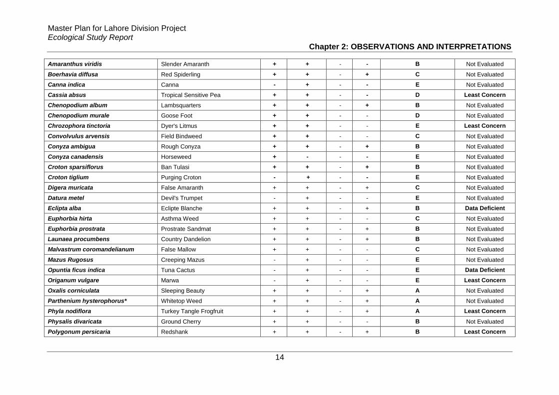
Master Plan for Lahore Division Project Ecological Study Report
Chapter 2: OBSERVATIONS AND INTERPRETATIONS
14
Amaranthus viridis Slender Amaranth + + - - B Not Evaluated
Boerhavia diffusa Red Spiderling + + - + C Not Evaluated
Canna indica Canna - + - - E Not Evaluated
Cassia absus Tropical Sensitive Pea + + - - D Least Concern
Chenopodium album Lambsquarters + + - + B Not Evaluated
Chenopodium murale Goose Foot + + - - D Not Evaluated
Chrozophora tinctoria Dyer's Litmus + + - - E Least Concern
Convolvulus arvensis Field Bindweed + + - - C Not Evaluated
Conyza ambigua Rough Conyza + + - + B Not Evaluated
Conyza canadensis Horseweed + - - - E Not Evaluated
Croton sparsiflorus Ban Tulasi + + - + B Not Evaluated
Croton tiglium Purging Croton - + - - E Not Evaluated
Digera muricata False Amaranth + + - + C Not Evaluated
Datura metel Devil's Trumpet - + - - E Not Evaluated
Eclipta alba Eclipte Blanche + + - + B Data Deficient
Euphorbia hirta Asthma Weed + + - - C Not Evaluated
Euphorbia prostrata Prostrate Sandmat + + - + B Not Evaluated
Launaea procumbens Country Dandelion + + - + B Not Evaluated
Malvastrum coromandelianum False Mallow + + - - C Not Evaluated
Mazus Rugosus Creeping Mazus - + - - E Not Evaluated
Opuntia ficus indica Tuna Cactus - + - - E Data Deficient
Origanum vulgare Marwa - + - - E Least Concern
Oxalis corniculata Sleeping Beauty + + - + A Not Evaluated
Parthenium hysterophorus* Whitetop Weed + + - + A Not Evaluated
Phyla nodiflora Turkey Tangle Frogfruit + + - + A Least Concern
Physalis divaricata Ground Cherry + + - - B Not Evaluated
Polygonum persicaria Redshank + + - + B Least Concern

Master Plan for Lahore Division Project Ecological Study Report
Chapter 2: OBSERVATIONS AND INTERPRETATIONS
15
Polygonum plebejum Small Knotweed + + - - B Not Evaluated
Solanum nigrum Black Nightshade + + - + A Not Evaluated
Sonchus asper Spiny Milk Thistle + + - - C Not Evaluated
Suaeda fruticosa Shrubby Seablite - + - - E Not Evaluated
Trianthema portulacastrum Wild Water Melon + + - + B Not Evaluated
Xanthium strumarium Cocklebur + + - - B Not Evaluated
GRASSES
Acrachne racemosa Goosegrass + + - - C Not Evaluated
Bothriochloa laguroides Silver Beardgrass + + - + C Not Evaluated
Brachiaria reptans Creeping Panic Grass + + - + C Least Concern
Cenchrus ciliaris Buffel Grass + + - - D Not Evaluated
Cenchrus setigerus Birdwood Grass + + - - C Not Evaluated
Cynodon dactylon Bermuda Grass + + + + A Not Evaluated
Dactyloctenium aegyptium Egyptian Crowfoot Grass + + - - C Not Evaluated
Dactyloctenium scindicum - + + - + B Not Evaluated
Desmostachya bipinnata Halfa Grass + + - + A Least Concern
Digitaria ciliaris Southern Crabgrass + + - + B Not Evaluated
Echinochloa colonum Jungle Rice + + - + B -
Echinochloa crusgalli Barnyardgrass + + - - C Least Concern
Eleusine indica Wiregrass + + - - D Least Concern
Eragrostis cilianensis Candy Grass + + - - D Not Evaluated
Eriochloa procera Spring Grass + + - - D Least Concern
Hemarthria compressa Whip Grass + + - + C Least Concern
Imperata cylindrica Blady Grass + + - - C Not Evaluated
Leptochloa panicea Mucronate Sprangletop + + - - C Least Concern
Panicum antidotale Blue Panicgrass + + - - C Not Evaluated
Paspalum distichum Gingergrass + + - - D Not Evaluated

Master Plan for Lahore Division Project Ecological Study Report
Chapter 2: OBSERVATIONS AND INTERPRETATIONS
16
Phragmites karka Tall Reed - - - + C Least Concern
Saccharum munja Plume Grass + + - + B Not Evaluated
Saccharum ravennae Canne D'italie + + - - C Least Concern
Saccharum spontaneum Wild Cane + + - + B Least Concern
Setaria glauca Yellow Foxtail + + - - D Not Evaluated
Setaria pumila Pigeon Grass + + - + C Not Evaluated
Sorghum halepense Johnson Grass + + - - C Not Evaluated
Sporobolus coromandelianus Madagascar Dropseed + + - - D Not Evaluated
SEDGES
Carex fedia ness. Carex + + - + C Not Evaluated
Cyperus difformis Smallflower Umbrella Sedge + + - - E Least Concern
Cyperus iria Rice Flat Sedge + + - + B Least Concern
Cyperus rotundus Nut-Grass + + - + B Least Concern
Pycreus flavidus - + + - - E Least Concern
"+" = Present, "-" = Absent, * = Invasive, A+O = Agriculture + Orchards, R/R.V/G.B. = Railway/Road Verges/Green Belts, R+O = Residential + Offices, R/C.B = River/ Canal Banks, A = very Common, B = Common & Widespread, C = Less Common, D = Uncommon, E = Rare
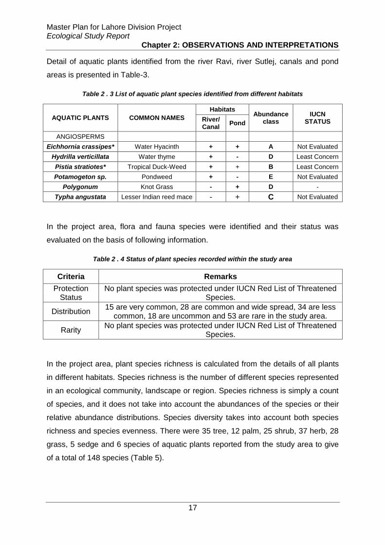
Master Plan for Lahore Division Project Ecological Study Report
Chapter 2: OBSERVATIONS AND INTERPRETATIONS
17
Detail of aquatic plants identified from the river Ravi, river Sutlej, canals and pond
areas is presented in Table-3.
Table 2 . 3 List of aquatic plant species identified from different habitats
AQUATIC PLANTS COMMON NAMES
Habitats Abundance
class IUCN
STATUS River/ Canal
Pond
ANGIOSPERMS
Eichhornia crassipes* Water Hyacinth + + A Not Evaluated
Hydrilla verticillata Water thyme + - D Least Concern
Pistia stratiotes* Tropical Duck-Weed + + B Least Concern
Potamogeton sp. Pondweed + - E Not Evaluated
Polygonum Knot Grass - + D -
Typha angustata Lesser Indian reed mace - + C Not Evaluated
In the project area, flora and fauna species were identified and their status was
evaluated on the basis of following information.
Table 2 . 4 Status of plant species recorded within the study area
Criteria Remarks
Protection Status
No plant species was protected under IUCN Red List of Threatened Species.
Distribution 15 are very common, 28 are common and wide spread, 34 are less
common, 18 are uncommon and 53 are rare in the study area.
Rarity No plant species was protected under IUCN Red List of Threatened
Species.
In the project area, plant species richness is calculated from the details of all plants
in different habitats. Species richness is the number of different species represented
in an ecological community, landscape or region. Species richness is simply a count
of species, and it does not take into account the abundances of the species or their
relative abundance distributions. Species diversity takes into account both species
richness and species evenness. There were 35 tree, 12 palm, 25 shrub, 37 herb, 28
grass, 5 sedge and 6 species of aquatic plants reported from the study area to give
of a total of 148 species (Table 5).

Master Plan for Lahore Division Project Ecological Study Report
Chapter 2: OBSERVATIONS AND INTERPRETATIONS
18
Table 2 . 5 Overall species richness of all plants recorded within the study area
Plant Type Richness
Trees 35
Palms 10
Shrubs 25
Herbs 37
Grasses 28
Sedges 5
Aquatic 6
Total 146
2.1.2.3. Survey for inventory of faunal diversity in the project site
Extensive surveys were carried-out in the project area and data was gathered for
mammals, reptiles, birds and amphibians. A checklist of the species that might be
expected in the study area was prepared by searching published literature. Both
direct observation and indirect methods were used to gather information. Community
surveys were carried out and data was gathered from the local people regarding
information of animals in the area using field guides and colored photographs. The
detailed survey included ecological importance of species, their niche and their IUCN
conservation status; like endangered, threatened, vulnerable etc.
Bird survey
Birds were surveyed in early morning and late afternoon of the same day with the
help of transects and walkovers in the study sites. Identification of species was done
using binoculars. Effective sampling distance was 200 m from transects. The
recorded data of birds was about species identity and their relative abundance in
each of the habitat. Table 7 and Figures 2-6 show details of the birds found in the
project area.

Master Plan for Lahore Division Project Ecological Study Report
Chapter 2: OBSERVATIONS AND INTERPRETATIONS
19
Mammal survey
Mammals were surveyed during the visits and were identified from field observations
of paw prints, scats and their burrows. Table 6 and Figure 7 show details of the
mammals found in the project area.

Master Plan for Lahore Division Project Ecological Study Report
Chapter 2: OBSERVATIONS AND INTERPRETATIONS
20
Table 2 . 6 List of mammals recorded within the project area
Mammals’ Species Common name
Habitats
AC IUCN status
Punjab Wildlife Act
CITES A+O R/R./G. B R+O R./C. B P
Rattus rattus House rat + + + + - A LC
Golunda ellioti Indian Bush rat + + - + - B LC
Millardia meltada soft furred field rat + + - + - B LC
Mus musculus House mouse + + + + - A LC
Suncus murinus Asiatic House shrew + + + + - A LC
Megaderma lyra Indian false vampires + + + + - B LC
Funambulus pennantii Palm squirrel + + + + - A LC
Hystrix indica Indian crested porcupine + + - + - B LC
Lepus nigricollis Indian hare + + - + - C LC
Felis chaus Jungle cat + + - + - B LC
Herpestes mungo Indian mongoose + + - + - B LC
Sus scrofa Wild boar + - - + - B LC
Canis aureus Asiatic Jackal + - - + - D LC
*=Migratory, A+O = Agriculture + Orchards, R/R.V/G.B = Railway/Road Verges/Green, R/C.B = River/Canal Bank, R+O = Residential+Offices, P = Ponds, AC = abundance class, LC=Least concern, VU=Vulnerable, NE=Not evaluated, NT = Near Threatened, A=very common, B= common & wide spread, C=
less common, D= Uncommon, E = Rare
Table 2 . 7 List of Bird species recorded within the project area
Birds Species Common name
Habitats
AC IUCN status Punjab Wildlife
Act A+O R/R/G. B R+O R. / C. B P
Egretta intermedia Intermediate Egret + - - + - B LC
Streptopelia tranquebarica Red turtle dove + + + + + A LC

Master Plan for Lahore Division Project Ecological Study Report
Chapter 2: OBSERVATIONS AND INTERPRETATIONS
21
Acridotheres tristis Common Myna + + + + + A LC
Passer domesticus House Sparrow + + + + + A LC
Dicrurus macrocersus vieillot Black Drongo + + - - - B LC
Corvus splendens House Crow + + + + + A LC
Pyconotus cafer Red vented bulbul + - - + - D LC
Bubulcus ibis Cattle egret + - - + + C LC
Upopa epops* Hoopoe + - - + + D LC
Hoplopterus indicus* Red-Wattled Lapwing + + - + + B LC
Merops orientalis Green bee eater + + - - - D LC
Acridotheres ginginianus Bank Myna + + - + + C LC
Anas Platyrhynchos* Mallard + - - - + C LC
Gallinula chloropus* Common moorhen + - - + - D LC
Ceryle rudis Pied kingfisher + - - + + C LC
Callacanthis burtoni Spectacle Finch + + - + - D LC
Milvus migrans migrans Black kite + - + + + A LC
Psittacula krameri Rose-ringed Parakeet + + + - - B LC
Columba livia Wild rock dove + + + + + A LC
Halcyon smyrnensis White-breasted Kingfisher + - - + + B LC
Treron phoenicoptera yellow-footed green pigeon + - - - - E LC
Merops philippinus* Blue tailed bee eater + - - + + D LC
Saxicoloides fulicata Indian robin + - - - - E LC
Actitis hypoleucos* Common Sand piper + - - + + E LC
Motacilla alba White wagtail + - - + + D LC
Gracupica contra Pied myna + + - + + B LC
Cinnyris asiaticus Purple sunbird + - - - - E LC
Spilopelia senegalensis little brown dove + + - + + D LC
Dinopium benghalense golden backed woodpecker + + - - - E LC

Master Plan for Lahore Division Project Ecological Study Report
Chapter 2: OBSERVATIONS AND INTERPRETATIONS
22
Saxicola caprata Bush chat + + - + - C LC
Petronia xanthocollis yellow throated sparrow + - - - - E LC
Anas crecca* Common teal + - - + + C LC
Amaurornis phoenicurus white breasted hen + - - + + C LC
Streptopelia capicola Ring necked dove + - - - - E LC
Coracias benghalensis Indian roller + + - - - D LC
Hirundo rustica* Common swallow + - - + - D LC
Galerida cristata Crested lark + - - - + D LC
Turdoides caudate Common babbler + + - - - C LC
Accipiter badius Shikra + - - - - E LC
Lanius schach* long tailed shrike + + - - - C LC
Coturnix coturnix* Common Quail + - - - - E LC
Egretta garzetta* little egret + - - + + B LC
Ardeola grayii Indian pond Heron + - - + + C LC
Himantopus himantopus* Black winged stilt - - - + + D LC
Orthotomus sutorius Common tailor bird + - - - - E LC
Ploceus philippinus baya weaver + - + + - D LC
Copsychus saularis Magpie robin + - - - - E LC
Zosterops palpebrosus Oriental white eye + - - - - E LC
Phalacrocorax niger* Cormorant - - - + + C LC
Egretta alba* Large Egretta - + - + - C LC
Aquila rapax nipalensis Tawny Eagle - - - - - D LC
Francolinus francolinus Black Partridge + - - + + B LC
Francolinus pondicerianus Grey Partridge + + - - - B LC
Centropus sinensis Large Indian Parakeet + + - - - E LC
Otus bakkamoena Indian Scops Owl + + - - - E LC
Alcedo atthis* Common Kingfisher - - - + + D LC

Master Plan for Lahore Division Project Ecological Study Report
Chapter 2: OBSERVATIONS AND INTERPRETATIONS
23
Eremopterix grisea Ashy Crowned Lark - - - + - E LC
Anthus novaeseelandiae Richard'Pipit + + - - - D LC
Dendrocopos assimilis Sindh Pied Woodpecker - - - + - E LC
Tephrodornis pondicerianus Common Wood Shrike + - - - - E LC
Pycnonotus leucogenys White-cheeked Bulbul + - - - - E LC
Cisticola juncidis* Fan-tail Warbler + - - + + C LC
Prinia gracilis Streaked Long-tail Warber + + - - - C LC
Chrysomma sinense Yellow-eyed Babbler - + - + - D LC
Chrysomma altirostre Sindh Babbler + - - + - E V
Turdoides caudatus Common Babbler + - - - - E LC
Lanius vittatus* Bay-backed Shrike + + - - - E LC
Lanius excubitor* Great Grey Shrike + - - - - E LC
Passer pyrrhonotus Sindh Jungle Sparrow - + - - - D LC
Prinia socialis Long Tailed Grass Warber + - - - - B LC
*=Migratory, A+O = Agriculture + Orchards, R/R.V/G.B = Railway/Road Verges/Green, R/C.B = River/Canal Bank, R+O = Residential+Offices, P = Ponds, AC = abundance class, LC=Least concern, VU=Vulnerable, NE=Not evaluated, NT = Near Threatened, A=very common, B= common & wide spread, C=
less common, D= Uncommon, E = Rare
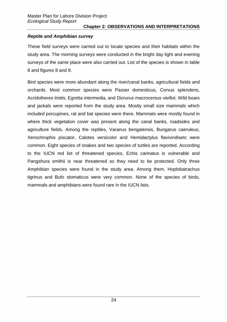
Master Plan for Lahore Division Project Ecological Study Report
Chapter 2: OBSERVATIONS AND INTERPRETATIONS
24
Reptile and Amphibian survey
These field surveys were carried out to locate species and their habitats within the
study area. The morning surveys were conducted in the bright day light and evening
surveys of the same place were also carried out. List of the species is shown in table
8 and figures 8 and 9.
Bird species were more abundant along the river/canal banks, agricultural fields and
orchards. Most common species were Passer domesticus, Corvus splendens,
Acridotheres tristis, Egretta intermedia, and Dicrurus macrocersus vieillot. Wild boars
and jackals were reported from the study area. Mostly small size mammals which
included porcupines, rat and bat species were there. Mammals were mostly found in
where thick vegetation cover was present along the canal banks, roadsides and
agriculture fields. Among the reptiles, Varanus bengalensis, Bungarus caeruleus,
Xenochrophis piscator, Calotes versicolor and Hemidactylus flaviviridisetc were
common. Eight species of snakes and two species of turtles are reported. According
to the IUCN red list of threatened species, Echis carinatus is vulnerable and
Pangshura smithii is near threatened so they need to be protected. Only three
Amphibian species were found in the study area. Among them, Hoplobatrachus
tigrinus and Bufo stomaticus were very common. None of the species of birds,
mammals and amphibians were found rare in the IUCN lists.

Master Plan for Lahore Division Project Ecological Study Report
Chapter 2: OBSERVATIONS AND INTERPRETATIONS
25
Table 2 . 8 List of Reptile and Amphibian species recorded within the project area
Animal Species Common name
Habitats
AC IUCN status
Punjab Wildlife Act
CITES A+O
R/R. V/GB
R+O R. / C. B
P
Reptiles
Bungarus caeruleus Indian crate + - - + + A LC
Amphiesma stolatum buff striped keelback - - - + + C NE
Lycodon aulicus Indian wolf snake + + - - - C NE
Ptyas mucosa Oriental/Indian rat snake - + + - - D NE II
Typhlops porrectus Slender Worm Snake, blind + - + - - E NE
Eryx johnii Indian sand boa (do-muha) + + - - - C NE
Xenochrophis piscator Checkered keelback - - - + + A NE III
Echis carinatus Saw-scaled viper + - - - - E V
Varanus bengalensis Indian monitor lizard + + + + + A LC I
Calotes versicolor Oriental/Indian garden lizard + + + - - A LC
Hemidactylus flaviviridis Yellow-bellied House Gecko + + + - - A NE
Ablepharus grayanus Minor snake-eyed skink + + + - - B NE
Eutropis macularia Bronze grass skink + + - - - C NE
Pangshura smithii Brown roofed turtle - - - + - E NT
II
Lissemys punctata Adersoni Indian flapshell turtle - - - + + B LC II
Amphibians
Hoplobatrachus tigrinus Indian bull frog + + + + - A LC
Bufo stomaticus Indus toad + + + + + A LC
Euphlyctis cyanophlyctis Indian skipper frog - - - + - C LC
*=Migratory, A+O = Agriculture + Orchards, R/R.V/G.B = Railway/Road Verges/Green, R/C.B = River/Canal Bank, R+O = Residential+Offices, P = Ponds, AC = abundance class, LC=Least concern, VU=Vulnerable, NE=Not evaluated, NT = Near Threatened, A=very common, B= common & wide
spread, C= less common, D= Uncommon, E = Rare

Master Plan for Lahore Division Project Ecological Study Report
Chapter 2: OBSERVATIONS AND INTERPRETATIONS
26
Fish survey
Fish surveys were carried-out in the main channel of river Ravi and river Sutlej using
monofilaments nylon gills net. These nets were deployed at different sites on 0.5 m
depth from the surface for 30 minutes to one hour during the vegetation survey in
nearby community. Fishermen were also interviewed to collect information on the
fish present in the rivers. The list of the species present in the two rivers is given in
Table 9
Table 2 . 9 List of fish species found in the rivers of the project area
Scientific Names Common Names IUCN status
Catla catla Thaila/Indian carp LC
Channa marulius Saul LC
Channa punctate Daula LC
Cirrhinus mrigala Mori LC
Ctenopharyngodon idella † Grass carp NE
Cyprinus carpio*† Common carp/Gulfam VU
Hypopthalmichthys molitrix † Silver carp NT
Hypophthalmichthys nobilis † Big head carp DD
Labeo rohita Rohu LC
Macrognathus pancalus Groj LC
Oreochromis aureus* Tilapia NE
Rita rita Khagga/Tirkanda LC
Sperata sarwari Singharee LC
Wallago attu Mullee NT
LC=Least concern, VU=Vulnerable, NT=Near threatened, DD= Data deficient, NE= Not evaluated, * = invasive, † exotic
In the current study 14 species were found to be present in river Ravi and Sutlej.
Among the fish species found grass carp (Ctenopharyngodon idella), bighead carp
(Hypophthalmichthys nobilis), silver carp (Hypophthalmichthys molitrix), common
carp (Cyprinus carpio) and tilapia (Oreochromis aureus) are exotic that were
introduced into freshwater reservoirs of Pakistan for aquaculture, sport fishing or
biological control of weeds. But now these species are competing with native species
for food, breeding grounds and are preying upon them thus causing a decline in their
population. These exotic species are becoming invasive in the freshwater biomes of
the Punjab and other provinces of Pakistan by reason of their potent reproductive
potential and feeding competitions with the native freshwater fish fauna. Resultantly

Master Plan for Lahore Division Project Ecological Study Report
Chapter 2: OBSERVATIONS AND INTERPRETATIONS
27
the native fish species viz; Channa marulius, Wallago attu, Rita rita, Sperata sarwari,
Catla catla, Cirrhinus mrigala and Labeo rohita, which are of economic value are
reported to be under threat (Khan et al. 2008, 2011). IUCN threat status of the
species showed that Hypopthalmichthys molitrix is near threatened and Cyprinus
carpio is vulnerable but both species are introduced and not native to this area and
the later one is an invasive exotic.
Egretta intermedia Corvus splendens Merops orientalis
Streptopelia tranquebarica Pyconotus cafer Acridotheres ginginianus
Acridotheres tristis Bubulcus ibis Anas Platyrhynchos*
Passer domesticus Upopa epops* Gallinula chloropus*

Master Plan for Lahore Division Project Ecological Study Report
Chapter 2: OBSERVATIONS AND INTERPRETATIONS
28
Dicrurus macrocersus vieillot Hoplopterus indicus* Francolinnus francolinus
*=Migratory birds, Source: Avibase- the world bird database www.avibase.bsc-eoc.org/avibase.jsp, Data Zone www.birdlife.org/datazone
Figure 2 . 1 Birds of study area
Ceryle rudis Halcyon smyrnensis Motacilla alba
Callacanthis burtoni Treron phoenicoptera Gracupica contra
Milvus migrans migrans Merops philippinus* Cinnyris asiaticus
Psittacula krameri Saxicoloides fulicata Spilopelia senegalensis

Master Plan for Lahore Division Project Ecological Study Report
Chapter 2: OBSERVATIONS AND INTERPRETATIONS
29
Columba livia Actitis hypoleucos*
Dinopium benghalense
Saxicola caprata Coracias benghalensis Accipiter badius
Petronia xanthocollis Hirundo rustica* Lanius schach
Anas crecca* Centropus sinensis Coturnix coturnix*
Amaurornis phoenicurus Galerida cristata Egretta garzetta*
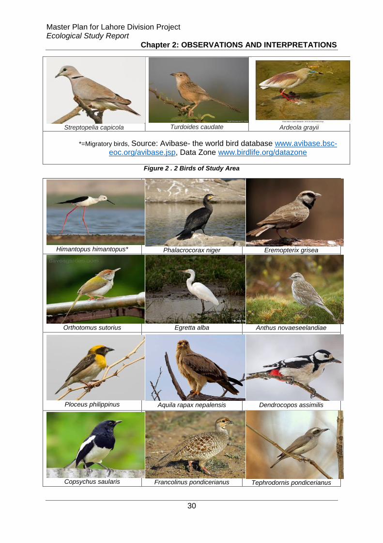
Master Plan for Lahore Division Project Ecological Study Report
Chapter 2: OBSERVATIONS AND INTERPRETATIONS
30
Streptopelia capicola Turdoides caudate Ardeola grayii
*=Migratory birds, Source: Avibase- the world bird database www.avibase.bsc-eoc.org/avibase.jsp, Data Zone www.birdlife.org/datazone
Figure 2 . 2 Birds of Study Area
Himantopus himantopus*
Phalacrocorax niger
Eremopterix grisea
Orthotomus sutorius
Egretta alba
Anthus novaeseelandiae
Ploceus philippinus
Aquila rapax nepalensis
Dendrocopos assimilis
Copsychus saularis
Francolinus pondicerianus
Tephrodornis pondicerianus
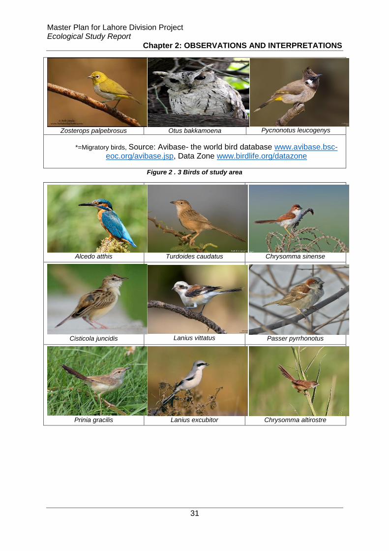
Master Plan for Lahore Division Project Ecological Study Report
Chapter 2: OBSERVATIONS AND INTERPRETATIONS
31
Zosterops palpebrosus
Otus bakkamoena
Pycnonotus leucogenys
*=Migratory birds, Source: Avibase- the world bird database www.avibase.bsc-eoc.org/avibase.jsp, Data Zone www.birdlife.org/datazone
Figure 2 . 3 Birds of study area
Alcedo atthis
Turdoides caudatus Chrysomma sinense
Cisticola juncidis
Lanius vittatus Passer pyrrhonotus
Prinia gracilis Lanius excubitor
Chrysomma altirostre

Master Plan for Lahore Division Project Ecological Study Report
Chapter 2: OBSERVATIONS AND INTERPRETATIONS
32
Prinia socialis
*=Migratory birds, Source: Avibase- the world bird database www.avibase.bsc-eoc.org/avibase.jsp, Data Zone www.birdlife.org/datazone
Figure 2 . 4 Birds of Study Area
Rattus rattus
Megaderma lyra
Herpestes mungo
Golunda elliota Funambulus pennantii Sus scrofa
Millardia meltada Hystrix indica
Canis aureus

Master Plan for Lahore Division Project Ecological Study Report
Chapter 2: OBSERVATIONS AND INTERPRETATIONS
33
Mus musculus Lepus nigricollis Suncus murinus
Felis chaus
Source: The IUCN Red list of threatened species www.iucnredlist.org
Figure 2 . 5 Mammals of Study Area
Bungarus caeruleus
Eryx johnii Hemidactylus flaviviridis
Amphiesma stolatum Xenochrophis piscator Ablepharus grayanus
Lycodon aulicus Echis carinatus Eutropis macularia

Master Plan for Lahore Division Project Ecological Study Report
Chapter 2: OBSERVATIONS AND INTERPRETATIONS
34
Ptyas mucosa Varanus bengalensis
Pangshura smithii
Typhlops porrectus Calotes versicolor
Lissemys punctata Adersoni
Source: The IUCN Red list of threatened species www.iucnredlist.org Figure 2 . 6 Reptiles of Study Area
Hoplobatrachus tigerinus
Bufo stomaticus
Euphlyctis cyanophlyctis
Data Source: The IUCN Red list of threatened species www.iucnredlist.org,
http://amphibiaweb.org/species/4703 , and http://eol.org/ Figure 2 . 7 Amphibians od Study Area
2.1.3. Protection status of all Animals found in the area
After evaluating habitats and developing inventory of fauna species, status of
protection was evaluated for the species of mammals, amphibians, reptiles and birds
according to the criteria described.
Following is the detail of mammals in the study area those are evaluated on their
distribution, protection status and rarity (Table 10).

Master Plan for Lahore Division Project Ecological Study Report
Chapter 2: OBSERVATIONS AND INTERPRETATIONS
35
Table 2 . 10 Status of Mammals Species recorded within the Study Area
Criteria Remarks
Protection Status
Herpestes mungo and Felis Chaus are protected under Punjab Wildlife Act.
Distribution
Rattus rattus, Funambulus pennantii, Mus musculus and Suncus murinus are very common. 7 species are common in the study area.
Lepus nigricollis and Canis aureus are less common and uncommon, respectively. There are no endemic species.
Rarity None of them are threatened according to IUCN red data list.
The detail of amphibian species evaluated on the basis of their distribution,
protection status and rarity is given in table 11.
Table 2 . 11 Status of Amphibian Species recorded within the Study Area
Criteria Remarks
Protection Status
None of the species are particularly protected.
Distribution 2 species are very common (Hoplobatrachus tigrinus and Bufo
stomaticus), 1 species (Euphlyctis cyanophlyctis) is common and wide spread. There are no endemic species.
Rarity None of them are rare locally or are threatened according to IUCN
red data list.
In case of reptiles, the details of their distribution, protection status and rarity are
listed in table 12.
Table 2 . 12 Status of Reptile Species recorded within the Study Area
Criteria Remarks
Protection Status
Amphiesma stolatum, Lycodon aulicus, Ptyas mucosa and Xenochrophis piscator are protected under Punjab Wildlife Act Schedule Three. Varanus bengalensis and Lissmeys punctata adersoni are also protected under this wildlife act. These two species are also recorded in CITES Appendix list I and II respectively. Pangshura smithii is listed only in CITES Appendix II.
Distribution 5 species are very common in the study area. Ablepharus grayanus and Lissemys Punctata are common and wide spread. 4 species are less common and only 1 species (Pytas mucosa) is uncommon.

Master Plan for Lahore Division Project Ecological Study Report
Chapter 2: OBSERVATIONS AND INTERPRETATIONS
36
Othter 3 species knowns as Typhlops porrectus, Echis carinatus, and Pangshura smithii are rare. There are no endemic species present in this area.
Rarity Echis carinatus and Pangshura smithii are graded as vulnerable and near threatened, respectively on IUCN Red List of threatened species.
The distribution, protection status and rarity of birds evaluated in the study area is
provided in Table 13.
Table 2 . 13 Status of Birds Species recorded within the Study Area
Criteria Remarks
Protection Status
Egretta Intermedia, Streptopelia tranquebarica, Bubulcus ibis, Anas platyrhynchos, Milvus migrans migrans, Amaurornis phoenicurus, Ardeola grayii, Egretta garzetta and Egretta alba are listed in Punjab Wildlife Act Schedule III. Francolinus francolinus and Francolinus pondicerianus are present under Schedule I. Himantopus himantopus is protected under UNEP’s Agreement on the Conservation of African-Eurasian Migratory Water birds of ‘Convention on migratory species’
Distribution 6 species are very common, 10 species are common and widespread, 14 species are less common, 18 are uncommon species. Remaining are rare. There is no endemic species in this area.
Rarity Only one species Chrysomma altirostre is vulnerable according to IUCN red data list.
2.2. Assessment of Ecological Impacts from the
planning of new Development in the project area
This section of the report deals with the impacts on ecological resources of project
area. The above identified habitats, species and other resources can have potential
impacts from proposed master plan. Evaluation of these impacts has been carried-
out for planning, implementation, construction and operation phases of the proposed
Master Plan. To reveal the potential impacts on resources, visits were carried-out in
the area in addition vigorous literature surveys were conducted to compile this
section. Keeping legislations and guidelines in consideration and researching
literature, the potential impacts on the ecological resources due to the planning in the
project area have been identified as follows

Master Plan for Lahore Division Project Ecological Study Report
Chapter 2: OBSERVATIONS AND INTERPRETATIONS
37
2.2.1. Implementation and construction impacts
2.2.1.1. Permanent loss of agricultural land/orchards
As in the planning of many sites, orchards and agriculture land will be totally
converted into residential and other areas which will result in loss of some important
habitats along with affecting food production. Agriculture is backbone to the Punjab
plains and the current project will have strong impact on agricultural productivity and
loss of livelihood opportunities of rural communities. Around 100,000 Acres of
agricultural land will be effected due change in land use with implementation of
master plan. Direct loss of productive capacity, the successive land conversions that
have taken place in the past has also negatively influenced the flora and fauna of
proposed area. These externalities were generally reported to have taken several
forms which imposed additional burdens on existing farming conditions.
2.2.1.2. Removal of native vegetation and habitat loss
During implementation and construction of the project, many habitats will be totally
diminished e.g. many agricultural fields. There will be removal of native vegetation
and loss of habitat for the native animal species. There will be more fragmentation in
the natural habitats due to extensive road network in the area.
2.2.1.3. Effects of land conversion on rural communities
The migration of a large proportion of non-farming population has generally reduced
the overall profitability of farming by restricting certain farming operations. This will
lead to a reduction in farm net income, Great loss of agricultural lands for built
surfaces not only affects the population food balance, but also changes the lifestyle
of rural population used to an agricultural one, causing their migration to the city or
changing the economic activities profile. Overall loss of biodiversity and agricultural
production as a consequence to the insertion of built spaces. Most important impact
to mention will be the loss of livelihood opportunities for the local people, land
owners, shop keepers etc. due to changes in land use pattern and agricultural
dependent families.

Master Plan for Lahore Division Project Ecological Study Report
Chapter 2: OBSERVATIONS AND INTERPRETATIONS
38
2.2.1.4. Habitat damage
Due to the construction in the project site, direct, indirect or temporary damages will
occur from site excavation and clearance, spoils in other habitat. Transportation
during construction process will also destroy wilderness of the area. Most of the
agricultural land will be damaged due to construction in the sites especially Kasur
and Nankana’s agricultural land.
2.2.1.5. Wildlife disturbance and Noise pollution
Wilderness is a trait of wild areas which are far from the urban areas. Urban areas
display lots of population, roads traffic, congestion, sounds of machines, etc. Due to
construction and development in this area, human disturbance to ecosystems will be
highest to the wild animals and birds especially. The severity of this disturbance
totally depends upon duration of activity in the site, intensity and frequency. Many
mammals and birds can be more disturbed by presence of workers, loud noises and
operational construction plants.
2.2.1.6. Soil erosion
Due to excavation and site clearance, soil will be exposed and eroded. As a result of
this soil erosion, there will be more soil deposition with runoff in canals and riverbeds
which will cause siltation and sedimentation. Aquatic life can face stress from the
high turbidity of suspended soil particles which will reduce light penetration.
Furthermore a higher eutrophication can deplete dissolve oxygen of the water bodies
providing more stress to fish and other aquatic macrophytes.
2.2.2. Operational impacts
2.2.2.1. Impacts of urban development on biodiversity
Research published by the Royal Society shows that cities retain only 8% of the
native bird species and 25% of the plant species of comparable undeveloped land
(Aronson et al. 2014). As supported by the published literature, broadly three things
can affect urban biodiversity in the project area:
• the quality, amount, and patch size of conserved open space;
• how open space and nearby built areas are managed; and

Master Plan for Lahore Division Project Ecological Study Report
Chapter 2: OBSERVATIONS AND INTERPRETATIONS
39
• the degree of open space connectivity.
Figure 2 . 8 Impacts of Urban Development on Biodiversity
The growth of cities may cause biodiversity to decline by fragmenting or destroying
large areas of natural habitat on which many species depend. The rising human
population is driving the expansion of urban areas and increasing the demand for
natural resources such as timber and fossil fuels. This inevitably leads to habitat
destruction which has been called “the largest factor contributing to the current
global extinction event as shown in Figure-10.
2.2.2.2. Change in land use pattern
Educational, commercial and Institutional offices are proposed as residential areas
which will bring an overall change in land use pattern. The environmental and social
consequences of the traffic bottlenecks arising from the land use complication as a
result of heavy commercialization and business activities in the area. It should be
noted that effective solution to traffic problems in the area cannot be found in a strait
jacket application of a particular solution but a combination of efforts. These will
result in the loss of wilderness of many habitats.
2.2.2.3. Habitat degradation due to higher pollutants
Water pollution
Urbanization has adverse impacts on the air and water quality, as well as climatic
conditions of the region. This poses a risk to the health of local community.

Master Plan for Lahore Division Project Ecological Study Report
Chapter 2: OBSERVATIONS AND INTERPRETATIONS
40
Development of more industrial units in area will result in serious water pollution in
the region.
Noise pollution due to urbanization
Due to the development in the area, urban life will create big burden on natural
resources. Human interruption in form of business centers and residential colonies
etc. will degrade naturalness of the wild. Therefore more noise pollution will result.
Light pollution
Another important operational impact of the project on wildlife will be from lights in
urban areas. Wild animals are used to conditions of wild that is low noise, low lights
and naturalness. With this mega development in the area, and lots of lights from
urban, residential, commercial and transportation pressure, many wild animals will
be forced to leave their wild sites.
Air pollution
Increase in the settlement is directly linked with increase in vehicles and more fuel
combustion. Vehicles are mobile source of pollution and fuel combustion in
stationary sources, including residential, commercial, and industrial heating and
cooling also release air pollutants. Air pollutants and particulates can penetrate deep
into lungs and have adverse health effects along with affecting the biological
diversity.
2.2.2.4. Habitat Fragmentation
Closely related to habitat loss is habitat fragmentation which can be defined as the
transformation of a large and continuous habitat into many smaller, isolated habitats.
The expansion of cities causes the fragmentation of large areas of natural habitat
through the construction of roads, houses and industry. The project will simply
increase fragmentation in different habitats due to change in land-use pattern.
2.2.2.5. Bird Collisions and strikes
There are special problems posed for birds living in or flying through cities. Research
has documented that buildings and windows are the top killer of wild birds. Between
one and five percent of the total migratory population die in window crashes annually
(Klem, 2009). Building collisions pose further risk to endangered or threatened

Master Plan for Lahore Division Project Ecological Study Report
Chapter 2: OBSERVATIONS AND INTERPRETATIONS
41
species whose populations are already declining due to habitat loss, toxin loads, and
other severe environmental pressures. Collision hazards include vehicles, bridges,
transmission towers, power lines, and turbines, but the majority of avian deaths and
injuries occur from impacts with building components such as transparent or
reflective glass. Night-time lighting also interferes with avian migrations.
2.2.2.6. Change in groundwater recharge capacity
Construction closer to irrigation channels, rivers and canals affects the transport of
water and sediment, so that the local hydrological equilibrium will be upset, and the
effects spread through the community, causing a general ecological transition.
Groundwater recharge capacity will be affected by making buildings, constructing
roads and other concrete and paved structures.
2.2.3. Social Impacts of urban growth due to new development
and planning
Impacts of urban growth due to new development and planning are summarized in
table 14
Table 2 . 14 Impacts of urban growth due to new development and planning
Parameters Positive effects Negative effects
Economic production
Will be enhanced by new development in many sectors
Agricultural productivity will be reduced but few areas can be still utilized for this purpose
Population growth
Today, a majority of the world’s population lives in cities. By 2050, two-thirds of all people on the planet are projected to call urbanized areas their home. in such case new areas are needed to reduce pressure on already existing mega cites
Planning of the area will reduce negative impacts of urban population growth.
Pressure on megacities
There is already much pressure on resources and life of mega cities like Lahore, in this particular case, nearby cities’ development will reduce pressure and will shift a big population back to their own cities.
Keeping future growth in mind, this will have more positive impact than negative. -
Livelihood It will provide many livelihood

Master Plan for Lahore Division Project Ecological Study Report
Chapter 2: OBSERVATIONS AND INTERPRETATIONS
42
opportunities opportunities in their regions for which people are travelling to mega cities on daily basis.
Employment Will increase employment chances for population of Lahore city
More employment will be generated in Sheikhupura, Nankana and Kasur cities.
Security New housing societies will have improved security system
With an implementation of this master plan, all three cities will be urbanized which will cause people of the surrounding villages to move into these areas for better job, education and healthcare facilities. This may increase security risks in the area.
Environmental scenario
Planned development makes more room for green spaces--trees, parks and yards--which help minimize both air and water pollution.
Unplanned growth poses higher impact on natural resources. Therefore, when these areas will be developed
Lifestyle Will be improved -
Services Transportation Education Healthcare Sewer & water system
New development will provide better services of infrastructure; better transport system in form of wider concrete roads, better educational and healthcare services, better water, and sewerage system in new housing
-
Attract tourist It attract more tourist activities -
Land and property value
It will raise land and property value of nearby society as well
-
Touch of global feel
Such improvements provide a global feel to the citizens
-
Triggers secondary development
It will enhance secondary development in the region
It should be planned as well.
2.3. Mitigation Measures to lessen the impacts of
development
The mitigation priorities for the project are avoidance or minimization, restoration and
compensation. The aims of providing mitigation measures are to provide
environmentally friendly options which can minimize the losses

Master Plan for Lahore Division Project Ecological Study Report
Chapter 2: OBSERVATIONS AND INTERPRETATIONS
43
2.3.1. Impact avoiding/ minimizing
First measure to reduce the impacts of construction and operation of the project, are
in form of avoiding and minimizing the impacts.
2.3.1.1. Minimizing biodiversity loss by developing Green Infrastructure
It is supported by literature that to enhance biodiversity of an area sustainable use of
region’s resources is needed as shown in Figure 11. There is a need to develop
good green infrastructure in the urban areas to minimize biodiversity loss. It is noted
that design is important both for the conserved areas and the landscape matrix
surrounding the conserved areas must be managed appropriately. Any green
infrastructure can dramatically lose its biological integrity over time due to lack of
appropriate management for both built and conserved lands therefore all
development should be carried-out keeping in view importance of green spaces and
linked biodiversity.
Figure 2 . 9 Pattern of Biodiversity loss and gain (Source: UNEP Global Environment 1997)
2.3.1.2. Green Infrastructure (GI)
Green Infrastructure is ‘a network of multi-functional green space, urban and rural,
which is capable of delivering a wide range of environmental and quality of life

Master Plan for Lahore Division Project Ecological Study Report
Chapter 2: OBSERVATIONS AND INTERPRETATIONS
44
benefits for local communities’(Department for Communities and Local Government
(2012) National Planning Policy Framework
(http://www.communities.gov.uk/documents/planningandbuilding/pdf/2116950.pdf).
Green space is taken to include rivers, standing waters, coastal waters and
estuaries.
Types of GI include
• Natural and semi-natural rural and urban green spaces, including woodland,
grassland, running water bodies and community forests.
• Urban parks and gardens, private gardens and institutional grounds e.g.
school or college ground.
• Amenity green spaces – informal recreation spaces, play areas, outdoor
sports facilities, housing green spaces, domestic gardens, community
gardens, roof gardens, village greens, commons, living roofs and walls,
hedges, civic spaces, and highway trees and verges.
• Urban farms, orchards, and suburban and rural farmlands.
• Graveyards and shrines.
• Green corridors – rivers and canals (including their banks), road verges and
rail embankments.
• Archaeological, historic and biologically protected sites.
• Built structures in the urban areas like green roofs and walls.

Master Plan for Lahore Division Project Ecological Study Report
Chapter 2: OBSERVATIONS AND INTERPRETATIONS
45
Figure 2 . 10 Examples of green urban infrastructure
(a) Canal water and bank (b) Graveyard
(c) Railroad verges (d) Agricultural fields and private plantations

Master Plan for Lahore Division Project Ecological Study Report
Chapter 2: OBSERVATIONS AND INTERPRETATIONS
46
(e) Roadside vegetation (f) Guava Orchard
Figure 2 . 11 Examples of some of the green infrastructures present at the study site
2.3.1.3. Avoiding dumping of dredged spoil in other ecological habitats
adjacent to the site:
During construction and developmental phases of the project, the dredged spoil will
be created. It should be avoided to dump such spoil in closer habitats. As excess
material will degrade other habitats too.
2.3.1.4. Protection of other habitats with fences and barriers:
During construction phase, a fence should be used as a barrier to protect vegetation
in closer area as well as agricultural land as much as possible. So that such habitats
and their wildlife remain undisturbed.
2.3.1.5. Minimization of barging disturbance to wildlife:
Noise and disturbance may increase while barging spoil and would have effects on
birds. Although this impact arising from spoil barging will not be significant, the
following mitigation measures should be adopted to protect birds against excessive
noise and disturbance:
• the construction workers on the barge should avoid making sudden loud
noises or disturbing birds
• barging of more spoil should be scheduled in the summer to avoid the
migratory period of birds in winter as far as possible.

Master Plan for Lahore Division Project Ecological Study Report
Chapter 2: OBSERVATIONS AND INTERPRETATIONS
47
2.3.2. Restoration and Compensation
Secondly restoration and compensation are mitigation measures to be followed if
impacts are to be minimized. Restoration can be important measure in this project to
value ecological resources of the area and restoring the degraded habitats is the
best option available. Whereas Compensation in this project refers to rehabilitation of
lost or used habitat in favorable condition. Restoration of native vegetation on
Railroad and Roadside verges and river and canal banks
Railroad and roadside verges are considered as wastelands and are always
underutilized. During the construction phase of the project many trees will be cut
down. Unfortunately the native thorn forest tree species (Salvadora oleoides,
Prosopis cineraria, Tamarix aphylla and Capparis decidua) have been totally
removed from the area due to land clearance for agricultural purposes. Moreover
riparian vegetation (Dalbergia sisso, Tamarix aphylla, Acacia nilotica and Populus
euphratica) have also suffered a significant decline and some of the reasons are
habitat loss, overexploitation and preference for fast growing exotic species like
Eucalyptus. It is therefore strongly recommended to revegetate railroad and roadside
verges with thorn forest species and river and canal banks with native riparian
species to compensate for the loss of trees and to provide biodiversity habitat to wild
animal species. This will provide compensation to the lost habitat and species.
2.3.2.1. Trees Plantation close to schools and hospitals
It will compensate for the lost trees and will also reduce Noise pollution in these
sensitive urban areas.
2.3.2.2. Identification and conservation of areas important for priority
animal species
There is a need to take the help of the experts for the identification and selection of
areas for the conservation of native animal species that are locally of internationally
threatened. This includes habitats of many reptiles and bird species including
migratory birds.

Master Plan for Lahore Division Project Ecological Study Report
Chapter 2: OBSERVATIONS AND INTERPRETATIONS
48
2.3.2.3. Strategic planning for nature conservation through the restoration
of ecological networks
For reversing habitat and species decline it is important to maintain and improve
ecological connectivity between different habitat patches of a landscape. There is a
need to plan for the establishment of resilient ‘ecological networks’ through which
movement of biota and materials can take place.
Figure 2 . 12 The components of ecological networks (Town & Country Planning Association 2012)
Figure 14 shows hypothesized ecological networks where green corridor can be
defined as, ‘an area of significant green space (100 m2 or greater) with a maximum
separation of 100 metres’(http://www.betterbuildingspartnership.co.uk/ecological-
master-plan-london) and stepping stones as, ‘areas of land that provide stop over
points in transit between core areas’. Core areas are, ‘existing areas, features, or
resources of importance for biodiversity, often made up of existing designated sites’
(http://www.planvu.co.uk/mdc/written/cpt6.htm).
2.3.2.4. Urban agriculture and kitchen gardening
Urban agriculture or urban farming is the practice of cultivating, processing, and
distributing food in or around a village, town, or city. Urban agriculture can also
involve animal husbandry, aquaculture, agroforestry, urban beekeeping, and
horticulture. In the developing countries, food security, nutrition, and income
generation are key motivations for the practice. Direct access to fresh vegetables,
fruits, and meat products through urban agriculture can improve food security and
food safety and can in part compensate for the loss of agricultural land. But this is

Master Plan for Lahore Division Project Ecological Study Report
Chapter 2: OBSERVATIONS AND INTERPRETATIONS
49
only possible when receiving formal institutional support, becoming integrated into
local town planning.
Figure 2 . 13 Urban agriculture and kitchen gardening
2.3.3. Conclusion and Recommendations
It is therefore concluded that development in this area will have less impacts on the
ecological resources of the area if the following recommendations will be considered
during planning and implementation phases of the project
2.3.3.1. Use of native species
The removal of native species from urban areas and their replacement with non-
native species drastically alters the composition of urban biological communities.
The ecology of cities is therefore very different from the surrounding undeveloped
areas and is dominated by exotic ornamental species. It is therefore important to
promote use native plant species in urban landscaping.
2.3.3.2. EIA of all new developments
It is strongly recommended that every developmental activity in this region e.g. a
housing scheme or industry should conduct prior environmental impact assessment
of the proposal including its effects on local biodiversity and ecosystems.
2.3.3.3. Groundwater recharge
There should be ground water recharge zones in the area to save the aquifer
depletion due to large scale construction of concrete structures. These areas should
be kept pollution free to avoid contamination of the ground water.

Master Plan for Lahore Division Project Ecological Study Report
Chapter 2: OBSERVATIONS AND INTERPRETATIONS
50
2.3.3.4. Rain water harvesting
Rain water harvesting should be adopted by the locals in the new development plan
to avoid water shortages and further sustainable use of water resources. It is a
technique of collection and storage of rainwater into natural reservoirs or tanks, or
the infiltration of surface water into subsurface aquifers (before it is lost as surface
runoff). One method of rainwater harvesting is rooftop harvesting.
2.3.3.5. Pollution control by following NEQS
Industry in the area shall strictly follow the NEQS to avoid air and water pollutions
that can affect the local biota and degrade both aquatic and terrestrial ecosystems.
2.3.3.6. Solid waste management
Increased urbanization is associated with increased solid waste generation. Solid
waste generated from the residential areas should be segregated at source and
properly recycled and disposed.
2.3.3.7. Wastewater treatment plants
Industrial effluents and domestic sewage shall be treated before releasing into
aquatic water bodies to ensure healthy aquatic ecosystems. For this purpose
wastewater treatment plants are required to be installed.
2.3.3.8. Urban agriculture and kitchen gardening
Major loss by the implementation of this master plan in the proposed study area is
that of agricultural land that will negatively impact food supply and can result in high
prices of food items from being supplied from distant places. This loss can just only
in part compensated by promoting urban agriculture and kitchen gardening. But this
will has to be incorporated in the developmental policy of the proposed project at the
planning stage.
2.3.3.9. Farm mechanization for increased agricultural productivity
It is highly recommended that for the compensation of the lost agricultural land there
is a need to increase agricultural production by using modern technology and seeds
of high yielding crop varieties. Farmers in the area shall be provided assistance in
getting loans for the purchase of farm machinery and seeds.

Master Plan for Lahore Division Project Ecological Study Report
Chapter 2: OBSERVATIONS AND INTERPRETATIONS
51
2.3.3.10. Tunnel Farming
Tunnel farming is a low-tech, but highly unconventional vegetable growing technique
that started in the early 2000s in Pakistan. Currently, it is centered in the districts of
Arifwala, Vehari and Mailsi in central Punjab with little emerging pockets in
Faisalabad, Jhang, Multan and Rahim Yar Khan. According to estimates of the
Punjab Agricultural Department, there are more than 200,000 acres of tunnel farms
in Punjab and the trend is growing. A very high urbanization rate in Pakistan keeps
creating greater demand for vegetables in the urban centers. Tunnel farmers
routinely achieve an astonishing 500% yield over conventional farmers. Surprisingly,
it’s not done by using exotic seeds or fertilizers. Instead, tunnel farmers adopt low-
tech methods. The vegetables from tunnel farms arrive two to three months earlier
than the same varieties grown conventionally in the open. Off-season arrival ensures
that the farmers command higher prices and get economic benefits.
2.3.3.11. Green roofs and walls
Living roofs and walls are other options to adopt which are important components of
the sustainable urban design. The roof gardens provide beautiful and pleasant
environment to live and work, to help improve air quality, especially in populated
areas. Green roofs of buildings perform the important functions of trapping dust,
producing oxygen and providing cooling affect in the hot summer months leading to
energy conservation. They also provide habitat for the urban biological diversity and
are one of the ways to ensure food security.
2.3.3.12. Policy Framework for green infrastructure (GI)
Following is the suggested policy framework for developing green infrastructure in an
urban context (Town & Country Planning Association 2012).
• Strategic planning of green infrastructure for the provision of a
comprehensive and integrated network
• Green infrastructure should be planned using up-to date and sound
ecological evidence regarding green infrastructure.
• Wherever possible green infrastructure shall be designed to provide multiple
functions, e.g. biodiversity, amenity and other social benefits can be derived

Master Plan for Lahore Division Project Ecological Study Report
Chapter 2: OBSERVATIONS AND INTERPRETATIONS
52
from public parks. An ecosystem-approach shall be applied to get multi-
functionality of green infrastructure.
• Green infrastructure needs to be central to the development’s design and
must reflect and enhance the area’s locally distinctive character. They must
be integrated in the design of the development including gardens, open
spaces in the built environment.
• Green infrastructure should contribute to biodiversity gain by safeguarding,
enhancing, restoring, and creating wildlife habitats and by integrating
biodiversity into the built environment. GI should be designed to reduce
isolation and fragmentation by increasing connectivity and assuring
movement of biota and materials across different habitat patches in a
landscape.
• GI needs to include accessible spaces and facilitate physically active travel.
GI within a development should include attractive, engaging and safe
outdoor spaces which meet a variety of social, health and well-being needs
for local people, including contact with nature, recreation, education, active
travel (including walking and cycling), water management, landscape
amenity, and temperature regulation
• Planning of the green infrastructure is required to be integrated with other
policy initiatives like groundwater recharge and rainwater harvesting etc.
2.3.3.13. Biotope/ habitat opportunity mapping and making ecological
action plans for individual cities.
Biodiversity and green infrastructure opportunity mapping using high resolution
satellite images, aerial photographs and finding ground realities with the help of
wildlife experts could feature as part of the Local Plan. Opportunity mapping uses
data on existing biodiversity interests, coupled with information about land use,
topology, soils, hydrology and other physical parameters to identify areas where
appropriate management can lead to the restoration or creation of new wildlife-rich
areas, as well as enhancing land or townscape characters. This will help in
developing ecological action plans for individual cities for mitigating biodiversity loss.
City ecological action plan shall have following objectives (Table 15).

Master Plan for Lahore Division Project Ecological Study Report
Chapter 2: OBSERVATIONS AND INTERPRETATIONS
53
Table 2 . 15 Objectives of city ecological action plan
Category Objective
Native vegetation
• Protect, expand and improve condition of naturally occurring native vegetation, including possible remnants. • Use of marginal land like railway embankments and road verges for the restoration of native vegetation and identification and maintenance of sites that are in good condition (figure 16).
Fauna
• Identification, protection and enhancement of the sites that provide habitat for priority fauna species. • Steps should be taken to increase the distribution and abundance of priority fauna species across the landscape.
Habitat connectivity
• Improve habitat connectivity across the landscape, particularly between priority sites, and between identified adjacent habitat areas.
Figure 2 . 14 Railroad and roadside vegetation provides excellent corridors for the movement of biota and increase connectivity among landscape patches
2.3.3.14. Disturbance to migratory species
Due to the construction and development in the area, many migratory birds of the
area will be disturbed or maybe they leave this site to visit in the future. It is therefore
important to avoid or reduce construction activities during that time of the year in
particular areas so as not to disturb their right-of-way. A list of birds along with their
migratory season is given in table 16
Table 2 . 16 Detail of migratory birds in the project area shown in table below
Scientific names Common names Migration season Months
Upupa epops Hoopoe Winter Oct-Feb
Anas Platyrhynchos Mallard Winter Nov-Feb

Master Plan for Lahore Division Project Ecological Study Report
Chapter 2: OBSERVATIONS AND INTERPRETATIONS
54
Gallinula chloropus Common moorhen Winter Sept-May
Merops philippinus Blue tailed bee eater Summer March-Sept
Actitis hypoleucos Common Sand piper Winter Aug-Mar
Anas crecca Common teal Winter Nov-Mar
Hirundo rustica Common swallow Winter Oct-Mar
Coturnix coturnix Common Quail Winter Sep-Mar
Egretta garzetta little egret Winter Oct-May
Himantopus himantopus Black winged stilt Winter Oct-Mar
Phalacrocorax niger Cormorant Winter Nov – March
Egretta alba Large Egretta winter Dec – April
Cisticola juncidis Fan-tail Warbler Winter Nov – Feb
Lanius vittatus Bay-backed Shrike Winter Dec – Feb
Lanius schach long tailed shrike Winter Nov- March
Lanius excubitor Great Grey Shrike Summer April – July
Alcedo atthis Common Kingfisher Winter Oct – Feb
2.3.3.15. Habitat and species conservation
Habitats and species of conservation value shall be protected that include many
reptile and bird species. It is therefore important to set aside areas that act as their
breeding grounds or nesting habitats. It is strongly recommended that areas along
both banks of River Ravi and River Sutlej shall be acquired and declared as buffer
zones to protect the native wildlife from human onslaughts and disturbance. In this
regard help can be taken from experts of Wildlife Department and WWF-P.
2.3.3.16. Avoiding bird collision and strikes
To avoid bird collisions following measures can be taken
• Bird-safe glazing treatments should be included like fritting, netting,
permanent stencils, frosted glass, exterior screens, physical grids placed on
the exterior of glazing or UV patterns visible to birds.
• Awareness campaigns for developers, architects, planners, property
owners, businesses, residents and youth groups should be arranged.

Master Plan for Lahore Division Project Ecological Study Report
Chapter 2: OBSERVATIONS AND INTERPRETATIONS
55
• Interior plants should be moved from the window so as not to be visible from
the outside to the birds.
• Consider limiting nighttime building use by combining motion operated light
sensors with daytime cleaning services. This combination will reduce light
pollution and increase energy conservation.
• Where interior lighting is used at night, window coverings should be closed
to block light transmission adequately.
• Consider seasonal migration needs. Unneeded interior and exterior lighting
should be turned off from dusk to dawn during this period.
2.3.3.17. Restoration of native vegetation
Native species restoration should be carried out to enhance biodiversity and
conservation in the area. In this regard help can be taken from Restoration Ecology
Research Group of Sustainable Development Study Centre, GC University Lahore
2.3.3.18. Reducing the effects of light pollution on biological diversity
Following are some of the recommendations for reducing effects of light pollution
(Florida Fish and Wildlife Conservation Commission
http://myfwc.com/conservation/you-conserve/lighting/pollution/, IDA (International
Dark Sky association) Practical Guide: PG1 Introduction to light pollution
(www.darksky.org)
• Keeping the light LOW (mounting the fixture as low as possible).
• Lower the wattage of all outdoor lighting—both municipal and private. Over
lighting reduces the eye’s ability to see outside of the lit area. In addition,
excess light can produce glare, which also reduces visibility. Selecting the
correct lamp wattage increases safety and reduces costs.
• Place motion sensors on essential outdoor lamps. Lighting on demand
trumps a manual switch or timer. Motion sensitive switches light walkways
when need.
• SHIELDED (fully shielding the light so bulbs and/or glowing lenses are not
visible) cuts down on the amount of glare and light visible to the animals, so

Master Plan for Lahore Division Project Ecological Study Report
Chapter 2: OBSERVATIONS AND INTERPRETATIONS
56
that there is less opportunity for them to get trapped, repelled, or have their
day/night patterns altered.
Figure 2 . 15 Useful and other types of light from a light source http://www.askaboutireland.ie/enfo/irelands-environment/noise/light/
Figure 2 . 16 Fixtures that enhance and reduce light pollution (Source: http://victoria.rasc.ca/night-lighting/)
• Keeping it LONG wavelength (ambers and reds) actually makes the light
that is visible seem dimmer to nocturnal animals that primarily use rod
vision. Some long wavelength light sources such as low pressure sodium
lights and amber and red LEDs use a fraction of the energy of their mercury
halide, incandescent and even fluorescent counterparts and cut down
greenhouse gas emissions.
• Closing curtains at night to keep indoor light in, especially in a multi-storied
building will prevent bird crashes
2.3.3.19. Reducing ecological footprint
Following are the recommendations to reduce ecological footprint:
• Development of mass transit system will cut down carbon emissions.
Master Plan for Lahore Division Project Ecological Study Report
Chapter 2: OBSERVATIONS AND INTERPRETATIONS
57
• Energy efficient buildings and building codes should be introduced in the
urban construction to reduce energy use by heating and cooling.
• Vegetation restoration and enhancement to capture and fix carbon dioxide.
• Street and other lights in the public areas should be on solar energy.
• Use of alternative energy resources will reduce ecological footprint.
• Setting aside areas for agriculture in the project for urban agriculture and
vegetables production to meet the needs of the local residents will reduce
ecological foot print.

Master Plan for Lahore Division Project Ecological Study Report
Literature Consulted
58
LITERATURE CONSULTED
Ahrné, K., Bengtsson, J., & Elmqvist, T. (2009). Bumble Bees (Bombus spp.) along a
Gradient of Increasing Urbanization. PLos One 4(5): e5574.
Ali, A., Hayat, S., Ahmed, M. S., Elahi, N., Saghir, A., Ali, H., & Khan, W. A. (2014).
Prevalence of Lernaeid Ectoparasites in some Culturable Fish species from
different Nurseries of Punjab. Biologia (Pakistan), 60(1), 123-127.
Altaf, M., Javid, A., Irfan, M. A., Munir, S. A., Iqbal, K. J., & Umair, M. (2013).
Diversity, distribution and ecology of birds in summer season flathead Khanki,
Punjab, Pakistan. Biologia (Pakistan), 59(1), 131-137.
AmphibiaWeb: Information on amphibian biology and conservation. [web
application]. 2016. Berkeley, California: AmphibiaWeb.
Available: http://amphibiaweb.org/. (Accessed: Jan 1, 2016).
Aronson, M. F. J. et al., (2014). A global analysis of the impacts of urbanization on
bird and plant diversity reveals key anthropogenic drivers. Proceedings of the
Royal Society of London B: Biological Sciences,281 (1780), 20133330.
http://dx.doi.org/10.1098/rspb.2013.3330
Babu, I., Naeem, M. M., Bukhari, M., Khalil-Ur-Rehman, S. A., & Butt, I. (2012).
Population Dynamics and Woodland Characteristics of Avian Fauna at the
Chhanga Manga Forest in Lahore, Pakistan. World Journal of Zoology, 7(3),
203-209.
Barton, H., & Tsourou, C. (2000). Healthy urban planning: a WHO guide to planning
for people. London: Spon Press on behalf of the World Health Organisation
Regional Office for Europe.
Bellows et al., (2003). Health benefits of urban agriculture. Community food and
security coalition’s North America urban agriculture Committee.
Bibi, F., & Ali, Z. (2013). Measurement of diversity indices of avian communities at
Taunsa Barrage Wildlife Sanctuary, Pakistan. Journal of Animal & Plant
Sciences, 23(2), 2013.
Chaudhry, M. J. I., Arshad, M., & Akbar, G. (2012). Some Observations on
Threatened and Near Threatened avifauna of Pakistan. Records Zoological
Survey of Pakistan, 21, 65-72.

Master Plan for Lahore Division Project Ecological Study Report
Literature Consulted
59
CITES (2011). Convention On International Trade In Endangered Species of Wild
Fauna and Flora International Environment House, Geneva: Switzerland.
http://www.cites.org
Encyclopedia of Life. Overview http://eol.org/ Accessed: Jan 5, 2016
ERC. (2010). A report on the surveying method of ecological impact study of the
environmental impact assessment of Hong Kong section of Guangzhou-
Shenzhen-Hong Kong Express Rail. Hong Kong: Eco-Education & Resources
Centre. http://www.legco.gov.hk/yr09-
10/english/panels/tp/tp_rdp/papers/tp_rdp0920cb1-2879-9-e.pdf. Accessed on
25 December 2015
GISD. (2005). Global Invasive Species Database. Kenya: Global Invasive Species
Programme. http://www.issg.org/database. Accessed 29 December 2015
GOP (2007). The Punjab Wildlife (Protection, Preservation, Conservation and
Management) (Amendment) Act, 2007. Punjab: Lahore, Pakistan.
Haider, M. J., & Rauf, A. (2011). An updated checklist of avifauna of coastal wetland
complex, Karachi, Pakistan. Áaoeoo, 17.
Healthy Cities Project, & Hancock, T. (1988). Promoting health in the urban context.
WHO Healthy Cities Project Office: FADL Publication.
Heim, S. (2002). Ecological impact study. Connecticut: TRC Environmental
Corporation Windsor.
www.middletownplanning.com/SumnerBrook_Ecological_Impact_St.
Accessed on 12 September 2014.
Hoch, P. (2011). Species/Flora of Pakistan. Missouri: Tropicos org. Missouri
Botanical Garden. http://www.tropicos.org/Project/Pakistan. Accessed on 4
January 2016
IEEM. (2006). Guidelines for ecological impact assessment in the United Kingdom.
Hampshire: Institute of Ecology and Environmental Management.
http://www.cieem.net/data/files/Resource_Library/Technical_Guidance pdf.
Accessed on 1 January 2016.
Iqbal, M.Z. Malik, S.A., & Chaudhry, A.A. (2007). Birds of Lahore cantonment.
Pakistan Journal of Zoology, 39(4), 203-214.

Master Plan for Lahore Division Project Ecological Study Report
Literature Consulted
60
Iqbal, Z., & Waseem, M. (2008). Gut Content of Freshwater Catfish Rita Rita
(Hamilton) From River Sutlej, District Kasur, Pakistan. Punjab University
Journal of Zoology, 23(1-2), 027-035.
IUCN. (2014). The IUCN red list of threatened species. Version 2014.2. Cambridge:
International Union for Conservation of Nature and Natural Resources. http://
www.iucnredlist.org. 30 December 2015.
Khalid, S., & Siddiqui, S. (2014). Weeds of Paksiatn: Cyperaceae. Pakistan Journal
of Weed Science Research. 20(2): 233-263.
Khan, A., Ali, Z., Shelly, S., Ahmad, Z., & Mirza, M. (2011). Aliens; a catastrophe for
native freshwater fish diversity in Pakistan. Journal of Animals and Plants
Sciences, 21:435-440.
Khan, A., Shakir, H., Khan, M., Abid, M., & Mirza, M. (2008). Ichthyofaunal survey of
some fresh water reservoirs in Punjab. Journal of Animal and Plant Sciences,
18:151
Khan, B. N., & Ali, Z. (2015). Assessment of Birds’fauna, Occurrence Status,
Diversity Indices and Ecological Threats At Mangla Dam, Ajk From 2011 To
2014. Journal of Animal & Plant Sciences, 25(2), 397-403.
Khan, M. S. & Mufti, S.A. (1995). ''Oropharyngeal morphology of detritivorous
tadpole of Rana cyanophlyctis Schneider, and its ecological correlates.''
Pakistan Journal of Zoology, 27, 43-49.
Klem, D. Jr. (2009). Avian Mortality At Windows: The Second Largest Human Source
of Bird Mortality on Earth. Proceedings of the Fourth International Partners in
Flight Conference: Tundra to Tropics. 244-251
Mahboob, S. (2009). Diversity of avifauna of Trimmu Barrage, District Jhang, Punjab,
Pakistan. Pakistan Journal of Zoology, 41(1), 43-49.
McIntyre, N.E., Rangob, J., Faganb, W.F., & Faeth, S.H. (2000). Ground Arthropod
Community Structure in a Heterogeneous Urban Environment. Landscape
and Urban Planning. 52, 257-274.
McKinney, M.L. (2008). Effects of Urbanization on Species Richness – A Review of
Plants and Animals. Urban Ecosystems. 11, 161-176.
Meyburg, B.U., Kirwan, G.M., & Christie, D.A. (2016). Steller's Sea-eagle (Haliaeetus
pelagicus). In: del Hoyo, J., Elliott, A., Sargatal, J., Christie, D.A. & de Juana,

Master Plan for Lahore Division Project Ecological Study Report
Literature Consulted
61
E. (eds.). Handbook of the Birds of the World Alive. Lynx Edicions, Barcelona.
(Retrieved from http://www.hbw.com/node/52988 on 2 January 2016).
Noreen, U. (2008). Illegal trade in freshwater turtle parts. Islamabad: Pakistan
Wetland Programme.
http://www.wwfpak.org/species/images/FreshwaterTurtles_publications/llegalT
radeofFreshwaterTurtlesParts.pdf. Assessed 5 January 2015.
NSTA. (2004). Protocol 5. Collecting aquatic invertebrates. Arlington: National
Science Teachers Association. http://www.scilinks.org/. Accessed on 27
December 2015.
Paucharda, A., Aguayob, M., Peñaa, E., & Urrutia, R. (2006). Multiple Effects of
Urbanization on the Biodiversity of Developing Countries: The Case of a Fast-
Growing Metropolitan Area (Concepción, Chile).Biological Conservation. 127,
272-281.
Pulido-Santacruz, P., & Renjifo, L.M. (2011). Live fences as tools for biodiversity
conservation: a study case with birds and plants. Agroforest System. 81:15–
30 DOI 10.1007/s10457-010-9331-x
Rafique, M., & Khan, N. U. H. (2012). Distribution and status of significant freshwater
fishes of Pakistan. Records: Zoological Survey of Pakistan, 21, 90-95.
Roberts, T.J. (1991). The birds of Pakistan, regional studies and non-passeriformes.
Oxford university press.
Roberts, T.J. (1992). The birds of Pakistan, passeriformes: Pittas to buntings. Oxford
university press.
Roberts, T.J. (1997). The mammals of Pakistan. Oxford university press. Revised
edition
Scarpa, R., Chiltonc, S. M., Hutchinsond, W. G., & Buongiornoe, J. (2000). Valuing
the recreational benefits from the creation of nature reserves in Irish forests.
Ecological Economics, 33 (2), 237–250.
Streed, E., (1999). The agroforestry advantage. Benefitting by combining trees and
shrubs with agriculture. 2 (2).
The Reptile Database http://reptile-database.reptarium.cz/ Accessed: Jan 5, 2016

Master Plan for Lahore Division Project Ecological Study Report
Literature Consulted
62
Town & Country Planning Association (2012). Planning for a healthy environment –
good practice guidance for green infrastructure and biodiversity. The Wildlife
Trusts.
UNESCO (2009). International expert meeting on world heritage and buffer zones
UNESCO World Heritage Centre. Switzerland.
US EPA. (1999). Guidance for Performing Aggregate Exposure and Risk
Assessments. Washington DC: Environmental Protection Agency.
Wheater, C.P., Bell, J.R., & Cook, P.A. (2011). Practical field ecology: A project
guide. Hoboken: Wiley & Sons Ltd. Publication.

Master Plan for Lahore Division Project Ecological Study Report
Appendices
63
APPENDICES

Master Plan for Lahore Division Project Ecological Study Report
Appendices
64
Appendix – I
CONVENTION ON INTERNATIONAL TRADE IN
ENDANGERED SPECIES OF WILD FAUNA AND FLORA

Master Plan for Lahore Division Project Ecological Study Report
Appendices
65

Master Plan for Lahore Division Project Ecological Study Report
Appendices
66

Master Plan for Lahore Division Project Ecological Study Report
Appendices
67
Master Plan for Lahore Division Project Ecological Study Report
Appendices
68
Appendix – II
THE PUNJAB WILDLIFE (PROTECTION, PRESERVATION,
CONSERVATION AND MANAGEMENT) (AMENDMENT) ACT, 2007

Master Plan for Lahore Division Project Ecological Study Report
Appendices
69

Master Plan for Lahore Division Project Ecological Study Report
Appendices
70

Master Plan for Lahore Division Project Ecological Study Report
Appendices
71

Master Plan for Lahore Division Project Ecological Study Report
Appendices
72
Third Schedule

Master Plan for Lahore Division Project Ecological Study Report
Appendices
73
Mammals

Master Plan for Lahore Division Project Ecological Study Report
Plates
74
PLATES

Master Plan for Lahore Division Project Ecological Study Report
Plates
75
Plate 1
A: Wastewater pond having aquatic species and grasses in a village near Muredke
B: Wastewater pond showing abundant growth of exotic Eichhornia crassipes

Master Plan for Lahore Division Project Ecological Study Report
Plates
76
Plate 2
A : Wastewater pond having aquatic species and grasses
B: A brick kiln near Sultan Town Muredke

Master Plan for Lahore Division Project Ecological Study Report
Plates
77
Plate 3
A: Master Plan of Lahore Division can help in better management of these areas.
B: Graveyards are part of green infrastructure that provide biodiversity habitat

Master Plan for Lahore Division Project Ecological Study Report
Plates
78
Plate 4
A: Railroad verges can provide excellent sites for the restoration of native vegetation
B: Calotropis, Suaeda and grasses along a railway tract near Changa Manga

Master Plan for Lahore Division Project Ecological Study Report
Plates
79
Plate 5
A: Railroad verges act as landscape corridors that allow the movement of biota
across different habitat patches (near Pattoki)
B: Roadside verges act as landscape corridors that allow the movement of biota
across different habitat patches (Faizpur)
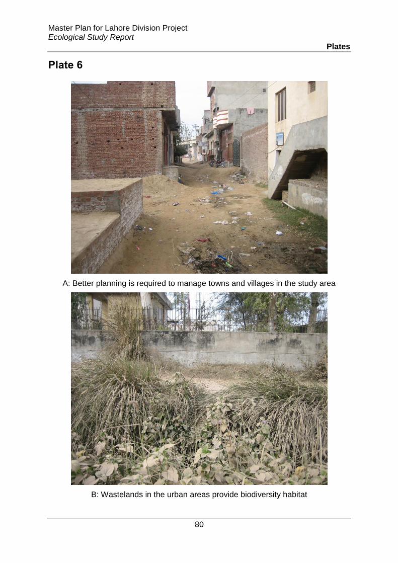
Master Plan for Lahore Division Project Ecological Study Report
Plates
80
Plate 6
A: Better planning is required to manage towns and villages in the study area
B: Wastelands in the urban areas provide biodiversity habitat

Master Plan for Lahore Division Project Ecological Study Report
Plates
81
Plate 7
A: Potato fields around Shikhupura
A: Mustard fields around Shikhupura

Master Plan for Lahore Division Project Ecological Study Report
Plates
82
Plate 8
A: Wheat and sugarcane are important crops in the study area
B: Agroforestry using bamboo plantation and seasonal vegetables and mustard

Master Plan for Lahore Division Project Ecological Study Report
Plates
83
Plate 9
A: Mixed farming using potato crop and Bamboo and Eucalyptus plantations near
Kasur
B: Trees in fields act as shelter belts and provide habitat to biodiversity
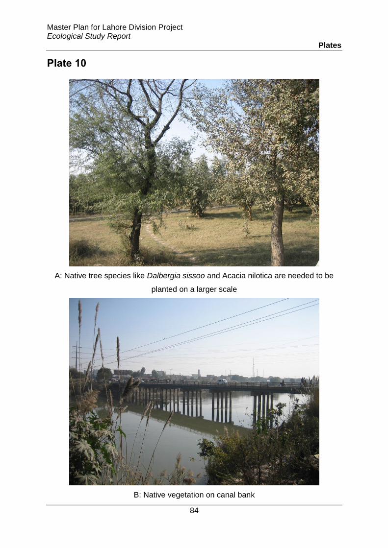
Master Plan for Lahore Division Project Ecological Study Report
Plates
84
Plate 10
A: Native tree species like Dalbergia sissoo and Acacia nilotica are needed to be
planted on a larger scale
B: Native vegetation on canal bank

Master Plan for Lahore Division Project Ecological Study Report
Plates
85
Plate 11
A: Eucalptus plantation around Farooqabad canal
B: Vegetated banks of upper Gugera branch canal providing wildlife
corridors

Master Plan for Lahore Division Project Ecological Study Report
Plates
86
Plate 12
A: Natural vegetation is a source of livelihood for local people. Ckick making from
Saccharum Near Farooqabad
B: Polygonum sp. growing in canal water

Master Plan for Lahore Division Project Ecological Study Report
Plates
87
Plate 13
A: Guava and mango orchards
B: Exotic Pistai growing in River Sutlej

Master Plan for Lahore Division Project Ecological Study Report
Plates
88
Plate 14
A: Along with providing fish rivers provide many services to local community (River
Sutlej near Kasur)
B: Aesthetic appeal is one of the services provided by the rivers to people

Amendment in Master Plan for Lahore Division (The Project) Environmental Impact Assessment (EIA) Report
Appendices
218
Appendix-II
Environmental Monitoring Report


Environmental Monitoring of Master Plan Lahore Division
Table of Content TOC-I
Table of Contents
DISCLAIMER ....................................................................................................................................... i
ABBREVIATIONS .............................................................................................................................. ii
UNITS iii
1. Introduction ................................................................................................................. 1-1
1.1 Project Background .......................................................................................................... 1-1
1.2 Objectives ............................................................................................................................. 1-4
1.3 Scope of Services ................................................................................................................ 1-4
1.4 Project Location ................................................................................................................. 1-4
1.4.1 Ambient Air Quality Locations: ...........................................................................................1-7
1.4.2 Noise Monitoring Locations ..................................................................................................1-7
1.4.3 Surface water Sampling Locations .....................................................................................1-8
1.4.4 Wastewater Sampling Locations ........................................................................................1-9
1.4.5 Groundwater Sampling Locations ......................................................................................1-9
2. Methodology ................................................................................................................. 2-1
2.1 Survey Planning ................................................................................................................. 2-1
2.1.1 Identification of Monitoring Locations ............................................................................2-1
2.1.2 Monitoring Plan .........................................................................................................................2-1
2.2 Sampling and Analysis Methods ................................................................................... 2-2
2.2.1 Ambient Air Quality Monitoring .........................................................................................2-2
2.2.2 Noise Level ...................................................................................................................................2-3
2.2.3 Water ..............................................................................................................................................2-4
3. Results and Discussion ............................................................................................. 3-1
3.1 Ambient Air Quality .......................................................................................................... 3-1
3.2 Noise ....................................................................................................................................... 3-4
3.3 Water Sampling .................................................................................................................. 3-5
3.3.1 Groundwater ...............................................................................................................................3-5
3.3.2 Surface Water Sampling (Canals) .......................................................................................3-9

Environmental Monitoring of Master Plan Lahore Division
Table of Content TOC-II
List of Tables
Table 1-1: Location sites for Ambient Air Quality .................................................................................1-7
Table 1-2: Location sites for Noise Monitoring ......................................................................................1-7
Table 1-3: Location Sites for Surface water Sampling-Canal ............................................................1-8
Table 1-4: Location Sites for Surface water Sampling- River ....................................................1-9
Table 1-5: Location Sites for Wastewater Sampling ............................................................................1-9
Table 1-6: Location sites for Groundwater Sampling ..........................................................................1-9
Table 2-1: Methodology of Ambient Air Quality Monitoring ............................................................2-2
Table 2-2: Water Testing Methods ..............................................................................................................2-6
Table 3-1: Ambient Air Quality Monitoring at Different Locations in Section I ........................3-1
Table 3-2: Noise Monitoring at Different Locations in Section II....................................................3-4
Table 3-3: Groundwater Sampling at Different Locations (Lahore) ..............................................3-5
Table 3-4: Surfacewater and Wastewater Sampling at Various Location ...................................3-9
Table 3-5: Wastewater Sampling from Drains .................................................................................... 3-11
Table 3-6: Surfacewater Sampling at Various Location (Rivers) ................................................. 3-14

Environmental Monitoring of Master Plan Lahore Division
Table of Content TOC-III
List of Figures
Figure 1-1: Proposed Project Area Map ......................................................................................................1-2
Figure 1-2: Project Area Map ...........................................................................................................................1-3
Figure 1-3: Monitoring Locations (Source: Monitoring Locations given by HEMC) .................1-5

Environmental Monitoring of Master Plan Lahore Division
DISCLAIMER i
DISCLAIMER
This report is produced in compliance with the Client Request for M/S Harris Engineering and
Management Consultants (HEMC) via letter No: HEMC/SEAL/LMP/ENV/01. The information
contained in this report was collected and produced from site visit and monitoring data. The
information supplied and contained in this report is, to the best of our knowledge, correct and
up to date. Solution Environmental & Analytical Laboratory (SEAL) accepts no responsibility for
changes made to this document by any third party once report is submitted to the client.

Environmental Monitoring of Master Plan Lahore Division
ABBREVIATIONS ii
ABBREVIATIONS
AA: Ambient Air
AM: Angle Marker
APHA: American Public Health Administration
BDL: Below Detection Limit
CO2: Carbon Dioxide
CO: Carbon Monoxide
DW: Drinkingwater
EPA: Environmental Protection Agency
GW: Groundwater
MW: Megawatt
NO: Nitrogen Oxide
NO2: Nitrogen Dioxide
NOx: Oxides of Nitrogen
NEQS: National Environmental Quality Standards
NL: Noise Level
NTDC: National Transmission and Despatch Company
PEPA: Pakistan Environmental Protection Act 1997
PM: Particulate Matter
PID: Photo Ionization Detector
SO2: Sulphur Dioxide
SOP: Standard Operating Procedures
SEAL: Solution Environmental & Analytical Laboratory
SW: Surface water
T/L: Transmission Lines
USEPA: United states Environmental Protection Agency
VOC: Volatile Organic Compounds
WHO: World Health Organization
WW: Wastewater

Environmental Monitoring of Master Plan Lahore Division
UNITS
m: Meter
°C: Degree Celsius
sec: Seconds
ppm: Parts per Million
mg/l: Milligram per Litre
mg/Nm3: Milligram per Normal cubic meter
µg/m3: Microgram per cubic meter

Environmental Monitoring of Master Plan Lahore Division
CHAPTER - I
INTRODUCTION

Environmental Monitoring of Master Plan Lahore Division
1Introduction 1-1
1. Introduction
This section describes the project location and scope of services performed by SEAL.
1.1 Project Background
Lahore commands a strategic, political and administrative role as the capital of the Punjab
Province and the second largest city of Pakistan. It is situated in the north eastern part of
Pakistan with its center lying within 25 km of the international border with India and occupies a
focal position in the Upper Indus Plain located along the left bank of River Ravi. The city has
grown along the historic route linking central Asia with sub-continent. In terms of cultural,
recreational, commercial, educational and health services, Lahore’s area of influence is well
beyond its metropolitan boundaries and extends deep into the province and the international
sphere between 1951 and 1965 the population and built up area of the city increased two folds.
The city continued to grow up and by 1998; Lahore was transformed into a metropolis with a
population of about 5.18 million and a developed area of about 300 square km. At present the
developed area has been increase up to 469 SQ KM with population almost 10 million. The
prevailing master plan of Lahore Metropolitan Area was notified in the year 2004 for the period
up to 2021. The study area, for the purpose of Integrated Master Plan of Lahore follows Lahore
Metropolitan Area boundaries under the jurisdiction of LDA. The completion of different
developmental projects and expansion of the city due to rapid urbanization has changed the
overall character of the area. Moreover this IMP 2021 is only for the Lahore city. The situation in
division due to rapid urbanization, the industries and residencies are growing without any plan.
Therefore, considering the whole division as Project Area and available planning documents, as
a single Plan Master Plan of Lahore Division is prepared by earmarking the existing and
proposed areas for industrial, residential, special development zones and allied land uses. The
project area map is shown in figure below-:

Environmental Monitoring of Master Plan Lahore Division
1Introduction 1-2
Figure 1-1: Proposed Project Area Map

Environmental Monitoring of Master Plan Lahore Division
1Introduction 1-3
Figure 1-2: Project Area Map

Environmental Monitoring of Master Plan Lahore Division
1Introduction 1-4
Lahore Division is an administrative division of Punjab Province, Pakistan and called the third
tier of government.Lahore statistical division contains the districts of Lahore, Nankana Sahib,
Kasur, and Shekhupura.
1.2 Objectives
The objective of the study is to:
Comply with the regulatory requirements of the project;
Monitor air, water, and noise level in study area/survey area;
1.3 Scope of Services
The environmental monitoring was conducted at advised locations master plan for following
environmental parameters.
Noise Level Monitoring
Ambient Air Quality Monitoring
Water Quality Sampling and Analysis
1.4 Project Location
Locations for sampling and monitoring of required environmental parameters were identified
by the HEMC representatives on master plan in 4 districts of Lahore division i.e. of Lahore,
Nankana Sahib, Kasur, and Shekhupura. The sampling points of air, noise and waster sampling is
shown in map below-:

Environmental Monitoring of Master Plan Lahore Division
1Introduction 1-5
Figure 1-3: Monitoring Locations (Source: Monitoring Locations given by HEMC)

Environmental Monitoring of Master Plan Lahore Division
1Introduction 1-6

Environmental Monitoring of Master Plan Lahore Division
1Introduction 1-7
1.4.1 Ambient Air Quality Locations:
Following sites were selected ambient air on Master Plan:
Table 1-1: Location sites for Ambient Air Quality
Sr. No. District X Coordinate Y Coordinate
AA 01 Sheikhopura 73°51’24.487’’E 31°44’36.325’’N
AA 02 Nankana sahib 73°30’25.872°E 31°33’4.325’’N
AA 03 Kasur 73°52’49.234’’E 31°5’8.326’’N
AA 04 Lahore 74°21’7.565’’E 31°27’16.518’’N
AA 05 Lahore 74°14’18.139’’E 31°20’36.142’’N
AA 06 Nankana sahib 73°58’7.621’’E 31°24’32.725’’N
AA 07 Sheikhopura 73°37’34.862’’E 31°49’35.107’’N
AA 08 Kasur 74°21’59.802’’E 31°1028.611’’N
AA 09 Sheikhopura 74°15’12.170’’E 31°48’33.968’’N
AA 10 Sheikhopura 74°12’12.564’’E 31°34’45.146’’N
AA 11 Sheikhopura 73°59’56.916’’E 30°56’39.571’’N
AA 12 Sheikhopura 74°7’6.081’’E 31°40’7.270’’N
AA 13 Sheikhopura 73°44’10.173’’E 31°34’57.274’’N
AA 14 Lahore 74°12’27.785’’E 31°15’21.141’’N
AA 15 Lahore 73°59’27.387’’E 31°14’14.609’’N
AA 16 Lahore 74°29’38.886’’E 31°241.793’’N
1.4.2 Noise Monitoring Locations
Following sites were selected noise monitoring for master plan of Lahore Division
Table 1-2: Location sites for Noise Monitoring
Sr. No District X Coordinate Y Coordinate
NL 01 Sheikhopura 73°52’9.705’’E 31°44’22.543’’N
NL 02 Sheikhopura 73°38’0.526’’E 31°49’13.857’’N

Environmental Monitoring of Master Plan Lahore Division
1Introduction 1-8
NL 03 Nankana Sahib 73°30’58.949’’E 31°32’42.466’’N
NL 04 Nankana Sahib 73°57’38.482’’E 31°24’28.518’’N
NL 05 Kasur 73°53’27.261’’E 31°5’27.884’’N
NL 06 Lahore 74°22;36.324’’E 31°10’7.090’’N
NL 07 Lahore 74°21’16.732’’E 31°26’40.635’’N
NL 08 Kasur 74°14’9.046’’E 31°21’26.637’’N
NL 09 Sheikhopura 74°15’5.308’’E 31°49’16.505’’N
NL 10 Lahore 74°11’53.880’’E 31°34’25.571’’N
NL 11 Kasur 73°59’24.557’’E 30°57’27.797’’N
NL 12 Sheikhopura 74°8’12.712’’E 31°39’43.921’’N
NL 13 Sheikhopura 73°45’21.690’’E 31°35’2.087’’N
NL 14 Kasur 74°12’7.203’’E 31°14’51.251’’N
NL 15 Kasur 74°0’34.330’’E 31°14’56.880’’N
NL 16 Lahore 74°29’55.391’’E 31°23’13.349’’N
1.4.3 Surface water Sampling Locations
The sites selected for Surface water sampling were as follow:
Table 1-3: Location Sites for Surface water Sampling-Canal
Sr.
No. Water Channel X Coordinate Y Coordinate
SW 03 Lahore Branch Canal 74°6’48.636’’E 31°19’44.589’’N
SW 04 Qadirabad Abad Balloki Link Canal 73°52’23.294’’E 31°38’0.141’’N
SW 05 Lahore BRB Canal 74°30’20.721’’E 31°28’8.132’’N
SW 06 Upper Chenab Canal 74°5’49.281’’E 31°42’45.108’’N
SW 07 ButcherKhana Distributary 74°12’44.791’’E 31°20’36.892’’N

Environmental Monitoring of Master Plan Lahore Division
1Introduction 1-9
Table 1-4: Location Sites for Surface water Sampling- River
Sr. No. River X Coordinate Y Coordinate
SW 01 Down Stream Of Ravi River 74°17’9.214’’E 31°36’0.760’’N
SW 02 Upper Stream Of Ravi River 74°19’19.640’’E 31°37’32.904’’N
SW 08 River Sutlej 74°26’0.991’’E 30°57’48.965’’N
1.4.4 Wastewater Sampling Locations
The sites selected for Wastewater sampling were as follows:
Table 1-5: Location Sites for Wastewater Sampling
Sr. No. Location/Drainage Name X Coordinate Y Coordinate
WW 1 Near Sheikhupura (near
RWP-LHR Rail track) 74°17’43.612’’E 31°38’51.241’’N
WW 2 Drain Near Kasur (near
Raiwind Kasur Road) 72°24’31.867’’E 31°9’8.044’’N
WW 3 Hudyara Drain 74°16’6.047’’E 31°22’55.310’’N
WW 4 Nanakana Sahib (near
Bucheki) 73°40’56.478’’E 31°26’17.761’’N
1.4.5 Groundwater Sampling Locations
Groundwater samples were collected from following sampling locations:
Table 1-6: Location sites for Groundwater Sampling
Sr. No. District X Coordinate Y Coordinate
GW 01 Kasur 74°26’39.206’’E 31d24’1.793’’N
GW 02 Sheikhopura 73°53’14.775’’E 31°36’40.989’’N
GW 03 Lahore 74°25’5.064’’E 31°23’2.963’’N
GW 04 Nankana sahib 73°28’41.437’’E 31°34’58.339’’N
GW 05 Lahore 74°14’17.442’’E 31°211.803’’N
GW 06 Nankana sahib 73°57’0.372’’E 31°24’17.447’’N
GW 07 Sheikhopura 73°53’0.372’’E 31°44’10.041’’N
GW 08 Sheikhopura 73°38’46.197’’E 31°48’45.852’’N

Environmental Monitoring of Master Plan Lahore Division
1Introduction 1-10
GW 09 Kasur 73°53’53.316’’E 31°6’5.257’’N
GW 10 Sheikhopura 74°15’20.907’’E 31°47’39.992’’N
GW 11 Sheikhopura 74°11’35.275’’E 31°34’6.488’’N
GW 12 Kasur 73°58’36.626’’E 30°57’54.009’’N
GW 13 Sheikhopura 74°7’38.975’’E 31°39’55.740’’N
GW 14 Lahore 74°12’44.603’’E 31°14’50.387’’N
GW 15 Lahore 74°0’1.495’’E 31°13’36.301’’N
GW 16 Lahore 74°21’25.624’’E 31°25’42.415’’N

Environmental Monitoring of Master Plan Lahore Division
CHAPTER – II
METHODOLOGY

Environmental Monitoring of Master Plan Lahore Division
2Methodology 2-1
2. Methodology
Following is the brief description of methodology adopted for this environmental monitoring:
2.1 Survey Planning
The project started with a planning of project activities with a management of the HEMC.
2.1.1 Identification of Monitoring Locations
Locations for the sampling and monitoring of required environmental parameters were
identified and finalized by the HEMC representatives in consultation with SEAL team. Following
criterion was used to finalize the sampling locations:
Area where there will be project activities;
Present environmental conditions at the site.
2.1.2 Monitoring Plan
On the basis of identified sampling locations a monitoring plan was developed in order to
achieve precision and accuracy in the monitoring and sampling of the required environmental
parameters. The monitoring plan was developed in consultation with HEMC representatives.
Plan of 7 days was formulated including travelling time. Project was started on Wednesday2-12-
2015 and completed on Tuesday- 08-12-2015
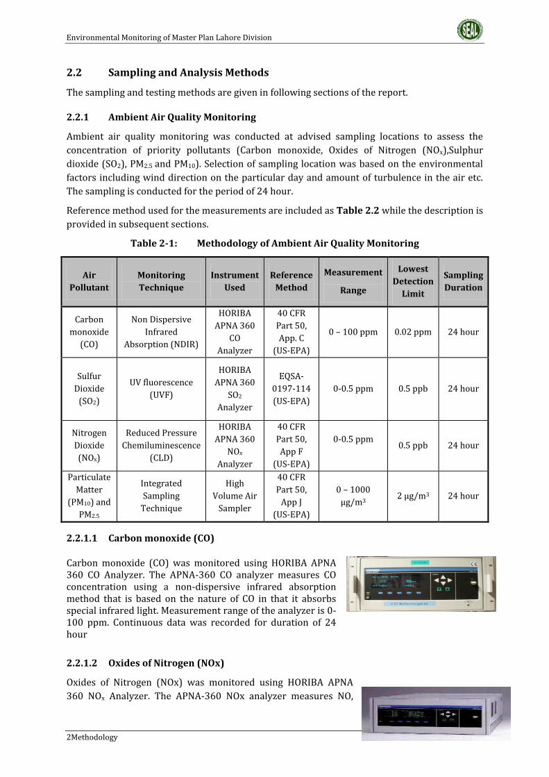
Environmental Monitoring of Master Plan Lahore Division
2Methodology 2-2
2.2 Sampling and Analysis Methods
The sampling and testing methods are given in following sections of the report.
2.2.1 Ambient Air Quality Monitoring
Ambient air quality monitoring was conducted at advised sampling locations to assess the
concentration of priority pollutants (Carbon monoxide, Oxides of Nitrogen (NOx),Sulphur
dioxide (SO2), PM2.5 and PM10). Selection of sampling location was based on the environmental
factors including wind direction on the particular day and amount of turbulence in the air etc.
The sampling is conducted for the period of 24 hour.
Reference method used for the measurements are included as Table 2.2 while the description is
provided in subsequent sections.
Table 2-1: Methodology of Ambient Air Quality Monitoring
Air
Pollutant
Monitoring
Technique
Instrument
Used
Reference
Method
Measurement
Range
Lowest
Detection
Limit
Sampling
Duration
Carbon
monoxide
(CO)
Non Dispersive
Infrared
Absorption (NDIR)
HORIBA
APNA 360
CO
Analyzer
40 CFR
Part 50,
App. C
(US-EPA)
0 – 100 ppm 0.02 ppm 24 hour
Sulfur
Dioxide
(SO2)
UV fluorescence
(UVF)
HORIBA
APNA 360
SO2
Analyzer
EQSA-
0197-114
(US-EPA)
0-0.5 ppm
0.5 ppb 24 hour
Nitrogen
Dioxide
(NOx)
Reduced Pressure
Chemiluminescence
(CLD)
HORIBA
APNA 360
NOx
Analyzer
40 CFR
Part 50,
App F
(US-EPA)
0-0.5 ppm
0.5 ppb 24 hour
Particulate
Matter
(PM10) and
PM2.5
Integrated
Sampling
Technique
High
Volume Air
Sampler
40 CFR
Part 50,
App J
(US-EPA)
0 – 1000
μg/m3 2 μg/m3 24 hour
2.2.1.1 Carbon monoxide (CO)
Carbon monoxide (CO) was monitored using HORIBA APNA 360 CO Analyzer. The APNA-360 CO analyzer measures CO concentration using a non-dispersive infrared absorption method that is based on the nature of CO in that it absorbs special infrared light. Measurement range of the analyzer is 0-100 ppm. Continuous data was recorded for duration of 24 hour
2.2.1.2 Oxides of Nitrogen (NOx)
Oxides of Nitrogen (NOx) was monitored using HORIBA APNA
360 NOx Analyzer. The APNA-360 NOx analyzer measures NO,

Environmental Monitoring of Master Plan Lahore Division
2Methodology 2-3
NO2and NOx using chemiluminescence (CLD) method with the help of chemical reaction
between NO2 and O3. Measurement range of the analyzer is 0-0.5 ppm. Continuous data was
recorded for period of 24 hr.
2.2.1.3 Sulphur dioxide (SO2)
SO2Sulphur dioxide was monitored using HORIBA APNA 360
SO2 Analyzer. The APNA-360 SO2 analyzer measures SO2 using
UV fluorescence method that operates on the principle that
when the SO2 molecules contained in the sample gas are
excited by ultraviolet radiation they emit a characteristic
fluorescence in the range of 220- 240 nm. This fluorescence is
measured and the SO2 concentration is obtained from changes
in the intensity of the fluorescence. Measurement range of the
analyzer is 0-0.5 ppm. Continuous data was recorded for
duration of 24 hrs
2.2.1.4 Particulate Matter (PM10 and PM2.5)
Particulate matter concentration in terms of PM10and PM2.5 was monitored in the ambient air
with the help of High Volume Air Sampler. Measurement range of the equipment is 2-1000
μg/m3 with lowest detection range of 2 μg/m3. PM10and PM2.5sampling was conducted for
period of 24 hour at identified sampling locations with the help of fiberglass filters. The filters
were properly stored and placed in the vacuum zipper bag in order to avoid moisture and
transported to SEAL Laboratory for detection of PM10.
2.2.1.5 Weather Station
A weather station was installed on each point
measurement to assess the environmental
parameters like Ambient Temperature, Relative
Humidity, Wind Speed and direction and other
weather conditions.
2.2.2 Noise Level
A noise level monitoring was conducted at identified
locations using portable Digital Sound Meter (TM, 103). All
noise monitoring was conducted in accordance with the
guidance set out in BS 7445:2003. Measurements were
made using Class 1 Integrating-Averaging Sound Level
Meters as defined in IEC 61672:2003. Meters were
calibrated and checked before and after each measurement
period by using sound level calibrator.

Environmental Monitoring of Master Plan Lahore Division
2Methodology 2-4
2.2.3 Water
Following methodology was adopted for water sampling and analysis:
2.2.3.1 Sample Collection
The water samples were collected from identified sampling points. The sampling was carried
out in accordance to the Standard Operating Procedures (SOP) based on the recognized
methods of United State Environmental Protection Agency (USEPA), World Health Organization
(WHO) and American Public Health Administration (APHA) for water sampling and analysis.
2.2.3.2 Measurement of Field Parameters
Parameters that quickly degrade after they are sampled must be tested in the field. Following
parameters were measured in field that can significantly change during storage and
transportation. These includes:-
pH (Measured at site)
Odor
Color
Clarity
TDS
Temperature
DO (Dissolve Oxygen)
2.2.3.3 Preservation
Preservation is important in order to minimize the changes in the sample. The collected water
samples were preserved in appropriate containers as per APHA Guidelines, the method of which
is given as under-:
For COD, organics and nitrates sample is preserved below pH -2 by addition of sulphuric acid.
For metals sample is preserved below pH-2 by adding nitric acid. For BOD and inorganic sample
is stored below 4 ⁰C.
2.2.3.4 Sample Identification and Chain of Custody
The collected samples were labeled and assigned a unique sample identification number,
sampling date and time of collection to collected samples. All the relevant information (sample
location, time of collection, sample identification, temperature, pH, collected by, preservation
techniques etc) was recorded immediately on the Chain of Custody form signed by SEAL field
Analyst.
2.2.3.5 Transportation
A shipping container (Ice box with eutectic cold packs instead of ice) with maintained
temperature of 4° C ±5 °C was used for transporting the sample from the collection site to the
environmental laboratory.
2.2.3.6 Parameters
Parameters provided in the scope of work for the testing include following:
Groundwater
Drinkingwater samples were collected from identified sampling points. The collected samples
were given to laboratory for analysis of following parameters:-

Environmental Monitoring of Master Plan Lahore Division
2Methodology 2-5
pH (Measured at site)
Temperature
Color (Measured at site)
Total Dissolved Solids (TDS) (Measured at site)
Total Suspended Solids (TSS) (Measured at site)
Taste and Odor (Measured at Site)
Total Hardness
Nitrate as NO3
Ammonia
E-Coli
Arsenic
Turbidity
Chlorides as Cl-
Fluoride as F-
Sulphate as SO42-
Iron as Fe3+
Sodium
Iodine
Zinc as Zn2+
Total Coliform
Surface & Wastewater
Surface and wastewater samples were collected from identified sampling locations. Testing
parameters for surface &Wastewater is given below:-
pH (Measured at site)
Temperature ( Measured at site )
Biochemical Oxygen Demand (BOD5)
Chemical Oxygen Demand (COD)
TSS
TDS (Measured at site)
Grease & Oil
Phenolic Compound as Phenols
Chloride as CI-
Fluoride as F-
Cyanide total as CN-
An-Ionic Detergents as MBAs
Sulphate as SO42-
Sulphide as S-
Ammonia
Pesticides
Phosphorous
Potassium
Dissolve Oxygen (DO)
Cadmium
Chromium trivalent and hexavalent
Copper
Lead
Mercury
Selenium
Nickel
Sliver
Total toxic metals
Zinc
Arsenic
Barium
Iron
Manganese
Boron
Chlorine
Nitrogen as Nutrient
Turbidity
2.2.3.7 Methods of Analysis
Methods used for the testing of above mentioned parameters are included as Table 2.3

Environmental Monitoring of Master Plan Lahore Division
2Methodology 2-6
Table 2-2: Water Testing Methods
Sr.No. Parameter Method / Technique Reference
1. TDS Conductivity Method, TDS meter APHA 2510 B
2. pH By pH meter APHA-4500 H+ B
3. TSS Photometric HACH Method 8165
4. Temperature Celsius thermometer APHA-2550 B
5. BOD5 Respirometric Method HACH Method 10099
6. COD Dichromate Reactor Digestion HACH Method 8000
7. Taste and Odour By Sensory -
8. Oil and Grease Hexane Extractable Gravimetric Method HACH Method 10056
9. Phenolic Compounds as
Phenols 4-Aminoantipyrine Method HACH Method 8047
10. Chloride Cl- Argentrometriy Titration APHA 4500 Cl- B
11. Fluoride Fl- SPANDS Method HACH Method 8209
12. Arsenic Ar Silver Diethyldithiocarbamate Method HACH Method 8103
13. Sulphate SO4-2 Sulpha Ver 4 Method HACH Method 8051
14. Sulfide S- Methylene Blue Method HACH Method 8131
15. Ammonia NH3 Salicylate Method HACH Method 8155
16. Pesticides Micro Extraction and Gas Chromatography ASTM-D5175
17. Total Hardness EDTA Titration APHA-2340 C
18. Nitrate No3- Cadmium Reduction Method APHA-4500-NO3 B
19. Turbidity Nephlometric Method HACH Method 8219
20. Iron as Fe+3 Ferrozine Method HACH Method 8147
21. Sodium Na+ Flame Emission Photometric APHA-3500-Na-B
22. Zinc as Zn +2 Zincon Method HACH Method 8009
23. Cyanide as CN- Pyridine-Pyrazalone Method HACH Method 8027
24. An Ionic detergent as MBAs Methylene Blue Active Substance (MBAS) method APHA 5540 C
25. Total Coli forms Microbiology APHA - 9222 B
26. Faecal Coli forms (E.Coli) Microbiology APHA - 9222 D
27. Cadmium Cd Dithizone Method HACH Method 8107
28. Chromium Trivalent and
Hexavalent 1,5 Diphenylcarbohydrazide Method HACH Method 8023
29. Copper Cu+2 Porphyrin Method HACH Method 8143
30. Lead Pb+2 Dithizone Method HACH Method 8033
31. Mercury Hg Mercury Extraction Method HACH Method 10066
32. Selenium Se Diaminobenzidine Method HACH Method 8194
33. Nickle Ni 1-(2 Pyridilazo )-2-Nephthol PAN Method HACH Method 8150
34. Silver Ag Colorimetric Method HACH Method 8120

Environmental Monitoring of Master Plan Lahore Division
2Methodology 2-7
Sr.No. Parameter Method / Technique Reference
35. Boron B Carmine Method HACH Method 8015
36. Manganese Mn PAN Method HACH Method 8149
37. Barium Ba Turbidimetric Method HACH Method 8014
38. Phosphorous Membrane Filter Method APHA 4500 P
39. Pottasium Flame Emission Photometric APHA 2340 B
40. Dissolve Oxygen (DO) Electrometric Method APHA 4500-OA
Note: APHA=American Public Health Association, ASTM = American Society for Testing and Materials

Environmental Monitoring of Master Plan Lahore Division
CHAPTER – III
RESULTS AND DISCUSSION

Environmental Monitoring of Master Plan Lahore Division
3Results and Discussion 3-1
3. Results and Discussion
This section of the report presents the testing results of Ambient Air (CO, NOx, SO2, PM10, PM2.5)
Ambient Noise, Groundwater, Surface water and Wastewater monitoring and analysis. Ambient
air monitoring were carried out at 16 different locations, Noise Level were monitored at 16
different locations whereas, Surface water sampling was carried out at 07 different locations,
wastewater sampling was carried out 04 locations and ground water sampling was carried out
at 16 different locations.
3.1 Ambient Air Quality
Concentration of CO, NOx, SO2, PM10 and PM2.5were measured at 16 sampling locations in the
project area to get an overview of the air quality. The results of measure concentration at each
sampling location are given in Tables below.
Table 3-1: Ambient Air Quality Monitoring at Different Locations in Section I
Sr. No.
Coordinates Location
Humidity Wind speed
Temp CO NO2 NO NOx SO2 PM10 PM2.5
% m/sec o C mg/m
3
µg/m3
µg/m3
µg/m3
µg/m3
µg/m3
µg/m3
Lahore
AA 04
74
°21
’7.5
65
’’E
31
°27
’16
.51
8’’N
Ferozpur Road near
Chungi 42.1 2.8 8.1 5.6 23.7 4.4 28.1 33.3 161 32
AA 05
74
°14
’18
.13
9’’E
3
1°2
0’3
6.1
42
’’N
Raiwind Road Near Lake City
40.1 2.9 9.2 5.1 22.2 4.3 26.5 32.1 240 37
AA 14
74
°12
’27
.78
5’’E
3
1°1
5’2
1.1
41
’’N
Sundar Road Raiwind
42.3 2.7 8.6 1.4 15.7 2.4 18.1 15.3 85 09
AA 16
74
°29
’38
.88
6’’E
3
1°2
41
.79
3’’N
Baddian Road near
Hera Village 42.1 2.6 8.4 3.7 28.6 4.6 33.2 37.3 215 28
Sheikhupura

Environmental Monitoring of Master Plan Lahore Division
3Results and Discussion 3-2
AA 01
73
°51
’24
.48
7’’E
3
1°4
4’3
6.3
25
’’N
Sargodha Road near
Farooqaabad
45.5 2.8 10.1 6.1 21.3 4.1 25.4 34.0 201 40
AA 07
73
°37
’34
.86
2’’E
3
1°4
9’3
5.1
07
’’N
Sargodha Road near
Khanka Dogra
43.5 2.8 9.4 1.4 14.7 2.6 16.3 19.8 92.1 12
AA 09
74
°15
’12
.17
0’’E
3
1°4
8’3
3.9
68
’’N
GT Road near
Mureedka 46.5 2.6 9.5 3.2 25.0 4.7 29.7 36.2 151 26
AA 10
74
°12
’12
.56
4’’E
3
1°3
4’4
5.1
46
’’N
Ranabhat near
Jarranwala Road
42.3 2.7 8.7 1.7 13.7 1.6 15.3 17.4 86 14
AA 12
74
°7’6
.08
1’’E
3
1°4
0’7
.27
0’’N
Sheikhupura Road near
Tiba Rehan Khan
42.6 2.5 10.2 1.3 15.3 2.6 17.9 18.3 89 11
AA 13
73
°44
’10
.17
3’’E
3
1°3
4’5
7.2
74
’’N
Faisalabad Road near Marawal Village
45.9 2.8 9.2 1.2 14.8 2.6 17.4 16.5 90 13
Kasur
AA 03
73
°52
’49
.23
4’’E
3
1°5
’8.3
26
’’N
Nai Abbadi Near Multan
Road
44.7 2.5 8.2 1.1 14.6 1.8 16.4 18.5 78 11
AA 08
74
°21
’59
.80
2’’E
3
1°1
02
8.6
11
’’N
Raiwind Near Kasur
Road
46.7 3.1 9.3 5.3 24.6 4.4 28.9 35.1 187 33
Environmental Monitoring of Master Plan Lahore Division
3Results and Discussion 3-3
AA 11
73
°59
’56
.91
6’’E
3
0°5
6’3
9.5
71
’’N
41.5 2.6 8.3 1.6 14.2 1.3 15.5 17.4 93 12
AA 15
73
°59
’27
.38
7’’E
3
1°1
4’1
4.6
09
’’N Village Ganai
Chamba Near Multan
Road 48.3 2.6 9.7 1.0 13.2 2.2 15.4 09.3 68 10
Nankana Sab
AA 02
73
°30
’25
.87
2°E
3
1°3
3’4
.32
5’’N
Village IslamKot
near Nankana Sab
Road
43.2 2.7 8.4 1.3 15.3 2.1 17.4 21.4 81 13
AA 06
73
°58
’7.6
21
’’E
31
°24
’32
.72
5’’N
Jarranwal Road Near QB Cannal
44.7 3.0 8.9 4.6 23.4 3.7 27.1 31.5 196 31
PAK NEQs 10 80 40 - 120 150 35
The results show that the ambient air quality on all the measured location is within NEQS except Particulate Matter
which is higher on road sides. The CO is also litter bit higher on road sides in comparison with clean ambient air for
which CO level should be less than 2.0 ppm.
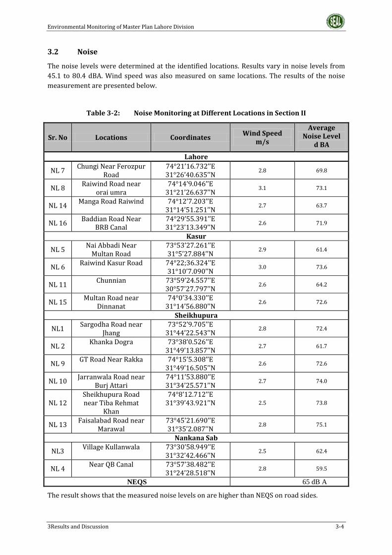
Environmental Monitoring of Master Plan Lahore Division
3Results and Discussion 3-4
3.2 Noise
The noise levels were determined at the identified locations. Results vary in noise levels from
45.1 to 80.4 dBA. Wind speed was also measured on same locations. The results of the noise
measurement are presented below.
Table 3-2: Noise Monitoring at Different Locations in Section II
Sr. No Locations Coordinates Wind Speed
m/s
Average Noise Level
d BA
Lahore
NL 7 Chungi Near Ferozpur
Road 74°21’16.732’’E 31°26’40.635’’N
2.8 69.8
NL 8 Raiwind Road near
orai umra 74°14’9.046’’E
31°21’26.637’’N 3.1 73.1
NL 14 Manga Road Raiwind 74°12’7.203’’E
31°14’51.251’’N 2.7 63.7
NL 16 Baddian Road Near
BRB Canal 74°29’55.391’’E 31°23’13.349’’N
2.6 71.9
Kasur
NL 5 Nai Abbadi Near
Multan Road 73°53’27.261’’E 31°5’27.884’’N
2.9 61.4
NL 6 Raiwind Kasur Road 74°22;36.324’’E
31°10’7.090’’N 3.0 73.6
NL 11 Chunnian 73°59’24.557’’E
30°57’27.797’’N 2.6 64.2
NL 15 Multan Road near
Dinnanat 74°0’34.330’’E
31°14’56.880’’N 2.6 72.6
Sheikhupura
NL1 Sargodha Road near
Jhang 73°52’9.705’’E
31°44’22.543’’N 2.8 72.4
NL 2 Khanka Dogra 73°38’0.526’’E
31°49’13.857’’N 2.7 61.7
NL 9 GT Road Near Rakka 74°15’5.308’’E
31°49’16.505’’N 2.6 72.6
NL 10 Jarranwala Road near
Burj Attari 74°11’53.880’’E 31°34’25.571’’N
2.7 74.0
NL 12 Sheikhupura Road near Tiba Rehmat
Khan
74°8’12.712’’E 31°39’43.921’’N 2.5 73.8
NL 13 Faisalabad Road near
Marawal 73°45’21.690’’E 31°35’2.087’’N
2.8 75.1
Nankana Sab
NL3 Village Kullanwala 73°30’58.949’’E
31°32’42.466’’N 2.5 62.4
NL 4 Near QB Canal 73°57’38.482’’E
31°24’28.518’’N 2.8 59.5
NEQS 65 dB A
The result shows that the measured noise levels on are higher than NEQS on road sides.

Environmental Monitoring of Master Plan Lahore Division
3Results and Discussion 3-5
3.3 Water Sampling
Surface, waste and Groundwater samples were collected from identified locations on study area.
The result and discussion is given in following sections:
3.3.1 Groundwater
Thirteen Groundwater samples were taken from different district locations that fall within the
master plan. 20 Parameters were analyzed; the results are presented in below Tables
Table 3-3: Groundwater Sampling at Different Locations (Lahore)
Sr.
No. Parameter Unit
WHO
Standards
Location
GW-03 GW-05 GW-14 GW-16
Near Village
Alha
Near Lake City
Sundar Road near
Raiwind
Near Pak Arab,Ferozpur
Road
74°25’5.064’’E
31°23’2.963’’N
74°14’17.442’’E
31°211.803’’N
74°12’44.603’’E
31°14’50.387’’N
74°21’25.624’’E
31°25’42.415’’N
1 pH - 6.5-8.5 7.4 7.1 7.9 7.7
2 Temperature 0C - 18 19 21 19
3 Color TCU 15 0 0 0 0
4 Total Dissolved
Solids (TDS) mg/l 1000 1080 1302 1212 1405
5 Total Suspended
Solids (TSS) mg/l - 05 15 06 17
6 Total Hardness
as CaCO3 mg/l 500 501 522 460 670
7 Taste and Odor - Obj-Unobj obj Obj Obj Obj
8 Nitrate (as NO3-) mg/l 50 31 34 28 29
9 Ammonia (NH3) mg/l 1.5 BDL BDL BDL BDL
10 Arsenic (As) mg/l 0.010 0.05 0.12 0.05 0.11
11 Turbidity NTU 5 0 0 0 0
12 Chloride (as Cl-) mg/l 250 288 244 214 302
13 Fluoride (as F-) mg/l 1.50 0.06 1.60 1.30 1.44
14 Sulphate (as
SO42-) mg/l 250 208 320 275 288
15 Iron (as Fe2+) mg/l 0.3 0.02 0.04 0.01 0.02
16 Sodium mg/l 200 310 302 269 344
17 Iodine mg/l - BDL 0.06 0.01 0.05

Environmental Monitoring of Master Plan Lahore Division
3Results and Discussion 3-6
The results shows that the samples taken from Lahore is contaminated with heavy metal, high
in TDS, hardness and is biologically contaminated
Table 3-6: Groundwater Sampling at Different Locations (Shiekhupura)
18 Zinc (as Zn2+) mg/l 03 0.04 1.2 0.8 1.4
19 Total Coliform Number 0/100 ml 04 12 08 15
20 E-Coli Number 0100 ml 0 02 01 04
Sr.
No
.
Parameter Unit
WHO
Standard
s
Location
GW-02 GW-
07 GW-08 GW-10
GW-
11 GW-13
Near QB Link
Canal
Village
Dhant Pura
Khanka
Dogra
GT Road near
Murredka
Buraj Attar
i
Tiba Rehmat Khan
73°53’14.775’’E
31°36’40.989’’N
73°53’0.372’’E
31°44’10.041’’N
73°38’46.197’’E
31°48’45.852’’N
74°15’20.907’’E
31°47’39.992’’N
74°11’35.275’’E
31°34’6.488’’N
74°7’38.975’’E
31°39’55.740’’N
1 pH - 6.5-8.5 7.2 7.4 7.9 7.8 7.4 7.8
2 Temperatur
e 0C - 20 21 24 21
20 21
3 Color TCU 15 0 0 0 0 0 0
4
Total
Dissolved
Solids (TDS)
mg/l 1000 607 544 540 708
602 670
5
Total
Suspended
Solids (TSS)
mg/l - 02 01 01 05
01 04
6
Total
Hardness as
CaCO3
mg/l 500 240 220 210 302
280 286
7 Taste and
Odor - Obj-Unobj Unobj Unobj Unobj Obj
Unobj Unobj
8 Nitrate (as
NO3-) mg/l 50 26 12 10 16
21 24
9 Ammonia
(NH3) mg/l 1.5 0 0 0 0
0 0
10 Arsenic (As) mg/l 0.010 0.002 0.005 0.005 0.0012 0.005 0.005
11 Turbidity NTU 5 0 0 0 0 0 0
12 Chloride (as
Cl-) mg/l 250 112 99 95 130
120 144
13 Fluoride (as
F-) mg/l 1.50 0.44 0.67 0.65 1.20
0.51 0.66

Environmental Monitoring of Master Plan Lahore Division
3Results and Discussion 3-7
The results show that the sample taken from district Shiekhupura has no contamination in form
of biological, chemical and toxic. The water can be used for drinking purposes
Table 3-7: Groundwater Sampling at Different Locations (Kasur)
Sr.
No. Parameter Unit
WHO
Standards
Location
GW-01 GW-09 GW-12 GW-15
Near Railway Station
Kulanwala Village
Bus Station
Village Chamba
74°26’39.206’’E
31d24’1.793’’N
73°53’53.316’’E
31°6’5.257’’N
73°58’36.626’’E
30°57’54.009’’N
74°0’1.495’’E
31°13’36.301’’N
1 pH - 6.5-8.5 7.2 7.4 7.1 7.7
2 Temperature 0C - 18 20 19 20
3 Color TCU 15 0 0 0 0
4 Total Dissolved
Solids (TDS) mg/l 1000 2506 1809 3017 1509
5 Total Suspended
Solids (TSS) mg/l - 25 18 24 13
6 Total Hardness as
CaCO3 mg/l - 1001 899 1617 766
7 Taste and Odor - Obj-Unobj Obj Obj Obj Obj
8 Nitrate (as NO3-) mg/l 50 78 60 85 55
9 Ammonia (NH3) mg/l 1.5 0 0 0 0
10 Arsenic (As) mg/l 0.010 0.56 0.12 1.1 0.10
11 Turbidity NTU 5 0 0 0 0
12 Chloride (as Cl-) mg/l 250 455 388 544 337
13 Fluoride (as F-) mg/l 1.50 3.1 2.5 3.4 1.9
14 Sulphate (as SO42-) mg/l 250 488 407 506 377
15 Iron (as Fe2+) mg/l 0.3 0.24 0.10 0.31 0.04
16 Sodium mg/l 200 667 603 704 302
14 Sulphate (as
SO42-) mg/l 250 104 101 96 134
124 136
15 Iron (as
Fe2+) mg/l 0.3 0.02 0.01 0.01 0.08
0.02 0.03
16 Sodium mg/l 200 167 144 140 167 154 160
17 Iodine mg/l - 0.04 0.01 0.01 0.05 0.01 0.04
18 Zinc (as
Zn2+) mg/l 03 0.05 0.06 0.06 0.7
0.2 0.4
19 Total
Coliform
Numbe
r 0/100 ml 0 0 0 0
0 0
20 E-Coli Numbe
r 0100 ml 0 0 0 0
0 0
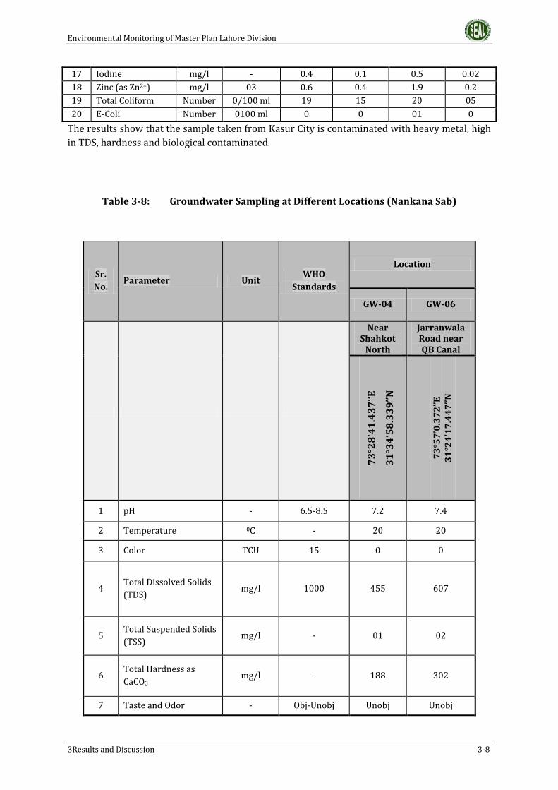
Environmental Monitoring of Master Plan Lahore Division
3Results and Discussion 3-8
17 Iodine mg/l - 0.4 0.1 0.5 0.02
18 Zinc (as Zn2+) mg/l 03 0.6 0.4 1.9 0.2
19 Total Coliform Number 0/100 ml 19 15 20 05
20 E-Coli Number 0100 ml 0 0 01 0
The results show that the sample taken from Kasur City is contaminated with heavy metal, high
in TDS, hardness and biological contaminated.
Table 3-8: Groundwater Sampling at Different Locations (Nankana Sab)
Sr.
No. Parameter Unit
WHO
Standards
Location
GW-04 GW-06
Near Shahkot
North
Jarranwala Road near QB Canal
73°28’41.437’’E
31°34’58.339’’N
73°57’0.372’’E
31°24’17.447’’N
1 pH - 6.5-8.5 7.2 7.4
2 Temperature 0C - 20 20
3 Color TCU 15 0 0
4 Total Dissolved Solids
(TDS) mg/l 1000 455 607
5 Total Suspended Solids
(TSS) mg/l - 01 02
6 Total Hardness as
CaCO3 mg/l - 188 302
7 Taste and Odor - Obj-Unobj Unobj Unobj
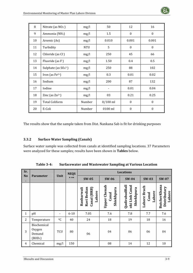
Environmental Monitoring of Master Plan Lahore Division
3Results and Discussion 3-9
The results show that the sample taken from Dist. Nankana Sab is fit for drinking purposes
3.3.2 Surface Water Sampling (Canals)
Surface water sample was collected from canals at identified sampling locations. 37 Parameters
were analyzed for these samples; results have been shown in Tables below.
Table 3-4: Surfacewater and Wastewater Sampling at Various Location
Sr.
No
.
Parameter Unit NEQS
* **
Locations
SW-05 SW-06 SW-04 SW-03 SW-07
Ba
nb
arw
ali
Ra
vi
Be
dia
n
Ca
na
l (B
RB
)
La
ho
re
Up
pe
r C
he
na
b
Ca
na
l
Sh
iek
hp
ura
Qa
dir
ab
ad
Ba
ll
ok
i L
ink
Ca
na
l
Sh
iek
hp
ura
La
ho
re B
rach
Ca
na
l
La
ho
re
Bu
tch
erK
ha
na
D
istr
ibu
tary
L
ah
ore
1 pH - 6-10 7.05 7.6 7.8 7.7 7.6
2 Temperature 0C 40 24 18 19 18 16
3
Biochemical
Oxygen
Demand
(BOD5)
TCU 80
06 04 06 06 04
4 Chemical mg/l 150 08 14 12 10
8 Nitrate (as NO3-) mg/l 50 12 16
9 Ammonia (NH3) mg/l 1.5 0 0
10 Arsenic (As) mg/l 0.010 0.001 0.001
11 Turbidity NTU 5 0 0
12 Chloride (as Cl-) mg/l 250 45 66
13 Fluoride (as F-) mg/l 1.50 0.4 0.5
14 Sulphate (as SO42-) mg/l 250 88 102
15 Iron (as Fe2+) mg/l 0.3 0.01 0.02
16 Sodium mg/l 200 87 132
17 Iodine mg/l - 0.01 0.04
18 Zinc (as Zn2+) mg/l 03 0.21 0.25
19 Total Coliform Number 0/100 ml 0 0
20 E-Coli Number 0100 ml 0 0

Environmental Monitoring of Master Plan Lahore Division
3Results and Discussion 3-10
Sr.
No
.
Parameter Unit NEQS
* **
Locations
SW-05 SW-06 SW-04 SW-03 SW-07
Ba
nb
arw
ali
Ra
vi
Be
dia
n
Ca
na
l (B
RB
)
La
ho
re
Up
pe
r C
he
na
b
Ca
na
l
Sh
iek
hp
ura
Qa
dir
ab
ad
Ba
ll
ok
i L
ink
Ca
na
l
Sh
iek
hp
ura
La
ho
re B
rach
Ca
na
l
La
ho
re
Bu
tch
erK
ha
na
D
istr
ibu
tary
L
ah
ore
Oxygen
Demand
(COD)
09
5 TSS mg/l 150 130 125 86 140 144
6 TDS mg/l 3500 128 124 635 343 150
7 Grease & Oil - 10 0 0 0 0 0
8
Phenolic
Compound as
Phenols
mg/l 0.1
BDL BDL BDL BDL BDL
9 Chloride (as
CI-) mg/l 1000 22 24 54 46 26
10 Fluoride (as F-
) mg/l 20 0.3 0.1 0.6 0.4 0.2
11 Cyanide total
(as CN-) NTU 2 BDL BDL BDL BDL BDL
12
An-Ionic
Detergents as
MBAs
mg/l 20 BDL 02 01 01 03
13 Sulphate (as
SO42-) mg/l 600 26 30 78 73 34
14 Sulphide (as S-
) mg/l 1.0 BDL BDL BDL BDL BDL
15 Ammonia
(NH3) mg/l 40 01 02 0.01 05 01
16 Pesticides mg/l 0.15 BDL BDL BDL BDL BDL
17 Cadmium mg/l 0.1 BDL BDL BDL BDL BDL
18
Chromium as (
trivalent and
hexavalent)
mg/l 1.0 BDL BDL BDL BDL BDL
19 Copper Num
ber 1.0 0.04 0.02 0.18 0.01 0.01
20 Lead Num
ber 0.5 0.01 0.001 BDL 0.001 BDL
21 Mercury mg/l 0.01 BDL BDL BDL BDL BDL
22 Selenium mg/l 0.5 BDL BDL BDL BDL BDL
23 Nickel mg/l 1.0 BDL BDL BDL BDL BDL
24 Sliver mg/l 1.0 BDL BDL BDL BDL BDL

Environmental Monitoring of Master Plan Lahore Division
3Results and Discussion 3-11
Sr.
No
.
Parameter Unit NEQS
* **
Locations
SW-05 SW-06 SW-04 SW-03 SW-07
Ba
nb
arw
ali
Ra
vi
Be
dia
n
Ca
na
l (B
RB
)
La
ho
re
Up
pe
r C
he
na
b
Ca
na
l
Sh
iek
hp
ura
Qa
dir
ab
ad
Ba
ll
ok
i L
ink
Ca
na
l
Sh
iek
hp
ura
La
ho
re B
rach
Ca
na
l
La
ho
re
Bu
tch
erK
ha
na
D
istr
ibu
tary
L
ah
ore
25 Total toxic
metals mg/l 2.0 0.06 0.023 0.21 0.04 0.01
26 Zinc mg/l 5.0 0.21 0.02 0.14 0.07 0.12
27 Arsenic mg/l 1.0 0.001 0.002 0.03 0.03 0.001
28 Barium mg/l 1.5 BDL BDL BDL BDL BDL
29 Iron mg/l 2.0 0.22 0.44 0.05 0.04 0.01
30 Manganese mg/l 1.5 BDL BDL BDL BDL BDL
31 Boron mg/l 6.0 BDL BDL 0.4 0.4 0.1
32 Chlorine mg/l 1.0 BDL BDL BDL BDL BDL
33 Turbidity NTU - 120 110 124 160 110
34 Total Nitrogen mg/l - 1.2 1.4 1.5 1.6 1.1
35 Phosphorous mg/l - 0.66 0.76 0.88 0.87 0.55
36 Potassium mg/l - 1.2 1.2 1.3 1.3 1.4
37 Dissolve Oxygen
mg/l - 06 05 04 04 05
All the surface water (canal) samples are found in compliance with NEQS.
Table 3-5: Wastewater Sampling from Drains
Sr. No.
Parameter Unit NEQS* ** Waste Water
WW-01 WW-02 WW-03 WW-04
74°17’43.612’’E
31°38’51.241’’N
(N
ala
D
aig
, Sh
iek
hp
ura
)
72°24’31.867’’E
31°9’8.044’’N
(Dra
in n
ea
r K
ha
ra,
Ka
sur)
74°16’6.047’’E
31°22’55.310’’N
(H
yd
eri
a D
rain
ne
ar
Kh
ay
ba
n e
Am
ee
n,
La
ho
re)
73°40’56.478’’E
31°26’17.761’’N
(V
illa
ge
S
hin
gi
Ko
t, N
an
ka
na
Sa
b)
1 pH - 6-10 8.29 7.9 8.54 7.70

Environmental Monitoring of Master Plan Lahore Division
3Results and Discussion 3-12
Sr. No.
Parameter Unit NEQS* ** Waste Water
WW-01 WW-02 WW-03 WW-04
74°17’43.612’’E
31°38’51.241’’N
(N
ala
D
aig
, Sh
iek
hp
ura
)
72°24’31.867’’E
31°9’8.044’’N
(Dra
in n
ea
r K
ha
ra,
Ka
sur)
74°16’6.047’’E
31°22’55.310’’N
(H
yd
eri
a D
rain
ne
ar
Kh
ay
ba
n e
Am
ee
n,
La
ho
re)
73°40’56.478’’E
31°26’17.761’’N
(V
illa
ge
S
hin
gi
Ko
t, N
an
ka
na
Sa
b)
2 Temperature 0C 40 30 28 29 26
3
Biochemical Oxygen Demand (BOD5)
TCU 80 180 164 336 120
4
Chemical Oxygen Demand (COD)
mg/l 150 344 260 620 234
5 TSS mg/l 150 144 124 146 110
6 TDS mg/l 3500 1506 1819 1216 889
7 Grease & Oil - 10 04 BDL 05 01
8 Phenolic Compound as Phenols
mg/l 0.1 BDL BDL BDL BDL
9 Chloride (as CI-)
mg/l 1000 244 288 188 178
10 Fluoride (as F-)
mg/l 20 1.1 0.12 0.05 0.02
11 Cyanide total (as CN-)
NTU 2 0.04 BDL 0.09 BDL
12 An-Ionic Detergents as MBAs
mg/l 20 09 07 12 01
13 Sulphate (as SO42-)
mg/l 600 340 344 301 222
14 Sulphide (as S-)
mg/l 1.0 BDL BDL 0.1 BDL
15 Ammonia (NH3)
mg/l 40 34
24 32 18
16 Pesticides mg/l 0.15 0.10 BDL BDL BDL
17 Cadmium mg/l 0.1 BDL BDL BDL BDL

Environmental Monitoring of Master Plan Lahore Division
3Results and Discussion 3-13
Sr. No.
Parameter Unit NEQS* ** Waste Water
WW-01 WW-02 WW-03 WW-04
74°17’43.612’’E
31°38’51.241’’N
(N
ala
D
aig
, Sh
iek
hp
ura
)
72°24’31.867’’E
31°9’8.044’’N
(Dra
in n
ea
r K
ha
ra,
Ka
sur)
74°16’6.047’’E
31°22’55.310’’N
(H
yd
eri
a D
rain
ne
ar
Kh
ay
ba
n e
Am
ee
n,
La
ho
re)
73°40’56.478’’E
31°26’17.761’’N
(V
illa
ge
S
hin
gi
Ko
t, N
an
ka
na
Sa
b)
18
Chromium as ( trivalent and hexavalent)
mg/l 1.0 1.4 0.05 1.6 BDL
19 Copper Number 1.0 1.1
0.01 1.4 0.01
20 Lead Number 0.5 0.6 BDL 0.9 BDL
21 Mercury mg/l 0.01 BDL BDL BDL BDL
22 Selenium mg/l 0.5 BDL BDL BDL BDL
23 Nickel mg/l 1.0 0.21 BDL 0.12 BDL
24 Sliver mg/l 1.0 BDL BDL BDL BDL
25 Total toxic metals
mg/l 2.0 4.75 0.07 5.52 0.01
26 Zinc mg/l 5.0 2.1 1.1 2.4 0.6
27 Arsenic mg/l 1.0 1.4 0.01 1.5 BDL
28 Barium mg/l 1.5 BDL BDL BDL BDL
29 Iron mg/l 2.0 0.02 0.04 0.13 0.01
30 Manganese mg/l 1.5 BDL BDL BDL BDL
31 Boron mg/l 6.0 BDL BDL BDL BDL
32 Chlorine mg/l 1.0 BDL BDL 0.23 BDL
33 Turbidity NTU - 76 54 88 34
34 Total Nitrogen
mg/l - 42 24 48 28
35 Phosphorous mg/l - 3.1 2.2 3.9 1.8
36 Potassium mg/l - 1.5 1.1 2.1 1.1
37 Dissolve Oxygen DO
mg/l - 0 0 0 0

Environmental Monitoring of Master Plan Lahore Division
3Results and Discussion 3-14
The waste water sample of hyderia drain and Deg Nullah found high in pollution load with contamination
of heavy metals.
Table 3-6: Surfacewater Sampling at Various Location (Rivers)
Sr.
No. Parameter Unit
NEQS*
**
Locations
SW-01 SW-02 SW-08
Down Stream of
River Ravi Lahore
Upper Stream of
Ravi River
River Sutlej, near
Baddian Kasur
1 pH - 6-10 7.86 7.71 7.44
2 Temperature 0C 40 20 18 16
3
Biochemical
Oxygen
Demand
(BOD5)
TCU 80 46 19 08
4
Chemical
Oxygen
Demand
(COD)
mg/l 150 102 32 15
5 TSS mg/l 150 155 144 122
6 TDS mg/l 3500 180 168 196
7 Grease & Oil - 10 0 0 0
8
Phenolic
Compound
as Phenols
mg/l 0.1 BDL BDL BDL
9 Chloride (as
CI-) mg/l 1000 24 22 31
10 Fluoride (as
F-) mg/l 20 0.02 0.02 0.04
11 Cyanide total
(as CN-) NTU 2 BDL BDL BDL
12
An-Ionic
Detergents
as MBAs
mg/l 20 05 02 02
13 Sulphate (as
SO42-) mg/l 600 30 28 36
14 Sulphide (as
S-) mg/l 1.0 BDL BDL BDL
15 Ammonia
(NH3) mg/l 40 BDL BDL BDL
16 Pesticides mg/l 0.15 BDL BDL BDL
17 Cadmium mg/l 0.1 BDL BDL BDL

Environmental Monitoring of Master Plan Lahore Division
3Results and Discussion 3-15
Sr.
No. Parameter Unit
NEQS*
**
Locations
SW-01 SW-02 SW-08
Down Stream of
River Ravi Lahore
Upper Stream of
Ravi River
River Sutlej, near
Baddian Kasur
18
Chromium
as ( trivalent
and
hexavalent)
mg/l 1.0 BDL BDL BDL
19 Copper Number 1.0 0.04 0.01 BDL
20 Lead Number 0.5 BDL
BDL
BDL
BDL
21 Mercury mg/l 0.01 BDL BDL BDL
BDL
22 Selenium mg/l 0.5 BDL BDL BDL
23 Nickel mg/l 1.0 BDL BDL BDL
24 Sliver mg/l 1.0 BDL BDL BDL
25 Total toxic
metals mg/l 2.0 0.041 0.01 0.061
26 Zinc mg/l 5.0 0.21 0.20 0.42
27 Arsenic mg/l 1.0 0.001 0.001 0.001
28 Barium mg/l 1.5 BDL BDL BDL
29 Iron mg/l 2.0 0.02 0.02 0.03
30 Manganese mg/l 1.5 BDL BDL BDL
31 Boron mg/l 6.0 0.1 0.1 BDL
32 Chlorine mg/l 1.0 BDL BDL BDL
33 Turbidity NTU - 120 120 141
34 Total Nitrogen
mg/l - 1.2 1.2 1.5
35 Phosphorous mg/l - 0.89 0.88 0.88
36 Potassium mg/l - 1.4 1.3 1.2
37 Dissolve Oxygen DO
mg/l - 03 04 06
*National Environmental Quality Standards
** There are no Standard for surfacewater in Pakistan
The river Ravi surface water sample found litter higher in pollution load on downstream side
however River Sutlej sample found no contamination.

EnvironmentalMonitoringofMasterPlanLahoreDivision
ANNEXURE–I
PHOTOLOG

EnvironmentalMonitoringofMasterPlanLahoreDivision
ANNEXURE–I:PHOTOLOG 1
ANNEXURE–I:PHOTOLOG
Fig1: Ambient Air Monitoring near Multan RoadPattoki
Fig2: Ambient Air Monitoring near shahkotRoad
Fig3:AmbientAirMonitoringatfarooqabad Fig4:AmbientAirMonitoringnearfarooqabad

EnvironmentalMonitoringofMasterPlanLahoreDivision
ANNEXURE–I:PHOTOLOG 2
Fig5: Noise Level Monitoring near ShahkotRoad
Fig6:NoiseLevelMonitoringnearFarooqabad
Fig7: Noise Level Monitoring neat LahoreShiekhpuraRoad
Fig8: Noise Level Monitoring LahoreShiekhpuraRoad

EnvironmentalMonitoringofMasterPlanLahoreDivision
ANNEXURE–I:PHOTOLOG 3
Fig9: Groundwater Sampling at Goth HashimDhakhna
Fig10: Groundwater Sampling from LahoreSouthEast
Fig11: Groundwater Sampling at Nawa KotShiekhpura
Fig12:GroundwaterSamplingatKasur

EnvironmentalMonitoringofMasterPlanLahoreDivision
ANNEXURE–I:PHOTOLOG 4
Fig13:SurfacewaterSamplingat Fig14:SurfacewaterSamplingatBRBCanal
Fig15:WastewaterSamplingatUpperChenab Fig16:SurfacewaterSamplingatCanal

EnvironmentalMonitoringofMasterPlanLahoreDivision
ANNEXURE–I:PHOTOLOG 5
Fig17:SurfaceWaterSamplingatRiverRavi Fig18:SurfaceWaterSamplingatRiverRavi

EnvironmentalMonitoringofT/LRoute
APPENDIX–I
STANDARDS

EnvironmentalMonitoringofT/LRoute
APPENDIX–I:STANDARDS 1
APPENDIX–I:STANDARDS
AMBIENTAIRQUALITYSTANDARDS
PollutantsUSEPA WHO WorldBank NEQS
AveragingTime
StandardAveragingTime
StandardAveragingTime
StandardAveragingTime
Standard
CO8HRS
1HR
10mg/m3(9ppm)
40mg/m3(35ppm)
8HRS
1HR
10mg/m3(9ppm)
30mg/m3(25ppm)
‐ ‐8HRS
1HR
5mg/m3
10mg/m3
NO2ANNUALMEAN
100µg/m3(50ppb)
ANNUALMEAN
1HR
40µg/m3(20ppb)
200µg/m3(105ppb)
ANNUALMEAN
24HRs
100µg/m3(53ppb)
200µg/m3(105ppb)
ANNUALMEAN
24HRS
40µg/m3
80µg/m3
SO2
24HRS
ANNUALMEAN
365µg/m3(140ppb)
80µg/m3(30ppb)
24HRS
ANNUALMEAN
10MIN
125µg/m3(48ppb)
50µg/m3(20ppb)
500µg/m3(190ppb)
ANNUALMEAN
24HRS
80µg/m3(30ppb)
300µg/m3(115ppb)
ANNUALMEAN
24HRS
80µg/m3
120µg/m3
TSP 24‐HRS 260µg/m3 24‐HRS150‐230µg/m3
AnnualMean
24‐HRS
80µg/m3
200g/m3
ANNUALMEAN24HRS
400µg/m3
360µg/m3
PM1024HRS
AnnualMean
150µg/m3
50µg/m3
ANNUALMEAN
24HRs
20µg/m3
50µg/m3
ANNUALMEAN
24HRs
50µg/m3
150µg/m3
ANNUALMEAN
24HRS
200µg/m3
250µg/m3
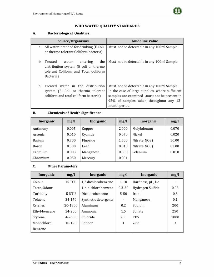
EnvironmentalMonitoringofT/LRoute
APPENDIX–I:STANDARDS 2
WHOWATERQUALITYSTANDARDS
A. BacteriologicalQualities
Source/Organisms’ GuidelineValue
a. Allwaterintendedfordrinking(EColiorthermotolerantColiformbacteria)
b. Treated water entering the
distribution system (E coli or thermotolerant Coliform and Total ColiformBacteria)
c. Treated water in the distributionsystem (E .Coli or thermo tolerantcoliformandtotalcoliformbacteria)
Mustnotbedetectableinany100mlSampleMustnotbedetectableinany100mlSampleMustnotbedetectableinany100mlSampleIn the case of large supplies,where sufficientsamplesareexamined,mustnotbepresentin95% of samples taken throughout any 12‐monthperiod
B. ChemicalsofHealthSignificance
Inorganic mg/l Inorganic mg/l Inorganic mg/l
Antimony
Arsenic
Barium
Boron
Cadmium
Chromium
0.005
0.010
0.700
0.300
0.003
0.050
Copper
Cyanide
Fluoride
Lead
Manganese
Mercury
2.000
0.070
1.500
0.010
0.500
0.001
Molybdenum
Nickel
Nitrate(NO3)
Nitrate(NO3)
Selenium
0.070
0.020
50.00
03.00
0.010
C. OtherParameters
Inorganic mg/l Inorganic mg/l Inorganic mg/l
Colour
Taste,Odour
Turbidity
Toluene
Xylenes
Ethyl‐benzene
Styrene
Monochloro
Benzene
15TCU
‐
5NTU
24‐170
20‐1800
24‐200
4‐2600
10‐120
1,2dichlorobenzene
1‐4dichlorobenzene
Dichlorobenzene
Syntheticdetergents
Aluminum
Ammonia
Chloride
Copper
1‐10
0.3‐30
5‐50
‐
0.2
1.5
250
1
Hardness,pH,Do
HydrogenSulfide
Iron
Manganese
Sodium
Sulfate
TDS
Zinc
‐
0.05
0.3
0.1
200
250
1000
3


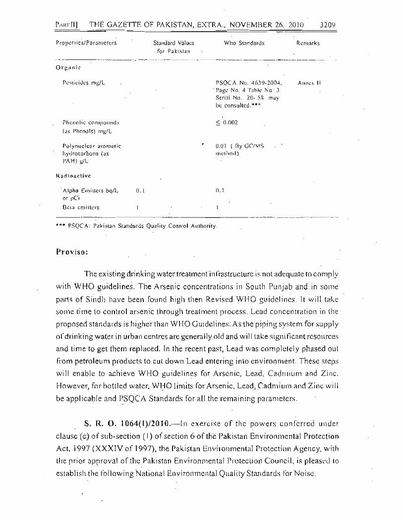


REGISTERED No. M-302 L. 7646
The Gazette
of Pakistan
EXTRAORDINARY
PUBLISHED BY AUTHORITY
===============================================================
ISLAMABD, THURSDAY, AUGUST 10, 2000 ===============================================================
PART-II
Statutory Notification (S.R.O)
GOVERNMENT OF PAKISTAN
MINISTRY OF ENVIRONMENT, LOCAL GOVERNMENT AND
RURAL DEVELOPMENT
NOTIFICATION
Islamabad, the 8th August 2000
S.R.O. 549 (I)/2000.___ In exercise of the powers conferred under clause (c) of sub-section (1) of section of 6 of the Pakistan environmental Protection Act. 1997 (XXXIV of 1997), the Pakistan Environmental Protection Agency, with the prior approval of the Pakistan Environmental Protection Council, is pleased to direct that the following further amendments shall be made in its Notification No. S.R.O. 742(I)/93, dated the 24th August, 1993, namely: ___ In the aforesaid Notification, in paragraph 2._____
(1289)
[4138(2000)/Ex.GAZ]
Price : Rs. 5.00

1290 THE GAZETTE OF PAKISTAN, EXTRA, AUGUST 10, 2000 [PART-II] =============================================================== (1) for Annex, I the following shall be substituted, namely:_____
Annex-I
“NATIONAL ENVIRONMENTAL QUALITY STANDARDS FOR MUNICIPAL AND LIQUID INDUSTRIAL EFFLUENTS (mg/I,
UNLESS OTHERWISE DEFINED)
S. No. Parameter Revised Standards
Existing Into Into Into Standards Inland Sewage Sea ( ) Waters Treatment (5)
1 2 3 4 5 6
1. Temperature or
Temperature Increase * 400C ≤3oC ≤3oC ≤3oC
2. pH value (H+) . 6-10 6-9 6-9 6-9 3. Biochemical Oxygen
Demand (BOD)5 at 200C (1)
80
80
250
80** 4. Chemical Oxygen Demand
(COD) (1) .. .. ..
150
150
400
400 5. Total Suspended Solids
(TSS) .. .. ..
150
200
400
200 6. Total Dissolved Solids
(TDS) 3500 3500 3500 3500
7. Oil and Grease 10 10 10 10 8. Phenolic compounds (as
phenol)
0.1
0.1
0.3
0.3 9. Chloride (as C1– )
1000
1000 1000 SC***
10. Fluoride (as F– ) 20 10 10 10 11. Cyanide (as CN–) total .. 2 1.0 1.0 1.0 12. An-ionic detergents (as
MBAS) (2) 20 20 20 20
13. Sulphate (SO42–) 600 600 1000 SC***
14. Sulphide (S2–) 1.0 1.0 1.0 1.0 15. Ammonia (NH3) 40 40 40 40 16. Pesticides (3) 0.15 0.15 0.15 0.15

PART-II] THE GAZETTE OF PAKISTAN, EXTRA, AUGUST 10, 2000 1291 ===============================================================
1 2 3 4 5 6
17. Cadmium (4) .. .. 0.1 0.1 0.1 0.1 18. Chromium (trivalent
and hexavalent (4).. .. 1.0 1.0 1.0 1.0
19. Cooper (4) .. .. 1.0 1.0 1.0 1.0 20. Lead (4) .. .. 0.5 0.5 0.5 0.5 21. Mercury (4) .. .. 0.01 0.01 0.01 0.01 22. Selenium (4) 0.5 0.5 0.5 0.5 23. Nickel (4) .. .. 1.0 1.0 1.0 1.0 24. Silver (4) 1.0 1.0 1.0 1.0 25. Total toxic metals .. .. 2.0 2.0 2.0 2.0 26. Zinc .. .. .. 5.0 5.0 5.0 5.0 27. Arsenic (4) .. .. 1.0 1.0 1.0 1.0 28. Barium (4) .. .. 1.5 1.5 1.5 1.5 29. Iron .. .. .. 2.0 8.0 8.0 8.0 30. Manganese .. .. 1.5 1.5 1.5 1.5 31. Boron (4) .. .. 6.0 6.0 6.0 6.0 32. Chlorine .. .. .. 1.0 1.0 1.0 1.0
Explanations:
1. Assuming minimum dilution 1:10 on discharge, lower ratio would attract progressively stringent standards to be determined by the Federal Environmental Protection Agency. By 1:10 dilution means, for example that for each one cubic meter of treated effluent, the recipient water body should have 10 cubic meter of water for dilution of this effluent.
2. Methylene Blue Active Substances; assuming surfactant as biodegradable.
3. Pesticides include herbicides, fungicides, and insecticides.
4. Subject to total toxic metals discharge should not exceed level given at S. N. 25.
5. Applicable only when and where sewage treatment is operational and BOD5=80mg/I
is achieved by the sewage treatment system.

PART-II] THE GAZETTE OF PAKISTAN, EXTRA, AUGUST 10, 2000 1292 ===============================================================
6. Provided discharge is not at shore and not within 10 miles of mangrove or other
important estuaries. * The effluent should not result in temperature increase of more than 30C at the
edge of the zone where initial mixing and dilution take place in the receiving body. In case zone is not defined, use 100 meters from the point of discharge.
** The value for industry is 200 mg/I *** Discharge concentration at or below sea concentration (SC).
Note:______ 1. Dilution of liquid effluents to bring them to the NEQS limiting values is
not permissible through fresh water mixing with the effluent before discharging into the environment.
2. The concentration of pollutants in water being used will be substracted
from the effluent for calculating the NEQS limits” and (2) for Annex-II the following shall be substituted, namely:____
Annex-II
“NATIONAL ENVIRONMENTAL QUALITY STANDARDS FOR INDUSTRIAL GASEOUS EMISSION (mg/Nm3, UNLESS
OTHERWISE DEFINED).”
S. No. Parameter Source of Emission Existing Standards
Revised Standards
1 2 3 4 5 1. Smoke Smoke opacity not to
exceed 40% or 2 Ringlemann Scale
40% or 2 Ringlemann Scale or equivalent smoke number
2. Particulate malter (1)
(a) Boilers and Furnaces
(i) Oil fired (ii) Coal fired (iii) Cement Kilns
(b) Grinding, crushing, Clinker coolers and Related processes, Metallurgical Processes, converter, blast furnaces and cupolas.
300 500 200
500
300 500 300
500
3. Hydrogen Chloride
Any 400 400

PART-II] THE GAZETTE OF PAKISTAN, EXTRA, AUGUST 10, 2000 1293
===============================================================
1 2 3 4 5
4. Chlorine Any 150 150 5. Hydrogen Fluoride Any 150 150 6. Hydrogen Sulphide Any 10 10 7. Sulphur Oxides (2) (3) Sulfuric
acid/Sulphonic acid plants Other Plants except power Plants operating on oil and coal
400
1700
8. Carbon Monoxide Any 800 800 9. Lead Any 50 50
10. Mercury Any 10 10 11. Cadmium Any 20 20 12. Arsenic Any 20 20 13. Copper Any 50 50 14. Antimony Any 20 20 15. Zinc Any 200 200 16. Oxides of Nitrogen
(3)
Nitric acid manufacturing
unit.
Other plants except power
plants operating on oil or coal:
Gas fired Oil fired
Coal fired
400
400 - -
3000
400 600
1200
Explanations:-
1. Based on the assumption that the size of the particulate is 10 micron or more.
2. Based on 1 percent Sulphur content in fuel oil. Higher content of
Sulphur will case standards to be pro-rated.
3. In respect of emissions of Sulphur dioxide and Nitrogen oxides, the power plants operating on oil and coal as fuel shall in addition to National Environmental Quality Standards (NEQS) specified above, comply with the following standards:-
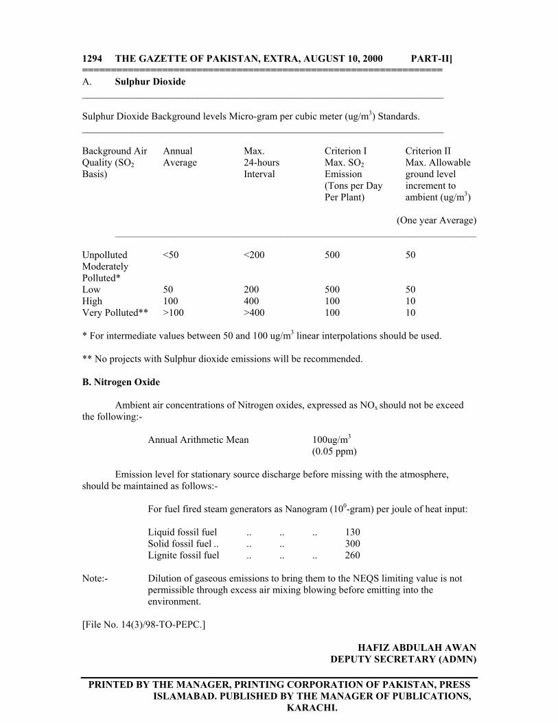
1294 THE GAZETTE OF PAKISTAN, EXTRA, AUGUST 10, 2000 PART-II] =============================================================== A. Sulphur Dioxide ________________________________________________________________________ Sulphur Dioxide Background levels Micro-gram per cubic meter (ug/m3) Standards. ________________________________________________________________________ Background Air Quality (SO2 Basis)
Annual Average
Max. 24-hours Interval
Criterion I Max. SO2 Emission (Tons per Day Per Plant)
Criterion II Max. Allowable ground level increment to ambient (ug/m3)
(One year Average)
________________________________________________________________________
Unpolluted Moderately Polluted*
<50 <200 500 50
Low 50 200 500 50 High 100 400 100 10 Very Polluted** >100 >400 100 10 * For intermediate values between 50 and 100 ug/m3 linear interpolations should be used. ** No projects with Sulphur dioxide emissions will be recommended. B. Nitrogen Oxide Ambient air concentrations of Nitrogen oxides, expressed as NOx should not be exceed the following:- Annual Arithmetic Mean 100ug/m3
(0.05 ppm) Emission level for stationary source discharge before missing with the atmosphere, should be maintained as follows:- For fuel fired steam generators as Nanogram (100-gram) per joule of heat input: Liquid fossil fuel .. .. .. 130 Solid fossil fuel .. .. .. 300 Lignite fossil fuel .. .. .. 260 Note:- Dilution of gaseous emissions to bring them to the NEQS limiting value is not
permissible through excess air mixing blowing before emitting into the environment.
[File No. 14(3)/98-TO-PEPC.]
HAFIZ ABDULAH AWAN DEPUTY SECRETARY (ADMN)
PRINTED BY THE MANAGER, PRINTING CORPORATION OF PAKISTAN, PRESS
ISLAMABAD. PUBLISHED BY THE MANAGER OF PUBLICATIONS, KARACHI.

Amendment in Master Plan for Lahore Division (The Project) Environmental Impact Assessment (EIA) Report
Appendices
219
Appendix-III
Hydrological Study Report

MASTER PLAN FOR LAHORE DIVISION PROJECT Districts Lahore, Kasur, Sheikhupura & Nankana Sab
Hydrological Study Report
Lahore Development Authority (LDA), Lahore.

Master Plan for Lahore Division Project Hydrological Study Report
Table of Contents
I
TABLE OF CONTENTS
TABLE OF CONTENTS .................................................................................... I
LIST OF FIGURES ......................................................................................... III
LIST OF TABLES ........................................................................................... IV
HYDROLOGY OF THE PROJECT AREAS ..................................................... 1
1.1. General .................................................................................................. 1
1.2. Description of Planned Area .................................................................. 1
1.3. Climate of Lahore Division ..................................................................... 3
1.4. Surface Water Availability: ..................................................................... 5
1.4.1. Rivers .............................................................................................. 5
1.4.1.1. Ravi River ................................................................................. 5
1.4.1.2. Deg Nallah: ............................................................................... 7
1.4.2. Flows in Ravi River: ......................................................................... 8
1.4.2.1. Average flows ........................................................................... 8
1.4.2.2. Floods: .................................................................................... 10
1.4.2.3. Water Quality: ......................................................................... 11
1.4.3. Sutlej River .................................................................................... 12
1.4.3.1. Structures on Sutlej River: ...................................................... 12
1.4.3.2. Floods ..................................................................................... 13
1.4.3.3. Water Quality .......................................................................... 14
1.4.4. Canals ........................................................................................... 14
1.4.4.1. Marala Ravi Link Canal ........................................................... 14
1.4.4.2. Upper Chenab Canal .............................................................. 14
1.4.4.3. Banbawali Ravi Bedian Canal ................................................. 14
1.4.4.4. Lower Chenab Canal .............................................................. 14
1.4.4.5. Qadirabad-Bulloki Link Canal .................................................. 14
1.4.4.6. Lower Bari Doab Canal ........................................................... 15
1.4.4.7. Balloki – Sulemanki Link Canal ............................................... 15
1.5. GROUND WATER ............................................................................... 15
1.5.1. Ground Water Quality: ................................................................... 16
1.5.2. Groundwater Challenges: .............................................................. 16
1.5.3. Conservation of Groundwater: ....................................................... 17
1.5.4. Ground Water Recharge: .............................................................. 19
1.6. Discussion on Each Site: ..................................................................... 20
1.6.1. Allah Abad ..................................................................................... 20
1.6.2. Bhai Pheru ..................................................................................... 20
1.6.3. Bhikhi ............................................................................................. 20
1.6.4. Bucheki .......................................................................................... 20
1.6.5. Changa Manga .............................................................................. 21
1.6.6. Chunian ......................................................................................... 21

Master Plan for Lahore Division Project Hydrological Study Report
Table of Contents
II
1.6.7. Farooqabad ................................................................................... 21
1.6.8. Feroz Wattwan .............................................................................. 21
1.6.9. Ferozpur Road & BRB Canal......................................................... 22
1.6.10. Ferozwala ................................................................................... 22
1.6.11. Industrial Estate ......................................................................... 22
1.6.12. Jamber ....................................................................................... 22
1.6.13. Jandiala Sher Khan .................................................................... 23
1.6.14. Jaranwala Road ......................................................................... 23
1.6.15. Jhabran ...................................................................................... 23
1.6.16. Kanganpur .................................................................................. 23
1.6.17. Kasur .......................................................................................... 24
1.6.18. Khanqah Dogran ........................................................................ 24
1.6.19. Khuddian Khas ........................................................................... 24
1.6.20. Kot Radha Kishan ...................................................................... 24
1.6.21. Lahore Muridke Road ................................................................. 24
1.6.22. Lahore Sheikhupura Road ......................................................... 25
1.6.23. Mananwala ................................................................................. 25
1.6.24. Mandi Faizabad .......................................................................... 25
1.6.25. Mor Khunda ................................................................................ 25
1.6.26. Muridke ...................................................................................... 26
1.6.27. Mustafa Abad ............................................................................. 26
1.6.28. Nankana Sab ............................................................................. 26
1.6.29. Narang Mandi ............................................................................. 27
1.6.30. Pattoki ........................................................................................ 27
1.6.31. Raiwind & Multan Road .............................................................. 27
1.6.32. Raja Jang ................................................................................... 27
1.6.33. Rao Khan Wala .......................................................................... 28
1.6.34. Safdarabad ................................................................................. 28
1.6.35. Sangla Hil ................................................................................... 28
1.6.36. Shahkot-I .................................................................................... 28
1.6.37. Shahkot-II ................................................................................... 29
1.6.38. Sharqpur .................................................................................... 29
1.6.39. Sheikhupura ............................................................................... 29
1.6.40. Syed Wala .................................................................................. 29
1.6.41. Talwandi ..................................................................................... 30
1.6.42. Warburton .................................................................................. 30
1.7. Floods .................................................................................................. 30
1.8. Conclusion ........................................................................................... 33
Master Plan for Lahore Division Project Hydrological Study Report
List of Figures
III
LIST OF FIGURES
Figure 1 Temperature Data of Lahore Region (Data Source: Climatic Data
Processing Centre (CDPC), Pakistan Meteorological Department, Karachi) ... 3
Figure 2 Average Rainfall of Lahore Region (Data Source: Climatic Data
Processing Centre (CDPC), Pakistan Meteorological Department, Karachi) ... 4
Figure 3 Average Relative Humidity of Lahore Region (Data Source: Climatic
Data Processing Centre (CDPC), Pakistan Meteorological Department,
Karachi) ........................................................................................................... 4
Figure 4 Average wind speed of Lahore Region (Data Source: Climatic Data
Processing Centre (CDPC), Pakistan Meteorological Department, Karachi) ... 5
Figure 5 Average Discharge (cusecs) in Ravi River in each month from 2000
to 2013 ............................................................................................................. 9
Figure 6 Average Annual Discharge (cusecs) in Ravi River from 2000 to 2013
......................................................................................................................... 9
Figure 7 Vertical Level Difference between Kasur and River Sutlej ............... 13
Figure 8 Flood in Rivers of Pakistan-2014, NDMA......................................... 31
Figure 9 Flood Early Warning Centre (Source- DRP-2013) ........................... 32

Master Plan for Lahore Division Project Hydrological Study Report
List of Tables
IV
LIST OF TABLES
Table 1 List of Bridges on River Ravi ............................................................... 7
Table 2 Flood Frequency Analysis ................................................................. 10

Master Plan for Lahore Division Project Ecological Study Report
Hydrology of the Project Areas
1
HYDROLOGY OF THE PROJECT AREAS
1.1. General
This Chapter provides an overview of the hydrological condition and hydraulic
activities in the subject area. The report is focused on studying the impacts of
planned settlements on hydrology of area. The report will be helpful in understanding
the present and future conditions of groundwater aquifer, canals and hydraulic
structures in Lahore Division. This chapter further discuss the possibilities of flood
risk and mitigation measures to be adopted.
The planned area is rich in hydrological assets, which is further supplemented by
hydrological flows of link canals. It is important to keep all these elements under
consideration for an integrated planning, without missing any important parameter.
1.2. Description of Planned Area
A master plan is prepared for Lahore Division by Lahore Development Authority,
which includes Lahore, Shiekhupura, Kasur and Nankana Sahib Districts. This
division is a part of Punjab Province of Pakistan. Geologically, this area is a part of
lower Indus Basin. The name “Punjab” itself is an indicative of healthy presence and
importance of rivers in this area. This word “Punjab” comes from 'punj-aab', meaning
five rivers. The five rivers of Punjab were Sutlej, Bias, Ravi, Jehlum and Chenab
Rivers; Bias River of which have discontinued to flow in Pakistan, as discussed later.
This blessing of rivers has resulted in cultivation on mast part of land in Punjab as
well as in the study area.
Two main rivers pass from Lahore Division, Ravi River and Sutlej River. The slope of
the land in planned area is to the south-west, which directs the rivers to flow in this
path. Average slope of the area is 0.32m/km.

Master Plan for Lahore Division Project Ecological Study Report
Hydrology of the Project Areas
2
These rivers have a major contribution in glorious history of the Lahore Division. All
the "historical assets" of Lahore, including but not limited to Lahore Fort, Badshahi
Mosque and Kamran ki Baradari, were built adjacent to Ravi River.
As per the Indus basin treaty of 1960, six major rivers were divided among Pakistan
and India. The rights of Eastern Rivers (Sutlej, Bias and Ravi) were allocated to
India, while the rights of Western Rivers (Chenab, Jehlum and Indus) were reserved
with Pakistan. Since the Indus basin treaty, India has completed series of structures
on eastern rivers to store and divert water from upstream and use it for generation of
electricity and irrigation. These interventions have put a stop to ecological and
sustainable flows in these rivers, thereby depriving the downstream areas of
Pakistan, including Lahore Division from naturally available water for irrigation. Two
of the rivers, Ravi and Sutlej, allocated to India, still flows seasonally through the
study area. While Bias River have discontinued to flow. The old bed of Bias River still
exists in Kasur. To meet the irrigation demands, Pakistan constructed multiple link
canals which divert water from western rivers to Eastern Rivers.
The following link canals pass through the planned area:
i. Bambanwala Ravi Bedian Link Canal
ii. Qadirabad-Bulloki Link Canal
iii. Balloki – Sulemanki Link
iv. Lower Bāri Doāb Canal
v. Upper Chenab Canal
vi. Lower Chenab Canal
In addition, the following hydraulic structures lie inside our study area
i. Balloki Barrage
ii. BRB-Ravi Siphon
The planned area also have abundance of water in the form of groundwater aquifer.

Master Plan for Lahore Division Project Ecological Study Report
Hydrology of the Project Areas
3
1.3. Climate of Lahore Division
Lahore Division experiences wide variation in temperature. The coldest month is
January in which the mean maximum temperature is 19.4 °C and the mean minimum
temperature is 6.6 °C. June is the hottest month with the mean maximum
temperature near 39.8 °C and the mean minimum temperature as 27.4 °C. Mean
temperature of the region during the last 20 years (1991-2010) is given in Figure (1).
Figure 1 Temperature Data of Lahore Region (Data Source: Climatic Data Processing Centre (CDPC), Pakistan Meteorological Department, Karachi)
The average annual rainfall during the last 20 years period from (1991-2010) is
calculated to be 55.25 mm. Nearly 70% of it is received in the form of high intensity
showers during the monsoon (July, August, September) and the remaining in winter.
One daily Max rainfall was recorded in 2014, equal to 213mm. The average monthly
rainfall at Lahore during the last 20 years (1991-2010) is also shown in Figure (2).
Jan Feb Mar April May June July Aug Sep Oct Nov Dec
Avergae Maximum 19.4 22.1 27.2 34 38.7 39.8 35.9 34.9 34.8 32.7 27.4 21.7
Average Minimum 6.6 9.7 14.7 20.2 24.5 27.4 27 26.7 24.7 18.9 12.5 7.7
Average 13 15.9 20.95 27.1 31.6 33.6 31.45 30.8 29.75 25.8 19.95 14.7
0
5
10
15
20
25
30
35
40
45
Tem
pe
ratr
ue
C °
Temperature Data of Lahore

Master Plan for Lahore Division Project Ecological Study Report
Hydrology of the Project Areas
4
Figure 2 Average Rainfall of Lahore Region (Data Source: Climatic Data Processing Centre (CDPC), Pakistan Meteorological Department, Karachi)
The most humid period is the month of August with maximum average relative
humidity of 85.3% and minimum average relative humidity of 61.2%. The average
relative humidity of Lahore region for last 20 years (1991-2010) recorded is shown in
Figure (3).
Figure 3 Average Relative Humidity of Lahore Region (Data Source: Climatic Data Processing Centre (CDPC), Pakistan Meteorological Department, Karachi)
Jan Feb Mar Apr May June July Aug Sep Oct Nov Dec
Rain Fall (mm) 22.3 30.4 36.2 18.8 21.1 49 190.7 169.9 60.5 12.2 5.3 10.7
0
50
100
150
200
250
Mill
ime
ter
(mm
)
Average Rainfall
Jan Feb Mar April May Jun Jul Aug Sep Oct Nov Dec
at 00 UTC 85.5 79.5 74.3 61.1 52.9 60.9 80.5 85.3 81.9 79.2 83.3 85.9
at 12UTC 48.7 42.5 37.9 26.7 23.1 31.8 55.8 61.2 50.8 41.2 47 52.3
0
10
20
30
40
50
60
70
80
90
100
Pe
rce
nta
ge (
%)
Relative Humidity

Master Plan for Lahore Division Project Ecological Study Report
Hydrology of the Project Areas
5
During cold seasons of the year northern winds prevail and during hot seasons
southern winds. Monthly mean velocity of the wind (Knots) taken for the period 1991-
2010 are shown in Figure (4).
Figure 4 Average wind speed of Lahore Region (Data Source: Climatic Data Processing Centre (CDPC), Pakistan Meteorological Department, Karachi)
1.4. Surface Water Availability:
1.4.1. Rivers
As discussed earlier, two main Rivers pass from the planned area, Ravi River and
Sutlej River.
1.4.1.1. Ravi River
The Ravi River originates in the Himalayas in the Multhan Tehsil of Kangra
District of Himachal Pradesh, India and is mostly fed by snow melt. Many tributaries
join Ravi River downstream of its source. It then flows along the Indo–Pak border for
80 kilometres (50 mi) before entering Pakistan and flows past Lahore City. South of the
town of Ahmadpur, Ravi River finally joins the Chenab River. The total length of the river
is about 725 kilometres.
According to Indus Water treaty (1960), rights of River Ravi belongs to India. India
diverts water of the river for generation of electricity and cultivation of its agricultural
Jan Feb Mar April May Jun Jul Aug Sep Oct Nov Dec
at 00 UTC 0.5 1.0 1.3 1.6 1.6 1.7 1.6 1.1 0.7 0.5 0.3 0.3
at 12UTC 1.5 2.6 3.2 3.3 2.8 2.8 2.6 2.1 1.9 1 0.5 0.6
0.0
0.5
1.0
1.5
2.0
2.5
3.0
3.5
Kn
ots
Wind Speed

Master Plan for Lahore Division Project Ecological Study Report
Hydrology of the Project Areas
6
lands. Due to construction of series of headworks on Ravi River in the past decade,
its flow path and pattern and intensity has changed tremendously, with its course
shifting towards west. (Thomas and Sharma, 1998)
The following hydraulic structures are constructed on Ravi River which affects flow
pattern in Lahore Division.
Thein Dam
Thein Dam was completed and put into operation in __ in India, Thein Dam is
constructed for generation of electricity and to supply water for irrigation. Thein Dam
has spillway capacity of 870,047 cusecs.
Shahpur Kandi Dam
Shahpur Kandi Dam lies downstream of Thein Dam and currently under
construction. It is being constructed to provide a balancing reservoir, to have uniform
water releases for canals, make excess water available for diversion into canals and
for generation of electricity. Shahpur Kandi Dam has spillway capacity of 7,50,400
cusec.
Madhopur Headwork l
Madhopur Headwork lies further downstream of Shahpur Kandi Dam and is built to
divert water for the purpose of irrigation.
Balloki Barrage
Balloki Barrage lies in planned area of Lahore Division, which lies at a distance of
29km from Lahore City. Two important canals, Balloki Sulemanki Link Canal and
Lower Bari Doab offtakes from Balloki Barrage. Balloki Barrage has spillway capacity
of 385,000 cusecs.
Ravi River is supplemented by the four natural drains inside border of Pakistan,
namely Ujh, Bein, Basantar and Deg Nullahs.
A number of fresh water input in the form of link canals also increases the river flow
and canals taking off at head works reduce the flows in the river. In the vicinity of
Lahore Divisions, three link canals are very important.

Master Plan for Lahore Division Project Ecological Study Report
Hydrology of the Project Areas
7
Marala-Ravi (M-R) link canal joins the river about 40km upstream of
Lahore. The canal is mainly used to divert the flood flows and as such
does not contribute to the river flows during the low flow period. M-R Link
Canal has design capacity of 22,500 cusecs.
Upper Chenab (U.C) canal with the capacity of 7770 cusecs at the tail
and joins the river at 42km downstream of Lahore.
Qaderabad (Q.B) link canal with the capacity of 14,480 cusecs joins the
river at 60km downstream of Lahore.
Water is diverted from Ravi into B.S. link canal and L.B.D. Canals at Balloki head
work. The combined capacity of these canals is to the tune of 29,000 cusecs. These
canals reduce the flow in the river downstream of Balloki head works.
1.4.1.2. Deg Nallah:
Deg Nallah is another tributary of Ravi River, which originates from Indian held
Kashmir. After entering into Pakistan, Deg Nallah crosses M-R Link Canal and
BRBD Canal, where cross drainage structures are provided. It joins Ravi River 18Km
downstream of Shahdara Town.
The nallah is of special importance due to its flood risk in some parts of Sheikhupura.
Main effectees of Deg Nallah are currently estimated to be around 0.5 million
farmers. Deg Nallah has flow capacity of only 25,000 cusecs, which is less than flood
of 10 years return period in this nallah.
The following areas are under threat from flooding in Deg Nallah
Ferozwala
Jaranwala Road
Muridke
The following bridges are present on Ravi River in Lahore District (Table 1):
Table 1 List of Bridges on River Ravi
Bridge Clear width (ft) Hydraulic Capacity
Railway Bridge 1450 250,000 cusecs

Master Plan for Lahore Division Project Ecological Study Report
Hydrology of the Project Areas
8
Old Ravi Bridge 1450 250,000 cusecs
New Ravi (Shahdara) Bridge 1660 350,000 cusecs
Saghian Bridge 2150 450,000 cusecs
Motorway Bridge 2225 450,000 cusecs
Head Balloki Bridge 1635 385,000 cusecs
1.4.2. Flows in Ravi River:
1.4.2.1. Average flows
Investigations indicates that flows in the river are highly variable with time during the
year which is directly resultant of structural interventions from Indian side and
Monsoon Rainfalls.The inflows in Ravi River are measured by gauging stations
installed on Railway Bridge near Shahdara and at Ravi Siphon.
Monthly averages flows (cusecs) at Shahdara and Ravi Syphon are tabulated in
Table (1) for the period 2000 to 2013. Monthly average flows are also listed in Table
(1). It indicates that flow available from October to March is very less. The average
flow in these six months is 1,638 cusecs with low value of 1371 cusecs that was
observed in the month of November. Flows are available in abundance for the Kharif
season, 12,315 cusecs in these six months from 2001 to 2013. The maximum flow
could reach to 18000 cusecs in the month of July while it may come to very low
value (1,200 cusecs) in the month of December (Figure 5).

Master Plan for Lahore Division Project Ecological Study Report
Hydrology of the Project Areas
9
Figure 5 Average Discharge (cusecs) in Ravi River in each month from 2000 to 2013
The temporal distribution of the mean annual flows at the Shahdara site is given in
Figure (6) from 2001-2013. The Figure shows that mean annual flow was highest in
2003 having a value of 10,518 cusecs and minimum mean annual flow in 2010 with
a value of 4,128 cusecs.
Figure 6 Average Annual Discharge (cusecs) in Ravi River from 2000 to 2013
0
2000
4000
6000
8000
10000
12000
14000
16000
18000
20000A
vera
ge D
isch
arge
0
2000
4000
6000
8000
10000
12000
2001 2002 2003 2004 2005 2006 2007 2008 2009 2010 2011 2012 2013
Ave
rage
Dis
char
ge (
Cu
secs
)

Master Plan for Lahore Division Project Ecological Study Report
Hydrology of the Project Areas
10
1.4.2.2. Floods:
The flood of 1988, with magnitude of 570,000 cusecs at Shahdara, was the worst
flood of 20th century to hit Lahore City. The flood claimed 731 lives and displaced
1,250,000 people. The Shahdara Distributary bund was breached causing heavy
flooding of the area between Shahdara and Kala Shah Kaku. Downstream, the
Balloki and Sidhnai head works were subjected to discharges far in excess of their
design capacities, and embankments were breached to save the structures.
The 1955 flood is the second highest on record flood for the Ravi River, with peak
discharges of 5,59,000 cusecs at Ravi Siphon. It breached the flood embankments
of the Bambanwala–Ravi–Bedian–Dipalpur Link Canal, upstream from Ravi Siphon,
and at Shahdara Bridge. The Punjab Irrigation Department estimated that flood
discharges of 259,000 cusecs passed through the breaches at Ravi Siphon and
300,000 m3/s through the breaches at Shahdara Bridge.
A flood frequency analysis was performed by Gumble (extreme value Type-I
method) using annual peak flood data for Lahore at Shahdara. The analysis gives
following results:
Table 2 Flood Frequency Analysis
Return Period (T) Probability of occurrence Discharge
(Years) (%) (cusecs)
2 50.00 73,303
5 20.00 152,280
10 10.00 204,569
20 5.00 254,726
25 4.00 270,637
40 2.50 303,924
50 2.00 319,650
100 1.00 368,301
200 0.50 416,774
500 0.20 480,725
1,000 0.10 529,058

Master Plan for Lahore Division Project Ecological Study Report
Hydrology of the Project Areas
11
As per international practice, safety for cities and barrages are checked against a
design flood of 100 years return period, which comes out to be 368,301 cusecs. The
peak floods of 5,59,000 cusecs and 570,000 cusecs were recorded before
construction of Thein Dam and Shahpur Kundi Dam on Ravi River.
The following settlements can come under threat for a flood of more than 100years
return period.
i. Bucheki
ii. Mor Khunda
iii. Mandi Faizabad
For establishment of industrial area, further detailed hydraulic analysis is required to
assess probability, nature and magnitude of flood at a specific site.
1.4.2.3. Water Quality:
The quality of Ravi River has deteriorated heavily with increase in urbanization
around it; both in Indian and Pakistan. A decreasing trend in DO levels and an
increase trend in BOD, TDS, total and Faecal Coliforms has been observed in Ravi
over time. The discharge of untreated wastewater from the city and nearby industrial
estates into the river is the main cause of deterioration in its water quality. (Ahmad
and Ali, 1997).
The river acts as a domestic wastewater and industrial effluent carrier from Kala
Shah Kaku, Lahore-Shiekhupura Road, Kot Lakhpat Industrial Estate and Multan
Road. Further, the entire municipal waste from Lahore city is collected through a
network of 14 main drains and discharged into the River Ravi without any treatment.
The industrial waste is directly discharged into the canal system by 271 industrial
units. These industries include textile, chemical, food processing, pulp and paper,
poultry, dairy, plastic, paint, pesticides, leather, tanneries and pharmaceuticals.
Another source of pollution is the Hudiara Drain. All along its route in India and
Pakistan wastewater, sewage, and industrial pollutants are discharged into the drain
without proper prior treatment. In India, Amritsar and many smaller towns and

Master Plan for Lahore Division Project Ecological Study Report
Hydrology of the Project Areas
12
villages besides industries, discharge untreated wastewater into this drain.
Currently, there are around 100 industries located along the Hudiara Drain, which
discharge wastewater directly into the River Ravi. (JICA, 2010).
The wastewater discharged into the River Ravi contains liquid and solid waste from
domestic, industrial, and commercial premises, including but not limited to toilet
waste, grey water (household wastewater of kitchens, bathrooms and laundries),
sludge, trade wastes and gross solids. According to very conservative estimates,
approximately 730 tons/day of Biological Oxygen Demand load is added to the River
Ravi.
Municipal and industrial toxicants, such as metals pose serious risk to living species.
Heavy metals not only affect health and wellbeing of nearby societies, but is also
affecting ground water quality of Lahore due to seepage. (Shakir and Qazi 2013).
1.4.3. Sutlej River
Sutlej River is also a part of Indus Basin Rivers which flows past Kasur District. The
source of the Sutlej River is near Lake Rakshastal in Tibet. From there, it flows at
first west-northwest for about 260 kilometres (160 mi) to the Shipki La pass, entering
India in Himachal Pradesh state. It then turns slightly, heading west-southwest for
about 360 kilometres (220 mi) to meet the Beas River near Makhu, Firozpur district
in Punjab state of India. Continuing west-southwest, the Sutlej enters Pakistan about
15 kilometres (9.3 mi) east of Bhedian Kalan, Kasur District, Punjab Province,
continuing southwest to join Indus River.
The waters of the Sutlej River are also allocated to India under the Indus Waters
Treaty between India and Pakistan, and are mostly diverted to irrigation canals within
India.
1.4.3.1. Structures on Sutlej River:
In year 1963, India completed Bhakra Dam on Sutlej River to store and use water for
production of electricity and divert water for irrigation purpose. The dam is
operational and has spillway capacity of 400,000 cusecs.

Master Plan for Lahore Division Project Ecological Study Report
Hydrology of the Project Areas
13
Just upstream of border, where Sutlej River enters Pakistan, Hussainwala Headwork
is present on river. This headwork was constructed in 1926 and currently has
spillway capacity of 4,50,000 cusecs.
Within or upstream of Lahore District, the Sutlej River is not supplemented by any
link canal.
1.4.3.2. Floods
Most of the flow in Sutlej River is yielded by heavy monsoon rains. The winter flow is
substantially lower when there is little rain or snowmelt from the Himalayan glaciers.
The risk of floods has drastically reduced since construction of series of dams on
Sutlej River by India. The flood in Sutlej River during floods of August 2015 was
estimated to be between 45,000 Cusecs to 55,000 Cusecs.
Figure 7 Vertical Level Difference between Kasur and River Sutlej
The planned settlements of Lahore Division are generally safe from moderate floods
in Chenab River. The metropolitan area of Kasur is roughly 10km away from Sutlej
River. Further, the BRBD Canal, lying between Kasur and Sutlej River, is acting as
protection bund. Similar is the case with the settlement of Khuddian Khas and
Kanganpur. All settlements in planned area were safe during the floods of 2015.

Master Plan for Lahore Division Project Ecological Study Report
Hydrology of the Project Areas
14
1.4.3.3. Water Quality
Water quality of Sutlej River inside Pakistan have not been determined. The water
coming from Indian side contains toxic chemicals and heavy metals which makes it
unsafe for drinking.
1.4.4. Canals
The total surface water diverted to Lahore for irrigation is 6.02 MCM/day. However,
water available for agricultural use is only 3.0 MCM/ day as the rest is lost en-route
as seepage from main and distributary canals, percolation losses from watercourses
and farmer fields.
Following are the canals which pass through Lahore Division;
1.4.4.1. Marala Ravi Link Canal
Marala Ravi Link Canal originates from Chenab River at Marala Headwork and
meets Ravi River, 59Km upstream of Railway Bridge. MR Link Canal has design
capacity of 22,500 cusecs.
1.4.4.2. Upper Chenab Canal
Upper Chenab Canal originates from Chenab River at Marala Headwork and meets
Ravi River, 32Km upstream of Balloki Barrage. Upper Chanab Canal has design
capacity of 7770 cusecs. The Deg Nallah also meets Upper Chenab Canal, 22Km
upstream from its confluence with Ravi River.
1.4.4.3. Banbawali Ravi Bedian Canal
Banbawali Ravi Bedian Canal offtakes from Upper Chenab Canal, which was
constructed for defense purposes. Multiple Branch Canals also originate from Upper
Chenab Canal for irrigation.
1.4.4.4. Lower Chenab Canal
Lower Chenab Canal offtakes from Chenab Canal at Khanki Headwork and is used
for irrigation in Punjab Region.
1.4.4.5. Qadirabad-Bulloki Link Canal
Qadirabad-Balloki Link Canal originates from Chenab River at Qadirabad Barrage.
The canal is used to supplement water from Chenab River into Ravi River. The Q-B

Master Plan for Lahore Division Project Ecological Study Report
Hydrology of the Project Areas
15
Link Canal meets Ravi River 15Km upstream of Balloki Barrage. QB Link Canal has
design capacity of 14,480cusecs.
1.4.4.6. Lower Bari Doab Canal
Lower Bari Doab Canal originates from Ravi River and is mainly used for irrigation
purpose.
1.4.4.7. Balloki – Sulemanki Link Canal
Balloki-Sulemanki Link Canal originates from Ravi River at Balloki Barrage and is
used to divert water towards Sutlej River.
Lower Bari Doab Canal and Balloki – Sulemanki Link Canal have combined design
capacity of around 29000 cusecs.
1.5. GROUND WATER
The groundwater has been the only source of domestic water supply since British
Era. It is still used to meet industrial, commercial and agricultural demands. This vast
usage of groundwater determines its vital position in long term sustainability of future
developments. The Lahore.
The aquifer of Lahore District is broadly viewed as a single contiguous, unconfined
aquifer. The presence of alluvial soil, frequent flooding and excessive rains in this
region for hundreds of years have enriched this aquifer with abundance of water.
This aquifer is about 1310ft deep with high transmission of about 22,604 ft2/day
(assuming 262.5ft thickness contributing to groundwater flow). The aquifer extends
from Lahore to the Piedmont area of foothills in Jammu and Kashmir in a north
eastern direction (about 100 km). In the downstream direction it extends to the
Arabian Sea at a distance of about 1,000 km (WAPDA, 1980).
Groundwater is extracted from a depth of 400-1300ft. Pumped water is widely used
for irrigation, domestic, industrial and commercial purposes. Despite presence of link
canals, the famer falls short of water to irrigate crops. In order to meet the demands,
more than 10,000 tube wells have been installed for agricultural purposes. Only for
Lahore, the total groundwater discharge from the aquifer for domestic, industrial and
agricultural purposes is 5813 Acre-ft/day (253.2 million Cft/day)

Master Plan for Lahore Division Project Ecological Study Report
Hydrology of the Project Areas
16
As estimated by WWF, in Lahore District, the industrial sector consumes 13 per cent,
agriculture uses 24 per cent and the remaining 10 per cent is consumed by the
institutional sector. The average recharge to groundwater is 5269.6 acre-ft/day
(229.55 million Cft/day). The recharge from the River Ravi is estimated to be 4302
acre-ft/year along its length, from canals 329 acre-ft/day, from rainfall 304.3 acre-
ft/day and groundwater return flow 334 acre-ft/day.
1.5.1. Ground Water Quality:
Regular groundwater water quality monitoring is carried out by Water and Sanitation
Agency (WASA), Punjab Irrigation Department (PID), Pakistan Council of Research
in Water Resources (PCRWR) and the Environmental Protection Agency (EPA).
A national study on water quality which was conducted in 2001 by the Pakistan
Council of Research in Water Resources (PCRWR) noted such issues as high
arsenic and fluoride concentrations in WASA bore holes in Lahore. The highly arsenic
contaminated groundwater is found at shallow water-table depths of up to 100ft While in
Shiekhupura, Motorway to Muridkey road is dense with varied nature of industries.
The waste water generated from these industries contain various hazardous
chemicals, including heavy metals and oils which have reported to contaminate the
groundwater in this area. The same problem is persistent in Kasur District, where
more than 300,000 Cft of heavily polluted waste water is being discharged. Dumping
of this water without proper treatment, has resulted in contamination ground water of
Kasur to poisonous level.
In general, the groundwater quality is good near the River Ravi and canals and
gradually deteriorates in the south and south-western direction. Many studies have
found higher arsenic levels (>50 parts per billion) in pumped groundwater in Lahore.
The quality of shallow groundwater is generally considered poor as these tube wells
are adversely effected.
1.5.2. Groundwater Challenges:
Lack of coordination between inter-departments has been one of the major
bottlenecks in successful and effective implementation of various management
strategies. Data between WASA, Department of Punjab Irrigation, WAPDA and

Master Plan for Lahore Division Project Ecological Study Report
Hydrology of the Project Areas
17
PCRWR is not shared timely and efficiently to allow adaptation of mitigation
measures before the problems transform into crisis.
The shallow aquifer of Lahore city has become highly polluted due to intrusion of
sewage water and the contamination level of faecal E. coli has crossed the
recommended limits of WHO (Ahmad et al., 2012). The deep aquifer is still safe from
sewage water intrusion. Lahore canal is also polluted and recharges contaminated
water into the shallow aquifer.
The difference between recharge and discharge is 23,660,826.7 Cft/day, which is
equivalent to a 21.6inch (0.55m) per year drop in aquifer levels.
Extensive groundwater withdrawal has formed a groundwater depression zone in the
central part of the city where the water table has dropped below 130ft. Continuous
groundwater pumping from this depression zone is likely to induce a negative
groundwater hydraulic gradient, which can accelerate the intrusion of saline
groundwater from neighbouring Raiwind and Pattoki areas where groundwater is
saline. This would be disastrous for local communities and industries as there is no
quick and simple way available to clean the polluted aquifer. The groundwater
contours as published by Department of Irrigation, Punjab are given in Annex – A.
In 1960, the groundwater table depth was 15ft. The extensive use of groundwater
has led to the lowering of the water table by about half a metre per year during the
last 30 years. In 1987, the depth of the water table ranged from 25 to 65ft, which has
lowered to 165ft in 2011 (Khalid et al., 2013). The increasing depth of the
groundwater table in different parts of Lahore is replete with serious consequences.
1.5.3. Conservation of Groundwater:
As discussed earlier, the groundwater table of Lahore Division is depleting with
alarming rate, which desperately calls for regulations to monitor and control ground
water extraction. Currently, no regulation exists in any of the districts, with respect to
installation of boreholes and the amount of water extracted by any individual, or even
community and industry. In the absence of any municipal water act or water-right
law, groundwater is pumped indiscriminately by private housing schemes and
industry. Private housing societies pump more than 13,000,000 Cft/day to supply

Master Plan for Lahore Division Project Ecological Study Report
Hydrology of the Project Areas
18
water to their residents. In areas where the water supply network is not available,
estimated extraction is more than 12,400,000 Cft/day. Therefore, the total
groundwater extracted by private housing schemes is more than 25,400,000. In the
absence of any municipal water act or water-right law, groundwater is pumped
indiscriminately by private housing schemes and industry. Private housing societies
pump 13066426.7 Cft/day to supply water to their residents. In areas where the
water supply network is not available, estimated extraction is 12360133 Cft/ day.
Therefore, the total groundwater extracted by private housing schemes is
approximately 25073414 Cft/day. Increase in urbanization and industrialization will
place an extra pressure on the ground water resources that is already depreciating.
The water extraction should be controlled and only permitted for certain uses that
would place a vital pressure on the water system or cannot be accommodated such
as high water demand industries.
Groundwater quality monitoring carried out by WASA (2011) shows that most of the
parameters (except arsenic) are within acceptable limits of WHO. The highly arsenic
contaminated groundwater (up to 2,400 ppb) is found in shallow water table depths
of up to 30m (Farooqi et al., 2007). The main anthropogenic source of arsenic is air
pollutants derived from kiln factories, with fertilizers a possible secondary source.
Minor amounts of sulphate (SO4) are also derived from air pollutants and fertilizers.
Household wastewater also contains SO4 but not arsenic.
To protect quantity and quality of groundwater resources, the following suggestions
may be helpful:
i. Water conservation should be educated at household level.
ii. For long-term sustainability of drinking water supplies, the possibility of
supplementing groundwater supplies with surface water supplies should be
explored, wherever possible.
iii. Water harvesting at the household level and the local level should be
promoted to maximize benefits of storm water and free up domestic water
supply sources. This option will also reduce magnitude of urban storm.
iv. Quota of groundwater extraction for new housing societies should be fixed
based on specified per capita demand.

Master Plan for Lahore Division Project Ecological Study Report
Hydrology of the Project Areas
19
v. Define groundwater protection zones according to the safe yield of the
aquifer. In Lahore, for example, central parts of the city where a
groundwater depression zone is being developed should be defined as a
“groundwater protection zone” and pumping should be regulated.
vi. In order to promote the culture of water conservation, a metering system
should be introduced to charge water on a volumetric basis. This will help in
reducing water use, in the same way as is being done for electricity, gas and
other utilities.
vii. WASA, LDA and EPA should enforce environmental laws to restrict
industries not to dispose of their waste in drains, canals or other water
bodies without treatment.
viii. Maximize the use of treated wastewater for irrigation purposes.
ix. Water should be treated as an economic good and its exploitation rights be
given through a proper permit system and compatible prices especially to
the industrial sector.
x. For long-term sustainability of drinking water supplies, the possibility of
supplementing groundwater supplies with surface water supplies should be
explored, wherever possible. For Lahore, provision of surface water supply
from the River Ravi or BRBD canal system may be considered after
addressing quality concerns.
1.5.4. Ground Water Recharge:
The average annual rainfall of Lahore District is 715 mm. However, its recharge to
groundwater in urban areas is minimal due to urbanization. In general, groundwater
discharge is higher than recharge, which is the main reason for the rapid depletion of
groundwater in the urban areas. The situation is likely to get worse with increase in
urban development. In agricultural areas, the rain water infiltrating in ground is
allowing percolation of harmful soluble chemicals used in irrigation, in the form of
pesticides and insecticides.
A sound mechanism is required to recharge the depleting groundwater with safe and
clean surface water.

Master Plan for Lahore Division Project Ecological Study Report
Hydrology of the Project Areas
20
1.6. Discussion on Each Site:
1.6.1. Allah Abad
Location: 74° 3' 19.982" E, 30° 52' 31.997" N
Nearest Surface Water: Gehlan Branch Canal
Groundwater Quality: Unfit to be used directly for water supply
Flood Hazard: safe from flood hazards of 100 years return period in Sutlej River.
1.6.2. Bhai Pheru
Location: 73° 59' 49.223" E, 31° 15' 30.033" N
Nearest Surface Water: Ravi River and Lahore Brach Canal
Groundwater Quality: The groundwater quality of Bhai Pheru is unfit to be used
directly for water supply. The seepage of polluted water from Ravi River have
contaminated groundwater quality of Bhai Peru, making it unfit for direct water
supply.
Flood Hazard: Bhai Pheru is located at a distance of around 4km from Ravi River,
which makes it susceptible to floods.
1.6.3. Bhikhi
Location: 73° 54' 39.810" E, 31° 37' 29.446" N
Nearest Surface Water: Qadirabad-balloki Link Canal
Groundwater Quality: Fit for drinking with minor treatment
Flood Hazard: No flood hazard below flood 1000 years return period in any river.
1.6.4. Bucheki
Location: 73° 39' 45.712" E, 31° 18' 35.372" N
Nearest Surface Water: Ravi River
Groundwater Quality: fit for drinking with minor treatment

Master Plan for Lahore Division Project Ecological Study Report
Hydrology of the Project Areas
21
Flood Hazard: Bucheki is protected by the elevated road of Syedwala – Baraghar –
Bucheki Road from flood hazards. Any part of Bucheki settlement, on south of
Syedwala – Baraghar – Bucheki Road can be subjected to flooding hazards from
Ravi River.
1.6.5. Changa Manga
Location: 73° 57' 43.261" E, 31° 5' 20.576" N
Nearest Surface Water: Balloki Sulemanki Link Canal
Groundwater Quality: Unfit for drinking
Flood Hazard: No flood hazard below flood 1000 years return period in any river.
1.6.6. Chunian
Location: 73° 58' 30.602" E, 30° 57' 52.576" N
Nearest Surface Water: Balloki Sulemanki Link Canal.
The old bed of Bias River also passes from Chunian
Groundwater Quality: Unfit for drinking
Flood Hazard: No flood hazard below flood 1000 years return period in any river.
1.6.7. Farooqabad
Location: 73° 49' 44.179" E, 31° 44' 49.660" N
Nearest Surface Water: Qadirabad-Balloki Link Canal
Groundwater Quality: unfit for drinking
Flood Hazard: No flood hazard below flood 1000 years return period in any river.
1.6.8. Feroz Wattwan
Location: 73° 48' 47.774" E, 31° 35' 26.947" N
Nearest Surface Water: Lower Chenab Canal on west and Qadirabad-Balloki Link
Canal on east

Master Plan for Lahore Division Project Ecological Study Report
Hydrology of the Project Areas
22
Groundwater Quality: Fit for drinking with minor treatment
Flood Hazard: No flood hazard below flood 1000 years return period in any river.
1.6.9. Ferozpur Road & BRB Canal
Location: 74° 25' 50.769" E, 31° 23' 38.889" N
Nearest Surface Water: BRB Canal on east and Lower Chenab Canal on west
Groundwater Quality: Unfit for drinking
Flood Hazard: No flood hazard below flood 1000 years return period in any river.
1.6.10. Ferozwala
Location: 74° 9' 24.584" E, 31° 39' 37.519" N
Nearest Surface Water: Deg Nallah on west and minor canal on east
Groundwater Quality: fit for drinking with minor treatment.
Flood Hazard: under potential threat of flooding due to Deg Nallah.
1.6.11. Industrial Estate
Location: 74° 26' 0.523" E, 31° 11' 37.770" N
Nearest Surface Water: Athilpur Minor Canal
Groundwater Quality: extremely poor and requires high level of cleaning before it can
be supplied for drinking
Flood Hazard: No flood hazard below flood 1000 years return period in any river.
1.6.12. Jamber
Location: 73° 55' 1.814" E, 31° 8' 36.791" N
Nearest Surface Water: Balloki – Sulemanki Link Canal
Groundwater Quality: Unfit for drinking
Flood Hazard: No flood hazard below flood 1000 years return period in any river.

Master Plan for Lahore Division Project Ecological Study Report
Hydrology of the Project Areas
23
1.6.13. Jandiala Sher Khan
Location: 73° 55' 14.085" E, 31° 49' 17.953" N
Nearest Surface Water: Qadirabad-Bulloki Link Canal and Lower Chenab Canal
Groundwater Quality: fit for drinking with minor treatment
Flood Hazard: No flood hazard below flood 1000 years return period in any river.
1.6.14. Jaranwala Road
Location: 74° 11' 27.858" E, 31° 34' 50.842" N
Nearest Surface Water: Shahdara Distributary
Groundwater Quality: Fit for drinking with minor treatment
Flood Hazard: Safe from flooding hazards from floods of 100 years return period in
Ravi River. Any higher flood can be hazardous.
1.6.15. Jhabran
Location: 73° 51' 47.563" E, 31° 51' 38.556" N
Nearest Surface Water: Qadirabad-Bulloki Link Canal and Lower Chenab Canal
Groundwater Quality: Unfit for drinking.
Flood Hazard: No flood hazard below flood 1000 years return period in any river.
1.6.16. Kanganpur
Location: 74° 7' 25.467" E, 30° 45' 50.234" N
Nearest Surface Water: kanganpur Minor Canal
Groundwater Quality: fit to be used as drinking water, with minor treatment.
Flood Hazard: Sutlej River is located 6Km east of Kanganpur. The Kanganpur
Settlement is safe from 100 year flood in Sutlej River due to presence of BRB Canal
Road.

Master Plan for Lahore Division Project Ecological Study Report
Hydrology of the Project Areas
24
1.6.17. Kasur
Location: 74° 26' 52.353" E, 31° 7' 23.277" N
Nearest Surface Water: BRB Canal
Groundwater Quality: highly polluted due to dumping of untreated or semi-treated
water from tanneries.
Flood Hazard: Safe from floods of 1000 years return period.
1.6.18. Khanqah Dogran
Location: 73° 37' 23.398" E, 31° 49' 53.340" N
Nearest Surface Water: Lower Chenab Canal, Qadirabad-Bulloki Link Canal and
Jhung Branch Canal.
Groundwater Quality: unfit for direct supply as drinking water.
Flood Hazard: No flood hazard below flood of 1000 years return period in any river.
1.6.19. Khuddian Khas
Nearest Surface Water: Jora Branch Canal
Groundwater Quality: Fit for drinking with minor treatment
Flood Hazard: No flood hazard below flood 1000 years return period in any river.
1.6.20. Kot Radha Kishan
Location: 74° 5' 50.437" E, 31° 10' 4.407" N
Nearest Surface Water: Turkwind Distributary Canal
Groundwater Quality: Unfit for direct water supply
Flood Hazard: No flood hazard below flood 1000 years return period in any river.
1.6.21. Lahore Muridke Road
Location: 74° 16' 50.492" E, 31° 39' 14.030" N
Nearest Surface Water: Shahdara Distributary Canal and Bhed Nalla

Master Plan for Lahore Division Project Ecological Study Report
Hydrology of the Project Areas
25
Groundwater Quality: Fit for drinking with minor treatment
Flood Hazard: No flood hazard below 100 years return period. Flood of higher
magnitude in Ravi River can cause flooding in this settlement.
1.6.22. Lahore Sheikhupura Road
Location: 74° 13' 50.662" E 31° 37' 48.749" N
Nearest Surface Water: Bhed nalla
Groundwater Quality: Fit for drinking with minor treatment
Flood Hazard: Potential threat from No flood hazard below 100 years return period.
Flood of higher magnitude in Ravi River can cause flooding in this settlement.
1.6.23. Mananwala
Location: 73° 41' 42.837" E, 31° 35' 18.236" N
Nearest Surface Water: Lower Chenab Canal
Groundwater Quality: Fit for drinking with minor treatment
Flood Hazard: No flood hazard below flood 1000 years return period in any river.
1.6.24. Mandi Faizabad
Location: 73° 59' 5.583" E, 31° 24' 54.453" N
Nearest Surface Water: Qadirabad-Bulloki Link Canal and Ravi River
Groundwater Quality: Unfit for drinking. Proper treatment is required to be used as
drinking water.
Flood Hazard: The settlement is present in north and south of Jaranwala Road.
Northern part is safe from flood hazards from Ravi River below flood of 100years
return period. Northern part, however, have no protection against floods and even a
moderate flood in Ravi River can cause flooding hazard.
1.6.25. Mor Khunda
Location: 73° 47' 33.363" E 31° 19' 11.977" N

Master Plan for Lahore Division Project Ecological Study Report
Hydrology of the Project Areas
26
Nearest Surface Water: Minor Canal
Groundwater Quality: Fit for drinking with minor treatment
Flood Hazard: The settlement is present in north and south of Jaranwala Road.
Northern part is safe from flood hazards from Ravi River below flood of 100years
return period. Northern part, however, have no protection against floods and even a
moderate flood in Ravi River can cause flooding hazard.
1.6.26. Muridke
Location: 74° 15' 16.546" E 31° 48' 34.800" N
Nearest Surface Water: Muridke Distributary
Groundwater Quality: Fit for drinking with minor treatment
Flood Hazard: Muridke settlement lies between Deg Nallah and Nikki Deg Drain,
both of which spread out water during flood season.
1.6.27. Mustafa Abad
Location: 74° 24' 43.942" E 31° 14' 48.821" N
Nearest Surface Water: Bedian Distributary Canal
Groundwater Quality: Unfit for drinking. Proper treatment is required to be used as
drinking water.
Flood Hazard: No flood hazard below flood 1000 years return period.
1.6.28. Nankana Sab
Location: 73° 42' 29.750" E 31° 27' 4.672" N
Nearest Surface Water: Lower Chenab Canal
Groundwater Quality: Fit for drinking with minor treatment
Flood Hazard: No flood hazard below flood 1000 years return period in any river.

Master Plan for Lahore Division Project Ecological Study Report
Hydrology of the Project Areas
27
1.6.29. Narang Mandi
Location: 74° 30' 25.749" E 31° 54' 32.110" N
Nearest Surface Water: BRB Canal
Groundwater Quality: Fit for drinking with minor treatment
Flood Hazard: Higher level of BRB Canal provides safety against floods in Ravi River
upto a flood of 100 years return period.
1.6.30. Pattoki
Location: 73° 51' 13.334" E 31° 1' 32.710" N
Nearest Surface Water: Wan Distributary Canal
Groundwater Quality: Unfit for drinking. Proper treatment is required to be used as
drinking water.
Flood Hazard: None
1.6.31. Raiwind & Multan Road
Location: 74° 11' 43.234" E 31° 18' 11.348" N
Nearest Surface Water: Bedian Distributary and Lahore Branch Canal
Groundwater Quality: Unfit for drinking. Proper treatment is required to be used as
drinking water.
Flood Hazard: No flood hazard below flood 1000 years return period in any river.
1.6.32. Raja Jang
Location: 74° 15' 23.669" E 31° 13' 16.020" N
Nearest Surface Water: Bedian Distributary
Groundwater Quality: Unfit for drinking. Proper treatment is required to be used as
drinking water.
Flood Hazard: No flood hazard below flood 1000 years return period in any river.
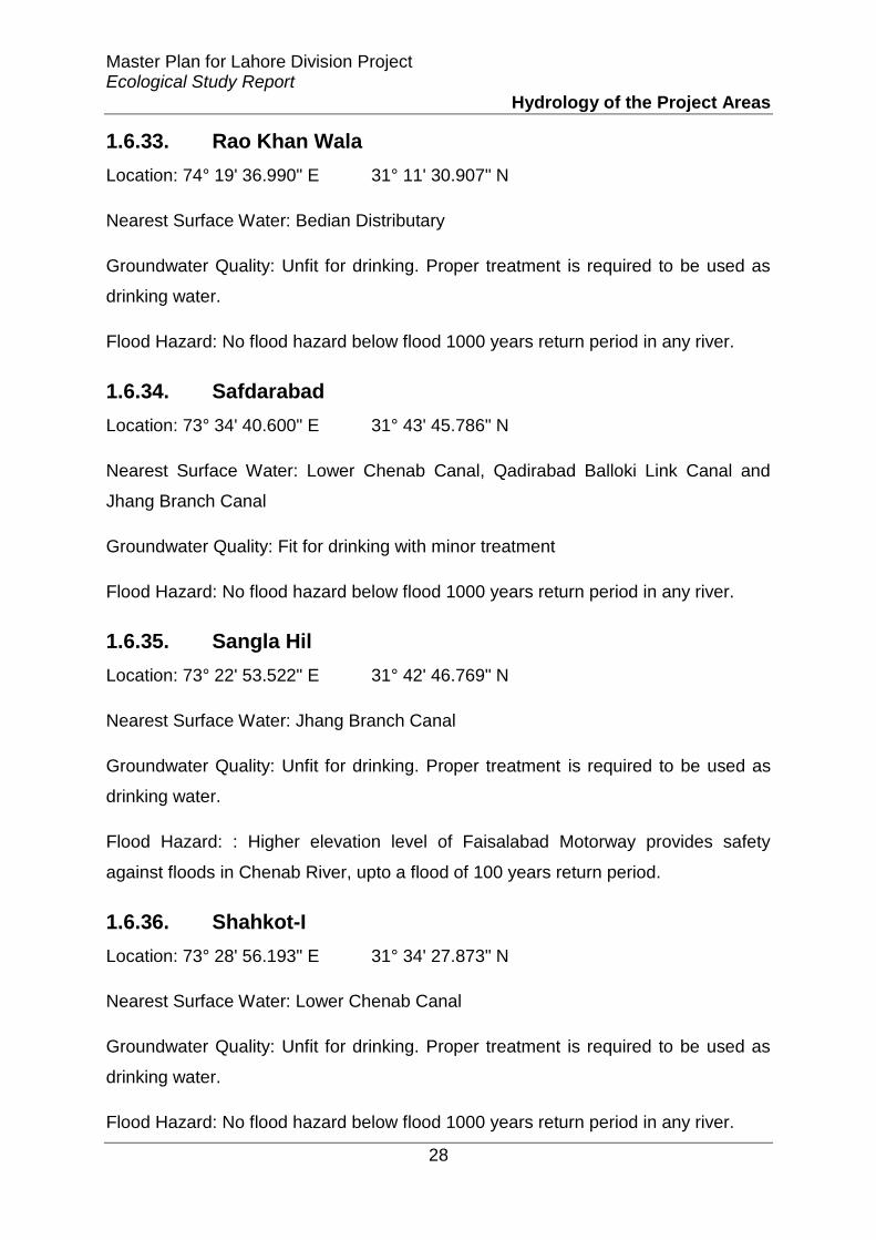
Master Plan for Lahore Division Project Ecological Study Report
Hydrology of the Project Areas
28
1.6.33. Rao Khan Wala
Location: 74° 19' 36.990" E 31° 11' 30.907" N
Nearest Surface Water: Bedian Distributary
Groundwater Quality: Unfit for drinking. Proper treatment is required to be used as
drinking water.
Flood Hazard: No flood hazard below flood 1000 years return period in any river.
1.6.34. Safdarabad
Location: 73° 34' 40.600" E 31° 43' 45.786" N
Nearest Surface Water: Lower Chenab Canal, Qadirabad Balloki Link Canal and
Jhang Branch Canal
Groundwater Quality: Fit for drinking with minor treatment
Flood Hazard: No flood hazard below flood 1000 years return period in any river.
1.6.35. Sangla Hil
Location: 73° 22' 53.522" E 31° 42' 46.769" N
Nearest Surface Water: Jhang Branch Canal
Groundwater Quality: Unfit for drinking. Proper treatment is required to be used as
drinking water.
Flood Hazard: : Higher elevation level of Faisalabad Motorway provides safety
against floods in Chenab River, upto a flood of 100 years return period.
1.6.36. Shahkot-I
Location: 73° 28' 56.193" E 31° 34' 27.873" N
Nearest Surface Water: Lower Chenab Canal
Groundwater Quality: Unfit for drinking. Proper treatment is required to be used as
drinking water.
Flood Hazard: No flood hazard below flood 1000 years return period in any river.

Master Plan for Lahore Division Project Ecological Study Report
Hydrology of the Project Areas
29
1.6.37. Shahkot-II
Location: 73° 32' 33.676" E 31° 35' 8.292" N
Nearest Surface Water: Lower Chenab Canal
Groundwater Quality: Unfit for drinking. Proper treatment is required to be used as
drinking water.
Flood Hazard: No flood hazard below flood 1000 years return period in any river.
1.6.38. Sharqpur
Location: 74° 6' 8.626" E 31° 27' 51.170" N
Nearest Surface Water: Upper Chenab Canal and Ravi River
Groundwater Quality: Unfit for drinking. Proper treatment is required to be used as
drinking water.
Flood Hazard: After the flood of 1988, a protective bund was constructed to save
Sharaqpur from future floods. The bund height is sufficient to save Sharaqpur
Settlement from flood of 100 years return period in Ravi River.
1.6.39. Sheikhupura
Location: 73° 59' 20.204" E 31° 42' 46.845" N
Nearest Surface Water: Upper Chenab Canal, Qadirabad-Bulloki Link Canal and
Lower Chenab Canal
Groundwater Quality: Unfit for drinking. Proper treatment is required to be used as
drinking water.
Flood Hazard: No flood hazard below flood 1000 years return period in any river.
1.6.40. Syed Wala
Location: 73° 29' 55.585" E 31° 8' 31.918" N
Nearest Surface Water: Ravi River

Master Plan for Lahore Division Project Ecological Study Report
Hydrology of the Project Areas
30
Groundwater Quality: Unfit for drinking. Proper treatment is required to be used as
drinking water.
Flood Hazard: Can be subjected to floods in case of flooding in Ravi River.
1.6.41. Talwandi
Location: 74° 8' 11.980" E 30° 54' 26.708" N
Nearest Surface Water: BRB Canal
Groundwater Quality: Fit for drinking with minor treatment
Flood Hazard: The higher level of BRB Canal provides safety against floods of 100
years return period in Sutlej River.
1.6.42. Warburton
Location: 73° 49' 45.203" E 31° 32' 23.270" N
Nearest Surface Water: Qadirabad Balloki Link Canal and Lower Chenab Canal
Groundwater Quality: Unfit for drinking. Proper treatment is required to be used as
drinking water.
Flood Hazard: No flood hazard below flood 1000 years return period in any river.
1.7. Floods
According to the PDMA- DRP, the River Ravi belongs to the category B flooding
(medium Level Flood). Two categories of flood can occur in the planned area i.e.
urban and riverine. Flood is considered as most drastic and re-occurring hazards in
Pakistan. Roughly 1.84 million people across Pakistan have been affected by floods
triggered by heavy monsoon rains. At least 346 people have been killed and 620
others have been injured in flood-related incidents, according to the latest figures
released by the National Disaster Management Authority (NDMA).
The most recent flood was occurred in current year of 2014 and considered as one
of the biggest flood in the history of Pakistan. According to the National Disaster
Management Authority (NDMA) almost 312 people have died, with 2,275,000

Master Plan for Lahore Division Project Ecological Study Report
Hydrology of the Project Areas
31
affected and nearly 1.7 million acres (687,965 hectares) of crops lost due to this
recent flood. The most affected were in Punjab Province and declared a state of
emergency. The situation of rivers during this recent flood is given in Figure 8 as
under-:
Figure 8 Flood in Rivers of Pakistan-2014, NDMA
As discussed in section 1.3.1.1 and section 1.3.1.2, the planned areas are generally
safe from moderate floods. However, safety measures have to be taken against
heavy flooding if flash discharge is released from Indian dams after heavy rainfall.
The recent flood noted in River Ravi is at Shahdara Gauging Station is 250,000
cusecs and considered as medium flood level. This is the highest flood level noted in
River Ravi after year 2000 as construction of Thein Dam on Indian side greatly
reduces the flows in River Ravi while the highest flood that observed in River Ravi is
in 1988 which was around 586,000 cusecs. Further detailed hydrological study is
required to calculate magnitude of future flood risk and resulting area inundation,
especially after construction of Thein Dam and Shahpur Kundi Dam in India.

Master Plan for Lahore Division Project Ecological Study Report
Hydrology of the Project Areas
32
Due to unusual event, if flood exceeds the level of 5,86,000 cusecs then following
mitigations will be adopted:-
Flood Warning Centre would analyze situation before 1 or 2 days in
accordance with the travelling time of flood with coordinating Pak-
Metrological Department, Irrigation Department, WAPDA, Indus water
commission and Police telecommunication (Head works and barrages) and
accordingly flood warning should announce and information should sent to
PDMA and related agencies.
Figure 9 Flood Early Warning Centre (Source- DRP-2013)
When flood warning should announce PDMA would implement state of
emergency in the area and evacuation would be done in accordance with
DPRP.
DDMA, TDMA and DRC will do their responsibilities in accordance with
DPRP

Master Plan for Lahore Division Project Ecological Study Report
Hydrology of the Project Areas
33
The peoples would ask to move at safer place and accordingly temporary
camps should be provided.
Rescue and Emergency activities in accordance with DPRP should start
soon after the flood hits the area. The objective of Rescue and Emergency
activities is to save life of each and every individual who not been moved to
safer place rather than property or valuables.
Temporary hospitals should be made at camp area. Ensure the supply of
food and portable water in the camps.
The following options should be considered to minimize flooding in settlements:
i. Existing drains should be restored into original shape by desilting and
removal of all encroachments, to allow passage of more flow of water before
overflowing.
ii. The settlements of Bucheki, Mor Khunda and Mandi Faizabad may be
considered to be expanded only in north of Jaranwala Road. In case of
extension towards south, protection bund will be mandatory to avoid flood
water to enter the settlement.
iii. Water of Deg Nallah can be partially diverted into Basanter Nallah in flood
season.
iv. Tree plantation around Ravi River, specially upstream of Lahore should be
encouraged, which will reduce risk of flooding to great extent.
1.8. Conclusion
Lahore is in constant danger of health and environmental risks and ecosystem
challenges due to huge discharges of untreated domestic and industrial waste. The
River Ravi is considered as the most polluted river among the main rivers in Punjab.
Recent water quality monitoring has shown the presence of faecal coliforms in
drinking water. Presence of toxic heavy metals in irrigation water, especially
downstream of the River Ravi, is also causing serious damage to animal life in
surrounding areas. A direct economic impact of untreated wastewater is the loss of
fishery catches, which affects incomes and has nutritional and health impacts on
Master Plan for Lahore Division Project Ecological Study Report
Hydrology of the Project Areas
34
consumers. The use of contaminated surface water from Ravi for irrigation and
recreational purposes is also replete with serious consequences as this will have a
direct impact on the ecosystem and human health. In peri-urban areas of Lahore
farmers are using untreated sewage/industrial water for vegetable production and
water-related diseases such as typhoid, cholera, dysentery and hepatitis are very
common. Evidence also shows that, in Lahore, vegetables and fruits grown with
wastewater are also prone to heavy metal contamination.
Seepage from rivers, lined or unlined channels, rainfall and agricultural fields is vital
to recharge groundwater, which is the major source of drinking water for most cities
including Lahore. The exact estimation of recharge to groundwater from these water
bodies is a complex procedure and not much has been done on this subject in
Pakistan. Recharge to groundwater in urban areas is relatively insignificant due to
large scale infrastructure development without any provisions for groundwater
recharge zones.
The annual rainfall in Lahore is reasonable enough to recharge the groundwater
aquifer. However, the existing landscape does not allow any recharge to
groundwater in urban areas of Lahore and most rainwater is lost to drains due to fast
runoff. By creating favourable conditions, about one-fourth of the average annual
rainfall (178 mm) can be recharged to groundwater.
The substantial contribution of the River Ravi in recharging the Lahore aquifer
suggests that we should stop discharging untreated wastewater into the river as it
can have serious consequences for millions of people in and around the city that rely
on groundwater as their principal source of drinking water.
Pakistan needs to prepare itself for the possibility of future changes in climate.
Current water management practices may not be robust enough to cope with the
impacts of climate change on water supply reliability, flood risk, health, agriculture,
energy and aquatic ecosystems. Therefore, improving water management is the best
strategy to cope with projected climate changes and their impact on the agricultural
economy, water supply to cities and the environment.

Amendment in Master Plan for Lahore Division (The Project) Environmental Impact Assessment (EIA) Report
Appendices
220
Appendix-IV
Framework/ Guidelines for Strategic Environmental Assessment
(SEA)

(A Guidance Document)
for
Master Planning of Lahore Division
Document developed by: M.Mansoor Khan (EIA and SEA practitioner)

Information Class: StandardStandardStandard
This document is prepared, developed, organized for the party which
contracted the consultant solely for this activity. This document is
inclusive /collection of literature taken from all over the world
including training literatures, articles, reports or any other text
sought useful for making this study for further actions or guidance.
This report should only be used for guidance purpose only.
This document contains information to be used for guidance
purpose only in the subject of SEA and EIA and necessary uptake of
other related studies. No liability shall be admissible to the writer,
developer of this report for any mistake incurred, overlooked or
copied herewith. The writer/author also does not bear any liability
of whole or any part of this document copied,used, misused,
edited or presented to any other party, document, audience etc

Contents
Section One: Understanding the SEA
Background of SEA 1
Defining SEA 2
Importance & Objectives 3
SEA Performance Criteria 4
Key Stakeholders in SEA 4
Relating EIA and SEA 5
Section Two: Conducting SEA
Step One: Developing the context
Creating Baseline 7
Identification of Strategic Issues (SI) 7
Setting the targets 8
Identification of decision makers 9
Identification of stakeholders 10
Step Two: Developing the strategy
Selecting the analytical methods 11
Integrating SEA in decision making 22
Conclusion of the Guidance document 24
Abbreviations used
CSIR: Council of Scientific & Industrial Research
CDF: Critical Factors for Decision Making
EIA: Environmental Impact Assessment
ESF: Environment Sustainability Factors
IAIA: International Association for Impact Assessment
IUCN: International Union for Conservation of Nature
IWRMD: Integrated Water Resources Management and Development
MCA: Multi Criteria Analysis
NGO: Non-Governmental Organization
OECD: Organization for Economic Cooperation and Development
SEA: Strategic Environmental Assessment
SI: Strategic Issues
SD: Sustainable Development
SEP: Stakeholder Engagement Plan
SWOT: Strength, Weakness, Opportunities and Threats
UNEP: United Nations Environment Programme
WB: World Bank

Preamble
This guidance document focuses on the Strategic Environment Assessment. As SEA is not
mandatory in Pakistan, but taking this an opportunity, this guidance document is carved out
considering the practices done so far specially in Portugal and Vietnam in order to motivate
environmental practitioners, organizations, institutions and decision makers to look into
environmental matters in a broad spectrum i.e; planning level.
Strategic Assessments have been undertaken in Pakistan for few developments including two
pilot SEAs (one for Gilgit City Master Plan and the other for Hydropower Sector Planning of
AJ&K) and legislated in some provinces of Pakistan as an outcome of efforts made under
National Impact Assessment Programme. Being part of this programme and SEA initiatives
performed, know-how of SEA is well-understood and it is privilege being considered to develop
a guidance document for Master Planning of Lahore Division of this newly introduced concept in
the world. Since, SEA has no hard and fast rules so far, hence, it is quite a flexible methodology
in terms of selection and application.
This document would present an understanding of the subject, core aspects, future propositions
for this Master Planning and will provide a platform to the experts for further studies and
decision making.
Special credits are paid to the institutions/organizations (IAIA, OECD, CSIR, WB, ADB, SMEC,
IUCN, gtz, Ramboll, Swiss Agency for Development and Cooperation, etc etc), Maria Rosário
Partidário and all others whose inputs/publications in this subject (SEA) have been quoted in this
document.

SEA Guidance Document (Master Planning of Lahore Division)
Pag
e1
Section One: Understanding the SEA
Background of SEA
This part of the section would narrate the background of origination of SEA. Different
scientists/researchers/institution narrated understanding of SEA in their own way, as and
when they have quoted. Thus, this part should not be assumed as a benchmark for
concluding the results, rather it must be considered as a pathway of developing an
understanding of the background.
In 1989 SEA was introduced as a concept, and a term, in the context of a European
research project as “the environmental assessments appropriate to policies, plans and
programs of a more strategic nature than those applicable to individual projects likely to
differ from them in several important respects” (Wood and Djeddour,1989)
(Ref: Strategic Environmental Assessment Better Practice Guide- methodological
guidance for strategic thinking in SEA by Maria Rosário Partidário)
During the last decade the world has witnessed a rapid, though controversial, evolution of
the environmental policy agenda. Increasingly, traditional environmental decision-
making is being questioned, not because it has not developed sufficient legal mechanisms
or methodological tools, or because it did not seek to find solutions for critical
environmental degradation, but essentially because it is not efficiently responding to the
new challenges of the late 20th century, as confirmed and proclaimed by the United
Nations Conference on Environment and Development in 1992. In particular, it is not
fully achieving the initially expected results regarding environmental soundness and
integration with economic and social issues.
Despite this apparently negative trend, much effort is dedicated to improving
environmental performances, to increasing environmental awareness across development
sectors, in public, governmental, or private decision-making, in inviting and guiding
change in decisional attitudes and its supporting values. Significant environmental policy
evolution is occurring not only in the developed world but also in the developing and
transitional economies.
Strategic Environmental Assessment (SEA) has been emerging in this context. May be
not surprisingly, there is an increasing complexity behind and around current
development and decision-making processes derived from the explosion of electronic
communications, the speediness of information production and outdateness, the emerging
societal values of equity and fairness, the urgency of rational decisions supported by
scarce or defective information and conflictual priorities, all development vectors that
call for new forms of proactive intervention in more strategic contexts.

SEA Guidance Document (Master Planning of Lahore Division)
Pag
e2
Project‟ Environmental Impact Assessment (EIA), as currently practiced, has been unable
to respond to this increasing complexity and provide for global, sustainable and sound
decision-making. Such desilusion with the capacity of project' EIA to assist, as a single
tool, sound environmental decision-making in a tiering system was the strongest
argument that determined the need for SEA in its early days (Lee and Walsh, 1992;
Therivel et al., 1992; Wood and Djeddour, 1992; Sadler and Verheem, 1996). The
reasons are various and can be summarized as (Partidário, 1999):
• the timing of decisions: project‟s EIA takes place at a stage when it is too late to
consider the effects of policy and planning critical decisions; these happen in the absence
of a systematic impact assessment process, which outcome could subsequently influence
project planning and design;
• the nature of decisions: the less concrete and more vague nature of policy and planning
decisions, often its incremental nature, through small, sequential and iterative decisions
that challenge rational and systematic processes was seen as a significant constraint to the
operation of a pragmatic, technically focused, and rationally oriented tool such as EIA; a
new impact assessment tool, inherently adaptable to more strategic, and often
incremental, levels of decision-making, was therefore needed;
• the level of information: at the policy and planning level often there are serious
limitations in the availability of information, and a reasonable uncertainty regarding
action implementation and respective timings; this impeded the satisfaction of project
EIA needs, in terms of required detailed levels of information and certainty.
(Ref: IAIA Training Course, “SEA current practices, future demands and capacity
building needs” by Maria Rosário Partidário)
Defining SEA
Strategic Environmental Assessments (SEAs) have been developed by the environment
community as “instruments to bring environmental concerns into the strategic levels of
decision making – policies, legislation, strategies, plans, and programs (PLSPP)”. SEAs
were developed to tackle concerns that Environmental Impact Assessments (EIAs) were
not fully effective because many of the environmental issues resulted from earlier,
strategic decisions.
SEAs have been used for a variety of purposes, including developing a shared
understanding of environmental issues, building a consensus on the way to tackle these
issues, identifying issues to be tackled in depth in project-level EIAs, developing
investment plans, in national, regional and transboundary settings. Essentially SEAs

SEA Guidance Document (Master Planning of Lahore Division)
Pag
e3
allow decision makers to take advantage of environmental and social opportunities while
managing environmental and social risks in a strategic setting.
(Ref: “SEA and IWRMD” World Bank, 2007)
Thus, SEAs are considered as Instrument (process) that assists and facilitates decision-
making, acts at strategic levels of decision-making and focuses on few relevant issues for
decision making. (conceived from Partidário 2007)
Importance & Objectives
There are several reasons why SEA is important (based on Partidario, 1999; CSIR, 2000;
IAIA, 2002):
1. Promotes and helps to understand sustainability challenges, incorporating an
integrated perspective earlier in policy-making and planning processes;
2. Supports strategic decision-making, setting enabling development conditions;
3. Facilitates identification and discussion of development options and provides
guidelines to help development to follow sustainability trajectories;
4. Informs planners, decision makers and affected public on the sustainability of
strategic decisions, ensuring a democratic decision making process, enhancing the
credibility of decisions;
5. Encourages political willingness, stimulates changes to mentalities and create a
culture of strategic decision-making.
In its understanding as a strategic thinking model, SEA applies to the strategic component
of decision-making processes in (i) public policies, (ii) sectorial development plans and
programmes, (iii) territorial development plans and programmes (iv) and also to major
structural investment projects that have long-term strategic objectives (such as new
international airports, new forms of energy production (ethanol, wind-based, water-
based) in relation to their strategic concept).
SEA has been widely promoted by international development agencies (World Bank,
2011; UNEP, 2009; OECD, 2006). However more than the assessment of development
proposals, SEA is an important instrument to help face development challenges generated
by:
a) Adaptation and mitigation to climate changes;
b) Poverty eradication and overcome of social and regional inequalities;

SEA Guidance Document (Master Planning of Lahore Division)
Pag
e4
c) Enhancement and maintenance of biodiversity values, ecosystem services and human
well-being;
d) Social and territorial cohesion;
e) Promotion of regional development potential;
f) Innovation and cultural diversity of the population;
g) Promotion of environmental quality, landscape and cultural heritage and sustainable
use of natural resources.
(Ref: Strategic Environmental Assessment Better Practice Guide- methodological
guidance for strategic thinking in SEA by Maria Rosário Partidário)
SEA Performance Criteria
IAIA narrates that an SEA must be:
• Integrated
• Sustainability-led
• Focused
• Accountable
• Participative
• Iterative
(Ref: IAIA 2002)
Key stakeholders in SEA
Key stakeholders in SEA are usually institutions (not individuals) because the institutions
have the authority and capacity to execute or in case implement the SEA.
Key authorities:
Agencies assigned to formulate Policy, Plan or Programme
Authorities that are responsible for approval of the Policy, Plan or Programme

SEA Guidance Document (Master Planning of Lahore Division)
Pag
e5
Authorities responsible for establishing SEA review councils (in some countries)
Authorities responsible for implementation of Policy, Plan or Programme
Other authorities usually consulted:
other authorities with environmental mandates (EPAs etc.)
relevant authorities with social mandate
relevant authorities with economic mandate
relevant ministries & ministerial level agencies
Other stakeholders in SEA
High-level or general Policy, Plan or Programme could raise interest of:
Academic organizations
Professional associations
Business groups
NGOs
Local or detailed Policy, Plan or Programme could raise interest of:
Local NGOs
Institutions that represent interests of affected citizens (e.g. social welfare
organizations, any committee/union of minorities etc)
Relating EIA and SEA
• SEAs may broadly follow basic analytical steps in EIA but have much larger boundaries
in terms of time, space and subject coverage
• SEAs should provide an overview of trends without the Policy, Plan or Programme and
with the Policy, Plan or Programme
• SEAs can recommend (i) changes within the proposed Policy, Plan or Programme, (ii)
improvements in coordination between relevant agencies, or (iii) new cross-sectoral
interventions
• SEAs can also provide suggestions for EIAs of future projects and improve their quality

SEA Guidance Document (Master Planning of Lahore Division)
Pag
e6
Following table below represents in a very brief way the major differences between an EIA
and SEA.
Features EIA SEA
Considered
alternatives
Locations and
technologies
Development directions
(objectives and scenarios) and
multiple actions to achieve them
Impacts Specific impacts
on the local state
of environment –
compared with
local env. quality
Long-term trends (often related to
env/SD objectives) – comparison
against env./SD objectives
Specific impacts often assessed
only if Policy, Plan or Programme
contains specific project proposals
Assessment More quantitative More qualitative (expert
judgements)
Public
concerned
Affected public
and organized
groups
Mainly organized “publics” –
interest groups, think-tanks
Quality
review
Quality of EIA
report and process
management
Quality of assessments and sound
process + due account of SEA in
the Policy, Plan or Programme

SEA Guidance Document (Master Planning of Lahore Division)
Pag
e7
Section Two: Conducting SEA for Master Plan of Lahore
Step One: Developing the context
The first step of developing an SEA for the said master planning of Lahore would be to develop
the context. Following key indicators would help to draw a framework for onward conducting an
SEA and facilitating the decision-making process viable and sustainable.
Creating Baseline
The desk studies must be done prior initializing the SEA process. Collecting enviro-social
baselines, organizing them, review already present literature of the project area and project
influence area. The baseline must be developed considering all inter-linked factors that may
cause hindrance in further process.
A review and analysis of all prevalent polices, laws and regulations must be carried out in
order to understand the prevalent legal and administrative structure. Focus can specially be given
to the related polices, laws, regulations etc which are directly or indirectly linked to this
development.
Identification of the loop holes, conflict of interest, gaps, or any other matter that can
alter or create hurdle in the development or the suggested outputs and decisions must be pointed
out and suggestions must be given as how to tackle those legal/legislative areas.
Identification of Strategic Issues (SI)
Identifying the key concerns/strategic issues is next step of an SEA. The fate of an SEA
relies upon identification of these issues. In other words, it can be called as “scoping” of SEA. It
needs to be assessed that what are the basic concerns/issues that are or can be resulted in case of
pursuing a certain project, plan or programme. Such as, in case of “Master Planning of Lahore”
the key strategic issues that need to be tackled/dealt with can be broadly classified as social,
environmental and economic.
This is the stage of an SEA which would identify as well as prioritize the needs that must
be addressed at the strategic level. Developing a master plan involving much districts of Lahore
would raise certain environmental and social impacts which must be prioritized according to the
sensitivity, nature and size. An example of the proposed strategic issues is presented below,
which is only for a general understanding which can be changed/modified while conducting an
SEA for this initiative:

SEA Guidance Document (Master Planning of Lahore Division)
Pag
e8
1) Environmental resources (ground water, surface water, air quality, forest cover,
climate change etc)
2) Social resources (population, traffic, employment, businesses, etc)
3) Any Other…….(Administration, institutions, inter-departmental coordination etc)
Identification of key strategic issues may or may not lead to Critical Factors for Decision Making
(CFD) that might be assessed at the same time. CFD would revolve around the strategic issues
(SI), environment sustainability factors (ESF) and sustainability reference framework (SRF).
Strategic issues (SI) : Express the intended strategy in the plan, policy or programme
Environment sustainability factors (ESF): Express the relevant environmental and
sustainability scope
SRF: basically establishes an assessment referential based on relevant major
environmental, sectoral and sustainable development policy objectives.
Setting the targets
As for the master plan of Lahore, a drastic change in the infrastructure would occur in the
next 30-50 years. So, setting the targets would be of utmost importance as “what to achieve in
the next 30-50 years?” Decision makers should set the targets as per achievement of
environmental and social sustainable targets.
For this, as an example, the motive should be, but not limited to target the aspects, such
as:
Reforms in the polices
Reforms in the plans
Environmental Sustainability
Social Sustainability
Economic Sustainability
Etc etc……………
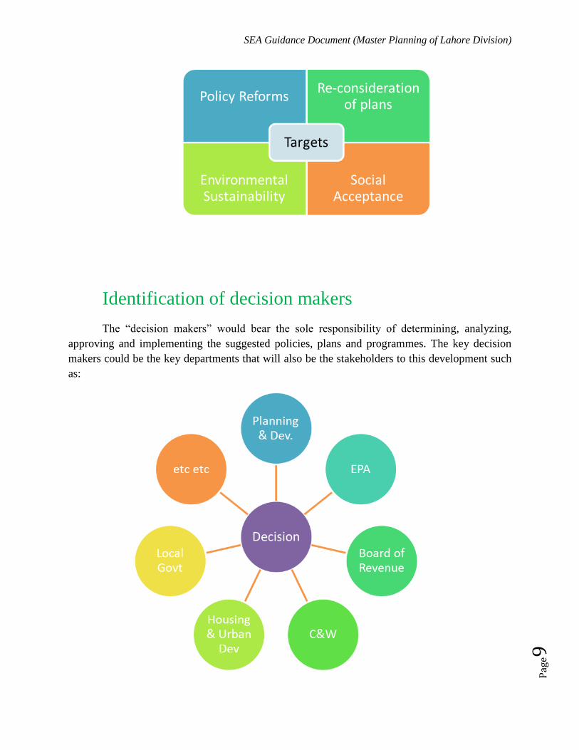
SEA Guidance Document (Master Planning of Lahore Division)
Pag
e9
Identification of decision makers
The “decision makers” would bear the sole responsibility of determining, analyzing,
approving and implementing the suggested policies, plans and programmes. The key decision
makers could be the key departments that will also be the stakeholders to this development such
as:

SEA Guidance Document (Master Planning of Lahore Division)
Pag
e10
Planning and Development
Environment Protection Department
Board of Revenue Punjab
Communication and Works
Housing, Urban Development and Public Health Engineering
Industries, Commerce and Investment
Law and Parliamentary Affairs
Local Government and Community Development
Etc etc
Furthermore, it can only be possible if higher dignitaries of the government, who can
actually take decisions, approve them and make reforms (if any) as per proposed
recommendations/suggestions in the SEA report.
Identification of stakeholders
Identifying stakeholders is yet another step of “involving” the institutions, organizations,
people or interested groups in Strategic process. In this case, the stakeholders can be, but not
limited to:
Government Departments (as listed above and others who can be directly or
indirectly affected or can make input)
Semi-Government/Autonomous bodies (Only relevant institutions)
Private Organizations (very specific organizations who have interest, or else can
be affected through amendments/initialization of the master plan)
National and International NGOs (NGOs related to environmental and social
mandate)
Social/Community Groups (ethnic, indigenous, native and other groups or unions
that can be impacted/affected either directly or indirectly)
Etc (any other as per the scenario)
A Stakeholder Engagement Plan (SEP) is suggested that would be a part of the SEA
report and included as a chapter or section.

SEA Guidance Document (Master Planning of Lahore Division)
Pag
e11
Step Two: Developing the strategy
Depending on the background work as discussed above (identification), a strategy should
be carved out/built on the same grounds as identified. Development of strategy would be based
on the key Strategic Issues and Targets.
Selecting the analytical methods
• Many methods exist (e.g. short survey by Ramboll & YEPB in China identified over 20
methods that could be possibly applied in SEA)
• Their application in SEA depends on whether they:
– Can analyze long-term trends and implications (e.g. 5-20 years ahead – depending
on the type of the policy, plan or programme)
– Are robust enough to cope with uncertainties and data gaps
– Can be used within the time & resources available for the SEA
– SEA methods should consider long-term trends
Future trends
WITH the plan
Future trends WITHOUT the plan
Environmental limit
Environmental parameter
(e.g. NOx)
X years ago Now X years ahead

SEA Guidance Document (Master Planning of Lahore Division)
Pag
e12
Most common analytical methods in SEA
Key methods:
• Collective expert judgements
• Matrices showing key risks and opportunities
• GIS or other spatial analyses
• Trend analyses, etc.
Less frequent methods:
• SWOT
• Scenarios
• Network & system diagrams
• Modeling (simulations)
• Multi-criteria analysis, etc.
Expert judgment
Expert judgment is a process for obtaining data directly from experts in response to a specific
question.
Expert judgments are inevitable part of any SEA process and of each SEA methodology.
Well organised expert judgments can reflect a life-long experience and expertise of participating
experts. Such judgments can be - especially in situations of significant data gaps - more precise
than quantitative predictions based on incomplete data.
It does not mean „guessing‟. The most sophisticated means of collective expert judgement is the
Delphi technique.
Expert judgement should clearly explain
Assumptions on which the judgment is based (when would the risk/impact occur and what it is
caused by);
Future trends and issues which should be considered when judging this risk/impact);
Character of the predicted risk/impact (e.g. probability, nature & scale; duration & reversibility)

SEA Guidance Document (Master Planning of Lahore Division)
Pag
e13
Key affected geographic areas, ecosystems or groups
Concerns associated with the risk/impact and its relative importance when compared with the
baseline situation; Magnitude of key uncertainties in this judgment.
Matrices
Matrices enable identification or presentation of:
impacts of proposed developments on various environmental issues (matrices of
impacts), or
synergies or conflicts between proposed development and the relevant environmental
objectives (matrices of conflicts or synergies).
They visually summarize these effects in user-friendly way. As such can be used to
quickly compare pros and cons of proposed development options.
A simple matrix can help to identify various effects of a single intervention. More complex
matrices can show cumulative effects of numerous projects on various environmental issues or
objectives.
Basic matrices can mark the existence of impacts or conflict/synergy using simple symbols (e.g.
X, XX). More elaborate matrices use various characters, numerical scores, colours or even
textual descriptions to outline the nature, scale, importance and duration or reversibility of each
effect.
Presented information should be easy to verify - matrices thus needs to be accompanied by a text
explaining the nature of specific effects.

SEA Guidance Document (Master Planning of Lahore Division)
Pag
e14
Example of a matrix
Spatial analyses: Overlay Mapping and Geographical Information Systems
(GIS)
These methods illustrate the spatial distribution of relevant issues and impacts.
They are undertaken through a preparation of maps with different information which is relevant
to the SEA. These maps are then laid over each other
Spatial analyses can be based on manual elaboration of transparent maps (overlay mapping) or
elaboration and processing of electronic maps (Geographical Information Systems, GIS).

SEA Guidance Document (Master Planning of Lahore Division)
Pag
e15
Example of spatial analyses
Networks and system diagrams
Networks and system diagrams can be in SEA used to illustrate:
implications of the proposed decisions on the subsequent decisions and knock-on effects
on other developments (decision-trees); or
a gradual progression from direct immediate effects to indirect or longer-term or delayed
effects (effect networks).
They do not illustrate spatial or temporal scales of impacts and can become too complex
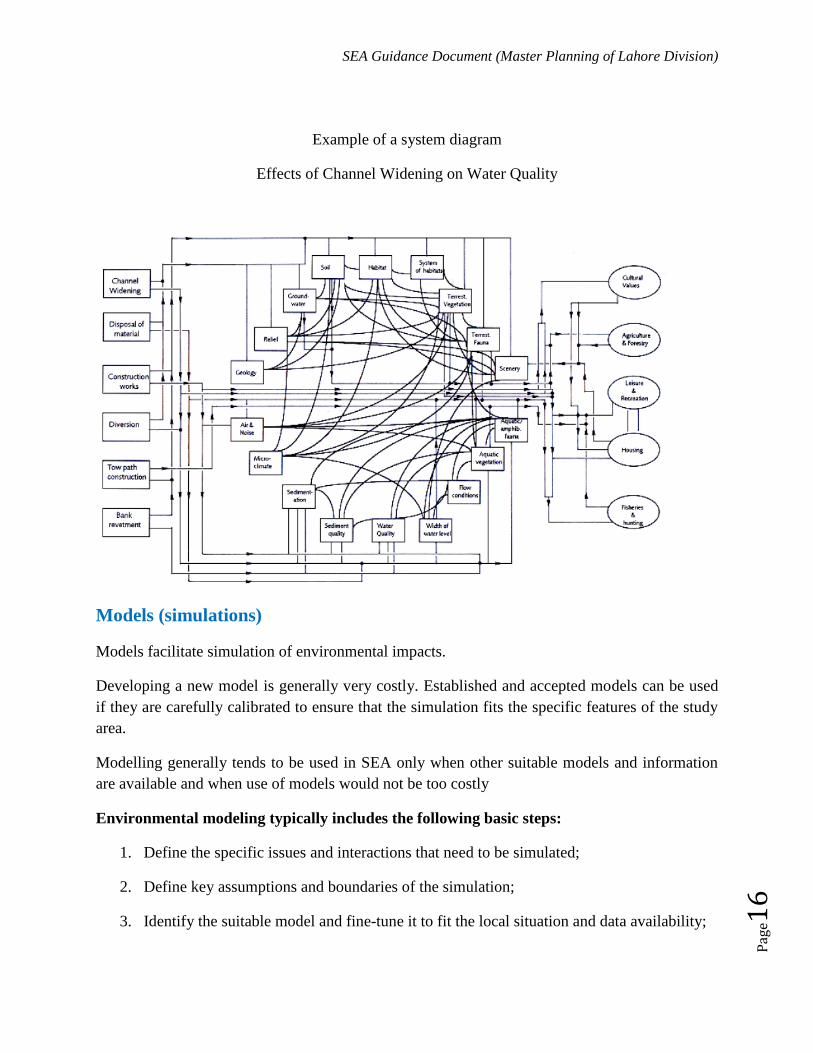
SEA Guidance Document (Master Planning of Lahore Division)
Pag
e16
Example of a system diagram
Effects of Channel Widening on Water Quality
Models (simulations)
Models facilitate simulation of environmental impacts.
Developing a new model is generally very costly. Established and accepted models can be used
if they are carefully calibrated to ensure that the simulation fits the specific features of the study
area.
Modelling generally tends to be used in SEA only when other suitable models and information
are available and when use of models would not be too costly
Environmental modeling typically includes the following basic steps:
1. Define the specific issues and interactions that need to be simulated;
2. Define key assumptions and boundaries of the simulation;
3. Identify the suitable model and fine-tune it to fit the local situation and data availability;
SEA Guidance Document (Master Planning of Lahore Division)
Pag
e17
4. Collect the basic data on the local environment (e.g. topography, wind speed & direction,
flow regimes, etc.)
5. Collect the input data for the past and current situations (e.g. emission levels) and run the
model to enable its verification and calibration;
6. Run the model for the different scenarios that are considered in the assessment.
Multi-criteria analysis
Multi-criteria analysis (MCA) numerically evaluates all alternative options against several
criteria, and combines these separate evaluations into one overall evaluation.
It can be used to identify a single most preferred option, to rank options, or simply to distinguish
acceptable and unacceptable solutions so that a limited number of options can be short-listed for
a detailed appraisal.
MCA requires:
Carefully identified assessment criteria reflecting the key environmental consequences of
all proposed alternative options
Judgments on relative importance/weights of these criteria
Judgments on performance of each option with regard to all criteria
MCA – if improperly used – may not facilitate consensus on very controversial decisions;
By presenting quantitative information (aggregated scores) MCA may create a false
impression of accuracy. This sometimes hides the fact that all MCAs heavily depend on a
value judgment;
MCA may be easily manipulated by those who perform it (this unlikely but the risk
exists)
It may reduces rational discussion into often meaningless debate about numbers
Trend analysis and extrapolation
Trend analysis and extrapolation helps to interpret environmental pressures and changes over
time.

SEA Guidance Document (Master Planning of Lahore Division)
Pag
e18
Trends should be analyzed over a correct temporal scale. The presentation of trends can be fairly
simple, e.g. a line graph, or complex graphs correlating trends in the environment with the
changes in their drivers
It can also assist predictions of future impacts as some trends can be safely extrapolated on the
assumption that the trend is going to continue in the same dynamic.
Be however careful of oversimplified extrapolation that does not consider how the trend will
evolve given the different driving forces, counter-trends or once they reach a breaking point
Example of simple trend analysis
SWOT
SWOT can be used in diagnosis of the current/instantaneous situation.
It highlights the key internal issues (strength and weaknesses) and the key external issues
(opportunities and threats) that should be considered in the policy, plan and programme making
process or in the assessment process.
Positive Negative

SEA Guidance Document (Master Planning of Lahore Division)
Pag
e19
Present & internal
issues
Strengths Weaknesses
Future & external
issues
Opportunity Threats
SWOT – key strengths
reduces a large quantity into simple overview of key issues that could be considered in
the policy, plan and programme making process or assessment.
useful method for obtaining various viewpoints on the current situation and can be very
well used in participatory processes.
depends only on personal knowledge and insights of participating experts - small demand
for data
can be done as a quick exercise by single person or as a rapid appraisal process of current
situation that involves a large number of stakeholders.
ability to analyze uncertainties
high transparency
SWOT – key weaknesses
SWOT has a tendency to oversimplify the situation.
simple presentation of strengths and weaknesses does not explain why these strengths and
weaknesses occur (their root causes) and whether there are any linkages between them.
Scenarios concept
Scenarios are acceptable descriptions on how the future may happen, based on propositions what
if…???
Scenarios are not predictions of the future, they outline possible future situations that reflect
present and future developments.
Scenario building
SEA Guidance Document (Master Planning of Lahore Division)
Pag
e20
Scenario building considers the key driving forces and uncertainties that affect the future
development.
It focuses on the following questions:
What are the key driving forces?
What are the key uncertainties?
What is inevitable (given the driving forces)?
What would happen (if the key uncertainties materialize)?
Use of Scenarios in environmental matters
Always include:
a representation of the initial state of the environment and
a description of the driving forces and changes that determine the future of the
environment
an identification of the key uncertainties that may determine a different evolution of the
future
An outline of possible future situations
Types of Scenarios
Forecasting;
Backcasting;
Qualitative;
Quantitative.
Forecasting scenarios
Start with the current situation and explore alternative future developments considering certain
assumptions.

SEA Guidance Document (Master Planning of Lahore Division)
Pag
e21
Backcasting scenarios
Start with a vision of the future (optimistic, pessimistic, neutral, wishful-thinking, etc.) and
analyse the different strategies to achieve such situation.
Qualitative scenarios (storylines)
Exclusively based in narratives.
Easy to understand and enable the representation of the view points of the different
stakeholders.
Easier way to communicate about the future (comparatively with numerical data, tables,
etc).
Often assumptions are not explicit and do not satisfy the need for numerical information.

SEA Guidance Document (Master Planning of Lahore Division)
Pag
e22
Quantitative scenarios (numerical models)
Normally based on models;
Assumptions are more explicit (through variables and equations as considered);
More difficult to understand by non-experts;
Numerical information may be misunderstood and take scenarios as if they were
predictions;
Normally used for specific environmental problems (e.g. Climate Changes).
Recommendation/Suggestion as per Current Project:
Accept the fact that you will never have a precise knowledge about the future trends
It is enough to have information on key impacts in terms of their: Probability, nature &
scale
This information will enable you to compare alternatives and to design mitigation and
enhancement measures
Select the simplest available methods which provide you with sufficiently reliable
information
Always acknowledge uncertainties in these predictions
Integrating SEA in decision making
Several aspects need to be considered when deciding on how to link SEA and the planning
process. Having a separate but well-articulated coordination may be better than a totally separate
or totally integrated coordination, because the interconnectedness of the SEA and planning
processes is crucial for their overall success. Totally separated coordination would make such
connection more difficult. Full integration may risk making SEA, or planning, dominant in
relation to each other. The same happens to reporting and teams. It is important to separate
functions and responsibilities, should this separation be enabled by the availability of technical
and financial resources.

SEA Guidance Document (Master Planning of Lahore Division)
Pag
e23
But it is very important that SEA and policy-making/planning processes share several activities,
such as fact-finding, information, stakeholder‟s engagement and public participation.
Different models on how SEA and the policy-making/planning processes may link were
identified some years ago (Partidário, 2004) (Figure below) and serve as an illustration of
possible linkages.
The first two models (1 and 2) relate more closely to the EIA-based SEA approaches, the parallel
model (2) being the most frequently used. Models 3 and 4 relate to more integrated and strategic
approaches in SEA.
While the integrated model (3) may eventually represent the best SEA model in the long-term,
the decision-centred model (4) seems to be the most flexible and adaptable but that is totally on
the one‟s disposal.
.
SEA Guidance Document (Master Planning of Lahore Division)
Pag
e24
Conclusion of the Guidance document
As per the above elaborative discussion on the SEA and SEA guidance for Master Plan of
Lahore, several items are concluded and suggested which are as below:
1- Strategic Environmental Assessment (SEA) is a must-to-do approach for any mega
intervention in Pakistan
2- SEA must be carried out well before the time so as to integrate its results into the
decision making process
3- SEA for master plan of Lahore should be conducted well before time so as to grip the
critical factors at the right stage and right time
4- Analytical approaches that might be used to carry out the SEA may depend on the
availability of the experts and their capacity to do such tasks in Pakistan or international
experts can be engaged in order to undertake assessment
5- Ideally model 3 and 4 (SEA and the policy-making/planning models) must have been
used but since now the planning process has gone a long way ahead hence model 1 and 2
are suggested for further development/assessment process
6- Policy reforms, as deemed necessary may be applied timely to mitigate future
development loop holes
7- EIA would be required for each development under this master plan and as per Punjab
Environmental Protection Act, SEA would govern as an umbrella for all the assessment
at global level (national and international)
8- Authorities should now look more into the strategic decisions rather than isolated
independent scenarios for mega level development
Amendment in Master Plan for Lahore Division (The Project) Environmental Impact Assessment (EIA) Report
Annexures
221
ANNEXURES

Amendment in Master Plan for Lahore Division (The Project) Environmental Impact Assessment (EIA) Report
Annexures
222
Annex-I
Map of Proposed Landfill Sites


Amendment in Master Plan for Lahore Division (The Project) Environmental Impact Assessment (EIA) Report
Annexures
223
Annex-II
Biodiversity Map of Project Site
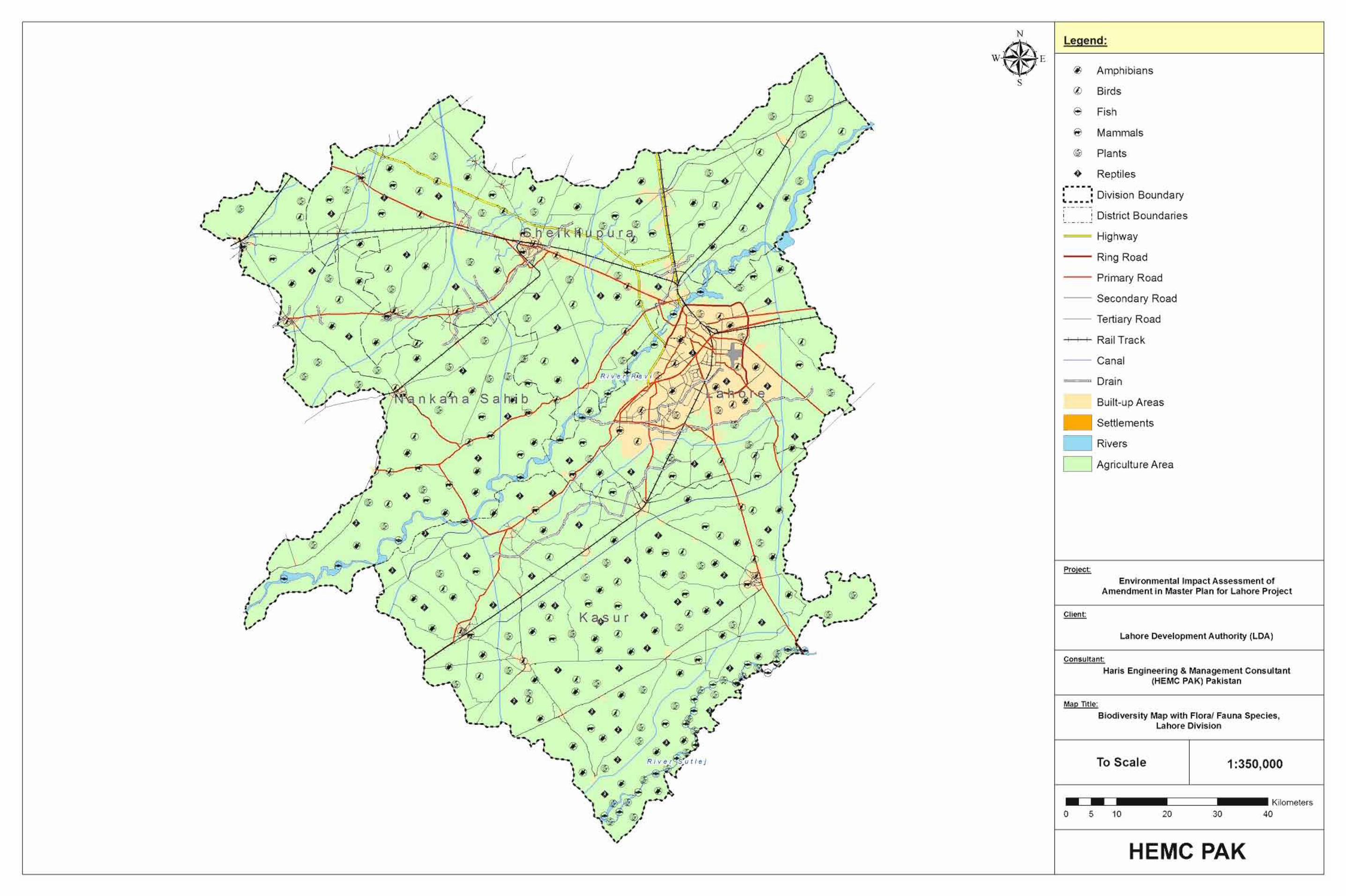

Amendment in Master Plan for Lahore Division (The Project) Environmental Impact Assessment (EIA) Report
Annexures
224
Annexure-III
Map of Flood Prone Areas


Amendment in Master Plan for Lahore Division (The Project) Environmental Impact Assessment (EIA) Report
Annexures
225
Annexure-IV
Map of Environmental Locations


Amendment in Master Plan for Lahore Division (The Project) Environmental Impact Assessment (EIA) Report
Annexures
226
Annexure-V
Photo Log of Project Site
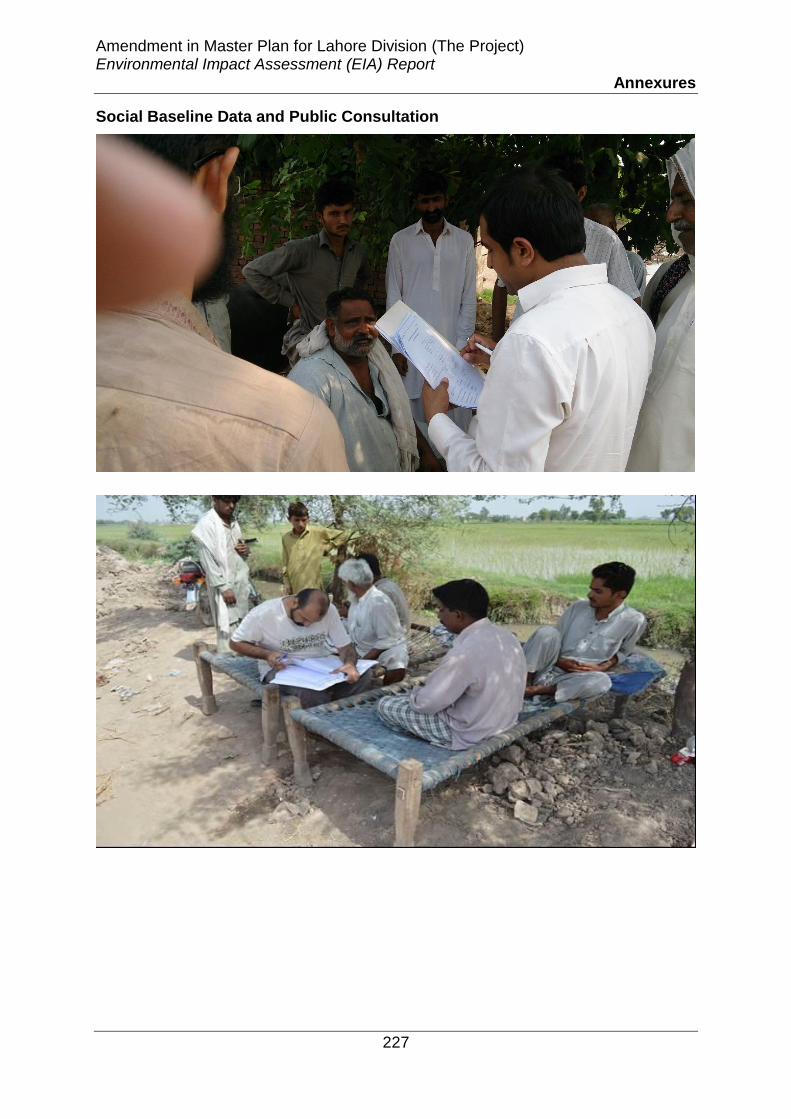
Amendment in Master Plan for Lahore Division (The Project) Environmental Impact Assessment (EIA) Report
Annexures
227
Social Baseline Data and Public Consultation

Amendment in Master Plan for Lahore Division (The Project) Environmental Impact Assessment (EIA) Report
Annexures
228

Amendment in Master Plan for Lahore Division (The Project) Environmental Impact Assessment (EIA) Report
Annexures
229

Amendment in Master Plan for Lahore Division (The Project) Environmental Impact Assessment (EIA) Report
Annexures
230

Amendment in Master Plan for Lahore Division (The Project) Environmental Impact Assessment (EIA) Report
Annexures
231
View of River Ravi

Amendment in Master Plan for Lahore Division (The Project) Environmental Impact Assessment (EIA) Report
Annexures
232

Amendment in Master Plan for Lahore Division (The Project) Environmental Impact Assessment (EIA) Report
Annexures
233
View of Rice Fields
Lakhu Der Proposed Landfill Site

Amendment in Master Plan for Lahore Division (The Project) Environmental Impact Assessment (EIA) Report
Annexures
234
Housing Societies in Project Site
View of Railway Track near Sheikhupura

Amendment in Master Plan for Lahore Division (The Project) Environmental Impact Assessment (EIA) Report
Annexures
235
Site Area Photographs

Amendment in Master Plan for Lahore Division (The Project) Environmental Impact Assessment (EIA) Report
Annexures
236

Amendment in Master Plan for Lahore Division (The Project) Environmental Impact Assessment (EIA) Report
Annexures
237

Amendment in Master Plan for Lahore Division (The Project) Environmental Impact Assessment (EIA) Report
Annexures
238

Amendment in Master Plan for Lahore Division (The Project) Environmental Impact Assessment (EIA) Report
Annexures
239

Amendment in Master Plan for Lahore Division (The Project) Environmental Impact Assessment (EIA) Report
Annexures
240

Amendment in Master Plan for Lahore Division (The Project) Environmental Impact Assessment (EIA) Report
Annexures
241
Annexure-VI
Environmental & Social Baseline Data Sheets

Page 1 of 5
SOCIO-ECONOMIC ENVIRONMENT
i). Human & Economic Development
a. Industries
Does the project area has any industries big / small Are there some home industries in the area
b. Infrastructure facilities Infrastructure facilities available to the people:
Facility Yes No Roads
Sanitation
Water Supply
Heath facilities
Educational facilities
If any other (Specify)
c. Mode of Transportation
Do the people of the area use conservative/modern modes of transportation:
(Specify) Is there any special trade of transportation in project area, etc.
e. Power Sources & Transmission
Is there any grid station/ sub-station present in the project area? Is electric supply available to every commercial/residential area? Do people use other sources of power like generators?
ii). Quality of Life Values/Socioeconomic Values
a. Income
No Yes
No Yes
No Yes
No Yes

Page 2 of 5
Are most of people living below/above poverty line?
Does the population comprises of Katcha Abadi/Pucca Abadi?
Do people have basic needs of life in their houses? _____________________
Do people are well off___________________________________
b. Employment and Occupation
What are major sources of employment __________________________________________________________________
c. Education
Is literacy level of the area low/medium/high
d. Religion
Is the religion of majority population Islam
Any other (Specify)
e. Gender Ratio
Is population of women more than men
Is population of men more than women
Ratio of population of men to population of women in the area (%)
1. Men 2. Women____________
Population density of the area is low/medium/high
f. Role of Women Either women of the area involve in
Activity Yes No Household activities
Business Activities
Private/Government service

Page 3 of 5
Electoral activities
Any other (specify)
g. Public Health
Are sanitation, water supply facilities available
Any hospitals, dispensaries available in the area
Any social health workers available
Any particular diseases reported in the area_______________________
h. Recreational Resources & Development
Parks/Swings get together areas / festivals arrangements If any other (Specify)
i. Aesthetic Values
Any sources of visual pollution Sources which add to the visual beauty If any other (Specify)
i. Archeological or Historical Treasures
Does the area any archeological or historical monuments If yes, (Specify)
j. Cultural Values
Is the culture of area modernized/conservative or a blend of
both_______________________
Is the community agree to absorb outsider visitors
No Yes
Yes No

Page 4 of 5
k. Indigenous People
Is there any group of indigenous people in project area?
Is there relocation of such a group is involved.
Anything special 4. STATUS OF LAND
Does the area fall under government proprietorship
Is it a private land
The extent of land which is to be acquired (if any)
_______________________________________________________ 5. EXISTING STRUCTURES
Sr.No Category Nos.
1 Residences 2 Commercial 3 Communal property 4 Religious building 5 Any other
6. Respondent’s Views about Project
6.1 In your opinion, how will you be affected by construction/operation of this project?
6.2 Is this project beneficial for the community? 6.3 Will you feel any disturbance from noise generated by the operation of ropeway
system?
Yes No
Yes No
Yes No
Yes No
Yes No
Yes No

Page 5 of 5
6.4 Do you think it will disturb your privacy? 6.5 Would you like to be associated with the project as a worker? 8. General Observations of Interviewer
Name & Signature of Interviewer: ___________________________ Date:__________
Yes No
Yes No

Scoping Session/Public Consultation Record 1. Project :_______________________________
Name Occupation Age Address Income Marital status ID no.
1. _____________ __________ _____ ________________ _______ _______ ____________
2. _____________ __________ _____ ________________ _______ _______ ____________
3. _____________ __________ _____ ________________ _______ _______ ____________
4. _____________ __________ _____ ________________ _______ _______ ____________
5. _____________ __________ _____ ________________ _______ _______ ____________
6. _____________ __________ _____ ________________ _______ _______ ____________
7. _____________ __________ _____ ________________ _______ _______ ____________
8. _____________ __________ _____ ________________ _______ _______ ____________
9. _____________ __________ _____ ________________ _______ _______ ____________
10. _____________ __________ _____ ________________ _______ _______ ____________
11. _____________ __________ _____ ________________ _______ _______ ____________
12. _____________ __________ _____ ________________ _______ _______ ____________
13. _____________ __________ _____ ________________ _______ _______ ____________
14. _____________ __________ _____ ________________ _______ _______ ____________

Name Occupation Age Address Income Marital status ID no.
15. _____________ __________ _____ ________________ _______ _______ ____________
16. _____________ __________ _____ ________________ _______ _______ ____________
17. _____________ __________ _____ ________________ _______ _______ ____________
18. _____________ __________ _____ ________________ _______ _______ ____________
19. _____________ __________ _____ ________________ _______ _______ ____________
20. _____________ __________ _____ ________________ _______ _______ ____________
21. _____________ __________ _____ ________________ _______ _______ ____________
22. _____________ __________ _____ ________________ _______ _______ ____________
23. _____________ __________ _____ ________________ _______ _______ ____________
24. _____________ __________ _____ ________________ _______ _______ ____________
25. _____________ __________ _____ ________________ _______ _______ ____________
26. _____________ __________ _____ ________________ _______ _______ ____________
27. _____________ __________ _____ ________________ _______ _______ ____________
28. _____________ __________ _____ ________________ _______ _______ ____________
29. _____________ __________ _____ ________________ _______ _______ ____________
30._____________ __________ _____ ________________ _______ _______ ____________

Page 1 of 4
BASELINES CONDITIONS AND IMPACTS 1. TYPE OF AREA
Arid Semi-arid Populated Densely populated Any other specify)
2. PHYSICAL ENVIRONMENT
a. geological conditions
Is the origin of rocks a) Sedimentary b) Igneous c) Metamorphic Any other (specify)
b. seismology
Is there any record of earthquakes in the past 50 years
Presence of faults/fractures
Any other details (specify)
c. topography & soils
Are the soils mixtures of sand /silt/clay/gravel/clayey silt Any other (specify)
d. Climate
Temperature (oC) (Min - Max) Winds
Relative humidity Precipitation Wind speed
Summer Winter Does the project area has any previous records of flooding? e. Surface and Ground water
Yes No
Yes No
No Yes
No Yes

Page 2 of 4
Is groundwater potable
If surface water available, what is its quality? _______________________ f .Air Quality
Is the area visually pollution free
Is the source of pollution traffic (cars, trucks, etc.) Or any other (specify)
Is the project area is highly; a) populated b) commercial g .Liquid effluents
Are there any liquid effluents due to industries/household If any other reason (specify) Is there exists proper drainage system? Is there any effluent treatment system exists?
How much quantity of wastewater generated per day h. Solid Waste
Is solid waste management of the area poor/nominal/good
Is poor management due to lack of awareness among people/authority is
not responsible enough
What type of solid waste management system exists?
__________________________________________
What is approximate quantity of solid waste generated from the project
area/study area per day?
What type of solid waste generated from the project area?
Is there any hospital waste generated in the project/study area
No Yes
No Yes
No Yes
No Yes
No Yes

Page 3 of 4
If yes, what are the management/disposal system
i. Noise
Any sources of noise like traffic/industry/commercial activities or other (specify)
Was any instrumental monitoring carried out to observe the noise levels? If yes, provide details
j. Buffer Zone
Are there any protected areas/park in close vicinity of the project area/study area
i). ECOLOGICAL ENVIRONMENT a. Flora & Fauna
Aquatic ecosystems (if exists)__________________________________
Prevailing non fruit trees______________________________________
Prevailing fruit trees__________________________________________
Is there presence of any endangered or rare species of plants
Is there presence of any endangered or rare species of animals
______________________________________________________
Is there any removal of trees involved
Is the project area falls under route of migratory birds?
Common wild animals in study/project area
___________________________________________________________
No Yes

Page 4 of 4
Is there any threaten national park, reserved forest or wildlife sanctuary in
close vicinity of the project route.
Common birds species in study/project area
__________________________________________________________________
Anything special
No Yes

Page 1 of 2
Serial No. __________
COMMERCIAL ACTIVITIES
(SHOPS)
Interviewer’s Name _________________________
Date _________________________
Q.1 Name of the Respondent _______________________
Q.2 Father’s Name ________________________________
Q.3 Age (years) __________________________________
Q.4 Education ___________________________________
Q.5 Income _______________________________________
Q.6 Marital Status __________________________________
Q.7 No. of family member ____________________________
Q. 8 How many shop(s) do you have to run your business?
(a) Self Owned __________ (b) Rented __________ Q. 9 what is the nature of your business in your shops. (a) Grocery Shop (b) Medical Store (c) Medical Clinic (d) Driver Hotel (e) Cloth/Garments (f) Shoes Store (g) Fertilizers/Pesticides (h) Grains/Flour Shop (i) Fruit/Vegetables (j) P.C.O. (k) Gold Smith (l) Black Smith (m) Driver Hotel (n) Auto Workshop (o) Dry Fruits Store (p) Precious Stones (q) General Store (r) Other________.
Q. 10 What is the approximate distance of your shop from Base Station/Landing Station? __________ feet. Q. 11 What is the size of plot, nature of construction and the estimated cost of your shop(s)?
___________feet.
Shop No.
Size of Plot (sq. ft)
Nature of Construction 1. Pucca
Estimated Cost (Rs)

Page 2 of 2
2. Semi-Pucca 3. Kachha 4. Wooden Cabins
1
2
3
Q. 12 For how many years are you running your business here? ______________ years. Q. 13 What is the estimated value of your present stock of goods in your shop? Rs.________ Q. 14 How many persons are working in your shops? No.____________ Q. 15 What is the dominant mode of payment of your goods & services?
(a) Cash Payment (b) Deferred / Credit Payments
(c) Kind (d) All
Q. 16 How much is your estimated daily sale of goods / services on an average? Rs.________
Q. 17 How much do you earn profit on an average in a month? Rs._________
--- END ---