Administrative Atlas, Part IX-A , Series-6, Haryana - Linguistic ...
189
CENSUS OF INDIA 1971 SERIES 6 PART IX-A ADMINISTRATIVE ATLAS HARYANA I. E. N. CHAUHAN NDIAN ADMINISTRATIVE SERVICE of Census Operations flaryana
-
Upload
khangminh22 -
Category
Documents
-
view
2 -
download
0
Transcript of Administrative Atlas, Part IX-A , Series-6, Haryana - Linguistic ...

CENSUS OF INDIA 1971
SERIES 6
PART IX-A ADMINISTRATIVE ATLAS
HARYANA
I. E. N. CHAUHAN NDIAN ADMINISTRATIVE SERVICE pir~ctor of Census Operations
flaryana

CENSUS OF INDIA 1971
A-CENTRAL GOVERNMENT PUBLICATIONS
The publications relating to Haryana bear Series No.6, and are bound separately as follows :-
Part I-A
Part I-B -.
Part I-C
Part II-A
Part II-A Supplement
Part II·B
Part II·CCi)
Part II-C(ii)
Part II-D
Part III-A
Part IX-A
Part X
General Report Part III-B Establishment Tables
General Report Part IV Housing Report and Tables
Subsidiary Tables
General Population Tables Patt VI-A Town Directory
General Population Tables Part VI-B Special Survey Reports on soIe~ted (Standard Urban Areas) towns
Economic Tables Part VI-C Survey Reports on selected v~Jages
Mother Tongue, Religion and Part VIII-A Administration Report: E'nUmeratian. Scheduled Castes and Scheduled (for official use only) Tribes Tables
Social and Cultural Tables and Part VIII-B Administration Report : Ta~on ; Fertility Tables (for official use only)
Migration Tables
Establishment Report Part IX-B Census Atlas
B-HARYANA GOVERNMENT PUBLICATIONS,
Administrative Atlas (The present volume)
District Census Handbook for each district in three Parts:
Part A-Village and Town Directory \
Part B-Village and Townwise Primary Census Abstracts
Part C-Analytical Report, Administrative Statistics and District Census Tables
(Parts A and B Qfthe District Censu~ Handbook for each District pfJ-ffiryana State have beeP t>rinte<,t in one volume)

FOREWORD
In order to ensure complete coverage at a population count, the Census Organization obtains or prepares uptodate detailed maps of all administrative units in the country on the eve of a Census. Though in several parts of the country maps of the Districts, Tahsils, Police Stations, etc., are available with the State Revenue or Survey authorities, often times, they reguired to be brought uptodate and they also varied greatly in scale. One also found it difficult to secure a complete or compact set of all these maps from State authorities. The Census Organization took upon itself the task of updating of the administrative maps and the standardization of scales essent~ally to meet its own requirements of coverage at the census and analysis of data. Standardization of symbols was also attempted to depict certain features such as the State/district/tahsil boundaries, administrative headquarters, national and state highways and other roads, markets and mandis, post and telegraph offices, travellers' bungalows, hospitals, etc. All urban centres and larger villages were depicted by names in the district maps, and in the tahsil maps the location of every village by dots proportionate to the population size and the distinctive location code number of each village marked. In each of the District Census Handbooks (there are 356 districts in the country) the district map as well as the tahsil maps will be printed.
While these administrative maps, prepared with great amount of care and effort, served the purposes of the Census extremely well, the 1971 Census Organization felt that these would be invaluable for many an administrative purpose and for planning and also to the scholars who might like to utilize these maps for various studies. Therefore, it was decided, after full consideration at the all-India Census Conference of Court all am (1970) and Pahalgam (1971) to publish all the district and tahsil maps of each State together in a compact and handy volume entitled "Administrative Atlas". Though this Atlas is basically a compilation of administrative maps giving the set up as on the census date, i.e., 1st April, 1971, it has been enriched by adding inset maps, wherever necessary, showing the changes in the boundaries during the decade 1961-71. Besides, the Atlas also contains a few introductory State maps showing certain basic characteristics as the physiography, density of population, distribution of towns and the distribution of rural population. A few schematic urban maps are also added to give the land-use patterns in the typical urban areas of the State. In order to make the Atlas somewhat selfcontained statistical statements are also added giving data on the area, population size, growth rate, sex and age structure, literacy, Scheduled Caste and Scheduled Tribe population and religion.
The Census Organization, as is well-known, is one of the largest producers of maps in the country. Apart from the Administrative Atlas, the 1971 Census publication programme envisages the production of separate Census Atlases which will depict the physiographic, demographic, economic, social and cultural characteristics of each State as derived from the census as well as other sources of data.
I wish to place on record my appreciation of the dedicated services of Dr. B.K. Roy, the Map Officer of .. the Registrar General's Office and all his colleagues in the Map Unit and also of all the State Directors of Census Operations and the staff of their Map Units who have all worked together as a team and have succeeded in the production of this Administrative Atlas which I hope will serve the needs of the administrator, the planner and the scholar alike.
New Delhi, Sep1etnber 26, 1972.
(iii)
A. CHANDRA SEKHAR Registrar General & Census Commissioner,
INDIA.


PREFACE
r ' The proposal for bringing out an Administrative Atlas was mooted by the Directo~ of Census Operatiohs, Uttar Pradesh, who observed that the utility of district and tahsil maps could be greatly enhanced if these were compiled and brought out in a single vqlume. It was a striking idea and was readily accepted keeping in view the utility of such a publication to the various heads of Government Departments, research scholars and the pub~ic in general. Since most of the maps prepared for inclusion in the District Census Handbooks were to be included in the Administrative Atlas, there was no difficulty in preparing such an Atlas without much additional cost. Accordingly, the State Government was approached and apprised of its importance and its special significance for the Haryana State. Considering its utility the Government of Haryana agreed to bear the cost of this Publication. .
This Atlas is a storehouse of information in so far as it gives the location of villages, tahsils and districts of Haryana as they existed at the time of 1971 Census. In addition the distribution pattern of population and amenities available down to the lowest unit with minute details have been depicted in the tahsil maps. Apart from the detailed district and tahsil jurisdictional maps, a number of other maps have been included documenting physiography, distribution of rural population, density, distribution of towns, administrative divisions of the State and also land use pattern as existing in the eleven typical urban centres of the State. Alongside all the relevant information has been furnished to assist the reader to a better understanding of the maps. An introductory note on land, people and economy given in the beginning of this pu blication will make the reader familiar with the Haryana State. This is probably the first time that such a carto-demographic study of such accuracy and detail has been ever attempted. All the administrators, specially those connected with the land revenue, formulation of various schemes and plans on regional basis, people in the public life of the State and scholars conducting applied research in the various branches of humanities will find this publication to be of great assistance in their work. This Atlas will also help in coaching our readers for an all out appraisal of the contents -of the second part of the Census Atlas, being published separately which will depict the physiographic, demographic, economic, social and cultural characteristics of the State based on the information released by the Census 1971 as well as other sources of data. .
In finalising this publication we had to take help from various departments such as the Director, Land Records, Haryana, Municipal Committees/Notified Area Committees and the Survey of India. I am thankful to them for extending their cooperation in bringing out this volume. In my Directorate the maps were prepared under the able guidance of Shri Shiv Rai Puri, Cartographer. He was assisted in this task by ~rvshri Amarjit Singh, Economic Investigator, N.P. Gupta, Artist and Go bind Singh, Hand Press Machine Operator. The collection and compilation of data for the maps was done by Sarvshri Ramesh Kumar Madan and Karam Singh, Assistant Compilers. The proof reading work was attended to by Shri J.N. Suri, Tabulation Officer w~th the assistance of Sarvshri Daulat Ram, Statistical Assistant and R.D. Verma, Proof Reader. I am thankful to all these officials for their dedicated work in bringing out this publication.
My thanks are also due to Shri Tara Chand, Controller and Shri K.S. Mathur, Assistant Controller of Printing & Stationery, Haryana, for extending their cooperation in the printing of this publication.
• Befote I conclude I must express my gratitude to Shri A. Chandra Sekhar, Ex-Registrar General, India, and his worthy successor Shri R.B. Chari for providing inspiration and guidance in seeing through this project. My grateful thanks are also due to Dr. B.K. Roy, Map Officer, whose technical guidance throughout has contributed in no small measure to the production of a work of such a hi~h order and significance.
Dated, Chandigarh : the 4th November, 1974.
(v)
I.E.N. CHAUHAN Director of Census Operations,
Haryana.


Foreword
Preface
Introductory Note
Maps
(i) Position of Haryana in India, 1971 (ii) Relief and DraiI1age
CONTENTS
(iii) Distribution of Population, 1971 (Rural) (iv) Density of Population, 1971 (v) Distribution of Towns, 1971
(vi) Administrative Divisions, 1971 (vii) Schem~tic maps of eleven typical Urban Centres
District Ambala
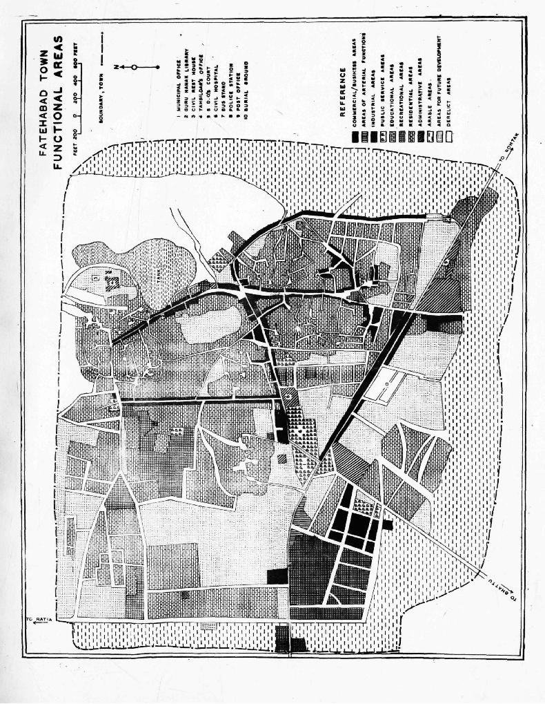
Basic Census Statistics District Map Names of villages, population, amenities data and maps of tahsils
District Karnal
Basic Census Statistics District Map Names of villages, population, amenities data and maps of tahsils
District Rohtak
Basic Census Statistics District Map Names of villages, population, amenities data and maps of tahsils
District Gurgaon
Basic Census Statistics District Map Names of villages, popUlation, amenities data and maps of tahsils
District Mahendragarh
Basic Census Statistics District Map
Names of villages, population, amenities data and maps of tahsils
District Risar
Basic Census Statistics District Map
Names of villages, population, amenities data and maps of tahsils
,. District Jind
Basic Census Statistics District Map
Names of villages, population1 amenities data and maps of tahsils
Page
111
v
1-10
Between pages 12-13
14 15
16-33
34 35
36-59
60 61
62-77
78 79
80-105
106 107
108-119
120 121
122-149
150 151
152-163


INTRODUCTORY NOTE
The Haryana State (Latitude 210 39' to 30cSS'S'N and Longitude 74°27'8' to 77°36'S'E) comprises a part of the Indo-Gangetic plain. Haryana State came into ~ing with effect from 1st November, 1966 on the re-organization of composite Punjab on the linguistic basis. It is one of the north-western states of India adjoining Delhi, the capital of the country. The State occupies tke seventeenth position in the lan~ area and ranks fifteenth in population size among the States of the country. Haryana is bounf,ied by Uttar Pradesh and Delhi on the east;. by Rajasthan on its south-west, Punjab, Chandigarh and Himachal Pradesh on the north-west and north. The Siwaliks are located in its north and the river Yamuna in the east. The Aravallis running south of Delhi and through Gurgaon district upto Alwar and further on the desert of Bikaner from its south-western boundary. To the west it is bounded half-way by the Ghaggar River.
According to the Surveyor General of India, the total area of the State is 44,222 square kilometres which forms 1.35 per cent of the country. Of this, 43,770.2 square kilometres or 98.98 per cent constitute rural areas while the remaining 451.8 square kilometres are covered by the urban definition. The district-wise area figures a10ngwith the rural and urban break up have been given in the following table :-
(Sq. Km.)
State/District *Total Rural Urban
1 2 3 4
Haryana 44,222.0(100.0) 43,770.2(100.0) 451.8(100.0)
Ambala 3,833.0(8.7) 3,722.0(8.5) 11l.0(24.6)
Kamal 8,068.0(18.2) 7,988.2(18.3) 79.8(17.7)
Rohtak 6,043 .0(13 .7) 5,987.7(13.7) 55.3(12.2)
Gurgaon 6,146.0(13.9) 6,068.6(13.9) 77 .4(17.1)
Mahendragarh 3,459.0(7.8) 3,436.0(7.8) 23.0(5.1)
HiSIiIX 13,982.0(31.6) 13,900.6(31.7) 81.4(18.0)
Jind 2,691.0(6.1) 2,667.1(6.1) 23.9(5.3)
The analysis of the above figures reveals that Hisar with an area of 13,982 sq. km. or representing 31.6 per cent of the State area is ,the biggest district of the State followed by Kamal and Gurgaon and others and the smallest district with an area of2,691 sq. km. or 6.1 per cent of the total is Jind. Regarding the urban areas, Ambala district with an area of 111 sq. km. or 24.6 per cent is the most urbanized district of the State followed by Hisar with an area 81.4 sq. km. or 18 per cent of the total.
PHYSIOGRAPHY
Excepting some hills of the Siwalik system in the north and of the AravaUi system in the south, the Haryana S!ate is a plain area. The plain can be sub-divided into eastem and western regions on the basis of aridity. The 50 cms. isohyet bifurcates the plain into two. The western plain which has a higher degree of aridity, mainly covers Hisar and Mahendragarh districts. The w;;lstem plain has a dry climate, steppe vegetation and sand dunes of various shapes and sizes. The eastern plain extends from 50 cms. isohyet upto Yamuna River. The entire plain has a fertile,light and loamy soil.
The Siwalik tract consists of a broad table-land composed of sand, silt, clay and conglomerates. A large number of rain-fed torrents flow down the outer slopes of the Siwaliks and spread much gravel and pebbles in their beds. Of these streams, the Ghaggar and the Markanda are the important ones.
The Ara-valli range is a narrow r~dge stretching into Haryana for 90 kilometres in the North..east-South-west direction upto Delhi. In Haryana, the range at no place is higher than 518 metres above sea level, yet this area is generally unfavourable to man due to its rocky nature. The range contains some minerals. The slope, in general, is from south to north, in which direction the streams such as Dohan and Sahibi, bring rain waters from the Rajasthan side.
*Total area figures for the State and the Districts represent"geographical area" figures (provisional) supplied by the Surveyor General. Figures for urban areas are those supplied by the local bodies. Area figures for rural areas are derived by substractinl! the urban area from the total area of the district.

SOILS
Most of the soils in the State are medium textured. Loamy sand is the average texture of the soils in the whole Of Mahendragarh district and the Tahsils of Dabwali , Loharu, Jhajjar, Rewari, Gurgaon, and Ballabgarh of the State. Sand is the average
soil texture available only in Block Khol of Tahsil Rewari.
There are two large tracts of .loam, one consistlrig of Tahsil Gohana and parts of Tahsil Rohtak and tlie other including Ta~i{s Guhla, K,aithal, Thanesar and, parts of Tahsils Kamal and Ambala. Sandy loam is the average soil texture available in the re~aining parts of the state. The average soil texture viz, silty loam, clay loam or clay is also found in small patcbes here and there.
A study of the Sub-soil Waier~table is marked with great variations in the different parts of the State. The Sub-soil'Watertable is mote than 15 metres deep' and is found largely in the parts of Hisar, Mahendragarh and Gurgaon districts and in the 'western parts of the Jind and Rohtak districts. While along the banks of Ghaggar river the Water-table is 6 to 9 metres deep' ill the District Hisar . and to tile east of the Ghaggar river in the Ambala district, in most of the Ambala, Kamal, Rohtak and lind districts, it' ranges from 3 to 6 ·m~tres. In Hansi area the Water-table is very high resulting in water-logging conditions: Such conditions are also eXistlng in the Bhakra Canal and the Western Yamuna Canal circles where the Water-table' varies from 1.5 metres to 3 metres.
DRAINAGE -_ - - -
The State is devoid of any perennial river except for the Yamuna which provides irrigation facilities. The river flows along the'~astern boundary of the State. Among the west-ward flowing rivers, Ghaggar, Markanda, Saraswati and Chautang afe more ./- .. " ....... ",,, ... ~~ .. ~ .. . important. Since the Aravallis hills project from the south to the north, a number of small rainy season rivulets carry
.. water from Rajasthan into Haryana in the south. Among them, the Sahibi, the Kansaoti (or Kasawati), the Indoris and the Landoha are worth to mentioning here.
NATURAL VEGETATION
The State is not rich in forest resources. Out of 17,849 km2. forest area of the composite Punjab, only 1,362 km2. or about 8 per cent of the total h~ come to the share of the Haryana State. As the areas which have the potential for the proper growth of the forests had gone to the share of Hlmaehil Pradesh. With only 3.1 per cent of the area under forests, the Haryana is one of ~he least forested States of the country. Prevailing arid conditions and long hUman occupance, have been responsible for its poor vegetal cover.
It may be mentioned here that the rain and the type of soil are the main determining factors of vegetation types in the plains while in the hilly areas, teinperature, altitude and slope are additional ihfluencing . factors. The natural vegetation found in the soutb.-,y~stern semi~arid and 9ry zones, is ~ropical thorn forest consisting of plants like ~ika,r, Ja), Jund and inferior grass . . TropicaLDry Deciduous forest is available in central zones which are hot and st)l11i-dry.\ Vegetation of the Sub-Tropical Broad Leafed forest type is found in the hot and sub-humid zone, adjoining the hills in the ncir,thern ~arts of the Ambala distrlc,t. Sub-Tropical Pine forests are found in the higher parts of Siwaliks. ..
MINERALS
For rapid economic advance,' the importance of minerals can hardly be over-emphasiied. Haryana enjoys a comfortable \
position in this respect in the north-western part of the country. The future development of industries connected with mihes and minerals can be explored by undertaking systematic surveys and investigation about the quality 'lind quantity of these minerals. The availability of minerals in the north and south of the State is related to its geology and strlqc1ure.
Limestone bands common in the Siwaliks of Ambala district are used for the manufattuf.e of cement at Surajpur. The Nangal Fertilizer Factory is also meeting. its limestone requirements from the Morni Hills of Ambali\ district.
Mahendragarh though an economically and industrially backward district otherwise is 'placed in a good position so far the availability of iron ate, limestone, marble, dolomite, slate, quartze etc., are concerned. In addition Jelspar, calcite,. copper, kynite, mica and pagmatite are also available in the district. Slate mines are also worked at Kund in Gurgaon district.
\ Iron ore deposits of District Mahendragarh ~ur in two belts, viz., Karota, Antri-beharipur~Dhonkhora; and Dlianota
Dhancholi Mokhuta.
CLIMATE
The climate of Haryana is semi-arid in the south-west and of the 'Gangetic' type in the rest of the State, due to its :continentallocltion on the outer margins of the Monsoon region between the Thar Desert and the Himalayas in the north-west of
2

the Indian sub-continent. MOI1SQons' bring ,rains from July. to ~ptember. From October to June, the we~ther r(~ajns dry (xcept for a few showers ,received.from western cyclones. The follQwina table shows tbe districtwise rainfall in the last five years :.....:
Actual annual rainfall in centimetres District
1967 1968 1969 1970 1971
1 2 3 4 5 6
Ambala "1 127.30 81.72 84.02 113.52 148.35
Karnal 74.27 70.35 42.21 56.60 69.04
Rohtak 63.98 42.36 64.01 54.32 49.54
Gurgaon 84.91 38.24 65.50 56.35 73.69
Mahendragarh 101.58 40.23 59.69 69.37 70.00
Hisar 40.01 18.93 35.85 42.07 30.77
Jind 67.25 51.12 55.79 41.55 56.74
In the winter season, the mercury sometimes touches to freezing point, with frost i';l the months of December and January. The summer season is characterised by hot winds (Loo) and occasional dust storms. The summer are scorchingly hot but the winters are fairly cool. Broadly speaking, it has a sub-tropical, semi-dry, continental, monsoonal climate.
The normal annual rainfall varies from less than 300 mm. in the south-western parts or: the Hisar district to over 1,250 mm. in the hilly tract in the north-east parts of the Ambala district. The amount of rainfall increases in the State in the direction of southwest to north-east.
POPULATION DISTRIBUTION AND HUMAN OCCUPATION
Though nature has not been benevolent in blessing the region with sufficient natural resources, yet it has gifted the land with a sturdy population. The semi-arid climate and the region's cultural history have 'forged a hardy stock that knows how to
. wrest a living out of nature'. The people are putting in their best to make their State prosperous. With a population of nearly ten million (1971), the State is not densely populated. The over-all density of population is only 227 per km!. (1971) .
. Due to vadations in physical and cultural environment, the population is not uniformly distributed. Th<; foll()wing table shows the districtwise distribution of population. density, percentage of population and area :-
--State/District Population
2
Haryana 10,036,808
Ambala 1,098,405
Karnal 1,981,303
Rohtak 1,785,534
Gurgaon 1,707,369
Mahendragarh 691,639
Hisar 2,132,948
lind 639,610
Density
3
227
287
246
295
278
200
153
238
Percentage of State Population
4
100.00
10.95
19.74
17.79
17.01
6.89
21.25
6.37
Percentage of
State Area
5
100.00
.8.67
18.24
13.66
13.90
7.82
31.62
6.09
The highest density of 295 persons per km". is found in Rohtak district followed by AmbaJa, Gurgaon, Karnal, Jind, Mahendragarh and Hisar. The lowest density (153) of Hisar district is due to its unfavourable climate and soil texture. It may
3

be mentioned that the State being predominantly agricultural, the factors explaining the distnDutional pattern of population relate mostly to the productivity of soil. However. with the extension of irrigation facilities to the drought affected areas, a considerable : re-distribution of population is taking place affecting thereby tbe degree of concentl'fltion of population in different parts olthe State. From about 4.6 million in 1901. the population of Haryana rose to 10 million by 1971, giving a percentage increase of 117.1. The percentage increase in urban 'population is more than double that of the rural population no doubt, due to better civic amenities and larger avenues for employment available in the urban areas.
SEX-RATIO
Although in number the two sexes are not widely divergent, their disparity is of great interest to social scientists because of the variance roles of the two se}QCS in economy and society.
Haryana is a region with a deficiency of females. This fact is supported by the 197I-Census results that the sex-ratio in Haryana is 867 whereas in India it is 930. Low sex-ratio at birth and a higher rate of mortality among females may explain this phenomenon.
Rural sex-ratio of Haryana is higher than that of the urban sex-ratio, but it is not as high as in other parts of India. because of the rural character of small towns and preponderance of family migrations to large towns.
It may be explained that the sex-ratio is relatively high in the southern part (except Tahsils Ballabgarh, Palwal and Nuh) of the State and goes on decreasing towards the north. The sex composition of an area is largely associated with its economy. The areas of high selt-ratio are the regions of inferior agriculture impelling out-migration while those with low sex-ratio are marked by a fair degree of industrial development attracting many workers.
LITERACY
According to the Census definition literacy refers to a person who can read and write anyone or more languages with understanding. The percentage distribution of literate persons between the rural and urban areas is similar to that of 1961 despite a big increase during the decade. The rate of literacy for the State comes to 26.89 per cent as against 29.46 per cent for the country as a whole.
Like other rural areas of the country. the literacy rate obtainable in the country side of the State is lower as compared to the position obtainable in the urban areas. In the rural areas the highest literacy rate 26.71 has been worked out for Rohtak district and the lowest 14.85 in Jind district. Regarding the urban areas the highest percentage of literate persons (56.03) have been reported from Ambala district and the minimum 42.45 per cent in lind district. The foll()wing table depicts literacy rates obtainable in the districts of the State.
State/District
Persons
Haryana
Ambala
Kamal
Rohtak
Gurgaon
Mahcndragarh
Hisar
lind
SCHEDULED CASTES/SCHEDULED TRIBES
2
21.72
26.17
19.19
26.71
22.70
24.12
18.52
14.85
Percentage of Litera.e and Educated
Rural
Males Females Persons
3 4 5
32.57 9.24 51.00
35.05 15.75 56.03
27.89 8.99 52.26
39.52 12.23 52.48
35.00 8.54 51.95
39.36 7.26 42.76
28.43 7.14 46.41
24.30 3.88 42.45
Persons
Urban
Males Females
6 7
59.12 41.48
62.09 49.11
59.48 43.85
61.04 42.59
61.07 40.89
55.16 28.53
55.15 35.96
51.46 31. 79
"Scheduled Castes" means such cast~, races or tribes or parts of or groups within such castes, races or tribes as are deemed under Article 341 to be scheduled castes for the purposes of this Constitution.
4

"Scheduled Tribes" means such tribes or tribal communities or parts of or groups within such tribes or tribal communities as are deemed under . Article 342 to be scheduled tribes for the purposes of this Constitution.
Under Articles 341 and 342 of the Constitution, the President of India is empowered to specify the list of scheduled castes and scheduled tribes for each State and Union Territory. According to the latest instructions on the subject, as many as 37 castes are listed as scheduled castes in the State of HaryaI1i1. Of these, 33 scheduled castes are listed for the whole State, three for districts other than Mahendragarh and Jind and one for Mahendragarh and Jind districts only. There is, however, no scheduled tribe, listed as such, for the whole or any part of Haryana State.
The population of scheduled castes in Haryana according to 1971- Census is 1,895,933. This accounts for 18.89 per ccmt of the total population of the State. This percentage of scheduled caste population to total population of the State is quite hiE her when compared with the corresponding figure of 14.60 per cent for India as a whole. In Haryana, the percentage of scheduled castes is higher from all the States except Punjab, Himachal Pradesh, Uttar Pradesh and West Bengal. The percentage of scheduled caste population in Haryana increased from 17.97 per cent in 1961 ~o 18.89 per cent in 1971. But at the all India level, the percentage of scheduled caste population to total population has slightly gone down. Districtwiie distribution of sctleduled caste population is given below :-
.-------------------------------------------------------------------------------------Scheduled Castes Percentage
of scheduled State/District Total Rural
2 3
Haryaoa 1,895,933 1,698,626
Ambala 245,970 212,409
Karnal 373,319 342,867
Rohtak 311,221 279,851
Gurgaon 276,162 240,752
Mahendragarh 103,449 94,077
Hisar 463,665 416,018
Jind 122,147 112,652
The growth rate of scheduled caste population during 1961-71 for the State
Urban caste population to total population 1971
4 5
197,307 18.89
33,561 22.39
30,452 18.84
31,370 17.43
35,410 16.17
9,372 14.96
47,647 21.74
9,495 19.10
as a whole comes to 38.98 as
Percentage growth rate of scheduled caste population during 1961-71
6
+38.98
+32.80
+40.07
+27.57
+40.77
+25.86
+52.13
+43.21
against 32.23 per cent observed in the general population. This shows that the scheduled caste population in Haryana has increased at a faster rate than the general population during the last decade. This position holds good in all the districts of the State except' Mahendragarh where the growth rate of the total population is more. Ambala district has the highest percentage of scheduled caste population (22.39) follow::d by Hisar (21.74) and the lowest percentage has been observed in Mahendragarh district (14.96). Scheduled caste population c()mtitutes 22.55 and 11.13 per cent of the total population in the rural and urban areas respectively. In other words, we can say th'lt every fifth person in the rural areas and every ninth person in the urban areas of the State belongs to the scheduled castes. This concentration of scheduled castes in the rural areas have been observed in all the districts of the State.
The sex-ratio in the scheduled caste population of the State as a whole is 871 females per 1,000 males as against 867 females in the general population. The sex-ratio obtaining in the scheduled caste population is thus slightly better than that in the general population. The literacy rate among the scheduled castes in the State as a whole is 12.60 per cent. This is far too low as compared with the literacy rate in the general population of the State which is 26.89 per cent. Among the male population of scheduled castes, the literacy position is somewhat better at 20.88 per cent as against the corresponding figure of 37.29 per cent for the general population. The literacy rate among the female population of scheduled castes in the State as a whole is only 3.09 per cent as compared with the female literacy in the general population at 14.89 per cent. A very great effort needs to be made to improve the literacy rate among the scheduled castes and especially of their woman folk. The proportion of workers among the scheduled castes in the State as a whole is 27.3 per cent. As against this the proportion of workers in the general population is 26.4 per cent. They claim better proportion both in the rural and urban areas.
5

RELIGION
Religion is one of the important and basic cultural characteristics of a population. Data on religion can be usefully utilized by the public and the scholars for carrying out ethnographic and socio-economic studies. In HlU'yana, as a whole, the Hindus are the dominant religious group accounting for 89.23 per cent of the total population. The Sikhs form the next largest group with 6.29 per cent while the percentage of Muslims is 4.04 of the total population. Thus the followers of three religions namely, Hindus, Sikhs and Muslims account for 99.56 per cent of the·total population of the State. Among the other religions, the number of Jains is 31,173 but in terms of percentage to total population they constitute only 0.31 per cent. Christianity which comes next has 9,802 followerS in the State i.e. 0.10 per cent of total population.
The majority of the Muslim population of Haryana is living in two tahsils namely, Nuh and Ferozepur Jhirka of District Gurgaon. The religious composition of the State is given below ;-
Religion
Total
Hindus
Sikhs
Muslims
Jains
Christians
Buddhists
All others
ECONOMIC ACTIVITIES
Number of Persons
2
10,036,808
8,956,310
631,048
405,723
31,173
9,802
845
1,907
Percentage to total population of the State
3
100.00
89-23
629
4.04
0.31
0.10
0.01
0.02
Information regarding economic activities is of great importance as it throws light on the economic health of a region. In India, 32.92 per cent of the population is enumerated as workers whereas in Haryana 26.44 per cent of its population is engaged in economic activities (1971). This low percentage of workers may on the one hand reflect the higher capacity of the working population to support larger number of dependents. on the other it may reflect the growing magnitude of unemployment.
It is surprising to note that the percentage of female workers to the female population is 2.41 in Haryana whereas in India it is 11.85 and most of the female workers in the State are engaged in agriculture. The lack of participation by women in other economic activities is attributed to certa:n prejudices against their joining the economic struggle. However, there are significant variations both with regard to the proportion of working population and its sex composition. The percentage of workers (Persons, Males and Females) to total population (Persons, Males and Females) has been given belcw :-
State/District
Hsrysns Ambala Karnal Rohtak Gurgaon Mahendragarh Hisar Jind
Persons
2
2,653,993 300,738 535,762 422,399 445,948 177,110 601,117 170,919
Total Workers
Males Females
3 4
2,541,577 1I2,416 292,262 8,476 519,574 16,188 403,778 18,621 427,211 18,737 163,459 13,651 571,970 29,147 163,323 7,596
Percentage of
Workers to Male Female total popu- workers workers lation to to
male fem'lle population population
5 6 7
26.44 47.27 2.41 27.38 49.47 1.67 27.04 48.62 1.77 23.66 42.55 2.23 26.12 46.55 2.37 25.61 44.93 4.17 28.18 50.03 2.94 26.72 47.46 2.57

The proportion of workers is lowest in Rohtak district which may be partly due to the out-migration of working males and the traditional prejudice against women joining the working force. The female participation in economic activities is the hi"hest in the Mahendragarh district and is the lowest in the Ambala district. In general, the degree of female participation is inverfely correlated with diversification of economy and general economic development of an-area. It will be possible to gain more insight into the matter if the distribution of workers by different categories is examined.
Haryana is one of the predominantly agricultural States of India and as many as 49 .08 per cent of the workers are cultivators (Category-I) and 16.21 per cent as. agricultural labourers (Category-II). High percentage (more than 55 per cent) of workers as cultivators is found in Mahendragarh, Jind and Hisar districts as these areas are still in the stage of subsistence agrarian economy and are not fully developed in the field of industries and commerce. The lowest percentage of workers as cultivators i.e. 33.21 per cent is found in Ambala district where agricultural economy has become more commercial and non-agricultural activities are also absorbing the working force.
Workers engaged in livestock, forestry, fishing, hunting, plantations, orchards, mmmg and quarrying etc. (Categories-III & IV) account for 1 .55 per cent of the workers and constitute insignificant proportion of the total working force.
As many as 9.96 per cent of the working population is engaged in manufacturing, processing, servicing and repairs (categoryV). The districts which are comparatively industrially developed absorb a greater proportion of workers in the tertiary sectors. Besides, 1.84 percent of the total workers are reported engaged in the construction activities (category-VI) of the State.
The proportion of workers engaged in the commercial activities reflect the index of the development and diversification of the commercial activities of that area. Commercial activities (category-VII) provides work to 6.72 per cent of the workers. The highest percentage of workers in commercial activity is found in the Ambala district which contains a city as well as a few industrial towns, while on the other hand Mahendragarh district absorbs less workers in these activities as the agricultural activities have not been developed. The trade activities attract more workers if the economy of that area is diversified and of a commercial nature.
As means of transport and communications (category-VIII) constitute the backbone of the present day development, the workers engaged in this sector reflect the extent of development and availability of transport, storage and cOIr.municaticn facilities in the State. According to 1971-Census data only 2.43 per cent of the total workers have been reported under this cate£ory.
Workers grouped under the category 'Other Services' (category-IX) are 12.21 per cent of the total workers in the State. It is noteworthy that females engaged in services are less in number than the males, but the percentage of females in services to total female workers is always more than the percentage of males in services to total male workers, e.g. in Ambala district 16.91 per cent of male workers are in service whereas 56.92 per cent female workers are earning their livelihood from services.
URBAN SYSTEM AND URBAN LOCATIONS
It was in the 1961-Census when, for the first time, uniform and somewhat rigid tests were sought to be applied throughout the country for taking the area as urban one and at the 1971-Census, the definition adopted for an urban centre generally follows that of 1961-Census. In Haryana, however, only places with a Municipality or a Cantonment Board or a Notified Ana Committee have been treated as towns to the exclusion of all other considerations.
During 1961-71, the urban population of the State increased by 35.6 per cent as against the 32.2 per cent increase in the total population. As many as 17.66 per cent of the State population live in the towns, the corresponding figure for the country is 19.91. The State is ranked ninth among the Indian States so far as urbanization is concerned.
Haryana has an urban population of 1,772,959 persons living in 65 towns. The following table shows the percentage of urban populatbn by size class of towns in 1971-Census:-
Class (P0pulation Size)
I. (Pop. 100,000 & above)
II. (Pop. 50,000 to 99,999)
III. (Pop. 20,000 to 49,999)
IV. (Pop. 10,000 to 19,999)
V. (Pop. 5,000 to 9,999)
VI. (Pop. less than 5,000)
Haryana
7
Number of Towns
2
2
9
14
15
20
5
65
Urban Population
3
227,248
704,821
462,074
222,344
138,989
17,483
1,771,959
Percentage of urb<lJl population in each size class of towns
4
12.82
39.75
26.06
12.54
7.84
0.99
100.00

The class I towns of Rohtak and Ambala Cantonment contMn 12.82 per cent of the State urban population as 39.75 per cent in the class II tOWlli (Kamal, Hisar, Panipat, Faridabad Township, Ambala, Bhiwani, Yamunanagar, Sonepat and Gurgaon). Most of these towns are either district or tahsil headquarters and have concentration of manufacturing activities. Of these, Faridabad Township and Yamunanagar are the blooming industrial centres of the State. Thus, 11 towns of class I and II account for 52.57 per cent of the urban population. Another 26.06 per cent of the urban population resides in 14 class III towns. Out of the remaining 40 towns, 15 belong to class IV, 20 to class V and 5 to class VI. It is interesting to note that the average size of a town in Haryana is 27,276 yet 72. 31 per cent of its population is restricted to 20 urban placcs cach having a population of morc than the aVCla&e size.
The urban population increased from 5.74 lakhs in 1901 to 17.73 lakhs in 1971 resulting into three fold increase. The growth pattern of urban population since 1901 has been tabulated in the table given below:-
Year
1901
1911
1921
1931
1941
1951
1961
1971
Number of Towns
2
54
36
39
41
45
59
61
65
Urban Percentage Population decade variation
3 4
574,074
449,704 -21.66
481,195 +7.00
564,743 +17.36
705,945 +25.00
968,494 +37.19
1,307,680 +35.02
1,772,959 +35.58
Since urban growth is both effect and cause of economic development, the trends in urbanisation are a reliable index to economic health of a particular region.
Towns located within the zone peripheral to the Union Territory of Delhi, such as Faridabad Township, BaIJabgarh, Faridabad, Bahadurgarh, Gurgaon, Sonepat, Jhajjar and Ganaur (a new town) have shown a rapid growth (cumulative growth rate is more than 30 per cent) due to their industrial expansion which stimulated large in-migration. Faridabad Township is important for engineering, electrical and transport goods, Ballabgarh for leather goods, Faridabad for processing of henna, Bahadurgarh for sanitary-wares and chemicals, Gurgaon for optical glasscs and rubber goods, Sonepat for bicycles and Ganaur for steel tubes. The main reason for their quick development is their close proximity to Delhi, the capital of the country and the source of supply of raw materials and markets.
Another tract with rapid urban growth has been the north-western Haryana which includes Fatehabad, Uklanamandi, Kalanwali, Narwana, Sirsa, Uchana, Tohaila, Mandi Dabwali and Jakhalmandi. Most of these towns are agricultural markets and' their growth is attributcd to increased agricultural production, with the availability of irrigational facilities from the Bhakra Canal and improved inputs etc.
The Hisar-Jind-Rohtak tract which includes Jind, Gohana, Hisar, Rohtak and Julana also recorded rapid urban gro"'th. Hisar, Rohtak and Jind are district headquarters and have consequently expanded much. In case of Gohana and Julana, rapid
growth is due to expansion of transport, commerce and education activities.
A rapid growth is also typical of the Thanesar-Yamunanagar tract which includes Pchowa, Thanesar, Yamunanagar, Jagadhri and Jagadhri Workshop Railway Colony. The establishment of a milk plant at Pehowa, of Kurukshetra University at Thanesar and growth of industries at Yamunanagar, Jagadhri and Jagadhri Workshop Railway Colony have grown rapidly. Jagadhri with 7.5 per cent increase has been included in this category for obvious reasons, because low growth rate is characterised by the treatment of Jagadhri Workshop Railway Colony as a separate town in the 1971-Census.
Areas of modern urban growth (cumulative growth rate 20 to 30 per cent) include towns which fall in two dissimilar parts of Haryana: the Karnal tract with distinctly progressive agricultural economy and southern and south-western parts of Haryana with meagre agricultural development.
8

The Karnal tract includes Kamal, Panipat, Kaithal, Ladwa. Radaur. Gharaunda. Pundri. Nilokheri and Safidon. where urban growth is not as fast as agriculture development. This may be due to the emergence of a large number of IUral service centres, which share many of the functions of the towns and hinder further growth of existing towns.
The southern and south-western traCt includes Hansi, Tosham, Bhiwani, Loharu Charkhi Dadri, Kanina, Mahendragarh, Ateli, Narnaul, Rewari, Bawal, Haileymandi. Pataudi, Sohna, Nuh, Palwal, Hodal and Ferozepur Jhirka, which has low agricultural production and lacks industry in general. The towns in this region have maintained growth by virtue of their several expanding activities in the fields of transport, health and education.
The areas with slow urban growth (cumulative growth is less than 20 per cent) include Ambala and Beri tracts. The Ambala tract includes Ambala Cantt.. Kalka, Ambala, Chhachhrauli, Shahbad, Sadaura, Naraingarh and Buria. The slow urban growth in this area may be due to considerable out-migration impelled by sluggish functional growth of the towns.
The Beri tract includes Beri, Maham, and Farrukhnagar where slow urban growth may be due to their location near to Rohtak and Gurgaon towns.
It is evident that although urban places are discrete point phenomena yet their growth on a collective level is the result of regional as well as external forces on the basis of which urban growth zones can be discerned.
AGRICULTURE
Agriculture occupies the foremost place in the economy of Haryana which is basically dependent on the vagaries of climate. Haryana is rich in agricultural resources and yet, paradoxically enough, it has remained poor because of stagnation in the subsistence agricultural economy and undue reliance upon nature. For decades preceding independence, agriculture remained mostly neglected, bound within traditional moorings and suffering deterioration thereby. Though planned effort~ for the development of agriculture began in 1951, the year when the first five year plan was launched, but actual development in Haryana in the field of agriculture was started when it came into being as a result of bifurcation of the composite Punjab State. The total cropped area in Haryana was 3,470 thousand hectares in 1950-51 and became 4,599 thousand hectares in 1966-67 and then increased to 5,048 thousand hectares in 1971-72. On the other hand cultivable waste land has been reduced from 87 thousand hectares in 1966-67 to 37 thousand hectares in 1971-72. Percentage of net area irrigated to net area sown has become 43.9 in 1971-72 from 29.6 in 1960-61. The food grains production has increased from 25.921akh tonnes in 1966-67 to 45.461akh tonnes in 1971-72. The consumption of chemical fertilizer has increased
, from 13,347 tonnes in 1966-67 to 82,134 tonnes in 1971-72. The economic development of Haryana is largely dependent upon its agriculture which is progressing at a faster rate coupled with latest agricultural technique, scientific appliances, chemical fertilizer, use of improved seeds and provision of increased water supply.
CATTLE WEALTH
Cattle wealth play an important role in the economy of Haryana, next to agriculture. It is the most developed State in India with respect to livestock population and rightly called as "The Denmark ofIndia". It is famous for its well-known breeds of Haryana cattle and Murah buffaloes. Haryana being primarily an agricultural State, its rural economy thus stands tied up with cattle. Thcugh Haryana has shifted a little from the traditional styles of dairy industry yet there is a large scope for its further development along with modern and scientific lines. Haryana is proud of its Government Livestock Farm at Hisar, the biggest Breeding Institute of Asia where valuable foundation stock for multiplication of the pure stock of various breeds of animals has been maintained. The Farm being the purest livestock breeding house in the country, supplies bulls of various breeds to other parts of the country as \\ell as abroad.
ELECTRIFICATION
Electricity is the first requisite for the upliftment of agricultural production and for bringing about socio-economic development in the rural areas, and also for industrialisation. Physiographically, Haryana is an alluvial plain with no drainage system to speak of, excepting for the River Yamuna at the eastern border, which restricts the scope for generating hydro-electricity. Other mineral fuels like coal or oil are also not available in the State.
Till 1969, Haryana was getting almost all its power supplies from the Bhakra Complex. During 1971-72, it had to secure almost 30 to 40 per cent of its total power from thermal sources which are more expensive than the hydel.
At the Ooty Conference of Power Ministers, it was decided that 50 per cent of rural electrification should be completed by the year 1980. Haryana had already executed cent per cent rural electrification by the 19th November, 1970.
It is true that consumption of electricity is an index of the progress and prosperity of a nation or a state. The annual consumption of electricity was 43.43 crore units at the time of formation of Haryana which increased to 107.68 crore units in 1971·72. The
9

availability of electricity has already revolutionised the social and economic structure of Haryana. The following table depicts the progress attained in the field of power supplies.
1966-67 1971-72 ---- ----------
1. Number of electrified villages 1,312 6,731 (100% village electrI-fication in Nov., 70)
2. L.T. Lines 9,796 36,974
3. 11 Kv. Lines 7,089 25,856
• 4. Number of Transformers 5,390 17,872
5. Units sold (Lakh K.W.H.) 5,393.99 10,804.41
Although the consumption of electricity has gone up immensely, yet the demand for more power is ever increasing. It is true that electricity has powered the green revolution in Haryana.
TRANSPORT Haryana due to its location, serves as a transport corridor between the border States of Punjab, Himachal Pradesh and J & K
:ind the rest of the country, therefore, these neighbouring States can find export possibilities only through Haryana, which has necessitated an efficient transport system. With the coming of the green revolution, it became necessary to connect villages to market centres. Roads had to be well maintained to ensure a continuous flow of raw materials from village to town and finished products from town to village.
The area now falling in Haryana had only 1,895 kilometres of metalled roads in August, 1947 whereas the road length (metalled) increased to 5,694 kilometres in 1966-67 and 12,501 kilometres in 1971-72. It is clear that the rapid development has been started after the formation of Haryana.
Side by side with the construction of new roads, due emphasis has been made on the strengthening and widening of the existing roads. Saharanpur-Kurukshetra, Panipat-Rohtak, Bahadurgarh-Jhajjar, Hansi-Bhiwani, Ambala-Pehowa-Kaithal-Narwana-Barwala-Hisar and Hisar-Tosham are some of the important roads which have been made double-lane. A thousand feet concrete bridge over the river Ghaggar has been constructed to make the Kalka Tahsil approachable entirely through Haryana.
The heavier movements such as coal, iron and steel, foodgrains, mineral oils and cement etc. are transhipped through railways. The broad gauge is mainly found in Ambala, Kamal, Rohtak and Jind districts, an4 parts of Districts Hisar and Gurgaon. The metre gauge serves the districts bordering Rajasthan, viz., Hisar, Mahendragarh and Gu~gacn.
The narrow gauge is found in Tahsil Kalka (District Ambala) for about three kilometres only. This transhipment point handles all trade between the Haryana and the Himachal Pradesh.
" The existin~ railway line capacities on a number of sections are either saturated or nearing saturation. These sections call
for additional capacity.
Haryana had 567 buses on the 31st March, 1968. Her fleet strength today exceeds 1,400 buses. Haryana Road\\ays is financially the soundest State transport undertaking in tbe country. Haryana Roadways have earl\oo a net profit of Rs. 123.70 lakhs from April, 1971 to September, 1971 against Rs. 108.70 lakhs for April,1970 to September,1970.
An additional attraction has been offered to the passengers travelling from Delhi to Chandigarh in the Air-conditioned buses of Haryana Roadways in the shape of film shows during the journey without any extra cost. Such a thing had not been attempted anywhere in the country before.
10

MAPS

'.

·-
....
RAJASTHAN
ARABIAN SEA
.......... ...,..,.,..".,.. ..................... ., ... ......,.,.._...., .... ..... ........, ...... .., .................. _ ........ ., ....... --_ ...... .__ .................... ....
A N
C H t N A
o
ft-
POSITION OF HARYANA IN INDIA, 1971
~.,-- -~ MJIhIIMIa. TONTO..,_. __
e."I'tAL or 5>TATt/UNJOJlt. _ TAL'" .... •
c
TI •• ITCR ...
1IlLO_'_1IIII • _ _ )GO _ .'lONU_
• E
BAY OF
BENGAL
~ ............. PONDICHERFW ... O'.IlI ..... GOA. DAMAN & DIU
ADMINISTRATLVE HEADQUARTER~ OF PUNJAB, HARVANA AND UIf.ON TI!:RRITORV OF CHANDIGARH ARE LOCATED AT CHANDLGARH.
E A N
1
I-LAI.
.... .......,.., ............. --.., ............. @ _ .. _-,<11 .,__ ................. ---(~ ... J .rt ""I. ... ... pM ..... .,.,....

)0
2
. 75-
HARYANA RELIEF AND DRAINAGE MI LE S B 4 0 e '6
B .. 0 8 16 24 32 Io\ I LO MET PES
BOUNDIIRY, STATE -_ . _ ._ .-
RIVERS / NADIS
KHADIIP AREA
S AND DUN ES
p
v
-______ .. 4
u
AL TIT UDE SCALE
900 METREs
600 ME TRES
300 METRES
CONTOURS ARE APPRO XI MATE AND
J
"
Q
a::
29
., veRmA, '.HRVOC' A' '00"' A N II
~----------------~7~'~·~E~'~'~T~O~'~G~A~E~E~N-W~'~C~"----------------~7~6~O~---------------------------------'~7·.------------------------~ ~

• JI
29
o 75
HARYANA
DISTRIBUTION OF POPULATION, .1971
KILOMET~E5 10 5 0
1 I
10 5
,OUND"'R.T , ST"'n;
~ . .,... . :-:~ . '\ ~:- . . . .
( RURAL)
10 10
p
I 10
;:.'. .' ' .. . "\ . .-:~ r ' : .. : . : '. ..... ..~ ....
• ' " ....... J •.
30 ~O 5C
u
.oNE DOT IIEPRlsENTI 2.SCO PERSONS
EAST Of CRUNWICH 75
o 7 6
76
7 7
77
, 31

• 31
. 30
2
29
"
. 75
HARYANA
DENSITY OF POPULATION
1971
KILOMETRES ,. ~ t ,. 'l' ,.. ., r 'I.; ~ II ]II :Jl.MlLES
.cUNDAll", STATli
.cUNDAll", DlSTIIICT
.cUNDAll", TAHSIL
rEIISONS PEII ~ -~ AaoVE4OO
301.400
P
-~ 101 ·300 ~ STATE AVERAGE 117
~l l_:___:__:_j
101.200
BELOW It'
U
EAST OF GRUNWI CH 7 '5
• o 76 77
o 31
CHANDIGARH
30 .:t-
CI)
w
a
<
~
\ ,
7 6 77

o 31
It
30
2
e
" 76
HARYANA t DISTRIBUTION OF TOWNS, 197.
KILOMI!TIIB 10 ~ 0 I. t ,I I
» 1
30 ... I I
I 10 • NILlES
eoUNDART.5TATE
1 .. , ~l ~ "';.-S'" ''''./
P U I ~''- i • -,...._.,., '\ '\
.... MANDt '.:l. _r't: '.., PJMOV!fA THANES""
r',1 DA.WALI _' (. ,_, " KALANWALI '-i' r. r· .... AKHAJ.. ._,' _ Nt'OKHHI. ~ (I)
c...". . .., \ i '-'_!'"' ,J .N~/ i r' _,' . it.,.;. TOHANA_
PUND"I KAI\'H"L. • J~ . ~ . ~
KA"NAL \ 0
"-. ~ \ ........ ~ ,../ ,., W' • NA"WANA
• SIRSA UKLANA- •
( GHARAUNDA. ,
"'\ _ FATEHA.AD MANDl UCH"NA • ."? ., )J-. j ".
\ A ._. /'1 'r \,.J' \.. v1
.J ~ l.
,I NO
!>AFIDON
' P"NfPAT ? )
• • GANAUR •
4.'''\ HISAR
HANSI • GOHANA
SONEPAT
I \
POPULATION SIZE OF TOWNS
........... .100,_ AND Oy .. ~
...... ::: ..... ::.:.:.:. ::::~:: .
:::: ....... .. .. $,000. 9,", ............. fLOW 5.000
EAST OF GU'NWICH
\.J
• MA~ I. ~ ~~~. \ TOSHAN (-- ~;.. \ i ,~ ~ \ BHIWANI • URI _ DE LH I t r '" •• I . \, .A,(ADUItGARH (
" CHARKHI DADItI JHAJJAR ." •• ~ .. >\ ~ ·-..LOHARU FARRUKHNAGAR • '. FAI\IDABAD
_ , GURGAON "\
, • H A;LEYHANDI'" FARIDABA i ~ • TOWNSHIP I
'\. • KANINA PATAUDI • BALLABGARH i. NAH~PRAGARH . _ jr".\ SOMNA 1 .
• _ •• ~ ATELI ~:.)'·- ·~REWARf"" · '). e t! .... ~ _ ..... t: . • ( ' I r
. ,I . ...r.\ J ~ . . NUH PALWAL·
.' , • ~ B~yAL \ " ,.} NARNAYL \( i r~
1-' I,. ,.. j' \., r HODAL V'. v ·_·"\ " .
'v' FI!ItOZEI!UR. . , J'uV-(
76
-4 ,HIRK'" ,- t. . l N ~ ,~)
",''-i I
c 31
o a
, II

• 31
o 30
o 75
HARYANA ADMINISTRATIVE DIVISIONS
1971
KILOMETRES 105 0 10 10 3CI so
,''''''0 ~=:;~:::::===,b~==:::=;lb==~=l;.!,O MILES
1I0UNDAIlY, STATE
BOUNDARY.OISTRICT
eOUNDAIlY, TAHSIL
STATE CAPITAL
DISTRICT HEADQUARTERS
TAHSIL HEADQUARTERS
\ \
o
o 76
N .II,· DIST""'CT HEADQUARTERS ARE ALSO TAHSIL HfADQUA.TIIIS,
WHERE THE DISTRICT/TAHSIL NAME DIFFERS FROM ITS HEADQUARTER'S
TOWN NAME, THE FORMER APPEARS WITHIN BRACKET.
. - 3.
o
II I )1 I il ~~A-S-T-O-F-Q-R-E-E-~-'W-'-C-H------~7~~~-------------------------------=7~6~------------------------------~7~7~------------------~
...... tIpC)ft Surve)' of Inodl .... n'IOv.1, WI\h the Permlulon
0I'U'le~ .. G_en.1 of I"dl ..

mil ~~ -F=-.:;J ~::. '] ---, ____j
,",001 ~
REFERENCE
Cc;> ..... ERCIAL {BUSINESS A.REAS
AREAS Or:- ARTER'''~ FUNCTION S
INOUSTJUAL AREAS
PUe.uc 5ERVI<:: E AREAS
EDOCATIONAL AREAS.
RECREATIONAL AR£A.S
RESIDENTIAL 4RE4S
ADMINtS TR ATI'vE IlRE A!:
ARAe ... E ARE AS
AREAS. FOR FUTURE DEVELOPMENT
DERELICT AREAS
KALKA TOWN
FUNCTIONAL AREAS
FEET 2501 o 2'51 502 753 FEET
8()UI"rf[)ARV. TClW'N ___ .. ___ .
RAIUWAY5. eAQIIID GAUGE RAILW/.vS, ~ GAUGE ...... ..........,_ __
.... --------------~ --:_ -=:._ -----:._ -=:._ -=:._ --:._ -=:._ --:_ -=:._ -=:._ --:_ -=:._ -=:._
.''\~-~~~-~-~-~~~~-~-~~::- -~-=:._-=:._-=:._-=:._-=:._-=:._-=:._-=:._-=:._-=:._-=:._-=:._-=:._-=:._-=:._
~::::::::::::::: ,,- --------------, -:_ -=- -- -=- -- -=- -:_ -:_ -=- -:._ -=- -:._ -=- -.:_ -=-\:-----=:_ -=---=:._ -=:._ --:._ -:._-_-:._ -=:_ -=----:_ ____ ---=:_
~~~~~~~~~~~~~~~~ \ __ ---_---------_-_--_---_\--_-_-_-_-_-_-_-_-_-_-_-_-_
, - -- -- -:._ -=- -- -=- -:._ -- _- -- -:_ -- --- .-",_ - - - - - - - - - - -
I ..... K:IPAL ~tCE 2 LIBRARV 3 RAILWAY STATIOIII 4 REST HOUS£ 5 TEMPLE KALI DEv'
\- - - - - - - - - - - - -, _--_--_-_-_---_-_-_----_ '~:==-:==-:==-:==-:=:-:==-:=:-:==-:=:-:=--:=-
'--.
6 POST. "'tELEGf:\APM OFFICE 7 TAHSILOAR"S OFF'1CE • POLICE STATtON • eIY'L HOSPITAL
N
f

I 5TATE CI: .. T""1. LI .... "" a ,.AIL."V 5TATIO" 3 H •• ya,.. RO.DWAVS eus 'ST .... O
. • ttEST "auK 'I f;'''CUIT HOUSE • O£NoUtaL POST • TILt."aPM. O~'C;. "7 '-OST .... ST' ... Gt: .. CftAL" Q'FICI( " CQIIUU5SIONI:R-S O""ICE .
.. "OUCI[ ST .. nON 100IVIS'ONAL t:"P\.OVIrII."T I"JlCHA".' II OIV'.'0NAL (:".,"I.It" TItLI."'H~ 'a VETl"'NARV HOS~IT"L
0' ": IIJ 'L -i .:')SPI TA;,_
14 :a.4. PilO L C.~ \.I R I.- "
15 "O .... N ClaTttOLI C C"'l.-~C ,,",
•• U:NH~D CWUI'CH
.7 T£"~L[ ~."AT£~ O".~A'" ,. T£MPL£ D16A .. It£,R ;AII'III
.. T£MPL[ "RV" s. .... .J
..0 .U ... UD ...... SUltaN ... SMA
a, .u"uo ... ". ~U"J.".' aa ~u"~,, .. · CEMI[TI:IIn' .23.""ca CIMcTI["1 a •• b" •• ,- _0,,"0.
AMIALA CANTONMENT fUNCTIONAL AREAS
PEaT .. 0 o ''''0 1 '; 40 '(.t1
REFERENCE
_ CO~"['IIIlCIAL/sust,.~.s AREAS
_ ."E;AS .0" a"Taft''"''- FUtiCTIQNS
_ lNDU~TA'''L .. "US
~ pUeL'C sERVICE aR£AS
F:E-a IEOUC"TIO""L A"E'"
lIE ftI:C .. £ .. T'O .... L .,,~ .. s
. a "IS1D'NT,A4., .A~.S
_ "OIlIN.IST""TI"~ .. 1Il~AS
"
i
~_-~ ..... L .... ~ ••
ED .IItt:.AS FOIII. 'UT{,,,t
I I _O£.IILICT AIIIEAS
" .• ~ .. ,~ }O" ...... '


" ,. '" Z .. r
1
NILOKHERI FU NCTIONAL
TOWN AREAS
FEET 200 0 200 400 tIOO FEET
A DMI N 1S1" RATOFl; 'S OFFICE
~. NOT I FIED ARE,.\ COMM ITTEE's OfFICE PA,N <.. H.~YA'" S A-MIT "S O F"Ce;
c . RA !lWAY STATION ~ _ NE,HAU At S1' H(IV?,e
e. SANA TAN C H AR,:IIM T£MPkE 7. POS"'; &. TELEGRAPH OFFICE 8 _ SlATE COMP"'UNITY DEVELOP MENT OF~ICE 9. £)CTENSIOJlt. EDUCATION INSTITUTE OF
... GRICUL-TU~£
N
f
R.EF E RENCE
_CO~Mf:RC :Jl l/&USIN f.!>S o.~EJ;5~ I.DV, tNl -:, TRI-'TIVE AREAS
_ IND\JSTR,A;._ 4.QEAS
a PU6L IC S~R "' IC E "'FlE AS
E::-~ e-t>uCATIOptAL AR£AS
111m "Eett£.A'1tONAL Mll:f:AS
~ REstDE"'ITI"l APEA S
r-_-d At=tAel£ AREAS
o O£RELtCT "PEAS
o ~:~O:~':N:UTURE
" o '" o
, . " z ,. r

i
t
z+---<>---
'!\
z a . ;;
o • . ~
.. ¥ ... " ... IL w III:
I[
'" v
'" It
.. ~ · ! .. · ~ !I · · ~ · · - ~ : :! .. .. ..
" _. · : · .. . i ~ .. ~ · .. .. .. ~ .. .. .. ! ! .
J .. l t .._ .. .. .. .. _. .. : j z ~ :. .. .. j · 2 . ~ ~ ~ .
;; · · : · . : 0 i
~ . ~ ~ " t · ~ v .. i .. c ;: a a il . · · , ~ l\ · 2 .. a · , : i : 11 ~ · i :l .. ~ c ~ .. co " 0
.11 []1I1~1~~DD
--------

·1
--EWE §:_§
= 1m ~ E3]
o U 1::::1
.,
REFERENCE
COM MERCIAL /fh )S INES S ARE~S
." r,USTR.AL ARE"S
PUBLIC St'RVICE AREAS
£DUCATIONAL "fl EA S
" ",CREATIONA l AREAS
rOMINIST RAT IVE AREA S
I>RA6LE AREA 5 1 . REAS FOR FUTURE DEvELOP MENT
OPEN D ~ qELlCT AREAS
,""OUNOS OR S IMI LAP AJ=lfAs. )
-
N MAHAM TOWN
f FUNCTIONAL AREAS
FItET 175 •
o •
BOUNDARY" TOWN
S P ACES 1 MUNICIPAL OFFIC E. 2 B U S STAND
3 R ES T HO US E <I- P OLle[ STA. T I ON
9 CIVil r1 0SPITAL
to TEiMPLE ARYA S "t.AAJ 11 TEMPLE S ANATAN D HAPAM 12 TEft.4PLE BI-l AGWAT O HAM
5 ..... OST 8. T EL E GRA P H ) F~ I CE 13 TEMPLE 5HtTAL PURl 6 eo o·'i. OFFI CE 14 GURU DWA"RA 7 B E 0 ·Oj, OFFIC E ,~ BURIAL G R OUND a vE TERINAR V H O SPI TAL

z+---o--
c/) c( UJ
zO: ~c(
g ...J
~c( «z ~o 0 .... lru
Z :::) IJ..
IW ... ...
~l ° '" !2
o '" '"
~ '" IW W ...
,,0
i I I i I ! w
'" ::> «
'" z 0 3: .. 0 ° l- ll.
'" >- '" a: >-" .. 0 3: z ...J ::> • 0
'" II:
:f _, !I
o 1/'
.... 0 o I-
W u z w II: W LL W II:
'" '" v « a. " z '" a. 0
~
t-Z
'" ::. Q. 0 ...J
'" <II > W .. 0
'" of>
a: '" « a: " <II W ::> .. a: w <II
t- W
" ? « ::> a: I- w LL
" ...J " a: a: " a. " III 0 I-;:: ~ 0 LL Z '!! ~
a: I,! w z " '" ...J 0 i aJ X « .. iii « u '" a: '" 0 a: ..: IX: .. a: " « 0 « 0
I~ ~ [;J [J D '" '" z " 0 w IX: ;:: « u z <II
oil ::> " <II
'" ... '" " uJ ...J
a: ., '" Z '" " « IX: .. '" iii 2 " IX: " ::> w w ..
aJ w a: u ...J -- t- o( '> « a: ~ -' .. a: z ~ ...J W Z 0 U ... « til Q ~ a: 0 it 0-W
of' l- \,! " w ::. ·t oil ...J U IX:
;;;: '" ::> III ::> U
° a: 0 ::> 0 '" u « ~ a. w a:
6 I e] ~ I] a I: ~ ',' t.:..G.. L'.!lJ
I ,

FARIDABAD TOWNSH FUNCTIONAL IP
r EET 660 AREAS o 1960 _ I~OFEE"
BOUN DARY. TOWN RAI LWAVS B . - --.-
• ROAD GAUGE
1 ADM.~' S TRA .2 RAILWAy S;OR!S OFFICE 3 POS T ATt O", 4 pOLie & TELEGRAPH 5 6AD5HE S T .. Tl O", OFF 'C E
6 s' AH KHAN 7 .~R' SH AK T ' S H 0 5P'T"'L TEMPLE EVA O AL
1;1 SANT 6 ..... H AV'F\ & L ' SPARv '3 eUA-IAL HAGAT SINGH GL IBRARV GROU ND URUDWARA
REFERENCE
I '·· i f . . .--'';';i .
-IIIIIIIl COMMERCIA L / r BUSINESS AREAS
INDUSTRIAL AREAS
PUBLIC SERViCE AREAS
EDUCATIOf'iAL AREAS
RECREATIONAL AREAS
RES IDENTIAL .AREA ~
ADMINISTRATiVE AREAS
ARABLE AnEA5
AREAS FOR } FUTURE DEVELOPMENT OPEN
N
f

z .. .. 3: fI) .. ..
z~ 0 C § I- 1&.1 a: c ~
I ... z
~ J:
~~ 0 I-
,.: l!) 'O 0 rt:
m~ 4: a ~U z
~ ::l _,Z g _J:;:) .. «I&. .. m ~
'" '" .., ~ on :c '" .. 0
~ +-z ... .. 1
c ~ ... rr: ... '" > .. .. .. .. .•
0 .. .. .. .. .. IE .. C .. r .. '" .. c · .. .. .. c IE
! .. IE !I .. < '" .. .. ... < .. .. !; < .. w ... ...
....... c
! > :I ... .. ,. ~ c ~
~ c ~ ~ ~ ~ .. s :I c
~ u
~ Ii ~
.. ... .. Ii .. J
.. i .. W !! • .. .. ~ : ..
" II a c 0 • .. j u ;0 :I .. .. c
l .. .. 0 II: C .. .. .. .. .. < c 0
_1,~llllcmliillD
"

til < LLI
z a:: !i: < 0 l- ..J
< Z
...J 0 W l- ..... « (J
Z ::> lL.
.,
z~
... ... ... ... 0
" N
0 ~
0 CD
0
0 CD ... ... ... ...
TO BUS
o I-
II Z
... <!> :> c <!>
~~ ... :;; _ :l
,. -" .. .. ,. o c z '" :>:! Oc .,,,
I-
o ...
w ()
Z w a:: w II. W a::
.. .. e Z ... 0
" ~ C
" II) Z II) :> ... ... Z -' OJ :! :> CI " OoI ...._ l--' " ~ c
" .. '" 0 OoI :I '" C :I ... 0 I( U ..
II)
c II) ... II) C .. I( c '" .. '" ... I( .. c .. OJ
~ " e I(
I( C ..J C
e ' :; ..J C -'
-' I( .. z :! ... z 0 :! .. 52 ;::: ... a: c z ...
~ I- ... ...
'" e 0 u It :> III '" U ;;;
0 :> 0 ... w ! .. ... " It
!
II) .. ... " c .. > ~ c a: I-!! ~ :li 0 e
!i IL 0
,...-J'---.
.. C OJ It e
w ..J CD c It e
... u ;;: ... o
I-Z OJ :I .. 0 ..J ... > ... 0
... " :> I-
'" ... a: 0 ... .. .. ... It c
.. o
i I ! II • o .. ,. • ~ .. §
z~
-" : 2 ~
~ ! i ' 'I::; G ~ : • • § !!~"': .. " • • :: •• c' i~~o~ .. ~ ~.2 "'~i.:::;= x
.... ,cO :!!t CJ~i:.:==c • ~~:~u~~.::. ~.~~; ... c .... ~! ~::;;~::;:~ ~'i:.J::i~~i~~ ~~~~o~~c;o~ &L~ ... i·~=~~c~~ 2eu~ .. () ... ". .... _= .. u .. ~"'~ -Nft ......... g tl:2.~~~:D!.cw
~ : i ; ~ ~ : ! ~ ~ ~ 2 uc ..... ccco
>- ...rr ~ --r-, ~ jT;" IjT 1 Tj1 j r;r, TjT;-r;-' ; 71"7i"i • iT. ~ III ~ 1m I mJ I EJ !ill n ~ ,A"l' ,',',',',',',',1,',',',',','1',',',' "I"'I""III,III~'~ ""IrTTl· F""'T': /,/.':':::::::::::::::::::':': 1:':':':':::::::::::::::::::::::::::::::::::::::::: ::::«; ~;-r-;-7i
',',',',',',',',',','11 1',',' ,',',','11 1',',',','1',','It,l l , , " ' " 1 ' , ' , ' , " ' , ' 1 1 , ' , ' , ' , ' , ' , ' , ' , ' , " ' , ' , ' " " III' t' , I, I I I'
, , ' 1 ' " , ' , ' , ' , ' , ' , ' I ' , ' , ' , ' , ' , ' , ' , ' , ' , ' , ' , ' " filii t III r,' , ',1,',',' ,',',',',',' ',',',',' , ',',' ,','11,',',1 ',',',',',','11' ,' 1',' ,',',',' ,1,',',1," , ,'III ' , , , , , 1 , , ,


DISTRICT AND TAHSIL MAPS

DISTRICT AMBALA
BASIC CENSUS STATISTICS
District/Tahsil
District Ambala 1. Tahsil Kalka 2. Tahsil Naraingarh 3. Tahsil Ambala 4. Tahsil Jagadhri
Area (in kmt)
:;rotal
·3;833.0 262.9
1,145.5 1,027.5 1,299.7
Rural Urban
3,722.0 111.0 260.0 2.9
1,128.7 16.8 982.5 45.0
1,253.4 46.3
Population and Industrial Categories Popula- Work- II III IV V tion ers
(a) (b)
Total M 590,751 292,262 99,209 47,554 3,362 438 8,588 32,870 F 507,654 8,476 661 505 58 4 771 769
Rural M 406,889 205,673 96,504 46,025 2,765 438 6,720 11,664 F 346,781 3,432 353 460 35 4 534 466
Urban M 183,862 86,589 2,705 1,529 597 1,868 21,206 F 160,873 5,044 308 45 23 237 303
Growth of Population 1901-71
Census Population Growth Religion Year Persons Males Females Absolute Percentage 1901 613,940 339,925 274,015 1911 514,925 293,741 221,184 - 99,015 -16.13 Buddhist 1921 506,623 285,211 221,412 - 8,302 - 1.61 Christian 1931 552,768 309,737 243,031 + 46,145 + 9.11 Hindu 1941 630,859 351,051 279,808 + 78,091 +14.13 Jain 1951 678,175 373,406 304,769 + 47,316 + 7.50 Muslim 1961 885,785 485,110 400,675 +207,610 +30.61 Sikh 1971 1,098,405 590,751 507,654 +212,620 +24.00 Others
Population of Urban Centres
Name of Status Growth Population Workers Town Rate Males FemaleS Males Females
1961-71 I Kalka (M.e.) -1.98 9,533 8,178 4,576 257 II Naraingarh eN.A.C.) 3,571 3,309 1,568 71'
III Sad aura (M.C.) +15.38 4,641 4,330 2,064 65 IV Ambala (M.C.) + 9.75 44,469 39,164 19,957 1,366 V Ambala Cantt. (C.B.) -2.89 53,202 49,291 24,503 1,950
VI Chhachhrauli (M.C.) + 6.83 2,769 2,613 1,177 85 VII Buria (M.C.) +16.47 2,469 2,176 1,092 26
VIII Jagadhri (M.C.) + 7.53 18,936 16,158 9,134 435 " IX Yamunanagar (M.C.) +40.41 40,253 32,341 20,713 745
X Jagadhri (N.A.C.) 4,019 3,313 1,805 44 Workshop Railway Colony
Other Data
Population Literates
Males Females Males Females Scheduled Castes 132,944 113,026 33,203 6,739
VI VII VIII IX X Non-
Workers 6,475 26,818 17,520 49,428 298,489
494 220 169 4,825 499,178 3,409 6,923 4,063 27,162 201,216
275 54 5 1,246 343,349 3,066 19,895 13,457 22,266 97,273
219 166 164 3,579 155,829
Population by Religion
Population Persons Males Females
93 49 44 3,051 1,457 1,594
907,075 488,441 418,634 4,541 2,307 2,234
45,407 24,943 20,464 138,018 73,419 64,599
220 135 85
Sex and Age Structure Age Groups Persons Males Females
0-14 470,991 250,319 220,672 15-19 114,426 60,056 54,370 20-24 90,828 47,440 43,388 25-29. 75,513 40,152 35,361 30-39 122,041 63,396 58,645 40-49 95,097 52,427 42,670 50-59 61,494 36,078 25,416 60+ 67,829 . 40,797 27,032 Age Not Stated 186 86 100
Scheduled Tribes Sex Ratio
Literacy
Total Rural Urban
Total Rural 859 852
Males Females 256,750 133,612 142,597 54,606 114,153 79,006
Urban 875
• Total area figures for the District represent "Geographical Area" figures (provisional) supplied by the Surveyor General. Figures for urban areas are those supplied by the local bodies. Area figures for rural areas are derived by substracting the urban area from the total area of the district. The total of the area figures of the tahsils will not tally with the district figures because the former represent 'land use area' and are derived from the figures supplied by the Director of Land Records.

31-
M 045
•
76-45' 77~ I ' 30'
DISTRICT AMBALA Milt:~
~ ..-
\..0 ~
~ ..,
CJ (\
U.T.
DISTRICT
MAIN THROUGH ROUTES METALLED ROADS· ROADS, MOTORABlE IN FAIR. WEATHER .
RAILWAYS, BROAD GAUGE·
RAilWAYS, NARROW GAUGE. ; . RIVER .
CANA.L· ' . ' RE.ST HOUSE··· POLICE STATIQN
ENCLAVE OF AMeAlA. ENCLAVE OF KARNAL. WORKSHOP RAilWAY COLONV ..
7"'IlA~T OF coaU.WICH
4 2 ° 4 B 12
42 0 4 e 12 16 Ki I omU rc~
STATE. BOUNDARY _ .. -DISTRICT BOUNDARY _._--TAHSIL BOUNDARY
_._._._ DISTRICT HEADQUARTER.S ® TAHSIL HEADQUARTERS' '0
URBAN CENTRES - 0
VillAGES WITH POPULATION 5,000 & ABOVE
OTHER VILLAGES WITH RH/PS" URBAN
RM
"5 .
A K
.we
AREAS. .~
D
31-
4rf.
,
3d-

Code Name No.
1 Khokhra 2 Nawannagar 3 Shahpur
4 Goraknath
5 Sitoo Majra
6 Lehroundi 7 Maranwala 8 Kona 9 Rampur Jhangi
10 Nanakpur
11 Khol Mola 12 Khol Fatehsingh 13 Khol Albela 14 Ramnagar 15 Banoi Khuda Bax
16 Banoi Sanwalia 17 NagaI Rootal 18 Kheranwali 19 Karanpur 20 Johlowal
21 Chrnian 22 Bar 23 Thane Ki Sair 24 Pargian 25 Kandiala
26 NagaI Bhaga 27 Paploha
28 Majra Mehtab 29 Gariran 30 Kiratpur
Size
TAHSIL KALKA
Location Code Numbers and Names of the Villages
Code Name No.
31 Basawal 32 Khera 33 Majri Jattan
Code Name No.
61 Manakpur Devilal 62 Ferozepur 63 Manakpur Khol
Gaman
Code Name No.
91 Kurhanwala 92 Rampur Sewri 93 Bhagwanpur
34 Prempura
35 Dhamala
64 Manakpur Nanak Chand 94 Miranpur Bakhshiwala
36 Tagra Kangan 37 Tagra Hasua 38 Tagra Sahoo 39 Tagra Harisingh 40 Tagra Kali Ram
41 Orian 42 Khera Sita Ram 43 Kalka 44 Kurari 45 Tagra Hakimpura
46 Basdevpura 47 Lohgarh 48 Ratpur 49 Abdulapur 50 Dharampur
51 Bitna 52 Kangoowala 53 Bheron Ki Sair 54 Tipra 55 Nala Bloug
56 Jaithal 57 Deval
58 Pinjore 59 Baghlana 60 Rajipur
65 Surajpur (including B.C.W. Surajpur)
66 Manakpur Thakar Dass 67 Milk 1 H.M.T. 68 Mahabatpur j Pinjore 69 NagaI Sodhian 70 Patan
71 Bhogpur 72 Dam Dama 73 Dhatogran 74 Noulta 75 Dakrog
76 Toran 77 Khoi 78 Bagharni 79 Gawahi 80 Janouli
81 Nala Domehrr 82 Kajiana 83 Nala Dakrog 84 Berghati 85 Dhamsoo
86 Ganeshpur Bhoorin 87 Bhawana
88 Raipur 89 Islamnagar 90 Tekwana
TAHSIL KALKA
Villages Classified by Population
No. of Population
95 Haripur Chor:ahar
96 Kharkua 97 Haripur Harisingh 98 Jodhpur 99 Jabrot
100 Malia
101 Mahlpur 102 Sandaspur 103 Kadarpur 104 Tibi 105 Nandpur
106 Jalla 107 Fatehpur Diwanwala 108 Kotian 109 Bans Ghati 110 Dera Guru
111 Chikan 112 Chandi Mandir 113 Bir Ghaghar 114 Dara Kharoni 115 Suketri
116 Bhainsa Tiba 117 Balaspur
118 Kharkak Mangoli 119 Soorajpur 120 Gumthala
Code Name No.
121 Chounki 122 Majri 123 Ferozepur Khurd
124 Judian
125 Dhilan
126 Dhamsoo 127 Ferozepur Kalan 128 Haripur 129 Devinagar 130 Nada
131 Maheshpur 132 Fatehpur 133 Raili
134 Madalpur 135 Budhanpur
136 Abhepur 137 Kundi 138 Birh Ferozrhi 139 Alipur 140 NagaI
141 Birh Babupur 142 Sultanpur 143 Jalouli 144 Rehawar 145 Palasra
146 Kami 147 Raipur alias
Sunderpur 148 Jitpur 149 Barwala 150 Bataoar
151 Bhagwanpur 152 Bhareli 153 Sangrana 154 Fatehpur Wiran
Categories Villages Males Females
Area-262.9 Kms Density-319 per Km2
Males Females
Less than 200 52 200-499 45 500-999 26 1,000-1,999 10 2,000-4,999 5 5,000-9,999 10,000 and above Total 138
2,903 2,521 7,843 6,270 9,414 7,495 7,168 5,426 9,341 7,883
36,669 29,595
16
Population Literates Workers Non-Workers Scheduled Castes Scheduled Tribes
46,202 19,934 24,321 21,881 8,661
37,773 10,333
798 36,975 7,200

"""'l TI-. ~ of HMT ~ h _ed ... - ar ..... of WIagn M; ......... ho_pur & Tekwanc> ".vin, code NOs. 67.&8&80, r-"ivcly. G-
2. T ..... Tahsil bOundary ; .. as ,upplie-d by Sur"er Or India., .-ncl '''C' YilJa-g .. boundari.s are a • ..,r R.venue Recorck..
c H
TAHSIL KALKA VILLAGES IV stzE OF POPULATION
1971 o Z. MILES
L-'=;i~6==r=:kz.;=i =,.~i KILOMETNS
()
TAHSIL IOUHOAIIY _-_.-._._ VLUGE IOUNDAIIY' LOCATK* CODE 110 I2IS ua.,... AaE" . ~ I K.ALKA li74'4:3 aE-cHlltAG VILUCQ • HAMES 01' _VILLAG«S' WlTM POPULATION ,.000" AacNE
~ER.O" • • 5,000 &,A.OYE
DD 2,000-,."."
§ 1.000--1 ....
[JJ] 500 -'" [ill 200 -4.9
0 LESS THAN 200 .
TOTAL POPULATION 83,975 TOTAL AREA 262'89 K.,,2 NO. OF VILLAGES 154 NO-OF URBAN AREAS,

Total Rural Urban
Population
83,975 66,264 17,711
Number of Villages
Total 154 Villages with all Amenities 6 Be-chirag Villagos 16
VJLLAGES HAVING
Educational
Primary School Middle School Secondary School College * Others
Medical
Hospital Health Centre Dispensary Medical Practitioner Family Planning Centre Maternity & Child Welfare Centre
Drinking Water
Wells only Handpumps only Canals/Rivers only Tanks only *·Others
Communication
Post Office Post & Telegraph Office
TAHSIL KALKA
EDUCATIONAL
COMMUNICATION -9- MEDICAL
DRINKING WATER
* Others include I. T. Is, Craft Schools, Training Schools, etc. **Others include Boulis, Springs and a combination of one and more sources of drinking water supply,
18
Total Rural Urban
Area
262.9 Km· 260.0 Km2
2.9 Km!
Number of Villages
44 5 7
Nil 2
2 3 5
12 1 2
56
4 17 61
5 5

TOTAL POPULATION TOTAL AREA NO· OF VILLAGES
" o
NO. OF URBAN AREAS
" 41 7' ~ DI&RJCT A"'BALA
83.'75 26a'891<m
2
I~. I
TAHSIL KALKA DISTRIBUTION OF AMENITIES IN VILLAGES
MILES I a
a
z
....
2
2 3 KILOMETRES
TAHSIL BOUNDARY VILLAGE BOUNDARY ROADS,METAlLED ROADS."'OTOItABL£ IN FAIR WEATHER RAIUIlAYS,IROAO GAUGE. RAILWAYS.NARROW GAUGE URBAN AREA IKALKA LOCATION CODE MO. r.E-CHIRAG VILLAGES
========
~ 123
X
EDUCATIONAL COMMUNICATION -4- MEDICAL
DRINI<ING WATER
EDUCATIONAL PRIMARY SCHOOL MIDDLE SCHOOL . SECOND"'R';' SCHOOL TRAINING CENTRE
• .... P
..... M .. $
I ~. . ....... . .. ...... + HOSPITAL ....... ......... .. .. ... H HEALTH CENTRE .................... .. .......... He DISPENSARY ................... 0 MEDICAL PRACTITIONER ................ ... FAMILY PLANNING CENTRE .................... 'c CHILD & MATERNITY WELFARE CENTRE ... Mew SOURCE OF DRINKING WATER HANDPUMP. TAP & WELL ........................ . TUBEWELL ........... . TANK .................... .. ......... .. . .. ......... _T CANAL/RIIIER COMMUNIcATION
.............. _,
POST OFFICE ................................ I'!O. POST & TELEGRAPH OFFICE .......... _. P.T
VILLAGES WITH ALL THE AMENITIES = POLICE STATION ............... p. ..
Not~s: I. The 'tahsil boundary is ••
2.
,"uppJieod by Survf')' of Indio. and th~ ViUoqf' boundQrie~ ar .. O~ prr Rtv~nuf'Rtcor •.
Tht habitCltion of HMT Pin).o~e.is locatC'd in the Gr ••• 0' yinoq •• Milk, "'''''obOlOO' L T ...... o .... haYioq c_ NO •. ""',_ e.90J r_ ... pectfVof'ly ••• s ."ch. CIIM'fIit ... haYe been reprcwnud join'~

TAHSIL NARAINGARH
Location Code Numbers and Names ofthe Villages
Bhoj Mator 2 Bhoj Palosra 3 Bhoj Dharti 4 Bhoj Nieta 5 Bhoj Tipra 6 Bhoj Darara 7 Bhoj Koti 8 Bhoj Kothi 9 Bhoj Nagal 10 Bhoj Jabyal 11 Bhoj Rajpura 12 Bhoj Kudana 13 Bhoj Balig 14 Bhoj Ponta 15 Talokpur 16 Dalopur 17 Khet Farali 18 Sabilpur 19 Tibbi 20 Dabkauri 21 Boonga 22 Asarwali 23 Nadlan 24 Koiwali 25 NagaI Mogi Nand 26 Ihioriwala 27 Bana Madanpur 28 Ramgarh 29 Manka 30 Bhanoo 31 Lana 32 Shimlipur 33 Bihla 34 Jaswantgarh 35 Kot 36 Khangaisra 37 Toka 38 Kanauli 39 Shamtoo 40 Amrala 41 Rattewali 42 Ganeshpur 43 Bhood 44 Kheriwali Palwala 45 Taparian 46 Kaimbwala 47 Bharoli 48 Rampur 49 Kazampur 50 Manak Tabra 51 Sukhdarshanpur 52 Khatauli 53 Dhandharru 54 Batwal 55 Raipur Rani 56 Shahpur 57 Narainpur 58 Badhaur 59 Gobindpul' 60 RiLhna 61 Masumpur 62 Debar 63 Sultanpur 64 Alipur 65 Garhi 66 Chhota Baroona 67 Tibi Majra 68 Bara Baroona 69 Kheri 70 Haruli 71 Samlehri 72 Shahjahanpur 73 Ferozepur 74 Danolawar 75 Ganauli 76 Bhoop 77 Piarawala 78 Qasampur 79 Bhagpur 80 Hangola 81 Hangoli 82 Bazidpur 83 Haripur 84 Tabar 85 Sarakpur 86 Mauli 87 Gulpura 88 Bagwali 89 Tharwa 90 Samanwa 91 Bhavli 92 Rataur 93 Wasalpur 94 Chhoti Kohri 95 Nagoli 96 Kohra Bhura 97 Fatehpur 98 Mancllai 99 Pulewala 100 Sam Bhalva 101 Rerh Viran 102 Ojal Majri 103 Khanpur Rajputan 104 Laha 105 Batora 106 Danora 107 Rampur 108 Dudhli 109 Jangoo Majra 110 Kattha Majra 111 Ferozepur 112 Chechi Majra 113 Toka 114 Dera 115 Sangrani 116 Jagatpur 117 Mianpur 118 Mugal Majra 119 Kullarpur 120 Husaini 121 Milk 122 Baroli 123 Mirpur 124 Ballopur 125 Kherki Manakpur 126 Bari Kohri 127 Jangoo Majra 128 Bihron 129 Bich Pari 130 Kakar Majra 131 Bagwala 132 BahbaJpur 133 Kakrali 134 Natwal 135 Noganwan uri Khadar 136 Toda 137 Khera Gani 138 Gazipur 139 Singhpura 140 Raiwali 141 Tepla 142 Fatehgarh 143 Jaspur 144 Khanpur Brahrnanan 145 Tesraula 146 Tesrauli 147 Gobindpur 148 Mukundpur 149 Rasidpur 150 Shahjadpur 151 Majra 152 Bapoli 153 Chautan 154 Kalal Majri 155 Blasapur 156 Bharanpur 157 Bibipur 158 Tandwal 159 Banondi 160 Baragarh 161 Chhajal Majra 162 Chhoti Bassi 163 Chhotagarh 164 Badi Bassi 165 Manglor 166 Akbarpur 167 Sian Majra 168 Ahmadpur 169 Panjlasa 170 Raipur Viran 171 Narainlarh (Rural) 172 Nabipur 173 Raw Majra 174 Shahpur 175 Hamidpur 176 Galoti 177 Asgarpur 178 Jhanda 179 Salahpur 180 MilakJhabalian 181 Thaska182 Pammuwala 183 Nanheri 184 Sangholi 185 Nayagaon 186 Bholiwala 187 Todarpur 188 Kotla 189 Tior 190 Peerwali 191 Chanchak 192 Kandaiwala 193 Gulapur 194 Jafarpur Jafri 195 Mahmadpur 196 Rasulpur 197 Nazampur 198 Rajpur 199 Rathali 200 Chhoti Rasaur 201 Manakpur 202 Bari Rasaur 203 Lautan 204 Barsoo Majra 205 Brahman Majra 206 Bara Gaun 207 Moona Majra 208 Ramgarh 209 Panjauri 210 Noganwan 211 Azampur 212 Harbon 213 Bakarpur 214 Khirki Jattan 215 Raju Majra 216 Nanhera 217 Dehar 218 Udamgarh 219 Laharpur 220 Bakala 221 Haveli 222 Bana Bahadurpur 223 Islamnagar 224 Mirzapur 225 Ratauli 226 Kalyanpur Attari 227 Garhi Viran 228 Sadakpur 229 Chak Majudat 230 Ferozepur Ranyan 231 Rampur Ranyan 232 Doomonwala 233 Ambli 234 GanoH 235 Okhal 236 Khanpur Lebana 237 Lakhnaura 238 Kurali 239 Taharpur 240 Sadakpur 241 Buraj Shahid 242 Tapri Shahid 243 Salola 244 Patrehri 245 Sontli 246 Khurd 247 Danana 248 Birpura 249 Patwi 250 Dabkora 251 Sadanpur 252 Jatwar 253 Samru 254 Khera Jattan 255 Boron 256 Chhajju Majra 257 Bharog 258 Dehri 259 Behloli 260 Nasaroli 261 Nagla 262 Babak Majra 263 Korwa Khurd 264 Santokhi 265 Gharoli 266 NagaI 267 Dhamouli Bichli 268 Dhamouli Oparli 269 Naugawan 270 Pal\ieton 271 Tanka Majra 272 Bakhtuwa 273 Chhoti Bareri 274 Neknawan 275 Farozpur Katka 276 Kanjala 277 Lalpur 278 Andhari 279 Mirzapur Kath 280 Bair Kheri 281 Gadauli 282 Toonda Bag 283 Paharipur 284 Tibri 285 Sultanpur 286 Ismailpur 287 Salaimpur 288 Rattuwala 289 Fazalpur 290 Parbholi 291 Udamgarh 292 Nushara 293 Shampur 294 Buraj Jamnanwala 295 Sabhapur 296 Sabhrl 297 Sadhora Patti Sainyan 298 Rajpur 299 Saidopur 300 Pandon 301 Majri 302 Kanipla 303 Seranwa 304 Ranyanwala 305 Jharsala 306 Negla 307 Hassanpur 308 Surgal 309 Bhookhri 310 Fatehpur 311 Shahpur 312 Nanduwali 313 Nakhroli 314 Mawa:Kheri 315 JeoH 316 Shakarpura 317 Taparia Ruldu 318 Chand Sauli 319 Bhuda Khera 320 Kalyana 321 Badhauli 322 Beri Bareri 323 Rajawli 324 Prel 325 Shairp;r 326 Handi Khera 327 Dhamoli Majri 328 Karasan 329 Rajpura 330 Maggharpura 331 Kalal Majra 332 Rachheri 333 Bara Korwa 334 Ganeshpur
TAHSaNARAINGARH
Villages Classified by Population
Size No. of Population Area-l,145.5 Krn! Categories Villages Density-In per Kml
Males Females Males
Less than 200 53 3,315 2,855 Population 105,244 200--499 134 24,252 20,817 Literates 35,386 500--999 89 32,315 27,797 Workers 52,324 1,000-1,999 32 23,935 20,810 Non-Workers 52,920 2,000-4,999 9 13,215 11,338 Scheduled Castes 25,152 5,<ID-9,999 Scheduled Tribes 10,000 and above Total 317 97,032 83,617
20
Females
91,256 13,468
925 90,331 21,617

...
• PERSONS 'POD ...... eovE
un 2.000-4,999
§ • ,000- 1,999
[ill EJ 200-499
D LESS TH,I,N 200
•
to
.. ,.
... ~
I L
A a
NOTE; The un ... u .. " .. " .. d a ...... i.e. 21:0'70 l-I.ctCllr~S. ~CI" Men '"elu_CII in rftIICCliV4' '''OJ .. ~
\1'14' ehoj.· Itounclarift art' ... ,t'r Rrvrnue
Rt'c::orcl:a.
L
TAHSIL NARAINGARH
VILLAGES BY SIZE OF POPU LATION
1971 ... MILES I a I 2
L_~: '='=6"===';~~ -~ KILOMETRES
TOTAl.. POPULATION
TOTAL AREA
NO- OF VIlJ..AGES 334
NO. OF URBAN AR£AS 2
..
.. .,.
TAHSIL aOUN~"'RY ------
VILL"GE IOUND",,"Y
LOC "TIOII CODE NO. 12>
URI"" ARE"" I I'IAAAINGARH ~ n SAOAURA NAMU Of VI ....... ES WITH POPULATION
2,000 "A~ IE-C:_G VlllAG£S X
...

Total Rural Urban
Population
196,500 180,649 15,851
Number of Villages
Total 334 Villages with all Amen ties 28 Be-chirag Villages 17
VILLAGES HAVING
Educational
Primary School Middle School Secondary School College ·Others
Medical
Hospital Health Centre Dispensary Medical Practitioner Family Planning Centre Maternity & Child Welfare Centre
Drinking Water
Wells only Handpumps only Canals/Rivers only Tanks only **Others
Communication
Post Office Post & Telegraph Office
TAHSIL NARAINGARH
EDUCATIONAL
COMMUNICATION -i- MEDICAL
DR1NKING WATER
'" Others include I.T.Is, Craft Schools, Training Schools, etc. "Others include Boulis, Springs and a combination of one and more sources of drinking water supply.
22
Total Rural Urban
Area
1,145.5 Kms 1,128.7 Kms
16.8 Km2
Number of Villages
141 19 13
4
3 10 15 31
3 2
77 5
16
220
46 2

..,
?
H s L
L 8 '"
"OTt· 1'l1li' ........... 4 _ ... ~.a .... TO ....... .., ....................... ctkte ..... .. ...... ...., ..................... f""' ... .......
"_a
TAHSIL NARAINGARH DISTRIBUTION OF AMENITIES IN VILLAGES
TAHSIL IOUPfDA"Y VILLAC.E aoUNOARY
URIAN AIlI.AS 1 NAJilAINGAFH1
][ SAOAVFtA
IE.ct'llflAG VILLAGES ItOAOS. M[TALLED
It
:21~0tJE':~~::A~E IN
.-
I;.DU CAo T1C)NAf..
PRIMARY J,Cl-tOQL MIODLE s-C:ttoOL. ~'ECO"D"'A'" SCHOOL. TA"'" '''.'''G C£NTRE.
~.
HOSPITAL HEALTH CENTRE, . DISPENS.tl:"Y ........ . uEDICAL PRACTITIONER. FAMILV PLAhNING CENTRIE CHiLO .. ~ATERNITV WELFARE. CENiRE .
SOURCE Of DRINKING WATEFl.
H~"O-P'IJMP. T~P "w£l.\,. TUBE WELL .. rANK, ... I • •••
CANAll RIVER. COMMUNICA.TION
.. • I
+ M He o ... "" Mew
POST Off~CE -. P.O. POST & TeLEGR"'PH oFFICE. NT
POLICE STATIO",· 'I.s. VILL,I,GES' WITH ALL AMENiTIEs. . _ .== LOCATION CODE No.. .• 123
.,
TOTAL II'"O"ULATION ..... 00 TOTAL " .. «. U45-St ~ 110.0# VM.LA.'_. "4 110. OP' u lit.... "'A.. a
EDUCATlONAL 'CO'UAlJtClCAl'04 -9-M£DIC .... L
DRINK'" WATER

TAHSIL AMBALA
Location Code Num~rs and Names of the Villages
1 Man'lkpur 2 Dangdheri 3 Sidhoopur 4 Lohgarh 5 Dadiyana 6 Devinagar 7 Patti Jatan 8 Patti Shekhan 9 Patti Rangran 10 Khur.tmpur Majra 11 Sultanpur 12 Kakroo 13 Mandhor 14 Khatoli 15 Panjokhara 16 Kalaheri 17 Eoh 18 Tundli 19 TU'1dla 20 Janetpur 21 Gamala 22 Barnala 23 Dhankor 24 Dhoolkot 25 Suba Akbarpur 26 Ambala City (Rural) 27 Patti Kalalan 28 Ghail29 Nijampur 30 Liharsa 31 Kolo Majra 32 Patti Chargaon 33 Singanwala 34 Patti Mehar 35 Mandli 36 JandIi 37 Ambala Cantt. (Rural) 38 Babiyal 39 Ramgarh f/rl Sharifpur 40 Chandpura 4] Sarseri 42 Rampur 43 Rawala 44 Mulaheri 45 Sahabpura 46 Ratanheri 47 Kapoori 48 Saphera 49 Khuca Kalan 50 Khuc1a Khurd 51 Khuddi 52 Kharoo Khera 53 Mitlnpur 54 Samleri 55 NagaI 56 Mahtabgarh 57 Bhilpura 58 Pilkhani 59 Toba 60 Shadipur 61 M1.hmo:Jdpur 62 Laha 63 Fatehpur 64 Malikpur 65 Sabapur 66 Gola 67 Goli 68 Tamnoli 69 Gokulgarh 70 Thakurpura 71 U,Jlana 72 Talheri Gujran 73 Jhando Majra 74 Gaganhcri 75 Kakar Kunda 76 Taprian 77 Noorhad 78 Sahla 79 Tharwa 80 Sulakhani 81 Sherpur 82 Sardaheri 83 Aliaspur 84 Zafarpur 85 Binjalpur 86 Dhanori 87 Alipur 88 Dhanaura 89 Dulyana 90 Tangel 91 Roolaheri 92 Ramgarh 93 Patti Chanarthal 94 Paplotha 95 Patti Bhageru 96 Khera 97 Nahawani 98 Hamidpur 99 Kalpi 100 Saha 101 Dhakola 102 Jawaharg<'.rh 103 Tepla 104 Phula! Mdra (Koloc r-.1ajra) 105 Akbarpur 106 Mang!ai 107 Brahman Majra 108 Salaheri 109 Khojkipur 110 NagaI 111 Kardhan 112 Nanhera 113 Machhonda 114 Meeranpur 115 ShekhMajra 1]6 Doodla 117 Kanwala 118 SaraiMahdud 119 Materi Jatan 120 Kanwali 121 Sondha 122 Nasirpur 123 Roopo Majra 124 Sarangpur 125 Dhurkara 126 Dhurala 127 Anandpur J<1.lbera 128 Ugara 129 Begampur 130 Bara 131 Machhondi 132 Shahpur 133 Ghasitpur 134 Burawa 135 Dukheri 136 Sanbalkha 137 Dhurala 138 Bihta 139 Ghasitpur 140 Chapra 141 Rampur 142 Alapur 143 Hema Majra 1-14 Sohana 145 Mulana 146 Sirsgarh 147 Duliyani 148 Jamal Majra 149 Salanpur 150 Pawati 151 Jahagirpur 152 Kansapur 153 Bikonpur 154 MilkDhanKotan 155 Manka Mank i 156 Khan Ahmadpur 157 Dhin 158 Rukri 159 Holi 160 Gaganpur 161 Barara 162 Sem!a 163 Bhudiyan 164 Sharkpur 165 RajauJi 166 Dadupur 167 Sajm Majri 168 Maujgarh 169 Rajoo Kheri 170 Dhaya Majra 171 Adhoya Musalmana 172 Siwan Majra 173 Milk Sikha 174 ;~3hra 175 Dera Salempur 176 Thamber 177 Malikpur 178 Alawalpur 179 Faksa 180 Manu Majra 181 Talheri Rangran 182 Akalgarh 183 Kambas 184 Adhoya 185 Tolawa.li 186 Adhoi 187 Kambasi 88 Kasrela Khurd 189 Kasrcla Kalan 190 Abdullagarh 191 la!ubee ]92 Ugala 193 Subhri 194 Tandwali 195 ChahaiI Majra 196 Tandwal 197 Geherri 198 Harra 199 Sh:!rgarh 200 Nagla 201 Haryali 202 Sabga 203 Rao Majra 204 Sohata 205 Khanpura 206 Raya Majra 207 Pasiala 208 Nmaingarh 209 Haldari 210 Langer 211 Chhanni 212 Wazidpur 213 Panjal 214 Hassanpur 215 Dinarpuf 216 Landa 217 Kesri 218 Chudiyala 219 Chlldiyali 220 Dubli 221 Khanpur 222 Pharauli 223 Mohra 224 Kot Kachwa Khurd 225 Kot Kachwa Kalan 226 Dhanaura 227 Babaheri 228 Tharwa 229 Mirjapur 230 Yakubpur 231 Dhurali 232 Behbalpur 233 Raula 234 Ladana 235 Bheno Kheri 236 Bego Majra 237 Rangian 238 Lakhnaur Sahib 239 Majri 240 Mohri 241 Teja 2~·2 Gobindgarh 243 Matheri Sekhan 244 Manka 245 Hamayupur 246 Bullana 247 Sullar 248 Ayema 249 Bhiri 250 M'.ljafra 251 Masatpur 252 Baranga 253 Kurbanpur 254 Dang Deheria 255 Asmailpur 256 Aminpur 257 Tar 258 Ladiali 259 Sukhrao 260 Khaspur 261 Kalal Majri 262 Bersa 263 Lalyana 264 Bichpari 265 Mardoo Sahib 266 Auj!a 267 Dhaneri 268 Ma'l5UrpUr 269 Sahab;:mra 270 Fazailpur 271 Durana 272 Nurpur 273 J(ankpur 274 Malwa 275 Jalalpur 276 Baraula 277 Barauli 278 KaleTa 279 Segti 280 Adoo Majra 28] Haisanpur 282 Nagai 283 Khera 284 Ghagru 285 Malaur 286 Bharangpur 287 Daudpur 288 Munda Majra 289 Miya Majra 290 Bamba 291 Baknaur 292 Mehmadpur 293 Segta 294 Bisangarh 295 Jansui 296 Saunta 297 Saunti 298 Mehlan 299 Roshanpura 300 Kangwal 301 Jaitpura 302 Jansua 303 Goursia 304 Allowdin Majra 305 Chugna 306 Metia 307 Niharsa 308 Niharsi 309 Jandheri 310'Chhpra 311 Ka1awar 312 Danipur
.,313 Jagauli 314 Sckhupura 315 Rasulpur 316 Khana Majra 317 Udeypur 318 Batroh!ill319 Nakatpur 320 Bahpur 321 Panjola 322 Khurchanpur 323 Lota 324 Naneola 325 Dhelo Majra
TAHSIL AMBALA
Villages Classified by Population
Size No. of Population Area-l,027.5 Km 2
Categories Villages ------- Density-420 per K 012
Males Females Males Females
Less than 200 39 2,705 2,357 Population 229,360 202,320 200--199 104 20,238 17,311 Literates 113,748 66,522 509-999 95 35,618 30,939 Workers 107,812 4,359 1,000-1,999 52 38,634 33,148 Non-Workers 121,548 197,961 2,000-4,999 17 25,956 22,571 Scheduled Castes 50,631 43,035 5,000--9,999 2 8,538 7,539 Scheduled Tribes 10,000 and above Total 309 131,689 113,865
24

z 52 ~ ~ ;:) 0-0 ::;
c 0- j'
~ "- .
[~ If) 0 2: Ul r::-C N
en 0-..J - .. I .i;;
en to' Ul ~ . ..J ..J :>
' . . .
IIUn r , . . ,.
: ::::
~:
_,
.. > on 0
' : , ~ E ! i lltjl~
lEiIEHJO
tiNa". !)
" r , , $
o

Total Rural Urban
Population
43],680 245,554 186.126
Number of Villages
Total 325 Villages with all Amenities 38 Be-chirag Villages 16
VILLAGES HAVING
Educational
Primary School Middle School Secondary School College ·Others
Medical
Hospital Health Centre Dispensary Medical Practitioner Family Planning Centre Maternity & Child Welfare Centre
Drinking Water
Wells only Handpumps only Canals/Rivers only Tanks only ··Others
Communication
Post Office Post & Telegraph Office
TAHSIL AMBALA
EDUCATIONAL
COMMUNICATION --<?- MlD~'C:AL DRINKING WATER
Total Rural Urban
Area
1,027.5 Kml
982.5 Kml
45.0 Km l
Number of Villages
193 27 18
3
3 11 13 65
3 3
47 7
'5 4
• Others include LT.Is, Craft Schools, Training Schools, etc . •• Others include Boulis. Springs and a combination of one and more sources of drinking water supply.
26

>
.. • 0 " .. . !. :;
~ ~ ~ . • · 0 ~ 5 ~ · ~
. . · ~ ;: · 0
~
~ 13 13
i ~ i
I-Z
~ w z a g 0 : ~ i .:. c ... .. z .. w .. ; .. ~~~ .... u 0 .. c ;;; .. ~ ::> ~ 0 .. ~ c 0 0 .... ;.: "
.~ .. z .... " It .. D C 0
"iii ~ :g II " « .... t ,. " .. . :;:
c , ~ ;I " " IIi '" j c I . c ::::! 0 c c ... 1'1 :I 0
0 .... >,,; c :> ...
I
1\1 I I ~ . -
i i
. ... I + J: I I) :i I. .~ .' ~ I ,=: : II
d

TAHSIL JAGADHRI Location Code Numbers and Names of the Villages
1 Rampur Gainda 2 Kathgarh 3 Uttamwala 4 Paniwala 5 Chuharpur 6 Naiwala 7 Bijwali 8 Bodhi 9 Nathanpur 10 Pipliwala 11 Ranipur 12 Sultanpur 13 Ranjitpur 14 Suabari 15 Majri 16 Shergarh 17 Dialgarh 18 Bhattuwala 19 Dhanaura 20 Bhagwanpur 21 Jungle Salampur Khoi 22 Negli 23 Muhi-Ud-Dinpur 24 SalimpUf Khoi 25 Sundar Bhadurpur 26 Gadwali 27 Alisharpur Majra 28 Pilkhanwala 29 Milkra 30 Rohlaheri 31 Mugalwali 32 Safilpur 33 Tunde Ki Tapprian 34 Banswala 35 Naglie 36 Rampur Harian 37 Mangalaur 33 Chhalaur 39 Rampur Kambohan 40 Ramgarh Sawai 41 Bankat 42 Katarwali 43 Ghauli 44 Rampur Jat 4S Chabutaron 46 Haidarpur 47 Taharpur Kalan 48 Rajpur 49 Gorabani 50 Jitpur 51 Ibrahimpur 52 Kholdarpur 53 Jungle Mehraniwala 54 Panch Khol 55 Darpur 56 Jatanwala 57 Bir Tahanpur 58 Tahri 59 Fatehpur 60 Prithipur 61 Katarwali 62 Bihta 63 Raianwala 64 Machhrauli 65 Nangal Patti Machhrauli 66 Mianpur 67 Taharpur Khurd 68 Parbhauli 69 Singhpura 70 Bhogpur 71 Kurali 72 Fatehgarh Timbi 73 Butgarh 74 Jamitgarh 7S Sanaur 76 Faqir Majra 77 Bhawanpur 78 Malik Khas 79 Kotra Khas 80 Sindhai 81 Udhamgarh 82 Muzafat 83 Bhamnauli 84 Jogiwara 85 Manakpur 86 Ramgarh urf Arjan Majra 87 Kot Basawasingh 88 Bachon 89 Dhakwala 90 Faqira Majra 91 Bhagwangarh urfBansantor 92 Khol Fatehgarh 93 Shahabudinpur Kalan 94 Yarah 95 Sipianwala 96 Chuharpur Mangalsingh 97 Shahabudinpur Khurd 98 Daulatpur 99 Mukarabpur 100 Shahzadwala 101 Chikkan 102 Kansli 103 Baniawala 104 Nathinpur 105 Meguwala 106 Khilanwala 107 Bhangera Bhangri 108 Khizri 109 Nagai Chakbat 110 Chak Baba Sahibsingh 111 Nagai Patti Malik 112 Jungle Kalesar 113 Kalesar 114 Rayanwala 115 Khizrabad 116 Muzafat Bari 117 Muzafat Chhoti 118 Lahasabad 119 Hafizpur 120 Bakarwala 121 Tibi Raian 122 Mahab Aliwala 123 Kotra- Kahansingh 124 Kot Sarkari 125 Kot Mushtarka 126 Ahmed Majra 127 Leda Khadar 128 Ledi 129 Dedupur Jatan 130 Khanuwala 131 Lalhari Chhoti 132 Chintpur 133 Manipur 134 Lalhari Bad 135 Malakpur Bangar 136 Rokali 137 Kurewala 138 Chau-ahi 139 Aharwala 140 Bilaspur 141 Mohri 142 Ambwala 143 Bhil Chhapar 144 Kaimpur 145 Munda Khera 146 Marwa Kalan 147 Kapur Kalan 148 Kapuri Khurd 149 Malik Raipur 150 Ramgarh Majra 151 Azizpur 152 Painsal 153 Sarawin 154 Manakpur 155 Dhalaur 156 Chaharwala 157 Ambwala 158 Jagdhauli 159 Nagla Khalsa 160 Khanpur Rajputan 161 Muradpur 162 Lawani 163 Kalawar 164 Sitari 165 Pinjauri 166 Kulchandu 167 Udamgarh 168 Nawan Shahar 169 Malakpur 170 Maheshri 171 Habatpur 172 Shekhpura 173 Gianawala 174 Makhaur 175 Rasulpur 176 MarwaKhurd 177 Kakrauni 178 Khera Majra 179 Tehi Jatan 180 TehaBramanan 181 RamKheri182 Piruwala181 Chanda Kheri 184 Shahpur 185 Dharmkot 186 Hartaul 187 Bisationwala 188 Daryapur 189 Ganaula 190 Chholi 191 Salehpur Khadir 192 Nah~rpur Taharpur 193 Khanpura 194 Tihanon 195 Lopon 196 Harauli 197 Dadupur Malian 198 TughaJpur 199 Barauli Majra 200 Damuli 201 Raipur 202 Taruwala 203 Yakubpur 204 Dasaura 205 Hafizi 206 Karkauli 207 Malikpur Khadir 208 TahhlU 209 Gulabgarh 210 Chuharpur Kalan 211 Kishanpura 212 Bahadurpur 213 Dekriwala 214 TajewaJa 215 Nainwala 216 MandaywaJa 217 Beli Bhud 218 Duiwala urfRamgarh 219 Koliwala 220 Bhud Kalan 221 Bhud Majra 222 Dodhar 223 Bhilpura 224 Pipli Majra 225 Shahjahanpur 226 Sherpur 227 Kherkhi 228 Ghurdhanpur 229 Urjani 230 Baloli 231 Ashabpura 232 K't.anpuri 233 Chuharpur Khurd 234 Chhachhrauli (Rural) 235 Ganauli 236 Sankhera 237 Chugnauli 238 Pheruwala 239 Jathed 240 Leda Khas 241 Mahmudpur 242 Bherthal 243 Taranwala 244 Chaowala 245 Judha Shae Khan 246 Mandhaur 247 Milak Sikhi 248 Pabni Chhoti 249 Judha Jatan 250 Pabni Bari 251 Bal Chappar 252 Nagla Jagir 253 Pinjaura 254 Talakaur 255 Kheri Darshansingh 256 Khera Bara 257 Azizpur Khurd 258 Shahpur 259 Liawa~a 260 Khera Chhota 261 Ambli 262 Sabalpur Mutsil Gadh'l.uli 263 GJ.dhauJa 264 Sabilpur Jatan 265 Daira 266 Kotar Khana 267 Musimbal Hinduan 268 Musimbal Musalmanan 269 Shah Qumaispur 270 Ponti 271 Arnauli 272 Mamli 273 Chahron 274 Salimpur Bangar 275 Mirpur 276 Mand Kheri 277 Panjeton 278 Balachaur 279 Singhpura 280 Jai Dhar 281 Harewa 282 Tapu Jai Dhar 283 Ismailpur 284 Bhul Kheri 285 Jai Dhri 286 Begampur 287 Manbharwala 288 Darwa 289 Balla Majra 290 Belgarh 291 Mujahidwala 292 Kaniawala 2Q3 Bhilpura 294 Bichpari 295 Natharpur 296 Hasanpur 297 Lahoriwala 298 Haldri Maru 299 NandgarIl 300 Khadri 301 Bhagwanpur 302 Kharwan 303 Ghaneta 304 Munda Khera 305 Mukaribpura 306 Modhuwala 307 Haluwala 308 Jhinwarheri 309 Shahpur 310 Budheri 311 Mahlanwali 312 Kathwala 313 Chhaju Nagla 314 Khundewala 315 Rajpura 316 Landhaura 317 Milak Majra 318 Garhi Gossain 319 Gadhauli 320 Chhappar Mansurpur 321 Mustafabad 322 Mali Majra urI Shergarh 323 Magarpura 324 Sultanpur 325 Fatehpur 326 Bhagwanpur 327 Saran 328 Kulpur 32,? Ahmadpur 330 Faridpur 331 Daulatpur Malian 332 U!lcha Chan:lna 333 Namdarpur 334 Jhar Chandna 335 Hingoli 336 Kanheri Bari 337 Gundapura 338 Sukhdaspur 339 Khanpur 340 Kanheri Chhoti 341 Bhambhauli 342 Rulla Kheri 343 Kail 344 Haripur Jatan 345 Bhatauli 346 Gulabnagar 347 Jarauda 348 Teli;JUra 349 Udamgarh 350 Manakpur 351 Garhi Banjara 352 Bhukri 353 Nabh 354 Naugawan Jagir 355 Dadupur Chhaoni 356 Jai Rampur Khalsa 357 Telipura 358 Rampur Khadir 3S9 Lakar Meh Partappur 360 Nawazpur 361 Haldri Gujlr 362 Alipur 363 Damonpur Bara 364 Mir Muainpur 365 Damonpur Chhota 366 Mehar Majra 367 Fatehgarh 368 Naugawan Sarkar 369 Shahzadpur 370 Buria Jagir 371 Naugawan Chak Pahla 372 Chaneti 373 Jagadhri (Rural) 374 Hundewala 375 Ratauli 376 Kheri Rangharan 377 Khera 378 Sudhel 379 Sudal 380 Bhanbaul 381 Jandhera 382 Guglon 383 Darazpur 384 Kalanpur 385 Sialba 386 Kazi Bas 387 Gholni 388 Topra Khurd 389 Akbarpur 390 Hasanpur 391 Galoli 392 Harnaul 393 Gohlanpur 394 Mandebri 395 Sisauli 396 Kanbapur 397 Gobindpura ·398 Garhi Mundo 399 Tejli 400 Parwalon 401 Bhagwangarh 402 Buria Sarkar 403 Bhojpur 404 Dialgarh 405 Mali Majra 406 Bhogpur 407 Kanalsi 408 Mandauli Gagar 409 Majri Tapu 410 Jai Rampur Jagir 411 Mukarimpur 412 Bakarpur 413 Amadalpur 414 Shug 415 Naya Gaon 416 Fatehpur 417 Darwa 418 Gadhauli 419 Badhi Majra 420 Munda Majra 421 Gobindpuri 422 Yamunanagar (Rural) 423 Mamida 424 Habibpur 425 Garhi Gujran 426 Chandpur 427 Mumidi 428 Jaurian 429 Farrukhpur
28

.. ..
.. :z:
u
z
I ~ ~ i i
Ii
o
.. $ H
8 ' .. ~ ~
& ~ [

TAHSIL JAGADHRI-conc/d. Location Code Numbers and Names of the Villages
'30 Mandebar 431 Jampur 432 Bhut Majra 433 Hargarh 434 Jhinjron 435 Modhli 436 Badanpuri 437 Kunjal Jatan 438 Hafiz~ur 439 Daulatpur 440 Dudhla 441 Ror Chhapar 442 Aurangabad 443 Patasgarh 444 Ishopur 445 Ramgarh uri Gulabgarh 446 Shadipur 447 Kami Majra 448 Pansra 44? Ratanpura 450 Tajikpur 451 Qaimpura 452 Rampura 453 Bahrampur 454 Kat !J.5S Sabapur456 Bibipur 457 BirTapu 458 Ghoron 459 Jodhpur 460 Odhri 461 Mandi462 Lapra463 Mahmudpur 464 Kalanaur MiS Isharpur 466 Dasani 467 Mundauli 468 Tighri 469 Daulatpur 470 Raipur 471 Chhota Karera 472 Panjupur '73 Khandwa 474 Haripur Kambohan 475 Sukhpura 476 Demla 477 Kunjal Kambohan 478 Rattangarh 479 Dhorang 480 Jaipur ~81 Bahadurpur 482 Sabhapur 483 Khurdi 484 Khajuri 485 Nagai 486 Todarpur 487 Hariabas 488 Naharpur 489 Tighra ~90 Akalgarh 491 Akalgarh Tapu 492 Tapu Kamalpur 493 Tapu Mundauli
TAHSIL JAGADHRI
Villages Classified by Population
Size No. of Population Area-l,299.7 Km' Density-297 per Km'
Categories Villages -------Males Females Males Females
Less than 200 83 5,347 4,578 Population 209,945 176,305 200-499 182 33,541 28,363 Literates 87,682 43,289 500-999 137 53,066 44,573 Workers 107,805 2,394 1,000-1,999 45 31,537 26,713 Non-Workers 107,140 173,911 2,000-4,999 8 12,327 10,658 Scheduled Castes 48,500 41,174 5,000-9,999 2 5,681 4,819 Scheduled Tribes 10,000 and above Total 457 141,499 119,704
31

T{)tal Rural Urban
Population
386,250 261,203 125,047
Number of Villages
Total 493 Villages with all Amenities 28 Be-chirag Villages 36
':VILLAGES HAVING
Educational
Primary School Middle School Secondary School College "Others
Medical
Hospital Health Centre Dispensary Medical Practitioner Family Planning Centre Maternity & Child Welfare Centre
Drinking Water
Wells only Handpumps only Canal sf Rivers only Tanks only ··Others
Communication
Post Office Post & Telegraph Office
TAHSIL JAGADHRI
EDUCATIONAL
COMMUNICATION -1-- MEDICAL
DRINKING WATER
Total R.ural Ul"ban
Area
1,299.7 Km" 1,253.,4· Kml
46.3.KmJ
Number of Villages
179 19 17
4
8 11 11 52
5 3
47 29
4
377
38 6
.. Others include LT.Is, Craft Schools, Training Schools, etc. ·"Others include Boulis, Springs and a combination of one and more sources of drinking water supply.
32

..
•
I)
•
, <
~J: I i i
.. l .. !! I § i ~ " :: .,.
• #
• + ..
•
.. .f1' !) t· ~ '\~ $AI1 1G
'i'
0 en ..... ::0 tv c -f 0
);! z 0 ::J:
~ '"TI r-
~ l-» rr1 ~ Z » =t 0
X rn ~
Z < F ,.... l>-(;) I'TI (/)
#
+
..
z
..

DISTRICT KARNAL
BASIC CENSUS STATISTICS
District/Tahsil
District Karnsl 1. Tahsil Guhla 2. Tahsil Kaithal 3. Tahsil Thanesar 4. Tahsil Karnal 5, Tahsil Panipat
Area (in km')
Total
"8,068.0 1,036.6 2,106.4 1,432.4 2,199.5 1,232.7
Rural Urban
7,988.2 79.8 1,028.8 7.8 2,094.6 11.8 1,404.8 27.6 2,174.7 24.8 1,224.9 7.8
Population and Industrial Categories
Popula- Work- I II III IV V VI VII VlIl IX X tion ers Non-
(a) (b) Workers Total M 1,068,598 519,574 251,552 110,873 5,273 121 16,257 26,701 11,256 37,887 8,613 51,041 549,024
F 912,705 16,188 2,468 5,349 113 907 1,420 799 335 55 4,742 896,517 Rural M 887,292 435,563 245,11.1 105,510 4,812 106 13,672 11,792 7,909 15,022 3,152 28,477 451,729
F 756,912 10,577 2,299 4,601 97 578 914 690 90 14 1,294 746,335 Urban M 181,306 84,011 6,441 5,363 461 15 2,585 14,909 3,347 22,865 5,461 22,564 97,295
F 155,793 5,611 169 748 16 329 506 109 245 41 3,448 150,182
Growth of Population 1901-71 Population by Religion
Census Population Growth Religion Population Year Persons Males Females Absolute Percentage Persons Males Females
1901 870,823 471,948 398,875 Buddhist 97 50 47 1911 788,236 431,186 357,050 -82,587 -9.48 Christian 2,693 1,495 1,198 1921 815,967 446,430 369,537 + 27,731 + 3.52 Hindu 1,714,103 926,264 787,839 1931 838,700 462,017 376,683 + 22,733 + 2.79 Jain 4,112 2,139 1,973 1941 978,868 534,097 444,771 +140,168 +16.71 Muslim 27,523 15,009 12,514 1951 1,077,381 579,809 497,572 + 98,513 +10.06 Sikh 232,237 123,332 108,905 1961 1,490,430 804,769 685,661 +413,049 +38.34 Others 538 309 22 9 197] 1,98],303 1,068,598 912,705 +490,873 +32.93
PopUlation of Urlnn Centres
Name of Town
Status Growth Rate 1961-71
Population Workers
Males Females Males Females Sex and Age Structure
J Pehowa (M.C.) +84.54 6,126 5,240 II Kaithal (M.C.) +29.55 24,359 20,840
III Pundri (M.C.) +18.89 IV Shahbad (M.C.) +13.31
V Thanesar (M.C.) +75.63 VI Ladwa (M.C.) +29.14
VII Radaur ." (M.C.) +26.85 VIII Nilokheri (N.A.C.) +16.4S
IX Karnal (M.C.) +28.67 X Gharaunda (M.C.) +24,29 XI Panipat (M.C.) +31.26
Other Data
Population
4,959 4,148 11,369 10,131 16,888 12,667 5,682 4,984 3,441 3,098 5,066 4,291
49,575 43,209 6,980 6,065
45,861 41,120
Literates
2,840 11,237 2,309 5,218 7,179 2,772 1,686 2,196
23,451 3,092
22,031
Males Females Scheduled Castes 200,935 172,384 Scheduled Tribes
Males 31,723
Females 4,338
Sex Ratio Total Rural Urban
Literacy 854 853 859 Males Females
Total 355,292 ]36,352
Rural 247,453 68,037 Urban 107,839 68,315
100 517 39
323 390 180 117 108
2,158 155
1,524
Age Groups Persons Males Females
0-14 916,685 15-19 197,416 20-24 154,567 25-29 127,044 30-39 203,410 40-49 159,058 50-59 107,420 60+ 115,363
Age Not Stated 340
491,011 425,674 107,883 89,533
80,707 73,860 65,987 61,057
103,219 100,191 84,719 74,339 62,561 44,859 72,424 42,939
87 253
.. Total area figures for the District represent "Geographical Area" figures (provisional) supplied by the Surveyor General. Figures for urban areas are those supplied by the local bOdies. Area figures for rural areas are deriVed by substracting the urban area from the total area of the district. The total of the area figures of the tahsils will not tally with the district figures because the former represent 'land use area' and are derived from the figures supplied by the Director of Land Records.
34

15'
DISTRICT MILI;S 4 2 0 4
H i i 6 i i
c3C;; 15' .42 4- e
.,
z O·
:::>
II.
45' c..
Z
0
~'30' 0
~
\J'
~ ~
30' 41'
KARNAL e 12
i , 12 16 KILbM£TR£5 0
I CO ,..
MAIN THROUGH ROUTES·METALLED ROADS-· ..... ROAbS, MOTORA8LE IN ... __ _ FAIR WEATHER RAILWA\"S.8ROAD GAUGE ... -
~l",.\RL::::::·::'-:.·:'- .-.-: : .... .- ..... .:::::=: REST HOUSE·· ......... ........ "" POLICE STATION ..... · ...... PS
T
77·
~
= :I Cf R~ C .,.
-4 lot
tt
STATE' BOUNDARY ... _ •• _ •• _ DISTRICT BOUNDARY ....... _. __ ._. TAHSIL BOUNDARY _._._._._
DISTRICT HEAOQUARTERS· ..• TAHSIL HEADQUARTERS .. '. ..0 URBAN C£NTR£5. 0
VILLA&U WITH POPULATION. 5,000 .. "BOVE Ont£R VII.LAGE$ WITH RH/PS-... IJRB6.N ARps .. '" .• , ... i' .. "4
15'
IS'
-4 (
'3C;;
U
T
T
A
R
4-So
p
R
A
0
E :5
S
H
ailS'

TAHSIL GUHLA
Location Code Numbers and Names of the Villages
Code Name Code Name Code Name Code Name Code Name No. No. No. No. No.
t Garhi Nazir 36 Bubakpur 71 Agond 106 Ramgarh alias Robar 141 Kawartan 2 Azimgarh 37 Nandgarh 72 Sultanian 107 Seonsar 142 Kakrala Inayat 3 Mahlnudpur 38 Berad 73 Kharaudi 108 Helwa 143 RasuJpur 4 Malakpur 39 Khushal Majra 74 Peedal 109 Theh Birbar Aswan 144 Mandi Sadra 5 Shadipur 40 Sadarheri 75 Balbebra 110 Salora 145 Sotha
6 Chaba 41 Kalar Majra 76 Theh Banhera 111 Ihinwarheri 146 Harnola 7 Daba 42 Badsoi 77 Kakrala Gujran 112 Galedwah 147 Umaidpur 8 Khambahera 43 Dhandauta 78 Garhi langri 113 Morthali 148 Paharpur 9 Kamheri 44 Sihi 79 Siyana Sydan 114 Pehowa (Rural) 149 Sair
10 BaupUl' 45 Mengran 80 Bhorak 115 Dhani Rampura 150 Janaidpur
11 landaheri 46 Majheri 81 Tikri 116 Balochpura 151 Megha Majra 12 Shazadpur 47 BhusaJan 82 Sursati Khera 117 Sainsa 152 Ramthali 13 Arnoli 48 Adhoya 83 ]orsi Khurd 118 Bibipur Kalan 153 Urlana 14 Chhana Agriayan 49 Teokar 84 lorsi Kalan 119 Surmi 154 Kharak 15 Chhana JaUan 50 Jakhwala 85 Bakhli 120 Tikoran 155 Ladana Chaku
16 Jodhwa 51 Tangauli 86 Ishaq 121 Chhaolan 156 Theh Kharak 17 Phaphrala 52 Mandharan 87 Neebwala 122 Garro Kabaran 157 Pasawal 18 Sohali 53 Bodha 88 Rattangarh alias 123 Rampura 158 Andhli
Kakrali 19 Budhanpur Gujran 54 Bodhni 89 Bichhian 124 Garhi Roran 159 Ghogh 20 Sharaqpur 55 Zulmat 90 Rawahar Jagir 125 Bhor Saidan 160 Parbhawat
21 Ratta Khera Karham 56 Shahpur 91 Theh Nawal 126 Nikatpura a/ias Garhi 161 Goran Singhan
22 Ahmadpurgarh 57 Kalsa 92 Theh Mukerian alias 127 Muqimpura 162 NagaI
58 Mohanpur Dharamgarh
23 Mohanpur 93 Dhundwa 128 Murtzapur 163 Lander Pirzada 24 Gagarpur 59 Karah 94 Bhuna 129 Sandholi 164 Lander Kiman 25 Kasauli 60 Diwana 95 Theh Butana 130 Sandhola 165 Sangatpura
26 Shughalpur 61 Bhagal 96 Majri 131 Usmanpur 166 Budha Khera 27 Kharal 62 Harigarh Kangan 97 Kasaur 132 Bherian 167 Manjhla 28 Tatiana 63 Chika 98 Theh Taranwali 133 Gumthala Garhu 168 Kheri Gulamali 29 Sarauia 64 Sleempur 99 Mastgarh 134 Kheri Shish Garan 169 Siwan 30 Ratta Khera Luqrnan 65 Guhla 100 Kharkhara 135 Guldehra 170 Ferozepur
31 Bhatian 66 Mund KaHan 101 Kangthali 136 Dhoolgarh 171 Malakpur 32 Sehan Majra 67 Duserpur 102 Kakheri 137 Thana 33 Hernun Majra 68 Chan Chak 103 Theh Mujibullah 138 Milngna 34 Lalgur 69 Kheri Daban 104 Papsar 139 Nawach 35 Ko Ii Kbera 70 Hansu Majra 105 Machharheri 140 Kakeor
TAHSIL GUHLA
Villages Classified by Population Area-l,036.6 'Kula
Size No. of Population Density-l71 per Kml Categories Villages
Males Females Males Females
Less than 200 17 1,105 952 Population 94,937 82,032 200-499 46 8,869 7,523 Literates 23,265 8,901 500-999 50 18,956 16,540 Workers 49,666 696 1,000-1,999 34 24,616 2],370 Non-Workers 45,271 8],336 2,000-4,999 18 26,789 2~,943 Scheduled Castes 19,201 16,883 5,000-9,999 ] 3,030 2,706 Scheduled Tribes 10,000 and above 1 ' 5,446 4,758 Total 167 88,811 76,792
36

z o !;( ...J ~ Q.
o Q.
... . ~ 00000-: gg= : ~ .. ~-:-.. ; !
, " ', , "',
@ § ~1!!!f1 ~iit§§i
.t;II~DD
..

Total Rural Urban
Population
176,969 165,603
11,366
Number of Villages
Total 171 Villages with all Amenities 20 Be-chirag Villages 4
TAHSIL GUHLA
EDUCP. TIONAL
COMMUNICATION -9- MEDICAL
DRINKING WATER
VILLAGES HAVING
Educational
Primary School Middle School Secondary School College "Others
Medical
Hospital Health Centre Dispensary Medical Practitioner Family Planning Centre Maternity & Child Welfare Centre
Drinking Water
Wells only Handpumps only Canals/Rivers only ·ranks only "·Others
Communication
Post Office Post & Telegraph Office
"Others include I.T.ls, Craft Schools, Training Schools, etc .
Total Rural Urban
Area
1,036.6 Km' 1,028.8 Kma
7.8 Km2
Number of Villages
102 10
5
1 5 9
40 5
4 20
142
23 2
• ·Others inc!u:le BJulis, S~rings and a combination of one and more sources of drinking water supply.
38

en 1&1
~ ::t :; z - ;
J
1 •
I

Code Name No.
1 Dohar 2 Jaswanti 3 Balwanti 4 Begpur 5 Theh Malboda
6 Urnaicha 7 Batheri 8 Ruan 9 S.usa
10 Singhpura
11 Lohar Majra 12 Khizarpura 13 Kamoda 14 Khanpur Roran 15 Barna
16 Jhanjarpur 17 Pindarsi 18 Bhainsi Majra 19 Pabla 20 Pabnawa
21 Ghararsi 22 Salempur Mehdud 23 Dadwana 24 Jajanpur 25 Dhand
26 Jandola 27 Sohlu Majra 28 Kheri Raiwali 29 Bandrana 30 Pobala
31 Rasulpur 32 Bahot 33 Keorak 34 Deohra 35 Ujana
36 Khurana 37 Khanpur 38 Serhata 39 Farash Majra 40 Atela
41 Ladhana Baba 42 Padla 43 Dilowala 44 Chhot 45 Garhi Padla
TAHSIL KAITHAL
Location Code Numbers and Names of the Villages
Code Name Code Name Code Name No. No. No.
46 Manas 91 Roherian 136 Rihara 47 Magho Majri 92 Chandana 137 Fariabad 48 Patti Khot 93 Peoda 138 Santokh Majra 49 Patti Afghan 94 Titram 139Narwal 50 Patti Kayath Seth 95 Harsola 140 Kachhana
51 Kultaran 96 Sega 141 Taragarh 52 Jagdishpura 97 Kakaut 142 Sangri 53 Geong 98 Pundri (Rural) 143 Guliana 54 Katwahar 99 Jamba 144 Kheri Simbalwali 55 Teek 100 Munerheri 145 Kheri Raowali
56 Khanaunda 101 Buchi 146 Majra Rohera 57 Pharal 102 Ahmadpur 147 Rajaund 58 Chuhar Majra 103 Rasina 148 Mandhwal 59 Chandlana 104 Sanch 149 Balona 60 Kaul 105 Tharota 150 Ratag
61 Sakra 106 Habri 151 Uplana 62 Ahun 107 Kheri Sikendar 152 Uplani 63 Kheri Sakra 108 Barsana 153 Thri 64 Dheraru 109 Jatheri 154 Qabulpur 65 Sangrauli 110 Baraila 155 Iabhala
66 Dosain 111 Pai 156 Jaisinghpura 67 Teontha 112 Pilni 157 Khanda Kheri 68 Duliani 113 Sisla Shishmore 158 Khizrabad 69 Kheri Matarwa 114 Kheri Sheroo 159 Chogwan 70 Mohna 115 Deoban 160 Bir Bassi
71 Fatehpur 116 Saran 161 Bassi 72 Meoli 117 Kisan 162 Kheri Sharafali 73 Rawanhera 118 Iakhauli 163 ThaI 74 Dhos 119 San,gal 164 Theh Bahri 75 Nainan 120 Majra Nanikaran 165, Bangran
76 Mundhri 121 Kotra 166 Durana 77 San pan Kheri 122 Serhada 167 Kheri Bulanwali 78 Narar 123 Bhana 168 Rohera 79 Bheni Majra 124 Kukar Kanda 169 Kathana 80 Deodh Kheri 125 Karora 170 Sandil
81 Shergarh 126 Hajwana 171 Mandi Kalan 82 Patti Gadar 127 Ramana Ramani 172 t<,:.alasar 83 Patti Chaudhary 128 Bakkal 173 Bhalang 84 Patti bogran 129 Deeg 174 Lodhar 85 Faranswala 130 Sirsal 175 Kheri Sher Khan
86 Bhanpura 131 Badhnara 176 Chhatar 87 Guhna 132 Acbhanpur 177 Kachrana Khurd 88 Dhunderheri 133 Rugsana 178 Kachrana Kalan 89 Duwal 134 Chochra 179 Thuha 90 Kutabpur 135 Lalain Pingala 180 Dauhla
TAHSIL KAITHAL
Villages Classified by Population Area-2,106.4 Km2
Density-239 per Km2
Code Name No.
181 Chuharpur 182 Shamdo 183 Pegan 184 Majra Pegan 185 Katwal
186 Baghana 187 Bahri 188 Mundh 189 Mardanheri 190 Assandh
191 Phaprana 192 Salwan 193 Rasalwa 194 MaJakpur 195 Theh Malakpur
196 Dopedi 197 Danauli 198 Rohar 199 Bandrala 200 Ardana
201 Muana 202 Kaul 203 Gangatheri 204 Popra 205 Alewa
206 Hasanpur 207 Kheri Naguran 208 Badhana 209 Naguran 210 Dhilowal
211 Rai Chandwala 212 Mandi Khurd 213 Goian 214 Khanda 215 Mohammad Khera
216 Dhatbrath 217 Khrak Gadian 218 Ahlanjogi Khera 219 Jhinwari Khera 220 Ratauli
Size Categories
No. of. Villages
Population
Males Females Males Females
Less than 200 200-499 500-999 1,000-1,999 2,000-4,999 5,000-9,999 10,000 and above Total
4 17 56 59 58 18
3 215
305 278 3,573 2,954
21,397 18,093 47,093 39,884 90,983 76,813 62,152 52,065 17,601 15,007
243,104 205,094
40
Population Literates Workers Non-Workers Scheduled Castes Scheduled Tribes
272,422 69,807
133,564 138,858 55,769
230,082 20,796
3,047 227,035 48,056

TAHSIL KAlTHALVILLAGES BY SIZE OF POPUl.ATION
1971
TAIIIIL _ ••• IIT
V'UA" IIOU.D4lIV LDUTIO. CODlIIQ. ...... 11 .. _
l"AITMAL
.~"DII" .I-CII'".. "'HAIU
..... 0' II,L.&8E. WIT .. "'ULATIO. tpoo & AIIOII~
• II [I]] [ill I':'7Cl L:.:.:J
5,000 ••• ov E a.ooo- __
•• 000- .....
500 -."
aoo",:", ....
Ll.as- TWA .. aoo
'13
...
T
A
H
s
L
.K
A
R
TOTAiI.. ~L'TIO" ~02"04
TOTAL AlII[. alo . ..... " ...
NO. 0' YILL.".C. lao
IrtQ. Of' U ... AN ,,"AS a

Total Rural Urban
Population
502,504 448,198
54,306
Number of Villages
Total 220 Villages with all Amenities 66 Be-chirag Villages 5
VILLAGES HAVl,NG
Educational
Primary School Middle School Secondary School College ·Others
Medical
Hospital Health Centre Dispensary Medical Practitioner Family Planning Centre Maternity & Child Welfare Centre
Drinking Water
Wells only Handpumps only Canals/Rivers only Tanks only ··Others
Communication
Post Office Post & Telegraph Office
TAHSIL KAITHAL
EDUCATIONAL
COMMUNICATION -<?- MEDICAL
DRINKING WATER
Total Rural Urban
Area
2,106.4 Km' 2,094.6 Km~
11.8 Km ll
Number of Villages
155 34 36 2 7
S 14 18 75
7 2
17 5
193
83 4
... Others include LT.ls, Craft Schools, Training Schools, etc. **Others include Boulis, Springs and a combination of one and more sources of drinking water supply

TAHSIL !CAITHAL
DISTRIBUTION OF AMENITIES IN VILLAGES
L-.....___f__.L_j MIl.!:S
f(1L.O .. ETIIt[S • b 'I i) I
TAHSIL .0'"'0 ....... vua_ aeu.DAa'l .OAOS. NETALLtO .OAOI. MOTOR"'". I. , ... W(ATMUI •• fLV.T", •• OAO ClAU.I----
Va.A. AAtAS 1 KAITHAL. ][ PUNDA,
K-CHf"'" vlu,.Aelt LOCATIO. COOl WO·
IRUCATIQNAL .
" ......... SCHOOL. . 1III00ll: S-CHOOL ... • 'CONOAFtY SCHOOL T"""NI~G CENTfI!.
~-
~:i~~A~·~-":R£.. . . :::~~:.eT;T4oNtA: : . ""MIL.Y PL.ANN1HG C:C:".1 ptE .
"TI:"""TY" CHII.O nU'AiJIIli!: CI.NTfI:(. . .
, I toupeE QF PRINKI"' WATC! H .... O,.UMP .. W'LI. , TtI'hEL l. . TAN • . CANAl. / ., .... " . _
SOMMUNICAT!0"
. p . ...
. ~ , . + . .. · N, · D .... . 'e . ... e ..
· T .... ~OST OIl'FtC£ . .. . . .. _ . _ . ."'.0. ~ST .. TEI.r..,,~p ... O""CE .. • , . .. NT POLIC[ STATION . _ . . .. _ .. ' .. . AI. VILl.,.,CI£S WITH ALI,. THI: AWCN'flI(S .• _ -
...
L
T
A
" 5
L
K
A
R
N
A
I..
TOT"' L Ii"Or v .... ., 0'" 50~"
"'..:;JTA-:... ''',f. 2 ' 060 ... .. ",' "'0. or va .. 1......... "20
..0. 0' LIlt..... A"UI .,

TAHSIL THANESAR
Location Code Numbers and Names of the Villages
1 Chhorpur 2 Mohri 3 Landi 4 Samalkhi 5 Haldaheri 6 Kaliana 7 Dau Majra 8 Zainpur 9 Patti Boripur 10 Boripur 11 Goripur 12 Mahi-ul-dinpur 13 Said pur Barwalian 14 Bukhar Majra 15 Golpura 16 Sulakhni 17 Nahar Majra 18 Nagla 19 Shahzadpur 20 Kankra Shahbad 21 Ramnagar 22 Tagra 23 Damli 24 Padlu 25 Dadlu 26 Salimpur 27 Rawa 28 Rawi 29 Jandheri 30 Jogi M3.jra 31 Dhangali 32 Yari 33 Deeg 34 Chhapri 35 Chhapra 36 Jhambra Shahbad 37 Gumti 38 Kalsani 39 Mahdoodan 40 Raipur 41 Nalwi 42 Rai Majra 43 Thaska Ali 44 Tharauli 45 Dola Majra 46 Mandheri 47 Bijarpur 48 Basantpur 49 Jharoli Khurd 50 Fatehgarh Jharoli 51 Mamu Majra 52 Kalsana 53 Malikpur 54 Madanpur 55 Mohanpur 56 Dharamgarh 57 Rattangarh 58 Kishangarh 59 Teora 60 Bakana 61 Kharindwa 62 Kahangarh 63 Yara 64 Buhawa 65 Buhawi 66 Lakhmari 67 Bir Magauli 68 Mangauli Jatan 69 Gajlana 70 Jhiwarheri 71 Hudia 72 Jamalpur 73 Mohammadpur 74 Balsuha 75 Birbal Suha 76 Gundana 77 Gundani 78 Rapauli 79 Kabulpur 80 Satgauli 81 Topra 82 Ismailpur 83 Jagori 84 Nagla Sadhan 85 Sagri 86 Kheri Lakhasingh 87 Masana Rangran 88 Masana JaUan 89 Bhago Majra 90 Ramgarh 91 Sahabpur 92 Garhi Sikandra 93 Bhogpur 94 Sikandra 95 Hartan 96 Ghalpur 97 Sanghor 98 Phalsand Jattan 99 Simbalwala 100 Mangoli Rangran 101 Dhanani 102 Bir Thali 103 Bir Thala 104 Isherheri 105 Kalwa 106 Sunarian 107 Bir Kalwa 108 Naraingarh 109 Bir Sujra 110 Sujri 111 Jal Kheri 112 Machhrauli 113 Dhantauri 114 Dola Majra 115 Khanpur Jatan 116 Hibana 117 Surakhpur 118 Dhakala 119 Mughal Majra 120 Kathwa 121 Fatehgarh Atari 122 Tangor 123 Tangori 124 Kurdi 125 Thol 126 Shekhpura 127 Fatehgarh Majra 128 Ajrawar 129 Babakpur 130 Saidpur Shahidani 131 Majri Khurd 132 Gorkha 133 Majri Kalan 134 Jhansa 135 Ajrana Khurd 136 Bibipur 137 Khera 138 Tigri 139 Ahmadpur 140 Katlaheri 141 Atwan 142 Charhuni Jattan 143 Ramnagar 144 Gulabgarh 145 CbanMthal 146 Masana 147 Bir Chhapar 148 Kalal Majra 149 Ramnagar 150 Mando Khera 151 Hamidpur 152 Sujra 153 Kanuni 154 Haripur 155 Phalsara Rangran 156 Ghisar Pari 157 Jhandola 158 Mokhri 159 Nakhrojpur 160 Bhartauli 161 Bir Bhartauli 162 Haran Chhapar 163 Daulatpur 164 Majri 165 Atawa 166 Kalesra 167 Dohli 168 Mansurpur 169 Basantpur 170 Chhari 171 Baindi 172 Khajuri 173 Palaka 174 NagaI 175 Chamrori 176 Bakana 177 Jubal 178 Halahar 179 Lakhi Bans 180 Barsan 181 Jathlana 182 Marupur 183 Unheri 184 Ramgarh 185 Pobari 186 Bagwali 187 Dhakwala 188 Nakum 189 Karhera 190 Majri 191 Lal Chhapar 192 Barheri 193 Mohri 194 Kartarpur 195 Palewala 196 Kanjnu 197 Rattangarh 198 Chhota Bans 199 Radauri 2.00 Radaur (Rural) 201 Bubaka 202 Amloha 203 Sili Kalan 204 Sili Khurd 205 Dhanupura 206 Bapa 207 Khirki Brahmana 208 Shahzadpur 209 Jogi Majra 210 Chhapra 211 Gudha 212 Bhukhari 213 Ramnagar 214 Kandoli 215 Ram Saran Majra 216 Gohan 217 Babain 218 Bint 219 Bhagwanpura 220 Kasithal 221 Rampura 222 Morthala 223 Dudhla 224 Khanpur Kolian 225 KanipIa 226 Rawal Kheri 227 Shrai Sukhi 228 Barham 229 Sudhpur 230 Ajrani 231 Ajrana Kalan 232 Gogpur 233 Khanjarpur 234 Duniya Majra 235 Rohti 236 Kheri Shahidan 237 Chamun 238 Kumhar Majra 239 Ismailpur 240 Thandran 241 Ismailabad 242 Nurpur Buchi 243 Thaska Miranji 244 Azmatpur 245 Megha Majra 246 Sirinagar 247 BhustaJa 248 Salpani Kalan 249 Salpani Khurd 250 Hinga Kheri 251 Udarsi 252 Chiba 253 Dhurala 254 Govind Majra 255 Bhirpur 256 Adon 257 Shadipur Shahid 258 Shadipur Shahabad 259 Sirsla 260 Sanwala 261 Rarngarh 262 Bazidpur 263 Baholi 264 Mukarpur 265 Musapur 266 Ishargarh 267 Kaulapur 268 Untsal 269 Mirchaheri 270 Bangran 271 Tatki 272 Tatka 273 Bagrat 274 Khera 275 Jalaludin Majra 276 Rurki 277 Khirki Virah 278 Bhaini 279 Kalirona 280 Prahladpur 281 Bahlolpur 282 Bhalar 283 Sultanpur 284 Dhandhla 285 Dugari 286 Mehra 287 Kharkauli 288 Saidupura 289 Sura 290 Alipura 291 Bapoli 292 Nachron 293 Madho Bas 294 Rapri 295 Sandhali 296 Sandhala 297 Nangla Rangri 298 Bucha Bans 299 Pahladpur 300 Nagli 301 Gumthala 302 Rao 303 Kandrauli 304 Mandhar 305 Rajheri 306 Fatehgarh 307 Bhagwangarh 308 Bhagwanpur 309 Ghispur ~10 Dholra 311 PotIi 312 Thaska Khadar 313 Khurdan 314 Sanghipur 315 Jandhera 316 Barshami 317 Jgeri Dab Dalan j18 Samalkha 319 Bakali 320 Dehra 321 Dhanaura 322 Bhalri 323 Garola 324 H,alalpur 325 Nawarsi 326 Lohara 327 Bir Kheri 328 Kheri 329 Bodla 330 Chharpura 331 Bir Mathana 332 Sirsala 333 Bir Pip\i 334 Pipli 335 Devi Dasspura 336 Ratgal 337 Kheri Markanda 338 Amargarh Majra 339 Partapgarh 340 Rattan Dera 341 Harrapur 342 Dodha Kheri 343 Bashadarpura 344 Malakpur 345 Bhawani Khera 346 Ghamur Kheri 347 Bach Gaon 348 Hamla 349 Hasanpur 350 Panwan 351 Jhinwarheri 352 Lukhi 353 Pipli Majra 354 Mandi 355 Jalbera 356 Tabrah 357 Shergarh 358 Naisi 359 Gangheri 360 Lotni 361 Kanthla 362 Malakpur 363 Talheri 364 Chhajupur 365 Urnai 366 Chanalheri 367 Bachgi 368 Bagthala 369 Balahi 370 Dab Kheri 371 Jogna Khera 372 Bahri 373 Dara Khurd 374 'Sundcrpur 375 Palwal 376 Umri 377 Shadipur Ladwa 378 Daulatpur 379 Mathana 380 Untheri 381 Dab Kheri 382 Sonti 383 Bir Sonti 384 Barhan 385 Barakpur 386 Ladwa (Rural) 387 Ban 388 Chhamulldi 389 Budha 390 Bani 391 Badarpur 392 Muradnagar 393 Bhut Majra 394 Bapdi 395 Bapda 396 Baronda 297 Lathi Dhanpura 398 Baraundi 399 Govindgarh 400 Baraut 401 Zainpur 402 Dhudha 403 Salempur 404 Dhudhi 405 Munyarpur 406 Gadli 407 Karami 408 ~eri Gadian 409 Kishangarh 410 Bodhi 411 Sodhi 412Iirbari 413 Chandar Bhanpur
44

1J .... ~~ .... :h.~


TAHSIL THANESAR-concld.
Location Code Numbers and Names of tbe Villages
414 Kheri Ramnagar 415 Kheri Brahman 416 Dara Kalan 417 Dara Khera 418 Nar Katari 419 Raogarh 420 Gulabgarh 421 Jatisar 422 Munda Khera 423 Indbari 424 Shamshpur 425 Mirza 426 Diyalpur 427 A1ampur 428 Salarpur 429 Bhuni
AHSIL THANESAR.
Villages Classified "y Population Area-t,432.4 Km'
Size No. of Population Density-257 per Km! Categories Villages -----
Males Females Males Females
Less than 200 44 2,785 2,393 Population 197,705 170,408 200-499 132 25,484 22,074 Literates 75,289 31,869 500-999 160 61,415 53,528 Workers 95,030 2,860 1,000-1,999 64 46,313 40,487 Non-Workers 102,675 167,548 2,000-4,999 15 24,328 21,046 Scheduled Castes 39,348 34,279 5,000-9,999 Scheduled Tribes 10,000 and above ... Total 415 160,325 139,528
41

Total' Rural Urban
Population.
368,B3 299,853
68,260
Number of Villages
Total 429 Villages with all Amenities 45 Be-chirag Villages 14
VILLAGES HAVING
Educational
Primary School Middle School Secondary School College "Others
Medical
Hospital Health Centre Dispensary Medical Practitioner
EDUCATIONAL
COMMUNICATION -9-- MEDICAL
DRINKING WATER
Family Planning Centre Maternity & Child Welfare Ce!ltre
Drinking Water
Wells only Handpump~ only Canals/Rivers only Tanks only **Others
Commun ication
Post Office Post & Telegraph Office
Total' Rural Urban
M.ea·
1,432.4 Km' 1,404,8 Km~
27.6 Km'
Number ofVillagts
2'50 22 16 3 4
5 11 12 78 8 7
IS 21)
.. / 361
61 4
'" Others include I.T.Is, Craft Schools, Training Schools, etc. "*Others include Boulis, Sprinas and a combination of one and mOf@ sources of drinking water supply.
48

~111 1
...,
" ,
,. ! ;= r
o '" ~ .. E

TAHSIL KARNAL
Location Code Numbers and Names of the Villages
1 Barwa 2 Kanthal Khurd 3 Kanthal Kalan 4 Shamsipur 5 Sunehra Khalsa 6 Fatuhpur 7 Khawaspur 8 Barana 9 Samani 10 Jhinwarheri 11 Bir Bhadsan 12 Kheri Jatan 13 Udana 14 Haibatpura 15 Raiti Khana 16 Dhoomsa Jagir 17 Dhoomsi 18 Brahman Majra 19 Chhapar Mustarka 20 Hanauri 21 Shekhupura 22 Dhanaura Jagir 23 Makri Kalri 24 Kalra Jagir 25 Kokhni 26 Chauganwan 27 Hansupur 28 Mukhali 29 Mukhala Khalsa 30 Shergarh Khalsa 31 Nathauri 32 Dhano Kheri 33 Chaprian 34 Khanpur 35 Gadhi Jatan 36 Bir Raiti Khana 37 Rampura 38 Sarwan Majra 39 Badsan Khalsa 40 Samana Bhau 41 Amin 42 Ishaqpur 43 Kirmach 44 Hathira 45 Raisan 46 Pastana 47 Badhara 48 Barsham 49 Gitalpur 50 Kunwar Kheri 51 Shadipur 52 Tighri Khalsa 53 Bir Amin 54 Barani 55 Barsalu 56 Machuri 57 Baqipur 58 Bairsal 59 Sherpur Viran 60 Panjokhera 61 Gadhi Sadhan 62 Badheri 63 Andhgarh 64 Santhri 65 Kahreba 66 Jaipur Sadhan 67 Budhanpur 68 Bhoji Khalsa 69 Nandi Khalsa 70 Garhi Birbal 71 Chandraon 72 Kharak Khalsa 73 Milkpur 74 Labkari 75 Umarpur 76 Rajapur 77 Patehra 78 Khera 79 Tapgriyan 80 Phusgarh 81 Ramgarh 82 BUdhanpur 83 Kheri Butan 84 Kamalpur 85 Manak Majra Jagir 86 Sikri 87 Latron 88 Kalsi Khalsa 89 Yanaspur 90 Arjaheri 91 Raipur 92 Barthal 93 Aibla Khalsa 94 Anbla Jagir 95 Jamba 96 Bhukapuri 97 Patanpuri 98 Nigdhu 99 Bir Badaloa 100 Karsa Khalsa 101 Haibatpur 102 Sanwat 103 Brahman Majra 104 Dabar Thala 105 Kamalpur 106 Khaja Ahmedpur 107 Punjam 108 Manak Majra 109 Sherpur 110 Bahlopur 111 Gumton 112 Dhammanheri 113 Dhumra Mustarka 114 Gudah 115 Matar Majra 116 Kadirabad 117 Shekhopura 118 Indri 119 Nanhera 120 Kalri Khalsa 121 Islamnagar 122 Tisang 123 Fatehgarh 124 Musapur 125 Kartarpur 126 Gadhpur Tapu 127 Said Chhapara 128 Nabiabad 129 Zabti Chhapra 130 Shamashpur Khalsa 131 Kalsaura 132 Sikandarpur 133 Bibipur Brahman 134 Halwana 135 Randoli 136 Badarpur 137 Bayana Jagir 138 Garhpur Khalsa 139 Johar Majra Khurd 140 FajiJpura 141 Johar Majra Kalan 142 Muradgarh 143 Indergarh 144 Rasulpur 145 Ghisar Pari 146 Janesran 147 Naurta 148 Gadhi Gujran 149 Gorgarh 150 Amargarh 151 Rajgarh 152 Sundhir 153 Butana 154 Nilokheri (Rural) 155 Dheru Majra
; 156 Saidpur Jagir 157 Anjan Thali 158 Sohlon 159 Gohalpura 160 Bahola Khalsa 161 Koer 162 Majra Roran 163 Sitamad 164 Parwala 165 Sanbhi Jagir 166 RamanaRamani 167 Saddiqpur168 GhalibKheri 169 Taraori 170 TikhanaKhalsa171 Gangar 172 Padhana 173 Kheri Mansingh 174 Samora 175 Churni Jagir 176 Kamalpur Roran 177 Bibipur Jatan 178 NagIa Roran 179 Manhorapur 180 Shahpur 181 Chand Samand 182 Chorpura 183 Dabakoli Kalan 184 NagaI 185 Tatarpur 186 Kamalpur Viran 187 Chaunrah Khalsa 188 Salarpura Jagir 189 Rindal 190 SIngoha 191 Ramba 192 Dodwa 193 Pakhana 194 Saunkhra 195 Chakda 196 Goeda 197 Amunpur 198 Bastali 199 Baras 200 Mohri Jagir 201 Sambhli 202 Motia 203 Dhindhari 204 Saga 205 Naraina 206 Bir Naraina 207 Jatpur Jagir 208 Kurak 209 Chupri.,210 Shekhanpur 211 Lalyani 212 Shamgarh 213 Sultanpur 214 Bhani Kalan 215 Bhani Khurd 216 Jhanjhari 217 Munda Khera 218 Dadupur Khal~a
219 Kurali 220 Darad 221 Salaru 222 Bara Gaon 223 Makhoo Majra224 Gheer 225 Shergarh Tapu 226 Landhaura 227 Modipur 228 Mughal Majra 229 Jarauli 230 Nalipur 231 Khirajpur 232 Kunda Kalan 233 Mohamedpur Jagir 234 Bahadurgarh alias Main Matti 235 Naiwal 236 Danialpur 237 Taprana 238 Til<;ri 239 Kailash 240 Mangalpur 241 Mukarampur 242 Baldhi 243 Dipu 244 Uchana 245 Pundark 246 Zarifa Wiran 247 Kachhwa 248 Bhalopur Mustarka 249 Jalala Jagir 250 Bhojrur 251 Singhra 252 Gunana 253 Nissang 254 Kuchpura 255 Bodanpur Viran 256 Balu 257 Majura 258 Babida Roran 259 Zarifabad 260 Sirsi 261 Shahpur 262 Kalampura 263 Dabri 264 Saidpura 265 Budha Kf¥:ra 266 Kunjpura 267 Nalwi Khurd· 268 Bajidpura 269 Muhammednagar 270 Nasirpur 271 Nalwi Par 272 Nalwi Kalan 273 Chusana 274 Chak Nalwi Par 275 Dibarki 276 Sharafabad 277 Mustfabad 278 Daburki Par 279 Chak Bheri 280 Chhapra Khera 281 Kalwaheri 282 Subhri 283 Rasulpur Khurd 284 Rasulpur Kalan 285 Chaundipur 286 Dhakwala 287 Maha-ud-dinpur 288 Shekhopura 289 Sohana 290 Phusgarh 291 Karnal (Rural) 2'.12 Budhanpur 293 Himda 294 Chirao 295 Dadupur Roran 296 Mandhai 297 Hathlana 298 J\gond 299 Gondar 300 Sehori 301 Golarpur 302 Alipur Viran 303 Katlari 304 Jundla 305 Kheri Naro 306 Pingli Jagir 307 Taharpur 308 Gogripur 309 Bazida Jatan 310 Kambohpura 311 Dadupur Ranga 312 Ranwar 313 Mirgahan 314 Chaundipur Par 315 Nagla Megha 316 Imratpur Khurd 317 Imratpur Kalan 318 Lalupura 319 Bidoli 320 Khirajpur 321 Sadarpur 322 Keharwali 323 Ganjogarhi 324 Pipalwali 325 Kutel 326 Ucha Siwana 327 Dah Jagir_ 328 Bhusli 329 Barota 330 Bir Majra 331 Jani 332 Pancholia 333 Bansa 334 Peont 335 Shekhpur Manghuri 336 Dachar 337 Karsa Chor 338 Julmana 339 Alaula 340 Tharwa Majra 341 Padha 342 Bhanbarheri 343 Aunchla 344 Gagsina 345 Staundi 346 Budhanpur Abad 347 Birchpur 348 Smalkha 349 Bijna 350 Rasin 351 Hasanpur 352 Jhinwarheri 353 Kharakwali 354 Basdhara 355 Mubarkabad 356 Kalron 357 Faijalipur Majra 358 Darul Amatlarpur 359 Chaunra 360 Upli 361 Phurlak 362 Raipur 363 Badshahpur 364 Shah Jahanpur 365 Kheri Munak 366 Bal Rangra 367 Korlan 368 Pabana Hasanpur 369 Khaktor 370 Bala 371 Goli 372 Mor Majra 373 Rer Kalan 374 Munak 375 Kapron 376 Khora Kheri 377 Malakpura 378 Gharaunda (Rural) 379 Giyanpura 380 Raipura 381 Basi Akbarpur 382 Budhanpur Khalsa 383 Khojgipur 384 Mundigarh 385 Bhau Majra 386 Chautra 387 Kalri 388 Balhera 389 Bhalolpur 390 Garhi Khajur 391 Malakpur Gadiyan 392 Jamalpur 393 Panauri 394 Jaroli 395 Dingar Majra 396 Garhi Multan 397 Shekhopura 398 Beghanpur 399 Dudlana 400 Kutana 401 Gudah
50

N"""" • \ '-000 • ABOV£_
II ~-.,'" g', ,'0<)-'-QD ",,0-999 o ;zOO--499
o LR •• THA"~
T .... IL _U ••• IlY Vlu.a ... ...,.....-,.
LOCATIO. CO_ 110. Ulla.. ...I..S INILQtcHI;'" .AAHAt..
-~- .........
........... AU .. OA
.. MI.l Of' YILLAS'S WIT" ",pu L. no.. z.ooo. aaGYIt
H~IIlA. vILLA.IS JC
123
TAHSIL K.'''''AL VILLAGES BY SIZ~ OF POPIJl.ATION
t9!! .. US I 0 2 r-r-;-f-'1 ___
T K
\
p A II p "
... Q
...
. ...___ . .--.- '_'--.J t~-;-.. ~~ ... .;~~-;7~~ ~:f~2 t ,"O-rAL .~;A 2 •• .,·S31tJ
tK) ("'''' "lU_ .. ~5 <424 NO OF Vf'tEjl .... N "REA'S I


TAHSIL KARNAL-concld.
Location Code Numbers and Names of the Villages
402 Sarai Kohand 403 Kaimla 404 Kulehri 405 Barsat 406 Garhi Bhalal 407 Faridpur 408 Pundri 409 Alipur Khalsa 410 Kohand 411 Ganj Barh 412 Barhauli 413 Babarpur 414 Ali Asgharpur 415 Khotpura 416 Harsangpura 417 Gadh Sunrai 418 Paleheri 419 Barana 420 Dilaura 421 Andhera 422 Manglaura Qadim 423 Manglaura Jadid 424 Nilokheri Townhship
TAHSIL KAR,NAL
Villages Classified by Population Area-2,199.5 Km!
Size No. of Population Density-260 per Km2
Categories Villages Males Females Males Females
Less than 200 40 2,094 1,836 Population 307,782 263,270 200-499 89 16,160 13,987 Literates 110,812 46,298 500-999 116 45,037 38,969 Workers 149,074 5,585 1,000-1,999 90 65,890 56,124 Non-Workers 158,708 257,685 2,000-4,999 58 94,395 79,715 Scheduled Castes 57,851 48,744 5,000-9,999 6 22,585 19,074 Scheduled Tribes 10,000 and above Total 399 246,161 209.705
53
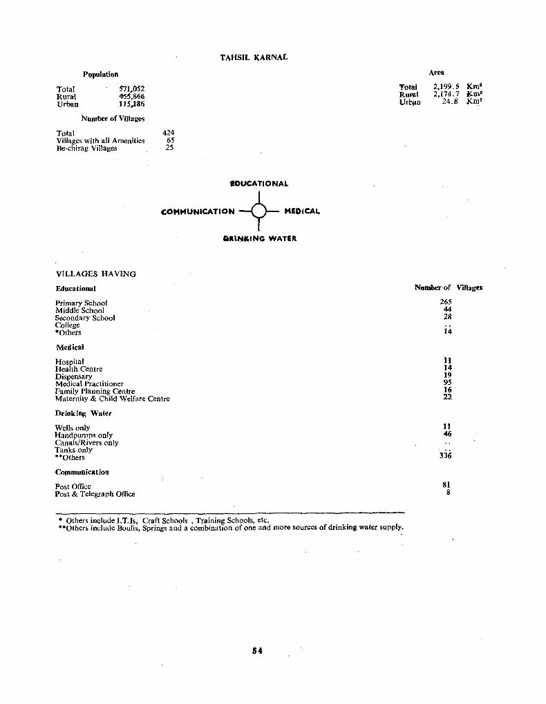
Total Rural Urban
Population
571.052 455,866 115,;186
Number of Villages
Total 424 Villages with all Amenities 65 Be-chirag Villages 25
TAHSIL KARNAL
EDUCATIONAL
COMMUNICATION --9- MEDICAL
aau,aK-ING WATER
VILLAGES HAVING
Educational
Primary School Middle School Secondary School College "Others
Medical
Hospital Health Centre Dispensary Medical Practitioner Family Planning Centre Maternity & Child Welfare Centre
Drinking Water
Wells only Handpumps only Canals/Rivers only Tanks only "'''Others
Communication
Post Office Post & Telegraph Office
Total RUFaI Urban
Area
2,199.5 Km l
2.17~. 7 J(~ 24.8 Krn!
Number of Villages
265 44 28
14
1.1 14 19 95 1(; 22
11 46
336
81 8
.. Others include I.T.Is, Craft Schools, Training Schools, etc. ""Others include Boulis, Springs and a combination of one and more sour()es of drinking water supply.
54

TAHSIL kARNAL
OISTRIBUTION OF AMENITIES 1M VILLAGES
YA •• L NUMO .. "
~ lOU_O"t" 1IOaOt . .. '1' ... 1 l!!O .... !. MO (O .... M.1 , . ,.,. W(J..TI'4f1 ~wAYI.P() "'D iAUU . ..... • Iea, J "1I .. 0 · . H~"1
........ 4l.
..... IIIAU"D ...
H-Ctl'.'" VILLa.l. LOCATIO. CODI[ ItO .
...
.. :
f:OUCA n O" AL COM"U'UC .. TIOM + IWEQ' C ..,l.
O .. ' NII(' ........ T!"
r;O!iCATIQ"''''b
".......... se~OOL ""OO~' $<:'Hool. MC.ONo.-". SCHOOL 1'."1"1". C& NTiII'lE WEDlCAa. . MOVITAL . '. .. tAL?"'" el .... T"E 0."''''''4''''' . _. . _ . . .... OIC .... "''''CTITIONt.R., ,. .... 'Ly Pl. ......... eUtTlff. "''Tr.,U.1TV &CM'LO .'1..4., crNTM . ... !9!,!!CJ ()!t ORINK'!!! w ... nit .... O~. wru. . TUM"!.L . " ... .. .. ... . c",.,U .. /"'VIU, .. . . CO!!!MYNICA TION
:8:: .o;[til.'lt.p'K Oril~· . .
1
. w . I
" ." .. D w, F,
T .._ _.0 ...
~Icr STATIOW • . - .• '" .... 'ItILLMCS .'TN AU. TItle AllIE_TIES .:='
\.
.7\0"2 ZIM'· !o:lK,.2 .... •
•
v
T
T
II
II
o
E
5
H

Code Name No.
1 Baholi 2 Razapur 3 Kachhroli 4 Simla Molana S Chandoli
6 Babail 7 Nagla 8 Rana Majra 9 Kundla
10 Jalalpur
11 Sanoli Kalan 12 Tamsabad 13 Nawadha 14 Dhansoli
15 Mohali
16 Saidpura 17 Kotani 18 Bhainswa!
19 Azizullapur 20 Sarai Bachhra
21 Nizampur 22 Faridpur 23 Mahmadpur 24 Ratipur 25 Sithana
26 Bal Jattan 27 Dharamgarh 28 Qawi 29 Sherah 30 Khandra
31 Asan Kalan 32 Narah 33 Kabri 34 Bagh Sher Afghan 3S Panipat Taraf Ansar
36 Kabulbagh 37 Panipat Taraf Makh
dumZadgan 38 Raja Kheri
,,39 Sewah Kheri 40 Kurar
TAHSIL PANIPAT
Location Code Numbers and Names of the Villages
Code Name No.
41 Janbha 42 Quamashpur 43 Baha-ud-dinpur 44 Sanoli Khurd 45 Ladhopur
46 Rishpur 47 Jalalpur 48 Chhajpur Khurd 49 Chhajpur Kalan 50 Jalpahar
51 Nimbri 52 Milk Ugra Kheri 53 Panipat Taraf Afghan 54 Panipat Taraf Raj-
Putan 55 Sikandarpur
56 Khukhrana 57 Asan Khurd 58 Muhay-ud-dinpur
Thirana 59 Shadipur 60 Madlauda
61 Ahmadpur Majra 62 Joshi 63 Narah 64 Waisar 65 Bhalsi
66 Vesari 67 Untiliya 68 Sutana 69 Jatol 70 Shodapur
71 Sarai Pilghan 72 Ugra Kheri 73 Ujah 74 Risalapur 75 Ataulahapur
76 Nanhera 77 Udmi
78 Jalmana 79 Behrampur 80 Dhadola
Code Name No.
81 Dhadoli 82 Risalu 83 Gadiwara 84 Sondhapur 85 Kheri Nangal
86 Mehrana 87 Binjhol 88 Dahar 89 Bhadaur 90 Kalkha
91 Lohari 92 Begumpur Bapnot, 93 Adiyana 94 Daryapur
95 Urlana Khurd
96 Urlana Kalan 97 Ataula 98 Alupur
99 Bhandari 100 Naill
101 Bhaupur 102 Brahman Majra 103 Naultha 104 Hartari 105 Sewah
106 Nurpur Mughla 107 Nurpur Gujran 108 Simla Gujran 109 Bapoli 110 RahimpurKheri
111 Mirzapur 112 Groela Kalan 113 Groela Khurd 114 Bhalaur 115 Garhi Bhalaur
116 Tajpur 117 Biholi
118 Pasina Khurd 119 Pasina Kalan 120 Diwana
TAHSIL .PANlPAT
Code Name No.
121 Borsham 122 Didwari 123 Balana 124 Jondhan Khurd 125 Jondhan Kalan
126 Karad 127 Khalila Majra Nain 128 Dumyana 129 Seenk 130 Pathri
131 Chhachhrana 132 Kurana 133 Ahar 134 Pardhana
135 Israna
136 Palri 137 Wazirpur Tatyana 138 Naryana
139 Pahladpur Khalila 140 Jatipur
141 Machhroli 142 Shahar Malpur 143 Begumpur Taharpur 144 SanjoJi 145 Raimal
146 Khojgipur 147 Bhanauli 148 Balaspur 149 Hathwala 150 Dikala
151 Atta 152 Matnouli 153 Garhi Chhaju 154 Jurasi Khalsa 155 J4rasi Saraf Khas
156 Bapura 157 Karanhs
158 Manana 159 Dhodpur 160 Gawalra
Villages Oassified by Population Area-I,232, 7 Km" Density-294 per Km2 No. of Population
Code Name No.
161 Mandi 162 Bandh 163 Bijawah 164 Shahpur 165 Kheri Shahpur
166 Kaith 167 Boanalakhu 168 Puthar 169 Kakoda 170 Chamrara
171 Dindhar 172 Namonda 173 Kiwana 174 Samalkha
175 Paonti
176 Patti Kalyana 177 Dehra 178 Ferozepur
179 Karkoli 180 Raksehra
181 Budanpur 182 Basahra 183 Mahoti 184 Haldana 185 Bodhwal Majri
Size CategQries Villages"
Males Females \
Males Females
Less than 200 200-499 500-999 1,000-1,999 2,000-4,999 5,000-9,999 10,000 and above Total
6 20 35 65 41
3
170
377 340 3,555 3,078
13,371 11,266 50,958 43,027 69,616 58,981 11,014 9,101
148,891 125,793
56
Population Literates Workers Non-Workers Scheduled Castes Scheduled Tribes
195,752 76,119 92,240
103,512 28,766
166,913 28,488
4,000 162,913 24,422

411
-f
:II
n
-f
:II
0
%
-f
.II>
"
o • ,.
'"
i i
C' I
... . o 0 o 0
I I
: I
..; o o I
i
~ o o I ~
i
~ l o 11 o • o 0
i : I
....
!S r-r-,.. CO)
"' fJ)
CD .... -<,.. fJ)::J: - en -N -
U)", r-.... - 0 ." .".
Z .,,-0; ." .... C .-,.. -I -0 Z
c

Total Rural Urban
Population
362,665 274,684
87,981
Number of Villages
Total 185 Villages with all Amenities 41 Be·chirag Villages 15
TAHSIL PANIPAT
EDUCATIONAl.
COMMUNICATION -<?- MEDICAL
PlUNKING WATER
VILLAGES HAVING
Educatioasl
Primary School Middle School Secondary School College ·Others
Medical
Hospital Health Centre Dispensary Medical Practitioner Family Planning Centre Maternity & Child Welfare Centre
Drinking Water
Wells only Handpumps only Canals/Rivers only Tanks only ""Others
Communication
Post Office Post & Telegraph Office
.. Others include I.T.ls, Craft Schools, Training Schools, etc . • "Others include Boulis, Springs and a combination of one and more sources of drinking water supply.
58
Total Rural Urban
Area
1,232.7 Kml 1,224.9 Kmi
7.8 Km~
Number of ViIJages
135 22 25
6
10 6
19 53
2 7
9 1
157
48 7

: 2
s I Q Vi ~ • tI ., J. n
<to
~
en ... "" .C) a ~ ...J ...J
> c.:
Z ... en g "" g ! " ... ~
J c !!:z
~"" Q.~
...J~
~u.. ~ ·O
o
u
Z 0 I-::> ~
~ en 0
Q
II)
o
.1 .1 s Q

DISTRICT ROHTAK
BASIC CENSUS STATISTICS
District/Tahsil
District Rohtak 1 . Tah~il Gohana 2. Tahsil Sonepat 3. Tahsil Rohtak 4. Tahsillhajjar
Area (in km')
Total
*6,043.0 1,432.7 1,161.4 1,339.2 2,107.0
Rural Urban
5,987.7 55 3 1,428.6 4.1 1,131.0 30.4 1,327.5 11.7 2,097.9 9.1
Population and In.Justrial Categories
Total
Rural
Urban
Census Year
1901 1911 1921 1931 1941 1951 1961 1971
Name of Town
M F M F M F
I Maham If· Gohana
III Ganaur IV Sonepat V Rohtak
VI Beri
Popula- Work- I II III IV tion ers
948,893 403,778 195,346 61,888 2,973 77 836,641 18,621 5,798 6,172 85 2 798,813 339,446 190,622 59,800 2,471 48 706,784 14,641 5,363 5,864 79 150,080 64,332 4,724 2,088 502 29 129,857 3,980 435 308 6 2
Growth of Population 1901-71
Population Growth ~-----~~----- --------Persons Males Females Absolute Percentage
858,184 456,131 402,053 74'),319 398,789 341,530 -117,865 -13.73 798,105 430,917 367,188 -I- 57,786 + 7.81 833,837 447,392 386,445 -I- 35,732 -I- 4.48 987,065 515,366 471,699 -1-153,228 +18.38
1,127,046 592,596 529,450 +134,981 -1-13.67 1,4'20,391 751,225 669,166 +298,345 -1-26.59 1,785,534 948,893 836,641 -1-365,143 -1-25.71
PopUlation of Urban Centres
Status Growth Population Workers Rate -------1961-71 Males Females Males Females
(M.e.) +13.34 5,492 5,049 2,272 133 (M.C.) +51.26 8,923 7,831 3,761 171 (N.A.C.) .1,542 3,857 2,078 92 (M.C.) +35.99 33,750 28,643 14,911 996 (M.C.) +41.46 66,933 57,822 28,269 1,754 (M.C.) +13.80 6,256 6,080 2,418 321
VI[ B.lhldurgarh (M.C.) +72.29 14,155 11,657 6;683 304 VIII Jhajjar (M.C.) +33.11 10,029 8,918 3,940 209
Other Data
Population Literates
Males Females Males Females
164,981 146,240 44,323 6,307
V
(a) (b) 16,828 22,941
818 946 15,709 10,573
730 752 1,119 17,368
88 194
VI VII VIII . IX X Non-
Workers 7,086 27,689 10,243 58,707 545,115
289 279 40 4,192 818,020 5,302 9,784 4,886 40,251 459,367
266 138 10 1,439 692,143 1,784 17,905 5,357 18,456 85,748
23 141 30 2,753 125,877
Population by Religion
Religion Population
Buddhist Christian Hindu Jain Muslim Sikh Others
Persons 62
432 1,758,S69
7,565 11,053 7,591
262
~.ales Females :9 33
::73 159 934,651 823,918
3,897 3,668 5,942 5,111 3,944 3,647
157 105
Sex and Age Structure
Age Groups Persons
0-14 827,834 ,15-19 178,600 20-24 130,308 25-29 105,767 30-39 183,518 40-49 146,780 50-59 105,307 60-1- 107,337 Age Not Stated 83
Males Females
443,601 97,560 66,168 52,768 89',594 76,067 58,548 64,566
21
384,233 81,040 64,140 52,999 93,924 70,713 46,759 42,771
62
Scheduled Castes Scheduled Tribes Sex Ratio
Literacy
Total Rural Urban
Total 882 Males
4:>7, '298 315,'594 91,604
Rural Urban 885 865
Fe:nales 1~1,764
86,451 55,303
.. Total area figures for the District represent "Geographical Area" figures (provisional) supplied by the Surveyor General. Figures for urban areas are those supplied by the local bodies. Area figures for rural areas are derived by substracting the urban area from the total area of the district. The total of the area figure'> of the tah~ils will not tally with the district figures because the former represent 'land use. area' and are derived from the figures supplied by the Director of Land Records.
60

IS'
>0 .. - . ~~I't
~29· t>l I S T R I C T
Is'
H I S
" R
DISTRICT ROHTAK 4 2 o _s 420
D I S T R I C T
hi A H E .. D R A G A R H
. ' 71115 E
C.
4 • 12
4 • II ~
0
~
o~
jt 'to
C .,.
STATE BOUNDARY . _ •• _ •• _ •• DISTRICT BOUNDARy . . _._._._ TAHSIL .BOUNDARY . . . . _._._._ DISTRICT HEADQUARTERS ... @) TAHSIL HEADQUARTERS. . . 0 UR8AN CENTRES .. . " . ... , 0
VILLAGES WIT~ POPULATION spoO & ABOVE . . . . . .... . OTHER VILLAGES WITH RH/PS URBAN AREAS . ....... (f//)
.. ... Ii • ..
Ii
P
P R A D E S
2'·1$'
~--...._~ YO ~~[~O,. ~
MA~ THROUGH AOUTES------__ METALLED ROADS .. ROADS,MOTORABLE IN FAIR WEATHER '"
RAiUMIlVS,8AoAD GAUGE .. =--=--==-.. RA~,METR£ GAUGE~~~~ RIVER . . . . ...._ CANAL. . .. .. . . . . . . . ==-== RESr HousE . . .... POLICE STATION ..... .. . . . '".
77'

Code Name No.
1 Nizampur 2 Bhawar 3 Gharwal 4 Rindhana 5 Dhanana Ala Padpur
6 Chhapra 7 Kehalpa 8 Bhanderi 9 Madina
10 Ahulana
11 Biroda Thuthan 12 Biroda Mor 13 Banwasa
TAHSIL GOHANA
Location Code NumtJers and Names of the Villages
Code Name No.
26 Siwanka 27 Ahmedpur Majra 28 Mamudpur 29 Gangesar 3.0 Khandrai
31 Khanpur Khurd 32 Gohana (Rural) 33 Gudha 34 Thaska 35 Mahra
36 Nagar 37 Barota 38 Gadhi Sarai Namdar
Khan
Code Name No.
51 Dhurana 52 Chirana 53 Samri Buran 54 Samd Lochab Buran 55 Samri Sisan
56 Khanpur Kalan 57 Kakana Bhadri 58 Kasanda 59 Kasandi 60 Saragthal
61 Joli 62 Nait 63 Kheri Damkan
Code Name No.
76 Rithal Phogat 77 Kanhi 7t 78 Kanhi 12t 79 Moi 80 Bali
81 Rabra 82 Puthi 83 Bhenswan Khurd 84 Rukhi 85 Gilor Kalan
86 Gilor Khurd 87 Mirzapur Kheri 88 Chhichhrana
Code Name No.
101 Mokhra Khas 102 Mokhra Kheri Rojh 103 Bahelba 104 Kharkra 105 Madina Korsan
106 Bharan 107 Nindana 108 Ajaib 109 Bensi 110 Kharak Jatan
111 Gugaheri 112 Pharmana Khas 113 Pharmllna Badshahpur
14 Kohla 39 Gadhi Ujale Khan 40 Ganwari
64 Sikanderpur Majra 65 Lath
89 Kathura 114 Bedwa 15 Nuran Khera 90 Kharak Churangla 115 Bheni Surjan
16 Issapur Kheri
17 Siwanamal 18 Rana Kheri 19 Gangana
41 Kelana Talka Khan-pur Kalan
42 Kelana Khas 43 Kelana Mamudpur 44 Sarsad
66 Bidhal 91 Chiri
67 Bhanswal Kalan Bawala 92 Gurawthi 68 Bhanswal Kalan Mithan 93 Chandi 69 Katwal 94 Nandal
20 Butana Khetlan 45 Mundlana 70 Riwara 95 Lakhan Majra
21 Butana Kundu 22 Bichpri 23 Jagsi 24 Matand 25 Chhatera
46 Busana 47 Bhadoti Mundlana 48 Bhadoti Busana 49 Bhadoti Khas 50 Johara
71 Anwali 72 Bilbian 73 Jasrana 74 Giwana 75 Rithal Nirwal
96 Kheranti 97 Gurawar 98 Nidana 99 Madina Gindhran
100 Muradpur Tekna
TAHSIL GOHANA
Villages Classified by Population Area-l,432.7 Km'
Size No. of Population Density-245 per Km! Categories Villages _-----
Males Females Males
Less than 200 1 64 49 Population 187,617 200-499 3 525 403 Literates 67,774 500-999 12 4,836 4,335 'Workers 82,213 1,000-1,999 32 26,331 23,2E4 Non-Workers 105,4C4 2,000-4,999 60 104,250 90,256 Scheduled Castes 36,717 5,000-9,999 11 37,196 32,704 Scheduled Tribes 10,000 and above
173,202 Total 119 151,011
62
116 Siman
117 Bheni Chanderpa l 118 Kheri Maham 119 Shekhupur Titri 120 Maham (Rural)
121 Bheni Maharajpur 122 Bheni Bharu 123 Sisar Khas
Females
163,891 18,611
3,547 160,344 32,C43

• ..
I ! I • - t - • : a .. o ii.I .. ~. I ..... I .. SUUS :-1 I g 0 8 Z -SiS··
.i~~DI\f I
" . .. I ... Is!!" .. : ~ =1 ~ . l;3t 2 c .. ~ ;f;f 'I>~ _
~ ~~.i .. .. of.
o •
....

Total Rural Urban
Population
351,508 324,213
27,295
Number of Villages
Total 123 Villages with all Amenities 49 Be-chirag Villages 4
TAHSIL GOHANA
EDUCATIONAL
COMMUNICATION -9- MEDICAl.
VILLAGES HAVING
Educational
Primary School Middle School Secondary School College *Others
Medical
Hospital Health Centre Dispensary Medical Practitioner Family Planning Centre Maternity & Child Welfare Centre
Drinking Water
Wells only Handpumps only Canals/Rivers only Tanks only **Others
Communication
Post Office Post & Telegraph Office
DR1NKING WATER
Total Rural Urban
Area
1,432.7 Kml 1,428.6 Km'
4.1 Km!
NIIRlber .r Villages
95 32 27 1 5
12 17 13 51 14 6
48 1
69
74 3
* Others include LT. Is, Craft Schools, Training Schools, etc. **Others include Boulis, Springs and a combination of one and more sources of drinking water supply.
64

... +
2 o t= i -~ t-
. f/) -,0 .
. . " .. • o • •.. .
( . .( , I
o
- ~ - .. ~ . . ,~\ :::a .. " ,"'
• • &"11."- +zla ~~ ~ .
. : :.: : ~ ~ [ i ~. [ .. ~. ~. :' :: :: i
. : :. , : . . . . . :: ! .. ... . .. : : : :. :.; I
- ",0' -:h. fa ~f o.
. .,
. ~
i .~
1.11· UI ,- i I;;: K
:t;. . .. • ~ .! i::
, , ~ I·: ~i I I:! : ::I ~. > c ! I: I!I ~: . - .. : -.1: ='11;;
II "~c. O~:& ;;;$-lI!~2i.:l : ~ II!! : I.a ~ • .,
" 0
~
• o

TAHSIL SONEPAT
Loea tion Code Numbers and Names or the Villages
Code Name No.
1 Bega 2 Ghasoli 3 Sanperha 4 Barhi 5 Pipli Kherha 6 Rannlagar 7 Umedgarh 8 Chandoli
9 Pabnera 10 GiasPUf
Code Name No. 51 Dahesra 52 Janti Kalan 53 Janti Khurd 54 Sersa 55 Kundli 56 Nathupur 57 Bazidpur 58 Shafiabad Panapa
Pushian 59 Munirpur 60 Shafiabad Kherhi
Manajat 11 Rasulpur 61 Kheri Manajat 12 Mimarpur 62 Akbarpur Barota 13 Malikpur 63 Jagdishpur 14 Tajpur 64 Rathdhana 15 Nasirpur Khadar 65 Lawan
Code Name No. 101 Larhsoli 102 Lalehrhi 103 Rajlu 104 Ganaur (Rural) 105 Bai 106 Barhot 107 Teha 108 Shahpur Taga
109 Kherhi Taga 110 Datauli
111 Pali Brahmnan 112 Charismi 113 Bhakarpur 114 Panchi Gujran 115 Zafarpur .
Code Name No. 151 Nainan Tatarpur 152 Salimpur Trali 153 Chitiya Deva 154 Rahmana 155 Satawali 156 Dabarpur 157 Mahra 158 Purkhas Rathi
159 Purkhas Dhiran 160 Agwanpur
161 Bhogipur 162 Bharhet 163 Udesipur 164 Panchi Jatan 165 Chitiya Aulia
Code Name No. 201 Hula Herhi 202 Barhwasani 203 Garhi Brahmnan 204 Jamalpur Khurd 205 Kalupur 206 Lahrarha 207 Bahyanpur 208 Harsana Kalan
209 Harsana Khurd 210 Nasirpur Bangar
211 Bhuapur 212 Ladpur 213 Badhnoli 214 Fatehpur 215 ROhat
16 Takola 66 Jat Herhi 17 Zainpur 67 Pitampura 18 Bakhtawarpur 68 Badh Malik
116 Bhora Rasulpur 117 Chhadya Usifpur 118 Chulkana
166 Sandal Kalan 167 Sandal Khurd 168 Shahzadpur 169 Tharia
216 Kanwali 217 Jharoti 218 Jharot
19 Nisifgarhi Bakhtawarpur 69 Rai 20 Menhdhipur 70 Fcrozepur Khadar 21 Machhrola 71 Asawarpur 22 Assadpur 72 Khewarha 23 Nand Naur 73 Bahalgarh 24 Barholi 74 Lawaspur 25 Basodi 75 Joshi Jat
119 Manak Majra 120 Atai! 121 Ahulana 122 Bali Qutubpur 123 Sardhana 124 Pugthala 125 Rajana Khurd 126 Bajana Kalan 127 Tewarhi 128 Majra
170 Tharu 171 Auldepur 172 Jawahri 173 Jamalpur Kalan 174 Sonepat (Rural) 175 Kallohrad
219 Anandpur 220 Thana Kalan 221 Thana Khurd 222 Mohamdabad 223 Garhi Bala 224 Turkpur 225 Mandora
176 Bhatana Zafrabad 226 Mandori 177 Juan 227 Nahra 178 Badshahpur Machhri 228 Abaspur
26 Muqimpur 27 Murshidpur 28 Dipalpur 29 Palrha 30 Mirakpur
76 Ahmadpur 77 Bandepur 78 Shadipur 79 Kabirpur 80 Sultanpur
129 Mohmmadpur Majra 130 Khubrhu
179 Jaji 229 Chhatera Bhatlurpur 180 Lohari Tiba 230 MalJa Majra
31 Palrhi Khurd 32 Palrhi Kalan 33 Jajal 34 Jhundpur 35 Manoli 36 Pabsara 37 Jakholi 38 Aurangabad 39 Sewali 40 PatJa 41 Badh Khalsa 42 Rasoi 43 Nangal Kalan
,,44 Aterna 45 Hansapur
46 Khatkarh 47 Baquipur 48 Khurumpur 49 Bhera 50 Basantpur
81 Fazilpur 82 Shah Jahanpur 83 Shahpur Turak 84 Raipur 85 Hasamabad 86 Joshi Chauhan 87 Kishora 88 Qmashpur 89 Nangal Khurd 90 Rewali
131 Naya Bans 132 Bulandpur 133 Kherhi Gujjar 134 Miana 135 Shamaspur 136 Bhanwar 137 Jalalabad 138 Khizarpur Ahir 139 Gomarh 140 Machhroli
91 Mortha! 141 Shekhupura 92 Kurarh Ibrahimpur 142 Sahia Kherha 93 Dewarhu 143 Kellana 94 Abdulpur 144 Moi 95 Kami 145 Dobheta
96 Bhuri 97 Rajpur 98 Bhigan 99 Hassanpur
100 Dhaturi
146 Bhadi 147 Rolad Latifpur 148 Dodwah 149 Pinana 150 Bohla
TAHSIL SONEPAT Villages Classified by Population
Size Categories
Less than 200 200----4·99 500-999 1,000---1,999 2,000-4,999 5,000---9,999 10,000 and above
No. of Population Villages ---
Males Females
17 793 578 22 4,205 3,643 61 25,586 21,814 83 64,552 56,134 47 74,286 63,081 4 13,731 11,511
Total 234 183.153 156.761
66
181 Mohana 231 Dhiki 182 Salarpur Majra 232 Mahri 183 Tiharh 233 Qatiupur 184 Guhna 234 Jhanjholi 185 Mahipur 235 Halalpur 186 Salimsar Majra 236 Jatola 187 Nakloi 237 Ferozepur Bangar 188 Njrthan 238 ;Nizampur 189 Kherhi Dahya 239 Saidpur 190 B~adana 240 Rampur 191 Ta)jpur Tihara Khurd 241 Kundal 192 Kakroi 193 Mahlana 194 Bagrhu 195 HaSsanyarpur Tihara
Kalan 196 Bhatgaon Malian 197 Bhatgaon Dogran 198 Karewarhi 199 Khizarpur Jat 200 Chitana
Area-1,161.4 Km l
Density-354 per Km" Males Females
Population Literates Workers Non-Workers Scheduled Castes Scheduled Tribes
221.445 97,479
97,415 124,030 34,466
189,261 33,791 4,039
185,222 30,247

TAHSIL SONEPAT
VILLAGES BY S·'ZE OF POPUlAnON 197.
--.-;=-----------. -==:.::-~=
.... .._ • -.boo _ ._ . .,_ .... ~ ~ \,000",._
III1l &00 - -
[i] --- -IiliJ1I .- - liOo
o
I.! I ,-r 1·1 • ...-n-
$
o
-... . ..
s
c·
D
D
•
~: l
H
T __
¥ILLMa __ *--- --- -.- .. tl-_-ctIIIiu ~ • ....... w.&Ma. wi", _ ...... -
u
T.
T
A
, Il
A
D
E
a .
H

Total Rural Urban
Population
410,706 339,914
70,792
Number of Villages
Total 241 Villages with all Amenities 48 Be-chirag Villages 7
TAHSIL SONEPAT
EDUCATIONAL
COMMUNICATION -9- MEDICAL
DR1NKING WATER
VILLAGES HAVING
Educational
Primary School Middle School Secondary School College *Others
Medical
Hospital Health Centre Dispensary Medical Practitioner Family Planning Centre Maternity & Child Welfare Centre
Drinking Water
Wells only Handpumps only Canals/Rivers only Tanks only **Others
Communication
Post Office Post & Telegraph Office
* Others include I.T.ls, Craft Schools, Training Schools, etc.
Total Rural Urban
Area
1,161.4 Km' 1,131.0 Km"
30.4 Kml
N.mlilar of Villages
168 33 27
6
4 5 8
65 7 8
24 5
198
74 7
**Others include Boulis, Springs and a combination of one and more sources of drinking water supply.
68

EO\,CATIOHAL •• , , • . _ .. .. ~"IIIAAY SCHOOL . • .•.• .• •• ... . . ,p
:~~~EO,.~H~g~OO~ : _. - - .. - . . .. ~ TRAIN.Me Ce."T"~ _ : : ~ IIIIEOtCAL .+ HOWIT"I. .. .. . . .. ..... _ NEALT" CENTRE. . DtSP'EIISARY •. •.... _ ... MEDICAL PRACTITIONER .. F"M'LY PLAN"'N. CENTRE ... AT£RNfTY • CHILO WCLFAR~ C£_TRe.. _.. . SOURCE OF D,UN'UNG WAT£R .. HAHDPU ...... WI:L L . .••. TUHWEl.L . .... . .•. TAN" . ..... . ... . CANAL / AlYEA. _ . _ COM .. UNICAT'QN.
.M . _ .Me
. _.D
.:.~
.. -... -.
. .. T .... ,
POST OFFICE. , . . . . . . . . . . . . _ ,PO , POST" TELe.AAPH OFFICE . . : _ ..... T POLICE STATION. . . . . _ . ___ • . . .. . .. .. VIt..LAaE'$ WITH ALL THE AMEHITI£5
... y-
"S-
'" ... r
TOTAL fIi'OPULATION "1o.7oe ... ,0
TOTAL A"E" ".'_81(.2 _ M "'L~A~. ,,41
_ Of' UtI .... " .. "", "
o 5
D
TAHSIL
DISTRIBUTION Of
T
co
E L H
SONEPAT AMENITIES IN VILLAGES
1'AH$lL toU.D"~Y VILL"U IOU.OUT 110"01 • III TUUO
:~~Sw~~~~:"ILl 1M
~"L."T1 ... OAD GAUCE u •• ". AllAS I eJt.H"UR • SONEPAT
LOC:ATlO. COOl NO. N-C'-"AS VILLASU
u
T
T
A
II
P
It
A
O
E
S
H

TAHSIL ROlITAK
Location Code Numbers and Names of the Villages
1 Nizampur Majra 26 Sasana 51 Bakheta 76 Sarai Ahmad 101 Sunari Kalan 2 Farmana 27 Garhi Sasana 52 Gorar 77 Nasirpur 102 Sunari Khurd 3 Muazamnagar 28 Samchana 53 Polangi 78 Sasrauli 103 Maroudi latan 4 Ridhao 29 Hasangarh 54 Rurki 79 Chamari 104 Kakrana 5 Silana 30 Bhansru Khurd 55 Mungan 80 Bahmanwas 105 Gurnavthi
6 Bidhlan 31 Bhansru Kalan 56 Asan 81 Sahan Majra 106 Baland 7 Sehri 32 Gijhi 57 Paksama 82 Jasia 107 Ritauli 8 Nasirpur Cholka 33 Naya Bans 58 BaJiana 83 Sanghi 108 Qabulpur 9 Khanda 34 Kheri Sampla 59 Bhalout 84 Katwara 109 Matana
10 Zia-ud-dinpur 35 Garhi Sampla 60 Kaloi Khas 85 Khadwali 11 0 Masudpur
11 Kharkhoda 36 Sampla 61 Kaloi Dopana 86 Guskhani 111 Sundana 12 Pipli 37 Ismaila (11 Biswa) 62 Dhamar 87 Jindran 112 Ballabh 13 Gopalpur 38 Ismaila (9 Biswa) 63 Basantpur 88 Titoli 113 Timurpur 14 Sohti 39 Chuliana 64 Makroli Kalan 89 Bhagotipur 114 Kahnaur 15 Pehladpur 40 Kahrawar 65 Ladhod 90 Samar Gopalpur 115 Sanghahera
16 Kirhauli 41 Karaur 66 Bhayanpur 91 Sunderpur 116 Pilana 17 Jasaur Kheri 42 Kheri Sadh 67 Para 92 Singhpura 117 Manjlla 18 KheriJasaur 43 Nunond 68 Boher 93 Bahu Jamalpur 118 Katesra 19 NiJothi 44 Gandhra 69 Paharawar 94 Bahu Akbarpur 119 Nigana 20 Pai 45 Dataur 70 Karountlla 95 Taja Majra 120 Garhi Balab
21 Khurrumpur 46 Atai! 71 Simli 96 Kutana 121 Patwapur 22 Barona 47 Kisranti 72 Miana 97 Gaddi Kheri 122 Marodi Rangran 23 Rohna 48 Mor Kheri 73 Kanehli 98 Bhali Anandpur 123 Banyani 24 Chhinauli 49 Kansala 74 Rohtak (Rural) 99 Dobh 124 Lahli 25 Ashraf-pur Matindu 50 Humanyunpur 75 MakroJi Khurd 100 Jalalpur 125 Anwal
126 Klanaur Kalan 127 Klanaur Khurd 128 Sampal 129 Busana 130 Kelanga
131 Kharak Kalan 132 Kharak Khurd 133 Kherari
TAHSIL ROHTAK
Villages Classified by Population Area-l,339.2 Km'
Size No. of Population Density-372 per Km" Categories Villages
Males Females Males Females
Less than 200 3 180 140 Population 264,629 233,283 200--499 3 574 561 Literates 123,522 53,437 500-999 13 5,513 4,717 Workers 111,160 5,312 1,000-1,999 26 22,317 19,886 Non-Workers 153,469 227,971 2,000--4,999 68 116,226 103,766 Scheduled Castes 45,694 40,052 5,000-9,999 15 52,886 46,391 Scheduled Tribes 10,000 and above 'Iotal 128- 197,696 175,461
70

o
z 2 ~ _, ~ G. 0
lICG. ~IL :x 0 Ow G: N ...... ~ii) en til :x)-~m
en lLI C) ..: _, _, :;
c
.,
" w 0: ... OJ .. ::I
~ 9 i i
J
c
')
... " 2-...... *.., .....
... ---

Total Rural Urban
Population
497,912 373,157 124,755
Number of Villages
Total 133 Villages with all Amenitie 48 Be-chirag Villages 5
TAHSIL ROHTAK
EDUCATIONAL
COMMUNICATION -9- MEDICAL
DR1NKING WATER
VILLAGES HAVING
Educational
Primary School Middle School Secondary School College "Others
Medical
Hospital Health Centre Dispensary Medical Practitioner Family Planning Centre Maternity & Child Welfare Centre
Drinking Water
Wells only Handpumps only Canals/Rivers only Tanks only "'*Others
Communication
Post Office Post & Telegraph Office
'" Others include LT.Is, Craft Schools, Training Schools, etc. ·*Others include Boulis, Springs and a combination of one and more sources of drinking water supply.
72
Total Rural Urban
Area
1,339.2 Kms 1,327.5 Km2
11.7 Km·
Number of Villages
88 34 3-9 1 2
13 13 19 54 14 13
49 1
76
62 6

x c .1-X ~ .. _, en x C t-
W' IaI o C . _, -S :; Z
~ ~.-
Z III 2: ~
~ Z 0 -~ ~ CD
C t-en 'Q
,
II r: .. 1 iC
:f • .. .. i
... ....
..
.. ~I[ _ .. 0" .... e ;a.
~~; ~a~ :aOz D;:'C .. co ...
i ::> s S o ..
•

TAHSIL JHAJJAR
Location Code Numbers and Names of the Villages
1 Bhambhewa 2 Dighal 3 Dewana 4 Gangtan 5 Mamian 6 Lakaria 7 Dhandlan 8 Gochhi 9 Seria 10 Madana Kalan 11 Raipur Viran 12 Madana Khurd 13 Chochi 14 Agarpur 15 Barhana 16 Kultana 17 Chhara 18 Kheri Asra 19 Rewari Khera 20 Mattan 21 Kharhar 22 Bhaproda 23 Asanda 24 Majra Asanda 25 Rohad 26 Dehkora 27 Loharheri 28 Asoda Todran 29 Asoda Sewan 30 Kulasi 31 Ladrawan 32 Kherpur 33 Kanonda 34 Mukandpur 35 Bahamnoli 36 Parnala 37 Hasanpur 38 Bahadurgarh (Rural) 39 Sankhol 40 Barahi 41 Jakhoda 42 Saidpur 43 Kasar 44 Sarai Aurangabad 45 Kherka Musalmanan 46 Nuna Majra 47 Lawa Khurd 48 Desalpur 49 Daboda Khurd 50 Mahandipur 51 Daboda Kalan 52 Tandaheri 53 Mandothi 54 Silothi 55 Kharman 56 Dulehra 57 Kherka Gujar 58 Goeta Kalan 59 Bupania 60 Shahpur 61 Zardakpur 62 Solda 63 Barkatabad 64 Balor 65 Lowa Kalan 66 Isharheri 67 Shedipur 68 Luksar 69 Gangarwa 70 Gubhana 71 Majri 72 Badli 73 Daryapur 74 Lagarpur 75 Dewar Khana 76 Lohat 77 Badsa 78 Munda Khera 79 Asmailpur 80 Fatehpur 81 Khalikpur 82 Yaqubpur 83 Sondhi 84 Nimana 85 Pelpa 86 Ladpur 87 Faizabad 88 Mehmoodpur Majra 89 Kheri Jat 90 Habibpur Viran 91 Khungai 92 Kablana 93 Chudani 94 Bhadani 95 Bhadana 96 Sekhupur Jat 97 Boria 98 Bazidpur Tappa Haveli 99 Sikanderpur 100 Jhajjar (Rural) 101 Nangali Viran 102 Kaimalgarh 103 Bir Sunarwala 104 Surakhpur Tappa Haveli 105 Tatarpur 106 Gorawar 107 Jondhi 108 Birdhana 109 Mehrana 110 Ifatkharnagar (llias Chimanpura 111 Dujana 112 Gudha 113 Dhor 114 Kheri Khumar 115 Talao 116 Khatiwas 117 Gawalison 118 Fortpura 119 Tamaspura 120 Islamgarh 121 Bir Chuchakwas 122 Achej 123 Palra 124 Jahazgarh 125 Mehmoodpur Majra 126 Wazirpur 127 Beri Dopana 128 Bisahan 129 Bhutian 130 Bakra 131 Beri Khas 132 Baghpur 133 Dubaldhan Bidhan 134 Dhurana 135 Chimni 136 Dubaldhan Ghikan 137 Sewana 138 Majra 139 Dubaldhan Kirmian 140 Paharipur 141 Malikpur 142 Shafipur 143 Godhri 144 Matanhail 145 Ruriawas 146 Noganwa 147 Maliawas 148 BirQhar 149 Kaliawas 150 Khachroli 151 Mankawas 152 Selanga 153 Dhalanwas 154 Jhamri 155 Bazidpur Tappa Birohar 156 Sasroli 157 Jharli 158 Mohanbari 159 Jhanswa 160 Sundrehti 161 Ladain 162 Hamayunpur 163 Jamalpur 164 Dhanirwas 165 Dhana 166 Salhawas 167 Dhania 168 Bhakali 169 Nathera 170 Surehli 171 Suada:tnagar 172 Judi 173 Sudhrana 174 Lilodh 175 Goria 176 Khanpur Khurd 177 Khanpur Kalan 178 Khorra 179 Chak K harji Bahu 180 Bahu 181 Jholri 182 Khursaidnagar 183 Kuharaq 184 Bharangi 185 Mamtazpura 186 Gadhi 187 Nayagaon 188 Khera Tharu 189 Bahala 190 Bawa 191 Karoli 192 Bisoha 193 Nahar 194 Bir Sarkar 195 Jhal196 Ganwari 197 LulaAhir 198 Jharoda 199 Kheri 200 Nangal 201 Tumna 202 Shamnagar 203 Zahdpur Tappa Kosli 204 Bhurthala 205 Kosli 206 Kahnarwas 207 Gugod 208 Gudiani 209 Boriawas 210 Ahmadpur Partal 211 Shadipur 212 Surakhpur Tappa Kosli 213 Ratanthal 214 Usmanpur 215 Neola 216 Bairampur 217 Mundra 218 Jakhala 219 Mubarakpur 220 Jaipur 221 Tumbaheri 222 Malasiawas 223 Chawa 224 Dharoli 225 Jatwara 226 Amboli 227 Bhurawas 228 Bithla 229 Bhikhanpur Viran 230 Nilaheri 231 Mundahera 232 Birar 233 Akeri Madanpur 234 Madalsahpur 235 Mundsa 236 Bambulia 237 Khaparwas' 238 Khetawas 239 Marot 240 Kheri Hosdarpur 241 Rankhanda 242 Dawala 243 Bakhtawarpur alias Rayya 244 Hllssanpur 245 Kunjia 246 Karoda 247 Bhindawas 248 Shahjahanpur 249 Bilochpura 250 Koilpuri 251 Chadhwana 252 Redhuwas 253 Niwada 254 Kundrali 255 Chan dol 256 Dhakla 257 Babepur 258 Girdharpur 259 Subana' 260 Samaspur Majra 261 Kasni 262 Surakhpur Viran 263 Kanwa 264 Chandpuri 265 Fatehpuri 266 Surehti 267 Saloda 268 Kilrod 269 Raipur :nO Khakhana .271 Dadanpur 272 Chandpur 273 Machhrauli 274 Asadpur Khera 275 Khudan 276 Isarhera 277 Sarola 278 9hapar 279 Ahri 280 Koka 281 Kulana 282 Patoda 283 Lohari 284 Kheri Talka Patoda 285 Amadalpur 286 Kahari ,287 Batehra 288 Zahidpur 289 Patasni 290 Untloda 291 Sabili 292 Silana 293 Gijarod 294 Babra 295 Silani Panazalim 296 '~ilani Panakeso 297 Ukhal Chana 298 Jahangirpur 299 Surah 300 Durina 301 Kaloi 302 Munimpur Kukrola 303 Bahamnola 304 Bir Dadri 305 Shivjipura 306 Aurangpur
·307 Nangla 308 Dadritoe 309 Kutani . \
TAHSIL JHAJJAR
Villages Classified by Population
Size No. of Categories Villages'
Less than 200 10 200-499 20 500-999 89 1,000-1,999 98 2,000-4,999 65 5,000-9,999 9 10,000 and above Total 291
Population
\ Males Females I
535 406 3,878 3,403
35,129 31,703 74,991 68,615 98,568 90,199 31,661 29,225
244,762 223,551
74
Area-2,107.0 K$' Density-249 per Km-
Males
Population 275,202 Literates 118,523 Workers 112,990 Non-Workers 162,212 Scheduled Castes 48,104 Scheduled Tribes
Females
250,206 35,925 5,723
244,483 43,898

o
...
o ...
•
...
...
g "
.. I)
It ..
hu~ , :r::
~

Total Rural Urban
Population
525,408 468,313
57,095
Number of Villages
Total 309 Villages with all Amenities 66 Be-chirag Villages 18
TAHSIL JHAJJAR
EDUCATIONAL
COMMUNICATION -9- MEDICAl.
DRINKING WATER
VILLAGES HAVING
Educational
Primary School Middle School Secondary School College *Others
Medical
Hospital Health Centre Dispensary Medical Practitioner Family Planning Centre Maternity & Child Welfare Centre
Drinking Water
Wells only Handpumps only Canals/Rivers only Tanks only. **Others
Communication
Post Office Post & Telegraph Office
* Others include I.TJs, Craft Schools, Training Schools, etc.
Total Rural Urban
Area
2,107.0 Ktn! 2,097.9 Km'
9.1 Km!
Number of Villages
213 45 43
2 3
10 18 23 65 14 11
206
84
109 14
**Others include Boulis, Springs and a combination of one and more sources of drinking water supply.
76


DISTRICT GURGAON BASIC CENSUS STATISTICS
District/Tahsil District Gurgaon
1. Tahsil Rewari 2. Tahsil Gurgaon 3. Tahsil HaUabgarh 4. Tahsil Palwal 5. Tahsil Nuh
Area (in km~)
Total *6,146.0 1.437.0 1,067.4
6. Tahsil Ferozepur Jhirka
749.5 999.7
1,048.0 814.2
Rural 6,068.6 1,424.1 1,045.9
723.7 991.6
1,042.3 810.8
Urban 77.4 12.9 21.5 25.8
8.1 5.7 3.4
Population and Industrial Categories
Popula- Work- I II III IV V tion ers
(a) (b)
Total M 917,766 427,211 204,778 42,591 5,617 2,116 15,581 49,519 F 789,603 18,737 5,346 4,804 163 303 572 1,894
Rural M 744,657 344,270 200,222 40,595 4,987 2,102 13,844 21,917 F 646,728 13,764 5,244 4,486 138 302 455 922
Urban M 173,109 82,941 4,556 1,996 630 14 1,737 27,602 F 142,875 4,973 102 318 25 1 117 972
Growth of Population 1901-71 Population Growth Religion
Census Year Persons Males Females Absolute Percentage 1901 877,728 460,783 416,945 Buddhist 1911 765,384 407,588 357,796 -112,344 -12.80 Christian 1921 712,946 383,687 329,259 - 52,438 - 6.85 Hindu 1931 779,325 419,195 360,130 + 66,379 + 9.31 Jain 1941 895,940 476,540 419,400 + 116,615 +14.96 Muslim 1951 967,664 512,891 454,773 + 71,724 + 8.0\ Sikh 1961 1,240,706 659,432 581,274 +273,042 +28.22 Others 1971 1,707,369 917,766 789,603 +466,663 +37.61
Population of Urban Centres
VI VII VIII IX X Non-
Workers
8,561 27,578 11,939 58,931 490,555 455 299 95 4,806 770,866
6,025 10,170 5,821 38,587 400,387 357 135 19 . 1,706 632,964
2,536 17,408 6,118 20,344 90,168 98 164 76 3,100 137,902
Population by Religion Population
Persons Males Females 101 57 44
1,799 1,094 705 1,387,102 747,918 639,184
3,704 1,926 1,778 298,499 157,976 140,523
15,889 8,648 7,241 275 147 128
Sex and Age Structure Age Groups Persons Males Females
Name of Status Growth Population Workers Town Rate 0-14 785,979 422,226 363,753
1961·71 Males Females Males Females 15-19 155,980 86,083 69,897 20--24 i 132,007 68,988 63,019
I Hawal (M.C.) +10.21 3,408 3,121 1,397 71 25-29 114,499 58,858 55,641 II Rewari (M.e.) +18.63 23,327 20,558 10,033 473 30-39 186,745 96,347 90,398
III Pataudi (M.e.) +42.47 3,121 2,924 1,292 95 40-49 139,852 73,902 65,950 IV Haileymandi (M.C.) +30.32 1,223 1,029 510 22 50-59 95,541 53,927 41,614 V Farruklmagar (M.C.) +10.89 2,886 2,601 1,255 69 60+ 96,624 57,370 39)54
VI Gurgaon VII Sohna
VIII Faridabarl Township
IX Farirlabad X Ballabgarh
XI Palwal XII Hodal
XIII Nuh XIV Ferozepur
lhirka
Scheduled Castes Scheduled Tribes Sex Ratio
Literacy
Total Rural Urban
(M.e.) +50.92 30,481 26,670 13,428 (M.e.) +27.38 4,669 4,106 2,081 (M.C.) +115.20 49,164 36,598 27,761
(M.e.) +80.93 10,956 8;688 5,371 (M.e.) +109.02 9,910 7,501 5,177 (M.e.) +29.95 19,538 16,669 8,311 (M.e.) +33.96 7,608 6,536 3,291 (M.e.) +25.40 2,596 2,134 1,088 (M.e.) +37.87 4,222 3,740 1,946
Other Data
Population Literates Males Females Males Females·
147,081 129,081 42,193 4,456
Total Rural Urean 860 868 825
Males Females 366,323 113,690 260,601 55,262 105,722 58,428
1,140 Age Not Stated 142 65 77 90
1,830
312 169 489 107 27 79
'" Total area figures for the District represent "Geographical Area" figures (provisional) supplied by the Surveyor General. Figures for urban areas are those supplied by the local bodies. Area figures for rural areas are derived by substracting the urban area from the total area of the district. The total of the area figures of the tahsils will not tally with the district figures because the former represent 'land use area' and are derived from the figures supplied by the Director of Land Records.

..
'0 ",
:z: u !II % z .. .. " " ..J ... 0
...... ..... I&J
Q
.., .. z 0, c( ,., C) !l! IS.
y a: 11\ ,., .:l II !l!
0
C) )) CD ., ...
t- ... 0 -~ I-f/J I/)
I&J - ..J
Q 2
-; ·~O
~ .'" zll til

TAHSIL REWARl
Location Code Numbers and Names (If the Villages
1 Lisan 2 Gothra Tappa Dahina 3 Kanwali 4 Fathpuri Tappa 5 Dakhaura 6 Darauli 7 Khushpura 8 BerH Kalan 9 Chauki 10 Babroli II Baldhan Kalan 12 Bohatwas Bhondu ]3 Nangal Pathani 14 Murlipur 15 Gopalpur Gazi 16 Parkhotampur 17 Jatusana 18 Lala 19 Suma Khera 20 Rojuwas 21 Kutabpuri Buzarg 22 Rasulpur 23 Saidpur 24 Chang 2.5 Pehrajwas 26 Hansawas 27 Kanhora 28 Kanhori 29 Gadala 30 Prithipura 31 Gurawada 32 Palahwas 33 Khera Alampur 34 Chandanwas 35 Asiaki Gorawas 36 Jivra 37 Mali aka 38 Chauki 39 Chhiliaki 40 HaJiaki 41 Nurgarh 42 Mangwaki 43 Bahamanwas 44 Husenka 45 Ghudana 46 Rajpura 47 Jatauli 48 Mubarikpur 49 Rampur 50 Narhera 51 Uncha Majra 52 Pataudi (Rural) 53 Chhawan 54 Devlawas 55 Mirjawas 56 Malikpur 57 Ransika 58 Inchapuri 59 Sahapur Jat 60 Mujera 61 Sherpur 62 Haqdar~ pur 63 Dadawas 64 Brijpura 65 Jasat 66 Basota 67 Nangia Ranmokh 68 Rohria 69 Mehi-ud-dinpur 70 Nain Sukhpura 71 Dohkia 72 Haluhera 73 Musepur 74 BerH Khurd 75 Kumroda 76 Motla Khurd 17 Motla Kalan 78 Baldhan Khurd 79 Kahari 80 Rampuri 81 Didoli 82 Masit 83 Dahina 84 Jainabad 85 Dhani Thetherbad 86 Dhawana 87 Luhana 88 Siha 89 Buroli 90 Aulant 91 Nangali Mundi 92 Mundi 93 Bhatera 94 Dehlawas 95 Gulabpura 96 Mandhia Khurd 97 Beharipur 98 Rasoli 99 Balawas Jamapur 100 Kishangarh 101 Mundawas 102 lharuwas 103 Sheikhupur Shikara 104 Mustfapur 105 Tehna Depalpur 106 Karawada Manakpur 107 Sadipur ]08 Rajawas ]09 Nurpur 110 Chillar 111 Beharhedi Rehanwan 112 Jaitpur Saidpur 113 Muzamabad 114 Pahari ll5 Bapas 116 Gangli 117 Khetiawas 118 KhaJilpur 119 Ghilnawas 120 Ahmadpur 121 Balewa 122 Bhogpuri 123 Daulatabad 124 Nanu Khurd 125 Gadiepur 126 Khor 127 Goriawas 128 Khanpur 129 Heraheri 130 Supedernagar 131 Ber Khurd 132 Baspa Damka 133 Torkanpur 134 Lohaka 135 Mumtajpur 136 Hansaka 137 Lokra 138 Darapur 139 Lohca]? 140 Dohkia 141 Malahera 142 Basatpur 143 Nanu Kalan 144 Shampur 145 Talpuri 146 Maheniawas 147 Pacblai 148 Mirpur 149 Gokalpur 150 Janti 151 Janti Sairwas 152 Kakoria 153 Ramgarh 154 Dabri 1.55 Mundhalia 156 Naya Gaon 157 Ghurkawas 158 Bhllrthal Thethar 159 Bhurthal Jat 160 Gagiacha Jat 161 Gagiacha Ahir 162 Bikaner 163 Lisana 164 Rajpura Khalsa 165 Lakhnor 166 Asspur 167 Bodia Kamalpur 168 Jadra ]69 Gindokhar 170 Rewari (Rural) 171 Bangarwa 172 Bohatwas Ahir 173 Raliawas 174 Gapalpur alia~ Pranpura 175 Aliawas 176 Chimnawas 177 Kathu alias Bhawanipura 178 MarndiaAsampur 179 Nangla Mayan 180 Batori 181 Khaleta 182 Mayan 183 Mandola 184 Nimoth 185 Srinagar 186 Bahka 187 Uncha 188 Nangal Jamalpur 189 Kulana 190 Basduda 191 Ahrod 192 Khole 193 Balwari 194 Nandha 195 Bhalki 196 Gothra Tappa Khori 197 Mamdia Thether 198 Mamdia Ahir 199 Khori 200 Gohindpuri 20t Rajpura Istemrar 202 Dhani Santu 203 Sahbajpur Istcmrar 204 Sundrodh 205 Badh Sundroj 206 Mahakharia 207 Balawas Ahir 208 Ladhuwas Ahir 209 Gangoli 210 Saharanwas 211 Khargwas 212 Kahan Majra 213 Chandawas 214 Bhudpur 215 Kaluwas 216 Gokalgarh 217 Dohki 218 Bhagwanpur 219 Pokharpur 220 Qutabpuri Jagir 221 Chaterpuri 222 Phaderi 223 Hansaka 224 Dudani 225 Turkiawas 226 Budana 227 Phadni 228 Rojhka 229 Tatarpur Istemrar 230 Sunaria 231 Asadur 232 Jitpur Istemrar 233 Dohna 234 Alamgirpur 235 Khatawali 236 Lokri 237 Mau 238 Kapriwas 239 Jonlawas 240 Malpura 241 Ghari Alawalpur 242 Ghatal Mehniwas 243 Akera 244 Mehshri 245 Dharuhera 246 Kharkra 247 Khaliawas 248 Masani 249 Rasgian 250 Dungarwas 251 Nikhri 252 Khijuri 253 Jonawas 254 Baliar Khurd 255 Baliar Kalan 256 Mundia Khera 257 Mulhawas 258 Muradpuri 259 Barnbar 260 Falehpuri Pipa 261 Majra Shoraj 262 KhaliJpuri 263 Mandhia Kalan 264 Kalaka 265 Kaunsiwas 266 Pinyara 267 Dumawas 268 Jhanjanwas 269 Rampura 270 Kutabpur Mola 271 Husanpur 272 Narainpur 273 Thot Walka 274 Bad Jethu 275 Dhamlawas 276 Dhani Sundradh 277 Mehlawas 278 Pitherawas 279 Bhandor 280 Gumina 28] 'Tint 282 Harjipur 283 Bawana 284 Pali 285 Majra Mutsal Bhalki 286 Manethi 287 Padla 288 Chita Dungra 289 Kundal 290 Kanuka 291 Aramnagar 292 Birwal" 293 Bhadrana 294 Punsika 295 Rajiaka 296 Pragpura 297 Goliaka 298 Kharkari Bhiwan 299 Nagli Godha 300 Danalampur 301 Datiaki 302 Asaka 303 Akbarpur 304 Khar Sanki 305 Jatuwas 306 Chandpur 307 Dhaliawas 308 Padniawas 309 SahbazpurKhalsa 310 Bariawas 311 Majra Gurdas 312 Sangvvari 313 Bhudla 314 Panchor 315 Panchgawan 316 Majri Duda 317 Laduwas Gujjar 318 Kanhu\.as 319 Raliawas 320 Nagniawas 321 Bhatsana 322 Tatarpur Khalsa 323 AJalwalpur 324 Nandrampur 325 Jarthal 326 Asiaki Tappa Jarthal 327 Sanpli 328 Salawas 329 Pithrawas 330' Lodhana 331 Bolni 332 Gudhi 333 Kasola 334 Baqapur 335 KasoH 336 Kathuwas 337 Dawana 338 Lalpur 339 Dodhai 340 Gujriwas 341 Chhuriawas 342 Dhamiaka 343 Devlawas 344 Gajjiwas 345 Kamalpur 346 Bithwana 347 Bhanwari 348 Karnawas 349 Bharawas 350 Jetrawas 351 Sulkha 352 Nechana 353 Mohamadpur 354 Balawas 355 Kharkhari 356 Dharan 357 Gobindpur 358 Rajgarh 359 Tankri 360 Narsinghpur Garhi 361 Behrampur Bhirangi 362 Sanjharpur 363 Asraka Majra 364 Saban 365 Harchandpur 366 Kalrawas 367 Odhi 368 Bawal (Rural) 369 Rondh 37Q Chirahra 371 Banipur 372 Ialiawas 373 Suthana 374 JalaJpur 375 Dhani Suthani 376 Suthani 377 Asanwas 378 Patuhcra 37,9 Bagthala 380 Mukandpur Basai 381 Kheri Motia 382 Kama!pur 383 Ibrahimpur 384 Mangaleshwar 385 Gujar Majri 386 Khera Murat 387 Raipur 388 Bishanpur 389 Alawanpur 390 Badhoj 391 Bejhabwa 392 Khijori 393 Bidawas 394 Nangal Shahbazpur 395 Mangli Persapur 396 Dulehra Khurd 397 Dulehra Kalan 398 Jhabwa 399 Subasheri 400 Khurampur 401 Bagwanpur 402 Sheikhpur 403 Dhar Chanan 404 Saidpur alias Jatpur 405 Teekla
80

o
~ 0 I-0( ....J
~
=> "' " ~ :;; 0 ,
IX g "'( ~
: it~ 3 ~ w 0 a: w
,.._ ...J en o ~ l o in t::! j-::t en < ~ >- .
UI w
i -en w CJ • .... .... >
('
.. • C D
:: 0 . ~ " c ..
G II 0 II \) 0.
~
I; ~ w
z>
-i! I ....... -~= 0 = .i ~; ~ 3 :: ~i"); :- ~~I: a~ i .. ~ i :! ii~ ! ~ ..... f •
~ 1'#
~~ I II
J. S I 0


T.MISIL REW A:KI-concld.
Location Code Numbers and Names of the Villages
406 Panwar 407 Paoti 408 Kishanpur 409 RanoH 410 Pranpura 411 Ransi Majri 412 Ragunathpur 413 Nangal Ugra 414 Shahpur 415 Tihara: 416 Nangal Teju 417 Kheri Dharchana 418 Rasiwas 419 Kheri 420 Keshopur 421 Anandpur 422 Jaisinghpur Khera 423 Khandewra 424 Mohanpur 425 Chancanwas 426 Ramsinghpura
TAHSIL REWARI
Villages Classified by Population Area-l,437.0 Km2
Size No. of Population Density-268 per Km2
Categories ViIIl\ges Males Females Males Females
Less than 200 38 2,196 2,067 Population 200,684 184,380 200-499 109 20,844 18,945 Literates 93,878 28,208 500-999 161 60,738 56,010 Workers 82,399 3,662 1,000-1,999 74 51.507 48,075 Non-Workers 118,285 180,718 2,000-4,999 22 31,618 29,332 Scheduled Castes 38,300 35,520 5,000-9,999 1 2,702 2,319 Scheduled Tribes 10,000 and above Total 405 169,605 156,748
83

Total Rural Urban
Populatioa
385,064 326,353 58,711
Number of Villages
Total 426 Villages with all Amenities 27 Be-chirag Villages 21
VILLAGES HAVING
Educatioual
Primary School Middle School Secondary School College ·Others
Medical
Hospital Health Centre Dispensary Medical Practitioner Family Planning Centre Maternity & Child Welfare Centre
Drinking Water
Wells only Handpumps only Canals/Rivers only Tanks only ·"Others
Communication
PoSt Office Post & Telegraph Office
TAHSIL REWARl
EDUCATIONAL
COMMUNICATION -9-- _,CAI. DIUNKING WATER
• Others include I.T.Is, Craft Schools, Training Schools, etc. ··Others include Boulis, Springs and a combination of one and more sources of drinking wator supply.
84
Total Rural Urban
Area
1,437.0 Km' 1.424.1 KIn'
12.9 Km'
NllDlber of Villages
253 50 24
1 6
6 6
18 26
8 5
317
85
74 5

a:. <I[
~ u.t a:
C/) UJ c,:, c( ~.
~
> z
en ~ .... Z UJ ~ c(
Lt,.. 0
..,~&..,coz
II<
.. '" .. :; 2 g i
1 i I i

TAHSIL GURGAON
Location Code Numbers and Names of the Villages
'Code Name No.
1 Siwari 2 Jaraon 3 Mushadpur 4 Duman
Code Name No.
46 Lakhuwas 47 Zekopur 48 Raipur
Code Name iC
No.
91 Joniawas 92 FazalpUl;.Badli 93 Jarola 94 Patli Hazipur
Code Name No.
136 Bhogpur 137 Ranika Singhola 138 Tolni 139Isaki
Code Name No.
181 Sadhrana 182 Gopalpur
5 Khurampur 49 Sohna (Rural) 50 Sanpki Nan~H 95 Saidpur Mohammad- 140 Chuherpur
183 Garolli Kalan 184 GarolJi Khurd 185 Kadipur
6 Sarbasirpur 7 Mubarikpur 8 Jhanjrolla 9Iqbalpur
10 Kaliawas
11 Mankrola 12 Budhera
51 Mohammadpur Gujar 52 Raisina 53 Ghairatpur Bas 54 Bargujar 55 Nainwal
56 Gwalior 57 Chandla Dungerwas
pur
96 SuItanpur 97 Chandu 98 Dhankot 99 Basai
100 Dhanwanpur
101 Tikampur 102 Gurgaon (Rural)
13 Kheri Majra Dhankot 58 Langra 103 Panwala Khusropur S9 Udaipuri 104 Allawardi 14 Daulatabad
15 Mohammadheri 60 Pathreri 105 Inaitpur
16 Dharampur 61 Bilaspur 106 Mulahera 17 Babupur 62 Bhudka 107 Shahpur 18 Choman 63 Dhanokri 108 Sirhole 19 Bajghera 64 Rathiwas 109 Sukhrali 20 Daulatpur Nasirabad 65 Sidhrawli 110 Silokhra
J
21 Dundahera 66 Prasoli 111 Kanahi 22 Nathupur 67 Bhonkarka 112 Bindapur 23 Sikandarpur Glitosi 68 Bhora Khurd 113 Shamaspur 24 Chakkarpur 69 Nurpur Bhora 114 Tigra 25 Wazirabad 10 Bhora Kalan 115 Ghatta
26 Haiderpur 11 Ghausgarh 116 Berampur 21 Gual Pahari 72 JanaUla 117 Qadarpur 28 Balola 13 Jori 118 Rithoj 29 Bandhwari 74 Sanpka 119 Sahjawas 30 Rojka Gujar 15 Jatola 120 Behlpa
31 Damdma 16 Tripri 121 Mahendwara 32 Mahendwara 17 Basonda 122 Pulhawas 33 Kherli Lala 18 Bakain 123 Kherla 34 Tahter 19 Khandewla 124 Garhi Bazidpur 35 Badshahpur Tahter 80 Mehchana 125 Abhaipur
36 Bai Khera 81 Faridpur 126 Jalalpur 31 Sarmathla 82 Karola 121 Khobri 38 Loh Singhani 83 Rajupur 128 Harchandpur 39 Ghangola 84 Gugana 129 Neemot 40 Bilhaka 85 Shekhopur Majri 130 Rahaka
41 Ranika Noabad 86 Birhera 131 Satlaka 42 Kau.tpuri 87 Palri 132 Bidhwaka 43 Silani 88 Alim-ud-dinpur 133 Kulikaka 44 Kiranki 89 Garhi Nathe Khan 134 Khatrika 45 Sancholi 90 Daboda 135 Jolhaka
TAHSIL GURGAON
Villages Classified hi Population
Size No. of Population Categories Villages
Males Females
Less than 200 17 898 \ 834 200-499 47 8,611 ,7,678 500--999 68 25,801 22,995 1,000--1,999 59 43,124 38,386 2,000-4,999 17 24,563 21,571 5,000-9,999 4 16,073 14,196 10,000 and above Total 212 119,076 105,660
86
141 Noonhera 142 Kharoda 143 Baluda 144 Daula 145 Lohtki
146 Kbaika 147 Siriska 148 Berka 149 Dhunela 150 Hariahera
151 Alipur 152 Ghamroj 153 Tikli 154 Sakatpur 155 Shikohpur
156 Naurangpur 151 Manesar 158 Khoh 159 Sehrawan 160 Kukrola
161 Fazalwas 162 Binola 163 Fakherpur 164 Mokalwas 165 Tatarpur
186 Naharpur Roopa 181 Jharsa 188 Adampur 189 Ghesola 190 Badshahpur
191 NangIi Umerpur 192 Ulhawas 193 Medawas 194 Dhumaspur 195 Bhondsi
196 Aqlimpur 191 Nurpur Jharsa 198 Palra 199 Darbaripur 200 Hassanpur
201 Kherki Daula 202 Sihi 203 Sikanderpur Badha 204 Lakhnola 205 Naharpur Kasan
206 Kankrola 207 Bas Kusla 208 Bhangrola 2Q9 Dhorka 210 Wazirpur
166 Kherkheri 211 Garhi Harsaru 167 Bas Lambi 212 Harsaru 168 Jamalpur 213 Khandsa 169 Tajnagar 214 Hidayatpur Chhaon 170 Farrukhnagar (Rural) 215 Islampur
171 Babra Baqipu~ 172 Khwaspur 173 Kasan 174 Bas Harya 115 Dhana
176 Jhund Sarai Wi~an 177 Jhund Sarai Abad 178 Dhanawas 179 Khetawas 180 Hamirpur
Area-1,067.4 Km 2
Density-277 per Km 2
Population Literates Workers Non-Workers Scheduled Castes Scheduled Tribes
Males
157,112 14,827 67,249 89,863 21,419
216 Fatehpur 217 Tikri 218 Fazilpur Jharsa 219 Behrampur 220 Begumpur Khatola
221 Narsinghpur 222 Mohammacipur Jharsa 223 Hayatpur 224 Meoka 225 Badha 226 Nawada Fatehpur
Females
139,037 29,130 3,232
135,805 24,182

...
_,
c
Z 0
~ _, ::.-~ ..
z G- .. ... 0 i c: u.. C)
l a:: 0 :::l C) I.IJ
N '" en 0' o 0 ...I
U') >-:x - .. III ..
4; It ... l-
t tJ) 0
UJ ... i
~ ..J ..J
>
lit
'" po
.:c ,
J. .L s o
rt\ ::I 1:1
.. z o <II 0: .. ..
i £- • .., i : • I I
l i ~ § o o ...
o o .. z C % ... $ .. ...

Total Rural Urban
Population
296,149 224,736 71,413
Number of Villages
Total 226 Villages with all Amenities 21 Be-chirag Villages 14
TAHSIL GURGAON
EDUCATIONAL
COMMUNICATION -?- MEDICAL,
DRINKING WATER
VILLAGES HAVING , " Educatioaal
Primary School Middle School Secondary School College *Others
Medical
Hospital Health Centre Dispensary Medical Practitioner Family Planning Centre Maternity &. Child Welfare Centre
Drinking Water
Wells only Handpumps only Canals/Rivers only Tanks only **Others
Communication
Post Office Post &. Telegraph Office
* Others include I.T.ls, Craft Schools, Training Schools, etc. **Others include Boulis, Springs and a combination of one and more'sources of drinking water supply.
88
Total Rural Urban
Area
1,067.4 KIn' 1,045.9 Km'
21.5 Km'
Number of Villages
136 21 23
7
4 5
11 27 4 7
101 1
111
40 2

-' .. a: 0",
....J 5 I-
~ ~ ; -+" ... <I: ~ ; is ~ ~ .. ,_ co ..
o i
J
Z I&J ~ ct t.L o Z o t::J CD -_ a: ten a
• ·Q.:J~~~:Z:~9~k ~
o
WI
r ... OJ
~ = "
~f~ WI .. -' i
x
0
a:
,_
I (/
1D-C...l...lCm15C«;Z:

TAHsa BALLABGARH
Location Code Numbers and Names of the Villages
Code Name No.
1 Arangpur 2 Lakarpur 3 Sarai Khuaja 4 Sehatpur 5 Ismailpur 6 Basantpur 7 . Aghwanpur
8 Salarpur 9 Kambakhshpur
10 Nasirpur 11 Asalatpur
12 Gulawli 13 Yakutpur 14 Dadasia 15 Kirawli
16 Dalelpur 17 Lalpur 18 Mauzamabad 19 Bhaskaula 20 Naurangabad
21 Garli:i Sarmastpur 22 Shikargah 23 Phulera 24 Tilori Khadar 25 Skindarpur 26 Sedhola 27 Amipur
Code Name Code Name No. No.
46 Jafarpur Majra Chhinsa 91 Sahrawak 47 Makhanpur 92 Tajpur 48 Walipur 93 Jasana 49 Chak Makhanpur 94 Dhakaula 50 KandoIi 95 Mahmudpur 51 Mohiapur 52 Mohna
96 AIipur 97 Raipur Kalan
53 Atema 98 Gharora 54 Juan 99 Ghurasan 55 Fatehpur Billoch 100 Dalelgarh 56 Pahladpur Majra'Digh 101 Nangla Majra
Chandpur 102 Chandpur 57 Digh
58 Piala 59 Sikri 60 Harphala
61 Mahola 62 Qabulpur Bangar 63 Ladhiapur 64 Auwli 65 Bijopur
103 Imam-ud-dinpur 104 Faizupur Khadar 105 Arrwa
106 Mothuka 107 Maujpur 108 Chhainsa 109 Ahmadpur 110 Hirapur
66 Khori Jamalpur III Naryala 67 Kot 112 Panhera Kalan 68 Mangar 113 Ladhauli 69 Gothra Mahabatabad 114 Shahpur Kalan 70 Pali 115 Sunpcr 71 Bhankri 116 Sagarpur 72 Badkhal 117 Jajru
Code Name No.
136 Dabwa 137 Nawada Khoh 138 Daulatabad 139 Fatehpur Chandila 140 Mawai 141 Wazirpur 142 Palwali
143 Baselwa 144 Kheri Kalan 145 Badarpur Said 146 Tajopur
147 Shahabad 148 Bhaunsraoli 149 Landola 150 Jafarpur Majra
Gharoda 151 Mandhaoli 152 Bahadarpur 153 Kurali 154 AtaIi 155 NarhaoIi
156 Panhera lGlurd 157 Bahbalpur 158 Sotai 159 Saupura 160 Malema 161 Jharsaintli 162 Kandhaoli
28 Qabulpur Khadar (Patti Mehtab)
73 Ankhir 118 Shahjajanpur Khurd 163 Shamepur
29 Motipur 30 Qabulpur Khadar
(Patti Parwarish) 31 Chirsi 32 ManjhawIi 33 Akbarpur 34 Shekhpur 35 Mauzamabad 36 Jaganpur
74 Meola Maharajpur 75 Etmadpur
76 Palla 77 Tilpat 78 Bindapur 79 Badshahpur 80 Tikawli 81 Rawajpur
119 Kaligaon 120 Nangla Jogian
121 Bhanakpur 122 Sakrona 123 Ferozepur Kalan 124 Zakupur 125 Sarohi 126 Alampur 127 Dhoj
164 Kamera 165 Madalpur
166 Fatehpuf Taga 167 Tekri Khera 168 Alawalpur 169 Qureshpur 170 Sarurpur 171 Gonchhi
37 Garhi Begampur 38 Bela Khurd 39 Naurangpur
82 Sherpur Khadar 83 Dhadhar 84 Bhupani
128 Nurpur Dhamaspur 129 Sulakhri
172 Nangla Qujran 173 Saran 174 Tilori Bangar 175 Maniaru 40 Bela Kalan
41 Shahjahanpur 42 Sahupura " 43 Latifpur 44 Dulapur alias Paras
rampur 45 Bhikuka
85 Chak Majai 86 Mahabatpur 87 Nachauli 88 Kanaura 89 Dungarpur
90 Rajpur Kalan
130 Paota 131 Pakhal 132 Nekpur ' 133 Kheri Gujran 134 Ghazipur
135 Bajri
TAHSa BALLABGARH
176 Faridabad (Rural) 177 Ajronda 178 Budaina 179 Bhatola
180 Kheri Khurd
Villages Classified by Population Area-749.5 Kmll
Size No. of Population Density-431 per Km 2
Categories Villages Males Females Males
Less than 200 29 1,571 1,266 Population 182,945 200-499 30 5,898 5,131 Literates 88,297 500-999 46 18,328 15,407 Workers 95,940 1,000-1,999 42 31,153 25,339 Non-Workers 87,005 2,000-4,999 21 38,222 28,077 Scheduled Castes 25,756 5,000-9,999 5 17,743 12,418 Scheduled Tribes 10,000 and above Total 173 112,915 87,644
90
Code Name No.
181 Faridpur 182 Sadpura 183 Fittupura 184 Bhoapur 185 Tigaon 186 Badraula 187 Pahladpur Majra
. Badrauta 188 Junehra 189 Dayalpur 190 Garh Khera 191 Phophunda
192 Machgar 193 ChandawIi 194 Uncha Gaon 195 Ranhera
196 Ballabgarh (Rural) 197 Mujesar 198 Sihi 199 BaroIi 200 Pahladpur Majra
Badoli 201 Faizupur Majra Nimka 202 Murtzapur 203 Nimka 204 Nawadat Gaon 205 Bukharpur 206 Mujheri
Females
140,431 33,529
5,033 135,398 20,643

TAHSIL 10UNDARY
VILLAGE 10UNDA"Y LOCATION CODE NO.
U"IIAN A"tAS I FARIOABAD TOWNSHIP n FARIOABAO
m BALLA BGARH
NAMES OF VILLAGES WITH POPULATION 2.000 .. ABOVE BE-CHII\AG VIL1-AGtS
PERSONS _____ - 5.000
-~:::.::.t8g8 -----500 ------200
PERSONS
• 5.000 & ABOYE
m 20000 - 4,99.
~ 1.000 - 1.999
rnJ]. 500- gig
[]I] 200 - .g.
D LESS THAN 200
123
\
x
TAHSIL VILLAGES BY
BALLABGARH SIZE OF POPULATION
1971 MILESI o 2
'6 ~ 3 KILOMETRES
p 52
._J", -......,-v:' .r----___ --~.......:;.:Jv::::....-_, A
TOTAL POPULATION 323,378 TO"tAL ARI:A 749'47 tcm2 NO or \IIU.,jIGES .208 NO ~ ~'AN AREAl 3
NOTE: . ALL THE BOUNDARIES SHOWN IN THE MAP ARE PROVISIONAL AND ARE S"tILL
. TO BE AVTHENTICATED BY THE DEPUTY COMMISSIONER. BURGAON.
L

Total Rural Urban
Population
323,376 200,559 122,817
Number of Villages
Total 206 Villages with all Amenities 19 Be-chirag Villages 33
TAHSIL BALLABGARH
EDUCATIONAL
COMMUNICATION -9- MEDICAl.
VILLAGES HAVING
E~ucation.1
Primary School Middle School Secondary School College *Others
Medical
Hospital Health Centre Dispensary Medical Practitioner Family Planning Centre Maternity & Child Welfare Centre
Drinkiog Water
Wells only Handpumps only Canals/Rivers only Tanks only **Others
Communication
Post Office Post & Telegraph Office
DRINKING WATER
* Others include I.T.ls, Craft Schools, Training Schools, etc . • *Others include Boulis, Springs and a combination of one and more 'sources of drinking water supply.
92
Total Rural Urban
.Area
749.5 KIn' 723.7 Krnl 25.8 KIn'
Nllflllter of Villages
103 13 11 1 4
4 8 6
27 1 2
51 8
110
24 1

EDUCATioNAL COMMUNICATION -<:r MEDICAL,
DRINKING WATER
EDUCATIONAL ; ...
PRIMARY SCHOOL. .MIDDLE SCHOOL. 'S.ECONDARV SCHOOL .•.... __ .. TRII.INING CENTP,E .......... . . . COLLEGE •...... , ......•...... MEDICAL _ . . ..... • ...•.. HOSPITAL . ....... . HEALTH CENTRE D I SPENS .. RV •... MEDICAL PRACTITIONER. FAMILV PLANNING CENTRE .. MATERNITY • CHIL-I) WELFARE CENTRE. SOURCE OF DRINKING WATER HAND PUMP & WELL .. TUBEWELL .......... : ....•.......
\
.P M S I C
. . + H He! o Mp
. Fe . We",
• TANK ...• ' .• . .••.•. ' T CAN ... LI RIVER ..•................ , .,.. COMMUNIC ... TION
POST OFFICE.. . . . PO'O! POST & TELEGR ... PH OFFICE...... pal' POLICE STATION .•.....•.•........ ,.$.::" IIIU.AGES WITH "Ll THE "'MENITlES: c-:-'
TAHSIL BALLABGARH
DISTRIBUTJON OF AMENITIES IN VILLAGE o 2
3 KllOMETFtES
TAHSIL aOUND",,":
Yll.LAGt .OUND ...... Y
I\OADS, MET ... LLED
1'0"'05, MOTOp. ... aLE IN FAI" WEATHER
"AILWAYs. aROAO GAUGE
URa ... N A"EAS
1 FARIDABAD TOWNSHIP ·u FARIDAB ... O
_._.----
========
m BALLA &GAflH
~~ATION CODE 1110.
\ .. /,iXr....;~._---'l" K-CHIRAG VillAGES x
A l
TOT"'l POPULATION 'f'OTAL AREA NO. OF VILLAGES NO. OF URIIAN "REAS
,.
NOTE: ALL THE BOUNDARIES SHOWN IN THE MAP ... RE PROVISION ... L "'ND ... RE STILL TO BE AUTHENTICATED BV THE DEPUTY COMMISSIONER, GURGAON.

TAHSIL PALWAL
Location Code Numbers and Names of the Villages
Code Name No.
t Sehrela 2 Harphali 3 Softa 4 Dundsa 5 Asawti
6 Ladpur 7 Mandkol 8 Kakripur 9 Badraon
10 Sadarpur
11 Ghagot 12 Gopi Khera 13 Jalhaka 14 Kulina 15 Masudpur
16 Hasanpur 17 Bagpur Kalan 18 Bhud l' Zaibabad Kherli 20 Sheikhpur
21 Behrampur 22 NagJia 23 Jhuppa 24 Bagpur Khurd 25 Solra
26 Bholra 27 Dostpur 28 Pehladpur 29 Gurwari 30 Chandat
31 Rahimpur 32 Sultan pur 33 Mustfabad 34 Kushak 35 Bilochpur
36 Atba 37 Kashipur 38 Fartaskunagar 39 Wali Mohammadpur 40 Murtazabad
Code Name No.
41 Hasanpur 42 Maholi 43 Bhaindoli 44 Bhiduki 45 Banswan
46 Khirbi 47 BatoH 48 Karwan 49 Bhulwana 50 Hodal (Rural)
51 Kachhi Khera 52 Boraka 53 Dadhka 54 Sondhad 55 Lohina
56 Seoli 57 Khatela 58 Aurangabad 59 Tikri Brahman 60 Rajpura
61 Durgapur 62 Ahrwan 63 Jalalpur Khalsa 64 Dhamaka 65 Nagli Palhanki
66 Rakhota 67 Jor Khera 68 Badha 69 Maheshpur 70 Adupur
71 Papri 72 Milakpur 73 Ulainda 74 Rajupur Bangar 75 Kishorpur
76 Attar Chata 77 Jaindapur 78 Chandpur 79 Hajipur 80 Paroli
Code Name No.
81 Kalwaka 82 Chapprola 83 Gadhpuri 84 Maidapur 85 Jatola
86 Tatarpur 87 Dewali 88 Jamoli 89 Alawalpur 90 Korara Shahpur
91 Katesra 92 Dadota 93 Amarpur 94 Balai 95 Thanthri
96 Rajupur Khadar 97 Ghori 98 Rampur Khor 99 Sujwari
100 Sihoi
101 Farizarabad Misa 102 Barauli 103 Lalgarh 104 Thalm Gujar 105 Amroli
106 Bela 107 Gulawad 108 Jatoli 109 Machhipura 110 Likhi
111 Sehnoli 112 Ramgarh 113 Darana 114 Paingaltu 115 Gorota
116 Banchari 117 Gudhrana 118 Tumarsa 119 Mitnol 120 Khed Sarai
TAHSIL PALWAL
Villages Classified by Population
Size No. of Population .Categories Villages
Females Males
Less than 200 12 539 . 479 200---499 38 7,073 5,963 500-999 64 24,706 21,086 1,000-1,999 45 34,172 28,919 2,000-4,999 24 40,242 33,934 5,000-9,999 7 20,196 16,727 10,000 and above Total 190 126,928 107,108
94
Code Name No.
121 Phulwari 122 Behraula 123 Rehrana 124 Chirawta 125 Jodhpur
126 Ratipur 127 Raipur 128 Gailpur 129 Rajoiaka 130 Kairaka
131 Bamnika 132 Alika 133 Dhatir 134 Tehkri 135 Dungalpur
136 Dehlaka 137 Saidpur 138 Bhurjo 139 Sikandarpur 140 Nagla Bhiku
141 Dudola 142 Pirthla 143 Miranpur 144 Baghola 145 Ferozepur
146 Fazalpur 147 Khajurka 148 Lalpur Qadim 149 Chirwari 150 Milak Ghani
151 Pelak 152 Kherla Farizarpur 153 Rasulpur 154 Nangal Brahman 155 Lulwari
156 Hidayatpur 157 Ladiaka 158 Bata 159 Raidaska 160 Pingor
Area-999.7 Km 2 Density-284 per Km 2
Males
Population 154,074 Literates 56,921 Workers 71,448 Non-Workers 82,626 Scheduled Castes 32,074 Scheduled Tribes
Code Name No.
161 Kanwarka 162 Meerpur Korali 163 Ghasera 164 Khanbi 165 Teekri .1i.s1ilhupgllrb
166 Palri 167 Sholaka 168 Marroli 169 Jalalpur Muafi 170 Kodla
171 Dakora 172 Siha 173 Deeghot 174 Rundhi 175 Sailothi
176 Atohan 177 Khusropur 178 Dholagarh 179 Palwal (Rural) 180 Lalwa
181 Kama 182 Kakrali 183 Meghpur 184 Gugera 185 Patli Khurd
186 Amru 187 Patli Kalan 188 Alapur 189 Aghwanpur 190 Kithwari
191 Taraka 192 Akbarpur Dakora 193 floshangabad 194 Chhajj unagar 195 Asawta
196 Lohagarh 197 Ronija
Females
130,313 12,900
3,818 126,495 28,041

i·
TAHSIL aOUNDA"V
YILLAGE aOUNDARY
LOCATIOK COOt: itO. URa.M ."EAS
I PAlWAL "HODAL
NAMIS Of VILLAGI,S WITH
~O"UL"'TION :t"ODD ~ A.OYE 1It:-CHIR"'G YIL ...... U x
PERSONS
---=-_:~gg : __ -1,000
-IUD § [ill]
ITIIl !Jill]
----588 -----2
PERS'ONS
!;p00 & AaOVIE
a.ooo -- 4,999
1.000 - '.999
200 - 488
LESS TH",N 200
TOTAl.. POPULATION
TOTAL AREA.
NO. Of VILLA.a H~ OF URBAN AREAS
a.4.3.7 9 ••. 72111:. 2
197
a
_r~
VILLAGES
s l
( l.
c:
TAHSIL
FEROZE·PUR
TAHSil PALWAL
BY SIZE OF POPULATION 1971 5' , .. 'LES
i.....F;=0~::::;:::!:;:2=-=r3 KILOMETRES
•• ' ,:to' DISTRICT GUIUaAON

Total Rural Urban
Population
284,387 234,036
50,351
Number of Villages
Total 197 Villages with all Amenities 20 Be-chirag Villages 7
TAHSIL PALWAL
EDUCATIONAL
CO .... UNICATION -9-- M ... ,e ....
VILLAGES HAVING
Educatioaal
Primary School Middle School Secondary School College ·Others
Medical
Hospital Health Centre Dispensary Medical Practitioner Family Planning Centre Maternity & Child Welfare Centre
Drinking Water
Wells only Handpumps only Canals/Rivers only Tanks only ··Others
COJDDluuiOttioD
Post Office Post & Telegraph Office
DRINKING WATER
* Others include I.T.ls, Craft Schools, Training Schools, etc. **Others include Boulis, Springs and a combination of one and more sources of drinking water supply.
96
Total Rural Urban
Area
999.7 Kml
991.6 Km-8.1 Km3
Number of Villages
134 16 16
7 7
10 30 4 6
58 4
124
27 2
TA~ SIL aOUIIDA"Y VILLAGE aOUNOA"Y "OAD$. METALLED IIOADS. "OTOIlAaLf III 'All' WEATII£" ===:=== "AILWAYS, '''OAD GAUGE _==--==-_ U"."" AII£AS ~ r P"lWAl n HOOAl LOeATIOII CODE 110. IE'CHIIIAG VILLAGES X
£DUCAT~ONAL
COtr.4l.,.UN ICATION ~ IotEDICAL
DRINKING WATER
EOUCA.TtOMAL
PRIMAR.Y SCHOOl..
MlOOLE SCHOOL SECONDAR.V SCHOOL TFl.AINING CENTRE MEOIC"L.
.P .. S
.1
HOSPIT"L. - . l
HEAL TH C£NTA.~ .. DISPENSARY.
. . ,1-1
H< .0
MEDICAL PR.ACTITIONER MATERN'''Y & CHU.D W£LFARE CENTRE· .. ... ,..ILY PLANNING CENTRE
~CE OF DR.'NI<ING WATER
HA.MOPUM~ &. WE\..l TUBEwEl.L
. ...
TANK. _ . . _ T CANAL,,.,YER ._
COMMUNICATION
POST OFFICE _ . .P. o. POST. TELEGRAPt-4 OFFICE .P. T POLICE STATION. _f!: $. vaL-LAGEs, WITH ALL TH£ AMENITIES .. =
TOTAL POPULATION 28+,387
TOT"L AREA 999·7211(",2
NO. OF VILLAGES "7 NO. OF URBAN AREAS a
.L .• _
TAHSIL PALWAL . \ DISTR IBUTION OF AMENITIES IN VILLAGES
MILES 1~~~O;:~~=r==~2 o 2 3 KILOMETRES
I.. l.
c
FEROZEPUR
u
T
T
II.
R
p
R
II.
D
E
s
H
I I

TAHSIL NUH
Location Code Numbers and Names of the Villages
Kota Khandeola 2 Gangani 3 Jalalpur Sohna 4 Kharak Sohna 5 Bhangoh 6 ChahIka 7 Sundh 8 Chhajjupur 9 Sahsola 10 Rojka 11 Raisika 12 Barota 13 Ata 14 Rampur 15 Udaka 16 Raoka 17 Halalpur 18 Bhirawati 19 Manuwas 20 Kiraj 21 Kherli Jita 22 Sarouli 23 Kanoli 24 Mandkoula 25 Manduri 26 Zainpur 27 Khokiaka 28 Puthli 29 Bichpuri 30 Sanpal 31 Mangoraka 32 Bhanguri Palwal33 Kalsara 34 Bamnola Jogi 35 Ranika Hathin 36 Bajida Pahari 37 Gahlab 38 Kondal 39 Manpur 40 Bahin 41 Nangal Jat 42 Andhop 43 Khaika Hathin 44 Nangal Sabha 45 Ali Brahman 46 Ali Meo 47 Rupnagar Natoli 48 Paosar 49 Kot 50 Raniala Khurd 51 Mahluka 52 Tonka 53 Alawalpur 54 Bhupawali 55 Deola Nangli 56 Sangel 57 Jajuka 58 Birsika 59 Shadipur 60 Osrika 61 Dihana 62 Akera 63 KotIa 64 Mohammadpur Nuh 65 Meoli 66 Bai 67 Baroji 68 Gehbar 69 Nalhar 70 Palri 71 Palla 72 Bhatka 73 Sonkh 74 Biwan 75 Nurpur 76 Silkho 77 Thana Alam alias Masit 78 Nanuka 79 Khaika Taoru 80 Saidpur 81 Bhogipur 82 Subaseri 83 Sewka 84 Raniaki 85 Gurnawat 86 Chindhika 87 Atitka 8S Khori Kalan 89 Khori Khurd 90 Rangala 91 Rathiwas 92 Unton 93 Jaurasi 94 Fatehpur 95 Kalwari 96 Para 97 Baghanki 98 Kherki 99 Bisar Akbarpur 100 Sarai 101 Dadu 102 Mohammadpur Ahir 103 Bhamroli 104 Jafrabad 105 Nanduki 106 Geola 107 Kaliaka 108 Dalawas 109 Padheni 110 Bidhwas 111 Dhulawat 112 Mendla 113 Mahawan 114 Sherpur Kalaheri 115 Basai 116 Khor 117 Bahaduri 118 Rupaheri 119 Dhirdunka 120 Marola 121 Kherli Kankar 122 Kanwar Sika 123 Badhelaki 124 Khanpur 125 Indri 126 Kaliaka 127 Ulehta 128 Hassanpur Sohna 129 Khalilpur 130 Dabalu 131 Ribar 132 Akbarpur Natol 133 Mandhnaka 134 Kalwaka 135 Ianacholi 136 Aluka 137 Gharot 138 Garhi Binoda 139 Ferozepur Rajput 140 Malo Khera 141 Rindka 142 Hathin 143 Korali Hathin 144 Andhrola 145 Mohdamka 146 Udepur Bhanguri 147 Pahari 148 Khilluka 149 Bhudpur 150 Jarari 151 Utawar 152 Ghurawali 153 Dhakalpur 154 Malai 155 Bhimsika 156 Thekraka 157 Gulesra 158 Bajhera! 159 Partapnagar 160 Kalanjar 161 Mojpur 162 Tajpur 163 Ujina 164 Malab 165 Khod Nub 166 Muradbas 167 Untka 168 Zakopur 169 Kherla 170 Nuh (Rural) 171 Shahpur Nangli 172 Chandeni 173 Tapkan 174 Chharora 175 Chalawali 176 Mandarka 177 Kangarka 178 Naharpur 179 Milakpur 180 Bharangpur 181 Dhidhara 182 Nizam Taoru 183 Sunari 184 Ghoraka 185 Kalarpur 186 Jhamuwas 187 Gudhi 188 Sheikhpur 189 Sabras 190 Hassan Taoru 191 Beri Nisfi Sohna 192 Bed Nisfi Taoru 193 Suntaka 194 Kharak Taoru 195 Dingarheri 196 Sianika 197 Taoru 198 Gogjaka 199 Shikarpur 200 Raheri 201 Kharkri 202 Malaka 203 Dalaka 204 Salaka 205 Barka Alim-ud-din 206 Kurali Sohna 207 Gajarpur 208 Chhapara 209 Rewason 210 Hirmathla 211 Melawash 212 Kutabgarh 213 Chhapara 214 Kherli Dusa 215 Ghangoli 216 Kira 217 Pondri 218 Chandaka 219 Bighawali 220 Swamika 221 Ghigraka 222 Buraka Hathin 223 Khandawali 224 Pachanika 225 Goraksar 226 Gohpur 227 Rupraka 228 Kukkar Chati 229 Paharpur 230 Lakhnaka 231 Jalalpur Hathin 232 Dhankii 233 Jaisinghpur 234 Noshera 235 Karaka 236 Suraka 237 Tarakpur 238 Babupur Nuh 239 Raipuri Nuh 240 Satputiaka 241 Husainpur 242 Nizampur Nuh 243 Marora 244 Adbar 245 Jogipur 246 Dundaheri 247 Salaheri 248 Ferozepur Namak 249 Salamba 250 Narainpur 251 Tahsinpur 252 Chandaki 253 Sadain 254 Rahna 255 Chila 256 Bhajalaka 257 Bawla 258 Gowarka 259 Buraka Taoru 260 Pachgaon 261 Durgapur 262 Barwa 263 Rithora 264 Ghasera 265 Sugarpur 266 Chhachhera 267 Alduka 268 Kurthla 269 Mirka 270 Lakaka !71 Chhainsa 272 Kherli Brahman 273 Horithal 274 Dhiranka 275 Mankaka 276 Ladmaka 277 Babupur Hathin 278 Dumka 279 Ransika 280 Karam Chandpur 281 Kontlaka 282 Mahaluka 283 Durechi 284 Golpuri 285 Bainsi 286 Bajarka 287 Mannaki 288 Tain 289 Dhanduka
"
TAHSIL NUH
Villages Classified by Population Area-l,048.0 Km 2
Size No. of Population pensity-220 per Km: Categories Villages
Males Females Males Females
Less than 200 44 2,480 2,172 Population 123,642 107,021 200-499 85 16,428 14,248 Literates 31,707 5,530 500-999 60 22,278 19,46~ Workers 60,725 2,113 1,000---1,999 47 34,781 30,104 Non-Workers 62,917 104,908 2,000-4,999 23 39,213 33,691· Scheduled Castes 14,631 12,960 5,000-9,999 2 5,866 5.204 Scheduled Tribes 10,000 and above Total 261 121,046 104,887
98

.,.
....
:r:
z.
P£RSONS
~----!I.OOO _____ 00
:_:.::.:---=-~~gg -----aoo
PERSONS
• s.ooo .. ABOVE
IIIIl ~o - .... ...
~ • .000- .... "
[I]] 500 - •••
[W 200- ....
[ill] LtSS T..... 200
,
o
l
TAHSIL HUH
VILLAGES BY SIZE OF POPULATION 1971
...
" It I
TOTAL POPULATIOM TOTAL' AREA N().~ VILLAK.
T II""~ IOUIIDAII'I' vII.I..AGI _DAII\' LOCATIOtI COOl _.
URI .. " AIIIA ~NUH
"AMIS or IItLLACU WI T" rOI'llLaTIOII 2000 .. AlOV£ lE-c .... G VI~L.CU X
NO. C* UltBAN AREAS
("

Total Rural Urbaa
Population
230,663 225,933
4,730
Number of Villages
Total 289 Villages with all Amenities 17 Be-chirag Villages 28
TAHSIL NUH
EDUCATIONAL
COMMUNICATION -?- MEDICAL
D"lNKING WATE"
VILLAGES HAVING
Educati .... 1
Primary School Middle School Secondary School College ·Others
Medical
Hospital Health Centre Dispensary Medical Practitioner Family Planning Centre Maternity & Child Welfare Centre
Drinking Water
Wells only Handpumps only Canals/Rivers only Tanks only ··Others
Communication
Post Office Post & Telegraph Office
• Others include I.T.Is, Craft Schools, Training Schools, etc. ··Others include Boulis, Springs and a combination of one and more sources of drinking water supply.
100
Total Rural Urban
Area
1,048.0 Km1 1,042.3 Kml
5.7 Kml
Number of Villages
148 10 10
4
2 3
14 21
1 4
192
66
28

,
,.
z
H 5 L F IE It 0
tOUCATIONAl.
COMMUNICATION+·M£DlCA\.
O"'.INKING ."TER
£:OUCATIQNAL' PltWAfIW S<:HOO(.· . . MID[)LE S-CHOot,.,· S!eONONII.V SCt100L !.
T~'''NING CEHTRE ~ ..... HOSPITAL- .. HEALTH C~NTRE O'.JI'ENSNtV- .... _'.,. - -MEDICAL PRACTITIONER' .... L'W' PLANN'''' C£NTIRE .. "TIER"I,.... • CHILD WEL-'ARE CENTA!E" .. soyRC£ Of DRINK!,". WAT~R HANDPUMP • -WELL'
~~=~~.: : : :: -CANAL I RlVE."· , COMMUWICATION POST OFFICE' .. POST & TEi.E.R ....... OFP'ICE .
POLICE 5TATJON· . VILLA". WITH ALL T~ AMENITIES
TAHSIL NUH
DISTRIBUTION OF AMENITIES IN VILLAGES
o
ZIE,.U
._ p
- -. hi . $ . J ..
'" -. tot Me
S. . 'I'c .... ·T ."
. - ·P.O ·paT,
P.5. --
,.
It J It
M'LE S 1~~=O*==r==T===;,1 o 2' J KILOWIE,."KS
TAMIIIL aOUllDAIIY VILLAGE eo.,.OAIIV 1101.05, METALLED 1101.0., MOTOIIA.U III ,.",11 .ATH •• U •• AII 1.1111. % MUH LOCATION c_ 110. IIE-C'-RAG VILL"" ••
I If
TOTAL POPU'-ATION TOTAl. AA~'- -
NO- OF VK.lAGES NO. OF URBAN AREA5
========
.".
<

Code Name No.
1 Kansali 2 Multhan 3 Jalalpur Nuh 4 Khanpur N uh 5 Kherli Nuh
6 Ganduri 7 Gohana 8 Nangal Shah pur 9 Umra
lQ Khan Mohammadpur
11 Huhuka 12 Bahadti 13 Rithath 14 Bilhaka 15 Shikrawa
16 Jahtana 17 Seroli 18 Milkpuri 19 Gubradi 20 Phardhari
21 Bisrp 22 Barka 23 Andhaki 24 Lafuri 25 Singar
26 Jharokri 27 Maryaka 28 Indana 29 Neemka 30 Bichhore
31 Samand Khera 32 Nai 33 Shamshahad Khurd 34 Hathangarh 35 Aminabad
TAHSIL FEROZEPUR JHIRKA Locaticn Code Numbers and Names or the Villages
Code Name No.
5! Ronota 52 Gokalpur 53 Dhandhola 54 Neem Khera 55 Baded
56 Lulinga Khurd 57 Tigaon 58 Mahun 59 Chitora 60 Hamjapur
61 Kherla Khurd 62 Nahrika 63 Rawa 64 Basai Meo 65 Binwan
66 Ghata Shamshabad 67 Rigarh 68 Agon 69 Pathrali 70 Badopur
71 Shabpur 72 Kherla Kalan 73 Bhakroji 74 Bariabas 75 Ibrahimbas
76 Sahmirbas 77 Koigaon 78 Doha 79 Shakarpuri 80 Patan Udaipuri
81 Rawli 82 Patkhori 83 Hasanpur Bilonda 84 Dodoli Khurd 85 Sidhrawat
Code Name No.
101 Mahu 102 Rajaka 103 Mandi 104 Hasanpur Nuh 105 Sultanpur Nuh
106 Khuspuri 107 Sukhpuri 108 Umri 109 Bazidpur 110 Khawajali Kalan
Code Name No.
151 Hirwa Bamanheri 152 Alipur Tigra 153 Akhnoka 154 Maholi 155 Sohabpur
156 Bilakpur 157 Kameda 158 Madapur 159 Nangli 160 Sulella
111 KhawajaJi Khurd 161 RajoJi 112 Amka 162 Dhanwala 113 Mohammadpur Ter 163 Chak Rangala 114 Ferozepur Meo 164 Dungri 115 Jalika 165 Ahmadbas
116 Rasoolpur 117 Rajpur 118 Gulalta 119 Rohera 120 Gabanshpur
121 Mubarikpur 122 Pana Khera 123 Gheera 124 Basdalla 125 Hazipur
126 Tirwara 127 Dadoli 128 Thek 129 Laharwali 130 Godhala
131 Godhali 132 Tundlaka 133 Lulinga Kalan 134 Anchwari 135 Dholi
166 Kherli Khurd 167 Mohmadbas 168 Siswana Jatka 169 Ranika 170 Mandi Khera
171 Santhawari 172 Nagina 173 Kerhera Ferozepur 174 Karheri 175 Asaisika
176 Bhadus 177 Bhukharaka 178 Badarpur 179 Banarsi 180 Ranyala Patakpur
181 Dungra Shahazadpur 182 Sakatpuri 183 Ter 184 Sultanpur Punahana 185 Higanpur
Code Name No.
201 Dhana 202 Bubalheri 203 Kherli Kalan 204 Gujar Nanga! 205 Shekhpur
206 Jargali 207 Kultajpur 208 Patakpur 209 Nai Nangal 210 Jalalpur Ferozepur
211 Pithorpuri 212 Aterna Shamshabad 213 Feroz Dahar 214 Mohanunadnagar 215 Imamnagar
216 Sadipur 217 Aklimpur 218 Sarol 219 Balai 220 Khanpur Ghati
221 Dhadola 222 Dhadoli Kalan 223 Rahpwa 224 Kherli Ter 225 Allahabad
226 Mundeta 227 Autha 228 Kheri Shah Chokha 229 Bhuriyaki 230 Chandki
231 Qutabpur 232 Falendi 233 Nasirpuri 234 Papra 235 Mamlika
36 Bikti 86 Bhor 136 Khori 186 Raipur 236 Papri 37 Naheda 38 Jakhokar 39 Suneheda
_ 40 Kherla Punahana
41 Qasampur 42 Jainvat 43 Siri Singlah~ri 44 Jamalgarh 45 Teekri
46 Badholi 47 Jakopur 48 Nakatpuri
87 Ferozepur Jhirka(Rural) 137 Malhaka 88 Rangala Rajpur 138 Jaitalka 89 Pol 139 Dungecha 90 Nasirbas 140 Chandaka
91 Nawli 92 Nangal Savit 93 Nangal Mlibarikpur 94 Phakharpur Khori 95 Glimat Bihari
96 Notki 97 Gohagas 98 Uleta
141 Mohammadbas 142 Ghatwasan 143 Bai Khera 144 Bahripur 145 Sakras
146 Kultajpur 147 Ranyali 148 Pad!a Shahpuri
187 Jasoli 237 Akbarpur 188 Naharpur· 238 Pingnwa 189 Khechatan (Shamsabad) 239 Jhimrauwat 190 Karehera Punaha~a 240 Malahaka
191 Nakanpur 192 Punahana 193 Patakpur Punahana 194 Tuseni 195 Niwana
196 Badli 197 Jakh
241 Basai Khanzada 242 Marora
49 Manota 99 Jaitaka 50 Nangal JamaJgarh 100 Aklimpur Nuh
149 Ranyala Ferozepur 150 Badhola
198 Ahmadbas Punahana 199 Gangwani 200 Jharpuri
TAHSIL FEROZEPUR JHIRKA Villages Classified by Population
Size Categories
Less than 200 200-499 500-999 1,0:>0-1,999 2.000--4,999 5.000-9,999 10,000 and above Total
No. of Population Villages -------
Males Females 33 1,969 1,827 81 15,646 14,lla 67 25,502 22,585 36 25,781 23,275 11 19,573 17,051 2 6,616 5,825
230 95,087 84,681
102
Area-814.2 Km2 Density-231 per Km 2
Males Population 99,309 Literates 20,693 Workers 49,450 Non-Workers 49,859 Scheduled Castes 8,901 Scheduled Tribes
Females 88,421 4,393
879 87,5"2
7,735

z 0 _
It
...
I I ~~ IC
A
• S • -18= L~
t' III t ,tl' 1,1 11
~
J
I

Total Rural Urban
Population
187,730 179,768
7,962
Number of Villages
Total 242 Villages with all Amenities 14 Be-cbirag Villages 12
TAHSIL FEROZEPUR JHIRKA
EDUCATIONAL
COMMUNICATION -9- MEDICAL
DIUNKING WATER
VILI,.AGES HAVING
Educ:atioaal
Primary School Middle School Secondary School College • Others
Medical
Hospital Health Centre Dispensary Medical Practitioner Family Planning Centre Maternity & Child Welfare Centre
Drinkiog Water
Wells only Handpumps only Canals/Rivers only Tanks only ··Others
Communication
Post Office Post & Telegraph Office
• Others include I.T.Is, Craft Schools, Training Schools, etc. "Others include Boulis, Springs and a combination of one and more sources of drinking water supply.
104
Total Rural Urban
Area
814.2 Kro2 810.8 Kro2
3.4 Kro2
Number of Villages
131 10 9
2
3 2
13 17 4 2
186 1
43
16 2

.. E :;: ..
.... ~ .,:- .... . - .. - ...
...

DISTRICf MAHENDRAGARH
BASIC CENSUS STATISTICS
Area (in km 2)
District/Tahsil Total Rural Urban
District Mahendragarh *3,459.0 3,436.0 23.0 1. Tahsil Dadri 1,454.4 1,449.9 4.5 2. Tahsil Mahendragarh 1,040.6 1,029.2 11.4 3. Tahsil Narnaul 954.5 947.4 7.1
Population and Industrial Categories
Total M F
Rural M F
Urban M F
Census Year
1901 1911 1921 1931 1941 1951 1961 1971
Name of Town
Popula- Work- I II III IV V tion ers
363,960 163,459 99,421 17,498 1,296 1,272 327,679 13,651 8,810 3,051 203 276 326,211 147,027 97,199 16,724 1,172 1,264 294,761 12,948 8,712 3,014 201 276
37,749 16,432 2,222 774 124 8 32,918 703 98 37 2
Growth of Population 1901-71
Population Growth Persons Males Females Absolute Percentage
N.A. N.A. N.A. N.A. N.A. N.A. N.A. N.A. N.A. N.A. N.A. N.A. N.A. N.A. N.A. N.A. N.A. N.A. N.A. N.A. N.A. N.A. N.A.
439,271 226,528 212,743 N.A. N.A. 543,448 281,597 261,851 +104,177 +23.72 691,639 363,960 327,679 + 14-8,191 +27.27
Population of Urban Centres
(a) (b)
5,808 4,098 239 154
5,316 1,719 214 101 492 2,379
25
Religion
Buddhist Christian Hindu Jain Muslim Sikh Others
53
VI VII
1,576 6,961 42 47
1,230 2,372 37 34
346 4,589 5 13
vm IX X
1,710 12
850 3
860 9
NonWorkers
23,819 200,501 817 314,028
19,181 179,184 356 281,813
4,638 21,317 461 32,215
Population by Religion
Population Persons ~Males Females
2 17
684,763 782
3,380 2,462
233
2 7 10
360,272 324,491 410 372
1,814 1,566 1,326 1,136
129 104
Sex and Age Structure Age Groups Persons Males Females
Status Growth Population Workers Rate 1961-71 Males Females Males Females
0-14 ~20,904 170,278 150,626 15-19 64,615 35,157 29,458 20-24 48,670 24,242 24,428
I Charkhi Dadri (M.e.) +40.79 10,521 8,963 4,804 231 25-29 42,969 21,826 21,143 II Kanina (M.e.) +28.22
III Mahendragarh (M.e.) +26.73 IV Ateli (M.e.) +27.35 V Narnaul (M.e.) +33.04
Other Data
Population --------Males Females
Scheduled Castes 53,724 49,725 Scheduled Tribes Sex:Ratio
Total Rural
Literacy 900 904 Males Females
Total 149,208 30,795 Rural 128,384 21,403 Urban 20,824 9,392
N.A. -Not Available.
3,042 2,833 1,191 33 30-39 70,749 34,535 36,214 6,147 5,349 2,604 107 40-49 58,509 30,125 28,384
50--59 1,062 875 16,977 14,898
Literates ------Males Females 15,383 1,387
Urban 872
444 17 7,389 315
42,448 23,824 18,624 60+ 42,645 23,899 18,746 Age Not Stated 130 74 56
* Total area figures for the District represent "Geographical Area" figures (provisional) supplied by the Surveyor General. Figures for urban areas are those supplied by the local bodies. Area figures for rural areas are derived by substracting the urban area from the total area of the district. The total of the area figures of the tahsils will not tally with the district figures because the former represent 'land use area' and are derived from the figures supplied by the Director of Land Records.
106

~45' 7~
DISTRICT MAHENDRAGARH e MILES
~~===:;:::::==r===t=----, KILOME tRES 4 2 0
4 2 0
4 ' 8 12 16
STATE BOUNDARY ........ _ •• _
DISTRICT BOUNDARY··· .. -'_'_
TAHSrL BOUNDARY······· .-._._
DISTRICT HEADQUARTERS····· @ ,-) TAHSIL HEADQUARTERS···· ...... 0 _.r' URBAN CENTRES"'· .............. 0 \ T'/ VILLAGES WITH POPULATION···· ~ _,/ 5~OOO & ABOV E _:>.---...__." OTHER VILLAGES ('. WIT H R HIps. .. . . . . .• G? )
( ~ L. . __
../'" ._"....._--._/
__,_n
ME. TALLED ROADS ROADS, MOTORABLE IN FAIR WEATHER
, RAILWAYS, METRE GAUGE 15 RIVER ....... "'~"""', .. ""'_
CANAL··· . . . . . ..... . REST HOUSE ........... · RH
POLICE STATION········· URBAN AREAS···· ........ .
H
15'
o X
-f

TAHSIL DADRI
Location Code Numbers and Names of the Villages
Code Name No.
1 Pahladgarh 2 Nimriwali 3 Galkata
Code Name No.
41 Jhinjar 42 Bhagesri 43 Aghina
Code Name No.
81 Dhani 82 Bir Shamashpur 83 Sarupgarh
4 Nania! 5 Dharwa
44 Bas Mutsil Raniia 45 Bigowa
84 Santor i5 Neemli
6 ·Umrawat 7 Sanga 8 Badala 9 Kaila
10 Sanwar
11 Sankror 12 Phogat 13 Rankoli 14 Nalkos 15 Neemri
46 Kidara 47 Irnlota 48 Kanehti 49 Bhagwi 50 Morwala
51 Loharwala 52 Shamaspur 53 Khatiwas 54 Kamod 55 Rawaldhi
16 Bond Kalan 56 Mirch 17 Un Mutsil Bond Kalan 57 Ghikara 18 Bond Khurd 58 Sahuwas 19 Ranila 59 Charkhi 20 Sanjarwas 60 Mankawas
21 Hindo! 22 Manheru 23 Kitlana 24 Rupgarh 25 Nandgaon
61 Pandwan 62 Birhi Khurd 63 Birhi Kalan 64 Chhapar 65 Sarang
86 Patuwas 87 Kheri Sanwal 88 Tikan Kalan 89 Tikan Khurd 90 Kapuri
91 Ghasola 92 Mandoli 93 Kalyana 94 Assawari 95 Mehra
96 Tiwala 97 Rehroda Kalan 98 Rehroda Khurd 99 Rehrodi
100 Kakroli Hatti
101 Kakroli Sardara 102 Bhariwas 103 Kakroli Hukmi 104 Ladawas 105 Duwarka
26 Narsingwas 27 Rasiwas
66 Rampura 106 Sham Kalayan 67 Dudiwala Kishanpura 107 Kari Tokha
28 Dohki 68 Dudiwala Nandkarn 108 Kari Adu 29 Pantawas Khurd 30 Akhtiarpura
69 Jitpura 109 Kari Rupa 70 Umrawas 110 Bhopali
31 Pantav.as Kalan 32 Goripur 33 Fatehgarh 34 Madh Madhvi 35 Kasani
36 Sonf 37 Misri 38 Lamba 39- Kohlawas 40 Jaitsri
71 Dohka Dina 72 Dohka Mauji 73 Atela Khurd 74 Dohka Haria 75 Atela Kalan
76 Barsana 77 Kheri Battar 78 Kheri Bura 79 Bhervi 80 Dadri (Rural)
III Dandma 112 Kari Dass 113 Kari Modh 114 Badhra 115 Dalawas
116 Gopi 117 Hooi 118 Jagrambas 119 Mandhi Kehar 120 Bindraban
*This village was transferred to Bhiwani Tahsil of Hisar District.
TAHSIL DADRI
Villages Classified by POfulation
Size No. of Population Categories Villages
Males Females
Less than 200 5 286 248 200--499 12 2,340 2,060 500-999 55 22,331 19,531 1,000-1,999 78 56,946 50,822 2,000-4,999 25 38,798 34,386 5,000-9,999 2 6,585 5,889 10,000 and above Total 177 127,286 112,936
108
Code Name No.
121 Bilawal 122 Badal 123 Seeswala 124 Jhojhu Kalan 125 ~alali
126 Abidpura 127 Mandola 128 Balkara 129 Mori 130 Makrani
131 Mahrana 132 Gothra 133 Dadhi Chhilar 134 Dadhi Bana 135 Hadhwana
136 Balali 137 Ramalwas 138 Jhojbu Kburd 139 Gudana 140 Todi
141 Pichopa Kalan 142 Pichopa Khurd 143 Kubjanagar 144 Berta 145 Mandhi Haria
146 Mandhi Piranu 147 Jewli 148 Chandwas 149 Hansawas Khurd 150 Bhandwa
151 Muthra 152 Kari Dharni 153 Khorra 154 Gobindpura 155 Surajgarb
156 Lad 157 Hansawas Kalan 158 Nandha 159 Dhanasri 160 Kiskandha
Area-l,454.4 Km2 Density-179 per Km:!
Population Literates Workers Non-Workers Scheduled Castes Scheduled TribeS
Males
137,807 55,203 63,169 74,638 21,430
Code Name No.
161 Nimar 162 Kadma 163 Kanhra 164 Dagroli 165 UB Near Badbwana
166 Rudrol 167 Rarnbas 168 Gokal 169 Chandeni 170 Mayen Kalan
171 Mayen Khurd 172 Beejna 173 Jawa 174 Palri 175 Balrod
176 Changrod 177 Dudhwa 178 Datoli 179 Chirya 180 Makrana
181 Santokhpura
Females
121,899 11,481 10,360
111,539 19,028

z o ... .II( ~ ::l Il.. o
a:1l.. o « o
~ w
i
,
~ z 0 ~oo ooo
~;S~~
\ \\11
~
....
..,.
z
...
...
0
~ .. > :: :: .. :: 0 :: ; .. : . ~. • « . I I I I .. 0 0 0 0 0 ~
0 0
~ l} 0 ~ 0 ~
Q. N .. j
lailllllBBD a

Total Rural Ucbaa
Population
259,706 2-40,222
19,484
Number of Villages
Total 180 Villages with all Amenities 29 Be-chirag Villages 3
TAHSIL DADRI
EDUCATIONAL
- COMMUNICATION -9- MEDICAL
DRINKING WATER
VILLAGES HAVING
Educati ••• 1 .
Primary School Middle School Secondary School College *Others
Medical
Hospital Health Centre Dispensary Medical Practitioner Family Planning Centre Maternity & Child Welfare Centre
Drinking Water
Wells only Handpumps only Canals/Rivers only Tanks only "Others
Communication
Post Office Post & Telegraph Office
Total Rural Urban
Area
1,454.4 Km' 1,449.9 Kml
4.5 Km'*
Number of Villages
112 40 22
7 8
11 26 4 4
115
62
58 2
... Others include I.T.Is, Craft Schools, Training Schools, etc. **Others include Boulis, Springs and a combination of one and more sources of drinking water supply.
110
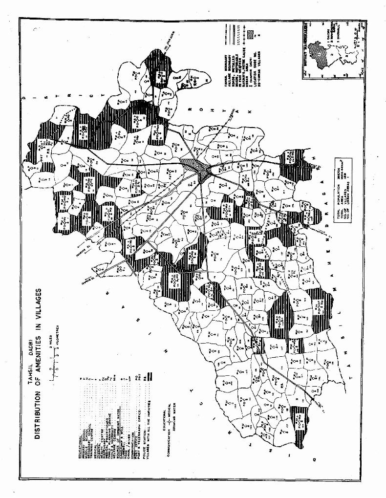
(/) w ~ ...J :: > z
(/)
a: UJ
~i= 02
L&J ~~ <J)-ct J: <u. 1-0
z o I;:) m a: le/)
C
en ...
"j ., ,I
!: ~~ .. " ~:
III
: ::J z<c
5~ ,_", .... ! ;;: o

Code Name No.
1 Shampura 2 Jarwa 3 Basri 4 Sohri 5 Badrai
6 Norangabad 7 Gadhi 8 Khudana 9 Kharkra
10 Bassai
11 Notana 12 Siana 13 Pota 14 Sehlong 15 Bhagot
16 Noswa 17 Uchat 18 Kheri 19 Talwana 20
ABawana
21 Jant 22 Bhur Jat 23 Adilpur 24 Dholi 25 Mandola
26 Nangal Mala 27 Gopalwas 28 Nanwan 29 Bir Singh was 30 Satnali
31 Patharwa 32 Bas 33 Dana
TAHSIL MAHENDRAGARH
Location Code Numbers and Names of the Villages
Code Name No.
36 Sureti Jakhar 37 Barda 38 Digrota 39 Zerpur 40 Pali
41 Palri 42 Bhagdana 43 Lawan 44 Malra 45 Aghiar
46 Pathera 47 Kaimla 48 Unhani 49 Dhanunda 50 Jharli
51 Chhitroli 52 Sihor 53 Gahra 54 Kanina (Rural) 55 Karira
56 Kotia 57 Lukhi 58 Gujarwas 59 Bharaf 60 I\.apuri
61 Kakrala 62 Mohamdpur 63 Chelawas 64 Gudha 65 Rasulpur
66 Akbarpur Nangal 67 Buchawas 68 JhagroJi
Code Name No.
71 Sigra 72 Sigri 73 Jhuk 74 Majra Kalan 75 Majra Khurd
76 Sisoth 77 Rewasa 78 Khaira 79 Khatod 80 Khurhawata
81 Devrali 82 Rathiwas 83 Khatodra 84 Paharwas 85 Neem Bhera
86 Balaicha 37 Rajawas 88 Usmapur 89 Madhogarh 90 Gadarwas
91 Dalanwas 92 Balana 93 Dhadhor 94 Sohla 95 Budin
96 Nimbi 97 Bir Jatwas 98 Janjeriawas 99 Jatwas
100 Paiga
Code Name No.
106 Chitlong 107 Khera 108 Gagarwas 109 Bachini 110 Koka
111 Bawania 112 Sunira 113 Parta! 114 Nanga! 115 Israna
116 Rambas 117 Manpura 118 Mori 119 Bhojawas 120 Jhigawan
121 Mudian 122 Surjanwas 123 Dewas 124 Bir Chit!ong 125 Jasawas
126 Bhandor Unchi 127 Bunde Bajnagar 128 Bhandor Nichi 129 Jonawas 130 Chhajiawas
131 Duloth 132 Gadania 133 Palh 134 Berawas 135 Nihalawas
101 Mahendragarh(Rural) 136 Paul 102 Cham Dhera 137 Kheroli 103 Salimabad 138 Nangal Sirohi
34 Sureti Mavdiana 35 Sureti Pilania
69 Annawas 70 Bucholi
104 Dulana 139 Bed 105 Meghanwas 140 Khatiwas
TAHSIL MAHENDRAGARH
Villages Classified by Population
Size No. of Population Area-1,040.6 Km2
Categories Villages Density-182 per Km2
Males Females Males
Less than 200 4 278 245 Population 98,916 200-499 19 3,651 3,261 Literates 40,119 500-999 53 20,499 18,886 Workers 43,521 1,000-1,999 56 39,455 35,869 Non-Workers 55,395 2,000-4,999 18 25,844 23,613 Scheduled Castes 14,820 5,000-9,999 Scheduled Tribes 10,000 and above Total 150 89,727 81,874
112
Code Name No.
141 Kothal Khurd 142 Balkhi 143 Bewal 144 Kherana 145 Gomli
146 Gomla 147 Mundia Khera 148 Kalwari 149 Dongra Jat 150 Dongra Ahir
151 Nanagwas 152 Kothal Kalan 153 Deroli Jat 154 Kuksi 155 Gulawla
156 Kherki
Females
90,056 7,850 1,850
88,206 13,899

z Q
~ :I:..J a:::> ""~ eJO ""n.. a: OLl.. ao ; LIJ ..... .... N (J\ ~- -~I/)
iii>:I: CD
"" .... 1/) LIJ C.!) C( ..J ..J
>
-'
, <>
~'\'-r D \ o-on .... r-- IITTh •
¥. \.... 'llJJI ... 1 .-' ''_.-.:" :r-'''/ ~ \ ~
\ / o
c£
,.
a:: _ u ....
z
z
.. 0 > 0 2 .. .. .. '" .. '" z '" .. ~
.. .. c ~ ~ .. z Z
~ c I I I I
g 0 0 0 0
~ I ~. § ~ 0
~ N
i lrallIlJ§aD _ __j

Total Rural Urban
Population
188,972 171,601
17,371
Number of Villages
Total 156 Villages with all Amenities 22 Be-chirag Villages 6
TAHSIL MAHENDRAGARH
EDUCATIONAL
COMMUNICATION ~ MEDICAL
DR1NKING WATER
VILLAGES HAVING
Educatio •• 1
Primary School Middle School Secondary School College *Others
Medical
Hospital Health Centre Dispensary Medical Practitioner Family Planning Centre Maternity & Child Welfare Centre
Drinking Water
Wells only Handpumps only Canals/Rivers only Tank&_only **Others
Communication
Post Office Post & Telegraph Office
* Others include I.T.ls, Craft Schools, Traj~ing Schools, etc. **Others include Boulis, Springs and a combination of one and more sources of drinking water supply.
114
Total Rural Urban
Area
1,040.6 Kml 1,029.2 Km2
11.4 Km2
Number of Villages
122 19 14
1 5 7
22 5 1
126
24
40 2

o " n
..
o
...
.(
.... C II: U ..
.... is .. c .. .. a :I •
:)
~-9-~ . 3 ~ i z: j;: i .. co
u li
I "
.. .. i Ii i
I 4-
~ .. "
()
z
o~"'11 .... "

TAHSIL NARNAUL
Location Code Numbers and Names of the Vil1ages
Code Name No.
1 Nangal Katha 2 Ghindalia 3 Mohamadpur Hamid
Khan 4 Jailab 5 Jakhni
6 Khorma 7 Baproli 8 Baskirarod Umarabad 9 Mehrampur
10 Dharso
11 Nawaznagar 12 Hazipur 13 Azamnagar 14 Mayee
15 Hudina
16 Rampura 17 Faizabad 18 Mitrapura 19 Akbarpur Ramu 20 Khampur
21 Khempura 22 Dehroli Ahir 23 Seehma 24 Khatripur 25 Dublana
26 Sagarpur 27 Atali 28 Duloth 29 Salarpur 30 Gujarwas
31 Katkai
Code Name No.
46 Jat Guwana 47 Guwani 48 Saloni
49 Nuni Kalan 50 Sarahpur
51 Kutbapur 52 Nang Tihari 53 Leharoda 54 Selarpur Mehata 55 Kirarod Afganan
56 Mandhlana 57 Abdulanagar 58 GehH 59 Khatoli Kalan or
Sultanpur 60 Dohar Khurd
61 Dohar Kalan 62 Goad 63 Balaha Kalan 64 Balaha Khurd 65 Dochana
66 Bhankhri 67 Khatoli Khurd 68 Hamidpur 69 Maksuspur 70 Raghunathpura
71 Buchakpur 72 Nasibpur 73 Nuniaval 74 Bar Gaon 75 Bar Koda
76 Surana 77 Sheonathpura
Code Name No.
91 Bajar 920aniar 93 Begpur
94 Ateli (Rural) 95 Saidpur
96 Meerpur 97 Nangal 98 Fatehpur 99 Tajpur
100 Shampura
101 Surani 102 Patikara 103 Meerpur 104 Narnaul (Rural)
105 Rasulpur
106 Lutafpur 107 Koriawas 108 Hasanpur 109 Kultajpur 110 Thana
111 Jadupur 112 Badopur 113 Rambas 114 MaroH 115 KaroH
116 Amarpur Jorasi 117 Tajpur 118 Tehla 119 Tajipur 120 Shahpur-l
121 Kodinja 122 Faizalipur 32 Mohamadpur
33 Rothal Garhi 34 Mahasar
78 Sarai Bahaduroagar 79 Chhapra Salimpur
123 Bhushan Khurd 124 Sobhapur
35 Khariwara
36 Khairani 37 Mohalra 38 Rata Kalan 39 Rata Khurd 40 Girdharpur
41 Bocharia 42 Kariya 43 Salimpur 44 Bohad 45 Tigra
80 Mirjapur
81 Bachhod 82 Bhilwara 83 Khor 84 Tobra 85 Dhanunda
86 Unindha 87 Gokalpur 88 Hasanpur 89 Chandpura 90 Sujapuf
125 Bhushan Kalan
126 Shahpur Doyam 127 Kunjpura 128 Rajpura 129 Prithipura 130 Bihali
131 Rampura 132 Navedi 133 Kheri 134 Kanti 135 Seka
-TAHSIL NARNAUL
Villages Classified by Population
Size No. of Popwation Categories Villages
Males Females
Less than 200 7 310 268 200-499 33 6,606 6,147 500-999 95 37,138 34,711 1,000-1,999 6S 45,616 41,106 2,000-4,999 15 19,528 17,719 5,000-9,999 10,000 and above Total 215 109,198 99,951
116
Code Name No.
136 Mandhana 137 Khanpur 138 Kanwi
139 Dhani Bhathotha 140 Nangal Sialu
141 Karota 142 Mukandpura 143 Basirpur 144 Talot 145 Chhilro
146 Dhanota 147 Dhancholi 148 Nizampur 149 Napla
150 Pawera
151 Ghataser 152 Bighopur 153 Dholera 154 Chhapra Bibipur 155 Khawajpur
156 Barundla 157 Kamania 158 Khatoli Ahir 159 Khatoli Jat 160 Daungli
161 Totaheri 162 Bhojawas 163 Sheoramnathpura 164 Mulodi 165 Muraripur
166 Akoli 167 Ikbalpur Nangli 168 Gandwa 169 Mohabatpur
Bhungarkha 170 Simli Ismailpur
171 Bir Simli 1 72 Akbarpur Sarohi 173 Sarohi Bhali 174 Nangal Pipa 175 Antri
176 Biharipur 177 Mausampur 178 Meghot Binza 179 Bakkrija 180 Sureli
Area-954.5 KmZ Density-255 per Km:!
Males
Population 127,237 Literates 53,886 Workers 56,769 Non-Workers 70,468 Scheduled Castes 17,474 Scheduled Tribes
Code Name No.
181 Isalampur 182 Ganwari Jat 183 Niazalipur
184 Nahareri 185 Bamanwas Nau
186 Azmabadi Mokota 187 Ruppur Sarai 188 Panchnota 189 Mosnota 190 Nanga) Durgo
191 Megho Thala 192 Lajota 193 Jainpur 194 Nangal Kalia
195 Chak MaIikpur
196 Kalva 197 Bamanwas Kheta 198 Udaipur Kataria 199 Momanpur 200 Nangal Chaudhry
201 Shahbazpur 202 Saidalipur 203 Gangu Tana 204 Bayal 205 Golwa
206 Dokhera 207 Bhadanti 208 Dostpur 209 Dantal 210 Naul Ayja
211 Nangal Nunia 212 Nain 213 Amarpura 214 Banihari
215 Thanwas
216 Nangal Soda 217 Asrawas 218 Niamatpur 219 Maurund 220 Budhwal
221 Raimalikpur 222 Gothari
Females
115,724 11,464 1,441
114,283 16,798

TAHSIL NARNAUL
VILLAGES BY SIZE OF POPULATION 1971
TAHSIL .OtlIlD.IY VILL4GE .OUMD4~Y LOCATION COOl NO. UflteAN AAEAS I ATEI.I lI: NAANAUL
MILI!5 I
"AM!S OF 'VILLACES WITH POPULATION 2,..000 .. AIOVI I[-CHIRAG VILl.AGE:S
R
A
J
A
5
7
H
A
o a
o 2 'l kiLOMETRES
123
x
TO"'A,- POPULATION 242,g61 TOTAL ARE". 954·46 KftII~ NO. OF VIl.LAGES ' 222 NO. ~, UR8AN AREAS. c
...
rl !
PERSO~S
__ - ~,ooo
__ - 2,000 - - - 1000 "_-"--:'~gg
PERSONS
• 5,000 & ABOVE
D.D1 apoe - -4,999
§ ~fJCQ - ',9'99
am 500-999
CIIJ ;ZOO-499
D LESS THAN 200

Total Rural Urban
Population
242,961 209,149
33,812
Number of Villages
Total 222 Villages with all Amenities 23 Be-chirag Villages 7
TAHSIL NARNAUL
EDUCAT\ONAL
COMMUNICATION -<?- MEDICAL
DR1NKING WATER
VILLAGES HAVING
EdMcational
Primary School Middle School Secondary School College "Others
Medical
Hospital Health Centre Dispensary Medical Practitioner Family Planning Centre Maternity & Child Welfare Centre
Drinking Water
Wells only Handpumps only Canals/Rivers only Tanks.only "·Others
Communication
Post Office Post & Telegraph Office
• Others include I.T.Is, Craft Schools, Training Schools, etc. ··Others include Boulis, Springs and a combination of one and more sources of drinking water supply.
I 18
Total Rural Urban
Area
954.5 Kmll 947.4 l(m 1
7.1 Km 2
Number ef Villages
162 24 19
12
6 9
13 35 9 4
178
- 36
42 1

J
$
T
..
TAHSIL NARNAUL
DISTRIBUTION OF AMENITIES IN VILLAGES
TAHSil BOUNDARV VillAGE BOUNDARY RO .. OS. METALLtD ~-O"DS, MOTORA'LE IN fAr,. WEATHEA ftAllWAYS.METR' GAUGE: URI"" ~~E'" I ATELI n NARNAUL
LOCATION CODE NO. I(-CHIRAG V~t.L"'G[S
...... ';~'-
..
:::~~:t ~~~~LATIO~ ::!~::IK",a NO· OF VILLAGES 22,i NO· OF URBANI A.REAs .2
.J'
..
E.DUCATIONAL
P"IMARY SCHOOL MIDDLE SCHOOL sECO .... O"AY SCHOOL TAil.INING CENiA.E
~ HOSPITAL "'£"LTH CENTRI=: DISPENSARY MEDICAL PRA('TI1"IONEA FA ... ILY PLANNING ~E NTRE. CHILD & ~Al'ERNITV .,ELF .. RE CENTRE S.OURCE OIF DRINKING WATER
HANOPUMP 'WELL TuBE wELL TANK CANALI RIVE"F\ COMMUNICATION
PO~T OfFICE POST. TELEGRAP,",
POLICE STATION
OFFICE
.~ VluA.GES WITH "L.L THE AMENIT"IES-........ . )~ ('O'-4M UNICAET~~~ ~~~~~ICAL
j DRIf'tKI~G 'II'" TEA
\
p .. s I + H
.. He:
" ". Fc
Mcw
PO PIT .. I. --

DISTRICT HISAR
BASIC CENSUS STATISTICS
District/Tahsil District Hisar
1. Tahsil Dabwali 2. Tahsil Sirsa 3. Tahsil Fatehabad 4. Tahsil Hisar 5. Tahsil Hansi 6. Tahsil Bhiwani 7. Tahsil loharu
Area (in kml)
Total *13,982.0
1,446.4 2,824.7 2,384.6 2,648.5 2,089.3 1,977 .4
581.0
Rural 13,900.6
1,440.8 2,819.5 2,374.2 2,611.7 2,080.2 1,965.7
578.4
Urban 81.4 5.6 5.2
10.4 36.8 9.1
11.7 2.6
Population and Industrial Categories
Popula- Work- I II III IV V tion ers
(a) (b) Total M 1,143,185 571,970 317,230 94,901 11,513 224 13,099 30,394
F 989,763 29,147 14,637 7,211 908 4 906 1,259 Rural M 958,164 485,216 310,928 91,645 10,('(18 223 11.496 10,736
F 834,956 25,634 14,452 6,981 886 4 764 933 Urban M 185,021 86,754 6,302 3,256 905 1 1,603 19,658
F 154,807 3,513 185 230 22 142 326
Growth of Population 1901-71
Census Population Growth Religion Year Persons Males Females Absolute Percentage 1901 783,317 418,724 364,593 Buddhist 1911 809,714 440,753 368,961 + 26,397 + 3.37 Christian 1921 822,724 438,406 384,318 + 13,010 + 1.61 Hindu 1931 904,754 487,785 416,969 + 82,030 + 9.97 Jain 1941 1,012,643 539,104 473,539 +107,889 +11.92 Muslim 1951 1,049,448 562,873 486,575 + 36,805 + 3.63 Sikh 1961 1,544,910 830,011 714,899 + 495,462 +47.21 Others 1971 2,132,948 1,143,185 989,763 +588,038 + 38.06
Population of Urban Centres
Name of Status Growth Population Workers Town Rate ------ -------
1961·71 Males Females Males Females
I Mandi Dabwali (M.C.) +35.67 11,247 9,674 5,502 205 II Kalanwali (M.C.) +60.11 3,454 3,077 1,675 49
III Sirsa (M.C.) +46.29 26,522 22,286 12,540 469 IV Fatehabad (M.C.) +81.61 12,077 10,553 5,717 192 V JaRhalmandi (M.C.) +24.89 2,059 1,860 971 57
VI Tohana (M.e.) +35.46 8,908 7,881 4,114 109 VII Uklanamandi (M.e.) +66.69 . 3,204 2,777 1,410 30
VIII Hisar (M.C.) +48.51 50,303 39,134 23,864 1,260 IX Hansi (M.C.) +21.94 21,645 19,463 9,554 419
X Bhiwani (~.C.) +25.59 39,957 33,129 18,560 584 XI Tosham (N.A.C.) 2,711 2,328 1,382 47
XII Loharu (M.C.) +24.95 2,934 2,645 1,465 92
Other Data
VI VII VIII IX X Non-
Workers 7,784 39,941 10,354 46,530 571,215
473 289 38 3,422 960,616 4,518 14,168 4,279 26,615 472,948
385 76 10 1,143 809,322 3,266 25,773 6,075 19,915 98,267
88 213 28 2,279 151,294
Population by Religion
Population Persons Males Females
482 269 213 1,732 840 892
1,893,125 1,015,090 878,035 6,239 3,153 3,086
12,211 6,576 5,635 218,854 117,110 101,744
305 147 158
Sex and Age Structure Age Groups Persons Males Females
0-14 1,009)963 531,556 478,407 15_j19 207,011 113,782 93,229 2o--N 167,250 89,433 77,817 25-\!9 134,796 70,625 64,171 30-~9 214,566 111,568 102,998 40-49 165,261 88,883 76,378 50--59 116,051 67,444 48,607 60+ 117,831 69,769 48,062 Age Not Stated 219 125 94
Population
Males Females Scheduled Castes Scheduled Tribes
248,371 215,294
Sex Ratio Total Rural
Literacy 866 871
Literates --------Males Females 35,893 3,356
Urban 837
*Total area figures for the District represent "Geographical Area" figures (provisional) supplied by the Surveyor General. Figures for urban areas are those supplied by the local bodies. Area figures for rural areas are derived by substracting the urban area from the total area of the district. The total of the area figures of the tahsils will not tally with the district figures because the former represent 'land use area' and are derived from the figures supplied by the Director of Land Records.
Males Females Total 374,479 115,244 Rural 272,433 59,579 Urban 102,046 55,665
120

.. ~ .
a: i ~ !!
en !! ~ i
D
:r:: !!
... • 0 a: ... .. en - 'I .. 0
D
.,. ... ~ '. 0,
... ~
~
.. I I I
I I
iii" i I
i :.0 . . . ~ I· i i I i

TAHSIL DABWALI
Location Code Numbers and Names of the Villages
Code Name Code Name Code Name Code Name Code Name No. No. No. No. No.
1 Panniwala Moreka 21 Nai Dabwali 41 Kingran 61 Rajpura 81 Ramgarh 2 JogewaJa 22 Shergarh 42 Rampura Bishnoian 62 Nahiyanwali 82 Gindran 3 Desu Jodha 23 Sakta Khera 43 Jandwala Jatan 63 Salam Khera 83 Khaja Khera 4 Phullu 24 Lohgarh 44 Malakpura 64 Odhan 84 Kussar 5 Chitha 25 JoUanwali 45 Matho Dadu 65 Ramnagar 85 Ghoranwali
6 Tigri 26 Abubsher 46 Jhuti Khera 66 Roharanwali 86 Chakan 7 Naurang 27 Gobindgarh 47 Goriawala 67 Panniwali 87 Bhoona 8 Hassu 28 Lakhuana 48 Modi 68 Ghokanwali 88 Mehna Khera 9 Desu Malkana 29 Maujgarh 49 Lambi 69 Banwala 89 Kharian
10 Asir 30 Masitan 50 Girdar Khera 70 Rasalia Khera 90 Khai Shergarh
11 Makha 31 Dewan Khera 51 Sukheranwala 71 Bijuwala 91 Bhagsar 12 Khokhar 32 Khuyan Malkhana 52 Teja Khera 72 Ahamadpur Darewala 92 Khuian Napalpur 13 Pana 33 Mithri 53 Chutala 73 Godeka 93 Pir Khera 14 Panniwali Ruldu 34 Tipi 54 Asakhera 74 Kaluna 94 Moranwali 15 Haibuwana 35 Pipli 55 Bharu Khera 75 Bachihar
16 Nillanwali 36 Jagmalwali 56 Jandwala Bishnoian 76 Bani 17 Mangiana 37 Kalanwali (Rural) 57 Ganga 77 Nathohar 18 Sanwat Khera 38 Chankerian 58 Moonanwali 78 Mattuwala 19 Dabwali 39 Jalanlana 59 Chak Jalu 79 Marner Khera 20 Alika 40 Chormar Khera 60 Raua Khera 80 Faridpur
TAHSIL DABWALI
Villages Classified by PopUlation
Size No. of Population Area-l,446.4 Km2 Categories Villages Density-1l3 per Km2
Males Females Males Females
Less than 200 7 272 211 Population 87,682 75,916 200-499 4 801 700 Literates 26,390 8,485 500-999 34 14,107 12,283 Workers 46,896 1,389 1,000---1,999 28 22,162 19,083 Non-Workers 40,786 74,527 2,000---4,999 18 29,144 25,142 Scheduled Castes M,564 21,303 5,000---9,999 2 6,495 5,746 Scheduled Tribes 10,000 and above Total 93 72,981 63,165
122

z o ~ _, ( o Q.
.)

Total Rural Urban
Population
163,598 136,146
27,452
Number of Villages
Total 94 Villages with all Amenities 28 Be-chirag Villages 1
TAHSIL DABWALI
EDUCATIONAL
COMMUNICATION -9- MEDICAl.
VILLAGES HAVING
Educational
Primary School Middle School Secondary School College *Others
Medical
Hospital Health Centre Dispensary Medical Practitioner Family Planning Centre Maternity & Child Welfare Centre
Drinking Water
Wells only Handpumps only Canals/Rivers only Tanks only **Others
Communication
Post Office Post & Telegraph Office
DR1NKING WATER
.. Others include I.T.Is, Craft Schools, Training Schools, etc. **Others include Boulis, Springs and a combination of one and more sources of drinking water supply.
124
Total Rural Urban
Area
1,446.4 Km2 1,440.8 Km2
5.6 Km2
[wber of Villages
69 14 7
1
1 3 5
44 2 3
7
5 9
70
30 1

ft]r~
, - tft 1. _
0jf-.. [_
- i ~
':; ~ ii
I
s I

TAHSIL SlRSA
Location Code l\"umbers and NaPles of the Villages
Code Name No.
1 Takhatmal 2 Kewal 3 Dharampura 4 Rampura 5 Sighpura 6 Pakka 7 Dadu 8 Tilokiwala 9 Taruana
10 Gidrana 11 Sukh Chain 12 Khatranwan 13 Dogranwali 14 Kamal 15 Kuranganwali 16 Phaggu 17 Surtia 18 Desu Khurd 19 Rohan 20 Rori 21 iiattar 22 Lahengewala 23 Ranga 24 Malhari 25 Bhiwan 26 Panjmala 27 Theraj 28 Jhurarrohi 29 Bhadra
Code Name No.
51 Sahuwala 52 Karamgarh 53 Panjuana 54 Khareka 55 Saharan 56 Neza Dala Kburd 57 Malewala 58 Budha Bhana 59 Farwain 60 Burj Karamgarh 61 Darbi 62 Bharokan 63 Baruwali I 64 Saugar Shrishtewala 65 Bahudin 66 Narel Khera 67 Bagguwali 68 Patli Dabar 69 Mochiwali 70 Jodhka 71 Suchan 72 Kotali 73 Shakar Khera 74 Rasulpur 75 Kasan Khera 76 Handi Khera 77 Baidwala 78 Sikanderpur
Code Name No.
101 Mangalia 102 Nanuana 103 Dhottar 104 Jhuramali 105 Kelnia 106 Shamshabad 107 Sirsa (Rural) 108 Khaja Khera 109 Kanganpur 110 Bajeka 111 Morewala 112 Phoolkan 113 Kanwarpura 114 Kusanbhi 115 Cbak Suchan 116 Kuker Thana 117 Ding 118 Gadli 119 Sherpura 120 Tajia Khera 121 Sahuwala 122 Ali Mohmad 123 Kh:mdanwali 124 Cbadhiwal 125 Nazia Khera 126 Shahpur Be~ u 127 Rangri Khera 128 Shahidawali 129 Natar
30 Biruwala Gudha 79 Neza Dala Kalan 80 Khairpur 130 Ramnagar
31 Daulatpur Khera 32 Subewala Khera 33 Lakarwali 34 Kheowali 35 Anandgarh 36 Raghuana
81 Chattargarh 82 Jodhpura 83 Mirpur 84 Ahamadpur 85 Ban Sudhar 86 Chamal 87 Shekhupuria
131 Alipur Titu Khera 132 Cbak Qasaban 133 Mangala 134 Chak Arian 135 Chak Jiwa 136 Dbannor 137 Sultanpuria 37 Gudha Kalan
38 Dhaban 39 Bap
88 Fatehapur Niamat 89 Jodhpuria
138 Abohli 139 OUu 140 Rania 40 Jhirri
41 Alika 42 Nagoki 43 Panihari 44 MasabW'ala 45 Kirrar Kat 46 Chakbani
47 Sawaipur 48 Burj Bhangu 49 Bhangu 50 Chhattrian
90 Darewala 91 Bukhara Khera 92 Sadewala 93 Keharwala 94 Sainpal 95 Baia 96 Dhudianwali
97 Naiwala 98 Balasar 99 Mohamadpuria
100 Fatehpuria
141 Nakora 142 Bharolanwali 143 Haripur 144 Kariwali 145 Thobria 146 Talwara Khurd
147 Dhani Jafan 148 Arnritsar 149 Hami Khurd 150 Mirzapur
TAHSIL SIRSA
Villages Classified by Population
Size No. of Population Categories Villages
Males Females
Less than 200 14 638 SIS 200-499 21 4,381 3,839 500-999 59 24,038 20.937 1,000-1,999 92 69,903 61,274 2,000-4,999 34 52,877 45,291 5,000-9,999 3 13,465 11,576 10,000 and above 1 6,656 5.808 Total 224 171,958 149,240
126
Code Name No.
151 Jiwannagar 152 Budhi Mari 153 Mamera 154 Moju Khera 155 Pati Kirpal 156 Shekhu Khera 157 Nigrana 158 Himayon Khera 159 Kuta Badh 160 Ferozabad 161 Gidranwali 162 Abutgarh 163 Alanoor 164 Bhamboor 165 Mohamadpur/Salarpur 166 Dhingtania 167 Arnianwali 168 Randhawa 169 Darba Kalan 170 Naharanwali 171 Kariwali 172 Narain Khera 173 Nahrana 174 Rampura Bishnoian 175 Ganjrupana 176 Chaharwala 177 Jogewala 178 Rampur Bagrian 179 Kagdana 180 Shakar Mandori 181 Shahpuria 182 Tarkanwali 183 Makho Shoran 184 Nathusari Kalan 185 Nathusari Khurd 186 Gigorani 187 Jasania 188 Kumhar1a 189 Kheri 190 Rajpura Sani 191 Gusaiana 192 Rampura Dhillonwala 193 Hanjira . 194 Ludesar 195 Manak Dewan 196 Rupana alias Darha
Kund 197 Nirban 198 Bakrianwali 199 Chuburja 200 Modia Khera
Area-2,824.7 Km2 Density-131 per Km2
Males
Population 198,480 Literates 63,902 Workers 104.579 Non-Workers 93,901 Scheduled Castes 45,322 Scheduled Tribes
Code Name No.
201 Gudia Khera 202 Raipur 203 Rupawas 204 Jorian 205 Kutiana 206 Barasari 207 Dhookra 208 Jamal 209 Baruwali II 210 Lawalwali 211 Madhosinghana 212 Maleka 213 Mojdin 214 Keshopura 215 Kotli 216 Umedpura 217 Maina Khera 218 Chilkni Dhab 219 Bhurtwala 220 Moosli 221 Pohrka 222 Mithi Surera 223 Khari Surera 224 Karam Sana 225 Mithanpur 226 Ellenabad 227 Nimla 228 Dholpalia 229 Berwala Khurd
Females
171,526 22,103
3,076 168,450 38,659
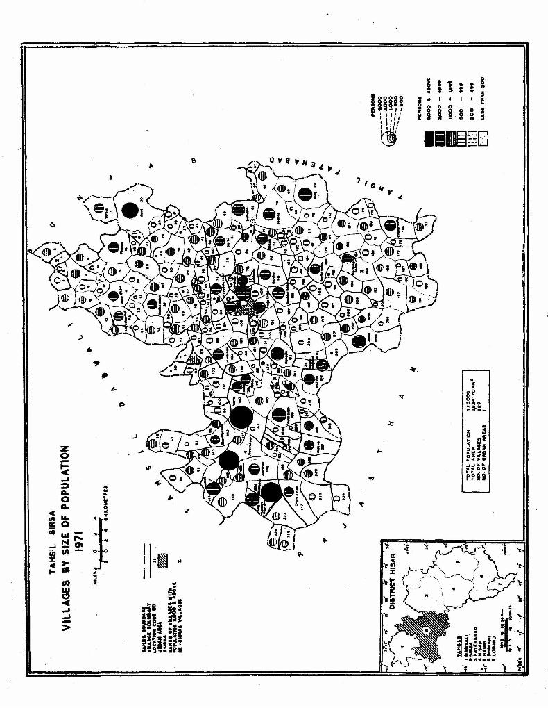
I i 1 0
• : 0 .. to .. ~ I
Inn~ •• I I I I ~.
§ 8 i 8 0 0 J r ' i I'I i 3 Ii 0 0 ~ .. .. I, ,I' I I,ll
lim~~G ~
)
, .)
• .,. ., •
C>
..)
Z 0 -~ _, ~ .. .. Q.
"' 0 0-
J Q. 0 :! cC
~ '" rn
~I a:: 0 (ii 1&1-
N .... ...J _0\ rn en-% ~ cC
t- dt g
I j ;~ ..
i en J 1&1 c,:) <C _, _, ->

Total Rural Urban
Population
370,006 321,198 48,808
Number of ViJlages
Total 229 Villages with all Amenities 46 Be-chirag Villages 5
TAHSIL SIRSA
EDUCATIONAL
COMMUNICATION -?- MEDICAL
DR1NKING WATER
VILLAGES HAVING
Educational
Primary School Middle School Secondary School College "Others
Medical
Hospital Health Centre Dispensary Medical Practitioner Family Planning Centre Maternity & Child Welfare Centre
Drinking Water
Wells only ''-. Handpumps only Canals/Rivers only Tanks only *"Others
Communication
Post Office Post & Telegraph Office
.. Others include I.T.ls, Craft Schools, Training Schools, etc. *·Others include Boulis, Springs and a combination of one and more sources of drinking water supply.
128
Total Rural Urban
Area
2,824.7 Km2
2,819.5 Km2 5.2 Km2
Number of Villages
183 17 10
5
8 10 11 71
7 6'
11 30
6 173
64 7

o ..... ,~
en IJJ t!) « _. _. -> Z
«en (/)1&.1 0:_f-VlZ
l&J
...J~ < (f') xII.. ~O
Z o i= :;) m -ex: fcn a
· .,
" II
B
II " I !i ~; ... II II
CI)

Code Name No.
1 Ladhuwas 2 Sardarewala
3 Nangal 4 Luthera 5 Bahmanwala
6 Rojhanwali 7 Bhudarwas 8 Nikuwana 9 Mehmra
10 Badalgarh
11 Babanpur 12 Lambha 13 Ghaswa 14 Chunmoon 15 Teliwara
TAHSIL FATEHABAD
Location Code Numbers and Names of the Villages
Code Name No.
41 Shahnal 42 Sukhmanpur
43 Munshiwaii 44 Nathwan 4S Kalandargarh
46 Kunal 47 Bury 48 Chandu Khurd 49 Chandu Kalan 50 Mohammadpur Sotad
51 Maganwali 52 Raipur 53 Palsar 54 Ahrwan 5S Alipur Bharota
Code Name No.
81 Ghotru 82 Digoi
83 Dhaulu 84 Tibbi 85 Bhunra
86 Kani Kheri 87 Kheri Rohan 88 Lahriyan 89 Dulat 90 Bawan
91 Bhatoo 92 Sanchla 93 Bhosti 94 Sanyana 95 Sohu
Code Name No.
12! Jhalnian 122 Jandli Kalan
123 Chanclrawal 124 Jandli Khurd 125 Mochiwali
126 Chaubara 127 Dehman 128 NehIa 129 Pabra 130 Kanch
131 Kirmara 132 Samani 133 Gorakhpur 134 Kajalheri 135 Khjuri Jati
Code Name No.
161 Bhana 162 Bhoodya Khera or
Bisbanoyan 163 Chabbarwal 164 Shekhupur Darauli 165 Suli Khera
166 Khabra Kalan 167 Khabra Khurd 168 Dhabi Kalan 169 Dhabi Khurd 170 Jandwala
171 Dhyar 172 Ram Sara 173 Gadli 174 Chuli Khurd 175 Chuli Kalan
16 Kawlgarh 17 Bhawani Khera 18 Bara
56 Phull 57 Haroli
96 Chamar Khera 97 Khasa Phathanan 98 Bhuna
136 Mohammadpur Rohi 137 Dhangar
176 Chuli Bagarian 177 Sadalpur
19 Kamana 20 Rattangarh
21 Mirana 22 Balyala 23 Bora 24 Kherpur 25 Kalotha
26 Khai 27 Mohammadki 28 Pilchian 29 Malwala 30 Marh
31 Alika 32 Hukmanwali 33 Alawalwas 34 Dadupur 35 Jalopur
36 Lali 37 Ratia 38 Rata Khera 39 Bharpoor. 40 Hamzapur
58 Nagpur 59 Saharan 60 Ganda
61 Bira Badi 62 Hanspur 63 Barolanwali 64 Khundan 65 Bahbalpur
66 Theri 67 Bhattu Khurd 68 Manakpur 69 Nakta 70 Chankothi
71 Mallhar 72 Ayalki 73 Dhir 74 Boswal 75 Kata Kheri
76 Razaabad 77 Shekhupur So tar 78 Pandri 79 Kheraiwala 80 Hasniga
99 Nadhauri 100 Bhutan Khurd
101 Birdhana 102 Fatehabad (Rural) 103 Khanpur 104 Khan Mohammad 105 Hijrawan Kalan
106 Hijrawan Khurd 107 Karnoli 108 Gilan Khera 109 Bodiwali 11 0 Sarwarpur
111 Kukarawali 112 Daryapur 113 Shahidanwali 114 Khairati Khera 115 Manawali
116 Bhodi Khera 117 Basti Bhiwan lI8 Basin 119 Bisla 120 Majra
TAHSIL FATEHABAD
138 Bighar 139 Bangram 140 Sirdhan
141 Dihing Sara 142 Mehuwala 143 Ban Mandori 144 Pili Mandori 145 Thiyan
146 Bhattu Kalan 147 Kirdhan 148 Banawali 149 Dhand 150 Dharni
151 Badopal 152 Kumharia 153 Sabarwas 154 Kuleri 155 Mirpur
156 Agroha 157 Bhoda Hoshnak 158 Khasa Mahanan 159 Khara Kheri 160 Chindhur
Villages Classified by Population Area-2,384.6 Km2
Size No. of Population Density-144 per Km2
Categories Villages Males Females Males
Less than 200 6 383 391 Population 184,325 200-499 29 5,539 4,771 Literates 50,991 500-999 32 13,114 11,259 Workers 95,908 1,000-1,999 58 45,570 39,707 Non-Workers 88,417 2,000-4,999 41 59,052 51,300 Scheduled Castes 40,291 5,000-9,999 12 40,708 35,553 Scheduled Tribes 10,000 and above 1 7,882 6,523 Total 179 172,248 149,504
130
178 Kherampur 179 Saragpur 180 Bhootan Kalan
Females
160,057 ]4,314
5,373 154,684 35,333

J
.....-
~----------:.::.-:_:-=-"=
• I0Il ~ [ill lTII1 CJ
--.100
PI:"'IONS
~ 1A8C¥1[
:r,poO-4!. ...
1.000-_
eoo - ...
zOO - ... '-US Ttl'" .aGO
'tOT .... ~~L .. TIOIII
TOT"" ARE" Oil' Yw.LAOES
-:;~.K.,.2 .00
1110· 0'- UR....... .,,'-AS I
VILLAGES TAHSIL FATEHABAD
BY ~IZE OF POPULATION 1971
o I ...... IS
JCILDM£TlttES t· I , i
\
"' .... ....,.,. 'III. LAC' &0UIKtAIt' LOCATIOII COOl _0. "'.AJIIA
I "ATI[M"UO
..... or n.LMO .TN :=:C:s.AIO'V[

Total Rural Urban
Population
344,382 321,752
22,630
Number of Villages
Total 180 Villages with all Amenities 46 Be-chirag Villages 1
TAHSIL FATEHABAD
EDUCATIONAL
COMMUNICATION -9- MEDICAL
DR1NKING WATER
VILLAGES HAVING
Educational
Primary School Middle School Secondary School College ·Others
Medical
Hospital Health Centre Dispensary Medical Practitioner Family Planning Centre Maternity & Child Welfare Centre
Drinking Water
Wells only Handpumps only Canals/Rivers only Tanks only ·"'Others
Communication
Post Office Post & Telegraph Office
• Others include I.T.ls, Craft Schools, Training Schools, etc. **Others include Boulis, Springs and a combination of one and more sources of drinking water supply.
132
Total Rural Urban
Area
2,384.6 Km2 2,374.2 Km2
10.4 Km2
nber of Villages
118 32 16
2
\' s 9
17 61
7 4
9 22
146
69 1

'0
I'DlIC.,tO""'CC~"'.OM + ... fOtlC ....
.cwu ..... !M9 .. Talll
. -Or ., .. . ·M, .<>
.... ,tIIp
.' ··c .. ~.
: : . ~ : = : : .;: .. ..... , .poui:t. ",..1'te.· .-.,.. ....... 1: ...... m ........ ,til: .... r...-nt.
TAHSIL FATEHA8AD
DISTR~BUT'ON Of AMENITIES IN VlLLAGES
ToT_ 1"O~ ... Tto'" 3~elI
TOT"'- ",JII~'" ~.IC"" NO 01" VoI4.lU." '.0 NO. 0" ~AI\I .... e:.~ •
----_.$~ ... "..,\;111 IIDIIQ$, 1fI{.roeaILI ,. , ..... 1111" .... ........ '" Ml.n~ t.1W4l ".,,... ....... 1,,,,~"'[1
L.GCA'.D" <::oac: ..a. y..c-_ ... lIIU .. ".

TAHSIL RlSAR
'Location Code Numbers and Names of the Villages
Code Name No.
1 Sidhani 2 Marthala 3 Sadhanwas 4 Talwara 5 Qasimpur
Code No.
Name
46 Rasulpur 47 Manghera 48 Kullan 49 Pohkri 50 Akkanwali
Code No.
Name
91 Daulatpur 92 Isherheri 93 Bhini Badshahpur 94 Khedar 95 Barwala
Code No.
Name
136 Abrer 137 BagJa 138 Talanwali 139 Ghursal 140 Chaudhriwali
6 lakhal (Rural) 7 Narel
51 Jamalpur Shekhan 52 Khanora
96 Kharkhara 97 Kumba Khera 98 Madloda
141 Kutia Kheri 142 Bandaheri 143 Burak 8 Talwari
9 Moond Bhoghanwali 10 Bhoor Thali
11 Chaodpura 12 Mondhallian 13 Moosa KheTa 14 Rupanwali 15 Shakilerpura
16 Meond Begumwali 17 NathuwaJ
18 Chuharpur 19 Udepur 20 Mamupur
21 Girnu 22 Chillewal 23 Hindalwala 24 Mayemadh 25 Karandi
26 Ratta Theh 27 Nanehri 28 Dharsul Khurd 29 Dharsul Kalan 30 Kana Khera
31 Lalluwal 32 Haiderwala 33 Buddanpur 34 Rainwala 35 Kudni
36 Himatpura 37 Puru Majra 38 Sllmbalwala 39 Tohana (Rural) 40 Darnkora
41 GuHerwala 42 Dher 43 Diwana 44 SaJempuri 45 Zabtawala
53 Ballianwala 54 Kamalwala 55 Kanhari
56 Dangra 57 Maduwala 58 Ratta Khera 59 Amani 60 Bhodia Khera
61 Chander Khurd 62 Chander Kalan
63 Bhodi 64 lndachhoi 65 Tharva
66 Fatehpuri 67 Laloda 68 Nangla 69 Badhai Khera 70 Loha Kheta
71 Malaheri 72 Sman 73 Nangli 74 BhimawaIa 75 ehhan
76 Gajuwala 77 Pirthla 78 Tharvi 79 Parta 80 Hansawala
81 Uklana (Rural) 82 Bhairi Akberpur 83 Budha Khera 84 Parbhuwala 85 Kaller Bhaini
86 Latani 87 Hassangarh 88 Bobua 89 Gaibipur 90 Nawagaon
99 Surera 100 Panghal
101 Sarsod 102 Bichpari 103 BaIak 104 Kirori 105 Sandol
106 Nangthala 107 Landhari Sukhlam
Bran 108 Risllu Khera 109 Fransi
110 Kalirawan
111 Kohli 112 Adampur 113 Kharabarwala 114 Daroli 115 Moda Khera
144 Dobhi 145 Kharya
146 Kirtan 147 Neoli Kalan 148 Neoli Khurd 149 Talwandi Rana 150 Juglan
151 Bahbalpllf 152 Badon Patti 1
153 Badon Patti II 154 Dhingtana 155 Bugana
156 Dhansu 157 Hisar (Rural) 158 Luda:;. 159 Shahpur 160 Matter Shem
116 Mohabatpur 161 Nathwana 117 SeesVval 162 Hindwan 118 Ladui 163 Rawalwas Khurd 119 Mahal Sarai Moth Sarai 164 Seeswala 120 Asranwan 165 Sundawala
121 Jagan 122 Cheekanwas 123 Thaska 124 Sharnsukh 125 Kirara
126 Jeora 127 Kheri Barki 128 Bir Hisar 129 Durjanpur 130 Kajla
131 Inchna Kharkhari 132· Mallapur 133 lakhod Khera 134 Meengni Khera 135 Salcrngarh
TAHSiL HISAR
166 Bhiwani RoheIan 167 Balsmand .' 168 Sarsana 169 Rawalwas Kalan 170 Dheeranwas
171 Patan 172 Tokas 173 Kurri 174 Gangwa ] 75 Satrod Khurd
] 76 Mirzapur 177 Nayana 178 Kharar 179 Alipur 180 Mayyer
VilIagcs Classificd by Population
Size No. of Categories Villages
Less than 200 8 200-499 21 500-999 40 1,000-1,999 77 2,000-4,999 59 5,000-9,999 6 10,000 and above 1 Total 212
Poplliation
Males Females
379 272 3,942 3,512
15,633 13,817 61,760 54.977 94,223 80;105 20,511 16,390
8,940 7,977 205,388 177.650
134
Area-2,648 . 5 Km 2 Density-I 88 per Km2
Males
Population 269,862 Literates 95,827 Workers 134,949 Non-Workers 134,913 Scheduled Castes 59,289 Scheduled Tribes
Code Name No.
]81 Raipur ] 82 Satrod Khas 183 Dabra 184 Kaimri 185 Dewe
]86 Muklan 187 Bhesian 188 Pinhar Chak 189 Gorchhi 190 Gawar
191 Chaudhriwas 192 Chiraud 193 Kaluwas 194 Mangali Jhara 195 -Mangali Aklan
196 Mangali 197 Meerka
198 Satrod Kalan 199 Bhagana 200 Ladwa
201 Daima 202 Guzar 203 Bhoj Raj 204 Mangal Mohabat 205 MangaliSurtia
206 Rawat Khera 207 Talwandi Badshahpur 208 Ta[wandi Rukka 209 Chandnaud 210 Daha
211 Harita 212 Badon Ranghran 213 Badon Brahmnan 214 Bure 215 Bharri
216 Dobeta 217 PayaJ 218 Saharwa
FemaJes
229,302 33,058
7,877 221,425
51,403

PER~ON~ - s.ooo • "801ft
DIll 2POO - 41>99
~ ' ,000 - .,..... [ill "00 ...... ITill , 200 -0 . \..E'S$ 1' ..... 200
TO,." L POPUo.."TIDH 499,164 TOT"L _A ",&47 k .. 2
lItO. Of' VIt..LAGES 21.
NO Of' URBAN M£AS 4
I
'\
If S I
TAHSIL HISAR
VILLAGES BY SIZE OF POPULATION
\._, o?!6 ( .
' '_; '\
BH1W"~
1971 MILES Z 0 2 4 ~_~.--J
r---r-r---r----r--"'I 2 0 4 6 8 KILOMETRES
TAHSIL eoUNDARY
VILLAGE t!IO\JttOARy LOCAT JON CODE NO V~$AH AREAS 1 .... 111."""-..,.. .. 01 .. TOM_
.UM.'I. " ...... " .. D I • ",sa" NAM£S OF VIt.LAG£S WITH POPULATtoM ;2'000 a AfKNE BE~~HtRAG VILLAtiE$
Zl
... .:i l S ~ I'S'
OIStRIC;T HISAR

Total Rural Urban
Population
499,164 383,038 116,126
Number of Villages
Total 218 Villages with all Amenities 4S Bexhirag Villages 6
TAHSIL HlSAR
EDUCATIONAL
COMMUNICATION ~ M"'ICAL
DllNKING WATER
VILJ.,AGES HAVING
Educational
Primlty School Middle School Secondary School College ·Others
Medical
Hospital Health Centre Dispensary Medical Practitioner Family Planning Centre Maternity & Child Welfare Centre
Drinking Water
Wells only Handpumps only Canals/Rivers only Tanks only ··Others
Communication
Post Office Post & Telegraph Office
Total Rural Urban
Area 2,648.5 Kml 2,611.7 Kml
36.8 Kml
Number of Villages
149 39 24
6
11 9
19 61 12 11
25 24
2 159
75 6
• Others include I.T.Is, Craft Schools, Training Schools, etc . •• Others include Boulis, Springs and a combination of one and more sources of drinking water supply.
136

TAHSIL S?UND\RY VILLAGE BOUNDARY ROADS, METALLED ROADS, MOTORA BLE IN FAIR WEATHER RAILWAYS, BROAD GAUGE RAILWAYS. METRE GAUGE ., •••• ,,_ URBAN AREAS IJAKHALW>NOI Il TQWoNA II UKL .... ..,. .. ANOI Dr HISAR
LOCATION CODE NO BE"CHIRAG VILLAGES
',J X
£OUC .. TION.AL
COMMUNICATION + MEDICAL
ORINt<ING "_ATE~
EDuCAT!ONAL. PIlI~Y sCHQO\. MIDOLE SCHOOl. SECONDARY sCHOOL TRAIoI'NG CENTR! ~ HOSPITAL HEALTH CENTR~ DISPE.NSARv MEDICAL PRACTITIONER F .... t.4IL ..... PLANNlNG CENTRE MATERNITY .. CHILO W~LF"Rf. C£NTRE SOURS' Of= MINK/NG WATER HANOPUMP • WELL TUbE: WELL
~:=l/RIVER COMMUNICATION
f"OST OfFICE POST ... TELEGRAPH OffiCE POLICE STAT ION VILLAGES WITH ALL THE AMENITIES
\
0 I>-
;!
M. "
T .-
F'S --
TAHSIL HISAR
DISTRIBUTION OF AMENITIES IN VfLLAGES '0
J MILES 2 C? 2 4
L_Z~~'~b~=a~'~4~'==6,-'i ~ILOMETRES
,0
0>
A
:I:
uJ
~
~
.~
-(I)
TOTAL ARE ... NO OF VILL .. /IG(s
NO OF URIIAN ARE"'S 4
.f' .:I .,,-4S ~fI • ,,,"
DISTRICT IiISAR
... • 0 • .,. . .s.

TAHSIL HANSI
Location Code Numbers and Names of the Villages
Code Name Code Name Code Name Code Name Code Name No. No. No. No. No.
1 Chhan 31 Mirchpur 61 Bhatala 91 Mahola 121 Bawani Khera 2 Sandlana 32 Milakpur 62 Khokha 92 Bad Chhapar 122 Paposa 3 Banbhori 33 Kheri Shoran 63 Kulana 93 Putthi Saman 123 Jamalpur 4 Kharak 34 Kheri Rogh 64 Kheri Gangan 94 Bas Badshahpur 124 Sipar 5 Sarsana 3~ Budana 65 Pali 95 Bas Khurd Bejan 125 Bohal
6 Bhada Khera 36 Rakhi Shahpur 66 Petwar 96 Kharbla 126 Ratera 7 Sotha 37 Tharwa 67 Khanda Kheri 97 Sisar 127 Balawas 8 Kapro 38 Shala Dheri 68 Jamni Khera 98 Sorkhi 128 Nalwa 9 Khot Kalan 39 Masudpur 69 Kani Kheri 99 Mahanda 129 Kirawar
10 Barsola 40 Singwa 70 Ghuskani 100 Barsi 130 Bhurtana
11 Khot Khurd 41 Girahe 71 Vgalan 101 Putthi Mangal Khan 131 Baliali 12 Nara 42 Sulkhani 72 Khera Rangran 102 Vmra 132 Sui 13 Gandas 43 Kharkhri 73 Bhaklana 103 Sultanpur 133 Taga 14 Kinar 44 Chanot 74 Thurana 104 Damian 134 Sumra Khera 15 Kheri Jalab 45 Majod 75 Kumba 105 Kanwari 135 Luhari Jatu
16 Panhari 46 Sisaikali Rawan 76 Jamabari 106 Majahadpur 136 Mundhana 17 Gianpura 47 Sisai Bola 77 Shekhpura 107 Rohnat 137 Dhanana 18 Biana Khera 48 Kajal 78 Bir Hansi 108 Hajampur 138 Badesra 19 Dhad 49 Moth Karnail Sahab 79 Hansi (Rural) 109 Aurangnagar 20 Badhawar 50 Moth Rangran 80 Kutabpur 110 Siwana
21 Rajli 51 Orang Shahpur 81 Ramain 111 Kungar 22 Sindhar 52 Bhani Amirpur 82 Dhandhari 112 Mundhal Kalan 23 Khanpur 53 Rajthal 83 Depal 113 Bandaheri 24 Gurana 54 Kagsar 84 Dhana 114 MundhalKhurd 25 Data 55 Sulchani 85 Kharkhara 115 Madanheri
26 Luhari Raghu 56 Narnaund 86 Bhatol Rangran 116.,.Singwa Khas 27 Habatpur 57 Majra 87 Bhatol Jatan 117 Jatai 28 Gamra 58 Madha 88 Badala 118 Talu 29 Kheri Lochap 59 Rajpura 89 Bas Azam Shahpur 119 Siwara 30 Rakhi Khas 60 Kheri Barkesh 90 Bas Akbarpur 120 Pur
TAHSIL HANSI
Villages Classified by Population
Size No. of Population Area-2,089.3 Km2 Categories Villages Density-193 per Km2
Males Females Males Females
Less than 200 5 164 113 Population 214,602 188,918 200--499 4 893 728 Literates 68,042 18,626 500--999 8 3,612 3,247 Workers 99,643 7,097 1,000-1,999 43 34,348 30,422 Non-Workers 114,959 181,821 2,000-4,999 59 100,130 87,550 Scheduled Castes 44,564 38,617 5,000-9,999 14 47,210 41,484 Scheduled Tribes .. 10,000 and above 1 6,600 5,911 Total 134 192,957 169,455
138

TAHSIL HANSI
VILLAGES IV SIZE OF POPULATION 1t71
...
...
z
c:
.. _ • uooa ".,.,.' . --~ --rnn 100 - -
mIl aoo-_ o " .• TtIM iIOO
-t::::£.-- -_ ........ \fiIJI=":';--i':.:: -= 1.····188-
•
•
... /, II) ;:J-, .. /,L! ~ Q-
oJ/ -,: ... ,.. .",......_ ~ .......... ....,,--r-
h=--r--4.J \
L
o
..
...

Total Rural Urban
Population
403,520 362,412 41,108
Number of Villages
TAHSIL HANSI
Total 138 Villages with all Amenities 56 Be-chirag Villages 4
'VILLAGES HAVING
Educational
Primary School Middle School Secondary School College ·Others
Medical
Hospital Health Centre Dispensary Medical Practitioner Family Planning Centre Maternity & Child Welfare Centre
Drinking Water
Wells only Handpumps only Canals/Rivers only Tankli only **Others
Communication
Post Office Post & Telegraph Office
EDUCATIONAL
COMMUNICATION -9-- MEDICAL
DRINKING WATER
* Others include I. T.Is, Craft Schools, Training Schools, etc.
Total Rural Urban
Area
2,089.3 Km2 2,080.2 Km2
9.1 Km2
NumlJer of Villages
103 28 29
3
8 9
16 59 13
3
47
84
70 2
**Others include Boulis, Springs and a combination of one and more sources of drinking water supply.
140

IpUCIlTIO!!AL ....... , .. .-.., SCHOOL MIDDLE 'SeHOOL .... $IE:CONOARV SCHOOL. "RAINING ~ENTPt£. ~ ... H051'ITAL. _ .. _. HEAL TH CENTRE. OISPENSAR,V ..•........• _ . MEOICAL PAAC1'ITIONER . "AMILY PLANNING CENTRE .. MATERNITY. CHILO- w"ELf'ARIE SOURCE: OF DRINKING WAYER HANDPUMP & wELL TuBE WELL TANK CANAL/R/VER . C:O"""UNI(;ATION
:g~~ • O~;~i!RAPH' OFFIC'E POLICE STATION. . ..... , . VILLAGES WITH ALL THE .ME .. ITt£S.
EOUCATIONAL
COMMUNICATION -?- MEDICAL
DRINKING WATER
. ~ .. .
.r
.+ M
. ... ~ ~ ... " "'-
s
=~::'".~ =~ NO 0' VlLU._ 130. NO- Of' u~"'" .. "IU.S I
DISTRIBUTION
o
I.
TAHSIL HANSI
OF AMENITIES IN VILLAGES
s
TAHSIL BOUNDARV viLLAGE: BOUNOARY ROADS, METALLED ROADS" MOTORASl.E IN FAIR WEATHER RAILWAYS. BROAD GAUGE RAILWAVS. METRE GAUGE URBAN AREA
".'" I HANSI ..r~ LOCATION eOOE No.
.,. BE-CHIRAG VILLAGES
~ 3.

T AHStL BlllWANT
.pcation Code N~~rs and Names of the Villages
Code Name Code Name Code Name Code Name Code Name
No. No, No. No, No.
t Sai 31 Naloi 61 Alarnpur 91 Dehna Bhrarnnan 121 Hasan
2 Chang 32 Grera 62 Dulehri 92 Nagla 122 Rodha
3 Mitathal 33 Dhani Silanwali 63 Nigana Kalan 93 Golagadeh 123 Kalur
4 Ghuskani 34 Lilas 64 Nigana Khurd 94 Jui Khurd 124 Esarwal
5 Tigri 35 Jhupa Kalan 65 Dharan 95 Jui Kalan 125 Talwani
6 Tigrana 36 Jhupa Khurd 66 Rewasa 96 Pokarwas 126 Mandholi
7 Prernnagar 37 Budhseli 67 Dinod 97 Lalawas 127 Swach
8 Bapora 38 Gangala 68 Rajpl.lra Kharkhari 98 Kurl 128 Mithi
9 Dang Khurd 39 Dhani Bakhran 69 Bhiwani Lahar 99 Endiwali 129 Matani
10 Beran 40 Bidhwan 70 Bhiwani Jonpal 100 Kairo 130 Morka
11 Dang Kalan 41 Gudha 71 Ninan 101 Degar 131 Garwa
12 Alakhpura 42 Mohla 72 Nathuwal> 102 Nekta 132 Surpura Khurd
13 Sagban 43 Kharkhari 73 Norallgabad·· 193· Legha Banan 133 Patwan
14 Tosharn (Rural) 44 Kalod 74 Kaluwas 104 Jitwanabas 134 Sudhiwas
15 Baganwala 45 Kalali 75 Gujrani 105 Legha Hetman 135 Behl
16 Khank 46 Devawas 76 Riwari 106 Heternpura ] 36 Surpura Kalan
17 Dadarn 47 Bhera 77 SaISa 107 Titini B7 Khariawas
18 Panjokhara 48 Sedhan 78 Phulpura 108 Kashume 138 Dharwanwas 139 Khaparwas
19 Chh~par Rangan 49 Mandhan 79 Barnla 109 Malwas Kohar
50 Jhuli 80 Paluwas' 110. Malwas Deusar . 140 Ladianwali 20 Garanpura
21 Chhapar Jogian 22 Daryapur 23 Chanana 24 Meran 25 Dholkot
26 Khera 27 Garhwa 28 Siwani 29 Kakral 30 Barwa
51 Khawa 81 Kont 52 Bhariwas 82 Dhana Ladanput 53 Bodola 83 Dhana Narsan 54 Badalwala 84-Halwas 55 Ptode 85 Dhirana Kalan
S6 Thalod 86 Rajgarh 57 Saral 37 Lohani 58 Jhanweri 88 .Aslwas Dubi 59 Kharkhari Suhan. 89 Halswas Mhirta 60 Kharkhari Mal>bwan 90 Bhakta
Villages ClaSsified by Pop~#on
Size Categories
l\fO. of \ljIJages
PopUlation
;,
142
III Deusar 141 Dhab Dhani 112 Kohar . ·142 Babarwas ] 13 Bagena 143 Jhundawas 114 Dhani Mahu 144 Chandawas 115 Gudha 145 Sirnliwas
116 Sugarpur 146 Mansarwas 117 Sandwa 147 Umrawat 118 Devrala 119 Slawala 120 Bushan
Area-':'l,977 . 4 -iin2 . ·pen$ity....:..149 p~rKml \
,'. '. Males }\emales .. :Population 158 106 ;titerates. 59:65'7 . -Workers 75;395 -:Non-Workers 82,711 S'Yh~.!l,ule~L~.astes 19,112· S~~.~¢~l¢9.~fihes .•..
137,0.59 p,228
. ·],,264 13.~.79S .2~293

+
.. ..
z 0
~ _. :l 0. 0 zo. ..
« , !IL • i O
} 1&1-N'" .,,-01
ijillt-:t: ~.~
... •
lit III
'" c: _. _. >
.. o
" a:: I .. ..
" . , ~
• "
..
...
..
•

Total Rural Urban
Population
295,165 217,040 78,125
Number of Villages
Total 147 Villages with all Amenities 27 Be-chirag Villages 2
TAHSIL BHIWANI
EDUCATIONAL
COMMUNICATION -9- MEDICAL
DllNKING WATER
VILLAGES HAVING 1
Educational
Primary School Middle School Secondary School College ·Others
Medical
Hospital Health Centre Dispensary Medical Practitioner Family Planning Centre Maternity & Child Welfare Centre
Drinking Water
Wells only Handpumps only Canals/Rivers only Tanks only ··Others
" Communication
Post Office Post & Telegraph Office
• Others include LTJs, Craft Schools, Training S;hools, etc. "Others include Boulis, Springs and a combination of one and more sources of drinking water &\lpply.
144
Total Rural Urban
Arca
1,977.4 Km' 1,9t 5.7 Km 2
11.7 Kml
NIBl her of Villages
113 29 20
5 9
12 2);
2 2
32
1 101
50 2

I/) w (l) c( ...J ...J
> ~
, I jl \ II ! ",I :: : I " . I I II 'I i :: I
N •
~
~~
i~! ...

TAHSIL LOHARU
Location Code Numbers and Nall'es of the VilI2ges
Code Name Code Name Code Name Code Name Code Name No. No. No. No. No.
1 Mandholi Kalan 16 Bairan 31 Cheber Kburd 46 Dbigawa Jatan 61 Ahmadv-as 2 Gopalwas 17 Bardoo Mughal 32 Sabzeinanpur 47 Dhigawa Shamian 62 Bisalwas 3 Hariawas 18 Bardoo Puran 33 Sahzadpur 48 Singhani 63 Gagarwas 4 Sidhenwa 19 Bardoo Chaina 34 Sorra Qadim 49 Jhanjra Sheoran 64 Dhani Dhola 5 Salimpur 20 Bardoo Jogi 35 Sorra Jadid 50 Demkora 65 Phurtia Bhima
6 Saheryarpur 21 Bithan 36 Nangel 51 Jhanjra Todo 66 Phurtia Tal 70bra 22 Bardoo Dhirja 37 Garenpura 52 Gignow 67 Phurlia Kehar 8 Noonsar 23 Alaudinpur 38 Sa her 53 Jhunpa Khurd 68 Loharu (Rural) 9 Bidhnoi 24 Dhani Lachhman 39 Dhana Jogi 54 Jhunpa Kalan 69 Dhani Shaman
10 Serla 25 Budhera 40 Berhaloo 55 Gothra 70 Rahimpur
11 Kasni Kalan 26 Amirwas 41 Dhani Ahmad 56 Kushalpura 71 Azempur 12 Kasni Khurd 27 Naqipur 42 Hasanpur 57 Dhani Mansukh 72 Sohansra 13 Gokalpura 28 Paju 43 Pahari 58 Akbarpur 14 Cheber Kalan 29 Badheri 44 Mohamadnagar 59 Bashirwas 15 Ladawas 30 Sarsi 45 Kharkari 60 Barwas
TAHSIL LOHARU
Villages Classified by Population
Size No. of Population Area-S81.0 Km2 Categories Villages Density-98 per Km2
Males Females Males Females
Less than 200 8 500 498 PopUlation 30,128 26,985 200-499 23 4,453 3,995 Literates 10,270 1,430 500-999 24 9,363 8,462 Workers 14,600 2,071 1,000-1,999 15 10,549 9,177 Non-Workers 15,528 24,914 2,000-4,999 2 2,329 2,208 Scheduled Castes 5,219 4,686 5,000-9,999 Scheduled Tribes 10,000 and above Total 72 27,194 24,340
146

,_
\
~., { @.
J
l
VILLAGES
TOTAl. POPULATION TOTAl. Aft!:A NO. Of' VLLAGE5 NO. Of' URBAN AREM
TAHSIL LOHARU ~ BY SIZE OF POPULATION I
0
1971 Of I
, b ~ ~ KILOMt:T"U
-
TAHSIL .OU .. OAR'I' VILlAGE 10UllOA • ., LOCATIO .. CODE "0. U •• A .. AREA X LOHARU
.... Iu. 0' VllLAGU WITH I'OI'ULATIOII 1,000 .. ".aVE
PERSONS
lUI 2.000 - 4."9
§ 1D00-~~99
ffID 500 - 199
I!IIJ 200 - ...
D I.ESS THA .. 200
511
""SONS
--- -- -.000 ---- . a.oOO - ... --. lr°OO ; ... _-- J88
o

Total Rural Urban
Population
57,113 51,534 5,579
Number of ViUages
Total 72 Villages with 1I1I Amenities 9 Be-chirag Villages Nil
TAHSIL LOHARU
EDUCATIONAL
COMMUNICATION -9- MlDICAL
DR1NKING WATER
VILLAGES HAVING
Educational
Primary School Middle School Secondary School College ·Others
Medical
Hospital Health Centre Dispensary Medical Practitioner Family Planning Centre Maternity & Child Welfare Centre
Drinking Water
Wells only Handpumps only CaQ,als/Rivers only Tan'ks only ··Others
Communication
Post Office Post & Telegraph Office
• Others include I.T.Is, Craft Schools, Training Schools, etc. *.Others iiJclude Boulis, Springs and a combination of one and more sources of drinking water supply.
148
Total Rural Urban
Area
581.0 Kml 578.4 Kml
2.6 Km1
Number of Villages
49 6 4
1 2 4 4 3 2
36
36
13

TAH1IIU
I DA •• ALI aal .... A ~ PAT_BAD 4 .. SAIl SM_ • IIMIWANI ., I.OMAIlU ..... .. 110 ........
obi. , "':'-.a .'" .. W • ... ~ ,.,
'\ L
,_
..,
.. ' HISAR .oJ
>Iff
TAHSil lOHARU
DISTRIBUTION OF AMENITIES IN VILLAGES
. .; .* ,0
..y
TarAL POPUlATION TOU1. AREA 110. OF VILLAIiES NO. OF URUN AREAS
MILlS I I
"'"
0 , , , b i
I a
., i 3KILOtolETRES
., -rAHIIL .0IIII04"" _._.-VILLA.r.' aouIIDA"" IlDAD&, IiIITALUD
r:~~,-:~~ !::'======= "AlUlAYS, :T ... AUGE UIWAII' All A ,. I LOMAAU
LOCATION COOE NO. 23
EOUCAT!O"A.L .......... " ..... , ........................ . PRIMARY SCHOOL._ ...•..••• _ .•• _' ..••.....•. " .• ,_ ••• p .. 101)1.£ SCHOOL ..................................... .. SECONQIIRY SCHOOL ...••...•... , ..•.........•..... _. TAANNCi CIiENTRE •••... _ •..••..••....••••. _ •.....•... _ :I
:~~~:;.~~::::::::: :'.:::: ... . .. ::: :: : :':.:::::"~ NI!'ALTH" CENTRE ...•.•..••... _,_ , ... ....•.....•..••.••.. He: DISI'£NSAFlY ......•..•..........•.•...........•......•.. D MEDICAL PRACTITIONER ............................. . ''''MILV PLANNING CENTA E .......• _ •. _ ••... _ .. ,. Co MATERNITY. CHILD wELFARE CENTRE .....• IOWel 9' ON"'" pATER HANDPUW' & WELL . TUM WELL ....•....••.•.................. _ ... • ..•..... _ TANK •.••••....•••........... ",.,' ' ................... _ .... T ~;:'A~J"~T':oN' ,. __ 0 •••••••• - ••••••
POST O"IC£ ...... " POST & TELEGRAPH
V .... LAGE: WITH ALL THE AMENITIES· •..••••••
EDUCATIO .... L
COMMUNiCATION 4 MIEOICAL
DRINKING WATER

DISTRICT JIND
BASIC CENSUS ST A TISTICS
Area (in Km2)
District/Tahsil Total
District Jind *2,691.0 I. Tahsil Narwana 1,487.5 2. Tahsil Jind 815.6 3. Tahsil Safidon 390.2
Rural
2,667.1 1,481. 7
804.0 383.7
Urban
23.9 5.8
11.6 6.5
Population and Industrial Cat~ories
Popula- Work- II III IV V VI VII VIII IX X tion ers Non-
(a) (b) Workers Total M 344,105 163,323 93,518 25,827 4,358 76 6,(,05 4,469 3,474 9,967 3,739 11,890 180,782
F 295,505 7,596 3,834 2,088 71 2 248 276 138 81 29 829 287,909 Rural M 298,199 142,358 90,426 24,945 4,148 72 5,151 2,311 2,729 4,036 1,327 7,213 155,841
F 256,702 6,981 3,800 2,063 68 2 228 266 123 62 7 362 249,721 Urban M 45,906 20,965 3,092 882 210 4 854 2,158 745 5,931 2,412 4,677 24,941
F 38,803 615 34 25 3 20 10 15 19 22 467 38,188
Growth of Population 1901~71 Population by Religion
Census Population Growth Religion Population Year Persons Males Females Absolute Percentage Persons Males Females
1901 N.A. N.A. N.A. .. 1911 N.A. N.A. N.A. N.A. 1921 N.A. N.A. N.A. N.A. 1931 N.A. N.A. N.A. N.A. 1941 N.A. N.A. N.A. N.A. 1951 339,629 183,523 156,106 N.A. 1961 464,873 250,653 214,220 +125,244 1971 639.610 344,105 295,505 +174,737
Population of Urban Centres
Name of Status Growth Population Town Rate -------
1961-71 Males Females
I Narwana (M.C.) +51.88 11,573 9,746 II Ucbana; (M.C.) +44.27 3,433 2,896
III lind (M.C.) +57.59 20,811 17,350 IV Julana (M.C:) +33.66 3,768 3,122 V Safidon (M.C.) +30.22 6,321 5,689
Other Data
Population Literates
N.A. N.A. N.A. N.A. N.A.
+36.88 +37.59
Workers -------Males Fur ales
5.413 1M 1,690 22 9,359 253 1,677 63 2,826 113
Buddhist 8 8 Christian 78 42 Hindu 611,573 328,765 Jain 4,230 2,231 Muslim 7,650 4,255 Sikh 15.997 8,762 Others 74 42
Sex and Age Structure Age Groups I i'crsoI.s Males
C-14 307,:48 15-19 60,8: 1 2C-:'4 47,732 25-29 39,559 30-39 65,162 40-49 50,102 50-59 35,401 60+ 33,474 Age Not Stated 111
165,028 33,548 24.247 20,009 32,797 26,864 20,689 20,846
77
36 282,808
1,999 3,395 7,235
32
Females
142,220 27,273 23,485 19,550 32,365 23,238 14,712 12,628
34
Males Scheduled Castes 65,440 Scheduled Tribes
Females Males 56,707 8,876
Females 695
*Total area figures for the District, represent "Geographical Area" figures (provisional) supplied by the Surveyor General. Figures for urban areas are those supplied by the local bodies. Area figures for rural areas are derived by substracting the urban area from the total area of the district. The total of the area figures of the tahsils will not tally with the district figures because the former represent 'land use area' and arc: derived from the figures supplied by the Director of Land Records.
Sex Ratio
Literacy Total
859
Males Total 96,074 Rural 72,452 Urban 23,622
N.A.-Not Available
Rural Urban 861 845
Females 22,298 9,963
12,335
150

Dr'STRICT JI'ND - 4 a 0 4 • 4 a 0 • II ..
o
o
_ •• _ .. - STATE ~ ---- Db. RiCT .I!ICII.NWW _._._._ 1JIHSL 'EICllNWN
• DISTRtC. ~ADGIlJMTERs o TNiSIi.. 1-EA0QUARTERs o ~ CENTRES
Vil.LAGES WITH fIOAJL.ATICN 5,000 AN) ABOVE OTHER. VILLAGES WITH RH/PS
• URBAN AREAS ... 5'-
3
- tat-.- RlVER ==== CANAL RH REsT HOUsE PS POLICE STATION
45'

Code Name No.
1 Kalwan 2 Dhamtan 3 Rashidan 4 Dhabitek Singh 5 Naraingarh
6 Pipaltha 7 Padarain Khera 8 Rewar 9 Hansdehar
10 Dhindoli
11 Barta 12 Nandsinghwala 13 Sanghan 14 Mahal Kheri 15 Haripura
16 Sinad 11 Dhanauri 18 Datasinghwala 19 Napewala 20 Garhi
21 Chak Ujhana 22 Kharal 23 Laun 24 Harnampura 25 Phulian Khurd
26 Phulian Kalan 27 Julera 28 Sulera 29 Lochap 30 Rajgarh
Size
TAHSIL NARWANA
Location Code Numbers and Names of the Villages
Code Name No.
31 Khararwal 32 Kalauda Khurd 33 Nehra 34 Amargarh 35 Kahna Khera or
Naraingarh
36 Karamgarh 37 Khanpur 38 Dharodi 39 Hamirgarh 40 Balerkha
41 Ujhana 42 Amratsar 43 Koel 44 Kurar 45 Dhundwa
46 Dubal 47 Sajooma 48 Bahmniwala 49 Dumara 50 Bata
51 Kharak Pandwan 52 Kheri Lamba 53 Kalayat 54 Kole Khan 55 Gurusar
56 Bhana Brahaman 57 Sheogarh 58 Gurthali 59 Mohal Khera 60 Narwana (Rural)
Code Name No.
61 Asmelpur 62 Phuran Kalan 63 Phuran Khurd 64 Bhekhewala 65 Kalauda Kalan
66 Bithmara 67 Danoda Khurd 68 Sancha Khera 69 Dublain 70 Badowala
71 Sunderpura 72 Dhakal 73 Hatho 74 Bhidrana 75 Simla
76 Pinjupura 77 Ramgarh Pandwan 78 Chushala 79 Wazirnagar 80 Kelram
81 Balu 82 Julani Khera 83 Badsikri Kalan 84 Kamalpur 85 Badsikri Khurd
86 Birkhadwala 87 Mataur 88 Singwal 89 Sudkain Khurd 90 Sinsar
TAHSIL NARWANA
Code Name No.
91 Sudkain Kalan 92 Dumarkha Khurd 93 Dumarkha Kalan 94 Jbeel 95 Badanpur
96 Mangalpura 97 Danoda Kalan 98 Sainthli 99 Jajanwala
100 Surcwala
101 Durjanpur 102 Daraund Khera 103 Nachhr Khera 104 Surbrah !O5 Tohana Khera
106 Bhagwanpura 107 Daroli Khera 108 Gbaso Kalan 109 Ghaso Khurd J 10 Kheri Safa
111 Tarkha 112 Kabarchha 1I3 Alipura 114 Khera Ganda 1I5 Kharak Bhura
116 Kberi Masania 117 Sedha Majra 118 Uchana Khurd 119 Kakrod 120 Udepur
Villages Classified by Population
No. of Population Area-I,487.5 Km2 Villages Density-2IS per Km2
Code Name No.
121 Makhand 122 Budain 123 Bhongra 124 Uchana Kalan 125 Pahlwan
126 Karsindhu 127 Ghogrian 128 Rojkhera 129 Baroda 130 Khapran
131 Kasohan 132 Kalta 133 Dhankhri 134 Bhunsla 135 Khatkar
136 Mohangarh
Categories Males Females Males Females
Less than 200 3 37 30 PopUlation 172,427 146,815 200-499 5 978 892 Literates 39,544 7,313 500-999 25 10,383 8,926 Workers 84,792 3,094 1,000-1,999 47 37,580 32,505 Non-Workers 87,635 143,721 2,000-4,999 45 72,975 61,604 Scheduled Castes 35,383 30,4(6 5,000- 9,999 10 35,468 30,216 Scheduled Tribes 10,000 and above Total 135 157,421 134,173
152
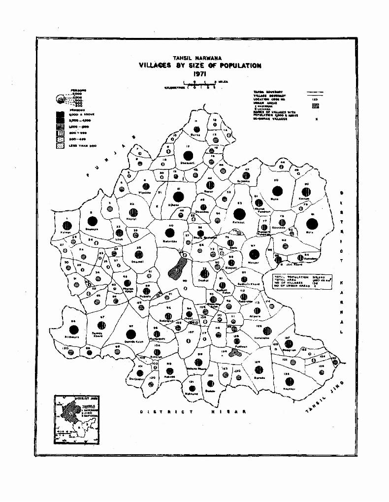
__ I
~--.. ----.. ----. :-~oo --aoo ....... I IPOO • AIIOVI apoo_----lID ....... [ill --... 0 ..... THAN aGO
3
+
TAHSil NARWAI!IA VILLARS 8Y SIZE Of POPULATION
1971
I 3 * ! ___ I i'
GIIT.feT
--._-lOtA'I' __ _
UIIAA. AUAI ........ -..u. JlUC-...... ..,. _. Of V_' ."" _ULAT .. II t.,ooo._VI __ 'f1LLMl.
,.,
.. [
• T
" C
T
=:::rcJ " In • A
" .. A
L

Total Rural Urban
Population
319,242 291,594 27,648
Number of Villages
TAHSIL NARWANA
Total 136 Villages with all Amenities 40 Be-chirag Villages 1
VILLAGES HAVING
Educational
Primary School Middle School Secondary School College *Dthers
Medical
Hospital Health Centre Dispensary Medical Practitioner Family Planning Centre Matrenity & Child Welfare Centre
Drinking Water
Wells only Handpumps only Canals/Rivers only Tanks only ""Others
Communication
Post Office Post & Telegraph Office
EDUCATIONAL
COMMUNICATION --9- MEDICAL
DRINKING WATER
>I< Others include I.T.Is, Craft Schools, Training Schools, etc. ' "Others include Boulis, Springs and a combination of One and more sources of drinking v.aler SUpj:ly.
154
Total Rural Vrban
Area
1,487.5 Krn2 1,481.7 Km2
5.8 Km2
Number of Villages
94 20 17
4 4 6
55 3 5
41 1
92
44 3

fiI'04.:.CiE .T.TtON· . 'V"U.A •• ~ WITH AU. THE ,.M."ITles
.OyCATIO .... L
C(HjIMUM,C:ATIOM -4- Me:O'CAl.
O'UNK'". WAT""
TAt4SIL NARWANA
DISTRIBUTION OF AMENITIES IN VILLAGES
. .. .. .. ·s I + M
Me D ... •• ....
, .... a. .... ~.T •
It T " c T M s A
TAM_ HU.'DA'-'l' YI\.~' eoV_Od, ..0.0 •••• TALLID lIOAos .-fIIIOTOaAkl. ,. ~.'IIII: HAT ... " • •• I.WA1'I ......... U •• oa .... AIICAS 1 "" ....... .. .OCH .... A
LO:CA,,"", COOII wo. .,-c ........ VtLL .. Gca
D
• T
" c
T
K
A
.-II
A
L
•• . ~ ,
II
I II
.. _==--=====1

TAHSIL JIND
Location Code Numbers and Names of the Villages
Code Name COLe Name Code Name Code Name Code N?me No. No. No. No. No.
1 Jajwan 26 19ra 51 Ashrafgarh 76 Lalit Khera 101 Budha Khera Lather 2 Kheri Jajwan 27 Bibipur 52 Kisianpura 77 Nidana 102 Akalgarh 3 Daryawala 28 Rarnrai 53 Gobindpura 78 Bharon Khera 103 Hathwala 4 Jhanj Kalan 29 Tkas 54 Birbaraban 79 Nandgarh 104 Zafargarh 5 Barodi 30 Ja!alpura Khurd 55 Ramgarh 80 Sirsa Kheri 105 Pauli
6 Roopgarh 31 Jalalpura Kalan 56 Ghimana 81 Meherera 7 Jitgarh 32 Jind (Rural) 57 Bahbalpur 82 Lajwana Kalan 8 Shahabpur 33 Habatpur 58 Birar Khera 83 Fathagarh 9 Jiwanpur 34 Khokhri 59 Buwana 84 Lajwana Khurd
10 Dalamwala 35 Bohatwala 60 Bura Dehar 85 Karsola
11 Siri Raj 36 Barsana 61 Gosian Khera 86 Gatauli 12 Kandala 37 Khunga 62 Kinana 87 Kharanti 13 Tegbahadurpur 38 Lochap b3 Anoopgarh 88 Gharwali 14 Amar Kheri 39 Taloda 64 Bishanpura 89 Jaijaiwanti 15 Ahirka 40 Kheri Taloda 65 BaroH 90 Khera Bakata
16 Karkheri 41 Slwaha 66 Siamlo Khurd 91 Karela 17 Jhanj Khurd 42 Assan 67 Khema Kheri 92 Jhamola 18 Julani .43 Brah Kalan 68 Siamlo Kalan 93 Rajgarh 19 Sangatpura 44 Manoharpur 69 Ramkali 94 Des Khera 20 Intal Ka lan 45 Mando Kheri 70 Dhigana 95 Nalvi
al Intal Khurd 46 Lakhmirwala 71 Pad ana 96 Kamach Khera 22 Rajpura 47 Nirjan 72 Nidani 97 Deverar 23 Gunkali 48 Pindara 73 Sindhvi Khera 98 Bahamanwas 24 Baganwala 49 Brah Khurd 74 Kharak Ramji 99 Julana (Rural) 25 Ponkar Kheri 50 Radhana 75 Chabri 100 Shauipur
TAHSIL JIND
Villages Classified by Population
Size No. of Population Area- 815.6 Kin2
Categories Villages ------- Density-265 per Km2 -Males Females I Males Females
Less than 200 3 230 180 Population 116,041 100,333 200-499 7 1,484 1,376 Literates 39,501 11,025 500-999 16 6,539 5,876 Workers ,52,763 3,044 1,000-1,999 44 32,234 28,284 Non -Workers 63,278 97,289 2,000-4,999 35 50,975 ,44,145 Scheduled Castes 20,064 17,441 5,COO-9,999 Scheduled Tribes 10,000 and above Total 105 91,462 79,861
156

TAHSIL JINO VILLAGES BY SIZE OF POPULATION
1971
TAM.'L tOU.DAIlY --VILLAa. :.ou.o.uy LOCATIOII CODE .0. 123 .tAII A.IAS· ~
xJ.ltO ~ :II: JUI.AN'"
IIAM.I 0' YILLa.. WITN POPULATIO. apoo .. Aaoy •.
• spoo .. A.CVI
• 2POO-.y"
~ .,,00 -~ •• lIm .00 - •••
[ill aoo - ....
0 . 1.1.. ™A" 200 .
...UIICT JIll_
"", • .. ~ ~"=. apoo
.-~§§
TOTAL POfOULATlO .. TOTAL A_A
NO· 0fI1 WII.L .....
NO 0fI1 u..... M.... a
T A M
• I L,
• A
.' • D o •

t~tal l(ural l.1rban
Population
216,374 171,323 45,051
Number of Villages
Total 105 Vdllages with all Amenities 23 Be-chirag Villages Nil
TAHSIL JINO
, 'EDUCATIONAL
CO ..... UNIC'ffION ~ MEDI
~
VILLAGES HAVINO" ~; :
Educatio8al , ' ;
'Primary School J\.4iddle School seconda~y School 'College. 'Others'
:fdedical'
Hospital lJealth Centre ' :pispensary' " .\Y{edical Practitioner Family Planning 'Centre . Maternity & Child Welfare Centre
:Qrinking Water
Wells only .,' ffandpU!TIPs o~~ Canals/Rivers only 1;anks .(lnly ~"qtflers .
COtnmuniQ'ation . ; ~ .
ll"pst Office f'st &;!elegJ:al?h:,~e
" . DRINKING WATER
)
,,: Other~ includel.T.Is, Craft.Scnools,.Ttaining Schoois'. etc, ,,; '.' ,~;, '." ,', ~·Other!l include~Boulis> Springs an<\ lJ., ~bination of~e ~~ inore sources~of drinKing water supply .
.:'_,., ,-
158
Total Rural LT-',ban
Area
815.6 Km1 804.0 Km1 11.6 Kmz
Number of -Villages
81' 13 12
$; 7,
'4 , 37:
6; t
46

TAHSIL' JIND
Dl STRI8UTION OF A,MENITIES IN VILLAGES o
()
I
EDUCATIONAL' ... P~lhlARY SCHOOL .. , ... ' . , M I DOL!' SCHool:··,·· . . . SECONDARY SCHOOL..' , .... , T~A1NING CENTRE MEDICAL HOSPITAL· • , ... , .....•... • . HEALTH .CENTRE DISPENSARY •..•.... , ... MEDICAL PI'IACTITIONER .. FAMILY PLANNING CENTRE' CHILD .. MATERNITY WELFARE CENTRE SOURCE OF DRINKING WATER
..... NDPUMP .. WELL TuDE'NELL· • , . , TANK" ..•..... CANAL I RIVER ... COMMUNICATION
POST OFFICE' .. , POST .. 'TELEGRAPH OFFIcE
, .. ,. P
'. M .. S .. I .. + '101
• •..• Me .. D .. !.lip
F< Mew
.. " T
- - -.'
P.O. .' P40T
VILLAGES WITH ALL THE "MENITllS ••• ·· ~
DRINKING ·WATER
TOTAL POPULATION TOTAL AREA NO. OF VILLAGES NO. OF URBAN AREAS
s
21~"4 815'56 Km2
lOS 2
c
TAHSIL IOIHIOAIIY VfLLAGI. IIOUIIDAAY !IOAOS •• 1IlLllO
===zc===..;: ROADS.MOTOIA.I.! t., .. WEAT ....
IIAII..,S S""'_UUGE -=-=--........ --I .lIND If JUL"H" LCK:A~ CO. NO .7
T A H S I L
S A F I D o N
o H
T
A
K
o I 5
T
" C
T

TAHSIL SAFIDON
Location Code Numbers and Names of the Villages
Code Name Code Name Code Name Code Name Code Name No. No. No. No. No.
1 Jamni 13 Basini 25 Dharoli 37 Anta 49 Bhartana 2 Rajana 14 Barod 26 Kalwa 38 Karsindho 50 Ladana 3 Beri Khera 15 Todi Kheri 27 Kalwati 39 Titoo Kheri 51 Morkhi 4 Chhapar 16 Shahnpur 28 Hoshiarpur 40 Bhaderpur 52 Bhiag Khera 5 Singhana 17 Khera Khamwati 29 Butani 41 Kurar 53 Bhagrd Kalan
6 Paju Khurd 18 Paju Kalan 30 Rajhala 42 Kherkra 54 Harigarh 7 Aftabgarh 19 Rampura 31 Malar 43 Karakhana 55 Anchra Khurd 8 Dharamgarh 20 Jaipur 32 Bahadurgarh 44 Hat 56 Sarfabad 9 Memnabad 21 Budha Khera 33 Silakhera 45 Ramnagar 57 A nchra Kalan
10 Didwara 22 Bhoran 34 Rata Khera 46 Hadwa 58 Bagru Khurd
11 Bhoslana 23 Amrali Khera 35 Singh pur 47 Kharak Gagar 59 Malshri Khera 12 Khatla 24 Pilo Khera 36 Safidon (Rural) 48 Gangoli 60 Bhambwa
TAHSIL SAFlDON
Villages Classified by Population
Size No. of Population Area-390.2 Km2
Categories . Villages Density-267 per Km2 Males Females Males Females
Less than 200 1 13 5 Population 55,637 48,357 200-499 4 911 795 Literates 17,029 3,960 500--999 18 7,312 6,534 Workers 25,768 1,458 1,000--1,999 23 17,922 15,631 Non-Workers 29,869 46,899 2,000-4,999 13 20,296 17,273 Scheduled Castes 9,993 8,800 5,000-9,999 1 2,862 2,430 Scheduled Tribes 10,000 and above Total 60 49,316 42,668
161)

TAHSIL SAFIDON VILLAGES BY SIZE OF POPULATION
1971
TAH_ aOUIllDARY YILLAGI.aouMDAAY LOCATIOII CODE 110. URMIf A.UI I: SAFIDON
o 2 MILlS
r 1I 2 ~ ICIL_TIlD
IIAMS OIF VILLAGE. WITH POPULATION 01" ZPOO" AaovI
o \
T
A
L
J
I
II
.0
o I a T \
\
o
TOTAL '~ATlOte IO~ •• 4 TOTAL AII.A .-0- Ie _.1' .0. 0" .,tL.~ . "-ItO (1# UMMt MWM 1 ...
,...
PERSONS :. 1,000 UD AICI'A
un 1,jIOO-'\9ft
~ 1.000-1 ....
[]] 100- HI
[ill] 100 - 4.,
0 . Li .. TIIA.IOO

Total Rural Urban
Population
103,994 91,984 12,010
Numbe( of Villages
Total 60 Villages with all Amenities 12 Be·chirag Villages Nil
VILLAGES HAVING
; Educatie •• l
Primary School Middle School Secondary School College ·Others
Medkal
Hospital Health Centre Dispensary Medical Practitioner Family Planning Centre
TAHSIL SAFIDON
EDUCATIONAL
COMMUNICATION -9-- MEDICAL
. DIUNKING WATER
Maternity & Child Welfare Centre
Drinking Water
Wells only Handpumps only Canals/Rivers only Tanks only ··Otbers
Communication
Post Office Post & Telegraph Office
• Others include I.T.Is, Craft Schools, Training Schools, etc. . ··Others include Boulis, Springs and a combination of one and more sources of drinking water supply.
162
Total Rural Urban
Area
390.2 Kml 383.7 Km1
6.S Kml
Nl!mber of Village
47 7 6
1 4
17
12 4
44
6

TAHSIL SAFIDON I
DISTRIBUTION OF AMENJTIES IN VILLAGES
TAHS'L aov .... y V'LLAS£ IOU. DAilY "OADS,MITALLlD aOADS,MOTOIlAIU ' " .. AI. IftATHIR RAILWAYS •• ROAD .-¥I.E UllIAII MU.
:r. SAFfDQtt
LOCATIO. C.JDE MO.
o
H
s
L
J
N
D
~o
II'" 0
I
_",l._._
so
\
S T "
"
"4-... '\
~ 0
~
'\
\ TOTAL POPUI.ATIQN 10~O94
TOTAL ARIEA '390".
NO-OF y 11.1. A.I!S 60
NO 0" UIIIIlAN ARIIAS
1(111,2
:::"'~'- : . ' ." .: ~. ' . : : ~~· • • • " · . . .. .. M SECOICWIT _001.. . . . . . . . . . s ~ ctllTltE' • . . . . . . •.. '1 ~ .. . ... .. .. .. . . . + 1I05I'IT..... . .,.. .. . . . . . . . H
lEAL TIt C 11fTII£ · • . . • . • • " • • He DIS'EIlSAIIY· • • . • . • • • • • • • ' 0 M!DICAL I'IIACTITIOIIU • . • • • . ..... CHILD & MATIANITY ' • .. . . • • 'M~w wa'AII! CIIITII[ , 'AHU I'LANIlIIlCiCIHTIU" .. • .f'~ iOyI!CI or p"'.'"G "TIl HANDI'UIV ~ WILL . • . • . • • • . . • TUI[ WELL . • ' . . . . . . . . . . . . .. TAIlIt • • • " ..• • ..• • •• , " T CA ....... /III V[II' • • . '.' • , . . . . _ !<OI1I!11MCI\I ION !'OST OFFICI ' .•..•• • .••. . AO. I'OST & 1't&UIIAI'H _ret· . . . . . PloT
VILLAGE WITI< ALL IIMDIIToES • • • _ -EDUCATIONAL
COMMUNICATION -?-ME'OICAL
DRINKING wATER
t!H!U I.IIAIIWAM Z.JIN.D , .,.",_
' l1li