Adding information about soils and paleosols to geological maps, through the application of the...
15
Quaternary International 175 (2007) 125–139 Forum communication Adding information about soils and paleosols to geological maps, through the application of the ‘‘pedostratigraphic level’’ concept Edoardo A.C. Costantini , Rosario Napoli, Giorgio D’Egidio Istituto Sperimentale per lo Studio e la Difesa del Suolo, Firenze, Italy Available online 21 May 2007 Abstract Paleosols are rarely reported on geological maps. However, their mapping and study can add a great deal of information, useful to the understanding of Quaternary geological and geomorphological processes. This study was aimed at developing a methodology that uses soil surveys and paleopedological studies to create a detailed map of Quaternary cover, suitable for integration with a standard geological map of similar scale. This study was conducted in the Montagnola Senese area of central Italy. Landscapes there included a small ridge made up of carbonate free metamorphic rocks, and calcareous deposits. Quaternary paleosols formed on slope and alluvial deposits derived from this bedrock were particularly abundant. The map of Quaternary cover was developed from the pedostratigraphic map, as a function of thickness of the regolith and age of the oldest pedostratigraphic level. A pedostratigraphic level was defined as a characteristic assemblage of soil genetic horizons, formed in materials having a certain degree of weathering and the age that was estimated by means of correlation to benchmark soils. Pedostratigraphic levels were generated from a Soil Information System, where digital soil maps and soil attributes were stored. Soil attributes derived from routine surveys, as well as from specific investigations and analyses performed in order to determine the pedogenetic processes active in the Montagnola Senese during the Pleistocene. The information coming from the map of Quaternary cover was used to generate a new geological map of the area, where Quaternary deposits were divided according to their estimated age (early, middle and late Pleistocene, and Holocene), thickness, and morphological position. r 2007 Elsevier Ltd and INQUA. All rights reserved. 1. Introduction Adding soil and paleosol information to geological mapping has always been a challenge for both paleopedol- ogists and geologists (Morrison, 1993). The North Amer- ican Commission on Stratigraphic Nomenclature (1983) has defined the concept and application of pedostrati- graphic unit as ‘‘a buried, traceable, three-dimensional body of rock that consists of one or more differentiated pedologic horizons’’ (Art. 55a). The upper and lower boundaries of a pedostratigraphic unit are related to the soil horizons formed by pedogenesis in a buried soil profile. A pedostratigraphic unit is characterized by the range of physical and chemical properties in the type area, rather than by ‘‘typical’’ properties exhibited in a type section. Consequently, a pedostratigraphic unit is identified on the basis of a composite stratotype (Arts. 8d and 57b). The concept of pedostratigraphic unit has also been utilized in Italy, especially at the detailed scale (Cremaschi, 1978; Amorosi et al., 1996), but also at the regional scale (Preti, 1999). More recently, in the project ‘‘new geological map of Italy at 1:50,000 scale’’, the concept of Unconfor- mity-Bounded Stratigraphic Units has been used to merge results of pedological and geological surveys (Carnicelli et al., 2003). The work for the new geological map of Italy carried out in the area of the Montagnola Senese (central Italy) produced a geological map where the Quaternary sedi- ments were described as alluvial or eluvial-colluvial and Terra Rossa deposits, and subdivided according to their ARTICLE IN PRESS 1040-6182/$ - see front matter r 2007 Elsevier Ltd and INQUA. All rights reserved. doi:10.1016/j.quaint.2007.05.006 Corresponding author. E-mail addresses: [email protected] (E.A.C. Costantini), [email protected] (R. Napoli), [email protected] (G. D’Egidio).
Transcript of Adding information about soils and paleosols to geological maps, through the application of the...
ARTICLE IN PRESS
1040-6182/$ - se
doi:10.1016/j.qu
�CorrespondE-mail addr
Quaternary International 175 (2007) 125–139
Forum communication
Adding information about soils and paleosols to geological maps,through the application of the ‘‘pedostratigraphic level’’ concept
Edoardo A.C. Costantini�, Rosario Napoli, Giorgio D’Egidio
Istituto Sperimentale per lo Studio e la Difesa del Suolo, Firenze, Italy
Available online 21 May 2007
Abstract
Paleosols are rarely reported on geological maps. However, their mapping and study can add a great deal of information, useful to the
understanding of Quaternary geological and geomorphological processes. This study was aimed at developing a methodology that uses
soil surveys and paleopedological studies to create a detailed map of Quaternary cover, suitable for integration with a standard geological
map of similar scale.
This study was conducted in the Montagnola Senese area of central Italy. Landscapes there included a small ridge made up of
carbonate free metamorphic rocks, and calcareous deposits. Quaternary paleosols formed on slope and alluvial deposits derived from
this bedrock were particularly abundant.
The map of Quaternary cover was developed from the pedostratigraphic map, as a function of thickness of the regolith and age of the
oldest pedostratigraphic level. A pedostratigraphic level was defined as a characteristic assemblage of soil genetic horizons, formed in
materials having a certain degree of weathering and the age that was estimated by means of correlation to benchmark soils.
Pedostratigraphic levels were generated from a Soil Information System, where digital soil maps and soil attributes were stored. Soil
attributes derived from routine surveys, as well as from specific investigations and analyses performed in order to determine the
pedogenetic processes active in the Montagnola Senese during the Pleistocene.
The information coming from the map of Quaternary cover was used to generate a new geological map of the area, where Quaternary
deposits were divided according to their estimated age (early, middle and late Pleistocene, and Holocene), thickness, and morphological
position.
r 2007 Elsevier Ltd and INQUA. All rights reserved.
1. Introduction
Adding soil and paleosol information to geologicalmapping has always been a challenge for both paleopedol-ogists and geologists (Morrison, 1993). The North Amer-ican Commission on Stratigraphic Nomenclature (1983)has defined the concept and application of pedostrati-graphic unit as ‘‘a buried, traceable, three-dimensionalbody of rock that consists of one or more differentiatedpedologic horizons’’ (Art. 55a). The upper and lowerboundaries of a pedostratigraphic unit are related to thesoil horizons formed by pedogenesis in a buried soil profile.A pedostratigraphic unit is characterized by the range of
e front matter r 2007 Elsevier Ltd and INQUA. All rights re
aint.2007.05.006
ing author.
esses: [email protected] (E.A.C. Costantini),
(R. Napoli), [email protected] (G. D’Egidio).
physical and chemical properties in the type area, ratherthan by ‘‘typical’’ properties exhibited in a type section.Consequently, a pedostratigraphic unit is identified on thebasis of a composite stratotype (Arts. 8d and 57b).The concept of pedostratigraphic unit has also been
utilized in Italy, especially at the detailed scale (Cremaschi,1978; Amorosi et al., 1996), but also at the regional scale(Preti, 1999). More recently, in the project ‘‘new geologicalmap of Italy at 1:50,000 scale’’, the concept of Unconfor-mity-Bounded Stratigraphic Units has been used to mergeresults of pedological and geological surveys (Carnicelliet al., 2003).The work for the new geological map of Italy carried out
in the area of the Montagnola Senese (central Italy)produced a geological map where the Quaternary sedi-ments were described as alluvial or eluvial-colluvial andTerra Rossa deposits, and subdivided according to their
served.
ARTICLE IN PRESSE.A.C. Costantini et al. / Quaternary International 175 (2007) 125–139126
particle size. Although these sediments occupy a large partof the investigated area and are shaped in different forms,the map reported neither chronological distinctions northickness of the deposits. This study was undertaken toimprove the geological map in terms of chronology andthickness of the Quaternary deposits, using the insightgained while studying the soils and paleosols of this regionduring the last 20 years.
The study worked out the concept of ‘‘pedostratigraphiclevel (PL)’’, based on the concept of pedostratigraphic unit,for non-buried soils. The rationale is that the whole soilbody, from the soil surface downwards, can be classified inlevels according to genetic characteristics and weathering.Therefore, a PL is considered a characteristic assemblageof genetic soil horizons, formed by materials having thesame degree of weathering and an estimated age throughcorrelation to benchmark soils.
The PL approach needs the characterization of profilehorizons according to two criteria: the expression ofpedofeatures, leading to the identification of a class ofgenetic horizon and the degree of weathering of the parentmaterial. Although both expression of pedofeatures anddegree of weathering are the results of the interplaybetween the same soil forming factors, the first one givesbetter clues to determine processes often related to specificclimatic or morphological conditions, whereas the amountof the weathering products of the primary materials is morerelated to the duration of pedogenesis. In addition, thedecoupling of the two criteria allows clear separation ofpedofeatures formed in fresh or pre-weathered materials.
2. Material and methods
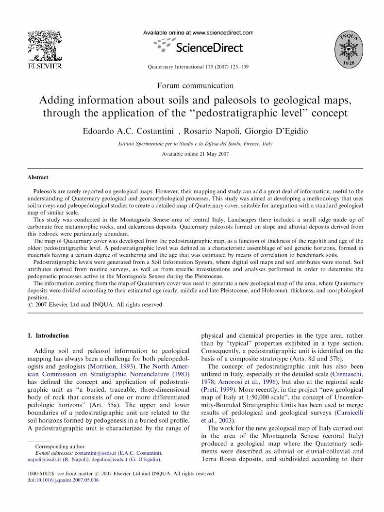
The territory studied, known as ‘‘Montagnola Senese’’,has an area of about 35 km2 (Fig. 1). It is located in centralItaly and is part of a broad ridge that emerged from the seaduring the Miocene age. The ridge underwent periods ofintense geomorphological evolution during the Plioceneand Quaternary periods. Consequently, tectonic move-ments and climatic changes caused extensive soil erosionand sediment deposition on terraces, gentle slopes anddepressions. Periods of biostasis and intense pedogenesisfollowed.
Because this area has been occupied by humans for atleast the last 3000 years, erosion processes were enhancedduring the Holocene, due to both agricultural managementand woodland activities. Evidence of glaciation is absent,although a loess deposit is evident in the upper part of asoil, which could indicate the presence of periglacialconditions during the Pleistocene (Mirabella et al., 1992;Costantini et al., 1996). Currently, the climate of the area isMediterranean, with maximum rainfall in October andminimum in July, which is also the warmest month, whilethe coldest month is January. The average annual rainfallof the area is 1019mm (Simignano 431180N; 419m a.s.l.,8 km west of Siena), while the average annual temperatureof nearby Siena (431190N; 348m a.s.l.) is 13.2 1C. The
annual potential evapotranspiration is estimated at735mm; total annual deficit is 97mm and the surplus is380mm for a soil with an available water capacity of200mm. The soil moisture regime is ‘‘udic’’, with a ‘‘mesic’’soil temperature regime, according to Soil Taxonomy (SoilSurvey Staff, 1998).Many rock types and sediments outcrop in the area.
They include metamorphic rocks, mainly free of carbo-nates, and calcareous rocks. The slope and alluvial depositsare derived from the local bedrock, with contributions. Thegeological reference used was the recent map published bythe Department of Earth Science of the University ofSiena, compiled at 1:25,000 scale and published at 1:50,000(Costantini and Sandrelli, 2004). In this publication, theQuaternary sediments are described as alluvial or eluvial-colluvial and Terra Rossa deposits (Fig. 2). For this work,the map was digitized, stored in a Soil Information System(SIS), and the legend simplified and translated into English.Many soils of the area had already been studied todetermine the influence of siliceous and calcareous parentmaterial on soil genesis (Costantini et al., 1992; Mirabellaet al., 1992), the relationships between Quaternarygeomorphological evolution and the occurrence of fragi-pans and other naturally consolidated (‘‘close-packed’’ or‘‘dense’’) horizons (Costantini et al., 1996), genesis ofAlisols (Motz, 1998), soil geochemistry (Costantini et al.,2002b), aging indicators (Costantini et al., 2002a), claymineralogy (Costantini and Damiani, 2004), and ironmineralogy transformation with time (Costantini et al.,2006).Forty-one benchmark profiles, previously investigated or
coming from a new set of survey and analyses, were used inthis study. The age of the parent material of 10 benchmarkprofiles was estimated through geological reconstruction(Bartolini et al., 1982), detailed geomorphological and soilsurveys. In addition, one significant fossil assemblage fromthe lower part of a profile, where Fondi (1972) foundcalcified remains of Cromerian fauna (early–middle Pleisto-cene) in the lowest soil horizon, and luminescence dating oftwo horizons in five profiles (unpublished data) were used.Soil survey and classification were carried out according
to methods of the Soil Survey Manual (Soil Survey Staff,1993), Soil Taxonomy (1998) and the World ReferenceBase (WRB) for Soil Resources (FAO, 1998). Routinelaboratory analysis was in compliance with the Italianofficial methods (Ministero delle Politiche Agricole eForestali, 2000). Plinthite nodules were submitted to thetest of Wood and Perkins (1976), with immersion ofsamples for 2 h in water, to check the persistence ofaggregates. Bulk density was obtained with the coremethod on replicated samples at field capacity. Cationexchange capacity and exchangeable bases were determinedby NH4OAc extraction and spectroscopy. Cation exchangecapacity of the clay fraction was measured on 14 samplesof clay separated by sedimentation and for the remainingsamples, through a correlation with clay content andcorrection for the organic matter content.
ARTICLE IN PRESS
Fig. 1. Study area.
E.A.C. Costantini et al. / Quaternary International 175 (2007) 125–139 127
Iron mineralogy was analyzed for the main horizons ofall soils. Total iron content was determined on dissolutionextracts obtained by acid digestion with a mixture ofHCl:HNO3:HF. Oxalate-soluble iron was estimated usingthe method of Schwertmann (1964). Dithionite citratebicarbonate extractable iron and silica were determinedusing the Mehra and Jackson (1969) method. Thin sections(80� 50mm2) were made of 50 undisturbed soil samplesfrom 20 soil profiles. The clay mineralogy of 84 horizonsand parts of horizons (stained masses and bleached tonguesand masses) for 20 selected soils was obtained by X-raydiffraction. The clay fraction composition and its semi-quantitative determination were estimated from peak areasobtained by diffraction using a Philips PW 1710, a RigakuD/MAX IIIC, or a Siemens D500 diffractometer.
Depth of the regolith was estimated by augering holes upto 1.5m, digging pits up to 3–4m and boring with auger onthe bottom for about another meter, examination of theface of marble quarries (around a dozen active andabandoned quarries were present in the middle-westernpart of the study area), natural exposures, a geoelectricalcampaign of measurements conducted around the town of
Pievescola, and a deep stratigraphic drill (30m) south ofthe town of Ancaiano, sampled every 0.5m.
3. Results and discussion
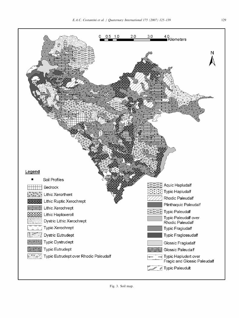
3.1. Pedological map
The pedological map (Fig. 3) was created by digitizing,joining, and harmonizing three soil maps at 1:10,000and 1:25,000 scales (Napoli, 1989; Napoli and Castellani,1992; Sulli, 1995) within an SIS. The vast majority ofsoils of the Montagnola Senese formed on Quaternaryslope, colluvial, alluvial, and aeolian deposits, withfrequent lithological discontinuities. Virtually all soilsthat formed on rock residuum show evidence of erosionand/or deposition. Even the very shallow soils on rockshow some lithological discontinuities in their upper part.However, as the climatic conditions favor rock weathering,almost all soils have a C horizon in their lower part and agradual boundary to the underlying rock, or a thickweathering rind in the case of limestone. In addition, allsoils in stable morphological positions, or situated on sites
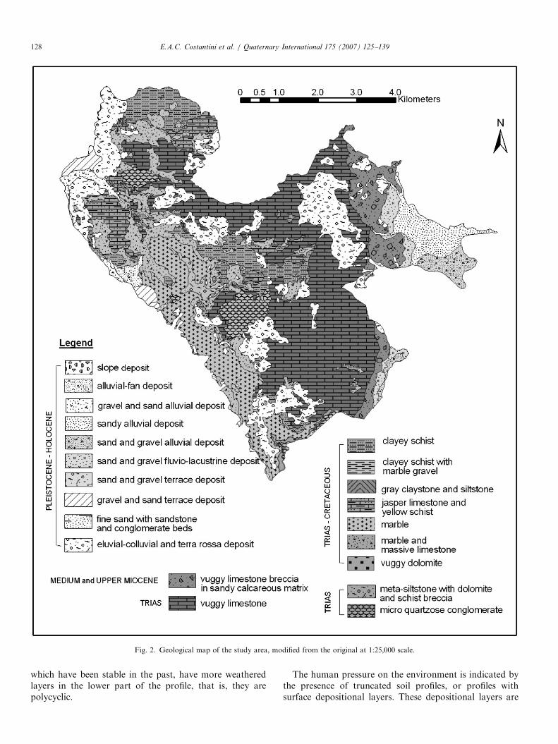
ARTICLE IN PRESS
Fig. 2. Geological map of the study area, modified from the original at 1:25,000 scale.
E.A.C. Costantini et al. / Quaternary International 175 (2007) 125–139128
which have been stable in the past, have more weatheredlayers in the lower part of the profile, that is, they arepolycyclic.
The human pressure on the environment is indicated bythe presence of truncated soil profiles, or profiles withsurface depositional layers. These depositional layers are
ARTICLE IN PRESS
Fig. 3. Soil map.
E.A.C. Costantini et al. / Quaternary International 175 (2007) 125–139 129
ARTICLE IN PRESSE.A.C. Costantini et al. / Quaternary International 175 (2007) 125–139130
characterized by a mineralogy that reveals a mixing of soilsediments with non-pedogenic material. These layers ofthick deposits are separated by erosional surfaces absent ofunweathered material. As a result, lithological disconti-nuities are very frequent, and many soils are alsopolygenetic.
Soils were correlated at the Soil Taxonomy subgrouplevel, differentiating soil map units based on surface soiland the buried soil, wherever present. The substratum onlypartially controls soil distribution. Dystric and lithicXerochrepts and Xerorthents dominate on schist, whileshallow soils on limestone and marble are similar but notdystric (lithic ruptic Xerochrepts, Haploxerolls, andXerorthents). Typic Eutrudepts are frequent on micro-quartzose conglomerates. Soils on thicker Quaternarycovers are much more variables. Typic and dystricEutrudepts and typic Fraglossudalfs are more frequenton slopes, whereas rhodic Paleudalfs are common insidekarsts depressions. Glossic Fragiudalfs, plinthaquic Paleu-dalfs, and dystric Eutrudepts have been found on the old,deep, alluvial deposits.
3.2. Pedostratigraphic map
The studies mentioned above suggested that the soils ofthe Montagnola Senese are the result of processes startedor active in different ages. Although fossilized paleosols areabsent, paleosols formed in different ages were covered bymainly colluvial materials, either fresh or pre-weathered,which were interested by new soil forming processesleading to new generations of pedofeatures. When broughtto the surface because of soil erosion, paleo-pedofeaturesand product of weathering, formed in paleo-pedoclimaticconditions, were transformed under the new pedoclimaticenvironment (Costantini et al., 2006).
Three groups of genetic horizons were identified, corre-sponding to three estimated times of pedogenesis: Holocene,late and middle Pleistocene, and early Pleistocene. Everygroup of genetic horizons reflects the specific pedoclimaticand morphological conditions of their time of pedogenesis.
The first group of genetic horizons, related to Holocene,included A horizons (ochric, mollic and umbric), Bwhorizon (cambic), and Bt horizon (argillic). The Bt horizonwas included in the first group only when its bulk densitywas less than 1.6Mgm�3 and its characteristics were not
Table 1
Criteria used to differentiate classes of pedogenetic processes
Class and estimated age of formation
1 (Holocene)
2 (Late and middle Pleistocene)
3 (Early Pleistocene or earlier) like overlying horizon
See the text for the correlation with the age of occurrence.
diagnostic for soil classification within the ‘‘pale’’ greatgroup of Soil Taxonomy (Table 1).A second class of genetic horizons reflected soil-forming
conditions of late and middle Pleistocene. Discriminatingproperties were either those diagnostic for the ‘‘pale’’ greatgroup, or compactness. The compactness required a Bthorizon with bulk density higher than or equal to1.6Mgm�3, or a Btx (fragipan), or a Bd (densipan).Fragipan and densipan were formed in depth duringPleistocene, under different climatic and morphologicalconditions. They could be either well preserved, whencovered by colluvial materials, or degraded during Holo-cene, when the erosion of the overlaying horizons broughtthem near to the surface (Costantini et al., 1996).The last class was created for Bv (plinthite) and Bt-nitic
horizons. The nitic horizon is exclusive of the WRB systemand corresponds to a soil horizon with nutty structure, lowamount of water dispersible clay, and a high amount offree iron. In the case of soils of the Montagnola Senese, thenitic horizon was formed from more or less pure insolubleresiduum of limestone, and it was characterized by a darkred color (Munsell 2.5YR 3/6, either dry or moist) greatthickness (up to some meters), extremely high content ofclay, up to 98% by weight of the horizon, and character-istic very thin clay cutans in thin section (leptocoatings).Soils with Bt-nitic horizon were classified as RhodicPaleudalf following the Soil Taxonomy system. Plinthiteoccurred as indurated iron concretions, occupying morethan 5% of the volume of Bt horizons, and showing onlyrare thin clay cutans in thin section. Well expressed plinthicand nitic horizons were assumed to date to the earlyPleistocene or earlier, on the basis of paleontology (Fondi,1972) and of detailed geological and geomorphologicalmapping (Costantini et al., 1996). Transitional horizonsBC, CB were classed as the overlying horizons.Costantini et al. (2002a) had indicated that aging of the
parent materials was significantly correlated to the valuesof selected physical, chemical and mineralogical soilparameters; in particular, silt/clay ratio, total and freeiron, CEC of clay, and kaolinite percentage of the clayfraction. Silt/clay ratio and iron mineralogy reflected theprogressive accumulation of clay and free crystalline ironobserved in soils, while the CEC of clay and the percentageof kaolinite were signs of the mineralogical transformationswhich had occurred in the soil parent material. Weatheringcaused a change in the clay mineral composition, which
Genetic horizon and bulk density (BD) values (Mgm�3)
A, Bw, Bt with BDo1.6 and not pale- great group (Soil Taxonomy)
Bt with BD X1.6 or pale- great group; or Btx or Bd
Bv and Bt-nitic (WRB) BC, CB
ARTICLE IN PRESSE.A.C. Costantini et al. / Quaternary International 175 (2007) 125–139 131
was pronounced in the transition between the Holoceneparent material and the parent material attributed to thelate and middle Pleistocene, but which was also significantin the older parent material. In general, kaolinite contentincreased as a consequence of direct weathering the mineralconstituents of the parent rock. The presence of vermiculitewas increased through the transformation of illite andchlorite into a series of intermediate hydroxy-interlayeredvermiculite and mixed layers.
Mineralogical transformation was specific to soilsformed on residuum of limestone. These soils were alwaysmore clay-rich than the others, because of the claycomposition of the residuum, and therefore the silt/clayratio could not be applied. Silt/clay ratio was also not usedfor plinthic soils, as the iron cementation process leading toplinthite produced an increase in the diameter of theparticles and a coarsening of the soil texture (Table 2).
Four classes of weathering were established in order todistinguish soil parent materials: non- or weakly weathered(class 1); slightly weathered (class 2); moderately weathered(class 3); and strongly weathered (class 4).
PLs grouped horizons of a profile in relation toestimated age of pedogenesis and of parent materialdeposition (Table 3). Classes of genetic horizons anddegree of weathering of the parent materials wereattributed to the horizons of all 41 studied profiles,allowing the qualification of the profiles into a successionof PLs (e.g. PL1; PL1 on PL2; PL2 on PL3; PL2 on PL3 onPL4, etc.). All soil map units were described in this way,using the benchmark profiles found in them. For instance,if class 1 pedogenic development was present in class 3
Table 2
Proprieties and range of values used to differentiate classes of weathering of t
Class Silt/clay ratioa Fedb (%) F
1 X3.89 p15.7
2 1.14–3.88 15.8–24.8 2
3 o1.14 24.9–29 3
4 430 and (Fd�Feo)/Fet 40.6 439 and (F
aNot used in case of Bv and soil formed on limestone.bFed ¼ iron extractable with dithionite-citrate-bicarbonate.cFet ¼ total iron.
Table 3
Criteria used to differentiate pedostratigraphic levels
Level Criterion
PL1 Classes 1 of both pedogenetic process and weathering
PL2 Class 1 of pedogenetic process and class 2 to 4 of weathering
PL3 Class 2 of pedogenetic process and class 2 to 4 of weathering
PL4 Class 2 and 3 of pedogenetic process (only Bt-nitic for soils
formed on limestone) and both classes 4 of weathering
weathering of the parent material, it was interpreted to beHolocene soil developed on sediment older than Holocene(PL2). Three examples of soil horizon grouping in PLs arereported in Table 4.Finally, the pedostratigraphic map was generated by the
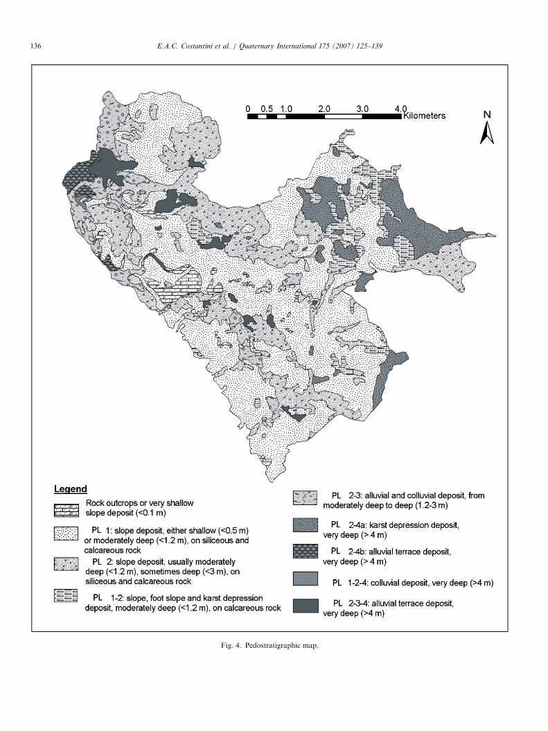
SIS, qualifying soil map units according to the character-istic succession of PLs, geomorphological position, esti-mated thickness of the regolith, and lithology of the parentmaterial (Fig. 4).
3.3. New geological map
The pedostratigraphy map is an outcome that gives ‘‘perse’’ relevant information, in particular about the occur-rence, chronology, extend and intensity of erosive anddepositional processes. However, the pedostratigraphymap can also provide information that can be added tothe original geological map, in order to obtain a betterqualification of the Quaternary deposits in terms of theirchronology, geomorphology and thickness.Thus, in the original geological map, the geometries of
the pre-Quaternary formations were maintained, while theQuaternary cover was differentiated according to (i) theestimated age (early, middle and late Pleistocene, andHolocene), (ii) class of thickness and (iii) geomorphologicalposition (Fig. 5). The age of the soil cover, in particular,was assumed to be that of the oldest level of the succession,even when more recent levels were deposited on it.The adopted solution appeared to be the most appropriateto complete the chronology of formations in the geologicalmap.
he sediments
etc (%) CEC of clay (cmol/kg) Kaolinite (% of clay)
p23.1 X47 p16
3.1–32.7 33–47 16–24
2.8–39 o33 424
d�Feo)/Fet 40.6
Meaning
Holocene soil horizons formed on fresh sediments
Holocene soil horizons formed on older sediments
Late and middle Pleistocene soil horizons formed on sediments of
the same age or older
Early Pleistocene soil horizons formed on sediments of the same
age or older
ARTICLE IN PRESS
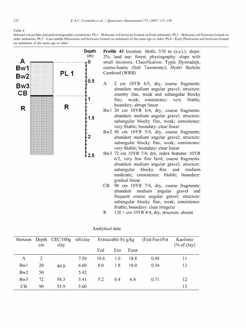
Table 4
Selected soil profiles and pedostratigraphic correlations: PL1—Holocene soil horizons formed on fresh sediments; PL2—Holocene soil horizons formed on
older sediments; PL3—Late-middle Pleistocene soil horizons formed on sediments of the same age or older; PL4—Early Pleistocene soil horizons formed
on sediments of the same age or older
E.A.C. Costantini et al. / Quaternary International 175 (2007) 125–139132
ARTICLE IN PRESS
Table 4 (continued )
E.A.C. Costantini et al. / Quaternary International 175 (2007) 125–139 133
ARTICLE IN PRESS
Table 4 (continued )
E.A.C. Costantini et al. / Quaternary International 175 (2007) 125–139134
ARTICLE IN PRESS
Table 4 (continued )
E.A.C. Costantini et al. / Quaternary International 175 (2007) 125–139 135
The original lithological subdivision of the Quaternarydeposits was not maintained because the information didnot fit with that of the soil map. This was probably due tothe fact that the geological survey mainly used theobservation of surface outcroppings, while during the soilsurveys, many deep profiles were dug.
4. Conclusions
The concept of PL proved to be a practical andstraightforward tool for the summarizing of informationabout soils and paleosols acquired from different studies,carried out in different years, and for conveying thisinformation to a geological map. It must be stressed thatthe success of soil correlation and creation of PLs rests onthe comparison of soil horizon with similar pedogeneticprocesses and degree of weathering of parent material.During the soil survey and sampling, the parametersused for age correlation of soils must come from athorough study of horizon and parts of the horizons ofprofiles (Figs. 6 and 7). Comparison has to be made onlyfor parts of soil horizons with similar soil-forming process.For instance, the mixing of samples belonging to thereduced and oxidized parts of a horizon, or to the leachedstreaks of a fragipan and the peds, must be carefullyavoided.
Adding soil and paleosol information to geologicalmapping remains a challenge, however, and a stimulusfor further studies. Currently, in the case of the Mon-tagnola Senese, some questions remain unsolved. In mostcases, the age of the soils was estimated through correla-tion, and the subdivision of the Quaternary was imprecise.Present knowledge cannot separate late and middle
Pleistocene. Moreover, the age of the oldest deposits couldbe older than early Pleistocene. The geological map doesnot include any information about Pliocene continentaldeposits in the area.This sort of limitation in assessing the age of the
Quaternary deposits in a definitive way can also occur inmany other areas. Nevertheless, a provisional age of theQuaternary cover is information that is always relevant fora geological map.Finally, the research has highlighted some problems
concerning compatibility between geological andpedological maps. Although the detail of both maps ishigh, the complexity of the territory and the forestcover made survey and mapping always difficult. There-fore, the spatializations made by the two approaches(i.e. the extension of the information from a point ofobservation to an area) can be slightly different.A combined pedological/geological approach, whichuses many soil profile excavations, auger and drillholes, besides observation of the outcrops, appears to bethe most appropriate for the survey of the Quaternarycover.
Acknowledgements
The authors thank Professor Fabio Sandrelli (Universityof Siena) for providing the geological map of the studiedarea, Bruce Harrison (Department of Earth and Environ-mental Sciences, New Mexico, USA), Norm Catto(Memorial University of Newfoundland, Canada), andtwo anonymous reviewers for providing very useful andstimulating suggestions.
ARTICLE IN PRESS
Fig. 4. Pedostratigraphic map.
E.A.C. Costantini et al. / Quaternary International 175 (2007) 125–139136

ARTICLE IN PRESS
Fig. 5. Geological map of the study area, with qualification of the Quaternary cover.
E.A.C. Costantini et al. / Quaternary International 175 (2007) 125–139 137
ARTICLE IN PRESS
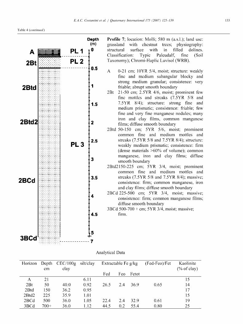
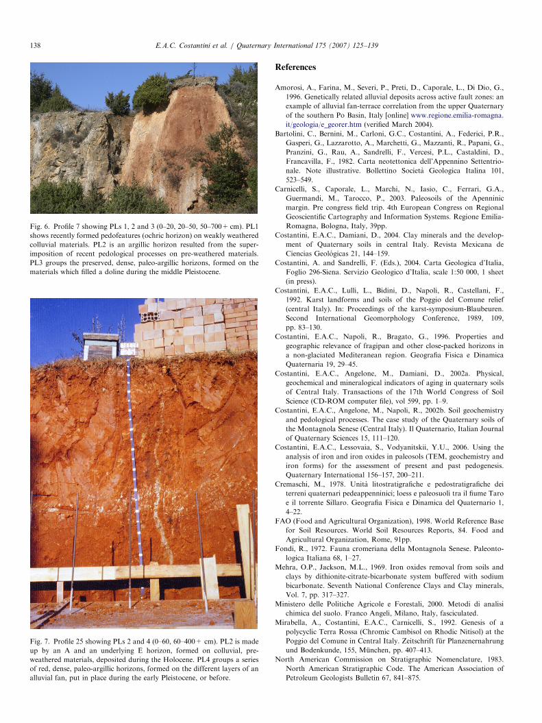
Fig. 6. Profile 7 showing PLs 1, 2 and 3 (0–20, 20–50, 50–700+cm). PL1
shows recently formed pedofeatures (ochric horizon) on weakly weathered
colluvial materials. PL2 is an argillic horizon resulted from the super-
imposition of recent pedological processes on pre-weathered materials.
PL3 groups the preserved, dense, paleo-argillic horizons, formed on the
materials which filled a doline during the middle Pleistocene.
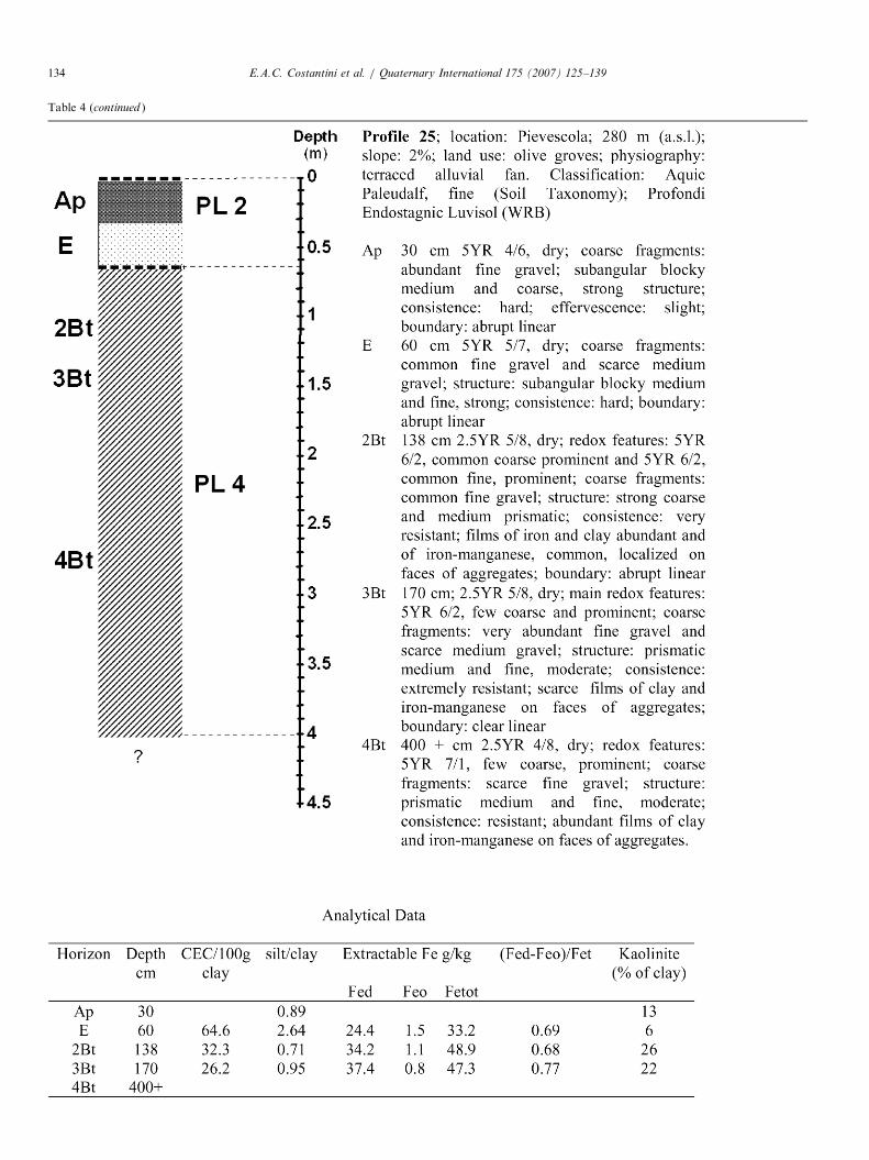
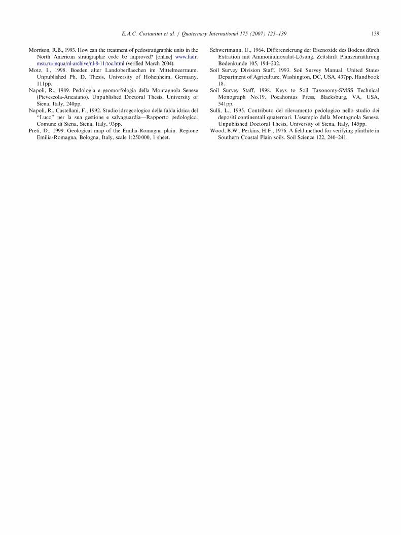
Fig. 7. Profile 25 showing PLs 2 and 4 (0–60, 60–400+ cm). PL2 is made
up by an A and an underlying E horizon, formed on colluvial, pre-
weathered materials, deposited during the Holocene. PL4 groups a series
of red, dense, paleo-argillic horizons, formed on the different layers of an
alluvial fan, put in place during the early Pleistocene, or before.
E.A.C. Costantini et al. / Quaternary International 175 (2007) 125–139138
References
Amorosi, A., Farina, M., Severi, P., Preti, D., Caporale, L., Di Dio, G.,
1996. Genetically related alluvial deposits across active fault zones: an
example of alluvial fan-terrace correlation from the upper Quaternary
of the southern Po Basin, Italy [online] www.regione.emilia-romagna.
it/geologia/e_georer.htm (verified March 2004).
Bartolini, C., Bernini, M., Carloni, G.C., Costantini, A., Federici, P.R.,
Gasperi, G., Lazzarotto, A., Marchetti, G., Mazzanti, R., Papani, G.,
Pranzini, G., Rau, A., Sandrelli, F., Vercesi, P.L., Castaldini, D.,
Francavilla, F., 1982. Carta neotettonica dell’Appennino Settentrio-
nale. Note illustrative. Bollettino Societa Geologica Italina 101,
523–549.
Carnicelli, S., Caporale, L., Marchi, N., Iasio, C., Ferrari, G.A.,
Guermandi, M., Tarocco, P., 2003. Paleosoils of the Apenninic
margin. Pre congress field trip. 4th European Congress on Regional
Geoscientific Cartography and Information Systems. Regione Emilia-
Romagna, Bologna, Italy, 39pp.
Costantini, E.A.C., Damiani, D., 2004. Clay minerals and the develop-
ment of Quaternary soils in central Italy. Revista Mexicana de
Ciencias Geologicas 21, 144–159.
Costantini, A. and Sandrelli, F. (Eds.), 2004. Carta Geologica d’Italia,
Foglio 296-Siena. Servizio Geologico d’Italia, scale 1:50 000, 1 sheet
(in press).
Costantini, E.A.C., Lulli, L., Bidini, D., Napoli, R., Castellani, F.,
1992. Karst landforms and soils of the Poggio del Comune relief
(central Italy). In: Proceedings of the karst-symposium-Blaubeuren.
Second International Geomorphology Conference, 1989, 109,
pp. 83–130.
Costantini, E.A.C., Napoli, R., Bragato, G., 1996. Properties and
geographic relevance of fragipan and other close-packed horizons in
a non-glaciated Mediteranean region. Geografia Fisica e Dinamica
Quaternaria 19, 29–45.
Costantini, E.A.C., Angelone, M., Damiani, D., 2002a. Physical,
geochemical and mineralogical indicators of aging in quaternary soils
of Central Italy. Transactions of the 17th World Congress of Soil
Science (CD-ROM computer file), vol 599, pp. 1–9.
Costantini, E.A.C., Angelone, M., Napoli, R., 2002b. Soil geochemistry
and pedological processes. The case study of the Quaternary soils of
the Montagnola Senese (Central Italy). Il Quaternario, Italian Journal
of Quaternary Sciences 15, 111–120.
Costantini, E.A.C., Lessovaia, S., Vodyanitskii, Y.U., 2006. Using the
analysis of iron and iron oxides in paleosols (TEM, geochemistry and
iron forms) for the assessment of present and past pedogenesis.
Quaternary International 156–157, 200–211.
Cremaschi, M., 1978. Unita litostratigrafiche e pedostratigrafiche dei
terreni quaternari pedeappenninici; loess e paleosuoli tra il fiume Taro
e il torrente Sillaro. Geografia Fisica e Dinamica del Quaternario 1,
4–22.
FAO (Food and Agricultural Organization), 1998. World Reference Base
for Soil Resources. World Soil Resources Reports, 84. Food and
Agricultural Organization, Rome, 91pp.
Fondi, R., 1972. Fauna cromeriana della Montagnola Senese. Paleonto-
logica Italiana 68, 1–27.
Mehra, O.P., Jackson, M.L., 1969. Iron oxides removal from soils and
clays by dithionite-citrate-bicarbonate system buffered with sodium
bicarbonate. Seventh National Conference Clays and Clay minerals,
Vol. 7, pp. 317–327.
Ministero delle Politiche Agricole e Forestali, 2000. Metodi di analisi
chimica del suolo. Franco Angeli, Milano, Italy, fasciculated.
Mirabella, A., Costantini, E.A.C., Carnicelli, S., 1992. Genesis of a
polycyclic Terra Rossa (Chromic Cambisol on Rhodic Nitisol) at the
Poggio del Comune in Central Italy. Zeitschrift fur Planzenernahrung
und Bodenkunde, 155, Munchen, pp. 407–413.
North American Commission on Stratigraphic Nomenclature, 1983.
North American Stratigraphic Code. The American Association of
Petroleum Geologists Bulletin 67, 841–875.
ARTICLE IN PRESSE.A.C. Costantini et al. / Quaternary International 175 (2007) 125–139 139
Morrison, R.B., 1993. How can the treatment of pedostratigraphic units in the
North American stratigraphic code be improved? [online] www.fadr.
msu.ru/inqua/nl-archive/nl-8-11/toc.html (verified March 2004).
Motz, I., 1998. Boeden alter Landoberflaechen im Mittelmeerraum.
Unpublished Ph. D. Thesis, University of Hohenheim, Germany,
111pp.
Napoli, R., 1989. Pedologia e geomorfologia della Montagnola Senese
(Pievescola-Ancaiano). Unpublished Doctoral Thesis, University of
Siena, Italy, 240pp.
Napoli, R., Castellani, F., 1992. Studio idrogeologico della falda idrica del
‘‘Luco’’ per la sua gestione e salvaguardia—Rapporto pedologico.
Comune di Siena, Siena, Italy, 93pp.
Preti, D., 1999. Geological map of the Emilia-Romagna plain. Regione
Emilia-Romagna, Bologna, Italy, scale 1:250 000, 1 sheet.
Schwertmann, U., 1964. Differenzierung der Eisenoxide des Bodens durch
Extration mit Ammoniumoxalat-Losung. Zeitshrift Planzenrnahrung
Bodenkunde 105, 194–202.
Soil Survey Division Staff, 1993. Soil Survey Manual. United States
Department of Agriculture, Washington, DC, USA, 437pp. Handbook
18.
Soil Survey Staff, 1998. Keys to Soil Taxonomy-SMSS Technical
Monograph No.19. Pocahontas Press, Blacksburg, VA, USA,
541pp.
Sulli, L., 1995. Contributo del rilevamento pedologico nello studio dei
depositi continentali quaternari. L’esempio della Montagnola Senese.
Unpublished Doctoral Thesis, University of Siena, Italy, 145pp.
Wood, B.W., Perkins, H.F., 1976. A field method for verifying plinthite in
Southern Coastal Plain soils. Soil Science 122, 240–241.