Acknowledgements - Alaska Department of Transportation
271
-
Upload
khangminh22 -
Category
Documents
-
view
0 -
download
0
Transcript of Acknowledgements - Alaska Department of Transportation
Acknowledgements
This Environmental Desk Reference would not have been possible without the individual contributions of many past and present PD&E analysts and engineers who offered creative ideas, tested the procedures, reviewed and offered comments, proofread and edited this vast collection of reference materials. Special thanks also to the Regional Environmental Manager and Section Chief for supporting this effort.
“Unity is strength…when there is teamwork and collaboration, wonderful things can be
achieved.” Mattie Stepanek
Preface
This Environmental Desk Reference was initiated and developed through the hard work and perseverance of CR Environmental Impact Analysts between 2009 and 2013. Analysts arrive at DOT&PF with a wide variety of backgrounds and familiarity with NEPA, but they all have to learn DOT&PFs unique application of NEPA. From day one, analysts are required to hit the ground running and learn as they go. This desk reference is intended to provide incoming analysts the tools they need to successfully transition into their new roles within DOT&PF. Equipped with the proper tools, analysts can quickly develop the knowledge, skills, and abilities needed to meet the demands of the job – minimizing the learning curve. Analysts will gain confidence, efficiency, and pride in their work, ultimately creating a more effective and higher quality program.
Purpose of this Environmental Desk Reference
The purpose of this Environmental Desk Reference is to provide new analysts with the foundational information and tools they need develop their knowledge base with the ultimate goal of easing their transition into DOT&PF. It is also intended to provide more experienced analysts a tool they can use to stay apprised of current procedures, maintain consistency, and create their own library of useful information.
Objectives of this Environmental Desk Reference
� To provide a consistent framework for common (and uncommon) procedures � To provide step-by-step processing instructions for routine actions � To provide solutions for common situations that causes analysts to struggle
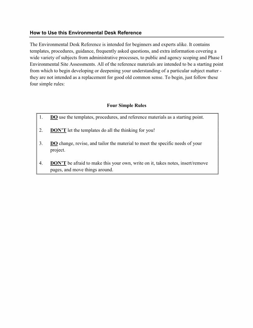
How to Use this Environmental Desk Reference
The Environmental Desk Reference is intended for beginners and experts alike. It contains templates, procedures, guidance, frequently asked questions, and extra information covering a wide variety of subjects from administrative processes, to public and agency scoping and Phase I Environmental Site Assessments. All of the reference materials are intended to be a starting point from which to begin developing or deepening your understanding of a particular subject matter - they are not intended as a replacement for good old common sense. To begin, just follow these four simple rules:
Four Simple Rules
1. DO use the templates, procedures, and reference materials as a starting point.
2. DON’T let the templates do all the thinking for you!
3. DO change, revise, and tailor the material to meet the specific needs of yourproject.
4. DON’T be afraid to make this your own, write on it, takes notes, insert/remove pages, and move things around.
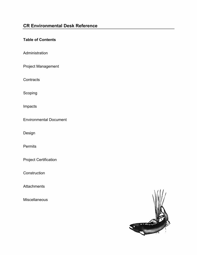
CR Environmental Desk Reference
Table of Contents
Administration
Project Management
Contracts
Scoping
Impacts
Environmental Document
Design
Permits
Project Certification
Construction
Attachments
Miscellaneous

Administration
Table of Contents
Technical Writing Cheat Sheet
Creating Files
Electronic File Naming
Types and Uses of Documents
Training Request Procedure
Training Request Form
Travel Procedure
Travel Frequently Asked Questions
Reimbursements
AD
MIN
ISTRA
TION

��
��
�La
st�R
evis
ed�–
�Nov
embe
r�20
11�
�
DO
T&PF
Cen
tral
Reg
ion
Tech
nica
l Writ
ing
Che
at S
heet
A
cron
yms
�Sp
ell o
ut th
e ac
rony
m o
r abb
revi
atio
n on
firs
t use
�
For d
ocum
ents
ove
r 50
page
s, re
defin
e ac
rony
ms i
f the
y ap
pear
few
er th
an fi
ve ti
mes
�
Do
not p
ut “
a”, “
an”,
or “
the”
bef
ore
an a
cron
ym, e
xcep
t at t
he b
egin
ning
of t
he se
nten
ce
�A
cron
yms s
houl
d be
def
ined
in ta
bles
eve
n if
defin
ed p
revi
ousl
y in
the
docu
men
t tex
t Fo
rmat
ting
Text
�Le
ft ju
stify
and
sing
le sp
ace
text
in p
arag
raph
s �
Doc
umen
t: 12
poi
nt T
imes
New
Rom
an�
Emai
ls: 1
2 po
int Verdana
or A
rial
�A
lway
s pro
vide
a h
eadi
ng w
here
app
licab
le to
bre
ak b
etw
een
para
grap
hs
oH
eadi
ngs:
12 p
oint
Aria
l (bo
ld, n
ot it
alic
s, u
nder
lined
or a
ll ca
ps)
oS
ubhe
adin
g: 1
2 po
int A
rial (
italic
s, n
ot b
old,
und
erlin
ed, o
r all
caps
)�
Alw
ays u
se a
com
ma
afte
r dat
es in
a se
nten
ce. F
or e
xam
ple:
On
Nov
embe
r 10,
200
9, w
e co
nduc
ted…
�
Avo
id u
sing
sym
bols
whe
n po
ssib
le (e
xcep
t in
tabl
es).
For e
xam
ple:
the
wor
d pe
rcen
t sho
uld
be sp
elle
d ou
t. �
Onl
y on
e sp
ace
afte
r pun
ctua
tion
mar
ks
Form
attin
gTa
bles
�Te
xt: 1
0 po
int A
rial
�Fo
otno
te: 8
poi
nt A
rial
�A
void
usi
ng v
ertic
al li
nes
�Pr
ovid
e a
title
and
num
ber a
bove
eac
h ta
ble
�A
lway
s ref
er to
tabl
e in
pre
cedi
ng te
xt
Scie
ntifi
cN
ames
�W
hen
first
usi
ng a
com
mon
spec
ies n
ame,
ital
iciz
e its
scie
ntifi
c na
me
in p
aren
thes
es [e
.g.,
Chi
nook
salm
on (O
ncor
hync
hus
tsha
wyt
scha
)]�
Whe
n th
ere
is n
o am
bigu
ity a
bout
the
spec
ies b
eing
refe
renc
e, y
ou m
ay u
se a
gen
eric
term
(e.g
., ea
gle,
fish
) �
Use
“sp
” if
the
spec
ies i
s unk
now
n an
d “s
pp”
if se
vera
l spe
cies
are
unk
now
n (d
o no
t ita
liciz
e “s
p” o
r “sp
p” –
e.g
., Al
nus s
p.)
Num
bers
�
Spel
l out
sing
le d
igit
num
bers
, exc
ept f
or m
oney
, tim
e of
day
, and
dat
es
�Sp
ell o
ut a
ll nu
mbe
rs u
sed
to st
art a
sent
ence
– if
pos
sibl
e, re
wor
d th
e se
nten
ce w
ith th
e nu
mbe
r app
earin
g la
ter i
n se
nten
ce
�W
hen
two
num
bers
are
adj
acen
t, sp
ell o
ut th
e nu
mbe
r tha
t is m
ost e
asily
exp
ress
ed in
wor
ds a
nd le
ave
the
othe
r as a
num
eral
�
Shou
ld y
ou w
rite
13-f
eet o
r 13
feet
? W
hen
you’
re c
ombi
ning
two
or m
ore
wor
ds to
form
a c
ompo
und
adje
ctiv
e in
fron
t of a
no
un, p
ut h
yphe
ns b
etw
een
thes
e w
ords
(e.g
., La
ra h
ande
d m
e a
15-f
oot p
ole;
Ant
hony
swun
g hi
s fiv
e-po
und
ham
mer
; Suz
anne
w
on th
e ra
ce b
y a
solid
15
feet
) �
A n
umbe
r fol
low
ed b
y an
abb
revi
ated
mea
sure
men
t is n
ever
hyp
hena
ted
(e.g
., 3
m st
ream
, not
3-m
stre
am)
�M
easu
rem
ents
less
than
1 u
nit a
re si
ngul
ar (e
.g.,
0.1
mile
, 0.5
foot
, 0.2
5 ac
re)
Stan
dard
Ref
eren
ces
�
Whe
n ci
ting
a re
fere
nce
in d
ocum
ent t
ext,
writ
e th
e au
thor
s las
t nam
e an
d ye
ar o
f pub
licat
ion
in p
aren
thes
is
�W
hen
two
coau
thor
s are
cite
d –
list b
oth
nam
es; m
ore
than
two
auth
ors c
ited
– lis
t the
prim
ary
auth
or fo
llow
ed b
y et
al.
�W
hen
a ci
tatio
n re
fere
nce
occu
rs w
ithin
a se
nten
ce, o
nly
incl
ude
the
year
of p
ublic
atio
n w
ithin
par
enth
esis
�
Ref
eren
ces a
t the
end
of a
doc
umen
t sho
uld
be in
alp
habe
tical
ord
er
�If
a fi
gure
or t
able
in a
repo
rt us
es d
ata
from
ano
ther
sour
ce, c
ite th
e so
urce
und
erne
ath
the
figur
e or
tabl
e �
Look
at t
he A
PA S
tyle
gui
de lo
cate
d at
http
://w
ww
.uw
p.ed
u/de
partm
ents
/libr
ary/
guid
es/a
pa.h
tm o
r the
AD
F&G
Writ
er’s
Gui
de –
Th
ird E
ditio
n fo
r mor
e in
form
atio
n �

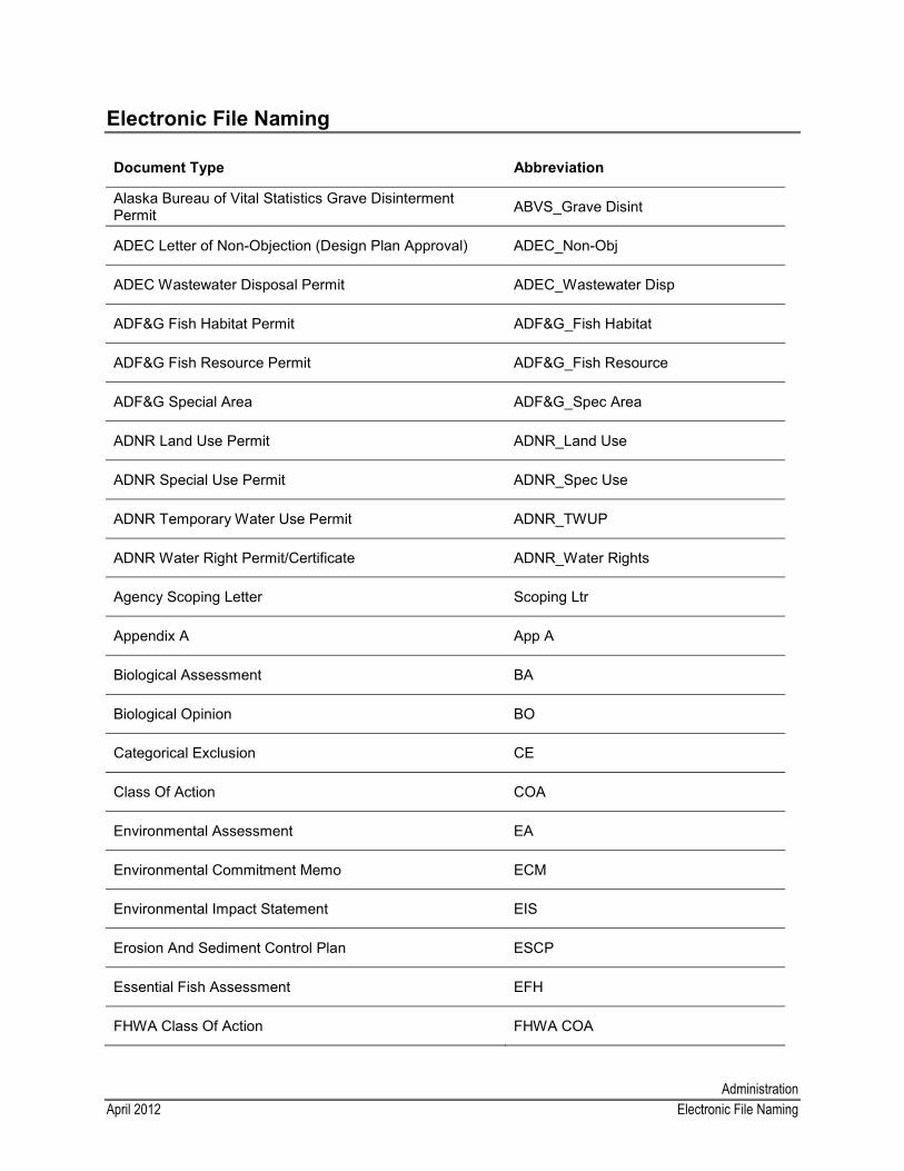
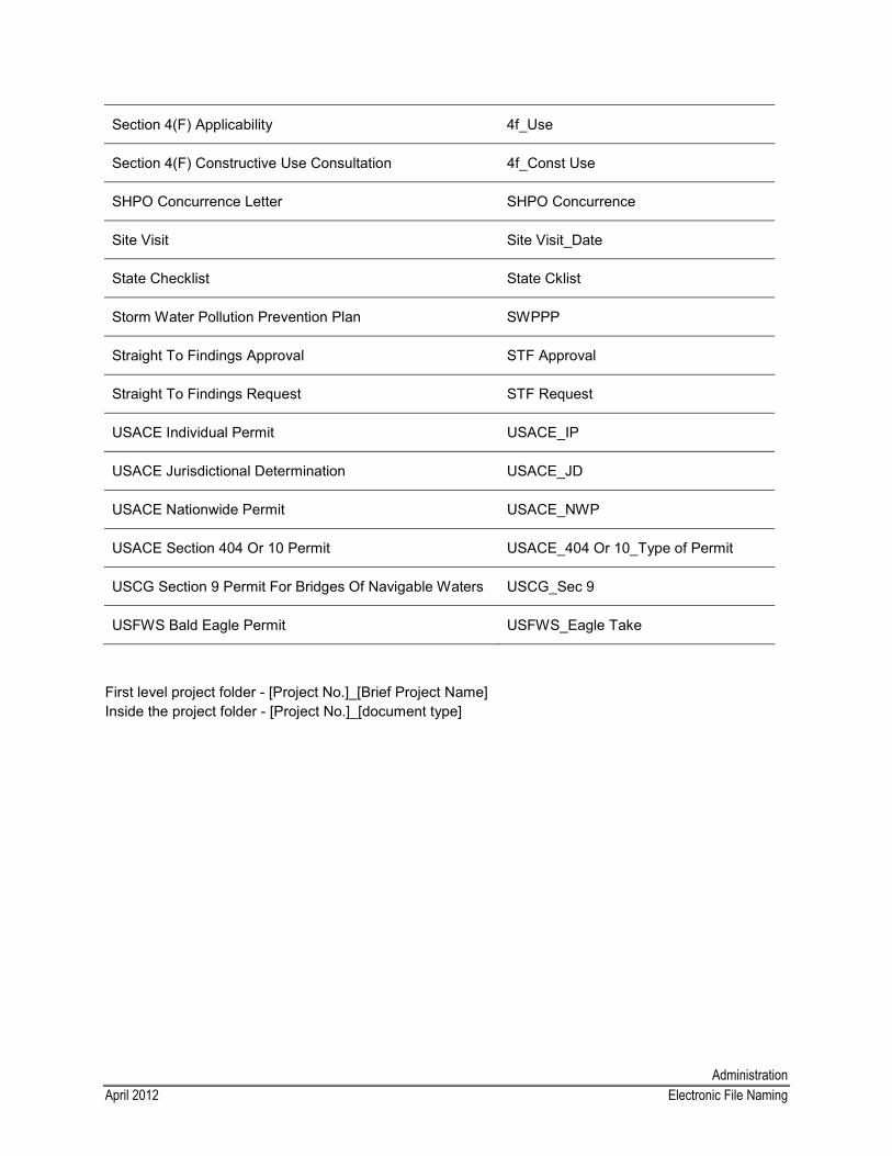
AdministrationApril 2012 Electronic File Naming
Electronic File Naming
Document Type Abbreviation
Alaska Bureau of Vital Statistics Grave Disinterment Permit ABVS_Grave Disint
ADEC Letter of Non-Objection (Design Plan Approval) ADEC_Non-Obj
ADEC Wastewater Disposal Permit ADEC_Wastewater Disp
ADF&G Fish Habitat Permit ADF&G_Fish Habitat
ADF&G Fish Resource Permit ADF&G_Fish Resource
ADF&G Special Area ADF&G_Spec Area
ADNR Land Use Permit ADNR_Land Use
ADNR Special Use Permit ADNR_Spec Use
ADNR Temporary Water Use Permit ADNR_TWUP
ADNR Water Right Permit/Certificate ADNR_Water Rights
Agency Scoping Letter Scoping Ltr
Appendix A App A
Biological Assessment BA
Biological Opinion BO
Categorical Exclusion CE
Class Of Action COA
Environmental Assessment EA
Environmental Commitment Memo ECM
Environmental Impact Statement EIS
Erosion And Sediment Control Plan ESCP
Essential Fish Assessment EFH
FHWA Class Of Action FHWA COA
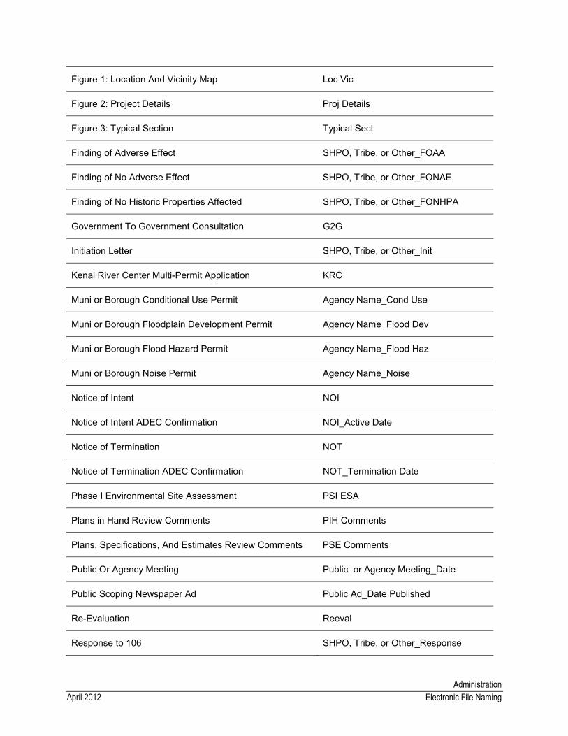
AdministrationApril 2012 Electronic File Naming
Figure 1: Location And Vicinity Map Loc Vic
Figure 2: Project Details Proj Details
Figure 3: Typical Section Typical Sect
Finding of Adverse Effect SHPO, Tribe, or Other_FOAA
Finding of No Adverse Effect SHPO, Tribe, or Other_FONAE
Finding of No Historic Properties Affected SHPO, Tribe, or Other_FONHPA
Government To Government Consultation G2G
Initiation Letter SHPO, Tribe, or Other_Init
Kenai River Center Multi-Permit Application KRC
Muni or Borough Conditional Use Permit Agency Name_Cond Use
Muni or Borough Floodplain Development Permit Agency Name_Flood Dev
Muni or Borough Flood Hazard Permit Agency Name_Flood Haz
Muni or Borough Noise Permit Agency Name_Noise
Notice of Intent NOI
Notice of Intent ADEC Confirmation NOI_Active Date
Notice of Termination NOT
Notice of Termination ADEC Confirmation NOT_Termination Date
Phase I Environmental Site Assessment PSI ESA
Plans in Hand Review Comments PIH Comments
Plans, Specifications, And Estimates Review Comments PSE Comments
Public Or Agency Meeting Public or Agency Meeting_Date
Public Scoping Newspaper Ad Public Ad_Date Published
Re-Evaluation Reeval
Response to 106 SHPO, Tribe, or Other_Response
AdministrationApril 2012 Electronic File Naming
Section 4(F) Applicability 4f_Use
Section 4(F) Constructive Use Consultation 4f_Const Use
SHPO Concurrence Letter SHPO Concurrence
Site Visit Site Visit_Date
State Checklist State Cklist
Storm Water Pollution Prevention Plan SWPPP
Straight To Findings Approval STF Approval
Straight To Findings Request STF Request
USACE Individual Permit USACE_IP
USACE Jurisdictional Determination USACE_JD
USACE Nationwide Permit USACE_NWP
USACE Section 404 Or 10 Permit USACE_404 Or 10_Type of Permit
USCG Section 9 Permit For Bridges Of Navigable Waters USCG_Sec 9
USFWS Bald Eagle Permit USFWS_Eagle Take
First level project folder - [Project No.]_[Brief Project Name] Inside the project folder - [Project No.]_[document type]
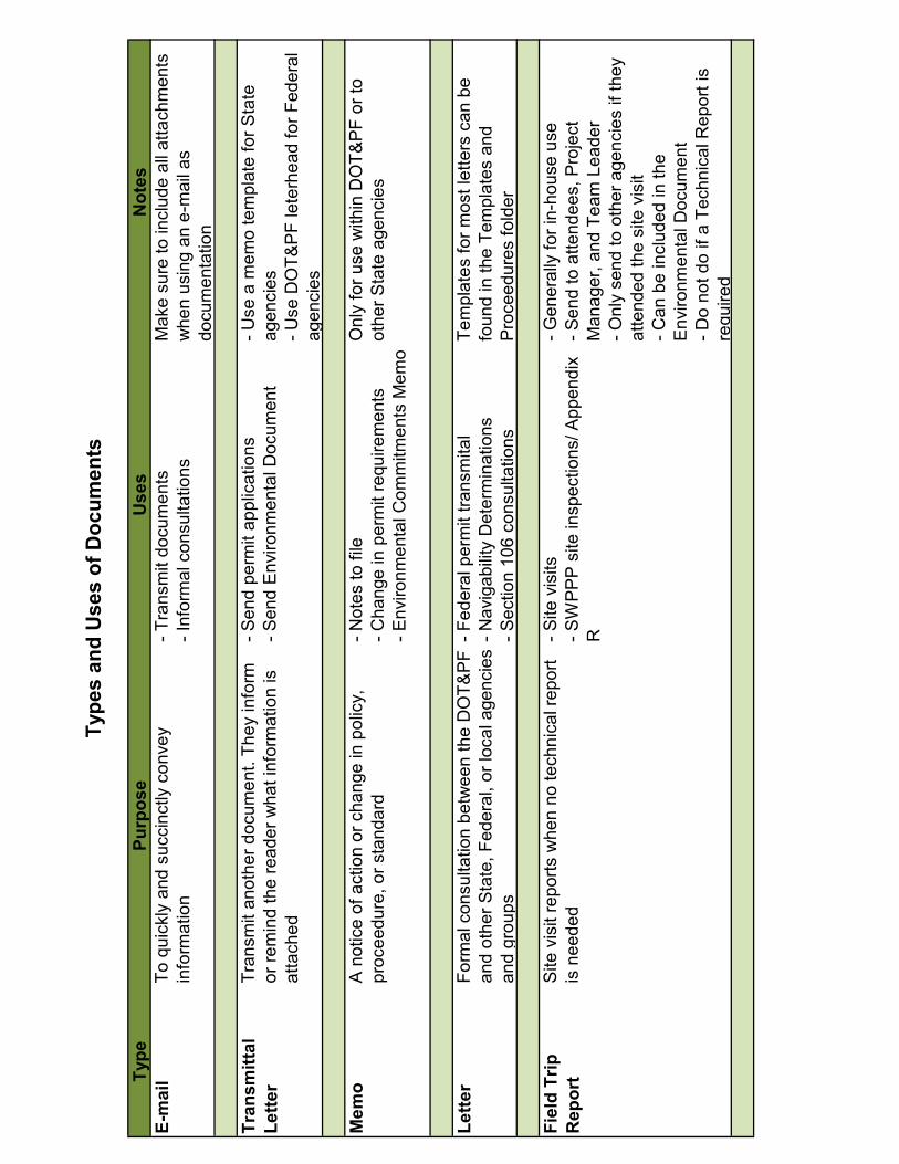
Type
Purp
ose
Use
sN
otes
E-m
ail
To q
uick
ly a
nd s
ucci
nctly
con
vey
info
rmat
ion
- Tra
nsm
it do
cum
ents
- Inf
orm
al c
onsu
ltatio
nsM
ake
sure
to in
clud
e al
l atta
chm
ents
w
hen
usin
g an
e-m
ail a
s do
cum
enta
tion
Tran
smitt
alLe
tter
Tran
smit
anot
her d
ocum
ent.
They
info
rm
or re
min
d th
e re
ader
wha
t inf
orm
atio
n is
at
tach
ed
- Sen
d pe
rmit
appl
icat
ions
- Sen
d E
nviro
nmen
tal D
ocum
ent
- Use
a m
emo
tem
plat
e fo
r Sta
te
agen
cies
- Use
DO
T&P
F le
terh
ead
for F
eder
al
agen
cies
Mem
oA
not
ice
of a
ctio
n or
cha
nge
in p
olic
y,
proc
eedu
re, o
r sta
ndar
d- N
otes
to fi
le- C
hang
e in
per
mit
requ
irem
ents
- Env
ironm
enta
l Com
mitm
ents
Mem
o
Onl
y fo
r use
with
in D
OT&
PF
or to
ot
her S
tate
age
ncie
s
Lette
rFo
rmal
con
sulta
tion
betw
een
the
DO
T&P
F an
d ot
her S
tate
, Fed
eral
, or l
ocal
age
ncie
s an
d gr
oups
- Fed
eral
per
mit
trans
mita
l- N
avig
abilit
y D
eter
min
atio
ns- S
ectio
n 10
6 co
nsul
tatio
ns
Tem
plat
es fo
r mos
t let
ters
can
be
foun
d in
the
Tem
plat
es a
nd
Pro
ceed
ures
fold
er
Fiel
d Tr
ip
Rep
ort
Site
vis
it re
ports
whe
n no
tech
nica
l rep
ort
is n
eede
d- S
ite v
isits
- SW
PP
P s
ite in
spec
tions
/ App
endi
x R
- Gen
eral
ly fo
r in-
hous
e us
e- S
end
to a
ttend
ees,
Pro
ject
M
anag
er, a
nd T
eam
Lea
der
- Onl
y se
nd to
oth
er a
genc
ies
if th
ey
atte
nded
the
site
vis
it- C
an b
e in
clud
ed in
the
Env
ironm
enta
l Doc
umen
t- D
o no
t do
if a
Tech
nica
l Rep
ort i
s re
quire
d
Type
s an
d U
ses
of D
ocum
ents
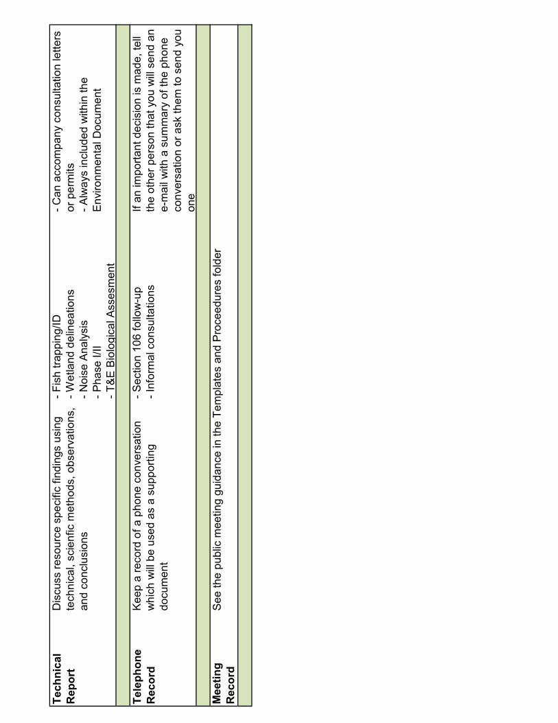
Tech
nica
lR
epor
tD
iscu
ss re
sour
ce s
peci
fic fi
ndin
gs u
sing
te
chni
cal,
scie
nfic
met
hods
, obs
erva
tions
, an
d co
nclu
sion
s
- Fis
h tra
ppin
g/ID
- Wet
land
del
inea
tions
- Noi
se A
naly
sis
- Pha
se I/
II- T
&E
Bio
logi
cal A
sses
men
t
- Can
acc
ompa
ny c
onsu
ltatio
n le
tters
or
per
mits
- Alw
ays
incl
uded
with
in th
e E
nviro
nmen
tal D
ocum
ent
Tele
phon
e R
ecor
dK
eep
a re
cord
of a
pho
ne c
onve
rsat
ion
whi
ch w
ill b
e us
ed a
s a
supp
ortin
g do
cum
ent
- Sec
tion
106
follo
w-u
p- I
nfor
mal
con
sulta
tions
If an
impo
rtant
dec
isio
n is
mad
e, te
ll th
e ot
her p
erso
n th
at y
ou w
ill s
end
an
e-m
ail w
ith a
sum
mar
y of
the
phon
e co
nver
satio
n or
ask
them
to s
end
you
one
Mee
ting
Rec
ord
See
the
publ
ic m
eetin
g gu
idan
ce in
the
Tem
plat
es a
nd P
roce
edur
es fo
lder
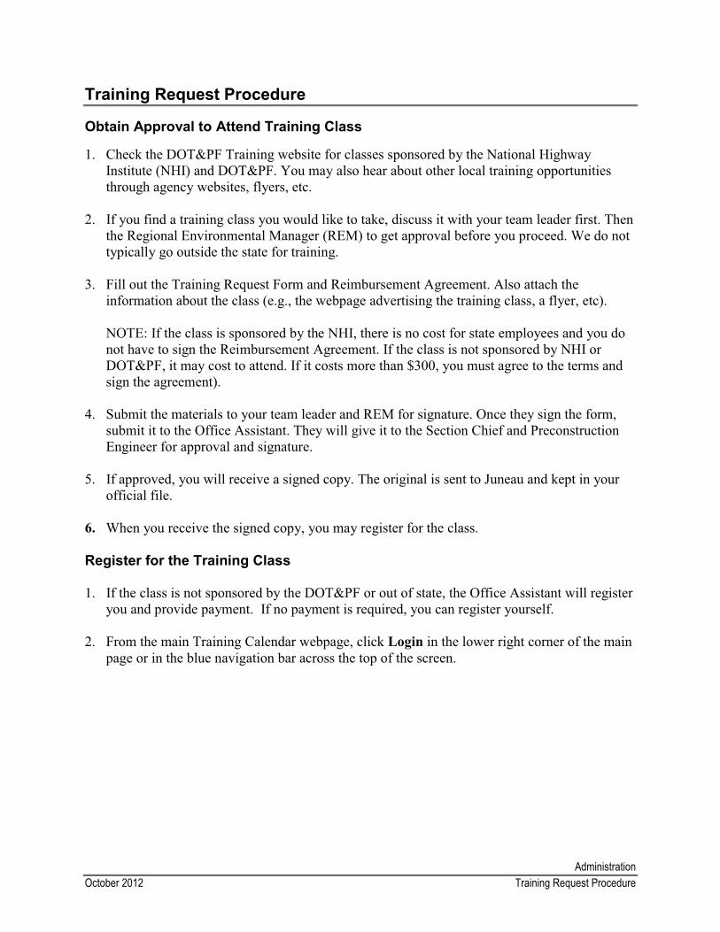
AdministrationOctober 2012 Training Request Procedure
Training Request Procedure
Obtain Approval to Attend Training Class
1. Check the DOT&PF Training website for classes sponsored by the National Highway Institute (NHI) and DOT&PF. You may also hear about other local training opportunities through agency websites, flyers, etc.
2. If you find a training class you would like to take, discuss it with your team leader first. Thenthe Regional Environmental Manager (REM) to get approval before you proceed. We do not typically go outside the state for training.
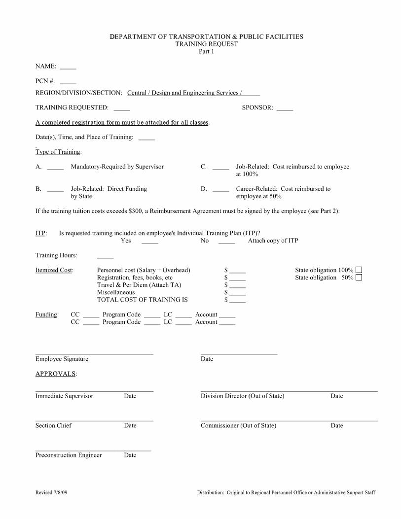
3. Fill out the Training Request Form and Reimbursement Agreement. Also attach the information about the class (e.g., the webpage advertising the training class, a flyer, etc).
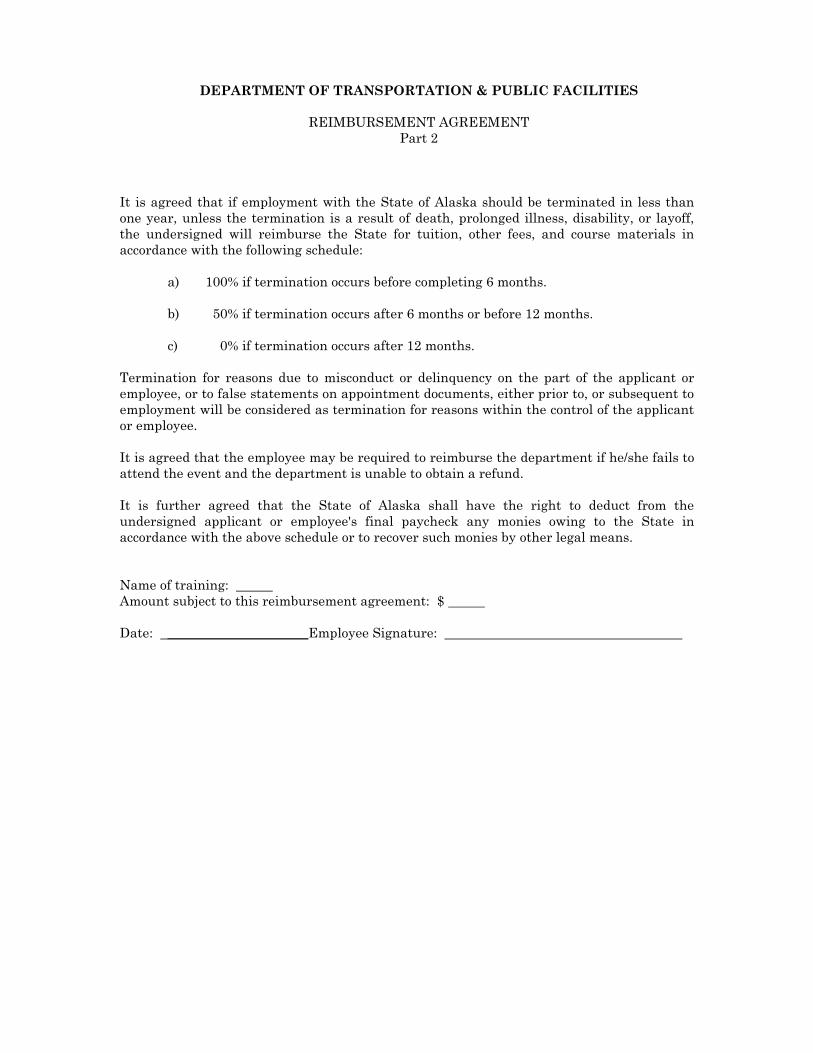
NOTE: If the class is sponsored by the NHI, there is no cost for state employees and you do not have to sign the Reimbursement Agreement. If the class is not sponsored by NHI or DOT&PF, it may cost to attend. If it costs more than $300, you must agree to the terms and sign the agreement).
4. Submit the materials to your team leader and REM for signature. Once they sign the form,submit it to the Office Assistant. They will give it to the Section Chief and Preconstruction Engineer for approval and signature.
5. If approved, you will receive a signed copy. The original is sent to Juneau and kept in your official file.
6. When you receive the signed copy, you may register for the class.
Register for the Training Class
1. If the class is not sponsored by the DOT&PF or out of state, the Office Assistant will register you and provide payment. If no payment is required, you can register yourself.
2. From the main Training Calendar webpage, click Login in the lower right corner of the main page or in the blue navigation bar across the top of the screen.
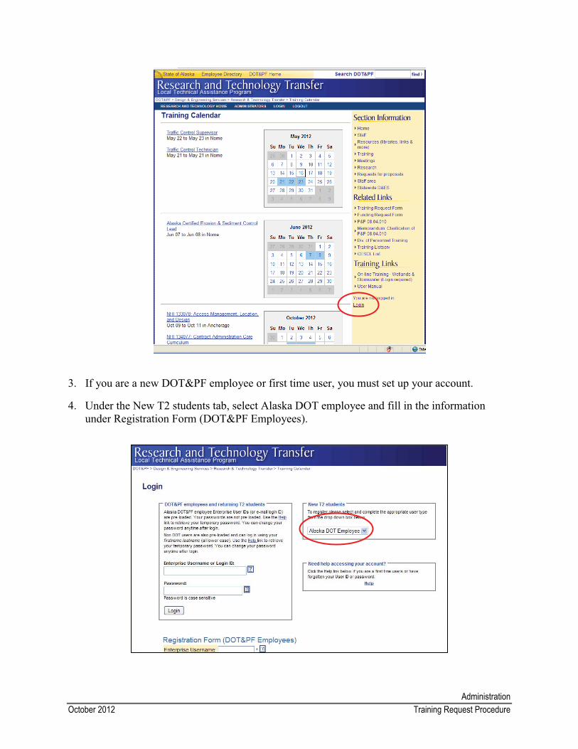
AdministrationOctober 2012 Training Request Procedure
3. If you are a new DOT&PF employee or first time user, you must set up your account.
4. Under the New T2 students tab, select Alaska DOT employee and fill in the information under Registration Form (DOT&PF Employees).
AdministrationOctober 2012 Training Request Procedure
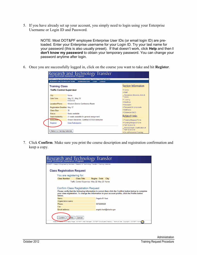
5. If you have already set up your account, you simply need to login using your Enterprise Username or Login ID and Password.
NOTE: Most DOT&PF employee Enterprise User IDs (or email login ID) are pre-loaded. Enter your Enterprise username for your Login ID. Try your last name for your password (this is also usually preset). If that doesn’t work, click Help and then Idon't know my password to obtain your temporary password. You can change your password anytime after login.
6. Once you are successfully logged in, click on the course you want to take and hit Register.
7. Click Confirm. Make sure you print the course description and registration confirmation and keep a copy.
Revised 7/8/09 Distribution: Original to Regional Personnel Office or Administrative Support Staff
DDEPARTMENT OF TRANSPORTATION & PUBLIC FACILITIESTRAINING REQUEST
Part 1
NAME:
PCN #:
REGION/DIVISION/SECTION: Central / Design and Engineering Services /
TRAINING REQUESTED: SPONSOR: A completed registration form must be attached for all classes.
Date(s), Time, and Place of Training:
Type of Training:
A. Mandatory-Required by Supervisor C. Job-Related: Cost reimbursed to employeeat 100%
B. Job-Related: Direct Funding D. Career-Related: Cost reimbursed to by State employee at 50%
If the training tuition costs exceeds $300, a Reimbursement Agreement must be signed by the employee (see Part 2):
ITP: Is requested training included on employee's Individual Training Plan (ITP)?Yes No Attach copy of ITP
Training Hours:
Itemized Cost: Personnel cost (Salary + Overhead) $ State obligation 100% Registration, fees, books, etc $ State obligation 50% Travel & Per Diem (Attach TA) $ Miscellaneous $ TOTAL COST OF TRAINING IS $
Funding: CC Program Code LC Account CC Program Code LC Account
Employee Signature Date
APPROVALS:
Immediate Supervisor Date Division Director (Out of State) Date
Section Chief Date Commissioner (Out of State) Date
___________________________________Preconstruction Engineer Date
DEPARTMENT OF TRANSPORTATION & PUBLIC FACILITIES
REIMBURSEMENT AGREEMENT Part 2
It is agreed that if employment with the State of Alaska should be terminated in less than one year, unless the termination is a result of death, prolonged illness, disability, or layoff, the undersigned will reimburse the State for tuition, other fees, and course materials in accordance with the following schedule: a) 100% if termination occurs before completing 6 months. b) 50% if termination occurs after 6 months or before 12 months. c) 0% if termination occurs after 12 months. Termination for reasons due to misconduct or delinquency on the part of the applicant or employee, or to false statements on appointment documents, either prior to, or subsequent to employment will be considered as termination for reasons within the control of the applicant or employee. It is agreed that the employee may be required to reimburse the department if he/she fails to attend the event and the department is unable to obtain a refund. It is further agreed that the State of Alaska shall have the right to deduct from the undersigned applicant or employee's final paycheck any monies owing to the State in accordance with the above schedule or to recover such monies by other legal means. Name of training: Amount subject to this reimbursement agreement: $ Date: _____________________Employee Signature:
Administrative November 2012 Travel Procedure
Travel Procedure
For more information about travel and work-related trips, see State Travel Frequently Asked Questions and the State Travel Policy on the Dept. of Administration/Division of Finance/Travel Quick Links webpage.
Pre-Travel
1. Obtain approval to travel from the Design Project Manager and your supervisor.
2. Look up flight and hotel availability, if needed. Per contract agreements, Alaska Airlines is the preferred airline and should be considered first. If no Alaska Airlines flights are available, we commonly use Era Aviation, Pen Air, or a charter airline. Arrangements will be made according to your preferences if possible, but cannot be guaranteed.
3. Complete the top of the Pre/Post Travel form (Located on the P: drive under Design/Forms/Travel) with the specific flight times and hotel information. Travel approval can take up to a week to obtain, so fill out your paperwork early to ensure time to get it approved.
4. Submit the Pre/Post Travel form to your supervisor for approval and signature.
5. Give the approved Pre/Post Travel form to the PD&E office assistant.
a. They will create a Travel Authorization form (TA) and submit it to the Section Chief & Pre-construction Engineer for approval and then book your flight, hotel, and vehicle.
b. If the office assistant does not have a copy of your driver’s license, make one for them – they need your date of birth and full name to book reservations.
6. The office assistant will provide you with an approved TA and flight, hotel, and vehicle itinerary.
7. Review the TA as soon as possible and let the office assistant know if anything is incorrect. Always take a copy of the flight itinerary, hotel confirmation, and vehicle confirmation as proof of your reservations.
8. If your trip is cancelled, let the office assistant know as soon as possible. Post Travel
1. Within 3 days of your return, complete the bottom of the Pre/Post Travel form. List any expenses at the bottom of the worksheet and turn in with receipts to the office assistant.
Administrative November 2012 Travel Procedure
2. The office assistant will provide you with a final TA for your approval and signature. Pay particular attention to the list of reimbursements, which should include per diem, parking, fuel, etc. Check carefully for mistakes before signing the form. If you find discrepancies,return it to the office assistant for a revision.
3. After you sign, your final TA will be processed for payment. You should receive a check from DOT in 3-6 weeks or a direct deposit for your per diem and any reimbursements, if applicable.
AdministrationNovember 2012 Travel Frequently Asked Questions
Travel Frequently Asked Questions
1. When do we travel?
Analysts travel for a variety of reasons. Most often, analysts travel to visit their project sites or to attend public or agency meetings. Analysts typically visit their project sites to review the project area with the Design team, to conduct technical studies (e.g. wetland delineation), to participate in agency site visits, and to monitor construction. Depending on the project location, trips could vary from day trips to several day trips. Other reasons analysts travel is to attend training or to participate in conferences or technical meetings.
2. When should I complete the Pre/Post Travel form?
You should complete the Pre/Post Travel form every time you fly or drive over 50 miles from the District office.
3. How far in advance should I submit the Pre/Post Travel form? Complete and submit the Pre/Post Travel form as soon as your travel has been approved by the Design Project Manager and supervisor and you have enough information to make reservations.
Be sure to coordinate your plans with others going on the trip. It is also a good idea to coordinate with other analysts with projects in the area to see if there is anything you may be able to do for them while you are there.
4. What airline and fights do I choose?
According to contract specifications, Alaska Airlines is the preferred airline and we must use them unless there are no available flights or Alaska Airlines does not service the destination.
5. How should I prepare for a trip?
� Research the community you’re traveling to get an idea of what to expecto Pack appropriately for the weather and accommodationso Keep in mind that you could get stranded for a few days in remote locations
and be prepared to sleep on the floor if you have to
� Plan your activities to maximize your time in the field
� Coordinate your visit so you do not have to be alone, especially in remote areas
� Confirm your reservations before you go
AdministrationNovember 2012 Travel Frequently Asked Questions
6. What else should I consider before and during travel?
� If you are heading out in the winter, it is a good idea to bring an emergency kit. PD&E has an emergency kit for vehicles above the locked supply cabinet
� Do not count on your cell phone working, especially an iPhone
� Go to the bathroom when you get the chance; some remote villages do not have bathroom facilities
� Bring cash, snacks, bug spray, and an empty water bottle to fill after you pass through security
� Pack everything you really need in your carry-on luggage. If checked bags get lost DOT will not reimburse you for buying items you need
� Always give your lodging info to your supervisor, as well as a family member, in case your cell does not work and someone needs to contact you
7. What do I need to know about renting a car?
� Budget Rental is mandatory for state employees in Anchorage, Fairbanks, and Juneau
� If Budget has no vehicles available you may use another company
� If there is any damage to a rental vehicle, never accept responsibility or admit liability and advise the lessor to contact the Dept. of Administration’s Division of Risk Management
8. What should I do if I encounter problems with my hotel or car reservations when I arrive?
� Obtain a Hotel/Car One Card Authorization form from the Office Assistant to provide proof of payment for your hotel and car rental.
� If you have a problem with your reservations while traveling, contact US Travel at 866-762-8728. They are available from 7:00 am to 7:00 pm every day. If you have problems with your car rental during normal business hours, contact Jessica Hollis at 907-269-0895. She is available Monday-Friday from 7:30 am to 4:00pm.
� Always travel with a copy of the Traveler Contact Card (copies of the card are available on the state travel website), in case of emergencies.
AdministrationNovember 2012 Travel Frequently Asked Questions
� Bring a credit card to use in case you have to pay for services and await for state reimbursement.
9. When do I get Per Diem and how much do I get?
� Per diem is only paid for trips over 12 hours long (The state factors in a two-hour check-in period for departures and a one hour [upon arrival] luggage retrieval period for flights)
� Short-term: Meals and Incidentals (M&IE) pay in Alaska is $60.00 for a full day, ($12.00 for breakfast, $16.00 for lunch, and $32.00 for dinner)
� Long-term: M&IE pay in Alaska is $33.00 per full day, ($7.00 for breakfast, $9.00 for lunch, $17.00 for dinner)
� Outside Alaska – Per diem rates vary based on the federal rate.
� Be sure to get receipts for parking, gas, hotel, and any other travel-related expenses.
10.What expenses will I not be reimbursed for?
� Lost or stolen articles, alcoholic beverages, services to gain entry to a locked vehicle, damage to personal cars, clothing or other items, gratuities, personal phone calls, entertainment expenses
� All expenses related to personal negligence of traveler (parking tickets, fines, etc.)
� Expenses for children, spouses, or companions while in travel status
11.If I get a voucher because my work flight was delayed or cancelled, do I get to keep it?
No. Involuntarily denied boarding compensation from airlines is payable to the state, not the traveler
12.Am I charged taxes for travel and lodging?
� State employees are ultimately responsible for identifying themselves as state employees and ensuring that no taxes are charged for services or products
� It is the traveler’s responsibility to pay for any taxes not removed prior to the issuance of a receipt
AdministrationNovember 2012 Travel Frequently Asked Questions
13.Can I drive my personal vehicle?
� Yes, if driving for a specific business errand; from one state office to another; or travelling to perform of field work *
� No, if you are allowing non-work-related riders while using your car for state business
� No, if travelling between your workplace and home (travel between a residence and an airport may be considered state business if the purpose of the air travel was state business)
* Anyone using his or her personal vehicle on state business must carry auto liability insurance. In the event of an accident, your personal auto liability insurance will cover damages and medical expenses to any third party up to the maximum limit of your policy. The state will usually cover any liability exposure in excess of your own liability coverage [except when the Attorney General determines the employee was not acting within the scope of the employee's office or employment at the time of the incident out of which the claim arose. You are required by State law to notify the Department of Public Safety of any accident involving personal injury or damage totaling $500 or more. In addition to this, if you have an auto accident while on State Business, you are required to complete State Form 02-919, Liability Accident Notice, and forward it to the Division of Risk Management.

AdministrationMay 2012 Reimbursements
Reimbursements
If you find you have to pay for something (gas, fee, etc.) while on official work business and need a reimbursement, complete the following.
1. Create an email to the Administrative Assistant with “Reimbursement for the item” in the subject line.
2. Provide detailed information of what you had to pay for and why it had to come from your personal credit card/cash. If it was for gas, be sure to include which fleet vehicle you were using. Make sure you include the dollar amount and attach a scan of the receipt.
3. Also provide the project #, the program code, the CC, and the LC within the body of the message.
4. The Administrative Assistant will create a memo to Finance. Double-check to make sure the amount is correct.
Project Management
Table of Contents
Project File Cover Sheet
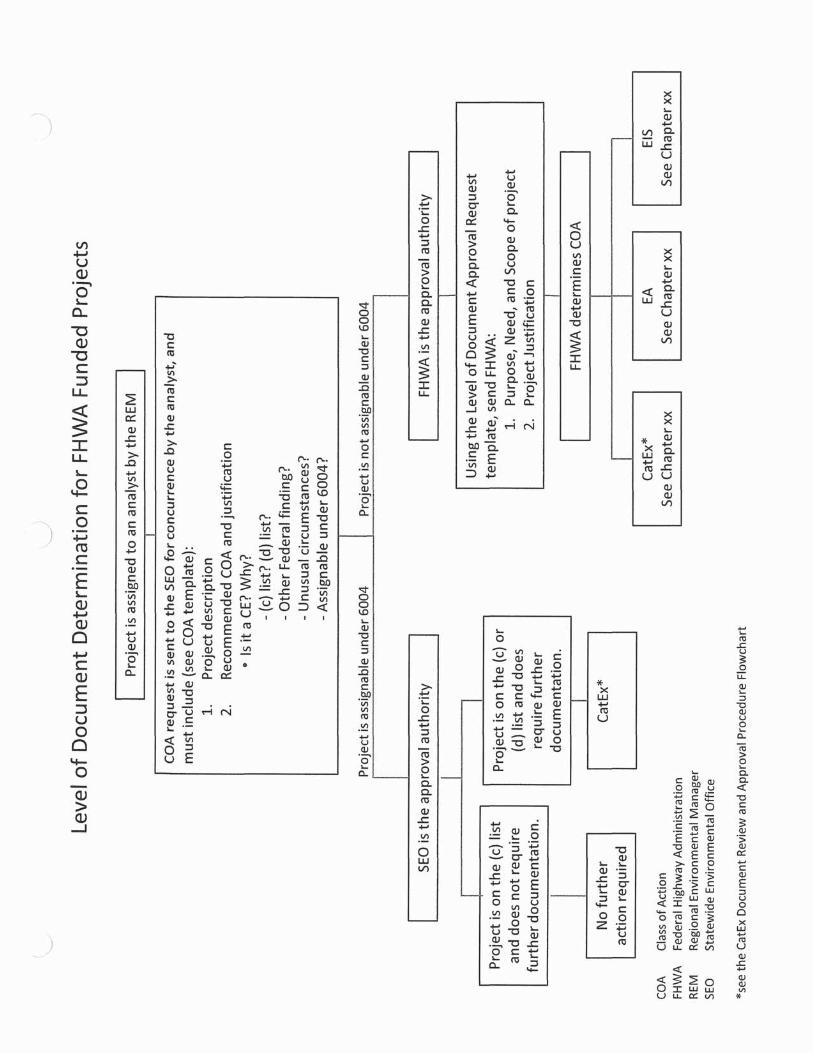
Level of Document Determination for FHWA-Funded Projects
Scope, Schedule, Budget (SSB)
Class of Action (COA) Procedure
Project Start-up Environmental Checklist
Work Product Review Matrix
Microsoft Project Template Instructions
Management Reporting System (MRS)
Complete Environmental File
PRO
JECT
MA
NA
GM
ENT
Project ManagementOctober 2012 SSB Preparation
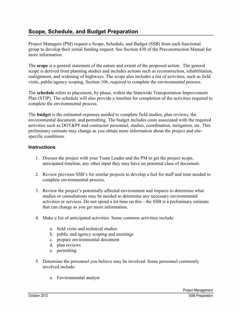
Scope, Schedule, and Budget Preparation
Project Managers (PM) request a Scope, Schedule, and Budget (SSB) from each functional group to develop their initial funding request. See Section 430 of the Preconstruction Manual for more information.
The scope is a general statement of the nature and extent of the proposed action. The general scope is derived from planning studies and includes actions such as reconstruction, rehabilitation, realignment, and widening of highways. The scope also includes a list of activities, such as field visits, public/agency scoping, Section 106, required to complete the environmental process.
The schedule refers to placement, by phase, within the Statewide Transportation Improvement Plan (STIP). The schedule will also provide a timeline for completion of the activities required to complete the environmental process.
The budget is the estimated expenses needed to complete field studies, plan reviews, the environmental document, and permitting. The budget includes costs associated with the required activities such as DOT&PF and contractor personnel, studies, coordination, mitigation, etc. This preliminary estimate may change as you obtain more information about the project and site-specific conditions.
Instructions
1. Discuss the project with your Team Leader and the PM to get the project scope, anticipated timeline, any other input they may have on potential class of document.
2. Review previous SSB’s for similar projects to develop a feel for staff and time needed to complete environmental process.
3. Review the project’s potentially affected environment and impacts to determine what studies or consultations may be needed to determine any necessary environmental activities or services. Do not spend a lot time on this - the SSB is a preliminary estimate that can change as you get more information.
4. Make a list of anticipated activities. Some common activities include:
a. field visits and technical studies b. public and agency scoping and meetingsc. prepare environmental document d. plan reviewse. permitting
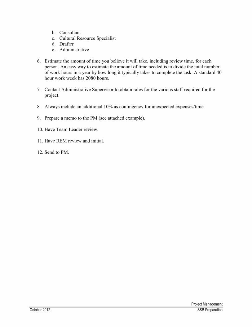
5. Determine the personnel you believe may be involved. Some personnel commonly involved include:
a. Environmental analyst
Project ManagementOctober 2012 SSB Preparation
b. Consultant c. Cultural Resource Specialistd. Draftere. Administrative
6. Estimate the amount of time you believe it will take, including review time, for each person. An easy way to estimate the amount of time needed is to divide the total number of work hours in a year by how long it typically takes to complete the task. A standard 40 hour work week has 2080 hours.
7. Contact Administrative Supervisor to obtain rates for the various staff required for the project.
8. Always include an additional 10% as contingency for unexpected expenses/time
9. Prepare a memo to the PM (see attached example).
10. Have Team Leader review.
11. Have REM review and initial.
12. Send to PM.
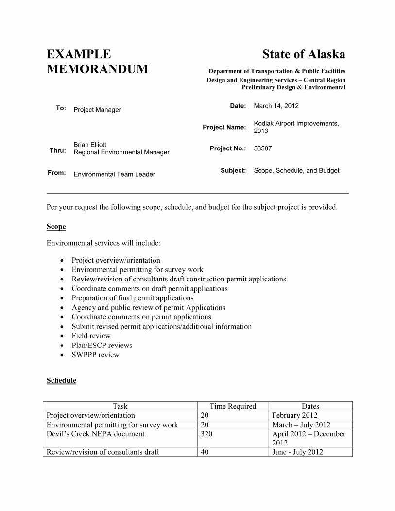
EXAMPLE State of AlaskaMEMORANDUM Department of Transportation & Public Facilities
Design and Engineering Services – Central RegionPreliminary Design & Environmental
To: Project Manager Date: March 14, 2012
Project Name: Kodiak Airport Improvements, 2013
Thru:Brian ElliottRegional Environmental Manager Project No.: 53587
From: Environmental Team Leader Subject: Scope, Schedule, and Budget
Per your request the following scope, schedule, and budget for the subject project is provided.
Environmental services will include:
Scope
� Project overview/orientation � Environmental permitting for survey work� Review/revision of consultants draft construction permit applications � Coordinate comments on draft permit applications � Preparation of final permit applications � Agency and public review of permit Applications � Coordinate comments on permit applications� Submit revised permit applications/additional information� Field review� Plan/ESCP reviews� SWPPP review
Schedule
Task Time Required DatesProject overview/orientation 20 February 2012Environmental permitting for survey work 20 March – July 2012Devil’s Creek NEPA document 320 April 2012 – December
2012Review/revision of consultants draft 40 June - July 2012
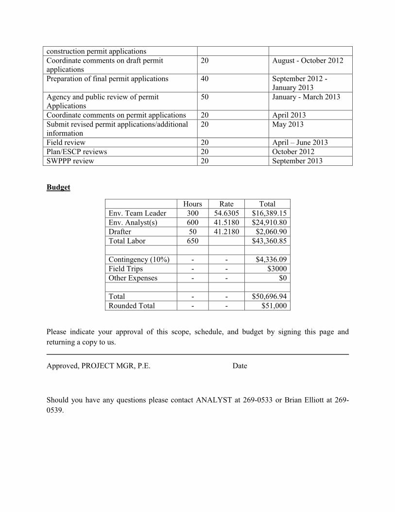
construction permit applicationsCoordinate comments on draft permit applications
20 August - October 2012
Preparation of final permit applications 40 September 2012 -January 2013
Agency and public review of permit Applications
50 January - March 2013
Coordinate comments on permit applications 20 April 2013Submit revised permit applications/additional information
20 May 2013
Field review 20 April – June 2013Plan/ESCP reviews 20 October 2012SWPPP review 20 September 2013
Budget
Hours Rate TotalEnv. Team Leader 300 54.6305 $16,389.15Env. Analyst(s) 600 41.5180 $24,910.80Drafter 50 41.2180 $2,060.90Total Labor 650 $43,360.85
Contingency (10%) - - $4,336.09Field Trips - - $3000Other Expenses - - $0
Total - - $50,696.94Rounded Total - - $51,000
Please indicate your approval of this scope, schedule, and budget by signing this page and returning a copy to us.
Approved, PROJECT MGR, P.E. Date
Should you have any questions please contact ANALYST at 269-0533 or Brian Elliott at 269- 0539.
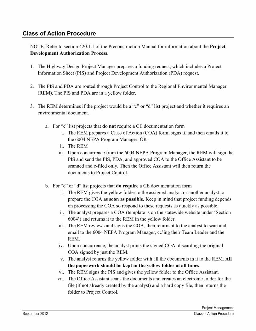
Project ManagementSeptember 2012 Class of Action Procedure
Class of Action Procedure
NOTE: Refer to section 420.1.1 of the Preconstruction Manual for information about the Project Development Authorization Process.
1. The Highway Design Project Manager prepares a funding request, which includes a Project Information Sheet (PIS) and Project Development Authorization (PDA) request.
2. The PIS and PDA are routed through Project Control to the Regional Environmental Manager (REM). The PIS and PDA are in a yellow folder.
3. The REM determines if the project would be a “c” or “d” list project and whether it requires an environmental document.
a. For “c” list projects that do not require a CE documentation form i. The REM prepares a Class of Action (COA) form, signs it, and then emails it to
the 6004 NEPA Program Manager. ORii. The REM
iii. Upon concurrence from the 6004 NEPA Program Manager, the REM will sign the PIS and send the PIS, PDA, and approved COA to the Office Assistant to be scanned and e-filed only. Then the Office Assistant will then return the documents to Project Control.
b. For “c” or “d” list projects that do require a CE documentation form i. The REM gives the yellow folder to the assigned analyst or another analyst to
prepare the COA as soon as possible. Keep in mind that project funding depends on processing the COA so respond to these requests as quickly as possible.
ii. The analyst prepares a COA (template is on the statewide website under ‘Section 6004’) and returns it to the REM in the yellow folder.
iii. The REM reviews and signs the COA, then returns it to the analyst to scan and email to the 6004 NEPA Program Manager, cc’ing their Team Leader and the REM.
iv. Upon concurrence, the analyst prints the signed COA, discarding the original COA signed by just the REM.
v. The analyst returns the yellow folder with all the documents in it to the REM. Allthe paperwork should be kept in the yellow folder at all times.
vi. The REM signs the PIS and gives the yellow folder to the Office Assistant. vii. The Office Assistant scans the documents and creates an electronic folder for the
file (if not already created by the analyst) and a hard copy file, then returns the folder to Project Control.

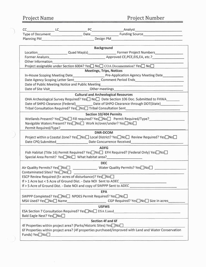
PROJECT START-UP ENVIRONMENTAL CHECKLIST
1
When starting a new project, analysts should schedule a meeting with the Design Project Manager (approx. 30 minutes) to discuss the project and answer the following questions.
1.1 State the project’s purpose and need.
Project Description
1.2 Describe the scope of the project.
1.3 What is the funding source for this project? FHWA FAA State Other
1.4 Does the project include any of the following (check all that apply):
Paving RepavingCulvert replacement (in-stream or drainage)Ditch cleaning
Guardrail (installation, replacement, or extension)Vegetative clearing
Raised medians Digouts Lighting
Signage (new or replacement) Fencing Pedestrian pathways or sidewalks (new or upgrade existing) Bridge workBlastingDetoursRoad closuresUtility relocation
New ground disturbance Storm drain work
1.5 What design/geotech studies are planned?
2
2.1 What is the extent of vegetation clearing?
Clearing
mowing/hydro ax grubbing
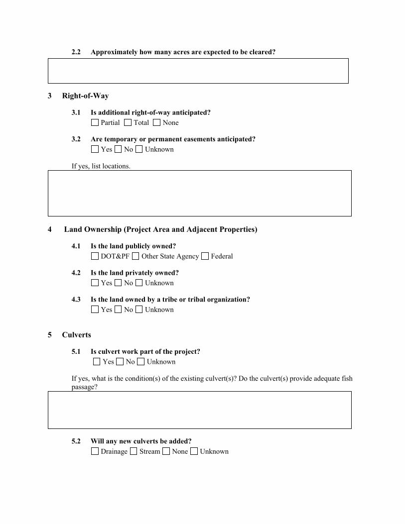
2.2 Approximately how many acres are expected to be cleared?
3
3.1 Is additional right-of-way anticipated?
Right-of-Way
Partial Total None
3.2 Are temporary or permanent easements anticipated? Yes No Unknown
If yes, list locations.
4
4.1 Is the land publicly owned?
Land Ownership (Project Area and Adjacent Properties)
DOT&PF Other State Agency Federal
4.2 Is the land privately owned?Yes No Unknown
4.3 Is the land owned by a tribe or tribal organization? Yes No Unknown
5
5.1 Is culvert work part of the project?
Culverts
Yes No Unknown
If yes, what is the condition(s) of the existing culvert(s)? Do the culvert(s) provide adequate fish passage?
5.2 Will any new culverts be added? Drainage Stream None Unknown
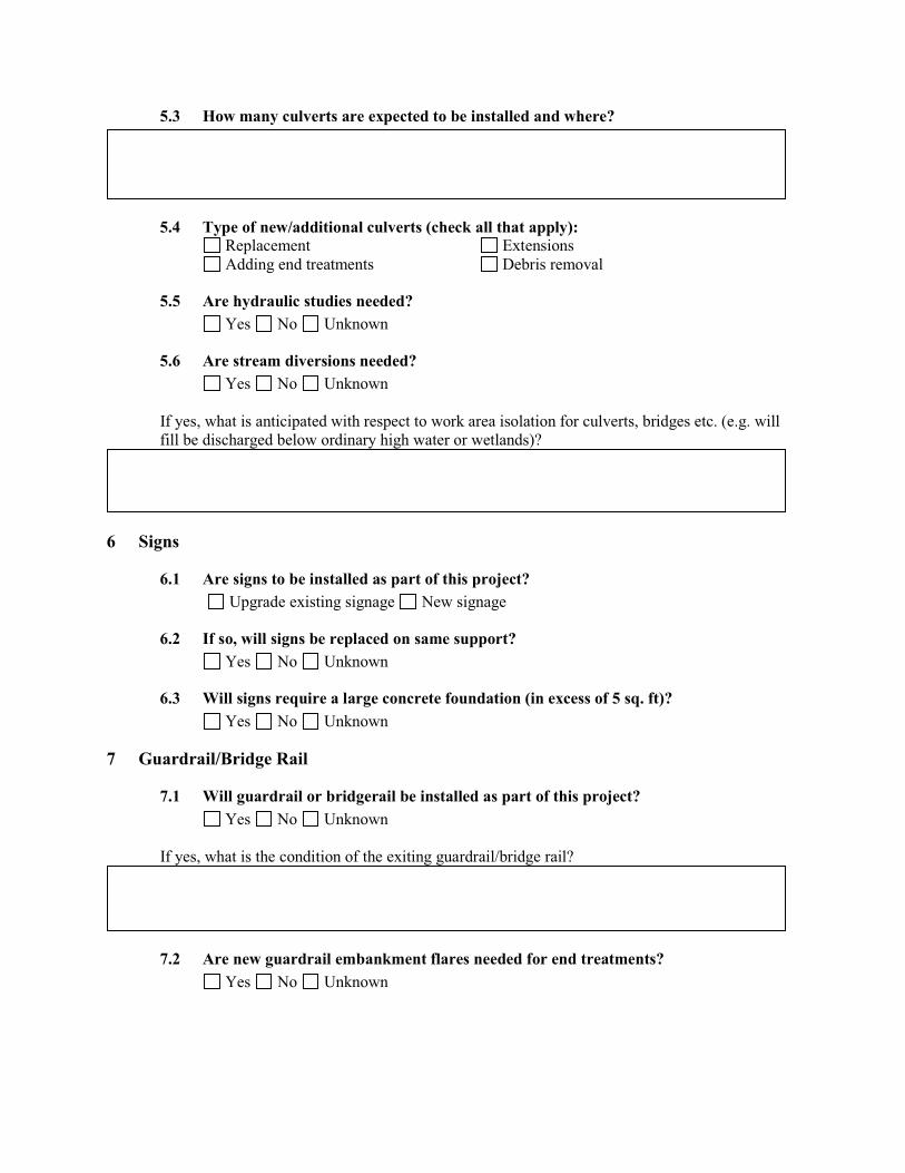
5.3 How many culverts are expected to be installed and where?
5.4 Type of new/additional culverts (check all that apply): Replacement Adding end treatments
ExtensionsDebris removal
5.5 Are hydraulic studies needed?Yes No Unknown
5.6 Are stream diversions needed? Yes No Unknown
If yes, what is anticipated with respect to work area isolation for culverts, bridges etc. (e.g. will fill be discharged below ordinary high water or wetlands)?
6
6.1 Are signs to be installed as part of this project?
Signs
Upgrade existing signage New signage
6.2 If so, will signs be replaced on same support?Yes No Unknown
6.3 Will signs require a large concrete foundation (in excess of 5 sq. ft)? Yes No Unknown
7
7.1 Will guardrail or bridgerail be installed as part of this project?
Guardrail/Bridge Rail
Yes No Unknown
If yes, what is the condition of the exiting guardrail/bridge rail?
7.2 Are new guardrail embankment flares needed for end treatments? Yes No Unknown
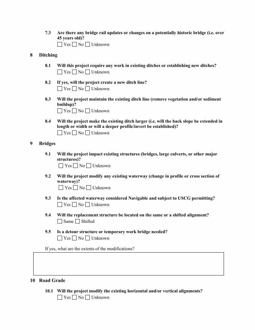
7.3 Are there any bridge rail updates or changes on a potentially historic bridge (i.e. over 45 years old)?
Yes No Unknown
8
8.1 Will this project require any work in existing ditches or establishing new ditches?
Ditching
Yes No Unknown
8.2 If yes, will the project create a new ditch line?Yes No Unknown
8.3 Will the project maintain the existing ditch line (remove vegetation and/or sediment buildup)?
Yes No Unknown
8.4 Will the project make the existing ditch larger (i.e. will the back slope be extended in length or width or will a deeper profile/invert be established)?
Yes No Unknown
9
9.1 Will the project impact existing structures (bridges, large culverts, or other major structures)?
Bridges
Yes No Unknown
9.2 Will the project modify any existing waterway (change in profile or cross section of waterway)?
Yes No Unknown
9.3 Is the affected waterway considered Navigable and subject to USCG permitting?Yes No Unknown
9.4 Will the replacement structure be located on the same or a shifted alignment?Same Shifted
9.5 Is a detour structure or temporary work bridge needed? Yes No Unknown
If yes, what are the extents of the modifications?
10 Road Grade
10.1 Will the project modify the existing horizontal and/or vertical alignments?Yes No Unknown
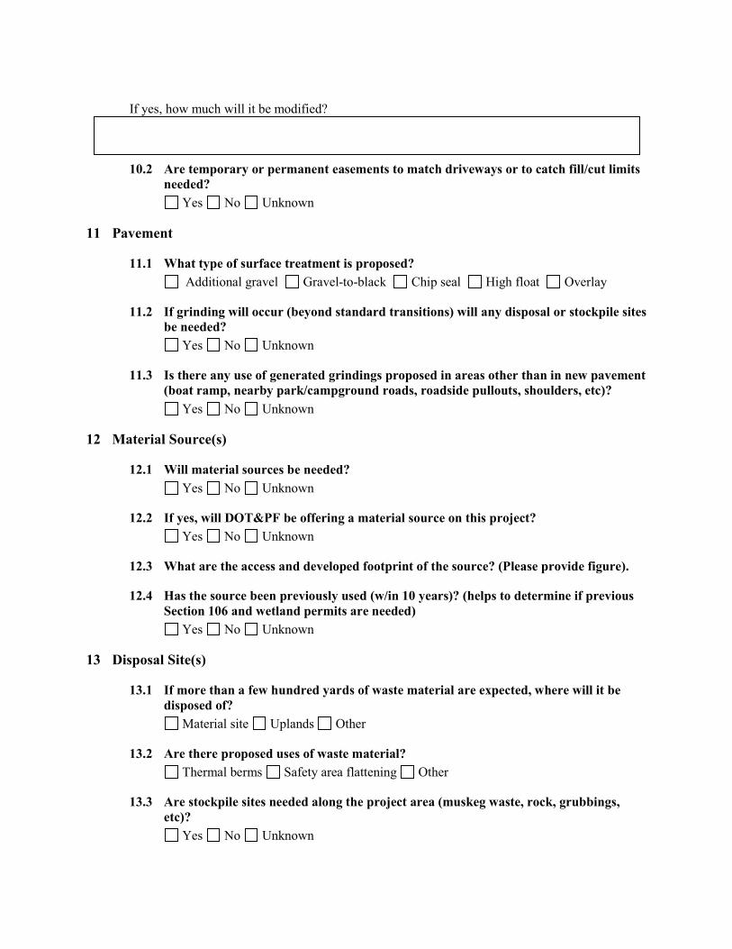
If yes, how much will it be modified?
10.2 Are temporary or permanent easements to match driveways or to catch fill/cut limits needed?
Yes No Unknown
11 Pavement
11.1 What type of surface treatment is proposed? Additional gravel Gravel-to-black Chip seal High float Overlay
11.2 If grinding will occur (beyond standard transitions) will any disposal or stockpile sites be needed?
Yes No Unknown
11.3 Is there any use of generated grindings proposed in areas other than in new pavement (boat ramp, nearby park/campground roads, roadside pullouts, shoulders, etc)?
Yes No Unknown
12
12.1 Will material sources be needed?
Material Source(s)
Yes No Unknown
12.2 If yes, will DOT&PF be offering a material source on this project? Yes No Unknown
12.3 What are the access and developed footprint of the source? (Please provide figure).
12.4 Has the source been previously used (w/in 10 years)? (helps to determine if previous Section 106 and wetland permits are needed)
Yes No Unknown
13
13.1 If more than a few hundred yards of waste material are expected, where will it be disposed of?
Disposal Site(s)
Material site Uplands Other
13.2 Are there proposed uses of waste material? Thermal berms Safety area flattening Other
13.3 Are stockpile sites needed along the project area (muskeg waste, rock, grubbings,etc)?
Yes No Unknown

If yes, what type and amount of material anticipated?
13.4 Can materials be recycled: grubbed material for reclamation, streambed material, and riprap?
Yes No Unknown
14
14.1 Will a separate access route be needed within or outside the right-of-way? Is temporary or long term access need?
Construction
Yes No Unknown
14.2 Where are temporary detours, work platforms, or crane pads needed?
14.3 What are the design assumptions for these detours?
14.4 Where is the project staging area?
14.5 Additional Comments or Special Requests/Considerations
Please attach a location and vicinity map, project figures, typical section, aerial photographs, and any other pertinent information available that encompass the extent of the project and all
reasonable alternatives. Identify the anticipated limits of the work. Provide figures in 8.5 x 11 formats, if possible.
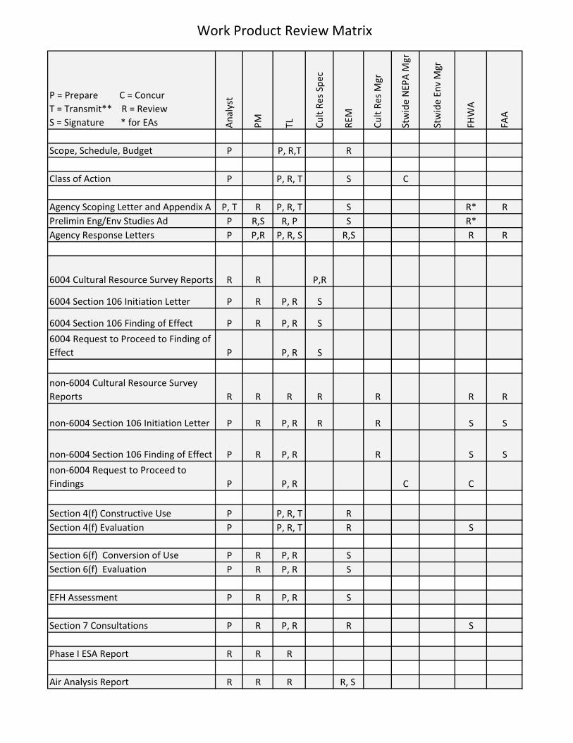
Work Product Review Matrix
P = Prepare C = Concur T = Transmit** R = Review S = Signature * for EAs A
naly
st
PM TL Cult
Res
Spec
REM
Cult
Res
Mgr
Stw
ide
NEP
A M
gr
Stw
ide
Env
Mgr
FHW
A
FAA
Scope, Schedule, Budget P P, R,T R
Class of Action P P, R, T S C
Agency Scoping Letter and Appendix A P, T R P, R, T S R* RPrelimin Eng/Env Studies Ad P R,S R, P S R*Agency Response Letters P P,R P, R, S R,S R R
6004 Cultural Resource Survey Reports R R P,R
6004 Section 106 Initiation Letter P R P, R S
6004 Section 106 Finding of Effect P R P, R S
6004 Request to Proceed to Finding of Effect P P, R S
non-6004 Cultural Resource Survey Reports R R R R R R R
non-6004 Section 106 Initiation Letter P R P, R R R S S
non-6004 Section 106 Finding of Effect P R P, R R S S
non-6004 Request to Proceed to Findings P P, R C C
Section 4(f) Constructive Use P P, R, T RSection 4(f) Evaluation P P, R, T R S
Section 6(f) Conversion of Use P R P, R SSection 6(f) Evaluation P R P, R S
EFH Assessment P R P, R S
Section 7 Consultations P R P, R R S
Phase I ESA Report R R R
Air Analysis Report R R R R, S

P = Prepare C = Concur T = Transmit** R = Review S = Signature * for EAs A
naly
st
PM TL Cult
Res
Spec
REM
Cult
Res
Mgr
Stw
ide
NEP
A M
gr
Stw
ide
Env
Mgr
FHW
A
FAA
Noise Analysis Report R R R R
Location Hydraulic Study Report R R R
ADEC Letter of Non Objection (for all areas outside the MOA) P R P, R
6004 PCE P R, S P, R, T S C6004 CE P R, S P, R, T S S non-6004 PCE P R, S R S, T C Cnon-6004 CE P R, S R S, T S SEA/EIS P R P,R S, T S SState-Funded Checklist P R R STransmittal Memo P R P,R S
PIH/PSE Review Comments P P, R
ESCP Review Comments P P, R
Env Commitments Memo P P, R S
NOI/NOT P P
USACE Section 10/404 P, S R P, R R SWetland Delineation Reports R R P, RADFG Title 16 P, S R P, RADFG Special Areas P, S R P, RUSFWS Section 7/Eagles P, S R P, RUSCG Bridge Permit P, S R P, RDNR-DMLW Water Rights P, S R P, RDNR-DPOR Special Use P, S R P, RADEC Letter of Non-Objection P, S R P, RADEC 401 Water Quality Cert P, S R P, RAPDES NOI/NOT P, S R P, RNoise Permit P, S R P, RFlood Hazard Permit P, S R P, RMat-Su Floodplain Development P, S R P, RKRC Multi-Agency P, S R P, R
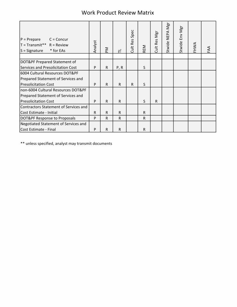
Work Product Review Matrix
P = Prepare C = Concur T = Transmit** R = Review S = Signature * for EAs A
naly
st
PM TL Cult
Res
Spec
REM
Cult
Res
Mgr
Stw
ide
NEP
A M
gr
Stw
ide
Env
Mgr
FHW
A
FAA
DOT&PF Prepared Statement of Services and Presolicitation Cost P R P, R S6004 Cultural Resources DOT&PF Prepared Statement of Services and Presolicitation Cost P R R R Snon-6004 Cultural Resources DOT&PF Prepared Statement of Services and Presolicitation Cost P R R S RContractors Statement of Services and Cost Estimate - Initial R R R RDOT&PF Response to Proposals P R R RNegotiated Statement of Services and Cost Estimate - Final P R R R
** unless specified, analyst may transmit documents
Project ManagementNovember 2012 Microsoft Project Template Instructions
Microsoft Project Template Instructions
Microsoft (MS) Project is a software program developed to assist with project management and planning. It is a tool used to determine preliminary timelines and completion dates for various project-specific tasks or milestones. These instructions are intended to be used in conjunction with the MS Project template for the environmental phase (found in the Templates and Procedures Project Management folder).
If you would like to learn more about MS Project, refer to the user’s manual (2007 version) andaccompanying disk with tutorials, which can be found in the electronics cabinet. The tutorials are also available in the templates and procedures folder.
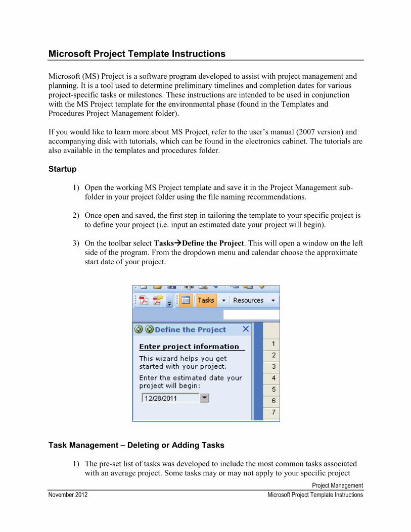
Startup
1) Open the working MS Project template and save it in the Project Management sub-folder in your project folder using the file naming recommendations.
2) Once open and saved, the first step in tailoring the template to your specific project is to define your project (i.e. input an estimated date your project will begin).
3) On the toolbar select Tasks��Define the Project. This will open a window on the left side of the program. From the dropdown menu and calendar choose the approximate start date of your project.
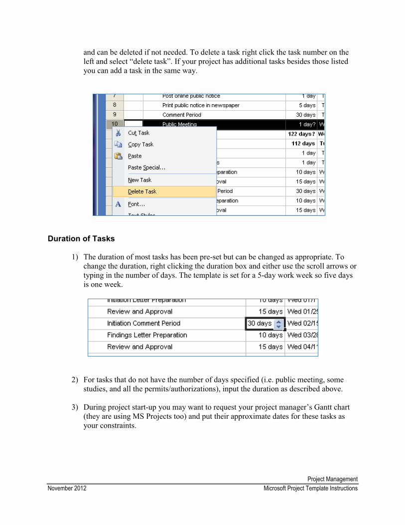
Task Management – Deleting or Adding Tasks
1) The pre-set list of tasks was developed to include the most common tasks associated with an average project. Some tasks may or may not apply to your specific project
Project ManagementNovember 2012 Microsoft Project Template Instructions
and can be deleted if not needed. To delete a task right click the task number on the left and select “delete task”. If your project has additional tasks besides those listed you can add a task in the same way.
Duration of Tasks
1) The duration of most tasks has been pre-set but can be changed as appropriate. To change the duration, right clicking the duration box and either use the scroll arrows or typing in the number of days. The template is set for a 5-day work week so five days is one week.
2) For tasks that do not have the number of days specified (i.e. public meeting, some studies, and all the permits/authorizations), input the duration as described above.
3) During project start-up you may want to request your project manager’s Gantt chart (they are using MS Projects too) and put their approximate dates for these tasks as your constraints.
Project ManagementNovember 2012 Microsoft Project Template Instructions
Start Date – Changing Start Date for Individual Tasks
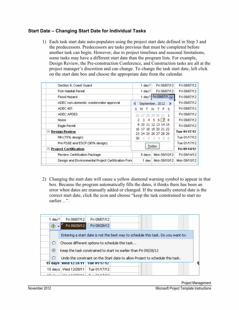
1) Each task start date auto-populates using the project start date defined in Step 3 and the predecessors. Predecessors are tasks previous that must be completed before another task can begin. However, due to project timelines and seasonal limitations, some tasks may have a different start date than the program lists. For example, Design Review, the Pre-construction Conference, and Construction tasks are all at the project manager’s discretion and can change. To change the task start date, left click on the start date box and choose the appropriate date from the calendar.
2) Changing the start date will cause a yellow diamond warning symbol to appear in that box. Because the program automatically fills the dates, it thinks there has been an error when dates are manually added or changed. If the manually entered date is the correct start date, click the icon and choose “keep the task constrained to start no earlier…”.
Project ManagementNovember 2012 Microsoft Project Template Instructions
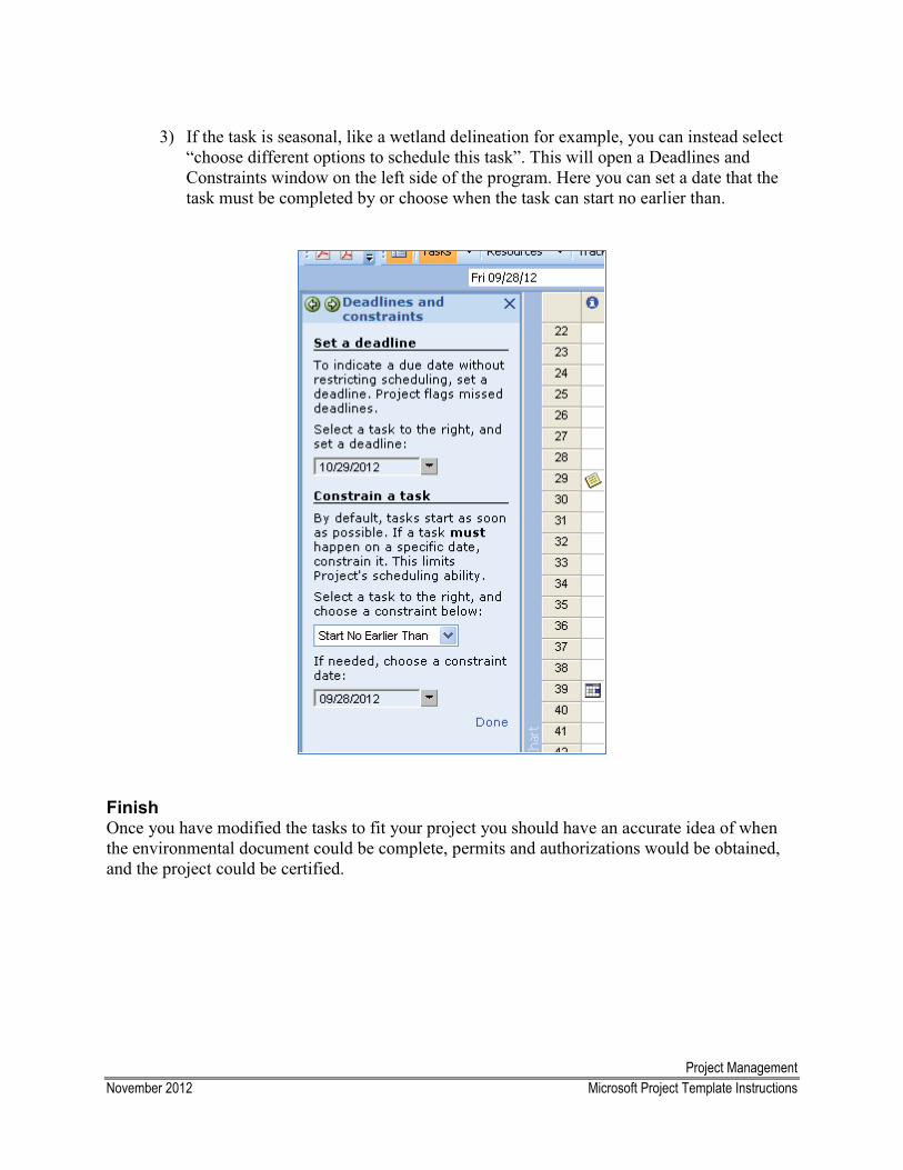
3) If the task is seasonal, like a wetland delineation for example, you can instead select “choose different options to schedule this task”. This will open a Deadlines and Constraints window on the left side of the program. Here you can set a date that the task must be completed by or choose when the task can start no earlier than.
Finish Once you have modified the tasks to fit your project you should have an accurate idea of when the environmental document could be complete, permits and authorizations would be obtained, and the project could be certified.
Project Management November 2012 Management Reporting System
Management Reporting System
The Management Reporting System (MRS) is an electronic database designed to provide decision makers with information on the status of active projects. Each functional group is responsible for updating the MRS once every other month. Project Managers then use the updated information to report to the Director, Design and Construction Director, and the Preconstruction Engineer at the Design Status Meeting. To help facilitate the reporting process, it is best to discuss only the important highlights or issues because it is impractical to review an exhaustive history of every project.
One to two weeks in advance, the REM or your team leader will send you an email notifying you when your updates need to be completed in MRS. Meetings are held on the third Thursday of the month. Updates typically must be completed by the end of the day on the Thursday prior to the meeting. If you are out of the office or otherwise unable to complete your updates, notify your team leader in advance. Below are instructions describing the types of information needed and how to input it into the MRS.
Step-by-Step Instructions
1. Access the MRS database (via: http://web.dot.state.ak.us/status.d/project_status.html)
2. A Username and Password box will be displayed (use your Team Leader’s log-on information)
3. Click on the Environmental tab 4. Enter the project number in the blank AKSAS Number box and hit enter. This will take
you to the main menu where your make your updates.
5. Verify and/or update the existing information (environmental contact, permits contact, environmental document type)
6. Update the Overall Environmental Progress using the following three headings: � Current Tasks � Completed Tasks � Issues/Problems
Examples of important information to include: dates public and agency scoping letters were sent or meetings occurred, relevant comments from the public, agencies, or tribal organizations, date of SHPO concurrence, conclusions of technical studies, and field work.
7. Click on Permits Forms and input the permit information.
Approved – November 2009
What Constitutes a Complete Environmental File?
Due to the State assuming responsibility for certain Categorical Exclusions (CEs) under SAFETEA-LU Section 6004 (MOU dated September 22, 2009) the State is required to “maintain paper or electronic project records and general administrative records…for proposed projects processed” under the MOU between FHWA and the State. These records must be available for inspection by FHWA and the Statewide Environmental Office at any time during normal business hours. It is recommended that there be one central environmental project file within the environmental section that contains all the original and official project documents. This file should be kept separate from the environmental analyst’s/project manager’s project files. It is important that there be one specific place that FHWA, FAA, Statewide Environmental Office, and/or the public can go to review files and obtain project information.
The State is required to retain these records, including all letters and comments received from governmental agencies, the public, and others regarding the project activities delegated under the MOU, for a period of no less than three (3) years after completion of project construction. Project environmental files need to be complete, and maintained in an orderly fashion. Any information that was necessary for the analyst to make a determination(s) in support of the environmental document must be filed. For example: conversations and correspondence with USFWS regarding Bald Eagles, locations of nests, timing of nest selection, etc. when a determination was made that there are no impacts to Bald Eagles within the project area. Per the MOU the following items must be kept within the project environmental file:
1) Class of Action (level of document) Determination – The project environmental file needs to contain a documented (written) copy of the class of action or level of document determination that was approved by a Statewide NEPA Manager.
2) Document MOU exclusions (kickouts) – The project environmental files should contain any information that is necessary to support determinations regarding any subject that may exclude the CE from assignment under Section 6004 of SAFETEA-LU.
3) Document FHWA decisions on any MOU exclusions – The project environmental files should contain any documented determinations that are made by FHWA that pertain to exclusions to the MOU. This would include documentation of determinations for those responsibilities that remain with FHWA, such as formal government-to-government consultation with the tribes.
4) The CE Documentation Form – The project environmental files should contain a copy of the final/approved environmental document with all appendices. Drafts should be removed from the file.
5) Anything that is required to be in the file per the procedures outlined within the Environmental Procedures Manual.
Contracts
Table of Contents
Reimbursable Service Agreement (RSA)
Small Procurement Contract Guidance
CO
NTR
AC
TS
ContractsMay 2012 Small Procurement Contract Guidance
Small Procurement Contract ($5,000 - $100,000) Guidance
The Environmental section may hire a contractor to perform a variety of environmental services including field studies, technical reports, environmental documents, and re-evaluations. We typically use a Small Procurement to hire contractors because our work often costs between $5,000 and $100,000. Small Procurements allow us to review several proposals and recommendthe most appropriate contractor for the specific task. The Contracting Officer makes the final decision on who is hired.
See Chapter 2 of the PSA Manual, training materials, definitions (words bolded in this guidance), and examples in the electronic folder for more information. You can find the most recent forms in the PSA Documents folder on the Library Drive: L:\PSA Documents\Word Templates.
Follow the steps outlined below to complete the process:
1. In consultation with a team leader, analysts prepare a Statement of Services, a Pre-Solicitation Cost Estimate, and Small Procurement Documents Part A and Part B. Try to base the cost estimate on previous contracts for the same type of work and concentrate on the hours needed for each specific task, not the total cost.
2. Send the Statement of Services, Pre-Solicitation Cost Estimate, and Small Procurement Documents Part A and B to the Project Manager, team leader, and Regional Environmental Manager for review. Once approved, send the package to the Professional Services Section for review and processing. Be sure to include any specific evaluation criteria you wish to use to select the contractor. The Professional Services Section will revise or return the documents to you with comments to address.
3. The Professional Services Section will advertise the RFP online for an average of three to ten days. You may want to notify contractors/firms to make them aware of the RFP so they can submit proposals, if interested.
4. Any contractor can submit a proposal. The proposals will go to the Professional Services Section, where they are reviewed and forwarded to the analyst and Project Manager(PM).
5. The PM and/or analyst objectively reviews the proposals based on the evaluation criteria.We usually receive anywhere from 2-6 proposals. If you do not get any proposals, you should repost the RFP or use another method, such as a Reimbursable Services Agreement, to complete the work. Discuss the situation with your team leader and the PM.
6. The PM or analyst prepares an evaluation report in which they identify the top three proposals. Send the report to the Project Manager, team leader, and Regional Environmental Manager for review. Once approved, send the report to the Professional Services Section and the Contracting Officer for review. The Contracting Officer
ContractsMay 2012 Small Procurement Contract Guidance
chooses which contractor is awarded the work.
1. The PM and analyst negotiate with the contractor as needed to reach a consensus. If you cannot reach consensus, notify the Professional Services Section.
2. Prepare a RONS and Small Procurement Document Part C – Contract Award and send to the Professional Services Section for review.
3. The Professional Services Section will return the RONS and NTP for signature by the analyst and Section Chief.
4. Return the signed RONS and NTP to the Professional Services Section. They will send the documents to the Contracting Officer for signature.
5. The NTP is returned to the analyst, who is responsible for getting the contractors signature.
6. Analyst returns the signed NTP to the Professional Services Section and a copy to the Finance Department.
7. Analyst prepares a memo to encumber the funds.
ContractsMay 2012 Small Procurement Contract Guidance
Definitions (see also Contract Definitions in Contracts folder)
Contracting Officer - The person authorized by the Commissioner, or designee, to enter into and administer the Contract on behalf of the Department. This entity has authority to make findings, determinations and decisions with respect to the Contract and, when necessary, to modify or terminate the Contract. The Contracting Officer for the PD&E section is the Director of Design & Construction.
Evaluation Criteria – The criteria used to select a contractor. The commonly used criteria (1-4) are listed at the bottom of Small Procurement Document – Part A. Please note that you can add project specific evaluation criteria to the form.
Innovative Term Agreement for Professional Services - Agreement between the DOT&PF and five contractors to perform environmental services.
Notice to Proceed (NTP) - A written notice to the Contractor that initiates the work and establishes the date on which the contracted time begins. There are two different versions of the NTP form – one lists the work by task the other by contractor. You can use either one.
Pre-Solicitation Cost Estimate - An Excel spreadsheet that allows you to list specific tasks, positions required, hours needed to complete the tasks, and expenses. There are four different options for the methods of payment including Fixed Price, Fixed Price Plus Expenses, Time and Expenses, and Cost Plus Fixed Fee. Refer to the definition of each. We typically prefer to use Fixed Price, but discuss it with the Project Manager and the Professional Services Section to determine which option is most appropriate for your situation.
Request for Proposal (RFP) - A letter to the contractor describing the project, scope (a.k.a. statement) of services, deliverables, schedule, payment, and submittal requirements.
Record of Negotiation (RONS) – A form describing the negotiation process between DOT&PF and the contractor.
Small Procurement - A procurement for supplies, services, or professional services that does not exceed an aggregate dollar amount of $50,000; construction that does not exceed an aggregate dollar amount of $100,000; or lease of space that does not exceed 3,000 square feet may be made in accordance with regulations adopted by the Commissioner for small procurements. Small procurements need not be made through competitive sealed bidding or competitive sealed proposals but shall be made with competition that is practicable under the circumstances.
Small Procurement Documents Part A – Request for Proposals
Small Procurement Documents Part B – Proposal Form. The contractor returns this with the proposal.
Small Procurement Document Part C – Contract Award, NTP, and Invoice Summary
Statement of Services – A detailed description of the work being requested.
Scoping
Table of Contents
Agency Scoping Frequently Asked Questions
Agency Scoping Letter and Appendix A
Electronic Scoping and FTP Transfer Instructions
Public Involvement Frequently Asked Questions
Notice of Intent to Begin Engineering and Environmental Studies Template
Increasing Level of Public Impact Chart
Public Involvement in Rural AK Tips
SCO
PING
ScopingDecember 2012 Agency Scoping Frequently Asked Questions
Agency Scoping Frequently Asked Questions
1. What is agency scoping?
Scoping is the process by which an organization solicits input from regulatory or resource agencies on the nature and extent of potential impacts of a proposed project and the methods used to analyze those impacts.
2. What is the purpose of agency scoping?
The purpose of agency scoping is to identify environmental resources, compliance requirements, potential impacts, and mitigation measures for a proposed project. The level of agency and local government coordination depends on the project’s complexity.
Consult with your Team Leader and the Regional Environmental Manager (REM) to decide if you should conduct agency scoping. In general, you should conduct agency scoping for proposed projects that involve the following:
� Potential impacts to any protected environmental resources (e.g. wetlands, fisheries, eagle nest)
� Right-of-way acquisition� Issues with a federally recognized tribal government
3. Is there a difference between agency coordination and agency scoping?
Agency coordination and agency scoping are both intended to solicit information from regulatory and resource agencies. Agency coordination is a continuous process that occurs throughout the project to update the agencies about project changes. Agency scoping is atype of agency coordination that occurs for a brief time at the beginning of the preliminary design and environmental phase of the project to solicit more specific information about environmental resources in the project area, compliance requirements, alternatives, impacts.NEPA requires agency scoping for EA and EIS-level projects.
4. When do we initiate agency scoping?
As early as possible in the process. Consult with the Engineering Manager, Team Leader, and REM to determine the best time to initiate the scoping process. In general, you can begin agency scoping when there is sufficient design information to determine the scope1
1 In project management, the term project scope is defined as “the work that needs to be accomplished to deliver a project, service, or result with the specified features and functions”.
of the
ScopingDecember 2012 Agency Scoping Frequently Asked Questions
project (with preliminary quantities and graphics), the potential impacts, and possible mitigation options.
5. How do we conduct agency scoping?
Agency scoping consists of a scoping letter, Appendix A, and graphics (described below) and may include a meeting and/or a field review. We disseminate scoping materials electronically unless requested to do so otherwise. See Section 1.3.5 and 5.2.4 Activity No. 4 of Environmental Procedures Manual for more information.
Scoping Letter: Provides general information about the project including the location, purpose and need, proposed action, and existing site conditions. Refer to the agency scoping letter template.
Appendix A: Describes the affected environment and provides a preliminary estimate of the proposed project’s environmental impacts. In each category, cite the sources (e.g., webpages, databases, correspondence with agency representatives) you used and when you reviewed them. Report your findings in as much detail as needed. Consult with your Team Leader and refer to the CE Documentation Form Instructions and recent examples.
Graphics/Figures: The standard set of graphics includes a 1) location and vicinity map, 2) proposed project details and 3) typical sections or any other pertinent graphics. Refer to the guidance for developing graphics.
6. Who do we send agency scoping letter to?� federal, state, and local regulatory and resource agencies� local governments � tribal organizations � any other entities that may be interested in the project
Refer to the PD&E contact list (suggested contacts will have a red asterisks).
7. How do we distribute agency scoping materials?
Follow the Electronic Agency Scoping and FTP Site Instructions.
8. How long is the comment period?
The recommended comment period provided to regulatory and resource agencies is 30 days; however, it can vary depending on the complexity of the project.
It is a good practice to call or send an email reminder of the deadline at least one week before the comment deadline
ScopingDecember 2012 Agency Scoping Frequently Asked Questions
9. Can we extend the comment period?
Yes, we accept comments throughout the project. Due to the linear nature of the project development process, we include a comment period deadline in our agency scoping letters to ensure the project continues to progress.
10.Who receives the comments?
Comments are usually sent to the Regional Environmental Manager, analyst, or Engineering Manager.
11.When do we respond to comments?
Although no formal response to scoping comments is required, the analyst, Engineering Manager, and REM (if needed) should work together to respond to all substantive comments. Non-substantive comments are often summarized and addressed in the environmental document.
12.How do we respond to comments?
When the project team decides written response to comments are necessary, responses should be in writing in the form of a formal letter or an email. All comments and responses should be documented and saved in the project’s administrative file.
13.Who signs the comments response letters?
The Engineering Manager or REM should sign the response letters.
14.What information goes in the environmental document?
Summarize your scoping efforts, issues raised during scoping, and the resolution of the issues. Attach copies of scoping letters, meeting minutes, comments, and responses to the environmental document.
15.When in the environmental process do we hold agency meetings?
Agency meetings can occur at any time during the environmental, design, or construction phases of the project. We typically hold agency meetings or field reviews during the scoping process for larger projects with complicated issues and many impacted resources or at the request of an agency. Other times agencies meetings can be useful are prior to submission of permit applications and prior to or during construction.
16.Why do we hold agency meetings?
Depending on the amount of agency involvement you anticipate, you may hold a meeting or field review to explain the proposed project, answer questions, and obtain information from
ScopingDecember 2012 Agency Scoping Frequently Asked Questions
the agencies. It is a good idea to offer the meeting or include the meeting date in the scoping letter and hold it during the scoping period. The FHWA Project Manager or Statewide NEPA Manager should be invited to attend.
17.What are the topics typically discussed at the agency meeting?
� purpose and need
� project scope/description
� questions/answers about the project
� technical studies (needed or completed)
� permit compliance requirements
� avoidance, minimization, mitigation requirements
18.What is the typical format for agency meetings?
Meeting formats vary depending on the complexity of the proposed project. Meetings for more complex projects are often more formal and may involve of a presentation of the project by the Engineering Manager, designer, and/or analyst. Meetings for less complex projects are often more informal and do not usually involve a presentation. Consult with the Engineering Manger, your Team Leader, and REM to determine.
19.What is the analyst’s role in the agency meeting?
The analyst role in meetings varies depending on whether a consultant has been hired to complete the environmental portion of the project. If a consultant is not involved, analysts take a more active role and are responsible for the following:
� planning the meeting
� facilitating the meeting
� describing the impacts, avoidance, minimization, and mitigation measures
� documenting/taking meeting notes
If a consultant is involved, analysts generally take a less active role. However, analysts should be prepared to discuss the project and describe the impacts, and avoidance, minimization, and mitigation measures.
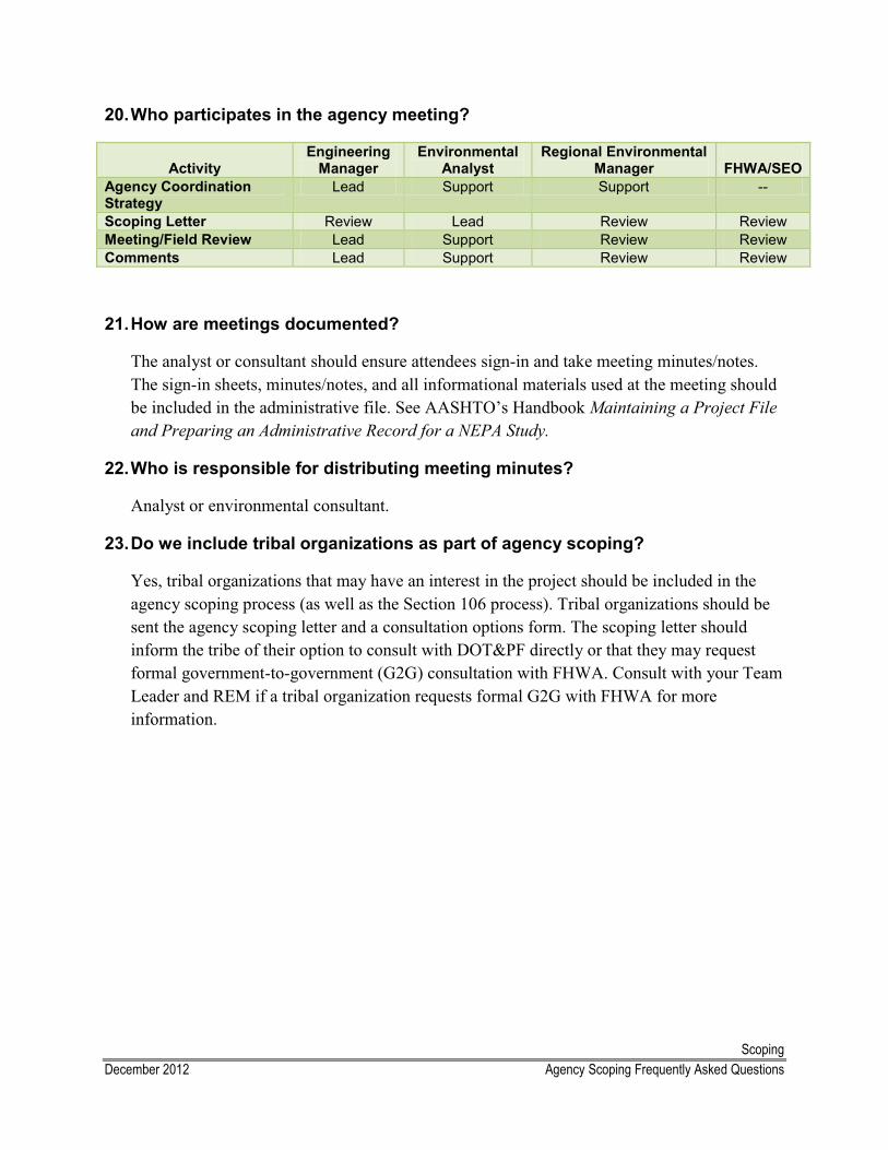
ScopingDecember 2012 Agency Scoping Frequently Asked Questions
20.Who participates in the agency meeting?
ActivityEngineering
ManagerEnvironmental
AnalystRegional Environmental
Manager FHWA/SEOAgency Coordination Strategy
Lead Support Support --
Scoping Letter Review Lead Review ReviewMeeting/Field Review Lead Support Review ReviewComments Lead Support Review Review
21.How are meetings documented?
The analyst or consultant should ensure attendees sign-in and take meeting minutes/notes. The sign-in sheets, minutes/notes, and all informational materials used at the meeting should be included in the administrative file. See AASHTO’s Handbook Maintaining a Project File and Preparing an Administrative Record for a NEPA Study.
22.Who is responsible for distributing meeting minutes?
Analyst or environmental consultant.
23.Do we include tribal organizations as part of agency scoping?
Yes, tribal organizations that may have an interest in the project should be included in the agency scoping process (as well as the Section 106 process). Tribal organizations should be sent the agency scoping letter and a consultation options form. The scoping letter should inform the tribe of their option to consult with DOT&PF directly or that they may request formal government-to-government (G2G) consultation with FHWA. Consult with your Team Leader and REM if a tribal organization requests formal G2G with FHWA for more information.
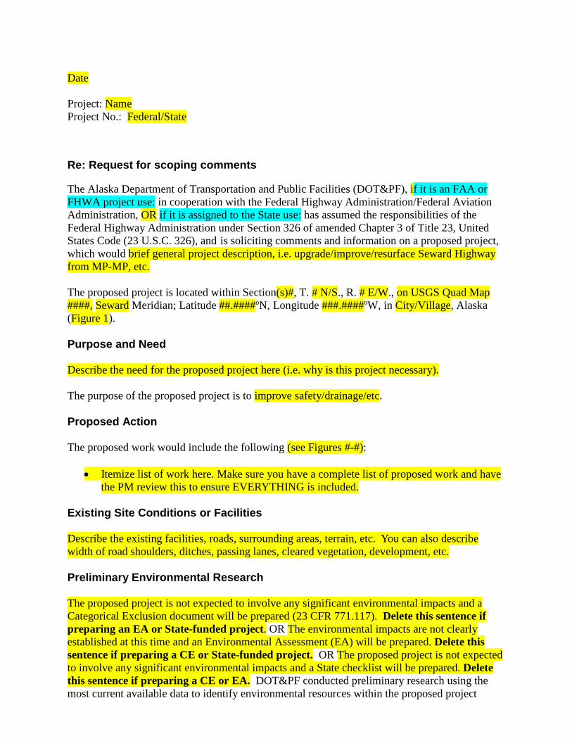
Date Project: Name Project No.: Federal/State
Re: Request for scoping comments
The Alaska Department of Transportation and Public Facilities (DOT&PF), if it is an FAA or FHWA project use: in cooperation with the Federal Highway Administration/Federal Aviation Administration, OR if it is assigned to the State use: has assumed the responsibilities of the Federal Highway Administration under Section 326 of amended Chapter 3 of Title 23, United States Code (23 U.S.C. 326), and is soliciting comments and information on a proposed project, which would brief general project description, i.e. upgrade/improve/resurface Seward Highway from MP-MP, etc. The proposed project is located within Section(s)#, T. # N/S., R. # E/W., on USGS Quad Map ####, Seward Meridian; Latitude ##.####ºN, Longitude ###.####ºW, in City/Village, Alaska (Figure 1). Purpose and Need Describe the need for the proposed project here (i.e. why is this project necessary). The purpose of the proposed project is to improve safety/drainage/etc. Proposed Action The proposed work would include the following (see Figures #-#):
• Itemize list of work here. Make sure you have a complete list of proposed work and have the PM review this to ensure EVERYTHING is included.
Existing Site Conditions or Facilities Describe the existing facilities, roads, surrounding areas, terrain, etc. You can also describe width of road shoulders, ditches, passing lanes, cleared vegetation, development, etc. Preliminary Environmental Research The proposed project is not expected to involve any significant environmental impacts and a Categorical Exclusion document will be prepared (23 CFR 771.117). Delete this sentence if preparing an EA or State-funded project. OR The environmental impacts are not clearly established at this time and an Environmental Assessment (EA) will be prepared. Delete this sentence if preparing a CE or State-funded project. OR The proposed project is not expected to involve any significant environmental impacts and a State checklist will be prepared. Delete this sentence if preparing a CE or EA. DOT&PF conducted preliminary research using the most current available data to identify environmental resources within the proposed project
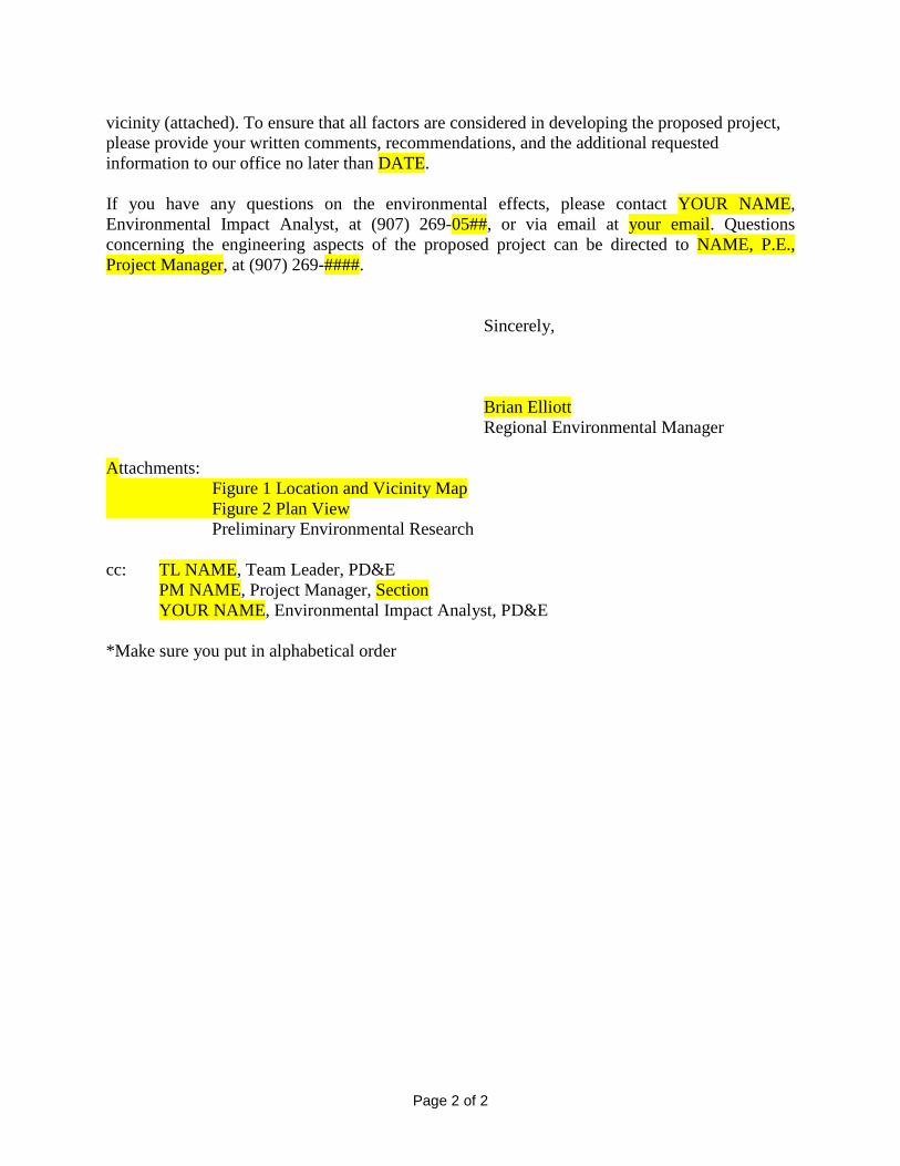
Page 2 of 2
vicinity (attached). To ensure that all factors are considered in developing the proposed project, please provide your written comments, recommendations, and the additional requested information to our office no later than DATE. If you have any questions on the environmental effects, please contact YOUR NAME, Environmental Impact Analyst, at (907) 269-05##, or via email at your email. Questions concerning the engineering aspects of the proposed project can be directed to NAME, P.E., Project Manager, at (907) 269-####. Sincerely,
Brian Elliott
Regional Environmental Manager Attachments: Figure 1 Location and Vicinity Map Figure 2 Plan View Preliminary Environmental Research cc: TL NAME, Team Leader, PD&E PM NAME, Project Manager, Section YOUR NAME, Environmental Impact Analyst, PD&E *Make sure you put in alphabetical order
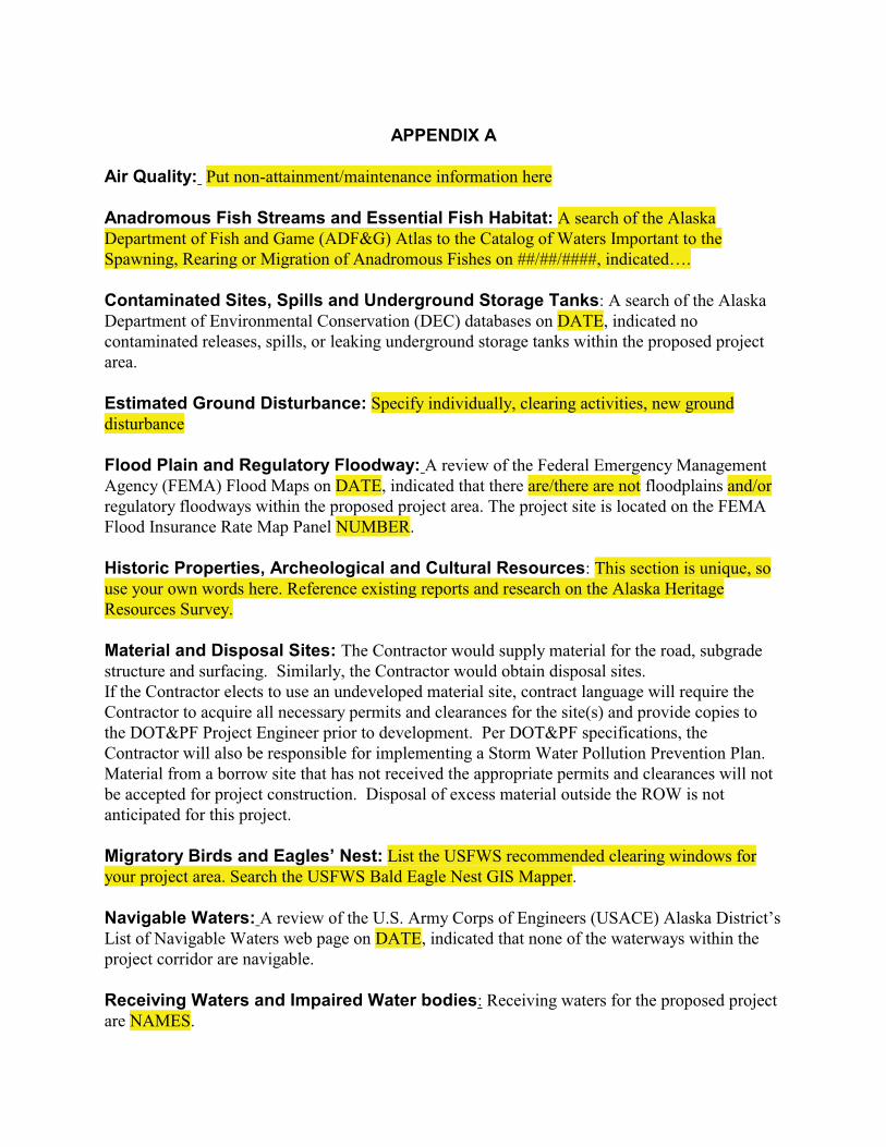
APPENDIX A
Air Quality: Put non-attainment/maintenance information here
Anadromous Fish Streams and Essential Fish Habitat: A search of the Alaska Department of Fish and Game (ADF&G) Atlas to the Catalog of Waters Important to the Spawning, Rearing or Migration of Anadromous Fishes on ##/##/####, indicated….
Contaminated Sites, Spills and Underground Storage Tanks: A search of the Alaska Department of Environmental Conservation (DEC) databases on DATE, indicated no contaminated releases, spills, or leaking underground storage tanks within the proposed project area.
Estimated Ground Disturbance: Specify individually, clearing activities, new ground disturbance
Flood Plain and Regulatory Floodway: A review of the Federal Emergency Management Agency (FEMA) Flood Maps on DATE, indicated that there are/there are not floodplains and/or regulatory floodways within the proposed project area. The project site is located on the FEMA Flood Insurance Rate Map Panel NUMBER.
Historic Properties, Archeological and Cultural Resources: This section is unique, so use your own words here. Reference existing reports and research on the Alaska Heritage Resources Survey.
Material and Disposal Sites: The Contractor would supply material for the road, subgrade structure and surfacing. Similarly, the Contractor would obtain disposal sites. If the Contractor elects to use an undeveloped material site, contract language will require the Contractor to acquire all necessary permits and clearances for the site(s) and provide copies to the DOT&PF Project Engineer prior to development. Per DOT&PF specifications, the Contractor will also be responsible for implementing a Storm Water Pollution Prevention Plan.Material from a borrow site that has not received the appropriate permits and clearances will not be accepted for project construction. Disposal of excess material outside the ROW is not anticipated for this project.
Migratory Birds and Eagles’ Nest: List the USFWS recommended clearing windows for your project area. Search the USFWS Bald Eagle Nest GIS Mapper.
Navigable Waters: A review of the U.S. Army Corps of Engineers (USACE) Alaska District’s List of Navigable Waters web page on DATE, indicated that none of the waterways within the project corridor are navigable.
Receiving Waters and Impaired Water bodies: Receiving waters for the proposed project are NAMES.
State Parks, National Parks, National Forests, Wild and Scenic Rivers: The National Park Service website was reviewed on DATE, and indicated there are/are no National Parks, Preserves, Monuments or Wild and Scenic Rivers in the proposed project area.
A search of the Alaska Department of Natural Resources (ADNR) Division of Parks and Outdoor Recreation (DPOR) was reviewed on DATE, indicated that there are/are no State parks in the proposed project area.
State Refuges, National Wildlife Refuges, Critical Habitat Areas and Sanctuaries:A review of the ADF&G listing of State of Alaska Refuges, Critical Habitat Areas, and Sanctuaries on DATE, indicated no/potential State Refuges, Critical Habitat Areas, or Sanctuaries in the project vicinity.
A review of the USFWS web site on DATE, indicated that no national wildlife refuges exist within the proposed project area.
A review of the Bureau of Land Management (BLM) and the National Park Service (NPS) web sites on DATE, found that no/potential Federal Recreational Areas exist in the proposed project area.
Threatened and Endangered Species: The U.S. Fish and Wildlife Service (USFWS) and ADF&G websites were both reviewed on DATE, to determine if any threatened or endangered species or their habitats are located within the proposed project corridor. None were listed.
Wetlands and Other Waters of the U.S.: The U.S. Fish and Wildlife Service wetlands mapper or other GIS server was reviewed on DATE, and indicated there are/there are notwetlands present in the proposed project area. At this time, wetlands are/are not expected to be impacted by the proposed project. The proposed project area will be evaluated during the growing season to determine if a wetland delineation and/or permits will be required. There is also the potential to impact WATERWAY during ACTIVITIES. *Also include any site visits or photos you looked at to determine the presence of wetlands*
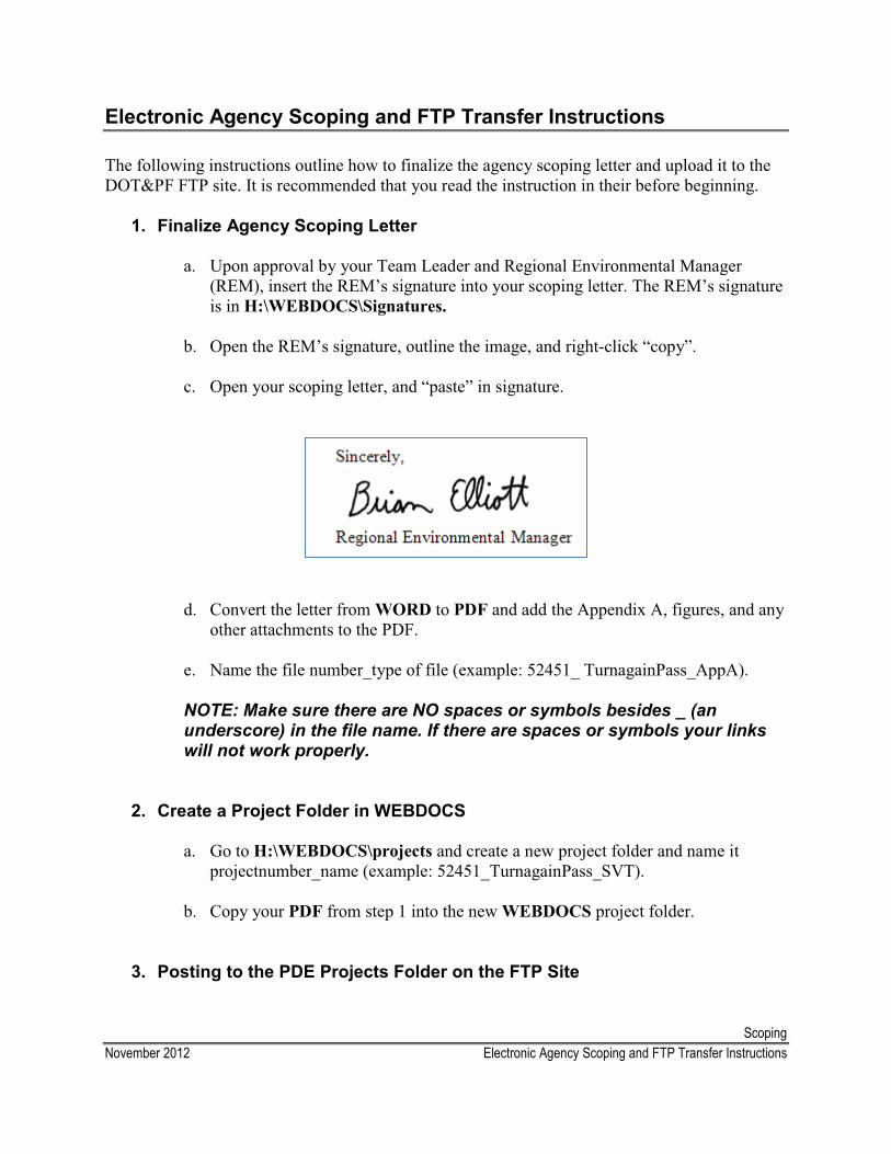
ScopingNovember 2012 Electronic Agency Scoping and FTP Transfer Instructions
Electronic Agency Scoping and FTP Transfer Instructions
The following instructions outline how to finalize the agency scoping letter and upload it to the DOT&PF FTP site. It is recommended that you read the instruction in their before beginning.
1. Finalize Agency Scoping Letter
a. Upon approval by your Team Leader and Regional Environmental Manager (REM), insert the REM’s signature into your scoping letter. The REM’s signature is in H:\WEBDOCS\Signatures.
b. Open the REM’s signature, outline the image, and right-click “copy”.
c. Open your scoping letter, and “paste” in signature.
d. Convert the letter from WORD to PDF and add the Appendix A, figures, and any other attachments to the PDF.
e. Name the file number_type of file (example: 52451_ TurnagainPass_AppA).
NOTE: Make sure there are NO spaces or symbols besides _ (an underscore) in the file name. If there are spaces or symbols your links will not work properly.
2. Create a Project Folder in WEBDOCS
a. Go to H:\WEBDOCS\projects and create a new project folder and name it projectnumber_name (example: 52451_TurnagainPass_SVT).
b. Copy your PDF from step 1 into the new WEBDOCS project folder.
3. Posting to the PDE Projects Folder on the FTP Site
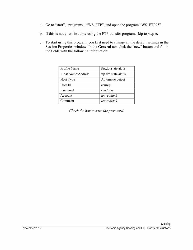
ScopingNovember 2012 Electronic Agency Scoping and FTP Transfer Instructions
a. Go to “start”, “programs”, “WS_FTP”, and open the program “WS_FTP95”.
b. If this is not your first time using the FTP transfer program, skip to step e.
c. To start using this program, you first need to change all the default settings in the Session Properties window. In the General tab, click the “new” button and fill in the fields with the following information:
Profile Name ftp.dot.state.ak.usHost Name/Address ftp.dot.state.ak.us
Host Type Automatic detectUser Id cenregPassword cen2playAccount leave blankComment leave blank
Check the box to save the password.
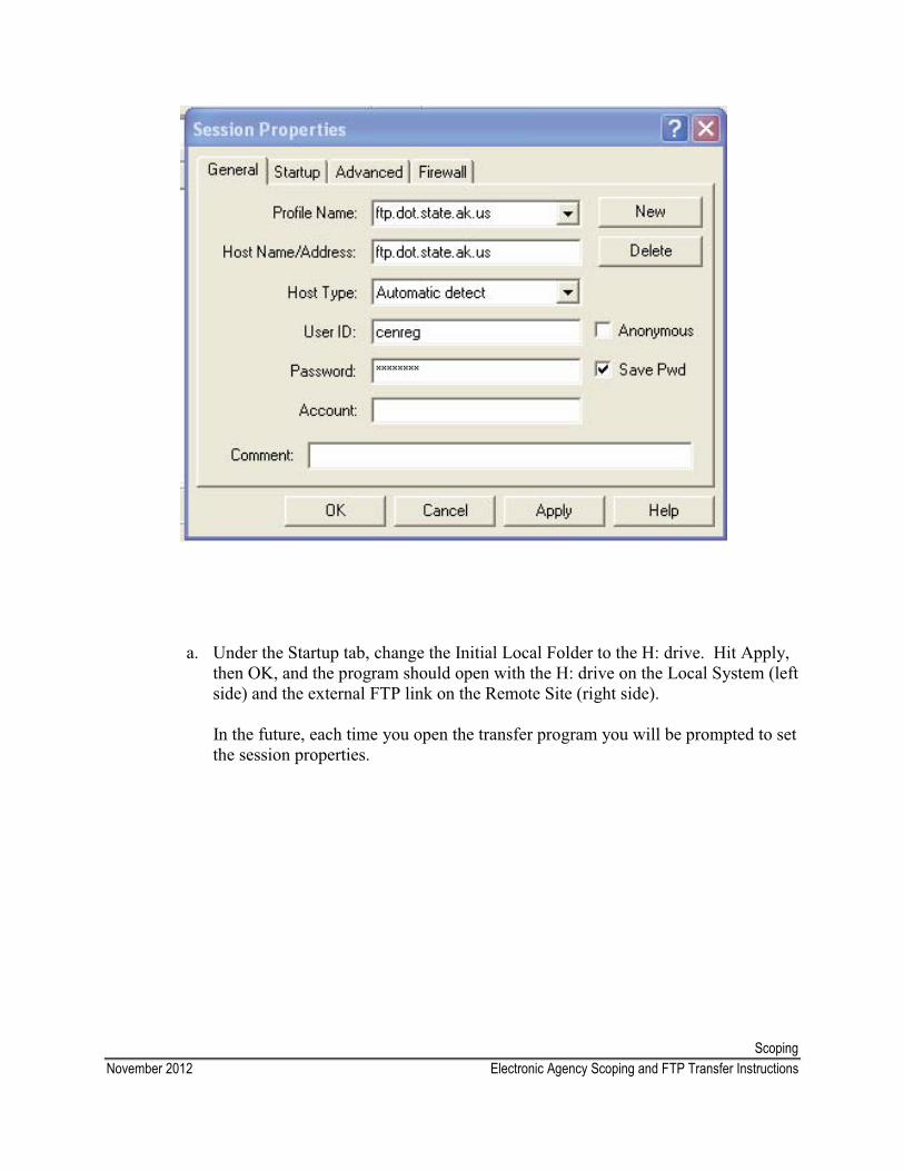
ScopingNovember 2012 Electronic Agency Scoping and FTP Transfer Instructions
a. Under the Startup tab, change the Initial Local Folder to the H: drive. Hit Apply, then OK, and the program should open with the H: drive on the Local System (left side) and the external FTP link on the Remote Site (right side).
In the future, each time you open the transfer program you will be prompted to set the session properties.
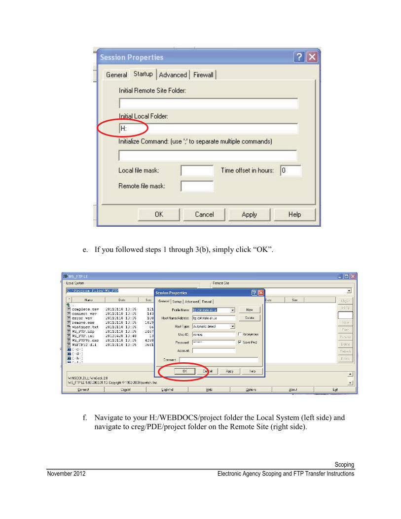
ScopingNovember 2012 Electronic Agency Scoping and FTP Transfer Instructions
e. If you followed steps 1 through 3(b), simply click “OK”.
f. Navigate to your H:/WEBDOCS/project folder the Local System (left side) and navigate to creg/PDE/project folder on the Remote Site (right side).
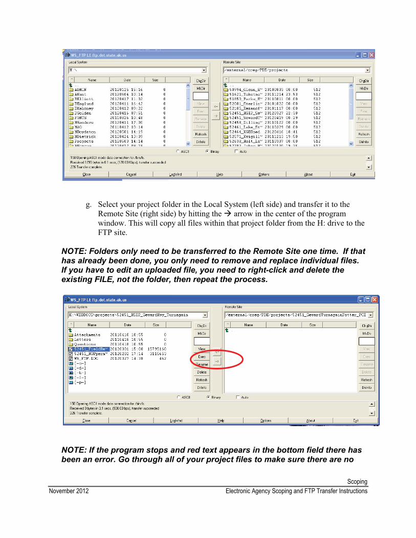
ScopingNovember 2012 Electronic Agency Scoping and FTP Transfer Instructions
g. Select your project folder in the Local System (left side) and transfer it to the Remote Site (right side) by hitting the � arrow in the center of the program window. This will copy all files within that project folder from the H: drive to the FTP site.
NOTE: Folders only need to be transferred to the Remote Site one time. If that has already been done, you only need to remove and replace individual files. If you have to edit an uploaded file, you need to right-click and delete the existing FILE, not the folder, then repeat the process.
NOTE: If the program stops and red text appears in the bottom field there has been an error. Go through all of your project files to make sure there are no
ScopingNovember 2012 Electronic Agency Scoping and FTP Transfer Instructions
spaces or symbols besides _ (an underscore). If you are still having difficulties here, talk to your Team Leader.
h. Once everything has transferred close the program.
i. Check to make sure that everything has been uploaded to the FTP site by going to http://dot.alaska.gov/creg/PDE/projects and navigating to your project file.
j. Copy your scoping letter URL from the website above into the scoping e-mail template below. Send this e-mail to all the agencies on your scoping list and on your electronic cc list.
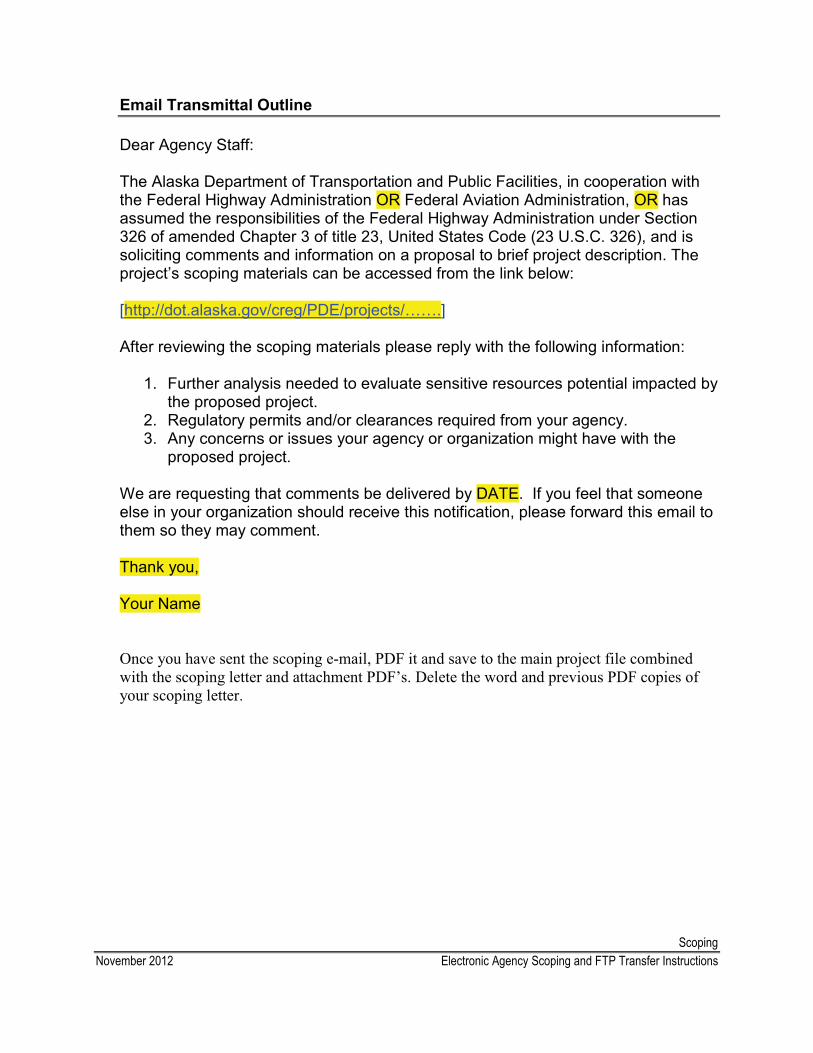
ScopingNovember 2012 Electronic Agency Scoping and FTP Transfer Instructions
Email Transmittal Outline
Dear Agency Staff:
The Alaska Department of Transportation and Public Facilities, in cooperation withthe Federal Highway Administration OR Federal Aviation Administration, OR hasassumed the responsibilities of the Federal Highway Administration under Section 326 of amended Chapter 3 of title 23, United States Code (23 U.S.C. 326), and issoliciting comments and information on a proposal to brief project description. The project’s scoping materials can be accessed from the link below:
[http://dot.alaska.gov/creg/PDE/projects/…….]
After reviewing the scoping materials please reply with the following information:
1. Further analysis needed to evaluate sensitive resources potential impacted by the proposed project.
2. Regulatory permits and/or clearances required from your agency.3. Any concerns or issues your agency or organization might have with the
proposed project.
We are requesting that comments be delivered by DATE. If you feel that someone else in your organization should receive this notification, please forward this email to them so they may comment.
Thank you,
Your Name
Once you have sent the scoping e-mail, PDF it and save to the main project file combined with the scoping letter and attachment PDF’s. Delete the word and previous PDF copies of your scoping letter.
ScopingDecember 2013 Public Scoping Frequently Asked Questions
Public Scoping Frequently Asked Questions
1. What laws, regulations, and guidance apply to public involvement in transportation?
Laws and regulations � National Environmental Policy Act and Council on Environmental Quality 40 CFR 1500 � National Historic Preservation Act and 36 CFR 800 � Freedom of Information Act � Civil Rights Act of 1976, Title VI
Executive Orders� EO 11990, Protection of Wetlands � EO 11988, Floodplain Management � EO 12898, Environmental Justice � EO 13166, Limited English Proficiency
FHWA � FHWA Regulations for Implementing NEPA (23 CFR 771) � FHWA Public Involvement Techniques for Transportation Decisionmaking, September
2006� FHWA Resource Center Public Involvement Guide, September 2008 � FAA Order 5050.4B
2. What is public involvement?
Public involvement is the process by which an organization solicits input from those with a stake in the project or who may be affected by the project to help identify potential significant issues.
3. What is the purpose of public involvement?
The fundamental objective of a public involvement program is to ensure that the public’s concerns and issues are identified and addressed in the development of the policies, programs, and projects.
4. Who is the “public”?
FHWA considers the “public” to be all individuals or groups who reside in, has interest in, does business in, or who are potentially affected by transportation decisions.
5. Why do we do public involvement?
NEPA requires federal agencies to provide an early and open process for determining the scope of issues to be addressed in the environmental document. State-funded projects do not require public involvement by law, but it may be desirable to coordinate somewhat depending on the impacts of the project. For DOT&PF, opportunities for public involvement are provided for all projects where an Environmental Impact Statement will be prepared and must involve the public to the extent
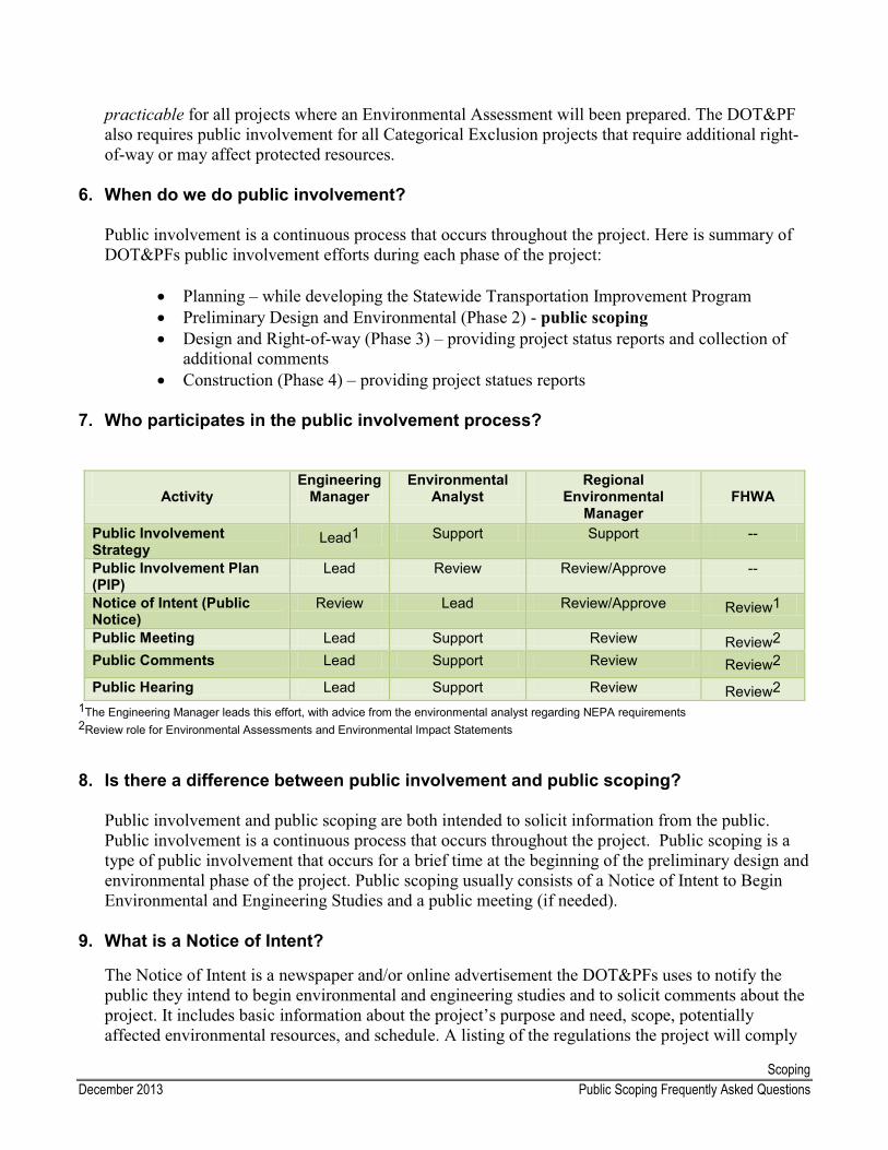
ScopingDecember 2013 Public Scoping Frequently Asked Questions
practicable for all projects where an Environmental Assessment will been prepared. The DOT&PF also requires public involvement for all Categorical Exclusion projects that require additional right-of-way or may affect protected resources.
6. When do we do public involvement?
Public involvement is a continuous process that occurs throughout the project. Here is summary of DOT&PFs public involvement efforts during each phase of the project:
� Planning – while developing the Statewide Transportation Improvement Program � Preliminary Design and Environmental (Phase 2) - public scoping� Design and Right-of-way (Phase 3) – providing project status reports and collection of
additional comments� Construction (Phase 4) – providing project statues reports
7. Who participates in the public involvement process?
ActivityEngineering
ManagerEnvironmental
AnalystRegional
Environmental Manager
FHWA
Public Involvement Strategy
Lead1 Support Support --
Public Involvement Plan (PIP)
Lead Review Review/Approve --
Notice of Intent (Public Notice)
Review Lead Review/Approve Review1
Public Meeting Lead Support Review Review2Public Comments Lead Support Review Review2
Public Hearing Lead Support Review Review21The Engineering Manager leads this effort, with advice from the environmental analyst regarding NEPA requirements2Review role for Environmental Assessments and Environmental Impact Statements
8. Is there a difference between public involvement and public scoping?
Public involvement and public scoping are both intended to solicit information from the public. Public involvement is a continuous process that occurs throughout the project. Public scoping is a type of public involvement that occurs for a brief time at the beginning of the preliminary design and environmental phase of the project. Public scoping usually consists of a Notice of Intent to Begin Environmental and Engineering Studies and a public meeting (if needed).
9. What is a Notice of Intent?
The Notice of Intent is a newspaper and/or online advertisement the DOT&PFs uses to notify the public they intend to begin environmental and engineering studies and to solicit comments about the project. It includes basic information about the project’s purpose and need, scope, potentially affected environmental resources, and schedule. A listing of the regulations the project will comply
ScopingDecember 2013 Public Scoping Frequently Asked Questions
or be consistent with is included in the Notice of Intent to meet the public involvement requirements of the individual laws and executive orders. The notice also provides DOT&PF contact information and logistic information about upcoming public meetings, if applicable. Refer to the Notice of Intent template for more information and processing instructions.
10.Besides the Notice of Intent, does DOT&PF use other methods to notify the public of project’s and public meetings?
Yes, the most effective methods will depend on the project location (i.e., rural vs. urban area), the project scope, and the level of public involvement needed. In addition to newspapers and online advertisements, DOT&PF disseminates information through radio announcements, press releases, fact sheets, flyers, letters to interested parties, transportation fairs, and project websites.
11.What is the analyst’s role in public scoping?
� Prepare and publish the Notice of Intent � respond to environmental questions and comments � provide support for public meetings/hearings
12.When do we initiate public scoping?
As early in the process as possible. Consult with the Engineering Manager, Team Leader, and REM to determine the best time to initiate the scoping process. In general, you can begin public scoping as soon as you have sufficient design information for the public to understand the nature of the project so they can provide informed feedback.
13.How long is the public scoping comment period?
The recommended comment period is 30 days; however, it varies depending on the complexity of the project.
14. Can we extend the comment period?
Yes, we accept comments throughout the project. Due to the linear nature of the project development process, we include a comment period deadline to ensure the project continues to progress.
15. Who receives the comments?
Comments are usually sent to the Regional Environmental Manager, analyst, or Engineering Manager.
16. When do we respond to comments?
Although no formal response to public scoping comments is required, the analyst, Engineering Manager, and REM (if needed) should work together to respond to all substantive comments.
17. How do we respond to comments?
The response should be in writing in the form of a formal letter, an email, a telephone record, etc. All comments and responses should be documented and saved in the project’s administrative file.
ScopingDecember 2013 Public Scoping Frequently Asked Questions
18.How do I know if we should hold a public meeting or a public hearing for my project?
Public Meetings DOT&PF holds at least one public meeting for most CE or EA projects; especially those that require additional right-of-way, may affected a protected resource, or involve public controversy. Public meetings generally occur during the scoping comment period, but can occur throughout the project. Consult with your Engineering Manager, Team Leader, and REM to determine the need for a publicmeeting. Another place you can look to find out if a public meeting is planned for your project is on the DOT&PF Planning Section online Calendar. All Project Managers should post public meeting dates on this calendar. These meetings are generally more informal than a public hearing, further explained below, and are documented by a meeting record.
Public HearingsAccording to FHWA regulations [23 CFR 771.111(h)(iii)], public hearings or the opportunity for hearing(s) should generally be held for Federal-aid project requiring an EIS; specifically projects which require significant amounts of right-of-way, substantially changes the layout or functions of connecting roadways or of the facility being improved, has a substantial adverse impact on abutting property, otherwise has a significant social, economic, environmental, or other effect or for which the FHWA determines that public hearing is in the public interest.
According to FAA Order 5050.4B, (sections 402-403), the opportunity for a public hearing should be offered for all projects that involve a new airport, a new runway, or a major runway extension.
As with a public meeting, a meeting record or transcript is required to document the hearing. However, a Certification of Public Hearing signed by the Engineering Manager is also required.
Consult with your Team Leader, Engineering Manager, and REM when deciding if a public meeting or hearing is appropriate for your project.
19.What is the analyst’s role in public meetings?
For most projects, a public involvement consultant or the Engineering Manager’s staff will organize and facilitate the public meeting. Analyst’s primary responsibilities are to:
� Support the engineering and design staff – this generally includes answering questions about the project and potential environmental impacts
� Ensure compliance with Title VI of the Civil Rights Act of 1964 (refer to the Title VI summary)
� Collect information from community members on environmental resources in the area and potential impacts that you may not have previously identified
20.How far in advance should we notify the public of an upcoming public meeting or hearing?
While there is no set standard, it is generally acceptable to publish Notice of Intent or separate meeting notice two to three weeks in advance of the meeting.
ScopingDecember 2013 Public Scoping Frequently Asked Questions
21.How should we prepare for a public meeting or hearing?
� Ensure the Notice of Intent included the date, time, and place of the public meeting and was published in the appropriate media.
� Collect information on the community, environmental resources in the project area, other projects in the area, project history, etc
� Prepare graphics showing environmental resources, parks and recreational facilities, land uses, existing and proposed right-of-way, project alternatives, etc. Coordinate with the Engineering Manager in deciding what graphics are appropriate for the project.
22.What should we take to a public meeting or hearing?
� Meeting Here Signs, Meeting This Way Signs� Title VI Sign-In Sheet � pens/pencils� name tags for all DOT&PF employees (usually Planner, ROW, Design, PD&E) � your business cards � comment sheets� box or envelope to put filled in comment sheets in � project information sheets (leave extras with local officials so they can give them out the next
day or two) � project plan sheets for wall or table (consider taking an extra set to leave for the local official
but be sure it is marked preliminary or draft)� masking tape or thumb-tacks to hang plan sheets � post-its, highlighters etc to mark up plan sheets
23.What documentation should we keep from the public meeting or hearing?
� Electronic and hard copies of all postcard notifications, letters, etc. with affidavit of publication
� Mailing list indicating who was notified� All information provided at the meetings (e.g. fact sheets) � Sign-in and comment sheets � Comment responses � Meeting notes/minutes or transcripts (public hearing)
24.Do we include tribal organizations as part of public scoping?
Tribal consultation is usually part of the agency scoping process. Refer to the Agency Scoping Frequently Asked Questions for more information.
25.What information goes in the environmental document?
ScopingDecember 2013 Public Scoping Frequently Asked Questions
Summarize your public scoping efforts, issues raised during scoping, and the resolution of the issues. Attach copies of scoping letters, meeting minutes, comments, and responses to the environmental document.
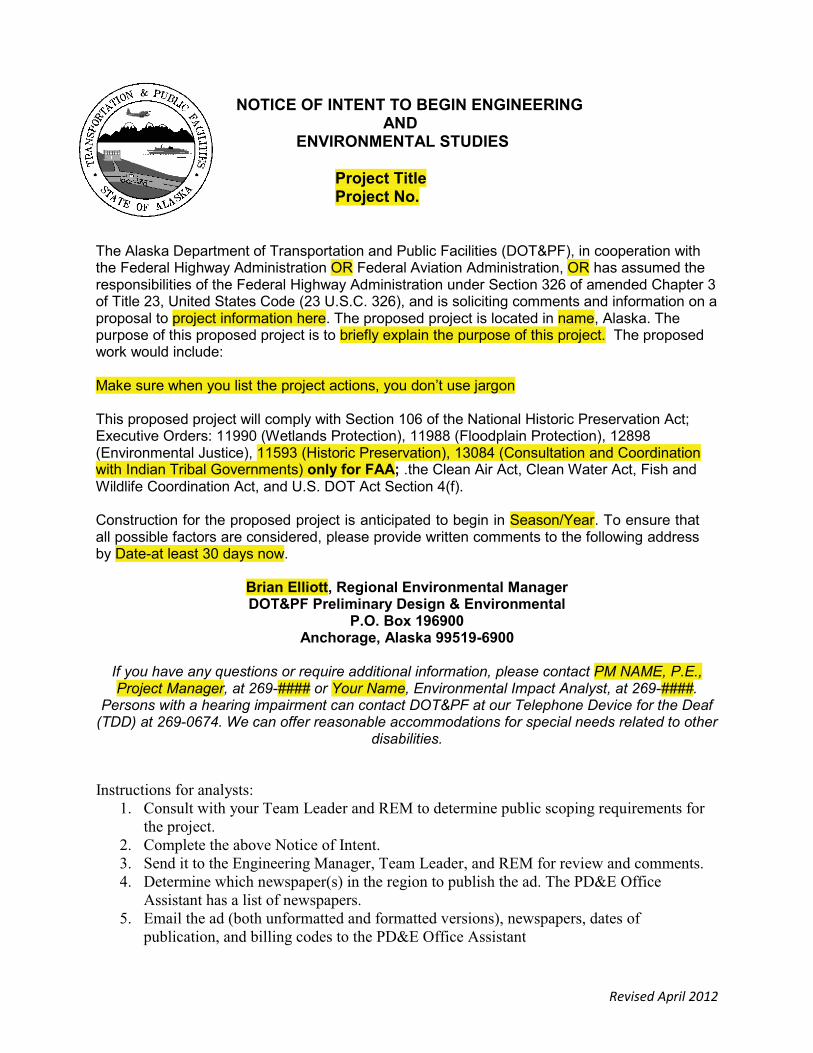
Revised April 2012
NOTICE OF INTENT TO BEGIN ENGINEERINGAND
ENVIRONMENTAL STUDIES
Project TitleProject No.
The Alaska Department of Transportation and Public Facilities (DOT&PF), in cooperation with the Federal Highway Administration OR Federal Aviation Administration, OR has assumed the responsibilities of the Federal Highway Administration under Section 326 of amended Chapter 3 of Title 23, United States Code (23 U.S.C. 326), and is soliciting comments and information on a proposal to project information here. The proposed project is located in name, Alaska. The purpose of this proposed project is to briefly explain the purpose of this project. The proposed work would include:
Make sure when you list the project actions, you don’t use jargon
This proposed project will comply with Section 106 of the National Historic Preservation Act; Executive Orders: 11990 (Wetlands Protection), 11988 (Floodplain Protection), 12898 (Environmental Justice), 11593 (Historic Preservation), 13084 (Consultation and Coordination with Indian Tribal Governments) only for FAA; .the Clean Air Act, Clean Water Act, Fish and Wildlife Coordination Act, and U.S. DOT Act Section 4(f).
Construction for the proposed project is anticipated to begin in Season/Year. To ensure that all possible factors are considered, please provide written comments to the following address by Date-at least 30 days now.
Brian Elliott, Regional Environmental ManagerDOT&PF Preliminary Design & Environmental
P.O. Box 196900Anchorage, Alaska 99519-6900
If you have any questions or require additional information, please contact PM NAME, P.E., Project Manager, at 269-#### or Your Name, Environmental Impact Analyst, at 269-####.
Persons with a hearing impairment can contact DOT&PF at our Telephone Device for the Deaf (TDD) at 269-0674. We can offer reasonable accommodations for special needs related to other
disabilities.
Instructions for analysts: 1. Consult with your Team Leader and REM to determine public scoping requirements for
the project. 2. Complete the above Notice of Intent. 3. Send it to the Engineering Manager, Team Leader, and REM for review and comments. 4. Determine which newspaper(s) in the region to publish the ad. The PD&E Office
Assistant has a list of newspapers. 5. Email the ad (both unformatted and formatted versions), newspapers, dates of
publication, and billing codes to the PD&E Office Assistant
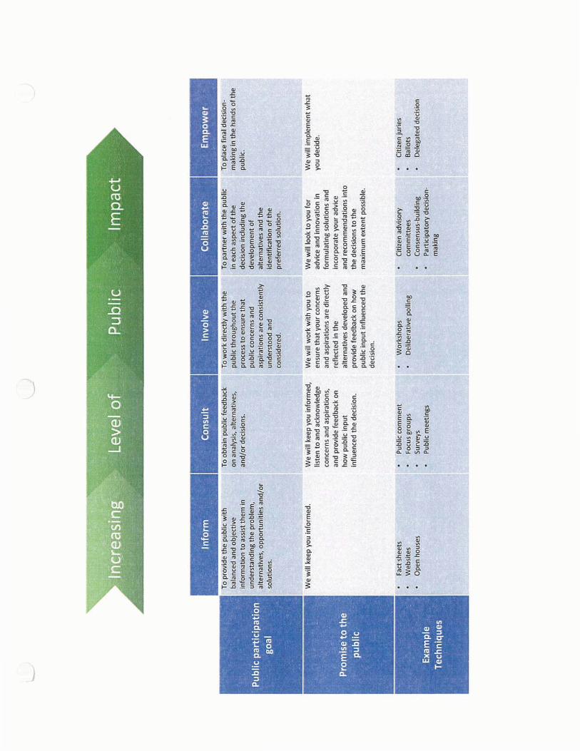
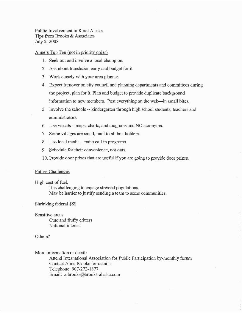
Impacts
Table of Contents
Ground Disturbance Comparison Chart
Section 106 Proceed Directly to Findings Worksheet
Internal Review Procedures for 6004, FAA, FHWA, and State Funded
Section 4(f) Applicability Determination Template
Essential Fish Habitat (EFH) Assessment Guidance
Invasive Species Guidance
Floodplain Guidance
Location Hydraulic Study Guidance and Template
Phase I & II Environmental Site Assessment FrequentlyAsked Questions
APDES, Outstanding Natural Resource Waters (Tier 3) Consultation, and Antidegradation Analysis
IMPA
CTS
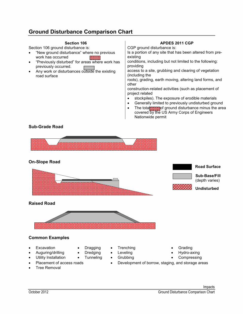
ImpactsOctober 2012 Ground Disturbance Comparison Chart
Ground Disturbance Comparison Chart
Section 106 APDES 2011 CGPSection 106 ground disturbance is:� “New ground disturbance” where no previous
work has occurred � “Previously disturbed” for areas where work has
previously occurred.� Any work or disturbances outside the existing
road surface
CGP ground disturbance is:Is a portion of any site that has been altered from pre-existingconditions, including but not limited to the following: providingaccess to a site, grubbing and clearing of vegetation (including theroots), grading, earth moving, altering land forms, and otherconstruction-related activities (such as placement of project related� stockpiles). The exposure of erodible materials� Generally limited to previously undisturbed ground� The total area of ground disturbance minus the area
covered by the US Army Corps of Engineers Nationwide permit
Sub-Grade Road
On-Slope Road Road Surface
Sub-Base/Fill (depth varies)
Undisturbed
Raised Road
Common Examples
� Excavation� Auguring/drilling� Utility Installation
� Dragging� Dredging� Tunneling
� Trenching� Leveling� Grubbing
� Grading� Hydro-axing� Compressing
� Placement of access roads� Tree Removal
� Development of borrow, staging, and storage areas
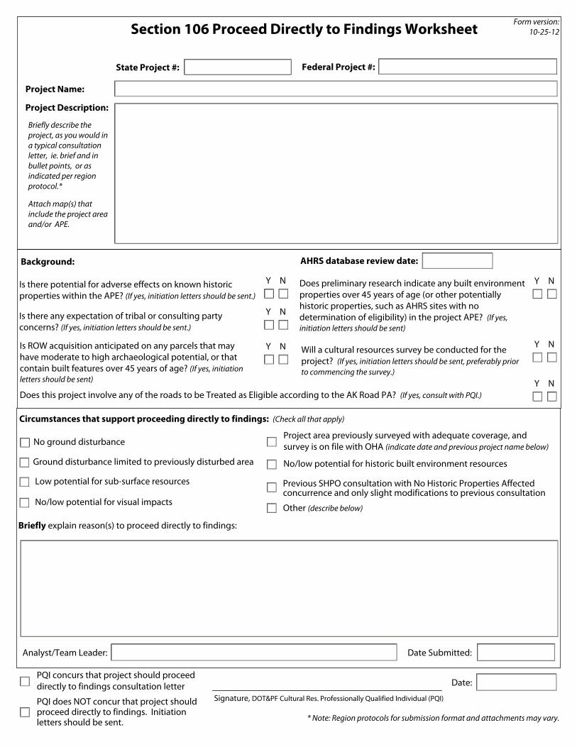
Section 106 Proceed Directly to Findings Worksheet
State Project #:
Project Description:
Does this project involve any of the roads to be Treated as Eligible according to the AK Road PA? (If yes, consult with PQI.)
No ground disturbance
Previous SHPO consultation with No Historic Properties Affected concurrence and only slight modifications to previous consultation
Low potential for sub-surface resources
No/low potential for visual impacts
Circumstances that support proceeding directly to findings: (Check all that apply)
Ground disturbance limited to previously disturbed area
Other (describe below)
AHRS database review date:
Briefly describe the project, as you would in a typical consultation letter, ie. brief and in bullet points, or as indicated per region protocol.* Attach map(s) that include the project area and/or APE.
Background:
Analyst/Team Leader: Date Submitted:
PQI concurs that project should proceed directly to findings consultation letter
Signature, DOT&PF Cultural Res. Professionally Qualified Individual (PQI)
Date:
PQI does NOT concur that project should proceed directly to findings. Initiation letters should be sent.
Federal Project #:
Form version: 10-25-12
No/low potential for historic built environment resources
* Note: Region protocols for submission format and attachments may vary.
Project area previously surveyed with adequate coverage, and survey is on file with OHA (indicate date and previous project name below)
Briefly explain reason(s) to proceed directly to findings:
NY
NY
Project Name:
Does preliminary research indicate any built environment properties over 45 years of age (or other potentially historic properties, such as AHRS sites with no determination of eligibility) in the project APE? (If yes, initiation letters should be sent)
Is ROW acquisition anticipated on any parcels that may have moderate to high archaeological potential, or that contain built features over 45 years of age? (If yes, initiation letters should be sent)
Will a cultural resources survey be conducted for the project? (If yes, initiation letters should be sent, preferably prior to commencing the survey.)
Is there potential for adverse effects on known historic properties within the APE? (If yes, initiation letters should be sent.)
Is there any expectation of tribal or consulting party concerns? (If yes, initiation letters should be sent.)
NY NY
NY
Y N
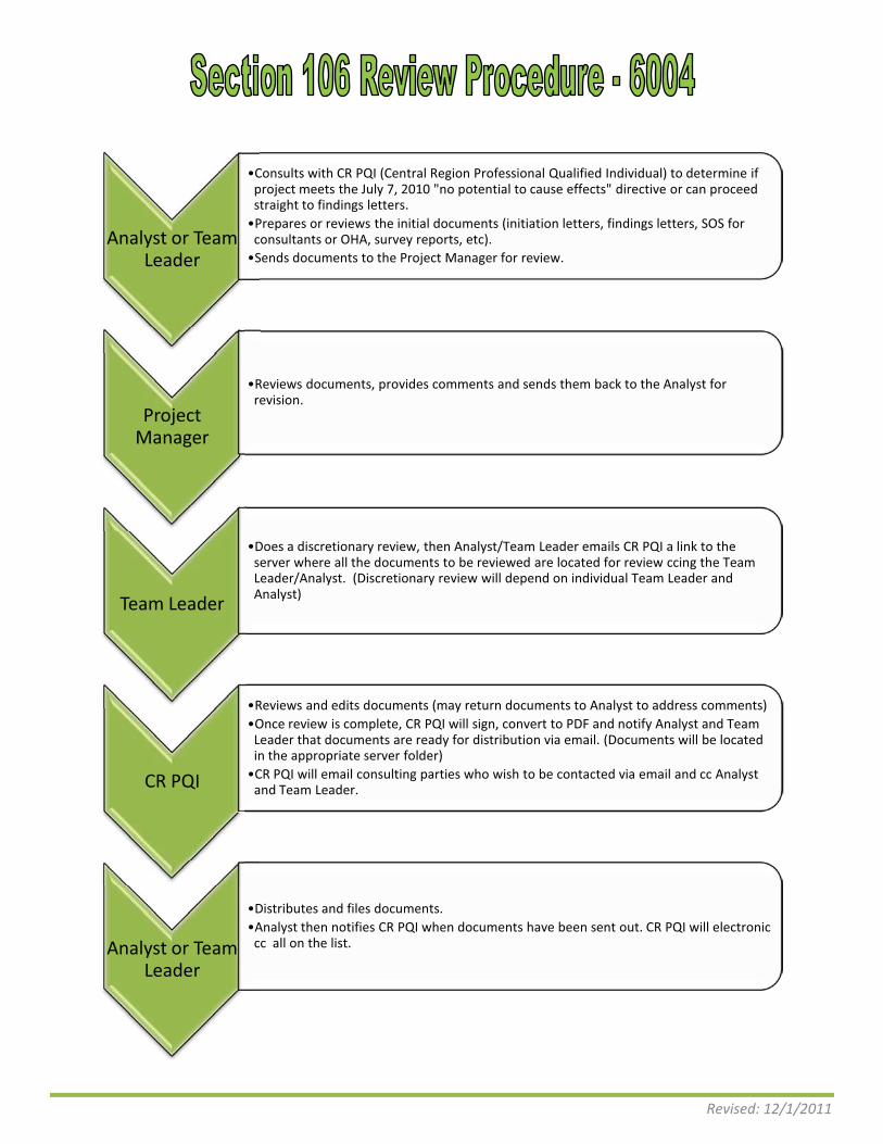
Revised: 12/1/2011
Analyst or Team Leader
�Consults with CR PQI (Central Region Professional Qualified Individual) to determine if project meets the July 7, 2010 "no potential to cause effects" directive or can proceed straight to findings letters.
�Prepares or reviews the initial documents (initiation letters, findings letters, SOS for consultants or OHA, survey reports, etc).
�Sends documents to the Project Manager for review.
Project Manager
�Reviews documents, provides comments and sends them back to the Analyst for revision.
Team Leader
�Does a discretionary review, then Analyst/Team Leader emails CR PQI a link to the server where all the documents to be reviewed are located for review ccing the Team Leader/Analyst. (Discretionary review will depend on individual Team Leader and Analyst)
CR PQI
�Reviews and edits documents (may return documents to Analyst to address comments) �Once review is complete, CR PQI will sign, convert to PDF and notify Analyst and Team
Leader that documents are ready for distribution via email. (Documents will be located in the appropriate server folder)
�CR PQI will email consulting parties who wish to be contacted via email and cc Analyst and Team Leader.
Analyst or Team Leader
�Distributes and files documents. �Analyst then notifies CR PQI when documents have been sent out. CR PQI will electronic
cc all on the list.

Revised: 1/4/2012
Analyst
�Prepares or reviews the initial documents (initiation letters, findings letters, SOS for consultants or OHA, survey reports, etc).
�Sends documents to the Project Manager for review.
Project Manager
�Reviews documents, provides comments and sends them back to the Analyst for revision.
Team Leader
�Does a discretionary review, then Analyst/Team Leader emails a link to the server where all the documents to be reviewed are to CR PQI for review ccing the Team Leader/Analyst. (Discretionary review will depend on individual Team Leader and Analyst)
CR PQI
�Reviews and edits documents (may return documents to Analyst to address comments) �Once review is complete, CR PQI will sign, convert to PDF and notify Analyst and Team
Leader that documents are ready for distribution via email. (Documents will be located in the appropriate server folder)
�CR PQI will email consulting parties who wish to be contacted via email and cc Analyst and Team Leader.
�If there is a finding of ADVERSE EFFECT, CR PQI will notify Statewide PQI for additional guidance and will forward documents to appropriate FAA representative for signature.
FAA
�If ADVERSE EFFECT is determined, FAA will sign letters and distribute. FAA will forward signed documents to REM.
�For all other findings, FAA is not a reviewer.
Analyst
�Distributes and files documents. �Analyst then notifies CR PQI when documents have been sent out. CR PQI will electronic cc
all on the list.
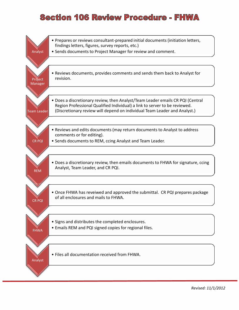
Revised: 11/1/2012
Analyst
� Prepares or reviews consultant-prepared initial documents (initiation letters, findings letters, figures, survey reports, etc.)
� Sends documents to Project Manager for review and comment.
Project Manager
� Reviews documents, provides comments and sends them back to Analyst for revision.
Team Leader
� Does a discretionary review, then Analyst/Team Leader emails CR PQI (Central Region Professional Qualified Individual) a link to server to be reviewed. (Discretionary review will depend on individual Team Leader and Analyst.)
CR PQI
� Reviews and edits documents (may return documents to Analyst to address comments or for editing).
� Sends documents to REM, ccing Analyst and Team Leader.
REM
� Does a discretionary review, then emails documents to FHWA for signature, ccing Analyst, Team Leader, and CR PQI.
CR PQI
� Once FHWA has reveiwed and approved the submittal. CR PQI prepares package of all enclosures and mails to FHWA.
FHWA
� Signs and distributes the completed enclosures. � Emails REM and PQI signed copies for regional files.
Analyst � Files all documentation received from FHWA.
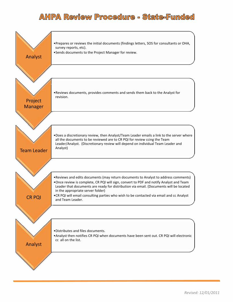
Revised: 12/01/2011
Analyst
�Prepares or reviews the initial documents (findings letters, SOS for consultants or OHA, survey reports, etc).
�Sends documents to the Project Manager for review.
Project Manager
�Reviews documents, provides comments and sends them back to the Analyst for revision.
Team Leader
�Does a discretionary review, then Analyst/Team Leader emails a link to the server where all the documents to be reviewed are to CR PQI for review ccing the Team Leader/Analyst. (Discretionary review will depend on individual Team Leader and Analyst)
CR PQI
�Reviews and edits documents (may return documents to Analyst to address comments) �Once review is complete, CR PQI will sign, convert to PDF and notify Analyst and Team
Leader that documents are ready for distribution via email. (Documents will be located in the appropriate server folder)
�CR PQI will email consulting parties who wish to be contacted via email and cc Analyst and Team Leader.
Analyst
�Distributes and files documents. �Analyst then notifies CR PQI when documents have been sent out. CR PQI will electronic
cc all on the list.
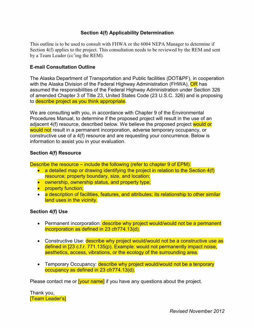
Revised November 2012
Section 4(f) Applicability Determination This outline is to be used to consult with FHWA or the 6004 NEPA Manager to determine if Section 4(f) applies to the project. This consultation needs to be reviewed by the REM and sent by a Team Leader (cc’ing the REM).
E-mail Consultation Outline The Alaska Department of Transportation and Public facilities (DOT&PF), in cooperation with the Alaska Division of the Federal Highway Administration (FHWA), OR hasassumed the responsibilities of the Federal Highway Administration under Section 326 of amended Chapter 3 of Title 23, United States Code (23 U.S.C. 326) and is proposing to describe project as you think appropriate.
We are consulting with you, in accordance with Chapter 9 of the Environmental Procedures Manual, to determine if the proposed project will result in the use of anadjacent 4(f) resource, described below. We believe the proposed project would or would not result in a permanent incorporation, adverse temporary occupancy, or constructive use of a 4(f) resource and are requesting your concurrence. Below is information to assist you in your evaluation.
Section 4(f) Resource
Describe the resource – include the following (refer to chapter 9 of EPM):� a detailed map or drawing identifying the project in relation to the Section 4(f)
resource; property boundary, size, and location; � ownership, ownership status, and property type; � property function; � a description of facilities, features, and attributes; its relationship to other similar
land uses in the vicinity.
Section 4(f) Use
� Permanent incorporation: describe why project would/would not be a permanent incorporation as defined in 23 cfr774.13(d).
� Constructive Use: describe why project would/would not be a constructive use as defined in [23 c.f.r. 771.135(p). Example: would not permanently impact noise, aesthetics, access, vibrations, or the ecology of the surrounding area.
� Temporary Occupancy: describe why project would/would not be a tenporary occupancy as defined in 23 cfr774.13(d).
Please contact me or [your name] if you have any questions about the project.
Thank you,[Team Leader’s]
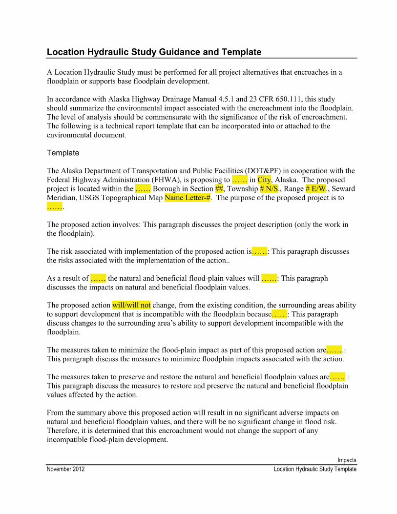
ImpactsNovember 2012 Location Hydraulic Study Template
Location Hydraulic Study Guidance and Template
A Location Hydraulic Study must be performed for all project alternatives that encroaches in a floodplain or supports base floodplain development.
In accordance with Alaska Highway Drainage Manual 4.5.1 and 23 CFR 650.111, this study should summarize the environmental impact associated with the encroachment into the floodplain. The level of analysis should be commensurate with the significance of the risk of encroachment. The following is a technical report template that can be incorporated into or attached to the environmental document.
Template
The Alaska Department of Transportation and Public Facilities (DOT&PF) in cooperation with the Federal Highway Administration (FHWA), is proposing to …… in City, Alaska. The proposed project is located within the …… Borough in Section ##, Township # N/S., Range # E/W., Seward Meridian, USGS Topographical Map Name Letter-#. The purpose of the proposed project is to …….
The proposed action involves: This paragraph discusses the project description (only the work in the floodplain).
The risk associated with implementation of the proposed action is……: This paragraph discussesthe risks associated with the implementation of the action..
As a result of …… the natural and beneficial flood-plain values will ……: This paragraph discusses the impacts on natural and beneficial floodplain values.
The proposed action will/will not change, from the existing condition, the surrounding areas ability to support development that is incompatible with the floodplain because……: This paragraph discuss changes to the surrounding area’s ability to support development incompatible with the floodplain.
The measures taken to minimize the flood-plain impact as part of this proposed action are…….:This paragraph discuss the measures to minimize floodplain impacts associated with the action.
The measures taken to preserve and restore the natural and beneficial floodplain values are…… :This paragraph discuss the measures to restore and preserve the natural and beneficial floodplain values affected by the action.
From the summary above this proposed action will result in no significant adverse impacts on natural and beneficial floodplain values, and there will be no significant change in flood risk. Therefore, it is determined that this encroachment would not change the support of any incompatible flood-plain development.

ImpactsDecember 2012 Phase I & II Environmental Site Assessment Frequently Asked Questions
Phase I & II Environmental Site Assessments Frequently Asked Questions
1. What is a Phase I Environmental Site Assessment (ESA)?
The process used to determine the likelihood that a particular parcel of property may contain hazardous substances or Recognized Environmental Conditions (REC).
The industry standard for preparing Phase I ESAs is found in the American Society for Testing Materials (ASTM) Standard E1527-05 “Standard Practice for Environmental Site Assessments: Phase I Environmental Site Assessment Process”.
2. What are the elements of a Phase I ESA?
� Interviews with past and present land owners, commercial operators, and occupants, if possible
� Review of historical sources of information, such as aerial photographs, fire insurance maps, building department records, chain of title documents, and land use records
� Review of government records, including regulatory reports for both the subject properties and nearby or adjoining properties
� Field visit involving only visual inspection of the subject properties and of adjoining properties
� Documentation of research, observations and results of the environmental inquiry in a written report that specifically identifies any properties that will require invasive site investigations and makes a recommendation regarding the need for additional study (i.e., a Phase II ESA).
3. What is a Recognized Environmental Condition?
The presence or likely presence of any hazardous substances or petroleum products on a property under conditions that indicate a spill has occurred on the property or into the ground, ground water, or surface water of the property.
4. Why are Phase I ESAs performed?
� To evaluate the property for potential contamination
� To assess potential liability for contamination that may be present

ImpactsDecember 2012 Phase I & II Environmental Site Assessment Frequently Asked Questions
� To establish an innocent landowner’s defense should environmental contamination be discovered after the property is acquired
5. What Federal and State laws, regulations, and guidance governs hazardous waste?
Federal � Comprehensive Environmental Response, Compensation, and Liability Act of 1980
(CERCLA), commonly known as Superfund
� Resource Conservation and Recovery Act of 1976 (RCRA)
� Clean Air Act (CAA)
� Clean Water Act (CWA)
� FHWA Interim Guidance – Hazardous Waste Sites Affecting Highway Project Development
State� Alaska Statue Title 46: Water, Air, Energy, and Environmental Conservation
(46.03.299)
� Title 18 Alaska Administrative Code Chapter 62: Environmental Conservation
6. Are there advantages to doing a Phase I ESA, aside from learning about hazardous material in the project area?
Yes - CERCLA can give liability protection for those purchasing a property. In order to qualify for this protection, the organization must have made “all appropriate inquiry” (such as conducting a Phase I ESA) into the history and potential contamination on the property. Without conducting “all appropriate inquiry” the new owner is held liable for clean up, remediation, or monitoring costs.
7. When should we conduct a Phase I ESA for a project?
� EA level projects
� Projects requiring numerous partial or total acquisitions of ROW
� If you suspect hazardous material may be present in your project area and you are proposing substantial excavation
ImpactsDecember 2012 Phase I & II Environmental Site Assessment Frequently Asked Questions
8. Does a Phase I ESA tell me if my project area has hazardous material?
Not exactly. The Phase I ESA will identify any RECs with respect to your project area. AREC is “the presence or likely presence of hazardous material”. Because the Phase I ESA does not involve sampling, it cannot say for sure if contamination is or is not present.
9. If the Phase I ESA identifies RECs, does DOT&PF then have to clean it up?
Not necessarily. If there is contamination in the project area, you will need to consult with ADEC to determine what needs to be done. If the area is not going to be disturbed and the contamination does not pose a threat to drinking water or human health, you may be able to leave the hazardous material where it is. If the material is going to be excavated, it may need to be disposed of at an approved treatment facility. It will depend on the project, the type of contamination, and how much material is present.
10.What is a Phase II ESA?
A Phase II ESA is a field sampling and lab analysis of soil and groundwater samples to confirm whether suspected hazardous materials are actually present on the property.
11.What are the elements of a Phase II ESA?
� Geophysical survey
� Soil and soil gas sampling
� Ground and surface water sampling
12.If the Phase I ESA identifies RECs, should we conduct a Phase II ESA?
Probably, but it depends on the amount of excavation and the previous land use in the project area. The Phase I should include a recommendation for additional study, if needed. Consult with your Team Leader and the Regional Environmental Manager in making this decision.
13.What types of hazardous materials are usually found?
The most common hazardous material is fuel (gasoline = GRO, diesel = DRO, oils = RRO). Other contaminants can include other hydrocarbons, PCBs, pesticides, or metals.
14.What if I already know hazardous material is present in my project area?
Then a Phase I ESA probably will not give you any new information. You can probably gostraight to consulting with ADEC and/or conducting a Phase II ESA.
15.Who performs a Phase I or Phase II ESA?
ImpactsDecember 2012 Phase I & II Environmental Site Assessment Frequently Asked Questions
An Environmental Professional who meets either of the following qualifications:
� Possesses sufficient specific education, training and experience necessary to exercise professional judgment to develop opinions and conclusions indicative of a release or threatened release on, at, in or to a property.
Or
� Possesses the following:
o A Professional Engineer’s (P.E.) or Geologist’s (P.G.) license
o A license or certification from the federal government to perform such assessments
o Works under the direct supervision of the above accredited personnel
o B.S. degree with 5 years experience or non B.S. degree with10 years experience performing ESAs.
16.Can anyone within DOT&PF perform ESAs?
The DOT&PF PD&E section typically hires a consultant to perform ESAs. Another option is to use the Term Contract through the Facilities section. Consult with your Team Leader and REM to determine the best method for your project.
17.Is a Right of Entry permit needed prior to performing the study?
According to Alaska Statute 09.55.280, entry upon land is allowed to make examination, survey, and map or locate boundaries. Therefore, a Right of Entry permit is not required to perform a Phase I ESA because it is does not involve ground disturbing activities (i.e., is non-invasive) in nature. A Right of Entry permit is required to perform a Phase II ESA because they involve soil sampling and drilling.
As a courtesy to property owners, it may be a good idea to notify them that survey work will occur on or near their property. The DOT&PF Right of Way section will send notification letters when requested. Consult with your Team Leader and Engineering Manager to determine if you should notify property owners.
18.The Environmental Procedures Manual (EPM) talks about “Initial Site Assessments” and “In Depth Site Assessments”. Are these Phase I and II ESAs?
Yes, “initial site assessment” is another term for a Phase I ESA and “in depth site assessment” is another term for a Phase II ESA. Initial site assessment and in depth site
ImpactsDecember 2012 Phase I & II Environmental Site Assessment Frequently Asked Questions
assessment are terms found in the AASHTO guidance on hazardous materials. Phase I and II ESA is the industry standard terminology for these studies.
19.What should be in a Phase I and II ESA reports?
The contents of a Phase I are outlined in ASTM 1527-05. Reports should, at a minimum, include the following information:
� Site Investigation Project Description - A description of the objectives and activities of the investigation, all contacts with regulatory agency personnel and regulatory agency input on work plans, and a summary of previous investigative and remediation site work
� Site Background - A thorough discussion of the site geology, hydrogeologic conditions observed during the investigation, and extent of soil and ground water contamination known prior to the current investigation
� Data Evaluation and Discussion - Compilation and discussion of the site investigation results including impacts to the environment, potential impacts to human health, potential liability, and health and safety concerns. The data to be presented includes, but is not limited to:
o Maps illustrating the site, physical features, boring locations, well locations, and contaminant distribution(s);
o Cross sections of subsurface geology and hydrologic conditions, including chemical results exceeding detection limits;
o Tabulated chemical data in all media sampled; and o Summary of laboratory results
� Conclusions and Recommendations - Documentation of the findings of the investigation, the potential impacts of the contamination to the planned transportation project, any further steps necessary to adequately assess the contamination, and mitigation issues to be considered if the contaminated property or site is included in the transportation project
� Appendices - Compilation of all data collected or used to support the report.
20.Does the Phase I need to be approved by an outside agency (i.e. ADEC)?No.
21.Is there anything after Phase II?
Yes, Phase III and Phase IV ESAs are performed to determine the full nature and extent of contamination so handling, remediation, and monitoring requirements can be established, if needed.

ImpactsDecember 2012 Phase I & II Environmental Site Assessment Frequently Asked Questions
22.How long will a Phase I or II take?
Either a Phase I or Phase II will probably take two to three months after the Notice to Proceed is issued (assuming the ground is not frozen for a Phase II).
ImpactsJanuary 2013 APDES, Tier 3 Consultation, and Antidegradation Analysis
APDES, Outstanding National Resource Waters (Tier 3) Consultation, and Antidegradation Analysis
Part 2.1.5 of the 2011 Alaska Pollution Discharge Elimination System (APDES) Construction General Permit (CGP) states that construction activities that may discharge stormwater into a“high quality water that constitutes an outstanding national resource” must contact the ADEC thirty calendar days prior to the planned start of construction. The Chief Engineer DirectiveMemo dated December 5, 2011, further clarifies this requirement and states that ADEC must be consulted when a proposed project discharges stormwater into waters within the boundaries of or within a mile upstream of a national or state park or wildlife refuge.
During the environmental document preparation stage of the project, it is the role of the Environmental Analyst to identify these potential “outstanding national resource waters”, also known as potential Tier 3 waters. The analyst would then consult with the ADEC using the consultation outline below and include the response in the environmental document.
Outstanding National Resource Waters (Tier 3) Consultation E-mail Outline
The Alaska Department of Transportation and Public Facilities (DOT&PF), in cooperation with the Federal Highway Administration, is proposing [DESCRIBE PROJECT IN AS MUCH DETAIL AS YOU THINK IS APPROPRIATE]. The proposed project is located [LOCATION DETAILS].
The DOT&PF is consulting with you to determine if additional submital requirements for the proposed project pursuant to the 2011 Alaksa Pollutant Discharge Elimination System (APDES) Construction General Permit (CGP) Part 2.1.5. The proposed project will discharge storm water into [WATER], a potential Tier 3 water.
Potential Tier 3 Waters[DESCRIBE: What potential Tier 3 water will the proposed project discharge stormwater into and what qualifies it as potential Tier 3?]
Please contact me by e-mail or by phone at (907)269-XXXX, if you have any questions or need additional information.
Antidegradation Analysis As a result of this consultation, ADEC may request additional information be submitted with the SWPPP. These additional requirements would include:
� Development of a site-specific Antidegradation analysis using the ADEC Policy Interim Antidegradation Implementation Methods dated July 14, 2010 or a subsequent version;
� Submittal of the Antidegradation analysis and the SWPPP to ADEC at least 14 calendar days prior to filing the Notice of Intent for the project
� Receipt of the ADECs written reply according to part 2.5 prior to commencement of construction
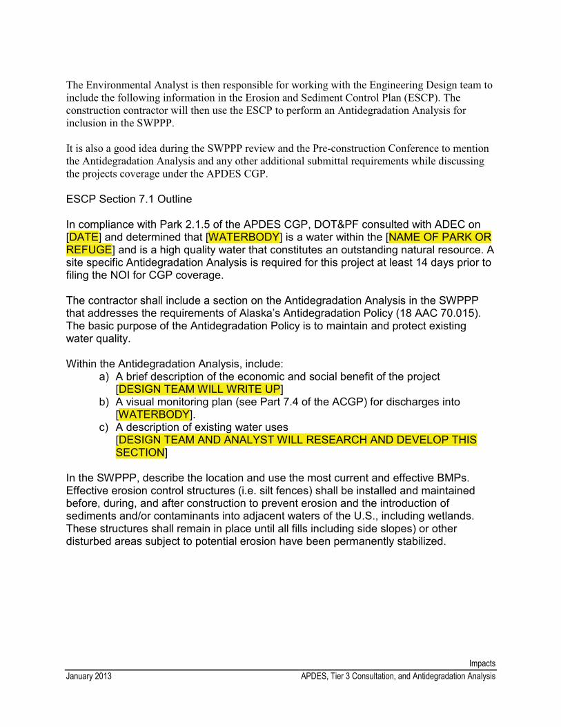
ImpactsJanuary 2013 APDES, Tier 3 Consultation, and Antidegradation Analysis
The Environmental Analyst is then responsible for working with the Engineering Design team to include the following information in the Erosion and Sediment Control Plan (ESCP). The construction contractor will then use the ESCP to perform an Antidegradation Analysis for inclusion in the SWPPP.
It is also a good idea during the SWPPP review and the Pre-construction Conference to mention the Antidegradation Analysis and any other additional submittal requirements while discussing the projects coverage under the APDES CGP.
ESCP Section 7.1 Outline
In compliance with Park 2.1.5 of the APDES CGP, DOT&PF consulted with ADEC on [DATE] and determined that [WATERBODY] is a water within the [NAME OF PARK OR REFUGE] and is a high quality water that constitutes an outstanding natural resource. A site specific Antidegradation Analysis is required for this project at least 14 days prior to filing the NOI for CGP coverage.
The contractor shall include a section on the Antidegradation Analysis in the SWPPP that addresses the requirements of Alaska’s Antidegradation Policy (18 AAC 70.015). The basic purpose of the Antidegradation Policy is to maintain and protect existing water quality.
Within the Antidegradation Analysis, include:a) A brief description of the economic and social benefit of the project [DESIGN TEAM WILL WRITE UP] b) A visual monitoring plan (see Part 7.4 of the ACGP) for discharges into
[WATERBODY].c) A description of existing water uses
[DESIGN TEAM AND ANALYST WILL RESEARCH AND DEVELOP THIS SECTION]
In the SWPPP, describe the location and use the most current and effective BMPs. Effective erosion control structures (i.e. silt fences) shall be installed and maintained before, during, and after construction to prevent erosion and the introduction of sediments and/or contaminants into adjacent waters of the U.S., including wetlands. These structures shall remain in place until all fills including side slopes) or other disturbed areas subject to potential erosion have been permanently stabilized.
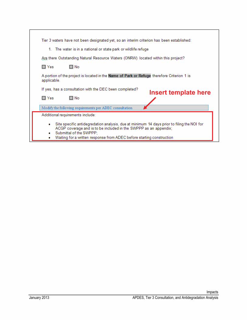
ImpactsJanuary 2013 APDES, Tier 3 Consultation, and Antidegradation Analysis
Insert template here
Environmental Document
Table of Contents
CE Process Guidance
Environmental Process for Categorical Exclusion Projects
Categorical Exclusion Document Review and Approval Procedure
Categorical Exclusion Transmittal Memo Template
Environmental Assessment Transmittal Letter Template
Limitations on Claims Template and Example
Common Environmental Commitments
ENVIR
ON
MEN
TAL
DO
CU
MEN
T
Environmental DocumentJune 2010 Categorical Exclusion Process Guidance
Categorical Exclusions Process Guidance
The following guidance outlines the basic process involved in completing the environmental phase for a categorical exclusion (CE) project. It is recommended that you read the guidance in its entirety and refer to the Environmental Procedures Manual CE chapter and your Team Leader before beginning.
1. When you receive a new project, you should receive the following information: a. Assumed type of document (i.e., PCE, CE, EA or state-funded project); b. Whether the project may be assignable under 6004 (see 6004 MOU);c. Purpose and need for project; d. Scope of work; e. Map(s) of project showing location and proposed actions.
2. In consultation with your Team Leader, complete the Class of Action form to determine if the project is CE [i.e. a “c” or “d” list project under 23CFR771.117(a), see Section 5 of the Environmental Procedures Manual] and if its assignable. See processing instructions in Project Management/Class of Action folder.
3. Ask your team leader for recently approved environmental documents/EAs similar to your project.
4. Orient yourself to the project area by viewing online maps/resources such as Google Earth and/or the Alaska Mapper. Once you have a good feel for the project site and scope of work, start conducting preliminary research. It’s a good idea to first go through each environmental impact category briefly to determine the potential impacts, then go back and analyze them in more detail. Refer to the list of resources and specific instructions for each environmental impact category in the Templates folder. The categories that usually take the most time/effort are Section 106, Section 4(f), waters/wetlands, and essential fish habitat.
5. When you have determined what potential impacts may be involved in the proposed project, visit the project site, if possible, to verify the on-site conditions and the project’s potential impacts. It’s a good idea to go with the PM, designer, hydrologist, and your Team Leader to discuss the project scope and answer any questions you may have about the proposed project. After your visit, write a trip report summarizing the trip, project site, potential impacts and any other relevant information. Attach photos taken during the trip.
6. At this point, you should have a thorough understanding of the scope of work and be ready to begin the environmental process and filling out the environmental document

Environmental DocumentJune 2010 Categorical Exclusion Process Guidance
form.
Next, in consultation with your Team Leader and the REM, determine if public and/or agency scoping is required. Agency scoping is required if any protected resources (e.g.wetlands, fisheries) would be potentially impacted. The agencies will usually reply and let you know if a permit is required, if they would like any additional studies conducted (e.g. a wetland delineation) or if they have additional information about the area.
Public scoping is required if there are any changes to the existing configuration of a site (e.g., another lane or new signals are being added or access changes) that may affect the public. Public comments vary depending on the project. The PM should respond to each of the comments, if necessary. The comments and responses should be discussed in the environmental document and attached as an appendix. Refer to the Public Involvement procedure in the Templates folder for specific instructions on agency and public scoping. If you have not received a response from agencies with jurisdiction by day 20-25, call/email to check the status.
7. It is best to begin the Section 106 process as early as possible and/or in conjunction with scoping. Plan to send out the scoping letters and Section 106 letters as close as possible. Review the AHRS database and visit the SHPO office to determine if any cultural resources are in the project area. Refer to Section 106 procedure in the templates folder.
Review the FHWA/DOT&PF “Program Undertakings with No Potential to Cause Effects to Historic Properties” agreement and discuss the situation with your Team Leader, REM, and DOT&PF Statewide. If the project meets the criteria listed in the agreement, prepare an email discussing the research you conducted and the results. Have your Team Leader review the email and revise it as necessary. DOT&PF Statewide will determine if the project would have a potential affect on historic sites. The email correspondence and response should be attached to the environmental document.
If the project does not meet the criteria listed in the FHWA/DOT&PF “Program Undertakings with No Potential to Cause Effects to Historic Properties” agreement, consult with your Team Leader, REM, and DOT&PF Statewide Cultural Resources Manager to determine if a Section 106 Initiation or Findings letter should be prepared. Typically an Initiation letter is sent first, then a Findings letter. However, sometimes wecan send a combined Initiation and Findings letter. These letters need to be reviewed by the Project Manager, Team Leader, REM, DOT&PF Statewide Cultural Resources Manager, and FHWA (in that order). The SHPO has 30 days to respond (however, they often do not respond to Initiation letters). If you have not received a response from SHPO or other consulting parties by day 20-25, call/email to check the status.
Environmental DocumentJune 2010 Categorical Exclusion Process Guidance
8. After scoping is complete and you know if field studies are required, you should start planning how and when to get them done. Depending on the study, we can do it in-house or we can hire a contractor to complete the work. We can usually do wetland delineations, fish trapping, and Essential Fish Habitat Assessments. Consultants are hired using a small procurement or a term contract. Consult with your Team Leader and REM and refer to the Contracts folder for specific guidance on completing this process.
9. The next environmental impact category you should analyze is Section 4(f) and Section 6(f) resources. First, determine if there are any Section 4(f)/6(f) resources within or adjacent to the project. If there are, you and your Team Leader will consult with FHWA or DOT&PF Statewide in much the same way as you consulted for Section 106 if the project met the programmatic agreement. If the project impacts (i.e. there is a “use” or a “conversion of use”) a Section 4(f) or Section 6(f) resource, an additional evaluation is required. Refer to the Section 4(f) procedures for specific guidance on completing this process.
10. Continue to analyze each environmental impact and fill in the environmental documentation form. Refer to the specific guidance for each impact category in the Templates folder. When you have completed each section of the CE form and conducted all required consultations, the document is ready to be finalized. Prepare a transmittal memo and attach the following documents/maps to your document:
a. Location/vicinity map; b. Section 106 Consultation; c. Section 4(f) Consultation; d. Wetlands Delineation, if any; e. Permits, if obtained; f. Public and Agency Coordination;g. Other relevant information.
11. The document is then ready to be reviewed. The document should be reviewed by the PM, your Team Leader, and the REM. First, give the document with the attachments and the transmittal memo to the PM. Specifically ask them to review the scope of work, purpose and need, and environmental commitments. They should provide you with comments/suggestions for revising the document. If you agree with their comments, make the suggested changes. Next, give the revised document, attachments, and memo to your Team Leader and they will provide you additional comments. Again, make the suggested changes and give the revised document to the REM for review and signature. Since this is the first time the REM sees the completed document, they may have additional changes. If so, make the changes and resubmit the document to the PM for signature. Re-submit it to the REM with your signature or Team Leaders signature. If the document is a CE, the REM will email it to FHWA or DOT&PF Statewide for their
Environmental DocumentJune 2010 Categorical Exclusion Process Guidance
signature.
12. When all the signatures have been obtained, complete the following: a. scan the document and email it to the everyone on the cc: list,b. save the PDF in the electronic file;c. file the original copy.
13. When the project design is roughly at least 50 percent complete, the project designer will send you a packet containing a plan set and booklet of special provisions for you to review. This review is called the Plans in Hand (PIH) or Plans, Specifications and Estimates (PS&E) review. Typically the PIH review happens first when the project is 50-75 percent complete, then the PSE review happens when the project is 75-95 percent complete. However, depending on the project schedule, sometimes the reviews are combined. The designers should also include an Erosion and Sediment Control (ESCP) with the package. You need to review each document and provide comments. Refer to the ESCP checklist and Design Review procedure. The aim of this review is to ensure the project plans and specifications are consistent with the environmental document and permits. Refer to the review instructions in the Templates folder.
14. Submit the ESCP and applicable plan sheets to the ADEC if the project: a. Involves 5 or more acres of ground disturbance; OR b. Changes or modifies the storm drain; ORc. Changes drainage patterns; ORd. Includes a sediment basin.
15. After you review the plan set and specifications, have your Team Leader review your comments. Submit your comments on the comment form or via the intranet. Shortly after the deadline for submitting comments, there will be a meeting to discuss the comments.At the meeting, all of the different functional groups meet to go over all the comments. You should attend this meeting, if possible, to discuss your comments and answer environmental-related questions. If you cannot attend, you should still submit your comments prior to the deadline. If you miss the deadline, you can bring them to the meeting and/or submit them electronically as soon as possible.
16. If permits are required, determine when the project is expected to be certified and start applying for permits approximately 6 months in advance. Refer to the Permits folder for specific guidance on applying for each permit.
17. When the project design and environmental processes are complete, the project is ready to move into the next phase [i.e. Phase III (ROW) or Phase IV (construction)]. You will be sent a certification package (known as a “cert pack”) containing the plan set and
Environmental DocumentJune 2010 Categorical Exclusion Process Guidance
specifications similar to what you received for the PIH and PSE review. The goal is to ensure the environmental document is consistent with the scope of the work shown in the plans and specifications and to ensure all environmental permits and approvals have been obtained. Review the package and prepare an Environmental Commitments Memo. Complete the certification form and submit the package and form to the REM.
18. The project will then move into the next phase. If it goes directly into construction, a new project manager and a project engineer will be assigned to the project.
19. If you are notified of any changes to the project footprint or scope of work, immediatelytalk with your Team Leader. You must consult with FHWA or DOT&PF Statewide to determine if a written re-evaluate the document is required.
20. When the project is ready to go into construction, it will go out for bid. After the contract is awarded, the DOT&PF and the contractor will meet at a Preconstruction Conference (known as a “Pre Con”). You will have to give a summary of the environmental permits and environmental commitments at the conference. Always attend the preconstruction conference, if possible.
21. The contractor will prepare a Storm Water Pollution Prevention Plan (SWPPP) based on the ESCP and send it to you for review. Review the SWPPP and figures using the ADECSWPPP review checklist and or EPA Appendix R. Prepare a memo to the construction PM discussing your comments on the SWPPP. The contractor will amend the SWPPP and resubmit it to you. Submit and NOI, if needed (over an acre of ground disturbance).
Once the project is in construction, you will need to monitor construction to ensure compliance with any environmental commitments, environmental permits, and the APDES Construction General Permit. You should stay in contact with the Project Engineer and visit the site during work that may impact a resource and to inspect the BMPs. The DOT&PF Erosion and Sediment Control Specialist will usually visit the site with you to help inspect the BMPs. The best times to go do site visits are during SWPPP inspections, major work periods, or when other agencies will be out there – coordinate all visits with your project engineer and (if possible) try to visit the site with Mary Nan Cunningham or Joshua James.
22. Once site work is complete and final stabilization is achieved, file an NOT.
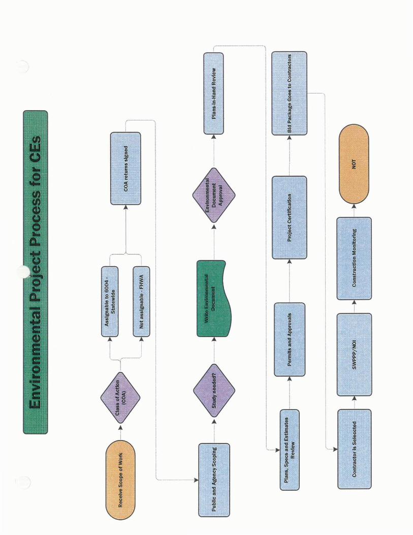
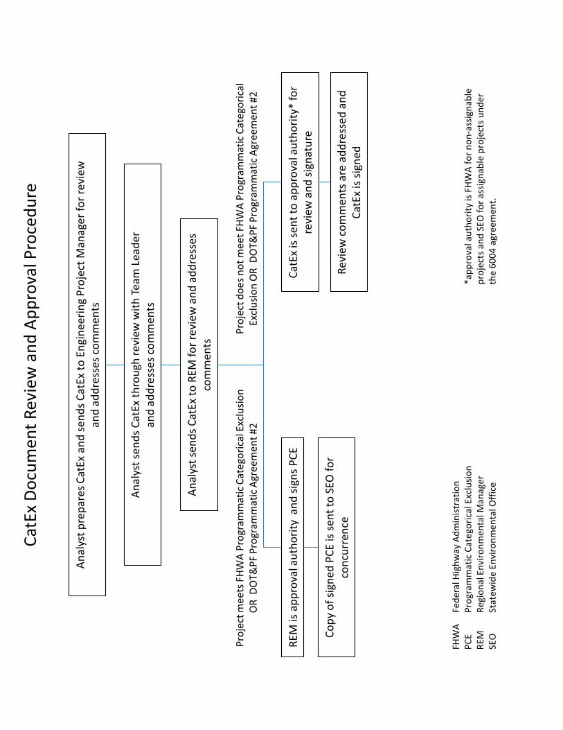
Ana
lyst
sen
ds C
atEx
thro
ugh
revi
ew w
ith T
eam
Lea
der
and
addr
esse
s co
mm
ents
CatE
x is
sen
t to
appr
oval
aut
hori
ty*
for
revi
ew a
nd s
igna
ture
RE
M is
app
rova
l aut
hori
ty a
nd s
igns
PCE
Ana
lyst
pre
pare
s Ca
tEx
and
send
s Ca
tEx
to E
ngin
eeri
ng P
roje
ct M
anag
er fo
r rev
iew
an
d ad
dres
ses
com
men
ts
Ana
lyst
sen
ds C
atEx
to R
EM fo
r rev
iew
and
add
ress
es
com
men
ts
Revi
ew c
omm
ents
are
add
ress
ed a
nd
CatE
x is
sig
ned
Proj
ect m
eets
FH
WA
Pro
gram
mat
ic C
ateg
oric
al E
xclu
sion
O
R D
OT&
PF P
rogr
amm
atic
Agr
eem
ent #
2
CatE
x D
ocum
ent R
evie
w a
nd A
ppro
val P
roce
dure
Copy
of s
igne
d PC
E is
sen
t to
SEO
for
conc
urre
nce
Proj
ect d
oes
not m
eet F
HW
A P
rogr
amm
atic
Cat
egor
ical
Ex
clus
ion
OR
DO
T&PF
Pro
gram
mat
ic A
gree
men
t #2
*app
rova
l aut
hori
ty is
FH
WA
for n
on-a
ssig
nabl
e pr
ojec
ts a
nd S
EO fo
r ass
igna
ble
proj
ects
und
er
the
6004
agr
eem
ent.
FHW
A
Fede
ral H
ighw
ay A
dmin
istr
atio
n PC
E Pr
ogra
mm
atic
Cat
egor
ical
Exc
lusi
on
REM
Re
gion
al E
nvir
onm
enta
l Man
ager
SE
O
Stat
ewid
e En
viro
nmen
tal O
ffic
e
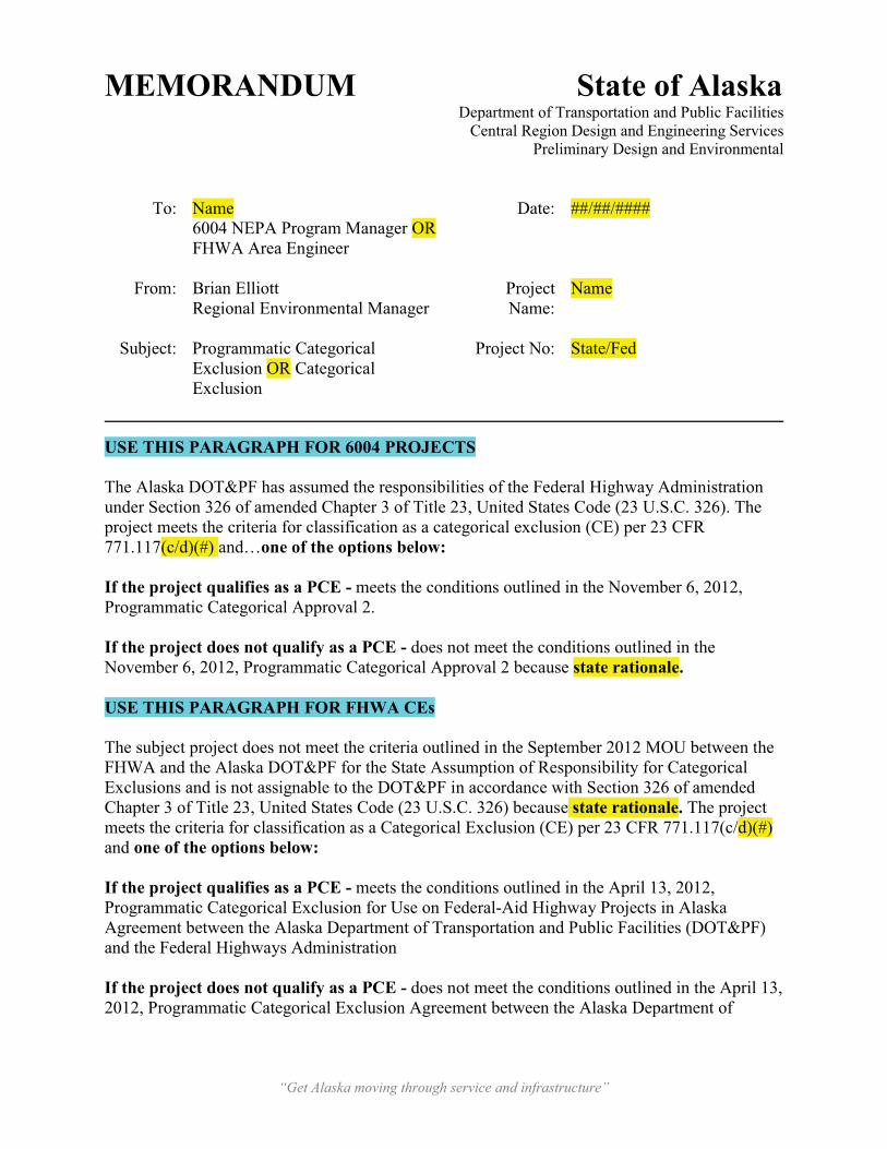
“Get Alaska moving through service and infrastructure”
MEMORANDUM State of AlaskaDepartment of Transportation and Public Facilities
Central Region Design and Engineering ServicesPreliminary Design and Environmental
To: Name6004 NEPA Program Manager OR FHWA Area Engineer
Date: ##/##/####
From: Brian ElliottRegional Environmental Manager
Project Name:
Name
Subject: Programmatic Categorical Exclusion OR Categorical Exclusion
Project No: State/Fed
USE THIS PARAGRAPH FOR 6004 PROJECTS
The Alaska DOT&PF has assumed the responsibilities of the Federal Highway Administration under Section 326 of amended Chapter 3 of Title 23, United States Code (23 U.S.C. 326). The project meets the criteria for classification as a categorical exclusion (CE) per 23 CFR 771.117(c/d)(#) and…one of the options below:
If the project qualifies as a PCE - meets the conditions outlined in the November 6, 2012, Programmatic Categorical Approval 2.
If the project does not qualify as a PCE - does not meet the conditions outlined in the November 6, 2012, Programmatic Categorical Approval 2 because state rationale.
USE THIS PARAGRAPH FOR FHWA CEs
The subject project does not meet the criteria outlined in the September 2012 MOU between the FHWA and the Alaska DOT&PF for the State Assumption of Responsibility for Categorical Exclusions and is not assignable to the DOT&PF in accordance with Section 326 of amended Chapter 3 of Title 23, United States Code (23 U.S.C. 326) because state rationale. The project meets the criteria for classification as a Categorical Exclusion (CE) per 23 CFR 771.117(c/d)(#)and one of the options below:
If the project qualifies as a PCE - meets the conditions outlined in the April 13, 2012, Programmatic Categorical Exclusion for Use on Federal-Aid Highway Projects in Alaska Agreement between the Alaska Department of Transportation and Public Facilities (DOT&PF) and the Federal Highways Administration
If the project does not qualify as a PCE - does not meet the conditions outlined in the April 13, 2012, Programmatic Categorical Exclusion Agreement between the Alaska Department of
“Get Alaska moving through service and infrastructure”
Transportation and Public Facilities (DOT&PF) and the Federal Highways Administration because state rationale.
The CE Documentation Form is attached for your review and approval. Please return original signature page to this office and keep a copy for your file. Delete if PCE
Enclosures: CE/PCE Documentation
cc: Project Manager, P.E., Highway/Aviation Design (w/ attachment) Environmental Team Leader, PD&E (w/o attachment)
Environmental Impact Analyst, PD&E (w/o attachment)
*Make sure to have the above cc list in alphabetical order by last name*
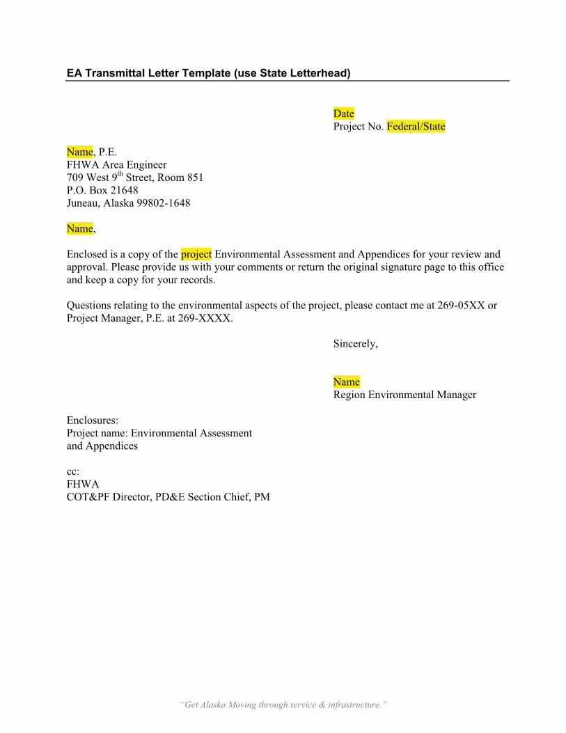
“Get Alaska Moving through service & infrastructure.”
EA Transmittal Letter Template (use State Letterhead)
Date Project No. Federal/State
Name, P.E. FHWA Area Engineer709 West 9th
P.O. Box 21648 Street, Room 851
Juneau, Alaska 99802-1648
Name,
Enclosed is a copy of the project Environmental Assessment and Appendices for your review and approval. Please provide us with your comments or return the original signature page to this office and keep a copy for your records.
Questions relating to the environmental aspects of the project, please contact me at 269-05XX or Project Manager, P.E. at 269-XXXX.
Sincerely,
NameRegion Environmental Manager
Enclosures: Project name: Environmental Assessment and Appendices
cc: FHWACOT&PF Director, PD&E Section Chief, PM

DEPARTMENT OF TRANSPORTATION [4910-RY]
Federal Highway Administration
Notice of Final Federal Agency Actions on Proposed Highways in Alaska
AGENCY: Federal Highway Administration (FHWA), DOT
ACTION: Notice of Limitation on Claims for Judicial Review of Actions by FHWA
SUMMARY: This notice announces actions taken by the FHWA that are final within the meaning
of 23 USC §139(l)(1). The actions relate to various proposed highway projects in the State of
Alaska. Those actions grant approvals for the projects.
DATES: By this notice, the FHWA is advising the public of final agency actions subject to 23 USC
§139(l)(1). A claim seeking judicial review of the Federal agency actions on any of the listed
highway projects will be barred unless the claim is filed on or before [Insert date 180 days after
publication in the Federal Register]. If the Federal law that authorizes judicial review of a claim
provides a time period of less than 180 days for filing such claim, then that shorter time period still
applies.
FOR FURTHER INFORMATION CONTACT: Mr. Dale J. Lewis, Area Liaison Engineer, FHWA
Alaska Division, P.O. Box 21648, Juneau, Alaska 99802-1648; office hours 7am-4:30pm (AST),
phone (907) 586-7429; email [email protected]. You may also contact Jerry O.
Ruehle, DOT&PF Central Region Environmental Coordinator, Alaska Department of
Transportation and Public Facilities, 4111 Aviation Drive, P.O. Box 196900, Anchorage, Alaska
99519-6900; office hours 7:30am-5pm (AST), phone (907) 269-0534, email
SUPPLEMENTARY INFORMATION: Notice is hereby given that the FHWA has taken final
agency actions by issuing approvals for the following highway projects in the State of Alaska that
are listed below. The actions by the Federal agency on the projects, and the laws under which
such actions were taken, are described in the Environmental Assessment (EA) issued in
connection with the projects. The EA, FONSI, and other documents from the FHWA files for the
listed projects are available by contacting the FHWA or the State of Alaska Department of
Transportation & Public Facilities at the addresses provided above. EA and FONSI documents
can be viewed and downloaded from the project Web site at http://projects.ch2m.com/Sewardhwy
and http://projects.ch2m.com/SewardMeridian or viewed at 4111 Aviation Avenue, Anchorage,
Alaska 99519.
This notice applies to all FHWA decisions and approvals on the listed projects as of the issuance
date of this notice and all laws and Executive Orders under which such actions were taken,
including but not limited to:
1. General: National Environmental Policy Act (NEPA) [42 U.S.C. 4321-4351]; Federal-Aid
Highway Act [23 U.S.C. 109].
2. Air: Clean Air Act, [42 U.S.C. 7401-7671(q)].
3. Land: Section 4(f) of the Department of Transportation Act of 1966 [49 U.S.C. 303].
4. Wildlife: Endangered Species Act of 1973 [16 USC 1531-1544 and Section 1536];
Anadromous Fish Conservation Act [16 U.S.C. 757(a)-757(g)]; Fish and Wildlife
Coordination Act [16 U.S.C. 661-667(d)], Migratory Bird Treaty Act [16 U.S.C. 703-712];
Magnuson-Stevenson Fishery Conservation and Management Act 1976 as amended [16
USC 1801 et seq.].
5. Historic and Cultural Resources: Section 106 of the National Historic Preservation Act of
1966, as amended [16 U.S.C. 470(f) et seq.]; Archeological Resources Protection Act of
1977 [16 U.S.C. 470(aa)-11]; Archeological and Historic Preservation Act [16 U.S.C. 469-
469(c)].
6. Social and Economic: Civil Rights Act of 1964 [42 U.S.C. 2000(d)-2000(d)(1)]; Farmland
Protection Policy Act (FPPA) [7 U.S.C. 4201-4209].
7. Wetlands and Water Resources: Clean Water Act [33 U.S.C. 1251-1377]; Coastal Zone
Management Act [16 U.S.C. 1451-1465]; Land and Water Conservation Fund (LWCF)
[16 U.S.C. 4601-4604]; Wild and Scenic Rivers Act [16 U.S.C. 1271-1287].
8. Executive Orders: E.O. 11990 Protection of Wetlands; E.O. 11988 Floodplain
Management; E.O. 12898, Federal Actions to Address Environmental Justice in Minority
Populations and Low Income Populations; E.O. 13186 Migratory Birds; E.O. 11514
Protection and Enhancement of Environmental Quality.
The projects subject to this notice are:
1. Project Location: Anchorage, Alaska, Municipality of Anchorage, New Seward Highway
(NSH). Project Reference Number: FRAF-CA-MGS-NH-0A3-1(27). Project type: Road
improvements to NSH between Rabbit Creek Road and 36th Avenue, a distance of
approximately eight miles. The NSH will remain a controlled access corridor and noise
barriers, fencing, and pathways throughout the corridor will be upgraded or constructed
as warranted and continuous illumination will be added to augment the existing high-mast
interchange lighting. Between O’Malley Road and Dimond Boulevard the existing NSH
will be widened from four to six lanes to address current and future travel demand and
mobility needs. NEPA document; Environmental Assessment and Finding of No
Significant Impact issued November 4, 2006 and available electronically at
http://projects.ch2m.com/Sewardhwy.
2. Project Location: Wasilla, Alaska, Matanuska-Susitna Borough, Seward Meridian
Parkway (SMP). Project Reference Number: IM-0001(302). Project type: Road
improvements to SMP from the Parks Highway to Bogard Road and extension of the road
one mile from Bogard Road to Seldon Road; a distance of approximately three miles.
The selected alternative will expand the existing SMP from a two-lane facility to a four-
lane facility with a center turn lane and a multi-use separated pathway. The project will
increase the capacity of SMP and provide a key system line from Seldon Road to the

Parks Highway. NEPA document: Environmental Assessment and Finding of No
Significant Impact issued April 2, 2007 and available electronically at
http://projects.ch2m.com/SewardMeridian.
(Catalog of Federal Domestic Assistance Program Number 20.205, Highway Planning and
Construction. The regulations implementing Executive Order 12372 regarding intergovernmental
consultation on Federal programs and activities apply to this program.)
Authority: 23 USC §139(l)(1)
Issued on: [date signed]
__________________________________
David C. Miller
Division Administrator
Juneau, Alaska
Environmental DocumentNovember 2012 Common Environmental Commitments
Common Environmental Commitments
General
The Contractor would conduct pre-construction survey to delineate environmentally sensitive areas that would be avoided during construction.
The contractor is responsible for obtaining all necessary permits and clearances for materials sites, disposal sites, and staging areas.
The contractor is required to create a traffic control plan and provide advance notice to the public and businesses of construction activities that could cause delays, detours, or affect access to adjacent properties.
The contractor would notify the public in advance of construction activities and road closures to reduce construction impacts on local businesses, residents, and road users.
Construction vehicles, equipment, and activities (stockpiling of materials, ect.) would be prohibited in wetland areas outside the design toe of slope unless permitted.
Air Quality
Air quality would be maintained through the use of best management practices such as watering, sweeping, maintaining construction entrances/exits, and equipment emission control devices.
Bald and Golden Eagles
If active Bald Eagle nests are found within 660 feet of the project area (primary and secondary projection zones), construction activities would be prohibited during sensitive nesting time periods or monitoring would be conducted during nesting period according to USFWS protocol.
Maintain a primary zone of a minimum of 330 feet as an undisturbed habitat buffer around nesting bald eagles. If topography or vegetation does not provide an adequate screen or separation, extend the buffer to 0.25 mile, or a sufficient distance to screen the nest from human activities. Within the secondary zone (between 330 and 660 feet), no obtrusive facilities or major habitat modifications shall occur. If nesting occurs in sparse stands of trees, treeless areas, or where activities would occur within line-of-site of the nest, this buffer shall extend up to 0.5 miles. No blasting, logging, or other noisy, disturbing activities within the primary or secondary zones should occur during the nesting period (March 1 – August 31).
Fisheries
Culverts would be replaced in accordance with the fish passage requirements stated in the 2001Memorandum of Agreement between the ADF&G and DOT&PF for the Design, Permitting, and Construction of Culverts for Fish Passage.
Environmental DocumentNovember 2012 Common Environmental Commitments
In-water work areas would be isolated from flowing waters.
Construction plans would be submitted to NMFS, USFWS, and ADF&G for comment prior to construction.
Hazardous Materials If contaminated or hazardous materials are encountered during construction, all work in the vicinity of the contaminated site would be stopped until ADEC is contacted and a corrective action plan is approved by ADEC and implemented. Historic Properties If cultural, archaeological, or historic sites are discovered during project construction, then all work that may impacts these resources would stop and the DOT&PF would consult with the State Historic Preservation Officer.
Invasive Plants
All construction equipment would be inspected and cleaned prior to enter and exiting the construction site.
Prior to construction, the project area will be surveyed and all weed populations to be avoided will be flagged.
A preliminary inventory of the area would be conducted prior to construction to ensure no previously unidentified high priority weeds are present and to determine the exact location of the weeds identified above.
All construction equipment and vehicles would be washed on site to remove dirt, seeds, roots, and other plant fragments.
Any erosion control materials made from straw or hay (e.g. wattles, bales of hay, etc.) would be made from certified weed free straw or hay. If certified materials are not available locally produced products would be used to minimize potential importation of new weed propagules from outside Alaska.
All disturbed areas would be reseeded with certified weed-free seed and vegetated with native species.
Migratory Birds
Vegetation clearing would occur only as needed and construction activities would be scheduled in accordance with the USFWS Recommended Time Periods for Avoiding Vegetation Clearing in Alaska, if possible.
Environmental DocumentNovember 2012 Common Environmental Commitments
Noise
The contractor will make every reasonable effort to minimize construction noise through abatement measures such as proper maintenance of construction equipment.
Storm Water
An Erosion and Sediment Control Plan (ESCP) would be prepared during design of the project.
A DOT&PF approved SWPPP and all applicable BMPs would be implemented in accordance with contract specifications and the APDES CGP.
Existing vegetation would be preserved when possible.
Design
Table of Contents
Plan Review Procedure
ESCP Review Procedure DESIG
N
DesignDecember 2012 Design Plan Review Frequently Asked Questions
Design Plan Review Frequently Asked Questions
Design plan reviews can be a bit complicated, so before beginning a design plan review, go through the following questions and consult with your Team Leader for more direction. You can also ask the Preliminary Design engineers and the project designers for help.
1) Where can we get more information on how to read plans?
Refer to the Basic Highway Plan Reading manuals (Georgia and Colorado DOT). You can find these and an example review within the Design folder in Templates and Procedures.
Design and construction standards for DOT&PF are available on our website: http://www.dot.state.ak.us/stwddes/dcsspecs/index.shtml#
2) What are the different types of plan reviews?
Local Review (optional) – occurs when the design is 30 percent to 50 percent developed [see Preconstruction Manual (PCM) 450.13].
Plans-in-Hand (PIH) – occurs when the design is 75 percent developed (see PCM 450.14).
Plans, Specifications, and Estimates (PS&E) – occurs when the design is complete. The PIH and PS&E reviews may be combined to expedite project delivery (see PCM 450.18).
3) What is the purpose of a plan review?
Local Review - to ensure development is proceeding consistently with the project scope and that there is adequate coordination between the various support groups.
PIH - to ensure conformity with project scope and design standards, to review design details and coordinate technical recommendations.
PS&E - to ensure conformity with project scope and design standards, to verify environmental commitments, to review design details and coordinate technical recommendations, to assess the cost-effectiveness of project construction, and to evaluate the quality of the project.
4) What is the analysts’ role in a plan review?
Analysts’ role in plan reviews is to ensure the plans are consistent with the environmental document and regulatory requirements, to ensure all necessary permits and approvals have been identified and obtained, and to ensure the environmental commitments have been incorporated into the design.
DesignDecember 2012 Design Plan Review Frequently Asked Questions
5) When do plan reviews occur during the design process?
Local Review – early in the design process and prior to approval of the environmental document
PIH – prior to approval of the environmental document
PS&E – after the approval of the environmental document and usually shortly before projectcertification and advertising
6) What elements are included in a review packet?
� Plan set� Modifications to the Standard Specifications � Special Provisions � Design Study Report � Erosion and Sediment Control Plan (ESCP) and ESCP sheets
7) What is a “Standard Specification”?
Standard specifications are detailed statements prescribing how work is to be conducted, types of acceptable materials, construction requirements, method of measurement, basis of payment, and the quality of work. The most current specifications can be found in the Standard Specifications for Highway Construction (“blue book”) and Standards for Specifying Construction of Airports. They provide clear and concise direction for a contractor to successfully bid and build a given project. You should be given these upon starting work, but you can review them on the DOT&PF and FAA websites or get extra copies from the Contracts section.
8) What is a “Standard Modification”?
Standard modifications are approved modifications to the Standard Specifications.
9) What is a “Special Provision”?
Special provisions are project-specific specifications that work in conjunction with, supplement, or modify standard specifications. They typically describe special construction features not covered in the Standard Specifications.
If a Standard Modification is changed, it will then be considered a Special Provision instead of a Standard Modification.
10)What does it mean if a section is not included in the Standard Modifications and Special Provisions?
If there are no changes to the Standard Specifications, they will not be included. However, they will still apply to the project.
DesignDecember 2012 Design Plan Review Frequently Asked Questions
11)What sections of the Standard Specifications do we review?
Analysts’ should review all sections that could apply to the project. Review the Standard Modifications and Special Provisions to make sure all environmental commitments, permit stipulations, and any other environmental issues are covered. At minimum, analysts should review the following sections:
Highways
107 Legal Relations & Responsibility to Public201-206 Earthwork 505 Piling507 Bridge Railing603-606 Culverts & Storm Drains, Manholes & Inlets, Underdrains 610-611 Ditch Lining, Riprap614 Concrete Barrier617 Railroad Crossing 618-621 Seeding, Soil Stabilization, Topsoil, Planting Trees and Shrubs 626-627 Sanitary Sewer System, Water System633 Silt Fence636 Gabions 640 Mobilization & Demobilization641 Erosion, Sediment, & Pollution Control 643 Traffic Maintenance (643-3.04 sweeping/power brooming section) 710 Fence and Guardrail724-727 Seed, Fertilizer, Topsoil, Soil Stabilization Material
Airports
Section 70 Legal Relations and Responsibility to Public Section 80 Prosecution and Progress D Items DrainageF Items FencingG-100 Mobilization and DemobilizationL Items Lighting InstallationP-151 to 157 EarthworkS Items StructuresT Items Turfing
12) What are the different types of plan sheets?
A Title Sheet and LegendB Typical SectionsC Estimate of QuantitiesD Summary SheetsE Detail Sheets
DesignDecember 2012 Design Plan Review Frequently Asked Questions
F Plan and Profile G Grading PlanH Traffic Detail and SignalizationJ Traffic ControlR Right-of-way
The plan sheet numbers only apply to highway projects. Not all plan sets include the same sheets. The ones that do not apply to the project are left out.
13)What sheets are most useful to us when conducting plan reviews and what information can we get from them?Plan and profile (F Sheets) – these sheets show overhead (plan) and side (profile) views. They are intended to convey a general overview of the project by showing how the project interacts with existing features. They contain information concerning alignments, profiles, and ditching. They give the most detailed depiction of the project.
Estimate of Quantities – these show an estimate of the types and quantities of materials needed to complete the project. They should be commensurate with scope of the project.
14)What information should analysts pay particular attention to and why?
For highway projects, analysts should pay particular attention to the following sections. The same things should be considered when reviewing airport plans although the section numbers do not apply.
� Estimate of Quantities - Erosion and sediment control should be somewhere around 3-5% of the total project budget
� Section 107 Legal Regulations and Responsibilities to Public o 1.11 Protection and restoration of property and landscape - Are conditions for
avoiding sensitive areas included here?
� Section 201 Clearing and Grubbing o Designated areaso Bird clearing window (not necessary if in 107)
� Section 618 Seeding o Changes to materialso 3.01 and 3.03 - Does it specify method of prep and dispersal? o 3.02 Seeding dates (should be a standard modification) o 3.03 Table - Check the type of seeds in the table against the DNR
revegetation manualo 3.05 Acceptance - should be 70% coverage in accordance with CGP
� Section 641 Erosion, Sediment, and Pollution Control o Is it the most recent version?
DesignDecember 2012 Design Plan Review Frequently Asked Questions
Plan Sheets� Read through all the notes to see that they make sense, especially any clearing or
environmental related. � Keep an eye out for the north arrow when looking at every sheet. If the project is
occurring along a large corridor and the road changes cardinal orientation many times it can be easy to mistake one side of the road for the other.
� Work below ordinary high water – this work must adhere to regulatory requirements for water quality, discharge of dredged/fill material, fish passage, and fish habitat.
� Work in or adjacent to Section 4(f) resources – it is important that all Section 4(f) resources have been identified and that FHWA/FAA has made an applicability determination on the property.
� Utility work – locations where utility work is needed is not always known early in the environmental phase and may not be discussed in the environmental document. As design progresses, it may be added to the plan set and the analyst may not be notified.
15)What type of comments should analysts make?
Analysts’ comments should generally focus on things within the environmental realm. However, you may comment on any other aspect of the project you deem appropriate. Be concise but clear. Your comments should include a solution or suggestion and a source orcitation. Be prepared to discuss your comments during the plan review meeting. Very minor comments can be given directly to the PM and excluded included from the formal comments.
16)How do we submit comments?
Comments are either written into a comment form (Word document) or entered into an online form. The cover page on the project’s standard modifications to the standard specification will typically have instructions describing the design project manager’s preference.
17)What can we expect from the plan review meeting?
All of the functional groups associated with the project are invited to attend the plan review meeting. At the meeting, a representative from each functional group goes over their comments. Be prepared to discuss your comments and offer solutions. The meeting can take several hours depending on the complexity of the project.

DesignOctober 2012 ESCP Review Procedure
ESCP Review Procedure
Contractors must develop a Storm Water Pollution Prevention Plan (SWPPP) for all projects with ground disturbance. The purpose of the Erosion and Sediment Control Plans (ESCP) is to provide the contractor with sufficient information and guidance to prepare their SWPPP. Toaccomplish this, the DOT&PF has an electronic ESCP template which the project managers are required to use. This template ensures that the ESCP (and in turn the SWPPP) meet the requirements and standards of the APDES Construction General Permit. The ESCP is broken into two Volumes; Volume I is the document and appendices and Volume II are the plan sheets.
Additional information can be found in section 1120.8 of the 2011 Alaska Highway Preconstruction Manual and in the references section of the ESCP template.
1. Volume I of the ESCP
Read Volume I of the ESCP in tandem with the most recent DOT&PF template (see the Design and Review Comments folder in Templates and Procedures). Check to make sure all the information in the ESCP is correct and consistent with the environmental document, permits, etc. Pay close attention to the following sections:
3.1 Project information � Is the project name, number, and location information correct?� Is the source of the latitude and longitude listed?� If the latitude and longitude are for the approximate midpoint of the
project corridor is it noted?
3.2 Project specific conditions � Are the slope, topography, and drainage patterns accurately described?� Are the types of vegetation, growing season, and seeding dates
accurate?� Are the clearing window and fish window consistent with the
environmental commitments in the Environmental Document?� Is the historic site contamination consistent with the Environmental
Document? 4.1 Scope of work
� Is it consistent with the Environmental Document? 4.4 Size of property and total area to be disturbed
� Is the total project area a reasonable number based on the size of the project corridor?
� Is the area for ACGP coverage less than or close to that listed in the water quality section of the Environmental Document?
4.5 Identification of all potential pollutant sources
DesignOctober 2012 ESCP Review Procedure
� Are all reasonable sources listed? � Are sources other than sediment listed?
5.0 Site maps� Check the site maps in Appendix A to make sure they show the
features listed in the ESCP template in the Site Maps section. 7.1 Identify receiving waters
� Are all the receiving waters identified in the Environmental Document and requested in the ESCP template listed here?
� Are the questions and check boxes for the Outstanding Natural Resource Waters (ONRW), also known as potential Tier 3 waters, answered correctly?
� If the proposed project will or may discharge storm water into and ONRW, is the consultation with ADEC from the Environmental Document and the date included?
� If an Antidegradation Analysis is required, is it included here? � Are the appropriate BMPs, including natural buffer areas, included in
Section 11 to meet any permit conditions or environmental commitments?
7.2 Identify TMDLs
� Are all impaired receiving waters with established TMDLs listed here, including a discussion on the water quality standards, pollutants, and pollutant sources?
� If the project affects a water body with an approved or established TMDL, are the proposed measures to ensure that discharges will be consistent with the requirements of the TMDL discussed?
� Are the appropriate BMPs, including natural buffer areas, included in Section 11 to meet any permit conditions or environmental commitments?
8.1 Information on endangered or threatened species or critical habitat � Are the threatened and endangered species or their critical habitat
identified in the Environmental Document discussed here? � Are the mitigation measures or commitments for avoiding adverse
impacts to the species discussed here?� Are the appropriate BMPs, including natural buffer areas, included in
Section 11 to meet any permit conditions or environmental commitments?
9.0 Historic Properties� Is the Section 106 consultation and findings of effect accurately
described here and a copy of the SHPO concurrence included in Appendix D?
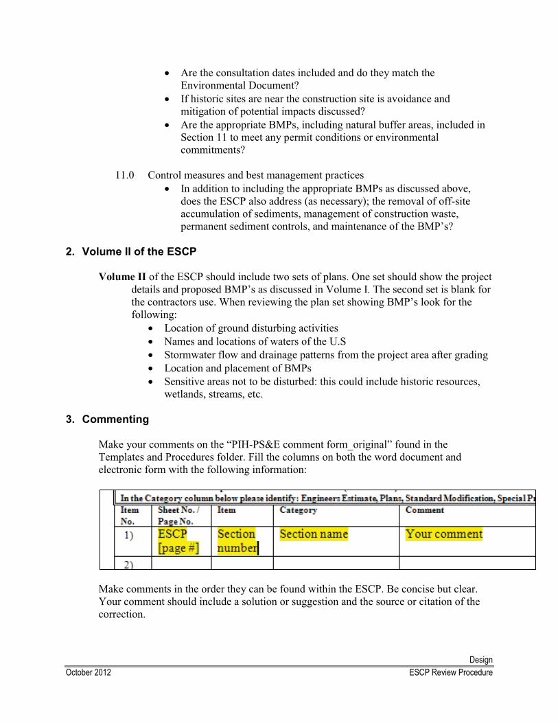
DesignOctober 2012 ESCP Review Procedure
� Are the consultation dates included and do they match the Environmental Document?
� If historic sites are near the construction site is avoidance and mitigation of potential impacts discussed?
� Are the appropriate BMPs, including natural buffer areas, included in Section 11 to meet any permit conditions or environmental commitments?
11.0 Control measures and best management practices� In addition to including the appropriate BMPs as discussed above,
does the ESCP also address (as necessary); the removal of off-site accumulation of sediments, management of construction waste, permanent sediment controls, and maintenance of the BMP’s?
2. Volume II of the ESCP
Volume II of the ESCP should include two sets of plans. One set should show the project details and proposed BMP’s as discussed in Volume I. The second set is blank for the contractors use. When reviewing the plan set showing BMP’s look for the following:
� Location of ground disturbing activities � Names and locations of waters of the U.S � Stormwater flow and drainage patterns from the project area after grading� Location and placement of BMPs � Sensitive areas not to be disturbed: this could include historic resources,
wetlands, streams, etc.
3. Commenting
Make your comments on the “PIH-PS&E comment form_original” found in the Templates and Procedures folder. Fill the columns on both the word document and electronic form with the following information:
Make comments in the order they can be found within the ESCP. Be concise but clear.Your comment should include a solution or suggestion and the source or citation of the correction.
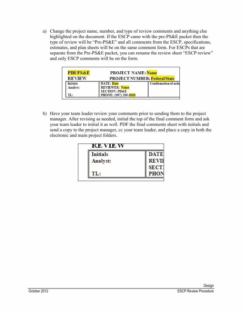
DesignOctober 2012 ESCP Review Procedure
a) Change the project name, number, and type of review comments and anything else highlighted on the document. If the ESCP came with the pre-PS&E packet then the type of review will be “Pre-PS&E” and all comments from the ESCP, specifications, estimates, and plan sheets will be on the same comment form. For ESCPs that are separate from the Pre-PS&E packet, you can rename the review sheet “ESCP review” and only ESCP comments will be on the form.
b) Have your team leader review your comments prior to sending them to the project manager. After revising as needed, initial the top of the final comment form and ask your team leader to initial it as well. PDF the final comments sheet with initials and send a copy to the project manager, cc your team leader, and place a copy in both the electronic and main project folders.
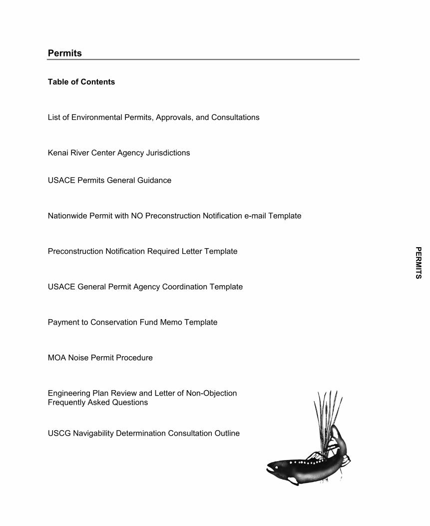
Permits
Table of Contents
List of Environmental Permits, Approvals, and Consultations
Kenai River Center Agency Jurisdictions
USACE Permits General Guidance
Nationwide Permit with NO Preconstruction Notification e-mail Template
Preconstruction Notification Required Letter Template
USACE General Permit Agency Coordination Template
Payment to Conservation Fund Memo Template
MOA Noise Permit Procedure
Engineering Plan Review and Letter of Non-ObjectionFrequently Asked Questions
USCG Navigability Determination Consultation Outline
PERM
ITS
Envi
ronm
enta
l Per
mits
, App
rova
ls, a
nd C
onsu
ltatio
ns
Page
1 o
f 3
Agen
cyPe
rmits
, App
rova
ls, a
nd C
onsu
ltatio
nsAc
tivity
Web
site
Esse
ntia
l Fis
h H
abita
t (EF
H) A
sses
smen
t W
ork
may
adv
erse
ly a
ffect
EFH
http
://al
aska
fishe
ries.
noaa
.gov
/hab
itat/e
fh.h
tm
Sect
ion
7 co
nsul
tatio
nW
ork
that
may
adv
erse
ly a
ffect
Bel
ugas
an
d/or
oth
er F
eder
ally
list
ed th
reat
ened
or
enda
nger
ed m
arin
e m
amm
als
http
://w
ww
.nm
fs.n
oaa.
gov/
pr/c
onsu
ltatio
n/
Sect
ion
10 P
erm
itW
ork
belo
w th
e O
rdin
ary
Hig
h W
ater
(OH
W)
of n
avig
able
wat
ers
Sect
ion
404
Perm
itsIn
divi
dual
Per
mits
1
. Sta
ndar
d Pe
rmits
2
. Let
ters
of P
erm
issi
onG
ener
al P
erm
its
1. R
egio
nal P
erm
its
2. N
atio
nwid
e Pe
rmits
3
. Pro
gram
atic
Per
mits
U.S
. Coa
st G
uard
(U
SCG
)N
avig
abilit
y D
eter
min
atio
nSe
ctio
n 9
Brid
ge P
erm
itC
onst
ruct
or m
odify
a b
ridge
or c
ause
way
ac
ross
a n
avig
able
wat
erw
ay o
f the
U.S
.ht
tp://
ww
w.u
scg.
mil/
hq/c
g5/c
g551
/BPA
G_P
age
.asp
U.S
. For
est S
ervi
ce
(USF
S)Sp
ecia
l-use
Aut
horiz
atio
nW
ork
on
USF
S la
ndht
tp://
ww
w.fs
.fed.
us/s
peci
alus
es/s
peci
al_a
pp_p
roce
ss.s
htm
l#sp
-app
-d
Bald
Eag
le N
on-p
urpo
sefu
l Tak
eTa
ke o
f Eag
le N
ests
Proj
ect r
esul
ts in
a ta
ke o
f or d
istu
rbs
eagl
es, n
ests
, or e
ggs
http
://w
ww
.fws.
gov/
mig
rato
rybi
rds/
Cur
rent
Bir
dIss
ues/
Man
agem
ent/B
aldE
agle
/App
licat
ion
andR
epor
ts.h
tml
Sect
ion
7 C
onsu
ltatio
nW
ork
that
may
impa
ct F
eder
ally
Thr
eate
ned
or E
ndan
gere
d sp
ecie
s or
thei
r des
igna
ted
criti
cal h
abita
t
http
://w
ww
.fws.
gov/
enda
nger
ed/p
erm
its/in
dex.
htm
l
Agen
cyPe
rmits
, App
rova
ls, a
nd C
onsu
ltatio
nsAc
tivity
Web
site
Alas
ka P
ollu
tant
Dis
char
ge E
llimin
atio
n Sy
stem
Con
stru
ctio
n G
ener
al P
erm
it
Con
stru
ctio
n pr
ojec
ts d
istu
rbin
g m
ore
than
on
e ac
re o
f gro
und,
exc
ludi
ng ro
utin
e m
aint
enan
ce p
roje
cts
http
://w
ww
.dec
.sta
te.a
k.us
/wat
er/w
npsp
c/st
orm
wat
er/s
w_c
onst
ruct
ion.
htm
Tier
3 C
onsu
ltatio
nW
ork
disc
harg
ing
stor
mw
ater
into
a
wat
erw
ay w
ithin
or l
ess
than
a m
ile u
pstre
am
of a
Sta
te o
r Fed
eral
par
k or
wild
life
refu
ge
http
://w
ww
.dec
.ala
ska.
gov/
wat
er/w
qsar
/Ant
ideg
rada
tion/
docs
/P&P
-In
terim
_Ant
ideg
rada
tion_
Impl
emen
atio
n_M
eth
ods.
Fede
ral
Stat
e
Alas
ka D
epar
tmen
t of
Env
ironm
enta
l C
onse
rvat
ion
(DEC
)
U.S
. Arm
y C
orps
of
Engi
neer
s (U
SAC
E)
Nat
iona
l Mar
ine
Fish
erie
s Se
rvic
e (N
MFS
)
U.S
. Fis
h an
d W
ildlif
e Se
rvic
e (U
SFW
S)
Dis
char
ge o
f dre
dged
or f
ill m
ater
ial i
nto
wet
land
s an
d w
ater
s of
the
U.S
.
http
://w
ww
.poa
.usa
ce.a
rmy.
mil/
Mis
sion
s/R
egul
ator
y.as
px
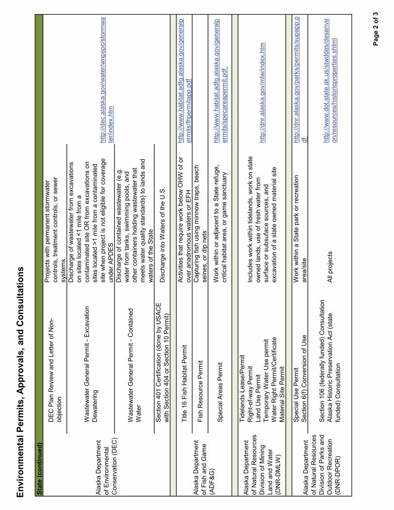
Envi
ronm
enta
l Per
mits
, App
rova
ls, a
nd C
onsu
ltatio
ns
Page
2 o
f 3
DEC
Pla
n R
evie
w a
nd L
ette
r of N
on-
obje
ctio
n
Proj
ects
with
per
man
ent s
torm
wat
er
cont
rols
, tre
atm
ent c
ontro
ls, o
r sew
er
syst
ems
Was
tew
ater
Gen
eral
Per
mit
- Exc
avat
ion
Dew
ater
ing
Dis
char
ge o
f was
tew
ater
from
exc
avat
ions
on
site
s lo
cate
d <1
mile
from
a
cont
amin
ated
site
OR
from
exc
avat
ions
on
site
s lo
cate
d >1
mile
from
a c
onta
min
ated
si
te w
hen
proj
ect i
s no
t elig
ible
for c
over
age
unde
r APD
ES
Was
tew
ater
Gen
eral
Per
mit
- Con
tain
ed
Wat
er
Dis
char
ge o
f con
tain
ed w
aste
wat
er (e
.g.
wat
er fr
om ta
nks,
sw
imm
ing
pool
s, a
nd
othe
r con
tain
ers
hold
ing
was
tew
ater
that
m
eets
wat
er q
ualit
y st
anda
rds)
to la
nds
and
wat
ers
of th
e St
ate
Sect
ion
401
Cer
tific
atio
n (d
one
by U
SAC
E w
ith S
ectio
n 40
4 or
Sec
tion
10 P
erm
it)D
isch
arge
into
Wat
ers
of th
e U
.S.
Title
16
Fish
Hab
itat P
erm
itAc
tiviti
es th
at re
quire
wor
k be
low
OH
W o
f or
over
ana
drom
ous
wat
ers
or E
FHht
tp://
ww
w.h
abita
t.adf
g.al
aska
.gov
/gen
eral
per
mits
/fhpe
rmita
pp.p
df
Fish
Res
ourc
e Pe
rmit
Cap
turin
g fis
h us
ing
min
now
trap
s, b
each
se
ines
, or d
ip n
ets
Spec
ial A
reas
Per
mit
Wor
k w
ithin
or a
djac
ent t
o a
Stat
e re
fuge
, cr
itica
l hab
itat a
rea,
or g
ame
sanc
tuar
yht
tp://
ww
w.h
abita
t.adf
g.al
aska
.gov
/gen
eral
per
mits
/spe
care
aper
mit.
Alas
ka D
epar
tmen
t of
Nat
ural
Res
ourc
es
Div
isio
n of
Min
ing
Land
and
Wat
er
(DN
R-D
MLW
)
Tide
land
s Le
ase/
Perm
itR
ight
-of-w
ay P
erm
itLa
nd U
se P
erm
itTe
mpo
rary
Wat
er U
se p
erm
itW
ater
Rig
ht P
erm
it/C
ertif
icat
eM
ater
ial S
ite P
erm
it
Incl
udes
wor
k w
ithin
tide
land
s, w
ork
on s
tate
ow
ned
land
s, u
se o
f fre
sh w
ater
from
su
rface
or s
ubsu
face
sou
rces
, and
ex
cava
tion
of a
sta
te o
wne
d m
ater
ial s
ite
http
://dn
r.ala
ska.
gov/
mlw
/inde
x.ht
m
Spec
ial U
se P
erm
itSe
ctio
n 6(
f) C
onve
rsio
n of
Use
Wor
k w
ithin
a S
tate
par
k or
recr
eatio
n ar
ea/s
iteht
tp://
dnr.a
lask
a.go
v/pa
rks/
perm
its/s
upap
p.p
df
Sect
ion
106
(fede
rally
fund
ed) C
onsu
ltatio
nAl
aska
His
toric
Pre
serv
atio
n Ac
t (st
ate
fund
ed) C
onsu
ltatio
nAl
l pro
ject
sht
tp://
ww
w.d
ot.s
tate
.ak.
us/s
twdd
es/d
esen
vir
on/re
sour
ces/
hist
oric
prop
ertie
s.sh
tml
Alas
ka D
epar
tmen
t of
Env
ironm
enta
l C
onse
rvat
ion
(DEC
)
Stat
e (c
ontin
ued)
Alas
ka D
epar
tmen
t of
Nat
ural
Res
ourc
es
Div
isio
n of
Par
ks a
nd
Out
door
Rec
reat
ion
(DN
R-D
PO
R)
Alas
ka D
epar
tmen
t of
Fis
h an
d G
ame
(AD
F&G
)
http
://de
c.al
aska
.gov
/wat
er/w
npsp
c/st
orm
wa
ter/i
ndex
.htm
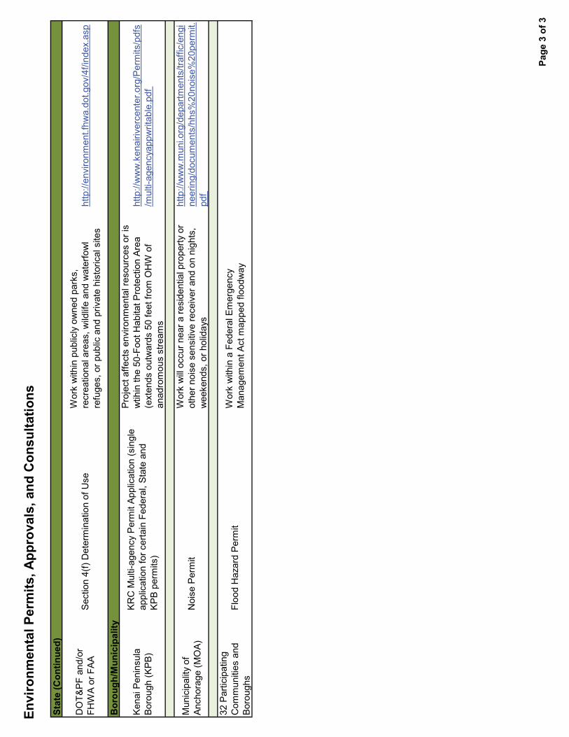
Envi
ronm
enta
l Per
mits
, App
rova
ls, a
nd C
onsu
ltatio
ns
Page
3 o
f 3
Stat
e (C
ontin
ued)
DO
T&P
F an
d/or
FH
WA
or F
AASe
ctio
n 4(
f) D
eter
min
atio
n of
Use
Wor
k w
ithin
pub
licly
ow
ned
park
s,
recr
eatio
nal a
reas
, wild
life
and
wat
erfo
wl
refu
ges,
or p
ublic
and
priv
ate
hist
oric
al s
ites
http
://en
viro
nmen
t.fhw
a.do
t.gov
/4f/i
ndex
.asp
Kena
i Pen
insu
la
Boro
ugh
(KPB
)
KRC
Mul
ti-ag
ency
Per
mit
Appl
icat
ion
(sin
gle
appl
icat
ion
for c
erta
in F
eder
al, S
tate
and
KP
B pe
rmits
)
Proj
ect a
ffect
s en
viro
nmen
tal r
esou
rces
or i
s w
tihin
the
50-F
oot H
abita
t Pro
tect
ion
Area
(e
xten
ds o
utw
ards
50
feet
from
OH
W o
f an
adro
mou
s st
ream
s
http
://w
ww
.ken
airiv
erce
nter
.org
/Per
mits
s/m
ulti-
agen
cyap
pwrit
able
Mun
icip
ality
of
Anch
orag
e (M
OA)
Noi
se P
erm
itW
ork
will
occu
r nea
r a re
side
ntia
l pro
perty
or
othe
r noi
se s
ensi
tive
rece
iver
and
on
nigh
ts,
wee
kend
s, o
r hol
iday
s
http
://w
ww
.mun
i.org
/dep
artm
ents
/traf
fic/e
ngi
neer
ing/
docu
men
ts/h
hs%
20no
ise%
20pe
rmit.
32 P
artic
ipat
ing
Com
mun
ities
and
Bo
roug
hsFl
ood
Haz
ard
Perm
itW
ork
with
in a
Fed
eral
Em
erge
ncy
Man
agem
ent A
ct m
appe
d flo
odw
ay
Bor
ough
/Mun
icip
ality
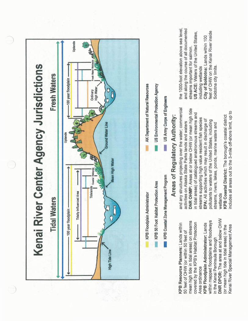
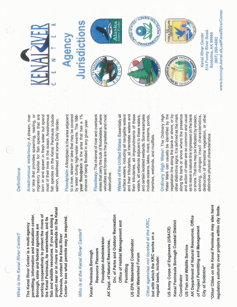
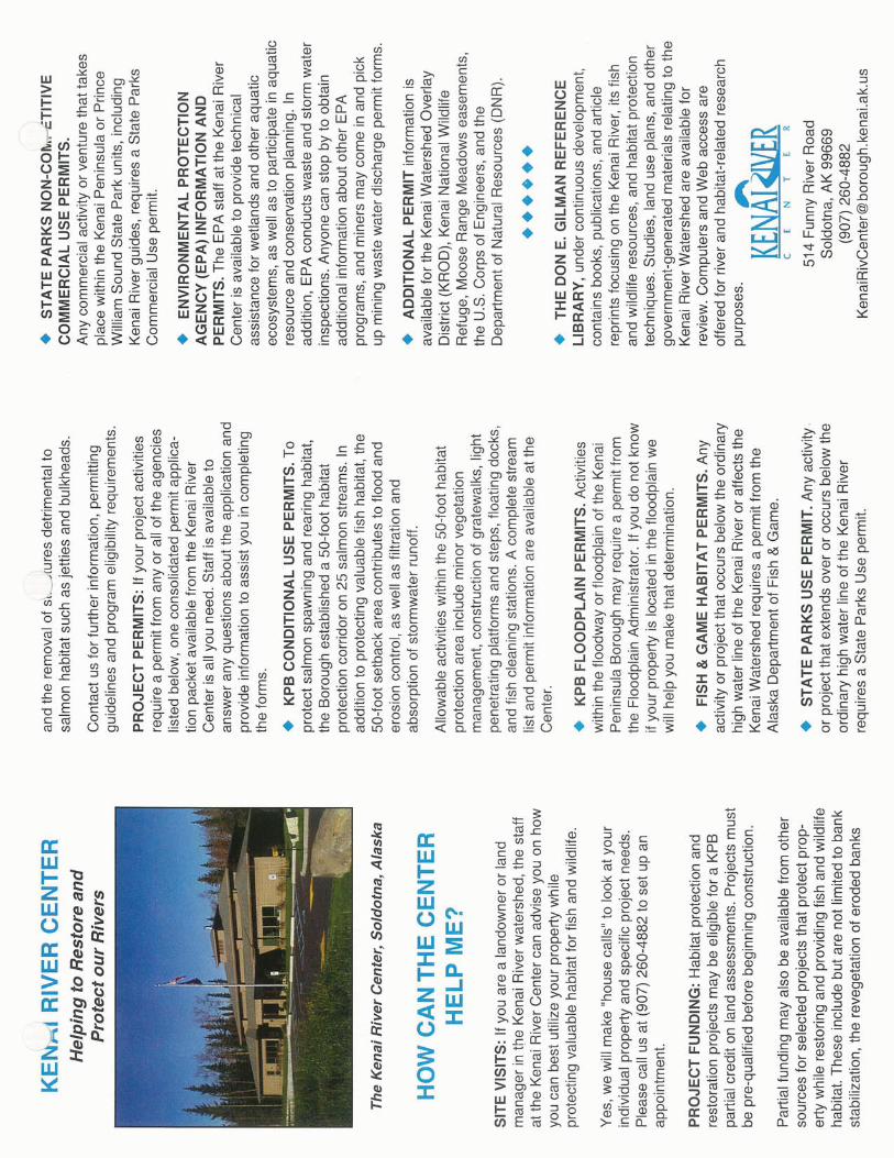

PermitsMay 2011 USACE Permit Guidance
USACE Permits General Guidance
When you coordinate with the USACE, they will evaluate your project to see if:
1. No permit is required (i.e. no jurisdiction, activities not jurisdictional, meets 404 exemptions, etc.).
2. The project meets a Nationwide Permit (NWP). They will always use the lowest level of authorization.
3. The project meets a Regional General Permit (GP). These are hardly ever used at DOT&PF, but the process is similar to NWP.
4. The project must go through the Letter of Permission or Individual Permit (IP) process.
Nationwide Permit
Nationwide permits are nationally issued permits that have already gone through agency review and have been determined to have a de minimus impact on natural resources and do not require an individual permit authorization through the USACE. They may require Pre-Construction Notification [(PCN) (not an application)] to the USACE to verify the project meets the conditions of the NWP and to let them know of your intent to use an NWP.
Processing
1. Review the NWPs to determine if one may apply to your proposed project. Read the complete language of the NWP.
2. Determine if a PCN is required. The NWPs usually state if a PCN is required through General Condition 27 and will give the stipulations for PCN requirement. Also, you can look at the NWP Summary Table which outlines each NWP and states whether or not a PCN is required.
1. If a PCN is not required, compose an email message and attach a location and vicinity map, plans, and any other pertinent information. Submit the materials to your team leader for review/approval. Upon approval, send the materials to the Regional Environmental Manager (REM). The REM will send it to the Statewide Environmental Manager for approval. They will reply with a concurrence and forward a courtesy copy to the USACE.
3. If a PCN is required, fill out the USACE PCN form and complete a transmittal letter. You should include the following:
a. location and vicinity mapb. plan view (bird’s eye view) of the project with the coordinates and the total
project footprint in acres, and c. cross-section of excavation and/or fill (including the slopes) with the amount of
fill in cubic yards.
PermitsMay 2011 USACE Permit Guidance
Submit the materials to your team leader for review/approval. Upon approval, send the materials to the Regional Environmental Manager (REM). The REM will send it to the Statewide Environmental Manager for approval. They will digitally sign it and send back to you for you to print and send to the USACE.
2. If a project results in the loss of ½ acre or greater of waters of the U.S. or is required by Regional Condition B, the USACE will send out a General Permit Agency Coordination email or fax for a 10-day agency review. If an agency contacts the USACE, they will wait 15 more days before making a decision.
3. NWPs and GPs have already been found consistent with the DEC 401 water quality standards and have obtained a Certificate of Reasonable Assurance. You do not need to seek additional authorization for this permit.
Regional General Permits
Regional Permits are issued by the Alaska District Engineer for a general category of activities when the activities are similar in nature and cause minimal environmental impact, both individually and cumulatively.
The only GPs you may encounter are:
� Bank Stabilization within the Kenai Peninsula Borough � Anchorage Wetlands Management Plan Revision (when working on a class “C”
wetlands), and � Bethel General Permit.
Read the complete language of the permit to determine if your project qualifies under them and for specific processing instructions.
Letter of Permission (Section 10 CE projects only)
Letters of Permission (LOP) are a type of permit issued through an abbreviated processing procedure, which includes coordination with Federal and state fish and wildlife agencies, as required by the Fish and Wildlife Coordination Act, and a public interest evaluation, but without the publishing of an individual public notice. LOPs may be used for projects subject to Section 10 of the Rivers and Harbors Act of 1899 when the Corps determines the proposed work would be minor, would not have significant individual or cumulative impacts on environmental values, and should encounter no appreciable opposition. Follow the processing instruction for IPs below.
Individual Permits
Individual Permits are issued following a full public interest review of an individual application for a Department of the Army permit. A public notice (usually 30 days in length) is distributed to all known interested persons. The permit decision is generally based on the outcome of a public interest balancing process, where the benefits of the project are weighed against the detriments.
PermitsMay 2011 USACE Permit Guidance
Processing
1. If your project is regulated under the USACE jurisdiction and does not fall under an NWP, you will probably need an IP. To expedite the process, contact the USACE for a pre-application meeting to discuss the project and what they might recommend for mitigation or if they think any will be required. This is also a good time to invite other agencies to have a complete pre-application agency meeting. Let them know when you expect to be sending the application.
2. Complete the Application Form. Read the instructions starting on page 3, which describe what to put in each box. Include a good plan set – this is really important and one of the most common things that will delay your project. Have them completed to meet the Guide to Drawings recommendations. If you have a completed EA, send a copy of that, too (while it is not required, it helps expedite the process).
3. Complete the Applicant Proposed Mitigation Statement. Make sure you discuss the avoidance, minimization, and mitigation measures with the Project Manager prior to completing the form.
4. Submit the materials to your team leader for review/approval. Upon approval, send the materials to the Regional Environmental Manager (REM). The REM will send it to the Statewide Environmental Manager for approval. They will digitally sign it and send back to you for you to send to the USACE.
5. The USACE will send you a letter of acknowledgement of receipt of the application and they may or may not request additional information.
6. If the application is complete, they will send out a Public Notice for a 30-day review to the public, associated villages/tribes, adjacent property owners, and agencies. Check their public notice website to see if your project has been posted. If the USACE receives comments, you will have an opportunity to respond to those comments and they will determine whether the project is contrary to public interest and whether or not it meets the 404(b)(1) guidelines.
Alternative Permit Process
The Alternative Permit Process (APP), also known as the Abbreviated Permit Process, is a form of standard permit evaluation that allows applications to be processed in an expedited fashion. Evaluation of these applications is accelerated because the substantive issues are resolved in an abbreviated time frame. An APP permit decision will normally be authorized within 30 days from the receipt of a complete application. Activities authorized by an APP are subject to the general and special conditions specific to each APP. The Alaska District currently has developed one APP for sanitation facilities in Alaskan villages (APP 93-1).
Permit Denial
PermitsMay 2011 USACE Permit Guidance
USACE permit denials are rare and your project would only be denied if one of the following were to occur:
• Fails 404(b)(1) guidelines. • Fails to receive ADEC 401 Certification.• Inconsistent with the Alaska Coastal Management Program (ACMP) standards.• Less damaging alternative practicable alternative available.• Jeopardizes a T&E species• Adversely effects overriding national interest.
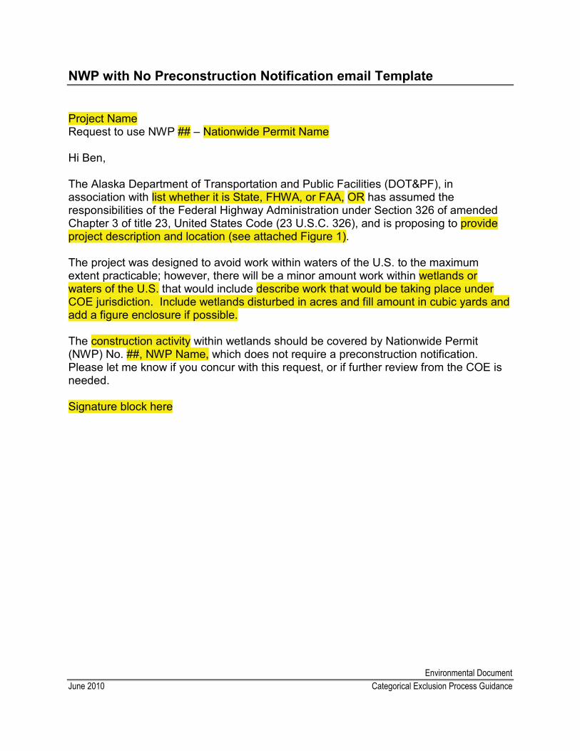
Environmental DocumentJune 2010 Categorical Exclusion Process Guidance
NWP with No Preconstruction Notification email Template
Project NameRequest to use NWP ## – Nationwide Permit Name
Hi Ben,
The Alaska Department of Transportation and Public Facilities (DOT&PF), in association with list whether it is State, FHWA, or FAA, OR has assumed the responsibilities of the Federal Highway Administration under Section 326 of amended Chapter 3 of title 23, United States Code (23 U.S.C. 326), and is proposing to provide project description and location (see attached Figure 1).
The project was designed to avoid work within waters of the U.S. to the maximum extent practicable; however, there will be a minor amount work within wetlands or waters of the U.S. that would include describe work that would be taking place under COE jurisdiction. Include wetlands disturbed in acres and fill amount in cubic yards and add a figure enclosure if possible.
The construction activity within wetlands should be covered by Nationwide Permit (NWP) No. ##, NWP Name, which does not require a preconstruction notification. Please let me know if you concur with this request, or if further review from the COE is needed.
Signature block here
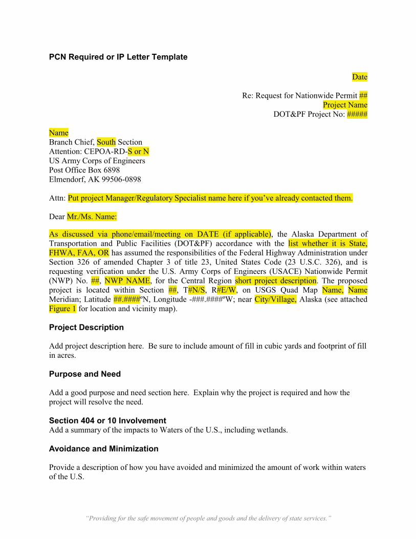
“Providing for the safe movement of people and goods and the delivery of state services.”
PCN Required or IP Letter Template
Date
Re: Request for Nationwide Permit ##Project Name
DOT&PF Project No: #####
NameBranch Chief, South SectionAttention: CEPOA-RD-S or NUS Army Corps of Engineers Post Office Box 6898 Elmendorf, AK 99506-0898
Attn: Put project Manager/Regulatory Specialist name here if you’ve already contacted them.
Dear Mr./Ms. Name:
As discussed via phone/email/meeting on DATE (if applicable), the Alaska Department of Transportation and Public Facilities (DOT&PF) accordance with the list whether it is State, FHWA, FAA, OR has assumed the responsibilities of the Federal Highway Administration under Section 326 of amended Chapter 3 of title 23, United States Code (23 U.S.C. 326), and is requesting verification under the U.S. Army Corps of Engineers (USACE) Nationwide Permit(NWP) No. ##, NWP NAME, for the Central Region short project description. The proposed project is located within Section ##, T#N/S, R#E/W, on USGS Quad Map Name, NameMeridian; Latitude ##.####ºN, Longitude -###.####ºW; near City/Village, Alaska (see attached Figure 1 for location and vicinity map).
Project Description
Add project description here. Be sure to include amount of fill in cubic yards and footprint of fill in acres.
Purpose and Need
Add a good purpose and need section here. Explain why the project is required and how the project will resolve the need.
Section 404 or 10 InvolvementAdd a summary of the impacts to Waters of the U.S., including wetlands.
Avoidance and Minimization
Provide a description of how you have avoided and minimized the amount of work within waters of the U.S.
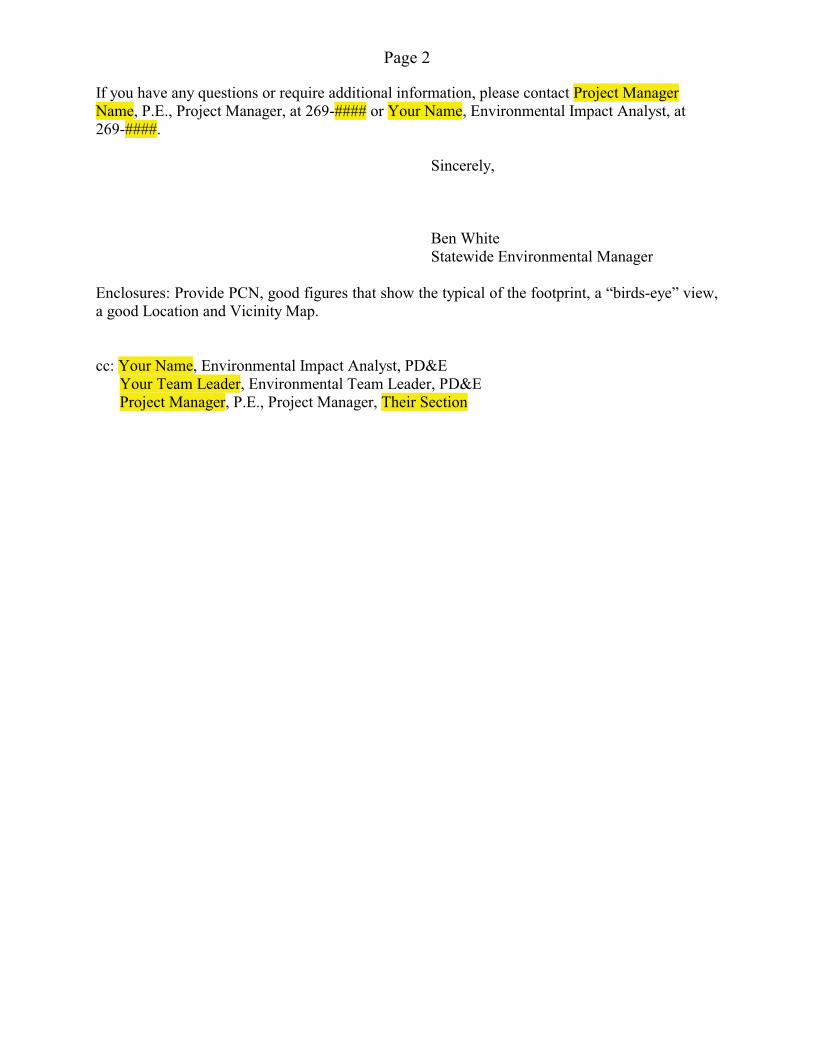
Page 2
If you have any questions or require additional information, please contact Project Manager Name, P.E., Project Manager, at 269-#### or Your Name, Environmental Impact Analyst, at 269-####.
Sincerely,
Ben White Statewide Environmental Manager
Enclosures: Provide PCN, good figures that show the typical of the footprint, a “birds-eye” view, a good Location and Vicinity Map.
cc: Your Name, Environmental Impact Analyst, PD&E Your Team Leader, Environmental Team Leader, PD&E Project Manager, P.E., Project Manager, Their Section
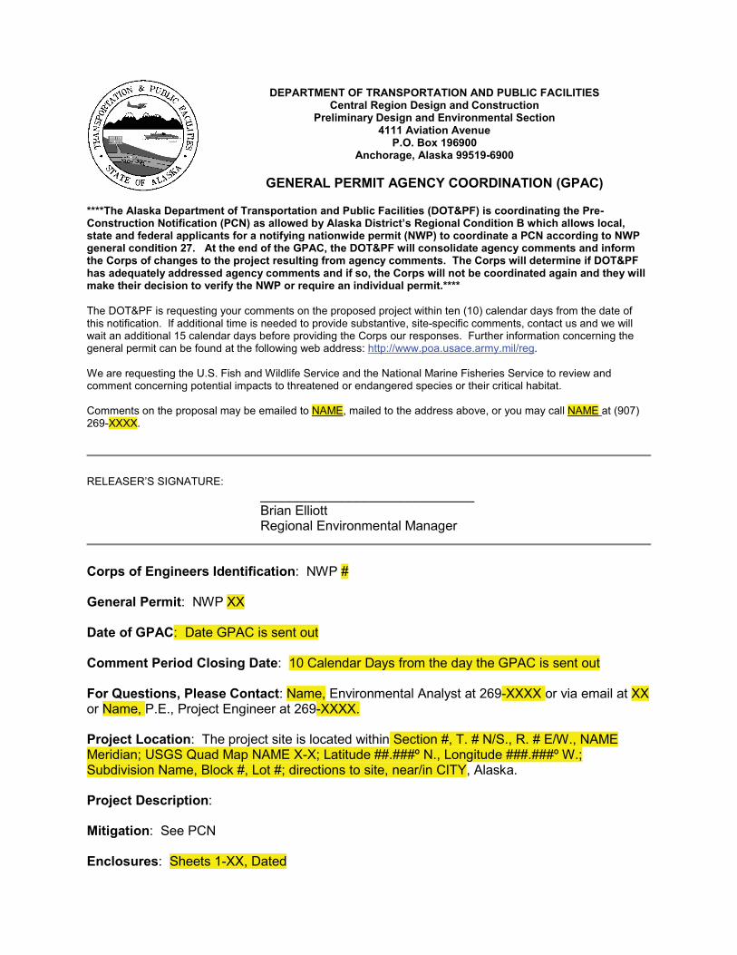
DEPARTMENT OF TRANSPORTATION AND PUBLIC FACILITIESCentral Region Design and Construction
Preliminary Design and Environmental Section4111 Aviation Avenue
P.O. Box 196900Anchorage, Alaska 99519-6900
GENERAL PERMIT AGENCY COORDINATION (GPAC)
****The Alaska Department of Transportation and Public Facilities (DOT&PF) is coordinating the Pre-Construction Notification (PCN) as allowed by Alaska District’s Regional Condition B which allows local, state and federal applicants for a notifying nationwide permit (NWP) to coordinate a PCN according to NWP general condition 27. At the end of the GPAC, the DOT&PF will consolidate agency comments and inform the Corps of changes to the project resulting from agency comments. The Corps will determine if DOT&PF has adequately addressed agency comments and if so, the Corps will not be coordinated again and they will make their decision to verify the NWP or require an individual permit.****
The DOT&PF is requesting your comments on the proposed project within ten (10) calendar days from the date of this notification. If additional time is needed to provide substantive, site-specific comments, contact us and we will wait an additional 15 calendar days before providing the Corps our responses. Further information concerning the general permit can be found at the following web address: http://www.poa.usace.army.mil/reg. We are requesting the U.S. Fish and Wildlife Service and the National Marine Fisheries Service to review and comment concerning potential impacts to threatened or endangered species or their critical habitat.
Comments on the proposal may be emailed to NAME, mailed to the address above, or you may call NAME at (907) 269-XXXX.
RELEASER’S SIGNATURE:_____________________________ Brian ElliottRegional Environmental Manager
Corps of Engineers Identification: NWP #
General Permit: NWP XX
Date of GPAC: Date GPAC is sent out
Comment Period Closing Date: 10 Calendar Days from the day the GPAC is sent out
For Questions, Please Contact: Name, Environmental Analyst at 269-XXXX or via email at XX or Name, P.E., Project Engineer at 269-XXXX.
Project Location: The project site is located within Section #, T. # N/S., R. # E/W., NAME Meridian; USGS Quad Map NAME X-X; Latitude ##.###º N., Longitude ###.###º W.; Subdivision Name, Block #, Lot #; directions to site, near/in CITY, Alaska.
Project Description:
Mitigation: See PCN
Enclosures: Sheets 1-XX, Dated
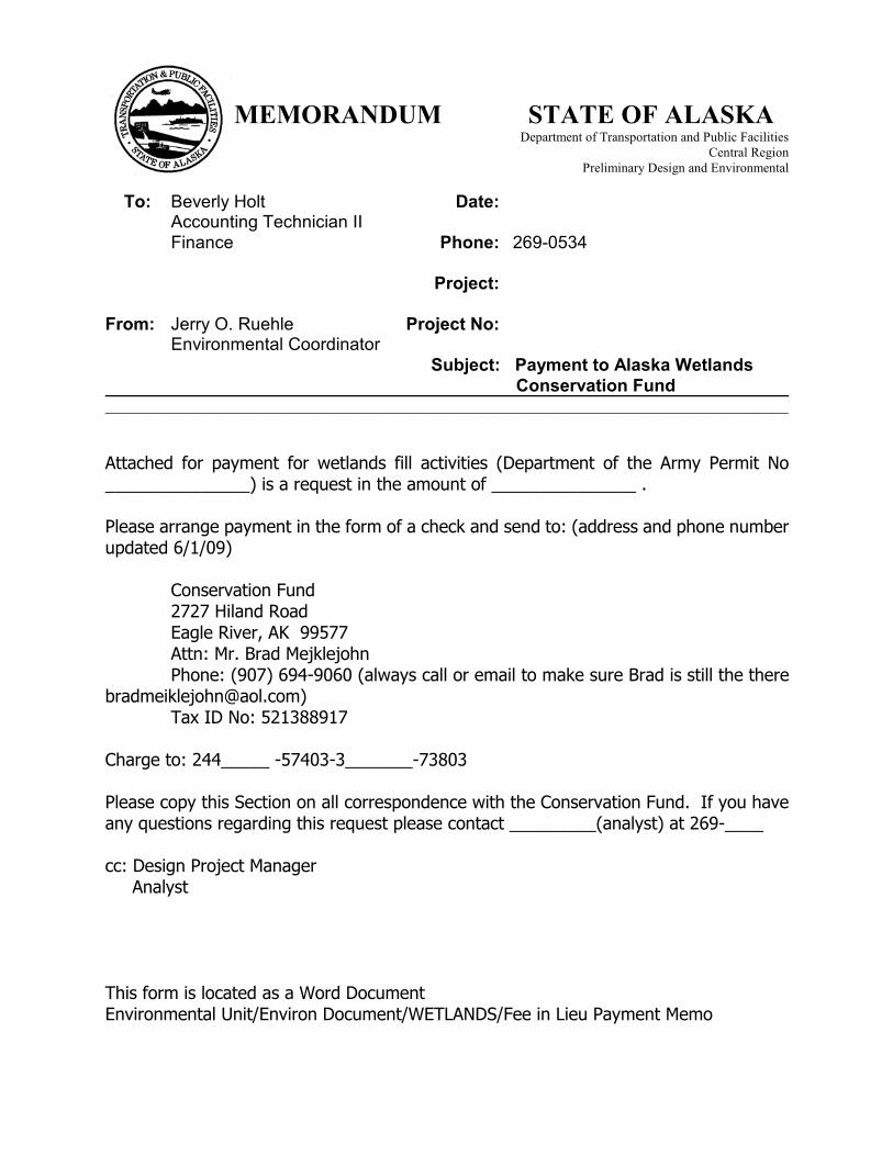
MEMORANDUM STATE OF ALASKADepartment of Transportation and Public Facilities
Central Region Preliminary Design and Environmental
To: Beverly Holt Date: Accounting Technician II Finance Phone: 269-0534 Project: From: Jerry O. Ruehle Project No: Environmental Coordinator
Subject: Payment to Alaska Wetlands Conservation Fund
_____________________________________________________________________________________
Attached for payment for wetlands fill activities (Department of the Army Permit No _______________) is a request in the amount of _______________ .
Please arrange payment in the form of a check and send to: (address and phone number updated 6/1/09)
Conservation Fund 2727 Hiland Road Eagle River, AK 99577 Attn: Mr. Brad Mejklejohn Phone: (907) 694-9060 (always call or email to make sure Brad is still the [email protected]) Tax ID No: 521388917
Charge to: 244_____ -57403-3_______-73803
Please copy this Section on all correspondence with the Conservation Fund. If you have any questions regarding this request please contact _________(analyst) at 269-____
cc: Design Project Manager Analyst
This form is located as a Word DocumentEnvironmental Unit/Environ Document/WETLANDS/Fee in Lieu Payment Memo
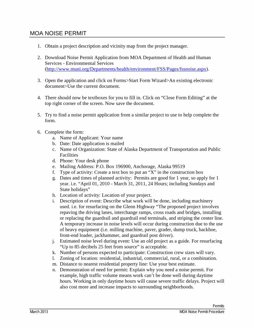
Permits March 2013 MOA Noise Permit Procedure
MOA NOISE PERMIT
1. Obtain a project description and vicinity map from the project manager.
2. Download Noise Permit Application from MOA Department of Health and Human Services - Environmental Services (http://www.muni.org/Departments/health/environment/FSS/Pages/fssnoise.aspx).
3. Open the application and click on Forms>Start Form Wizard>An existing electronic document>Use the current document.
4. There should now be textboxes for you to fill in. Click on “Close Form Editing” at the top right corner of the screen. Now save the document.
5. Try to find a noise permit application from a similar project to use to help complete the form.
6. Complete the form: a. Name of Applicant: Your name b. Date: Date application is mailed c. Name of Organization: State of Alaska Department of Transportation and Public
Facilities d. Phone: Your desk phone e. Mailing Address: P.O. Box 196900, Anchorage, Alaska 99519 f. Type of activity: Create a text box to put an “X” in the construction box g. Dates and times of planned activity: Permits are good for 1 year, so apply for 1
year. i.e. “April 01, 2010 - March 31, 2011, 24 Hours; including Sundays and State holidays”
h. Location of activity: Location of your project. i. Description of event: Describe what work will be done, including machinery
used. i.e. for resurfacing on the Glenn Highway “The proposed project involves repaving the driving lanes, interchange ramps, cross roads and bridges, installing or replacing the guardrail and guardrail end terminals, and striping the center line. A temporary increase in noise levels will occur during construction due to the use of heavy equipment (i.e. milling machine, paver, grader, dump truck, backhoe, front-end loader, jackhammer, and guardrail post driver).
j. Estimated noise level during event: Use an old project as a guide. For resurfacing “Up to 85 decibels 25 feet from source” is acceptable.
k. Number of persons expected to participate: Construction crew sizes will vary. l. Zoning of location: residential, industrial, commercial, rural, or a combination. m. Distance to nearest residential property line: Use your best estimate. n. Demonstration of need for permit: Explain why you need a noise permit. For
example, high traffic volume means work can’t be done well during daytime hours. Working in only daytime hours will cause severe traffic delays. Project will also cost more and increase impacts to surrounding neighborhoods.
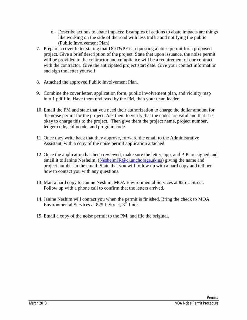
Permits March 2013 MOA Noise Permit Procedure
o. Describe actions to abate impacts: Examples of actions to abate impacts are things like working on the side of the road with less traffic and notifying the public (Public Involvement Plan)
7. Prepare a cover letter stating that DOT&PF is requesting a noise permit for a proposed project. Give a brief description of the project. State that upon issuance, the noise permit will be provided to the contractor and compliance will be a requirement of our contract with the contractor. Give the anticipated project start date. Give your contact information and sign the letter yourself.
8. Attached the approved Public Involvement Plan.
9. Combine the cover letter, application form, public involvement plan, and vicinity map into 1 pdf file. Have them reviewed by the PM, then your team leader.
10. Email the PM and state that you need their authorization to charge the dollar amount for the noise permit for the project. Ask them to verify that the codes are valid and that it is okay to charge this to the project. Then give them the project name, project number, ledger code, collocode, and program code.
11. Once they write back that they approve, forward the email to the Administrative Assistant, with a copy of the noise permit application attached.
12. Once the application has been reviewed, make sure the letter, app, and PIP are signed and
email it to Janine Nesheim, ([email protected]) giving the name and project number in the email. State that you will follow up with a hard copy and tell her how to contact you with any questions.
13. Mail a hard copy to Janine Neshim, MOA Environmental Services at 825 L Street. Follow up with a phone call to confirm that the letters arrived.
14. Janine Neshim will contact you when the permit is finished. Bring the check to MOA Environmental Services at 825 L Street, 3rd floor.
15. Email a copy of the noise permit to the PM, and file the original.
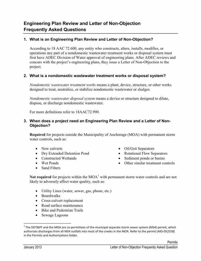
Permits January 2013 Letter of Non-Objection Frequently Asked Question
Engineering Plan Review and Letter of Non-ObjectionFrequently Asked Questions
1. What is an Engineering Plan Review and Letter of Non-Objection?
According to 18 AAC 72.600, any entity who constructs, alters, installs, modifies, or operations any part of a nondomestic wastewater treatment works or disposal system must first have ADEC Division of Water approval of engineering plans. After ADEC reviews and concurs with the project’s engineering plans, they issue a Letter of Non-Objection to the project.
2. What is a nondomestic wastewater treatment works or disposal system?
Nondomestic wastewater treatment works means a plant, device, structure, or other works designed to treat, neutralize, or stabilize nondomestic wastewater or sludges.
Nondomestic wastewater disposal system means a device or structure designed to dilute, dispose, or discharge nondomestic wastewater.
For more definitions refer to 18AAC72.990.
3. When does a project need an Engineering Plan Review and a Letter of Non-
Objection?
Required for projects outside the Municipality of Anchorage (MOA) with permanent storm water controls, such as:
� New culverts� Dry Extended Detention Pond � Constructed Wetlands � Wet Ponds � Sand Filters
� Oil/Grit Separators� Rotational Flow Separators� Sediment ponds or basins � Other similar treatment controls
Not required for projects within the MOA1
� Utility Lines (water, sewer, gas, phone, etc.)
with permanent storm water controls and are not likely to adversely affect water quality, such as:
� Boardwalks� Cross-culvert replacement� Road surface maintenance� Bike and Pedestrian Trails� Sewage Lagoons
1 The DOT&PF and the MOA are co-permittees of the municipal separate storm sewer system (MS4) permit, which authorizes discharges from all MS4 outfalls into most of the creeks in the MOA. Refer to the permit (AKS-052558) in the Permits and Authorizations folder.
Permits January 2013 Letter of Non-Objection Frequently Asked Question
4. Who is responsible for submitting the engineering plans and obtaining the Letter of Non-objection?
The Analyst should submit the engineering plans and/or consult with the ADEC while preparing the environmental document. The plans can be submitted electronically or hard copy.
5. If my project does not involve any permanent storm water controls mentioned above, is any additional consultation required to document compliance?
DOT&PFs policy is for Analysts to get ADEC concurrence that no Engineering Plan Review and Letter of Non-Objection are required for the project during preparation of the environmental document. To obtain this concurrence, we usually send ADEC an email with ashort description of the project and an explanation of why the project is not likely toadversely affect water quality. If they agree with the assessment, they will waive the Engineering Plan Review and send a concurrence email. This email should be appended to the environmental document.
6. How does an Engineering Plan Review and Letter of Non-objection relate to
the Alaska Pollutant Discharge Elimination System (APDES) Construction General Permit (CGP) Notice if Intent?
Projects that construct permanent storm water controls must undergo an Engineering Plan Review and obtain a Letter of Non-Objection. Every construction project that disturbs more than one acre of land must submit a Notice of Intent to use the APDES CGP.
Construction projects with permanent storm water controls should follow a four-step process:� Obtain a Letter of Non-Objection� Develop a Storm Water Pollution Prevention Plan � File an APDEs CGP NOI � Submit a copy of the SWPPP to ADEC
7. How long is a Letter of Non-Objection valid for?
If construction has begun within two years after issuance of Letter of Non-objection, the Letter of Non-objection is valid until completion of the project. If construction has not begun within two years after issuance of Letter of Non-objection, the Letter of Non-objection is void and plans must be resubmitted to ADEC.
8. How long does it take to get a Letter of Non-Objection issued?
A Letter of Non-Objection is usually issued two weeks to a month from date all required documents and information are provided.
Permits January 2013 Letter of Non-Objection Frequently Asked Question
9. What do we submit to ADEC?
� Transmittal memo2
� Erosion and Sediment Control Plan (ESCP)
– you can use the ADEC Letter of Non-Objection transmittal memo_template in the Permits and Authorizations folder
� ESCP plan sheets� Permanent Storm Water Management Control Checklist
Refer to your Team Leader and the Work Product Review Matrix for review and processing guidance.
2 The DOT&PF policy is to use a transmittal memo when submitting documents to other State of Alaska departments. The policy is to use a transmittal letter (i.e., on letterhead) when submitting documents to any other Federal, local, or tribal organizations.
Project Certification
Table of Contents
Project Certification Procedure
Environmental Pre-Certification Checklist
PRO
JECT
Project CertificationNovember 2012 Project Certification Procedure
Project Certification Procedure
Once the Final PS&E plan set is complete, the project should be ready to advertise for construction. Before the project can be advertised, the Alaska Division of FHWA requires that the Engineering Manager, Regional Environmental Manager, Right-of-Way Chief, Utilities Chief, and Preconstruction Engineer certify the project. The purpose of Project Certification is to confirm that the project meets all applicable standards and legal requirements. Project Certification occurs when the environmental document and re-evaluations, if necessary, are approved and all the regulatory permits are obtained, and all environmental commitments and mitigation requirements are incorporated into the plans and specifications.
1. When the Final PS&E is finalized, the Engineering Project Manager circulates it for review and certification. The Final PS&E certification package will include a plan set, standard modification to the specifications, special provisions, and a Project Certification Form.
2. Review the certification package to ensure
a. your PIH/PS&E review comments have been addressed
b. project scope is consistent with the environmental document
c. environmental commitments and mitigation measures have been incorporated
d. all regulatory permits have been obtained (except for MOA Noise Permit and ADEC Tier 3 consultation)
3. Fill out the Environmental Pre-Certification Checklist (EPCC). The EPCC is an internal Environmental document that summarizes the work done on the project. The EPCC includes the type of document, permits, when various consultations took place, etc. You can find the EPCC in the Templates and Procedures folder.
4. The project can be certified if all the requirements in #2 above have been met
a. If the project is ready for certification, give the certification package and completed EPCC to the REM
b. If the project is not ready for certification, resolve any issues preventing certification
5. The REM will then sign the Project Certification Form and return the certification package to the analyst. Scan the signed Project Certification Form and EPCC. File the electronic versions in the “project management folder” and file hard copies in the administrative file.
6. The analyst returns it to the Engineering Project Manager (without the EPCC).
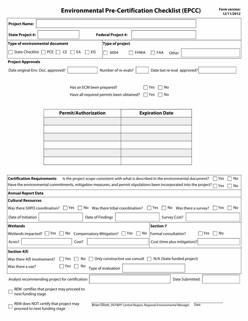
Environmental Pre-Certification Checklist (EPCC)
State Project #:
Project Name:
Date of Initiation
Annual Report Data
Analyst recommending project for certification Date Submitted:
REM certifies that project may proceed to next funding stage
Brian Elliott, DOT&PF Central Region, Regional Environmental ManagerREM does NOT certify that project may proceed to next funding stage
Federal Project #:
Form version: 12/11/2012
NoYesWas there SHPO coordination?
Type of environmental document
State Checklist PCE EA EISCE FAAFHWA6004
Type of project
Other
Project Approvals
Cultural Resources
Date of Findings
Was there tribal coordination? NoYes NoYesWas there a survey?
Survey Cost?
Section 4(f)
Was there 4(f) involvement? NoYes Only constructive use consult N/A (State funded project)
Type of evaluation
Wetlands
NoYesWetlands impacted?
Acres?
Compensatory Mitigation? Yes No
Cost?
Section 7
Formal consultation? Yes No
Cost (time plus mitigation)?
Have the environmental commitments, mitigation measures, and permit stipulations been incorporated into the project?Certification Requirements
NoYes
Is the project scope consistent with what is described in the environmental document? NoYes
NoYesHas an ECM been prepared?
Permit/Authorization Expiration Date
Date original Env. Doc. approved? Date last re-eval approved?
Was there a use? NoYes
Date
NoYesHave all required permits been obtained?
Number of re-evals?
Construction
Table of Contents
Construction Frequently Asked Questions
Environmental Expo Notes on the Role of the Environmental Analyst
Environmental Commitment (ECM) Template
Pre-construction Conference Guidance fir Analysts
APDES Notice of Intent, Modification, and Notice of Termination (NOI/NOT) Instructions
CO
NSTR
UC
TION
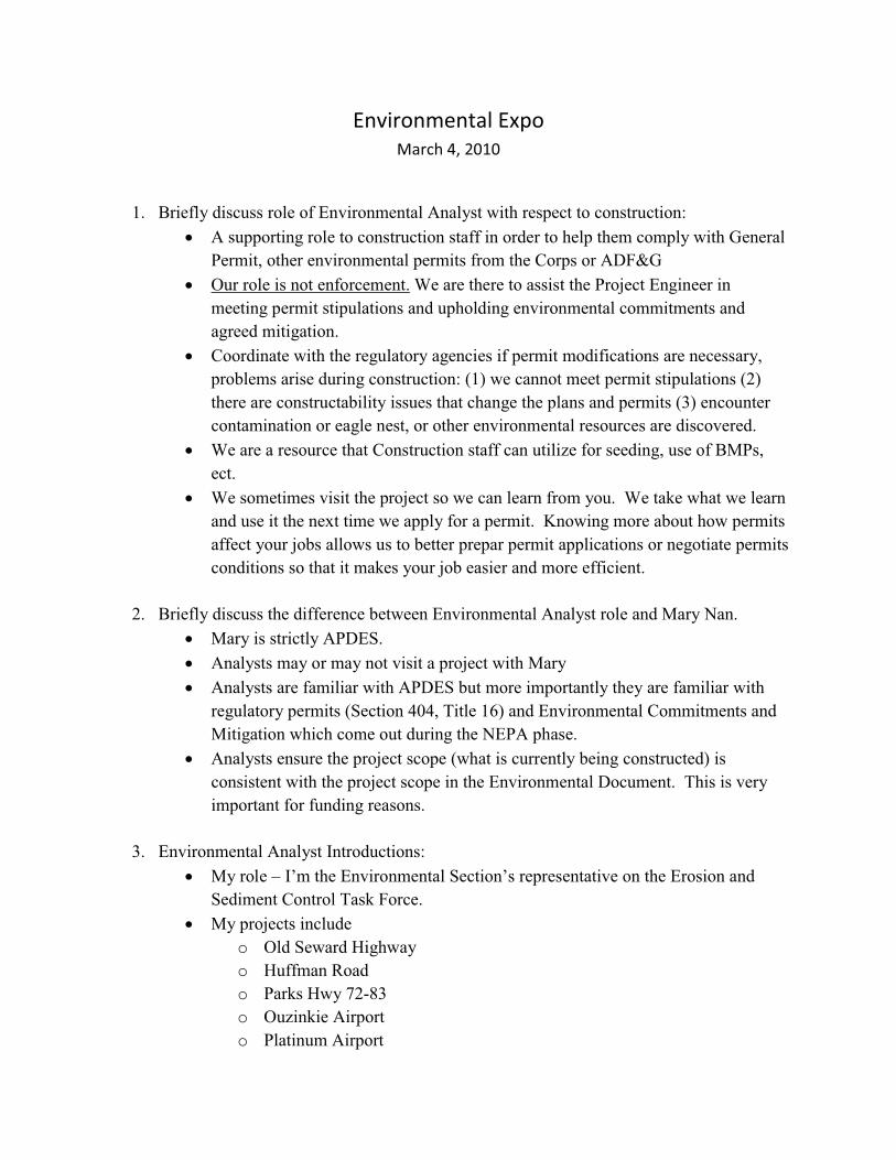
Environmental Expo March 4, 2010
1. Briefly discuss role of Environmental Analyst with respect to construction: � A supporting role to construction staff in order to help them comply with General
Permit, other environmental permits from the Corps or ADF&G � Our role is not enforcement. We are there to assist the Project Engineer in
meeting permit stipulations and upholding environmental commitments and agreed mitigation.
� Coordinate with the regulatory agencies if permit modifications are necessary, problems arise during construction: (1) we cannot meet permit stipulations (2)there are constructability issues that change the plans and permits (3) encounter contamination or eagle nest, or other environmental resources are discovered.
� We are a resource that Construction staff can utilize for seeding, use of BMPs, ect.
� We sometimes visit the project so we can learn from you. We take what we learn and use it the next time we apply for a permit. Knowing more about how permits affect your jobs allows us to better prepar permit applications or negotiate permits conditions so that it makes your job easier and more efficient.
2. Briefly discuss the difference between Environmental Analyst role and Mary Nan. � Mary is strictly APDES. � Analysts may or may not visit a project with Mary� Analysts are familiar with APDES but more importantly they are familiar with
regulatory permits (Section 404, Title 16) and Environmental Commitments and Mitigation which come out during the NEPA phase.
� Analysts ensure the project scope (what is currently being constructed) is consistent with the project scope in the Environmental Document. This is very important for funding reasons.
3. Environmental Analyst Introductions: � My role – I’m the Environmental Section’s representative on the Erosion and
Sediment Control Task Force. � My projects include
o Old Seward Highwayo Huffman Road o Parks Hwy 72-83 o Ouzinkie Airport o Platinum Airport
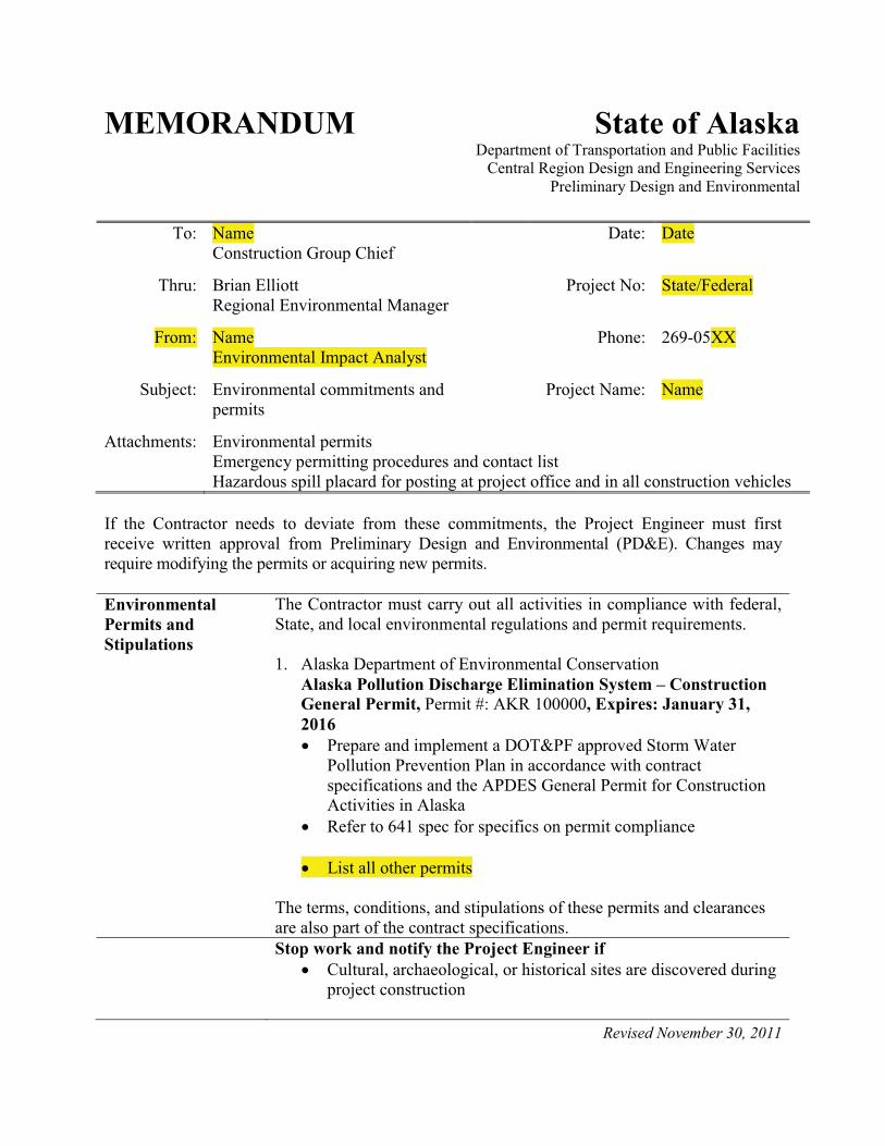
Revised November 30, 2011
MEMORANDUM State of AlaskaDepartment of Transportation and Public Facilities
Central Region Design and Engineering ServicesPreliminary Design and Environmental
To: NameConstruction Group Chief
Date: Date
Thru: Brian ElliottRegional Environmental Manager
Project No: State/Federal
From: NameEnvironmental Impact Analyst
Phone: 269-05XX
Subject: Environmental commitments and permits
Project Name: Name
Attachments: Environmental permitsEmergency permitting procedures and contact list Hazardous spill placard for posting at project office and in all construction vehicles
If the Contractor needs to deviate from these commitments, the Project Engineer must first receive written approval from Preliminary Design and Environmental (PD&E). Changes mayrequire modifying the permits or acquiring new permits.
EnvironmentalPermits and Stipulations
The Contractor must carry out all activities in compliance with federal, State, and local environmental regulations and permit requirements.
1. Alaska Department of Environmental Conservation Alaska Pollution Discharge Elimination System – Construction General Permit, Permit #: AKR 100000, Expires: January 31, 2016� Prepare and implement a DOT&PF approved Storm Water
Pollution Prevention Plan in accordance with contract specifications and the APDES General Permit for Construction Activities in Alaska
� Refer to 641 spec for specifics on permit compliance
� List all other permits
The terms, conditions, and stipulations of these permits and clearances are also part of the contract specifications.Stop work and notify the Project Engineer if
� Cultural, archaeological, or historical sites are discovered during project construction
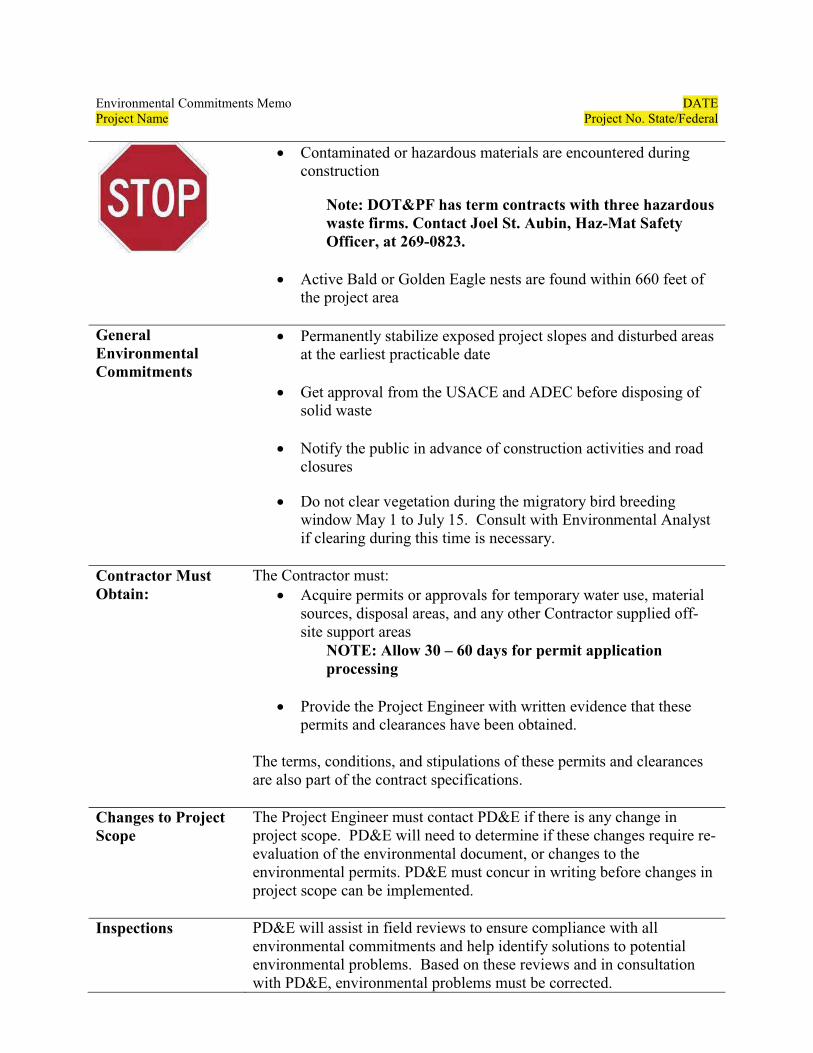
Environmental Commitments Memo DATEProject Name Project No. State/Federal
� Contaminated or hazardous materials are encountered during construction
Note: DOT&PF has term contracts with three hazardous waste firms. Contact Joel St. Aubin, Haz-Mat Safety Officer, at 269-0823.
� Active Bald or Golden Eagle nests are found within 660 feet of the project area
General Environmental Commitments
� Permanently stabilize exposed project slopes and disturbed areas at the earliest practicable date
� Get approval from the USACE and ADEC before disposing of solid waste
� Notify the public in advance of construction activities and road closures
� Do not clear vegetation during the migratory bird breeding window May 1 to July 15. Consult with Environmental Analyst if clearing during this time is necessary.
Contractor Must Obtain:
The Contractor must:� Acquire permits or approvals for temporary water use, material
sources, disposal areas, and any other Contractor supplied off-site support areas
NOTE: Allow 30 – 60 days for permit application processing
� Provide the Project Engineer with written evidence that these permits and clearances have been obtained.
The terms, conditions, and stipulations of these permits and clearances are also part of the contract specifications.
Changes to Project Scope
The Project Engineer must contact PD&E if there is any change in project scope. PD&E will need to determine if these changes require re-evaluation of the environmental document, or changes to the environmental permits. PD&E must concur in writing before changes in project scope can be implemented.
Inspections PD&E will assist in field reviews to ensure compliance with all environmental commitments and help identify solutions to potential environmental problems. Based on these reviews and in consultation with PD&E, environmental problems must be corrected.
Environmental Commitments Memo DATEProject Name Project No. State/Federal
The Project Engineer must notify Name and Mary Nan Cunningham when the project is approximately 80% complete and the Contractor is still available with equipment on site for an on-site inspection. Also, please notify the Environmental Analyst when work in environmentally sensitive areas is planned, so that on-site monitoring can be completed as necessary.
Environmental and Sediment Control Contacts
Environmental Analyst:Name Phone Email
Environmental Team Leader: Name Phone Email
Erosion and Sediment Control Specialist: Mary Nan Cunningham 907-269-0450 [email protected]
Emergency Permitting
Periodically, natural disasters (flooding, earthquakes, wildfire,windstorms, etc.) occur which threaten or result in serious damage totransportation infrastructure. In many of these situations, work necessary to protect, repair, or replace infrastructure (roads, bridges, culverts, etc.), requires permits from various resource agencies and localgovernments.
If this happens, please reference the attached emergency permitting procedures and contact list for guidance on how to proceed. PD&E staff will help you determine which, if any, permits are required and which agencies must be notified to obtain authorization.
Environmental Document
A Categorical Exclusion or Environmental Assessment document was prepared and approved on DATE and is available for review upon request.
cc: P.E., Construction Project Manager P.E., Construction Project EngineerEnvironmental Team Leader, PD&E
Ben White, Statewide Environmental Manager
ConstructionMay 2012 Pre-con Guidance
Pre-construction Conference Guidance for Analysts
This purpose of this guidance is to provide analysts an outline of topics that should be discussed during the preconstruction conference. Analysts should adapt this outline to describe the specific needs of the project.
General Outline
� Introduce yourself as the point of contact for PD&E.
� Provide a brief description of the analysts role in construction (e.g., to provide support and assistance in complying with permits).
�Provide packet of information including the Environmental Commitments Memo, emergency permitting procedures, contact list, placards, etc.
� Recommend the following be posted at the project office:o All permits required for this project o Brief description of project (to hand out) o Contact information for on-site SWPPP Manager or Project Engineero Emergency Contact List o Oil & Hazardous Substance Spills Placards
� Small placards go in vehicles� Large placards posted at Project Office and at Material/Equipment staging
site. o DOT will assist in inspections throughout the project to make sure construction is
in compliance with the SWPPP and permit conditions.
� If applicable, describe the permits and stipulations to the degree you feel necessary to convey all pertinent information. This is your opportunity to inform the Project Engineer and Contractor of the permit stipulations and commitments agreed upon during the Environmental process.
o Recommend the Project Engineer and Contractor read the permit in advance. o State that Construction must be done in compliance with all permit conditions. o If a permit needs to be modified, consult with the Project Engineer. o The Contractor is responsible for obtaining Temporary Water Use Permits,
permits associated with material and disposal sites, and Contractor staging areas.
� Note any sensitive resources nearby that are not be directly affected by the project or discussed previously.
� State that an eNOI will/will not be submitted upon approval of the SWPPP. o State that Mary Nan Cunningham or Joshua James are DOT&PF Central Region
POCs and are available to answer any questions about erosion, sedimentation, or upkeep of the SWPPP.
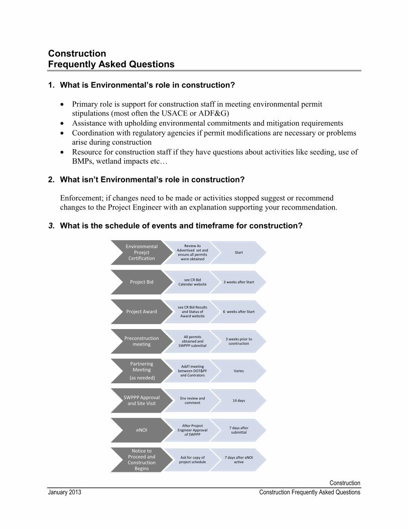
ConstructionJanuary 2013 Construction Frequently Asked Questions
Construction Frequently Asked Questions
1. What is Environmental’s role in construction?
� Primary role is support for construction staff in meeting environmental permit stipulations (most often the USACE or ADF&G)
� Assistance with upholding environmental commitments and mitigation requirements� Coordination with regulatory agencies if permit modifications are necessary or problems
arise during construction � Resource for construction staff if they have questions about activities like seeding, use of
BMPs, wetland impacts etc…
2. What isn’t Environmental’s role in construction?
Enforcement; if changes need to be made or activities stopped suggest or recommend changes to the Project Engineer with an explanation supporting your recommendation.
3. What is the schedule of events and timeframe for construction?
Environmental Proejct
Certification
Review As Advertised set and ensure all permits
were obtained
Start
Project Bid see CR Bid Calendar website 3 weeks after Start
Project Award see CR Bid Results
and Status of Award website
6 weeks after Start
Preconstruction meeting
All permits obtained and
SWPPP submittal
3 weeks prior to cosntruction
Partnering Meeting
(as needed)
Add'l meeting between DOT&PF
and Contrators Varies
SWPPP Approval and Site Visit
Env review and comment 14 days
eNOI After Project
Engineer Approval of SWPPP
7 days after submittal
Notice to Proceed and Construction
Begins
Ask for copy of project schedule
7 days after eNOI active
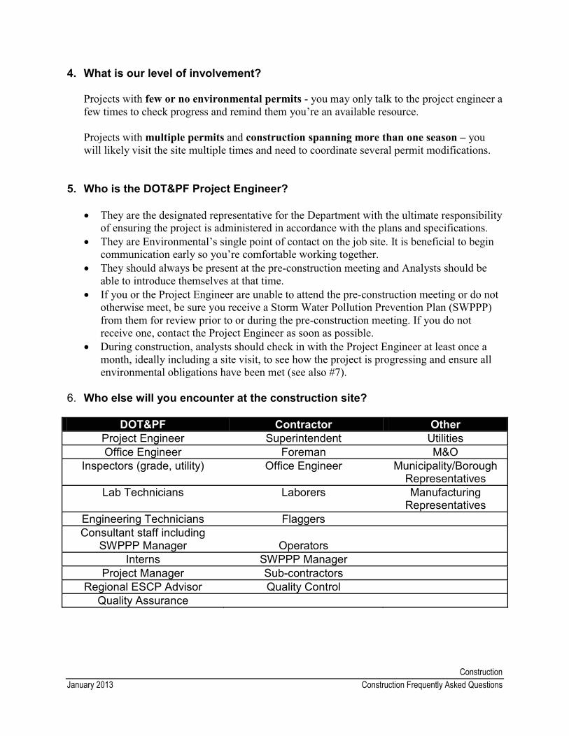
ConstructionJanuary 2013 Construction Frequently Asked Questions
4. What is our level of involvement?
Projects with few or no environmental permits - you may only talk to the project engineer a few times to check progress and remind them you’re an available resource.
Projects with multiple permits and construction spanning more than one season – you will likely visit the site multiple times and need to coordinate several permit modifications.
5. Who is the DOT&PF Project Engineer?
� They are the designated representative for the Department with the ultimate responsibility of ensuring the project is administered in accordance with the plans and specifications.
� They are Environmental’s single point of contact on the job site. It is beneficial to begin communication early so you’re comfortable working together.
� They should always be present at the pre-construction meeting and Analysts should be able to introduce themselves at that time.
� If you or the Project Engineer are unable to attend the pre-construction meeting or do not otherwise meet, be sure you receive a Storm Water Pollution Prevention Plan (SWPPP) from them for review prior to or during the pre-construction meeting. If you do not receive one, contact the Project Engineer as soon as possible.
� During construction, analysts should check in with the Project Engineer at least once a month, ideally including a site visit, to see how the project is progressing and ensure all environmental obligations have been met (see also #7).
6. Who else will you encounter at the construction site?
DOT&PF Contractor OtherProject Engineer Superintendent UtilitiesOffice Engineer Foreman M&O
Inspectors (grade, utility) Office Engineer Municipality/Borough Representatives
Lab Technicians Laborers Manufacturing Representatives
Engineering Technicians FlaggersConsultant staff including
SWPPP Manager OperatorsInterns SWPPP Manager
Project Manager Sub-contractorsRegional ESCP Advisor Quality Control
Quality Assurance
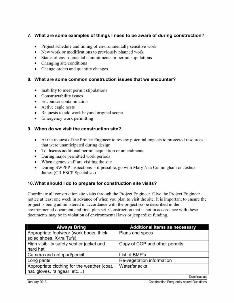
ConstructionJanuary 2013 Construction Frequently Asked Questions
7. What are some examples of things I need to be aware of during construction?
� Project schedule and timing of environmentally sensitive work � New work or modifications to previously planned work � Status of environmental commitments or permit stipulations � Changing site conditions � Change orders and quantity changes
8. What are some common construction issues that we encounter?
� Inability to meet permit stipulations� Constructability issues� Encounter contamination � Active eagle nests� Requests to add work beyond original scope� Emergency work permitting
9. When do we visit the construction site?
� At the request of the Project Engineer to review potential impacts to protected resources that were unanticipated during design
� To discuss additional permit acquisition or amendments� During major permitted work periods � When agency staff are visiting the site� During SWPPP inspections - if possible, go with Mary Nan Cunningham or Joshua
James (CR ESCP Specialists)
10.What should I do to prepare for construction site visits?
Coordinate all construction site visits through the Project Engineer. Give the Project Engineer notice at least one week in advance of when you plan to visit the site. It is important to ensure theproject is being administered in accordance with the project scope described in the environmental document and final plan set. Construction that is not in accordance with these documents may be in violation of environmental laws or jeopardize funding.
Always Bring Additional items as necessaryAppropriate footwear (work boots, thick-soled shoes, X-tra Tufs)
Plans and specs
High visibility safety vest or jacket and hard hat
Copy of CGP and other permits
Camera and notepad/pencil List of BMP’sLong pants Re-vegetation informationAppropriate clothing for the weather (coat, hat, gloves, raingear, etc…)
Water/snacks
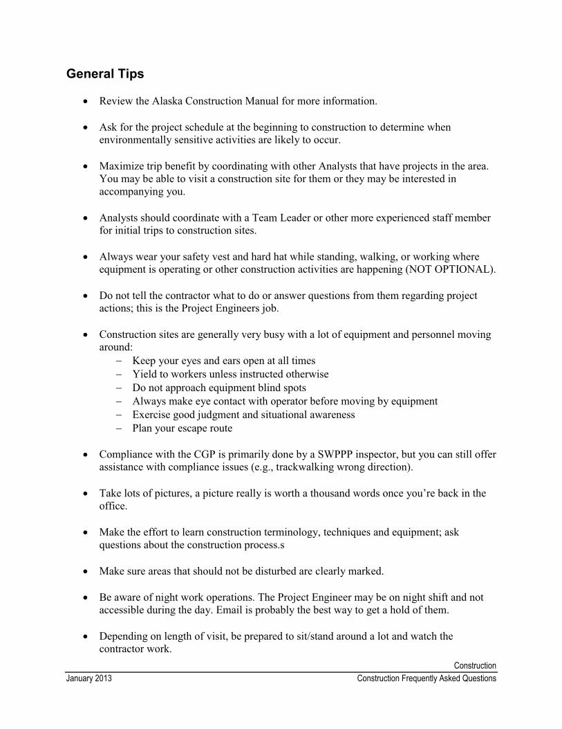
ConstructionJanuary 2013 Construction Frequently Asked Questions
General Tips
� Review the Alaska Construction Manual for more information.
� Ask for the project schedule at the beginning to construction to determine when environmentally sensitive activities are likely to occur.
� Maximize trip benefit by coordinating with other Analysts that have projects in the area. You may be able to visit a construction site for them or they may be interested in accompanying you.
� Analysts should coordinate with a Team Leader or other more experienced staff member for initial trips to construction sites.
� Always wear your safety vest and hard hat while standing, walking, or working where equipment is operating or other construction activities are happening (NOT OPTIONAL).
� Do not tell the contractor what to do or answer questions from them regarding project actions; this is the Project Engineers job.
� Construction sites are generally very busy with a lot of equipment and personnel moving around:
� Keep your eyes and ears open at all times� Yield to workers unless instructed otherwise � Do not approach equipment blind spots � Always make eye contact with operator before moving by equipment � Exercise good judgment and situational awareness� Plan your escape route
� Compliance with the CGP is primarily done by a SWPPP inspector, but you can still offer assistance with compliance issues (e.g., trackwalking wrong direction).
� Take lots of pictures, a picture really is worth a thousand words once you’re back in the office.
� Make the effort to learn construction terminology, techniques and equipment; ask questions about the construction process.s
� Make sure areas that should not be disturbed are clearly marked.
� Be aware of night work operations. The Project Engineer may be on night shift and not accessible during the day. Email is probably the best way to get a hold of them.
� Depending on length of visit, be prepared to sit/stand around a lot and watch the contractor work.

ConstructionDecember 2012 APDES Notice of Intent, Modification, and Notice of Termination Instructions
APDES Notice of Intent, Modification, and Notice of Termination Instructions
Notice of Intent (NOI)
1. Review the Storm Water Pollution Prevention Plan (SWPPP) and provide comments to the DOT&PF Construction project engineer.
2. Once the Construction Project Engineer approves the SWPPP, you should receive the following:
a. SWPPP delegation of authority - designates the Construction Project Engineer as the authorized representative overseeing compliance with the Construction General Permit
b. SWPPP approval memo – a memo the Construction Project Engineer writes to the Contractor notifying them that the SWPPP has been approved
c. SWPPP Certification for DOT&PF - states that the SWPPP was prepared by qualified personnel under the supervision of the Construction Project Engineer
d. A copy of the Contractor’s NOI
3. Complete the Notice of Intent (NOI) form. You can find a partially completed NOI form in the Templates and Procedures/Construction/NOI-NOT folder or on the ADEC website.
4. Once the NOI form is complete, save and print it. Take the NOI form and all four documents listed in 2a-d above to the PD&E office assistant, who will get it signed by the Regional Director and file the NOI with the ADEC.
5. The ADEC will reply in writing (via email) stating they received the NOI. The PD&E Office Assistant will forward it to the following people:
a. Environmental analyst b. DOT&PF SWPPP/ESCP advisor, c. Environmental Protection Agency, d. DOT&PF Design Project Managere. Construction Project Engineer
If the NOI and ADEC response letter are not forwarded to all those listed above, the analyst is responsible for providing it.
6. The PD&E Office Assistant will file the NOI and its supporting paperwork in the project’s paper file.
7. File the NOI Modification in the project’s electronic folder.
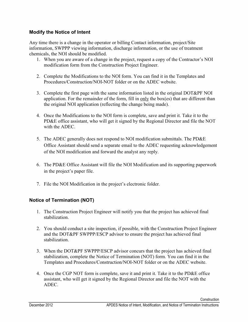
ConstructionDecember 2012 APDES Notice of Intent, Modification, and Notice of Termination Instructions
Modify the Notice of Intent
Any time there is a change in the operator or billing Contact information, project/Site information, SWPPP viewing information, discharge information, or the use of treatment chemicals, the NOI should be modified.
1. When you are aware of a change in the project, request a copy of the Contractor’s NOI modification form from the Construction Project Engineer.
2. Complete the Modifications to the NOI form. You can find it in the Templates and Procedures/Construction/NOI-NOT folder or on the ADEC website.
3. Complete the first page with the same information listed in the original DOT&PF NOI application. For the remainder of the form, fill in only the box(es) that are different than the original NOI application (reflecting the change being made).
4. Once the Modifications to the NOI form is complete, save and print it. Take it to the PD&E office assistant, who will get it signed by the Regional Director and file the NOT with the ADEC.
5. The ADEC generally does not respond to NOI modification submittals. The PD&E Office Assistant should send a separate email to the ADEC requesting acknowledgement of the NOI modification and forward the analyst any reply.
6. The PD&E Office Assistant will file the NOI Modification and its supporting paperwork in the project’s paper file.
7. File the NOI Modification in the project’s electronic folder.
Notice of Termination (NOT)
1. The Construction Project Engineer will notify you that the project has achieved final stabilization.
2. You should conduct a site inspection, if possible, with the Construction Project Engineer and the DOT&PF SWPPP/ESCP advisor to ensure the project has achieved final stabilization.
3. When the DOT&PF SWPPP/ESCP advisor concurs that the project has achieved final stabilization, complete the Notice of Termination (NOT) form. You can find it in the Templates and Procedures/Construction/NOI-NOT folder or on the ADEC website.
4. Once the CGP NOT form is complete, save it and print it. Take it to the PD&E office assistant, who will get it signed by the Regional Director and file the NOT with the ADEC.

ConstructionDecember 2012 APDES Notice of Intent, Modification, and Notice of Termination Instructions
5. The PD&E Office Assistant will forward the ADEC NOT acceptance letter to: a. Environmental analyst b. DOT&PF SWPPP/ESCP advisor, c. Environmental Protection Agency, d. DOT&PF Design Project Managere. Construction Project Engineer
The PD&E Office Assistant will file the NOT and it’s supporting paperwork in the project file. E-file the NOT in the project folder.
If the NOI and ADEC response letter are not forwarded to all those listed above, the analyst is responsible for providing it.
6. The PD&E Office Assistant will file the NOI and its supporting paperwork in the project’s paper file.
7. File the NOT in the project’s electronic folder.
Attachments
Table of Contents
Guidance on Preparing Figures
Using CAD Standards
Public Meeting Records
Title VI of the Civil Rights Act Frequently Asked Questions
Title VI Public Meeting Sign-in Sheet
DOT&PF Civil Rights Office Title VI Pamphlet
Introduction to Title VI Power Point Presentation
Meeting Record
ATTA
CH
MEN
TS
AttachmentsJune 2012 Developing Project Figures Guidance
Developing Project Figures Guidance
When developing a set of figures for a project, first decide the purpose of the figures (scoping, permitting, 106, etc.) and what details (ROW, wetlands, APE, etc) need to be shown. Look for existing graphics or figures you can use or adapt for your project and talk with your Team Leader and Drafter before you start working on them. You can also refer to the enclosed examples for ideas.
Here are some general things to consider:
� Keep them simple and use the fewest sheets possible to adequately show the proposed activity.
� Think about your audience and conform to their expectations as much as possible. � Try to make one set of figures that can be used or easily adapted for scoping,
consultations, the environmental document, and permit applications. � For projects with a minor scope, it is okay to combine Figures 1 and 2. � In addition to Figures 1-3, you can attach plan sheets (e.g., temporary diversions/detours),
aerial or site photos, other maps, etc. � Other non-graphic related materials like permit applications, mitigation statement, and
technical reports should be separate enclosures.
Standard Set of Figures At a minimum, all figures should use the standard title block and format and include a scale, north arrow, and location data.
Figure 1 - Location and Vicinity MapThis figure is done for every project and often comes from the project manager or design team. This figure depicts the general project location within the state (vicinity) and the specific local (location). The standard title block contains the state of Alaska in the bottom left side and the project information in bottom right side (see attached examples).
Figure 2 - Project Details (Plan View)This figure depicts the project area as if you were looking down on it. The standard title block contains a legend in the bottom left side and the project information in the bottom right side. Use your best judgment in determining the most relevant information to show so that it is easy to understand, but still accurately portrays the proposed action. At a minimum, it should contain the following items:
� current aerial imagery, if available� Topo lines, if needed � all project activities� BOP/EOP
� major roads and roads referenced in text
� existing and proposed ROW � cut and fill lines
AttachmentsJune 2012 Developing Project Figures Guidance
Additional information could include:
� waterbodies with direction of flow � wetland boundaries � floodplains or regulatory floodways � critical habitat areas � cultural resources, if appropriate � recreational areas
� eagle nests� areas of high wildlife/vehicle
accidents� hazardous waste sites � schools, churches, businesses � noise sensitive receivers
Figure 3: Typical Cross Section ViewThis figure depicts the typical roadway section. It is used when the project involves a culvert installation, bridge work, or other in-water work, a new roadway configuration, new lane, etc.Some minor projects, such as resurfacing, do not need this figure. At a minimum, it should contain the following items:
� representative typical sections for similar work (e.g. numerous culvert replacements)
� existing and proposed ground � grade of slope
� dimensions where appropriate � OHW, MHW� Stabilization measures (e.g. riprap) � Table of temporary and permanent
fill quantities, if necessary
AttachmentsJanuary 2013 Using CAD Standards
Using CAD Standards
Before you begin developing project figures, read the Developing Project Figures Guidance, templates, and consult with the Drafter and your Team Leader.
You will need to provide a few things to the Drafter when you begin developing figures:
1. Project name, number, LC, PC and CC number 2. Location of the project. For all location there will be a USGS map available. (Unless
it is outside of the United States). In some cases there will be an aerial photo available via Google earth or other venues.
3. A clear description of the project. There may be similar projects that can be “robbed” of details and or photographs.
4. Giving a marked up drawing of a similar project can help speed up the process so a drawing won’t need to be started from scratch.
CAD Standards
The following CAD standard was set in place to ensure that all drafting work performed by the Environmental Section follows the same guidelines. These guidelines are essential to the standardization of practices and to a uniform interpretation of drawings.
Standard template files have been created in order to make creating your drawing easier and to adhere to PD&E figure standards. These files already contain the standard layers, line types, blocks, dimension styles, text styles, drawing boarders and much more. They are designed to allow the user to immediately begin the drawing and plotting without worrying about text size, dimension styles, which north arrow to use or what scale.
Please note: DO NOT change or update the content of the title block. You many add line types and hatches as needed. For fonts use Ariel text .08, .1 and .12 . For bodies of water, rivers etc. use New Times Roman, Italics.
If there is something you need that is not already a part of the template, please notify your Team Leader and they will have the drafter identify and properly update the template.
Starting a CAD Drawing
To start a figure drawing go to :\Environmental\Resources\Drafting Templates\ and start with the appropriately name file. This will depend on which figure you need and the size. Fig 1 is only available in 8.5x11. Other figures have the option of using an 11x17 size that can be folded to an8.5x11 sheet size.
Open the file and immediately do a SAVE AS to your project folder. The folder should be namedaccording to the standard filing naming conventions (refer to Electronic File Naming in the templates folder).
AttachmentsJanuary 2013 Using CAD Standards
The list of layers is very short at this time. You may add layers if necessary to allow for isolating items. The viewport (orange line) is on its own layer and although you can see it, it will not print.Please remember to LOCK the viewport once you are done with the drawing.
Create the drawing in model space at 1 drawing unit = 1ft.
Xref in base maps, images and surveys on appropriate layers. The boarder is a block with attributes on the boarder layer. Double click and a window will open allowing you to insert the title, date, fig no. your name etc.
Never move or erase a .dwg or image file unless you created it and know (100%) that it has not been “xrefed” into another drawing.
Project Number and Name
Figure 1 is always the project’s “Location and Vicinity” map. It has the Standard title block,north arrow and location map in the upper right hand corner. The preferred scale for this drawing is 1” = 1 mile. The graphic scale is dynamic so you can change it if you need to show a larger or smaller area. The north arrow is also a dynamic block and can be rotated by highlighting the arrow and clicking on the blue dot. However north should always be up if at all possible!
At this time there are no specialized line types. Please use what CAD provides in the line type pull down menu. Use plines to increase line width so that work area’s stand out. When plotting in color use the acad.ctb file. Do not customize the ctb file. If you need a black and white drawing such as for ACOE, use the Grayscale.ctb. or mono. For annotation, (detail or section titles, cut lines etc.) use imperial annotation blocks provided by AutoCAD.
Figure 2 is usually the “Project Details” drawing. It will show the area you are working on “up close”. CAD drawings should be drawn to be dimensionally accurate if possible so that an approximate measurement can be obtained by reading a dimension or scaling the printed drawing. All line work shall be in model space at a scale of 1 to 1.Where practicable the coordinate system of a drawing should remain set to World coordinates.
Figure 3 is usually the “Cross Sections” drawing. It provides even more detail of the project. Keep in mind not to add more information than is necessary to get your design across to the viewer. Be clear and concise.
There are sample/templates you can start with for any of the figures at: :\Environmental\Resources\Drafting Templates
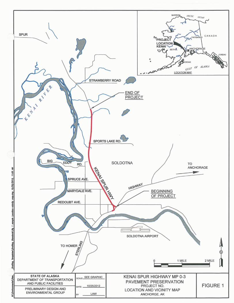
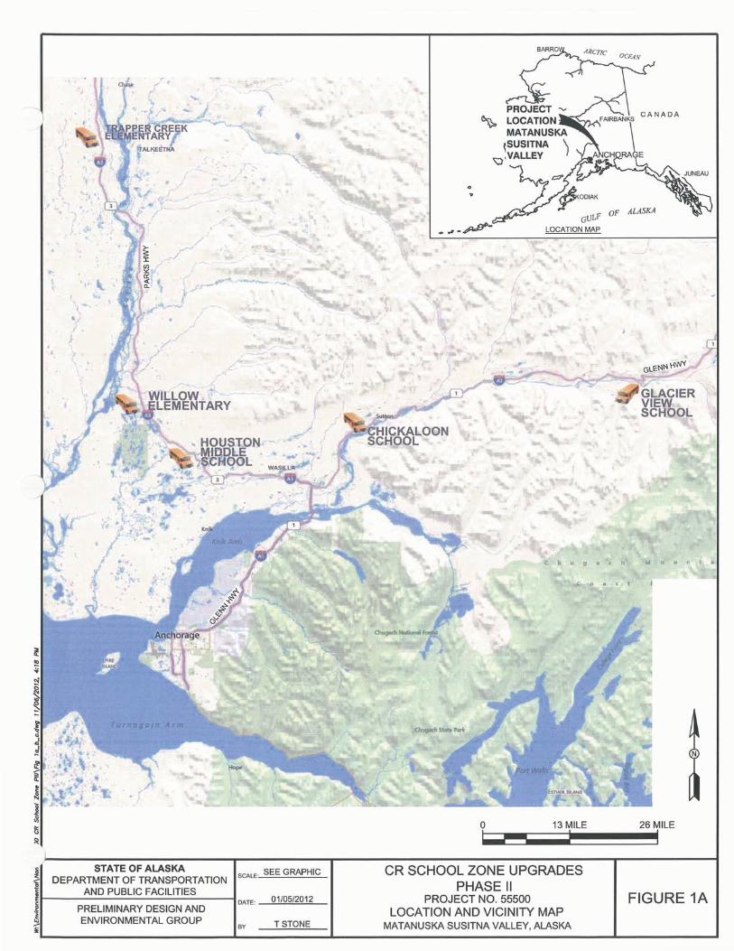
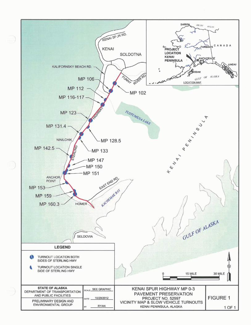
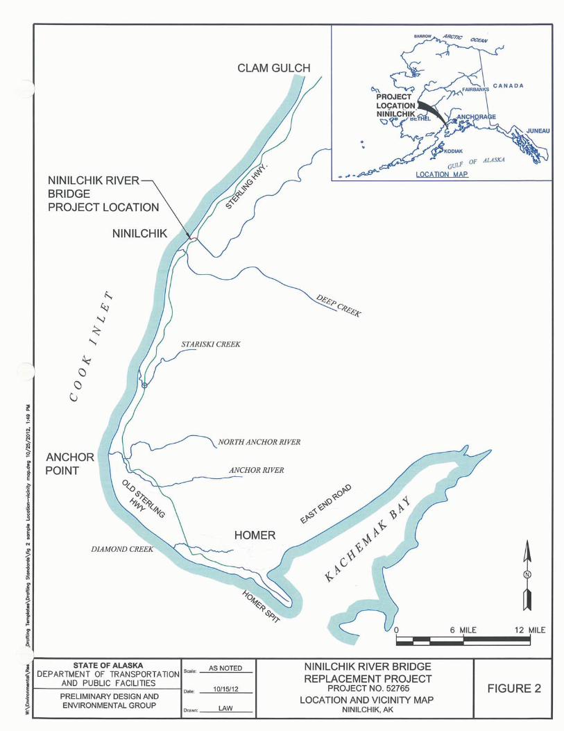
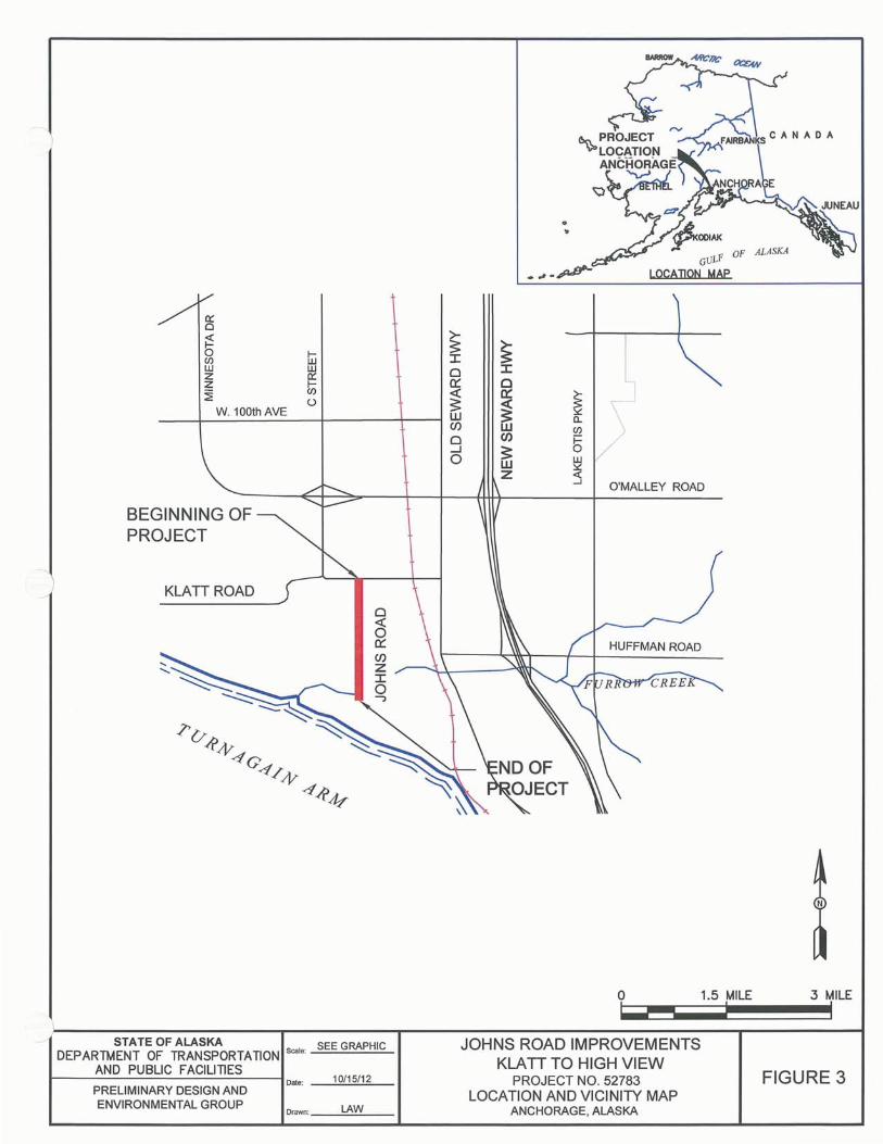
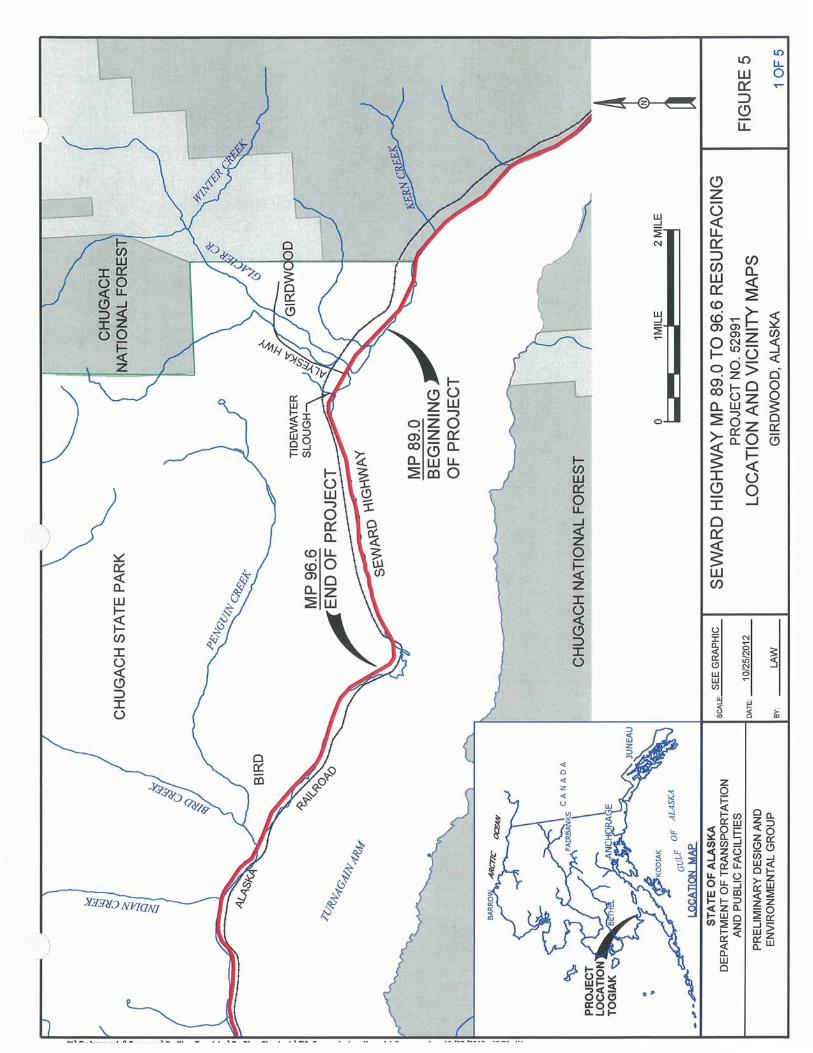

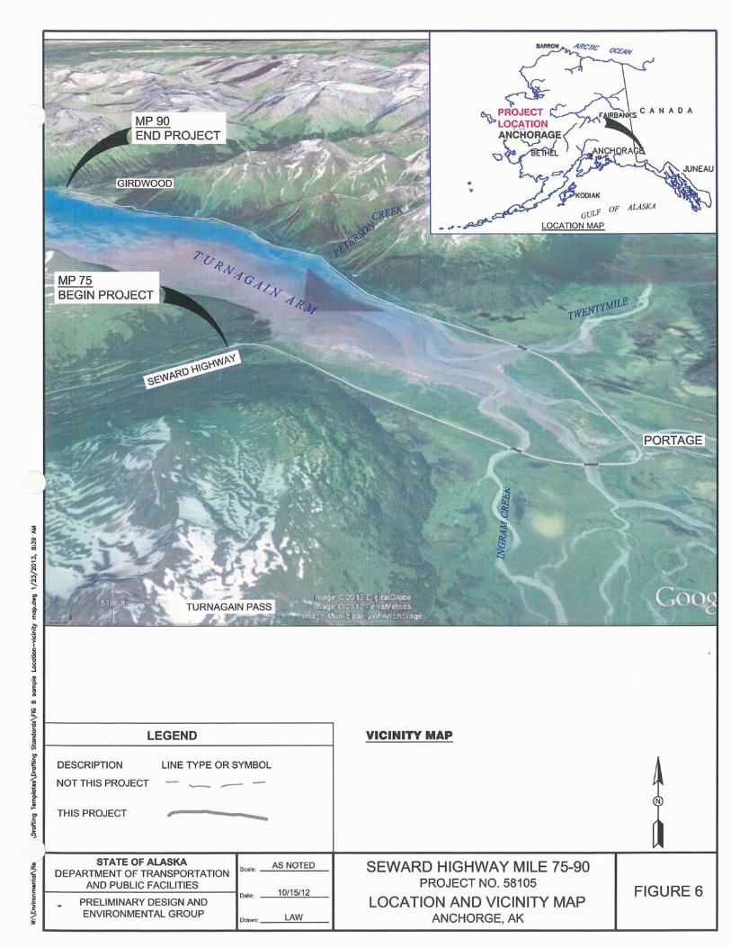
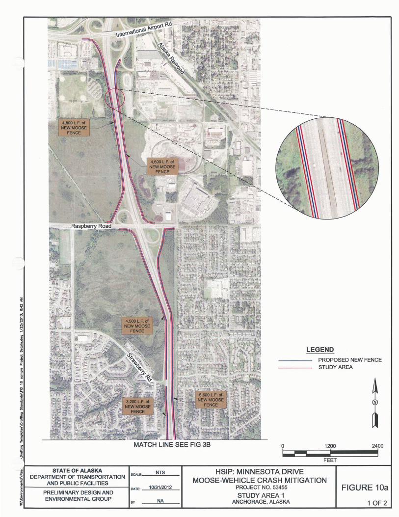
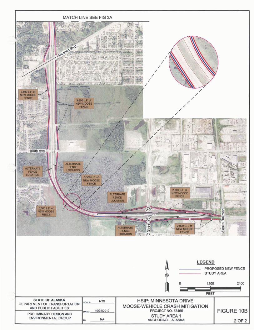
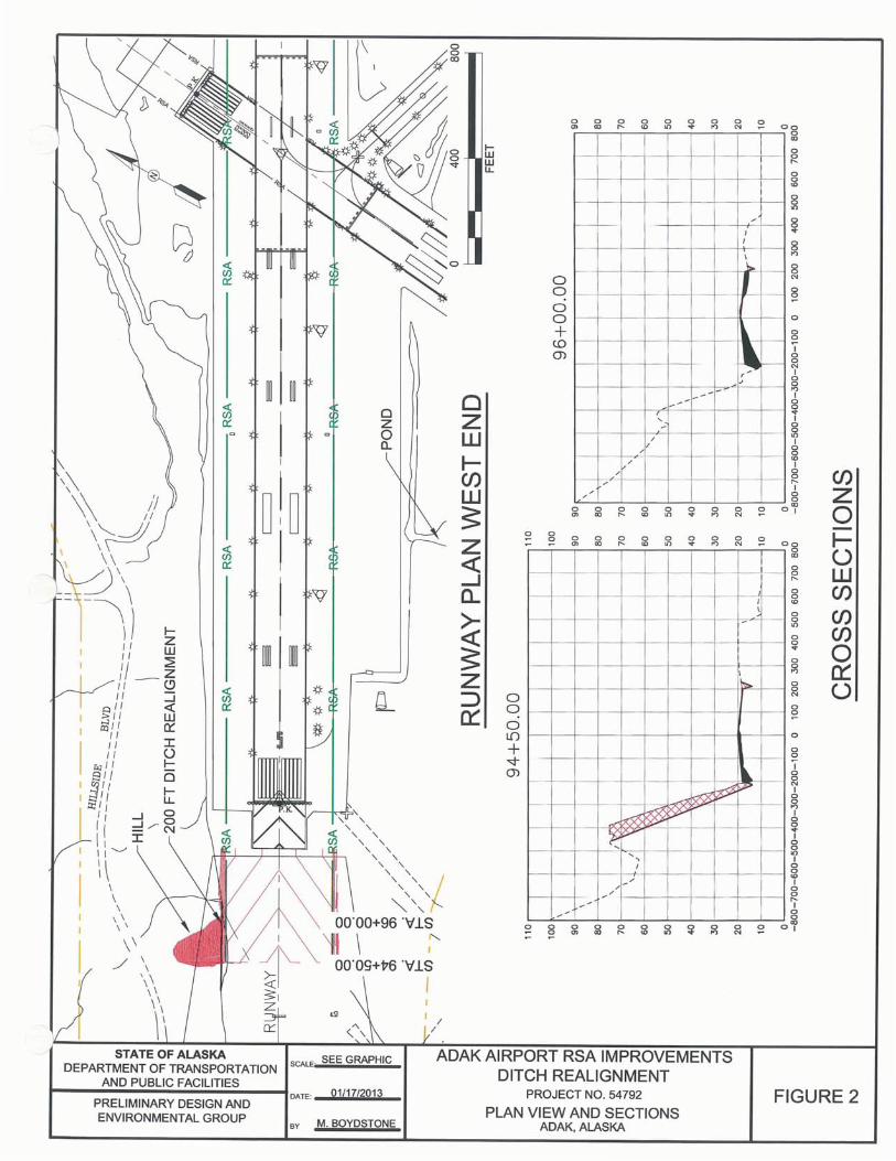
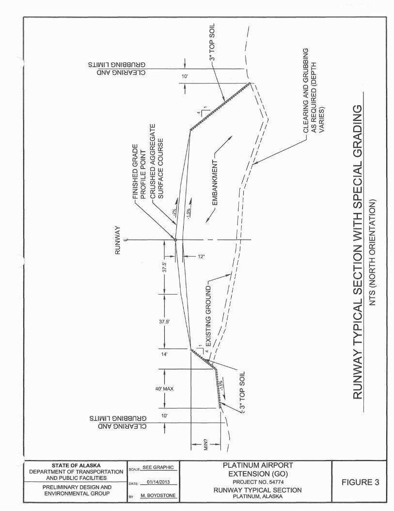
AttachmentsJanuary 2013 Title VI of the Civil Rights Act
Title VI of the Civil Rights ActFrequently Asked Questions
1. What is Title VI of the Civil Rights Act?
Title VI of the Civil Rights Act of 1964 states that, “No person in the United States shall, on the ground of race, color, or national origin, be excluded from participation in, be denied the benefits of, or be subjected to discrimination under any program or activity receiving Federal financial assistance.” Two Presidential Executive Orders place further emphasis upon the Title VI protections of race and national origin:
2. What other regulatory requirements apply to civil rights?
Executive Order #12898 (Environmental Justice) directs federal agencies to develop strategies to address disproportionately high and adverse human health or environmental effects of their programs on minority and low-income populations.
Executive Order # 13166 (Limited-English-Proficiency) directs federal agencies to evaluate services provided and implement a system that ensures that Limited English Proficiency persons are able to meaningfully access the services provided consistent with and without unduly burdening the fundamental mission of each federal agency.
Additionally, each federal agency shall ensure that recipients of federal financial assistance provide meaningful access to their Limited-English-Proficiency applicants and beneficiaries. Please note that while an Executive Order has the force of law, a lawsuit may not be brought under an Executive Order.
3. How does DOT&PF comply with Title VI for Federal-Aid Projects?
The regulations require that all FHWA projects be developed consistent with Title VI. Executive Order 12898, Environmental Justice, provides for additional civil rights requirements regarding nondiscrimination in environmental considerations and decisions made by the Department. The mechanism established by the Federal regulations to guide and oversee project development is the environmental document. As mandated by these regulations, all projects that have any potential Title VI impacts are subject to investigation and evaluation by either an Environment Assessment (EA) or an Environmental Impact Statement (EIS). Categorical Exclusions (CE) rarely have Title VI issues. However, the analysts working on a CE must be aware of potential Title VI issues.
4. Who is responsible for ensuring compliance with Title VI?
DOT’s Civil Rights Office is responsible for the Department’s compliance with Title VI,including monitoring and annual reporting. The DOT Civil Rights Office – Environmental Justice Resource Website (http://www.dot.alaska.gov/cvlrts/tvi.shtml) is a good resource for additional information about their role in project development.

AttachmentsJanuary 2013 Title VI of the Civil Rights Act
For additional information regarding Title VI goals, please see the Title VI office brochure and PowerPoint presentation in this section.
The environmental analyst assesses Title VI compliance in the environmental document and during public outreach and involvement.
5. What information should be in the environmental document?
Analysts research and evaluate project-specific social, economic, and environmental impacts in every environmental document. PD&E relies primarily on the Alaska Department of commerce, Community, and Economic Development (DCCED) for the demographic profile of communities impacted by projects when looking at potential environmental impacts (including environmental justice). Additional sources of community information include census data, school district data (for languages), state department of labor, and any other sites listed on the Title VI website.
6. How does DOT&PF perform public involvement?
Project managers are responsible for public involvement during the NEPA process. Environmental analysts support the project manager in this effort. Refer to the Public Involvement and Scoping Frequently Asked Questions for more information.
The Department advertises each Notice for Public Meetings or Notice of Opportunity for Public Hearing in such periodicals and newspapers as are necessary to provide optimum coverage of the affected area to maximize opportunities for awareness by all people affected. This includes women, minorities, and low-income and any other traditionally underrepresented populations. The Public Hearing process requires a formal transcript be made of the hearing. Further, all verbal or written comments presented at the hearing or submitted as part of the hearing must be addressed and documented.
When supporting a public meeting or hearing, analysts should ensure the attached sign-in sheets are used, because this information is required for annual reporting back to FHWA.
7. What are the reporting requirements under Title VI?
Every October, the Regional Environmental Manager provides information to the Civil Rights Office (CRO) for inclusion in the annual report to FHWA. Information includes the number and types of environmental documents completed during the previous year. EAs and EIS documents are forwarded to the CRO for their review during the NEPA process. Other information is provided once a year, including:
� A list of projects that considered demographics, including low-income populations
� The number of public meetings for each project, number of attendees at each meeting and demographic breakdown of attendees (from sign-in sheets); interpreters present and languages used; brochures and languages of brochures
� The number of commitment memos prepared by Environmental for Design, and Design
AttachmentsJanuary 2013 Title VI of the Civil Rights Act
for Construction
� An electronic copy of public comments, DOT&PF response to the comments, and resolution. When there is a comment or suggestion DOT&PF cannot accommodate, include why
� The number of complaints received and status of each
� The number of employees and demographics of employees who attended the following: a. Title VI Training,b. Diversity/cultural sensitivity training, or c. Other training.
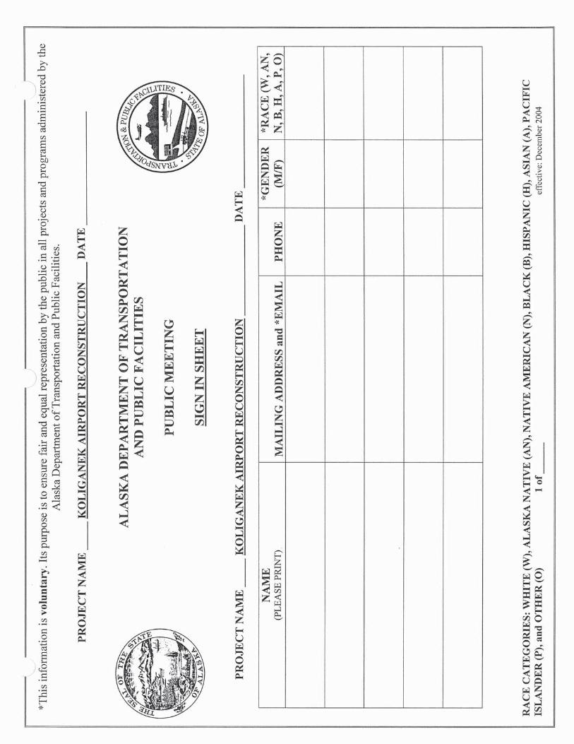
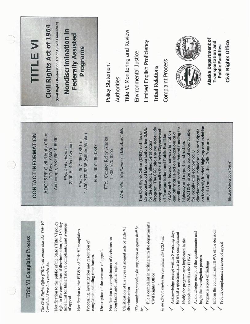


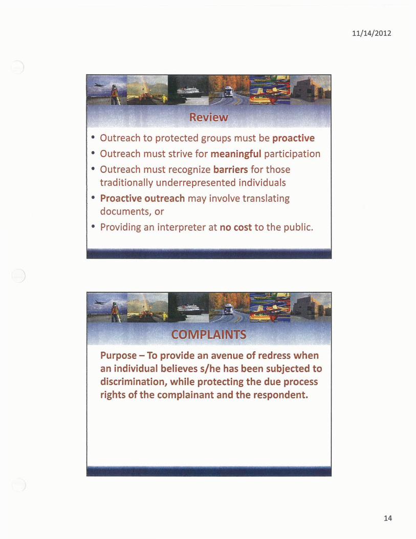
STATE OF ALASKADEPARTMENT OF TRANSPORTATION & PUBLIC FACILITIESCENTRAL REGION STATEWIDE DESIGN & ENGINEERING SERVICESPRELIMINARY DESIGN & ENVIRONMENTAL
MEETING RECORD
DATE:TIME:
LOCATION:PROJECT:
PROJECT NO.:SUBJECT:
PARTICIPANTS:NOTED BY:
CC:
Miscellaneous
Table of Contents
Staff Meeting Special Topic Presentation Guidelines
Glossary and Acronyms
MISC
ELLAN
EOU
S
Revised October 2012
Staff Meeting Special Topic Presentation Guidelines
Since the types of impacts our project have is unpredictable, often times analysts may miss out on learning opportunities because some issues never come up on their projects. To help analysts learn about topics they’re specifically interested in, they’re allowed to pick a topic to research and share at a staff meeting. So, the purpose of sharing a special topic is to provide analysts (i.e. the facilitator) an opportunity to 1) research a topic of interest they might not typically get to learn about and 2) Share what they learned with the group so we can all learn. The purpose is NOT to out-do the previous presenter, present a topic in its entirety, or provide an in-depth training. Analysts are encouraged to have fun with it and learn something new.
In general, here are the guidelines you should follow:
1. Special topics should be project-related lessons learned or unique situations or decisions, regulations, trainings, or other work-related topics of interest
2. Keep it Simple - max time 10 minutes3. Presentation does not have to be all talking, can be an activity or game 4. Powerpoint optional – if used, limit number of slides with text and use more for photos,
graphics, or visual aids
1
GLOSSARYA-weighted Decibel (dBA) -- An acoustic unit of measure which approximates the frequency response of the human ear. Normal speech at three feet is approximately 65 dBA.
A-weighting -- The sound pressure level which has been filtered or weighted to approximate the human ear's perception of sound.
AASHTO – American Association of State Highway and Transportation Officials. An organization of State officals that establish and update highway design standards. All 50 states are members of this organization. The AASHTO Standards have been adopted by law in the State of Alaska.
ACHP – Advisory Council on Historic Preservation
ADEC or DEC– Alaska Department of Environmental Conservation
ADF&G or F&G – Alaska Department of Fish and Game
ADGC or DGC – Alaska Division of Governmental Coordination. Under the Office of the Governor. Provides certification for consistency with Alaska Coastal Zone Management Program as well as any local program. ADGC provides certification for projects needing a federal permit or more than one State permit.
ADNR or DNR – Alaska Department of Natural Resources
ADOT&PF or DOT&PF – Alaska Department of Transportation and Public Facilities
ADT – Average Daily Traffic
Air Carrier - A company engaged in providing scheduled commercial air transportation services.
Air Route Traffic Control Center (ARTCC) -- An FAA facility established to provide air traffic control service to aircraft operating on an IFR flight plan within controlled airspace during the enroute portion of a flight.
Air Traffic Control (ATC) -- Division of the Federal Aviation Administration responsible for the safe guiding of pilots in their transit of airspace and on the ground at towered airports.
Airport Master Plan -- A long-term (usually 20-year) comprehensive development plan for an airport. Typical elements of a Master Plan include: activity forecasts, airport layout plan, development recommendations with cost estimates and an environmental overview.
AMATS – Anchorage Metropolitan Area Transportation Study
2
Approach Control Descent Area (ACDA) -- Airspace restrictions established to provide for the separation of landing aircraft from departing aircraft.
Approach Procedure -- A general procedure for how an aircraft comes in for a landing at an airport. Includes both visual and instrument approaches.
ASTM -- American Society for Testing and Materials
BMP – Best Management Practices. ADOT&PF guidance for erosion and pollution control. Includes installation of silt fences and temporary drainage structure, mulching, or matting of exposed soils, revegetation, and work scheduling to avoid erosion and pollution.
BTEX – Benzene, Toluene, Ethylbenzene, Xyelene. Volatile components of petroleum products often used in field measurements of contamination.
CAA – Clean Air Act of 1977
Catchbasin: A constructed device to collect surface storm water runoff from a gutter or median into an enclosed storm drainage system. Catch basins commonly have a grated inlet with or without a sump.
Catchbasin manhole: A constructed device to collect surface stormwater runoff along an enclosed storm drainage system. Catch basin manholes differ from CatchBasins in that they provide: · Access to inlet pipes for inspection and maintenance· Changes in horizontal storm pipe direction · Junctions for connecting pipes · Junctions for changes in pipe sizes · Junctions for changes in pipe depths
CAAA – Clean Air Act Amendments of 1990
CE – Categorical Exclusion. An environmental document that is written when no significant impact is associated with a construction project. Fulfills NEPA requirements. See 23 CFR 771.
CEQ – Council on Environmental Quality. A presidential council of three persons tasked with specific duties in regard to the environment. CEQ regulations implement NEPA.
3
CERCLA – Comprehensive Environmental Response, Compensation, and Liability Act of 1980. Also known as Superfund. Amended in 1986 by SARA. The CERCLA gives the federal government the power to respond to releases, or threatened releases, of any hazardous substance into the environment as well as to a release of a pollutant or contaminant that may present an imminent and substantial danger to public health or welfare. The CERCLA established a Hazardous Substance Trust Fund (Superfund) available to finance responses taken by the federal government.
CFR – Code of Federal Regulations
CFR – Crash, Fire and Rescue
CMAQ – Congestion Mitigation and Air Quality Improvement Program. A categorical Federal-aid funding program created with ISTEA. Directs funding to projects that contribute to meeting National air quality standards. CMAQ funds generally may not be used for projects that result in the construction of new capacity improvements for single occupant vehicles.
CO – carbon monoxide. A colorless, odor-free, tastless gas formed in large part by incomplete combustion of fuel.
COE 404 – U.S. Corps of Engineers, Section 404 of the Clean Water Act. Permit for fill placement in wetlands.
COE Nationwide Permit (NWP) – Section 404 permits that have been exempted from full review due to the limited potential for environmental harm from the wetland fill.
COE Section 10 – Corps or Engineers, Section 10 of the Rivers and Harbor Act. Permif for dredging or filling in navigable waters.
CPESC (Certified Professional of Erosion & Sediment Control) -- A recognized specialist in erosion and sediment control.
Day-Night Average Sound Level (DNL or Ldn) -- The Federal Aviation Administration's standard noise descriptor, measured in A-weighted decibels (dBA), that represents a cumulative, integrated, average sound level. Based on the equivalent A-weighted sound level (Leq) with a 10-decibel penalty for noise events in the nighttime hours (10:00 p.m. to 7:00 a.m.).
Decibel (dB) -- The smallest unit of measure of acoustic energy that a person can distinguish. A doubling of loudness is generally approximated by a change of about 10 decibels. A doubling of acoustic energy occurs at 3 decibels.
Decision Height (DH) -- The altitude at which a decision must be made, during an instrument approach, to either continue the approach or execute a missed approach.
DEIS – Draft Environmental Impact Statement (see EIS).
Departure Procedure -- A general procedure for how an aircraft takes off and climbs to a designated altitude. There are various generalized and specialized departure procedures. Procedures usually describe various velocities, altitudes, or rates of climb that are benchmarks to be followed.
Departure Profile -- The two-dimensional description (altitude and distance from brake release) of the aircraft departure trajectory. Various points along the trajectory may be associated with specific departure procedures.
Displaced Threshold -- A threshold located on the runway at a point other than at the end or beginning of the full strength pavement.
DNL -- See Day-Night Average Sound Level.
DOI – U.S. Department of Interior
DOT -- U.S. Department of Transportation.
EA – Environmental Assessment. An environmental document that is written when the environmental impacts of a construction project are unknown. This document results in a decision to write an EIS if the potential for significant impacts exist or a Finding of No Significant Impact (FONSI) is issued and the EA/FONSI becomes the final environmental document. Fulfills NEPA requirements.
EIS – Environmental Impact Statement. An environmental document that is written when a significant environmental impact or impacts is thought to be a result of a construction project. Fulfills NEPA requirements.
Engine Run-up -- A required test procedure which is performed after specified aircraft engine maintenance repairs.
Environmental Commitments – Commitments that have been made by ADOT&PF as part of the project development/NEPA process. These commitments are contained in the environmental specification sections and often are incorporated as permit stipulations. An additional memo is prepared with a list of these commitments for our Construction Engineer and the Contractor.
EO – Executive Order.
EPA – U.S. Environmental Protection Agency. The Federal regulatory agency responsible for administering and enforcement of Federal environmental laws including the CAA, CWA and others.
Equivalent A-weighted Sound Level (Leq) -- The average (on an energy basis) noise level integrated over some specified period of time.
FAA -- Federal Aviation Administration (part of the U.S. Department of Transportation).
FAR -- See Federal Aviation Regulations.
FAST – Fixed Anti-Icing Spray Technology. Means to proactively fight ice and snow conditions on roads and bridges before an event.
Federal Aviation Regulations (FAR) -- The body of Federal regulations relating to aviation. Published as Title 14 of the Code of Federal Regulations.
FEMA – Flood Emergency Management Agency.
FHWA – Federal Highway Administration. An agency of the USDOT that funds highway planning and programs.
Flight Heading -- The direction in which the nose of the airplane points during flight; this is usually expressed by reference to a compass reading from 1o to 360o.
Flight Track -- The path along the ground followed by an aircraft in flight.
FONSI – Finding of No Significant Impact. A decision document that is issued when an EA determines that no significant impact will occur.
General Aviation (GA) -- All civil aviation except commercial carriers.
Glide Slope (GS) -- An instrument landing system facility providing vertical guidance for aircraft during approach and landing.
HABS – Historic American Buildings Survey
HAER – Historic American Engineering Record
Head-to-head Operations -- Taking off in one direction and landing in the opposite direction.
HOV – High Occupancy Vehicle. A motor vehicle carrying a sufficient number or passengers to qualify for occupying a lane which is reserved for movement of a large number of people.
Hub -- 1) As defined by the Federal Aviation Administration, an airport enplaning a certain percentage of the total passengers in scheduled service in the nation. A small hub enplanes from 0.25 percent to 0.5 percent, a medium hub 0.5 percent to 1 percent, and a large hub enplanes 1 percent or more. 2) In airline operations, the center of a "hub and spoke" operation, in which an airline feeds passengers from a number of points (the spokes) to one airport (the hub) to carry them beyond the hub on fewer flights.
IFR -- Sees Instrument Flight Rules.
Instrument Approach -- An approach to a landing area guided by instruments in the aircraft and
on the ground, as opposed to a visual approach.
Instrument Flight Rules (IFR) -- Federal procedures, using instruments in the aircraft and on the ground, which pilots must follow when weather conditions are below the minimums prescribed for visual flight conditions (see also Visual Flight Rules).
ILS -- See Instrument Landing System.
Instrument Landing System (ILS) -- Instrument landing aid providing altitude and directional guidance.
Instrument Meteorological Conditions (IMC) -- Weather conditions expressed in terms of visibility, distance from clouds, and cloud ceilings during which all aircraft are required to operate using instrument flight rules (IFR).
Integrated Noise Model (INM) -- The Federal Aviation Administration-specified computer model for assessing airport noise impacts.
ISA – Initial Site Assessment. Sometimes referred to as a Phase I investigation. The ISA is used to help determine whether a hazardous waste potential exists at a site or parcel, and if a PSI or Phase II should be preformed.
ISTEA – Intermodal Surface Transportation Efficiency Act of December 18, 1991. Federal law restructuring the Federal Highway program by creating broad funding categories, including the Surface Transportation Program (STP) and the National Highway System (NHS). The emphasis of ISTEA was on preservation, operation, and better management of existing transportation facilities. Superceded by TEA- 21 (1998) and the upcoming TEA3 (2003).
Knots -- Airspeed measured as the distance in nautical miles covered in 1 hour.
L10 -- The sound level exceeded 10 percent of the time.
Ldn -- See Day-Night Average Sound Level.
Leq -- Equivalent A-weighted sound level.
Lmax -- Maximum A-weighted sound level.
LOS – Level of Service. A qualitative rating of the effectiveness of a highway in serving traffic. Measured in terms of operating conditions.
LSR&T – Local Service Roads and Trails program
LUST – Leaking Underground Storage Tank
Manhole: A constructed device that provides an access point along an enclosed storm drainage
system. Manholes are defined as performing the following functions: · Access at desired intervals for system inspection and maintenance · Changes in horizontal storm pipe direction · Junctions for connecting pipes · Junctions for changes in pipe sizes · Junctions for changes in pipe depths · Vertical drops along a pipe system.
Mean Sea Level (MSL) -- The average height of the surface of the sea for all stages of the tide, used as a reference for elevations. Also called sea level datum.
MOA – Municapility of Anchorage
MOA – Memorandum of Agreement
MOA GP – Municipality of Anchorage General Permit. For fill in wetlands that are classified as Developable in the Anchorage Wetlands Management Plan.
MOU – Memorandum of Understanding
MPO – Metropolitan Planning Organization. The organizational entity designated by law with lead responsibility for developing transportation plans and programs for urbanized areas with populations of 50,000 or more (ie Anchorage). MPOs are established with agreement of the Governor and units of general purpose local government which together represent 75% of the affected population of an urbanized area.
MS4 - Municipal Separate Storm Sewer System. Part of the NPDES Phase II mandate.
NAAQS – National Ambient Air Quality Standards. Federal standards that set allowable concentrations and exposure limits for various pollutants. The EPA developed the standards in response to a requirement of the CAA.
National Plan of Integrated Airport Systems (NPIAS) -- A plan prepared by the Secretary of Transportation for the development of public use airports in the United States.
Nautical Mile -- A measure of distance equal to 1 minute of arc on the earth's surface (approximately 6,000 feet).
NAVAIDS -- Visual and electronic aids to air navigation.
NEPA – National Environmental Policy Act of 1969, as amended (42 U.S.C. 4321 et seq.) act that requires consideration of environmental factors through systematic interdisciplinary approach in all federally funded projects.
NHPA – National Historic Preservation Act
NHS – National Highway System. The national transportation system designated by Congress that includes the Interstate Highway System and other nationally significant roads for interstate and interregional travel, national defense, intermodal connection, and international commerce. A fund of money with an 80 percent federal share whose purpose is to focus resources on roads that aremost important to interstate travel and national defense.
NIOSH – National Institute for Occupational Safety and Health
Noise Abatement -- Measures taken to reduce the off-airport impacts of aircraft noise.
Noise Contour -- A line depicting equal levels of sound exposure, usually drawn on a base map of the area.
NMFS – National Marine Fisheries Service
Non-Attainment Area – Area that does not meet EPA ambient air quality standards for CO or dust. Part of Anchorage is in non-attainment area for CO.
NPDES – National Pollutant Discharge Elimination System. General permit authorized by EPA for the protection of water quality.
NPS – National Park Service
NTP – Notice to Proceed. Written notice to a Contractor to begin contract work.
Official Airlines Guide (OAG) -- Listing of schedules and policies of commercial U.S. airlines.
Operation -- A landing or a takeoff by an aircraft.
OSHA – Occupational Safety and Health Administration Act of 1971.
Part 36 -- FAR Part 36 establishes the aircraft noise certification sound levels and associated requirements for certificated aircraft.
Part 91 -- FAR Part 91 are general operating rules which include a schedule for all air carrier jets to meet FAR Part 36 Stage 3 requirements.
Part 150 -- FAR Part 150 establishes a uniform national metric for describing aircraft noise and Federal Aviation Administration program guidelines for airport noise compatibility planning.
PD&E – Preliminary Design & Environmental Section of ADOT&PF.
PID – Photoionization Detector. A device that breaks down or ionizes volatile organiz vapors with light energy and measures their concentration in the air. Often used in field equipment that does not separate the components of the fuel. Usually a single estimate of total vapor concentration is provided.
PM-10 – Particulate material in the atmosphere that measures less than 10 microns in size. (Note: A micron is one millionth of a meter.) Particulate matter this size is too small to be filter by the nose and lungs.
Precision Approach Path Indicator (PAPI) -- A landing aid which provides visual approach slope guidance to a runway.
Preferential Runway System (PRS) -- A system of runway use which attempts to route as muchtraffic as possible over the least noise-sensitive areas around the airport.
PSI – Preliminary Site Investigation. Also known as a Phase II. Is only conducted when an ISA (Phase I) reveals known or potential hazardous waste sites.
QAPP – Quality Assurance Project Plan. A plan that describes protocols necessary to achieve the data quality objectives defined for a remedial investigation.
QA/QC – Quality Assurance/Quality Control
RCRA – Resource Conservation and Recovery Act. A federal law roviding the development of federal and state programs for the regulation of land disposal of waste materials and the recover of materials and energy resources. The Act regulates not only the generation, transportation, treatment, storage and disposal of hazardous wastes, but also solid waste disposal facilities.
Reverse Thrust -- a procedure utilized by a pilot which redirects engine thrust to slow aircraft and is used frequently after touchdown on landings to rapidly decelerate the aircraft.
RFP – Request for Proposal
ROD – Record of Decision. Reason and summary of a project if an EIS has been done.
Runway Protection Zone (RPZ) -- An area at the end of a runway maintained clear of development or uses which would lead to congregation of people (formerly called the clear zone).
Runway Use System (RUS) -- A system of runway use designed to redistribute traffic around the airport for noise compatibility purposes; can also be called preferential runway system.
Runway Visual Range (RVR) -- An instrumentally-derived value that represents the horizontal distance a pilot will see down the runway from the approach end.
RWIS – Road Weather Information Systems – instruments that give you weather information
Section 4(f) – of the Department of Transportation Act. Addresses preservation of publicly owned parklands, waterfowl and wildlife refuges, and all historic areas. These lands must be avoided unless no prudent and feasible alternative exists.
Section 6(f) – Addressed lands obtained with money from the Land and Water Conservation Fund (LWCF). The LWCF (established in 1965) provides funding to the states for purchasing or improving lands to ensure access to outdoor recreation resources. Replacement of 6(f) lands is required if taken for purposes other than recreation.
Section 106 – Process by which appropriate mitigation for Section 4(f) historical resources is derived.
Section 401 – Section of the Clean Water Act, Alaska Department of Environmental Conservation. Certification for any work requiring a Section 404 permit.
SHPO – State Historic Preservation Officer. Reviews projects for potential effects on historic properties and cultural resources.
SIP – State Implementation Plan. A plan mandated by the CAA that contrains procedures to monitor, control, maintain, and enforce compliance with the NAAQS.
Sound Exposure Level (SEL) - A measure of the total sound energy of an event taking into account amplitude, frequency, and duration.
Stage 1, 2, 3 Aircraft -- Classification of aircraft based on noise emissions, as defined in Federal Aviation Regulation Part 36. Stage 1 aircraft are the noisiest; Stage 3 are the quietest.
STP – Surface Transportation Program. The most flexible federal highway funding program bywhich 80 percent is the federal share.
TACAN -- Tactical Air Navigation. A navigational system used by the military. TACAN provides both azimuth and distance information to a receiver on board an aircraft.
TCLP – Toxicity Characteristic Leachate Procedure
TCMs – Transportation Control Measures. Actions to adjust traffic patterns or reduce vehicle use to reduce air pollutant emissions. These may include HOV lanes, provision of bicycle facilities, ridesharing, telecommuting, etc. Such actions many be included in a SIP if need to demonstrate attainment of the NAAQS. See CAA Section 108(f)(1)(A).
TEA-21 – Federal legislation initiated by the U.S. Congress in 1998 to provide various funding programs for community enhancements, transit, air quality (CMAQ), TCSP, etc for fiscal years 1998-2003.. Started (thru ISTEA) to devolve more federal transportation funds down to the local and regional level. The passage of the bill represented a 40 percent increase in federal funds for transportation programs.
Terminal Control Area (TCA) -- Controlled airspace surrounding one or more airports and extending from the surface or some higher altitude within which all aircraft (regardless of the type of flight rules in effect, i.e. VFR or IFR) are subject to specified operation, communication, minimum equipment and pilot qualification regulations as specified in 14 CFR Part 91.
Terminal Instrument Procedures (TERPS) -- Federal Aviation Administration design criteria for determining minimums of ceiling and visibility for all types of instrument approaches.
Threshold -- The beginning of that portion of the runway available for landing.
Threshold Crossing Height (TCH) -- The height above the ground at which an aircraft on the Glide Slope crosses the runway threshold.
Time Above (TA) -- The total time that a particular A-weighted sound level is exceeded during a specified period of time.
TIP – Transportation Improvement Program. A multi-year prioritized list of projects (3 year minimum) proposed to be funded or approved by FHWA or FTA.
Title 16 – Department of Fish and Game, Title 16.05.840. Permit for inwater work in anadromous fish streams.
TORA – Transfer of responsibility agreement
TRM – turf reinforcement mat
Traffic Calming -- The combination of mainly physical measures (speed bumps, roundabouts, signage, streetscape) that reduce the negative effects of motor vehicle use, alter driver behavior and improve conditions for non-motorized street users.
Transportation and Community and System Preservation (TCSP) -- Pilot program that is part of TEA 21, $25 million for fiscal 2002, fairly flexible program, competitive program grant.
TSM – Transportation System Management. A part of the transportation planning process that identifies short-range, low-cost improvements for the urban transportation system.
Turboprop Aircraft -- An aircraft whose main propulsive force is provided by a propeller driven by a gas turbine. Additional propulsive force may be provided by gas discharged from the turbine exhaust.
USF&WS – U.S. Fish and Wildlife Service
USGS – U.S. Geological Service
UST – Underground Storage Tank. Any tank, including underground piping connected to the tank which is 10 percent or more beneath the surface of the ground.
VFR -- See Visual Flight Rules.
Visual Approach -- An approach to a landing area following visual flight rules.
Visual Approach Slope Indicators (VASI) -- A landing aid which provides visual approach slope guidance to a runway.
Visual Flight Rules (VFR) -- Federal procedures which pilots may use when weather conditions are above the minimums prescribed for visual flight conditions. Under these rules, pilots may fly with visual reference to the ground and without reference to radio navigational aids (see also Instrument Flight Rules).
Visual Meteorological Conditions (VMC) -- Weather conditions equal to or greater than those specified in 14 CFR 91.155 for aircraft operations under Visual Flight Rules (VFR).
VMT – Vehicle Miles Traveled. A measurement of the total miles traveled by all vehicles in an area.
VORTAC -- Very High Frequency Omnidirectional Range with Tactical Air Navigation. A navigational radio station which provides magnetic bearing and distance (DME) from the station. The most common form of radio navigation currently in use.
Wetlands -- Those areas that are inundated or saturated by surface or groundwater at a frequency and duration sufficient to support, and under normal circumstances do support, a prevalence of vegetation typically adapted for life in saturated soil conditions. Wetlands generally include swamps, marshes, bogs, and similar areas.
Widebody Aircraft -- Refers to aircraft which typically are configured internally for a seating capacity of over 200 passengers with twin aisles and have gross weights in excess of 300,000 pounds. These are considered "heavy" aircraft for airfield capacity and ATC separation requirements.
Wilderness -- The Wilderness Act (1964) defines wilderness as areas that:
� Are affected primarily by the forces of nature, where man is a visitor who does not remain.� Possess outstanding opportunities for solitude or a primitive and unconfined type of recreation.� Are undeveloped, federally-owned, and generally over 5,000 acres (2,020 hectares) in size.� Are protected and managed as to allow natural ecological processes to operate freely.� May contain ecological, geological, or other features of scientific, educational, scenic, or historical value.� Are formally designated by Congress as wilderness.
Aircraft Types
A320 -- a twin-engined, Stage 3 aircraft manufactured by Airbus Industries which seats approximately 150 passengers and generally is used for short to medium-haul (300-1500 miles) stage lengths.

BAC-111 -- a twin-engined Stage 2 aircraft manufactured by British Aerospace which seats less than 100 passengers and generally is used for short-haul (300-600 mile) stage lengths.
B-727-100 or 727-200 -- a three-engined, Stage 2 aircraft (unless modified to meet Stage 3 specifications) manufactured by Boeing which seats approximately 145 passengers and generally is used in medium-haul (400-1,500 mile) stage lengths.
B-737-100 or 737-200 -- a twin-engined, Stage 2 aircraft (unless modified to meet Stage 3 specifications) manufactured by Boeing which seats approximately 120 passengers and generally is used in short-to medium-haul (300-1,500 mile) stage lengths.
B-737-300, B-737-400, or B-737-500 -- a twin-engined, Stage 3 aircraft manufactured by Boeing which seats approximately 130 passengers and generally is used in short to medium-haul (300-1,500 mile) stage lengths.
B-747 -- a four-engined, generally Stage 3 widebody aircraft which seats approximately 400 passengers and is used for long-haul (1,500-miles plus) stage lengths and freight.
B-757 -- a twin-engined, Stage 3 aircraft manufactured by Boeing which seats approximately 185 passengers and generally is used in medium-haul (600-2,000 mile) stage lengths.
B-767 -- a twin-engined, Stage-3 widebody aircraft manufactured by Boeing which seats 230 passengers and generally is used medium to long haul (600-mile plus) stage lengths.
Bae146 -- a twin-engined, Stage 3 aircraft manufactured by British Aerospace which seats approximately 100 passengers and generally is used for short-haul (300-600 mile) stage lengths.
DC-9 -- a twin-engined, Stage 2 aircraft manufactured by McDonnell Douglas which seats approximately 120 passengers and generally is used for short- and medium-haul (300-1,500 mile) stage lengths.
F-28 -- a twin-engined Stage 2 aircraft manufactured by Fokker which seats less than 100 passengers and generally is used for short-haul (300-600 mile) stage lengths.
F-100 -- a twin-engined Stage 3 aircraft manufactured by Fokker which seats approximately 120 passengers and generally is used for short-and medium-haul (300-1,500 mile) stage lengths.
MD-80 -- a twin-engined Stage 3 aircraft manufactured by McDonnell Douglas which seats approximately 180 passengers and generally is used for short- and medium-haul (300-1,500 mile) stage lengths.
H:environ docs/glossary
January 9, 2002 1
THE TRANSPAC ACRONYM DECODER RING
Acronyms/Transportation Terms
AA - Alternatives Analysis: An analysis of the engineering and financial feasibility of alternatives under consideration for a rail extension or other major transit construction project, required before federal monies can be allocated to a project. An AA is usually done in conjunction with a DEIS and a DEIR, leading to a mix that boils over into alphabet soup: AA/DEIS/DEIR study. The same type of analysis for road projects is called an MIS (Major Investment Study).
AASHTO - American Association of State Highway and Transportation Officials: Aninterest group based in Washington, D.C., whose membership is obvious from the name. Involved in research, advocacy and technical assistance.
ABAG - Association of Bay Area Governments: A voluntary association of counties and cities (otherwise known as a Council of Governments, COG) that is the land-use planning agency for the nine-county San Francisco Bay Area. Also provides demographic, financial, administrative, training and conference services to local governments and businesses. A member sits on MTC. ABAG publishes forecasts of projected growth for the region and adopts housing need numbers which are used in Housing Elements.
Accessibility: The extent to which facilities are usable by people with disabilities, including wheelchair users.
ACE (Altamont Commuter Express): A commuter train service providing trips between Stockton and San Jose.
Action Plan: A document prepared by a Regional Transportation Planning Committee that includes: (1) a specific program for each designated Route of Regional Significance consisting of traffic service objectives and actions and implementing responsibilities; (2) regional actions for reducing congestion such as land use policy changes and demand management strategies; and (3) a process for monitoring and review of activities that might affect performance of the regional transportation system. (Detailed information about Action Plan requirements is included in the Authority's Growth Management Program Implementation Documents).
AC Transit: A provider of bus service in Alameda and Contra Costa Counties. Berkeley is located within AC Transit’s service area.
ADA - Americans With Disabilities Act: Federal civil rights legislation for disabled persons passed in 1990; calls on public transit systems to make their services more fully accessible as well as to underwrite a parallel network of paratransit service.
January 9, 2002 2
ADT - Average Daily Traffic: The average number of vehicles passing a specified point during a 24-hour period.
Alternative Modes or Alternative Transportation: Any way of getting from Point A to Point B other than driving alone in a car, van or truck. Alternative modes include carpooling, vanpooling, bicycling, walking, or riding transit.
APCC - Action Plan Coordinating Committee: Refers to a CCTA committee of the technical staff from each RTPC responsible for the development of each subregion's Action Plan for Routes of Regional Significance. APCC also works with the TDM Program Managers on transportation demand management projects and programs for Contra Costa.
APCC/TDM Program Managers: A joint committee of Action Plan Managers and TDM Program Managers charged with implementation of the Contra Costa Commute Alternative Network, implementation of BAAQMD requirements for TFCA funding of TSM programs and recommendations on funding of TSM projects.
APTA - American Public Transit Association: An international lobbying and research organization for transit operators and suppliers based in Washington, D.C.
APTS - advanced public transportation systems. See IVHS.
AQAP - Air Quality Attainment Plan: The plan for attainment of state air quality standards, as required by the California Clean Air Act of 1988. It is adopted by air quality districts and subject to approval by the State Air Resources Board.
ARB - Air Resources Board, aka CARB: The state agency responsible for adopting state air quality standards, establishing emission standards for new cars sold in the state, and overseeing activities of regional and local air pollution control agencies.
Arterial Streets: provide for traffic movement through a city or between cities.
ATC - also known as FasTrak automated toll collection, aka electronic toll collection (IVHS term): Now even law-abiding commuters will be able to zoom past the toll takers. Sensors at toll booths will pick up billing information from devices installed in cars, allowing motorists to drive through without stopping. The amount of the toll is automatically deducted from a prepaid account or billed to the vehicle's owner.
ATIS - advanced traveler information systems (IVHS term): No more fumbling with the map, no more dreading unknown traffic hazards that lurk ahead of you -- these innovations provide travelers with information to help in trip planning and changing course en route to bypass congestion, e.g., broadcast traffic reports, in-car computerized maps and highway

January 9, 2002 3
Changeable Message Signs (CMS). Also can include automated transit trip planning and automated rideshare matching.
ATMS - advanced traffic management systems (IVHS term): A high-tech version of the old-fashioned traffic cop, ATMS uses a variety of means to more efficiently manage traffic. It can include roadside sensors, ramp metering, HOV lanes and synchronized traffic signals that respond to traffic flows. May also be known as "smart corridor".
Authority - Contra Costa Transportation Authority aka CCTA.
AVCS - advanced vehicle control system (IVHS term): New techniques to ease the stresses and strains of driving are evolving, possibly leading to the day when you may be able to sit back and leave your car in charge. AVCS spans the gamut from ordinary cruise control to "smart cruise control" that helps maintain safe following distance to, researchers hope, "platooning"---the ability to electronically link and guide a dense pack of cars moving in formation at high speed.
Average Daily Traffic: It is the total volume of traffic passing a single point of a roadway in both directions for a 24-hour period.
Average Travel Time: It is the time spent by drivers on road segment between two locations.
AVI - automated vehicle identification (IVHS term): You won't even be asked to flash your driver's license when this system is in place. It combines an in-car device as well as a roadside receiver that will identify vehicles for purposes of automated toll collection, stolen vehicle recovery, etc.
AVL - automated vehicle location system (IVHS term): This computerized system can tell you the answer: It employs satellites and other technologies to track vehicles in a fleet, assisting with dispatching and other applications. Currently used by truckers and courier services, it could be used in the future by transit systems to provide real-time schedule information for patrons, and will help the CHP monitor FSP tow trucks.
AVO - average vehicle occupancy: The number of people traveling by private passenger vehicles divided by the number of vehicles used.
AVR - average vehicle ridership: The ratio of all people traveling by any mode, including cars, buses, trains and bicycles (or telecommuting), in a given area during a given time period to the number of cars on the road. A key measure of the efficiency and effectiveness of a transportation network--the higher the AVR, the better you're doing in terms of energy consumption and air pollution.
January 9, 2002 4
AWSC - All way stop controlled.
Basic Routes: All local roads not designated as Routes of Regional Significance. Measure C level-of-service standards, which are tied to adjoining land uses, apply to all signalized intersections on Basic Routes.
BAAQMD - Bay Area Air Quality Management District: Since the acronym seems to take longer to say than the full name akas include the Air District or the Air Board. The regional agency created by the state legislature for the Bay Area air basin (Alameda, CCC, half of Solano, half of Sonoma, Marin, Napa, SF, San Mateo, Santa Clara counties) is charged with implementation of the Clean Air Act. Polices industry to keep air pollution in check and implements certain Transportation Control Measures (TCMs). The Air District prepares the CAP with input from ABAG and MTC.
Bay Area Partnership: This group often referred to as “The Partnership” is a confederation of the top staff of various regional transportation agencies (MTC, public transit operators, county CMAs, city and county public works depts., ports, Caltrans, U.S. DOT, environmental protection agencies). The Partnership works by consensus to improve the overall efficiency and operation of the Bay Area’s transportation network, including developing strategies for financing transportation improvements.
BART (San Francisco Bay Area Rapid Transit District): A heavy rail commuter system serving Alameda, Contra Costa, San Francisco and San Mateo counties in the San Francisco Bay Area. An extension to the San Francisco Airport is under construction and an extension Fremont to San Jose is being discussed. Other extensions to Eastern Contra Costa and the Tri-Valley, etc., called eBART and tBART, are under analysis. These extensions may use a lightweight, self-propelled diesel multiple-unit rail vehicle (DMU) with a 135 seat capacity and a 75 mph maximum speed. For more information about BART, check out www. bart.gov.
BATA – Bay Area Toll Authority: Created by the State legislature to administer the base $1 toll from the Bay Area’s seven state-owned (which one isn’t state-owned?) toll bridges, a responsibility previously held by the California Transportation Commission. BATA operations began on 1/1/98.
BCDC - Bay Conservation and Development Commission: A state-established agency with jurisdiction over filling and dredging of San Francisco Bay and jurisdiction over development within 100 feet of the Bay; a representative sits on MTC.
Bicycle Facilities: They are categorized according to the degree to which bicycle circulation is separated from vehicular circulation.
January 9, 2002 5
Bid Targets: Based on the county minimum formula, each county is limited in the amount of funds that can be requested from the state in a given STIP cycle. This limit is called the bid target. In a multi-county region such as MTC, bid targets can be pooled to give additional flexibility at the regional level. MTC also uses bid targets for the federal Surface Transportation Program and Congestion Mitigation and Air Quality program under the ISTEA and TEA-21 federal funding programs.
Bill: A proposed law introduced during a session for consideration by the Legislature and identified as AB or SB (indicating whether the amendment was introduced on the Assembly or Senate side of the California legislature) plus a numeric identification in order of presentation. Also a reference that may include joint and concurrent resolutions and constitutional amendments.
BOS - Board of Supervisors: BOS reps refers to those Commissioners appointed by the Board of Supervisors.
CAA - Clean Air Act, aka FCAA: Federal legislation that sets national air quality standards; requires each state with areas that have not met federal air quality standards to prepare a SIP. The sweeping 1990 amendments to the CAA, sometimes referred to as CAAA, established new air quality requirements for the development of metropolitan transportation plans and programs.
CAC - Citizens Advisory Committee
Caltrans - California State Department of Transportation: Owner/operator of the state highway system.
CAP - (Bay Area) Clean Air Plan: A regional plan adopted by the BAAQMD in response to the CCAA to meet state standards for ozone and carbon monoxide pollution (which in the case of the ozone standard is more stringent than the federal standard). Includes TCMs to reduce vehicle emissions as well as controls on stationary sources of pollution like factories.
Capital Outlay: "All money allocated by the California Transportation Commission from the State Highway Account, and the net revenues from the passenger rail bond transportation Bond Fund for streets, highways, guideways, and rail, but not including allocations or expenditures for projects for maintenance, traffic system management, intercity rail and the state-local partnership program, which are expended for construction, including the acquisition of rights-of-way, reconstruction, and construction engineering." (Streets and Highways Code, Section 188)
Capital Priorities: A process used by MTC to evaluate and prioritize transit projects in the region. All sources of transit funding, including federal grants, state programs, and other
January 9, 2002 6
sources are considered. This process involves all of the transit operators in the region, including bus, rail, and ferries.
CARB - California Air Resources Board: See ARB.
Carpool: Two to six people traveling together in the same vehicle for the majority of the trip.
CBD - Central Business District
CCAA - California Clean Air Act of 1988: Why we do a CAP.
CCCAN - Contra Costa Commute Alternative Network: In order to provide a more cohesive and singular identity for the purposes of representing the combined TDM implementation efforts, the three TDM Programs (TRANSPAC/TRANSPLAN, WCCTAC and SWAT) cooperatively developed the Contra Costa Commute Alternative Network (CCCAN). This umbrella program encompasses all of the Countywide Programs, and includes projects which affect all commute alternative modes.
CCCFCWD - Contra Costa County Flood Control and Water Conservation District
CCCTA - Central Contra Costa Transit Authority: Also known as County Connection or "triple CTA", it is the Central County bus company. It provides service within the Central County and San Ramon Valley areas with connections at BART stations and to other bus carriers at key transfer points. It is not the CCTA - the Contra Costa Transportation Authority.
Constitutional Amendment: A resolution proposing a change to the California Constitution. It may be presented by the Legislature or by initiative and is adopted upon voter approval at a statewide election. May be referred to ACA or SCA indicating whether the amendment was introduced on the Assembly or Senate side of the California legislature plus a numeric identification in order of presentation.
CCTA - Contra Costa Transportation Authority: (Not to be confused with the bus company defined above) A Transportation Authority established pursuant to SB 142. CCTA may also be referred to as the Authority or the Partnership and occasionally is incorrectly referred to as TRANSPAC (see below). CCTA should not be confused with the other CCTA, Contra Costa Taxpayers' Association or as noted CCCTA, the Central Contra Costa Transit Authority. CCTA also functions as Contra Costa's Congestion Management Agency (CMA) - see below.
January 9, 2002 7
CCTA Subcommittees:
APC - Administration and Programs Committee - (formerly known as the Administrative Committee and before that the Administrative Oversight Committee or ATC). Responsible for administrative, legal, legislative, personnel and office matters for the Commission as well as project and program development, allocation recommendations etc. In October, 1996 the CCTA approved the merger of the Projects and Programs Committee and the Administrative Committee.
CAC - Citizens' Advisory Committee. CAC is a citizens' advisory committee. Representatives are appointed by each local jurisdiction (20) and seven (7) by the Authority.
Executive Committee - empowered to act on CCTA issues in an emergency.
PC - Planning Committee. A subcommittee of the Authority dealing with growth management and other planning issues. The Growth Management Task Force (GMF) comprised of Advisory Committee members, city managers, city and county planners and technical staff from the Technical Coordinating Committee (TCC) completed its task at the end of 1996 and was disbanded. (Formerly known as the Planning and Governmental Affairs Committee.)
TCC - Technical Coordinating Committee of the Contra Costa Transportation Authority. The TCC is composed of members of the city and county engineers and transportation planners, Caltrans and MTC. TRANSPAC designates members of its TAC (one city planner, one city engineer and one transportation planner) to attend TCC meetings.
CEQA - California Environmental Quality Act of 1970: See EIR. State law providing certain environmental protections that apply to all transportation projects funded with state funds.
CFR - Code of Federal Regulations
CHP - California Highway Patrol: You know who they are!
CIP - Capital Improvement Program: Multi-year investment program (5,7,20 years, etc.) for capital projects including project descriptions and financial plans. Measure C and the Congestion Management Program both require the development of CIP's. CMP CIP means the Capital Improvement Program required by the Congestion Management Program (CMP).
CMA - Congestion Management Agency: A countywide organization responsible for preparing and implementing the county's CMP. The CMA can be a new or existing public agency designated by a county's cities and board of supervisors. CMAs came into existence
January 9, 2002 8
as a result of state legislation and voters' approval of Prop. 111 in 1990 (increase in State gas tax). In Contra Costa County, the CCTA is the designated CMA.
CMAQ - Congestion Mitigation and Air Quality program: A pot of money contained in ISTEA for projects and activities that reduce congestion and improve air quality in regions that have not attained federal air quality standards.
CMP - Congestion Management Program: Administered by the CMA (see above), and required by the passage of Proposition 111 (June, 1990) of every county in California with an urbanized area of at least 50,000 people. Updated biennially, a CMP sets performance standards for roadways and public transit, and shows how local jurisdictions will attempt to meet those standards through TDM strategies (including a TRO) and a seven-year capital improvement program. The CMP requires the establishment of traffic level of service requirements, trip reduction programs involving transportation systems management and job/housing balance strategies and capital improvement programming for reducing the cumulative regional traffic impacts of development. A CMP is necessary in order to qualify for certain funds made available through the state gas tax increase authorized in 1990. CMPs must be consistent with the RTP. Measure C was used as a model for the CMP legislation although the CMP was modified for statewide application. However, the requirements of the two programs are very similar.
CMS - Changeable Message Sign: Signs on the side of the road with information indicating construction ahead, change in freeway configuration or reason for delay. See TOS.
CNEL - Community Noise Equivalent Level
CNG - compressed natural gas: A clean-burning alternative fuel for vehicles.
CO - Carbon Monoxide
COG - Council of Governments: A voluntary organization of local governments that strives for comprehensive, regional planning. If you are in a fog over the duties of your local COG, let it be known that a COG can also be an M.O., an RTP, a CMA, or any combination of the four.
Collector Streets: They connect arterial streets and local streets. They provide traffic circulation within residential, commercial and industrial areas.
COM - Conference of Mayors: The Contra Costa Mayors' Conference. The term "COM Rep" refers to the Mayors' Conference representative to the Contra Costa Transportation Authority.
Community Bus Routes: Transit routes that operate on fixed route/fixed schedule that join key trip generators and attractors within the local community. The routes provide frequent
January 9, 2002 9
service within a small service area to locations such as apartment complexes, senior residences, transit hubs, retail concentrations, educational institutions and employment centers.
Commute: Travel between work and home.
County Minimums: Instituted in 1983 by SB 215 (Fora), the county minimum represents the minimum share of state fund programming each county should receive. Under this Statute (Section 188.8 of the Streets and Highways Code), 70% of the capital outlay funds must be expended in each county according to a formula based 75% on county population and 25% on centerline state highway miles in the county. The county minimum is accounted for over a fixed five-year period called a quiquennium.
Couplet: It is the term for parallel one-way roadways that accommodate traffic streams traveling in opposite directions.
Critical Intersection Traffic Volumes: They apply to the combination of the highest conflicting traffic volumes (north/south and east/west) passing through an intersection.
Cross-section: It is the term that describes street width (traffic lanes) and other features (such as medians and bicycle lanes).
CTC - California Transportation Commission: A nine-member board appointed by the Governor to oversee and administer state and federal transportation funds and provide oversight on project delivery.
CTP - California Transportation Plan: A requirement of ISTEA and TEA-21 for the state to prepare as a long-range, policy-oriented plan for all transportation modes.
Cul-de-sacs: They are short streets with a single access point.
Curb-to-curb: Refers to demand responsive transportation wherein services are provided from the curb of the origin to the curb of the destination.
CVO - commercial vehicle operations: See IVHS.
dB - decibels; dBA - decibels adjusted for A-weighing
Deadhead: Refers to the time in hours or miles spent driving a bus to or from the beginning or end of its route.

January 9, 2002 10
DEIR/DEIS: Draft Environmental Impact Report prepared in accordance with the California Environmental Quality Act (CEQA) and Draft Environmental Impact Statement prepared in accordance with the National Environmental Policy Act (NEPA). See EIR/EIS.
Demand Responsive Transit: Public transportation system which provides service door-to-door or point-to-point at the user's request.
Door-to-door: Refers to demand responsive transportation wherein services are provided from the door of the origin to the door of the destination.
DOT - Department of Transportation: At the federal level, a cabinet agency with responsibility for highways, mass transit, aviation and ports; headed by the secretary of transportation. The DOT includes the FHWA, the FTA and the FAA, among others. There are also state DOTs (California's is referred to as Caltrans).
EBMUD - East Bay Municipal Utilities District
ECCID - East Contra Costa Irrigation District
EIR/EIS - Environmental Impact Report/Environmental Impact Statement: An analysis of the environmental impacts of proposed land development and transportation projects; it's an EIR when developed pursuant to The California Environmental Quality Act (CEQA, 1970 as amended), and an EIS when conducted for federally funded or approved projects per the National Environmental Policy Act (NEPA, 1969 as amended). A Draft EIR or Draft EIS (DEIR and DEIS often prepared simultaneously) is circulated to the public and agencies for comments. A DEIR or DEIS grows up to be a certified Final EIR or Final EIS. Once this process is completed, a project is considered to be "environmentally cleared" and construction/implementation may proceed.
EPA - Environmental Protection Agency
ETC - employee transportation coordinator: Someone designated by a business or organization to assist its workers with forming carpools and vanpools. (Also stands for electronic toll collection: See ATC.)
ETR - Employer-Based Trip Reduction Program
FAA - Federal Aviation Administration: See DOT.
FCAA - Federal Clean Air Act: See CAA.
January 9, 2002 11
FHWA - Federal Highway Administration: (Why not FHA? That acronym was already taken, so they threw in a 'W'.) See DOT.
FIP - Federal Implementation Plan: When you don't do your SIP as required by the CAA, you get "FIPped," which means the feds step in and do one for you. Fixed-route Transit: A transit vehicle, such as a Citifare bus, which follows one or more routes. It is different from other modes of transportation, such as taxicabs or demand-response, in which each trip may differ in its origin and destination.
FRR - Farebox Recovery Ratio
FSP - Freeway Service Patrol: Faster than you can say "change my tire" chances are this free, roving tow truck service will be by to get you moving. FSP trucks aid stranded motorists and help to clear incidents along 100 miles of the region's most congested freeways. The program is administered by MTC.
FTA - Federal Transit Administration: (Pre-ISTEA, known as the Urban Mass Transportation Administration, or UMTA.) This Division of the U.S. Department of Transportation (DOT) administers federal transit programs.
FTIP (Federal Transportation Improvement Program): A three-year list of all transportation projects proposed for federal transportation funding within the planning area of an MPO (for the Metropolitan Transportation Commission (MTC).
Fund Estimate: The STIP cycle begins with the development of the Fund Estimate, which compares existing commitments against total estimated revenue expected from state and federal sources. Caltrans estimates state and federal funds "reasonably expected" in annual increments for 5 years (the STIP period). The calculation of existing capital program commitments is based on Caltrans' Project Delivery Report, while non-capital expenditures of operation and administration costs are estimated based on current spending and projected needs. This comparison of revenues to commitments results in an estimate of total uncommitted funds that are available for programming and which are then prorated to each program category.
GME - Growth Management Element: Required in local jurisdiction General Plans by the Measure C Growth Management Program.
Goal: Statement describing in general terms a condition or quality desired by the jurisdiction. Goals may be used as the policy basis for standards and objectives.
Guaranteed Ride Home (GRH): A program which offers a free ride home in the event of an emergency to employees who have traveled to work using a mode other than driving alone.
January 9, 2002 12
Programs can be provided by employers or public entities, like the City or County. Free rides can be provided by a taxi service, fleet vehicles, or rental cars.
Handicap Accessible Parking: They are specially designated spaces conveniently located at building access points and pedestrian facilities and are designed to specific dimensions.
HAR - Highway Advisory Radio (IVHS term): "Chains required on Donner Summit." Such radio warnings broadcast via a special frequency are to assist drivers who want to prepare for, or avoid altogether, hazardous or difficult road conditions ahead. See TOS.
HCD - Housing and Community Development Department of the State of California: administers Housing Element requirements for jurisdictions.
HCM - Highway Capacity Manual: A manual of procedures on how to calculate the capacity of freeways, roads and intersections.
Headway - The scheduled length of time between buses or trains on a transit route.
Horizon Year: It is a future year assumed for the analysis so that anticipated traffic characteristics can be identified.
HOT Lanes - High Occupancy Toll Lanes: The use of excess capacity in a carpool lane, commuter lane or diamond lane reserved for buses, vanpools and carpools (2 or 3 occupants per car) by paying customers in single occupant cars. Hot Lanes are controversial in some areas and are occasionally referred to as “Lexus” lanes.
HOV - High Occupancy Vehicle. May also refer to a road or freeway lane or facility for buses and carpools
HOV lane - High-Occupancy-Vehicle lane: The technical term for a carpool lane, commuter lane or diamond lane reserved for buses, vanpools and carpools (2 or 3 occupants per car).
HPD - Historic Properties Directory
HVAC - heating, ventilation and air conditioning
IMPACT FEE: A fee, also called a development fee, or depending upon the discussion, a mitigation fee pursuant to Measure C Regional Traffic Mitigation Program (RTMP). Such fees are levied by a city, county, or other public agency to pay for impacts a project will produce. California Government Code Section 66000 et seq. specifies that development fees shall not exceed the estimated reasonable cost of providing the service for which the fee is charged. To lawfully impose a development fee, the public agency must verify its method of calculation and
January 9, 2002 13
document proper restrictions on the use of the fund. (Commonly referred to as establishing a nexus).
Interregional Travel: As defined in California Government Code Section 65088.1(g), "any trip that originates outside the boundary of the agency." i.e. trips to or going through Contra Costa County from another county.
IRRS - Interregional Road System: On 2/1/90 Caltrans submitted a plan to the state legislature that identified a set of projects that "Will provide the most adequate interregional road system to all economic centers in the State." Statute defines eligible routes that were included, and specified that these be located outside the boundaries of urbanized areas of over 50,000 population, "except as necessary to provide connection for continuation of the routes within urban areas." From this plan, Caltrans includes projects, consistent with the Fund estimate, in its PSTIP to the CTC for programming in the STIP.
ISTEA (pronounced ICE TEA as though you were going to drink it) - INTERMODAL SURFACE TRANSPORTATION EFFICIENCY ACT OF 1991: A seminal piece of legislation passed by Congress in December of 1991 that provides for major restructuring of the highway program. Key components of this Act include greatly increased flexibility in the programming of projects, a "level playing field" between highway and transit projects with a consistent 80/20 matching ratio, ties to the Federal Clean Air Act and Americans with Disabilities Act, major earmarks for the Bay Area's New Rail Starts program, with an emphasis on maintenance of the existing system and operation improvements. ISTEA stressed the importance in local officials directing transportation investments and allows some flexibility in use of the funds for highway and transit projects. Reauthorized as TEA-21 (Transportation Equity Act for the 21st
Century) in 1998 (see below).
ITE - Institute of Transportation Engineers
ITIP (Interregional Transportation Improvement Program): The portion of the STIP that includes projects selected by Caltrans (25% of STIP funds; the other 75% are RTIP funds).
ITS - Institute of Transportation Studies, University of California: (Not pronounced "its.") The stated goal of this multi campus research unit is to "improve the way transportation is organized, managed and maintained. Projects cover transportation policy, new technology (see PATH), safety, traffic management, infrastructure, and freight and logistics.
IVHS - intelligent vehicle-highway systems: Also known as "smart cars," "smart streets" and even "smart buses," it promises to move the daily commute from the era of the Flintstones to the age of the Jetsons, from frustration-filled gridlock to computer-guided navigation. The term refers to a wide range of advanced electronics and communications technology applied to roads and vehicles. Designed to improve safety and productivity, IVHS also can have a

January 9, 2002 14
positive impact on air quality by cutting congestion. When the term is applied to transit, it is called APTS; in commercial trucking, it is referred to as CVO.
IVHS America - Intelligent Vehicle Highway Society of America: Non-profit, public/private scientific and educational corporation based in Washington, D.C., that coordinates IVHS activities among government agencies and the private sector and promotes the application of advanced technology to the nation's highways and public transportation systems.
LOS - Traffic Level of Service: A scale that measures the amount of traffic using a given roadway segment or intersection. Levels range from A to F with A representing the highest standard meaning free flow of traffic with no limitations on vehicle movement or speed. Level of Service F usually means vehicles have to wait through one or more signal changes and traffic stoppages of long duration. Level of Service standards, comparing traffic volumes with intersection or road segment capacity, are the primary measure of effectiveness used in the Growth Management Program for Basic Routes. The Congestion Management Program required LOS standards to be applied to a designated network of State highways and principal arterials.
Load Factor: It is the ratio of passengers to seats on a transit vehicle. If all seats are occupied and no one is standing, the load factor equals 1.0.
Local Streets: They are roads that provide local access to businesses and residences.
LRT - light-rail transit: Fixed-guideway transportation mode that typically operates on city streets and draws its electric power from overhead wires; includes streetcars, trolley cars and tramways. Differs from heavy rail (which has a separated right of way, and includes commuter and intercity rail) in that it can operate on streets and has and more closely spaced stops.
LRV - light-rail vehicle: Fancy word for a streetcar.
LTF (Local Transportation Fund): Fund which receives TDA revenues.
LTS - less than significant (impact classification)
Maglev - magnetic levitation: This technology permits trains to move at high speed above a guideway on a cushion of air generated by magnetic force.
Mass Transportation: Generally referring to any mode of conveyance, e.g., bus, train, etc., designed to provide the general public with regular and continuing transport service. Synonymous with Public Transit.
January 9, 2002 15
Measure C: The Revised Contra Costa Transportation Improvement and Growth Management Program was approved by Contra Costa voters in 1988. Placed on the ballot by the cities and County, Measure C established a local option retail transactions and use tax (2%) and specified the allocation of the sales tax revenues for transportation projects and programs. Measure C was the first local option sales tax to include a Growth Management Program. Local jurisdictions which complied with the requirements of the Growth Management Program receive Measure C funds for local street maintenance, local, subregional and regional transportation projects and may also be used to cover the costs associated with complying with Measure Growth Management requirements. The funds, usually and incorrectly referred to as return to source funds, include a basic $50,000 allocation with remaining funds allocated based on a 50% population and 50% maintained street and road mileage. Eighteen percent of Measure funds are set aside for this purpose.
Mode Split: The percentage of travelers who use each of the different travel modes (see definition of travel mode below). Different mode splits can be measured, including, but not limited to: commuter mode split, peak hour mode split, and 24-hour mode split. Mode splits can be measured among many different groups, including, but not limited to: employees of a specific employer, residential populations, and all travelers to certain sites or geographic areas or sites.
Model - Gravity: A mathematical trip distribution model that is based on the premise that the amount of travel between two zones is proportional to the amount of activity in each of the two zones and inversely proportional to the impedance to travel between the two zones. IN other words, trips produced in any given area will distribute themselves in accordance with the accessibility of other areas and the opportunities.
Model - Land Use: A model used to predict the future spatial allocation of urban activities (land use), given total regional growth, the future transportation system, and other factors.
Model - Mode Choice/Trip Generation: A model used to forecast the proportion of total person trips on each of the available transportation modes.
Model: Regional Growth - A model used to project aggregate land uses in a region.
Model: Traffic - A mathematical equation or graphic technique used to simulate traffic movements, particularly those in urban areas or on a freeway.
MOE - Maintenance of Effort: Pronounced M.O.E. not Moe (as in Larry, Moe and Curly). MOE is required by many state and federal funding programs as well as Measure C. Generically, it means that an entity receiving certain types of State, Federal or local funds may not use those funds to replace its own investment in a program. For example, under Measure C, local "return to source" funds may not be used to replace monies currently being used for
January 9, 2002 16
transportation purposes. Additionally, funds from the Measure may not be used to replace developer fee funding for transportation projects.
MPO - Metropolitan Planning Organization: If this were "Jeopardy," the question would be, what is MTC? The answer is an MPO, a federally required transportation planning body responsible for the RTP and the TIP in its region; the governor designates an MPO in every urbanized area with a population of over 50,000.
MTC - Metropolitan Transportation Commission: See above! The transportation planning and financing agency (programming for federal, state and local funds) for the nine-county San Francisco Bay Area.
MTS - Metropolitan Transportation System: At the heart of ISTEA and by extension the RTP, this is an integrated, multimodal transportation system consisting of the major highways, arterials and other transit routes used to move people and goods around a region.
NARC - National Association of Regional Councils: The nationwide organization for MOPs, COGs and other such entities; based in Washington, D.C.
“Near Capacity”: It describes the situation in which the traffic volume is approaching the street’s theoretical maximum, and therefore congestion occurs.
NEPA - National Environmental Policy Act of 1969: See EIS. Federal environmental law that applies to all projects funded with federal funds or requiring review by a federal agency.
Nexus - See "IMPACT FEE".
NHS - National Highway System: An approximately 160,000-mile network brewed in ISTEA to provide an interconnected system of principal routes to serve major travel destinations and population centers. Picks up where the Interstate Highway System left off.
No Shows: A term related to a door-to-door trip which was scheduled by a person, but not taken, either because the trip was not canceled or the person was not at the pre-arranged pick-up point.
North/South Split: State law (Section 188 of the Streets and Highway Code) requires that programming be balanced so that 60 percent of the capital outlay (see definition above) is spent in the 11 Southern counties, and 40 percent is spent in the 45 Northern counties. This balance must occur for the period July 1, 1989 to June 30, 1993, and for each subsequent five year period. This rule has a serious impact on the type of projects programmed in the North or the South. Rehabilitation and safety funds have historically tended to be spent roughly 60% in the north, and only 40 % in the South, due to worse weather conditions and more mountainous

January 9, 2002 17
roads in the North. In addition, engineering costs are relatively higher in the North than in the South. Furthermore, Caltrans' project support for locally funded projects, of which the North has a disproportionate share, is also included. Thus, funds for capacity increasing projects have historically been weighted towards the South, so that the overall balance remains 60%/40%.
NPDES - National Pollutant Discharge Elimination System
Objective: Statement representing a level or quality of performance that the jurisdiction seeks to attain through its programs and policies.
Obligation: An action by an administrative agency approving the spending of money for a specific purpose to a specific grant recipient.
Operating revenues: Monies used to fund general, day-to-day costs of running transportation systems. For transit, costs include fuel, salaries and replacement parts; for roads, operating costs involve maintaining pavement, filling potholes, paying workers' salaries, and so forth.
Paratransit: All forms of public transportation other than those provided on a fixed-route, fixed-schedule basis.
Pass-by Traffic: It is the term used to describe drivers who are on the road system between destinations and make an intermediate stop at a business adjacent to the road.
PATH - (California) Partners for Advanced Transit and Highways: A leading research and development program for IVHS, sponsored by Caltrans and managed by ITS-Berkeley. Research is carried out by public and private academic institutions across the state.
PCC - Paratransit Coordinating Council: MTC-created body composed of representatives of social service and paratransit agencies as well as users to set priorities for annual paratransit operating subsidies and capital assistance allocated by MTC. There is one in each of the Bay Area's nine counties.
PD - Planned Development
Peak (Peak Period, Rush Hour): 1) The period during which the maximum amount of travel occurs. It may be specified as the morning (A.M.) Or afternoon or evening (P.M.); 2) The period when demand for transportation service is the heaviest.
PIP - Productivity Improvement Program: Where MTC, per state mandate and in conjunction with transit operators, lays out projects and programs to streamline and integrate the region's more than two dozen transit systems.
January 9, 2002 18
Plan Holding Capacity: Maximum possible development within a stated planning period given existing regulations and policies in the local General Plan and implementing ordinances.
Planning Area: Land area identified within a jurisdiction's General Plan for which the jurisdiction has designated land uses.
PM10 - Particulate matter less than ten microns in diameter
PMA - Public Managers Association: The association of Contra Costa City Managers and County Administrator. As necessary, issues are referred to the PMA, usually by the Mayors Conference, for review, evaluation and recommendation.
PMS - Pavement Management System: Used in the Bay Area to refer to MTC's computer-assisted program for diagnosing and curing potholes as well as other street problems in a timely, cost-effective manner, and prevention through judicious maintenance. In wide use among the region's cities and counties. Required by Section 2108.1 of the Streets and Highways Code, any jurisdiction that wishes to qualify for funding under the STIP must have a PMS that is in conformance with the criteria adopted by the Joint City/County/State Cooperation Committee. At a minimum, the PMS must contain: An inventory of the arterial and collector routes in the jurisdiction that is reviewed and updated at least biennially; An assessment of pavement condition for all routes in the system, updated biennially; Identification of all sections of pavement needing rehabilitation or replacement; and Determination of budget needs for rehabilitation or replacement of deficient sections of pavement for the current biennial period, and for the following biennial period.Certification is done by implementing jurisdiction and submittal to MTC. MTC then makes a finding of agreement with the certification and transmits the certification to the CTC with the RTIP.
POP - Breakfast cereal brother of "Snap" and "Crackle," or a Program of Projects: Adoptedby MTC every fall, it shows projects and programs to benefit from federal transit funding flowing to the Bay Area by formula in the coming fiscal year from the FTA Section 9, FTA Section 3 Fixed Guideway, STP and CMAQ programs.
Ppm - parts per million
PRC - Public Resources Code
Principal Arterial: This federal functional classification system defines principal arterials for rural areas, urbanized areas, and small urban areas. In urbanized areas, the principal arterial system can be identified as unusually significant to the area in which it lies in terms of the nature and composition of travel. Principal arterials derive importance from service to rural oriented traffic and from service for major movements within the urbanized area. The principal arterial system should carry the major portion of trips entering and leaving the urban area, as
January 9, 2002 19
well as the majority of through movements desiring to bypass the central city. In addition, significant intra-area travel, such as between major business districts and outlying residential areas, between major inner city communities or between major suburban centers should be served by this system. Frequently, the principal arterial system will carry important intra-urban as well as intercity bus routes. This term is also mentioned in the Congestion Management Program legislation which requires that the CMP network include all “State Highways and Principal Arterials .” The legislation does not, however, make any reference or specific linkage to the federal designation.
Probable Plan Buildout: Amount of development that can be reasonably expected in a stated time period given General Plan land use policies. In some cities, Probable Plan Buildout will be less than Plan Holding Capacity.
Program: (1) verb, to assign funds to a project that has been approved by MTC, the state or other agency; (2) noun, a system of funding for implementing transportation projects or policies, such as through the State Transportation Improvement Program (see STIP).
Project Study Report (PSR): Chapter 878 of Statutes 1987 requires that any capacity increasing project on the state highway system, prior to programming the STIP, have a completed PSR. The PSR must include a detailed description of the project scope and estimated costs. The intent of this legislation was to improve the accuracy of the schedule and costs shown in the STIP, and thus improve the overall accuracy of the estimates of STIP delivery and costs.
Proposed State Transportation Improvement Program (PSTIP): This program is based on the adopted STIP and the most recent Project Delivery Report. It may include additional schedule changes and/or cost changes, plus new projects that Caltrans proposed for the interregional road system, retrofit soundwalls, and toll bridge and aeronautics programs, as well as the intercity rail program. Caltrans may also propose, under specified conditions, alternative FCR projects to those proposed in the RTIPs; this is the only overlap with the RTIPs. The PSTIP is due to the CTC on 12/1 of odd numbered years.
Proposition 116: Passed by voters in June of 1990, this initiative sponsored by the Planning and Conservation League provides $1.99B in rail bonds, primarily to projects specified in the legislation. Guidelines for the implementation of the program were available in the Fall of l990. All of the monies under this Proposition have been allocated.
PS - potentially significant (impact classification); 'S' - significant (impact classification); 'SU' - significant unavoidable effect (impact classification)
PTA (Public Transportation Account): The major state transportation account for mass transportation purposes. Revenues include a portion of the sales tax on gasoline and diesel fuels.

January 9, 2002 20
PTAC - Paratransit Advisory Committee
PTF - Public Transportation Fund
Public Transit: See Mass Transportation.
Public Transportation: Transportation available to the general public as opposed to restricted to individual and private use. Public transportation refers to both paratransit and mass transportation.
RACM - Reasonably Available control Measure
ROG - reactive organic gases
Request for Proposal (RFP): A request from an agency asking for formal bids (proposals) from outside entities to provide a specified set of services for a specified cost.
Route of Regional Significance (RORS): Road designated by the Contra Costa Transportation Authority, consistent with procedures described in the Implementation Guide: Traffic Level of Service Standards and Programs for Routes of Regional Significance. Theseroads are subject to objectives and programs in adopted Action Plans. Also referred to as "Regional Routes".
RTCC - Regional Transit Coordinating Council: Created by state statute and overseen by MTC, the RTCC was created in 1992 to better coordinate transit routes, schedules, fares and transfers throughout the Bay Area, and to explore potential advantages of joint ventures in areas such as marketing, maintenance and purchasing. Membership in the RTCC includes the senior managers of the region's transit agencies. The RTCC also functions as a standing committee of See The Bay Area Partnership, an MTC-led body of transportation and environmental agencies.
RTIP (Regional Transportation Improvement Program): Share of capital outlay improvement funds controlled by regional agencies (75 percent of STIP funds).
RTP (Regional Transportation Plan): Federally required 25-year plan prepared by metropolitan planning organizations, updated every three years. Includes projections of population growth and travel demand, along with a specific list of proposed projects to be funded.
RTPA (Regional Transportation Planning Agency): State designated agency responsible for preparing the RTP, RTIP, and administering certain state and federal funds.
January 9, 2002 21
RTC - Regional Transit Connection: A one-stop shopping center for the sale of transit tickets, passes and tokens at Bay Area worksites. In this MTC/RTCC-sponsored program, member companies receive tickets on consignment and administer their own ticket sales.
RTCC - Regional Transit Coordinating Council: Composed of the general managers of the region's largest transit operators, this committee coordinates routes, schedules, fares and transfers among operators; provides input to MTC on transit policy and funding; and conducts legislative advocacy. MTC's executive director chairs the panel, while MTC staff provide day-to-day support. Formed in 1992 to assume the responsibilities of both the Regional Transit Association and the Transit Operator Coordinating Council.
RTIP - Regional Transportation Improvement Program: The first stop on the way to the STIP, it lists highway and transit projects for which the region hopes to capture FCR funds. Compiled by MTC every two years from priority lists submitted by local jurisdictions. MTC may only include projects in its RTIP that are first included in a CMP.
RTP - Regional Transportation Plan: One of MTC's most important documents, it is a multimodal blueprint to guide the region's transportation development for a 25 year period. Updated every three years, it is based on projections of growth and travel demand coupled with financial assumptions. Required by state and federal law.
RTPA - Regional Transportation Planning Agency: A state designated agency responsible for monitoring the RTP and RTIP; administering TDA and other state funds; and other tasks. MTC is the Bay Area's RTPA.
RTPC - Regional Transportation Planning Committee: Each of the four geographic regions has an established regional transportation planning committee responsible for transportation issues within that area including the development of Action Plans. The following are the four RTPCs:
TRANSPAC - RTPC for the Central County Area. Jurisdictions include Clayton, Concord, Martinez, Pleasant Hill, Walnut Creek and the County.
TRANSPLAN - RTPC for Eastern Contra Costa. Jurisdictions include Antioch, Brentwood, Pittsburg, Oakley and the County.
SWAT - Southwest RTPC. Jurisdictions include Danville, San Ramon, Lafayette, Moraga, Orinda and the County.
WCCTAC - Western Contra Costa Transportation Advisory Committee. Jurisdictions include El Cerrito, Hercules, Pinole, Richmond, San Pablo and the County.
January 9, 2002 22
RWQCB - Regional Water Quality Control Board
RVH - Revenue Vehicle Hour: It refers to the amount of time, in hours, that a vehicle is actually in service. This does not include Deadhead time.
RVM - Revenue Vehicle Miles: It refers to the number of miles that a vehicle is actually in service. This does not include deadhead mileage.
Route Ridership: Refers to the total number of passengers carried on all routes in the system for a given time period.
SAFE - Service Authority for Freeways and Expressways: Made up of the MTC commissioners and staffed by MTC, this body administers the roadside call boxes and roving tow truck patrols (FSP) that help stranded motorists get safely off the highways.
SB 45 (Chapter 622, Statutes of 1997, Kopp): Senate bill which established the current STIP process and shifted control of decision-making from the state to the regional level.
SEL - Single event noise levels
Service Area: Defined as the area within 1/4 mile of a bus route.
SIG - signalized intersections
SHA (State Highway Account): The major state transportation account for highway purposes. Revenues include the state excise taxes on gasoline and diesel fuel and truck weight fees.
Shared Parking: It occurs when two (or more) uses in a mixed use project have different parking characteristics: parking demand patterns that differ by time of day or time of week that allow sharing of parking spaces.
SHOPP (State Highway Operation and Protection Program): A capital improvement program for rehabilitation, safety, and operational improvements on state highways.
Shuttles: Transit routes serving specific travelers and specific origins and destinations. Shuttles are often provided by private organizations and employers for their memberships or employees.
Signalized Intersections: They are controlled by signal lights that control drivers through the intersection by providing alternate right-of-way for each movement through the intersection.
January 9, 2002 23
Signal Warrants: They are documented in the Traffic Manual published by Caltrans. They define 10 criterion or “signal warrants” for determining whether or not a traffic signal should be installed at an unsignalizeded intersection.
SIP - State Implementation Plan: Here's a case where one term refers to two different--albeit related--documents. Metropolitan areas prepare local and regional SIPs showing steps they plan to take to meet federal air quality standards (outlined in the CAA). Take several SIPs and what do you have? A big gulp, and the ARB's plan for cleaning the air statewide--also known as a SIP.
SOHP - State Office of Historic Preservation
SOV - Single-occupant vehicle: Epithet hurled by frustrated transportation planners.
SPA - Special Planning Areas
Spare Ratio: FTA defines spare ratio as the number of buses in the fleet (63) minus the number of buses needed during the peak period (51) divided by the peak requirement (12/51=23.5 percent). FTA requires that the spare ratio not exceed 20 percent
Sphere of Influence: Sometimes called SOI. The probable ultimate physical boundaries and service area of a local agency or government as determined by the Local Agency Formation Commission (LAFCo).
SR4 - State Route 4
SRTP - Short-Range Transit Plan: A nine-year comprehensive plan required of all transit operators by federal and regional transportation funding agencies.
Standard: Statement representing a commitment by a public agency to attain a specified level or quality of performance through its program and policies.
STA (State Transit Assistance): State funding program for mass transit operations and capital projects. Current law requires that STA receive 50 percent of PTA revenues.
State/Local Transportation Partnership: Originally created by SB 140, and subsequently funded by the passage of Proposition 111 by the voters in June of 1990, the State/Local Partnership provides state matching funds for locally funded and constructed highway and exclusive public mass transit guideway projects. $2 billion over ten years have been allocated under this program. The amount of state match available in a given year is dependent upon the number of eligible applicants and the size of the appropriation to the program by the legislature
January 9, 2002 24
during the budget process. The state match cannot exceed 50 percent. Program has been fully implemented and is no longer operational.
STIP - State Transportation Improvement Program: What the CTC ends up with after combining and whittling down all the RTIPs. Includes a five year span and updated every two years, the STIP establishes when and for how much transportation projects will be funded by the state. The STIP is approved and adopted by the CTC and is the combined result of the ITIP and the RTIP.
STP - Surface Transportation Program: One of the key capital programs in TEA-21. In the words of the STP, it provides flexibility in expenditure of "road" funds for transit modes, as well as for pedestrian and bicycle facilities.
SWPPP - Storm Water Pollution Prevention Plan (East County)
System Ridership: System ridership refers to the total number of passengers carried by Citifare during a given time period. This includes both route passengers and special service passengers, such as those who rode the SkyFire Shuttle on the 4th of July.
TAC - Technical Advisory Committee: Some of the Regional Transportation Planning Committees (RTPCs) have supporting technical staff which meets separately from the RTPC. Such groups are referred to as a TAC. The TRANSPAC TAC meets once or twice a month.
TACs - toxic air contaminants
TAZ - Traffic Analysis Zone: Geographic area delineated for the purpose of organizing land use or travel data to be used in computer modeling of traffic patterns.
TCCR – Traffic Corridor Concept Report: Developed by Caltrans to establish a concept for a future transportation system (over a 20 year span) in a specified corridor. The TCCR examines the existing transportation network, planned improvements and programmed improvements, land uses, and projected growth in order to analyze future operating conditions and ultimate corridor improvements and right-of-way requirements.
TCM - transportation control measure: A strategy to reduce driving or smooth traffic flows in order to cut auto emissions and resulting air pollution. Required by the Clean Air Act, TCMs for the Bay Area are jointly developed by MTC and the Bay Area Air Quality Management District. Examples of TCMs include roving tow truck patrols to clear stalls and accidents from congested roadways, new or increased transit service, or a program to promote carpools and vanpools.
TDA - Transportation Development Act: State law enacted in 1971. TDA funds are generated from a tax of one-quarter of one percent on all retail sales in each county; used for transit,
January 9, 2002 25
paratransit, bicycle and pedestrian purposes, they are collected by the state and allocated by MTC to projects and programs within the county of origin. In non-urban areas, TDA funds may be used for streets and roads in certain circumstances.
TDM - Transportation Demand Management: Mechanisms to reduce and/or manage the number of vehicles using a roadway and/or the number of persons driving alone during commute periods. Increasing the number of trips made by carpools, vanpools, buses, etc. TDM can be an element of a TSM program (see below). Low-cost ways to reduce demand by automobiles on the transportation system include programs which promote telecommuting, flextime and ridesharing.
TEA – Transportation enhancement Activities: Ten percent of STP monies must be set aside for projects that enhance the compatibility of transportation facilities with their surroundings. Examples of TEA projects include bicycle and pedestrian paths, restoration of rail depots or other historic transportation facilities, acquisition of scenic or open space lands next to travel corridors, and murals or other public art projects.
TEA-21 (Transportation Equity Act for the 21st Century) Federal transportation act covering the period from 1998 through 2004. Provides about 40 percent more funding than previous federal act (see ISTEA).
Telecommuting: Working at home in lieu of commuting to an office location.
TFCA – Transportation Fund for Clean Air: The BAAQMD allocates these funds for cost-effective projects which reduce air pollution from motor vehicles. The TFCA is funded by a $4 per vehicle surcharge on motor vehicles registered in the Bay Area and generates about $20 million per year. Forty percent of TFCA revenues are distributed through a designated Program Manager in each Bay Area county (CCTA in Contra Costa). Sixty percent of TFCA funds are allocated by the BAAQMD through a competitive grant process. Funding for natural gas and electric vehicles and electric vehicle charging stations is also available.
TIC - Transportation Information Center: See TraveInfo.
TIP - Transportation Improvement Program: A spending plan for federal funding expected to flow to the region from all sources for transportation projects of all types. MTC prepares the three-volume TIP annually with the cooperation of local governments, transit operators and Caltrans. Depending on the funding source, it covers a three to seven year period.
TLC – Transportation for Livable Communities: New funding program created by MTC in 1998 to fund small-scale, community- and transit-oriented projects that improve neighborhood vitality. TMA - (1) Transportation Management Association: A voluntary group set up by employers or other entities to reduce vehicle trips within a certain area. (2) Transportation Management
January 9, 2002 26
Area: A region subject to certain planning requirements under ISTEA. Any urbanized area with a population of more than 200,000 automatically is a TMA.
TMP -Transportation Management Plan: The feds require a TMP showing how traffic flows will be smoothed or diverted during construction. A TMP might call for installing ramp meters or upgrading parallel roads; boosting public transit service; aggressively marketing carpooling and vanpooling; and mounting a public information campaign.
TOC - Traffic Operations Center: TOS Headquarters.
TOD - Transit-Oriented Development: Higher density residential and commercial development near transit stops or hubs.
TOS - Traffic Operations System: In the Bay Area, Caltrans and the CAP monitor traffic flows by means of detectors embedded in pavement and closed-circuit television cameras, quickly dispatching tow trucks and other assistance. CMSs and HAR will alert drivers to trouble ahead, while ramp metering will control traffic flows. By the year 2000, all 500 miles of Bay Area's freeways should be TOS-equipped.
Traffic Flow Gaps: They are the time interval between vehicles in a traffic stream.
Traffic Models: They are mathematical equations that simulate travel demand based on land use, demographic, and transportation characteristics.
Transit: Bus, Light Rail, Heavy Rail, Ferry, Shuttles.
Transit Dependent: Someone who must use public transportation for their travel.
Transit Transfer Center: It is used by passengers transferring from one transit line to another line and by transit operators to for lines originating or terminating there at the center.
Transportation and Community and System Preservation Pilot Program (TCSP): Aprogram of TEA-21 that funds projects that address the link between land use, community quality of life and transportation.
Transportation Demand: Travelers; People Needing to get from Point A to Point B.
Transportation Disabled: Persons who, due to mental or physical disability, have difficulty using mass transportation.
Transportation Fund for Clean Air (TFCA): A funding source managed by counties and air districts that supports projects that improve air quality.
January 9, 2002 27
Transportation for Livable Communities (TLC): A federal funding source for planning studies and capital expenditures for projects that improve town centers, public transit hubs, or key streets as a way of fostering the link between transportation alternatives and land use.
Transportation Supply: The transportation infrastructure of highways, streets, roads, parking spaces, transit lines, bicycle lanes, bike parking, sidewalks, vanpools, ferries, and shuttles.
Travel Mode: The method by which a person travels: car (drive alone or carpool); walk; bike; transit (bus, light rail, ferry, heavy rail); vanpool.
TR@KS - Transportation Information Kiosk Project: Provides comprehensive transportation information via the TR@KS website ( www.traks.org) The site provides transportation information for all transit services in the Bay Area, real-time traffic speeds and incidents, shuttles, airport transportation, bikes, RIDES ridematch lists, TravInfo, carpool and vanpool information and forms, and on-line registration forms for all of the Contra Costa Countywide Incentive Programs.
TransLink®: MTC's prototype for a universal ticket valid on all transit modes, from BART to buses to ferries. Translink will be tested in a pilot project involving six Bay Area transit operators beginning in the spring of 2001.
TravInfo - Bay Area Intermodal Traveler Information System: Spearheaded by MTC, detailed, timely information on transit schedule adherence and roadway congestion--possibly even parking accessibility is available to the public. Travelers can obtain data from home or at work as well as en route. Currently operational and accessed by the phone number 817-1717 throughout the nine Bay Area counties.
Trip assignment: Predicting of travel routes. Travel between specified origins and destinations is assigned to a specific travel route and mode.
Trip Distribution: Projection of destinations for trips originating in a TAZ.
Trip generation: The number of trips associated with a specific type and density of land use, usually estimated based on number of dwelling units, gross square feet of commercial space, or other appropriate independent variable.
TRO - Trip Reduction Ordinance: Trip reduction ordinances have been enacted by local governments in response to Measure C and CMP requirements in Contra Costa County. These requirements vary from county to county. Although originally drafted to impose requirements of employers, current ordinances describe a variety of TDM/TSM strategies to reduce the number of SOV users.
January 9, 2002 28
TSM -Transportation Systems Management: A comprehensive strategy for addressing an increase in trips. TSM focuses on more efficient utilization of existing highway and transit systems rather than increasing capacity. TSM measures are usually characterized by low cost and short implementation time frame, such as traffic signal coordination. TSM Programs increase the efficiency of the transportation system, reduce demand for road capacity during the peak hours and otherwise affect travel behavior to minimize the need for capacity-increasing capital projects.
TSO - Traffic Service Objective: A flexible, quantifiable measure of transportation facility performance, such as vehicle occupancy or delay. Used in RTPC Action Plans to establish objectives for Routes of Regional Significance.
TWSC - two way stop controlled
UBC - Uniform Building Code
UMTA - The Urban Mass Transportation Administration: Now the Federal Transit Administration (see FTA).
Unsignalized Intersections: They are controlled by stop signs either at the side-street approaches to the intersection, or at all approaches to the intersection.
UPRR - Union Pacific Railroad
UPWP: The Unified Work Program is prepared annually and describes specific transportation planning activities to be undertaken by the MPO in cooperation with local agencies during the coming fiscal year.
Urbanized Area: As defined by the Bureau of the Census, a population concentration of at least 50,000 inhabitants, generally consisting of a central city and the surrounding, closely settled, contiguous territory (suburbs). The boundary is based primarily on a population density of 1,000 people/mile, but also includes some less densely settled areas, as well as such areas as industrial parks and railroad yards, if they are within areas of dense urban development.
Vanpool: Seven to 15 people traveling together in the same vehicle for the majority of the trip.
Vehicle Peak Hour: It is the term used to define the highest one-hour period of the day when traffic levels are highest.
Vehicle Platoon: It is a group of vehicles traveling together as a group because of signal control, geometrics or other factors.
Vehicle Queue: It is a line of vehicles waiting to be served by the system.
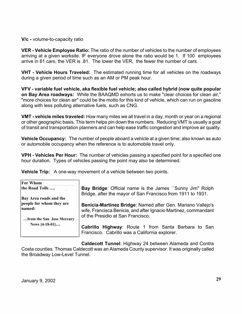
January 9, 2002 29
V/c - volume-to-capacity ratio
VER - Vehicle Employee Ratio: The ratio of the number of vehicles to the number of employees arriving at a given worksite. IF everyone drove alone the ratio would be 1. If 100 employees arrive in 81 cars, the VER is .81. The lower the VER, the fewer the number of cars.
VHT - Vehicle Hours Traveled: The estimated running time for all vehicles on the roadways during a given period of time such as an AM or PM peak hour.
VFV - variable fuel vehicle, aka flexible fuel vehicle; also called hybrid (now quite popular on Bay Area roadways: While the BAAQMD exhorts us to make "clear choices for clean air," "more choices for clean air" could be the motto for this kind of vehicle, which can run on gasoline along with less polluting alternative fuels, such as CNG.
VMT - vehicle miles traveled: How many miles we all travel in a day, month or year on a regional or other geographic basis. This term helps pin down the numbers. Reducing VMT is usually a goal of transit and transportation planners and can help ease traffic congestion and improve air quality.
Vehicle Occupancy: The number of people aboard a vehicle at a given time; also known as auto or automobile occupancy when the reference is to automobile travel only.
VPH - Vehicles Per Hour: The number of vehicles passing a specified point for a specified one hour duration. Types of vehicles passing the point may also be determined.
Vehicle Trip: A one-way movement of a vehicle between two points.
Bay Bridge: Official name is the James ``Sunny Jim'' Rolph Bridge, after the mayor of San Francisco from 1911 to 1931.
Benicia-Martinez Bridge: Named after Gen. Mariano Vallejo's wife, Francisca Benicia, and after Ignacio Martinez, commandant of the Presidio at San Francisco.
Cabrillo Highway: Route 1 from Santa Barbara to San Francisco. Cabrillo was a California explorer.
Caldecott Tunnel: Highway 24 between Alameda and Contra Costa counties. Thomas Caldecott was an Alameda County supervisor. It was originally called the Broadway Low-Level Tunnel.
Names behind Bay Area Highways & Bridges
For Whomthe Road Tolls ….
Bay Area roads and the people for whom they are named:
…from the San Jose Mercury News [4-18-01]…

January 9, 2002 30
James Lick Freeway: 101 in San Francisco. Lick was a piano and organ maker who financed the observatory atop Mount Hamilton. He moved to San Francisco and made a fortune in real estate.
Cmdr. Isiah Nelson Memorial Hanging Gardens: The large retaining wall on I-280 between Army and Mariposa streets. Nelson was a San Francisco police officer killed in a motorcycle accident nearby.
Eisenhower Highway: I-80. The former president is considered the father of the interstate system.
Eugene A. Doran Bridge: Bridge on I-280 at San Mateo Creek. Doran was a Hillsborough police officer killed in the line of duty.
Gillian Cichowski Memorial Overcrossing: Bridge over Highway 17 at Lexington Reservoir. Cichowski was killed in an accident here, resulting in construction of the overcrossing to eliminate left turns.
Nimitz Freeway: I-880. Named for World War II admiral who lived on Yerba Buena Island.
Richard ``Fresh Air'' Janson Bridge: Route 37 in Sonoma County. Janson was one of the premier decoy carvers in the American West.
Sig Sanchez Highway: 101 through Morgan Hill. Sanchez was a Santa Clara County supervisor.
Waldo Tunnel: 101 in Sausalito. Waldo ran for governor in 1853 but lost.
Warren Freeway: Route 13 through the Oakland hills. Named for former California governor and Supreme Court Justice Earl Warren.Allocated: When either a check for the full amount is given or it is put into an account to be used by municipality. A promise to make the funds available.
Apportioned: The formula share from which one receives funds. Example: The city's apportionment grew by 5% this year.
Authorized: Legislation assigns a dollar amount which is the maximum amount that can be spent. They can be trust funds or annual. Example: The legislative body authorizes the total amountof funds which can be budgeted for the two-year cycle.
Citizen's GuideToTransportation
Financese
Glossary of TIP Vocabulary .....MTC Library.
January 9, 2002 31
Awarded: This refers to a contract, not funds. A contract is awarded once the selection process has been completed and a contractor has been chosen.
Drawn Down: Using funds which have been awarded.
Encumbered: The point at which there is a complete contract. Used in various terms, encumbered is one type of obligation.
Expended: Same as drawn down, but uses its own funds.
Flexible funding: Unlike funding that flows only to highways or only to transit by a established formula, this is money that can be invested on a range of transportation projects. Examples include the Surface Transportation Program (STP) and the Congestion Management and Air Quality program (CMAQ).
Obligated: The money for a project becomes obligated once the monies have gone from the 'promise' to actually being in an account. Effective once an E76 form is signed for Caltrans and FHWA projects.
Programmed: Funds are programmed in the TIP after authorization. Funds are considered to be programmed at the point that the TIP is adopted by the MPO. Example: The bridge project was programmed in the last TIP.
Reimbursed: Paid back. In some cases, municipalities must first spend the money before getting funds back from the government.
* TRANSPAC thanks all of the authors of all of the acronym lists and glossaries from which these definitions were copied, plagiarized and otherwise appropriated. Please feel free to use this Decoder Ring for your own purposes, nefarious or otherwise. If you have any additions, deletions or corrections to the Decoder Ring, please call (925) 671-5250 or e-mail [email protected] and let us know.