A window into the soul? A reappraisal of Parc Le Breos Chambered Tomb, Gower, South Wales
29
Abstract It is believed that the now open central passage of Parc le Breos tomb could originally have been roofed and contained a roof opening. The tomb’s orientation, combined with this opening, enabled sunlight to shine into the tomb’s passageway during the period of the mid -winter solstice standstill. To test this hypothesis a temporary roof with a small window opening was placed over the tomb’s central passage. This focussed the mid-winter sunlight into the passageway of the tomb and provided confirmation that the tomb could have been built with a similar sized window. Sunlight shining into the passage could be observed from a shallow recess built into the forecourt’s west wall without the observer’s shadow breaking the beams entering the passageway and interrupting the solar ritual taking place. An accompanying landscape survey highlighted a number of other features that help explain why the tomb was raised in such an unusual location, on the floor of a steep sided cwm. The tomb sits at the junction of a number of paths crossing south Gower. The cwm is also a route northwards to the rest of Gower and during the Neolithic period, southwards it would have been a route to a safe harbour on an inlet of the sea. Constructed with its central passage aligned in one direction on the solar noon of mid-winter, in the opposite direction the tomb was aligned on the narrow vertical fissure of Cat Hole Rock, with the entrance to Cat Hole Cave at its base. Also an important spring rises close by. The tomb’s passageway, the fissures in the rock and inside of the cave’s main chamber and the spring are all illuminated by the same sunlight at the solar noon. In addition it is believed that the tomb is aligned along a major fault in the bedrock directly below it. If these features were considered relevant to the solar worship and rituals practiced in the early Neolithic then the builders could not have erected this tomb more that a few centimetres from its present position and still have achieved this combination of alignments. A window into the soul? A reappraisal of Parc le Breos Chambered Tomb, Gower, South Wales John Cooper, March 2014 Keywords: Neolithic, chambered tomb, burial and funereal ritual, cave burials, Gower, Wales
Transcript of A window into the soul? A reappraisal of Parc Le Breos Chambered Tomb, Gower, South Wales

Abstract
It is believed that the now open central passage of Parc le Breos tomb could originally have been roofed and contained a roof opening. The tomb’s orientation, combined with this opening, enabled sunlight to shine into the tomb’s passageway during the period of the mid-winter solstice standstill. To test this hypothesis a temporary roof with a small window opening was placed over the tomb’s central passage. This focussed the mid-winter sunlight into the passageway of the tomb and provided confirmation that the tomb could have been built with a similar sized window. Sunlight shining into the passage could be observed from a shallow recess built into the forecourt’s west wall without the observer’s shadow breaking the beams entering the passageway and interrupting the solar ritual taking place.
An accompanying landscape survey highlighted a number of other features that help explain why the tomb was raised in such an unusual location, on the floor of a steep sided cwm. The tomb sits at the junction of a number of paths crossing south Gower. The cwm is also a route northwards to the rest of Gower and during the Neolithic period, southwards it would have been a route to a safe harbour on an inlet of the sea. Constructed with its central passage aligned in one direction on the solar noon of mid-winter, in the opposite direction the tomb was aligned on the narrow vertical fissure of Cat Hole Rock, with the entrance to Cat Hole Cave at its base. Also an important spring rises close by. The tomb’s passageway, the fissures in the rock and inside of the cave’s main chamber and the spring are all illuminated by the same sunlight at the solar noon. In addition it is believed that the tomb is aligned along a major fault in the bedrock directly below it. If these features were considered relevant to the solar worship and rituals practiced in the early Neolithic then the builders could not have erected this tomb more that a few centimetres from its present position and still have achieved this combination of alignments.
A window into the soul? A reappraisal of Parc le Breos Chambered Tomb, Gower, South Wales
John Cooper, March 2014
Keywords: Neolithic, chambered tomb, burial and funereal ritual, cave burials, Gower, Wales

Parc le Breos Chambered Tomb, Gower: John Cooper, March 2014
2
of Three Cliffs Bay. Spring tides can still flow inland as far as Parkmill, about 500 m downstream from the tomb. Given the silting that has occurred since the early Neolithic it is quite likely that the lower cwm was a tidal creek as far as Parkmill.
Immediately below the site of the tomb the cwm widens and three smaller cwms merge with Green Cwm, the largest of these, Le Breos Cwm, from the west and the other two from the south. At this junction the cwm narrows again as it turns sharply southeast towards Parkmill and the sea.
The lower slopes of all these cwms are covered with limestone scree, above that the hillsides are steep, almost precipitous, with numerous rocky outcrops topped in places with lines of
Site Location
NGR: SS53738982, NPRN: 93072, SAM: GM122
The Neolithic transepted long cairn of Parc le Breos was built nearly 6,000 year ago and was used as a tomb in two discrete phases. An extensive programme of radiocarbon dating of bones from the tomb undertaken by Alasdair Whittle and Michael Wysocki indicated that the tomb was in use during the early Neolithic for a period of around five hundred years from c.3,800 BC, after which it appeared to fall into disuse. Then, between seven and eight hundred years later, the tomb was used again, possibly for as long as two hundred and fifty years, or for what could have been a period as short as perhaps fifty years. At some time around c.2,200 BC, the end of this second period of reuse, the tomb was finally closed (Whittle & Wysocki, 1998).
The tomb was built on the west side of Green Cwm, on the Gower Peninsular, South Wales. Green Cwm is the middle section of a dry cwm (valley) complex that cuts through the limestone karst of south Gower from the edge of Pengwern Common to the sea at Three Cliffs Bay, a distance of some 4000 m. A spring rises 300 m below the tomb’s site and the stream flowing from it runs through the lower section of the cwm to Parkmill. Below Parkmill the final steep sided 1000 m of the cwm, known as Pennard Pill, is tidal. The cwm ends at the cliffs
Looking northwards: Parc Le Breos tomb was built on a slightly sloping bank next to an ancient stream bed. Within a few metres Green Cwm starts to narrows rapidly, Cat Hole Rock is directly behind the large conifer in the centre of the picture.
Parc Le Breos tomb
The Gower Peninsular and the location of Parc Le Breos tomb in Green Cwm.

Parc le Breos Chambered Tomb, Gower: John Cooper, March 2014
3
constructed to face slightly west of south, at 185 degrees magnetic and not along the long axis of the cwm as might be expected. The orientation along the central passage of the tomb is towards a point above a steep razor back rocky spur that marks the passing of the solar noon of the mid-winter solstice standstill. This spur is also the junction of Green Cwm with Le Breos Cwm and two other smaller cwms. In the opposite direction the
passageway is aligned on Cat Hole Rock.
The tomb was designed and constructed in the Cotswold-Severn style, with a central passage and four small rectangular chambers set at right angles to the passage. It is regarded as the most westerly example of this type of tomb construction in Wales, although two nearby tombs at Penmaen and Nicholaston have at times been associated with this style of tomb design (RCAHMW, 1976).
The trapezoidal shaped tomb is 22 m long and 13 m across at its widest point, tapering to about 6 m at the northern end of the cairn. It has a central passage 6 m in length and 1 m wide. The central passage and side chambers were constructed using large slabs of water
A 1962 post-restoration photograph shows the deeper recess in the western wall noted almost one hundred years earlier by Gardner Wilkinson.
© RCAHMW
‘Before the Cairn was opened, it simply appeared to be a heap of stones with a few bushes and old trees about it, as at present.’ Hussey Vivian, 1887
low cliffs. These cwms were originally carved out by glacial or periglacial action, (Saunders, G., 1986) and they all contain remnants of high level fossil cave systems, of which Cat Hole Cave and Tooth Cave are the most well-known. They all contained surface streams at some time in prehistory but these have long since worked their way down to lower subterranean passages. Today water only flows on the surface of Green Cwm under the most extreme of flash flood conditions.
About 300 m below the Parc le Breos tomb, and just beyond the point where the cwms merge and turn eastwards a spring rises from below a low cliff in the north slope of the cwm. Called the Wellhead, it is the largest resurgence on Gower and at one time Dŵr Cymru, (Welsh Water) pumped from it to provide drinking water for the whole of north Gower. Their tests confirmed that much of the water emerging from it originates from the Brecon Beacons, some 600 m higher and 40 miles (64 km) to the north. Because of the continuous flow of water moving through the rock under gravity, the resurgence produces a good all year round flow. After heavy rain the addition of ground water from the surrounding hills can increase the flow rate dramatically with the pressure from the increased volume creating a boiling mass of water and even forming a small fountain in front of the cliff. On the southern slope, opposite the Wellhead, another spring known as Kitchen Well rises. These two risings are the main sources of fresh water in the area.
Parc le Breos tomb
The Neolithic tomb of Parc le Breos is located on the western floor of Green Cwm. It was erected at the base of the cwm’s steep scree covered slopes on a slightly sloping low bank of scree which had spread part way across the cwm. The eastern flank of the tomb was set alongside and just a few centimetres above the ancient stream bed. The tomb’s positioning is unusual in that It was built on the floor of the cwm, rather than a sloping hillside as most other tombs of this period were; also its forecourt and entrance passage were

Parc le Breos Chambered Tomb, Gower: John Cooper, March 2014
4
worn streambed limestone. The largest of these slabs were used to line the passageway, with smaller slabs of the same material lining the lower walls of the chambers. Gaps between the orthostats were filled with dry stone walling, neatly built using small, regularly shaped blocks of limestone. No roofing lintels or capstones survive but three pairs of large upright slabs lining the passageway could be presumed to have been the main roof supports. These are all around 1 m high but one of the pair at the rear of the passage stands 1.5 m high, substantially taller than the rest.
The southern end of the tomb has a wide almost bell shaped walled forecourt that leads to the entrance of the central passage. The entrance is framed by two entrance orthostats with a low kerb stone set between them. Using more small rectangular blocks of limestone, the dry stone walls of the forecourt were built to a high standard. The perimeter of the trapezoidal shaped long cairn was delineated with a low dry stone wall, again neatly built and using the same thin rectangular shaped limestone blocks that were used for the walls of the forecourt.
Excavation and research chronology
As just a low mound in the scree slope extending onto the floor of the cwm, the tomb remained undiscovered until 1869 when
© Swansea Museum
workmen were looking for stone to repair an estate road (Vivian, 1887). Green Cwm and the surrounding lands were at that time owned by Hussey Vivian and were once part of an ancient deer park established by William Le Breos in the thirteenth century. So the tomb was called Parc le Breos but because of the enormous size of some of the human bones found in it, the tomb was and still is known locally as the Giant’s Graveyard.
There have only been two excavations at this tomb. The first in 1869 was at Vivian’s request shortly after the tomb had been found, and was conducted by Sir John Lubbock. The second was undertaken by R J Atkinson on behalf of the Ministry of Works in 1960. The following year Atkinson supervised the tomb’s restoration.
A number of drawings, sketches and plans of the tomb made at the time of the 1869 excavation by Sir John Gardner Wilkinson can be found in the collection of his drawings and manuscripts held by the Bodleian Library, Oxford. Some of these do not appear to have been published or referenced before.
In addition Swansea Museum holds a number of early photographs of the tomb. The earliest of these, showing the open tomb was taken by Arthur Howorth just a few years after Lubbock’s excavation. Others taken by William
© Bodleian Library
Left: Possibly the original of the plan prepared for the engraving pub-lished with Lubbock’s excavation report. Above: Gardner Wilkinson’s plan of the tomb shows a more accurate shape to the front half of the tomb, the indent in the west wall and he identifies the oval outline as cairn spread and excavation material.

Parc le Breos Chambered Tomb, Gower: John Cooper, March 2014
5
Morgan span the period between 1890 and 1910.
In 1998 a substantial appraisal of the tomb and the bones it contained was undertaken by Alasdair Whittle and Michael Wysocki (Whittle, 1998).
The excavations
Lubbock published his findings from the 1869 excavation in 1871 (Lubbock, 1871). With regard to this project, one of the salient points in his paper was that he discovered the foundations of both forecourt walls to be intact.
In his paper Lubbock mentions a party from the Cambrian Archaeological Society attending during the excavation (Lubbock, 1871, p. 168). An influential member of that society was Sir John Gardner Wilkinson, the eminent Egyptologist, who had retired to the Gower village of Reynoldston, just two or three miles from Green Cwm. It was probable that he attended with other members of the Cambrian Archaeological Society during their visit to the excavation.
In 1869 Gardner Wilkinson drew a number of plans of the tomb. In these he also drew the foundations as intact. When Lubbock first excavated the west wall in 1869, it was revealed to be markedly more curved than the east wall, forming a shallow indent and although Lubbock didn’t note this indentation, Gardner Wilkinson recorded this feature in all three of his site drawings. Gardner Wilkinson also recorded the west wall as being intact to approximately some twelve stone courses high. He also recorded all the orthostats in place, bar one.
Quite possibly he also visited the site before Lubbock arrived as his field sketch books and folios from 1869 contain a number of drawings, plans and watercolours of the excavated tomb, including a pre-excavation profile of the mound.
These documents also have descriptive annotations; one of these contains a detailed sketch of the tomb on which he records the dimensions of each stone in the passage and the four chambers (Wilkinson, 1869). He drew a plan of the tomb that was closer to its original shape than the one published by Lubbock. Comparing Gardner Wilkinson’s plan with an original plan of that time, possibly the one used for the engraved plan published in Lubbock’s paper, highlights the differences between the two drawings. Lubbock appears to
‘Case No. 3 contains those of at least ten individuals (these bones were found in the central avenue), one of whom, I should say, had reached an extreme age. Enclosed separately are the condyloid ends of two femurs, representing a skeleton of gigantic size, and a portion of a thick skull.’ Dr Morton Douglas. 1869
Extract from Atkinson‘s report on the 1960 excavation. © RCAHMW
Detail from Gardner Wilkinson’s detailed measurements of the tomb. He records the indent in the west wall.
© Bodleian Library

Parc le Breos Chambered Tomb, Gower: John Cooper, March 2014
6
have mistaken the spread of the cairn’s stony fill as the actual outline of an oval cairn mound, whereas in the annotations to his more shapely drawing, Gardner Wilkinson recognised the shape for what it was, cairn spread.
This could suggest that these two eminent archaeologists didn’t communicate on this matter. Perhaps Lubbock, as one of the rising stars of modern archaeology, didn’t wish to be eclipsed by the older, well known but now retired, Egyptologist. However, apart from the inaccurate tomb plan shown in Lubbock’s paper Gardner Wilkinson’s drawings, notes and precise measurements are the only extant visual reference to the original excavation.
Following Lubbock’s excavation and a post mortem by Swansea physician Dr. Morton Douglas, some of the bones recovered from
the tomb, were reburied beneath the chamber floors. Vivian claimed they were placed under the same chamber from which they had been taken (Vivian, 1887). This is suspect, especially as not all of the bones recorded as returned by Douglas appear to have been reburied; plus Gardner Wilkinson’s notes on his plan of the tomb indicate that two skulls were found in the south west chamber; and these also appear to have been lost.
The tomb was then left as Lubbock excavated it, partly filled with loose stone and open to the elements. It quickly became overgrown, as Arthur Howorth’s photograph taken only a few years’ later shows. This photograph also shows that Vivian by this time had had some of the orthostats bound with iron hoops to stop them from splitting apart. The series of photographs taken by William Morgan between 1890 and 1910 highlight the mass of loose stone left in the forecourt and show the tomb surrounded by iron estate fencing. The Vivian estate was sold off piecemeal in 1898 and over the next sixty years the site became progressively more overgrown, with the trees that had always grown on the cairn mound becoming mature. These were all removed in 1960 (Atkinson, 1960). The tree shown in one Gardner Wilkinson watercolour of the tomb could be one of those removed during the restoration as Atkinson commented that one of the trees had started growing around 1820.
There was no formal report published after
Atkinson’s excavation in 1960 but documents
and letters in the RCAHMW archive provide an
outline of his work. In his very brief report to
the Ministry of Works, (Atkinson, 1960)
Atkinson also confirmed that the foundations
and lower courses of the forecourt walls were
found to be intact and as originally built; and
that all the passage orthostats, except one of
the passage entrance stones, the same one
noted by Gardner Wilkinson, were still in their
original positions. This missing stone was
replaced during the 1961 restoration.
Arthur Howorth’s c.1870 photograph of the tomb. Taken from the cairn mound behind the passage.
© Swansea Museum
The opposite view. A William Morgan photograph from c.1890 shows the tomb’s forecourt still partly filled with loose stone.
© Swansea Museum

Parc le Breos Chambered Tomb, Gower: John Cooper, March 2014
7
In his renovation report Akinson also wrote
that the tomb was built over an underground
stream ‘this underground stream lies beneath
the west side of the cairn where a stretch of 3m
of the outer wall has foundered into an ‘Aven’
or swallow-hole, undermined from
below.’ (Atkinson, 1961).
Background and Research methodology
Visiting the tomb during the mid-winter of 2011 it was noted that just after midday sunlight shone directly along the tomb’s central passage without casting any shadows from the walls onto the floor. The possibility that the
tomb had been built at an unusual angle in the cwm specifically to allow the winter sunlight to shine along the passage and into the tomb was considered.
A fallen branch from the nearby wood was placed across the entrance to simulate a capstone and the position of the shadow it cast noted. It could be seen that if the tomb had a capstone resting on the entrance orthostats and with any entrance blocking stone removed, mid-winter sunlight could only penetrate a short distance along the passage. A person wanting to observe sunlight shining along the passage would have to bend over or kneel in
The lintel created by the branch and the shadow on the floor of the passage. The problem of observing the sun’s passage while standing on the east side of the forecourt is highlighted by the photographer’s shadow. The indent in the west wall can be seen.
the forecourt in order to look in.
The shadow of the branch also showed the tomb could only have been designed for the sunlight of the mid-winter solstice period, as the Sun’s maximum elevation of 62 degrees during the June solstice is too high for direct sunlight to reach past the entrance kerb stone (NOAA, 2012).
Photographing the shadow in the passage made by the branch highlighted this important factor along with another; the problem of an observer’s shadow cast across the entrance or even into the tomb itself.
In common with most of the early Neolithic tombs in the region it appears that the importance of sunlight entering a tomb on the specific day given over to ritual at that tomb was part of its design. If it could be assumed that sunlight entering a tomb during that specific day or period was an important, if not a fundamental part of the ritual, then disturbing the flow of sunlight could have been considered to have interrupted or debased the solar and ancestor worship rituals taking place.
During the winter solstice standstill period the Sun is low in the sky and at the latitude of the tomb the maximum zenith of the Sun at the solar noon of the mid-winter solstice is only 15.4 degrees (NOAA, 2012). Given the orientation of the tomb’s passage, this low elevation allows winter solstice sunlight to illuminate the complete length of the now uncovered central passage. If instead of the branch, a capstone had been placed on the first two orthostats forming a lintel at the entrance, and assuming any forecourt passage blocking stones had been removed, direct sunlight could reach only part of the way along the passage, and as already noted an observer would have to kneel in the forecourt area in order to look inside.
Measuring the noticeably taller orthostat towards the rear of the passage showed it to be 0.5 m higher than the entrance orthostats and it was thought possible that it could have been part of a higher roof arrangement, stepped or sloping up from the entrance lintel

Parc le Breos Chambered Tomb, Gower: John Cooper, March 2014
8
level. Perhaps this difference was introduced to allow for some form of window arrangement above the passage, as this height difference would be sufficient to allow for the provision of a small rectangular opening. Possibly when not in use this opening had an easily removable stone or wattle cover. If the height of the passage was increased, as indicated by the higher rear orthostats, then provision could have been made for the passage roof to step up from one level to the other.
A person standing between the low winter Sun and the entrance to any tomb casts a long shadow and this can block sunlight entering the tomb. At Parc le Breos tomb, a person standing in the eastern side of the forecourt to look into the tomb would block the sunlight as the mid-winter Sun, low in the sky, approaches and then passes the solar noon; and it is the
shadow of the person that enters the tomb, not the sunlight. Standing next to the forecourt’s western wall avoids casting a shadow into the tomb but only until the Sun reaches its zenith, as from that point the shadow of the person bending to look along the passage through the tomb’s low entrance would again start to block some of the sunlight from entering.
It would appear that the designers of Parc le Breos tomb understood this problem from the outset and overcame it by building an asymmetrical forecourt with a shallow recess in the west wall. (It should be noted that there is no similar recess in the east wall.) Creating this space would have enabled one or possibly two people to stand in this recess, offset from the direct line of sunlight, and observe the sunlight illuminating the interior of the tomb’s passage without a shadow being cast across the entrance.
The combination of the indent in the west wall and a small rectangular opening set between the two levels would have allowed an observer to stand in the western forecourt recess and look into the rear section of the passageway. From the recess they could watch the sunlight ritual unfold as the interior of the rear of the tomb was illuminated, increasing and then diminishing as the sun passed from east to west across the opening, all without fear of casting shadows into the tomb.
Gardner Wilkinson noted the pre-excavation ground level on his longitudinal section of the tomb and the annotation states: ‘ the flat stones of the upper part of the tomb have long since been carried away for building purposes, the stones of the mound fell in & filled the chambers & passage & smashed the bodies sitting the length of the mound to the line where the grass grew on the stones CB & CC’, i.e. the rear section of the passage.
This drawing also indicates two ground levels. The lower level represents the grassy surface of the tomb as he must
have seen it prior to Lubbock’s excavation, with the taller orthostats, then grassed over, protruding above the cairn mound and a young tree growing out of this surface. (This tree is also shown in his better known watercolour view of the forecourt and could be the one that Atkinson noted as growing since 1820). The upper cairn mound level repre-sented his thoughts on the overall profile of the mound.
CB CC
© Bodleian Library
Gardner Wilkinson’s watercolour of the forecourt and the entrance passage, painted in 1869, shows the excavated walls of the forecourt to be substantially intact.

Parc le Breos Chambered Tomb, Gower: John Cooper, March 2014
9
Research results
Was the focus of the southerly orientation of this tomb to allow sunlight of the midwinter solar noon to reach through a roof window to illuminate the ancestral remains placed in the passageway? And if so, could this ritual be viewed by observers standing in the western recess without their shadows interrupting the process?
Gardner Wilkinson’s 1869 longitudinal section sketch of the tomb outlines his idea for the overall shape of the cairn but more importantly, on this and also on his tomb plan, he indicates the position of the bone piles in the four chambers and in the passageway. In his annotations to these drawings he wrote that bodies (i.e. collapsed piles of bones ) had been found placed in the passage in a sitting position, but only in the rear, northern half of the passage.
The placing of some of the bones of the community’s long dead ancestors or the corpses of others, more recently deceased, into this section of the tomb could have been to allow sunlight to touch them through the window. Perhaps this was part of some symbolic ritual of rebirth. The recess in the wall helped to ensure observers could view this ritual event without their shadow interrupting the flow of sunlight.
In an attempt to seek answers to some of the above questions in the summer of 2013 the cwm was surveyed to help fix the position of the tomb within the surrounding landscape. This included surveying the suspected northerly alignment to Cat Hole Rock. Permission was granted to cover the tomb and the temporary cover was placed over the tomb during the midwinter solstice standstill period of 2013/14.
CB
CC
Below left: Part of the timed sequence recorded as sunlight shining through the opening in the roof moved from west to east across the rear sill stone. The fourth image records the sun’s rays centred on the passage and rear sill stone. The position of orthostats CB & CC is marked. Times between: 12:09 and 12:30 GMT on 02/01/14.

Parc le Breos Chambered Tomb, Gower: John Cooper, March 2014
10
Lightweight, free standing timber frames were constructed along the passageway and covered with tarpaulin representing the missing roof capstones. The frames represented the heights of the different pairs of orthostats. A small rectangular window frame was inserted between the two roof levels. The tarpaulin covers kept out unwanted daylight and focussed the sunlight through the adjustable
frame representing the passage window. Using these two flexible materials meant that adjustments to test different roof opening positions could be made quickly and easily. Using freestanding structures also eliminated risk of damage to the fabric of the tomb.
The high ridges of Gower allow sunrises and sunsets to be observed throughout the year; and with horizons approximately 40 miles, (64 Km) away, the smallest movement of the Sun’s position on the horizon can be observed. Over a number of years the author has recorded many winter sunrises from these high points and has noted that the Sun’s southern passage along the horizon is seen to come to a virtual stop on December 15. After the sunrise of this date these observation confirm that the Sun is not seen to start rising northwards again until January 8. This is the day the Sun starts to return warmth to the earth as each day, from this day forward, the Sun can be seen to rise further north and higher in the sky.
Although this period is slightly longer than the period known as the mid-winter solstice standstill, this is what a person without clocks or almanacs would observe. During this
Above left: The first window was set too far back and although perfectly framed, sunlight didn’t illuminate the kerb stone or the passage properly.
Centre: Looking out to the window above the passage from the rear sill. Time: 12:27 GMT. The photograph was taken from a sitting position on the rear kerbstone. According to Gardner Wilkinson, on this kerbstone the bones from two bodies were found in a collapsed pile. From this he considered that they were placed in the tomb in a sitting position. Two other bodies were found in the passageway, also in a sitting position, but behind the stone marked CC.
Above right: Immediately the sun passed the opening and started its descent to the south west, its shadow started to leave the sill stone as it crept towards the east side of the passage. Time: 12:37 GMT, Date: 02/01/2014.
Constructing the framework representing a capstone covered roof.

Parc le Breos Chambered Tomb, Gower: John Cooper, March 2014
11
standstill period, at the latitude of Parc le Breos the Sun’s average solar noon elevation is 15.0 degrees (NOAA, 2012). At this elevation, given the tomb’s position, the Sun is low enough to shine in through a roof window and illuminate the rear of the tomb but not low enough to shine along the length of a roofed passage.
From the floor of the cwm the winter Sun rises from behind the hill at the southeast end of the cwm sometime after the actual dawn and by mid-afternoon it has disappeared behind the hillside to the southwest. Between this morning rising and the early afternoon setting the Sun clears the top of the wooded hillside at the southern end of the cwm and for a few minutes during and after the solar noon it passes directly above a small col or saddle in a low rocky ridge 300 m south of the tomb.
Inclement weather during the standstill period provided only two days when there was sunshine above this southern hillside during the middle of the day. On both of these occasions it was observed that the Sun’s rays,
restricted by the rectangular opening in the tarpaulin roof, shone directly along the passage and illuminated the complete width of the passage, the rear kerb stone and the passage back stone during the solar noon. The direct sunlight meant that there were no shadows from either wall falling across the passage (and therefore on any corpses or bones placed there) for a short period of no longer than five minutes.
On the first of these days the window was positioned in front of the stone marked ‘CB’ by Gardener Wilkinson. This proved to be too far along the passage, with the result that sunlight illuminated the rear wall but not the passage. Also in this position the window was too far away for an observer standing in the west wall recess to see down into the passage.
Moving the window position forward, in front of the next pair of orthostats proved to be a better position. This was at the front edge of the stone Gardener Wilkinson marked ‘CC’. From this position sunlight illuminated both
The temporary tarpaulin roof helps to provides a scale to the tomb’s outline and shows that the original cairn profile, built mainly from limestone scree, was almost certainly quite low, possibly similar in profile to the nearby Nicholaston Long Cairn.

Parc le Breos Chambered Tomb, Gower: John Cooper, March 2014
12
the rear of the passage and the rear wall and it was also possible to observe the movement of sunlight across the stones from the recess in the west wall. According to Gardener Wilkinson, position ‘CC’ was the closest point to the entrance where human bones were found in the passage.
During the hour or so when sunlight moved across the passage as the Sun passed across the sky from east to west and as the solar zenith approached and then passed the shadows on the east side of the passageway gradually shortened and finally disappeared. The length of time that direct sunlight shone on the back wall of the passage was quite short. From the time the first sliver of sunlight reached the west side of the rear kerb to the time it left the east side of the kerb was just over an hour but the length of time that only the rear kerbstone and back stones of the tomb were illuminated was no longer than five minutes. Then, as the Sun continued its westward passage, sunlight started to move along the east wall and shadows formed by the west wall crept across the floor.
Covering the tomb and focussing the sunlight through the window showed that it could have been built with an opening in the roof, perhaps blocked by an easily removable stone or wooden frame. Set in the same position and height as the temporary window frame, the original opening would have enabled the Sun’s
rays to illuminate the rear section of the passageway and allowed one or two observers standing in the western recess to watch this ritual.
The landscape context
The unusual placing of the tomb at the bottom of a steep sided cwm and set at an odd angle to the axis of the cwm floor has been noted by
The position of the window shown here was the second window location, one that allowed sunlight to enter and a viewer to observe this ritual.
The passageway is 6 m long and 1 m wide. The higher frame covering the rear section was constructed to be 1.5 m high. This represented the underside of a capstone spanning the passage. The lower frame was 1.m high, this represented the upper surface of a capstone acting as lintel across the entrance orthostats. The window area of the rectangular frame between these two levels was 0.3 m high and 0.8 m wide.
Clear cold water bubbles gently to the surface from within the Wellhead spring in the summer. In the winter the pool often boils and seeths and the flow rate can exceed 70,000 gallons an hour.

Parc le Breos Chambered Tomb, Gower: John Cooper, March 2014
13
LIDAR images, © Environment Agency copyright, 2013. All rights reserved
The ancient landscape surrounding Parc Le Breos tomb
1. Cat Hole Cave 2. Le Breos Cwm fissure 3.The Wellhead in flood 4. Pennard Pill as a 1000 m long tidal estuary 5, The rocky outcrop above the tomb The shape of the cwm has not changed greatly since the tomb was built apart from higher seas levels than today it can be seen that it was positioned at a merging of ancient tracks, close to the head of a tidal inlet and in proximity to a number of other sacred places. 4
2
3
Tracks to farmland, Cefn Bryn, south & west Gower
Llethryd Cwm, track to central and north Gower
Track known as ‘the Roman Road’ crosses the cwm from Cefn Bryn and leads inland
Wiloxton Cwm, track to Farmland, Ilston Cwm & east Gower
Parkmill ford
Estimated spring tide range during the early Neolithic
Parc Le Breos tomb
Ilston Cwm
Tracks to north Gower and the mid-summer sunrise/sunset tombs of Arthur’s Stone, Great Carn, circles & cairn fields
Cefn Bryn east , mid-winter sunset at Nicholaston tomb & equinox sunrise at Penmaen tomb.
Pennard Pill & Three Cliffs Bay
5
1

Parc le Breos Chambered Tomb, Gower: John Cooper, March 2014
14
both Atkinson and Whittle in their comments on the tomb’s location (Atkinson, 1960), (Whittle & Wysocki, 1998).
However, the landscape survey in 2013 showed it not to have been built in an isolated position as previously thought but, as the LIDAR map confirms, it is at the centre of a crossing place, where a number of tracks leading to all parts of Gower meet, close to the main all season source of fresh water and near a sea inlet that could have contained one of the few all weather harbours along the rocky south Gower coast. In addition, the tomb was built on a number of solar and other alignments that would have been considered to have religious and ritual associations, including a spring where water perpetually bubbles up from inside the rock. When in flood it boils and surges and the cwm resound to regular deep booming sounds as air trapped in the cave passages below is released.
Although at the height of the last glaciation the sea was about 200 miles south west of the
cliffs of Gower and some 100 m lower than today, at the beginning of the Mesolithic/Neolithic transition the coastline was rapidly becoming closer as the sea continued to rise. By the start of the Neolithic the shallow plains that once fronted Gower had all disappeared, with sea levels rising some 4 to 5 metres above those of today before gradually dropping back over succeeding millennia (Bridges, 1976).
Today high tides pushed inland along Pennard Pill by storm surges can reach as far as Parkmill.
A line of phreatic tubes high in the southern cliffs of Le Breos Cwm mark the remains of long abandoned water passages. A spring once emerged from the scree directly below the fissure to the right.
To the north of the tomb Cat Hole Cave was formed in one of the numerous fissure that run vertiucally through Cat Hole Rock.
On the southern side of Le Breos Cwm the southern alignment across the rocky spur bisects another rocky outcrop, fissured in the same way as Cat Hole Rock.

Parc le Breos Chambered Tomb, Gower: John Cooper, March 2014
15
The 2013 survey of the cwm determined that the stream bed below the Wellhead is at 10.30 m above Ordinance Datum (O.D.) and at Parkmill the ford is only 5.5 m O.D.. The depth of sediment deposited on the floor of the cwm would have been less during the early Neolithic than today and would have meant that the pill would have been a sea filled inlet at most states of the tide and the sea would have reached Parkmill during normal spring tides; possible higher during storm surges, (U.K. Hydrographic Office, 2002). The steep sided Pennard Pill widens at Parkmill and this area could have provided a safe, natural harbour for small sailing craft.
In the Late Upper Palaeolithic Green Cwm would always have been a major route for both animals and humans as it was one of the few places along the southern cliffs that offered easy access from the plains to the land above. It would have still remained a major route in the Mesolithic for the same reasons. However the start of the Neolithic, the lower cwm provided access to the sea, and the lowest high tide land crossing point would have been Wiloxton Cwm. It, and the smaller cwms both above and below the tomb, provided access to the farmlands above the cwm and to the high level tracks of the dryer limestone plateaus and sandstone ridges leading to all other parts of Gower.
Any stream running off the high sandstone ridges of south Gower quickly disappears below ground as soon as it find its way into the cracks in the limestone below the fields of south Gower. One of the very few sources of
Magnetic north varies considerable over the years. For example Gardner Wilkinson recorded magnetic north at the Le Breos tomb as 20° 6” W in 1869, whereas in 2011 it was 1° 3” W. To help avoid variation errors when comparing true north with magnetic north data from different years, magnetic north is given for all bearings.
The passage of the tomb is aligned towards the south on the low saddle of the rocky spur 300 m from the tomb. The ranging pole, right of centre, is the last of the series of poles used to mark this southward alignment from the tomb.
The profile of the rocky spur looking north from Le Breos Cwm.
Fissure or rock cut ditch
Flat topped rock outcrop
Saddle rectangular feature
Parc le Breos Chambered Tomb, Gower: John Cooper, March 2014
16
water in this area guaranteed to flow all year round is the perpetually flowing Wellhead rising set at the crossroads of these tracks.
The orientation of Parc le Breos tomb
A centreline along the central passageway of the tomb shows that it is orientated just a few degrees west of south, at 185 degrees magnetic.
This bearing leads southwards towards a small rocky spur formed at the junction of Green Cwm and Le Breos Cwm. The steep sides of this spur taper to a narrow ridge. On this is a low saddle between two small platforms of rock. A small rectangular recess appears to have been cut into the rock behind the saddle and this area is separated from the rest of the spur where it merges into the hill above by a natural fissure or shallow ditch cut into the rock.
Behind that ridge and facing it from the other side of Le Breos Cwm is another fissured
limestone cliff line containing the remnants of a fossil cave system. This cliff line ends at a vertically fissured rocky outcrop very similar to Cat Hole Rock.
Along the southerly alignment of the tomb’s passage the Sun is almost directly above the saddle in the spur a few minutes after its zenith. If the alignment from the tomb is continued across the southern spur it bisects the fissured rocky outcrop on the opposite side of Le Breos Cwm.
Some 300 m northwards from the tomb is Cat Hole Rock. Both Upper and Lower Cat Hole Caves were formed by a series of large fissures inside the rock and the entrance to Upper Cat Hole Cave is at the base of the largest of these fissures, the one that cuts Cat Hole Rock vertically in two. A compass reading taken along the centre line of the tomb’s passageway, through the back stone and the rear of the cairn provides a northerly bearing of 05.0 degrees magnetic. This is the direct opposite of the southerly bearing and aligns the central passageway directly on Cat Hole Rock.
Although this relationship between the central passageway of Parc le Breos tomb and Cat Hole Rock had been identified in 2011, the accuracy of the northerly alignment could not be confirmed before the 2013 survey. This was because the dense woodland between the two sites affects the accuracy of GPS readings and the trees block the direct line of sight. Probably for the same reason, the position of the entrance of Cat Hole Cave at the bottom of Cat Hole Rock, had never previously been precisely determined.
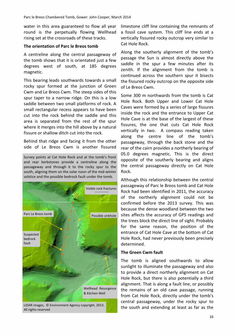
The Green Cwm fault
The tomb is aligned southwards to allow sunlight to illuminate the passageway and also to provide a direct northerly alignment on Cat Hole Rock, but there is also potentially a third alignment. That is along a fault line, or possibly the remains of an old cave passage, running from Cat Hole Rock, directly under the tomb’s central passageway, under the rocky spur to the south and extending at least as far as the
Suspected bedrock fault
Possible sinkhole
Visible rock fractures
Parc Le Breos tomb
Wellhead Resurgence
& Kitchen Well
Survey points at Cat Hole Rock and at the tomb’s front and rear kerbstones provide a centreline along the passageway and through it to the rocky spur to the south, aligning them on the solar noon of the mid-winter solstice and the possible bedrock fault under the tomb.
LIDAR images, © Environment Agency copyright, 2013. All rights reserved

Parc le Breos Chambered Tomb, Gower: John Cooper, March 2014
17
fissured southern rock face of Parc le Breos Cwm.
The limestone beds that originally extended as a plateau across all of this part of Gower are peppered with a series of cave systems that started forming a million or more years ago. These systems followed the dip of the limestone beds creating ever lower channels.
The cwm floor drops only around 50 m over its 4000 m length from Llethyd Bridge to Three Cliffs Bay and this indicates that many of these systems must have contained passages with wide shallow streams flowing almost horizontally through the limestone, dropping from one bed to the next and opening up the fissures in the rock into tall chambers.
The vast volumes of water released during the retreat of the ice of the last two glaciations cut through the limestone, destroying many of these cave passages (Bridges, 1985). As the cwms were cut deeper and deeper, the fossil remnants of those systems were left in the steep slopes as visible entrances into caves,
such as Cat Hole or Tooth Cave, or as smaller phreatic passages high in the cliffs or, closer to the floor of the cwm, as swallets, sinkholes and collapsed chambers.
In the upper section of the cwm a fault is visible, where sections of the bedrock in the west side of the cwm have been thrust steeply upwards, resulting in the rock dipping steeply under the lower scree slope and the track on the cwm floor. On the east side of the cwm the rock dips slightly downwards, towards the northwest. When the cwm was forming surface water would have exploited this natural weakness and flowed along the rocks in the western slope. As a result the eastern slopes eroded more quickly, steepening its slopes and forming the cliffs and hanging caves seen today.
Although most of the bedrock is buried under scree, the fault seen in the upper cwm appears to extend along much of the rest of the cwm as it can be seen again in the rocky spur 300 m below the tomb and it is believed that it could extend at least as far as the southern junction of the cwms below the tomb. In addition, from Cat Hole Rock to Parc le Breos Cwm, a number of fissures in the visible rock face have also been noted.
It can be seen from the levels of the chambers inside Cat Hole Cave, the position of the Wellhead, and the old dry resurgence openings in the cliffs that the active underground stream has worked its way eastwards away from the cwm and further under the hillside towards the Wellhead. This means that any stream passage under Green Cwm has now almost certainly
The diagram indicates a possible position of the fault line suspected to be below the tomb. The Wellhead resurgence and two earlier, now dry resurgence openings in the cliff are also
shown.
Scree
Water table
Wellhead resurgence
Green Cwm
Parc Le Breos tomb
Left: the steep dip of the rock marks the fault in the western slope of llethryd Cwm and can be compared with the dip of the rock in the opposite, eastern slopes of Green Cwm. These beds of limestone meet under the cwm.

Parc le Breos Chambered Tomb, Gower: John Cooper, March 2014
18
been abandoned as the stream cut its way eastwards under the rock but a shallow sinkhole, representing a collapsed chamber, can be seen within a few metres of the tomb. Atkinson’s statement that a 3 m section of the western wall had fallen into ‘aven’ or collapsed chamber confirm that once an underground passages existed just a few metres below the tomb.
The 2013 survey of the cwm showed that the floor of the central passage of the tomb to be just under 17.0 m O.D., with the exposed old stream bed next to the tomb’s forecourt at 16.5 m O.D. Atkinson stated that 9 m to the east of the tomb a winch anchor station was dug and the stream bed was found at 1.5 m below the alluvium covering the floor of the cwm at this location, (Atkinson, 1961). This would have been the bed of the main stream passage. The spring at the Wellhead, 300 m below the tomb, is at 11.5 m O.D. That leaves a maximum of 5.0 m of alluvium, scree, stream bed material and bedrock between the tomb’s floor and the water table in the bedding planes extending under the tomb from the eastern side of the cwm. It is quite possible that in addition to the two visible alignments another reason for this deliberate choice of the tomb’s site was because it was aligned directly above a fault line or, where water has exploited the weakness of the fault, possibly an old cave passage running through the rock just a few metres below the floor of the tomb.
Discussion
The passageway window, capstones and the cairn mound
In 1869 Gardner Wilkinson wrote that he thought that the passage and chambers originally had capstones, ‘long been carried away for building purposes’; while in 1871,
Lubbock just commented in his excavation report that he saw no sign of covering slabs (Lubbock, 1871). In 1887 Vivian, published a paper reviewing Lubbock’s excavation report. In this paper some of his views differed from Lubbock’s and in part he appears critical of the excavation detail originally recorded by Lubbock. Vivian also wrote that he was convinced the passage was never covered (Vivian, 1887). In 1998, Whittle also conjectured that this tomb possibly never had capping stones and had been designed in the manner of some early Neolithic tombs, with the orthostats intended to protrude above the cairn mound (Whittle & Wysocki, 1998), whereas prior to this in 1960, Atkinson had suggested that the passage roof was formed with three or four layers of corbelled slabs
The low cross section of Nicholaston Long Cairn, Cefn Bryn, Gower. From Williams’ excavation report on the Nicholaston site in 1940. The depression to the right of the chamber was the result of gravel extraction.
CB
CC
The photograph was taken from a sitting position on the rear kerbstone. According to Gardner Wilkinson the remains two bodies were found in a sitting position on this kerbstone. Two other bodies were found in the passageway, also stated to have been interred in a sitting position.

Parc le Breos Chambered Tomb, Gower: John Cooper, March 2014
19
(Atkinson, 1960).
From the shape of the passage with its temporary cover and window in place it is considered that the tomb’s passage and chambers had capstones and from this a profile for the tomb mound can be suggested. This profile assumes that the fill of the mound was piled up to approximately the same level as the upper surfaces of the capping stones covering the central passage and these were left exposed.
The limited amount of material in the cairn spread recorded in the 1869 plans, and in the early photographs, indicate that the tomb either had a low overall profile, leaving the capstones exposed as indicated in the photographs, or a large amount of material was removed at the time the capstones were taken away. It is unlikely that many of the smaller stones would have been carried away at that time, considering the mass of more readily available limestone blocks in the scree lining both sides of the cwm. However, a capstone sized slab of limestone, with the
same characteristic stream bed patterning as the tomb’s orthostats has been noted on the flat top of the hill on the west side of the cwm, almost directly above the tomb and in the vicinity of the recently discovered Roman farmstead. Now tilted and almost fallen, it probably was originally set upright. Perhaps the capstones were taken and used as boundary markers.
The profile suggested by the temporary roof is more in keeping with the low cross-section of nearby Nicolaston Long Cairn, first discovered in 1939 and excavated by A. Williams in May of that year (Williams, 1940). If the Parc le Breos cairn mound had been raised much higher, stone piled up in the horns of the forecourt on either side of the window probably would have fallen into the forecourt.
The quality and neatness of the dry stone walls of the forecourt and the low wall surrounding the perimeter is notable, especially as it is recorded that Atkinson’s reconstructed them almost as they were originally built. His reconstruction includes the upsweeping design
Gardener Wilkinson’s plan of the tomb’s chambers shows the position of the bone piles in each chamber. (The image has been hardened to help highlight the fading colours and his handwritten notes.) © Bodleian Library
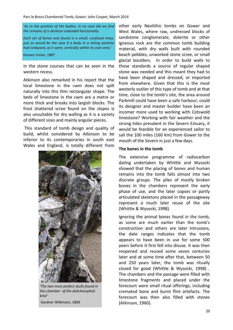
Parc le Breos Chambered Tomb, Gower: John Cooper, March 2014
20
in the stone courses that can be seen in the western recess.
Atkinson also remarked in his report that the local limestone in the cwm does not spilt naturally into this thin rectangular shape. The beds of limestone in the cwm are a metre or more thick and breaks into largish blocks. The frost shattered scree found on the slopes is also unsuitable for dry walling as it is a variety of different sizes and mainly angular pieces.
This standard of tomb design and quality of build, whilst considered by Atkinson to be inferior to its contemporaries in south east Wales and England, is totally different from
other early Neolithic tombs on Gower and West Wales, where raw, undressed blocks of sandstone conglomerate, dolerite or other igneous rock are the common tomb building material, with dry walls built with rounded beach pebbles, unworked stone scree, or small glacial boulders. In order to build walls to these standards a source of regular shaped stone was needed and this meant they had to have been shaped and dressed, or imported from elsewhere. Given that this is the most westerly outlier of this type of tomb and at that time, close to the tomb’s site, the area around Parkmill could have been a safe harbour; could its designer and master builder have been an incomer more used to working with Cotswold limestone? Working with fair weather and the strong tides prevalent in the Severn Estuary, it would be feasible for an experienced sailor to sail the 100 miles (160 Km) from Gower to the mouth of the Severn in just a few days.
The bones in the tomb
The extensive programme of radiocarbon dating undertaken by Whittle and Wysocki showed that the placing of bones and human remains into the tomb falls almost into two discrete groups. The piles of mostly broken bones in the chambers represent the early phase of use, and the later copses or partly articulated skeletons placed in the passageway represent a much later reuse of the site (Whittle & Wysocki, 1998).
Ignoring the animal bones found in the tomb, as some are much earlier than the tomb’s construction and others are later intrusions, the date ranges indicates that the tomb appears to have been in use for some 500 years before it first fell into disuse. It was then reopened and reused some seven centuries later and at some time after that, between 50 and 250 years later, the tomb was ritually closed for good (Whittle & Wysocki, 1998) . The chambers and the passage were filled with limestone fragments and placed under the forecourt were small ritual offerings, including cremated bone and burnt flint artefacts. The forecourt was then also filled with stones (Atkinson, 1960).
‘As to the position of the bodies, in no case did we find the remains of a skeleton extended horizontally.
Each set of bones was found in a small, confused mass, just as would be the case if a body in a sitting position had collapsed, as it were, vertically within its own area.’
Hussey Vivian, 1887
‘The two most perfect skulls found in this chamber of the dolichocephali kind‘
Gardner Wilkinson, 1869

Parc le Breos Chambered Tomb, Gower: John Cooper, March 2014
21
Commenting on the broken state of many of the bones, Gardner Wilkinson thought that they had been smashed before Lubbock’s excavation started. He surmised that as the capstones were removed the chambers became filled with loose stone falling from the cairn mound and these stones caused the breakages. However, according to Atkinson the broken state of the bones recovered was due in part to the picks and shovels of the diggers employed by Lubbock.
It is unlikely that the excavation diggers would have broken such a quantity of bones from so many separate bone piles. Some perhaps, as the workers first reached the floor level, but not almost all. Antiquarians had been digging cave and tomb sites on Gower for the previous forty years; and nearby Cat Hole Cave had only been excavated five years earlier with a quantity of faunal remains recovered, none damaged by excavation tools. Vivian was a member of the Royal Institute of South Wales (RISW), and Lubbock was an experienced excavator, as was Gardner Wilkinson. This combination of interested parties and local knowledge would not have allowed those digging to break so many of the bones they were seeking to recover.
Gardner Wilkinson also recorded that two perfect skulls, were found in the southwest chamber, they are now lost, and also that the bones recovered from the passageway showed less signs of damage. He thought that the broken bones found in the chambers had been smashed before the tomb was excavated. In this he could have been right. But in any event, the biggest and the best of the bones recovered were probably those sent to Dr Morton Douglas and although he wrote he had returned them, there is no evidence that they were reburied under the chambers along with the others.
Gardner Wilkinson also recorded the position of the bone piles in each chamber:
North east chamber: four bone piles in the inner chamber and bones of children in the outer annex
North west chamber: four bone piles in the inner chamber and bones of children in the outer annex
South east chamber: four bone piles
South west chamber: four bone piles and two ‘perfect skulls’
Bones from the passageway: between four and six bodies, including ‘bones of men in a sitting position’ and fragments of pottery
Perhaps there was a change in ritual or a movement of people and breaking the bones was part of a symbolic breaking of ancestral bonds when the tomb first fell into disuse. Possibly they were broken by the people who later reused the tomb nearly seven hundred years later as part of some other ritual. But it was unlikely to have been part of the process of finally closing the tomb, or when the capstones were removed, as according to Whittle, analysis of the bones from the passageway that he examined indicated they had been treated differently from the bones in the chambers. They were relatively less damaged and without signs of having been gnawed by animals.
The enigma of the skulls in the cave
When he excavated Cat Hole Cave in 1864, Lt. Col. Wood found two skulls and a few associated bone fragments inside the low entrance chamber. These he gave to the British
From Gardner Wilkinson’s notes, 1869
‘I caused the remainder of the bones, after taking such portions as were required for scientific purposes, to be reburied, each set in their former resting-place, enclosed in the fire-clay retorts which we use for the manufacture of spelter.’ Hussey Vivian, 1878

Parc le Breos Chambered Tomb, Gower: John Cooper, March 2014
22
Museum along with the other faunal remains found in the cave. These are now all in the Natural History Museum, (Ref: M 80 to M120, the human remains are M111 to M118). A year or so later Wood told Vivian, who by then had become the owner of the cave, where the skulls were found. Vivian located their position on the plan of the cave he published in 1887 (Vivian, 1887).
In 1886 Vivian opened up the smaller Lower Cat Hole Cave, which is known to have been connected to the upper cave at that time. In the single small central passage of this cave he also found parts of a human skull. These were examined by Dr. Douglas, the same physician who had examined the remains from the tomb fifteen years earlier. Douglas commented that these skull fragments had the same unusually thick skull characteristics as he had noted in one of the skulls recovered from the tomb.
From within Cat Hole Cave it can be seen that during the mid-winter solstice period direct sunlight starts to enter the cave at the same time of day as enters the tomb. Winter sunlight then increasingly illuminates the north wall of the main entrance chamber and the northern section of the floor to a depth of 6 m or so until the sun sets in the southwest, behind the hill at the bottom of the cwm. (A small roof collapse in 1964 now allows some sunlight to enter the southern part of this chamber.)
According to Vivian’s positioning of the skulls on his plan, one was found within the area illuminated by the mid-winter sunset. (The position Vivian gives for the second skull indicates that it would have been illuminated by the mid-summer setting sun shining along the cwm from the northwest.)
The approximate position of these two burials or depositions of bones is indicated in the schematic plan of the tomb and by the vertical markers in the photograph.
It is not known at what depth Wood found the bones, if they had been buried within the fill or laid on the Neolithic floor but at the points recorded by Vivian the cave is low, only between 1.5 and 1.75 m high with the highest point in this area of the chamber just a fraction over 2m. Patches of soliflucion breccia concretion mark the post glacial floor level and can be found adhering to the north wall at 1.18 m above the floor of the now empty cave, with
‘I perfectly remember Colonel Wood telling me that the cave contained the bones of the same animals as had been found in the other caves, such as rhinoceros, bear, bra, deer, hyena, wolf, etc. There were also two human skulls; one of a man of very low type, and the other a woman of a much higher order. The plan shows the position in which these skulls were found.’ Hussy Vivian, on Cat Hole Cave, 1887
Cat Hole Cave illuminated by direct sunlight. Based on
Vivian’s plan, the red markers approximate the locations
where the skulls were found. The orange line represents
the top of the soliflucion breccia left on the walls. This
was the pre-excavation cave floor level upon which the
skulls and other bones would have been placed.
Above: in the diagram of the entrance chamber of the
cave the stars indicate the positions of the skulls as
recorded by Vivian. Also shown is the low roof height in
this chamber and the breccia height on the cave walls.
(Not to scale)
N
Sunset angle Mid-winter Mid-summer

Parc le Breos Chambered Tomb, Gower: John Cooper, March 2014
23
purposes.
Plus, unless they were taken in at a much later date, at least one of the two skulls recovered from the cave had lain there during much of the initial, and all of the secondary phase of the tomb’s use, a period of well over a thousand years.
Dowsing as an archaeology tool
Many early sites and especially early Neolithic tombs are believed to have been ritually associated with water or underground
some on the south west wall at 1.53 m above the floor. The chamber opens up further inside this chamber, from the point where a fissure had split the rock apart, and the roof rises to over 8 m above the present floor. However the breccia levels on the walls show that for the first 6 m or so in from the cave’s entrance, during the early Neolithic, the chamber would only have been about 0.5 m high. An approximation of this old floor level is marked by the orange line in the photograph.
Wood claimed that one of the skulls was from a male and the other female. In this he could have been correct as the remaining portion of one of the two skulls is probably male. The second, together with some of the other associated facial bones appear more gracile and it is possible that this person was female. This more gracile skull (M 112) has recently been dated to 4675 BP +/- 39 (OxA 16605). This date equates to sometime after 3,600 BC, over 200 years after the first bones were placed in the tomb and in the middle of the first phase of the tomb’s use.
Whittle suggested that Cat Hole Cave may have been used to provided a mortuary function for the Le Breos tomb as some of the bones examined from the chambers in the tomb, appeared to have been gnawed and possibly these were subject to a process of excarnation elsewhere (Whittle, 1998). Assuming both skulls from Cat Hole are of a similar date then they could only have been placed in the cave no earlier than the middle of the first phase of the tomb’s use, some two hundred years after it was built. Alternatively it is possible that they could have been taken into the cave at a much later date. However neither of the skulls, nor any of the other associated bone fragments from the caves show any sign of cut marks or of having been gnawed by animals.
Originally the cave would have had just a small entrance visible above the scree line and the height of the pre-excavation fill level in the entrance chamber confirms that in places inside it was filled nearly to the roof. This raises some doubt on the practicality of such a low and airless space being used for excarnation
The line southwards. The poles were placed by the dowser as the line progressed. This line, surveyed later, is also the solar alignment along the centre line of the passageway.

Parc le Breos Chambered Tomb, Gower: John Cooper, March 2014
24
passages. At some sites there is a nearby stream or spring linked to the monument. At others there is no longer any indication of surface water. This is especially so in limestone areas where there is little surface water. Under these ground conditions dowsing can be considered a useful tool to help locate old stream passages or underground water.
The stream rising at the nearby Wellhead is believed to flow inside the hill to the east, not under the floor of the cwm. In an attempt to confirm its location a local dowser offered to try to locate water flowing below the cwm but apart from a mains water pipe nothing was found.
However, close to the tomb the dowsing rod produced a strong reaction. This reaction was followed first in a southerly direction and then later to the north with the results shown in the photographs. As the reaction appeared to occur along a path not much more than a metre wide, dowsing progressed in a zigzag manner with the dowser determining the position of the ranging poles, placing them along the perceived strongest line of reaction.
The southerly line of ranging poles placed by the dowser marked a precise extension to the solar alignment of the tomb’s central passage. This was followed for about 200 m, as far as the base of the spur.
Dowsing to the north of the tomb produced a similar result with an alignment on the central passage leading through the rear of the cairn across the floor of the cwm straight to Cat Hole Rock. The position of the poles was surveyed and a few days later the process was repeated with the same results.
From the pole in the southern scree slope the line through the central passage of the tomb to the base of Cat Hole Rock is a straight line approximately 500 m long.
No explanation is offered for this phenomena but the c.500 m straight line produced on both occasions is on exactly the same alignment between the centres of the tomb’s front and rear kerbstones of the passageway south to the
Cat Hole Rock
The dowsing line extending northwards from a centre line along the passage. Again the ranging poles were placed as dowsing progressed. In the upper picture the line extends up the steep scree slope directly to the fissures in Cat Hole Rock.
Parc le Breos Chambered Tomb, Gower: John Cooper, March 2014
25
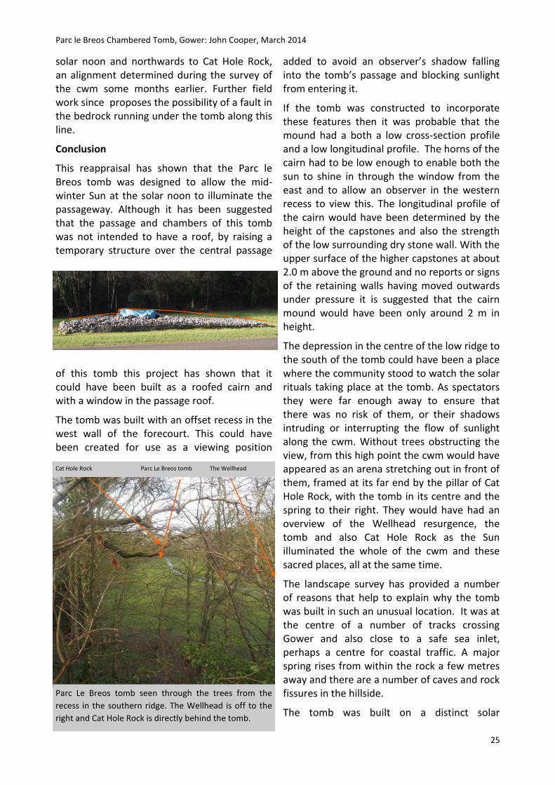
solar noon and northwards to Cat Hole Rock, an alignment determined during the survey of the cwm some months earlier. Further field work since proposes the possibility of a fault in the bedrock running under the tomb along this line.
Conclusion
This reappraisal has shown that the Parc le Breos tomb was designed to allow the mid-winter Sun at the solar noon to illuminate the passageway. Although it has been suggested that the passage and chambers of this tomb was not intended to have a roof, by raising a temporary structure over the central passage
of this tomb this project has shown that it could have been built as a roofed cairn and with a window in the passage roof.
The tomb was built with an offset recess in the west wall of the forecourt. This could have been created for use as a viewing position
added to avoid an observer’s shadow falling into the tomb’s passage and blocking sunlight from entering it.
If the tomb was constructed to incorporate these features then it was probable that the mound had a both a low cross-section profile and a low longitudinal profile. The horns of the cairn had to be low enough to enable both the sun to shine in through the window from the east and to allow an observer in the western recess to view this. The longitudinal profile of the cairn would have been determined by the height of the capstones and also the strength of the low surrounding dry stone wall. With the upper surface of the higher capstones at about 2.0 m above the ground and no reports or signs of the retaining walls having moved outwards under pressure it is suggested that the cairn mound would have been only around 2 m in height.
The depression in the centre of the low ridge to the south of the tomb could have been a place where the community stood to watch the solar rituals taking place at the tomb. As spectators they were far enough away to ensure that there was no risk of them, or their shadows intruding or interrupting the flow of sunlight along the cwm. Without trees obstructing the view, from this high point the cwm would have appeared as an arena stretching out in front of them, framed at its far end by the pillar of Cat Hole Rock, with the tomb in its centre and the spring to their right. They would have had an overview of the Wellhead resurgence, the tomb and also Cat Hole Rock as the Sun illuminated the whole of the cwm and these sacred places, all at the same time.
The landscape survey has provided a number of reasons that help to explain why the tomb was built in such an unusual location. It was at the centre of a number of tracks crossing Gower and also close to a safe sea inlet, perhaps a centre for coastal traffic. A major spring rises from within the rock a few metres away and there are a number of caves and rock fissures in the hillside.
The tomb was built on a distinct solar
Parc Le Breos tomb seen through the trees from the
recess in the southern ridge. The Wellhead is off to the
right and Cat Hole Rock is directly behind the tomb.
Cat Hole Rock Parc Le Breos tomb The Wellhead

Parc le Breos Chambered Tomb, Gower: John Cooper, March 2014
26
alignment to allow sunlight at the solar noon during mid-winter solstice standstill to shine along its passage; and at the same time it was aligned on Cat Hole Rock and the cave in its base. Plus, it appears to have been built directly above a geological fault and/or possibly a cave passage running below the cwm.
Research has also highlighted a number of questions still to be answered, including the enigma of the skulls found during the 1864 excavations in Cat Hole Cave. Also the quite remarkable reaction recorded during the dowsing search for underground water, finding a possible geological fault instead.
If a dowser could find this alignment, did the tomb builders also know about it, if so how did they find it and why was it so important to their rituals?
A window into the soul?
It can be assumed that the Sun’s rays entering the tomb and illuminating the ancestral bones within with warmth and light was considered part of a sacred ritual, possibly representing some symbolic time of rebirth. That could account for the need for a roof opening focussing sunlight into the rear of the tomb’s passage. As such, any shadows blocking the light would interrupt the ritual flow of sunbeams reaching the ancestral bones. Therefore it could also be considered that the recess in the west wall was an integral feature of this solar design, providing a way to view this ritual without fear of shadows falling across the sunbeams illuminating the interior.
It has also been shown that these observations could only have been made when the Sun was low enough in the sky for its rays to enter the tomb through the window. This could only be at, or a few minutes after the solar noon during the period of the mid-winter solstice standstill.
With the tomb so designed, only the rear section of the passageway could be reached by the rays of the mid-winter Sun. Placing the community’s ancestral bones in the passage or on the rear kerb stone, where the warmth of
the Sun could reach in and touch them, was possibly intended to be part of a seasonal cycle of ritual ancestor worship. Possibly these rituals were revived during the later phase of the tomb’s use when bodies or partly articulated skeletons were placed in sitting positions along the passage.
The orientation of the tomb’s southern alignment on the two rocky spurs is considered one of the reasons for the tomb’s unusual location. The southern rocky spur is a place briefly occupied by the Sun as it passed low above the saddle on and just after the solar noon of the winter standstill. This was also a place where the community could stand and watch these rituals.
Set in the base of Cat Hole Rock on a direct northerly alignment with the tomb, Cat Hole Cave starts to receive the same mid-winter sunlight through its low entrance in the fissured rock at exactly the same time as the tomb and the Sun continues to shine ever deeper into the cave until sunset.
The combination of these alignments must have played a very important part in the decision to build this tomb, as building the tomb on the centreline of the solar alignment between these two natural features enabled the builders to control the Sun’s rays along the tomb’s central passage in order to help them perform the burial rituals practiced at the tomb.
Some two hundred years after the tomb was built, possible changes in ritual meant that one or more skulls and other bones were placed
10
25
45
25
70
20
5
25
15
200
740
45
4
40
400
0 2 4 6 8 10 12 14
Parc Le Breos tomb and Cat Hole CaveTime between deposition of bones: years
Cat Hole Cave skull
Deposition order
Tim
e in
yea
rs

Parc le Breos Chambered Tomb, Gower: John Cooper, March 2014
27
inside Cat Hole Cave. Their resting place was seemingly chosen to receive the rays of the sunlight entering the cave. According to Vivian’s plan, one skull was placed in a position where it would receive the sunlight of the mid-winter sunset and the other was placed to receive the sunlight of the mid-summer sunset.
Why did the bones of these two people stay in the cave for so many centuries and not removed to the tomb to be placed with the rest of the ancestral bones; either after the tomb initially fell into disuse or when it was finally closed?
Had they just been forgotten or possibly could their bones have been considered too sacred to move? Were they the focus of other rituals connected to the mid-winter and mid-summer sunsets?
Following the dowsing exercise, which produced a strong reaction in the dowser’s rod that never varied from a centre line along the tomb’s passageway for about 250 m in either direction, further investigation indicated that just below the surface of the cwm there appears to be an extension of a geological fault visible inside both Upper and Lower Cat Hole Caves. Possibly this fault links the two highly fissured outcrops, north and south of the tomb.
It must be considered that the fault under the tomb was something known or sensed by the builders; perhaps they had some inner sense that we have now lost or perhaps they actually dowsed for water and those who still practice the skill of dowsing have inherited a legacy from those times.
Added to the solar alignments, the two possibly three rocky points, the underground fault or cave below the tomb and the spring water rising from within the rock, could have meant that this area of the cwm might have always been regarded as a special place.
Always a sacred cwm?
Cat Hole Cave and the cwm are known to have been visited by humans hunting game long before the depths of the last glaciation; and
again almost immediately as soon as the ice started to retreat, as the recently discovered Late Upper Palaeolithic reindeer carving found deep in the cave confirms (Nash, 2012).
Mesolithic tribes passed through the cwm and used the caves. They would have drunk from the Wellhead spring, the only all year round water source in the cwm. An accumulation of their knowledge of this place might have passed down through the generations, or they might have left markers or some other visible indications that led the tomb builders to this exact spot.
The solar alignments along the tomb’s central passages and in the cave, confirmed by both survey and observation, along with the force that moved the dowser’s rod, provide evidence that this tomb could not have been built more than a few centimetres either side of its location on the low bank of the cwm, or moved more than a metre or two to the north or south and still have maintained these sacred alignments
With all these ancient associations in this cwm, with its caves and fissures we know of and perhaps other, now lost, sacred places, the area would have been known as a special
place, possibly as a sacred place, even after the tomb ceased to be used. Especially so if the water that gushes up from below the rock at one end of the arena in the cwm and the cave illuminated by sunlight at the other were associated in ancient minds with places that connected to another of their worlds (Lewis-Williams, 2005).
Moving forward in time, long after the tomb
One of the long forgotten caves in the cwm

Parc le Breos Chambered Tomb, Gower: John Cooper, March 2014
28
was finally closed up; the cwm was still regarded as special. In the Bronze Age the tomb was respected and the ancestral bones in it remained untouched. Both Upper and Lower Cat Hole Caves were used for burials and cremations, as was Tooth Cave, 1000 m higher up the cwm and perhaps also other caves, now lost.
The implication of these research findings, at the tomb, at Cat Hole Cave, and in the surrounding landscape just reinforces the still limited understanding of the early Neolithic tomb builders and the rituals they practiced.
The people who built this tomb were worshippers of the Sun, of their ancestors and also of other worlds. Worlds they found inside the caves, below the ground and also in the spring waters that rise out of the rocks (Lewis-Williams, 2004). With an intuitive sensitivity to the many natural forces that surrounded them, the concepts they understood and believed in are perhaps still beyond our comprehension.
Acknowledgements
Many thanks to CADW for allowing the temporary cover to be placed over the tomb and to Natural Resources Wales for granting access and permission to field walk and survey the cwms. Without their support this project could not have been undertaken.
Special thanks to Roy and Ken Church at the Gower Heritage Centre, Parkmill who provided advice, materials and built the frames.
As always, thanks to the Glamorgan Gwent Archaeological Trust, especially Sue Hill, for all the support and advice willingly given.
Thanks also to the archivists and curators at the RCAHMW, Swansea Museum, the National Museum of Wales, and the Natural History Museum for their help during the research phases of this project.

Parc le Breos Chambered Tomb, Gower: John Cooper, March 2014
29
References and works cited Atkinson, R., 1960. The Giant’s Grave in Parc le Breos Cwm, Gower, s.l.: s.n.
Atkinson, R. P., 1961. The Chambered Tomb at Park le Breos, Gower, s.l.: s.n.
Bridges, E., 1976. The Evolution of the Burry Inlet. Gower, Volume 27, pp. 84-89.
Bridges, E., 1985. Gower: The ice Age Limit. Gower, Volume Vol. 36, pp. 71-97.
Cooper, J., 2013. Cat Hole Cave, Gower South Wales, a Photographic Examination, Part I: The Cat's Eyes. [Online] Available at: http://https://www.academia.edu/4625396/Cat_Hole_Cave_a_photographic_examination_Part_I_The_Cats_Eyes [Accessed November 2013].
Hoskins, M. &. P. T., 1999. The Orientation of Megalithic Tombs in Eastern Catalonia. Archaeoastronomy, Volume 24.
Joussaume, R., 1985. Dolmens for the dead: Megalith Building throughout the World. London: Batsford.
Lewis-Williams, D., 2004. The Mind in the Cave. London: Thames and Hudson.
Lewis-Williams, D., 2005. Inside the Neolithic Mind, Consciousness, Cosmos and the Realm of the Gods. London: Thames and Hudson.
Lubbock, J., 1871. Description of the Park Cwm Tumulus. Archaeologia Cambrensis, pp. 168-172.
Mohen, J.-P., 1999. Standing Stones, Stonehenge, Carnac and the world of Megaliths. London: Thames & Hudson.
Nash, G., 2012. A discovery of possible Upper Palaeolithic parietal art in Cathole Cave, Gower, South Wales. University of Bristol Spelaeological Society, 25(3), p. 327=336.
NOAA, 2012. NOAA Solar Calculator. [Online] Available at: http://www.esrl.noaa.gov/gmd/grad/solcalc/ [Accessed January 2012].
RCAHMW, 1976. An Inventory of the Ancient Monuments in Glamorgan. Cardiff: RCAHMW.
Ruggles, C. H. M., 1999. Astronomy before History. In: M. Hoskin, ed. The Cambridge Concise History of Astronomy. Cambridge: s.n.
Saunders, G. E., 1986. Flood Plain and Valley Development in South Wales: Some initial findings from the Ilston tributary of the Pennard Pill, Gower. Cambria, Volume 13, pp. 189-196.
Strahan, A., 1907. The Geology of the South Wales coalfields. Cardiff: HMSO.
U.K. Hydrographic Office, 2002. Admiralty Tide Tables, United kingdom and Ireland including European Channel Ports. s.l.:U.K. Hydrographic Office.
Vivian, H., 1887. Description of the Park Cwm Tumulus. Archaeologica Cambrensis, pp. 192 -201.
Whittle, A. & Wysocki, M., 1998. Parc le Breos Cwm Transepted Long Cairn, Gower, West Glamorgan: Date, Contents, and Context. Proceedings of the Prehistoric Society, Volume 64.
Wilkinson, S. J. G., 1869. MS, Sketch books and folios. Oxford: Bodleian Library.
Williams, A., 1940. A Megalithic Tomb at Nicholaston, Gower, Glamorgan. The Prehistoric Society, Issue Jan-July.
Author’s contact details:
John Cooper
Apartment 3, Highbury House, Langland
Swansea, SA3 4QW
Email: [email protected]
All photographic images, including those acknowledged are
© John Cooper 2010-2014