A Study of Ground Water Potential for Sustainable Development in Igbo-Ora, Oyo State, Nigeria
10
Kofo A Aderogba, Toun A Afelumo / IOSR Journal of Engineering (IOSRJEN) www.iosrjen.org ISSN : 2250-3021 Vol. 2 Issue 2, Feb.2012, pp.263-272 www.iosrjen.org 263 | P a g e A Study of Ground Water Potential for Sustainable Development in Igbo-Ora, Oyo State, Nigeria Kofo A Aderogba Tai Solarin University of Education Ijebu Ode, Nigeria Toun A Afelumo Sheffield Hallam University Sheffield, United Kingdom ABSTRACT: The entire system of Opeki Dam serving the Igbo-Ora Community of Oyo State is spent. Rainfall, rivers, ponds and swamps are seasonal and grossly inadequate. Thus, the quest for alternative sources of supply. Electrical Resistivity method of Geophysical investigation was adopted using Rectified Resistivity Meter (RRM) Model. Readings were taken of the earth resistance by sending fairly large current I(μ A) into the ground. Data were collected from three locations: Igbole, Saganun, and Isale-Oba. A typical geo-electric section showing the thickness, depth, and lithography reveals that topmost is sandy clay soil (1m), followed by wet clay soil (2.1-3.1m); and at a depth of about 8.7m is the unsaturated weathered basement rock which is about 5.6m thick. Saturated weathered basement rock is about 11.3m thick and it is 20.0m deep on the average. The average resistivity within the first 1m is 120.3Ωm and it is 156.1Ωm to a depth of 20.0m. The groundwater potential may be feasible at the sounded points with average groundwater yield: An overburden unit depth of about 25m (on the average and total drill depth of between 35 and 38m). For sustainable water, the hole must be properly cased to a stable earth unit below the overburden unit. BACKGROUND TO THE STUDY: Access to safe drinking water is indicated by the number of people using proper sanitary sources, (Wikipedia, 2008). These improved drinking water sources include household connection, public standing pipe, borehole condition, protected dug wells, protected springs, and rain water collection, (Aderogba, 1999 and 2005 and Wikipedia, 2008). Sources that do not encourage improved drinking water include : unprotected well, unprotected springs, rivers or pounds, vendor- provided water, bottled water (consequential of limitations in quantity and quality of water), and tanker truck water. Access to sanitary water comes hand in hand with access to improved sanitation facilities for excreta. These facilities include connection to public sewer, connection to septic system, pour-flush latrine, and ventilated improved pit latrine. Unimproved sanitation facilities are: public or shared latrine, open pit latrine, or bucket latrine (Wikipedia, 2008). According to this source, the earth‟s surface consists of 70% water; and that wate r is available nearly everywhere if proper methods are used to get it. It went further to say that „‟as a country‟s economy becomes stronger (as its GNP per capital or PPP rises) a larger percentage of its people tend to have access to drinking water and sanitation. Access to drinking water is measured by the number of people who have a reasonable means of getting an adequate amount of water that is safe for drinking, washing, and essential household activities. As of the year 2006 ( and pre-existing for at least three decades) there is a substantial short fall in availability of potable water in less developed countries, primarily arising from industrial contamination and pollution, (Aderogba, 2005 and In Print and Wikipedia, 2008). As of the year 2000, 20% of the populations of lesser developed countries did not have access to safe drinking water (World Health Organization, 2005 and Wikipedia, 2008). Implications for disease propagation are significant. Many nations have water quality regulations for water sold as drinking water, although these are often not strictly enforced outside of the developed world. The World Health Organization sets international standard for drinking water. A broad classification of drinking water safety worldwide can be found in Safe Drinking Water for International Travelers. It reflects the health of a country‟s people and the country‟s capacity to collect, clean, and distribute water to consumers. According to the United Nations‟ World Health Organization (2005), more than one billion people in low and middle - income countries lack access to safe water for drinking, personal hygiene and domestic use. These numbers represent more than 20% of the World‟s people. In addition, close to 3 billion people did not have access to adequate facilities for sanitation. Certainly, Nigeria is
-
Upload
independent -
Category
Documents
-
view
1 -
download
0
Transcript of A Study of Ground Water Potential for Sustainable Development in Igbo-Ora, Oyo State, Nigeria
Kofo A Aderogba, Toun A Afelumo / IOSR Journal of Engineering (IOSRJEN)
www.iosrjen.org ISSN : 2250-3021
Vol. 2 Issue 2, Feb.2012, pp.263-272
www.iosrjen.org 263 | P a g e
A Study of Ground Water Potential for Sustainable Development in
Igbo-Ora, Oyo State, Nigeria
Kofo A Aderogba Tai Solarin University of Education
Ijebu Ode, Nigeria
Toun A Afelumo Sheffield Hallam University
Sheffield, United Kingdom
ABSTRACT: The entire system of Opeki Dam serving the Igbo-Ora Community of Oyo State is spent. Rainfall,
rivers, ponds and swamps are seasonal and grossly inadequate. Thus, the quest for alternative sources of supply.
Electrical Resistivity method of Geophysical investigation was adopted using Rectified Resistivity Meter (RRM)
Model. Readings were taken of the earth resistance by sending fairly large current I(µ A) into the ground. Data
were collected from three locations: Igbole, Saganun, and Isale-Oba. A typical geo-electric section showing the
thickness, depth, and lithography reveals that topmost is sandy clay soil (1m), followed by wet clay soil (2.1-3.1m);
and at a depth of about 8.7m is the unsaturated weathered basement rock which is about 5.6m thick. Saturated
weathered basement rock is about 11.3m thick and it is 20.0m deep on the average. The average resistivity within
the first 1m is 120.3Ωm and it is 156.1Ωm to a depth of 20.0m. The groundwater potential may be feasible at the
sounded points with average groundwater yield: An overburden unit depth of about 25m (on the average and total
drill depth of between 35 and 38m). For sustainable water, the hole must be properly cased to a stable earth unit
below the overburden unit.
BACKGROUND TO THE STUDY: Access to safe drinking water is indicated by the number of people using proper sanitary sources, (Wikipedia, 2008).
These improved drinking water sources include household connection, public standing pipe, borehole condition,
protected dug wells, protected springs, and rain water collection, (Aderogba, 1999 and 2005 and Wikipedia, 2008).
Sources that do not encourage improved drinking water include : unprotected well, unprotected springs, rivers or
pounds, vendor- provided water, bottled water (consequential of limitations in quantity and quality of water), and
tanker truck water. Access to sanitary water comes hand in hand with access to improved sanitation facilities for
excreta. These facilities include connection to public sewer, connection to septic system, pour-flush latrine, and
ventilated improved pit latrine. Unimproved sanitation facilities are: public or shared latrine, open pit latrine, or
bucket latrine (Wikipedia, 2008). According to this source, the earth‟s surface consists of 70% water; and that water
is available nearly everywhere if proper methods are used to get it. It went further to say that „‟as a country‟s
economy becomes stronger (as its GNP per capital or PPP rises) a larger percentage of its people tend to have access
to drinking water and sanitation. Access to drinking water is measured by the number of people who have a
reasonable means of getting an adequate amount of water that is safe for drinking, washing, and essential household
activities.
As of the year 2006 ( and pre-existing for at least three decades) there is a substantial short fall in availability of
potable water in less developed countries, primarily arising from industrial contamination and pollution, (Aderogba,
2005 and In Print and Wikipedia, 2008). As of the year 2000, 20% of the populations of lesser developed countries
did not have access to safe drinking water (World Health Organization, 2005 and Wikipedia, 2008). Implications for
disease propagation are significant. Many nations have water quality regulations for water sold as drinking water,
although these are often not strictly enforced outside of the developed world. The World Health Organization sets
international standard for drinking water. A broad classification of drinking water safety worldwide can be found in
Safe Drinking Water for International Travelers. It reflects the health of a country‟s people and the country‟s
capacity to collect, clean, and distribute water to consumers. According to the United Nations‟ World Health
Organization (2005), more than one billion people in low and middle - income countries lack access to safe water
for drinking, personal hygiene and domestic use. These numbers represent more than 20% of the World‟s people. In
addition, close to 3 billion people did not have access to adequate facilities for sanitation. Certainly, Nigeria is
Kofo A Aderogba, Toun A Afelumo / IOSR Journal of Engineering (IOSRJEN)
www.iosrjen.org ISSN : 2250-3021
Vol. 2 Issue 2, Feb.2012, pp.263-272
www.iosrjen.org 264 | P a g e
absolutely within this cohort and undoubtedly the almost 100,000 people living in Igbo-Ora and its immediate
environment falls into this proportion.
In Igbo-Ora, the needs for water were met over time, mostly from streams, rivers, rain water harvesting, dew and of
late, water hawks around by mai-ruwa and or Water Tanker Drivers, (Aderogba In Print). There is Opeki Dam
commissioned for use for four of the seven major towns of the then Ibarapa Local Government Area namely Igbo-
Ora, Eruwa, Lanlate and Idere. That was over four decades ago. There has not been reliable supply from the source
any longer. The dam and its facilities and equipment are spent – it is now an „‟abandoned government property‟‟.
Thus, nobody from the community thought of it as any source of supply any more. Whereas, the number, size and
needs of the community kept on increasing in quantity and quality. In addition, the streams, ponds, and rivers (apart
from drying-up) and rain sources are no longer sufficient nor meet the required specifications. The need for potable
water for use industrially, commercially, domestically and even in agriculture, recreation and tourism etc are fast
increasing over time, and space. Though Makinde (2002), Okwueze et al (1995), Edet et al (2002), Emenike (2001),
Evans et al (2007),and Akpabi et al (2007) worked in different geological zones of Nigeria and with successes. But
to the indigenes of Igbo Ora and the entire inhabitants, to bore holes for groundwater is expensive; and reliably
uncertain source of water, (Aderogba, 1999, 2005 and In Print). These thus explain the need to explore alternative
sources of water for sustainable development or to dispel and or confirm the certainty of groundwater for sustainable
development in Igbo-Ora.
Therefore, the objective of this work is to ascertain the availability of groundwater and its physical conditions for
development in Igbo-Ora. This is necessary because, for now, there must be alternative(s) to Opeki Dam and other
sources of water for sustainable development in the community. It will find out the suitability of boreholes, at what
levels and locations it may be suitable to store groundwater in quantity and quality for exploitation as a major source
of water to the community and for sustainable development.
THE STUDY AREA: The history of Igbo-Ora dates back to the early 18th Century when Lagaye, Lasogba, Olupeti, Ogboja, Baba-Aso,
and Ajade came from different parts of „‟the world‟‟ to settle as farmers and hunters where their descendants have
finally settled today as distinct Quarters of Igbo-Ora. The amalgamations of the different quarters come to be what is
called Igbo-Ora today. She was a nodal town that served as market centre for agricultural produce from the
adjoining villages and farmsteads around. She was also a major trade route particularly for cattle between the
extreme south and northern Nigeria. She was once the administrative Headquarters of Ibarapa Local Government
Area (that was made up of Lanlate, Eruwa, Igbo-Ora, Idere, Aiyete, Tapa and Igangan). Today, she is the
administrative Headquarters of Ibarapa Central Local Government Area of Oyo State that was carved out of the
formal. The population is well over 100,000 (an estimate) people mainly agrarian, local craft men and women and
civil servants - local government workers, teachers and lectures predominantly.
She can be located within the coordinates: 7®43‟4” and 5®42‟32;” and on an altitude of about 130m (450ft) above
sea level. It is bounded in the North and West by Ibarapa North and East respectively and in the West and South by
Ogun State. She falls within the populous SW Nigeria with the two geological Terrains: the basement complex
(massive crystalline rock terrain) and the sedimentary unit (soft rock dominant). But locally, it is typically
metamorphic which is underlain with granitic/quartzite suite, (Kogbe, 1986). It is suspected that the rock dominating
this study area may be a good aquifer if fracturally weathered. Therefore, it may be a good water reservoir, (Trinity
Composite Geoservices, 2008).
The topography is undulating, and the town is traversed by Agogo stream. There are a number of pounds and
swamps from where the inhabitants draw water at their seasons - they all have water mainly during rainy seasons;
and the swamps produce little spring water in the dry seasons, (Aderogba, In Print).
The climate is tropical continental: rainfall (with double maxima) is about 1600 mm on the average; and the
temperature is usually about 27®c on the average too. Relative Humidity is high. It is not less than 80% on the
average. The vegetation is purely Guinea Savanna with tall grasses and stuntedly grown trees of thick barks.
Typically, there are tall trees and palms in swamp areas and along river banks. But grass burning and felling of trees,
clearing of forest for cultivation of crops and lumbering have changed the natural vegetation to cultigens and
secondary forests and grassland. There is a University Campus, a comprehensive Hospital, Several Secondary
Grammar and Comprehensive Schools and Colleges, that is, talk less of numerous Nursery and Primary Schools.
Kofo A Aderogba, Toun A Afelumo / IOSR Journal of Engineering (IOSRJEN)
www.iosrjen.org ISSN : 2250-3021
Vol. 2 Issue 2, Feb.2012, pp.263-272
www.iosrjen.org 265 | P a g e
Apart from the physical presence of State and Federal Governments, Igbo-Ora has long been the Administrative
Headquarters of Local Government Council. There are five major markets that are observed at five days interval,
that is, apart from Area Commercial Centers, lock-up shops and supermarkets that are found scattered all over along
the streets and major roads of the town. Apart from the agricultural produce- maize, yam, cassava, vegetable, melon
etc, - manufactured items are brought in from the neighboring urbanized centers - Lagos, Ibadan and Abeokuta – for
sale.
But non-existence of adequate supply of potable water has made the inhabitants to seek for alternatives for
sustainable development, (Aderogba, In Print). Among the alternatives is the borehole source which is perceived to
be very expensive to dig and equipped compared to the financial capability of the agrarian community. That
explains the weariness of the members of the community to attempt the uncertain venture of digging boreholes.
Also, there is non-challant attitude of the governments in power to wade into the problem thus, the objective of the
work.
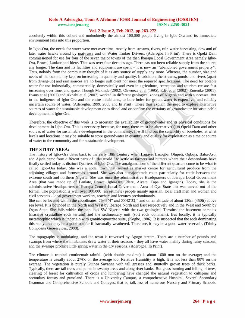
METHODOLOGY AND DATA COLLECTION: Electrical Resistivity Method of geophysical investigation was adopted for the study that is, using Rectified
Resistivity Meter (RRM) Model otherwise known as Terra Meter of High Precision and Accuracy. It involves
measurement of the earth resistance by sending a fairly large current I(mA) into the ground and recording the
response as potential difference ∆V(mV). The currents were sent into the ground at ten points each at pre-
determined locations at Igbole, Saganun and Oke-Odo. Two of the locations (Igbole and Oke Ode) are privately
owned and sponsored while the third belongs to Oyo State Government. But the three locations were examined
within the second week of the month of March, 2008. The eventual plotted resistivity values were obtained using the
working relations, as specified by Wenner Array: In the concept, electrode arrangements are used in resistivity
survey. It consists of four equally spaced collinear electrodes with the outer two serving as current sources and the
inner as potential measuring points, (Sheriff, and 1991):
K = 2πa
where K = constant
a = inter-electrode spacing.
Similarly, Schlumberger Configuration electrode arrangements are used in surface resistivity survey. It consists of
four collinear electrodes with the outer two serving as current sources and the inner two (which are closely spaced
about the midpoint of the outer points) are serving as potential measuring point; and see Table IV and Fig. IV below.
This can be expressed as:
K = 2π (L²-l²)
2l
Again, where K = Geo-electric constant.
ρa = K.R
= apparent resistivity
L = Distance between 1st and last electrodes (Two outer electrodes).
l = Distance between 2nd and 3rd electrodes (Two inner electrodes).
Table I: Resistance and Resistivity Readings at Igbole. Station Number Resistance Resistivity
1 1.810 170.6106
2 1.528 144.0292
3 1.455 137.1483
4 1.119 105.4769
5 1.2 111.112

Kofo A Aderogba, Toun A Afelumo / IOSR Journal of Engineering (IOSRJEN)
www.iosrjen.org ISSN : 2250-3021
Vol. 2 Issue 2, Feb.2012, pp.263-272
www.iosrjen.org 266 | P a g e
6 1.219 114.9029
7 1.15 108.399
8 0.962 90.67812
9 1.094 103.1204
10 1.019 96.05094
Source: Field Work
RESISTIVITY
180
x
x
x
x x x
100 x x
x x
0
1 2 3 4 5 6 7 8 9
10
Fig. 1: Profile at Igbole. (a = 12m l = 3m)
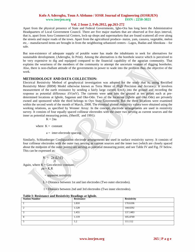
Table II: Resistance and Resistivity Reading at Saganun. Station No. Resistance Resistivity
1 1.86 171.8110
2 1.552 146.1112
3 1.123 124.1121
4 1.116 106.0845
5 1.6 113.105
6 0.898 89.8821
7 1.221 115.0121
8 1.126 113.103
9 1.096 115.0101
Kofo A Aderogba, Toun A Afelumo / IOSR Journal of Engineering (IOSRJEN)
www.iosrjen.org ISSN : 2250-3021
Vol. 2 Issue 2, Feb.2012, pp.263-272
www.iosrjen.org 267 | P a g e
10 1.018 95.10102
Source: Field Work
RESISTIVITY
180
x
x
x x
100 x x x
x x x
0
1 2 3 4 5 6 7 8 9
10
Fig. 2: Profile at Saganun (a = 12m l = 3m)
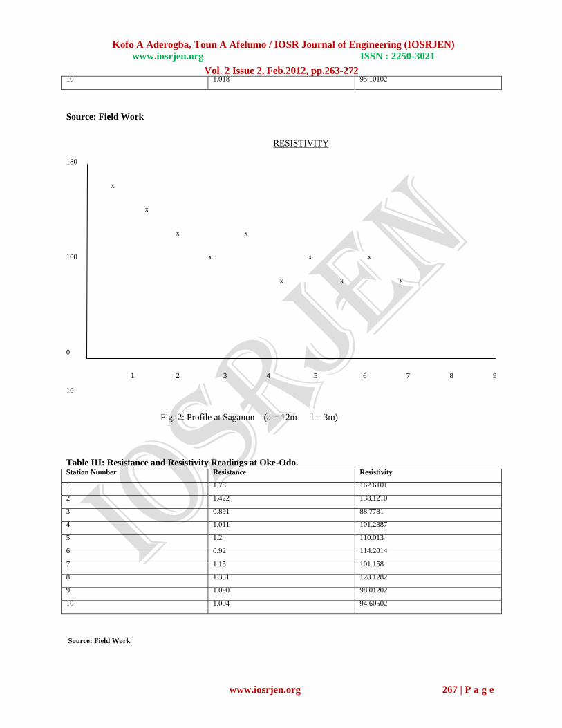
Table III: Resistance and Resistivity Readings at Oke-Odo. Station Number Resistance Resistivity
1 1.78 162.6101
2 1.422 138.1210
3 0.891 88.7781
4 1.011 101.2887
5 1.2 110.013
6 0.92 114.2014
7 1.15 101.158
8 1.331 128.1282
9 1.090 98.01202
10 1.004 94.60502
Source: Field Work
Kofo A Aderogba, Toun A Afelumo / IOSR Journal of Engineering (IOSRJEN)
www.iosrjen.org ISSN : 2250-3021
Vol. 2 Issue 2, Feb.2012, pp.263-272
www.iosrjen.org 268 | P a g e
RESISTIVITY 180
x
x x x
100 x x x x
x x
0
1 2 3 4 5 6 7 8 9
10
Fig. 2: Profile at Oke Odo (a = 12m l = 3m)
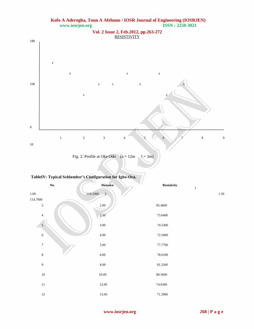
TableIV: Typical Schlumber’s Configuration for Igbo-Ora.
No. Distance Resistivity
1
1.00 119.3300 2 1.50
114.7900
3 2.00 85.4600
4 2.50 73.6400
5 3.00 74.5300
6 4.00 72.5600
7 5.00 77.7700
8 6.00 78.0100
9 8.00 81.2500
10 10.00 80.5600
11 12.00 74.6300
12 15.00 71.2900

Kofo A Aderogba, Toun A Afelumo / IOSR Journal of Engineering (IOSRJEN)
www.iosrjen.org ISSN : 2250-3021
Vol. 2 Issue 2, Feb.2012, pp.263-272
www.iosrjen.org 269 | P a g e
13 20.00 72.2300
14 25.00 56.4300
15 30.00 58.9100
16 35.00 60.1400
17 40.00 67.3300
18 45.00 86.3100
Source: Field Work
10^3 No. Res. Thick. Depth
1 120.3 1.0 1.0
2 52.2 2.1 3.1
3 115.1 5.6 8.7
4 30.2 11.3 20.0
1 5 156.1 -- -- ------
1o^2 Weighted RMS: 0.1
10^1
10^0 10^0 10^1 10^2 10^3
Current Electrode Distance (AB/2) [m]
Kofo A Aderogba, Toun A Afelumo / IOSR Journal of Engineering (IOSRJEN)
www.iosrjen.org ISSN : 2250-3021
Vol. 2 Issue 2, Feb.2012, pp.263-272
www.iosrjen.org 270 | P a g e
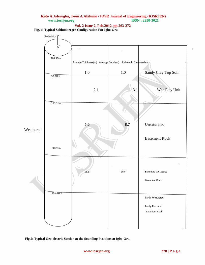
Fig. 4: Typical Schlumberger Configuration For Igbo-Ora
Resistivity
Average Thickness(m) Average Depth(m) Lithologic Characteristics
1212121112121212 1.0
1.0
Sandy Clay Top Soil
2.1 3.1 Wet Clay Unit
5.6 8.7 Unsaturated
Weathered
Basement Rock
11.3 20.0 Saturated Weathered
Basement Rock
Partly Weathered/
Partly Fractured
Basement Rock.
Fig.5: Typical Geo-electric Section at the Sounding Positions at Igbo-Ora.
120.3Ωm
52.2Ωm
115.1Ωm
30.2Ωm
156.1Ωm

Kofo A Aderogba, Toun A Afelumo / IOSR Journal of Engineering (IOSRJEN)
www.iosrjen.org ISSN : 2250-3021
Vol. 2 Issue 2, Feb.2012, pp.263-272
www.iosrjen.org 271 | P a g e
To suitably locate the best point for borehole, the ten stations of each location were examined using profiling. The
least resistive points were sounded for better vertical resolution. The sounding data were processed with manual
curve matching. This involves use of auxiliary and master curves. The obtained parameters were fed into the
computer using resist programme for iteration to enhance better sub-surface resolution for geo-electric configuration
(Trinity Composite Geosciences Services, 2008).
RESULTS AND INTERPRETATION: The sounded points are 8, 6 and 3 at Igbole, Saganun and Oke Odo respectively. See Tables I, II, III and IV and
Figures 1, 2, 3and 4. The resistance and resistivity readings are 0.962 and 90.67812, 0.898 and 89.8821, and 0.891
and 88.7781 respectively on Tables I, II and III. All over, there are five layers of rocks: the topmost layer is the
sandy clay top soil with average resistivity value of 120.3Ωmn and to the depth of about 1.00m and thickness of
1.00m too. See Fig. 5 above. The top soil is underlained by wet clay unit with average resistivity value of 52.2Ωm
and to the depth of about 3.1m on the average. Also, it is 2.1m thick averagely. Immediately beneath is the
unsaturated weathered basement rock with resistivity value of 115.1Ωm, thickness of 5.6m and depth of 8.7m.
The fourth layer is the saturated weathered basement rock. The average resistivity, thickness and depth of the
layers are 30.2Ωm 11.3m and 20.0m respectively. The average thickness is 11.3m. The last layer is fairly deep. This
work cannot determine the depth and thickness, but it is partly weathered and partly fractured basement rock
with resistivity value of about 156.1Ωm on the average. See Fig. 5 above.
DISCUSSIONS AND CONCLUSION: The type of rock in Igbo-Ora is predominantly massive granitic gneisses quartzitic rock and mixed migmatised to
unmigmatised gneisses suites. It is typically metamorphic environment which is underlain with granitic/quartzite
suite. The curve type encountered is the HKH-curve which is a good indication of suitability for ground water
exploration and exploitation. The obtained sounding parameters suitably establish the overburden depth of 25m and
feasible total drills of 35 - 38m that characterize the sounded points.
The rock dominating the area may be good aquifer as it is fracturally weathered and thus a good ground water
reservoir. The results dispel the fear that any expenditure on borehole will be futile and unproductive effort . The
three locations, Igbole, Saganun and Oke Odo have good potential for ground water supply that will worth the
investment in boreholes and that will sustain development in the community. At Oke Odo, the aquifer has more
potential to withstand high rate of discharge than the others. It is relatively thicker. In addition, the work has
revealed the lithologic composition of the study area for purpose of engineering constructions and installations.
Also, the aquifers and their depth of burial are now known.
The hole must be properly cased; and to a stable earth unit below the overburden unit to ensure longevity, quantity
and quality production. Also in these regards, appropriate gravel packing and grouting will need to be applied in
each case for better performance.
Beyond reasonable doubt, this study has allayed the fear that Igbo – Ora does not have enough groundwater that
may worth expending the amount of money for bore holes in the region. It is now a guide to all stake holders in the
ground water resources management and at the locations in particular to explore and exploit ground water for
sustainable development.
In conclusion, since there are no reliable potable water sources that can sustain development in Igbo- Ora, and there
is this alternative from the aquifer, the choice is now for the government and people of Igbo – Ora to choose
between rehabilitating the Opeki Dam or build a new Dam or bore holes for the community. Igbo – Ora must
develop: There is no community that can develop without reasonable quantity of portable water. Therefore, all tiers
of government and Non-Governmental Agencies have to wade-in to provide the community with water through bore
holes and or maintain the Opeki Dam. The prospects of Boreholes are high in quite a number of locations within the
locality.
Kofo A Aderogba, Toun A Afelumo / IOSR Journal of Engineering (IOSRJEN)
www.iosrjen.org ISSN : 2250-3021
Vol. 2 Issue 2, Feb.2012, pp.263-272
www.iosrjen.org 272 | P a g e
REFERENCES
Aderogba, K. A. (1999) “Quality Potable Well Water for All in Urban Centers of Ogun State, Nigeria by the Year
2010 AD” Arts and Social Sciences Forum Journal. Vol. 1 No 1 pp. 1-11.
Aderogba, K. A. (2005) “ Ground Water Development in Nigeria: A case Study of Abeokuta- Ewekoro-Ifo-Ota-
Agbara Axis of Ogun State, Nigeria.” International Journal of Environmental Issues, Vol. 3 No.1 (June) pp.51-68.
Akpabio, I. O. and Udoinyang, I. E (2007) „‟ Electrical Resistivity Survey for Groundwater Exploration in Orumba
South of Anambra State. „‟ Journal of Scientific and Industrial Studies. No.5. pp. 92-96.
Edet, A. E and Okereke, C. S. (2002) “Delineation of shallow Groundwater Aquifers in the Coastal
Plain Sands of Calabar Using Surface Resistivity and Hydrological Data.” Journal of African Earth Sciences. Vol.
35. pp. 433-443.
Emenike, J. A (2001) “Geophysical Exploration for Groundwater in a Sedimentary Environment: A Case Study of
Nanka Formation in Anambra Basin.” Global Journal of Pure and Applied Sciences. No 7 pp. 1-5.
Evans, U. F and George, N. J. (2007) “Resistivity Study of the Groundwater Potential at Aka-Offot and Ikot Ntuen
Nsit Villages in Uyo Capital City Development Area of Akwa Ibom State, Nigeria.” Journal of Environmental
Studies. Vol. 3 No. 4 pp. 114-118.
Kogbe, C. A. (1986) Geology of Nigeria. Jos: Rock View Nigeria Ltd.
Makinde, V. (2002) “Determination of Borehole Site for Extensive Agriculture Irrigation Works.” Paper presented
at the 27th Annual Conference of Nigerian Institute of Physics, Sheraton Hotel and Towers, Abuja. (18th-21st
September).
Okwueze, E. E.; Selemo, A. and Ezeanyim, V. I. (1995) “Preliminary Lithologic Deductions From a Regional
Electrical Resistivity Survey of Ogoja, Nigeria.” Nigeria Journal of Physics, No.7 pp. 15-17.
Palmer. D (1980) The Generalised Reciprocal Method of Seismic Refraction Interpretation. Society Exploration
Geophysics.
Sheriff, R. E (1991) Encyclopedia Dictionary of Exploration Geophysics. (Third Edition)
Tulsa: Society of Exploration Geophysicists pp.260 and 330.
Spies, B. R (1989) Depth of Investigation of Electromagnetic Sounding Method. Geophysics. No.54, pp.872-888.
Trinity Composite Geoservices (2008) “Geophysical Site Investigation for Sitting a Viable Point for Groundwater
Exploitation at Igbole Area, Igbo-Ora, Oyo State.” Ibadan: Trinity Composite Geoservices.
Wikipedia (2008) Drinking Water-Wikipedia: The Free Encyclopedia. Coy.
World Health Organization (2005) Safe Drinking Water for International Travelers. Geneva: World Health
Organization.