A Socio-ecological Analysis of the Loss of Public Properties in an Urban Environment: A Case Study...
36
A Socio-ecological Analysis of the Loss of Public Properties in an Urban Environment: A Case Study of Pokhara, Nepal. Jagannath Adhikari Introduction: In this paper, the historical, religious and cultural aspects that led to the development of public properties (mainly chautaras – platform with huge shade providing trees - and community orchards, open spaces and water ponds) in Pokhara, Nepal, are discussed in detail in relation to their ecological functions. The processes (urbanization and modernization separating nature and culture) that led to the decline of these properties are then examined. It is argued in this paper that while urbanization may be a necessity and important, the concept of separating urban people and culture from nature led to the decline of trees and other important properties which are equally important for the life of a city. Pokhara, a tourist town in central Nepal, has undergone a rapid change in the last five decades. The urbanization process of the last five decades has brought many changes in social and ecological features of the town. One of the main features of the town was the existence, in plenty, of the public properties, mainly open space, chautaras (huge shade proving trees and a platform where people can sit, rest and meet) and community orchards, and water ponds. These features were man-made, and, were maintained, as is argued in this paper, as they had many cultural, ecological and economic functions at a time when the mode of production was largely agriculture and livestock. Trees, This article is based on a research carried out by the author under the financial support of Ford Foundation, New Delhi. The research grant was made available to Martin Chautari, a discussion group based in Kathmandu. The author is the convener of this group. In the field, Min Bahadur Giri, supported in the collection of data and information.
-
Upload
independent -
Category
Documents
-
view
2 -
download
0
Transcript of A Socio-ecological Analysis of the Loss of Public Properties in an Urban Environment: A Case Study...
A Socio-ecological Analysis of the Loss of Public Properties in an Urban
Environment: A Case Study of Pokhara, Nepal.
Jagannath Adhikari
Introduction:
In this paper, the historical, religious and cultural aspects that led to the
development of public properties (mainly chautaras – platform with huge shade
providing trees - and community orchards, open spaces and water ponds) in Pokhara,
Nepal, are discussed in detail in relation to their ecological functions. The processes
(urbanization and modernization separating nature and culture) that led to the decline of
these properties are then examined.
It is argued in this paper that while urbanization may be a necessity and
important, the concept of separating urban people and culture from nature led to the
decline of trees and other important properties which are equally important for the life of
a city.
Pokhara, a tourist town in central Nepal, has undergone a rapid change in the last
five decades. The urbanization process of the last five decades has brought many changes
in social and ecological features of the town. One of the main features of the town was
the existence, in plenty, of the public properties, mainly open space, chautaras (huge
shade proving trees and a platform where people can sit, rest and meet) and community
orchards, and water ponds. These features were man-made, and, were maintained, as is
argued in this paper, as they had many cultural, ecological and economic functions at a
time when the mode of production was largely agriculture and livestock. Trees,
This article is based on a research carried out by the author under the financial support of Ford
Foundation, New Delhi. The research grant was made available to Martin Chautari, a discussion group
based in Kathmandu. The author is the convener of this group. In the field, Min Bahadur Giri, supported in
the collection of data and information.
Loss of Public Properties … Socio-Ecological Analysis - Jagannath Adhikar 2
particularly those used in chautaras, and ponds were also important from religious points
of views.
As the process of urbanization continued, Pokhara became more and more
exposed to modernization. The developmentist attitude of the government established
after the downfall of autocratic Rana rule in 1950 gave priority to physical development
even at the cost of nature. Pokhara, which is now (in 2001) a home to about 156,000
people, started attracting people who worked in foreign countries. Their resettlement and
investment in the town is also responsible for its rapid pace of urbanization (see Adhikari
and Seddon 2002). This town is the fastest growing town in the country. Population in
the town has been growing by more than 8 % per year in the last four decades. Tourism
income and remittances are the main sources of income. Agricultural production, which
was the main source of income until the 1970s, now contributes less than one fourth to
the total income of its population. Clearly, it is not a main source of income for a large
majority of households in Pokhara.
Changes in the economy and the shift in the attitude of people led to not only the
lack of interest in planting trees and in maintaining open spaces and water ponds, but also
to the destruction of these properties. These properties, particularly the trees, were seen as
obstacles for the progress of the town. An attitude that a place covered by trees does not
represent modern place started to occupy the mind of the people as Pokhara started to
urbanize. Influence of the modern buildings and urban life and the concept of
modernization and development created a notion that urban areas are modern and rural
areas are backward. Urban areas, people and their cultures were thought as shabya (or
civilized), and village areas, people and their folk culture were thought as ashabya or
pakhe (uncivilized) or gaule (folk). In extreme case, the village people were also called
jangali (people of forest), which means wild, uncivilized and without culture. Existence
of a large number of trees and forest/tree grooves was considered to be associated with
village life.
Loss of Public Properties … Socio-Ecological Analysis - Jagannath Adhikar 3
The above change in the concept of people is also generally found to impact upon
the economy of Nepal as a whole. Professions dependent on land and forest like
agriculture are now regarded as backward, and to be done by people who are illiterate and
ignorant. Trade and job (service) are now celebrated professions. But until 3-4 decades
ago people regarded agriculture as the best profession. Even the Sanskrit scriptures are
said to profess farming as a best occupation, followed by trade and service. Farming was
considered as a 'pure' occupation in that it does not involve cheating and lieing as in other
professions. But now with changes in the economy and influence of modern value,
people have been distinctively isolated from land and forest. The dominant development
thinking separated people and nature as different things. It is also partly because of this
thinking that the leaders of the Pokhara and even the urban planners in early 1950s to
1960s did not pay attentions to the existing trees, and cultural features. These were
thought necessary only in the villages, and for the pakhe (uncivilized people). But again
since the 1980s, the necessity of trees in urban settings has also been considered
important. This has again come as a fashion, and due to the influence of 'green' in
attracting tourists. The city planners in the 1990s even stated that they would make the
city as a 'green city'. While it is important that trees are now considered essential even in
urban setting, but the dominant thinking is that they are separate from human culture.
Public Properties and Their Importance:
Public properties are the natural and manmade resources, assets or other things
whose ownership is not private. Therefore, it is mainly the mode of ownership that
distinguishes 'public' properties as against 'private' properties. Here public properties also
mean those properties whose use right is not limited to an individual or household but
determined, in some cases, by the community. Accordingly, air, water, river, lake and
water bodies, forests, and other natural and cultural resources like public pasture,
building, temples and pati and pauwas (home and shelters for public use and for
homeless), chautaras, trees, water taps, well, and the like are the public properties. But in
Loss of Public Properties … Socio-Ecological Analysis - Jagannath Adhikar 4
this article, chautaras and community orchards, open space (public ground and others)
and water ponds are studied in detail.
Public properties are necessary for the security, health and sustainable
development of a society. In an urban setting, public properties play an even greater role,
and are more important. A large majority of urban population do not have their own
house, land and other natural things like trees. In this context, open spaces, buildings and
shelters, temples, pati and pauwas, trees and park are important for their recreational,
emergency and other uses.
The general perception now is that 'public properties' are important only in rural
settings and there are a large number of studies about this in Nepal. But there are almost
negligible number of studies about 'public properties' and the changes in their use and
existence in an urban setting. As public resources like forests, pasture, water and the like
play an important role in the livelihoods of rural people, there is a large body of studies
devoted to status, ownership and management of these resources. But this is just the
reverse in the context of an urban environment. There are a few studies about the changes
in the status and role of public properties like temple, pati, pauwa (homes and shelters for
the homeless and for public use) and guthi (land devoted to temples and religious
purpose) in Kathmandu. But even here there is little attention on trees, and public open
space.
The lack of studies on public properties in urban areas is also a product of a
mindset which considers these properties less useful in an urban environment. On the
other hand, in rural areas these properties are generally called 'common property
resources' which are thought to be essential for the livelihoods or enterprises of rural
areas like agriculture, livestock, agro-forestry, fishery and the like. As the profession of
the urban population is generally not 'primary production', it could be one of the reasons
for giving less emphasis in the study of public properties in urban areas. But these
properties are also equally important in urban context.
Loss of Public Properties … Socio-Ecological Analysis - Jagannath Adhikar 5
In urban areas, public properties, particularly the large open spaces, are important
and essential from security point of view. To lessen the adverse impact of earth-quakes,
floods and manmade disasters like fire, it is essential to have open spaces. Especially in
the event of an earthquake, it is important to bring the people to an open space, because it
is not the earthquake as such that kills many people, but the after affects of the
earthquake (like fire, floods and the like) that kill more people. To reduce the impact of
these after affects, it is essential to have open spaces. It is said that the earthquake that
devastated Kathamndu and killed about 34,000 people in 1934 would have killed many
times more people if there had been no Tundikhel (large open space in the middle of the
town). Pokhara and the surrounding areas are prone to earthquake as they lie in the fault
line created by the immersion of Indian Plate under the Tibetan Plate. As the process of
immersion of the Plate is continuing, earthquakes are frequent in this region. Apart from
this benefit, open spaces are also essential for sports, recreations and other physical
exercises of the urban people. Temples, pati and pauwas are also important from the
cultural, social and environmental point of view. Poor residents of the city who cannot
afford to have their own open space, trees, and temples, need to be dependent on these
public properties. Accordingly, public properties are also essential for the proper physical
growth and health of the children of the low income people. Public properties are, thus,
even more important to the low income families than the wealthier ones.
Migration of poorer households from rural areas to the urban areas is a worldwide
phenomenon and it is growing rapidly. The urban population is thus exploding. Even in
Nepal, about 16 % of her population now live in urban areas. Now, poverty is no longer a
rural problem alone; it has also become an urban problem. Availability of 'public
properties' in urban areas has been providing some respite for the poor people. In some
cases 'public properties' have also been helpful in securing a part of livelihoods of the
poor people. Considering this fact the new concepts of poverty reduction through 'urban
agriculture' and 'urban livestock raising' have been promoted. In most Indian cities urban
'dairy production' has given employment and income for many poorer households.
Loss of Public Properties … Socio-Ecological Analysis - Jagannath Adhikar 6
Because of the growing environmental consciousness in urban areas, 'urban forestry' has
been popularized. In Pokhara, 'urban forestry' has now come as a dilemma. Previously,
the urban planners and leaders destroyed the trees, and now they suggest that 'greening' is
necessary, for which they are using more and more alien trees, whose ecological and
economic functions to the community are not known.
Several studies/researches have been conducted about Pokhara. Most of them
describe the natural beauty and its interesting geological and geographical features. This
tendency is seen especially in the studies conducted in the past1. Even though there are
large numbers of researches conducted in Pokhara, there is no concern to study the
'public properties'. In the books written about Nepal by foreigners, there are few
references to Pokhara, but they are not related to its natural resources, public properties
and their uses. Some of them have explained the commercial possibilities in the town.
William Krickpatric (1973) has mentioned that he had crossed the bridge on Seti river
and been up to Beni in Magydi. Hemilton (1971) had traveled in Pokhara in 1819 and he
had mentioned 'Pokhara is a place frequented by businesspersons from all over the
country'. Similarly, Perceival Landon (1987) has also written some comments about
Pokhara. In 1899, a Japanese Monk, Ekai Kawaguchi (1909) visited Pokhara while he
was traveling to Tibet. He had described the town as the most beautiful place on the
earth, but considered its size like a bigger village in Japan. Tucci (1987) while traveling
in Pokhara in 1950 had forecasted that Pokhara will become a commercial center.
Among the studies of Pokhara, Harka Gurung's study (1965) is considered as a
foundation. But his study is also focused on geological and social aspects of the town.
The study has covered the land-use patterns and urban development, but there is little
discussion on manmade and traditionally developed land-uses like chautaras and water
ponds. He has mentioned about the chautaras, but has not given detailed numbers and
their functions. After the 1970s, several studies were conducted about Pokhara (Meirow
2000; Murphi 1965; Raj 2000; Thapa 1990). Blaikie and his friends (1980) argued that
1 Various studies conducted in Pokhara are described in Adhikari and Seddon (2002).
Loss of Public Properties … Socio-Ecological Analysis - Jagannath Adhikar 7
Pokhara's urbanization was the result of government policies and the expanding
bureaucracy. Studies conducted then after are concerned with commerce, trade, industry,
tourism, settlement pattern and migration, land-use changes and the like (Blaike et al
1980; Gurung et al 2000; Bansnet et al 1992; Gurung 2002; Gurung 1979; Gyawali 1997;
Adhikari 2000; KC et al 1992; Pandit 1989; Parajuli 1999 and 2000; Shrestha 2000).
These studies have mentioned that public properties in Pokhara have declined. Even in
media this has been raised as an issue. Still then there is no proper study as to why these
public properties were maintained and why they have now been disappearing. Shroeder
(1978) in a study of a village located just outside the then Pokhara town had mentioned
that a large public open space used as community pasture and recreational ground had
been shrinking because of mainly encroachment from individuals.2
Even though it was clear that public properties in Pokhara like open spaces,
chautaras , water ponds and the like have been lost along with the process of
urbanization, there were no studies either on the adverse impact of this loss or for its
documentation. In this context, a study was conducted in Pokhara in 2000 to study the
loss of public property, the reasons for their development and existence and the adverse
impact of this loss on the society and ecology. While conducting this research, an
inventory on public properties of Pokhara developed on the basis of a survey conducted
in 1977 was also found. This proved useful in making a comparison. In addition, oral
history records were also developed from elderly people regarding the social and
ecological changes in Pokhara. Various reports published in newspapers were also
consulted to understand and reconstruct the historical reality leading to the development
of various public properties3.
2 During the study of Shroeder, Batulechaur was a rural area, but it is now placed under Pokhara
municipality.
3 Various persons interviewed for the historical information include first secretary (Krishnaji Sharma) of
Pokhara municipality when it was establishd in 1959, the then local land revenue collector Jimmwal
Purna Bahadur Baniya and an elderly woman of Pokhara Uttara Kumari Palikhe.
Loss of Public Properties … Socio-Ecological Analysis - Jagannath Adhikar 8
Development of public properties and their loss in the context of socio-cultural
changes and urbanization.
The frequently asked question about Pokhara is 'why so many open grounds
(spaces) suitable for pasture existed in Pokhara and that too as public property?'. Why
trees were not developed in these grounds? Was it a natural feature or a manmade
feature? Studies conducted about Pokhara do not take up these questions, even though
similar questions seem to have been raised in the context of India and Pakistan
(Zimmerman 1987 and Dove 1998) in rural context. Similarly there are other questions
related to other manmade features in Pokhara. Why chautaras were so numerous in
Pokhara? Why were they developed at a time when forests were converted into pasture
lands? Why people kept so many water ponds? Answers to these questions require some
insight from the historical development of this place.
The prehistory writings (see Shrestha 2000) about Pokhara valley and its
surrounding hills reveal that the valley area was a dense forest with a hot and humid
climate. Because of this natural reason, prehistoric people lived only in the surrounding
hills. But after the 8th and 9th centuries, people of Tibeto-Burman origin (like Gurungs
and Magars) started to settle in the forests of the hills. They practiced the swidden
cultivation, the remnants of which are still seen in the hill villages where these people
rotate lands located away from the settlement in a 3 or 5 years cycle. Their main
occupation was animal husbandry. Various ethnographic studies and the historical
writing in the past 250-300 years reveal that their economy was totally based on animal
husbandry.
The valley bottom area was inhospitable because of hot climate and malaria.
Therefore, only in winter people would come to the valley with the main purpose of
raising animals. This would also save the fodder collected at home. This grazing of
Loss of Public Properties … Socio-Ecological Analysis - Jagannath Adhikar 9
animals required the conversion of dense forest into grass fields. The yearly grazing
would also prevent the conversion of this land into a forest. This is the reason that
Pokhara was known as a place with tall grasses in the past. Until the 11th century, there
was no settlement in the Pokhara valley. Politically, it was under the jurisdiction of a
Ghale Gurung king of the Kaski, a microstate before the unification of Nepal4.
In the 13th century, Shah kings, follower of Hindu religion, started a slow entry
into the present day Nepal. They had already taken over a kingdom (Syanjya) south of
Pokhara by the 14th century. The king Kulmandan Shah conquered the Kaski kingdom
also, which included Pokhara valley.
The king Kulmandan had numerous and large herds of cows. He kept his cattle in
Pokhara. It is not known to what extent the natural forest of Pokhara was destroyed in the
past by the early seasonal herdsmen or by the newcomer Hindu king for the grazing of his
cattle. But it is certain that before these human interventions, Pokhara was full of forest.
The natural regeneration of vegetation is quite high in this area. Prevention of human and
domestic animal interference can easily lead to regeneration of trees and development of
forest in a due course of time. Therefore, large grazing lands were developed purposively
to maintain the extensive animal husbandry. But still then, Pokhara was not settled by
the people because of the malaria. At the most people would come here during the day,
but would return to the hill tops for the night. Later on, the hills were also increasingly
settled by the Hindus who migrated eastward from Jumla, their center of entry to Nepal
from India. Shrestha (2000) also writes that because of suitability to grow rice in the
plains of valley bottom, people started to cultivate rice there even in summer season. But,
invariably, they would return to the hilltops to spend the night. The increased human
intervention and the changes in landuse in Pokhara had already reduced the severity of
malaria.
4 The present day Nepal was divided into several microstates (about 80) before its unification. The process
of unification was led by the king Prithiwi Narayan Shah of Gorkha, one of the microstates existed then.
The kingdom of Nepal was created in 1969 when he conquered the Kathmandu valley. The unification and
territorial expansion continued till 1816, when Nepal was defeated by East-India company (Britain), which
had colonized India then. Kaski is now one of the 75 districts of Nepal.
Loss of Public Properties … Socio-Ecological Analysis - Jagannath Adhikar 10
Later on Pokhara was developed as a winter residential place. When the king
Kulmandan constructed a winter place in Batulachaur, more and more people started to
settle in Pokhara, especially in winter. The area around the palace started to develop as a
permanent settled area. It should also be important to note that this place is located at a
considerable height within the Pokhara valley. The problem of malaria and hot climate
would have been considerably low here. Under the order of Kulmandan Shah to develop
a temple in his new place in Kaskikot5, Bindybasini idol was brought from Bindyachal in
India. Before, it was taken to Kaskikot, it was placed in a hillock in Pokhara valley for a
night stop. But the next morning, people could not lift up the idol, and the king then
ordered its people to build the temple there. To look after the temple, Brahmin priests
were assigned and they were also given some land as grant. A permanent settlement was
also started to develop around the temple. It is just at this time that Pokhara also gained
some importance in commerce. The trade route from India to Tibet passed through
Pokhara. Similarly another trade route from Jumla in the west to Kathamdnu in the east
also passed through Pokhara. In winter there used to be a huge crowd of people, which
would require development of several seasonal shelters. As the commercial importance of
Pokhara began to grow, the last king of Kaski (Siddi Narayan Shah) developed a plan to
build a town and houses like in Kathmandu. He brought skilled Newar from Bhaktapur
in Kathmandu valley in 1752 for this purpose. But rapid development of the town began
from 1769 after Gorkha king Prithiwi Narayan Shah unified Nepal in 1769. This
unification led to the migration of businesspersons like Newars from Kathmandu to
Pokhara in great numbers. After the unification of the country, Pokhara was also
considered as a strategic administrative and military outpost. More and more government
offices started to appear. But until 1950s, Pokhara was not considered as a good place for
living.
It is precisely to make Pokhara a pleasant place for settlement that that led to the
development of numerous chautaras, which were so useful during summer. In the context
5 The headquarters of Kaski kingdom, located on a hill top overlooking the Pokhara valley.
Loss of Public Properties … Socio-Ecological Analysis - Jagannath Adhikar 11
of conversion of large forest area into pasture, it seems that chautaras were thought
essential for the shade and cooling effect. These chautaras were made at a place where
people would like to have rest while walking or for shelter during peak heat periods after
working in the fields. It must have also been thought that chautaras were useful for
reducing the impact of malaria. In places where incidence of malaria was high, chautaras
were numerous. The existence of big trees would also make the locality cool. The
practice of making chautaras was also common in other places in west central Nepal, but
they were not built in such large numbers as in Pokhara. The Hindu religious values that
required worshipping of trees that are generally used in chautaras might have also led to
the development of these chautras. Moreover, the leaves of these trees were also needed
in religious ceremonies. The development of water ponds in Pokhara was also to
encourage farmers to settle in the valley and to help in raising livestock. These water
ponds were useful for storing rainwater, recharging water table, and for irrigation and
animals. Community orchards of mango trees were also developed to encourage
settlement and for other social, religious and public health functions.
After a historic phase that required the development of chautaras, open grounds
for grazing and water ponds, Pokhara underwent another phase of development
(urbanization) that did not consider these properties as valuable. The changes in the mode
of production, the rapid decline in the importance of farming as a source of livelihood,
control of malaria since the 1950s with the help of USAID support, possibility of
importing foodgrains from distance places due to the development of transportation
reduced the importance of these properties. On the other hand, the concept introduced by
the state especially after the 1950s about the need for development and modernization
created an image to the people that trees and water ponds are the symbols of
backwardness and rural life. This also led to the indiscriminate felling of the trees and
abandonment of water ponds. Similarly, individualistic ideas and erosion in social and
community control also led to the indiscriminate felling of community orchards.
Government agencies often felled these trees to earn income which was then used for the
development of infrastructures. Even though urbanization and reduction in the
Loss of Public Properties … Socio-Ecological Analysis - Jagannath Adhikar 12
importance of these public properties can also be seen from societal evolutionary point of
view, but the main contention is that the separation of 'nature' and 'culture' led to the
thinking that trees are only natural things and they represent backwardness. And, they
were to be placed in rural areas (which were perceived as ashabya, pakhe, gaule or
jangali). If trees or chautaras in Pokhara were also considered as manmade features
developed with some functions, they would not have been destructed in such a manner as
discussed in the sections below. They would have been modified in a way that would
have been suitable in a changed circumstance. Dove (1998) has also found the adverse
impact of such separation of 'nature' and 'culture' concepts, which he argued, led to
deforestation in Punjab, Pakistan.
The process of urbanization of Pokhara had started from the 1950s as it is from
this time that market started to grow in terms of both physical expansion and the volume
of transactions. Since 1953, Pokhara was linked to other towns in Nepal and India by
airplane. But it is only in 1957 that first vehicle was run there. In 1959, it was declared as
'municipality', and from then on various development projects, educational institutions
and service centers were established. Government also declared it as a headquarters of the
'western development region' in 1973. By that time, it was also linked with an Indian
border town (Bhairahawa and Sunauli) by a road built by Indian assistance, and to
Kathmandu by a road built with Chinese assistance. Construction of these roads increased
the commercial importance of the town. Immigration of people to Pokhara was at its
height after the construction of these roads. For sometime, population growth rate
remained about 18% per year. But after sometime, this population growth rate had
reduced, and stabilized at about 8 % per year.
The west central Nepal, of which Pokhara is a center, is also known as a place
from where a proportionately large number of people, especially hill ethnic groups like
Gurungs and Magars, go to foreign countries to work (Adhikari 1996). The Gurungs and
Magars have been working in British and Indian armies for the last 200 years. The
Loss of Public Properties … Socio-Ecological Analysis - Jagannath Adhikar 13
income earned by the people working away in foreign lands has also been invested in
Pokhara for the purchase of land and building of houses.
In terms of social composition of people, Pokhara had been traditionally a
Brahmin-Chettri dominated place. As discussed above, because of the hot climate and
danger of malaria, hill ethnic groups had not settled in Pokhara, even though it is
probable that they had used it for winter pasturage. But the later migrants like Brahmins
and Chettris had probably no access to good land in the hills, and because of the
possibility of combining animal husbandry in dry lands and paddy cultivation in wet
places, they occupied the valley. But initially, they used to work all day in the valley and
return to the hills during night. Conquering of Kaski by Shah king, his establishment of a
winter place and an important temple in Pokhara had encouraged Brahmins and Chettris
to settle here despite inhospitable climate and health conditions. But after the 1970s,
migration of hill ethnic groups who could improve their economic conditions from higher
incomes changed the social composition of Pokhara. Gurungs and Magars now dominate
the population of the town (Adhikari and Seddon 2002). In Pokhara, their main
profession was to follow the skills they learned while in the army jobs. Most of them
did/do not farm. They developed and followed various non-farm jobs. Because of the
high economic growth and creation of employment opportunities in construction and
service sectors, poorer people also migrated to Pokhara in equal magnitude. The
encroachment on public land thus increased.
The development of 'open spaces', and particularly trees, community orchards,
water ponds and chautaras owes much to the religious practice of Brahmins and Chettris.
In the Sanskrit scriptures, trees have special place. In various religious ceremonies of
Brahmins and Chettries, various parts of these plants/trees are necessary. Women
worship these trees once every week. Marriages between trees were also a common
practice. Therefore, Brahmins and Chettris had a special relation to these trees. As their
occupation was also farming, these trees and water ponds were also required to them. On
the other hand, the new immigrants, mainly Gurungs and Magars, even though were
Loss of Public Properties … Socio-Ecological Analysis - Jagannath Adhikar 14
nature-worshippers in their place of origin (villages), had no especial value to the trees
and objects developed by the people of other culture. Their several years of service in
foreign lands also mean that they had been accustomed to other cultures and were less
sensitive to the religious values and rituals with which these trees were planted,
maintained and used. It is also interesting that political power in Pokhara slowly shifted
to these recent migrants who are also considered novae riche. Their new-found wealth
power was also instrumental for their ascendancy to political power. This has been
described elsewhere by Adhikari (2003) by analyzing the political history of the last 4
decades. As persons with new cultural and religious values became decision-makers, the
sensitivity towards these traditionally made features was certainly less.
Pokhara also attracts about a hundred thousand tourists in a year. Tourism is now
one of the main sources of income. Even though tourism is vital in the economy, this has
also led to various social and ecological changes. The main change is seen in the
treatment of nature, which is now seen as a way to increase profit. To attract the tourists,
more and more hotels have been made at a location from where view of the Himalayas is
clear. A large chunk of open grounds were first privatized and then sold to these hotel
owners. Those objects that would attract tourists started to receive more attention. For the
tourists, the chautaras, community orchards and small water ponds were not attractive
because, firstly, they would come only in winter when the skies are clear and, secondly,
they would be able to afford cooling things. Therefore, from the tourism point of view
also, there was less urgency to preserve these trees.
It is natural that with increased urbanization and population growth, more houses, roads
and other physical infrastructures are necessary. But in the process of the development of
these infrastructures, traditionally existing public properties have been destroyed,
encroached upon and lost. Until 1974, when the government had started a scientific and
modern survey of the land and property, there were plenty of public properties in
Pokhara. But in the name of development of roads, government destroyed much of the
planted trees and built chautaras, community orchids and water ponds. On the other
Loss of Public Properties … Socio-Ecological Analysis - Jagannath Adhikar 15
hand, the powerful and wealthy persons captured the 'open spaces' kept and maintained
for the public use as the value of land increased significantly. From time to time, legal
systems are distorted to facilitate the registration of the public land into private land by
the powerful class. The previous political regime (1960-1990) used much of this public
land to gain political favors from these powerful people. The landless squatters have also
occupied such land. Today, a common Pokhara resident does not find an open space for
recreation, sports and for physical exercise. Youths are seen to play in the roads and in a
small plots of land reserved for house construction. One or two common playgrounds
kept for the colleges and sports complex are not accessible to the common residents of
the town.
In the sections below, magnitude of the decline of these public properties and the specific
reasons surrounding their preservation in the past and destruction in recent times are
discussed.
Chautaras and community orchards:
Chautaras are also one of the special features of the landscape of Pokhara. Built along
the sides of a road or trail and within a short distance from one another, these chautaras
used to provide different aesthetic value to the landscape. Generally two or three trees
were/are planted in chautaras; these trees are pipal (Ficus religiosa), bar (Ficus
bangalensis) and sami (Ficus benjamina). Generally first two are planted in a chautara.
The major use of these chautaras is to provide shade to the pedestrians and the people. In
the summer, various meetings, gatherings, and celebrations were also organized on the
chautaras. The trees planted here are big trees. They produced especial types of fruits
which attracted a large number of birds. Similarly, these trees were also home to various
orchids. The large leaf size of these trees was also useful to absorb the dust of the
road/trails.
Loss of Public Properties … Socio-Ecological Analysis - Jagannath Adhikar 16
Even though the primary aim of the chautaras is to provide shade and cooling
effects in a hot and humid summer condition, people were motivated to build them from
religious point of view. Generally people would build chautaras and plant trees there to
earn merit in the next birth. But planting trees and building chautaras was an especial
endeavor of the people who had no children. The Sanskrit scripture has clearly said that
planting and developing a tree is equivalent to producing a child. The childless couples
would construct a chautara, plant bar and pipal trees, and then organize a marriage
ceremony of these two trees. The marriage ceremony was the same as that was organized
for the people. People had the faith that organizing this ceremony would help in having
children. The other religious reason for the planting of these trees is that leaves of these
trees are needed in most of the religious ceremonies. Planting of trees in chautaras and in
other places was also motivated by the Sanskrit text that says that if one preserves nature,
nature will preserve him/her. The trees (especially the pipal) were worshipped by women
regularly for the wellbeing of the family.
The trees generally planted in chautaras were also having medicinal values.
Especially the pipal tree was considered to have high medicinal value. If people had
wounds they used to get a small piece of the bark of the tree, which was powdered and
put into the wounds. The wound would become dry soon which would help in natural
healing.
In the past, it was also a practice to construct a pond by the side of a chautara. In
the pond rain water was collected. This water was useful for irrigation and feeding
animals. At the center of the ponds a wooden pole was placed. Every year people would
worship that wooden pole.
There used to be a provision of drinking water in the chautara in summer. This
was essentially meant for the pedestrians. A large earthen pot was placed in a hole dug in
the chautara. A lid and a small pot were also placed there. Every day the local people
would fill the pot with clean and fresh water. At certain times of the year, people would

Loss of Public Properties … Socio-Ecological Analysis - Jagannath Adhikar 17
mix water with boiled sugarcane juice. All these works were performed voluntary, solely
for the purpose of earning religious merit.
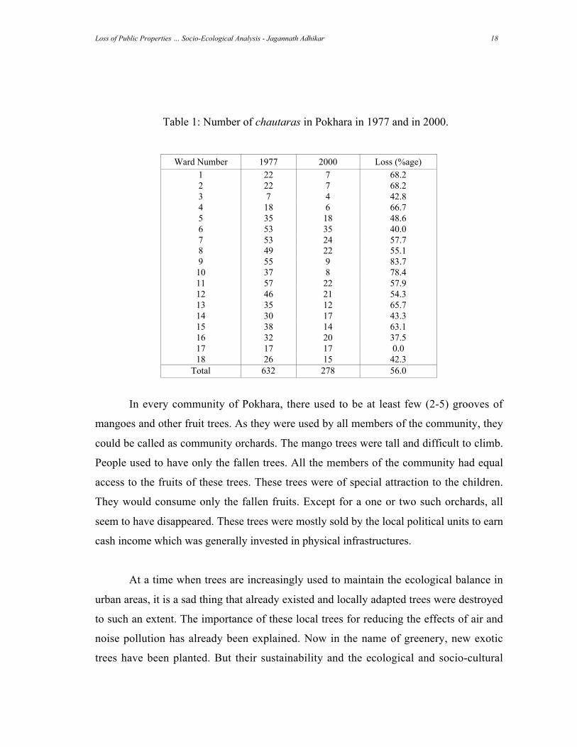
It is now difficult to say how many chautaras were there in Pokhara. A document
which listed the chautaras in 1977 revealed that there were 632 chautaras then. In 2000,
we counted only 278 chautaras in whole of Pokhara. This shows that in a period of 23
years, 354 or 56 % chautaras were destroyed. In Table 1, the ward-wise existence of
chautaras in 1977 and in 2000 is shown. This Table also shows the percentage of
chautaras lost in these 23 years. The Table shows that chautaras from Wards 1, 2, 4, 9,
10 and 13 were lost in proportionately more numbers.
There are several reasons for the lost of these chautaras. The impact of the cultural
and political changes has already been discussed. But visibly, it is seen that political
bodies destroyed these trees and chautaras in the name of physical development. The
roads were expanded and new roads were built, which required destruction of these trees.
Similarly, extension of electricity and telephone lines also led to cutting down of these
trees. Most importantly, these trees were the sources of revenue for the local political
units. These trees were generally sold to brick factories which were so much flourishing
at that time. The indiscriminate felling of trees was motivated by the newly emerging
concept that trees were required in villages and their presence in city is unsuitable.
Loss of Public Properties … Socio-Ecological Analysis - Jagannath Adhikar 18
Table 1: Number of chautaras in Pokhara in 1977 and in 2000.
Ward Number 1977 2000 Loss (%age)
1 22 7 68.2
2 22 7 68.2
3 7 4 42.8
4 18 6 66.7
5 35 18 48.6
6 53 35 40.0
7 53 24 57.7
8 49 22 55.1
9 55 9 83.7
10 37 8 78.4
11 57 22 57.9
12 46 21 54.3
13 35 12 65.7
14 30 17 43.3
15 38 14 63.1
16 32 20 37.5
17 17 17 0.0
18 26 15 42.3
Total 632 278 56.0
In every community of Pokhara, there used to be at least few (2-5) grooves of
mangoes and other fruit trees. As they were used by all members of the community, they
could be called as community orchards. The mango trees were tall and difficult to climb.
People used to have only the fallen trees. All the members of the community had equal
access to the fruits of these trees. These trees were of special attraction to the children.
They would consume only the fallen fruits. Except for a one or two such orchards, all
seem to have disappeared. These trees were mostly sold by the local political units to earn
cash income which was generally invested in physical infrastructures.
At a time when trees are increasingly used to maintain the ecological balance in
urban areas, it is a sad thing that already existed and locally adapted trees were destroyed
to such an extent. The importance of these local trees for reducing the effects of air and
noise pollution has already been explained. Now in the name of greenery, new exotic
trees have been planted. But their sustainability and the ecological and socio-cultural
Loss of Public Properties … Socio-Ecological Analysis - Jagannath Adhikar 19
importance would be certainly less than the locally adapted traditional trees. Because of
the importance of trees in controlling the increase in temperature due to heat trapping in
urban areas, the traditional chautaras and trees would have played an important role.
Accordingly, it would have been wise to preserve those trees.
Water ponds:
The name Pokhara comes from the fact that it had many Pokharis (water ponds).
Therefore, the name of the town itself gives the indication that there were several water
bodies. Pokhara had many natural as well as manmade water bodies. Out of the 7 natural
lakes, 3 are considerably bigger. Other four have already been extinct or are on the verge
of extinction. These lakes were created through a geological process. As the Seti river
carried the moraine from Annapurna Himalayas after the burst of glacial lakes at various
pre-historical time periods, the moraine were deposited on the routes of the rivers. This
caused formation of natural lakes.
Apart from these natural lakes, people also had made several water ponds. At
every community or neighborhoods, there would be at least 2-3 water ponds. These
ponds were made from religious as well as practical point of view. These ponds were
needed for the collection of rain water. The stored water was used for irrigation, feeding
animals and also for washing if necessary. As the households were not connected to
water pipes, these ponds were essential to meet the necessity of water. For drinking water
people depended on other sources like springs, wells, lakes and the like. It is even seen
that when animals suffered from FMD (foot and mouth disease – with sores on foot and
mouth), these animals were made to stand on the ponds for a week. It was believed that
this practice would cure the disease, and then animals were taken to the homestead.
As mentioned in the previous section, religious ponds were generally located by
the side of chautaras. As a matter of fact it was a custom to build a pond while building
the chautaras. The reason is not clear, but it seems to have some practical value. As the
Loss of Public Properties … Socio-Ecological Analysis - Jagannath Adhikar 20
trees on chautaras would harbor various birds, water ponds would also be useful for the
birds to drink the water. Moreover, water ponds by the side of chautaras would store
water for a long time as the shade of the huge trees would prevent the loss of water
through evaporation.
It is not clear whether people had consciously understood the distant role of these
water ponds like controlling the temperature and recharging the underground water table.
This recharging water table was certainly essential for the proper functioning of springs,
wells, and the like. It is a major method by which water scarcity is met in desert areas.
This is also followed to revive the lost water bodies like rivers, wells, springs and the like
in water-scarce areas.
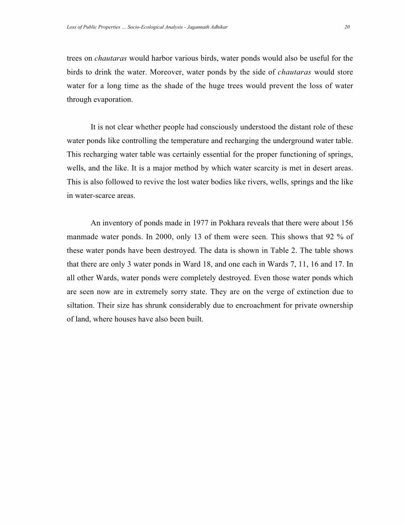
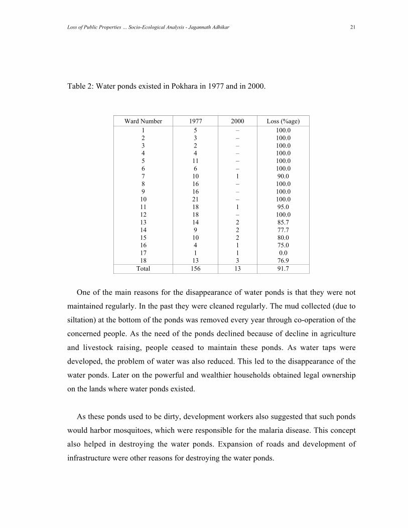
An inventory of ponds made in 1977 in Pokhara reveals that there were about 156
manmade water ponds. In 2000, only 13 of them were seen. This shows that 92 % of
these water ponds have been destroyed. The data is shown in Table 2. The table shows
that there are only 3 water ponds in Ward 18, and one each in Wards 7, 11, 16 and 17. In
all other Wards, water ponds were completely destroyed. Even those water ponds which
are seen now are in extremely sorry state. They are on the verge of extinction due to
siltation. Their size has shrunk considerably due to encroachment for private ownership
of land, where houses have also been built.
Loss of Public Properties … Socio-Ecological Analysis - Jagannath Adhikar 21
Table 2: Water ponds existed in Pokhara in 1977 and in 2000.
Ward Number 1977 2000 Loss (%age)
1 5 – 100.0
2 3 – 100.0
3 2 – 100.0
4 4 – 100.0
5 11 – 100.0
6 6 – 100.0
7 10 1 90.0
8 16 – 100.0
9 16 – 100.0
10 21 – 100.0
11 18 1 95.0
12 18 – 100.0
13 14 2 85.7
14 9 2 77.7
15 10 2 80.0
16 4 1 75.0
17 1 1 0.0
18 13 3 76.9
Total 156 13 91.7
One of the main reasons for the disappearance of water ponds is that they were not
maintained regularly. In the past they were cleaned regularly. The mud collected (due to
siltation) at the bottom of the ponds was removed every year through co-operation of the
concerned people. As the need of the ponds declined because of decline in agriculture
and livestock raising, people ceased to maintain these ponds. As water taps were
developed, the problem of water was also reduced. This led to the disappearance of the
water ponds. Later on the powerful and wealthier households obtained legal ownership
on the lands where water ponds existed.
As these ponds used to be dirty, development workers also suggested that such ponds
would harbor mosquitoes, which were responsible for the malaria disease. This concept
also helped in destroying the water ponds. Expansion of roads and development of
infrastructure were other reasons for destroying the water ponds.
Loss of Public Properties … Socio-Ecological Analysis - Jagannath Adhikar 22
While Pokhara now suffers from water scarcity as well as rising heat, these ponds
would have also been useful had they been maintained and cleaned properly.
Public land:
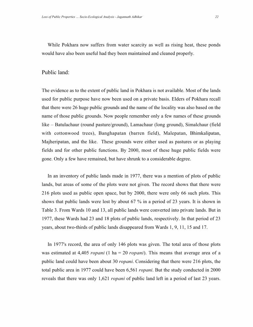
The evidence as to the extent of public land in Pokhara is not available. Most of the lands
used for public purpose have now been used on a private basis. Elders of Pokhara recall
that there were 26 huge public grounds and the name of the locality was also based on the
name of those public grounds. Now people remember only a few names of these grounds
like – Batulachaur (round pasture/ground), Lamachaur (long ground), Simalchaur (field
with cottonwood trees), Banghapatan (barren field), Malepatan, Bhimkalipatan,
Majheripatan, and the like. These grounds were either used as pastures or as playing
fields and for other public functions. By 2000, most of these huge public fields were
gone. Only a few have remained, but have shrunk to a considerable degree.
In an inventory of public lands made in 1977, there was a mention of plots of public
lands, but areas of some of the plots were not given. The record shows that there were
216 plots used as public open space, but by 2000, there were only 66 such plots. This
shows that public lands were lost by about 67 % in a period of 23 years. It is shown in
Table 3. From Wards 10 and 13, all public lands were converted into private lands. But in
1977, these Wards had 23 and 18 plots of public lands, respectively. In that period of 23
years, about two-thirds of public lands disappeared from Wards 1, 9, 11, 15 and 17.
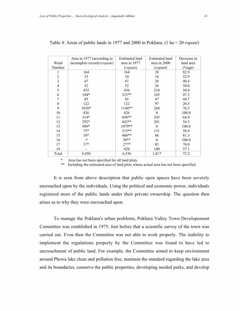
In 1977's record, the area of only 146 plots was given. The total area of those plots
was estimated at 4,405 ropani (1 ha = 20 ropani). This means that average area of a
public land could have been about 30 ropani. Considering that there were 216 plots, the
total public area in 1977 could have been 6,561 ropani. But the study conducted in 2000
reveals that there was only 1,621 ropani of public land left in a period of last 23 years.
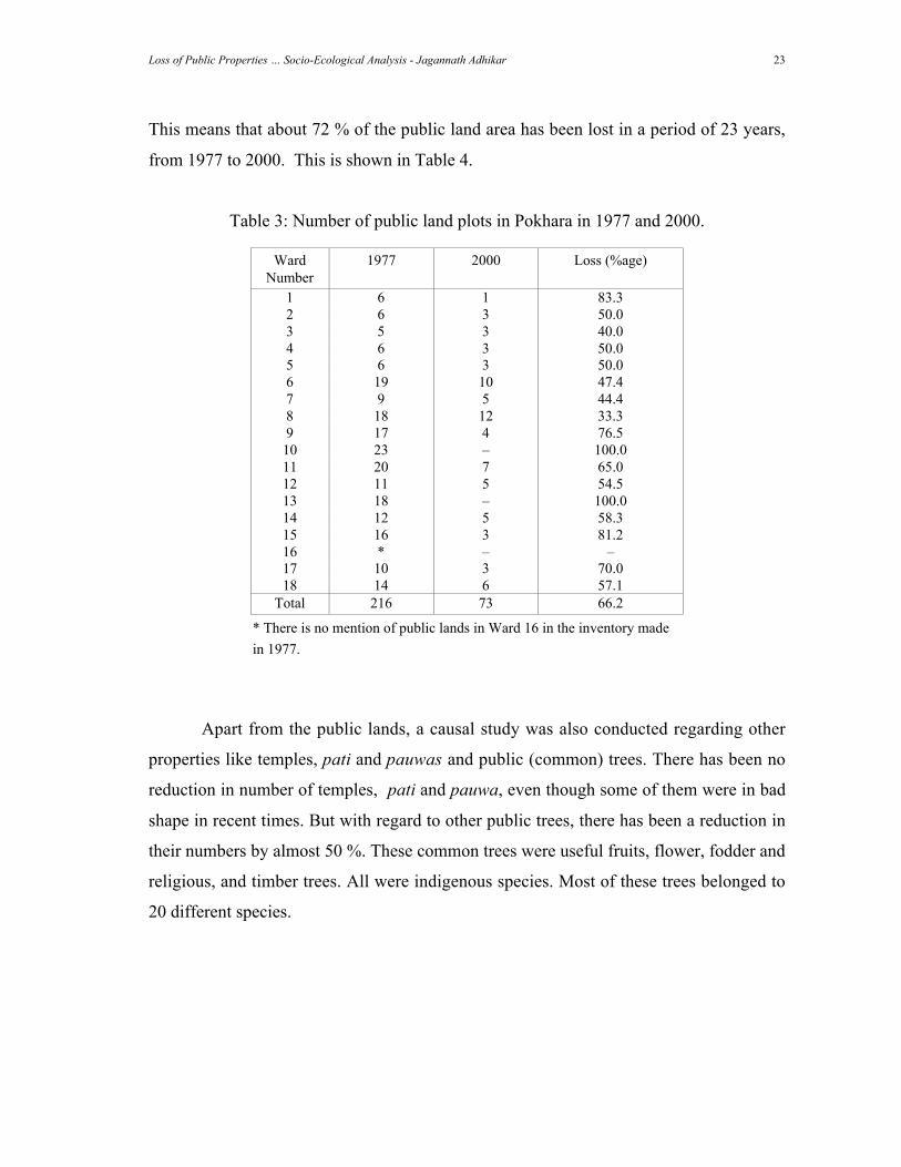
Loss of Public Properties … Socio-Ecological Analysis - Jagannath Adhikar 23
This means that about 72 % of the public land area has been lost in a period of 23 years,
from 1977 to 2000. This is shown in Table 4.
Table 3: Number of public land plots in Pokhara in 1977 and 2000.
Ward
Number
1977 2000 Loss (%age)
1 6 1 83.3
2 6 3 50.0
3 5 3 40.0
4 6 3 50.0
5 6 3 50.0
6 19 10 47.4
7 9 5 44.4
8 18 12 33.3
9 17 4 76.5
10 23 – 100.0
11 20 7 65.0
12 11 5 54.5
13 18 – 100.0
14 12 5 58.3
15 16 3 81.2
16 * – –
17 10 3 70.0
18 14 6 57.1
Total 216 73 66.2
* There is no mention of public lands in Ward 16 in the inventory made
in 1977.
Apart from the public lands, a causal study was also conducted regarding other
properties like temples, pati and pauwas and public (common) trees. There has been no
reduction in number of temples, pati and pauwa, even though some of them were in bad
shape in recent times. But with regard to other public trees, there has been a reduction in
their numbers by almost 50 %. These common trees were useful fruits, flower, fodder and
religious, and timber trees. All were indigenous species. Most of these trees belonged to
20 different species.
Loss of Public Properties … Socio-Ecological Analysis - Jagannath Adhikar 24
Table 4: Areas of public lands in 1977 and 2000 in Pokhara. (1 ha = 20 ropani)
Ward
Number
Area in 1977 (according to
incomplete record) (ropani)
Estimated land
area in 1977
(ropani)
Estimated land
area in 2000
(ropani)
Decrease in
land area
(%age)
1 164 164 28 82.9
2 33 34 16 52.9
3 47 47 28 40.4
4 52 52 26 50.0
5 435 436 218 50.0
6 104* 323** 165 47.3
7 85 85 47 44.7
8 122 122 97 20.5
9 1020* 1140** 268 76.5
10 426 426 0 100.0
11 514* 694** 243 64.9
12 292* 442** 201 54.5
13 989* 1079** 0 100.0
14 75* 315** 131 58.4
15 10* 460** 86 81.3
16 -* 30** 0 100.0
17 37* 277* 83 70.0
18 - 420 180 57.1
Total 4,450 6,536 1,817 72.2
* Area has not been specified for all land plots.
** Including the estimated area of land plots whose actual area has not been specified.
It is seen from above description that public open spaces have been severely
encroached upon by the individuals. Using the political and economic power, individuals
registered most of the public lands under their private ownership. The question then
arises as to why they were encroached upon.
To manage the Pokhara's urban problems, Pokhara Valley Town Developoment
Committee was established in 1975. Just before that a scientific survey of the town was
carried out. Even then the Committee was not able to work properly. The inability to
implement the regulations properly by the Committee was found to have led to
encroachment of public land. For example, the Committee aimed to keep environment
around Phewa lake clean and pollution free, maintain the standard regarding the lake area
and its boundaries, conserve the public properties, developing needed parks, and develop
Loss of Public Properties … Socio-Ecological Analysis - Jagannath Adhikar 25
spots for Phewa view. But none of these objectives were achieved. All the government
norms have not been followed and land around the lake have been encroached upon and
made private. Still then, the Committee has not done much to restrict these trends. The
media reports that even the land covered by lake water has been registered under private
ownership. But people do not know the reality.
The encroachment of public land by unscrupulous individuals is intense in
Pokhara. Using different excuses and pretensions, public lands have been made private.
Based on hereditary rights (paitrik hak), thousands of ropanis have been claimed by the
people under their private ownership. Government's resettlement programs have taken
about 2,000 ropanis of public land. Apart from that lands in important places have been
encroached upon by sukumbasis (landless people having no property at all) and
hukumbasis (powerful people grabbing public land under the name of squatters). About
1,000 ropani land has been taken over by this process. The other processes by which
public lands have been converted to private lands are sorayani and guthi encroachment.
These processes are discussed below.
Hereditary claim (paitrik hakdabi) :
The main reason for the encroachment of public lands in Pokhara is the
'hereditary claim'. Before 1934, there was a concept that land should not be left fallow.
The state badly required a large sum of revenue. To collect more and more revenue from
the lands, the jimmawals and mukhiyas (the land revenue collectors) were appointed in
every village. They were to submit the pre-fixed amount of revenue from the village(s)
under their jurisdiction. If they could not collect the revenue to the stipulated land, they
themselves had to pay the tax. To raise the required amount of taxes, they had given lands
to people for cultivation and other purpose. If that tax was not paid, the revenue
collectors would pay the tax and use the land until the tax was paid. In many cases these
revenue collectors had levied taxes on pastures, forest and open land. These were called
khartari tiro (pasture or grass tax). Later on there were several conflicts on the ownership
of land between villages and between individuals based on this khartari tiro. This
Loss of Public Properties … Socio-Ecological Analysis - Jagannath Adhikar 26
historical reality means that the elites of the villages had at some points paid taxes on
various pieces of land. The receipts of these taxes are now increasingly used for claiming
ownership on public land. A large proportion of public land has already been made
private on the basis of evidence of the payment of tax in the past.
In 1974 all the lands in Pokhara was surveyed on a scientific basis. After the
survey, all the public lands should have been identified and recorded. From 1977 the
process of registering lands on the basis of khartari tiro (tax – see above) was stopped.
But still then the process of giving private ownership based on past tax record is still
continuing. Some clever and unscrupulous people have been able to create various
evidence to claim such public lands. In many cases they also have been successful in
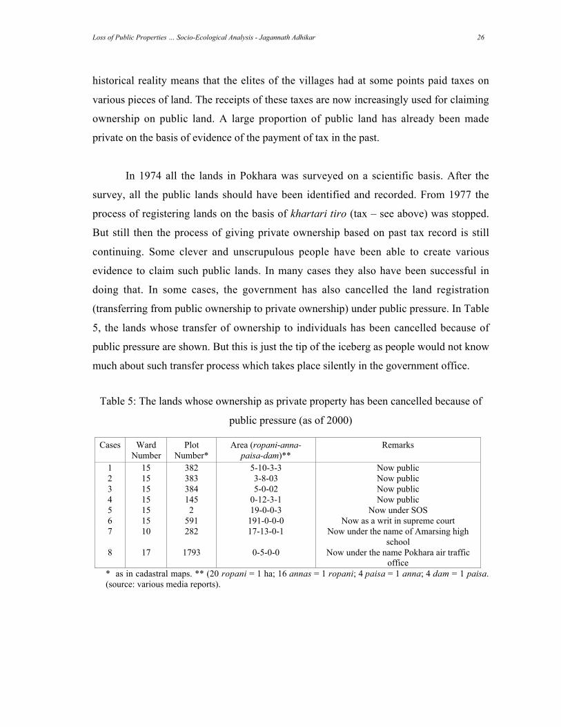
doing that. In some cases, the government has also cancelled the land registration
(transferring from public ownership to private ownership) under public pressure. In Table
5, the lands whose transfer of ownership to individuals has been cancelled because of
public pressure are shown. But this is just the tip of the iceberg as people would not know
much about such transfer process which takes place silently in the government office.
Table 5: The lands whose ownership as private property has been cancelled because of
public pressure (as of 2000)
Cases Ward
Number
Plot
Number*
Area (ropani-anna-
paisa-dam)**
Remarks
1 15 382 5-10-3-3 Now public
2 15 383 3-8-03 Now public
3 15 384 5-0-02 Now public
4 15 145 0-12-3-1 Now public
5 15 2 19-0-0-3 Now under SOS
6 15 591 191-0-0-0 Now as a writ in supreme court
7 10 282 17-13-0-1 Now under the name of Amarsing high
school
8 17 1793 0-5-0-0 Now under the name Pokhara air traffic
office
* as in cadastral maps. ** (20 ropani = 1 ha; 16 annas = 1 ropani; 4 paisa = 1 anna; 4 dam = 1 paisa.
(source: various media reports).
Loss of Public Properties … Socio-Ecological Analysis - Jagannath Adhikar 27
While claiming the public land under 'hereditary claim', the general practice is that
people give application to the Land Revenue Office saying that their name were left out
while registering the land. For this the following documents need to be submitted.
• The evidence of the claim specifying the area (bij-mana).
• Receipt of tax paid.
• Copy of citizenship certificate.
• The recommendation of the respective Ward Office.
• The recommendation of the respective VDC or Municipality Office.
• The field checking (sarjamin muchulka) from Land Revenue Office.
• The decision of the 'land registration committee' of the Land Revenue Office.
• Notice to the respective VDC or Municipality about the land registration.
• Notice in the local print media.
Despite the fact that one can make up a case for the claim of public land based on
above papers, it is extremely difficult for the Land Revenue Office to identify whether
the person claiming the land is genuinely the owner of the land. Similarly, it is extremely
difficult for the Office to identify whether the land being claimed is a public land. It is
still unclear as to what is the public land. If the chautaras and the water ponds are to be
considered as public properties, there are several examples in Pokhara of the ponds being
under the private lands and now being sold and bought in land markets. If pastures and
forests have to be considered as public land, there are no such lands existing in Pokhara.
Even the forests which are considered as important for promoting tourism have been
registered under private ownership by fabricating and creating various evidences. Even
though the process of registering public lands into private ownership has been continuing,
there have been public outcries about it.
Loss of Public Properties … Socio-Ecological Analysis - Jagannath Adhikar 28
Government's resettlement programs:
The role of government's resettlement programs is also important for the loss of
public lands in Pokhara. Even though these programs can be justified under the
humanitarian and moral points of view, but they have been used for gaining political
favors and for individual self-interest. In 1976, there was a huge landslide problem in
Majhathana of Kaski District, and those victims of the disaster were settled in Wards 14,
15 and 18. About 232 families were resettled in Pokhara. Each family had been allocated
with 8 ropani land and in total 1,850 ropani land was distributed. Only a few of them
have got the land titles, and the rest of the land allocated for them have been claimed by
others under their private property. After this disaster and resettlement, Pokhara now
frequently receives victims of landslides and natural disasters. But in reality they are
found to be used for political purpose. For example, people living in a large squatter
settlement now developed behind the Bus Park and the Airport were brought there
because they favored the then Panchayati political system in a referendum in 1979.
Squatters' settlements:
After examining the process of public land encroachment, it is revealed that
squatters6 settlements is another major factor behind this process. It was in 1972 that
squatter settlement began to develop in Pokhara. In this year, the existing bus park in
front of the old airport office was transferred to the present location on the north side of
the airport. The 73 families staying at the old bus park were given a piece of land in the
new bus park. But in reality land was made available for 150 families. Now there is a
large squatter settlement around the new bus park. It is also observed in the field visits
that there are several huts in the bus park and near the road which are rented out to the
migrant workers and the traders. These huts are owned by the powerful people. The rent
was found to range from Rs 3,000 to Rs 8,000. The tenants staying there did not know the
owners, who use agents to collect the rent. This shows that power has been misused for
6 The squatters (sukumbasis) are those people who do not possess any property (land or other assets
including money) and who stay in public land without any title of ownership. Even though some of the
squatters have also obtained land titles, their neighborhoods are still called squatter settlements
(sukumbasi basti).
Loss of Public Properties … Socio-Ecological Analysis - Jagannath Adhikar 29
the individual benefit. This practice is not an unique feature of this place only; it is a
common practice in Pokhara.
There are more than 40 squatter settlements in Pokhara, and about 4,500 families
live there. In reality only 13 % of them are the genuine squatters. The rest are mainly the
poor people who have come to Pokhara for work. It is very difficult to tell the exact
population of squatters in Pokhara. Sometimes, over a night, 3000-4000 huts of squatters
can be seen constructed. Under pressure from government, they also seem to disappear. It
is generally observed that when the government policies and supervision are weak, more
squatters seem to appear and occupy the public land. This makes it difficult to get
accurate picture of squatter settlements. Various studies also give differing accounts
because of the same reason. A study conducted by Pokhara Municipality has estimated
that squatter population has been growing in Pokhara by 26 % a year. If this rate of
growth is maintained, squatter population will account up to 55 % of the Pokhara's total
population in 2021. If this happens, there will be almost no any piece of public land in
Pokhara.
Soryani encroachment:
This is a slow and gradual process of encroaching the public land. This practice is
also common in Pokhara. People slowly extend the border of their land towards the
public land. Similarly they encroach the public land under the excuse of making their
plots straight. In some cases people have given certain help to schools and in return have
got recommendations from the school authority and political units to extend their lands
into the public lands.
Guthi encroachment:
Guthi lands (land donated to religious institutions) which are also considered as
public property have also been encroached. From ancient times, temples were constructed
and religious institutions formed from the cultural and social reasons. To look after these
infrastructures and institutions, land-grants were assigned to them, the income of which
Loss of Public Properties … Socio-Ecological Analysis - Jagannath Adhikar 30
was used to meet the expenses required. The lands like pakho (dry land, upland), khet
(lowland for paddy cultivation) and even forests had been assigned as guthis. These
guthis were also common in Pokhara. But large parts of these religious lands have also
been encroached and made private. This process is still under going.
The major guthis in Pokhara include: Bindyabasini guthi, Bhairavthan guthi and
Bhimsen guthi in Ward 2; Narayan guthi in Ward 3; Barahi guthi in Ward 6; Jalpadevi
guthi in Ward 8; Ramghat Santiban guthi in Ward 9; Gita temple and Shivalaya guthi in
Ward 11; Sitaladevi guthi in Ward 12; Bhadrakali guthi in Ward 13; Siddeshowr guthi in
Ward 15; Sitapaila and Ram temple Guthi in Ward 17. Of these guthis, 30 ropani khet
(paddy land) in Biruwa field which was allocated to Sitapaila temple have been registered
by the guthiars (who look after the temple) under the condition that they pay Rs 30,000 a
year to the temple. The pakho (dry land) is under the process of registration in the name
of guthiars. In most other guthis, guthiars have themselves registered guthi lands under
their private ownership. There is a case pending in court in relation to guthis of Ramghat.
It is now seen that unless some drastic and strict measures are not taken and the guthi
committee is not made active, almost all guthis will disappear as public property.
Conclusion:
This study conducted on the public properties of Pokhara reveals that these
properties have been lost in an increasing rate. In a period of 23 years from 1977 to 2000,
56 % of the chautaras, 92 % water ponds, 70 % of the plots of public lands and 72 % of
the public land area have been lost, or converted to private ownership. There has not been
encroachment on temples, patis and pauwas.
Loss of Public Properties … Socio-Ecological Analysis - Jagannath Adhikar 31
It is then clearly evident that public properties maintained and developed in the
past for the use of the society have been destroyed as the urbanization and modernization
proceeded in Pokhara. As the planners and political leaders considered these public
properties as given – not as the product of human endeavors – they were not sensitive to
them even though they could be useful to urban society also. The public properties (like
chautaras, community orchards, common trees, water ponds and open space) - which
were generally considered as nature – were thought to be useful only for the rural people.
These properties were also considered as symbols of backwardness. This essentially
means that urban society was separated from the nature. These properties were thought to
be out of place in an urban society considered as shabya (civilized). The nature
(represented by these properties in the mind of policy makers and planners) is linked only
with the uncivilized village people (pakhe, ashabya, gaule-folk).
Apart from the above conceptions, the change in social composition of the
population of Pokhara is also linked with the loss of the public properties discussed
above. The dominant ethnic groups before and during the early phase of urbanization
were Brahmins and Chettris who were strongly influenced by Hindu religion and its
description of nature like trees. The various public properties described here were
developed based on the belief of Hindu norms which gave considerable weight on the
preservation of trees, water ponds, chautaras, and community orchids. The mode of
production like agriculture and animal husbandry was also responsible for the
development and maintenance of these properties. But as the urbanization process
brought in new people who became dominant in politics and policy making because of
their new-found wealth, the public properties developed in different religious and
economic context did not receive much sympathy and attention. As a result there was
indiscriminate destruction of these properties.
The government policy has not been sensitive as to the creation and existence of
these open spaces, but just considered that it is the free gift of nature to be used and
Loss of Public Properties … Socio-Ecological Analysis - Jagannath Adhikar 32
distributed for political benefits. The result now is seen in the lack of free open space for
recreational use of the common people. The common people and their children do not
have access to open space for sports, leisure, and the like. Even the municipality could
not develop adequate services like toilets and libraries because there are no free public
spaces available in the core town area. Now it is also difficult to take over private lands
by the government, even though in the past it was easy to do so.
From the study of an inventory prepared by the then Pokhara Municiplaity in 1977
about the public properties in Pokhara and this study conducted in 2000 about the status
of these properties, it seems that the following measures by the relevant office
(government office and Pokhara Municipality) have to be immediately taken for stopping
the further loss of these properties.
• Clearly indicate the borders of the public lands and specify the plot numbers and
their areas.
• Specify the land occupied by the public buildings, government offices, schools,
universities, hospitals and the like.
• Keep the record of the existing temples, patis, pauwas, chautaras, park and the
like and renovate these properties if necessary.
• Keep the record of the guthi lands and take measures to preserve them.
• The related office (e.g., Pokhara Municipality) should form a committee to study
the remaining and lost public lands and take steps to recover those lost lands, and
then preserve them.
It is now certain that if strong measures are not taken for the protection of the
public properties in Pokhara, no public property will remain in near future. It is mainly
the responsibility of the government to take such steps, but citizens and residents of the
town should also show readiness in helping the government in this regard. Then only it
can be hoped that the existing public properties can be saved for the future generation.

Loss of Public Properties … Socio-Ecological Analysis - Jagannath Adhikar 33
Loss of Public Properties … Socio-Ecological Analysis - Jagannath Adhikar 34
References
Adhikari, Jagannath. 2003. Urban Context of Environmental Justice. A Study of Pokhara.
(in Nepali). Kathmandu: Martin Chautari.
Adhikari, Jagannath. 2003. "Exclusion and Access to Economic Opportunities :
Implications for Political Participation and Conflicts". Paper presented at 'The
Agendas of Transformation: Inclusion in Nepali Democracy' Organized by Social
Science Baha, Kathmandu, 24-26 April, 2003.
Adhikari, Jagannath and Seddon, David. 2002. Pokhara. Biography of a Town.
Kathmandu: Mandala Book Point.
Adhikari, Jagannath. 2001. Mobility and Agrarian Change in Central Nepal.
Contributions to Nepalese Study 28(2): 247-267.
Adhikari, Jagannath. 2000. Urbanization, Government Policies and Growing
Environmental and Social Problems in Pokhara. Studies in Nepali History and
Society 5(1): 43-87.
Adhikari, Jagannath and David Seddon. 2002. Pokhara: Biography of a Town.
Kathmandu: Mandala Book Point.
Adhikari, Jagannath. 1996. The beginnings of Agrarian Change. A Study in Central
Nepal. Kathmandu: TM Publication.
Basnet, Kedar et al. 1992. The Issue of Urban Development in Pokhara Town, Nepal. In
Perspective on Urbanization and Urban System. Ram Bali Singh and Minati Singh,
eds., pp. 196-209. Varanasi: Shakti Publishing House.
Blaikie, Piers, John Cameron and David Seddon. 1980. Nepal in Crisis Growth and
Stagnation at the Periphery. Delhi: Oxford University Press.
Dove, Michael R., 1998. "Jungle in Nature and Culture" in Ramachandra Guha (ed.)
Social Ecology. New Delhi: Oxford University Press.
Loss of Public Properties … Socio-Ecological Analysis - Jagannath Adhikar 35
Gurung, Birendra Singh. 1985. Pokhara: A Study in Urban Geography. Ph.D. Thesis.
Ranchi University.
Gurung, Birendra Singh et al. 2000. Market Zone Delineation of Pokhara Town (1999).
A Report Submitted to Rural-Urban Partnership Programme of UNDP.
Gurung, Harka. 1965. Pokhara Valley: A Field Study in Regional Geography. Ph.D.
Thesis. University of Edinburgh.
Gurung, Harka. 2002. Pokhara Valley: Geographical Study. Kathmandu: Nepal
Geographical Society.
Gurung, Tek Bahadur. 1979. Pattern of Gurungs' Migration in Pokhara. MA (Geography)
Thesis. P N Campus, Pokhara.
Gyanwali, Milan. 1997. Problems and Prospects of Industrial Development in Pokhara.
MA (Geography) Thesis. P N Campus, Pokhara.
Hamilton, F.B. 1971. An Account of the Kingdom of Nepal. New Delhi: Manjusri
Publishing House.
Karkpatric, Willilam. 1811. An Account of the Kingdom of Nepal. London (Reprinted as
Vol.3 in Series I of Bibliotheca Himalayica 1969).
Kawaguchi, Ekai. 1909. Three Years in Tibet. Madras: The Theosophical Office.
KC, Krishna et al. 1992. A Study of Squatter Settlement in Pokhara Town, Nepal. In
Perspective on Urbanization and Urban System. Ram Bali Singh and Minati Singh,
eds., pp. 254-266. Varanasi: Shakti Publishing House.
Landon, Perceval. 1987. Nepal (two vols). New Delhi: Cosmo Publications (Reprint).
Mierow, Dorothy. 2000. Thirty Years in Pokhara. Delhi: Book-Faith India.
Murphy, Dervla. 1967. Waiting Land: A Spell in Nepal. London: John Murry.
Pandit, Durga Lal. 1989. Urban Growth and Land Value Pattern: A Case Study of
Pokhara Town Panchayat. MA Thesis. P N Campus, Pokhara.
Parajuli, Bishwo Kallyan. 1999. Mobility and Change in Occupational Structure of
Pokhara City. Journal of Political Science 2(1): 1-23. Pokhara: P N Campus.
Parajuli, Bishwo Kallyan. 2000. Environmental Pollution and Awareness in Pokhara
City: A Sociological Perspective. Occasional Papers in Sociology and
Loss of Public Properties … Socio-Ecological Analysis - Jagannath Adhikar 36
Anthropology VI: 74-92. Kathmandu: Central Department of Sociology and
Anthropology.
Raj, Prakash A. 2000. Pokhara Valley in the Himalaya. Kathmandu: Nabeen Prakashan.
Shakya, Surya Ratna. 1996. Glimpses of Pokhara. Pokhara: Surya Ratna Shakya
Shrestha, Hari. 2000. Evolution and Growth Process of Urban Pokhara: A Historical
Analysis. Historia IV-V: 36-54. Pokhara: Department of History and Culture, P N
Campus.
Shroeder, R. F. 1978. Ecological Change in Rural Nepal: A Case Study of Batulechaur.
Ph.D. Thesis. University of Washington, USA.
Thapa, L. B. 1990. Pokhara: The Heart of Nepal. Kathmandu: Pilgrims Book House.
Tucci, Guiseppe. 1987. A Journey from Kathmandu to Mustang. Kathmandu: Ratna
Pustak Bhandar.
Zimmermann, F. 1987. The Jungle and the Aroma of Meats: An Ecological Theme in
Hindu Medicine. Berkeley: University of California Press.