A report on the flood menace: Will Assam ever be safe from its ...
48
1 A report on the flood menace: Will Assam ever be safe from its annual ravaging? Fact-Finding team: S. No. Name of member Organisation 1 NanditaDeka Human Rights Law Network 2 BaishaliDutta Human Rights Law Network 3 SauradeepDey Human Rights Law Network 4 LakhyaSaikia Peoples’ Action for Development 5 NakulGogoi Peoples’ Action for Development Report compiled by: SauradeepDey
-
Upload
khangminh22 -
Category
Documents
-
view
5 -
download
0
Transcript of A report on the flood menace: Will Assam ever be safe from its ...

1
A report on the flood menace:
Will Assam ever be safe from
its annual ravaging?
Fact-Finding team:
S.
No.
Name of member Organisation
1 NanditaDeka Human Rights Law Network
2 BaishaliDutta Human Rights Law Network
3 SauradeepDey Human Rights Law Network
4 LakhyaSaikia Peoples’ Action for
Development
5 NakulGogoi Peoples’ Action for
Development
Report compiled by: SauradeepDey
2
Contents:
S. No. Particulars Page No.
1 List of Abbreviations 3
2 Introduction 5
3 Lakhimpur and its Geopgraphy 7
4 Floods in Lakhimpur 8
5 The Dam effect 10
6 Fact-finding on the effect of floods on the people 14
7 Fact-finding methodology 14
8 The effect of floods in Telahi Block, Lakhimpur 14
9 Effect of Floods in Lakhimpur Block 24
10 A different perspective to floods 27
11 Meeting with the District Project Officer, District
Disaster Management Authority, Lakhimpur
29
12 Interaction with NGOs 31
13 The total effect of the floods of 2017 32
14 Conclusion 34
15 Gallery 40

3
List of Abbreviations:
AASU: All Assam Students Union
ASDMA: Assam State Disaster Management Authority
ASHA: Accredited Social Health Activist
CMD: Chairman & Managing Director
DC: Deputy Commissioner
DDMA: District Disaster Management Authority
DPO: District Project Officer
DPR: Detailed Project Report
EIA: Environment Impact Assessment
FLEWS: Flood Early Warning System
HRLN: Human Rights Law Network
IIT: Indian Institute of Technology
MoU: Memorandum of Understanding
MW: Mega-watt
NEEPCO: North East Electric Power Corporation Limited
NESAC: North Eastern Space Application System
NGO: Non-Government Organisation
NH: National Highway
NHPC: National Hydel Power Corporation
PAD: Peoples‟ Action for Development

4
PHC: Primary Health Centre
P&RD: Panchayat& Rural Development
RoR: Run-of-the-river
Rs.: Rupees
USD: United States Dollar

5
INTRODUCTION
Floods are an annual recurrent event in Assam, causing damage worth crores and
affecting thousands of lives. All rivers in Assam are liable to floods, mainly because they
receive heavy rainfall within a short period of time. These rivers are in their early stage
of maturity and are very active agents of erosion. The river waters collect a tremendous
amount of silt and other debris, raising the level of river beds. Therefore, it becomes
impossible for the main channel to cope with the vast volume of water received during
the rains.1 39.58% of the total land area of Assam is flood-prone, while only 10.2% of
the total area of the country is prone to floods – making Assam four times as
vulnerable. 2 In absolute terms, about 4.75 lakh hectares of area in the state is
chronically flood-prone.3
The major river of Assam is the Brahmaputra and is one of the largest rivers in the
world. It originates in the Kailash ranges of the Himalayas and enters India after flowing
through Tibet through Arunachal Pradesh. It flows through Assam and Bangladesh
before it joins the Bay of Bengal. The drainage area lying in India is 194,413 sq. kms.
The sub-basin lies in the States of Arunachal Pradesh, Assam, Nagaland, Meghalaya,
West Bengal and Sikkim. The largest drainage area of the Brahmaputra lies in
Arunachal Pradesh, covering an area of 81,424 sq kms followed by Assam with a
drainage area of 70,634 sq kms. Thus, floods in Assam are significantly influenced by
rain in Arunachal Pradesh. The rainfall in Brahmaputra basin is mainly due to South-
West monsoon and out of total annual rainfall, 85% occurs during the monsoon months
from May to September. Moreover, during its course in the Assam valley from Kobo to
Dhubri, the river is joined by about 20 important tributaries on its northern bank and 13
on its southern bank.4 In addition to the Brahmaputra river system, the Barak is another
major river flowing through the state, with its main tributaries -- Katakhal, Jiri, Chiri,
Modhura, Longai, Sonai, Rukni and Singla. The Barak valley also faces floods when
precipitation occurs.
1Assam State Disaster Management Authority.
2Water Resources Department, Government of Assam.
3Economic Survey, 2015-16, Directorate of Economics and Statistics, Government of Assam.
4Ibid.
6
The severity of flood problem in the state has been further aggravated by the acuteness
of erosion on both banks of the river Brahmaputra and its tributaries. Studies reveal that
4.27 lakh hectares of land in the state have been eroded by the rivers since 1950 –
about 7.40% of the state‟s net area. The average annual rate of erosion is 8,000
hectares.5
The floods are concomitant with huge losses in the state. In addition to the material loss
including damage to croplands, people and livestock are also killed by the floods and
many more are injured. Lakhs of people are affected. A cumulative flood report of the
2017 flood season prepared by the Assam State Disaster Management Authority
(ASDMA) and updated up to August 2, 2017, states that 29 districts have been affected
by the floods and the total crop area affected is 2,09,051.65 hectares. These are only
government figures and the actual quantum of loss could be much more.
The state suffers losses of hundreds of crores. In 2017, Assam suffered losses to the
tune of a whopping 2,939 crores apart from the human and animal lives lost.6 Moreover,
the state spends a large amount of money on both preventive and rehabilitative
measures. During 2014-15, the Planning and Development Department of the State
Government undertook 97 Flood Management Schemes (both new and ongoing) in
different districts of Assam.7
Recently, a total package of Rs 2,350 crores was announced by Prime Minister
Narendra Modi for all northeastern states for mitigating the impact of floods in the short-
and long-term basis.8 This amount is meant to be shared between the Northeastern
states and the share of each state is still to be worked out. Assam, being the worst
affected, is likely to get the lion‟s share of this package.
To understand the ground realities of the effects of floods, a team of activists and
lawyers from Human Rights Law Network (HRLN) and Peoples‟ Action for Development
5Economic Survey, 2015-16, Directorate of Economics and Statistics, Government of Assam.
6 Assam Floods Aftermath: Crores of rupees wasted in state’s ineffective fight against annual deluge, Firstpost.
7Economic Survey, 2015-16, Directorate of Economics and Statistics, Government of Assam.
8 PM announces Rs. 2,350 croreaid for flood-hit Northeast States, The Hindu.

7
(PAD) visited some flood affected villages of Lakhimpur district in Assam which is the
worst affected of all districts in the State.
Lakhimpur and its Geography9
The name Lakhimpur is believed to be originated from the word „Lakshmi‟, the goddess
of prosperity. The district is mainly dependent upon agriculture and paddy. Paddy is
regarded locally as „Lakhimi‟. The word „pur‟ means „full‟. Lakhimpur therefore means
„full of paddy‟ or the place where paddy is grown abundantly. The district was notified as
Lakhimpur district through a proclamation issued by then Governor General on July,
1839. On 2nd October, 1971, the district was reorganized with two sub divisions --
Dhemaji and North Lakhimpur. In 1989, it was reorganized again with two subdivisions,
Dhakuakhana and North Lakhimpur, leaving Dhemaji as a separate district.
The district covers an area of 2277 Sq. km out of which 2257 Sq. km is rural and 20 sq.
km is urban. The population of the district as per Census 2011 is 10,42,137 of which
5,29,674 are male and 5,12,463 are female.
Lakhimpur district is situated on the north-east corner of Assam and at the north bank of
the river Brahmaputra. It is bounded on the north by Siang and Papumpare district of
Arunachal Pradesh and on the east by Dhemaji district and Subansiri river. The river
Brahmaputra along with Majuli district stands on the southern side and Gohpur sub-
division of Sonitpur district is on the west. The main rivers in the district are:
1. The Brahmaputra: The mighty Brahmaputra is the southern boundary of the district
and touches all along the southern and southeastern boundary.
2. The Subansiri: Subansiri originates from Tibet and enters the plains of Lakhimpur
and Dhemaji district. The total length of the river is 326 miles up to the international
border. The catchments area of the river is 10148 Sq miles in Arunachal Pradesh and
440 Sq miles in Assam. The river discharges 2,09,546 cusecs of water at Bhimpara
Ghat.
9lakhimpur.nic.in; Official website of Lakhimpur district, Assam, India.

8
3. The Ranganadi: The river originates from the Dafla hills of Arunachal Pradesh. The
total length of the river is 90 miles and total catchment area is 839 sq. miles in
Arunachal Pradesh and 296 sq. miles in Assam. It discharges 17,500 cusecs of water at
2 miles upstream of National Highway–52.
4. The Dikrong: The Dikrong originates from the Dafla Hills of Arunachal Pradesh. In
Arunachal Pradesh, it is known as Par Nadi. It enters the plains near Harmutty Tea
Estate and runs 25 miles to join the Brahmaputra at Badati. It discharges 20,000 cusecs
of water at 1 mile downstream of National Highway-52. The catchments area of the river
is 512 sq. miles in Arunachal Pradesh and 101 sq. miles in Assam.
Floods in Lakhimpur
Lakhimpur is the worst-affected district in Assam. The district located on the foothills of
the Himalayas has received 1493.2 mm of rainfall during the period between 01-06-
2017 to 02-08-2017 -- which is 29% more than the normal rainfall in the district during
the same period.10
The parts adjacent to the north of the district receive a lot of rainfall, causing floods in
Lakhimpur. A flood report of the District Disaster Management Authority updated till 30-
07-2017 reveals the following information:
1) Total number of revenue circles affected: 7 (Nowboicha, North Lakhimpur, Subansiri,
Narayanpur, Bihpuria, Kadam, Dhakuakhana)
2) Total number of villages affected: 462
Nowboicha: 73
North Lakhimpur: 133
Subansiri: 61
Narayanpur: 67
Bihpuria: 73
10
District wise rainfall distribution, Indian Meteorological Department, Hydromet Division.

9
Kadam: 8
Dhakuakhana: 47
3) Total population affected: 3,34,041
4) Total crop area affected: 24,511.04 Hectares
5) Total number of animals affected: (i) Big: 97,200, (ii) Small: 55,744,
(iii) Poultry: 53,000
6) Human lives lost: 13
Flood: 6
Landslide: 2
Storm: 3
Electrocution: 2
7) Missing persons: 1
8) Total number of animal lives lost: 58
9) Health camps organized: 457
10) Houses damaged: Fully: 179 (Kutcha), 4 (Pucca)
Partially: 7536 (Kutcha)
11) Infrastructure damage: 852
Roads: 105 (Rural roads – 64, State roads – 41)
Embankments: 7
Bridge/Culverts: 59
Under P&RD: Roads – 152, Agri Bund - 66

10
12) Total schools affected: 463 (LP – 334, UP – 77, HSS/HS – 52)
Fully damaged – 19 (UP – 2, LP – 17)
Partially damaged – 392 (UP – 75, LP – 317)
RELIEF MEASURES
1) Relief camps: 21 (Subansiri, Nowboicha, North Lakhimpur, Bihpuria & Kadam)
2) Inmates in relief camp: 5447 (442 – Subansiri, 713 – Nowboicha, 235 – Kadam,
2788 – North Lakhimpur, 1269 – Bihpuria)
3) Rescue operations: total evacuated – 2651
4) Relief distribution points: 242 (Nowboicha – 81, North Lakhimpur – 68, Narayanpur –
11, Subansiri – 46, Bihpuria – 18, Kadam – 16,
Dhakuakhana – 2)
The Dam effect
A common perception amongst many people is that the severity of the 2017 floods that
hit Lakhimpur district is primarily due to the release of large amounts of water from the
405 MW Ranganadi Hydroelectric Power Plant at Yazali (in Arunachal Pradesh) that is
run by the state-owned North East Electric Power Corporation Limited (NEEPCO). This
is a run-of-the-river project and in 2008, after similar accusation of causing floods, the
then CMD of NEEPCO had said, “The Ranganadi project in Arunachal Pradesh is a run-
of-river scheme. The natural flood occurring in the upstream of the project cannot be
absorbed by the small reservoir and excess water from the upstream has to be released
to control the water level. There is no other option.”

11
Many articles have reported on the flood situation created by the release of excess
water from the dam. A couple of excerpts from articles with regard to the role of
NEEPCO in the floods of Lakhimpur follow:
“Release of excess water from 405 MW Ranganadi Hydro-Electrical Power Plant
by North East Electric Power Corporation Limited (NEEPCO) at Yazali in
Arunachal Pradesh led to flash floods in the lower areas near Pahumara in
Lakhimpur. The release left the Ranganadi river overflowing with an alarming
speed.
According to the District Disaster Management Authority, NEEPCO released
3500 mm of water through its Gate No. 1,5000 mm water through Gate No. 3 and
2000 mm water through its Gate No. 5 at 3.30 pm on Sunday. The situation was
such that national highway was blocked due to the flash flood.
In Bihpuria, the dam-induced flood water of Dikrong inundated 18 villages
stretching from Badatighat to West Laluk in Bihpuria revenue circle area.”
(NEEPCO dam water causes floods in Lakhimpur, NH in pathetic condition;
thenewsmill.com)
“The sudden rise in water level was induced by NEEPCO’s 405-MW Ranganadi
Hydro-Electrical Power Plant at Yazali in Arunachal Pradesh, which caused
havoc in the district since the early hours of Sunday by breaching the
embankment at one point, besides inundating thousands of hectares of
cropland….
The overflowing waters of Ranganadi also breached its embankment on the right
hand side at Jainpur village last night and destroyed households and swept away
cattle of 10 families. The breach on the embankment submerged 50 villages
under TelaheeGaonPanchayatof North Lakhimpur Revenue Circle and Nowboisa
Revenue Circle.
12
The rise of the Ranganadi due to release of water by the NEEPCO dam today
claimed the life of one KanakGogoi, who drowned at Bagaleejaan area of
Ranganadi as he tried to oar a boat….”
(Dam-induced flood and nature‟s fury devastate North Lakhimpur; silchar.com)
The NEEPCO flood fiasco is not a new affair. The project has been blamed for floods in
the Lakhimpur and Dhemaji region since its inception. The accusation that the
Ranganadi dam aggravates the problem of flooding in the downstream district of
Lakhimpur is as old as the dam itself, which became operational in 2001.11
In 2008 as well, NEEPCO was accused for its part in the devastating floods that had hit
the state. The then chief minister Tarun Gogoi blamed NEEPCO for the flood fury and
demanded compensation from the power major. Gogoi had said, “Excess water
released from Ranganadi dam without prior warning caused the floods.”
Many including the All Assam Students Union (AASU) have called for a shutdown of the
Ranganadi project. Partha Jyoti Das, head of the Water, Climate and Hazards
Programme of the Guwahati-based non-profit Aaranyak said, “The nature and patterns
of the floods would have been very different in the absence of the dam. People living in
downstream areas always lived with natural floods always, but with the dam, the river‟s
course has been altered and the nature of floods has completely changed. Yes, there
would be floods even without the dam, but the hazards would be much less.”
The flow of the Ranganadi is very erratic. By design, if the Ranganadi‟s flow is greater
than 160 cubic metres per second, the surplus water is released into the river
downstream to protect the dam. In the winter, the river flow is, more often than not, less
than that. Therefore, no water is released into the Ranganadi at all, which results in a
practically dead river. People also claim that the continuous flushing of sediments at the
dam site at Yazali has raised the river bed significantly, so it was unfair to say that the
dam has not increased the intensity of the floods.12
11
Severity of Assam floods heightens old fears about dams in the Brahmaputra basin; Scroll.in. 12
Severity of Assam floods heightens old fears about dams in the Brahmaputra basin; Scroll.in.

13
Now with so much talk about NEEPCO being responsible for the floods, one would be
curious about what NEEPCO‟s stand on the matter is. In fact after the little fiasco,
NEEPCO published a clarification in a newspaper where it termed all allegations made
against it holding it responsible for the flood in and around North Lakhimpur as totally
untrue and malicious. It explained how the dam in subject is a run-of-the-river (RoR)
project with very little storage capacity (5.7 million cum live storage). It said that the
small reservoir of the RoR project stores water for running turbines only for a few hours.
It is unlike the storage hydro power projects whose reservoirs are significantly bigger
and can store water for running of turbines for a longer period of few weeks or few
months. It also stated that when water was released on July 9, 2017, information was
communicated to concerned authorities in downstream areas. It said a flood of this
quantum would have occurred even without the dam and reservoir. Further, it went on
to state how its engineers are stationed at remote area with little comfort and that the
allegations made could demoralize them.13
So now that both perspectives have been placed, it is only experts who can judge better
on the role of NEEPCO‟s dam in the floods of Lakhimpur, while we will focus on what is
the effect of the floods on the local people.
But let us also take a glimpse at the development of dams in Arunachal Pradesh, which
lies in the upstream region of most rivers that flow through Assam. Over the last
decade, over 150 memorandum of understandings (MoU) for Hydel power projects
which would make Arunachal home to one of the greatest concentration of dams in the
world. Taking for instance the river Lohit, six dams were proposed on this river by 2013
and the space between these dams was 1km, 9.5km, 1.8km, 3.8km and 1.8km. And this
was despite the lack of studies on what such clustering means for a river.14
Former environment minister Jairam Ramesh used the term „MoU Virus‟ to describe the
speed at which the Arunachal Government was signing MoUs.15 Although most of these
13
Clarification Regarding Allegation Against NEEPCO For Flooding in North Lakhimpur. 14
M Rajshekhar (Jan 30, 2016), The Mess in Arunachal Pradesh that no one is talking about;Scroll.in. 15
SANDRP (March 1. 2014),Hydromania in Arunachal Pradesh: Massive 1850 MW Dam Planned Without Any Basic Data, Not even Water Flow Data…

14
projects either never took off or were stalled, they are potent threats and are mired in
controversies. Residents of Arunachal Pradesh have long been concerned about the
proposed projects. And now, the private companies that had earlier queued up to build
the dams are losing interest and asking the public sector National Hydel Power
Corporation (NHPC) to take over their projects.16 The future course of action must
definitely take into consideration all potential impacts on Assam along with that on
Arunachal Pradesh.
Fact-finding on the effect of floods on people
Methodology:
On the 30 and 31 August, 2017, a three-member team from the Human Rights Law
Network (HRLN), assisted and guided by members from Peoples‟ Action for
Development (PAD), visited some of the flood-affected villages of Lakhimpur district in
Assam and interacted with local villagers to learn about the situation in these villages.
They also visited two places where the Ranganadi had breached its embankments to
enter with great force into residential areas, causing severe damages. The team also
interacted with personnel from the Lakhimpur District Disaster Management Authority,
personnel from Americares and PAD -- two NGOs that were actively involved in relief
work in the district.
The effect of floods in Telahi block, Lakhimpur:
Jainpur:
The team first visited Jainpur village in Telahi block. To reach this village, the team had
to take a boat across the Ranganadi. The river, at the time of the visit, was hardly 4-5
feet deep and the width was probably less than a hundred metres. There were many
16
AzeraParveenRahman (February 25, 2016), Private Dam Builders back out of Brahmaputra dams; thethirdpole.net

15
children swimming in it. We wondered what was on the other side of the river. The body
of water looked deceptively innocent.
Jainpur is one of the clusters of villages that were devastated when the embankment
protecting Jainpur and nearby villages from the Ranganadi broke letting in the
raging waters into the village areas and wreaking havoc. It rained quite heavily on July
9, 2017, and the Ranganadi, which is otherwise a shallow rivulet that can be crossed on
foot in drier times, was swollen. Some villagers were alarmed and were anticipating a
breach of the embankment at one particular point which had been weak. Some of them
had rushed to this vulnerable spot in the heavy rain to repair it, said Sitaram Bania of
Jainpur, who was one of men who went for the repair.
But the breach in the embankment unexpectedly occurred at a different spot around
9.45 pm on the July 9. Floodwaters gushed in right in the middle of the village and took
the villagers by surprise. Very few could rescue valuable items. Moreover, those who
were engaged in the repair of the embankment had no time to salvage anything at all.
The waters immediately inundated Jainpur and struck Majgaon village. At Jainpur, there
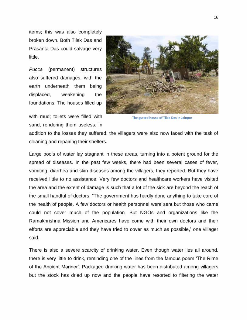
are over 100 households. 15 houses were completely destroyed and others suffered
partial losses. The houses that suffered the most damage were kutcha huts – those
made of mud and bamboo. One Tilak Das‟s house was completely destroyed. In front of
his house, another villager, Prasanta Das, had set up a little shop to sell household
The Ranganadi&Spot of the breach of embankment in Jainpur area
16
items; this was also completely
broken down. Both Tilak Das and
Prasanta Das could salvage very
little.
Pucca (permanent) structures
also suffered damages, with the
earth underneath them being
displaced, weakening the
foundations. The houses filled up
with mud; toilets were filled with
sand, rendering them useless. In
addition to the losses they suffered, the villagers were also now faced with the task of
cleaning and repairing their shelters.
Large pools of water lay stagnant in these areas, turning into a potent ground for the
spread of diseases. In the past few weeks, there had been several cases of fever,
vomiting, diarrhea and skin diseases among the villagers, they reported. But they have
received little to no assistance. Very few doctors and healthcare workers have visited
the area and the extent of damage is such that a lot of the sick are beyond the reach of
the small handful of doctors. “The government has hardly done anything to take care of
the health of people. A few doctors or health personnel were sent but those who came
could not cover much of the population. But NGOs and organizations like the
Ramakhrishna Mission and Americares have come with their own doctors and their
efforts are appreciable and they have tried to cover as much as possible,‟ one villager
said.
There is also a severe scarcity of drinking water. Even though water lies all around,
there is very little to drink, reminding one of the lines from the famous poem „The Rime
of the Ancient Mariner‟. Packaged drinking water has been distributed among villagers
but the stock has dried up now and the people have resorted to filtering the water
The gutted house of Tilak Das in Jainpur
17
through crude methods, such as with sand and rocks. However, the river water which is
the primary source for these villagers is so dirty, even the „filtered‟ water looks slurry.
Adding to their woes, a large number of their livestock -- cows, goats and poultry -- died.
The villagers were taken by surprise by the flood and had no time to rescue their
animals. Almost every household has lost an animal, but has been no proper count of
the loss. Numalia Das, whose house was destroyed, also lost three cows and six goats.
The cowsheds of every household were kutcha structures that were broken down in the
floods. For the surviving animals, some amount of fodder has been provided by the
government and a veterinarian was also sent to check on animals, but there has been
no compensation for those who lost their animals to the flood.
Many villagers also operated fisheries and these too suffered losses, sometimes worth
lakhs as the fish escaped and the structure of fisheries entirely decimated. A lot of
money had been put into setting up the structures, said a villager, Ganesh Das.
The economic losses from the flood, then, were huge. These villagers are primarily
dependent on agriculture for livelihood, with some of them owning land and others
working on a daily-wage basis on others‟ lands. There are hardly any salaried
employees, and the few that hold down jobs work outside the villages in other towns
and cities. The floods deposited a thick layer of silt on farm lands, destroying the
existing crops and also rendering the land useless for further cultivation for the next
several years. In some spots, the silt is over 2 fee thick. Therefore, at present, there is
no economic work for the villagers, and they worry about making ends meet.
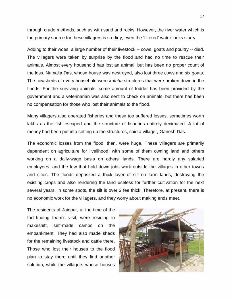
The residents of Jainpur, at the time of the
fact-finding team‟s visit, were residing in
makeshift, self-made camps on the
embankment. They had also made sheds
for the remaining livestock and cattle there.
Those who lost their houses to the flood
plan to stay there until they find another
solution, while the villagers whose houses

18
were not completely decimated aim to finish repairs before they return.
These temporary structures have been built with tarpaulins, tin sheets and bamboo. The
tarpaulin was provided by the state two days after the disaster on July 9 – one tarpaulin
per family and raw material to prepare food. The villagers salvaged the bamboo and tin
sheets from the ruins of their damaged houses. However, there are complaints that the
government-issued tarpaulin was of poor quality and began to tear down after a couple
of days. The villagers preferred using better quality tarpaulin provided by NGOs such as
Oxfam. The NGOs also shared essential provisions such as good items, buckets, mugs,
hygiene kits with soaps, nail cutters, toothbrush, and toothpaste, among other things.
For this help, the people seemed grateful to the NGOs, but were scornful towards the
Government.
Gopalpur:
The fact-finding team then went to Gopalpur, which is a village located opposite Jainpur
and was affected less than Jainpur. The floodwaters had struck Jainpur first and were a
little less forceful by the time they reached Gopalpur, but this village faced another
peculiar problem. Jainpur, having been struck first, was inundated with large large
amounts of silt, creating an elevation and leaving Gopalpur at a lower level.
Consequently, a lot of water was stuck in Gopalpur, pooling in many houses for long
period of time. The fields of Gopalpur were still under water when the fact-finding team
visited. Many residents of this village too were residing on embankments. The
conditions in Jainpur and Gopalpur were similar, but there was less infrastructure
damage in Gopalpur.
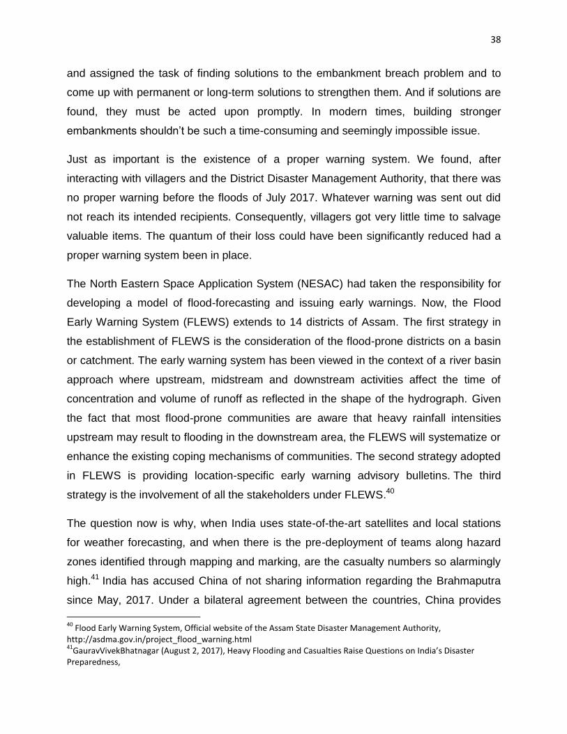
Schools in Gopalpur had been shut for about three weeks when the team visited, again
due to the pooling of water. It did not seem likely that they would reopen anytime soon.
The floors of the classrooms were covered with slush and the entire compound had
become a breeding ground for vectors of diseases such as mosquitoes. Much of the
furniture and other articles were also damaged. The floods have had a drastic impact on
the education of children.

19
Jamuguri:
From Gopalpur, the team went to Jamuguri, another village near Jainpur and Gopalpur.
Jamuguri too was inundated, but being a little further from the breach of the
embankment, the infrastructural damage was less. Since several houses were
damaged, some villagers were living on the embankment, while some others remained
in their houses and some had just moved back. These people were living in houses
inside which water still remained.
The team met JitaKalita, a pregnant woman from the village. She was 27, and seven-
months pregnant. On the night of the breach, she and her family had to rush to the
embankment. Jita used to go to the Panigaon Primary Health Centre (PHC) for her
check-ups, by taking a boat across the Ranganadi to Panigaon.
Since the flood, which was about three weeks ago, she had not been able to go for any
check-ups even though it was due. The local ASHA (accredited social health worker),
also besieged with problems brought by the floods, was not able to help either. Jita was
not sure when she could go for a her check-up, because her house was filled with slush
and water pooled around it, with no indication that this would clear up soon. This made
movement very difficult for her and she was forced to live in unhygienic conditions.
Moreover, in all likelihood, there are chances of further rain. The roads too had been
damaged to such an extent that all traffic of four-wheeler vehicles to and from Jamuguri
had stopped. The only option for her, if she wanted to go for a check-up, would be to
walk a couple of kilometers to reach the boat which would take her across the Rangandi
and return back the same way – a difficult journey that she was not sure she could
undertake. She had hoped that the doctors who came for health camps would check her
too, but they had not. And she had bigger worries: she wasn‟t sure if the road would be
repaired in time for her delivery so an ambulance could take her to a health centre.
20
A damaged part of the road near Jamuguri that also connects Gopalpur, Jainpur, and some other villages
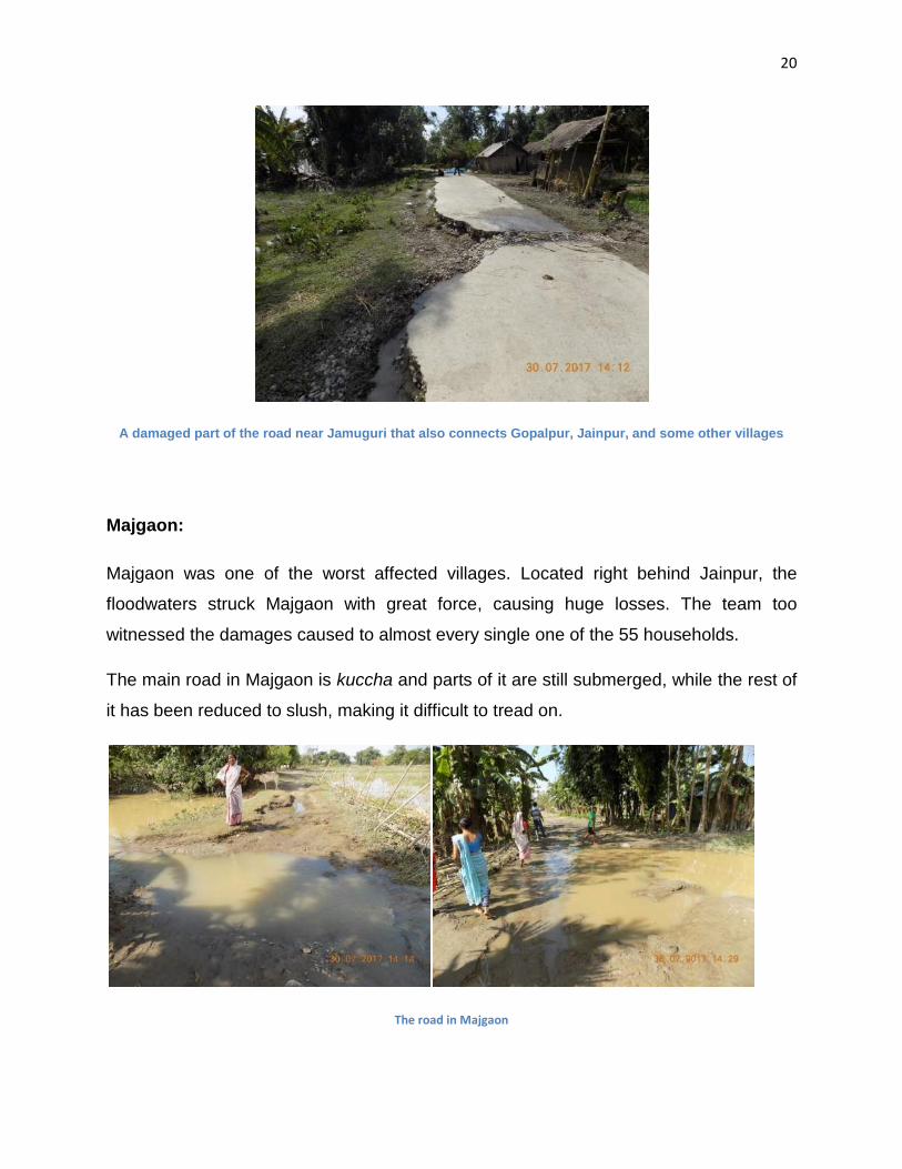
Majgaon:
Majgaon was one of the worst affected villages. Located right behind Jainpur, the
floodwaters struck Majgaon with great force, causing huge losses. The team too
witnessed the damages caused to almost every single one of the 55 households.
The main road in Majgaon is kuccha and parts of it are still submerged, while the rest of
it has been reduced to slush, making it difficult to tread on.
The road in Majgaon

21
Due to the suddenness of the flood, the villagers had very little time to move to safer
grounds. In addition to infrastructural damage and loss of livestock, several people also
lost important documents and household items. The villagers here are mostly engaged
in agriculture, but some men also work in other cities as security guards to be able to
sustain their families.
Those engaged in farming suffered huge losses: their crops were damaged and the
flood left behind thick layers of silt on the fields, rendering them unfit for cultivation.
Tractors too were damaged and huge stocks of grains (known locally as ‘bhoral’) were
lost.
Families from which men were working in other cities suffered terribly too; in the
absence of men, women were forced to carry the children and some belongings to
safety, but they were unable to salvage any perishables from their houses.
Jayanta Das is one such villager who works as a security guard in Hyderabad; he had
used this money to build a fishery and a house for his wife and infant child. He visits
home twice or thrice a year, but when the floods came, he was in Hyderabad. His wife
managed to rush to higher ground with their child, aided by other villagers. When he
heard of the flood, Das attempted to return home as soon as he could, but tickets were
not easily available. He undertook a five-day journey starting from July 10, and changed
four trains to finally reach home on the 15th. When he reached, he found his house had
sustained severe damages and that all the fish had escaped from in fishery. The fishery
had also been made shallow by huge silt deposits. Das cannot go back to work any time
soon, and his scared wife does not want him to go at all. For now, they have modified
their food grain store into a makeshift residence. Living in constant fear of return of the
floodwaters, they have fixed their beds at a height of four feet to keep them safe. Hardly
any furniture remains in their house, and during the day, their child lies on a tarpaulin
sheet spread on the ground. They eat the food provided by NGOs and the state
government as relief material.

22
JayantaDas' living conditions
MakanBania has a similar story to share. Her husband too works as a security guard in
Bangalore, and she lives with her 10-year-old son in Majgaon. MakanBania also ran a
shop, which was wiped out by the floods and she couldn‟t salvage anything. Now, her
son is also suffering from fever and has been vomiting, but has still not been checked
by a doctor. Makan is hoping for a doctor‟s visit soon or she‟ll be forced to take her son
to Panigaon. She is facing all these difficulties without anyone to help her. Her husband
was informed about the flood but has not been able to get leave from work and return
from Bangalore to visit them.
In the same village, there‟s an old, blind couple. They managed to stay alive the night of
the flood climbing to a raised platform inside their house. They feared their house would
collapse entirely, but it held up somehow. They were rescued next morning by a
relative.
Another couple, Sri Ramnath Das and his wife, Majoni Das, narrowly managed to
survive. Ramnath has a disability and has difficulty walking. On the night of the flood,
they didn‟t know what to do and thought they would die. They managed to reach the
Majgaon market that was near their house, clambered on to a raised pucca structure
and stayed there till the waters receded. Some other villagers too assembled at the
spot. But their kutcha house was decimated entirely, along with all their belongings.

23
A ten-year-old boy from the village was
swept away by the flood waters and
was dragged for almost a kilometer
before another villager rescued him.
After the incident, the boy is still in
shock, and has stopped eating or
drinking. His family says that he starts
screaming suddenly sometimes, for no
reason. The Deputy Commissioner, on
one of his visits, was apprised about the
boy‟s condition, but no medical
assistance has been provided to him yet.
Many animals have also been lost in Majgaon, with the net loss of cattle, poultry and
fish reaching several lakhs.
The village also has an Anganwadi and a lower primary school that have all been
inundated in about 2.5 feet of silt brought by the raging river. Food grains, books and
toys stored in the Anganwadi are almost entirely destroyed. The school definitely is not
in a condition to reopen for a long time.
Some NGOs and student organisations, such as All Assam Students‟ Union, have been
conducting relief work for the rehabilitation of the villagers. This is mostly in the form of
food items such as rice, dal, oil, salt and drinking water, and handy items like buckets,
tarpaulins, mugs, hygiene kits, etc.
Villagers believe that relief providers have significantly focused on Majgaon, because of
which it has received more relief material than the other villages. Correspondingly, this
village also appeared to be the worst-affected of all the villages visited by the fact-
finding team. There has been just one health camp organized in the village since the
floods and it has not been enough to cater to the entire health needs of the people.
The team also visited Gokhaipam and Kohuadoloni, two other villages located in Telahi
block that was affected by floods. The situation in these villages was similar to that in
KonDas' son who was swept away in the floods
24
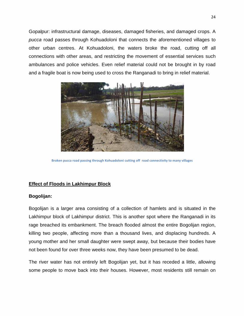
Gopalpur: infrastructural damage, diseases, damaged fisheries, and damaged crops. A
pucca road passes through Kohuadoloni that connects the aforementioned villages to
other urban centres. At Kohuadoloni, the waters broke the road, cutting off all
connections with other areas, and restricting the movement of essential services such
ambulances and police vehicles. Even relief material could not be brought in by road
and a fragile boat is now being used to cross the Ranganadi to bring in relief material.
Broken pucca road passing through Kohuadoloni cutting off road connectivity to many villages
Effect of Floods in Lakhimpur Block
Bogolijan:
Bogolijan is a larger area consisting of a collection of hamlets and is situated in the
Lakhimpur block of Lakhimpur district. This is another spot where the Ranganadi in its
rage breached its embankment. The breach flooded almost the entire Bogolijan region,
killing two people, affecting more than a thousand lives, and displacing hundreds. A
young mother and her small daughter were swept away, but because their bodies have
not been found for over three weeks now, they have been presumed to be dead.
The river water has not entirely left Bogolijan yet, but it has receded a little, allowing
some people to move back into their houses. However, most residents still remain on
25
the streets in temporary camps. A few hamlets that were located on higher ground were
spared the brunt of the flood.
There has also been some discontent among the residents over the distribution of relief
material. People who lost their houses have been accusing the others of unfairly taking
relief material without genuine need. Those who were severely affected blame the less
affected for taking more than their actual share. Although the beneficiaries are thankful
to the NGOs and state for helping them, they have expressed displeasure that the relief
material was distributed indiscriminately without any no proper assessment, which, they
say, created a scarcity for the people who needed it the most.
Several families lived on the banks of the Ranganadi in kutcha houses. The team spoke
to some of these people, including 26-year-old Diwakar Borah, who lives with his wife
and 2-year-old son, and one Bina Borah, who lives with her two children and husband,
to determine why those chose to live in such an unsafe area. They explained that they
were landless people who did not have any other place to stay. Other villages did not let
them stay in safer spots, they said, and so they were forced to settle on the banks. They
had been living there for many years, they said, and in the earlier years, when the
floods came, they would relocate to safer ground, but never before had they seen the
river strike with such rage. On all other occasions, their houses had survived, but this
time, everything they owned was lost, because of the sudden influx of water. Diwakar
Borah worked as a daily wage labourer while Bina Borah had a little farm which is under
water now. In the floods, she lost a pig, two goats, a calf, and 15 ducks. Diwakar Borah
and his family too lost three goats and a pig.
About 27 or 28 families lived near the bank where the embankment broke. These
families now continue to live on the embankment, surviving on relief material in camps
built out of bamboo, tarpaulin and tin sheets. Donations included food grains, clothes,
utensils and water filters. A local political leader, Utpal Dutta, has helped them as well
through food donations and providing them with water filters. The Deputy Commissioner
and one Akhil Gogoi of the Krishak Mukti Sangram Samiti had also visited them to
check the situation.

26
At present, the people here have no work. A couple of families – including Bina Borah‟s
-- have set up their small shops selling cooked food. “It is not possible to survive without
money and we have no income now. So I am trying to sell food and earn some money.
People here need what I‟m selling but most do not have the money to buy it. It‟s not
very profitable but I‟m trying to survive and feed my children”, Bina Borah said.
The team visited another part of Bogolijan where nine families from the Adivasi
community had set up camp on a road. Their homes were about half a kilometer from
these camps, and are still almost half sunk in the water, forcing them to evacuate. Some
people from this community have moved into a local school building for the time being.
The main occupation of these people is farming, but their crops have been completely
damaged and their farmlands are presently under about three feet of water. Speaking to
the team, these families said that they would only be able to assess the extent of
damage to their land once the water recedes, but that presently, they have no income
and are dependent completely on donations. These families also lost a lot of animals.
The floods brought along a lot of diseases, of which the most common are fever,
vomiting and skin diseases. The dirty water that has pooled everywhere has caused the
skin diseases and is a breeding ground for pathogens. Doctors have visited the area
thrice till date.
One Carlos Induwar told the team that he got itchy skin rashes that started after he
walked through stagnant water while making trips to his house to salvage his
belongings. He said that the doctors gave him some medicines a week back, but the
itching and rashes had still not subsided, which is why his family fears that his condition
could get worse. He is the only earning member in the family.
Sanitation has become a very pressing issue in the area. Most of the displaced
residents of Bogolijan had toilets in their houses, but after the floods, they are forced to
defecate in the open. Adding to their woes, presently, there is no private space to
defecate. There is very little space that is not inundated and people have flocked to
them. Moreover, there is the problem of the lack of availability of clean water. People
have received some packaged water that they are utilizing thriftily. But otherwise, there

27
is no water for other uses. There are some tube wells that were set up by the
government a few years ago, but none of them work.
A different perspective to floods
Nowboicha Revenue Circle
One article17 focused on flooding being caused for a slightly different reason: two dykes
constructed by gaon panchayats which became the cause of unprecedented inundation
of around 14 villages in the Nowboicha Revenue Circle of Lakhimpur district.
The dykes had been constructed in different rural development blocks to block the
natural cause of the Singra Rivers and mitigate the onslaught of floodwaters on
agriculture lands and human settlement. River Singra is known for causing annual
flooding in the Nowboicha region of Lakhimpur. It had been in spate since early May
due to heavy rain in the neighbouring Arunachal Pradesh and has inundated a wide
area of Rowdang Pathar, Rohali, Gelahati and Goshaneebari. The Goshanee Pathar
area has been marooned in floodwaters for more than a month now.
One dyke had been constructed by the Barchala-Mahghuli-Paandhowagaon panchyat
near number-1 Barchala village with the supervision of Karunabari Developmental Block
earlier this year. The second was constructed by Ranganadigaon panchayat through
Nowboicha Development Block, some distance up on the river in Singra village.
We found that both the Rural Development Blocks had allowed the respective gaon
panchayats to construct the dykes without consulting the districts‟ Water Resources
Department, which had already constructed an embankment on the other side of the
river. As the river swelled during the monsoons, these dykes prevented it from flowing in
its original course. As a result, the waters slammed against the left hand bank, flooding
the entire area.
17
Farhan Ahmed, ‘Wrong construction of two dykes causes inundation of 14 villages in Lakhimpur’.

28
On public demand, the Lakhimpur district administration pulled down the dyke
constructed by the Barchala-Mahghuli-Paandhowagaon panchayat last week after brief
resistance by locals. However, the existence of the other dyke, constructed by
Ranganadigaon panchyat is still blocking the flow of the river and, hence, causing flood
in the Goshaneebari area.
Though the district authorities sent a team to remove the Singra dyke, they were
resisted by local villages fearing a similar flood in their village. The villagers of Singra
sought two days‟ time to decide on the removal of the dyke following a public meeting
held at the office of Nowboicha Revenue Circle recently.18
Gelahati is a village located in Nowboicha block of Lakhimpur district. It was one of the
clusters of villages that had been affected by the diversion of the Singra River. Gelahati
villagers claimed that there had never been flooding in the area before, but the situation
had changed in the last 25 years, with the building of dykes, because of which there
were floods every monsoon. The dykes had caused the Singra to flow much closer to
their village than it originally used to, they said.
Gelahati is affected by floods every monsoon, and its effects last the whole year. The
village is located in a low-lying area, relative to other nearby villages. Due to its
topography, the floodwaters stay stuck in Gelahati. Consequently, parts of the village
remain inundated throughout the year. Some villagers manage by building their houses
at higher spots in the village, but their agricultural fields are no longer usable.
Consequently, there is no economic work available here. A lot of men from this village
move out to different cities and towns for work, leaving their families behind. Here too, a
lot of men become security guards outside the state. The few who remain find work as
daily wage labourers in neighboring villages.
The villagers are used to the floods now, since they live with it for roughly four months a
year. However, their lives are made infinitely more difficult and messy for this problem.
They build their houses on a raised platform, but even these get inundated during the
18Farhana Ahmed,‘Wrong construction of dykes causes inundation of 14 villages in Lakhimpur’.
29
flood season. To deal with the problem, they place their beds as close to the roof as
possible. But there is no proper place to cook in their houses. Even though they have
been getting adequate food grains as relief material, there is a scarcity of firewood to
cook with, so they are forced to resort to community cooking.
They also face a scarcity of drinking water. The village has two tubewells placed
strategically at a height that the villagers have to use boats to reach. The villagers say
that they rarely bathe and even when they do, it is often the floodwaters that they bath
in. Toilets are also rendered useless. Villagers sometimes defecate from the roofs of
their houses; other times, they take their boats to find a secluded place. There is also
the issue of health, because doctor visits to the village are very rare. Animals die too.
This year, the villagers have staged multiple protests in front of the Deputy
Commissioner‟s office, where they placed a charter of six demands. These included a
redirection of the river to its original course, payment of adequate compensation to the
flood-affected and waiver of farmers‟ loans. Their village has received attention from the
media too. Consequently, the Additional Deputy Commissioner sent a team to survey
the area to conduct a survey. The villagers are now hoping for positive action. The
administration gave the protestors a written assurance that a solution would be found
within 15 days, but not much has been done yet. Only time will tell if the lives of
Gelahati residents will improve.
Meeting with the District Project Officer (DPO), District Disaster Management
Authority, Lakhimpur:
The DPO acknowledged that the condition this year was much worse compared to other
years. The last time things were this bad was in 2008. The DPO mentioned the two
embankment breaches at Bogolijan and Jainpur, and said that the North Lakhimpur
bypass on NH-52 had prevented further damage. Being on a raised location, the
highway prevented spilling of water into the main Lakhimpur town, she said.
30
As a preventive measure, the DPO claimed, the movement of big vehicles on the NH-52
was stopped on the evening of July 9 when rainfall got particularly bad. She also said
that villages likely to be affected by the Ranganadi‟s rising waters had been warned.
The warning system consisted of information given to the circle officer who informed the
local Mandal, who in turn passed on the warning to the local village headmen
(gaonbura). Each village headman looks after 4-5 villages. The DPO acknowledged that
the gap in communication was significant.
According to the DDMA‟s estimate, as of August 2, 2017, about 3 lakh people in 460 to
500 villages have been affected by the floods in Lakhimpur. The government has set up
21 relief camps and 457 health camps in 7 circles. Six people had died because of the
floods in Lakhimpur, and their families had been paid a compensation of Rs 4 lakhs
each.
The DPO also said that the release of water by NEEPCO from its dam at Yazali had a
major role to play in the floods. On July 9, 13,000 mm of water had been released from
the dam‟s three gates. This was a huge quantity because even 4,000-5,000mm of water
is dangerous and can cause significant damage.
Repair work on embankments had started, the DPO said, and it was expected to be
completed soon. She said that residents would be paid compensation for their losses
and infrastructural damages as per the norms of the State Disaster Relief Fund and
National Disaster Relief Fund. According to these, people who lost their houses are
liable to be paid Rs 95,100, while those who suffered partial damages have to be paid
Rs 3,200 and Rs 5,200 for kutcha and pucca houses respectively.
The DPO said that the department was in the process of carrying out an assessment of
the damages. The Agriculture Department too assessing the deposit of silt on farmlands
and a decision on compensation and resuscitation would be arrived at shortly.
31
Interaction with NGOs
Relief poured in after the floods. Several NGOs and individuals took up the role of
messiahs during these trying times and provided relief to the affected people. We spoke
with some NGO personnel – such as those from the People‟s Action for Development
(PAD), which is a Lakhimpur-based organization with sturdy local connections, and
more prominent NGOs such as OXFAM and Americares which brought in large
amounts of relief material. The other organisations took PAD‟s help in delivering the
material to the affected. PAD also worked with the European Union Commission and
the Tata Trust. The villagers we met spoke highly of the work of these groups.
Americares flew in two of their own doctors and staff members. One doctor worked in
Lakhimpur district while the other went to Majuli (another nearby island-district ravaged
by the floods). At Lakhimpur, the doctor and a staff member from Americares with the
support of PAD regularly visited flood-affected regions and set up health camps. They
had also brought with their own stock of medicines. In July, Americares had conducted
16 health camps in Lakhimpur, Telahi and Nowboicha blocks of Lakhimpur.
Americares provides emergency response services and has had years of experience in
this field. Therefore, they were prepared for dealing with the diseases that emerge after
such disasters, bringing along medication for health problems such as diarrhea, fever,
cough, skin infections, and gastrointestinal problems, among others.
Along with medicines, Americares also gave out hygiene kits and shelter kits; in all, they
handed relief material to about 1,500 families. OXFAM too provided wide support. Till
the point of this fact-finding, OXFAM had distributed relief materials to about a thousand
families and was bringing in more material for another thousand families. An Americares
member said that they are trying to make arrangements with health department officials
in the district so leftover medication could be used in the local health centres or in their
own health camps.
32
The total effect of the floods of 2017:
The damage is enormous, and while not all of it can be assessed in economic terms,
the sheer numbers associated with this disaster are staggering. According to
government figures, 31 out 33 districts in the state were affected by the floods. The
crop-affected area is 3,97,910.25 hectares. 62,073 people had to be evacuated in 26
districts. 956 relief camps had to be set up which housed 4,51,946 people. 19 The
information publicly released by the state government on the website of the State
Disaster Management Authority bluntly throws these numbers without elaborating.
There is district-wise information on the amount of foodgrains distributed, but there is no
available data on other significant questions -- how much longer will cultivation be
stalled on lands with silt deposit? Will there be any compensation to these landowners?
How many people have been compensated for losses so far?
157 lives have been lost this year.20 The count of animal lives will easily go up to
multiple lakhs. In Kaziranga National Park, reportedly 398 animals died.21
OXFAM India says the total number of people affected by the floods in Assam is 33.5
Lakhs.22
There were breaches in the river embankment in 26 places in 15 districts. 7,000 schools
were washed away and 3,500 houses were damaged. Some 14,000 roads were also
broken.23
These floods have resulted in a loss of over Rs 2,939 crores.24 In 2016, the Water
Resource Department in Assam submitted a flood memorandum to the Centre following
the flood, seeking Rs 5,038 crores for the repair of embankments, damage to river
19
Assam Disaster Management Authority, Flood Report, Flood Situation as on 15th
September, 2017. 20
DebasreePurkayastha (September 6, 2017), All you need to know about Assam floods; The Hindu. 21
Ibid. 22
www.Oxfamindia.org/Assam-Floods-2017. 23
MubinaAkhtar(August 25, 2017), Dam Worsens Flood Devastation in Assam. 24
Ibid.

33
banks and building flood control structures. This year, the state government has allotted
2,723.34 crores to the water resource department.25
Some can justify the damages, calling it the fury of nature, but the same story repeats
itself every year. Each year, there is some noise on social media, with a lot of it calling
for national attention. But to what end is this national attention? Does the central
government not know about the money being spent from its coffers for floods?
Information sourced from the Central Water Commission in an article 26 shows the
following figures:
Particulars Annual Average
(between 1953-2016)
Maximum
No. of people affected 26 lakhs 1.2 crores (in 2004)
Value of damage to homes 7 crores 104 crores (in 1998)
Loss of cattle 10,961 1,18,772 (in 2004)
Loss of Human Lives 47 497 (in 2004)
Total damage 128 crores 3200 crores (in 2012)
25
DebasreePurkayastha (September 06, 2017), All you need to know about Assam floods; The Hindu. 26
ShantanuNandan Sharma (July 16, 2017), Assam Floods, an annual tragedy: A detailed Report; The Economic Times.
34
Conclusion:
The problem of floods in Assam is an enormous issue that deserves the world‟s
attention and immediate mitigation efforts. It recurs annually, but there still seems to be
no permanent solution in sight. Can there even be a permanent solution to such a
problem?
Compensation for flood victims is essential, of course, but the process of actually fixing
the problem will take some time. Damage needs to be assessed so authorities can
decide the appropriate quantum of relief. At last count, 11 Jainpur families whose
houses were completely destroyed were paid compensation of Rs 95,100 each. But
those in Majgaon have still not been paid any compensation. Compensation is paid as
per norms of assistance from the State Disaster Relief Fund and the National Disaster
Relief Fund. The families of people who lost their lives were paid a compensation of Rs
4 Lakhs each.
Nayan Sharma, a specialist in hydraulic structures, river engineering and irrigation and
a professor in IIT-Roorkee, said that there can be no permanent solution to Assam‟s
floods but one should aim to find a durable solution instead.27 Himanshu Thakkar, a
water activist, was quoted as saying it is „not possible to flood-proof the whole of
Assam.‟28
The Prime Minister has visited the state and announced a relief package for those
affected. Newspapers reports said that finding a permanent solution to the problem was
one of the purposes behind the visit. The government announced the allocation of Rs
100 crores to fund a study on the course of Brahmaputra river and its effects.29
Another solution that has been proposed is the dredging of the Brahmaputra, and this
project is scheduled to commence soon. The dredging is also meant to facilitate the
upgradation of the Brahmaputra into an „International Waterway‟. A tripartite agreement
for dredging the Brahmaputra was signed between the Assam government and the
27
PrabinKalita (August 2, 2017), ‘Permanent Solution to floods in Assam not feasible’; The Times of India. 28
DebasreePurkayastha (September 06, 2017), All you need to know about Assam floods; The Hindu. 29
PrabinKalita (August 1, 2017), ‘Northeast Floods: PM announces Rs. 2000 crore relief’; The Times of India.

35
Indian Inland Waterways and National Highways authorities at the closing ceremony of
the Namami Brahmaputra Festival in Guwahati in April.
Nitin Gadkari, India‟s Union Minister of Road Transport, Highways and Shipping, had
said that he hoped the project would change the economic condition of Assam residents
and announced that the national government would provide Rs 400 billion (US$ 6.2
billion) for the construction of the ambitious Brahmaputra Express Highways on both
banks of the river. The World Bank has given Rs 98 million (US$ 1.5 million) to the
Inland Water Transport infrastructure development project to support its work in
dredging the river. The material needed to build the highway would be provided through
the dredging activities.
“Dredging of the Brahmaputra and Barak rivers will not only help to deal with the
problem of floods, which affects Assam and Bangladesh, but also improve the
navigation facilities in the rivers, which can strengthen trade and commerce between
India and its neighbour through riverine routes,” said Sarbananda Sonowal, chief
minister of Assam, at the inaugural session of the 8th India-Bangladesh Friendship
Dialogue on July 2, 2017.However, no Detailed Project Report (DPR) is available for
this project.30
Should the efficacy of this project in dealing with the floods be trusted? “During British
rule, dredging was done as a protective measure from floods,” says PK Dutta, an
engineer who submitted the dredging plans to Prime Minister Modi.31 But did it work?
Apprehension has been expressed about these plans. “It is impossible to make the river
bed free from silt deposition by dredging, unless a suitable mechanism is applied to
capture and dispose of the silt load flowing into the main stream from its tributaries.
Otherwise, the dredged portion of the river bed will be filled up with fresh silt
immediately. Dredging along a particular width of a channel along the Brahmaputra for
navigational purposes will not support a permanent solution to the recurring floods and
erosion of the Brahmaputra basin” says Pradip Puzari, a project manager at M/S Patel
Engineering Ltd.
30
MubinaAkhtar (August 29, 2017), Dredging the Brahmaputra. 31
Ibid.

36
Numerous environmental concerns associated with dredging the Brahmaputra also
need to be addressed, but the government is ignoring some of the most critical ones.
There are questions over how the construction of the expressways on both banks of the
river is possible without disturbing the river connections with other channels and water
bodies. A one key question still remains: how can the Assam government continue with
such a massive project, without conducting the necessary environment impact
assessment?32
Nayan Sharma also shares similar apprehensions over the dredging plans. “The
sediment generated per year in the Brahmaputra is alarmingly high at about 1 billion
tonnes -- five times as much as in China‟s Huang He (Yellow River). The Rs 400 crore
that the Centre has sanctioned for dredging the Brahmaputra will go down the drain
unless the catchment area treatment is first done, as in the Yellow River,” says Sharma.
He added, “You can‟t put the cart before the horse. Dredging is the second step. Unless
sedimentation is controlled by catchment area treatments, including massive
afforestation, dredging will be meaningless. The more you dredge, the more sediment
will be collected,”33
No sane person would be against a proper executable and feasible plan to stop the
destruction caused by the floods in Assam. But one should be wary of a plan that is to
be executed without any proper assessment. When so much public money is to be
spent, it must be strongly assured that the project will be fruitful. But in this case, if the
concerns expressed by experts are to be believed, it would seem that the plan will not
work as expected to prevent floods. Dredging will be futile if the dredged silt gets rapidly
restored by its tributaries. Moreover, there has not even been an Environment Impact
Assessment (EIA) done.
What are the other options? The planned 1,300 km long highway along the
Brahmaputra, if built earnestly and with genuine intention, could be embraced despite
its whopping cost (Rs 400 billion). But environmentalists say that this road-cum-
32
MubinaAkhtar (August 29, 2017), Dredging the Brahmaputra. 33
ShantanuNandan Sharma (July 30, 2017), Standalone Dredging in the Brahmaputra will be futile.

37
embankment will also be ineffective.34 If that‟s true, the highway and the dredging efforts
offered as permanent solutions to the problem of flooding are lies.
The embankments in the state are worn out. Breaches are common and can be
anticipated. The annual floods are disasters waiting to happen while state residents sit
helplessly in their anticipation and while the state government allots hundreds of crores
for repair of embankments every year. More than Rs 33,000 crore has been spent in the
name of flood prevention since the 1950s in Assam.35 Despite this, breaches continue.
There are allegedly 26 breaches in 15 districts in 2017.
The embankments on the Brahmaputra and its 103 tributaries in Assam were built
based on 15- to 20-year-old flood data.36 82% of the state‟s embankments and dykes
have already crossed the lifespan for which they were supposed to be effective.37 What
is the purpose of rebuilding these embankments every year when they will be breached
again? Could it be money that causes successive Governments to depend on
embankments as a solution for flooding problems? Himangshu Thakkar says, “A lot of
money keeps getting spent on embankments because it's a lot of money, mostly
unaccountable money. Money keeps getting spent without really helping the local
people and helping from the flood problem."38
In 2008, after Lakhimpur was ravaged by a particularly catastrophic wave of floods, a
project worth Rs 362 crores was announced to rebuild and repair embankments along
the Ranganadi river. The cost was to be borne by the central and state government,
with the former paying 70% of the total expenditure. The project remains incomplete till
date. The district administration and the contractors are blaming each other.39
If embankments are the solution, we need stronger ones. Instead of solely focusing and
annually spending huge amounts of money on repair, research teams can be convened
34
ZarirHussain, Rina Chandra (July 27, 2017), India plans 800-mile highway embankment to curb floods in Northeast. 35
Saurabh Gupta (August 6, 2016), Assam’s Embankments: Crores Washed Away. 36
MubinaAkhtar, August 25, 2017, Dam Worsens Flood Devastation in Assam. 37
Samudra Gupta Kashyap (March 29, 2013), 82% embankments in Assam have outlived their utility. 38
Saurabh Gupta (August 6, 2016), Assam’s Embankments: Crores Washed Away. 39
ArunabhSaikia (July 20, 2017), Assam floods: How an embankment in Lakhimpur failed, leaving villages devastated and people dead.
38
and assigned the task of finding solutions to the embankment breach problem and to
come up with permanent or long-term solutions to strengthen them. And if solutions are
found, they must be acted upon promptly. In modern times, building stronger
embankments shouldn‟t be such a time-consuming and seemingly impossible issue.
Just as important is the existence of a proper warning system. We found, after
interacting with villagers and the District Disaster Management Authority, that there was
no proper warning before the floods of July 2017. Whatever warning was sent out did
not reach its intended recipients. Consequently, villagers got very little time to salvage
valuable items. The quantum of their loss could have been significantly reduced had a
proper warning system been in place.
The North Eastern Space Application System (NESAC) had taken the responsibility for
developing a model of flood-forecasting and issuing early warnings. Now, the Flood
Early Warning System (FLEWS) extends to 14 districts of Assam. The first strategy in
the establishment of FLEWS is the consideration of the flood-prone districts on a basin
or catchment. The early warning system has been viewed in the context of a river basin
approach where upstream, midstream and downstream activities affect the time of
concentration and volume of runoff as reflected in the shape of the hydrograph. Given
the fact that most flood-prone communities are aware that heavy rainfall intensities
upstream may result to flooding in the downstream area, the FLEWS will systematize or
enhance the existing coping mechanisms of communities. The second strategy adopted
in FLEWS is providing location-specific early warning advisory bulletins. The third
strategy is the involvement of all the stakeholders under FLEWS.40
The question now is why, when India uses state-of-the-art satellites and local stations
for weather forecasting, and when there is the pre-deployment of teams along hazard
zones identified through mapping and marking, are the casualty numbers so alarmingly
high.41 India has accused China of not sharing information regarding the Brahmaputra
since May, 2017. Under a bilateral agreement between the countries, China provides
40
Flood Early Warning System, Official website of the Assam State Disaster Management Authority, http://asdma.gov.in/project_flood_warning.html 41
GauravVivekBhatnagar (August 2, 2017), Heavy Flooding and Casualties Raise Questions on India’s Disaster Preparedness,

39
water-flow information to India, twice a day, during the monsoon season to help with
flood forecasting.42
The lacuna in the flood-warning system became evident after interaction with the
villagers who did not get information about the impending disaster despite information
having been disseminated by the Disaster Management Authority. It lies in the channel
through which the information passes -- the flow is not smooth and the information gets
lost somewhere in the middle. In Assam where floods are an annual affair, a strong
warning system is imperative.
The impact of dams on the floods in Assam requires intensive research. Simply building
hundreds of dams without a clear assessment of their effects could be potentially
catastrophic for all stakeholders. But the general public always suffers the most.
Moreover, it is not clear how beneficial the dams in providing locals with electricity
supply either.
The floods bring unimaginable grief to Assam every year. It is difficult to fathom its full
effect, because even if we succeed in assessing all economic losses, we may never
know the emotional impact of such a disaster. Lakhs of people are affected, directly or
indirectly and thousands are displaced from their houses every year. Families are
destroyed. Domestic animals and crops are lost. Relief and compensation to affected
people is definitely appreciable, but one has to think beyond the short-term as well, and
start working for a future where these disasters lose their power. Resouce-intensive but
ultimately inefficient efforts such as dredging of the Brahmaputra can be like throwing
dust in the eyes of the people, when we see there has been so much logical concerns
expressed against it. We earnestly request the government to invest public resources
into genuine and long-lasting solutions to the problem rather than in projects which are
least likely to have lasting impacts.
42
MubinaAkhtar(August 25, 2017), Dam Worsens Flood Devastation in Assam.

40
Gallery
Pictures from Jainpur:

41

42
43
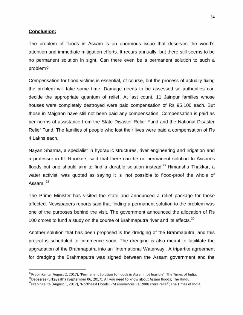
Pictures from Gopalpur:
A school campus in Gopalpur

44

45
Pictures from Majgaon:
Silt deposited at the door of a classroom in the primary school at Majgaon
Silt deposited in and around the local Anganwadi at Majgaon

46
A damaged tractor A villager in front of his fishery that used to be
47
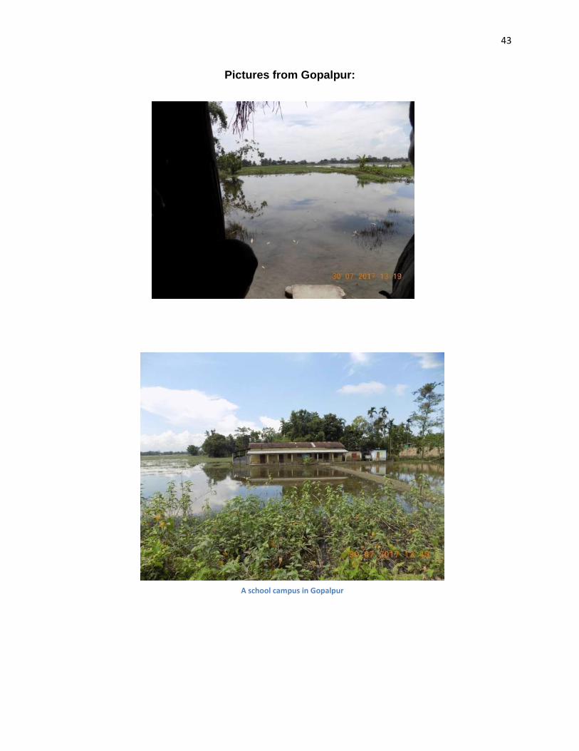
A broken culvert
48
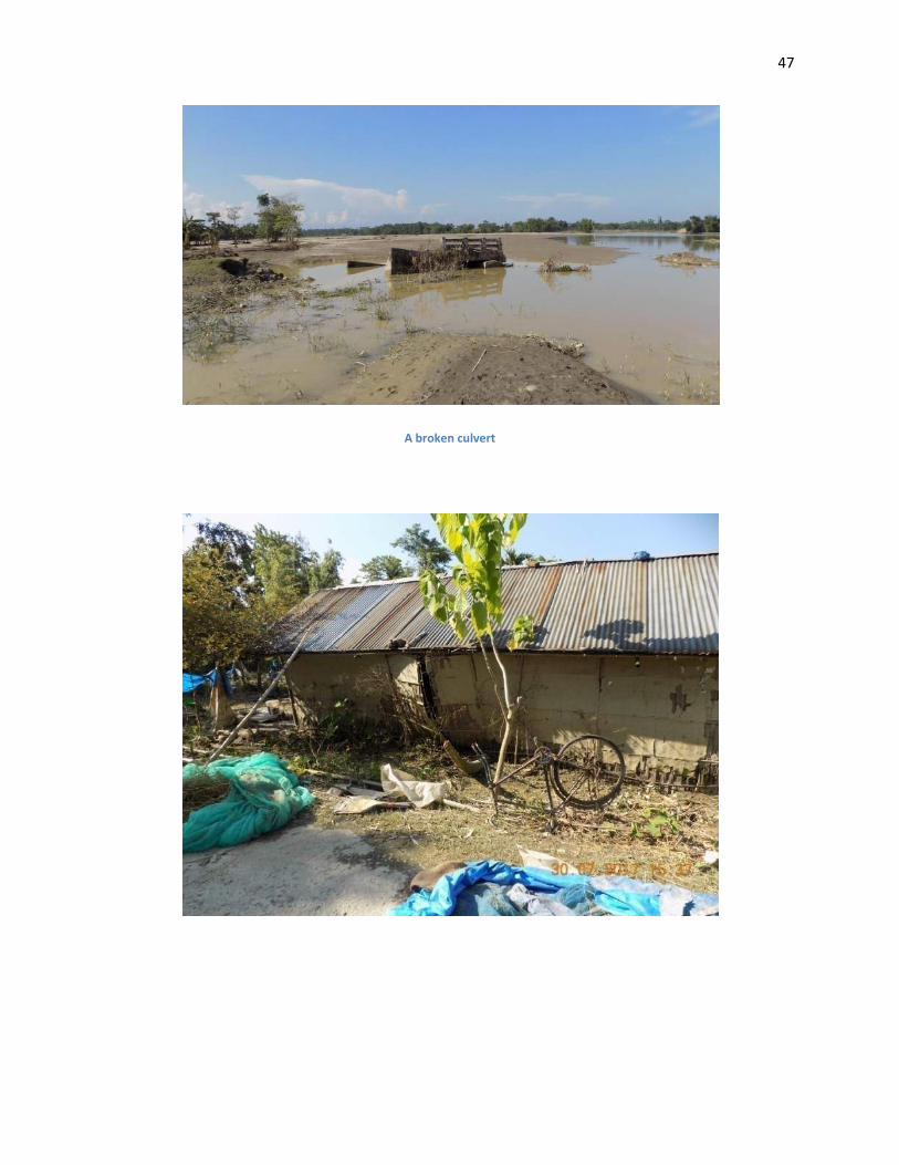
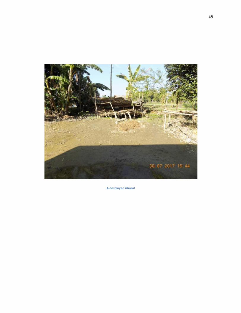
A destroyed bhoral