Before the Emirates: an Archaeological and Historical Account ...
lable at ScienceDirect
Quaternary International xxx (2015) 1e16
Contents lists avai
Quaternary International
journal homepage: www.elsevier .com/locate/quaint
A multi-proxy analysis of the Holocene humid phase from the UnitedArab Emirates and its implications for southeast Arabia's Neolithicpopulations
Gareth W. Preston a, *, David S.G. Thomas b, Andrew S. Goudie b, Oliver A.C. Atkinson b,Melanie J. Leng c, d, Martin J. Hodson e, Helen Walkington a, Vincent Charpentier f,Sophie M�ery f, Federico Borgi g, h, Adrian G. Parker a
a Department of Social Sciences, Oxford Brookes University, Headington, Oxford, OX3 0BP, UKb School of Geography and the Environment, University of Oxford, South Parks Road, Oxford, OX1 3QY, UKc NERC Isotope Geosciences Facilities, British Geological Survey, Keyworth, Nottingham, NG12 5GG, UKd Centre for Environmental Geochemistry, School of Geography, University of Nottingham, Nottingham, NG7 2RD, UKe Faculty of Health and Life Sciences, Oxford Brookes University, Headington, Oxford, OX3 0BP, UKf Bureau 107F, ArScAn e Arch�eologie de l'Asie Centrale, UMR 7041, Maison de l'Arch�eologie et de l'Ethnologie, 21 All�ee de l'Universit�e, F-92023,Nanterre Cedex, Franceg Universit�e Paris 1 Pantheon-Sorbonne, ArScAn e Arch�eologie de l'Asie Centrale-UMR 7041, Maison de l'Arch�eologie et de l'Ethnologie,21 All�ee de l'Universit�e, F-92023, Nanterre Cedex, Franceh Universit�a degli Studi di Milano, Dipartimento di scienze della Terra “Ardito Desio”, Scuola di dottorato in “Terra, Ambiente e Biodiversit�a”, Italy
a r t i c l e i n f o
Article history:Available online xxx
Keywords:ArabiaHoloceneNeolithicPalaeolakeDunesPalaeoclimate
* Corresponding author.E-mail address: [email protected] (G.W. Pre
http://dx.doi.org/10.1016/j.quaint.2015.01.0541040-6182/© 2015 Elsevier Ltd and INQUA. All rights
Please cite this article in press as: Preston, Gits implications for southeast Arabia's Neoli
a b s t r a c t
An early-to mid-Holocene humid phase has been identified in various Arabian geo-archives, althoughsignificant regional heterogeneity has been reported in the onset, duration and stability of this period. Amulti-proxy lake and dune record from Wahalah in the United Arab Emirates (UAE) documents signif-icant variations in hydrology, biological productivity and landscape stability during the first half of theHolocene. These data reveal that post-Last Glacial Maximum dune emplacement continued into theearliest part of the Holocene, with the onset of permanent lacustrine sedimentation at the sitecommencing ~8.5 ka cal. BP. A long-term shift towards more arid conditions is inferred between ~7.8 and5.9 ka cal. BP, with intermittent flooding of the basin and distinct phases of instability throughout thecatchment area. This transition is linked to the southwards migration of the Intertropical ConvergenceZone (ITCZ) and associated weakening of monsoon rains. A peak in landscape instability is recordedbetween ~5.9 and 5.3 ka cal. BP and is marked by a pronounced increase in regional dune emplacement.These variations are considered alongside the record of human settlement raising important questionsabout the interactions between population demographics, climate and environment in southeast Arabiaduring the Neolithic.
© 2015 Elsevier Ltd and INQUA. All rights reserved.
1. Introduction
Understanding climatic variability is crucial when examiningarchaeological records in the world's arid regions, where thelandscape is highly sensitive to subtle shifts in precipitation andevaporation. This has led an increasing number of palaeoclimaticstudies to link the rise and fall of early human societies to changingclimatic conditions during the Holocene (e.g. Cullen et al., 2000;
ston).
reserved.
.W., et al., A multi-proxy analthic populations, Quaternary
Brooks, 2006; Staubwasser and Weiss, 2006; Dixit et al., 2014a).However, it is important that causal relationships are not basedsolely on broad, continental-scale changes in climate, but insteadassess their impact at a more local level in terms of landscapesensitivity and stability and the availability of environmental re-sources, such as freshwater and vegetation (Berger et al., 2012).
Geo-archives have revealed that areas of the presently hyper-arid Arabian sub-continent were transformed into an amelioratedlandscape during the early-to mid-Holocene, with more favourablehydrological conditions leading to the expansion of lakes andvegetation throughout the desert interior (Parker et al., 2004;
ysis of the Holocene humid phase from the United Arab Emirates andInternational (2015), http://dx.doi.org/10.1016/j.quaint.2015.01.054
G.W. Preston et al. / Quaternary International xxx (2015) 1e162
Please cite this article in press as: Preston, G.W., et al., A multi-proxy analysis of the Holocene humid phase from the United Arab Emirates andits implications for southeast Arabia's Neolithic populations, Quaternary International (2015), http://dx.doi.org/10.1016/j.quaint.2015.01.054

G.W. Preston et al. / Quaternary International xxx (2015) 1e16 3
L�ezine et al., 2010; Berger et al., 2012). This change is thought tohave been driven by a northwards shift in the mean latitudinalposition of the Intertropical Convergence Zone (ITCZ) and associ-ated monsoon precipitation belt (Overpeck et al., 1996; Fleitmannet al., 2007). Speleothem d18O data from northern (Hoti Cave) andsouthern (Qunf Cave) Oman suggest that monsoon precipitationincreased rapidly between ~10.6 and 10.1 ka BP and remainedgenerally high until ~6.3 ka BP (Fleitmann et al., 2007; Fleitmannand Matter, 2009). These palaeohydrological reconstructions arein good agreement with marine records from the Northern ArabianSea which show increased upwelling/productivity and reduceddust influx during the early-to mid-Holocene (Sirocko et al., 1993;Schultz et al., 1998; Gupta et al., 2003). Whilst these long-term,continuous sedimentary archives have proven invaluable inreconstructing broad climatic trends, they reveal little about theevolution of the terrestrial landscape at the local level. Indeed, arecent synthesis of a range of Arabian geo-archives demonstratedthat there is significant regional heterogeneity (sensu Thomas et al.,2012) throughout the Peninsula during the Holocene (Berger et al.,2012). Fleitmann et al. (2007) linked these differences to the time-transgressive migration of the summer ITCZ, with the onset andtermination of humid conditions, and whether these transitionswere gradual or abrupt, dependent upon the geographical locationof a particular site. The contribution of mid-latitude westerly(MLW) systems during this period, an important source of moisturethroughout northern and central Arabia today, remains unclear.Speleothem d18O data from Hoti Cave indicate that these systemsbecame increasingly important after ~6.3 kyr BP (Fleitmann et al.,2007). They may have contributed to continued lacustrine sedi-mentation at some sites north of 24�N during the mid-Holocene,when most palaeolake records from central and southern Arabiahad ceased (Parker and Goudie, 2008). Understanding the signifi-cance of these differences is complicated further as most Arabianterrestrial geo-archives are prone to erosion, yield little dateablematerial and are rarely continuous (Berger et al., 2012). Further-more, high-resolution palaeoclimate records reveal a series ofmillennial-scale, high amplitude, short-term periods of increasedaridity superimposed on these long-term trends, further chal-lenging the notion that the early-to mid-Holocene was stable andwholly humid (Fleitmann et al., 2007; Fleitmann andMatter, 2009).Indeed, it is now clear that the period was characterised by sig-nificant temporal and spatial climatic variability, in turn high-lighting the importance of understanding the evolution of theterrestrial landscape at the local level when examining clima-teehuman interactions. This variability is evident throughout thePeninsula today, largely as a consequence of changes in elevation,with higher precipitation in the mountainous terrain which runsalong the eastern (al-Hajar Mountains, Oman), southern (DhofarMountains, Oman, and the Hadramawt Plateau, Yemen), andwestern (Yemeni Highlands) fringes of the Peninsula (Glennie andSinghvi, 2002). In addition, significant rainfall events, resulting inflash-flooding, have been recorded throughout parts of the UAE andOman (Membery, 1997; Kwarteng et al., 2009).
Palaeoenvironmental evidence in southeast Arabia is derivedfrom palaeolakes (Parker et al., 2004, 2006; Radies et al., 2005;
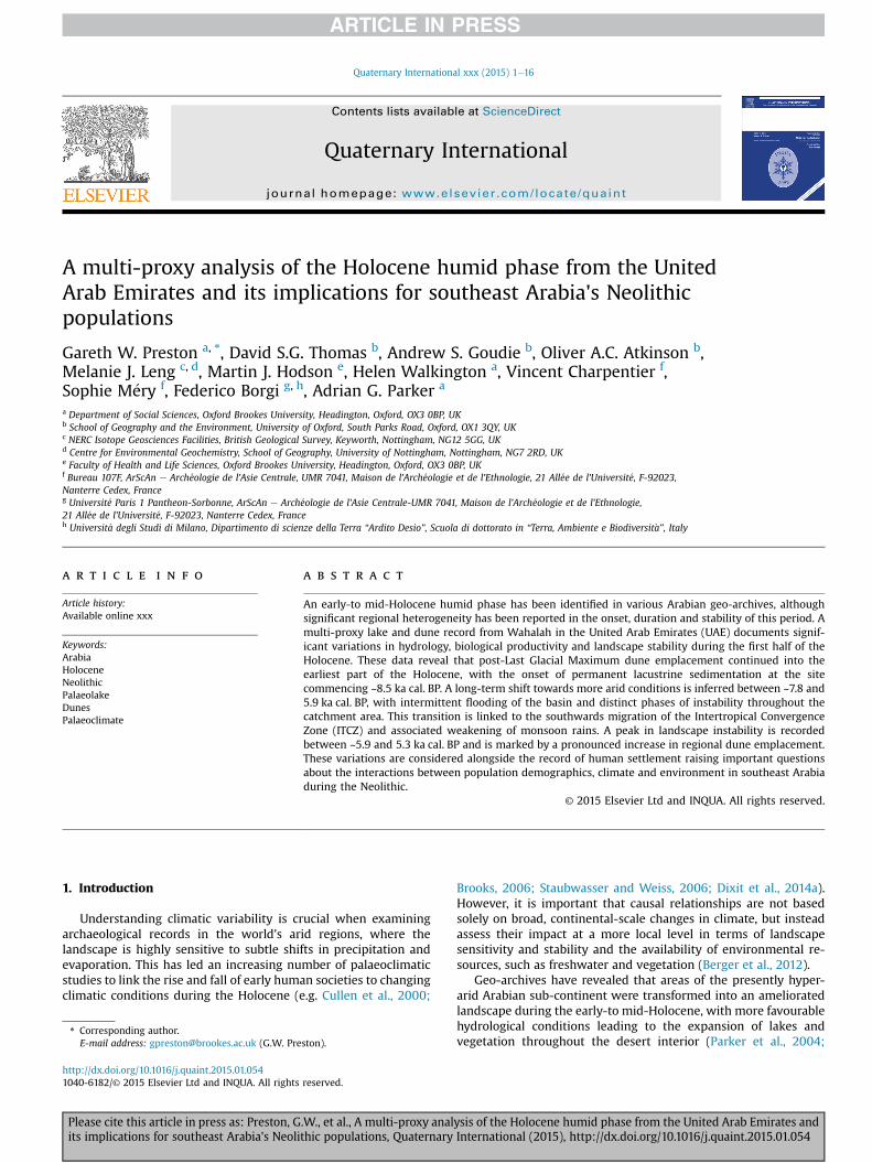
Fig. 1. (a) Map of the study region showing the location of key geo-archives and archaeologiet al., 1989; Atkinson et al., 2011), al-Daith 1e3 (Parker and Goudie, 2007; Atkinson et al., 2012012), Emirates Highway (Atkinson et al., 2011), Hili (Kallweit et al., 2005), Idhn (Goudie e2008), Jebel Faya (Uerpmann et al., 2009), Nad al-Thamam (Uerpmann et al., 2009), Ramlat a(Atkinson et al., 2011), Tawi Asmar (Atkinson et al., 2012), Umm al-Quwain 2 & Airstrip (Atkinstudy; Atkinson et al., 2011). (b) Map of the Arabian Peninsula showing the dominant atmospsites discussed in the text: al-Adhla (Wilkinson, 2005), al-Hawa (L�ezine et al., 2007), An Nafuand M�ery, 2008), Dhamar Highlands (Davies, 2006), Hoti Cave (Fleitmann et al., 2007), Liwaand Buerkert, 2009), Mundafan and Rub' al-Khali (McClure, 1976; Rosenberg et al., 2011), QuConsultation of the original studies for the precise location of each site is recommended.
Please cite this article in press as: Preston, G.W., et al., A multi-proxy analits implications for southeast Arabia's Neolithic populations, Quaternary
Fuchs and Buerkert, 2008; Urban and Buerkert, 2009; Prestonet al., 2012), fluvial deposits (Dalongeville, 1999), and aeolian se-quences (Goudie et al., 2000a; Preusser et al., 2005; Stokes andBray, 2005; Atkinson et al., 2011, 2012, 2013). These records haverevealed that the environment underwent significant changeduring the early-to mid-Holocene in response to the continental-scale shifts in climate discussed above. Archaeological investiga-tion has shown that the corresponding period marked a large-scale re-occupation of the landscape during the Neolithic, a timeof significant cultural development (e.g. domestication of animals,changes in material culture, growth of maritime exchange re-lations) throughout Arabia (Potts, 2001). This paper presents anew, multi-proxy record of early-to mid-Holocene environmentalchange from Wahalah palaeolake, United Arab Emirates (UAE)(Fig. 1), which has potentially important implications for our un-derstanding of the region's archaeological record. Previous work atthe site by Atkinson et al. (2011) has provided important infor-mation on the age and development of the regional dune-fieldsthat impinge on the basin. By comparing the multi-proxy lakerecord with the chronology from the surrounding dunes and withdata from other geo-archives from southeast Arabia, this studyseeks to develop a reliable framework of climate change andlandscape evolution within which to examine the region'sNeolithic archaeology.
2. Environmental and archaeological setting
Wahalah (N25� 380 4800, E55 470 2600; 10 m asl), is a dry, inter-dunal lake basin of ~2.4 km2 situated in the Emirate of Ras' al-Khaimah, approximately half-way between the cities of Ras' al-Khaimah and Umm al-Quwain in the UAE (Fig. 1). The site lies4 km inland from Jazirat al-Hamra on the Arabian Gulf coast andapproximately 30 km to the west of the al-Hajar Mountain range.
Provenance studies of the dune sands in the UAE have shownthat both the Arabian Gulf basin and al-Hajar Mountains (Musan-dam and Ru'us al Jibal Groups) aremajor sources of carbonate in theregion, with the latter also contributing ultramafic igneousmaterial(Semail Ophiolite Suite). Fe-rich quartz grains, derived from theArabian continental interior, are a third major component of theregion's dune sands (El-Sayed, 1999; White et al., 2001; Garzantiet al., 2003; Farrant et al., 2012).
Wahalah is considered to have been a closed basin with anoverall catchment area of less than 5 km2 and is bordered bynortheastesouthwest trending linear mega-ridges which rise>50m above the basin floor andmark the north-eastern limit of theRub' al-Khali sand sea (Fig. 2). Whilst the orientation of the mainmega-ridge features is broadly northeastesouthwest, reworking bythe current Shamal wind regime has formed multiple transverse,northwestesoutheast orientated, ridges on the more gently gradednorthwestern flanks. These features are typically up to 15 m highwith frequent coalescence of multiple ridges at Y-junctions(Atkinson et al., 2011). The southeastern slip faces are considerablysteeper, resulting in a distinct asymmetric profile. Many factorsinfluence dune accretion, migration and stabilisation (Thomas andBurrough, 2012; Leighton et al., 2013), predominantly sediment
cal sites discussed in the text: Akab Island (Charpentier and M�ery, 2008), Al Ain (Gebel2; Parker unpubl.), Awafi (Goudie et al., 2000a; Parker et al., 2004, 2006; Preston et al.,t al., 2000a), Jazirat al-Hamra (Atkinson et al., 2012), Jebel al-Buhais (Uerpmann et al.,sh-Shuruq (Atkinson et al., 2012), Ras' al-Khaimah south (Atkinson et al., 2012), Shu'aybson et al., 2012; Parker unpubl.), Wadi Dhaid region (Dalongeville, 1999), Wahalah (thisheric circulation patterns today and the location of key geo-archives and archaeologicald (Schulz andWhitney, 1986), Core 723A (Gupta et al., 2003), Dalma Island (Charpentier(Bray and Stokes, 2003; Wood and Imes, 2003; Stokes and Bray, 2005), Maqta (Urban
nf Cave (Fleitmann et al., 2007), Tayma (Engel et al., 2012), Wahiba (Radies et al., 2005).
ysis of the Holocene humid phase from the United Arab Emirates andInternational (2015), http://dx.doi.org/10.1016/j.quaint.2015.01.054
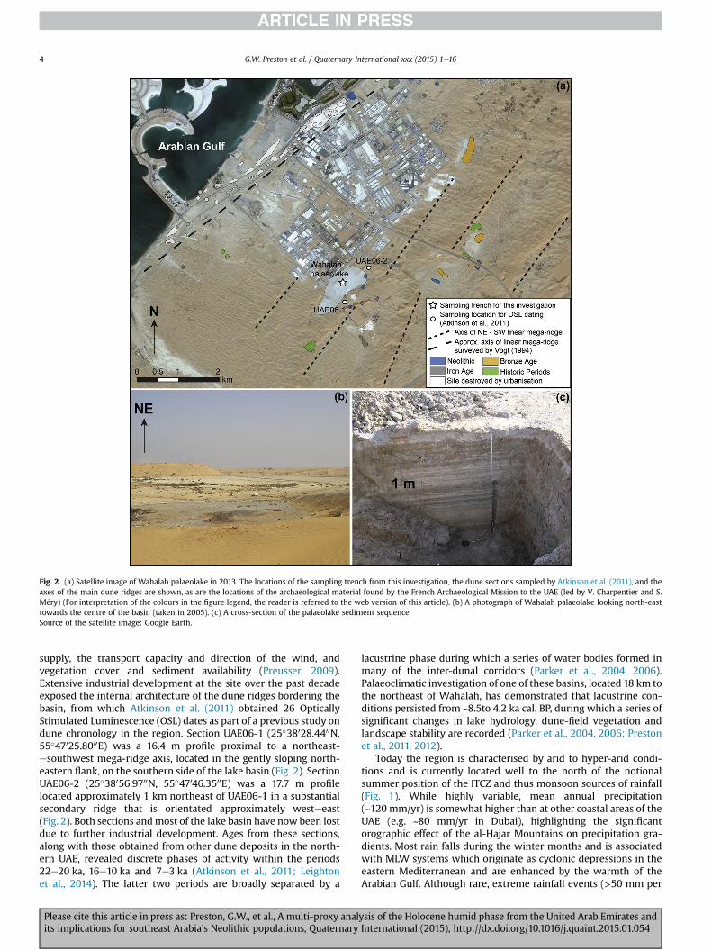
Fig. 2. (a) Satellite image of Wahalah palaeolake in 2013. The locations of the sampling trench from this investigation, the dune sections sampled by Atkinson et al. (2011), and theaxes of the main dune ridges are shown, as are the locations of the archaeological material found by the French Archaeological Mission to the UAE (led by V. Charpentier and S.M�ery) (For interpretation of the colours in the figure legend, the reader is referred to the web version of this article). (b) A photograph of Wahalah palaeolake looking north-easttowards the centre of the basin (taken in 2005). (c) A cross-section of the palaeolake sediment sequence.Source of the satellite image: Google Earth.
G.W. Preston et al. / Quaternary International xxx (2015) 1e164
supply, the transport capacity and direction of the wind, andvegetation cover and sediment availability (Preusser, 2009).Extensive industrial development at the site over the past decadeexposed the internal architecture of the dune ridges bordering thebasin, from which Atkinson et al. (2011) obtained 26 OpticallyStimulated Luminescence (OSL) dates as part of a previous study ondune chronology in the region. Section UAE06-1 (25�38028.4400N,55�47025.8000E) was a 16.4 m profile proximal to a northeast-esouthwest mega-ridge axis, located in the gently sloping north-eastern flank, on the southern side of the lake basin (Fig. 2). SectionUAE06-2 (25�38056.9700N, 55�47046.3500E) was a 17.7 m profilelocated approximately 1 km northeast of UAE06-1 in a substantialsecondary ridge that is orientated approximately westeeast(Fig. 2). Both sections andmost of the lake basin have now been lostdue to further industrial development. Ages from these sections,along with those obtained from other dune deposits in the north-ern UAE, revealed discrete phases of activity within the periods22e20 ka, 16e10 ka and 7e3 ka (Atkinson et al., 2011; Leightonet al., 2014). The latter two periods are broadly separated by a
Please cite this article in press as: Preston, G.W., et al., A multi-proxy analits implications for southeast Arabia's Neolithic populations, Quaternary
lacustrine phase during which a series of water bodies formed inmany of the inter-dunal corridors (Parker et al., 2004, 2006).Palaeoclimatic investigation of one of these basins, located 18 km tothe northeast of Wahalah, has demonstrated that lacustrine con-ditions persisted from ~8.5to 4.2 ka cal. BP, during which a series ofsignificant changes in lake hydrology, dune-field vegetation andlandscape stability are recorded (Parker et al., 2004, 2006; Prestonet al., 2011, 2012).
Today the region is characterised by arid to hyper-arid condi-tions and is currently located well to the north of the notionalsummer position of the ITCZ and thus monsoon sources of rainfall(Fig. 1). While highly variable, mean annual precipitation(~120 mm/yr) is somewhat higher than at other coastal areas of theUAE (e.g. ~80 mm/yr in Dubai), highlighting the significantorographic effect of the al-Hajar Mountains on precipitation gra-dients. Most rain falls during the winter months and is associatedwith MLW systems which originate as cyclonic depressions in theeastern Mediterranean and are enhanced by the warmth of theArabian Gulf. Although rare, extreme rainfall events (>50 mm per
ysis of the Holocene humid phase from the United Arab Emirates andInternational (2015), http://dx.doi.org/10.1016/j.quaint.2015.01.054

G.W. Preston et al. / Quaternary International xxx (2015) 1e16 5
day) do occur throughout the northern al-Hajar Mountains,resulting in flash flooding and extensive land degradation(Kwarteng et al., 2009). The current wind regime is broadlybimodal, with ~52% blowing from the west and northwest (Shamal)and ~28% from the southeast (Goudie et al., 2000b). The dune-fieldsof the north-eastern Rub' al-Khali are vegetated by a mix of Cor-nulaca monacantha, Hammada elegans, Calligonum comosum,Pennisetum divisum, Citrullus colocynthis, Tamarix, and Tribulussp, while Cyperus conglomeratus, Crotalaria aegyptiaca, and Lep-tadenia pyrotechnica are common in areas of dune exposure. Pro-sopis cineraria and Calotropis procera are found on the leeward sidesof dunes and in the inter-dunes.
Archaeological investigations have revealed the presence ofmultiple shell middens along the coastal zone between Abu Dhabiand Ras' al-Khaimah, which span the Neolithic(~11.0e5.1 ka cal. BP), Bronze Age (~5.1e3.3 ka cal. BP), Iron Age(~3.3e2.3 ka cal. BP), Late Pre-Islamic (~2.3e1.4 ka cal. BP) and Is-lamic era (1.4 ka cal. BP to present). Evidence from the Neolithic hasrevealed a rich assemblage of marine resources which, along withfinds of pottery, net sinkers and flint tools, represent the presenceof a nomadic population (Boucharlat et al., 1991; Vogt, 1994;Uerpmann and Uerpmann, 1996; Philips, 2002). In addition, bonematerial reveals the herding of goats, sheep and cattle in the sur-rounding area. Evidence of trade between the southern Gulf regionand Mesopotamia is characterised by the presence of Ubaid potteryoriginating from Mesopotamia (Potts, 2001).
Archaeological survey work in the vicinity of Wahalah was firstundertaken in the early 1980s along the coast near Jazirat al-Hamra(Uerpmann,1992),where Vogt (1994)mapped60 shellmidden sites,most of which were located on a Pleistocene, northeastesouthwestorientated, mega-ridge. Much of this coastal dune has beendestroyed by constructionwork, although remnant parts survive andrun parallel to the coast for some 10 km with a maximum width of300m. Coastal sabkha (salt flats), reflecting former Holocenemarinehigh stands, are recorded on either side of the mega-ridge. Furthersurveys were conducted in 2009, 2010 and 2013 by the FrenchArchaeological Mission to the UAE (led by V. Charpentier and S.M�ery), and included the dunes further inland around Wahalah,during which an additional 36 new shell midden sites were located(Fig. 2). Of the 60 sites originally mapped by Vogt (1994), less than athird survive due to recent urban development.Whilst the density ofecofacts and degree of fragmentation varies, the shell middensmainly comprise extended disarticulated shell concentrations, withsome comprising stratified contexts. These shell concentrationsattest to the exploitation of marine resources and in particular spe-cies associated with mangroves including the mangrove whelk,Terebralia palustris (a species now extinct in the Arabian Gulf). Ar-tefacts found include lithic debitage (flint, chert, chalcedony, andcarnelian), Ubaid pottery, net sinkers, stone crushers and Veneridaeshell scrapers. Of note, a Fasad point attributed to the early Holocenewas found on a shell midden located 2 km further inland fromWahalah in Wadi Misekhin. Several other Fasad points have beendocumented in the area (e.g. Millet, 1988).
A series of Neolithic posthole structures were also identified atthree sites (JH1, JH9 and JH45 according to Vogt's (1994) siteclassification) and represent themost important known occupationsites from the northern coast of the UAE. Neolithic architecturalremains are also recorded at UAQ2 (M�ery et al., unpublished), AkabIsland, both Umm al-Quwain (Charpentier and M�ery, 2008) andDalma Island, Abu Dhabi (Beech et al., 2000) (Fig. 1).
3. Methodology
Contiguous 1 cm sediment samples for palaeoenvironmentalanalyses were retrieved from an open cut trench (2 m �
Please cite this article in press as: Preston, G.W., et al., A multi-proxy analits implications for southeast Arabia's Neolithic populations, Quaternary
2 m� 2.14 m) excavated in the centre of the dry lake basin to adepth of 2.14 m (Fig. 2).
This study presents new radiocarbon ages from dune sectionsUAE06-1 and UAE06-2 and thereby builds on the previous dunechronological work at the site by Atkinson et al. (2011). At UAE06-1a sample for radiocarbon dating was collected from a 20 cm-thickshell midden layer, dominated by disarticulated mangrove andlittoral marine shell species including T. palustris, Murex kuester-ianus, Ostrea cuculata and Marcia cf. hiantina. The shell layer isrecorded at a depth of 0.52m beneath themodern dune surface andis therefore stratigraphically above the uppermost OSL sample(UAE06-1-14) collected by Atkinson et al. (2011) at the section.
Section UAE06-2 includes a significant unconformity at 6.5 mwith a 20 cm-thick shell layer and a weakly developed palaeosolfromwhich a charcoal sample was collected for radiocarbon dating.OSL samples were previously taken above and below the middenlayer (UAE06-2-8 and UAE06-2-9, see Atkinson et al., 2011). At6.15 m, between OSL samples UAE06-2-8 and UAE06-2-7 (Atkinsonet al., 2011), a distinct charcoal-rich horizon running over 20 m inlength was visible across the section. A total of three samples werecollected from this horizon for radiocarbon dating.
3.1. Laboratory analyses
Mass specific, low frequency mineral magnetic susceptibilitymeasurements (clf) were made following the procedure outlined inDearing (1999), using a Bartington MS2 meter with a MS2B sensor at0.1SI sensitivity.Drybulkdensity (Рb)measurementsweremadeusingcalibrated brass pots as described in Parker (1995). Loss on ignitionorganic content (LOIorg), carbonate content (LOIcarb) and minerogeniccontent (LOImin) followed the standard preparation procedure out-lined in Heiri et al. (2001). For particle size analysis, samples weretakenat5cmintervals andsoakedovernight ina solutionof5%sodiumhexametaphosphate dissolved in de-ionised water. Grain size distri-butions between 0.02 and 2000 mm were determined by laserdiffraction spectrometry using a Malvern Mastersizer 2000.
Geochemical analyses were performed at 2 cm intervals usingInductively Coupled Plasma e Atomic Emission Spectrometry (ICP-AES) at the NERC ICP-AES Facility, Royal Holloway, University ofLondon. Sample preparation followed the procedure outlined inEngstrom and Wright (1984). Organic carbon isotope (d13Corg)values and total organic carbon (%C)measurementswereperformedat 5 cm intervals using a Carlo Erba 1500 on-line to a VG TripleTrapand Optima dual-inlet mass spectrometer, and prepared followingthe procedure outlined in Leng et al. (2005). Nitrogen levels (%N)were below the detection range and thus C/N data is not available.d13Corg values were calculated to the Vienna Peedee belemnite(VPDB) scale using a within run laboratory standard. Precision ford13Corg, analysesbasedonduplicate analyseswas±0.1‰ (1 std. dev.).All isotope analyseswereperformed at theNERC IsotopeGeoscienceFacilities, Keyworth, Nottingham. Microfossils (e.g. ostracods) werehand-picked from 2 g of sediment after it had been wet sieved at63 mm and were identified under a binocular microscope.
3.2. Dating
The Wahalah lake chronology is based on four accelerator massspectrometry (AMS) 14C dates performed onMelanoides tuberculatashells (Poz-14898 and Poz-14897) and detrital organic samples(Beta-382525 and Beta-246361). Dating was undertaken at theRadiocarbon Accelerator Unit, Poznan, Poland and the Beta AnalyticLtd Radiocarbon Laboratory, Miami, USA. Four charcoal samplesfrom the dune midden horizons at UAE06-2 were also dated (OxA-16911, OxA-16892, OxA-16913, and OxA-16912), along with a shellhorizon at UAE06-1 (OxA-16855). These were dated at the Oxford
ysis of the Holocene humid phase from the United Arab Emirates andInternational (2015), http://dx.doi.org/10.1016/j.quaint.2015.01.054
G.W. Preston et al. / Quaternary International xxx (2015) 1e166
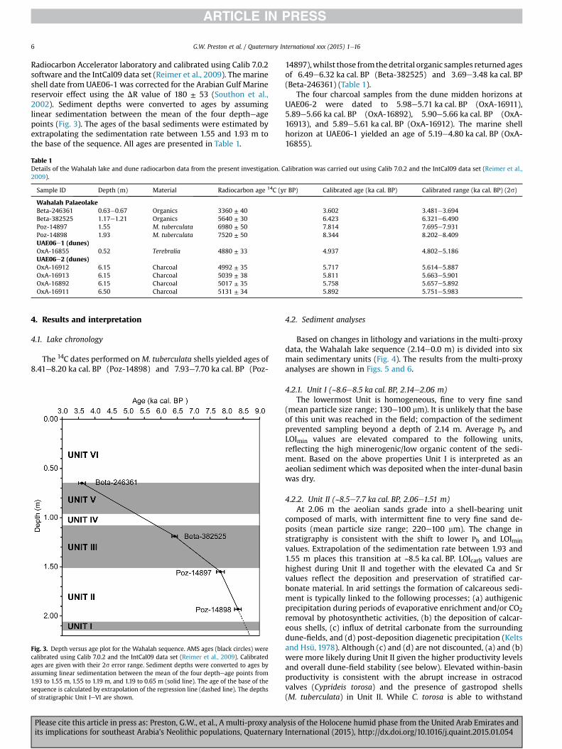
Radiocarbon Accelerator laboratory and calibrated using Calib 7.0.2software and the IntCal09 data set (Reimer et al., 2009). The marineshell date from UAE06-1 was corrected for the Arabian Gulf Marinereservoir effect using the DR value of 180 ± 53 (Southon et al.,2002). Sediment depths were converted to ages by assuminglinear sedimentation between the mean of the four deptheagepoints (Fig. 3). The ages of the basal sediments were estimated byextrapolating the sedimentation rate between 1.55 and 1.93 m tothe base of the sequence. All ages are presented in Table 1.
Table 1Details of the Wahalah lake and dune radiocarbon data from the present investigation. Calibration was carried out using Calib 7.0.2 and the IntCal09 data set (Reimer et al.,2009).
Sample ID Depth (m) Material Radiocarbon age 14C (yr BP) Calibrated age (ka cal. BP) Calibrated range (ka cal. BP) (2s)
Wahalah PalaeolakeBeta-246361 0.63e0.67 Organics 3360 ± 40 3.602 3.481e3.694Beta-382525 1.17e1.21 Organics 5640 ± 30 6.423 6.321e6.490Poz-14897 1.55 M. tuberculata 6980 ± 50 7.814 7.695e7.931Poz-14898 1.93 M. tuberculata 7520 ± 50 8.344 8.202e8.409UAE06e1 (dunes)OxA-16855 0.52 Terebralia 4880 ± 33 4.937 4.802e5.186UAE06e2 (dunes)OxA-16912 6.15 Charcoal 4992 ± 35 5.717 5.614e5.887OxA-16913 6.15 Charcoal 5039 ± 38 5.811 5.663e5.901OxA-16892 6.15 Charcoal 5017 ± 35 5.758 5.657e5.892OxA-16911 6.50 Charcoal 5131 ± 34 5.892 5.751e5.983
4. Results and interpretation
4.1. Lake chronology
The 14C dates performed onM. tuberculata shells yielded ages of8.41e8.20 ka cal. BP (Poz-14898) and 7.93e7.70 ka cal. BP (Poz-
Fig. 3. Depth versus age plot for the Wahalah sequence. AMS ages (black circles) werecalibrated using Calib 7.0.2 and the IntCal09 data set (Reimer et al., 2009). Calibratedages are given with their 2s error range. Sediment depths were converted to ages byassuming linear sedimentation between the mean of the four deptheage points from1.93 to 1.55 m, 1.55 to 1.19 m, and 1.19 to 0.65 m (solid line). The age of the base of thesequence is calculated by extrapolation of the regression line (dashed line). The depthsof stratigraphic Unit IeVI are shown.
Please cite this article in press as: Preston, G.W., et al., A multi-proxy analits implications for southeast Arabia's Neolithic populations, Quaternary
14897),whilst those fromthedetrital organic samples returned agesof 6.49e6.32 ka cal. BP (Beta-382525) and 3.69e3.48 ka cal. BP(Beta-246361) (Table 1).
The four charcoal samples from the dune midden horizons atUAE06-2 were dated to 5.98e5.71 ka cal. BP (OxA-16911),5.89e5.66 ka cal. BP (OxA-16892), 5.90e5.66 ka cal. BP (OxA-16913), and 5.89e5.61 ka cal. BP (OxA-16912). The marine shellhorizon at UAE06-1 yielded an age of 5.19e4.80 ka cal. BP (OxA-16855).
4.2. Sediment analyses
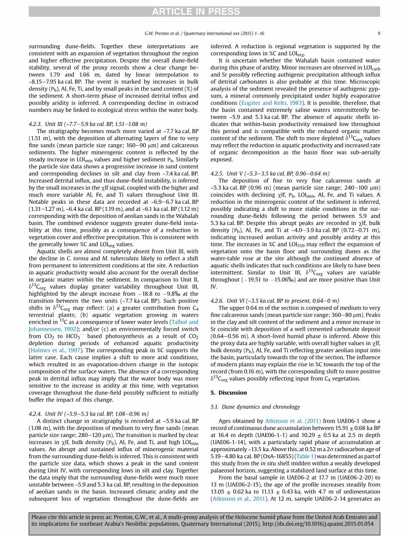
Based on changes in lithology and variations in the multi-proxydata, the Wahalah lake sequence (2.14e0.0 m) is divided into sixmain sedimentary units (Fig. 4). The results from the multi-proxyanalyses are shown in Figs. 5 and 6.
4.2.1. Unit I (~8.6e8.5 ka cal. BP, 2.14e2.06 m)The lowermost Unit is homogeneous, fine to very fine sand
(mean particle size range; 130e100 mm). It is unlikely that the baseof this unit was reached in the field; compaction of the sedimentprevented sampling beyond a depth of 2.14 m. Average Рb andLOImin values are elevated compared to the following units,reflecting the high minerogenic/low organic content of the sedi-ment. Based on the above properties Unit I is interpreted as anaeolian sediment which was deposited when the inter-dunal basinwas dry.
4.2.2. Unit II (~8.5e7.7 ka cal. BP, 2.06e1.51 m)At 2.06 m the aeolian sands grade into a shell-bearing unit
composed of marls, with intermittent fine to very fine sand de-posits (mean particle size range; 220e100 mm). The change instratigraphy is consistent with the shift to lower Рb and LOIminvalues. Extrapolation of the sedimentation rate between 1.93 and1.55 m places this transition at ~8.5 ka cal. BP. LOIcarb values arehighest during Unit II and together with the elevated Ca and Srvalues reflect the deposition and preservation of stratified car-bonate material. In arid settings the formation of calcareous sedi-ment is typically linked to the following processes; (a) authigenicprecipitation during periods of evaporative enrichment and/or CO2
removal by photosynthetic activities, (b) the deposition of calcar-eous shells, (c) influx of detrital carbonate from the surroundingdune-fields, and (d) post-deposition diagenetic precipitation (Keltsand Hsü, 1978). Although (c) and (d) are not discounted, (a) and (b)were more likely during Unit II given the higher productivity levelsand overall dune-field stability (see below). Elevated within-basinproductivity is consistent with the abrupt increase in ostracodvalves (Cyprideis torosa) and the presence of gastropod shells(M. tuberculata) in Unit II. While C. torosa is able to withstand
ysis of the Holocene humid phase from the United Arab Emirates andInternational (2015), http://dx.doi.org/10.1016/j.quaint.2015.01.054
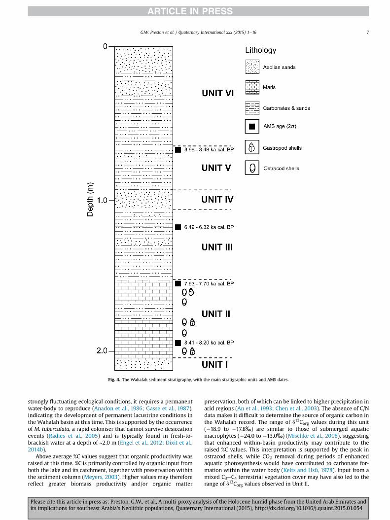
Fig. 4. The Wahalah sediment stratigraphy, with the main stratigraphic units and AMS dates.
G.W. Preston et al. / Quaternary International xxx (2015) 1e16 7
strongly fluctuating ecological conditions, it requires a permanentwater-body to reproduce (Anadon et al., 1986; Gasse et al., 1987),indicating the development of permanent lacustrine conditions inthe Wahalah basin at this time. This is supported by the occurrenceof M. tuberculata, a rapid coloniser that cannot survive desiccationevents (Radies et al., 2005) and is typically found in fresh-to-brackish water at a depth of ~2.0 m (Engel et al., 2012; Dixit et al.,2014b).
Above average %C values suggest that organic productivity wasraised at this time. %C is primarily controlled by organic input fromboth the lake and its catchment, together with preservation withinthe sediment column (Meyers, 2003). Higher values may thereforereflect greater biomass productivity and/or organic matter
Please cite this article in press as: Preston, G.W., et al., A multi-proxy analits implications for southeast Arabia's Neolithic populations, Quaternary
preservation, both of which can be linked to higher precipitation inarid regions (An et al., 1993; Chen et al., 2003). The absence of C/Ndata makes it difficult to determine the source of organic carbon inthe Wahalah record. The range of d13Corg values during this unit(�18.9 to �17.8‰) are similar to those of submerged aquaticmacrophytes (�24.0 to �13.0‰) (Mischke et al., 2008), suggestingthat enhanced within-basin productivity may contribute to theraised %C values. This interpretation is supported by the peak inostracod shells, while CO2 removal during periods of enhancedaquatic photosynthesis would have contributed to carbonate for-mation within the water body (Kelts and Hsü, 1978). Input from amixed C3eC4 terrestrial vegetation cover may have also led to therange of d13Corg values observed in Unit II.
ysis of the Holocene humid phase from the United Arab Emirates andInternational (2015), http://dx.doi.org/10.1016/j.quaint.2015.01.054
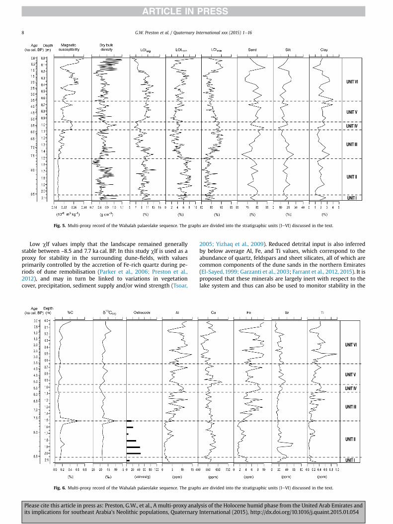
Fig. 5. Multi-proxy record of the Wahalah palaeolake sequence. The graphs are divided into the stratigraphic units (IeVI) discussed in the text.
G.W. Preston et al. / Quaternary International xxx (2015) 1e168
Low clf values imply that the landscape remained generallystable between ~8.5 and 7.7 ka cal. BP. In this study clf is used as aproxy for stability in the surrounding dune-fields, with valuesprimarily controlled by the accretion of Fe-rich quartz during pe-riods of dune remobilisation (Parker et al., 2006; Preston et al.,2012), and may in turn be linked to variations in vegetationcover, precipitation, sediment supply and/or wind strength (Tsoar,
Fig. 6. Multi-proxy record of the Wahalah palaeolake sequence. The graph
Please cite this article in press as: Preston, G.W., et al., A multi-proxy analits implications for southeast Arabia's Neolithic populations, Quaternary
2005; Yizhaq et al., 2009). Reduced detrital input is also inferredby below average Al, Fe, and Ti values, which correspond to theabundance of quartz, feldspars and sheet silicates, all of which arecommon components of the dune sands in the northern Emirates(El-Sayed,1999; Garzanti et al., 2003; Farrant et al., 2012, 2015). It isproposed that these minerals are largely inert with respect to thelake system and thus can also be used to monitor stability in the
s are divided into the stratigraphic units (IeVI) discussed in the text.
ysis of the Holocene humid phase from the United Arab Emirates andInternational (2015), http://dx.doi.org/10.1016/j.quaint.2015.01.054
G.W. Preston et al. / Quaternary International xxx (2015) 1e16 9
surrounding dune-fields. Together these interpretations areconsistent with an expansion of vegetation throughout the regionand higher effective precipitation. Despite the overall dune-fieldstability, several of the proxy records show a clear change be-tween 1.79 and 1.66 m, dated by linear interpolation to~8.15e7.95 ka cal. BP. The event is marked by increases in bulkdensity (Рb), Al, Fe, Ti, and by small peaks in the sand content (%) ofthe sediment. A short-term phase of increased detrital influx andpossibly aridity is inferred. A corresponding decline in ostracodnumbers may be linked to ecological stress within the water body.
4.2.3. Unit III (~7.7e5.9 ka cal. BP, 1.51e1.08 m)The stratigraphy becomes much more varied at ~7.7 ka cal. BP
(1.51 m), with the deposition of alternating layers of fine to veryfine sands (mean particle size range; 160e90 mm) and calcareoussediments. The higher minerogenic content is reflected by thesteady increase in LOImin values and higher sediment Рb. Similarlythe particle size data shows a progressive increase in sand contentand corresponding declines in silt and clay from ~7.4 ka cal. BP.Increased detrital influx, and thus dune-field instability, is inferredby the small increases in the clf signal, coupled with the higher andmuch more variable Al, Fe, and Ti values throughout Unit III.Notable peaks in these data are recorded at ~6.9e6.7 ka cal. BP(1.31e1.27m), ~6.4 ka cal. BP (1.19 m), and at ~6.1 ka cal. BP (1.12m)corresponding with the deposition of aeolian sands in the Wahalahbasin. The combined evidence suggests greater dune-field insta-bility at this time, possibly as a consequence of a reduction invegetation cover and effective precipitation. This is consistent withthe generally lower %C and LOIorg values.
Aquatic shells are almost completely absent from Unit III, withthe decline in C. torosa and M. tuberculata likely to reflect a shiftfrom permanent to intermittent conditions at the site. A reductionin aquatic productivity would also account for the overall declinein organic matter within the sediment. In comparison to Unit II,d13Corg values display greater variability throughout Unit III,highlighted by the abrupt increase from �18.8 to �9.8‰ at thetransition between the two units (~7.7 ka cal. BP). Such positiveshifts in d13Corg may reflect: (a) a greater contribution from C4terrestrial plants; (b) aquatic vegetation growing in watersenriched in 13C as a consequence of lower water levels (Talbot andJohannessen, 1992); and/or (c) an environmentally forced switchfrom CO2 to HCO3
� based photosynthesis as a result of CO2depletion during periods of enhanced aquatic productivity(Holmes et al., 1997). The corresponding peak in %C supports thelatter case. Each cause implies a shift to more arid conditions,which resulted in an evaporation-driven change in the isotopiccomposition of the surface waters. The absence of a correspondingpeak in detrital influx may imply that the water body was moresensitive to the increase in aridity at this time, with vegetationcoverage throughout the dune-field possibly sufficient to initiallybuffer the impact of this change.
4.2.4. Unit IV (~5.9e5.3 ka cal. BP, 1.08e0.96 m)A distinct change in stratigraphy is recorded at ~5.9 ka cal. BP
(1.08 m), with the deposition of medium to very fine sands (meanparticle size range; 280e120 mm). The transition is marked by clearincreases in clf, bulk density (Рb), Al, Fe, and Ti, and high LOIminvalues. An abrupt and sustained influx of minerogenic materialfrom the surrounding dune-fields is inferred. This is consistent withthe particle size data, which shows a peak in the sand contentduring Unit IV, with corresponding lows in silt and clay. Togetherthe data imply that the surrounding dune-fields were much moreunstable between ~5.9 and 5.3 ka cal. BP, resulting in the depositionof aeolian sands in the basin. Increased climatic aridity and thesubsequent loss of vegetation throughout the dune-fields are
Please cite this article in press as: Preston, G.W., et al., A multi-proxy analits implications for southeast Arabia's Neolithic populations, Quaternary
inferred. A reduction is regional vegetation is supported by thecorresponding lows in %C and LOIorg.
It is uncertain whether the Wahalah basin contained waterduring this phase of aridity. Minor increases are observed in LOIcarband Sr possibly reflecting authigenic precipitation although influxof detrital carbonates is also probable at this time. Microscopicanalysis of the sediment revealed the presence of authigenic gyp-sum, a mineral commonly precipitated under highly evaporativeconditions (Eugster and Kelts, 1983). It is possible, therefore, thatthe basin contained extremely saline waters intermittently be-tween ~5.9 and 5.3 ka cal. BP. The absence of aquatic shells in-dicates that within-basin productivity remained low throughoutthis period and is compatible with the reduced organic mattercontent of the sediment. The shift to more depleted d13Corg valuesmay reflect the reduction in aquatic productivity and increased rateof organic decomposition as the basin floor was sub-aeriallyexposed.
4.2.5. Unit V (~5.3e3.5 ka cal. BP, 0.96e0.64 m)The deposition of fine to very fine calcareous sands at
~5.3 ka cal. BP (0.96 m) (mean particle size range; 240e100 mm)coincides with declining clf, Рb, LOImin, Al, Fe, and Ti values. Areduction in the minerogenic content of the sediment is inferred,possibly indicating a shift to more stable conditions in the sur-rounding dune-fields following the period between 5.9 and5.3 ka cal. BP. Despite this abrupt peaks are recorded in clf, bulkdensity (Рb), Al, Fe, and Ti at ~4.0e3.9 ka cal. BP (0.72e0.71 m),indicating increased aeolian activity and possibly aridity at thistime. The increases in %C and LOI550 may reflect the expansion ofvegetation onto the basin floor and surrounding dunes as thewater-table rose at the site although the continued absence ofaquatic shells indicates that such conditions are likely to have beenintermittent. Similar to Unit III, d13Corg values are variablethroughout (�19.51 to �15.06‰) and are more positive than UnitIV.
4.2.6. Unit VI (~3.5 ka cal. BP to present, 0.64e0 m)The upper 0.64 m of the section is composed of medium to very
fine calcareous sands (mean particle size range; 360e80 mm). Peaksin the clay and silt content of the sediment and a minor increase inSr coincide with deposition of a well cemented carbonate deposit(0.64e0.56 m). A short-lived humid phase is inferred. Above thisthe proxy data are highly variable, with overall higher values in clf,bulk density (Рb), Al, Fe, and Ti reflecting greater aeolian input intothe basin, particularly towards the top of the section. The influenceof modern plants may explain the rise in %C towards the top of therecord (from 0.16 m), with the corresponding shift to more positived13Corg values possibly reflecting input from C4 vegetation.
5. Discussion
5.1. Dune dynamics and chronology
Ages obtained by Atkinson et al. (2011) from UAE06-1 show arecord of continuous dune accumulation between 15.91± 0.68 ka BPat 16.4 m depth (UAE06-1-1) and 10.29 ± 0.5 ka at 2.5 m depth(UAE06-1-14), with a particularly rapid phase of accumulation atapproximately ~13.5 ka. Above this, at 0.52ma2s radiocarbon age of5.19e4.80 ka cal. BP (OxA-16855) (Table 1)wasdeterminedaspart ofthis study from the in situ shell midden within a weakly developedpalaeosol horizon, suggesting a stabilized land surface at this time.
From the basal sample in UAE06-2 at 17.7 m (UAE06-2-20) to13 m (UAE06-2-15), the age of the profile increases steadily from13.05 ± 0.62 ka to 11.13 ± 0.43 ka, with 4.7 m of sedimentation(Atkinson et al., 2011). At 12 m, sample UAE06-2-14 generates an
ysis of the Holocene humid phase from the United Arab Emirates andInternational (2015), http://dx.doi.org/10.1016/j.quaint.2015.01.054
G.W. Preston et al. / Quaternary International xxx (2015) 1e1610
age of 10.38 ± 0.44 ka and at 8 m sample UAE06-2-10 an age of10.65 ± 0.53 ka, indicating the rapid deposition of 4 m of sediment(Atkinson et al., 2011). At 6.5 m depth a distinctive low-angle un-conformity is observed, with a weakly developed palaeosol horizonand anthropogenic shell midden, radiocarbon dated to5.98e5.75 ka cal. BP (OxA-16911) (Table 1). This denotes a stabi-lized land surface, separating the underlying darker red aeolianunit from an overlying buff-pale red aeolian unit. Radiocarbon agesfrom the overlying charcoal-rich horizon at 6.15 m range between5.90-5.66 ka cal. BP (OxA-16913), 5.89e5.66 ka cal. BP (OxA-16892), and 5.89e5.61 ka cal. BP (OxA-16912) (Table 1). OSL sampleages from the buff-pale red aeolian unit overlying the palaeosol/midden layers yielded ages of 5.85 ± 0.31 ka (UAE06-2-7) at 6 mand 5.18 ± 0.24 ka (UAE06-2-3) at 2 m, suggesting a rapid phase ofdune accumulation (Atkinson et al., 2011).
At site UAE06-1, the lower 8.1 m of sediment accumulated andwas preserved in less than 1 ka. At site UAE06-2, two phases ofgeologically rapid sediment accumulation occurred at approxi-mately 5.5 ka and 10.5 ka respectively.
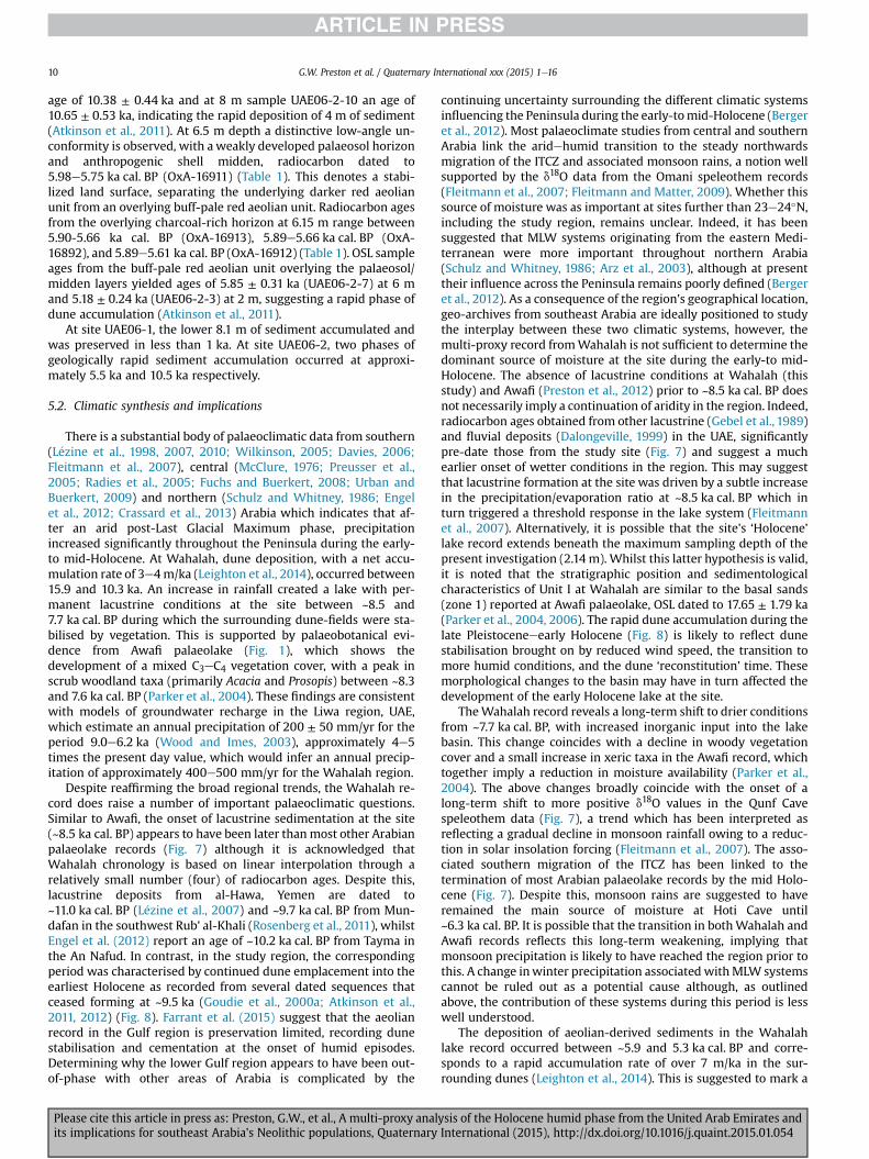
5.2. Climatic synthesis and implications
There is a substantial body of palaeoclimatic data from southern(L�ezine et al., 1998, 2007, 2010; Wilkinson, 2005; Davies, 2006;Fleitmann et al., 2007), central (McClure, 1976; Preusser et al.,2005; Radies et al., 2005; Fuchs and Buerkert, 2008; Urban andBuerkert, 2009) and northern (Schulz and Whitney, 1986; Engelet al., 2012; Crassard et al., 2013) Arabia which indicates that af-ter an arid post-Last Glacial Maximum phase, precipitationincreased significantly throughout the Peninsula during the early-to mid-Holocene. At Wahalah, dune deposition, with a net accu-mulation rate of 3e4m/ka (Leighton et al., 2014), occurred between15.9 and 10.3 ka. An increase in rainfall created a lake with per-manent lacustrine conditions at the site between ~8.5 and7.7 ka cal. BP during which the surrounding dune-fields were sta-bilised by vegetation. This is supported by palaeobotanical evi-dence from Awafi palaeolake (Fig. 1), which shows thedevelopment of a mixed C3eC4 vegetation cover, with a peak inscrub woodland taxa (primarily Acacia and Prosopis) between ~8.3and 7.6 ka cal. BP (Parker et al., 2004). These findings are consistentwith models of groundwater recharge in the Liwa region, UAE,which estimate an annual precipitation of 200 ± 50 mm/yr for theperiod 9.0e6.2 ka (Wood and Imes, 2003), approximately 4e5times the present day value, which would infer an annual precip-itation of approximately 400e500 mm/yr for the Wahalah region.
Despite reaffirming the broad regional trends, the Wahalah re-cord does raise a number of important palaeoclimatic questions.Similar to Awafi, the onset of lacustrine sedimentation at the site(~8.5 ka cal. BP) appears to have been later thanmost other Arabianpalaeolake records (Fig. 7) although it is acknowledged thatWahalah chronology is based on linear interpolation through arelatively small number (four) of radiocarbon ages. Despite this,lacustrine deposits from al-Hawa, Yemen are dated to~11.0 ka cal. BP (L�ezine et al., 2007) and ~9.7 ka cal. BP from Mun-dafan in the southwest Rub' al-Khali (Rosenberg et al., 2011), whilstEngel et al. (2012) report an age of ~10.2 ka cal. BP from Tayma inthe An Nafud. In contrast, in the study region, the correspondingperiod was characterised by continued dune emplacement into theearliest Holocene as recorded from several dated sequences thatceased forming at ~9.5 ka (Goudie et al., 2000a; Atkinson et al.,2011, 2012) (Fig. 8). Farrant et al. (2015) suggest that the aeolianrecord in the Gulf region is preservation limited, recording dunestabilisation and cementation at the onset of humid episodes.Determining why the lower Gulf region appears to have been out-of-phase with other areas of Arabia is complicated by the
Please cite this article in press as: Preston, G.W., et al., A multi-proxy analits implications for southeast Arabia's Neolithic populations, Quaternary
continuing uncertainty surrounding the different climatic systemsinfluencing the Peninsula during the early-tomid-Holocene (Bergeret al., 2012). Most palaeoclimate studies from central and southernArabia link the aridehumid transition to the steady northwardsmigration of the ITCZ and associated monsoon rains, a notion wellsupported by the d18O data from the Omani speleothem records(Fleitmann et al., 2007; Fleitmann and Matter, 2009). Whether thissource of moisture was as important at sites further than 23e24�N,including the study region, remains unclear. Indeed, it has beensuggested that MLW systems originating from the eastern Medi-terranean were more important throughout northern Arabia(Schulz and Whitney, 1986; Arz et al., 2003), although at presenttheir influence across the Peninsula remains poorly defined (Bergeret al., 2012). As a consequence of the region's geographical location,geo-archives from southeast Arabia are ideally positioned to studythe interplay between these two climatic systems, however, themulti-proxy record fromWahalah is not sufficient to determine thedominant source of moisture at the site during the early-to mid-Holocene. The absence of lacustrine conditions at Wahalah (thisstudy) and Awafi (Preston et al., 2012) prior to ~8.5 ka cal. BP doesnot necessarily imply a continuation of aridity in the region. Indeed,radiocarbon ages obtained from other lacustrine (Gebel et al., 1989)and fluvial deposits (Dalongeville, 1999) in the UAE, significantlypre-date those from the study site (Fig. 7) and suggest a muchearlier onset of wetter conditions in the region. This may suggestthat lacustrine formation at the site was driven by a subtle increasein the precipitation/evaporation ratio at ~8.5 ka cal. BP which inturn triggered a threshold response in the lake system (Fleitmannet al., 2007). Alternatively, it is possible that the site's ‘Holocene’lake record extends beneath the maximum sampling depth of thepresent investigation (2.14 m). Whilst this latter hypothesis is valid,it is noted that the stratigraphic position and sedimentologicalcharacteristics of Unit I at Wahalah are similar to the basal sands(zone 1) reported at Awafi palaeolake, OSL dated to 17.65 ± 1.79 ka(Parker et al., 2004, 2006). The rapid dune accumulation during thelate Pleistoceneeearly Holocene (Fig. 8) is likely to reflect dunestabilisation brought on by reduced wind speed, the transition tomore humid conditions, and the dune ‘reconstitution’ time. Thesemorphological changes to the basin may have in turn affected thedevelopment of the early Holocene lake at the site.
TheWahalah record reveals a long-term shift to drier conditionsfrom ~7.7 ka cal. BP, with increased inorganic input into the lakebasin. This change coincides with a decline in woody vegetationcover and a small increase in xeric taxa in the Awafi record, whichtogether imply a reduction in moisture availability (Parker et al.,2004). The above changes broadly coincide with the onset of along-term shift to more positive d18O values in the Qunf Cavespeleothem data (Fig. 7), a trend which has been interpreted asreflecting a gradual decline in monsoon rainfall owing to a reduc-tion in solar insolation forcing (Fleitmann et al., 2007). The asso-ciated southern migration of the ITCZ has been linked to thetermination of most Arabian palaeolake records by the mid Holo-cene (Fig. 7). Despite this, monsoon rains are suggested to haveremained the main source of moisture at Hoti Cave until~6.3 ka cal. BP. It is possible that the transition in bothWahalah andAwafi records reflects this long-term weakening, implying thatmonsoon precipitation is likely to have reached the region prior tothis. A change inwinter precipitation associated withMLW systemscannot be ruled out as a potential cause although, as outlinedabove, the contribution of these systems during this period is lesswell understood.
The deposition of aeolian-derived sediments in the Wahalahlake record occurred between ~5.9 and 5.3 ka cal. BP and corre-sponds to a rapid accumulation rate of over 7 m/ka in the sur-rounding dunes (Leighton et al., 2014). This is suggested to mark a
ysis of the Holocene humid phase from the United Arab Emirates andInternational (2015), http://dx.doi.org/10.1016/j.quaint.2015.01.054
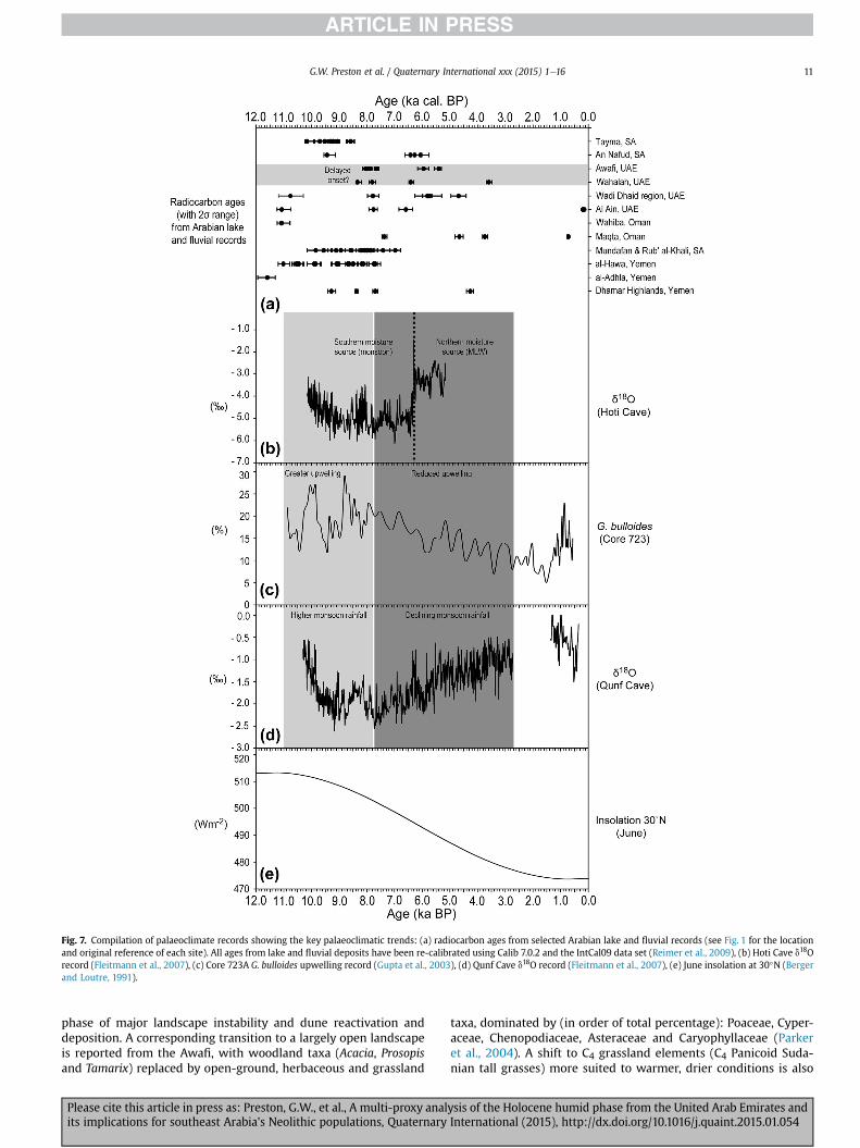
Fig. 7. Compilation of palaeoclimate records showing the key palaeoclimatic trends: (a) radiocarbon ages from selected Arabian lake and fluvial records (see Fig. 1 for the locationand original reference of each site). All ages from lake and fluvial deposits have been re-calibrated using Calib 7.0.2 and the IntCal09 data set (Reimer et al., 2009), (b) Hoti Cave d18Orecord (Fleitmann et al., 2007), (c) Core 723A G. bulloides upwelling record (Gupta et al., 2003), (d) Qunf Cave d18O record (Fleitmann et al., 2007), (e) June insolation at 30�N (Bergerand Loutre, 1991).
G.W. Preston et al. / Quaternary International xxx (2015) 1e16 11
phase of major landscape instability and dune reactivation anddeposition. A corresponding transition to a largely open landscapeis reported from the Awafi, with woodland taxa (Acacia, Prosopisand Tamarix) replaced by open-ground, herbaceous and grassland
Please cite this article in press as: Preston, G.W., et al., A multi-proxy analits implications for southeast Arabia's Neolithic populations, Quaternary
taxa, dominated by (in order of total percentage): Poaceae, Cyper-aceae, Chenopodiaceae, Asteraceae and Caryophyllaceae (Parkeret al., 2004). A shift to C4 grassland elements (C4 Panicoid Suda-nian tall grasses) more suited to warmer, drier conditions is also
ysis of the Holocene humid phase from the United Arab Emirates andInternational (2015), http://dx.doi.org/10.1016/j.quaint.2015.01.054
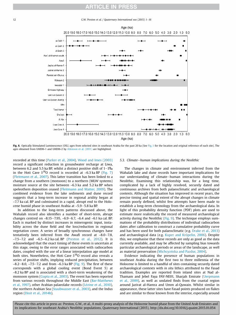
Fig. 8. Optically Stimulated Luminescence (OSL) ages from selected sites in southeast Arabia for the past 20 ka (See Fig. 1 for the location and original reference of each site). Theages obtained from UAE06-1 and UAE06-2 by Atkinson et al. (2011) are highlighted.
G.W. Preston et al. / Quaternary International xxx (2015) 1e1612
recorded at this time (Parker et al., 2004). Wood and Imes (2003)record a significant reduction in groundwater recharge at Liwa,between 6.2 and 5.5 ka BP, whilst a distinct positive shift of 1e3‰in the Hoti Cave d18O record is recorded at ~6.3 ka BP (Fig. 7)(Fleitmann et al., 2007). This latter transition has been linked to achange from a southern (monsoon) to a northern (MLW systems)moisture source at the site between ~6.3 ka and 5.2 ka BP whenspeleothem deposition ceased (Fleitmann and Matter, 2009). Thecombined evidence from the lake sediments and dune recordsuggests that a long-term increase in regional aridity began at~7.7 ka cal. BP and culminated in a rapid, abrupt end to the Holo-cene humid phase in southeast Arabia at ~5.9e5.8 ka BP.
In addition to the long-term patterns discussed above, theWahalah record also identifies a number of short-term, abruptchanges centred on ~8.15e7.95, ~6.9e6.7, ~6.4 and ~6.1 ka cal. BP.Each is marked by distinct increases in minerogenic input, insta-bility across the dune field and the loss/reduction in regionalvegetation cover. A series of broadly synchronous changes havetentatively been inferred from the Awafi record at ~8.0e7.8,~7.5e7.2 and ~6.5e6.2 ka cal. BP (Preston et al., 2012). It isacknowledged that the exact timing of these events is uncertain atthis stage, owing to the error ranges associated with radiocarbondates, coupled with the use of a linear interpolation age model atboth sites. Nonetheless, the Hoti Cave d18O record also reveals aseries of positive shifts, implying reduced precipitation, between~8.2e8.0, ~7.5e7.2 and from ~6.3 ka BP (Fig. 9). The first of thesecorresponds with a global cooling event (Bond Event 5) at~8.2 ka BP and is associated with a short-term weakening of themonsoon system (Gupta et al., 2003). The event has been reportedfrom various records throughout the Middle East (Bar-Matthewset al., 1997), other Arabian palaeolake records (L�ezine et al., 2010),the northern Arabian Sea (Staubwasser et al., 2003), and the Indusregion (Dixit et al., 2014b).
Please cite this article in press as: Preston, G.W., et al., A multi-proxy analits implications for southeast Arabia's Neolithic populations, Quaternary
5.3. Climateehuman implications during the Neolithic
The changes in climate and environment inferred from theWahalah lake and dune records have important implications forour understanding of climateehuman interactions during theNeolithic. Examining this relationship was, for a long time,complicated by a lack of highly resolved, securely dated andcontinuous archives from both palaeoclimatic and archaeologicalcontexts. Although the situation has improved in recent years, theprecise timing and spatial extent of the abrupt changes in climateremain poorly defined, whilst few attempts have been made toestablish a long-term chronology from the archaeological data. Inlight of this probability density function (PDF) plots are used toestimate more realistically the record of measured archaeologicalactivity during the Neolithic (Fig. 9). The technique employs sum-mations of the probability distributions of individual radiocarbondates after calibration to construct a cumulative probability curveand has been used for both palaeoclimatic (e.g. Drake et al., 2013)and archaeological data (e.g. Kuper and Kr€opelin, 2006). Despitethis, we emphasise that these records are only as good as the datacurrently available, and may be affected by sampling bias towardsparticular archaeological periods or areas of the landscape, as wellas material preservation (Michcyz�nska and Pazdur, 2004).
Evidence indicating the presence of human populations insoutheast Arabia during the first two to three millennia of theHolocene is limited to a handful of sites containing securely datedarchaeological contexts with in situ lithics attributed to the Fasadtradition. Examples are reported from inland sites at Nad al-Thamam and Jebel Faya FAY-NE01, Sharjah Emirate (Uerpmannet al., 2009), as well as undated finds from the coastal regionaround Jazirat al-Hamra and Umm al-Quwain. Whilst similar inappearance, these latter sites have Fasad points produced on flakesand are similar to those known from the interior, especially around
ysis of the Holocene humid phase from the United Arab Emirates andInternational (2015), http://dx.doi.org/10.1016/j.quaint.2015.01.054
Fig. 9. Comparison of the archaeological and palaeoclimate data, showing phases of aridity identified in the Hoti Cave record (black stars): (a) Awafi Fe data (Preston et al., 2012), (b)Wahalah Fe data (this study), (c) Hoti Cave d18O record (Fleitmann et al., 2007), (d) and (e) probability density function (PDF) plots of calibrated radiocarbon dates fromarchaeological contexts, (d) is based on 31 radiocarbon ages from interior sites and (e) is based on 50 radiocarbon ages from archaeological sites along the Arabian Gulf coast. Non-marine ages have been re-calibrated using Calib 7.0.2 and the IntCal09 data set (Reimer et al., 2009). Ages based on marine shells were corrected for the Arabian Gulf marinereservoir effect using the DR value of 180 ± 53 (Southon et al., 2002), and calibrated using the Marine04 data set (Reimer et al., 2009). Each radiocarbon date is represented by a peakin the PDF curve, with the relative width of each determined by the error of the age estimate. The height of the curve is determined by the number of overlapping age estimates,with higher values reflecting a greater number of similar radiocarbon ages.
G.W. Preston et al. / Quaternary International xxx (2015) 1e16 13
Hili (cf. Kallweit et al., 2005), suggesting a possible distinct formfrom the “Faya” group. These finds suggest one or a combination ofthe following: (a) the region was sparsely populated during theearliest Holocene; (b) the populationwas largely mobile with scantevidence preserved in the record; and/or (c) a significant number ofsites remain undiscovered. The former (a) cannot be discounted,
Please cite this article in press as: Preston, G.W., et al., A multi-proxy analits implications for southeast Arabia's Neolithic populations, Quaternary
with some noting that the period remains underrepresented whencompared to the growing number of archaeological sites from theregion (Drechsler, 2009). Despite this, it is suggested that the lack ofarchaeology is likely to reflect a reduction in the preservation ofmaterial during this period owing to the continuation of duneemplacement and thus site burial, coupled with the marine
ysis of the Holocene humid phase from the United Arab Emirates andInternational (2015), http://dx.doi.org/10.1016/j.quaint.2015.01.054
G.W. Preston et al. / Quaternary International xxx (2015) 1e1614
transgression of the Arabian Gulf basin, which has led to the sub-mergence and loss of sites. The paucity of archaeological materialmeans opinions are currently divided regarding the subsistencebase of these early populations. Whilst some authors link thearchaeological finds from this period to mobile herderegatherers(Drechsler, 2009), others suggest they were left by hunter-egatherer populations (Charpentier, 2008; Rose, 2010) whosefootprint on the landscape is likely to be less visible today.Furthermore, it is suggested that hunteregather groups are morelikely to have concentrated in areas of the landscape with greaterecological diversity and resource availability, which during theearliest Holocene is more likely to have been within the now sub-merged Arabian Gulf basin or within the al-Hajar Mountains andthe alluvial piedmont bahadas.
A link between the development of humid conditions during theearly-to mid-Holocene and the expansion of Neolithic populationsthroughout southeast Arabia has been suggested by several authors(Parker et al., 2006; Parker and Goudie, 2008; Drechsler, 2009;Uerpmann et al., 2009). However, the palaeoclimate data pre-sented in this paper adds to the growing body of evidence sug-gesting that the period was punctuated by a series of abrupt, short-term phases of aridity, some of which have been suggested to haveled to significant changes in the archaeological record. For example,although the archaeological chronologies during the earliest Ho-locene remain poorly defined, Drechsler (2009) links the climaticdownturn between ~8.5 and 8.0 ka BP, to the transition betweenthe earliest Holocene Qatar B/Fasad lithics and the proceedingNeolithic Arabian Bifacial Tradition (ABT) assemblages. Drechsler(2009) suggests that the interaction of various population groupsin refuge areas of the landscape resulted in the development of auniform material culture during the ABT. Evidence for occupationduring the Neolithic comes from the extensive shell middens alongthe coast (Vogt, 1994; Uerpmann and Uerpmann, 1996; Philips,2002; Charpentier and M�ery, 2008) and inland across the dune-fields surrounding Wahalah. In addition, several importantNeolithic sites have been examined from the interior includingJebel al-Buhais (Uerpmann et al., 2008) and Kharimat KhorManahil(Kallweit et al., 2005). A broad correspondence between phases ofreduced precipitation inferred from the Hoti Cave d18O record at~7.5e7.2 and ~6.5e6.3 ka BP, and possible reductions in humanactivity (Fig. 9) has been noted in several recent publications(Parker and Preston, 2008; Preston et al., 2012; Preston and Parker,2013). It is, however, acknowledged that such finer grained trendsshould not be overstated at this stage and remain speculative.
Fig. 9 reveals an abrupt decline in archaeological sites and datedoccupation fromacross theGulf region at ~5.9 ka cal. BP. This paucityof data and apparent decline in humanpopulation has been referredas marking the Dark Millennium (Uerpmann, 2003). This change hasbeen widely linked to increased climatic aridity during the mid-Holocene (Uerpmann, 2003; Parker et al., 2006; Preston et al.,2012), a notion consistent with the palaeoclimatic data presentedin this paper. Radiocarbon ages from the shell midden and charcoalhorizons at UAE06-2 date to the terminal end of the Neolithic periodin the lower Gulf region, and are overlain by approximately 5 m ofsediment which accumulated rapidly from ~5.8 ka to 5.2 ka. Despitethis, it is suggested that the pattern of human settlement during thisperiod ismore complex than has been suggested. Fig. 9 indicates thatwhilst evidence from the interior declines, occupation along thesouthern Arabian Gulf coast increased between ~6.3 and5.7 ka cal. BP. This may suggest a concentration of settlements alongthe coast, maybe owing to greater availability of marine resources atthis time as the interior became increasingly arid. Alternatively, it isnoted that the increase approximately corresponds with maximumsea level rise in theArabianGulf (Lambeck,1996), possibly suggestingthe trend reflects the greater preservation of material at this time
Please cite this article in press as: Preston, G.W., et al., A multi-proxy analits implications for southeast Arabia's Neolithic populations, Quaternary
compared to earlier periods when rising sea levels are likely to havesubmergedmany coastal sites. The subsequent decline in occupationfrom ~5.8 ka cal. BP corresponds with an intensification of activityalong theGulf ofOman coast (Biagi,1994), supporting the notion thatpopulations migrated to the latter region owing to its greaterecological diversity and availability of freshwater (Uerpmann, 2003).
Re-occupation of the region occurred during the early BronzeAge with several shell midden sites dated between ~5.2 and4.4 ka BP at Al-Daith (Parker and Goudie, 2007), Jazirat al-Hamra,and Ras' al-Khaimah south (Atkinson et al., 2012). The radio-carbon age from the shell midden horizon recorded in the UAE06-01 section falls within this period. Increased landscape stability isinferred during this period, with a return to shallow water lakes atAwafi and Wahalah along with human demographic expansion.
6. Conclusions
Variations in multi-proxy lake and dune data are used toreconstruct the evolution of climate and associated landscaperesponse during the early-to mid-Holocene, a period characterisedby significant regional heterogeneity throughout Arabia. These datashow that the earliest Holocene was characterised by continueddune emplacement until ~9.5 ka, with the onset of permanentlacustrine conditions at the site (~8.5 ka cal. BP) much later thanmost other Arabian palaeolake records, particularly those at moresoutherly latitudes. This supports the earlier work at Awafi palae-olake and highlights the importance of understanding the impact ofbroad, continental-scale changes in climate at a more local level. Along-term shift to drier conditions and increased landscape insta-bility is recorded between ~7.7 and 5.9 ka cal. BP, possibly markingthe gradual southern migration of the summer ITCZ and associatedweakening of monsoon rains in the region. An abrupt decrease inmoisture, regional vegetation cover and rapid dune reactivationand deposition is recorded between ~5.9 and 5.3 ka cal. BP. Theshifts in climate identified in this study have important implica-tions for our understanding of the region's Neolithic archaeology interms of both site preservation as well as their potential impact onhuman activity. The development of further high-resolution,securely dated archives from both palaeoclimate and archaeolog-ical contexts is essential if climateehuman interactions during thisperiod are to be better understood.
Acknowledgements
The authors thank Christian Velde and Imke Moellering,Department of Antiquities and Museums, Government of Ra's al-Khaimah for permission to work in the area and for logisticalsupport. The lake geochemical analyses were possible thanks to aNERC Facility grant award (OSS/297/0805). Jo Green and ChrisKendrick at the NERC Isotope Geosciences Laboratory, Keyworth,UK, are thanked for assistance with the isotope analysis. Radio-carbon dates from theWahalah dune sections were possible thanksto the ORADs award NERC/2006/11/07. Oxford Brookes University isthanked for funding aspects of this the fieldwork. David Thomaswas in receipt of the Royal Geographical Society's Thesiger OmanInternational Fellowship, which provided fieldwork costs for thedune component. Finally, the authors wish to thank the twoanonymous reviewers for their constructive comments.
References
Anadon, P., De Deckker, P., Julia, R., 1986. The Pleistocene lake deposits of the NEBaza Basin (Spain) e salinity variations and ostracods succession. Hydrobiologia143, 199e208.
An, Z.S., Porter, S.C., Zhou, W.J., Lu, Y.C., Donahue, D.J., Head, M.J., Wu, X.H., Ren, J.Z.,Zheng, H.B., 1993. Episode of strengthening summer monsoon climate of
ysis of the Holocene humid phase from the United Arab Emirates andInternational (2015), http://dx.doi.org/10.1016/j.quaint.2015.01.054
G.W. Preston et al. / Quaternary International xxx (2015) 1e16 15
Younger Dryas age on the Loess Plateau of central China. Quaternary ScienceReviews 39, 45e54.
Arz, H.W., Lamy, F., P€atzold, J., Müller, P.J., Prins, M., 2003. Mediterranean moisturesource for an early-Holocene humid period in the northern Red Sea. Science300, 118e121.
Atkinson, O.A.C., Goudie, A.S., Thomas, D.S.G., Bailey, R.M., 2011. Late Quaternarychronology of major dune ridge development in the northeast Rub' al-Khali,United Arab Emirates. Quaternary Research 76, 93e105.
Atkinson, O.A.C., Thomas, D.S.G., Goudie, A.S., Parker, A.G., 2012. Holocene devel-opment of multiple dune generations in the northeast Rub' al-Khali, UnitedArab Emirates. The Holocene 22, 179e189.
Atkinson, O.A.C., Thomas, D.S.G., Parker, A.G., Goudie, A.S., 2013. Late Quaternaryhumidity and aridity dynamics in the northeast Rub' al-Khali, United ArabEmirates: Implications for early human dispersal and occupation of easternArabia. Quaternary International 300, 292e301.
Bar-Matthews, M., Ayalon, A., Kaufman, A., 1997. Late quaternary paleoclimate inthe eastern Mediterranean region from stable isotope analysis of speleothemsat Soreq Cave, Israel. Quaternary Research 47, 155e168.
Beech, M., Elders, J., Shepherd, E., 2000. Reconsidering the Ubaid of the SouthernGulf: new results from excavations on Dalma Island, UAE. Proceedings of theSeminar for Arabian Studies 30, 41e47.
Berger, A., Loutre, M.F., 1991. Insolation values for the climate of the last 10 millionyears. Quaternary Science Reviews 10, 297e317.
Berger, J.-F., Bravard, J.-P., Purdue, L., Benoist, A., Mouton, M., Braemer, F., 2012.Rivers of the Hadramawt watershed (Yemen) during the Holocene: clues of latefunctioning. Quaternary International 266, 142e161.
Biagi, P., 1994. A radiocarbon chronology for the aceramic shell-middens of coastalOman. Arabian Archaeology and Epigraphy 5, 17e31.
Boucharlat, R., Dalongeville, R., Hesse, A., Millet, M., 1991. Occupation humaine etenvironment au 5e et au 4e millenie sur la Cote Sharjah-Umm al Qaiwain (UAE).Arabian Archaeology and Epigraphy 2, 93e100.
Bray, H.E., Stokes, S., 2003. Chronologies for Late Quaternary barchan dune reac-tivation in the southeastern Arabian Peninsula. Quaternary Science Reviews 22,1027e1033.
Brooks, N., 2006. Cultural responses to aridity in the Middle Holocene andincreased social complexity. Quaternary International 151, 29e49.
Charpentier, V., 2008. Hunter-gatherers of the “empty quarter of the early Holo-cene” to the last Neolithic societies: chronology of the late prehistory of south-eastern Arabia (8000 e 3100 BC). Proceedings of the Seminar for ArabianStudies 38, 93e116.
Charpentier, V., M�ery, S., 2008. A Neolithic settlement near the Strait of Hormuz:Akab Island, United Arab Emirates. Proceedings of the Seminar for ArabianStudies 38, 117e136.
Chen, C.T.A., Lan, H.C., Lou, J.Y., Chen, Y.C., 2003. The dry Holocene megathermal inInner Mongolia. Palaeogeography, Palaeoclimatology, Palaeoecology 193,181e200.
Crassard, R., Petraglia, M.D., Parker, A.G., Parton, A., Roberts, R.G., Jacobs, Z.,Alsharekh, A., Al-Omari, A., Breeze, P., Drake, N.A., Groucutt, H.S., Jennings, R.,R�egagnon, E., Shipton, C., 2013. Beyond the Levant: first evidence of a pre-potteryNeolithic incursion into the Nefud Desert, Saudi Arabia. PLoS ONE 8 (7), e68061.
Cullen, H.M., deMenocal, P.B., Hemming, S., Hemming, G., Brown, F.H.,Guilderson, T., Sirocko, F., 2000. Climate change and the collapse of the Akka-dian empire. Geology 28, 379e382.
Dalongeville, R., 1999. Mleiha: �etude physique et pal�eoenvironment. In: Mouton, M.(Ed.), Mleiha I; Environment, Stat�egies de Subsistance et Artisanats, TravauxMaison de l'Orient 29, Lyon, pp. 33e54.
Davies, C.P., 2006. Holocene palaeoclimates of Southern Arabia from lacustrinedeposits of the Dhamar highlands, Yemen. Quaternary Research 66, 454e464.
Dearing, J., 1999. Magnetic susceptibility. In: Walden, J., Oldfield, F., Smith, J. (Eds.),Environmental Magnetism: a Practical Guide, Technical Guide 6. QuaternaryResearch Association, London, pp. 35e63.
Dixit, Y., Hodell, D.A., Petrie, C.A., 2014a. Abrupt weakening of the summermonsoon in northwest India ~4100 yr ago. Geology. http://dx.doi.org/10.1130/G35236.1.
Dixit, Y., Hodell, D.A., Sinha, R., Petrie, C.A., 2014b. Abrupt weakening of the Indiansummer monsoon at 8.2 kyr B.P. Earth and Planetary Science Letters 391, 16e23.
Drake, N.A., Breeze, P., Parker, A.G., 2013. Palaeoclimate in the Saharan and ArabianDeserts during the Middle Palaeolithic and the potential for hominin dispersals.Quaternary International 300, 48e61.
Drechsler, P., 2009. The Dispersal of the Neolithic over the Arabian Peninsula.Archaeopress, Oxford.
El-Sayed, M.I., 1999. Sedimentological characteristics and morphology of the aeoliansand dunes in the eastern part of the UAE: a case study from Ar Rub' Al Khali.Sedimentary Geology 123, 219e238.
Engel, M., Brückner, H., Pint, A., Wellbrock, K., Ginau, A., Voss, P., Grottker, M.,Klasen, N., Frenzel, P., 2012. The early Holocene humid period in NW SaudiArabia e sediments, microfossils and palaeo-hydrological modelling. Quater-nary Research 266, 131e141.
Engstrom, W., Wright Jr., H.E., 1984. Chemical stratigraphy of lake sediments as arecord of environmental change. In: Haworth, E.Y., Lund, J.W.D. (Eds.), LakeSediments and Environmental History. Leicester University Press, Leicester,pp. 11e67.
Eugster, H.P., Kelts, K., 1983. Lacustrine chemical sediments. In: Goudie, A.S., Pye, K.(Eds.), Chemical Sediments and Geomorphology: Precipitates and Residua inthe Near-surface Environment. Academic Press Inc, London, pp. 321e368.
Please cite this article in press as: Preston, G.W., et al., A multi-proxy analits implications for southeast Arabia's Neolithic populations, Quaternary
Farrant, A.R., Ellison, R.A., Thomas, R.J., Pharaoh, T.C., Newell, A.J., Goodenough, K.M.,Lee, J.R., Knox, R., 2012. The Geology and Geophysics of the United ArabEmirates. In: Geology of the Western and Central United Arab Emirates, vol. 6.British Geological Survey.
Farrant, A.R., Duller, G.A.T., Parker, A.G., Roberts, H.M., Parton, A., Knox, R.W.O.,Bide, T., 2015. The dune story: developing a framework of dune accumulation inthe northern Rub' al-Khali, Arabia. Quaternary International (this volume).
Fleitmann, D., Matter, A., 2009. The speleothem record of climate variability inSouthern Arabia. Comptes Rendus Geosciences 341, 633e642.
Fleitmann, D., Burns, S.J., Mangini, A., Mudelsee, M., Kramers, J., Villa, I., Neff, U., Al-Subbary, A., Buettner, A., Hipper, D., Matter, A., 2007. Holocene ITCZ and Indianmonsoon dynamics recorded in stalagmites from Oman and Yemen (Socotra).Quaternary Science Reviews 26, 170e188.
Fuchs, M., Buerkert, A., 2008. A 20 ka sediment record from the Hajar Mountainrange, N. Oman, and its implications for detecting arid e humid periods of thesoutheastern Arabian Peninsula. Earth and Planetary Science Letters 265,546e558.
Garzanti, E., And�o, S., Vezzoli, G., Dell' Era, D., 2003. From rifted margins to forelandbasins: investigating provenance and sediment dispersal across Desert Arabia.Journal of Sedimentary Research 73, 572e588.
Gasse, F., Fontes, J.C., Plaziat, J.C., Carbonal, P., Macmarska, I., De Deckker, P., Soulie-Marshe, I., Callot, Y., Dupeuple, P.A., 1987. Biological remains, geochemistry andstable isotopes for the reconstruction of environmental and hydrologicalchanges in the Holocene lakes from the North Sahara. Palaeogeography,Palaeoclimatology, Palaeoecology 60, 1e46.
Gebel, H.G., Hanss, C., Liebau, A., Raehle, W., 1989. The Late Quaternary environ-ments of Ain al-Faidha/Al-Ain, Abu Dhabi Emirate. Archaeology in the UnitedArab Emirates 5, 9e48.
Glennie, K.W., Singhvi, A.K., 2002. Event stratigraphy, palaeoenvironment andchronology of SE Arabian deserts. Quaternary Science Reviews 21, 853e869.
Goudie, A.S., Colls, A., Stokes, S., Parker, A.G., White, K., Al-Farraj, A., 2000a. LatestPleistocene dune construction at the north-eastern edge of the Rub al Khali,United Arab Emirates. Sedimentology 47, 1011e1021.
Goudie, A.S., Parker, A.G., Al-Farraj, A., 2000b. Coastal change in Ras Al-Khaimah(United Arab Emirates): a cartographic analysis. Geographical Journal 166,14e25.
Gupta, A., Anderson, D.M., Overpeck, J.T., 2003. Abrupt changes in the Asiansouthwest monsoon during the Holocene and their links to the North AtlanticOcean. Nature 421, 354e356.
Heiri, O., Lotter, A.F., Lemcke, G., 2001. Loss on ignition as a method for estimatingorganic and carbonate content in sediments: reproducibility and comparabilityof results. Journal of Paleolimnology 25, 101e110.
Holmes, J.A., Street-Perrott, F.A., Allen, M.J., Fothergill, P.A., Harkness, D.D., Kroon, D.,Perrott, R.A., 1997. Holocene palaeolimnology of Kajemarum Oasis, NorthernNigeria: an isotope study of ostracods, bulk carbonate and organic carbon.Journal of the Geological Society 154, 311e319.
Kallweit, H., Beech, M., Al-Tikriti, W.Y., 2005. Kharimat Khor al-Man�ahil and Khor �AlMan�ah�ıl e new Neolithic sites in the south-eastern desert of the UAE. Pro-ceedings of the Seminar for Arabian Studies 35, 97e113.
Kelts, K., Hsü, K.J., 1978. Freshwater carbonate sedimentation. In: Lerman, A. (Ed.),Lakes: Chemistry, Geology, Physics. Springer-Verlag, New York, pp. 295e323.
Kuper, R., Kr€opelin, R., 2006. Climate-controlled Holocene occupation in the Sahara:motor of Africa's evolution. Science 313, 803e807.
Kwarteng, A.Y., Dorvlo, A.S., Vijaya Kumara, G.T., 2009. Analysis of a 27-year rainfalldata (1977e2003) in the Sultanate of Oman. International Journal of Clima-tology 29, 605e617.
Lambe0ck, K., 1996. Shoreline reconstructions for the Persian Gulf since the lastglacial maximum. Earth and Planetary Science Letters 142, 43e57.
Leighton, C.L., Bailey, R.M., Thomas, D.S.G., 2013. The utility of desert sand dunes asQuaternary chronostratigraphic archives: evidence from the northeast Rub' alKhali. Quaternary Science Reviews 78, 303e318.
Leighton, C.L., Thomas, D.S.G., Bailey, R.M., 2014. Reproducibility and utility of duneluminescence chronologies. Earth Science Reviews 129, 24e39.
Leng, M.J., Metcalfe, S.E., Davies, S.J., 2005. Investigating Late Holocene climatevariability in central Mexico using carbon isotope ratios in organic materialsand oxygen isotope ratios from diatom silica within lacustrine carbonates.Journal of Paleolimnology 34, 413e431.
L�ezine, A.M., Saliege, J.F., Robert, C., Wertz, F., Inizan, M.L., 1998. Holocene lakes fromRamlat as-Sab'atayn (Yemen) illustrate the impact of Monsoon activity inSouthern Arabia. Quaternary Research 50, 290e299.
L�ezine, A.M., Tiercelin, J.J., Robert, C., Sali�ege, J.F., Cleuziou, S., Inizan, M.L.,Braemer, F., 2007. Centennial to millennial-scale variability of the Indianmonsoon during the early Holocene from a sediment, pollen and isotope recordfrom the desert of Yemen. Palaeogeography, Palaeoclimatology, Palaeoecology243, 235e249.
L�ezine, A.M., Robert, C., Cleuziou, S., Inizan, M.-I., Braemer, F., Saliege, J.-F.,Sylvestre, F., Tiercelin, J.-J., Crassard, R., Mery, S., Charpentier, V., Steimer-Herbert, T., 2010. Climate change and human occupation in the SouthernArabian lowlands during the last deglaciation and the Holocene. Global andPlanetary Change 72, 412e428.
McClure, H.A., 1976. Radiocarbon chronology of late Quaternary lakes in the ArabianDesert. Nature 263, 755e756.
Membery, D., 1997. An unusual wet weather across Arabia. Weather 52, 166e174.Meyers, P.A., 2003. Applications of organic geochemistry to palaeolimnological
reconstructions: a summary of examples from the Laurentian Great Lakes.Organic Geochemistry 34, 261e289.
ysis of the Holocene humid phase from the United Arab Emirates andInternational (2015), http://dx.doi.org/10.1016/j.quaint.2015.01.054
G.W. Preston et al. / Quaternary International xxx (2015) 1e1616
Michcyz�nska, D.J., Pazdur, A., 2004. A shape analysis of cumulative probabilitydensity function of radiocarbon dates set in the study of climate change in LateGlacial and Holocene. Radiocarbon 46, 733e744.
Millet, M., 1988. Survey of the Sharjah coast. Archaeological Survey in SharjahEmirate (UAE). Sharjah Archaeology 4, 23e30.
Mischke, S., Kramer, M., Zhang, C., Shang, H., Herzschuh, U., Erzinger, J., 2008.Reduced early Holocene moisture availability in the Bayan Har Mountain,northeastern Tibetan Plateau, inferred from a multi-proxy lake record. Palae-ogeography, Palaeoclimatology, Palaeoecology 267, 59e76.
Overpeck, J., Anderson, D., Trumbore, S., Prell, W., 1996. The southwest IndianMonsoon over the last 18 000 years. Climate Dynamics 12, 213e225.
Parker, A.G., 1995. Late Quaternary Environmental Change in the Upper ThamesBasin, Central-southern England (DPhil thesis). University of Oxford.
Parker, A.G., Goudie, A.S., 2007. Development of the Bronze Age landscape in thesoutheastern Arabian Gulf: new evidence from a buried shell midden in theeastern extremity of the Rub' al-Khali desert, Emirate of Ras al-Khaimah, UAE.Arabian Archaeology and Epigraphy 18, 132e138.
Parker, A.G., Goudie, A.S., 2008. Geomorphological and palaeoenvironmental in-vestigations in the southeastern Arabian Gulf region and the implication for thearchaeology of the region. Geomorphology 101, 458e470.
Parker, A.G., Preston, G.W., 2008. Early to Middle Holocene climate change andvegetation dynamics in the northern Oman Peninsula: an ecogeographicalsynthesis of the Jebel al-Buhais environment. In: Uerpmann, H.-P.,Uerpmann, M., Jasim, S.A. (Eds.), The Natural Environment of Jebel al-Buhais:Past and Present. Kerns Verlag, Tübingen, Germany, pp. 71e82.
Parker, A.G., Eckersley, L., Smith, M.M., Goudie, A.S., Stokes, S., Ward, S., White, K.,Hodson, M.J., 2004. Holocene vegetation dynamics in the eastern Rub al Khalidesert, Arabian Peninsula: a phytolith and carbon isotope study. Journal ofQuaternary Science 19, 665e676.
Parker, A.G., Goudie, A.S., Stokes, S., White, K., Hodson, M.J., Manning, M., Kennet, D.,2006. A record of Holocene climate change from lake geochemical analyses insouth-eastern Arabia. Quaternary Research 66, 465e476.
Philips, C.S., 2002. Prehistoric middens and a cemetery from the southern ArabianGulf. In: Cleuziou, S., Tosi, M., Zarins, J. (Eds.), Essays on the Late Prehistory ofthe Arabian Peninsula, Serie Orientale Roma XCIII. Instituto Italiano Per L'AfricaE L'Oriente, pp. 169e186.
Potts, D., 2001. Before the Emirates: an archaeological and historical account ofdevelopments in the region ca 5000 BC to 676 AD. In: Ghareeb, E., Abed, A.(Eds.), Perspectives on the United Arab Emirates. Trident Press Ltd, London,pp. 28e69.
Preston, G.W., 2011. From Nomadic Herder-hunters to Sedentary Famers: theRelationship Between Climate, Environment and Human Societies in the UnitedArab Emirates from the Neolithic to the Iron Age (Ph.D thesis). Oxford BrookesUniversity.
Preston, G.W., Parker, A.G., 2013. Understanding the evolution of the HolocenePluvial Phase and its impact on Neolithic populations in south-east Arabia.Arabian Archaeology and Epigraphy 24, 87e94.
Preston, G.W., Parker, A.G., Walkington, H., Leng, M.J., Hodson, M.J., 2012. Fromnomadic herder-hunters to sedentary farmers: the relationship betweenclimate change and ancient subsistence strategies in South-eastern Arabia.Journal of Arid Environments 86, 122e130.
Preusser, F., 2009. Chronology of the impact of Quaternary climate change oncontinental environments in the Arabian Peninsula. Comptes Rendus Geo-science 341, 621e632.
Preusser, F., Radies, D., Driehorst, F., Matter, A., 2005. Late Quaternary history of thecoastal Wahiba Sands, Sultanate of Oman. Journal of Quaternary Science 20,395e405.
Radies, D., Hasiots, S.T., Preusser, F., Neubert, E., Matter, A., 2005. Paleoclimaticsignificance of early Holocene faunal assemblages in wet interdune deposits ofthe Wahiba Sand Sea, Sultanate of Oman. Journal of Arid Environments 62,109e125.
Reimer, P.J., Baillie, M.G.L., Bard, E., Bayliss, A., Beck, J.W., Blackwell, P.G., BronkRamsey, C., Buck, C.E., Burr, G.S., Edwards, R.L., Friedrich, M., Grootes, P.M.,Guilderson, T.P., Hajdas, I., Heaton, T.J., Hogg, A.G., Hughen, K.A., Kaiser, K.F.,Kromer, B., McCormac, F.G., Manning, S.W., Reimer, R.W., Richards, D.A.,Southon, J.R., Talamo, S., Turney, C.S.M., van der Plicht, J., Weyhenmeyer, C.E.,2009. IntCal09 and Marine09 radiocarbon age calibration curves, 0e50,000years cal BP. Radiocarbon 51, 1111e1150.
Rose, J.I., 2010. New light on human prehistory in the Arabo-Persian Gulf Oasis.Current Anthropology 51, 849e883.
Please cite this article in press as: Preston, G.W., et al., A multi-proxy analits implications for southeast Arabia's Neolithic populations, Quaternary
Rosenberg, T.M., Preusser, F., Fleitmann, D., Schwalb, A., Penkman, K., Schmid, T.W.,Al-Shanti, M.A., Kadi, K., Matter, A., 2011. Humid periods in southern Arabia:windows of opportunity for modern human dispersal. Geology 39, 1115e1118.
Schulz, E., Whitney, J.W., 1986. Upper Pleistocene and Holocene lakes in the AnNafud, Saudi Arabia. Hydrobiologia 143, 175e190.
Schultz, H., von Rad, U., Erlenkeuser, H., 1998. Correlation between Arabian Sea andGreenland climate oscillations of the past 110,000 years. Nature 393, 54e57.
Sirocko, F., Sarnthein, M., Erlenkeuser, H., Lange, H., Arnold, M., Duplessy, J.C., 1993.Century-scale events in monsoonal climate over the past 24,000 years. Nature364, 322e324.
Southon, J., Kashgarian, M., Fontugne, M., Metivier, B., Yim, W.W.-S., 2002. Marinereservoir corrections for the Indian Ocean and Southeast Arabia. Radiocarbon44, 167e180.
Staubwasser, M., Weiss, H., 2006. Holocene climate and cultural evolution in lateprehistoriceearly historic West Asia. Quaternary International 66, 372e387.
Staubwasser, M., Sirocko, F., Grootes, P.M., Segl, M., 2003. Climate change at the 4.2ka BP termination of the Indus valley civilisation and Holocene Asian monsoonvariability. Geophysical Research Letters 30, 1425e1428.
Stokes, S., Bray, H.E., 2005. Late Pleistocene eolian history of the Liwa region,Arabian Peninsula. Bulletin of the Geological Society of America 117, 1466e1480.
Talbot, M.R., Johannessen, T., 1992. A high resolution palaeoclimate record for thelast 27,500 years in tropical West Africa from the carbon and nitrogen isotopiccomposition of lacustrine organic matter. Earth and Planetary Science Letters110, 23e37.
Thomas, D.S.G., Burrough, S.L., 2012. Interpreting geoproxies of late Quaternaryclimate change in African drylands: implications for understanding environ-mental change and early human behaviour. Quaternary International 253, 5e17.
Thomas, D.S.G., Burrough, S.L., Parker, A.G., 2012. Extreme events as drivers of earlyhuman behaviour in Africa? The case for variability, not catastrophic drought.Journal of Quaternary Science 27, 7e12.
Tsoar, H., 2005. Sand dunes mobility and stability in relation to climate. Physica A:Statistical Mechanics and Its Applications 357, 50e56.
Uerpmann, H.-P., Uerpmann, M., 1996. Ubaid pottery in the eastern Gulf e newevidence from Umm al-Quwain (U.A.E.). Arabian Archaeology and Epigraphy 7,125e139.
Uerpmann, H.P., Uerpmann, M., Jasim, S.A., 2008. The Archaeology of Jebel al-Buhais. In: The Natural Environment of Jebel al-Buhais: Past and Present, vol. 2.Kerns Verlag, Tübingen, Germany.
Uerpmann, H.-P., Potts, D.T., Uerpmann, M., 2009. Holocene (Re-) occupation ofEastern Arabia. In: Petraglia, M.D., Rose, J.I. (Eds.), The Evolution of HumanPopulations in Arabia: Palaeoenvironments, Prehistory and Genetics. Springer,Dordrecht, pp. 205e214.
Uerpmann, M., 1992. Structuring the Late Stone Age of southeastern Arabia. ArabianArchaeology and Epigraphy 3, 65e109.
Uerpmann, M., 2003. The dark millennium e remarks on the final Stone Age in theEmirates and Oman. In: Potts, D., Naboodah, H.A., Hellyer, P. (Eds.), Archaeologyin the United Arab Emirates: Proceedings of the First International Conferenceon the Archaeology of the U.A.E. Trident Press Ltd, London, pp. 73e84.
Urban, B., Buerkert, A., 2009. Palaeoecological analysis of a Late Quaternary sedi-ment profile in northern Oman. Journal of Arid Environments 73, 296e305.
Vogt, B., 1994. In search for coastal sites in prehistoric Makkan: mid-Holocene “shelleaters” in the coastal desert of Ras al-Khaimah, UAE. In: Kenoyer, J.M. (Ed.),From Sumer to Meluhha: Contributions to the Archaeology of South and WestAsia in Memory of George F. Dales, Jr, Wisconsin Archaeological Report No 3,pp. 113e128.
White, K., Goudie, A.S., Parker, A.G., Al-Farraj, A., 2001. Mapping the geochemistry ofthe Northern Rub Al Khali using multispectral remote sensing techniques. EarthSurface Processes and Landforms 26, 735e748.
Wilkinson, T.J., 2005. Soil erosion and valley fills in the Yemen Highlands andSouthern Turkey: integrating settlement, geoarchaeology and climatic change.Geoarchaeology 20, 169e192.
Wood, W.W., Imes, J.L., 2003. Dating of Holocene ground-water recharge inwestern part of Abu Dhabi (United Arab Emirates): constraints on globalclimate-change models. In: Alsharhan, A.S., Wood, W.W. (Eds.), Water Re-sources Perspectives: Evaluation, Management and Policy. Elsevier Science,Amsterdam, pp. 379e385.
Yizhaq, H., Ashkenazy, Y., Tsoar, H., 2009. Sand dune dynamics and climate change:a modelling approach. Journal of Geophysical Research 114, F01023. http://dx.doi.org/10.1029/2008JF001138.
ysis of the Holocene humid phase from the United Arab Emirates andInternational (2015), http://dx.doi.org/10.1016/j.quaint.2015.01.054
Copyright © 2022 FDOKUMEN