A medieval landscape of power and interaction. The castle of Raseborg and the peasants of the castle...
13
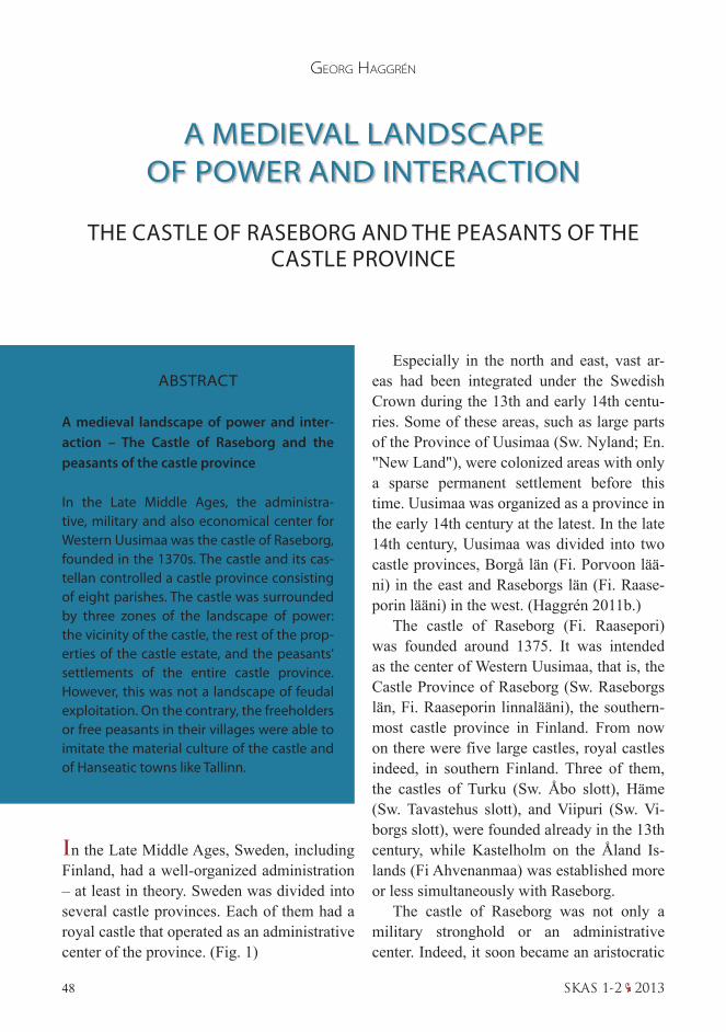
48 SKAS 1-2 2013 Especially in the north and east, vast ar- eas had been integrated under the Swedish Crown during the 13th and early 14th centu- ries. Some of these areas, such as large parts of the Province of Uusimaa (Sw. Nyland; En. "New Land"), were colonized areas with only a sparse permanent settlement before this time. Uusimaa was organized as a province in the early 14th century at the latest. In the late 14th century, Uusimaa was divided into two castle provinces, Borgå län (Fi. Porvoon lää- ni) in the east and Raseborgs län (Fi. Raase- porin lääni) in the west. (Haggrén 2011b.) The castle of Raseborg (Fi. Raasepori) was founded around 1375. It was intended as the center of Western Uusimaa, that is, the Castle Province of Raseborg (Sw. Raseborgs län, Fi. Raaseporin linnalääni), the southern- most castle province in Finland. From now on there were five large castles, royal castles indeed, in southern Finland. Three of them, the castles of Turku (Sw. Åbo slott), Häme (Sw. Tavastehus slott), and Viipuri (Sw. Vi- borgs slott), were founded already in the 13th century, while Kastelholm on the Åland Is- lands (Fi Ahvenanmaa) was established more or less simultaneously with Raseborg. The castle of Raseborg was not only a military stronghold or an administrative center. Indeed, it soon became an aristocratic A MEDIEVAL LANDSCAPE OF POWER AND INTERACTION THE CASTLE OF RASEBORG AND THE PEASANTS OF THE CASTLE PROVINCE GEORG HAGGRÉN ABSTRACT A medieval landscape of power and inter- action – The Castle of Raseborg and the peasants of the castle province In the Late Middle Ages, the administra- tive, military and also economical center for Western Uusimaa was the castle of Raseborg, founded in the 1370s. The castle and its cas- tellan controlled a castle province consisting of eight parishes. The castle was surrounded by three zones of the landscape of power: the vicinity of the castle, the rest of the prop- erties of the castle estate, and the peasants' settlements of the entire castle province. However, this was not a landscape of feudal exploitation. On the contrary, the freeholders or free peasants in their villages were able to imitate the material culture of the castle and of Hanseatic towns like Tallinn. In the Late Middle Ages, Sweden, including Finland, had a well-organized administration – at least in theory. Sweden was divided into several castle provinces. Each of them had a royal castle that operated as an administrative center of the province. (Fig. 1)
Transcript of A medieval landscape of power and interaction. The castle of Raseborg and the peasants of the castle...
48 SKAS 1-2 2013
Especially in the north and east, vast ar-eas had been integrated under the Swedish Crown during the 13th and early 14th centu-ries. Some of these areas, such as large parts of the Province of Uusimaa (Sw. Nyland; En. "New Land"), were colonized areas with only a sparse permanent settlement before this time. Uusimaa was organized as a province in the early 14th century at the latest. In the late 14th century, Uusimaa was divided into two castle provinces, Borgå län (Fi. Porvoon lää-ni) in the east and Raseborgs län (Fi. Raase-porin lääni) in the west. (Haggrén 2011b.)
The castle of Raseborg (Fi. Raasepori) was founded around 1375. It was intended as the center of Western Uusimaa, that is, the Castle Province of Raseborg (Sw. Raseborgs län, Fi. Raaseporin linnalääni), the southern-most castle province in Finland. From now on there were five large castles, royal castles indeed, in southern Finland. Three of them, the castles of Turku (Sw. Åbo slott), Häme (Sw. Tavastehus slott), and Viipuri (Sw. Vi-borgs slott), were founded already in the 13th century, while Kastelholm on the Åland Is-lands (Fi Ahvenanmaa) was established more or less simultaneously with Raseborg.
The castle of Raseborg was not only a military stronghold or an administrative center. Indeed, it soon became an aristocratic
A MEDIEVAL LANDSCAPE OF POWER AND INTERACTION
THE CASTLE OF RASEBORG AND THE PEASANTS OF THE CASTLE PROVINCE
GeorG HaGGrén
ABSTRACT
A medieval landscape of power and inter-action – The Castle of Raseborg and the peasants of the castle province
In the Late Middle Ages, the administra-tive, military and also economical center for Western Uusimaa was the castle of Raseborg, founded in the 1370s. The castle and its cas-tellan controlled a castle province consisting of eight parishes. The castle was surrounded by three zones of the landscape of power: the vicinity of the castle, the rest of the prop-erties of the castle estate, and the peasants' settlements of the entire castle province. However, this was not a landscape of feudal exploitation. On the contrary, the freeholders or free peasants in their villages were able to imitate the material culture of the castle and of Hanseatic towns like Tallinn.
In the Late Middle Ages, Sweden, including Finland, had a well-organized administration – at least in theory. Sweden was divided into several castle provinces. Each of them had a royal castle that operated as an administrative center of the province. (Fig. 1)

49SKAS 1-2 2013
residence for the castellans who were usu-ally members of the Swedish aristocracy. The first castellan was Tord Röriksson Bonde, who dated a charter in Raseborg in 1378. In the 1460s, the former king of Sweden, Karl Knutsson Bonde, resided in the castle for some years before he became the sovereign for the third time. During the following dec-ades, Raseborg was occupied by several powerful castellans, such as Laurens Axels-son Tott, Nils Eskilsson Banér, and Erik Fleming. (Drake 1994,8; Hartman 1896.) These aristocrats belonged simultaneously to the Privy Council of Sweden (Gillingstam 2009).
In 1540, King Gustaf Vasa set the castle of Raseborg under the direct administration of the crown. In those days the castle was in
bad condition and it had lost much of its former impor-tance. Ten years later, the ad-ministrative center was trans-ferred to Helsinki, where a new royal manor, as well as a town, were founded in 1550. Some years later, the old cas-tle was abandoned and was never settled again.
THREE ZONES IN THE LANDSCAPE OF POWER
From its foundation in the 1370s, the castle of Raseborg was the administrative and mili-tary center of Western Uusimaa. The name of the Castle Province of Raseborg character-izes the castle's role as the heart or core of the province. A landscape of power, the power of the Swedish Crown, was spread out from this center. (cfr. Mogren 2000.) (Fig. 2)
This landscape of power around Raseborg can be divided into three zones.
1. The innermost zone consisted of activity areas from which one could (almost) see the castle or the center of the landed estate of Raseborg, the manor of Raseborg.
Korsholma
KORSHOLMAN LÄÄNI
SATAKUNTA
HÄME
SAVO
KARJALA
AHVENANMAALÄNSIUUSIMAA
ITÄUUSIMAA
Olavinlinna
Viipurin linna
Viipuri
TurkuNaantali
Porvoo
Rauma
Ulvila
Kuusistonpiispanlinna
TurkuKastelholma
Raasepori
Häme
Kokemäen kartano
Fig. 1 The castle provinces in Fin-land in the 15th century. (Map by Maija Holappa.)
50 SKAS 1-2 2013
2. The middle zone consisted of tenant farms, fisheries, mills, and other proper-ties belonging to the castle estate.
3. The third zone was formed by the castle province of Raseborg, which covered a large coastal area divided into eight par-ishes.
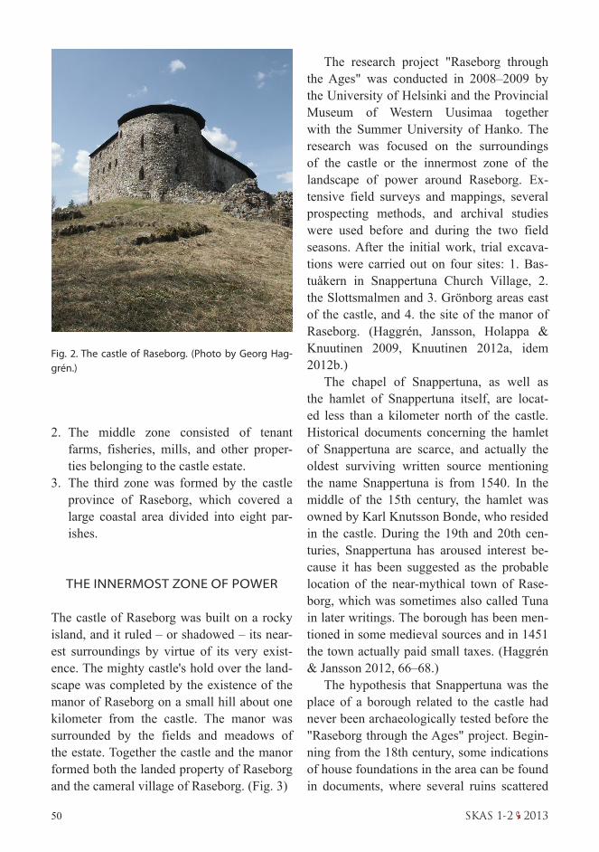
THE INNERMOST ZONE OF POWER
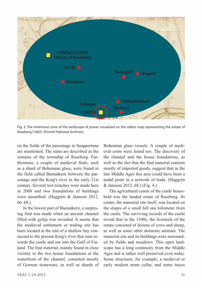
The castle of Raseborg was built on a rocky island, and it ruled – or shadowed – its near-est surroundings by virtue of its very exist-ence. The mighty castle's hold over the land-scape was completed by the existence of the manor of Raseborg on a small hill about one kilometer from the castle. The manor was surrounded by the fields and meadows of the estate. Together the castle and the manor formed both the landed property of Raseborg and the cameral village of Raseborg. (Fig. 3)
The research project "Raseborg through the Ages" was conducted in 2008–2009 by the University of Helsinki and the Provincial Museum of Western Uusimaa together with the Summer University of Hanko. The research was focused on the surroundings of the castle or the innermost zone of the landscape of power around Raseborg. Ex-tensive field surveys and mappings, several prospecting methods, and archival studies were used before and during the two field seasons. After the initial work, trial excava-tions were carried out on four sites: 1. Bas-tuåkern in Snappertuna Church Village, 2. the Slottsmalmen and 3. Grönborg areas east of the castle, and 4. the site of the manor of Raseborg. (Haggrén, Jansson, Holappa & Knuutinen 2009, Knuutinen 2012a, idem 2012b.)
The chapel of Snappertuna, as well as the hamlet of Snappertuna itself, are locat-ed less than a kilometer north of the castle. Historical documents concerning the hamlet of Snappertuna are scarce, and actually the oldest surviving written source mentioning the name Snappertuna is from 1540. In the middle of the 15th century, the hamlet was owned by Karl Knutsson Bonde, who resided in the castle. During the 19th and 20th cen-turies, Snappertuna has aroused interest be-cause it has been suggested as the probable location of the near-mythical town of Rase-borg, which was sometimes also called Tuna in later writings. The borough has been men-tioned in some medieval sources and in 1451 the town actually paid small taxes. (Haggrén & Jansson 2012, 66–68.)
The hypothesis that Snappertuna was the place of a borough related to the castle had never been archaeologically tested before the "Raseborg through the Ages" project. Begin-ning from the 18th century, some indications of house foundations in the area can be found in documents, where several ruins scattered
Fig. 2. The castle of Raseborg. (Photo by Georg Hag-grén.)
51SKAS 1-2 2013
on the fields of the parsonage in Snappertuna are mentioned. The ruins are described as the remains of the township of Raseborg. Fur-thermore, a couple of medieval finds, such as a shard of Bohemian glass, were found in the field called Bastuåkern between the par-sonage and the King's river in the early 21st century. Several test trenches were made here in 2008 and two foundations of buildings were unearthed. (Haggrén & Jansson 2012, 66–68.)
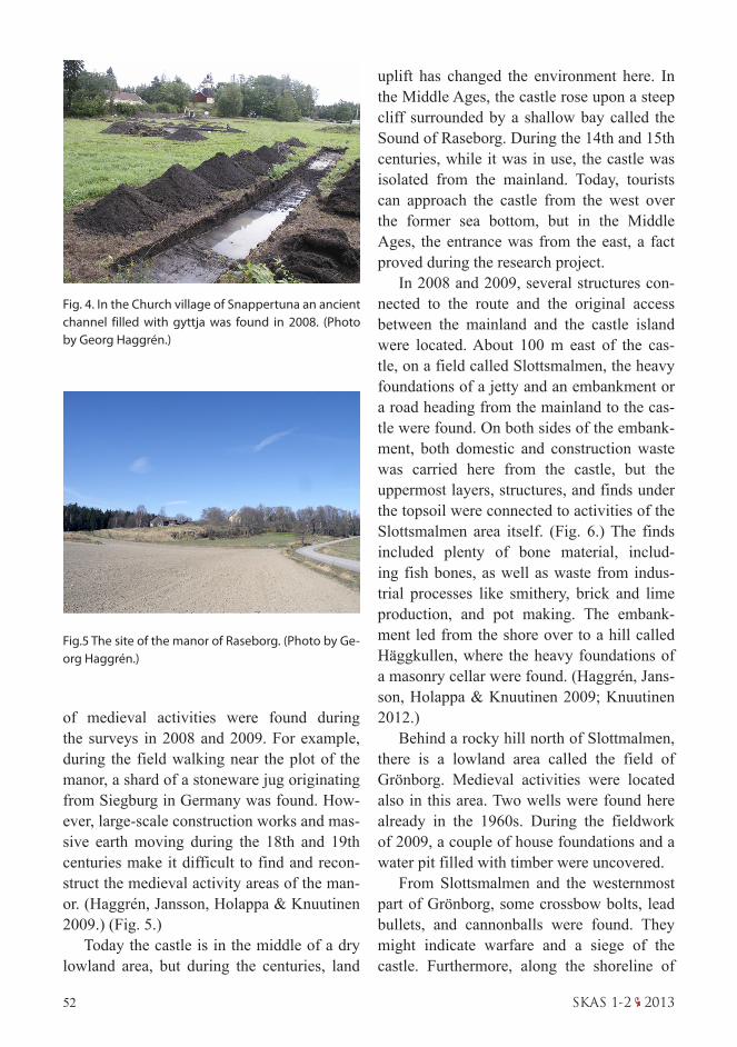
In the lowest part of Bastuåkern, a surpris-ing find was made when an ancient channel filled with gyttja was revealed. It seems that the medieval settlement or trading site has been located at the end of a shallow bay con-nected to the present King's river that runs to-wards the castle and out into the Gulf of Fin-land. The find material, mainly found in close vicinity to the two house foundations or the waterfront of the channel, consisted mostly of German stoneware, as well as shards of
Bohemian glass vessels. A couple of medi-eval coins were found too. The discovery of the channel and the house foundations, as well as the fact that the find material consists mostly of imported goods, suggest that in the late Middle Ages this area could have been a nodal point in a network of trade. (Haggrén & Jansson 2012, 68.) (Fig. 4.)
The agricultural center of the castle house-hold was the landed estate of Raseborg. Its center, the manorial site itself, was located on the slopes of a small hill one kilometer from the castle. The surviving records of the castle reveal that in the 1540s, the livestock of the estate consisted of dozens of cows and sheep, as well as some other domestic animals. The manorial site and its buildings were surround-ed by fields and meadows. This open land-scape has a long continuity from the Middle Ages and is rather well preserved even today. Some structures, for example, a medieval or early modern stone cellar, and some traces
LANDED ESTATEManor of Raseborg
CASTLE
Palisade
Fields
Meadows
"Slottsmalmen"Harbour
Borough? Chapel?
Fig. 3. The innermost zone of the landscape of power visualized on the oldest map representing the estate of Raseborg (1682). (Finnish National Archives)
52 SKAS 1-2 2013
uplift has changed the environment here. In the Middle Ages, the castle rose upon a steep cliff surrounded by a shallow bay called the Sound of Raseborg. During the 14th and 15th centuries, while it was in use, the castle was isolated from the mainland. Today, tourists can approach the castle from the west over the former sea bottom, but in the Middle Ages, the entrance was from the east, a fact proved during the research project.
In 2008 and 2009, several structures con-nected to the route and the original access between the mainland and the castle island were located. About 100 m east of the cas-tle, on a field called Slottsmalmen, the heavy foundations of a jetty and an embankment or a road heading from the mainland to the cas-tle were found. On both sides of the embank-ment, both domestic and construction waste was carried here from the castle, but the uppermost layers, structures, and finds under the topsoil were connected to activities of the Slottsmalmen area itself. (Fig. 6.) The finds included plenty of bone material, includ-ing fish bones, as well as waste from indus-trial processes like smithery, brick and lime production , and pot making. The embank-ment led from the shore over to a hill called Häggkullen, where the heavy foundations of a masonry cellar were found. (Haggrén, Jans-son, Holappa & Knuutinen 2009; Knuutinen 2012.)
Behind a rocky hill north of Slottmalmen, there is a lowland area called the field of Grönborg. Medieval activities were located also in this area. Two wells were found here already in the 1960s. During the fieldwork of 2009, a couple of house foundations and a water pit filled with timber were uncovered.
From Slottsmalmen and the westernmost part of Grönborg, some crossbow bolts, lead bullets, and cannonballs were found. They might indicate warfare and a siege of the castle. Furthermore, along the shoreline of
Fig. 4. In the Church village of Snappertuna an ancient channel filled with gyttja was found in 2008. (Photo by Georg Haggrén.)
Fig.5 The site of the manor of Raseborg. (Photo by Ge-org Haggrén.)
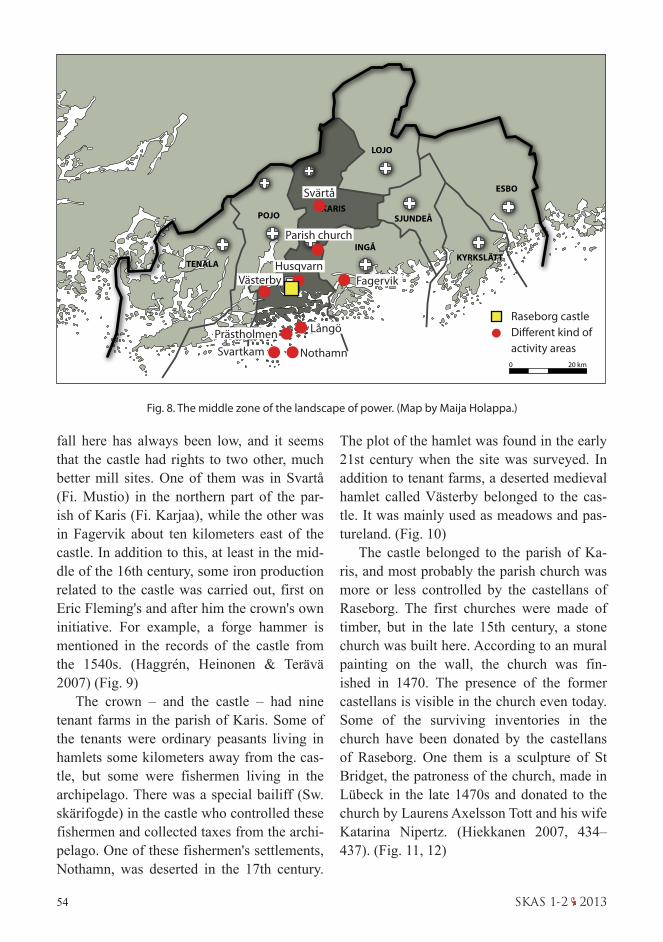
of medieval activities were found during the surveys in 2008 and 2009. For example, during the field walking near the plot of the manor, a shard of a stoneware jug originating from Siegburg in Germany was found. How-ever, large-scale construction works and mas-sive earth moving during the 18th and 19th centuries make it difficult to find and recon-struct the medieval activity areas of the man-or. (Haggrén, Jansson, Holappa & Knuutinen 2009.) (Fig. 5.)
Today the castle is in the middle of a dry lowland area, but during the centuries, land

53SKAS 1-2 2013
the Slottsmalmen area, there are some stone structures that can probably be connected to the boat harbor of the castle. From this site, it is about 1.5 kilometers to the mouth of the River Raseborg or King's river, the former Sound of Raseborg.
A large amount of finds and structures dating to the Middle Ages was found in the surroundings of the chapel and the settlement in Snappertuna, the environs of the manor of Raseborg, and the Slottsmalmen and Grön-borg areas east of the castle. Together they reflect different kinds of activities connected to the castle. In contradiction to these three or four areas with indications of lots of activi-ties during the 180 years when the castle was occupied, large areas between them lack any traces of medieval activities.
THE MIDDLE ZONE
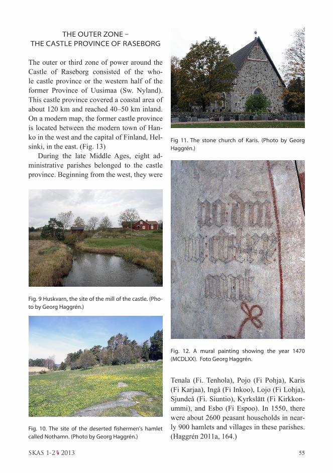
The middle zone of the landscape of power around the castle of Raseborg was under the direct control of the castle and the castellan. In addition to the near vicinity of the castle, several production sites and activity areas, as well as tenant farms, belonged to the castle household or the landed property of the cas-tle. The Sound of Raseborg was so shallow that the castle was forced to keep a harbor in front of the estuary of the sound – or the River Raseborg as it is called today. In the es-tuary of the sound, rocks blocked the chan-nel so that only smaller boats were able to make the last two kilometers to the castle. In modern times, some of these rocks have been blasted away. Before this, all larger ships, such as medieval cogs, were forced to an-chor in deeper waters in front of the estuary. On the island of Prästholmen on the west-ern shore of the river mouth, a group of rock carvings made in the late 15th century were found in the late 1970s. These carvings were
located close to the shoreline. They consisted of the coats of arms of several noblemen and women with a close connection to the castle. The harbor of the castle was probably near this site. (Drake 1991, 125–127; Nummela, Sarvas & Taavitsainen 1979.) (Fig. 8)
The castle household and the small gar-rison in the castle consumed large amounts of bread and flour. Quite naturally the castle had a mill just a couple of kilometers up-stream along the King's river. The mill was located in a place called Huskvarna, literally "the Mill of the Castle". However, the water-
Fig. 6. Domestic and construction waste layers on the southern side of the embankment on Slottsmalmen revealed during the excavations in 2009. (Photo by Georg Haggrén.)
Fig. 7. The site of a stone cellar or a masonry build-ing on Häggkullen before the excavation. (Photo by Georg Haggrén.)
54 SKAS 1-2 2013
TENALA
POJOKARIS
LOJO
SJUNDEÅ
KYRKSLÄTT
ESBO
INGÅ
0 20 km
fall here has always been low, and it seems that the castle had rights to two other, much better mill sites. One of them was in Svartå (Fi. Mustio) in the northern part of the par-ish of Karis (Fi. Karjaa), while the other was in Fagervik about ten kilometers east of the castle. In addition to this, at least in the mid-dle of the 16th century, some iron production related to the castle was carried out, first on Eric Fleming's and after him the crown's own initiative. For example, a forge hammer is mentioned in the records of the castle from the 1540s. (Haggrén, Heinonen & Terävä 2007) (Fig. 9)
The crown – and the castle – had nine tenant farms in the parish of Karis. Some of the tenants were ordinary peasants living in hamlets some kilometers away from the cas-tle, but some were fishermen living in the archipelago. There was a special bailiff (Sw. skärifogde) in the castle who controlled these fishermen and collected taxes from the archi-pelago. One of these fishermen's settlements, Nothamn, was deserted in the 17th century.
The plot of the hamlet was found in the early 21st century when the site was surveyed. In addition to tenant farms, a deserted medieval hamlet called Västerby belonged to the cas-tle. It was mainly used as meadows and pas-tureland. (Fig. 10)
The castle belonged to the parish of Ka-ris, and most probably the parish church was more or less controlled by the castellans of Raseborg. The first churches were made of timber, but in the late 15th century, a stone church was built here. According to an mural painting on the wall, the church was fin-ished in 1470. The presence of the former castellans is visible in the church even today . Some of the surviving inventories in the church have been donated by the castellans of Raseborg. One them is a sculpture of St Bridget, the patroness of the church, made in Lübeck in the late 1470s and donated to the church by Laurens Axelsson Tott and his wife Katarina Nipertz. (Hiekkanen 2007, 434–437). (Fig. 11, 12)
Fig. 8. The middle zone of the landscape of power. (Map by Maija Holappa.)
Svärtå
Parish church
HusqvarnVästerby
Prästholmen Långö
Fagervik
NothamnSvartkam
Raseborg castleDifferent kind of activity areas
55SKAS 1-2 2013
THE OUTER ZONE – THE CASTLE PROVINCE OF RASEBORG
The outer or third zone of power around the Castle of Raseborg consisted of the who-le castle province or the western half of the former Province of Uusimaa (Sw. Nyland). This castle province covered a coastal area of about 120 km and reached 40–50 km inland. On a modern map, the former castle province is located between the modern town of Han-ko in the west and the capital of Finland, Hel-sinki, in the east. (Fig. 13)
During the late Middle Ages, eight ad-ministrative parishes belonged to the castle province. Beginning from the west, they were
Fig. 9 Huskvarn, the site of the mill of the castle. (Pho-to by Georg Haggrén.)
Fig. 10. The site of the deserted fishermen's hamlet called Nothamn. (Photo by Georg Haggrén.)
Fig 11. The stone church of Karis. (Photo by Georg Haggrén.)
Fig. 12. A mural painting showing the year 1470 (MCDLXX). Foto Georg Haggrén.
Tenala (Fi. Tenhola), Pojo (Fi Pohja), Karis (Fi Karjaa), Ingå (Fi Inkoo), Lojo (Fi Lohja), Sjundeå (Fi. Siuntio), Kyrkslätt (Fi Kirkkon-ummi), and Esbo (Fi Espoo). In 1550, there were about 2600 peasant households in near-ly 900 hamlets and villages in these parishes.(Haggrén 2011a, 164.)

56 SKAS 1-2 2013
More than 90 % of the peasants in Uusi-maa were freeholders without any feudal ties. However, they had several duties towards the crown and its local representative, the castle and castellan of Raseborg. The freeholders, or all the peasants apart from tenants living on farms owned by the nobility, were organ-ized under the control of the castle. In the late 14th century, when the castle was founded, the peasants were obliged to bring materi-als and help in the construction works. In a medieval castle, the building and construc-tion activities continued almost every year. If there were no larger construction works, the buildings always needed maintenance. As late as in the 1540s, each of the parishes sent a carpenter to the castle annually. The peas-ants probably also paid their taxes directly to the castle. The peasants were also obliged to provide statute labor for the castle. The near-est parishes took part in the agriculture and fishing under the castle household several times a year. Furthermore, each parish had
to take care of the haymaking on one of the meadows belonging to the castle. For exam-ple, the peasants from Esbo parish were re-sponsible for a meadow called Stubbängen, located a couple of kilometers east of the castle. Because of the work duties, annual tax payments, and transporting parcels, the castle became familiar to peasants in every corner of the castle province. (Fig 14)
One of the villages in the castle province was Mankby in the western part of the parish of Esbo. Mankby, with its 8 medieval farms, was in Finnish terms a large hamlet, more like a village. It was abandoned in 1556, al-most at the same time as the castle of Rase-borg. In the same year, the village was laid under a new royal demesne or manor called Esbo kungsgård (Fi Espoon kuninkaankar-tano), and the peasants were forced to leave their farms. Soon afterwards the entire vil-lage plot in Mankby was abandoned.
In 2007, a research project was started in Mankby. During the first season, the site
Fig. 13 The Castle Province of Raseborg., the outer zone of the power. Maija Holappa.
TENALA
POJOKARIS
LOJO
SJUNDEÅ
KYRKSLÄTT
ESBO
INGÅ
0 20 km
Raseborg castleMankby

57SKAS 1-2 2013
was surveyed and mapped. After that, field-work and excavations have been carried out on the site every year. The research has been conducted by the University of Helsinki, The City Museum of Espoo, and the Summer University of Hanko.
In Finnish terms, Mankby is an exception-ally well-preserved deserted medieval village site. More than 20 house foundations and fireplaces, as well as several roads, are still visible on the terrain, and the village plan of the early 16th century can be reconstructed. Mankby is not a typical deserted settlement, not just any poor hamlet in a marginal area. It was a wealthy village in a good location with plenty of natural resources. (Haggrén, Holap-pa, Knuutinen & Rosendahl 2010.) (Fig 15)
On the grounds of the historical sources, we know that there was a lot of interaction between the peasants and the castle. When comparing archaeological find material, we can find many similarities in the material cul-
ture of the castle and the peasant farms. The castle, possibly together with the little bor-ough in its vicinity, was the economic center of the province. Another economic center for the peasants in Uusimaa was one of the large Hanseatic towns in the Eastern Baltic area, Tallinn, or Reval as it was called in those days. Even though it was located on the other side of the Gulf of Finland, Tallinn played an important role in the economy of the peasants in medieval Uusimaa. For the inhabitants of the Castle Province of Raseborg, Tallinn was much more important than Turku (Sw. Åbo), the largest town in Medieval Finland, or tiny Porvoo (Sw. Borgå), the only town with for-mal privileges in Uusimaa. From Mankby it took a day or two to get to Tallinn. Turku was much further away, and it took several days to get there.
The castle household, as well as the Han-seatic merchants in Tallinn, transferred all over the castle province not only traded
Fig. 14. The records of the castle from the year 1540 show how the peasants of Österby bol in the parish of Karis have manured a field called Ladugårdsåkern near the manor of Raseborg. (Finnish National Archives. Photo by Elina Terävä.)

58 SKAS 1-2 2013
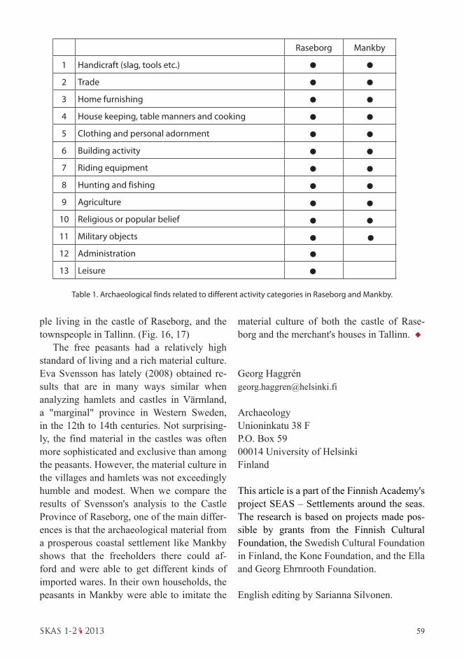
In the archaeological find material from both Raseborg and Mankby, there are import-ed ceramics, such as German stoneware, and Bohemian glass vessels. There are also dif-ferent kinds of industrial or craftsmen's prod-ucts, such as table knives and metal vessels, like tripods made of bronze, as well as keys and padlocks made in some Hanseatic towns. The castle and the collection of taxes have played an important role in the monetariza-tion process in the whole castle province. The coin finds from both sites illustrate this phe-nomenon. Horse furniture has usually been interpreted as part of a noble context, but there are several finds belonging to this cate-gory even from Mankby. The early industrial processes in the castle province concentrated on the inner and middle zones of power, but at least smithing and milling have taken place in the villages too. Agriculture and fishing had a fundamental importance for the peas-ants, but these activities were connected to the castle household as well.
On the grounds of the large material re-sulting from the excavations, we can com-pare the find material from Raseborg to that from the village of Mankby. (Table 1.) This comparison based on different activity cat-egories reveals more similarities than differ-ences. Only two categories, administration and leisure, are not clearly represented in the material from Mankby. With their direct con-tacts over the sea, the inhabitants of Mankby were able to follow the material culture of the Hanseatic world. This was also the case with Hanko, another medieval village in the cas-tle province of Raseborg (cf. Jansson, Hag-grén, Mannermaa & Tenhunen 2010). The peasants continuously acquired new influ-ences and ideas not only from the merchants in Tallinn but also when they were obliged to visit the castle or work for the castle estate. There were lots of similarities in the material culture of the freeholder peasants, the peo-
Fig. 15. A house foundation with a ruin of a fire place on the plot of the village of Mankby. (Photo by Georg Haggrén.)
Figs. 16 and 17. German stone ware, mostly from Sieg-burg in Rheinland, found from Slottsmalmen in Rase-borg and from Mankby. (Photos by Georg Haggrén.)
wares but also a new kind of material culture, and probably immaterial culture too. All this is visible in the find material from Raseborg and the village of Mankby.
59SKAS 1-2 2013
ple living in the castle of Raseborg, and the townspeople in Tallinn. (Fig. 16, 17)
The free peasants had a relatively high standard of living and a rich material culture. Eva Svensson has lately (2008) obtained re-sults that are in many ways similar when analyzing hamlets and castles in Värmland, a "marginal" province in Western Sweden, in the 12th to 14th centuries. Not surprising-ly, the find material in the castles was often more sophisticated and exclusive than among the peasants. However, the material culture in the villages and hamlets was not exceedingly humble and modest. When we compare the results of Svensson's analysis to the Castle Province of Raseborg, one of the main differ-ences is that the archaeological material from a prosperous coastal settlement like Mankby shows that the freeholders there could af-ford and were able to get different kinds of imported wares. In their own households, the peasants in Mankby were able to imitate the
Table 1. Archaeological finds related to different activity categories in Raseborg and Mankby.
Raseborg Mankby
1 Handicraft (slag, tools etc.)
2 Trade
3 Home furnishing
4 House keeping, table manners and cooking
5 Clothing and personal adornment
6 Building activity
7 Riding equipment
8 Hunting and fishing
9 Agriculture
10 Religious or popular belief
11 Military objects
12 Administration
13 Leisure
material culture of both the castle of Rase-borg and the merchant's houses in Tallinn.
Georg Haggré[email protected]
ArchaeologyUnioninkatu 38 FP.O. Box 5900014 University of HelsinkiFinland
This article is a part of the Finnish Academy's project SEAS – Settlements around the seas. The research is based on projects made pos-sible by grants from the Finnish Cultural Foundation, the Swedish Cultural Foundation in Finland, the Kone Foundation, and the Ella and Georg Ehrnrooth Foundation.
English editing by Sarianna Silvonen.
60 SKAS 1-2 2013
SOURCES
Literature
Drake, Knut: Raseborg – gråstenmurar berättar sin his-toria. In Henry Rask: Snappertuna. En kustbygds häv-der I. Ekenäs 1991. p. 87-138.
John Gardberg: Byar och gårdar genom tiderna. Snap-pertuna fornminnesförening 2005.
Gillingstam, Hans: Det svenska riksrådets världsliga medlemmar under medeltiden. Opuscula 12. Sällskapet Runica et Mediævalia. Stockholm 2009.
Haggrén, Georg: Colonization, Desertion and Ent-renchment of the Settlements in Western Nyland ca. 1300–1635 AD. Maritime landscape in change. Archa-eological, Historical, Palaeoecological and Geological studies on Western Uusimaa. Iskos 19. Helsinki 2011 (a). p. 152–179.
Haggrén, Georg: The Colonization of Western Uusimaa in the Middle Ages. Marjo Poutanen(Ed.): Colonists on the shores of The Gulf of Finland. Vantaa City Museum publications no 22. Vantaa 2011 (b). s. 7–25.
Haggrén, Georg, Tuuli Heinonen & Elina Terävä: Siun-tion Hyttiskogen – Suomen vanhin masuuni? SKAS 2/2009. s. 38–45.
Haggrén, Georg, Maija Holappa, Henrik Jansson & Tarja Knuutinen: Alla tiders Raseborg – Kaikkien aiko-jen Raseborg 2008–2009. SKAS 4/2009. s. 36–45.
Haggrén, Georg, Maija Holappa, Tarja Knuutinen & Ulrika Rosendahl: Stratigrafin på en välbevarad bytomt – Mankby i Esbo. SKAS 2/2010. s. 42–49.
Haggrén, Georg & Henrik Jansson: Raseborg through the Ages. Castella Maris Baltici X. AMAF XVIII. Tur-ku 2012. p. 61–70.
Hartman, Torsten: Raseborgs slotts historia. Skrifter utg. av Svenska litteratursällskapet i Finland XXXIII. Helsingfors 1896.
Hiekkanen, Markus: Suomen keskiajan kivikirkot. Suo-malaisen kirjallisuuden seuran toimituksia 1117. Hel-sinki: Suomalaisen kirjallisuuden seura 2007.
Jansson, Henrik , Georg Haggrén, Kristiina Mannermaa & Tanja Tenhunen: Settlement history and economy of the Gunnarsängen site at the Hanko peninsula. Fennos-candia Archaeologica XXVII. Helsinki 2010. p. 69–88.
Knuutinen, Tarja: Monimenetelmäinen prospektointi kohdetason arkeologisessa tutkimuksessa – yhdistetty ilmakuvatulkinta ja maatutkaus Raseborgin Slottsmal-menin tutkimuksissa 2008–2009. Pro Gradu. Archa-eology, University of Helsinki 2012 (a). (unpublished).
Knuutinen, Tarja: Überlegungen zur Rekonstruktion von Umgebung und Infrastruktur der spätmittelalter-lichen Burg Raseborg. Burgen und Schlösser 3/2012 (b). s. 163–168.
Mogren, Mats: Faxeholm i maktens landskap. En histo-risk arkeologi. Lund Studies in Medieval Archaeology 24. Stockholm 2000.
Nummela, Johanna, Pekka Sarvas & Jussi-Pekka Taa-vitsainen: Hällristningarna på Prästholmen - ett bidrag till Finlands medeltidshistoria. Historisk tidskrift för Finland 3/1979. s. 262–270.
Svensson, Eva: The Medieval Household. Daily Life in Castles and Farmsteads. Scandinavian Examples in their European Context. The Medieval Counryside 2. Brepols 2008.