A Matter of Life and Death at Mienakker (the Netherlands) - Spatial Analysis
85
Nederlandse Archeologische Rapporten 045 A Maer of Life and Death at Mienakker (the Netherlands) Late Neolithic Behavioural Variability in a Dynamic Landscape
-
Upload
thehumanjourney -
Category
Documents
-
view
4 -
download
0
Transcript of A Matter of Life and Death at Mienakker (the Netherlands) - Spatial Analysis

NederlandseArcheologischeRapporten 045
A Matter of Life and Death at Mienakker (the Netherlands)Late Neolithic Behavioural Variability in a Dynamic Landscape
P257419
Typewritten Text
Spatial Analysis

A Matter of Life and Death at Mienakker (the Netherlands)Late Neolithic Behavioural Variability in a Dynamic Landscape
J.P. Kleijne, O. Brinkkemper, R.C.G.M. Lauwerier, B.I. Smit & E.M. Theunissen (eds)

Nederlandse Archeologische Rapporten 45A Matter of Life and Death at Mienakker (the Netherlands)Late Neolithic Behavioural Variability in a Dynamic Landscape
Authors: S.M. Beckerman, D.C. Brinkhuizen, O. Brinkkemper, V. García-Díaz, J.P. Kleijne, L. Kubiak-Martens, G.R. Nobles, T.F.M. Oudemans, E. Plomp, E.M. Theunissen, M. van den Hof, H.J.T. Weerts & J.T. Zeiler, R.C.G.M. Lauwerier, J.H.M. Peeters, B.I. Smit, A.L. van Gijn & D.C.M. Raemaekers
Editors: J.P. Kleijne, O. Brinkkemper, R.C.G.M. Lauwerier, B.I. Smit & E.M. Theunissen (eds)
Illustrations: G.R. Nobles, M. Haars (BCL-Archaeological Support), S. Boersma (University of Groningen, Groningen Institute of Archaeology, ceramics Chapter 4), the authors, Cultural Heritage Agency of the Netherlands, unless otherwise stated
Editors of illustrations: M. Haars (BCL-Archaeological Support), O. BrinkkemperEnglish correction and translation: S. McDonnell, UtrechtDesign and layout: uNiek-Design, Almere
ISBN/EAN: 9789057992148
© Cultural Heritage Agency of the Netherlands, Amersfoort, 2013
Cultural Heritage Agency of the NetherlandsP.O. Box 16003800 BP AmersfoortThe Netherlandswww.cultureelerfgoed.nl
This research was supported by the Netherlands Organisation for Scientific Research (NWO, Den Haag), Cultural Heritage Agency (RCE, Amersfoort), BIAX Consult, ArchaeoBone, Kenaz Consult, University of Groningen, Groningen Institute of Archaeology, Faculty of Archaeology of Leiden University, Province of Noord-Holland, and Stichting Nederlands Museum voor Anthropologie en Praehistorie (SNMAP, Amsterdam).
S•N•M•A•POL.indd 1 3/28/12 4:04:30 PM
Kenaz Consult

3—
The archaeological record of the province of Noord-Holland is spectacular in many respects. Just below the modern man-made landscape lie well-preserved remains, left by many generations of past inhabitants. The good state of preservation of these traces, particularly the perishable material, makes them very valuable. This is an extraordinary feature of these sites, especially for the Late Neolithic Single Grave Culture (SGC). The excavated settlements are a unique resource that can afford us a better understanding of the earliest habitation of Noord-Holland. The SGC sites embedded in a tidal landscape are regarded as one of the most important Late Neolithic cultural landscapes in Northwestern Europe.
Tackling the backlog in the analysis and publication of these important sites has been a serious challenge. As part of the Odyssey programme funded by the Netherlands Organisation for Scientific Research (NWO) and the Ministry of Education, Culture and Science, a four-year project was started to unlock this Late Neolithic treasure chest. The monograph before you concerns the second key site on which information has been made accessible. The Keinsmerbrug site, published in volume 43 (2012), was the first to be revealed.
This publication highlights the Mienakker site, excavated in 1990. Mienakker had an advantage over other as yet unanalysed Neolithic sites in the sense that many of the material categories had already been studied. House plans had been identified and the well-preserved human burial, known as ‘Cees’, was published in 1991.
The analysis of Mienakker – like that of Keinsmerbrug – took the form of a multidisciplinary project involving a number of partners: the Cultural Heritage Agency, the universities of Groningen and Leiden, Noord-Holland provincial authority and various commercial parties – BIAX Consult, ArchaeoBone and Kenaz Consult.
All kinds of specialists worked closely together to reveal the cultural/ecological details and other research data, and to thoroughly integrate all the information. The project team consisted of 18 people, including both established and young researchers. The PhD students on the project clearly developed their writing skills and academic approach. Two very young researchers, Master’s students, also took the opportunity to get involved in the project. The final result of this close collaboration is an intriguing new story of Late Neolithic life at Mienakker, which in many ways differs from Keinsmerbrug. This publication will alter our ideas about prehistoric societies in Noord-Holland.
During the process of unlocking key sites the provincial repository proved invaluable. The availability of good-quality materials and excavation data is essential for each study. The new repository at Castricum, due to open in the near future, promises to be a paradise, not only for archaeologists, but above all for the present inhabitants of Noord-Holland. They will, for example, be able to meet ‘Cees of Mienakker’ face to face thanks to the lifelike reconstruction based on this study. His life and Neolithic environment, illustrated by tools, ornaments, ceramics and other finds, will form an important part of the prehistoric story of the province.
We should like to thank all who took part in this project for their efforts, and to compliment them on the impressive result. We wish the reader a great deal of pleasure in perusing the report.
Jos BazelmansHead of the department of research, Cultural Heritage Agency of the Netherlands
Rob van EerdenCultural resource manager for archaeology, Province of Noord-Holland
Preface
Preface 3
Summary 6
Samenvatting 8
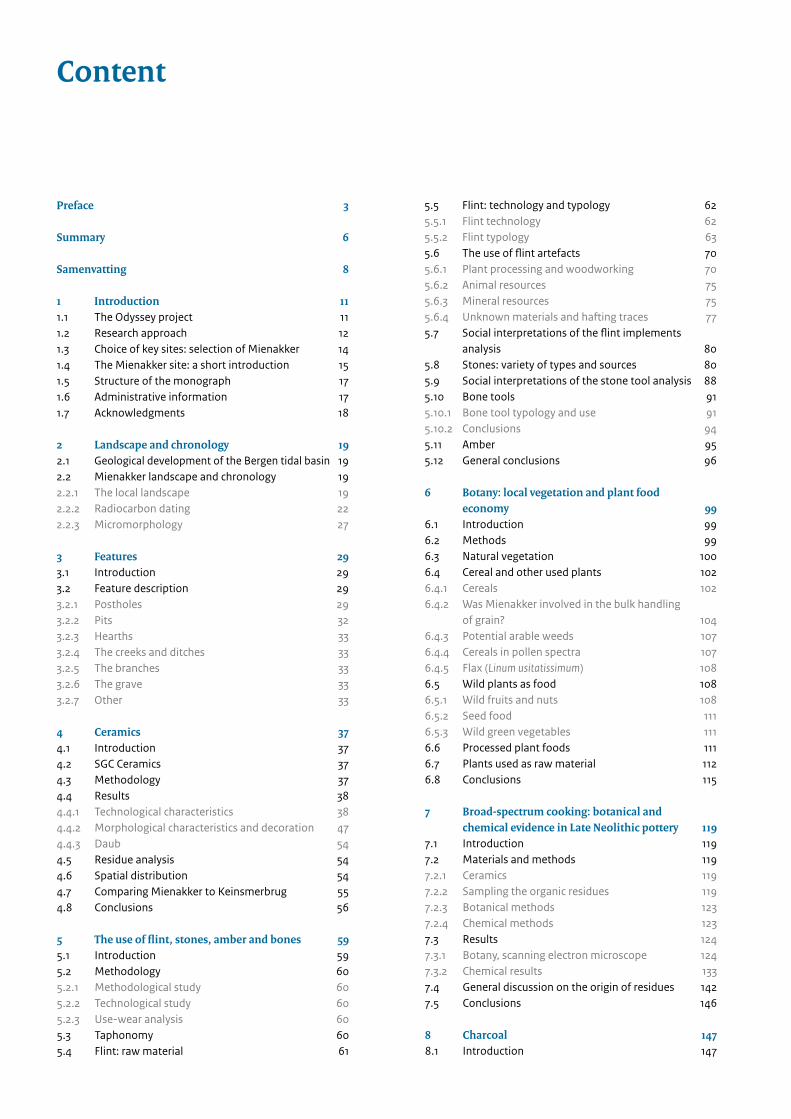
1 Introduction 111.1 The Odyssey project 111.2 Research approach 121.3 Choice of key sites: selection of Mienakker 141.4 The Mienakker site: a short introduction 151.5 Structure of the monograph 171.6 Administrative information 171.7 Acknowledgments 18
2 Landscape and chronology 192.1 Geological development of the Bergen tidal basin 192.2 Mienakker landscape and chronology 192.2.1 The local landscape 192.2.2 Radiocarbon dating 222.2.3 Micromorphology 27
3 Features 293.1 Introduction 293.2 Feature description 293.2.1 Postholes 293.2.2 Pits 323.2.3 Hearths 333.2.4 The creeks and ditches 333.2.5 The branches 333.2.6 The grave 333.2.7 Other 33
4 Ceramics 374.1 Introduction 374.2 SGC Ceramics 374.3 Methodology 374.4 Results 384.4.1 Technological characteristics 384.4.2 Morphological characteristics and decoration 474.4.3 Daub 544.5 Residue analysis 544.6 Spatial distribution 544.7 Comparing Mienakker to Keinsmerbrug 554.8 Conclusions 56 5 The use of flint, stones, amber and bones 595.1 Introduction 595.2 Methodology 605.2.1 Methodological study 605.2.2 Technological study 605.2.3 Use-wear analysis 605.3 Taphonomy 605.4 Flint: raw material 61
5.5 Flint: technology and typology 625.5.1 Flint technology 625.5.2 Flint typology 635.6 The use of flint artefacts 70 5.6.1 Plant processing and woodworking 705.6.2 Animal resources 755.6.3 Mineral resources 755.6.4 Unknown materials and hafting traces 775.7 Social interpretations of the flint implements
analysis 805.8 Stones: variety of types and sources 805.9 Social interpretations of the stone tool analysis 885.10 Bone tools 915.10.1 Bone tool typology and use 915.10.2 Conclusions 945.11 Amber 955.12 General conclusions 96
6 Botany: local vegetation and plant food economy 99
6.1 Introduction 996.2 Methods 996.3 Natural vegetation 1006.4 Cereal and other used plants 1026.4.1 Cereals 1026.4.2 Was Mienakker involved in the bulk handling
of grain? 1046.4.3 Potential arable weeds 1076.4.4 Cereals in pollen spectra 1076.4.5 Flax (Linum usitatissimum) 1086.5 Wild plants as food 1086.5.1 Wild fruits and nuts 1086.5.2 Seed food 1116.5.3 Wild green vegetables 1116.6 Processed plant foods 1116.7 Plants used as raw material 1126.8 Conclusions 115
7 Broad-spectrum cooking: botanical and chemical evidence in Late Neolithic pottery 119
7.1 Introduction 1197.2 Materials and methods 1197.2.1 Ceramics 1197.2.2 Sampling the organic residues 1197.2.3 Botanical methods 1237.2.4 Chemical methods 1237.3 Results 1247.3.1 Botany, scanning electron microscope 1247.3.2 Chemical results 1337.4 General discussion on the origin of residues 1427.5 Conclusions 146
8 Charcoal 1478.1 Introduction 147
Content

8.2 Method 1478.3 Results 1498.4 Discussion 1528.5 Conclusions 153
9 Faunal remains 1559.1 Introduction 1559.2 Methods 1559.3 Results 1569.3.1 General results 1569.3.2 Mammals 1589.3.3 Birds 1639.3.4 Fish 1679.3.5 Background fauna 1719.4 Discussion 1729.5 Conclusions 173
10 The human skeleton 17510.1 Introduction 17510.2 Burial context and analysis 17510.3 Materials 17810.4 Determination of sex 17810.5 Estimation of age-at-death 17910.6 Metrics and non-metrics traits 17910.7 Dietary reconstruction 18010.8 Pathological condition 18210.9 Discussion 18310.10 Conclusion 184
11 Spatial analysis 18511.1 Introduction 18511.2 Critical analysis of the dataset and the
recovery process 18511.3 Visual inspection 18611.4 Spatial analysis 18811.4.1 Methodology 18811.4.2 Data acquisition 18811.4.3 Outline of analysis and presentation 18811.5 Elevation model 19011.6 The animal remains 19111.6.1 Characterising the data 19111.6.2 Results 19211.6.3 Analysis 19211.6.4 Associations and interpretation 19211.7 Flint 19311.7.1 Characterising the data 19311.7.2 Results 19311.7.3 Analysis 19311.7.4 Associations and interpretations 20211.8 Stone 20311.8.1 Characterising the data 20311.8.2 Results 20311.8.3 Analysis 20911.8.4 Associations and interpretation 209
11.9 Amber 21411.9.1 Characterising the data 21411.9.2 Results 21411.9.3 Analysis, association and interpretation 21411.10 Ceramics 21411.10.1 Characterising the data 21411.10.2 Results 21511.10.3 Analysis 21511.10.4 Association and interpretation 21611.11 Other materials 22611.11.1 Clay and daub 22611.11.2 Organic residues 22711.11.3 Botanical remains 22711.12 Synthesis and discussion 22811.12.1 Combining the datasets 22811.12.2 Remaining elements 23111.12.3 Phasing 23311.12.4 Site function 23411.13 Conclusions 240
12 The canoe 24112.1 Introduction 24112.2 Comparable wooden finds in the Netherlands 24212.3 Ethnographic parallels 24212.4 Archaeological evidence for skin linings 24612.5 The canoe 24712.6 Conclusion 247
13 Synthesis - A matter of life and death at Mienakker 249
13.1 Introduction 24913.2 Chronology 24913.3 Environment 25113.4 Exploitation of animal resources 25213.5 Crop cultivation and use of wild plant resources 25313.6 Food preparation and consumption 25413.7 Production and use of ceramics 25513.8 Production and use of flint, hard stone and amber 25513.9 Spatial distribution of finds and features 25613.9.1 Identification of activity areas 25613.9.2 Features and dwellings 25613.10 Seasonality at Mienakker 25713.11 Concluding Mienakker 258
Bibliography 261
List of contributors 279
Appendices 281

6—
A matter of life and death at MienakkerThe second excavation analysed in further detail as part of the Odyssey ‘Unlocking Noord-Holland's Late Neolithic Treasure Chest’ project was that performed at the Mienakker site in 1990. Mienakker had an advantage over other as yet unpublished Neolithic sites in the sense that many of the material categories had already been studied. The area excavated was small, at 840 m2, but there were many post traces on the basis of which the excavators had identified two house plans. The clearest is approx. 5.7 metres long and 3 metres wide. This is a simple, light, two-aisled structure that was recorded as a ‘small hut’ or auxiliary building. The other house plan was not published. It is slightly bigger, at 9 to 14 metres long and 3 to 4 metres wide, and appeared to be the remnants of a light structure that was rebuilt and altered several times on the same spot. The Mienakker settlement was interpreted at the time as a temporary hunters’ camp, as opposed to the larger, more permanent residential settlements like Aartswoud, Kolhorn and Zeewijk. All kinds of specialists worked closely together to reveal all the cultural/ecological details and other research data, and to thoroughly integrate all the information, focusing on the same research questions as those addressed in the recent analysis of Keinsmerbrug. The project team consisted of 18 people working at different organisations (commercial agencies, universities and the Cultural Heritage Agency), each of whom contributed their own particular expertise. Two students took the opportunity to focus on a particular area: an analysis of the charcoal and a physical-anthropological study of the skeleton. The spatial analysis of the find distributions and posthole clusters gave rise to surprising new
insights. The study showed that Mienakker had two phases of occupation. The first was associated with an rectangular ground plan that largely coincides with the unpublished structure recognised in the 1990s. The northwestern end was found to be slightly longer, however, bringing the dimensions to 16.5 by 4 metres. Large amounts of settlement waste ended up in and around this house, and in the creek that ran parallel to it, enabling us to conclude that the first phase of occupation was intensive and diverse. After the creek silted up over time, a second structure was built over it. This has a slightly different, more trapezoid shape. The southwestern end is 3 metres wide and coincides with the small ‘hut’ identified previously. The northeastern end is also straight, but it is 6 metres wide. The structure is 22 metres long and is associated with the grave of an adult male. His burial was the last action performed at this place. The settlement was then abandoned and was overgrown with peat.
The first inhabitants chose as their settlement site a sandy ridge in a salt marsh, in a fairly saline and open environment. Cattle grazed in the surrounding area, between the saltwater creeks. Further to the east, where there was an influx of fresh water, there were extensive reed beds. The landscape was probably not entirely devoid of trees. Close to the settlement there were poplar (probably aspen) and birch trees and, in the higher-lying parts of the area, oak and hazel. The inhabitants probably also used driftwood, which would have regularly washed up on shore, for building and for fuel. The abundant water in the surrounding area was fully exploited. The inhabitants caught and ate lots of fish, both saltwater and freshwater species. Their diet regularly included cod,
Summary

7—
flounder, plaice and even haddock. The presence of this last species, haddock, is unusual, because it has never before been found at a prehistoric site. The discovery of large quantities of mature haddock remains is therefore striking. Haddock prefers deep, cold waters, which means that in the winter months the farmers of Mienakker must have taken to a deep tidal creek, or even the open sea, in boats to catch haddock using long lines. Branch configurations in the creek and cut marks on seal phalanges provide clear indications of the presence, and even construction, of a skin-lined canoe which may have been used to fish for haddock. Hunting on land focused mainly on animals with fur, such as polecats, ermine and stone martens. Their skins may have been used to produce warm clothes and other forms of protection from the cold. As regards their meat intake, the farmers of Mienakker mainly ate beef from adult or sub-adult cattle. Though sheep, goats and pigs did forage around the settlement, they were not eaten as frequently. The inhabitants also occasionally harvested food at low tide from the extensive mussel banks in tidal gullies and on sandbanks. Naked barley and emmer wheat were both grown, as was flax, for its oil-bearing seeds. The farmers brought complete ears of barley and wheat to the settlement, possibly with the stalks still attached. The grain was milled and made into a type of porridge, or it was stored for later use. In autumn, the Mienakker diet was supplemented with hazelnuts, acorns and wild apples. Food crusts left on pots at the settlement indicate that the food prepared there contained barely any fat or oil. It may therefore have consisted of vegetable foods like orache, or of low-fat animal foods like protein, blood, lean
meat, shellfish or white fish. The encrusted fish scales show that fish was indeed prepared at Mienakker. Starch-rich plants such as cereals, acorns and roots also found their way to the cooking pot, along with leafy green plants, shoots and other edible parts. Another notable feature is the uniformity of the pottery used for cooking. Stone, flint and amber were collected on the nearby beach or on the higher boulder clay outcrop at Wieringen, where the raw material lay on the surface. The inhabitants used the flint to make all kinds of tools, including borers and scrapers, which they used for working wood, cleaning skins and making amber beads. The use of the trapezoid structure and the burial of the incomplete body of an adult male at the base of one of the central posts were among the final actions performed at Mienakker. This intensively used site had already been abandoned for some time, and may have been partially overgrown by then. As to the reason behind the re-use of the structure and the significance attributed to it, they remain hypothetical, but these were no everyday activities. At some point the people of Mienakker built the trapezoid structure, and a short time later they buried one of their number in the middle of the building. We can probably refer to it as a ‘mortuary structure’, which gives Mienakker a more ‘ritual’ complexion, a location where the people said goodbye to someone close, or perhaps a more distant acquaintance. In summary, we can conclude that Mienakker may be interpreted as a site that was inhabited year-round, where a wide range of very diverse activities were performed. It was inhabited and returned to for many years. Over the years, Mienakker evolved from ‘home’ to become a place of parting and memory.
8—
Mienakker, een kwestie van leven en doodDe tweede opgraving die in het Odyssee-project ‘Het openen van de laat-neolithische schatkist van Noord-Holland’ is uitgewerkt, is de vindplaats Mienakker, opgegraven in 1990. Mienakker had in vergelijking met andere onuitgewerkte steentijd-vindplaatsen een streepje voor, omdat voor een groot aantal materiaal categorieën al studies wa-ren verricht. Het op gegraven oppervlak was klein, 840 m2, maar er waren veel paalsporen waarin door de opgravers al twee huisplattegronden wa-ren herkend. De duidelijkste heeft een lengte van ca. 5,7 meter en is 3 meter breed. Het is een een-voudige, lichte tweeschepige structuur die in de boeken inging als een ‘kleine hut’ of bijgebouw. De andere huisplattegrond bleef ongepubliceerd. Deze was wat groter, 9 tot 14 meter met een breedte van 3 bij 4 meter en leek de weerslag te zijn van een lichte constructie die verschillende malen op dezelfde plaats was her- en verbouwd. De nederzetting Mienakker werd destijds aange-merkt als een tijdelijk jachtkamp, een tegenhan-ger van de meer vaste woonplekken, permanente grote nederzettingen zoals Aartswoud, Kolhorn en Zeewijk. Om alle culturele/ecologische detailinformatie en andere onderzoeksgegevens te ontsluiten en goed met elkaar te integreren, werkten allerlei specialisten weer nauw samen, vanuit dezelfde onderzoeksvragen als bij het onderzoek van Keinsmerbrug. Het projectteam bestond uit 18 personen met elk hun eigen expertise, werkend vanuit verschillende instanties (bedrijven, uni-versiteiten en de Rijksdienst voor het Cultureel Erfgoed). Twee studenten namen de gelegen-heid zich te richten op een deelonderwerp, de analyse van het houtskool en een fysisch- antropologische studie op het skelet.
De ruimtelijke analyse van vondstverspreidingen en paalspoorclusters brachten verrassende nieu-
we inzichten. De studie wees uit dat Mienakker twee bewoningsfasen heeft gekend. De eerste is verbonden aan een langwerpige plattegrond, die grotendeels samenvalt met de ongepubliceerde structuur herkend in de jaren negentig. Alleen het noordwestelijke uiteinde lijkt wat langer te zijn, en daarmee komen de afmetingen op 16,5 bij 4 meter. Op en rondom dit huis, en in de pa-rallel liggend kreek is veel nederzettingsafval te-rechtgekomen, waaruit we kunnen afleiden dat deze eerste bewoningsfase intensief en veelom-vattend was. Toen de kreek in de loop der tijd opgevuld raakte, is er een tweede structuur overheen gebouwd. Deze is wat anders van vorm, meer trapeziumvormig. Het zuidweste-lijke einde heeft een breedte van 3 meter en valt samen met de eerder herkende kleine ‘hut’ van Mienakker. Het noordoostelijke uiteinde is ook recht, maar heeft een breedte van 6 meter. De structuur is 22 meter lang en is geassocieerd met een graf van een volwassen man. Het begraven van zijn lichaam was de laatste handeling op deze plek. De nederzetting is daarna verlaten en raakte overgroeid met veen.
De eerste bewoners kozen een zandige kwelder-rug uit in het open, vrij zoute milieu. In de omge-ving graasden de koeien, tussen de zoutwater-kreken in. Verder naar het oosten waar zoet water uitstroomde, groeide uitgestrekte rietlan-den. Helemaal boomloos was het landschap waarschijnlijk niet. Dicht bij de woonplek ston-den berken en op de hogere delen eik en haze-laar. Voor bouw- en brandhout was men wellicht ook aangewezen op drijfhout, dat regelmatig aanspoelde.De waterrijke omgeving werd goed benut; vele vissen, zowel zout- als zoetminnende soorten, werden gevangen en opgegeten. Kabeljauw, bot, schol en zelfs schelvis stonden regelmaat op het menu. Deze laatste, schelvis, is bijzonder omdat
Samenvatting

9—
deze soort nimmer is aangetroffen op andere prehistorische vindplaatsen. De ontdekking van een grote hoeveelheid volwassen schelvissen is dan ook opvallend. Schelvis houdt zich vooral op in koude, diepe wateren en dat betekent dat de boeren van Mienakker met boten in de winter-maanden een diepe getijdenkreek of zelfs open zee moeten op zijn gegaan, om schelvis met lange lijnen te vangen. Takkenconfiguraties in de geul en de snijsporen op de kootjes van zee-honden zijn duidelijke aanwijzingen voor de aanwezigheid, en zelfs bouw, van een huiden-boot waarmee op schelvis gevist kan zijn.De jacht op het land was vooral gericht op dieren met een harige vacht, zoals bunzing, hermelijn en marter. De huiden werden getwijfeld ver-werkt tot warme kleding, en andere vormen van bescherming tegen de koude. Voor wat betreft het vlees aten de boeren van Mienakker vooral runderen, volwassen of bijna-volwassen dieren. Schapen, geiten en ook varkens scharrelden ook rond, maar werden minder vaak gegeten. De grote, uitgestrekte mosselbanken die in getij-dengeulen en op zandplaatsen leven, werden bij eb af en toe bezocht. Naakte gerst en emmertarwe werden beide ver-bouwd, evenals vlas, voor oliehoudende zaden. De boeren brachten de complete aren, en mis-schien wel met stengel en al naar de nederzetting. Het graan werd gemalen, en tot pap bereid, of even opgeslagen. In de herfst vulden hazel noten, eikels en wilde appels de dagelijkse kost aan. Aankoeksels aan de potten geven aan dat het bereide voedsel nauwelijks vet of olie bevat. We kunnen dan denken aan plantaardige kost, zoals melde, maar ook aan vetarme dierlijke proteï-nen, zoals eiwit, bloed, mager vlees, schelp-dieren of vis. De vastgekoekte visschubben laten zien dat er daadwerkelijk vis is gekookt. Ook zet-meelrijke planten, zoals graan, eikels en wortels, verdwenen in de kookpot, aangevuld met groe-
ne bladeren, scheuten en andere eetbare delen. Opmerkelijk is verder dat het gebruikte aarde-werk opvallend uniform is. Steen, vuursteen en barnsteen werd verzameld op het strand nabij of op de hogere keileembult van Wieringen waar het ruwe materiaal aan het oppervlak lag. Van het vuursteen maakten de bewoners allerlei werktuigen, zoals boortjes en schrapers, waarmee onder andere hout en hui-den werden schoongekrabd en barnsteen be-werkt tot kraal.
Het gebruik van de trapeziumvormige structuur en het begraven van het onvolledige lichaam van een volwassen man, aan de voet van een van de middenstaanders, is een van de laatste handelingen op Mienakker. De intensief gebruik-te plek was toen al enige tijd verlaten en mis-schien wel deels overgroeid geraakt. Wat precies de achterliggende redenen zijn geweest van het hergebruik en welke betekenis de mensen eraan gaven, blijft hypothetisch, maar het waren geen gewone dagelijkse handelingen die daar werden uitgevoerd, zoals voedselbereiding. Op een ze-ker moment bouwden ze de trapeziumvormige structuur, en even later begroeven ze een van hen in het midden van het gebouw. Zeer waar-schijnlijk kunnen we dit een ‘mortuary structure’ noemen, een huis voor de dode. En daarmee kreeg de plek van Mienakker een meer ‘rituele’ lading, een locatie waar afscheid werd genomen van een naaste of verre bekende. Samenvattend kunnen we concluderen dat Mienakker geïnterpreteerd kan worden als een locatie waar het gehele jaar rond is gewoond, en waar allerlei, zeer verschillende activiteiten zijn uitgevoerd. Het is een plek waar jarenlang is gewoond en waar telkens naar is terugge-keerd. In de loop der tijd veranderde Mienakker van ‘home’, naar een plek van afscheid en her-innering.

185—
404 Hogestijn 1992, 202.405 Van Ginkel & Hogestijn 1997, 98;
Hogestijn 1997, 35; Hogestijn 1998, 102; Hogestijn & Drenth 2000, 138; Hogestijn 2001, 150; Arnoldussen & Fontijn 2006, 293; Kossian 2007, 270; Drenth, Brinkkemper & Lauwerier 2008, 157; Nobles 2012, 206.
406 Archive sheet 2001-0136.
11.1 Introduction
At the time of excavation, two structures were identified in the field, the larger measuring 9-14 by 3-4 m and the smaller 5-7 by 3 m. The smaller of the two is illustrated in Figure 11.1, the larger in Figure 11.2. Both have been described as ‘small huts’,404 but only the smaller structure has been published;405 the larger has remained in the archive.406 This chapter will investigate the spatial relationships between features and find categories in a systematic way. The information from the specialist reports in the preceding chapters of this monograph form the basic building blocks for this analysis, which follows two lines of investigation: a visual inspection of features, and a density pattern analysis of the various find categories. The analytical results will be discussed in relation to each other later in Section 11.12.
11.2 Critical analysis of the datasets and the recovery process
Mienakker was excavated using a grid system comprising 3600 0.5 m-squares. From a two-dimensional perspective the data are very promising; it is the third dimension which gives cause for concern. Layer information is missing from the majority of the site; it appears that this information was only recorded during the initial stages of the excavation. Context information is available. However, as discussed in Chapter 3, a Harris Matrix failed to define any reliable relationships.
Chapter 3 also mentions a further complication regarding features, in that they were recorded only once they could be recognised in the natural subsoil. This leaves great potential for many features to be missed or for later features higher in the stratum to have a lesser impact upon the underlying natural layer. For instance, postholes from a later phase which cut through the cultural layer may appear smaller in diameter than they would have done from higher in the stratum. This also limits the
11 Spatial analysisG.R. Nobles
N 3m0
Small hut Pits Postholes Cow hoof marks
Figure 11.1 The small ‘hut’-like structure at Mienakker (after Drenth et al. 2008, 157).

186—
phasing of individual features by their stratigraphical location. Analysis can therefore only be based on the two-dimensional distributions. Despite these problems the data are still of high-quality, and the majority of finds can be returned to their spatial context within a 0.5 m square. The material recovered is listed in Table 11.1.
11.3 Visual inspection
Following the full digitisation of the archived site drawings the feature distributions were assessed to see if any structures could be identified visually, and particularly to assess the two previously identified small ‘huts’. The larger structure from the archive appeared reasonably well defined. The majority of postholes could be maintained, but following a visual inspection of the spatial configuration and relative dimensions
of the postholes a substantial addition was identified at the northwestern end. It measures 16.5 m in length and up to 4 m in width and has a naviform (oval) shape. The association of postholes will be referred to as the Mienakker II structure (MKII). There appears to be a hearth within the structure. As the structure is somewhat aligned with the southwestern creek, an association has been assumed.
The smaller ‘hut’ took considerable thought as it appeared difficult to define the northeastern extent and end wall. An end wall was searched for within and just beyond the southwestern creek. However, this search proved fruitless, mainly because it was likely that the creek or the MKII structure would obscure any end wall. Also, expectations with regard to the potential positioning of the end wall depended heavily on the previous interpretation of the structure as a small hut.
To investigate the pattern further, the central post line was extended beyond the site
Figure 11.2 The unpublished larger ‘hut’ at Mienakker.
187—
as a guide line. This line passed directly over the grave and converged with one of a pair of larger postholes on the other edge of the settlement.
With this association of features, other linear arrangements of postholes could be identified. The arrangement of postholes forms a trapezoidal structure 22 m in length, with a width of 3 m at the narrow end and 6 m at the wider end. Some degree of phasing can be deduced from its location and associations, as it traverses the southwestern creek. It is suggested that at this stage of site formation the creek was sufficiently filled up to allow such a structure to be built. One of the postholes clearly cut through feature S120, indicating a later date. The occurrence of a burial within the wider end is also intriguing.
An isometric cross-section of all the posts at the two ends of the structure demonstrates a fair degree of symmetry (Fig. 11.3). This uniformity is lacking through the length of the
structure. Since the structure spans the site, which is defined by a varying thickness in the cultural layer, the postholes do not intrude into the natural substrate in a uniform way. This trapezoidal structure is referred to as Mienakker I (MKI), and is partially based upon the original published structure.
Two other potential structures have been identified, as well as two possible fence lines. Of course other structures or site elements may have been at the site but they can no longer be identified. One 'fence line' has two postholes occurring at different levels within one of the profiles. This would suggest three possibilities: either it was used and replaced in multiple phases, or the spatial association is coincidental and is not a fence line, or it is the result of the archaeological visibility within these highly complex layers. These are presented in Section 11.12.2.
Table 11.1 Types of data and availability for spatial analysis.
Type Available for study (n=number/g=gram)
Spatially located (n=number/g=gram)
Percentage missing spatial location (%)
Flint 1298 (n) 1009 (n) 22.3
Stone 862 (n) 846 (n) 1.9
Amber** 135 (n) 300+ (n) 0
Animal bones* 39949.1 (g) 33902.4 (g) 15.1
Ceramics 5185.4 (g) 4216.1 (g) 18.7
Burned Clay 177.7 (g) 177.6 (g) 0.1
Daub 9.6 (g) 9.6 (g) 0
Daub/clay** 1255.7 (g) 1255.7 (g) 0
* excluding fish remains
** spatial information based on data from previous study
1m0
Figure 11.3 Isometric posthole depths for the postholes of the MKI structure. Top wider end NE facing, bottom
thinner end SW facing.

188—
11.4 Spatial analysis
11.4.1 Methodology
As this report is the second in the current series, following on from the analysis of the seasonal settlement site of Keinsmerbrug;407 many analytical techniques have been replicated. Consequently, methodological issues are not discussed here in any great detail. For a detailed outline of the methodology, see Nobles.408
11.4.2 Data acquisition
All the data were digitised, including the plans and sections. The finds specialists used
databases and spreadsheets to record their data, which were later incorporated into a single database and linked to the GIS409 ready for the spatial analysis. Unique identifiers were applied to each record as shown in Table 11.2.
11.4.3 Outline of analysis and presentation
Distribution plots are presented, but these have little interpretive value. On the whole, they were not visually inspected to any great degree. Kernel Density Estimation (KDE) is used to investigate the changes in density of the find distributions across the site.Hotspot and Cluster & Outlier (Getis and Ord’s Gi* statistic & Local Moran’s Ii statistic) have been used to investigate the degrees and types of clustering of the artefacts. With these types of spatial statistics it is vital that a suitable colour
Figure 11.4 Site overview with the key features highlighted.
MKIMKI
hearth 2hearth 2
hearth pithearth pit
E a s
t e r
n
c r
e e
k
(N e
o l
i t h
i c)
E a s
t e r
n
c r
e e
k
(N e
o l
i t h
i c)
MKI
MKI
MKIIMKII hearth 1hearth 1
Test Pittest pit
test pittest pit
Test Pittest pit
MKIIMKII
S120S120
S138S138
Southern Pit Clustersouthern pit cluster
Southwestern Pitsouthwestern pit
Ditch (Medieval)
ditch (Medieval)
Ditch (Medieval)
ditch (Medieval)
Ditch (Medieval)
ditch (Medieval)
Ditch (Medieval)
ditch (Medieval)
gravegrave
D A T A E X T E N
TD
A T A E X T E N T
S w e s t e r n c r e e k (N e o l i t h i c)
S o u t h w e s t e r n c r e e k (N e o l i t h i c)
gu
lly (Medieval)
gu
lly (Medieval)
gully ( M
edieval)
gully ( M
edieval)
D A
T A
E
X T
E N
TD
A T
A
E X
T E
N T
D A T A E X T E N TD A T A E X T E N T
D A T A E X T E N TD A T A E X T E N T
MKIAsh deposits MKIICreeks Pits Postholes Test pits
5m0
407 Smit et al. 2012. 408 Nobles 2012.409 GRASS version 6.4 and MySQL database.

189—
410 Nobles 2012.411 Brewer & Marlow 1993. 412 Craig, Aldenderfer & Moyes 2006.413 Red, green and blue.
ramp is chosen and applied according to significance levels. In this case a three-tone colour ramp has been applied with classifications which relate to significance levels. For the Gi* statistic blue depicts areas of significant clustering of low values (< -1.96) and red indicates significance clustering of high values (> 1.96) between the excavation units. For the Local Moran’s statistic a different approach was taken from the methodology applied at Keinsmerbrug.410 In this case the Ii statistic was classified in terms of the relationships between the excavation unit and its neighbours. These relationships can be either High-High, Low-Low, High-Low or Low-High.Hierarchical clustering has been applied to the identified ceramic vessels. These are presented with the distribution of the sherds as well as the dendrogram depicting the scales of clustering using the Ward’s method. In two instances the tree structure has been manipulated into a wheel for ease of display due to the large quantity of sherds.Aspect-Slope plots display the direction of a land surface as well as the angle of the surface within a single image.411 Figure 11.5 shows the colour scheme used, whereby the lighter the hue, the less the degree of slope, and changes in colour indicate changes in direction. The brightest colours, the inner circle, indicate a slope value of greater than 40%; the middle circle indicates moderate slopes, 20-40%; the outer circle indicates slopes of 5-20%; the colour grey indicates slopes of <5%, essentially considered to be flat areas. These angles are illustrated in Figure 11.6.
Multivariate visualisation methods are applied in this volume. These are used to indicate locations where two or three variables co-exist,
using the methods outlined by Craig et al.412 Based upon additive colour theory, three relative KDEs have been combined into an RGB413 composite. Each colour band (red, green, blue) represents a single KDE; where two relatively high density areas co-exist the colours yellow, magenta or cyan will be dominant; where all three variables co-exist all the colours blend,
.
Table 11.2 Unique identifiers for each dataset as recorded in the database.
Dataset Unique identifier
Animal remains 1-21495
Flint 1-1009
Stone 1-861
Pottery 862-6218
Clay 1-219
N NE
E SE
S S
W
W
NW5-20%
20-40%
>40%
5-20%
20-40%
>40%
5-20%20-40%
>40%
5-20%
20-40%>40%
5-20%
20-40%
>40%
5-20%
20-40%
>40%
5-20%
20-40%
>40%
5-20
%
20-4
0% >40%
<5%
Figure 11.5 Aspect-Slope colour scheme and slope
partitions.
Figure 11.6 Angles of slope associated with the Aspect-
Slope plot.
40%
20%
5%
Was
te Flake
Splinter
Figure 11.7 Colour additive theory explained.
190—
giving white. Areas of only one of the densities will be displayed by its associated red, green or blue colouring. For instance in Figure 11.7, where high densities of flint waste and flint flakes are present, the area will be yellow. Where there is an occurrence of flint waste, flakes and splinters, the colouring will be appear white.
Presentation: To avoid unnecessary duplication of annotation in the figures and in order to present the data most effectively, an uniform overview of the site is presented. Figure 11.4 provides all the required information for the reader.
11.5 Elevation model
Estimates of land surface elevations prior to habitation derive from elevation measurements of the final excavation level.
A terrain model414 shows the two creeks to be prominent features (Fig. 11.8). Either side of the southwestern creek are two slightly raised areas, especially to the north and northeast. The same can be said of the area to the west of the eastern creek, specifically to the north. The south of the site is lower than these two areas, but still higher than the area to the north. This northern area may be a local depression, but more information on the wider landscape would be required to confirm or reject such an interpretation. The local relief would have changed to varying degrees due to the Neolithic occupation of the site.
This information indicates that at the time of the first settlers, two creeks existed with
slightly higher banks within the centre of the site. It appears the elevated area to the north and east of the southwestern creek was chosen for the location of the first structure, MKII. The two creeks are different in nature. The southwest creek forms an acute bend. It is likely that this creek meanders through the landscape and joins a partially excavated creek to the northwest. The other creek in the east bends away from the site. Local differences in the elevation may have a bearing on the distribution of finds, as the creeks create a natural trap for materials.
An Aspect-Slope map was produced to investigate this (Fig. 11.9) within the area of the MKII structure.415
Part of the material distributions within the MKII structure are within the catchment of the southwest creek, which may explain some of the distributions illustrated later. There is also an area which slopes away from the structure which may influence the distribution patterns to the northeast. As many of the 0.5 m squares are within both the MKII structure and the creek’s catchment, it is clear that these slope values are not the result of the interpolation method.
The presence of material remains in the creek suggests that if there was any water flow it was not sufficient to wash this material away. These natural creeks may therefore have been dry or contained water only during severe rain or flooding events. It is possible that these creeks contained a constant supply of slow-flowing water; however the filling of the creeks, especially in the southwest of the site, would have significantly restricted their capacity to drain rain and flood water.
414 IDW and Kriging methods were
assessed, but spline appeared to be more representative of the underlying data.
415 Methodology outlined in Brewer & Marlow 1993.
Figure 11.8 The local terrain at the time of the initial habitation.

191—
416 Previous research on the faunal remains
was carried out by W. Schnitger (mammals and birds), B. Beerenhout (fish) and W.J. Kuijper (molluscs), see also Zeiler & Brinkhuizen, this volume, for further reference.
417 Zeiler & Brinkhuizen, this volume. 418 Zeiler & Brinkhuizen, this volume. 419 Van Heeringen & Theunissen 2001, 173.
W
N
S
E
NENW
SWSE
MKIAsh deposits MKIIPits Postholes
5m0
Figure 11.9 The Aspect-Slope map indicating the areas with varying degrees of steepness as well as direction.
Table 11.3 Subdivision of the animal remains in terms of the number of database rows and weight.
Type Number of records
% Weight (g) %
Bird 12099 56.3 5092.9 14.5
Mammal 8773 40.8 30049.1 85.5
Mollusc 46 0.2 2.8 0.0
Total 31682 100 35146.9 100
11.6 The animal remains
The bone data were initially based on the old data from the excavation.416 However, this was only a sample of the remains. An assessment of the data by J.T. Zeiler led to the conclusion that the original interpretation to species level was more or less in line with his interpretation.417 The remaining assemblage was then incorporated. D.C. Brinkhuizen assessed a sample of the fish remains.418 Due to the vast quantity and the time available, only a proportion could be analysed. As a result fish bones were not suitable for spatial analysis as such a random sample could not be quantified in relation to the remaining material. The original data on fish remains were equally unsuitable for analysis.
Originally, the material was recovered from the excavated squares and collected from a 4 mm sieve.419
11.6.1 Characterising the data
The database has a total of 21,396 records. Due to time constraints precise numbers for the remains are unknown. Table 11.3 summarises the data but does not provide an exact quantification of the real population. The weights of bones were used for the spatial analysis.

192—
420 Appendix XIII.421 Appendix XIV.422 Zeiler & Brinkhuizen, this volume. 423 Zeiler & Brinkhuizen, this volume.
11.6.2 Results
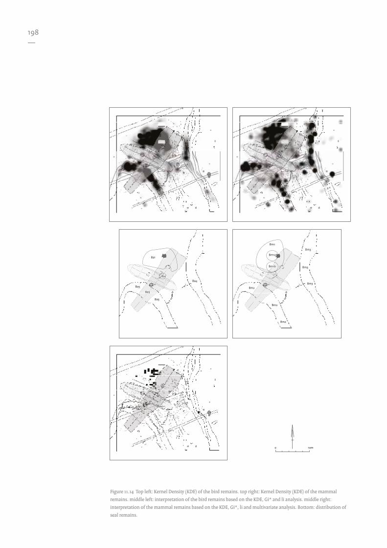
DistributionsFrom the distribution plots420 the animal remains can be seen to be located in both the eastern and southwestern creeks, as well as in the north of the site. There are three gaps in the dataset due to test pits. The density plots in Figure 11.14 clearly display these three areas. There are further medium and high densities of bone material spreading to the south of this main area. This zone is cut by the Medieval ditch. The impact of this upon the density plot is clearly visible.
Bird remainsThe density analysis (KDE)421 indicates four areas of interest, which have been designated areas Ba1-Ba4 as illustrated in Figure 11.14. There is a large area where the majority of the remains occur (Ba1); again, much of the material is found in the creeks (Ba3 and Ba4). Ba2 has two interpretations: either it is related to the hearth pit or it is a dump of material extracted from the settlement during the digging of the grave.
Mammal remainsThe mammal KDE (Fig. 11.14) displays a similar pattern to the bird data. Areas have been designated Bm1-Bm3.
As seen with the bird remains, there is one large area (Bm1) of accumulation; the remainder are concentrated in the creeks (Bm2 and Bm3). Area Bm1 contains two subareas, Bm1a and Bm1b, defined by the presence of seal bones. Although it is difficult to subdivide the dataset into specific animal types, seal remains are an exception. Even when severely fragmented, they are relatively easy to identify compared to the bones of terrestrial mammals.
Seal remainsThere are 54 records of seal bones in the database weighing 99.6 g. They can be identified to three groups: Seal sp., Common Seal and Ringed Seal.422 Although this assemblage consists of relatively few bones the seal remains are clustered within a particular part of the site. This grouping can be divided into two clusters: one directly west of feature S120 (Bm1a) and the other just south (Bm1b) of this other cluster. The remains comprise bones from the skull, an
upper jaw, a mandible, a tooth, phalanges (feet and hand) (n=47), and ribs (n=4). As Zeiler notes, these bones are the remains of hide processing where at least three skins were processed.423 The seals were butchered elsewhere and specific parts were brought to the settlement for further processing. In view of the spatial distribution of these remains, these two concentrations can be interpreted as a seal skin processing area. Considering the low numbers of remains it is possible that they represent a single event.
As the material has been reduced to two dimensions temporal aspects are increasingly difficult to determine. Temporal association is therefore assumed due to the spatial situation; however the actual situation may be more complex.
11.6.3 Analysis
Spatial statisticsGetis and Ord’s Gi* and Local Morans I (Ii) were applied to both the mammal and bird remains. They indicate a large area of statistically similar high values within a single area of the site. This significant clustering of values is apparent at all of the scales of analysis applied; there is no scalar differentiation to the material. Similar high values also occur in the creeks, which is to be expected (Figs. 11.10-11.13).
With the combination of the spatial statistics, Kernel Density Estimations, seal remains distributions and the multivariate visualisation, various areas can be defined. These are summarised in Figure 11.14. These areas are labelled Ba (Bone-Aves) and Bm (Bone-Mammalia); Bm1a and Bm1b refer to the concentrations of seal remains.
11.6.4 Associations and interpretation
Multivariate visualisation (Fig. 11.15) of the bird (red) and mammal (green) bone relative densities indicate that overall the bird bone occurs in areas of similar densities of mammal remains (yellow). The mammal remains are more dispersed, extending beyond the yellow area. There are some red areas, but these are either on the fringe of the main area or within

193—
424 García-Díaz, this volume.
the creek. It would appear that the animal remains are associated with the MKII structure, but dependent upon an association of segregation. That is to say: the animal remains are mostly outside this structure. The grave cuts through the bird bone material, as clearly illustrated in the KDE (Fig. 11.14), suggesting the grave is of a later date than the disposal of the bird remains. In summary, areas Ba1 and Bm1 define a relatively large area of animal processing associated with the MKII structure.
11.7 Flint
11.7.1 Characterising the data
In total 1298 pieces of flint were recovered from the excavation.424 Of these, 1009 were attributed to a square number, whereas 263 were lacking this information. This must be taken into consideration when drawing conclusions regarding the interpretations. An additional 26 were from test pits, but it is not clear which flints are from which test pit. All the finds from the test pits were therefore excluded from further analysis.
11.7.2 Results
Analysis continues with the pieces of flint which were spatially located (n=1009; Table 11.4).
DistributionsFrom the distribution plots the flint can be seen to occur all over the site. However, to the northwest, the majority of the artefacts are in an area along and within the southwestern creek. If we look at the relative densities in Figure 11.20 it is clear that the test pits have a slight impact on the distribution. The density plot illustrates how the majority of the flint occurs close to the southwestern creek as well as within the creek. Just to the northeast of this density, between the hearth pit and the burial, there is a triangular-shaped high density area slightly distorted by a test pit. Just to the north of the largest density there are further areas of high densities of material. The remainder of the site contains
moderate densities with some accumulation in the eastern creek.
The distribution of flint can be subdivided into tool types as illustrated in Figures 11.16 and 11.17. Unfortunately in this case, this gives us no greater insight into activities on the site due to the low numbers and/or apparent randomness of the distributions. This is discussed further in Section 11.12.
11.7.3 Analysis
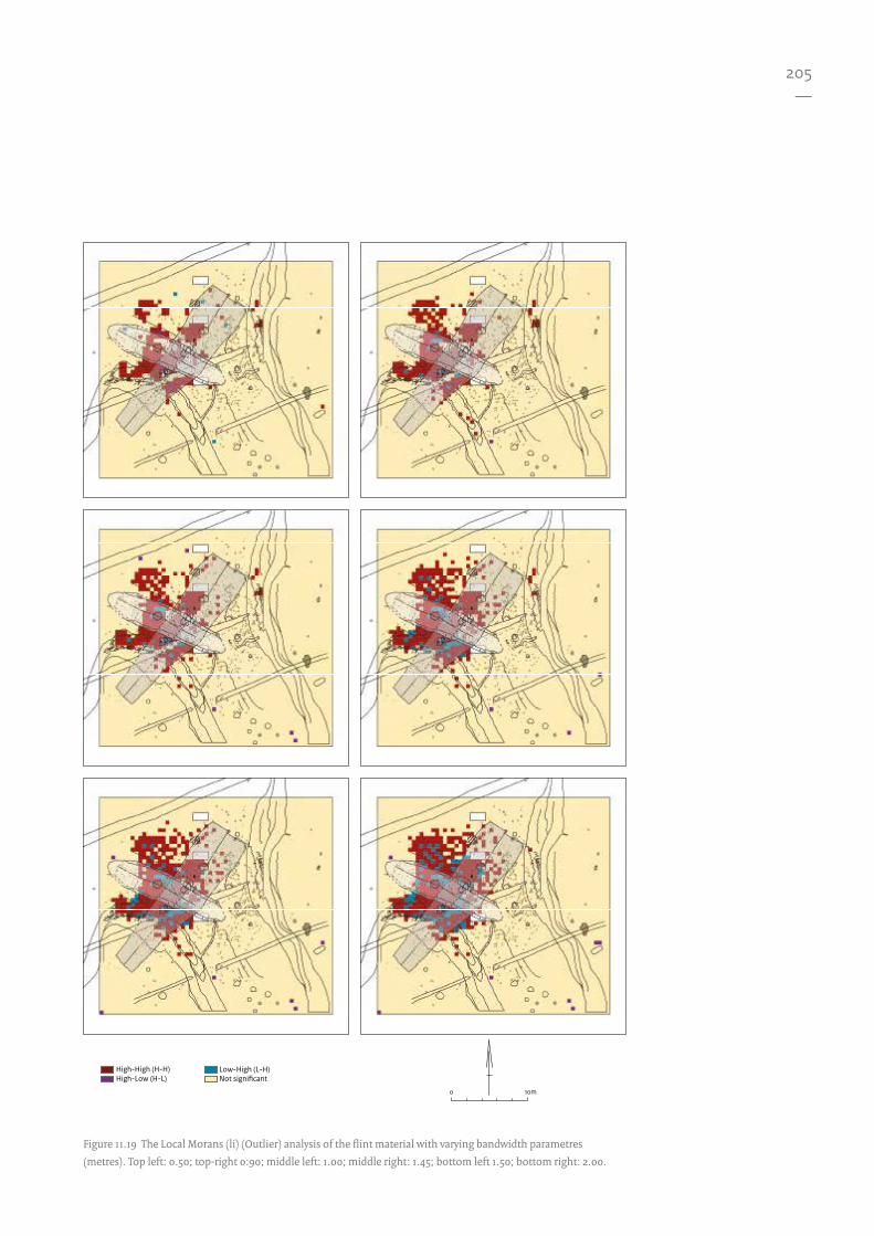
The spatial statistics in Figures 11.18-11.19 help to identify patterns of clustering. Interpretation based upon these results indicates three areas of significant clustering northeast of the MKII structure. These areas are labelled F (flint) and numbered for identification purposes, illustrated in Figure 11.22. Two of these areas are clear (F1 and F2), whereas the third area (F3) is only identified in the Gi* statistic and is at its clearest at the 0.9m scale. A larger area is indicated by both statistics; it occurs within the MKII structure and extends into the southwestern creek (F4). The density analysis (KDE) shows a similar pattern. However, the patterns become a little clearer when the datasets are subdivided by their topological classifications.
All of the classifications were assessed with KDE. The greatest concentration of flakes is in
Table 11.4 The subdivision of the flint material.
Type Number %
Blade 8 0.8
Core fragment 4 0.4
Core 23 2.3
Flake 142 14.1
Pebble 25 2.5
Test pebble 3 0.3
Retouched flake 1 0.1
Splinter 237 23.5
Waste 505 50
Undetermined 61 6
Total 1009 100

194—
10m0
< -2.58 Std. Dev. -2.58 - -1.96 Std. Dev.-1.96 - -1.65 Std. Dev.-1.65 - 1.65 Std. Dev.
1.65 - 1.96 Std. Dev.1.96 - 2.58 Std. Dev.> 2.58 Std. Dev.
Figure 11.10 The Gi* (hotspot) analysis of the mammal remains with varying bandwidth parameters (metres).
Top left: 0.50; top right 0.90; middle left: 1.00; middle right: 1.45; bottom left: 1.50; bottom right: 2.00.

195—
10m0
< -2.58 Std. Dev. -2.58 - -1.96 Std. Dev.-1.96 - -1.65 Std. Dev.-1.65 - 1.65 Std. Dev.
1.65 - 1.96 Std. Dev.1.96 - 2.58 Std. Dev.> 2.58 Std. Dev.
Figure 11.11 The Gi* (hotspot) analysis of the bird remains with varying bandwidth parameters (metres).
Top left: 0.50; top right 0.90; middle left: 1.00; middle right: 1.45; bottom left: 1.50; bottom right: 2.00.

196—
10m0
High-High (H-H)High-Low (H-L)
Low-High (L-H)Not signi cant
Figure 11.12 The Local Morans (li) (Outlier) analysis of the mammal remains with varying bandwidth parameters
(metres). Top left: 0.50; top right 0.90; middle left: 1.00; middle right: 1.45; bottom left: 1.50; bottom right: 2.00.
197—
10m0
High-High (H-H)High-Low (H-L)
Low-High (L-H)Not signi cant
Figure 11.13 The Local Morans (li) (Outlier) analysis of the bird remains with varying bandwidth parameters (metres).
Top left: 0.50; top right 0.90; middle left: 1.00; middle right: 1.45; bottom left: 1.50; bottom right: 2.00.
198—
Ba1
Ba2
Ba3
Ba4
Ba3
Ba3
Bm1
Bm1a
Bm1b
Bm2
Bm2
Bm2
Bm3
Bm3
Bm3
Ba1
Ba2
Ba3
Ba4
Ba3
Ba3
Bm1
Bm1a
Bm1b
Bm2
Bm2
Bm2
Bm3
Bm3
Bm3
10m0
Figure 11.14 Top left: Kernel Density (KDE) of the bird remains. top right: Kernel Density (KDE) of the mammal
remains. middle left: interpretation of the bird remains based on the KDE, Gi* and li analysis. middle right:
interpretation of the mammal remains based on the KDE, Gi*, li and multivariate analysis. Bottom: distribution of
seal remains.

199—
N/A
MammalBird
MKI MKIIPits Postholes
5m0
Test pits
Figure 11.15 Multivariate visualisation of bird (red) and mammal (green) remains; yellow represents both bird and
mammal remains. The blue spectrum is not present. This would normally be reserved for the fish densities, but
these have not been analysed sufficiently for their incorporation. They can be brought into the blue channel if they
are analysed in the future.

200—
Scrapers Points
Borers Blades
Type unknown Flakes
10m00 1 2 3 4 5 6 7 12
Quantity
Figure 11.16 Flint tool type distribution.

201—
Retouch general Core preperation piece
Cores Waste
Unmodied Unspecied
10m00 1 2 3 4 5 6 7 12
Quantity
Figure 11.17 Flint tool type distribution.

202—
425 Discussions took place between García-Díaz, Nobles and Peeters regarding the order and nature of the refits as previously defined by Peeters.
426 Peeters 2001a.
area F4. However, after visual examination of the multivariate analysis, it turned out to be possible to subdivide this area into two subgroups (F4a, F4b). The KDE of the flint splinters also indicates the areas F1, F2 and F4. However, there is a concentration of splinters between F1 and F2. The flint waste also indicates areas F1-4.
11.7.4 Associations and interpretations
Area F1 has relatively high concentrations of waste and splinters. Its location outside the MKII structure and lack of associated features inhibits any clear interpretation at this stage.
Area F2 appears to be slightly distorted due to the later burial; it is separated from area F4 by the wall of MKII, although there is always the possibility of an association with MKI.
Area F3 is the clearest in relation to the flint waste, although flakes and splinters are present. There are three high density areas which form an arc around feature S120, suggesting they may be behaviourally related.
Area F4 can be divided into two areas, F4a and F4b. F4a can be associated with the hearth within MKII; it has a clear concentration of flakes with splinters and waste (seen in white in Figure 11.21). The spatial association of these three categories (waste, splinters and flakes) indicates a strong possibility that flint knapping was centred next to the hearth. The spatial association of F4b is difficult to define. Flint waste, splinters and flakes all occur together; the multivariate visualisation indicates that this grouping is cut by a later ditch. Despite this, when these categories are combined, they are contained within the area previously hypothesised as structure MKI, clearly bound by the predicted location of a post wall. As with area F4a, the material is in the location of a hearth, making the interpretation of a similar activity, flint knapping, just as likely. The bounding of this distribution by structure MKI and the association of the material to hearth 1 associates the hearth with the MKI structure. Area F5 appears to be related to feature S138.
Much of the remaining material occurs within the settlement and in the SW creek. The rather indecipherable ‘kaleidoscope effect’ depicted in Figure 11.21 illustrates the random
nature of the distribution, mostly the product of individual findspots for each of the three categories; this is also clear in some of the KDE plots (flakes and splinters). Material is to be expected in the creeks, as it would be susceptible to water flows and gravity. As the Aspect-Slope plot demonstrates (Fig. 11.9), it is likely that material near the creek may move into it over time. Movement within the rest of the settlement as a result of natural processes is believed to be a less likely factor. As there is no clear ‘dump’ of material these accumulations have been interpreted as the result of natural processes following primary, behaviour-related discard.
Flint refittingThe spatial interpretation of refitted flint is presented here.425 Where clustering has been observed, this was it by means of visual inspection rather than the use of more formal methods. Peeters classifies the refitting material into Raw Material Units (RMU).426 RMUs 1, 2, 9, 13 are shown in Figure 11.23. They have an association to site elements based upon the spatial interpretation of the refitting information. Such detailed analysis was not possible for the remainder of the raw material units due to an absence of associated spatial information.
RMU1These groups of flint indicate two individual events. This flint was knapped or smashed in a single action, perhaps just for a single flake or, at most, a few flakes. After this the remaining core was picked up and moved to the south of the settlement and smashed again to procure at least another flake. The initial knapping event occurred in the north of the settlement, and may relate to the trapezoidal structure (MKI) or the burnt grain area (S120). The reuse of the core does not necessarily mean it was quickly picked up and used; it may have been discarded for a period of time either within its knapping context or loose on the surface of the settlement. Either way, it was involved in a second knapping event in the south of the settlement, where it remained. This area is within the area of the MKI structure, next to the associated hearth and outside the MKII structure. It is not possible to associate these events with any of the phases of the settlement.

203—
427 Peeters 2001a.428 See flint Section 11.7. 429 García-Díaz, this volume.
RMU2A clear grouping of relatively high quantities of flint is apparent to the south of the MKII hearth; this main concentration appears to be within this structure. A few pieces of waste are located in the creek, suggesting a natural movement due to site formation processes. To the north, two flakes and one piece of waste are in the large activity area outside the house. The majority of the flint appears to be contained within the MKII structure, forming the remains of a single knapping event. This flint was sequentially knapped rather than crushed.427
RMU9 This selection has multiple refits: flints related to the initial breakdown of the nodule are mostly just outside the MKII structure, the core is located at the boundary of this structure. This suggests a knapping event just outside the MKII structure.
RMU13The majority of this material is grouped near to the hearth previously associated with the MKI structure. Within this grouping, there are a few refits within their location unit (0.5 m square). A few (n=3) pieces are slightly further away from this concentration. This has been interpreted as a single knapping event. Although temporal associations remain unclear, this does further support the interpretation of area F4b (defined previously) as a product of the flint knapping process.
Remaining RMUsAll but one piece are located outside the MKII structure within the large activity area and the wider end of the MKI structure. There is one possible scraper. The nature of the material indicates that it began life as a pebble and was smashed prior to use. Material categorised as RMU4 could not be spatially located and RMU5 contained insufficient quantities of material for an interpretation. Within RMU6 there was one scraper with unclear associations. This unit comprises Grand Pressigny flint which Peeters suggests could be the reused remains of a Grand Pressigny dagger.
Flint assigned to RMU 8 is located within the large activity area outside the MKII structure. The remaining RMUs (7, 14-17, 19, 21, 22 and 28) consist of only a few pieces, clearly making spatial interpretation difficult.
11.8 Stone
11.8.1 Characterising the data
In total 862 pieces of stone (excluding flint428) were recovered from the excavation.429 Of these, 846 were attributed to a square, while the remaining 16 lacked this information. Analysis continued with the pieces of stone which were spatially locatable (Table 11.5).
11.8.2 Results
DistributionsFrom the distribution plot (Fig. 11.27) the stone can be seen to be generally more to the northwest of the site; the quantity of stone per square is low, with a maximum value of 12.
Table 11.5 The subdivision of the stone material.
Type Amount of records %
Waste 22 2.6
Flake 5 0.6
Broken 1 0.1
2-5mm 95 11.2
5-16mm 566 66.9
16-64mm 137 16.2
64-100mm 15 1.8
100-500mm 5 0.6
Total 846 100

204—
10m0
< -2.58 Std. Dev. -2.58 - -1.96 Std. Dev.-1.96 - -1.65 Std. Dev.-1.65 - 1.65 Std. Dev.
1.65 - 1.96 Std. Dev.1.96 - 2.58 Std. Dev.> 2.58 Std. Dev.
Figure 11.18 The Gi* (hotspot) analysis of the flint material with varying bandwidth parametres (metres). Top left:
0.50; top-right 0:90; middle left: 1.00; middle right: 1.45; bottom left 1.50; bottom right: 2.00.
205—
10m0
High-High (H-H)High-Low (H-L)
Low-High (L-H)Not signi cant
Figure 11.19 The Local Morans (li) (Outlier) analysis of the flint material with varying bandwidth parametres
(metres). Top left: 0.50; top-right 0:90; middle left: 1.00; middle right: 1.45; bottom left 1.50; bottom right: 2.00.

206—
10m0
Figure 11.20 Kernel Density (KDE) plots of the flint subdivisions. Top left: all flint; top right: flint flakes; bottom left:
flint waste; bottom right: flint splinters.

207—
Splinter
FlakeWaste
MKI MKIIPits Postholes
5m0
Test pits
Figure 11.21 Multivariate visualisation of the flint waste, flakes and splinters.
F1
F2
F3
F4a
F4b
F5
F1
F2
F3
F4a
F4b
F5
10m0
Figure 11.22 Interpretation of the flint material based on
the KDE, Gi*, li and multivariate analysis. Flint areas F1-F5.

208—
Knapping Event
Knapping Event
CORE
Knapping Event
Natural or HumanProcesses
Natural Processes
Knapping Event

209—
11.8.3 Analysis
The density plot and spatial statistics (Figs. 11.24 and 11.25) yield more information which is summarised in Figure 11.27. The Gi*, Ii and density analysis indicates a concentration of material north of the MKII structure in the west of the site (S1). Area S2 can be subdivided into two zones (S2a and S2b), as indicated in the Gi* and Ii statistics; the KDE suggests that it might divide into four zones. S3 is in the area of the MKII structure, although it extends into the area of the southwestern creek. S4 lies on the bank of the creek, and is also contained by the MKI structure. S5 is possibly cut by a later ditch. It is located within the southeastern end of the MKII structure. S6 and S7 occur in the two creeks.
Some of the stone material can be classified into querns, grinding stones, hammerstones, flaked stones, stone flakes and combination stones.430 The distributions of these types are illustrated in Figure 11.26.
11.8.4 Associations and interpretation
Due to the low quantities of material, interpretations are difficult. There are three clear areas: within the MKII structure around the hearth (S3), just outside this structure to the northwest (S1) and surrounding feature S120 (S2). It is thought unlikely that the remaining areas (S4-7) represent defined activity areas as they comprise few stones. The associations of stone to the hearth within structure MKII, and the association of stone with feature S120 are thought to be significant (Section 11.12).
Knapping Event
10m0
A single event Re t with direction(from core to �ake)
Re t without direction(e.g. two breaks of a �ake)
A process
Knapping Event Re �ed �int location
Feature S120
Figure 11.23 Lithic refitting of the selected Raw Material Units (RMU). Refitting of RMUs 1, 2, 9 & 13 with associated
interpretations.
430 As defined by García-Díaz, this volume.

210—
10m0
< -2.58 Std. Dev. -2.58 - -1.96 Std. Dev.-1.96 - -1.65 Std. Dev.-1.65 - 1.65 Std. Dev.
1.65 - 1.96 Std. Dev.1.96 - 2.58 Std. Dev.> 2.58 Std. Dev.
Figure 11.24 The Gi* (hotspot) analysis of the stone material with varying bandwidth parameters (metres). Top left:
0.50; top right: 0.90; middle left: 1.00; middle right: 1.45; bottom left: 1.50; bottom right: 2.00.

211—
10m0
High-High (H-H)High-Low (H-L)
Low-High (L-H)Not signi cant
Figure 11.25 The Local Morans (li) (Outlier) analysis of the stone material with varying bandwidth parameters
(metres). Top left: 0.50; top right: 0.90; middle left: 1.00; middle right: 1.45; bottom left: 1.50; bottom right: 2.00.

212—
Querns Grinding Stones
Hammer Stones Flaked Stones
Stone Flakes Combination Stones
10m00 1 2 3
Quantity
Figure 11.26 The distribution of stone tools.

213—
Count of Stones
1 - 2
3 - 4
5 - 6
7 - 8
9 - 10
11 - 12S1
S5
S2a
S3
S4
S2b
S6
S1
S5
S2a
S3
S4
S7
S2b
S6
10m0
High
Low
Density
Figure 11.27 Top left: stone material distribution; top right: stone material density (KDE); bottom: interpretation of
the flint material based upon the distribution, KDE, Gi* and li analysis.

214—
Table 11.6 The subdivision of the amber data based upon Bulten’s data.
Type Number %
Bead 25 7.9
Pendant 2 0.6
Waste 0 0.0
Splinter 159 50.5
Flake 67 21.3
Prepared 21 6.7
Block 3 0.9
Block unworked 24 7.6
Block worked 11 3.5
Block broken 1 0.3
Block burned 1 0.3
Block worked and burned 1 0.3
Total 315 100
11.9 Amber
11.9.1 Characterising the data
Although analysed by García-Díaz, the spatial dataset was derived from the original database,431 because of the high quantity of missing material: the current archive contains 134 pieces , but Bulten records 315 pieces (Table 11.6). As these original records also include a spatial reference, it is possible to use the complete dataset.
11.9.2 Results
Bulten’s data suggest that the amber forms two clear groupings: one nearer to the centre of the excavation area and the other near the eastern edge. The first group is diffusely clustered around a central location within the MKII structure.
11.9.3 Analysis, association and interpretation
Since the patterns from the distribution plots are clear, no further spatial analysis is required to define the patterns. The more central grouping comprises beads, broken beads, splinters, flakes, blocks, some prepared and some not. The assemblage represents a full chaîne opératoire of amber bead production.432
Refitting of the amber pieces was not possible as a large proportion of the material is missing. However, Bulten illustrates the refits, as seen in Figure 11.28. All links are between pieces within the central area of the site and are in close proximity to each other.
As this activity area dissects the MKII structure, a direct association would not normally be assumed. However, if we return to the Aspect-Slope map (Fig. 11.9) it is clear that this material is within the confines of the southwestern creek catchment. It is therefore possible that the pattern is influenced by the creek, and that material once resided within the
confines of the MKII structure (Fig. 11.29). Hence, the location of the amber bead production area may be associated with the hearth.
The second area is located slightly nearer to the edge of the excavation and appears in close proximity to feature S138. The majority of the amber consists of splinters with a high proportion of flakes and a small quantity of prepared pieces. The composition of the assemblage is different from the previous one, as it does not represent the full chaîne opératoire. The association with feature S138 is also interesting, as it is the only rectangular pit on the site. The association of further amber from the squares directly neighbouring the pit contain a similar composition, suggesting they are related. This leaves two possibilities: either the amber was within the pit and the pit was redug,433 or the pit was the focus of activity and material spread beyond it.
11.10 Ceramics
11.10.1 Characterising the data
There were 5357 sherds in total, weighing 5207.4 g. Of these sherds 5123 could be referenced to an excavated square; these weighed a total of
431 Bulten 2001.432 Bulten 2001.433 Nobles, this volume Chapter 3.

215—
434 Beckerman, this volume.
4216.2 g. Several reconstructed vessels could not be located for analysis and had to be excluded from this study. This is therefore an incomplete dataset.
Some vessels have been partially reconstructed; refitting of these sherds would have aided the assessment of dispersal patterns (section 11.10.4). Unfortunately these joined sherds lacked the required spatial information, so such an analysis was not viable.
11.10.2 Results
DistributionsFrom the distribution plot (weight), the ceramics show no clear patterning (Appendix XII). They appear evenly distributed over the site, although more in the west of the excavated area than in the east. A few squares with high weight values can be identified. The densities indicate that the majority of the distribution is within the southwestern creek, as well as on its southwestern bank. Another high density area is within, and north and south of the hearth pit. There are also more isolated high-density areas further to the north, with some moderate densities to the east of feature S120. There is a high-density area near the centre of the excavation area, possibly related to the hearth-pit area. The location of the Medieval ditch and the test pit may distort the density within this area.
As 19 vessels have been identified434 it is possible to break down the overall distribution by plotting the sherds of the individual vessels. Since none of the analysed vessels is whole, each vessel is therefore a proportion of the original. The proportion of the sherds to the whole vessel could not be calculated. Weights are however indicative, as each vessel will be of differing size and, given their various materials, differences in weights can be the result of differences in the density of the clay and tempering of the fabric.
Vessels or elements of vessels can have varying degrees of mobility due to the underlying site formation processes and preservation conditions. Mobility of sherds can vary between vessels and is not uniform for all sherds from a single pot. There are various spatial patterns which would be expected: either clustering, dispersal, or a combination of the two. For instance, if all the sherds from a single
vessel radiated outwards from an original location then some kind of doughnut ring may be visible. If on the other hand the sherds exhibited limited post-depositional mobility then the sherds would remain clustered within the area of the original location of the vessel.
Such a model is extremely simplistic as the dispersion and movement of ceramics vary according to the differences in site formation processes within the settlement. Natural weathering, and zoogenic and anthropogenic processes all play a role. Therefore any interpretation based upon the spatial analysis of the sherds is highly subjective and should be treated with caution.
11.10.3 Analysis
To investigate this further, the distribution of sherds was assessed at multiple scales through the use of hierarchical cluster analysis (HCA) (Figs. 11.30-11.45). This is a multi-scalar approach which, in the first instance, treats each location as a cluster or singleton. The next stage is to
60
60
50
40
30
20
10
00 10 20 30 40 50
Figure 11.28 Schematic overview of the amber refits as
published in 2001 (after Bulten 2001, 477, Fig. 10).
216—
combine the two closest sherds into a pair forming a cluster that is treated as a single entity. This procedure is continued until all the locations are grouped.
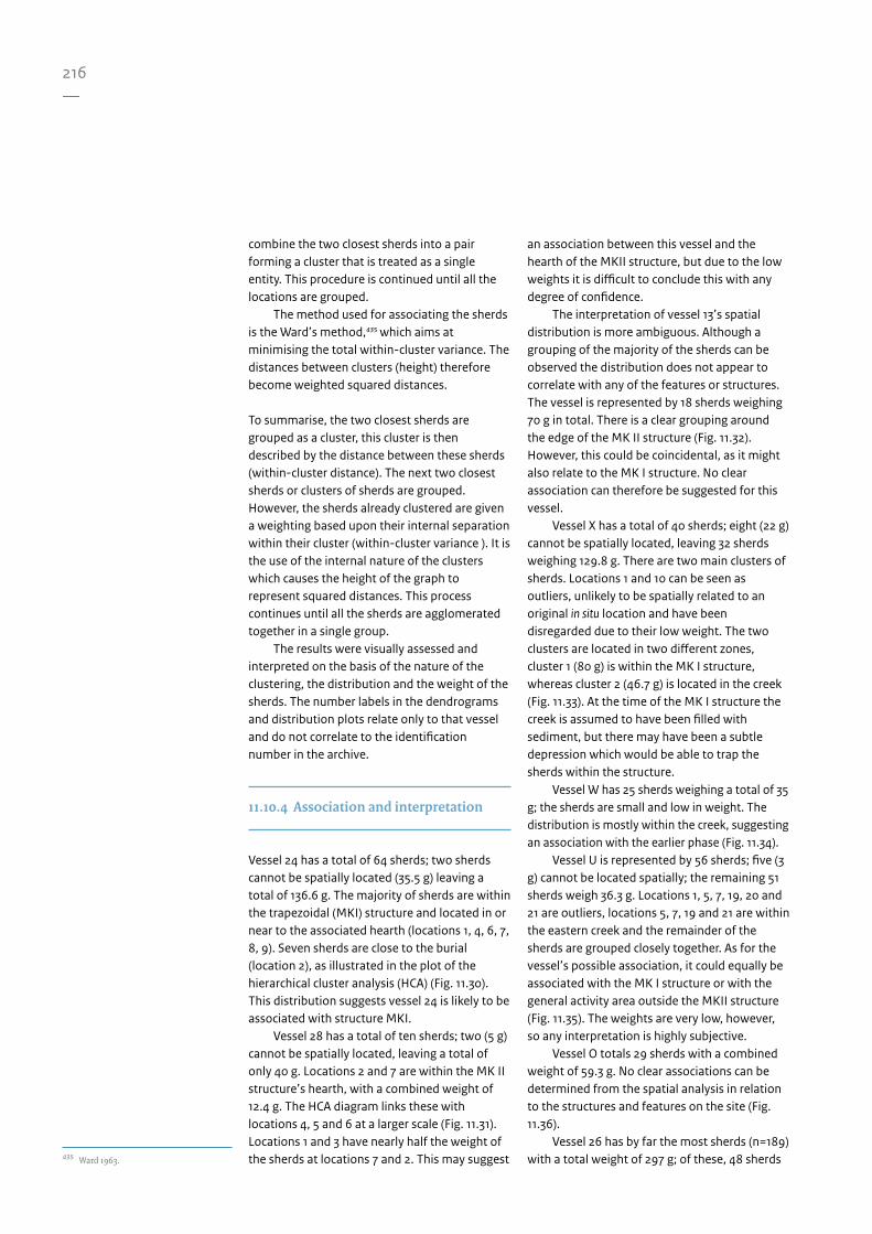
The method used for associating the sherds is the Ward’s method,435 which aims at minimising the total within-cluster variance. The distances between clusters (height) therefore become weighted squared distances.
To summarise, the two closest sherds are grouped as a cluster, this cluster is then described by the distance between these sherds (within-cluster distance). The next two closest sherds or clusters of sherds are grouped. However, the sherds already clustered are given a weighting based upon their internal separation within their cluster (within-cluster variance ). It is the use of the internal nature of the clusters which causes the height of the graph to represent squared distances. This process continues until all the sherds are agglomerated together in a single group.
The results were visually assessed and interpreted on the basis of the nature of the clustering, the distribution and the weight of the sherds. The number labels in the dendrograms and distribution plots relate only to that vessel and do not correlate to the identification number in the archive.
11.10.4 Association and interpretation
Vessel 24 has a total of 64 sherds; two sherds cannot be spatially located (35.5 g) leaving a total of 136.6 g. The majority of sherds are within the trapezoidal (MKI) structure and located in or near to the associated hearth (locations 1, 4, 6, 7, 8, 9). Seven sherds are close to the burial (location 2), as illustrated in the plot of the hierarchical cluster analysis (HCA) (Fig. 11.30). This distribution suggests vessel 24 is likely to be associated with structure MKI.
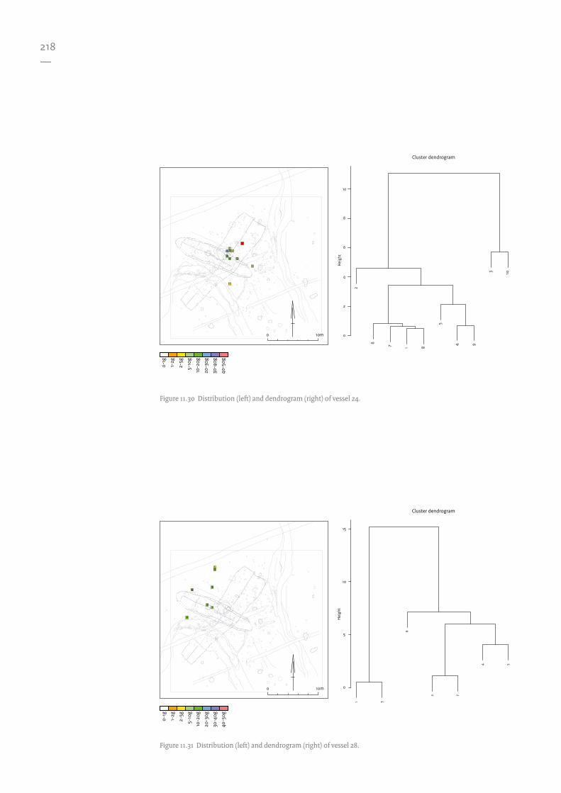
Vessel 28 has a total of ten sherds; two (5 g) cannot be spatially located, leaving a total of only 40 g. Locations 2 and 7 are within the MK II structure’s hearth, with a combined weight of 12.4 g. The HCA diagram links these with locations 4, 5 and 6 at a larger scale (Fig. 11.31). Locations 1 and 3 have nearly half the weight of the sherds at locations 7 and 2. This may suggest
an association between this vessel and the hearth of the MKII structure, but due to the low weights it is difficult to conclude this with any degree of confidence.
The interpretation of vessel 13’s spatial distribution is more ambiguous. Although a grouping of the majority of the sherds can be observed the distribution does not appear to correlate with any of the features or structures. The vessel is represented by 18 sherds weighing 70 g in total. There is a clear grouping around the edge of the MK II structure (Fig. 11.32). However, this could be coincidental, as it might also relate to the MK I structure. No clear association can therefore be suggested for this vessel.
Vessel X has a total of 40 sherds; eight (22 g) cannot be spatially located, leaving 32 sherds weighing 129.8 g. There are two main clusters of sherds. Locations 1 and 10 can be seen as outliers, unlikely to be spatially related to an original in situ location and have been disregarded due to their low weight. The two clusters are located in two different zones, cluster 1 (80 g) is within the MK I structure, whereas cluster 2 (46.7 g) is located in the creek (Fig. 11.33). At the time of the MK I structure the creek is assumed to have been filled with sediment, but there may have been a subtle depression which would be able to trap the sherds within the structure.
Vessel W has 25 sherds weighing a total of 35 g; the sherds are small and low in weight. The distribution is mostly within the creek, suggesting an association with the earlier phase (Fig. 11.34).
Vessel U is represented by 56 sherds; five (3 g) cannot be located spatially; the remaining 51 sherds weigh 36.3 g. Locations 1, 5, 7, 19, 20 and 21 are outliers, locations 5, 7, 19 and 21 are within the eastern creek and the remainder of the sherds are grouped closely together. As for the vessel’s possible association, it could equally be associated with the MK I structure or with the general activity area outside the MKII structure (Fig. 11.35). The weights are very low, however, so any interpretation is highly subjective.
Vessel O totals 29 sherds with a combined weight of 59.3 g. No clear associations can be determined from the spatial analysis in relation to the structures and features on the site (Fig. 11.36).
Vessel 26 has by far the most sherds (n=189) with a total weight of 297 g; of these, 48 sherds
435 Ward 1963.

217—
Figure 11.29 Top left: amber distribution (count); top right: amber density (KDE); bottom: pie chart distribution
indicating the different subdivisions of the material. The expanded window of the main amber concentration is
shown in the upper right corner.
10m0
0 1 2 3
Quantity
5m0
Bead
Pend
ant
Splin
ter
Flak
e
Prep
ared
Blocks
Bloc
k
Unw
orke
d
Wor
ked
Brok
en
Burn
edW
orke
d/Bu
rned
Bead
Pendant
Splinter
Flake
Prepared
Blocks
Block
Unworked
Worked
Broken
BurnedWorked/Burned
218—
1
2
3
45
6
7
1 3
6
2 7
4 5
0
5
10
15
Cluster dendrogram
Hei
ght
10m0
0-1g
1-2g
2-5g
5-10
g
10-2
0g
20-3
0g
30-4
0g
40-5
0g
Figure 11.31 Distribution (left) and dendrogram (right) of vessel 28.
1
2
3
4 5
678
9
10
2
6 7 1 8
5
4 9
3 10
0
2
4
6
8
10
Cluster dendrogram
Hei
ght
10m0
0-1g
1-2g
2-5g
5-10
g
10-2
0g
20-3
0g
30-4
0g
40-5
0g
Figure 11.30 Distribution (left) and dendrogram (right) of vessel 24.

219—
1
2
3
4
5
6
7
8
9
10
11
12
1311 13
3 9
5 7 2 4
6
10 12
1 8
0
5
10
15
20
25
30
Cluster dendrogram
Hei
ght
10m0
0-1g
1-2g
2-5g
5-10
g
10-2
0g
20-3
0g
30-4
0g
40-5
0g
Figure 11.32 Distribution (left) and dendrogram (right) of vessel 13.
1
2
3
4
5
67
8
9
10
11
12
13
141516
17
18
19
20
21
22
13 7 6 4 20 12 17 18 15 16 22
1 10
11
3 5 9 14 2 8
19 21
0
10
20
30
40
50
Cluster dendrogram
Hei
ght
10m0
0-1g
1-2g
2-5g
5-10
g
10-2
0g
20-3
0g
30-4
0g
40-5
0g
Figure 11.33 Distribution (left) and dendrogram (right) of vessel X.

220—
1
2
34
5
6
7
89
1011
12
13
14
15
16
17
18
19
20
21
222324
25
10 11 6 151
84 17
12 9 18 24 25 23 13 222
314 16
205 21
7 19
0
10
20
30
40
50
Cluster dendrogram
Hei
ght
10m0
0-1g
1-2g
2-5g
5-10
g
10-2
0g
20-3
0g
30-4
0g
40-5
0g
Figure 11.35 Distribution (left) and dendrogram (right) of vessel U.
1
2
3
4
5
6
7
8
9
1011
12
13
13 4 12
2 5
3
1
11 8 10
6
7 9
0
10
20
30
Cluster dendrogram
Hei
ght
10m0
0-1g
1-2g
2-5g
5-10
g
10-2
0g
20-3
0g
30-4
0g
40-5
0g
Figure 11.34 Distribution (left) and dendrogram (right) of vessel W.
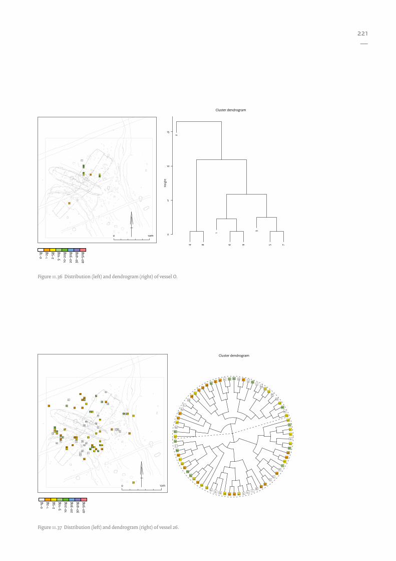
221—
1
2
3 45
6
7
8
9
2
4 8
1
6 9
3
5 7
0
5
10
15
Cluster dendrogram
Hei
ght
10m0
0-1g
1-2g
2-5g
5-10
g
10-2
0g
20-3
0g
30-4
0g
40-5
0g
Figure 11.36 Distribution (left) and dendrogram (right) of vessel O.
1
2
3
456
7
8
9
10
11
1213
14
15
16
17
18
19
20
21
22
23
24
25
26
27
28
29
30
31
32
33
34
35
36
37
38
39
40
41
42
43
44
45
46
47
48
49
505152
53
54
55
56
57
58
59
60
6162
63
64
65
6667
68
69
70
71
72
73
74
75
Cluster dendrogram
70 23 43 3 632
2450
5318
22
58
66
10
60
48
75
51
52
9
44
68
28
40
62
71
8
39
12
3734
161
17
6
54725424919413
5659
29
5465
64
32
45
61
33
69
7
57
67
14
46
74
27
31
15
11
20
26
5541
3836
7335 30 21 72
10m0
0-1g
1-2g
2-5g
5-10
g
10-2
0g
20-3
0g
30-4
0g
40-5
0g
Figure 11.37 Distribution (left) and dendrogram (right) of vessel 26.

222—
1
2
3 4
5 67 8 9
10
7
10
6 9
5 8
3 4
1 2
0
5
10
15
20
25
30
Cluster dendrogram
Hei
ght
10m0
Unknown weight
Figure 11.38 Distribution (left) and dendrogram (right) of vessel b.
1
23
45 6 78 9 1011 1213
6 7 13 9 10 11 12
4 5 8
3
1 2
0
10
20
30
40
Cluster dendrogram
Hei
ght
10m0
Unknown weight
Figure 11.39 Distribution (left) and dendrogram (right) of vessel c.
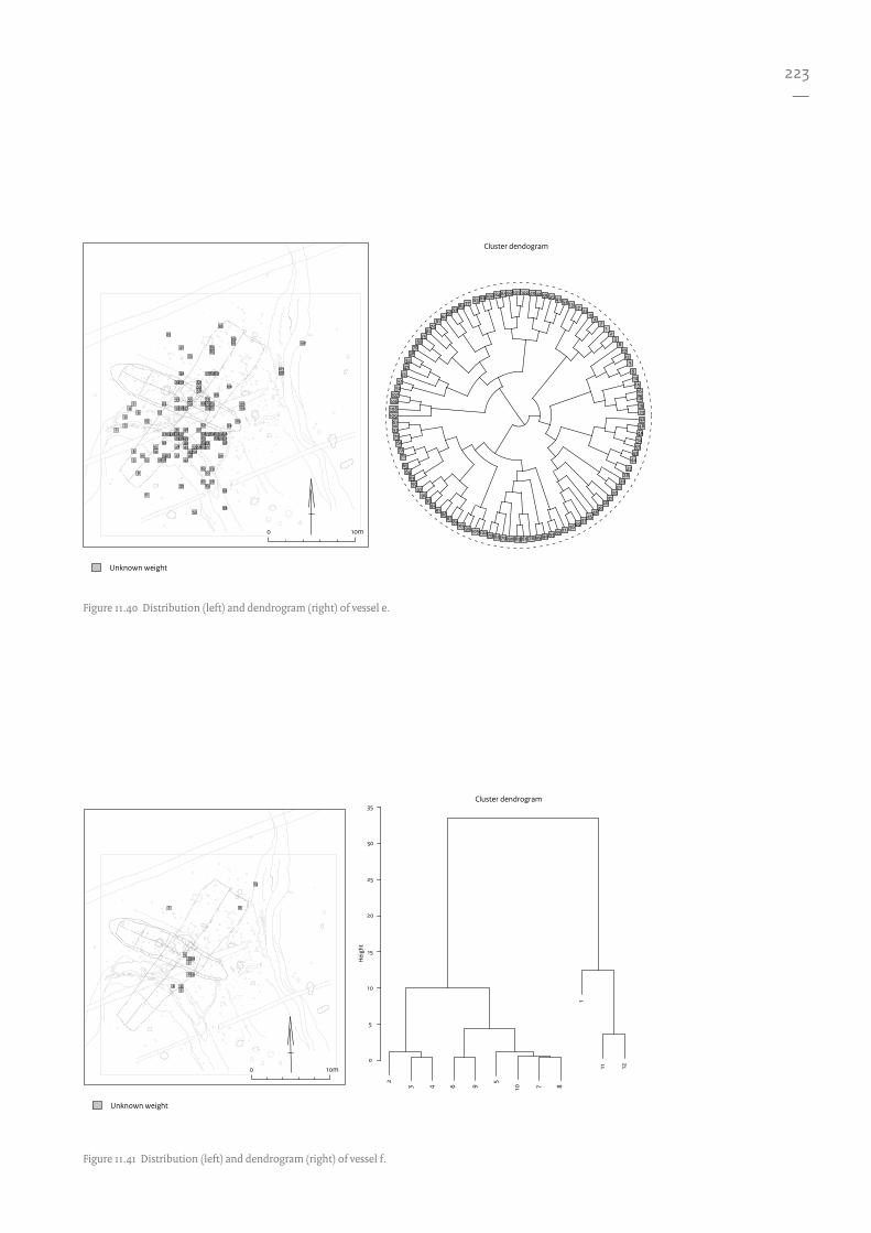
223—
101
109108106107
5051
334732
3876
6875
8274
8160
5859
8977 83 88100 8485
1722
94
71
23
810
125
6141516
2728
2021
2431
2630
4645
3729
361135539495786169907962701041059910380
8786
9192
9896
9756
6364
65
7172
66735767
93 102 4034 39 25 41 52 13
18
2342484954
5543
44
19
12
3
4
5
6
7
8
9
10
11
12
13
1415
16
17
1819
20
21
22
23
24
25
26
27
28
293031
32
33
34
35
3637
38
39
40
41
42
434445
46
47
4849
5051
52
53
545556
57
585960
61
62
63646566
67
68
69
70
7172
73
747576
77
78
79
80
8182
83
8485
8687
88
89
90
9192
93
94
95
969798
99
100
101102
103
104105
106107
108
Cluster dendogram
Unknown weight
10m0
Figure 11.40 Distribution (left) and dendrogram (right) of vessel e.
1
234
5
6
78
9
10
11
12
2
3 4 6 9
5
10 7 8
1
11 12
0
5
10
15
20
25
30
35Cluster dendrogram
Hei
ght
10m0
Unknown weight
Figure 11.41 Distribution (left) and dendrogram (right) of vessel f.

224—
1
2
3
45
6
7
8
9
10
11
1213
14
15
16
1718
192021
22
23
2425
26
27
28
29
30
31
32
33
12 138
11 14 4 5 1 2 3 76
9 10 15 17 18 22 26 16 21 19 2030
24 2532
23 2733
31 28 29
0
20
40
60
80
100
Cluster dendrogram
Hei
ght
10m0
Unknown weight
1
2
3
5
6
7
1 2
6
4
3 5
0
5
10
15
20
25
30
35
Cluster dendrogram
Hei
ght
10m0
Unknown weight
Figure 11.42 Distribution (left) and dendrogram (right) of vessel g.
Figure 11.43 Distribution (left) and dendrogram (right) of vessel h.

225—
12
3
4
5
6
7
8
910
11
5
4
1
2 3
6
9 10
11
7 8
0
5
10
15
20
25
Cluster dendrogram
Hei
ght
10m0
Unknown weight
Figure 11.45 Distribution (left) and dendrogram (right) of vessel j.
123
4
567
89
10
1112
1
2 3
12
6 5 7
4
8 9
10 11
0
10
20
30
Cluster dendrogram
Hei
ght
10m0
Unknown weight
Figure 11.44 Distribution (left) and dendrogram (right) of vessel i.
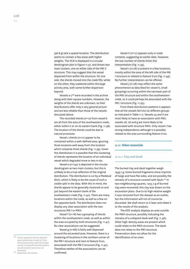
226—
436 Vessel a appears to have an identical
spatial patterning as vessel 26. Since these locations were taken from paper records, it is possible that this vessel is actually vessel 26 and is thus not illustrated.
437 Beckerman, this volume.
(96.8 g) lack a spatial location. The distribution seems to contain a few areas with higher weights. The HCA is displayed in a circular dendrogram plot in Figure 11.37, and shows two main clusters, one on either side of the MK II structure. This may suggest that the vessel dispersed from within the structure. On one side, the sherds moved into the creek fills, while on the other, they scattered within the large activity area, with some further dispersion beyond.
Vessels a-j436 were recorded in the archive along with their square numbers. However, the weights of the sherds are unknown, so their distributions offer only a very general picture and are less reliable than those of the vessels discussed above.
The recorded sherds (n=12) from vessel b are all from the area of the southwestern creek, either within it or on its eastern bank (Fig. 11.38). The location of the sherds could be due to natural processes.
Vessel c sherds (n=21) appear to be contained within a well-defined area, ignoring three locations well away from this location which comprise three sherds (Fig. 11.39). Given this distribution it is possible that this clustering of sherds represents the location of an individual vessel which degraded more or less in situ.
Vessel e (n=142) is depicted in the circular dendrogram as two main clusters, but this is unlikely to be a true reflection of the original distribution. The distribution is cut by a Medieval ditch, which is likely to be the cause of such a visible split in the data. With this in mind, the sherds appear to be generally clustered on and just beyond the eastern bank of the southwestern creek (Fig. 11.40). There are many locations within the creek, as well as a few on the opposite bank. The distribution does not display any clear association with the two structures MK I or MKII.
Vessel f (n=18) has a grouping of sherds within the southwestern creek, as well as within the area occupied by both structures (Fig. 11.41). No clear associations can be suggested.
Vessel g (n=66) is fairly well dispersed around the excavated area. However, there is a clustering of locations in the northern corner of the MK I structure and next to feature S120, associated with the MK II structure (Fig. 11.42). Therefore neither of the associations can be confirmed.
Vessel h (n=17) appears only in creek contexts, suggesting an earlier date. However, the low number of sherds limits this interpretation (Fig. 11.43).
Vessel i (n=26) is present in a few locations, mostly within the area of the left side of the MK I structure or related to feature S120 (Fig. 11.44). No further interpretation can be offered.
Vessel j (n=28) may reflect the same phenomenon as described for vessel X, small groupings occurring within the narrower part of the MKI structure and within the southwestern creek, so it could perhaps be associated with the MK I structure (Fig. 11.45).
From these distribution patterns it appears that all the vessels fall into six different groups as indicated in Table 11.7. Vessels 24 and X are most likely to have an association with MKI; vessels 28, 26 and g are more likely to be associated with structure MKII. Only vessel c has strong independence although it is possibly related to the area surrounding feature S120.
11.11 Other materials
11.11.1 Clay and daub
The burned clay and daub together weigh 1443.1 g. Some burned fragments show imprints of twigs and have flat sides, and are possibly the remains of a structure covered with daub.437 In two neighbouring squares, 1255.7 g of burned clay were recovered; this clay was drawn on the excavation plans. Due to its high relative weight it was removed from the dataset as an outlier, but the information will not of course be discarded. We shall return to it later and relate it to the results of the analysis.
The KDE analysis displays an area outside the MKII structure, possibly indicating the remains of a collapsed daub wall (Fig. 11.46). Other high-density areas are present which could relate to the MKII structure. The daub does not relate to the MKI structure. Preservation does not allow for the identification of an oven.

227—
438 Oudemans & Kubiak-Martens, this
volume. 439 Kubiak-Martens, this volume.
11.11.2 Organic residues
Sixteen sherds in the ceramic assemblage were selected for residue analysis; nine relate to individual vessels.438 However, only vessels 13, 26, O, X and e had sufficient spatial information. From the spatial analysis of the vessels it is clear that the ceramic material has a certain degree of mobility. It is therefore unwise to postulate spatial relationships between the residues and their final location, as this may have little to do with the residue itself.
As the spatial relationships of the vessels to the features within the site are unclear, it is equally impossible to infer anything from these results which would add to the spatial analysis. It is always possible that certain vessels functioned within a particular part of the site but the evidence is not sufficient for these aspects to be investigated any further.
11.11.3 Botanical remains
The botanical dataset is difficult to interpret due to the sampling strategy. Samples were collected where material was visually identifiable. The lack of a systematic sampling strategy has resulted in a dataset with little spatial meaning. For this reason the information below remains descriptive.
The remains contain plant species indicative of a saltwater and freshwater environment; some can be classed as crop species.439 The remaining categories are arable weeds, processed plant remains and trees or shrubs. Each sampled location contains material which can be assigned to the above categories with, for the most part, each category being represented at each sample location (Fig. 11.47). There is a high number of charred grains in the area of feature S120: approx. 1500 naked barley grains and approx. 500 emmer grains.
Table 11.7 Association between vessels and recognised structures and important features, in terms of likelihood.
Association MKI MKII S120 and extended area
SW creek E creek Independence
Vessel 24
Vessel 28
Vessel 13
Vessel X
Vessel W
Vessel U
Vessel O
Vessel 26
Vessel b
Vessel c
Vessel e
Vessel f
Vessel g
Vessel h
Vessel i
Vessel j
Likely Unlikely
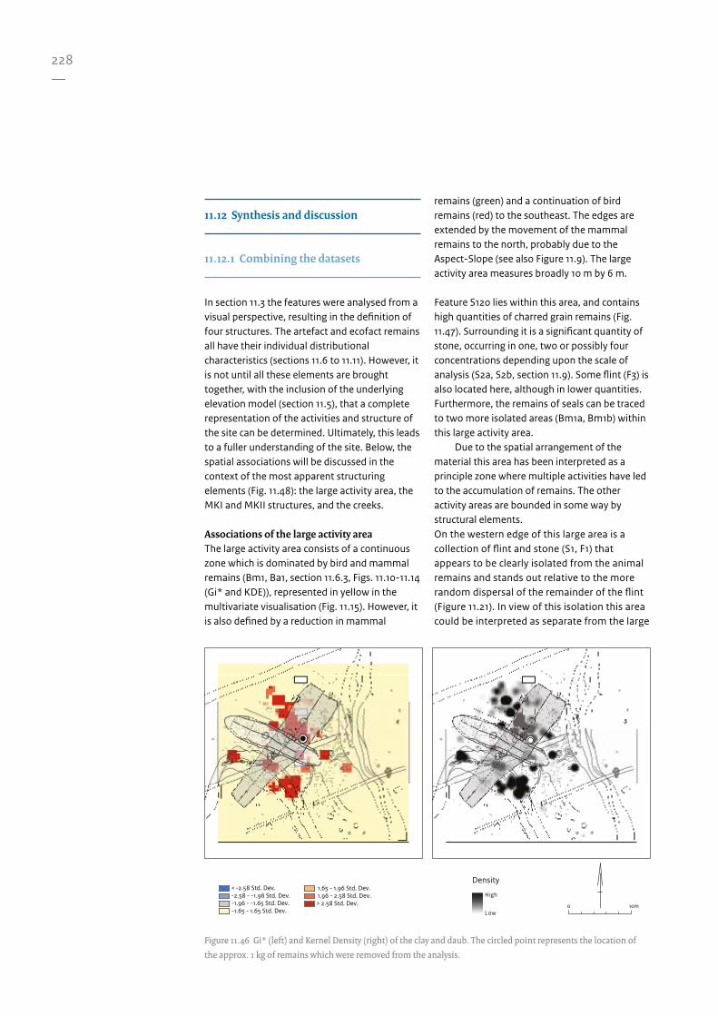
228—
Figure 11.46 Gi* (left) and Kernel Density (right) of the clay and daub. The circled point represents the location of
the approx. 1 kg of remains which were removed from the analysis.
High
Low
Density
10m0
< -2.58 Std. Dev. -2.58 - -1.96 Std. Dev.-1.96 - -1.65 Std. Dev.-1.65 - 1.65 Std. Dev.
1.65 - 1.96 Std. Dev.1.96 - 2.58 Std. Dev.> 2.58 Std. Dev.
11.12 Synthesis and discussion
11.12.1 Combining the datasets
In section 11.3 the features were analysed from a visual perspective, resulting in the definition of four structures. The artefact and ecofact remains all have their individual distributional characteristics (sections 11.6 to 11.11). However, it is not until all these elements are brought together, with the inclusion of the underlying elevation model (section 11.5), that a complete representation of the activities and structure of the site can be determined. Ultimately, this leads to a fuller understanding of the site. Below, the spatial associations will be discussed in the context of the most apparent structuring elements (Fig. 11.48): the large activity area, the MKI and MKII structures, and the creeks.
Associations of the large activity areaThe large activity area consists of a continuous zone which is dominated by bird and mammal remains (Bm1, Ba1, section 11.6.3, Figs. 11.10-11.14 (Gi* and KDE)), represented in yellow in the multivariate visualisation (Fig. 11.15). However, it is also defined by a reduction in mammal
remains (green) and a continuation of bird remains (red) to the southeast. The edges are extended by the movement of the mammal remains to the north, probably due to the Aspect-Slope (see also Figure 11.9). The large activity area measures broadly 10 m by 6 m.
Feature S120 lies within this area, and contains high quantities of charred grain remains (Fig. 11.47). Surrounding it is a significant quantity of stone, occurring in one, two or possibly four concentrations depending upon the scale of analysis (S2a, S2b, section 11.9). Some flint (F3) is also located here, although in lower quantities. Furthermore, the remains of seals can be traced to two more isolated areas (Bm1a, Bm1b) within this large activity area.
Due to the spatial arrangement of the material this area has been interpreted as a principle zone where multiple activities have led to the accumulation of remains. The other activity areas are bounded in some way by structural elements. On the western edge of this large area is a collection of flint and stone (S1, F1) that appears to be clearly isolated from the animal remains and stands out relative to the more random dispersal of the remainder of the flint (Figure 11.21). In view of this isolation this area could be interpreted as separate from the large

229—
activity area or an addition to it.
Associations of the MKII structureThe southwestern edge of this area coincides with the external wall of the proposed MKII structure. This boundary is defined not only by the wall structure, but also by various artefact categories. Flint (F4a) and stone (S3) occur together between the large activity area and the southwestern creek. Material continues into this creek due to gravitational displacement on the slope (Fig. 11.49). In consideration of this, it is evident that the majority of the material was formerly contained within the area defined by the MKII structure, surrounding the hearth (hearth 1). The structure, or at least the walls, must have disappeared before displacement of the material could take place. This is assumed to have happened during a phase of abandonment after the structure had decayed or been removed.
The flint refitting (RMU 2) and waste-flakes-splinter association (Fig. 11.21) indicates that flint knapping took place in the vicinity of the hearth, and possibly outside the MKII structure (RMU 9), assuming this material has not been displaced from within the structure. The amber, which is located in the area of the MKII structure (A1), has been displaced towards the southwestern creek for the reasons outlined above, and represents an amber working area which is close to the hearth.
The relationship of the hearth to the MKII structure has been derived from its association with the preceding artefact categories and its location. It is positioned centrally relative to the central post line, albeit slightly to the northwest.
A concentration of stone (S5) is possibly associated with the MKII structure, although this remains unclear. The distribution of daub and clay can be interpreted as a collapsed wattle and daub wall which formed the exterior of the structure. Unfortunately none of the ceramic vessels can be firmly attributed to the structure. However, some are dispersed in such a way as to suggest that they could have originated from within the structure (Table 11.7).
Associations of the MKI structureLittle in the distribution patterns of artefact and ecofact categories corresponds to the MKI structure, as compared with the MKII structure. This might give rise to doubts about the
reliability of the definition of this structure. However, the interpretation of the MKI structure can be substantiated by an assessment of the distributions in terms of the absence of material. This is discussed in more detail in the following section.
One posthole of the northeastern long wall cuts through feature S120, indicating a lack of association with this feature, and consequently also the large activity area. This can be used to further explain the absence of mammal bones within the structure. It would appear that the bird remains have survived as they were trampled into the ground surface, whereas the mammal remains would have been more susceptible/liable to fragmentation, disintegration and displacement due to their greater size.
The presence of a boundary within the vicinity of the long northeastern wall of the MKI structure shows a relative absence of the mammal remains inside, in contrast with the presence of mammal remains outside. Bird remains occur both inside and outside the structure.
Two hearths exist within the outline of the structure: hearth 2 and the hearth pit. Hearth 2 appears to correspond to the MKI structure in view of associated artefactual evidence (section 11.7). Flint indicates that knapping took place in the location of this hearth (F4b); this flint material is bounded by both long walls of the structure. The hearth pit, however, is harder to associate with this structure. It cannot correspond to the MKII structure as it coincides with one of its walls. Association with the MKI structure therefore remains a possibility, although no supporting evidence can be derived from the artefact remains. In contrast, the grave occupies a clear position within the MKI configuration. It is positioned exactly on the central line of the structure. In addition, based upon stratigraphy, the phasing (section 11.12.3) associates the grave with the same phase as the MKI structure, representing the final set of activities at the site.
Associations of the creeksThroughout this chapter material has been observed within the two creeks; these are ‘negative’ features, and as such one would expect them to naturally accumulate material. This material could also have a higher potential
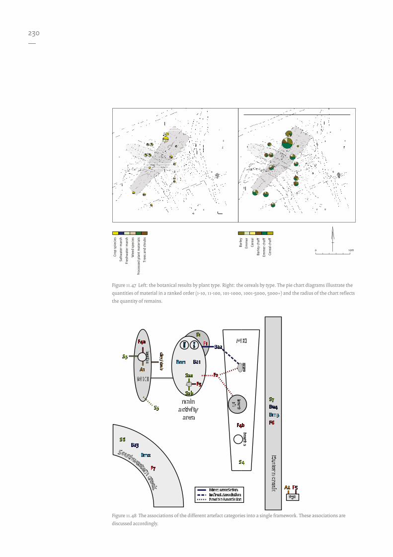
230—
Figure 11.47 Left: the botanical results by plant type. Right: the cereals by type. The pie chart diagrams illustrate the
quantities of material in a ranked order (1-10, 11-100, 101-1000, 1001-5000, 5000+) and the radius of the chart reflects
the quantity of remains.
Figure 11.48 The associations of the different artefact categories into a single framework. These associations are
discussed accordingly.
Crop
spi
ecie
s
Saltw
ater
mar
sh
Fres
hwat
er m
arsh
Wee
d sp
ecie
s
Proc
esse
d pl
ant m
ater
ials
Tree
s an
d sh
rubs
Barle
y
Emm
er
Cere
al
Barle
y ch
a�
Emm
er c
ha�
Cere
al c
ha�
10m0
F2F2
Bm2Bm2
F7F7
Ba2Ba2
Ba3Ba3S6S6
F6F6
Bm3Bm3
Ba4Ba4S7S7
F1F1
F3F3
Bm1Bm1
Bm1a
Bm1a
Bm1b
Bm1b
Ba1Ba1
S1S1
S2aS2a
S2bS2b
F4aF4a
A1A1
S3S3
S5S5
clay / daubclay / daub
hearth 1hearth 1
MKIIMKII
F4bF4b
S4S4
gravegrave
hearth 2hearth 2
hearthpit
hearthpit
MKIMKI
F5F5A2A2
S138S138
Direct associationIndirect AssociationPossible Association
Direct associationIndirect AssociationPossible Association
Southwestern creek
Southwestern creek
Eastern creekEastern creek
main activity
area
main activity
area

231—
for preservation. The dispersal of the materials from the MKII structure seems to be primarily related to down slope displacement of materials, as would be expected in relation to the underlying topography (Fig. 11.49). This dispersal is also seen in the amber distribution; it is not therefore thought that this material is the result of the discarding of refuse or other deliberate behaviour.
11.12.2 Remaining elements
There are a few elements which have not been discussed, due to their lack of association with the two structures (MKII and MKI) and the lack
of clear evidence for other structures.The pits to the south lack large quantities of
material remains, a feature that appears common in SGC settlements. Their function is unclear and the sections do not provide sufficient indications of their use. However, use as water holes as at Keinsmerbrug440 would seem to be a reasonable assumption. Such features would be expected to be associated with habitation and therefore a settlement phase of the site. The association of pit S138 located in the southeast of the excavated area cannot be reliably linked to either phase of the site. The possible plough mark which was discussed earlier is also indicated.
Two other possible structures can be suggested (Fig. 11.50). They were identified
W
N
S
E
NENW
SWSE
MKIAsh deposits MKIIPits Postholes
5m0
Figure 11.49 The Slope Aspect map indicating the areas with varying degrees of steepness as well as direction.
440 Smit et al. 2012.

232—
by means of visual dot-to-dot methods for joining postholes, and remain strictly hypothetical. The more northerly is represented by an area measuring 8.5 m by 4 m. Within this area lies a pit with two features extruding from it, one joining each of the two creeks. These two features have been interpreted as paths in the archive documentation, but it is thought more likely that they represent water channels. There are low quantities of material in this area, although stone (S5) may be related. The edge of the material to the southwest as indicated in Figure 11.51 does appear to signify a limit to the spread of the remains. But without further, more substantial evidence, no further structures can be determined with any degree of confidence.
There are a number of cow hoof marks, which would appear to be contained within what could
be the remains of a fence line. The containment of the hoof marks is questionable, as they do not extend to this fence line; they appear to correspond more to the edge of the field drawing, indicating a bias in recording between areas. With the occurrence of hoofmarks in both the creeks it is suggested that cows might have been free to move within the site. A possible multiphase post line has also been identified; a few of the posts were represented within the profile sections at different levels. However these different levels could be due to the lack of clear archaeological visibility with very little contract between the upper fill of the postholes and that of the cultural layer in which they are situated.
The presence of fences and walls could be demonstrated from the distribution of fish bones. As seen at Keinsmerbrug, they have the potential to line the walls of structures.
E a s
t e r
n
c r
e e
k
(N e
o l
i t h
i c)
E a s
t e r
n
c r
e e
k
(N e
o l
i t h
i c)
test pittest pit
test pittest pit
test pittest pit
S120S120
ditch (Medieval)
ditch (Medieval)
ditch (Medieval)
ditch (Medieval)
ditch (Medieval)
ditch (Medieval)
ditch (Medieval)
ditch (Medieval)
D A T A E X T E N
TD
A T A E X T E N T
S o u t h w e s t e r n c r e e k (N e o l i t h i c)
S o u t h w e s t e r n c r e e k (N e o l i t h i c)
cre ek (Medieval)
cre ek (Medieval)
creek (Medieval)
creek (Medieval)
D A
T A
E
X T
E N
TD
A T
A
E X
T E
N T
D A T A E X T E N TD A T A E X T E N T
D A T A E X T E N TD A T A E X T E N T
MKIIIMKIII
MKIV
MKIV
poss
ible
fenc
e lin
e
poss
ible
fenc
e lin
e
possible multi-phase post line
possible multi-phase post line
cow hoof marks
cow hoof marksco
w h
oof m
arks
cow
hoo
f mar
ks
cow hoof marks
cow hoof marks
ploughmark
ploughmark
Cow hoof marksAsh deposits MKIII/IVCreeks Pits Postholes Test pits
5m0
Figure 11.50 Possible other features and interpretations.

233—
However, the fish bone data would be expected to correspond to the large activity area. This would be a very good way to test the results presented here.
11.12.3 Phasing
As explained in Chapter 3 the site’s stratigraphy could not be reconstructed. However, there are clues to a more general phasing of the site based upon various spatial associations. The creeks, especially the southwestern creek, are central to this line of reasoning.
The MKII structure appears to be situated on the outer bank of the southwestern creek, as indicated by the elevation model illustrated in Figure 11.49. The alignment of the structure
appears to correspond to that of the creek. The creek would have been open at the time of habitation, allowing for the natural accumulation of material. The displacement of material from within the MKII structure also indicates that the creek was open but gradually filling up during habitation. The remains of a possible skin-lined canoe441 and quantities of other find materials within the creek suggest that these were more likely to be associated with the MKII structure and related activities.
The MKI structure overlies the southwestern creek, and would have been built following the natural filling of the creek. If this was not the case postholes would have reached the base of the creek, and consequently would have been recorded by the excavators. A single post from the MKI structure cuts through feature S120, supporting the association of feature S120 with 441 Nobles, this volume Chapter 12.
Flint
StoneAnim
al
MKI MKIIPits Postholes
5m0
Test pits
Figure 11.51 Multivariate visualisation of the animal, stone and flint material.
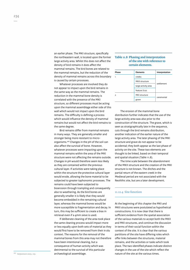
234—
442 Serjeantson 2009, 109.
an earlier phase. The MKI structure, specifically the northeastern wall, is located upon the former large activity area. Whilst this does not affect the density of bird remains it does affect the mammal remains. The bird bones are related to the mammal remains, but the reduction of the density of mammal remains across this boundary is caused by certain processes.
Whatever processes are involved they do not appear to impact upon the bird remains in the same way as the mammal remains. The reduction in the mammal bone density is correlated with the presence of the MKI structure, so different processes must be acting upon the mammal assemblage either side of this wall which would not impact upon the bird remains. The difficulty is defining a process which would influence the density of mammal remains but would not affect the bird remains to the same degree.
Bird remains differ from mammal remains in many ways. They are generally smaller and stronger being more resistant to micro-organisms.442 Changes in the pH of the soil can also affect the survival of bone. However, whatever processes were impacting upon the mammal remains within the area of the MKI structure were not affecting the remains outside. Changes in pH would therefore seem less likely as they are contained within the previous cultural layer. If activities were taking place within the structure the protective cultural layer would erode, allowing the bone material to be subjected to greater taphonomic processes. The remains could have been subjected to bioerosion through trampling and consequently also to weathering. As the bird bones are generally smaller it is likely that they would become embedded in the remaining cultural layer, whereas the mammal bones would be more susceptible to fragmentation and decay. In turn, this may be sufficient to create a bias in retrieval even if a 4mm sieve is used.
If deliberate cleaning of the area took place the same cleaning process would impact more or less equally upon both sets of material as they would first have to be removed from their in situ context. The reasons for the removal of the mammal bones from this area may not therefore have been intentional cleaning, but a consequence of human activity which was detrimental to the survival of this particular archaeological assemblage.
The erosion of the mammal bone distribution further indicates that the use of the large activity area was also prior to the construction of the structure. The grave, which is seen as stratigraphically late in the sequence, cuts through the bird remains distribution, another indication of the earlier nature of the large activity area. The later phasing of the MKI structure and grave do not appear to be accidental; they both appear as the last phase of activity on the site. These two elements are thought to be linked, based on their temporal and spatial situation (Table 11.8).
The time scale between the abandonment of the MKII structure and the creation of the MKI structure is not known. The ditches and the partial return of the eastern creek in the Medieval period are not associated with the Neolithic site, but are a later development.
11.12.4 Site function
At the beginning of this chapter the MKI and MKII structures were postulated as hypothetical constructions. It is now clear that there is sufficient evidence from the spatial association of the various materials to accept both the MKII and MKI structures, and continue the discussion in terms of their social function within the context of the site. It is clear that the various partitions of the site have differing roles which offer links between the structures, material remains, and the activities or tasks which took place. The two identified phases indicate distinct changes in the use of the site which reflect the nature of the site at the various times.
Table 11.8 Phasing and interpretation of the site with reference to certain elements.
Phase Elements Interpretation
1 creeks
settlementMKII structure
large activity area
feature S120
2 MKI structureceremonial
grave

235—
The function and form of the MKII structureThe MKII structure appears to represent the first phase of human activity at the site. The juxtaposition of animal remains in the large activity area with the stone (including flint) and amber material within the structure indicates a deliberate segregation of contemporaneous activities. This is clearly illustrated in Figure 11.51. The large activity area is clearly visible through the remains of the animal bones; this is likely to relate to the processing of the animal carcasses for the processing of meat. The seal remains indicate the processing of hides. Feature S120, which is situated within this activity area, contains, and is surrounded by, a high quantity of charred grain remains. This is surrounded by stone material, which indicates a high possibility for the processing of cereals. Whether these cereals were locally produced is a matter of
opinion. As suggested in Chapter 3 (Section 3.2.7) there is the possibility of an ard mark, which could indicate local production. Equally, from the perspective of this chapter there is no reason why cereal remains could not come from elsewhere; a mixture of these two models would also be possible. On the edge of this area is a grouping of flint and stone. This could potentially represent a stored collection but would require further investigation to determine. Within the structure, craft activities are represented by an amber bead production area. This is located next to the hearth, which is also associated with flint knapping and the use of stone material.
It is highly probable that other craft activities, which cannot be identified from an archaeo-spatial perspective, also took place both within and outside the structure. The
N
2.5m0
Figure 11.52 Illustrative reconstruction of the MKII structure.

236—
outside craft activities are likely to be restricted to the large activity area. This suggests there were cultural rules regarding attitudes towards the use and disposal of certain materials in regard to discard behaviour, as the juxtaposition of stone and organic remains is so distinct
All of the material related to the MKII structure appears to reflect activity of a domestic nature. Therefore the only interpretation which can be presented is that MKII represents a structure with a domestic function: a house.
This house is naviform in shape, measuring 16.5 by 4 m. It would have had a reed roof which was continuous around the structure, providing the only link between the central post line and external post line. The exterior wall was given a daub finish. It is not clear whether the inner post or the outer posts of the post pairings were part of the exterior wall. If the outer posts formed the wall then the inner posts would have supported the crossbeams, which in turn would support the central post line. If the daub wall was formed on the inner posts, the exterior posts would have served to support the roof and create an overhang.
Figure 11.52 illustrates a potential reconstruction based on the ground plan. As no entrances were identified none has been included. The heights of the walls, and the pitch and height of the roof are speculative. Yet the reconstruction serves to illustrate the general form and look the structure might have had.
No parallels from the SGC currently exist within the published literature for this type of structure. At Noordwijk-Bronsgeest, two partially overlapping early Bronze Age structures were identified, both naviform and measuring 12 and 16 m in length, consisting of a single central post line and a single post external wall.443 At the Bell Beaker site of Molenaarsgraaf there is a structure broadly naviform in shape with a double post wall and a single central post line.444
The function and form of the MKI structureThe MKI structure lacks the association of large quantities of animal remains seen with the MKII structure. Hearth 2 is contained within the structure. It has multiple firings – at least nine – and has some associated flint material (F4b). It is unclear whether the hearth pit is associated. As stated above, only the absence of material
10m0
Figure 11.53 Left Zeewijk-Oost structure (after Nobles in prep.). Right Mienakker MKI.
443 Van Heeringen & Van der Velde 1999.444 Louwe Kooijmans 1974.

237—
supports the definition of the structure, but this absence cannot suggest the role it might have played. For this, parallels with other similar structures have to be sought.
The form of the structure has some clear similarities with another structure. In the immediate vicinity, at the Zeewijk site, there is a comparable structure (Zeewijk-Oost). Initially they may look quite different, as Zeewijk-Oost is constructed from posts of a greater size and regularity, yet there are some clear and crucial similarities. These can be compared in Figure 11.53.
In both structures there are entrance posts at the wider end. They are both trapezoidal, and orientated southwest to northeast. The difference in orientation is only 5.42 degrees. By adjusting this orientation, the Mienakker structure can be superimposed onto the Zeewijk structure using the rear central post and two entrance posts as reference points. With no changes in scaling it is clear that the positions of these three posts are identical, as illustrated in Figure 11.54. Furthermore, there are extra postholes in the narrow end of both structures.
At Zeewijk, these have been described as a four-post arrangement,445 whereas in the Mienakker structure there is a more ‘horseshoe’ or ‘U-shaped’ shaped arrangement. If the Zeewijk structure is re-examined, then the four-post feature can be combined with a post from the central post line to create a similar ‘horse shoe’ shape. The initial stages of construction would appear to be identical. Firstly, the central post line would be set out, one post at the rear and the other at the front, oriented northeast to southwest. Once set out, a framing post for the entrance would be marked. This could be achieved by standing next to this post facing outwards from the structure and taking a side step to the right and half a step backwards. This would mark the location of the second entrance post. The structure would then take shape around these key elements. Given these similarities it is possible that the person or persons involved in the construction of the Mienakker structure were also involved in the building of the Zeewijk-Oost structure. In these two cases it is clear that the final designs differ, both in terms of construction materials and overall dimensions.
As there are large numbers of postholes in the MKI/MKII overlap area it is difficult to
associate particular postholes to either of the structures with any confidence. This is indicated through the use of dashed lines.
A central post line is possible, given the identification of centrally located postholes. However, due to the previous settlement activity these posts cannot be determined with any degree of certainty. This raises the question of whether the structure had, or was capable of supporting, a roof.
445 Hogestijn 1997, 35; Hogestijn & Drenth
2001, 61.
ZeewijkOost
MienakkerMK I
5m0
Figure 11.54 The two structures superimposed on each
other. The Zeewijk-Oost structure has been rotated
eastwards by 5.42 degrees. The north arrow belongs to
the Mienakker structure.
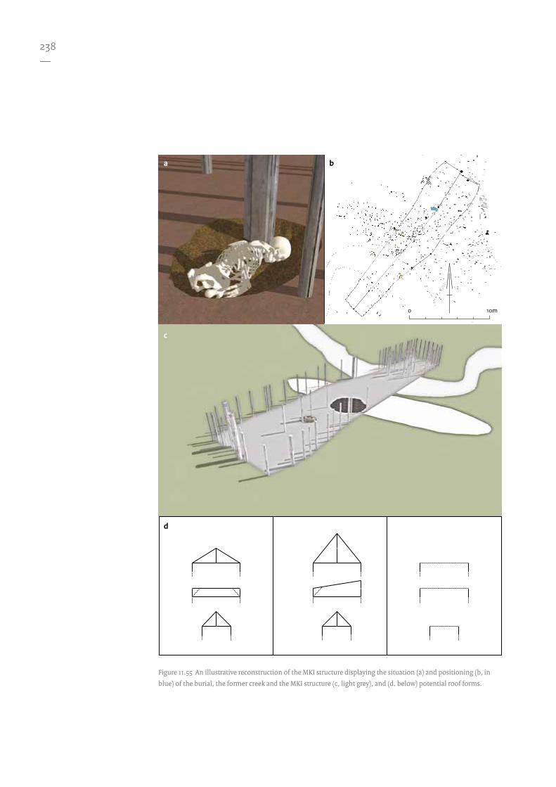
238—
10m0
Figure 11.55 An illustrative reconstruction of the MKI structure displaying the situation (a) and positioning (b, in
blue) of the burial, the former creek and the MKI structure (c, light grey), and (d. below) potential roof forms.
a
c
d
b

239—
Such a roof would have two potential forms (Fig. 11.55). A horizontal apex would result in a varied change in the pitch of the roof to a lower angle at the wider end, leading to greater dependence on a central post line. Since no substantial central post line can be determined, this option is less likely. Alternatively the pitch of the roof could remain the same, resulting in a change in the angle of the apex of the roof, being higher at the wider gabled end, and
possible creating a more impressive embellishment or imposing façade.
Again, this would add considerable weight to the supporting posts which would push the posts further into the natural substrate relative to those at the thinner end. No such situation was observed.
The fairly small postholes (relative to the MKII structure) could be presented as a flimsy construction. The reader should bear in mind that the postholes were recorded below the cultural layer and any associated postholes would cut through the cultural layer from a higher level allowing for the possibility of smaller postholes. However, the postholes at the thinner end would have cut through a much thinner cultural layer. Their widths do not appear to be significantly different to those in the remainder of the structure.
The trapezoidal form of the structure with such small-diameter postholes and the divergence of the long wall from a straight line, particularly the southeastern wall, would be less than ideal for a roof.
This creates the distinct possibility that the structure may not have had a roof at all. This, therefore, would cast doubt on any discussion regarding the structure as a dwelling or house.
There are other indications of the structure’s possible function. Although a hearth and possibly the hearth pit are associated, this does not necessarily suggest a domestic function. The location of a burial centrally within the wider end of a structure which also has a similar stratigraphical situation would suggest this is not a coincidence. In this respect the structure is not unique and fits into a certain category of structure which occurs throughout parts of Europe.
Wooden parallels can be identified at various earlier sites across Europe such as at Niedźwiedź and Pawłow in Poland446, and Fussell’s Lodge447 in England. The trapezoidal form is also reflected at many other sites including the Kujavian long barrows of the Polish lowlands and various sites in Denmark, such as at Storgård. This latter example (Fig. 11.56) illustrates the variability of the definition of the tomb which can be compared to the MKI structure’s southeastern wall, which also has a comparable orientation.
The entrance of the MKI structure appears to have been blocked by the presence of a few
10m0
Figure 11.56 The ground plan of the Early Neolithic long
barrow of Storgård in Denmark (after Kristensen 1989,
74, Fig. 3).
446 Rzepecki 2011.447 Ashbee 1970.

240—
448 Piggot 1962.449 Midgely 1992, 481. 450 Hogestijn 1992. 451 Hogestijn 1992, 203. 452 Hogestijn 1992, 1998, 2001. 453 Smit et al. 2012.
smaller postholes, forming a line which hinders movement within. The blocking of entrances is often seen in megalithic long barrows, a textbook example of which exists at West Kennet (Wiltshire, UK) where an entrance into the chamber is deliberately blocked.448
The structure was probably made of wood due to the absence of stone building materials, a direct consequence of the wetland geological situation. Large stone boulders would only be available on the earlier Pleistocene soils which are much further to the east and were used in the earlier TRB period for the construction of megalithic tombs (the Dutch Hunebedden).
Based upon these earlier trapezoidal parallels it would appear that the Mienakker (MKI) structure is a prime candidate for a wooden tomb in the style of similar long barrows. The burial in the wider end, as in the case of Mienakker, is often reflected in trapezoidal burial monuments. Thus the lack of any great quantity of identifiable domestic material remains, the presence of a grave in the wider end and the parallels with other trapezoidal structures would indicate that the MKI structure had a mortuary/ceremonial/ritual function.
The presence of a ceremonial or mortuary structure at a former settlement is not uncommon.449 However, this is the first time the Single Grave Culture and the wider Corded Ware Culture have been linked with such a practice. Quite how this form manifests itself within the Single Grave Culture is a topic for further debate, but it raises the issue of the context of settlement burials versus the individual flat graves which typify this cultural group. Ultimately this could provide a link to the earlier TRB communities, although more research is required before such a link can be proposed.
There also remains a distinct possibility that similar structures exist at the other settlement sites. However, the majority of these have undergone little or no archaeological excavation.
11.13 Conclusions
The site at Mienakker in its initial phase represents a single house settlement. This was later transformed into a place of ceremonial and ritual through the construction of the mortuary structure. Table 11.8 identifies the elements which are associated with the separate phases and the interpretation of the site’s main function.
The site was originally included in Hogestijn's two-group settlement model,450 and interpreted as a seasonal settlement for the purpose of processing cod and haddock, possibly for transportation to a larger population at permanent settlements.451 However, based upon the spatial analysis it is clear that the site at Mienakker was a settlement where people lived, hunted, herded and grazed their cattle. The people undertook craft activities and took to the water for fishing from their canoes. The presence of the later mortuary structure indicates a more complex relationship between the realms of the living and the dead, a key aspect which is missing from Hogestijn’s proposed settlement model. 452 As seen in the previous publication453 the use of a multi-approach analytical framework has yielded detail and provided support for the interpretation of structures at a previously excavated site. It challenges the structures previously published, and identifies their full extent. The identification of a mortuary structure is surprising, and potentially challenges long-held views regarding the association of these structures with the earlier periods only. This allows the potential integration of the transference of ideologies across archaeologically defined cultural barriers in time and space.

261—
In this bibliography reference to all mentioned literature is made. In addition to the standard way of citing, a special hyperlink has been added to some records. This hyperlink is a combination of a resolver (like http://dx.doi.org) and a ‘digital object identifier’ (DOI), a unique code which forever refers to the original digital document. This identifier is only present when a document is digitally made available through a trusted online repository. This DOI can be used to cite and link to an electronic document, whether it is a dataset in the DANS EASY archiving system, a journal article made available on ScienceDirect (or any other online publisher) or a book section in a university repository. By clicking on the hyperlink, one finds the official location of the digital document on the World Wide Web.
Adams, J.L., 1988: Use-wear analysis on manos and hide-processing stones, Journal of Field Archaeology 15, 307-315. http://dx.doi.org/ 10.1179/009346988791974394
Adams, J.L., 1999: Refocusing the role of food-grinding tools as correlates for subsistence strategies in the U.S. South-west, American Antiquity 64, 475-498. http://www.jstor.org/sta-ble/2694147
Adams, J.L., 2002: Mechanisms of wear on ground stone sur-faces, in: H. Procopiou & R. Treuil (eds), Moudre et broyer. L’interprétation fonctionnelle de l’outillage de mouture et de bro-yage dans la Préhistoire et l’Antiquité, Paris, 57-68.
Albarella, U., K. Dobney & P. Rowley-Conwy 2009: Size and shape of the Eurasian wild boar (Sus scrofa), with a view to the reconstruction of its Holocene history, Environmental Archaeology 14, 103-136. http://dx.doi.org/10.1179/146141009X12481709928283
Amkreutz, L.W.S.W. & R. Cor-bey 2008: An eagle-eyed per-spective. Haliaeetus albicilla in the Mesolithic and Neolithic of the Lower Rhine Area, in: H. Fokkens, B.J. Coles, A.L. van Gijn, J.P. Kleijne, H.H. Ponjee & C.G. Slappendel (eds), Between foraging and farming. An extended broad spectrum of papers presented to Leendert Louwe Kooijmans, Lei-den (Analecta Praehistorica Leidensia 40), 167-180. http://www.persistent-identifier.nl/? identifier=urn:nbn:nl:ui:13-pej-6ha
Andersen, N.H., 2004: Sarup: causewayed enclosures placed in a Neolithic ritual landscape on Funen, Denmark, Journal of Nordic Archaeological Science 14, 11-17.
Andersen, S.H., 1987: Tybrind Vig: a submerged Ertebølle set-tlement in Denmark, in: J.M. Coles & A.J. Lawson (eds), Euro-pean wetlands in Prehistory, Ox-ford, 253-280.
Andrefsky, W.J., 1994: Raw-material availability and the organization of technology, American Antiquity 59, 21-34. http://www.jstor.org/sta-ble/3085499
Arnoldussen, S. & D.R. Fontijn 2006: Towards familiar land-scapes? On the nature and ori-gin of Middle Bronze Age landscapes in the Netherlands, Proceedings of the Prehistoric Soci-ety 72, 289-317.
Ashbee, P., 1970: The earthen long barrow in Britain, London.
Bakels, C.C., 1988: Hekelingen: a Neolithic site in the swamps of the Meuse estuary, in: H. Küster (ed.), Der prähistorische Mensch und seine Umwelt, Stutt-gart (Forschungen und Berichte zur Vor- und Frühgeschichte in Baden-Württemberg 31), 155-161.
Bakels, C.C., 2006: Pollen anal-ysis and the reconstruction of the former vegetation, in: L.P. Louwe Kooijmans & P.F.B. Jongste (eds), Schipluiden: a Neo-lithic settlement on the Dutch North Sea coast c. 3500 cal BC, Leiden (Analecta Praehistorica Leiden-sia 37/38), 305-315. http://www.persistent-identifier.nl/? identifier=urn:nbn:nl:ui:13-bi6-nuy
Bakels, C.C. & J.T. Zeiler 2005: The fruits of the land. Neolithic subsistence, in: L.P. Louwe Kooijmans, P.W. van den Broe-ke, H. Fokkens & A.L. van Gijn (eds), The Prehistory of the Nether-lands, Amsterdam, 311-335.
Bartosiewicz, L., L. Zapata & C.J. Bonsall 2010: A tale of two shell middens. The natural ver-sus the cultural in “Obanian” deposits at Carding Mill Bay, Oban, Western Scotland, in: A.M. Vanderwarker & T.M. Pe-res (eds), Integrating zooarchaeo-logy and paleoethnobotany. A con-sideration of issues, methods, and cases, New York, 205-225.
Bass, W.M., 2005: Human oste-ology. A laboratory and field ma-nual. Columbia.
Bazelmans, J.G.A., M.J. van der Meulen & H.J.T. Weerts 2011: Atlas van Nederland in het Holoceen, Amsterdam.
Bibliography

262—
Beckerman, S.M., 2012a: Dutch beaker chronology re-examined, Palaeohistoria 53/54, 25-64.
Beckerman, S.M., 2012b: Ceram-ics, in: B.I. Smit, O. Brinkkem-per, J.P. Kleijne, R.C.G.M. Lau-werier & E.M. Theunissen (eds), A kaleidoscope of gathering at Keinsmerbrug (the Netherlands). Late Neolithic behavioural varia-bility in a dynamic landscape, Amersfoort (Nederlandse Archeologische Rapporten 43), 35-56.
Beerenhout, B., 1991: Mienak-ker: verslag van het onderzoek aan de visresten, Amersfoort (intern rapport ROB).
Beerenhout, B., 1994: What conclusions can be drawn from mature haddock bones in a Neolithic site in the Nether-lands?, Offa 51, 341-347.
Beerenhout, B., 1996: Vissen bij Wateringen (Zuid-Holland) rond 3700 v.Chr., Westerheem 45, 125-131.
Beets, D.J. & A.J.F. van der Spek 2000: The Holocene evo-lution of the barrier and the back-barrier basins of Belgium and the Netherlands as a func-tion of late Weichselian mor-phology, relative sea-level rise and sediment supply, Geologie en Mijnbouw 79, 3-16.
Bienenfeld, P., 1988: Stone tool use and the organisation of technology in the Dutch Neo-lithic, in: S. Beyries (ed.), Indus-tries lithiques: tracéologie et tech-nologie, Oxford (British Archaeological Reports Inter-national Series 411), 219-230.
Bijlsma, R.G., F. Hustings & C.J. Camphuysen 2001: Alge-mene en schaarse vogels van Ne-derland, Haarlem/Utrecht (Avi-fauna van Nederland 2).
Binder, D., C. Perlès, M.-L. Ini-zan & M. Lechevallier 1990: Strategies de gestion des outil-lages lithiques au Néolithique, Paléo 2, 257-283.
Bochenski, Z.M., 2004: Owls, diurnal raptors and humans: signatures on avian bones, in: T. O’Connor (ed.), Biosphere to lithosphere. New studies in verte-brate taphonomy (Proceedings of the 9th conference of the interna-tional council of archaeozoology, Durham, August 2002), Durham, 31-45.
Boon, J.J., 2006: Analytical re-port on some archaeological charred residues from Schiplui-den, in: L.P. Louwe Kooijmans & P.F.B. Jongste (eds), Schiplui-den: a Neolithic settlement on the Dutch North Sea coast c. 3500 cal BC, Leiden (Analecta Praehisto-rica Leidensia 37/38), 353-361. http://www.persistent-identifier.nl/? identifier=urn:nbn:nl:ui:13-bi6-nuy
Boon, J.J. & T.F.M. Oudemans 2007: A comparative study of extractable lipids in the sherds and surface residual crusts of ceramic vessels from Neolithic and Roman Iron Age settle-ments in the Netherlands, in: H. Barnard & J.W. Eerkens (eds), Theory and practice of archaeologi-cal residue analysis, Oxford (Bri-tish Archaeological Reports In-ternational Series 1650), 99-124.
Bos, J.A.A., B. van Geel, B.J. Groenewoudt & R.C.G.M. Lau-werier 2005: Early Holocene environmental change, the presence and disappearance of early Mesolithic habitation near Zutphen (the Nether-lands), Vegetation History and Ar-chaeobotany 15, 27-43. http://dx.doi.org/10.1007/s00334-004-0056-5
Boschian, G. & E. Montagnari-Kokelj 2000: Prehistoric shep-herds and caves in the Trieste Karst (Northeastern Italy), Geo-archaeology 15, 331-371. http://dx.doi.org/10.1002/(SICI)1520-6548(200004) 15:4<331::AID-GEA3>3.0.CO;2-H
Bovy, K.M., 2002: Differential avian skeletal part distribution: explaining the abundance of wings, Journal of Archaeological Science 29, 965-978. http://dx.doi.org/10.1006/jasc.2001.0795
Braadbaart, F., 2004: Carboni-zation of peas and wheat. A win-dow into the past, Leiden (PhD thesis Leiden University).
Braadbaart, F. & I. Poole 2008: Morphological, chemical and physical changes during char-coalification of wood and its relevance to archaeological contexts, Journal of Archaeologi-cal Science 35, 2434–2445. http://dx.doi.org/10.1016/j.jas.2008.03.016
Brewer, C. & K. Marlow 1993: Color representation of aspect and slope simultaneously, in: Proceedings of the eleventh inter-national symposium on computer-assisted cartography (Auto-Car-to-11), Minneapolis, 328-337.
263—
Brink, J., 1978: The role of abrasives in the formation of lithic use-wear, Journal of Ar-chaeological Science 5, 363-371. http://dx.doi.org/10.1016/0305-4403(78)90055-9
Brinkhuizen, D.C., 1992: Het dieet van de otter (Lutra lutra), in De Deelen en de Oude Venen (Fries-land), bepaald door middel van analyse van spraints, Groningen.
Brinkhuizen, D.C. & K. Hän-ninen 2011: Een visfuik in een waterput, in: W. Roessingh & E. Lohof (eds), Bronstijdboeren op de kwelders. Archeologisch onder-zoek in Enkhuizen-Kadijken, Amersfoort (ADC Rapport 2200, ADC Monografie 11), 241-249. http://www.persistent-identifier.nl/ ?identifier=urn:nbn:nl: ui:13-9jf-vqg
Bronk Ramsey, C., 2009: Baye-sian analysis of radiocarbon dates, Radiocarbon 51, 337-360.
Brooks, S. & J.M. Suchey 1990: Skeletal age determination based on the Os Pubis. A com-parision of the Acsádi-Nemes-kéri and Suckey-Brooks me-thods, Human Evolution 5, 227-238. http://dx.doi.org/10.1007/BF02437238
Brothwell, D.R., 1981: Digging up bones. The excavation, treat-ment, and study of human skeletal remains, London.
Buckberry, J.L. & A.T. Cham-berlain 2002: Age estimation from the auricular surface of the Illium. A revised method, American Journal of Physical An-thropology 119, 231-239. http://www.ncbi.nlm.nih.gov/ pubmed/12365035
Buikstra, J.E. & D.H. Ubelaker 1994: Standards for data collection from human skeletal remains, Fay-etteville (Arkansas Archaeolo-gical Survey Report 44).
Bulten, E.E.B., 2001: Het barn-steen van de laat-neolithische nederzetting “Mienakker”: Een onderzoek naar de bewerking van barnsteen in een nederzet-ting van de Enkelgrafcultuur, in: R.M. van Heeringen & E.M. Theunissen (eds), Kwaliteitsbe-palend onderzoek ten behoeve van duurzaam behoud van neolithische terreinen in West-Friesland en de Kop van Noord-Holland, deel 3: archeologische onderzoeksversla-gen, Amersfoort (Nederlandse Archeologische Rapporten 21), 471-483. http://www.persistent-identifier.nl/? identifier=urn : nbn:nl:ui:13-clt-stg
Bulten, E.E.B., J.W.H. Hogesti-jn & S.W. Jager 1990: De Gouw. Een aanvullend onderzoek naar sporen van bewoning uit het laat-Neolithicum en de vroege Bronstijd in het ruilverkavelingsgebied De Gouw, Amersfoort (intern rap-port ROB).
Bulten, E.E.B., F.J.G. van der Heijden & T. Hamburg 2002: Emmeloord. Prehistorische visweren en fuiken, Bunschoten (ADC Rapport 140).
Bulten, E.E.B., F.J.G. van der Heijden & T. Hamburg 2009: Prehistorische visweren en fuiken op kavel J97 bij Emmel-oord, Archeologie 13, 47-62.
Busschers, F.S., C. Kasse, R.T. van Balen, J. Vandenberghe, K.M. Cohen, H.J.T. Weerts, J. Wallinga, C. Johns, P. Clever-inga & F.P.M. Bunnik 2007: Late Pleistocene evolution of the Rhine-Meuse system in the southern North Sea basin: im-prints of climate change, sea-level oscillation and glacio-iso-stacy, Quaternary Science Reviews 26, 3216-3248. http://dx.doi.org/10.1016/j.quascirev.2007.07.013
Butrimas, A., 1992: Corded pottery culture graves from Li-thuania, in: M. Buchvaldek & C. Strahm (eds), Die Kontinentaleu-ropäischen Gruppen der Kultur mit Schnurkeramik, Schnurkeramik Symposium 1990, Praha (Prae-historica XIX), 307-311.
Campana, D.V., 1980: An analy-sis of the use-wear patterns on Na-tufian and Proto-Neolithic bone implements, New York (PhD the-sis Columbia University).
Cappers, R.T.J., 1994: An ecolog-ical characterization of plant ma-cro-remains of Heveskesklooster (the Netherlands). A methodolog ic-al approach, Groningen (PhD thesis Groningen University). http://irs.ub.rug.nl/ppn/123942365
Cappers, R.T.J. & D.C.M. Rae-maekers 2008: Cereal cultiva-tion at Swifterbant? Neolithic wetland farming on the North European Plain, Current Anthro-pology 49, 385-402. http://dx.doi.org/10.1086/588494
Chapelle, H., 1983: Artic skin boats, in: E.T. Adney & H. Cha-pelle (eds), The bark canoes and skin boats of North America, Washington D.C., 174-211.

264—
Charles, M., G. Jones & J.G. Hodgson 1997: FIBS in ar-chaeobotany: functional inter-pretation of weed floras in re-lation to husbandry practices, Journal of Archaeological Science 24, 1151-1161. http://dx.doi.org/10.1006/jasc.1997.0194
Chestnut, V.K., 1974: Plants used by the indians of Mendocino coun-try, California, Forg Bragg (Con-tribution from the U.S. national herbarium VII).
Christidou, R., 1999: Outils en os néolithiques du Nord de la Grèce: étude technologique, Paris (PhD thesis University of Paris X).
Clason, A.T., 1967: Animal and man in Holland’s past, Groningen (Palaeohistoria 13).
Clemente Conte, I., 1997: Los instrumentos líticos de Túnel VII: una aproximación etnoarqueoló-gica, Madrid (Treballs d´Etnoarqueologia 2).
Conrad, M. & W.R. Teegen 2010: Gewalt und Konfliktaus-tragung im 3. Jahrtausend v. Chr. Ein Fallbeispiel aus Sach-sen, Archaeo 6, 48-53. Craig, N., M. Aldenderfer & H. Moyes 2006: Multivariate visu-alization and analysis of photo-mapped artifact scatters, Jour-nal of Archaeological Science 33, 1617–1627. http://dx.doi.org/10.1016/j.jas.2006.02.018
Croese, J., 2010: Gebruikssporen-onderzoek Molenaarsgraaf, Leiden (bachelor thesis Leiden Univer-sity). http://hdl.handle.net/1887/18806
D´Errico, F., 1993: Identifica-tion des traces de manipula-tion, suspension, polissage sur l´art mobilier en os, bois de cervidés, ivoire, in: P. Anderson, S. Beyries, M. Otte & H. Plisson (eds), Trace et fonction: les gestes retrouvés, Liège (ERAUL 50), 117-188.
Damm, C.B., 1991: Continuity and change. An analysis of social and material patterns in the Danish Neolithic, Cambridge (PhD the-sis Cambridge University). http://hdl.handle.net/10068/436981
David, N., J. Sterner & K. Gavua 1988: Why pots are decorated, Current Anthropology 29, 365-389. http://www.jstor.org/sta-ble/2743453
De Mulder, E.F.J. & J.H.A. Bosch 1982: Holocene stratig-raphy, radiocarbon datings and palaeogeography of central and northern North-Holland (the Netherlands), Mededelingen Rijks Geologische Dienst 36(3), 111-160.
De Vries, L.S., 1996: De fauna-resten van Zeewijk, een laatneoli-thische nederzetting in de Groetpol-der (N-H), Leiden (master thesis Leiden University).
De Vries, L.S., 2001: De fauna-resten van Zeewijk, een laat-neolithische nederzetting in de Groetpolder (N-H), in: R.M. van Heeringen & E.M. Theunissen (eds), Kwaliteitsbepalend onderzoek ten behoeve van duurzaam behoud van neolithische terreinen in West-Friesland en de Kop van Noord-Hol-land, deel 3: archeologische onder-zoeksverslagen, Amersfoort (Nederlandse Archeologische Rapporten 21), 281-332. http://www.persistent-identifier.nl/? identifier=urn:nbn:nl:ui:13-clt-stg
Delagado Raack, S., D. Gómez Gras & R. Risch 2008: Las pro-piedades mecánicas de los ar-tefactos macrolíticos: una base metodológica para el análisis funcional/The mechanical pro-perties of macrolithic artefacts: a methodological background for functional analysis, in: S. Rovira Llorens, M. García-Heras, M. Gener Moret & I. Monero Ruíz (eds), Proceedings of VII congreso Ibérico de arqueo-metría (8-10 Octubre), Madrid, 330-345.
Desse-Berset, N., 2009: First archaeozoological identifica-tion of Atlantic sturgeon (Aci-penser oxyrinchus Mitchill 1815) in France, Comptes Rendus Palevol 8, 717-724.http://dx.doi.org/10.1016/j.crpv.2009.06.001
Desse-Berset, N., 2011: Ancient sturgeon populations in France through archaeozoological remains, from prehistoric time until the eighteenth century, in: P. Williot, E. Rocard, N. Desse-Berset, F. Kirschbaum & J. Gessner (eds), Biology and con-servation of the European sturgeon Acipenser sturio L. 1758. The reun-ion of the European and Atlantic sturgeons, Berlin/Heidelberg, 91-116.
DiBennardo, R. & J.V. Taylor 1979: Sex assessment of the Femur. A test of a new method, American Journal of Physical An-thropology 50, 635-638. http://dx.doi.org/10.1002/ajpa.1330500415
Dietler, M. & I. Herbich 1989: Tich Matek: the technology of Luo pottery production and the definition of ceramic style, World Archaeology 21, 148-164. http://www.jstor.org/stable/124490

265—
Dörfler, W. & J. Müller 2008: Umwelt – Wirtschaft – Siedlungen im dritten vorchristlichen Jahrtau-send Mitteleuropas und Südskandi-naviens, Neumünster (Offa 84).
Drenth, E., O. Brinkkemper & R.C.G.M. Lauwerier 2008: Sin-gle Grave Culture settlements in the Netherlands: the state of affairs anno 2006, in: W. Dör-fler & J. Müller (eds), Umwelt – Wirtschaft – Siedlungen im dritten vorchristlichen Jahrtausend Mit-teleuropas und Südskandinaviens, Neumünster (Offa 84), 149-181.
Drenth, E. & J.W.H. Hogestijn 1999: De klokbekercultuur in Nederland: De stand van on-derzoek anno 1999, Archeologie 9, 99-149.
Drenth, E. & J.W.H. Hogestijn 2001: The Bell Beaker Culture in the Netherlands: the state of research in 1998, in: F. Nicolis (ed.), Bell Beakers today. Pottery, people, culture, symbols in prehis-toric Europe. Proceedings of the in-ternational colloquium Riva del Garda (Trento, Italy), 11-16 May 1998, Trento, 309-332.
Drenth, E. & H. Kars 1990: Non-flint stone tools from two Late Neolithic sites at Kolhorn, Province of North Holland, the Netherlands, Palaeohistoria 32, 21-46.
Drenth, E. & A.E. Lanting 1991: Die Chronologie die Einzelgrab-kultur in den Niederlanden. Ei-nige vorläufige Bemerkungen, in: C. Strahm (ed.), Internationa-les Symposium. Die kontinentaleu-ropäischen Gruppen der Kultur mit Schnurkeramik, Praha-Stirin 1.-6.10.1990. Die Chronologie der regi-onalen Gruppen. Zusammenfassun-gen, Freiburg, 103-114.
Drenth, E. & E. Lohof 2005: Mounds for the dead. Funerary and burial ritual in Beaker pe-riod, Early and Middle Bronze Age in: L.P. Louwe Kooijmans, P.W. van den Broeke, H. Fok-kens & A.L. van Gijn (eds), The Prehistory of the Netherlands, Am-sterdam, 433-454.
Duday, H., 2006: Archaeotha-natology or the archaeology of death (l’archéothanatologie ou l’archéologie de la mort), in: R. Gowland & C.J. Knüsel (eds), Social archaeology of funerary remains, Oxford, 30-56.
Ellmers, D., 1980: Ein Fellboot-Fragment der Ahrensburger Kultur aus Husum, Schleswig-Holstein?, Offa 37, 12-16.
Ellmers, D., 1984: The earliest evidence for skinboats in Late-Palaeolithic Europe, in: S. Mc-Grail (ed.), Aspects of maritime archaeology and ethnography, London, 41-56.
Enghoff, I.B., 2011: Regionality and biotope exploitation in Danish Ertebølle and adjoining periods, København (Scientia Danica Series B: Biologica, vol. 1).
Ericson, P.G.P., 1987: Interpre-tations of archaeological bird remains: a taphonomical ap-proach, Journal of Archaeological Science 14, 65-75. http://dx.doi.org/10.1016/S0305-4403(87)80006-7
Exaltus, R.P., 1992: Micromorfo-logisch onderzoek van Mienakker, Amersfoort (intern rapport ROB).
Exaltus, R.P. & R. Miedema 1994: A micromorphological study of four Neolithic sites in the Dutch coastal provinces, Journal of Archaeological Science 21, 289-301. http://dx.doi.org/10.1006/jasc.1994.1029
Fernandes, R., S. Bergemann, S. Hartz, P.M. Grootes, M.-J. Nadeau, F. Melzner, A. Ra-kowski & M. Hüls 2012: Mus-sels with meat: bivalve tissue-shell radiocarbon age differences and archaeological implications, Radiocarbon 54, 953-965.
Fernandes, R., A. Dreves, M.-J. Nadeau & P.M. Grootes 2013: A freshwater lake saga: carbon routing within the aquatic food web of Lake Schwerin, Radio-carbon 55, in press.
Figueiral, I., 1995: Evidence from charcoal analysis for envi-ronmental change during the interval late Bronze Age to Ro-man, at the archaeological site of Castro de Penices, NW Por-tugal, Vegetation History and Ar-chaeobotany 4, 93–100. http://dx.doi.org/10.1007/BF00206917
Finnegan, M., 1978: Non-met-ric variation of the infracranial skeleton, Journal of Anatomy 125, 23-37. http://www.ncbi.nlm.nih.gov/pmc/articles/PMC1235564/
Fischer, U., 1956: Die Gräber der Steinzeit im Saalegebiet. Studien über neolithische und frühbronzezeitliche Grab- und Bestattungsformen in Sachsen-Thüringen, Berlin (Vorge-schichtliche Forschungen 15).
Fisher, A. & J. Heinemeier 2003: Freshwater reservoir ef-fect in 14C-dates of food resi-due on pottery, Radiocarbon 45, 449-466.
266—
Floore, P.M., 1991: Golfbandpot-ten van de Enkelgrafcultuur, Am-sterdam (master thesis Univer-sity of Amsterdam.
Fokkens, H., 2005a: Late Neo-lithic, Early and Middle Bronze Age: introduction, in: L.P. Lou-we Kooijmans, P.W. van den Broeke, H. Fokkens & A.L. van Gijn (eds), The Prehistory of the Netherlands, Amsterdam, 357-369.
Fokkens, H., 2005b: Voorbeel-dige voorouders: graven naar de ideeënwereld van prehistorische boerengemeenschappen, Leiden. http://hdl.handle.net/1887/4287
Fokkens, H., 2012: Background to Dutch beakers. A critical re-view of the Dutch model, in: H. Fokkens & F. Nicolis (eds), Back-ground to beakers. Inquiries into regional cultural backgrounds of the Bell Beaker complex, Leiden, 9-36.
Fontijn, D.R., 2002: Sacrificial landscapes. Cultural biographies of persons, objects and ‘natural’ places in the Bronze Age of the southern Netherlands, c. 2300-600 BC, Lei-den (Analecta Praehistorica Leidensia 33/34). http://www.persistent-identifier.nl/? identifier=urn:nbn:nl:ui:13-9cs-ip0
Furholt, M., 2003: Die abso-lutchronologische Datierung der Schnurkeramik in Mitteleuropa und Südskandinavien, Bonn (Univer-sitätsforschungen zur Prähisto-rischen Archäologie 101).
García-Díaz, V., 2012: Flint, amber and stone artefacts: technology, typology and use-wear analysis, in: B.I. Smit, O. Brinkkemper, J.P. Kleijne, R.C.G.M. Lauwerier & E.M. Theunissen (eds), A kaleidoscope of gathering at Keinsmerbrug (the Netherlands). Late Neolithic beha-vioural variability in a dynamic landscape, Amersfoort (Neder-landse Archeologische Rappor-ten 43), 57-80.
García-Díaz, V., in preparation: Flint, stone and bone, in: RCE (eds), Zeewijk, Amersfoort (Ne-derlandse Archeologische Rap-porten).
Gosselain, O.P., 2000: Material-izing identities: an African per-spective, Journal of Archaeological Method and Theory 7, 187-217. http://dx.doi.org/10.1023/ A:1026558503986
Gramsch, B., J. Beran, S. Hanik & R. Sommer 2013: A Palaeo-lithic fishhook made of ivory and the earliest fishhook tradi-tion in Europe, Journal of Archae-ological Science 40, 2458-2463. http://dx.doi.org/10.1016/j.jas.2013.01.010
Greenhill, B., 1976: Archaeology of the boat, London.
Habermehl, K.-H., 1975: Die Alterbestimmung bei Haus- und Labortieren, Berlijn/Hamburg.
Hamburg, T., C. Kruijshaar, J. Nientker, J.H.M. Peeters & A. Rast-Eicher 2001: Grondspo-ren: antropogene sporen en structuren, in: J.H.W. Hogestijn & J.H.M. Peeters (eds), De me-solithische en vroeg-neolithische vindplaats Hoge Vaart A27 (Flevo-land), Amersfoort (Rapportage Archeologische Monumenten-zorg 79). http://www.persistent-identifier.nl/? identifier=urn:nbn:nl:ui:13-xkx-dfx
Hather, J.G., 2000: The identifi-cation of the Northern European woods. A guide for archaeologists and conservators, London.
Henry, A., 2011: Paléoenvironne-ments et gestion des combustibles au Mésolithique dans le sud de la France: anthracologie, ethnoar-chéologie et expérimentation, Nice (PhD thesis Université de Nice). http://tel.archives-ouvertes.fr/tel-00726927
Higham, C.F.W., 1967: Stock rearing as a cultural factor in prehistoric Europe, Proceedings of the Prehistoric Society 33, 84-106.
Hillman, G.C., 1981: Recon-structing crop husbandry prac-tices from charred remains of crops, in: R.J. Mercer (ed.), Far-ming practice in British Prehistory, Edinburgh, 123-162.
Hillman, G.C., 1984: Interpreta-tion of archaeological plant remains: the application of eth-nographic model from Turkey, in: W. van Zeist & W.A. Casparie (eds), Plants and ancient man: stu-dies in palaeoethnobotany: pro-ceedings of the sixth symposium of the international work group for pa-laeoethnobotany, Groningen, 30 May-3 June 1983, Groningen, 1-41.

267—
Hirsch, K. & D. Liversage 1987: Ravforarbejdning i yngre stenalder, Nationalmuseets Arbe-jdsmark 1987, 193-200.
Hogestijn, J.W.H., 1992: Func-tional differences between some settlements of the Single Grave culture in the northwes-tern coastal area of the Nether-lands, in: M. Buchvaldek & C. Strahm (eds), Die Kontinentaleu-ropäischen Gruppen der Kultur mit Schnurkeramik, Schnurkeramik Symposium 1990, Praha (Prae-historica XIX), 199-205.
Hogestijn, J.W.H., 1997: Enkele resultaten van het archeo-logische onderzoek op twee woonplaatsen van de Enkel-grafcultuur bij Winkel in de Groetpolder, in: D.P. Hallewas, G.H. Scheepstra & P.J. Wolte-ring (eds), Dynamisch landschap. Archeologie en geologie van het Nederlandse kustgebied, Assen, 27-45.
Hogestijn, J.W.H., 1998: Enkele aspecten van het nederzet-tingssysteem van de Enkelgraf-cultuur in het westelijke kust-gebied van Nederland, in: J.H.C. Deeben & E. Drenth (eds), Bij-dragen aan het onderzoek naar de Steentijd in Nederland. Verslagen aan de ‘Steentijddag’ 1, Amers-foort (Rapportage Archeo-logische Monumentenzorg 68), 97-109. http://www.persistent-identifier.nl/? identifier=urn:nbn:nl:ui:13-dak-2v3
Hogestijn, J.W.H., 2001: Enkele aspecten van het nederzet-tingssysteem van de Enkelgraf-cultuur in het westelijk kustge-bied van Nederland, in: R.M. van Heeringen & E.M. Theunis-sen (eds), Kwaliteitsbepalend on-derzoek ten behoeve van duurzaam behoud van neolithische terreinen in West-Friesland en de Kop van Noord-Holland, deel 3: archeo-logische onderzoeksverslagen, Amersfoort (Nederlandse Archeologische Rapporten 21), 145-158. http://www.persistent-identifier.nl/? identifier=urn:nbn:nl:ui:13-clt-stg
Hogestijn, J.W.H., 2005: Shell fishers and cattle herders. Set-tlements of the Single Grave culture in Westfrisia in: L.P. Louwe Kooijmans, P.W. van den Broeke, H. Fokkens & A.L. van Gijn (eds), The Prehistory of the Netherlands, Amsterdam, 429-432.
Hogestijn, J.W.H. & E. Drenth 2000: The TRB culture ‘house-plan’ of Slootdorp-Bouwlust and other known ‘house plans’ from the Dutch Middle and Late Neolithic: a review, in: R. Kelm (ed.), Vom Pfostenloch zum Steinzeithaus. Archäologische For-schung und Rekonstruktion jungsteinzeitlicher Haus- und Sied-lungsbefunde im nortwestlichen Mitteleuropa, Heide, 126-154.
Houkes, R.A., 2011: Natuursteen, in: W. Roessingh & E. Lohof (eds), Bronstijdboeren op de kwel-ders. Archeologisch onderzoek in Enkhuizen-Kadijken, Amersfoort (ADC Rapport 2200), 223-234. http://www.persistent-identifier.nl/?identifier=urn:nbn:nl:ui:13-9jf-vqg
Houttuyn, F., 1764: Natuurlyke Historie of uitvoerige beschryving der Dieren, Planten en Mineraalen volgens het Samenstel van den Heer Linnaeus, Amsterdam.
Huisman, D.J., A.G. Jongmans & D.C.M. Raemaekers 2009: Investigating Neolithic land use in Swifterbant (NL) using mi-cromorphological techniques, Catena 78, 185-197. http://dx.doi.org/10.1016/j.catena.2009.03.006
Jacomet, S. & C. Brombacher 2005: Reconstructing intra-site patterns in Neolithic lakeshore settlements: the state of ar-chaeological research and fu-ture prospects, Collectio Archae-ologica 3, 69-94.
Johnstone, P., 1988: The sea-craft of Prehistory, London.
Jørgensen, G., 1977: Acorns as a food-source in the late Stone Age, Acta Archaeologica 48, 233-238.
Kleijne, J.P., 2008: Graves of the Corded Ware Culture in Poland and the Baltic region. Grave set or set-ting our own grave?, Leiden (un-published MPhil-report),
Kleijne, J.P., 2010: Approaching high flux interaction. Pottery, iden-tity and overseas contacts in the later Early and Middle Bronze Age (2000-1200 cal BC), of North West Europe, Leiden (MPhil thesis Leiden University). http://www.persistent-identifier.nl/? identifier=urn:nbn:nl:ui:13-8gh-9vw

268—
Kolár, J., 2012: Secondary mor-tuary practices during the Late Eneolithic in Moravia, Czech Re-public. State of knowledge, his-tory of research, terminology and interpretations, in: J. Kolár & F. Trampota (eds), Theoretical and methodological considerations in Central European Neolithic ar-chaeology, Oxford (BAR Interna-tional Series 2325), 25-44.
Kooistra, L.I., 2001: Houtskool uit een laat-neolithische site te Zijpe (Noord-Holland), in: R.M. van Heeringen & E.M. Theunis-sen (eds), Kwaliteitsbepalend on-derzoek ten behoeve van duurzaam behoud van neolithische terreinen in West-Friesland en de Kop van Noord-Holland, deel 3: archeo-logische onderzoeksverslagen, Amersfoort (Nederlandse Archeologische Rapporten 21), 203-212. http://www.persistent-identifier.nl/? identifier=urn:nbn:nl:ui:13-clt-stg
Kopytoff, I., 1986: The cultural biography of things: commodi-zation as process, in: A. Appa-durai (ed.), The social life of things. Commodities in a cultural perspective, Cambridge, 64-94.
Körber-Grohne, U., 1992: Stu-dies in salt marsh vegetation and their relevance to the re-construction of prehistoric plant communities, Review of Palaeobotany and Palynology 73, 167-180. http://dx.doi.org/10.1016/ 0034-6667(92)90055-L
Kossian, R., 2007: Hunte 1. Ein mittel- bis spätneolithischer und frühbronzezeitlicher Siedlungsplatz am Dümmer, Ldkr. Diepholz (Nie-dersachsen). Die Ergebnisse der Ausgrabungen des Reichsamtes für Vorgeschichte in den Jahren 1938 bis 1940, Hannover (Veröffent-lichungen der archäologischen Sammlungen des Landesmuse-ums Hannover 52).
Kovárová, T., 2004: The spatial distribution of artefacts in Cor-ded Ware graves, in: L. Šmejda & J. Turek (eds), Spatial analysis of funerary areas, Plzen, 21-37.
Kristensen, I.K., 1989: Storgård IV: an early long barrow near Fjelsø North Jutland, Journal of Danish Archaeology 8, 71-87.
Krištuf, P., J. Peška & L. Rytíř 2012: Archeologický výzkum eneolitického mohylníku v Dřevohostickém lese: výsledky první sezóny, in: J. Pěška & F. Trampota (eds), Otázky neolitu a eneolitu 2011, Mikulov, Olomouc, 67-77.
Kruidhof, C., Y. Raczynski-Henk, E. Lyklema & L. Koehler 2011: Een boomstamkano in Dijk-gatsweide. Een bijzondere vondst uit het Midden Neolithicum, ge-meente Wieringermeer, Amster-dam (RAAP Rapport 2161).
Kubiak-Martens, L., 1999: The plant food component of the diet at the late Mesolithic (Er-tebølle), settlement at Tybrind Vig, Denmark, Vegetation History and Archaeobotany 8, 117-127. http://dx.doi.org/10.1007/BF02042850
Kubiak-Martens, L., 2002: New evidence for the use of root foods in pre-agrarian sub-sistence recovered from the Late Mesolithic site at Halss-kov, Denmark, Vegetation History and Archaeobotany 11, 23-31. http://dx.doi.org/10.1007/s003340200003
Kubiak-Martens, L., 2006: Roots, tubers and processed plant food in the local diet, in: L.P. Louwe Kooijmans & P.F.B. Jongste (eds), Schipluiden: a Neo-lithic settlement on the Dutch North Sea coast c. 3500 cal BC, Leiden (Analecta Praehistorica Leiden-sia 37/38), 339-352. http://www.persistent-identifier.nl/? identifier=urn:nbn:nl:ui:13-bi6-nuy
Kubiak-Martens, L., 2008: Wortels, knollen en bereid plantaardig voedsel, in: J.M. Koot, L. Bruning & R.A. Houkes (eds), Ypenburg-Locatie 4. Een ne-derzetting met grafveld uit het Mid-den-Neolithicum in het West-Ne-derlandse kustgebied, Leiden, 325-335.
Kubiak-Martens, L., 2012: Bo-tany. Local vegetation and plant use, in: B.I. Smit, O. Brinkkemper, J.P. Kleijne, R.C.G.M. Lauwerier & E.M. Theunissen (eds), A kaleidoscope of gathering at Keinsmerbrug (the Netherlands). Late Neolithic behav-ioural variability in a dynamic landscape, Amersfoort (Neder-landse Archeologische Rappor-ten 43), 81-100.
Kubiak-Martens, L. in prepa-ration: Botany, in: RCE (eds), Zeewijk, Amersfoort (Neder-landse Archeologische Rappor-ten).
269—
Kubiak-Martens, L. & T.F.M. Oudemans 2007: Geen voedsel maar teer. Botanisch en chemisch onderzoek aan de inhoud van een vroege-ijzertijdpot uit Wierden, En-ter “De Akkers”, Leiden/Zaandam (Kenaz Rapport 2; BIAXiaal 331).
Kubiak-Martens, L. & T.F.M. Oudemans 2008: Voedsel in in-heems-Romeins Egmond. Bota-nisch en chemisch onderzoek van verkoolde en onverkoolde residuen, Leiden/Zaandam (Kenaz Rap-port 3; BIAXiaal 354).
Kubiak-Martens, L. & T.F.M. Oudemans 2009a: Gefermen-teerd voedsel? Chemische en bota-nisch onderzoek van organische re-siduen op aardewerk uit 1e eeuws Leidsche Rijn (LR60), Leiden/Zaandam (Kenaz Rapport 5; BIAXiaal 389).
Kubiak-Martens, L. & T.F.M. Oudemans 2009b: Voedselresi-duen in trechterbeker- en bronstijd-aardewerk uit Hattemerbroek Be-drijventerrein Zuid (HB068), Leiden/Zaandam (Kenaz Rap-port 6).
Kuhnlein, H.V. & N.J. Turner 1991: Traditional plant foods of Canadian indigenous peoples: nu-trition, botany and use, Philadel-phia (Food and nutrition in his-tory and anthropology 8).
Kuijper, W.J., 2001: Malacolo-gisch onderzoek naar mariene mollusken uit laat-neolithische vindplaatsen in Noord-Hol-land, in: R.M. van Heeringen & E.M. Theunissen (eds), Kwali-teitsbepalend onderzoek ten be-hoeve van duurzaam behoud van neolithische terreinen in West-Friesland en de Kop van Noord-Holland, deel 3: archeologische on-derzoeksverslagen, Amersfoort (Nederlandse Archeologische Rapporten 21), 333-347. http://www.persistent-identifier.nl/? identifier=urn:nbn:nl:ui:13-clt-stg
Lanting, J.N., 1973: Laat Neoli-thicum en Vroege Bronstijd in Nederland en N.W.-Duitsland. Continue ontwikkelingen, Pa-laeohistoria 15, 215-312.
Lanting, J.N., 1998: Dates for the origin and diffusion of the European logboat, Palaeohisto-ria 39/40, 627-650.
Lanting, J.N., B.W. Kooi, W.A. Casparie & R. van Hinte 1999: Bows from the Netherlands, Journal of the Society of Archer-Antiquarians 42, 1-8.
Lanting, J.N. & J. van der Plicht 1996: Wat hebben Floris V, ske-let Swifterbant S2 en visotters gemeen?, Palaeohistoria 37/38, 491-519.
Lanting, J.N. & J. van der Plicht 2000: De 14C chronologie van de Nederlandse Pre- en Proto-historie III: Neolithicum, Palae-ohistoria 41/42, 1-110.
Lanting, J.N. & J.D. van der Waals 1976: Beaker culture re-lations in the Lower Rhine Ba-sin, in: J.N. Lanting & J.D. van der Waals (eds), Glockenbecher Symposion Oberried 1974, Bus-sum/Haarlem, 1-80.
Larsson, Å.M., 2009: Breaking and making bodies and pots. Mate-rial and ritual practices in Sweden in the third millennium BC, Uppsala (PhD thesis Uppsala University).
Lauwerier, R.C.G.M., 2001: Ar-cheozoölogie, in: R.M. van Heeringen & E.M. Theunissen (eds), Kwaliteitsbepalend onder-zoek ten behoeve van duurzaam behoud van neolithische terreinen in West-Friesland en de Kop van Noord-Holland, deel 1: waardestel-ling, Amersfoort (Nederlandse Archeologische Rapporten 21), 174-219. http://www.persistent-identifier.nl/? identifier=urn:nbn:nl:ui:13-clt-stg
LeMoine, G.M., 1994: Use wear on bone and antler tools from the Mackenzie Delta, North-west Territories, American Anti-quity 59, 316-334. http://www.jstor.org/stable/281935
Lemonnier, P., 1986: The study of material culture today. To-ward an anthropology of tech-nical systems, Journal of Anthro-pological Archaeology 5, 147-186. http://dx.doi.org/10.1016/0278-4165(86)90012-7
Lenselink, G., 2001a: Booron-derzoek laat-neolithische en vroege Bronstijd-nederzettin-gen ruilverkavelingsgebied ‘De Gouw’ (N.-H.), 1989, in: R.M. van Heeringen & E.M. Theunis-sen (eds), Kwaliteitsbepalend on-derzoek ten behoeve van duurzaam behoud van neolithische terreinen in West-Friesland en de Kop van Noord-Holland, deel 3: archeo-logische onderzoeksverslagen, Amersfoort (Nederlandse Archeologische Rapporten 21), 21-96. http://www.persistent-identifier.nl/? identifier=urn:nbn:nl:ui:13-clt-stg

270—
Lenselink, G., 2001b: Fysisch-geografisch onderzoek in de omgeving van Mienakker, een nederzetting van de Enkelgraf-cultuur, Aartswoud (N.-H.), in: R.M. van Heeringen & E.M. Theunissen (eds), Kwaliteitsbe-palend onderzoek ten behoeve van duurzaam behoud van neolithische terreinen in West-Friesland en de Kop van Noord-Holland, deel 3: archeologische onderzoeksversla-gen, Amersfoort (Nederlandse Archeologische Rapporten 21), 111-144. http://www.persistent-identifier.nl/? identifier=urn:nbn:nl:ui:13-clt-stg
Leuzinger, U., 2000: Die jungsteinzeitliche Seeufersiedlung Arbon-Bleiche 3. Befunde, Frauen-feld (Archäologie im Thurgau 9).
Lidke, G., 2008: Untersuchungen zur Bedeutung von Gewalt und Ag-gression im Neolithikum Deutsch-lands unter besonderer Berücksich-tigung Norddeutschlands, Greifswald (PhD thesis Univer-sity of Greifswald).
Livingston, S.D., 1989: The taphonomic interpretation of avian skeletal part frequencies, Journal of Archaeological Science 16, 537-547. http://dx.doi.org/ 10.1016/0305-4403(89)90072-1
Louwe Kooijmans, L.P., 1974: The Rhine/Meuse Delta, four stu-dies on its prehistoric occupation and Holocene geology, Leiden (Analecta Praehistorica Leiden-sia 7). http://hdl.handle.net/1887/2787
Louwe Kooijmans, L.P., 1986: Het loze vissertje of boerke Naas?, in: M.C. van Trierum & H.E. Henkes (eds), Rotterdam Papers V. A contribution to prehis-toric, roman and medieval archaeo-logy. Teksten en lezingen gehouden tijdens het symposium landschap en bewoning rond de mondingen van de Rijn, Maas en Schelde te Rotter-dam 5 en 6 oktober 1984, Rotter-dam, 7-26.
Louwe Kooijmans, L.P., 2005: Hunters become farmers. Early Neolithic B and Middle Neoli-thic A, in: L.P. Louwe Kooij-mans, P.W. van den Broeke, H. Fokkens & A.L. van Gijn (eds), The Prehistory of the Netherlands, Amsterdam, 249-271.
Louwe Kooijmans, L.P, K. Hän-ninen & C.E. Vermeeren 2001: Artefacten van hout, in: L.P. Louwe Kooijmans (ed.), Har-dinxveld-Giessendam De Bruin. Een kampplaats uit het Laat-Mesolithi-cum en het begin van de Swifter-bant-cultuur (5500-4450 v.Chr.), Amersfoort (Rapportage Archeologische Monumenten-zorg 88), 435-477.
Louwe Kooijmans, L.P., C.E. Vermeeren & A.M.I. van Wa-veren 2001: Artefacten van hout en vezels, in: L.P. Louwe Kooijmans (ed.), Hardinxveld-Giessendam Polderweg. Een meso-lithisch jachtkamp in het rivierenge-bied (5500-5000 v.Chr.), Amersfoort (Rapportage Archeologische Monumenten-zorg 83), 379-418.
Louwe Kooijmans, L.P., A.L. van Gijn, J.F.S. Oversteegen & M. Bruineberg 2001: Artefacten van been, gewei en tand, in: L.P. Louwe Kooijmans (ed.), Hardinxveld-Giessendam De Bruin. Een woonplaats uit het laat-meso-lithicum en de vroege Swifterbant-cultuur in de Rijn/Maasdelta (5500-4450 v. Chr.), Amersfoort (Rapportage Archeologische Monumentenzorg 88), 327-367.
Lovejoy, C.O., 1985: Dental wear in the Libben population: Its functional pattern and role in the determination of adult skeletal age at death, American Journal of Physical Anthropology 68, 47-56. http://www.ncbi.nlm.nih.gov/pubmed/4061601
Lovejoy, C.O., R.S. Meindl, T.R. Pryzbeck & R.P. Mensforth 1985: Chronological metamor-phosis of the auricular surface of the Ilium: A new method for the determination of adult skel etal age at death, American Journal of Physical Anthropology 68, 15-28. http://www.ncbi.nlm.nih.gov/pubmed/4061599
Loze, I.B., 1992: Corded Pottery Culture in Latvia, in: M. Buch-valdek & C. Strahm (eds), Die Kontinentaleuropäischen Gruppen der Kultur mit Schnurkeramik, Schnurkeramik Symposium 1990, Praha (Praehistorica XIX), 313-320.
Ludwig, A., L. Debus, D. Lieck-feldt, I. Wirgin, N. Benecke, I. Jenneckens, P. Williot, J.R. Waldman & C. Pitra 2002: When the American sea stur-geon swam east, Nature 419, 447-448. http://dx.doi.org/10.1038/419447a

271—
Maat, G.J.R., 2001: Diet and age-at-death determinations from molar attrition. A review related to the low countries, The Journal of Forensic Odontosto-matology 19, 18-21. http://www.ncbi.nlm.nih.gov/pubmed/11494676
Machnik, J., 1970: The Corded Ware Culture and Cultures from the Turn of the Neolithic Age and the Bronze Age, in: T. Wis-lanski (ed.), The Neolithic in Po-land, Wroclaw, 383-420.
Maes, B., J. Bastiaens, O. Brinkkemper, K. Deforce, C. Rövekamp, P. van den Bremt & A. Zwaenepoel 2006: In-heemse bomen en struiken in Ne-derland en Vlaanderen. Herkenning, verspreiding, geschiedenis en ge-bruik, (2nd ed.) Amsterdam.
Magnin, E., 1964: Validité d’une distinction spécifique entre les deux acipenséridés: Acipenser sturio L. d’Europe et Acipenser oxyrhynchus d’Amérique du Nord, Le Naturaliste Canadien 91, 5-20.
Maier, U. & H. Schlichtherle 2011: Flax cultivation and tex-tile production in Neolithic wetland settlements on Lake Constance and in Upper Swabia (south-west Germany), Vegetation History and Archaeobo-tany 20, 567-578. http://dx.doi.org/10.1007/s00334-011-0300-8
Maigrot, Y., 2003: Étude techno-logique et fonctionnelle et l´outillage en màtiere dures animals. La station 4 de Chalain (Néolithique final, Jura, France), Paris (PhD the-sis University of Paris I).
Mann, R.W., R.L. Jantz, W.M. Bass & P.S. Willey 1991: Maxil-lary suture obliteration. A vi-sual method for estimating skeletal age, Journal of Forensic Sciences 36, 781-791. http://www.ncbi.nlm.nih.gov/pubmed/1856646
Mann, R.W., S.A. Symes & W.M. Bass 1987: Maxillary su-ture obliteration. Aging the hu-man skeleton based on intact or fragmentary maxilla, Journal of Forensic Sciences 32, 148-157. http://www.ncbi.nlm.nih.gov/pub-med/3819673
Manning, R.A.G.F.M. & P.G. van der Gaauw 1987: De Gouw: Een archeologische kartering, in-ventarisatie en waardering, Am-sterdam (RAAP Rapport 10). http://www.persistent-identifier.nl/? identifier=urn:nbn:nl:ui:13-7qt-boe
Mason, S., 1995: Acornutopia? Determining the role of acorns in past human subsistence, in: J. Wilkins, D. Harvey & M. Dod-son (eds), Food in antiquity, Exe-ter, 12-23.
Matolcsi, J., 1970: Historische Erforschung der Körpergrösse des Rindes auf Grund von un-garischen Knochenmaterial, Zeitschrift für Tierzüchtung und Zü-chtungsbiologie 87, 89-137. http://dx.doi.org/10.1111/ j.1439-0388.1970.tb01330.x
Mears, R. & G.C. Hillman 2007: Wild food, London.
Meindl, R.S. & C.O. Lovejoy 1985: Ectocranial suture clo-sure. A revised method for the determination of skeletal age at death based on the lateral-anterior sutures, American Jour-nal of Physical Anthropology 68, 57-66. http://www.ncbi.nlm.nih.gov/pubmed/4061602
Metaxas, O., 2010: Hellevoet-sluis-Ossenhoek. Use-wear analysis and unsettled issues of the Vlaar-dingen period, Leiden (master thesis Leiden University).
Meyer, C., G. Brandt, W. Haak, R.A. Ganslmeier, H. Meller & K.W. Alt 2009: The Eulau eu-logy. Bioarchaeological inter-pretation of lethal violence in Corded Ware multiple burials from Saxony-Anhalt, Germany, Journal of Anthropological Archae-ology 28, 412-423. http://dx.doi.org/10.1016/j.jaa.2009.07.002
Meyer, C., R. Ganslmeier, V. Dresely & K.W. Alt 2012: New Approaches to the reconstruc-tion of kinship and social struc-ture based on bioarchaeologi-cal analysis of Neolithic multiple and collective graves, in: J. Kolár & F. Trampota (eds), Theoretical and methodological considerations in Central European Neolithic archaeology, Oxford (BAR International Series 2325), 11-23.
Midgely, M., 1992: TRB Culture. The first farmers of the North Euro-pean Plain, Edinburgh.
Miller, C.E., N.J. Conard, P. Goldberg & F. Berna 2009: Dumping, sweeping and tram-pling: experimental micromor-phological analysis of anthro-pogenically modified combustion features, in: I. Thé-ry-Parisot, L. Chabal & S. Costamagno (eds), The tapho-nomy of burned organic residues and combustion features in archae-ological contexts. Proceedings of the round table, Valbonne, May 27-29, 2008, vol. 2, 25-37.

272—
Miller, C.E. & C. Sievers 2012: An experimental micromor-phological investigation of bedding construction in the Middle Stone Age of Sibudu, South Africa, Journal of Archaeo-logical Science 39, 3039-3051. http://dx.doi.org/10.1016/j.jas.2012.02.007
Moore, A.M.T., G.C. Hillman & A.J. Legge 2000: Village on the Euphrates. From foraging to farm-ing at Abu Hureyra, Oxford.
Moskal-del Hoyo, M., M. Wa-chowiak & R.A. Blanchette 2010: Preservation of fungi in archaeological charcoal, Journal of Archaeological Science 37, 2106-2116. http://dx.doi.org/10.1016/j.jas.2010.02.007
Nijssen, H. & S.J. de Groot 1987: De vissen van Nederland, Utrecht (Natuurhistorische Bi-bliotheek van de Koninklijke Nederlandse Natuurhistorische Vereniging 43).
Nobles, G.R., 2012: Spatial analysis, in: B.I. Smit, O. Brinkkemper, J.P. Kleijne, R.C.G.M. Lauwerier & E.M. Theunissen (eds), A kaleidoscope of gathering at Keinsmerbrug (the Netherlands). Late Neolithic behav-ioural variability in a dynamic landscape, Amersfoort (Neder-landse Archeologische Rappor-ten 43), 149-210.
Nobles, G.R., in preparation: Spatial analysis, in: RCE (eds), Zeewijk, Amersfoort (Neder-landse Archeologische Rappor-ten).
Oudemans, T.F.M., 2007: Teer in haardkuilen. Moleculaire DTMS karakterisering van extraheerbare organische verbindingen in de vul-ling van vroeg Holocene haardkui-len in “Knooppunt Hattemerbroek”, Leiden (Kenaz Rapport 1).
Oudemans, T.F.M., 2008: Kook-aardewerk uit Peizermaden. Che-misch onderzoek van verkoolde re-siduen op aardewerk uit de 12e tot 14e eeuw, Leiden (Kenaz Rap-port 4).
Oudemans, T.F.M., 2009: Ber-kenbastteer op Gallo-Romeins aar-dewerk uit West-België. Chemische karakterisering van organische resi-duen met behulp van DTMS, Lei-den (Kenaz Rapport 8).
Oudemans, T.F.M., 2010: Pitch & porridge in Slavic ceramics. Chem ical characterisation of organic residues found in 9th -12th century ceramics from Slavic sites (Wustrow 10 and Lenzen 1), in the Elbe valley, Leiden (Kenaz Rapport 10).
Oudemans, T.F.M. & L. Kubiak-Martens 2012: Botanical and chemical characterisation of charred organic residues, in: B.I. Smit, O. Brinkkemper, J.P. Kleijne, R.C.G.M. Lauwerier & E.M. Theunissen (eds), A kalei-doscope of gathering at Keinsmer-brug (the Netherlands). Late Neo-lithic behavioural variability in a dynamic landscape, Amersfoort (Nederlandse Archeologische Rapporten 43), 107-130.
Oversteegen, J., A.L. van Gijn & L.P. Louwe Kooijmans 2001: Artefacten van been, gewei en tand, in: L.P. Louwe Kooijmans (ed.), Hardinxveld-Giessendam Polderweg. Een mesolithisch jacht-kamp in het rivierengebied (5500-5000 v.Chr.), Amersfoort (Rap-portage Archeologische Monumentenzorg 83), 285-323.
Pals, J.P., 1984: Plant remains from Aartswoud, a Neolithic settlement in the coastal area, in: W. van Zeist & W.A. Casparie (eds), Plants and ancient man: stu-dies in palaeoethnobotany: pro-ceedings of the sixth symposium of the international work group for palaeoethnobotany, Groningen, 30 May-3 June 1983, Groningen, 313-321.
Passalacqua, N.V.M.S., 2009: Forensic age-at-death estima-tion from the Human Sacrum, Journal of Forensic Sciences 54, 255-262. http://www.ncbi.nlm.nih.gov/pubmed/19261048
Pastorova, I., R.E. Botto, P.W. Arisz & J.J. Boon 1994: Cellu-lose char structure: a combined analytical Py-GC-MS, FTIR and NMR study, Carbohydrate Re-search 27, 27-47. http://dx.doi.org/10.1016/0008-6215(94)84003-2
Pastorova, I., T.F.M. Oude-mans & J.J. Boon 1993: Experi-mental polysaccharide chars and their ‘fingerprints’ in char-red archaeological foods, Jour-nal of Analytical and Applied Pyrol-ysis 25, 63-74. http://dx.doi.org/10.1016/0165-2370(93)80033-V
273—
Pasveer, J.M. & H.T.T.C. Uytter-schaut 1992: Two Late Neolith-ic human skeletons. A recent discovery in the Netherlands, International Journal of Osteoar-chaeology 2, 1-14. http://dx.doi.org/10.1002/oa.1390020102
Peeters, J.H.M., 2001a: Het (vuur)steenmateriaal van de laat-neolithische en vroege Bronstijd-nederzettingen van de Gouw (AAO-campagne 1989), in: R.M. van Heeringen & E.M. Theunissen (eds), Kwali-teitsbepalend onderzoek ten be-hoeve van duurzaam behoud van neolithische terreinen in West-Friesland en de Kop van Noord-Holland, deel 3: archeologische on-derzoeksverslagen, Amersfoort (Nederlandse Archeologische Rapporten 21), 485-511. http://www.persistent-identifier.nl/? identifier=urn:nbn:nl:ui:13-clt-stg
Peeters, J.H.M., 2001b: Lithisch materiaal van Mienakker: Tech-nologische organisatie en ty-pologie, in: R.M. van Heeringen & E.M. Theunissen (eds), Kwali-teitsbepalend onderzoek ten be-hoeve van duurzaam behoud van neolithische terreinen in West-Friesland en de Kop van Noord-Holland, deel 3: archeologische on-derzoeksverslagen, Amersfoort (Nederlandse Archeologische Rapporten 21), 515-625. http://www.persistent-identifier.nl/? identifier=urn:nbn:nl:ui:13-clt-stg
Pélegrin, J., P. Karlin & P. Bodu 1988: Chaines opératoires: un outil pour le préhistorien, in: J. Tixier (ed.), Technologie prehisto-rique, Paris (Notes et mono-graphies techniques 25), 55-62.
Perry, D., 1999: Vegetative tis-sues from Mesolithic sites in the northern Netherlands, Cur-rent Anthropology 40, 231-237. http://dx.doi.org/10.1086/200008
Peter-Röcher, H., 2007: Gewalt un Krieg im prähistorischen Europa. Beiträge zur Konfliktforschung auf der Grundlage archäologischeran-thropologischer und ethnologischer Quellen, Bonn (Universitätsfor-schungen Prähistorischen Ar-chäologie 143).
Phenice, T.W., 1969: A newly developed visual methods of sexing the Os Pubis, American Journal of Physical Anthropology 30, 297–301. http://dx.doi.org/10.1002/ajpa.1330300214
Pickard, C. & C.J. Bonsall 2009: Deep-sea fishing in the Euro-pean Mesolithic: fact or fan-tasy?, European Journal of Archae-ology 7, 273-290. http://dx.doi.org/10.1177/1461957104056504
Piena, H. & E. Drenth 2001: Doorboorde sieraden van de laat-neolithische site Aarts-woud, gem. Opmeer, in: R.M. van Heeringen & E.M. Theunis-sen (eds), Kwaliteitsbepalend on-derzoek ten behoeve van duurzaam behoud van neolithische terreinen in West-Friesland en de Kop van Noord-Holland, deel 3: archeo-logische onderzoeksverslagen, Amersfoort (Nederlandse Archeologische Rapporten 21), 433-469. http://www.persistent-identifier.nl/? identifier= urn:nbn:nl:ui:13-clt-stg
Piggott, S., 1962: The West Ken-net long barrow: Excavations 1955–56, London.
Poll, M., 1947: Poissons marins. Faune de Belgique 1. Le patrimoine de Musée Royal d’Histoire Naturelle de Belgique, Brussel.
Pollard, A.M., C.M. Batt, B. Stern & S.M.M. Young, 2007: Analytical chemistry in Archaeology, Cambridge (Cambridge manu-als in archaeology).
Raemaekers, D.C.M., 2005: An outline of Late Swifterbant pottery in the Noordoostpolder (province of Flevoland, the Neth-erlands), and the chronological development of the pottery of the Swifterbant culture, Palaeo-historia 45/46, 11-36.
Raemaekers, D.C.M., L. Kubi-ak-Martens & T.F.M. Oude-mans, in press: New food in old pots. Charred organic residues in Early Neolithic ceramic vessels from Swifterbant, the Neth-erlands (4300-4000 cal. BC), Archäologisches Korrespon-denzblatt.
Redeke, H.C., 1935: De Noord-zeevisserij, Amsterdam.
Redeke, H.C., 1941: Pisces (Cy-clostomi Euichthyes). Fauna van Nederland, Leiden.

274—
Reimer, P.J., M.G.L. Baillie, E. Bard, A. Bayliss, J.W. Beck, P.G. Blackwell, C. Bronk Ramsey, C.E. Buck, G.S. Burr, R.L. Ed-wards, M. Friedrich, P.M. Grootes, T.P. Guilderson, I. Hajdas, T.J. Heaton, A.G. Hogg, K.A. Hughen, K.F. Kaiser, B. Kromer, F.G. McCormac, S.W. Manning, R.W. Reimer, D.A. Richards, J.R. Southon, S. Tala-mo, C.S.M. Turney, J. van der Plicht & C.E. Weyhenmeyer 2009: IntCal09 and Marine09 radiocarbon age calibration curves, 0-50,000 years cal BP, Radiocarbon 51, 1111-1150.
Rissech, C., G.F. Estabrook, E. Cunha & A. Malgosa 2006: Using the acetabulum to esti-mate age at death of adult ma-les, Journal of Forensic Sciences 51, 213-229. http://www.ncbi.nlm.nih.gov/pubmed/16566753
Rogers, T.L., 1999: A visual meth-od of determining the sex of skeletal remains using the dis-tal humerus, Journal of Forensic Sciences 44, 57-60. http://www.ncbi.nlm.nih.gov/pubmed/9987870
Rogers, T.L. & S. Saunders 1994: Accuracy of sex determi-nation using morphological traits of the human pelvis, Jour-nal of Forensic Sciences 39, 1047-1056. http://www.ncbi.nlm.nih.gov/pubmed/8064263
Roorda, I.M., 2001: Het beker- en nederzettingsaardewerk van de Enkelgrafcultuur: wat is het verschil?, in: R.M. van Heerin-gen & E.M. Theunissen (eds), Kwaliteitsbepalend onderzoek ten behoeve van duurzaam behoud van neolithische terreinen in West-Friesland en de Kop van Noord-Holland, deel 3: archeologische on-derzoeksverslagen, Amersfoort (Nederlandse Archeologische Rapporten 21), 349-377. http://www.persistent-identifier.nl/? identifier=urn:nbn:nl:ui:13-clt-stg
Rots, V., 2008: Hafting traces on flint tools, in: L. Longo & N. Skakun (eds), ‘Prehistoric Tech-nology’ 40 years later. Functional studies and the Russian legacy, Oxford (British Archaeological Reports: International Series 1783), 75-84.
Rots, V. & P.M. Vermeersch 2004: Experimental characteri-zation of hafting traces and their recognition in archaeolog-ical assemblages, in: E.A. Wal-ker, F. Wenban-Smith & F. Healy (eds), Lithics in action. Pa-pers from the conference lithic stu-dies in the year 2000, Oxford (Li-thic Studies Society Occasional Papers 8), 156-168.
Rudnicki, M. & P. Wlodarczak 2007: Graves of the Corded Ware Culture at the multicultur-al site 6 in Pelczyska, district of Pińczów, Sprawozdania Archeolo-giczne 59, 219-266.
Rzepecki, S., 2011: The roots of megalithism in the TRB Culture, Lodz.
Schlanger, N., 1994: Mindful technology. Unleashing the chaîne opératoire for an ar-chaeology of mind, in: A.C. Renfrew & E.B.W. Zubrow (eds), The ancient mind: elements of cognitive archaeology, Cam-bridge, 143-151.
Schmalfuss, G., 2009: Die bi-polare geschlechtsspezifische Bestattungsweise in der mit-teldeutschen Schnurkeramik. Ein Interpretationsproblem, in: S. Grunwald, J.K. Koch, D. Möl-ders, U. Sommer & S. Wolfram (eds), ARTeFACT. Festschrift für Sa-bine Rieckhoff zum 65. Geburtstag, Bonn (Universitätsforschungen zur Prähistorischen Archäolo-gie 172), 763–772.
Schnitger, F.W., 1989: De Gouw. Het botmateriaal uit enkele EGK vindplaatsen in Noord-Holland; de voorlopige resultaten, Amersfoort (intern rapport ROB).
Schnitger, F.W., 1991: Mienakker 1990. De botten van vogels en zoogdieren, Amersfoort (intern rapport ROB).
Schoeninger, M.J., M.J. DeNiro & H. Tauber 1983: Stable ni-trogen isotope ratios of bone collagen reflect marine and ter-restrial components of prehis-toric human diet, Science 220, 1381-1383. http://www.ncbi.nlm.nih.gov/pubmed/6344217
Schweingruber, F.H., 1976: Prä-historisches Holz. Die Bedeutung von Holzfunden aus Mitteleuropa für die Lösung archäologischer und vegetationskundlicher Probleme, Bern/Stuttgart (Academica Hel-vetica 2).
Schweingruber, F.H., 1978: Mikroskopische Holzanatomie, Birmensdorf.

275—
Schweingruber, F.H., O. Lenz, R. Amiet & K. Baudais-Lund-ström 1990: Mikroskopische Holz anatomie: Formenspektren mitteleuropäischer Stamm- und Zweighölzer zur Bestimmung von rezentem und subfossilem Material, Birmensdorf.
Semenov, S.A., 1981 [1957]: Tec-nología prehistórica: estudio de las herramientas y objetos antiguos a través de las huellas del uso, Madrid.
Serjeantson, D., 2009: Birds, Cambridge (Cambridge Manu-als in Archaeology).
Shackleton, C.M. & F. Prins 1992: Charcoal analysis and the “Principle of Least Effort”. A conceptual model, Journal of Archaeological Science 19, 631-637. http://dx.doi.org/10.1016/ 0305-4403(92)90033-Y
Shillito, L.-M. & W. Matthews 2013: Geoarchaeological inves-tigations of midden-formation processes in the Early to Late Ceramic Neolithic Levels at Ça-talhöyük, Turkey ca. 8550–8370 cal BP, Geoarchaeology 28, 25-49. http://dx.doi.org/10.1002/gea.21427
Sier, M.M., 2001: Het aarde-werk van Zeewijk, in: R.M. van Heeringen & E.M. Theunissen (eds), Kwaliteitsbepalend onder-zoek ten behoeve van duurzaam behoud van neolithische terreinen in West-Friesland en de Kop van Noord-Holland, deel 3: archeo-logische onderzoeksverslagen, Amersfoort (Nederlandse Archeologische Rapporten 21), 379-432. http://www.persistent-identifier.nl/? identifier=urn:nbn:nl:ui:13-clt-stg
Smit, B.I., 2012: Landscape, geology and absolute dates, in: B.I. Smit, O. Brinkkemper, J.P. Kleijne, R.C.G.M. Lauwerier & E.M. Theunissen (eds), A kalei-doscope of gathering at Keinsmer-brug (the Netherlands). Late Neo-lithic behavioural variability in a dynamic landscape, Amersfoort (Nederlandse Archeologische Rapporten 43), 15-21.
Smit, B.I., O. Brinkkemper, J.P. Kleijne, R.C.G.M. Lauwerier & E.M. Theunissen 2012: A kalei-doscope of gathering at Keinsmer-brug (the Netherlands). Late Neo-lithic behavioural variability in a dynamic landscape, Amersfoort (Nederlandse Archeologische Rapporten 43). http://www.persistent-identifier.nl/? identifier=urn:nbn:nl:ui:13-6wni-xz
Smits, E., & H. van der Plicht 2009: Mesolithic and Neolithic human remains in the Nether-lands: physical anthropological and stable isotope investiga-tions, Journal of Archaeology in the Low Countries 1-1, 55-85. http://dpc.uba.uva.nl/jalc/01/nr01/a04
Stevens, C.J., 2003: An investi-gation of agricultural con-sumption and production: mod els for prehistoric and Roman Britain, Environmental Archaeology 8, 61-67.
Stilborg, O. & I. Bergenstråhle 2000: Traditions in transition. A comparative study of the pat-terns of Ertebølle lithic and pottery changes in the Late Mesolithic ceramic phase at Skateholm I, III and Soldattor-pet in Scania, Sweden, Lund Ar-chaeological Review 6, 23-41.
Stokes, P. & P. Rowley-Conwy 2002: Iron Age cultigen? Exper-imental rates for fat han (Chenopodium album L.), Environ-mental Archaeology 7, 95-99.
Taylor, M., 1981: Wood in archae-ology, Aylesbury.
Ten Cate, C.L., 1972: Wan God Mast gift…; Bilder aus der Geschich-te der Schweinezucht im Walde, Wageningen.
Therkorn, L.L., E.A. Besselsen, M. Diepeveen-Jansen, S. Ger-ritsen, J. Kaarsemaker, M.S.M. Kok, L. Kubiak-Martens, J. Slopsma & P.C. Vos 2009: Landscapes in the Broekpolder. Ex-cavations around a monument with aspects of the Bronze Age to the Modern (Beverwijk & Heemskerk, North-Holland), Amsterdam (Themata 2).
Tixier, J., M.L. Inizan, H. Roche & M. Dauvois 1980: Préhistoire de la pierre taillée. Vol. 1. Termino-logie et technologie, Valbonne.
Todd, T.W., 1920: Age changes in the pubic bone. I. The white male pubis, American Journal of Physical Anthropology 3, 467-470. http://dx.doi.org/10.1002/ajpa.1330030301
Trotter, M., 1970: Estimation of stature from intact long bones, in: T.D. Stewart (ed.), Personal identification in mass disasters, Washington D.C., 71-83.
Turner, C.G., C.R. Nichol & G.R. Scott 1991: Scoring procedures for key morphological traits of the permanent dentition, in: M.A. Kelley & C.S. Larsen (eds), Advances in dental anthropology, New York, 13-31.

276—
Turner, N.J., 1998: Plant technol-ogy of the first peoples in British Columbia, Vancouver.
Uerpmann, H.-P., 1973: Animal bone finds and economic ar-chaeology. A critical study of ‘osteo-archaeological’ method, World Archaeology 4, 307-322. http://www.jstor.org/stable/124190
Van der Beek, Z. & H. Fokkens 2001: 24 years after Oberried: the ‘Dutch’ model reconside-red, in: F. Nicolis (ed.), Bell beak-ers today. Pottery, people, culture, symbols in prehistoric Europe. Pro-ceedings of the International Col-loquium Riva del Garda (Trento, Italy), 11-16 May 1998, Trento, 301-308.
Van der Lijn, P., 1973: Het keien-boek: Mineralen, gesteenten en fos-sielen in Nederland, Zutphen.
Van der Ploeg, D.T.E., 1977: Vo-gels en wetten, in: D.T.E. van der Ploeg, W. de Jong, M.J. Swart, J.A. de Vries, J.H.P. Westhof, A.G. Witteveen & B. van der Veen (eds), Vogels in Friesland (deel II), Leeuwarden, 547-584.
Van der Veen, M., 2007: For-mation processes of desiccated and carbonized plant remains: the identification of routine practice, Journal of Archaeological Science 34, 968-990. http://dx.doi.org/10.1016/j.jas.2006.09.007
Van der Veen, M. & J. Jones 2007: The production and con-sumption of cereals: a question of scale, in: C. Haselgrove & T. Moore (eds), The Later Iron Age in Britain and beyond, Oxford, 419-429.
Van der Waals, J.D. & W. Glas-bergen 1955: Beaker types and their distribution in the Nether-lands, Palaeohistoria 4, 3-46.
Van Gijn, A.L., 1990: The wear and tear of flint. Principles of func-tional analysis applied to Dutch Neolithic assemblages, Leiden (Analecta Praehistorica Leiden-sia 22). http://www.persistent-identifier.nl/? identifier=urn:nbn:nl:ui:13-2f6-gfp
Van Gijn, A.L., 2006a: Imple-ments of bone and antler: a Mesolithic tradition continued, in: L.P. Louwe Kooijmans & P.F.B. Jongste (eds), Schipluiden: a Neolithic settlement on the Dutch North Sea coast c. 3500 cal BC, Lei-den (Analecta Praehistorica Leidensia 37/38), 207-224. http://www.persistent-identifier.nl/? identifier=urn:nbn:nl:ui:13-bi6-nuy
Van Gijn, A.L., 2006b: Orna-ments of jet, amber and bone, in: L.P. Louwe Kooijmans & P.F.B. Jongste (eds), Schipluiden: a Neolithic settlement on the Dutch North Sea coast c. 3500 cal BC, Lei-den (Analecta Praehistorica Leidensia 37/38), 195-205. http://www.persistent-identifier.nl/? identifier=urn:nbn:nl:ui:13-bi6-nuy
Van Gijn, A.L., 2010: Flint in fo-cus. Lithic biographies in the Neo-lithic and Bronze Age, Leiden.
Van Gijn, A.L., in preparation: Amber bead production and use (the Netherlands), in: RCE (eds), Zeewijk, Amersfoort (Ne-derlandse Archeologische Rap-porten).
Van Gijn, A.L. & J.A. Bakker 2005: Megalith builders and sturgeon fishers. Middle Neo lith-ic B: Funnel Beaker culture and the Vlaardingen group., in: L.P. Louwe Kooijmans, P.W. van den Broeke, H. Fokkens & A.L. van Gijn (eds), The Prehistory of the Neth-erlands, Amsterdam, 281-306.
Van Gijn, A.L. & J.J. Boon 2006: Birch bark tar, in: L.P. Louwe Kooijmans & P.F.B. Jongste (eds), Schipluiden: a Neo-lithic settlement on the Dutch North Sea coast c. 3500 cal BC, Leiden (Analecta Praehistorica Leiden-sia 37/38), 261-266. http://www.persistent-identifier.nl/? identifier=urn:nbn:nl:ui:13-bi6-nuy
Van Gijn, A.L. & R.A. Houkes 2006: Stone, procurement and use, in: L.P. Louwe Kooijmans & P.F.B. Jongste (eds), Schiplui-den: a Neolithic settlement on the Dutch North Sea coast c. 3500 cal BC, Leiden (Analecta Praehisto-rica Leidensia 37/38), 167-193. http://www.persistent-identifier.nl/? identifier=urn:nbn:nl:ui:13-bi6-nuy
Van Gijn, A.L., V. van Betuw, A. Verbaas & K. Wentink 2006: Flint, procurement and use, in: L.P. Louwe Kooijmans & P.F.B. Jongste (eds), Schipluiden: a Neo-lithic settlement on the Dutch North Sea coast c. 3500 cal BC, Leiden (Analecta Praehistorica Leiden-sia 37/38), 129-166. http://www.persistent-identifier.nl/? identifier=urn:nbn:nl:ui:13-bi6-nuy
Van Gijn, A.L. & A. Verbaas 2008: Het technologische sys-teem van Ypenburg: een ge-bruikssporenanalyse van ver-schillende werktuigtypen in: J.M. Koot, L. Bruning & R.A. Houkes (eds), Ypenburg Loca-tie-4: neolithische nederzetting met grafveld, Leiden, 289-314.
277—
Van Ginkel, E.J. 2010: Program-ma Odyssee. 32 archeologische pro-jecten behouden thuis. Weten-schappelijke en maatschappelijke meerwaarde van vergeten opgra-vingen, Amsterdam.
Van Ginkel, E.J. & J.W.H. Hogestijn 1997: Bekermensen aan zee, Abcoude/Amersfoort.
Van Heeringen, R.M. & E.M. Theunissen 2001: Kwaliteitsbe-palend onderzoek ten behoeve van duurzaam behoud van neolithische terreinen in West-Friesland en de Kop van Noord-Holland, Amers-foort (Nederlandse Archeo-logische Rapporten 21). http://www.persistent-identifier.nl/? identifier=urn:nbn:nl:ui:13-clt-stg
Van Heeringen, R.M. & H.M. van der Velde 1999: Delta talk: an Early Bronze Age house plan and field system in the coastal dunes near Noordwijk, the Neth-erlands, in: H. Sarfatij, W.J.H. Verwers & P.J. Woltering (eds), In discussion with the past. Archaeo-logical studies presented to W.A. van Es, Zwolle/Amersfoort, 23-34.
Van Iterson Scholten, F.R., 1977: Rope and fishing tackle, in: B.L. van Beek, R.W. Brandt & W. Groenman-van Waateringe (eds), Ex Horreo, Amsterdam (Cingula 4), 135-143.
Van Iterson Scholten, F.R. & W.H. de Vries-Metz 1981: A Late Neolithic settlement at Aarts-woud 1. The trial excavation in 1972, Helinium 21, 105-135.
Van Smeerdijk, D.G., 2001: Ar-cheobotanisch onderzoek van de vindplaats Mienakker, in: R.M. van Heeringen & E.M. Theunissen (eds), Kwaliteitsbe-palend onderzoek ten behoeve van duurzaam behoud van neolithische terreinen in West-Friesland en de Kop van Noord-Holland, deel 3: archeologische onderzoeksversla-gen, Amersfoort (Nederlandse Archeologische Rapporten 21), 223-258. http://www.persistent-identifier.nl/? identifier=urn:nbn:nl:ui:13-clt-stg
Van Zeist, W., 1957: De mesoli-thische boot van Pesse, Nieuwe Drentse Volksalmanak 75, 4-11.
Van Zeist, W., 1974: Palaeo-botanical studies of settlement sites in the coastal area of the Netherlands, Palaeohistoria 16, 223-371.
Verbaas, A., 2005: Stenen werk-tuigen en hun gebruik; een onder-zoek naar de stenen werktuigen van Geleen-Janskamperveld en de ge-bruikssporenanalyse op stenen werktuigen als methode, Leiden (master thesis Leiden Univer-sity).
Verbaas, A. & A.L. van Gijn 2008a: Querns and other hard stone tools from Geleen-Jans-kamperveld, in: P. van de Velde (ed.), Excavations at Geleen-Jans-kamperveld 1990/1991 Leiden (Analecta Praehistorica Leiden-sia 39), 191-204. http://www.persistent-identifier.nl/? identifier=urn:nbn:nl:ui:13-we6-7xx
Verbaas, A. & A.L. van Gijn, 2008b: Use-wear analyses of the flint tools from Geleen-Janskamperveld, in: P. van de Velde (ed.), Excavations at Ge-leen-Janskamperveld 1990/1991 Leiden (Analecta Praehistorica Leidensia 39), 174-184. http://www.persistent-identifier.nl/? identifier=urn:nbn:nl:ui:13-we6-7xx
Von den Driesch, A., 1976: A guide to the measurement of ani-mal bones from archaeological sites, Cambridge (MA).
Vos, P.C. & P. Kiden 2005: De landschapsvorming tijdens de steentijd, in: J.H.C. Deeben, E. Drenth, M.-F. van Oorsouw & L.B.M. Verhart (eds), De steentijd van Nederland, Zutphen (Archeologie 11/12), 7-37.
Vos, P.C., J. Bazelmans, H.J.T. Weerts & M.J. van der Meulen (eds), 2011: Atlas van Nederland in het Holoceen, Amsterdam.
Waldron, T., 2009: Palaeo-pathol ogy, Cambridge.
Ward, G.K. & S.R. Wilson 1978: Procedures for comparing and combining radiocarbon age de-terminations: a critique, Ar-chaeometry 20, 19-31. http://dx.doi.org/10.1111/ j.1475-4754.1978.tb00208.x
Ward, J., 1963: Hierarchical grouping to optimize an objec-tive function, Journal of the Amer-ican Statistical Association 58, 236–244. http://dx.doi.org/10.1080%-2f01621459.1963.10500845

278—
Waterbolk, H.J. & H.T. Water-bolk 1991: Amber on the coast of the Netherlands, in: E. Thoen, J. Bourgeois, F. Vermeu-len, P. Crombé & K. Verlaeckt (eds), Studia archeologica. Liber amicorum Jacques A.E. Nenquin, Gent, 201-209.
WEA (Workshop of European Anthropologists), 1980. Re-commendations for age and sex diagnoses of skeletons, Journal of Human Evolution 9, 517-549.
Weeda, E.J., R. Westra, C. Westra & T. Westra 1985: Ne-derlandse oecologische flora. Wilde planten en hun relaties 1, Deventer.
Weeda, E.J., R. Westra, C. Westra & T. Westra 1988: Ne-derlandse oecologische flora. Wilde planten en hun relaties 3, Deventer.
Weerts, H.J.T., 2013: Holocene sea-level change, sedimenta-tion, coastal change and palae-ogeography in the southern North Sea lowlands: a 2012 geological literature overview, in: E. Thoen, G.J. Borger, A.M.J. de Kraker, T. Soens, D. Thys & H.J.T. Weerts (eds), Landscapes or seascapes? The history of the coastal environment in the North Sea area reconsidered, Turnhout (CORN Publications Series 13), 147-173.
Westerhoff, W.E., E.F.J. de Mulder & W. de Gans 1987: Toelichtingen bij de geologische kaart van Nederland 1:50.000. Blad Alkmaar West (19W), en Alkmaar Oost (19O), Haarlem.
Wheeler, A. & A.K.G. Jones 1989: Fishes, Cambridge (Cam-bridge manuals in archaeology)
White, T.D. & P.A. Folkens 2005: The human bone manual, Burlington.
Włodarczak, P., 2006: Kultura ceramiki sznurowej na Wyzynie Małopolskiej, Kraków.
Workshop of European An-thropologists 1980: Recom-mendations for age and sex diagnoses of skeletons, Journal of Human Evolution 9, 517-549.
Wouters, W., L. Muylaert & W. van Neer 2007: The distinction of isolated bones from plaice (Pleuronectes platessa), flounder (Platichthys flesus), and dab (Li-manda limanda): a description of the diagnostic characters, Ar-chaeofauna 16, 33-72.
Zandstra, J.G., 1988: Noordelijke kristallijne gidsgesteenten. Een be-schrijving van ruim tweehonderd gesteentetypen (zwerfstenen) uit Fennoscandinavië, Leiden.
Zeiler, J.T., 1988: Zoogdieren, vogels, vissen en amfibieën, in: D.A. Gerrets, E.E.B. Bulten & J.M. Pasveer (eds), De laat-neoli-thische nederzetting ‘Zeewijk’. Ver-slag van een kwartair-geologische boorverkenning in de Groetpolder (Noord-Holland), Groningen (Vakgroep F.G.B. Rapport nr. 25), 26-28.
Zeiler, J.T., 1997: Hunting, fowling and stock-breeding at Neolithic sites in the western and central Netherlands, Groningen (PhD thesis University of Groningen). http://irs.ub.rug.nl/ppn/161617514
Zeiler, J.T., 2006a: Birds, in: L.P. Louwe Kooijmans & P.F.B. Jongste (eds), Schipluiden: a Neo-lithic settlement on the Dutch North Sea coast c. 3500 cal BC, Leiden (Analecta Praehistorica Leiden-sia 37/38), 421-422. http://www.persistent-identifier.nl/? identifier=urn:nbn:nl:ui:13-bi6-nuy
Zeiler, J.T., 2006b: Mammals, in: L.P. Louwe Kooijmans & P.F.B. Jongste (eds), Schipluiden: a Neolithic settlement on the Dutch North Sea coast c. 3500 cal BC, Lei-den (Analecta Praehistorica Leidensia 37/38), 375-420. http://www.persistent-identifier.nl/? identifier=urn:nbn:nl:ui:13-bi6-nuy
Zeiler, J.T. & D.C. Brinkhuizen, 2012: The faunal remains, in: B.I. Smit, O. Brinkkemper, J.P. Kleijne, R.C.G.M. Lauwerier & E.M. Theunissen (eds), A kalei-doscope of gathering at Keinsmer-brug (the Netherlands). Late Neo-lithic behavioural variability in a dynamic landscape, Amersfoort (Nederlandse Archeologische Rapporten 43), 131-147.
Zeiler, J.T. & D.C. Brinkhuizen, in preparation: The faunal remains, in: RCE (eds), Zeewijk, Amersfoort (Nederlandse Archeologische Rapporten).
Zeiler, J.T., D.C. Brinkhuizen & D.L. Bekker 2007: Niet bij vee alleen. Archeozoölogisch onderzoek van de Vroege Bronstijdvindplaats Hoep Noord te Schagen, Schagen (ArchaeoBone Rapport nr. 54; intern rapport in opdracht van Archeologische Werkgroep ‘Kop van Noord-Holland’).
Zeiler, J.T. & A.T. Clason 1993: Fowling in the Dutch Neolithic at inland and coastal sites, Ar-chaeofauna 2, 67-74.

279—
S.M. (Sandra) Beckerman, MAGroningen Institute of ArchaeologyUniversity of Groningen Poststraat 69712 ER GroningenThe [email protected]
Dr. D.C. (Dick) BrinkhuizenBrinkhuizen Medical Trade (BMT)Koninginnelaan 18a9717 BT GroningenThe [email protected]
Dr. O. (Otto) BrinkkemperCultural Heritage Agency of the NetherlandsP.O. Box 16003800 BP AmersfoortThe [email protected]
V. (Virginia) García-Díaz, MAFaculty of ArchaeologyLeiden University P.O. Box 95152300 RA Leiden The [email protected]
J.P. (Jos) Kleijne, MPhil Cultural Heritage Agency of the NetherlandsP.O. Box 16003800 BP AmersfoortThe [email protected]
Dr. L. (Lucy) Kubiak-MartensBIAX ConsultBiological Archaeology & Environmental ReconstructionHogendijk 1341506 AL ZaandamThe [email protected]
Dr. R.C.G.M. (Roel) LauwerierCultural Heritage Agency of the NetherlandsP.O. Box 16003800 BP AmersfoortThe [email protected]
G.R. (Gary) Nobles, MAGroningen Institute of ArchaeologyUniversity of GroningenPoststraat 69712 ER GroningenThe [email protected]
Dr. T.F.M. (Tania) OudemansPücklerstrasse 4410997 BerlinGermany [email protected]
Dr. J.H.M. (Hans) PeetersGroningen Institute of ArchaeologyUniversity of GroningenPoststraat 69712 ER GroningenThe [email protected]
E. (Esther) Plomp, BAFaculty of ArchaeologyLeiden University P.O. Box 95152300 RA Leiden The [email protected]
Prof. dr. D.C.M. (Daan) RaemaekersGroningen Institute of ArchaeologyUniversity of Groningen Poststraat 69712 ER GroningenThe [email protected]
Dr. B.I. (Bjørn) SmitCultural Heritage Agency of the NetherlandsP.O. Box 16003800 BP AmersfoortThe [email protected]
Dr. E.M. (Liesbeth) Theunissen Cultural Heritage Agency of the NetherlandsP.O. Box 16003800 BP AmersfoortThe [email protected]
Prof. dr. A.L. (Annelou) van GijnFaculty of ArchaeologyLeiden University P.O. Box 95152300 RA Leiden The [email protected]
M. (Marit) van den Hof, BAFaculty of ArchaeologyLeiden University P.O. Box 95152300 RA Leiden The [email protected]
Dr. H.J.T. (Henk) WeertsCultural Heritage Agency of the NetherlandsP.O. Box 16003800 BP AmersfoortThe [email protected]
Dr. J.T. (Jørn) ZeilerArchaeoBoneBlekenweg 619753 JN HarenThe [email protected]
List of contributors(in alphabetical order)