Choice criteria of personnel selection methods - Atlantis Press
A Focus on the Geologic Sciences Related to Atlantis-Bakhu
G. J. WellsWells Research Laboratory
ABSTRACT
This unique comprehensive study explores the legend of Plato’s lost city of Atlantis and usescompelling observations to support the hypothetical possibility of its existence at a specific site alongthe eastern edge of the Saharan-Atlas Mountain Steppe. It entertains a series of difficultgeomythological questions to show how it is possible that Atlantis did not sink, but rather, onlyappeared to have sunk and actually rose instead in a process similar to epeirogenesis. Althoughcounter intuitive, this paradigm shift--from an apparently sunken island to one uplifted--surprisinglyexhibits the ability to still fully comply with Plato’s thoroughly detailed descriptions. This analysisuses satellite images, topographies and common maps to provide convincing evidence for satisfyingPlato’s 10 specific macroscopic geographic measurements as well as his 10 most demanding specialfeatures. Several geologic anomalies are also discussed which may demonstrably support this theoryof continental uplift. In addition, this research details a rich correlation between Atlantis and theearly pre-dynastic Egyptian city known as Bakhu. No other proposed location has ever exhibited theability to match Plato’s descriptions with such exactitude.
1. INTRODUCTION
In our comprehensive geomythology investigation, we will begin by asking a rather provocativequestion concerning a common interpretation of the most popular and well known of all myths; themyth of a sunken island transcribed by Plato in his Timaeus and Critias dialogues (Greek to Englishtranslations of Plato’s dialogues used in this study are by Benjamin Jowett, 1871. Excerpts from hisworks are noted in quotation marks).
What if Plato’s Atlantis did not sink, but rather, only appeared to have sunk and actually roseinstead? Would this paradigm shift--from an apparently sunken island to one uplifted--still fullycomply with Plato’s detailed descriptions and might it help to solve the mystery? Can theapplication of this new geomythological hypothesis provide compelling physical evidence to supportnot only the prehistoricity of Plato’s lost Atlanteans, but reveal the exact location of their legendaryseaport, Atlantis, as well? To answer these questions and many more, we must first look at ageophysics model of the general area Plato described to gain an understanding of the tectonic forcesthat could have been the source of the seismic action associated with the catastrophe. And, with thisgeophysics model as our template, we will attempt to follow the virtual map Plato left behind tolocate the site of a once powerful and influential cultural center known to the Greeks as Atlantis andto the early pre-dynastic Egyptians as Bakhu (Faulkner, 1960). The results from this analysis are
intriguing and could inspire constructive debate among scholars from a wide variety of disciplines.
1.1 Did Atlantis sink or was it actually uplifted during the catastrophe?
Plato describes nearly unfathomable destruction from “violent earthquakes” lasting “a single day andnight” which, according to his expressed dating, occurred 9,000 years before Solon, orapproximately 11,600 years ago. This distant point in time is now known to be consistent with theend of the Younger-Dryas (Hughen et al. 2000), a geologic period marked by catastrophicclimatological changes accompanying the last glacial retreat of the Pleistocene ice ages and thebeginning of the present-day Holocene period. While many scientific teams are actively searchingfor the cause of this alarming and unprecedented warming, there is general agreement that thedisaster was probably initially on a hemispheric scale and, similar to the beginning of the YoungerDryas some 1,300 years earlier, could have resulted from the shock-wave effects associated withsome form of Earth impact such as a comet (Kennett et al. 2009), asteroid, or an unknown. Impactdynamics can plausibly account for initiating mechanisms leading to the deduced rapid atmosphericheating and may have caused strong seismic actions detailed by Plato.
This long duration seismic activity could suggest huge upheavals in the Earth’s crust, farexceeding mere meters of uplift or subsidence that result from earthquakes in recent centuries whichlast only a few seconds, but still have horrific effects. With a need to define this dynamic, we look atthe geophysics of plate tectonics. First, we find that the plate boundary between the African andEurasian Plates in the Mediterranean Region is extremely active and seems to provide more thanadequate means (Morris et al. 1996); each plate jostling the other for advantage, with the slightestimbalance releasing significant stored energy. The forces along this boundary are comprised ofvarious forms, including but not limited to: uplift and drag of convective hydraulics within themantle; delamination; orogenic uplift of Atlas Ranges along the Atlas fault; subductive fracture at theEurasian Plate; isostatic rebound of the Eurasian Plate; and real or apparent minor longitudinalgravitational imbalance between the east and west hemispheres of the African Plate itself. Second,we learn that there is a relatively slow tectonic process known as epeirogenesis, whereby large areasof the Earth's crust gradually heave and subside more or less as a uniform body. Although theknown phenomenon is a rather slow process, it can be generally applied to help establish aframework for the sudden unprecedented crustal action suggested by Plato. We only need considerthe compounding effect on this known process when catalyzed by the particularly seismically activeregion and, as we’ve suggested above, the potential down-thrust forces of an unknown cosmicimpact, arguably associated with the end of the Younger-Dryas.
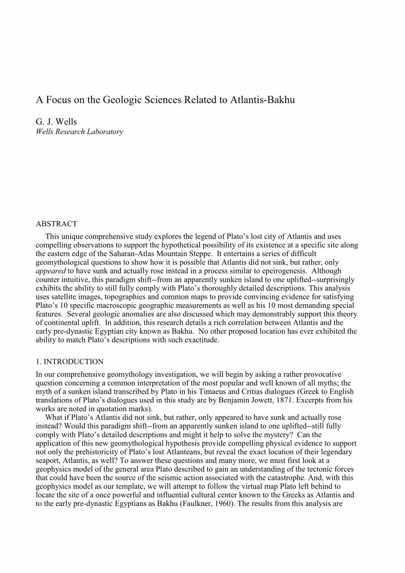
The tectonic model shown in Figure 1 is a northwest view of a cross-section of Earth’s crust in theMediterranean region that depicts the catastrophe scenario and demonstrates the principle of anabrupt continental upheaval. This model takes into account that areas of the Sahara were wet duringthe Pleistocene-Holocene transition and it wasn’t until about 7,000 years ago that the region began itsmost recent aridification. The question is, how wet was it at the time ascribed to the Atlanteans? Thatquestion is still under diligent study today (Barnikel et al. 2002), but there is already generalagreement that many large lakes and reed filled swamps covered vast areas at the time despite a briefaridification during the Younger-Dryas (Lubell, 2001). If for a moment we assume that the strait atGibralter was closed, as it had been occasionally throughout the Pleistocene (Duggen et al. 2003),and that the northwestern Sahara desert was actually a former glacial shallow sea, continuous withthe Mediterranean Sea of historic times (let’s call the unified body the Saharan-Atlantic Sea fordiscussion purposes as indicated in Figure 1), then the model clearly shows it is possible ATLANTISDID NOT SINK; it only appeared to have sunk and was actually uplifted along with a large portionof north and northwest (NW) Africa.
During a sudden upheaval of this magnitude, which would have coincidently ripped open theclosed strait at Gibralter, the expansive Saharan-Atlantic Sea would have drained in frenzied torrentsfrom the top of the uplifted African Plate flooding down into the Mediterranean basin (Fig.1; #2).This uplift would have also caused a powerful tsunami to race northward colliding with the northerncoast, inundating and destroying all settlements in its path, including ancient Athens. The tsunamicflooding would have receded with such current into the Mediterranean basin as to denude the fertilesoils from much of the northern coast commingling them with drainage from the African plate. Thesecombined soil-laden waters would have flowed through the newly opened strait into the Atlanticbasin as the dynamic settled, possibly contributing to the formation of the Spartel mud bank.Simultaneously, ancient Athens would have been left submerged in the newly formed modernMediterranean Sea (Fig.1; #3). In support of this aspect of our theory, Plato did in fact indicate thatancient Athens was destroyed by the same catastrophe as Atlantis, noting of Athens that “all thericher and softer parts of the soil, having fallen away, and mere skeletons of the land being left” and“the Earth has fallen away all round and sunk out of sight”.
For the sailors who later ventured toward Atlantis and witnessed the aftermath, the exposedseafloor of the formerly navigable shallow sea on top of the African Plate would have caused anunavoidable illusion suggesting the island sank--depositing its dissolved soils into the sea renderingit forever closed to sailed passage. They would have only found “a shoal of mud…impassable and
African Plate
Mediterranean Sea
Former Sea Levels Current Sea Level
Figure 1: Block Diagram Sequence of Atlantis’ Upheaval (northwesterly cross-sectional view), Wells,2008. This geophysics tectonic model is of a proposed rapid form of epeirogenesis along the north andnorthwest margins of the African plate. #1 Details the site geography prior to the catastrophe. #2 Detailsthe dynamic actions from the sudden African Plate uplift and resultant “Saharan-Atlantic” sea drainingoff the continental surface. #3 Details current conditions in the Mediterranean Basin demonstrating thatancient Athens may have been submerged and Atlantis uplifted by the catastrophe.
“Saharan-Atlantic” Sea
MediterraneanBasin
Atlantis Ancient Athens
#2
“Saharan-Atlantic” SeaMediterranean
Basin
Atlantis Ancient Athens
African Plate Eurasian PlatePlate Boundary
#1
Ancient Athens (submerged)
Mediterranean Sea
Former Sea Levels Current Sea Level
Current SaharanDesert Basin whereAtlantis Appeared toHave “Sunk” Mediterranean
Basin
#3
Continental Upheaval
“Saharan-Atlantic” SeaDrains into Basin andFloods Entire Region
Atlantis (uplifted & buriedbeyond horizon)
impenetrable” which they could have assumed “was caused by the subsidence of the island” sincethe illusion was entirely convincing. These ancient mariners would have had no way of knowing thatthe former island was actually uplifted by an extraordinarily rare rolling and tilting adjustment of theAfrican Plate, exposing the sea-floor of the drained Saharan-Atlantic Sea; and that the city itself wasbeyond the horizon rendering invisible its existence in the distance (Fig. 1; #3). So, these sailorswould have reported to others what they believed they saw, which was much later chronicled byPlato. Although somewhat counter intuitive, this model shows that it is possible for Atlantis to havebeen uplifted and still fully comply with Plato’s descriptive requirements. The model also could helpexplain why Atlantis hasn’t already been found--no one was looking in this location and accidentaldiscovery would have been hindered since, over thousands of years, ruins in this area would havenaturally been covered by many meters of sand as the arid conditions began to prevail.
2. TOPOGRAPHIC CONFIRMATION OF ATLANTIC ISLAND IN ALGERIA, MOROCCO &TUNISIA?
In the quest to identify a scientifically plausible and physically tangible site for Plato’s lost island, itis imperative that researchers uphold his descriptions without alteration and they thoroughlyscrutinize his words in an effort to glean every minute detail. Though all previous claims of theisland’s discovery have come replete with requisite adjustment factors necessary to mold Plato’swork to fit those hypotheses, ours is unique in that we take Plato at his word. Therefore, in thefollowing few paragraphs, we cannot emphasize enough how important it is that our Saharan-Atlassite has the ability to act as testament to Plato’s descriptive accuracies.
By following Plato’s detailed descriptions, along with Egyptian cosmogonies (Ions, 1983) andvarious Greek myths relating to Atlas (Graves, 1957), much as prehistoric travel guides, we find thatthe lost Atlantic Island should be one and the same as the Atlas Mountain Ranges of Algeria,Morocco and Tunisia prior to the continental uplift discussed in the previous section. Indeed, in thisargument, the capitol city of Atlantis should be located on the western edge of the Great OccidentalErg of the Sahara Desert directly adjacent the peak of a large hypsographic hill named Garet elDjeder in El Bayadh province of modern Algeria situated at approximately 31.84° North Latitudeand 1.03° East Longitude, at an elevation of nearly 460 meters above current sea level.
This premise can be tested by comparing the macroscopic geographic and dimensionaldescriptions from Plato for Atlantis to the environs of the Atlas Mountain Range when it wasphysically a little deeper in the Earth’s mantle prior to the sudden catastrophic tilting-uplift.Fortunately, the natural history of the Atlas Ranges has been studied extensively, so we can use thisreservoir of data to compare it to detailed characterizations by Plato.
We will begin by reviewing the topography of NW Africa using the collage of images Figures 2a-2c to determine how the island would have appeared. Figure 2a (USGS, 1984) outlines the Africanregion of interest and Figure 2b (Beauchamp, 1997) is a digital topography of this NW region withcaptions and arrows to demonstrate the proposed general outline of Plato’s isle. Figure 2c is ourreconstructed image of Plato’s Atlantic Island which compensates for lower ocean levels during theYounger-Dryas. In concert, these images can be used as a helpful visual aid in comprehending thisseemingly complicated idea.
Figure 2b shows the digital topography with lower elevations (sea level to ~460 meters) of theAtlas region depicted in black. As we’ve explained, prior to the catastrophe that caused thecontinental uplift and ultimate abandonment of Atlantis, NW Africa would have been tipped slightlywestward and positioned deeper in the Earth’s mantle. So, in applying our hypothesis, the lowestelevations in this region would have been even lower and thus covered by waters merging with themodern day Mediterranean. Therefore, in Figure 2b, we need to simply consider that black represents

the ancient sea and ocean levels and the transition to light gray is indicative of the coastline of theformer Atlantic Island. Then you can see the enormous island becomes visible revealing an outlinethat is easily subjected to a multitude of exacting measurements. Focusing on Figure 2b, the arrowsand captions help emphasize 10 major macroscopic features Plato has attributed to his island thatseem to consistently mirror the physical geography and gross dimensions of NW Africa.
Macro-Feature#1: Plato said the Atlantean kings came from an island home on the Atlantic Oceanin front of, or beyond, the Pillars of Heracles which are widely recognized as the Strait of Gibralterin modern times. Notably, our proposed site for Atlantic Island has a coastline on the Atlantic Oceanand encompasses the entire area up to and beyond the Pillars of Heracles, just as Plato said.
Macro-Feature#2: Plato describes from around the great island “…was the way to other islands,and from these you might pass to the whole of the opposite continent”. We can see in Figure 2b thatsailing SW from the harbor of Atlantis via the proposed Saharan-Atlantic Sea and through the DraaRiver Valley leads to the Canary Islands, from which west flowing equatorial currents could carrysailors to the Caribbean Islands and the Americas. Or, alternatively, they could sail north from theCanary Islands toward the Celtic Isles and Europe. Both sailing routes satisfy Plato’s description.
Macro-Feature#3: Plato said, “… for this sea which is within the Straits of Heracles is only aharbour, having a narrow entrance, but the other is a real sea”. We have proposed that when NW
Figures 2a-c: Topographic Maps of Africa Detailing Atlantic Island. Figure 2a: Elevation map of Africa, after USGeologic Survey, 1984. Figure 2b: Atlantic Island Detail after Digital Topography of North Africa, Beauchamp,Cornell University 1997. This is a general approximation of the Saharan-Atlantic’s sea-level prior to its destructionalong with Atlantis 11,600 years ago. At that time, the Atlas mountain range was positioned deeper in theasthenosphere. Figure 2c: Reconstructed Image of Plato’s Atlantic Island adjusting for reduced sea level duringYounger-Dryas, Wells, 2008.
Figure 2b:NW Africa
Figure 2c: Plato’s Atlantic IslandFigure 2a: African Continent
~2,093 km
Strait of Gibralter(Pillars of Heracles)
Iberian Peninsula (formerly Gades)
Atlantic Ocean
Mediterranean Sea
AtlasMountain Range
Saharan-Atlantic Sea
Passage to Canary Islands
Plain
~555 km City of Atlantis onGaret el Djeder Hill
~370km
Atlantis
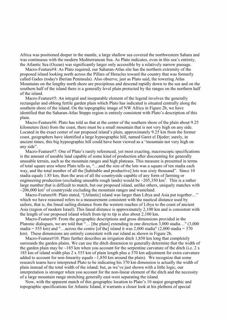
Africa was positioned deeper in the mantle, a large shallow sea covered the northwestern Sahara andwas continuous with the modern Mediterranean Sea. As Plato indicates, even in this sea’s entirety,the Atlantic Sea (Ocean) was significantly larger only accessible by a relatively narrow passage.
Macro-Feature#4: As Plato required, our Saharan-Atlas site has the northern extremity of theproposed island looking north across the Pillars of Heracles toward the country that was formerlycalled Gades (today's Iberian Peninsula). Also observe, just as Plato said, the towering AtlasMountains on the lengthy north shore are precipitous and descend rapidly down to the sea and on thesouthern half of the island there is a generally level plain protected by the ranges on the northern halfof the island.
Macro-Feature#5: An integral and inseparable element of the legend involves the generallyrectangular and oblong fertile garden plain which Plato has indicated is situated centrally along thesouthern shore of the island. On the topographic image of NW Africa in Figure 2b, we haveidentified that the Saharan-Atlas Steppe region is entirely consistent with Plato’s description of thisplain.
Macro-Feature#6: Plato has told us that at the center of the southern shore of the plain about 9.25kilometers (km) from the coast, there must be a small mountain that is not very high on any side.Located in the exact center of our proposed island’s plain, approximately 9.25 km from the formercoast, geographers have identified a large hypsographic hill, named Garet el Djeder; surely, inancient times, this big hypsographic hill could have been viewed as a “mountain not very high onany side”.
Macro-Feature#7: One of Plato’s rarely referenced, yet most exacting, macroscopic specificationsis the amount of useable land capable of some kind of production after discounting for generallyunusable terrain, such as the mountain ranges and high plateaus. This measure is presented in termsof total square area where Plato tells us, “…and the size of the lots was a square of ten stadia eachway, and the total number of all the [habitable and productive] lots was sixty thousand”. Since 10stadia equals 1.85 km, then the area of all the countryside capable of any form of farming orengineering production (excluding unusable rough lands) would be ~205,350 km2. This is a ratherlarge number that is difficult to match, but our proposed island, unlike others, uniquely matches with~206,000 km2 of countryside excluding the mountain ranges and wasteland.
Macro-Feature#8: Plato stated, “[Atlantic] island was larger than Libya and Asia put together…”which we have reasoned refers to a measurement consistent with the nautical distance used bysailors, that is, the lineal sailing distance from the western reaches of Libya to the coast of ancientAsia (region of modern Israel). This lineal distance is approximately 2,100 km and is consistent withthe length of our proposed island which from tip to tip is also about 2,100 km.
Macro-Feature#9: From the geographic descriptions and gross dimensions provided in thePlatonic dialogues, we are told that “… [the plain] extending in one direction 3,000 stadia…" (3,000stadia = 555 km) and "…across the centre [of the] island it was 2,000 stadia" (2,000 stadia = 370km). These dimensions are entirely consistent with our island as shown in Figure 2b.
Macro-Feature#10: Plato further describes an irrigation ditch 1,850 km long that completelysurrounds the garden plains. We can use the ditch dimension to generally determine that the width ofthe garden plain may be ~185 km when you account for the serpentine curvature of the ditch (i.e. 2 x185 km of island width plus 2 x 555 km of plain length plus a 370 km adjustment for extra curvatureadded to account for non-linearity equals ~1,850 km around the plain). We recognize that someresearch teams have interpreted Plato to be indicating his 370 km dimension is actually the width ofplain instead of the total width of the island; but, as we’ve just shown with a little logic, ourinterpretation is stronger when you account for the non-linear element of the ditch and the necessityof a large mountain range stretching generally east-west separating the island.
Now, with the apparent match of this geographic location to Plato’s 10 major geographic andtopographic specifications for Atlantic Island, it warrants a closer look at his plethora of special
features to determine if any other correlations are evident to help bolster the hypothesis that Atlantis-Bakhu exists at this site and its environs were uplifted instead of sinking as the illusion implied.
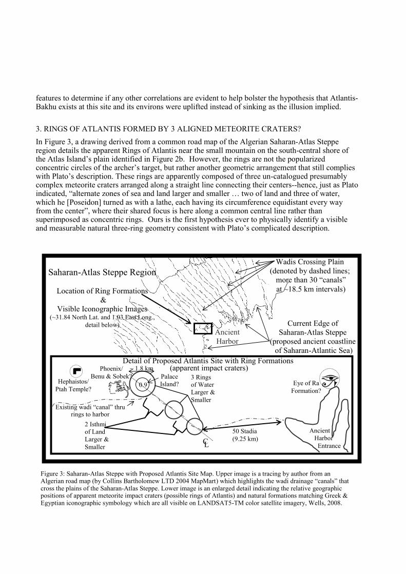
3. RINGS OF ATLANTIS FORMED BY 3 ALIGNED METEORITE CRATERS?
In Figure 3, a drawing derived from a common road map of the Algerian Saharan-Atlas Stepperegion details the apparent Rings of Atlantis near the small mountain on the south-central shore ofthe Atlas Island’s plain identified in Figure 2b. However, the rings are not the popularizedconcentric circles of the archer’s target, but rather another geometric arrangement that still complieswith Plato’s description. These rings are apparently composed of three un-catalogued presumablycomplex meteorite craters arranged along a straight line connecting their centers--hence, just as Platoindicated, “alternate zones of sea and land larger and smaller … two of land and three of water,which he [Poseidon] turned as with a lathe, each having its circumference equidistant every wayfrom the center”, where their shared focus is here along a common central line rather thansuperimposed as concentric rings. Ours is the first hypothesis ever to physically identify a visibleand measurable natural three-ring geometry consistent with Plato’s complicated description.
Figure 3: Saharan-Atlas Steppe with Proposed Atlantis Site Map. Upper image is a tracing by author from anAlgerian road map (by Collins Bartholomew LTD 2004 MapMart) which highlights the wadi drainage “canals” thatcross the plains of the Saharan-Atlas Steppe. Lower image is an enlarged detail indicating the relative geographicpositions of apparent meteorite impact craters (possible rings of Atlantis) and natural formations matching Greek &Egyptian iconographic symbology which are all visible on LANDSAT5-TM color satellite imagery, Wells, 2008.
Detail of Proposed Atlantis Site with Ring Formations(apparent impact craters)~ 1.8 km
50 Stadia(9.25 km)
AncientHarbor
Entrance
0.93 Ringsof WaterLarger &Smaller
2 Isthmiof LandLarger &Smaller
CL
Existing wadi “canal” thrurings to harbor
Hephaistos/Ptah Temple?
Current Edge ofSaharan-Atlas Steppe
(proposed ancient coastlineof Saharan-Atlantic Sea)
AncientHarbor
Wadis Crossing Plain(denoted by dashed lines;
more than 30 “canals”at ~18.5 km intervals)
Eye of RaFormation?
Phoenix/Benu & Sobek? Palace
Island?
Saharan-Atlas Steppe Region
Location of Ring Formations&
Visible Iconographic Images(~31.84 North Lat. and 1.03 East Long.,
detail below)
3.1 Meteorite impacts offer potential explanation for special features of Atlantis
Many scholars have repeatedly expressed disbelief that the Atlanteans could have produced thespecial attributes described by Plato such as the orichalcum metal and massive canals that cross theplain. It does seem a bit far-fetched unless the Atlanteans didn’t produce all of these characteristicsthemselves; but rather, simply adapted for their own use the naturally occurring geography thatpreceded their occupation. If the ring formations are meteorite craters (Schultz, 2007), then they canactually play a profound role in providing a measurable basis for at least 5 of the special features.
Special Feature#1: The triple rings themselves as described above and shown in Figure 3 are thefirst special feature that can be attributed to the meteorite craters.
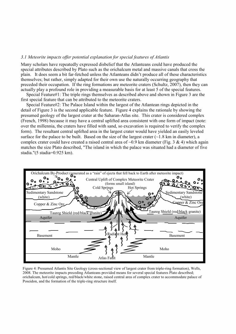
Special Feature#2: The Palace Island within the largest of the Atlantean rings depicted in thedetail of Figure 3 is the second applicable feature. Figure 4 explains the rationale by showing thepresumed geology of the largest crater at the Saharan-Atlas site. This crater is considered complex(French, 1998) because it may have a central uplifted area consistent with one form of impact (note:over the millennia, the craters have filled with sand, so excavation is required to verify the complexform). The resultant central uplifted area in the largest crater would have yielded an easily leveledsurface for the palace to be built. Based on the size of the largest crater (~1.8 km in diameter), acomplex crater could have created a raised central area of ~0.9 km diameter (Fig. 3 & 4) which againmatches the size Plato described, "The island in which the palace was situated had a diameter of fivestadia."(5 stadia=0.925 km).
Figure 4: Presumed Atlantis Site Geology (cross-sectional view of largest crater from triple-ring formation), Wells,2008. The meteorite impacts preceding Atlanteans provided means for several special features Plato described;orichalcum, hot/cold springs, red/black/white stone, raised central area of complex crater to accommodate palace ofPoseidon, and the formation of the triple-ring structure itself.
Basement
Taureg Shield (red/black granite)
Copper & Zinc Ore
Aquifer
Hot SpringsCold Springs
Orichalcum By-Product (generated as a “rain” of ejecta that fell back to Earth after meteorite impact)
Sedimentary Sandstone(white)
Copper & Zinc Ore
Sedimentary Sandstone(white)
Taureg Shield (red/black granite)
Aquifer
Basement
MohoMoho
Mantle MantleAtlas Fault
Radiant Heat
Central Uplift of Complex Meteorite Crater(forms small island)
Special Feature#3: The meteorite impact would have also caused fissures in the Earth’s crust thatcould have accounted for the artesian wells and hydrothermal springs as shown in Figure 4.
Special Feature#4: The impact sites are in sedimentary sandstone that over-lies the red and blackgranitic Taureg-shield (Schlüter et al. 2008). Both the sandstone and granite layers were likelyuplifted by the meteorite impact when the central Palace Island area was formed as detailed above,thereby making the red, black and white stone described by Plato readily available to quarry.
Special Feature#5: The rare metal orichalcum, an alloy from copper and zinc ore similar to brass,can also be attributed to the meteorite craters. All we need to consider is that the Atlas Mountainsregion has reserves of zinc and copper ore (Schlüter et al. 2008); the meteorite itself introducedunknown metals; and the meteorite impact would have introduced enough roasting heat into the oreto naturally produce the alloy in a rain of ejecta that fell back to Earth in a manner similar to thatdepicted in Figure 4. Remember, Plato specifically said, “…they dug out of the Earth…orichalcum”,clearly suggesting the metal was already formed.
Special Feature#6: Plato indicated "…beginning from the sea they bored a canal of three hundredfeet in width and one hundred feet in depth and fifty stadia in length", (50 stadia = 9.25 km). Whenmeasured from the outer most meteorite crater, the distance to the harbor is exactly 9.25 km (Fig. 3).
4. L-WAVE EARTHQUAKE REMNANTS PROVIDE MEANS FOR ATLANTIS CANALS?
Special Feature#7: The massive canals described by Plato are evident at this location as well and canbe readily seen on essentially any map of the Saharan-Atlas region (Fig. 3). These maps shownumerous extinct or ephemeral watercourse beds called wadis visible across the inland plain. Thesenatural wadis are possibly the result of a powerful L-wave earthquake along the Atlas fault-line thatpreceded Atlantean occupation of the site and which may have been induced by the forces releasedduring the meteorite impacts. If so, the harmonic waves from the earthquake were propagated acrossthe plain much as a pebble thrown in a pond creates ripples across the surface, only here, once therolling earthquake stopped, the footprint of the repeating vibration was left behind in the soil as ifflash frozen. Regardless of origin, across the entire plain, more than thirty approximately 160 kmlong “canals” can still easily be seen today on a common road map. Most of these wadis areessentially 18.5 km apart as Plato described and from the ground would have appeared as giganticstraight canals that could have been readily adapted for irrigation and transport.
5. EVIDENCE FOR FAUNA AND FLORA ON ATLANTIC ISLAND
Special Features#8 & #9: Based on fossil remains and prehistoric cave art found in the area, thefauna and flora Plato described as diverse and plentiful including elephants and bulls along withabundant woods, marshes and rivers were also present at the Saharan-Atlas site. This art has beendiscovered throughout the Sahara ranging from Tassili-n-Ajer to Bardai dating as far back as 8,500years ago. Some scholars even estimate the cave drawings occurred as early as 12,000 years ago, butunfortunately that imagery did not endure the test of time. The surviving paintings and etchingsdepict elephants, bulls, giraffe, and even catfish, indicating this type of fauna was prevalent in theregion at the end of the ice age. Similarly, as mentioned earlier, this extreme northwestern area ofthe Sahara appears to have remained relatively moist during the Younger-Dryas compared to thecentral regions, apparently fed by Atlas rivers which crossed the steppe and pooled in lakessurrounded by verdant grass and reeds. The region of Atlantis was located in semi-desert soils whichare sufficiently fertile to support abundant vegetation when irrigated as readily evidenced by oases.In addition, researchers have discovered that numerous types of vegetation were prolific in the AtlasMountains at the Pleistocene-Holocene transition including deciduous, sclerophyllous and coniferous
trees (Schulz, 1991). As we noted above, the Atlanteans would have been ideally situated with thenaturally occurring irrigation canals that were fed by “streams that came down from the mountains.”
6. THE EGYPTIAN CONNECTION
Plato said the original Atlantis story came from an Egyptian source, but due to a steep languagebarrier the names were almost unrecognizably different in the individual cultures. In again trustingPlato, our investigation has found reasonable Egyptian parallels which closely match the Atlantislegend. According to accepted research, the predynastic creation (Hart, 1990) and destruction mythsor legends, some recorded in the ancient Egyptian Book of the Heavenly Cow (Hornung, 1999),originated in prehistoric times and were transmitted through oral traditions until about 5,200 yearsago. Here is where we find many correlations between Plato’s city of Atlantis and the fabledEgyptian city of Bakhu (Faulkner, 1985). Some of the most notable similarities include: 1.) Bothwere located on a large island raised from the deep and formless primeval waters of Earth by a groupof creation gods; 2.) Each city was described as being situated on an average-sized mountain near aneastern sunrise shore; 3.) Each city appeared luminescent in the morning light, emitting adistinguished yellow-orange-reddish glow; 4.) They were associated with multiple sets of twinscreated by the gods with the first born taking precedence and dominion over the others; and 5.) Inboth stories, almost verbatim, the reigning gods, Zeus and Ra, called together the elder gods andasked for their advice on how to punish the insubordinate humans which then led to the end of thesecultures by an unprecedented, catastrophic destruction and abandonment of the cities.
With this apparent connection, let’s take a closer look to determine if any other attributesassociated with the Greco-Egyptian city, Atlantis-Bakhu, are evident on-site.
7. TEMPLES OF ATLANTIS-BAKHU
Special Feature#10: Since Plato never finished writing Critias, he didn’t describe in great detail whatall of the temples looked like, but he did indicate that “there were many temples built and dedicatedto the many gods.” So, it seemed plausible that if this location has merit, some of these megalithictemple structures might be present at the Saharan-Atlas site. And, since the Atlantean history wasshared by the Greeks and the Egyptians, it’s reasonable to assume that even if the names weredifferent in the individual cultures as Plato indicated they were, both may have referencedformations, structures and images in their legends that dated back to the Atlantean reign.
The immediate area surrounding the apparent meteorite craters (Fig. 3) does indeed appear to yieldseveral distinctly visible formations (partially buried under the sand, but visible via satellite imagery)that closely resemble iconic symbology found in Greek and Egyptian culture. These appear to benatural forms that the Atlanteans incorporated or adapted for their beliefs, including: 1.) An L-shapedformation that could represent the architectural square which is a symbol associated with the Greekgod Hephaistos and the Egyptian god Ptah; 2 & 3.) A crocodilian shape along with the upper body ofa bird-like formation seemingly sitting on an earthen feature resembling the twisted-twigs of a nestthat appears to be in flames. These could symbolically represent Greek Poseidon and Phoenix or theEgyptian Sobek and immortal Benu bird; 4.) A natural formation of hills resembling the udjat, or theEye of Ra; and 5.) The triple crater rings themselves also appear to match several Egyptianhieroglyphs associated with Sun god Ra (Gardiner, 1957).
The chance of all five of these possibly related formations occurring randomly in this exceedinglysmall area of the entire Earth’s surface, including the seafloor--remember, an area that was identifiedby following Plato’s descriptions--is seemingly beyond astronomical. Therefore, it appears highlyunlikely that the presence of these natural formations and earthen sculptures is random, but rather, it

seems much more likely they are indeed intrinsic parts of an ancient culture consistent with what weknow from both Greek and Egyptian sources about the Atlanteans.
8. GEOLOGIC ANOMALIES
The proposed sudden rapid epeirogenic-like continental uplift of NW Africa may have been amanifestation of a much larger uniform easterly roll of the northern aspects of the African Plateitself. This can be envisioned by considering an iceberg in the ocean at a critical gravitationaltipping-point where, with speed and violence, the massive body rolls. A diastrophic dynamicsufficient in magnitude to cause major deformations in the Earth’s crust would likely leavewidespread physical evidence in its wake in a variety of scientifically measurable forms.
Based on our hypothesis, after the seismic activity and tectonic forces waned, the sudden massiveshifting, tilting movement of the Earth’s crust (similar to a lever on a fulcrum effect) would have leftthe northwestern margin of the African continent at the Atlas mountains uplifted, as we find today,explaining the seemingly confounding ~460 meters in elevation of the proposed Saharan-Atlas sitefor Atlantis-Bakhu. This broad redistribution of forces in an area spanning tectonic boundariesconnecting the African, North American, Eurasian and Arabian Plates, would have left manymeasurable regional crustal deformation effects stretching from about the 28th to the 38th LatitudeNorth and from the Mid-Atlantic Ridge (MAR) in the west to the Zagros Mountains in the east. Areview of geologic data in this expansive area has identified studies that are investigating anomalieswhich may be associated with uniform plate movement. Our theory of sudden continental tilting andregional uplift could help explain these interesting geologic anomalies, thereby presumablystrengthening its merit. Some of these anomalies have been under international investigation byscientists and scholars for decades, including uplifts of the seafloor along the MAR at fracture zones,transform and non-transform faults, and even massif uplift at the ridge (Blackman et al. 2002). And,at the Arabian Plate margin in the east near the Zagros, deep seismic activity and a Bouguer gravityirregularity (Snyder et al. 1986) may be linked to the rare crust movement. Even the Great Bend ofthe Nile is attributed to a recent uplift of the Nubian Swell (Stern et al. 1996) thought to havepossibly occurred at the same time as the catastrophe connected to Plato’s timeline.
9. IN CONCLUSION, IS THIS HYPOTHESIS COMPELLING?
The prevailing paradigm for Plato’s Atlantis insists the island sank…if it ever really existed at all.However, we have presented geophysics models in this investigation which reveal that it is plausibleAtlantis-Bakhu only appeared to have sunk and was actually uplifted, in an expansive plate-widetectonic phenomenon similar to smaller epeirogenic models, which formed an illusory image in themind of witnessing sailors.
It’s notable that by adopting our paradigm shift of an island uplifted and following the map ofPlato’s 10 major geographic measurements for his Atlantic Island, we have identified strong physicalcorrelations with the Atlas Mountain Ranges of NW Africa. And that we have also identified aspecific site on the Saharan-Atlas Steppe which seems to comply with the 10 special featuresdetailed by Plato. Even the most demanding of Plato’s details are satisfied by our hypothesis,including: the three unique rings, an oblong plain with expansive canals that cross it, and naturalmeans for the formation of the metal orichalcum. No other proposed location has ever matched thesedetails with such exactitude--none.
It is our sincere hope that the broad spectrum of observations detailed in this paper willsufficiently stimulate the necessary debate among academic circles to ultimately provide personnel
and means for future exploration of the Saharan-Atlas Steppe site. Indeed, with the legends ofAtlantis-Bakhu, events are not always as they appear, and truth is often stranger than fiction!
For a more in-depth discussion along with full-color satellite images and topographies, pleasevisit the website Atlantis-Bakhu.com.
REFERENCES
Barnikel, F. and Becht, M. (2002). Pluvial Phases in the Sahara During the Holocene: A Multi-disciplinary Comparison,Proceedings, European Geophysical Society XXVII General Assembly, Abstract #2636, Volume 27: p. 2636B.
Beauchamp, W. (1997). Digital Topography of North Africa. Tectonic Evolution of the Atlas Mountains,North Africa. Cornell University.
Blackman, D. K., Karson, J. A., Kelley, D. S., Cann, J. R., Früh-Green, G. L., Gee, J. S., Hurst, S. D., John, B. E.,Morgan, J., Nooner, S. L., Ross, D. K., Schroeder, T. J. and Williams, E. A. (2002). Geology of the Atlantis Massif(Mid-Atlantic Ridge, 30°N): Implications for the evolution of an ultramafic oceanic core complex. MarineGeophysical Researches Volume 23 Numbers 5-6: pp. 443-469.
Duggen, S, Hoernie K, van den Bogaard, P, Rupke, L and Phipps Morgan, J. (2003). Deep roots of the Messinian salinitycrisis, Nature Volume 422: pp. 602-605.
Faulkner, R. O. (1960). The Ancient Egyptian Coffin Text Volume 1 Spells 1-354. Warminster: Aris & Phillips, LTD.pp. 138-139.
Faulkner, R. O. (trans.) & Andrews, C. (ed.) (1985). The Ancient Egyptian Book of the Dead. New York: Macmillan.pp. 101-103, 137-141, 185-189.
French, B. M. (1998). Traces of Catastrophe, A Handbook of Shock-Metamorphic Effects in Terrestrial Meteorite ImpactStructures. Houston: Lunar and Planetary Institute. LPI Contribution Number 954. pp. 17-28.
Gardiner, A. (1964). Egyptian Grammar: Being an Introduction to the Study of Hieroglyphs. Edition 3. Oxford: GriffithInstitute, Ashmolean Museum, Oxford University Press. pp. 438-543; N5, N6, N8.
Graves, R. (1957). The Greek Myths Volumes 1 & 2. New York: George Braziller, Inc. pp. 27, 41, 127,143-149 (Volume 1) and pp. 145-152 (Volume 2).
Hart, G. (1990). Egyptian Myths. Austin: University of Texas Press. pp. 9-28.Hornung, E. (1999). The Ancient Egyptian Books of the Afterlife. Ithaca and London: Cornell University Press.
pp. 148-151.Hughen, K. A., Southon, J. R., Lehman, S. J., Overpeck, J. T. (2000). Synchronous Radiocarbon and Climate Shifts
During the Last Deglaciation. Science Volume 290 Number 5498: pp. 1951–1954.Ions, V. (1983). Library of the Worlds Myths and Legends: Egyptian Mythology. New York: Peter Bedrick Books.
pp. 21-33.Jowett, B. (1871). The Dialogues of Plato Volume 3. New York: Charles Scribner and Company.Kennett, D. J., Kennett J. P., West, A., Mercer, C, Que Hee, S. S., Bement, L., Bunch, T. E., Sellers, M., and Wolbach,
W. S. (2009). Nanodiamonds in the Younger Dryas Boundary Sediment Layer. Science Volume 323 Number 5910: p.94.
Lubell, D. (2001). Late Pleistocene-Early Holocene Maghreb, Encyclopedia of Prehistory Africa. New York: KluwerAcademic/Plenum Publishers. pp. 129-149.
Morris, A. and Tarling, D. H. (1996). Palaeomagnetism and Tectonics of the Mediterranean Region: An IntroductionSpecial Publication 105. London: The Geologic Society.
Schulz, E. (1991). Holocene Environments in the Central Sahara. Hydrobiologia Volume 214: pp. 359-65.Schultz, P. (2007, 30 November). Electronic correspondence with author indicating ring formations “really promising” as
craters. Brown University. Planetary Geosciences Group, Department of Geological Sciences, (available uponrequest).
Schlüter, T. & Trauth, M. (2008). Geological Atlas of Africa: With Notes on Stratigraphy, Tectonics, EconomicGeology, Geohazards, Geosites and Geoscientific Education of Each Country. Edition 2. New York: Springer-Verlag. pp. 32-37.
Snyder, D. & Barazangi, M. (1986). Deep crustal structure and flexure of the Arabian plate beneath the Zagroscollisional mountain belt as inferred from gravity observations, Tectonics Volume 5: pp. 361-373.
Stern, R. J. & Abdelsalam, M. G. (1996). The Origin of the Great Bend of the Nile from SIR-C/X-SAR Imagery.Science Volume 272 Issue 5293: pp. 1696-1698.
United States Geological Survey (1984). Elevation Data of Africa. EROS Data Center.
Copyright © 2022 FDOKUMEN