A Cursory Examination of Laboratory Data from a Preliminary Survey and Test Excavations at Levi...
16
1 Anthropology 550 Final Project Joseph Jakubs Spring Semester, 2013 A Cursory Examination of Laboratory Data from a Preliminary Survey and Test Excavations at Levi Colbert’s Prairie Homestead Introduction This report summarizes inferences and correlations with historic documents achieved through an assemblage and analysis of artifacts recovered from the geographic location associated with the historic site of Levi Colbert’s prairie homestead in Mississippi. Specifically, it highlights the cultural activities and processes that may be attributed to the accumulation of these particular artifacts at the site. Also, it attempts to determine the prevalence of one activity over another. This is useful for many reasons. First, the types and distribution of activities provides insight concerning the number of persons occupying the site and the types of work prevalent during the period of interest. Second, recognition of preference or frequency of activates will further an understanding of the archaeological record of this site and help to determine other socioeconomic aspects of the Colberts. This information helps to achieve a comprehensive understanding of the Colberts and their relationship with communities and cultures with whom they interacted.. Other persons studying the Colberts and/or this particular period of time will find this analysis useful to gain insight into materialculture relationships and the roles they play in larger social and economic agendas. An assemblage of artifacts from the site provides the data for this quantitative analysis. The assemblage is relatively small in size due to the
Transcript of A Cursory Examination of Laboratory Data from a Preliminary Survey and Test Excavations at Levi...

1
Anthropology 550 Final Project Joseph Jakubs Spring Semester, 2013 A Cursory Examination of Laboratory Data from a Preliminary Survey and
Test Excavations at Levi Colbert’s Prairie Homestead
Introduction
This report summarizes inferences and correlations with historic documents
achieved through an assemblage and analysis of artifacts recovered from the
geographic location associated with the historic site of Levi Colbert’s prairie
homestead in Mississippi. Specifically, it highlights the cultural activities and
processes that may be attributed to the accumulation of these particular artifacts at
the site. Also, it attempts to determine the prevalence of one activity over another.
This is useful for many reasons. First, the types and distribution of activities
provides insight concerning the number of persons occupying the site and the types
of work prevalent during the period of interest. Second, recognition of preference
or frequency of activates will further an understanding of the archaeological record
of this site and help to determine other socio-‐economic aspects of the Colberts. This
information helps to achieve a comprehensive understanding of the Colberts and
their relationship with communities and cultures with whom they interacted..
Other persons studying the Colberts and/or this particular period of time will find
this analysis useful to gain insight into material-‐culture relationships and the roles
they play in larger social and economic agendas.
An assemblage of artifacts from the site provides the data for this
quantitative analysis. The assemblage is relatively small in size due to the

2
preliminary nature of the research project at this time. Further site research and
excavation is necessary to achieve a more thorough and comprehensive
understanding of the site and features associated. Due to the relatively limited size
of the assemblage at this time most of these analysis and conclusions will appear
rather cursory in nature (Beaudrey et al., 1983; Jones et al., 1989; Noël Hume,
1969).
Background
The Levi Colbert prairie homestead site is one of many sites affiliated with
the Colbert family legacy. The Colbert family influenced the Chickasaw nation and
acted as mediator, for lack of a better word, between the United States government
and the Chickasaw people. Throughout history the Colberts have been criticized for
the transformation of certain historic economic principles and practices of the
Chickasaw.
This research project is intended to increase knowledge about the prairie
homestead site of Levi Colbert. The research impetus asks questions relating to the
number of persons occupying the site historically, relocation of the original home of
Levi and one of his wives, and everyday life practices by the Colberts. Economic
beliefs and practices of the Colberts are addressed, including the utilization of slaves
and capitalism, free trade, free market, ideals synonymous with the incorporation or
dismissal of European influences, and economic expansion (Craig, 1998).
James Logan Colbert, father of Levi and his brother George, was a Scottish
immigrant who married into the Chickasaw people. While James Colbert was one of
the European traders instrumental in the dramatic economic and cultural shift of

3
the Chickasaw, he also is responsible for fathering several of the people who would
later protect it, namely Levi and George Colbert.
Important to note about this period are the cultural shifts and economic
practices adopted by the Chickasaw, such as the European system of slavery and
free enterprise. This system of free enterprise is perhaps significantly more
prevalent during the years 1803-‐1818 portrayed by the economic enterprises of
Levi and his brother George. Also indicative of this change in economic beliefs are
the several treaties that the Colberts were instrumental in facilitating during this
period. Specifically, this includes the Treaty of 1818 that played a pivotal role in the
future of the Chickasaw.
Through manipulation of the beliefs and practices of the Chickasaw, in
particular their trade arrangements, the United States government was able to gain
considerable leverage and achieve the end results of their (Chickasaw) relocation to
“open new land” for future settlers at a price that was far below market value at that
time (Craig, 1998).
This report focuses on the occupation period 1818 through the 1840’s. The
location associated with Levi Colbert’s prairie homestead was relatively large in size
with a substantial amount of acreage devoted to agriculture. The property was
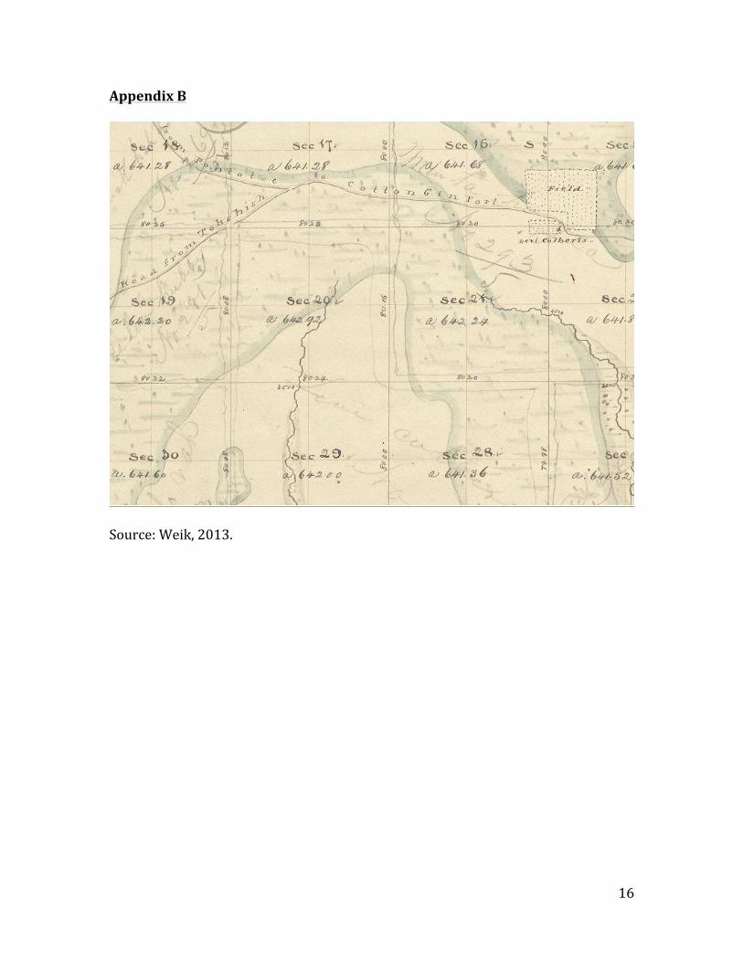
located within relatively close proximity to the site of the Colbert ferry. The
property designated as Levi Colbert’s homestead on the historic plat map (see
Appendix B) illustrates the geographic and environmental features attributed to the
site at that time.
4
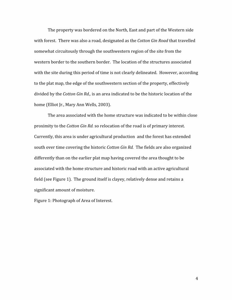
The property was bordered on the North, East and part of the Western side
with forest. There was also a road, designated as the Cotton Gin Road that travelled
somewhat circuitously through the southwestern region of the site from the
western border to the southern border. The location of the structures associated
with the site during this period of time is not clearly delineated. However, according
to the plat map, the edge of the southwestern section of the property, effectively
divided by the Cotton Gin Rd., is an area indicated to be the historic location of the
home (Elliot Jr., Mary Ann Wells, 2003).
The area associated with the home structure was indicated to be within close
proximity to the Cotton Gin Rd. so relocation of the road is of primary interest.
Currently, this area is under agricultural production and the forest has extended
south over time covering the historic Cotton Gin Rd. The fields are also organized
differently than on the earlier plat map having covered the area thought to be
associated with the home structure and historic road with an active agricultural
field (see Figure 1). The ground itself is clayey, relatively dense and retains a
significant amount of moisture.
Figure 1: Photograph of Area of Interest.

5
Source: Weik, 2013
Methodology
The fieldwork involved in this project is preliminary in nature consisting of a
geophysical survey and subsequent test units and shovel test pits in relation to the
anomalies discovered in the geophysical survey. The various physical methods used
to collect data include metal detecting, surface collection, shovel test pit excavation,
and test excavation pits.
“The metal detector hits (places where metal was detected) were often
explored by shoveling or troweling out a tiny irregular hole until the metal was
recovered. Shovel test pits (“st” or “stp” are small pits, approximately 30x30cm, dug
down to sterile soil [no features or artifacts]). Data from st’s are less precise as the
soil and artifacts are not mapped or bagged and removed in careful levels or strata.

6
They are quick means to see the range of artifacts there. Some stratigraphic
information is possible to recover when the st walls are cleaned up. However, only a
small area is exposed for profile sketches or photos. Because st’s are dug in less
precise ways, artifacts can fall down into the lower level soil during excavation. Like
metal detector pits, stp’s are not considered ideal methods for exposing soil
stratigraphy. Surface collection data are often indicative of the presence or absence
of a site, but can be suspect because it is not in situ (soil context)” (Excerpt from
field notes, Weik, 2013).The geophysical survey consists of ground penetrating
radar (GPR), magnetic gradiometer and electromagnetic induction (EMI). Through
the interpretation of the data resulting from these survey methods, areas of interest
were delineated and subsequently probed for information by the physical collection
methods listed above (see Figure 2).

7
Figure 2: Locations of STP’s and TU’s with Associated Anomalies.
Source: Weik, 2013
The methods employed in the lab included rough sorting, cleaning, and
cataloging of the samples resulting from the preliminary testing and excavations

8
stated above. The artifacts were first sorted then cleaned according to the
individual needs of the particular artifact, e.g. metal objects were dry brushed not
submerged or cleaned with water. After the sorting and cleaning process the
artifacts were analyzed and cataloged. All of these procedures were completed
while maintaining any provenience information associated with that particular
sample (Jones et al., 1989; Miller, 1991; Miller, 1980; Noël Hume, 1969; Beaudrey et
al., 1983).
Analysis of the artifacts involved the use of an Excel which allowed several
categories of attributes to be listed. Each artifact was analyzed by general attributes
and an attempt at a generalized set of descriptors was made. Categories of brief
description, material, type, variety, number of specimens, number of fragments,
weight, POTS typology, and functional classification were used when possible. Some
of the artifacts could not be identified at this time due to various limitations
necessitating further in-‐depth analysis of individual artifacts.1 Through application
of theoretical and interpretive methods, such as those discussed in A Guide to
Artifacts of Colonial America (Noel-‐Hume, 1969), and several works by George
Miller, inferences were made with relative precision.
For example, through George Miller’s (1991) A Revised Set of CC Index Values
for Classification and Economic Scaling of English Ceramics from 1787 to 1880,
valuable information was discerned to date and classify with considerable accuracy
artifacts in the assemblage. By dating and classifying the artifacts in the assemblage
1 Refer to Appendix A for a full list of artifacts cataloged for this cursory study.
9
with relative consistency and precision, theoretical methods were applied to ferret
out information regarding spatial distribution of features, artifacts and
socioeconomic practices occurring historically at the site (Jones et al., 1989; Miller,
1991; Miller, 1980; Noël Hume, 1969; Beaudrey et al., 1983; Bradley, 2000; Hoskins,
2006).
Results
A functional classification system was devised and applied to the artifacts
during analysis and cataloging. Categories such as architecture, kitchen, clothing,
and metal were applied (for a complete list, see Appendix A).
Artifacts recovered included a substantial number of brick fragments ranging
from several inches to a few millimeters, pottery shards, a number of faunal
remains, and many metal artifacts ranging from nails and farm equipment to
unidentifiable pieces. Two of the metal artifacts that stand out are pieces of lead
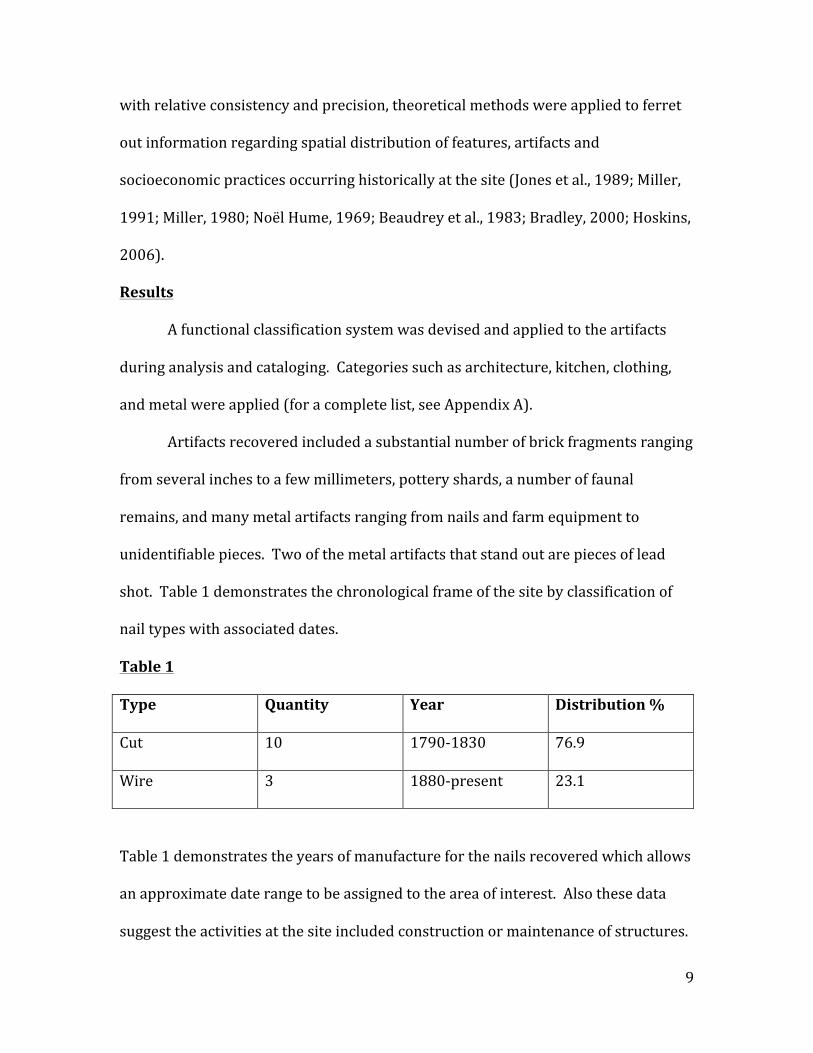
shot. Table 1 demonstrates the chronological frame of the site by classification of
nail types with associated dates.
Table 1
Type Quantity Year Distribution %
Cut 10 1790-‐1830 76.9
Wire 3 1880-‐present 23.1
Table 1 demonstrates the years of manufacture for the nails recovered which allows
an approximate date range to be assigned to the area of interest. Also these data
suggest the activities at the site included construction or maintenance of structures.
10
Further excavation, recovery, and analysis of artifacts from the site is needed to gain
a more comprehensive understanding of the context of these nails and structures
and/or activities which utilized them (Nelson, 1968).
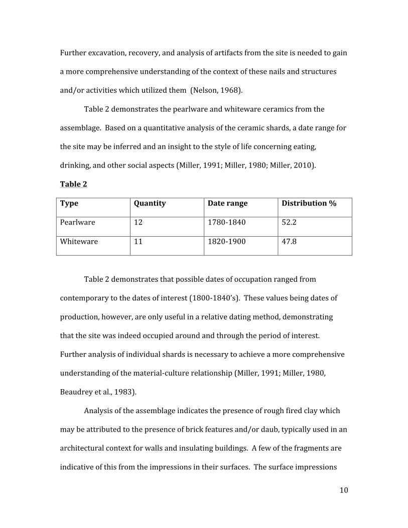
Table 2 demonstrates the pearlware and whiteware ceramics from the
assemblage. Based on a quantitative analysis of the ceramic shards, a date range for
the site may be inferred and an insight to the style of life concerning eating,
drinking, and other social aspects (Miller, 1991; Miller, 1980; Miller, 2010).
Table 2
Type Quantity Date range Distribution %
Pearlware 12 1780-‐1840 52.2
Whiteware 11 1820-‐1900 47.8
Table 2 demonstrates that possible dates of occupation ranged from
contemporary to the dates of interest (1800-‐1840’s). These values being dates of
production, however, are only useful in a relative dating method, demonstrating
that the site was indeed occupied around and through the period of interest.
Further analysis of individual shards is necessary to achieve a more comprehensive
understanding of the material-‐culture relationship (Miller, 1991; Miller, 1980,
Beaudrey et al., 1983).
Analysis of the assemblage indicates the presence of rough fired clay which
may be attributed to the presence of brick features and/or daub, typically used in an
architectural context for walls and insulating buildings. A few of the fragments are
indicative of this from the impressions in their surfaces. The surface impressions

11
resemble those left by being in contact with other objects at the time of curing or
firing. Further in-‐depth analysis is needed to achieve an accurate conclusion of
these artifacts (McGrath, 1979; Noël Hume, 1969).
At the time of this study, there are no illustrations or photographs of artifacts
to use in further analysis of the assemblage. Illustrations and photographs would be
a significant boon to the analysis, enabling a more detailed approach to discerning
the material-‐culture relationships and other socio-‐economic aspects (Orton et al.,
1994).
Through a quantitative approach various activities may be discerned that
likely occurred at the site. The ability to demonstrate particular dates of
manufacture for specific items allows a relative date to be assigned to the site.
Further quantitative analysis will result in a more comprehensive understanding to
the nature of the site indicating the types of activities that were taking place at the
time of occupation (Miller, 2010).
By utilizing a qualitative approach to the analysis of the assemblage, clues to
the culture of the Colberts and other inhabitants of the homestead area may be
discerned. Further excavation and subsequent collection and analysis of artifacts
are necessary to acquire adequate data to draw conclusions surrounding the
socioeconomic beliefs and practices of the inhabitants.
A cursory examination of the assemblage at this point in the research project
indicates several activities occurred at the site. From the presence of bricks and
brick fragments, the conclusion may be drawn that brick features or structures were
located there historically. Also the presence of a number of pottery shards, some of
12
European design or manufacture, indicates the possibility of a culturally
homogenous environment. It is likely that the cultural practices associated with the
Chickasaw began to incorporate those introduced by Europeans through
interaction. This could be attributed to the influence through trading or likely a
result of gradual incorporation through long-‐term interaction due to both trade
arrangements and relatively close proximity to settlers. It should be noted that
though the Colberts spoke for the Chickasaw nation on many levels. The Chickasaw
also followed the free-‐market practices introduced by early European settlers,
incorporating aspects from both cultures in their everyday lives and economic
practices (Miller, 2010; Craig, 1998; Elliot Jr., Mary Ann Wells, 2003; Beaudrey, et al.,
1991; Bradley, 2000; Hoskins, 2006).
Conclusion
In summary, the assemblage positively indicates the presence of artifacts
associated with structures contemporary with the time period of occupancy by the
Colberts. Several activities may be inferred to have taken place, such as the building
of or maintenance of structures as well as eating and drinking, as indicated by the
ceramic shards and faunal remains. Other activities are also indicated by the
presence of many metal artifacts, such as the two pieces of lead shot recovered,
chain links, bridal bit, and horse-‐shoe. These artifacts hint at some of the
agricultural practices and the presence of weapons possibly for defense or hunting.
Further testing and analysis of the current assemblage is necessary to draw more
conclusive results.
13
With regards to the location of STP’s and test units that resulted in artifacts
relevant to the relocation of the Colbert’s home structure, further geophysical
surveying and subsequent excavations should be conducted. The possibility of
relocating, to a more accurate degree, the site of the home structure will allow
further quantitative and qualitative analysis. The ability to achieve more data for
future analysis will significantly enhance the ability to discern important social,
cultural, and economic relationships of the Colberts.
References Beaudry, Mary C., Janet Long, Henry M. Miller, Fraser D. Neiman, Garry Wheeler Stone 1983. A Vessel Typology for Early Chesapeake Ceramics: The Potomac Typological System. Historical Archaeology -‐ Vol. 17, No. 1. Society for Historical Archaeology. Historical Archaeology. 17 1: 1-‐5. (tDAR ID: 151236)
Beaudrey, Mary C., Lauren J. Cook, Stephen A. Mrozowski 1991. Artifacts and Active Voices: Material Culture as a Social Discourse. Images of the Recent Past, Chapter 11. AltaMira Press, Walnut Creek, CA.
Bradley, Charles S. 2000. Studies in Material Culture Research. Society for Historical Archaeology, California University of Pennsylvania, California, Pennsylvania.
Craig, Ronald Eugene 1998. The Colberts in Chickasaw History, 1783-‐1818: A Study of Internal Tribal Dynamics. The University of New Mexico, Albuquerque, New Mexico.
Elliot Jr., Jack D., Mary Ann Wells 2003. Cotton Gin Port: A Frontier Settlement on the Upper Tombigbee. Quail Ridge Press for the Mississippi Historical Society,

14
Hoskins, Janet 2006. Handbook of Material Culture: Chapter 5: Agency, Biography and Objects. Sage Publications, Thousand Oaks Califorina, USA.
Jones, Olive, Catherine Sullivan, George L. Miller, E. Ann Smith, Jane E. Harris, Kevin Lunn 1989. The Parks Canada Glass Glossary. Canadian Government Publishing Centre, Supply and Services Canada, Hull, Quebec, Canada.
McGrath, Thomas L. 1979. Notes on the Manufacture of Hand-‐Made Bricks. Bulletin of the Association for Preservation Technology, Vol. 11, No. 3. Pgs. 88-‐95
Miller, George L. 1991. A Revised Set of CC Index Values for Classification and Economic Scaling of English Ceramics from 1787 to 1880.
1980. Classification and Economic Scaling of 19th Century Ceramics. Miller, Daniel 2010. Stuff. Polity Press, Cambridge, UK Nelson, Lee H. 1968. Nail Chronology as an Aid to Date Old Buildings. American Association for State and Local History. Technical Leaflet No. 48. Nashville, Tennessee.
Noël Hume, Ivor 1969. A Guide to Artifacts of Colonial America. University of Pennsylvania Press. Philadelphia, Pennsylvania.
Orton, Clive, Paul Tyers, Alan Vince 1993. Pottery in Archaeology. Cambridge University Press. Cambridge, UK. Weik, T. 2013. USC Blackboard. Anthropology 550: Lab Methods

15
Appendix A
Insert Appendix A Here
(See attached file labeled Appendix A)
16
Appendix B
Source: Weik, 2013.