9 Italian Soil Management from Antiquity to Nowadays
47
9 Italian Soil Management from Antiquity to Nowadays Giuseppe Corti, Stefania Cocco, Giorgia Brecciaroli, Alberto Agnelli, and Giovanna Seddaiu 9.1 Introduction Soil is the product of the cumulative action of matter and energy fluxes on a parent material, whose primary minerals are progressively transformed into secondary constituents (Chadwick and Chorover 2001; Cornu 2005; Samouëlian and Cornu 2008). Topographic relief, living organisms including humans and climate modify fluxes of mineral, organic matter and energy over time. Agriculture is an important human soil activity as the human practices strongly affect physical, chemical and biotic soil properties and processes (Yaalon 2007). As expressed by Dudal (2004), human and humankind activities must be considered as soil-forming forces able to induce anthropo-pedogenetic processes (Richter 2007). In the past, some of these pro- cesses, actuated for prolonged time, were able to degrade soil so as to contribute to the failure of past civilizations like those Mesopotamian and Greek (Diamond 2005; Montgomery 2007; Brevik and Hartemink 2010). In fact, the first human civilizations unintentionally interfered on soil formation processes through deforestation by means of fire, vegetation changes, relief modifications, excessive tillage, irrigation, excess of animal trampling and changing of the parent material by transport and dumping of new substrata (Dudal 2004; Goudie 2006). Doing this, they favoured erosion and salinization (Brevik and Hartemink 2010). The first soil management practices were concocted as there was the raising consciousness that soil degradation determined reduction in food quantity and diversity, which is nowadays known to be caused by erosion and alteration of microbial population, nutrient and soil organic matter cycles (Matson et al. 1997; Guo and Gifford 2002). These problems, together with the demographic pressure and the genetic improvement of most crops that increased sensi- tivity to fertilizers, are those that in the last 60 years have induced the introduction and the even higher use of fertil- izers and pesticides (e.g. Lobry de Bruyn 1999). Nowadays, agriculture approximately interests 40 % of Earth’s land surface (FAO 2003; Kareiva et al. 2007). Because of this, human activity is even more driving soil evolution and landform modification by soil redistribution processes due to water erosion (Hairsine and Rose 1992a, b; Legout et al. 2005) and tillage erosion (Lindstrom et al. 1992; Govers et al. 1994, 1996; Van Oost et al. 2003a, b), which are mainly controlled by topography and, to a lesser extent, farmer activities. As agricultural soils are subjected to degrade and man has been (and is) the main force governing occurrence and intensity of degradation and rehabilitation, it is mandatory to know and develop techniques able to preserve soil and its functions for the future generations. Soil management is intended as the total of agricultural practices and operations that are finalized to minimize soil degradation and improve soil performance in the agro-ecosystems. Because of this, soil management is also much implicated in the soil carbon sequestration and in the mitigation of global warming (Lal et al. 2007). In Italy, many types of physiographic regions can be recognized, each one resulting from the interaction of many factors like geology, geomorphology, climate, vegetation and land use (Costantini et al. 2004). In this context, the human factor differently operated through the time. Soil modifications were induced in early times by vegetation changes caused by fire, but the use of soil increased after the advent of agriculture. The human impact became bigger with increasing population, and when lithic tools evolved into iron ploughshares, coulters and spades that in turn G. Corti (&) Á S. Cocco Á G. Brecciaroli Dipartimento di Scienze Agrarie, Alimentari e Ambientali, Università Politecnica delle Marche, Ancona, Italy e-mail: [email protected] A. Agnelli Dipartimento di Scienze Agrarie ed Ambientali, Università degli Studi di Perugia, Perugia, Italy G. Seddaiu Dipartimento di Agraria, Università degli Studi di Sassari, Sassari, Italy E. A. C. Costantini and C. Dazzi (eds.), The Soils of Italy, World Soils Book Series, DOI: 10.1007/978-94-007-5642-7_9, Ó Springer Science+Business Media Dordrecht 2013 247
Transcript of 9 Italian Soil Management from Antiquity to Nowadays

9Italian Soil Management from Antiquityto Nowadays
Giuseppe Corti, Stefania Cocco, Giorgia Brecciaroli, Alberto Agnelli,and Giovanna Seddaiu
9.1 Introduction
Soil is the product of the cumulative action of matter andenergy fluxes on a parent material, whose primary mineralsare progressively transformed into secondary constituents(Chadwick and Chorover 2001; Cornu 2005; Samouëlianand Cornu 2008). Topographic relief, living organismsincluding humans and climate modify fluxes of mineral,organic matter and energy over time. Agriculture is animportant human soil activity as the human practicesstrongly affect physical, chemical and biotic soil propertiesand processes (Yaalon 2007). As expressed by Dudal(2004), human and humankind activities must be consideredas soil-forming forces able to induce anthropo-pedogeneticprocesses (Richter 2007). In the past, some of these pro-cesses, actuated for prolonged time, were able to degradesoil so as to contribute to the failure of past civilizationslike those Mesopotamian and Greek (Diamond 2005;Montgomery 2007; Brevik and Hartemink 2010). In fact,the first human civilizations unintentionally interfered onsoil formation processes through deforestation by means offire, vegetation changes, relief modifications, excessivetillage, irrigation, excess of animal trampling and changingof the parent material by transport and dumping of newsubstrata (Dudal 2004; Goudie 2006). Doing this, theyfavoured erosion and salinization (Brevik and Hartemink2010). The first soil management practices were concoctedas there was the raising consciousness that soil degradation
determined reduction in food quantity and diversity, whichis nowadays known to be caused by erosion and alterationof microbial population, nutrient and soil organic mattercycles (Matson et al. 1997; Guo and Gifford 2002). Theseproblems, together with the demographic pressure and thegenetic improvement of most crops that increased sensi-tivity to fertilizers, are those that in the last 60 years haveinduced the introduction and the even higher use of fertil-izers and pesticides (e.g. Lobry de Bruyn 1999).
Nowadays, agriculture approximately interests 40 % ofEarth’s land surface (FAO 2003; Kareiva et al. 2007).Because of this, human activity is even more driving soilevolution and landform modification by soil redistributionprocesses due to water erosion (Hairsine and Rose 1992a, b;Legout et al. 2005) and tillage erosion (Lindstrom et al.1992; Govers et al. 1994, 1996; Van Oost et al. 2003a, b),which are mainly controlled by topography and, to a lesserextent, farmer activities.
As agricultural soils are subjected to degrade and manhas been (and is) the main force governing occurrence andintensity of degradation and rehabilitation, it is mandatoryto know and develop techniques able to preserve soil and itsfunctions for the future generations. Soil management isintended as the total of agricultural practices and operationsthat are finalized to minimize soil degradation and improvesoil performance in the agro-ecosystems. Because of this,soil management is also much implicated in the soil carbonsequestration and in the mitigation of global warming (Lalet al. 2007).
In Italy, many types of physiographic regions can berecognized, each one resulting from the interaction of manyfactors like geology, geomorphology, climate, vegetationand land use (Costantini et al. 2004). In this context, thehuman factor differently operated through the time. Soilmodifications were induced in early times by vegetationchanges caused by fire, but the use of soil increased after theadvent of agriculture. The human impact became biggerwith increasing population, and when lithic tools evolvedinto iron ploughshares, coulters and spades that in turn
G. Corti (&) � S. Cocco � G. BrecciaroliDipartimento di Scienze Agrarie, Alimentari e Ambientali,Università Politecnica delle Marche, Ancona, Italye-mail: [email protected]
A. AgnelliDipartimento di Scienze Agrarie ed Ambientali, Università degliStudi di Perugia, Perugia, Italy
G. SeddaiuDipartimento di Agraria, Università degli Studi di Sassari,Sassari, Italy
E. A. C. Costantini and C. Dazzi (eds.), The Soils of Italy, World Soils Book Series,DOI: 10.1007/978-94-007-5642-7_9, � Springer Science+Business Media Dordrecht 2013
247

made place to heavy tillage machinery (Dudal 2004). Froma pedological point of view, by agriculture, man is aforming force that may cause soil changes through directinterventions such as manuring, liming, ploughing, fertil-ization, and through indirect interventions such as relief anddrainage modification that change moisture regimes, recla-mation of natural soils after their deforestation, irrigation(Dudal 2004).
The climate variability was also an important drivingfactor for the soils evolution in Italy. Information obtainedfrom archaeology records and classical geographic docu-ments of antiquity suggest that, in the Mediterranean basin,the climate should have been moister in Roman times thannowadays. The widespread presence of aqueducts, bridgesand thermal baths built around 2,000 years ago in areas thatare currently facing desertification processes and the his-torical documents written by many Greek and Romanauthors support this hypothesis. After the downfall of theRoman Empire, Middle Ages represented a dark hole in thehuman civilization, and in the development of agriculture aswell. Because of this, forests expanded, re-occupyingformer cultivated soils that, in turn, had been obtained fromdeforestation. During the Medieval Warm Optimum (about950–1250 A.D.), forests occupied even soils of high alti-tude, but in general, they declined again because of a strongdemographic increment that occurred around the eleventhcentury. Between about 1300 and 1870 A.D., there was aperiod, called Little Ice Age, during which Europe andNorth America were subjected to much colder winters thanduring the previous and successive centuries. Winters werebitterly cold and prolonged, reducing the growing season ofseveral weeks. These conditions led to widespread cropfailure, famine and, in some regions, population decline.During this period, as obvious, soil temperature and mois-ture regimes changed.
A comprehensive understanding and managing of actualsoil functionalities requires the knowledge of soil manage-ment evolution from its pre-agricultural to current state.Thus, as Italian agriculture dates back thousands of years, itis difficult to recollect all the climatic, cultural and techno-logical changes the soils faced, although soil managementhas been driven and defined by many of these changes. Forall these reasons and because of a high variability of soiltypes, the Italian territory is one of those with a majordiversity of soil uses in the Mediterranean basin. This con-dition can be established giving a look from the top of theAlps to the African shelf islands of Sicily and the smallothers. Such a territory covers a vast gradient of climates andhabitats that includes mountains, hills, plains, but alsovolcanic apparata, islands, marshes, lacustrine environ-ments, all with a great variety of parent materials.
The aim of this chapter is to present an overview of thesoil management practices through the time and in thedifferent Italian physiographic districts, analysing theireffects on soil conservation and fertility.
9.2 General Concepts of Soil Management
Processes of soil degradation or reduction in the soil fertilitycan reduce the ecological state and the productive capacityof the soil. Degradation can result from inappropriatefarming practices such as unbalanced fertilization, excessiveuse of groundwater for irrigation, improper use of pesticides,use of heavy machinery and overgrazing. Other causes ofsoil degradation include the abandonment of certain farmingpractices (Cannell and Hawes 1994). Soil management is theharmonious whole of agricultural practices, operations andtreatments that farmers adopt in each context to minimizesoil degradation, obtain the relatively highest quantitativeand qualitative production of food and fibres and preservethe soil and agro-ecosystem functions. As a matter of fact, inthe various agro-ecosystems, the soil management and thelocal environmental conditions are the main factors involvedin the conservation of the soil from the various types ofdegradation that threaten it. From this statement derives that,if soil management is not well harmonized with the envi-ronmental conditions, soil is prone to degradation, whichproceeds because of erosion, soil sealing, compaction,salinization, pollution, and often deals with some of the soilproperties like drainage, decline of organic matter andnutrient supply, so reducing the soil fertility. Here below,we report a brief description of the main soil threats;however, for an exhaustive coverage of the matter, seeChap. 8 of this book.
9.2.1 Erosion
Erosion is a natural process consisting in the removal of soilparticles by the action of water or wind. With respect to soildegradation, most problems about erosion are associated withaccelerated erosion. In fact, conversely to the ‘‘geologicalerosion’’, which removes the soil at nearly the same rate thesoil is formed, accelerated erosion causes a loss of soil at afaster rate than it is formed. This process is a product ofunwise human activities such as overgrazing or unsuitablecultivation practices that leave the soil vulnerable to theaction of water or wind. In fact, during rainfall or windstorm,soil may be detached, transported and deposited elsewhere. Inparticular, in the hilly lands, the strong mechanization andthe abandonment of land set-up systems for soil and water
248 G. Corti et al.

conservation have triggered erosion processes (Bazzoffi andJakab 2006; Bazzoffi et al. 2011) producing loss of soil, fer-tility and biodiversity.
Worldwide, 16 % of land was estimated to be vulnerableto erosion hazard, and water erosion is considered one of themajor causes of soil degradation (FAO 2000). In Europe,12 % of the land is estimated to be subject to soil erosion(CEC 2006), whereas 30 % of the Italian soils are affectedby a risk of potential erosion greater than 10 Mg of soil perha per year mostly because of geomorphic reasons and soilerodibility.
9.2.2 Soil Sealing
The covering of the soil surface with impermeable mate-rials as a result of urban development and infrastructureconstruction (OECD 1993; Gentile 1999) or a change inthe soil properties leading to impermeability (Jones andMontanarella 2001) is known as soil sealing. Practically,sealing is the separation of the soil from atmosphere andabove-ground biosphere. This problem occurs mainly inmetropolitan areas, where high is the soil surface covered byconstructions, industrial and commercial infrastructures androads. However, also cultivated soils may develop subsoilcompaction because of inappropriate use of machinery andintensive agriculture (Jones and Montanarella 2001). Thesoil sealing generates an impoverishment or a loss of soilecological functions and affects the water cycle and flowpatterns of the surrounding agro-ecosystem. In fact, the maineffect of the soil sealing is the reduction in water penetrationinto the soil and the increase in run-off that, in turn, cantrigger erosion processes.
During the last decades, in Europe, the urbanized areasincreased about 20 % with a population growth of 6 %(APAT 2007). Further, the global economical crisis havefavoured the abandonment of obsolete industrial plant thatoccupied wide sealed surfaces (brownfields), so producing ashifting of population towards new growing areas that areoften developed over natural or agricultural land (Blumet al. 2004; Burghardt 2006). In Italy, Lombardy, Venetoand Campania regions have the relative largest sealedsurfaces, with values between 8 and 10 % of their regionalterritories (APAT 2007).
9.2.3 Compaction
Soil compaction is the result of the rearrangement in adenser way of soil aggregates and/or particles induced byheavy machinery or passage of animals. The orientation,size and shape of soil aggregates are signs of soil
compaction, which produces a typical soil platy structure(aggregates with one side much longer than the other and ina horizontal way). Compaction modifies soil temperatureand moisture regimes, produces changes in the biologicalactivity, porosity and permeability, reduces water infiltra-tion capacity and increases erosion risks by acceleratingrun-off. All agricultural soils in developed countries displaya certain degree of compaction. In arable land with annualploughing, compaction of both topsoil and subsoil ispossible as tillage operations may cause the formation ofpan-layers (Castrignanò et al. 2004), which are poorlypermeable for roots, water and oxygen. In Italy, the for-mation of a pan-layer occurs commonly in the alluvialplains intensively cultivated (especially monoculture),where it is responsible of drainage reduction and conse-quent soils submersion.
9.2.4 Pollution
Soil contamination is the occurrence of pollutants in soilabove a certain level, so as to cause deterioration or loss ofone or more soil functions. The soil contamination is defined‘‘diffuse’’ when the origin is not easily identifiable or ‘‘local’’if it derives from a specific source. The diffuse soil contam-ination, recognized as a threat of the soil quality by theThematic Strategy for Soil Protection of the EuropeanCommission (CEC 2006), affects wide areas, and it is due toagricultural practices (use of fertilizer, waste materials asamendments and pesticides) and diffusion of pollutantsproduced by industrial plants, traffic and other humanactivities. The main effects derived from the diffuse con-tamination are accumulation in soil of nutrients, heavymetals and persistent organic molecules (Tremolada et al.2008). With time, when the buffering capacity of soil withrespect to a certain substance is exceeded, the substance canbe released to the environment, causing impairment ofgroundwater and/or surface water. This is the case of nitrogenand phosphorous over-fertilization: when application of fer-tilizers is beyond plant necessities and soil retaining capacity,the excess is leached, eroded or washed off into groundwaterand/or surface waters so inducing eutrophication of the waterbodies. Besides over-fertilization, accumulation of nitrogencan be caused by wet and dry nitrogen depositions (Fabiettiet al. 2010). Further, the use of fertilizer such as superphos-phate and calcium nitrate has been associated with heavymetals soil accumulation (Lopez-Mosquera et al. 2005).
The local soil contamination affects specific areas sub-jected to high degree of industrialization, and usually arisesfrom the percolation of contaminated surface water tosubsurface strata, leaching of wastes from landfills, directdischarge of industrial wastes to the soil, application of
9 Italian Soil Management from Antiquity to Nowadays 249
pesticides and damages to underground storage tanks. Themost common chemicals involved in soil contaminationare petroleum hydrocarbons, solvents, pesticides and heavymetals.
Areas with local soil contaminations are the ‘‘brown-fields’’, abandoned industrial areas whose reclaiming is oftenhampered by the contamination of the site. A problem thatimplies soil pollution in many places of the Italian territory isrepresented by the abusive waste landfills, which is a sordidbehaviour in which are involved criminal organizationsknown as camorra, mafia, ‘ndrangheta, sacra corona unita,as well as non-organized criminals. In a report of the NationalForest Corp (Corpo Forestale dello Stato 2002), in the year2002 in the Italian territory (excluding the regions of Sicily,Sardinia, Val d’Aosta, Trentino-Alto Adige and FriuliVenezia Giulia, which are regulated by a Special Statute),there were 4,866 abusive waste landfills of any nature, with arather diffuse incidence in all the territory. The major prob-lems of soil pollution due to this aspect occurred in regionssuch as Campania, Calabria, Apulia and Abruzzo, wherecriminal organizations have been more active and buriedwaste of industrial origin. However, in Tuscany, Emilia-Romagna, Veneto and Lombardy, the number of abusivelandfills are relatively high as, in the last two decades, parts ofthese regions have become terrain of conquest and settlementof more or less organized criminal conspiracies.
9.2.5 Salinization and Sodicization
Salinization and sodicization are among the major degra-dation processes that affect southern European soils. Theseprocesses are among the main soil threats identified in theThematic Strategy for Soil Protection of the EuropeanCommission (CEC 2006). Sodic soils become less perme-able to water and air, and more prone to erosion. Saline andalkaline (or sodic) soils are characterized by excess salts thatmodify their chemical and physical properties. If carefullymanaged, saline soils can maintain a suitable structure andpermeability to water and air. Sodic soils, on the contrary,are affected by clay dispersion and structural instability,are less permeable to water and air, and display scarceworkability. Degradation of the soil structure also increasessoil erodibility. In terms of field operations, the increasedenergy requirements due to reduced trafficability andworkability and the increasing compaction damage arethe most important consequences of soil salinization andsodicization (Spugnoli et al. 2002).
In the Mediterranean soils, salt accumulation is a naturalprocess favoured by the ecological conditions in the region
governed by the water balance of the area (Zalidis et al.2002), but human activities may modify this water balanceand cause salt accumulation under limited drainage condi-tions so as to accelerate land degradation. Further, in manycoastal areas, the groundwater contains high concentrationsof NaCl and the continuous use of this saline–sodic waterfor irrigation leads to soil salinization and yield reduction(Lal and Stewart 1990; Oster 1994; Shalevet 1994; Aragüésand Tanji 2003).
Globally, 20 % of irrigated lands suffer salinization,which is induced by the increase in salts due to irrigation(Wood et al. 2000). In Italy, one of the main problems of thecoastal alluvial plains, which are used intensively for agri-culture and industry, is that the groundwater is affected bysea water intrusion due to natural and man-induced subsi-dence (Pagliuca 2004).
9.2.6 Decline of Organic Matter
Among the main causes of soil fertility decline, the loss oforganic matter is one of the most relevant causes. Soilorganic matter is made up of heterogeneous mixtures ofboth simple and complex substances containing carbon.Most of the soil organic matter is found in the upper10–20 cm of soil, and its amount and quality in the topsoilis often used as indicator of soil quality and productivity(Allison 1973; Bauer and Black 1994; Davidson 2000).
The annual rate of organic matter loss varies depending oncultivation practices, type of plant/crop cover, soil drainagestatus and weather conditions. A decline of organic matter iscaused by the reduced presence of decaying materials or theincrease rate of decay, which may occur as the result ofchanges in natural (climate, land cover and vegetation,topography) or anthropic (land use, soil management anddegradation) factors (Davidson and Janssens 2006). The lossof organic matter can limit the presence of available nutrients(Loveland and Webb 2003), so reducing crop yields and soilbiodiversity. The depletion of organic matter may alsodeteriorate structure and, therefore, reduce water infiltrationcapacity and available water content, so leading to anincreased run-off and erosion and, under semi-arid climate,even to soil drying up or desertification (Costantini et al.2009). As it is predicted that global warming speeds up thedecay of soil organic matter with release of greenhouse gasesand increasing climate change, it is expected that themajor decline of organic matter should occur in the areasunder cold and wet climatic conditions. Consequently, inItaly, soil degradation might progressively affect mountainsoils from south to north (Costantini and L’Abate 2009).
250 G. Corti et al.
9.2.7 Decline of Soil Fertility
Soil fertility is defined as ‘‘the quality of a soil that enablesit to provide nutrients in adequate amounts and in properbalance for the growth of specified plants or crops’’ (SSSA1997). Although soil fertility does not consider the signifi-cance of physical and biological properties of soil for cropproductivity, it is a useful simplification to understand theimportance of nutrient balance. Decline of soil fertility canbe due to nutrient depletion (larger removal than addition ofnutrients), nutrient mining (large removal of nutrients andno inputs), acidification (decline in pH and increase inexchangeable Al), loss of organic matter and increase intoxic elements (Hartemink 2006). Concerning with nutrientdepletion, it is a matter of fact that, at the harvest, thenutrients (N, P, K, Mg …) taken up by crops are removedfrom soil, and this removal may result in a decline of thesoil fertility if replenishment with inorganic or organicfertilizers is inadequate.
Soil fertility decline, although it has not received thesame attention as soil erosion, is considered as an importantcause for low productivity of many soils (Foley et al. 2011).Soil fertility is preserved by applications of manure or otherorganic materials, inorganic fertilizers, lime, appropriaterotation and cropping systems, or a combination of these.
9.3 Soil Quality Rating: A Systemto Evaluate Soil Management
Through the time, farmers have always ‘‘fought’’ againstclimate and environment to obtain yields optimization, butsometimes their efforts were not sustainable and inducedsoil quality decline (Lal 1993, 1994; Pimm 1984; Blum andSantelises 1994; Eswaran 1994; Sombroek 1994; Szabolcs1994a; Herrick and Wander 1998). To understand theenvironmental sustainability and the impact of a certain soilmanagement on a given soil and avoid mistakes, it ismandatory to evaluate ex-ante and ex-post the effects of thesoil management on the soil quality (Herrick 2000). Soilquality reflects the capacity of a soil to sustain plant andanimal productivity, to maintain or enhance water and airquality and to promote plant and animal health (Doran andParkin 1994; Doran et al. 1994). However, soil quality isaffected by soil management, which may modify physical,chemical and biological properties of soil (Caravaca et al.2002). Fromm et al. (1993) found that soil management canaffect biological soil quality more than soil type does.
As physical, chemical and biological properties of soilinteract among themselves, and the soil quality can beconsidered as the outcome of these interactions (Bloemet al. 2006; Marzaioli et al. 2010), a proper assessment of
the soil quality requires considering many soil indicatorssuch as texture, thickness, infiltration index, bulk density,water-holding capacity, pH, electrical conductivity, micro-bial biomass C and N, mineralizable N and microbialactivity (Duiker 2006). Evaluating soil quality by means ofthese indicators is evidently a scientific approach, but it isundoubtedly time-consuming and expensive. Because ofthis, less scientific but quick (even though subjective) fieldapproaches have been developed to rate soil quality so as toestablish sustainability of a certain soil management.Examples of soil quality determination are those of Duiker(2006) developed for Maryland, Oregon and Pennsylvaniasoils, and the visual soil assessment (VSA) developed byShepherd (2003). In the first case, the indicators taken intoconsideration are the following: surface cover, soil struc-ture, soil colour, soil erosion, soil compaction, water infil-tration, presence of earthworms, amount and morphology ofseedlings and spontaneous plants. The second approachgenerally takes into consideration indicators such as soiltexture, soil structure, soil colour, soil porosity, number andcolour of soil mottles, earthworms, potential rooting depth,surface bonding, surface crusting and cover, soil manage-ment, with some difference that depends on the crop to whichis applied. In fact, at the moment, the application of VSAmethod has been developed for the following nine differentcultivations: wheat (Shepherd et al. 2008a), vineyards(Shepherd et al. 2008b), olive orchards (Shepherd et al.2008c), annual crops (Shepherd et al. 2008d), orchards(Shepherd et al. 2008e), pastoral grazing and cropping(Shepherd 2009a), pastoral grazing on hill country (Shepherd2009b), corn (Shepherd 2010a) and pasture (Shepherd2010b). The reiterated application of one of the soil qualitiesevaluating systems is able to give information on thesustainability of a certain soil management after few years,but always before that major damages may occur.
In agricultural systems, soils are subjected to a range ofstresses that may affect physical and biological properties ofsoil and, at extreme consequences, compromise soil func-tionality. How the soil responds to stresses both initially andover time defines the concepts of resistance and resilience,respectively (Lal 1993; Kay et al. 1994; Seybold et al.1999), and both are key factors to establish sustainability ofsoil management. For example, soil resilience studies oftenmonitor a particular soil property or function prior to,during and following imposition of a stress. Soil physicalresilience has been evaluated through monitoring porevolume (O’Sullivan et al. 1999; Zhang et al. 2005; Kuanet al. 2007) and strength (Munkholm and Schøjnning 2004;Gregory et al. 2007) during and after compaction, bymeasuring stability and size distribution of soil aggregatesto wet–dry cycles (Grant et al. 1995; Denef et al. 2001), andby measuring vertical soil movements after compaction(Tobias et al. 2001). Soil biological resilience has been
9 Italian Soil Management from Antiquity to Nowadays 251

assessed by measuring changes in the dissolved organiccarbon (Merckx et al. 2001), catabolic function (Degens andHarris 1997), specific microbial function groups (Tobor-Kaplon et al. 2005; Wada and Toyota 2007; Wertz et al.2007), size and activity of the microbial biomass (Francoet al. 2004) and rate of plant residues mineralization(Griffiths et al. 2000; Kuan et al. 2007) in response to dis-turbance. Orwin and Wardle (2004) offer an interestingdiscussion on how to convert measured soil properties intoresilience indices: ‘‘Using soils from long-term controlledfield experiments, where management practices have beenin place for 45–160 years, Gregory et al. (2009) found largedifferences in biological and physical resilience to stressbetween arable, grassland and forest soils. Total organicmatter varied markedly between the soils and managementpractice, with arable soils having the smallest amounts.Strong positive relationships were found between organicmatter and many soil resilience indices. In the grasslandsoils, greater particulate organic matter probably enhancedelastic recovery from the physical compression stress. Theresistance to heat and copper stresses in grassland soils mayalso be enhanced by greater organic matter, as well asmicrobial diversity. Between the different experimentalsites, clay content had a large impact on soil resilience’’.
9.4 The Italian Soil Management:A Historical Overview from Protohistoryto Nowadays
In Italy, soil management has a long history since the storyof land use is as old as the occupation of this country bydifferent people. In the different Italian agro-ecosystems, allthe soil threats have been experienced, and the agriculturistshave been refining various soil managements so as to avoiddegradation and maintain or improve the capability of soilto produce food or fibres. This means also that the history ofthe progression or the innovations that were realized in thecourse of time in terms of soil management depends on thedifficulties the people encountered in the various places theysettled and on the human history. Because of this, the his-tory of the Italian soil management will be presentedaccording to the following historical sub-divisions:(1) Protohistory, meaning the time spanning from thebeginning of agriculture (Neolithic Age, about 9,500 yearsbefore present (YBP)) to the foundation of Rome(773 B.C.), hence including the Iron Age; (2) Classic Age(or Classical Antiquity), which is conventionally taken tobegin with the foundation of Rome and that roughly coin-cides with the first recorded Olympiad (776 B.C.), while theend is considered to coincide with the collapse of the wes-tern Roman Empire, in AD 476 (the abdication of RomulusAugustus, the last emperor of the western Roman Empire);
(3) Middle Ages, which spans from AD 476 and is consid-ered to end in 1401 (contract for the building of the northdoors of the Florence Baptistery) or 1453 (the Turkishconquest of Constantinople) or 1492 (the ChristopherColumbus’s voyage to America); (4) Renaissance, whichstarted in the late Middle Ages and is considered to span tillthe beginning of sixteenth century, and Modern Age;(5) Risorgimento from the end of the Modern Age to theItalian unification, and (6) from the Unification of Italy(1861) to nowadays. However, it is usually hard or impos-sible to find information about soil management for manyhistorical periods, consequently some information is infer-red from the dietary habits, which have been often recon-structed thanks to archaeological studies.
9.4.1 Protohistory
Italian landscape is changing since the Protohistory whenman ceased to be nomadic and became able to create smallniches within which he managed to cultivate the land throughthe use of fire and primitive cutting tools. The first signs ofagricultural impact in the late Mesolithic, namely about8,500 YBP, were detected by the occurrence of cereal pollenwhich showed that the principal cultivated cereals in Italywere hulled six-rowed barley (Hordeum vulgare L.), emmer(Triticum dicoccum Schübler), spelt (Triticum spelta L.)and broomcorn millet (Panicum miliaceum L.). During theIron Age (about 3,100–2,500 YBP), in addition to thesespecies, also naked wheat (Triticum aestivum L.) and foxtailmillet (Setaria italica L.) were cultivated (Schmidl et al.2007). The diet was supplemented by protein-rich seeds ofbroad bean (Vicia faba L.), pea (Pisum sativum L.), lentil(Lens culinaris Medik.) and picked berries such as mulber-ries, strawberries, and the fruits of sloe (Prunus spinosa L.)and European cornel (Cornus mas L.).
Many pollen studies were also conducted in villageremains that represent the sign of a cultural settlementnamed Terramara or Terramare, which diffused from 3,700to 3,150 YBP mainly in the Po plain and other parts of Italy(Bertolani Marchetti et al. 1988; Mallory 1997; Nisbet andRottoli 1997; Rottoli 1997; Menotti 2004; Cremaschi et al.2006; Mercuri et al. 2006). These villages were made ofhouses built upon piles and were surrounded by trenchesand earthworks (vallum) or by an earth wall, whose traces insome cases survived till nowadays. The most studiedTerramara villages are those found in Emilia-Romagna,Lombardy, Trentino (Perini 1984), on the shores of Lago diMezzano, near Rome (Follieri et al. 1977; Sadori et al.2004) and in the area of Longola–Poggiomarino, nearNaples (Cicirelli et al. 2006). The economy of this societywas based on agriculture (mainly cereals) and pastoralism,while hunting and fishing were occasional. The species
252 G. Corti et al.
cultivated were six-rowed barley, emmer, spelt, rye (Secalecereale L.), chickling vetch (Lathyrus cicera L.), broadbean and common flax (Linum usitatissimum L.). In addi-tion, they also consumed hazelnuts (Corylus avellana L.),acorns (Quercus sp.) and many berries. Pastures were cre-ated for sheep and goats, but they also raised bovines andpigs, while horses were considered of less importance. TheTerramara people were somehow aware that soil was sub-jected to reduce its fertility probably thanks to the empiricobservation that production declined with time. Because ofthis, to improve soil fertility, they were use to incorporateash and wood into the soil by means of a plough made withdeer’s antlers. Nonetheless, cultivation, picking and rearingof all these species and a quick demographic incrementinduced an intense impact on the environment in terms ofdeforestation and declining of soil fertility. The cause of theabandonment of the Terramara villages is not entirelyknown but, together with the decline of the amber marketthanks to which they have flourished, the intense exploita-tion of soil and forests, and the incoming aridic climateperiod have probably played a role in their collapse(Bernabò Brea et al. 1997; Cremaschi et al. 2006; Mercuriet al. 2006).
9.4.2 Classic Age
The first important transformation of Italian soils, fromnatural to cultivated, dates back to the Greek civilization,which was followed by those Etruscan and Roman. Thepeople of these three big civilizations were profoundly tiedto soil, which represented a precious resource for theiragricultural economies.
During the II millennium B.C., Greek people werealready aware about the importance of soil (Krupenikov1992; Brevik and Hartemink 2010). Around 3,000 YBP,some places of southern Italy became Greek colonies, andthe main modification of the colonizers imposed to theItalian landscape was the diffusion of the viticulture, so thatthe Greeks called the southern Italy Oimxsqia (Oinotria),namely the land of the vines supported by stakes. Thus,during the eighth and seventh centuries B.C., Greeks colo-nized much of the southern Italian Peninsula (Cerchiai et al.2004), which they called Leca9kg Ekka9f (Megále Hellás),namely the Great Greece. Greeks were successful inchoosing crops suitable for the soils of their colonies, andfrom eighth to third century B.C., the Greeks philosophers/scientists (Hesiod, Xenophon, Plato, Aristotele) recognizeddifferences among soils, described soil profiles, improvedthe knowledge on the crops most suitable for a given soiland devoted literature to agronomy, soil classification, soilmanagement practices and ability of soils to store water
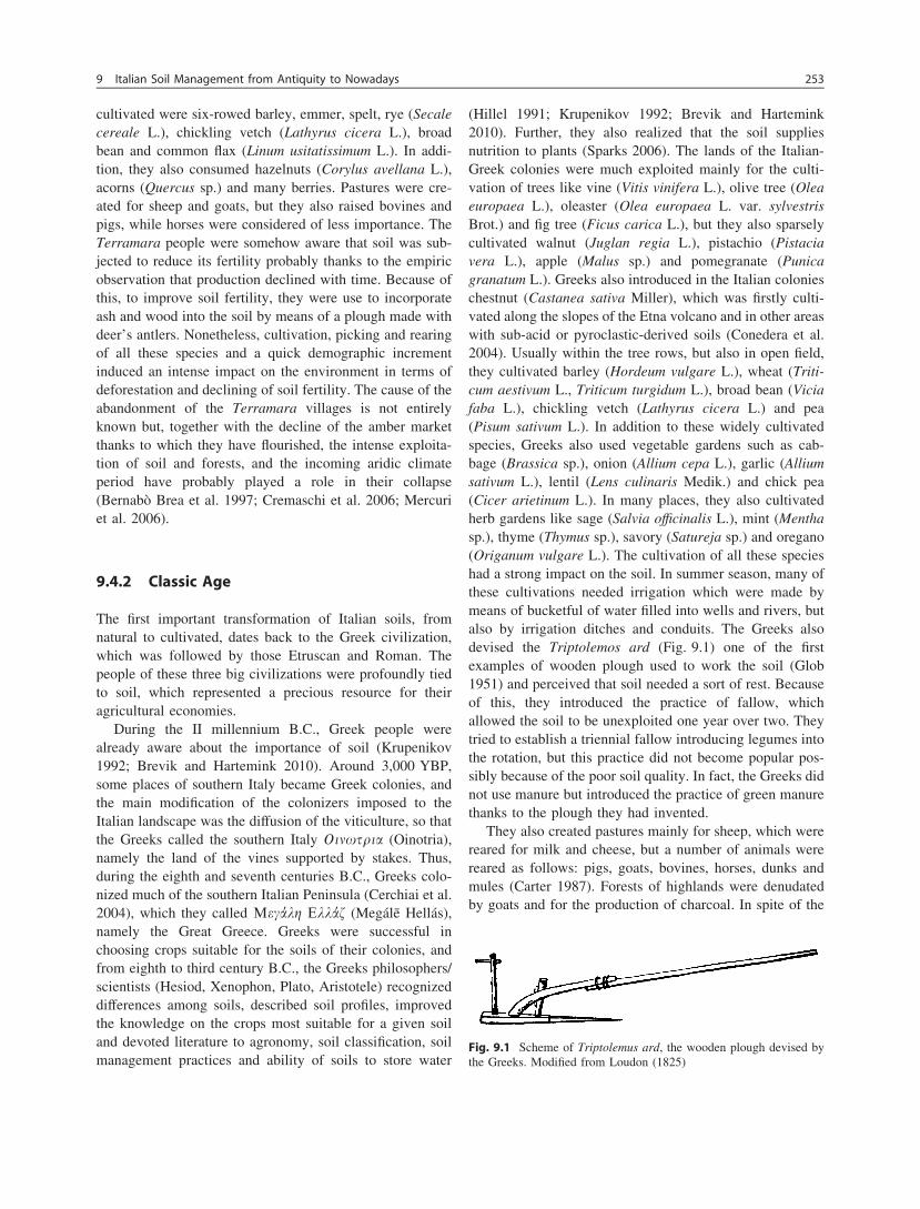
(Hillel 1991; Krupenikov 1992; Brevik and Hartemink2010). Further, they also realized that the soil suppliesnutrition to plants (Sparks 2006). The lands of the Italian-Greek colonies were much exploited mainly for the culti-vation of trees like vine (Vitis vinifera L.), olive tree (Oleaeuropaea L.), oleaster (Olea europaea L. var. sylvestrisBrot.) and fig tree (Ficus carica L.), but they also sparselycultivated walnut (Juglan regia L.), pistachio (Pistaciavera L.), apple (Malus sp.) and pomegranate (Punicagranatum L.). Greeks also introduced in the Italian colonieschestnut (Castanea sativa Miller), which was firstly culti-vated along the slopes of the Etna volcano and in other areaswith sub-acid or pyroclastic-derived soils (Conedera et al.2004). Usually within the tree rows, but also in open field,they cultivated barley (Hordeum vulgare L.), wheat (Triti-cum aestivum L., Triticum turgidum L.), broad bean (Viciafaba L.), chickling vetch (Lathyrus cicera L.) and pea(Pisum sativum L.). In addition to these widely cultivatedspecies, Greeks also used vegetable gardens such as cab-bage (Brassica sp.), onion (Allium cepa L.), garlic (Alliumsativum L.), lentil (Lens culinaris Medik.) and chick pea(Cicer arietinum L.). In many places, they also cultivatedherb gardens like sage (Salvia officinalis L.), mint (Menthasp.), thyme (Thymus sp.), savory (Satureja sp.) and oregano(Origanum vulgare L.). The cultivation of all these specieshad a strong impact on the soil. In summer season, many ofthese cultivations needed irrigation which were made bymeans of bucketful of water filled into wells and rivers, butalso by irrigation ditches and conduits. The Greeks alsodevised the Triptolemos ard (Fig. 9.1) one of the firstexamples of wooden plough used to work the soil (Glob1951) and perceived that soil needed a sort of rest. Becauseof this, they introduced the practice of fallow, whichallowed the soil to be unexploited one year over two. Theytried to establish a triennial fallow introducing legumes intothe rotation, but this practice did not become popular pos-sibly because of the poor soil quality. In fact, the Greeks didnot use manure but introduced the practice of green manurethanks to the plough they had invented.
They also created pastures mainly for sheep, which werereared for milk and cheese, but a number of animals werereared as follows: pigs, goats, bovines, horses, dunks andmules (Carter 1987). Forests of highlands were denudatedby goats and for the production of charcoal. In spite of the
Fig. 9.1 Scheme of Triptolemus ard, the wooden plough devised bythe Greeks. Modified from Loudon (1825)
9 Italian Soil Management from Antiquity to Nowadays 253
strong soil exploitation, the Greeks did not conceive specifictechniques to combat the erosion, which caused soil qualitydecline (Brevik and Hartemink 2010). Hence, as well asthey had caused soil denudation and formation of badlandsin Greece (van Andel et al. 1990), it is assumed they madethe same in the southern Italy, where the intense soilexploitation and the soil-forming factors (semi-coherentsedimentary pedologic substrates, warm and aridic climate,hilly morphology) should have favoured soil erosion.This may explain why in southern Italian regions such asCalabria, Basilicata and Apulia (most of the ancient GreatGreece) there is the diffuse perception that the vast badlandsarea ‘‘has always existed’’.
However, for some aspects, Greeks also paid particularattention to soil quality as they began to drain large areas ofmarshland and floodplain so as to increase agriculturalproductivity (Smith 1976). The reclamation of floodplainhas been continued by Etruscans and Romans in southern aswell as in other parts of Italy so as to arrive to nowadays, asin the case of the agronomic drainage systems that are stillunder process in the area of central Italy known asMaremma.
To obtain cultivable soil in very steep slope areas, Greekfarmers made little terraces that were surrounded by dry-walls to protect the crops from animals and thieves. Theterraces were planted with olive trees and vines that,because of the hydric competition of the grasses and thegood drainage of the artificial soil, had to be irrigated bymeans of ditches and conduits. With this landscape modi-fication, Greeks unwittingly reduced incidence of erosionsin the terraced areas.
Greeks landscape organization included subdivision ofcultivated soil into geometric fields, which were ploughedwith the ard according to regular stripes. Because of this,properties had irregular borders but with geometricallysubdivided fields cultivated with crops under rotation,orchards and isolated tree fruits, drywall terraces, pastures,small woods and a net of ditches and conduits with sparsewells. This man-made landscape tessera is actuallydenominated Mediterranean garden (Sereni 1986) and wasrather diffuse in southern Italy.
In southern Italy, the Greek influence lasted over cen-turies until the end of the later Byzantine Empire (middle offifteenth century). In the meanwhile, the Etruscans inhab-ited the central and northern Italy (their land was labelled asEtruria), and Romans extended their dominium in Italy andsubsequently in many other countries.
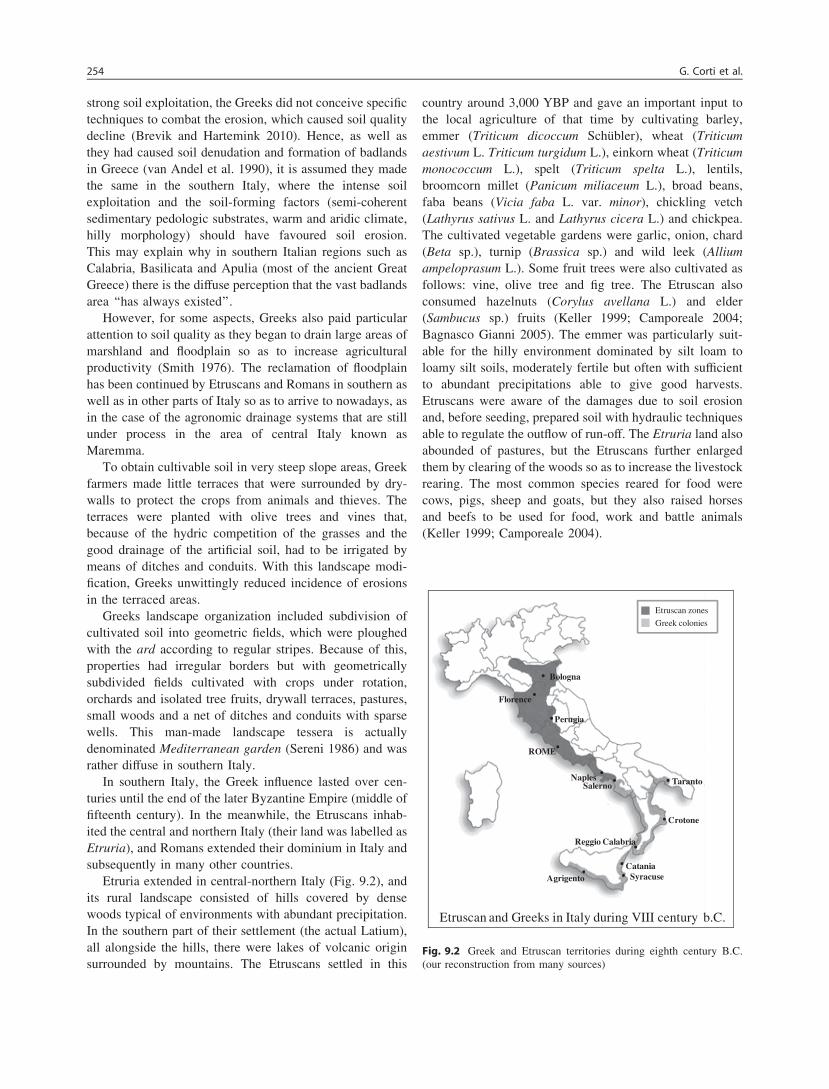
Etruria extended in central-northern Italy (Fig. 9.2), andits rural landscape consisted of hills covered by densewoods typical of environments with abundant precipitation.In the southern part of their settlement (the actual Latium),all alongside the hills, there were lakes of volcanic originsurrounded by mountains. The Etruscans settled in this
country around 3,000 YBP and gave an important input tothe local agriculture of that time by cultivating barley,emmer (Triticum dicoccum Schübler), wheat (Triticumaestivum L. Triticum turgidum L.), einkorn wheat (Triticummonococcum L.), spelt (Triticum spelta L.), lentils,broomcorn millet (Panicum miliaceum L.), broad beans,faba beans (Vicia faba L. var. minor), chickling vetch(Lathyrus sativus L. and Lathyrus cicera L.) and chickpea.The cultivated vegetable gardens were garlic, onion, chard(Beta sp.), turnip (Brassica sp.) and wild leek (Alliumampeloprasum L.). Some fruit trees were also cultivated asfollows: vine, olive tree and fig tree. The Etruscan alsoconsumed hazelnuts (Corylus avellana L.) and elder(Sambucus sp.) fruits (Keller 1999; Camporeale 2004;Bagnasco Gianni 2005). The emmer was particularly suit-able for the hilly environment dominated by silt loam toloamy silt soils, moderately fertile but often with sufficientto abundant precipitations able to give good harvests.Etruscans were aware of the damages due to soil erosionand, before seeding, prepared soil with hydraulic techniquesable to regulate the outflow of run-off. The Etruria land alsoabounded of pastures, but the Etruscans further enlargedthem by clearing of the woods so as to increase the livestockrearing. The most common species reared for food werecows, pigs, sheep and goats, but they also raised horsesand beefs to be used for food, work and battle animals(Keller 1999; Camporeale 2004).
Etruscan and Greeks in Italy during VIII century b.C.
Etruscan zones
Greek colonies
Naples
Crotone
Taranto
Syracuse
Reggio Calabria
CataniaAgrigento
Salerno
ROME
Perugia
Florence
Bologna
Fig. 9.2 Greek and Etruscan territories during eighth century B.C.(our reconstruction from many sources)
254 G. Corti et al.

Contacts with the Greek culture brought the cultivationof vine in Etruria during the seventh century B.C. Thiscultivation became so popular and widespread that in turnsof a century, Etruscan wines were exported throughout theMediterranean sea (Haynes 2005). Starting from the fifthcentury B.C., Etruscans also started the cultivation of olivetree and, after a century, the olive oil begun to be exported(Haynes 2005). The pictures on the Etruscan vases, dis-covered in numerous tombs in Tuscany, revealed how thisculture used and regarded both the olive tree and its oil.Etruscans also introduced the crop rotation with the aim toproduce food while preserving soil. At that time, theEtruscan territory was famous for its fertility, which wasdue to the geological characteristics and the man’s inter-ventions such as manuring, ploughing and irrigation orreclamation of marsh areas (Pallottino 1975; Barker andRasmussen 2000). In fact, the Etruscans were capable ofvaluable works of civil engineering such as excavation ofaqueducts in the rock, change in the river course, drainageof marsh areas surrounding the riverbanks of the majorrivers (Chiani, Ombrone and Po), forming a dense networkof canals and conduits for irrigation and shipping. Shipchannels were diffused mainly in the Po plain and Mare-mma (Rodenwaldt and Lehmann 1962; Carandini et al.2002). This means that, like Greeks, Etruscans heavilyexploited the soil, but the territory of these latter receivedmore precipitations than that of the former, and this wasprobably the reason why soil degradation was less in Etruriathan in the Great Greece. Yet, in Etruria too, there weresemi-coherent and sedimentary plio-pleistocene parentmaterials that made soils prone to catastrophic erosion. Thepresence of badlands in central Italy would be residualerosion forms developed in aridic conditions by degradationof soils with silt, silt clay or silt loam texture (Rodolfi andFrascati 1979; Mazzanti and Rodolfi 1989), when submittedto deforestation (Dramis et al. 1982; Ricci and De Sanctis2004). Because of this, the badlands in the territory of theancient Etruria probably formed during one of the twowarm periods occurred in the last 3,000 years (Alley 2000;Sicre et al. 2008): the Roman Warm Period (250 B.C.–250A.D.) or the Medieval Warm Optimum (950–1250 A.D.).The first one was in the same period the Etruscans pros-pered in their territory and, consequently, with their intensesoil and forest exploitation they could have been responsi-ble for the beginning of a catastrophic soil degradation thatbrought to the formation of badlands. The second warmperiod occurred in correspondence with a strong demo-graphic increment (especially in the cities of Tuscany andEmilia-Romagna, which were part of the ancient Etruria)that entailed deforestation of hills and mountains to getwood as building material or for commerce (il Glabro 1991;Fisher and Pedrotti 1997; Cardini and Montesano 2006).Because of this, it is possible that much of the badlands
territory of the central Italy formed during this period ratherthan during the Etruscan civilization.
Roman society overlapped and succeeded that of theEtruscans and improved the rural land organization.According to Krupenikov (1992), the agricultural and soilknowledge of the Romans was initially developed under theinfluence of the Greeks because of the contact with coloniesof the Great Greece. However, it was also thanks to Romanscientists/writers such as Marcus Porcius Cato, alias Catothe Elder (234–149 B.C.), that the Roman territories wereintroduced of hedgerows, drywalls and ditches to separatecountryside properties. Another roman scientist, MarcusTerentius Varro, known as Varro Reatinus (116–27 B.C.),defined farming as a science. He considered soil as one ofthe most important components of farming, developed a soilclassification system and advocated methods for theimprovement of soil fertility (Krupenikov 1992). Under thefirst Emperor Gaius Iulius Caesar Octavianus Augustus(known as Augustus), from 27 B.C. to 14 A.D., the Romansalso began to terrace steep slopes to reduce soil erosion(Troeh et al. 2004) and obtain soil to cultivate. For the samereason, a strong deforestation interested all the remainingplanitial forests for the double aim to get timber and soil tocultivate or transform in pasture. In fact, the planitial foreststhat occupied deep soils with a high content of organicmatter and a good availability of water were made of oaks(Quercus sp.), elms (Ulmus sp.), limes (Tilia sp.), horn-beams (Carpinus betulus L. and Ostrya carpinifolia Scop.),maples (Acer sp.), ashes (Fraxinus sp.), poplars (Populussp.), alders (Alnus sp.), with a great variety of understory.Where the soils were shallow and/or with a lesser water-holding capacity, vegetation was represented by the asso-ciation known as Macchia Mediterranea (Celant 2002;Di Rita et al. 2010). The fact is that the Roman people had aso high level of consumptions and experienced a so strongdemographic increment that any pocket-handkerchief plotof the Italian territories of the Roman Emperor had to becultivated. As a support of this statement, one has to con-sider that the Rome of Augustus had about 1,000,000inhabitants (Castiglioni 1878; Abbate 2004). Because of thehigh demographic increment and of their style life, Romansimported huge amounts of food and fibres from the colonies,but they also needed to cultivate intensively the Italian soils.Under Augustus, Rome was able to import each year asmuch as 350,000 t of wheat mainly from Egypt, Asiatic andAfrican provinces, Sicily and Sardinia, but importationactivities also included metals, animals, wine, olive oil,cheese, dried fruit, wood, pitch, wax and many otherproducts from any Empire angle (Moss 1980). The scientistGaius Plinius Secundus, known as Pliny the Elder (A.D.23–79), argued about soil fertility decline under cropping(Pliny the Elder 1855). In the same period, Lucius JuniusModeratus Columella (A.D. 4–70), a Roman soldier and
9 Italian Soil Management from Antiquity to Nowadays 255
farmer, wrote a manuscript titled De re rustica, which wascomposed of twelve books devoted to furnish a simplepractical classification of soil aimed to help farmers.According to the Columella’s method, to understand thetype of soil, one had to dig a hole into the soil and then tofill it up with the extracted material. On the basis of thebehaviour of the filling soil material, the soil could beranked into three classes as follows: the soils of the firstclass (fat soils) were those whose extracted material wasoverfilling the hole; the soils of the third class (poor soils)were those whose extracted material was not sufficient to fillthe hole; the soils of the second class (moderate soils) werethose in between. This is one of the first examples of soilclassification based on soil properties (Nortcote 1986).However, at the end of the Roman Empire (fifth century),there was a soil classification that included considerationsof mineral grain size, colour, density, structure and fertilityof the soil, and had some recommended tests for deter-mining soil properties and fertility (Tisdale et al. 1993;Winiwarter 2006).
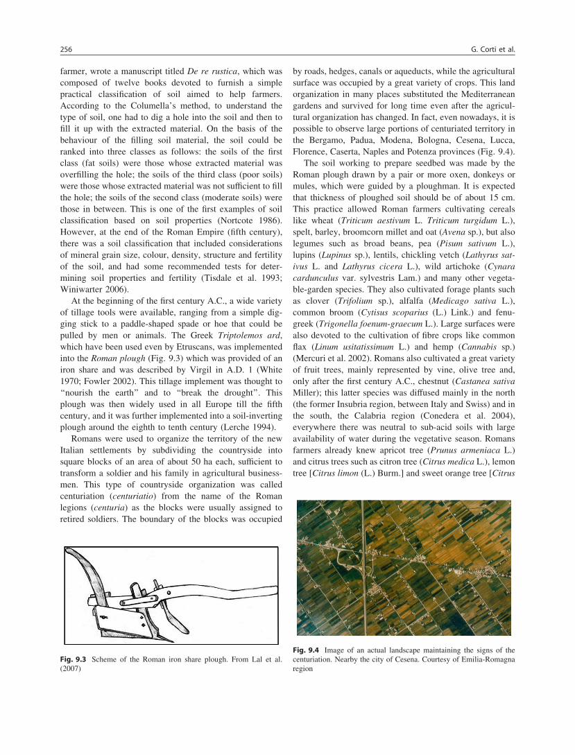
At the beginning of the first century A.C., a wide varietyof tillage tools were available, ranging from a simple dig-ging stick to a paddle-shaped spade or hoe that could bepulled by men or animals. The Greek Triptolemos ard,which have been used even by Etruscans, was implementedinto the Roman plough (Fig. 9.3) which was provided of aniron share and was described by Virgil in A.D. 1 (White1970; Fowler 2002). This tillage implement was thought to‘‘nourish the earth’’ and to ‘‘break the drought’’. Thisplough was then widely used in all Europe till the fifthcentury, and it was further implemented into a soil-invertingplough around the eighth to tenth century (Lerche 1994).
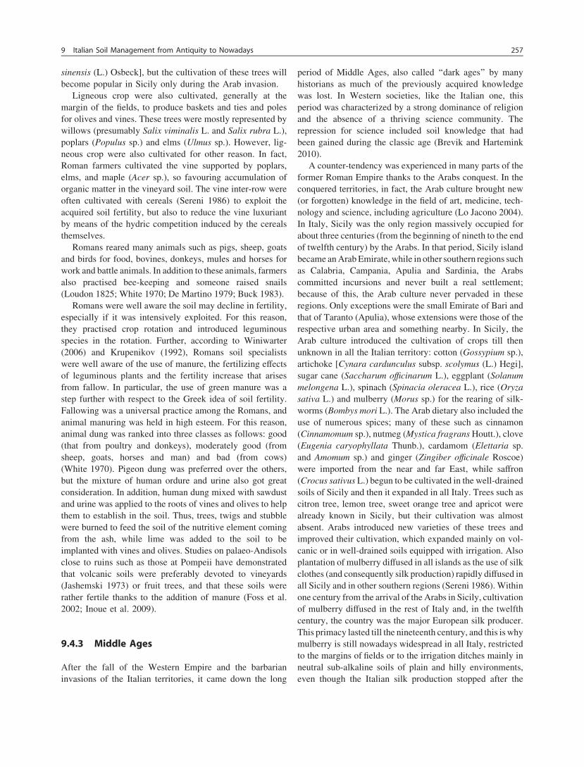
Romans were used to organize the territory of the newItalian settlements by subdividing the countryside intosquare blocks of an area of about 50 ha each, sufficient totransform a soldier and his family in agricultural business-men. This type of countryside organization was calledcenturiation (centuriatio) from the name of the Romanlegions (centuria) as the blocks were usually assigned toretired soldiers. The boundary of the blocks was occupied
by roads, hedges, canals or aqueducts, while the agriculturalsurface was occupied by a great variety of crops. This landorganization in many places substituted the Mediterraneangardens and survived for long time even after the agricul-tural organization has changed. In fact, even nowadays, it ispossible to observe large portions of centuriated territory inthe Bergamo, Padua, Modena, Bologna, Cesena, Lucca,Florence, Caserta, Naples and Potenza provinces (Fig. 9.4).
The soil working to prepare seedbed was made by theRoman plough drawn by a pair or more oxen, donkeys ormules, which were guided by a ploughman. It is expectedthat thickness of ploughed soil should be of about 15 cm.This practice allowed Roman farmers cultivating cerealslike wheat (Triticum aestivum L. Triticum turgidum L.),spelt, barley, broomcorn millet and oat (Avena sp.), but alsolegumes such as broad beans, pea (Pisum sativum L.),lupins (Lupinus sp.), lentils, chickling vetch (Lathyrus sat-ivus L. and Lathyrus cicera L.), wild artichoke (Cynaracardunculus var. sylvestris Lam.) and many other vegeta-ble-garden species. They also cultivated forage plants suchas clover (Trifolium sp.), alfalfa (Medicago sativa L.),common broom (Cytisus scoparius (L.) Link.) and fenu-greek (Trigonella foenum-graecum L.). Large surfaces werealso devoted to the cultivation of fibre crops like commonflax (Linum usitatissimum L.) and hemp (Cannabis sp.)(Mercuri et al. 2002). Romans also cultivated a great varietyof fruit trees, mainly represented by vine, olive tree and,only after the first century A.C., chestnut (Castanea sativaMiller); this latter species was diffused mainly in the north(the former Insubria region, between Italy and Swiss) and inthe south, the Calabria region (Conedera et al. 2004),everywhere there was neutral to sub-acid soils with largeavailability of water during the vegetative season. Romansfarmers already knew apricot tree (Prunus armeniaca L.)and citrus trees such as citron tree (Citrus medica L.), lemontree [Citrus limon (L.) Burm.] and sweet orange tree [Citrus
Fig. 9.3 Scheme of the Roman iron share plough. From Lal et al.(2007)
Fig. 9.4 Image of an actual landscape maintaining the signs of thecenturiation. Nearby the city of Cesena. Courtesy of Emilia-Romagnaregion
256 G. Corti et al.
sinensis (L.) Osbeck], but the cultivation of these trees willbecome popular in Sicily only during the Arab invasion.
Ligneous crop were also cultivated, generally at themargin of the fields, to produce baskets and ties and polesfor olives and vines. These trees were mostly represented bywillows (presumably Salix viminalis L. and Salix rubra L.),poplars (Populus sp.) and elms (Ulmus sp.). However, lig-neous crop were also cultivated for other reason. In fact,Roman farmers cultivated the vine supported by poplars,elms, and maple (Acer sp.), so favouring accumulation oforganic matter in the vineyard soil. The vine inter-row wereoften cultivated with cereals (Sereni 1986) to exploit theacquired soil fertility, but also to reduce the vine luxuriantby means of the hydric competition induced by the cerealsthemselves.
Romans reared many animals such as pigs, sheep, goatsand birds for food, bovines, donkeys, mules and horses forwork and battle animals. In addition to these animals, farmersalso practised bee-keeping and someone raised snails(Loudon 1825; White 1970; De Martino 1979; Buck 1983).
Romans were well aware the soil may decline in fertility,especially if it was intensively exploited. For this reason,they practised crop rotation and introduced leguminousspecies in the rotation. Further, according to Winiwarter(2006) and Krupenikov (1992), Romans soil specialistswere well aware of the use of manure, the fertilizing effectsof leguminous plants and the fertility increase that arisesfrom fallow. In particular, the use of green manure was astep further with respect to the Greek idea of soil fertility.Fallowing was a universal practice among the Romans, andanimal manuring was held in high esteem. For this reason,animal dung was ranked into three classes as follows: good(that from poultry and donkeys), moderately good (fromsheep, goats, horses and man) and bad (from cows)(White 1970). Pigeon dung was preferred over the others,but the mixture of human ordure and urine also got greatconsideration. In addition, human dung mixed with sawdustand urine was applied to the roots of vines and olives to helpthem to establish in the soil. Thus, trees, twigs and stubblewere burned to feed the soil of the nutritive element comingfrom the ash, while lime was added to the soil to beimplanted with vines and olives. Studies on palaeo-Andisolsclose to ruins such as those at Pompeii have demonstratedthat volcanic soils were preferably devoted to vineyards(Jashemski 1973) or fruit trees, and that these soils wererather fertile thanks to the addition of manure (Foss et al.2002; Inoue et al. 2009).
9.4.3 Middle Ages
After the fall of the Western Empire and the barbarianinvasions of the Italian territories, it came down the long
period of Middle Ages, also called ‘‘dark ages’’ by manyhistorians as much of the previously acquired knowledgewas lost. In Western societies, like the Italian one, thisperiod was characterized by a strong dominance of religionand the absence of a thriving science community. Therepression for science included soil knowledge that hadbeen gained during the classic age (Brevik and Hartemink2010).
A counter-tendency was experienced in many parts of theformer Roman Empire thanks to the Arabs conquest. In theconquered territories, in fact, the Arab culture brought new(or forgotten) knowledge in the field of art, medicine, tech-nology and science, including agriculture (Lo Jacono 2004).In Italy, Sicily was the only region massively occupied forabout three centuries (from the beginning of nineth to the endof twelfth century) by the Arabs. In that period, Sicily islandbecame an Arab Emirate, while in other southern regions suchas Calabria, Campania, Apulia and Sardinia, the Arabscommitted incursions and never built a real settlement;because of this, the Arab culture never pervaded in theseregions. Only exceptions were the small Emirate of Bari andthat of Taranto (Apulia), whose extensions were those of therespective urban area and something nearby. In Sicily, theArab culture introduced the cultivation of crops till thenunknown in all the Italian territory: cotton (Gossypium sp.),artichoke [Cynara cardunculus subsp. scolymus (L.) Hegi],sugar cane (Saccharum officinarum L.), eggplant (Solanummelongena L.), spinach (Spinacia oleracea L.), rice (Oryzasativa L.) and mulberry (Morus sp.) for the rearing of silk-worms (Bombys mori L.). The Arab dietary also included theuse of numerous spices; many of these such as cinnamon(Cinnamomum sp.), nutmeg (Mystica fragrans Houtt.), clove(Eugenia caryophyllata Thunb.), cardamom (Elettaria sp.and Amomum sp.) and ginger (Zingiber officinale Roscoe)were imported from the near and far East, while saffron(Crocus sativus L.) begun to be cultivated in the well-drainedsoils of Sicily and then it expanded in all Italy. Trees such ascitron tree, lemon tree, sweet orange tree and apricot werealready known in Sicily, but their cultivation was almostabsent. Arabs introduced new varieties of these trees andimproved their cultivation, which expanded mainly on vol-canic or in well-drained soils equipped with irrigation. Alsoplantation of mulberry diffused in all islands as the use of silkclothes (and consequently silk production) rapidly diffused inall Sicily and in other southern regions (Sereni 1986). Withinone century from the arrival of the Arabs in Sicily, cultivationof mulberry diffused in the rest of Italy and, in the twelfthcentury, the country was the major European silk producer.This primacy lasted till the nineteenth century, and this is whymulberry is still nowadays widespread in all Italy, restrictedto the margins of fields or to the irrigation ditches mainly inneutral sub-alkaline soils of plain and hilly environments,even though the Italian silk production stopped after the
9 Italian Soil Management from Antiquity to Nowadays 257

World War II. Some historians have defined the agriculturalmodification occurred in Sicily at that time as the ‘‘ArabAgricultural Revolution of the Middle Ages’’, meaning thatthe implementation of cultivations was of high level (Watson1974; Di Pasquale et al. 2004). In effect, the Arabs developeda scientific approach to agriculture based on advanced sys-tems of crop rotation, irrigation techniques and the cata-loguing of a large variety of crops according to season, type ofland and amount of water they required (Watson 1974). Arabsalso developed a system of cultivation that combined orch-ards and vegetable garden known with the Spanish wordhuerta. Each huerta was organized with trees [citrus, apricot,laurel (Laurus nobilis L.), myrtle (Myrtus communis L.), etc.]that shadowed vegetable cultivations and was all manuredand irrigated so as to have more harvests during the year.In wide extensions of good soils, many huertas were madeone close to the other, so as to take advantage from irrigationand fertilization. This sort of landscape organization is knownas ‘‘the Islamic garden’’ (Fairchild Ruggles 2008) and wasdiffused in all the Sicilian plains where there was a certainavailability of water to irrigate. The famous Conca d’Oro(golden basin) in which the city of Palermo grew is a fertilevalley once organized as huertas (Bresc 1972; Lombard2004). To have an idea of how attractive and useful was theConca d’Oro, Palermo was called Gennai al-rad, namely theParadise on Earth. The hilly environments made of heavysoil with relatively high water retention were cultivated withdurum wheat. As this wheat contains less gluten than the softone, it was not milled to have flour for bread but to have acoarse flour known as semolina (from the Arab semoules)used to make couscous.
The rest of Italy, submitted to a long period of anarchyand barbarism, faced population decline and landscapechange. Roman centuriated territory almost disappeared andin many places pasturage was preferred to tillage. Agri-cultural and human activities focused around castles andfortified villages where the peasant population residing inthe countryside could find protection in case of enemyattack. Agriculture survived in little ‘‘kitchen gardens’’within the city walls and in religious buildings possessionsthat were considered as respected territories; here, the landswere cultivated by servants under directions of the priests.Since the food products derived from in-wall agriculturalactivities, some practices were developed to increase cropproductivity, which, however, did not avoid famine crisis.Among all, the old Roman plough was improved and a newheavy plough equipped with a mouldboard that allowedreversing a thicker slice of earth was devised. Also therewas the introduction of a three-year crop rotation, the smallagricultural areas on which agriculture persisted weredivided into three plots and in each plot winter cereals,
annual legumes and fallowing succeeded. The soil fertilitywas enhanced thanks to animal manuring and human ordure(Anderlini 1981). Far from the cities, a general lack of carefor agriculture raged and, consequently, during early Mid-dle Ages, soils experienced a fertility decline that obligedthe farmers to cultivate poor cereals like oats (Avena sp.),millet (Panicum miliaceum L.), sorghum (Sorghum sp.) andbarley (Hordeum vulgare L.), while olive tree and vine werecultivated close to the cities. Along the Apennines chain,also chestnut (Castanea sativa Miller) was rather diffused.Orchards were mainly concentrated around the great lakesof the north as well as of central Italy, while lemon andsweet orange trees were diffused in the south (Kleinhenzand Barker 2004).
As a further demonstration of the lack of care for agri-culture, in the first centuries of Middle Ages forests andswamps expanded re-occupying former cultivated soils that,in turns, had been obtained from deforestation and drainage.Further, Italy, as all the north Atlantic and North Americaregions, experienced a warm climate known as MedievalWarm Optimum, which lasted from 950 to 1250 (Grove andSwitsur 1994; Mann et al. 2009). In these 300 years, forestsre-occupied areas of higher altitudes but, in general, thesoils faced a fertility decline because of the strong demo-graphic increment that occurred around the eleventhcentury.
During thirteen to fourteenth century, viticulture andoliviculture almost disappeared, surviving only in monas-teries, convents, churches and within the wall of the city-states such as Florence and Siena. Since twelfth century, Poplain marshes were reclaimed by Chiaravalle Monks thattransformed waterlogged soils into productive soils. In thisperiod, in fact, they began water-meadow cultivation thatendured until recent times. Thanks to the monks, cultivationof rice began in the hydromorphic soils since fourteenthcentury, and rice became one of the most characteristiccereals of the Po plain for centuries. Chiaravalle monkswere considered expert hydraulic engineers and practisedirrigation from the eleventh century.
The soil drainage and reclamation of the southern Poplain began in the tenth century and continued until thesecond half of the twentieth century. In the early part of thefourteenth century, the inhabitants of southern Italy wereignorant of the vine cultivation while Florentines tradedwine with England and France. Because of the lack ofmanuscripts about agriculture of this period, the mostimportant instrument to understand land organization ispictures which often represented agriculture and pastoralactivities. Forests and hunting scenes were generallydepicted in a wild landscape with extended marshlands andwithout particular soil organization (Sereni 1997).
258 G. Corti et al.
9.4.4 The Age of Communes
Social and policy evolution has often conditioned soilmanagement and organization. After the Middle Ages, theage of municipalities began and agriculture flourished againout of the city walls. Large extensions of marsh soils werereclaimed and ploughed, while agronomists like Pietro De’Crescenzi with his book Trattato della Agricoltura (EstateCultivation) suggested instructions to save deforested slopesfrom erosion using trees and bushes especially in the centralItaly. In the Po plain, meadows and fields of cereals weredelimited by ditches and tree rows. Depicted countrylandscapes of this period show a new organization ofenclosed plots of land all around the cities which generallyrested at the top of the hills. On the slopes, pastures andwoods extended where stock-breeding and hunting werepractised.
The discovery of the Americas was a major ‘‘revolution’’that brought a variety of benefits for the Western man. Theoccupation of the Americas provided the Western societiesof new varieties or new species to be imported in Europe,such as maize, potato, tomato and beans. All these cropswere rapidly introduced into the rotations.
9.4.5 Renaissance and Modern Age
In the sixteenth century, a period of scientific thinking andapproach to natural resources began. The scientific studyencompassed many disciplines including agriculture. Thefarmer improved drainage systems to eliminate excesswater, land fertilization and the terracing of steep terrain.During this period, the greatest agricultural improvementsin Italy took place in Tuscany, Lombardy and Veneto. Thefirst excelled in vine and olive culture, while in the otherstwo rice, maize (Zea mays L.), vineyards and cattle breedingabounded. Pastures were widespread in plains with suitableclimate conditions, good soils and abundant water for irri-gation. The agricultural landscape of this period was rep-resented as very attractive by many painters, andintellectuals like Leonardo da Vinci gave an importantcontribution to engineering progress with drainage andirrigation projects in Arno and Adda rivers and in the Poplain. In the same period, however, the south of Italy wasless involved in the agricultural progresses, and the land-scape was characterized by Mediterranean gardens and‘‘starze’’, a sort of enclosed orange and olive treesplantations.
During the Renaissance, farmers started to cultivateforage crops so as to feed the livestock during the wintermonths. The property of alfalfa (Medicago sativa L.) andclover (Trifolium sp.) to restore soil fertility enabled farmers
to reduce or eliminate the practice of fallow to replenish thesoil. Alfalfa, which had been cultivated as a forage crop inancient times and fell out of use in Italy during the MiddleAges, reappeared in Italy around the year 1540, after therediscovery of Columella’s writings. Alfalfa was mostlycultivated in northern Italy, sometimes along with rice.During this age, farmers put fences around their fields toseparate them from pasture or open areas.
The northern cool districts were devoted to pastures, thehills of central Italy hosted olive trees and vines, and theplains were cultivated with maize (Zea mays L.). The Poplain soils in Lombardy and part of Piedmont were enclosedwith hedges of different plants (willow, mulberry) and dit-ches, or with open water courses for irrigation. Forage cropswere cultivated for cattle, and the trees were common in thehedgerows. Cultivation of pear (Pyrus sp.) and apple (Malussp.) trees was common, while olive trees were planted ondeclivities with southern exposure. In central Italy, Tuscanclimate was esteemed as the best of Italy with the exceptionof that of Maremma, the malaria-affected region on the sea-coast. Irrigation was practised in Lombardy in every plain,where the fields were generally surrounded by ditch plantedwith poplars and vines or by rows lengthways made ofmulberry, maple or manna ash (Fraxinus ornus L.), alsointerspersed with vines. In the arable lands of the plains,three- or five-year crop rotations were adopted.
9.4.6 Risorgimento
In the first decades of 1800, agriculture dominated theItalian economy and the type of farming varied from northto south (Chapman 2008). In the north of Italy, Lombardyand Veneto regions, farmers cultivated rice, maize and flaxin the fertile soils of the Po plain and produced wines andsilk; in central Italy, farmers cultivated the hilly land withvines, olive trees and cereals, while in the southern regionslatifundia abounded of cash crops such as tobacco andwheat in the plains and olive trees on the hills of the warmerareas. Different situations required different soil manage-ment. In fact, the soils of the northern Italy needed drainageand hydraulic land settings because of the abundance ofwater, the hilly soils of central Italy needed land set-upsystems to prevent erosion, whereas the southern soils,affected by aridity, needed a careful water conservationmanagement.
In 1853, one of the most efficient and, for the time, largeirrigation systems was built in the rural area of Vercelli(northern Italy). The complex infrastructure was upgradedin 1866 with the construction of the Gran Canale Cavour(Fig. 9.5), a canal that allowed the distribution of water ofthe Po, Dora Baltea, Sesia, Ticino rivers and Maggiore lake
9 Italian Soil Management from Antiquity to Nowadays 259
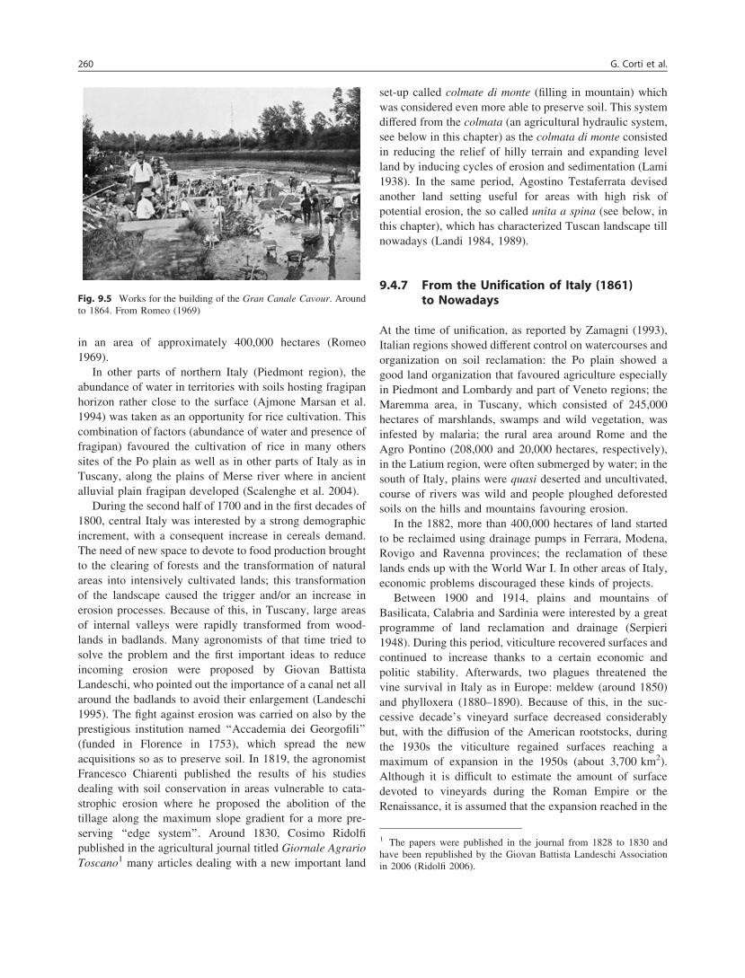
in an area of approximately 400,000 hectares (Romeo1969).
In other parts of northern Italy (Piedmont region), theabundance of water in territories with soils hosting fragipanhorizon rather close to the surface (Ajmone Marsan et al.1994) was taken as an opportunity for rice cultivation. Thiscombination of factors (abundance of water and presence offragipan) favoured the cultivation of rice in many otherssites of the Po plain as well as in other parts of Italy as inTuscany, along the plains of Merse river where in ancientalluvial plain fragipan developed (Scalenghe et al. 2004).
During the second half of 1700 and in the first decades of1800, central Italy was interested by a strong demographicincrement, with a consequent increase in cereals demand.The need of new space to devote to food production broughtto the clearing of forests and the transformation of naturalareas into intensively cultivated lands; this transformationof the landscape caused the trigger and/or an increase inerosion processes. Because of this, in Tuscany, large areasof internal valleys were rapidly transformed from wood-lands in badlands. Many agronomists of that time tried tosolve the problem and the first important ideas to reduceincoming erosion were proposed by Giovan BattistaLandeschi, who pointed out the importance of a canal net allaround the badlands to avoid their enlargement (Landeschi1995). The fight against erosion was carried on also by theprestigious institution named ‘‘Accademia dei Georgofili’’(funded in Florence in 1753), which spread the newacquisitions so as to preserve soil. In 1819, the agronomistFrancesco Chiarenti published the results of his studiesdealing with soil conservation in areas vulnerable to cata-strophic erosion where he proposed the abolition of thetillage along the maximum slope gradient for a more pre-serving ‘‘edge system’’. Around 1830, Cosimo Ridolfipublished in the agricultural journal titled Giornale AgrarioToscano1 many articles dealing with a new important land
set-up called colmate di monte (filling in mountain) whichwas considered even more able to preserve soil. This systemdiffered from the colmata (an agricultural hydraulic system,see below in this chapter) as the colmata di monte consistedin reducing the relief of hilly terrain and expanding levelland by inducing cycles of erosion and sedimentation (Lami1938). In the same period, Agostino Testaferrata devisedanother land setting useful for areas with high risk ofpotential erosion, the so called unita a spina (see below, inthis chapter), which has characterized Tuscan landscape tillnowadays (Landi 1984, 1989).
9.4.7 From the Unification of Italy (1861)to Nowadays
At the time of unification, as reported by Zamagni (1993),Italian regions showed different control on watercourses andorganization on soil reclamation: the Po plain showed agood land organization that favoured agriculture especiallyin Piedmont and Lombardy and part of Veneto regions; theMaremma area, in Tuscany, which consisted of 245,000hectares of marshlands, swamps and wild vegetation, wasinfested by malaria; the rural area around Rome and theAgro Pontino (208,000 and 20,000 hectares, respectively),in the Latium region, were often submerged by water; in thesouth of Italy, plains were quasi deserted and uncultivated,course of rivers was wild and people ploughed deforestedsoils on the hills and mountains favouring erosion.
In the 1882, more than 400,000 hectares of land startedto be reclaimed using drainage pumps in Ferrara, Modena,Rovigo and Ravenna provinces; the reclamation of theselands ends up with the World War I. In other areas of Italy,economic problems discouraged these kinds of projects.
Between 1900 and 1914, plains and mountains ofBasilicata, Calabria and Sardinia were interested by a greatprogramme of land reclamation and drainage (Serpieri1948). During this period, viticulture recovered surfaces andcontinued to increase thanks to a certain economic andpolitic stability. Afterwards, two plagues threatened thevine survival in Italy as in Europe: meldew (around 1850)and phylloxera (1880–1890). Because of this, in the suc-cessive decade’s vineyard surface decreased considerablybut, with the diffusion of the American rootstocks, duringthe 1930s the viticulture regained surfaces reaching amaximum of expansion in the 1950s (about 3,700 km2).Although it is difficult to estimate the amount of surfacedevoted to vineyards during the Roman Empire or theRenaissance, it is assumed that the expansion reached in the
Fig. 9.5 Works for the building of the Gran Canale Cavour. Aroundto 1864. From Romeo (1969)
1 The papers were published in the journal from 1828 to 1830 andhave been republished by the Giovan Battista Landeschi Associationin 2006 (Ridolfi 2006).
260 G. Corti et al.

1950s was the maximum reached in the Italian viticulturehistory (Corti et al. 2011a). Thus, a surface reduction startedand it persists till nowadays when a surface of about8,000 km2 has been reached.
At the beginning of 1900, different physiographic situ-ations and land organization along the peninsula still causeddifferent levels of technological advances in north, centreand south Italy. In the north, there were born ‘‘farmersassociations’’ and peripatetic agricultural instructors whoprovided farmers with selected seeds, fertilizers, pesticidesand machinery, while in the south, these figures wereintroduced later. In the same period, the adoption ofchemical fertilizers was accompanied by an increase in theproduction especially in the Po plain (Zamagni 1993).
In the first decades of the twentieth century, the main soilmanagement revolution was the reclamation (bonificaintegrale) of waterlogged soils and marshes, which tookplace in several Italian areas such as Bassa Friuliana inFriuli Venezia Giulia, Agro Pontino in Latium, coastalplains of Ferrara in Emilia-Romagna, Catania plain inSicily, Arborea in Sardinia and others. In these areas, thisreclamation allowed malaria diffusion to be almost solvedand agriculture developed (ITPA 1970). Contemporarily, agreat technological effort was made to expand the irrigatedareas by the construction of water pumps, ditches, canals,etc. These new infrastructures had a big impact in theagricultural soil use and management by increasing thecultivation of maize and rice mainly in northern Italy,flowers in Liguria, fruit and horticultural crops in the Poplain and in the south. In order to increase the nationalwheat yields and to become autonomous for wheat flourproduction, the Italian government launched in 1925 the socalled ‘‘Battle for Grains’’ (battaglia del grano), whichconsisted of an increased use of chemical fertilizers(Fig. 9.6) and the substitution of fruit and vegetables pro-duction with wheat in many areas. As a result of thiscampaign, Italy did increase grain production, but the fruitand vegetable production declined (ITPA 1970).
In Italy, farm mechanization started in the 1930s, and itencouraged agricultural intensification and progressive cropspecialization that favoured nutrients, pesticides and heavymetals soil loading. Hedgerows and sparse vine rows almostdisappeared. The intensification of agricultural practicesalso influenced soil physical characteristics such as struc-ture and drainage, and modified the organization of the soilhorizons so as to lower variability and diversity of soilmicroflora and microfauna (Gray 1987; Haynes et al. 1995).
The availability of electric pumps allowed the drainageof vast areas, especially along the shores of the lagoons.Rice cultivation was widespread and different stages ofcultivation (land preparation, planting and flooding, weed-ing and rice harvest) required a lot of manpower. Above all,the manual removal of weeds and harvest, until the 1950s
brought into paddy fields 260–280 thousand people in latespring and autumn. The practice of transplantation in orderto exploit the soil with other crops, then abandoned,required a great number of highly skilled workers.
During this period, Italian soil management profoundlychanged by neglecting most of the previously developedsoil management, so improving incidence of landslides andrun-off. In addition, soil management in the last decades hasbeen led by the numerous European directives, as reportedin the following paragraph.
9.5 Effect of European Directives on the Soiland Land Management
Soil management has been frequently driven by techno-logical innovations (Schneeberger et al. 2007) and socialand cultural changes (Antrop 2005; Mattison and Norris2005), but also by policies such as laws and regulations(IEEP 2007; Osterburg et al. 2010) and economic instru-ments like subsidies and taxes (Aviron et al. 2009; Stoateet al. 2009). The European Union (EU) policy instruments
Fig. 9.6 Advertising poster produced in the first years of 1900 forMagni & C., an Italian (Vicenza) agricultural supply company. Themotto says ‘‘by fertilizing we cultivate the plenty’’. Location ScienceMuseum, London
9 Italian Soil Management from Antiquity to Nowadays 261

have always played a crucial role in shaping agriculturalsystems and, among them, the Common Agricultural Policy(CAP) contributed particularly to the increase in croppingsystems productivity through agricultural intensification andfarm specialization (Tappeiner et al. 2003; Stoate et al.2009; Acs et al. 2010). In fact, when it was introduced in1962, the CAP’s original goal was to expand production inorder to reduce dependence on imported food as well as tocut down the EU import requirements in energy, rawmaterials, etc. The growing intensification of productioncaused several problems such as persistent products sur-pluses associated mainly to decline of demand and popu-lation falling and ageing, asymmetries between the kind ofproducts available or their quality and what consumerswanted, and a range of environmental threats. For example,greater specialization towards arable farming systems hadfrequently meant the end of traditional cropping systemsand the use of green manure that helped restoring thecontent of soil organic matter. In some Italian areas, thesefactors have induced farmers to develop cropping systemsand forest management practices not fully harmonized withthe local environmental conditions, so causing land degra-dation (INEA 1999a).
The CAP reform in 1992 (the so called MacSharryreform) was designed to reduce production (e.g. settingaside farmland), to encourage greater attention to theenvironment and to the use of land and to decrease prices.The subsidies favoured the cultivation of some crops(wheat, oil seeds, etc.) even under unsuitable ecologicalconditions. Example of this is the cultivation of sunflowerunder rainfed semi-arid Mediterranean conditions, whichbecame a rather common practice in all the southern regionsof Italy. In fact, farmers received subsidies just because theyfollowed sustainable agricultural practices, no matter theyproduced or not! At the same time, the CAP was not alwaysfully in accordance with other European directives, leadingto contrasting impacts on land use compared to the intendedgoals. For instance, Roggero and Toderi (2002) observed agreater adoption of the agro-environmental measures underthe Regulation 2,078/92 in the farms characterized by apredominant incidence of already low-input cropping sys-tems (i.e. alfalfa meadows, vineyards) than in the farmsreceiving the CAP-coupled subsidies to grow mainly wheatand oilseeds. This lack of coordination between CAP and2078/92/EC schemes limited the achievement of the agro-environmental objectives to induce the more intensivecropping systems to be converted into low-input or evenorganic farming systems.
It is important to highlight that among the major threatsto the ecology of agro-ecosystems, both intensification insome regions and concurrent abandonment in others are keyof the soil state and of the biological diversity in agricul-tural landscapes (Stoate et al. 2009). The last CAP reforms
have put a greater emphasis on environmental concerns byintroducing accompanying measures such as agro-environ-mental schemes and by making direct payments to farmersconditional on meeting the cross-compliance requirements(Aviron et al. 2009; Stoate et al. 2009). Despite theincreased attention towards environment-friendly farmingpractices, soil protection was not so far a specific objectiveof EU legislation, but it is cited in some policies as asecondary objective. For instance, the Nitrate Directive(91/676/EEC) and the Water Framework Directive (2000/60/EC) could contribute to some extent to soil quality,although not always effectively (Louwagie et al. 2011).Other directives, such as the Sewage Sludge Directive(86/278/EEC), the Birds Directive (79/409/EEC) and theHabitats Directive (92/43/EEC) are expected to have ben-eficial effects on soil quality, but to a lesser extent owing toa more focussed set of objectives. The EU Commission isstill discussing on the opportunity to develop a specific SoilFramework Directive [COM(2006)232] targeted to soilconservation and sustainable use of soil, proposed withinthe Thematic Strategy for Soil Protection [COM(2006)231].
Nevertheless, the EU policies have been evaluated onlyto a limited extent for the achievement of their, even sec-ondary, soil quality goals. The assessments were restrictedto specific policy measures (Alliance Environnement 2007;Hudec et al. 2007) or considered only one soil degradationprocess (Rodrigues et al. 2009). Moreover, target levels ofsoil quality were not often clearly defined, the uptake ofmany measures for soil protection was low also due tolimited awareness-raising and technical advice efforts, andthe coordination between existing measures focused on soilprotection is missing at the EU level (Louwagie et al. 2011).However, some initiatives at national and local levels exist.Another problem is the lack of data from a monitoringnetwork on soils and in relation to the adopted managementsystem at territorial scale (see, for example, Rusco et al.2009). For a comprehensive assessment of the role of EUpolicies to address soil degradation processes linked toagricultural systems, we suggest the chapter of Louwagieet al. (2011).
9.5.1 Set-Aside
Agricultural set-aside schemes were introduced by the CAPin the late 1980s to reduce the large and costly surplusesproduced in Europe, and it should also favour the restora-tion of self-sustaining plant successions by taking soil out ofproduction. In 1993, thanks to the MacSharry reform, set-aside became obligatory for any farmer receiving EuropeanEconomic Community subsidies, whose main goal was todecrease rates of cereal production. The reform included aset-aside programme requiring farmers to take certain
262 G. Corti et al.
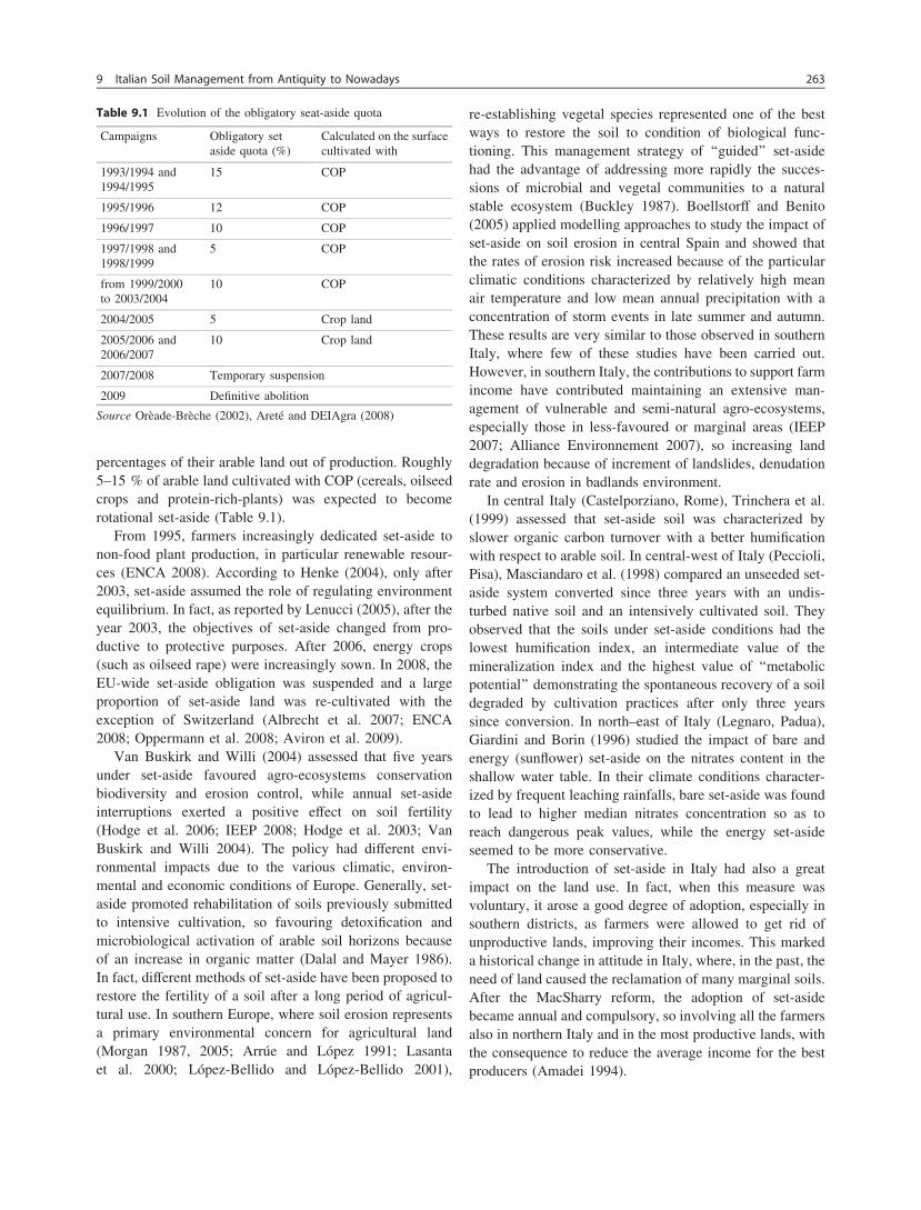
percentages of their arable land out of production. Roughly5–15 % of arable land cultivated with COP (cereals, oilseedcrops and protein-rich-plants) was expected to becomerotational set-aside (Table 9.1).
From 1995, farmers increasingly dedicated set-aside tonon-food plant production, in particular renewable resour-ces (ENCA 2008). According to Henke (2004), only after2003, set-aside assumed the role of regulating environmentequilibrium. In fact, as reported by Lenucci (2005), after theyear 2003, the objectives of set-aside changed from pro-ductive to protective purposes. After 2006, energy crops(such as oilseed rape) were increasingly sown. In 2008, theEU-wide set-aside obligation was suspended and a largeproportion of set-aside land was re-cultivated with theexception of Switzerland (Albrecht et al. 2007; ENCA2008; Oppermann et al. 2008; Aviron et al. 2009).
Van Buskirk and Willi (2004) assessed that five yearsunder set-aside favoured agro-ecosystems conservationbiodiversity and erosion control, while annual set-asideinterruptions exerted a positive effect on soil fertility(Hodge et al. 2006; IEEP 2008; Hodge et al. 2003; VanBuskirk and Willi 2004). The policy had different envi-ronmental impacts due to the various climatic, environ-mental and economic conditions of Europe. Generally, set-aside promoted rehabilitation of soils previously submittedto intensive cultivation, so favouring detoxification andmicrobiological activation of arable soil horizons becauseof an increase in organic matter (Dalal and Mayer 1986).In fact, different methods of set-aside have been proposed torestore the fertility of a soil after a long period of agricul-tural use. In southern Europe, where soil erosion representsa primary environmental concern for agricultural land(Morgan 1987, 2005; Arrúe and López 1991; Lasantaet al. 2000; López-Bellido and López-Bellido 2001),
re-establishing vegetal species represented one of the bestways to restore the soil to condition of biological func-tioning. This management strategy of ‘‘guided’’ set-asidehad the advantage of addressing more rapidly the succes-sions of microbial and vegetal communities to a naturalstable ecosystem (Buckley 1987). Boellstorff and Benito(2005) applied modelling approaches to study the impact ofset-aside on soil erosion in central Spain and showed thatthe rates of erosion risk increased because of the particularclimatic conditions characterized by relatively high meanair temperature and low mean annual precipitation with aconcentration of storm events in late summer and autumn.These results are very similar to those observed in southernItaly, where few of these studies have been carried out.However, in southern Italy, the contributions to support farmincome have contributed maintaining an extensive man-agement of vulnerable and semi-natural agro-ecosystems,especially those in less-favoured or marginal areas (IEEP2007; Alliance Environnement 2007), so increasing landdegradation because of increment of landslides, denudationrate and erosion in badlands environment.
In central Italy (Castelporziano, Rome), Trinchera et al.(1999) assessed that set-aside soil was characterized byslower organic carbon turnover with a better humificationwith respect to arable soil. In central-west of Italy (Peccioli,Pisa), Masciandaro et al. (1998) compared an unseeded set-aside system converted since three years with an undis-turbed native soil and an intensively cultivated soil. Theyobserved that the soils under set-aside conditions had thelowest humification index, an intermediate value of themineralization index and the highest value of ‘‘metabolicpotential’’ demonstrating the spontaneous recovery of a soildegraded by cultivation practices after only three yearssince conversion. In north–east of Italy (Legnaro, Padua),Giardini and Borin (1996) studied the impact of bare andenergy (sunflower) set-aside on the nitrates content in theshallow water table. In their climate conditions character-ized by frequent leaching rainfalls, bare set-aside was foundto lead to higher median nitrates concentration so as toreach dangerous peak values, while the energy set-asideseemed to be more conservative.
The introduction of set-aside in Italy had also a greatimpact on the land use. In fact, when this measure wasvoluntary, it arose a good degree of adoption, especially insouthern districts, as farmers were allowed to get rid ofunproductive lands, improving their incomes. This markeda historical change in attitude in Italy, where, in the past, theneed of land caused the reclamation of many marginal soils.After the MacSharry reform, the adoption of set-asidebecame annual and compulsory, so involving all the farmersalso in northern Italy and in the most productive lands, withthe consequence to reduce the average income for the bestproducers (Amadei 1994).
Table 9.1 Evolution of the obligatory seat-aside quota
Campaigns Obligatory setaside quota (%)
Calculated on the surfacecultivated with
1993/1994 and1994/1995
15 COP
1995/1996 12 COP
1996/1997 10 COP
1997/1998 and1998/1999
5 COP
from 1999/2000to 2003/2004
10 COP
2004/2005 5 Crop land
2005/2006 and2006/2007
10 Crop land
2007/2008 Temporary suspension
2009 Definitive abolition
Source Orèade-Brèche (2002), Areté and DEIAgra (2008)
9 Italian Soil Management from Antiquity to Nowadays 263
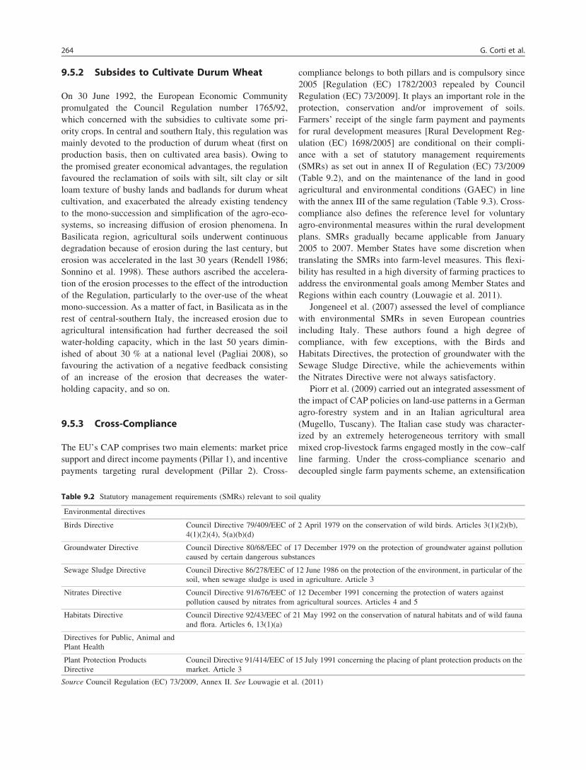
9.5.2 Subsides to Cultivate Durum Wheat
On 30 June 1992, the European Economic Communitypromulgated the Council Regulation number 1765/92,which concerned with the subsidies to cultivate some pri-ority crops. In central and southern Italy, this regulation wasmainly devoted to the production of durum wheat (first onproduction basis, then on cultivated area basis). Owing tothe promised greater economical advantages, the regulationfavoured the reclamation of soils with silt, silt clay or siltloam texture of bushy lands and badlands for durum wheatcultivation, and exacerbated the already existing tendencyto the mono-succession and simplification of the agro-eco-systems, so increasing diffusion of erosion phenomena. InBasilicata region, agricultural soils underwent continuousdegradation because of erosion during the last century, buterosion was accelerated in the last 30 years (Rendell 1986;Sonnino et al. 1998). These authors ascribed the accelera-tion of the erosion processes to the effect of the introductionof the Regulation, particularly to the over-use of the wheatmono-succession. As a matter of fact, in Basilicata as in therest of central-southern Italy, the increased erosion due toagricultural intensification had further decreased the soilwater-holding capacity, which in the last 50 years dimin-ished of about 30 % at a national level (Pagliai 2008), sofavouring the activation of a negative feedback consistingof an increase of the erosion that decreases the water-holding capacity, and so on.
9.5.3 Cross-Compliance
The EU’s CAP comprises two main elements: market pricesupport and direct income payments (Pillar 1), and incentivepayments targeting rural development (Pillar 2). Cross-
compliance belongs to both pillars and is compulsory since2005 [Regulation (EC) 1782/2003 repealed by CouncilRegulation (EC) 73/2009]. It plays an important role in theprotection, conservation and/or improvement of soils.Farmers’ receipt of the single farm payment and paymentsfor rural development measures [Rural Development Reg-ulation (EC) 1698/2005] are conditional on their compli-ance with a set of statutory management requirements(SMRs) as set out in annex II of Regulation (EC) 73/2009(Table 9.2), and on the maintenance of the land in goodagricultural and environmental conditions (GAEC) in linewith the annex III of the same regulation (Table 9.3). Cross-compliance also defines the reference level for voluntaryagro-environmental measures within the rural developmentplans. SMRs gradually became applicable from January2005 to 2007. Member States have some discretion whentranslating the SMRs into farm-level measures. This flexi-bility has resulted in a high diversity of farming practices toaddress the environmental goals among Member States andRegions within each country (Louwagie et al. 2011).
Jongeneel et al. (2007) assessed the level of compliancewith environmental SMRs in seven European countriesincluding Italy. These authors found a high degree ofcompliance, with few exceptions, with the Birds andHabitats Directives, the protection of groundwater with theSewage Sludge Directive, while the achievements withinthe Nitrates Directive were not always satisfactory.
Piorr et al. (2009) carried out an integrated assessment ofthe impact of CAP policies on land-use patterns in a Germanagro-forestry system and in an Italian agricultural area(Mugello, Tuscany). The Italian case study was character-ized by an extremely heterogeneous territory with smallmixed crop-livestock farms engaged mostly in the cow–calfline farming. Under the cross-compliance scenario anddecoupled single farm payments scheme, an extensification
Table 9.2 Statutory management requirements (SMRs) relevant to soil quality
Environmental directives
Birds Directive Council Directive 79/409/EEC of 2 April 1979 on the conservation of wild birds. Articles 3(1)(2)(b),4(1)(2)(4), 5(a)(b)(d)
Groundwater Directive Council Directive 80/68/EEC of 17 December 1979 on the protection of groundwater against pollutioncaused by certain dangerous substances
Sewage Sludge Directive Council Directive 86/278/EEC of 12 June 1986 on the protection of the environment, in particular of thesoil, when sewage sludge is used in agriculture. Article 3
Nitrates Directive Council Directive 91/676/EEC of 12 December 1991 concerning the protection of waters againstpollution caused by nitrates from agricultural sources. Articles 4 and 5
Habitats Directive Council Directive 92/43/EEC of 21 May 1992 on the conservation of natural habitats and of wild faunaand flora. Articles 6, 13(1)(a)
Directives for Public, Animal andPlant Health
Plant Protection ProductsDirective
Council Directive 91/414/EEC of 15 July 1991 concerning the placing of plant protection products on themarket. Article 3
Source Council Regulation (EC) 73/2009, Annex II. See Louwagie et al. (2011)
264 G. Corti et al.
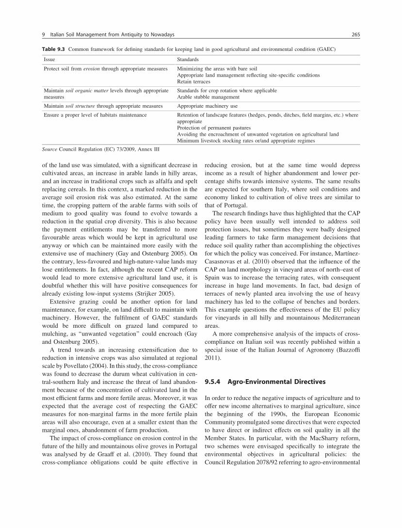
of the land use was simulated, with a significant decrease incultivated areas, an increase in arable lands in hilly areas,and an increase in traditional crops such as alfalfa and speltreplacing cereals. In this context, a marked reduction in theaverage soil erosion risk was also estimated. At the sametime, the cropping pattern of the arable farms with soils ofmedium to good quality was found to evolve towards areduction in the spatial crop diversity. This is also becausethe payment entitlements may be transferred to morefavourable areas which would be kept in agricultural useanyway or which can be maintained more easily with theextensive use of machinery (Gay and Ostenburg 2005). Onthe contrary, less-favoured and high-nature-value lands maylose entitlements. In fact, although the recent CAP reformwould lead to more extensive agricultural land use, it isdoubtful whether this will have positive consequences foralready existing low-input systems (Strijker 2005).
Extensive grazing could be another option for landmaintenance, for example, on land difficult to maintain withmachinery. However, the fulfilment of GAEC standardswould be more difficult on grazed land compared tomulching, as ‘‘unwanted vegetation’’ could encroach (Gayand Ostenburg 2005).
A trend towards an increasing extensification due toreduction in intensive crops was also simulated at regionalscale by Povellato (2004). In this study, the cross-compliancewas found to decrease the durum wheat cultivation in cen-tral-southern Italy and increase the threat of land abandon-ment because of the concentration of cultivated land in themost efficient farms and more fertile areas. Moreover, it wasexpected that the average cost of respecting the GAECmeasures for non-marginal farms in the more fertile plainareas will also encourage, even at a smaller extent than themarginal ones, abandonment of farm production.
The impact of cross-compliance on erosion control in thefuture of the hilly and mountainous olive groves in Portugalwas analysed by de Graaff et al. (2010). They found thatcross-compliance obligations could be quite effective in
reducing erosion, but at the same time would depressincome as a result of higher abandonment and lower per-centage shifts towards intensive systems. The same resultsare expected for southern Italy, where soil conditions andeconomy linked to cultivation of olive trees are similar tothat of Portugal.
The research findings have thus highlighted that the CAPpolicy have been usually well intended to address soilprotection issues, but sometimes they were badly designedleading farmers to take farm management decisions thatreduce soil quality rather than accomplishing the objectivesfor which the policy was conceived. For instance, Martínez-Casasnovas et al. (2010) observed that the influence of theCAP on land morphology in vineyard areas of north–east ofSpain was to increase the terracing rates, with consequentincrease in huge land movements. In fact, bad design ofterraces of newly planted area involving the use of heavymachinery has led to the collapse of benches and borders.This example questions the effectiveness of the EU policyfor vineyards in all hilly and mountainous Mediterraneanareas.
A more comprehensive analysis of the impacts of cross-compliance on Italian soil was recently published within aspecial issue of the Italian Journal of Agronomy (Bazzoffi2011).
9.5.4 Agro-Environmental Directives
In order to reduce the negative impacts of agriculture and tooffer new income alternatives to marginal agriculture, sincethe beginning of the 1990s, the European EconomicCommunity promulgated some directives that were expectedto have direct or indirect effects on soil quality in all theMember States. In particular, with the MacSharry reform,two schemes were envisaged specifically to integrate theenvironmental objectives in agricultural policies: theCouncil Regulation 2078/92 referring to agro-environmental
Table 9.3 Common framework for defining standards for keeping land in good agricultural and environmental condition (GAEC)
Issue Standards
Protect soil from erosion through appropriate measures Minimizing the areas with bare soilAppropriate land management reflecting site-specific conditionsRetain terraces
Maintain soil organic matter levels through appropriatemeasures
Standards for crop rotation where applicableArable stubble management
Maintain soil structure through appropriate measures Appropriate machinery use
Ensure a proper level of habitats maintenance Retention of landscape features (hedges, ponds, ditches, field margins, etc.) whereappropriateProtection of permanent pasturesAvoiding the encroachment of unwanted vegetation on agricultural landMinimum livestock stocking rates or/and appropriate regimes
Source Council Regulation (EC) 73/2009, Annex III
9 Italian Soil Management from Antiquity to Nowadays 265
measures and the Council Regulation 2080/92 concerning(re)afforestation. Other relevant EU environmentaldirectives dealing with soil are the Council Directive 91/676known as Nitrates Directive and the Council Regulation60/2000 known as the Water Framework Directive.
9.5.4.1 Council Regulation No 2078/92The Regulation 2078/92 provided for programmes toencourage farmers to carry out environmentally beneficialactivities on their land. Among the promoted land man-agement activities, the most relevant measures that couldhave had impacts on soil protection were as follows:• reversion of intensively exploited land, such as arable or
grass for silage, to extensive grassland;• reduction in the use of nutrients (low-input farming
practices);• reduction or suppression of pesticides use (e.g. organic
farming);• creation of natural zones taken out of production;• maintenance of landscape features that are no longer
agriculturally viable.In Italy, the most adopted measure was that supporting
the low-input farming systems (almost 50 % of the overallsubsidies), followed by the organic farming measure (about25 %), while the measure aiming to promote the conversionfrom arable to extensive grassland systems received around6 % of the total incentives (INEA 1999a). With fewexceptions, most of the cropping systems that benefited ofthe subsidies were rather extensive such as vineyard andtemporary or permanent pastures (INEA 1999a). Forinstance, in Sardinia, the 80 % of areas converted to organicfarming was previously interested by forage crops culti-vated following agricultural management practices verysimilar to the traditional ones (INEA 1999b). The samepattern was observed by Roggero and Toderi (2002) in theMarche region. Thus, more intensive cropping systems,which were the main target of the Regulation, were lessinterested by the agro-environmental schemes application.Because of this, we may assume that the effects of theRegulation 2078/92 on changing soil management practiceswere negligible in all countries. In terms of reduction innitrate pollution, considered one of the main goals of the2078/92 prescriptions, Roggero and Toderi (2002) foundthat the application of the agro-environmental measures inmany cases had improved soil nutrient balance. At the sametime, when considering the nitrate concentration in waterrun-off, it was often above the legal threshold, in particularimmediately after the first autumn rainfalls, and it was onaverage higher in less-diversified agricultural landscape.Further, the high nitrate concentration in the water run-offwas only partially related to nitrogen fertilization, and wasmainly attributed to organic matter mineralization occurringwhen soil was bare and the rain precipitation overcame soil
water-holding capacity. Nevertheless, the spatial and tem-poral cropping system diversification was not taken intoaccount by the directive, and no measures were specificallydesigned to promote it.
9.5.4.2 Council Regulation 2080/92The 2080/92 Regulation has been the first comprehensivescheme of EU intervention in the forestry sector. TheRegulation was directly carried out by the Italian regions bymeans of specific operative programmes that in the1994–1999 period contributed directly to (re)afforest about80,000 ha (INEA 2000a; Cesaro and Povellato 2001). Themost active regions were Lombardy, Sicily and Sardinia.The afforestation of agricultural land was mainly concen-trated in the plains and in the areas with the most intensiveagriculture, with about 48,000 ha of arable crops convertedto woodlands, while only 10,000 ha of grasslands fromhill and mountain areas was converted. Fast-growing plan-tations (i.e. poplars) and, in general, broad-leavedtrees were mostly used for the afforestation (INEA 2000b).At European level, the actual role of the conversion ofagricultural land to forest as an eligible measure to achievemitigation of climate change and biodiversity protection is avery debated argument. A pan-European assessment of theimpact of the afforestation programmes promoted in EU,highlighted that the initial expectations have mainly notbeen fulfilled and the planted areas were below the initialtargets (Zanchi et al. 2007). The report on the Regulation2080/92 confirmed that the potential role of afforestation inagricultural areas was considerably over-estimated in the1980s since environmental, economic, social and legalconstraints were not taken into account. In this context,Zanchi et al. (2007) questioned whether the estimatedemission reduction targets of 14 MtCO2 from (re)affores-tation in the EU-15 could be considered as realistic.
9.5.4.3 Council Directive 91/676The Nitrate Directive was adopted with the aim to protectwater quality by preventing nitrates from agriculturalsources polluting ground and surface waters and by pro-moting the use of ‘‘good’’ farming practices (EuropeanCommission 2002). The Nitrates Directive forms part of acomprehensive framework of the EU framework legislationto protect the environment. In this case, the EU was forcedto focus its efforts on water for human consumption(Goodchild 1998) because of sanitary problems induced bynitrates diffusion such as ‘‘blue baby syndrome’’ (Shortleet al. 2001) and stomach cancer (Harrison 1996). Agricul-ture was considered a significant source of nitrogen forground and surface water pollution (e.g. Heathwaite et al.1996; Yadav et al. 1997; Carpenter et al. 1998; Hadas et al.1999), in some cases strongly associated to eutrophicationof surface and marine waters (Carpenter et al. 1998; Rejesus
266 G. Corti et al.

and Hornbaker 1999). Under this directive, all MemberStates have to analyse their waters nitrate concentrationlevels and trophic state and drawn up action programmes tocut nitrate pollution. An expanding European monitoringnetwork is demonstrating a trend towards steady or fallingnitrate concentrations. Overall, the 2004–2007 report indi-cated good progress towards more healthy water.
However, the Nitrates Directive has been considered oneof the most controversial and unsuccessful directives evermade in the EU on environmental matters, because of theslow and difficult implementation by the Member States andbecause of the unsuccessful results of its prescriptions(Grossman 2000; Sonneveld and Bouma 2003) or less sat-isfactory than expected (Agence de l’Eau Adour-Garonne2004; Belhouchette et al. 2011). An ex-ante assessment ofthe impact of Nitrates Directive in the Midi-Pyrenees region(France) by using a bio-economic model to analyse farmincome and three environmental indicators (nitrate leaching,erosion, water consumption) showed that nitrogen leachingat the farm scale did not change significantly, while theoverall water consumption increased and soil erosiondecreased mainly because of modifications in croppingpatterns and soil management. In a nitrates vulnerable zonein central Sardinia, with an intensive double-cropping silagemaize–Italian ryegrass rotation on a loamy sand soil,Urracci et al. (2010) observed that the nitrates concentrationin the soil percolation water was highly variable andoccasionally above 300 mg L-1. Moreover, the directiveprescriptions for the allowed organic fertilizer rates (170 kgha-1 year-1 of N from organic sources) did not show asubstantial reduction in nitrate concentration in the perco-lation water. In an agricultural watershed of the Po plainlocated in the Ferrara Province and representative of avulnerable zone for Nitrates Directive, nitrates concentra-tion in efflux water exceeded occasionally the maximumlevel permitted by the directive (Ventura et al. 2008).By calculating a soil balance, total N outputs and inputswere found of similar magnitude, indicating that crop andsoil management (and especially N fertilization techniques)have reached good level of ecological sustainability underNitrates Directive application.
9.5.4.4 Council Regulation 60/2000The Water Framework Directive (WFD) aims to preventand reduce water pollution, to protect and improve thestatus of the aquatic environment, to mitigate the effects offloods and droughts and to promote the sustainable use ofwater. Its general goal is to establish a ‘‘good status’’ for allwaters by 2015.
Hudec et al. (2007) analysed the institutional settingssurrounding soil management in ten European countrieswith the main objective to study the role of some EU
directives, including the WFD, on soil protection issues.These authors demonstrated that the majority of the policymeasures were not focused mainly or exclusively on soilconservation but had another or a broader set of objectives,nonetheless affecting soil management. For the WFD, aswell as for many EU directives, the closest link between soilquality and water quality was with measures aimed atcontrolling water pollution, particularly from local anddiffuse nutrients contamination. Soil erosion was consideredas a key factor affecting water quality, whereas decline insoil organic matter and soil compaction were recognized asnegative factors only in few cases. Other aspects, such assalinization, soil biodiversity and landslides, were not citedamong the soil degradation processes connected to waterquality (Louwagie et al. 2011).
9.5.5 Good Agricultural Practices
Good agricultural practices consist of ‘‘practices thataddress environmental, economic and social sustainabilityfor on-farm processes, and result in safe and quality foodand non-food agricultural products’’ (FAO-COAG 2003).Principal objectives are soil and water protection. Appro-priate soil management favours soil productivity byimproving the availability and plant uptake of water andnutrients, replenishing soil organic matter and soil mois-ture, and minimizing losses of soil, nutrients, and agro-chemicals through erosion, run-off and leaching intosurface or ground water. Good practices related to soilinclude the following:• maintaining or improving soil organic matter through
appropriate crop rotations, manure application, pasturemanagement and other land-use practices, rationalmechanical and/or conservation tillage practices;
• maintaining soil cover to provide a conducive habitat forsoil biota, minimizing erosion losses by wind and/orwater;
• application of organic and mineral fertilizers and otheragro-chemicals in amounts and timing and by methodsappropriate to agronomic, environmental and humanhealth requirements.Agriculture carries a high responsibility for the man-
agement of water resources in quantitative and qualitativeterms. Good practices related to water include the follow-ing: (1) maximization of water infiltration and reduction inunproductive efflux of surface waters from watersheds, (2)managing ground and soil water by proper use, (3)improving soil structure and increasing soil organic mattercontent, (4) preventing soil salinization by adopting water-saving measures and re-cycling where possible, (5)enhancing the functioning of the water cycle by establishingpermanent cover, or maintaining or restoring wetlands.
9 Italian Soil Management from Antiquity to Nowadays 267
9.5.6 The Soil Thematic Strategy
The Thematic Strategy for Soil Protection consists of aCommunication from the Commission of the EuropeanUnion to the other European Institutions of a proposal for aframework directive (a European law), and an ImpactAssessment. The Communication COM(2006)231 of theyear 2006 explained why further action is needed to ensurea high level of soil protection, sets the overall objective ofthe Strategy and explains what kind of measures mustbe taken (European Commission 2006). It establishes aten-year work programme for the European Commission.The proposal for a framework directive COM(2006)232 setsout common principles for protecting soils across theEuropean Union. Within this common framework, theMember States will be in the position to decide how best toprotect their soils and how to use it in a sustainable way ontheir own territory. Moreover, Member States would have toestablish risk reduction targets and adopt appropriate mea-sures for reaching those targets. The implemented measuresand strategies would vary in response to the severity of thedegradation processes, local conditions and socio-economicissues. The national programmes could be shaped takinginto account measures already implemented in national andcommunity contexts, such as cross-compliance and ruraldevelopment under the CAP. The adoption of the proposedSoil Framework Directive would achieve an EU-widecoordination between the different Member States-specificlegislation on soil protection. Such coordination wouldallow dealing with soil degradation processes at multi-scale(from global and regional to local) and would triggeralignment of regional approaches with supra-nationalrequirements, that would be particularly relevant for trans-boundary soil degradation processes (Louwagie et al. 2011).
The proposal for a Soil Framework Directive to becomeoperative is still under discussion.
9.6 Soil Management and Land Set-upSystems for Soil and WaterConservation
Soil degradation processes represent a direct threat to bothbiomass and economic yields worldwide. The need to putunder control the environmental impact of agriculturalactivities limiting soil structure decay is one of the mainaims of soil management.
Soil structure is one of the most important propertiesaffecting crop production, because it determines the depththat roots can penetrate, the amount of water that can be
stored in the soil and the movement of air, water and soilfauna (Hermavan and Cameron 1993; Langmaack 1999).Soil quality is strictly related to soil structure and much ofthe environmental damage in intensively cropped landssuch as erosion, desertification and susceptibility to com-paction, originate from soil structure degradation. More-over, soil functions strongly depend on the quality of soilstructure, with optimum structure defined as soil having thewidest range of possible uses (Dexter 2002). The adoptionof intensive monocultures without application of farmyardmanure to the soil instead of traditional farming rotationshas compromised soil structural stability (Lal et al. 1994) soreducing the effect of chemical fertilizers, and increasingsoil particles and nutrients transport with the consequentrisk of surface water pollution. The introduction of newagriculture practices to increase production has oftenchanged land systems from complex to homogeneous(Borselli et al. 2006; Busoni and Colica 2006; Ramos et al.2007), so modifying soil porosity (Pagliai et al. 1995),hydrologic characteristics (Ludwig et al. 1995) and, finally,landscape structure (van Oost et al. 2000).
The land set-up systems, both for plains and hilly envi-ronments, were ideated to exploit new areas for agriculturaluses and, at the same time, to maintain or improve the soilquality together with landscape structure and heterogeneity.Many of these systems are today obsolete because of theadvent of mechanization and the costs, in terms of work andmoney, for their maintenance. However, the knowledge ofthe land set-up systems, each one shaped for specific soiltype, geomorphology and climate, may help adopting thesoil management most respectful for the soil and mostsustainable for the agro-ecosystem.
9.6.1 Land Set-up Systems
The agricultural hydraulic land settings were developed toimprove physical, chemical and biological soil conditionsand reduce hydraulic erosion.
In Italy, the agricultural systems are particularlyimportant because of the occurrence of (1) large bare arableareas with respect to the naturally covered lands (woodsand pasture); (2) climatic regimes characterized by intenseand concentrated precipitations; (3) common fine-texturedsoils with low permeability; (4) hilliness of most of theagricultural soils; (5) lack of a sufficient height to dischargethe water in excess from the plain soils. As a consequenceof the many physiographic areas present in the country,many systems were elaborated for both plain and slopingsurfaces.
268 G. Corti et al.
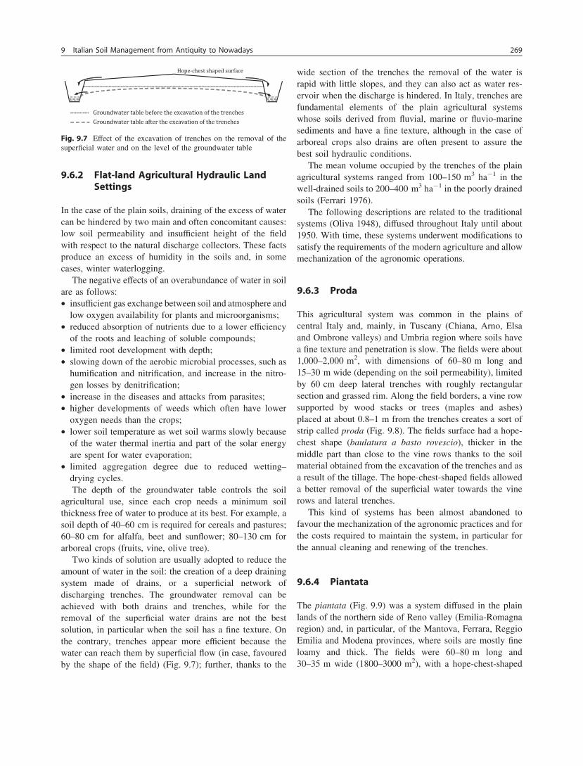
9.6.2 Flat-land Agricultural Hydraulic LandSettings
In the case of the plain soils, draining of the excess of watercan be hindered by two main and often concomitant causes:low soil permeability and insufficient height of the fieldwith respect to the natural discharge collectors. These factsproduce an excess of humidity in the soils and, in somecases, winter waterlogging.
The negative effects of an overabundance of water in soilare as follows:• insufficient gas exchange between soil and atmosphere and
low oxygen availability for plants and microorganisms;• reduced absorption of nutrients due to a lower efficiency
of the roots and leaching of soluble compounds;• limited root development with depth;• slowing down of the aerobic microbial processes, such as
humification and nitrification, and increase in the nitro-gen losses by denitrification;
• increase in the diseases and attacks from parasites;• higher developments of weeds which often have lower
oxygen needs than the crops;• lower soil temperature as wet soil warms slowly because
of the water thermal inertia and part of the solar energyare spent for water evaporation;
• limited aggregation degree due to reduced wetting–drying cycles.The depth of the groundwater table controls the soil
agricultural use, since each crop needs a minimum soilthickness free of water to produce at its best. For example, asoil depth of 40–60 cm is required for cereals and pastures;60–80 cm for alfalfa, beet and sunflower; 80–130 cm forarboreal crops (fruits, vine, olive tree).
Two kinds of solution are usually adopted to reduce theamount of water in the soil: the creation of a deep drainingsystem made of drains, or a superficial network ofdischarging trenches. The groundwater removal can beachieved with both drains and trenches, while for theremoval of the superficial water drains are not the bestsolution, in particular when the soil has a fine texture. Onthe contrary, trenches appear more efficient because thewater can reach them by superficial flow (in case, favouredby the shape of the field) (Fig. 9.7); further, thanks to the
wide section of the trenches the removal of the water israpid with little slopes, and they can also act as water res-ervoir when the discharge is hindered. In Italy, trenches arefundamental elements of the plain agricultural systemswhose soils derived from fluvial, marine or fluvio-marinesediments and have a fine texture, although in the case ofarboreal crops also drains are often present to assure thebest soil hydraulic conditions.
The mean volume occupied by the trenches of the plainagricultural systems ranged from 100–150 m3 ha-1 in thewell-drained soils to 200–400 m3 ha-1 in the poorly drainedsoils (Ferrari 1976).
The following descriptions are related to the traditionalsystems (Oliva 1948), diffused throughout Italy until about1950. With time, these systems underwent modifications tosatisfy the requirements of the modern agriculture and allowmechanization of the agronomic operations.
9.6.3 Proda
This agricultural system was common in the plains ofcentral Italy and, mainly, in Tuscany (Chiana, Arno, Elsaand Ombrone valleys) and Umbria region where soils havea fine texture and penetration is slow. The fields were about1,000–2,000 m2, with dimensions of 60–80 m long and15–30 m wide (depending on the soil permeability), limitedby 60 cm deep lateral trenches with roughly rectangularsection and grassed rim. Along the field borders, a vine rowsupported by wood stacks or trees (maples and ashes)placed at about 0.8–1 m from the trenches creates a sort ofstrip called proda (Fig. 9.8). The fields surface had a hope-chest shape (baulatura a basto rovescio), thicker in themiddle part than close to the vine rows thanks to the soilmaterial obtained from the excavation of the trenches and asa result of the tillage. The hope-chest-shaped fields alloweda better removal of the superficial water towards the vinerows and lateral trenches.
This kind of systems has been almost abandoned tofavour the mechanization of the agronomic practices and forthe costs required to maintain the system, in particular forthe annual cleaning and renewing of the trenches.
9.6.4 Piantata
The piantata (Fig. 9.9) was a system diffused in the plainlands of the northern side of Reno valley (Emilia-Romagnaregion) and, in particular, of the Mantova, Ferrara, ReggioEmilia and Modena provinces, where soils are mostly fineloamy and thick. The fields were 60–80 m long and30–35 m wide (1800–3000 m2), with a hope-chest-shaped
Fig. 9.7 Effect of the excavation of trenches on the removal of thesuperficial water and on the level of the groundwater table
9 Italian Soil Management from Antiquity to Nowadays 269
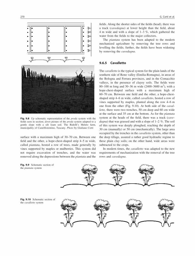
surface with a maximum high of 30–70 cm. Between onefield and the other, a hope-chest-shaped strip 4–5 m wide,called piantata, hosted a row of trees, made generally byvines supported by maples or mulberries. This system didnot require excavation of trenches, and the water wasremoved along the depressions between the piantata and the
fields. Along the shorter sides of the fields (head), there wasa track (cavedagna) at lower height than the field, about4 m wide and with a slope of 1–3 %, which gathered thewater from the fields to the major collectors.
The piantata system has been adapted to the modernmechanized agriculture by removing the tree rows andlevelling the fields; further, the fields have been wideningby removing the cavedagna.
9.6.5 Cavalletto
The cavalletto is the typical system for the plain lands of thesouthern side of Reno valley (Emilia-Romagna), in areas ofthe Bologna and Ferrara provinces, and in the Comacchiovalleys, in the presence of clayey soils. The fields were80–100 m long and 30–36 m wide (2400–3600 m2), with ahope-chest-shaped surface with a maximum high of60–70 cm. Between one field and the other, a hope-chest-shaped strip 4–6 m wide, called cavalletto, hosted a row ofvines supported by maples, planted along the row 4–6 mone from the other (Fig. 9.10). At both side of the caval-letto, there were two trenches, 50 cm deep and 60 cm wideat the surface and 35 cm at the bottom. As for the piantatasystem at the heads of the field, there was a track (cave-dagna) that was grassed and with a slope of 1–2 %. The soilof this system was deeply ploughed, reaching the depth of30 cm (manually) or 50 cm (mechanically). The large areaoccupied by the trenches in the cavalletto system, other thanthe deep tillage, assured a rather good hydraulic regime tothese plain clay soils; on the other hand, wide areas weresubtracted to the crops.
In modern times, the cavalletto was adapted to the newrequirements of mechanization with the removal of the treerows and cavedagna.
Fig. 9.8 Up schematic representation of the proda system with thefields seen in section; down picture of the proda system adapted to agentle slope with a silt loam soil. The Ridolfi’s Meleto farm,municipality of Castelfiorentino, Tuscany. Photo by Giuliano Corti
Fig. 9.9 Schematic section ofthe piantata system
Fig. 9.10 Schematic section ofthe cavalletto system
270 G. Corti et al.

9.6.6 Cavino
This system was common in the Veneto region, in thenorth-east part of Italy, and in particular in Padua province,where soils have fine texture and low penetration. The fieldswere 60–100 m long and 35–50 m wide (2400–4000 m2),with the ridge of the hope-chest-shaped surface perpendic-ular to the long side of the field and 1–1.5 m high withrespect of the original surface (Fig. 9.11). The fields wereseparated by 4–5 m wide strips hosting a row of trees.A trench (cavino) ran along the long side of the fields,sometimes substituted by a track 2.5–3 m wide. The systemwas not very efficient in the water removal, and in particularin the areas closed to the heads of the fields, where the cropssuffered for the slow draining due to the standing water inthe cavino. Another inconvenience of this kind of systemwas the onerous works to maintain the hope-chest shapeof the field surface and to ensure the accessibility andefficiency of cavino and track.
This system was adapted to mechanization through theremoval of the tree rows and, sometimes, joining the fields.
9.6.7 Larghe
Larghe was a common system for the drained lands innorthern (Ravenna, Ferrara, Po river delta) and central Italy(Ombrone river, near Grosseto), characterized by the absenceof tree rows (Fig. 9.12). Soils of these areas have fine to veryfine textures and had a shallow natural height to discharge thewater in excess that had been increase thanks to artificialdrainage systems. The fields were 200 m long and 40 m wide
(8,000 m2), with a hope-chest-shaped surface. Along the longside of the fields, the water was collected by trenches that,in turn, were connected to bigger trenches running along thehead of the fields and parallel to the track.
This system was easily adapted for the requirements ofthe modern agriculture without particular modifications.
9.6.8 Hilly Agricultural Hydraulic Land Settings
The hydraulic land settings in the hilly lands, other than toconsider the problems related to mechanization, soil thick-ness and fertility, exposition and precipitations regime, arefundamental to control the erosion processes, throughreducing the run-off and favouring the infiltration of water.The maintaining and improving of the hill and steep slopingsurfaces systems are addressed not only towards the opti-mization of the agricultural production, but can be consid-ered as important environmental issues. Indeed, they areresponsible for soil and slope stability conservation, whichinfluence the development of human settlements andactivities in these disadvantaged areas and, finally, thesafety of the communities living in the downstream plainregions.
Fig. 9.11 Schematic representation of the cavino system with thefields seen in section
Fig. 9.12 Up schematic representation of the larghe system with thefields seen in section; down picture of the larghe system taken at theRidolfi’s Meleto farm, Municipality of Castelfiorentino, Tuscany.Photo by Giuliano Corti
9 Italian Soil Management from Antiquity to Nowadays 271
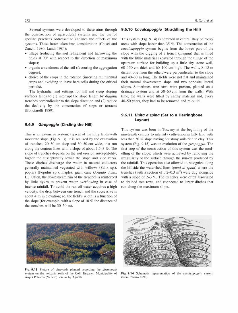
Several systems were developed to these aims throughthe construction of agricultural systems and the use ofspecific practices addressed to enhance the effects of thesystems. These latter taken into consideration (Chisci andZanchi 1980; Landi 1984):• tillage (reducing the soil refinement and harrowing the
fields at 90� with respect to the direction of maximumslope);
• organic amendment of the soil (favouring the aggregationdegree);
• choice of the crops in the rotation (inserting multiannualcrops and avoiding to leave bare soils during the criticalperiods).The hydraulic land settings for hill and steep sloping
surfaces tends to (1) interrupt the slope length by diggingtrenches perpendicular to the slope direction and (2) reducethe declivity by the construction of steps or terraces(Bonciarelli 1989).
9.6.9 Girapoggio (Circling the Hill)
This is an extensive system, typical of the hilly lands withmoderate slope (Fig. 9.13). It is realized by the excavationof trenches, 20–30 cm deep and 30–50 cm wide, that runalong the contour lines with a slope of about 1.5–3 %. Theslope of trenches depends on the soil erosion susceptibility,higher the susceptibility lower the slope and vice versa.These ditches discharge the water in natural collectorsgenerally maintained vegetated with willows (Salix sp.),poplars (Populus sp.), maples, giant cane (Arundo donaxL.). Often, the downstream rim of the trenches is reinforcedby little dykes to prevent water overflowing in case ofintense rainfall. To avoid the run-off water acquires a highvelocity, the drop between one trench and the successive isabout 4 m in elevation; so, the field’s width is a function ofthe slope (for example, with a slope of 10 % the distance ofthe trenches will be 30–50 m).
9.6.10 Cavalcapoggio (Straddling the Hill)
This system (Fig. 9.14) is common in central Italy on rockyareas with slope lesser than 35 %. The construction of thecavalcapoggio system begins from the lower part of theslope with the digging of a trench (piegaia) that is filledwith the lithic material excavated through the tillage of theupstream surface for building up a little dry stone wall,60–150 cm thick and 60–100 cm high. The walls, 8–15 mdistant one from the other, were perpendicular to the slopeand 40–80 m long. The fields were not flat and maintainedtheir natural downstream slope and two opposite lateralslopes. Sometimes, tree rows were present, planted on adrainage system and at 50–60 cm from the walls. Withtime, the walls were filled by earthy material and, every40–50 years, they had to be removed and re-build.
9.6.11 Unita a spina (Set to a HerringboneLayout)
This system was born in Tuscany at the beginning of thenineteenth century to intensify cultivation in hilly land withless than 30 % slope having not stony soils rich in clay. Thissystem (Fig. 9.15) was an evolution of the girapoggio. Thefirst step of the construction of this system was the mod-elling of the slope, which were achieved by removing theirregularity of the surface through the run-off produced bythe rainfall. This operation also allowed to recognize alongthe hillside the watershed lines (punti di spina) where thetrenches (with a section of 0.2–0.3 m2) were dug alongsidewith a slope of 2–3 %. The trenches were often associatedto drained tree rows, and connected to larger ditches thatrun along the maximum slope.
Fig. 9.13 Picture of vineyards planted according the girapoggiosystem on the volcanic soils of the Colli Euganei. Municipality ofArquà Petrarca (Veneto). Photo by Agnelli
Fig. 9.14 Schematic representation of the cavalcapoggio system(from Caruso 1898)
272 G. Corti et al.
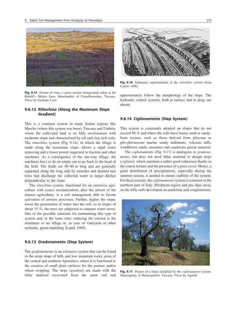
9.6.12 Rittochino (Along the Maximum SlopeGradient)
This is a common system in many Italian regions likeMarche (where this system was born), Tuscany and Umbria,where the cultivated land is on hilly environment withmoderate slope and characterized by silt and clay-rich soils.The rittochino system (Fig. 9.16), in which the tillage ismade along the maximum slope, allows a rapid waterremoving and a lower power requested to tractors and othermachines. As a consequence of the one-way tillage, themachines have to do an empty run to go back to the head ofthe field. The fields are 50–80 m long and are generallyseparated along the long side by trenches and drained treerows that discharge the collected water in larger ditchesperpendicular to the slope.
The rittochino system, functional for an extensive agri-culture with scarce mechanization, after the advent of theintense agriculture, is a soil management able to favouractivation of erosion processes. Further, higher the slope,lower the penetration of water into the soil, so in slopes ofabout 15 %, the trees are subjected to summer water stress.One of the possible solutions for maintaining this type ofsystem and, at the same time, reducing the erosion is theminimum or no tillage or, in case of vineyards or otherorchards, green-mulching (Landi 1989).
9.6.13 Gradonamento (Step System)
The gradonamento is an extensive system that can be foundin the steep slope of hills and low mountain rocky areas ofthe central and southern Apennines, where it is functional tothe creation of small plain surfaces for the pasture and/orwheat cropping. The steps (gradoni) are made with thelithic material excavated from the same soil and
approximately follow the morphology of the slope. Thehydraulic control systems, both at surface and in deep, areabsent.
9.6.14 Ciglionamento (Step System)
This system is commonly adopted on slopes that do notexceed 40 % and where the soils have loamy-sand or sandy-loam texture, such as those derived from pliocene orplio-pleistocene marine sandy sediments, volcanic tuffs,windblown sands, moraines and sandstone parent material.
The ciglionamento (Fig. 9.17) is analogous to gradona-mento, but does not need lithic material to design steps(ciglioni), which maintain a rather good coherence thanks tothe coarse texture and the presence of a grass cover. Hence, agood distribution of precipitations, especially during thesummer season, is needed to ensure stability of the system.For these reasons, the ciglionamento system is common in thenorthern part of Italy (Piedmont region and pre-Alps area),on the hilly soils developed on sandstone and conglomerate.
Fig. 9.15 Picture of unita a spina system (foreground) taken at theRidolfi’s Meleto farm, Municipality of Castelfiorentino, Tuscany.Photo by Giuliano Corti
Fig. 9.16 Schematic representation of the rittochino system (fromCaruso 1898)
Fig. 9.17 Picture of a slope modelled by the ciglionamento system.Municipality of Montespertoli, Tuscany. Photo by Agnelli
9 Italian Soil Management from Antiquity to Nowadays 273

The width of the fields is function of the slope: considering afixed height of the step, higher is the slope, minor is the widthof the fields. In case of mixed crops, the width increased, and aslight downstream slope is given to the fields. Generally,hydraulic control systems are absent.
9.6.15 Terrazzamento (Terracing)
Terraced slopes are widely distributed in the world sinceancient times both for productive and aesthetic purposes(Gardner and Gerrard 2003) and represent a large portion ofthe world’s cultivated slopes (Sandor 1998). Terracebuilding required a complete slope reshaping that in the pastwas carried out manually. Currently, some mechanization isused in favourable morphologic conditions (Veek et al.1995), particularly where roads and slope allow accessing.Soil terraces provide a stable topographic base for crops andfavour soil moisture conservation in the crop root zone,which is particularly important in coarse-textured soils andin the Mediterranean regions (Sandor et al. 1990; Ramoset al. 2007).
Terracing is commonly adopted on hills and mountains(Figs. 9.18 and 9.19), with a slope ranging from 25 to 50 %.
The building of terraces begins from the lower part of theslope with the digging of a 0.4–1.2 m deep trench (piegaia),where a wall 1.5–2.5 m high and at least 0.6 m thick is builtwith the lithic material obtained by the excavation of thetrench or soil tillage. The space between the slope and thewall is filled by the soil material coming from the trenchexcavation. As for gradonamento and ciglionamento, thewidth of the fields is function of the slope. The fields have adownstream slope of 2–3 %, and in case of mixed cultures,a tree row is planted on the external border of the terrace.The hydraulic control system is comprised of small ditchesand drains connected to main collectors that run along themaximum slope.
Terraced slopes require frequent maintenance of the wallstructure (Posthumus and De Graaff 2005) and of thenetwork of tracks and minor roads that connect the terraces.A continuous effort is required because slope instability,excessive run-off velocity, rainfall infiltration, and suscep-tibility of soil to erosion can threaten terrace stability,leading to soil loss and even slope failures (Yaalon and
Fig. 9.18 Up schematic representation of the terracing system (fromCaruso 1898); down picture of terraced vineyards in the Municipalityof Morgex, Val d’Aosta. Photo by Cocco
Fig. 9.19 Up schematic representation of the lunette system (fromCaruso 1898); down picture of an olive grove organized with lunette inthe Municipality of Vaiano, Tuscany. Photo by Costantini
274 G. Corti et al.
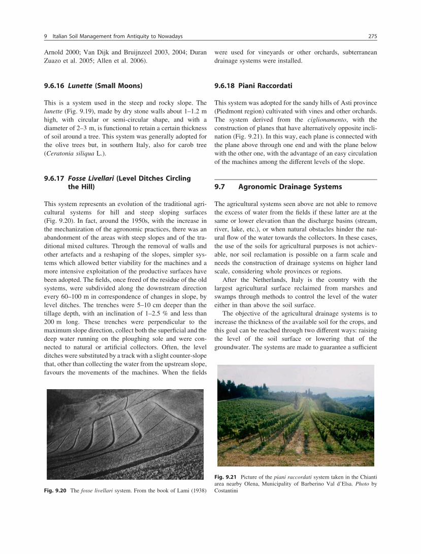
Arnold 2000; Van Dijk and Bruijnzeel 2003, 2004; DuranZuazo et al. 2005; Allen et al. 2006).
9.6.16 Lunette (Small Moons)
This is a system used in the steep and rocky slope. Thelunette (Fig. 9.19), made by dry stone walls about 1–1.2 mhigh, with circular or semi-circular shape, and with adiameter of 2–3 m, is functional to retain a certain thicknessof soil around a tree. This system was generally adopted forthe olive trees but, in southern Italy, also for carob tree(Ceratonia siliqua L.).
9.6.17 Fosse Livellari (Level Ditches Circlingthe Hill)
This system represents an evolution of the traditional agri-cultural systems for hill and steep sloping surfaces(Fig. 9.20). In fact, around the 1950s, with the increase inthe mechanization of the agronomic practices, there was anabandonment of the areas with steep slopes and of the tra-ditional mixed cultures. Through the removal of walls andother artefacts and a reshaping of the slopes, simpler sys-tems which allowed better viability for the machines and amore intensive exploitation of the productive surfaces havebeen adopted. The fields, once freed of the residue of the oldsystems, were subdivided along the downstream directionevery 60–100 m in correspondence of changes in slope, bylevel ditches. The trenches were 5–10 cm deeper than thetillage depth, with an inclination of 1–2.5 % and less than200 m long. These trenches were perpendicular to themaximum slope direction, collect both the superficial and thedeep water running on the ploughing sole and were con-nected to natural or artificial collectors. Often, the levelditches were substituted by a track with a slight counter-slopethat, other than collecting the water from the upstream slope,favours the movements of the machines. When the fields
were used for vineyards or other orchards, subterraneandrainage systems were installed.
9.6.18 Piani Raccordati
This system was adopted for the sandy hills of Asti province(Piedmont region) cultivated with vines and other orchards.The system derived from the ciglionamento, with theconstruction of planes that have alternatively opposite incli-nation (Fig. 9.21). In this way, each plane is connected withthe plane above through one end and with the plane belowwith the other one, with the advantage of an easy circulationof the machines among the different levels of the slope.
9.7 Agronomic Drainage Systems
The agricultural systems seen above are not able to removethe excess of water from the fields if these latter are at thesame or lower elevation than the discharge basins (stream,river, lake, etc.), or when natural obstacles hinder the nat-ural flow of the water towards the collectors. In these cases,the use of the soils for agricultural purposes is not achiev-able, nor soil reclamation is possible on a farm scale andneeds the construction of drainage systems on higher landscale, considering whole provinces or regions.
After the Netherlands, Italy is the country with thelargest agricultural surface reclaimed from marshes andswamps through methods to control the level of the watereither in than above the soil surface.
The objective of the agricultural drainage systems is toincrease the thickness of the available soil for the crops, andthis goal can be reached through two different ways: raisingthe level of the soil surface or lowering that of thegroundwater. The systems are made to guarantee a sufficient
Fig. 9.20 The fosse livellari system. From the book of Lami (1938)
Fig. 9.21 Picture of the piani raccordati system taken in the Chiantiarea nearby Olena, Municipality of Barberino Val d’Elsa. Photo byCostantini
9 Italian Soil Management from Antiquity to Nowadays 275

soil thickness free of water (franco di bonifica) even in theworst meteorological conditions. In Italy, the techniquesused for increasing the soil thickness bringing the soilsurface at higher level were colmata and mazzuolatura,while the groundwater level is usually lowered by drainingpumps.
9.7.1 Colmata (Filling)
The aim of the colmata system is to raise the soil surface ata higher level than discharge collectors through the accu-mulation of soil material. The traditional colmata methodconsists in diverting in a delimited area the water of a riveror stream that runs in the vicinity and allowing the materialsuspended to sediment. The surface to be reclaimed (cassadi colmata, filling crate), bordered by a main dyke andsubdivided by secondary dikes in smaller areas (casse orpreselle, crates), is flooded thanks to an artificial canals thatdeflect part of the water flow of the river. Once inside thecassa, the water flow reduces its velocity and lets the sus-pended material to sediment, after, through a spillway, thewater is left to run away to another canal that brings thewater to the river. The size of the sediments is function ofthe flow speed, but also of the soils that mantle thewatershed.
The small crates inside the cassa di colmata are gener-ally in succession, and sometimes, they are cultivated evenduring reclamation. Crops cultivated are those with spring-summer cycle that need high amount of water such asmaize, tomato, rice, watermelon, alfalfa. The soils obtainedwith this system are generally fertile, thanks to their good
chemical properties due to the fine and rich-in-nutrientmaterials deposited by the water of the river. In contrast,physical properties of the sediments are usually poor andrequire several mechanical works to be improved.
Notwithstanding its efficiency and low costs ofachievement, nowadays, this system has been abandonedbecause of the long time (20–40 years) required to obtain asufficient soil thickness free of water.
The colmata system was born in Tuscany during theRenaissance, as attested by some writings of Leonardo daVinci and by the fact that Evangelista Torricelli, a studentof Galileo Galilei, designed the colmata system utilized forthe reclamation of the Chiana valley, close to Arezzo(Fossombroni 1835; Taddei 1957) (Fig. 9.22). Anotherimportant land reclamation accomplished by the colmatasystem was that of the Grosseto plain, central Italy(Fig. 9.23). In this case, the operations started around thebeginning of 1800 (Taddei 1957) taking advantage of theOmbrone river that crosses the area to be reclaimed. It hasbeen estimated that this river would have been able totransport about 2.4 kg of solid per m3 of water and that theamount of suspended material would have allow to deposita layer of about 10 cm per year. In contrast, the rising of thesoil surface was much lower (around some mm per year)and, consequently, in the 1930s to complete the reclamationof this area, the system was implemented with 4 drainingpumps with a total flow rate of 17.7 m3 s-1.
Another version of this hydraulic system is the artificialcolmata, where the rising of the soil surface is achieved byusing earthy materials of various origin or extracted fromquarries, transported and deposited in the reclaimed area.The artificial colmata is suitable for small surfaces, but
Fig. 9.22 The canale maestro della Chiana (main canal of the Chianavalley), in Tuscany, an artificial canal that runs for 62 km from theChiusi lake to the Arno river. The canal was part of a drainage system
till 1788; then, it became the main canal of the colmata system used tobring sediments on the most depressed areas of the valley. Photo byAgnelli
276 G. Corti et al.
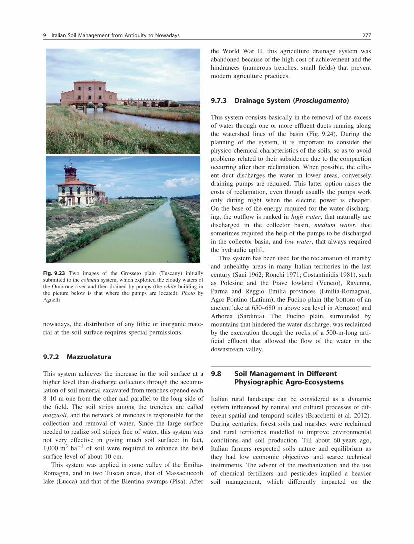
nowadays, the distribution of any lithic or inorganic mate-rial at the soil surface requires special permissions.
9.7.2 Mazzuolatura
This system achieves the increase in the soil surface at ahigher level than discharge collectors through the accumu-lation of soil material excavated from trenches opened each8–10 m one from the other and parallel to the long side ofthe field. The soil strips among the trenches are calledmazzuoli, and the network of trenches is responsible for thecollection and removal of water. Since the large surfaceneeded to realize soil stripes free of water, this system wasnot very effective in giving much soil surface: in fact,1,000 m3 ha-1 of soil were required to enhance the fieldsurface level of about 10 cm.
This system was applied in some valley of the Emilia-Romagna, and in two Tuscan areas, that of Massaciuccolilake (Lucca) and that of the Bientina swamps (Pisa). After
the World War II, this agriculture drainage system wasabandoned because of the high cost of achievement and thehindrances (numerous trenches, small fields) that preventmodern agriculture practices.
9.7.3 Drainage System (Prosciugamento)
This system consists basically in the removal of the excessof water through one or more effluent ducts running alongthe watershed lines of the basin (Fig. 9.24). During theplanning of the system, it is important to consider thephysico-chemical characteristics of the soils, so as to avoidproblems related to their subsidence due to the compactionoccurring after their reclamation. When possible, the efflu-ent duct discharges the water in lower areas, converselydraining pumps are required. This latter option raises thecosts of reclamation, even though usually the pumps workonly during night when the electric power is cheaper.On the base of the energy required for the water discharg-ing, the outflow is ranked in high water, that naturally aredischarged in the collector basin, medium water, thatsometimes required the help of the pumps to be dischargedin the collector basin, and low water, that always requiredthe hydraulic uplift.
This system has been used for the reclamation of marshyand unhealthy areas in many Italian territories in the lastcentury (Sani 1962; Ronchi 1971; Costantinidis 1981), suchas Polesine and the Piave lowland (Veneto), Ravenna,Parma and Reggio Emilia provinces (Emilia-Romagna),Agro Pontino (Latium), the Fucino plain (the bottom of anancient lake at 650–680 m above sea level in Abruzzo) andArborea (Sardinia). The Fucino plain, surrounded bymountains that hindered the water discharge, was reclaimedby the excavation through the rocks of a 500-m-long arti-ficial effluent that allowed the flow of the water in thedownstream valley.
9.8 Soil Management in DifferentPhysiographic Agro-Ecosystems
Italian rural landscape can be considered as a dynamicsystem influenced by natural and cultural processes of dif-ferent spatial and temporal scales (Bracchetti et al. 2012).During centuries, forest soils and marshes were reclaimedand rural territories modelled to improve environmentalconditions and soil production. Till about 60 years ago,Italian farmers respected soils nature and equilibrium asthey had low economic objectives and scarce technicalinstruments. The advent of the mechanization and the useof chemical fertilizers and pesticides implied a heaviersoil management, which differently impacted on the
Fig. 9.23 Two images of the Grosseto plain (Tuscany) initiallysubmitted to the colmata system, which exploited the cloudy waters ofthe Ombrone river and then drained by pumps (the white building inthe picture below is that where the pumps are located). Photo byAgnelli
9 Italian Soil Management from Antiquity to Nowadays 277
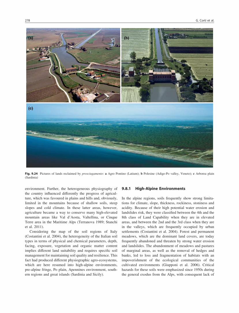
environment. Further, the heterogeneous physiography ofthe country influenced differently the progress of agricul-ture, which was favoured in plains and hills and, obviously,limited in the mountains because of shallow soils, steepslopes and cold climate. In these latter areas, however,agriculture became a way to conserve many high-elevatedmountain areas like Val d’Aosta, Valtellina, or CinqueTerre area in the Maritime Alps (Terranova 1989; Stanchiet al. 2011).
Considering the map of the soil regions of Italy(Costantini et al. 2004), the heterogeneity of the Italian soiltypes in terms of physical and chemical parameters, depth,facing, exposure, vegetation and organic matter contentimplies different land suitability and requires specific soilmanagement for maintaining soil quality and resilience. Thisfact had produced different physiographic agro-ecosystems,which are here resumed into high-alpine environments,pre-alpine fringe, Po plain, Apennines environment, south-ern regions and great islands (Sardinia and Sicily).
9.8.1 High-Alpine Environments
In the alpine regions, soils frequently show strong limita-tions for climate, slope, thickness, rockiness, stoniness andacidity. Because of their high potential water erosion andlandslides risk, they were classified between the 4th and the8th class of Land Capability when they are in elevatedareas, and between the 2nd and the 3rd class when they arein the valleys, which are frequently occupied by urbansettlements (Costantini et al. 2004). Forest and permanentmeadows, which are the dominant land covers, are todayfrequently abandoned and threaten by strong water erosionand landslides. The abandonment of meadows and pasturesof marginal areas, as well as the removal of hedges andbanks, led to loss and fragmentation of habitats with animpoverishment of the ecological communities of thecultivated environments (Giupponi et al. 2006). Criticalhazards for these soils were emphasized since 1950s duringthe general exodus from the Alps, with consequent lack of
Fig. 9.24 Pictures of lands reclaimed by prosciugamento: a Agro Pontino (Latium); b Polesine (Adige-Po valley, Veneto); c Arborea plain(Sardinia)
278 G. Corti et al.

human presidium and abandonment of soil management andconservation practices (Giupponi et al. 2006; Monteiro et al.2011). Unsuitable soil management was in some casesdisrespectful of climax conditions like in the case of pas-tured grasslands on Udorthents or Cryorthents (Zilioli et al.2011) or Lithic Borofolists developed on limestone undersubalpine vegetation belt (Strunk 2003). In fact, changes inthe management of these fragile ecosystems (forest fires,clear-cutting and overgrazing by cattle and horses) slowlyerased the organic horizons reducing their water absorptioncapacity and favouring the formation of gully erosion withconsequent severe soil losses along the slopes (Strunk2003).
In the Alpine region, the tree cultivation is rather wide-spread, especially for vine and apple trees. Recently,Monteiro et al. (2011) observed changes in soil manage-ment of the high and south-exposed slopes of Valtellinawhere meadows were converted to vineyards and orchards.Vineyards and many apple tree plantations are traditionallycultivated on human made-terraces, which have been moreor less maintained or subjected to mass movements infunction of the financial supports provided by different localadministrations (Costantini et al. 2004). In the Alpine steepslopes, terraced agro-ecosystems cover considerable sur-faces and represent the ancient sustainable soil managementto protect mountain soils (Scaramellini and Varotto 2008).The soils of the terraced slopes are anthropogenic soils(Yaalon and Arnold 2000; Hammad et al. 2004; Posthumusand De Graaff 2005; Shi et al. 2004; Van Dijk and Bru-ijnzeel 2004; Sang-Arung et al. 2006; Zornoza et al. 2009)and host high-quality crops such as vines and fruit trees.Terraces are made of a human-reworked substrate wherepedogenesis occurs under a strong human influence, andsoils have generally a coarse texture and limited develop-ment. Terraces are subjected to progressive decay due toerosion processes and slope failures if abandoned; hence,they need maintenance because their stability is threatenedby excessive run-off velocity, rainfall infiltration and thesusceptibility of soil to erosion (Van Dijk and Bruijnzeel2003, 2004; Duran Zuazo et al. 2005; Allen et al. 2006;Khanal and Watanabe 2006). Consequently, the preserva-tion of the vertical structures, the tracks network and thedrainage system is necessary. The substrate, morphologyand soil characteristics show a remarkable heterogeneity,but some common points can be observed, such as the lossof fertility and soil quality when terrace management is notefficient, with a sudden enhancement of erosion and soillosses due to abandonment (Stanchi et al. 2011).
With the development of the winter sports, frequentmanipulations of the alpine environment occurred.An example is the construction of new ski-runs and asso-ciated infrastructures (Caravello et al. 2006), often at ele-vations as low as 1000–1500 m. At this altitude, the effect
of climate warming on snow conditions and the increasingdemand for longer skiing season (from November to April)has caused an increase in the production of artificial snowand ski-slope preparation (Keller et al. 2004). Developmentof ski resorts generally induces drastic land modificationsand topographic adjustments that cause the degradation ofsoil and vegetation (Isselin-Nondedeu et al. 2006). Theconsequent alteration of both ecologic and geomorphicprocesses caused by heavy machines has an impact on thesoil properties, biomass production, composition of plantspecies and hydrologic system, thereby increasing the riskof land degradation by erosion, landslides and avalanches(Cavallin et al. 1996; Arnaud-Fassetta et al. 2005; Jamiesonand Stethem 2002). Thus, also hydrologic changes occurand, to a large extent, they are caused by the removal of soilmaterial that could store water. To create ski-slopes, thenatural landform is often levelled, exposing unweatheredparent material or deep soil horizons (Freppaz et al. 2002).The extremely scarce development of the ski-slopes soilsinvolves an almost complete lack of structure, with sub-sequent problems of soil compaction and reduction in waterand air permeability (Tsuyuzaki 1994).
9.8.2 Pre-Alpine Fringe
At the base of Alps, a wide hilly chain called Pre-Alpsdivides the high mountain from the Po plain. These alpinefoothills, belonging to Friuli Venezia Giulia, Veneto,Trentino-Alto Adige and Piedmont regions, are particularlydevoted to high-quality wine production. In Piedmont,where viticulture interests fine-textured soils, soils with agrass cover are protected against water erosion especiallyduring summer season, while without grass covering ero-sion may assume an intense character (Corti et al. 2011a).High-quality wines are also produced in the Collio area(Friuli Venezia Giulia), where vineyards are mainly plantedon terraced soils.
A particular ecosystem of this area, along the boundarybetween Pre-Alps and plain in Friuli Venezia Giulia is theso called Magredi, which in the local dialect means poorland. This habitat has particularly poor and gravely soils,which developed from fluvio-glacial sediments deposited atthe end of the last glaciations (Würm). The Magredi habitatrepresents one of the last examples of a steppe landscape inItaly, and for this reason, it is actually protected (S.C.I.: Siteof Community Importance). In this environment ratherrainy, the well-drained soils of the Magredi are somewherecultivated with vines, kiwi (Actinidia sp.) and asparagus(Asparagus officinalis L.), which give appreciated yieldsthanks to the mild water stress to which cultivations aresubmitted. Gravels and pebbles of the Magredi system are
9 Italian Soil Management from Antiquity to Nowadays 279

protected by law, and collection is restricted to citizens whomay pick up only a certain amount per day.
9.8.3 Po Plain
Po plain occupies more than 44,000 of the 77,000 km2 ofItalian plain land and consists of the flat area situated alongthe course of the Po river and within its watershed. The Poplain is the most intensive agricultural area in Italy as ithosts 36 % of the utilized agricultural area (UAA) and75 % of the total livestock units (ISTAT 2000). The soils ofthe area developed from alluvial sediments and their maincharacteristics depend upon the parent materials from whichthe deposits originated. The main distinction that should bemade at this regard is between the deposits originated fromthe Alps (rocks of igneous or crystalline nature) and thosecoming from the Apennines (sedimentary rocks like marl,sandstone, limestone and shales). These features determinethe presence of gravely soils in the upper plain close to theAlps (northern Po Plain), while the soils located close to theApennines have mainly sandy and clayey textures. Loamysoils (silty-clay-loam, loam, silty-loam), with optimalcondition for the agricultural exploitation and for thecultivation of a widest range of crops, spread over 45 % ofthe cultivated area of the Po plain.
The flat landscape is the results of many human modi-fications that began with the Romans, who divided this landin portions that afterwards became green ways or drainagecanals (Tozzi 1972). As described by Tempesta (2010),after the advent of mechanization, the area was transformedfollowing an intensive agricultural model and by a simpli-fication of the landscape with residential and industrialsettlements dispersed in the plain. After the innovation inmechanization, in the last decades, the European CAPinduced deep alteration of the Italian landscape, particularlyin this plain. Many typical lands with perennial vegetationwere abandoned, and fields were enlarged to favour mech-anization, while hedgerows, tree plantations, naturalmeadows and mulberry trees gradually disappeared fromthe plain.
The main crops of the Po plain are as follows (Giardiniet al. 1994; ISTAT 2000):• Forage crops (permanent meadows and alfalfa), which
cover about 27 % of the UAA and are diffused especiallyin the plain along the borders of Alps and Apennines.
• Summer cereal cultivations (mostly maize, for both silageand grain), which amount to 25 % of the UAA and arelocated in the central plain of Lombardy (provinces ofMilano, Como, Cremona, Bergamo, Brescia and Mantova)and in the provinces of Turin and Rovigo.
• winter cereals (wheat and barley), which cover about20 % of the UAA and are located mainly in the plain of
Alessandria and in other areas in the provinces of Pavia,Modena and Bologna.
• Industrial crops (sugar beet, tobacco, soybean and sun-flower), which cover about 20 % of the UAA with higherpercentages in the eastern part of the Po plain.
• Rice (9 % of the UAA), which is cultivated in veryspecialized areas located mainly in the north-west(provinces of Vercelli, Novara and Pavia), where soildrainage is reduced by the presence of fragipan or hori-zons with fragic properties within 1–2 m of depth.
• Vineyards, which cover 5 % of the UAA and are locatedin highly specialized areas (provinces of Asti, Alessan-dria, Pavia, Verona), where the cultivated surface oftenoverpasses 50 % of the land.
• Fruit crops (apple, peer, peach and others), which coverabout 3 % of the UAA and are diffused mainly in theeastern part of the area, in particular in the provinces ofFerrara and Verona.
• Vegetables (potato, tomato and others), which coverabout 3 % of the UAA and are mostly located in thecentral area of the plain.All the soils of the Po plain are deeply ploughed
(40–50 cm of depth) and, even though in areas close tolivestock farms, a certain reintroduction of organic matter ispractised, the intense agricultural use has degraded thefertile soils, which now suffer of low organic matter contentand nitrogen leaching. In fact, the high-productive croppingsystems that characterize the plain is largely dependent onthe addition of N fertilizers (Tilman et al. 2002). In someareas of the plain to mitigate the effects of diffuse agricul-tural pollution, farmers realized vegetated buffer stripsamong the fields. Buffer strips and other managementpractices are provided under current and future regionalplanning to support the development of more sustainableagriculture (Borin et al. 2010).
9.8.4 Apennines
Large changes in landscape characterized the high Apen-nines areas, triggered by the depopulation occurred in thelast 50–60 years. The abandonment of traditional agricul-ture and farming, which represented a human presidium ofthe territory of these areas since the Renaissance, brought tothe decline of crops and grasslands as woodlands expandedat the expense of the fields. This general trend was observedat large scale in rural mountain areas in Italy as well as inother European countries (Bracchetti et al. 2012). Forexample, in the Apuane Alps (Tuscany), the decline of themountain population caused a great landscape mosaictransformation besides the alteration of structure, density,and the specific composition of tree vegetation (Agnoletti2007). The elements that are most likely to disappear from
280 G. Corti et al.

the landscape of Apuane Alps are chestnut groves, mead-ows, pastures, pastures with trees and cultivated lands.Further, it has been found a relationship between landslidesand changes in land use linked to abandonment of terracedchestnut groves due to the lack of terrace maintenance.
The hilly fringe made of plio-pleistocene pelitic (siltclay) marine sediments that mantle the Apennines chain incentral and southern Italy show many sloping areas that areprone to land degradation because of their peculiar climatic,pedological and morphological characteristics. On thesesediments, the most representative soils show middle-highplasticity and a high sodic nature, which makes them easilydispersible when wetted (Capolongo et al. 2008; Clarke andRendell 2006; Moretti and Rodolfi 2000). According toAlexander (1982) and Clarke and Rendell (2006), the hillmorphology, seasonal rain distribution and often unsuitablesoil managements combined with these soil peculiarities,favoured the catastrophic erosion phenomena and a landdegradation that brought to the formation of badlands. Thisprobably happened mainly during the Medieval WarmOptimum (950–1250 A.D.) when a strong demographicincrement induced a heavy exploitation of the hilly forestsconcentrated in a short time. On these soils vulnerable toerosion, this exploitation caused rapid decline of thestructure and changed the soil hydrologic equilibrium, withconsequent formation of badlands. In the badland environ-ments, also transformations of the twentieth century wereintense, with slopes that were levelled and remodelled withthe help of dynamite before vineyards, olive tree andorchards were implanted. In the soils of these areas, afterrainfall events, there is a tendency to develop a layer ofreduced permeability that becomes a crust during drierperiod (Robinson and Phillips 2001). Crust developmentwas inversely related to stability of soil structure, which inturns depends on organic matter content and exchangeablesodium percentage. In this context, soil management par-ticularly influences degradation of soil structure. In fact,while under semi-natural wood-land and scrubs, soilaggregates are stable and crust did not occur, in cultivatedsoils, aggregates were weak and prone to raindrop energy.The decline of soil organic matter content and the conse-quent lost of structure in Tuscan and Calabrian fine-texturedsoils were attributed by Papini et al. (2011) to the long-termapplication of deep ploughing on steep slopes and agro-nomic techniques like removal of crop residues. Nowadays,there is a tendency to preserve the badland environments asnatural habitats, but in case of land cultivated thanks toformer levelling, suitable soil managements able to reduceerosion seem to be the constitution of pastures or grasscover of vineyards and orchards. Unfortunately, in manyregions, the soils of badland environment are still used fordurum wheat production, so as to further worsen soil qualityand increase erosion (Fig. 9.25).
9.8.5 Southern Italy
In Mediterranean regions agriculture may play an importantrole both in economical and social terms (e.g. peopling ofhilly marginal lands) as well as under environmental aspectsuch as the control of erosion phenomena (Bombino et al.2011). However, intensive agricultural activities togetherwith climatic, geomorphologic and land-use factors, such ashigh rainfall intensity, scarce vegetal coverage, low soilorganic matter content, expose the fragile soils to degra-dation and erosion risks (Van der Knijff et al. 1999; Grimmet al. 2003). Therefore, in the agricultural lands under semi-arid conditions, soil degradation problems must beaccounted for proper soil management systems with lowenvironmental impacts, especially on soil hydrology. Fol-lowing the application of the EU CAP measures, in southernItaly, soil management exerted important effects on landtransformation during the last 50 years (e.g. Clarke andRendell 2006; Piccareta et al. 2006). These actions resultedin reclamation of badlands and degraded grasslands foragriculture, principally for the cultivation of durum wheat.This farming practice and the abandonment of some of theremodelled areas increased the risk of soil erosion anddesertification processes, as manifested by land degradationand diffusion of rill networks and gullies.
In southern Italy, most of the higher slopes (even inbadlands) and the majority of the river catchments havesoils with fine texture and are cultivated with durum wheat.In contrast, the plain along rivers and close to the sea aredevoted to the production of fruit and vegetables thanksirrigation systems constructed after the 1950s (Clarke andRendell 2006). Because of the over-exploitation of the
Fig. 9.25 Picture of a land formerly cultivated with durum wheat andnow subjected to catastrophic erosion processes that are addressing ittowards badlands transformation. Nearby Crotone, Calabria. Photo byPier Paolo Roggero
9 Italian Soil Management from Antiquity to Nowadays 281
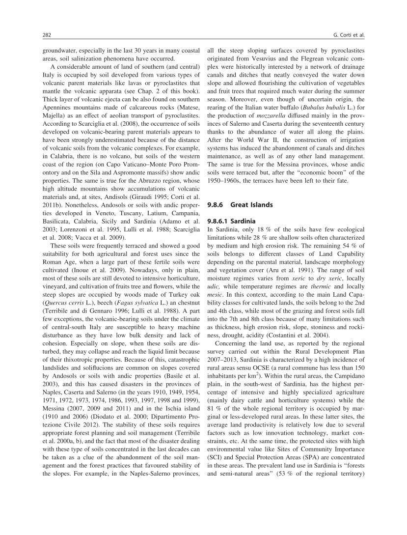
groundwater, especially in the last 30 years in many coastalareas, soil salinization phenomena have occurred.
A considerable amount of land of southern (and central)Italy is occupied by soil developed from various types ofvolcanic parent materials like lavas or pyroclastites thatmantle the volcanic apparata (see Chap. 2 of this book).Thick layer of volcanic ejecta can be also found on southernApennines mountains made of calcareous rocks (Matese,Majella) as an effect of aeolian transport of pyroclastites.According to Scarciglia et al. (2008), the occurrence of soilsdeveloped on volcanic-bearing parent materials appears tohave been strongly underestimated because of the distanceof volcanic soils from the volcanic complexes. For example,in Calabria, there is no volcano, but soils of the westerncoast of the region (on Capo Vaticano–Monte Poro Prom-ontory and on the Sila and Aspromonte massifs) show andicproperties. The same is true for the Abruzzo region, whosehigh altitude mountains show accumulations of volcanicmaterials and, at sites, Andisols (Giraudi 1995; Corti et al.2011b). Nonetheless, Andosols or soils with andic proper-ties developed in Veneto, Tuscany, Latium, Campania,Basilicata, Calabria, Sicily and Sardinia (Adamo et al.2003; Lorenzoni et al. 1995, Lulli et al. 1988; Scarcigliaet al. 2008; Vacca et al. 2009).
These soils were frequently terraced and showed a goodsuitability for both agricultural and forest uses since theRoman Age, when a large part of these fertile soils werecultivated (Inoue et al. 2009). Nowadays, only in plain,most of these soils are still devoted to intensive horticulture,vineyard, and cultivation of fruits tree and flowers, while thesteep slopes are occupied by woods made of Turkey oak(Quercus cerris L.), beech (Fagus sylvatica L.) an chestnut(Terribile and di Gennaro 1996; Lulli et al. 1988). A partfew exceptions, the volcanic-bearing soils under the climateof central-south Italy are susceptible to heavy machinedisturbance as they have low bulk density and lack ofcohesion. Especially on slope, when these soils are dis-turbed, they may collapse and reach the liquid limit becauseof their thixotropic properties. Because of this, catastrophiclandslides and soliflucions are common on slopes coveredby Andosols or soils with andic properties (Basile et al.2003), and this has caused disasters in the provinces ofNaples, Caserta and Salerno (in the years 1910, 1949, 1954,1971, 1972, 1973, 1974, 1986, 1993, 1997, 1998 and 1999),Messina (2007, 2009 and 2011) and in the Ischia island(1910 and 2006) (Diodato et al. 2000; Dipartimento Pro-tezione Civile 2012). The stability of these soils requiresappropriate forest planning and soil management (Terribileet al. 2000a, b), and the fact that most of the disaster dealingwith these type of soils concentrated in the last decades canbe taken as a clue of the abandonment of the soil man-agement and the forest practices that favoured stability ofthe slopes. For example, in the Naples-Salerno provinces,
all the steep sloping surfaces covered by pyroclastitesoriginated from Vesuvius and the Flegrean volcanic com-plex were historically interested by a network of drainagecanals and ditches that neatly conveyed the water downslope and allowed flourishing the cultivation of vegetablesand fruit trees that required much water during the summerseason. Moreover, even though of uncertain origin, therearing of the Italian water buffalo (Bubalus bubalis L.) forthe production of mozzarella diffused mainly in the prov-inces of Salerno and Caserta during the seventeenth centurythanks to the abundance of water all along the plains.After the World War II, the construction of irrigationsystems has induced the abandonment of canals and ditchesmaintenance, as well as of any other land management.The same is true for the Messina provinces, whose andicsoils were terraced but, after the ‘‘economic boom’’ of the1950–1960s, the terraces have been left to their fate.
9.8.6 Great Islands
9.8.6.1 SardiniaIn Sardinia, only 18 % of the soils have few ecologicallimitations while 28 % are shallow soils often characterizedby medium and high erosion risk. The remaining 54 % ofsoils belongs to different classes of Land Capabilitydepending on the parental material, landscape morphologyand vegetation cover (Aru et al. 1991). The range of soilmoisture regimes varies from xeric to dry xeric, locallyudic, while temperature regimes are thermic and locallymesic. In this context, according to the main Land Capa-bility classes for cultivated lands, the soils belong to the 2ndand 4th class, while most of the grazing and forest soils fallinto the 7th and 8th class because of many limitations suchas thickness, high erosion risk, slope, stoniness and rocki-ness, drought, acidity (Costantini et al. 2004).
Concerning the land use, as reported by the regionalsurvey carried out within the Rural Development Plan2007–2013, Sardinia is characterized by a high incidence ofrural areas sensu OCSE (a rural commune has less than 150inhabitants per km2). Within the rural areas, the Campidanoplain, in the south-west of Sardinia, has the highest per-centage of intensive and highly specialized agriculture(mainly dairy cattle and horticulture systems) while the81 % of the whole regional territory is occupied by mar-ginal or less-developed rural areas. In these latter sites, theaverage land productivity is relatively low due to severalfactors such as low innovation technology, market con-straints, etc. At the same time, the protected sites with highenvironmental value like Sites of Community Importance(SCI) and Special Protection Areas (SPA) are concentratedin these areas. The prevalent land use in Sardinia is ‘‘forestsand semi-natural areas’’ (53 % of the regional territory)
282 G. Corti et al.
followed by ‘‘agricultural areas’’ (43 %) where pastures andforage systems are highly represented.
To understand the actual land uses and soil managementpractices and the role of different drivers on their dynamics,it is important to look at the past and at the more recenttrends. Since 1950s, there was a general trend towardsintensification of the land uses. D’Angelo et al. (2001)analysed the evolution of the soil uses along the period1955–1996 and observed a marked increase in improvedpastures at the expense of cork woodlands. Sheep grazingwas taken over and intensified with negative consequencesfor cork oak regeneration (Ruiu et al. 1995). Since the1980s, due to the EU CAP that allocated subsidies on thenumber of animals and on the introduction of mechanizedfarming, the traditional agro-pastoral landscape of Sardiniawas subjected to a further marked intensification. Wideareas of Macchia Mediterranea were cleared to createartificial pastures through bush and stone removal, tillageand sowing of forage species (Pulina et al. 1997; Rivoiraet al. 1989). Among these agricultural practices, tillage andmechanical shrub removal (which were made, in manycases, on steep slopes along the maximum gradient) wereconsidered the main causes of land degradation. In manyagro-pastoral areas of Sardinia, these have been carried outonce every 3–5 years aiming to remove invasive not pal-atable species that re-colonized the pastures (Zucca et al.2010). These practices resulted in losses of the shrub layer,so contributing to soil organic matter decline, soil exposureand erosion particularly on steep slopes (Vogiatzakis et al.2008 and references therein). In an agro-pastoral area ofcentral-eastern Sardinia (Irgoli, Nuoro province), Zuccaet al. (2010) estimated a soil loss between 30 and 60 t ha-1
y-1 in pastures after 15–30 years since Macchia Mediter-ranea clearing and periodical tillage. These authors foundthat the early autumn rainfall events were very erosive andcould have a great impact on pasture soils, deprived of thevegetation cover by grazing and, eventually, by ploughing,which was generally carried out at the end of summer.Other authors found lower soil erosion rates, with soil lossesover 6 years up to 3 t ha-1, but for different cropping sys-tems (Eucalyptus plantations) on more gentle slope condi-tions (Vacca et al. 2000). In pasture areas of the same studysite of the work of Zucca et al. (2010), challenged watererosion was found to be intense too (Zucca et al. 2006). Thiswas mainly attributed to over-exploitation of the pasture-land and to the creation of new pastures on unsuitablemarginal land managed by periodical tillage, often carriedout along the maximum slope gradient.
In more recent years, the agricultural landscape ofSardinia have been subjected to deterioration processesthrough abandonment of marginal land and intensification ofmost favourable areas. This has led to a substantial increasein areas classified as permanent pastures, although many
of them are actually abandoned arable lands previouslycultivated with durum wheat (Roggero et al. 2011). Theincrease in the permanent pastures, provided the mainte-nance of the same or even lower livestock numbers, seemsconsistent with the objective to protect soil quality fromovergrazing and ploughing of steep areas. Nevertheless, asstated above, the increase in permanent pastures is alsostrongly associated to the abandonment of the farmingactivities, since farmers, who are dealing with a global agro-food crisis and with a serious crisis of the Sardinian agro-pastoral sector, are strongly oriented to reduce productioncosts (i.e. fuel, seeds, extra-farm feeds). It is debatedwhether the effect of the abandonment could be positive ornegative (Mazzoleni et al. 2004). Under limiting water andnutrients conditions causing low soil fertility and vegetationproduction, abandonment could enhance land degradation,while under more favourable conditions abandoned land canbe rapidly colonized by vegetation facilitating the accumu-lation of soil organic matter and, in turn, increasing theoverall soil fertility. At the same time, increased plantbiomass in abandoned land also could create higher risks ofwildfires and, thus, the soil could return to a status moresusceptible to erosion. However, research findings analysingthe impact of land abandonment on soil processes are notso far available for the specific contexts of Sardinia.
Regarding the impact of intensification in the mostfavourable areas, some processes of soil degradation areoccurring. One case is that of the anthropic salinization,which is related to the over-pumping of coastal groundwaterthat has caused the infiltration of sea water. The use of thislow-quality water for irrigation is increasingly affectingseveral coastal areas like the Cedrino river delta in eastern-central Sardinia and the Muravera coastal plain in southern-eastern Sardinia (Vacca et al. 2000). The sea water intrusionwas recognized as an important driver of soil salinizationalso in the Nurra district in the north–east of Sardinia, butother various geochemical processes due to the groundwa-ter–rock interaction, including ion exchange with hydro-thermal minerals, and clays were found to be involved(Ghiglieri et al. 2009).
9.8.6.2 SicilySicily encompasses several agricultural landscapes and agro-forestry systems. As a consequence of different natural andhistorical settings intersecting for millennia, Sicily can beviewed as representative of the Mediterranean area as awhole. Sicily has hosted continuous and intensive agricul-tural activity since the Neolithic Age (Sereni 1997), leadingto remarkable growth of its autochthonous species in termsof both quantity (with varieties brought from other regions asa result of historical events) and intra-specific biodiversity(through anthropic selection). Sicily’s high environmentalvariability is particularly visible in locations where plains,
9 Italian Soil Management from Antiquity to Nowadays 283

hills, mountains, sea and sizeable human settlements alloccur within a small area. Traditional landscapes (sensuAntrop 2005) are often encountered in such areas, showinghistorical identities that were largely stable until themid-twentieth century (Antrop 2005; Bignal et al. 1995; Vosand Meekes 1999); however, in recent years, they have beensubject to either agricultural intensification or abandonment(renaturalization) and degradation (e.g. urbanization).Through these processes, traditional landscapes are nowshrinking and gradually disappearing (Aalen 2001; Agnoletti2007; Green and Vos 2001).
Traditional agricultural and agro-forestry landscapes arecharacterized by low-intensity systems and land manage-ment activities, providing a high degree of multifunction-ality (Jones-Walters 2008; Pinto-Correia and Vos 2004; Vosand Klijn 2000) in terms of production (typical products),environment (e.g. soil protection and biodiversity) andculture (distinctive landscapes).
The area of Mount Mongibello (Etna volcano), in theeast coast of the island, is characterized by a mixture ofdifferent traditional land uses and covers. In general, naturaland semi-natural communities (especially forests and shrub-lands) prevail above 1,000 m of altitude (Poli-Marcheseand Patti 2000). Below 1,000 m of altitude, the flanks of thevolcano are characterized by various combinations ofclosed agro-forestry systems (Barbera et al. 2004; Busacca2000), which are terraced and cultivated with mixed fruitcrops and other traditional crops such as pistachio, hazelnutand vine. Irrigated agricultural systems are located below300–400 m above sea level and host citrus trees, olive tree,almond trees, pistachio and cactus pears. The coastal plainhosts intensive irrigated agricultural systems characterizedby orchards and vegetable gardens that recall the huertas.
In south-east of Sicily, the Mazzarrone area ‘‘is a veryclear example showing the effects of the land-use change inthe soilscape by large scale farming over time’’ (Lo Papaet al. 2011). In this area, the rapid expansion of vineyards fortable grape production involved deep irreversible transfor-mation of the soils that, due to anthropic pressure, under-went a process of entisolization leading to the formation ofstrong anthropogenic features (Dazzi and Monteleone2002). The soils of Mazzarrone, after a deep mixing of theoriginal horizons occurred about 30 years ago to establishthe vineyards, changed according to WRB (FAO/ISRIC/ISSS, 1998) from Calcaric Kastanozem to Aric Regosols(Dazzi and Monteleone 2007). Recently, the same soils wereclassified as Geomiscic Anthrosols as a consequence of theaddition on their surface of transported earthy material and adeep ploughing in order to improve the quality of grape(Dazzi and Monteleone 2007).
References
Aalen FHA (2001) Landscape development and change. In: Green B,Vos W (eds) Threatened landscapes, conserving cultural environ-ments. Spon Press, London
Abbate P (2004) Time out Guide: Rome. Tecniche Nuove, MilanoAcs S, Hanley N, Dallimer M, Robertson P, Wilson P, Gaston K,
Armsworth PR (2010) The effect of decoupling on marginalagricultural systems: implications for farm incomes, land use andupland ecology. Land Use Policy 27:550–563
Adamo P, Denaix L, Terribile F, Zampella M (2003) Characterizationof heavy metals in contaminated volcanic soils of the Solofranariver valley (southern Italy). Geoderma 117:347–366
Agence de l’eau Adour-Garonne (2004) Bilan sur la qualité de l’eaudes principales rivières du bassin Adour-Garonne en 2003. Agencede l’eau Adour-Garonne. Internal report
Agnoletti M (2007) The degradation of traditional landscape in amountain area of Tuscany during the 19 and 20th centuries:implications for biodiversity and sustainable management. ForEcol Manage 249:5–17
Ajmone Marsan F, Pagliai M, Pini R (1994) Identification andproperties of fragipan soils in the piemonte region (Italy). Soil SciSoc Am J 58:891–900
Albrecht M, Duelli P, Schmid B, Muller CB (2007) Interaction diversitywithin quantified insect food webs in restored and adjacentintensively managed meadows. J Anim Ecol 76:1015–1025
Alexander D (1982) Difference between ‘‘calanchi’’ and ‘‘biancane’’badlands in Italy. In: Bryan R, Yair A (eds) Badland geomorphol-ogy and piping. Geobook, Norwich
Allen HD, Randall RE, Amable GS, Devereux BJ (2006) The impactof changing olive cultivation practices on the round flora of olivegroves in the messala and psiloritis regions, Crete, Greece. LandDegrad Dev 17:249–273
Alley RB (2000) The younger Dryas cold interval as viewed fromcentral Greenland. Quatern Sci Rev 19:213–226
Alliance Environnement (2007) Evaluation of the application of crosscompliance as foreseen under Regulation 1782/2003. Part II:Replies to evaluation questions. European commission, directorate-general for agriculture and rural development
Allison FE (1973) Soil organic matter and its role in crop production.Elsevier, New York
Amadei G (1994) Advantages and disadvantages of set-aside (Italy).Ponte 5:3–10
Anderlini R (1981) 9000 anni di fertilità. Calderoni, BolognaAntrop M (2005) Why landscapes of the past are important for the
future. Landscape Urban Planning 70:21–34APAT (Agenzia per la Protezione dell’Ambiente e per i servizi
Tecnici) (2007) Il suolo. La radice della vita. APAT, RomaAragüés R, Tanji KK (2003) Water quality of irrigation return flows,
Encyclopedia of water science. Marcel Dekker Inc., pp 502–506Areté (Research & Consulting in Economics), DEIAgra (Dipartimento
di Economia ed Ingegneria Agrarie, Università di Bologna) 2008.Evaluation of the Set Aside Measure 2000 to 2006. TenderN�AGRI/2006-G4-16. Final Report, May 2008
Arnaud-Fassetta G, Cossart E, Fort M (2005) Hydro-geomorphichazards and impact of man-made structures during the catastrophicflood of June 2000 in the upper guil catchment (Queyras, SouthernFrench Alps). Geomorphology 66:41–67
Arrúe JL, López MV (1991) Laboreo de conservación; tendencias yprioridades de investigación (Conservation work; trends andpriorities for investigation). Suelo y Planta 1:555–564
284 G. Corti et al.

Aru A, Baldaccini P, Vacca A, Delogu G, Dessena MA, Madrau S,Melis RT, Vacca S (1991) Nota illustrativa alla carta dei suoli dellaSardegna. Dipartimento di Scienze della Terra Università degliStudi di Cagliari, Assessorato Regionale alla ProgrammazioneBilancio ed Assetto del Territorio, Cagliari
Aviron S, Nitsch H, Jeanneret P, Buholzer S, Luka H, Pfiffner L, PozziS, Schüp-Bach B, Walter T, Herzog F (2009) Ecological crosscompliance promotes farmland biodiversity in Switzerland. FrontEcol Environ 7:247–252
Bagnasco Gianni G (2005) Tarquinia, il deposito reiterato: unapreliminare analisi dei comparando. In: Borghi JM, Chiesa F (eds.)Offerte dal regno vegetale e dal regno animale nelle manifestazionidel sacro. Atti dell’incontro di studio, giugno 2003. L’Erma diBretschneider Publisher, Milano, pp 26–27
Barbera G, Cullotta S, Pizzurro G (2004) Agroforestry systems of MtEtna, Italy: biodiversity analysis at landscape, stand and specificlevel. In Marchetti M (ed.) Monitoring and indicators of forestbiodiversity in Europe—from ideas to operationality. EFI Pro-ceedings, vol 51. pp 481–492
Barker G, Rasmussen T (2000) The peoples of Europe—the Etruscans.Wiley
Basile A, Mele G, Terribile F (2003) Soil hydraulic behaviour of aselected benchmark soil involved in the landslide of Sarno 1998.Geoderma 117:331–346
Bauer A, Black AL (1994) Quantification of the effect of soil organicmatter content on soil productivity. Soil Sci Soc Am J 58:185–193
Bazzoffi P (ed.) (2011) Environmental effectiveness of GAEC cross-compliance standards implemented in Italy. Ital J Agron 6(supplement 1)
Bazzoffi P, Ciancaglini A, Laruccia N (2011) Effectiveness of theGAEC cross-compliance standard short-term measures for runoffwater control on sloping land (temporary ditches and grass strips)in controlling soil erosion. Ital J Agron 6(supplement 1):10–24
Bazzoffi P, Jakab G (2006) Land levelling. In: Boardman J, Poesen J(eds) Soil erosion in Europe. Wiley, Chichester
Belhouchette H, Louhichi K, Therond O, Mouratiadou I, Wery J, vanIttersum M, Flichman G (2011) Assessing the impact of the nitratedirective on farming systems using a bio-economic modellingchain. Agric Syst 104:135–145
Bernabò Brea M, Cardarelli A, Cremaschi M (eds.) (1997) LeTerramare. La più antica civiltà padana. Edizioni Electa, Milano—Elemond Editori Associati
Bertolani Marchetti D, Dallai D, Trevisan Grandi G (1988) Ricerchepalinologiche sugli insediamenti preistorici e protostorici di Tabinadi Magreta. In: Cardarelli A (ed) Modena dalle Origini all’annoMille. Studi di Archeologia e Storia I, Modena
Bignal EM, Mc Cracken DI, Corrie H (1995) Defining European low-intensity farming systems: the nature of farming. In Mc CrackenDI, Bignal EM, Wenlock SE (eds.) Farming on the edge: the natureof traditional farmland in Europe. Joint Nature ConservationCommittee, Peterborough
Bloem J, Hopkins DW, Benedetti A (2006) Microbiological methodsfor assessing soil quality. CABI Publishing, Oxfordshire
Blum WEH, Büsing J, Montanarella L (2004) Research needs insupport of the European thematic strategy for soil protection.Trends Anal Chem 23:680–685
Blum WEH, Santelises AA (1994) A concept of sustainability andresilience based on soil functions: The role of the internationalsociety of soil science in promoting sustainable land use. In:Greenland DJ, Szabolcs I (eds) Soil resilience and sustainable landuse. CAB Int, Wallingford, pp 535–542
Boellstorff D, Benito G (2005) Impacts of set-aside policy on the riskof soil erosion in central Spain. Agric Ecosyst Environ107:231–243
Bombino G, Denisi P, Tamburino V, Zema DA, Zimbone SM (2011)Sistemazioni ed ecosistemi di fiumara in Calabria: analisi di uncaso-studio di valutazione dell’ ’’Indice di funzionalità fluviale’’Convegno di Medio Termine dell’Associazione Italiana di Inge-gneria Agraria, Belgirate, settembre pp 22–24
Bonciarelli F (1989) Fondamenti di Agronomia Generale. EdizioniAgricole, Bologna
Borin M, Passoni M, Thiene M, Tempesta T (2010) Multiple functionsof buffer strips in farming areas. Eur J Agron 32:103–111
Borselli L, Torri D, Øygarden L, De Alba S, Martínez-Casasnovas JA,Bazzoffi P, Jakab G (2006) Land levelling. In Boardman J, PoesenJ (eds.) Soil erosion in Europe, Wiley, West Sussex
Bracchetti L, Carotenuto L, Catorci A (2012) Land-cover changes in aremote area of central Apennines (Italy) and management direc-tions. Landscape Urban Planning 104:157–170
Bresc H (1972) Les jardin de Palerme (1290–1460). In: Mélangesd’Archéologie et d’Histoire. Ecole Française de Rome
Brevik EC, Hartemink AE (2010) History, philosophy, and sociologyof soil science. In: Squires V, Verheye W (eds) Encyclopedia oflife supporting system (EOLSS). UNESCO EOLSS Publishers,Oxford
Buck RJ (1983) Agriculture and agricultural practice in Roman law.Franz Steiner Verlag Gmbh Wiesbaden
Buckley GP (ed) (1987) Biological habitat reconstruction. BelhavenPress, London
Burghardt W (2006) Soil sealing and soil properties related to sealing.Geol Soc 266: 117–124 Special Publications, London
Busacca P (2000) Il racconto del territorio–l’Etna tra le Aci el’Alcantara. ed. Gangemi, Roma
Busoni E. Colica A (2006) Influence of land use changes on landscapefactors and characteristics of a Pliocene basin. Geografia Fisica eDinamica Quater 29:139–152
Camporeale G (2004) Gli Etruschi Storia e civiltà. UTET Università,Torino
Cannell RQ, Hawes JD (1994) Trends in tillage practices in relation tosustainable crop production with special reference to temperateclimates. Soil Tillage Res 30:245–282
Capolongo D, Pennetta L, Piccarreta G, Boenzi F (2008) Spatial andtemporal variations in soil erosion and deposition due to land-levelling in a semi-arid area of Basilicata (southern Italy). EarthSurf Proc Land 33:364–379
Carandini A, Cambi F, Celuzza M, Fentress E (eds.) (2002) Paesaggid’Etruria—Valle dell’Albegna, Valle d’Oro, Valle del Chiarore,Valle del Tafone. Edizioni di Storia e Letteratura. Litosud s.r.l.Publisher, Roma
Caravaca F, Masciandaro G, Ceccanti B (2002) Land use in relation tochemical and biochemical properties in semiarid Mediterraneanenvironment. Soil Tillage Res 68:23–30
Caravello G, Crescini E, Tarocco S, Palmeri F (2006) Environmentalmodifications induced by the practice of ‘‘Artificial snow-making’’in the Obereggen/Val D’Ega Area (Italy). J Mediterranean Ecol7:31–39
Cardini F, Montesano M (2006) Storia medievale. Le MonnierUniversità, Firenze
Carpenter SR, Caraco NF, Correll DL, Howarth RW, Sharpley AN,Smith VH (1998) Non-point pollution of surface waters withphosphorus and nitrogen. Ecol Appl 8:559–568
Carter JC (1987) Agricoltura e pastorizia in Magna Grecia (traBradano e Basento). In: Pugliese Caratelli G (ed.) Magna Grecia.Lo sviluppo politico, sociale ed economico. Electa, Milano
Caruso G (1898) Agronomia—Secondo le lezioni date nella RegiaUniversità di Pisa. Unione Tipografica Torinese, Torino
Castiglioni P (1878) Della popolazione di Roma: dalle Origini aiNostri tempi. Anasthatic reprint. Kessinger Publishing, LLC
9 Italian Soil Management from Antiquity to Nowadays 285
Castrignanò A, De Giorgio D, Fornaro F, Vonella AV (2004) 3DSpatial variation of soil impedance as affected by soil tillage. ISCO2004—13th international soil conservation organisation confer-ence—Brisbane, July 2004. Paper no. 744
Cavallin A, Marchetti M, Panizza M (1996) Geomorphology andenvironmental impact assessment: a methodological approach. In:Panizza M, Fabbri AG, Marchetti M, Patrono A (eds) Geomor-phologic analysis and evaluation in environmental impact assess-ment, vol 32. ITC publication, Enschede
CEC (Commission of the European Communities) (2006) Communi-cation from the commission to the council, the European parlia-ment, the European economic and social committee and thecommittee of the regions. Thematic strategy for soil protection.Brussels, 22.9.2006, COM (2006) 231 final
Celant A (2002) Ricerche archeobotaniche nel villaggio eneolitico diLe Cerquete-Fianello (Maccarese, Fiumicino). In: Manfredini A(ed) Le dune, il lago, il mare. Istituto Italiano di Preistoria eProtostoria, Firenze
Cerchiai L, Jannelli L, Longo F, Smith ME (2004) Die Griechen inSüditalien: Auf Spurensuche zwischen Neapel und Syrakus.Konrad Theiss Verlag, Stuttgart
Cesaro L, Povellato A (2001) Land use changes in Italy. A shortanalysis of the main driving forces for rangeland. Proceeding of theseminar ‘‘Land use changes and cover and water resources in theMediterranean region’’ Medenine (Tunisia), April 2001, pp 20–21
Chadwick OA, Chorover J (2001) The chemistry of pedogenicthresholds. Geoderma 100:321–353
Chapman T (2008) The Risorgimento—Italy 1915–71. Humanities-Ebooks.co.uk, Tirril Hall, Tirril, Penrith. ISBN 978-1-84760-062-2
Chisci G, Zanchi C (1980) The influence of different tillage systemsand different crops on soil losses on hilly silty-clayey soil.In: Morgan RPC (ed) Soil conservation—problems and prospects.Wiley, Lonon
Cicirelli C, Arbore Livadie C, Boni M (2006) Dati preliminari suimanufatti metallici dell’insediamento protostorico in loc. Longola(Poggiomarino-Napoli). In: Materie prime e scambi nella preistoriaitaliana, Atti XXXIX Riunione Scientifica dell’Istituto Italiano diPreistoria e Protostoria, Firenze Firenze, Novembre 2004, pp 25–27
Clarke ML, Rendell HM (2006) Process–form relationships inSouthern Italian badlands: erosion rates and implications forlandform evolution. Earth Surf Proc Land 31:15–29
Commission of the European Communities (2006) Thematic strategyfor soil protection. directive COM (2006) 231 and 232. Brussels
Conedera M, Krebs P, Tinner W, Pradella M, Torriani D (2004) Thecultivation of Castanea sativa (Mill.) in Europe, from its origin toits diffusion on a continental scale. Vegetation Hist Archaeobotany13:161–179
Cornu S (2005) Pedogeneses d’hier et d’aujourd’hui, Thesis. Univer-sité d’Orléans, France
Corpo Forestale dello Stato (2002) Corpo forestale delle Stato:Rapporto sul Terzo censimento delle discariche abusive del 22ottobre 2002. Il censimento delle discariche abusive/Temi 2,Documento 31
Corti G, Cavallo E, Cocco S, Biddoccu M, Brecciaroli G, Agnelli A(2011a) Evaluation of erosion intensity and some its consequencesin vineyards from two hilly environments under a Mediterraneantype of climate, Italy. In: Godone D, Stanchi S (eds.) Soil Erosionin Agriculture. Chapter 6. InTech Open Access Publisher, Rijeka,Croatia. ISBN 978-953-307-435-1
Corti G, Cocco S, Basili M, Cioci C, Warburton J, Agnelli A (2011b)Soil formation in kettle holes from high altitudes in centralApennines, Italy. Geoderma 170:280–294
Costantini EAC, L’Abate G (2009) A soil aridity index to assesdesertification risk for Italy. In: Faz Cano A, Mermut AR, ArocenaJM, Ortiz Silla R (eds.) Land degradation and rehabilitation—
dryland ecosystems. Adv GeoEcology 40 Catena Verlag, Reiskir-chen, Germany
Costantini EAC, L’abate G, Urbano F (2004) Soil Regions of Italy.CRA-ISSDS, Firenze, pp. 8 [online] http://www.soilmaps.it/ita/downloads.html
Costantini EAC, Urbano F, Aramini G, Barbetti R, Bellino F, BocciM, Bonati G, Fais A, L’Abate G, Loj G, Magini S, Napoli R, NinoP, Paolanti M, Perciabosco M, Tascone F (2009) Rationale andmethods for compiling an atlas of desertification in Italy. LandDegrad Dev 20:261–276
Costantinidis CA (1981) Bonifica ed irrigazione. Edagricole, BolognaCremaschi M, Pizzi C, Valsecchi V (2006) Water management and
land use in the terramare and a possible climatic co-factor in theirabandonment: the case study of the terramara of poviglio SantaRosa (northern Italy). Quatern Int 151:87–98
D’Angelo M, Enne G, Madrau S, Zucca C (2001) Land cover changesat landscape-scale in Sardinia (Italy): the role of agriculturepolicies on land degradation. A conocher land degradation. KluwerAcademic Publishers, Dordrecht
Dalal RC, Mayer RJ (1986) Long-term trends in fertility of soils undercontinuous cultivation and cereal cropping in southern Queensland.IV. Loss of organic carbon for different density functions. Aust JSoil Res 24:301–309
Davidson DA (2000) Soil quality assessment: recent advances andcontroversies. Prog Environ Sci 2:342–350
Davidson EA, Janssens IA (2006) Temperature sensitivity of soilcarbon decomposition and feedbacks to climate change. Nature440:165–173
Dazzi C, Monteleone S (2002) Soil emergency and landscapeanthropization: the pedodiversity loss due to entisolization.(In Italian) In: Proceedings of the Italian society of soil sciencecongress: ‘‘L’emergenza suolo’’. Bollettino SISS (Società Italianadella Scienza del Suolo), vol 51, pp 557–570
Dazzi C, Monteleone S (2007) Anthropogenic processes in theevolution of a soil chronosequence on marly-limestone substrata inan Italian Mediterranean environment. Geoderma 141:201–209
de Graaff J, Duarte F, Fleskens L, de Figueiredo T (2010) The future ofolive groves on sloping land and ex-ante assessment of crosscompliance for erosion control. Land Use Policy 27:33–41
De Martino F (1979) Storia economica di Roma antica. La NuovaItalia Publisher, Firenze
Degens BP, Harris JA (1997) Development of a physiologicalapproach to measuring the catabolic diversity of soil microbialcommunities. Soil Biol Biochem 29:1309–1320
Denef K, Six J, Bossuyt H, Frey SD, Elliott ET, Merckx R, Paustian K(2001) Influence of dry–wet cycles on the interrelationshipbetween aggregate, particulate organic matter, and microbialcommunity dynamics. Soil Biol Biochem 33:1599–1611
Dexter AR (2002) Soil structure: the key to soil function. AdvGeoEcology 35:57–69
Di Pasquale G, Garfì G, Migliozzi A (2004) Landscape dynamics inSouth-eastern Sicily in the last 150 years: the case of the Ibleimountains. In: Mazzoleni S, Di Pasquale G, Mulligan M, DiMartino P, Rego F (eds) Recent dynamics of the mediterraneanvegetation and landscape. Wiley, Chichester
Di Rita F, Celant A, Magri D (2010) Holocene environmentalinstability in the wetland north of the Tiber delta (Rome, Italy):sea-lake-man interactions. J Paleolimnol 44:51–67
Diamond J (2005) Collapse—how societies choose to fail or succeed.Viking Press, Penguin Group USA. Inc., New York
Diodato N, Mazza G, Amendola E (2000) L’alluvione del 5 maggio1998 in Campania: Appunti di storia climatico-ambientale. Nimbus19/20: 8–14
Dipartimento Protezione Civile, Presidenza del Consiglio dei Ministri(2012) http://www.protezionecivile.gov.it
286 G. Corti et al.
Doran JW, Coleman DC, Bezdicek DF, Stewart BA (1994) Definingsoil quality for a sustainable environment. In: Doran JW, ColemanDC, Bezdicek DF, Stewart BA (eds.) Defining soil quality for asustainable environment. Soil Science Society of America SpecialPublication No. 35. Soil Science Society of America, Madison
Doran JW, Parkin TB (1994) Defining and assessing soil quality.In: Doran JW, Coleman DC, Bezdicek DF, Stewart BA (eds.)Defining soil quality for a sustainable environment. Soil ScienceSociety of America Special Publication No. 35. Soil ScienceSociety of America, Madison
Dramis F, Gentili B, Coltorti M, Cherubini C (1982) Osservazionigeomorfologiche sui calanchi marchigiani. Geografia Fisica eDinamica del Quaternario 5:38–45
Dudal R (2004) The sixth factor of soil formation. In: Proceedings ofthe international conference on soil classification 2004. Petrozav-odsk, Russia, August 2004, pp 3–5
Duiker SW (2006) Soil Management. In: Haering KC, Evanylo GE(eds.) The mid-atlantic nutrient management handbook. Mid-Atlantic regional water program. Delaware, Maryland, Pennsylva-nia, Virginia and West Virginia Land Grant Universities andUSDA’s Cooperative State Research, Education and ExtensionService (CSREES)
Duran Zuazo VH, Aguilar Ruiz J, Martínez Raya A, Franco Tarifa D(2005) Impact of erosion in the taluses of subtropical orchardterraces. Agric Ecosyst Environ 107:199–210
ENCA (2008) Safeguarding environmental benefits of set-aside—theEuropean commission’s proposal on the CAP health check.Sustainable Landuse and Agriculture Interest Group, Brussels
Eswaran H (1994) Soil resilience and sustainable land management inthe context of AGENDA21. In: Greenland DJ, Szabolcs I (eds) Soilresilience and sustainable land use. CAB Int, Wallingford
European Commission (2002) Implementation of council directive 91/676/EEC concerning the protection of waters against pollutioncaused by nitrates from agricultural sources, synthesis from Year2000 member states reports. p 7
European Commission (2006) Thematic strategy for soil protection.COM (2006)231 final, 22.9.2006. Brussels, Belgium
Fabietti G, Biasioli M, Barberis R, Ajmone-Marsan F (2010) Soilcontamination by organic and inorganic pollutants at the regionalscale: the case of Piedmont, Italy. J Soils Sediments 10:290–300
Fairchild Ruggles D (2008) Islamic Gardens and Landscapes.University of Pennsylvania Press
FAO (2000) Global assessment of soil degradation (GLASOD). FAO,Rome
FAO (2003) Compendium of agricultural-environmental indicators1989–91 to 2000. United Nations Food and Agricultural Organi-zation, Rome
FAO/ISRIC/ISSS (1998) World reference base for soil resources.World Soil Resources Rep., vol 84. FAO, Roma
FAO-COAG (2003) Development of a framework for good agricul-tural practices. FAO, Rome. Available at: http://www.fao.org/docrep/meeting/006/y8704e.htm
Ferrari L (1976) Tecniche moderne di sistemazione del suolo.Edagricole, Bologna
Fisher M, Pedrotti W (1997) Le città italiane nel Medioevo. GiuntiEditore, Firenze
Foley JA, Ramankutty N, Brauman KA, Cassidy ES, Gerber JS,Johnston M, Mueller ND, O’Connell C, Ray DK, West PC, BalzerC, Bennett EM, Carpenter SR, Hill J, Monfreda C, Polasky S,Rockström J, Sheehan J, Siebert S, Tilman D, Zaks DPM (2011)Solutions for a cultivated planet. Nature 478:337–342
Follieri M, Coccolini G, Catullo A (1977) Strutture lignee di un abitatodell’età del Bronzo nel lago di Mezzano (Viterbo). Annali diBotanica 35–36, 175–183
Foss JE, Timpson ME, Ammos JT, Lee SY (2002) Paleosols of thePompeii area. In: Frederick WJ, Meyer G (eds.) The natural historyof pompeii. Cambridge University Press, Cambridge
Fossombroni V (1835) Memorie idraulico-storiche sopra la Val diChiana. Tip. Fumi, Montepulciano
Fowler P (2002) Farming in the first millennium AD: Britishagriculture between Julius Caesar and William the Conqueror.Cambridge University Press, Cambridge
Franco I, Contin M, Bragato G, De Nobili M (2004) Microbiologicalresilience of soils contaminated with crude oil. Geoderma121:17–30
Freppaz M, Lunardi S, Bonifacio E, Scalenghe R, Zanini E (2002) Skislopes and stability of soil aggregates. In: Pagliai M, Jones R (eds)Advances in geoecology 35 sustainable land management-envi-ronmental protection. Catena Verlag, Germany
Fromm H, Winter K, Filser J, Hantschel R, Beese F (1993) Theinfluence of soil type and cultivation system on the spatialdistribution of the soil fauna and microorganisms and theirinteractions. Geoderma 60:109–118
Gardner RAM, Gerrard AJ (2003) Runoff and soil erosion oncultivated rainfed terraces in the middle hills of Nepal. ApplGeogr 23:23–45
Gay SH, Osterburg B (2005) Land use implications of the 2003 reformof the common agricultural policy in the European Union. GermanAssociation of Agricultural Economists
Gentile AR (1999) Towards the development of a system of policyrelevant indicators on soil. European Soil Forum, Berlin
Ghiglieri G, Oggiano G, Fidelibus MD, Alemayehu T, Barbieri G,Vernier A (2009) Hydrogeology of the Nurra Region, Sardinia(Italy): basement-cover influences on groundwater occurrence andhydrogeochemistry. Hydrogeol J 17:447–466
Giardini L, Borin M (1996) Effetti del set-aside annuale sul contenutodi azoto nitrico nella falda sottosuperficiale. Rivista di Agronomia30:205–211
Giardini L, Borin M, Fantinato L, Giupponi C (1994) Studi e ricercheper la razionale utilizzazione a scopo agricolo delle risorse idrichedel Bacino del Fiume Po. Fase pluriennale di gestione. Indaginesull’interazione fra usi agricoli e qualità delle acque. Ministerodelle Risorse Agricole, Alimentari e Forestali—Consorzio diBonifica di Secondo Grado per il Canale Emiliano Romagnolo
Giraudi C (1995) I detriti di versante ai margini della Piana del Fucino(Italia Centrale): significato paleoclimatico ed impatto antropico.Il Quaternario, Ital J Quat Sci 8: 203–210
Giupponi C, Ramanzin M, Sturaro E, Fuser S (2006) Climate and landuse changes, biodiversity and agri-environmental measures in theBelluno province, Italy. Environ Sci Policy 9:163–173
Glob PV (1951) Ard og plow I Nordens oldtid (Ard and Ploush inPrehistoric Scandinavia). Jysk arkaeologisk selskab I, Aarhus
Goodchild RG (1998) EU policies for the reduction of nitrogen inwater: the example of the nitrates directive. Environ Pollut102:737–740
Goudie A (2006) The human impact on the natural environment, 6thedn. Blackwell Publishing, United Kingdom
Govers G, Quine TA, Desmet PJJ, Walling DE (1996) The relativecontribution of soil tillage and overland flow erosion to soilredistribution on agricultural land. Earth Surf Landforms 21:929–946
Govers G, Vandaele K, Desmet J, Poesen J, Bunte K (1994) The role oftillage in soil redistribution on hillslopes. Eur J Soil Sci 45:469–478
Grant CD, Watts CW, Dexter AR, Frann BS (1995) An analysis offragmentation of remoulded soils with regard to self-mulchingbehaviour. Aust J Soil Sci 33:569–583
Gray NF (1987) Nematophagous fungi with particular reference totheir ecology. Biol Rev 62:245–304
9 Italian Soil Management from Antiquity to Nowadays 287
Green BH, Vos W (2001) Managing old landscapes and making newones. In: Green BH, Vos W (eds) Threatened landscapes:conserving cultural landscapes. Spon Press, London
Gregory AS, Watts CW, Griffiths BS, Hallett PD, Kuan HL, WhitmoreAP (2009) The effect of long-term soil management on the physicaland biological resilience of a range of arable and grassland soils inEngland. Geoderma 153:172–185
Gregory AS, Watts CW, Whalley WR, Kuan HL, Griffiths BS, HallettPD, Whitmore AP (2007) Physical resilience of soil to fieldcompaction and the interactions with plant growth and microbialcommunity structure. Eur J Soil Sci 58:1221–1232
Griffiths BS, Ritz K, Bardgett RD, Cook R, Christensen S, Ekelund Fet al (2000) Ecosystem response of pasture soil communities tofumigation-induced microbial diversity reductions: an examinationof the biodiversity–ecosystem function relationship. Oikos90:279–294
Grimm M, Jones RJA, Rusco E, Montanarella L (2003) Soil erosionrisk in Italy: a revised USLE approach. European soil bureauresearch report no. 11, EUR 20677 EN, (2002), Office for OfficialPublications of the European Communities, Luxembourg, p 28
Grossman MR (2000) Nitrates from agriculture in Europe: the ECnitrates directive and its implementation in England. BostonCollege Environ Affairs Law Rev 27:567–630
Grove JM, Switsur R (1994) Glacial geological evidence for themedieval warm period. Clim Change 26:143–169
Guo LB, Gifford RM (2002) Soil carbon stocks and land use change:a meta analysis. Glob Change Biol 8:345–360
Hadas A, Sagiv B, Haruvy N (1999) Agricultural practices, soilfertility management modes and resultant nitrogen leaching ratesunder semi-arid conditions. Agric Water Manage 42:81–95
Hairsine PB, Rose CW (1992a) Modelling water erosion due tooverland flow using physical principles: I uniform flow. Water ResRes 28:245–250
Hairsine PB, Rose CW (1992b) Modelling water erosion due tooverland flow using physical prionciples: II rill flow. Water ResRes 28:237–244
Hammad AA, Haugen LE, Børresen T (2004) Effects of stonewalledterracing techniques on soil-water conservation and wheat produc-tion under Mediterranean conditions. Environ Manage 34:701–710
Harrison RM (1996) Pollution: causes, effects and control, 3rd edn.Royal Society of Chemistry, Cambridge
Hartemink AE (2006) Soil fertility decline: definitions and assessment.In: Lal R (ed) Encyclopedia of soil science, 2nd edn. Taylor andFrancis, New York
Haynes RJ, Fraser PM, Williams PH (1995) Earthworm populationsize and composition and microbial biomass: effect of pastoral andarable management in Canterbury, New Zealand. In: The signif-icance and regulation of soil biodiversity. Kluwer AcademicPublishers, Netherlands
Haynes S (2005) Etruscan civilization: a cultural history. GettyPublications
Heathwaite AL, Johnes PJ, Peters NE (1996) Trends in nutrients.Hydrol Process 10:263–293
Henke R (2004) Il riorientamento delle politiche di sostegno all’agricoltura nell’UE. PAGRI-1-2/2004
Hermavan B, Cameron KC (1993) Structural changes in a silt loamunder long-term conventional or minimum tillage. Soil TillageRes 26:139–150
Herrick JE (2000) Soil quality: an indicator of sustainable landmanagement? Appl Soil Ecol 15:75–83
Herrick JE, Wander MM (1998) Relationships between soil organiccarbon and soil quality in cropped and rangeland soils: theimportance of distribution, composition and soil biological activity.In: Lal R, Kimble JM, Follett RF, Stewart BA (eds) Soil processes
and the carbon cycle. Advances in soil science. CRC Press, BocaRaton, pp 405–426
Hillel D (1991) Out of the earth: civilization and the life of the soil.University of California Press, California
Hodge I, Latacz-Lohmann U, McNally S, Renwick A, Rush C (2003)Beyond money for nothing; beyond set aside? EuroChoices 2:26–31
Hodge I, Reader M, Revoredo C (2006) Project to assess future optionsfor set aside. report for the department for environment, food andrural affairs, University of Cambridge, Department of LandEconomy
Hudec B, Kaufmann C, Landgrebe-Trinkunaite R, Naumann S (2007)Evaluation of soil protection aspects in certain programmes ofmeasures adopted by member states. Contract No. 07010401/2006/443994/ATA/B1. Final report. European Commission, Environ-ment Directorate-General, Brussels
IEEP (Institute for European and Environmental Policy) (2007)Evaluation of the application of Cross Compliance as foreseenunder Regulation 1782/2003. Part I: descriptive final report.deliverable prepared for DG agriculture
IEEP (Institute for European and Environmental Policy) (2008) Theenvironmental benefits of set aside in the EU—a summary ofevidence. Institute for European Environmental Policy, studyprepared for DEFRA, February 2008
il Glabro R (known as Rodolfo il Glabro in Italy, as Raoul Le Chauvein France, as Glaber Rodulfus in Latin language) (1991) Cronachedell’anno mille (storie). Cavallo G, Orlandini G (eds.) with Latinparallel text. Fondazione Lorenzo Valla/Arnoldo MondadoriEditore, Milano
INEA (Istituto Nazionale di Economia Agraria) (1999a) Le misureagroambientali in Italia. Analisi e valutazione del reg. CEE 2078/92 nel quadriennio 1994-97. Rapporto nazionale. Osservatoriosulle Politiche Strutturali, Roma
INEA (Istituto Nazionale di Economia Agraria) (1999b) Le misureagroambientali in Italia. Analisi e valutazione del reg. CEE 2078/92 nel quadriennio 1994-97. Rapporti regionali. Osservatorio sullePolitiche Strutturali, Roma
INEA (Istituto Nazionale di Economia Agraria) (2000) Rapporto sullepolitiche agricole dell’Unione Europea 1998–99. Istituto Nazionaledi Economia Agraria, Roma
INEA (Istituto Nazionale di Economia Agraria) (2000b) Le politichecomunitarie per lo sviluppo rurale. Verso la nuova programmaz-ione 2000–2006. Istituto Nazionale di Economia Agraria, Roma
Inoue Y, Baasansuren J, Watanabe M, Kamei H, Lowe DJ (2009)Interpretation of pre-AD 472 Roman soils from physicochemicaland mineralogical properties of buried tephric paleosols at SommaVesuviana ruin, Southwest Italy. Geoderma 152:243–251
Isselin-Nondedeu F, Rey F, Bédécarrats A (2006) Contributions ofvegetation cover and cattle hoof prints towards seed runoff controlon ski pistes. Ecol Eng 27:193–201
ISTAT (Istituto Italiano di Statistica) (2000) V Censimento nazionaledell’agricoltura. Dataset available on line at http://censagr.istat.it/
ITPA (Istituto di Tecnica e Propaganda Agraria) (1970) Guida brevedell’Agricoltura Italiana. Tipografia Dell’Orso, Roma
Jamieson B, Stethem C (2002) Snow avalanche hazards and manage-ment in Canada: challenges and progress. Nat Hazards 26:35–53
Jashemski WF (1973) The discovery of a large vineyard at Pompeii.University of Maryland excavation, 1970. Ame J Archaeol77:27–41
Jones RJA, Montanarella L (2001) Subsoil compaction: a hidden formof soil sealing in Europe, INCO-COPERNICUS project on subsoilcompaction, 3rd Workshop, Busteni, Romania, pp 14–19 June2001
Jones-Walters L (2008) European policy review: biodiversity inmultifunctional landscapes. J Nature Conserv 16:117–119
288 G. Corti et al.
Jongeneel R, Brouwer F, Farmer M, Müssner R, Roest KD, Poux C,Fox G, Meister A, Karaczun Z, Winsten J, Ortéga C (2007)Compliance with mandatory standards in agriculture. A compar-ative approach of the EU vis-á-vis the United States, Canada andNew Zealand. LEI, Wageningen
Kareiva P, Watts S, McDonald RC, Boucher T (2007) Domesticatednature: shaping landscapes and ecosystems for human welfare.Science 316:1866–1869
Kay BD, Rasiah V, Perfect E (1994) Structural aspects of soilresilience. In: Greenland DJ, Szabolcs I (eds) Soil resilience andsustainable land use. CAB Int, UK, pp 449–468
Keller K, Bolker BM, Bradfordc DF (2004) Uncertain climatethresholds and optimal economic growth. J Environ Econ Manage48:723–741
Keller W (1999) La civiltà etrusca. Garzanti Libri, MilanoKhanal NR, Watanabe T (2006) Abandonment of agricultural land and
its consequences. A case study in the sikles area, gandaki basinNepal Himalaya. Mountain Res Dev 26:32–40
Kleinhenz C, Barker JW (2004) Medieval Italy: an encyclopedia,Volume 2 ed. Routledge
Krupenikov IA (1992) History of soil science from its inception to thePresent. Oxonian Press, New Delhi
Kuan HL, Hallett PD, Griffiths BS, Gregory AS, Watts CW, WhitmoreAP (2007) The biological and physical stability and resilience of aselection of Scottish soils to stresses. Eur J Soil Sci 58:811–821
Lal R (1994) Tillage effects on soil degradation, soil resilience, soilquality, and sustainability. Soil Tillage Res 27:1–8
Lal R, Mahboubi AA, Fausey NR (1994) Long-term tillage androtation effects on properties of a central Ohio soil. Soil Sci SocAm J 58:517–552
Lal R, Reicosky DC, Hanson JD (2007) Evolution of the plow over10,000 years and the rationale for no-tillage farming. Soil TillageRes 93:1–12
Lal R, Stewart BA (1990) Advances in soil science, soil degradation.Springer, New York, p 349
Lami F (1938) La bonifica della collina tipica toscana da G.B.Landeschi a C. Ridolfi. Barbèra, Firenze
Landeschi GB (1995) Saggi di Agricoltura. ETS, PisaLandi R (1984) Sistemazioni collinari. L’Italia agricola 117: 122–142Landi R (1989) Revision of land management systems in Italian hilly
areas. In: Schwertmann U, Rickson RJ, Auwerswald K (eds.) Soilerosion protection measures in Europe. Soil Technology Series 1.Catena Werlag, Cremlingen, Germany
Langmaack M (1999) Earthworm communities in arable land influ-enced by tillage, compaction, and soil. Zeitschrift für Ökologie undNaturschutz 8:11–21
Lasanta T, García-Ruiz JM, Pérez-Rontomé C, Sancho-Marcén C(2000) Runoff and sediment yield in a semi-arid environment: theeffect of land management after farmland abandonment. Catena38:265–278
Legout C, Leguédois S, Le Bissonnais Y, Malam Issa O (2005) Splashdistance and size distribution for various soil. Geoderma124:279–292
Lenucci V (2005) Gestire il set aside, un problema in più. L’infor-matore Agrario 21: 20–26
Lerche G (1994) Ploughing implements and tillage practices inDenmark from the Viking period to about 1,800: Experimentallysubstantiated. Commission for research on the history of agricul-tural implements and field structures, vol. 8. Royal DanishAcademy of Sciences and Letters: Poul Kristensen, Herning
Lindstrom MJ, Nelson WW, Schumacher TE (1992) Quantifyingtillage erosion rates due to moldboard plowing. Soil TillageRes 24:243–255
Lo Jacono C (2004) Storia del mondo musulmano (VII-XVI secolo).Einaudi Editori, Torino
Lo Papa G, Palermo V, Dazzi C (2011) Is land-use change a cause ofloss of pedodiversity? The case of the Mazzarrone study area.Sicily Geomorphology 135:332–342
Lobry de Bruyn LA (1999) How do farmers measure and monitor soilfertility? Aclep Newsletter 8:6–11
Lombard M (2004) The golden age of Islam. Markus WienerPublishers, USA
López-Bellido RJ, López-Bellido L (2001) Efficiency of nitrogen inwheat under Mediterranean conditions: effect of tillage, croprotation and N fertilization. Field Crops Res 71:31–46
Lopez-Mosquera ME, Barros R, Sainz MJ, Carral E, Seoane S (2005)Metal concentrations in agricultural and forestry soils in NorthwestSpain: implications for disposal of organic wastes on acid soils.Soil Use Manage 21:298–305
Lorenzoni P, Mirabella A, Bidini D, Lulli L (1995) Soil genesis ontrachytic and leucititic lavas of Cimini volcanic complex (Latium,Italy). Geoderma 68:79–99
Loudon JC (1825) An encyclopædia of agriculture; comprising thetheory and practice of the valuation, transfer, laying out, improve-ment, and management of landed property; and the cultivation andeconomy of the animal and vegetable productions of agriculture,including all the latest improvements; a general history ofagriculture in all countries; and a statistical view of its presentstate, with suggestions for its future progress in the British Isles.Longman, Hurst, Rees, Orme, Brown, and Green; SpottiswoodePrinter, London
Louwagie G, Gay SH, Sammeth F, Ratinger T (2011) The potential ofEuropean Union policies to address soil degradation in agriculture.Land Degrad Dev 22:5–17
Loveland P, Webb J (2003) Is there a critical level of organic matter inthe agricultural soils of temperate regions: a review. Soil TillageRes 70:1–18
Ludwig B, Boiffin J, Chadoeuf J, Auzet AV (1995) Hydrologicalstructure and erosion damage caused by concentrated flow incultivated catchments. Catena 25:227–252
Lulli L, Bidini D, Quantin P (1988) A climo and litho soil-sequence onthe vico volcano (Italy). Cahiers ORSTOM, Séries PédologieXXIV: 49–60
Mallory JP (1997) Terramare culture. Encyclopedia of indo-Europeanculture. Fitzroy Dearborn, Chicago
Mann ME, Zhang Z, Rutheford S, Bradley RS, Hughes MK, ShindellD, Amman C, Faluvegi G, Ni F (2009) Global signatures anddynamical origins of the little ice age and medieval climateanomaly. Science 326:1256–1260
Martínez-Casasnovas JA, Concepcion Ramos M, Cots-Folch R (2010)Influence of the EU CAP on terrain morphology and vineyardcultivation in the Priorat region of NE Spain. Land Use Policy27:11–21
Marzaioli R, D’Ascoli R, De Pascale RA, Rutigliano FA (2010) Soilquality in a Mediterranean area of Southern Italy as related todifferent land use types. Appl Soil Ecol 44:205–212
Masciandaro G, Ceccanti B, Gallardo-Lancho JF (1998) Organicmatter properties in cultivated versus set-aside arable soils. AgricEcosyst Environ 67:267–274
Matson PA, Parton WJ, Power AG, Swift MJ (1997) Agriculturalintensification and ecosystem properties. Science 277:504–509
Mattison EHA, Norris K (2005) Bridging the gaps between agricul-tural policy, land-use and biodiversity. Trends Ecol Evol20:610–616
Mazzanti R, Rodolfi G (1989) Evoluzione del rilievo nei sedimentiargillosi e sabbiosi dei cicli neogenici e quaternari italiani. In: LaGestione delle Aree Franose. Edizioni delle Autonomie
Mazzoleni S, Di Pasquale G, Mulligan M, Di Martino P, Rego F (eds)(2004) Recent dynamics of mediterranean vegetation and land-scape. Wiley, London
9 Italian Soil Management from Antiquity to Nowadays 289
Menotti F (2004) Living on the lake in prehistoric Europe—150 years oflake-dwelling research. Routledge, Taylor & Francis Group, London
Merckx R, Diels J, Vanlauwe B, Sanginga N, Denef K, Oorts K (2001)Soil organic matter and soil fertility. In: Tian G, Ishida F, KeatingeD (eds.) Sustaining soil fertility in West Africa. Soil ScienceSociety of America Special Publication No 58, Madison pp 69–89
Mercuri AM, Accorsi CA, Bandini Mazzanti M (2002) The long termhistory of Cannabis and its cultivation by Romans in central Italy,shown by pollen records from Lago Albano and Lago Nemi.Vegetation Hist Archaeobotany 11:263–276
Mercuri AM, Accorsi CA, Bandini Mazzanti M, Bosi G, Cardarelli A,Labate D, Marchesini M, Trevisan Grandi G (2006) Economy andenvironment of Bronze Age settlements—Terramaras—on the poplain (Northern Italy): first results from the archaeobotanicalresearch at the Terramara di Montale. Vegetation Hist Archaeobo-tany 1:43–60
Monteiro AT, Fava F, Hiltbrunnerc E, Della Marianna G, Bocchia S(2011) Assessment of land cover changes and spatial driversbehind loss of permanent meadows in the lowlands of Italian Alps.Landscape Urban Planning 100:287–294
Montgomery DR (2007) Dirt: the erosion of civilizations. Universityof California Press, Berkeley
Moretti S, Rodolfi G (2000) A typical ‘‘calanchi’’ landscape on theEastern Apennine margin (Atri Central Italy): geomorphologicalfeatures and evolution. Catena 40:217–228
Morgan RPC (1987) Sensitivity of European soils to ultimate physicaldegradation. In: Bath H, L’Hermite P (eds) Scientific basis for soilprotection in the European community. Elsevier Applied Science,London
Morgan RPC (2005) Soil erosion and conservation, 3rd edn. BlackwellPublishing Ltd, Oxford
Moss HStLB (1980) The Birth of the Middle Ages—395–814.Greenwood Press
Munkholm LJ, Schjønning P (2004) Structural vulnerability of a sandyloam exposed to intensive tillage and traffic in wet conditions. SoilTillage Res 79:79–85
Nisbet R, Rottoli M (1997) Le analisi dei macroresti vegetali dei sitidell’età del bronzo. In: Bernabò Brea M, Cardarelli A, CremaschiM (eds.) Le Terramare. La Più Antica Civiltà Padana. Electa,Milano
Nortcote KH (1986) Soil classification in Australia. In: Moore AW(ed.) CSIRO Division of Soils, Divisional Report No. 84
OECD (Organisation for Economic Cooperation and Development)(1993) OECD core set of indicators for environmental performancereviews. Environmental Monographs No. 83, Paris
Oliva A (1948) Le sistemazioni dei terreni. Edagricole, BolognaOppermann R, Neumann A, Huber S (2008) Die Bedeutung der
obligatorischen Flächenstillegung für die biologische Vielfalt.Naturschutzbund Deutschland, Berlin
Oréade-Brèche (2002) Evaluation de l’impact des mesures commun-autaires concernant le gel des terres. Rapport final d’évaluationpour le EU DG-Agriculture and Rural Development
Orwin KH, Wardle DA (2004) New indices for quantifying theresistance and resilience of soil biota to exogenous disturbances.Soil Biol Biochem 36:1907–1912
Oster JD (1994) Irrigation with poor quality water. Agric WaterManag 25:271–297
Osterburg B, Isermeyer F, Lassen B, Röder N (2010) Impact ofeconomic and political drivers on grassland use in the EU.Grassland Sci Europe 15:14–28
O’Sullivan MF, Henshall JK, Dickson JW (1999) A simplified methodfor estimating soil compaction. Soil Tillage Res 49:325–335
Pagliai M (2008) La prevenzione della degradazione del suolo per unagestione sostenibile. In:Proceedings of theCongress ‘‘Conservazione
e fertilità del suolo, cambiamenti climatici e protezione del paesag-gio’’. Roma, pp 10–11 Decembre 2008
Pagliai M, Raglione M, Panini T, Maletta M, La Marca M (1995) Thesoil structure after 10 years of conventional and minimum tillageof two Italian soils. Soil Tillage Res 34:209–223
Pagliuca S (2004) Infiltrazione di acque salmastre in aree costiere.In: Scandella P, Macella G (eds) Irrigazione sostenibile—La buonapratica irrigua, Progetto Editoriale PANDA—Ministero dellePolitiche Agricole e Forestali, vol. 5, Edizioni L’InformatoreAgrario, Verona, ISBN: 88-7220-195-0
Pallottino M (1975) The etruscans. Indiana University PressPapini R, Valboa G, Favilli F, L’Abate G (2011) Influence of land use
on organic carbon pool and chemical properties of VerticCambisols in central and southern Italy. Agriculture, Ecosystemsand Environment 140: 1-2/68-79
Perini R (1984) Scavi archeologici nella zona palafitticola di Fiavé-Carera, Parte I, Campagne 1969–1976. Servizio Beni Culturalidella Provincia Autonoma di Trento
Piccarreta M, Capolongo D, Boenzi F, Bentivenga M (2006)Implication of decadal changes in precipitation and land use policyto soil erosion in Basilicata, Italy. Catena 65:138–151
Pimm SL (1984) The complexity and stability of ecosystems. Nature307:321–326
Pinto-Correia T, Vos W (2004) Multifunctionality in Mediterraneanlandscapes—past and future. In: Jongman RHG (ed) The newdimensions of the European landscape. Springer, Wageningen,pp 135–164
Piorr A, Ungaro F, Ciancaglini A, Happe K, Sahrbacher A, Sattler C,Uthes S, Zander P (2009) Integrated assessment of future CAPpolicies: land use changes, spatial patterns and targeting. EnvironSci Policy 12:1122–1136
Pliny the Elder (1855) The natural history. In: Bostock J, Riley HT(eds.) Taylor and Francis, London (http://www.perseus.tufts.edu/cgi-bin//ptext?lookup=Plin.+Nat.+toc)
Poli-Marchese E, Patti G (2000) Carta della vegetazione dell’Etna:note illustrative. Istituto di Biologia ed Ecologia Vegetale,Università degli Studi di Catania, S.EL.C.A., Firenze
Posthumus H, De Graaff J (2005) Cost-benefit analysis of benchterraces, a case study in Peru. Land Degrad Dev 16:1–11
Povellato A (2004) Potential effects of cross- compliance in Italianagriculture, paper presented at the seminar ‘‘Evaluation of cross-compliance’’. Concerted action ‘‘developing cross compliance inthe EU: background, lessons and opportunities’’ (Qlk5-Ct-2002-02640). Granada, Spain (19–20 April)
Pulina G, d’Angelo M, Dettori S, Caredda S, Enne G (1997) Attivitàagropastorali e degrado ambientale nel bacino del Mediterraneo.Genio Rurale LIX 6: 48–53
Ramos MC, Cots-Folch R, Martínez-Casanovas JA (2007) Sustain-ability of modern land terracing for vineyard plantation in aMediterranean mountain environment—the case of the Prioratregion (NE Spain). Geomorphology 86:1–11
Rejesus RM, Hornbaker RH (1999) Economic and environmentalevaluation of alternative pollution-reducing nitrogen managementpractices in central Illinois. Agric Ecosyst Environ 75:41–53
Rendell HM (1986) Soil erosion and land degradation in southernItaly. In: Fantechi R, Margaris NS (eds.) Desertification in Europe,Commission of the European Communities, Brussels
Ricci F, De Sanctis A (2004) Studio della dinamica temporale delpaesaggio della Riserva dei Calanchi di Atri tramite rilievi su fotoaeree. Riserva naturale dei Calanchi d’Atri—WWF
Richter DD (2007) Humanity’s transformation of earth’s soil:pedology’s new frontier. Soil Sci 172:957–967
Ridolfi C (2006) Delle Colmate di Monte, Articoli dal GiornaleAgrario Toscano 1828–1830. FM Edizioni, San Miniato
290 G. Corti et al.
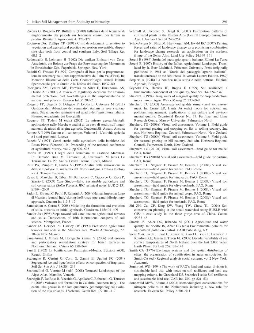
Rivoira G, Roggero PP, Bullitta S (1989) Influenza delle tecniche dimiglioramento dei pascoli sui fenomeni erosivi dei terreni inpendio. Rivista di Agronomia 4: 372–377
Robinson DA, Phillips CP (2001) Crust development in relation tovegetation and agricultural practice on erosion susceptible, disper-sive clay soils from central and southern Italy. Soil Tillage Res60:1–2
Rodenwaldt E, Lehmann H (1962) Die antiken Emissari von Cosa-Ansedonia, ein Beitrag zur Frage der Entwässerung der Maremmenin Etruskischer Zeit. Paperback, Springer, New York
Rodolfi G, Frascati F (1979) Cartografia di base per la programmaz-ione in aree marginali (area rappresentativa dell’alta Val d’Era). In:Memorie Illustrative della Carta Geomorfologia. Annali IstitutoSperimentale per lo Studio e la Difesa del Suolo 10:37–80
Rodrigues SM, Pereira ME, Ferreira da Silva E, Hursthouse AS,Duarte AC (2009) A review of regulatory decisions for environ-mental protection: part I—challenges in the implementation ofnational soil policies. Environ Int 35:202–213
Roggero PP, Bagella S, Deligios P, Ledda L, Gutierrez M (2011)Gestione dell’abbandono dei seminativi italiani in aree svantag-giate. Situazione dei seminativi nel quadro dell’agricoltura italiana.Firenze, Accademia dei Georgofili
Roggero PP, Toderi M (eds.) (2002) Le misure agroambientali:applicazione nelle Marche e analisi di un caso di studio sull’inqui-namento da nitrati di origine agricola. Quaderni 5B, Assam, Ancona
Romeo R (1969) Cavour e il suo tempo. Volume 1- L’attività agricolae i suoi problemi. Laterza
Ronchi V (1971) Cenni storici sulla agricoltura delle bonifiche delBasso Piave (Venezia). In: Proceeding of the national conferenceof agriculture history, vol 2. pp 507–595
Rottoli M (1997) I legni della terramara di Castione Marchesi.In: Bernabò Brea M, Cardarelli A, Cremaschi M (eds.) LeTerramare. La Più Antica Civiltà Padana. Electa, Milano
Ruiu PA, Pampiro F, Pintus A (1995) Analisi della rinovazione indiverse tipologie di sughereta del Nord-Sardegna. Collana Biolog-ica 4. Tempio Pausania
Rusco E, Maréchal B, Tiberi M, Bernacconi C, Ciabocco G, Ricci P,Spurio E (2009) Case Study—Italy. Sustainable agriculture andsoil conservation (SoCo Project). JRC technical notes. EUR 24131EN/9—2009
Sadori L, Giraudi C, Petitti P, Ramrath A (2004) Human impact at Lagodi Mezzano (central Italy) during the Bronze Age: a multidisciplinaryapproach. Quatern Int 113:5–17
Samouëlian A, Cornu S (2008) Modelling the formation and evolutionof soils, towards an initial synthesis. Geoderma 145:401–409
Sandor JA (1998) Steps toward soil care: ancient agricultural terracesand soils. Transactions of 16th international congress of soilscience, Montpellier, France
Sandor JA, Gersper PL, Hawley JW (1990) Prehistoric agriculturalterraces and soils in the Mimbres area, World Archaeology, 22:70–86 New Mexico
Sang-Arung J, Mihara M, Horaguchi Yamaji Y (2006) Soil erosionand participatory remediation strategy for bench terraces inNorthern Thailand. Catena 65:258–264
Sani E (1962) La bonificazione Parmigiana-Moglia. Edizioni AGE,Reggio Emilia
Scalenghe R, Certini G, Corti G, Zanini E, Ugolini FC (2004)Segregated ice and liquefaction effects on compaction of fragipans.Soil Sci Soc Am J 68:204–214
Scaramellini G, Varotto M (eds) (2008) Terraced Landscapes of theAlps: Atlas. Marsilio, Venezia
Scarciglia F, De Rosa R, Vecchio G, Apollaro C, Robustelli G, TerrasetF (2008) Volcanic soil formation in Calabria (southern Italy): Thececita lake geosol in the late quaternary geomorphological evolu-tion of the sila uplands. J Volcanol Geoth Res 177:101–117
Schmidl A, Jacomet S, Oeggl K (2007) Distribution patterns ofcultivated plants in the Eastern Alps (Central Europe) during IronAge. J Archaeol Sci 34:243–254
Schneeberger N, Bürgi M, Hersperger AM, Ewald KC (2007) Drivingforces and rates of landscape change as a promising combinationfor landscape change research—an application on the northernfringe of the Swiss Alps. Land Use Policy 24:349–361
Sereni E (1986) Storia del paesaggio agrario italiano. Editori La TerzaSereni E (1997) History of the Italian Agricultural Landscape. Trans-
lated by R. Burr Litchfield. Princeton University Press (originallypublished in 1961 as ‘‘Storia del paesaggio agrario italiano’’,translation based on the Biblioteca Universale Laterza Edition, 1989)
Serpieri A (1948) La bonifica nella storia e nella dottrina. EdizioniAgricole, Bologna
Seybold CA, Herrick JE, Brejda JJ (1999) Soil resilience: afundamental component of soil quality. Soil Sci 164:224–234
Shalevet J (1994) Using water of marginal quality for crop production:major issues. Agric Water Manag 25:233–269
Shepherd TG (2003) Assessing soil quality using visual soil assess-ment. In: Currie LD, Hanly JA (eds.) Tools for nutrient andpollutant management: applications to agriculture and environ-mental quality. Occasional Report No. 17. Fertilizer and LimeResearch Centre, Massey University, Palmerston North
Shepherd TG (2009a) Visual soil assessment. Volume 1. Field guidefor pastoral grazing and cropping on flat to rolling country. 2ndedn. Horizons Regional Council, Palmerston North, New Zealand
Shepherd TG (2009b) Visual soil assessment. Volume 3. Field guidefor pastoral grazing on hill country. 2nd edn. Horizons RegionalCouncil, Palmerston North, New Zealand
Shepherd TG (2010a) Visual soil assessment—field guide for maize.FAO, Rome
Shepherd TG (2010b) Visual soil assessment—field guide for pasture.FAO, Rome
Shepherd TG, Stagnari F, Pisante M, Benites J (2008a) Visual soilassessment—field guide for wheat. FAO, Rome
Shepherd TG, Stagnari F, Pisante M, Benites J (2008b) Visual soilassessment—field guide for vineyards. FAO, Rome
Shepherd TG, Stagnari F, Pisante M, Benites J (2008c) Visual soilassessment—field guide for olive orchards. FAO, Rome
Shepherd TG, Stagnari F, Pisante M, Benites J (2008d) Visual soilassessment—field guide for annual crops. FAO, Rome
Shepherd TG, Stagnari F, Pisante M, Benites J (2008e) Visual soilassessment—field guide for orchards. FAO, Rome
Shi ZH, Cai CF, Ding SW, Wang TW, Chow TL (2004) Soilconservation planning at the small watershed using RUSLE withGIS: a case study in the three gorge area of China. Catena55:33–48
Shortle JS, Abler DG, Ribando M (2001) Agriculture and waterquality. In: Shortle JS, Abler DG (eds) Environmental policies foragricultural pollution control. CABI Publishing, NY
Sicre M-A, Jacob J, Ezat U, Rousse S, Kissel C, Yiou P, Eiriksson J,Knudsen KL, Jansen E, Turon J-L (2008) Decadal variability of seasurface temperatures of North Iceland over the last 2,000 years.Earth Planet Sci Lett 268:137–142
Smith CA (1976) Exchange systems and the spatial distribution ofelites: the organization of stratification in agrarian societies. In:Smith CA (ed.) Regional analysis social systems, vol 2 New York,Academic
Sombroek WG (1994) The work of FAO’s land and water division insustainable land use, with notes on soil resilience and land usemapping criteria. In: Greenland DJ, Szabolcs I (eds) Soil resilienceand sustainable land use. CAB Int, UK, pp 521–534
Sonneveld MPW, Bouma J (2003) Methodological considerations fornitrogen policies in the Netherlands including a new role forresearch. Environ Sci Policy 6:501–511
9 Italian Soil Management from Antiquity to Nowadays 291
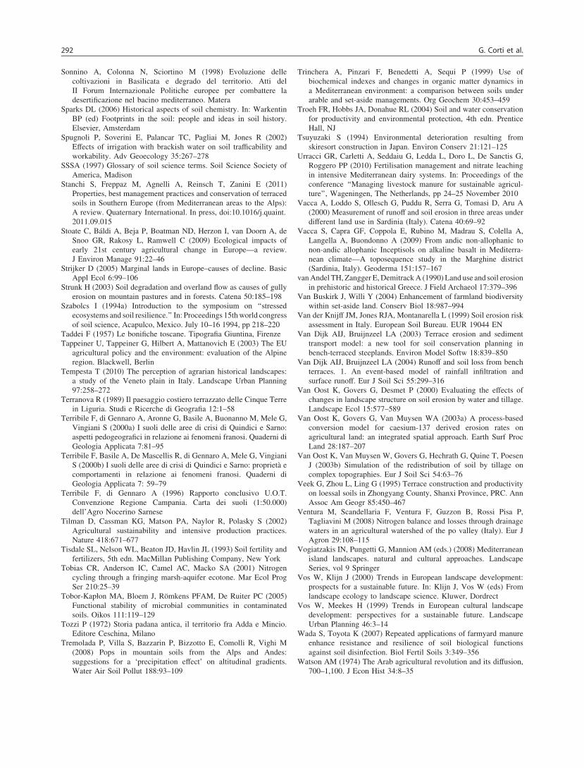
Sonnino A, Colonna N, Sciortino M (1998) Evoluzione dellecoltivazioni in Basilicata e degrado del territorio. Atti delII Forum Internazionale Politiche europee per combattere ladesertificazione nel bacino mediterraneo. Matera
Sparks DL (2006) Historical aspects of soil chemistry. In: WarkentinBP (ed) Footprints in the soil: people and ideas in soil history.Elsevier, Amsterdam
Spugnoli P, Soverini E, Palancar TC, Pagliai M, Jones R (2002)Effects of irrigation with brackish water on soil trafficability andworkability. Adv Geoecology 35:267–278
SSSA (1997) Glossary of soil science terms. Soil Science Society ofAmerica, Madison
Stanchi S, Freppaz M, Agnelli A, Reinsch T, Zanini E (2011)Properties, best management practices and conservation of terracedsoils in Southern Europe (from Mediterranean areas to the Alps):A review. Quaternary International. In press, doi:10.1016/j.quaint.2011.09.015
Stoate C, Báldi A, Beja P, Boatman ND, Herzon I, van Doorn A, deSnoo GR, Rakosy L, Ramwell C (2009) Ecological impacts ofearly 21st century agricultural change in Europe—a review.J Environ Manage 91:22–46
Strijker D (2005) Marginal lands in Europe–causes of decline. BasicAppl Ecol 6:99–106
Strunk H (2003) Soil degradation and overland flow as causes of gullyerosion on mountain pastures and in forests. Catena 50:185–198
Szabolcs I (1994a) Introduction to the symposium on ‘‘stressedecosystems and soil resilience.’’ In: Proceedings 15th world congressof soil science, Acapulco, Mexico. July 10–16 1994, pp 218–220
Taddei F (1957) Le bonifiche toscane. Tipografia Giuntina, FirenzeTappeiner U, Tappeiner G, Hilbert A, Mattanovich E (2003) The EU
agricultural policy and the environment: evaluation of the Alpineregion. Blackwell, Berlin
Tempesta T (2010) The perception of agrarian historical landscapes:a study of the Veneto plain in Italy. Landscape Urban Planning97:258–272
Terranova R (1989) Il paesaggio costiero terrazzato delle Cinque Terrein Liguria. Studi e Ricerche di Geografia 12:1–58
Terribile F, di Gennaro A, Aronne G, Basile A, Buonanno M, Mele G,Vingiani S (2000a) I suoli delle aree di crisi di Quindici e Sarno:aspetti pedogeografici in relazione ai fenomeni franosi. Quaderni diGeologia Applicata 7:81–95
Terribile F, Basile A, De Mascellis R, di Gennaro A, Mele G, VingianiS (2000b) I suoli delle aree di crisi di Quindici e Sarno: proprietà ecomportamenti in relazione ai fenomeni franosi. Quaderni diGeologia Applicata 7: 59–79
Terribile F, di Gennaro A (1996) Rapporto conclusivo U.O.T.Convenzione Regione Campania. Carta dei suoli (1:50.000)dell’Agro Nocerino Sarnese
Tilman D, Cassman KG, Matson PA, Naylor R, Polasky S (2002)Agricultural sustainability and intensive production practices.Nature 418:671–677
Tisdale SL, Nelson WL, Beaton JD, Havlin JL (1993) Soil fertility andfertilizers, 5th edn. MacMillan Publishing Company, New York
Tobias CR, Anderson IC, Camel AC, Macko SA (2001) Nitrogencycling through a fringing marsh-aquifer ecotone. Mar Ecol ProgSer 210:25–39
Tobor-Kapłon MA, Bloem J, Römkens PFAM, De Ruiter PC (2005)Functional stability of microbial communities in contaminatedsoils. Oikos 111:119–129
Tozzi P (1972) Storia padana antica, il territorio fra Adda e Mincio.Editore Ceschina, Milano
Tremolada P, Villa S, Bazzarin P, Bizzotto E, Comolli R, Vighi M(2008) Pops in mountain soils from the Alps and Andes:suggestions for a ‘precipitation effect’ on altitudinal gradients.Water Air Soil Pollut 188:93–109
Trinchera A, Pinzari F, Benedetti A, Sequi P (1999) Use ofbiochemical indexes and changes in organic matter dynamics ina Mediterranean environment: a comparison between soils underarable and set-aside managements. Org Geochem 30:453–459
Troeh FR, Hobbs JA, Donahue RL (2004) Soil and water conservationfor productivity and environmental protection, 4th edn. PrenticeHall, NJ
Tsuyuzaki S (1994) Environmental deterioration resulting fromskiresort construction in Japan. Environ Conserv 21:121–125
Urracci GR, Carletti A, Seddaiu G, Ledda L, Doro L, De Sanctis G,Roggero PP (2010) Fertilisation management and nitrate leachingin intensive Mediterranean dairy systems. In: Proceedings of theconference ‘‘Managing livestock manure for sustainable agricul-ture’’, Wageningen, The Netherlands, pp 24–25 November 2010
Vacca A, Loddo S, Ollesch G, Puddu R, Serra G, Tomasi D, Aru A(2000) Measurement of runoff and soil erosion in three areas underdifferent land use in Sardinia (Italy). Catena 40:69–92
Vacca S, Capra GF, Coppola E, Rubino M, Madrau S, Colella A,Langella A, Buondonno A (2009) From andic non-allophanic tonon-andic allophanic Inceptisols on alkaline basalt in Mediterra-nean climate—A toposequence study in the Marghine district(Sardinia, Italy). Geoderma 151:157–167
van Andel TH, Zangger E, Demitrack A (1990) Land use and soil erosionin prehistoric and historical Greece. J Field Archaeol 17:379–396
Van Buskirk J, Willi Y (2004) Enhancement of farmland biodiversitywithin set-aside land. Conserv Biol 18:987–994
Van der Knijff JM, Jones RJA, Montanarella L (1999) Soil erosion riskassessment in Italy. European Soil Bureau. EUR 19044 EN
Van Dijk AIJ, Bruijnzeel LA (2003) Terrace erosion and sedimenttransport model: a new tool for soil conservation planning inbench-terraced steeplands. Environ Model Softw 18:839–850
Van Dijk AIJ, Bruijnzeel LA (2004) Runoff and soil loss from benchterraces. 1. An event-based model of rainfall infiltration andsurface runoff. Eur J Soil Sci 55:299–316
Van Oost K, Govers G, Desmet P (2000) Evaluating the effects ofchanges in landscape structure on soil erosion by water and tillage.Landscape Ecol 15:577–589
Van Oost K, Govers G, Van Muysen WA (2003a) A process-basedconversion model for caesium-137 derived erosion rates onagricultural land: an integrated spatial approach. Earth Surf ProcLand 28:187–207
Van Oost K, Van Muysen W, Govers G, Hechrath G, Quine T, PoesenJ (2003b) Simulation of the redistribution of soil by tillage oncomplex topographies. Eur J Soil Sci 54:63–76
Veek G, Zhou L, Ling G (1995) Terrace construction and productivityon loessal soils in Zhongyang County, Shanxi Province, PRC. AnnAssoc Am Geogr 85:450–467
Ventura M, Scandellaria F, Ventura F, Guzzon B, Rossi Pisa P,Tagliavini M (2008) Nitrogen balance and losses through drainagewaters in an agricultural watershed of the po valley (Italy). Eur JAgron 29:108–115
Vogiatzakis IN, Pungetti G, Mannion AM (eds.) (2008) Mediterraneanisland landscapes. natural and cultural approaches. LandscapeSeries, vol 9 Springer
Vos W, Klijn J (2000) Trends in European landscape development:prospects for a sustainable future. In: Klijn J, Vos W (eds) Fromlandscape ecology to landscape science. Kluwer, Dordrect
Vos W, Meekes H (1999) Trends in European cultural landscapedevelopment: perspectives for a sustainable future. LandscapeUrban Planning 46:3–14
Wada S, Toyota K (2007) Repeated applications of farmyard manureenhance resistance and resilience of soil biological functionsagainst soil disinfection. Biol Fertil Soils 3:349–356
Watson AM (1974) The Arab agricultural revolution and its diffusion,700–1,100. J Econ Hist 34:8–35
292 G. Corti et al.
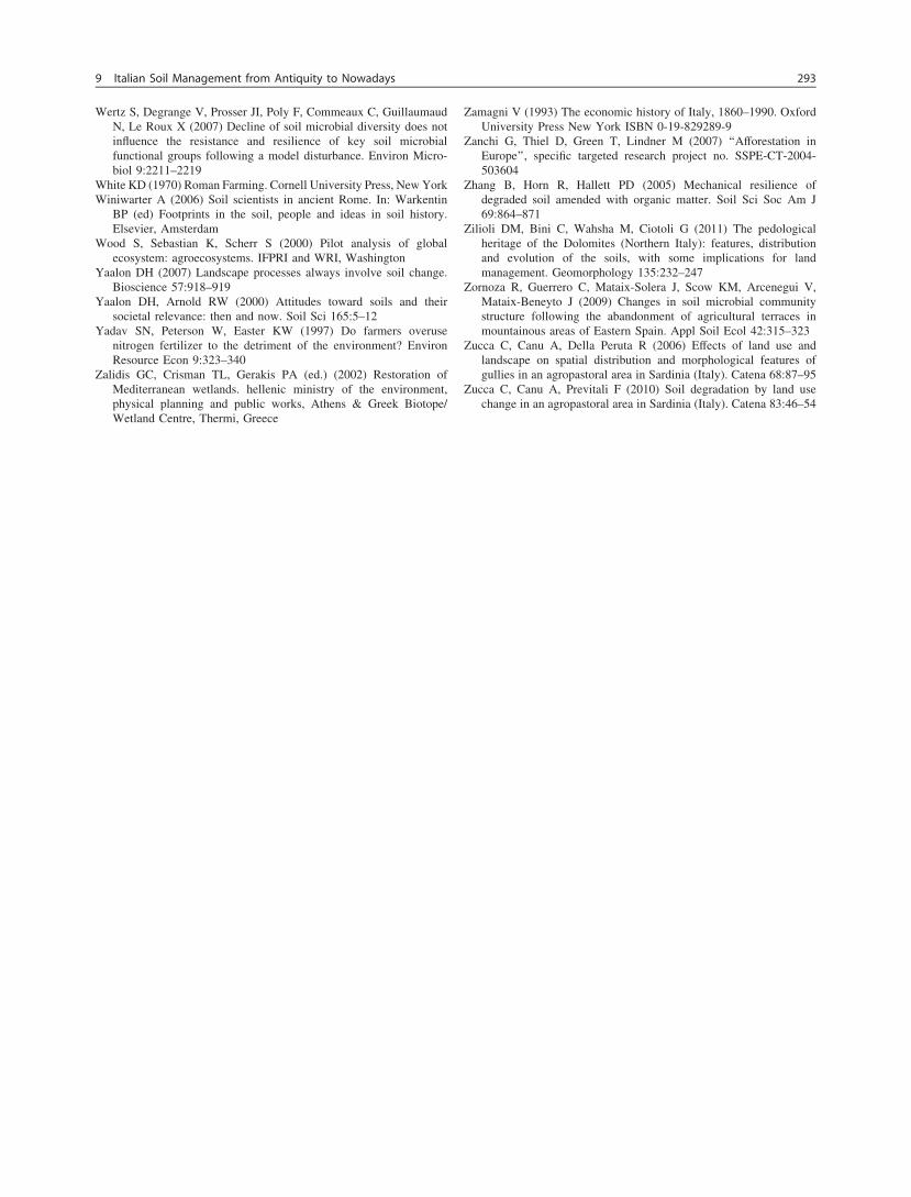
Wertz S, Degrange V, Prosser JI, Poly F, Commeaux C, GuillaumaudN, Le Roux X (2007) Decline of soil microbial diversity does notinfluence the resistance and resilience of key soil microbialfunctional groups following a model disturbance. Environ Micro-biol 9:2211–2219
White KD (1970) Roman Farming. Cornell University Press, New YorkWiniwarter A (2006) Soil scientists in ancient Rome. In: Warkentin
BP (ed) Footprints in the soil, people and ideas in soil history.Elsevier, Amsterdam
Wood S, Sebastian K, Scherr S (2000) Pilot analysis of globalecosystem: agroecosystems. IFPRI and WRI, Washington
Yaalon DH (2007) Landscape processes always involve soil change.Bioscience 57:918–919
Yaalon DH, Arnold RW (2000) Attitudes toward soils and theirsocietal relevance: then and now. Soil Sci 165:5–12
Yadav SN, Peterson W, Easter KW (1997) Do farmers overusenitrogen fertilizer to the detriment of the environment? EnvironResource Econ 9:323–340
Zalidis GC, Crisman TL, Gerakis PA (ed.) (2002) Restoration ofMediterranean wetlands. hellenic ministry of the environment,physical planning and public works, Athens & Greek Biotope/Wetland Centre, Thermi, Greece
Zamagni V (1993) The economic history of Italy, 1860–1990. OxfordUniversity Press New York ISBN 0-19-829289-9
Zanchi G, Thiel D, Green T, Lindner M (2007) ‘‘Afforestation inEurope’’, specific targeted research project no. SSPE-CT-2004-503604
Zhang B, Horn R, Hallett PD (2005) Mechanical resilience ofdegraded soil amended with organic matter. Soil Sci Soc Am J69:864–871
Zilioli DM, Bini C, Wahsha M, Ciotoli G (2011) The pedologicalheritage of the Dolomites (Northern Italy): features, distributionand evolution of the soils, with some implications for landmanagement. Geomorphology 135:232–247
Zornoza R, Guerrero C, Mataix-Solera J, Scow KM, Arcenegui V,Mataix-Beneyto J (2009) Changes in soil microbial communitystructure following the abandonment of agricultural terraces inmountainous areas of Eastern Spain. Appl Soil Ecol 42:315–323
Zucca C, Canu A, Della Peruta R (2006) Effects of land use andlandscape on spatial distribution and morphological features ofgullies in an agropastoral area in Sardinia (Italy). Catena 68:87–95
Zucca C, Canu A, Previtali F (2010) Soil degradation by land usechange in an agropastoral area in Sardinia (Italy). Catena 83:46–54
9 Italian Soil Management from Antiquity to Nowadays 293


![#FacebookPA 2012 [Italian Version]](https://static.fdokumen.com/doc/165x107/6312f715fc260b71020ee117/facebookpa-2012-italian-version.jpg)