Cabinet - Meetings, agendas, and minutes - Southwark Council
Upload
khangminh22Category
view
4download
0
MINUTES Ordinary Meeting of Council Minutes Held on Tuesday 17 December 2019 at 6:00pm City of Rockingham Council Chambers

Council Minutes Tuesday 17 December 2019 PAGE 2
City of Rockingham Ordinary Council Meeting
6:00pm Tuesday 17 December 2019 CONTENTS
1. Declaration of Opening/Announcement of Visitors 4
2. Record of Attendance/Apologies/Approved Leave of Absence 4
3. Responses to Previous Public Questions Taken on Notice 4
4. Public Question Time 11
5. Applications for Leave of Absence 15
6. Confirmation of Minutes of the Previous Meeting 15
7. Matters Arising from Minutes of Previous Meeting 15
8. Announcement by the Presiding Person without Discussion 15
9. Declaration of Member’s and Officer’s Interest 15
10. Petitions/Deputations/Presentations/Submissions 16
11. Matters for which the Meeting may be Closed 16
Planning and Engineering Services Committee 17 PD-073/19 Proposed Agreement - Revegetation Works at the Tamworth Hill Swamp
Reserve 17
12. Receipt of Minutes of Standing Committees 19
13. Officers Reports and Recommendations of Committees 19
Planning and Engineering Services Committee 20 PD-074/19 Demolition and Reconstruction of the Subdivision Estate Wall - No.1
Basslet Place to No.19 Basslet Place, Warnbro 20 PD-075/19 Proposed Structure Plan – Lots 1006, 1007 and 1272 Baldivis Road and
Lot 1 and 503 Serpentine Road, Baldivis (‘South East Baldivis’) 31 PD-076/19 Review of Planning Policy No.3.1.1 – Rural Land Strategy - Advertising 76 PD-077/19 Proposed Updates to Planning Policy 3.4.3 - Urban Water Management 95 PD-078/19 Revocation of Planning Policy 7.1 - East Rockingham Industrial Park:
Environmental Planning Policy 106 PD-079/19 Revised Planning Policy 3.3.8 - East Rockingham Industrial Zones
(Replacing East Rockingham Development Guidelines) 123 PD-080/19 Proposed Scheme Amendment No.178 - East Rockingham Industrial
Zones 135 PD-081/19 Proposed Amendments to Planning Policy 3.3.14 - Bicycle Parking and
End-Of-Trip Facilities (Final Adoption) 150 PD-082/19 Proposed Modification to Building Envelope 163 PD-083/19 Proposed Modification to Building Envelope 171 PD-084/19 Joint Development Assessment Panel Application - Commercial
Development 181 PD-085/19 Safety Bay Shoalwater Foreshore Master Plan - Adoption 221

Council Minutes Tuesday 17 December 2019 PAGE 3
Confirmed at a Council meeting held on Tuesday 28 January 2020
Mayor (B W Sammels)
EP-025/19 Tender T19/20-05 – Provision of Services to Carry Out Civil Works at the Baldivis District Sporting Complex 252
EP-026/19 Tender T19/20-19 - Extension of the Point Peron Boat Ramp Facility 257 EP-027/19 Car Park Closure - Warnbro Foreshore Reserve, La Seyne Crescent,
Warnbro 261 EP-028/19 Tender T19/20-20 – Provision of Services to Renovate the 50m and 25m
Pools at the Aqua Jetty 265 Corporate and Community Development Committee 270 CS-015/19 City Business Plan 2020/2021 to 2029/2030 (December 2019) 270 CS-016/19 Debt write off in relation to prosecution charges and court fines 275 GM-031/19 Repeal of Bush Fire Control and Bush Fire Brigades Local Law 2001 279 CD-029/19 Community Art Project (The Blue Tree Project) 285 CD-030/19 Koorana Reserve Master Plan – Final Concept Design 295 CD-031/19 Baldivis Men’s Shed Needs Assessment, Site Analysis and Feasibility
Study (Absolute Majority) 301 CD-032/19 Draft Economic Development Strategy 2020-2025 312 CD-033/19 Recommendation from the Rockingham Education Training Advisory
Committee Meeting held on 11 November 2019 316
14. Receipt of Information Bulletin 319
15. Report of Mayor 320
MR-012/19 Meetings and Functions Attended by the Mayor and Deputy Mayor 320
16. Reports of Councillors 323
17. Reports of Officers 323
18. Addendum Agenda 323
19. Motions of which Previous Notice has been given 324
Planning and Engineering Services Committee 324 PD-086/19 Notice of Motion – Single Use Plastics and Balloons Advocacy 324 PD-087/19 Notice of Motion - Proposal to Repurpose the Council Chambers into
Office Space and use the Reception Room for all Council Meetings 328 Corporate and Community Development Committee 335 GM-032/19 Notice of Motion - Provision of Hospitality (Alcohol) 335 GM-033/19 Notice of Motion - Audio/Video Recording of Council Meetings 340
20. Notices of Motion for Consideration at the Following Meeting 348
21. Questions by Members of which Due Notice has been given 348
22. Urgent Business Approved by the Person Presiding or by Decision of Council 348
23. Matters Behind Closed Doors 348
24. Date and Time of Next Meeting 348
25. Closure 348

Council Minutes Tuesday 17 December 2019 PAGE 4
Confirmed at a Council meeting held on Tuesday 28 January 2020
Mayor (B W Sammels)
City of Rockingham Ordinary Meeting of Council Minutes
Tuesday 17 December 2019 – Council Chambers 1. Declaration of Opening The Mayor declared the Council Meeting open at 6:00pm, welcomed all present, and
delivered the Acknowledgement of Country.
2. Record of Attendance/Apologies/Approved Leave of Absence 2.1 Councillors
Cr Barry Sammels (Mayor) Cr Deb Hamblin (Deputy Mayor) Cr Sally Davies Cr Hayley Edwards Cr Matthew Whitfield Cr Lorna Buchan Cr Mark Jones Cr Craig Buchanan Cr Rae Cottam Cr Leigh Liley Cr Joy Stewart
Rockingham/Safety Bay Ward Rockingham/Safety Bay Ward Baldivis Ward Baldivis Ward Baldivis Ward Comet Bay Ward Comet Bay Ward Rockingham/Safety Bay Ward Rockingham/Safety Bay Ward Rockingham/Safety Bay Ward Rockingham/Safety Bay Ward
2.2 Executive
Mr Michael Parker Mr Bob Jeans Mr Sam Assaad Mr John Pearson Mr Peter Doherty Mr Michael Holland Mr Peter Varris Mr Peter Le Mrs Jelette Edwards Mr Aiden Boyham
Chief Executive Officer Director Planning and Development Services Director Engineering and Parks Services Director Corporate Services Director Legal Services and General Counsel Director Community Development Manager Governance and Councillor Support Senior Legal and Councillor Liaison Officer Governance Coordinator City Media Officer
2.3 Members of the Gallery: 51
2.4 Apologies: Nil
2.5 Approved Leave of Absence: Nil
3. Responses to Previous Public Questions Taken on Notice
3.1 Ms Dawn Jecks, Safety Bay – Autumn Centre / Funding of Rockingham Kwinana Chamber of Commerce
At the Council meeting held on 26 November 2019, Ms Jecks asked the following questions that were taken on notice and the Director Community Development provided a response in a letter dated 4 December 2019 as follows:

Council Minutes Tuesday 17 December 2019 PAGE 5
Confirmed at a Council meeting held on Tuesday 28 January 2020
Mayor (B W Sammels)
Question 1. Which department of City of Rockingham has oversight of the management
of the Autumn Centre and very briefly what is the management structure for the Autumn Centre?
Response (provided at the meeting) The Mayor referred the question to the Acting Director Community Development. Mr Rogers advised that the Autumn Centre is managed and staffed by the City of Rockingham through the Community Development Division. Membership has increased from 1500 to 1800 this year. Ms Jecks noted she was very impressed in the manner in which the Centre is run and congratulated the City on providing such a valuable service to the community. Question 2. What financial receipts do the Rockingham Kwinana Chamber of
Commerce receive on an annual basis from the City of Rockingham in the form of: · Grants · Sponsorship · Contractual arrangements for services · Office premises supplied at less than commercial rentable value · Any other items
Response The Rockingham Kwinana Chamber of Commerce Inc. (RKCC) receive the following financial payments from the City. Some of these are annual payments (recurring each year), while some are one-off payments. Grants and Sponsorship The City of Rockingham operates a Community Grants Program (CGP) which all requests for grants and sponsorship are to be applied. The CGP provides funding opportunities to incorporated not-for-profit organisations/associations, or those limited by guarantee (e.g. community groups, clubs and school P&Cs) towards programs, projects, initiatives and events that benefit the Rockingham community. There are conditions and eligibility criteria to adhere to. The Rockingham Kwinana Chamber of Commerce Inc. (RKCC) is an eligible organisation that applied to the City via the Community Grants Program. · In 2019/2020 the RKCC has applied via the CGP and been approved
towards two events (The Rockingham Long Table Lunch on the Beach; and the Regional Business Awards) totalling $25,000.
· In 2018/2019 the RKCC applied via the CGP and was approved towards two events totalling $7,000.
· In 2017/2018 the RKCC applied via the CGP and was approved towards four events totalling $26,500.
Contractual arrangements for services There are three current/recent contractual arrangements for services with the RKCC: · The City has an annual Fee-for-Service arrangement with the RKCC to
deliver the ‘Key Leaders in Business Breakfasts’ at a cost of $30,000 per annum (four events per year at $7,500 each).

Council Minutes Tuesday 17 December 2019 PAGE 6
Confirmed at a Council meeting held on Tuesday 28 January 2020
Mayor (B W Sammels)
· In 2018 the City appointed RKCC through the standard City procurement (Request for Quote) process to run the 2019 Youth Careers Expo. The budget for this event was $20,000 and included all payments, costs involved in the running of the event (including an event management fee). RKCC was appointed through a similar process in 2017.
· In 2019, the City received a $10,000 grant through the Lighthouse Project (Local Government Professionals WA). The City requested quotes from suitable event management companies to deliver two events focussing on disability employment. Through the standard City procurement (Request for Quote) process, the RKCC was appointed to deliver these services during 2019/2020 at a cost of $20,000.
Office premises supplied at less than commercial rentable value The RKCC receive a 30% discount on their rent at the Gary Holland Centre as they are a community group in a commercial space. This is in accordance with the City’s Council Policy – Community Leasing which states: “Community Leases in Commercial Property Associations that qualify as community lessees may be considered for commercial premises on the following basis: · The City is unable to attract a commercial tenant after a prolonged
advertising and marketing campaign. · The rent is to be 70% of the market valuation with annual rent adjusted by
the Consumer Price Index in other years. · The term is limited to 3 years with no option to renew. · At the end of the term the premises will be offered to market at commercial
valuation with the incumbent lessee having first option to lease”. The RKCC lease is due to expire next year and the premises will be advertised once again at the full market value.
Any other items The City is a member of the RKCC (Gold Membership at a cost of $3,630 per annum).
3.2 Mr Tom Mannion, Safety Bay – Credit Card Transactions / Mayor Fridge
At the Council meeting held on 26 November 2019, Mr Mannion asked the following question/s that were taken on notice and the Manager Governance and Councillor Support provided a response in a letter dated 10 December 2019 as follows: Question 1. The credit card transactions for former CEO Mr Hammond show among a
number of travel expenses, 2 airfare tickets purchased for non-city officers to Paris in 2017, his credit card did not include his own ticket or yours.
Can you advise ratepayers · The attendees and their roles · The purpose of the trip · The total cost the trip · Itinerary including schedule, meeting agendas and attendees · Any benefit to the community from this trip?
Response (provided at the meeting) The Mayor noted that the trip to France was for investigation into establishing the Rockingham Technopole and took the question on notice.

Council Minutes Tuesday 17 December 2019 PAGE 7
Confirmed at a Council meeting held on Tuesday 28 January 2020
Mayor (B W Sammels)
Additional Response Mr Mannion has been previously advised the following by email dated 15 November 2019 –
“The visit to France was in relation to the City pursuing opportunities with the French consortium involved in the successful bid to build the Australian Submarine Fleet. It also involved fact-finding around the potential for a technopole in Rockingham and the signing of an agreement with the City of Cherbourg, the location of the French submarine building businesses. In attendance on the visit was the Mayor, CEO, the City’s Manager Investment Attraction and the WA President of the French-Australian Chamber of Commerce. Council was fully aware and supportive of pursuing these opportunities which if successful could result in the French businesses establishing in Rockingham and the community benefitting from the resultant economic development and employment that may arise.”
An itinerary is included as an attachment. The estimated cost of the delegation was $46,064. The Rockingham Technopole has since been unanimously supported and established by Council. Question 2. The local governments guidelines on the use of credit cards states they
should not be used to withdraw cash, they should only be used for purchasing goods and services on behalf of the local government.
Bank statements for the credit card of Mr Hammond shows cash withdrawn while in Paris. a) Can the City present ratepayers with the receipts of how that cash was
spent? b) Will you investigate if any other of the City’s credit cards have been used
to withdraw cash? c) Why do breakfasts, lunches and dinners purchased on the former CEO’s
credit card for the benefit of executive staff fall under the category of a goods or service and how this spend of ratepayers money benefits the ratepayer?
Response a) No. The cash advance of 200 Euro was appropriately approved and acquitted by the former CEO and was used for official incidental expenses while in France. b) No. City purchasing cards are barred from the ability to withdraw cash. Such facility is opened on approval of the CEO only and is very rarely exercised for restricted durations. c) The City Executive (CEO and Directors) meet formally every week, including once a month to discuss significant organisational matters under the CEO’s responsibilities. These monthly meetings often extend outside of normal business hours and the provision of a meal is appropriate. Question 3. When was the private bar for the Mayor established and what is the total
amount spent on alcohol to stock this bar since its inception? Response (provided at the meeting) The Mayor advised that there is a small fridge in his office and noted that it is rarely used, however took the question on notice.

Council Minutes Tuesday 17 December 2019 PAGE 8
Confirmed at a Council meeting held on Tuesday 28 January 2020
Mayor (B W Sammels)
Additional Response The small fridge in the Mayor’s office has been in-situ since the opening of the current administration building in 1994. It contains a limited amount of soft drink, beer and wine for civic hospitality. Usage is very minor, and for 2019 cost of beverages consumed is less than $100.
3.3 Mr Mark Cozens, Shoalwater – Blue Tree Project
At the Council meeting held on 26 November 2019, Mr Cozens asked the following question/s that were taken on notice and the Director Engineering and Parks Services provided a response in a letter dated 6 December 2019 as follows:
Question Mr Cozens advocated for the Blue Tree Project and asked - 1. The risk of damage being caused by the tree is provided as a reason not to
proceed. Risk assessments and inspections on Council assets are performed routinely. The cliffs at Point Peron are an example of a natural hazard being managed. Why is it not possible to add a tree to a register of things to be inspected?
Response (provided at the meeting) The Mayor noted that nothing is preventing this project proceeding on private property and noted that a report will be coming to Council at its December 2019 meeting on this issue. Response A detailed report regarding the Blue Tree project has been prepared and will be submitted for consideration at the Council meeting 17 December. Should council support the project, a program of regular arboricultural inspection to ensure the integrity and safety of a chosen tree would be required. Question 2. The pain of removing a tree if it becomes unsafe is raised. I ask was there
any report conducted into the impact on community members performed before this project proceeded?
Response (provided at the meeting) The Mayor noted the initial response was initially undertaken at an officer level but will be referred to Council next month. Question 3. If the Council still does not allow the allocation of a blue tree on its land I
ask could it work with a landowner willing to allow a tree to be painted on their property? Would it please consider assistance in the form of machinery such as elevated work platforms or other resources to enable this to happen?
Response The Blue Tree Project team detail on their website the inherent risks and issues associated with painting of dead trees. Their guidelines for safety, as per their website, are as follows:
“We recommend only painting trees from ground level to reduce any risk of injury. If you use a ladder- please have one person for stabilisation and supervision of safety (spotter). We recommend using a paint roller stick extension to reach higher trees whilst feet remain on ground level.”

Council Minutes Tuesday 17 December 2019 PAGE 9
Confirmed at a Council meeting held on Tuesday 28 January 2020
Mayor (B W Sammels)
The project promotes involvement of community groups and a detailed report regarding the Blue Tree Project will be considered at the Council meeting 17 December 2019.
3.4 Mr James Mumme, Shoalwater – Lake Richmond
At the Council meeting held on 26 November 2019, Mr Mumme asked the following questions that were taken on notice and the Director Planning and Development Services provided a response in a letter dated 6 December 2019 as follows: Question 1. Mr Mumme referred to the Lake Richmond Management Plan Draft and
noted the work by Dr Ryan Vogwill. What did Dr Vogwill say to Councillors that about the current health of the thrombolites?
Response Specific comments made at Councillor Engagement sessions are not recorded. Dr Vogwill’s advice on the matter is contained in his study report, a copy of which was provided to you on 22 November 2019. Question 2. What did Dr Vogwill say to Councillors about the growth of the thrombolites
between 2013 and 2018? Response See response to Question 1. Question 3. What did he say to Councillors about the levels of lake water? Response See response to Question 1. Question 4. Is it your conclusion that the thrombolites are in good health up to 2018? Response (provided at the meeting) The Mayor noted that his personal opinion is irrelevant on the matter, as the Council’s decision will be the key outcome.
Additional Response The results of Dr Vogwill’s study indicate that the microbialites are currently inactive and likely have been for some time (since the late ~1960s). Question 5. Did Dr Vogwill say to Councillors that the thrombolites may be in danger of
dying unless remedial action is taken? Response See response to Question 1. Question 6. Council is represented on the Planning Investigation Area Working Group
set up by the WA Planning Minister, what messages from Dr Vogswill's research will our representatives be given to present in discussions about the Water Corporation drain and the proposed duplication of the sewer pipeline?

Council Minutes Tuesday 17 December 2019 PAGE 10
Confirmed at a Council meeting held on Tuesday 28 January 2020
Mayor (B W Sammels)
Response (provided at the meeting) The Mayor advised that Cr Buchanan is Council’s representative on the Working Group and will no doubt put a position on the issue in consultation with the City’s professional officers. Question 7. Mr Mumme tabled an attachment to his questions noting he has read
quickly through the report and would like to table extracts that say clearly, I believe, that unless serious action is taken, our thrombolites will become extinct. Dr Vogwill identifies three problems that mean the thrombolites are not growing – water levels since the drain went in, nutrient levels. pH levels – and he concludes by saying if the City of Rockingham desires to recover the health of this system certain work needs to be undertaken (including) a study to re-engineer the stormwater system to achieve lake water and solute balances by reducing (or diverting) stormwater inflows.
Response (provided at the meeting) The Mayor noted that the attachment will be distributed to Councillors.
3.5 Ms Teresa Ong, Singleton – Taxi Cab Vouchers
At the Council meeting held on 26 November 2019, Ms Ong asked the following questions that were taken on notice and the Manager Governance and Councillor Support provided a response in a letter dated 10 December 2019 as follows: Question 1. Can the City of Rockingham Council please inform me of how many taxi
vouchers were issues (sic) each year for the last 3 financial years? Response (provided at the meeting) The Mayor advised that the research required for this matter may require the diversion of substantial officer time. The Mayor took the question on notice. Additional Response In respect to elected member ‘cab charges’ there were 9 trips in 2017, 6 trips in 2018 and 7 trips to date in 2019. Question 2. How many taxi vouchers were issued to Councillors post meeting of any
type where alcohol was served? Response (provided at the meeting) The Mayor referred to his answer to the first question. Additional Response The City is unable to make an assessment on what meeting or function may or may not have served alcohol and determine whether the attendee partook of alcohol while in attendance. Question 3. Whey are taxi vouchers provided to Councillors paid from the rates when
they have been to meetings? Is this safe driving post alcohol? Response (provided at the meeting) The Mayor advised that legislation provides that Councillors are entitled to reimbursement of expenses incurred in performing a function under the express authority of the local government (for example, attending a meeting for which that Councillor represents the Council) or an expense incurred in performing a function in his or her capacity as Council member.

Council Minutes Tuesday 17 December 2019 PAGE 11
Confirmed at a Council meeting held on Tuesday 28 January 2020
Mayor (B W Sammels)
Travelling by taxi, public transport, and ‘share rides’ to a meeting or a function is a legitimate expense. This can be for convenience, avoiding parking, and preparation time and should not be simply linked to the potential for alcohol being served.
4. Public Question Time 6:01pm The Mayor opened Public Question Time and invited members for the
Public Gallery to ask questions. The Mayor noted that this was the only opportunity in the meeting for the public to ask questions.
4.1 Mr Les Anderson, Safety Bay – Baldivis District Community Men’s Shed
The Mayor invited Mr Anderson to present his questions to the Council. Mr Anderson asked the following questions: 1. Why wasn’t the Baldivis and Districts Community Men’s Shed Inc (August
2018) included in discussions with reference to this site analysis and feasibility study?
The Mayor advised that the report clearly states that the City had been consulting with the BDCMS ongoing and will continue to engage the BDCMS throughout the development of the study. It must be noted that the proposed new study with be a City document and the BDCMS as a key stakeholder will be consulted with during its development. 2. The cost of $50,000 – how was this figure arrived at? The Mayor advised that the City has Officers with over 20 years of experience in leisure planning and project management that have prepared a large number of scopes for consultants. This estimate was based on similar type of studies the City has undertaken previously including the cost of a current feasibility study for a community sporting group with over 140 members which includes a similar scope including needs assessments, site investigations, site due diligence, concept designs and cost estimates. 3. Can management define the definition of a suitable consultant and who
decides the criteria? The Mayor advised that in addition to a detailed scope preparation formal Request for Quote documentation is prepared by the City’s procurement team, and is included as part of the suite of documents sent to the consultants. These documents clearly identifies the scope of works, the consultant’s obligations, and details the assessment criteria to be applied when selecting the consultant. Following receipt of the submissions, the assessment criteria would address the consultant’s relevant experience, current commitments, skills and experience of key personnel, organisational structure and quality assurance, as well as how well the consultant demonstrates an understanding of the scope requirements, outline of methodology to be used and evidence of expected timeframes/grant charts as well as cost breakdown. The submissions received are then assessed by at least three senior Officers with experience and knowledge of the scope, assessment process and procurement requirement of the City.
4.2 Mr Teresa Ong, Singleton – Provision of Hospitality (Alcohol)
The Mayor invited Ms Ong to present her questions to the Council. Ms Ong asked the following questions: Ms Ong referred to the City of Rockingham Health and Wellbeing Strategy 2018-2022 noting that this Strategy makes no less than 36 references to alcohol, which outline the health risk it poses in our community (pages 19, 27). How the Strategy fits within the Department of Health’s (WA) own strategic framework on alcohol reduction (page 10), the Public Health Act (page 11), and Department of Sport and Recreation (page 12) own policies relating to alcohol.

Council Minutes Tuesday 17 December 2019 PAGE 12
Confirmed at a Council meeting held on Tuesday 28 January 2020
Mayor (B W Sammels)
The City itself promotes healthy messages and alcohol free events (page 16) and the Health and Wellbeing Strategy has listed the reduction of harmful consumption of alcohol as a priority (page 22) and outlines the need to challenge dangerous drinking patterns… and also recognises that “modelling positive behaviour can have significant impacts” (page 27) which are all references made regarding alcohol consumption in our community. The City also cites itself as an “industry leader” in relation to the Health and Wellbeing plan (page 26). This vote provides the perfect opportunity for the City of Rockingham Councillors to demonstrate their leadership skills and to model positive behaviour around alcohol consumption in our community. Also to demonstrate responsible alcohol management within the Council that is being promoted to other community areas. Providing free alcohol at the City of Rockingham events is no longer an appropriate practice that reflects the values of the wider community or the City’s own policies. To be aware of the City of Rockingham’s own alcohol policy in relation to health and to vote for no change in the current free alcohol arrangement would be hypocritical. I urge you to consider voting for a reduction in alcohol consumption at Council meetings by either introducing a ban on alcohol at these events or by implementing barriers to consumption by introducing pay for your own bar. This means Councillors can have a drink at their own health risk and the cost both health and monetary is borne by the respective Councillors. Financial barrier to reduce alcohol consumption is a valid and appropriate health promotion measure that Council can introduce in support of their own and fellow Councillors wellbeing. 1. Does this reference have any links to alcohol consumed by Councillors and
paid for by ratepayers? 2. Are the policies and strategies approved and endorsed by this Council for
the good of the people, do they exclude the Councillors? The Mayor invited the Director Community Development to provide advice on the Health and Wellbeing Strategy. Mr Holland advised that the City’s Health and Wellbeing Strategy 2018-2022 makes a commitment to addressing the issue of harmful levels of alcohol consumption (this relates to excessive alcohol consumption – not a zero tolerance). It particularly focusses on young people as an education tool. The specific actions in the Strategy include:
· Educate the community on how to report inappropriate alcohol advertising to the Alcohol Advertising Review Board
· Investigate the development and adoption of town planning guidelines to influence the consideration of locations of alcohol and fast food outlets in Rockingham
· Continue the promotion of the “Family Friendly Foreshore” to encourage healthy behaviours at one of the City’s most iconic and popular locations (this is the alcohol free massage as it relates to ‘illegally drinking in public which is a criminal offence and handled by the Police’
· Promote all City of Rockingham events as smoke and alcohol and drug free - this action refers to outdoor and some community events and does not necessarily mean all events run by the City
· Deliver healthy lifestyle initiatives and education within local senior sporting clubs to encourage healthier behaviours, particularly amongst men (eg Men’s Health Week, responsible alcohol management).
The City plays a leadership role in reducing harmful (excessive) levels of alcohol consumption which are known have to negative community impacts. The responsible consumption and management of alcohol is not the target of the Health & Wellbeing Strategy.

Council Minutes Tuesday 17 December 2019 PAGE 13
Confirmed at a Council meeting held on Tuesday 28 January 2020
Mayor (B W Sammels)
4.3 Ms Laura Fisher, Shoalwater – Safety Bay/Shoalwater Foreshore Master Plan
The Mayor invited Ms Fisher to present her questions to the Council. Ms Fisher asked the following questions: Ms Fisher expressed concern that the proposed Master Plan would impact the pristine foreshore environment and make it look like a ‘carnival place’. 1. What level of community consultation has been provided to the residents? The Mayor advised that the Master Plan has been subject to a significant level of consultation and invited the Director Planning and Development to expand. Mr Jeans advised that the overall process of preparing the Master Plan and opportunities for community input has extended for the most part of 2019. 2. Why is the Council voting on this Master Plan before the Annual Meeting of
Electors? The Mayor advised that the Annual Meeting of Electors is to consider the Annual Report for 2018/2019 and later, any general business raised. The matter of the Master Plan is appropriately considered by Council at this meeting. The matter is on the agenda tonight and Councillors have an opportunity to take your views into account when considering the Plan’s adoption.
4.4 Mr Robert Needham, Shoalwater - Safety Bay/Shoalwater Foreshore Master Plan On-Street Parking
The Mayor invited Mr Needham to present his question to the Council. Mr Needham asked the following question: 1. Under the new proposals for Arcadia Drive, Shoalwater has Council
considered the traffic and safety ramifications of parking bays being installed on the southern side of existing change rooms (parking area) of Arcadia which is on a major blind curve in the road?
The Mayor advised that the officer recommendation proposes the following modifications –
· The proposed on-street carpark immediately north of the intersection of Arcadia Drive and North Road being deleted.
· The proposed on-street parking near the intersection of Arcadia Drive/Churchill Avenue being deleted with the area identified as ‘potential future parking’.
· The potential for a 40kmph street environment along all or part of Arcadia Drive and Safety Bay Road being acknowledged as a treatment which warrants further consideration.
4.5 Mr Tom Mannion, Safety Bay – French Delegation / Technopole / Baldivis District Sporting Complex
The Mayor invited Mr Mannion to present his questions to the Council. Mr Mannion asked the following questions: 1. In response to my question at the Council meeting held 26 November 2019,
the City showed that approximate expenses for the delegation that went to Paris was $46,000. The former CEO’s credit card showed that expenses related to his card to be approximately $11,500. Can you advise on whose credit card the remaining $35,000 was used and provide me with bank statements for that expenditure?
The Mayor advised that the additional expenditure was arranged either through purchase order or through support staff and took the question on notice.

Council Minutes Tuesday 17 December 2019 PAGE 14
Confirmed at a Council meeting held on Tuesday 28 January 2020
Mayor (B W Sammels)
2. The reasons for the delegation travelling was explained. Can you give an update on what $500,000 or that part of ratepayers money to establish a technopole has achieved to date for the benefit of ratepayers?
The Mayor advised that he and the CEO attended a meeting at the Rockingham Technopole last night and took the question on notice. 3. In reference to the new Baldivis District Sporting Complex. Were there
independent land valuations carried out prior to the purchase of these properties, if so by who and the results and if not why not?
The Mayor noted that valuations were obtained and took the question on notice.
4.6 Ms Melinda Hansson, Port Kennedy – Parking at Port Kennedy Primary School
The Mayor invited Ms Hansson to present her question to the Council. Ms Hansson asked the following question: 1. Ms Hansson referred to a recent incident where a number of cars outside
the Port Kennedy Primary School were given parking infringements. Ms Hansson noted the difficulty parents of the students had in parking at drop off and pick up times and asked that the City consider restricted parking times such as 8:15am to 9:30am and 2:15pm to 3:30pm to allow parking at these periods.
The Mayor advised that the City acts on complaints from the numerous schools, parents and local residents regarding unsafe and dangerous parking at schools during set own and pick up times. The Mayor noted that while the City can specify car parking requirements for private commercial development, the City has no such control over the State Government when it builds schools. This causes ongoing issues for the City in monitoring safe parking and traffic management around schools in the district. The Mayor stated that the request would be directed to the Ranger Team for investigation and response.
4.7 Baldivis Leos Club delegates – Blue Tree Project
Members of the Baldivis Leos Club outlined their establishment, objectives and projects they are pursuing, one of which is the Blue Tree Project. They stated – We are part of the Baldivis Leos Club associated with the Baldivis Lions. On behalf of the Baldivis Leos we will be speaking to you about a project that means a lot to us which is the Leos blue project. The Blue Tree Project is painting a tree blue, it’s to raise awareness for suicide and depression. Our mission is to help spark difficult conversations and encourage people to speak up when battling mental health by spreading paint and spreading the message that “it’s ok not to be ok”. The Blue Tree was our first project that we stared working on 27 June and now its 17 December so we have been working on it for about 6 months now. On behalf of everyone in the Baldivis Leos we are just trying to spread awareness. All we want to say is that we’re not asking you for your money, we’re not asking you to provide use of any blue paint or a cherry picker to paint the tree. We are just asking for you to allow us the opportunity to help raise awareness of suicide by painting a dead tree blue. As a club we would greatly appreciate it if you accepted us to paint a dead tree blue to raise awareness of suicide. The Mayor congratulated the Baldivis Leos members’ on their presentation and advised that the matter is for consideration by council this evening and there is both an Officer/Committee recommendation and an Alternate Motion for deliberation.

Council Minutes Tuesday 17 December 2019 PAGE 15
Confirmed at a Council meeting held on Tuesday 28 January 2020
Mayor (B W Sammels)
4.8 Ms Eve Fontana, Port Kennedy – Blue Tree Project
The Mayor invited Ms Fontana to present her question to the Council. Ms Fontana asked the following question: Ms Fontana noted her personal connection to the matter of suicide and depression through a family member. She asked - 1. Why does no-one care about this issue and the Blue Tree Project? 2. How come the City officers did not approach the request from her family
member more sympathetically given her young age? The Mayor expressed sincere sympathy to Mrs Fontana and apologised for the unfortunate manner in which the request was dealt with. Once the City was aware of the sensitivity of the matter it took action to liaise with affected family members. The matter is now before Council for direction this evening.
6:33pm There being no further questions the Mayor closed Public Question Time.
5. Applications for Leave of Absence Nil
6. Confirmation of Minutes of the Previous Meeting Moved Cr Whitfield, seconded Cr Hamblin:
That Council CONFIRMS the Minutes of the Ordinary Council Meeting held on 26 November 2019, as a true and accurate record.
Carried – 11/0
7. Matters Arising from Minutes of Previous Meeting Nil
8. Announcement by the Presiding Person without Discussion 6:33pm The Mayor announced to all present that decisions made at Committees of
Council are recommendations only and may be adopted in full, amended or deferred when presented for consideration at the Council meeting.
9. Declarations of Members and Officers Interests 9.1 Item PD-073/19 Proposed Agreement – Revegetation Works at the
Tamworth Hill Swamp Reserve
Officer: Mr Brett Ashby, Manager Strategic Planning and Environment
Type of Interest: Impartiality
Nature of Interest: Mr Ashby played football with three Directors of WA Limestone (David Della Bonna, Peter Della Bonna and James Della Bonna) at the Melville Amateur Football Club in the early 2000’s.
Extent of Interest: Not Applicable
6:33pm The Mayor noted the interests declared in Item 9.1 and asked if there were any further interests to declare.

Council Minutes Tuesday 17 December 2019 PAGE 16
Confirmed at a Council meeting held on Tuesday 28 January 2020
Mayor (B W Sammels)
9.2 Item CD-029/19 Community Art Project (The Blue Tree Project)
Councillor: Cr Hayley Edwards
Type of Interest: Impartiality
Nature of Interest: Cr Edwards is Chair of Rockingham Alliance Against Depression.
Extent of Interest: Not Applicable
9.3 Item CD-029/19 Community Art Project (The Blue Tree Project)
Councillor: Cr Joy Stewart
Type of Interest: Impartiality
Nature of Interest: Cr Stewart is a member of Rockingham Alliance Against Depression.
Extent of Interest: Not Applicable
9.4 Item CD-031/19 Baldivis Men’s Shed Needs Assessment, Site Analysis and Feasibility Study
Councillor: Cr Hayley Edwards
Type of Interest: Impartiality
Nature of Interest: Cr Edwards is a full fee paying member of the Totally and Partially Disabled Veterans of WA.
Extent of Interest: Not Applicable
The Mayor noted there were no further interests declared.
10. Petitions/Deputations/Presentations/Submissions Nil
11. Matters for which the Meeting may be Closed 6:34pm The Mayor advised in accordance with section 5.23(2)(c) of the Local
Government Act 1995 – if there are any questions or debate on Confidential Item PD-073/19 - Proposed Agreement - Revegetation Works at the Tamworth Hill Swamp Reserve, then the Council will need to defer the matter for consideration at Agenda Item 23 - Matters Behind Closed Doors. There were no questions or request for debate.

Council Minutes Tuesday 17 December 2019 PD-073/19 PAGE 17
Confirmed at a Council meeting held on Tuesday 28 January 2020
Mayor (B W Sammels)
Planning and Engineering Services Committee
CONFIDENTIAL ITEM NOT FOR PUBLIC ACCESS
Section 5.95(3) Local Government Act 1995 (the Act) This item may be discussed behind closed doors as per
Section 5.23(2)(c) of the Act
Planning and Development Services Strategic Planning and Environment Services
Reference No & Subject: PD-073/19 Proposed Agreement - Revegetation Works at the Tamworth Hill Swamp Reserve
File No: EVM/187
Proponent/s: WA Limestone
Author: Mr Brett Ashby, Manager Strategic Planning and Environment
Other Contributors:
Date of Committee Meeting: 9 December 2019
Previously before Council:
Disclosure of Interest: Mr Brett Ashby, Manager Strategic Planning and Environment declared an Impartiality Interest in Item PD-073/19 - Proposed Agreement - Revegetation Works at the Tamworth Hill Swamp Reserve, as detailed in Clause 3.3 of Council's Code of Conduct and Regulation 34C of the Local Government (Administration) Regulations 2007 and as per Section 5.65 of the Local Government Act 1995, as he played football with three Directors of WA Limestone (David Della Bonna, Peter Della Bonna and James Della Bonna) at the Melville Amateur Football Club in the early 2000s.
Nature of Council’s Role in this Matter: Executive
Site: Tamworth Hill Swamp Reserve
Lot Area: 66.3ha
Attachments: Draft Tamworth Hill Swamp Reserve Revegetation Plan (2019) Confidential Attachment as per Section 5.95 of the Local Government Act 1995
Maps/Diagrams:

Council Minutes Tuesday 17 December 2019 PD-073/19 PAGE 18
Confirmed at a Council meeting held on Tuesday 28 January 2020
Mayor (B W Sammels)
Voting Requirements Simple Majority
Officer Recommendation That Council DELEGATES authority to the CEO to enter into an agreement with the WA Limestone group of companies to undertake the revegetation and management requirements relating to EPBC Approval 2010/5649 subject to the following: 1. WA Limestone contributing $70,000 (exc GST) towards the cost of revegetation. 2. Responsibility for the EPBC Approval being transferred to the City. 3. The Minister for the Environment approving the draft revised Tamworth Hill Swamp Reserve
Revegetation Plan.
Committee Recommendation That Council DELEGATES authority to the CEO to enter into an agreement with the WA Limestone group of companies to undertake the revegetation and management requirements relating to EPBC Approval 2010/5649 subject to the following: 1. WA Limestone contributing $70,000 (exc GST) towards the cost of revegetation. 2. Responsibility for the EPBC Approval being transferred to the City. 3. The Minister for the Environment approving the draft revised Tamworth Hill Swamp Reserve
Revegetation Plan. Committee Voting (Carried) – 5/0
The Committee’s Reason for Varying the Officer’s Recommendation Not Applicable
Implications of the Changes to the Officer’s Recommendation Not Applicable
Council Resolution Moved Cr Whitfield, seconded Cr Jones: That Council DELEGATES authority to the CEO to enter into an agreement with the WA Limestone group of companies to undertake the revegetation and management requirements relating to EPBC Approval 2010/5649 subject to the following: 1. WA Limestone contributing $70,000 (exc GST) towards the cost of revegetation. 2. Responsibility for the EPBC Approval being transferred to the City. 3. The Minister for the Environment approving the draft revised Tamworth Hill Swamp Reserve
Revegetation Plan. Carried – 11/0
The Council’s Reason for Varying the Committee’s Recommendation Not Applicable

Council Minutes Tuesday 17 December 2019 PAGE 19
Confirmed at a Council meeting held on Tuesday 28 January 2020
Mayor (B W Sammels)
12. Receipt of Minutes of Committees Moved Cr Jones, seconded Cr Whitfield:
That Council RECEIVES and CONSIDERS the minutes of the: 1. Planning and Engineering Services Committee meeting held on 9 December 2019; and 2. Corporate and Community Development Committee meeting held on 10 December
2019. Carried – 11/0
13. Officers Reports and Recommendations of Committees Method of Dealing with Agenda Business
The Mayor advised the meeting that with the exception of the items identified to be withdrawn for discussion that the remaining reports committee recommendations would be adopted en bloc, ie all together. Withdrawn Items The following officer report items were withdrawn for discussion: PD-075/19 Proposed Structure Plan – Lots 1006, 1007 and 1272 Baldivis Road and Lot
1 and 503 Serpentine Road, Baldivis (‘South East Baldivis’) PD-084/19 Joint Development Assessment Panel Application - Commercial
Development EP-026/19 Tender T19/20-19 - Extension of the Point Peron Boat Ramp Facility EP-027/19 Car Park Closure - Warnbro Foreshore Reserve, La Seyne Crescent,
Warnbro CD-029/19 Community Art Project (The Blue Tree Project) CD-031/19 Baldivis Men’s Shed Needs Assessment, Site Analysis and Feasibility Study
(Absolute Majority)

Council Agenda Tuesday 17 December 2019 PD-074/19 PAGE 20
Confirmed at a Council meeting held on Tuesday 28 January 2020
Mayor (B W Sammels)
Planning and Engineering Services Committee
Planning and Development Services Building Services
Reference No & Subject: PD-074/19 Demolition and Reconstruction of the Subdivision Estate Wall - No.1 Basslet Place to No.19 Basslet Place, Warnbro
File No: Various
Applicant:
Owner:
Author: Mrs Erica King, Coordinator Health and Building Services
Other Contributors: Mr Rod Fielding, Manager Health and Building Services Mr Bob Jeans, Director Planning and Development Services
Date of Committee Meeting: 9 December 2019
Previously before Council:
Disclosure of Interest:
Nature of Council’s Role in this Matter: Executive
Site: Lot 1 (No.1) Basslet Place, Warnbro Lot 2 (No.3) Basslet Place, Warnbro Lot 15 (No.5) Basslet Place, Warnbro Lot 16 (No.7) Basslet Place, Warnbro Lot 17 (No.9) Basslet Place, Warnbro Lot 18 (No.11) Basslet Place, Warnbro Lot 19 (No.13) Basslet Place, Warnbro Lot 20 (No.15) Basslet Place, Warnbro Lot 21 (No.17) Basslet Place, Warnbro Lot 22 (No.19) Basslet Place, Warnbro
Lot Area:
LA Zoning: Residential
MRS Zoning: Urban
Attachments:
Maps/Diagrams: 1. Location Plan 2. Photo 1 - No.13 Basslet Place, Warnbro

Council Agenda Tuesday 17 December 2019 PD-074/19 PAGE 21
Confirmed at a Council meeting held on Tuesday 28 January 2020
Mayor (B W Sammels)
3. Photo 2 - No.13 and No.15 Basslet Place, Warnbro 4. Photo 3 - No.13 Basslet Place, Warnbro 5. Photo 4 - No.7 Basslet Place, Warnbro 6. Photo 5 - No.3 Basslet Place, Warnbro 7. Photo 6 - No.15 Basslet Place, Warnbro 8. Photo 7 - No.1 Basslet Place, Warnbro 9. Photo 8 - Looking South Along Warnbro Sound Avenue 10. Looking South-West Towards Corner 11. Corner Showing Affected Footpath Next to Wall
Purpose of Report To seek Council approval for the City to undertake the project management of the demolition and reconstruction of the subdivision estate wall that runs from No.1 Basslet Place to No.19 Basslet Place, Warnbro. To also seek Council approval for the City to instigate discussions with the affected landowners to facilitate these works and recover the costs.
1. Location Plan
Background The City was advised of a potentially dangerous masonry subdivision estate wall that runs along Warnbro Sound Ave, between Holcombe Road and the Warnbro Community Church. The wall is located on private property, and is adjacent to a public footpath. On receipt of the complaint, the City arranged for temporary fencing to be installed to prevent the public accessing the footpath. One section of the wall had a significant lean and had already been propped by the landowner, and other sections were also identified as being potentially dangerous. There are mature trees impacting on a number of sections of the wall, and some land owners have installed additional screening materials on top of the wall.
Affected Properties

Council Agenda Tuesday 17 December 2019 PD-074/19 PAGE 22
Confirmed at a Council meeting held on Tuesday 28 January 2020
Mayor (B W Sammels)
2. Photo 1 - No.13 Basslet Place, Warnbro
3. Photo 2 - No.13 and No.15 Basslet Place, Warnbro

Council Agenda Tuesday 17 December 2019 PD-074/19 PAGE 23
Confirmed at a Council meeting held on Tuesday 28 January 2020
Mayor (B W Sammels)
4. Photo 3 - No.13 Basslet Place, Warnbro
5. Photo 4 - No.7 Basslet Place, Warnbro

Council Agenda Tuesday 17 December 2019 PD-074/19 PAGE 24
Confirmed at a Council meeting held on Tuesday 28 January 2020
Mayor (B W Sammels)
6. Photo 5 - No.3 Basslet Place, Warnbro
7. Photo 6 - No.15 Basslet Place, Warnbro

Council Agenda Tuesday 17 December 2019 PD-074/19 PAGE 25
Confirmed at a Council meeting held on Tuesday 28 January 2020
Mayor (B W Sammels)
8. Photo 7 - No.1 Basslet Place, Warnbro
9. Photo 8 - Looking South Along Warnbro Sound Avenue

Council Agenda Tuesday 17 December 2019 PD-074/19 PAGE 26
Confirmed at a Council meeting held on Tuesday 28 January 2020
Mayor (B W Sammels)
10. Photo 9 - Looking South-West Towards Corner
11. - Photo 10 - Corner Showing Affected Footpath Next to Wall

Council Agenda Tuesday 17 December 2019 PD-074/19 PAGE 27
Confirmed at a Council meeting held on Tuesday 28 January 2020
Mayor (B W Sammels)
The City arranged for an independent Structural Engineer to undertake an inspection on the wall. The Structural Engineer provided an Inspection Report which advises the following:
· The wall located on all of the properties had a lean exceeding the allowable maximum.
· 9 of the 10 properties had fill on their property exceeding 300mm at the wall.
· The wall was not constructed in a structurally acceptable manner. · The wall is not adequate to retain more than 300mm of fill. · The degree of lean is a structural failure. · The lean of the wall will gradually increase from the retaining loads and eventually collapses
will occur. · If a storm occurs with strong enough wind gusts, collapses will occur. · Demolition and replacement is recommended – it is not impossible to rectify the wall, but
replumbing is not a minor task and there may be complications. Given the information provided by the Structural Engineer, the City cannot ignore the risk to public safety posed by this wall. The City can only legally order the demolition of a wall, but cannot order that a replacement wall be constructed of a particular material. The City wrote to all affected landowners on 18 October 2019 to advise them of the structural concerns with the wall. A copy of the Structural Engineer’s Inspection Report was provided to each landowner, along with a Notice of Proposed Building Order requiring the demolition of their section of the wall. The Notice of Proposed Building Order is not a Building Order. It gives landowners the opportunity to engage with the City and provide alternative solutions to demolition, should they have one. The Building Order follows the Notice of Proposed Building Order, and has not yet been issued. The extent of the lean of this wall means that this cannot be monitored over time, and action is required now by the landowners.
Details The City has received considerable feedback from the affected land owners, raising concerns over their ability to coordinate the demolition of the wall, the appearance of the replacement wall, and their ability to fund the works. As the City cannot legally order that a particular type of replacement wall be constructed, landowners have the option to install whatever fencing material they choose. There is no need for a Building Permit, however, landowners have been advised that they need to adequately retain the additional fill they have on their properties. This is likely to lead to an inconsistent appearance of the subdivision estate wall, in what is a prominent location on Warnbro Sound Avenue, curving into Holcombe Road. The wall is located on private property, and the City has no statutory responsibility to become involved in project managing its demolition and replacement, however, the logistics involved in the landowners undertaking these works themselves do raise concerns in respect to safety, and the uniformity of the end product. Whilst this process is being worked through, the City will continue to keep the temporary fencing up to block the footpath adjacent to the wall. Public safety, and the safety of the occupants of these properties, is paramount and the driver for the action being taken.
Implications to Consider
a. Consultation with the Community The City wrote to all affected landowners on 18 October 2019 to advise them of the structural concerns with the wall. A copy of the Structural Engineer’s Inspection Report was provided to each landowner, along with a Notice of Proposed Building Order requiring the demolition of their section of the wall.

Council Agenda Tuesday 17 December 2019 PD-074/19 PAGE 28
Confirmed at a Council meeting held on Tuesday 28 January 2020
Mayor (B W Sammels)
A number of landowners have contacted both the City’s Officers and Councillors in response to the letter dated 18 October 2019. The concerns raised include the logistics of removing the wall, the appearance of the replacement wall, the cost to do the works and the inability to pay, and questions over who originally built the wall and under what approval.
b. Consultation with Government Agencies As part of the landowner notification, the City has also notified the Housing Authority which owns two of the affected properties.
c. Strategic Community Plan
This item addresses the Community’s Vision for the future and specifically the following Aspiration and Strategic Objective contained in the Strategic Community Plan 2019-2029: Aspiration 2: Grow and Nurture Community Connectedness and Wellbeing Strategic Objective: Community Safety and Support - Provide support to residents and
visitors so they feel safe and secure at home and outdoors Aspiration 4: Deliver Quality Leadership and Business Expertise Strategic Objective: Effective Governance - Apply systems of governance which
empower the Council to make considered and informed decisions within a transparent, accountable, ethical and compliant environment.
d. Policy Nil
e. Financial The subdivision estate wall is located on private property, and the City considers that there is no direct financial contribution required from the City. The City would, however, be required to bear the costs of project managing the project, which is estimated to be approx. $15,000. If the City undertakes the project management of the demolition and reconstruction of the subdivision estate wall, there will be initial unbudgeted costs that are yet to be determined. These costs should be passed in whole back to the landowners, possibly by way of a specified area rate. A legal agreement/contract would be required to be entered into with each landowner, ensuring that the landowner is responsible for funding the entire costs of the works (applicable to their particular property). This approach would be undertaken on the basis of full cost recovery. A precedent may be set with respect to the City bearing the project management costs. There are other estate walls within the City which have been identified as requiring rectification works and should the Council agree to the recommendations contained within this report, it is likely that further approaches for the City to deploy this model may be forthcoming. In this instance, however, the City's involvement is to coordinate demolition of the existing wall and its replacement to assist in coordinating the landowners, to ensure public safety and an appropriate replacement wall is constructed.
f. Legal and Statutory The City can require the landowners to demolish their own section of the subdivision estate wall under Section 112 of the Building Act 2011 because the wall is in a dangerous state. The City cannot, however, prescribe the replacement wall materials under wither Building Act 2011, the Dividing Fences Act 1961 or the City's Fences Local Law 2000 and this will be addressed when the Fences Local Law 2000 is next reviewed.. Given the location of the wall is on private property, the City will need to enter into a legal contract with each landowner should the City undertake the project management of the demolition and reconstruction of the wall. This will also involve negotiations with the

Council Agenda Tuesday 17 December 2019 PD-074/19 PAGE 29
Confirmed at a Council meeting held on Tuesday 28 January 2020
Mayor (B W Sammels)
Department of Communities which has contended that it is not liable for some or all of the costs associated with the replacement of the wall on the properties owned by it. While the City does not accept that this is so, it is a matter that is best addressed before any works commence. The City considers that it is not legally responsible for any costs associated with demolishing and replacing the wall.
g. Risk All Council decisions are subject to risk assessment according to the City’s Risk Framework. Implications and comment will only be provided for the following assessed risks.
Customer Service / Project management / Environment: High and Extreme Risks Finance / Personal Health and Safety: Medium, High and Extreme Risks
Personal Health and Safety Risk - High There is a high risk of injury to members of the public including the landowners posed by the current condition of the wall and its potential collapse. Given the evident lack of capacity of the current landowners to undertake the works, the City proposes to eliminate the risk by taking responsibility for the demolition of the wall, including funding the project management. If this project is not undertaken by the City, the wall will remain a threat to public safety until such time as the landowners take responsibility for the works. In the meantime, the City has fenced off the pedestrian footpath.
Comments The concerns raised by the affected landowners have been noted. The City has no statutory responsibility to undertake the reconstruction of the wall, however, consideration needs to be given to the possible safety risk with the landowners undertaking these works themselves, as well as the appearance of the end result. The City may opt to enter into a contract with the landowners in order to project manage the demolition and reconstruction of the subdivision estate wall. The City would require agreement on payment arrangements from each landowner to fund the works, noting the full cost be borne by the owner of the property. The City could consider a payment arrangement with the landowners via a Specified Area Charge on their rates (as one option; direct payment to the City is another). This would need to be negotiated through the contract with individual landowners. It should also be noted that for this process to succeed, it would need a majority (if not all) of landowners to agree. Should there be no agreement then this process will fail and the City will be left with no other legal option but to issue Building Orders. The following matters need to be taken into account should the City consider undertaking the project management of the demolition and reconstruction of this wall: - The material of the replacement wall and required retaining needs to be agreed by the
landowners, as the City cannot legally specify the required material through a Building Order. The cost, durability and appearance are all considerations;
- Costs of temporary fencing during the works, along with the security of the properties and safety of the occupants whilst temporary fencing is erected;
- Demolition and disposal costs of the existing wall; - The provision of contractor access to private property for the works and indemnity for such
access; - Provision for full cost recovery by the landowners; and - An executed contract would be required between the City and each landowner ensuring all
legal matters are covered. Should the City agree to meet the project management costs to get the existing wall demolished and a new wall built, and the landowners are in agreement to have the City act in this way, this will ensure the project is undertaken in a coordinated way, as a single construction site, at the same time. As advised earlier in this report, the City would pay the project management costs (estimated at $15,000) and landowners would pay the costs of demolishing and replacing the wall.

Council Agenda Tuesday 17 December 2019 PD-074/19 PAGE 30
Confirmed at a Council meeting held on Tuesday 28 January 2020
Mayor (B W Sammels)
Voting Requirements Simple Majority
Officer Recommendation That Council, subject to landowner agreement: 1. DIRECTS the Chief Executive Officer to undertake the project management of the
demolition and reconstruction of the subdivision estate wall facing Warnbro Sound Avenue and Holcombe Road Warnbro, running between No.1 Basslet Place to No.19 Basslet Place, Warnbro.
2. DIRECTS the Chief Executive Officer to make all necessary arrangements in respect to legally undertaking the demolition and reconstruction of the subdivision estate wall, and charging the landowners accordingly.
3. AGREES to fund the project management costs for the wall replacement project.
Committee Recommendation That Council, subject to landowner agreement: 1. DIRECTS the Chief Executive Officer to undertake the project management of the
demolition and reconstruction of the subdivision estate wall facing Warnbro Sound Avenue and Holcombe Road Warnbro, running between No.1 Basslet Place to No.19 Basslet Place, Warnbro.
2. DIRECTS the Chief Executive Officer to make all necessary arrangements in respect to legally undertaking the demolition and reconstruction of the subdivision estate wall, and charging the landowners accordingly.
3. AGREES to fund the project management costs for the wall replacement project. Committee Voting (Carried) – 5/0
The Committee’s Reason for Varying the Officer’s Recommendation Not Applicable
Implications of the Changes to the Officer’s Recommendation Not Applicable
Council Resolution Moved Cr Jones, seconded Cr Whitfield: That Council, subject to landowner agreement: 1. DIRECTS the Chief Executive Officer to undertake the project management of the
demolition and reconstruction of the subdivision estate wall facing Warnbro Sound Avenue and Holcombe Road Warnbro, running between No.1 Basslet Place to No.19 Basslet Place, Warnbro.
2. DIRECTS the Chief Executive Officer to make all necessary arrangements in respect to legally undertaking the demolition and reconstruction of the subdivision estate wall, and charging the landowners accordingly.
3. AGREES to fund the project management costs for the wall replacement project. Carried – 11/0
The Council’s Reason for Varying the Committee’s Recommendation Not Applicable

Council Agenda Tuesday 17 December 2019 PD-075/19 PAGE 31
Confirmed at a Council meeting held on Tuesday 28 January 2020
Mayor (B W Sammels)
Planning and Development Services Strategic Planning and Environment Services
Reference No & Subject: PD-075/19 Proposed Structure Plan – Lots 1006, 1007 and 1272 Baldivis Road and Lot 1 and 503 Serpentine Road, Baldivis (‘South East Baldivis’)
File No: LUP/2122-02
Applicant: The Trustee for The Everett Bennett Unit Trust (CLE Town Planning and Design) on behalf of KEC Nominees Pty Ltd
Owner: KEC Nominees Pty Ltd Lot 1 Serpentine Road; and Lots 1006, 1007 and 1272 Baldivis Road, Baldivis. State Planning Commission Lot 503 Serpentine Road, Baldivis.
Author: Mr Tristan Fernandes, Coordinator Strategic Planning
Other Contributors: Mr Brett Ashby, Manager Strategic Planning and Environment
Date of Committee Meeting: 9 December 2019
Previously before Council: June 2017 (PDS-030/17)
Disclosure of Interest:
Nature of Council’s Role in this Matter: Executive
Site: Lots 1006, 1007 and 1272 Baldivis Road and Lot 1 and 503 Serpentine Road, Baldivis
Lot Area: 26.99ha
LA Zoning: Development
MRS Zoning: Urban
Attachments: 1. Advertised Structure Plan Map 2. Schedule of Submissions
Maps/Diagrams: 1. Location Plan 2. Aerial Photograph 3. Advertised Structure Plan Map 4. Advertised Subdivision Concept Plan 5. Location of Advertising 6. Extract from South Metropolitan and Peel Sub-Regional Planning Framework. 7. Mature Trees Recommended to be Retained. 8. Road Reserve Amendments 9. Mapped Threatened Ecological Community

Council Agenda Tuesday 17 December 2019 PD-075/19 PAGE 32
Confirmed at a Council meeting held on Tuesday 28 January 2020
Mayor (B W Sammels)
1. Location Plan
Purpose of Report To consider a proposed Structure Plan over Lot 1 and 503 Serpentine Road and Lots 1006, 1007 and 1272 Baldivis Road, Baldivis following the completion of public advertising.
Background In March 2016, the applicant made a request for the subject land to be rezoned from 'Rural' to 'Urban' under the Metropolitan Region Scheme (MRS), due to the site being shown as 'Urban Expansion' within the then draft South Metropolitan Peel Sub-Regional Structure Planning Framework. In its submission on the Planning Framework, the City supported the proposal on the basis that it was a logical extension of the 'Heritage Park' estate south to Sixty Eight Road, ensuring alignment with the urban cell to the west.

Council Agenda Tuesday 17 December 2019 PD-075/19 PAGE 33
Confirmed at a Council meeting held on Tuesday 28 January 2020
Mayor (B W Sammels)
In May 2017, the Minister for Planning granted approval to a Minor MRS Amendment (1315/57), which rezoned the land to ‘Urban’ under the MRS. In June 2017, the Council resolved to initiate Amendment No.165 to Town Planning Scheme No.2 (TPS2) for the purpose of rezoning the subject land from ‘Rural’ and ‘Special Rural’ to ‘Development’. As the Amendment was seeking to bring TPS2 in line with the ‘Urban’ zoning under the MRS, it was classified as a ‘Basic Amendment’, and therefore was not the subject of public advertising. Amendment No.165 was subsequently approved by the Western Australian Planning Commission and gazetted in November 2017. In March 2018, the State Government adopted the South Metropolitan Peel Sub-Regional Structure Planning Framework which forms part of the Perth and [email protected] Million suite of documents. The framework identifies the site for ‘Urban’ with an urban staging timeframe of short-medium term (2015-2031).
Details Site Context The site is bounded by Serpentine Road to the north, Baldivis Road and Baldivis Tramway Reserve to the west, Sixty Eight Road to the south and the Kwinana Freeway to the east. The subject land has been extensively cleared for rural pursuits and contains scattered areas of mature vegetation and a number of buildings and outbuildings. The Parmelia Gas Pipeline, a high pressure gas main, passes through the southern portion of the amendment area. The land abuts Bush Forever Area 376 - Baldivis Road Bushland on the southern boundary of Sixty Eight Road. The site is bordered by the yet to be developed Heritage Park (Phase 2) Structure Plan to the north and the developing Brightwood Estate Structure Plan to the west.

Council Agenda Tuesday 17 December 2019 PD-075/19 PAGE 34
Confirmed at a Council meeting held on Tuesday 28 January 2020
Mayor (B W Sammels)
2. Aerial Photograph
Description of the Proposal (as advertised) The proposed Structure Plan contains the following elements: 1. Residential densities ranging from R30 (300m² average lot size) to R40 (220m² average lot
size) to facilitate development of 440 - 460 lots/dwellings. 2. A linear park providing a total of 4.3ha of public open space. 3. Road connections onto Serpentine Road to the north and Sixty Eight Road to the south. 4. A road connection across the Baldivis Tramway Reserve via a new roundabout proposed
on Baldivis Road at the intersection of Solis Boulevard. In accordance with the Planning Regulations, the Structure Plan application submitted for assessment contained the following technical documentation: - Structure Plan Map; - Structure Plan Report; - Bushfire Management Plan; - Road Traffic Noise Assessment; - Concept Landscape Masterplan; - Transport Impact Assessment;

Council Agenda Tuesday 17 December 2019 PD-075/19 PAGE 35
Confirmed at a Council meeting held on Tuesday 28 January 2020
Mayor (B W Sammels)
- Local Water Management Strategy; - Engineering Services Report; and - Parmelia Gas Pipeline Safety Management Study (Qualitative Risk Assessment).
3. Advertised Structure Plan Map

Council Agenda Tuesday 17 December 2019 PD-075/19 PAGE 36
Confirmed at a Council meeting held on Tuesday 28 January 2020
Mayor (B W Sammels)
4. Advertised Subdivision Concept Plan

Council Agenda Tuesday 17 December 2019 PD-075/19 PAGE 37
Confirmed at a Council meeting held on Tuesday 28 January 2020
Mayor (B W Sammels)
Implications to Consider a. Consultation with the Community
Advertising Methodology The proposed Structure Plan was advertised for a period of 28 days, commencing on 9 October 2019 and concluding on 6 November 2019. Public advertising was carried out in the following manner: (i) Nearby owners and occupiers (216 referrals) of properties within or partially within
500m of the proposal were notified in writing and invited to comment. (ii) The Applicant erected two signs on the property in a prominent location, being on
the corner of Baldivis Road and Serpentine Road as well as on Baldivis Road, across from Solis Boulevard, the planned access point into the Structure Plan area.
(iii) The Applicant placed a notice in the Sound Telegraph newspaper on the 9th October 2019.
(iv) Copies of the proposed Structure Plan and relevant documents were made available for inspection during the advertising period at the City’s Administrative Offices and on the City’s website.
Advertising was undertaken in accordance with the requirements of Schedule 2, Part 4, Clause 18 of the Planning and Development (Local Planning Schemes) Regulations 2015 (the Regulations).
5. Location of Advertising (land within black border)

Council Agenda Tuesday 17 December 2019 PD-075/19 PAGE 38
Confirmed at a Council meeting held on Tuesday 28 January 2020
Mayor (B W Sammels)
Public Submissions: At the close of the advertising period, the City had received 63 submissions from landowners and occupiers. Submissions were received from throughout the City and are summarised as follows: - 11 were received from within the notification area shown in Figure 5; - 35 submissions were received from within the South Baldivis District Structure Plan
area but from outside of the notification area; - 16 submissions were received from within the City outside the southern Baldivis
locality; and - 1 submission did not contain an address. A full copy of the submissions received during the advertising period is set out in the Schedule of Submissions (Attachment No.2 to this Report). The content of the issues raised in these submissions are summarised and addressed as follows:
1. Amenity
1.1 Submission: The Structure Plan will introduce additional residential development which will have an undue impact to existing infrastructure and facilities (telecommunications, public transport, police, schools, community facilities, employment opportunities).
Applicant’s Response: Development of the Structure Plan area will see the completion of the overall services strategy for the South Baldivis growth area, with development of the site connecting the services brought in from the west via ‘Brightwood’ with those to the north via Heritage Park, completing the network. This will result in all essential services, including telecommunications, being provided to future residents with adequate capacity. The location and sizing of all commercial centres and community services (including schools) have been carefully planned by the City as part of the South Baldivis District Structure Plan (DSP), including Ridge View Secondary College which is located in the adjacent ‘Brightwood’ estate. The Structure Plan not looking to disrupt planning undertaking as part of the DSP.
City’s Comment: The City’s Community Infrastructure Plan (CIP) addresses the provision of community facilities within Baldivis, taking into account anticipated development and population growth in the area. The CIP is reviewed annually to ensure the provision and delivery of community facilities is appropriately planned for. The delivery of infrastructure and services by the State Government is beyond the scope of a planning assessment for the proposed Structure Plan.
1.2 Submission: Additional services, retail outlets and attractions for families are required to support existing residential development within Baldivis.
Applicant’s Response: As indicated above, the location and sizing of all commercial centres and community services (including schools) have been carefully planned by the City as part of the South Baldivis District Structure Plan (DSP). The Structure Plan itself is situated outside, at the far south-eastern corner of the DSP, meaning any commercial centre would firstly undermine and compromise those planned for by the DSP, and secondly is likely to be unviable due to it being located at the extremities of patron catchments. Nonetheless future residents will have excellent (and immediate) access to a range of amenities, with the Structure Plan in close proximity to a number of existing activity centres, schools and community services.

Council Agenda Tuesday 17 December 2019 PD-075/19 PAGE 39
Confirmed at a Council meeting held on Tuesday 28 January 2020
Mayor (B W Sammels)
1. Amenity (cont…)
City’s Comment: The City’s Local Commercial Strategy identifies two neighbourhood activity centres within the Paramount and Parkland Heights Estates and a local centre on Smirk Road within southern Baldivis that have yet to be constructed. The provision of centres outlined within the Local Commercial Strategy have been informed by a retail needs assessment and modelling to ensure there is an appropriate hierarchy of centres to serve the retail demand within Baldivis.
1.3 Submission: Over supply of vacant residential lots is driving down the value of established properties.
Applicant’s Response: Noted - however property values are not a valid concern for planning decision making. Further, property values are not simply a function of supply but are also linked to a range of factors such as economic growth, employment, consumer confidence, local estate presentation and lending (mortgage) criteria. That said, the commencement of development is a commercial decision that must be carefully considered by the proponent. This decision is based on a range of factors and will be made when considered commercially appropriate.
City’s Comment: Property values are not a matter that can be considered in the assessment of a proposed Structure Plan.
1.4 Submission: Existing lot supply should be developed before releasing further residential land.
Applicant’s Response: The Structure Plan is the next sequential phase for development, providing the proponent certainly over the site. Subdivision is the subsequent phase which will see the creation of lots. With the proponent is also looking to avoid an oversupply of vacant residential lots in the locality. As a consequence, the proponent will be carefully monitoring the residential market in the locality and will only bring additional supply of land to the market when it can be absorbed by the market. Similarly, the proponent will look to obtain all the relevant approvals to allow for residential land to be brought to the market as soon as conditions improve to avoid not having adequate supply.
City’s Comment: The purpose of the Structure Plan is to guide the future subdivision and development of land. Approval of a Structure Plan will provide certainty to the community and stakeholders for the intended development outcomes consistent with the zoning of the land. Under the Planning Regulations, a Structure Plan approval is valid for a period of 10 years. As the land is appropriately zoned, the timing of subdivision and the release of lots is a decision for the developer/landowner.
1.5 Submission: Development of the Structure Plan area will result in a loss of rural character.
Applicant’s Response: While it is acknowledged that the Structure Plan will see the development of former semi-rural land, it is important to highlight that the land has been identified in both state and local planning frameworks as being suitable for urban development, including the South Metropolitan and Peel Sub-regional Planning Framework and the City’s Urban Growth Programme. The land is also zoned for urban development in both the Metropolitan Region Scheme and the City’s Local Planning Scheme.

Council Agenda Tuesday 17 December 2019 PD-075/19 PAGE 40
Confirmed at a Council meeting held on Tuesday 28 January 2020
Mayor (B W Sammels)
1. Amenity (cont…)
Further to the planning framework, the land abuts the Kwinana freeway (east), ‘Brightwood’ estate (west) and Heritage Park (north), all which are urban in nature and significantly undermine any rural characteristics of the locality.
City’s Comment: The Structure Plan area is zoned ‘Urban’ under the MRS and is proposed to be developed for residential land uses, which is consistent with the planned intent of the area. Given the land to the immediate north and west is zoned and being developed for urban purposes, the proposal represents a logical extension to urban development and will not impact on the character of remaining rural areas.
1.6 Submission: The proposal will contribute to excessive noise and overcrowding.
Applicant’s Response: It is unclear what the submitter’s concerns are relating to excessive noise and overcrowding. There is no evidence to suggest that development of the site will result in any untoward noise when compared with any of the adjacent residential estates, especially as the primary noise generator (Kwinana Freeway) is located immediately east. Similarly the Structure Plan is only looking to deliver residential lots of generally 300m2 to 450m2, with no planned high density development of any kind, and while the Structure Plan achieves the density target set out in Perth and [email protected] million (26 dwellings/residential hectare), it only does so marginally (29.6, dwellings/residential hectare)
City’s Comment: The proposed residential land uses within the Structure Plan area will not generate ‘excessive’ noise within the context of the ‘Urban’ zone. The projected population within the Structure Plan area is generally consistent with State Government population targets and projections.
1.7 Submission: The proposed Structure Plan provides for lack of privacy.
Applicant’s Response: It is unclear what the submitter’s concerns are on a ‘lack of privacy’. If it relates to future residents, privacy protection is a function of dwelling design that is carefully controlled by the Residential Design Codes. If it is the privacy of existing land owners, the Structure Plan area is delineated on all side by key roads, being Baldivis Road (west), Serpentine Road (north), Sixty Eight Road (south) and the Kwinana Freeway (east), ensuring ample separation to any existing residents in the locality.
City’s Comment: The proposed application is for a Structure Plan which provides a coordinated approach to land uses, servicing and infrastructure. The protection of privacy will be a matter that must be addressed as part of the design and approval process for individual dwelling applications as guided by the Residential Design Codes.

Council Agenda Tuesday 17 December 2019 PD-075/19 PAGE 41
Confirmed at a Council meeting held on Tuesday 28 January 2020
Mayor (B W Sammels)
2. Bushfire
2.1 Submission: The proposal and surrounding developments will be put at risk from a Bushfire as there are limited exit points for residents to leave to safety.
Applicant’s Response: Bushfire planning is at the forefront of any residential development, with the Structure Plan being accompanied by a comprehensive Bushfire Management Plan (BMP). The BMP shows that all identified bushfire risks are able to be managed through appropriate interface and construction standards. Furthermore, the very nature of residential development largely removes any onsite bushfire risks, thereby reducing these risks to existing (neighbouring) residential - noting that development to the west and east are similar residential estates, with the Kwinana freeway located east. The BMP confirms that residents are provided with three separate egress points onto the district road network, adequate in the highly unlikely event of a bushfire within the Structure Plan area.
City’s Comment: As referenced within the Policy section of this Report, the City’s assessment of the Bushfire Management Plan has determined the Structure Plan provides at least two points for access and egress in different directions, consistent with the requirements of the WAPC’s Planning in Bushfire Prone Area Guidelines.
3. Environment
3.1 Submission: The Structure Plan contributes to continued urban sprawl resulting in the loss of natural areas containing native flora and fauna.
Applicant’s Response: The Structure Plan area is identified in both state and local planning frameworks as being suitable for future urban development, with the land likewise being zoned for urban development in both the Metropolitan Region Scheme and the City’s Local Planning Scheme. One of the key considerations that resulted in the land being identified for urban development is the site being largely devoid of native flora and fauna, due to the land having a long history of semi-agricultural pursuits which has seen the site largely cleared and disturbed. The proponent has proposed to retain as many existing trees as possible within the POS areas, this considerations formed the basis of the spatial layout.
City’s Comment: The subject site is zoned ‘Urban’ under the Metropolitan Region Scheme and ‘Development’ under the City’s Town Planning Scheme, confirming the site is appropriate for residential development. The application contains a number of supporting studies; Environmental Assessment Report, Local Water Management Strategy, Landscape Concept Plans; which identify suitable areas for being retained/developed as natural areas. The City has assessed these documents and has recommended a number of modifications to integrate and enhance areas of existing natural vegetation into the Structure Plan design, whilst respecting the site constraints and facilitating orderly and proper planning principles. These measures are outlined within the ‘Comments’ section of this Report.
3.2 Submission: Measures should be taken to protect the flood gums, tuarts and marri trees, as these are local and iconic flora.

Council Agenda Tuesday 17 December 2019 PD-075/19 PAGE 42
Confirmed at a Council meeting held on Tuesday 28 January 2020
Mayor (B W Sammels)
3. Environment (cont…)
Applicant’s Response: The site is almost wholly devoid of native vegetation with only a small number of scattered tress remaining of which the most significant are located in areas of public open space and road reserves (in particular the entry road).
It is assumed that the submitter’s reference to gums, tuarts and marris is in fact referring to those found within the adjacent Tramway Reserve (abutting Baldivis Road) and not within the Structure Plan area. It should be clarified that with the exception of the singular entry way through the Tramway Reserve (which has been designed to avoid the loss of any mature trees), no development other than a bridal trail is proposed within the Reserve or any trees to be removed – with this land being outside the Structure Plan area and in the control of the City of Rockingham.
City’s Comment: Additional measures and design changes should be implemented to integrate and protect additional mature vegetation as part of the Structure Plan design. These measures are outlined within the ‘Comments’ section of this Report.
4. Public Open Space
4.1 Submission: More large parks to support current population demands.
Applicant’s Response: The Structure plan provides some 4.3ha of open space, and while it is acknowledged that the Parmelia Gas Pipeline is not able to be sought as creditable open space, it will be delivered as useable, functional, high quality and publicly accessible open space. This is in addition to the Tramway Reserve which, whilst not part of the development, nonetheless provides a linear area of open space that again is public accessible and of high natural amenity.
City’s Comment: The City has determined that the location and configuration of public open space provides for a large flexible reserve capable of accommodating informal sport and recreational activities. The reserve also provides open space linkage into the Baldivis Tramway reserve and across Baldivis Road into the public open space within the Brightwood Estate.
4.2 Submission: Lack of accessible park areas nearby for residents in the northern portion of the Structure Plan area.
Applicant’s Response: As outlined above the Structure Plan provides some 4.3ha of open space, in addition to the Tramway Reserve which provides an linear are of open space that is public accessible, abutting the Structure Plan area. The comment that the northern area is seemingly disconnected from any open space neglects to recognise that a large area of public open space is being provided immediately north of Serpentine Road as part of Heritage Park. Collectively this will ensure all future residents are located within 400m and an area of public open space.
City’s Comment: The proposal complies with the requirements of Liveable Neighbourhoods to ensure all residential development is located within a 300m to 400m walkable catchment of public open space.

Council Agenda Tuesday 17 December 2019 PD-075/19 PAGE 43
Confirmed at a Council meeting held on Tuesday 28 January 2020
Mayor (B W Sammels)
5. Utilities and Servicing
5.1 Submission: There is a lack of telecommunications infrastructure to meet existing demand, resulting in poor reception.
Applicant’s Response: It is unclear what telecommunications infrastructure is being referred to by the submission; however, with respect to the Structure Plan the NBN network is being delivered within the adjacent ‘Brightwood’ estate and will be extended into the Structure Plan area ensuring excellent telecommunications (phone & internet) services. If the submitter’s comment is referring to cellular network coverage, this is beyond the scope and ability of the Structure Plan to deliver.
City’s Comment: This matter is beyond the scope of a planning assessment for the proposed Structure Plan.
6. Development Staging
6.1 Submission: Postpone the release of more residential land for 5 years to allow property market to recover in the Baldivis locality.
Applicant’s Response: As outlined in an earlier submission response, property values are not a valid concern for planning decision making and are also not just related to land supply, instead being influenced by a number of other aspects including (but not limited to) economic growth, employment, consumer confidence, local estate presentation and mortgage criteria. To simply defer development for 5 years is both misleading and uninformed. The proponent is nonetheless keen to avoid compounding property values and will be carefully monitoring the local land market, only bringing additional supply of land to the market when there is confidence that it will be acquired.
City’s Comment: Property values and market performance are not matters that can be considered in the assessment of a Structure Plan.
7. Structure Plan Design
7.1 Submission: Higher density development will result in poor urban design outcomes and streetscapes that cannot support visitor parking.
Applicant’s Response: The Structure Plan is only looking to deliver traditional lots of adequate size (300m2 to 450m2) to contain the necessary parking onsite. It is not looking to deliver any small ‘cottage’ style lots that require off site visitor parking. No higher density (grouped/multiple dwelling) development is being considered for the site.

Council Agenda Tuesday 17 December 2019 PD-075/19 PAGE 44
Confirmed at a Council meeting held on Tuesday 28 January 2020
Mayor (B W Sammels)
7. Structure Plan Design (cont…)
City’s Comment: Urban design and streetscape outcomes are guided by Liveable Neighbourhoods and the Residential Design Codes. It is noted that the proposed lot sizes and the designated R-Codes on the proposed Structure Plan are not aligned, with the base R30 code allowing for a smaller lot size range than proposed. In this regard, the proposed Structure Plan states a proposed lot size range of 300m2 to 450m2, whereas the R30 code provides for a lot size range of 260m2 to 300m2. R30 is considered a medium residential density and is not justified as a minimum base density for the proposed Structure Plan given it is located at the periphery of the urban corridor, and not within a walkable distance of activity centres or higher order transit that would support a higher density.
The City notes that surrounding Structure Plan areas utilise a base code of R25 and achieve residential development outcomes in a manner consistent with that proposed by the applicant. The utilisation of a base R30 density is not supported in light of the site’s context to activity centres, public transport and amenity. It is recommended that the Structure Plan provide a base R25 Code and permit a limited provision of R30 and R40 densities within in the following locations: - On the end of street blocks to encourage housing diversity; and - Adjacent to and overlooking public open space.
Recommendation 1: The Structure Plan be modified to: (i) Provide a base R25 residential density; (ii) Redistribute R30 and R40 densities shown on the Structure Plan Map to the
following locations: - On the end of street blocks to encourage housing diversity; and - Adjacent to and overlooking public open space.
7.2 Submission: The proposed densities of R30 and R40 will contribute to the ‘urban heat island’ effect.
Applicant’s Response: The ‘base’ density code of R30 will provide for a range of traditional lot types, with select areas of R40 to provide for a more compact choice. The Structure Plan does not provide for any high density development. The most efficient manner in which to address urban heat island effect is to ensure that public spaces and streetscapes are ‘green’, provided with adequate landscaping and shade trees. A location and list of street (shade) tree species - typically one for each residential lot - is set out in the Landscape Master Plan, prepared by LD Total – which accompanies the Structure Plan. The proponent will implement this Master Plan.
City’s Comment: There are no planning provisions to guide specific targets to reduce the impact of the urban heat island effect on private property. The provision of a low density base code of R25 is recommended in light of the site’s context (see Recommendation 1). Consistent with the WAPC’s Better Urban Forest Planning Guidelines, to address the urban heat island effect and encourage opportunities for urban greening and tree canopy cover, the City will seek to ensure the applicant implements its Street Tree Master Plan at subdivision stage to provide shade cover and reduce any impact of the ‘urban heat island’ effect within road reserves.

Council Agenda Tuesday 17 December 2019 PD-075/19 PAGE 45
Confirmed at a Council meeting held on Tuesday 28 January 2020
Mayor (B W Sammels)
7. Structure Plan Design (cont…)
7.3 Submission: The structure plan should be amended to provide larger lot sizes.
Applicant’s Response: The Structure Plan presently suggests that it expects to deliver a range of residential lots between 300m2 and 400m2; however, the proposed density code can provide for residential lots as large as 599m2 (without the risk of uncontrolled subdivision), further expanding the variety of lots sizes, should buyers be found for this size.
City’s Comment:
The State Government’s Directions 2031 Policy sets a minimum density target of 15 dwellings per gross urban zoned hectare of land in new development areas. The Structure Plan proposes 16.6 dwellings per gross hectare.
Given the Structure Plan area’s context at the edge of the Baldivis urban corridor, there is no justification for the provision of a higher dwelling yield, and there is opportunity to provide a variety of lots sizes, including larger lot sizes, whilst still meeting the State Government’s density target. Liveable Neighbourhoods specifies that low density lots are best located on the periphery of neighbourhoods.
In this regard, it is recommended that the Structure Plan Report be modified to outline appropriate locations for the provision of larger low density lots which is to be implemented at subdivision stage. The location of low density sites are recommended to be located in accordance with Liveable Neighbourhoods to provide additional housing diversity within the Structure Plan area.
Recommendation 2: The Structure Plan Report be modified to reduce the dwelling yield to 15 dwellings per hectare and outline appropriate locations for the provision of low density larger lot sizes, in accordance with Liveable Neighbourhoods to promote housing diversity.
7.4 Submission: Provide more commercial development for local employment in the area to help balance the proliferation of residential development to support more jobs in the area.
Applicant’s Response: The location and sizing of a number of commercial (retail) centres have been planned by the City as part of the South Baldivis District Structure Plan (DSP). With the Structure Plan situated at the far south-eastern corner of the DSP, any commercial centre is unlikely to be commercially viable due to it being located at the extremities of the Baldivis urban cell, with a limited patron catchment. Further, the ad hoc provision of an additional centre would also risk undermining the commercial viability of those planned for by the DSP. Future residents will have excellent (and immediate) access to a range of commercial centre, both in terms of convenience and employment opportunity, with the Structure Plan is in close proximity to a number of existing activity centres.
City’s Comment: Appropriate areas for local commercial development have been identified in the Baldivis South District Structure Plan and the Local Commercial Strategy. The City is currently addressing the broader issue for the provision of employment land and employment opportunities in liaison with the State Government as a key element in the preparation of the Local Planning Strategy.

Council Agenda Tuesday 17 December 2019 PD-075/19 PAGE 46
Confirmed at a Council meeting held on Tuesday 28 January 2020
Mayor (B W Sammels)
7. Structure Plan Design (cont…)
7.5 Submission: The proposed residential densities provide for a lack of solar access and airflow through dwellings.
Applicant’s Response: The Structure Plan provides excellent opportunities for solar access through street cell orientation; however, ultimately solar access and ventilation is a direct function of individual dwelling designs which in turn are controlled through the Residential Design Codes and largely beyond the ability of the Structure Plan to determine.
City’s Comment: The Structure Plan facilitates a climate responsive design in accordance with Liveable Neighbourhood requirements, providing streets with a north/south and east/west orientation. Achieving appropriate solar access and airflow through dwellings will be determined as part of the design of individual dwellings.
8. Traffic and Transport
8.1 Submission: The Structure Plan will contribute to a proliferation of roundabouts along Baldivis Road.
Applicant’s Response: The requirements for the Baldivis Road roundabouts have been at the requested of the City, generated from the ‘Brightwood’ and ‘Heritage park’ developments, albeit to provide for consolidated entry points to urban estates along Baldivis Road (east and west). The City’s traffic engineers have determined that roundabouts best serve the community in both creating a legible road network and for traffic calming along Baldivis Road.
City’s Comment: The intersection locations and roundabout treatments onto Baldivis Road are an appropriate treatment to provide a safe and legible road environment.
8.2 Submission: The Structure Plan should be amended to provide wider road reserves.
Applicant’s Response: The Structure Plan is designed wholly in accordance with Liveable neighbourhoods, including road reserve widths. All internal roads have been found to be low volume roads, being designated as Access Streets. The entry road and easternmost road (running parallel to the Kwinana Freeway) have been provided with extra width for aesthetic purposes, allowing for additional streetscape landscaping.
City’s Comment: Road reserve widths are allocated consistent with the requirements of Liveable Neighbourhoods, based on anticipated traffic volumes. The City’s comments relating to the movement network and road reserve widths are contained within the Liveable Neighbourhoods assessment contained within the ‘Policy’ section of this Report.

Council Agenda Tuesday 17 December 2019 PD-075/19 PAGE 47
Confirmed at a Council meeting held on Tuesday 28 January 2020
Mayor (B W Sammels)
8. Traffic and Transport (cont…)
8.3 Submission: The Structure Plan does not provide for safe pedestrian crossing points for children.
Applicant’s Response: The Structure Plan is accompanied by a comprehensive Transport Impact Assessment which collectively sets out how a safe and legible pedestrian pathway network will be delivered throughout the Structure plan area. This includes footpaths to at least one side of every road (including pram ramps for ease of crossing), wider shared paths to Serpentine Road, all connecting to the Principal Shared pathway along the Kwinana Freeway. Designated pedestrian (zebra) crossings cannot be identified via a local structure plan, which instead is a matter for the local authority to identify the need for and implement - if it is found to be warranted. Nonetheless the proponent, through detail design phase, will work with the City and is prepared to implement designated pedestrian crossings (if found to be required by the City).
City’s Comment: The Structure Plan addresses the requirement for pedestrian paths and crossings (appropriate to this phase of the planning process) in accordance with Liveable Neighbourhoods. The detailed design for the location of pedestrian paths will be addressed through the subdivision process.
8.4 Submission: There is insufficient public transport infrastructure capable of servicing the development.
Applicant’s Response: It is PTA’s practice to only provide public transport services once a population exists to utilise these services; however, the Structure Plan will provide the critical mass to support the expansion of a robust public transport service. Presently bus services 566 and 567 run through existing development west and east of Baldivis Road respectively, both services terminating at the Baldivis Road / Furioso Green intersection, located approximately 500m of the Structure Plan area. With the development of the Structure Plan area it is expected that these bus routes will be extended by the PTA (along Baldivis Road) to service future residents.
City’s Comment: Advice from the Public Transport Authority (PTA) has confirmed that public transport will service the Structure Plan area with services on Baldivis Road. Through the future subdivision process, the City will seek to ensure there is pedestrian connectivity from the subject site to access these services.
8.5 Submission: The Structure Plan will contribute to increased traffic congestion.
Applicant’s Response: The Structure Plan is accompanied by a comprehensive Transport Impact Assessment which shows that at ultimate development, the site will only generate some 3000 vehicle movements per day – a relatively low number when the higher order hierarchy of the surrounding road network is considered. This includes Baldivis Road which is being upgraded as a Regional Distributor, and Sixty Eight Road and Serpentine Road as Neighbourhood Connectors. Add to these the key entry point – controlled by a consolidated roundabout with ‘Brightwood’ estate - there are ample opportunities for traffic distribution and flows.
City’s Comment: The City’s assessment determined that the surrounding road network has sufficient capacity to accommodate the future traffic volumes without incurring detrimental impacts to its functionality.

Council Agenda Tuesday 17 December 2019 PD-075/19 PAGE 48
Confirmed at a Council meeting held on Tuesday 28 January 2020
Mayor (B W Sammels)
b. Consultation with Government Agencies As mentioned above, relevant government agencies and servicing authorities were notified of the proposal in writing and invited to comment, pursuant to Schedule 2, Part 4, clause 18(1)(b) of the Regulations. In this regard, the City invited comments from the following agencies:
- ATCO Gas - APA Group - Department of Biodiversity Conservation and Attractions - Department of Education - Department of Fire and Emergency Services - Department of Health - Department of Planning, Lands and Heritage - Department of Transport - Department of Water and Environmental Regulation - Main Roads Western Australia - Public Transport Authority - Telstra - Water Corporation - Western Power
Following the close of the advertising period, the City had received 11 submissions from State Agencies. A full copy of all submissions received during the advertising period is set out in the Schedule of Submissions (Attachment No.2 to this Report). The submissions that raised matters for consideration are outlined as follows:
1. Water Corporation
Submission: 1. Stirling Trunk Main
The Water Corporation may be required to duplicate the Stirling trunk main with a similar sized pipe in the long term. Open excavation and construction activity for a second trunk main will require sufficient space on the eastern side of the existing main to accommodate: installation of a parallel 1,400mm diameter underground pipe; a zone of influence for a 3.5-4m deep excavation; and a construction corridor for physical access and for storage and laydown of fill and materials. It is estimated that approximately 18m will be required on the eastern side of the existing trunk main centerline in order to accommodate the above works. It appears from visual inspection of the scaled plans contained in the structure plan reports that sufficient horizontal clearance has been provided to the east along the length of the trunk main. However, in two locations the proposed residential lots appear to be in close proximity to the trunk main. It is also noted that the structure plan proposes a north-south road crossing over the trunk main and extensive landscaping and surface development within the linear public open space areas. It is recommended that, following the adoption of the structure plan and prior to lodging subdivision applications, the proponent’s consulting engineers should submit to the Water Corporation detailed cross-sections through the linear POS, trunk main corridor and adjacent road and residential lots in the locations shown on the attached plan. The cross-sections should demonstrate appropriate horizontal and vertical clearances and adequate cover levels over the trunk main and acceptable surface treatments within the POS. The water and sewerage reticulation designs for the subdivision of the land must also demonstrate that they can achieve compliant grades and clearance under/over the existing and future water trunk mains.

Council Agenda Tuesday 17 December 2019 PD-075/19 PAGE 49
Confirmed at a Council meeting held on Tuesday 28 January 2020
Mayor (B W Sammels)
2. South Baldivis Main Sewer Alignment The long term wastewater planning for the full urban development of the Baldivis, South Baldivis and Karnup Sewer Districts will require the construction of a large diameter gravity sewer (~1,000mm diameter) running south to north through the subject land, post-2030. The proponent has shown a 20m wide central road reserve to accommodate the future installation of the main sewer. The site fill levels must address the invert levels for the future sewer. The water and sewerage reticulation designs for the subdivision of the land must demonstrate how the future main sewer will be accommodated and that the shallower reticulation mains can achieve compliant grades and adequate clearance over the main sewer.
3. Drainage The Peel Sub Drain B, which is an open, rural standard drain runs inside the eastern boundary of the site near the freeway. Following established arrangements between the Water Corporation, the City of Rockingham and developers in the area, the affected section of this rural drain will be incorporated within open and piped local drainage at the subdivision stage. The Water Corporation’s drainage engineers are currently assessing the LWMS that accompanies the structure plan.
4. Local Water Management Strategy Section 5.2 and Figure 14 - The transfer of the north-south Peel Sub B drain from the Corporation to the City of
Rockingham when subdivisional development occurs has been agreed to in principle and this governance arrangement should be discussed and included in the LWMS document.
- The proposed piped Sub B Drain may have to incorporate sub-soil drainage to control groundwater levels (especially for the local sections south of Serpentine Road and north of Sixty Eight Road). Alternatively consideration could be given to upsizing the proposed Sub B pipe diameter to help control groundwater levels in the low lying areas immediately west of the Kwinana Freeway.
- Consideration could also be given to connecting the piped Sub B Drain into Flood Storage 2C Basin instead of direct discharge downstream.
- The existing pipe under Sixty Eight Road may have to be throttled to meet the restricted allowable discharge downstream.
City’s Comment: The changes to the LWMS recommended by the Water Corporation are not able to be implemented due to existing groundwater levels and/or have been addressed through other design factors of the drainage infrastructure.
2. Perth Transport Authority
Submission: Advice The PTA supports increase in residential developments as this is conductive to the operation and growth of the Transperth network. PTA advocate for higher residential densities to maximise the opportunities for land use and public transport integration. 1. Pedestrian Connection
- The PTA recommend that the City provide pedestrian connectivity from the subject site (specifically lots 1272, 1006 and 1007) to Baldivis Road so that residents are able to access Transperth bus services running along Baldivis Road.
- The PTA favour that the City avoid using perimeter/ boundary walls along Baldivis Rd to develop the liner park. Perimeter/ boundary walls may cause a barrier to pedestrians accessing public transportation along Baldivis Road.

Council Agenda Tuesday 17 December 2019 PD-075/19 PAGE 50
Confirmed at a Council meeting held on Tuesday 28 January 2020
Mayor (B W Sammels)
2. Perth Transport Authority (cont…)
City’s Comment: The City will seek to implement strategically located pedestrian access points to Baldivis Road and across the Baldivis Tramway Reserve as part of the subdivision process. The Baldivis Tramway Reserve Master Plan requires rural style fencing for conservation purposes. Strategic crossing points are proposed at the main entry to the Structure Plan area at Solis Road and Baldivis Road, and where the Parmelia gas pipeline crosses Baldivis Road to the west.
3. Department of Fire and Emergency Services (DFES)
Submission: 1. Policy Measure 6.3 a) (ii) Preparation of a BAL Contour Map
At the Structure Planning stage, consideration should be given to the intensification of land use and how this relates to identified bushfire hazards. DFES is satisfied that the bushfire hazard level assessment has adequately identified the bushfire risk and considered how compliance with the bushfire protection criteria can be achieved at subsequent planning stages.
Notwithstanding the above, modifications as indicated in the above table(s) to the BMP are required prior to subsequent planning stages to ensure compliance with the bushfire protection criteria. As these modifications are minor in nature and will not affect the LSP, these modifications should be undertaken to support subsequent stages of the planning process (subdivision & development applications).
City’s Comment: The submission is noted. The City has recommended a modification to the proposed Structure Plan in response to drainage and bushfire matters identified in the Structure Plan (see Recommendation 4). This will address DFES recommendation to require modification at subsequent planning stages in order to achieve a BAL29 rating or less across the site.
4. Department of Education
Submission: The Department has no objection to the proposed Structure Plan in its current form subject to the following considerations being supported: - A holistic review of the educational needs to be undertaken as part of any further
structure plan proposals surrounding the BSDSP having regard to the student enrolment demand in BSDSP; and
- if required, additional public school site/s may be recommended beyond the standard requirement as per the DC Policy 2.4 to support a larger student catchment area.
City’s Comment: The submission is noted.

Council Agenda Tuesday 17 December 2019 PD-075/19 PAGE 51
Confirmed at a Council meeting held on Tuesday 28 January 2020
Mayor (B W Sammels)
5. APA Group
Submission: 1. Sensitive Uses
APA seeks to limit sensitive uses from establishing within the Measuring Length (ML) so as to retain a high level of compliance with applicable safety standards. The ML area is the heat radiation zone associated with a full-bore pipeline rupture. APA is mandated to consider community safety in the ML due to the high consequences of pipeline rupture to life, property and the economy. The ML of the Parmelia Gas Pipeline is approximately 279 metres. Note that the ML is a radial dimension, and therefore applies to both sides of the pipe. AS2885 defines a sensitive use as one which may increase the consequences of failure due to its use by members of the community who may be unable to protect themselves from the consequences of a pipeline failure. To this end, APA’s preferred position is that all land uses listed below be located outside of the ML: - Aged Care Facilities. - Retirement Villages. - Child care / family day care centres. - Cinema based entertainment
facility. - Schools or other educational
establishments. - Prisons / corrective institutions. - Hospitals and medical centres.
- Place of assembly or worship. - Retail premises. - Service station. - Higher density residential uses. - Other uses, as determined by the
relevant decision maker, as substantially used by community members unable to protect themselves from the consequences of pipeline failure.
2. Residential Development within Pipeline Easement One road crossing has been proposed to cross the Parmelia Gas Pipeline easement which will be subject to engineering assessment. The Structure Plan also shows a small section of residential area (R30) where the road crossing is proposed over APA’s easement. APA would like to make it very clear that no residential development will be allowed to occur over our easement and as such the structure plan is required to be amended to clearly reflect this.
3. Pipeline Risk Management/Protection Plan The development must be constructed in accordance with the actions outlined in the Safety Management Study (identified as SMS Workshop Report – Baldivis Road Development, Document No. R-PF-1073) to the satisfaction of the Responsible Authority. Written confirmation that the respective actions have been completed to the satisfaction of owner of the gas transmission line (APT Parmelia Pty Ltd) must be submitted to the Responsible Authority prior to the commencement of the development approved under this permit.
4. No improvements within Easement Buildings, structures, roadway, pavement, pipeline, cable, fence, change in ground level, or any other improvement on or under the land, must not be constructed within the gas transmission pipeline easement, without the prior authorisation of APA. This includes both temporary and permanent improvements of the type detailed above. All construction workers on site must be made aware of this requirement.
5. Road Crossings Engineering Plans required Prior to development commencing, detailed engineering plans for the proposed road
crossings over the gas transmission pipeline/ transmission gas pipeline easement must be submitted to and approved by the Responsible Authority. These crossing must not result in any reduction in the cover over the pipeline asset. The Responsible Authority will seek the view of the pipeline licensee / operator APT Parmelia Pty Ltd in this matter.

Council Agenda Tuesday 17 December 2019 PD-075/19 PAGE 52
Confirmed at a Council meeting held on Tuesday 28 January 2020
Mayor (B W Sammels)
5. APA Group (cont…)
City’s Comment: The proposed Structure Plan was modified prior to lodgement to address the Safety Management Study Workshop Report, with all residential lots to be developed outside of the pipeline easement and separated by a road from any POS. The Structure Plan Report does not reflect the requirement to implement the outcomes of the SMS Workshop Report. Updates to the Structure Plan Report No.1 are therefore required to reflect condition 2 of APA Group’s advice. All other subsequent conditions will be the responsibility of the landowner/developer to comply with at the detailed design stage. The City has avoided the inclusion of hard infrastructure within the easement corridor to prevent potential conflict in the future.
Recommendation 4 Update Part One of the Structure Plan Report to require the preparation and implementation of a Pipeline Protection Plan at subdivision stage.
c. Strategic Community Plan
This item addresses the Community’s Vision for the future and specifically the following Aspiration and Strategic Objective contained in the Strategic Community Plan 2019-2029: Aspiration 3: Plan for future generations Strategic Objective: Responsive planning and control of land use: plan and control the
use of land to meet the needs of the growing population, with consideration of future generations.
d. Policy State Planning Policies
Directions 2031 and Beyond: Metropolitan Planning Beyond the Horizon ('Directions 2031')
Policy Implications
Directions 2031 was released by the WAPC in August 2010 as the plan to provide a vision for the future growth of the Metropolitan and Peel region. It provides a broad framework to guide detailed planning and the delivery of the various elements that provide for growth.
Directions 2031 seeks to increase the proportion of infill development to the ratio of new 'greenfield' development sites. A target of 47% infill development is sought under the Policy. As of 2009, only 30% infill development was being achieved. This Policy seeks a 50% improvement from the existing trend.
To achieve this target, the Policy sets a density target of 15 dwellings per gross urban zoned hectare of land in new development areas.
City Assessment
The Structure Plan achieves the target density by providing 16.6 dwellings per gross urban zoned hectare, which satisfies the objectives of the State Strategy.
In light of the location of the site at the periphery of the Baldivis urban corridor, the City considers there to be no basis to provide densities greater than the target set by Directions 2031. See Recommendation 2.

Council Agenda Tuesday 17 December 2019 PD-075/19 PAGE 53
Confirmed at a Council meeting held on Tuesday 28 January 2020
Mayor (B W Sammels)
South Metropolitan and Peel Sub-Regional Planning Framework (2018)
Policy Implications
Perth & Peel @ 3.5million ([email protected]) is a high level ‘spatial framework’ and strategic plan that manages the growth of the metropolitan region and provides a framework to guide the planning and delivery of essential housing infrastructure and services.
The overarching [email protected] provides the basis for the four Sub-Regional Planning Frameworks and articulates the following key outcomes:
- A more consolidated urban form with development that balances greenfield and infill; - A strengthened key activity centres and employment nodes; - The provision of key regional community and social infrastructure requirements; - A future regional transport network and the provision of service infrastructure; - The protection of areas with regional conservation and landscape values along with essential basic raw materials; - The protection of public drinking water source areas and diversity of water supply options; and - The retention of land for rural purposes. More specifically, the South Metropolitan Peel Sub-regional Planning Framework provides greater detail regarding the implementation of [email protected] at a sub-regional level which includes:
- Expected population growth; - Servicing and infrastructure; - Housing demands; and - Development opportunities. City Assessment
The proposed Structure Plan has been designed to accommodate residential land uses, consistent with the ‘Urban’ classification reflected under [email protected], as reflected in the figure below.
6. Extract from South Metropolitan and Peel Sub-Regional Planning Framework.

Council Agenda Tuesday 17 December 2019 PD-075/19 PAGE 54
Confirmed at a Council meeting held on Tuesday 28 January 2020
Mayor (B W Sammels)
Liveable Neighbourhoods
Policy Implications
Liveable Neighbourhoods (LN) has been prepared to implement the objectives of the State Planning Strategy and State Sustainability Strategy, and operates as a sustainable development control policy to guide structure planning and subdivision. The document outlines all the requirements a new structure plan and the supporting documentation needed to assess such. These requirements are intended to facilitate the State Government's objective to create communities that reduce dependency on private vehicles and are more energy and land efficient.
LN contains eight 'elements' under which structure plans and subdivisions are assessed, as follows:
Element 1 - Community Design
Element 2 - Movement Network
Element 3 - Lot Layout
Element 4 - Public Parkland
Element 5 - Urban Water Management
Element 6 - Utilities
Element 7 - Activity Centres and Employment
Element 8 - Schools
Each Element has two components - 'Objectives' and 'Requirements'. Objectives describe the principal aims of each Element, and Requirements present a range of qualitative and quantitative responses to meeting the Objectives. Requirements include matters that 'should' be considered, where there is a range of design solutions, and matters that 'must' be satisfied.
City Assessment
The City has assessed the proposal in accordance with the Objectives' and 'Requirements' of LN. The assessment outcomes are summarised as follows:
Element 1 - Community Design The subject site is located on the south eastern periphery of the Baldivis urban corridor and is situated adjacent two planned and developing residential precincts to the north (Heritage Park Phase Two) and to the west (Brightwood Estate) (see Figure 1). The proposed Structure Plan integrates appropriately with its surroundings and all lots are within a walkable catchment to public open space from within the Structure Plan area. As the site is very flat in nature there is the opportunity to integrate a greater proportion of the mature vegetation into the Structure Plan design. In particular, it is recommended row of 40+ mature eucalypts, which contains Black Carnaby Cockatoo habitat, be retained and appropriately integrated into the Structure Plan design.

Council Agenda Tuesday 17 December 2019 PD-075/19 PAGE 55
Confirmed at a Council meeting held on Tuesday 28 January 2020
Mayor (B W Sammels)
7. Mature Trees Recommended to be Retained.
Element 2 - Movement Network The Structure Plan design provides a permeable and efficient movement network consistent with the recommendations of LN. To ensure the road network appropriately considers the context of the features of the site and requirements for road side rain gardens the following amendments to the movement network and recommended: - - Provision of an Access Street ‘A’ profile reserve on Sixty Eight Road forming the southern
boundary of the site to contain a central median that accommodates drainage infrastructure;
- Provision of an Access Street ‘B’ profile (containing a wider 19.4m) road reserve abutting the Baldivis Tramway Reserve accommodate the road side drainage swales;
- Provision of an Access Street ‘C’ profile road reserve will be required to contain road side swales abutting eastern boundary of the public open space.
The City’s assessment of the Transport Assessment Report also identified minor modifications required to be made to the document to be consistent with the adjacent developments, the details of which will be forwarded to the WAPC for its consideration.
Element 3 - Lot Layout LN specifies that lots should be shaped and orientated to enable dwellings built on them to be sited to: - Facilitate climate responsive and energy efficient housing; - Protect natural and cultural features; - Acknowledge site constraints including noise, soil erosion, poor drainage, saline or acid sulphate soils and bushfire risk; - Minimise earthworks and retaining walls on sloping sites; - Capitalise on views;

Council Agenda Tuesday 17 December 2019 PD-075/19 PAGE 56
Confirmed at a Council meeting held on Tuesday 28 January 2020
Mayor (B W Sammels)
Liveable Neighbourhoods (cont…)
- Minimise overlooking and overshadowing; and - Providing space for appropriate planning for microclimate management and energy
conservation. The indicative lot layout demonstrates that the proposed Structure Plan layout can effectively accommodate the siting and construction of dwellings on generally rectangular shaped lots that maximises solar efficiency. Liveable Neighbourhoods encourages smaller residential lots and higher density housing in areas close to a Town or Neighbourhood Centre, near public transport stops, and in areas with high amenity, such as parks. In this regard, the provision of medium and high density land within the proposed Structure Plan Amendment is considered appropriate in the following locations: - On the end of street blocks to encourage housing diversity; and - Adjacent to and overlooking public open space. The R30 base density is not appropriate to the site’s context, as it is located outside of the walkable catchment to a Neighbourhood Centre and planned high frequency pubic transport. It is also not consistent with the approved base density of R25 utilised within surrounding Structure Plan areas. In light of the site’s context and intended lot mix as outlined within the Structure Plan Report, it is recommended that the Structure Plan provide a base R25 R-Code and provide for a medium density R30 or R40 code adjacent to and overlooking public open space and to frame the end of street blocks to provide diversity in housing choices. There is also opportunity to provide a variety of larger lot sizes, given the Structure Plan’s location at the edge of the urban corridor. See Recommendations 1 and 2. Element 4 - Public Parkland The Structure Plan proposes 4.3ha of public open space, sited to address the site’s land use constraints associated with the high pressure gas pipeline easement and drainage requirements. The Structure Plan meets the minimum requirement to provide 10% of the net subdivisible area for public open space. The location of public open space is supported as it forms part of the broader district network of recreation space, providing linkages to the linear Baldivis Tramway Reserve, Kwinana Freeway Principal Shared Path and established recreation reserves west of the structure plan area. While the location of the public open space is supported, it is recommended that the Structure Plan Report and Landscape Concept Plans be amended to ensure the space is designed to maximum usability for recreation purposes. The City assessment also determined that the open space schedule be updated to clarify the area of the Gas Pipeline Easement. Element 5 - Urban Water Management The application is supported by a Local Water Management Strategy (LWMS), prepared by Urbaqua (Aug 2019). It proposes measures in which stormwater will be managed throughout the site, with the report stating it is in-line with principles and objectives of the WAPC’s Better Urban Water Management Guidelines, as well as consistent with the approved District Water Management Strategy. Further information is required within the Structure Plan Report and technical appendices to demonstrate how the proposal for road reserve swales will be designed, implemented and managed as part of the overall stormwater drainage infrastructure. The following matters have also been identified that will impact the design of the Structure Plan: - - Provision of an Access Street ‘A’ profile reserve on Sixty Eight Road forming the southern
boundary of the site. The swale proposed abutting rural properties along the southern verge of Sixty Eight Road is not supported. A central median should be implemented to appropriately accommodate drainage requirements and water sensitive urban design.

Council Agenda Tuesday 17 December 2019 PD-075/19 PAGE 57
Confirmed at a Council meeting held on Tuesday 28 January 2020
Mayor (B W Sammels)
Liveable Neighbourhoods (cont…)
- Provision of an Access Street ‘B’ profile (containing a wider 19.4m) road reserve will be required to accommodate the road side swales abutting the Baldivis Tramway Reserve; and
- Provision of an Access Street ‘C’ profile road reserve will be required to contain road side swales abutting eastern boundary of the public open space.
The location of the recommended road reserve width changes associated with the LWMS is outlined in Figure 8 below. It is also recommended that the LWMS be amended to clarify the Strategy requirements for the design of stormwater basins to provide appropriate: - Landscape batters to the drainage basins; - Clearance to the groundwater table; - Information to ensure drainage infrastructure can be accommodated without encroaching into the High Pressure Gas Easement; and - Information to clarify subsoil drainage requirements. Assessment of the LWMS also identified a number of minor modifications required to be made to the document, the details of which will be forwarded to the WAPC for its consideration.

Council Agenda Tuesday 17 December 2019 PD-075/19 PAGE 58
Confirmed at a Council meeting held on Tuesday 28 January 2020
Mayor (B W Sammels)
Liveable Neighbourhoods (cont…)
8. Road Reserve Amendments
Element 6 - Utilities The Structure Plan is accompanied by an Engineering Services Report which proposes approximately 2m to 2.5m of fill to accommodate development of the site. The documentation provided does not provide information regarding how level differences will be managed to the boundaries of the Structure Plan area. It is also noted that commitments are required within the Report to ensure stormwater drainage infrastructure can be appropriately implemented on the site, given its low lying nature. The City recommends modifications to the Engineering Service Report as follows: - - Information regarding the earthworks interface to the Kwinana Freeway and Baldivis
Tramway Reserve; - Provision of a cut to fill plan which outlines the proposed development interface to the
boundaries for the site, and addresses how the level difference will be managed.

Council Agenda Tuesday 17 December 2019 PD-075/19 PAGE 59
Confirmed at a Council meeting held on Tuesday 28 January 2020
Mayor (B W Sammels)
Liveable Neighbourhoods (cont…)
- A commitment for ‘clay grading’ for the entire Structure Plan area to accommodate subsoil drainage infrastructure.
The City’s assessment of the Engineering Services Report also identified a number of minor modifications required to be made to the document, the details of which will be forwarded to the WAPC for its consideration. Element 7 - Activity Centres and Employment Not applicable. Element 8 - Schools Not applicable.
Recommendation 4
Modify the Structure Plan design to retain the linear strip 40+ mature eucalypts located in the north-western portion of the site.
Recommendation 5
The following modifications to the Structure Plan Map be implemented: -
(i) Provision of an Access Street ‘A’ profile reserve on Sixty Eight Road forming the southern boundary of the site to contain a central median that accommodates drainage infrastructure;
(ii) Provision of an Access Street ‘B’ profile (containing a wider 19.4m) road reserve abutting the Baldivis Tramway Reserve to accommodate the road side drainage swales;
(iii) Provision of an Access Street ‘C’ profile road reserve will be required to contain road side swales abutting eastern boundary of the public open space.
Recommendation 6 The Structure Plan Report and Landscape Concept Plans be amended to ensure the space is designed to maximise usability for recreation purposes.
Recommendation 7 Amend the Local Water Management Strategy to clarify the Strategy requirements for the design of stormwater basins to provide appropriate:
- Landscape batters to the drainage basins; - Clearance to the groundwater table; - Information to ensure drainage infrastructure can be accommodated without encroaching into the High Pressure Gas Easement; and - Information to clarify subsoil drainage requirements.
Recommendation 8
Modify the Engineering Servicing Report to provide the following information: (i) A cut to fill plan which outlines the proposed development interface to the
boundaries for the site, and addresses how the level difference will be managed; and
(ii) A commitment for ‘clay grading’ for the entire Structure Plan area to accommodate subsoil drainage infrastructure.

Council Agenda Tuesday 17 December 2019 PD-075/19 PAGE 60
Confirmed at a Council meeting held on Tuesday 28 January 2020
Mayor (B W Sammels)
State Planning Policy 3.7 – Planning in Bushfire Prone Areas
Policy Implications State Planning Policy 3.7: Planning in Bushfire Prone Areas (SPP3.7) applies immediately to all planning applications in designated bushfire prone areas identified on the Fire and Emergency Services Commissioner’s Map of Bushfire Prone Areas (FESC Map). It sets out Policy measures applicable to the consideration of development in bushfire prone areas. SPP3.7 provides a general presumption against the introduction or intensification of land use in areas subject to extreme bushfire hazard (including BAL-40 and BAL-FZ) unless it is minor or unavoidable development. The guidelines recommend that the following issues be addressed for Structure Plans: - Location of bushfire prone areas within and adjacent to the structure plan area and the need for further assessment of the risk in such areas; - Avoidance of land use and development intensification in any areas likely to maintain or generate a hazard level of extreme; - Existing firefighting infrastructure such as response or suppression capacity, water tanks, brigades etc; - Existing and proposed road network, its’ likely effectiveness in a bushfire emergency, and any gaps in the local access network from a bushfire safety perspective; - Biodiversity issues and their interrelationships with bushfire prone areas; - Means of protection for areas with high conservation values to accommodate biodiversity objectives such as, adequate separation from existing or proposed buffers for wetlands and foreshores; - Accommodation of biodiversity objectives such as, adequate separation from existing or proposed buffers for wetlands and foreshores; and - Location of any vulnerable or high-risk land uses within identified bushfire prone areas and whether such uses may require management strategies to be prepared. City Assessment Assessment confirms that the risk of a bushfire can be adequately managed through the implementation of Asset Protection Zone’s (APZ) around the specified classes of vegetation. The site is designated as bushfire prone in accordance with the FESC map. An APZ can be achieved through the placement and development of local access streets, which include the construction of on-street parking and footpaths, as well as mandatory building setbacks between the bushfire prone vegetation and the habitable building. In the event a dwelling falls within 100m of any identified bushfire prone vegetation, the dwelling will be required to construct to a BAL 12.5 standard, with notifications placed on titles to inform landowners of this requirement. The following amendments are required to the BMP: - Vegetation Classification:
The Tramway reserve is intended to be revegetated in accordance with the Baldivis Tramway Master Plan. The vegetation for the Tramway reserve, is required to be classified as Class B – Woodland.
- BAL Contours: The BAL contour plan is recommended to be modified to include the planted vegetated swales as they could contribute to the bushfire risk.
- Asset Protection Zones: The BMP should demonstrate that Asset Protection Zone (APZ) widths will be contained within the Structure Plan area.
- Public Open Space: The BMP states that post development, the central POS is proposed as ‘low threat’ vegetation that will not contribute to the bushfire risk. This cannot be determined from the information provided within the Landscape Masterplan. The City notes that the Concept Master Plan shows tree planting as well as planted basins that may contribute to bushfire risk.

Council Agenda Tuesday 17 December 2019 PD-075/19 PAGE 61
Confirmed at a Council meeting held on Tuesday 28 January 2020
Mayor (B W Sammels)
State Planning Policy 3.7 – Planning in Bushfire Prone Areas (cont…)
It is recommended that the vegetation classification over the POS needs to be updated to reflect the holistic impact resulting from the landscape vegetation identified in the POS concepts or alternatively identify any relevant exclusion(s) under AS 3959-2009 clause 2.2.3.2.
The City’s assessment has determined that minor technical matters and points of clarification that are required to comply within the provisions of the Guidelines.
Recommendation 9
Amend the Bushfire Management Plan as follows: - Acknowledge the future revegetation within the Tramway Reserve, consistent with
the Class B Woodland classification throughout the whole reserve; - Classify all vegetation within the Baldivis Tramway Reserve to ultimately be Class B
– Woodland; - Amend the BAL contour plan to include the planted vegetated swales contained
within road reserve; - Classify proposed trees and landscaping according to the POS concept plans, or
identify a relevant exclusion under AS 3959-2009; - Outline the Asset Protection Zone (APZ) widths to proposed residential
development; and - Classify vegetation proposed for bio-retention basins as Class G Grassland, or
identify a relevant exclusion under AS 3959-2009.
State Planning Policy 5.4 – Road and Rail Noise (SPP5.4)
Policy Implications SPP5.4: Road and Rail Noise (SPP5.4) applies where a noise-sensitive land use is proposed within the Policy’s trigger distance of specified transport routes (300 meters in this instance). The intent of the Policy is to minimise the adverse impacts of road and rail noise on noise sensitive land-use and/or development within the specified trigger distance of strategic freight and major traffic routes and other significant freight and traffic routes. It also seeks to ensure that the community is protected from unreasonable levels of transport noise, whilst also ensuring the future operations of these transport corridors are protected from encroachment of sensitive land uses. The Policy identifies that the more critical period for compliance with noise levels is at night time, limiting the noise targets to 50 dB(A) for LAeq (night) (the equivalent steady-state, A-weighted sound level which in a specified time period contains the same acoustic energy as the time-varying level during the same period for a period of 8 hours from 10pm to 6am). City Assessment The City has assessed the Acoustic Report provided as part of the Structure Plan and supports the recommendations contained within the document. The Report recommends lots fronting the Kwinana Freeway reservation be required to construct to ‘Package A’ Quiet House Design and require a notification on titles to ensure compliance with SPP5.4 for dwelling design/construction. For the first row of lots siding on to the Kwinana Freeway, a notification only is required to be placed on the certificate of title.
WAPC Planning Bulletin No.87 – High Pressure Gas Transmission Pipelines
Policy Implications
WAPC Planning Bulletin No.87 provides guidance for development and ensures orderly and proper planning within the vicinity of regional gas pipelines, including the Parmelia Gas Pipeline. Table 1 of the Bulletin provides for a 65m setback between residential development and the gas pipeline easement 'as of right'.

Council Agenda Tuesday 17 December 2019 PD-075/19 PAGE 62
Confirmed at a Council meeting held on Tuesday 28 January 2020
Mayor (B W Sammels)
WAPC Planning Bulletin No.87 – High Pressure Gas Transmission Pipelines (cont…)
For proposals within the specified setback distance, applicants are required to demonstrate that the risk from the pipeline is within acceptable risk levels, with agreement to be reached with the pipeline owner on the need for a Risk Assessment.
City Assessment The application contains a Pipeline Safety Management Study Workshop Report, prepared by Pipeline Integrity. According to the Report, Planning Bulletin 87 permits residential development to abut the service easement along this section of the pipeline, with ongoing liaison with the pipeline operator (APA Group) confirming that road reserves, public utilities and other infrastructure may be located within the pipeline easement. As a prerequisite, a Pipeline Risk Assessment (Safety Management Plan) has been prepared in accordance with Australian Standard AS2885 Pipelines - Gas and Liquid Petroleum, identifying any potential threats associated with the proposed works and future protection of the pipeline. A number of physical and procedural mitigations measures have been identified as being required as part of carrying out any physical works on the site, in consultation with the pipeline operator. It is considered that the application has complied with the requirements of PB87, with a detailed assessment contained under the Comment section. The proposed development seeks to construct a single road crossing over the high pressure gas easement. The gas easement is contained within a public open space reserve corridor within the structure plan site. Advice received from the pipeline owner/operator, APA Group, provides in principle support for the proposed development, confirming the preferred outcome for APA Group is to have the pipeline contained within a public open space reservation. The proposed road crossing, although agreed in principle, will be subject to engineering assessment.
Local Planning Framework
Baldivis Tramway Master Plan
Policy Implications The Baldivis Tramway Master Plan (June 2014) envisions the protection and rehabilitation of the natural environment and habitat corridor of the Baldivis Tramway Reserve. It provides sustainable nature based recreation opportunities which encourages greater community participation in the use and management of the reserve. The purpose of the Plan is to establish key directions for the use, development and management of the Tramway reserve over a ten year period. The vision and purpose of the Plan are to be driven by the following overarching objectives: - Conserve and enhance the natural environment; - Encourage community use and participation in the reserve; - Coordinate management practices and responsibilities within the reserve; - Improve sense of place through landscaping, infrastructure and interpretive opportunities; and - Ensure equity and safety of reserve users. The Plan outlines the parameters for the treatment and enhancement of the Tramway, particularly, by enabling the development of a contiguous dual use path network, low fuel zone area and access points for bushfire risk management, revegetation, access provisions and interface treatments to urban areas.

Council Agenda Tuesday 17 December 2019 PD-075/19 PAGE 63
Confirmed at a Council meeting held on Tuesday 28 January 2020
Mayor (B W Sammels)
Baldivis Tramway Master Plan (cont…)
City Assessment The subject site borders the Baldivis Tramway Reserve along its western boundary. The site appropriately integrates with the Tramway Reserve with POS 1 abutting the reserve to provide an integrated recreation area. The Structure Plan identifies opportunities of providing a 3.5km long bridle path meandering north-south within the Tramway reserve and a Dual Use Path located along the eastern boundary.
Detailed landscape concepts and engineering drawings will need to have due regard for the Baldivis Tramway Master Plan, with particular consideration to the interface treatment between future development and the reserve. It is recommended that the location of the Dual Use Path be swapped with the Bridle Trail to double up as a firebreak and trafficable surface for emergency vehicles along the perimeter, whilst providing a pedestrian/cycle network through the centre of the tramway reserve. This should be reflected through updates to the Landscape Concept Plans and Environmental Assessment Report.
The Baldivis Tramway Master Plan identifies bridle facilities within the Tramway Reserve. It is recommended that the concept plans provide an access point for horse access to the tramway and parking for vehicles with horse floats to meet.
Recommendation 10 (i) Amend the Landscape Concept Plans, Environmental Assessment Report and
Structure Plan Report to address the Baldivis Landscape Master Plan as follows - Provide a Bridle Trail to align with the existing firebreak and the Dual Use Path
through the centre of the Tramway Reserve; - Provide Bridle facilities, as identified in Figure 5.2.1 of the Baldivis Tramway Master
Plan; and - Provide an access into the Tramway Reserve from Sixty Eight Road for horses and
floats to park and meet. (ii) Amend the Environmental Assessment Report and Structure Plan Report to illustrate
and explain how the interface between urban development and the Baldivis Tramway Reserve will be managed.
e. Financial Nil
f. Legal and Statutory Planning and Development (Local Planning Schemes) Regulations (2015) In accordance with Clause 19(1) of the Regulations, the local government: (a) must consider all submissions made to the local government within the period
specified in a notice advertising the structure plan; and (b) may consider submissions made to the local government after that time; and
(c) may request further information from a person who prepared the structure plan; and (d) may advertise any modifications proposed to the structure plan to address issues
raised in submissions. Determination of a structure plan ultimately rests with the WAPC. In accordance with
Clause 20 of the Regulations, the local government must perform the following actions: (1) The local government must prepare a report on the proposed structure plan and
provide it to the WAPC no later than 60 days after the day that is the latest of: (a) the last day for making submissions specified in a notice given or published
under clause 18(2); or

Council Agenda Tuesday 17 December 2019 PD-075/19 PAGE 64
Confirmed at a Council meeting held on Tuesday 28 January 2020
Mayor (B W Sammels)
(b) the last day for making submissions after a proposed modification of the structure plan is advertised under clause 19(2); or
(c) a day agreed by the Commission. (2) The report on the proposed structure plan must include the following: (a) a list of the submissions considered by the local government, including, if
relevant, any submissions received on a proposed modification to the structure plan advertised under clause 19(2);
(b) any comments by the local government in respect of those submissions; (c) a schedule of any proposed modifications to address issues raised in the
submissions; (d) the local government’s assessment of the proposal based on appropriate
planning principles; (e) a recommendation by the local government on whether the proposed
structure plan should be approved by the WAPC, including a recommendation on any proposed modifications.
g. Risk All Council decisions are subject to a risk assessment according to the City’s Risk Framework. Implications and comment will only be provided for the following assessed risks.
Customer Service / Project management / Environment: High and Extreme Risks Finance / Personal Health and Safety: Medium, High and Extreme Risks
Nil
Comments
The proposed Structure Plan has been assessed by the City and the following additional comments are provided: Environmental Assessment Report (EAR) A desktop investigation over the site confirms that two Threatened Ecological Communities (TEC) buffers extend over the south west portion of Lot 1007 Baldivis Road, as well as the north, north-west portions of Lot 1272 Baldivis Road, Lot 1 Serpentine Road and Lot 503. The buffers are associated with the Banksia Woodlands of the Swan Coastal Plain community. It is recommended that the EAR identify the TEC buffers within the subject site.

Council Agenda Tuesday 17 December 2019 PD-075/19 PAGE 65
Confirmed at a Council meeting held on Tuesday 28 January 2020
Mayor (B W Sammels)
9. Mapped Threatened Ecological Community
The EAR suggests that the site is unlikely to support conservation significant fauna due to the limited habitat on site. Notwithstanding the degraded nature of the site, it is recommended that a Fauna Relocation Management Plan be implemented though the subdivision process. This will ensure any nesting birds and other native fauna are relocated prior to commencement of any future subdivision works. It is also recommended that further information be provided within the EAR and Structure Plan Report to ensure the identification and protection of trees to be protected and incorporated into the Structure Plan design. The City has also identified technical information which should be included within an amended EAR.
Recommendation 11 Amend the Environmental Assessment Report as follows: (i) Provide a figure showing all potential Black Cockatoo Habitat Trees with a DBH >500mm; (ii) Provide a survey of any trees with a DBH >100mm located within future POS and entry statements; (iii) Identify the Black Cockatoo habitat trees are to be retained as part of the development; (iv) Note any need for referral under the EPBC Act; (v) Note that each tree with hollows to be removed will be offset with a Black Cockatoo nesting box, to be installed in the Tramway Reserve at subdivision stage;

Council Agenda Tuesday 17 December 2019 PD-075/19 PAGE 66
Confirmed at a Council meeting held on Tuesday 28 January 2020
Mayor (B W Sammels)
(vi) Amend Part One Implementation Section Report be modified to require that a Tree Protection Management Plan be submitted to the City and the Western Australian Planning Commission at subdivision stage, with satisfactory arrangements being made for the implementation of the approved plan. The plan is to ensure the protection and management of significant trees on the site identified for retention; (vii) Acknowledge the TEC buffers for the Banksia Woodlands, which extend into the subject site; (viii) Include results from a Level 1 Fauna survey, including a site reconnaissance, consistent with the EPA’s Technical Guidance - Terrestrial Fauna Survey;
Alternatively, update Part One of the Structure Plan Report to include the requirement for a “Fauna Relocation Management Plan” to be prepared at subdivision stage to ensure nesting birds and other native fauna are located prior to commencement of works;
(ix) Include a table identifying all fauna species (not only conservation significant) with possibility to occur on site, to be managed through a Fauna Relocation Management Plan at subdivision stage; and
(x) Update Part Two of the Structure Plan Report, to identify the priority trees for retention (as shown in Figure 1 of the EAR), proposed to be retained through the subdivision process. Landscape Master Plan/Street Tree Master Plan The Landscape Master Plan includes a Street Tree Master Plan. The City supports the intent of the plan, however, recommends the Landscape Master Plan and Structure Plan Report outline the intent for maintenance. It is also recommended that cross-section plans be provided, to outline the proposed landscape treatment along the verge adjacent the acoustic wall.
Recommendation 12 Modify the Landscape Master Plan to include cross-sections of the streetscape for the road abutting the acoustic noise wall/Kwinana Freeway, ensuring sufficient road reserve width is provided to allow for low maintenance landscape treatments such as street trees and grass (non-irrigated).
In addition to the matters raised above, minor corrections and updates are also required to the documentation contained within the Structure Plan and Technical Appendices, which will be provided to the Department of Planning, Lands and Heritage for its consideration. Conclusion Following the consideration of the submissions received and the City’s assessment of the Structure Plan proposal, it is recommended that the Council advise the WAPC that the Structure Plan be approved subject to the following matters being addressed: Recommendation 1: The Structure Plan be modified to: (i) Provide a base R25 residential density; and (ii) Redistribute R30 and R40 densities shown on the Structure Plan Map to the following locations: - On the end of street blocks to encourage housing diversity; and - Adjacent to and overlooking public open space. Recommendation 2: The Structure Plan Report be modified to reduce the dwelling yield to 15 dwellings per hectare and outline appropriate locations for the provision of low density larger lot sizes, in accordance with Liveable Neighbourhoods to promote housing diversity.

Council Agenda Tuesday 17 December 2019 PD-075/19 PAGE 67
Confirmed at a Council meeting held on Tuesday 28 January 2020
Mayor (B W Sammels)
Recommendation 3: Update Part One of the Structure Plan Report to require the preparation and implementation of a Pipeline Protection Plan at subdivision stage. Recommendation 4: Modify the Structure Plan design to retain the linear strip 40+ mature eucalypts located in the north-western portion of the site Recommendation 5: The following modifications to the Structure Plan Map be implemented: - (i) Provision of an Access Street ‘A’ profile reserve on Sixty Eight Road forming the southern boundary of the site to contain a central median that accommodates drainage infrastructure; (ii) Provision of an Access Street ‘B’ profile (containing a wider 19.4m) road reserve abutting
the Baldivis Tramway Reserve accommodate the road side drainage swales; and (iii) Provision of an Access Street ‘C’ profile road reserve will be required to contain road side swales abutting eastern boundary of the public open space. Recommendation 6: The Structure Plan Report and Landscape Concept Plans be amended to ensure the space is designed to maximise usability for recreation purposes. Recommendation 7: Amend the Local Water Management Strategy to clarify the Strategy requirements for the design of stormwater basins to provide appropriate: (i) Landscape batters to the drainage basins; (ii) Clearance to the groundwater table; (iii) Information to ensure drainage infrastructure can be accommodated without encroaching into the High Pressure Gas Easement; and (iv) Information to clarify subsoil drainage requirements. Recommendation 8: Modify the Engineering Servicing Report to provide the following information: (i) A cut to fill plan which outlines the proposed development interface to the boundaries for the
site, and addresses how the level difference will be managed; and (ii) A commitment for ‘clay grading’ for the entire Structure Plan area to accommodate subsoil
drainage infrastructure. Recommendation 9: Amend the Bushfire Management Plan as follows: - Acknowledge the future revegetation within the Tramway Reserve, consistent with the Class
B Woodland classification throughout the whole reserve; - Classify all vegetation within the Baldivis Tramway Reserve to ultimately be Class B –
Woodland; - Amend the BAL contour plan to include the planted vegetated swales contained within road
reserve; - Classify proposed trees and landscaping according to the POS concept plans, or identify a
relevant exclusion under AS 3959-2009; - Outline the Asset Protection Zone (APZ) widths to proposed residential development; and - Classify vegetation proposed for bio-retention basins as Class G Grassland, or identify a
relevant exclusion under AS 3959-2009. Recommendation 10: (i) Amend the Landscape Concept Plans, Environmental Assessment Report and Structure
Plan Report to address the Baldivis Landscape Master Plan as follows:

Council Agenda Tuesday 17 December 2019 PD-075/19 PAGE 68
Confirmed at a Council meeting held on Tuesday 28 January 2020
Mayor (B W Sammels)
- Provide a Bridle Trail to align with the existing firebreak and the Dual Use Path through the Tramway Reserve;
- Provide Bridle facilities, as identified in Figure 5.2.1 of the Baldivis Tramway Master Plan; and
- Provide an access into the Tramway Reserve from Sixty Eight Road for horses and floats to park and meet.
(ii) Amend the Environmental Assessment Report and Structure Plan Report to illustrate and explain how the interface between urban development and the Baldivis Tramway Reserve will be managed.
Recommendation 11: Amend the Environmental Assessment Report as follows: (i) Provide a figure showing all potential Black Cockatoo Habitat Trees with a DBH >500mm; (ii) Provide a survey of any trees with a DBH >100mm located within future POS and entry statements; (iii) Identify the Black Cockatoo habitat trees are to be retained as part of the development; (iv) Note any need for referral under the EPBC Act; (v) Note that each tree with hollows to be removed will be offset with a Black Cockatoo nesting box, to be installed in the Tramway Reserve at subdivision stage; (vi) Amend Part One Implementation Section Report be modified to require that a Tree
Protection Management Plan be submitted to the City and the Western Australian Planning Commission at subdivision stage, with satisfactory arrangements being made for the implementation of the approved plan. The plan is to ensure the protection and management of significant trees on the site identified for retention;
(vii) Acknowledge the TEC buffers for the Banksia Woodlands, which extend into the subject site;
(viii) Include results from a Level 1 Fauna survey, including a site reconnaissance, consistent with the EPA’s Technical Guidance - Terrestrial Fauna Survey; Alternatively, update Part One of the Structure Plan Report to include the requirement for a “Fauna Relocation Management Plan” to be prepared at subdivision stage to ensure nesting birds and other native fauna are located prior to commencement of works;
(ix) Include a table identifying all fauna species (not only conservation significant) with possibility to occur on site, to be managed through a Fauna Relocation Management Plan at subdivision stage; and (x) Update Part Two of the Structure Plan Report, to identify the priority trees for retention (as
shown in Figure 1 of the EAR), proposed to be retained through the subdivision process. Recommendation 12: Modify the Landscape Master Plan to include cross-sections of the streetscape for the road abutting the acoustic noise wall/Kwinana Freeway, ensuring sufficient road reserve width is provided to allow for low maintenance landscape treatments such as street trees and grass (non-irrigated). It is further recommended that the Council request that the WAPC consider the advice and recommendations outlined in this Report in its determination of the proposed Structure Plan.
Voting Requirements Simple Majority
Officer Recommendation That Council APPROVES the following recommendations to the Western Australian Planning Commission, with respect to the proposed Structure Plan prepared over Lots 1006, 1007 and 1272 Baldivis Road and Lot 1 and 503 Serpentine Road, Baldivis (‘South East Baldivis’):

Council Agenda Tuesday 17 December 2019 PD-075/19 PAGE 69
Confirmed at a Council meeting held on Tuesday 28 January 2020
Mayor (B W Sammels)
1. That the proposed Structure Plan be supported subject to the following modifications being addressed:
(i) Provide a base R25 residential density; and (ii) Redistribute R30 and R40 densities shown on the Structure Plan Map to the
following locations: (a) On the end of street blocks to encourage housing diversity; and (b) Adjacent to and overlooking public open space. (iii) The Structure Plan Report be modified to reduce the dwelling yield to 15 dwellings
per hectare and outline appropriate locations for the provision of low density larger lot sizes, in accordance with Liveable Neighbourhoods to promote housing diversity.
(iv) Update Part One of the Structure Plan Report to require the preparation and implementation of a Pipeline Protection Plan at subdivision stage.
(v) Modify the Structure Plan design to retain the linear strip 40+ mature eucalypts located in the north-western portion of the site.
(vi) Amend the Structure Plan to provide: (a) Provision of an Access Street ‘A’ profile reserve on Sixty Eight Road forming
the southern boundary of the site to contain a central median that accommodates drainage infrastructure;
(b) Provision of an Access Street ‘B’ profile (containing a wider 19.4m) road reserve abutting the Baldivis Tramway Reserve accommodate the road side drainage swales; and
(c) Provision of an Access Street ‘C’ profile road reserve will be required to contain road side swales abutting eastern boundary of the public open space.
(vii) The Structure Plan Report and Landscape Concept Plans be amended to ensure the space is designed to maximum usability for recreation purposes.
(viii) Amend the Local Water Management Strategy to clarify the Strategy requirements for the design of stormwater basins to provide appropriate:
(a) Landscape batters to the drainage basins; (b) Clearance to the groundwater table; (c) Information to ensure drainage infrastructure can be accommodated without encroaching into the High Pressure Gas Easement; and (d) Information to clarify subsoil drainage requirements. (ix) Modify the Engineering Servicing Report to provide the following information: (a) A cut to fill plan which outlines the proposed development interface to the
boundaries for the site, and addresses how the level difference will be managed; and
(b) A commitment for ‘clay grading’ for the entire Structure Plan area to accommodate subsoil drainage infrastructure.
(x) Amend the Bushfire Management Plan as follows: (a) Acknowledge the future revegetation within the Tramway Reserve,
consistent with the Class B Woodland classification throughout the whole reserve;
(b) Classify all vegetation within the Baldivis Tramway Reserve to ultimately be Class B - Woodland;
(c) Amend the BAL contour plan to include the planted vegetated swales contained within road reserve;
(d) Classify proposed trees and landscaping according to the POS concept plans, or identify a relevant exclusion under AS 3959-2009;

Council Agenda Tuesday 17 December 2019 PD-075/19 PAGE 70
Confirmed at a Council meeting held on Tuesday 28 January 2020
Mayor (B W Sammels)
(e) Outline the Asset Protection Zone (APZ) widths to proposed residential development; and (f) Classify vegetation proposed for bio-retention basins as Class G Grassland,
or identify a relevant exclusion under AS 3959-2009. (xi) Amend the Landscape Concept Plans, Environmental Assessment Report and
Structure Plan Report to address the Baldivis Landscape Master Plan as follows: (a) Provide a Bridle Trail to align with the existing firebreak and the Dual Use
Path through the Tramway Reserve; (b) Provide Bridle facilities, as identified in Figure 5.2.1 of the Baldivis Tramway
Master Plan; and (c) Provide an access into the Tramway Reserve from Sixty Eight Road for
horses and floats to park and meet. (xii) Amend the Environmental Assessment Report and Structure Plan Report to illustrate
and explain how the interface between urban development and the Baldivis Tramway Reserve will be managed.
(xiii) Amend the Environmental Assessment Report as follows: (a) Provide a figure showing all potential Black Cockatoo Habitat Trees with a
DBH >500mm; (b) Provide a survey of any trees with a DBH >100mm located within future POS
and entry statements; (c) Identify the Black Cockatoo habitat trees are to be retained as part of the
development; (d) Note any need for referral under the EPBC Act; (e) Note that each tree with hollows to be removed will be offset with a Black
Cockatoo nesting box, to be installed in the Tramway Reserve at subdivision stage;
(f) Amend Part One Implementation Section Report be modified to require that a Tree Protection Management Plan be submitted to the City and the Western Australian Planning Commission at subdivision stage, with satisfactory arrangements being made for the implementation of the approved plan. The plan is to ensure the protection and management of significant trees on the site identified for retention;
(g) Acknowledge the TEC buffers for the Banksia Woodlands, which extend into the subject site;
(h) Include results from a Level 1 Fauna survey, including a site reconnaissance, consistent with the EPA’s Technical Guidance - Terrestrial Fauna Survey;
Alternatively, update Part One of the Structure Plan Report to include the requirement for a “Fauna Relocation Management Plan” to be prepared at subdivision stage to ensure nesting birds and other native fauna are located prior to commencement of works; and
(i) Include a table identifying all fauna species (not only conservation significant) with possibility to occur on site, to be managed through a Fauna Relocation Management Plan at subdivision stage.
(xiv) Update Part Two of the Structure Plan Report, to identify the priority trees for retention (as shown in Figure 1 of the EAR), proposed to be retained through the subdivision process.
(xv) Modify the Landscape Master Plan to include cross-sections of the streetscape for the road abutting the acoustic noise wall/Kwinana Freeway, ensuring sufficient road reserve width is provided to allow for low maintenance landscape treatments such as street trees and grass (non-irrigated).

Council Agenda Tuesday 17 December 2019 PD-075/19 PAGE 71
Confirmed at a Council meeting held on Tuesday 28 January 2020
Mayor (B W Sammels)
2. That the advice and recommendations as outlined in the City's Report be considered by the Western Australian Planning Commission in its determination.
Committee Recommendation That Council APPROVES the following recommendations to the Western Australian Planning Commission, with respect to the proposed Structure Plan prepared over Lots 1006, 1007 and 1272 Baldivis Road and Lot 1 and 503 Serpentine Road, Baldivis (‘South East Baldivis’): 1. That the proposed Structure Plan be supported subject to the following modifications being
addressed: (i) Provide a base R25 residential density; and (ii) Redistribute R30 and R40 densities shown on the Structure Plan Map to the
following locations: (a) On the end of street blocks to encourage housing diversity; and (b) Adjacent to and overlooking public open space. (iii) The Structure Plan Report be modified to reduce the dwelling yield to 15 dwellings
per hectare and outline appropriate locations for the provision of low density larger lot sizes, in accordance with Liveable Neighbourhoods to promote housing diversity.
(iv) Update Part One of the Structure Plan Report to require the preparation and implementation of a Pipeline Protection Plan at subdivision stage.
(v) Modify the Structure Plan design to retain the linear strip 40+ mature eucalypts located in the north-western portion of the site.
(vi) Amend the Structure Plan to provide: (a) Provision of an Access Street ‘A’ profile reserve on Sixty Eight Road forming
the southern boundary of the site to contain a central median that accommodates drainage infrastructure;
(b) Provision of an Access Street ‘B’ profile (containing a wider 19.4m) road reserve abutting the Baldivis Tramway Reserve accommodate the road side drainage swales; and
(c) Provision of an Access Street ‘C’ profile road reserve will be required to contain road side swales abutting eastern boundary of the public open space.
(vii) The Structure Plan Report and Landscape Concept Plans be amended to ensure the space is designed to maximum usability for recreation purposes.
(viii) Amend the Local Water Management Strategy to clarify the Strategy requirements for the design of stormwater basins to provide appropriate:
(a) Landscape batters to the drainage basins; (b) Clearance to the groundwater table; (c) Information to ensure drainage infrastructure can be accommodated without encroaching into the High Pressure Gas Easement; and (d) Information to clarify subsoil drainage requirements. (ix) Modify the Engineering Servicing Report to provide the following information: (a) A cut to fill plan which outlines the proposed development interface to the
boundaries for the site, and addresses how the level difference will be managed; and
(b) A commitment for ‘clay grading’ for the entire Structure Plan area to accommodate subsoil drainage infrastructure.

Council Agenda Tuesday 17 December 2019 PD-075/19 PAGE 72
Confirmed at a Council meeting held on Tuesday 28 January 2020
Mayor (B W Sammels)
(x) Amend the Bushfire Management Plan as follows: (a) Acknowledge the future revegetation within the Tramway Reserve,
consistent with the Class B Woodland classification throughout the whole reserve;
(b) Classify all vegetation within the Baldivis Tramway Reserve to ultimately be Class B - Woodland;
(c) Amend the BAL contour plan to include the planted vegetated swales contained within road reserve;
(d) Classify proposed trees and landscaping according to the POS concept plans, or identify a relevant exclusion under AS 3959-2009;
(e) Outline the Asset Protection Zone (APZ) widths to proposed residential development; and (f) Classify vegetation proposed for bio-retention basins as Class G Grassland,
or identify a relevant exclusion under AS 3959-2009. (xi) Amend the Landscape Concept Plans, Environmental Assessment Report and
Structure Plan Report to address the Baldivis Landscape Master Plan as follows: (a) Provide a Bridle Trail to align with the existing firebreak and the Dual Use
Path through the Tramway Reserve; (b) Provide Bridle facilities, as identified in Figure 5.2.1 of the Baldivis Tramway
Master Plan; and (c) Provide an access into the Tramway Reserve from Sixty Eight Road for
horses and floats to park and meet. (xii) Amend the Environmental Assessment Report and Structure Plan Report to illustrate
and explain how the interface between urban development and the Baldivis Tramway Reserve will be managed.
(xiii) Amend the Environmental Assessment Report as follows: (a) Provide a figure showing all potential Black Cockatoo Habitat Trees with a
DBH >500mm; (b) Provide a survey of any trees with a DBH >100mm located within future POS
and entry statements; (c) Identify the Black Cockatoo habitat trees are to be retained as part of the
development; (d) Note any need for referral under the EPBC Act; (e) Note that each tree with hollows to be removed will be offset with a Black
Cockatoo nesting box, to be installed in the Tramway Reserve at subdivision stage;
(f) Amend Part One Implementation Section Report be modified to require that a Tree Protection Management Plan be submitted to the City and the Western Australian Planning Commission at subdivision stage, with satisfactory arrangements being made for the implementation of the approved plan. The plan is to ensure the protection and management of significant trees on the site identified for retention;
(g) Acknowledge the TEC buffers for the Banksia Woodlands, which extend into the subject site;
(h) Include results from a Level 1 Fauna survey, including a site reconnaissance, consistent with the EPA’s Technical Guidance - Terrestrial Fauna Survey;
Alternatively, update Part One of the Structure Plan Report to include the requirement for a “Fauna Relocation Management Plan” to be prepared at subdivision stage to ensure nesting birds and other native fauna are located prior to commencement of works; and

Council Agenda Tuesday 17 December 2019 PD-075/19 PAGE 73
Confirmed at a Council meeting held on Tuesday 28 January 2020
Mayor (B W Sammels)
(i) Include a table identifying all fauna species (not only conservation significant) with possibility to occur on site, to be managed through a Fauna Relocation Management Plan at subdivision stage.
(xiv) Update Part Two of the Structure Plan Report, to identify the priority trees for retention (as shown in Figure 1 of the EAR), proposed to be retained through the subdivision process.
(xv) Modify the Landscape Master Plan to include cross-sections of the streetscape for the road abutting the acoustic noise wall/Kwinana Freeway, ensuring sufficient road reserve width is provided to allow for low maintenance landscape treatments such as street trees and grass (non-irrigated).
2. That the advice and recommendations as outlined in the City's Report be considered by the Western Australian Planning Commission in its determination.
Committee Voting (Carried) – 4/1 (Cr Whitfield voted against)
The Committee’s Reason for Varying the Officer’s Recommendation Not Applicable
Implications of the Changes to the Officer’s Recommendation Not Applicable
Council Resolution
Moved Cr Whitfield, seconded Cr Jones: That Council APPROVES the following recommendations to the Western Australian Planning Commission, with respect to the proposed Structure Plan prepared over Lots 1006, 1007 and 1272 Baldivis Road and Lot 1 and 503 Serpentine Road, Baldivis (‘South East Baldivis’): 1. That the proposed Structure Plan be supported subject to the following modifications being
addressed: (i) Provide a base R25 residential density; and (ii) Redistribute R30 and R40 densities shown on the Structure Plan Map to the
following locations: (a) On the end of street blocks to encourage housing diversity; and (b) Adjacent to and overlooking public open space. (iii) The Structure Plan Report be modified to reduce the dwelling yield to 15 dwellings
per hectare and outline appropriate locations for the provision of low density larger lot sizes, in accordance with Liveable Neighbourhoods to promote housing diversity.
(iv) Update Part One of the Structure Plan Report to require the preparation and implementation of a Pipeline Protection Plan at subdivision stage.
(v) Modify the Structure Plan design to retain the linear strip 40+ mature eucalypts located in the north-western portion of the site.
(vi) Amend the Structure Plan to provide: (a) Provision of an Access Street ‘A’ profile reserve on Sixty Eight Road forming
the southern boundary of the site to contain a central median that accommodates drainage infrastructure;
(b) Provision of an Access Street ‘B’ profile (containing a wider 19.4m) road reserve abutting the Baldivis Tramway Reserve accommodate the road side drainage swales; and

Council Agenda Tuesday 17 December 2019 PD-075/19 PAGE 74
Confirmed at a Council meeting held on Tuesday 28 January 2020
Mayor (B W Sammels)
(c) Provision of an Access Street ‘C’ profile road reserve will be required to contain road side swales abutting eastern boundary of the public open space.
(vii) The Structure Plan Report and Landscape Concept Plans be amended to ensure the space is designed to maximum usability for recreation purposes.
(viii) Amend the Local Water Management Strategy to clarify the Strategy requirements for the design of stormwater basins to provide appropriate:
(a) Landscape batters to the drainage basins; (b) Clearance to the groundwater table; (c) Information to ensure drainage infrastructure can be accommodated without encroaching into the High Pressure Gas Easement; and (d) Information to clarify subsoil drainage requirements. (ix) Modify the Engineering Servicing Report to provide the following information: (a) A cut to fill plan which outlines the proposed development interface to the
boundaries for the site, and addresses how the level difference will be managed; and
(b) A commitment for ‘clay grading’ for the entire Structure Plan area to accommodate subsoil drainage infrastructure.
(x) Amend the Bushfire Management Plan as follows: (a) Acknowledge the future revegetation within the Tramway Reserve,
consistent with the Class B Woodland classification throughout the whole reserve;
(b) Classify all vegetation within the Baldivis Tramway Reserve to ultimately be Class B - Woodland;
(c) Amend the BAL contour plan to include the planted vegetated swales contained within road reserve;
(d) Classify proposed trees and landscaping according to the POS concept plans, or identify a relevant exclusion under AS 3959-2009;
(e) Outline the Asset Protection Zone (APZ) widths to proposed residential development; and (f) Classify vegetation proposed for bio-retention basins as Class G Grassland,
or identify a relevant exclusion under AS 3959-2009. (xi) Amend the Landscape Concept Plans, Environmental Assessment Report and
Structure Plan Report to address the Baldivis Landscape Master Plan as follows: (a) Provide a Bridle Trail to align with the existing firebreak and the Dual Use
Path through the Tramway Reserve; (b) Provide Bridle facilities, as identified in Figure 5.2.1 of the Baldivis Tramway
Master Plan; and (c) Provide an access into the Tramway Reserve from Sixty Eight Road for
horses and floats to park and meet. (xii) Amend the Environmental Assessment Report and Structure Plan Report to illustrate
and explain how the interface between urban development and the Baldivis Tramway Reserve will be managed.
(xiii) Amend the Environmental Assessment Report as follows: (a) Provide a figure showing all potential Black Cockatoo Habitat Trees with a
DBH >500mm; (b) Provide a survey of any trees with a DBH >100mm located within future POS
and entry statements; (c) Identify the Black Cockatoo habitat trees are to be retained as part of the
development;

Council Agenda Tuesday 17 December 2019 PD-075/19 PAGE 75
Confirmed at a Council meeting held on Tuesday 28 January 2020
Mayor (B W Sammels)
(d) Note any need for referral under the EPBC Act; (e) Note that each tree with hollows to be removed will be offset with a Black
Cockatoo nesting box, to be installed in the Tramway Reserve at subdivision stage;
(f) Amend Part One Implementation Section Report be modified to require that a Tree Protection Management Plan be submitted to the City and the Western Australian Planning Commission at subdivision stage, with satisfactory arrangements being made for the implementation of the approved plan. The plan is to ensure the protection and management of significant trees on the site identified for retention;
(g) Acknowledge the TEC buffers for the Banksia Woodlands, which extend into the subject site;
(h) Include results from a Level 1 Fauna survey, including a site reconnaissance, consistent with the EPA’s Technical Guidance - Terrestrial Fauna Survey;
Alternatively, update Part One of the Structure Plan Report to include the requirement for a “Fauna Relocation Management Plan” to be prepared at subdivision stage to ensure nesting birds and other native fauna are located prior to commencement of works; and
(i) Include a table identifying all fauna species (not only conservation significant) with possibility to occur on site, to be managed through a Fauna Relocation Management Plan at subdivision stage.
(xiv) Update Part Two of the Structure Plan Report, to identify the priority trees for retention (as shown in Figure 1 of the EAR), proposed to be retained through the subdivision process.
(xv) Modify the Landscape Master Plan to include cross-sections of the streetscape for the road abutting the acoustic noise wall/Kwinana Freeway, ensuring sufficient road reserve width is provided to allow for low maintenance landscape treatments such as street trees and grass (non-irrigated).
2. That the advice and recommendations as outlined in the City's Report be considered by the Western Australian Planning Commission in its determination.
Carried – 11/0
The Council’s Reason for Varying the Committee’s Recommendation Not Applicable

Council Minutes Tuesday 17 December 2019 PD-076/19 PAGE 76
Confirmed at a Council meeting held on Tuesday 28 January 2020
Mayor (B W Sammels)
Council Resolution – En bloc Resolution Moved Cr Jones, seconded Cr Hamblin: That the committee recommendations in relation to Agenda Items PD-076/19 to PD-083/19 be carried en bloc.
Carried – 11/0
Planning and Development Services Strategic Planning and Environment Services
Reference No & Subject: PD-076/19 Review of Planning Policy No.3.1.1 – Rural Land Strategy - Advertising
File No: LUP/815
Applicant:
Owner:
Author: Mr Jeff Bradbury, Senior Projects Officer - Strategic Planning
Other Contributors: Mr Brett Ashby, Manager Strategic Planning and Environment
Date of Committee Meeting: 9 December 2019
Previously before Council: 16 December 2003 (PD279/12/03), 26 August 2008 (PD164/8/08), 24 February 2009 (PD22/2/09), 24 November 2009 (PD137/11/09), 23 February 2010 (PD4/2/10), 28 August 2012 (SPE-017/12), 26 February 2013 (SPE-003/13), 31 October 2017 (PDS-060/17), 23 January 2018 (PD-004/18)
Disclosure of Interest:
Nature of Council’s Role in this Matter: Executive
Site:
Lot Area:
LA Zoning:
MRS Zoning:
Attachments: Draft revised Rural Land Strategy
Maps/Diagrams: 1. South Metropolitan Peel Sub-Regional Planning Framework - Spatial Plan.
2. Policy Area 1 - Rural Residential Areas.
3. Policy Area 2 - Rural Areas.
4. Policy Area 3 - Urban Expansion Areas.
5. Policy Area 4 - Planning / Urban Investigation Areas.

Council Minutes Tuesday 17 December 2019 PD-076/19 PAGE 77
Confirmed at a Council meeting held on Tuesday 28 January 2020
Mayor (B W Sammels)
Purpose of Report To consider for the purposes of public advertising the review of Planning Policy No.3.1.1 – Rural Land Strategy, undertaken to ensure that the City’s rural land use planning aligns with the State Government’s strategic planning framework.
Background
In 1996, the City adopted a Rural Land Strategy to provide the basis for land use planning in the rural areas of the municipality and in particular, to guide the assessment of proposals to rezone, subdivide and develop rural land in the City. In 2003, a revised Rural Land Strategy (RLS) was subsequently adopted as a Statement of Planning Policy to inform the preparation of Town Planning Scheme No.2 (TPS2). In March 2009, a minor targeted review of the RLS was undertaken to update land use buffers and to review land uses that were no longer operational. Minor targeted updates were also undertaken to the RLS in 2013 to incorporate the outcomes of a Visual Landscape Evaluation for the Golden Bay and Singleton dunes, and in 2018 to ensure the minimum lot size of rural residential development was consistent within each Planning Unit. A comprehensive review and update of the RLS was not undertaken on these occasions as the State was progressing sub-regional planning which was expected to significantly influence planning in the rural areas when released, and ultimately require a further review of the RLS. In March 2018, the State Government released its Perth and [email protected] suite of strategic planning documents, which included the South Metropolitan Peel Sub-Regional Planning Framework (Framework). The Framework is the primary document for guiding the preparation of local planning strategies and town planning schemes, providing a broad guide for preferred land use across the region. The recommended future land use pattern is identified on the Framework Spatial Plan (see Figure 1). The Framework was prepared in close conjunction with preparation of the State’s draft Green Growth Plan, and has sought to reduce the impact of development on areas of environmental value. The Framework land use designations of particular relevance to the review of the RLS are summarised below: • The identification of rural land for ‘Urban Expansion’ within parts of southern Baldivis (south
of Sixty Eight Road), and Karnup (see Figure 4). • The identification of rural land for ‘Urban Investigation’ within northern Baldivis (Kerosene
Lane), and Golden Bay (south of Dampier Drive). See Figure 5. • The identification of rural land for ‘Planning Investigation’ within north-eastern Baldivis
(Mundijong Road). See Figure 5. • Limiting ‘Rural Residential’ to the following areas (see Figure 2):
- The ridge along the eastern side of Mandurah Road; - The Doghill Road area;
- Areas on the eastern side of Eighty Road between Sixty Eight and Stakehill Roads that are predominantly zoned Special Rural;
- The north-east corner of the ‘Amarillo’ Special Rural zone; - The Singleton dunes Special Rural zone; and - Three Special Rural zoned lots in Golden Bay.
• The remaining Rural zoned land within the City is designated as ‘Rural’ (see Figure 3). The Framework states that the proposed consolidated urban form largely avoids and minimises impacts on significant environmental values. Even so, some land classified as Urban Expansion/Investigation or Planning Investigation may contain significant environmental attributes and these classifications should not be construed as support for the development of such land.

Council Minutes Tuesday 17 December 2019 PD-076/19 PAGE 78
Confirmed at a Council meeting held on Tuesday 28 January 2020
Mayor (B W Sammels)
More detailed planning for these sites will need to prioritise avoidance and/or protection of these attributes. The release of the Framework has necessitated a comprehensive review of the RLS to ensure it aligns with the State Government’s strategic direction.
1. South Metropolitan Peel Sub-Regional Framework Spatial Plan

Council Minutes Tuesday 17 December 2019 PD-076/19 PAGE 79
Confirmed at a Council meeting held on Tuesday 28 January 2020
Mayor (B W Sammels)
Details
Methodology The RLS review process has involved a thorough assessment of the relevant State and local strategic planning frameworks to identify the key issues that need to be addressed by the RLS to ensure that the strategic direction and objectives are aligned with the overarching planning frameworks. The assessment identified the following key issues:- • The requirement to align with the objectives and broad land uses outlined in the
Framework. • With regard to rural areas identified in the Framework for ‘Urban Expansion’, the need to
consider the management of rural land which is proposed to transition to Urban and the treatment of the associated rural/urban interface.
• That planning applications within Planning Investigation and Urban Investigation Areas be considered against the overarching planning objectives of the Framework.
• The need to be consistent with the Sub-Regional Planning Framework in terms of the location of ‘rural residential’ proposals.
• The need to determine whether any Rural zoned land within the municipality is suitable for identification and protection as ‘priority agricultural land’.
• The need to give consideration to the protection of current agricultural pursuits and the retention of productive potential of agricultural land.
• The need to identify and protect areas of ecological significance and landscape significance.
• The need to protect and enhance the character and amenity of rural areas. • The need to consider ‘rural residential’ lot size criteria in the context of the objectives of the
State and local planning frameworks. • That consideration be given to the promotion of performance-based initiatives aimed at
achieving improved environmental outcomes. • The need to seek a balance between bushfire risk mitigation measures and the associated
adverse environmental impacts associated with the clearing of remnant vegetation. • The need to be consistent with Western Australian Planning Commission (WAPC)
Development Control Policy 2.5 and prevent the future rezoning of Rural zoned land to Special Residential.
• That consideration be given to the promotion of tourism related proposals, taking into account the scale of the proposal and the capacity of the site to absorb development without a detrimental environmental impact and loss of visual character and amenity.
Assessment of Key Issues Consistency with the Sub-regional Planning Framework The Framework has designated much of the City’s rural land for urban expansion, urban investigation and planning investigation. It has also determined the limit of future rural residential development. These changes to the sub-regional planning framework have necessitated changes to the RLS to ensure that the City’s rural planning aligns with the State’s strategic direction. As such, it is recommended that the suite of Planning Units identified in the RLS be replaced by the following four Policy Areas that generally reflect the land use designations shown on the Framework Spatial Plan. These Policy Areas are to be broken down into precincts to reflect their specific location (see Figures 2 - 5):- • Policy Area 1 - Rural Residential Areas. • Policy Area 2 - Rural Areas. • Policy Area 3 - Urban Expansion Areas. • Policy Area 4 - Planning / Urban Investigation Areas.

Council Minutes Tuesday 17 December 2019 PD-076/19 PAGE 80
Confirmed at a Council meeting held on Tuesday 28 January 2020
Mayor (B W Sammels)
2. Policy Area 1 – Rural Residential Areas

Council Minutes Tuesday 17 December 2019 PD-076/19 PAGE 81
Confirmed at a Council meeting held on Tuesday 28 January 2020
Mayor (B W Sammels)
3. Policy Area 2 – Rural Areas

Council Minutes Tuesday 17 December 2019 PD-076/19 PAGE 82
Confirmed at a Council meeting held on Tuesday 28 January 2020
Mayor (B W Sammels)
4. Policy Area 3 – Urban Expansion Areas

Council Minutes Tuesday 17 December 2019 PD-076/19 PAGE 83
Confirmed at a Council meeting held on Tuesday 28 January 2020
Mayor (B W Sammels)
5. Policy Area 4 –Planning / Urban Investigation Areas

Council Minutes Tuesday 17 December 2019 PD-076/19 PAGE 84
Confirmed at a Council meeting held on Tuesday 28 January 2020
Mayor (B W Sammels)
Urban Transition Management State Planning Policy No.2.5 – Rural Planning (SPP 2.5) addresses the management of rural pursuits which are proposed to transition to Urban. It states that it is necessary for land use transition to be managed, such that existing operators can continue to function and new landowners have reasonable expectations. The City will be guided by the provisions of SPP 2.5 when managing the transition of rural pursuits to Urban, however, further guidance is required to address the management of other ‘rural’ land uses (i.e. Special Rural) which are proposed to transition to urban. Whilst the primary intent is to ensure that development for the intended urban purposes can be carried out in an orderly and coordinated manner, it is a reasonable expectation that existing rural land uses continue to function wherever possible without unnecessary restriction, however, new rural land use proposals considered to be inconsistent with the intended urban use of the land should not be supported. Also, further subdivision in these areas should not be supported, as the further fragmentation of this land would compromise the management of the urban transition. In the interests of orderly and proper planning and the preservation of existing rural amenity, guidance is also required to address the treatment of the rural/urban interface where (as a consequence of urban transition) urban land uses will directly adjoin land which is to remain rural. In this regard, SPP 2.5 states that planning decision-makers shall consider the associated impacts of zoning proposals affecting rural land and that the continuation of existing rural land uses are taken into account. As such, urban structure planning will need to recognise the rights of existing rural activities through the recognition of buffer areas and the transitional treatment of the urban/rural interface. Measures required to address the urban/rural interface may include (but not limited to) the use of existing roads and/or public open space to provide separation between urban and rural areas. Land Use Control in Planning / Urban Investigation Areas As part of the strategic reconsideration of land use in the sub-region, the Framework has classified a large area of land in north-eastern Baldivis (north and south of Mundijong Road) for ‘Planning Investigation’ and land within northern Baldivis (north of Kerosene Lane) and Golden Bay (south of Dampier Drive) for ‘Urban Investigation’. The intent of these planning investigations is to determine whether any possible change from the land’s current zoning is possible and/or appropriate. For example, employment generating land uses (e.g. bulky goods/light industry in nature) are considered to be a possible sequential land use for the Kerosene Lane site. Whereas, the Dampier Drive site is subject to urban investigation due mainly to its proximity to the future Karnup Train Station. A business-as-usual approach to the consideration of planning applications within investigation areas (prior to the investigations being finalised and resolved) could potentially compromise the investigation process. As a consequence, the WAPC has advised that any planning application submitted to the City for land located within a Planning Investigation Area (PIA) will need to be considered against the overarching planning objectives of the Framework, including whether the proposal could compromise the investigations being undertaken for the PIA and/or pre-empt a decision on appropriate future land uses. It is recommended that the City adopt the same precautionary approach when considering planning applications within the Urban Investigation Areas. Rural Residential Zones The Framework defines ‘rural residential’ as a land use zone with land parcels ranging from one to four hectares in size, commonly referred to as a Special Rural zone. Whereas lot sizes above 4 hectares fall within the ‘rural’ classification. The Framework states that the creation of new ‘rural residential’ lots/areas beyond those identified on the Framework Spatial Plan are unlikely to be supported by the WAPC. This position is confirmed in SPP 2.5 which states that ‘rural residential’ proposals for rural land that do not align with endorsed sub-regional planning frameworks are considered inconsistent with the policy objectives and shall not be supported.

Council Minutes Tuesday 17 December 2019 PD-076/19 PAGE 85
Confirmed at a Council meeting held on Tuesday 28 January 2020
Mayor (B W Sammels)
As previously mentioned, it is recommended that the suite of Planning Units identified in the previous RLS be replaced by Policy Areas which generally reflect the land use designations shown on the Framework Spatial Plan. Policy Area 1 reflects the extent of land classified as ‘rural residential’ in the Framework and as such, it is recommended that ‘rural residential’ proposals outside Policy Area 1 not be supported. An outcome of this recommendation is notwithstanding that land may be considered suitable for rezoning to Special Rural (1 to 4ha) in the current RLS, if it is not identified for ‘rural residential’ in the Framework, rezoning is unlikely to be supported by the WAPC. This recommendation will affect the Larkhill Precinct (see Figure 3). Given the proximity of the land to the Larkhill horse training facility, the current RLS provides for the rezoning of this precinct to facilitate equine land uses to a minimum lot size of 1 hectare. The Framework, however, classifies the Larkhill precinct as ‘rural’ and as a consequence, the minimum lot size likely to be supported by the WAPC would be 4ha. Should the scale of operations at the Larkhill horse training facility be expanded in the future, it would be appropriate to review the RLS policy provisions applicable to the Larkhill precinct. Identify and Protect Priority Agricultural Land State Planning Policy 2.5 - Rural Planning Guidelines (Version 3, December 2016) gives context to the importance of planning for priority agricultural land. The guidelines state that priority agricultural land is land that is of State, regional or local significance for agricultural and/or food production purposes due to its comparative advantage in terms of soils, climate, water (rain or irrigation) and access to services. The identification of priority agricultural land is based on land evaluation standards utilising high-quality agricultural land data, removing land required for existing and future urban/development areas, public use areas and land required for environmental purposes. The land capability assessment considers the ability of land to support the land use without causing damage. It thus considers both the specific requirements of the land use, e.g. rooting depth or soil water availability, plus the risks of degradation associated with the land use, e.g. phosphorus export hazard or wind erosion. The City utilised this best-practice land evaluation methodology to assess the suitability of ‘Rural’ zoned land for annual and perennial horticulture. The assessment area was confined to land on the eastern side of the Kwinana Freeway as the majority of the remaining rural land west of the Freeway is identified for Urban Expansion or Rural Residential in the Framework (which includes land currently being used for market gardening around Stakehill Swamp and along Fletcher Road). The assessment concluded that the remaining ‘Rural’ zoned land in the municipality is not considered suitable for identification and protection as ‘priority agricultural land’ due mainly to the low land capability. Protection of Existing Agricultural Pursuits The City’s current RLS includes objectives intended to conserve the productive potential of agricultural land and to protect current agricultural pursuits and encourage new agricultural uses in rural areas. It has been necessary, however, to review the City’s current policy position in light of the following considerations: • The majority of existing agricultural pursuits in the City are located on land classified for
Urban Expansion and Rural Residential in the Framework, which would indicate that the continued use of the land for agriculture is likely to transition in the medium to long-term.
• Land classified for Rural land use in the Framework is generally limited to the eastern side of the Kwinana Freeway, generally between Mundijong Road (to the north) and Karnup Road (to the south). The City has undertaken an assessment and concluded that this land is not suitable for identification and protection as ‘priority agricultural land’.
• The Rural land on the eastern side of the Kwinana Freeway is located entirely within the Peel-Harvey Coastal Plain Catchment and the encouragement of new agricultural uses in the area may be inconsistent with the objectives of State Planning Policy No.2.1 – Peel-

Council Minutes Tuesday 17 December 2019 PD-076/19 PAGE 86
Confirmed at a Council meeting held on Tuesday 28 January 2020
Mayor (B W Sammels)
Harvey Coastal Plain Catchment which are intended to avoid and minimise environmental damage by preventing land uses likely to result in excessive nutrient export into the drainage system.
Given the above considerations, the City’s current policy position to protect existing agricultural pursuits no longer aligns with the State’s strategic direction for the area and the encouragement of new agricultural uses within the Peel-Harvey Coastal Plain Catchment is not considered to be a matter that should be pursued as a strategic objective of the RLS. Whilst the protection of current agricultural pursuits and encouragement of new agricultural uses is no longer considered to be a strategic objective of the RLS, this will not prevent the continued operation of existing agricultural pursuits or the consideration of applications to expand existing operations or for new proposals. It is recommended that such applications be assessed against the relevant State and local legislative and policy frameworks. Identify and Protect Priority Ecological Values Urban expansion on the Swan Coastal Plain and associated clearing of native vegetation has led to significant fragmentation and habitat loss for native flora and fauna. Maintaining continuity in the form of habitat corridors or ecological linkages (the connection of these fragmented sites to one another) is particularly important so that species and genetic diversity are maintained over a wider area in the event that smaller areas are degraded or destroyed. Collectively, these Natural Areas form stepping stones of habitat which enables the movement and dispersal of native flora and fauna across the urban environment. In 2018, the City undertook a technical assessment of the ecological values contained within all Natural Areas across different zonings, land tenure and management arrangements. The following ecological values were considered in this assessment: • Threatened and Priority flora, fauna and ecological communities; • Carnaby’s Cockatoo feeding, breeding and roosting habitat; • Conservation Category Wetlands, Resource Enhancement Wetlands and watercourses and
their buffers; • Bush Forever sites; • Low represented vegetation complexes in the Swan Coastal Plain region and the City; • Patch sizes of remnant vegetation; and • The presence of ecological linkages to other areas of remnant vegetation. For the purpose of the assessment, the City defined Natural Areas as all remnant vegetation, wetlands and watercourses in the municipality, irrespective of ownership or management responsibility. Where these Natural Areas are located on private land, they are referred to as Local Natural Areas (LNAs). It is recommended that the RLS require that proposals and applications on land considered by the City to contain priority LNAs be required to include environmental and planning assessments to analyse the impact of the intended development on the LNAs. Key matters to be addressed would include (but not limited to) protection of Threatened and Priority flora, fauna and ecological communities, protection of habitat used by Priority fauna, protection and enhancement of remnant vegetation, protection of ecological linkages and wetland protection and management. In providing a framework for future land use planning, it is recommended that the RLS include a strategic objective to mitigate potential adverse impacts of development upon priority LNAs. Identify and Protect Significant Landscapes The State Planning Framework seeks to ensure that significant landscapes are identified and protected and that development proposals incorporate measures to retain or enhance landscape elements and vegetation. In this regard, the State Planning Strategy 2050 includes ‘Environment’ as a strategic direction with the objective “to conserve biodiversity, achieve resilient ecosystems, protect significant landscapes and manage the State’s natural resources in a sustainable manner”.

Council Minutes Tuesday 17 December 2019 PD-076/19 PAGE 87
Confirmed at a Council meeting held on Tuesday 28 January 2020
Mayor (B W Sammels)
State Planning Policy No.2: Environment and Natural Resources Policy elaborates on the importance of protecting and enhancing landscapes by stating that planning strategies, schemes and decision making should: • Identify and protect landscapes with high natural resource values (such as ecological,
aesthetic or geological) and encourage the restoration of degraded landscapes; • Consider the capacity of landscapes to absorb development and the need for careful
planning, siting and design of new development in a way which is sensitive to the character of the landscape;
• Consider the need for a landscape or visual impact assessment for development proposals that may impact upon sensitive landscapes.
The State Planning Policy No.2.5 – Rural Planning Guidelines state that the character of landscape reflects and enhances rural areas and is valued for its intrinsic qualities, and that Local Planning Strategies should identify regional and local landscapes and the objectives and provisions required for their protection and enhancement It is recommended that land use planning proposals on land considered by the City to contain significant landscapes be required to include landscape and visual impact assessments to assess the impact of the intended development on the landscape. In providing a framework for future land use planning, it is recommended that the RLS include a strategic objective to identify significant landscapes, consider the capacity of these landscapes to absorb development and formulate policy measures to mitigate potential adverse impacts of development. Lot Size Considerations Whilst the planning framework provides for consideration of a ‘rural living’ lot size range of between 1ha to 40ha, the ultimate determination of minimum lot size is a site-specific assessment measured against the intent of both the State and local planning frameworks. For ‘rural residential’ (one to 4ha) proposals in particular, the planning frameworks include policy measures intended to ensure that proposals demonstrate and achieve improved environmental and landscape outcomes. In this regard, lot size is a major consideration in achieving a character of development consistent with the objectives of environmental protection, conservation and enhancement. Historically, the RLS fostered a pattern of subdivision and development in rural residential areas that provided for an acceptable level of bushland/vegetation retention, resulting in the various policy areas maintaining a desirable character of development. Confining development to strategically located building envelopes was a key method of achieving this outcome. The Guidelines for Planning in Bushfire Prone Areas (Version 1.3, December 2017) often require the clearing outside of the building envelope for the provision of an Asset Protection Zone. This has the potential for significant additional loss of vegetation on sites which is contrary to the State Planning Policy No.3.7 – Planning in Bushfire Prone Areas (SPP 3.7) objective of achieving a balance between bushfire risk management and environmental protection and as a result, the desired character of development promoted in the RLS is being compromised. An analysis of rural residential areas both before and after the introduction of SPP 3.7 indicates that the extent of clearing required to facilitate development has increased considerably. Prior to the introduction of SPP 3.7, clearing within rural residential areas was typically limited to approximately 20-30%, whereas development following SPP 3.7 has typically resulted in clearing of approximately 50-60%. To protect environmental and landscape values and provide for the desired rural character originally intended for the City’s rural residential areas, the extent of land that is impacted by development should be restricted. In this regard, it is recommended that planning proposals be required to demonstrate that the ‘development footprint’ does not exceed 30% of the structure plan area. Where the City determines that a Structure Plan is not required to ensure coordination of future subdivision and development, the proposal will be required to demonstrate that the 30% ‘development footprint’ criteria can be achieved on a lot by lot basis.

Council Minutes Tuesday 17 December 2019 PD-076/19 PAGE 88
Confirmed at a Council meeting held on Tuesday 28 January 2020
Mayor (B W Sammels)
To achieve a character of development consistent with the objectives of environmental protection, conservation and enhancement, it is recommended that the RLS stipulate a minimum lot size of 2ha for ‘rural residential’ subdivision. In some instances, however, it is likely that lot sizes will need to be increased to achieve the 30% ‘development footprint’ criteria. For ‘rural smallholdings’ (4ha to 40ha) proposals generally located on the eastern side of the Kwinana Freeway, a minimum lot size of 8ha is required.
Note: In this RLS, ‘development footprint’ means the areas planned to be utilised for the construction of buildings and associated infrastructure, including building envelopes, areas for access/driveways, roads, Asset Protection Zones, earthworks, and fire breaks.
Environmental Benefit State Planning Policy No.2.8 – Bushland Policy for the Perth Metropolitan Region seeks to assist conservation planning, planning assessment and decision-making processes by providing a policy and implementation framework for bushland protection and management. This implementation framework provides for the favourable consideration of land use planning proposals that incorporate best-practice, performance-based planning, design and management outcomes. It is considered important that the RLS promote performance-based initiatives aimed at achieving improved environmental outcomes and in this regard, it is recommended that the RLS policy provisions provide for the exercise of discretion with respect to certain performance standards in exceptional circumstances where improved environmental outcomes can be achieved. Bushfire Risk Mitigation The intent of SPP 3.7 and the associated Guidelines is to ensure that bushfire risk is considered in the planning process, including in regional and local planning strategies, regional and local planning schemes and amendments, structure planning, subdivisions and development applications. Prior to the adoption of SPP 3.7, however, land management regimes in non-urban areas were focussed on maintaining biodiversity, with the retention of remnant vegetation being afforded priority above fire management imperatives. Confining development to strategically located building envelopes was a key method of achieving this objective. TPS2 provides for the establishment of building envelopes in Special Rural zones where the environmental attributes of the site are such that development should be limited to a specific area. Prior to the introduction of SPP 3.7, the use of building envelopes was successful in helping minimise the loss of vegetation through building and associated development. The risk-based approach promoted in SPP 3.7 often requires clearing to be undertaken outside of the building envelope for the provision of an Asset Protection Zone. This has the potential for the loss of significant additional vegetation on sites which is contrary to the intent of the building envelope and a clear demonstration that the SPP 3.7 objective of achieving a balance between bushfire risk management and environmental protection is difficult to achieve. It is critical for the RLS to facilitate a balance between bushfire risk mitigation measures and the associated adverse environmental impacts associated with the clearing of remnant vegetation and/or impacts of earthworks upon landscape. In order to achieve this strategic objective, it is proposed that where necessary the following policy measures be incorporated into the RLS: • That minimum lot sizes be increased to facilitate retention of remnant vegetation. • That the size of building envelopes be restricted to facilitate retention of remnant vegetation. • That building construction to BAL-29 be required to limit clearing associated with bushfire
risk mitigation. • That development be strategically sited to minimise impacts of bushfire risk mitigation upon
remnant vegetation and significant landscapes. • That ‘performance principle-based solutions’, as provided for in the Guidelines for Planning
in Bushfire Prone Areas, be utilised to minimise impacts of bushfire risk mitigation upon remnant vegetation.

Council Minutes Tuesday 17 December 2019 PD-076/19 PAGE 89
Confirmed at a Council meeting held on Tuesday 28 January 2020
Mayor (B W Sammels)
Special Residential Zones Defined as a residential land use zone with land parcels from 2,000m² to one hectare in size, WAPC Development Control Policy 2.5 - Special Residential Zones states that special residential development should be avoided within landscapes worthy of protection, and will generally only be approved within an urban zone, apart from in exceptional circumstances. This policy position is proposed to be strengthened in a current policy revision which recommends that special residential development should only be supported on land that is zoned ‘Urban’ in the Metropolitan Region Scheme (MRS) and ‘Residential’ with a relevant Residential Code in a local planning scheme. The WAPC policy position will affect land on the eastern side of the ridgeline within the Rural Wedge Precinct (see Figure 2). North of Sixty Eight Road, the current RLS provides for Special Rural rezoning to a minimum lot size of 1 hectare west of the ridgeline to maintain a rural viewshed from Mandurah Road and protect landscape values and for Special Residential rezoning to a minimum lot size of 5000m2 east of the ridgeline to provide a transition of lot densities to the adjacent Baldivis urban area. As a consequence, the WAPC policy position will prevent land on the eastern side of the ridgeline from being rezoned to Special Residential. Instead, the land in question will be restricted to Special Rural rezoning. It is recommended that the Council support the WAPC policy position regarding the location of Special Residential zones and that the RLS state that future applications seeking to rezone ‘Rural’ zoned land to ‘Special Residential’ will not be supported. Given that Special Residential zoning is now deemed to be a residential land use, it is recommended that the RLS no longer guide decision-making in respect of new special residential land use planning proposals. Instead, decision-making would be assessed against the provisions of TPS2 and any other relevant State or local planning policy. Tourism City’s Strategic Community Plan 2019-2029 includes an aspiration to ‘Actively pursue tourism and economic development’ and a key strategic element of the City’s Tourist Destination Strategy 2019 – 2024 is destination marketing that targets eco and adventure tourism (Eco: connection with nature – ocean, bushland and wildlife and Adventure: active outdoor experiences to suit all). The Strategy includes the following related task:
“Identify opportunities in the non-coastal areas of Rockingham which could be developed and promoted to enhance Rockingham’s image as a tourist destination that caters for the needs of all.”
The current RLS encourages tourism related proposals provided that the intended site has suitable characteristics and it is recommended that this policy position be maintained, provided that the intended site has the capacity to absorb development without a detrimental environmental impact and loss of visual character and amenity. In this regard, it is recommended that the RLS require that tourism related land use planning proposals be assessed against the following criteria: • The location of the site. Proposals on or abutting future urban land are unlikely to be
supported. • The suitability of the site to accommodate the tourism activity. • The scale of activity and its likely impacts on surrounding amenity. • Accessibility to the site. • Environmental impacts. • Bushfire risk management. • Public attitude to the proposal. Strategic Objectives It was apparent from the above assessment that the objectives within the current RLS are no longer sufficiently aligned with the intent and objectives of the overarching planning frameworks and the review process has developed revised strategic objectives to address the key issues that have been identified.

Council Minutes Tuesday 17 December 2019 PD-076/19 PAGE 90
Confirmed at a Council meeting held on Tuesday 28 January 2020
Mayor (B W Sammels)
It is recommended that these strategic objectives, along with associated policy measures and performance standards, form the basis of a policy framework to guide the City’s approach to land use planning on rural land within the municipality and inform the formulation of Policy Statements for each Policy Area. The strategic objectives and related planning elements are set out below.
Local Natural Area Protection
Strategic Objective To mitigate the potential impacts of development on significant ecological values by ensuring priority Local Natural Areas are protected, integrated or enhanced through future land use planning.
Planning Elements • Protection of Threatened and Priority flora, fauna and ecological communities.
• Protection of habitat used by Priority fauna. • Protection and enhancement of remnant vegetation. • Protection of ecological linkages. • Protection and management of wetland and waterways.
Landscape Protection
Strategic Objective To protect and enhance areas of significant landscape and visual amenity, particularly where these overlap with priority Local Natural Areas.
Planning Elements • Protection and enhancement of significant landscapes. • Capacity of landscapes to absorb development. • Landscape and visual impact assessment.
Bushfire Risk Mitigation
Strategic Objective That the extent of vegetation clearing to satisfy bushfire safety requirements be minimised through strategic siting of future development in designated bushfire prone areas.
Planning Elements • Protection of LNAs from impacts of bushfire risk mitigation. • Protection of significant landscapes from impacts of bushfire risk
mitigation. • Performance principle-based solutions to bushfire risk mitigation
where a demonstrated environmental benefit can be achieved.
Urban Transition Management
Strategic Objective To consider the management of rural land which is proposed to transition to Urban and the treatment of the associated rural/urban interface.
Planning Elements • Avoid or minimise potential land use conflicts. • Identification of potential hazards and separation areas. • Identification of rural pursuits which require separation areas. • Management of potential rural/urban interface areas. • Prevention of new inconsistent development proposals. • Protection of existing rural character and amenity.
Environmental Benefit
Strategic Objective To provide a policy framework aimed at achieving improved environmental outcomes.
Planning Elements • Performance-based approach to protection of significant ecological values.
• Performance-based approach to protection of significant landscapes.

Council Minutes Tuesday 17 December 2019 PD-076/19 PAGE 91
Confirmed at a Council meeting held on Tuesday 28 January 2020
Mayor (B W Sammels)
Policy Measures Land use planning applications will be required to demonstrate that the RLS strategic objectives have been achieved to the City’s satisfaction. To address this requirement, it is recommended that specialist studies/reports be provided with land use planning applications (at the City’s discretion) to address the strategic objectives. Examples of the information likely to be required include: • Environmental Assessment Report. • Wetland Management Plan. • Bushfire Management Plan. • Tree Survey. • Indicative Earthworks Plan. • Landscape and Visual Impact Assessment. • Structure Plan. • Local Water Management Strategy. It is intended to prepare an Information Sheet/s to provide guidance on what the Structure Plan, Environmental Assessment Report and Wetland Management Plan are required to address. Policy Statements The abovementioned strategic objectives, policy measures and performance standards have informed the preparation of draft Policy Statements for each Policy Area sub-precinct. Refer to the draft RLS (Attachment 1) to view the full extent of each proposed Policy Statement. Implementation Interim modifications to Town Planning Scheme No.2 In light of the revised strategic objectives recommended by the RLS review, it will be necessary to determine whether TPS2 requires amendment to ensure that it remains aligned with the revised RLS. Matters to be considered include (but not limited to) the following: • Review the Scheme objectives for the Rural, Special Rural and Special Residential zones. • Review the Scheme provisions for the Rural, Special Rural and Special Residential zones. • Review land use permissibility in the Rural, Special Rural and Special Residential zones. • Review land use permissibility in the areas that are intended to transition to urban. • Delete reference to ‘Rural Planning Units’ in favour of ‘Rural Policy Areas’. • Amend clause 4.11.3 to reflect the basis for the policy areas. • Amend Schedule 4 and Plans 2, 3 and 4 to reflect relevant Policy Areas. • Amend Schedule 5 and Plans 5 and 6 where necessary. • Amend the TPS2 Map to reflect revised RLS policy areas. • Review historical Rural Concept Plans/Subdivision Guide Plans (Structure Plans) under
TPS2 to identify plans that can no longer be effectively implemented because of a legislative change or a change in a State planning policy (per section 28(4) of the Regulations).
• That consideration be given to the introduction of a Rural Smallholdings Zone to differentiate between rezoning for ‘rural residential’ purposes (1 to 4ha) and rezoning for ‘rural smallholdings’ purposes (4 to 40ha).
• That other relevant Planning Policies be reviewed to ensure they remain aligned with the revised RLS.
Recommendations for new Town Planning Scheme The strategic direction recommended by the RLS review will inform the Local Planning Strategy (currently under preparation). Matters to be considered include (but not limited to) the following:

Council Minutes Tuesday 17 December 2019 PD-076/19 PAGE 92
Confirmed at a Council meeting held on Tuesday 28 January 2020
Mayor (B W Sammels)
• Whether the Local Planning Strategy recommends the introduction of Special Control Areas into the Town Planning Scheme to protect significant landscapes and apply planning controls to conserve and enhance their character;
• Whether the Local Planning Strategy recommends the introduction of Landscape Protection zones into the Town Planning Scheme to control land use and development which could adversely impact on the landscape, and to ensure that new development complements and enhances the landscape.
• Whether the Local Planning Strategy recommends rezoning existing Rural zoned lots to Special Rural to introduce additional land use planning controls aligned with the strategic objectives of the RLS.
Implications to Consider a. Consultation with the Community
Under the deemed provisions of TPS2, if the local government resolves to amend a Planning Policy, it is required to advertise the proposed Policy as follows: (a) publish a notice of the proposed Policy in a newspaper circulating in the Scheme
area giving details of: (i) the subject and nature of the proposed amended Policy; (ii) the objectives of the proposed amended Policy; (iii) where the proposed amended Policy may be inspected; (iv) to whom, in what form and during what period submissions (being not less
than 21 days from the day the notice is published) may be made; (b) if, in the opinion of the local government, the Policy is inconsistent with any State
Planning Policy, give notice of the proposed Policy to the WAPC; and (c) give notice of the proposed Policy in any other way and carry out any other
consultation the local government considers appropriate. Given the scope of the proposal, it is recommended the amended Policy is advertised for a
period of 42 days. b. Consultation with Government Agencies
Clause 4.11.5(a) of TPS2 requires that the Council consult with the WAPC in respect of a proposed amendment to the RLS and shall have due regard to the comments and recommendations of the WAPC. Other Government agencies will also be consulted.
c. Strategic Community Plan This item addresses the Community’s Vision for the future and specifically the following Aspiration and Strategic Objective contained in the Strategic Community Plan 2019-2029: Aspiration 3: Plan for Future Generations Strategic Objective: Responsive planning and control of land use - Plan and control
the use of land to meet the needs of the growing population, with consideration of future generations.
d. Policy Planning Policy No.3.3.6 – Development Guidelines for Special Residential Zones: The purpose of this Planning Policy is to guide the development of those lots within Special Residential Zones that are affected by steep topography by the implementation of special housing design requirements. These requirements are necessary in order to minimise the amount of site earthworks to protect the landscape character of each lot.

Council Minutes Tuesday 17 December 2019 PD-076/19 PAGE 93
Confirmed at a Council meeting held on Tuesday 28 January 2020
Mayor (B W Sammels)
Planning Policy No.3.3.17 – Variations to Building Envelopes: The objective of this Planning Policy is to promote the orderly and proper development of land by identifying in what circumstances a Building Envelope may be varied and the process by which such an application would be considered.
e. Financial The cost of community consultation is estimated to be $500.
f. Legal and Statutory Town Planning Scheme No.2 TPS2 includes objectives and general provisions applicable to the Rural, Special Rural and Special Residential zones. With respect to development within the Special Rural and Special Residential zone, Schedule Nos.4 and 5 of TPS2 include provisions relating to specified areas that have due regard to the objectives and principles outlined in the RLS. Clause 4.11.4 of TPS2 states that in assessing applications for rezoning, development approval and formulating comments and recommendations on applications for the subdivision of land, the Local Government shall take into account the objective for the particular Zone and the principles and policies as set out in the RLS. Under the deemed provisions of TPS2, the Council may prepare, amend or revoke a Planning Policy.
g. Risk All Council decisions are subject to risk assessment according to the City’s Risk Framework. Implications and comment will only be provided for the following assessed risks.
Customer Service / Project management / Environment: High and Extreme Risks Finance / Personal Health and Safety: Medium, High and Extreme Risks
Nil
Comments The release of the Framework has necessitated a comprehensive review of the RLS to ensure it aligns with the State Government’s strategic planning direction. The review process has identified that the objectives within the current RLS are no longer sufficiently aligned with the intent and objectives of the overarching planning frameworks and as a consequence, a revised policy framework has been developed to guide the City’s approach to land use planning on rural land within the municipality. The revised RLS includes updated strategic objectives, policy measures and performance standards that have informed the development of Policy Statements for each Policy Area. It is recommended that the proposed RLS revision be advertised for a period of 42 days and referred to the WAPC in accordance with the requirements of TPS2.
Voting Requirements Simple Majority
Officer Recommendation That Council APPROVES the revised ‘Planning Policy No.3.1.1 – Rural Land Strategy’ for public comment.
Committee Recommendation That Council APPROVES the revised ‘Planning Policy No.3.1.1 – Rural Land Strategy’ for public comment.
Committee Voting (Carried) – 5/0

Council Minutes Tuesday 17 December 2019 PD-076/19 PAGE 94
Confirmed at a Council meeting held on Tuesday 28 January 2020
Mayor (B W Sammels)
The Committee’s Reason for Varying the Officer’s Recommendation Not Applicable
Implications of the Changes to the Officer’s Recommendation Not Applicable
Council Resolution That Council APPROVES the revised ‘Planning Policy No.3.1.1 – Rural Land Strategy’ for public comment.
Carried en bloc
The Council’s Reason for Varying the Committee’s Recommendation Not Applicable

Council Minutes Tuesday 17 December 2019 PD-077/19 PAGE 95
Confirmed at a Council meeting held on Tuesday 28 January 2020
Mayor (B W Sammels)
Planning and Development Services Land and Development Infrastructure
Reference No & Subject: PD-077/19 Proposed Updates to Planning Policy 3.4.3 - Urban Water Management
File No: PKR/61
Applicant:
Owner:
Author: Mrs Sarah Main, Urban Water Assessment Officer
Other Contributors: Mr James Henson, Manager Land and Development Infrastructure
Date of Committee Meeting: 9 December 2019
Previously before Council: 28 November 2017 (PDS-070/17); 27 March 2018 (PD-008/18)
Disclosure of Interest:
Nature of Council’s Role in this Matter: Executive
Site:
Lot Area:
LA Zoning:
MRS Zoning:
Attachments:
Maps/Diagrams:
Purpose of Report To consider adopting Planning Policy 3.4.3 - Urban Water Management, (as amended) - December 2019.
Background With a view to obtaining the best possible environmental and water management outcomes for the City, it is important to ensure that all development occurs with a focus on the total water cycle and not just traditional ‘end of pipe’ drainage solutions. It is also important to develop an urban water management approach that can be applied consistently, while recognising and promoting alternative water conservation and sustainability practices. In November 2017, a Planning Policy was developed which articulated the City’s position on the planning, design and construction of Urban Water Management proposals. The Planning Policy applies to proposals that facilitate residential (on both rural and urban land), commercial and industrial zoning, subdivision or development; and is consistent with the responsibilities applied to the activities, works, services and programs conducted by the City.
Council Minutes Tuesday 17 December 2019 PD-077/19 PAGE 96
Confirmed at a Council meeting held on Tuesday 28 January 2020
Mayor (B W Sammels)
Under Clause 4(1), 3 and 4 of the deemed provisions of Town Planning Scheme No.2 the City was required to advertise the proposed Policy. Subsequent to the expiry of the advertising period, Council reviewed the Policy in the light of submissions and resolved at its ordinary Meeting held in March 2018 to:
‘Adopt the amended Planning Policy No.3.4.3 - Urban Water Management’
Details Council endorsed a local Planning Policy for the Cockburn Sound Catchment (PP 7.3) in 2004, with a purpose of protecting and improving the marine waters of Cockburn Sound by minimising contaminant inputs (particularly nutrients) from land use sources. In August 2019, the City commenced a review of Policy and identified that the provisions and objectives of PP 7.3 are now appropriately addressed at a State level under the Environmental Protection Act 1986. Specifically, potential impacts are regulated through the Environmental Protection Authority’s State Environment (Cockburn Sound) Policy 2015 and the associated environmental quality criteria and standard operating procedures. The only potential impact to Cockburn Sound still requiring management through a local planning policy is the quality and volume of stormwater/groundwater discharge from the coastal catchment. It was therefore proposed that water quality management for the Cockburn Sound was best addressed by making a minor amendment to Planning Policy 3.4.3 – Urban Water Management, (PP3.4.3), following which Council may under cl.6 of the deemed provisions incorporated into TPS2, consider revoking PP 7.3. Given this requirement, it also presented an opportunity to refine other items within PP3.4.3; importantly, clarification on when a Stormwater Management Plan is required and supplied to satisfy the accuracy in assessing an application, together with including opportunities to explore alternate water sources, which may deliver a more sustainable water future. Schemes such as groundwater replenishment, managed aquifer recharge and abstraction or wastewater recycling.
Implications to Consider a. Consultation with the Community In accordance with Regulation 5 of the Deemed Provision of the Planning and
Development (Local Planning Schemes) Regulations 2015, an amendment can be made to a local planning policy without advertising the amendment if, in the opinion of the local government, the amendment is a minor amendment (subclause 2).
The proposed amendments are considered minor and therefore advertising of the amendments has not been undertaken.
b. Consultation with Government Agencies Nil c. Strategic Community Plan
This item addresses the Community’s Vision for the future and specifically the following Aspirations and Strategic Objectives contained in the Strategic Community Plan 2019-2029: Aspiration 3 Plan for Future Generations Strategic Objective: Responsive planning and control of land use – Plan and control the
use of land to meet the needs of the growing population, with consideration of future generations.
Climate change adaptation – Acknowledge and understand the impacts of climate change, and identify actions to mitigate and adapt to those impacts.
Preservation and management of bushland and coastal reserves: Encourage the sustainable management and use of the City’s bushland and coastal reserves.

Council Minutes Tuesday 17 December 2019 PD-077/19 PAGE 97
Confirmed at a Council meeting held on Tuesday 28 January 2020
Mayor (B W Sammels)
Aspiration 4: Key stakeholder partnerships Strategic Objective: Foster relationships and partnerships with key stakeholders to
achieve enhanced community outcomes
d. Policy PP3.4.3 is not part of TPS2 and does not bind the Council in respect of any application for
Development Approval, but it must have due regard to the provisions of the Policy and the objectives, which the Policy is designed to achieve, before making its determination.
e. Financial Nil
f. Legal and Statutory Clause 3(1) of the deemed provisions of TPS2 enable the local government to prepare a
local planning policy in respect of any matter related to the planning and development of the Scheme Area. Regulation 5 of the Deemed Provision of the Planning and Development (Local Planning Schemes) Regulations 2015 provides the ability not to advertise for minor amendments to already adopted local planning policies. Once adopted, the Council needs to advertise its adoption in the local paper.
g. Risk All Council decisions are subject to risk assessment according to the City’s Risk Framework. Implications and comment will only be provided for the following assessed risks.
Customer Service / Project management / Environment: High and Extreme Risks Finance / Personal Health and Safety: Medium, High and Extreme Risks
Nil
Comments The Planning Policy has been amended, where applicable, to expand on elements of the urban water management assessment criteria. The following adjustments have been made to ensure the best possible environmental and water management outcomes are achieved. 1. Environmental criteria for coastal catchment reference in the relevant Environmental
Protection Authority documentation for Cockburn Sound. 2. Clarification around when a storm water management plan is to be supplied to complete
a full and accurate assessment and; 3. Changes which acknowledge the opportunities attached to the supply of alternative water
sources All these elements seek to improve the City’s methodology and consistency when carrying out assessment and it is therefore recommended that the Council adopt the revised Planning Policy 3.4.3 - Urban Water Management, inclusive of all amendments. Corresponding updates to Planning Procedure 1.8 – Urban Water Management will be implemented upon adoption of the amended Planning Policy.
Voting Requirements Simple Majority
Officer Recommendation That Council ADOPTS the amended Planning Policy 3.4.3 - Urban Water Management (changes in red).

Council Minutes Tuesday 17 December 2019 PD-077/19 PAGE 98
Confirmed at a Council meeting held on Tuesday 28 January 2020
Mayor (B W Sammels)
Committee Recommendation That Council ADOPTS the amended Planning Policy 3.4.3 - Urban Water Management (changes in red).
Committee Voting (Carried) – 5/0
The Committee’s Reason for Varying the Officer’s Recommendation Not Applicable
Implications of the Changes to the Officer’s Recommendation Not Applicable
Council Resolution That Council ADOPTS the amended Planning Policy 3.4.3 - Urban Water Management (changes in red):
PLANNING POLICY NO.3.4.3 – URBAN WATER MANAGEMENT 1. INTRODUCTION Urban development within the City of Rockingham (the City) has traditionally taken advantage of elevated land with sandy soils, limited surface water drains or watercourses, as well as generous clearance to groundwater. As the more suitable land has now largely been urbanised the focus has moved to areas which are more difficult to develop due to the presence of seasonal surface water inundation and/or geological complexity. In addition, the new focus on housing diversity typical throughout the Perth Metropolitan and regional growth areas has meant lot sizes have decreased in size; which in turn has increased the impervious area (house, driveway and pavement), as well as providing less garden area and turf suitable for infiltration purposes. With a view to obtaining the best possible environmental and water management outcomes for the City, it is important to ensure that all development occurs with a focus on total water cycle management and not just traditional ‘end of pipe’ drainage solutions. The purpose of this Planning Policy is therefore to: (a) Ensure the application of Better Urban Water Management (WAPC, 2008), and any future
versions of BUWM, as part of the planning approvals process; (b) Provide guidance on the City’s urban water management requirements to ensure that
planning and development proposals are dealt with in a consistent manner; (c) Ensure that appropriate measures are taken to manage catchments in order to maintain or
improve surface and groundwater resources; (d) Promote alternative water conservation and sustainability practices that reduce reliance on
traditional supplies. 2. POLICY APPLICATION This Policy articulates the City’s position on the planning, design and construction of Urban Water Management proposals and is to be considered by applicants, and City Officers in the design, assessment, and determination of: ü Structure Plans (District, Local and Activity Centre); ü Subdivision Applications; ü Development Applications; ü Detailed engineering/landscape drawings. This Policy applies to proposals that facilitate residential (on both rural and urban land), commercial and industrial zoning, subdivision or development; and is also consistent with the responsibilities applied to the activities, works, services and programs conducted by the City.

Council Minutes Tuesday 17 December 2019 PD-077/19 PAGE 99
Confirmed at a Council meeting held on Tuesday 28 January 2020
Mayor (B W Sammels)
3. POLICY OBJECTIVES The objectives of the Policy seek to: (a) Improve the achievement of total water cycle management outcomes via the structure plan,
subdivision and development approvals processes, consistent with State Planning Policy 2.9: Water Resources (2006), Better Urban Water Management (WAPC, 2008), future versions of BUWM and Decision Process for Stormwater Management in WA (2017).
(b) Ensure that land use planning decisions integrate land and water planning, achieve catchment specific environmental criteria, and thereby deliver better-improved water management outcomes for the catchments within the City.
(c) Implement Water Sensitive Urban Design (WSUD) principles and best management practices for all development proposals and City Operations.
(d) Improve water quality within the City and ensure the protection and management of sensitive environments. Where possible, restore and enhance the environmental, economic and social values of the City’s waterways and protected wetlands.
(e) Assess the practical and appropriate level of risk related to the proposal (guidance on level of risk is contained in Appendix 1).
4. POLICY STATEMENT 4.1 General Requirements Under the Better Urban Water Management (WAPC, 2008) framework, the following table articulates the integrated urban water planning with land planning process to ensure WSUD is achieved.
Planning Trigger Document Required Responsibility Approving Authority
District Structure Plan
District Water Management Strategy (DWMS)
Local Authority or Landowner/ Developer
WAPC on advice of DWER
Local Structure Plan Local Water Management Strategy (LWMS)
Local Authority or Landowner/ Developer
WAPC on advice of DWER and City of Rockingham
Subdivision Application
Urban Water Management Plan (UWMP)
Landowner/ Developer City of Rockingham
Development Application (DA)
Engineering Design Landscape Design
Landowner/ Developer City of Rockingham
4.1.1 District Water Management Strategy (DWMS) A DWMS is to be prepared to support a District Structure Plan (DSP) and/or as a component of an amendment to the Metropolitan Region Scheme (MRS). A DWMS must demonstrate that the area is capable of supporting the change in land use to rural residential, urban residential, commercial or industrial by achieving appropriate urban water management outcomes. A DWMS is to be prepared consistent with Guidelines for District Water Management Strategies (DoW, 2013).

Council Minutes Tuesday 17 December 2019 PD-077/19 PAGE 100
Confirmed at a Council meeting held on Tuesday 28 January 2020
Mayor (B W Sammels)
4.1.2 Local Water Management Strategy (LWMS) A LWMS is required to support rezoning at the Local Scheme Amendment stage, or where the provisions of the zone require a Local Structure Plan to be prepared. Any Structure Plan associated LWMS is to be consistent with the overarching DWMS, where applicable. In the absence of a DWMS, a combined District and Local Water Management Strategy (D&LMWS) must be prepared. A LWMS must demonstrate how the proposed change in land use (rural residential, urban residential, commercial or industrial) will address water use, the protection of water dependent environments and management, and identify existing and required water management infrastructure, including detailed land requirements. Any application to amend a Structure Plan is to include an assessment of the impact of the proposed amendments on the approved LWMS. The City will then determine whether the proposed Structure Plan amendment is required to be supported by a revised LWMS. A LWMS is to be prepared consistent with Interim: Developing a Local Water Management Strategy (DoW, 2008). 4.1.3 Urban Water Management Plan (UWMP) An UWMP is to be submitted to the City as a condition of Subdivision Application approval and must be approved by the City prior to the commencement of any subdivisional works and/or lodgement of associated subdivision clearance. An UWMP is not generally required for subdivision in infill/brownfield areas, unless the development is likely to impact on significant water resources. The UWMP is an extension of the LWMS that articulates the critical parameters for infrastructure design at the subdivision stage. An UWMP must demonstrate how the final built form will use and manage water including specific infrastructure, land requirements and detailed designs for both stormwater and groundwater management. An UWMP applies to urban residential, rural residential, commercial and industrial land uses. The UWMP must include detailed hydrologic and hydraulic investigation, modelling and design to resolve issues identified within both the DWMS and LWMS with the level of detail required for the UWMP to be determined by the City based on the complexity and risk associated with each development proposal. An UWMP is to be prepared consistent with Urban Water Management Plans: Guidelines for Preparing Plans and for Complying with Subdivision Conditions (DoW, 2008). 4.1.4 Stormwater Management Plan Where applicable, the City may impose conditions on Development Application (DA) approvals to ensure the implementation of strategies outlined in an approved UWMP. In the absence of an approved UWMP, a DA is still bound by the objectives and assessment criteria provided in this Policy. The applicant may be required to demonstrate the function and/or efficacy of their stormwater management methodology through the submission of a Stormwater Management Plan (Plan) which includes detailed Engineering and Landscape drawings. The Plan may be requested as a condition of a DA or in support of a DA, depending on the nature of the development proposed and the sensitivity of the area in which it is located. 4.2 Environmental Criteria Compliance Development proposals and City projects must demonstrate compliance with catchment specific environmental criteria outlined in the following:
ü State Planning Policy 2.1 – Peel-Harvey Coastal Plain Catchment (WAPC, 2003)
ü Water Quality Improvement Plan for the Rivers and Estuary of the Peel-Harvey System (EPA, 2008)
ü Hydrological Nutrient Modelling of the Peel-Harvey Catchment – Water Science Technical Series Report No. WSPT 33 (DoW, 2011)
ü Environmental Quality Criteria reference document for Cockburn Sound (EPA, 2015)
ü State Environmental (Cockburn Sound) Policy 2015 (EPA, 2015)

Council Minutes Tuesday 17 December 2019 PD-077/19 PAGE 101
Confirmed at a Council meeting held on Tuesday 28 January 2020
Mayor (B W Sammels)
4.3 Urban Water Management Compliance Development proposals and City project stormwater management systems must be designed using Australian Rainfall & Runoff (Geoscience Australia, 2016) in conjunction with the Bureau of Meteorology’s 2016 Intensity-Frequency-Duration design rainfall estimates.
Stormwater and groundwater management systems must consider the principles, objectives and guidelines outlined in the following:
ü Stormwater Management Manual for Western Australia (DoW, 2004-2007)
ü North East Baldivis Drainage and Water management Plan (in preparation by DWER)
ü Decision Process for Stormwater Management in WA (DWER, 2017)
ü Local Government Guidelines for Subdivisional Development (WAPC, 2017)
ü Water Resource Considerations when Controlling Groundwater Levels in Urban Development (DoW, 2013)
ü Specification Separation Distances for Groundwater Controlled Urban Development (IPWEA, 2016)
ü Peel-Harvey Coastal Catchment WSUD Technical Guidelines (Peel Development Commission, 2006)
ü Urban Development within a Rural Drainage District: Development Services Fact Sheet (Water Corporation)
4.4 WSUD Principles The following WSUD principles (in order of priority) adapted from Stormwater Management Manual for Western Australia (DoW, 2004 – 2007) must be applied for all new development proposals as well as City operational projects and activities:
(a) Provide protection to life and property from flooding that would occur in a 1% Annual Exceedance Probability (AEP) event.
(b) Manage runoff from small rainfall events on-site or as close to the source as possible.
(c) Retain and restore existing elements of the natural drainage system, including waterway, wetland and groundwater features, regimes and processes, and integrate these elements into the urban landscape.
(d) Protect and enhance sensitive receiving environments by managing the water cycle, water quality, habitat diversity and biodiversity.
(e) Minimise pollutant inputs through implementation of appropriate non-structural source controls and structural controls.
(f) Increase water use efficiency and reduce potable water demand by maximising use of harvested stormwater from impervious surfaces.
(g) Achieve good urban amenity by integrating stormwater management systems within the design of road reserves and public open space.
(h) Reduce urban temperatures, runoff volumes, and peak flow rates and improve water quality, biodiversity and aesthetics by managing stormwater through the retention and planting of vegetation.
4.5 Assessment Criteria 4.5.1 Stormwater Management The assessment criteria for stormwater management must be cognisant of the existing hydrological regime and the level of detail to be presented in accordance with the general requirements as outlined in Section 4.1.

Council Minutes Tuesday 17 December 2019 PD-077/19 PAGE 102
Confirmed at a Council meeting held on Tuesday 28 January 2020
Mayor (B W Sammels)
Stormwater Quantity
(a) For frequently occurring small rainfall events up to and including the first 15mm, lot runoff should be managed within lots and road runoff should be managed within road reserves. Where site conditions do not allow for the full runoff to be managed at source, manage as much as practical at-source. The remaining runoff should be conveyed from a lot or road reserve via piped drainage or overland flow wherever practical.
(b) For minor events up to and including 20% AEP (residential) and 10% AEP (high density residential, commercial and industrial), stormwater management systems must be designed to provide appropriate levels of serviceability, amenity and road safety.
(c) For major events, protect people and property from flooding by constructing residential, commercial and industrial building habitable floor levels at least 0.3 m above the 1% AEP flood level of the urban drainage system and at least 0.5 m above the 1% AEP flood level of waterways and major drainage systems, or otherwise based on advice from the Department of Water and Environmental Regulation (DWER). Overland flow paths utilising the road network must be provided whilst avoiding trapped low points.
(d) For land within the Peel-Harvey Estuary Catchment, stormwater management designs must be cognisant of the criteria specified by the DWER and Water Corporation in the following publications:
- Urban Development within a Rural Drainage District: Development Services Fact sheet (Water Corporation);
- Drainage for Liveability Fact Sheet: Living Streams in Water Corporation Assets (Water Corporation), and;
- Drainage and Water Management Plan (DWMP) (In prep.) (DWER).
Development proposals located with the Water Corporation’s Mundijong Drainage District will need to seek advice from Water Corporation. Where there is no published criteria, adequate on-site detention and/or retention is required to maintain post development outflows relative to pre-development conditions, consistent with BUWM.
(e) Drainage infrastructure (including basins, swales, living streams and drainage channels) should be designed so that flood depths do not exceed 0.5m for a 1 Exceedances per Year (EY) event, 0.9m for 20% AEP event and 1.2m for a 1% AEP event.
(f) The City will not accept direct discharge of small rainfall event runoff into wetlands or the Cockburn Sound. Runoff from minor and major events is acceptable providing it has been demonstrated that there is appropriate onsite management and treatment of small rainfall events to improve water quality.
Stormwater Quality
(a) Stormwater retention, use and quality treatment for runoff generated by small frequent rainfall events, up to the first 15 mm, shall occur at source or as high as possible in the catchment. Minimise pollutant inputs through implementation of appropriate non-structural source controls and structural controls.
(b) A treatment train approach is to be applied to maximise water quality improvement and achieve objectives of water sensitive urban design at the appropriate scale of development.
(c) Biofiltration systems (incorporated into swales, rain gardens, tree pits and drainage basins) are required to remove nutrients, sediment, heavy metals and other pollutants from stormwater runoff. Biofiltration systems should be considered as part of an overall strategy for managing stormwater in a development where the depth to Maximum Groundwater Level (MGL) is less than 5m. The City requires biofiltration systems to be designed and constructed in accordance to the specifications outlined in Adoption Guidelines for Stormwater Biofiltration Systems (Version 2) (CRCWSC, 2015).

Council Minutes Tuesday 17 December 2019 PD-077/19 PAGE 103
Confirmed at a Council meeting held on Tuesday 28 January 2020
Mayor (B W Sammels)
(d) To reduce health risks from mosquitoes, retention and detention treatments should be designed to ensure detained immobile stormwater is fully infiltrated in a time period not exceeding 96 hours. Where applicable, the City may require a Mosquito Management Plan to address how mosquitoes will be controlled.
(e) The City requires the development of Multiple Use Corridors (MUCs) to integrate water quantity and quality management within Public Open Space (POS) that preserve nature conservation and ecological function, and provide recreational and educational opportunities.
(f) Demonstration of compliance with the environmental criteria referred to in Section 4.2 must be achieved through appropriate computer models (e.g. UNDO), assessments and calculations appropriate to the stage of planning and scope of the proposal, as supported by the DWER.
4.5.2 Groundwater Management The assessment criteria for groundwater management must consider the existing groundwater regime to determine whether specific measures are required. This includes pre-development monitoring consistent with DWER standard practice. The level of detail to be presented is to be in accordance with the general requirements as outlined in Section 4.1. Groundwater Levels
(a) Where the Maximum Groundwater Level (MGL) is at or within 1.2m of the surface, the importation of fill will be required together with the provision of subsoil drainage. In areas where the MGL is more than 1.2m from the surface, subsoil drainage may still be required to restrict the rise in groundwater and ensure there is adequate separation to critical elements of the built form and infrastructure. Any sub-surface drainage will need to be placed at an approved controlled groundwater level consistent with Water Resource Considerations when Controlling Groundwater Levels in Urban Development (DoW, 2013).
(b) Groundwater management systems must be designed to provide sufficient separation distances appropriate to acceptable levels of risk and amenity for critical elements of built form and infrastructure. Modelling must be performed to predict the performance of groundwater management systems under future climate, site and land use conditions. Planning and development proposals must consider the design methodology and criteria outlined in the Specification Separation Distances for Groundwater Controlled Urban Development (IPWEA, 2016).
Groundwater Quality (a) Groundwater discharged by subsoil drainage should be treated to the appropriate level as
determined based on the requirements of the receiving environment (outlined in Section 4.2).
(b) Treatment may be achieved using a suitably selected filter material to treat groundwater prior to entry into the subsoil pipe or by construction of a treatment system at the subsoil drainage system outlet (as described in Section 4.5.1).
4.5.3 Wastewater Management A connection to reticulated sewerage is required as part of any proposal to develop land for residential, special residential, commercial or industrial uses. If exemptions apply, then: (a) On-site sewerage disposal proposals are required to meet the minimum specifications
outlined in the Government Sewerage Policy (as amended). (b) The City may require additional setbacks for effluent disposal facilities and/or require the
installation of specific types of facilities (including those involving the removal of nutrients) where it is considered such requirements appropriate or necessary for the protection of water resources or other environmental values.
4.5.4 Water Conservation and Sustainability The City has been endorsed as a Waterwise Council under the Water Corporation and DWER’s Waterwise Councils program. As such, the following water conservation and sustainability criteria must be considered.

Council Minutes Tuesday 17 December 2019 PD-077/19 PAGE 104
Confirmed at a Council meeting held on Tuesday 28 January 2020
Mayor (B W Sammels)
(a) At the lot scale alternative sources of water and actions to minimise the use of potable water such as the reuse of rainwater and grey water in toilets, laundries and on gardens are encouraged and should be investigated as part of the planning and design process.
(b) At the development scale, where water resources are constrained, a water balance may be required for the plan area to guide identification of alternative sources of water (e.g. treated wastewater, harvested stormwater). to determine what impacts the development may have on the existing environment.
(c) The City requires the application of waterwise design and practices to minimise total water use. Land use planning should apply an average irrigation rate across a development of 7,500 kL/ha/yr from a suitable fit-for-purpose water source, unless directed otherwise by the DWER. A reduced rate of 6,750 kL/ha/yr may be acceptable providing sufficient information is provided to demonstrate suitability.
(d) Potential alternate water sources, which may otherwise be underutilised or wasted, (i.e. Groundwater replenishment, managed aquifer recharge schemes or wastewater recycling).
5. AUTHORITY This Planning Policy has been adopted by the Council and applies to the entire Scheme area. Whilst it is not part of the Scheme, the Council is to have due regard to the provisions of this Policy and the objectives which the Policy is designed to achieve. 6. INTERPRETATIONS 6.1 Agency Acronyms CRCWSC - Cooperative Research Centre for Water Sensitive Cities DoH - Department of Housing DoW - Department of Water (now referred to as DWER) DWER - Department of Water and Environmental Regulation (formerly referred to as DoW) IPWEA - Institute of Public Works Engineering Australasia WAPC - West Australian Planning Commission 6.2 Interpretations Annual Exceedance Probability (AEP) - the probability of an event occurring or being exceeded within a year expressed as a percentage. Best Management Practice - devices, practices or methods for removing, reducing or preventing targeted pollutants from reaching receiving waters and for reducing runoff volumes and velocities. Includes structural and non-structural controls. Biofilter - (also known as biofiltration basin and rain garden) are excavated basins or trenches filled with porous filter media and planted with vegetation to remove pollutants from stormwater runoff. They use natural and physical processes to treat stormwater. Controlled Groundwater Level (CGL) - the controlled (ie modified) groundwater level (measured in metres Australian Height Datum) at which drainage inverts are set. This level must maintain the hydrologic regimes of groundwater dependent ecosystems, such as wetlands, that are to be protected. Council - means the Council of the City of Rockingham. Exceedances per Year (EY) - expresses the probability of how many times in any year that an event will occur. Intensity Frequency Duration (IFD) - IFDs are Intensity-Frequency-Duration design rainfall intensities (mm/h) or design rainfall depths (mm) corresponding to selected standard probabilities, based on the statistical analysis of historical rainfall. Maximum Groundwater Level (MGL) - to be determined through on-site measurement, monitoring and/or modelling and compared to the DWER’s regional long-term monitoring records (if available).

Council Minutes Tuesday 17 December 2019 PD-077/19 PAGE 105
Confirmed at a Council meeting held on Tuesday 28 January 2020
Mayor (B W Sammels)
Non-Structural Practices - institutional and pollution prevention practices that prevent or minimise pollutants from entering stormwater runoff and/or reduce the volume of stormwater requiring management. They do not involve fixed permanent facilities and they usually work by changing behaviour through government regulation, persuasion and/or economic instruments. Such practices use alternative maintenance procedures, regulatory measures, economic incentives, education of management and technical personnel, or planning and design of structures to reduce the amount of pollutants entering stormwater and accumulating on impervious areas. Multiple Use Corridors (MUCs) - wide corridors of land that provide water quality treatment, flood conveyance and retention/detention, wildlife habitat, pedestrian and cycle paths and public open space. Structural Practices - structural stormwater quality and quantity best management practices are permanent, engineered devices implemented to control and improve stormwater quality and restore natural hydrological flows and velocities. Structural controls should be installed at or near the source of run-off/pollutant inputs, to prevent or treat pollution and manage the quantity of stormwater as high in the catchment as possible. Total Water Cycle - water supply, stormwater, groundwater and sewage services are interrelated components of catchment systems, and therefore must be dealt with using an holistic water management approach that reflects the principles of ecological sustainability. Water efficiency, re-use and recycling are integral components of total water cycle management. Treatment train - application of several types of stormwater best management practices in series or designed to achieve improved stormwater management. Water Sensitive Urban Design (WSUD) - the philosophy of achieving better water resource management outcomes in an urban context by using an integrated approach to planning and incorporating total water cycle management objectives into the planning process. The key elements of this design include protection from flooding; management of water quantity and quality to achieve ecological objectives; and water conservation, efficiency and re-use. 7. ADOPTION This Planning Policy was adopted by the Council at its ordinary Meeting held on XX December 2019 27 March 2018.
Carried en bloc
The Council’s Reason for Varying the Committee’s Recommendation Not Applicable

Council Minutes Tuesday 17 December 2019 PD-078/19 PAGE 106
Confirmed at a Council meeting held on Tuesday 28 January 2020
Mayor (B W Sammels)
Planning and Development Services Statutory Planning Services
Reference No & Subject: PD-078/19 Revocation of Planning Policy 7.1 - East Rockingham Industrial Park: Environmental Planning Policy
File No: LUP/259-02
Applicant:
Owner:
Author: Mr Mike Ross, Manager Statutory Planning
Other Contributors: Mr David Waller, Coordinator Statutory Planning Mrs Erica King, Coordinator Health Services Mr Rory Garven, Environmental Planning Officer
Date of Committee Meeting: 9 December 2019
Previously before Council: 23 May 2017 (PDS-025/17); 23 February 2010 (PD5/2/2010), 27 April 2004 (PD83/4/04)
Disclosure of Interest:
Nature of Council’s Role in this Matter: Executive
Site:
Lot Area:
LA Zoning:
MRS Zoning: Special Industry Zone, General Industry Zone, Light Industry Zone and Service Commercial Zone
Attachments: Planning Policy No.7.1 East Rockingham Industrial Park: Environmental Planning Policy (PP7.1)
Maps/Diagrams: 1. IP14 Area (East Rockingham) 2. Original IP14 Structure Plan 3. East Rockingham Industrial Park IP14 Structure Plan 1996 4. TPS2 Zoning Map (Industry zoning transition) 5. Rockingham Industrial zone Strategic Environmental
Assessment (SEA) and Conservation Boundaries
Purpose of Report The current East Rockingham Industrial Area planning framework is as follows: 1. Town Planning Scheme No.2 (TPS2) Industrial zone provisions require applications for
Development Approval to be considered by Council in accordance with an ‘Industry Policy’, also known as Planning Policy 7.1 East Rockingham Industrial Park: Environmental Planning Policy (PP7.1).

Council Minutes Tuesday 17 December 2019 PD-078/19 PAGE 107
Confirmed at a Council meeting held on Tuesday 28 January 2020
Mayor (B W Sammels)
2. PP7.1 includes both general and specific policy statements and in particular environmental criteria that has been historically applied to development applications for major heavy industry within East Rockingham.
3. Planning Policy No.3.3.8 East Rockingham Development Guidelines (PP3.3.8) include industrial development standards (e.g. building setbacks, landscaping) applying to Improvement Plan 14 (IP14) discussed in the comment section below.
Following a review of the City’s planning framework, the following planning documents have been identified for review: (a) PP7.1 includes policy statements addressing environmental criteria such as air quality,
noise, risks and hazards, water quality and social environment, however, PP7.1 has been superseded by environmental standards of various Government Agencies in various legislation, regulations, policy and guidelines.
(b) PP3.3.8 includes ‘policy level’ industrial development standards that should be properly applied and prevail as ‘statutory requirements’ in TPS2, rather than by policy. The application of development setbacks and landscaping standards also should be broadened to apply all Industrial zones. PP3.3.8 should be revoked and replaced with a new policy which includes built form and landscaping guidance requirements.
(c) Should Council revoke PP7.1, by consequence it will also need to amend TPS2 provisions to delete the industry provisions which refer to PP7.1 (‘Industrial Policy’), as it would no longer apply. The planning framework in TPS2 as it applies to zoning would remain though and be expanded as outlined in (b) above.
In the context of the current planning framework, this report considers revoking PP7.1, which should also be considered in the context of Agenda Item PD-079/19 and Agenda Item PD-080/19.
Background In 1990, the Council adopted Planning Policy 7.1 (PP7.1) to provide guidance in determining environmental acceptability of industrial development within the East Rockingham Improvement Plan (IP14) locality (Figure 1). The IP14 Structure Plan was adopted by Cabinet and the Western Australian Planning Commission (WAPC). The original and then updated IP14 Structure Plan (Figures 2 and 3) have guided the development of East Rockingham for over two decades, which supports port-related industry, environmentally acceptable heavy industry, general industry and light industry based on a gradation of industrial land use. The planning objectives of IP14 reflect that it is the remaining land resource available for major heavy industry within the Perth Metropolitan Region and recognise its unique relationship to existing and future port and rail infrastructure. The IP14 Structure Plan was used to prepare PP7.1 and it filled a policy void at the time when Council was considering a planning application for a major heavy industry within East Rockingham. Regardless of the nature of heavy industry, PP7.1 defined criteria by which environmentally acceptable industrial development could occur. TPS2 requires that when Council considers applications for Development Approval or otherwise planning for development on industrial zoned land in the East Rockingham Industrial Park - IP14 Area, the Council shall have regard to Industrial Policy, which is PP7.1. PP7.1 incorporates both general and specific policy statements. General policy statements address air quality, noise, risks and hazards, water quality, social environment and other matters. Specifically, policy clauses require proponents to explain how environmental standards are proposed to be satisfied and how recommended buffer zones for industrial residual air emissions are intended to be satisfied. Proponents are required by the City to submit reports which outline how the environmental criteria is being met as per PP7.1. PP7.1 needs to be reviewed in the context of more relevant and current environmental standards and separate environmental approval process being undertaken by proponents and the current legislative requirements.

Council Minutes Tuesday 17 December 2019 PD-078/19 PAGE 108
Confirmed at a Council meeting held on Tuesday 28 January 2020
Mayor (B W Sammels)
PP7.1 is divided into three sections as follows: - Chapter 1 Introduction, background - Chapter 2 Policy Objectives, application, principles, policies, industrial classification - Chapter 3 Policy implementation - Appendix A Recommended Buffer Zones for Industrial Residual Air Emissions In 1996, the East Rockingham Industrial Park IP14 Structure Plan was prepared to guide the industrial development of the area, however, it was not formally adopted by Council (Figure 3). In 1999, PP7.1 was updated and referred to as the ‘Industrial Policy’ in clause 4.10.5 of TPS2. At the instruction of the former Minister for Planning and Infrastructure, PP7.1 was reviewed and advertised concurrently with proposed TPS2. In 2004, the revised PP7.1 was adopted by the Council with the major changes as follows: (a) Air Quality Environmental Protection (Kwinana)(Atmospheric Wastes) Policy EPP 1992 and the Environmental Protection (Kwinana)(Atmospheric Wastes) Regulations 1992. (b) Risks and Hazards Criteria released in 2000 was applied which was considered equally effective and involves risk, cumulative risk, sensitive and intermittent land uses. (c) Noise A 1997 noise guidance statement was in place as a standard. Other preliminary noise criteria for transportation was applied. (d) Water Quality The review updated the Swan Coastal Wetlands Policy Reference and updated Department of Environment Assessment levels for soil, sediment and water. (e) Social Environment No changes. (f) Industry Classification and Implementation PP7.1 was reviewed to omit the previously used Industry Classification Index as it had been superseded. Instead, PP7.1 was updated to use the Victorian Environmental Protection Authority Classification as an Appendices. The Western Australian State Government agencies at the time did not prescribe recommended buffer zone distances, so as a guide PP7.1 in Appendix A included the EPA of Victoria’s recommended buffer zones for Industrial Residual Air Emissions; this was only a guide, providing a tool for proponents to use in the preparation of development proposals. Buffer zones were to be determined for individual industry proposals in response to Government Standards and Legislation. The WAPC Statement of Planning Policy 4.1 – State Industrial Buffer Policy, was also supported in the reviewed Policy, which trigger agency referrals to the Department of Environment and EPA PP7.1 was intended to be a supporting document, giving guidance to Council and potential developers in the IP14 area on the acceptability of heavy industry and the buffers that would be required if they were to locate in East Rockingham.

Council Minutes Tuesday 17 December 2019 PD-078/19 PAGE 109
Confirmed at a Council meeting held on Tuesday 28 January 2020
Mayor (B W Sammels)
1. IP14 Area (East Rockingham)
2. Original IP14 Structure Plan

Council Minutes Tuesday 17 December 2019 PD-078/19 PAGE 110
Confirmed at a Council meeting held on Tuesday 28 January 2020
Mayor (B W Sammels)
3. East Rockingham Industrial Park IP14 Structure Plan 1996
4. TPS2 Zoning Map (Industry zoning transition)

Council Minutes Tuesday 17 December 2019 PD-078/19 PAGE 111
Confirmed at a Council meeting held on Tuesday 28 January 2020
Mayor (B W Sammels)
In 2002, a second review of PP7.1 brought it in line with new environmental legislation, regulation and guidelines issued by the State Government. For optimum utilisation of industrial land in East Rockingham, TPS2 includes a Light Industry zone at the periphery of the area (both south and east), General Industry and Special Industry zone (i.e. heavier industry) towards the core and heavy and port related industry at the core in the north and west of the IP14 area. (Figure 4) Conservation Area In May 2011, having regard to an EPA Report 1390, the Minister for Environment issued Ministerial Statement No.863 to identify a development footprint for future industrial development over a 540 hectares of the Rockingham Industrial Zone, whilst still retaining a Conservation Area. The environmental attributes retained within the Conservation Area include native vegetation which represents the Sedglelands within Holocene dune swales of the southern Swan Coastal Plain, Threatened Ecological Communities, Conservation Category Wetlands, protected fauna habitat including for Carnaby’s Black Cockatoo and the occurrence of unusual spider species. The Conservation Area is approximately 91 hectares.

Council Minutes Tuesday 17 December 2019 PD-078/19 PAGE 112
Confirmed at a Council meeting held on Tuesday 28 January 2020
Mayor (B W Sammels)
5. Rockingham Industrial Zone Strategic Environmental Assessment (SEA) and Conservation
Boundaries

Council Minutes Tuesday 17 December 2019 PD-078/19 PAGE 113
Confirmed at a Council meeting held on Tuesday 28 January 2020
Mayor (B W Sammels)
Details The State Government legislation and policy guidance surrounding industrial development has significantly changed since the last revision of PP7.1 in 2002. The items addressed by PP7.1 are covered by other legislation and as a result the City considers PP7.1 has been superseded. PP7.1 Criteria The following table is a summary of the current responsibilities for Government Agencies with respect to PP7.1 environmental criteria upon which major heavy industry seeking development approval are considered:
PP7.1 Agency Act and Regulations Comment
Air Quality Minister for Environment Environmental Protection Authority (EPA)
Environmental Protection Act 1986 (EP Act)
Minister for Environment and EPA The (EPA) and Minister for Environment under Part IV of the Environmental Protection Act 1986 (EP Act), have a range of functions related to environmental impact assessment including: - Assessment of significant proposals
(section 40); - Assessment of significant schemes
(section 48C); - Changes to proposals after
assessment (section 45C); - Amendment of implementation
conditions by inquiry (section 46); - Minor changes to implemented
conditions (section 46C); - Change of Nominated Proponent
(section 38(6) and 38(7). The EPA’s preferred hierarchy for the management of industrial emissions is: - Avoidance of impacts; - Minimise the creation and discharge
of waste by implementing best practice;
- Ensure environmental impacts from industrial emissions are acceptable and meet the relevant regulations and health criteria beyond the boundary of the site, industrial estate or buffer area.
EPA Statement of Environmental Principles, Factors and Objectives considers how environmental factors and objectives are considered and how the EPA determines whether or not to assess a proposal. Environmental Guidance for Planning and Development - Guidance Statement No.33 May 2008 also provides some criteria for biophysical factors, air quality management, water, noise, light, social

Council Minutes Tuesday 17 December 2019 PD-078/19 PAGE 114
Confirmed at a Council meeting held on Tuesday 28 January 2020
Mayor (B W Sammels)
PP7.1 Agency Act and Regulations Comment surroundings etc. and provides a broader basis for EPA’s evaluation and advice on, proposals that are considered under s.38 and s.48 of the EP Act 1986 subject to Environmental Impact Assessment.
Air Quality Department of Water, Environment and Regulation (DWER)
Environmental Protection (Kwinana) (Atmospheric Wastes) Policy 1999
DWER provides strategic, technical and policy advice on air quality matters such as ambient air quality, industrial emissions, odour modelling, meteorology, health standards and air toxics. It works with and provides regular advice to the Minister for Environment, EPA, other parts of the DWER (licensing, environmental impact assessment and the regions), other State and local government agencies, industry and the community. The Kwinana EPP 1999 has more stringent air quality than standards in the current PP7.1 as it defines various envelopes with different requirements. The envelopes vary in requirements (from A to C) from the centre of the Kwinana Industrial Area to the fringe. There are more stringent requirements at the fringe bordering Rockingham to the southern boundary of Kwinana. This includes for Kwinana dust levels for industry within the policy area, and for new industry set by a case-by-case basis as appropriate.

Council Minutes Tuesday 17 December 2019 PD-078/19 PAGE 115
Confirmed at a Council meeting held on Tuesday 28 January 2020
Mayor (B W Sammels)
PP7.1 Agency Act and Regulations Comment
Environmental Protection (Kwinana) (Atmospheric Wastes) Regulations 1992
The Environmental Protection (Kwinana) (Atmospheric Wastes) Regulations 1992 include ambient air quality standards and ambient air quality limits for atmospheric wastes, and include prescribed licence conditions for industrial premises in the policy area.
Air Quality DWER
Environmental Protection Regulations 1987
Any industrial development proposal that can be categorized as a Prescribed Premises under the Environmental Protection Regulations 1987, is required to obtain a Works Approval and a Licence under the EP Act from the DWER. There are 89 categories of Prescribed Premises which include industrial processing, milling or refining, blending, mixing, manufacturing, crushing, waste discharge and landfill. Any proposals for non-Prescribed Premises is assessed by the City’s Health Services.
Risks and Hazards
EPA DWER
EP Act
A significant proposal with risks or hazards is referred by the City to DWER for its assessment. It may also require further environmental assessment by the EPA and Minister for Environment. Significant proposals are also considered by the EPA against the EPA Guidance for the Assessment of Environmental Factors - Separation Distances between Industrial and Sensitive Land Uses No.3 June 2005 The EPA’s current approach to risk is to identify whether a proposal for a new hazardous plant meets the EPA’s off-site individual risk criteria (EPA 2000). The EPA seeks technical advice from the former Department of Industry Resources (DoIR) for proposals under its statutory responsibility, now Department of Mines, Industry Regulation and Safety (DMIRS)
Department of Mines, Industry Regulation and Safety (DMIRS)
Dangerous Goods Safety Act 2004
Development Applications that require a Dangerous Goods Licence under the Dangerous Goods Safety Act 2004 are referred to the Dangerous Goods branch of the DMIRS for their advice and separate approval if required.
Department of Planning, Lands and Heritage (DPLH)
State Planning Policy No.4.1 State Industrial Buffer Policy (SPP4.1)
State Planning Policy No.4.1 State Industrial Buffer Policy (SPP4.1) does not apply buffer distances or Industry Classifications as with PP7.1. Rather the DPLH SPP4.1 states that buffers should be determined site specifically by environmental criteria based on risk (individual and societal); air quality (e.g. dust, sulphur dioxide); noise; and odour.

Council Minutes Tuesday 17 December 2019 PD-078/19 PAGE 116
Confirmed at a Council meeting held on Tuesday 28 January 2020
Mayor (B W Sammels)
PP7.1 Agency Act and Regulations Comment SPP4.1 also refers to ‘best environmental management practices’ to achieve the maximum environmental performance possible. Draft SPP4.1 Industrial Interface was released in 2017 but has not been finalised and suggests using a gradation and separation of zones to manage potential land use conflicts.
Petroleum Pipelines Act 1969 Dampier to Bunbury Pipeline Act 1997
The Dampier to Bunbury Natural Gas Pipeline and Parmelia Gas Pipeline currently transport gas from the north-west to the south-west of the State through the Perth metropolitan region and the City of Rockingham. Under the Petroleum Pipelines Act 1969, DoIR is the statutory regulator for gas pipelines and is responsible for ensuring that risks associated with pipelines are managed in accordance with the owner’s licence.
Planning Bulletin 87 High Pressure Gas Transmission Pipelines Draft Development Control Policy 4.3 - Planning for high-pressure gas pipelines
The Dept. Planning Lands and Heritage (DPLH) manages the Dampier to Bunbury Natural Gas Pipelines Corridor and prescribes when a quantitative risk assessment and risk management plan endorsed by the pipeline owner is required for land use, subdivision or development with setback distance. High Pressure Gas Pipeline requirements are prescribed in Planning Bulletin 87 which is to be amended by draft Development Control Policy 4.3 - Planning for high-pressure gas pipelines.
Noise Minister for Environment EPA DWER City of Rockingham
Environmental Protection Regulations 1987
For significant proposals with environmental impacts, the EPA and Minister for Environment will consider noise impacts as part of the assessment of industrial development proposals. Noise impact assessment is also a consideration for any proposal that can be categorized as a Prescribed Premises where under the Environmental Protection Regulations 1987 a Works Approval is required to be obtained and a Licence under the EP Act from the DWER.
Environmental Protection (Noise) Regulations 1997 (EP Noise Regs)
Any proposals for non-Prescribed Premises will be assessed by the City’s Health Services for compliance against the EP (Noise) Regs and the acoustic consultant’s report, while the DWER deals with industries that are Prescribed Premises under the EP Act.

Council Minutes Tuesday 17 December 2019 PD-078/19 PAGE 117
Confirmed at a Council meeting held on Tuesday 28 January 2020
Mayor (B W Sammels)
PP7.1 Agency Act and Regulations Comment
Water Quality
Minister for Environment EPA DWER City of Rockingham
EP Act Planning and Development Act 2005 (P&D Act)
A significant proposal must demonstrate compliance with the: - Planning and Development Act, Part
10, Division 6, Section 170-1(a), (b), (c); (refer to legal and statutory section);
- State Planning Policy 2.9 Water Resources; (under review)
- City Planning Policy No.3.4.3 Urban Water Management
All applications that will result in discharge of surface water or groundwater into Cockburn Sound will be referred to the Cockburn Sound Management Council branch of the Environmental Protection Authority for assessment. Holding ponds for water storage will be considered for mosquito control by the City’s Health Services.
State Environmental (Cockburn Sound) Policy 2015
At an EPA level the following is of note: - State Environmental (Cockburn
Sound) Policy 2015 – the overall objective of the Policy is to ensure that water quality of the Sound is maintained and where possible improved so there is no further net loss and preferably a net gain in seagrass and other values and uses are maintained. The Policy requires that the values of the Sound are fully considered in decision-making about ongoing and new uses of Cockburn Sound. The application of the Policy is the marine area and its associated catchment.

Council Minutes Tuesday 17 December 2019 PD-078/19 PAGE 118
Confirmed at a Council meeting held on Tuesday 28 January 2020
Mayor (B W Sammels)
PP7.1 Agency Act and Regulations Comment
Social Environment
Minister for Environment EPA DWER Western Australian Planning Commission (WAPC)
EP Act PD Act Town Planning Scheme No.2 (TPS2)
- The environmental impact of development is considered by the EPA in its assessment of significant industrial proposals requiring assessment for compliance with the EP Act.
- The process for the EPA considering significant proposals includes publishing all documents for public comment.
- The WAPC administers the Metropolitan Region Scheme (MRS) which designates East Rockingham as ‘Industry’ and IP14 area as land of strategic importance to the state economy. It also applies: - State Planning Policy 4.1 State
Industrial Buffer Policy; - State Planning Policy 5.4 Rail and
Road Transport Noise; - State Planning Policy 2.0
Environment and Natural Resources Policy and
- State Planning Policy 2.9 Water Resources
Town Planning Scheme No.2 (TPS2)
- The City administers TPS2 under the P&D Act. TPS2 has the objective of providing for a range of industrial land uses that are environmentally and socially acceptable. Industrial areas must be safe and have a high standard of amenity and ensure that adjacent urban areas are not subjected to pollution and hazards. (Figure 3)
Other Issues (light spill)
EPA DWER
EP Act
- The environmental impact of lighting may be considered by the EPA in its assessment of significant industrial proposals requiring assessment for compliance with the EP Act.
City of Rockingham
TPS2
- Lighting of major industrial development may also be considered by the City when issuing Development Approvals under TPS2 to ameliorate light intrusion, both at the plant level (screen planting) and buffer or separation zones between industry and residences. Lighting impacts for significant proposals can be addressed by conditions of Development Approval.

Council Minutes Tuesday 17 December 2019 PD-078/19 PAGE 119
Confirmed at a Council meeting held on Tuesday 28 January 2020
Mayor (B W Sammels)
Implications to Consider a. Consultation with the Community
Nil b. Consultation with Government Agencies
Nil c. Strategic Community Plan
This item addresses the Community’s Vision for the future and specifically the following Aspiration and Strategic Objective contained in the Community Plan 2019-2029: Aspiration 3: Plan for Future Generations Strategic Objective: Responsive planning and control of land use - Plan and control the
use of land to meet the needs of the growing population, with consideration of future generations.
d. Policy Nil
e. Financial Nil
f. Legal and Statutory Town Planning Scheme No. 2 (TPS2) – cl. “Clause” The objectives of Industrial Zones are included in cl.4.10.1, as follows: “(a) to provide for a range of industrial land uses by establishing guiding principles and
policies that are environmentally and socially acceptable; (b) to encourage and facilitate the establishment of attractive and efficient industrial
areas ensuring that acceptable levels of safety and high standards of amenity are provided through the application of appropriate landuse, design and landscaping controls; and
(c) to ensure that industrial areas are developed in a manner which has due regard to potential industries and their infrastructure needs, and that adjacent urban areas are not subjected to pollution and hazards.”
The form of development is included in cl. 4.10.2, as follows: “In considering an application for development approval on industrial zoned land, the Local Government, in addition to any other aim or objective of the Scheme and to any other matter it is required or permitted to consider, shall have regard to the following: (a) Promotion of a high standard of building development, landscaping and working
environment; (b) Protection of the amenity of adjacent residential and open space areas; (c) Management of drainage systems and land uses to promote groundwater
conservation; and (d) To ensure safe movement of vehicular and pedestrian traffic in the area.” Improvement Plan (IP14) is included in cl.4.10.5 (b), as follows: “(b) In considering applications for development approval or otherwise planning for
development on industrial zoned land in the East Rockingham Industrial Park (IP14 area), the Local Government shall have regard to the Industrial Policy.

Council Minutes Tuesday 17 December 2019 PD-078/19 PAGE 120
Confirmed at a Council meeting held on Tuesday 28 January 2020
Mayor (B W Sammels)
(c) The Industrial Policy incorporates both general and specific policy statements. General policy statements address:-
- Air Quality; - Noise; - Risk and Hazards;
- Water Quality; and - Social Environment.”
The term ‘Industry Policy’ is PP7.1. Scheme Amendment No.178 to TPS2 includes a proposal to delete clause 4.10.5 of TPS2 for consistency with revoking PP7.1 recommended in this report. Planning and Development (Local Planning Schemes) Regulations 2015 Under cl.6 of the deemed provisions incorporated into TPS2, a Local Planning Policy may be revoked by a notice of revocation prepared by the Council and published in a newspaper circulating the scheme area. “cl.6. Revocation of local planning policy A local planning policy may be revoked – (a) By a subsequent local planning policy that – (i) Is prepared in accordance with this Part; and (ii) Expressly revokes the local planning policy; (b) By a notice of revocation – (i) Prepared by the local government; and (ii) Published in a newspaper circulating in the Scheme area” Planning and Development Act 2005 “Part 10, Division 6, Section 170 (1) Before a person who is subdividing land commences to construct and drain roads or
construct artificial waterways shown in the diagram or plan of survey, that person is to give to the responsible authority — (a) drawings showing longitudinal and cross sections of the proposed road or artificial waterway; and
(b) specifications of the proposed road or artificial waterway; and (c) such other information including information relating to levels, drainage,
nature of soil, and physical features as the local government, requires.” Environmental Protection Act 1986 (EP Act) The DWER regulates industrial emissions and discharges to the environment through a Works Approval and Licence process, under the EP Act. Environmental Protection Regulations 1987 (EP Regs) Industrial premises with potential to cause emissions and discharges to air, land or water are known as ‘Prescribed Premises’. Prescribed Premises categories are outlined in the EP Regs.
g. Risk All Council decisions are subject to risk assessment according to the City’s Risk Framework. Implications and comment will only be provided for the following assessed risks.
Customer Service / Project management / Environment: High and Extreme Risks Finance / Personal Health and Safety: Medium, High and Extreme Risks
Nil

Council Minutes Tuesday 17 December 2019 PD-078/19 PAGE 121
Confirmed at a Council meeting held on Tuesday 28 January 2020
Mayor (B W Sammels)
Comments The objective of PP7.1 is to provide a framework for protection of the environment for the local and regional community and to support Council’s stance on the unacceptability of further noxious, hazardous or polluting industry in the IP14 area. Irrespective of PP7.1, the onus is on the proponent to illustrate that through the use of best practice emission control technology, compliance with all relevant standards and guidelines can be achieved at the nearest sensitive receptor; i.e. residents, schools, hospitals or at site boundary depending on the Regulations’ requirements. Following review of PP7.1, the City considers PP7.1 has been superseded for the following reasons: (a) State Government Controls: The Acts, Regulations, State Planning Policies and Guidelines
in this report have statutory effect together with policy controls, which apply more stringent standards for significant proposals than PP7.1. Environmental assessments are also administered by Minister for Environment, Environmental Protection Authority (EPA), or Department of Water, Environment and Regulation (DWER) together with other various Agencies applying to a significant proposal.
(b) State Government Industrial Separation Distances: All of the environmental standards included in PP7.1 Appendix A - Recommended Buffer Zones for Industrial Residual Air Emissions include the EPA of Victoria’s recommended buffer zones for Industrial Residual Air Emissions; which was only intended to be applied as a guide, providing a tool for proponents to use in the preparation of development proposals, to fill a void and were leading practice.
Appendix A of PP7.1 has since been superseded by EPA Guidance for the Assessment of Environmental Factors (in accordance with the Environmental Protection Act 1986) Separation Distances between Industrial and Sensitive Land Uses No.3 June 2005. Almost half of PP7.1 includes Appendix A which is replaced by EPA criteria. Irrespective of PP7.1 applying, a significant proposal must demonstrate compliance with acceptable environmental standards based on the EPA Guidance requirements above.
(c) Department Water Environment and Regulation (DWER): DWER provides strategic, technical and policy advice on air quality matters such as ambient air quality, industrial emissions, odour modelling, meteorology, health standards and air toxics. DWER works with and provides regular advice to the Minister for Environment, EPA, other parts of the DWER (licensing, environmental impact assessment and the regions), other State and local government agencies, industry and the community.
(d) State Environmental Approval: Significant proposals require environmental approval from DWER or via the EPA irrespective of complying with PP7.1. Both Development Approval under TPS2 and Environmental Approval required under the EP Act or EP Regs for significant proposals. Without both approvals significant proposals cannot proceed. State Agencies are required to act within the bounds of legislation, Policy and Guidelines.
If PP7.1 is revoked by Council, the current planning and environmental approval process will still apply by which only environmentally acceptable industrial development within the IP14 area can occur, together with conditions set by DWER, EPA via Minister for Environment. It is recommended that PP7.1 be revoked, together with the review of PP3.3.8 and initiating Scheme Amendment No.178 which will bring TPS2 into line with these changes. As a consequence of TPS2 industry provisions which directly refer to PP7.1, the revocation of PP7.1 can only take effect upon the gazettal of Scheme Amendment No.178.
Voting Requirements Simple Majority
Council Minutes Tuesday 17 December 2019 PD-078/19 PAGE 122
Confirmed at a Council meeting held on Tuesday 28 January 2020
Mayor (B W Sammels)
Officer Recommendation That Council REVOKES Planning Policy 7.1 - East Rockingham Industrial Park: Environmental Planning Policy, to take effect upon the gazettal of Scheme Amendment No.178 - East Rockingham Industrial Zones.
Committee Recommendation That Council REVOKES Planning Policy 7.1 - East Rockingham Industrial Park: Environmental Planning Policy, to take effect upon the gazettal of Scheme Amendment No.178 - East Rockingham Industrial Zones.
Committee Voting (Carried) – 5/0
The Committee’s Reason for Varying the Officer’s Recommendation Not Applicable
Implications of the Changes to the Officer’s Recommendation Not Applicable
Council Resolution That Council REVOKES Planning Policy 7.1 - East Rockingham Industrial Park: Environmental Planning Policy, to take effect upon the gazettal of Scheme Amendment No.178 - East Rockingham Industrial Zones.
Carried en bloc
The Council’s Reason for Varying the Committee’s Recommendation Not Applicable

Council Minutes Tuesday 17 December 2019 PD-079/19 PAGE 123
Confirmed at a Council meeting held on Tuesday 28 January 2020
Mayor (B W Sammels)
Planning and Development Services Statutory Planning Services
Reference No & Subject: PD-079/19 Revised Planning Policy 3.3.8 - East Rockingham Industrial Zones (Replacing East Rockingham Development Guidelines)
File No: LUP/2133
Applicant:
Owner: Various
Author: Mr David Waller, Coordinator Statutory Planning
Other Contributors: Mr Mike Ross, Manager Statutory Planning
Date of Committee Meeting: 9 December 2019
Previously before Council: February 2008 (PD 5/2/2008), May 2008 (PD 81/5/08)
Disclosure of Interest:
Nature of Council’s Role in this Matter: Executive
Site: Various
Lot Area:
LA Zoning: Special Industry zone, General Industry zone, Light Industry zone and Service Commercial zone
MRS Zoning: Industrial
Attachments: Planning Policy 3.3.8 - East Rockingham Development Guidelines (PP3.3.8)
Maps/Diagrams: 1. Zoning Map 2. IP14 area (East Rockingham)
Purpose of Report The current East Rockingham Industrial Area planning framework is as follows: 1. Town Planning Scheme No.2 (TPS2) Industrial zone provisions require applications for
Development Approval to be considered by Council in accordance with an ‘Industry Policy’, also known as Planning Policy 7.1 - East Rockingham Industrial Park - Environmental Planning Policy (PP7.1)
2. PP7.1 includes both general and specific policy statements and in particular environmental criteria that has been historically applied to development applications for major heavy industry within East Rockingham.
3. PP3.3.8 includes industrial development standards (e.g. building setbacks, landscaping) applying to Improvement Plan No.14 (IP14) discussed in the comment section below.

Council Minutes Tuesday 17 December 2019 PD-079/19 PAGE 124
Confirmed at a Council meeting held on Tuesday 28 January 2020
Mayor (B W Sammels)
Following a review of the City’s planning framework, the following planning documents have been identified for review: (a) PP7.1 includes policy statements addressing environmental criteria such as air quality,
noise, risks and hazards, water quality and social environment, however, PP7.1 has been superseded through the environmental standards of various Government Agencies in various legislation, regulations, policy and guidelines.
(b) PP3.3.8 includes ‘policy level’ industrial development standards that should be applied and prevail as ‘statutory requirements’ in TPS2 rather than by policy. The development setbacks and landscaping and its application also should be broadened to apply all Industrial zones. PP3.3.8 should be revoked and replaced with a new policy which includes built form and landscaping guidance requirements.
(c) Should Council revoke PP7.1, by consequence it will also need to amend TPS2 provisions to delete the industry provisions which refer to PP7.1 (‘Industrial Policy’), as it would no longer apply. The planning framework in TPS2 as it applies to zoning would remain though and be expanded as outlined in (b) above.
In the context of the current planning framework, this report considers revised Planning Policy 3.3.8 – East Rockingham Industrial Zones (Revised PP3.3.8), which seeks to replace existing PP3.3.8, for public advertising. It should also be considered in the context of Agenda Item PD-078/19 and Agenda Item PD-080/19.
1. Zoning Map

Council Minutes Tuesday 17 December 2019 PD-079/19 PAGE 125
Confirmed at a Council meeting held on Tuesday 28 January 2020
Mayor (B W Sammels)
2. IP14 Area (East Rockingham)
Background The three East Rockingham Design Guidelines (EDRG), which currently form Appendices to PP3.3.8, were prepared by Development WA (previously Landcorp) to guide development in East Rockingham Industrial Park Improvement Plan No.14 Area (IP14). Prior to 2008, the ERDG did not have statutory effect, as they were not an adopted Planning Policy under Town Planning Scheme No.2 (TPS2). In February 2008, as part of a broader review of Planning Policies, the City advertised a draft PP3.3.8 for public comment for two months, which in essence sought to give ‘due regard’ to the ERDG under TPS2. In May 2008, following public advertising, Council resolved to adopt PP3.3.8, which included the ERDG as Appendices.
Details As part of the City’s current review of Planning Policies and in liaison with Development WA, it was identified that there was a need to review PP3.3.8. It was also considered appropriate to review PP7.1 and the relevant provisions in TPS2 as part of a broader review. The purpose of reviewing PP3.3.8 is to ensure the City’s objectives will be achieved for the industrial areas and to simplify the Policy requirements and standards. The main changes to PP3.3.8 are outlined below: 1. Rationalisation of Appendices Remove the three (3) Development Guidelines which are currently Appendices of PP3.3.8 and replace them with one set of revised ‘Development Standards’ in the revised Policy. The new Development Standards include requirements for: - Site Layout, Building Orientation and Materials; - Setbacks; - Building Height; - Car Parking; - Fencing;

Council Minutes Tuesday 17 December 2019 PD-079/19 PAGE 126
Confirmed at a Council meeting held on Tuesday 28 January 2020
Mayor (B W Sammels)
- Landscaping; - Service, Storage and Display Areas; - Plant and Equipment; and - Outbuildings and Other Structures. 2. Application of Policy Consistent with proposed Scheme Amendment No.178 – East Rockingham Industrial Zones (see Agenda Item PD-079/19), broaden the application area of the revised PP3.3.8 so that it applies to all Industrial zones, not just the areas covered by IP14 (i.e. Special Industry zone, General Industry zone, Light Industry zone and Service Commercial zone). The area covered under IP14 currently does not include Light Industrial Zone and Services Commercial Zone at the western end of Dixon Road. It also excludes the Cooperative Bulk Handling (CBH) site, which is located next to the Cee & See Caravan Park, which is in the General Industry Zone. 3. Building Setbacks and Landscaping Scheme Amendment No.178 seeks to rationalise building setbacks and landscaping requirements, to incorporate them into TPS2. It is also proposed to reflect these requirements in revised PP3.3.8 for ease of access for applicants, with there being one source document, where all the industrial development requirements are set out. 4. Terminology Updating terminology as per the Planning and Development (Local Planning Schemes) Regulations 2015 (Regulations), including changing ‘East Rockingham Design Guidelines’ to ‘East Rockingham Industrial Zone Policy’ in TPS2. 5. Application/Information Requirements Include a new section which outlines all the information requirements for applicants and matters to be generally considered by the City in considering applications for Development Approval.
Implications to Consider a. Consultation with the Community Under clause 4(1) of the deemed provisions of TPS2, if the local government resolves to
amend a Planning Policy, it is to advertise the proposed amendments as follows: “(a) publish a notice of the proposed Policy in a newspaper circulating in the Scheme
area giving details of: (i) the subject and nature of the proposed amended Policy; and (ii) the objectives of the proposed amended Policy; and (iii) where the proposed amended Policy may be inspected; and (iv) to whom, in what form and during what period submissions (being not less
than 21 days from the day the notice is published) may be made; (b) if, in the opinion of the local government, the Policy is inconsistent with any State
Planning Policy, give notice of the proposed Policy to the Commission; (c) give notice of the proposed Policy in any other way and carry out any other
consultation the local government considers appropriate." Given the scope of the proposal, it is recommended the amendment is advertised for a
period of 28 days and include letters inviting owners and occupiers to comment. b. Consultation with Government Agencies
Nil c. Strategic Community Plan
This item addresses the Community’s Vision for the future and specifically the following Aspiration and Strategic Objective contained in the Community Plan 2019-2029:

Council Minutes Tuesday 17 December 2019 PD-079/19 PAGE 127
Confirmed at a Council meeting held on Tuesday 28 January 2020
Mayor (B W Sammels)
Aspiration 3: Plan for Future Generations Strategic Objective: Responsive planning and control of land use: Plan and control the
use of land to meet the needs of the growing population, with consideration of future generations.
d. Policy Nil
e. Financial Nil
f. Legal and Statutory Town Planning Scheme No.2 (TPS2) Under the deemed provisions of TPS2 the Council may prepare, modify or revoke a Local Planning Policy. If the Council resolves to amend a Policy the City is required to publicly advertise the proposed changes for a period of not less than 21 days.
g. Risk All Council decisions are subject to risk assessment according to the City’s Risk Framework. Implications and comment will only be provided for the following assessed risks.
Customer Service / Project management / Environment: High and Extreme Risks Finance / Personal Health and Safety: Medium, High and Extreme Risks
Nil
Comments The revised PP3.3.8 simplifies the current policy framework by removing the three Appendices and incorporating these into one set of ‘Development Standards’, which are imbedded into the Policy itself. Other changes to PP3.3.8 include changes to align with modifications proposed in Scheme Amendment No.178 to TPS2, with respect to building setbacks and landscaping requirements. It is also proposed to broaden the application of PP3.3.8, so that it applies to all Industrial zoned land and not just the area covered by IP14. It is recommended that Council approves revised PP3.3.8 for the purpose of advertising. As the revised Policy essentially will replace the current version of PP3.3.8 in its entirety, the existing Policy will need to be revoked when the replacement Policy is adopted. This will be considered by Council following the close of advertising and consideration of submissions. The City’s recommendation below does not include any tracked changes as it is a replacement Policy.
Voting Requirements Simple Majority
Officer Recommendation That Council APPROVES the advertising of the revised Planning Policy No.3.3.8 - East Rockingham Development Guidelines (Renamed East Rockingham Industrial Zones), for public comment.
Committee Recommendation That Council APPROVES the advertising of the revised Planning Policy No.3.3.8 - East Rockingham Development Guidelines (Renamed East Rockingham Industrial Zones), for public comment.
Committee Voting (Carried) – 5/0

Council Minutes Tuesday 17 December 2019 PD-079/19 PAGE 128
Confirmed at a Council meeting held on Tuesday 28 January 2020
Mayor (B W Sammels)
The Committee’s Reason for Varying the Officer’s Recommendation Not Applicable
Implications of the Changes to the Officer’s Recommendation Not Applicable
Council Resolution That Council APPROVES the advertising of the revised Planning Policy No.3.3.8 - East Rockingham Development Guidelines (Renamed East Rockingham Industrial Zones), for public comment, as follows:
PLANNING POLICY No.3.3.8 - EAST ROCKINGHAM INDUSTRIAL ZONES 1. INTRODUCTION The East Rockingham Industrial Park (ERIP), now known as the Rockingham Industrial Zones (RIZ), forms part of the southern section of the Western Trade Coast (WTC). The name Western Trade Coast was identified for the area to recognize its strategic economic importance to the Western Australian economy. The Western Trade Coast encompasses some of the state’s major established industrial and strategic assets, comprising about 3,900ha of land which includes land in the City of Cockburn, City of Kwinana and the City of Rockingham. The RIZ is one of the four primary industrial estates within the WTC, which also includes the Kwinana Industrial Area, Latitude 32 Industry Zone, and the Australian Marine Complex. 2. BACKGROUND The ERIP is a strategic site that was first identified for industrial development through the Western Australian Planning Commission’s (WAPC) East Rockingham Industrial Park Improvement Plan No.14 Area (IP14). IP14 was initiated in 1988 under the provisions of Section 37A of the former Metropolitan Region Town Planning Scheme Act 1959 (as amended), for the purpose of advancing the planning, development and use of the land affected by the Plan for industrial purposes. The IP14 Improvement Plan has been adopted by Cabinet and the WAPC. Proposed industrial precincts intended within IP14 include port-related industry, environmentally acceptable heavy industry, an advanced materials park, general industry and light industry. 3. PURPOSE The purpose of this Planning Policy is to set out the objectives and policy provisions which the Local Government must have due regard to in the assessment and determination of applications for Development Approval within all Industrial zones. The Policy has been formulated to provide applicants with a user friendly set of planning criteria and to ensure that the industrial areas within East Rockingham have a consistent high standard of development and visual amenity expected by the community, to be applied by applicant’s seeking Development Approval. 4. POLICY APPLICATION Town Planning Scheme No.2 (TPS2) states that in considering applications for Development Approval and otherwise planning for development within industrial zones, the Local Government must have due regard to the ERIZ Policy. The ERIZ Policy applies to the Special Industry Zone, General Industry Zone, Light Industry Zone and Service Commercial Zone (refer to Appendix 1 – Zoning Map). 5. POLICY OBJECTIVES The objectives are: (a) To achieve attractive and unified development which acknowledge the goal of conserving
and enhancing the natural environment through the retention of natural vegetation and the introduction of water efficient and quality landscaping together with well-designed buildings;

Council Minutes Tuesday 17 December 2019 PD-079/19 PAGE 129
Confirmed at a Council meeting held on Tuesday 28 January 2020
Mayor (B W Sammels)
(b) To achieve consistency and compatibility in the built form and landscaping, whilst allowing for individuality and a well presented corporate or market image;
(c) To avoid unsightly and poorly planned development; and (d) To protect and enhance natural vegetation along Patterson Road and Mandurah Road, as
major entry ways to the City, to ensure Industrial development is appropriately screened. 6. DEVELOPMENT STANDARDS 6.1 Site Layout, Building Orientation and Materials (a) Office and administrative buildings must be designed to address the street, providing a
legible entrance for pedestrians and a positive contribution to the streetscape through the use of glazing, a mixture of materials and architectural features.
(b) The ground floor facades of all buildings visible from the primary road or open space area must be of masonry construction with exposed aggregate or coated with a textured finish or equivalent. The second floor or its equivalent may be constructed of other materials.
(c) Walls on side or rear boundaries must be exposed aggregate or coated with a textured finish or equivalent.
(d) Customer service areas and employee amenities must be located within the front portion of the buildings, with operational areas being located to the rear of the site.
(e) Corner lots must apply articulated elevations to both street frontages. (f) Buildings must be oriented to take advantage of passive solar values and prevailing winds
for improved energy efficiency. (g) Direct vehicle access to the western and eastern sides of Patterson Road and the western
side of Mandurah Road is not permitted. 6.2 Building Setbacks and Landscaping Requirements The building setbacks, buffers and landscaping requirements applied to each industrial zone are provided in the tables below: Table No.2 – Building Setbacks for Industrial Zones
Zone/Structure Type Building Setback Requirements - (m) metres Special Industry and General Industry Zone - Minor Structures (e.g. offices, reception, staff amenities, showroom, lunch room)
Primary Street Frontage: Secondary Street Frontage: Patterson Road and Western side of Mandurah Road:
Minimum: 15m Minimum: 10m Minimum: 50m
Special Industry and General Industry Zone - Major Structures (e.g. fuel depot, stacks, sheds and industrial processes)
Primary Street Frontage: Secondary Street Frontage: Patterson Road and Western side of Mandurah Road:
Minimum: 25m Minimum: 10m Minimum: 100m
Light Industry Zone and Service Commercial Zone - All Structures
Primary Street Frontage: Secondary Street Frontage:
Minimum: 15m Minimum: 3m
Special Industry Zone, General Industry Zone, Light Industry Zone and Service Commercial Zone
Side and Rear Setbacks In accordance with the Building Code of Australia. (Side and Rear Building Setbacks to Mandurah Road and Patterson Road Frontages as per Primary and Secondary Street setbacks)

Council Minutes Tuesday 17 December 2019 PD-079/19 PAGE 130
Confirmed at a Council meeting held on Tuesday 28 January 2020
Mayor (B W Sammels)
Table No.3 – Landscaping Requirements for Industrial Zone
Zone Landscaping Requirements - (m) metres
Special Industry Zone and General Industry Zone
Primary Street Frontage: Secondary Street Frontage:
Patterson Road and Western side of Mandurah Road Frontage:
Minimum: 10m, plus the street verge. Minimum: 5m, plus the street verge. Minimum 50m in all circumstances
Light Industry Zone and Service Commercial Zone
Primary Street Frontage:
Secondary Street Frontage:
Minimum: 5m, plus street verge Minimum: 3m, plus the street verge
6.3 Building Height Tall structures such as stacks, large structures, sheds, manufacturing equipment and the like must be located towards the centre of the development land where practical, particularly when the land is located adjacent to Patterson Road or Mandurah Road, in order to minimise visual impact of building bulk and large scale infrastructure. 6.4 Car Parking The following development standards for car parking for all industrial zones are applicable: (a) Car parking provision must be in accordance with the minimum requirements of Table No.2 of TPS2; (b) Parking for service/haulage vehicles is to be separated from visitor/staff parking areas; (c) The number and location of crossovers must consider traffic safety, ease of vehicle moment and the location of existing and proposed vegetation; (d) All commercial vehicles and passenger vehicles must be able to enter and leave the site in a forward gear; (e) Provide shade trees at a ratio of 1 per 4 car bays, evenly throughout customer/staff parking areas; (f) Provide clear footpaths for pedestrian movement separate from areas of frequent vehicular movement; (g) Parking and access for people with Disability must designed in accordance with Australian Standard 2890.6.2009 – Parking facilities Off-street parking for people with disabilities (as amended); (h) Car parking areas must be designed in accordance with Australian Standard AS2890.1 (as amended); and (i) Car parking areas must be constructed using concrete, bitumen or trafficable brick paving. 6.5 Fencing Fencing in all industrial zones must address security, visual permeability and streetscape interface, and is subject to the following development standards: (a) Security fencing will be permitted on side and rear lot boundaries; (b) Security fencing within the street setback area is discouraged and must be considered on a
case-by-case basis. Where security fencing is required to the street frontage, the fence line should be setback at the building line or behind the required landscaping area;
(c) The minimum standard for fencing is black PVC coated galvanised link mesh. Colourbond or fibre cement fencing is not supported within the primary or secondary street setback;
(d) Masonry fencing is permitted subject to open style fencing being incorporated to facilitate passive surveillance to the street;

Council Minutes Tuesday 17 December 2019 PD-079/19 PAGE 131
Confirmed at a Council meeting held on Tuesday 28 January 2020
Mayor (B W Sammels)
(e) Long expanses of fencing or solid wall structures are generally not supported to prevent monotony; and
(f) Fencing to otherwise be in accordance with the City’s Fencing Local Law. 6.6 Service, Storage and Display Areas Service, storage and display areas for all industrial zones is subject to the following development standards: (a) Loading and storage areas are to be effectively screened with appropriately placed, quality
visual screening. Landscaping and approved obscure fencing can be utilised to screen such areas;
(b) Service and storage areas must be located behind the front building line; and (c) Adequate provision for turning and reversing of vehicles on-site and appropriately sized
crossover is to be provided. 6.7 Plant and Equipment All plant and equipment is to be screened or placed remote from the street public areas where appropriate. 6.8 Outbuildings and Other Structures Outbuildings and other structures separate to the main administration building are subject to the following development standards: (a) Where numerous separate buildings are located on the site, the design of each should be
considered with a 'whole of site' planning approach, so that they may present as an integrated development; and
(b) Future expansion and staging should be considered so as to integrate with these buildings. The use of colours, form and materials should otherwise match existing buildings on site.
6.9 Signage All signage/advertisements to comply with Planning Policy No.3.3.1 - Control of Advertisements. 6.10 Landscaping In the General Industrial zone and Special Industry zone, protection of landscaping buffer areas is of key importance to soften the impact of large scale industry developments in order to provide a green entrance along Patterson Road and Mandurah Road. The following landscaping width only applies to the Special Industry zone and General Industry zone: - The 50m landscaping buffer to Mandurah Road and Patterson Roads to be revegetated
with native endemic species. The following development standards apply to all industrial zones: - Landscaping and revegetation of buffers to have a 3 tier composition, to include ground
covers (grasses etc.), middle section (bushes, small trees) and upper storey (larger trees etc.).
- The Landscape Plan as a condition of Development Approval must include a list of planting species, the density and location of plants. The plant species selected must be in accordance with Development WA’s Development Guidelines or Water Corporation’s Water Wise plant list.
- Verge areas are to be landscaped and reticulated at the time of development by the owner/operator. This may include turf, mulch or some other form of groundcover, unless where natural vegetated swales have already been installed by Development WA at the time of subdivision. The owner/operator is to maintain landscaping accordingly.
- Shade trees in the verge (outside of buffer areas) must be provided at 1 tree per 10 metres of street frontage, unless otherwise approved.

Council Minutes Tuesday 17 December 2019 PD-079/19 PAGE 132
Confirmed at a Council meeting held on Tuesday 28 January 2020
Mayor (B W Sammels)
- Existing native vegetation must be retained in buffer areas and where practical, existing trees are to be retained elsewhere.
- Landscaping is to be provided within parking areas to provide shade for parked vehicles and soften the impact of hardstand areas. Shade trees are to be provided at a ratio of 1 per 4 car bays, evenly throughout parking areas.
- Soil conditioner (humus) and mulch must be used in all planted areas to help retain soil moisture and nutrients. Fertilisers should be slow release to minimise leaching of nutrients into groundwater as coastal soils have a low nutrient retention capacity.
- Landscaping is to be used to screen service and storage areas. - On-site and verge landscaping must be maintained for the life of the development. - Landscaping to be considered together with Planning Policy 3.4.3 – Urban Water
Management. 7. APPLICATION REQUIREMENTS AND CONSIDERATIONS 7.1 Accompanying information for Applications Applications for Development Approval must be made on the form prescribed by the City of Rockingham, and must be signed by the owner(s), and accompanied by the following information: (a) A written submission describing the proposal, which should include confirmation that the
requirements of this Planning Policy can be achieved; (b) Such plans (Survey, Site Plan, floor plans and elevations) and other information that the
City may reasonably require to enable the application to be determined, including but not limited to the location, number and layout of all existing and proposed car parking spaces on-site, all proposed buildings, storage/set down areas, service areas and loading areas;
(c) The site plan to show the areas to be landscaped or revegetated as per section 5.10 of this policy;
(d) A Traffic Impact Assessment or Traffic Impact Statement required as per the Department of Planning Lands and Heritage (DPLH) Traffic Impact Assessment Guidelines;
(e) A Bushfire Management Plan prepared in in accordance with the DPLH’s Guidelines for Planning in Bushfire Prone Areas for land designated as Bushfire Prone by the Department of Fire and Emergency Services (DFES) Commissioner. An Emergency Evacuation Management Plan will also be required to be accompanied for any proposal which involves Vulnerable or High Risk land uses;
(f) Heritage Impact Assessment/Statement may be required for any property listed on the City’s Heritage List or State Register of Heritage Places;
(g) A Pipeline Risk Management Plan (or Risk Assessment) endorsed by the pipeline operator (APA Group) for any development located with the buffer of the Parmelia pipeline (which runs along Office Road and Mandurah Road) as per the Department of Planning, Lands and Heritage’s (DPLH) Planning Bulletin 87 - High Pressure Gas Transmission in the Perth Metropolitan Area and Development Control Policy 4.3 - Planning for High-Pressure Gas Pipelines;
(h) An Acoustic Consultant’s Report (if required) for any noise generating premises in accordance with the Environmental Protection (Noise) Regulations (1997);
(i) Copies of any Works Approvals or Licence (or applications lodged) from the Department of Water and Environmental Regulation for Prescribed Premises under Schedule 1 of the Environmental Protection Regulations (1997);
(j) Any other technical report to manage off-site impacts and/or issues identified during the assessment of the application as identified in Planning Procedure No.28 - East Rockingham Industrial Park Improvement Plan No.14; and
(k) Details of any proposed signage to be erected.

Council Minutes Tuesday 17 December 2019 PD-079/19 PAGE 133
Confirmed at a Council meeting held on Tuesday 28 January 2020
Mayor (B W Sammels)
7.2 Permissibility The Zoning Table in TPS2 designates the uses permitted in the Scheme Area in the various industrial zones. 7.3 Relevant Policies/Procedures This Planning Policy should be read in conjunction with the following City Policies and Procedures: Policies
- Planning Policy No.3.3.1 - Control of Advertisements - Planning Policy No.3.4.3 - Urban Water Management - Planning Policy No. 3.3.21 - Heritage Conservation and Development - Planning Policy No.7.2-– Assessment of Local Bushland - Planning Policy No.7.3 - Cockburn Sound Catchment
Procedures - Planning Procedure 1.15 - Preparation and Assessment of Development Application - Planning Procedure 1.16 - Car parking and Access Considerations for People with
Disability - Planning Procedure 1.19 - Development Assessment Panels - Planning Procedure 1.21 - Requirements for Planning Proposals in Bushfire Prone Areas - Planning Procedure 1.23 - Environmental Assessment - Planning Policy 1.28 - East Rockingham Industrial Park Improvement Plan No.14
(Note: any new Policies or Procedures will be automatically included or removed as required) 7.4 Public Consultation Where the Manager, Statutory Planning considers that an application for Development Approval is likely to have a significant potential impact upon the amenity of an area, environmentally or affected neighbouring properties or the use is an ‘A’ use in the TPS2, the application will be the subject of a process of community consultation in accordance with clause 64 of the deemed provisions of Town Planning Scheme No.2 and Planning Procedure No.1.3 - Community Consultation. 8. INTERPRETATIONS For the purposes of this Planning Policy, the following terms must have the same meaning as in Town Planning Scheme No.2: City: means City of Rockingham Local Government. Council: means the Council of the City of Rockingham Local Government; Primary Street Frontage: means the principle frontage from where vehicle access is taken. Secondary Street: means another street which is not the principal frontage, but which adjoins the site. 9. AUTHORITY Development Applications which comply in all respects with the objectives and provisions of this Planning Policy will be determined under delegated authority, pursuant to clause 83 of the deemed provisions of TPS2 and the Delegated Authority Register. In the event that substantiated objections are received following community consultation, the application for Development Approval may be referred to Council for determination. 10. ADOPTION This Policy was adopted by the Council at its ordinary Meeting held on 27 May 2008. 11. AMENDMENT This Planning Policy was amended by the Council at its ordinary Meeting held on XX XXX 2020.
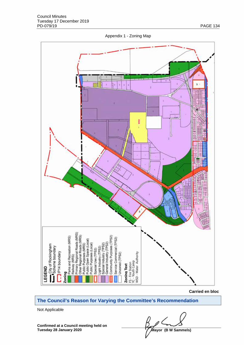
Council Minutes Tuesday 17 December 2019 PD-079/19 PAGE 134
Confirmed at a Council meeting held on Tuesday 28 January 2020
Mayor (B W Sammels)
Appendix 1 - Zoning Map
Carried en bloc
The Council’s Reason for Varying the Committee’s Recommendation Not Applicable

Council Minutes Tuesday 17 December 2019 PD-080/19 PAGE 135
Confirmed at a Council meeting held on Tuesday 28 January 2020
Mayor (B W Sammels)
Planning and Development Services Statutory Planning Services
Reference No & Subject: PD-080/19 Proposed Scheme Amendment No.178 - East Rockingham Industrial Zones
File No: LUP/2133
Applicant:
Owner: Various
Author: Mr Dave Waller, Coordinator Statutory Planning
Other Contributors: Mr Mike Ross, Manager Statutory Planning
Date of Committee Meeting: 9 December 2019
Previously before Council:
Disclosure of Interest:
Nature of Council’s Role in this Matter: Legislative
Site: Various
Lot Area:
LA Zoning: Special Industry, General Industry, Light Industry, Service Commercial (Industrial Zones)
MRS Zoning: Industrial
Attachments:
Maps/Diagrams: 1. Zoning Map with IP14 boundary 2. Aerial Photo with IP14 boundary 3. Original IP14 Structure Plan (Superseded) 4. IP14 Structure Plan 1996 5. Landcorp’s Current IP14 Structure Plan (Not Endorsed)
Purpose of Report The current East Rockingham Industrial Area planning framework is as follows: 1. Town Planning Scheme No.2 (TPS2) Industrial zone provisions require applications for
Development Approval to be considered by Council in accordance with an ‘Industry Policy’, also known as Planning Policy 7.1 - East Rockingham Industrial Park - Environmental Planning Policy (PP7.1).
2. PP7.1 includes both general and specific policy statements and in particular environmental criteria that has been historically applied to development applications for major heavy industry within East Rockingham.

Council Minutes Tuesday 17 December 2019 PD-080/19 PAGE 136
Confirmed at a Council meeting held on Tuesday 28 January 2020
Mayor (B W Sammels)
3. Planning Policy 3.3.8 - East Rockingham Development Guidelines (PP3.3.8) includes industrial development standards (e.g. building setbacks, landscaping) applying to Improvement Plan No.14 (IP14) discussed in the comment section below.
Following a review of the City’s planning framework, the following planning documents have been identified for review: (a) PP7.1 includes policy statements addressing environmental criteria such as air quality,
noise, risks and hazards, water quality and social environment, however, PP7.1 has been superseded through the environmental standards of various Government Agencies in various legislation, regulations, policy and guidelines.
(b) PP3.3.8 includes ‘policy level’ industrial development standards that should be applied and prevail as ‘statutory requirements’ in TPS2 rather than by policy. The application of development setbacks and landscaping standards should be broadened to apply all Industrial zones. PP3.3.8 should be revoked and replaced with a new policy which includes built form and landscaping guidance requirements.
(c) Should Council revoke PP7.1, by consequence it will also need to amend TPS2 provisions to delete the industry provisions which refer to PP7.1 (‘Industrial Policy’), as it would no longer apply. The planning framework in TPS2 as it applies to zoning would remain though and be expanded as outlined in (b) above.
In the context of the current planning framework, this report considers initiating Scheme Amendment No.178 to Town Planning Scheme No.2 (TPS2) to update the industry Scheme provisions. It should also be considered in the context of Agenda Item PD-078/19 and Agenda Item PD-080/19.
1. Zoning Map

Council Minutes Tuesday 17 December 2019 PD-080/19 PAGE 137
Confirmed at a Council meeting held on Tuesday 28 January 2020
Mayor (B W Sammels)
2. Aerial Photo with IP14 boundary shown
Background
The East Rockingham Industrial Park (ERIP) or Rockingham Industrial Zone (RIZ), which it is also known as, adjoins the southern section of the Kwinana Industrial Area (KIA). The RIZ is a strategic site that was first identified for industrial development through the Kwinana-East Rockingham Industrial Area Improvement Plan No.14 (IP14). IP14 was initiated in 1988 for the purpose of advancing the planning, development and use of the land affected by the plan for industrial purposes. The IP14 Structure Plan was adopted by Cabinet and the Western Australian Planning Commission (WAPC). The IP14 Structure Plan has guided the development of East Rockingham for over two decades. IP14 is a plan which supports port-related industry, environmentally acceptable heavy industry, general industry and light industry. The name Western Trade Coast (WTC) was more recently identified for the various industrial estates along the southern coast of the Perth metropolitan area, to recognize their strategic economic importance in the WA economy and promote the area from a marketing perspective. The Western Trade Coast encompasses WA's major established industrial and strategic assets, comprising about 3,900ha of land within Cockburn, Kwinana and Rockingham. The RIZ is one of four primary estates within the WTC, which also consists of the Kwinana Industrial Area, Latitude 32 Industry Zone and the Australian Maritime Complex.

Council Minutes Tuesday 17 December 2019 PD-080/19 PAGE 138
Confirmed at a Council meeting held on Tuesday 28 January 2020
Mayor (B W Sammels)
3. Original IP14 Structure Plan

Council Minutes Tuesday 17 December 2019 PD-080/19 PAGE 139
Confirmed at a Council meeting held on Tuesday 28 January 2020
Mayor (B W Sammels)
4. IP14 Structure Plan 1996

Council Minutes Tuesday 17 December 2019 PD-080/19 PAGE 140
Confirmed at a Council meeting held on Tuesday 28 January 2020
Mayor (B W Sammels)
5. Landcorp’s Current IP14 Structure Plan (Not Endorsed)
Details The proposed Scheme Amendment is an outcome of a review of the planning framework for Industrial Zones. The proposed changes in red text to TPS2 are summarised below: Proposal 1 – Buffer Objectives to Mandurah and Patterson Roads The objectives of the Industrial zones are proposed to be modified to include sub-clauses which seek to better maintain existing vegetated buffers along Mandurah Road and Patterson Roads, to screen larger scale industrial developments. It is intended that this will provide greater statutory effect by having objectives which clearly set out the City’s intentions in this regard. Recommendation 1.1 Amend TPS2 to include a new Objective (d) for the Industrial zones, as follows: 4.10 Industrial Zones 4.10.1 Objectives The following objectives apply to industrial zoned land within the Scheme Area: (a) to provide for a range of industrial land uses by establishing guiding principles and policies
that are environmentally and socially acceptable;

Council Minutes Tuesday 17 December 2019 PD-080/19 PAGE 141
Confirmed at a Council meeting held on Tuesday 28 January 2020
Mayor (B W Sammels)
(b) to encourage and facilitate the establishment of attractive and efficient industrial areas ensuring that acceptable levels of safety and high standards of amenity are provided through the application of appropriate land-use, design and landscaping controls; and
(c) to ensure that industrial areas are developed in a manner which has due regard to potential industries and their infrastructure needs, and that adjacent urban areas are not subjected to pollution and hazards.
(d) to protect and enhance natural vegetation along Patterson Road and Mandurah Road as major entry ways to the City, to ensure industrial development is appropriately screened.
Recommendation 1.2 Amend Clause 4.10.2 Form of Development as follows: 4.10.2 Form of Development In considering an application for development approval on industrial zoned land, the Local Government, in addition to any other aim or objective of the Scheme and to any other matter it is required or permitted to consider, shall have regard to the following: (a) promotion of a high standard of building development, landscaping and working
environment; (b) protection of the amenity of adjacent residential, and open space areas and major entry
ways into the City; (c) management of drainage systems and land uses to promote groundwater conservation; (d) to ensure safe movement of vehicular and pedestrian traffic in the area; and (e) management of bushfire risks is balanced against environmental outcomes and landscape
buffers. Proposal 2 – Rename and Extend Application of ERDG Policy It is intended to change all references of ‘East Rockingham Design Guidelines’ (ERDG) to ‘East Rockingham Industrial Zones Policy’ (ERIZP) in TPS2. It is intended to align the name of the Policy to ensure it is more associated with East Rockingham, where the majority of the industrial land is located. The ERDG provided under the current PP3.3.8 only applies to areas within the boundary IP14. The area of IP14 currently does not include all the land within the Light Industrial zone and Service Commercial zones located at the western end of Dixon Road and the Cooperative Bulk Handling (CBH) site on Rockingham Beach Road, next to the Cee & See Caravan Park. It is intended that PP3.3.8 will be applied to all land in the Industrial zones, including the Special Industry, General Industry, Light Industry and Service Commercial zones. Recommendation 2.1 In TPS2, rename ERDG to ‘East Rockingham Industrial Zones Policy’ in the first paragraph of clause 4.10.4 as follows: 4.10.4 General Development Provisions On all Industrial zoned land within the Local Government, unless otherwise specified in the East Rockingham Industrial Zones Policy or East Rockingham Development Guidelines: Recommendation 2.2 In TPS2, replace all occurrences of ERDG with ‘East Rockingham Industrial Zones Policy’ in Clause 4.10.6, and renumber Clause 4.10.5, as follows: 4.10.5 East Rockingham Development Guidelines Industrial Zones Policy (a) The East Rockingham Development Guidelines Industrial Zones Policy has been prepared
to guide the orderly development of serviced industrial zoned land within Rockingham and East Rockingham within the East Rockingham Industrial Park (IP14 Area).

Council Minutes Tuesday 17 December 2019 PD-080/19 PAGE 142
Confirmed at a Council meeting held on Tuesday 28 January 2020
Mayor (B W Sammels)
(b) Objectives: The main objectives of the East Rockingham Development Guidelines Industrial Zones Policy are: (i) to achieve an attractive and unified development which acknowledges the goal of conserving and enhancing the natural environment by emphasising the retention of natural vegetation and the introduction of complementary quality landscaping and well designed buildings;
(ii) to achieve a degree of consistency and compatibility in the built form and landscaping, whilst allowing for individuality and a well presented corporate or market image; and
(iii) to avoid unsightly and poorly planned development and enhance and protect the amenity of surround residential areas. investment of all owners within the East Rockingham Industrial Park and the investment of others in the region.
(c) In considering applications for development approval and otherwise planning for development within the East Rockingham Industrial Park and Rockingham, the Local Government shall have due regard to the East Rockingham Development Guidelines Industrial Zones Policy. Proposal 3 - IP14 Provisions IP14 is identified by the Department of Planning, Land and Heritage (DPLH) as an active Improvement Plan of the WAPC. Improvement Plans are strategic instruments used to facilitate the development of land in areas identified by the WAPC as requiring special planning. Improvements Plans, however, do not have any statutory effect, as they do not replace the existing region or local planning scheme. In the City’s view, IP14 is no longer required, given planning for the area has progressed substantially since 1988 and also given that it does not have any statutory effect. The planning basis for references to IP14 in TPS2 are therefore is no longer considered to be relevant. Clause 10.5 also sets out environmental matters that are to be addressed by the ‘Industrial Policy’, being PP7.1. As these matters are now covered by environmental legislation and other approval requirements, which are no longer needed. Hence, it is proposed to revoke PP7.1 (see Agenda Item PD-078/19). Given that IP14 has been superseded, it is recommended that reference to IP14 in TPS2 should also be deleted. Recommendation 3.1 Amend TPS2 by deleting Clause 4.10.5: 4.10.5 Improvement Plan No.14 (IP 14) (a) Improvement Plan No. 14, hereinafter referred to as IP14, was initiated in 1988 under the provisions of Section 37A of the Metropolitan Region Town Planning Scheme Act 1959 (as amended) for the purpose of advancing the planning, development and use of the land affected by the Plan for industrial purposes. (b) In considering applications for development approval or otherwise planning for development on industrial zoned land in the East Rockingham Industrial Park (IP14 Area), the Local Government shall have regard to the Industrial Policy. (c) The Industrial Policy incorporates both general and specific policy statements. General policy statements address:- - Air Quality; - Noise; - Risks and Hazards; - Water Quality; and - Social Environment.

Council Minutes Tuesday 17 December 2019 PD-080/19 PAGE 143
Confirmed at a Council meeting held on Tuesday 28 January 2020
Mayor (B W Sammels)
Recommendation 3.2 In TPS2, amend and renumber Clause 4.10.6 to Clause 4.10.5 and delete reference to IP14 as follows: 4.10.5 East Rockingham Development Guidelines Industrial Zones Policy (a) The East Rockingham Development Guidelines Rockingham Industrial Zones Policy has been prepared to guide the orderly development of serviced industrial zoned land within Rockingham and East Rockingham. within the East Rockingham Industrial Park (IP14 Area). Proposal 4 – Modify Policy Advertising Requirements It is proposed to delete Clause 4.10.7 of TPS2, which provides for preparing or amending the Industrial Policy, as it has been superseded by clauses 4 and 5 of the Deemed Provisions of the Planning and Development (Local Planning Scheme) Regulations (2015) (Regulations), which came into effect in October 2015. These clauses set out how planning policies are to be adopted, amended or revoked. Recommendation 4.1 Amend TPS2 by deleting Clause 4.10.7: 4.10.7 Modification of Policy and/or Guidelines (a) The Local Government may modify the Industrial Policy or the East Rockingham Development Guidelines, provided that it is satisfied that such modification is in the interest of orderly and proper planning and will not detract from the amenity of the locality. (b) Modifications shall be advertised for public comment in accordance with the provisions of clause 4 and 5 of the deemed provisions unless the proposed modification is minor. Proposal 5 – Building Setbacks and Landscaping TPS2 setbacks and landscaping requirements are already included in TPS2, but are varied where they are set out in the East Rockingham Design Guidelines (ERDG), which form the three appendices to PP3.3.8. This Scheme Amendment proposes to modify and simplify the current building setbacks in the ERDG and incorporate them into TPS2 so they will have statutory effect. The other major change is to insert minor and major development setbacks to Patterson Road and the western side of Mandurah Road to ensure appropriate screening is provided for larger scale industrial developments. Recommendation 5.1 Amend TPS2 to delete existing clauses 4.10.8, 4.10.9 and 4.10.10 and replace with renumbered Clause 4.10.6 and new Tables 2 and 3 as follows: 4.10.8 Light Industry Zone On all land zoned Light Industry, unless otherwise specified in the Industrial Policy or East Rockingham Development Guidelines:- (a) Setbacks: A minimum front setback of fifteen (15) metres shall apply. Where a lot has frontage to two or more streets, the prescribed front setback of fifteen (15) metres shall apply to the primary street and a minimum setback of three (3) metres shall apply to the secondary street, or streets, unless otherwise determined by the Local Government. (b) Landscaping: Provision shall be made for a minimum area of landscaping of 10% of the site, comprising a minimum 5 metre wide planting strip adjacent to the primary street boundary, and a minimum 3 metre wide planting strip on the secondary street plus the street verge to be landscaped and maintained to the satisfaction of the Local Government. 4.10.9 General Industry Zone On all land zoned General Industry, unless otherwise specified in the East Rockingham Development Guidelines:-

Council Minutes Tuesday 17 December 2019 PD-080/19 PAGE 144
Confirmed at a Council meeting held on Tuesday 28 January 2020
Mayor (B W Sammels)
(a) Setbacks: A minimum front setback of twenty five (25) metres shall apply for major structures and a minimum front setback of fifteen (15) metres shall apply to offices, gatehouses and amenity buildings. Where a lot has frontage to two or more streets, the prescribed front setbacks of twenty five (25) metres and fifteen (15) metres shall apply to the primary street and the setback to the secondary street shall be determined by the Local Government, but shall not be less than the prescribed minimum landscaping setback requirement. (b) Landscaping: Landscaping shall be provided on all street frontages for a distance of not less than 10 metres from each property boundary. At the discretion of Local Government, additional landscaping may be required on the remainder of the site. 4.10.10 Special Industry Zone On all land zoned Special Industry, unless otherwise specified in the East Rockingham Development Guidelines:- (a) Setbacks: A minimum front setback of twenty five (25) metres shall apply for major structures and a minimum front setback of fifteen (15) metres shall apply to offices, gatehouses and amenity buildings. Where a lot has frontage to two or more streets, the prescribed front setbacks of twenty five (25) metres and fifteen (15) metres shall apply to the primary street and the setback to the secondary street shall be determined by the Local Government, but shall not be less than the prescribed minimum landscaping setback requirement. (b) Landscaping: Landscaping shall be provided on all street frontages for a distance of not less than 10 metres from each property boundary. At the discretion of Local Government, additional landscaping may be required on the remainder of the site. 4.10.6 Setbacks and Landscaping Table 2 – Building Setbacks for Industrial Zones
Zone/Structure Type Building Setback Requirements
Special Industry Zone and General Industry Zone - Minor Structures (e.g. offices, reception, staff amenities, showroom, lunch room)
Primary Street Frontage: Secondary Street Frontage: Patterson Road and Western side of Mandurah Road:
Minimum: 15 metres Minimum: 10 metres Minimum: 50 metres
Special Industry Zone and General Industry Zone - Major Structures (e.g. fuel depot, stacks, sheds, industrial activities)
Primary Street Frontage: Secondary Street Frontage: Patterson Road and Western side of Mandurah Road:
Minimum: 25 metres Minimum: 10 metres Minimum: 100 metres
Light Industry Zone and Service Commercial Zone - All Structures
Primary Street Frontage: Secondary Street Frontage:
Minimum: 15 metres Minimum: 3 metres
Special Industry Zone, General Industry Zone, Light Industry Zone and Service Commercial Zone
Side and Rear Setbacks In accordance with the Building Code of Australia. (Side and Rear Building Setbacks to Mandurah Road and Patterson Road Frontages as per Primary and Secondary Street setbacks)

Council Minutes Tuesday 17 December 2019 PD-080/19 PAGE 145
Confirmed at a Council meeting held on Tuesday 28 January 2020
Mayor (B W Sammels)
Table 3 – Landscaping Requirements for Industrial Zones
Zone Landscaping Requirements
Special Industry zone and General Industry zone
Primary Street Frontage: Secondary Street Frontage: Patterson Road and Western side of Mandurah Road Frontage:
Minimum: 10 metres, plus the street verge. Minimum: 5 metres, plus the street verge. Minimum 50m in all circumstances
Light Industry Zone and Service Commercial Zone
Primary Street Frontage: Secondary Street Frontage:
Minimum: 5 metres, plus street verge Minimum: 3 metres, plus the street verge
Implications to Consider a. Consultation with the Community If the Scheme Amendment is initiated by the Local Government, it is required to be
advertised in accordance with the Planning and Development (Local Planning Schemes) Regulations 2015 (Regulations) for a minimum period of 42 days from the date of publication, with an advertisement being placed in a newspaper circulating in the area.
b. Consultation with Government Agencies Consultation with the Environmental Protection Authority (EPA), the Western Australian Planning Commission (WAPC) and other relevant government agencies will occur should the Scheme Amendment be initiated by the Local Government in accordance with clause 47 of the Regulations.
c. Strategic Community Plan
This item addresses the Community’s Vision for the future and specifically the following Aspiration and Strategic Objective contained in the Community Plan 2019-2029: Aspiration 3: Plan for Future Generations Strategic Objective: Responsive planning and control of land use: Plan and control the
use of land to meet the needs of the growing population, with consideration of future generations.
d. Policy Nil e. Financial
Nil f. Legal and Statutory Scheme Amendment The procedures for dealing with proposals to amend TPS2, as per the Planning and Development Act 2005, are set out in the Regulations.
Regulation 35(1) enables the Local Government to prepare or adopt an amendment to TPS2, in a form approved by the WAPC. The resolution must specify whether, in the opinion of the local government, the amendment is a complex amendment, a standard amendment or a basic amendment, and include an explanation for the reason for the local government forming that option.

Council Minutes Tuesday 17 December 2019 PD-080/19 PAGE 146
Confirmed at a Council meeting held on Tuesday 28 January 2020
Mayor (B W Sammels)
The City considers the proposed Scheme Amendment to be a standard amendment, for the following reasons: (a) A standard amendment means an amendment to a zone or reserve that is
consistent with the Scheme objectives, Local Planning Strategy, Metropolitan Region Scheme, consistent with a structure plan and minimal impact on land in the Scheme area, and has no significant environmental, social, economic or governance impacts.
g. Risk All Council decisions are subject to risk assessment according to the City’s Risk Framework. Implications and comment will only be provided for the following assessed risks.
Customer Service / Project management / Environment: High and Extreme Risks Finance / Personal Health and Safety: Medium, High and Extreme Risks
Nil
Comments The proposed Scheme Amendment is to be considered in conjunction with the review of PP3.3.8 and PP7.1 as part of a broader review of the statutory framework that applies to the East Rockingham Industrial zones. The main change to the Industrial zone requirements in TPS2 is to include provisions to maintain existing vegetated buffers along Mandurah Road and Patterson Roads. The intention is to ensure appropriate screening of large scale industrial developments along these major entryways into the City. This includes changes to objectives of the Industrial zones, setbacks and landscaping requirements. Currently TPS2 contains default building setback provisions that apply where they are not provided for in the various appendices of ERDG attached to PP3.3.8. The ERDG, however, do contain conflicting setbacks for areas between the three Appendices and is therefore confusing. It is proposed that revised setbacks be inserted into TPS2, as the head of power, for consistency and simplicity. It is also intended to simplify landscaping requirements and insert new Objectives which provide greater protection for these vegetated buffers to existing and future industrial development. The other major change is to broaden out the ERDG so that the revised Policy 3.3.8 applies to all the Industrial zones, not just the area covered by IP14. This will allow for consistency for industrial developments and ensure appropriate built form outcomes are achieved by reference to a revised PP3.3.8. It is recommended that Council adopt (initiate) the Scheme Amendment for the purpose of advertising.
Voting Requirements Simple Majority
Officer Recommendation That Council: 1. ADOPTS (initiates) Amendment No.178 to Town Planning Scheme No.2 for the purposes of
amending the Industrial Zone provisions. 2. CONSIDERS the proposed Scheme Amendment is a ‘Standard amendment’ in accordance with Regulation 34 of the Planning and Development (Local Planning Schemes) Regulations 2015; and 3. REQUIRES the proposed Scheme Amendment to be advertised for a minimum period of 42 days in accordance with Regulation 47(4) of the Planning and Development (Local Planning Schemes) Regulations 2015.

Council Minutes Tuesday 17 December 2019 PD-080/19 PAGE 147
Confirmed at a Council meeting held on Tuesday 28 January 2020
Mayor (B W Sammels)
Committee Recommendation That Council: 1. ADOPTS (initiates) Amendment No.178 to Town Planning Scheme No.2 for the purposes of
amending the Industrial Zone provisions. 2. CONSIDERS the proposed Scheme Amendment is a ‘Standard amendment’ in accordance with Regulation 34 of the Planning and Development (Local Planning Schemes) Regulations 2015; and 3. REQUIRES the proposed Scheme Amendment to be advertised for a minimum period of 42 days in accordance with Regulation 47(4) of the Planning and Development (Local Planning Schemes) Regulations 2015.
Committee Voting (Carried) – 5/0
The Committee’s Reason for Varying the Officer’s Recommendation Not Applicable
Implications of the Changes to the Officer’s Recommendation Not Applicable
Council Resolution That Council: 1. ADOPTS (initiates) Amendment No.178 to Town Planning Scheme No.2 for the purposes of
amending the Industrial Zone provisions as follows: (i) Inserting new subclause 4.10.1(d), which reads: “(d) to protect and enhance natural vegetation along Patterson Road and
Mandurah Road as major entry ways to the City to ensure Industrial development is appropriately screened.”
(ii) Replacing subclause 4.10.2(b) as follows: “(b) protection of the amenity of adjacent residential, open space areas and
major entry ways into the City;” (iii) Inserting new subclause 4.10.2(e) which reads: “(e) management of bushfire risks is balanced against environmental outcomes
and landscape buffers.” (iv) Replacing the first paragraph of clause 4.10.4 as follows: “On all industrial zoned land within the Local Government, unless otherwise
specified in the East Rockingham Industrial Zones Policy:-“ (v) Deleting subclauses 4.10.5 and 4.10.10 in its entirety, including subheadings, and
replace with the following: “4.10.5 East Rockingham Industrial Zones Policy (a) The East Rockingham Development Guidelines have been prepared to
guide the orderly development of serviced industrial land within Rockingham and East Rockingham.
(b) Objectives: The main objectives of the East Rockingham Industrial Zones Policy are: (i) to achieve an attractive and unified development which
acknowledges the goal of conserving and enhancing the natural environment by emphasising the retention of natural vegetation and the introduction of complementary quality landscaping and well-designed buildings;

Council Minutes Tuesday 17 December 2019 PD-080/19 PAGE 148
Confirmed at a Council meeting held on Tuesday 28 January 2020
Mayor (B W Sammels)
(ii) to achieve a degree of consistency and compatibility in the built form and landscaping, whilst allowing for individuality and a well presented corporate or market image; and
(iii) to avoid unsightly and poorly planned development and enhance and protect the amenity of the surrounding residential areas.
(c) In considering applications for development approval and otherwise planning for development within East Rockingham and Rockingham, the Local Government shall have due regard to the East Rockingham Industrial Zones Policy.
4.10.6 Setbacks and Landscaping for Industrial Zones. Table 2 – Special Industry and General Industry Zones”
Zone/Structure Type Building Setback Requirements
Special Industry Zone and General Industry Zone - Minor Structures (e.g. offices, reception, staff amenities, showroom, lunch room)
Primary Street Frontage: Secondary Street Frontage: Patterson Road and Western side of Mandurah Road:
Minimum: 15 metres Minimum: 10 metres Minimum 50 metres
Special Industry and General Industry Zone - Major Structures (e.g. fuel depot, stacks, sheds and industrial activities)
Primary Street Frontage: Secondary Street Frontage: Patterson Road and Western side of Mandurah Road:
Minimum: 25 metres Minimum: 10 metres Minimum: 100 metres
Light Industry Zone and Service Commercial Zone - All Structures
Primary Street Frontage: Secondary Street Frontage:
Minimum: 15 metres Minimum: 3 metres
Special Industry Zone, General Industry Zone, Light Industry Zone and Service Industry Zone
Side and Rear Setbacks In accordance with the Building Code of Australia. (Side and Rear Building Setbacks to Mandurah Road and Patterson Road Frontages as per Primary and Secondary Street setbacks)
Table 3 – Landscaping Requirements for Industrial Zones
Zone Landscaping Requirements
Special Industry Zone and General Industry Zone
Primary Street Frontage:
Secondary Street Frontage:
Patterson Road and Western side of Mandurah Road Frontage:
Minimum: 10 metres, plus the street verge. Minimum: 5 metres, plus the street verge. Minimum 50 metres in all circumstances
Light Industry Zone and Service Commercial Zone
Primary Street Frontage: Secondary Street Frontage:
Minimum: 5 metres, plus street verge Minimum: 3 metres, plus the street verge

Council Minutes Tuesday 17 December 2019 PD-080/19 PAGE 149
Confirmed at a Council meeting held on Tuesday 28 January 2020
Mayor (B W Sammels)
(vi) Renumbering Tables 2, 3 and 4 to 4, 5 and 6 respectively. (vii) Renumber clauses and subclauses accordingly. 2. CONSIDERS the proposed Scheme Amendment is a ‘Standard amendment’ in accordance with Regulation 34 of the Planning and Development (Local Planning Schemes) Regulations 2015; and 3. REQUIRES the proposed Scheme Amendment to be advertised for a minimum period of 42 days in accordance with Regulation 47(4) of the Planning and Development (Local Planning Schemes) Regulations 2015.
Carried en bloc
The Council’s Reason for Varying the Committee’s Recommendation Not Applicable

Council Minutes Tuesday 17 December 2019 PD-081/19 PAGE 150
Confirmed at a Council meeting held on Tuesday 28 January 2020
Mayor (B W Sammels)
Planning and Development Services Statutory Services
Reference No & Subject: PD-081/19 Proposed Amendments to Planning Policy 3.3.14 - Bicycle Parking and End-Of-Trip Facilities (Final Adoption)
File No: LUP/1265-05
Applicant:
Owner:
Author: Mr David Banovic, Senior Planning Officer
Other Contributors: Mr David Waller, Coordinator Statutory Planning Mr Mike Ross, Manager Statutory Planning
Date of Committee Meeting: 9 December 2019
Previously before Council: 28 April 2009 (PD54/4/09); 24 May 2011 (SP-024/11); 26 July 2011 (SP-039/11); 31 October 2017 (PDS-062/12); 24 September 2019 (PDS-060/19)
Disclosure of Interest:
Nature of Council’s Role in this Matter: Executive
Site:
Lot Area:
LA Zoning:
MRS Zoning:
Attachments:
Maps/Diagrams:
Purpose of Report To consider the adoption of amendments to Planning Policy 3.3.14 - Bicycle Parking and End-Of-Trip Facilities (PP3.3.14), following the completion of public advertising.
Background In September 2019, the Council resolved to adopt the following amendments to PP3.3.14 for the purpose of public advertising:
PLANNING POLICY 3.3.14 BICYCLE PARKING AND END-OF-TRIP FACILITIES
1. INTRODUCTION The City of Rockingham supports the use of sustainable transport and acknowledges the need to provide supportive environments including bicycle parking and end-of-trip facilities. New developments should endeavour to include bicycle parking alongside car parking. Large-scale

Council Minutes Tuesday 17 December 2019 PD-081/19 PAGE 151
Confirmed at a Council meeting held on Tuesday 28 January 2020
Mayor (B W Sammels)
development will be encouraged to also provide end-of-trip facilities including lockers, change rooms and showers. Existing development will be encouraged to provide these bicycle parking and end-of-trip facilities when upgrading developments. The aim of the policy is to facilitate the appropriate provision of secure, well designed and effective on site bicycle parking and end-of-trip facilities to encourage the use of bicycles as a means of transport and access to and within the City. The Western Australian Bicycle Network Plan 2014-2031 seeks to double the number of cycling trips in Western Australia within five years, and this Policy aims to cater for this projected demand for bicycle parking and end-of-trip facilities. Clause 67 of the deemed provisions of Town Planning Scheme No.2 sets out the matters that the Council, in considering an application for Development Approval, is to have due regard to as are in the opinion of the Council relevant to the use or development the subject of the application, and includes:- "(iv) the availability and adequacy for the development of the access for pedestrians and cyclists (including end of trip storage, toilet and shower facilities)" 2. POLICY APPLICATION This Policy applies to all applications for Development Approval, including change-of-use applications where an intensification of land use is proposed. 3. POLICY OBJECTIVES The objectives of this Planning Policy are as follows: (a) To ensure the provision of adequate appropriate bicycle parking and end-of-trip facilities in
new developments and extension or intensification of existing developments in the City as outlined in Table 1 and Table 2; and
(b) To provide guidance on the development and design of bicycle parking and end-of-trip facilities.; and
(c) To encourage the use of bicycles for all sorts of journeys. 4. POLICY STATEMENT 4.1 Provision of Bicycle Parking Devices Bicycle parking devices are installations that allow for the secure and convenient parking of bicycles, and are separated into two different types: long-term parking and short-term parking. Long-term and short-term bicycle parking devices are to be provided at the rates shown on the following table: All developments subject to this Planning Policy shall be provided with long-term parking and short-term parking in accordance with the following ratios:
Table 1 - Bicycle Parking Rates
Usea Minimum Long-term Parking Minimum Short-term Parking
· Multiple Dwelling
As per the Residential Design Codes
As per the Residential Design Codes
· Lodging House
1 space per 3 lodging rooms 1 space per 10 lodging rooms
· Short Stay Accommodation · Hotel · Motel
1 space per 40 guest bedrooms none required
· Commercial b:-
- Local Shops (less than 1,000m² NLA)
1 space per 250m² NLA 1 space per 150m² NLA (minimum 2 spaces)

Council Minutes Tuesday 17 December 2019 PD-081/19 PAGE 152
Confirmed at a Council meeting held on Tuesday 28 January 2020
Mayor (B W Sammels)
Usea Minimum Long-term Parking Minimum Short-term Parking
- Neighbourhood Centres (between 1,001m² - 4,999m²
NLA)
1 space per 500m² NLA (minimum 4 spaces)
1 space per 300m² NLA (minimum 6 spaces)
- District Centres (greater than 5,000m² NLA)
1 space per 1,500m² NLA (minimum 10 spaces)
1 space per 750m² NLA (minimum 16 spaces)
· Office 1 space per 200m² NLA 1 space per 500m² NLA
· Consulting Rooms · Medical Centre
1 space per 8 practitioners 1 space per 4 practitioners
· Hotel (excluding accommodation)
· Tavern · Small Bar · Nightclub
1 space per 100m² of bars and public areas, including lounges, beer gardens and restaurants
1 space per 150m² of bars and public areas, including lounges, beer gardens and restaurants
· Health Studio · Private Recreation
1 space per 400m² NLA available to the public, including swimming pools
1 space per 200m² NLA available to the public, including swimming pools
· Community Use · Exhibition Centre · Public Worship - Place of · Club Premises · Reception Centre
none required 1 space for every 30 people the building is designed to accommodate
· Showroom 1 space per 750m² NLA for premises greater than 300m² 1 space per 1,000m² NLA
· Industry - Servicec · Industry - Light
1 space per 800m² NLA for premises greater than 300m² NLA
none required
· Other Industrial Uses 1 space per 1,000m² for premises greater than 300m² NLA
none required
a Unless defined elsewhere by this Policy, the uses specified above are defined in Schedule No.1 - Interpretations of the City of Rockingham Town Planning Scheme No.2.
b "Commercial" includes a Shop, Bank, Betting Agency, Convenience Store, Fast Food Outlet, Homestore, Lunch Bar, Restaurant, Restricted Premises, Service Station (convenience store component).
c "Industry - Service" includes a Dry Cleaning Premises, Funeral Parlour, Landscape Supply Yard, Laundromat, Motor Vehicle and Marine Sales Premises, Motor Vehicle Repair Station, Open Air Display, Plant Nursery, Trade Display.
Land Use Minimum Short-Term Parking Minimum Long-Term Parking
Multiple Dwelling As per Residential Design Codes
As per Residential Design Codes
Office 0.05 spaces per 100m2 NLA 0.45 spaces per 100m2 NLA Shop
- Local Centre - Neighbourhood Centre - Regional Centre
0.20 spaces per 100m2 NLA 0.30 spaces per 100m2 NLA 0.25 spaces per 100m2 NLA
0.1 spaces per 100m2 NLA 0.12 spaces per 100m2 NLA 0.05 spaces per 100m2 NLA
Retail 0.15 spaces per 100m2 NLA 0.07 spaces per 100m2 NLA

Council Minutes Tuesday 17 December 2019 PD-081/19 PAGE 153
Confirmed at a Council meeting held on Tuesday 28 January 2020
Mayor (B W Sammels)
Land Use Minimum Short-Term Parking Minimum Long-Term Parking
Education N/A 0.3 spaces per student and staff
Accommodation N/A 0.1 spaces per staff Place of Assembly 0.05 spaces per visitor 0.1 spaces for staff Food and Drink Premises 0.1 spaces per five seats 0.1 spaces per staff Health Services 0.1 spaces per patient (max
on site at any one time) 0.1 spaces per staff
Industry N/A 0.1 spaces per 100m2 NLA All other uses 0.05 spaces per visitor 0.1 spaces per staff
Note: All rounding of bicycle parking rates is to be calculated by rounding to the nearest whole number. The Council may approve an application that does not comply with Table 1 or may approve an application for a use that is not listed in Table 1 having regard to: (i) the Western Australian Bicycle Network Plan 2014-2031 aim of doubling the number of cycling trips in Western Australia within five years; (ii) Austroads Part 14 - Bicycles; (iii) the nature of the proposed development; (iv) the number of employees likely to be employed on site; (v) the anticipated demand for employee, customer, resident and student parking; and (vi) the orderly and proper planning of the locality. 4.2 Design of Bicycle Parking Facilities All bicycle parking facilities shall comply with the following: - Bicycle parking facilities shall be located in a convenient and safe location and not require
access via steps; and - Bicycle parking facilities shall be located as close as possible to the main entrance of the
premises. Long-term bicycle parking facilities should be located in a convenient and secure location for employees/residents and can include the following: - Locked compounds with communal access using duplicate keys or electronic swipe cards in a secure location and fitted with bicycle parking devices; or - Fully-enclosed individual lockers; or - Devices to which the bicycle frame and wheels can be locked positioned close to and directly visible from inside the place of employment. Short-term bicycle parking facilities includes devices to which the bicycle frame and wheels can be locked, and should be located in a convenient and secure position close to the entrance of the premises. Regardless of the type of bicycle parking, All bicycle parking devices should be designed in accordance with AS 2890.3 - Bicycle Parking Facilities and Austroads Part 14 - Bicycles, must be convenient and secure, and should comply with the following criteria: - enable wheels and frame to be locked to the device without damaging the bicycle; - be placed in public view (i.e. where they can be viewed by passers-by, shopkeepers, station attendants, teachers or fellow workers); - be located outside pedestrian movement paths; - be easily accessible from the road; - be arranged so that parking and vehicle manoeuvring will not damage adjacent bicycles; - be protected from manoeuvring motor vehicles and opening car doors;

Council Minutes Tuesday 17 December 2019 PD-081/19 PAGE 154
Confirmed at a Council meeting held on Tuesday 28 January 2020
Mayor (B W Sammels)
- be as close as possible to the cyclist's ultimate destination; - be well lit by appropriate existing or new lighting; - be protected from the weather; and - be sympathetic in design, material and colour to compliment the surrounding environment.;
and - be protected from malicious damage. Where the building is built up to the front boundary, the City will accept short-term parking spaces being provided in the road reserve adjacent to the building, located so as to provide a minimum clear footpath width of 1.5m directly adjacent to the building unless otherwise approved by the City, subject to the standards defined in AS 2890.3 being met. Long-term parking must be provided on site. Signs should be provided to direct cyclists to parking devices where their purpose is not immediately apparent or are not readily visible. 4.3 Provision of End-of-Trip Facilities End-of-trip facilities include destination facilities provided for bicycle commuters such as showers, change rooms and lockers. Where long-term bicycle parking spaces are provided, showers must be provided at the following rate:
Table 2 - Provision of showers
Number of long-term parking spaces provided Number of showers required
0-2 0
3-5 1
6-10 2 (one male, one female)
11-20 4 (two male, two female)
more than 20
4 (two male, two female) plus additional showers at the rate of 2 showers (one male, one female) for every 10 long-term parking
spaces after 20 provided thereafter
Number of Showers Change Rooms One shower following the first five (5) long-term parking spaces, plus an additional shower for each four (4) bicycle parking spaces thereafter
One change room or direct access to a communal change room per shower
Note: in instances where more than one shower/facility is required, there must be provision for separate male and female facilities. Where it can be demonstrated that staff of a development work predominately part-time, casual or varied hours, the requirement to provide for shower facilities may be reduced where shower facilities are used at different hours. Where showers are required, change rooms must also be provided. They must be provided as either: - a combined shower and change cubicle; or - one communal change room for each gender, directly accessible from the showers for that gender without passing through a public space. Shower and change facilities must be located so that users and their belongings have a high level of security.

Council Minutes Tuesday 17 December 2019 PD-081/19 PAGE 155
Confirmed at a Council meeting held on Tuesday 28 January 2020
Mayor (B W Sammels)
All showers provided are to dispense both hot and cold water. Cold-only showers must not be counted towards the requirements of this section. Clothing lockers encourage cycling by providing secure storage for cycling clothes, footwear and towels. Clothing lockers should be: - provided at a minimum rate of one clothing locker for each long-term bicycle parking space
(only if 10 or more spaces provided); - of suitable volume and dimensions to allow storage of clothing, towels, cycling helmets and footwear; - well ventilated, secure and lockable; and - located close to shower and change facilities. Where possible, showers and clothing lockers should be located close to long-term bicycle parking facilities. Where bicycle parking lockers are provided, clothing may be stored within the bicycle parking locker provided there is adequate space and hangers. 5. AUTHORITY This Planning Policy has been adopted by the Council under Clause 4 (4) of the deemed provisions of TPS2. The Council is to have due regard to the provisions of the Policy and the objectives which the Policy is designed to achieve before making its determination. This Planning Policy has been adopted by the Local Government under the deemed provisions of TPS2 and whilst it is not part of the Scheme and does not bind the Local Government in respect of any application for Development Approval, the Local Government is to have due regard to the provisions of the Policy and the objectives which the Policy is designed to achieve before making its determination. 6. INTERPRETATIONS For the purposes of this Planning Policy, the following terms shall have the same meaning as in Town Planning Scheme No.2: Local Government Council: means the Council Local Government of the City of Rockingham. Deemed Provisions: means the Schedule 2 – Deemed Provisions for local planning
schemes in accordance with the Planning and Development (Local Planning Schemes) Regulations 2015.
Device: means a thing to or in which one or more bicycle frame(s) and wheels can be locked, and includes rails, bicycle lockers and bicycle compounds.
End-of-trip facilities: are secure bicycle storage and other secure 'end of trip' facilities such as lockers and showers.
Net Lettable Area (NLA): means the area of all floors within the internal finished surfaces of permanent walls but excludes the following areas:-
(a) all stairs, toilets, cleaners cupboards, lift shafts and motor rooms, escalators, tea rooms and plant rooms, and other services areas;
(b) lobbies between lifts facing other lifts serving the same floor;
(c) areas set aside as public space or thoroughfares and not for the exclusive use of occupiers of the floor or building;
(d) areas set aside for the provision of facilities or services to the floor or building where such facilities are not for the exclusive use of occupiers of the floor or building.
Residential Design Codes: means State Planning Policy 3.1 7.3 – Residential Design Codes - Volume 1 and 2 as amended from time to time.
Long-Term Parking: includes day parking for employees, residents’ parking at apartments and student parking at educational establishments.
Short-Term Parking: includes parking for shoppers and visitors to a premises. Space: means parking for one bicycle.

Council Minutes Tuesday 17 December 2019 PD-081/19 PAGE 156
Confirmed at a Council meeting held on Tuesday 28 January 2020
Mayor (B W Sammels)
7. DELEGATION Applications for Development Approval that comply with the objectives and provisions of this Planning Policy will be determined under delegated authority, pursuant to the Delegated Authority Register. 8. ADOPTION This Planning Policy was adopted by the Council at its ordinary Meeting held on the 28th April 2009. 9. AMENDMENT This Planning Policy was amended by the Council at its ordinary Meeting held on the XX XXXX XXXX.
Details Following the conclusion of the advertising period, the PP3.3.14 must be considered by Council for Adoption. The proposed changes to PP3.3.14 seek to simplify the Policy, revise bicycle parking and end-of-trip facility ratios and reflect changes in terminology. The proposed changes to PP3.3.14 are summarised as follows: - Implement less onerous bicycle parking and end-of-trip facility ratios; - Add a new objective which relates to Clause 1 'Introduction' of this Policy; - Table 1 - Bicycle Parking Rates is modified to reflect land use classification (through
grouping) for simplicity; - Table 2 - Provision of Showers is also modified for simplicity and only requires the provision
of lockers in instances where 10 or more long term bicycle parking spaces are required; - Includes a requirement for rounding off bicycle parking rates, which is currently absent; - The Design of Bicycle Parking Facilities section is amended to inform landowner/applicants
that consideration is given to safety features for bicycle facilities to minimise potential damage; and
- Wording changes for ease of use.
Implications to Consider a. Consultation with the Community
In accordance with Clause 4(2) of the deemed provisions in the Town Planning Scheme No.2 (TPS2), the proposed amendments to PP3.3.14 were advertised for 21 days in the following manner: - An advertisement was published in the Sound Telegraph Newspaper on 9 October
2019; - A copy of the draft PP3.3.14 was advertised on the City's website from 9 October
2019 to 30 October 2019; and - Copies of the draft PP3.3.14 were made available at the City's Administration Office. At the close of the public consultation period, one (1) submission had been received from a resident of Shoalwater. The submission received has been summarised in the table below, including the Officer's response to the issues.
1. General observation regarding the inadequacy of bicycle parking facilities and commendation for bicycle parking facilities at the Rockingham Beach Foreshore.
Submission: There are developments which do not provide for adequate bicycle parking facilities.

Council Minutes Tuesday 17 December 2019 PD-081/19 PAGE 157
Confirmed at a Council meeting held on Tuesday 28 January 2020
Mayor (B W Sammels)
1. General observation regarding the inadequacy of bicycle parking facilities and commendation for bicycle parking facilities at the Rockingham Beach Foreshore.
City’s Comment The appropriateness of bicycle parking facilities is assessed at the time of submission of an application for Development Approval and applied based on Policy requirements. It is acknowledged that a number of development do not have any bicycle parking, however, this would be primarily due to such sites being developed prior to the Policy coming into effect. The recently upgraded Rockingham Beach foreshore has also provided significant bicycle parking to encourage this mode of transport to the foreshore.
Submission: Commendation for the provision of bicycle parking facilities undertaken as part of the recent Rockingham Beach Foreshore Revitalisation works.
City’s Comment Noted.
b. Consultation with Government Agencies Nil c. Strategic Community Plan
This item addresses the Community’s Vision for the future and specifically the following Aspiration and Strategic Objective contained in the Strategic Community Plan 2019-2029: Aspiration 3: Plan for Future Generations Strategic Objective: Responsive planning and control of land use: Plan and control the
use of land to meet the needs of the growing population, with consideration of future generations.
d. Policy Nil
e. Financial Nil
f. Legal and Statutory PP3.3.14 is not part of TPS2 and does not bind the Council in respect of any application for Development Approval, but the Council is to have due regard to the provisions of the Policy and the objectives which PP3.3.13 is designed to achieve before making its determination. Pursuant to the Deemed Provisions of TPS2, if the local government resolves to proceed to Adopt the policy, the local government must publish notice of the policy in a newspaper circulating in the Scheme area.
g. Risk All Council decisions are subject to risk assessment according to the City’s Risk Framework.
Implications and comment will only be provided for the following assessed risks. Customer Service / Project management / Environment: High and Extreme Risks Finance / Personal Health and Safety: Medium, High and Extreme Risks
Nil

Council Minutes Tuesday 17 December 2019 PD-081/19 PAGE 158
Confirmed at a Council meeting held on Tuesday 28 January 2020
Mayor (B W Sammels)
Comments The proposed changes are generally administrative in nature to ensure PP3.3.14 is simplified for ease of use and to ensure legislative terminology is consistent with State Planning Policy 7.3 - Residential Design Codes (Volume 1 and 2). The proposed bicycle parking and end-of-trip facility ratios have been tailored to better meet the expectations of cyclists, whilst being less onerous on smaller developments. Some further refinements to the draft PP3.3.14 were made following consultation with the community as follows: - The note at the bottom of Table 1, Bicycle Park Rates in section 4.1, is amended to clarify that
rounding of the rate is to the next highest whole number and not a lesser one. This is to avoid confusion.
- The words in the last dot point in paragraph 2 of section 4.3 Design of Bicycle Parking Facilities is amended from ‘be protected from malicious damage’ to ‘secure devices to protect from theft’.
These refinements provided for clarification and therefore do not require further comment from the community. The submission received during the consultation period has been considered and the City's comments have previously addressed the submission made in this report. It is recommended the Council adopts the revised PP3.3.14 accordingly.
Voting Requirements Simple Majority
Officer Recommendation That Council ADOPTS revised Planning Policy 3.3.14 - Bicycle Parking and End-Of-Trip Facilities.
Committee Recommendation That Council ADOPTS revised Planning Policy 3.3.14 - Bicycle Parking and End-Of-Trip Facilities.
Committee Voting (Carried) – 5/0
The Committee’s Reason for Varying the Officer’s Recommendation Not Applicable
Implications of the Changes to the Officer’s Recommendation Not Applicable
Council Resolution That Council ADOPTS revised Planning Policy 3.3.14 - Bicycle Parking and End-Of-Trip Facilities as follows:
PLANNING POLICY 3.3.14 BICYCLE PARKING AND END-OF-TRIP FACILITIES
1. INTRODUCTION The City of Rockingham supports the use of sustainable transport and acknowledges the need to provide supportive environments including bicycle parking and end-of-trip facilities. New developments should endeavour to include bicycle parking alongside car parking. Large-scale development will be encouraged to also provide end-of-trip facilities including lockers, change rooms and showers.

Council Minutes Tuesday 17 December 2019 PD-081/19 PAGE 159
Confirmed at a Council meeting held on Tuesday 28 January 2020
Mayor (B W Sammels)
Existing development will be encouraged to provide these bicycle parking and end-of-trip facilities when upgrading developments. The aim of the policy is to facilitate the appropriate provision of secure, well designed and effective on site bicycle parking and end-of-trip facilities to encourage the use of bicycles as a means of transport and access to and within the City. The Western Australian Bicycle Network Plan 2014-2031 seeks to double the number of cycling trips in Western Australia within five years, and this Policy aims to cater for this projected demand for bicycle parking and end-of-trip facilities. 2. POLICY APPLICATION This Policy applies to all applications for Development Approval, including change-of-use applications where an intensification of land use is proposed. 3. POLICY OBJECTIVES The objectives of this Planning Policy are as follows: (a) To ensure the provision of adequate bicycle parking and end-of-trip facilities as outlined in
Table 1 and Table 2; (b) To provide guidance on the development and design of bicycle parking and end-of-trip
facilities; and (c) To encourage the use of bicycles for all sorts of journeys. 4. POLICY STATEMENT 4.1 Provision of Bicycle Parking Devices All developments subject to this Planning Policy shall be provided with long-term parking and short-term parking in accordance with the following ratios:
Table 1 - Bicycle Parking Rates
Land Use Minimum Short-Term Parking Minimum Long-Term Parking
Multiple Dwelling As per Residential Design Codes
As per Residential Design Codes
Office 0.05 spaces per 100m2 NLA 0.45 spaces per 100m2 NLA Shop
- Local Centre - Neighbourhood Centre - Regional Centre
0.20 spaces per 100m2 NLA 0.30 spaces per 100m2 NLA 0.25 spaces per 100m2 NLA
0.1 spaces per 100m2 NLA 0.12 spaces per 100m2 NLA 0.05 spaces per 100m2 NLA
Retail 0.15 spaces per 100m2 NLA 0.07 spaces per 100m2 NLA Education N/A 0.3 spaces per student and
staff Accommodation N/A 0.1 spaces per staff Place of Assembly 0.05 spaces per visitor 0.1 spaces for staff Food and Drink Premises 0.1 spaces per five seats 0.1 spaces per staff Health Services 0.1 spaces per patient (max
on site at any one time) 0.1 spaces per staff
Industry N/A 0.1 spaces per 100m2 NLA All other uses 0.05 spaces per visitor 0.1 spaces per staff
Note: All rounding of bicycle parking rates is to be calculated by rounding up to the nearest whole number. The Council may approve an application that does not comply with Table 1 or may approve an application for a use that is not listed in Table 1 having regard to: (i) the Western Australian Bicycle Network Plan 2014-2031 aim of doubling the number of cycling trips in Western Australia within five years; (ii) Austroads Part 14 - Bicycles; (iii) the nature of the proposed development; (iv) the number of employees likely to be employed on site; (v) the anticipated demand for employee, customer, resident and student parking; and

Council Minutes Tuesday 17 December 2019 PD-081/19 PAGE 160
Confirmed at a Council meeting held on Tuesday 28 January 2020
Mayor (B W Sammels)
(vi) the orderly and proper planning of the locality. 4.2 Design of Bicycle Parking Facilities All bicycle parking facilities shall comply with the following: - Bicycle parking facilities shall be located in a convenient and safe location and not require
access via steps; and - Bicycle parking facilities shall be located as close as possible to the main entrance of the
premises. All bicycle parking devices should be designed in accordance with AS 2890.3 - Bicycle Parking Facilities and Austroads Part 14 - Bicycles, must be convenient and secure, and should comply with the following criteria: - enable wheels and frame to be locked to the device without damaging the bicycle; - be placed in public view (i.e. where they can be viewed by passers-by, shopkeepers, station attendants, teachers or fellow workers); - be located outside pedestrian movement paths; - be easily accessible from the road; - be arranged so that parking and vehicle manoeuvring will not damage adjacent bicycles; - be protected from manoeuvring motor vehicles and opening car doors; - be as close as possible to the cyclist's ultimate destination; - be well lit by appropriate existing or new lighting; - be protected from the weather; - be sympathetic in design, material and colour to compliment the surrounding environment;
and - secure devices to protect from theft. Where the building is built up to the front boundary, the City will accept short-term parking spaces being provided in the road reserve adjacent to the building, located so as to provide a minimum clear footpath width of 1.5m directly adjacent to the building unless otherwise approved by the City, subject to the standards defined in AS 2890.3 being met. Long-term parking must be provided on site. 4.3 Provision of End-of-Trip Facilities Where long-term bicycle parking spaces are provided, showers must be provided at the following rate:
Table 2 - Provision of showers Number of Showers Change Rooms One shower following the first five (5) long-term parking spaces, plus an additional shower for each four (4) bicycle parking spaces thereafter
One change room or direct access to a communal change room per shower
Note: in instances where more than one shower/facility is required, there must be provision for separate male and female facilities. Where it can be demonstrated that staff of a development work predominately part-time, casual or varied hours, the requirement to provide for shower facilities may be reduced where shower facilities are used at different hours. Clothing lockers encourage cycling by providing secure storage for cycling clothes, footwear and towels. Clothing lockers should be: - provided at a minimum rate of one clothing locker for each long-term bicycle parking space
(only if 10 or more spaces provided); - of suitable volume and dimensions to allow storage of clothing, towels, cycling helmets and footwear;

Council Minutes Tuesday 17 December 2019 PD-081/19 PAGE 161
Confirmed at a Council meeting held on Tuesday 28 January 2020
Mayor (B W Sammels)
- well ventilated, secure and lockable; and - located close to shower and change facilities. Where possible, showers and clothing lockers should be located close to long-term bicycle parking facilities. Where bicycle parking lockers are provided, clothing may be stored within the bicycle parking locker provided there is adequate space and hangers. 5. AUTHORITY This Planning Policy has been adopted by the Local Government under the deemed provisions of TPS2 and whilst it is not part of the Scheme and does not bind the Local Government in respect of any application for Development Approval, the Local Government is to have due regard to the provisions of the Policy and the objectives which the Policy is designed to achieve before making its determination. 6. INTERPRETATIONS For the purposes of this Planning Policy, the following terms shall have the same meaning as in Town Planning Scheme No.2: Local Government: means the Local Government of the City of Rockingham. Deemed Provisions: means the Schedule 2 – Deemed Provisions for local planning
schemes in accordance with the Planning and Development (Local Planning Schemes) Regulations 2015.
Device: means a thing to or in which one or more bicycle frame(s) and wheels can be locked, and includes rails, bicycle lockers and bicycle compounds.
End-of-trip facilities: are secure bicycle storage and other secure 'end of trip' facilities such as lockers and showers.
Net Lettable Area (NLA): means the area of all floors within the internal finished surfaces of permanent walls but excludes the following areas:-
(a) all stairs, toilets, cleaners cupboards, lift shafts and motor rooms, escalators, tea rooms and plant rooms, and other services areas;
(b) lobbies between lifts facing other lifts serving the same floor;
(c) areas set aside as public space or thoroughfares and not for the exclusive use of occupiers of the floor or building;
(d) areas set aside for the provision of facilities or services to the floor or building where such facilities are not for the exclusive use of occupiers of the floor or building.
Residential Design Codes: means State Planning Policy 7.3 – Residential Design Codes - Volume 1 and 2 as amended from time to time.
Long-Term Parking: includes day parking for employees, residents’ parking at apartments and student parking at educational establishments.
Short-Term Parking: includes parking for shoppers and visitors to a premises. Space: means parking for one bicycle. 7. DELEGATION Applications for Development Approval that comply with the objectives and provisions of this Planning Policy will be determined under delegated authority, pursuant to the Delegated Authority Register. 8. ADOPTION This Planning Policy was adopted by the Council at its ordinary Meeting held on 28 April 2009.

Council Minutes Tuesday 17 December 2019 PD-081/19 PAGE 162
Confirmed at a Council meeting held on Tuesday 28 January 2020
Mayor (B W Sammels)
9. AMENDMENT This Planning Policy was amended by the Council at its ordinary Meeting held on 17 December 2019.
Carried en bloc
The Council’s Reason for Varying the Committee’s Recommendation Not Applicable

Council Minutes Tuesday 17 December 2019 PD-082/19 PAGE 163
Confirmed at a Council meeting held on Tuesday 28 January 2020
Mayor (B W Sammels)
Planning and Development Services Statutory Planning Services
Reference No & Subject: PD-082/19 Proposed Modification to Building Envelope
File No: DD024.2019.00000010.001
Applicant: Cachet Homes Pty Ltd
Owner: Mr M and Mrs V Macrin
Author: Mr Neels Pretorius, Planning Officer
Other Contributors: Mr Mike Ross, Manager Statutory Planning Mr David Waller, Coordinator Statutory Planning
Date of Committee Meeting: 9 December 2019
Previously before Council:
Disclosure of Interest:
Nature of Council’s Role in this Matter: Tribunal
Site: Lot 4 (No.24) Sawley Close, Golden Bay
Lot Area: 0.6338ha
LA Zoning: Special Residential
MRS Zoning: Rural
Attachments:
Maps/Diagrams: 1. Location Plan 2. Aerial Photo 3. Building Envelope Plan 4. Consultation Plan
Purpose of Report To consider an application to modify the existing Building Envelope on No 24 (Lot 4) Sawley Close, Golden Bay.
Background
The site is located west of Mandurah Road, north of Dampier Drive, on the eastern side of Sawley Close. The existing Building Envelope, was created as part of the original subdivision of this part of Sawley Close, Golden Bay.

Council Minutes Tuesday 17 December 2019 PD-082/19 PAGE 164
Confirmed at a Council meeting held on Tuesday 28 January 2020
Mayor (B W Sammels)
1. Location Plan
2. Aerial Photo
Details The applicant proposes to modify the approved Building Envelope for the purpose of accommodating a future Single House. The Building Envelope will increase in area from 913m² to 971m² area, equating to an increase of 6.4%.
Subject Site
Subject Site

Council Minutes Tuesday 17 December 2019 PD-082/19 PAGE 165
Confirmed at a Council meeting held on Tuesday 28 January 2020
Mayor (B W Sammels)
The proposed Building Envelope will be set back from the property boundaries as follows: - 9.6m from the western boundary; - 31.5m from the eastern boundary; - 29.4m from the northern boundary; and - 19.6m from the southern boundary. It is intended for the proposed Single House, within the modified Building Envelope, to be set back from the property boundaries as follows: - 11.5m from the western boundary; - 32.5m from the eastern boundary; - 32m from the northern boundary; and - 29m from the southern boundary. The existing and proposed Building Envelope are indicated in Figure 3 below.
3. Building Envelope Plan

Council Minutes Tuesday 17 December 2019 PD-082/19 PAGE 166
Confirmed at a Council meeting held on Tuesday 28 January 2020
Mayor (B W Sammels)
Implications to Consider a. Consultation with the Community
In accordance with Clause 64 of the deemed provisions of Town Planning Scheme No.2 (TPS2), the application was referred to adjoining property owners and occupiers, as per the consultation plan below. At the closing of advertising, two submissions in support were received.
4. Consultation Plan
b. Consultation with Government Agencies Not Applicable
c. Strategic Community Plan
This item addresses the Community’s Vision for the future and specifically the following Aspiration and Strategic Objective contained in the Community Plan 2019-2029. Aspiration 3: Plan for Future Generations Strategic Objective: Responsive Planning and Control of Land Use - plan and control
the use of land to meet the needs of the growing population, with consideration of future generations.
d. Policy Planning Policy 3.3.17 – Variations to Building Envelopes (PP3.3.17) applies.
The objective of the policy is “to promote the orderly and proper development of land by identifying in what circumstances a Building Envelope be varied, and the process by which such an application would be considered”.

Council Minutes Tuesday 17 December 2019 PD-082/19 PAGE 167
Confirmed at a Council meeting held on Tuesday 28 January 2020
Mayor (B W Sammels)
The following is an assessment against the relevant requirements of PP3.3.17:
Requirement Provided Compliance
Compliance with Schedule No.5 of TPS2.
Schedule No.5 of TPS2 provides that the size and location of an approved Building Envelope may be varied with the approval of Council.
Yes
The varied Building Envelope must not result in an adverse environmental impact.
The proposed modification will not result in the removal of any trees.
Yes
The varied Building Envelope must not result in an unacceptable level of bushfire risk.
The proposed modification will not result in an increased level of bushfire risk
Yes
No unacceptable amenity impacts to neighbours.
No objections have been received to the proposed building envelope modification from neighbours.
Yes
The variation is a minor increase in the size of the approved Building Envelope. An increase up to a maximum of 10% of the area of the original approved Building Envelope will be considered.
The size of the original Building Envelope will be increased from 913m² to 971m², which is an increase of 6.5%.
Yes
Building Envelopes are to be of a regular shape and comprise one single contiguous area.
The shape of the proposed Building Envelope is regular in shape.
Yes
State Planning Policy 3.7 - Planning in Bushfire Prone Areas (SPP3.7) The proposal will not increase the risk of bushfire, as the proposed modified proposal is a slight adjustment to the existing Building Envelope.
e. Financial Nil
f. Legal and Statutory Town Planning Scheme No.2 (TPS2) Schedule No.5 of TPS2 provides that the size and location of an approved Building Envelope may be varied with the approval of Council. Schedule 5 also contains provisions which restrict the removal of vegetation, including Clause 14, which states:

Council Minutes Tuesday 17 December 2019 PD-082/19 PAGE 168
Confirmed at a Council meeting held on Tuesday 28 January 2020
Mayor (B W Sammels)
“No indigenous trees or substantial vegetation shall be removed, including from within a building envelope, without the prior approval of the Local Government, except where: (a) The trees are dead, diseased or dangerous; (b) The establishment of a fire break as required under regulation or local law; (c) Fire protection within a building protection zone as defined in the Western Australian
Planning Commission publication “Planning for Bushfire Protection”; (d) Access to an approved development site is required; (e) Subdivisional works require the removal of vegetation”.
g. Risk All Council decisions are subject to risk assessment according to the City’s Risk Framework. Implications and comment will only be provided for the following assessed risks.
Customer Service / Project management / Environment: High and Extreme Risks Finance / Personal Health and Safety: Medium, High and Extreme Risks
Nil
Comments The proposed Building Envelope modification is compliant with TPS2 and PP3.3.17. The modification is to facilitate the construction of a future dwelling on the property. The Building Envelope modification will not result in any environmental impact. The modification will allow for a minor projection of the Single House to be included within the Building Envelope. Further, the modification will not result in the removal of any trees and it will not increase the level of bushfire risk. Two adjacent owners have also supported the proposal. It is recommended that the proposed Building Envelope variation be approved.
Voting Requirements
Simple Majority
Officer Recommendation
That Council APPROVES the application to vary the Building Envelope at Lot 4 (No.24) Sawley Close, Golden Bay as shown on the plan below.

Council Minutes Tuesday 17 December 2019 PD-082/19 PAGE 169
Confirmed at a Council meeting held on Tuesday 28 January 2020
Mayor (B W Sammels)
Committee Recommendation That Council APPROVES the application to vary the Building Envelope at Lot 4 (No.24) Sawley Close, Golden Bay as shown on the plan below.
Committee Voting (Carried) – 5/0

Council Minutes Tuesday 17 December 2019 PD-082/19 PAGE 170
Confirmed at a Council meeting held on Tuesday 28 January 2020
Mayor (B W Sammels)
The Committee’s Reason for Varying the Officer’s Recommendation Not Applicable
Implications of the Changes to the Officer’s Recommendation Not Applicable
Council Resolution That Council APPROVES the application to vary the Building Envelope at Lot 4 (No.24) Sawley Close, Golden Bay as shown on the plan below.
Carried en bloc
The Council’s Reason for Varying the Committee’s Recommendation Not Applicable

Council Minutes Tuesday 17 December 2019 PD-083/19 PAGE 171
Confirmed at a Council meeting held on Tuesday 28 January 2020
Mayor (B W Sammels)
Planning and Development Services Statutory Planning Services
Reference No & Subject: PD-083/19 Proposed Modification to Building Envelope
File No: DD024.2019.00000011.001
Applicant: Mr Craig Page and Ms Lisa Utterson
Owner: Mr Craig Page and Ms Lisa Utterson
Author: Mr Neels Pretorius, Planning Officer
Other Contributors: Mr Mike Ross, Manager Statutory Planning Mr David Waller, Coordinator Statutory Planning
Date of Committee Meeting: 9 December 2019
Previously before Council: 10 March 2017
Disclosure of Interest:
Nature of Council’s Role in this Matter: Tribunal
Site: Lot 903 (No.36) Sawley Close, Golden Bay
Lot Area: 0.2432ha
LA Zoning: Special Residential
MRS Zoning: Rural
Attachments:
Maps/Diagrams: 1. Location Plan 2. Aerial Photo 3. Building Envelope Plan 4. Photograph - Location of Proposed Pool 5. Consultation Plan
Purpose of Report To consider an application to modify the existing Building Envelope on No.36 (Lot 903) Sawley Close, Golden Bay.
Background
The site is located west of Mandurah Road, north of Dampier Drive, on the eastern side of Sawley Close.

Council Minutes Tuesday 17 December 2019 PD-083/19 PAGE 172
Confirmed at a Council meeting held on Tuesday 28 January 2020
Mayor (B W Sammels)
The existing Building Envelope, measuring 916m² was approved on 10 March 2017, when an amendment to the original approved Building Envelope of No.36 Sawley Close was approved by Council.
1. Location Plan
2. Aerial Photo

Council Minutes Tuesday 17 December 2019 PD-083/19 PAGE 173
Confirmed at a Council meeting held on Tuesday 28 January 2020
Mayor (B W Sammels)
Details The applicant proposes to modify the approved Building Envelope for the purpose of accommodating a Swimming Pool. The Building Envelope will decrease in area from 916m² to 873m² area, equating to a decrease of 4.7%. The proposed Building Envelope will be set back from the property boundaries as follows: - 8.5m from the western boundary; - 10m from the eastern boundary; - 3m from the northern boundary; and - 3.5m from the southern boundary. It is intended for the proposed Pool, within the modified Building Envelope, to be set back 3m from the northern boundary of the site. The existing and proposed Building Envelope are indicated in Figure 3 below.
3. Building Envelope Plan

Council Minutes Tuesday 17 December 2019 PD-083/19 PAGE 174
Confirmed at a Council meeting held on Tuesday 28 January 2020
Mayor (B W Sammels)
4. Photograph - Location of Proposed Pool

Council Minutes Tuesday 17 December 2019 PD-083/19 PAGE 175
Confirmed at a Council meeting held on Tuesday 28 January 2020
Mayor (B W Sammels)
Implications to Consider a. Consultation with the Community
In accordance with Clause 64 of the deemed provisions of Town Planning Scheme No.2 (TPS2), the application was referred to adjoining property owners and occupiers, as per the consultation plan below. At the closing of advertising one submission in support was received.
5. Consultation Plan
b. Consultation with Government Agencies Not Applicable
c. Strategic Community Plan
This item addresses the Community’s Vision for the future and specifically the following Aspiration and Strategic Objective contained in the Community Plan 2019-2029. Aspiration 3: Plan for Future Generations Strategic Objective: Responsive Planning and Control of Land Use - plan and control
the use of land to meet the needs of the growing population, with consideration of future generations.
d. Policy Planning Policy 3.3.17 - Variations to Building Envelopes (PP3.3.17) applies.
The objective of the policy is “to promote the orderly and proper development of land by identifying in what circumstances a Building Envelope be varied, and the process by which such an application would be considered”.

Council Minutes Tuesday 17 December 2019 PD-083/19 PAGE 176
Confirmed at a Council meeting held on Tuesday 28 January 2020
Mayor (B W Sammels)
The following is an assessment against the relevant requirements of PP3.3.17:
Requirement Provided Compliance
Compliance with Schedule No.5 of TPS2.
Schedule No.5 of TPS2 provides that the size and location of an approved Building Envelope may be varied with the approval of Council.
Yes
The varied Building Envelope must not result in an adverse environmental impact.
The proposed modification will not result in the removal of any trees.
Yes
The varied Building Envelope must not result in an unacceptable level of bushfire risk.
The proposed modification will not result in an increased level of bushfire risk
Yes
No unacceptable amenity impacts to neighbours.
No objections have been received to the proposed building envelope modification from neighbours.
Yes
The variation is a minor increase in the size of the approved Building Envelope. An increase up to a maximum of 10% of the area of the original approved Building Envelope will be considered.
The size of the original Building Envelope will decrease from 916m² to 873m², which is a decrease of 4.7%.
Yes
Building Envelopes are to be of a regular shape and comprise one single contiguous area.
The shape of the proposed Building Envelope is irregular, to the extent necessary to ensure that the proposed pool is fully contained within the Building Envelope. The shape is less contiguous but it comprises of one area.
No, the Building Envelope shape is irregular, however the proposed Building Envelope still comprises one contiguous area and the majority of the Building Envelope (containing the existing dwelling) is still sufficiently regular in shape to comply with the intent of the Policy. The modifications will ensure that the proposed pool will be installed within the Building Envelope.
State Planning Policy 3.7 - Planning in Bushfire Prone Areas (SPP3.7) The proposal will not increase the risk of bushfire, as the proposed modified proposal is a slight adjustment to the existing Building Envelope.
e. Financial Nil

Council Minutes Tuesday 17 December 2019 PD-083/19 PAGE 177
Confirmed at a Council meeting held on Tuesday 28 January 2020
Mayor (B W Sammels)
f. Legal and Statutory Town Planning Scheme No.2 (TPS2) Schedule No.5 of TPS2 provides that the size and location of an approved Building Envelope may be varied with the approval of Council. Schedule 5 also contains provisions which restrict the removal of vegetation, including Clause 14, which states: “No indigenous trees or substantial vegetation shall be removed, including from within a building envelope, without the prior approval of the Local Government, except where: (a) The trees are dead, diseased or dangerous; (b) The establishment of a fire break as required under regulation or local law; (c) Fire protection within a building protection zone as defined in the Western Australian
Planning Commission publication “Planning for Bushfire Protection”; (d) Access to an approved development site is required; (e) Subdivisional works require the removal of vegetation”.
g. Risk All Council decisions are subject to risk assessment according to the City’s Risk Framework. Implications and comment will only be provided for the following assessed risks.
Customer Service / Project management / Environment: High and Extreme Risks Finance / Personal Health and Safety: Medium, High and Extreme Risks
Nil
Comments The proposed Building Envelope modification is compliant with TPS2 and PP3.3.17. The modification is to facilitate the construction of a future pool on the property. The Building Envelope modification will not result in any environmental impact in the removal of any trees and it will not increase the level of bushfire risk. The adjoining owner has also supported the proposal. It is recommended that the proposed Building Envelope variation be approved.
Voting Requirements
Simple Majority
Officer Recommendation
That Council APPROVES the application to vary the Building Envelope at Lot 903 (No.36) Sawley Close, Golden Bay as shown on the plan below.

Council Minutes Tuesday 17 December 2019 PD-083/19 PAGE 178
Confirmed at a Council meeting held on Tuesday 28 January 2020
Mayor (B W Sammels)

Council Minutes Tuesday 17 December 2019 PD-083/19 PAGE 179
Confirmed at a Council meeting held on Tuesday 28 January 2020
Mayor (B W Sammels)
Committee Recommendation That Council APPROVES the application to vary the Building Envelope at Lot 903 (No.36) Sawley Close, Golden Bay as shown on the plan below.
Committee Voting (Carried) – 5/0
The Committee’s Reason for Varying the Officer’s Recommendation Not Applicable
Implications of the Changes to the Officer’s Recommendation Not Applicable

Council Minutes Tuesday 17 December 2019 PD-083/19 PAGE 180
Confirmed at a Council meeting held on Tuesday 28 January 2020
Mayor (B W Sammels)
Council Resolution That Council APPROVES the application to vary the Building Envelope at Lot 903 (No.36) Sawley Close, Golden Bay as shown on the plan below.
Carried en bloc
The Council’s Reason for Varying the Committee’s Recommendation Not Applicable

Council Minutes Tuesday 17 December 2019 PD-084/19 PAGE 181
Confirmed at a Council meeting held on Tuesday 28 January 2020
Mayor (B W Sammels)
Planning and Development Services Statutory Planning Services
Reference No & Subject: PD-084/19 Joint Development Assessment Panel Application - Commercial Development
File No: DD020.2019.00000197.001
Applicant: Planning Solutions
Owner: APB Pty Ltd and Mr A and Mrs D Pereira
Author: Mr David Banovic, Senior Planning Officer
Other Contributors: Mr Greg Delahunty, Senior Projects Officer Mr Bob Jeans, Director Planning and Development Services
Date of Committee Meeting: 9 December 2019
Previously before Council:
Disclosure of Interest:
Nature of Council’s Role in this Matter: Executive
Site: Lot 492 (No.2514) Mandurah Road, Singleton Lot 24 (No.15) Jade Court, Singleton
Total Lot Area: 4.23ha
LA Zoning: Commercial Special Rural Primary Regional Road
MRS Zoning: Rural Primary Regional Road
Attachments: 1. Responsible Authority Report 2. Schedule of Submissions
Maps/Diagrams: 1. Location Plan 2. Aerial Photograph 3. Town Planning Scheme No.2 Zoning Map 4. Metropolitan Region Scheme Zoning Map 5. Site Plan 6. Landscape Plan 7. Elevations 1 8. Elevations 2 9. Perspectives 1 10. Perspectives 2

Council Minutes Tuesday 17 December 2019 PD-084/19 PAGE 182
Confirmed at a Council meeting held on Tuesday 28 January 2020
Mayor (B W Sammels)
11. Perspectives 3 12. The Vistas Local Structure Plan 13. Consultation Plan 14. Adjoining Development to the West
Purpose of Report To provide recommendations to the Metro South West Joint Development Assessment Panel (MSWJDAP) on an application for a commercial development at Lot 492 (No.2514) Mandurah Road, Singleton.
Background
The subject site is located at the corner of Mandurah Road and Singleton Beach Road, with Mandurah Road to the east and Singleton Beach Road to the north. The property is affected by the Mandurah Road Primary Regional Road (PRR) land reservation (refer below to Figures 3 and 4). To the west, the subject site adjoins a Telstra exchange building and small communication mast; on the opposite side of Mandurah Road is the Vistas Estate Neighbourhood Centre. The subject site also adjoins Public Open Space and Special Rural zoned land. The nearest dwelling is situated approximately 30m south of the development site, in the Special Rural zone and approximately 103m north-east of the development site, in the Residential zone. The subject site has a total land area of 6,899m2 and presently operates as a Commercial Centre, comprising of a Mechanical Workshop (MKT Mechanical Services), Service Station (Shell), Takeaway Food Stall (Fisho), Fast Food Outlet (Subway) and Shops (Head Gamez Hair Studio and Singleton Op Shop). The subject site is highly visible from the adjoining roads and is generally level, sloping gently from north-east to south-west.
1. Location Plan
Subject Land

Council Minutes Tuesday 17 December 2019 PD-084/19 PAGE 183
Confirmed at a Council meeting held on Tuesday 28 January 2020
Mayor (B W Sammels)
2. Aerial Photograph
3. Town Planning Scheme No.2 zoning map

Council Minutes Tuesday 17 December 2019 PD-084/19 PAGE 184
Confirmed at a Council meeting held on Tuesday 28 January 2020
Mayor (B W Sammels)
4. Metropolitan Region Scheme zoning map
Details A Development Assessment Panel (DAP) application to construct and operate a Convenience Store (fuel retailing building), two (2) Fast Food Outlets and two (2) Shops was lodged with the City on 6 August 2019. The development comprises of four (4) separate buildings with shared access and parking arrangements, bin storage areas, landscaping and signage. Specifically, the proposed development includes: ü Demolition of all existing buildings and structures; ü A fuel retailing building of 168m2 net lettable area (NLA) operated by BP; ü Two (2) commercial units within one building, with a total NLA of 222m2, with tenants yet to
be confirmed; ü A Fast Food Outlet of 270m2 NLA that includes a drive through lane, with tenant yet to be
confirmed; ü A Fast Food Outlet of 225m2 NLA that includes a drive through lane, with tenant yet to be
confirmed; ü A 6m high light vehicle fuel canopy, providing cover to four (4) fuel bowsers; ü Two (2) underground fuel storage tanks, a vent stack and an associated filling point to
accommodate fuel tankers; ü Delivery and loading areas associated with the service yard and bin storage areas for
buildings; ü A total of 88 new car parking spaces throughout the site, comprised of 53 customer and
staff bays and an additional seven (7) temporary bays within the Primary Regional Road (PRR) reservation and 28 service and queuing bays;

Council Minutes Tuesday 17 December 2019 PD-084/19 PAGE 185
Confirmed at a Council meeting held on Tuesday 28 January 2020
Mayor (B W Sammels)
ü Various signage including two Pylon Signs, including one 9.5m high Pylon Sign fronting Singleton Beach Road and one 8.9m high Pylon Sign fronting Mandurah Road; and
ü Associated landscaping treatments throughout the site including retention of three mature trees.
The proposed fuel retailing facility of the convenience store will operate 24 hours per day, seven days per week. Whilst tenants have not yet been confirmed for the proposed Fast Food Outlets and commercial tenancies, it is understood the Centre is intended to operate 24 hours per day, seven days per week. The following reports accompanied the DAP application: ü Planning Report; ü Environmental Noise Assessment; ü Transport Impact Assessment; and ü Bushfire Management Plan, Bushfire Risk Management Plan and Bushfire Emergency
Evacuation Plan. The applicant's Bushfire Management Plan identifies a 14 metre Asset Protection Zone (APZ) that extends beyond the lot boundaries of the subject site into the southern Lot 24 Jade Court, Singleton. The use of adjoining land for the purposes of an APZ will required modification and maintenance of vegetation (for the life of the development), which constitutes 'Development' under the Planning and Development Act 2005. As the APZ is required to be managed on adjoining land in perpetuity, the landowner of Lot 24 has signed the owner details section on the relevant development application forms and is party to this DAP application. No other development is proposed within Lot 24 as part of this application.

Council Minutes Tuesday 17 December 2019 PD-084/19 PAGE 186
Confirmed at a Council meeting held on Tuesday 28 January 2020
Mayor (B W Sammels)
5. Site Plan

Council Minutes Tuesday 17 December 2019 PD-084/19 PAGE 187
Confirmed at a Council meeting held on Tuesday 28 January 2020
Mayor (B W Sammels)
6. Landscape Plan

Council Minutes Tuesday 17 December 2019 PD-084/19 PAGE 188
Confirmed at a Council meeting held on Tuesday 28 January 2020
Mayor (B W Sammels)
7. Elevations 1

Council Minutes Tuesday 17 December 2019 PD-084/19 PAGE 189
Confirmed at a Council meeting held on Tuesday 28 January 2020
Mayor (B W Sammels)
8. Elevations 2

Council Minutes Tuesday 17 December 2019 PD-084/19 PAGE 190
Confirmed at a Council meeting held on Tuesday 28 January 2020
Mayor (B W Sammels)
9. Perspectives 1

Council Minutes Tuesday 17 December 2019 PD-084/19 PAGE 191
Confirmed at a Council meeting held on Tuesday 28 January 2020
Mayor (B W Sammels)
10. Perspectives 2

Council Minutes Tuesday 17 December 2019 PD-084/19 PAGE 192
Confirmed at a Council meeting held on Tuesday 28 January 2020
Mayor (B W Sammels)
11. Perspectives 3

Council Minutes Tuesday 17 December 2019 PD-084/19 PAGE 193
Confirmed at a Council meeting held on Tuesday 28 January 2020
Mayor (B W Sammels)
12. The Vistas Local Structure Plan

Council Minutes Tuesday 17 December 2019 PD-084/19 PAGE 194
Confirmed at a Council meeting held on Tuesday 28 January 2020
Mayor (B W Sammels)
Implications to Consider a. Consultation with the Community
The application was advertised for public comment over a period of 21 days, commencing on 12 August 2019 and concluding on 2 September 2019. The nature of the Centre, operating 24 hours per day, seven days per week warranted comment from nearby landowners and occupiers prior to Council providing its recommendation to the MSWJDAP. Advertising was carried out in the following manner: ü Landowners and occupiers within 100m of the subject site were notified in writing of
the proposed development; and ü Copies of technical documents and plans of the proposal were made available for
public inspection at the City's Administration Offices and placed on the City's website.
13. Consultation Plan

Council Minutes Tuesday 17 December 2019 PD-084/19 PAGE 195
Confirmed at a Council meeting held on Tuesday 28 January 2020
Mayor (B W Sammels)
At the close of the public consultation period a total of 28 submissions were received, which included 19 objections and 9 letters of support. The objections received have been grouped and summarised in the table below, including the applicant's and City Officer's response to the issues. The applicant's responses to concerns raised have also been summarised.
1. Traffic Impacts
Submission: Concerns including safety and traffic issues.
Proponent’s Response: A Traffic Impact Assessment (TIA) was prepared as part of the development application. The TIA has also been amended to respond to comments from the City and MRWA and concludes that the development will not have an adverse impact on Mandurah Road, Singleton Beach Road or the respective intersection.
City’s Comment: The City has assessed the applicant’s TIA and considers that there will be no undue local traffic impacts from the proposal. Therefore, from the City's perspective, traffic impacts have been adequately addressed by the applicant.
2. Alternative Location
Submission: Development is more appropriate at the Vistas Shopping Centre.
Proponent’s Response: The subject site is zoned 'Commercial' under the City' Local Planning Scheme with development being capable of approval on the site.
City’s Comment: The Council is required to consider the application before it, having due regard to the planning merits of the proposal. The site is located at the main entry road into Singleton and within a commercial wedge, between two residential areas, which has a bearing in consideration of this application. The land use considerations are discussed in detail in the Legal and Statutory section of this report where it has been determined that the scale of development is appropriate at this location from a traffic and safety perspective.
3. Lot Boundary Setbacks
Submission: Concerns regarding the fast food restaurant setback from the southern boundary and nature of its 24hour service.
Applicant's Response: Whilst the proposed fast food restaurant building is situated 4.1m from the common boundary, the dwelling on this property is substantially set back. In addition, a solid masonry wall is proposed to this boundary, ensuring no adverse impact to the amenity of this property.
City’s Comment: This matter is discussed in detail in the Legal and Statutory section of this report, where it is considered that the setback and operation of proposed 'Fast Food Restaurant 2' is acceptable. It is noted that the landowner directly south of the site is party to this application.

Council Minutes Tuesday 17 December 2019 PD-084/19 PAGE 196
Confirmed at a Council meeting held on Tuesday 28 January 2020
Mayor (B W Sammels)
4. Impact on safety
Submission: Concerns relating to anti-social behaviour and crime.
Applicant's Response: There is no evidence to support that the proposed development will cause social disruption. Conversely, the development has been designed in a manner to maximise passive surveillance with appropriate lighting and activation. The development will provide increased employment opportunities for the surrounding community as well as providing enhanced amenities for the locality. As such, it is considered that the development will provide an enhanced social amenity for the surrounding locality.
City’s Comment: There is no evidence that the proposed development will have negative impact on safety.
5. Rezoning of Adjoining Land
Submission: No. 15 Jade Court would best be rezoned to Commercial.
Applicant's Response: This is not a relevant planning consideration.
City’s Comment: This is not a relevant consideration of the development application at hand. It is noted that the landowner of No.15 (Lot 24) Jade Court is party to this application.
6. Commercial Competition
Submission: Concerns regarding loss of existing businesses on this site.
Applicant's Response: This is not a relevant planning consideration.
City’s Comment: It is noted the majority of the objections received pertained to loss of existing local businesses present at the subject site, however, this is not a valid planning consideration.
7. Waste
Submission: Concerns relating to littering.
Applicant's Response: A Waste Management Plan can be provided as a condition of development approval.
City’s Comment: Waste management is discussed in the Policy section of this report, where it is considered that development can adequately address on-site waste management. Potential littering caused off-site cannot be sustained as a relevant planning consideration and would be a separate policing matter.

Council Minutes Tuesday 17 December 2019 PD-084/19 PAGE 197
Confirmed at a Council meeting held on Tuesday 28 January 2020
Mayor (B W Sammels)
b. Consultation with Government Agencies The following government departments and service agencies were consulted: ü Main Roads Western Australia; ü Department of Fire and Emergency Services; and ü Department of Water and Environmental Regulations; The comments received are as follows:
1. Main Roads Western Australia (MRWA) – summarised
MRWA Applicant's Response City's Comment
This section of Mandurah Road is a Control of Access Road and subject to section 28A of the Main Roads Act 1930. This development triggers the closure of the existing crossover from Mandurah Road.
No Response Provided MRWA's comment is noted.
The intensification of Mandurah Road and the existing Mandurah Road crossover does not conform to the current road design standards and furthermore promoting a crossover in a turn pocket is refused.
The proposal simply seeks to retain an existing crossover that has remained functional for a number of years. No amendments to the crossover are proposed as part of this application.
MRWA's comment is noted.
The application is in conflict with Western Australian Planning Commission (WAPC) Development Control Policy 5.1 Regional Roads (vehicular access).
It is considered the development is entirely compliant with provisions of the policy, in particular clauses 3.3.1, 3.3.2 and 3.3.5. The TIA supports the retention of the crossover, concluding that the retention of the single crossover to Mandurah Road is acceptable from a traffic/ access perspective with no significant impacts to Mandurah Road.
The City has assessed the applicant’s TIA and considers that the development will be satisfactory from a local traffic point of view. It is, however, acknowledged that the application may conflict with clause 3.3.2 of DC5.1, which indicates that there is a general presumption against the increased use of existing access to regional roads on traffic and safety grounds. As such, the City has referred the application to DPLH to submit its own recommendation to the MSWJDAP. It is considered that DPLH is the appropriate authority to consider the regional traffic matters.
The TIA as presented is uncertain and cannot be relied upon.
Refer proceeding comments and amendment TIA, appended as Attachment 1.
The City has assessed an amended TIA and considers that the information contained within demonstrates that there will be no undue local traffic issues arising from the proposal.

Council Minutes Tuesday 17 December 2019 PD-084/19 PAGE 198
Confirmed at a Council meeting held on Tuesday 28 January 2020
Mayor (B W Sammels)
1. Main Roads Western Australia (MRWA) – summarised (cont…)
MRWA Applicant's Response City's Comment
Accordingly, the proposed development is not acceptable having regard to Schedule 2 Clause 67 (f), (r), (s), (t), (v), (x) and (z) of the Planning and Development (Local Planning Schemes) Regulations 2015.
Whilst not a relevant consideration to MRWA, a response to the cited due regard clauses is provided below.
With respect to the specific matters mentioned by MRWA, the following responses are provided:
(f) any policy of the State
(f) the proposed development is compliant with all relevant State Planning and Development Control Policies.
It is considered that the application may conflict with clause 3.3.2 of DC5.1, which indicates that there is a general presumption against the increased use of existing access to/from regional roads on traffic and safety grounds. As such, the City has referred the application to DPLH to submit its own recommendation to the MSWJDAP.
(r) the suitability of the land for the development, taking into account the possible risk to human health or safety
(r) it is considered that the development has been designed in a manner, including from a transport and access perspective to mitigate any harm to human health and safety.
There is nothing to suggest that this development will result in risk to human health or safety. In fact the proposed relocation of the Singleton Beach Road crossover, away from the intersection of Mandurah Road and Singleton Beach Road, is considered to be a safer option than the crossover which exists there presently.
(s) the adequacy of the proposed means of access to, and egress from, the site
(s) As demonstrated in the TIA, the development provides safe and efficient ingress, egress and manoeuvrability into and throughout the site.
A condition is recommended that a “No Stopping” yellow painted box be installed at the crossover to Singleton Beach Road for eastbound traffic. This will assist with traffic flow and safety.
(t) the amount of traffic likely to be generated by the development, particularly in relation to the capacity of the road system in the locality and the probable effect on traffic flow and safety;
(t) As demonstrated within the TIA, the development will not have an adverse impact to Mandurah Road or Singleton Beach Road, which will both continue to operate at satisfactory levels.
The City assessed the traffic modelling provided in support of this application and is satisfied that this development will not have an undue impact on the surrounding local road network.

Council Minutes Tuesday 17 December 2019 PD-084/19 PAGE 199
Confirmed at a Council meeting held on Tuesday 28 January 2020
Mayor (B W Sammels)
1. Main Roads Western Australia (MRWA) – summarised (cont…)
MRWA Applicant's Response City's Comment
(v) the potential loss of any community service or benefit resulting from the development other than potential loss that may result from economic competition between new and existing businesses
(v) the proposed development will provide enhanced community benefits through increased amenities and employment opportunities.
The proposed development will provide further services and amenities for the Singleton area.
The development will not result in the loss of a community service or benefit.
(x) the impact of the development on the community as a whole notwithstanding the impact of the development on particular individuals
(x) The proposed development will enhance the community as a whole through increased amenities and employment opportunities.
The development will result in a greater level of amenity that what is presently available on site. Additionally, the location of the new crossover to Singleton Beach Road is a safer distance from the Mandurah Road and Singleton Beach Road intersection than the current crossover.
(z) the comments or submissions received from any authority consulted under clause 66
(z) The proposed development has provided a response to all comments received from the public and all referral agencies.
The City has taken MRWA’s comments into consideration and referred the application to DPLH to provide its own recommendation to the MSWJDAP. Given that the MRWA objection is on regional transport grounds, DPLH is considered to be the most appropriate authority to make a recommendation to the MSWJDAP on this matter.
If the development is approved in its current form, the JDAP is issuing a non-operational approval due to the requirements of a third party approval from Main Roads. This approval is separate and distinct approval from the Planning and Development Act 2005.
It is noted that the proposed development does not involve works within the Mandurah Road reservation in order to provide vehicle access to the subject site. Accordingly, no approval from MRWA will be required or sought for this development. The proposal simply seeks to retain the existing crossover to Mandurah Road that remain operational.
Given that there are no works proposed to the existing crossover from Mandurah Road, it is not certain that a separate approval from MRWA for the continued use of this crossover is required. It is, however, understood that the MRWA Commissioner has the power to make a recommendation on the closure of the crossover in question under Main Roads Act 1930 per clause 28A, irrespective of the MSWJDAP decision on the proposed development.

Council Minutes Tuesday 17 December 2019 PD-084/19 PAGE 200
Confirmed at a Council meeting held on Tuesday 28 January 2020
Mayor (B W Sammels)
1. Main Roads Western Australia (MRWA) – summarised (cont…)
MRWA Applicant's Response City's Comment
The applicant must redesign the development removing all access from Mandurah Road. Main Roads has previously provided pre-lodgement advice for this site (enclosed.)
The overall development has been designed to utilise the ingress movement from Mandurah Road. No changes are proposed to this crossover. Therefore, the overall layout and access to the subject site is not proposed to change.
Access to the site in the form proposed from Mandurah Road is within the jurisdiction of the MRWA, not the City. The City, however, considers that the retention of an existing crossover may be reasonable when considering that there are no undue local traffic impacts arising from this development.
An Access strategy for Singleton Beach Road, must be implemented to determine where appropriate access points can be established without impacting the function of the road network and specifically the signalised intersection.
The proposed development has incorporated detailed traffic reporting and analysis, included swept paths to confirm the most appropriate access and movement of vehicles. The retention of the Mandurah Road and Singleton Beach crossovers ensures access to and from the subject site is coordinated and logical to ensure minimal impact on the surrounding street network.
As indicated, the City considers that the information in the TIA demonstrates an acceptable access strategy. A condition recommending a “No Stopping” painted yellow box on Singleton Beach Road for eastbound traffic will assist with traffic flow and safety at the Singleton Beach Road crossover.
This property is affected by land reserved in the Metropolitan Region Scheme (MRS) for road widening purposes at some point in the future. Any revised development plans must annotate the land requirement on the plan.
A MRS Clause 42 certificate was obtained to confirm the extent of the PRR reservation on the subject site. The proposed development was designed in a manner to allow for the future PRR reserve widening, in accordance with the MRS Clause 42 certificate. This has been annotated on the plan.
MRWA's comment is noted.
2. Department of Fire and Emergency Services (DFES) - summarised
The Bushfire Management Plan (BMP) proposes a 14 metre Asset Protection Zone (APZ) that extends beyond the lot boundaries of the subject site. It is unclear how this area of classified vegetation will be managed as no vegetation management program has been submitted with the BMP. Further, an enforceable mechanism is required to provide certainty that the proposed development measures can be enforced in perpetuity. DFES acknowledges documentation showing informal agreements between landowners, however, it is unclear what legal mechanism exists to condition this measure outside of the subject site or require enforcement in perpetuity. If unsubstantiated, the BAL ratings stated in the BMP may be inaccurate and development may be subject to BAL-40/BAL-FZ.

Council Minutes Tuesday 17 December 2019 PD-084/19 PAGE 201
Confirmed at a Council meeting held on Tuesday 28 January 2020
Mayor (B W Sammels)
2. Department of Fire and Emergency Services (DFES) - summarised (cont…)
Decision maker is to be satisfied that the APZ on the adjoining lots can be enforced and managed in accordance with Schedule 1 of the Guidelines in perpetuity.
Applicant's Response: It is noted that following receipt of the DFES referral comments, the application was amended to ensure Lot 24 (No.15) Jade Court was a party to the application.
City’s Comment: DFES comments are discussed in the Policy section of this report, when it was concluded that an enforceable mechanism could be put in place to permit an overlapping APZ onto Lot 24 Jade Court, Singleton.
3. Department of Water and Environmental Regulations (DWER) - summarised
Contamination and Stormwater Management The subject site was classified under section 13 of the Contamination Sites Act 2003 (CS Act) as possibly contaminated - investigation required on 18 July 2011 and a memorial was placed on the certificate of title. The classification was based on groundwater monitoring reports submitted by May 2007. Given the uncertainties associated with the current contamination status of the subject site, DWER cannot comment on the suitability of the site for the proposed development. DWER recommends the following conditions and advice notes are included. Condition Prior to, or in conjunction with the development works, investigation for soil and groundwater contamination is to be carried out to determine if remediation is required. If required, remediation, including validation of remediation, of any construction identified shall be completed prior to the completion of construction works to the satisfaction of the City of Rockingham on advice from DWER, to ensure that the site is suitable for the proposed use. Advice Investigations and remediation are to be carried out in compliance with the CS Act and current Department of Water and Environmental Regulation contaminated sites guidelines. In accordance with regulation 31(1)(c) of the Contaminated Sites Regulations 2006, a Mandatory Auditor's Report, prepared by an accredited contained sites auditor, will need to be submitted to the Department of Water and Environmental Regulation as evidence of compliance with Condition. A current list of accredited auditors is available from www.dwer.wa.gov.au. A stormwater management plan is to be prepared for the site in accordance with the Stormwater Management Manual for Western Australia (DWER, 2004-2007) and decision process for the stormwater management in Western Australia (DWER, 2017) that demonstrates the appropriate management of small, minor and major rainfall events.
Applicant's Response: It is considered that the Stormwater Management Plan, underground layout plan and details on infrastructure design to the satisfaction of DWER can be conditioned as part of the development approval.
City’s Comment: As vehicles will be moving through the fuel area and into the surrounding car parking next to the convenience store, it is highly likely that hydrocarbons will be mobilised outside of the bunded area. The piped drainage network outside of this area must therefore be connect to the SPEL unit. Underground tanks and their pipe work (excluding any gas venting and tank fill lines that are normally dry) should have double-walled construction, with an interstitial leak-monitoring space.

Council Minutes Tuesday 17 December 2019 PD-084/19 PAGE 202
Confirmed at a Council meeting held on Tuesday 28 January 2020
Mayor (B W Sammels)
3. Department of Water and Environmental Regulations (DWER) - summarised (cont…)
DWER recommendations in respect to contamination are noted, and the recommended condition and advice note is supported. Should the development be approved, a condition requiring a stormwater management plan is recommended. Advice Notes DWER in its submission also provides for Advice Notes relating to service stations water quality protection and groundwater. A copy of the advice notes forms part of Attachment 4 of the City's RAR. The applicant has been provided with a copy of the DWER submission.
c. Strategic Community Plan
This item addresses the Community’s Vision for the future and specifically the following Aspiration and Strategic Objective contained in the Community Plan 2019-2029: Aspiration 3: Plan for Future Generations Strategic Objective: Responsive planning and control of land use - Plan and control the
use of land to meet the needs of a growing population, with consideration of future generations.
d. Policy Western Australian Planning Commission - Development Control Policy 5.1 - Regional
roads (vehicular access) (DC5.1) DC5.1 sets out the principles to be applied when considering proposals for vehicle access to or from developments abutting regional roads. Development requirement 3.3.2 of DC5.1 indicates that there is a general presumption on traffic and safety grounds against the increased use of existing accesses to regional roads. It also states that where alternative access is or could be made available from side or rear streets or from rights of way, no access shall be permitted to the regional road unless special circumstances apply. The City has assessed the applicant’s Transport Impact Assessment (TIA) and considers that there are no local traffic issues resulting from the proposed development. It is, however, considered that the application may conflict with development requirement 3.3.2 of DC5.1, as it proposes the increased use of existing access to a regional road. Given that the section of Mandurah Road abutting the site is reserved as a PRR under the MRS and it is a “Control of Access” road subject to section 28A of the Main Roads Act 1930 (MRACT), the application was referred to Main Roads Western Australia (MRWA). MRWA’s objection to the application is discussed in detail in the Consultation section of this report. It should be noted, however, that as the City considers there to be no local traffic impacts, the City has decided to provide a recommendation that conflicts with MRWA’s advice. As a result of this, the application requires a dual Responsible Authority Report (RAR). See Legal and Statutory for where this is explained in further detail. State Planning Policy 3.7 - Planning in Bushfire Prone Areas (SPP3.7) SPP3.7 seeks to guide the implementation of effective risk-based land use planning and development to preserve life and reduce the impact of bushfire on property and infrastructure. The subject land has been designated bushfire prone under the Fire and Emergency Services Act 1998 (as amended) and therefore the requirements of SPP3.7 are applicable. The objectives of SPP3.7 are to: - "Avoid any increase in the threat of bushfire to people, property and infrastructure. The
preservation of life and the management of bushfire impact are paramount.

Council Minutes Tuesday 17 December 2019 PD-084/19 PAGE 203
Confirmed at a Council meeting held on Tuesday 28 January 2020
Mayor (B W Sammels)
- Reduce vulnerability to bushfire through the identification and consideration of bushfire risks in decision-making at all stages of the planning and development process.
- Ensure that higher order strategic planning documents, strategic planning proposals, subdivision and development applications take into account bushfire protection requirements and include specified bushfire protection measures.
- Achieve an appropriate balance between bushfire risk management measures and, biodiversity conservation values, environmental protection and biodiversity management and landscape amenity, with consideration of the potential impacts of climate change.”
As the land is designated as a bushfire prone area and retail sale of fuel is classified as a 'high risk' land use, the applicant submitted a Bushfire Management Plan (BMP), Bushfire Risk Management Plan (BRMP) and Bushfire Emergency Plan (BEP) in support of the application, as per the requirements of SPP3.7. The proposal was referred to DFES, which was not satisfied that that there was an enforceable mechanism in place (that is binding on all parties) to permit an overlapping APZ to be managed on an adjacent lot in perpetuity. Following the advice of DFES, the applicant provided an additional signed development application form from the adjoining landowner of Lot 24 Jade Court, Singleton for the management of vegetation on this lot. Consequently, DFES and the City can be satisfied that an enforceable mechanism can be put into place to allow the maintenance of an APZ on this land. Should the MSWJDAP resolve to approve the proposed DAP application, the City recommends imposing a condition requiring a legal agreement being entered into between the land owners to ensure that the APZ on the adjacent lot is managed in perpetuity. The revised BMP has also been assessed by City staff and is considered to be acceptable, however, it is noted that the revised site plan has not been included within the revised BMP. It is therefore recommended that the BMP be updated as a condition of approval should the development be approved. Guidelines for Planning in Bushfire Prone Areas (GfPBPA) The Department of Planning, Lands and Heritage’s GfPBPA provide supporting information to assist in the interpretation of the objectives and policy measures outlined in SPP3.7. The City’s attached RAR contains an assessment demonstrating that the application complies with the four elements of the GfPBPA. Environmental Protection Authority (EPA) - Separation Distances between Industrial and Sensitive Land Uses No.3 (Guidance Statement) The EPA Guidance Statement provides advice to proponents, responsible authorities, stakeholders and the public, on the minimum requirements for environmental management which the EPA would expect to be met when the Authority considers a development proposal. The EPA recommends a 200m buffer distance to all 24 hour Service Station operations because of Gaseous, Noise, Odour and Risk to sensitive land uses. The buffer recommended by the Guidance Statement is not an absolute separation distance, but instead are default distances providing general guidance in the absence of site-specific technical studies. The nearest noise sensitive premises (a dwelling) is situated approximately 30m south from the proposed development. It is, however, noted that the development proposes the replacement of an existing 24hour fuel retailing facility and therefore the amenity of the locality has already been established by the existing use and activities on the site. Notwithstanding, to protect the amenity of the nearby sensitive land uses, the following implementation measures are considered:

Council Minutes Tuesday 17 December 2019 PD-084/19 PAGE 204
Confirmed at a Council meeting held on Tuesday 28 January 2020
Mayor (B W Sammels)
Noise The City's Health Services has reviewed the submitted Acoustic report and is satisfied that development is unlikely to have an adverse noise impact on surrounding residences, subject to the implementation of the recommended measures contained within the Acoustics Report. Should the development be approved, it is recommended that a condition be applied requiring compliance with all recommendations as detailed in the Acoustic Report. Lighting Lighting can be designed and regulated by Australian Standard AS/NZS 4282:2010 - Control of the obtrusive effects of outdoor lighting and Australian Standard AS/NZS 1158.3.1:2005 - Lighting for Roads and Public Spaces so as to ensure there is no glare or light spill that will adversely impact the nearby sensitive land uses. Odour/Waste The bin store areas are located away from any adjoining development, so as to ensure they are not visible or impact on the amenity of the nearby sensitive land uses. The dangerous goods licensing process will assess the likely impact from vapours/odours. Accordingly, the assessment of petrol vapours and odours is appropriately assessed and managed through the dangerous goods licensing and requires implementation of appropriate design measures to mitigate potential risk impact. Based on above, it is considered that the applicant has demonstrated that the proposed development is appropriately designed and sited to mitigate any potential amenity and environmental impacts on nearby sensitive land uses.
Local Planning Policy 3.1.2 - Local Commercial Strategy (PP3.1.2) The principal objective of the Local Commercial Strategy is to promote commercial development for the benefit of the community and to maximise local employment opportunities. Clause 2.3 of the PP3.1.2 differentiates neighbourhood and local shopping centres based on Net Lettable Area (NLA). The proposed Commercial Centre is a 'Local Centre' as the allocated Shop/Retail floor space is less than 1,000m2 NLA. Clause 2.4 of the PP3.1.2 divides centres into five policy precincts. The proposed Centre forms part of Precinct 3 'South Coastal' and is known as 'Singleton East'. The Singleton East has a recommended maximum Shop/Retail NLA of 5,300m2. The Centre proposes a floor space area of 885m² NLA. The total Retail/Shop floor space area (inclusive of the proposal) for Singleton East is approximately 5,200m2 NLA which is consistent with the Neighbourhood disposition of the overall Centre. The proposed Centre is considered to be an 'ancillary use' meaning that the site can accommodate ancillary convenience uses, retail and non-retail uses, operated independently and separately of the core retailing within the Karnup Village Shopping Centre directly across Mandurah Road from the site. NLA for ancillary uses is generally included in the Shop/Retail floor space allocated for the Centre and includes land uses such as fast food outlets, convenience shops attached to service stations and the like. The proposal is compliant in this regard. The proposal is considered to be compliant with PP3.1.2. Local Planning Policy 3.3.1 - Control of Advertisements (PP3.3.1) The applicant has submitted a signage strategy as part of the development application which includes details, type size and size of signage. The signage strategy consists of various wall signs, directional signage, roof signs and two pylon signs. The following provides an assessment of the pylon signs against the requirements of PP3.3.1.

Council Minutes Tuesday 17 December 2019 PD-084/19 PAGE 205
Confirmed at a Council meeting held on Tuesday 28 January 2020
Mayor (B W Sammels)
A Pylon Sign must not:
Officer Comment Compliance - 9.5m high Pylon Sign
Compliance - 8.9m high Pylon Sign
be located within 1.8m of a boundary
The pylon sign associated with the fuel retailing building is setback 0.5m from the Mandurah Road road reserve whilst the pylon sign associated with the commercial units is setback 0.6m from the Singleton Beach Road road reserve.
No No
be situated within 6.0m of any other sign of the same lot
There are no existing or proposed signs within 6m of the two proposed pylon signs.
Yes Yes
project over a street, walkway or any other public area by more than 1.0m
The proposed pylon signs do not project over a street, walkway or any other public area.
Yes Yes
have a height exceeding 6.0m, unless it can be demonstrated to the Council that a greater height is warranted and it complies with the objectives of this Planning Policy. In any event, a Pylon Sign shall not exceed 9.0m in height
A 9.5m height above natural ground level is proposed for the commercial units sign, whilst a 8.9m height above natural ground level is proposed for the fuel retailing building sign.
No Yes
have any part of the sign less than 2.7m from the ground level, unless the sign is designed such that the underside of the face area is located at ground level
The proposed pylon sign for the commercial units comprise of brick pavers which are incorporated from ground level up to underneath top of the sign, with a skillion feature finish. The proposed pylon sign for the fuel retailing building comprise of panels which are incorporated from ground level to the top of the sign.
Yes Yes
have a face area exceeding more than 3.5m width or height
The face area of both proposed pylon signs exceed 3.5m in height.
No No
have a face area of more than 4m2 on each side (single tenancy) or 13m2 on each side (multiple tenancy)
The proposed pylon sign for the fuel retailing building has a face area of 17.2m2 and the proposed pylon sign for the commercial units has a face area of 22.3m2.
No No

Council Minutes Tuesday 17 December 2019 PD-084/19 PAGE 206
Confirmed at a Council meeting held on Tuesday 28 January 2020
Mayor (B W Sammels)
A Pylon Sign must not:
Officer Comment Compliance - 9.5m high Pylon Sign
Compliance - 8.9m high Pylon Sign
Only one (1) pylon sign shall be permitted on a lot with a single tenancy. For lots with two or more tenancies, only one (1) pylon sign will be generally permitted unless the site is large and has more than one street frontage, in which case one pylon sign per street frontage may be permitted.
The subject site has frontage to two streets. The appropriateness of two proposed pylon signs on this site is detailed below.
Yes Yes
The following objectives of PP3.3.1 are relevant for the consideration of pylon signs: "(a) Ensure that advertisements are appropriate for their location; (b) Minimise the proliferation of advertisements; and (d) Protect the amenity of residential areas, townscape areas and areas of
environmental significance." Pylon signage is proposed on a commercially zoned site and is intended to advertise the businesses and services associated with the site. Hence pylon signs are considered acceptable in the context of this site. The proposed signage strategy proposes no more than two signs per building façade with one additional pylon sign proposed per its street frontage. It is also noted that there are no commercial properties adjoining to the development site, therefore it is considered proposed signage would not result in proliferation of advertisements. The BP Pylon Sign is proposed adjacent to a major arterial road with its commercial branding whilst the commercial pylon sign is adjacent to a neighbourhood connector road and is designed as an architectural feature with limited advertising space. The signs have been designed in a manner that is sympathetic to the surroundings. In light of the above, two pylon signs are supported on this site. Should the development be approved, a condition requiring the height of the commercial pylon sign be reduced to a maximum height of 9m, in line with the requirements of PP3.3.1, is recommended. Local Planning Policy 3.3.9 - Fast Food Outlets (PP3.3.9) PP3.3.9 provides development standards relating to the development of Fast Food Outlets within the City. The objectives of PP3.3.9 are: "(a) To promote the orderly and proper development of land by making suitable provisions
relating to the location and design of Fast Food Outlets. (b) To secure the amenity and convenience of the locality through appropriate
development requirements." The provisions are outlined below and considered in relation to the proposed development.

Council Minutes Tuesday 17 December 2019 PD-084/19 PAGE 207
Confirmed at a Council meeting held on Tuesday 28 January 2020
Mayor (B W Sammels)
Policy Requirement Provided Compliance Location
The preferred locations for Fast Food Outlets are within approved Neighbourhood and District Town Centre zones and within the City Centre Zones specified under Clause 2(a) of this Policy.
The proposed development is situated within a Commercial zone, which is identified as a preferred location for the development/use of Fast Food Outlets as per Clause 2(a) of this Policy. It is noted that the proposed development is also situated opposite the Vistas Estate Neighbourhood Centre.
Yes
Development Requirements In its consideration of proposals to establish Fast Food Outlets, the City will seek to reduce the impact of the use on the amenity of the locality (particularly adjacent to residential areas), through the following measures:
(a) The location of signage, parking, drive-through facility, bin storage areas and service vehicle access;
(a) The City is satisfied with the location of incidental facilities associated with fast food outlets.
Yes
(b) The control of trading hours, noise, lighting (light spill), cooking odours and wind-blown litter;
(b) The applicant has submitted an Acoustic Report which has been reviewed by the City and is considered to sufficiently address noise related aspects of the proposal.
In the event development is approved, applicant would be required to demonstrate that external lighting from the fast food outlets can be designed and regulated by Australian Standard 4282 - Control of Obtrusive Effectives of Outdoor Lighting, so as to ensure there is no glare or light spill that will adversely impact the nearby sensitive land uses.
As above, relevant conditions can be applied to address cooking odours and wind-blown litter associated with the proposed fast food outlets.
Yes
(c) The provision of suitable setbacks and landscaping buffers.
(c) Setbacks and landscaping have been determined to be appropriate within the Legal and Statutory section of this report.
Yes

Council Minutes Tuesday 17 December 2019 PD-084/19 PAGE 208
Confirmed at a Council meeting held on Tuesday 28 January 2020
Mayor (B W Sammels)
Policy Requirement Provided Compliance Development Requirements (cont…)
The City has not specified a minimum lot area for Fast Food Outlets as it considers that such a requirement may vary dependent upon location and access or whether the facility is free standing or shares a common site. Accordingly, each proposal will be considered on its merits.
The application has been considered on its merits and it is concluded that the overall development suitable for its site and locality.
Yes
Parking and Access An application for Development Approval shall make provision for carparking bays in accordance with the requirements of Clause 4.15 and Table Nos.2, 3 and 4 of TPS2.
Development includes a parking shortfall of 10 car parking bays to requirements of Clause 4.15 and Table No.2 of TPS2. This is, however, considered to be acceptable given that there are drive through facilities proposed and they can be used to accommodate some of the parking requirements. See below.
No, however, acceptable in terms of PP3.3.9 as cars can be accommodated within the drive through facilities.
Where a drive-through facility is to be provided, the on-site queue accessway shall be sufficient to accommodate a minimum of 10 cars (measured from the pick-up point).
The drive-through facility associated with Fast Food Restaurant '1' accommodates for the queuing of up to 12 cars whilst the drive-through facility associated with Fast Food Restaurant '2' accommodates for the queuing of up to 11 cars. The access ways do not obstruct off-street car parking spaces and do not extend onto the external roadway.
Yes
This accessway must not obstruct access to car parking spaces and not extend onto the external roadway.
The carparking bays accommodated within the drive-through facility (on-site queue accessway) can be included in the carparking allocation require for a Fast Food Outlet, up to a maximum of 50% of the Scheme carparking requirement.
The technical number of required parking bays on site can therefore be reduced to 48, thus resulting in an on-site surplus of 5 bays.
Yes

Council Minutes Tuesday 17 December 2019 PD-084/19 PAGE 209
Confirmed at a Council meeting held on Tuesday 28 January 2020
Mayor (B W Sammels)
Policy Requirement Provided Compliance Parking and Access (cont…)
Consistent with Main Street design principles, drive-through facilities will generally not be supported in the Primary Centre City Centre, Primary Centre Waterfront Village and Primary Centre Urban Village zones and within the Main Street locations of the District Town Centre Zones and Neighbourhood Centres.
Based on NLA of the proposed development, the subject site is classified as a 'Local Centre', pursuant to Clause 2.3 Neighbourhood and Local Shopping Centres of PP3.1.2 and therefore, drive through facilities can be entertained.
Yes
Other Planning Considerations Applications for Fast Food Outlets that are integrated into the design of buildings such as Service Stations will be considered on their merits after considering issues of location, vehicular access, layout and amenity.
The proposed buildings which are intended to operate as Fast Food Outlets will not be integrated into the proposed fuel retailing building.
N/A
Advertising Signs Any proposed advertising sign must accord with the deemed provisions and Planning Policy No.3.3.1 – Control of Advertisements.
Refer above to assessment against PP3.3.1 of this report.
Yes
Bicycle Parking and End-of-Trip Facilities Applications for Development Approval including the upgrading of existing Fast Food Outlets will be required to provide for bicycle parking and end-of-trip facilities in accordance with Planning Policy No.3.3.14 – Bicycle Parking and End-of-Trip Facilities.
Refer below to assessment against PP3.3.14 of this report.
Yes, with a condition of approval.
Other Considerations Under the City of Rockingham Planning Policy No.3.1.2 – Local Commercial Strategy, a Fast Food Outlet is categorised as an Ancillary Use and the floorspace (NLA) will be included in the retail floorspace allocation for Centres.
Noted. Yes

Council Minutes Tuesday 17 December 2019 PD-084/19 PAGE 210
Confirmed at a Council meeting held on Tuesday 28 January 2020
Mayor (B W Sammels)
Local Planning Policy 3.3.14 - Bicycle Parking and End-of-Trip Facilities (PP3.3.14) PP3.3.14 facilitates the appropriate provision of secure, well designed and effective on site bicycle parking and end-of-trip facilities to encourage the use of bicycles as a means of transport and access to and within the City. Bicycle Parking Requirement
Land Use
Required
Long Term Short Term
Rate Number Rate Number
Commercial - Service Station -
Convenience Store component
- Local Shops - Fast Food Outlet
1:250m² NLA
4
1:150m² NLA
6
Total 4 6
The proposed development provides a total of 14 bicycle parking spaces and satisfies the bicycle parking requirements of PP3.3.14. End-of-Trip Facilities In terms of PP3.3.14, the provision of 10 long term parking spaces requires the provision of two showers (one male, one female). No showers are provided as part of the development. Should the application be approved, it is recommended that a condition be imposed requiring the provision of two showers.
e. Financial Nil
f. Legal and Statutory Main Roads Act 1930 (MRACT) The section of Mandurah Road abutting the subject site is a “Control of Access” road under Section 28A of the MRACT. Consequently, the Commissioner of Main Roads Western Australia (MRWA) may make a recommendation to the Governor of WA that any portion of the road should have control of access. Accordingly, the application was referred to Main Roads Western Australia (MRWA) for comment. MRWA’s objection to this application is discussed in detail in the Consultation Section of this report. Planning and Development Act 2005 (The Act) Under Clause 16 of the Act the Western Australian Planning Commission (WAPC) may, by resolution, delegate to a Local Government any function of the WAPC under this Act or any other written law, except this power of delegation. Resolution under Section 16 of the Act (delegation) On 24 May 2017, pursuant to section 16 of the Act, the WAPC resolved to delegate to Local Governments its functions in respect of the determination of applications for development approval under the MRS on land on, or abutting, land that is reserved in the MRS for the purpose of a regional road. This delegation was only applicable provided that advice was sought from the relevant public authority responsible for the regional road either Main Roads Western Australia (MRWA) or the Department of Planning Lands and Heritage (DPLH) and where the recommendation provided by the public authority responsible for the regional road is acceptable to the Local Government. If the advice is not acceptable to the Local Government, the application must be referred to the WAPC for determination.

Council Minutes Tuesday 17 December 2019 PD-084/19 PAGE 211
Confirmed at a Council meeting held on Tuesday 28 January 2020
Mayor (B W Sammels)
The subject lot abuts Mandurah Road which is reserved as a Primary Regional Road (PRR) under the MRS. MRWA is responsible for the management of Mandurah Road in this location. As such, the application was referred to MRWA for comment. Details of MRWA’s comments are discussed in the Consultation Section this report, however, given that the City is providing a different recommendation to MRWA, the delegation under the MRS is removed and the WAPC will also have to provide a RAR to the MSWJDAP. Metropolitan Region Scheme (MRS) Clause 30 (1) of the MRS required due regard to be given to the following matters when determining a development application: · The purpose for which the land is zoned or reserved under the MRS; · The orderly and proper planning of the locality; and · The preservation of the amenities of the locality.
The regional issues relevant to this application include its compliance with State Government legislation and policy and the proposed access arrangements from Mandurah Road. Town Planning Scheme No.2 (TSP2) Clause 3.2 - Zoning Table The subject site is zoned 'Commercial' under TPS2. The proposed uses of 'Convenience Store' and 'Fast Food Outlet' are uses that are not permitted (D), unless the Council has exercised its discretion by granting Development Approval. The proposed 'Shop' use is permitted (P), providing the use complies with the relevant development standards and the requirements of the Scheme. TPS2 defines the proposed land uses as follows: Convenience Store "premises used for: (a) use for the retail sale of convenience goods commonly sold in supermarkets,
delicatessens or newsagents, or the retail sale of petrol and those convenience goods;
(b) operated during hours which include, but may extend beyond, normal trading hours; (c) which provide associated parking; and (d) the floor area of which does not exceed 300m2 net lettable area." The proposed fuel retailing building will operate 24 hours per day, seven days per week and offer the retail sale of fuel for private vehicles as well as the retail sale of incidental convenience goods commonly sold in supermarkets, delicatessens and newsagents. Fast Food Outlet "premises used for the preparation, sale and serving of food to customers in a form ready to be eaten without further preparation, primarily off the premises, but does not include a lunch bar." The proposed development comprises of two separate drive through fast food outlets on the western portion of the subject site. Both buildings contain a dual lane wrap around drive through service and a dedicated service bay. Shop "means premises used to sell goods by retail, hire goods, or provide services of a personal nature (including a hairdresser or beauty therapist) but does not include a showroom or fast food outlet." The proposed development comprises of two commercial tenancies adjacent to the convenience store, on the northern portion of the subject site. The contemporary manner of the buildings allows for a mixture of retail and/or fast food outlet land uses.

Council Minutes Tuesday 17 December 2019 PD-084/19 PAGE 212
Confirmed at a Council meeting held on Tuesday 28 January 2020
Mayor (B W Sammels)
Clause 4.6.1 - Objective of the Commercial zone The objective of the Commercial zoned land is to provide for the development of District, Neighbourhood and Local shopping facilities to cater for the present and future residents of the Local Government consistent with the Local Government’s Local Commercial Strategy and supported by any other Plan or Policy that the Local Government from time to time may adopt as a guide for the future development within the zone. The City has a suite of Planning Policies including the Local Commercial Strategy which the proposed development has been considered against within the Policy section of this report. The subject site is situated at a prominent intersection. The area north-east of the intersection is transitioning to urban as per the approved Vistas Local Structure Plan with the Karnup Village shopping centre established at the intersection of Mandurah Road and Redwood Avenue. The proposed development is considered to be consistent with the objective of the Commercial zone. Clause 4.6.2 - Form of Development In considering applications for development approval in the Commercial Zone, the Council shall ensure that that site planning, scale, built form, elevations and landscaping of the development positively contribute to the streetscape, appearance and amenity of the locality. The Singleton Beach Road frontage includes a contemporary feature wall, comprising timber slats and multi-coloured custom made steel panel squares. The wall promises a coastal palette and provides a positive streetscape response. The frontage also utilises the use of feature brick and wood cladding to ensure development integrates with its surrounds. From Mandurah Road frontage, buildings are well setback and articulated to break up the scale of the development. The building facades with their architectural features and materials improve the visual appearance of the development. The development is single storey in nature therefore the proposed building heights will not be visually obtrusive at pedestrian level. The buildings will be conveniently connected to the pedestrian streetscape through the provision of direct access point level with the Singleton Beach Road road reserve. The buildings achieve a human scale interface and are considered to moderate the impact of bulk and present a human scale for pedestrians. All external fixtures have been integrated into the design of the building or are screened from view. Development also proposes various landscaping treatments to improve the appearance of the development and this includes the integration of vegetation with buildings, retention of mature trees, incorporation of new trees and shrubs on the verge and throughout the development. The proposed development has been designed to ensure it integrates into the character of the surrounding area. The proposal is considered to be compliant with clause 4.6.2. Clause 4.6.3 - Parking TPS2 requires the provision of on-site parking for vehicles for development on Commercial zoned land in accordance with the provisions of Clause 4.15 and Table No.2. The table below provides an assessment of the proposal against the relevant car parking requirements of TPS2.

Council Minutes Tuesday 17 December 2019 PD-084/19 PAGE 213
Confirmed at a Council meeting held on Tuesday 28 January 2020
Mayor (B W Sammels)
Use Rate Required Provided
Convenience Store
6 bays per 100m2 NLA 11
Fast Food Outlet 1 bay per 11m2 NLA (including outdoor eating areas)
45
Shop 6 bays per 100m2 NLA 14
Total 70 60 (includes 7 bays in the road widening
area) *
* Note: As per the requirements of Local Planning Policy 3.3.9 Fast Food Outlets, the number of on-site bays can be reduced where a drive through facility is proposed.
A total of 70 car parking bays are required for the proposed development. The proposed development provides a total of 60 on-site car parking spaces, which does not satisfy the car parking requirements of Clause 4.15 of TPS2. Notwithstanding this shortfall, pursuant to Clause 4.3 of Local Planning Policy 3.3.9 - Fast Food Outlets, up to a maximum of 50% of the drive through queue lane can be utilised for the car parking allocation. The drive-through facility associated with Fast Food Restaurant '1' accommodates for the queuing of up to 12 cars whilst the drive-through facility associated with Fast Food Restaurant '2' accommodates for the queuing of up to 11 cars. Therefore, the number of parking bays required on site can be reduced to 48, thus resulting in an on-site surplus of 12 bays. Clause 4.6.4 - Setbacks In assessing applications for development approval, the Local Government shall take into account the following requirements when determining the setbacks for developments in the Commercial Zone: "(a) where a development is proposed to be located on a lot having a common boundary
with a Residential zoned lot or residential use class, the setbacks shall not be less than those prescribed in the R-Codes for the particular density code of the adjoining residential lot.
The proposed development does not share a common boundary with residential zoned land. (b) in all other cases, setbacks to be determined by the Local Government taking into
account the principles outlined in clause 4.6.2 and the requirements of the Building Code of Australia (BCA)."
Western setback The minimum proposed building setback relates to the drive through canopy posts for 'Fast Food Restaurant 1', set back 0.65m from the western boundary with remainder of development achieving a setback between 4.5m to 7.1m from the boundary. The canopy structure presents as open style and is well integrated into the overall built fabric. Development adjoins a Telstra exchange building and small communication mast on land zoned 'Community Purpose'. The adjoining site recently obtained Development Approval to construct a 31.6m high monopole structure (Telecommunications Infrastructure), set back approximately 6m from the common boundary (refer to plan below). It is considered, on balance that the development is sufficiently set back from the western boundary, having regard to the principles outlined in clause 4.6.2 and the requirements of the BCA.

Council Minutes Tuesday 17 December 2019 PD-084/19 PAGE 214
Confirmed at a Council meeting held on Tuesday 28 January 2020
Mayor (B W Sammels)
11. Adjoining Development to the West
Southern setback Development adjoins a Single Dwelling on 'Special Rural' zoned land set back approximately 34m from the common boundary. The proposed 'Fast Food Restaurant 2' building setback varies from 4.1m to 6.8m from the common boundary with remainder of the development (as viewed from the adjoining land) used for parking. The proposed development is sufficiently setback away from the adjoining dwelling and has been designed to minimise impact on the property with the inclusion of a noise wall. Northern and Eastern setback There are no established building setbacks along Mandurah Road/Singleton Beach Road frontages. Taking into account the principles contained in clause 4.6.2, the City is satisfied that proposed setbacks to Mandurah Road and Singleton Beach Road are appropriate. Clause 4.6.5 - Landscaping "(a) within any development in a Commercial Zone a minimum of ten percent (10%) of
the total site area shall be provided as landscaping in the form approved by the Local Government. The area of the site required to be provided under this sub-clause shall not include areas which would normally be set aside for pedestrian movement."
The development provides a total of approximately 14.1% (970m2) as landscaped areas. g. Risk
All Council decisions are subject to risk assessment according to the City’s Risk Framework. Implications and comment will only be provided for the following assessed risks.
Customer Service / Project management / Environment: High and Extreme Risks Finance / Personal Health and Safety: Medium, High and Extreme Risks
Nil

Council Minutes Tuesday 17 December 2019 PD-084/19 PAGE 215
Confirmed at a Council meeting held on Tuesday 28 January 2020
Mayor (B W Sammels)
Comments Land use Based on the Commercial zoning of the land, the proposed commercial development is considered to be compliant with TPS2. Design From a planning perspective, the proposed development is considered to be of an appropriate scale for the site and that its built form, setbacks, elevations and landscaping positively contribute to the streetscape, appearance and amenity of the locality. Traffic The City has undertaken an analysis of the TIA provided by the applicant. In light of the findings of the report, it is considered that the potential traffic generated from this development will not have an undue impact on the site and surrounding road network and with the provision of a “No Stopping” yellow painted box on Singleton Beach Road, it will provide adequate means of access to and egress from the site. Given the MRWA objection to the retention of the existing vehicular access from Mandurah Road, the application was referred to DPLH. It is expected that DPLH will consider if the development is appropriate on regional transport grounds, and make a recommendation to the MSWJDAP accordingly. From the City’s perspective, however, it is considered that, as the development will not have an undue local traffic impact, it may be reasonable to retain the use of the existing crossover from Mandurah Road. Conclusion The proposed development is considered to be suitable for its site and locality. It is therefore recommended that this application be conditionally approved.
Voting Requirements Simple Majority
Officer Recommendation That Council ADOPTS the Responsible Authority Report for the application for the proposed Commercial Development at Lot 492 (2514) Mandurah Road, Singleton and Lot 24 (No.15) Jade Court, Singleton contained as Attachment 1 as the report required to be submitted to the presiding member of the South-West Joint Development Assessment Panel (MSWJDAP) pursuant to Regulation 12 of the Planning and Development (Development Assessment Panels) Regulation 2011.
Committee Recommendation That Council ADOPTS the Responsible Authority Report for the application for the proposed Commercial Development at Lot 492 (2514) Mandurah Road, Singleton and Lot 24 (No.15) Jade Court, Singleton contained as Attachment 1 as the report required to be submitted to the presiding member of the South-West Joint Development Assessment Panel (MSWJDAP) pursuant to Regulation 12 of the Planning and Development (Development Assessment Panels) Regulation 2011.
Committee Voting (Carried) – 4/1 (Cr Buchan voted against)
The Committee’s Reason for Varying the Officer’s Recommendation Not Applicable

Council Minutes Tuesday 17 December 2019 PD-084/19 PAGE 216
Confirmed at a Council meeting held on Tuesday 28 January 2020
Mayor (B W Sammels)
Implications of the Changes to the Officer’s Recommendation Not Applicable
Council Resolution Moved Cr Buchan, seconded Cr Jones: That Council ADOPTS the Responsible Authority Report for the application for the proposed Commercial Development at Lot 492 (2514) Mandurah Road, Singleton and Lot 24 (No.15) Jade Court, Singleton contained as Attachment 1 as the report required to be submitted to the presiding member of the South-West Joint Development Assessment Panel (MSWJDAP) pursuant to Regulation 12 of the Planning and Development (Development Assessment Panels) Regulation 2011, which recommends: That the Metro South-West Joint Development Assessment Panel resolves to Approve the DAP Application reference DAP/19/01644 and accompanying plans: ü Site Location Plan, Dwg DA01, Rev A, Dated 11.07.19; ü Demolition Plan, Dwg DA02, Rev B, Dated 09.07.19; ü Site Plan, Dwg DA03, Rev D, Dated 09.07.19; ü Survey Overlay, DA04, Rev B, dated 09.07.19; ü Landscape Plan, DA05, Rev C, dated 09.07.19; ü Floor Plan, DA06, Rev B, dated 11.07.19; ü Elevations, DA07, Rev C, dated 09.07.19; ü Elevations, DA08, Rev C, dated 09.07.19; ü Perspectives, DA09, Rev B, dated 09.07.19; ü Perspectives, DA10, Rev B, dated 09.07.19; ü Perspectives, DA11, Rev B, dated 09.07.19; in accordance with Clause 68 of the Planning and Development (Local Planning Schemes) Regulations 2015 and the provisions of Clause 68(2)(c) of the deemed provisions of the City of Rockingham Town Planning Scheme No.2, subject to the following conditions of approval: Conditions 1. This decision constitutes development approval only and is valid for a period of 2 years from
the date of approval. If the subject development is not substantially commenced within the 2 year period, the approval shall lapse and be of no further effect.
2. Prior to applying for a Building Permit, revised drawings shall be provided illustrating that:
· The commercial Pylon Sign has a maximum height of 9 metres from the ground level, measured from the street; and
· BP Floor Plan and Site plan are provided with screening device along the eastern elevation of the building to ensure external fixtures are screened from view.
3. Prior to commencement of development, a Stormwater Management Plan must be prepared by a suitably qualified engineer showing how stormwater will be contained on-site and those plans must be submitted to the City of Rockingham for its approval. All stormwater generated by the development must be managed in accordance with Planning Policy 3.4.3 - Urban Water Management to the satisfaction of the City of Rockingham. The approved plans must be implemented and all works must be maintained for the duration of the development.

Council Minutes Tuesday 17 December 2019 PD-084/19 PAGE 217
Confirmed at a Council meeting held on Tuesday 28 January 2020
Mayor (B W Sammels)
4. Prior to applying for a Building Permit, an updated Landscaping Plan to the satisfaction of the City of Rockingham must be prepared and must include the following: (i) the location, number and type of existing and proposed trees and shrubs, including
calculations for the landscaping area; (ii) any lawns to be established and areas to be mulched; (iii) any natural landscape areas to be retained, including retention of all existing street
trees adjoining the site; (iv) those areas to be reticulated or irrigated; (v) proposed upgrading to landscaping, paving and reticulation of all verge areas; and (vi) the portion of existing concrete kerbing within the Mandurah Road verge is to be
removed in order to provide a continuous irrigated turf verge; (vii) show concrete garden kerb separation between garden beds and turf areas; and (viii) show portions of proposed footpath to be installed and connected to the existing. The landscaping, paving and reticulation must be completed prior to the occupation of the development, and the approved Landscaping Plan must be maintained at all times to the satisfaction of the City of Rockingham for the duration of the development.
5. Prior to occupation of the development, the Asset Protection Zone, as depicted in the Bushfire Management Plan prepared by Eco Logical, dated October 2019, must be provided in accordance with the WAPC’s Guidelines for Planning in Bushfire Prone Areas.
The Asset Protection Zone must be maintained for the duration of the development. 6. Prior to the occupation of the development the landowner/s of Lot 24 Jade Court, Singleton
and Lot 492 Mandurah Road, Singleton shall enter into a legal agreement with the City of Rockingham to ensure that appropriate arrangements are put in place for the ongoing maintenance of the Asset Protection Zone as depicted in the Bushfire Management Plan prepared by Eco Logical, dated October 2019.
7. Prior to applying for a Building Permit, a Waste Management Plan must be prepared and include the following detail to the satisfaction of the City of Rockingham:
(i) the location of bin storage areas and bin collection areas; (ii) the number, volume and type of bins, and the type of waste to be placed in the bins; (iii) management of the bins and the bin storage areas, including cleaning, rotation and
moving bins to and from the bin collection areas; (iv) frequency of bin collections; (vi) the collection of the bins from an approved position on the Pedicel Avenue road
reserve. All works must be carried out in accordance with the approved Waste Management Plan, for
the duration of development and maintained at all times. 8. Prior to applying for a Building Permit, an external lighting plan is to be submitted and
approved by the City of Rockingham, demonstrating compliance with AS/NZS 4282 - Control of Obtrusive Effects of Outdoor Lighting and AS/NZS 1158.3.1:2005 - Lighting for Roads and Public Spaces.
External lighting is to be implemented in accordance with the lighting plan for the duration of the development, to the satisfaction of the City of Rockingham.
9. Prior to applying for a Building Permit, a Sign Strategy must be prepared (which must include the information required by Planning Policy 3.3.1, Control of Advertisements) to the satisfaction of the City of Rockingham and it must thereafter be implemented for the duration of the development.

Council Minutes Tuesday 17 December 2019 PD-084/19 PAGE 218
Confirmed at a Council meeting held on Tuesday 28 January 2020
Mayor (B W Sammels)
10. Prior to the occupation of the development, a Final Acoustic Assessment must be prepared and provided to the City of Rockingham which demonstrates to the City’s satisfaction, that the completed development complies with the Environmental Protection (Noise) Regulations 1997.
The Final Acoustic Assessment must include the following information: (i) noise sources compared with the assigned noise levels as stated in the
Environmental Protection (Noise) Regulations 1997, when the noise is received at the nearest “noise sensitive premises” and surrounding residential area;
(ii) tonality, modulation and impulsiveness of noise sources; and (iii) confirmation of the implementation of noise attenuation measures.
Any further works must be carried out in accordance with the Acoustic Report and implemented as such for the duration of the development.
11. Prior to occupation of the development, applicant shall implement the recommendations detailed in the Environmental Noise Assessment report prepared by Lloyd George Acoustics, dated June 2019.
The recommendations of the report must be implemented for the duration of the development.
12. Prior to the occupation of the development, an Odour Assessment Report must be prepared and provided to the City of Rockingham which addressed Odour prevention and management.
13. Prior to the occupation of the development, the verge, footpath and kerbing must be reinstated to the satisfaction of the City of Rockingham.
14. Prior to occupation of the development, the Bushfire Management Plan prepared by Eco Logical, dated October 2019 shall be updated to reflect the revised approved site plan.
15. Earthworks over the site associated with the development must be stabilised to prevent sand or dust blowing off the site, and appropriate measures shall be implemented within the time and in the manner directed by the City of Rockingham in the event that sand or dust is blown from the site.
16. The on-site car park area shall: (i) be provided with a minimum of 53 parking spaces, seven temporary bays and 28
service and queuing bays; (ii) be designed in accordance with Australian/New Zealand Standard AS/NZS
2890.1:2004, Parking facilities, Part 1: Off-street car parking unless otherwise specified by this approval, prior to applying for a Building Permit;
(iii) include one car parking space dedicated to people with disability designed in accordance with Australian/New Zealand Standard AS/NZS 2890.6:2009, Parking facilities, Part 6: Off-street parking for people with disabilities, linked to the main entrance of the development by a continuous accessible path of travel designed in accordance with Australian Standard AS 1428.1—2009, Design for access and mobility, Part 1: General Requirements for access—New building work; and
(iv) be constructed, sealed, kerbed, drained and marked prior to the development being occupied and maintained thereafter.
The car parking area must comply with the above requirements for the duration of the development.
17. Materials, sea containers, goods or bins must not be stored within the carpark at any time. 18. A bin storage area must be designed with a size suitable to service the development and be
screened from view of the street to the satisfaction of the City of Rockingham. The bin storage area must be constructed prior to the occupation of the development and
must be retained and maintained in good condition for the duration of the Development.

Council Minutes Tuesday 17 December 2019 PD-084/19 PAGE 219
Confirmed at a Council meeting held on Tuesday 28 January 2020
Mayor (B W Sammels)
19. The development must be connected to Water Corporation sewer mains prior to the occupation of the development, and must remain connected at all times.
20. Four (4) long-term and six (6) short-term bicycle parking spaces must be designed in accordance with AS2890.3-1993, Parking facilities, Part 3: Bicycle parking facilities, prior to commencement of development.
The bicycle parking scapes must be constructed prior to occupation of the development. 21. In accordance with City of Rockingham Planning Policy 3.3.14 - Bicycle parking and End of
Trip Facilities, one (1) male and one (1) female secure hot-water shower, change room and clothing locker must be provided for the development which must be designed in accordance with that Policy and approved by the City of Rockingham prior to applying for a Building Permit and constructed prior to occupancy of the development.
The showers, change rooms and lockers must be retained and maintained in good and safe condition for the duration of the development.
22. Trees, shrubs taller than 2m and grasstree plants (XANTHORRHOEACEAE family) must be retained (unless specifically identified for removal on the approved plans) and, during the construction period, measures for their retention must be taken in accordance with Australian Standard AS 4970— 2009, Protection of trees on development sites.
23. All commercial vehicle movements shall occur outside the peak hour periods to minimise traffic safety risk.
24. Prior to occupation of development, a 'No Stopping' yellow painted box shall be provided within the east bound land of the Singleton Beach Road road reserve adjacent to the proposed access location, to the satisfaction of the City of Rockingham.
Advice Notes 1. This Approval relates to the details provided in the application; to undertake the
development in a different manner to that stated in the application, a new application for Development Approval must be submitted to the City of Rockingham.
2. A Certified Building Permit must be obtained prior to construction and thereafter an Occupancy Permit must be obtained; the applicant and owner should liaise with the City's Building Services in this regard.
3. The development must comply with the Environmental Protection (Noise) Regulations 1997; contact the City’s Health Services for information on confirming requirements.
4. A separate approval from the City’s Health Services is required under the Food Act 2008 and Food Safety Standards. This is required prior to the lodgement of an application for a Building Permit. The applicant should liaise with the City’s Health Services in this regard.
5. A Sign Permit must be obtained for any advertising associated with the development, including signage painted on the building; the applicant should liaise with the City's Building Services in this regard.
6. With respect to the landscaping plan, the applicant and owner should liaise with the City of Rockingham's Land Development and Infrastructure Services to confirm requirements for the landscaping plan, including the requirements for developing and maintaining of the street verges abutting the development site.
7. All works in the road reserve, including construction of a crossover or footpath and any works to the road carriageway must be to the specifications of the City of Rockingham. The applicant should liaise with the City of Rockingham's Engineering Services in this regard.
8. Existing retained street trees adjacent to the development site must be protected throughout the course of the project in accordance with Australian Standard AS 4970-2009 protection of trees on Development Sites.
9. Any demolition work involving asbestos must be in accordance with the Health (Asbestos) Regulations 1992.

Council Minutes Tuesday 17 December 2019 PD-084/19 PAGE 220
Confirmed at a Council meeting held on Tuesday 28 January 2020
Mayor (B W Sammels)
10. Development the subject of this development approval must comply with the Environmental Protection Act 1986 and the Environmental Protection (Unauthorised Discharge) Regulations 2004 in relation to discharges into the environment.
11. In relation to Condition 23, the swept path analysis suggests that the movement for the commercial vehicles within the site would be encroaching into the opposing traffic lane as well as incorporating reversing movements which increases traffic safety risks and would impact upon traffic flow within the car parking areas.
12. In relation to Condition 10, the following conditions must form part of the Final Acoustics Report as per the approved Acoustic Report's recommendations:
· Rooftop mechanical plant (including exhaust fans) to be located behind local screening or as close to parapets as possible;
· Mechanical plant to be in line with those assumed in the modelling – refer Table 3-2;
· Floor mounted mechanical plant of BP and commercial tenancies to be located within a solid screened service yard of at least 2.0m wall height;
· Mechanical plant that will operate during the night (e.g. refrigeration condensers) to be selected having a low speed option;
· Mechanical plant to be maintained to ensure noise levels do not increase over time;
· Mechanical plant to be installed using anti-vibration isolation mounts;
· Any external music or the like shall be low level and completely inaudible at residences;
· Bin servicing shall occur between 7am and 7pm Mondays to Saturdays. The servicing of bins would fall under regulation 14A and provided it is carried out within the stipulated hours and undertaken as quietly as reasonably practicable, the ‘normal’ assigned levels do not apply. Where possible, bins shall be located in areas away from and/or screened from residences;
· Access grates shall be firmly seated in position and fitted with rubber gaskets to avoid excess banging.
Where an development approval has so lapsed, no development shall be carried out without further approval having first been sought and obtained, unless the applicant has applied and obtained Development Assessment Panel approval to extend the approval term under regulation 17(1)(a) of the Planning and Development (Development Assessment Panels) Regulations 2011.
Carried – 10/1
Councillors having voted for the motion: Councillors having voted against the motion: Cr Jones Cr Whitfield Cr Buchan Cr Liley Cr Buchanan Cr Stewart Cr Hamblin Cr Sammels Cr Cottam Cr Edwards Cr Davies
The Council’s Reason for Varying the Committee’s Recommendation Not Applicable

Council Minutes Tuesday 17 December 2019 PD-085/19 PAGE 221
Confirmed at a Council meeting held on Tuesday 28 January 2020
Mayor (B W Sammels)
Council Resolution – En bloc Resolution Moved Cr Jones, seconded Cr Hamblin: That the committee recommendations in relation to Agenda Items PD-085/19 and EP-025/19 be carried en bloc.
Carried – 11/0
Planning and Development Services Directorate, Planning Services
Reference No & Subject: PD-085/19 Safety Bay Shoalwater Foreshore Master Plan - Adoption
File No: LUP/2084-05
Proponent/s:
Author: Mr Peter Ricci, Manager Major Planning Projects
Other Contributors:
Date of Committee Meeting: 9 December 2019
Previously before Council: 19 December 2017 (PD-075/17), 26 June 2019 (PD-043/19), 14 September 2019 (PD-061/19)
Disclosure of Interest:
Nature of Council’s Role in this Matter: Executive
Site: Foreshore Reserve and abutting Road Reserve between Boundary Road, Shoalwater and Warnbro Beach Road, Waikiki
Lot Area:
LA Zoning: Parks and Recreation/Local Road
MRS Zoning: Parks and Recreation/Urban
Attachments: 1. Adopted ‘Design Drivers’ 2. Master Plan Report 3. Schedule of Submissions 4. Indicative Cost Estimates
Maps/Diagrams: 1. Study Area 2. Master Plan Sections 3. Shoalwater Reserve Activity Node 4. Lions Park Activity Node 5. Mersey Point Activity Node 6. The Pond Activity Node 7. Waikiki Beach Activity Node 8. Shoalwater DUP 9. On-street Carpark - Arcadia Drive/North Street 10. Interpretative Boardwalk

Council Minutes Tuesday 17 December 2019 PD-085/19 PAGE 222
Confirmed at a Council meeting held on Tuesday 28 January 2020
Mayor (B W Sammels)
11. Carlisle Street Boat Ramp Precinct 12. Mersey Point Potential Future Parking 13. ‘Other Heritage Site – Mersey Point Burial’ 14 Revised Activity Node – The Pond 15. Tern Island Boardwalk
Purpose of Report To seek adoption of the Safety Bay Shoalwater Foreshore Master Plan (‘Master Plan’) following conclusion of the community consultation process.
Background In December 2017, Council resolved to approve the Master Plan project and allocate funding. The Master Plan study area was defined as the foreshore reserve and abutting road reserves generally between Boundary Road, Shoalwater and Warnbro Beach Road, Safety Bay, as shown in Figure 1.
1. Study Area
The adopted ‘Project Purpose’ for the Master Plan was:
“To develop a strategic vision for the Safety Bay and Shoalwater Foreshore Precinct that gives direction to: - Realising its tourism potential, including ‘marine based tourism’, with a focus on the
emerging kite-surfing and wind-surfing industry; - Coordinating the existing and future commercial activity within the foreshore; - Maximising community use by enhancing the existing recreational experiences; and - Protecting key environmental and built assets.

Council Minutes Tuesday 17 December 2019 PD-085/19 PAGE 223
Confirmed at a Council meeting held on Tuesday 28 January 2020
Mayor (B W Sammels)
In proceeding with the project, Council acknowledged that the Master Plan will be a high-level, strategic document that will provide direction to how the foreshore will evolve over the next 20 - 30 years. It was also noted that its outcomes would be delivered over the short, medium and long term as funding becomes available. The key phases of the project were as follows: (i) Site Analysis Mapping. (ii) Initial Community Consultation. (iii) Endorsement of ‘Design Drivers’. (iv) Draft Master Plan Preparation. (v) Second Consultation - Draft Master Plan. (vi) Master Plan Adoption. In late 2018, GHD Woodhead was commissioned to assist in the preparation of the Master Plan. Phases (i) – (iv) of the project have been completed with the ‘Design Drivers’ endorsed by Council in June 2019 and the draft Master Plan approved for community consultation in September 2019. The ‘Design Drivers’ provided guidance and direction to the Master Plan content and responded to the key themes and input received through the Initial Community Consultation and the technical details gathered from the Site Analysis Mapping. The full list of ‘Design Drivers’ are contained in Attachment 1. The draft Master Plan includes an Overall Master Plan Concept which is a consolidated design response for the entire study area over the four sections shown in Figure 2.
2. Master Plan Sections

Council Minutes Tuesday 17 December 2019 PD-085/19 PAGE 224
Confirmed at a Council meeting held on Tuesday 28 January 2020
Mayor (B W Sammels)
The key elements of the Overall Master Plan Concept are described below: (i) A 3m wide dual use path (DUP) along the entire length of the study area to act as the central
connecting infrastructure element. Within Shoalwater, the existing pedestrian path abutting Arcadia Drive is to be retained and complemented by the new DUP within the dune environment linking Shoalwater Reserve with Mersey Point via Lions Park. The proposed DUP extends around the rear of the Mersey Point carpark and facility and seeks to address the current issues associated with conflicts between pedestrians/cyclists and motorists. The DUP continues through Safety Bay and predominantly follows the alignment of the existing pedestrian path which it will replace.
(ii) Two elevated pedestrian boardwalks; one that links Lions Park to Mersey Point and another which extends from The Pond Activity Node to the end of Tern Bank.
(iii) Parking has been increased by about 30% throughout the foreshore through the rationalisation of existing carparks (to reduce ‘wasted’ area and maximise the number of bays) and the inclusion of on-street parking.
(iv) All-abilities beach access at Shoalwater Reserve and Lions Park. (v) Reduced traffic speeds and improved pedestrian safety through series of raised and flush
plateaus. (vi) Additional shade shelters, shade sails and trees throughout the foreshore, particularly at the
Activity Nodes. (vii) The provision for Water Sensitive Urban Design (WSUD) elements, to treat stormwater
before it enters the marine environment, with each catchment being treated through either rain gardens in carparks, swales adjacent to carparks and basins in the foreshore and dune areas. The most notable change will be the introduction of vegetated swales within the Safety Bay foreshore.
The Overall Master Plan Concept is presented in Attachment 2, pages 31 – 38. The Master Plan also identifies five Activity Nodes which are locations which require a more detailed planning response based on their use and function. A brief description of each Activity Node is provided below: (i) Shoalwater Reserve – will continue to perform a local function and primarily attract visitors
from the immediate vicinity. The function of the reserve is proposed to be improved by the placement of shade shelters
and barbeques, adjacent to the central DUP and existing toilet facility, and other amenities including a ‘nature play space’.
The existing carpark is proposed to be slightly reconfigured to achieve separation from Arcadia Drive and additional on-street parking is proposed further south in proximity to the intersection with Churchill Avenue. The Concept Plan makes provision for a set-down and wash-down zone for kayaks and other water sports along with all-abilities access to the beach.
A location for a food truck has also been identified which would likely have a weekend presence.

Council Minutes Tuesday 17 December 2019 PD-085/19 PAGE 225
Confirmed at a Council meeting held on Tuesday 28 January 2020
Mayor (B W Sammels)
3. Shoalwater Reserve Activity Node
(ii) Lions Park – will retain its local function and predominantly accommodate visitors from the surrounding area.
The Lions Park Activity Node is also proposed to contain improved amenity adjacent to the new DUP which includes shade shelters, barbeques and a ‘nature play space’. The existing fitness equipment is proposed to be relocated the northern end of the Reserve. A water sport set-up and wash-down zone has been proposed adjacent to an improved beach access path which will allow for the transfer of water sport craft and all-abilities access. The existing carpark has been reconfigured and slightly expanded such that the parking provision has increased by approximately 20 bays.

Council Minutes Tuesday 17 December 2019 PD-085/19 PAGE 226
Confirmed at a Council meeting held on Tuesday 28 January 2020
Mayor (B W Sammels)
4. Lions Park Activity Node
(iii) Mersey Point - presently performs a regional function based on it being the destination for the almost 190,000 visitors per year who access Penguin Island and the Shoalwater Marine Park.
The Mersey Point Activity Node proposes the allocation of additional space for recreation/tourism activities, the integration of the new DUP around the rear of the Mersey Point facility, additional planting, upgraded play space and rationalisation of the carpark. The potential for a new PTA bus terminal within the carpark is also included. The existing building footprint is proposed to be retained, although the opportunity to modify the internal layout has been proposed to allow for the café/kiosk to front the western edge and enjoy a better visual connection with the coast.
An additional building, between the Mersey Point facility and the jetty has been proposed to allow for additional tourism experiences, potentially of an interpretative nature, associated with the Shoalwater Marine Park.

Council Minutes Tuesday 17 December 2019 PD-085/19 PAGE 227
Confirmed at a Council meeting held on Tuesday 28 January 2020
Mayor (B W Sammels)
5. Mersey Point Activity Node
(iv) The Pond - presently performs a district function as a destination for kite-surfing and wind-surfing enthusiasts in the broader catchment.
The Pond Activity Node is geared towards capitalising on the kite-surfing and wind-surfing presence which has been increasing over recent years. It involves the removal of the aging Safety Bay Yacht Club building in favour of new buildings to accommodate commercial and community uses. The Master Plan suggests a two storey building profile, that frames a public alfresco space, and that food and beverage be the preferred commercial uses.
Open space and infrastructure to allow for rigging, observation, the placement of marquees etc and the general assembly of people is also proposed to support day-to-day kite-surfing and the hosting of events.
The Activity Node also proposes an ‘all ages recreation node’ notionally shown to contain ball and skate elements.

Council Minutes Tuesday 17 December 2019 PD-085/19 PAGE 228
Confirmed at a Council meeting held on Tuesday 28 January 2020
Mayor (B W Sammels)
6. The Pond Activity Node
(v) Waikiki Beach – currently performs a district function with people drawn from the broader locality to the beach and its amenities.
The Waikiki Beach Activity Node is proposed to retain its key structural elements but offer improved amenity through infrastructure upgrades. It also includes the potential for a café/restaurant to be established in the location of the existing toilet facility with an alfresco/observation deck established on the ocean-side.

Council Minutes Tuesday 17 December 2019 PD-085/19 PAGE 229
Confirmed at a Council meeting held on Tuesday 28 January 2020
Mayor (B W Sammels)
Another significant element is the potential for a jetty/swimming platform in the vicinity of the existing beach access pedestrian ramp. The jetty/swimming platform is seen to be a major placemaking feature and provide an attraction which this section of the coast does not currently offer.
7. Waikiki Beach Activity Node
The Master Plan is also accompanied by supporting information which contains recommendations on matters such as Pedestrian/Cycle Movement, Parking/Traffic, Public Art, WSUD, Furniture, Materials and Built Form. A full copy of the Master Plan Report is contained within Attachment 2.
Details Following consideration of the comments received during the community consultation period, aspects of the draft Master Plan have been re-assessed. The matters raised during consultation, and the recommended amendments to the Master Plan, are contained in the ‘Consultation with the Community’ section below.
Implications to Consider a. Consultation with the Community
The ‘Design Drivers’ were adopted by Council after considering the outcomes of the Site Analysis Mapping and Initial Community Consultation conducted in February/March 2019. In summary, the Initial Community Consultation was a survey based approach, referred to as the ‘Coastal Values Survey’, which was designed to gain an appreciation of the existing values attached to the foreshore, where there is capacity for change and to what extent. Almost 625 survey responses were received and one-on-one interviews were conducted with numerous long-term residents, business owners and State Government representatives. The Initial Community Consultation was also discussed at a Councillor Engagement Session on 9 April 2019.

Council Minutes Tuesday 17 December 2019 PD-085/19 PAGE 230
Confirmed at a Council meeting held on Tuesday 28 January 2020
Mayor (B W Sammels)
The draft Master Plan was advertised for comment between 9 October - 8 November 2019 following Council’s approval in September 2019. Prior to doing so, it was presented to a Councillor Engagement Session on 10 September 2019. The Master Plan was advertised through the following means: - Emails to those that registered as part of the Initial Community Consultation
(approximately 300). - Letters to approximately 700 landowners in proximity to the study area. - Correspondence to adjacent commercial traders, community groups and State
Government agencies. - Articles and advertisements in the Sound Telegraph and Spring Chronical. - Posts on the City’s social media platforms, RockPort and the City’s website. - Two Public Information Workshops at the Safety Bay Yacht Club (15th October
2019) and Safety Bay Library (24th October 2019) where interested parties could view the draft Master Plan and ask questions of the Project Team. An estimated 250 - 300 people attended the two Public Information Workshops.
The City also formed a Focus Group comprising representatives of the kite-surfing and wind-surfing industry and members of the Safety Bay Yacht Club. The Focus Group was used as a forum to discuss the proposed improvements and layout within The Pond Activity Node to ensure that existing and future needs were addressed. The City also met with representatives from Rockingham Wild Encounters (the eco-tourism operator from Mersey Point) with respect to the proposals for the Mersey Point Activity Node. At the conclusion of the community consultation period, sixty-nine (69) submissions were received of which more an 25% offered general support to the project and/or the general content of the draft Master Plan. Two submissions provided unqualified objection to the Master Plan whilst one submission included a petition with about 70 signatures which expressed satisfaction with the current foreshore and did not support change. All submissions are contained in the Schedule of Submissions, refer to Attachment 3. A summary of the relevant comments on the draft Master Plan, and a response and recommendation from the City (where appropriate), is provided below for each of the four Sectors and five Activity Nodes. A number of ‘general comments’ have also been addressed.
1. Master Plan Section One – Boundary Road to Lions Park
1.1 Dual Use Path – Shoalwater Dunes
The proposed DUP met with some support as it was seen to offer an enhanced recreational experience. It was opposed by others, however, on the grounds that it would be built in a fragile, dynamic dune system and it would be environmentally detrimental. It was also expressed that the proximity of the DUP to the 2030 erosion would mean that the City is investing in an asset which could have a limited asset life. The alignment of the proposed DUP is shown in Figure 8.
City Comment The proposed DUP will complement the existing pedestrian path abutting Arcadia Drive and offer a different experience away from the road, within a natural environment closer to the coast. The DUP’s through the Warnbro Dunes and at South Beach have been identified as examples with similar attributes. The alignment of the DUP has been designed to follow similar contours to reduce the need for earthworks.

Council Minutes Tuesday 17 December 2019 PD-085/19 PAGE 231
Confirmed at a Council meeting held on Tuesday 28 January 2020
Mayor (B W Sammels)
1.1 Dual Use Path – Shoalwater Dunes (cont…)
As with all proposals within the Master Plan (when adopted), this element is conceptual and there will be a need to obtain the necessary statutory approvals should it proceed. The approvals process, which will include a clearing permit from the Department Water and Environmental Regulation, will determine the extent and appropriateness of any environmental impact. The claim that the dune is fragile and mobile is noted, however, the City’s observations suggest that the dunes at Shoalwater are generally stable. Again, the statutory approvals processes will further interrogate this issue if the project proceeds. The proposed alignment is, in part, adjacent to the 2031 erosion line from the City’s Coastal Hazard Risk Management Adaptation Plan (CHRMAP). Erosion lines are shown on the Master Plan to assist the City in understanding the potential extent and timing of coastal processes, noting that the modelling which informed the erosion lines is inherently conservative and subject to ongoing review. As with all decisions to proceed with coastal infrastructure, the City needs to balance the cost of the infrastructure (construction and whole-of-life), the expected life of the asset, the community benefit and the risk of damage through coastal processes. A decision to proceed with this element would be no different. On balance, the proposed DUP is considered to present an opportunity to create a unique recreational experience and the environmental merits of the proposal will be confirmed if the City decides to implement the proposal. It is recommended that it be retained in the Master Plan.
8. Shoalwater Dual Use Path

Council Minutes Tuesday 17 December 2019 PD-085/19 PAGE 232
Confirmed at a Council meeting held on Tuesday 28 January 2020
Mayor (B W Sammels)
1.2 On-street Carpark – Arcadia Drive/North Road
An on-street carpark, containing about fifteen (15) 90o bays, is proposed immediately north of the intersection of Arcadia Drive and North Road (refer to Figure 9). A number of submissions objected to the carpark on the basis that it would cause road safety concerns with vehicles reversing onto Arcadia Drive close to a bend in the road. Others questioned the need for it based on existing demand in the area.
City Comment All on-street parking proposals will be assessed for compliance against the relevant engineering standards prior to implementation when road safety will be assessed. Notwithstanding, there are limited attractions proposed in the vicinity of the proposed parking and it is recommended that the proposed carpark be removed.
Recommendation That the proposed on-street carpark immediately north of the intersection of Arcadia Drive and North Road be deleted from the Master Plan.
9. On-street Carpark North Road/Arcadia Drive
2. Master Plan Section Two – Lions Park to Carlisle Street
2.1 Interpretive Boardwalk/Dual Use Path Duplication
Along with the DUP which links Lions Park and Mersey Point, an ‘interpretive boardwalk’ is proposed, closer to the coast (refer to Figure 10). The boardwalk is proposed to be an elevated, ‘light footprint’ structure which contains interpretative signage about the Shoalwater Marine Park to assist in enhancing the tourist experience. It also allows visitors to use the Lions Park carpark, should Mersey Point be at capacity, and walk along the boardwalk to their destination. Some submissions considered the parallel paths to be a duplication and unnecessary.

Council Minutes Tuesday 17 December 2019 PD-085/19 PAGE 233
Confirmed at a Council meeting held on Tuesday 28 January 2020
Mayor (B W Sammels)
2.1 Interpretive Boardwalk/Dual Use Path Duplication (cont…)
City Comment The interpretive and educational benefits are directly in response to an adopted ‘Design Driver’ aimed at raising awareness of Penguin Island and the Shoalwater Marine Park. Rather than simply erect additional signage at Mersey Point, the boardwalk is designed to allow for interpretation in a natural setting overlooking the Shoalwater Marine Park. It provides a different function to the DUP and is considered to have value. Similar to the commentary about the Shoalwater DUP above, the City needs to balance the merits of the boardwalk before a decision is made on its implementation. It is recommended that the ‘interpretive boardwalk’ be retained in the Master Plan.
10. Interpretive Boardwalk
2.2 Carlisle Street Carpark/Amenities
The proposed additional 90o on-street parking east of the Carlisle Street boat ramp was supported (refer to Figure 11). It was also expressed in some submissions that better facilities for wind-surfing and access to the beach are warranted.
City Comment The foreshore reserve adjacent to the Carlisle Street boat ramp is regularly occupied by wind-surfers who set-up and access the beach from this location. Some wind-surfers also use the boat ramp carpark to park their vehicles. In recognition of this activity and to support its ongoing use, it is recommended that the Master Plan show facilities and dedicated beach access.
Recommendation That facilities to support wind-surfing and other water sports, and dedicated beach access, be depicted east of the Carlisle Street boat ramp.

Council Minutes Tuesday 17 December 2019 PD-085/19 PAGE 234
Confirmed at a Council meeting held on Tuesday 28 January 2020
Mayor (B W Sammels)
2.2 Carlisle Street Carpark/Amenities (cont…)
11. Carlisle Street Boat Ramp Precinct
3. Master Plan Section Three – Carlisle Street to Bent Street
3.1 The Pond/Bent Street Boat Ramp
Numerous submissions mentioned the nature and function of The Pond and the benefits it offers. The submissions requested that it be retained and appropriately managed. These submissions emphasised that The Pond, and more broadly Safety Bay, is a world-class water sport destination, particularly for kite-surfing enthusiasts. It attracts kite-surfers from around the world who are drawn to the combination of calm waters, through protection from Tern Bank, and consistent seasonal winds. A submission from Kiteboarding WA, the peak body for the kite-surfing industry, highlighted the standing of The Pond and potential which exists for it to be enhanced. Other submissions recommended other interventions to improve water depth and water quality, whilst others recommended changes to the function of the Bent Street boat ramp.
City Comment The City has been consistent in its communications that the Master Plan will not be used as a platform to influence the City’s ongoing operational practices, nor will it undermine or influence other processes (eg. ‘Coastal Management Study’) that are in progress. This matter is further discussed in Section 10.8 below. The City is currently conducting a ‘Coastal Management Study’ which will ultimately guide the way in which this section of the coast is managed and the ongoing role of boat launching facilities within Safety Bay. When adopted, the ‘Coastal Management Study’ will establish the City’s approach to sediment management at Term Bank/The Pond for the next ten years which will consider whether the current dredging practices should continue. The ‘Coastal Management Study’, which will be finalised in early 2020, will also provide insight to the future role of the Bent Street boat ramp. The Master Plan contains reference to the ‘Coastal Management Study’ and the need to accommodate changes within the foreshore environment to complement its outcomes. Although the link between The Pond and kite-surfing/wind-surfing is recognised, and various ‘Design Drivers’ seek to create a setting where this industry can reach its potential, the Master Plan will not directly influence the future of The Pond or the Bent Street boat ramp.

Council Minutes Tuesday 17 December 2019 PD-085/19 PAGE 235
Confirmed at a Council meeting held on Tuesday 28 January 2020
Mayor (B W Sammels)
4. Master Plan Section Four – Bent Street to Warnbro Beach Road
There were no comments attributed to Master Plan Section Four.
5. Activity Node – Shoalwater Reserve (Figure 3)
5.1 Existing Character/Use of Shoalwater Reserve
A number of submissions suggested that the appeal of Shoalwater Reserve is its simplicity and lack of formality. It was thought that the introduction of improvements, through shade shelters, play equipment and amenities would detract from the ‘feel and tranquillity’ of the Reserve. Conversely, there are submissions that supported the proposed changes specifically the ‘kayak/water sports set-up and wash-down zone’ and the introduction of shade.
City Comment The status of Shoalwater Reserve is not proposed to alter. As mentioned above, it is intended to remain a ‘local’ Reserve that predominantly attracts people from the local area. The proposed improvements are not intended to make the Reserve more of a destination but to offer those who use the space some basic amenity and comfort. Most of the proposed improvements are contained in the northern portion of the Reserve in proximity to the existing off-street carpark and toilet facility. The balance of the Reserve, approximately 75%, is not proposed to contain any significant structural improvements. It is considered that an appropriate balance has been achieved between maintaining the form of the Reserve and offering some amenity. Changes to the Master Plan are not recommended.
5.2 On-street Parking – Arcadia Drive/Churchill Avenue
Approximately twenty (20) 90o on-street bays are proposed close to the intersection of Arcadia Drive and Churchill Avenue (refer to Figure 3 above – Item 9). Numerous submissions considered that these bays are not needed, based on parking occupancy at the off-street carpark to the north, and it presents a traffic safety concern for vehicles reversing onto Arcadia Drive. It was also expressed that the Master Plan is proposing drop-off trailer parking for the kayak businesses (and other users) but there is no trailer parking in the carpark. There is also a suggestion that trailer parking should be provided in the southern section of Reserve.
City Comment The parking occupancy surveys conducted at the start of the process confirmed that there is capacity within the off-street carpark to the north and the angled on-street bays between Liverpool Street and Boundary Road. It is therefore agreed that parking demand is unlikely to warrant more parking in the short-term and it is recommended that the on-street parking be removed from the Master Plan and shown as ‘potential future parking’. It is recommended that this option be maintained primarily due to the distance between the off-street carpark and the southern extent of the Reserve. In terms of road safety, a detailed assessment against the relevant engineering standards will occur prior to implementation when safety will be tested. There are numerous examples where 90o and angled on-street parking is located in similar settings, some of which exist on Arcadia Drive (ie. Dempster Road/Arcadia Drive and Seaforth Road/Arcadia Drive). It is also recommended that a quantity of trailer parking bays be shown within the existing off-street carpark.

Council Minutes Tuesday 17 December 2019 PD-085/19 PAGE 236
Confirmed at a Council meeting held on Tuesday 28 January 2020
Mayor (B W Sammels)
5.2 On-street Parking – Arcadia Drive/Churchill Avenue (cont…)
Recommendation (i) That the proposed on-street parking near in the intersection of Arcadia
Drive/Churchill Avenue be deleted from the Master Plan with the area identified as ‘potential future parking’.
(ii) That trailer parking be shown in the off-street carpark north of Shoalwater Reserve.
6. Activity Node – Lions Park (Figure 4)
6.1 Existing Character/Use of Lions Park
Similar to the comments received about Shoalwater Reserve, some feedback suggested that the relaxed, local feel of Lions Park would be diminished through the proposed improvements. It was also expressed that the open space it currently provides is important to many of its users. The introduction of vegetation, mounding and shade structures would therefore reduce its appeal. To the contrary, other submissions supported the Master Plan proposals and the increased amenity it would bring. Two submissions objected to boat launching in proximity to the Lions Park carpark.
City Comment There is no intent for the status of Lions Park to be elevated from a local reserve. The proposed layout and introduction of new shade structures, play equipment etc recognises the fact that the existing layout of the reserve could be improved. It was also recognised when the draft Master Plan was prepared that, given the recent installation of some infrastructure at Lions Park, it is unlikely that significant change would occur in the short-term. It is also the case that, should the City proceed to amending the layout of the reserve as per the Master Plan, it would be done in consultation with the local community at which time the location of new vegetation, new levels and the siting of infrastructure will be discussed and resolved. No boat launching is proposed and the Master Plan identifies an all-abilities beach access path from the carpark to the beach. It is recommended that the proposed layout for Lions Park be retained.
6.2 Toilet Facility
The draft Master Plan identifies the indicative location of new toilet facility immediately north of the existing carpark (refer to Figure 4 above - Item 3). There was support for a facility based on need, however, other submissions questioned demand and objected to it being visually obstructive. Alternative, less conspicuous, locations for the facility were also suggested.
City Comment At this stage it has not been established whether a toilet facility is needed at Lions Park; this will be established through a broader study which will arrive at a recommendations for new public toilet facilities throughout the City. The Study is expected to be commenced next calendar year. If it is identified that a facility is needed at Lions Park, and a decision is made to proceed with the project, its final location and form will be finalised in concert with the local community. It is recommended that the indicative location of the Lions Park toilet facility be retained.

Council Minutes Tuesday 17 December 2019 PD-085/19 PAGE 237
Confirmed at a Council meeting held on Tuesday 28 January 2020
Mayor (B W Sammels)
6.3 Carpark Expansion
Some submissions objected to the expansion of the Lions Park carpark as demand is not apparent and it would change the character of the Reserve.
City Comment The capacity of the carpark is proposed to increase primarily through reconfiguration of the existing carpark. A minor southern expansion (approximately 7m) into a degraded section of the foreshore is also proposed to facilitate the expansion. Through a subtle change to the carpark footprint, the capacity of the carpark can be doubled which is a positive outcome. It is acknowledged that Lions Park itself will unlikely generate traffic to fill the carpark, however, the opportunity exists for the carpark to be used as an overflow for Mersey Point (linked by the proposed DUP and interpretive boardwalk). It is recommended that the proposed carpark configuration be retained noting that access to the carpark will need to comply with the relevant Australian Standard.
7. Activity Node – Mersey Point (Figure 5)
7.1 Parking Supply
The popularity of Mersey Point, particularly on weekends and during the summer months, regularly tests the capacity of the carpark. It is common for the carpark to reach capacity and for vehicles to park (often illegally) within the adjacent street environment. Some submissions requested that the Master Plan address the parking demand at Mersey Point.
City Comment Parking demand at Mersey Point is well known to the City. In 2016, the City expanded the carpark to increase its capacity by 40 bays in an attempt to meet demand. Despite the carpark expansion, there are still occasions where demand cannot be met and the parking occupancy surveys carried at the start of the project confirmed this. There are limited opportunities to increase on-street parking in the vicinity and the only opportunity is to expand the existing carpark further north. The approvals process to progress an expansion would be challenging based on the site being classified as ‘Bush Forever’, however, it is recommended that the potential be noted on the Master Plan. The scale of the expansion should be similar to that carried out in 2016. There is a strong case to promote alternative means of transport to Mersey Point to reduce reliance on the carpark and this matter is discussed further in Section 7.3 below.
Recommendation That an area immediately north of the existing Mersey Point carpark be identified as ‘potential future parking’.

Council Minutes Tuesday 17 December 2019 PD-085/19 PAGE 238
Confirmed at a Council meeting held on Tuesday 28 January 2020
Mayor (B W Sammels)
7.1 Parking Supply (cont…)
12. Mersey Point Potential Future Parking
7.2 Northern Beach Access Path
A commercial kayak trader advised that the carpark is used to deliver customers to the Shoalwater Marine Park and that a northern beach access path, which is proposed to removed, is used.
City Comment There is no objection to the carpark being used as a drop-off for kayaks and other water sports, although it is expected that there would be motivation to move the activity to Shoalwater Reserve or Lions Park when the wash-down facilities, improved beach access etc are installed.
Recommendation That the northern beach access path at Mersey Point be reinstated on the Master Plan.
7.3 PTA Bus Terminal
The City’s Engineering Services has been in discussion with the Public Transport Authority about locating a two bay bus terminal at, or in proximity to, Mersey Point. At present, a number of bus services connect the Rockingham Station with Shoalwater but the nearest stops are on Penguin Road, some of which are about 500m from Mersey Point. The buses also wait at these on-road locations between services which can cause local traffic issues. The option preferred by PTA and the City’s Engineering Services is within the Mersey Point carpark which would allow visitors to more readily access this destination and potentially contribute to more trips by bus. The draft Master Plan, through a reconfiguration of the carpark, has identified a location for the bus terminal without compromising vehicle and bus parking provision.

Council Minutes Tuesday 17 December 2019 PD-085/19 PAGE 239
Confirmed at a Council meeting held on Tuesday 28 January 2020
Mayor (B W Sammels)
7.3 PTA Bus Terminal (cont…)
City Comment Although the PTA bus presence in the carpark has the potential to improve bus patronage, it is not most efficient use of space (particularly the parking of buses between services) and an alternative location is recommended. A location has been identified as an embayment off a proposed northern vehicle access to Arcadia Drive. This area is also identified as a potential carpark expansion, and in the event that this occurs, the new layout can accommodate the buses.
Recommendation That the PTA bus terminal be shown as an embayment within the Mersey Point carpark adjacent to the northern vehicle access.
7.4 Aboriginal Heritage Site
A submission from the Department of Planning, Lands and Heritage identified the presence of a potential Aboriginal Heritage Site at Mersey Point, south of the existing building (refer to Figure 13 below). The location has been nominated on the basis that it is an Aboriginal burial site. Under the Aboriginal Heritage Act 1972, the area has been classified as an ‘Other Heritage Site – 22891 – Mersey Point Burial’, which is effectively an interim listing until the matter is investigated. The proposed DUP traverses the site. The site is afforded protection under the Act and the City would be required to obtain the requisite approvals prior to commencing with this segment of the Master Plan.
13. ‘Other Heritage Site – Mersey Point Burial’
City Comment In light of the above, it is recommended that the alignment of the DUP be modified to avoid the site to the greatest possible extent, and the need to obtain approval under the Act be acknowledged in the Master Plan.
Recommendation That the Mersey Point DUP be realigned to avoid the ‘Other Heritage Site’ and a notation be included in the Master Plan about the need to obtain approval under the Aboriginal Heritage Act 1972 prior to commencing works.

Council Minutes Tuesday 17 December 2019 PD-085/19 PAGE 240
Confirmed at a Council meeting held on Tuesday 28 January 2020
Mayor (B W Sammels)
8. Activity Node – The Pond (Figure 6)
8.1 Safety Bay Yacht Club
A number of submissions mentioned the current function of the Yacht Club and the value it offers as a community asset. It was viewed as being part of the fabric of Safety Bay and a presence that should be retained. Other submissions, however, supported the removal of the Yacht Club.
City Comment The Yacht Club building was established in the 1960’s at a time when it had a closer physical association with the coast. The Yacht Club occupies the building under lease from the City. Yachting activities are still part of the Club’s activities albeit at a reduced scale to previous years. At present, approximately 20 yachts and some power boats are stored under the building and transported to the beach. A commercial trader operates from space within the building under agreement with the Yacht Club. The Yacht Club offers space which is regularly occupied by local community groups. The Yacht Club has confirmed that its membership is changing with the percentage of sailors reducing in favour of kite-surfers and wind-surfers. The Yacht Club has indicated the sailing remains an integral part of its functions but it is transitioning to more of a ‘water sports’ club. The Club hosted a national kite surfing event at The Pond earlier this year and has plans to conduct further events into the future. A recent assessment of the building has established that its condition is declining and it has systemic structural issues. Although some minor building works have recently been carried out to make it safe, and access has been restricted to unsafe parts of the building, it appears likely that the building has a short-term asset life. Given that the planning horizon of the Master Plan is 20 - 30 years, it was assumed that the Yacht Club building would be removed in this timeframe and new building footprints have been proposed to the immediate east (further discussed in Section 8.2 below). One of the buildings will accommodate a ‘community use’. The Master Plan will not resolve the ongoing presence of the Yacht Club as an entity. This decision will be made following consideration of the ongoing value and viability of the Club most likely during the lease renewal phase.
8.2 Proposed Community/Commercial Buildings
Some submissions questioned the location and size of the proposed community and commercial building footprints and made suggestion on the activities which should ultimately occupy the buildings (refer to Figure 6 – Items 5 & 6). There were submissions in support of food and beverage commercial uses, and the activation it would bring, whilst others suggested that it would detrimentally effect existing traders in proximity.
City Comment The Pond Activity Node contains a number of new infrastructure items and open spaces which need to be planned in a cohesive manner. The site of the new buildings was selected to compliment the location of the ‘all-ages play space’, carpark and appurtenant open spaces. It would also allow those travelling south on Safety Bay Road to have a coastal view rather than built form which is currently the case with the existing Yacht Club building.

Council Minutes Tuesday 17 December 2019 PD-085/19 PAGE 241
Confirmed at a Council meeting held on Tuesday 28 January 2020
Mayor (B W Sammels)
8.2 Proposed Community/Commercial Buildings (cont…)
Also, given the existing levels, the buildings (which are notionally shown to be two levels) will read as a single storey from the street. The impact on the coastal views from adjacent properties is noted, and detailed design will seek to minimise any obstruction, but any view which may be lost would be off-set by an enhanced vista through where the Yacht Club building will be removed. At this conceptual level of planning, the size and function of the buildings is impossible to reconcile. In the event that the City proceeds with the construction of the building/s, its design will respond to its approved use and function. The presence of a commercial building directly responds to an original ‘project purpose’ and a ‘Design Driver’ to locate leisure-based commercial activities, such as cafes, bars and restaurants, within strategic locations. The current management restrictions over the Reserve require amendment to allow non-recreational uses. In terms of competition with similar commercial uses in proximity, this matter was not raised by the existing commercial operators and the City has an opportunity to carry out a ‘retail sustainability assessment’ or similar to understand the impact. In fact, this would likely be a requirements from the Department of Planning, Lands and Heritage in the event that the City seeks to amend the management restrictions over the Reserve to allow the commercial activities. It is recommended that the Master Plan retain the location and conceptual layout of the community and commercial buildings.
8.3 Kite Rigging Area/Event Space
Through liaison with the ‘The Pond Focus Group’, and within submissions, it was established that the grassed open space south of the proposed ‘all-ages play space’ is not sufficient to allow for the rigging and training associated with kite-surfing. It was also expressed that the space would not allow for large events to be hosted. The mix of people using and passing through the space and rigging was also seen as a safety issue which requires resolution.
City Comment In consultation with the ‘Focus Group’, a revised design for the Activity Node was prepared which realigned the proposed seawall further south and allowed the grassed open space area to be increased. The revised design has been met with support as it is deemed to be more functional. The comments about safety and the mix of rigging and the people using the space is noted, and the revised design will provide for better separation, but it needs to be recognised that the foreshore is a public asset that all users should have a right to access. The Master Plan should avoid a situation where areas are exclusively occupied by one user group.
Recommendation That the revised design for The Pond Activity Node, which increases the extent of grassed open space area, be included in the Master Plan.

Council Minutes Tuesday 17 December 2019 PD-085/19 PAGE 242
Confirmed at a Council meeting held on Tuesday 28 January 2020
Mayor (B W Sammels)
8.3 Kite Rigging Area/Event Space (cont…)
14. Revised Activity Node – The Pond
8.4 All-Ages Play Space
A mix of support and suggestions were received for the proposed ‘all-ages play space’ (refer to Figure 6 – Items 2, 17 – 19) with some submissions identifying alternative locations and others requesting more detail. The potential for anti-social behaviour was also raised.
City Comment A ‘Design Driver’ specifically requested that ‘options for youth play amenity, including skate infrastructure’ be explored in this location. It was established, through reference to the Community Infrastructure Plan 2018 – 2028 that there is lack of recreational facilitates for the older youth cohort in this area. The Pond Activity Node was selected as the preferred location given the available space and its relationship with the other activities which are proposed in proximity. There has been nothing presented in the submissions to warrant an alternative location or to demonstrate that it is not needed. Although the Master Plan shows ball sport and skate elements, the detail of the proposed facility will be determined subsequently, however, it will not be a dedicated skate park in the normal sense but offer more recreational options.
8.5 Tern Bank Boardwalk
The boardwalk was supported in a number of submissions, whilst others questioned it being built on such as dynamic, mobile landform. Others questioned whether it would be suitable for access to The Pond by kite-surfers. The Department of Biodiversity, Conservation and Attractions, which has management responsibility over much of the Reserve upon which the boardwalk is proposed, identified the potential impacts of coastal processes and recommended that the proposal be reconsidered.
City Comment Although the rationale for the proposed boardwalk is sound in terms of controlling access, allowing a different experience and providing the opportunity for interpretation/education, the risks associated with building the structure will likely outweigh the benefits. It is recommended that the length of the boardwalk be reduced to be contained within the Reserve managed by the City (refer to Figure 15).

Council Minutes Tuesday 17 December 2019 PD-085/19 PAGE 243
Confirmed at a Council meeting held on Tuesday 28 January 2020
Mayor (B W Sammels)
8.5 Tern Bank Boardwalk (cont…)
Recommendation That the length of the Tern Bank boardwalk be reduced and contained within Reserve 22948.
15. Tern Island Boardwalk
9. Activity Node – Waikiki Beach
9.1 Swimming Platform
Numerous submissions supported the swimming platform and saw it as being a positive addition to the Safety Bay/Waikiki foreshore. One submission questioned whether it impacts the main portion of the swimming beach.
City Comment The support of the swimming platform is noted. This element is an aspirational part of the Master Plan and a commitment to its delivery will need to consider its priority against that of the other elements. The placemaking attributes of a jetty or swimming platforms are undeniable and many of the most popular and recognisable coastal destinations have this type of infrastructure. There will be an impact on how the beach is currently used and this will be a factor in any decision-making process to proceed its construction.
10. General
10.1 Existing Character/Function
Various submissions, including a petition, expressed a desire to retain the existing character and use of the foreshore and were concerned that the Master Plan would result in this changing. It was suggested that the foreshore currently has a relaxed, natural feel (particularly Shoalwater) and that the balance between tourist use and local use needs to be carefully managed.

Council Minutes Tuesday 17 December 2019 PD-085/19 PAGE 244
Confirmed at a Council meeting held on Tuesday 28 January 2020
Mayor (B W Sammels)
10.1 Existing Character/Function (cont…)
City Comment Through the initial ‘project purpose’ and within the adopted ‘Design Drivers’, there has been a desire to produce a Master Plan which retains the key assets of the foreshore. The Master Plan works within the existing structure of the foreshore and does not seek to change the balance between what is natural and developed. The Master Plan recommends that more destination based features be included which is in direct response the ‘Coastal Values Survey’ carried out as part of the Initial Community Consultation process. The majority of the survey respondents were satisfied with the foreshore but believed it needed improvement and the addition of cafes and new amenities were raised by many as preferred additions. These responses were balanced by the desire to restore dunes, create habitat for fauna and protect the marine environment. A number of adopted ‘Design Drivers’ also reflected these outcomes. The Master Plan is not intended to markedly change the existing usage patterns or function of the foreshore other than at The Pond Activity Node where the proposed improvements are seeking to capitalise on the opportunities presented by the emerging kite-surfing industry.
10.2 Alignment with CHRMAP/Erosion Lines
Some submissions enquired about the relationship between the CHRMAP and the Master Plan in terms of the location of proposed infrastructure close to the coastal erosion lines and recognition of the adaptation pathways. The veracity of the erosion lines was also raised along with the the appropriateness of the erosion lines being displayed on the Master Plan.
City Comment All proposed improvements have been located within the Master Plan upon considering the forecasted erosion lines and adaptation pathway in the CHRMAP; being to ‘protect’ at the Safety Bay foreshore and ‘managed retreat’ at the Shoalwater foreshore. With respect to Safety Bay, the proposed infrastructure at The Pond is shown to be notionally protected by a seawall. The only other significant infrastructure item is the commercial facility/public toilet at Waikiki which is already protected by a buried seawall. All other proposed infrastructure is minor in nature and/or replacing existing infrastructure. The majority of proposed improvements within Shoalwater are placed landward of the 2030 erosion line. Any decision to build infrastructure in an area that may be subject to coastal erosion needs to balance the risk against the cost of the asset (construction and whole-of-life), the expected life of the asset and the community benefit. It is also possible that more detailed, localised coastal process modelling would be carried to better inform the decision. A ‘managed retreat’ pathway does not mean that the City ceases all investment in the foreshore, but it considers the factors mentioned above in arriving at a decision to proceed. The erosion lines have been established through the CHRMAP against all available information under the guidance of the State Coastal Planning Policy. There will be an ongoing review of the erosion lines as further information comes to hand which will either confirm or lead to changes. Given that the City has this information available and has shared it with the community, it is appropriate to use the erosion lines as a basis to inform the Master Plan.

Council Minutes Tuesday 17 December 2019 PD-085/19 PAGE 245
Confirmed at a Council meeting held on Tuesday 28 January 2020
Mayor (B W Sammels)
10.3 Kite-Surfing Restrictions
The City received feedback that the Master Plan is being used as a means to restrict kite-surfing activities in some parts of the coast, primarily Shoalwater.
City Comment There is no intention to limit water sports activities through the Master Plan process. In any event, the responsibility rests with the Department of Transport and the City has not received any advice that restrictions are being contemplated. The Master Plan provides for water sport facilities (wash-down, set-up etc) at Shoalwater to reflect current usage behaviours.
10.4 Speed Management – Safety Bay Road/Arcadia Drive
A number of submissions raised traffic speeds as an ongoing concern and requested that the Master Plan introduce measures to reduce speed. Some submissions nominated reduced speed limits that should be imposed.
City Comment A ‘Design Driver’ requested that the Master Plan investigate ways to reduce traffic speeds along Arcadia and Safety Bay Road. The Master Plan includes a Traffic Management Strategy which involves a series of raised and flush plateaus which are designed to reduce vehicle speed and improve pedestrian safety. Fourteen plateaus are proposed across the study area and are concentrated at the five Activity Nodes. The use of plateaus is one means of slowing traffic and there are others which can achieve a similar outcome without having the same impact on motorist comfort. Given that Arcadia Drive/Safety Bay Road is a Tourist Drive there may be a case to introduce other interventions to slow traffic and it is recommended that the Master Plan be more generic and allow the detailed design process establish the type of intervention and its placement. The potential for a change in road conditions conducive to a 40kmph speed environment has also been discussed. A number of 40kmph coastal roads have been examined which could be applied to Arcadia Drive and Safety Bay Road. Some examples are in Cottesloe (Marine Parade), Mullaloo (Oceanside Promenade) and Scarborough Foreshore. All examples have a mix of reduced road carriageway widths, on-street parking, refuge islands, strategically placed street trees, limited on-road cycle facilities and other measures. The interventions to create a 40kmph environment are significant and the Master Plan process is not able to interrogate the potential further. It is recommended that the Master Plan acknowledge the potential for this treatment.
Recommendation (i) That the reference to ‘plateaus,’ as a means to reduce speed and improve
pedestrian access, be removed in favour of a more generic reference, with the type of intervention to be established through detailed design.
(ii) That the potential for a 40kmph street environment along all or part of Arcadia Drive and Safety Bay Road be acknowledged in the Master Plan as a treatment that warrants further consideration.

Council Minutes Tuesday 17 December 2019 PD-085/19 PAGE 246
Confirmed at a Council meeting held on Tuesday 28 January 2020
Mayor (B W Sammels)
10.5 Proposed Vegetation
The placement of proposed trees and vegetation, primarily with respect the impact on views from private property and the public domain, was raised in a number of submissions.
City Comments A desire to increase the amount of shade within the foreshore was one of the preferred improvements identified during the ‘Coastal Value Survey’ which translated into an adopted ‘Design Driver’. The Master Plan has sought to address this outcome through strategic revegetation and the placement of shade shelters.
The proposed shade trees are Norfolk Island Pines which continues the existing theme in both Shoalwater and Safety Bay. Other smaller scale revegetation is proposed including planting within the proposed drainage swales as part of the WSUD approach. The placement of trees and infrastructure in a foreshore setting needs to balance the community benefit against the interests of landowners in the vicinity. This balance is regularly confronted by the City when planning works within the foreshore, and when the City commits to implementation of these Master Plan elements, the adjacent landowners will be consulted as part of the process. The feedback in this regard is acknowledged, however, it is recommended that the Master Plan not be amended to address specific requests to remove or relocation vegetation.
10.6 Funding/Priority/Managing Community Expectation
A number of submissions asked how the improvements within the Master Plan will be funded and what would be the priority projects. It was also expressed that the City should manage the expectations of the community with regard to the timing of the Master Plan implementation.
City Comment There are numerous references within the Master Plan Report, and in the City’s communications through the consultation processes, about the purpose and planning horizon of the Master Plan. This is also discussed in the ‘Financial’ section below. At this stage it is not possible to offer certainty about the timing of implementation and the City will continue to explain the intent and role of the Master Plan.
10.7 City Operational Matters
Various submissions used the Master Plan process to highlight ongoing, City operational matters such as the maintenance of existing foreshore vegetation, marine water quality and the presence of sea wrack on beaches.
City Comments Throughout the process, the City has communicated the purpose of the Master Plan and advised that it will not directly influence how the City currently maintains and manages the foreshore and its immediate surrounds. As a result, these matters will not be further discussed. Where appropriate, however, these operational matters have been referred to the responsible party within the City for consideration.

Council Minutes Tuesday 17 December 2019 PD-085/19 PAGE 247
Confirmed at a Council meeting held on Tuesday 28 January 2020
Mayor (B W Sammels)
10.8 Detailed Master Plan Considerations
Some submissions sought to address specific, fine-grain Master Plan issues such as the width of beach access paths, the placement of signs and the location of single infrastructure items. Other submissions sought to re-examine the earlier consultation process and recommend how it could be enhanced.
City Comments A Master Plan is a broad interpretation that will guide the next, detailed design phase when (and if) the City proceeds with implementation. The precise dimension and location of new infrastructure will be resolved at detailed design in consultation with the effected landowners.
b. Consultation with Government Agencies The draft Master Plan was referred to Department of Biodiversity, Conservation and Attractions, Department of Planning, Lands and Heritage, Department of Transport and Department of Water and Environmental Regulation. DPLH raised the matter of the Aboriginal Heritage Site at Mersey Point as discussed in Section 7.4 of ‘Consultation with the Community’ above. DBCA advised as follows: ”(i) The draft plan needs to more fully consider the environmental variables impacting on
the shoreline along this section of coast in general, but specifically areas which are currently threaten by erosion such as Mersey Point. Without significant protection, any built infrastructure at this location will be threatened in the short to medium term.
(ii) ‘The Pond Activity Node’ suggests the construction of a formal boardwalk and signage on Reserve 43903 (Tern Island). As per our correspondence letter in March 2019, this area should have been removed from the plan as it is not under the jurisdiction of the City of Rockingham. Further, the construction of built infrastructure on a mobile sand spit is inconsistent with best practice coastal infrastructure design, specifically in an area prone to sand accretion and erosion.
(iii) The proposed construction of a boardwalk at this location is also inconsistent with the City’s communicated plan for maintaining access to Bent Street Boat Ramp Navigation Channel.
(iv) The proposed uses for Tern Island need to consider the environmental values of the area including this being a roosting and breeding site for resident and migratory shore and sea birds. The proposal to increase infrastructure at the site will likely impact the ability of birds to successfully use the area.
(v) The promotion of dogs utilising the proposed area is discouraged as they are not permitted on land vested under Conservation and Land Management Act 1984. Dogs are also inconsistent with the natural environmental values in the area, specifically birds.
(vi) The Waikiki Beach activity node includes a conceptual drawing of a structure extending out into the marine park. Any proposal for in-water infrastructure requires approvals from the Conservation and Parks Commission. Any proposed in-water infrastructure needs to ensure no impacts on the marine park’s environmental assets, specifically seagrass which is a key performance indicator under the Shoalwater Islands Marine Park Management Plan 2007-2017.”
The advices in the submission are noted and a response to the matters raised about the proposed Tern Bank boardwalk are contained in Section 8.5 of ‘Consultation with the Community’ above.

Council Minutes Tuesday 17 December 2019 PD-085/19 PAGE 248
Confirmed at a Council meeting held on Tuesday 28 January 2020
Mayor (B W Sammels)
c. Strategic Community Plan
This item addresses the Community’s Vision for the future and specifically the following Aspiration and Strategic Objective contained in the Community Plan 2019-2029: Aspiration 1: Actively Pursue Tourism and Economic Development Strategic Objective: Coastal Destination - Promote the City as the premier metropolitan
coastal tourism destination. d. Policy
Nil e. Financial The final Master Plan will be used as a basis to allocate and seek funding for
implementation over its planning horizon of 20 – 30 years. The implementation of the Master Plan will not occur through a single works program and decisions on which elements are delivered will consider the benefit it will derive (in a social, economic and/or environmental sense) against the funding that is available.
The Master Plan can also be used as a tool to attract funding from external sources to assist in its delivery. Most funding providers see merit in contributing to high-profile, community led projects that will result lead to positive outcomes.
Also, the Master Plan will provide guidance to the City’s ongoing asset maintenance and replacement by recommending design themes and infrastructure materials to ensure a coordinated approach.
The current Budget allocates $600,000 for the implementation of a Master Plan project and the adopted Business Plan 2019/20 – 2028/29 identifies an additional $500,000 in 2020/2021. A decision on what project these funds contribute towards will be made following the adoption of the Master Plan.
GHD Woodhead has provided Indicative Cost Estimates to implement the Master Plan, refer to Attachment 4. GHD Woodhead advises that the estimated costs ‘are based on industry standard costs, or if they are not standard costs such as the architectural built form, swimming platform, rock revetment wall etc, the costs were obtained from relevant internal GHD Woodhead personnel’.
The total cost to implement the Master Plan is estimated to be approximately $31.3M. The estimates are presented for each of the four Sections of the Master Plan with the most significant costs, other than landscaping and minor furniture elements, being as follows:
(i) Dual Use Path (Sections 1 – 4) $1.45M (ii) Mersey Point ‘Interpretive’ Boardwalk $0.52M (iii) Mersey Point ‘Interpretative Centre’ $1.0M (iv) The Pond Community/Commercial Buildings (400m2) $2.0M (v) The Pond ‘All-ages Play Space’ $2.3M (vi) Term Bank Boardwalk $1.32M (vii) Waikiki Swimming Platform $2.5M (viii) Waikiki Commercial/Public Toilet Facility $1.2M f. Legal and Statutory
Nil g. Risk
All Council decisions are subject to risk assessment according to the City’s Risk Framework. Implications and comment will only be provided for the following assessed risks.
Customer Service / Project management / Environment: High and Extreme Risks Finance / Personal Health and Safety: Medium, High and Extreme Risks
Nil

Council Minutes Tuesday 17 December 2019 PD-085/19 PAGE 249
Confirmed at a Council meeting held on Tuesday 28 January 2020
Mayor (B W Sammels)
Comments The interest and engagement in the Master Plan project was encouraging and emphasises the community value attached to the Shoalwater and Safety Bay foreshores. The feedback on the draft Master Plan was varied and at different levels of detail. As expected, some elements within the draft Master Plan were met with an equal amount of support and objection. In these cases, the assessment and recommendations have sought to arrive at the outcome which delivers community benefit and respects the Council’s purpose in committing to the Master Plan project. The Initial Community Consultation, involving the ‘Coastal Values Survey’, and the adopted ‘Design Drivers’, also provided a reference against which the content of many submissions were assessed. It was important to reinforce the role of the Master Plan when considering the content of the submissions; that being a conceptual representation of how the foreshore could evolve and function in the long-term. It essentially provides a series a themes and cues to assist in guiding detailed planning and design decisions. Some of the proposals are bold and aspirational which is appropriate given the strategic nature and planning horizon of the Master Plan. A decision on the delivery of these elements, and other aspects of the Master Plan, will made once the availability of funding is reconciled against the benefit that will be delivered. It is therefore recommended that the Master Plan be adopted subject to the Recommendations contained with the ‘Consultation with the Community’.
Voting Requirements Simple Majority
Officer Recommendation That Council ADOPTS the Safety Bay Shoalwater Foreshore Master Plan subject to the following modifications: (i) The proposed on-street carpark immediately north of the intersection of Arcadia Drive and
North Road being deleted. (ii) Facilities to support wind-surfing and other water sports, and dedicated beach access, being
depicted east of the Carlisle Street boat ramp. (iii) The proposed on-street parking near the intersection of Arcadia Drive/Churchill Avenue
being deleted with the area identified as ‘potential future parking’. (iv) Trailer parking being shown in the off-street carpark north of Shoalwater Reserve. (v) An area immediately north of the existing Mersey Point carpark being identified as ‘potential
future parking’. (vi) The northern beach access path at Mersey Point being reinstated. (vii) A bus terminal being shown as an embayment within the Mersey Point carpark adjacent to
the proposed northern access. (viii) The proposed Mersey Point dual use path being realigned to avoid the ‘Other Heritage Site’
and a notation being included regarding the need to obtain approval under the Aboriginal Heritage Act 1972 prior to commencing works.
(ix) The revised design for The Pond Activity Node, which increases the extent of grassed open space area, being included.
(x) The length of the Tern Bank boardwalk being reduced and contained within Reserve 22948. (xi) The reference to ‘plateaus,’ as a means to reduce speed and improve pedestrian access,
being removed in favour of a more generic reference, with the type of intervention to be established through detailed design.

Council Minutes Tuesday 17 December 2019 PD-085/19 PAGE 250
Confirmed at a Council meeting held on Tuesday 28 January 2020
Mayor (B W Sammels)
(xii) The potential for a 40kmph street environment along all or part of Arcadia Drive and Safety Bay Road being acknowledged as a treatment which warrants further consideration.
Committee Recommendation That Council ADOPTS the Safety Bay Shoalwater Foreshore Master Plan subject to the following modifications: (i) The proposed on-street carpark immediately north of the intersection of Arcadia Drive and
North Road being deleted. (ii) Facilities to support wind-surfing and other water sports, and dedicated beach access, being
depicted east of the Carlisle Street boat ramp. (iii) The proposed on-street parking near the intersection of Arcadia Drive/Churchill Avenue
being deleted with the area identified as ‘potential future parking’. (iv) Trailer parking being shown in the off-street carpark north of Shoalwater Reserve. (v) An area immediately north of the existing Mersey Point carpark being identified as ‘potential
future parking’. (vi) The northern beach access path at Mersey Point being reinstated. (vii) A bus terminal being shown as an embayment within the Mersey Point carpark adjacent to
the proposed northern access. (viii) The proposed Mersey Point dual use path being realigned to avoid the ‘Other Heritage Site’
and a notation being included regarding the need to obtain approval under the Aboriginal Heritage Act 1972 prior to commencing works.
(ix) The revised design for The Pond Activity Node, which increases the extent of grassed open space area, being included.
(x) The length of the Tern Bank boardwalk being reduced and contained within Reserve 22948. (xi) The reference to ‘plateaus,’ as a means to reduce speed and improve pedestrian access,
being removed in favour of a more generic reference, with the type of intervention to be established through detailed design.
(xii) The potential for a 40kmph street environment along all or part of Arcadia Drive and Safety Bay Road being acknowledged as a treatment which warrants further consideration.
Committee Voting (Carried) – 5/0
The Committee’s Reason for Varying the Officer’s Recommendation Not Applicable
Implications of the Changes to the Officer’s Recommendation Not Applicable
Council Resolution That Council ADOPTS the Safety Bay Shoalwater Foreshore Master Plan subject to the following modifications: (i) The proposed on-street carpark immediately north of the intersection of Arcadia Drive and
North Road being deleted. (ii) Facilities to support wind-surfing and other water sports, and dedicated beach access, being
depicted east of the Carlisle Street boat ramp. (iii) The proposed on-street parking near the intersection of Arcadia Drive/Churchill Avenue
being deleted with the area identified as ‘potential future parking’. (iv) Trailer parking being shown in the off-street carpark north of Shoalwater Reserve.

Council Minutes Tuesday 17 December 2019 PD-085/19 PAGE 251
Confirmed at a Council meeting held on Tuesday 28 January 2020
Mayor (B W Sammels)
(v) An area immediately north of the existing Mersey Point carpark being identified as ‘potential future parking’.
(vi) The northern beach access path at Mersey Point being reinstated. (vii) A bus terminal being shown as an embayment within the Mersey Point carpark adjacent to
the proposed northern access. (viii) The proposed Mersey Point dual use path being realigned to avoid the ‘Other Heritage Site’
and a notation being included regarding the need to obtain approval under the Aboriginal Heritage Act 1972 prior to commencing works.
(ix) The revised design for The Pond Activity Node, which increases the extent of grassed open space area, being included.
(x) The length of the Tern Bank boardwalk being reduced and contained within Reserve 22948. (xi) The reference to ‘plateaus,’ as a means to reduce speed and improve pedestrian access,
being removed in favour of a more generic reference, with the type of intervention to be established through detailed design.
(xii) The potential for a 40kmph street environment along all or part of Arcadia Drive and Safety Bay Road being acknowledged as a treatment which warrants further consideration.
Carried en bloc
The Council’s Reason for Varying the Committee’s Recommendation Not Applicable

Council Minutes Tuesday 17 December 2019 EP-025/19 PAGE 252
Confirmed at a Council meeting held on Tuesday 28 January 2020
Mayor (B W Sammels)
Engineering and Parks Services Infrastructure Project Delivery Services
Reference No & Subject: EP-025/19 Tender T19/20-05 – Provision of Services to Carry Out Civil Works at the Baldivis District Sporting Complex
File No: T19/20-05
Proponent/s: Mr Rob Pollock, Major Infrastructure Project Officer
Author: Mr Ian Daniels, Manager Infrastructure Project Development Mr Gary Rogers, Manager Community Infrastructure Planning Ms Carly Kroczek, Senior Community Infrastructure Planning Officer
Other Contributors:
Date of Committee Meeting: 9 December 2019
Previously before Council:
Disclosure of Interest:
Nature of Council’s Role in this Matter: Executive
Site: Lots 4, 103, 104, 105 Eighty Road, Baldivis
Lot Area: 19,4091m2 (Combined)
LA Zoning:
MRS Zoning:
Attachments:
Maps/Diagrams:
Purpose of Report To provide Council with details of the tenders received for Tender T19/20-05 - Provision of Services to Carry Out Civil Works at the Baldivis District Sporting Complex, document the results of the tender assessment and make recommendations regarding award of the tender.
Background Tender T19/20-05 – Provision of Services to Carry out Civil Works at the Baldivis District Sporting Complex was advertised in the West Australian on Saturday, 5 October 2019. The Tender closed at 2.00pm, Wednesday, 30 October 2019 and was publicly opened immediately after the closing time.
Details The Baldivis District Sporting Complex is to provide an innovative, contemporary, multipurpose sport and recreation facility that can accommodate a wide variety of sport and recreation activities.

Council Minutes Tuesday 17 December 2019 EP-025/19 PAGE 253
Confirmed at a Council meeting held on Tuesday 28 January 2020
Mayor (B W Sammels)
The Baldivis District Sporting Complex will act as an organised sport and informal recreation hub and significantly contribute towards the health and wellbeing of the Baldivis and Rockingham community. This civil works tender will be the initial major works of the sporting complex and will include; ü Identifying flora and fauna that will remain or requires protection ü Clearing the site ü Cut and fill works to establish sporting ovals, car parks and site works for the buildings ü Road widening and intersection works to Eighty Road ü Relocation of communication infrastructure ü Relocation of lighting and installing underground power to Eighty Road ü Pre-lay of electrical assets to accommodate future sports oval lighting and western power
assets ü Installation of Water Corporation infrastructure to accommodate new sporting pavilions and
recreation centre The period of the contract is 20 weeks from the date the contractor takes site possession. ü Evaluation of the tender was undertaken by an assessment panel comprising of; ü Major Infrastructure Project Officer ü Senior Community Infrastructure Planning Officer ü Manager Community Infrastructure Planning ü Manager Infrastructure Project Delivery Evaluation of the tender, in accordance with the advertised tender assessment criteria, produced the following weighted scores:
Implications to Consider a. Consultation with the Community
Nil b. Consultation with Government Agencies
The development of the Baldivis District Sporting Complex was referred to the Federal Department of the Environment and Energy for assessment under the Environment Protection and Biodiversity Conservation Act 1999 (EPBC Act). The development was deemed ‘not a controlled action’, and further assessment and approval under the EPBC Act is not required A Clearing Permit has been granted by the State Department of Water and Environmental Regulation. This permit is subject to key terms and conditions which include Fauna management, a Revegetation Plan and the implementation of a Conservation Covenant on an area set aside for rehabilitation.
Assessment Criteria Level of Service
Understanding Tender
Requirements
Tendered Price/s
Total Weighted
Scores Max. Points 30 Pts 30 Pts 40 Pts 100 Pts
Ralmana Pty Ltd trading as RJ Vincent & Co. (RJV) 25.1 23.4 38.3 86.8
Wormall Civil Pty Ltd 23.1 16.5 40.0 79.6 Civcon Civil & Project Management Pty 23.1 19.5 26.4 69.0 Densford Civil Pty Ltd 25.0 4.0 35.3 64.3

Council Minutes Tuesday 17 December 2019 EP-025/19 PAGE 254
Confirmed at a Council meeting held on Tuesday 28 January 2020
Mayor (B W Sammels)
The City has also sought consultation and design approval from relevant service agencies, with regard to upgrade of public utility infrastructure.
c. Strategic Community Plan
This item addresses the Community’s Vision for the future and specifically the following Aspirations and Strategic Objectives contained in the Strategic Community Plan 2019-2029: Aspiration 1: Actively Pursue Tourism and Economic Development Strategic Objective: Infrastructure investment - local, regional and state: Lobby local,
state and federal stakeholders to establish infrastructure and development opportunities for the City.
Aspiration 2: Grow and Nurture Community Connectedness and Wellbeing Strategic Objective: Youth development and involvement - Engage and encourage
youth to become actively involved in contributing to the wellbeing of our community.
Accessibility - Ensure that the City's infrastructure and services are accessible to seniors and to people with a disability.
Services and facilities - Provide cost effective services and facilities which meet community needs.
Aspiration 3: Plan for Future Generations Strategic Objective: Infrastructure planning - Plan and develop community, sport and
recreation facilities which meet the current and future needs of the City's growing population.
Preservation and management of bushland and coastal reserves - Encourage the sustainable management and use of the City’s bushland and coastal reserves.
Aspiration 4: Deliver Quality Leadership and Business Expertise Strategic Objective: Effective governance - Apply systems of governance which
empower the Council to make considered and informed decisions within a transparent, accountable, ethical and compliant environment.
d. Policy In accordance with the City’s Purchasing Policy, for purchases above $150,000, a public tender process is to be conducted in accordance with the provision of section 3.57 of the Local Government Act 1995; and Local Government (Functions and General) Regulations 1996, Part 4, Division 2, regulation 11A(1).
e. Financial Tenderers lump sum price is inclusive of $121,500 in provisional sums for utility services and connection fees, and some quantified provisional rates for works that may be required. These have been included in the Tenderers lump sum price.
Tenderer Price (ex GST)
Wormall Civil Pty Ltd $3,955,030.64
Ralmana Pty Ltd trading as RJ Vincent & Co. (RJV) $4,131,015.86
Densford Civil Pty Ltd $4,477,602.63
Civcon Civil & Project Management Pty $5,983,536.87

Council Minutes Tuesday 17 December 2019 EP-025/19 PAGE 255
Confirmed at a Council meeting held on Tuesday 28 January 2020
Mayor (B W Sammels)
There is $8.1 million in the 2019/20 budget allocated to complete all civil and other works. Along with this contract the budget figure includes other items such as Western Power works along Eighty Road, site boundary fencing and works associated with establishing the playing fields with reticulation and turf. These other works are estimated to cost approximately $3,580,000. This contract is related to the civil works only, therefore sufficient funds are available to award this contract.
f. Legal and Statutory In accordance with section 3.57 of the Local Government Act 1995 and Local Government (Functions and General) Regulations 1996, Part 4, Division 2, regulation 11(1).
‘Tenders are to be publicly invited according to the requirements of this Division before a local government enters into a contract for another person to supply goods or services if the consideration under the contract is, or is expected to be, more, or worth more, than $150,000 unless sub regulation (2) states otherwise’.
g. Risk All Council decisions are subject to risk assessment according to the City’s Risk Framework. Implications and comment will only be provided for the following assessed risks.
Customer Service / Project management / Environment : High and Extreme Risks Finance / Personal Health and Safety : Medium, High and Extreme Risks
Nil
Comments Following consideration of the submissions in accordance with the tender criteria, all companies demonstrated a capacity to complete the works taking into account their current resources and work commitments. All Tenderers provided details of experience in major civil works as well as details of company structure and plant and equipment. All Tenderers have ISO accredited management and quality systems in place. As part of the assessment criteria Tenderers were asked to outline their proposed methodology for the different components of the works including environmental and fauna relocation, dust suppression, protection of existing trees and traffic management. Some of the submissions did not clearly address the project stages with enough detail to articulate that they had a clear understanding of the project’s requirements. Tenderers were also asked to provide a project timeline indicating a proposed works program. The submission from Ralmana Pty Ltd trading as RJ Vincent and Co (RJV), provided a detailed construction methodology, and provided a demonstrated clear understanding of critical aspects of the project. RJV provided a comprehensive risk assessment covering all of the critical aspects of the project which allocated controls for the risk as well as identified RJV’s internal policies and procedures relevant to the risks identified. RJV’s submission was site specific and not generic in nature. RJV provided a detailed list of plant and equipment that would be allocated to the project and committed a management team with extensive civil engineering qualifications and experience. RJV also demonstrated significant local area experience and showed an understanding of local conditions through its comprehensive local subdivision work. The submission from RJV received the highest overall score as it best addressed the assessment criteria and demonstrated a high level of understanding of the project requirements. RJV’s submission is considered best value to the City and is recommended as the preferred tenderer.
Voting Requirements Simple Majority

Council Minutes Tuesday 17 December 2019 EP-025/19 PAGE 256
Confirmed at a Council meeting held on Tuesday 28 January 2020
Mayor (B W Sammels)
Officer Recommendation That Council ACCEPTS the tender submitted from Ralmana Pty Ltd, trading as RJ Vincent & Co. (RJV) for Tender T19/20-05 - Provision of Services to Carry out Civil Works at the Baldivis District Sporting Complex in accordance with the tender documentation for the lump sum value of $4,131,015.86 (ex GST).
Committee Recommendation That Council ACCEPTS the tender submitted from Ralmana Pty Ltd, trading as RJ Vincent & Co. (RJV) for Tender T19/20-05 - Provision of Services to Carry out Civil Works at the Baldivis District Sporting Complex in accordance with the tender documentation for the lump sum value of $4,131,015.86 (ex GST).
Committee Voting (Carried) – 5/0
The Committee’s Reason for Varying the Officer’s Recommendation Not Applicable
Implications of the Changes to the Officer’s Recommendation Not Applicable
Council Resolution That Council ACCEPTS the tender submitted from Ralmana Pty Ltd, trading as RJ Vincent & Co. (RJV) for Tender T19/20-05 - Provision of Services to Carry out Civil Works at the Baldivis District Sporting Complex in accordance with the tender documentation for the lump sum value of $4,131,015.86 (ex GST).
Carried en bloc
The Council’s Reason for Varying the Committee’s Recommendation Not Applicable

Council Minutes Tuesday 17 December 2019 EP-026/19 PAGE 257
Confirmed at a Council meeting held on Tuesday 28 January 2020
Mayor (B W Sammels)
Engineering and Parks Services Engineering Services
Reference No & Subject: EP-026/19 Tender T19/20-19 - Extension of the Point Peron Boat Ramp Facility
File No: T19/20-19
Proponent/s:
Author: Mr Manoj Barua, Manager Engineering Services
Other Contributors: Mr Matthew Donaldson, Coastal Engineering Officer
Date of Committee Meeting: 9 December 2019
Previously before Council:
Disclosure of Interest:
Nature of Council’s Role in this Matter: Executive
Site: R39475
Lot Area: Lot 2804 Point Peron Road, Peron
LA Zoning: Parks and Recreation
MRS Zoning:
Attachments:
Maps/Diagrams: Point Peron Boat Launching Facility Location Plan
Purpose of Report To provide Council with details of the tender submission received for Tender T19/20-19 - Extension of the Point Peron Boat Ramp Facility, document the results of the tender assessment and make recommendations regarding the award of the tender.
Background
A project was listed in the City’s 2019/20 budget for upgrading the Point Peron boat ramp facility from four lanes to six lanes.

Council Minutes Tuesday 17 December 2019 EP-026/19 PAGE 258
Confirmed at a Council meeting held on Tuesday 28 January 2020
Mayor (B W Sammels)
Point Peron Boat Launching Facility Location Plan
Tender T19/20-19 – Extension of the Point Peron boat ramp facility was advertised in the West Australian newspaper on Saturday, 12 October 2019. A mandatory site meeting was held on 22 October 2019 at Point Peron boat ramp facility to brief prospective contractors about the project and for contractors to raise general or technical questions regarding the proposed works. Eight representatives from seven marine contracting companies attended the mandatory site meeting. The tender closed at 2.00pm, Wednesday, 6 November 2019 and was publicly opened immediately after the closing time.
Details The scope of works for the tender involves the fabrication and installation of two (2) additional pre-cast reinforced concrete boat ramps and the construction of the associated onshore reversing bays that are essential for boat launching and retrieval. A section of repairs to the existing rock revetment wall on the south western end of the Point Peron Boat Harbour seawall is also included as part of the project works. These works will provide great improvements to the operational functionality and capacity of the facility. The City has applied for funding through the Recreational Boating Facilities Scheme (RBFS) of Department of Transport (DoT). The maximum funding offered through RBFS is up to 75% of the total project cost with a maximum funding amount of $750,000. The City will know the outcome of the funding application by the end of December 2019. The City also have a project to extend the car park in the 2020/21 Business Plan with a budget of $1M. The car park extension is separated from the boat ramp extension project to maximize the funding opportunity for the City as the City intends to submit another funding application to RBFS for the car park project. The City received one submission for the works with a lump sum cost of $562,881.24 excluding GST. The submitted price schedule includes a $35,000 provisional sum for replacement steel piles should the Superintendent and Design Engineer deem the condition of the existing extracted piles not suitable for reuse. A panel comprising of the Director Engineering and Parks Services, Manager Engineering Services, Coastal Engineering Officer and Engineering Technical Officer undertook the tender evaluation. Evaluation of the tender, in accordance with the advertised tender assessment criteria, produced the following weighted scores:

Council Minutes Tuesday 17 December 2019 EP-026/19 PAGE 259
Confirmed at a Council meeting held on Tuesday 28 January 2020
Mayor (B W Sammels)
Implications to Consider a. Consultation with the Community
Stakeholder consultation was undertaken during the design phase of the project, including Rockingham Volunteer Sea Rescue Group (RVSRG). Further stakeholder and community notification will be provided prior to construction.
b. Consultation with Government Agencies The following government agencies were consulted during the design phase of the project.
· Department of Transport (DoT),
· Department of Biodiversity, Conservation and Attractions (DBCA),
· Department of Primary Industry and Regional Development (DPIRD), and
· Water Corporation. c. Strategic Community Plan
This item addresses the Community’s Vision for the future and specifically the following Aspirations and Strategic Objectives contained in the Strategic Community Plan 2019-2029: Aspiration 1: Actively Pursue Tourism and Economic Development Strategic Objective: Coastal destination - Promote the City as the premier metropolitan
coastal tourism destination. Aspiration 3: Plan for Future Generations Strategic Objective: Infrastructure planning - Plan and develop community, sport and
recreation facilities which meet the current and future needs of the City’s growing population.
d. Policy In accordance with the City’s Purchasing Policy, for purchases above $150,000, a public tender process is to be conducted in accordance with the provision of section 3.57 of the Local Government Act 1995; and Local Government (Functions and General) Regulations 1996, Part 4, Division 2, regulation 11A(1).
e. Financial An amount of $750,000 has been allocated for the project in the 2019/2020 budget. If maximum applicable RBFS funding is offered then the City may receive up to $422,161 (ex GST) from DoT.
f. Legal and Statutory In accordance with section 3.57 of the Local Government Act 1995 and Local Government (Functions and General) Regulations 1996, Part 4, Division 2, regulation 11(1).
‘Tenders are to be publicly invited according to the requirements of this Division before a local government enters into a contract for another person to supply goods or services if the consideration under the contract is, or is expected to be, more, or worth more, than $150,000 unless sub regulation (2) states otherwise’.
Assessment Criteria Level of Service
Status of Organisation
Tendered Price/s
Total Weighted
Scores Max. Points 35 Pts 35 Pts 30 Pts 100 Pts
D.B. Cunningham Pty Ltd trading as Advanteering Civil Engineers 32 31 30 93

Council Minutes Tuesday 17 December 2019 EP-026/19 PAGE 260
Confirmed at a Council meeting held on Tuesday 28 January 2020
Mayor (B W Sammels)
g. Risk All Council decisions are subject to risk assessment according to the City’s Risk Framework. Implications and comment will only be provided for the following assessed risks.
Customer Service / Project management / Environment: High and Extreme Risks Finance / Personal Health and Safety: Medium, High and Extreme Risks
Nil
Comments
Though the City received one submission, consideration of the submission in accordance with the tender criteria, demonstrated that D.B. Cunningham Pty Ltd trading as Advanteering Civil Engineers has extensive experience, knowledge and resources. D.B. Cunningham Pty Ltd trading as Advanteering Civil Engineers provided strong evidence of previous experience in delivering similar marine construction work; both within private industry and local government. Reference checks were undertaken and these aligned with the tender assessment. The assessment panel considers that the tender submitted by D.B. Cunningham Pty Ltd trading as Advanteering Civil Engineers offers value for money for the City and therefore recommended for award of the contract.
Voting Requirements Simple Majority
Officer Recommendation That Council ACCEPTS the tender submitted by D.B. Cunningham Pty Ltd trading as Advanteering Civil Engineers for Tender T19/20-19 - Extension of the Point Peron Boat Ramp in accordance with the tender documentation for the lump sum value of $562,881.24 (excluding GST).
Committee Recommendation That Council ACCEPTS the tender submitted by D.B. Cunningham Pty Ltd trading as Advanteering Civil Engineers for Tender T19/20-19 - Extension of the Point Peron Boat Ramp in accordance with the tender documentation for the lump sum value of $562,881.24 (excluding GST).
Committee Voting (Carried) – 5/0
The Committee’s Reason for Varying the Officer’s Recommendation Not Applicable
Implications of the Changes to the Officer’s Recommendation Not Applicable
Council Resolution Moved Cr Whitfield, seconded Cr Jones: That Council ACCEPTS the tender submitted by D.B. Cunningham Pty Ltd trading as Advanteering Civil Engineers for Tender T19/20-19 - Extension of the Point Peron Boat Ramp in accordance with the tender documentation for the lump sum value of $562,881.24 (excluding GST).
Carried – 11/0
The Council’s Reason for Varying the Committee’s Recommendation Not Applicable

Council Minutes Tuesday 17 December 2019 EP-027/19 PAGE 261
Confirmed at a Council meeting held on Tuesday 28 January 2020
Mayor (B W Sammels)
Engineering and Parks Services Parks Services
Reference No & Subject: EP-027/19 Car Park Closure - Warnbro Foreshore Reserve, La Seyne Crescent, Warnbro
File No: RDS/5
Proponent/s:
Author: Mr Adam Johnston, Manager Parks Services
Other Contributors:
Date of Committee Meeting: 9 December 2019
Previously before Council:
Disclosure of Interest:
Nature of Council’s Role in this Matter: Executive
Site: Warnbro Foreshore Reserve, La Seyne Crescent, Warnbro
Lot Area: Reserve 42491
Attachments:
Maps/Diagrams: 1. La Seyne Car Park - Warnbro Foreshore 2. Existing Carparks in Relation to La Seyne Carpark
Purpose of Report To seek Council approval to undertake community engagement on the proposed closing of the car park adjacent to La Seyne Crescent located within Warnbro Foreshore Reserve (R42491).
Background The foreshore car park adjacent to La Seyne Crescent is located within Warnbro Foreshore Reserve (R42491). This location has been raised as a concern by local residents due to escalating levels of antisocial behaviour and vandalism.
1. La Seyne Car Park - Warnbro Foreshore

Council Minutes Tuesday 17 December 2019 EP-027/19 PAGE 262
Confirmed at a Council meeting held on Tuesday 28 January 2020
Mayor (B W Sammels)
The car park was constructed in the early nineties to provide access to the adjacent Warnbro Foreshore Reserve and provides parking for fifty (50) vehicles. Alternate car parking facilities to the La Seyne parking facility exist at St Malo Cove to the north and St Ives Cove to the south.
2. Existing Carparks in Relation to La Seyne Carpark
Details The City has received 41 reports over the past 24 months for incidents including drugs, graffiti, lighting issues, rubbish dumping, hooning and general negative behaviour. A separate incident in November 2019 was attended to by both WAPOL and DFES where a stolen car was set fire to in the La Seyne car park. The purpose of this community engagement is to seek the community’s feedback and concerns on a proposal to close the Le Seyne public parking area within the Warnbro Foreshore Reserve either temporarily or permanently. Prior to commencing the community engagement, in order to quantify the car park usage and assist in informing the public, the City will undertake a car park utilisation assessment for this location as well as the alternate parking locations to the north and south.
Implications to Consider a. Consultation with the Community
Advertising of the proposed car park closure is proposed to be undertaken for 42 days (6 weeks), through February and March 2020. Community feedback during the consultation period will be sought by: ü Advertising the consultation period through online channels and in the local
newspaper; ü Displaying notices within the La Seyne carpark; and ü Directly informing residents through written notification (within a 400m radius).

Council Minutes Tuesday 17 December 2019 EP-027/19 PAGE 263
Confirmed at a Council meeting held on Tuesday 28 January 2020
Mayor (B W Sammels)
b. Consultation with Government Agencies Nil
c. Strategic Community Plan
This item addresses the Community’s Vision for the future and specifically the following Aspirations and Strategic Objectives contained in the Strategic Community Plan 2019-2029: Aspiration 1: Actively Pursue Tourism and Economic Development Strategic Objective: Community engagement - Facilitate comprehensive community
engagement on issues facing the City, ensuring that residents can provide input into shaping our future.
Services and facilities - Provide cost effective services and facilities which meet community needs.
Aspiration 3: Plan for Future Generations Strategic Objective: Liveable suburbs - Plan for attractive sustainable suburbs that
provide housing diversity, quality public open spaces, walkways, amenities and facilities for the community.
d. Policy Not Applicable
e. Financial The cost of undertaking community engagement regarding the proposed closure of the carpark and undertake the car park utilisation study is estimated to be $2,500
f. Legal and Statutory Nil
g. Risk All Council decisions are subject to risk assessment according to the City’s Risk Framework. Implications and comment will only be provided for the following assessed risks.
Customer Service / Project management / Environment: High and Extreme Risks Finance / Personal Health and Safety: Medium, High and Extreme Risks
Nil
Comments To ensure the community is involved in the provision of community services, it is important that community engagement is undertaken. Officers will seek feedback on the community’s views and concerns for either the retention of the La Seyne carpark or to have it closed from public use (either temporarily or permanently). Following the outcome of the proposed consultation process, a further report will be presented to Council providing details of the consultation feedback received.
Voting Requirements Simple Majority
Officer Recommendation That Council DIRECTS the CEO to undertake a carpark utilisation assessment and a community engagement on the proposed closure of La Seyne Crescent car park within the Warnbro Foreshore Reserve.

Council Minutes Tuesday 17 December 2019 EP-027/19 PAGE 264
Confirmed at a Council meeting held on Tuesday 28 January 2020
Mayor (B W Sammels)
Committee Recommendation That Council DIRECTS the CEO to undertake a carpark utilisation assessment and a community engagement on the proposed closure of La Seyne Crescent car park within the Warnbro Foreshore Reserve.
Committee Voting (Carried) – 5/0
The Committee’s Reason for Varying the Officer’s Recommendation Not Applicable
Implications of the Changes to the Officer’s Recommendation Not Applicable Note: Cr Liley proposed an Alternate Motion without notice – adding a part 2, directing the
CEO to undertake removal of vegetation so the car park can be visually maintained. The Mayor noted that the CEO had not been given the opportunity to provide advice
on the Alternate Motion so an informed decision can be made. The Director Engineering and Parks advised that the City would need to obtain
approvals to clear vegetation and suggested that the removal be investigated rather than undertaken.
Council Resolution
Moved Cr Liley, seconded Cr Hamblin: That Council: 1. DIRECTS the CEO to undertake a carpark utilisation assessment and a community
engagement on the proposed closure of La Seyne Crescent car park within the Warnbro Foreshore Reserve.
2. DIRECTS the CEO to investigate brush/vegetation removal on La Seyne Crescent in proximity to the car park to allow for passive surveillance by security teams, policy and the local community.
Carried – 7/4
Councillors having voted for the motion: Councillors having voted against the motion: Cr Liley Cr Hamblin Cr Whitfield Cr Edwards Cr Davies Cr Cottam Cr Sammels Cr Stewart Cr Buchan Cr Jones Cr Buchanan
The Council’s Reason for Varying the Committee’s Recommendation The Council amended the Committee Recommendation to address the lack of surveillance of the carpark.

Council Minutes Tuesday 17 December 2019 EP-028/19 PAGE 265
Confirmed at a Council meeting held on Tuesday 28 January 2020
Mayor (B W Sammels)
Engineering and Parks Services Infrastructure Project Delivery Services
Reference No & Subject: EP-028/19 Tender T19/20-20 – Provision of Services to Renovate the 50m and 25m Pools at the Aqua Jetty
File No: T19/20-20
Proponent/s:
Author: Mr Rob Pollock, Major Infrastructure Projects Officer
Other Contributors: Mr Ian Daniels, Manager Infrastructure Project Delivery
Date of Committee Meeting: 9 December 2019
Previously before Council:
Disclosure of Interest:
Nature of Council’s Role in this Matter: Executive
Site: Lot 531 Warnbro Sound Avenue, Warnbro
Lot Area:
LA Zoning:
MRS Zoning:
Attachments:
Maps/Diagrams:
Purpose of Report To provide Council with details of the tenders received for Tender T19/20-20 – Provision of services to renovate the 50m and 25m pools at the Aqua Jetty, document the results of the tender assessment and make recommendations regarding award of the tender.
Background Tender T19/20-20 – Provision of services to renovate the 50m and 25m pools at the Aqua Jetty was advertised in the West Australian on Saturday, 26 October 2019. The Tender closed at 2.00pm, Wednesday, 20 November 2019 and was publicly opened immediately after the closing time.
Details The Aqua Jetty was constructed in 2003. Over the last three years, the 50 metre pool liner has degraded rapidly and has had several repairs to keep the pool operating. The pool liner has an recommended life expectancy of 10 years and exceeded this by 6 years.

Council Minutes Tuesday 17 December 2019 EP-028/19 PAGE 266
Confirmed at a Council meeting held on Tuesday 28 January 2020
Mayor (B W Sammels)
The City engaged an Aquatic Engineer to provide a cost-benefit analysis on what system should replace the current vinyl liner. New vinyl liners were recommended due to reduced capital costs, quicker installation times and longer product warranties. Included in this scope of works is the wet deck tiling and diving block headwalls. Both are showing extensive signs of wear and tear. Whilst the 50m pool is being renovated, City officers saw the opportunity to optimise the 50m functionality by installing a swim wall. This structure is permanently fixed on the bottom of the 50m pool and operates by inflating with air. The swim wall is an excellent opportunity for the Aqua Jetty to maximise summer activities including:
· Converting the 50m pool into two 25m pools
· Allow for additional laneway configuration
· Better accommodate recreational and lap lane swimmers In summary, the works under contract are three separable portions:
· 50m pool liner replacement, wet decks tiling and tile head walls
· 25m pool liner replacement, wet decks tiling and tile head walls
· Swim wall in the 50 metre pool During works, members of the Aqua Jetty will get free access to the Rockingham Aquatic Centre. Works are staged as follows:
· 50 metre pool – 14 weeks beginning 21 March 2020 - 29 June 2020
· 25 metre pool – 12 weeks beginning 12 October 2020 – 31 December 2020
· Swim wall – to be installed once the liner works are completed Evaluation of the tender was undertaken by an assessment panel comprising of:
· Major Infrastructure Project Officer
· Manager Infrastructure Project Delivery
· Manager Asset Services Evaluation of the tender, in accordance with the advertised tender assessment criteria, produced the following weighted scores:
Implications to Consider a. Consultation with the Community
Not Applicable b. Consultation with Government Agencies
Not Applicable
Assessment Criteria Level of Service
Understanding of Tender
Requirements
Tendered Price/s
Total Weighted
Scores Max. Points 40 Pts 30 Pts 30 Pts 100 Pts
Prestige Projects Group Pty Ltd ATF Prestige Projects Trust trading as Tropical Pools
32.3 27.0 29.7 89
State Wide Pool Services Australia Pty Ltd 28.8 14.5 30.0 73.3
SRG Global Services (Western) Pty Ltd 17.8 15.2 28.8 61.8 Safeway Building and Renovations Pty Ltd 24.3 10.7 26.7 61.7

Council Minutes Tuesday 17 December 2019 EP-028/19 PAGE 267
Confirmed at a Council meeting held on Tuesday 28 January 2020
Mayor (B W Sammels)
c. Strategic Community Plan
This item addresses the Community’s Vision for the future and specifically the following Aspiration and Strategic Objective contained in the Strategic Community Plan 2019-2029: Aspiration 2: Grow and Nurture Community Connectedness and Wellbeing Strategic Objective: Services and facilities - Provide cost effective services and facilities
which meet community needs. d. Policy
In accordance with the City’s Purchasing Policy, for purchases above $150,000, a public tender process is to be conducted in accordance with the provision of section 3.57 of the Local Government Act 1995; and Local Government (Functions and General) Regulations 1996, Part 4, Division 2, regulation 11A(1).
e. Financial Tenderers lump sum prices below include all three separable portions.
Tenderer Price (ex GST)
Prestige Projects Group Pty Ltd ATF Prestige Projects Trust trading as Tropical Pools
$1,154,496.00
State Wide Pool Services Australia Pty Ltd $1,142,920.00
SRG Global Services (Western) Pty Ltd $1,190,633.40
Safeway Building and Renovations Pty Ltd $1,282,860.00
The total budget available in the 2019/2020 financial year for this project is $1,363,829. f. Legal and Statutory
In accordance with section 3.57 of the Local Government Act 1995 and Local Government (Functions and General) Regulations 1996, Part 4, Division 2, regulation 11(1).
‘Tenders are to be publicly invited according to the requirements of this Division before a local government enters into a contract for another person to supply goods or services if the consideration under the contract is, or is expected to be, more, or worth more, than $150,000 unless sub regulation (2) states otherwise’.
g. Risk All Council decisions are subject to risk assessment according to the City’s Risk Framework. Implications and comment will only be provided for the following assessed risks.
Customer Service / Project management / Environment : High and Extreme Risks Finance / Personal Health and Safety : Medium, High and Extreme Risks
Nil
Comments Following consideration of the submissions in accordance with the tender criteria, all Tenderers demonstrated a capacity to complete the works to varying degrees taking into account their current resources and work commitments. All Tenderers provided details of their capacity and experience in major aquatic projects as well as details of company structure and plant and equipment.

Council Minutes Tuesday 17 December 2019 EP-028/19 PAGE 268
Confirmed at a Council meeting held on Tuesday 28 January 2020
Mayor (B W Sammels)
Tropical Pools provided a comprehensive submission that scored well in the following areas:
· Its submission clearly defined the program of works and included details of lead times on all materials and components of the project, it also included inspection hold points in its program. The company identified critical elements of the project that will have a direct impact on the quality and timely delivery of the project.
· The company has an accumulation of 60 years’ experience in similar projects including a nearly identical project scope at South West Sports Centre for the City of Bunbury, it also completed a renovation of a large complex pool on Hayman Island, Queensland - the largest pool in the southern hemisphere.
· Its proposed liner system complies with all requirements of the specification and its staff are trained and accredited by the vinyl liner manufacturer. The vinyl liner proposed demonstrates rigorous testing by independent European laboratories.
· It included details of a management plan that showed policies and procedures in line with ISO accredited systems of management.
The submission from Tropical Pools received the highest overall score and is considered the best value to the City and is recommended as the preferred supplier.
Voting Requirements Simple Majority
Officer Recommendation That Council ACCEPTS the tender submitted by Prestige Projects Group Pty Ltd ATF Prestige Projects Trust trading as Tropical Pools as the preferred tenderer for Tender T19/20-20– Provision of services to renovate the 50m and 25m pools at the Aqua Jetty for a lump sum of $1,154,496.00 (excluding GST) which includes
· Separable Portion 1 - 50m pool liner replacement, wet decks tiling and tile head walls
· Separable Portion 2 - 25m pool liner replacement, wet decks tiling and tile head walls
· Separable Portion 3 - Swim wall in the 50 metre pool.
Committee Recommendation That Council ACCEPTS the tender submitted by Prestige Projects Group Pty Ltd ATF Prestige Projects Trust trading as Tropical Pools as the preferred tenderer for Tender T19/20-20– Provision of services to renovate the 50m and 25m pools at the Aqua Jetty for a lump sum of $1,154,496.00 (excluding GST) which includes
· Separable Portion 1 - 50m pool liner replacement, wet decks tiling and tile head walls
· Separable Portion 2 - 25m pool liner replacement, wet decks tiling and tile head walls
· Separable Portion 3 - Swim wall in the 50 metre pool. Committee Voting (Carried) – 5/0
The Committee’s Reason for Varying the Officer’s Recommendation Not Applicable
Implications of the Changes to the Officer’s Recommendation Not Applicable

Council Minutes Tuesday 17 December 2019 EP-028/19 PAGE 269
Confirmed at a Council meeting held on Tuesday 28 January 2020
Mayor (B W Sammels)
Council Resolution Moved Cr Jones, seconded Cr Whitfield: That Council ACCEPTS the tender submitted by Prestige Projects Group Pty Ltd ATF Prestige Projects Trust trading as Tropical Pools as the preferred tenderer for Tender T19/20-20– Provision of services to renovate the 50m and 25m pools at the Aqua Jetty for a lump sum of $1,154,496.00 (excluding GST) which includes
· Separable Portion 1 - 50m pool liner replacement, wet decks tiling and tile head walls
· Separable Portion 2 - 25m pool liner replacement, wet decks tiling and tile head walls
· Separable Portion 3 - Swim wall in the 50 metre pool. Carried – 11/0
The Council’s Reason for Varying the Committee’s Recommendation Not Applicable

Council Minutes Tuesday 17 December 2019 CS-015/19 PAGE 270
Confirmed at a Council meeting held on Tuesday 28 January 2020
Mayor (B W Sammels)
Corporate and Community Development Committee
Corporate Services Director and Support
Reference No & Subject: CS-015/19 City Business Plan 2020/2021 to 2029/2030 (December 2019)
File No: CPM/7-02
Proponent/s:
Author: Mr John Pearson, Director Corporate Services
Other Contributors:
Date of Committee Meeting: 10 December 2019
Previously before Council: 21 May 2019 (CS-007/19 – City Business Plan 2019/2020 to 2028/2029)
Disclosure of Interest:
Nature of Council’s Role in this Matter: Executive
Site:
Lot Area:
Attachments: City Business Plan 2020/2021 to 2029/2030 (December 2019)
Maps/Diagrams:
Purpose of Report The purpose of the report is to adopt the City Business Plan 2020/2021 to 2029/2030.
Background The City of Rockingham’s Business Plan provides a 10-year financial overview of the City’s operations. Pursuant to the Council Policy – Strategic Development Framework, the City’s Business Plan must be reviewed and adopted by Council in December and May each financial year. The last version of the City Business Plan was adopted at the May 2019 Council meeting.
Details The December 2019 version of the City Business Plan is not prepared to meet the statutory requirements of the Local Government Act 1995. This occurs in the May 2020 edition. The City Business Plan provides allocations of financial resources to ensure that the key strategic objectives of the City are achieved. It also ensures that resources exist to safeguard standard operating functions, and ensure funding allocations are provided so capital construction programs may occur.

Council Minutes Tuesday 17 December 2019 CS-015/19 PAGE 271
Confirmed at a Council meeting held on Tuesday 28 January 2020
Mayor (B W Sammels)
It also provides an overview of the main community infrastructure projects. This is particularly relevant in local governments with rapidly growing populations such as the City of Rockingham.
Community Infrastructure Plan (CIP) Projects Construction Start Year
CIP Figure
Baldivis Indoor Recreation Centre 2020/2021 $18,800,000
Baldivis District Sporting Complex (outdoor courts) 2021/2022 $7,411,000
Rockingham Foreshore Activity Node 2021/2022 $2,416,000
Stan Twight Reserve Clubroom Extension 2022/2023 $3,413,000
Baldivis Outdoor Recreation Space 2022/2023 $1,514,000
Aqua Jetty Stage 2 2024/2025 $18,156,000
Anniversary Park Master Plan 2025/2026 $3,097,000
East Baldivis Recreation Reserve 2026/2027 $5,441,000
Baldivis South Outdoor Courts 2027/2028 $1,196,000
Secret Harbour Community Library 2028/2029 $1,254,000
Rockingham Aquatic Centre Redevelopment 2028/2029 $14,161,000
Waikiki/Warnbro Outdoor Recreation Space 2029/2030 $1,105,000
Arpenteur Park Master Plan 2030/2031 $3,129,000
Lark Hill Sportsplex Northern Expansion 2031/2032 $15,406,000
The above table represents a start date only and should be read in context with the key assumptions contained in the Business Plan document and Community Infrastructure Plan (CIP). These dates may change depending on the accuracy of these assumptions. Key Assumptions:
· All revenues and expenses from the Millar Road Landfill Facility have been quarantined and clearly indicated where included.
· The figures included within the plan are based upon present conditions, as well as projections based on current knowledge.
· Rate increases for the first year of the plan need to be at least 2.4%, years two to five of the plan at 2.7% and the remainder at 2.4%. This is net of natural rate growth which is expected to be approximately 1.5%.
· The City of Rockingham is a minimum Financial Assistance Grant (FAGs) local government and receives FAGs in line with population growth. This is anticipated to grow in line with population and can be reasonably anticipated.
· Grants for major capital programs will be available on some occasions. With the exception of road grants, capital grants have been included where known and approved. Capital road grants have been averaged for the duration of the plan.
· Recurring grants have been calculated to increase in line with traditional annual increases.
· Contributions and reimbursements have been calculated to increase in line with inflation.
· City’s fees and charges will be put before Council prior to budget adoption, with the majority of these expected to be increased by at least the level of inflation.

Council Minutes Tuesday 17 December 2019 CS-015/19 PAGE 272
Confirmed at a Council meeting held on Tuesday 28 January 2020
Mayor (B W Sammels)
· Increases in the sanitation charges will be in line with expense requirements.
· Interest on investments of the City’s “unrestricted funds” has been reduced from prior plans to reflect decreased interest rates. This will be reviewed in future plans. There will be variations to the interest earnings on each of the City's cash reserve accounts due to the fluctuations in the amounts transferred into and out of the respective reserve accounts. All interest related to cash reserves is earmarked to be deposited into the related reserve.
· State planning policies allow for local governments to collect revenue from “new” land parcels created within the City boundaries. The City has implemented a Developer Contribution Scheme and is collecting revenue for newly created land within the City boundaries. The City now has a few years of history related to contributions and the accuracy of population forecasts. Given its uncertain nature in recent years, a very close eye needs to be kept on revenues received.
· For all other income, allowances have been made for these to increase in line with inflation, where these are expected to continue into future years.
· Employee costs are expected to increase moderately in the forthcoming years. This will need to be reviewed annually in line with staff number increases related to population growth. A 1.5% increase in the employee cost is directly related to population growth. The business plan also attempts to align with predictions made in the team plans related to approved staff changes.
· Materials and contractors is an area where there can be large cost fluctuations depending upon what is planned. A base figure from prior years has been used and this has been increased or decreased depending on planned operational works. The trend is for this to increase over future years. It is traditionally very difficult to predict.
· Utilities have been calculated to increase above inflation given known charge increases. Historically this has been difficult to estimate, particularly related to electricity costs. Unit rates for power have been known to increase in past years by much more than inflation.
· Insurances have been calculated to increase by inflation in future years.
· Transfers to and from reserves are to occur as per the separate Reserves Summary which is included in section 4 of this document. Cash reserves are a mixture of cash held by statutory requirement and by decision of Council. The ratio of this mixture will adjust year-in, year-out according to prevailing conditions.
· The details of loans projected to be repaid each year are shown on the Loans Summary which is included in section 4 of this document. Proposed borrowings are directly related to projects. The City has implemented a modified Gross Debt to Operating Revenue Ratio to measure suitable debt to be held on the balance sheet. This ratio for any given year should not exceed 45%. A Debt Servicing Ratio is also used which is not to exceed 8%.
· Except for year one where known carry overs have been accommodated, all opening balances remain at $0 for the duration of the plan. This will adjust as budget reviews predict the opening balance for the annual budget.
Implications to Consider a. Consultation with the Community
Nil b. Consultation with Government Agencies
Nil c. Strategic Community Plan
This item addresses the Community’s Vision for the future and specifically the following Aspiration and Strategic Objective(s) contained in the Strategic Community Plan 2019-2029:

Council Minutes Tuesday 17 December 2019 CS-015/19 PAGE 273
Confirmed at a Council meeting held on Tuesday 28 January 2020
Mayor (B W Sammels)
Aspiration 4: Deliver Quality Leadership and Business Expertise Strategic Objective: Strategic and sustainable financial planning – Undertake long term
resource planning and allocation, with prioritised spending on core services, infrastructure development and asset management.
d. Policy This plan has been prepared in accordance with Council Policy - Strategic Framework and discussed at the December 2019 Councillor Engagement Session
e. Financial Nil
f. Legal and Statutory This version of the City Business Plan is not designed to comply with Regulation 19DA of the Local Government (Administration) Regulations 1996. Regulation 19DA requires a local government to prepare a corporate business plan covering a period of at least four financial years each financial year. The plan must contain priorities in line with the Strategic Community Plan, internal operations planning, resource management and other integrated matters relating to long term financial planning. Regulation 19DA(6) also requires Council to make a determination on the Business Plan via absolute majority.
g. Risk All Council decisions are subject to risk assessment according to the City’s Risk Framework. Implications and comment will only be provided for the following assessed risks.
Customer Service / Project management / Environment : High and Extreme Risks Finance / Personal Health and Safety : Medium, High and Extreme Risks
Nil
Comments This plan, similar to prior years, requires significant resources to be delivered to new community infrastructure in the coming decade, and keeps rate increases to a minimum. Given the population growth of the City, the construction of new facilities to service the community needs to be matched with the replacement of existing assets and buildings. A balance between these goal areas is always difficult and catering for specific needs can vary between years. The full cost of any new item needs to be fully investigated and taken into account with those costs projected across the years. Millar Road Landfill continues to provide significant revenue to the City although this has fallen slightly. Actions are occurring to ensure the landfill assists in providing a revenue stream to the City. Ultimately, the City needs to prepare itself for a time when extraordinary revenue from this facility does not exist. If this happens sooner rather than later, rate increases or alternate revenues would need to be found to cover the loss in income. The City is currently facing some financial challenges. The City is highly reliant on residential rate revenue and lacks diversity of rateable land uses when compared against similar local governments. Noticeably, the City currently lacks a significant rateable industrial precinct. It should be noted that the locality of East Rockingham will assist somewhat in correcting this situation over the next two decades. This plan also reviews expenditure to ensure increases are kept to a minimum. Given the above, the City is not in a position to finance new facilities without increasing rates at or above those details section of this report in the Key Assumptions. Notwithstanding the above, a City Business Plan needs to be flexible enough to allow for changes that may arise. When such situations do arise, Council should be prepared to consider varying its forward plans as much as possible to take advantage of any changes. This said, it should be conditional upon any new projects (which may or may not involve grants) not significantly impinging upon the City’s core goals and long term financial and non-financial objectives.

Council Minutes Tuesday 17 December 2019 CS-015/19 PAGE 274
Confirmed at a Council meeting held on Tuesday 28 January 2020
Mayor (B W Sammels)
Voting Requirements Simple Majority
Officer Recommendation That Council ADOPTS the December 2019 City of Rockingham Business Plan 2020/2021 to 2029/2030.
Committee Recommendation That Council ADOPTS the December 2019 City of Rockingham Business Plan 2020/2021 to 2029/2030.
Committee Voting (Carried) – 5/0
The Committee’s Reason for Varying the Officer’s Recommendation Not Applicable
Implications of the Changes to the Officer’s Recommendation Not Applicable
Council Resolution Moved Cr Buchanan, seconded Cr Whitfield: That Council ADOPTS the December 2019 City of Rockingham Business Plan 2020/2021 to 2029/2030.
Carried – 11/0
The Council’s Reason for Varying the Committee’s Recommendation Not Applicable

Council Minutes Tuesday 17 December 2019 CS-016/19 PAGE 275
Confirmed at a Council meeting held on Tuesday 28 January 2020
Mayor (B W Sammels)
Council Resolution – En bloc Resolution Moved Cr Stewart, seconded Cr Whitfield: That the committee recommendations in relation to Agenda Items CS-016/19 and GM-031/19 be carried en bloc.
Carried – 11/0
Corporate Services Financial Services
Reference No & Subject: CS-016/19 Debt write off in relation to prosecution charges and court fines
File No: FLM/113-02
Proponent/s:
Author: Mrs Esther Ruskulis, Assistant Accountant
Other Contributors: Mrs Janice Burgess, Accounts Receivable Officer Mr Khushwant Kumar, Financial Controller
Date of Committee Meeting: 10 December 2019
Previously before Council:
Disclosure of Interest:
Nature of Council’s Role in this Matter: Executive
Site:
Lot Area:
Attachments:
Maps/Diagrams:
Purpose of Report To obtain Council approval to write off debts totalling to $27,541.76 owed by various individuals and one company, in relation to prosecution charges and court fines.
Background A total debt of $27,541.76, accrued between January 2009 and July 2017, is outstanding for the debtors listed. Each of these debts is in relation to prosecution charges or court fines. Each debt was pursued as per standard procedure upon non-payment and every attempt has been made to recover the debt.
Details The below table summarises the circumstances of each outstanding prosecution charge. The debts listed are considered unrecoverable, due to the circumstances outlined.

Council Minutes Tuesday 17 December 2019 CS-016/19 PAGE 276
Confirmed at a Council meeting held on Tuesday 28 January 2020
Mayor (B W Sammels)
Debtor No. 2519
Outstanding Charges: (i) $2,521.70 outstanding since January 2009 for prosecution regarding property.
Actions Taken: The City has pursued this debt for 10 years, and the matter had been referred to McLeods Barristers & Solicitors. However, given that this prosecution was from over ten years ago and the offender no longer owns the property, it is unlikely that the City will recover this amount.
Debtor No. 3485
Outstanding Charges: (ii) $5,082.46 outstanding since October 2010 for dog attack prosecution.
Actions Taken: Fines Enforcement Registry attempted to recover this amount but were unable to locate the debtor, and thus could not enforce an execution warrant. Fines Enforcement Registry advised that it wrote this debt off in May 2019.
Debtor No. 4083
Outstanding Charges: (iii) $2,192.85 outstanding since April 2016 for parking prosecution.
Actions Taken: Fines Enforcement Registry attempted to recover this amount. A warrant of commitment was satisfied in May 2019, so this cannot be pursued further.
Debtor No. 4139
Outstanding Charges: (iv) $4,292.25 outstanding since June 2012 for dog attack prosecution.
Actions Taken: Fines Enforcement Registry attempted to recover this amount. A warrant of commitment was satisfied in May 2019, so this cannot be pursued further.
Debtor No. 5968
Outstanding Charges: (v) $4,452.50 outstanding since October 2017 for dog attack prosecution and court costs
awarded to the City of Rockingham.
Actions Taken: Fines Enforcement Registry attempted to recover this amount. In May 2019 Fines Enforcement Registry advised that this amount had been withdrawn by the Court and cannot be pursued further.
Debtor No. 4126
Outstanding Charges: (vi) $9,000.00 outstanding in total for two court fines, amounting to $4,500.00 each.
Actions Taken: The City has pursued this debt as per standard procedure, however, as the company is no longer a registered entity, recovery is no longer possible.

Council Minutes Tuesday 17 December 2019 CS-016/19 PAGE 277
Confirmed at a Council meeting held on Tuesday 28 January 2020
Mayor (B W Sammels)
Implications to Consider a. Consultation with the Community
Not Applicable b. Consultation with Government Agencies Not Applicable c. Strategic Community Plan
This item addresses the Community’s Vision for the future and specifically the following Aspiration and Strategic Objective(s) contained in the Community Plan 2019-2029: Aspiration 4: Deliver Quality Leadership and Business Expertise Strategic Objective: Effective Governance – Apply systems of governance which
empower the Council to make considered and informed decisions within a transparent, accountable, ethical compliant environment
d. Policy Nil
e. Financial The City has provision for this write off so there is no impact on the budget. f. Legal and Statutory
Section 6.12(c) of the Local Government Act 1995 enables a Local Government to write off an amount of money.
g. Risk All Council decisions are subject to risk assessment according to the City’s Risk Framework. Implications and comment will only be provided for the following assessed risks.
Customer Service / Project management / Environment : High and Extreme Risks Finance / Personal Health and Safety : Medium, High and Extreme Risks
Nil
Comments The City has actively pursued these debts for several years without success. Advice from the Fines Enforcement Registry in relation to relevant cases states that the City is unlikely to ever recoup the money and that it should be written off. As such, it is recommended the debts be written off.
Voting Requirements Simple Majority
Officer Recommendation That Council APPROVES the write off of the following debts totalling $27,541.76;
· Debtor 2519 - $2,521.70 · Debtor 3485 - $5,082.46 · Debtor 4083 - $2,192.85 · Debtor 4139 - $4,292.25 · Debtor 5968 - $4,452.50 · Debtor 4126 - $9,000.00.

Council Minutes Tuesday 17 December 2019 CS-016/19 PAGE 278
Confirmed at a Council meeting held on Tuesday 28 January 2020
Mayor (B W Sammels)
Committee Recommendation That Council APPROVES the write off of the following debts totalling $27,541.76;
· Debtor 2519 - $2,521.70 · Debtor 3485 - $5,082.46 · Debtor 4083 - $2,192.85 · Debtor 4139 - $4,292.25 · Debtor 5968 - $4,452.50 · Debtor 4126 - $9,000.00.
Committee Voting (Carried) – 5/0
The Committee’s Reason for Varying the Officer’s Recommendation Not Applicable
Implications of the Changes to the Officer’s Recommendation Not Applicable
Council Resolution That Council APPROVES the write off of the following debts totalling $27,541.76;
· Debtor 2519 - $2,521.70 · Debtor 3485 - $5,082.46 · Debtor 4083 - $2,192.85 · Debtor 4139 - $4,292.25 · Debtor 5968 - $4,452.50 · Debtor 4126 - $9,000.00.
Carried en bloc
The Council’s Reason for Varying the Committee’s Recommendation Not Applicable

Council Minutes Tuesday 17 December 2019 GM-031/19 PAGE 279
Confirmed at a Council meeting held on Tuesday 28 January 2020
Mayor (B W Sammels)
General Management Services Governance and Councillor Support
Reference No & Subject: GM-031/19 Repeal of Bush Fire Control and Bush Fire Brigades Local Law 2001
File No: LWE/67
Proponent/s:
Author: Mrs Jelette Edwards, Governance Coordinator
Other Contributors: Mr Peter Varris, Manager Governance and Councillor Support Mr David Caporn, Manager Compliance and Emergency Liaison
Date of Committee Meeting: 10 December 2019
Previously before Council: 26 June 2018 (GM-017/18), 27 November 2018 (GM-034/18), 28 May 2019 (GM-014/19)
Disclosure of Interest:
Nature of Council’s Role in this Matter: Legislative
Site:
Lot Area:
Attachments: City of Rockingham Repeal Local Law 2019
Maps/Diagrams:
Purpose of Report To propose the repeal of the City of Rockingham Bush Fire Control and Bush Fire Brigades Local Law 2001 and rescind the Council Policy – Rules Governing the Operation of Bush Fire Brigades. Below is the purpose and effect for the repeal of the City of Rockingham Bush Fire Control and Bush Fire Brigades Local Law 2001. Purpose: To repeal the Bush Fire Control and Bush Fire Brigades Local Law 2001 as the City no longer has Bush Fire Brigades. Effect: The City will no longer have a Bush Fire Control and Bush Fire Brigades Local Law 2001 as it will be repealed.
Background At the 26 June 2018 Council Meeting, Council resolved to start the local law process for the City of Rockingham Bush Fire Control and Bush Fire Brigades Amendment Local Law 2018. At the 27 November 2018 Council Meeting, Council resolved to make a Bush Fire Control and Bush Fire Brigades Amendment Local Law 2018 which was published in the Government Gazette on 18 January 2019.

Council Minutes Tuesday 17 December 2019 GM-031/19 PAGE 280
Confirmed at a Council meeting held on Tuesday 28 January 2020
Mayor (B W Sammels)
The Joint Standing Committee on Delegated Legislation (JSCDL) wrote to the City on 21 March 2019 that they had considered the City of Rockingham Bush Fire Control and Bush Fire Brigades Amendment Local Law 2018. The committee advised the City that it considers a number of the changes made by the amendment local law to be inconsistent with the Bush Fires Act 1954 (the Act) and has requested the City to reinstate a number of the clauses deleted by the amendment local law, failing which the JSCDL would recommend to Parliament that the amendment local law be disallowed. In response a report was presented to the 28 May 2019 Council Meeting advising that the changes would not be made and for the amendment local law to be disallowed due to the City’s only remaining Bush Fire Brigade would soon transition to the responsibility of Department of Fire and Emergency Services (DFES). With that transition there would no longer need a Bush Fire Control and Bush Fire Brigades Local Law 2001 At the 28 May 2019 Council Meeting, Council resolved to:
That Council: 1. ADVISES the Joint Standing Committee on Delegated Legislation (JSCDL) that it
has no issue with the City of Rockingham Bush Fire Control and Bush Fire Brigades Amendment Local Law 2018 being disallowed;
2. ADVISES the JSCDL that this does not mean that the City disagrees with its position which is acknowledged and respected, but simply that the City of Rockingham’s only remaining Bush Fire Brigade will soon transition to a Volunteer Fire and Emergency Service and responsibility will be assumed by the WA Department of Fires and Emergency Services (DFES), making further amendments to the local law pointless; and
3. COMMITS to the JSCDL that the City will begin the process to repeal the City of Rockingham Bush Fire Control and Bush Fire Brigades Local Law 2001 within 3 months of transferring responsibility of the existing brigade to DFES.
The City advised the JSCDL on 4 June 2019 of the Council resolution as above. In June 2019 the JSCDL produced Report 16 – Joint Standing Committee on Delegated Legislation, City of Rockingham Bush Fire Control and Bush Fire Brigades Amendment Local Law 2018. The report’s recommendation was for the City of Rockingham Bush Fire Control and Bush Fire Brigades Amendment Local Law 2018 be disallowed. The City of Rockingham Bush Fire Control and Bush Fire Brigades Amendment Local Law 2018 was disallowed by Parliament on 7 August 2019. The Legislative Council passed a motion to disallow the instrument and therefore the amendment local law has no effect from that date. This was published in the Government Gazette on 13 August 2019, No. 119.
Details The Baldivis Volunteer Bush Fire Brigade (BVBFB) was transferred to DFES control on 21 November 2016 and is now registered as the Baldivis Volunteer Fire and Emergency Service (Baldivis VFES). Management of the City of Rockingham Incident Control Vehicle (ICV) was transferred to DFES control effective 20 June 2017. The Singleton Volunteer Bush Fire Brigade (SVBFB) was transferred to DFES control on 19 September 2019 and is now registered as the Karnup Volunteer Fire and Emergency Service (Karnup VFES). Council made a commitment to begin the repeal process of the Bush Fire Control and Bush Fire Brigades Local Law 2001 within 3 months of transferring responsibility of the last volunteer bush fire brigade to DFES.

Council Minutes Tuesday 17 December 2019 GM-031/19 PAGE 281
Confirmed at a Council meeting held on Tuesday 28 January 2020
Mayor (B W Sammels)
Implications to Consider a. Consultation with the Community
Section 62 of the Bush Fires Act 1954 provides that a local government may make local laws about bush fire brigades using the process set out in section 3.12 of the Local Government Act 1995. Amongst other things this requires a local government to give state-wide and local public notice stating that it proposes to make a local law, the purpose and effect of which is summarized in the notice for a period of 6 weeks after it first appears. The purpose and effect of the local law is: Purpose: To repeal the Bush Fire Control and Bush Fire Brigades Local Law 2001 as the City no longer has Bush Fire Brigades. Effect: The City will no longer have a Bush Fire Control and Bush Fire Brigades Local Law 2001 as it will be repealed. The results of the community consultation and feedback from the Minister are to be considered by Council before it makes the local law.
b. Consultation with Government Agencies As part of the process, local governments are required to send a copy of the proposed Amendment local law to the Minister for Local Government and the Minister for Emergency Services.
c. Strategic Community Plan
This item addresses the Community’s Vision for the future and specifically the following Aspiration and Strategic Objective(s) contained in the Strategic Community Plan 2019-2029: Aspiration 4: Deliver Quality Leadership and Business Expertise Strategic Objective: Effective governance: Apply systems of governance which
empower the Council to make considered and informed decisions within a transparent, accountable, ethical and compliant environment.
d. Policy Rescind the Council Policy – Rules Governing the Operation of Bush Fire Brigades as the City no longer has a Bush Fire Brigade under its control.
e. Financial The costs associated with drafting, advertising and eventual Gazettal of the proposed local law have been budgeted for.
f. Legal and Statutory Section 3.12 of the Local Government Act 1995 (the Act) is the procedure for making and/or repealing local laws. Section 3.12(2) of the Act provides that - at a council meeting the person presiding is to give notice to the meeting of the purpose and effect of the proposed local law in the prescribed manner. Section 3.12(3) of the Act provides that – the local government is to – (3) The local government is to — (a) give Statewide public notice stating that — (i) the local government proposes to make a local law the purpose and effect of which is summarized in the notice; and (ii) a copy of the proposed local law may be inspected or obtained at any place specified in the notice; and

Council Minutes Tuesday 17 December 2019 GM-031/19 PAGE 282
Confirmed at a Council meeting held on Tuesday 28 January 2020
Mayor (B W Sammels)
(iii) submissions about the proposed local law may be made to the local government before a day to be specified in the notice, being a day that is not less than 6 weeks after the notice is given; and (b) as soon as the notice is given, give a copy of the proposed local law and a copy of the notice to the Minister and, if another Minister administers the Act under which the local law is proposed to be made, to that other Minister; and (c) provide a copy of the proposed local law, in accordance with the notice, to any person requesting it. (3a) A notice under subsection (3) is also to be published and exhibited as if it were a local public notice. Section 41(3) of the Bush Fires Act 1954 authorises Local Governments to de-register Bush Fire Brigades.
g. Risk All Council decisions are subject to risk assessment according to the City’s Risk Framework. Implications and comment will only be provided for the following assessed risks.
Customer Service / Project management / Environment : High and Extreme Risks Finance / Personal Health and Safety : Medium, High and Extreme Risks
Nil
Comments DFES has assumed the role of combat agency for all fires (structural and bush) in the City of Rockingham, enabling the City to focus its resources on supporting (rather than leading) response to fire, fire prevention, increasing resilience in the community and on the critical local government function of managing recovery from emergencies and disasters. As the City of Rockingham no longer has a bush fire brigade there is no need for the City of Rockingham Bush Fire Control and Bush Fire Brigades Local Law 2001.
Voting Requirements Simple Majority
Officer Recommendation That Council: 1. DIRECTS the Chief Executive Officer in accordance with s62 of the Bush Fires Act 1954 and sections 3.12(3)(a) and (3a) of the Local Government Act 1995 (the Act), to give State wide and local public notice stating that:
· It is proposed to repeal the City of Rockingham Bush Fire Control and Bush Fire Brigades Local Law 2001, and a summary of its purpose and effect;
· Copies of the proposed Amendment local law may be inspected at the City’s offices;
· Submissions about the proposed Amendment local law may be made to the City within a period of not less than 6 weeks after the notice is given;
2. DIRECTS the Chief Executive Officer In accordance with s3.12(3)(b), as soon as the notice is given, to supply a copy to the Minister for Local Government and the Minister for Emergency Services; 3. DIRECTS the Chief Executive Officer In accordance with s3.12(3)(c) of the Act, to supply a copy of the proposed local law to any person requesting it; and 4. NOTES that the results will be presented to Council for consideration of any submissions received.

Council Minutes Tuesday 17 December 2019 GM-031/19 PAGE 283
Confirmed at a Council meeting held on Tuesday 28 January 2020
Mayor (B W Sammels)
5. RESCINDS the Council Policy – Rules Governing the Operation of Bush Fire Brigades. 6. APPROVES the new terms of reference of the Bush Fire Advisory Committee as follows:
· Provide advice and guidance to Council on matters relating to bushfire risk management; and
· Facilitate collaboration between stakeholders with a shared responsibility for bushfire management within the City of Rockingham including prevention, preparedness, response and recovery.
7. CANCELS the registration of the Baldivis Volunteer Bush Fire Brigade and the Singleton Volunteer Bush Fire Brigade as per section 41(3) of the Bush Fires Act 1954.
Committee Recommendation That Council: 1. DIRECTS the Chief Executive Officer in accordance with s62 of the Bush Fires Act 1954 and sections 3.12(3)(a) and (3a) of the Local Government Act 1995 (the Act), to give State wide and local public notice stating that:
· It is proposed to repeal the City of Rockingham Bush Fire Control and Bush Fire Brigades Local Law 2001, and a summary of its purpose and effect;
· Copies of the proposed Amendment local law may be inspected at the City’s offices;
· Submissions about the proposed Amendment local law may be made to the City within a period of not less than 6 weeks after the notice is given;
2. DIRECTS the Chief Executive Officer In accordance with s3.12(3)(b), as soon as the notice is given, to supply a copy to the Minister for Local Government and the Minister for Emergency Services; 3. DIRECTS the Chief Executive Officer In accordance with s3.12(3)(c) of the Act, to supply a copy of the proposed local law to any person requesting it; and 4. NOTES that the results will be presented to Council for consideration of any submissions received. 5. RESCINDS the Council Policy – Rules Governing the Operation of Bush Fire Brigades. 6. APPROVES the new terms of reference of the Bush Fire Advisory Committee as follows:
· Provide advice and guidance to Council on matters relating to bushfire risk management; and
· Facilitate collaboration between stakeholders with a shared responsibility for bushfire management within the City of Rockingham including prevention, preparedness, response and recovery.
7. CANCELS the registration of the Baldivis Volunteer Bush Fire Brigade and the Singleton Volunteer Bush Fire Brigade as per section 41(3) of the Bush Fires Act 1954.
Committee Voting (Carried) – 5/0
The Committee’s Reason for Varying the Officer’s Recommendation Not Applicable
Implications of the Changes to the Officer’s Recommendation Not Applicable

Council Minutes Tuesday 17 December 2019 GM-031/19 PAGE 284
Confirmed at a Council meeting held on Tuesday 28 January 2020
Mayor (B W Sammels)
Council Resolution That Council: 1. DIRECTS the Chief Executive Officer in accordance with s62 of the Bush Fires Act 1954 and sections 3.12(3)(a) and (3a) of the Local Government Act 1995 (the Act), to give State wide and local public notice stating that:
· It is proposed to repeal the City of Rockingham Bush Fire Control and Bush Fire Brigades Local Law 2001, and a summary of its purpose and effect;
· Copies of the proposed Amendment local law may be inspected at the City’s offices;
· Submissions about the proposed Amendment local law may be made to the City within a period of not less than 6 weeks after the notice is given;
2. DIRECTS the Chief Executive Officer In accordance with s3.12(3)(b), as soon as the notice is given, to supply a copy to the Minister for Local Government and the Minister for Emergency Services; 3. DIRECTS the Chief Executive Officer In accordance with s3.12(3)(c) of the Act, to supply a copy of the proposed local law to any person requesting it; and 4. NOTES that the results will be presented to Council for consideration of any submissions received. 5. RESCINDS the Council Policy – Rules Governing the Operation of Bush Fire Brigades. 6. APPROVES the new terms of reference of the Bush Fire Advisory Committee as follows:
· Provide advice and guidance to Council on matters relating to bushfire risk management; and
· Facilitate collaboration between stakeholders with a shared responsibility for bushfire management within the City of Rockingham including prevention, preparedness, response and recovery.
7. CANCELS the registration of the Baldivis Volunteer Bush Fire Brigade and the Singleton Volunteer Bush Fire Brigade as per section 41(3) of the Bush Fires Act 1954.
Carried en bloc
The Council’s Reason for Varying the Committee’s Recommendation Not Applicable

Council Minutes Tuesday 17 December 2019 CD-029/19 PAGE 285
Confirmed at a Council meeting held on Tuesday 28 January 2020
Mayor (B W Sammels)
Community Development Community Support and Safety Services
Reference No & Subject: CD-029/19 Community Art Project (The Blue Tree Project)
File No: CSV/588-04
Proponent/s:
Author: Ms Alicia Kilminster, Coordinator Youth and Community Support Services
Other Contributors: Ms Mary-Jane Rigby, Manager Community Support and Safety Services Mr Michael Holland, Director Community Development
Date of Committee Meeting: 10 December 2019
Previously before Council:
Disclosure of Interest:
Nature of Council’s Role in this Matter: Executive
Site:
Lot Area:
Attachments:
Maps/Diagrams:
“Trigger Warning” this report discusses suicide. In response to reading this report, if you or someone you know requires help or support,
please contact Lifeline on 13 11 14
Purpose of Report To seek Council support for the concept and development of a public art project to raise awareness of mental health in the City of Rockingham.
Background The City has received four requests from the community to implement the Blue Tree Project and paint dead trees blue on City managed lands. The Blue Tree Project was introduced by a bereaved family member and the Mukinbudin community after the death of a local young man to suicide in 2018. In 2014 the young man as a practical joke painted one of the farm property’s trees blue with help from a friend. The tree painting was shared at his funeral four years later and the community painted another tree blue in his honour and as a visual tool for people to connect to support if they are feeling ‘blue”. There are currently 248 blue trees listed in Western Australia, 22 in New South Wales, three in the Northern Territory, 17 in Queensland, 12 in South Australia, 13 in Victoria, two in Tasmania and six internationally, totalling 323. The project hopes to raise awareness, be a catalyst for change in the health system and ultimately save lives.

Council Minutes Tuesday 17 December 2019 CD-029/19 PAGE 286
Confirmed at a Council meeting held on Tuesday 28 January 2020
Mayor (B W Sammels)
The first request was received from the community group, Passionate Lives in April 2019, to paint a tree blue in the community. The second request was received from the Baldivis Leo’s in June 2019 for a tree to be painted in Baldivis. The third request was from the Rockingham Golf Club to be painted at the 11th hole (painted in October 2019) and the final request was received in July 2019 from a resident asking permission to paint a dead tree in Port Kennedy. After balanced consideration of all the issues, the various groups were notified in November 2019 of the decision to not approve the painting of dead trees blue on Council land, however, support was noted of the project on private property. The Blue Tree Project website indicates that private property is the preferred option for Blue Trees. The Rockingham Golf Club request to paint a dead tree blue was approved on the basis that the lease it had for the land makes it the owner and it is treated as private property. In response to the notification received, a resident posted on social media disappointment of the decision made by the City. A follow up phone call to the resident was made by senior staff. The outcome was for a meeting to be scheduled with officers from Community Development with the concerned family to attend, to obtain further information on the City’s education and awareness programs and possible alternatives to the painting of dead trees blue.
Details The concepts related to the blue tree project and the painting of dead trees blue includes the following positives and negatives; Project Positives:
· The project may invite difficult, but necessary conversations regarding mental health and suicide.
· The initiative is intended to encourage a feeling of community · The initiative is intended to provide emergency contact numbers · The project has already been supported in other areas
Project Concerns: · Tree selection – location and tree integrity for public safety · Individuals or families painting trees that may be seen as memorials to lost family members · Trees have been known to represent a trigger for people suffering with mental health
conditions · Environmental impacts · Visual amenity impacts · How many trees is a suitable limit for painting · Tree removal at a later date, community resistance through attachment · The potential of a large numbers of requests to paint trees blue
The City regularly provides education and awareness raising sessions in the area of mental health and suicide prevention as outlined in the Community Support Services Strategy 2017-2022 and Children and Young People Strategy 2018-2023. The awareness programs, events and training delivered as actions within the adopted strategies, are delivered within industry standard best practice and have been evaluated to be effective tools in raising awareness of mental health across a community. They can also be targeted toward a specific demographic in order to achieve a greater awareness impact that can be measured. To date, there is no evidence to support that the Blue Tree Project is a positive tool to raise awareness of mental health. The City is involved in and are a member of the Mental Health Interagency Group (Chair), Mental Health Sub Committee and Community Response Team. Examples of mental health projects/initiatives offered to the community by the City are below:
· MHFA - Mental Health First Aid Training for the community and sector · YMHFA - Youth Mental Health First Aid Training for the community and sector · ASIST Suicide prevention Training for the community and sector · Suicide to Hope Training Clinicians

Council Minutes Tuesday 17 December 2019 CD-029/19 PAGE 287
Confirmed at a Council meeting held on Tuesday 28 January 2020
Mayor (B W Sammels)
· Be Empowered Body Image Butterfly Foundation training and workshops · Emotional regulation individual and group work in schools · Resilience Armed for Life and Izra workshops in schools and the local community · Transition to High School Armed for Life and Izra workshops in schools and the local
community · Bullying National Day Against Bullying and Violence workshops in high schools support · National Buddy Day Primary schools Values for Life Workshops · Navigating Teenage Depression workshops for the community · Sexuality Gender Diversity and Mental Health Training for the community and sector · Anxiety, What the Hell Is Happening workshop for the community · Mental Health and Wellbeing Community Champions AnglicareWA workshop for the
community · The Art of Positive Thinking Workshop for the Community · Understanding depression and anxiety in Youth Workshop Communicare
The Western Australian Primary Health Alliance (WAPHA) is using the principles of European Alliance Against Depression (EAAD), to inform mental health commissioning and related activities throughout WA. EAAD was established in Germany, is based on evaluated trials and is recognised as the world’s best practice for the care of people with depression and in the reduction of suicide. It draws the focus on the individual, the community and the system altogether. It suggests that four well-integrated pillars of focus or interventions within a community can increase the diagnosis and treatment of depression and reduce suicide. This framework provides the platform to come together as stakeholders, partners and communities to treat depression and reduce deaths by suicide in WA. From July 2019, WAPHA has supported communities to establish local Alliance Against Depression (AAD) using the EAAD framework. The EAAD framework indicates the need for a contextualised response which may look different dependent on the community and place. The Rockingham AAD was launched on 10 October 2019 and has formed a committee and working party to address the four pillars:
· Primary care and mental health, · Patients high risk groups and relatives, · General public depression awareness campaign, · Community facilitators and stakeholders.
The City provides an officer to support the community based AAD to connect people with existing services, and coordinate education and awareness raising sessions, building capacity of the members of the Alliance to deliver projects. If the officer recommendation within this report is supported by Council, the City officer providing support to capacity build to the Rockingham AAD will also provide support with the creation of the public art concept that will inform the community of existing support services in the area of mental health and wellbeing. This will be supported by the mental health sector providing information, support and best practice with all information and supports that are provided on the structure.
Implications to Consider a. Consultation with the Community
Numerous phone calls and written correspondence has been entered into, in response to feedback that has been received. On 8 November 2019 the Acting Chief Executive Officer spoke to a resident about his idea of a public art project to raise awareness of youth suicide, and supported allocating staff resources to explore options to engage with his family and relevant stakeholders about a future public art project. This phone conversation was well received.

Council Minutes Tuesday 17 December 2019 CD-029/19 PAGE 288
Confirmed at a Council meeting held on Tuesday 28 January 2020
Mayor (B W Sammels)
Further correspondence from the City was sent on 11 November 2019 to an individual who made a request to the City in support of seeking her involvement in a future project. A meeting was held on 15 November 2019 with the family and community members about the blue tree public art concept and it was agreed by all present that: - A project group would be established within the AAD Community Group to identify what
the project aims to achieve, timelines and activities - The family will use the platform of the AAD community group to support them to drive
the project, with support from the City where required - That an art sculpture may not be a tree and other options such as a signpost with
services listed could be explored - That the AAD could look at the evidence based projects identified by The Suicide
Prevention Hub as a tool to inform the awareness activities - Gobo lighting on the Rockingham Foreshore would be used on 10 September 2020 –
World Suicide Prevention Day with a community driven event, led by the young individual who submitted an initial request to aid in raising awareness on what the lighting means.
- A City Officer would attend the AAD meetings to provide support on the project - It was advised that targeted mental health education and awareness initiatives to
specific demographics is more effective The family was also provided details on existing community engagement and activities as listed in the details section of this report. Mindframe- Mindframe is managed by Everymind and is funded by the Australian Government’s Department of Health under the National Suicide Prevention Leadership and Support Program. The core pillars of work Everymind focus on the promotion of mental health and wellbeing, the prevention of mental ill-health and the prevention of suicide. Mindframe have not been directly contacted by the Blue Tree Project to seek advice on the safe methods of communicating the projects aims using media channels. Mindframe stated that the symbolism of a tree to raise awareness of mental health, could be perceived as a risk. Whilst the Blue Tree Project is not aimed to be a memorial, it may be perceived by some members of the community as such. In researching best practice there is evidence that memorials may risk re-traumatisation and unintended distress. Research by Mindframe states to limit promotion of public memorials, including online memorial pages, as these may inadvertently reinforce suicide as a desired outcome for people at risk. headspace- headspace National Youth Mental Health Foundation is funded by the Australian Government Department of Health. It is stated on the headspace website that, while there may be little harm in the creation of spontaneous memorials, it’s important that such sites don’t inadvertently glamorise the death or cause distress to others who may see it. Setting some limits around the material, the content, cultural sensitivity, the location and the length of time it remains in place can reduce potential distress. However, this must be done with respect and sensitivity for those who are grieving. The Blue Tree Project is not supported by headspace.
b. Consultation with Government Agencies The local Mental Health Sector was unable to provide formal comment on the Blue Tree Project upon request due to lack of evidence available on the project. It was stated that there has been no evaluation of its effectiveness in harm minimization or delivery of information to the community in the areas of mental health and suicide prevention. Informally mental health practitioners have advised there is a risk that the Blue Tree Project would be seen as a memorial rather than a place for information. Usually the trees have a crisis number in proximity. Concern was stated on the symbolism of a dead tree, alongside consideration of means/method of suicide.

Council Minutes Tuesday 17 December 2019 CD-029/19 PAGE 289
Confirmed at a Council meeting held on Tuesday 28 January 2020
Mayor (B W Sammels)
c. Strategic Community Plan
This item addresses the Community’s Vision for the future and specifically the following Aspiration and Strategic Objectives contained in the Strategic Community Plan 2019-2029: Aspiration 2: Grow and nurture community connectedness and wellbeing Strategic Objective: Youth development and involvement – Engage and encourage
youth to become actively involved in contributing to the wellbeing of our community.
Community Capacity Building – Empower the community across all ages and abilities to become culturally aware and involved with a diverse range of community initiatives that incorporate volunteering, sport, culture and the arts.
Community Safety and Support – Provide support to residents and visitors so they feel safe and secure at home and outdoors.
d. Policy Nil
e. Financial The 2019/2020 Annual Budget includes a remaining amount of $60,000 available for the purposes of public art in public open space. Should Council resolve to proceed with the development of a public art project with the mental health awareness focus, these funds will be allocated towards this project. Should additional funds be required the City will provide support to the AAD in seeking external funding options.
f. Legal and Statutory Nil
g. Risk All Council decisions are subject to risk assessment according to the City’s Risk Framework. Implications and comment will only be provided for the following assessed risks.
Customer Service / Project management / Environment : High and Extreme Risks Finance / Personal Health and Safety : Medium, High and Extreme Risks
Nil
Comments Mental health has been identified as a priority area for the City to raise awareness, educate and advocate for. It is believed that the development of a public art project aligning with existing research and campaigns can be seen as a proactive way forward. A dedicated public art project specifically designed to raise awareness of mental health will meet the aims of the Blue Tree Project, whilst reducing the opportunity of the negative impacts as described in this report. Relevant family members who have submitted requests have been consulted regarding the possibility of the development of a public art project. It was discussed to work alongside the Rockingham AAD, and partnering with the mental health sector to provide an evidence based, best practice approach to developing the public art. Should Council support the officer recommendation, further engagement with other stakeholders will occur. The Rockingham AAD is working towards education and awareness raising activities, events, forums and training in the area of depression and suicide prevention. This newly formed initiative has strong community support and is receiving support from the City with an officer working with the committee to support the development and facilitation of these activities. The AAD is supportive of a proposed public art project with information and support services for mental health well-being and crisis numbers to be included within the scope.

Council Minutes Tuesday 17 December 2019 CD-029/19 PAGE 290
Confirmed at a Council meeting held on Tuesday 28 January 2020
Mayor (B W Sammels)
Painting a dead tree blue may have merit for those seeking to raise awareness in regard to depression, however, there is no evidence that the painting of a tree raises awareness of mental health in the community. There is a lot of evidence available on best practice when promoting and educating the community on topics surrounding mental health and suicide, however to date, the Blue Tree Project does not feature. Anecdotally there is concern that the blue trees would become memorialised. Furthermore there is concern that the blue tree has become aligned with suicide and could be a trigger for people with suicide ideation, in particular if no support is present. The mental health sector is unable to publically comment on the Blue Tree Project as there is no evaluation of the project to date, however, these concerns have been expressed by practitioners in the mental health field. The blue trees were not designed as memorials, rather to be a visual reminder of recognising that you are feeling blue, ‘its ok not to be ok’, and to provide a telephone number. There is no evidence to support that the Blue Tree Project is endorsed by Beyond Blue or Lifeline, Australia’s leading health experts and emergency contact numbers for people to call when ‘feeling blue’. The founder of the Blue Tree Project encourages that blue trees be positioned on private property rather than public land, or alternatives to be explored. In Rockingham there is already one blue tree positioned at the Rockingham Golf Course (treated as private property) and the City is aware of a stump painted blue on private property on Warnbro Sound Avenue. The City has been advised that there is another tree painted blue on private property in Baldivis, however no specific location details were provided. As the City aims to support best practice methods in delivering community education and awareness, until further information is made available on the effectiveness of the Blue Tree Project, an alternative public art project is recommended.
Voting Requirements Simple Majority
Officer Recommendation That Council SUPPORTS the concept and development of a public art project to raise awareness of mental health in the City of Rockingham.
Committee Recommendation Cr Jones proposed the following alternate motion – That Council: 1. SUPPORTS the Blue Tree Project to help raise awareness around mental wellbeing. 2. SUPPORTS the concept and development of a moveable public art project to raise
awareness of mental health in the City of Rockingham. 3. DIRECTS the Chief Executive Officer to assist the Baldivis Leos (together with any other
interested groups) to identify and paint one suitable dead tree blue in Baldivis on City managed land.
That Council: 1. SUPPORTS the Blue Tree Project to help raise awareness around mental wellbeing. 2. SUPPORTS the concept and development of a moveable public art project to raise
awareness of mental health in the City of Rockingham. 3. DIRECTS the Chief Executive Officer to assist the Baldivis Leos (together with any other
interested groups) to identify and paint one suitable dead tree blue in Baldivis on City managed land.
Note: The Committee was advised that the Chief Executive Officer had not been provided the opportunity to respond to the proposed alternative motion and that a reason for the alternate motion had not been provided.
Committee Voting (Lost) – 2/3 (Crs Liley, Davies and Stewart voted against)

Council Minutes Tuesday 17 December 2019 CD-029/19 PAGE 291
Confirmed at a Council meeting held on Tuesday 28 January 2020
Mayor (B W Sammels)
That Council SUPPORTS the concept and development of a public art project to raise awareness of mental health in the City of Rockingham.
Committee Voting (Carried) – 3/2 (Crs Jones and Cottam voted against)
Alternate Motion Cr Hamblin proposed the following Alternate Motion: That Council: 1. SUPPORTS the concept and development of a public art project to raise awareness of
mental health in the City of Rockingham. 2. DIRECTS the Chief Executive Officer in consultation with resident groups and mental health
organisations to identify one tree appropriately located within the City to be painted blue.
Reason for Alternate Motion The City has had four requests to date and there may be others in the future. The premise of the Project is to actively paint the tree together, spread the paint and spread the word. There is a fear that it could be memorialised. The sculpture can be seen as a memorial and the one blue tree can be pained and then repainted by others as required. It is critical that the selection is done in consultation with residents and mental health organisations as the tree itself must be a positive trigger to ask for help and hopefully present with the RUOK signage.
Implications to Consider
a. Consultation with the Community Numerous phone calls and written correspondence has been entered into, in response to feedback that has been received. On 8 November 2019 the Acting Chief Executive Officer spoke to a resident about his idea of a public art project to raise awareness of youth suicide, and supported allocating staff resources to explore options to engage with his family and relevant stakeholders about a future public art project. This phone conversation was well received. Further correspondence from the City was sent on 11 November 2019 to an individual who made a request to the City in support of seeking her involvement in a future project. A meeting was held on 15 November 2019 with the family and community members about the blue tree public art concept and it was agreed by all present that: - A project group would be established within the AAD Community Group to identify what
the project aims to achieve, timelines and activities - The family will use the platform of the AAD community group to support them to drive
the project, with support from the City where required - That an art sculpture may not be a tree and other options such as a signpost with
services listed could be explored - That the AAD could look at the evidence based projects identified by The Suicide
Prevention Hub as a tool to inform the awareness activities - Gobo lighting on the Rockingham Foreshore would be used on 10 September 2020 –
World Suicide Prevention Day with a community driven event, led by the young individual who submitted an initial request to aid in raising awareness on what the lighting means.
- A City Officer would attend the AAD meetings to provide support on the project - It was advised that targeted mental health education and awareness initiatives to
specific demographics is more effective

Council Minutes Tuesday 17 December 2019 CD-029/19 PAGE 292
Confirmed at a Council meeting held on Tuesday 28 January 2020
Mayor (B W Sammels)
The family was also provided details on existing community engagement and activities as listed in the details section of this report. Mindframe- Mindframe is managed by Everymind and is funded by the Australian Government’s Department of Health under the National Suicide Prevention Leadership and Support Program. The core pillars of work Everymind focus on the promotion of mental health and wellbeing, the prevention of mental ill-health and the prevention of suicide. Mindframe have not been directly contacted by the Blue Tree Project to seek advice on the safe methods of communicating the projects aims using media channels. Mindframe stated that the symbolism of a tree to raise awareness of mental health, could be perceived as a risk. Whilst the Blue Tree Project is not aimed to be a memorial, it may be perceived by some members of the community as such. In researching best practice there is evidence that memorials may risk re-traumatisation and unintended distress. Research by Mindframe states to limit promotion of public memorials, including online memorial pages, as these may inadvertently reinforce suicide as a desired outcome for people at risk. headspace- headspace National Youth Mental Health Foundation is funded by the Australian Government Department of Health. It is stated on the headspace website that, while there may be little harm in the creation of spontaneous memorials, it’s important that such sites don’t inadvertently glamorise the death or cause distress to others who may see it. Setting some limits around the material, the content, cultural sensitivity, the location and the length of time it remains in place can reduce potential distress. However, this must be done with respect and sensitivity for those who are grieving. The Blue Tree Project is not supported by headspace.
b. Consultation with Government Agencies The local Mental Health Sector was unable to provide formal comment on the Blue Tree Project upon request due to lack of evidence available on the project. It was stated that there has been no evaluation of its effectiveness in harm minimization or delivery of information to the community in the areas of mental health and suicide prevention. Informally mental health practitioners have advised there is a risk that the Blue Tree Project would be seen as a memorial rather than a place for information. Usually the trees have a crisis number in proximity. Concern was stated on the symbolism of a dead tree, alongside consideration of means/method of suicide.
c. Strategic Community Plan
This item addresses the Community’s Vision for the future and specifically the following Aspiration and Strategic Objectives contained in the Strategic Community Plan 2019-2029: Aspiration 2: Grow and nurture community connectedness and wellbeing Strategic Objective: Youth development and involvement – Engage and encourage
youth to become actively involved in contributing to the wellbeing of our community.
Community Capacity Building – Empower the community across all ages and abilities to become culturally aware and involved with a diverse range of community initiatives that incorporate volunteering, sport, culture and the arts.
Community Safety and Support – Provide support to residents and visitors so they feel safe and secure at home and outdoors.
d. Policy Nil

Council Minutes Tuesday 17 December 2019 CD-029/19 PAGE 293
Confirmed at a Council meeting held on Tuesday 28 January 2020
Mayor (B W Sammels)
e. Financial The 2019/2020 Annual Budget includes a remaining amount of $60,000 available for the purposes of public art in public open space. Should Council resolve to proceed with the development of a public art project with the mental health awareness focus, these funds will be allocated towards this project. Should additional funds be required the City will provide support to the AAD in seeking external funding options.
f. Legal and Statutory Nil
g. Risk All Council decisions are subject to risk assessment according to the City’s Risk Framework. Implications and comment will only be provided for the following assessed risks.
Customer Service / Project management / Environment : High and Extreme Risks Finance / Personal Health and Safety : Medium, High and Extreme Risks
Nil
Officer Comment on Alternate Motion Painting a dead tree blue may have merit for those seeking to raise awareness in regard to depression, however, there is no evidence that the painting of a tree raises awareness of mental health in the community. There is a lot of evidence available on best practice when promoting and educating the community on topics surrounding mental health and suicide, however to date, the Blue Tree Project does not feature. Anecdotally there is concern that the blue trees would become memorialised. Furthermore there is concern that the blue tree has become aligned with suicide and could be a trigger for people with suicide ideation, in particular if no support is present. The mental health sector is unable to publically comment on the Blue Tree Project as there is no evaluation of the project to date, however, these concerns have been expressed by practitioners in the mental health field. Consideration needs to be given to point two of the Alternate Motion. The mental health sector do not support the painting of trees blue, and it is envisioned that they would not be in a position to be involved in the selection of, or painting of, a tree blue. Consultation with resident groups could also prove problematic in agreeing where the tree should be located. It would be prudent to direct the CEO to request the Parks Department to provide advice of a suitable dead tree in the City of Rockingham for consideration. It is to be noted that the City has a guideline for the management of dead trees in the interest of public safety, to which this recommendation goes against. The blue trees were not designed as memorials, rather to be a visual reminder of recognising that you are feeling blue, ‘its ok not to be ok’, and to provide a telephone number. There is no evidence to support that the Blue Tree Project is endorsed by Beyond Blue or Lifeline, Australia’s leading health experts and emergency contact numbers for people to call when ‘feeling blue’. The founder of the Blue Tree Project encourages that blue trees be positioned on private property rather than public land, or alternatives to be explored. In Rockingham there is one blue tree positioned at the Rockingham Golf Course (treated as private property) and the City is aware of a stump painted blue on private property on Warnbro Sound Avenue. The City has been advised that there is another tree painted blue on private property in Baldivis, however no specific location details were provided and that Mother Teresa Catholic College have also painted a tree blue. As the City aims to support best practice methods in delivering community education and awareness, until further information is made available on the effectiveness of the Blue Tree Project, an alternative public art project is recommended.
Officer Recommendation That Council SUPPORTS the concept and development of a public art project to raise awareness of mental health in the City of Rockingham.

Council Minutes Tuesday 17 December 2019 CD-029/19 PAGE 294
Confirmed at a Council meeting held on Tuesday 28 January 2020
Mayor (B W Sammels)
Council Resolution Moved Cr Hamblin, seconded Cr Edwards: That Council: 1. SUPPORTS the concept and development of a public art project to raise awareness of
mental health in the City of Rockingham. 2. DIRECTS the Chief Executive Officer in consultation with resident groups and mental health
organisations to identify one tree appropriately located within the City to be painted blue. Carried – 11/0
The Council’s Reason for Varying the Committee’s Recommendation The City has had four requests to date and there may be others in the future. The premise of the Project is to actively paint the tree together, spread the paint and spread the word. There is a fear that it could be memorialised. The sculpture can be seen as a memorial and the one blue tree can be pained and then repainted by others as required. It is critical that the selection is done in consultation with residents and mental health organisations as the tree itself must be a positive trigger to ask for help and hopefully present with the RUOK signage.

Council Minutes Tuesday 17 December 2019 CD-030/19 PAGE 295
Confirmed at a Council meeting held on Tuesday 28 January 2020
Mayor (B W Sammels)
Community Development Community Infrastructure Planning
Reference No & Subject: CD-030/19 Koorana Reserve Master Plan – Final Concept Design
File No: CPR/1236
Proponent/s:
Author: Mr Matthew Emmott, Community Infrastructure Planning Officer
Other Contributors: Mr Gary Rogers, Manager Community Infrastructure Planning
Date of Committee Meeting: 10 December 2019
Previously before Council:
Disclosure of Interest:
Nature of Council’s Role in this Matter: Executive
Site: Koorana Reserve. Reserve no. 44065, Warnbro
Lot Area: 68,804m2
Attachments: 1. Koorana Reserve Site Layout Concept Plan 2. Koorana Reserve Building Floor Plan
Maps/Diagrams: 1. Aerial Image: Koorana Reserve with clubrooms highlighted 2. Location Plan: Koorana Reserve

Council Minutes Tuesday 17 December 2019 CD-030/19 PAGE 296
Confirmed at a Council meeting held on Tuesday 28 January 2020
Mayor (B W Sammels)
1. Aerial Image: Koorana Reserve with clubrooms highlighted
2. Location Plan: Koorana Reserve

Council Minutes Tuesday 17 December 2019 CD-030/19 PAGE 297
Confirmed at a Council meeting held on Tuesday 28 January 2020
Mayor (B W Sammels)
Purpose of Report For Council to approve the Koorana Reserve Master Plan final concept design to enable the project to proceed to detailed design.
Background Koorana Reserve is Crown Land with the Management Order issued to the City of Rockingham for the purpose of public recreation. Located at Lot 4240, Royal Palm Drive, Warnbro, the reserve is over 6.8ha in size. An existing shared use agreement is in place with the Koorana Primary School for part of the existing developed reserve space. The reserve is currently utilised by the Port Kennedy Soccer Club (PKSC) as their home ground, and as an overflow competition venue for the Peel Cricket Association (PCA) and Peel Cricket Junior Association (PCJA). The City’s Community Infrastructure Plan 2019 identifies the development of the Koorana Reserve Master Plan in the 2020/2021 financial year. The Coastal Central Sporting Infrastructure Assessment (City of Rockingham, March 2015) identified an opportunity to master plan Koorana Reserve to meet the growth and future needs of senior and junior sporting clubs. The redevelopment of this reserve presents significant opportunities for the City to provide additional active reserve space in an effective and cost efficient manner. The Koorana Reserve Master Plan (KRMP) results in the available playing space being increased and the facility being upgraded from neighbourhood to sub district. The final KRMP was endorsed by Council in August 2018. The master plan determined the overall vision for the future of Koorana Reserve to be expanded in size to enhance its significance as a sporting and community asset for the community of Warnbro and surrounds. In consultation with both internal and external stakeholders, the final KRMP included the following key outcomes:
- Increase of the active reserve space; - Subdivision of the lot on which the clubroom is located from the school site and transfer of
the lot to the City; - Extension and refurbishment of the clubroom facility in line with the City’s Sport and
Community Facility Provision Policy and guidelines to ensure the facilities are suitable for use by both genders of all ages;
- Provide additional parking at the reserve; - Improve security on the reserve specifically around the club facility; - Improved sports floodlighting to the western playing space; - Improve the vegetation around and enhance the visual amenity of the reserve; and - Provide permanent shade structures around the reserve.
Details The design of the KRMP and increase in the active reserve space will ensure the reserve will continue to serve the needs of the current and future user groups, whilst accommodating the relocation of the Hillman Hornets Cricket Club from Shoalwater Oval. The final site layout and building concept plans have been guided by the final master plan documentation. Refinements of the plans have been undertaken through consultation with the project team and external stakeholders. The final designs have focussed on maximising the site in an efficient and cost effective manner. The site layout concept design has been developed to increase the amount of active reserve space to improve the functionality, appearance, activation, and safety of the reserve and associated facilities. The final plan presents a cost effective and functional design to incorporate the expanded playing space along with the provision of suitable car parking, a redesign of the drainage swale, and the accommodation of other park improvements such as landscaping and park furniture.

Council Minutes Tuesday 17 December 2019 CD-030/19 PAGE 298
Confirmed at a Council meeting held on Tuesday 28 January 2020
Mayor (B W Sammels)
The final building floor plan has been produced in line with the Sport and Community Facility Provision Policy and guidelines. The design incorporates an extension and refurbishment of the current facility, and the final floor plan has been developed to ensure the most cost effective and functional layout of the facility. Retention of key structural sections of the building has been incorporated in the design. The design ensures that the building will accommodate additional reserve uses and will support and encourage participation by both genders of all ages, through the inclusive design. The table below outlines the key spaces that will be included in the final clubroom design:
Room Size (m2) Home change rooms 46 Away change rooms 42 IT room 11 Plant 10 Equipment store 1 39 Equipment store 2 37 First Aid room 15 Kitchen/Kiosk 34 Clubroom 166 Admin room 20 Female toilet 20 Male toilet 17 Universal Accessible Toilet (UAT) 7 Cleaners store 6 Internal store 1 15 Internal store 2 15
Extensive consultation has been undertaken with representatives from both the Port Kennedy Soccer Club and the Hillman Hornets Cricket Club in the development of the final site layout and building floor plan designs.
Implications to Consider a. Consultation with the Community
During the development of the master plan, Officers liaised with the current and future reserve user groups to ensure that the master plan would reflect the future sporting needs of these user groups. Which include: - Port Kennedy Soccer Club - Hillman Hornets Cricket Club The Draft Koorana Reserve Master Plan 2018 was advertised for public comment from Friday 6 July until Friday 20 July 2018 in accordance with the requirements of the City of Rockingham Policy Framework, and was undertaken in the following manner:
- An invitation to comment was placed on the City’s website through the ‘Share Your Thoughts’ webpage for the duration of the advertising period;
- The link to the ‘Share Your Thoughts’ page was sent out to Rock Port subscribers inviting them to comment on the draft master plan; and
- Property owners and residents within a 200m radius (totalling 217 households) of Koorana Reserve were invited by mail to comment on the proposal.

Council Minutes Tuesday 17 December 2019 CD-030/19 PAGE 299
Confirmed at a Council meeting held on Tuesday 28 January 2020
Mayor (B W Sammels)
The concept designs of both the site layout and building floor plans have been developed in consultation with representatives from both the Port Kennedy Soccer Club and the Hillman Hornets Cricket Club.
b. Consultation with Government Agencies Officers have been liaising with the Department of Education (DOE), Western Australian Planning Commission and the Water Corporation with respect to meeting the conditions associated with the lot subdivision. The DOE has also been liaising with the Principal of the Koorana Primary School with respect to the development of the site layout and building concept plans.
c. Strategic Community Plan
This item addresses the Community’s Vision for the future and specifically the following Aspiration and Strategic Objectives contained in the Strategic Community Plan 2019-2029: Aspiration 2: Grow and Nurture Community Connectedness and Wellbeing Strategic Objective: Services and facilities: Provide cost effective services and facilities
which meet community needs. Aspiration 3: Plan for Future Generations Strategic Objective: Infrastructure planning: Plan and develop community, sport and
recreation facilities which meet the current and future needs of the City’s growing population.
d. Policy The Koorana Reserve Building Concept Plan has been developed in line with the Council’s Sport and Community Facility Provision Policy. This policy is supported by guidelines in the development of sporting and community infrastructure based on State and National Sporting Association preferred infrastructure guidelines.
e. Financial The cost estimate received as part of the design package estimates the construction of the Koorana Reserve Master Plan at $4,550,000 million. This figure includes contingency funds and approximately $125,000 worth of minor landscaping and overflow parking items that will be included as a separable portion when the works are packaged up for tender. The City’s 2019/20 budget has an overall allocation of $4,290,274 to deliver the Koorana Reserve Master Plan including floodlighting. The project scope will be continually reviewed throughout the design phase to ensure that the final design is within budget parameters. There are rates included within the current cost estimate that are disproportionate based on latest market rates from recently tendered City projects. These rates along with other areas for cost savings have been identified and will be incorporated into the detailed design and the pre tender cost estimate. The City has also received a grant of $650,000 through the Community Sporting and Recreation Facilities Fund from the Department of Local Government, Sport and Cultural Industries.
f. Legal and Statutory Lot 4240, Royal Palm Drive, Warnbro (Reserve No. 44065) is Crown Land with the Management Order issued to the City of Rockingham for the purpose of Public Recreation. Officers have been liaising with the relevant State departments with respect to the subdivision of the clubroom lot from the Department of Education site.
g. Risk All Council decisions are subject to risk assessment according to the City’s Risk Framework. Implications and comment will only be provided for the following assessed risks.
Customer Service / Project management / Environment: High and Extreme Risks Finance / Personal Health and Safety: Medium, High and Extreme Risks
Nil

Council Minutes Tuesday 17 December 2019 CD-030/19 PAGE 300
Confirmed at a Council meeting held on Tuesday 28 January 2020
Mayor (B W Sammels)
Comments Community facilities and public open spaces play a vital role in providing spaces for both active and passive recreation. These areas are valued by communities, not only for the recreational opportunities, but also for their ability to define landscapes and establish a sense of place. The final site layout and building floor plans presented to Council reflect designs that maximise the potential of the reserve and supporting infrastructure to cater to the current user groups and provides a well-planned approach in supporting the growth of the City’s sporting clubs. The designs have also been developed to ensure that the reserve remains well activated and is able to grow with community needs. Through ongoing consultation with the two sporting clubs who will be the end users, Officers have been able to work with the project architect to produce designs that are compatible with their needs. The designs have been developed to ensure that the reserve and clubrooms will be well activated and have the ability to grow with community needs. The design has considered current industry trends to produce an inclusive and functional design that caters to female participation both on the sporting field and within the sporting club setting. Council’s approval of the final concept design including, site layout and building floor plan designs will enable the project to progress to the detailed design phase. Following the completion of the detailed design, the City will be able to call for tenders to enable construction to occur.
Voting Requirements Simple Majority
Officer Recommendation That Council APPROVES the Koorana Reserve Master Plan final concept design to enable the project to proceed to detailed design.
Committee Recommendation That Council APPROVES the Koorana Reserve Master Plan final concept design to enable the project to proceed to detailed design.
Committee Voting (Carried) – 5/0
The Committee’s Reason for Varying the Officer’s Recommendation Not Applicable
Implications of the Changes to the Officer’s Recommendation Not Applicable
Council Resolution Moved Cr Stewart, seconded Cr Whitfield: That Council APPROVES the Koorana Reserve Master Plan final concept design to enable the project to proceed to detailed design.
Carried – 11/0
The Council’s Reason for Varying the Committee’s Recommendation Not Applicable

Council Minutes Tuesday 17 December 2019 CD-031/19 PAGE 301
Confirmed at a Council meeting held on Tuesday 28 January 2020
Mayor (B W Sammels)
Community Development Community Infrastructure Planning
Reference No & Subject: CD-031/19 Baldivis Men’s Shed Needs Assessment, Site Analysis and Feasibility Study (Absolute Majority)
File No: CPR/1324
Proponent/s:
Author: Mr Matthew Emmott, Community Infrastructure Planning Officer
Other Contributors: Mr Gary Rogers, Manager Community Infrastructure Planning
Date of Committee Meeting: 10 December 2019
Previously before Council:
Disclosure of Interest:
Nature of Council’s Role in this Matter: Executive
Site:
Lot Area:
Attachments:
Maps/Diagrams:
Purpose of Report To seek Council’s endorsement to complete further investigations into the establishment of a Baldivis Men’s Shed through completing a needs assessment, site analysis and feasibility study.
Background The Baldivis and Districts Community Men’s Shed (BDCMS) Inc. was established in late 2017 with the group becoming incorporated in August 2018. The BDCMS currently has over 20 members, and the group has stated that it has a significant number of residents who have indicated their willingness to join once the organisation has an established premises. The City initially awarded a grant to the Rockingham Model Railway Group for the investigation of a community “Hobby Hub.” The group then determined that there was more potential for support for a Men’s Shed and requested that the grant be transferred to the newly incorporated BDCMS. The project was supported as the development of the feasibility study has a strong capacity building ethos which aligns with the Community Grants Program Policy and policy objective. The development of the feasibility study was administered by members of the BDCMS with the City consulted with respect to the suitability of the investigated sites. The BDCMS received the Infrastructure Planning and Development Grant in May 2019 to assist it in producing a needs and feasibility study for the establishment of a Men’s Shed in Baldivis through the City’s Community Grants Program. The amount received by the group was $5,960.

Council Minutes Tuesday 17 December 2019 CD-031/19 PAGE 302
Confirmed at a Council meeting held on Tuesday 28 January 2020
Mayor (B W Sammels)
The group engaged the services of Tredwell Management Services to produce the Baldivis Men’s Shed Feasibility Study. The study was completed in July 2019.
Details Baldivis Men’s Shed Feasibility Study (July 2019) The Baldivis Men’s Shed Feasibility Study (‘the Study’) was produced by Tredwell Management Services and due to budget limitations, the scope was refined to produce a document containing a basic level of information. The Executive Summary stated; it should be noted that the BDCMS (Baldivis and Districts Community Men’s Shed) had limited funds available for the development of this report. Whilst every effort has been made to deliver these key outputs the funds available meant only a high level analysis was conducted in some areas. These areas will require further analysis at the next stage of the project. On this basis the City considered that the Study has some shortfalls with respect to the required detail included to establish the need for a Men’s Shed in Baldivis. Key areas that require further investigations include:
- Detailed demographic and population analysis, focussing on the demographic of potential users of Men’s Sheds;
- Profile, audit and distribution analysis of Men’s Sheds in the City of Rockingham and surrounds. The study failed to include the Kwinana Men’s Shed and Mandurah Men’s Shed in the distribution map and investigate the impact the development of a new shed may have on their membership numbers. The report stated that; the preferred site chosen is strategically located between the Rockingham Men’s Shed and the Pinjarra Men’s Shed;
- Trend analysis for Men’s Sheds, including identification of essential and desirable spaces to be incorporated into the building design;
- Detailed site assessment of all available sites including environmental considerations, site topography, availability of services, works required to the site/s, land tenure, etc.;
- Production of a facility concept design supported by an indicative cost estimate. Site Assessment The Study completed investigations and assessment of three sites, against pre-determined criteria. The three sites investigated were:
- 1677 Mandurah Rd, Baldivis: This is an approximately 8.9ha site which is Crown Land vested in the City for the purpose of Veterans Respite Centre. The Site is currently leased to the Totally and Partially Disabled Veterans of WA until March 2026.
- 342 Baldivis Rd, Baldivis (Reserve no. 23932): This is an approximately 13.75ha site and is the site of the former Baldivis Primary School the reserve is Crown Land vested in the City for the purpose of Recreation & Parklands.
- Lot 42 Lugg Road, Baldivis: This is an approximately 14.57ha site which is Crown Land vested in the City for the purpose of Recreation. The site is currently utilised by the Baldivis Pony Club.
The site at 1677 Mandurah Road, leased to the Totally and Partially Disabled Veterans of WA Inc. (TPDV) was identified in the report as the preferred site. This site received the highest score based on the site assessment completed, and assessment against the pre-determined site selection criteria. This site was recommended in the Study as the preferred option, despite feedback provided by the City during the development of the report indicating that this site was not supported as the City has a Management Order over Reserve 46970 from the Department of Lands for the purpose of “Veterans Respite Centre”. A 21 year lease is currently in place over the whole Reserve (including all land and buildings) between the City and the TPDV. The lease expires on the 6 March 2026. Feedback was also sought from the City’s Statutory Planning team on all three preferred sites. The team stated that, from a bushfire perspective, there will be issues with all three sites being used for this purpose. All sites are located in high fire risk areas and will need a Bushfire Management Plan (BMP) and Evacuation Management Plan (EMP) as part of any application for Development

Council Minutes Tuesday 17 December 2019 CD-031/19 PAGE 303
Confirmed at a Council meeting held on Tuesday 28 January 2020
Mayor (B W Sammels)
Approval. State Planning Policy 3.7 – Planning in Bushfire Prone Areas has a Policy objective of not increasing bushfire risk where possible. The EMP will need to be approved in consultation with Department of Fire and Emergency Services as part of the Development Approval referral process. Shed Design and Footprint Prior to the commencement of the Study, the BDCMS had not established a scope for the size of the shed. During the development of the Study, members of the BDCMS developed concept plans for what they would like to see included at the site. This included two separate buildings, one space to be a respite area (1000m2), and the second to be a workshop (1000m2). The total space identified by the group was 2000m2, however, the Study identified that a suitable sized facility would be approximately 500m2 based on a comparison that was undertaken on other Men’s Sheds located nearby. Following the receipt of the Study, the City has held meetings with members of the BDCMS where they have expressed their desire to have a two storey shed of approximately 4000m2 in size. The financial and design implications of this request have not been tested as part of the Study.
Implications to Consider a. Consultation with the Community
The City has and will continue to engage with the BDCMS throughout the development of the needs assessment and feasibility study. Wider community engagement will be completed as part of the study as deemed appropriate.
b. Consultation with Government Agencies The City will be required to consult with the Department of Planning, Lands and Heritage with respect to any land tenure issues.
c. Strategic Community Plan
This item addresses the Community’s Vision for the future and specifically the following Aspiration and Strategic Objective contained in the Strategic Community Plan 2019-2029: Aspiration 4: Deliver Quality Leadership and Business Expertise Strategic Objective: Effective governance – Apply systems of governance which
empower the Council to make considered and informed decisions within a transparent, accountable, ethical and compliant environment.
d. Policy Not Applicable
e. Financial The City has no budget allocation for this parcel of work to occur. It is anticipated the Needs Assessment, Site Analysis and Feasibility Study will cost approximately $50,000. This will pay for the services of a suitable consultant to complete the study. The officer recommendation includes an allocation of $50,000 occur in the 2019/2020 Annual Budget.
f. Legal and Statutory Local Government Act 1995 Section 6.8(1)(b) A local government is not to incur expenditure from municipal funds for an additional purpose except where the expenditure is authorised in advance by resolution (Absolute Majority).
g. Risk All Council decisions are subject to risk assessment according to the City’s Risk Framework. Implications and comment will only be provided for the following assessed risks.
Customer Service / Project management / Environment: High and Extreme Risks Finance / Personal Health and Safety: Medium, High and Extreme Risks
Nil

Council Minutes Tuesday 17 December 2019 CD-031/19 PAGE 304
Confirmed at a Council meeting held on Tuesday 28 January 2020
Mayor (B W Sammels)
Comments There are a number of benefits of being involved in a Men’s Shed, with Beyond Blue completing research in 2013 in the report titled: ‘Men’s Sheds in Australia: Effects on Physical Health and Mental Well-Being’. Key findings include:
- Shed membership helps to cope with significant life changes such as retirement, relocating, family changes, or health challenges. Significant drivers for joining include making friends, giving back to the community, and development or sharing of skills;
- In a shed vs non-shed research study, shed members articulated better outcomes across the board when scored by physical functioning, bodily pain, general health and vitality, emotional and social functioning, and mental health; and
- Shed members were not only more likely to identify a need for help with mental health issues such as depression and anxiety, but also more likely to consider a wide-reaching variety of sources for help.
In consultation with Men’s Shed association representatives, it has been identified that Men’s Sheds not only provide socialisation and health benefits to men, there are number of sheds that include opportunities for other members of the community. Groups that are known to be involved in Men’s Sheds throughout the state include:
- Women’s programs; - Intergenerational and school programs; and - Programs that are accessible to people with disability.
With studies highlighting that involvement in Men’s Sheds has positive benefits on an individual’s overall mental health and wellbeing, Officers are recommending full investigations occur as to the needs, design and suitable location. Specifically, in order to clearly establish the need, refine the project scope and determine the suitability of sites for future development, further investigation is needed. To assist the BDCMS, it is proposed that investigations are completed and managed by the City. These investigations would include:
- Completion of a needs assessment including: o Analysis of current and future demographics and population; o Review existing men’s shed provision in the region, including facility catchment and
membership; o Identify current and future trends, including review of relevant association plans; o Investigate the proposed activities of the Men’s Shed; o Complete a gap analysis to determine any gaps in facility provision.
- Site assessment of potential sites (including the TPDV site) using the following assessment criteria:
Passive Surveillance - Site has passive surveillance day and night - traffic, neighbours, pedestrians, etc. - Clear sight lines achieved through/to the facility
Accessibility - Site has multiple access options. In particular public transport and driving - Site is easily accessible by emergency vehicles
Location - Suitable separation from neighbours achieved in respect to noise and visual impact - The site is able to service all residents of Baldivis

Council Minutes Tuesday 17 December 2019 CD-031/19 PAGE 305
Confirmed at a Council meeting held on Tuesday 28 January 2020
Mayor (B W Sammels)
Infrastructure - Provision of existing or space for new car-parking on/at the site - The site has adequate provision of services (power, water and sewer) - The site can accommodate the proposed facility (minimum size) - There is space for future expansion of the facility on the site
Site Specifics - Appropriate land tenure in place (i.e. City owned, controlled or managed) - No environmental conditions affecting proposed use (i.e. contaminated site, Bush Forever,
etc.) - Site accommodates a variety of design options
Sustainability - People want to/will go to the location - There is little/no potential competition from nearby/similar activities
Following the determination of a suitable site/s, the feasibility of the establishment of a Baldivis Men’s Shed will be undertaken. As part of the feasibility investigation the project will thoroughly examine the following;
- Suitable management options; - Building design and footprint; - All location options (both within the region and on the selected sites); - Impact on other similar facilities in the region; - Social, economic and environmental sustainability of the project; - Capital construction costs; and - Whole of life costs.
There is a Rockingham Men’s Shed located at Anniversary Park. During its initial investigations and eventual establishment, Officers were involved in investigations into its feasibility. Considering the level of support offered to the Rockingham Men’s Shed, it is considered appropriate to support the BDCMS in similar investigations. Given their size, the BDCMS is not in a position to fund further detailed investigations which are needed to both justify the development of a Men’s Shed at a to be determined location. This matter is being presented to Council at this time as the development of a Men’s Shed in Baldivis is currently not included within the City’s Community Infrastructure Plan. As the City has not previously considered this matter, Council’s approval for the study and the budget allocation is required in order for the study to proceed. Subject to Council approving the allocation of funds to this project, an external consultant will be engaged to complete a detailed needs assessment, feasibility study and site investigations to properly inform and detail requirements of any future men’s shed development in Baldivis. It is expected that completion of the investigations will take approximately nine months. The study will be returned to Council for further consideration once complete.
Voting Requirements Absolute Majority
Officer Recommendation That Council: 1. APPROVES a Baldivis Men’s Shed Needs Assessment, Site Analysis and Feasibility project. 2. ALLOCATES $50,000 in the 2019/2020 Annual Budget to undertake the study.

Council Minutes Tuesday 17 December 2019 CD-031/19 PAGE 306
Confirmed at a Council meeting held on Tuesday 28 January 2020
Mayor (B W Sammels)
Committee Recommendation That Council: 1. APPROVES a Baldivis Men’s Shed Needs Assessment, Site Analysis and Feasibility project. 2. ALLOCATES $50,000 in the 2019/2020 Annual Budget to undertake the study.
Committee Voting (Carried) – 3/2 (Crs Jones and Cottam voted against)
The Committee’s Reason for Varying the Officer’s Recommendation Not Applicable
Implications of the Changes to the Officer’s Recommendation Not Applicable
Alternate Motion Cr Whitfield proposed the following Alternate Motion: 1. That the Council SUPPORTS the concept of a Men's shed in Baldivis at 1677 Mandurah
Road. 2. That the Council DIRECTS the CEO to liaise with the Baldivis and Districts Men’s shed and
all relevant stakeholders to proactively assist in progressing this land to a position where it could considered for an appropriate parcel of land to be excised and sub-divided to support a men's shed at this site.
Reason for Alternate Motion The Baldivis and Districts Men’s shed is an incorporated body and the main stakeholder in any future Men’s shed. They have a committee, constitution and have good links to local councillors, state and federal members of parliament and the wider community. This group are not supportive of many aspects of the officer’s recommendation and whilst they are incredibly grateful for the intent of this they, as a lawful committee, have made a decision that they wish for the TPDVWA site to be the location of their men’s shed. It is true that the previous feasibility study (which the city part funded) was not as comprehensive as we all would have hoped, however the committee do not feel that another feasibility study is required. The City have already funded a feasibility study and want to do the same again! The Committee wish to build the men’s shed on this site. The Site is state land vested to the City to oversee and leased to the Totally partial disabled veterans of WA. Letters of support from the State Government are coming to support this site being used as a men’s shed. Letters of support are coming from the TPVDWA with their support for this site being used as a men’s shed. A portion of the TPDVWA site could be excised and sub-divided in order to facilitate a Men’s shed on this site and it is true that there are difficulties around this in terms of historic and current planning concerns, however these obstacles could be overcome. The City officer’s recommendation is well meaning, however rate payers are being asked to fund a report when it is not necessary. The Baldivis and District men’s shed are not asking the city for any money, they are asking for support to progress this site to build a men’s shed. It is for the organisation to conduct planning approvals, building design and footprint, capital construction costs, not for ratepayers.

Council Minutes Tuesday 17 December 2019 CD-031/19 PAGE 307
Confirmed at a Council meeting held on Tuesday 28 January 2020
Mayor (B W Sammels)
The Committee are confident of securing funding for this building, this does not need to be supported through the community infrastructure plan. Ratepayers do not need to help with the initial funding for this proposal, help of this manner is not being sought. Where the committee are hoping for help is proactive help from the city to address the outstanding land tenure issues, which can then allow the site to be properly considered for a potential men’s shed. A men’s shed was never included in the CIP and has been driven and promoted fantastically by the local Member of Parliament in recent years. The State government have access to much greater levels of funding than the City of Rockingham and this is a state government project. The role for the City of Rockingham will not be without cost though. That cost will be through officer time in helping to guide both the TPDVWA and the Baldivis and Districts men’s shed through the various technical obstacles in building a facility at this location.
Implications to Consider a. Consultation with the Community
The City has and will continue to engage with all stakeholders throughout the development of the needs assessment and feasibility study. Wider community engagement will be completed as part of the study as deemed appropriate.
b. Consultation with Government Agencies Consultation with relevant government agencies will occur through the feasibility process.
c. Strategic Community Plan
This item addresses the Community’s Vision for the future and specifically the following Aspiration and Strategic Objective contained in the Strategic Community Plan 2019-2029: Aspiration 4: Deliver Quality Leadership and Business Expertise Strategic Objective: Effective governance – Apply systems of governance which
empower the Council to make considered and informed decisions within a transparent, accountable, ethical and compliant environment.
d. Policy Not Applicable
e. Financial The City has no budget allocation for this parcel of work to occur. It is anticipated the Needs Assessment, Site Analysis and Feasibility Study will cost approximately $50,000. This will pay for the services of a suitable consultant to complete the study. The officer recommendation includes an allocation of $50,000 occur in the 2019/2020 Annual Budget.
f. Legal and Statutory Local Government Act 1995 Section 6.8(1)(b) A local government is not to incur expenditure from municipal funds for an additional purpose except where the expenditure is authorised in advance by resolution (Absolute Majority).
g. Risk All Council decisions are subject to risk assessment according to the City’s Risk Framework. Implications and comment will only be provided for the following assessed risks.
Customer Service / Project management / Environment: High and Extreme Risks Finance / Personal Health and Safety: Medium, High and Extreme Risks
Nil

Council Minutes Tuesday 17 December 2019 CD-031/19 PAGE 308
Confirmed at a Council meeting held on Tuesday 28 January 2020
Mayor (B W Sammels)
Officer Comment on Alternate Motion The City of Rockingham has no strategic planning in place for the development of a Men’s Shed in Baldivis, and the officer report and recommendation outlined the process of investigation and due diligence that is applied for the planning of community infrastructure within the City. This process considers all factors pertaining to need, feasibility, planning requirements, site development implications, overall community benefit and project cost. The intent of the officer recommendation is therefore to allow resources to be allocated to ensure that appropriate planning principles are applied in the investigation and planning of a Men’s Shed facility in Baldivis. The Alternate Motion from Councillor Whitfield includes some very specific comments as follows:
‘It is true that the previous feasibility study (which the city part funded) was not as comprehensive as we all would have hoped, however the committee do not feel that another feasibility study is required. The City have already funded a feasibility study and want to do the same again! The Committee wish to build the men’s shed on this site. The Site is state land vested to the City to oversee and leased to the Totally partial disabled veterans of WA. Letters of support from the State Government are coming to support this site being used as a men’s shed. Letters of support are coming from the TPVDWA with their support for this site being used as a men’s shed. A portion of the TPDVWA site could be excised and sub-divided in order to facilitate a Men’s shed on this site and it is true that there are difficulties around this in terms of historic and current planning concerns, however these obstacles could be overcome. The City officer’s recommendation is well meaning, however rate payers are being asked to fund a report when it is not necessary. The Baldivis and District men’s shed are not asking the city for any money, they are asking for support to progress this site to build a men’s shed. It is for the organisation to conduct planning approvals, building design and footprint, capital construction costs, not for ratepayers. The Committee are confident of securing funding for this building, this does not need to be supported through the community infrastructure plan.’
It is assumed that Cr Whitfield’s above comments have been developed in close cooperation with the members of the Baldivis and District Community Men’s Shed (BDCMS), who have determined that the TPDVWA site is to be the future location of a Men’s Shed and that no other site will be investigated. The comments clearly articulate that BDCMS do not need or want the City’s support to undertake a feasibility study as they will be responsible for all planning, design, construction, approvals, funding applications and costs, and that the project should not be included in the City’s Community Infrastructure Plan as they are confident in securing all funding for their facility without a City financial contribution. Councillor Whitfield’s Alternate Motion refers to support from the Total and Partially Disabled Veterans of Western Australia and State Government when substantiating the group’s confidence in securing funding for the project. It should be emphasised no advice has been received by the City to this effect. Mr Les Anderson, President of the Baldivis Districts Community Men’s Shed, addressed the Corporate and Community Development Committee during question time at the meeting on 10 December 2019 to demonstrate his leadership credentials and the relevant experience of the BDCMS Committee. Mr Anderson and the BDCMS Committee are confident that they possess all the core competencies, contacts and support required to lead the project without further involvement or financial support from the City, with the exception of assistance to access land. The above approach as described by Cr Whitfield has merit as it clearly aligns with the City’s community capacity building (CCB) ethos around community groups, such as the BDCMS, having an ownership of this community project particularly when it is not included in any of the City’s plans

Council Minutes Tuesday 17 December 2019 CD-031/19 PAGE 309
Confirmed at a Council meeting held on Tuesday 28 January 2020
Mayor (B W Sammels)
or strategies. This CCB approach was the concept put in place in relation to Council funding the BDMS through the community grants program to undertake the recent feasibility study. Whilst acknowledging the merit of the approach outlined in the Alternate Motion, the Officer’s report took into account the experience and understanding of City Officers in leisure planning principles, and level of due diligence required in the planning and development of successful community infrastructure within the City. As stated in the officer report, needs assessment, targeted demographic and population analysis, determination of the essential and desirable spaces within a building design, detailed assessment of all available sites, a detailed understanding of all planning related matters, facility concept designs and cost estimates are required, all of which are missing from the BDCMS feasibility study. Documentation of this, coupled with the needs analysis, justification, scope and feasibility testing of the project has proven to be successful in attracting external funding opportunities for previous community infrastructure projects undertaken by the City. Assistance to be provided if the Alternate Motion is supported The City has provided consistent advice over many months that the nominated site (Lot 1677 Mandurah Road) is not supported, however this advice has been disregarded by the BDCMS Committee. Should Cr Whitfield’s Alternate Motion be supported, officers would assist the Men’s Shed to access the nominated land. The planning considerations in respect to a future Men’s Shed being constructed at Lot 1677 Mandurah Road include the following; The subject land is zoned Rural under both the City’s Town Planning Scheme No.2 (TPS2) and the Metropolitan Region Scheme (MRS). A Men’s Shed is classified as a ‘Club Premises’ under TPS2, which is defined as follows: “Club Premises: means premises used or designed for use by a legally constituted club or association or other body of persons united by a common interest.” A Club Premises within the Rural zone is a land use that is prohibited (‘X’) and is not capable of being legally approved under TPS2, unless by way of a Scheme Amendment. Section 75 of the Planning and Development Act 2005, enables the Council to amend TPS2, for any land within the district. The general requirements for preparing and assessing Scheme Amendments are set out in the City’s Planning Procedure 1.14 Preparation and Assessment of Scheme Amendments, which include the following: An application for a Scheme Amendment submitted to the City shall include a written application from the applicant, clearly describing the proposal and the changes sought to TPS2. Such detail may include such plans and other information that the City may reasonably require to enable the application to be determined, and may include the following:
- The address of the subject land to which the Scheme Amendment applies; - An accurate description of the requested change in zoning to TPS2; - The reasons for the Scheme Amendment - Planning justification for the application, referencing any applicable City Policies and Western
Australian Planning Commission Policies; - The likely effects, if any, of the proposal on the amenity of surrounding land, in terms of
building form, traffic, access and the proposed use of the land generally; - Bush Fire Management Plan in accordance with Western Australian Planning Commission
(WAPC) State Planning Policy 3.7 – Planning in Bushfire Prone Areas (SPP3.7) and WAPC Guidelines for Planning in Bushfire Prone Areas (Guidelines) as the land is designated bushfire prone; and
- Such other information as may be required by the City. An Administration Fee, as described in the City’s Scale of Fees for Planning Services is also required, which for a TPS Amendment (standard) is $7,500 plus advertising and gazettal costs of $1,000 – 50% Fee refunded if amendment is not advertised.

Council Minutes Tuesday 17 December 2019 CD-031/19 PAGE 310
Confirmed at a Council meeting held on Tuesday 28 January 2020
Mayor (B W Sammels)
When an application for Scheme Amendment is considered by Council and it is decided to entertain a proposal, the planning process for Scheme Amendment is set out in the Planning and Development (Local Planning Schemes) Regulations 2015. This includes referral of the Scheme Amendment to the Environmental Protection Authority (EPA), 42 day public advertising, government agency referrals, consideration of any public submissions received before Council considers the proposal further and provides its recommendations to the WAPC for the decision of the Minister for Planning. The Minister for Planning may approve the Scheme Amendment (with or without modifications) or refuse to approve the Scheme Amendment. City officers would provide administrative support to the proponents should Council agree to seeking a Scheme Amendment. The Baldivis and Districts Men’s Shed must engage a private planning consultant to prepare any Scheme Amendment, as it would be a conflict of interest for City’s Officers to prepare and then assess the application. While it is the professional opinion of the Officers to follow a robust and structured community facility planning methodology for this project, Council needs to consider the wording of Cr Whitfield’s Alternate Motion which clearly highlights that the BDCMS does not need or in fact want the City to undertake the proposed feasibility study. A Men’s Shed facility in Baldivis is not included in any of the City’s plans or strategies, nor is the $50,000 to undertake the study in the current budget. There is a concern that as the BDCMS do not support the City undertaking a feasibility study, the key stakeholder group may not want to positively engage in the study process. There is confidence from the BDCMS Committee and in the wording of the Alternate Motion that the group will secure support from the State Government and TPDVWA with land access and project funding, although confirmation of this has not been received by City. The intent of the BDCMS is to proceed independent of the City, and this proactive approach is acknowledged. However, the reasons and intent of the officer report and recommendation remain that robust and validated leisure planning principles should apply to future community infrastructure proposals, and for this reason the Alternate Motion is not supported.
Officer Recommendation That Council: 1. APPROVES a Baldivis Men’s Shed Needs Assessment, Site Analysis and Feasibility project. 2. ALLOCATES $50,000 in the 2019/2020 Annual Budget to undertake the study.
Council Resolution
Moved Cr Whitfield, seconded Cr Buchan: That Council: 1. SUPPORTS the concept of a Men's shed in Baldivis at 1677 Mandurah Road. 2. DIRECTS the CEO to liaise with the Baldivis and Districts Men’s shed and all relevant
stakeholders to proactively assist in progressing this land to a position where it could considered for an appropriate parcel of land to be excised and sub-divided to support a men's shed at this site.
Carried – 7/4
Councillors having voted for the motion: Councillors having voted against the motion: Cr Whitfield Cr Buchan Cr Davies Cr Sammels Cr Buchanan Cr Edwards Cr Liley Cr Hamblin Cr Jones Cr Cottam Cr Stewart

Council Minutes Tuesday 17 December 2019 CD-031/19 PAGE 311
Confirmed at a Council meeting held on Tuesday 28 January 2020
Mayor (B W Sammels)
The Council’s Reason for Varying the Committee’s Recommendation The Baldivis and Districts Men’s shed is an incorporated body and the main stakeholder in any future Men’s shed. They have a committee, constitution and have good links to local councillors, state and federal members of parliament and the wider community. This group are not supportive of many aspects of the officer’s recommendation and whilst they are incredibly grateful for the intent of this they, as a lawful committee, have made a decision that they wish for the TPDVWA site to be the location of their men’s shed. It is true that the previous feasibility study (which the city part funded) was not as comprehensive as we all would have hoped, however the committee do not feel that another feasibility study is required. The City have already funded a feasibility study and want to do the same again! The Committee wish to build the men’s shed on this site. The Site is state land vested to the City to oversee and leased to the Totally partial disabled veterans of WA. Letters of support from the State Government are coming to support this site being used as a men’s shed. Letters of support are coming from the TPVDWA with their support for this site being used as a men’s shed. A portion of the TPDVWA site could be excised and sub-divided in order to facilitate a Men’s shed on this site and it is true that there are difficulties around this in terms of historic and current planning concerns, however these obstacles could be overcome. The City officer’s recommendation is well meaning, however rate payers are being asked to fund a report when it is not necessary. The Baldivis and District men’s shed are not asking the city for any money, they are asking for support to progress this site to build a men’s shed. It is for the organisation to conduct planning approvals, building design and footprint, capital construction costs, not for ratepayers. The Committee are confident of securing funding for this building, this does not need to be supported through the community infrastructure plan. Ratepayers do not need to help with the initial funding for this proposal, help of this manner is not being sought. Where the committee are hoping for help is proactive help from the city to address the outstanding land tenure issues, which can then allow the site to be properly considered for a potential men’s shed. A men’s shed was never included in the CIP and has been driven and promoted fantastically by the local Member of Parliament in recent years. The State government have access to much greater levels of funding than the City of Rockingham and this is a state government project. The role for the City of Rockingham will not be without cost though. That cost will be through officer time in helping to guide both the TPDVWA and the Baldivis and Districts men’s shed through the various technical obstacles in building a facility at this location.

Council Minutes Tuesday 17 December 2019 CD-032/19 PAGE 312
Confirmed at a Council meeting held on Tuesday 28 January 2020
Mayor (B W Sammels)
Council Resolution – En bloc Resolution Moved Cr Stewart, seconded Cr Whitfield: That the committee recommendations in relation to Agenda Items CD-032/19 and CD-033/19 be carried en bloc.
Carried – 11/0
Community Development Economic Development and Tourism
Reference No & Subject: CD-032/19 Draft Economic Development Strategy 2020-2025
File No: ECD/24-03
Proponent/s:
Author: Mr Scott Jarvis, Manager Economic Development and Tourism
Other Contributors: Mr Michael Holland, Director Community Development
Date of Committee Meeting: 10 December 2019
Previously before Council:
Disclosure of Interest:
Nature of Council’s Role in this Matter: Executive
Site:
Lot Area:
Attachments: Draft Economic Development Strategy 2020-2025
Maps/Diagrams:
Purpose of Report To seek Council’s endorsement of the draft Economic Development Strategy 2020-2025 for the purpose of public consultation.
Background The City’s previous Economic Development Strategy 2014-2017 served as a guide to decision making, resource allocation and program delivery during this period, but has now expired and the economic and demographic data and analysis used in developing the strategy document needs to be updated. A discussion paper was provided at the Councillor Engagement session on 13 August 2019, where the strategic discussion informed the development of four key elements that would provide direction for the new Economic Development Strategy 2020-2025. A range of actions were then developed for each key element to reflect feedback from the business and community consultation process, and research outcomes, as well as professional knowledge and opinion.

Council Minutes Tuesday 17 December 2019 CD-032/19 PAGE 313
Confirmed at a Council meeting held on Tuesday 28 January 2020
Mayor (B W Sammels)
A Council resolution made on 27 August 2019, provided a revised timeframe for the development and final adoption of the new Economic Development Strategy, under the City’s Strategic Development Framework Policy. The revised timeframe specified the draft Economic Development Strategy 2020-2025 be presented to Council at the December 2019 meeting, and a final strategy presented for final endorsement by Council at the March 2020 meeting.
Details The draft Economic Development Strategy 2020-2025 identifies four key elements based on research and consultation outcomes that provide clear directions for the City over the next five years. Key Element 1 Investment Attraction Key Element 2 Strategic Regional Opportunities Key Element 3 Local Business Development Key Element 4 Advocacy and Lobbying At the Councillor Engagement session held on 27 August 2019, Councillors were given the opportunity to provide feedback in relation to the Strategy. Feedback was received, in relation to:
- refocusing on the importance of the Defence industry - strengthening the City’s advocacy platform and profile - looking at key infrastructure projects and advocating and lobbying at a state and federal
level - maintaining focus on the Rockingham foreshore redevelopment, and the Safety Bay
foreshore - acknowledging the role of private partnerships in moving forward - including Tourism as a key economic industry.
This feedback has now been incorporated into the draft Economic Development Strategy 2020-2025.
Implications to Consider
a. Consultation with the Community To engage a broad range of stakeholders from across Rockingham, the following methods of consultation was undertaken:
· over 20 meetings with individual business owners, staff, property owners, government representatives and other strategic stakeholders
· three workshops with City of Rockingham Councillors, Executive and staff
· two online surveys, completed by 88 businesses and150 residents b. Consultation with Government Agencies
Five of the major government agencies were consulted including:
· Premier’s Office
· Department of Defence / HMAS Stirling
· Rockingham General Hospital
· Development WA (previously Landcorp)
· South Metropolitan Tafe

Council Minutes Tuesday 17 December 2019 CD-032/19 PAGE 314
Confirmed at a Council meeting held on Tuesday 28 January 2020
Mayor (B W Sammels)
c. Strategic Community Plan
This item addresses the Community’s Vision for the future and specifically the following Aspiration and Strategic Objectives contained in the Community Plan 2015-2025: Aspiration 1: Actively Pursue Tourism and Economic Development Strategic Objective: Investment attraction: Attract local and international investment to
the City to contribute to the local economy. Marketing and promotion: Develop and implement effective
marketing approaches to promote the City as a destination of choice for the local community, visitors, investors and businesses.
Attractions and events: Seek to host iconic community events and attractions that will entice residents and visitors throughout the year.
Infrastructure investment – local, regional and state: Lobby local, state and federal stakeholders to establish infrastructure and development opportunities for the City.
Business development: Support business development initiatives throughout the City.
MICE (meetings, incentives, conferences and events): Identify and attract conferences and high profile business and sporting events to the City to develop its profile as a destination of choice for event organisers.
Aspiration 2: Grow and Nurture Community Connectedness and Wellbeing Strategic Objective: Facilitate comprehensive community engagement on issues facing
the City, ensuring that residents can provide input into shaping our future.
Aspiration 3: Plan for Future Generations Strategic Objective: Infrastructure planning: Plan and develop community, sport and
recreation facilities which meet the current and future needs of the City’s growing population.
Responsive planning and control of land use: Plan and control the use of land to meet the needs of the growing population, with consideration of future generations.
Aspiration 4: Plan for Future Generations Strategic Objective: Key stakeholder partnerships: Foster relationships and partnerships
with key stakeholders to achieve enhanced community outcomes. d. Policy
The Strategic Development Framework Policy (for Community Plan Strategies) which stipulates Councillors, staff, stakeholders and members of the community should be involved or participate in the strategic development process.
e. Financial The costs associated with the implementation actions outlines in the Economic Development Strategy 2020-2025 will be incorporated in the relevant team plans over the strategy timeframe and where required incorporated into the City’s Business Plan.
f. Legal and Statutory Nil

Council Minutes Tuesday 17 December 2019 CD-032/19 PAGE 315
Confirmed at a Council meeting held on Tuesday 28 January 2020
Mayor (B W Sammels)
g. Risk All Council decisions are subject to risk assessment according to the City’s Risk Framework. Implications and comment will only be provided for the following assessed risks.
Customer Service / Project management / Environment : High and Extreme Risks Finance / Personal Health and Safety : Medium, High and Extreme Risks
Nil
Comments The development of the draft Economic Development Strategy 2020-2025 aims to achieve a long-term economic vision for Rockingham, and reflects Council’s ongoing commitment to addressing the needs of the local business community, attracting new jobs, industries and investment to deliver increased economic and social benefit to our community. The next step in the development of the strategy is for Council to consider the draft Strategy for endorsement to consult. Public comment will then be sought over a 4 week period (6 January 2020 to 31 January 2020), taking into consideration the impact of the festive season via Rockport, the City Website, copies provided to Libraries and Administration Building and sent to relevant external stakeholders and a public notice will be placed in the Sound Telegraph. Following the public comment period, all feedback will be reviewed for possible inclusion into the final Economic Development Strategy 2020-2025, to be presented to Council for approval in March 2020.
Voting Requirements Simple Majority
Officer Recommendation That Council ENDORSES the draft Economic Development Strategy 2020-2025 for the purpose of advertising for public comment.
Committee Recommendation That Council ENDORSES the draft Economic Development Strategy 2020-2025 for the purpose of advertising for public comment.
Committee Voting (Carried) – 5/0
The Committee’s Reason for Varying the Officer’s Recommendation Not Applicable
Implications of the Changes to the Officer’s Recommendation Not Applicable
Council Resolution That Council ENDORSES the draft Economic Development Strategy 2020-2025 for the purpose of advertising for public comment.
Carried en bloc
The Council’s Reason for Varying the Committee’s Recommendation Not Applicable

Council Minutes Tuesday 17 December 2019 CD-033/19 PAGE 316
Confirmed at a Council meeting held on Tuesday 28 January 2020
Mayor (B W Sammels)
Community Development Community Capacity Building Services
Reference No & Subject: CD-033/19 Recommendation from the Rockingham Education Training Advisory Committee Meeting held on 11 November 2019
File No: CSV/1522-05
Author: Ms Tenille Voges, Coordinator Recreation and Wellbeing
Other Contributors: Ms Julia Dick, Collaborative Manager Community Capacity Building
Date of Committee Meeting: 10 December 2019
Disclosure of Interest:
Nature of Council’s Role in this Matter: Executive Function
Attachments: Minutes of the Rockingham Training Education Advisory Committee Meeting held on 11 November 2019
Maps/Diagrams:
Purpose of Report For Council to consider and recommend the assessment criteria for the Tertiary Scholarship Scheme (TSS).
Recommendations to the Corporate and Community Development Committee
Advisory Committee Recommendation 1 of 1: Tertiary Scholarship Scheme Assessment Criteria That Council APPROVES the Tertiary Scholarship Scheme assessment criteria until December 2020 as: · Limited family support · First in the family to attend further education · Clear study pathway linked to career aspirations · Demonstrated capacity to achieve further education · Involvement in Rockingham community (i.e. volunteering, attendance at Rockingham
community events/programs)
Officer Recommendation if Different to Advisory Committee Recommendation
Not Applicable
The Officer’s Reason for Varying the Advisory Committee Recommendation
Not Applicable

Council Minutes Tuesday 17 December 2019 CD-033/19 PAGE 317
Confirmed at a Council meeting held on Tuesday 28 January 2020
Mayor (B W Sammels)
Background
The objective of the Tertiary Scholarship Scheme (TSS) is to enable more Rockingham residents aged 17- 40 to complete tertiary qualifications, primarily an Undergraduate University Degree and/or a TAFE/VET Diploma. The TSS has two scholarship categories; Undergraduate University degree in the amount of up to $10,000 per scholarship ($2,500 per year, $1,250 per semester), for up to four years or upon completion of the degree, whichever occurs first, and TAFE/VET Diploma in the amount of up to $4,000 per scholarship, ($2,000 per year, $1,000 per semester) for up to two years or completion of the Diploma, whichever occurs first. To be considered for a scholarship applicants must meet all of the required eligibility criteria. Applicants must meet the current TSS eligibility criteria to be eligible to apply for a scholarship: · City of Rockingham resident for a minimum of three (3) years at the time of the application · aged between 17 and 40 years · an Australian Citizen or Permanent Resident · can demonstrate financial hardship · must provide a letter of offer or evidence of current enrolment at a nationally recognised
University, TAFE/VET provider · have a minimum of one full semester (6 months) of study remaining from the TSS round closing
date · must be completing an Undergraduate University Degree and/or TAFE/VET Diploma for the first
time. On Monday 21 August 2017, the Rockingham Education Training Advisory Committee (RETAC) set assessment criteria (different to eligibility criteria) for the TSS with the purpose to assist officers and committee members in making informed recommendations to Council. The assessment criteria were scheduled for review by December 2019. TSS assessment criteria used to determine recommendations on TSS applications include: · Limited family support · First in the family to attend further education · Clear study pathway linked to career aspirations · Demonstrated capacity to achieve further education · Involvement in Rockingham community (i.e. volunteering, attendance at Rockingham
community events/programs) As stated in the Tertiary Scholarship Council Policy, “The Rockingham and Education and Training Advisory Committee (RETAC) is to consider and recommend assessment criteria annually.” The RETAC confirmed the inaugural assessment criteria to be used again in 2020.
Implications to Consider
a. Strategic Community Plan
This item addresses the Community’s Vision for the future and specifically the following Aspiration and Strategic Objective(s) contained in the Strategic Community Plan 2019-2029: Aspiration 2: Grow and Nurture Community Connectedness and Wellbeing Strategic Objective: Community Capacity Building – Empower the community across all
ages and abilities to be culturally aware and involved with a diverse range of community initiatives that incorporate volunteering, sport, culture and the arts.
b. Policy The Tertiary Scholarship Scheme operates in line with the Tertiary Scholarship Scheme Council Policy and Executive Policy.

Council Minutes Tuesday 17 December 2019 CD-033/19 PAGE 318
Confirmed at a Council meeting held on Tuesday 28 January 2020
Mayor (B W Sammels)
c. Financial An annual allocation of $90,000 per financial year is available for the Tertiary Scholarship Scheme. There are no financial implications to this funding allocation as a result of this report.
d. Legal and Statutory Nil e. Voting Requirements Simple Majority f. Risk
All Council decisions are subject to risk assessment according to the City’s Risk Framework. Implications and comment will only be provided for the following assessed risks.
Customer Service / Project management / Environment : High and Extreme Risks Finance / Personal Health and Safety : Medium, High and Extreme Risks
Nil
Committee Recommendation That Council APPROVES the Tertiary Scholarship Scheme assessment criteria until December 2020 as: · Limited family support · First in the family to attend further education · Clear study pathway linked to career aspirations · Demonstrated capacity to achieve further education · Involvement in Rockingham community (i.e. volunteering, attendance at Rockingham
community events/programs) Committee Voting (Carried) – 5/0
The Committee’s Reason for Varying the Officer’s Recommendation Not Applicable
Implications of the Changes to the Officer’s Recommendation Not Applicable
Council Resolution That Council APPROVES the Tertiary Scholarship Scheme assessment criteria until December 2020 as: · Limited family support · First in the family to attend further education · Clear study pathway linked to career aspirations · Demonstrated capacity to achieve further education · Involvement in Rockingham community (i.e. volunteering, attendance at Rockingham
community events/programs) Carried en bloc
The Council’s Reason for Varying the Committee’s Recommendation Not Applicable

Council Minutes Tuesday 17 December 2019 PAGE 319
Confirmed at a Council meeting held on Tuesday 28 January 2020
Mayor (B W Sammels)
14. Receipt of Information Bulletin
Moved Cr Buchan, seconded Cr Cottam: That Council RECEIVES the Information Bulletin as follows: 1. Planning and Development Services Bulletin – December 2019; 2. Engineering and Parks Services Bulletin – December 2019; 3. Corporate and General Management Services Bulletin - December 2019; and 4. Community Development Bulletin – December 2019.
Carried – 11/0

Council Minutes Tuesday 17 December 2019 MR-012/19 PAGE 320
Confirmed at a Council meeting held on Tuesday 28 January 2020
Mayor (B W Sammels)
15. Report of Mayor
City of Rockingham Mayor’s Report
Reference No & Subject: MR-012/19 Meetings and Functions Attended by the Mayor and Deputy Mayor
File No: GOV/85
Proponent/s: City of Rockingham
Author: Cr Barry Sammels, Mayor
Other Contributors: Cr Deb Hamblin, Deputy Mayor
Date of Council Meeting: 17 December 2019
Previously before Council:
Disclosure of Interest:
Nature of Council’s Role in this Matter: Executive
Purpose of Report To advise on the meetings and functions attended by the Mayor and Deputy Mayor during the period 27 November 2019 to 17 December 2019.
Background Nil
Details
Date Meeting/Function
27 November 2019 Business Leaders Breakfast Disability Engagement Series Baldivis Secondary College Year 12 Presentations
28 November 2019 Promotion Eagle Ray sculpture Rockingham Foreshore Opening of Safety for Seniors Christmas Lunch
29 November 2019 Safety Heroes Assembly, Cooloongup Primary School LGIS Scheme Results and Surplus meeting Lucy Saw Management Committee – 40 Year Service City of Cockburn 40th Anniversary Dinner
2 December 2019 South West Group Board meeting Australian Citizenship Ceremony
3 December 2019 Opening Celebrate Ability event Opening Seniors Christmas Lunch, Samy Medical Practice Councillor Engagement Session

Council Minutes Tuesday 17 December 2019 MR-012/19 PAGE 321
Confirmed at a Council meeting held on Tuesday 28 January 2020
Mayor (B W Sammels)
Date Meeting/Function
4 December 2019 Promotion Castaways People’s Choice Awards Comet Bay College Year 12 Presentation and Awards
5 December 2019 Opening Picnic on the Green – Thank a Volunteer Day 7 December 2019 Opening of Iplay Rockingham – attended by Deputy Mayor Deb Hamblin
Opening of Christmas Festival Switching on Christmas Lights
11 December 2019 Meeting with President, Tourism Rockingham – attended by Deputy Mayor Deb Hamblin GRA Partners Briefing for South West Group Kolbe Catholic College Annual Awards Night – Years 10 and 12
12 December 2019 City Safe Advisory Committee Paul Papalia’s Community Christmas Party
17 December 2019 Council meeting
Implications to Consider
a. Consultation with the Community Nil
b. Consultation with Government Agencies Nil
c. Strategic Nil
d. Policy Nil
e. Financial Nil
f. Legal and Statutory Nil
g. Risk All Council decisions are subject to risk assessment according to the City’s Risk Framework. Implications and comment will only be provided for the following assessed risks.
Customer Service / Project management / Environment : High and Extreme Risks Finance / Personal Health and Safety : Medium, High and Extreme Risks
Nil
Comments Nil
Voting Requirements Simple Majority
Officer Recommendation That Council RECEIVES the Mayor’s Report for the period 27 November 2019 to 17 December 2019.

Council Minutes Tuesday 17 December 2019 MR-012/19 PAGE 322
Confirmed at a Council meeting held on Tuesday 28 January 2020
Mayor (B W Sammels)
Council Resolution Moved Cr Stewart, seconded Cr Whitfield: That Council RECEIVES the Mayor’s Report for the period 27 November 2019 to 17 December 2019.
Carried – 11/0
The Council’s Reason for Varying the Officer’s Recommendation Not Applicable

Council Agenda Tuesday 17 December 2019 PAGE 323
Confirmed at a Council meeting held on Tuesday 28 January 2020
Mayor (B W Sammels)
16. Reports of Councillors Nil
17. Reports of Officers Nil
18. Addendum Agenda Nil

Council Minutes Tuesday 17 December 2019 PD-086/19 PAGE 324
Confirmed at a Council meeting held on Tuesday 28 January 2020
Mayor (B W Sammels)
19. Motions of which Previous Notice has been given
Planning and Engineering Services Committee
Planning and Development Services Strategic Planning and Environment Services
Reference No & Subject: PD-086/19 Notice of Motion – Single Use Plastics and Balloons Advocacy
File No: EVM/185-02
Proponent/s: Cr Hayley Edwards
Author: Mr Brett Ashby, Manager Strategic Planning and Environment
Other Contributors: Ms Natalie Elliott, Coordinator Sustainability and Environment
Date of Committee Meeting: 9 December 2019
Previously before Council: 26 February 2019 (PD-006/19), 28 May 2019 (PD-028/19)
Disclosure of Interest:
Nature of Council’s Role in this Matter: Executive
Site:
Lot Area:
LA Zoning:
MRS Zoning:
Attachments:
Maps/Diagrams:
Purpose of Report To provide officer comment on the following motion submitted by Cr Hayley Edwards for consideration at the 17 December 2019 Council Meeting: “That Council: 1. ADVOCATES for a state-wide ban on single use plastic serving materials (such as spoons,
forks, plates and straws) and an amendment to the Litter Act 1979 to define balloon releases as littering.
2. DIRECTS the CEO to write to the Western Australian Minister for Environment requesting that action be taken to implement a state-wide ban on single use plastic serving materials and an amendment to the Litter Act 1979 to define balloon releases as littering.”

Council Minutes Tuesday 17 December 2019 PD-086/19 PAGE 325
Confirmed at a Council meeting held on Tuesday 28 January 2020
Mayor (B W Sammels)
Background Cr Edwards provided the following reasons in support of the proposed motion: 1. The Council has acknowledged that the widespread use, distribution and misuse of single
use plastics can have a significant impact on our marine and coastal environment. 2. The Council has a Policy in place to stop the use of single use plastic serving materials and
the release of balloons at approved events. 3. In May 2019 the Council supported a state-wide ban on single use plastic serving materials
and an amendment to the Litter Act 29179 to define balloon releases as littering. 4. A state-wide ban would be the most effective approach for reducing the impact of single use
plastics on our environment. 5. There is strong community support for a ban on single use plastic serving materials, as
evidenced by an online Petition advocating for Rockingham banning single use plastic straws from our region, this petition currently has 217 supporters and is growing daily.
Details In May 2019, the Council resolved to adopt a Single Use Plastics and Balloons Council Policy (the Policy), which requires that single use plastic items be substituted with compostable or reusable alternatives, where possible. The Council also resolved to support a state wide ban on single use plastic serving materials and an amendment to the Litter Act 1979 to define balloon releases as littering. The Policy applies only to City operations; traders operating with a permit issued by the City and events held in thoroughfares, public places and on City controlled land. Compliance with the Policy will be required as a condition of approval for all new trading permits, however, an initial transition period of 12 months is being applied to allow traders time to adjust. Changes to City operations in response to the Policy are being implemented as soon as practicable, on an ongoing basis, as staff identify opportunities for improvement. This is being facilitated through an internal ‘plastic champions’ working group to ensure awareness of Policy requirements and consistency across the organisation. The Policy is supported by a 'Turn the Tide on Plastic' Guideline (the Guideline) which provides detailed information to assist in making the switch away from single use plastics, while also educating businesses and individuals wishing to reduce their plastic impact. Council’s support for a state wide ban has since been noted by City officers at WALGA workshops, in a presentation at the 2019 State Waste and Recycling Conference and in response to all submissions received during advertising of the Policy. This included encouraging those who made submissions to complete the State Government’s online survey seeking input from the public on measures and priorities for reducing single use plastics.
Implications to Consider
a. Consultation with the Community Nil
b. Consultation with Government Agencies Nil
c. Strategic Community Plan
This item addresses the Community’s Vision for the future and specifically the following Aspirations and Strategic Objectives contained in the Strategic Community Plan 2019-2029:
Aspiration 1: Actively Pursue Tourism and Economic Development Strategic Objective: Coastal Destination - Promote the City as the premier
metropolitan coastal tourism destination.

Council Minutes Tuesday 17 December 2019 PD-086/19 PAGE 326
Confirmed at a Council meeting held on Tuesday 28 January 2020
Mayor (B W Sammels)
Aspiration 3: Plan for Future Generations Strategic Objective: Preservation and management of bushland and coastal reserves -
encourage the sustainable management and use of the City’s bushland and coastal reserves.
Aspiration 4: Deliver Quality Leadership and Business Expertise Strategic Objective: Leadership in sustainability - provide community education on the
management of waste and provide opportunities for community involvement in sustainability programs.
d. Policy Council Policy - Single Use Plastics and Balloons requires that single use plastic items be substituted with compostable or reusable alternatives, where possible. It only applies to City operations; traders operating with a permit issued by the City and events held in thoroughfares, public places and on City controlled land.
e. Financial Nil
f. Legal and Statutory Nil
g. Risk All Council decisions are subject to risk assessment according to the City’s Risk Framework. Implications and comment will only be provided for the following assessed risks.
Customer Service / Project management / Environment : High and Extreme Risks Finance / Personal Health and Safety: Medium, High and Extreme Risks
Medium: Financial - Lack of restriction on the use, distribution and misuse of single use plastics at City events, and community facilities could have a significant impact on marine and coastal wildlife; particularly as community events are predominantly held on the foreshore. Evidence suggests that single use plastics are already polluting the City’s nearshore environment and a lack of action may result in a level of harm requiring long term remediation.
Comments The Policy, in minimising the use of single use plastics and the release of balloons at approved outdoor events, addresses activities with the greatest risk of impacting on the environment. In not applying to all businesses and operations, however, there remains significant risk of single use plastics and balloons being released into the environment through activities not controlled by the Policy. Advice was sought during the preparation of the Policy on the practicalities of applying the Policy to City leases as well as the creation of a local law. As a result of that advice, it was determined that it was impractical to apply the Policy to City Leases and hence not recommended. It was also determined that the successful implementation of a new local law to restrict the use of single use plastic was attended by significant doubt. A state wide ban on single use plastic serving materials, along with defining balloon releases as littering, would be the most effective way of significantly reducing the risk of plastics and balloons impacting on the environment. The City has previously advocated to WALGA on the issue of single use plastic bags, which contributed to the eventual state wide ban, and it would be beneficial for a similar approach to be taken with single use plastic serving materials and balloons. Cr Edwards’ Notice of Motion is therefore supported.

Council Minutes Tuesday 17 December 2019 PD-086/19 PAGE 327
Confirmed at a Council meeting held on Tuesday 28 January 2020
Mayor (B W Sammels)
Voting Requirements Simple Majority
Officer Recommendation That Council: 1. ADVOCATES for a state-wide ban on single use plastic serving materials (such as spoons,
forks, plates and straws) and an amendment to the Litter Act 1979 to define balloon releases as littering.
2. DIRECTS the Chief Executive Officer to write to the Western Australian Minister for Environment requesting that action be taken to implement a state-wide ban on single use plastic serving materials and an amendment to the Litter Act 1979 to define balloon releases as littering.
Notice of Motion from Cr Hayley Edwards That Council: 1. ADVOCATES for a state-wide ban on single use plastic serving materials (such as spoons,
forks, plates and straws) and an amendment to the Litter Act 1979 to define balloon releases as littering.
2. DIRECTS the Chief Executive Officer to write to the Western Australian Minister for Environment requesting that action be taken to implement a state-wide ban on single use plastic serving materials and an amendment to the Litter Act 1979 to define balloon releases as littering.
Council Resolution
Moved Cr Edwards, seconded Cr Liley: That Council: 1. ADVOCATES for a state-wide ban on single use plastic serving materials (such as spoons,
forks, plates and straws) and an amendment to the Litter Act 1979 to define balloon releases as littering.
2. DIRECTS the Chief Executive Officer to write to the Western Australian Minister for Environment requesting that action be taken to implement a state-wide ban on single use plastic serving materials and an amendment to the Litter Act 1979 to define balloon releases as littering.
Carried – 10/1
Councillors having voted for the motion: Councillors having voted against the motion: Cr Edwards Cr Liley Cr Whitfield Cr Davies Cr Buchan Cr Cottam Cr Stewart Cr Jones Cr Sammels Cr Buchanan Cr Hamblin
The Council’s Reason for Varying the Committee’s Recommendation Not Applicable

Council Minutes Tuesday 17 December 2019 PD-087/19 PAGE 328
Confirmed at a Council meeting held on Tuesday 28 January 2020
Mayor (B W Sammels)
Planning Services Directorate Planning and Development Services
Reference No & Subject: PD-087/19 Notice of Motion - Proposal to Repurpose the Council Chambers into Office Space and use the Reception Room for all Council Meetings
File No: LUP/2135
Proponent/s: Cr Matthew Whitfield
Author: Mr Bob Jeans, Director Planning and Development Services
Other Contributors:
Date of Committee Meeting: 9 December 2019
Previously before Council:
Disclosure of Interest:
Nature of Council’s Role in this Matter: Executive
Site:
Lot Area:
LA Zoning:
MRS Zoning:
Attachments:
Maps/Diagrams:
Purpose of Report To provide advice in respect of the following Notice of Motion from Cr Matthew Whitfield: 1. That Council DIRECTS the CEO to fully investigate utilising the current Council Chambers
for operational purposed on a full time basis. 2. That Council DIRECTS the CEO to fully investigate utilising the Reception room in the City
Building to hold all council meetings. 3. That Council DIRECTS the CEO to bring that report to the Council before the March 2020
Council meeting.
Background On 13 November 2019, Councillor Whitfield forwarded the following email to Acting Chief Executive Officer, John Pearson:
"Morning John. In a previous Business Plan (May 2018) there was a line item which I queried at the time , and that being the $440,000 for the refurb/fit out of the Council chambers.

Council Minutes Tuesday 17 December 2019 PD-087/19 PAGE 329
Confirmed at a Council meeting held on Tuesday 28 January 2020
Mayor (B W Sammels)
This was subsequently deferred. I remain strongly of the opinion that we could use that large space for a more practical use, such as housing staff! The Council meetings could instead take place in the reception room. I understand and respect the tradition and history but without staffing levels increasing this has seen significant money on fitting out other buildings to house staff (rangers depot and youth centre being two examples). 1. Has any work been undertaken to investigate this option please? (Turning into office
space). 2. Is there the actual need for more office space? The reason for my asking this now as it relates directly to a notice of motion in the system in regards to live streaming. There have been comments around including any equipment in the proposed refurbishment. Thank you John and sorry to add to the work load. Matt."
By email dated 15 November 2019, the Acting Chief Executive Officer provided the following answers to Councillor Whitfield's enquiry:
"Good Morning Cr Whitfield The City is about to commence an investigation into office accommodation. This study will cover working areas of: 1. Civic and governance 2. Office administration 3. Customer service As it stands at the moment, there is a need for more office space. The existing refit of City office's occurred around 2010-2011 and from memory anticipated to cater for growth for approximately 7 years. Thank you. John"
By email dated 15 November 2019, Councillor Whitfield submitted his Notice of Motion, after receiving the Acting Chief Executive Officer's email advice.
Details Cr Whitfield has submitted the following reasons in support of his Notice of Motion: 1. In the May 2018 Business Plan I queried a line item of $440,000 for the refurbishment/fit out
of the Council Chambers, this was subsequently deferred. I have internally raised this issue and the need for firm direction has arrived, as I will outline.
2. Notwithstanding tradition and history, the Council chambers are used once a month (for council purposes), and occupies a large space in the City Building.
3. There is a need for more office space. The existing refit of the City offices occurred approximately in 2011 and was intended to cater for 7 years growth.
4. The Council chambers could be used to house staff, office space or for other operational reasons as determined by the CEO. In its current format there is very little flexibility to allow for any other uses outside of the Council meeting format.
5. The Council meetings could easily take place in the reception room opposite every month. The layout could be configured to a council meeting format very easily, and then be used for the rest of the month.
6. $440,000 to refurbish the council chambers for Council meetings is considered, by me, to be a gross use of funds. I respect that there are accessibility issues that need to be addressed but these funds could be better utilised elsewhere, a better purpose being to retrofit into office space.

Council Minutes Tuesday 17 December 2019 PD-087/19 PAGE 330
Confirmed at a Council meeting held on Tuesday 28 January 2020
Mayor (B W Sammels)
7. The City is about to commence an investigation into office accommodation through the civic and governance, office administration and customer service working areas. This report will be able to coincide with that report and this Notice of Motion will improve the scope of that internal investigation.
Implications to Consider a. Consultation with the Community
Nil b. Consultation with Government Agencies
Nil c. Strategic Community Plan
This item addresses the Community’s Vision for the future and specifically the following Aspiration and Strategic Objectives contained in the Strategic Community Plan 2019-2029: Aspiration 4: Deliver Quality Leadership and Business Expertise Strategic Objective: Strategic and sustainable financial planning - Undertake long-term
resource planning and allocation, with prioritised spending on core services, infrastructure development and asset management.
Strategic Objective: Management of Current Assets - Maintain civic buildings, sporting facilities, public places and road and cycle way infrastructure based on best practice principles and life cycle cost analysis.
d. Policy Nil
e. Financial
The $440,000 detailed in the 2018 Business Plan was intended for the refurbishment/fit out of the Council Chambers and was deferred pending the broader Accommodation Feasibility Study. $100,000 has been allocated in the current Budget to undertake this Study.
f. Legal and Statutory Nil
g. Risk All Council decisions are subject to risk assessment according to the City’s Risk Framework. Implications and comment will only be provided for the following assessed risks.
Customer Service/ Project Management / Environment: High and Extreme Risks Finance / Personal Health and Safety: Medium, High and Extreme Risks
Nil
Comments Proposed Accommodation Feasibility Study 2019-2029 Background Since the completion of the existing main Administration Office complex in 1994, the City has undertaken two separate accommodation reviews and refurbishments of its existing office and public counter spaces. Both reviews were in response to constraints and demands associated with amended staff structures, increased staff numbers, dysfunctional work spaces, outdated IT capabilities and to meet the customer service demands and expectations associated with the rapid population growth of the City of Rockingham.

Council Minutes Tuesday 17 December 2019 PD-087/19 PAGE 331
Confirmed at a Council meeting held on Tuesday 28 January 2020
Mayor (B W Sammels)
As a result of the reviews, refurbishments were undertaken to address the shortage of practical and efficient use of office space on two separate occasions, most recently in 2011. Since the completion of the refurbishments, there has also been further minor modifications undertaken throughout the Administration offices to increase the number of workstations to accommodate additional staff. The purpose of the 2011 refurbishment was to meet existing and predicted staff growth and operational requirements until approximately 2018. Since the completion of these major office refurbishment works in 2011, staff numbers within existing office spaces have again reached capacity and a functional needs analysis is required to thoroughly investigate accommodation options to provide for the immediate (1-3 years), medium (3-5 years) and long term (5-10 years). Current Study The current Accommodation Feasibility Study will facilitate a review to determine the optimal operational requirements of the administration functions (existing and proposed staff), civic and governance needs and customer service requirements for the period 2019-2029, and prepare a recommended accommodation schedule which can then be used to inform the Council. It is anticipated that the Study will provide a clear strategic understanding of the future floorspace needs of the organisation and this, in turn, will provide an objective and properly researched accommodation strategy for future decision making and budget allocation. The Study will be undertaken in three stages to address the City’s accommodation requirements for the following functions: 1. Administration 2. Civic and Governance 3. Customer Service Function 1 - Administration - General office administration areas - Offices - Breakout spaces - Meeting rooms (internal) - Amenities/service areas/waste management Function 2 – Civic and Governance - Mayor’s Office - Councillor’s Lounge - Committee and Boardrooms - Council Chambers - Civic Reception Room Function 3 – Customer Service - Administration foyer - Customer service counters - Customer information pods - Meeting Rooms - Public information counters The Study will address the following: · Determine the ‘best fit’ operational layout for all City and Council functions (administration,
civic and governance and customer service); · Forecast predicted total floorspace requirements to meet demand for:
- Immediate (1-3 years)

Council Minutes Tuesday 17 December 2019 PD-087/19 PAGE 332
Confirmed at a Council meeting held on Tuesday 28 January 2020
Mayor (B W Sammels)
- Medium term (3-5 years) - Long term (5-10 years)
· Document current and future staffing and administration operational requirements (taking into account changes in management structures, as required); predicted civic and governance requirements, and customer service needs.
· Undertake discussions and workshops with the City Executive Team, Mayor and Councillors to allow input into future operational needs and requirements.
Buildings
The scope of the Accommodation Feasibility Study will examine the following buildings:
· Council Chambers and Administration Building.
· Bridge Wing Building.
· Square Entry Wing Building (facing Civic Boulevard, next to Lotteries House).
· Hurrell Way Operations Centre.
· Depot Administration Building, Crocker Street.
· 18 Goddard Street (Goddard House).
· 20 McKinnon Street (Proposed Youth Centre).
· 33 Crompton Road (Compliance Building).
Stages The Accommodation Feasibility Study will be conducted in three Stages. Stage 1 will be an Accommodation Needs Assessment which involves: · Inspecting and documenting all buildings. · Undertaking discussions with the Mayor, Councillors and Executive to allow input into future
needs and requirements. · Documenting current and future staffing and administration, civic and governance and
customer service requirements. · Forecast predicted total floorspace to meet demand for the immediate, medium and long
term needs. · Determine best fit operational layout for all City and Council functions (administration, civic
and governance and customer service). · Prepare a detailed schedule of accommodation layout for all buildings, with costings. · Prepare three concept options, together allied accommodation schedule and Quantity
Surveyor costings, for client feedback. Stage 2 will involve a detailed evaluation and analysis of the three concept options, including:- · Preparation of indicative floor-by-floor layouts for all buildings. · Documenting the strength and weaknesses for each concept option. · Recommending a Staging Plan for all required works. · Preparing a Schedule of Works for all works, verified by a Quantity Surveyor. · Presentation of a detailed Brief for feedback via a client workshop (Council and Executive). Stage 3 will be a consolidation of findings, involving: · Selection of a preferred concept option. · Preparation of consolidated development accommodation schedule and associated
information for inclusion in a Development Brief, together with recommendations for implementation.
· Confirm cost estimates for recommended development option.

Council Minutes Tuesday 17 December 2019 PD-087/19 PAGE 333
Confirmed at a Council meeting held on Tuesday 28 January 2020
Mayor (B W Sammels)
· Prepare Final Report for presentation to Council. The Accommodation Feasibility Study will be comprehensive, seek input from Council and staff, and consider all accommodation and operational options, measured against the requirements of the Council and the City for the next 10 years. Timing of Study The consultant selection process will be run during December 2019 and January 2020, with an appointment anticipated in early February 2020. The actual Study process is estimated to take approx. six months, including consultation steps (this will be subject to negotiation with the appointed consultant). Conclusion In light of the above, there is no basis for the Chief Executive Officer to undertake an additional investigation into the use of the Council Chambers and Reception room, as the Accommodation Feasibility Study will undertake this work, in a comprehensive way, and its outcomes will address the reasons detailed in the Notice of Motion. In summary, for the Chief Executive Officer to undertake a separate investigation would be a duplication of the Study process. It would be a waste of City resources to duplicate this work, when there is dedicated Study process already underway. It is therefore recommended that the Notice of Motion not be supported.
Voting Requirements Simple Majority
Officer Recommendation That Cr Whitfield’s Notice of Motion not be supported.
Notice of Motion from Cr Whitfield 1. That Council DIRECTS the CEO to fully investigate utilising the current Council Chambers for
operational purposed on a full time basis. 2. That Council DIRECTS the CEO to fully investigate utilising the Reception room in the City
Building to hold all Council meetings. 3. That Council DIRECTS the CEO to bring that report to the Council before the March 2020
Council meeting.
Amended Notice of Motion from Cr Whitfield Cr Whitfield proposed the following amended Notice of Motion. That Council SUPPORTS the Council Chambers being used for operational purposes on a full time basis.
Reason for Amended Notice of Motion Cr Whitfield provided the following additional reasons in support – 1. Currently this conversation has never been had where the Council can have a formal view
on this. There is little point in having a paid consultant come in and do an accommodation study and include the Council Chambers if there is no chance that the Council want to retain the Council Chambers for the current purpose.
2. This notice of motion will provide clear guidance either way. We do not want to waste time or money and this notice of motion will show whether we are supportive of the chambers being used for other purposes."

Council Minutes Tuesday 17 December 2019 PD-087/19 PAGE 334
Confirmed at a Council meeting held on Tuesday 28 January 2020
Mayor (B W Sammels)
Officer Comment on Amended Notice of Motion The proposed accommodation study is to examine all options and make recommendations on the best location of each function, taking into account a range of factors. To resolve as recommended would compromise the objectivity of the consultant’s options, and could unfairly skew the options and consequent end results. As part of the study process, the consultant team will hold a workshop with the Councillors, to seek input on the views and opinions of Councillors. These views and opinions will form part of the inputs into the study process. The proposed Amended Notice of Motion is not supported.
Officer Recommendation That Cr Whitfield’s Amended Notice of Motion not be supported.
Council Resolution Moved Cr Whitfield, seconded Cr Jones: That Council SUPPORTS the Council Chambers being used for operational purposes on a full time basis.
Motion Lost – 4/7
Councillors having voted for the motion: Councillors having voted against the motion: Cr Whitfield Cr Jones Cr Sammels Cr Hamblin Cr Buchan Cr Cottam Cr Liley Cr Stewart Cr Edwards Cr Davies Cr Buchanan
The Council’s Reason for Varying the Committee’s Recommendation Not Applicable

Council Minutes Tuesday 17 December 2019 GM-032/19 PAGE 335
Confirmed at a Council meeting held on Tuesday 28 January 2020
Mayor (B W Sammels)
Corporate and Community Development Committee
General Management Services Governance and Councillor Support
Reference No & Subject: GM-032/19 Notice of Motion - Provision of Hospitality (Alcohol)
File No: COM/133
Proponent/s: Cr Matthew Whitfield
Author: Mr Peter Varris, Manager Governance and Councillor Support
Other Contributors: Mr John Pearson, Acting Chief Executive Officer
Date of Committee Meeting: 10 December 2019
Previously before Council:
Disclosure of Interest:
Nature of Council’s Role in this Matter: Executive
Site:
Lot Area:
Attachments:
Maps/Diagrams:
Purpose of Report To respond to the following Notice of Motion from Cr Whitfield –
“1. That Council SUPPORTS the removal of all Alcoholic beverages from the Councillors lounge. 2. That Council DIRECTS the CEO to remove all Alcoholic beverages from the Councillors
lounge and, moving forwards, to not stock alcoholic beverages in that lounge. 3. That Council DIRECTS the CEO to review the policies surrounding the providing of free
alcohol (at Citizenships, City functions and City events) and prepare a report to Council within 3 months.”
Background Notice of Cr Whitfield’s proposed motion was given at the 26 November 2019 Council meeting and the following reasons were given in support –
“1. The City is a community and corporate leader. An example needs to be set by this Council that we acknowledge that drinks should not be consumed in the workplace.
2. We have a duty of care to each other, to our guests and to community members. If someone were to be caught drink driving after consuming alcohol provided by the City then there could be severe repercussions.

Council Minutes Tuesday 17 December 2019 GM-032/19 PAGE 336
Confirmed at a Council meeting held on Tuesday 28 January 2020
Mayor (B W Sammels)
3. In regards to the Councillors Lounge, ratepayer’s funds should not be paying for alcohol. 4. There are many volunteer committee members who are invited into the lounge after meetings
to thank them for their time. Food, soft drinks and conversation is enough. 5. In asking the CEO to review the current policies the intent is to research fully the data,
information sources, action group websites and State/Federal government policies so that a fully informed decision can be made in the future by this Council. This can be contrasted with our duty of care, what is considered the norms of government, and a future council can make a decision whether we continue to support the providing of alcohol at city run events.”
Details Conditions of use of the Councillors Lounge is prescribed by Council policy – Councillors Lounge. It states –
“Persons other than Councillors and their guests do not have access to the Councillor’s Lounge, unless specifically invited, and in such cases a standard of etiquette must be observed. The Mayor and individual Councillors are welcome to invite members of the public to the Councillor’s Lounge as their guest, however, it is expected that such invitations will be issued in accordance with the following guidelines, to respect the intended use of the facility. 1. To host guest/s following a Council/Committee Meeting or official deputations 2. Invitees to be responsible for the entertainment and conduct of the guest/s 3. Invitees to escort their guest/s from the Councillor’s Lounge upon departing 4. Ensure general tidiness and cleanliness of the Lounge and undertake security arrangements 5. Introduce guests to the Mayor and/or other Councillors, if they are utilising the facility at the time of visit. NOTE: The inviting Councillor must remain in the lounge until his/her guest/s has/have departed, or make arrangements with another Councillor to host the visitor/s. Etiquette - As the Lounge is provided as a working and relaxation area for Councillors, individuals are to ensure that courtesy and respect is shown for other users at all times, including an acceptable standard of dress. The Mayor shall consider and judge complaints relating to breach of etiquette.”
This Policy is currently under review with other civic natured policies, with any proposed changes to be directed through the Governance Review Committee. Access to the Councillors Lounge is restricted by security swipe to Councillors and key City personnel and access logs are maintained. In the past the City has not separately identified the cost of alcoholic beverages from non-alcoholic beverages, and as a consequence obtaining accurate costs is difficult. However the approximate cost of all beverages (alcoholic and non-alcoholic) consumed through the Councillors’ Lounge is recorded and for 2018 was $2,100 and for 2019 (Jan – Oct) $1,600. The City hosts a wide range of functions and events for which alcoholic beverages are served. These can be generally categorised into the following –
· Citizenships
· Volunteer / community recognition
· Award presentations
· Civic / stakeholder engagement Recent research provides that for the 2018 calendar year the City conducted 21 functions/events catering for approximately 2,485 guests. Cost of beverages (alcoholic and non-alcoholic) was estimated to be $5,730.

Council Minutes Tuesday 17 December 2019 GM-032/19 PAGE 337
Confirmed at a Council meeting held on Tuesday 28 January 2020
Mayor (B W Sammels)
For the 2019 calendar year (to end of October) the City conducted 20 functions/ events for approximately 2,402 guests with an estimated $6,185 expended on beverages (alcoholic and non-alcoholic). It is worthy to note that in each year over half the events are citizenship ceremonies. Alcoholic beverages for functions is limited to mid-range beer and wine. Spirits are not served. All alcohol is served by appropriately trained (Responsible Service of Alcohol) catering staff.
Implications to Consider a. Consultation with the Community
Nil b. Consultation with Government Agencies
Nil c. Strategic Community Plan
This item addresses the Community’s Vision for the future and specifically the following Aspiration and Strategic Objective(s) contained in the Strategic Community Plan 2019-2029: Aspiration 4: Deliver Quality Leadership and Business Expertise Strategic Objective: Key stakeholder partnerships – Foster relationships and
partnerships with key stakeholders to achieve enhanced community outcomes.
d. Policy Several Council policies are currently under review that relate to the hosting of receptions (with the provision of refreshments) and the use of the Councillors’ Lounge, as follows –
· Australia Day Functions and Awards
· Councillors Lounge
· Functions Hosted by Council The review of these policies are on hold pending the outcome of this Notice of Motion.
e. Financial The cost of alcoholic beverages per annum for functions and the Councillors’ Lounge was recently investigated. The annual cost of the provision of alcoholic beverages (for all City conducted functions, events and the Councillors’ Lounge) is estimated as less than $10,000pa.
f. Legal and Statutory Not Applicable
g. Risk All Council decisions are subject to risk assessment according to the City’s Risk Framework. Implications and comment will only be provided for the following assessed risks.
Customer Service / Project management / Environment : High and Extreme Risks Finance / Personal Health and Safety : Medium, High and Extreme Risks
Nil
Comments In his reasons for support of the Notice of Motion, Cr Whitfield states “the City is a community and corporate leader. An example needs to be set by this Council that we acknowledge that drinks should not be consumed in the workplace.”

Council Minutes Tuesday 17 December 2019 GM-032/19 PAGE 338
Confirmed at a Council meeting held on Tuesday 28 January 2020
Mayor (B W Sammels)
It is commonplace for corporate and community organisations to host functions and events to recognise and celebrate stakeholders, and at which alcohol is provided within appropriate parameters. It needs to be noted that Councillors are not employees and alcohol provided at these events is not being served at the ‘workplace’. As stated previously, alcohol served at City hosted events is limited in range, served by appropriately trained contractors who understand the obligations in respect to the responsible service of alcohol. Councillors’ Lounge Use of the Councillors’ Lounge is subject to a Council policy that is currently under review. Practice has been for Councillors to invite advisory committee members and other stakeholders who provide valuable input into Council decision making, into the lounge for light refreshment after meetings as a part of City hospitality and fellowship. From 1 January to 31 October this year there were 1,659 recorded entries to the Councillors’ Lounge, including cleaning staff, governance officers and elected members. This does not include multiple visitors from the single recorded door opening. Evidence suggests cost is minimal; if one were to assume that alcohol cost vs non-alcohol cost was 60/40 split, the cost of alcohol from 1 January to 31 October 2019 for the lounge is estimated at $960. Given the number of elected members and guests likely to have used the lounge this is considered reasonable. It needs to be reiterated that Councillors and volunteers are not employees and therefore industrial relations law does not apply. It is a Councillor’s responsibility to ensure their guests are appropriate in the use of the facility. Civic Functions One of the traditional civic functions of a local government is to recognise the contributions and successes of community members and stakeholders. These may include (note - the below list is not exhaustive) –
· a resident becoming an Australian citizen;
· an elderly pioneer who contributed to the development of the city;
· a member of the volunteer fire brigade being recognised for their service;
· an advisory committee community member who assists Council in making an informed decision;
· a long-time volunteer of a not-for-profit sporting club or other community group collaborating with the City on delivering services to the community; and
· the nominees for the Sports Star awards. It is important for the City and Council to appropriately acknowledge, encourage, support and engage its community through events and functions, including the responsible service of alcoholic beverages. It is understood that the consumption of alcohol is considered a value judgement by the consumer, however it is a legal product and when consumed in moderation is considered appropriate and socially acceptable. The past five years has seen the City review the manner it delivers civic functions and events, providing significant cost savings. As noted, the cost of alcoholic beverages across these functions is very modest. It is exceptionally rare for guests at these events to ‘abuse’ the City’s hospitality. The City takes its duty of care for its guests very seriously, and most functions (including all those which include the service of alcohol) will have at least one security guard present. Feedback shows that recognition by the City in this manner is appreciated by the community. In summary, the City hosts a range of functions and events which include the responsible service of alcohol. These functions are purpose focused, well managed and in the vast majority attended by members of the Rockingham community who are appreciative of the City’s hospitality. The City’s current approach to the delivery of these functions and the very modest provision of alcohol on these occasions is considered appropriate, is very similar to most, if not all local governments in Western Australia. An investigation is seen as unwarranted and a needless redirection of the City’s resources.

Council Minutes Tuesday 17 December 2019 GM-032/19 PAGE 339
Confirmed at a Council meeting held on Tuesday 28 January 2020
Mayor (B W Sammels)
Voting Requirements Simple Majority
Officer Recommendation Cr Whitfield’s Notice of Motion is not supported.
Notice of Motion from Cr Whitfield That Council: 1. SUPPORTS the removal of all Alcoholic beverages from the Councillors lounge. 2. DIRECTS the CEO to remove all Alcoholic beverages from the Councillors lounge and,
moving forwards, to not stock alcoholic beverages in that lounge. 3. DIRECTS the CEO to review the policies surrounding the providing of free alcohol (at
Citizenships, City functions and City events) and prepare a report to Council within 3 months.
Council Resolution
Moved Cr Whitfield, seconded Cr Cottam: That Council: 1. SUPPORTS the removal of all Alcoholic beverages from the Councillors lounge. 2. DIRECTS the CEO to remove all Alcoholic beverages from the Councillors lounge and,
moving forwards, to not stock alcoholic beverages in that lounge. 3. DIRECTS the CEO to review the policies surrounding the providing of free alcohol (at
Citizenships, City functions and City events) and prepare a report to Council within 3 months.
8:19pm Cr Edwards departed the Chambers. 8:20pm Cr Edwards rejoined the meeting. 8:38pm The Mayor advised Mr Anthony Caine to desist recording of the meeting on his device as he is
in breach of Standing Orders.
Carried – 6/5
Councillors having voted for the motion: Councillors having voted against the motion: Cr Whitfield Cr Cottam Cr Sammels Cr Hamblin Cr Edwards Cr Buchanan Cr Liley Cr Stewart Cr Jones Cr Buchan Cr Davies
The Council’s Reason for Varying the Committee’s Recommendation Not Applicable

Council Minutes Tuesday 17 December 2019 GM-033/19 PAGE 340
Confirmed at a Council meeting held on Tuesday 28 January 2020
Mayor (B W Sammels)
General Management Services Governance and Councillor Support
Reference No & Subject: GM-033/19 Notice of Motion - Audio/Video Recording of Council Meetings
File No: GOV/74
Proponent/s: Cr Matthew Whitfield
Author: Mr Peter Varris, Manager Governance and Councillor Support
Other Contributors:
Date of Committee Meeting: 10 December 2019
Previously before Council: 25 August 2015 (GMS-011/15), 22 May 2018 (GMS-013/18), and 27 November 2018 (GM-042/18)
Disclosure of Interest:
Nature of Council’s Role in this Matter: Executive
Site:
Lot Area:
Attachments: 1. Council Report on Live Streaming – November 2018 2. McLeods Local Government Update on Live Streaming
Maps/Diagrams:
Purpose of Report To respond to the following Notice of Motion from Cr Whitfield –
“1. That Council SUPPORTS audio and video recording of Council meetings, including live-streaming, once adequate policy has been established and equipment installed;
2. APPROVES sufficient funds to be allocated in the 2019/2020 budget to include adequate equipment and resources to allow audio and video recordings and the capacity to live-stream Council meetings from July 2020; and
3. DIRECTS the CEO to prepare a draft policy within three months that supports and allows audio and video recordings of Council meetings, including live-streaming.”
Background Notice of Cr Whitfield’s proposed motion was given at the 26 November 2019 Council meeting and the following reasons were given in support under the following broad headings -
· Transparency · Truthfulness of reporting events · Community support · Behaviour

Council Minutes Tuesday 17 December 2019 GM-033/19 PAGE 341
Confirmed at a Council meeting held on Tuesday 28 January 2020
Mayor (B W Sammels)
· Eliminating ratepayer’s resources (sic) · Community aspirations · Costs
These reasons will be addressed further on in this report. Cr Whitfield concludes –
“Residents have elected their Councillors to speak on their behalf, to represent them and to make informed decisions for their benefit. The decision of council is final but the decisions made by Councillors, and the reasons surrounding those, are important to residents. By sharing council meetings with the wider community, at their leisure, this aim can be achieved. Council meetings are not the most exciting events in the world but if more people can access them the trust in the elected body will increase. This will lead to a more positive community outcome.”
The City of Rockingham decision-making process is conducted under the statutory provisions of the Local Government Act 1995, subsidiary Regulations and the City of Rockingham Standing Orders Local Law 2001, supported by Council’s Governance and Meeting Framework policy. The City meets and often exceeds these provisions, fostering an environment of openness, transparency and accountability for all involved. Council has considered the matter of recording Council meetings on two recent occasions, originating from Notices of Motion. At the August 2015 Council meeting Cr Whitfield noted the advice from officers in the report responding to his Notice of Motion and he stated he no longer wished to pursue Part 2, namely “that the Planning and Engineering Services Committee, Corporate and Community Development Committee and full Council Meetings are all recorded in video form and made available on the City website”. No decision of Council was consequently made. In May 2018 Council considered another Notice of Motion from Cr Whitfield related to livestreaming Council meetings. Council adopted the officer recommendation as follows –
“That Council DIRECTS the Chief Executive Officer to prepare a report which – · investigates policy options on live-streaming which mitigates the potential risks and guides
its use; and · examines cost effective options to live-stream City of Rockingham Council meetings; and that the findings be presented back to Council for further consideration within six months.”
The findings from the investigation were presented to Council at its November 2018 meeting where it was resolved that Council NOT APPROVE live streaming of Council Meetings.
Details Fundamental in underpinning Council’s November 2018 decision were the following issues –
· Need to amend Standing Orders and development of appropriate policy; · Legal risks of defamation; · Need to clearly identify speakers; · Potential victimisation of elected members, officers and members of the public; · Management of recordings and copyright; · Requirement for training; · Quality of recording; · Cost and resources required for recording.
The report supporting Council’s decision is included as an attachment.

Council Minutes Tuesday 17 December 2019 GM-033/19 PAGE 342
Confirmed at a Council meeting held on Tuesday 28 January 2020
Mayor (B W Sammels)
As stated on the Department of Local Government, Sport and Cultural Industries website – “Council members are not protected from defamation in the same manner as Members of Parliament for statements they make in the council chamber. Defamation is the aspect of law that protects people’s reputations. It may be divided into libel, which relates to written or pictorial material, and slander, which relates to oral comments. Defamation can be defined as anything that tends to lower a person in the estimation of members of society. In a Council meeting, the elected member fulfils a public duty and is therefore given limited protection from legal actions of defamation. However, unlike a Member of Parliament, the councillor’s privilege is qualified. This means that protection is only provided if the statements are made in good faith. Statements made with malice or made recklessly are not protected by qualified privilege. Statements made outside council meetings are unlikely to attract qualified privilege. This is particularly pertinent in relation to social media. While it can be a powerful tool for communicating ideas and policy platforms directly with the community, care should be used. The Local Government Act 1995, Defamation Act 2005 and the Local Government (Rules of Conduct) Regulations 2007 apply in the virtual world, just as they do in real life. The test is whether a councillor would feel comfortable saying something on social media that could still be said in a public forum like a council meeting, or on the front page of a newspaper.”
Until recent changes to the legislation relating to this matter, the local government could also be found to be a party to defamation arising from a council meeting should the defamatory comments be published through an audio/visual recording. These comments could arise from not only an elected member but also a member of public at question time. The legislation now protects the City from this risk, however an elected member, City officer and member of the public can still be individually at risk of defamation.
Implications to Consider a. Consultation with the Community
Nil b. Consultation with Government Agencies
A number of Western Australian local governments were previously contacted in respect to the recording of council meetings to assist in the preparation of past reports on this matter.
c. Strategic Community Plan
This item addresses the Community’s Vision for the future and specifically the following Aspiration and Strategic Objective(s) contained in the Strategic Community Plan 2019-2029: Aspiration 4: Deliver Quality Leadership and Business Expertise Strategic Objective: Effective Governance – Apply systems of governance which
empower the Council to make considered and informed decisions within a transparent, accountable, ethical and compliant environment.
d. Policy The Governance and Meeting Framework policy provides guidance in the City’s approach to decision-making. A decision to audio/video record council meetings will require an underpinning policy to protect the interests of the City as well as those members of the public that attend meetings.
e. Financial There is no specific provision within the 2019/2020 budget to instigate the audio/visual recording of council meetings. The previous investigation into livestreaming provided an establishment cost of between $28,500 and $143,000, with an anticipated cost of delivering

Council Minutes Tuesday 17 December 2019 GM-033/19 PAGE 343
Confirmed at a Council meeting held on Tuesday 28 January 2020
Mayor (B W Sammels)
a professional standard of ‘livestreaming’ at $84,500. Ongoing operational costs for publishing varied between $24,000pa and $42,000pa. Additional officer resourcing will be required to coordinate recording at the meeting as well as to manage the publication, retention and removal of these official records.
f. Legal and Statutory Section 5.23 of the Local Government Act 1995 states that the following meetings are to be open to the public –
• All council meetings • All committee meetings that may exercise a power delegated by council.
The City of Rockingham opens the Planning and Engineering Services Committee and Corporate and Community Development Committee to the public and allows both Public Question Time and deputations at these meetings.
g. Risk All Council decisions are subject to risk assessment according to the City’s Risk Framework. Implications and comment will only be provided for the following assessed risks.
Customer Service / Project management / Environment : High and Extreme Risks Finance / Personal Health and Safety : Medium, High and Extreme Risks
Nil
Comments In his reasons for transparency, Cr Whitfield comments that the City “should be providing the opportunity for residents to be fully engaged in the democratic business of their Council. It is true that any resident is welcome to attend Council meeting in person, however this is not always possible due to work commitments, family or lack of transport or mobility.” An incorrect community perception is that a Council meeting is a ‘public meeting’. It is not. It is a formal meeting of Council which is open to the public. Public participation is limited to public question time and deputations. Beyond this members of the public are able to watch the decision making of Council. Recent experience demonstrates that members of the public will make every endeavour to attend a council meeting when there is a controversial matter or issue of significant interest. Nevertheless, it is acknowledged that audio/visual recording of Council meetings will provide a further avenue for community members to see decision making in action. Cr Whitfield further comments that the Council minutes “reflect nothing other than the vote”, and “elected members (sic) views are not expressed in anything other than the final vote”. In his article dated 12 November 2015 on the “Proposed Recording of Council Meetings”, respected Barrister and Adjunct Professor Denis McLeod states “a Council acts as a collegiate body. The views of individual Council members are for practical purposes irrelevant. The only view that counts is that expressed in a resolution of the Council. To record and stream live the comments of individual Council members during debate has the potential to deflect attention away from the most important statement on the topic, which is the resolution passed by the Council and any reasons it identifies for its decision.” The CEO is responsible for providing advice to Council so that an informed decision can be made. The Officer’s report contains all relevant information for this purpose. In presenting an Alternate Motion, an elected member has the opportunity to present reasons to support his or her position and the CEO has the opportunity to address the implications of that position. These are recorded in the minute. There is no legislative requirement to record debate (or an elected member’s opinion) in the minute. That being said, livestreaming would provide the opportunity to address issues arising from an individual Councillor’s debate, including providing the ability for the City to clarify incorrect statements made that are otherwise unable to be dealt with at the meeting. Cr Whitfield suggests that “live streaming (and having the meeting available for later viewing) will ensure that the record of events is 100% accurate and available to all, unfiltered and without bias”. The community should rely only on information officially released by the City as there are risks inherent in people acting on matters based on the ‘reporting’ through unofficial channels, such as

Council Minutes Tuesday 17 December 2019 GM-033/19 PAGE 344
Confirmed at a Council meeting held on Tuesday 28 January 2020
Mayor (B W Sammels)
social media. Applicants with matters before Council for a decision cannot rely on the recording of the meeting as official notification due to the potential for a revocation motion or some other barrier to implementation arising. A disclaimer will need to be made accordingly. In support of the Notice of Motion Cr Whitfield notes “that the community is supportive of making the Council meetings accessible to all through technology. Every new Councillor expressed their view, and were subsequently elected, that they supported the Live Streaming of Council meetings.” In delivering inductions to the new elected members it was apparent they were unaware of many of the risks and challenges to the City arising from livestreaming, particularly in respect to defamation. Nevertheless, there is an opportunity for those Councillors to make an informed decision as consequence of this Notice of Motion. Cr Whitfield reiterates part of the officer’s 22 May 2018 report to Council by stating “Earlier in 2018 the Minister for Local Government stated in the media that he believed it was “inevitable” that local governments will take up live-streaming of council meetings, commenting that this will improve transparency and the behaviour of council members at meetings.” While there is a potential that the behaviour of elected members may improve, many elected members (and officers) may feel constrained when being recorded or are on camera. Should Council pursue the audio/visual recording of council meetings it is imperative that both elected members and key officers receive training and support to provide them with the skills and confidence to speak and debate in such an environment. In his reasons supporting his Notice of Motion, Cr Whitfield alleges that “historically the City has spent considerable resources in monitoring councillor’s social media pages, and considerable time and resources into action arising from those councillor’s social media pages. By having the Council meeting freely available online to the community there is little need for Councillors to report on the proceedings of the meetings as the City will have provided that, un-filtered already.” Council has an adopted Communications and Social Media policy that reasonably requires ethical behaviour from elected members when posting on social media, including the expectation that elected members will moderate public comment arising from their posts. It is very unlikely that recording Council meetings will reduce the level of public commentary on social media regarding the meeting outcomes and it is reasonable to expect that Councillors will continue to provide their views on topical issues arising from the meeting. Cr Whitfield identifies six community aspirations that support his Notice of Motion and provides the following commentary - Youth development and involvement - Engage and encourage youth to become actively involved in contributing to the wellbeing of our community. “The youth in our community are not going to come to Council meetings, however they would be more likely to watch council meetings from home. Local schools would have the opportunity to show the council meetings as part of their civics classes. This could lead to more youth being aware of the decision making process, which ultimately could lead to them being more actively involved.” Officer comment – An engaged youth may very well choose to watch a Council meeting from home. Past research suggests that there is very little engagement of the community in livestreaming; the City of Bunbury averaged seven viewers per meeting. The City of Joondalup has three people on average listening to their audio recordings, whereas the City of Vincent has 85 viewers per Council meeting. Copyright restrictions may limit the opportunity for local schools to use recording of Council meetings for educative purposes, however this would need to be investigated. Accessibility: Ensure that the City’s infrastructure and services are accessible to seniors and to people with a disability “There are seniors, and persons with a disability, who may not feel safe or comfortable in leaving their homes on an evening. Live streaming council meetings means that this service is accessible to them.” Officer comment – It is reasonable to believe that livestreaming will address the needs of a small minority of those that may be unable to attend Council meetings due to age, infirmity or disability. Community Engagement: Facilitate comprehensive community engagement on issues facing the City, ensuring that residents can provide input into shaping our future.

Council Minutes Tuesday 17 December 2019 GM-033/19 PAGE 345
Confirmed at a Council meeting held on Tuesday 28 January 2020
Mayor (B W Sammels)
“Facilitation is a two way street. If Residents can access council meetings at their leisure then they will gain a greater understanding of how their submissions and feedback are seriously factored into the decision making process. This could lead to a greater trust in submissions and lead to more quality input from residents.” Officer comment – A resident simply needs to read how submissions are addressed in the officers’ report to understand that submissions are dealt with in an appropriate manner in the Council’s deliberative process. Recent experiences show that when controversial matters are dealt with and there is a significant gallery present, those who are aggrieved by the decision are generally indifferent to the sound reasons supporting the deliberation. Effective governance: Apply systems of governance which empower the Council to make considered and informed decisions within a transparent, accountable, ethical and compliant environment. “Transparent and ethical are the two key words here.” Officer comment – This issue has been addressed earlier in this report. Benchmarking and optimising performance: Explore opportunities to review, enhance and optimise performance through local government benchmarking programs and community feedback mechanisms. “Community feedback is asking for live streaming. We could set the benchmark for quality engagement through the live streaming of council meetings.” Officer comment – Livestreaming of council meetings would be only a minor consideration in determining how well the local government is delivering its services and responding to community needs. Key stakeholder partnerships: Foster relationships and partnerships with key stakeholders to achieve enhanced community outcomes. “The Residents are the most important key stakeholders.” Officer comment – The City has a diversity of stakeholders including industrial and commercial ratepayers, the state and federal governments and agencies, not for profit community groups, among others. The relevance of stakeholders is assessed on each issue on its merits and the consideration of the public interest. Cr Whitfield identifies cost as an issue an suggests “the aim of providing live streaming is for people at home to watch Live as the council meeting is taking place, or to watch at a later date. We do not need to provide the most sophisticated and HD ready technology.” Cr Whitfield further suggests that there is “no need to provide 8 cameras and multiple recording devices as that is overkill.” And further that “These costs provided need revising and a more practical and affordable solution found”. The previous ‘recommended’ approach suggested three cameras. The City is obliged to produce appropriate level of audio/visual recording for evidentiary purposes and will be guided on ensuring a quality outcome that meets record keeping requirements. Such requirements will drive the ‘practicality and affordability’ of the solution should Council choose to support the audio/visual recording of council meetings. In another Notice of Motion to be considered by Council at this meeting, Cr Whitfield suggests that a dedicated Council Chamber is not necessary and that meetings be held in the Reception Room each month. While this report will not specifically address the rationality of such a suggestion, having non-permanent arrangements for the conduct of council meetings, the microphone system, any proposed audio/visual recording systems brings a significant level of challenge to the preparation that goes into the sound conduct of the Council’s formal decision making forum. As outlined in the officer report responding to the abovementioned Notice of Motion from Cr Whitfield, the City is currently undertaking an accommodation review including the current arrangements for civic and decision making purposes.

Council Minutes Tuesday 17 December 2019 GM-033/19 PAGE 346
Confirmed at a Council meeting held on Tuesday 28 January 2020
Mayor (B W Sammels)
The author’s view is that audio/visual recording of Council meetings is not the panacea to allegations that council meetings lack transparency and accountability. As outlined in previous reports, the implementation of audio/visual recording council meetings and publishing those recordings brings a number of challenges to the City, and the cost benefits are questionable. Should Council support the implementation of the audio/visual recording and publication of council meetings it would be prudent to await the outcomes of the accommodation review before committing funds toward the implementation.
Voting Requirements Simple Majority
Officer Recommendation Cr Whitfield’s Notice of Motion is not supported.
Notice of Motion from Cr Whitfield That Council: 1. SUPPORTS audio and video recording of Council meetings, including live-streaming, once
adequate policy has been established and equipment installed; 2. APPROVES sufficient funds to be allocated in the 2019/2020 budget to include adequate
equipment and resources to allow audio and video recordings and the capacity to live-stream Council meetings from July 2020; and
3. DIRECTS the CEO to prepare a draft policy within three months that supports and allows audio and video recordings of Council meetings, including live-streaming.
Amended Notice of Motion from Cr Whitfield Cr Whitfield proposed the following amended Notice of Motion: 1. SUPPORTS audio and video recording of Council meetings, including live-streaming; and 2. DIRECTS the CEO to prepare a draft policy within three months that supports and allows
audio and video recordings of Council meetings, including live-streaming.
Reason for Amended Notice of Motion First of all, especially for the new Councillors, here are the previous attempts and background to this. In August 2015 I put forward something similar to this motion and, at the time, sound arguments were given over the cost implications as well as indications that many other councils were not offering this to residents so there was limited data. At the time there were large cost implications and technology was not as advanced as it is today. Page 104 – https://rockingham.wa.gov.au/your-city/council/council-and-committee-meetings/agendas-and-minutes/2015/august/ordinary-council-minutes-august-2015 In May 2018 I attempted this again (page 182) https://rockingham.wa.gov.au/your-city/council/council-and-committee-meetings/agendas-and-minutes/2018/may/ordinary-council-minutes-may-2018 Following on from my notice of motion a report was prepared that came back to Council in November 2018 (page 279) - https://rockingham.wa.gov.au/your-city/council/council-and-committee-meetings/agendas-and-minutes/2018/november/ordinary-council-minutes-november-2018
Implications to Consider Unchanged from Officer’s response to Notice of Motion as contained in the Agenda.

Council Minutes Tuesday 17 December 2019 GM-033/19 PAGE 347
Confirmed at a Council meeting held on Tuesday 28 January 2020
Mayor (B W Sammels)
Officer Comment on Amended Notice of Motion Cr Whitfield has amended his original Notice of Motion as follows – “1. That Council SUPPORTS audio and video recording of Council meetings, including
livestreaming, once adequate policy has been established and equipment installed; 2. APPROVES sufficient funds to be allocated in the 2019/2020 budget to include adequate
equipment and resources to allow audio and video recordings and the capacity to live-stream Council meetings from July 2020; and
3. 2. DIRECTS the CEO to prepare a draft policy within three months that supports and allows audio and video recordings of Council meetings, including live-streaming.”
It appears that Cr Whitfield seeks to obtain Council’s ‘in principle’ support of audio/visual recording of Council meetings subject to the establishment of Council policy to guide such undertaking. The resourcing for the recording of Council meetings has been removed. The Officer’s response to the original Notice of Motion remains unchanged.
Officer Recommendation Cr Whitfield’s Amended Notice of Motion is not supported.
Council Resolution
Moved Cr Whitfield, seconded Cr Buchan: That Council: 1. SUPPORTS audio and video recording of Council meetings, including live-streaming; and 2. DIRECTS the CEO to prepare a draft policy within three months that supports and allows
audio and video recordings of Council meetings, including live-streaming. Carried – 8/3
Councillors having voted for the motion: Councillors having voted against the motion: Cr Whitfield Cr Buchan Cr Sammels Cr Stewart Cr Cottam Cr Hamblin Cr Liley Cr Buchanan Cr Davies Cr Jones Cr Edwards
The Council’s Reason for Varying the Committee’s Recommendation Not Applicable

Council Minutes Tuesday 17 December 2019 PAGE 348
Confirmed at a Council meeting held on Tuesday 28 January 2020
Mayor (B W Sammels)
20. Notices of Motion for Consideration at the Following Meeting 8:54pm The Mayor identified one Notice of Motion for consideration at the January
2020 Council meeting.
20.1 Notice of Motion from Cr Lorna Buchan – Verge Policy
In accordance with Clause 3.9 of the City of Rockingham Standing Orders, Cr Buchan has submitted the following Notice of Motion for consideration at the January 2020 meeting: That Council AMENDS the Verge Development Policy as follows – 1. Under the section entitled “Council Policy Statement – Policy Principles”, delete the
sentence “Any verge development that includes acceptable materials must be approved by the City’s Engineering and Parks Services division in writing”; and
2. Under the section entitled “Council Policy Statement – List of Acceptable Materials”, in the seventh line, delete the words “50% of the verge or 10m2, whichever is greater. The remaining balance of the verge must be lawn, garden or organic mulch”, and replace with the word “100%”.
21. Questions by Members of which Due Notice has been given
Nil
22. Urgent Business Approved by the Person Presiding or by Decision of the Council
Nil
23. Matters Behind Closed Doors Nil
24. Date and Time of Next Meeting The next Ordinary Council Meeting for the City of Rockingham will be held on Tuesday 28
January 2020 at 6:00pm in the Council Chambers, Civic Boulevard, Rockingham.
25. Closure There being no further business, the Mayor thanked those persons present for attending the
Council Meeting, wished all a Merry Christmas and a Happy New Year and declared the meeting closed at 8:55pm.
Copyright © 2022 FDOKUMEN