2014 Master Plan Update - Crawford County, Michigan
185
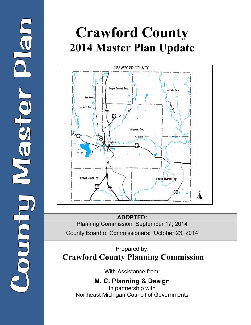
Crawford County 2014 Master Plan Update ADOPTED: Planning Commission: September 17, 2014 County Board of Commissioners: October 23, 2014 Prepared by: Crawford County Planning Commission With Assistance from: M. C. Planning & Design In partnership with Northeast Michigan Council of Governments
-
Upload
khangminh22 -
Category
Documents
-
view
0 -
download
0
Transcript of 2014 Master Plan Update - Crawford County, Michigan
Crawford County 2014 Master Plan Update
ADOPTED:
Planning Commission: September 17, 2014 County Board of Commissioners: October 23, 2014
Prepared by: Crawford County Planning Commission
With Assistance from:
M. C. Planning & Design In partnership with
Northeast Michigan Council of Governments

Crawford County 2014 Master Plan Update
Including Recreation Plan
Prepared by: Crawford County Planning Commission:
Cris Jones, Chair Rick Anderson
Bernie Feldhauser Rick Harland Brian Hulbert Denny Inman
William Johnson Erich Podjaske
Lee Riley
With Participation and Assistance from: Justin Andre Joe Duran
Adopted Planning Commission: September 17, 2014
County Board of Commissioners: October 23, 2014
With Assistance from:
M.C. Planning & Design In partnership with
Northeast Michigan Council of Governments

CRAWFORD COUNTY
MASTER PLAN UPDATE 2014
Table of Contents CHAPTER 1 - INTRODUCTION ..............................................................................................1-1 CHAPTER 2 -SOCIO ECONOMIC CONDITIONS ....................................................................2-1 CHAPTER 3 - COMMUNITY SERVICES AND FACILITIES .....................................................3-1 CHAPTER 4 - NATURAL RESOURCES ..................................................................................4-1
CHAPTER 5 - EXISTING LAND COVER/USE .........................................................................5-1 CHAPTER 6 - RECREATION ..................................................................................................6-1 CHAPTER 7 - STATUS OF PLANNING AND ZONING ...........................................................7-1
CHAPTER 8 - COMMUNITY GOALS AND OBJECTIVES .......................................................8-1 CHAPTER 9 - PUBLIC LANDS ANALYSIS ..............................................................................9-1 CHAPTER 10 - FUTURE LAND USE ..................................................................................... 10-1
CHAPTER 11 - ADOPTION ................................................................................................... 11-1 APPENDIX A PUBLIC INPUT SUPPORTING DOCUMENTS ............................................. A-1 APPENDIX B ADOPTION PROCESS SUPPORTING DOCUMENTS ................................. B-1 APPENDIX C DNR CERTIFICATIONS ............................................................................... C-1
Crawford County 2014 Master Plan Update
Introduction 1-1
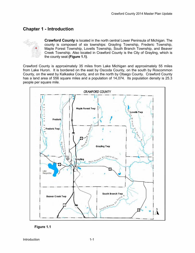
Chapter 1 - Introduction
Crawford County is located in the north central Lower Peninsula of Michigan. The county is composed of six townships: Grayling Township, Frederic Township, Maple Forest Township, Lovells Township, South Branch Township, and Beaver Creek Township. Also located in Crawford County is the City of Grayling, which is the county seat (Figure 1.1).
Crawford County is approximately 35 miles from Lake Michigan and approximately 55 miles from Lake Huron. It is bordered on the east by Oscoda County, on the south by Roscommon County, on the west by Kalkaska County, and on the north by Otsego County. Crawford County has a land area of 556 square miles and a population of 14,074. Its population density is 25.3 people per square mile.
Figure 1.1
Crawford County 2014 Master Plan Update
Introduction 1-2
Purpose and Planning Process The Crawford County Planning was formed under County Planning Act 282 of 1945, and under that law commenced updating the Master Plan. In 2008 the Michigan Planning Enabling Act, P.A. 33 of 2008, replaced the County Planning Act. In accordance the planning act a county may adopt, amend, and implement a master plan. The Michigan Planning Enabling Act states: The general purpose of a master plan is to guide and accomplish, in the planning jurisdiction and its environs, development that satisfies all of the following criteria: (a) Is coordinated, adjusted, harmonious, efficient, and economical. (b) Considers the character of the planning jurisdiction and its suitability for particular uses,
judged in terms of such factors as trends in land and population development. (c) Will, in accordance with present and future needs, best promote public health, safety,
morals, order, convenience, prosperity, and general welfare. (d) Includes, among other things, promotion of or adequate provision for 1 or more of the
following: (i) A system of transportation to lessen congestion on streets. (ii) Safety from fire and other dangers. (iii) Light and air. (iv) Healthful and convenient distribution of population. (v) Good civic design and arrangement and wise and efficient expenditure of public funds. (vi) Public utilities such as sewage disposal and water supply and other public
improvements. (vii) Recreation. (viii) The use of resources in accordance with their character and adaptability.
M.C. Planning & Design in Partnership with NEMCOG, assisted the Crawford County Planning Commission in preparing the 2014 Master Plan Update, which is based in large part on the 2009 Master Plan (prepared with assistance from NEMCOG). Since Crawford County no longer administers zoning in unincorporated areas of the county, this master plan does not address future land use in detail. Future land use planning is addressed at the township and city level in their respective master planning processes, and those local future land use maps are compiled and in this 2014 Master Plan Update. This plan presents background information on social and economic data, natural resources, existing community services and facilities, and existing land cover. The background information is used to identify important characteristics, changes and trends in County. Community zoning maps and future land use maps were stitched together to form composite maps that were reviewed and analyzed for consistency and boundary conflicts. As part of the 2014 Master Plan Update, a recreation plan component was incorporated. Both the County Planning Commission and the Grayling Recreation Authority sponsored public input sessions and additional public meetings during the planning process to solicit public input. Other community workshops and surveys were reviewed to gain an understanding of the issues and concerns of county residents, landowners and local officials. In addition, results of workshops conducted by several townships during their own master plan development and subsequent township goals and objectives were reviewed. Based on this information, the County Planning Commission developed and refined goals and recommendations. The final component involved an analysis of public lands that may be appropriate for transfer into private ownership, and would benefit the county and local communities.
Crawford County 2014 Master Plan Update
Social and Economic Conditions 2-1
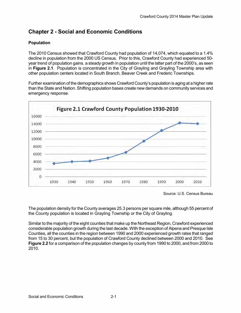
Chapter 2 - Social and Economic Conditions Population The 2010 Census showed that Crawford County had population of 14,074, which equated to a 1.4% decline in population from the 2000 US Census. Prior to this, Crawford County had experienced 50-year trend of population gains. a steady growth in population until the latter part of the 2000’s, as seen in Figure 2.1. Population is concentrated in the City of Grayling and Grayling Township area with other population centers located in South Branch, Beaver Creek and Frederic Townships. Further examination of the demographics shows Crawford County’s population is aging at a higher rate than the State and Nation. Shifting population bases create new demands on community services and emergency response.
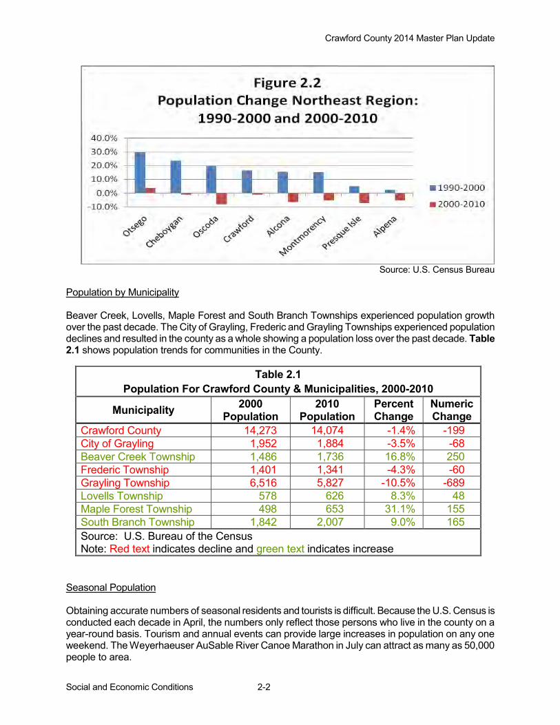
Source: U.S. Census Bureau The population density for the County averages 25.3 persons per square mile, although 55 percent of the County population is located in Grayling Township or the City of Grayling. Similar to the majority of the eight counties that make up the Northeast Region, Crawford experienced considerable population growth during the last decade. With the exception of Alpena and Presque Isle Counties, all the counties in the region between 1990 and 2000 experienced growth rates that ranged from 15 to 30 percent, but the population of Crawford County declined between 2000 and 2010. See Figure 2.2 for a comparison of the population changes by county from 1990 to 2000, and from 2000 to 2010.
Crawford County 2014 Master Plan Update
Social and Economic Conditions 2-2
Source: U.S. Census Bureau
Population by Municipality Beaver Creek, Lovells, Maple Forest and South Branch Townships experienced population growth over the past decade. The City of Grayling, Frederic and Grayling Townships experienced population declines and resulted in the county as a whole showing a population loss over the past decade. Table 2.1 shows population trends for communities in the County.
Seasonal Population Obtaining accurate numbers of seasonal residents and tourists is difficult. Because the U.S. Census is conducted each decade in April, the numbers only reflect those persons who live in the county on a year-round basis. Tourism and annual events can provide large increases in population on any one weekend. The Weyerhaeuser AuSable River Canoe Marathon in July can attract as many as 50,000 people to area.
Table 2.1 Population For Crawford County & Municipalities, 2000-2010
Municipality 2000 Population
2010 Population
Percent Change
Numeric Change
Crawford County 14,273 14,074 -1.4% -199 City of Grayling 1,952 1,884 -3.5% -68 Beaver Creek Township 1,486 1,736 16.8% 250 Frederic Township 1,401 1,341 -4.3% -60 Grayling Township 6,516 5,827 -10.5% -689 Lovells Township 578 626 8.3% 48 Maple Forest Township 498 653 31.1% 155 South Branch Township 1,842 2,007 9.0% 165 Source: U.S. Bureau of the Census Note: Red text indicates decline and green text indicates increase

Crawford County 2014 Master Plan Update
Social and Economic Conditions 2-3
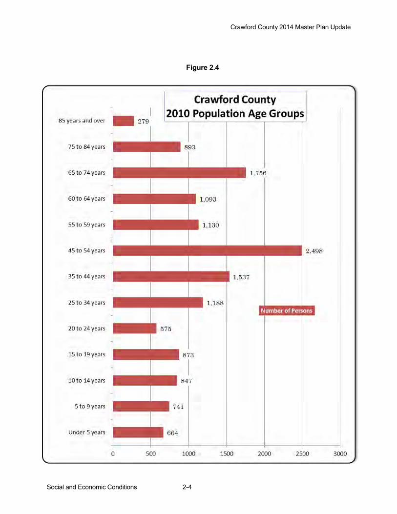
A rough estimate of the number of county seasonal residents can be calculated by multiplying the number of county seasonal housing units by the county's average number of persons per household. The 2010 Census showed that there were 4,535 seasonal housing units in the county and an average household size of 2.5 persons. Considering the additional influx of seasonal visitors or tourists staying in area motels, campgrounds, or family homes, a spike in population could increase the County population by more than 10,000 persons during certain times. These spikes in populations should be acknowledged when identifying hazard mitigation strategies. Age Distribution According to the 2010 Census, Crawford County’s year round population was 14,074 persons. This figure represents a loss of 199 persons or 1.4 percent from the 2000 Census. Even with the loss, the age group of 45 years and older gained population, increasing by 1,571 persons (26% increase). However, the county experienced losses in age groups that represent young families. Youth age group (19 years and younger) lost 703 persons (18.4% decrease) and the adult age group (25-44 years of age) declined by 1,073 persons (28.3% loss). See Figures 2.3 and 2.4, and Table 2.2. The median age of the County has increased from 34.7 years in 1990, to 40.6 years in 2000, and to 47.7 years in 2010. At the same time the State’s median age increase from 32.5 to 38.9 years. The difference in median age between the County and State increased from 1990 to 2010 as the County’s population make-up “ages” at the faster rate, Figure 2.3 In conclusion, shifts in the County’s demographic make-up are changing the population structure. Long term trends in the increase in median age continue at the faster rate than the State of Michigan and US. The rate has increased with the down turn in the economy, as young families move to other areas for employment. An aging population needs access to social and medical services. The county’s emergency response services will experience an increase in demands.
Figure 2.3
Crawford County 2014 Master Plan Update
Social and Economic Conditions 2-4
Figure 2.4
Crawford County 2014 Master Plan Update
Social and Economic Conditions 2-5
Race and Ethnic Composition Information found below on (Table 2.3) shows that Crawford County has a very small minority population and that statistic has changed relatively little over the last several decades. The respondents were given the opportunity to choose more than one race category.
Table 2.3 Population By Race And Ethnicity For Crawford County 2010
Number of Persons % of Total Population
White 13,721 97.5% African American 51 0.4% American Indian 76 0.5% Asian 52 0.4% Pacific Islander 1 >0.1% Other Race 17 0.1% Two or More Races* 156 1.1% Hispanic or Latino Origin** 182 1.3% Total 14,074 100.0% * Census 2010 - opportunity to choose more than one race category. ** Persons of Hispanic or Latino Origin may be of any race. Source: U.S. Bureau of the Census
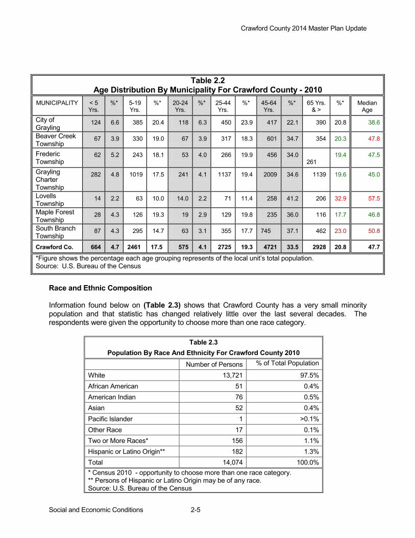
Table 2.2 Age Distribution By Municipality For Crawford County - 2010
MUNICIPALITY < 5 Yrs.
%* 5-19 Yrs.
%* 20-24 Yrs.
%* 25-44 Yrs.
%* 45-64 Yrs.
%* 65 Yrs. & >
%* Median Age
City of Grayling 124 6.6 385 20.4 118 6.3 450 23.9 417 22.1 390 20.8 38.6
Beaver Creek Township 67 3.9 330 19.0 67 3.9 317 18.3 601 34.7 354 20.3 47.8
Frederic Township
62 5.2 243 18.1 53 4.0 266 19.9 456 34.0 261
19.4 47.5
Grayling Charter Township
282 4.8 1019 17.5 241 4.1 1137 19.4 2009 34.6 1139 19.6 45.0
Lovells Township 14 2.2 63 10.0 14.0 2.2 71 11.4 258 41.2 206 32.9 57.5
Maple Forest Township 28 4.3 126 19.3 19 2.9 129 19.8 235 36.0 116 17.7 46.8
South Branch Township 87 4.3 295 14.7 63 3.1 355 17.7 745 37.1 462 23.0 50.8
Crawford Co. 664 4.7 2461 17.5 575 4.1 2725 19.3 4721 33.5 2928 20.8 47.7
*Figure shows the percentage each age grouping represents of the local unit’s total population. Source: U.S. Bureau of the Census

Crawford County 2014 Master Plan Update
Social and Economic Conditions 2-6
Education Since 1990, Crawford County has continued to make increases in educational attainment as shown by Table 2.4. The percent of people in Crawford County age 25 and older who have earned a high school diploma or higher has increased from 73.6 percent in 1990 to 84.4 percent in 2010. There were also significant increases in the number and percent of persons with associates, bachelors, graduate or professional degrees.
Table 2.4 Crawford County Educational Attainment 2000 & 2007-2011
Degree
2000 2007-2011 Number Percent Number Percent
Less than 9th grade 436 4.4 341 3.3 9th to 12th no Diploma 1,457 14.8 1,290 12.4 High School Diploma 3,715 37.6 4,010 38.6 Some college no degree 2,342 23.7 2,288 22.0 Associates 643 6.5 915 8.8 Bachelors 845 8.6 1,041 10.0 Graduate or Professional 433 4.4 515 5.0 Source: U.S. Bureau of the Census 2000 and American Community Survey 2007-2011
Other encouraging news shown by the 2010 census the numbers of persons who only completed 9th to 12th grade and had no diploma and those who had less than a 9th grade have continued to decrease. On a regional scale, post-secondary educational attainment is more likely to be found in the counties of Alpena, Cheboygan, Crawford and Otsego than in the other Northeast Michigan counties (Figure 2.5). This is not surprising, given the fact that community colleges are located in or very near these four counties. Access to four-year colleges and advanced training opportunities are also more readily available in these counties, as are jobs in the manufacturing sector. Some of these jobs require post-secondary education or training.
0
10
20
30
40
50
Figure 2.5Northeast Michigan Educational Attainment 2011
<HS Diploma
HS Graduate, No College
Some College, No Degree
Assoc-Bach Degree
Post Grad Degree
Persons age 25 years or over. Source: American Community Survey 2007-2011
Crawford County 2014 Master Plan Update
Social and Economic Conditions 2-7
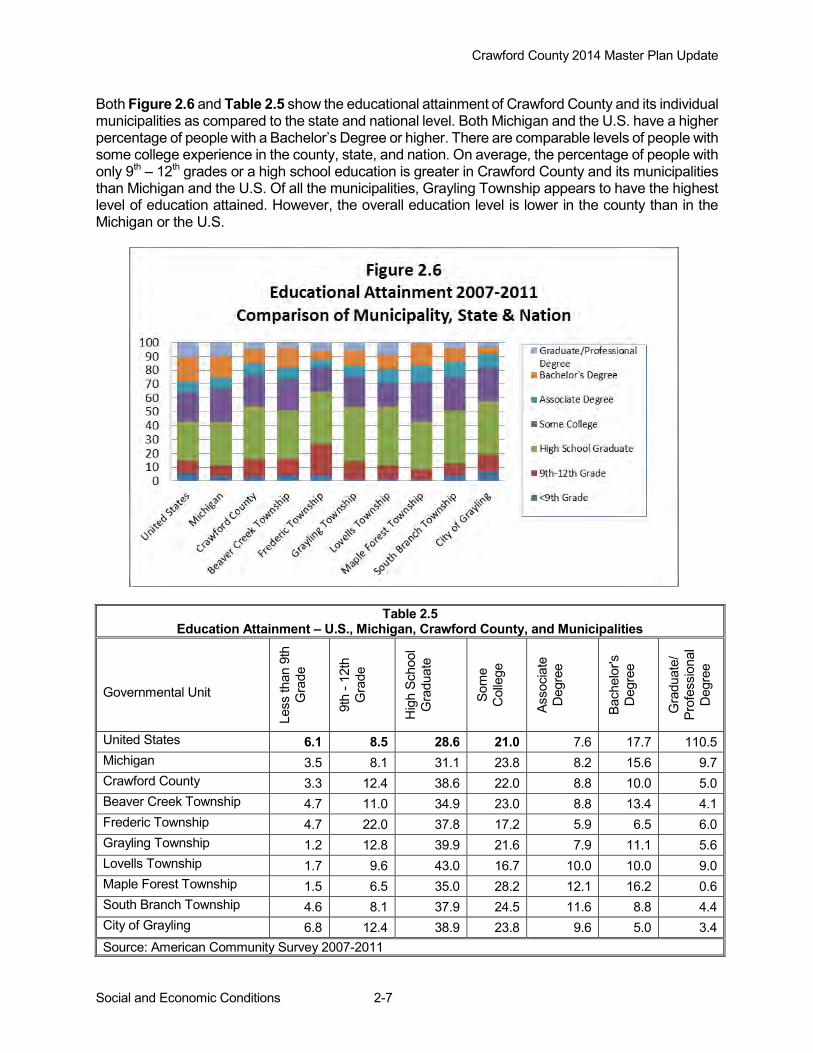
Both Figure 2.6 and Table 2.5 show the educational attainment of Crawford County and its individual municipalities as compared to the state and national level. Both Michigan and the U.S. have a higher percentage of people with a Bachelor’s Degree or higher. There are comparable levels of people with some college experience in the county, state, and nation. On average, the percentage of people with only 9th – 12th grades or a high school education is greater in Crawford County and its municipalities than Michigan and the U.S. Of all the municipalities, Grayling Township appears to have the highest level of education attained. However, the overall education level is lower in the county than in the Michigan or the U.S.
Table 2.5 Education Attainment – U.S., Michigan, Crawford County, and Municipalities
Governmental Unit
Less
than
9th
G
rade
9th
- 12t
h G
rade
Hig
h Sc
hool
G
radu
ate
Som
e C
olle
ge
Asso
ciat
e D
egre
e
Bach
elor
's
Deg
ree
Gra
duat
e/
Prof
essi
onal
D
egre
e
United States 6.1 8.5 28.6 21.0 7.6 17.7 110.5 Michigan 3.5 8.1 31.1 23.8 8.2 15.6 9.7 Crawford County 3.3 12.4 38.6 22.0 8.8 10.0 5.0 Beaver Creek Township 4.7 11.0 34.9 23.0 8.8 13.4 4.1 Frederic Township 4.7 22.0 37.8 17.2 5.9 6.5 6.0 Grayling Township 1.2 12.8 39.9 21.6 7.9 11.1 5.6 Lovells Township 1.7 9.6 43.0 16.7 10.0 10.0 9.0 Maple Forest Township 1.5 6.5 35.0 28.2 12.1 16.2 0.6 South Branch Township 4.6 8.1 37.9 24.5 11.6 8.8 4.4 City of Grayling 6.8 12.4 38.9 23.8 9.6 5.0 3.4 Source: American Community Survey 2007-2011

Crawford County 2014 Master Plan Update
Social and Economic Conditions 2-8
Economic Overview As with much of northern Michigan, Crawford County has long been an area of high poverty, low incomes, and unemployment. This problem is due largely to the lack of high paying, year-round employment for local residents. Although less obvious in Crawford County, Michigan’s economic boom during the 1990s did bring positive economic results. The retail and service sectors have grown, particularly in health care and tourism related fields. Crawford County has become better known in the State as a recreation and retirement destination. Favorable land prices have helped draw new residents and seasonal visitors to the area. The County’s high quality of life, including an abundant natural resource base, has helped sustain the local economy. Income and Poverty Income and poverty statistics for Crawford County show that, although median income in the county has increased by 28 percent, it is still considerably lower than the State. The gap has narrowed over the last few decades to less than 30 percent (Table 2.6). From 1990 to 2000, the poverty rate in Crawford County had modest declines in all categories (Table 2.7). The poverty rate for families with children had only a small reduction of 0.8 percent, while the rate for families with a female householder with no husband present dropped by 4.5 percent. The poverty rate of all individuals dropped by 1.9 percent. Unfortunately, with the economic downturn of the late 2000s, the percent of those living in poverty, as of 2010, rose for most of the categories as seen in Table 2.7
Table 2.6 Median Family Income For Crawford County & State: 2000 & 2010
Year Crawford County Michigan 2000 $37,056 $53,457 2010 $47,500 $60,895
Source: American Community Survey 2007-2011
Table 2.7 Poverty Status For Crawford County: 1990, 2000 & 2007-2011
Category
1990 2000 2007-2011 Percent Percent Percent
Individuals 14.6% 12.7% 17.0% Families 10.8% 10.0% 12.1% Families, no husband present 35.8% 31.3% 27.0% Individuals 65+ 11.8% 7.6% 8.7%
Source: U.S. Bureau of the Census and American Community Survey 2007-2011 Employment and Unemployment Figure 2.7 shows that the county's unemployment rate is again increasing after a period of decline from 1994 to 2000. The unemployment rate peaked in 1994 at 9.9 percent and declined steadily until 1998. The rate remained more or less steady at about 6 percent until 2000. Between 2000 and 2002 the rate rose 2 percent, peaking at 8 percent unemployment rate. As was the case with the State and most of the Country, a slowing national economy exacerbated by the terrorist attack of September 11 were the primary causes for Crawford County’s 1.1 and 1.2 percent rise in the unemployment rate for

Crawford County 2014 Master Plan Update
Social and Economic Conditions 2-9
this time period. These increases were the largest in nine years, and unemployment rose to its highest level since 1995. Following this period, the unemployment rate gradually fell to 6.7 percent by the year 2005. Current data indicates that the jobless rate increased to a recent annual average high of 13.4 percent in 2009, but the annual average rate had improved to 10.1 percent by 2013. Crawford County’s unemployment rate has historically been 3 to 4 points higher than the State and has mirrored the State’s trend.
Employment in Crawford County is most likely to be found in the retail sector, government or services The top job producers in Crawford County are much the same as found in other Northeast Michigan counties: service sector (approximately 28%), followed by the government sector and retail employment at approximately 24 percent and 21 percent respectively. The county’s percentage of jobs in the government sector is the highest percentage in that sector of any in Northeast Michigan (Alpena County, however, has a higher number of government jobs). The county's manufacturing sector is approximately 16 percent of the county's wage and salary employment and "other" employment makes up approximately 68 percent. The smallest sector of the county's economy is employment in mining and construction (less than 4% of the wage and salary employment). Housing Stock Over past decades, Crawford County has experienced a steady increase in number housing units, with a high percentage used as seasonal housing. New housing starts drastically dropped in 2008 with the down turn in the U.S. economy. Housing characteristics from the 2010 US Census are presented in Tables 2.9 and 2.10. The Census identified 11,092 housing units with 6,016 units occupied and 5,076 units vacant within Crawford
Figure 2.7Crawford County Unemployment Rate 1994-2012
0.0%
2.0%
4.0%
6.0%
8.0%
10.0%
12.0%
14.0%
1994
1995
1996
1997
1998
1999
2000
2001
2002
2003
2004
2005
2006
2007
2008
2009
2010
2011
2012

Crawford County 2014 Master Plan Update
Social and Economic Conditions 2-10
County. Grayling Township has the most housing units at 4,289 units (39% of the county total). As in many areas of northern Michigan, Crawford County has a large percentage of seasonal housing units, nearly 41 percent. Frederic, Lovells, and South Branch Townships have percentages of seasonal housing units greater than 40 percent. The City of Grayling has a very low percentage of seasonal housing units (2.25%). Over past decade, the number of residential housing units in the county increased by 10.5 percent (1,050 units) while the permanent population actually decreased by 1.4 percent (199 persons). Table 2.9 shows that between 2000 and 2010, Crawford County's total number of persons per household decreased from 2.42 to 2.31 persons. The percentage of the occupied housing units which are owner-occupied in Crawford County have remained stable over the last decade at approximately 82. Vacancy data is one measure of the availability of housing in a community. Sufficient housing stock, for both owner-occupied and renter-occupied, must be provided to accommodate an expanding population base. According to the Census, Crawford County's housing market vacancy rate was remarkably low in 1990 and 2000, but increased in 2010 (Table 2.8). Throughout the county, owner and renter vacancy rates increased between 2000 and 2010. In 2010 the greatest percent vacancy rate in the County was 13% in Frederic Township. Typical normal vacancy rates of owner-occupied housing are nationally about 5 percent. Crawford County's low percentage indicates a tight housing market and an inadequate supply of available units for new residents. This situation indicates that the demand for housing is not being met through the existing housing stock. Housing characteristics by municipality are found in Table 2.9. As in many areas of northern Michigan, townships in Crawford County have a large percentage of seasonal housing units, particularly in Lovell Township where 67.1% (694 dwellings) are seasonal units. Other areas with high percentages of seasonal housing units are the Townships of South Branch (48%), Beaver Creek (40%), Maple Forest (39%), and Grayling (38%). The City of Grayling has a very low percentage of seasonal housing units (1.2%). Seasonal units are often located on rivers and lakes and can vary from excellent to substandard. Many lots platted in the 1920’s or 1930’s are substandard in size, have private wells and use outdated or inadequate wastewater practices.
Table 2.8 Crawford County Housing Characteristics (2000 - 2010)
Housing Characteristics 2000 2010 % Change Total Housing Units 10,042 11,092 10.5% Total Occupied Units 5,625 6,016 7.0% Owner-Occupied (#) 4,655 4,937 6.1% Owner-Occupied (%) 82.8% 82.1% -0.8% Renter-Occupied (#) 970 1,079 11.2% Renter-Occupied (%) 17.2% 17.9% 4.1%
Total Vacant Units 4,417 5,076 14.9% Seasonal Units 4,112 4,535 10.3% Vacancy Rate:* Owner (%) 1.7% 3.4% Renter (%) 6.3% 10.1% Persons Per Household 2.45 2.31 -5.7%
*Includes units that are vacant, for sale or rent; does not include seasonal units Source: U.S. Bureau of the Census
Crawford County 2014 Master Plan Update
Social and Economic Conditions 2-11
Table 2.9 Crawford County Municipality Housing Characteristics - 2010
Municipality Total* Units
Total Occupied
% Owner Occupied
% Renter Occupied
Total Vacant
% Seasonal*
Vacant % Owner
Vacant % Renter
Crawford County 11,092 6,016 82.1 17.9 5,076 40.9 3.4 10.1
City of Grayling 890 764 47.0 53.0 126 2.2 5.3 11.4
Beaver Creek Township 1,317 733 89.7 10.4 584 39.8 3.9 5.0
Frederic Township 1,231 576 85.9 14.1 655 47.6 2.7 13.3
Grayling Township 4,289 2,464 85.2 14.8 1,825 38.0 2.7 11.7
Lovells Township 1,034 315 91.4 8.6 719 67.1 5.9 0.0
Maple Forest Township 470 263 89.4 10.6 207 38.5 5.2 3.3
South Branch Township 1,861 901 89.2 10.8 960 48.4 2.9 3.9
*Total number of housing units for each municipality **Percent of total housing units used as seasonal housing
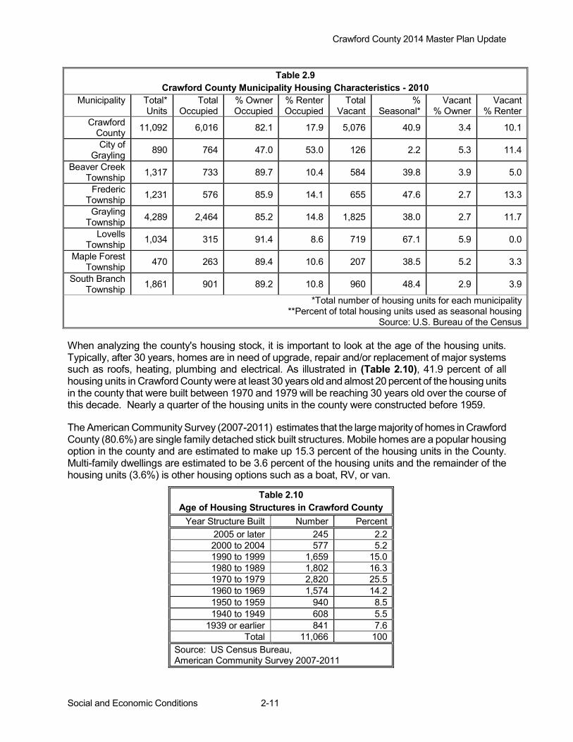
Source: U.S. Bureau of the Census When analyzing the county's housing stock, it is important to look at the age of the housing units. Typically, after 30 years, homes are in need of upgrade, repair and/or replacement of major systems such as roofs, heating, plumbing and electrical. As illustrated in (Table 2.10), 41.9 percent of all housing units in Crawford County were at least 30 years old and almost 20 percent of the housing units in the county that were built between 1970 and 1979 will be reaching 30 years old over the course of this decade. Nearly a quarter of the housing units in the county were constructed before 1959. The American Community Survey (2007-2011) estimates that the large majority of homes in Crawford County (80.6%) are single family detached stick built structures. Mobile homes are a popular housing option in the county and are estimated to make up 15.3 percent of the housing units in the County. Multi-family dwellings are estimated to be 3.6 percent of the housing units and the remainder of the housing units (3.6%) is other housing options such as a boat, RV, or van.
Table 2.10 Age of Housing Structures in Crawford County
Year Structure Built Number Percent 2005 or later 245 2.2 2000 to 2004 577 5.2 1990 to 1999 1,659 15.0 1980 to 1989 1,802 16.3 1970 to 1979 2,820 25.5 1960 to 1969 1,574 14.2 1950 to 1959 940 8.5 1940 to 1949 608 5.5
1939 or earlier 841 7.6 Total 11,066 100
Source: US Census Bureau, American Community Survey 2007-2011

Crawford County 2014 Master Plan Update
Community Services and Facilities 3-1
Chapter 3 - Community Services and Facilities Public Water Supply
The Department of Environmental Quality (DEQ) has primary enforcement authority in Michigan for the Federal Safe Drinking Water Act under the Michigan Safe Drinking Water Act. The DEQ has regulatory oversight for all public water supplies including approximately 1,500 community and 11,000 non-community water supplies. The program also regulates drinking water well drilling for approximately 25,000 new domestic wells drilled each year. Michigan has over 1.12 million households served by private wells, more than any other state. Like most of northern Michigan, Crawford County’s only source of drinking water is groundwater. Public water supply for the County is summarized below: Private Wells: Most of Crawford County’s land area is served by private wells and 2,645 of these wells supply water to County residents. If drinking water comes from a private well, the owner is responsible for the water's safety. EPA rules do not apply to private wells, but the agency recommends that well owners have their water tested annually.
Community Water Systems: Community water systems serve the population year-round, such as in private residences or businesses. There are five active community water systems active in Crawford County, serving a total of 2,776 persons. This figure includes the City of Grayling community system, which supplies drinking water to 1,952 City residents and is maintained by the City of Grayling Department of Public Works. Non-Transient Non-Community Water Systems: Non-transient water systems serve the same population, but not year-round (for example, schools that have their own water system). There are fifteen such water systems active in Crawford County, serving a total of 1,986 persons. Transient Non-Community Water Systems: Transient non-community water systems are systems that do not consistently serve the same population. Rest stops, campgrounds, gas stations, motels and convenience type stores not hooked into a community water supply would be included in this category. Most of the wells in the County that are not considered private wells fall into this group. Eighty such wells are found in the County, serving approximately 20,000 persons. Sewage Disposal The City of Grayling Department of Public Works provides sewer services to the City of Grayling. Residents and business owners in the remainder of the County must rely on private onsite septic systems for wastewater disposal. Currently there are 7,641 households and businesses using these private systems throughout the County. There are several septage haulers located in Crawford County. The method of disposal used by the haulers is land application. The District Health Department regulates and maintains a permitting system for private wells and septic systems, and is responsible for inspection of the septage-hauling operation. A very limited portion of Beaver Creek Township on the North side of Higgins Lake, part of Camp Curnalia is served by sewer system operated by the Higgins Lake Utility Authority, which was completed in 2009. Currently the system serves 405 households, 9 of which are in Beaver

Crawford County 2014 Master Plan Update
Community Services and Facilities 3-2
Creek Township. The system was designed with additional capacity to accommodate future expansion, including potential future connection by Higgins Lake State Park. Solid Waste
Collection of residential and commercial solid waste in Crawford County is accomplished by commercial haulers and by individuals transporting their own waste to the landfill or one of the transfer stations located in many of the townships across the County. Private hauling companies provide residential and commercial service pick-up throughout the county, through private agreements with customers, as well as servicing the township transfer stations. Waste Management, Inc. operates the primary solid waste disposal facility for the County, located in Maple Forest Township. Waste Management and American Waste handle the bulk of solid waste disposal in Crawford County. It continues to be an on-going challenge to provide affordable solid waste disposal and provide recycling choices for individuals and businesses. Recycling: Crawford County currently provides county-wide recycling services via a contract with Grayling Charter Township’s Compacting/Recycle Center. A recycle council moderates all aspects of recycling in the County. The council membership consists of a representative from the City, County, each of the Townships and Camp Grayling. The council serves as an advisory board to County, City and each of the Townships within the County. Residents can recycle certain materials through the use of recycling stations at transfer stations located in the City of Grayling, as well as Beaver Creek, Frederic, Grayling Charter, Lovells, Maple Forest and South Branch Townships. Most of the recyclable materials are then transferred to Grayling Charter Township’s Compacting/Recycle Center for processing. The Compacting/Recycle Center is located west of I-75 on North Down River Road. The recycle council is currently working with Camp Grayling in a continued effort to provide enhanced services and reduce overall costs. Utility Services
Due to the large amount of public land and internal parcels (parcels in the center of a section that does not abut a public road), utility services are lacking in some areas of the County. Costs of providing telephone service to these isolated residences can be prohibitively high. Since these landowners must pay the cost of running the lines, some have chosen not to bear the expense, instead relying on cellular telephones. Gas and Electricity Providers—MichCon provides natural gas service for the County; several sections in the northeast portion do not have natural gas service. Consumer Energy and Great Lakes Energy provide electricity to developed areas within the County. Three-phase service is throughout the County. Three-phase power is needed to support some types of commercial and industrial activities, particularly in businesses that operate heavy machinery or equipment. Telephone and Internet Service— Frontier and AT&T provide telephone service to the largest geographic area of the County, although there are pockets of un-served areas in the county. Additionally, there are a variety of internet, wireless, and cellular telephone services available in Crawford County. Schools and Libraries Most of Crawford County is within the Crawford AuSable School District located on 1135 N. Old US 27, Grayling, MI 49738, Phone: (989) 344-3500. South Branch Township and a portion of Beaver Creek Township are located in the Roscommon Area Public School District located at 702 Lake
Crawford County 2014 Master Plan Update
Community Services and Facilities 3-3
St., Roscommon, MI 48653, Phone: (989) 275-6600. Table 3.1 provides a summary of school districts and schools servicing Crawford County.
The area is served by Kirtland Community College, as well as the M-TEC and University Center in Gaylord for local post-secondary education. The Devereau Memorial Crawford County Library system has four branches to serve the communities of Crawford County. The main branch of the library is located on Plum Street in the City of Grayling, and offers a wide variety of services and programs including internet service, inter-library loans, children’s activities, specialized book sections. The three satellite branches include the Frederic Library, located on Manistee Street in the Frederic Township Governmental Offices and Community Center, the Beaver Creek Library located in Beaver Creek Township on South Grayling Road, and the Lovell Library located in Lovell Township on Twin Bridge Rd. Public Safety
Law Enforcement Crawford County has two local law enforcement agencies, the Sheriff Department, located at 200 W. Michigan Avenue in Grayling and the City of Grayling Police Department located at 1020 City Blvd. in Grayling. The County 911 system is co-located in the Sheriff Department as well as the Crawford County Jail. The County receives Michigan State Police support assigned to the Houghton Lake Post and the Kalkaska Detachment. There are troopers that are assigned to Crawford County that start and aend their shifts at the Michigan State Police Crime Lab located on the I-75 business loop in Grayling. Camp Grayling will provide some law enforcement to Crawford County if needed.
Table 3.1 Crawford County Schools
Crawford AuSable School District School Name Address Students and Staff Grayling Elementary-AuSable Primary School Phone: (989) 344-3604
100 Michigan Ave. Grayling, MI 49738
Students: 712 Staff: 79
Grayling Middle School Phone: (989) 344-3558
500 Spruce St. Grayling, MI 49738
Students: 368 Staff: 43
Grayling High School-Adult Ed Phone: (989) 344-3508
1135 N. Old-27 Grayling, MI 49738
Students: 566 Staff: 55
Roscommon Area Public Schools School Name Address Students and Staff Roscommon Elementary School (989) 275-6610
175 W. Sunset Dr. Roscommon, MI 48653
Students: 510 Staff: 43
Roscommon Middle School Phone: (989) 275-6640
299H W. Sunset Dr. Roscommon, MI 48653
Students: 428 Staff: 44
Roscommon High School Phone: (989) 275-6675
10600 Oakwood Dr. Roscommon, MI 48653
Students: 474 Staff: 41
Source: NEMCOG

Crawford County 2014 Master Plan Update
Community Services and Facilities 3-4
Emergency Medical Services Crawford County maintains Emergency Medical Services (EMS) throughout the county. Mobile Medical Response (MMR) units are located in Beaver Creek Township and the City of Grayling. Frederic and South Branch Townships maintain local Emergency Medical Services (EMS). Fire Services Crawford County has five community fire departments providing fire protection to all areas of the County. In addition, while Camp Grayling has no structural fire department, they do provide assistance with wildland firefighting. There are a total of eight Fire Departments located in Crawford County consisting of: Frederic Township FD, a combination partially paid and full-time fire department covering 108 square miles, and providing fire protection for approximately 1,994 persons. It is located on 6547 Frederic St., Frederic, MI. The Frederic FD provides fire and advanced life support (ALS) ambulance services to Frederic and Maple Forest Townships. The mailing address is PO Box 79, Frederic, MI 49733. Phone (989) 348-8190. Grayling Department of Public Safety(DPS), a combination of partially paid and full-time firefighters covering 180 square miles, and providing fire protection for approximately 8,468. It is located on 1041 City Blvd., Grayling, MI. The mailing address is 1041 City Blvd., Grayling, MI 49738. Phone (989) 348-6319. Grayling DPS provides medical first response along with MMR and Station 1-Frederic EMS. Water sources are located at Pollack Bridge, Euclid Bridge/Portage Creek, Stephan Bridge, Wakeley Bridge, Wilcox Bridge, and Lake Margrethe ½ mile west of Danish Landing Rd. Lovells Township FD, a volunteer fire department covering 108 square miles, and providing fire protection for approximately 626. It is located on 8405 Twin Bridge Rd., Grayling, MI. The mailing address is 8405 Twin Bridge Rd., Grayling, MI 49738. Phone (989) 348-9215. The Lovells Township FD provides fire and first responder services township- wide. The water sources are the lakes in the Township. South Branch Township FD, a combination partially paid and full-time fire department covering 108 square miles, and providing fire protection for approximately 2000. It is located on 5245 N. M-18 Roscommon, MI. The mailing address is 5245 N. M-18, Roscommon, MI 48653. Phone (989) 275-4779. The Township also provides emergency medical ambulance service within the Fire Department. Beaver Creek FD, a partially paid and full-time fire department covering 72 square miles, and providing fire protection for approximately 2000. It is located on 8972 S. Grayling Rd., Grayling, MI. The mailing address is 8972 S. Grayling Rd., Grayling, MI 49738. Phone (989) 275-8548. Mobile Medical Response operates in Crawford County with their primary station located in the City of Grayling and uses the Beaver Creek station as a full time satellite station.
Camp Grayling and Grayling Army Airfield: Fire suppression has been funded through the military. The Camp contracts with the Grayling Department of Public Safety for structural fire suppression and has a seasonal crew for first response on wildfire suppression on military property from March to November.
Crawford County 2014 Master Plan Update
Community Services and Facilities 3-5
DNR Grayling Field Office is located on 1955 Hartwick Pines Rd., Grayling, MI 49738. Phone: (989) 348-6371. The northern two thirds of the county covered out of Grayling field office. DNR Roscommon Field Office is located at 8717 North Roscommon Rd, Roscommon. The southern one third of the county is covered out of the Roscommon Field Office. Medical Facilities
Crawford County has numerous health service establishments. Most of the facilities are located in or near the City of Grayling. The largest medical facility in Crawford County is Mercy Hospital Grayling, a 130 bed facility (90 acute care, 40 long term care) located on 110 Michigan Avenue in Grayling. Troop Medical Clinic located within Camp Grayling addresses troop related medical issues. The Clinic has minimal staff much of the year and is only fully staffed during troop training. Northern Lakes Community Mental Health of Traverse City provides support services to developmentally disabled persons as well as persons needing mental health services. District Health Department #10 is often able to fill health care needs of the community. The Crawford County Branch is located on 220 Meadows Drive in Grayling. Programs offered by the Health Department fall into three categories: home health care services, environmental health services and personal health services. Recreation The lakes, streams and woodlands of the area provide a venue for a variety of recreational activities. Recreation is an important economic factor for the region. See Chapter 6- Recreation for additional details.
Crawford County 2014 Master Plan Update
Natural Resources 4-1
Chapter 4 - Natural Resources
The woodlands, open spaces, wildlife, water, and rolling hills are several key resource values that draw people to both recreate and live in the County. Abundant public lands offer access to thousands of acres of recreational lands for hunting, hiking, wildlife viewing and snowmobiling. Lakes, creeks and streams, especially the Manistee and Au Sable Rivers provide opportunities for fishing, boating and water sports. Special recreation areas such as the Mason Tract are additional draws to the County. A rural landscape, abounding with views of forestlands and wetlands, typifies the community character of Crawford County. Forestlands are important to the local economy; recreational use and production of forest goods bring dollars into the Community. Many long time visitors decide to move to the area upon retirement. These renewable yet priceless resources warrant special considerations when planning for future growth.
The protection and wise use of these natural resources are central to maintaining a sustainable community. Along with planning for the built-up infrastructure like roads and utilities, a community needs to plan for the green infrastructure; the forests, wetlands, farmland and water. Development, without consideration of carrying capacity of the land, can have long term negative impacts on the resources. When planning for future growth, the community must identify environmental constraints, such as wetlands, steeply sloped areas, ecological corridors and ground water recharge zones. This chapter will analyze the physical environment to assist local officials in developing a desired future of the County. Natural resources addressed include climate, geology, topography, soils, water, vegetation and wildlife. Climate The climate is yet another reason why people are drawn to the area. Typical of northern Michigan, the distinct four seasons offer an ever-changing landscape. Long snowy, cold winters; and moderately warm summers are separated by a cool, green spring and a cool colorful fall. Located in the north central part of the northern lower peninsula, the County is approximately 35 miles inland from Lake Michigan and 55 miles inland from Lake Huron. Given this geographic location, with the exception of lake effect snowfall, the weather is not significantly influenced by the lake moderating effect of both Great Lakes. Table 4.1 shows the average temperature and precipitation by month calculated over a 30-year period. Moderately warm temperatures dominate summers. The warmest days occur in the month of July and between the years of 1981-2010, there was an average of six days per year that exceeded the 90-degree mark. There were no temperatures over 100 degrees in the 30-year period and temperatures in the high 80’s have occurred as early as April and as late as October. Normal temperatures for the area range from the high 70’s to the low in the high 40’s in the summer and from the high 20’s to single digits in the winter. The following temperature extremes for the station in Crawford County are: maximum, 104 F, recorded July 11, 1936; minimum, -45 F, recorded February 3, 1898; warmest monthly mean, 75.5 F recorded in July of 1921; and coldest monthly mean, 4.4 F was recorded February 1904.
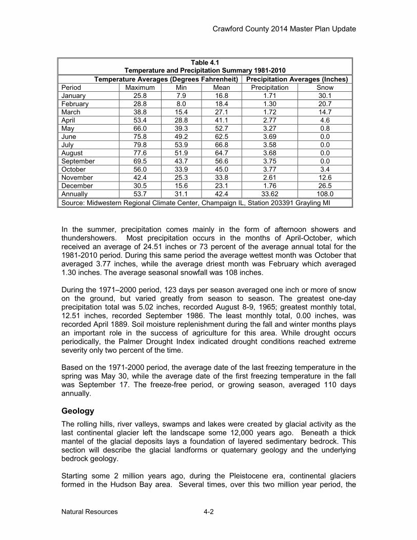
Crawford County 2014 Master Plan Update
Natural Resources 4-2
In the summer, precipitation comes mainly in the form of afternoon showers and thundershowers. Most precipitation occurs in the months of April-October, which received an average of 24.51 inches or 73 percent of the average annual total for the 1981-2010 period. During this same period the average wettest month was October that averaged 3.77 inches, while the average driest month was February which averaged 1.30 inches. The average seasonal snowfall was 108 inches. During the 1971–2000 period, 123 days per season averaged one inch or more of snow on the ground, but varied greatly from season to season. The greatest one-day precipitation total was 5.02 inches, recorded August 8-9, 1965; greatest monthly total, 12.51 inches, recorded September 1986. The least monthly total, 0.00 inches, was recorded April 1889. Soil moisture replenishment during the fall and winter months plays an important role in the success of agriculture for this area. While drought occurs periodically, the Palmer Drought Index indicated drought conditions reached extreme severity only two percent of the time. Based on the 1971-2000 period, the average date of the last freezing temperature in the spring was May 30, while the average date of the first freezing temperature in the fall was September 17. The freeze-free period, or growing season, averaged 110 days annually. Geology The rolling hills, river valleys, swamps and lakes were created by glacial activity as the last continental glacier left the landscape some 12,000 years ago. Beneath a thick mantel of the glacial deposits lays a foundation of layered sedimentary bedrock. This section will describe the glacial landforms or quaternary geology and the underlying bedrock geology. Starting some 2 million years ago, during the Pleistocene era, continental glaciers formed in the Hudson Bay area. Several times, over this two million year period, the
Table 4.1 Temperature and Precipitation Summary 1981-2010
Temperature Averages (Degrees Fahrenheit) Precipitation Averages (Inches) Period Maximum Min Mean Precipitation Snow January 25.8 7.9 16.8 1.71 30.1 February 28.8 8.0 18.4 1.30 20.7 March 38.8 15.4 27.1 1.72 14.7 April 53.4 28.8 41.1 2.77 4.6 May 66.0 39.3 52.7 3.27 0.8 June 75.8 49.2 62.5 3.69 0.0 July 79.8 53.9 66.8 3.58 0.0 August 77.6 51.9 64.7 3.68 0.0 September 69.5 43.7 56.6 3.75 0.0 October 56.0 33.9 45.0 3.77 3.4 November 42.4 25.3 33.8 2.61 12.6 December 30.5 15.6 23.1 1.76 26.5 Annually 53.7 31.1 42.4 33.62 108.0 Source: Midwestern Regional Climate Center, Champaign IL, Station 203391 Grayling MI
Crawford County 2014 Master Plan Update
Natural Resources 4-3
massive sheets of ice built up and inched their way south across what is today Michigan. The massive ice sheets, more than one mile thick, advanced in a southerly direction, bulldozing their way across the landscape. The glacier pushed material in front of it, incorporated rocks and soil into the debris laden ice; and scraped, ground, and broke apart the sedimentary bedrock of the Michigan Basin. Each advance and retreat of the continental glaciers took tens of thousands of years. This reoccurring process shaped and reshaped the land; obliterating and then creating hills, valleys, rivers and lakes, swamps and marshes. The last glacial period, called the Wisconsin era, created the landscape we know today. The glacier left behind boulders, rocks, cobble, sand, gravel, silt, clay and loam. In some areas the material was deposited in unsorted masses called till plains, ground moraines and end moraines. Water flowing from the melting glaciers also sorted materials, creating outwash channels, sand deltas, kames and eskers. Fine materials, captured in the fast moving glacial meltwater, settled to the bottom of expansive glacial lakes creating lacustrine clay and silt plains. Figure 4.1 from “The Glacial Lakes around Michigan,” by William R. Farrand, shows how glacial landforms were created. According to the USDA Crawford County Soil Survey, the county has three main physiographic regions. The northwestern and north-central parts of the County are characterized by a series of four high plateau-like remnant moraines that were dissected by glacial meltwater. The remnant moraine landforms have a north-south linear orientation and are referred to as the Grayling fingers. The second landform region is located in the central and northeastern parts of the county. These areas are characterized by nearly level to gently sloping outwash plains. The mainstream and north branch of the Au Sable River are located in this region. The streams have cut shallow valleys in the outwash materials. The third landform region. located in the south part of the County, consists of a nearly level to gently sloping plain that is interrupted by a series of high kame moraines. Much of the gently sloping plain is over washed with sand. The kame moraines have a general east-west orientation. Some of the highest elevations in the county are found on these kames. There are several small postglacial lake plains, dominated by loam and clay, in the County. At the front of the massive retreating glaciers, large streams originated from the melting ice. The debris laden water carved through moraines creating wide drainageways and outwash channels. The Au Sable River and Manistee River further to the west are located in the glacial drainageways. These areas are dominated by sands and organic muck soils. As the continental glaciers melted, huge blocks of ice became separated from the retreating ice front. The ice blocks became embedded in the glacial debris deposited by the retreating glacier. The embedded ice blocks eventually melted and left depressions (kettle holes) which are today's inland lakes, associated wetlands and bogs. Beneath the glacial deposits, some 200 to 300 feet below the surface, is sedimentary bedrock that was created during the Late Mississippian ages of the Paleozoic Era. The bedrock was formed in ancient seas, which covered the area some 310- 345 million years ago. The shallow marine seas deposited layers of silt, clay, sediments, marine animals, plants, coral, and other calcareous materials. These deposits formed shale, sandstone and limestone bedrock. According to the 1987 Bedrock Geology of Northern Michigan map, prepared by the Geological Survey Division of the Michigan Department of Environmental Quality, the upper layer of bedrock is Coldwater shale. Other bedrock formations beneath the glacial overburden include the Michigan Formation and Marshall

Crawford County 2014 Master Plan Update
Natural Resources 4-4
Formation. Natural gas deposits have been discovered in the Michigan and Marshal formation. Recent proposals to explore for gas adjacent to the Mason Tract have caused concerns with many groups. Concerns are the proposed drilling and associated road widening, flow line/pipeline burying, and constructed facilities (if needed) would reduce the quality of the outdoor recreation experience of visitors to the Mason Tract. The US Forest Service completed an Environmental Assessment in the fall of 2004 and authorized drilling adjacent to the Tract. The authorization is being appealed.
Figure 4.1 Glacial Landforms
Crawford County 2014 Master Plan Update
Natural Resources 4-5
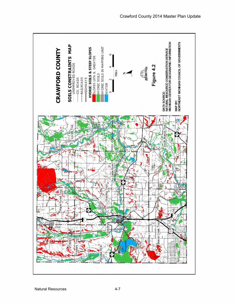
Topography Most of the county is nearly level or gently rolling. Local differences in elevation are slight, in a few places exceeding 100 feet, although the hills and plateau-like ridges appear to rise above adjacent sand plains when viewed from a distance. Slopes of hilly land are both long and expansive or, where the relief is choppy, smooth and rounded. There are no steep slopes except along watercourses. The northern part of the county consists of three broad highland plateaus, having a general north-south direction, three complementary broad sand valleys, and a wide sandy plain on the east. The central part, from eastern to western boundaries, is a wide level sand plain through which the AuSable River and its tributaries have cut valleys. Several detached swells or ridges, irregular in outline but having general east to west trends, characterize the southern part of the county. Here the general relief is gently rolling or moderately hilly. Level sand plain and swamps intervene between masses of higher land. The highest elevation, ranging from 1,300 to 1,480 feet above see level, can be found on kame moraines in the southeastern parts of the county. The lowest elevation of 1,010 feet above sea level, noted on USGS quadrangle maps, is located in the eastern edge of the County where the main branch of the Au Sable River flows into Oscoda County. Soils The soils of Crawford County are generally sandy with low fertility and low moisture-holding capacity. Few loamy soils are found in the northwest portion of the county. Portions of the county have building limitations due to poor filtration of septic effluents. The two predominant soil associations in Crawford County are: Grayling-Rubicon (nearly level to undulating, well drained sandy soils on outwash plains); and Grayling-Graycalm-Montcalm (rolling to hilly, well-drained sandy soils, on uplands). Found in the northwest portion of the county are significant beds of a third association, Kalkaska-Blue Lake (sloping to steep, well-drained sandy soils, on the side of ridges and escarpment-like features enclosing upland valleys). When planning for types and intensity of land uses, soil types and slopes are two important factors that determine the carrying capacity of land. The construction of roads, buildings and septic systems on steeply sloped areas or areas with organic and hydric soils require special design considerations. In addition, costs for developing these sensitive areas are greater than in less constrained parts of the landscape. If developed improperly, the impacts to natural resources can be far reaching. The Natural Resource Conservation Service completed a detailed soil survey of Crawford County. A digital or computerized version of the soil survey maps was acquired from the Michigan Department of Natural Resources, MIRIS program. Using information contained within the published soil survey book, a series of maps are presented that depict hydric soils, steep slopes, soils with building limitations and soils with septic system limitations. Hydric Soils and Steeply Sloped Areas Figure 4.2 is a color thematic map that classifies hydric soils and soils on steep slopes. Lower density and less intensive development should be directed to these areas with severe building constraints. Hydric soils are saturated, flooded or ponded during part of the

Crawford County 2014 Master Plan Update
Natural Resources 4-6
growing season and are classified as poorly drained and very poorly drained. Hydric soils have poor potential for building site development and sanitary facilities. Wetness and frequent ponding are severe problems that are difficult and costly to overcome. Sites with high water tables may be classified as wetlands and a wetlands permit would be required to develop these areas. Less than ten percent of the County is mapped as hydric soils with a high potential for wetlands. The hydric soils are mainly located adjacent to streams and lakes. The largest concentrations are found in the central portions and northern portions of the community. Note the green areas or hydric soils are typically drained by creeks and streams that in turn empty in the major rivers. This connectivity of riparian wetlands and surface water features can be seen throughout the landscape. Hills and steeply rolling terrain may provide opportunities for spectacular views of the landscape. However, steeply sloped sites have severe building constraints, are more difficult and costly to develop. Maintenance costs tend to be higher on steeply sloped terrain. Special design standards such as erosion control measures, limiting size of disturbed areas, retaining natural vegetation, revegetation, slope stabilization and on-site retention of water run-off from impervious surfaces would all serve to minimize resource impacts. According to information presented in the Crawford County Soil Survey areas with slopes 18 percent and greater are minimal. Of greatest concern are steeply sloping hillsides adjacent waterways. Steeply slopes areas are depicted in red on Figure 4.2. Note the large area mapped as steep slopes in the northern part of the county. This anomaly is related to the bombing range of Camp Grayling. Building Site Development The USDA soil survey of Crawford County rates soils for various uses such as building site development and identifies the limiting factors such as steep slopes or high water table. The rating system is slight, moderate and severe limitations. Using the rating system developed by USDA, soil limitations for buildings without basements have been mapped and are displayed in Figure 4.3. Areas with well drained soils and slopes less than 10 percent tend to have slight limitations for building development. Areas with steep slopes, high water tables and organic soils have severe limitations. Lands with severe constraints are scattered throughout the County, but tend to be more prevalent near streams and in the northeast and southeast parts of the county. Due to the prevalence of sandy soils in Crawford County large areas have slight to moderate limitations for buildings. Septic Systems Using a computer mapping system soils maps have been color coded to show areas with slight to severe septic system limitations as defined by the USDA Natural Resource Conservation Service. Criteria include depth to water table, wetness, filtering capacity and ability to perc water. Figure 4.4 is a septic system limitations map. Much of the County is classified as having severe limitations. Clearly the greatest limiting factor is the prevalence of sandy soils with severe limitations due to poor filtration of septic effluents. This is a critical issue when the water table is close to the surface or when high density development occurs. Limiting types and density of development or making public water and sewer available for high density development are likely the best options for protecting the groundwater resources.
Crawford County 2014 Master Plan Update
Natural Resources 4-7
Figu
re 4
.2

Crawford County 2014 Master Plan Update
Natural Resources 4-8
Figu
re 4
.3

Crawford County 2014 Master Plan Update
Natural Resources 4-9
Figu
re 4
.4
Crawford County 2014 Master Plan Update
Natural Resources 4-10
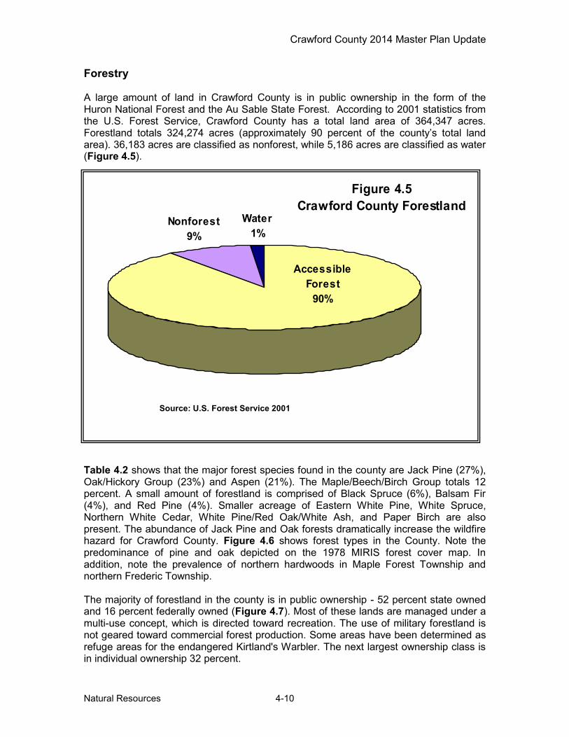
Forestry A large amount of land in Crawford County is in public ownership in the form of the Huron National Forest and the Au Sable State Forest. According to 2001 statistics from the U.S. Forest Service, Crawford County has a total land area of 364,347 acres. Forestland totals 324,274 acres (approximately 90 percent of the county’s total land area). 36,183 acres are classified as nonforest, while 5,186 acres are classified as water (Figure 4.5).
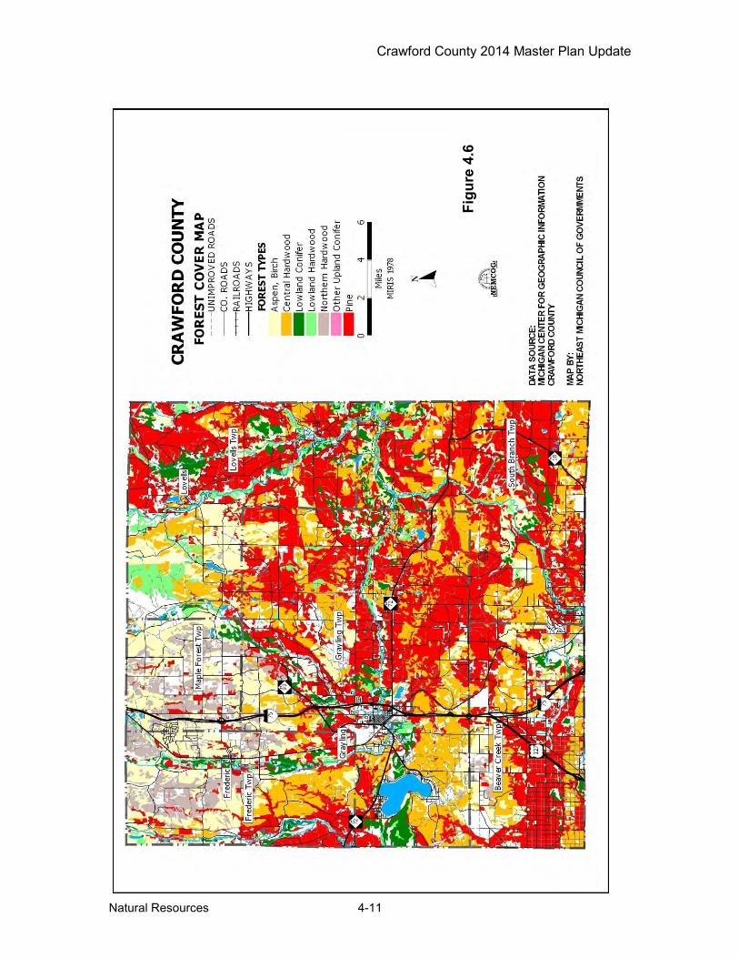
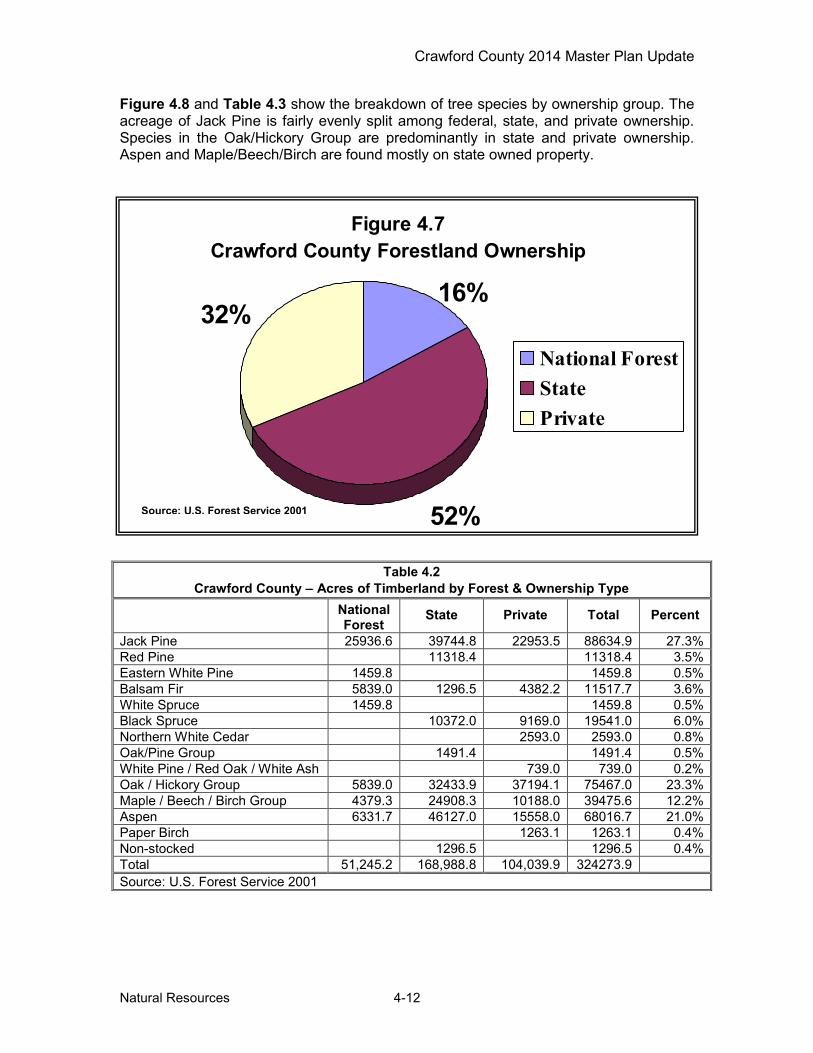
Table 4.2 shows that the major forest species found in the county are Jack Pine (27%), Oak/Hickory Group (23%) and Aspen (21%). The Maple/Beech/Birch Group totals 12 percent. A small amount of forestland is comprised of Black Spruce (6%), Balsam Fir (4%), and Red Pine (4%). Smaller acreage of Eastern White Pine, White Spruce, Northern White Cedar, White Pine/Red Oak/White Ash, and Paper Birch are also present. The abundance of Jack Pine and Oak forests dramatically increase the wildfire hazard for Crawford County. Figure 4.6 shows forest types in the County. Note the predominance of pine and oak depicted on the 1978 MIRIS forest cover map. In addition, note the prevalence of northern hardwoods in Maple Forest Township and northern Frederic Township. The majority of forestland in the county is in public ownership - 52 percent state owned and 16 percent federally owned (Figure 4.7). Most of these lands are managed under a multi-use concept, which is directed toward recreation. The use of military forestland is not geared toward commercial forest production. Some areas have been determined as refuge areas for the endangered Kirtland's Warbler. The next largest ownership class is in individual ownership 32 percent.
Figure 4.5Crawford County Forestland
Nonforest9%
Water1%
Accessible Forest
90%
Source: U.S. Forest Service 2001
Crawford County 2014 Master Plan Update
Natural Resources 4-11
Figu
re 4
.6
Crawford County 2014 Master Plan Update
Natural Resources 4-12
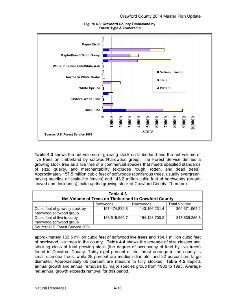
Figure 4.8 and Table 4.3 show the breakdown of tree species by ownership group. The acreage of Jack Pine is fairly evenly split among federal, state, and private ownership. Species in the Oak/Hickory Group are predominantly in state and private ownership. Aspen and Maple/Beech/Birch are found mostly on state owned property.
Table 4.2 Crawford County – Acres of Timberland by Forest & Ownership Type
National Forest
State Private Total Percent
Jack Pine 25936.6 39744.8 22953.5 88634.9 27.3% Red Pine 11318.4 11318.4 3.5% Eastern White Pine 1459.8 1459.8 0.5% Balsam Fir 5839.0 1296.5 4382.2 11517.7 3.6% White Spruce 1459.8 1459.8 0.5% Black Spruce 10372.0 9169.0 19541.0 6.0% Northern White Cedar 2593.0 2593.0 0.8% Oak/Pine Group 1491.4 1491.4 0.5% White Pine / Red Oak / White Ash 739.0 739.0 0.2% Oak / Hickory Group 5839.0 32433.9 37194.1 75467.0 23.3% Maple / Beech / Birch Group 4379.3 24908.3 10188.0 39475.6 12.2% Aspen 6331.7 46127.0 15558.0 68016.7 21.0% Paper Birch 1263.1 1263.1 0.4% Non-stocked 1296.5 1296.5 0.4% Total 51,245.2 168,988.8 104,039.9 324273.9 Source: U.S. Forest Service 2001
Figure 4.7Crawford County Forestland Ownership
52%
32%16%
National ForestStatePrivate
Source: U.S. Forest Service 2001
Crawford County 2014 Master Plan Update
Natural Resources 4-13
Table 4.3 shows the net volume of growing stock on timberland and the net volume of live trees on timberland by softwood/hardwood group. The Forest Service defines a growing stock tree as a live tree of a commercial species that meets specified standards of size, quality, and merchantability (excludes rough, rotten, and dead trees). Approximately 157.5 million cubic feet of softwoods (coniferous trees, usually evergreen, having needles or scale-like leaves) and 143.2 million cubic feet of hardwoods (broad-leaved and deciduous) make up the growing stock of Crawford County. There are
approximately 163.5 million cubic feet of softwood live trees and 154.1 million cubic feet of hardwood live trees in the county. Table 4.4 shows the acreage of size classes and stocking class of total growing stock (the degree of occupancy of land by live trees) found in Crawford County. Thirty-eight percent of the forest acreage in the county is small diameter trees, while 28 percent are medium diameter and 32 percent are large diameter. Approximately 66 percent are medium to fully stocked. Table 4.5 depicts annual growth and annual removals by major species group from 1980 to 1993. Average net annual growth exceeds removal for this period.
Table 4.3 Net Volume of Trees on Timberland in Crawford County
Softwoods Hardwoods Total Volume Cubic feet of growing stock by hardwood/softwood group
157,474,832.8 143,196,231.4 300,671,064.2
Cubic feet of live trees by hardwood/softwood group
163,515,556.7 154,123,700.2 317,639,256.8
Source: U.S Forest Service 2001
0
1000
0
2000
0
3000
0
4000
0
5000
0
6000
0
7000
0
8000
0
9000
0
1000
00
Jack Pine
Eastern White Pine
White Spruce
Northern White Cedar
White Pine/Red Oak/White Ash
Maple/Beech/Birch Group
Paper Birch
ACRES
National Forest
State
Private
Figure 4.8: Crawford County Timberland by Forest Type & Ownership
Source: U.S. Forest Service 2001
Crawford County 2014 Master Plan Update
Natural Resources 4-14
Table 4.4 Crawford County Timber Stock
Area of Timberland By Stand Size Class (acres) Large Diameter Medium Diameter Small Diameter Non-stocked
104,904 93,866 124,207 1297 32.4% 28.9% 38.3% 0.4%
Stocking Class of Growing Stock Trees (acres)* Overstocked Fully Stocked Medium Stocked Poorly Stocked Non-stocked
64,504 109,548 103,970 45,577 674 19.9% 33.8% 32.1% 14.1% 0.2%
*An overstocked stand is defined as one in which stocking of live trees is 133% or more. Fully stocked stands are those in which stocking of live trees is 100 – 132.9%. Medium stocked stands are 60 - 99.9% stocked, poorly stocked stands have only 16.7 – 59.9% live trees stock, and a stand is considered non-stocked if live tree stock is less than 16.7%. Source: U.S. Forest Service 2001
Table 4.5 Annual Growth & Removal
Average Net Annual Growth
1980-1993
Growing Stock
(1000 Cu. ft.)
Saw Timber (1000 Board ft.)
Average Net Annual Removal
1980-1993
Growing Stock (1000 cu. ft.)
Saw Timber (1000 Board ft.)
Pine 2,936 13,963 Pine 545 1,697 Other Softwoods 365 1,495 Other Softwoods 0 0 Soft Hardwoods 2,252 5,628 Soft Hardwoods 1,342 1,903 Hard Hardwoods 3,155 11,300 Hard Hardwoods 1,614 1,313 TOTAL 8,708 32,386 TOTAL 3,501 4,319 Source: U.S. Forest Service 1993
Groundwater Resources Groundwater can be found in the deep glacial deposits of sand and gravel throughout the county. The availability of groundwater appears consistently good, ranging from 400 to 500 gallons per minute from wells ten inches in diameter. Ground water provides the only source of potable water for the county. Because of the deep sand and gravel underlying the county, the aquifer is quite vulnerable to contamination from surface and subsurface discharges. Surface Water Resources Crawford County has an abundance of lakes and streams (Figure 4.9). The county has a total of 53 lakes that are one acre or larger. The largest body of water in the county is Lake Margrethe, with a surface area of 1,928 acres, an average depth of 16 feet and a maximum depth of 65 feet. A portion of Higgins Lake (approximately 24 acres of surface water and one mile of shoreline) is located within the County. Seven lakes are over 100 acres. The large majority of the lakes are less than 50 acres in size. The county is predominantly within the Au Sable watershed. The Manistee River drains the western portion of the county. There are 45 miles of inland shoreline in Crawford County with approximately 25 miles open to the public. Almost all of the lakes and streams provide good fishing and many tourists come to the county to
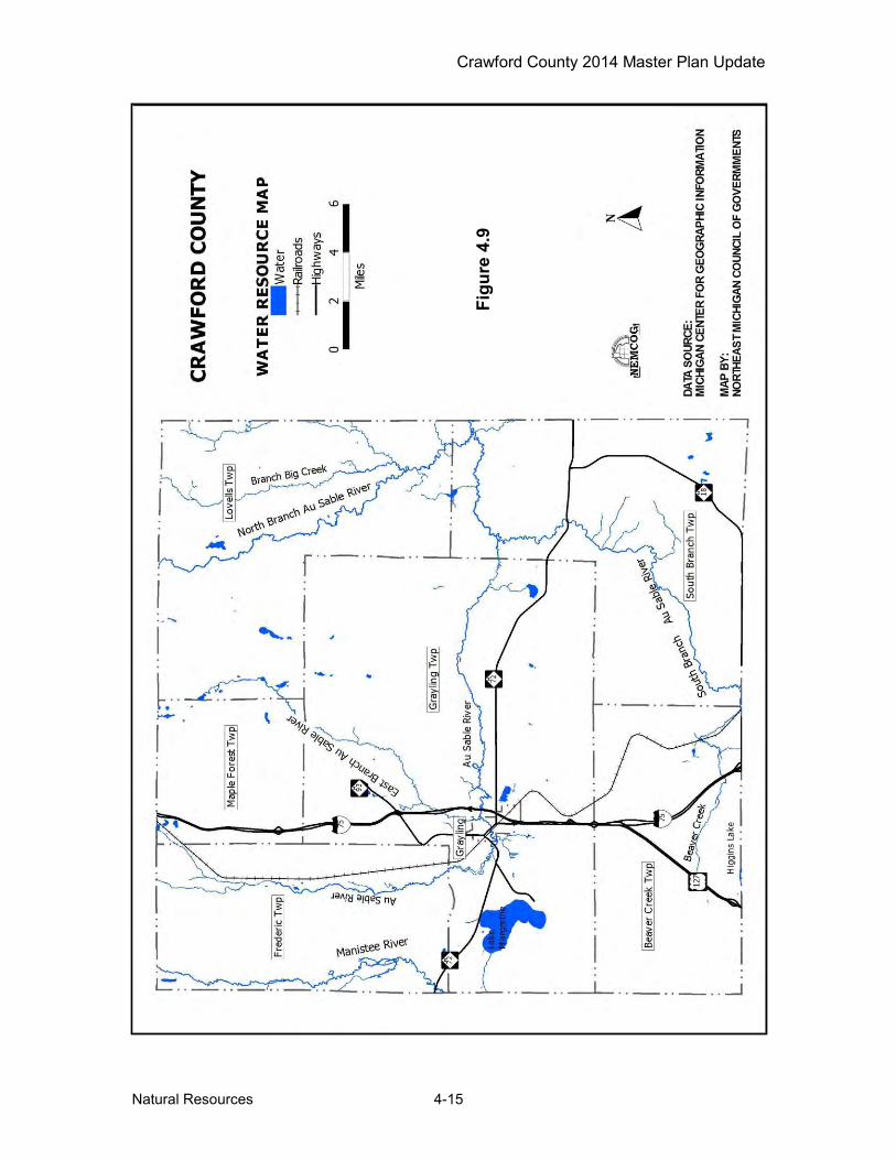
Crawford County 2014 Master Plan Update
Natural Resources 4-15
Figu
re 4
.9
Crawford County 2014 Master Plan Update
Natural Resources 4-16
fish. The lake is at the headwaters of the Manistee River watershed and is a popular recreational and tourist area in the county. Other significant lakes in the county include Shupac Lake, Shellengarger Lake and Jones Lakes. Smaller lakes are quite numerous. The lakes and streams in the county are popular tourist attractions and are heavily used in the summer and winter months. Canoeing and fishing are very popular on the rivers, with swimming and boating being popular on the larger lakes. The Au Sable River watershed drains approximately 1,932 square miles within portions eight counties. The main branch enters the County in the northwest corner and flows out of the southeast corner. An eight mile stretch of the Main Branch of the Au Sable, east of Grayling, from Burton's Landing downstream to Wakely Bridge, is designated flies-only, no-kill water. This segment is known as "the Holy Water." The East Branch, North Branch and South Branch all flow into the Crawford County and empty into the main stream as it traverses the County. The Au Sable is rated as a “Blue-Ribbon” trout stream and is designated as a Michigan Natural River. Since 1947, the Au Sable River Canoe Marathon, a yearly 120 mile (190 km) pro-am canoe race, runs the river from Grayling to Oscoda. The Upper Manistee River watershed drains 565 square miles and covers portions of five counties. The Upper Manistee River flows through the western edge of the County. The stretch of the River in Crawford County is supports an excellent trout fishery with fishing landmarks such as Deward, Cameron Bridge, and Goose Creek Camp. It is a state designated “Blue Ribbon Trout Stream” from Deward downstream through the County. The Au Sable River and Upper Manistee River are designated Natural Rivers under the Michigan Natural Rivers Act (Part 305 N.R.P. Act (1994 PA 451)). The Michigan Department of Natural Resources enacted natural rivers zoning ordinances for each river. The ordinances are administered by local communities in the County. Fish and Wildlife The predominance of forested land and surface water makes Crawford County the home to many species of fish and wildlife. The recreational opportunities linked with these resources are many. With over 3,000 acres of lakes and streams, the County has an abundance and variety of fish habitat. Many of the streams in Crawford County are suitable for trout fishing. Three branches of the AuSable River are designated Blue Ribbon Trout Streams. Brook, rainbow, and brown are established singly or in combination in these streams. Many of the deeper lakes in the County also contain trout, including Glory, Bright, Sandhill, and Kneff Lake. Other lakes in the County support populations of rock bass, yellow perch, blue gills, small mouth bass, large mouth bass, tiger muskie, northern pike, and walleye. Lake Margrethe, the largest lake in the County, has a wide variety of pan fish and sports fish. In 2006, the Department of Natural Resources established guidelines to develop a process to create quality fishing lakes by designation. Based on the newly developed criteria, Jones Lake has been placed into the ‘Quality Lakes’ designation. Wildlife abundant in the County includes deer, rabbit, grouse and woodcock. Bear, coyote, bobcat, elk and turkey have small to moderate populations that are growing. Wildlife is a resource that brings in hunters and tourists. October and November bring thousands of hunters to the county for small game hunting, bear and bow season (deer), peaking sharply in mid-November with the opening day of deer (rifle) season.
Crawford County 2014 Master Plan Update
Natural Resources 4-17
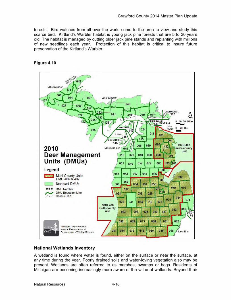
Unfortunately, large deer populations, combined with indiscriminate feeding practices, were contributing factors to the spread of Bovine Tuberculosis (TB) across northern Michigan. TB is a serious disease caused by bacteria attacking the respiratory system. There are three main types of TB - human, avian, and bovine. Human TB is rarely transmitted to non-humans, and avian TB is typically restricted to birds. Bovine TB - also known as 'cattle TB' is the most infectious of the three, and is capable of infecting most mammals. In addition to the 509 infected deer reported throughout the State, Michigan has found several other species to be infected with the disease, including four elk, and several coyotes, raccoons, black bear, bobcats, red fox and opossums. The disease has been confirmed in 33 cattle herds to date, but none during the last testing season. Two humans and one domestic house cat have also been diagnosed with the same unique strain of TB found in deer and cattle. While 96% of the Bovine TB infected deer came from five counties in northern Michigan (Alpena, Alcona, Montmorency, Oscoda and Presque Isle), the impact of this disease has been nonetheless felt in Crawford County. As of the 2005 testing season, four deer and one coyote have tested positive for TB in the County. The effort to eradicate the disease has led to an aggressive TB testing campaign and the creation of a 42 county surveillance area and a seven county Deer Management Unit (DMU) that is subject to special regulations. Hunters in the surveillance area are asked to submit deer heads for testing, in DMU 452 (the core area covering portions of the four counties directly east and northeast of Crawford County) testing was mandatory until 2002, but testing is now on a voluntary basis. While Crawford County had been included in the seven County DMU area in 2005, as of 2010 Crawford County was not included in the multi-county DMU (see Figure 4.10). The situation continues to be monitored and as of 2014 Crawford County is still excluded. Efforts to eradicate the disease has led to changes in deer feeding rules, quota increases, extension of the number of hunting days and the banning of new deer or elk farms. As the eradication effort continues, more changes in hunting and feeding rules can be expected.
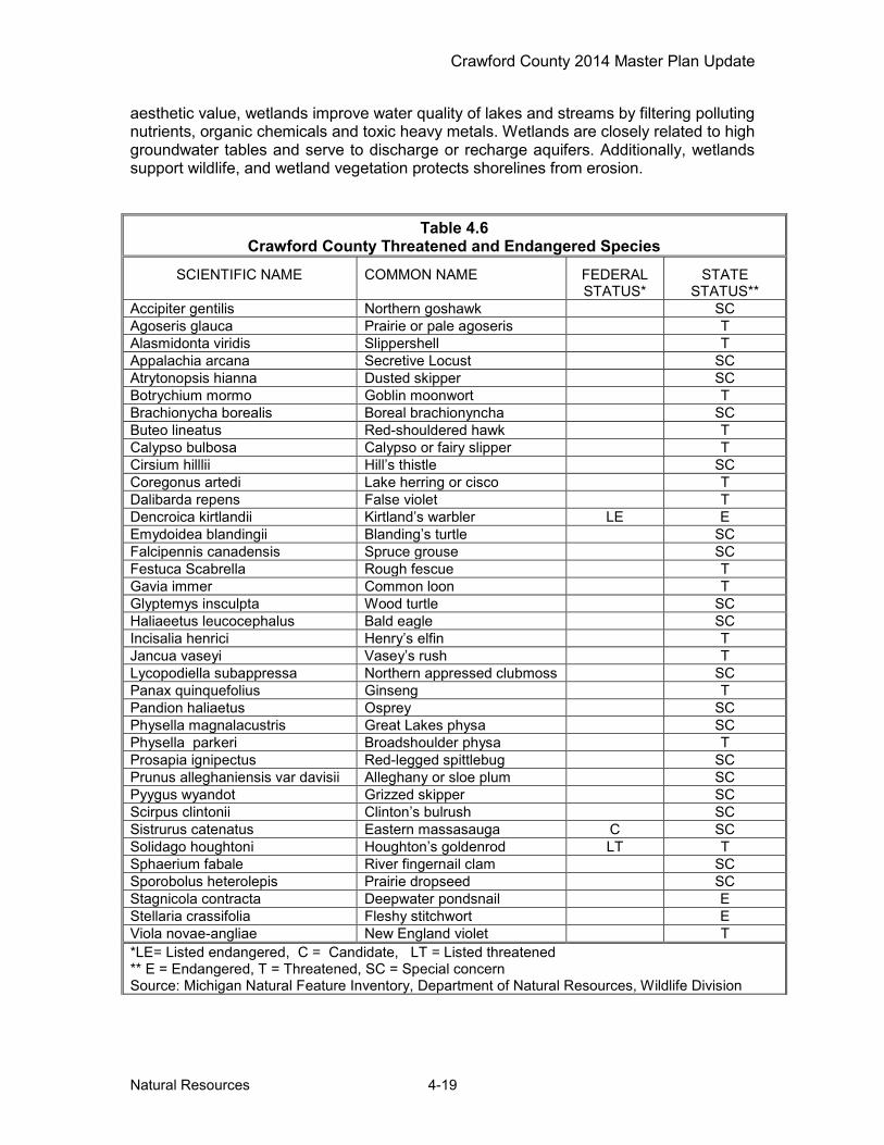
Endangered Species Crawford County is also home to a number of different plants and animals that are threatened, endangered or is of special concern. Table 4.6 presents the Endangered (E) or Threatened (T) plant and animal species of Crawford County, which are protected under the Endangered Species Act of the State of Michigan (Public Act 203 of 1974 as amended). This list also includes plant and animal species of Special Concern (SC). While not afforded legal protection under the act, many of these species are of concern because of declining or relict populations in the state. Should these species continue to decline, they would be recommended for Threatened or Endangered status. Protection of Special Concern species before they reach dangerously low population levels would prevent the need to list them in the future by maintaining adequate numbers of self-sustaining populations. The primary summer nesting area of the very rare songbird, Kirtland's Warbler, is found in the immediate vicinity of Crawford and Roscommon counties. This Warbler winters in the Bahamas and migrates to northern Michigan nesting areas in young jack pine
Crawford County 2014 Master Plan Update
Natural Resources 4-18
forests. Bird watches from all over the world come to the area to view and study this scarce bird. Kirtland's Warbler habitat is young jack pine forests that are 5 to 20 years old. The habitat is managed by cutting older jack pine stands and replanting with millions of new seedlings each year. Protection of this habitat is critical to insure future preservation of the Kirtland's Warbler.
Figure 4.10
National Wetlands Inventory A wetland is found where water is found, either on the surface or near the surface, at any time during the year. Poorly drained soils and water-loving vegetation also may be present. Wetlands are often referred to as marshes, swamps or bogs. Residents of Michigan are becoming increasingly more aware of the value of wetlands. Beyond their
Crawford County 2014 Master Plan Update
Natural Resources 4-19
aesthetic value, wetlands improve water quality of lakes and streams by filtering polluting nutrients, organic chemicals and toxic heavy metals. Wetlands are closely related to high groundwater tables and serve to discharge or recharge aquifers. Additionally, wetlands support wildlife, and wetland vegetation protects shorelines from erosion.
Table 4.6 Crawford County Threatened and Endangered Species
SCIENTIFIC NAME COMMON NAME FEDERAL STATUS*
STATE STATUS**
Accipiter gentilis Northern goshawk SC Agoseris glauca Prairie or pale agoseris T Alasmidonta viridis Slippershell T Appalachia arcana Secretive Locust SC Atrytonopsis hianna Dusted skipper SC Botrychium mormo Goblin moonwort T Brachionycha borealis Boreal brachionyncha SC Buteo lineatus Red-shouldered hawk T Calypso bulbosa Calypso or fairy slipper T Cirsium hilllii Hill’s thistle SC Coregonus artedi Lake herring or cisco T Dalibarda repens False violet T Dencroica kirtlandii Kirtland’s warbler LE E Emydoidea blandingii Blanding’s turtle SC Falcipennis canadensis Spruce grouse SC Festuca Scabrella Rough fescue T Gavia immer Common loon T Glyptemys insculpta Wood turtle SC Haliaeetus leucocephalus Bald eagle SC Incisalia henrici Henry’s elfin T Jancua vaseyi Vasey’s rush T Lycopodiella subappressa Northern appressed clubmoss SC Panax quinquefolius Ginseng T Pandion haliaetus Osprey SC Physella magnalacustris Great Lakes physa SC Physella parkeri Broadshoulder physa T Prosapia ignipectus Red-legged spittlebug SC Prunus alleghaniensis var davisii Alleghany or sloe plum SC Pyygus wyandot Grizzed skipper SC Scirpus clintonii Clinton’s bulrush SC Sistrurus catenatus Eastern massasauga C SC Solidago houghtoni Houghton’s goldenrod LT T Sphaerium fabale River fingernail clam SC Sporobolus heterolepis Prairie dropseed SC Stagnicola contracta Deepwater pondsnail E Stellaria crassifolia Fleshy stitchwort E Viola novae-angliae New England violet T *LE= Listed endangered, C = Candidate, LT = Listed threatened ** E = Endangered, T = Threatened, SC = Special concern Source: Michigan Natural Feature Inventory, Department of Natural Resources, Wildlife Division
Crawford County 2014 Master Plan Update
Natural Resources 4-20
Poorly drained, lowland areas support northern white cedar, tamarack, balsam fir, black spruce, eastern hemlock, white pine, balsam poplar, trembling aspen, paper birch, black ash, speckled alder and shrub willows. Northern white cedar dominates the wetland areas where there is good lateral water movement and the soils are high in organic content. Lowland forests are typically located adjacent to water features and function as riparian forests and water quality buffers. The network of lowland forests, associated with rivers and creeks, also function as wildlife corridors and are the backbone of large regional ecological corridors. Lowland forests adjacent to rivers and streams may be prone to flooding during the spring snowmelt, particularly when combined with heavy spring rains. Forested and non-forested wetlands are a finite resource in the County. Land use planning activities should focus on protecting and preserving these limited and critical resources. The U.S. Fish and Wildlife Service developed national wetlands inventory program in the 1980’s. Through this effort a national wetlands inventory map was compiled for Crawford County. The digital data was acquired from the Center for Geographic Information, State of Michigan, and used to compile Figure 4.11. The map depicts forested and non-forested wetlands. Pre-Settlement Vegetation The Michigan Department of Natural Resources has compiled pre-settlement vegetation maps of counties in Michigan. The maps were generated from information contained in the first government land survey notes in the 1800’s along with information such as current vegetation, land forms and soils, Figure 4.12. A review of the pre-settlement vegetation map of Crawford County shows extensive areas were covered with jack pine-red pine forest, pine barrens, and pine-oak barrens. This clearly shows a long history of wildfires in the area. The map delineates jack pine-red pine forest, white pine-red pine forest, pine barrens, pine-oak barrens, pine-oak forests, and northern hardwood forests. In the late 1800’s extensive logging and subsequent wildfires altered the forest make-up, yet still today as noted on the 1978 forest vegetation map, jack pine covers large parts of the county. Figure 4.13 shows historical vegetation and interpolated fire observations from General Land Office Survey Notes. This map again supports that jack pine and wildfires have long been a part of life in this part of the state. Today, the concern lies in residential development within these historic fire prone areas. Sites of Environmental Contamination The Part 201 (Environmental Response) of Natural Resources and Environmental Protection Act (P.A. 451 of 1994), as amended, provides for the identification, evaluation and risk assessment of sites of environmental contamination in the State. The Environmental Response Division (ERD) is charged with administering this law. A site of environmental contamination, as identified by ERD, is “a location at which contamination of soil, ground water, surface water, air or other environmental resource is confirmed, or where there is potential for contamination of resources due to site conditions, site use or management practices”. The agency publishes a list of environmentally contaminated sites by county showing the sites by name, pollutant(s) and site status (Table 4.7). A Site Assessment Model (SAM) score is computed to assess the relative risk a site may pose and to help determine the aggressiveness of clean up efforts. SAM scores range

Crawford County 2014 Master Plan Update
Natural Resources 4-21
from 0 to 48 with 0 being the least contaminated and 48 the most contaminated. In some instances where the score is high and further contamination is possible, immediate response may be required. Conversely, a location where the score is low and the conditions of the site are not likely to change; no action may be the preferred course.
Figu
re 4
.11
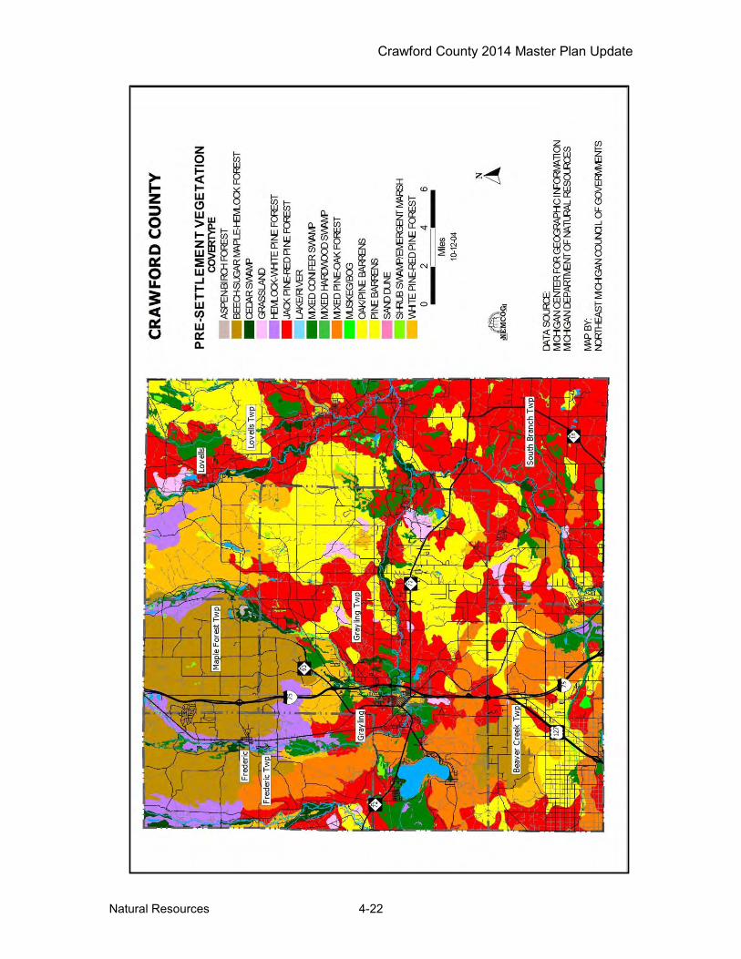
Crawford County 2014 Master Plan Update
Natural Resources 4-22
Figu
re 4
.12
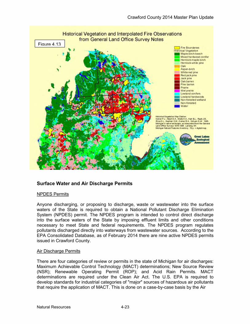
Crawford County 2014 Master Plan Update
Natural Resources 4-23
Figure 4.13
Surface Water and Air Discharge Permits NPDES Permits Anyone discharging, or proposing to discharge, waste or wastewater into the surface waters of the State is required to obtain a National Pollutant Discharge Elimination System (NPDES) permit. The NPDES program is intended to control direct discharge into the surface waters of the State by imposing effluent limits and other conditions necessary to meet State and federal requirements. The NPDES program regulates pollutants discharged directly into waterways from wastewater sources. According to the EPA Consolidated Database, as of February 2014 there are nine active NPDES permits issued in Crawford County. Air Discharge Permits There are four categories of review or permits in the state of Michigan for air discharges: Maximum Achievable Control Technology (MACT) determinations; New Source Review (NSR); Renewable Operating Permit (ROP); and Acid Rain Permits. MACT determinations are required under the Clean Air Act. The U.S. EPA is required to develop standards for industrial categories of "major" sources of hazardous air pollutants that require the application of MACT. This is done on a case-by-case basis by the Air

Crawford County 2014 Master Plan Update
Natural Resources 4-24
Quality Division. NSR requires a person to obtain a permit prior to the installation of any potential source of air pollution unless the source is exempt from the permitting process. The ROP program is a national permitting system, administered by each state. Each major source of pollution is subject to the program. A "major source" is a facility that is capable of emitting more than certain amounts of air contaminants. Acid Rain Permits may be required for electric generating units which sell electricity to the grid and burn fossil fuel. Table 4.8 lists the current Air Discharge (renewable operating permits) permits issued to businesses in Crawford County as of May 2014. Additionally, within Crawford County, only CMS Generation, Grayling Generating Station has submitted a
Table 4.7 Crawford County Contamination Sites
SITE ID & STATUS LOCATION SOURCE POLLUTANT SAM SCORE
20000002 Active M-93 National Security PCE , TCE 28
20000003 Active Sherman Rd Landfill Benzene Iron, Vinyl Chloride , 4-methylphenol 24
20000004 Active
6636 AuSable St (Old 27)
Gasoline Service Station
BTEX 1,1 DCA Lead , 1,1,1 TCA PERC 30
20000007 Active Rt #1, 7 Mile Rd Pumps & Pumping Equipment BTEX 31
20000008 No Action Taken W. Kolka Creek Oil drilling Brine 20
20000009 Inactive 5453 M-18 Hwy Gasoline Service Station
BTEX , 1,2 DCA 27
20000010 No Action Taken 123 Barbara St Non-classifiable
Establishments BTEX 22
20000028 Monitoring Only 427 South Grayling Rd Auto Dealer &
Service Stations
Tetrachloroethylene, 1,2 Dichloroethylene, Trichloroethylene
17
20000049 Active Industrial Dr Sewerage Systems Nitrate 24 20000058 Active 106 Jonassen Private Households Heating Oil , Ethylbenzene 14 20000060 Active 2459 Industrial Dr Wood Preserving Cr+6 20
20000064 Active 200 West Michigan Ave Railroad Transportation
PNAs Dibenzofuran, 2-Methylnaphthalene 29
20000065 No Action Taken Beech Terrace Dr Private Households Fuel Oil 20
20000066 State Project Terminated 308 Huron St (M-72) Lumber & Wood
Products Benzo(a)pyrene, Fluor-anthene, Phenanthrene 21
20000067 De-listed 1985 Dansk Ln Private Household Heating Oil, Phenanthrene 21
20000068 De-listed 1320 S. McMasters Bridge Rd
Hotels & Other Lodging Places Heating Oil 15
20000071 Active Camp Grayling National Security Lead , Zinc , Phenanthrene 33
20000073 Active N. Down River Rd Sporting & Athletic Goods
TMB; Benzene; Ethylbenzene; PCE; Toluene; Xylenes; n-Propylbenzene
31
20000074 Active 10360 W. Deward Rd Pipelines Ethylbenzene 22
20000075 Active 4364 N. Down River Rd Fabricated Metal Products PCE; TCE; cis-1,2 DCE 34
20000077 9439 East North Down River Rd
Gasoline Service Station
TMB; Benzene; Ethylbenzene; Naphthalene; Toluene; Xylenes
31
20000090 Inactive 4622 Young St Lumber & Wood Products TMB; Pb 27
Source: Department of Environmental Quality
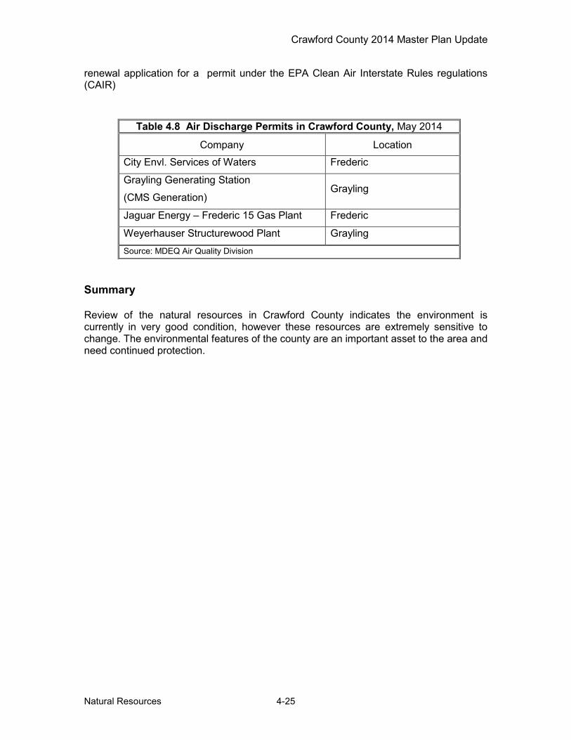
Crawford County 2014 Master Plan Update
Natural Resources 4-25
renewal application for a permit under the EPA Clean Air Interstate Rules regulations (CAIR) Summary Review of the natural resources in Crawford County indicates the environment is currently in very good condition, however these resources are extremely sensitive to change. The environmental features of the county are an important asset to the area and need continued protection.
Table 4.8 Air Discharge Permits in Crawford County, May 2014 Company Location
City Envl. Services of Waters Frederic
Grayling Generating Station
(CMS Generation) Grayling
Jaguar Energy – Frederic 15 Gas Plant Frederic
Weyerhauser Structurewood Plant Grayling Source: MDEQ Air Quality Division

Crawford County 2014 Master Plan Update
Land Use Characteristics 5-1
Chapter 5 – Land Use Characteristics This chapter presents information on both the types and location of land uses on a countywide basis. The process identifies both urban built-up land uses such as residential and commercial, along with natural land cover types like forests and wetlands. As a result the final map presented in this chapter is a hybrid that combines land cover and land use. Land Division Patterns As development occurs, larger tracts of land are generally broken down into smaller parcels. Therefore, studying the existing pattern of land divisions is one way to analyze the status of land use and development. Most of the private ownership is in tracts that are 10 acres and smaller. Large tracts of private ownership, typically hunt/fish clubs, are scattered throughout the County. Subdivisions and small tracts are located near rivers, around lakes along major highways, within recreational developments and clustered around the community of Grayling. Figure 5.1 shows the distribution of parcels 160 acres or larger, and parcels 10 acres or less. A key factor that determines community character and the location of potential future development areas is the amount of land public ownership. Table 5.1 and Figure 5.2 show the breakdown of public land ownership in Crawford County. Excluding water, all public lands (including that owned by cities, townships, the county, as well as federal and state properties) make up over 70 percent of the county's total land area.
Table 5.1 Crawford County Land Ownership
Public Lands Acres Percent State of Michigan 116,614 32 Military 97,294 27 USA 41,433 12 Other Public 1,366 >1 Water 3,031 >1 Source: NEMCOG
Land Use One of the features that attract people to Crawford County is the rural character of the area. Data from 1992 satellite imagery shows that 86.3 percent of the County's 360,294 total acreage is forested, with another 7.1 percent non-forest. Agriculture, wetlands and surface water each claim an additional 1.1 percent (Table 5.1 and Figure 5.1). Just a little over three percent of the County's land is used for urban-type purposes, including commercial, industrial, recreational and residential (see Table 5.2 and Figure 5.3)

Crawford County 2014 Master Plan Update
Land Use Characteristics 5-2
Figu
re 5
.1
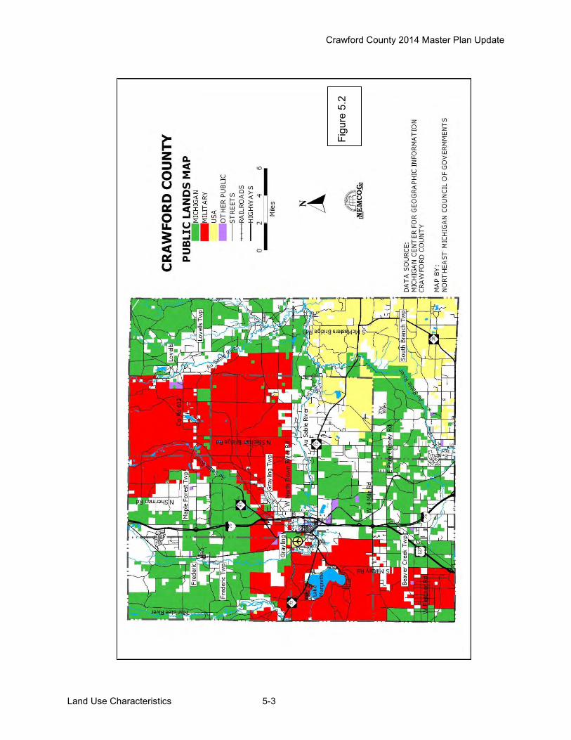
Crawford County 2014 Master Plan Update
Land Use Characteristics 5-3
Figu
re 5
.2

Crawford County 2014 Master Plan Update
Land Use Characteristics 5-4
Data for the land/cover use inventory was taken from the Michigan Land Cover Dataset (MLCD), which was produced as part of the National Land Cover Dataset (NLCD). The NLCD was compiled from Landsat satellite imagery in 1992 as a cooperative effort between the U.S Geological Survey (USGS) and the U. S. Environmental Protection Agency (US EPA) to produce consistent land cover data for the US. It is important to note this approach utilizes lower resolution satellite imagery and computer generated image interpretation to compile the generalized land cover map. The approach did not involve field checking and manual boundary adjustments. Due to the scale, low density urban development and development in dense forestland was not delineated. The computer generated map offers a general view of land use in the county, adequate for general planning purposes. The computer generated land use for Crawford County consists of the following ten classes:
Table 5.2 Crawford County General Land Use
Land Use Type Acres Square Miles % of Total Area Agricultural 3,957 6.18 1.1% Commercial/Industrial/Transportation 2,679 4.18 0.7% Extractive/Transitional 8,278 12.93 2.3% Lowland Forest 43,959 68.68 12.2% Non-Forest Upland 25,719 40.18 7.1% Recreational 460 0.71 0.13% Residential 472 0.73 0.13% Upland Forest 266,861 416.97 74.1% Surface Water 4,005 6.25 1.1% Wetlands 3,904 6.10 1.1% Total 360,294 562.95 100%
Residential According to the MLCD, 0.14 percent (472 acres) of the County's total land area was used for residential purposes in the early 1990s. As noted in Chapter 2, the number of housing units in the County increased over 15 percent between 1990 and 2000. This increase in housing units indicates a likely increased percentage of land in residential use. The most popular areas for residential development tend to be along the banks of the County’s water resources. Residential usage is concentrated in and around the City of Grayling, Frederic Township, around the north and east shore of Lake Margrethe, along the Manistee River in Frederic Township, along the Au Sable River in Grayling Township and along the South Branch of the Au Sable River in South Branch Township. For the most part, residential development in the County consists of single-family dwellings. However, single family duplexes, multi-family units, condominiums, mobile homes and mobile home parks are also listed in this category. Commercial/Industrial/Transportation Commercial land uses include primary/central business districts, shopping center/malls, secondary/neighborhood business districts, including commercial strip development, as well as industrial development, transportation, oil and gas, communication and utility facilities, and all
Crawford County 2014 Master Plan Update
Land Use Characteristics 5-5
highways. The MLCD identified 2,679 acres, or 0.7 percent of Crawford County’s in this land use category. Commercial/Industrial facilities are found primarily in the City of Grayling and in Frederic Township, with expansion noted in areas along M-72, along I-75 and in Beaver Creek Township around the junction I-75 and US 27. Extractive/Barren This category includes quarries, strip mines and gravel pits as well as land in transition (forest clear cuts, transition between agriculture and forest lands, and changes due to natural causes such as fire or flooding). Areas of bare rock, sand or clay with little green vegetation are also included in this class, which makes up 2.3 percent (8278 acres) of Crawford’s land area. Recreational Land devoted specifically to active or developed recreational purposes amounted to approximately 0.13 percent, or about 460 acres in Crawford County. Land uses included in this category are public parks and campgrounds, golf courses, schools, churches and public buildings. Note: Due to the extensive state-owned lands there is a tremendous amount of land available for recreation that is mapped as forested – see Chapter 6 for more recreation details. Agricultural With only 3,957 acres classified as farmland, agriculture operations make up a relatively small portion (1.1%) of the County’s land use. The largest concentration and majority of the agricultural land use is located in Maple Forest Township with smaller areas located in Beaver Creek Township and South Branch Township. Agriculture land is used predominately as pastureland hay and growing crops such as beans, oats, and barley. A small amount of land is used for livestock such as cattle, milk cows and hogs. Non-Forested Uplands Non-forested land is defined as areas supporting early stage of plant succession consisting of plant communities characterized by grasses or shrubs. Non-forest land makes up 7.1 percent or 25,719 acres of the County's land area. Typical grass species are quack grass, Kentucky bluegrass, upland and lowland sedges, reed canary grass and clovers. Typical shrub species include blackberry and raspberry briars, dogwood, willow, sumac and tag alder. Also included in this category are the lands used by the National Guard at camp Grayling for artillery and bombing ranges. Upland Forest Upland forests make up 266,861 acres or 74.1 percent of the County’s surface area. While some of this land may have been converted to other uses since 1990, it is still by far the largest single land cover/use in the County. The predominant species on much of these lands is jack pine but other species such as white, red, scotch pines, sugar and red maple, elm, beech, yellow birch, cherry, basswood, white ash, and aspen can also be found. Lowland Forest The County’s land use inventory shows that 43,959 acres or 12.2 percent of the County’s surface area consists of lowland forests. Lowland forests are defined as those containing ash, elm and soft maple, along with cottonwood and balsam popular. Lowland conifers, such as cedar, tamarack, black and white spruce and balsam fir stands are also included. Lowland forests are mostly found close to the rivers and lakes in the county.
Crawford County 2014 Master Plan Update
Land Use Characteristics 5-6
Wetlands As can be noted from Table 5.1, 3,904 acres or 1.1 percent of the County's land area was identified as wetlands. Wetlands are those areas between terrestrial and aquatic systems where the water table is at, near, or above the land surface for a significant part of most years. The hydrologic regime is such that it permits the formation of hydric soils or it supports the growth of hydrophytic vegetation. Examples of wetlands include marshes, mudflats, wooded swamps and floating vegetation situated on the shallow margins of bays, lakes, rivers, ponds, streams. These wetland categories include shrub wetlands, fresh-water marshes, wet meadows, open bogs, emergent wetlands and aquatic bed wetlands. Surface Water Crawford County is home to many small lakes and several major rivers. Surface water makes up 1.1 percent (4,005 acres) of the County's land use types. The combination of wetlands types, lowland forests and surface water makes up a significant portion (14.6 percent) of the County's surface area. Therefore, protecting the county's water and wetland resources should be a major priority in land use planning.
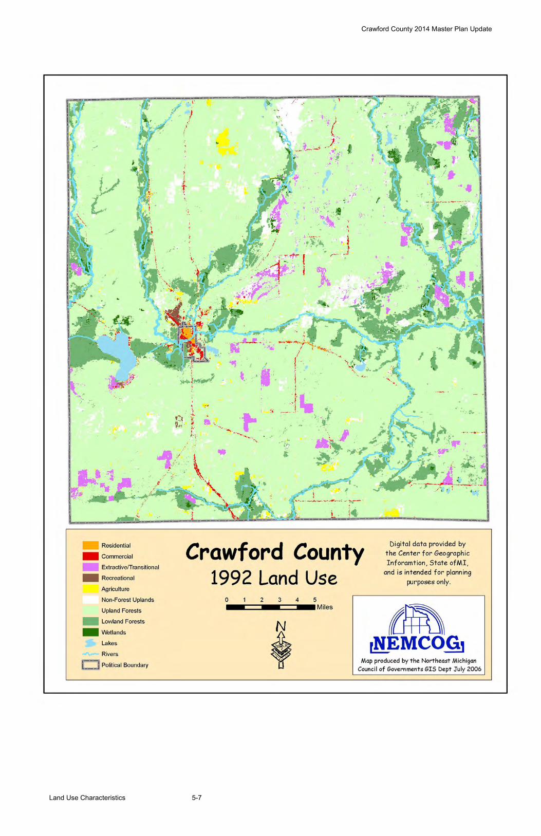
Crawford County 2014 Master Plan Update
Land Use Characteristics 5-7

Crawford County 2014 Master Plan Update
Recreation 6-1
Chapter 6 – Recreation
The recreational opportunities in Crawford County and the abundance of natural resources are vast, thus the County includes recreation as a key component in the Master Plan. This chapter with the support of the information in the other chapters of the Master Plan is intended to serve as a recreation plan for approval by the Michigan Department of Natural Resources for Crawford County, Beaver Creek Township, Grayling Township, Lovells Township, and South Branch Township. Frederic Township and Maple Forest Township are not specifically included as they recently updated their respective Township Master Plans, including recreation plans. The City of Grayling also maintains a separate recreation plan, thus is not specifically included in this recreation plan. In past years, the County and Townships have provided recreation services and facilities to residents and visitors. The mix of County and Township owned facilities along with other publicly owned State Forest lands and campgrounds and privately owned recreation facilities offers a wide range of passive and active recreational opportunities. A description of these facilities is included in the recreation inventory, which follows. Crawford County and the respective Townships intends to continue providing recreation services to its residents and visitors, but also plans to make improvements at the existing facilities, including compliance with Americans with Disabilities Act (ADA) and Universal Design standards, to improve accessibility for all. As recreation service providers, Crawford County including the Grayling Recreation Authority, and the Township recognizes the importance of planning for future recreation services and facilities. A major factor in the provision of any service is the question of how projects will be funded. One possible source of funding for recreation projects is through grants available from Michigan Department of Natural Resources (MDNR). To become grant eligible for MDNR funding, a community must have an approved recreation plan. Components of a MDNR approved recreation plan include:
--- Community Description
--- Recreation Inventory
--- Administrative Structure
--- Description of the Planning Process
--- Action Program
--- Basis for the Action Program
--- Plan Review and Adoption
Elements of the community description can be found in Chapters 1 and 2 of this Plan. A location map can be found in Chapter 1- Introduction, which shows the relationship between the Townships and the County as a whole. Chapter 2 provides background studies including socio-economic characteristics of the County and each of the Townships. Data on the natural environment, including resource inventory information is provided in Chapter 4 and existing land use patterns are discussed in Chapter 5. The remaining components of the recreation plan are covered in this chapter.

Crawford County 2014 Master Plan Update
Recreation 6-2
Administrative Structure Crawford County Crawford County Board of Commissioners operates under an administrative structure consisting of a Chair, Vice-Chair and board members. These positions are chosen by qualified voters of the county in at-large elections by districts held every other November. Bylaws adopted by the County determine the order of business and method of conducting regular county business. For most issues that require a vote for determination, a majority of commissioners present is required. The county does have a recreational authority – the Grayling Recreation Authority (GRA). The Grayling Recreation Authority was created by local units of Crawford County government to facilitate parks and recreation services in Crawford County, to operate the Hanson Hills Recreation Area.
Crawford County Organizational Chart
Crawford County Parks & Recreation Staff The County does not employ any parks and recreation staff. Duties related to recreation properties are assigned to existing staff. Table 6.1
Crawford County Budget and Recreation Expenditures, 2011-2014
Budget
FY Ending Sept 30 2011-2012 2012-2013 2013-2014
Recreation $2,500 $58,984 $200,000
Total County $5,298,406 $5,278,424 $5,380,122
Expenditures
Recreation $2,500 $58,984 TBD
Source: Crawford County 2011-2014

Crawford County 2014 Master Plan Update
Recreation 6-3
Grayling Recreation Authority The Grayling Recreation Authority (GRA) was created by the local units of Crawford County to address the recreational needs of the county. This body’s primary function is to facilitate parks and recreation services in Crawford County and to operate Hanson Hills Recreation Area and Winter Sports Park. Hanson Hills has the unique distinction of being a State legislated recreational facility, created under P.A. 156 of 1917. The property is located in Grayling Township and is owned by the State of Michigan Department of Military Affairs. The lease to the Hanson Hills Recreation Area is renewed periodically with joint signatures from GRA and the Michigan National Guard. The property is leased to the Grayling Recreation Authority based on a renewable twenty (20) year lease. The current lease expires in 2026. The GRA is governed by a Board of Directors made up of appointed representatives from the County, Grayling Township and the Crawford AuSable School Board and appointed at-large members. The three at-large members are selected and approved by a majority vote of the six appointed members. The term length for at-large members is three years. Term lengths for the appointed members are determined by the appointing body. GRA Parks & Recreation Staff The GRA has full-time staff for administration, operation, service and maintenance of the Hanson Hills Recreation Area. Funding for the GRA Budget The GRA is currently funded by a county-wide millage. Apart from millage funds, other possible funding sources for recreational improvements in the county exist in grant opportunities with agencies such as the Michigan Department of Natural Resources, private foundations, community service organizations and community fund-raising groups. Table 6.2
Grayling Recreation Authority Budget and Recreation Expenditures, 2011-2014
Budget
FY Ending Mar 31 2011-2012 2012-2013 2013-2014
Recreation 426,860.00 444,806.00 480,754.00
GRA Total Budget 426,860.00 444,806.00 480,754.00
Expenditures
Recreation 399,827.00 422,032.00 455,224.00
Source: Grayling Recreation Authority 2011-2014
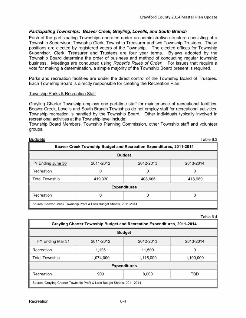
Crawford County 2014 Master Plan Update
Recreation 6-4
Participating Townships: Beaver Creek, Grayling, Lovells, and South Branch Each of the participating Townships operates under an administrative structure consisting of a Township Supervisor, Township Clerk, Township Treasurer and two Township Trustees. These positions are elected by registered voters of the Township. The elected offices for Township Supervisor, Clerk, Treasurer and Trustees are four year terms. Bylaws adopted by the Township Board determine the order of business and method of conducting regular township business. Meetings are conducted using Robert’s Rules of Order. For issues that require a vote for making a determination, a simple majority of the Township Board present is required. Parks and recreation facilities are under the direct control of the Township Board of Trustees. Each Township Board is directly responsible for creating the Recreation Plan. Township Parks & Recreation Staff Grayling Charter Township employs one part-time staff for maintenance of recreational facilities. Beaver Creek, Lovells and South Branch Townships do not employ staff for recreational activities. Township recreation is handled by the Township Board. Other individuals typically involved in recreational activities at the Township level include: Township Board Members, Township Planning Commission, other Township staff and volunteer groups. Budgets Table 6.3
Beaver Creek Township Budget and Recreation Expenditures, 2011-2014
Budget
FY Ending June 30 2011-2012 2012-2013 2013-2014
Recreation 0 0 0
Total Township 419,330 408,605 418,989
Expenditures
Recreation 0 0 0
Source: Beaver Creek Township Profit & Loss Budget Sheets, 2011-2014
Table 6.4
Grayling Charter Township Budget and Recreation Expenditures, 2011-2014
Budget
FY Ending Mar 31 2011-2012 2012-2013 2013-2014
Recreation 1,125 11,500 0
Total Township 1,074,000 1,115,000 1,100,000
Expenditures
Recreation 900 8,000 TBD
Source: Grayling Charter Township Profit & Loss Budget Sheets, 2011-2014

Crawford County 2014 Master Plan Update
Recreation 6-5
Table 6.5 Lovells Township Budget and Recreation Expenditures, 2011-2014
Budget
FY Ending Mar 31 2011-2012 2012-2013 2013-2014
Recreation 0 0 0
Total Township 172,255 207,361 150,171
Expenditures
Recreation 200 200 200
Source: Lovells Township General Budget Sheets, 2011-2014
Table 6.6
South Branch Township Budget and Recreation Expenditures, 2011-2014
Budget
FY Ending Mar 31 2011-2012 2012-2013 2013-2014
Recreation $5000 $1000 $1000
Total Township $397,355 $374,620 $365,860
Expenditures
Recreation $0 $209 $243
Source: South Branch Township Profit & Loss Budget Sheets, 2011-2014
Crawford County 2014 Master Plan Update
Recreation 6-6
Relationships with Other Agencies Numerous groups within the county are involved with the improvement and operation of the recreational facilities in Crawford County. The majority of these organizations are operated on a volunteer basis. The organizations and special interest groups that assisted to provide recreation opportunity in Crawford County are:
1. Trails Sub Committee 2. Grayling Sportsplex 3. Crawford Ausable Soccer Association 4. Redskins Football 5. Little League Baseball 6. Crawford Ausable Athletic Director 7. Grayling Parks and Recreation Committee 8. Archery
9. Wellington Farm Park 10. Canoeing 11. Grayling Senior Center 12. Cross Country Ski Trails 13. Grayling City Parks & Recreation 14. Bicycling 15. MSUE 4-H 16. Boy Scouts/Girl Scouts 17. Trout Fishing
Beaver Creek Township, Grayling Township, Lovells Township and South Branch Township are participating in the Crawford County Recreation Plan. The City of Grayling participated in the process, but has its own recreation plan. Frederic and Maple Forest Townships participated in the process, but they each have an approved, current Recreation Plan within their Master Plan. The Crawford AuSable School District is also actively participating in the Recreation Plan The Recreation Plan Proposed pathway projects are consistent with the Northeast Michigan Regional Non-motorized Transportation Plan and Investment Strategy.
Crawford County 2014 Master Plan Update
Recreation 6-7
Status Report of all Grant-Assisted Parks and Recreation Facilities
The following is a summary of the grant assistance which has been received by Crawford County or one of the participating Townships. Post-completion certification reports for each of these projects are provided in Appendix C.
Additionally, Crawford County has one active grant (#26-01713) for the development of little league fields at the County Sports Complex.
Crawford County 2014 Master Plan Update
Recreation 6-8
Crawford County 2014 Master Plan Update
Recreation 6-9
Inventory of Existing Parks, Natural Areas and Recreation Facilities The previous recreation plan inventory was used as a starting point for the following updated inventory, which was compiled with assistance from Crawford County, each of the participating Townships, Department of Natural Resources staff as well as the Recreation Stakeholders.
Public Recreational Properties – Crawford County Table 6.7
CRAWFORD COUNTY & GRA RECREATIONAL FACILITIES Name Classification Description Accessibility Size
Hanson Hills Recreation Area
Large Urban Park
Natural Resource Area
Sports Complex
Large Park/Open Area that is located on State Land. Area is close to town, with bordering neighborhoods. Consists of Ski Lodge, Downhill Ski run, Nordic Ski trails, and Tubing Hill. Mt. Bike and Hiking Trail System. Includes Playground Area, Softball and Soccer Fields, Archery Facility, Disc Golf Course, Fishing Pond and Picnic Area.
2
277 Acres
(Leased)
1500 Acres approx.
(Special Use
Permit)
Grayling Fish Hatchery
Special Use
Fish Hatchery Located in town, Bordering numerous residential areas. Includes Trout fishing tanks, Museum building, Picnic Area.
3 50 Acres
Crawford County Sportsplex (fairgrounds)
Sports Complex Concession stand and ball fields 2 30 acres
Wakeley Bridge Canoe Launch
Mini-Park Canoe access 1 ½ acre
Township Park Park leased to Grayling Township on 99 year lease

Crawford County 2014 Master Plan Update
Recreation 6-10
Public Recreational Properties – Townships and Chamber Table 6.8
BEAVER CREEK TOWNSHIP
Name Classification Description Accessibility Size
Beaver Creek Governmental Complex
Community Park
Community Center, playground, tennis courts, baseball and basketball courts, soccer field, ½ mile paved multi-use trail, pavilions, bathroom building
3
40 ac
FREDERIC TOWNSHIP
Betty Sadjak Memorial Park
Community Park Playground, picnic tables, basketball court, walking path and gazebo. 3 1ac
Frederic Community Center/Twp Hall
Community Park Meeting rooms, offices, kitchen, gymnasium, picnic area, playground/tot lot and multi-purpose fields
3 5 ac
GRAYLING TOWNSHIP
Grayling Township Fish Hatchery Park
Natural Urban family recreational area
Located on AuSable River East Branch close to City of Grayling and Grayling Fish Hatchery. Large playground, picnic pavilion, hiking trails, disc golf course, swimming and fishing
2
20 ac on E side and 4 ac on W side of river
LOVELLS TOWNSHIP
Douglas Park Neighborhood Park
Children’s playground, picnic pavilion, ball diamond, volleyball area, shuffle board court, museum
3
5.5 acres
MAPLE FOREST TOWNSHIP Maple Forest Township Hall
Neighborhood Park Meeting Room with kitchen facilities 3 <1 ac
SOUTH BRANCH TOWNSHIP
Township Hall
Neighborhood Park Township Hall 3 5
OTHER RECREATIONAL FACILITIES IN CRAWFORD COUNTY
Chamber of Commerce City Park
Neighborhood Park
Chamber office, parking, pavilion/picnic area, river access 3 3

Crawford County 2014 Master Plan Update
Recreation 6-11
State Parks, State and Federal Forest Campgrounds in Crawford County Table 6.9
STATE & FEDERAL RECREATIONAL FACILITIES
Facility Amenities Location North Higgins Lake State Park
174 campsites, trailer station, cabins, boat access, fishing, trails, museum, pavilions, conference center
Section 36, southern edge of Beaver Creek Township
Goose Creek State Forest Campground and Trail Camp
9 campsites, canoeing, hiking, horseback riding, wildlife viewing, fishing large equestrian group camp area
5.5 miles west of Frederic, Frederic Township
Manistee River Bridge Campground
23 campsites, canoeing, fishing, canoe access Section 31, Frederic Township
Upper Manistee River Campground
30 campsites, 10 walk-in sites, canoeing, fishing, group camp for canoeists
Section 7, Frederic Township
AuSable River Canoe Camp
13 campsites (5 are canoe access only) hiking, picnicking, fishing, wildlife viewing
Grayling Township, 5.5 miles east of Grayling
Burton’s Landing Canoe Launch
12 campsites, canoeing, fishing Section 10, Grayling Township
4 Mile State Forest Trail Camp
50 campsites, horse camp, horseback riding, boat launch, fishing, canoeing, hiking, wildlife viewing
9 miles southeast of Grayling, Grayling Township
Hartwick Pines 100 campsites, hiking, mountain bike trails, fishing, logging museum & camp, Interpretive Center
6 miles Northeast of Grayling, Grayling Township
Keystone Landing Campground
18 campsites, canoeing, fishing, canoe launch Section 11, Grayling Township
Kneff Lake Campground 26 campsites, boating, fishing, swimming, picnicking
7 miles southeast of Grayling, Grayling Township
Lake Margrethe Forest Campground
37 campsites, boating, swimming, fishing, boat ramp reservations available
Section 17, Grayling Township
Wakeley Lake Area Federal Forest
4 walk-in campsites, limited fishing, trails Section 23, 10 miles southeast of Grayling
Jones Lake State Forest Campground
42 campsites, boating, swimming, fishing, small-boat ramp
Section 31, Lovells Township
Shupac Lake Campground
30 campsites, boating, boat ramp, swimming, fishing
Section 18, Lovells Township
Canoe Harbor Campground
44 campsites, canoeing, fishing, group campsites (6)
Section 32, South Branch Township
Rainbow Bend Forest Campground
6 campsites, canoeing, fishing, canoe access, canoe group camping sites
Section 3, South Branch Township
Walsh Road Equestrian Campground
Horseback riding, large group use area available by permit only,(7) sites
SW1/4 of Lovells NE, off Walsh Rd. north of East Townline Road
White Pine State Forest Canoe Camp
Open area campsite, canoe access only, fishing, wildlife viewing
Section 7, South Branch Township
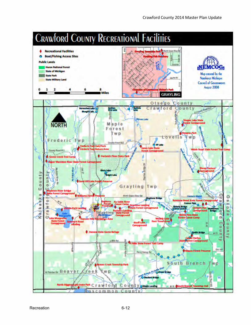
Crawford County 2014 Master Plan Update
Recreation 6-12

Crawford County 2014 Master Plan Update
Recreation 6-13
Private Campgrounds in Crawford County Table 6.10 PRIVATE RECREATIONAL CAMPGROUNDS
Facility Amenities Location River Park Campgrounds Grayling Township
Timberly Village Campground & Mobile Home Park City of Grayling
Happi Days Campground and Diner Frederic, Frederic Township
The Trails Campground 63 Campsites Frederic, Frederic Township
Yogi Bear’s Jellystone Campground 218 Campsites Grayling Township
Sno-Trac Village 60 campsites, 10 mobile homes, snowmobiling Lovells, Lovells Township
Headwaters Camping and Cabins Waters, Maple Forest Township
Whispering Pines Campgrounds, Cabins and Showers Frederic Township
Trails in Crawford County Table 6.11
RECREATION TRAILS
Trail Description Location
MULTI-USE TRAILS Mason Tract Trail Point to point hiking and cross country
skiing trail along the South Branch AuSable River
Between Chase Bridge and M-72, 14 miles east of Grayling
Michigan Shore to Shore Hiking and Riding Trail
Point to point trail hiking and riding trail from Lake Huron to Lake Michigan
Parallels M-72, South Branch Twp.
Midland to Mackinac Hiking Trail
Point to point hiking and backpacking trail that extends from Midland to Mackinac City
Parallels F97, South Branch Twp.
Hanson Hills Trails Skiing, biking, hiking Hanson Hills Recreation Area
Hartwick Pines Skiing, biking, hiking Hartwick Pines State Park
Grayling Non-motorized Pathway (Grayling Bicycle Turnpike)
Biking, walking, running
Wakeley Lake Trail Skiing, hiking National Forest Service System

Crawford County 2014 Master Plan Update
Recreation 6-14
Trails Table 6.11-cont’d ORV TRAILS
Cycle Conservation Club ORV Trail
Motorized off road vehicle trail
Pioneer Rd,
to South of Hunters Trail in Beaver Creek Twp.
West Higgins ATV Trail Motorized off road vehicle Trail South of Hunters Trail in Beaver Creek Twp.
The Meadows ORV Trail Motorized off road vehicle trail Pioneer Road, South Branch Twp.
Frederic ORV Loop Motorized off road vehicle Trail Frederic Twp.
Frederic ORV Route Motorized off road vehicle Trail Batterson Road to M 93along N Old 27
SNOWMOBILE TRAILS Trail #4 Snowmobile Trail Lovells Twp.
Trail #7 Snowmobile Trail Frederic to Beaver Creek
Trail #9 Snowmobile Trail Meridian Road at east boundary of South Branch Twp.
Trail # 47 Snowmobile Trail Grayling to Lovells
Trail #79 Snowmobile Trail M-72 to Kalkaska Co.
Trail #409 Snowmobile Trail Lovells Twp. to Oscoda Co.
Trail #482 Snowmobile Trail 4 Mile Road to Grayling along I-75 Corridor
Trail #487 Snowmobile Trail South east corner of Grayling Twp.
Trail #489 Snowmobile Trail Beaver Creek Twp
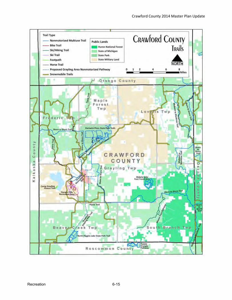
Crawford County 2014 Master Plan Update
Recreation 6-15
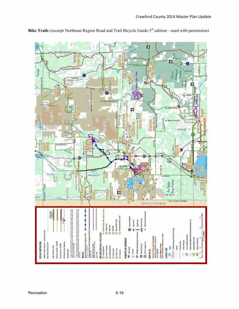
Crawford County 2014 Master Plan Update
Recreation 6-16
Bike Trails (excerpt Northeast Region Road and Trail Bicycle Guide-3rd edition—used with permission)
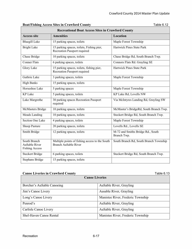
Crawford County 2014 Master Plan Update
Recreation 6-17
Boat/Fishing Access Sites in Crawford County Table 6.12 Recreational Boat Access Sites in Crawford County
Access site Amenities Location Bluegill Lake 15 parking spaces, toilets Maple Forest Township
Bright Lake 15 parking spaces, toilets, Fishing pier, Recreation Passport required
Hartwick Pines State Park
Chase Bridge 10 parking spaces, toilets Chase Bridge Rd, South Branch Twp.
Conner Flats 6 parking spaces, toilets Connors Flats Rd. Grayling SE
Glory Lake 15 parking spaces, toilets, fishing pier, Recreation Passport required
Hartwick Pines State Park
Guthrie Lake 3 parking spaces, toilets Maple Forest Township
High Banks 15 parking spaces, toilets
Horseshoe Lake 5 parking spaces Maple Forest Township
KP Lake 5 parking spaces, toilets KP Lake Rd, Lovells NW
Lake Margrethe 30 parking spaces Recreation Passport required
Via McIntyres Landing Rd, Grayling SW
McMasters Bridge 10 parking spaces, toilets McMaster’s BridgeRd, South Branch Twp.
Meads Landing 10 parking spaces, toilets Steckert Bridge Rd, South Branch Twp.
Section One Lake 4 parking spaces, toilets Maple Forest Township
Sheep Pasture 20 parking spaces, toilets Lovells Rd., Lovells SE
Smith Bridge 12 parking spaces, toilets M-72 and Smiths Bridge Rd., South Branch Twp.
South Branch AuSable River Fishing Access
Multiple points of fishing access to the South Branch AuSable River
South Branch Rd, South Branch Township
Steckert Bridge 6 parking spaces, toilets Steckert Bridge Rd, South Branch Twp.
Stephans Bridge 15 parking spaces, toilets
Canoe Liveries in Crawford County Table 6.13 Canoe Liveries
Borcher’s AuSable Canoeing AuSable River, Grayling
Jim’s Canoe Livery Ausable River, Grayling
Long’s Canoe Livery Manistee River, Frederic Township
Penrod’s AuSable River, Grayling
Carlisle Canoe Livery AuSable River, Grayling
Shel-Haven Canoe Rental Manistee River, Frederic Township
Crawford County 2014 Master Plan Update
Recreation 6-18
Privately Owned Recreational Public Facilities
In addition to the above listed recreational opportunities, Crawford County is host to a number of other private recreational facilities including a bowling alley, boys and girls camps, golf courses, miniature golf, marina, shooting range and senior center. Crawford County also has numerous resorts, cabins and motels that are utilized by fishermen, hunters and other sports enthusiasts for overnight accommodations. Most of these facilities are located in and around the Grayling and Frederic area.
Regional Recreational Opportunities
The amounts and types of recreation opportunities, which are available in neighboring counties, are highly variable. All neighboring counties have an ample supply of state and/or federal lands, much of which can be used for recreational activities, including hunting, fishing, hiking, wildlife viewing, etc.
The closest neighboring community to the major population of Crawford County is Roscommon (Roscommon County). Roscommon has a variety of recreational facilities including a community recreation/fitness center. They also have an outdoor ice rink, a soccer field and tennis courts. Roscommon is approximately 15 miles from Grayling. Higgins Lake and Houghton Lake both provide recreational water opportunities.
To the north, Gaylord (Otsego County) has several recreational facilities that are open to the public. The Sportsplex offers an indoor ice rink and swimming pool. There are several ski lodges, groomed cross country ski trails, golf courses, a bowling alley and theatre complex. The travel distance from Gaylord to areas in Crawford County vary from about 20 minutes to close to one hour.
Oscoda County, to the east, is a very rural county with few recreational facilities beyond state and federal lands and campgrounds and the AuSable River. The area does offer a major golf/cross country ski resort. The travel distance from Crawford County to Oscoda County ranges from 30 minutes to more than one hour.
Kalkaska County is located to the west of Crawford County. Located within the City of Kalkaska are a variety of recreational opportunities. The area has a roller skating rink, an archery course and a sportsplex called “Kaliseum”. They also have an assortment of sports teams such as Little League, soccer and softball. Kalkaska is a 30 minute drive from Grayling, but is over an hour from other portions of the county.

Crawford County 2014 Master Plan Update
Recreation 6-19
Planning Process
The planning process for the Master Plan and Recreation Plan update began in the fall of 2013, when it was decided that the Recreation Plan would be updated and incorporated into the Crawford County 2014 Master Plan update. The planning process included a series of meetings with the County Planning commission with representation from each of the Townships, the School District and the County Board of Commissioners. Additionally, a group of recreation stakeholders representing diverse cross-section of recreational interests were identified and involved to provide input throughout the process. Advertised public meetings for recreation input were held during the plan preparation process. Each township also provided input regarding recreation in their jurisdiction. A copy of the draft recreation section as well as the entire draft Master Plan were made available for public review and comment for over two months prior to a public hearing on June 4, 2014. Copies of the meeting notices, sign-in sheets and minutes are provided in Appendix A.
Crawford County 2014 Master Plan Update
Recreation 6-20
Goals and Objectives
In the review of past goals and recent input, the following overall goal and component goals were developed and apply at both the County level and the Township level.
Recreation and Public Lands Goal
GENERAL OVERALL GOAL:
Preserve and improve access to public lands and water, recreation trails, public parks and recreation facilities for the safe enjoyment by residents,
visitors, and future generations. ADDITIONAL COMPONENT GOALS:
1. Pursue improvements to recreational opportunities within Crawford County. 2. Ensure public recreational facilities and activities are open and accessible to
all. 3. Work cooperatively with appropriate agencies and units of government to
develop and maintain an extensive network of trails and the necessary support facilities for each, including hiking, biking, horseback riding, x-c skiing, snowmobiling, and ORV.
4. Work cooperatively with appropriate agencies and units of government to establish and maintain access sites for canoe/kayak use and fishing access, and promote the local water trails.
5. Work cooperatively to promote recreational opportunities in the area and the related economic benefits for the region, including providing support for the Trail Town initiative.
Crawford County 2014 Master Plan Update
Recreation 6-21
Crawford County - Recreation Goals & Objectives Goal 1. Renovate the Grayling Fish Hatchery Building and maintain the grounds.
Objectives: a. Procure the funding necessary to renovate the interior of the hatchery so that it can be
used by and for the community. b. Maintain and improve the exterior of the building and the grounds as funding becomes
available. c. Create and maintain a walking trail through the property and onward to M – 72 East. d. Replace the current foot bridge over the AuSable River as part of the walking path/trail. e. Develop the balance of the property in such a manner that allows for the natural beauty to
be enjoyed by all through nature trails, parks, etc. f. Work with Huron Pines to develop a fish passage in order to reconnect 28 miles of the
East Branch of the AuSable River for fish travel.
Goal 2. Develop the Crawford County Sports Complex so that it becomes a one-stop shopping for recreational sports in Crawford County.
Objectives: a. Build up to six additional soccer fields (two soccer fields have been completed) along the
northern boundary of the property. b. Build a series of baseball/softball fields to accommodate all levels of little league
activities. c. Design, build and maintain a network of roads throughout the complex that maximizes
safe and efficient traffic flow patterns. d. Create the necessary parking areas so that all events may be effectively accommodated. e. Design and build a facility to handle all concession needs for any and all programs that
are being held on the site. f. Design and build ADA accessible restrooms for the needs of all patrons on the site. g. Design and build a walking path system throughout the complex for access to various
facilities and exercise. h. Conduct a feasibility study to establish the viability of a Crawford Community Center.
Goal 3. Develop, maintain and improve the Wakeley Landing Property.
Objectives: a. Maintain current access for canoeists and anglers on the property. b. Develop better opportunities throughout the property to accentuate the experience for
canoeists and anglers.
Goal 4. Continue to expand on the non-motorized trail system within the County.
Objectives: Develop and build the following trails: a. Au Sable River Water/Bike Trail from Grayling to Oscoda b. Grayling Connector to North Higgins State Park thus connecting with Hartwick Pines c. Rayburn Property Loop North Down River Road/M-72 East d. Riverside Trail from Downtown to Fish Hatchery/Township Park e. West M-72, north side of M-72, to Old Dam Party Store then to AuSable Trail f. Walk-under for Downtown Bridge g. Extended shoulders from Frederic to Waters h. Connect Camp Grayling/M-93 to North Higgins State Park i. M-72 West to Manistee River Road to 612 and East to Frederic j. CR 612 East to F-97 south to North Down River Road k. Sherman Road North to Marlett Road west into Waters
Crawford County 2014 Master Plan Update
Recreation 6-22
l. Extend shoulders on M-72 East to Wakeley Lake and Mason Tract m. Separate trail extending from High School to Frederic n. Extended shoulder on CR 612 from Frederic around to Hartwick Pines Entrance o. Separate Bridge crossing I-75 servicing Hartwick Pines Trail segments p. Trailhead parking at beginning of Grayling Bicycle Turnpike/North Down River q. Extended shoulders on North Down River Road r. Sidewalk connecting Ramada/Days Inn to Golf Course sidewalk s. Separate pathway, McIntyre’s Landing to M-93 t. Sidewalk connecting sports complex to city sidewalk system
Goal 5. Work with the City of Grayling, Townships, Michigan DNR and the U.S. Forest Service to support implementation of the Trail Town Master Plan.
Objectives: a. Address all types of trail systems in the Trail Town Initiative including hiking trails,
paved bike trails, off-road bike trails, ski trails, snowshoe trails, fat bike trails, ORV trails, snowmobile trails and water trails.
b. Improve connectivity of all trail systems to the City of Grayling and other key areas of the County.
c. Improve trail signage. d. Make information about Crawford County trails systems readily available. e. Address the issue of maintaining public walkways during the winter months. f. Promote the “trail-friendly” nature of the County.
Grayling Recreation Authority - Recreation Goals & Objectives Goal 1. Pursue improvements to recreational opportunities that are not currently available
within the county.
Objectives a. Expand recreational facilities within Hanson Hill Recreation Area. b. Upgrade the winter sports equipment and facilities. c. Continue to maintain and enhance the physical appearance of the park. d. Continue to add to recreational trail system for all season activities.
Goal 2. Ensure county sponsored recreational facilities and activities are open and accessible to all members of the public, regardless of age, race, handicap, etc.
Objectives a. New construction will meet barrier free accessibility requirements for parks.
Goal 3. Facilitate parks and recreation services within Crawford County.
Objectives a. Lead update of the County-wide five year recreation plan.

Crawford County 2014 Master Plan Update
Recreation 6-23
Beaver Creek Township - Recreation Goals & Objectives Goal 1. Pursue improvements to recreational opportunities that are not currently available within the
township.
Objectives a. Expand recreational facilities within the township including adding new playground
equipment. b. Construct pavilions on township park property. c. Add lighting to ball field at township hall property. d. Continue to maintain and enhance the physical appearance of the park.
Goal 2. Ensure township sponsored recreational facilities and activities are open and accessible to all
members of the public, regardless of age, race, handicap, etc.
Objectives a. Construct shuffleboard court under pavilion to allow by all ages regardless of weather. b. New construction will meet barrier free accessibility requirements for parks.
Grayling Township - Recreation Goals & Objectives Goal 1. Pursue improvements to recreational opportunities that are not currently available within the
township.
Objectives a. Expand recreational facilities within the township. b. Construct two fishing and viewing decks. c. Provide additional benches and picnic tables. d. Expand disc golf course
Goal 2. Ensure township sponsored recreational facilities and activities are open and accessible to all members of the public, regardless of age, race, handicap, etc.
Objectives a. Construct fishing site to be handicap accessible. b. Paving the parking lot and trails will help make the park barrier free. c. New construction will meet barrier free accessibility requirements for parks. d. Discuss potential to establish a Township Park with boat launch and dockage on Lake
Margrethe.
Lovells Township - Recreation Goals & Objectives Goal 1. Pursue improvements to recreational opportunities that are not currently available within the
township.
Objectives a. Expand recreational property within the township. b. Construct a concrete and dirt multi-purpose courts on township park property. c. Develop walking/jogging trail around Township Park.
Goal 2. Ensure township sponsored recreational facilities and activities are open and accessible to all members of the public, regardless of age, race, handicap, etc.
Objectives a. Encourage participation in township sponsored recreation activities. b. New construction will meet barrier free accessibility requirements for parks.

Crawford County 2014 Master Plan Update
Recreation 6-24
South Branch Township - Recreation Goals & Objectives
Goal 1. Maintain township trails (hiking, cross country skiing, snowmobile) and assure that canoe/fishing access sites are maintained in an appropriate manner.
Objectives a. Work with the DNR, USFS and the Friends of the Mason Tract to ensure the trails are
adequately maintained by the appropriate governmental unit or volunteer group. b. Work with the DNR, USFS and the Friends of the Mason Tract to ensure that water and
fishing access sites are adequately maintained. c. Work with the DNR and the Friends of the Mason Tract to improve Mason Tract signage
through the installation of permanent maps at all points of interests. d. Work with the DNR and the Friends of the Mason Tract to continue winter cross country
ski trail grooming on the Mason Tract trail system. e. Work with the DNR and the Friends of the Mason Tract to reroute the Thayer Creek loop
of the Mason Tract trail system
Goal 2. Pursue improvements to recreational opportunities which are not currently available within the township.
Objectives a. Expand recreational facilities within the township. b. Construct a picnic area on township hall property.
Goal 3. Ensure township sponsored recreational facilities and activities are open and accessible to all members of the public, regardless of age, race, handicap, etc.
Objectives a. Work with the DNR and the Friends of the Mason Tract to Improve canoe/kayak
ingress/egress at the Mason Tract Durant’s Castle canoe landing. b. New construction will meet barrier free accessibility requirements for parks.
Action Program
The following action program is presented by jurisdiction including the proposed projects and rationale for each. These lists were developed by each jurisdiction in consideration of input received from the Recreation Stakeholders group and other public input received. The public input summaries are presented in Appendix A.

Crawford County 2014 Master Plan Update
Recreation 6-25
CRAWFORD COUNTY CAPITAL IMPROVEMENTS SCHEDULE Table 6.14
Project # Year Project Est. Cost Funding
Source(s) Priority
1 2009-20 Renovate the Fish Hatchery Building $1,500,000 DNR, Local & Private High
2 2010-16 Replace foot bridge over the East Branch of the AuSable River behind the hospital $5,000 DNR, Local &
Private Low
3 2010-20 Construct Soccer Fields $50,000 DNR, Local & Private Medium
4 2010-20 Construct Baseball/Softball fields $200,000 DNR, Local & Private Medium
5 2010-25 Construct Paved Roads through sports complex $500,000 DNR, Local & Private Medium
6 2010-25 Construct paved parking areas @ sports complex $250,000 DNR, Local &
Private Low
7 2010-20 Construct Concession Stand @ sports complex $25,000 DNR, Local & Private Medium
8 2010-20 Construct Public Restrooms @ sports complex $50,000 DNR, Local & Private High
9 2014-20 Construct walking path system @sports complex $100,000 DNR, Local &
Private Medium
10 2010-30 Au Sable River Water/Bike Trail from Grayling to Oscoda Unknown DNR, Local &
Private Medium
11 2010-30 Grayling Connector to North Higgins State Park thus connecting with Hartwick Pines Unknown DNR, Local &
Private Medium
12 2010-30 Rayburn Property Loop North Down River/M-72 East Unknown DNR, Local &
Private Medium
13 2010-30 Riverside Trail from Downtown to Fish Hatchery/Township Park Unknown DNR, Local &
Private Medium
14 2010-30 West M-72 north side of M-72 to Old Dam Party Store then to AuSable Trail Unknown DNR, Local &
Private Medium
15 2010-30 Walk-under for Downtown Bridge Unknown DNR, Local & Private Medium
16 2010-30 Extended shoulders from Frederic to Waters Unknown DNR, Local & Private Medium
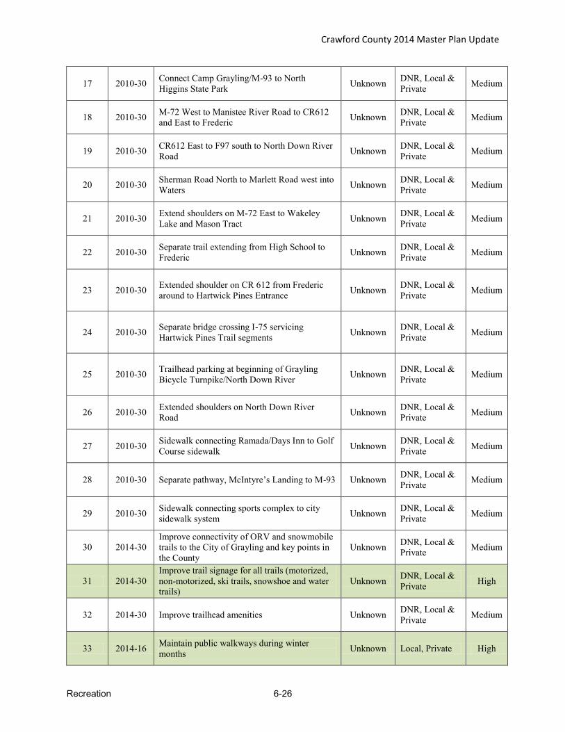
Crawford County 2014 Master Plan Update
Recreation 6-26
17 2010-30 Connect Camp Grayling/M-93 to North Higgins State Park Unknown DNR, Local &
Private Medium
18 2010-30 M-72 West to Manistee River Road to CR612 and East to Frederic Unknown DNR, Local &
Private Medium
19 2010-30 CR612 East to F97 south to North Down River Road Unknown DNR, Local &
Private Medium
20 2010-30 Sherman Road North to Marlett Road west into Waters Unknown DNR, Local &
Private Medium
21 2010-30 Extend shoulders on M-72 East to Wakeley Lake and Mason Tract Unknown DNR, Local &
Private Medium
22 2010-30 Separate trail extending from High School to Frederic Unknown DNR, Local &
Private Medium
23 2010-30 Extended shoulder on CR 612 from Frederic around to Hartwick Pines Entrance Unknown DNR, Local &
Private Medium
24 2010-30 Separate bridge crossing I-75 servicing Hartwick Pines Trail segments Unknown DNR, Local &
Private Medium
25 2010-30 Trailhead parking at beginning of Grayling Bicycle Turnpike/North Down River Unknown DNR, Local &
Private Medium
26 2010-30 Extended shoulders on North Down River Road Unknown DNR, Local &
Private Medium
27 2010-30 Sidewalk connecting Ramada/Days Inn to Golf Course sidewalk Unknown DNR, Local &
Private Medium
28 2010-30 Separate pathway, McIntyre’s Landing to M-93 Unknown DNR, Local & Private Medium
29 2010-30 Sidewalk connecting sports complex to city sidewalk system Unknown DNR, Local &
Private Medium
30 2014-30 Improve connectivity of ORV and snowmobile trails to the City of Grayling and key points in the County
Unknown DNR, Local & Private Medium
31 2014-30 Improve trail signage for all trails (motorized, non-motorized, ski trails, snowshoe and water trails)
Unknown DNR, Local & Private High
32 2014-30 Improve trailhead amenities Unknown DNR, Local & Private Medium
33 2014-16 Maintain public walkways during winter months Unknown Local, Private High
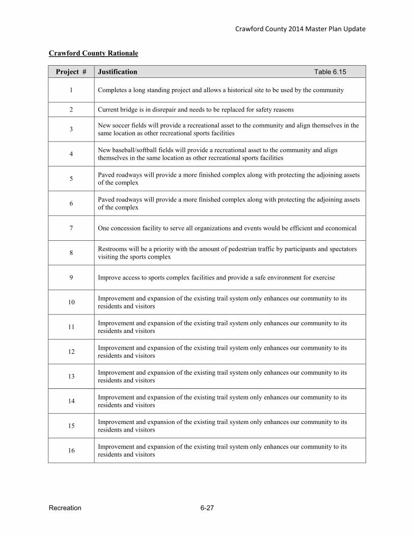
Crawford County 2014 Master Plan Update
Recreation 6-27
Crawford County Rationale
Project # Justification Table 6.15
1 Completes a long standing project and allows a historical site to be used by the community
2 Current bridge is in disrepair and needs to be replaced for safety reasons
3 New soccer fields will provide a recreational asset to the community and align themselves in the same location as other recreational sports facilities
4 New baseball/softball fields will provide a recreational asset to the community and align themselves in the same location as other recreational sports facilities
5 Paved roadways will provide a more finished complex along with protecting the adjoining assets of the complex
6 Paved roadways will provide a more finished complex along with protecting the adjoining assets of the complex
7 One concession facility to serve all organizations and events would be efficient and economical
8 Restrooms will be a priority with the amount of pedestrian traffic by participants and spectators visiting the sports complex
9 Improve access to sports complex facilities and provide a safe environment for exercise
10 Improvement and expansion of the existing trail system only enhances our community to its residents and visitors
11 Improvement and expansion of the existing trail system only enhances our community to its residents and visitors
12 Improvement and expansion of the existing trail system only enhances our community to its residents and visitors
13 Improvement and expansion of the existing trail system only enhances our community to its residents and visitors
14 Improvement and expansion of the existing trail system only enhances our community to its residents and visitors
15 Improvement and expansion of the existing trail system only enhances our community to its residents and visitors
16 Improvement and expansion of the existing trail system only enhances our community to its residents and visitors

Crawford County 2014 Master Plan Update
Recreation 6-28
17 Improvement and expansion of the existing trail system only enhances our community to its residents and visitors
18 Improvement and expansion of the existing trail system only enhances our community to its residents and visitors
19 Improvement and expansion of the existing trail system only enhances our community to its residents and visitors
20 Improvement and expansion of the existing trail system only enhances our community to its residents and visitors
21 Improvement and expansion of the existing trail system only enhances our community to its residents and visitors
22 Improvement and expansion of the existing trail system only enhances our community to its residents and visitors
23 Improvement and expansion of the existing trail system only enhances our community to its residents and visitors
24 Improvement and expansion of the existing trail system only enhances our community to its residents and visitors
25 Improvement and expansion of the existing trail system only enhances our community to its residents and visitors
27 Improvement and expansion of the existing trail system only enhances our community to its residents and visitors
28 Improvement and expansion of the existing trail system only enhances our community to its residents and visitors
29 Improvement and expansion of the existing trail system only enhances our community to its residents and visitors
30 Improvement in access to local facilities and business to improve the trail-friendly nature of the County
31 Improvement in the user-friendly nature and safety of the County trail systems
32 Improvement in the user-friendly nature and safety of the County trail systems
33 Improve safety of public walkways during the winter months

Crawford County 2014 Master Plan Update
Recreation 6-29
Crawford County Basis for Action
Of the 360,000 acres in Crawford County, almost 70% of it is publicly owned. Many of the more
than 14,000 people that live in this community do so because of the abundance of public land.
Certainly, many of the visitors to Crawford County throughout the year are here for that very
reason. It is for this purpose that the County must make the most of our recreational activities. The
more the County improves its recreational activities for those that live here and those that visit, the
more it will grow as a community, economically & culturally. Crawford County already boasts many
hunting and fishing opportunities. However, for its size, the County also has excellent non-
motorized trail opportunities to go along with canoeing, hiking, skiing, snowshoeing and biking
excursions waiting to be experienced. There exists a county-wide voted millage to preserve and
enhance the prospects of our recreational challenges.
Hatchery
The old Grayling Fish Hatchery has been a source of pride and nostalgia for many residents over the
years. Deeded to the County under a public use deed, it was operated by the Grayling Recreational
Authority as a fund raiser for many summers. Recently the Grayling Fish Hatchery operation was
taken over by a private contractor under the agreement that it remain open to the public. Over the
last ten years, grant dollars have been secured to reconstruct the raceways, enhance the grounds,
create a children’s fishing pond along with a storm water retention pond. The building has had its
roof replaced, the cupola restored and the exterior completely painted. It is now in need of a
complete interior restoration. Once complete, the building could be utilized by a public agency,
community service agency or historical preservation group. It could also potentially be converted
to a museum of area history. In any event, the once abandoned and dilapidated building would
regain its past luster and become a center of community activity once again.
The fish hatchery grounds provide even more opportunities for trips through nature. There are
occasional trails that follow the river up until the foot bridge. There are limitless opportunities to
expand these trails on site and connect with other trails leading to various points of interest in the
County. The fish hatchery grounds also have a dam to maintain water levels in the fish hatchery
races. Construction of a fish ladder around the dam will reconnect 28 miles of the East Branch of
the AuSabie River to the lower river habitat.
Sports Complex
Years ago, this parcel was deeded to the County by the State in order to allow the community a
place to hold its county fair. As time passed and interest waned in the fair, the property began to be
used as a center for sporting events, such as football, mud bogs and equestrian activities. Although
open and utilized by the community, the Crawford County Board of Commissioners has recognized
the potential for this site to be a “one-stop-shopping” for community sporting events that are not
sponsored by the public school system. The vision for this site would be to host the bulk of the
community sporting leagues such as football, soccer, baseball, etc. as well as a place for safe
walking/running. We believe, if designed well, the various groups could capitalize on the economies
of scale that occur when the organizations share one large site.
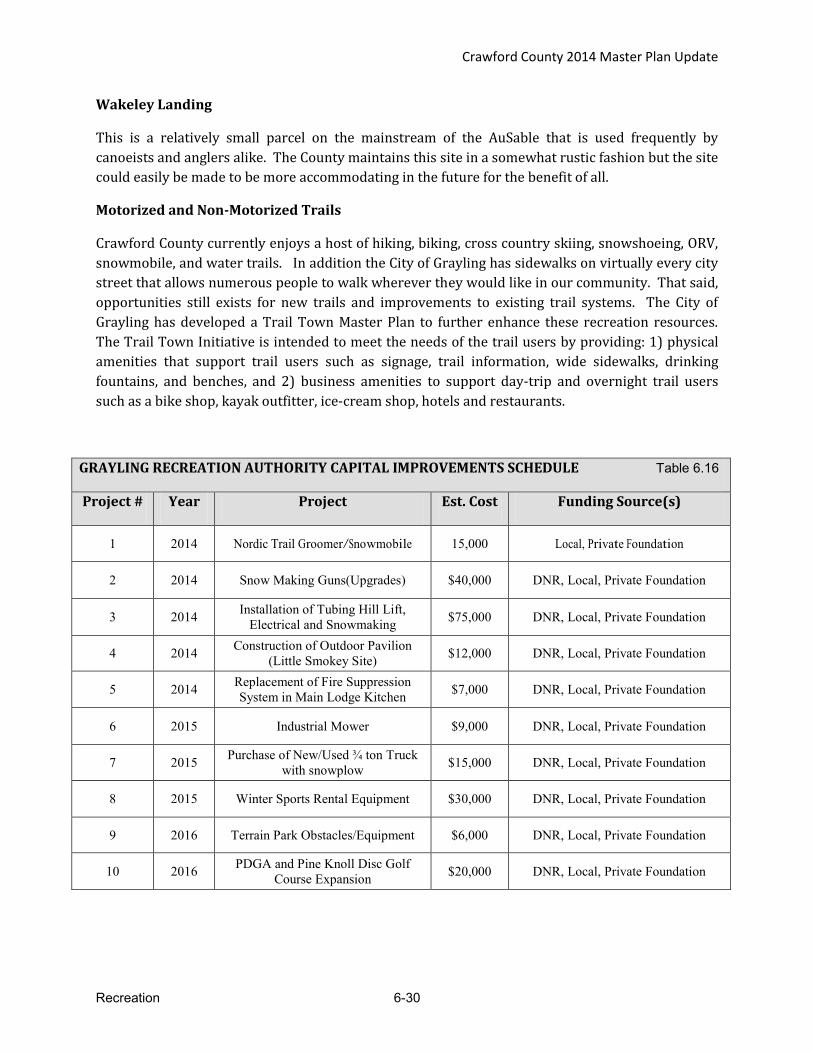
Crawford County 2014 Master Plan Update
Recreation 6-30
Wakeley Landing
This is a relatively small parcel on the mainstream of the AuSable that is used frequently by
canoeists and anglers alike. The County maintains this site in a somewhat rustic fashion but the site
could easily be made to be more accommodating in the future for the benefit of all.
Motorized and Non-Motorized Trails
Crawford County currently enjoys a host of hiking, biking, cross country skiing, snowshoeing, ORV,
snowmobile, and water trails. In addition the City of Grayling has sidewalks on virtually every city
street that allows numerous people to walk wherever they would like in our community. That said,
opportunities still exists for new trails and improvements to existing trail systems. The City of
Grayling has developed a Trail Town Master Plan to further enhance these recreation resources.
The Trail Town Initiative is intended to meet the needs of the trail users by providing: 1) physical
amenities that support trail users such as signage, trail information, wide sidewalks, drinking
fountains, and benches, and 2) business amenities to support day-trip and overnight trail users
such as a bike shop, kayak outfitter, ice-cream shop, hotels and restaurants.
GRAYLING RECREATION AUTHORITY CAPITAL IMPROVEMENTS SCHEDULE Table 6.16
Project # Year Project Est. Cost Funding Source(s)
1 2014 Nordic Trail Groomer/Snowmobile 15,000 Local, Private Foundation
2 2014 Snow Making Guns(Upgrades) $40,000 DNR, Local, Private Foundation
3 2014 Installation of Tubing Hill Lift, Electrical and Snowmaking $75,000 DNR, Local, Private Foundation
4 2014 Construction of Outdoor Pavilion (Little Smokey Site) $12,000 DNR, Local, Private Foundation
5 2014 Replacement of Fire Suppression System in Main Lodge Kitchen $7,000 DNR, Local, Private Foundation
6 2015 Industrial Mower $9,000 DNR, Local, Private Foundation
7 2015 Purchase of New/Used ¾ ton Truck with snowplow $15,000 DNR, Local, Private Foundation
8 2015 Winter Sports Rental Equipment $30,000 DNR, Local, Private Foundation
9 2016 Terrain Park Obstacles/Equipment $6,000 DNR, Local, Private Foundation
10 2016 PDGA and Pine Knoll Disc Golf Course Expansion $20,000 DNR, Local, Private Foundation

Crawford County 2014 Master Plan Update
Recreation 6-31
11 2017 Replacement of Siding, Windows and Doors on Main Lodge Facility $100,000 Local, Private Foundation
12 2017 Snowmobile (Ski Patrol) $12,000 DNR, Local, Private Foundation
13 2018 Lighted Ski/Walking Trail $10,000 DNR, Local, Private Foundation
14 2018 Lights for Softball Field $30,000 DNR, Local, Private Foundation
15 2019 Bridge to island and docks for pond $5,000 DNR, Local, Private Foundation
16 2019 Multi-Purpose Bathroom Facility $65,000 DNR, Local, Private Foundation
17 2019 Athletic Field Expansion $30,000 DNR, Local, Private Foundation
18 2019 Purchase of New/Used Downhill Groomer $80,000 DNR, Local, Private Foundation
Grayling Recreation Authority Rationale
Project # Justification Table 6.17
1 A snowmobile will increase the efficiency and labor spent on trail grooming.
2 Additional Snowmaking guns will insure that ski runs have adequate amounts of snow coverage for the safety of the participants.
3 The installation of a second lift and electrical and water for snowmaking capability will allow a greater volume of customers to enjoy tubing activities.
4 A multi-purpose pavilion will allow for more public/family events and allow participants to have shelter from the elements.
5 The installation of a Cooking Hood Fire Suppression System at Hanson Hills Recreation Area’s Main Lodge Building, to prevent potential personal injury, and prevent loss or significant damage to kitchen equipment and/or Lodge Building.
6 An industrial mower will allow for efficient mowing of grounds and athletic fields.
7 The purchase of a new/used Plow Truck will allow for efficient snow removal processes and will help reduce costly repairs of older equipment.
8 The availability of winter sports rental equipment is needed service to the customers.
9 Terrain Park obstacles will allow participants a variety of different technical challenges and to practice freestyle skills.
10 The expansion of Disc Golf Courses will allow for increased participation and provide an ideal tournament destination.
11 The replacement of siding, windows and doors on the Main Lodge facility will help to increase the heating efficiency, outside aesthetics, decrease the cost of repairs/maintenance and detour nesting bats.
12 A snowmobile will increase the efficiency and response time for the ski patrol.
13 Lighting the Nordic ski trails and the walking trail will allow for night use by residents/visitors who cannot use them at other times.
14 Lighting the Softball field will allow for league expansion. 15 Bridge and docks will allow participants better access for fishing & recreational purposes. 16 The construction of new outdoor bathroom will allow GRA to create a barrier free facility. 17 The expansion of athletic fields will allow for more adult sports leagues and children’s programs.
18 The purchase of a new/used Downhill Groomer will allow for efficient Grooming Practices and will help to reduce costly repairs of older equipment.
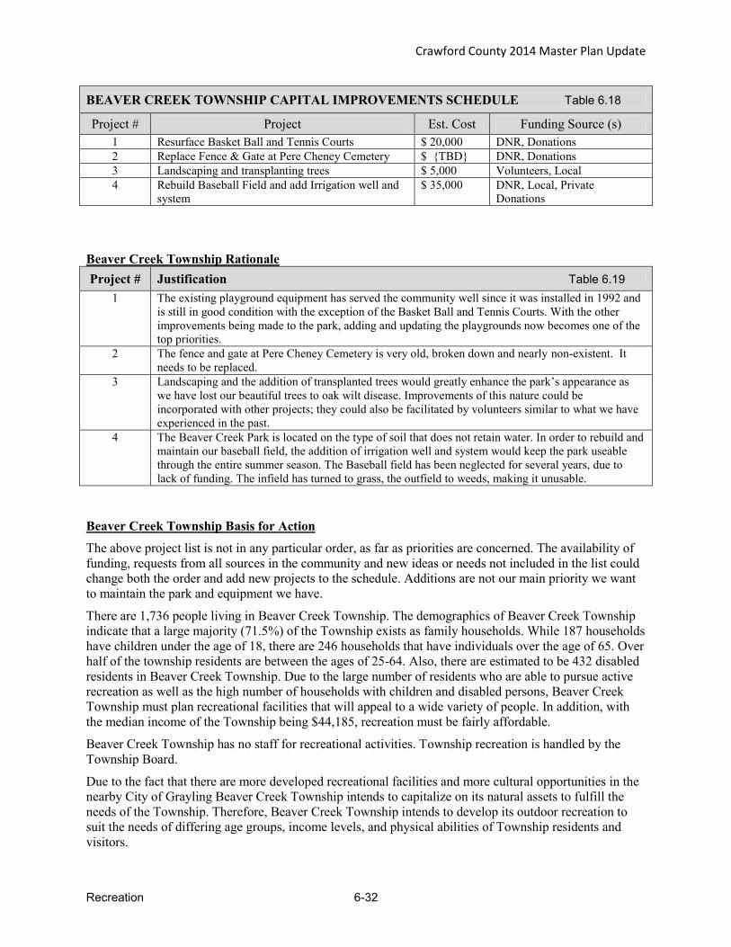
Crawford County 2014 Master Plan Update
Recreation 6-32
BEAVER CREEK TOWNSHIP CAPITAL IMPROVEMENTS SCHEDULE Table 6.18
Project # Project Est. Cost Funding Source (s) 1 Resurface Basket Ball and Tennis Courts $ 20,000 DNR, Donations 2 Replace Fence & Gate at Pere Cheney Cemetery $ {TBD} DNR, Donations 3 Landscaping and transplanting trees $ 5,000 Volunteers, Local 4 Rebuild Baseball Field and add Irrigation well and
system $ 35,000 DNR, Local, Private
Donations Beaver Creek Township Rationale Project # Justification Table 6.19
1 The existing playground equipment has served the community well since it was installed in 1992 and is still in good condition with the exception of the Basket Ball and Tennis Courts. With the other improvements being made to the park, adding and updating the playgrounds now becomes one of the top priorities.
2 The fence and gate at Pere Cheney Cemetery is very old, broken down and nearly non-existent. It needs to be replaced.
3 Landscaping and the addition of transplanted trees would greatly enhance the park’s appearance as we have lost our beautiful trees to oak wilt disease. Improvements of this nature could be incorporated with other projects; they could also be facilitated by volunteers similar to what we have experienced in the past.
4 The Beaver Creek Park is located on the type of soil that does not retain water. In order to rebuild and maintain our baseball field, the addition of irrigation well and system would keep the park useable through the entire summer season. The Baseball field has been neglected for several years, due to lack of funding. The infield has turned to grass, the outfield to weeds, making it unusable.
Beaver Creek Township Basis for Action
The above project list is not in any particular order, as far as priorities are concerned. The availability of funding, requests from all sources in the community and new ideas or needs not included in the list could change both the order and add new projects to the schedule. Additions are not our main priority we want to maintain the park and equipment we have.
There are 1,736 people living in Beaver Creek Township. The demographics of Beaver Creek Township indicate that a large majority (71.5%) of the Township exists as family households. While 187 households have children under the age of 18, there are 246 households that have individuals over the age of 65. Over half of the township residents are between the ages of 25-64. Also, there are estimated to be 432 disabled residents in Beaver Creek Township. Due to the large number of residents who are able to pursue active recreation as well as the high number of households with children and disabled persons, Beaver Creek Township must plan recreational facilities that will appeal to a wide variety of people. In addition, with the median income of the Township being $44,185, recreation must be fairly affordable.
Beaver Creek Township has no staff for recreational activities. Township recreation is handled by the Township Board.
Due to the fact that there are more developed recreational facilities and more cultural opportunities in the nearby City of Grayling Beaver Creek Township intends to capitalize on its natural assets to fulfill the needs of the Township. Therefore, Beaver Creek Township intends to develop its outdoor recreation to suit the needs of differing age groups, income levels, and physical abilities of Township residents and visitors.

Crawford County 2014 Master Plan Update
Recreation 6-33
Township Hall and Park
Beaver Creek Township plans to make major improvements to its township park since this is the only recreational property that the township owns. Park improvements are important to the township. As funding is secured, the township’s intent is to continue to make improvements so that it will offer all residents recreational opportunities.
The Township’s plan for development include additional pavilions, new playground equipment, shuffleboard courts, additional pavilions, lighting, and paving, landscaping and additional trails and parking.
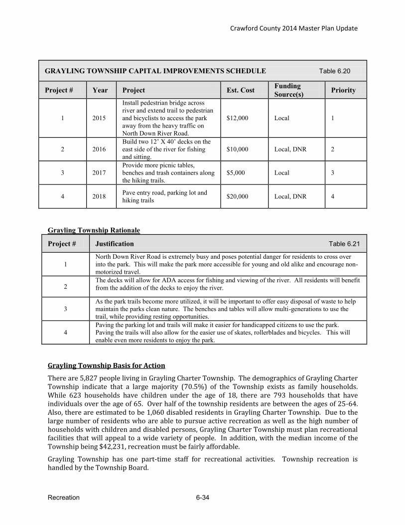
Crawford County 2014 Master Plan Update
Recreation 6-34
GRAYLING TOWNSHIP CAPITAL IMPROVEMENTS SCHEDULE Table 6.20
Project # Year Project Est. Cost Funding Source(s) Priority
1 2015
Install pedestrian bridge across river and extend trail to pedestrian and bicyclists to access the park away from the heavy traffic on North Down River Road.
$12,000 Local 1
2 2016 Build two 12’ X 40’ decks on the east side of the river for fishing and sitting.
$10,000 Local, DNR 2
3 2017 Provide more picnic tables, benches and trash containers along the hiking trails.
$5,000 Local 3
4 2018 Pave entry road, parking lot and hiking trails $20,000 Local, DNR 4
Grayling Township Rationale
Project # Justification Table 6.21
1 North Down River Road is extremely busy and poses potential danger for residents to cross over into the park. This will make the park more accessible for young and old alike and encourage non-motorized travel.
2 The decks will allow for ADA access for fishing and viewing of the river. All residents will benefit from the addition of the decks to enjoy the river.
3 As the park trails become more utilized, it will be important to offer easy disposal of waste to help maintain the parks clean nature. The benches and tables will allow multi-generations to use the trail, while providing resting opportunities.
4 Paving the parking lot and trails will make it easier for handicapped citizens to use the park. Paving the trails will also allow for the easier use of skates, rollerblades and bicycles. This will enable even more residents to enjoy the park.
Grayling Township Basis for Action
There are 5,827 people living in Grayling Charter Township. The demographics of Grayling Charter Township indicate that a large majority (70.5%) of the Township exists as family households. While 623 households have children under the age of 18, there are 793 households that have individuals over the age of 65. Over half of the township residents are between the ages of 25-64. Also, there are estimated to be 1,060 disabled residents in Grayling Charter Township. Due to the large number of residents who are able to pursue active recreation as well as the high number of households with children and disabled persons, Grayling Charter Township must plan recreational facilities that will appeal to a wide variety of people. In addition, with the median income of the Township being $42,231, recreation must be fairly affordable.
Grayling Township has one part-time staff for recreational activities. Township recreation is handled by the Township Board.
Crawford County 2014 Master Plan Update
Recreation 6-35
Due to the fact that there are more developed recreational facilities and more cultural opportunities in the nearby City of Grayling, Grayling Township intends to capitalize on its natural assets to fulfill the needs of the Township. Therefore, Grayling Township intends to develop its outdoor recreation to suit the needs of differing age groups, income levels, and physical abilities of Township residents and visitors.
Fish Hatchery Park Nature Park
Grayling Township plans to utilize this property to fill recreational gaps for all residents. The Township intends to develop the park property to include recreational opportunities for a variety of recreation activities and for all ages. To accommodate the increased usage, the parking lot will need to be improved. It is the townships desire to increase recreation opportunities at the park.
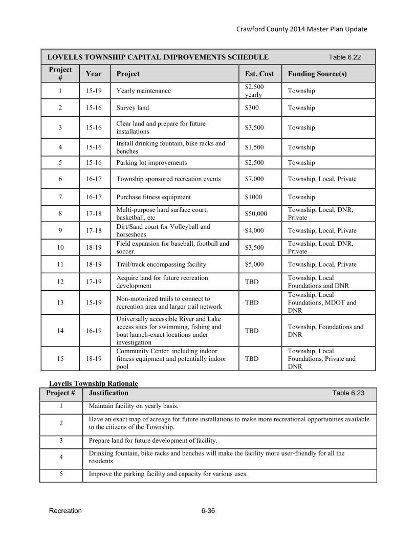
Crawford County 2014 Master Plan Update
Recreation 6-36
LOVELLS TOWNSHIP CAPITAL IMPROVEMENTS SCHEDULE Table 6.22 Project
# Year Project Est. Cost Funding Source(s)
1 15-19 Yearly maintenance $2,500 yearly Township
2 15-16 Survey land $300 Township
3 15-16 Clear land and prepare for future installations $3,500 Township
4 15-16 Install drinking fountain, bike racks and benches $1,500 Township
5 15-16 Parking lot improvements $2,500 Township
6 16-17 Township sponsored recreation events $7,000 Township, Local, Private
7 16-17 Purchase fitness equipment $1000 Township
8 17-18 Multi-purpose hard surface court, basketball, etc $50,000 Township, Local, DNR,
Private
9 17-18 Dirt/Sand court for Volleyball and horseshoes $4,000 Township, Local, Private
10 18-19 Field expansion for baseball, football and soccer. $3,500 Township, Local, DNR,
Private
11 18-19 Trail/track encompassing facility $5,000 Township, Local, Private
12 17-19 Acquire land for future recreation development TBD Township, Local
Foundations and DNR
13 15-19 Non-motorized trails to connect to recreation area and larger trail network TBD
Township, Local Foundations, MDOT and DNR
14 16-19
Universally accessible River and Lake access sites for swimming, fishing and boat launch-exact locations under investigation
TBD Township, Foundations and DNR
15 18-19 Community Center including indoor fitness equipment and potentially indoor pool
TBD Township, Local Foundations, Private and DNR
Lovells Township Rationale
Project # Justification Table 6.23
1 Maintain facility on yearly basis.
2 Have an exact map of acreage for future installations to make more recreational opportunities available to the citizens of the Township.
3 Prepare land for future development of facility.
4 Drinking fountain, bike racks and benches will make the facility more user-friendly for all the residents.
5 Improve the parking facility and capacity for various uses.

Crawford County 2014 Master Plan Update
Recreation 6-37
6 Encourage township participation and social activities.
7 Purchasing some sporting equipment will encourage increased use of the facilities and bike rack installation.
8 Constructions of a multi-use hard surfaced court will encourage multi-season recreation uses such as basketball, tennis, street hockey, rollerblading and ice skating for all ages.
9 Construction of a multi-use dirt court will encourage recreational uses such as volleyball, badminton, horse shoes and provide a backup court area to use to play if the hard surfaced court is in use.
10 Expansions of the current field will enable the field o be used for multi-purposes. This will encourage recreations of baseball, football and soccer.
11 Constructing a trail/track around the entire facility will serve as a facility boundary and can also encourage the recreations for a run/walk area.
12 In order to develop expand recreational opportunities in the Township, additional land will be ultimately be needed.
13 There is interest in providing non-motorized safe routes to recreational areas within the Township and also to connect to the expanding network of trails in Northern Michigan.
14 Many of the access sites on the rivers and lakes in the Township are challenging even for the spry, and given the median age of the Township residents of over 57 years of age it is increasingly important to provide access sites that utilize universal design principles to make these waterways accessible to all.
15
Given the length of winter in northern Michigan, and the above average median age, there is a strong desire to have a local indoor recreation facility. The Township Hall is scheduled for some of these uses on a limited basis, but due to meetings and hall rental fitness equipment must be hauled to and from the hall by the given groups.
Lovells Township Basis for Action
The above project list is not in any particular order, as far as priorities are concerned. The availability of funding, requests from all sources in the community and new ideas or needs not included in the list could change both the order and add new projects to the schedule.
There are 626 people living in Lovells Township. The demographics of Lovells Township indicate that a majority (59.4%) of the Township exists as family households. While 36 households have children under the age of 18, there are 147 households that have individuals over the age of 65. Just over half of the township residents are between the ages of 25-64. Also, there are estimated to be 151 disabled residents in Lovells Township. Due to the large number of residents who are able to pursue active recreation as well as the high number of households with children and disabled persons, Lovells Township must plan recreational facilities that will appeal to a wide variety of people. In addition, with the median income of the Township being $35,769, recreation must be fairly affordable.
Due to the fact that there are more developed recreational facilities and more cultural opportunities in the nearby City of Grayling, Lovells Township intends to capitalize on its natural assets to fulfill the needs of the Township. Therefore, Lovells Township intends to develop its outdoor recreation to suit the needs of differing age groups, income levels, and physical abilities of Township residents and visitors.
Douglas Park
Lovells Township plans to utilize this property to fill recreational gaps for all residents by developing the park property to include recreational opportunities for a variety of recreation activities for all ages. The park is lacking drinking fountains, basketball, tennis, street hockey, rollerblading, shuffle board courts,

Crawford County 2014 Master Plan Update
Recreation 6-38
walking/jogging trails, volleyball and badminton courts. To accommodate the increased usage, the parking lot will need to be improved. It is the townships desire to increase recreation opportunities at the park.

Crawford County 2014 Master Plan Update
Recreation 6-39
SOUTH BRANCH TOWNSHIP CAPITAL IMPROVEMENTS SCHEDULE Table 6.24
Project # Year Project Est.
Cost Funding Source(s) Priority
1. 2014-15 Construct township picnic area at the township hall property $5,000 Local, Private Donations MED
2. 2014 Mason Tract Trail reroute (Thayer Creek Loop) $1,000 Local, DNR, Private
Donations HIGH
3. Annually Mason Tract Ski Trail Grooming $1,000 Local, DNR, Private Donations HIGH
4. 2014-15 Permanent map installation at Mason Tract trail points of interests $2,000 Local, DNR, Private
Donations HIGH
5. 2014-15 Durant’s Castle canoe landing (replace existing dock with landing to improve canoe ingress/egress)
$20,000 Local, DNR, Private Donations HIGH
6. 2014-15 Development of AuSable Water Trail $2000 DNR, USFS, Business Owners, Huron Pines HIGH
South Branch Township Rationale Project # Justification Table 6.25
1. Provides a convenient picnic area for township residents.
2. Reroute required to avoid replacing a bridge that has a history of flooding due to beaver dams. All work to be done in conjunction with the MDNR.
3. Grooming has been suspended due to DNR funding issues. Grooming would be reinstituted through a volunteer effort of the Friends of the Mason Tract Group.
4. Permanent maps at all points of interest will aid hikers, hunters, skiers, fishermen and canoers in finding their way. It will also enhance emergency rescues. All work to be done in conjunction with the MDNR.
5. Repair work needed to address a canoe/kayak ingress/egress issue that exists due to the wide range in water depth. All work to be done in conjunction with the MDNR.
6. Provides emergency management number and maps at locations along the AuSable South Branch and Main Branch.
South Branch Township Basis for Action
There are 2,007 people living in South Branch Township. The demographics of South Branch Township indicate that a majority (68.1%) of the Township exists as family households. 189 households have children under the age of 18. Over half of the township residents are between the ages of 25-64. Also, there are estimated to be 266 disabled residents in South Branch Township. Due to the large number of residents who are able to pursue active recreation as well as the high number of households with children and disabled persons, South Branch Township must plan recreational facilities that will appeal to a wide variety of people. In addition, with the median income of the Township being $49,180, recreation must be fairly affordable.

Crawford County 2014 Master Plan Update
Recreation 6-40
South Branch Township has no staff for recreational activities. Township recreation is handled by the Township Board.
Due to the fact that there are more developed recreational facilities and more cultural opportunities in the nearby City of Grayling, South Branch Township intends to capitalize on its natural assets to fulfill the needs of the Township. Therefore, South Branch Township intends to develop its outdoor recreation to suit the needs of differing age groups, income levels, and physical abilities of Township residents and visitors.
Township Hall Property
South Branch Township has very little in the way of developed recreational facilities such as parks, playgrounds, ball fields, etc. South Branch Township is interested in pursuing a careful expansion of recreational facilities within the township in order to better meet the needs of its residents. Constructing a public picnic area at this location will provide a convenient picnic area for Township residents.
Trails
South Branch Township plans to use the natural assets of this area in order to provide the public access to the natural amenities. The Township has excellent access to the main branch and the south branch of the AuSable River for outdoor recreational activities. Hiking, cross country ski and snowmobiles trails have already been established and are dependent upon the MDNR and the NFS to maintain. Therefore, the Township wishes to focus on assuring that the non-motorized trails systems are adequately maintained by the appropriate unit of Government. Consistent with this desire, South Branch Township has formed a Friends of the Mason Tract group through a Memorandum of Agreement with the MDNR. This group will facilitate maintenance and improvement of the Mason Tract through the involvement of volunteers. The Friends of the Mason Tract will also pursue arrangements to groom the Mason Tract trail for cross country skiing in the winter. All work will be done in conjunction with the MDNR.
Water Access
The township has plenty of access to the AuSable River. Durant’s Castle canoe dock was replaced with a handicap accessible dock. However, canoe/kayak ingress/egress is an issue due the wide range in water levels. Replacement of the dock with a canoe landing is planned to address the ingress/egress issues. The AuSable Water Trail project will provide emergency management number and maps at key points along the river for use by canoers, kayakers, and fishermen. All work will be done in conjunction with the MDNR.

Crawford County 2014 Master Plan Update
Status of Planning and Zoning 7-1
Chapter 7 – Status of Planning and Zoning Introduction Planning and Zoning are the principal tools that local communities have to manage growth, preserve community character, protect property values and enhance the economic viability of the area. Planning helps establish and focus the desired future of the community and zoning ordinances are used as one of the primary ways to implement the community master plan and achieve the goals of the community. The purpose of this chapter is to present the status of planning and zoning in Crawford County. It is not the intention to compare the strengths and weaknesses of zoning regulations among the various zoning ordinances, but to give a general perspective on planning and zoning in the county. Table 7.1 presents the status of planning in Crawford County. In the county, the City of Grayling and all the townships have adopted master plans. All of the communities administer their own zoning ordinance.
Table 7.1 Crawford County Planning and Zoning Status
Municipality Master Plan (year adopted)
Zoning Ordinance (year of last amendment)
Beaver Creek Township 2006 2014 (update in-progress) Frederic Township 2014 2010 Grayling Township * 2010 Lovells Township * 2012 Maple Forest Township 2013 2011 South Branch Township 2006 2013 City of Grayling 2008 2009 Crawford County 2009 - * Updates in process--anticipated 2014
Crawford County 2014 Master Plan Update
Status of Planning and Zoning 7-2
Community Future Land Use Plans A key element of the community master plan is the future land use plan. This is the culmination of the planning process that entails an analysis of existing conditions, public input and goal setting, and finally establishing the community’s desired future. The community-wide future land use plan includes a map that depicts where the community envisions types and densities of development. As well, the plan may address important resource areas to protect. Accompanying text describes future land use categories, compatible uses, incompatible uses and development densities. Special issue areas may include utility service areas, roads, open space development and waterfront development. The future land use plan is a policy document designed to guide land use decisions over a given planning horizon, usually 20 years. By comparison, the zoning ordinance and zoning map is a local law that regulates how property can be developed today. See Chapter 10 for a Crawford County composite future land us map, which combines the future land use maps from each of the local jurisdictions. Generally communities place public lands into low intensity development categories such as forest recreation, resource conservation or public lands. Most townships have identified select areas of public land for private development such as residential, commercial or industrial. Grayling Township and Beaver Creek Township have identified the largest areas of public lands for private development mostly around the West 4 Mile Road interchange and between West 4 mile and M-72. Kirtland Community College is exploring the development of a Health Sciences Campus on former State property recently transferred to the community college, located north of West 4 Mile and east of I-75. If this project is built, this area may experience associated growth such as residential and commercial/retail. Community Zoning With South Branch Township adopting its own ordinance in March, 2008, all zoning is administered at the local level. Tables on the following pages summarize each community’s zoning districts by showing minimum lot sizes, and general uses such as residential and commercial. In natural resource and agricultural districts most communities allow for minimum two acre lot sizes for residential. Maple Forest allows minimum 10 acre lot sizes in their Resource Conservation; South Branch Township allows a minimum 20 acre lot size in its resource conservation district, while Frederic Township allows for 20 acre minimum lots sizes in its Deferred Development. All of the communities recognize the natural rivers act for the Au Sable River and in the case of Frederic Township the Upper Manistee River. Figure 7.1 is a composite zoning map for Crawford County. Areas colored yellow and orange are zoned for residential, areas colored red are commercial and purple areas are zoned for industrial.
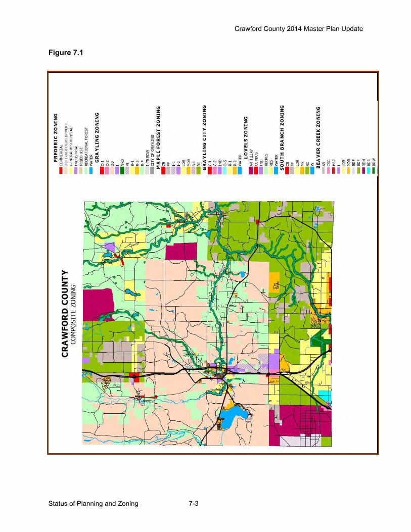
Crawford County 2014 Master Plan Update
Status of Planning and Zoning 7-3
Figure 7.1
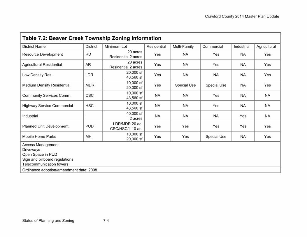
Crawford County 2014 Master Plan Update
Status of Planning and Zoning 7-4
Table 7.2: Beaver Creek Township Zoning Information District Name District Minimum Lot Residential Multi-Family Commercial Industrial Agricultural
Resource Development RD 20 acres Residential 2 acres Yes NA Yes NA Yes
Agricultural Residential AR 20 acres Residential 2 acres Yes NA Yes NA Yes
Low Density Res. LDR 20,000 sf 43,560 sf Yes NA NA NA Yes
Medium Density Residential MDR 10,000 sf 20,000 sf Yes Special Use Special Use NA Yes
Community Services Comm. CSC 10,000 sf 43,560 sf NA NA Yes NA NA
Highway Service Commercial HSC 10,000 sf 43,560 sf NA NA Yes NA NA
Industrial I 40,000 sf 2 acres NA NA NA Yes NA
Planned Unit Development PUD LDR/MDR 20 ac. CSC/HSC/I 10 ac. Yes Yes Yes Yes Yes
Mobile Home Parks MH 10,000 sf 20,000 sf Yes Yes Special Use NA Yes
Access Management Driveways Open Space in PUD Sign and billboard regulations Telecommunication towers Ordinance adoption/amendment date: 2008

Crawford County 2014 Master Plan Update
Status of Planning and Zoning 7-5
Table 7.3: Frederic Township Zoning Information District Name District Minimum Lot Residential Multi-Family Commercial Industrial Agricultural General Residential R 20,000 sf Yes Special Use NA NA NA Mixed Use MU 20,000 sf Yes Special Use Yes NA NA Commercial C 26,000 sf NA NA Yes NA NA Industrial I 5 acres NA NA NA Yes NA
Recreational-Forest R-F 40,000 sf Yes Special Use Limited Special Use NA Yes
Deferred Development DD 20 acres NA NA NA Yes AuSable River ARD 50,000 sf Yes NA NA NA NA Manistee River MR 80,000 sf Yes NA NA NA NA Landscaping PUD may be established in all districts except ARD and MRD Sign and billboard regulations Telecommunication towers Wind Turbine Generators Ordinance adoption/amendment date: 2010
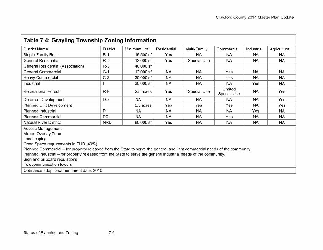
Crawford County 2014 Master Plan Update
Status of Planning and Zoning 7-6
Table 7.4: Grayling Township Zoning Information District Name District Minimum Lot Residential Multi-Family Commercial Industrial Agricultural Single-Family Res. R-1 15,500 sf Yes NA NA NA NA General Residential R- 2 12,000 sf Yes Special Use NA NA NA General Residential (Association) R-3 40,000 sf General Commercial C-1 12,000 sf NA NA Yes NA NA Heavy Commercial C-2 30,000 sf NA NA Yes NA NA Industrial I 30,000 sf NA NA NA Yes NA
Recreational-Forest R-F 2.5 acres Yes Special Use Limited Special Use NA Yes
Deferred Development DD NA NA NA NA NA Yes Planned Unit Development 2.5 acres Yes yes Yes NA Yes Planned Industrial PI NA NA NA NA Yes NA Planned Commercial PC NA NA NA Yes NA NA Natural River District NRD 80,000 sf Yes NA NA NA NA Access Management Airport Overlay Zone Landscaping Open Space requirements in PUD (40%) Planned Commercial – for property released from the State to serve the general and light commercial needs of the community. Planned Industrial – for property released from the State to serve the general industrial needs of the community. Sign and billboard regulations Telecommunication towers Ordinance adoption/amendment date: 2010
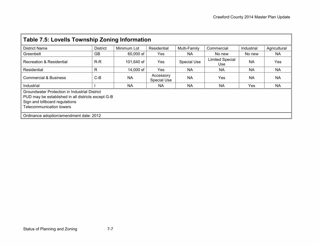
Crawford County 2014 Master Plan Update
Status of Planning and Zoning 7-7
Table 7.5: Lovells Township Zoning Information District Name District Minimum Lot Residential Multi-Family Commercial Industrial Agricultural Greenbelt GB 60,000 sf Yes NA No new No new NA
Recreation & Residential R-R 101,640 sf Yes Special Use Limited Special Use NA Yes
Residential R 14,000 sf Yes NA NA NA NA
Commercial & Business C-B NA Accessory Special Use NA Yes NA NA
Industrial I NA NA NA NA Yes NA Groundwater Protection in Industrial District PUD may be established in all districts except G-B Sign and billboard regulations Telecommunication towers
Ordinance adoption/amendment date: 2012
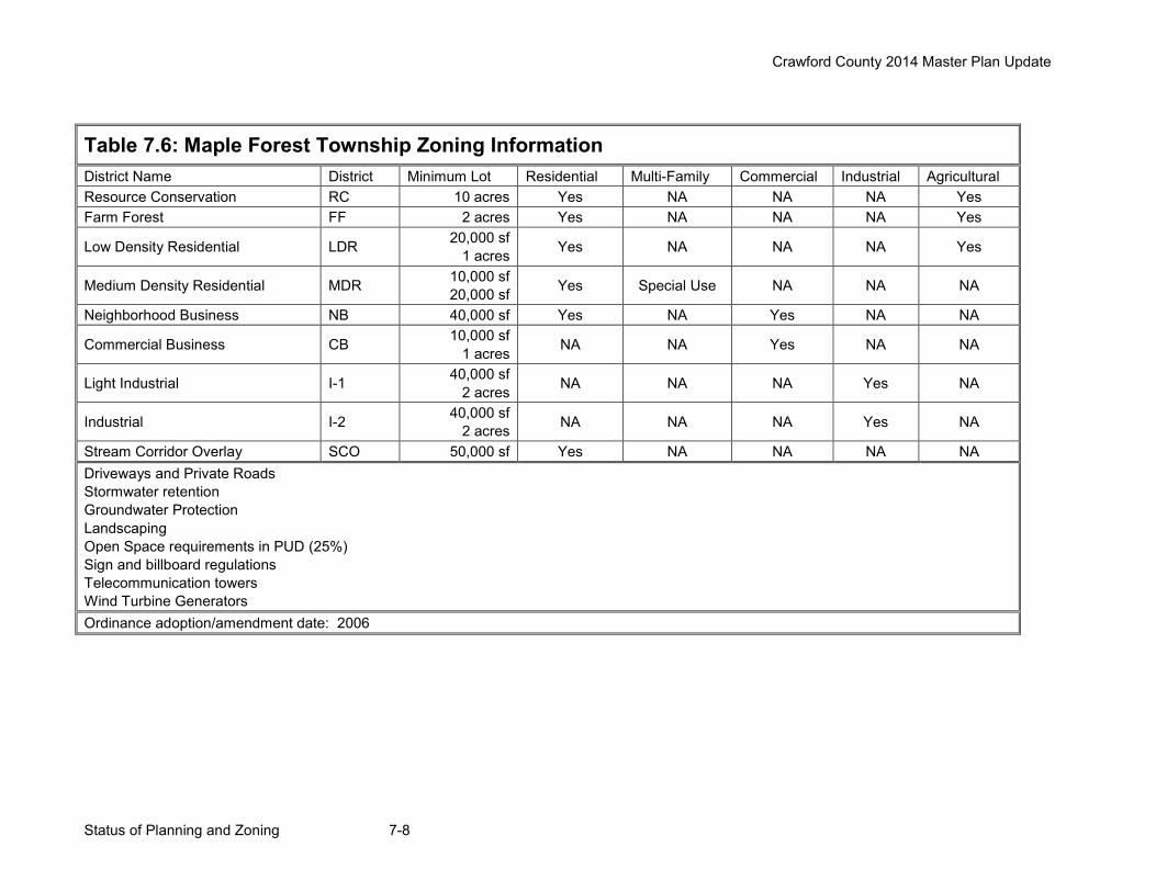
Crawford County 2014 Master Plan Update
Status of Planning and Zoning 7-8
Table 7.6: Maple Forest Township Zoning Information District Name District Minimum Lot Residential Multi-Family Commercial Industrial Agricultural Resource Conservation RC 10 acres Yes NA NA NA Yes Farm Forest FF 2 acres Yes NA NA NA Yes
Low Density Residential LDR 20,000 sf 1 acres Yes NA NA NA Yes
Medium Density Residential MDR 10,000 sf 20,000 sf Yes Special Use NA NA NA
Neighborhood Business NB 40,000 sf Yes NA Yes NA NA
Commercial Business CB 10,000 sf 1 acres NA NA Yes NA NA
Light Industrial I-1 40,000 sf 2 acres NA NA NA Yes NA
Industrial I-2 40,000 sf 2 acres NA NA NA Yes NA
Stream Corridor Overlay SCO 50,000 sf Yes NA NA NA NA Driveways and Private Roads Stormwater retention Groundwater Protection Landscaping Open Space requirements in PUD (25%) Sign and billboard regulations Telecommunication towers Wind Turbine Generators Ordinance adoption/amendment date: 2006
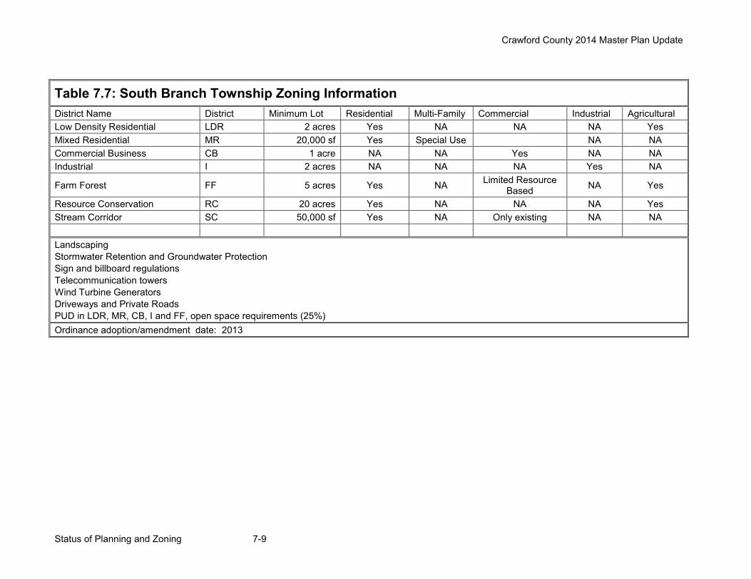
Crawford County 2014 Master Plan Update
Status of Planning and Zoning 7-9
Table 7.7: South Branch Township Zoning Information District Name District Minimum Lot Residential Multi-Family Commercial Industrial Agricultural Low Density Residential LDR 2 acres Yes NA NA NA Yes Mixed Residential MR 20,000 sf Yes Special Use NA NA Commercial Business CB 1 acre NA NA Yes NA NA Industrial I 2 acres NA NA NA Yes NA
Farm Forest FF 5 acres Yes NA Limited Resource Based NA Yes
Resource Conservation RC 20 acres Yes NA NA NA Yes Stream Corridor SC 50,000 sf Yes NA Only existing NA NA Landscaping Stormwater Retention and Groundwater Protection Sign and billboard regulations Telecommunication towers Wind Turbine Generators Driveways and Private Roads PUD in LDR, MR, CB, I and FF, open space requirements (25%) Ordinance adoption/amendment date: 2013
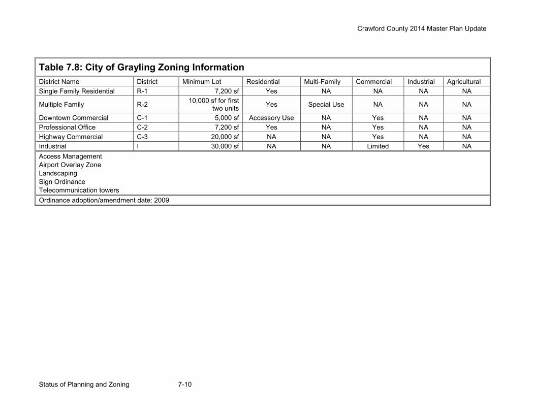
Crawford County 2014 Master Plan Update
Status of Planning and Zoning 7-10
Table 7.8: City of Grayling Zoning Information District Name District Minimum Lot Residential Multi-Family Commercial Industrial Agricultural Single Family Residential R-1 7,200 sf Yes NA NA NA NA
Multiple Family R-2 10,000 sf for first two units Yes Special Use NA NA NA
Downtown Commercial C-1 5,000 sf Accessory Use NA Yes NA NA Professional Office C-2 7,200 sf Yes NA Yes NA NA Highway Commercial C-3 20,000 sf NA NA Yes NA NA Industrial I 30,000 sf NA NA Limited Yes NA Access Management Airport Overlay Zone Landscaping Sign Ordinance Telecommunication towers Ordinance adoption/amendment date: 2009
Crawford County 2014 Master Plan Update
Community Goals and Objectives 8-1
Chapter 8 – Community Goals and Objectives Introduction This chapter of the County’s Master Plan will set forth goals and recommendations. These are written to have a countywide perspective, though they do address common local issues. It is not the intention of the Crawford County Planning Commission for these goals to replace goals and objectives found in township or city master plans; but to bring forth a multi-jurisdictional approach to addressing common community needs and issues. It is hopeful these goals and recommendations will not only provide guidance to Crawford County government, but also encourage a coordinated approach to planning and zoning at a local level. Surveys and Workshops There have been a number of “Visioning” efforts completed in recent years. These include goal-setting workshops conducted by many communities as a part of their master planning process; a series of Focus Groups Sessions held by the Grayling Regional Chamber of Commerce in 2002; and two roundtable discussions held by the County Planning Commission (see Appendix A). All of these efforts were reviewed and used to develop goals and recommendations for the master plan. There are a number of common themes that surface in all of the surveys and workshops. 1) People live in and visit Crawford County because of the abundant natural resources, which
include forests, lakes, streams, clean air, wetlands, wildlife and fish. 2) People like the County because of its rural character and friendly atmosphere. 3) Development pressures are increasing. Growth needs to be managed to preserve the very
reasons people live here. However, this should be done without over regulating landowners. 4) There is a need for ongoing education on land use planning geared at both the general
public and local decision makers. 5) There is a lack of good paying jobs within the County. A coordinated effort, by communities
and organizations, must continue and expand to improve the economic health of Crawford County.
6) Communities need to invest in the infrastructure such schools, roads, water and sewer, public facilities and parks, downtown business districts, public transit, industrial parks, and recreational trails.
7) There needs to be more commercial and retail opportunities for residents of the County. 8) There is a general consensus that, where appropriate, the transfer of public lands into
private ownership would benefit the county and local communities. During the 2014 Master Plan Update, the Planning Commission reviewed the past input and the above themes and determined that the input was still relevant. Based on the past input, additional input received during the update process as well as the information from the recently completed Crawford County Wildfire Protection Plan (2013), the Planning Commission prepared the following goals with supporting objectives and recommendations.
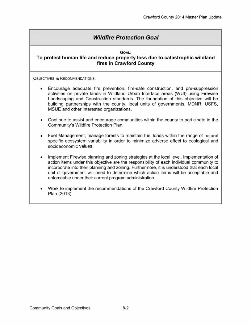
Crawford County 2014 Master Plan Update
Community Goals and Objectives 8-2
Wildfire Protection Goal
GOAL: To protect human life and reduce property loss due to catastrophic wildland
fires in Crawford County
OBJECTIVES & RECOMMENDATIONS:
Encourage adequate fire prevention, fire-safe construction, and pre-suppression activities on private lands in Wildland Urban Interface areas (WUI) using Firewise Landscaping and Construction standards. The foundation of this objective will be building partnerships with the county, local units of governments, MDNR, USFS, MSUE and other interested organizations.
Continue to assist and encourage communities within the county to participate in the Community’s Wildfire Protection Plan.
Fuel Management; manage forests to maintain fuel loads within the range of natural specific ecosystem variability in order to minimize adverse effect to ecological and socioeconomic values.
Implement Firewise planning and zoning strategies at the local level. Implementation of action items under this objective are the responsibility of each individual community to incorporate into their planning and zoning. Furthermore, it is understood that each local unit of government will need to determine which action items will be acceptable and enforceable under their current program administration.
Work to implement the recommendations of the Crawford County Wildfire Protection Plan (2013).
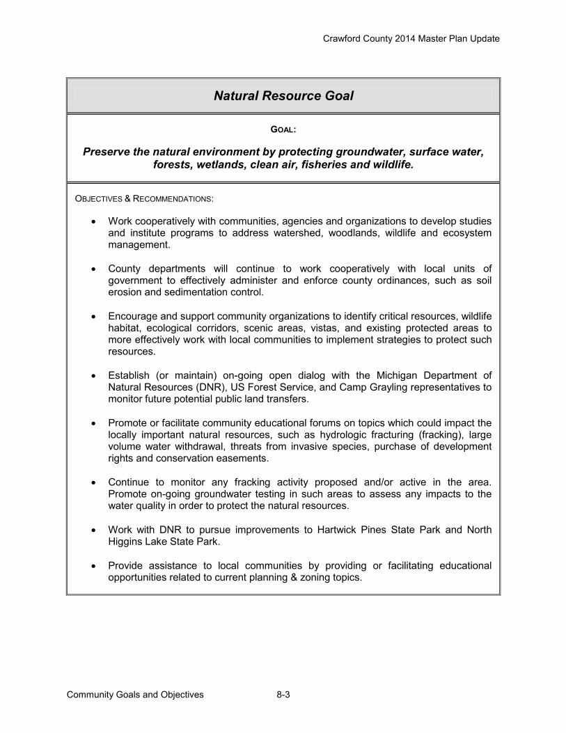
Crawford County 2014 Master Plan Update
Community Goals and Objectives 8-3
Natural Resource Goal
GOAL:
Preserve the natural environment by protecting groundwater, surface water, forests, wetlands, clean air, fisheries and wildlife.
OBJECTIVES & RECOMMENDATIONS:
Work cooperatively with communities, agencies and organizations to develop studies and institute programs to address watershed, woodlands, wildlife and ecosystem management.
County departments will continue to work cooperatively with local units of government to effectively administer and enforce county ordinances, such as soil erosion and sedimentation control.
Encourage and support community organizations to identify critical resources, wildlife habitat, ecological corridors, scenic areas, vistas, and existing protected areas to more effectively work with local communities to implement strategies to protect such resources.
Establish (or maintain) on-going open dialog with the Michigan Department of Natural Resources (DNR), US Forest Service, and Camp Grayling representatives to monitor future potential public land transfers.
Promote or facilitate community educational forums on topics which could impact the locally important natural resources, such as hydrologic fracturing (fracking), large volume water withdrawal, threats from invasive species, purchase of development rights and conservation easements.
Continue to monitor any fracking activity proposed and/or active in the area. Promote on-going groundwater testing in such areas to assess any impacts to the water quality in order to protect the natural resources.
Work with DNR to pursue improvements to Hartwick Pines State Park and North Higgins Lake State Park.
Provide assistance to local communities by providing or facilitating educational opportunities related to current planning & zoning topics.

Crawford County 2014 Master Plan Update
Community Goals and Objectives 8-4
Land Use Goal
GOAL:
Encourage a coordinated, locally administered approach to regulating land uses in order to protect the natural, social, cultural, and economic resources
in each jurisdiction. OBJECTIVES & RECOMMENDATIONS:
Address cross-jurisdictional issues when reviewing and commenting on local (or adjacent) community master plans and zoning ordinances.
Provide information and assistance to local communities to address current planning and zoning issues and foster improved communication.
Support or facilitate land use education programs for county and local officials.
Continue to fund and support the Crawford County Planning Commission to provide County level planning coordination and review services.
Improve public awareness and effectiveness of the Crawford County Planning Commission through the coordination, facilitation, and promotion of local educational opportunities and assistance for local communities.
Coordinate an annual joint meeting/awards luncheon to promote communication between local planning commissions and recognize outstanding local planning and zoning efforts.
Explore opportunities for some common zoning provisions (for adoption locally) across the County.

Crawford County 2014 Master Plan Update
Community Goals and Objectives 8-5
Economic & Business Goals
GOAL:
Improve the competitiveness of the county’s economy while enhancing the
employment opportunities for residents and the profitability of businesses and industries.
Promote a varied business environment, and encourage retention, expansion
and enhancement of business and industry to meet the needs of residents and tourists, while preserving the natural environment and rural character of the
community. OBJECTIVES & RECOMMENDATIONS:
Work cooperatively with Kirtland Community College to promote the development of the Health Sciences Campus near the 4 Mile Road/I-75 interchange.
Promote economic development opportunities in Crawford County and coordinate efforts with existing organizations.
Continue to work with economic development organizations, local communities, and Chambers of Commerce to promote the area for natural resource based recreational tourism, and as a prime location to live, work and play!
Promote Trail Town initiative county-wide to promote the area for the recreational trails: water, hiking, biking, skiing, snowmobiling and ORV.
Work with Chambers of Commerce and local businesses to develop and/or promote a shop local program.
Continue to pursue broad band and high speed internet services throughout the County.
Work with local businesses and organizations, with support from regional and state organizations to enhance the economic prosperity of Crawford County.
Encourage local communities to support existing commercial centers and direct new commercial development to locate in designated hubs and corridors.
Recommend local communities incorporate sound planning and zoning techniques to support local commercial business, such as clustering, shared parking, access management and landscaping standards.
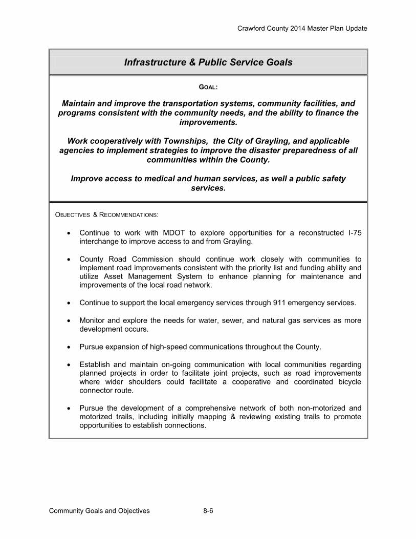
Crawford County 2014 Master Plan Update
Community Goals and Objectives 8-6
Infrastructure & Public Service Goals
GOAL:
Maintain and improve the transportation systems, community facilities, and
programs consistent with the community needs, and the ability to finance the improvements.
Work cooperatively with Townships, the City of Grayling, and applicable
agencies to implement strategies to improve the disaster preparedness of all communities within the County.
Improve access to medical and human services, as well a public safety
services. OBJECTIVES & RECOMMENDATIONS:
Continue to work with MDOT to explore opportunities for a reconstructed I-75 interchange to improve access to and from Grayling.
County Road Commission should continue work closely with communities to implement road improvements consistent with the priority list and funding ability and utilize Asset Management System to enhance planning for maintenance and improvements of the local road network.
Continue to support the local emergency services through 911 emergency services.
Monitor and explore the needs for water, sewer, and natural gas services as more development occurs.
Pursue expansion of high-speed communications throughout the County.
Establish and maintain on-going communication with local communities regarding
planned projects in order to facilitate joint projects, such as road improvements where wider shoulders could facilitate a cooperative and coordinated bicycle connector route.
Pursue the development of a comprehensive network of both non-motorized and motorized trails, including initially mapping & reviewing existing trails to promote opportunities to establish connections.

Crawford County 2014 Master Plan Update
Community Goals and Objectives 8-7
Residential Goal
GOAL:
Encourage a variety of suitable housing opportunities to meet the lifestyle needs of all, regardless of economic circumstances or age.
OBJECTIVES & RECOMMENDATIONS:
Encourage communities to designate areas appropriate for all types of residential housing including single family, multi-family, condominium, low to moderate-income rental complexes, and extended care facilities, especially near community facilities and shopping areas.
Continue to support and promote the Crawford County Housing Commission and
Michigan State Housing Development Authority (MSHDA) programs to rehabilitate substandard housing and to provide needed moderately priced housing in the County.
Encourage all communities to preserve the integrity of existing residential areas by
protecting them from intrusion of incompatible uses.
Explore allowing construction of an accessory structure prior to a dwelling in some zoning districts and share information with local units of governments.

Crawford County 2014 Master Plan Update
Community Goals and Objectives 8-8
Recreation and Public Lands Goal
GOAL:
Preserve and improve access to public lands and water, recreation trails, public parks and recreation facilities for the safe enjoyment by residents,
visitors, and future generations. ADDITIONAL COMPONENT GOALS:
1. Pursue improvements to recreational opportunities within Crawford County.
2. Ensure public recreational facilities and activities are open and accessible to all.
3. Work cooperatively with appropriate agencies and units of government to develop and maintain an extensive network of trails and the necessary support facilities for each, including hiking, biking, horseback riding, x-c skiing, snowmobiling, and ORV.
4. Work cooperatively with appropriate agencies and units of government to establish and maintain access sites for canoe/kayak use and fishing access, and promote the local water trails.
5. Work cooperatively to promote recreational opportunities in the area and the related economic benefits for the region, including providing support for the Trail Town initiative.
[see Chapter 6-Recreation for County and Township specific goals and objectives]

Crawford County 2014 Master Plan Update
Public Lands Analysis 9-1
Chapter 9 – Public Lands Analysis A key factor that determines community character and the location of potential future development areas is the amount of land public ownership. Table 9.1 and Figure 9.1 show the breakdown of public land ownership in Crawford County. Excluding water, all public lands (including that owned by cities, townships, the county, as well as federal and state properties) make up over 70 percent of the county's total land area. Communities have been successful in working with the State of Michigan to transfer public lands into private ownership for economic development. The Michigan Department of Natural Resources is in the process of completing a review of state-owned, the DNR administered lands. According to the DNR Web site, “The DNR is completing this land review to evaluate state-owned parcels located outside DNR project boundaries to determine if their natural resource and outdoor recreation values contribute significantly to the DNR’s mission. Completing this review will assist the DNR in consolidating state land ownership. This will also increase efficiency of management by reducing the cost of managing small, isolated parcels, especially those that do not have significant natural resource or recreation potential. The proceeds from the sale or exchange of such parcels will be used to acquire replacement land to consolidate state lands and increase recreation opportunities.” This section will identify state owned lands that communities would potentially be interested in having transferred into private ownership. Community master plans, zoning ordinances, long range community development proposals, in addition to local officials’ input, help guide this process.
Table 9.1 Crawford County Land Ownership
Public Lands Acres Percent State of Michigan 116,614 32 Military 97,294 27 USA 41,433 12 Other Public 1,366 >1 Water 3,031 >1 Source: NEMCOG
Figure 9.2 shows publicly owned lands that communities have identified for private economic development. The areas are mapped according to type of proposed development such as commercial or industrial. Areas were identified in master plans, zoning ordinances or other community planning activities. Maple Forest Township has identified lands around the Frederic I-75 Interchange for future commercial and light industrial development. State owned lands in Section 6 adjacent to several small lakes have been identified for future residential development. In addition, state lands at the intersection of Co Rd. 612 and Hartwick Pines Road are identified for neighborhood business and lands bordering Bear Lake are identified for transfer to Township ownership for development of a park. Frederic Township identified lands in Sections 25 and 36 in T.28N.-R.4W. for industrial development.

Crawford County 2014 Master Plan Update
Public Lands Analysis 9-2
The County Master Plan supports the transfer of State lands to private ownership to support development of residential, commercial and industrial uses in locations identified by the local communities. Figure 9.2 depicts areas identified by communities as part of an outreach effort by the County Planning Commission. The intent is to depict land identified to date, but should not construed as the only areas to be considered for future transfer to private ownership.

Crawford County 2014 Master Plan Update
Public Lands Analysis 9-3
Figure 9.1

Crawford County 2014 Master Plan Update
Public Lands Analysis 9-4
Figure 9.2
Crawford County 2014 Master Plan Update
Future Land Use 10-1
Chapter 10 – Future Land Use
The Crawford County Planning Commission serves as a coordinating and reviewing body regarding planning and zoning activities within the County with zoning ordinances adopted and administered by the local units of government. Thus this chapter compiles the future land use information from the most recently adopted master plans of the local units of government, and presents it in two map formats to more readily assess what is planned for the future of the entire County.
Figure 10.1 presents a Composite Future Land Use Map which combines the Future Land Use Maps for each of the Townships and the City of Grayling into a single map. As seen in the legend on the map, each jurisdiction has slight difference in the future land use categories and the number of categories.
Figure 10.2 presents a Generalized Future Land Use Map which is a revision of Figure 10.1 to map the future land uses across the County into the following ten broad future land use categories: Residential; Commercial/ Business/ Office; Industrial/Planned Mixed Use; Institutional; Rights-of-way (ROW); Recreation; Forest/ Recreation/ Residential; Stream Corridor; Public/ Conservation/ Open Space; and Water. A comparison of the generalized future land use categories and the categories utilized by each of the local units of government is presented in Table 10.1.
Due to the importance and prominence of public lands in Crawford County, as well as the risks of wildfire in this County, both are included for ease of reference in this chapter as Figures 10.3 and 10.4.

Crawford County 2014 Master Plan Update
Future Land Use 10-2
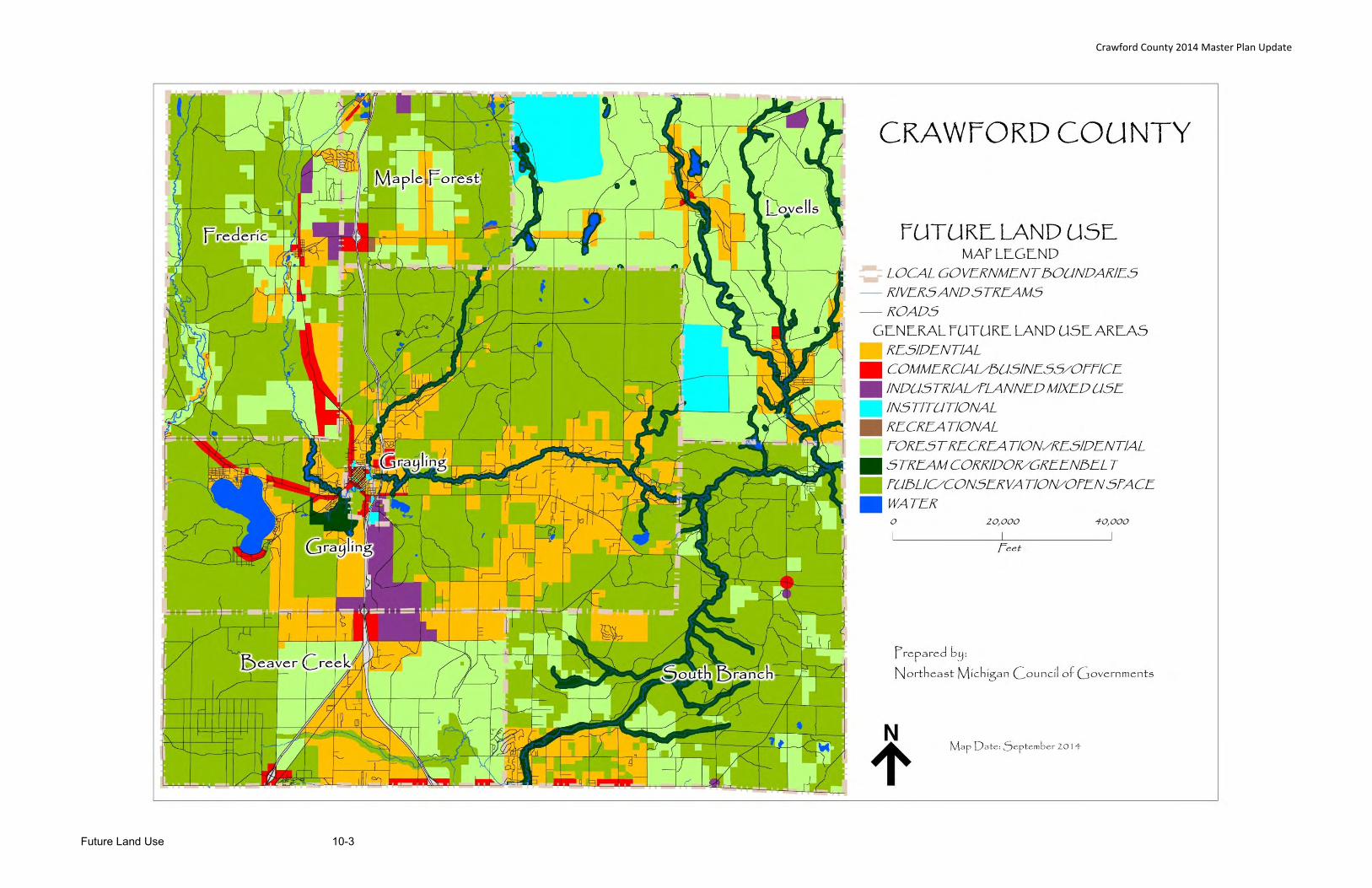
Crawford County 2014 Master Plan Update
Future Land Use 10-3

Crawford County 2014 Master Plan Update
Future Land Use 10-4
Table 10.1
Future Land Use Categories Comparison Table
Generalized FLU Categories BEAVER CREEK TWP CITY OF GRAYLING FREDERIC TWP GRAYLING TWP LOVELLS TWP MAPLE FOREST TWP SOUTH BRANCH TWP
Residential
Low density Residential High Density Residential Residential High Density Residential Residential Low Density Residential General Residential
Medium Density Residential Low Density Residential Low Density Residential Medium Density Residential Rural Residential
Medium Density Residential Medium Density Residential
Multi-Family
Commercial/Business/Office
Commercial General Business General Business Commercial Commercial Business Commercial Commercial
General Commercial Mixed Use
Neighborhood Commercial
Medical Cottage Industry
Industrial Industrial Industrial Light Industrial Planned Mixed Use Industrial Industrial Industrial
Light Industrial
Institutional Institutional City Artillery
Rights of Way State Highway ROW ROW
Recreation Recreational Recreation Recreation
Forest Rec/Residential Rural Residential Forest-Rural Residential Recreation Residential Forest Recreation Forest Recreation
Stream Corridor Greenbelt Stream Corridor
Public/Conservation/ Open Space
Open space, Vacant, Agric.
& Forest Conservation- Recreation Public Resource Conservation Resource Conservation
Public
Water Water Water Water Water Water Water

Crawford County 2014 Master Plan Update
Future Land Use 10-5

Crawford County 2014 Master Plan Update
Future Land Use 10-6
Figure 10.4

Crawford County 2014 Master Plan Update
Plan Adoption 11-1
Chapter 11 – Plan Adoption Public Notice Pursuant to the Michigan Planning Enabling Act, (PA 33 of 2008, as amended), the Crawford County Planning Commission sent a written notice explaining that they intended to prepare a county master plan update. This notice requested the recipients’ cooperation and comment on the plan. The notice was sent to the planning commissions (or if no planning commission to the legislative body) of each city, village or township located within or contiguous to Crawford County. It was also sent to all county planning commissions (or if no planning commission to the county board of commissioners) for each county located contiguous to Crawford county. It was sent to each public utility company and railroad company owning or operating a public utility or railroad within the county and to any government entity that registered its name and mailing address for this purpose with the county planning commission. The Crawford County Planning Commission approved the draft “Crawford County 2014 Master Plan Update” for distribution at their March 5, 2014 meeting. They forwarded the draft plan to the Crawford County Board of Commissioners. The Crawford County Board of Commissioners approved the draft plan for distribution at their March 27, 2014 meeting. Copies of the draft plan were mailed to the required recipients on April 1, 2014. A copy of the draft plan was also posted on the Crawford County web site. Articles concerning the draft were printed in the local press. Comments were taken on the draft plan up until the date of the formal public hearing. A notice of the public hearing was printed in the Crawford County Avalanche newspaper on May 15, 2014. The formal public hearing took place on June 4, 2014. [Comments in appendix] Plan Adoption After considering comments made by the public through the public comment period and those made at the public hearing, the Crawford County Planning Commission approved the “Crawford County 2014 Master Plan Update” at their September 17, 2014 meeting, and recommended the plan to the Board of Commissioners for adoption. The Crawford County Planning Commission then forwarded the final plan to the Crawford County Board of Commissioners. Legal Transmittals Once the final plan was presented to the Crawford County Board of Commissioners at their October 23, 2014 meeting, copies of the approved plan were mailed to all of the recipients as required by law.
Appendix A
Master Plan including Recreation Plan
Public Input – Supporting Documents
Newspaper notice of information meeting for Master Plan Master Plan Public Input Session Summary Newspaper notice of information meeting for Recreation Plan Recreation Public Input Session Summary Newspaper Public Hearing Notice Comments received from Antrim County and DNR Planning Commission Public Hearing Minutes

Crawford County 2014 Master Plan Update
Appendix A Public Input Supporting Documents A-1
Crawford County Master Plan Update Public Input Session Newspaper Notice:
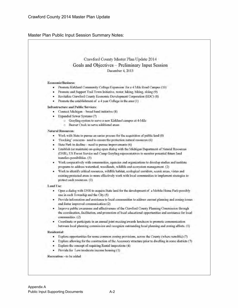
Crawford County 2014 Master Plan Update
Appendix A Public Input Supporting Documents A-2
Master Plan Public Input Session Summary Notes:
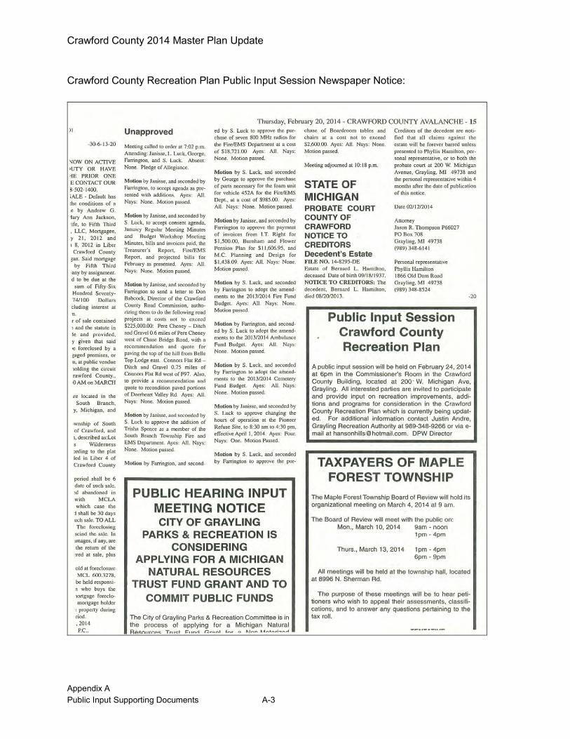
Crawford County 2014 Master Plan Update
Appendix A Public Input Supporting Documents A-3
Crawford County Recreation Plan Public Input Session Newspaper Notice:

Crawford County 2014 Master Plan Update
Appendix A Public Input Supporting Documents A-4
Recreation Public Input Session Summary Notes:

Crawford County 2014 Master Plan Update
Appendix A Public Input Supporting Documents A-5
Crawford County Master Plan and Recreation Plan Public Hearing Notice:
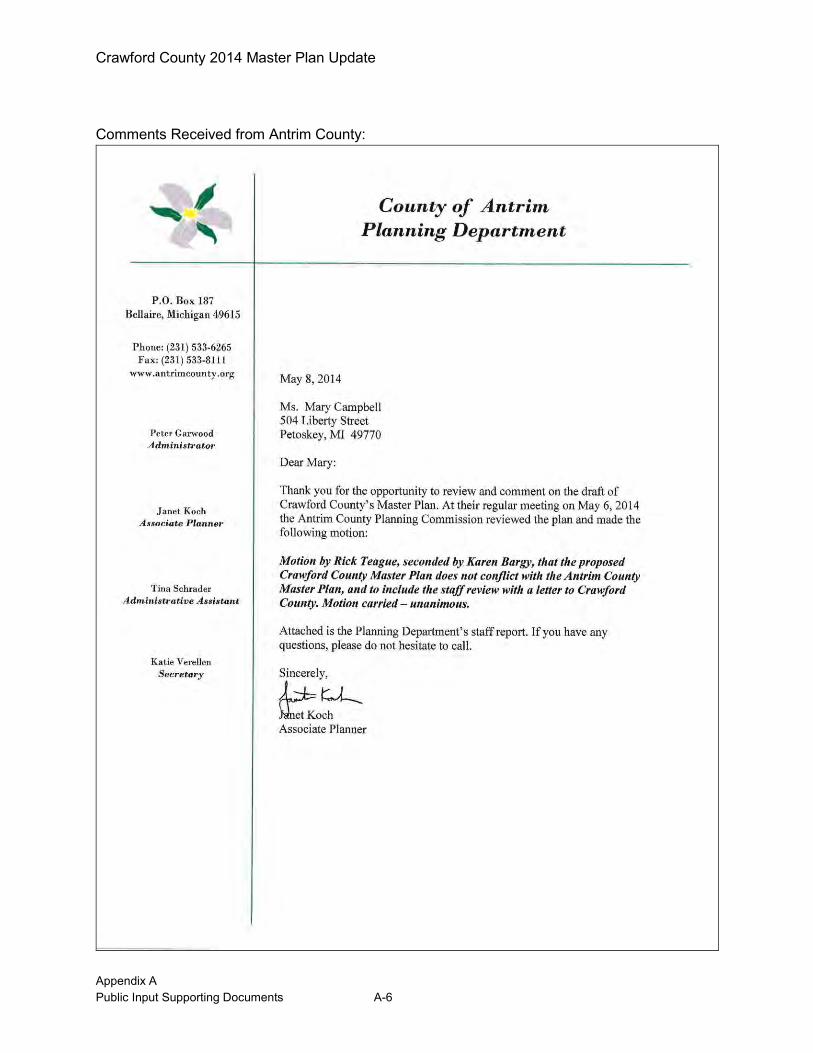
Crawford County 2014 Master Plan Update
Appendix A Public Input Supporting Documents A-6
Comments Received from Antrim County:

Crawford County 2014 Master Plan Update
Appendix A Public Input Supporting Documents A-7
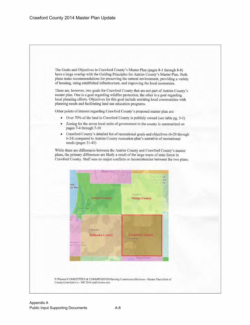
Crawford County 2014 Master Plan Update
Appendix A Public Input Supporting Documents A-8

Crawford County 2014 Master Plan Update
Appendix A Public Input Supporting Documents A-9
Comments Received From Department of Natural Resources:

Crawford County 2014 Master Plan Update
Appendix A Public Input Supporting Documents A-10

Crawford County 2014 Master Plan Update
Appendix A Public Input Supporting Documents A-11
DNR Comments Received via e-mail:
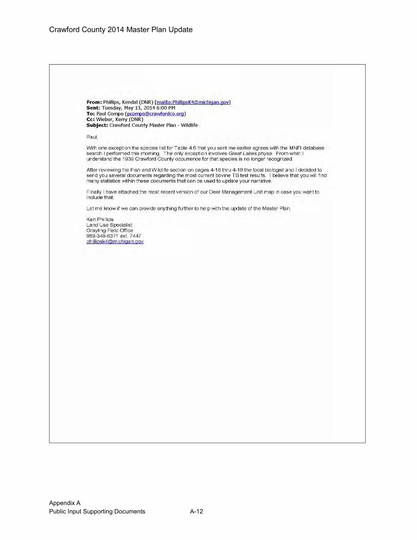
Crawford County 2014 Master Plan Update
Appendix A Public Input Supporting Documents A-12

Crawford County 2014 Master Plan Update
Appendix A Public Input Supporting Documents A-13
Crawford County 2014 Master Plan Update
Appendix A Public Input Supporting Documents A-14
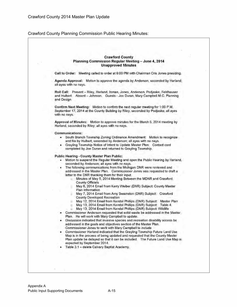
Crawford County 2014 Master Plan Update
Appendix A Public Input Supporting Documents A-15
Crawford County Planning Commission Public Hearing Minutes:
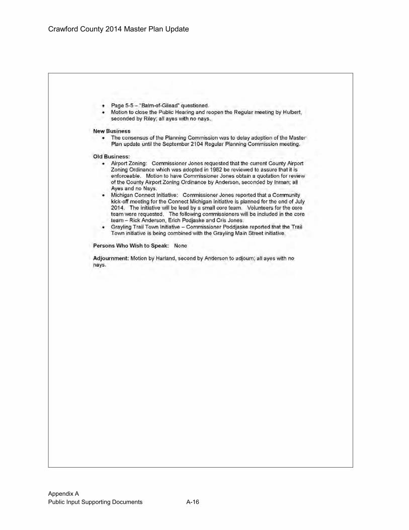
Crawford County 2014 Master Plan Update
Appendix A Public Input Supporting Documents A-16
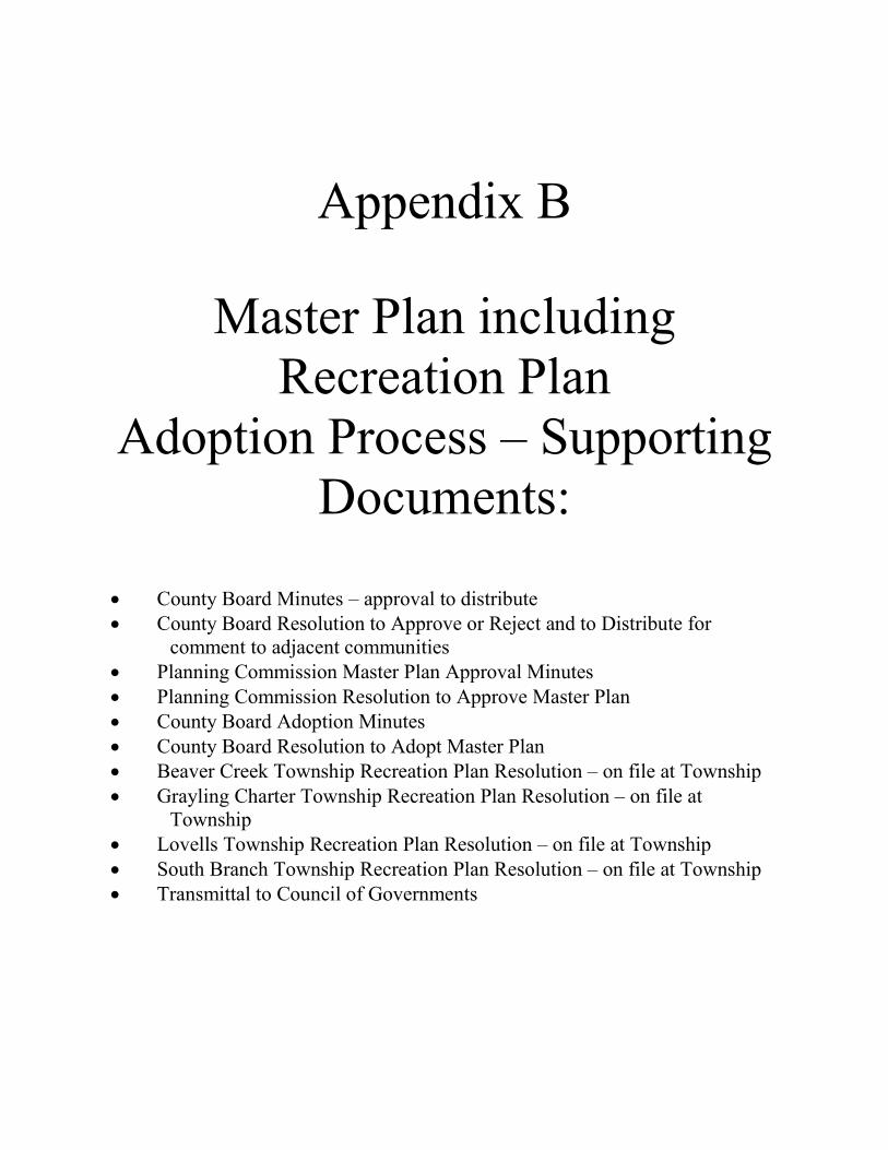
Appendix B
Master Plan including Recreation Plan
Adoption Process – Supporting Documents:
County Board Minutes – approval to distribute County Board Resolution to Approve or Reject and to Distribute for
comment to adjacent communities Planning Commission Master Plan Approval Minutes Planning Commission Resolution to Approve Master Plan County Board Adoption Minutes County Board Resolution to Adopt Master Plan Beaver Creek Township Recreation Plan Resolution – on file at Township Grayling Charter Township Recreation Plan Resolution – on file at
Township Lovells Township Recreation Plan Resolution – on file at Township South Branch Township Recreation Plan Resolution – on file at Township Transmittal to Council of Governments
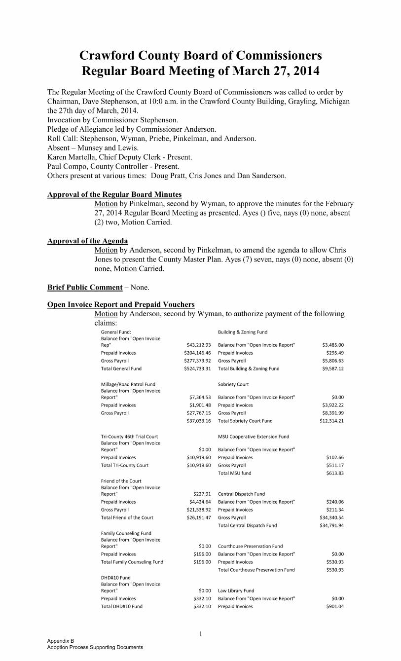
1
Crawford County Board of Commissioners Regular Board Meeting of March 27, 2014
The Regular Meeting of the Crawford County Board of Commissioners was called to order by Chairman, Dave Stephenson, at 10:0 a.m. in the Crawford County Building, Grayling, Michigan the 27th day of March, 2014. Invocation by Commissioner Stephenson. Pledge of Allegiance led by Commissioner Anderson. Roll Call: Stephenson, Wyman, Priebe, Pinkelman, and Anderson. Absent – Munsey and Lewis. Karen Martella, Chief Deputy Clerk - Present. Paul Compo, County Controller - Present. Others present at various times: Doug Pratt, Cris Jones and Dan Sanderson. Approval of the Regular Board Minutes
Motion by Pinkelman, second by Wyman, to approve the minutes for the February 27, 2014 Regular Board Meeting as presented. Ayes () five, nays (0) none, absent (2) two, Motion Carried.
Approval of the Agenda
Motion by Anderson, second by Pinkelman, to amend the agenda to allow Chris Jones to present the County Master Plan. Ayes (7) seven, nays (0) none, absent (0) none, Motion Carried.
Brief Public Comment – None. Open Invoice Report and Prepaid Vouchers
Motion by Anderson, second by Wyman, to authorize payment of the following claims:
General Fund: Building & Zoning Fund Balance from "Open Invoice
Rep" $43,212.93 Balance from "Open Invoice Report" $3,485.00
Prepaid Invoices $204,146.46 Prepaid Invoices $295.49
Gross Payroll $277,373.92 Gross Payroll $5,806.63
Total General Fund $524,733.31 Total Building & Zoning Fund $9,587.12
Millage/Road Patrol Fund
Sobriety Court Balance from "Open Invoice
Report" $7,364.53 Balance from "Open Invoice Report" $0.00
Prepaid Invoices $1,901.48 Prepaid Invoices $3,922.22
Gross Payroll $27,767.15 Gross Payroll $8,391.99
$37,033.16 Total Sobriety Court Fund $12,314.21
Tri-County 46th Trial Court
MSU Cooperative Extension Fund Balance from "Open Invoice
Report" $0.00 Balance from "Open Invoice Report"
Prepaid Invoices $10,919.60 Prepaid Invoices $102.66
Total Tri-County Court $10,919.60 Gross Payroll $511.17
Total MSU fund $613.83
Friend of the Court Balance from "Open Invoice
Report" $227.91 Central Dispatch Fund Prepaid Invoices $4,424.64 Balance from "Open Invoice Report" $240.06
Gross Payroll $21,538.92 Prepaid Invoices $211.34
Total Friend of the Court $26,191.47 Gross Payroll $34,340.54
Total Central Dispatch Fund $34,791.94
Family Counseling Fund Balance from "Open Invoice
Report" $0.00 Courthouse Preservation Fund Prepaid Invoices $196.00 Balance from "Open Invoice Report" $0.00
Total Family Counseling Fund $196.00 Prepaid Invoices $530.93
Total Courthouse Preservation Fund $530.93
DHD#10 Fund Balance from "Open Invoice
Report" $0.00 Law Library Fund Prepaid Invoices $332.10 Balance from "Open Invoice Report" $0.00
Total DHD#10 Fund $332.10 Prepaid Invoices $901.04
Appendix B Adoption Process Supporting Documents

2
Total Law Library Fund $901.04
Airport Fund Balance from "Open Invoice
Report" $4,799.20 Family/Probate Court Prepaid Invoices $411.97 Balance from "Open Invoice Report" $0.00
Gross Payroll $62.80 Prepaid Invoices $26,040.14
Total Airport Fund $5,273.97 Gross Payroll $14,749.58
Total Family/Probate Court $40,789.72
Recycling Fund Balance from "Open Invoice
Report" $0.00 Fish Hatchery Fund Prepaid Invoices $349.03 Balance from "Open Invoice Report" $0.00
Gross Payroll $482.42 Prepaid Invoices $201.47
Total Recycling Fund $831.45 Total Fish Fund $201.47
Landfill/Maintenance Fund
Sports Complex Fund Balance from "Open Invoice
Report" $1,437.31 Balance from "Open Invoice Report" $200.00
Prepaid Invoices $241.84 Prepaid Invoices $80.52
Gross Payroll $3,684.01 Total Sports Complex fund $280.52 Total Landfill/Maintenance fund $5,363.16
Register of Deeds Technology Fund
COPS in Schools Fund
Balance from "Open Invoice Report" $12,946.50 Balance from "Open Invoice Report" $0.00 Prepaid Invoices $0.00
Prepaid Invoices $0.00 Total ROD Technology Fund $12,946.50
Gross Payroll $6,857.90 Total COPS Fund $6,857.90 Soldiers and Sailors Relief Fund
Balance from "Open Invoice Report" $0.00
Prepaid Invoices $1,005.56
Total S&S Relief Fund $1,005.56
Roll Call: Anderson – aye, Lewis – absent, Munsey – absent, Pinkelman – aye, Priebe – aye, Stephenson – aye, Wyman – aye, Motion Carried.
Approval Correspondence Motion by Anderson, second by Pinkelman, to accept the correspondence and add The Michigan League for Public Policy as item 17 and the Northeast Michigan Council of Governments 2014 Directory as item18. Ayes (5) five, nays (0) none, absent (2) two, Motion Carried.
Correspondence
1. Antrim County Board – Resolution in support of HB 5125; Resolution opposing SB 636 Landline Elimination; and Resolution in support of HB 5253.
2. Gratiot County Board – Resolution supporting restoration of the community mental health general fund appropriation.
3. Oceana County Board – Resolution in support of HB 5215 to reimburse a local tax collecting unit for any revenue lost as a result of the exemption for disabled Veterans pertaining to payment of property taxes.
4. Oscoda County Board – Resolution opposing SB 552 due to the adverse effects it will have on the revenue of local jurisdictions.
5. MAC - Legislative updates for February 28, and March 7 & 14, 2014. Commissioner Anderson gave an update on HB 5097 and requested a resolution in opposition.
6. Grayling Regional Chamber of Commerce – Business Expo, April 24 from 4 – 7 p.m.
7. 2-1-1 NE Michigan, Scott Redman, Executive Director – 2-1-1 2013 Annual Report.
8. NEMCSA – Assistance availability guidelines.
9. Jane Kozlowski – e-mail message to Commissioner Lewis regarding the need for Animal Shelter Funding. Copy of “The Future of Animal Control” Law & Policy brief attached.
10. Crawford-Roscommon Conservation District – 2-5-14 Minutes. 11. State Tax Commission – Notice of Walgreens Appeals with the Michigan Tax Tribunal. 12. Animal Shelter President – Request to place shelter bond on November 4, 2014 ballot.
Discussion followed why this bond is to be placed on the ballot.
Appendix B Adoption Process Supporting Documents
3
13. Lovells Supervisor – Replace Planning Commission Lovells representative Gary
Neumann with Dennis Inman effective immediately.
Appointment of Planning Commission Member
Motion by Anderson, second by Wyman, to appoint Dennis Inman as the Lovells Township Representative on the Planning Commission (replacing Gary Neumann), for the remainder of the term, which expires 12-31-14. Ayes (5) five, nays (0) none, absent (2) two, Motion Carried.
14. Forgotten Eagles of MI – 2014 Itinerary RAM 8-8-14 11:15 @ Veterans Memorial
15. Michigan Association of County Veterans Counselors – MACVC hosting National Association of County Veterans Service Officers (NACVSO) Conference at Amway Grand June 8 – 13, 2014. The Board had previously approved DAV Rep Terry Fillmore to attend.
16. Road Commission – 5 year Surface Transportation and Improvement Program.
17. Michigan League for Public Policy – Making Ends Meet in Michigan.
18. NE MI Council of Governments – 2014 Directory. County Master Plan Presentation Cris Jones appeared on behalf of the Planning Commission to recommend the distribution of the County Master Plan for public review.
Motion by Anderson, second by Wyman, to authorize distribution of the Crawford County Master Plan 2014 update to adjacent Townships and Counties for the required comment period, and make plans available for public review in accordance with the Michigan Planning Enabling Act (PA 33 of 2008, as amended). Ayes (5) five, nays (0) none, absent (2) two, Motion Carried.
Department Reports County Recycling Program Controller Paul Compo inquired if the County was interested in renewing the recycling services contract from 4/1/14 through 3/31/15 as recommended by the Crawford County Recycling Council.
Motion by Wyman, second by Priebe, to authorize the County to enter into the Recycling Contract with Grayling Township for one year of recycling services from 4/1/14 through 3/31/15 in the amount of $32,000. Roll Call: Lewis – absent, Munsey – absent, Pinkelman – aye, Priebe – aye, Stephenson – aye, Wyman – aye, Anderson – aye, Motion Carried.
Block Grant Funding Controller Paul Compo requested support for the block grant funding for the Crawford County Housing Commission.
Motion by Wyman, second by Priebe, to authorize the NE MI Community Service Agency, Inc. to assist in preparing the application for funding the Michigan State Housing Development Authority’s 2014 Community Development Block Grant Fund. Roll Call: Munsey – absent, Pinkelman – aye, Priebe – aye, Stephenson – aye, Wyman – aye, Anderson – aye, Lewis – absent, Motion Carried.
Controller Paul Compo remarked on the various topics he attended at the MAC Conference. Unfinished Business Veterans Wall Committee – By Laws
Motion by Priebe, second by Pinkelman, to adopt the Veterans Wall Committee By Laws as presented. Roll Call: Pinkelman – aye, Priebe – aye, Stephenson – aye, Wyman – aye, Anderson – aye, Lewis – absent, Munsey – absent, Motion Carried.
Commissioner’s Report Commissioner Wyman – The Commissioner The Commissioner reported the Ways & Means Committee Report for Commissioner Lewis.
Appendix B Adoption Process Supporting Documents
4
Executive Session Minutes
Motion by Wyman, second by Pinkelman, to approve the minutes of March 13, 2014 Executive Session as read. Ayes (5) five, nays (0) none, absent (2) two, Motion Carried.
Commissioner Priebe - The Commissioner advised the Hanson Hills paint ball event was a success. The Commissioner informed members that the Shelter is applying for a grant for seniors to receive free pet. Commissioner Pinkelman – The Commissioner reported her Law Enforcement Committee recommendation. Police Protection Millage Renewal Proposal for August 5, 2014 Primary Ballot
Motion by Pinkelman, second by Wyman, to place the Police Protection Millage Renewal Proposal on the August 5, 2014 ballot and to update the county millage rates due to the Headlee Rollback. Roll Call: Priebe – aye, Stephenson – aye, Wyman – aye, Anderson – aye, Lewis – aye, Munsey – aye, Pinkelman – aye, Motion Carried.
The Commissioner placed the Local Update of Census Addresses (LUCA) Program, from the MAC 3/24/14 Legislative Conference on file. The Commissioner indicated Crawford County needs someone in charge of the LUCA program and suggested E-911 Director, Larry Akers. The Commissioner gave updates from the MAC Conference. The Commissioner continues to meet with District 10 Health Department. Commissioner Munsey – The Commissioner was absent. Commissioner Anderson – The Commissioner advised he has no Personnel & Labor Committee recommendations to report. The Commissioner submitted NEMCOG reports and commented on the MAC Conference. Commissioner Stephenson – The Commissioner updated the Board on the TIGER Grant and the Military involvement and impact on our county roads. The Commissioner reminded members that Jason Allen will attend the April committee meeting to discuss veteran’s issues. The Commissioner remarked on the DNR sign issues to designate trails. Commissioner Lewis – The Commissioner was absent. New Business Animal Shelter Bonds Millage Proposal
Motion by Pinkelman, second by Anderson, to approve the Animal Shelter Bonds millage Proposal language for the November 4, 2014 ballot. Commissioner Priebe requested she be allowed to abstain from the vote, due to a possible conflict. Roll Call: Stephenson – aye, Wyman – aye, Anderson – aye, Lewis – absent, Munsey – absent, Pinkelman – aye, Priebe – abstain, Motion Carried.
Extended Public Comment – None. Announcements – None.
Adjournment
Motion by Pinkelman, second by Wyman, to adjourn the meeting at 11:10 a.m. Ayes (5) five, nays (0) none, absent (2) two, Motion Carried.
____________________________ _______________________________ Dave Stephenson, Chairman Sandra Moore, County Clerk/Register Board of Commissioners ____________________________ Karen Martella, Chief Deputy Clerk
Appendix B Adoption Process Supporting Documents

Appendix B Adoption Process Supporting Documents
Appendix B Adoption Process Supporting Documents
Appendix B Adoption Process Supporting Documents
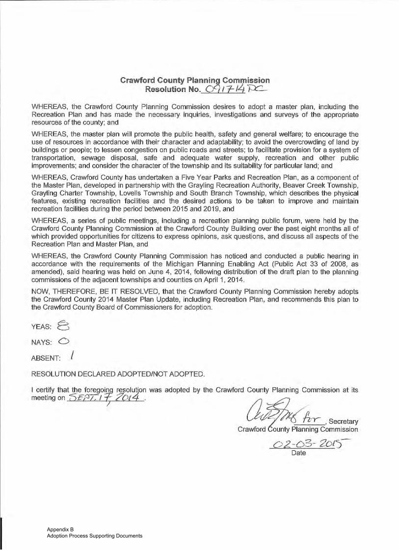
Appendix B Adoption Process Supporting Documents

to/[email protected] 8ZA3 PA6E 03
Crawford County Board of CommissionersRegular Board Meeting of Octob er 23,2014
The Reguler Meeting of the Crawford County Board of Commissioners was called to order by
Chairman, Dave Stephenson at 10:00 a-m. in the Crawford County Buildirrg, Grayling, Michigan
the 23rd day ofOotober,20l4,Invocation by Commissioner Wyman.Pledge of Allegiance led by Commissictner Anderson.
Roll CaUr Stephenson, Anderson, Lowis, McClain, Pinkehnan, Priebe and Wynan,
Absent - None,Sandra Moore, County Clerk-Register of Deeds - Present.
Peul Compo, County Controllpr - Present,
Others present at vffious times: Trey Ayers, Wm Veltman, f in Heliin, Kevin Hunter, Karen
Martella, Bonnie Cherven, Lynnette CCrrlew, Darwin BOOher, Bruce Rendon, Doug Pratt, Cris
Jones, Ilene Geiss-Wilson, Kirk Wakefield and Dal Sanderson,
Approval ol..lle Resular BotXd MinutesM!&4 by Lowis, second by Wyman, to approve the Minutes for the September
25,2014 Regular Board Meeting as presented. Ayes (7) seven' nays (0) none'
absent (0) uone, Motion Carried.
Motion by Pinkelman, secortd by cClain, to approve the Minutes for the
Septerr,bcr 30, 2014 Special Budget Bonrd Mecting as presented. Ayes (7) seven,
nays (0) none, absent (0) uone, Motion Carried.
Approval of the As€,F4qMotion by Lewis, second by Pinkelman, to accept the agenda as presented. Ayes
(7) seven, nays (0) none, absent (0) none, Motion Carried.
Brief Public CorJm+ntState Representative.Bruce Rendon advised he is working within District until efter the electionand is seeking his 3'd and final term in oft'ice for Stato Representative. Rep Rondon advised the
State continues to seek a solution for tire serious need for road repairs. The Representative is
actively seeking an avenue for funding the interchange off North Down River Road.
Open Juyoice Reoort ond PrgHFid VouchgrsMotiol by Lewis, seoond by Wltnan, to authorize payment of the followingprepaid bills ancl claims:
6eneral Fund: qQPS in Schodls Fundgslence,rom nODen Invoi(eReD" 92,569,39 galehce from "Open lnvqice Report" 50.00
9193,r08,4Prepaid Involcas 1 Prdpaid Involcts
1280,16s,5Gross Payroll 0 Gross Payrcll
Total Gene.dl Fund Total COPS Fund
Millage/Road Petrol tufl d
6alrnce from *open InvoiceRepon"
PrEprld Involces
Gross Payroll
Total ioad Patrol fund
Sbbriety CouilBalance from "open Invoitre
Trl-Countv | 6th Trial courtgSlrnce from'Ogen InvokeReport'
Buildlh8 & Zonlng Fuod
90,00 galar)c€ from "Open Invqlce REport"
53,512.61 PrepBldlnvolces
s32,262,18 GfossPayrsll
535.775.01 Total Bulldlng & zonint Fund
MSI,J Coooeaetive Extenslon Fund
Repdrt" 90,00 Baledr€ from "open Invoke Repon"
PrEpeld Involc€s $11,?38.30 Prepaid Involces
Grors Payroll $15,181.89 crorl Paytoll
Total Sobrlsty Court Fund $25,420,19 Total MSU tvnd
s0.00
$6,891.05
s6,891.05
$0,00
94,104.9s
95,e16.82
5ro,olL,t7
s102,66
5s11.15
561J,Ez
Coniral olspatch Fuftd
90.00 Balince from 'op€n Invol.e Report" S720.0o
IAppendix B Adoption Process Supporting Documents
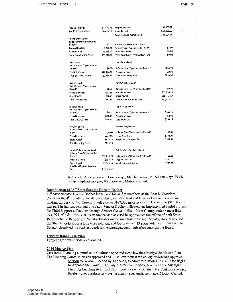
t1l2VzAM 02: @3 PAGE g4
Prepeld hvolces
Totdl Trl-Caunty cdurt
Frlend qfthE Coultgalence frqm "open InvdiceR€ po rt"
Prepaid Inv0lc0g
G.oB Payroll
Total fiend of th8 Coun
2013 HSGP
BalancP lrom "0pen Involce
Report"
Pl€p8ld Involce5
Total 2013 H56P lund
Airport Fund
BOlance frem "Op€n lovdlc€RepOrt"
PrGpaid InvoEos
6rosl POytoll
Tottl Airpon Fund
DHO#10 FundBalanc€ lrom "open InvolceReport"
Prepaid Invoices
Total DHDHlO Fudd
Recycling Fur\dEalance frori "Opon InvolceRepo4"
Prep.ld Invcices
Grosr Psyroll
Total Recvrlint fund
[andfl lYMainrenanc€ Fund
Salance from rOpEd InvolccRe port'
Prepald Involces
Grori Peytoll
Toto I La ndtill./Maintpnadcc
fund
54,471 20 Pi€peld Involc€s
|;4,471,20 GrosiPayroll
Tqtal Central Dlspetch Fund
So.m Courthovse PresqNetbn Fund
$710,70 Balance from "Opei ldvolce Repon'
S11,199,d0 Prepaidlfrvolt€s
521,010,10 Tolal Cqurthdusd Pjes€rvallon Fund
bw Library Fund
$0.4o Belence from "open InveiEe Repoft"
$r0,194.50 Prepaidlnvolces
9foi.91.50 Total |lw Llbrary Fund
FamllV/Probate court
50,00 Balance lrom "open lnvolce Report"
5291.55 Prepaidlnvoices
966.29 Gro55 Payroll
$157.84 Tolnl tamily/Probatecourt
Flsh Hatchery Fund
$0.00 Balanre from "open tnvolce Report"
$408.60 Prdpatdtnvolc€5
5408.60 Total tlsh Fund
SPorts ComPlex Fund
lo.0o Bilance lrom "open Invoice Report"
5233,93 Prepaidldvolces
S570,35 Total sportscompler fund
S8o4.zB
SoldierJ & Sellort Rellel Fund
$12,874.7s Ealance from'Oprn Involce Report"
S587,38 Prepaidlnvoicei
53,70r.45 Total Soldierr & 5?ilo.s
Su,1Er.6z
91,s90.12
s32,023,97
944,294.2e
90.00
50.00
$0,00
985s er
50 o0
5S55 sr
$o,oo
5lz,z5E,s3
$15,715,17
547197J'70
s180.19
50.00
J18o.re
$0.0o
$i78,97
5r73,97
90.00
5250.00
s250_m
Roll CaIl: Anderson - aye, Lewis - aye, McClaiil - a/€, Pinkelman - aye, Priebe
- aye, Stephe$son - ay€, Wyman - aye, Motion Carrjed.
35'n State Senator Dqrwin Booher introduoed hinself to rnembers of the Board. Cra*{ordCounty is the 4h county in the stste with the most state land and he is seeking an increase infunding for our sounty. Crawford will receive $167,000 more ur swamp tru< urd the PILT taxwas paid in firll last year and this year, Senator Booher indiceted has implemented a pilot projectfor Child Support collections tluough Senator Caswell bills in Kerrt County urder Senate Bills973,9'14,9i5 & 1086. Chaiulan Stephenson advised he approciates the efforts ofboth State
Representative Rendon nnd Senator Booher on the road funding issue, Senatot Booher advisedthe State is looking fbr a long term solution, and hes rpviewed t 3 plans voted on 3 thus far. TheSenator circulated his business cards and enooursqgd comruunication amonsst the Board,
I.ib rarv B oard l-4tFrviewLynnette Codew interview conducted,
2014 Mrstqr flEqCris Jones, Planning Commission Chairman appeared to review tho Countpvide Master Plan,The Platrning Commission has approved ald mnst now request the county review and approve.
MoJion by Wyman, second by Anderson, to adopt resolution 1023 14PC for Rightto Approve the Crawford Corurty Master Plzur in accordance with the MichiganPlanning Enabling Aat. Rqll Calll Lewis - aye, McClain - aye, Pinkelman - By€,
Priebe - aye, Stephenson - aye, Wyman - aye, Anderson - aye, Motion Carried.
Appendix B Adoption Process Supporting Documents
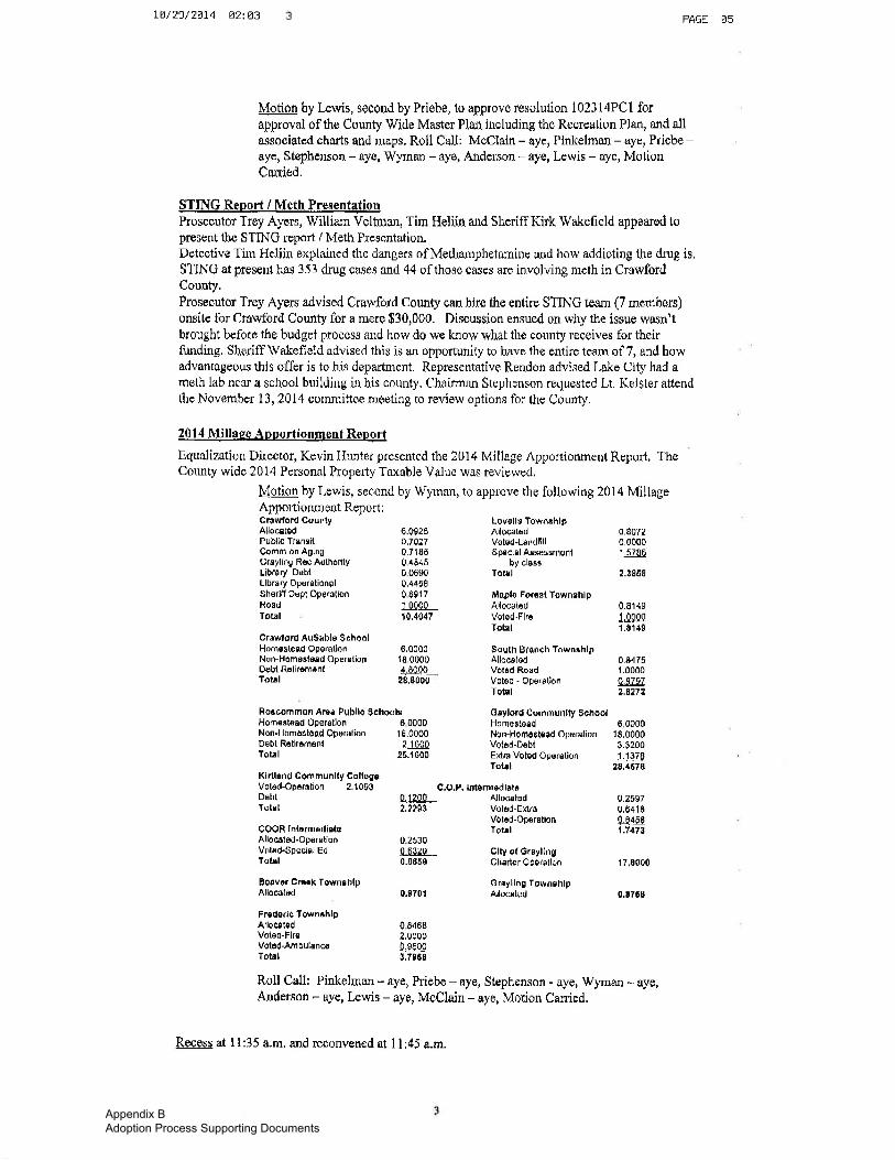
1.8/29/28t4 AziLj PAGE A5
Motion by Lewis, second by Priebe, to approve resolution 1 023 l4PC I forapproval of the County Wide Master Plan including the Remeation Plan, and allassociated charts and maps. Roll Call: McCIain - aye, Pinkelrnan - aye, Priebe -eye, Stephenson - aye, Wym*u - aye, Andersou - aye, Lewis - aye, MotionC*nied'
$TING Ren_o.f! / Meth PrcspltgtionProseoutot Trey Ayers, William Veltnan, Tim Holirn and Sheriff Kirk Wakefield appeared topresent the STING report / Meth Presentatiou.Detective Tim Heliia explained tire dangers of MethanrphetarniuE and how addioting the drug is.STINC at present has 353 drug cases and 44 ofthose cases &ro involving meth in CrawfordCounty.Proseculor Trey Ayers advised Crawford County oan hire the entire STn IG ieam (7 mernbers)onsite for Crawford County for a mere $30,000. Discussion ensued on why the issue wa$n'tbrought before the budget process and how do we know what the county receives for theirfunding, Sheriff Wakefield advised this is an opportunity to hnve tha entit'e teaur of 7, and howadvantageous this offer is to his department. Representative Rendon advised Lake City had ameth lab near a school buildiug in his county. Chsirman Stephonson recluested Lt. Keister attendthe November 13,2Q14 cornmittee meeting to review options for the County.
20 14 trliUqse rlpportionlgent Reoort
Equalization Duector, Kevin Hunter presented the 2014 Millage Apportionment Report, TheCounty wide 2014 Personal Propety Taxable Value was reviewed.
Motion by Lewis, second by Wynan, to approve the following 2014 MillugeApportionnrent Rcporl:
crrwoid Ausrble SchoolHomos(ef,d Operallon 6,0000Non Hom€8(s8d OperElion '18.0000
Oebl Rolij6m6n( 4.8000Torrl 2s,&000
Rotcommon Aree Publlc SchoolgHom€stdad ODetetlon 6 0000Non-Homo8tead Oporation 18,0000
Cr+wlord CountyAllocstBdPublic TrsnsitComm on AgingGrEyling Rsc AuthorityLibrery D6btLibrary Op€rdtionolShBrifl Depl OporationRoadTotrl
Debl R6tlmm6nlTotrl
Kirtldnd Com munlty CollsgsVoted-Oparatlon 2.1093DsbtTotel
GOOR IntarmedicteAllocrted-OporationVoted.Special EdTolrl
Lovolld TowruhlpAllocatsdVcted-LgrtdflllSp€cial AsBescrn6nl
py clE6ETolIl
Maplo Fomsl TownshlpAllocalodVoted-FlroTotrl
gquth BiqnCh TownrhlpAlloetadVot6d-Ro6dVot6d - OperetionTot{l
OEylord CornmUnlty SchoolHomes[etd 6 0000Non-HomcEt€edopergtion 18.0000Volcd-D€bt 3.3200E)dra Voted Opsrstion 1.1179Totrl 28.4670
q,O,P, lntEfinodlrtt
0,0925
0,71850 48450 06900.44580 89171 ndoo'10,4047
0,80720,00001.5700
2.3868
0.9149$09q1.8 1,t9
0.84 751.0000OBTqz2.62f 2
2,1 60026.1600
0,1,?00 Alloceted2.2293 Votod-EKrc
Votcd-OPorBtionTolrl
0 25300,03200.886e
clty ol GrsylingChrrter Oporellon
Gnyllng TownshlpAllosted
0.25970,6418q.8458ti,7it73
r 7,0000
0.8768EoFvor cmk TownohlpAlloBtod 0.8701
Frcdofic Towh+hlpAilocttsd 0 8d68Voled-Fire 2,OOOOVoitd-AmbulsncE 0,9500Totrl t.te6g
Roll Call: Pinkelman - aye, Priebe - aye, Stephcnson - &ye, Wyman - aye,Anderson - aye, lewis - aye, McClain - eye, Motion Can'ied.
Recess at I l:35 a.m. and reconvened at 1l:45 a.nr.
Appendix B Adoption Process Supporting Documents

Appendix B Adoption Process Supporting Documents

M. C. Planning & Design Community Planning Site Planning Landscape Architecture
504 Liberty Street Petoskey, MI 49770 Phone: (231) 487-0745 Fax (231) 487-0746 E-mail: [email protected]
Letter of Transmittal
If transmitted items are not as noted, notify writer immediately.
To: Northeast Michigan Council of Governments
P.O. Box 457 Gaylord, MI 49734
Attn: Diane Rekowski, Executive Director
RE: Crawford County 2014 Master Plan Update, including Recreation Plan
Date: February 4, 2015
Transmitted By: Regular Mail Overnight Delivery
Hand Delivered
Picked Up By:
X Other: e-mail
We are transmitting 1 copy(s) of the following:
Certification for Payment No. Discs Prints Specs.
Change Order No. Drawings Product Literature Tracings
Construction Change Req. No. Field Measure Plans Samples Work Orders No.
Copy of Letter Plans Shop Drawings
X Other: Crawford County 2014 Master Plan Update
For your: Action As Requested Information Review/Comment Use
Approval Distribution X Records /Files Signature Remarks: Enclosed please find a copy of the Crawford County Master Plan Update including Recreation Plan. This Plan has
been prepared to meet the DNR guidelines. As you are aware one of the DNR requirements is that a copy of the adopted Recreation Plan must be transmitted to the Regional Planning Agency. If you would like to receive a hard copy of this plan, please contact me. Thank you for your attention to this matter.
Job No. CRA
By: Mary H. Campbell, ASLA, AICP
cc:
Sandra Moore, Crawford County Clerk
Appendix B Adoption Process Supporting Documents

Appendix C
DNR Certifications:
Post-Completion Self-Certification Reports o Crawford County o Beaver Creek Township o Grayling Charter Township o Lovells Township
Crawford County Recreation Plan - Plan Certification Checklist
Township Certification Checklists o Beaver Creek Township – Plan Cert. Checklist (on file with Township) o Grayling Charter Township – Plan Cert. Checklist (on file with Township) o Lovells Township – Plan Cert. Checklist (on file with Township) o South Branch Township – Plan Cert. Checklist (on file with Township)


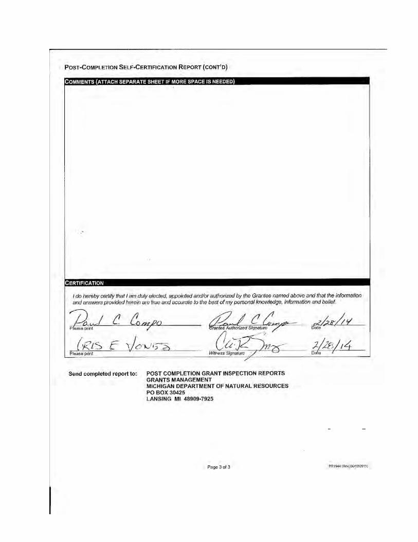
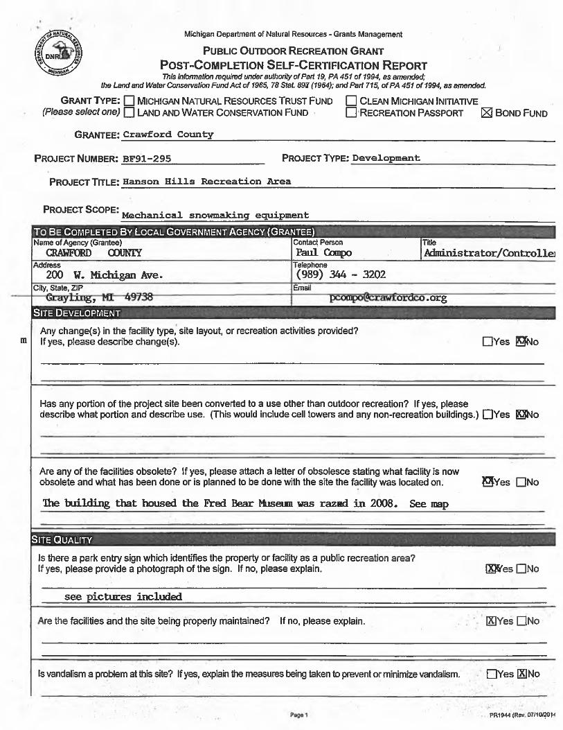
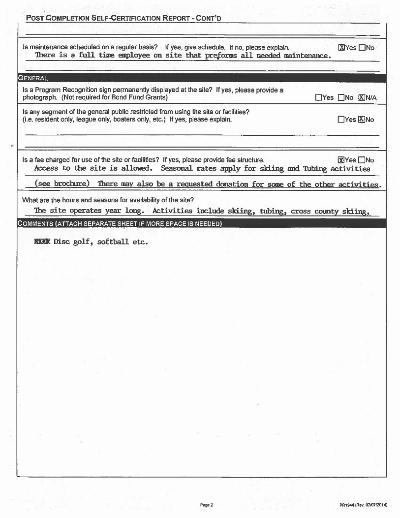

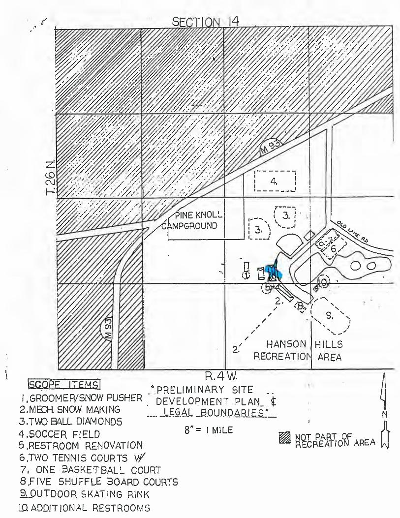


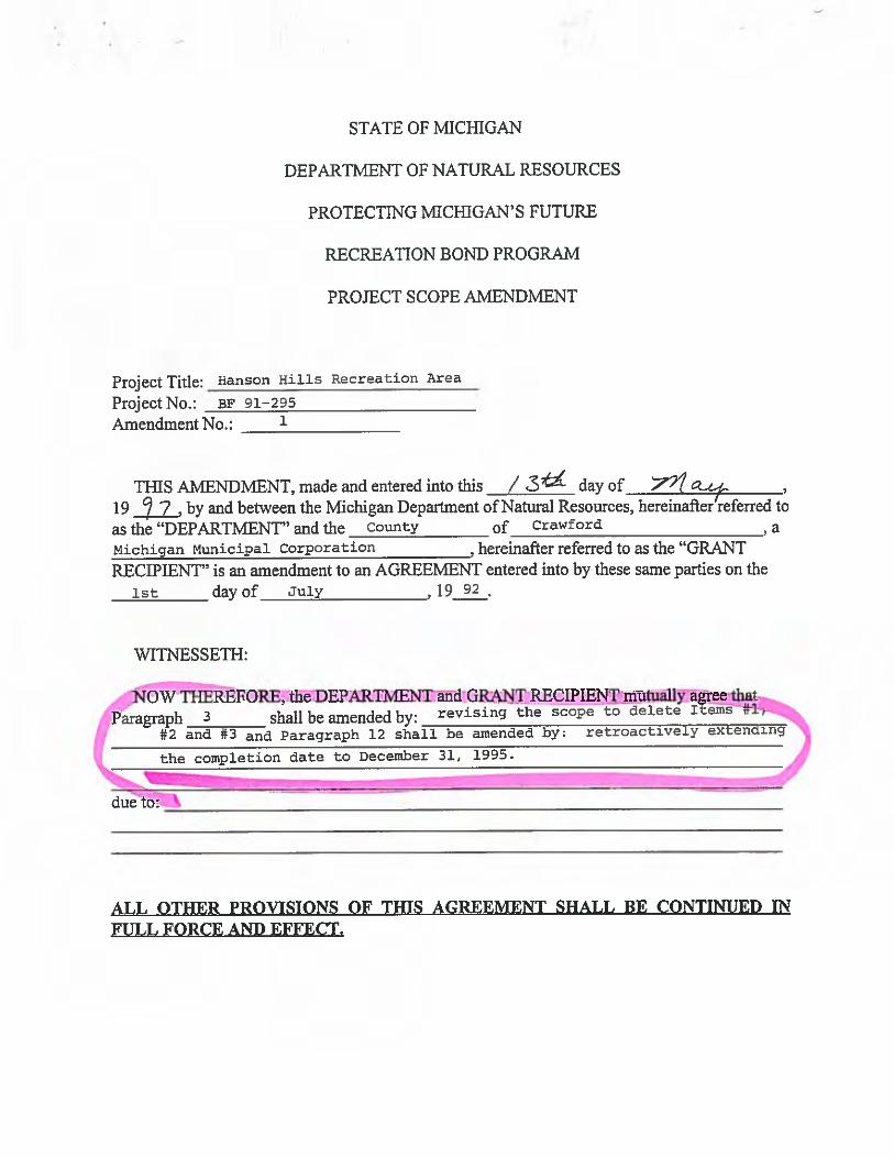

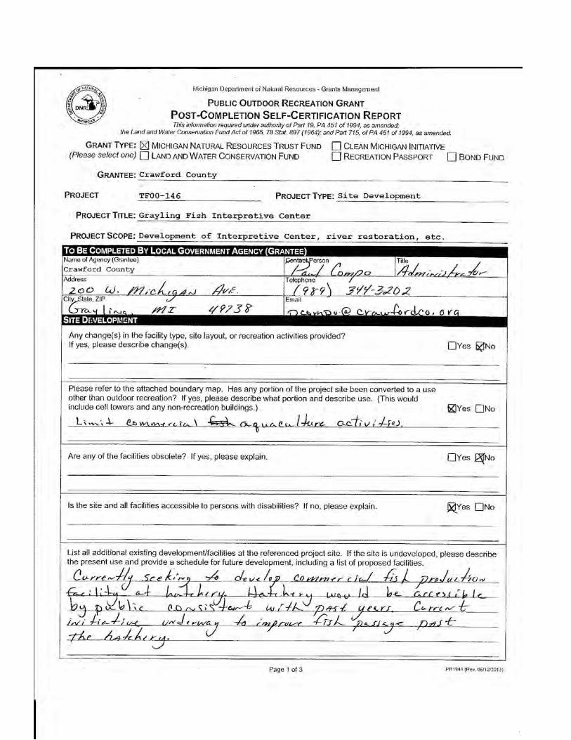

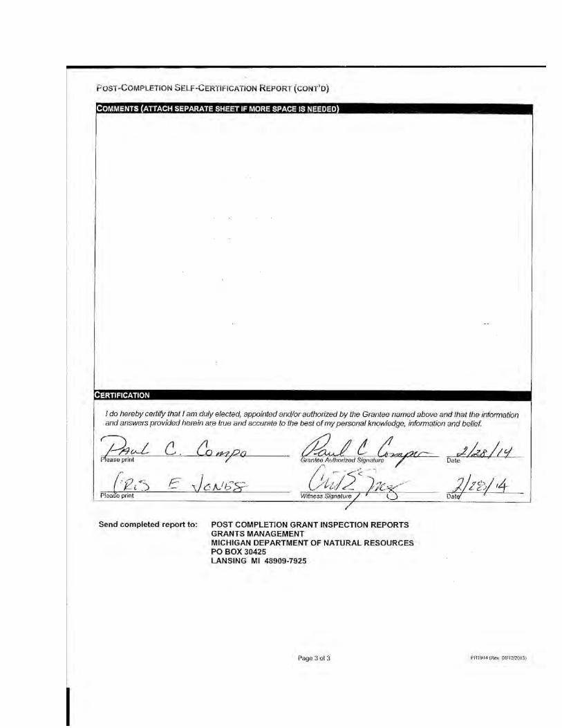

Michigan Department of Natural Resources - Grants Management
PuaLlc Ourooon RecneerroN GRANT
Posr-CoMpLETtoN Srlr-CeRTtFtcATtoN REpoRTThis information required under authoity of Paft 19, PA 451 of 1994, as amended;
the Land and Water Conservation Fund Act of 1965, 78 Stat. 897 (1964); and Paft 71 5, ot PA 451 of 1994, as amended.
GRANT Tvpe: fl MtcHlcnN NATURAL Rrsounces TRUST FuND E crcnru MtcHtcAN lNrrrnlvr(Please se/ecf ane) I Lnno nno Wnrcn CorusrnvRTroN FuND fl REcnEnloN pASSpoRT fl Borlo Furuo
Gnerutee: Beaver Creek Townshi
26-OL572 PnolectTYpe: site DevelopmentPno.,lecr
Pnorecr Trrle:
Pnorect Scope:
Beaver Creek Park t Project
Expanding parking & physical plant facilities
Township
Sa. 6,"/l) as/bn
Any change(s) in the facility type, site layout, or recreation activities provided?lf yes, please describe change(s). nves ffruo
Please refer to the attached boundary map. Has any portion of the project site been converted to a useother than outdoor recreation? lf yes, please describe what portion and describe use, (This wouldinclude cell towers and any non-recreation buildings,)
Are any of the facilities obsolete? lf yes, please explain. nYes FNo
ls the site and all facilities accessible to persons with disabilities? lf no, please explain.
List all additional existing developmenUfacilities at the referenced project site. lf the site is undeveloped, please describethe present use and provide a schedule for future development, including a list of proposed facilities.
Page 1 of 3 PR1944 (Rev 0611212013)

Posr-ColrpLETIoN SElr-CenlFtcATtoN Reponr (corur'o)
ls there a park entry sign which identifies the property or facility as a public recreation area?lf yes, please provide a photograph of the sign. lf no, please explain. Fv"r nruo
Are the facilities and the site being properly maintained? lf no, please explain. ,Kves nruo
Are there any features near the site which would detract from the use and enjoyment of the site or wouldpose a health or safety problem? lf yes, please explain. nvesrffruo
ls vandalism a problem at this site? lf yes, explain the measures being taken to prevent or minimize vandalism. nVes(rue
ls mainte scheduled on a regular basis? lf yes, give schedule. lf no, please explain. Fv". nruo
ls a Program Recognition plaque permanently displayed at the site? lf yes, please provide aphotograph. (Not required for Bond Fund Grants)
ls any segment of the general public restricted from using the site or facilities?(i.e. resident only, league only, boaters only, etc.) lf yes, please explain.
ls a fee charged for use of the site or facilities? lf yes, please provide fee structure.
What are the hours and seasons for availabilitv of the site?^t4 ola-n dei,
Page 2 of 3 PR1944 (Rev 0611212013)
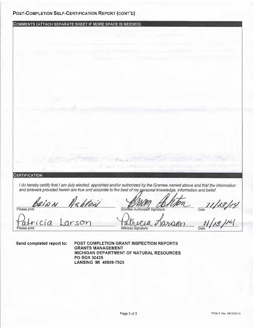
Posr-Corvr pLETroN S elp-C enr FrcATtoN Repo nr (corur' o)
I do hereby ceftify that I am duly elected, appointed and/or authorized by the Grantee named above and that the informationand answers provided herein are true and accurate to the best of my knowledge, information and belief.
Send completed report to: POST GOMPLETION GRANT INSPECTION REPORTSGRANTS MANAGEMENTMICHIGAN DEPARTMENT OF NATURAL RESOURCESPO BOX 30425LANSTNG Mt 48909-7925
Page 3 of 3 PR'1944 (Rev 0611212013l
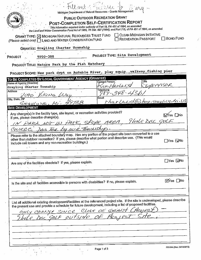
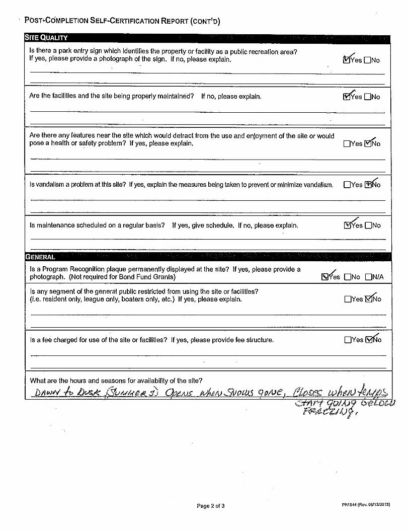

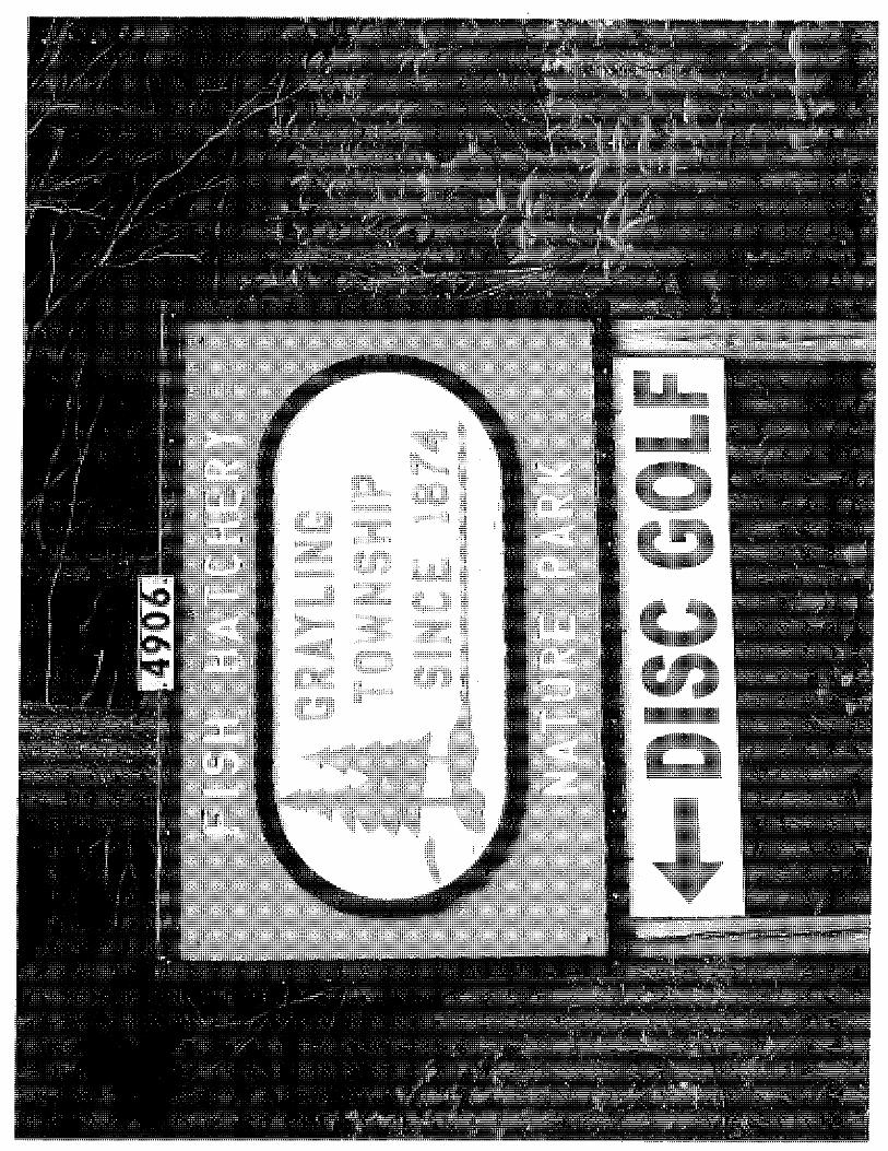

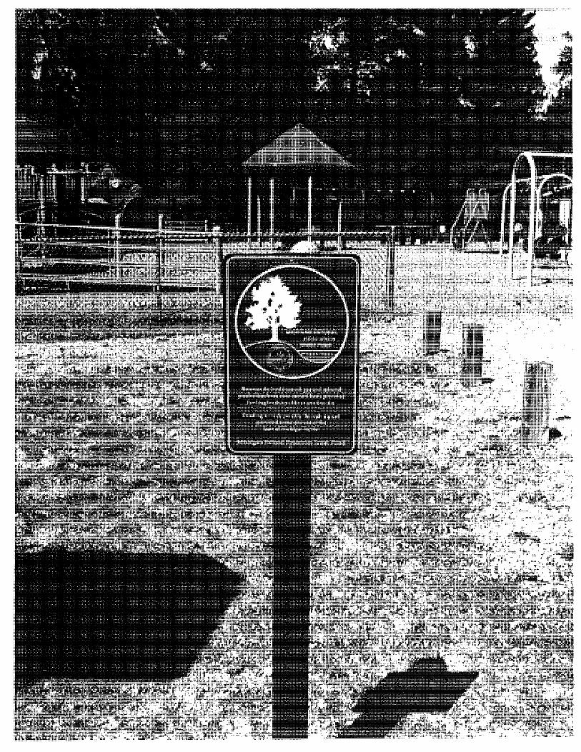
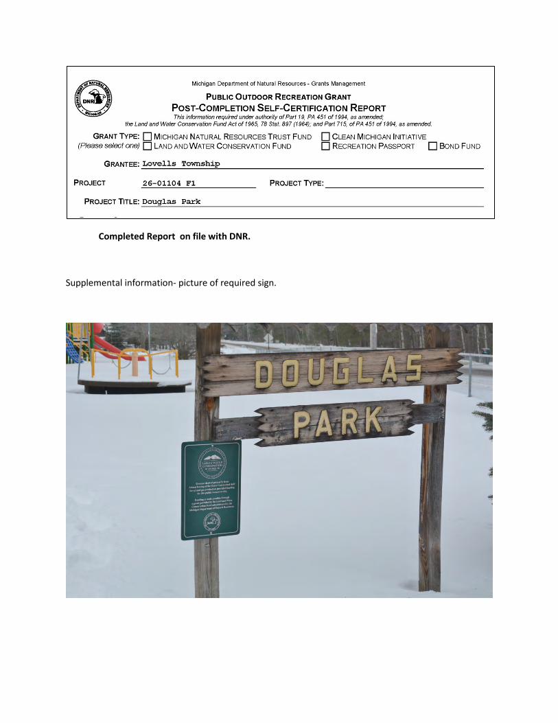
Completed Report on file with DNR.
Supplemental information- picture of required sign.

Township Checklists
Plan Certification Checklists for the following participating Townships are on file with the individual Townships and submitted separately to the DNR.
Beaver Creek Township Grayling Charter Township Lovells Township South Branch Township

Page 1 of 2 PR1924-1 (Rev. 12/26/2012)
Michigan Department of Natural Resources-Grants Management
COMMUNITY PARK, RECREATION, OPEN SPACE, AND GREENWAY PLAN CERTIFICATION CHECKLIST
By Authority of Parts 19, 703 and 716 of Act 451, P.A. 1994, as amended, submission of this information is required for eligibility to apply for grants
INSTRUCTIONS: Complete, obtain certification signatures and submit this checklist with a locally adopted recreation plan.
All recreation plans are required to meet the content and local approval standards listed in this checklist and as outlined in the Guidelines for the Development of Community Park, Recreation, Open Space and Greenway Plans provided by the Michigan Department of Natural Resources (DNR). To be eligible for grant consideration, plans must be submitted to the DNR prior to the grant application deadline with a completed checklist that has been signed by an authorized official(s) of the local unit of government(s) submitting the plan.
PLAN INFORMATION Name of Plan:
List the community names (including school districts) covered by the plan County Month and year plan adopted by the
community’s governing body
PLAN CONTENT
INSTRUCTIONS: Please check each box to certify that the listed information is included in the final plan.
1. COMMUNITY DESCRIPTION
2. ADMINISTRATIVE STRUCTURE
Roles of Commission(s) or Advisory Board(s)
Department, Authority and/or Staff Description and Organizational Chart
Annual and Projected Budgets for Operations, Maintenance, Capital Improvements and Recreation Programming
Current Funding Sources
Role of Volunteers
Relationship(s) with School Districts, Other Public Agencies or Private Organizations
Regional Authorities or Trailway Commissions Only
Description of the Relationship between the Authority or Commission and the Recreation Departments of Participating Communities
Articles of Incorporation
3. RECREATION INVENTORY
Description of Methods Used to Conduct the Inventory
Inventory of all Community Owned Parks and Recreation Facilities
Location Maps (site development plans recommended but not required)
Accessibility Assessment Status Report for all Grant-Assisted Parks and Recreation Facilities
4. RESOURCE INVENTORY (OPTIONAL)
5. DESCRIPTION OF THE PLANNING PROCESS
Assistant Station
Typewritten Text
Crawford County 2014 Master Plan Update including Recreation Plan
Assistant Station
Typewritten Text
Crawford County
Assistant Station
Typewritten Text
Crawford
Assistant Station
Typewritten Text
October 2014
Server
Typewritten Text
Beaver Creek Township
Server
Typewritten Text
Server
Typewritten Text
Grayling Charter Township
Server
Typewritten Text
Lovells Township
Server
Typewritten Text
Server
Typewritten Text
Server
Typewritten Text
South Branch Township
Server
Typewritten Text
Crawford
Server
Typewritten Text
Server
Typewritten Text
Crawford
Server
Typewritten Text
Crawford
Server
Typewritten Text
Crawford
Server
Typewritten Text
Server
Typewritten Text
Server
Typewritten Text
November 2014
Server
Typewritten Text
Server
Typewritten Text
November 2014
Server
Typewritten Text
November 2014
Server
Typewritten Text
November 2014
Server
Typewritten Text

X e, oescRIPTIoN oF THE PUBLIc INPUT PRocESSI Description of the Method(s) Used to Solicit Public Input Before or During preparation of the plan, Includingcopy of the survey or Meeting Agenda and a sum nary of the Responses ReceivedX Copy of the Notice of the Availability of the Draft Plan for public Review and Comment
Date of the Notice May 22, 2014Type of Notice Newspaper and websitePlan Location Countv office and websiteDuration of Draft Plan Public Review period (Must be at Leasr 30 Days) 5 months
X Copy of the Notice f9r tle Public Meeting Held after the one Month public Review period and Before thePlan's Adoption by the Governing Body(ies)Date of NoticeName of NewspaperDate of Meeting ) ? .
^1 A
X Copy of the MinutesGOALS AND OBJECTIVES
ACTION PROGRAM
POST.COMPLETION SELF.INSPECTION REPORT
Xz.Xa,Xs,
P,lans must be adopted by the highest level goveming bo_dy (i.e., city council, county commission, township board), lfplanning is the responsibility of a Planning Commission, Park and Rbcreation Commission, Recreation AJri.o,^,, goard orother local Board or commission, the plan should also include a resolution from the Board or Commission r".omm"norngadoption of the plan by the governing body,The local unit of government must submit the final plan to both the cgynly and Regional planning Agency for theirinformation, Documentation that this was done must be submitted with the plan to-the DNR,Items 1 3 and 4 below are required and must be included in the plan
APPROVAL DOCUMENTATION: For multi-jurisdictional plans, each local unit of government must pass a resolutionadopting the plan. Prepare and attach a separate page for each unit of government included in the olan.
X 1, Official resolution of adoption by the governing body dated: oct ober 2 3 , 2 01_ 4
X 2. Official resolution of the Planningrecommending adoption of the plan by the governing body, dated: September 1T , 2 O 14
X 3, Copy of letter transmitting adopted plan to County Planning Agency dated: Feb . 4, 2OI5X 4, Copy of letter transmitting adopted plan to Regional Planning Agency dated: Feb . 4 , 2OI5
NOTE: For multi-jurisdictional plans, Overall Certification must include the signature of each local unit of government.Prepare and attach a separate signature page for each unit of government included in the plan.
I hereby certify that the recreation plan for
Crawford County(Local Unit of Government)
above and as set forth bv the DNR.
This completed checklist must be signed andsubmitted with a locally adopted recreation plan to:
GRANTS MANAGEMENTMICHIGAN DEPARTMENT OF NATURALRESOURCESPO BOX 30425LANStNG, Mt48909-7925
includes the required content, as indicated
flfu'*Local Unit
The recreation,plan is approved by the DNR and the community (ies) covered by the plan,as listed on page 1 of this checklist is/are eligible to apply for recrealion grants t-nrougtr
Date
Page 2 ol 2 PR'1s24.'1 (Rev 1212612012)