2013-PGSCD-Reference-Manual.pdf - Prince George's Soil ...
296
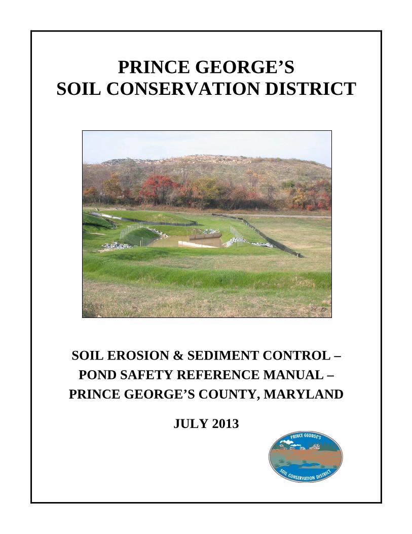
PRINCE GEORGE’S SOIL CONSERVATION DISTRICT SOIL EROSION & SEDIMENT CONTROL – POND SAFETY REFERENCE MANUAL – PRINCE GEORGE’S COUNTY, MARYLAND JULY 2013
-
Upload
khangminh22 -
Category
Documents
-
view
1 -
download
0
Transcript of 2013-PGSCD-Reference-Manual.pdf - Prince George's Soil ...
PRINCE GEORGE’S
SOIL CONSERVATION DISTRICT
SOIL EROSION & SEDIMENT CONTROL –
POND SAFETY REFERENCE MANUAL –
PRINCE GEORGE’S COUNTY, MARYLAND
JULY 2013

Prince George’s Soil Conservation District 5301 Marlboro Race Track Road
Upper Marlboro, MD 20772 Phone (301) 574-5162 – Fax (301) 574-5156
INTRODUCTION Dependence on the natural resources of Maryland is unending---and so is the need to protect our environment. The soil and water conservation program in Maryland, aimed at protecting soil and water resources, is the result of over 70 years of cooperative effort at the federal, state, and local levels. Under the State Soil Conservation District's Law, each Board of Supervisors is responsible for carrying out a soil and water conservation program to "provide for the conservation of the soil, water, and related resources of the state and for the control and prevention of soil erosion in order to preserve natural resources, control floods, prevent impairment of dams and reservoirs, assist in maintaining the navigability of rivers and harbors, preserve wildlife, protect the tax base, protect the public lands, protect and promote the health, safety, and general welfare of the people of the state, and otherwise enhance their living environment". Acceptable erosion and sediment control plans must be designed to mitigate soil erosion, prevent increases in stormwater runoff, and minimize the discharge of pollutants. The Maryland Stormwater Management Act of 2007 and the 2011 Maryland Standards and Specifications for Soil Erosion and Sediment Control requires the establishment of a comprehensive process for the review and approval of erosion and sediment control and stormwater management plans. A coordinated comprehensive review process includes the submission and review of erosion and sediment control and stormwater management plans for each of the following three phases of plan development: Concept Plan; Site Development Plan; and Final Plan. This manual is intended to be a reference guide for engineers, developers, reviewers, and inspectors who will be involved with design and implementation of erosion and sediment control practices and dam safety. Existing references have been updated and consolidated into one document. As a service to our customers, we have attempted to simplify and clarify requirements from various sources. This manual will be used by our plan reviewers to ensure consistency in the plan review process and should be the basis for plan preparation and submittal by engineering consultants. The Prince George’s Soil Conservation District prohibits discrimination in all its programs and activities on the basis of race, color, national origin, sex, religion, age, disability, political beliefs, sexual orientation, or marital or familial status.
CONSERVATION – DEVELOPMENT – SELF-GOVERNMENT i

ACKNOWLEDGEMENTS
The latest revisions to the Prince George’s Soil Conservation District Soil Erosion and Sediment Control – Pond Safety Manual, January 2013, are the result of the effort of the Erosion and Sediment Control Environmental Site Design Committee. The committee consisted of members representing Prince George’s Soil Conservation District (PGSCD), Prince George’s County Department of Public Works and Transportation (PGDPW&T), Maryland-National Capital Building Industry Association (BIA) and engineering consultant firms. Many individuals assisted with the revision to this document by providing review comments, suggestions, reference documents, and participation at committee meetings. We would like to acknowledge the following individuals for their invaluable contributions:
Graham M. Baldwin Prince George’s County DPW&T Gurmeet S. Gahunia Dewberry and Maryland-National Capital BIA Lance C. Gardner Prince George’s Soil Conservation District Michael A. Novy Ben Dyer Associates, Inc. and Maryland-National Capital BIA Rand Postell Stantec, formerly Greenhorne and O’Mara Supreet K. Rekhi Prince George’s Soil Conservation District Brenda K. Sanford Prince George’s Soil Conservation District John Tarr Prince George’s County DPW&T Massoud Towhidi Capitol Development Design, Inc. Michael E.Wagner Loiederman Soltesz Associates and Maryland-National Capital BIA Eugene K. Whitehead Prince George’s Soil Conservation District The Prince George’s Soil Conservation District, Board of Supervisors approved and adopted the revised manual. We hope this consolidated and updated information will be helpful and encourage interested persons to contribute their experiences and knowledge in a continuing process of program improvement.
ii

Table of Contents
Section I - PGSCD Concept Grading, Erosion and Sediment Control Plan (CSC) Page A. Introduction for Concept Grading, Erosion and Sediment Control Plans………. I-1-2 B. Concept Grading, Erosion and Sediment Control Plan Design Considerations………………………………………………………………..…. I-3-5 C Concept Grading, Erosion and Sediment Control Plan Preparation……………. I-6-7 D. Preliminary Soil Report Requirements…………………………………………. I-8 E. COMAR Highly Erodible Soils Map…………………………………………… I-9-14 F. Highly Quality (Tier II) Waters……………………………………………….... I-15-18 G. Sediment Impairments and TMDLS…………………………………..………... I-19-22 H. Concept Grading, Erosion and Sediment Control Plan Submittal……………… I-23 I. PGSCD Concept Grading, Erosion and Sediment Control Fees……………..… I-24-25 J. Concept Grading, Erosion and Sediment Control Plan Approval…………..….. I-26 K. PGSCD Concept Grading, Erosion and Sediment Control Approval Stamp…………………………………………………………………...…...….. I-27-28 L. PGSCD Concept Grading, Erosion and Sediment Control Plan Transmittal Letter……………………………………………………………….. I-29 M. PGSCD Concept Grading, Erosion Sediment Control Plan Site Analysis…..…. I-30 Section II – PGSCD Environmental Site Development Grading, Erosion and Sediment Control Plan (SSC) A. Introduction for Environmental Site Development Grading, Erosion and Sediment Control Plans……………………………..………………………. II-1 B. Environmental Site Development Grading, Erosion and Sediment Control Plan Design Considerations………………………………….. II-2-4 C. Environmental Site Development Grading, Erosion and Sediment Control Plan Preparation……………………………….…………..…. II-5-6 D. PGSCD Small Pond Soil Reports and Borrow Areas…………..…………….…. II-7 E. PGSCD Dam Hazard Classification………………………………….…….……. II-8-9 F. TR-66 Simplified Dam-Breach Routing Procedure………………………..……. II-10 G. Preliminary Pond Exemptions…………………………………………..….……. II-11-12 H. Examples of Embankment, Excavated and Exempt Ponds……………………… II-13-18 I. Maryland Average Rainfall from NOAA Atlas 14…………………………….... II-19 J. Environmental Site Development Grading, Erosion and Sediment Control Plan Submittal…………………………..……………….…… II-20 K. PGSCD Environmental Site Development Grading, Erosion and Sediment Control Fees…………………………….……………….. II-21-22 L. Environmental Site Development Grading, Erosion and Sediment Control Plan Approval……………………………………………….. II-23-24 M. PGSCD Environmental Site Development Grading, Erosion and Sediment Control Approval Stamp…………………..…………….. II-25-28 N. PGSCD Environmental Site Development Grading, Erosion and Sediment Control Plan Transmittal Letter…………………………. II-29 O. PGSCD Environmental Site Development Grading, Erosion and Sediment Control Plan Site Analysis……………………..…..……. II-30
iii
Table of Contents
Section III – PGSCD Final Grading, Erosion and Sediment Control Plan (FSC) Page
A. Introduction for Final Grading, Erosion and Sediment Control Plans……………………………………………………………..……… III-1-2 B. Final Grading, Erosion and Sediment Control Plan Design Considerations…………………………………………………………..……….. III-3-8 C. Final Grading, Erosion and Sediment Control Plan Preparation………………... III-9-15 D. Final Soil Report Requirements……………………………………………….… III-16-17 E. Final Grading, Erosion and Sediment Control Practices Review Checklist………………………………………………………………... III-18-24 F. Vegetative Stabilization……………………..………………………………….. III-25-35 G. Critical Area Planting Code-342…………………………………..……………. III-36-59 H. UM Turfgrass Technical Update TT-77, July 2012……………………..……… III-60-66 I. Final Rough Grading Plan Checklist……………...…………………..………… III-67-68 J. Final Grading, Erosion and Sediment Control Plan Submittal………………..... III-69 K. PGSCD Final Grading, Erosion and Sediment Control Plan Fees……………… III-70-72 L. Final Grading, Erosion and Sediment Control Plan Approval………………….. III-73-74 M. PGSCD Final Grading, Erosion and Sediment Control Approval Stamp..…...... III-75-78 N. PGSCD Final Grading, Erosion and Sediment Control Plan Transmittal Letter……………………………………………………………...... III-79 O. PGSCD Final Grading, Erosion and Sediment Control Plan Site Analysis…….…………………………………………………………..….. III-80 P. Final Grading, Erosion and Sediment Control Plan Updates….….……….….... III-81-82 Q. Adequacy of Existing Erosion and Sediment Controls Checklist….…..………. III-83-88 R. Minor Plan Changes…………………………………………..…………..……. III-89 S. Major Plan Changes…………………………………..…………..……..……… III-90 T. Locations of Resource Documents……………………………………..…..….. III-91-92 Section IV – PGSCD Standard Erosion and Sediment Control Plan A. Standard Erosion and Sediment Control Plan Checklist….……..……….……. IV-1 B. Non-Tidal Wetlands of Special State Concern………………………………… IV-2 C. Sample copy of PGSCD Standard Erosion and Sediment Control Plan……………………………………………………....……….…… IV-3-4 Section V – Prince George’s Soil Conservation District Details A. PGSCD Detail – 1 Sediment Basin Horizontal Draw – Down Device………… V-1-4 B. PGSCD Detail – 2 Sandbag Diversion…………………………………………. V-5-8
iv

Table of Contents
Section VI – PGSCD Forest Harvest Erosion and Sediment Control Page A. Guidelines and Criteria for PGSCD Forest Harvest Operations……………...... VI-1-5 B. Logging Assistance Form……………………………………………….……… VI-6 C. PGSCD Forest Harvest Operation, Erosion and Sediment Control Plan Application……………………………………………………………………… VI-7-8 D. Standard Erosion and Sediment Control Plan for Forest Harvest……..….……. VI-9-13 E. Seeding Season for Maryland…………………………………………………… VI-14 F. Streamside Management Zone (SMZ) Plan…………………………………….. VI-15-16 G. Non-Tidal Wetlands BMP’s for Forest Harvest………………………………… VI-17-18 H. Special Permit Requirements and Restoration of Existing Adjacent Roadway……………………………………………………………… VI-19-20 Section VII – Dam Safety Pond Plan A. Guidelines and Criteria for (SWM) Pond Plans……………………………….… VII-1-2 B. Pond Plan Submittal and Coordination………………………………………….. VII-3-4 C. Pond Plan Preparation………………………………………………………..….. VII-5-8 D. Pond Plan Preparation Checklist………………………………………………… VII-9-12 E. Pond Updating to Current MD-378……………………………………………… VII-13 F. General Requirements for Pond Construction…………………………………… VII-14-17 G. As-Built Plans Checklist…………………………………………………………. VII-18-20 H. Major/Minor Pond Plan Changes………………………………………………… VII-21 I. Hydrologic Soil Groups for Prince George’s County……………………………. VII-22-35 J. USDA/NRCS Conservation Engineering Tools
and Documents, August/2005……………………………………………………. VII-36-37 K. MDE Publication List, July/2013………………………………………………… VII-38 L. Small Pond Approval Letter, July/2013……………………………………......... VII-39-40 M. NRCS-MD-378, Pond Summary Sheet, October/2000………………………….. VII-41-42 N. Operation and Maintenance Plan Guidelines…………………………………….. VII-43-50 Section VIII – Pond MD-378 A. USDA Natural Resources Conservation Maryland, Conservation Practice Standards, Pond Code 378, January/2000……………..………………… VIII-1-28 B. Revision to ASTM C 361 Concrete Pipe…………………………………………. VIII-29-30 C. HDPE Dual Wall Pipe…………………………………………………………….. VIII-31-32 Section IX – Pond Maintenance A. Memorandum of Understanding – Pond Review, effective January 17, 1996/Updated July/2013………………………………… IX-1-4
v

PAGE LEFT INTENTIONLY BLANK
vi

SECTION I
PRINCE GEORGE’S SOIL CONSERVATION DISTRICT
CONCEPT
GRADING, EROSION AND SEDIMENT CONTROL PLAN


___ I. PRINCE GEORGE’S SOIL CONSERVATION DISTRICT (PGSCD) CONCEPT GRADING, EROSION AND SEDIMENT CONTROL PLAN (CSC)
___A. INTRODUCTION FOR CONCEPT GRADING, EROSION AND SEDIMENT CONTROL PLANS
___1. The following guidelines are to be considered in the preparation of a Concept Grading, Erosion and Sediment Control Plan submitted to PGSCD for review and approval. All Concept Grading, Erosion and Sediment Control plans (CSC’s), are to be in conformance with this document, the criteria established in the Code of Maryland Regulation Title 26, Subtitle 17, Chapter 01, the 2011 Maryland Standards and Specifications for Soil Erosion and Sediment Control, (Standards and Specifications), or later revisions and Chapter 5 Environmental Design of the 2000 Maryland Stormwater Design Manual.
___2. A comprehensive design strategy for maintaining predevelopment runoff characteristics and protecting natural resources is available. This strategy, known as Environmental Site Design or “ESD,” relies on integrating site design, natural hydrology, and small controls to capture and treat runoff.
___3. The primary goal is to maintain the natural hydraulic runoff of a site to predevelopment runoff characteristics to the Maximum Extent Practicable (MEP) after development.
___4. Designers must develop plans that are designed to: ____ a. Prevent soil erosion from development projects. ____ b. Prevent increases in nonpoint pollution. ____ c. Minimize pollutants in stormwater runoff from both new development and redevelopment. ____ d. Restore, enhance, and maintain chemical, physical, and biological integrity
of receiving waters to protect public health and enhance domestic, municipal, recreational, industrial and other uses of water as specified by MDE.
____ e. Maintain 100% of the average annual predevelopment groundwater recharge volume.
____ f. Capture and treat stormwater runoff to remove pollutants. ____ g. Implement a channel protection strategy to protect receiving streams. ____ h. Prevent increases in the frequency and magnitude of out-of-bank flooding
from large, less frequent storms. ____ i. Protect public safety through the proper design of stormwater
management facilities. ___ j. Preserve sensitive natural features.
___5. Environmental Site Design (ESD) is defined as “…using small-scale stormwater management practices, nonstructural techniques, and better site planning to mimic natural hydrologic runoff characteristics and minimize the impact of land development on water resources.” This definition, includes: ____ a. Optimizing conservation of natural features (e.g., drainage patterns, soil, vegetation, steep slopes and highly erodible soils). ____ b. Minimizing impervious surfaces (e.g., pavement, concrete channels, roofs). ____ c. Slowing down runoff to maintain discharge timing and to increase
infiltration and evapotranspiration. ____ d. Using other nonstructural practices or innovative technologies approved by MDE.
___6. The goal of traditional site design strategies has been to maximize development potential by focusing on the layout of buildings, roads, parking, and other features. Conventional development practices tend to maximize site imperviousness and contribute to many undesired impacts. These include the undesired effects of diminished groundwater recharge, increased flows and runoff volumes, pollutant accumulation, and elevated water temperatures.
I-1

___7. Stream quality and watershed health diminish when impervious cover exceeds 10% and become severely degraded beyond 25% (Center for Watershed Protection, 2003). Results from the Maryland Biological Stream Survey (MBSS) indicated that in surveyed streams, health was never good when watershed imperviousness exceeded 15% (Boward, 1999). These studies establish a fundamental connection between impervious cover and watershed impairment.
___8. ESD techniques involve protecting natural resources, integrating erosion and sediment
controls with stormwater management practices, minimizing site imperviousness, and using natural conveyance and ESD practices throughout the site. Applying these techniques early in the design process will ensure that all available resources have been considered in order to protect streams, waterways, steep slopes and highly erodible soils from the impact of land development activities.
___9. Developing a site plan begins with gathering, mapping, and analyzing information about
the physical characteristics of the site. Designers should visit the proposed development site in order to clearly understand its topographic, vegetative, drainage and soil characteristics. Relying exclusively on topographic maps, soils maps, or other materials in the office without field verification is not an acceptable planning technique.
I-2
___B. CONCEPT GRADING, EROSION AND SEDIMENT CONTROL PLAN DESIGN CONSIDERATIONS
___1. Site Plan and Resource Mapping
___ a. The Concept Grading, Erosion and Sediment Control plan will include site resource mapping with protection and conservation strategies. Review of the Concept Grading, Erosion and Sediment Control plan will ensure that all important resources have been mapped, protected, and all opportunities to enhance natural areas have been explored early in the design process. ___ b. The resource mapping component will be used as a basis for all subsequent
decisions during project design. During this step, the consultant for the developer shall identify significant natural resources and demonstrate how these areas will be protected and preserved. Additionally, options will be evaluated to enhance important hydrologic functions. The District may require that other features be shown depending on site characteristics. This map shall be field verified by the project consultant. The specific areas that shall be mapped are organized by government regulatory authority in Table 1 below.
Table 1 Natural Resources and the Corresponding Regulatory Authorities:
Federal State Local - Wetland - Major Waterways - Floodplains
- Tidal and nontidal wetland - Wetlands of Special State Concern - Wetland buffers - Stream buffers - Perennial streams - Floodplains - Forests - Forest buffers - Critical Areas
- Steep slopes - Highly erodible soils - Enhanced stream buffers - Topography/slopes - Springs - Seeps - Intermittent streams - Vegetative cover - Soils - Bedrock/geology - Existing drainage areas - Ponds
___ c. The mapping process will identify important natural resources as well as areas that are highly susceptible to erosion. Identifying these important resources and high risk locations and then protecting them from disturbance is the first step in the planning process. ___ d. When steep slopes and highly erodible soils are found measures shall be taken to limit disturbance and minimize impacts. For the purpose of project planning, steep slopes are considered to be any mapping unit with a slope class of 15% or greater. While it may not be practicable to eliminate earth disturbing activities exclusively
on the basis of soil erodibility or slope alone, constraints are warranted when both steep slopes and highly erodible soils occupy the same area within the development footprint.
___ e. Areas with highly erodible soils (includes K factor >.35 with slopes greater than 5% and slopes equal to or greater than 25%), that are to remain, shall be incorporated into adjacent buffers, remain undisturbed, be protected during the construction process, and/or preserved as open space.
I-3

___ f. Topography of the site, mapped at a minimum two-foot contour intervals, will allow the identification of drainage patterns, slopes, and natural resources such
as wetlands, seeps, streams, forests, critical areas, and buffers. ___ g. Mapping the flow of water onto, through, and off the site enables the delineation of drainage area and flow patterns. Downstream wetlands, lakes, streams, structures,
or other areas particularly sensitive to damage from erosion and sedimentation should also be investigated, mapped, and incorporated into the design to afford additional protection to these areas.
___ h. The design shall never allow sediment to flow through a sensitive area. ___ i. Investigating the on-site soil characteristics and referring to the Prince George’s County Soil Survey enables the designer to identify highly erodible soil areas, and designate those that are to remain undisturbed. ___ j. Vegetative buffer strips along water bodies shall be mapped and designate them
to remain undisturbed (i.e., buffers).
___2. Strategies to protect steep slopes ad highly erodible soil include:
___ a. Identify and map all highly erodible soils and steep slopes 15% or greater; and ___ b. Protect area(s) with highly erodible soils on slopes equal to or greater than 25% from earth disturbing activities.
___ c. In addition to preserving sensitive areas during disturbance, the environmental benefits of other existing natural resources should be maximized by incorporating protection strategies into the overall goals of the project.
___ d. Protecting these resources up front will allow them to be utilized for infiltration, flow attenuation, groundwater recharge, flood storage, runoff reduction, nutrient cycling, air and water pollution reduction, habitat diversity, and thermal impact reduction.
___ 3. Natural resources protection and enhancement strategies include:
___ a. Protecting large tracts of contiguous open space, forested areas, and other important resources through conservation easements.
___ b. Identifying afforestation opportunities in open space areas and setting aside land for natural regeneration. ___ c. Identifying important resources areas that may be expanded such as stream buffers
and floodplains. ___ d. Minimize disturbance to highly permeable soils.
___4. Site Layout
___ a. After conserving and protecting sensitive resources, the next step in the planning process involves determining the approximate location of buildings, roadways, parking lots, and other impervious areas. These site improvements should be placed
at a sufficient distance to protect the conservation areas. Protecting these resources will involve enhancing or expanding forested and stream buffers of adequate widths based on site characteristics.
___ b. Minimum buffer widths may be expanded based on receiving stream characteristics, stream order, adjacent land slopes, 100-year floodplain, wetlands, mature forest, vegetative cover, depth of the groundwater table, and the presence of springs, seeps and other sensitive areas. The District may enhance existing buffer requirements depending upon resource protection goals identified.
I-4

___ c. After the development footprint has been established, consideration should be given to natural drainage areas and how runoff will travel over and through the site. Sheet flow and existing drainage patterns shall be maintained and discharges
from the site shall occur at the natural location wherever possible. New drainage patterns result in concentrated flow that can leave the site at inappropriate or unstable locations, as well as creating erosion, sediment transport, and stream channel stability problems.
___ d. The use of storm drains and engineered conveyance systems should be minimized by using vegetated swales and other natural systems so that forest, buffers and overland flow characteristics remain intact. Planning for on-site and off-site drainage patterns must be done early in the design process to establish a stable outfall for downstream discharges. Some of the strategies listed below can be used to establish nonstructural practices such as sheetflow to natural areas. These protection and enhancement tools, can then double as important strategies for meeting on-site stormwater and erosion and sediment control requirements.
___5. Strategies for site layout and connecting landscape features include:
___ a. Plan the building footprint and layout to protect conservation areas. ___ b. Evaluate opportunities to enhance/expand forested, wetland, and stream buffers. ___ c. Grade the site so that runoff will flow from impervious areas directly to pervious areas or other natural conveyance systems. ___ d. Maintain natural flow paths between the site and upstream and downstream systems. ___ e. Maintain sheet flow and natural overland flow processes wherever feasible. ___ f. Provide stable conveyance of runoff off-site.
I-5

___C. CONCEPT GRADING, EROSION AND SEDIMENT CONTROL PLAN PREPARATION
The Concept Grading, Erosion and Sediment Control plans shall be submitted to Prince George’s Soil Conservation District and shall include natural resources mapping, ESD location, concept narrative, soil survey and on-site investigation. PGSCD may require additional information at this phase, however at a minimum the Concept Grading, Erosion and Sediment Control plan shall include the following:
___1. Plan location of all site resources shown in Table 1. ___2. Field verification from the project consultant of the natural resource map as needed. ___3. Include appropriate photographs of the natural resources. (i.e. – outfalls and/or slope failures) as needed. ___4. Proposed limits of clearing and grading. ___5. Include percent impervious cover proposed. ___6. Location of proposed impervious areas (buildings, roadways, parking, and sidewalks). ___7. Location of existing and proposed utilities. ___8. Preliminary locations of erosion and sediment control practices. (Optional for Concept). ___9. Preliminary location of ESD practices. ___10. Include stable conveyance of stormwater at potential outfall locations. ___11. A narrative/sequence of construction that supports the concept and describes how the design will achieve the following:
___ a. Natural resources protection, enhancement, and preservation. ___ b. Maintenance of natural flow patterns. ___ c. Reduction of impervious areas through better site design, alternative surfaces,
and nonstructural practices. ___ d. Integration of erosion and sediment controls into the stormwater strategy. ___ e. Implementation of ESD planning techniques and practices to the MEP. ___ f. Evaluation of stabilization requirements.
___12. Soil survey and onsite investigation as needed, of site soils to identify highly erodible soils. ___13. Delineation of on-site and off-site drainage patterns. ___14. Delineation of vegetative buffer strips along water bodies. ___15. Delineation of slopes 15% and steeper.
___16. Delineate all highly erodible soils. ___17. Delineate and protect sites in Tier II Watersheds, and/or discharges to impaired waters
with an established Total Maximum Daily Load (TMDL) allocation for sediment, with buffers (minimum 100 feet) for all perennial and intermittent streams. When the site requires MDE wetlands permits, a review for antidegradation may result in MDE establishing TIER II buffers and easements.
Buffer Width (feet) for Perennial and Intermittent Streams Hydrologic Soil Group
Slope 0-25% >25%
A/B 100 125 C/D 125 150
Buffer from top of bank on each side on perennial streams and centerline for intermittent streams.
___18. The scope of the Concept Grading, Erosion and Sediment Control plan is to be clearly defined and fully identified in the title block. All Concept, Grading, Erosion and
Sediment Control plan sheets are to be numbered chronologically with a CSC#.
I-6

___19. Plans are to be legible and shall include: scale (1”=50’ maximum), two foot contour intervals, legends, and north arrow. All plan sheets must be the same size with a maximum
size of 30”x42”. Include a site specific vicinity map to scale. Include road identification, nearest intersections and distance to. Include enough detail on the vicinity map so that someone unfamiliar with the site can quickly locate it in the field.
___20. All Concept Grading, Erosion and Sediment Control plans submitted for review shall contain two sets of folded prints (9” x 12”) and one set of accompanying data. Do not submit mylars/originals until PGSCD plan reviewer indicates the plan is ready
for approval. Four sets of final prints and original/sepia (optional) shall be submitted for approval and signing. Additional plans submitted for approval will be processed at the current fee rate.
___21. If the Concept Grading, Erosion Sediment Control plan is presented on three or more sheets, provide a composite-overall drawing showing how the individual sheets tie together. Match lines and matching sheet numbers are to be included on each sheet. ___22. Plans must include topographic data sufficiently adequate to show existing conditions adjacent to the site and downstream of all concept sediment control. This shall be a minimum 100 foot adjacent strip and minimum 100 foot downstream, or as otherwise
needed to clearly reflect existing conditions. Show all property lines. ___23. The following certification shall be included on all Concept Grading, Erosion and Sediment Control Plans and shall be signed at time of plan submittal. Include on the first sheet (lower right hand corner) and do not alter the wording.
CONSULTANTS CERTIFICATION “I certify that this Concept Grading, Erosion and Sediment Control Plan represents all significant
natural resources based on my personal knowledge of the site, and that this plan was prepared in accordance with the requirements of the Prince George’s Soil Conservation District and “Standards and Specifications for Soil Erosion and Sediment Control”. I have reviewed this Concept Grading, Erosion and Sediment Control Plan with the owner/developer”. Signature_________________________________________MD License#______________ Print Name________________________________________ Date_______________
(Include seal, company name, address and phone number if not included elsewhere on plan). ___24. Prince George’s Soil Conservation District will provide coordinated feedback to the consultant for natural resource protection and erosion and sediment control before a project proceeds to the site development phase. This feedback will accompany the concept plan approval and shall be incorporated into future submissions for site development and final plans.
___25. Any site requiring District grading, erosion and sediment control approval that requires the subdivision review process will need separate approvals for concept, site development and final plans.
___26. Sites not requiring the subdivision process have the option of combining the concept and site development grading, erosion and sediment control plans for review and approval by the District. The combined concept/site development shall be incorporated into future submissions for final plans. Fees will be based on site development for these combined concept/site development reviews.
___27. Lots that are eligible for utilizing the standard grading, erosion and sediment control plan may include all three plan requirements for concept, site development and final on one plan.
___28. Forest harvest erosion and sediment control plans shall use the MDE Standards and Specifications for Forest Harvest Operations 2005 Draft.
I-7

___D. PRELIMINARY SOIL REPORT REQUIREMENTS
(For Concept and/or Site Development Plans)
___1. A soils investigation should be required under any of the following conditions: ___ a. The site for development contains soils prone to movement and failure.
These include the Christiana soil complexes, Marlboro Clay formations, and Howell soils. These soils have severe limitations for foundation development according to the Prince George’s County Soil Survey.
___ b. The ponding of water above the Marlboro Clay formation or other unstable soil is not recommended as this can accelerate slope failure. Traps and basins
should be lined with an impervious lining and the drainage pipe outfalling below the Marlboro Clay formation. Septic systems and infiltration devices or ponds are not recommended for placement above the Marlboro Clay formation.
___ c. Presence of sulfidic soils (cat clays) on site. ___ d. Presence of diatomaceous soils on site. ___ e. Placement of fill on existing 4:1 slopes or steeper. ___ f. Construction of a pond. Provide a soils investigation for the pond
areas, embankment, core trench and borrow areas. (Optional for Concept). ___ g. A field investigation shows visual signs of slope failure or potential
slope failure. ___2. The report should address and include recommendations for: ___ a. Existing and proposed grades. ___ b. Fill being placed on steep slopes. ___ c. Perched water tables. ___ d. Drainage systems. ___ e. A safety factor of 1.3 must be achieved, and engineering recommendations
presented to ensure that safety and slope stability can be maintained. ___3. Test borings: ___ a. Provide enough borings to adequately address stability concerns and represent
the size of the site. ___ b. All borings shall be numbered and shown on a topographical site plan. ___ c. Show existing grades. ___ d. The borings shall penetrate into and below the unstable material. ___ e. All soil borings shall have a description in accordance with the USDA textural classification. ___ f. Include all geologic information. ___ g. Note the presence of all slickensided joints. ___ h. Note the location and elevation of encountering ground water after 24 hours.
I-8

___E. MARYLAND COMAR HIGHLY ERODIBLE SOILS PRINCE GEORGE'S COUNTY, MARYLAND
SLOPES GREATER THAN 15 PERCENT
NOTES: Table is based on data from NRCS SSURGO data (7/31/2009) exported from the Soil Data Mart. This table lists soils meeting the Maryland COMAR and local SCD definition of Highly Erodible Soils (HES). Percent Composition is only given for major components, not minor components. Highly Erodible Soils (HES) Criteria element: Slopes greater than 15 percent.
Map Unit Sym Map Unit Name/Component Name(s) Total Acres Comp %
AfE Annapolis fine sandy loam, 15 to 25 percent slope
220
Annapolis 80 AfF Annapolis fine sandy loam, 25 to 40 percent
slope 114
Annapolis 75 BwD Brinklow channery loam, 15 to 25 percent
slopes 8
Brinklow 85 ByD Brinklow-Blocktown channery loams, 15 to
25 percent slopes 6
Brinklow Blocktown
50 35
ByF Brinklow-Blocktown channery loams, 25 to 65 percent slopes
64
Brinklow Blocktown
50 40
CbE Chillum-Urban land complex, 15 to 25 percent slopes
62
Chillum 50 CcE Christiana-Downer complex, 15 to 25
percent slopes 851
Christiana Downer
45 55
CcF Christiana-Downer complex, 25 to 40 percent slopes
220
Christiana Downer
45 35
CdE Christiana-Downer –Urban land complex, 15 to 25 percent slopes
523
Christiana Downer
35 30
CnE Collington-Wist complex, 15 to 25 percent slopes
3140
Collington Wist
60 25
CnF Collington-Wist complex, 25 to 40 percent slopes
921
Collington Wist
60 25
CoE Collington-Wist-Urban land complex, 15 to 25 percent slopes
472
Collington Wist
40 30
I-9

Map Unit Sym Map Unit Name/Component Name(s) Total Acres Comp%
CrE Croom gravelly sandy loam, 15 to 25 percent slopes
295
Croom 75 CsE Croom-Howell-Collington complex, 15 to 25
percent slopes 869
Croom Howell Collington
50 25 25
CsF Croom-Howell-Collington complex, 25 to 40 percent slopes
980
Croom Collington Howell
50 25 25
CwE Croom-Marr complex, 15 to 25 percent slopes
8309
Croom Marr
50 30
CwG Croom-Marr complex, 25 to 60 percent slopes
2381
Croom Marr
50 30
CxE Croom-Marr-Urban land complex, 15 to 25 percent slopes
810
Croom Marr
45 30
CzE Croom-Urban land complex, 15 to 25 percent slopes
499
Croom 70 EwE Evesboro-Downer complex, 15 to 25
percent slopes 191
Evesboro Downer
40 30
GmF Grosstown-Marr-Hoghole complex, 15 to 40 percent slopes
3
Marr Grosstown Hoghole Dodon
30 30 15 10
HOE Howell and Annapolis soils, 15 to 25 percent slopes
36
Howell Annapolis
50 40
HZE Howell and Dodon soils, 15 to 25 percent soils
94
Howell Dodon
50 30
HZF Howell and Dodon soils, 25 to 40 percent slope
40
Howell Dodon
50 30
McD Manor loam, 15 to 25 percent slopes 187 Manor 90
I-10
I-10

Map Unit Sym Map Unit Name/Component Name(s) Total Acres Comp%
MfF Manor-Brinklow complex, 25 to 65 percent slopes, very rocky
417
Manor Brinklow
55 30
MnE Marr-Dodon complex, 15 to 25 percent slopes
11947
Marr Dodon
50 35
PT Pits, gravel, (on slopes > 15%) 1097 Pits, gravel 100 SnE Sassafras-Urban land complex, 15
to 25 percent slopes 281
Sassafras 55 SOE Sassafras and Croom soils, 15 to 25
percent slopes 1238
Sassafras Croom
40 35
SOF Sassafras and Croom soils, 25 to 40 percent slopes
610
Sassafras Croom
40 35
UdbE Udorthents, loamy, 15 to 25 percent slopes
114
Udorthents 100 UdgE Udorthents, reclaimed gravel pits,
15 to 25 percent slopes 747
Udorthents 100 UdrF Udorthents, refuse substratum, 0 to
50 percent slopes 1198
Udorthents 100 WDF Westphalia and Dodon soils, 25 to
40 percent slopes 6272
Westphalia Dodon
45 40
WDG Westphalia and Dodon soils, 40 to 80 percent slopes
1128
Westphalia Dodon
45 40
I-11
MARYLAND COMAR HIGHLY ERODIBLE SOILS PRINCE GEORGE'S COUNTY, MARYLAND
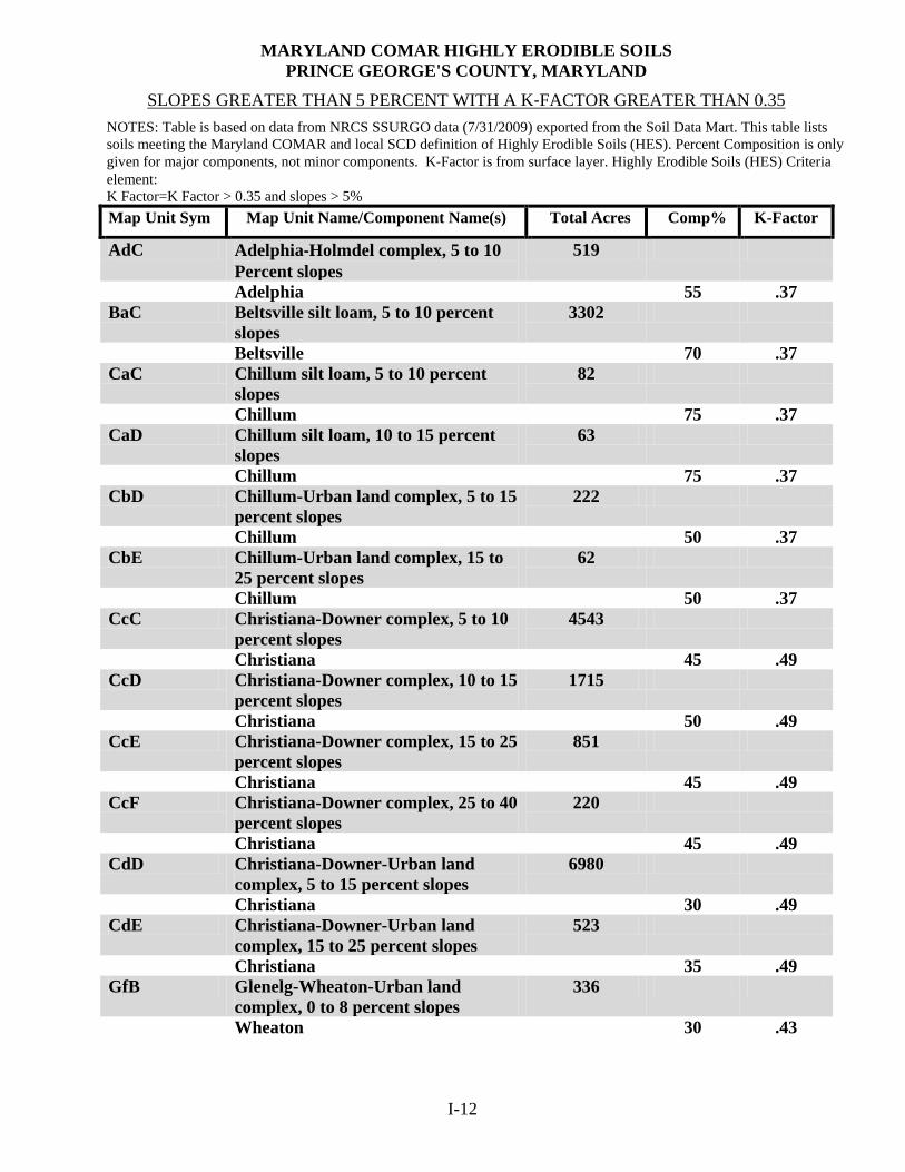
SLOPES GREATER THAN 5 PERCENT WITH A K‐FACTOR GREATER THAN 0.35
NOTES: Table is based on data from NRCS SSURGO data (7/31/2009) exported from the Soil Data Mart. This table lists soils meeting the Maryland COMAR and local SCD definition of Highly Erodible Soils (HES). Percent Composition is only given for major components, not minor components. K‐Factor is from surface layer. Highly Erodible Soils (HES) Criteria element: K Factor=K Factor > 0.35 and slopes > 5%
Map Unit Sym Map Unit Name/Component Name(s) Total Acres Comp% K-Factor
AdC Adelphia‐Holmdel complex, 5 to 10 Percent slopes
519
Adelphia 55 .37 BaC Beltsville silt loam, 5 to 10 percent
slopes 3302
Beltsville 70 .37 CaC Chillum silt loam, 5 to 10 percent
slopes 82
Chillum 75 .37 CaD Chillum silt loam, 10 to 15 percent
slopes 63
Chillum 75 .37 CbD Chillum-Urban land complex, 5 to 15
percent slopes 222
Chillum 50 .37 CbE Chillum-Urban land complex, 15 to
25 percent slopes 62
Chillum 50 .37 CcC Christiana-Downer complex, 5 to 10
percent slopes 4543
Christiana 45 .49 CcD Christiana-Downer complex, 10 to 15
percent slopes 1715
Christiana 50 .49 CcE Christiana-Downer complex, 15 to 25
percent slopes 851
Christiana 45 .49 CcF Christiana-Downer complex, 25 to 40
percent slopes 220
Christiana 45 .49 CdD Christiana-Downer-Urban land
complex, 5 to 15 percent slopes 6980
Christiana 30 .49 CdE Christiana-Downer-Urban land
complex, 15 to 25 percent slopes 523
Christiana 35 .49 GfB Glenelg-Wheaton-Urban land
complex, 0 to 8 percent slopes 336
Wheaton I-12
30 .43

Map Unit Sym Map Unit Name/Component Name(s) Total Acres Comp% K-Factor
GfC Glenelg-Wheaton-Urban land complex, 8 to 15 percent slopes
5
Wheaton 30 .43 GwD Grosstown-Woodstown-Beltsville
complex, 5 to 15 percent slopes 311
Beltsville 20 .37 HwC Howell-Dodon complex, 5 to 10
percent slopes 23
Dodon 40 .37 HZD Howell and Dodon soils, 10 to 15
percent slopes 74
Dodon 40 .37 HZE Howell and Dodon soils, 15 to 25
percent slopes 94
Dodon 30 .37 HZF Howell and Dodon soils, 25 to 40
percent slopes 40
Dodon 30 .37 LxD Liverpool-Piccowaxen complex, 5 to
15 percent slopes 296
Liverpool 45 .37 MnD Marr-Dodon complex, 10 to 15
percent slopes 10473
Dodon 40 .37 UrcD Urban land-Christiana-Downer
complex, 5 to 15 percent slopes 3655
Christiana 15 .49 WDF Westphalia and Dodon soils, 25 to 40
percent slopes 6272
Dodon 40 .37 WDG Westphalia and Dodon soils, 40 to 80
percent soils 1128
Dodon 40 .37
I-13

I-14

___F. HIGH QUALITY (TIER II) WATERS IN PRINCE GEORGE’S COUNTY CODE OF MARYLAND REGULATIONS 26.08.02.04-1
The Clean Water Act requires three components to water quality standards that set goals for and protect each States’ waters. The three components are: (1) designated uses that set goals for each water body (e.g., recreational use), (2) criteria that set the minimum conditions to support the use (e.g., bacterial concentrations below certain concentrations) and (3) an antidegradation policy that maintains high quality waters so they are not allowed to degrade to meet only the minimum standards. Maryland’s antidegradation policy has been promulgated regulations: COMAR 26.08.02.04 sets out the policy itself, COMAR 26.08.02.04-1, provides for implementation of Tier II (high quality waters) of the antidegradation policy. An application for proposed discharge to Tier II waters that will result in a new, or an increased, permitted annual discharge of pollutants and a potential impact to water quality, shall evaluate alternatives to eliminate or reduce discharges or impacts. The following is the Tier II stream segments and watersheds for Prince George’s County:
County: Prince George’s County 2011 Baseline: Date
Listed
Stream Name 12-Digit
Watershed From Lat
From Long
To Lat
To Long
Fish IBI*
Benthie IBI*
Assimilative Capacity
Remaining? 2007 Bald Hill Branch 1 021311030925 38.99228 -76.84371 38.92241 -76.82020 4.00 4.14 YES 2007 Beaverdam Creek 1 021402050823 39.02370 -76.85045 39.02190 -76.85974 4.33 4.43 YES 2007 Beaverdam Creek 2 021402050823 39.02287 -76.86218 39.01585 -76.89775 4.33 4.71 YES 2007 Mataponi Creek UT1 021311020905 38.72979 -76.82511 38.71989 -76.79437 4.00 4.43 YES 2008 Mattawoman Creek 1 021401110786 38.65497 -76.93916 38.65767 -76.98456 5.00 4.43 NO 2009 Patuxent River 1 021311040937 39.01110 -76.73676 39.00709 -76.73319 4.00 4.71 YES 2003 Piscataway Creek 1 021402030803 38.73428 -76.86811 38.73258 -76.87590 4.67 4.43 YES 2007 Piscataway Creek 2 021402030799 38.70638 -76.97208 38.69906 -76.98589 4.33 4.14 YES 2007 Rock Creek 1 021311010904 38.69443 -76.75155 38.69093 -76.72613 4.67 4.71 YES 2003 Swanson Creek 1 021311010893 38.60760 -76.74634 38.58927 -76.74244 4.67 5.00 YES 2007 Swanson Creek 2 021311010890 38.55844 -76.74044 38.55404 -76.72821 4.67 4.14 YES 2007 Swanson Creek 3 021311010893 38.58927 -76.74244 38.55844 -76.74044 4.67 4.43 YES 2009 Turkey Branch 1 021311030921 38.84980 -76.84000 38.85763 -76.78847 4.67 4.14 YES 2003 Wolf Den Branch 1 021401080769 38.63601 -76.82109 38.62192 -76.82043 4.33 4.71 YES 2003 Zekiah Swamp Run 1 021401080769 38.63464 -76.79846 38.62196 -76.82036 4.33 4.14 NO
*IBI=Index of Biotic Integrity
I-15

PAGE LEFT INTENTIONLY BLANK
I-16

I-17

PAGE LEFT INTENTIONLY BLANK
I-18
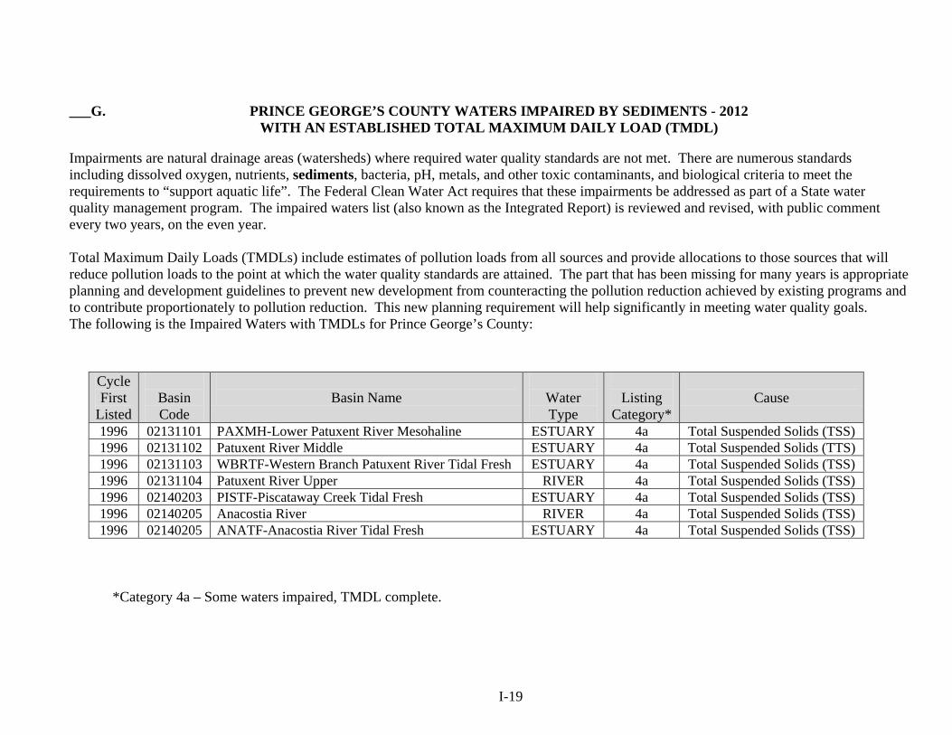
___G. PRINCE GEORGE’S COUNTY WATERS IMPAIRED BY SEDIMENTS - 2012
WITH AN ESTABLISHED TOTAL MAXIMUM DAILY LOAD (TMDL)
Impairments are natural drainage areas (watersheds) where required water quality standards are not met. There are numerous standards including dissolved oxygen, nutrients, sediments, bacteria, pH, metals, and other toxic contaminants, and biological criteria to meet the requirements to “support aquatic life”. The Federal Clean Water Act requires that these impairments be addressed as part of a State water quality management program. The impaired waters list (also known as the Integrated Report) is reviewed and revised, with public comment every two years, on the even year. Total Maximum Daily Loads (TMDLs) include estimates of pollution loads from all sources and provide allocations to those sources that will reduce pollution loads to the point at which the water quality standards are attained. The part that has been missing for many years is appropriate planning and development guidelines to prevent new development from counteracting the pollution reduction achieved by existing programs and to contribute proportionately to pollution reduction. This new planning requirement will help significantly in meeting water quality goals. The following is the Impaired Waters with TMDLs for Prince George’s County:
Cycle First
Listed
Basin Code
Basin Name
Water Type
Listing
Category*
Cause
1996 02131101 PAXMH-Lower Patuxent River Mesohaline ESTUARY 4a Total Suspended Solids (TSS) 1996 02131102 Patuxent River Middle ESTUARY 4a Total Suspended Solids (TTS) 1996 02131103 WBRTF-Western Branch Patuxent River Tidal Fresh ESTUARY 4a Total Suspended Solids (TSS) 1996 02131104 Patuxent River Upper RIVER 4a Total Suspended Solids (TSS) 1996 02140203 PISTF-Piscataway Creek Tidal Fresh ESTUARY 4a Total Suspended Solids (TSS) 1996 02140205 Anacostia River RIVER 4a Total Suspended Solids (TSS) 1996 02140205 ANATF-Anacostia River Tidal Fresh ESTUARY 4a Total Suspended Solids (TSS)
*Category 4a – Some waters impaired, TMDL complete.
I-19

PAGE LEFT INTENTIONLY BLANK
I-20

PRINCE GEORGE’S COUNTY WATERS IMPAIRED BY SEDIMENTS – 2012
Water Impaired Watersheds
Water Impaired Stream Segments and Tributaries
For site specific determinations follow instructions below:
1. www.mde.state.md.us (MDE website); 2. On Home Page click on scrolling titles (#3) – titled Water Quality Mapping Center; 3. Click on Integrated Report Maps; 4. Scroll down and click on Sediments; 5. Click on Prince George’s County watersheds; 6. See (How to Use) to navigate the maps.
I-21

PAGE LEFT INTENTIONLY BLANK
I-22

___H. CONCEPT GRADING, EROSION AND SEDIMENT CONTROL PLAN SUBMITTAL
___1. General ___ a. Concept Grading, Erosion and Sediment Control plans submitted to PGSCD
will not be accepted for a completed review unless the submittal includes: The PGSCD Concept Grading, Erosion and Sediment Control Transmittal Letter, PGSCD Concept Grading, Erosion and Sediment Control Site Analysis, and Concept Supplementary Information as contained in these guidelines; the required consultant certification has been signed; the review fee has been paid; plan sheets sealed; and two sets of folded review prints included.
___ b. Concept Fees are payable by check or money order to Prince George’s Soil Conservation District ___ c. All Concept Grading, Erosion and Sediment Control plans submitted for review shall
contain two sets of folded (9” x 12”) review prints and one set of accompanying data. Do not submit original/sepia until PGSCD indicates the plan is ready for approval. Four sets of prints and original/sepia (optional) shall be submitted for approval and signing. Additional plans submitted for approval will be processed at the current fee rate.
___ d. Include signed and completed consultants certification. ___ e. All Concept Grading, Erosion and Sediment Control plan sheets shall be sealed by a registered professional civil engineer, architect, landscape architect, or land surveyor.
___ 2. Prince George’s Soil Conservation District Concept Grading, Erosion and Sediment Control Transmittal Letter – is required for each submittal. Include project name (same as on plan), contents listed, check reason for submittal and type of submittal (new-resubmittal-revision-update-additional stamped copy).
If a revision to an approved plan, note what has been revised and why in comments section. Include PGSCD Concept Grading, Erosion and Sediment Control number (CSC), once assigned, in any subsequent correspondence or resubmittals.
___3. Prince George’s Soil Conservation District Concept Grading, Erosion and Sediment Control Site Analysis – is required for each new submittal or revision. Include project name (same as on
the plan); complete the plan review fee, map coordinates, area of site, and remaining items.
___4. Concept Supplementary Information – all supplementary information shall be adequately and appropriately identified.
___ a. Soils, soil boundaries from Soil Survey, Prince George’s County Maryland-December 2009, or later revisions. Provide a photocopy of the appropriate soil survey sheet with the site boundaries clearly outlined. Website for soil survey for Prince George’s County is:
http://websoilsurvey.nrcs.usda.gov/app/HomePage.htm ___ b. Drainage map of site, including off-site contributory areas. ___ c. Natural Resource Photographs with location noted for field verification.
___ d. Concept Narrative. ___ e. Preliminary Soils Report as needed.
I-23

___I. PRINCE GEORGE’S SOIL CONSERVATION CONCEPT GRADING, EROSION AND SEDIMENT CONTROL FEES
___1. Concept Grading, Erosion and Sediment Control Plan Review Concept Application Fee $300.00 Major Revision(s) After Approval $300.00 Update(s) $150.00 NOTE: Fees are payable by check or money order ONLY (no cash or credit/debit cards accepted). Make check(s) payable to Prince George’s Soil Conservation District. ___2. Unapproved Plans ___ a. If no activity occurs within one year, an unapproved Concept Grading, Erosion and Sediment Control Plan will be considered expired and will be cancelled.
___ b. The engineer/owner may request in writing a six month continuance prior to cancellation.
___3. Plan Expiration ___ a. All Concept Grading, Erosion and Sediment Control plans expire three years after approval. ___ b. Expired plans require a full Concept Application Fee. ___4. Updating or Extending a Plan ___ a. Plans can only be updated on or before the plan expiration date. If the plan has expired, a full fee is required. ___ b. Updates extend the plan approval for another 3 years. ___ c. Fee for concept plan update(s) is $150.00. ___ d. For plan design changes, see revisions. Revision approval dates and revision fees paid have no bearing on update fees or plan expiration. ___5. Revisions (to approved Concept Grading, Erosion and Sediment Control plans) ___ a. Additional stamped copies (must match approved plans exactly with no changes) ___ (1) Additional Copies - $50.00 each. ___ b. Minor revision of $100.00. ___ (1) Owner change; ___ (2) Engineer change. ___ c. Major Revision is $300.00. ___ d. Revised approval does not extend expiration dates. ___6. Governmental Fees ___ a. County agencies will no longer charge each other fees. The County agencies
include DER, OCS, DPW&T, MNCPPC, PGSCD and Fire/EMS Department. ___ b. For municipalities and Prince George’s County School Board the concept fee is $300.00.
I-24

___7. Checks Returned for Insufficient Funds ___ a. The engineer/owner/applicant shall be liable for a collection fee of $35.00. ___ b. Fees not satisfied within ten days notice given by PGSCD may result in prosecution
under the Maryland criminal code and/or withdrawal of any plan approvals and notification of permitting authorities for stop work orders.
___ c. We accept only certified checks or money orders from an engineer/owner applicant for payment of a returned check. ___ d. For a period of six months from the date the insufficient funds are paid, a certified check or money order will be required on any additional plans submitted. ___8. District Fee Return Policy ___ a. On occasion a request for a refund of plan review fees is made. The following conditions have resulted in an applicant receiving a refund: ___ (1) The owner or engineer requested a plan be withdrawn before plan review has started; ___ (2) During review a plan is found to be exempt from erosion and sediment
control plan approval and only an exemption letter is issued; ___ (3) Evidence of overpayment has been provided by the owner or engineer. ___ (4) Transfer of payment from one plan to another by separating a plan. This
may only be done when no additional design review or overlapping of plans will occur.
___ b. A letter to the District Manager requesting return of fee and reason is required by the owner/applicant. Also, a copy of the cancelled check is required. For administrative costs $100.00 of the concept fee is not refundable.
I-25

____J. CONCEPT GRADING, EROSION AND SEDIMENT CONTROL PLAN APPROVAL
___1. Any changes or modifications (not approved by the PGSCD) to an approved Concept Grading,
Erosion and Sediment Control plan, shall invalidate the plan approval. ___2. PGSCD Concept Grading, Erosion and Sediment Control plan approval shall remain valid for a period of three years from the approval date. An expiration date will be shown on all plans. ___3. Four sets of prints and original/sepia (optional) shall be submitted for approval and signing. The
copy or copies (prints) of the Concept Grading, Erosion and Sediment Control plan with signed PGSCD approval stamp, will become an official record copy of the approved Concept Grading, Erosion and Sediment Control plan. Copies made from the approved mylars are approved copies as long as no changes to the plans have been made.
___4. Include the PGSCD approval stamp in close proximity to the title block (lower right hand corner)
on the first sheet of the Concept Grading, Erosion and Sediment Control plan. Note: Do not alter approval block. The approval stamp needs to show on the outside when the plans are folded.
___5. Revisions and updates to previously approved Concept Grading, Erosion and Sediment Control plans will be reviewed in accordance with PGSCD requirements in effect at time of submittal. Include an explanation of what was revised, changed, or added, and why. ___6. PGSCD reserves the right to deny the issuance of an approval where the proposed project
would adversely affect the public safety and welfare.(COMAR 26.17.01.08)
I-26

___K. PRINCE GEORGE’S SOIL CONSERVATION DISTRICT CONCEPT GRADING, EROSION AND SEDIMENT CONTROL
APPROVAL STAMP
PRINCE GEORGE'S SOIL CONSERVATION DISTRICT
APPROVAL CONCEPT GRADING, EROSION AND SEDIMENT CONTROL
CSC# EXPIRATION DATE
DISTRICT SIGNATURE APPROVAL DATE
___1. NOTE: INCLUDE THE PGSCD APPROVAL STAMP IN CLOSE PROXIMITY TO THE TITLE BLOCK (LOWER RIGHT HAND CORNER) ON THE FIRST SHEET OF THE CONCEPT GRADING, EROSION AND SEDIMENT CONTROL PLAN ONLY. STAMP MUST SHOW ON THE OUTSIDE WHEN CONCEPT GRADING,
EROSION AND SEDIMENT CONTROL PLANS ARE FOLDED.
PGSCD WILL SIGN AND/OR INITIAL THE APPROVAL AND INCLUDE APPROVAL AND EXPIRATION DATES ON PLANS AS APPROPRIATE.
DO NOT ALTER THE SIZE (2-7/8” X 3-3/4”) OR CONTENT OF THE APPROVAL STAMP.
I-27

PAGE LEFT INTENTIONLY BLANK
I-28

CONCEPT
FROM: PRINCE GEORGE’S SOIL CONSERVATION DISTRICT
GRADING, EROSION AND SEDIMENT CONTROL PLAN TRANSMITTAL LETTER
(Required for each submittal)
TO: PRINCE GEORGE’S SOIL CONSERVATION DISTRICT 5301 MARLBORO RACE TRACK RD. UPPER MARLBORO, MD 20772 301-574-5162 X 3 301-574-5156 Fax
DATE: ATTENTION: CSC# RE:
SUBMITTED FOR: ___Concept Grading, Erosion and Sediment Control Plan Review (CSC)
(Always submit two sets of prints for review)
TYPE OF SUBMITTAL: ___New ___Resubmission ____Revision ____Update _____ Copies ___Concept Approval (Include originals & four prints) Do Not Send Until Requested
COPIES DESCRIPTION
INFORMATION ENCLOSED: Check appropriate spaces
Concept Grading, Erosion and Sediment Control Plan ___Review Fees ___Soil Survey Soil Boundaries ___2 Sets of Prints (folded) ___Drainage Map ___Signed Certification ___Site Limits/Property Lines ___Plans Sealed ___Natural Resource Photographs ___Site Analysis Sheet ___Concept Narrative ___Preliminary Soils Report
COMMENTS:_____________________________________________________________________________________ __________________________________________________________________________________________________ _________________________________________________________________________________________________ _________________________________________________________________________________________________ PRINT NAME_______________________________________________________PH#______________________________
EMAIL ADDRESS:_______________________________________________________________
I-29

PRINCE GEORGE’S SOIL CONSERVATION DISTRICT CONCEPT
GRADING, EROSION AND SEDIMENT CONTROL PLAN SITE ANALYSIS
(Required for each new submittal or revision)
NAME OF PROJECT IN TITLE BLOCK: _______________________________________________________________________
1. Concept Grading, Erosion and Sediment Control Plan Review Amount
Concept Application Fee $300.00 ___________ Revision(s) After Approval $300.00 ___________
Update(s) $150.00 ___________ Total Due ___________
NOTE: Checks or money orders ONLY made payable to Prince George's Soil Conservation District (no cash or credit/debit cards accepted). 2. Location P.G. Co. Street Map Book Coordinates ________________________________________ 3. Street Address____________________________________________________________________ ________________________________________________________________________________ 4. Area of Site/Property _____________________ ac.
Existing Natural Resources: 5. Steep Slopes (acres) >15% ________________ >25%__________________ 6. Highly Erodible Soils ______________ Marlboro Clays ________ Sulfidic Soils ___________ Diatomaceous Soils _______________
7. Vegetative Cover (acres) Grass __________ Cropland ___________ Disturbed/Graded _______ Other ______________
8. Forests (acres) ____________
9. Perennial Stream(s) ______________________ Intermittent Stream(s)____________________ 10. Spring(s) _______________ Seep(s)___________________
11. Pond(s) _____________
12. Wetland(s) (acres) ___________________________
13. Floodplain (acres) __________________
14. Chesapeake Bay Critical Area (acres) _________________
15. Waters of the United States ________________________________________________________
16. Percent impervious cover proposed __________________________________________________
17. TIER II Waters__________________________________________________________________
18. Impaired Waterways with TMDL____________________________________________________
19. Other __________________________________________________________________________
I-30
SECTION II
PRINCE GEORGE’S
SOIL CONSERVATION DISTRICT
ENVIRONMENTAL SITE DEVELOPMENT
GRADING, EROSION AND SEDIMENT
CONTROL PLAN

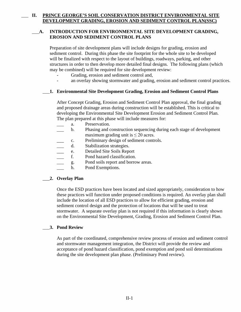
___ II. PRINCE GEORGE’S SOIL CONSERVATION DISTRICT ENVIRONMENTAL SITE DEVELOPMENT GRADING, EROSION AND SEDIMENT CONTROL PLAN(SSC)
___A. INTRODUCTION FOR ENVIRONMENTAL SITE DEVELOPMENT GRADING, EROSION AND SEDIMENT CONTROL PLANS
Preparation of site development plans will include designs for grading, erosion and sediment control. During this phase the site footprint for the whole site to be developed will be finalized with respect to the layout of buildings, roadways, parking, and other structures in order to then develop more detailed final designs. The following plans (which may be combined) will be required for site development review:
- Grading, erosion and sediment control and, - an overlay showing stormwater and grading, erosion and sediment control practices.
___1. Environmental Site Development Grading, Erosion and Sediment Control Plans
After Concept Grading, Erosion and Sediment Control Plan approval, the final grading
and proposed drainage areas during construction will be established. This is critical to developing the Environmental Site Development Erosion and Sediment Control Plan.
The plan prepared at this phase will include measures for: ___ a. Preservation. ___ b. Phasing and construction sequencing during each stage of development
maximum grading unit is ≤ 20 acres. ___ c. Preliminary design of sediment controls. ___ d. Stabilization strategies. ___ e. Detailed Site Soils Report ___ f. Pond hazard classification. ___ g. Pond soils report and borrow areas. ___ h. Pond Exemptions.
___2. Overlay Plan Once the ESD practices have been located and sized appropriately, consideration to how
these practices will function under proposed conditions is required. An overlay plan shall include the location of all ESD practices to allow for efficient grading, erosion and sediment control design and the protection of locations that will be used to treat stormwater. A separate overlay plan is not required if this information is clearly shown on the Environmental Site Development, Grading, Erosion and Sediment Control Plan.
___3. Pond Review As part of the coordinated, comprehensive review process of erosion and sediment control and stormwater management integration, the District will provide the review and acceptance of pond hazard classification, pond exemption and pond soil determinations during the site development plan phase. (Preliminary Pond review).
II-1

___B. ENVIRONMENTAL SITE DEVELOPMENT GRADING, EROSION AND SEDIMENT CONTROL PLAN DESIGN CONSIDERATIONS
___1. Preservation Comments received during Environmental Site Development Grading, Erosion and Sediment Control Plan review shall be used as a basis for preparing the Final Grading,
Soil Erosion and Sediment Control Plan. Strategies to preserve sensitive resources, ensure soil stability, and prevent erosion begin with protecting those areas during project construction.
___ a. Identify areas to be protected by field marking (flagging or painting) for the limit of disturbance, sensitive areas, buffers, and forested areas that are to be preserved or protected. ___ b. In addition, infiltration and recharge areas that need to be protected from
fine sediments and compaction shall be identified for field marking. ___ c. Plans shall also include a note that all protected areas shall be marked in the field prior to any land disturbing activity. ___2. Phasing and Sequences of Construction During Each Stage of Development
___ a. Provide a sequence of construction for each stage of development.
These include initial clearing and grubbing, rough grading, site development, and final grading. Because initial and final flow patterns will not apply to all intermediate phases, this sequence shall consider flow pattern changes, drainage areas, and discharge points at transitional phases of the construction process. Phased plans need to ensure that erosion and sediment controls adequately address the changing runoff patterns.
___ b. Proper sequencing of grading operations will minimize site exposure. Sequentially grading and stabilizing the site, rather than grading the entire site as one operation, will minimize the length of time that the land is in a disturbed condition. Maximum grading unit is ≤ 20 acres.
___ c. Environmental Site Development Grading, Erosion and Sediment Control Plan strategies for minimizing erosion during interim grading include:
___ (1) Interim plans to address grade changes and flow patterns during clearing and grading, rough grading, site development, and final grading. ___ (2) Slope length and steepness reductions. ___ (3) Diverting clean water around or through a site and discharging to a stable outlet.
___ (4) Additional stabilization strategies. ___ (5) Additional grading, erosion and sediment control practices.
___3. Preliminary Design of Sediment Controls
Water handling practices need to provide erosion protection during site grading operations. This may be done by diverting runoff away from highly erodible soils, steep slopes, and disturbed areas by using dikes, swales, or reverse benches. Similarly, runoff can be safely conveyed from the top of slopes to a stable outfall using pipe slope drains or channels. Check dams may be needed to reduce velocities and prevent erosion. A stable outlet shall be provided for runoff from all discharge points. Provide preliminary sediment control and pond computations.
II-2

___4. Stabilization Strategies ___ a. When vegetation is removed and soil disturbance occurs, the extent and
duration of exposure shall be minimized. All efforts shall be made to delay grading operations until it is certain that final grades can be reached in as little time as possible. The extent and duration of disturbance shall be limited, and enhanced stabilization techniques such as soil stabilization matting or turf
reinforcement shall be used on areas with highly erodible soils and slopes greater than 15 %. Soil exposure shall be shortened if warranted by site conditions.
___ b. Perimeter controls, perimeter slopes, and extreme grade modification (e.g., slopes greater than 3:1 or where cuts and fills exceed 15 feet vertical) require stabilization within three days. Mass clearing and grading shall be avoided, with larger projects (e.g. ≥20 acres) being phased so that disturbed
areas remain exposed for the shortest time possible. All other areas shall have a good cover of temporary, permanent vegetation and/or mulch.
___ c. Natural vegetation shall be retained in an undisturbed state wherever possible. If it is not possible to retain natural vegetation, the topsoil shall be salvaged, stockpiled on-site, protected from erosion, and replaced at final grade. Topsoil removal, grading, and filling reduce soil quality resulting in detrimental impacts on plant growth and increased runoff.
Additionally, the removal of topsoil inhibits biological activity and reduces the supply of organic matter and plant nutrients. Similarly, unrestricted use of construction equipment can result in soil compaction.
___ d. Applicable practices include, but are not limited to, temporary and permanent seeding, sodding, mulching, plastic covering, erosion control fabrics and
matting, the early application of gravel base on areas to be paved, and dust control. Soil stabilization measures should be appropriate for the time of year, site conditions, and estimated duration of use. Soil stockpiles must be stabilized, protected with sediment trapping or filtering measures, and be located away from storm drain inlets, waterways, and drainage channels. Linear construction activities, including right-of-way and easement clearing, roadway development, pipelines, and trenching for utilities shall be phased so that soils are stabilized as quickly as possible.
___ e. Strategies to limit the extent and duration that soils are exposed may include: ___ (1) Minimizing disturbed area. ___ (2) Phasing earth disturbing activities so that the smallest area is exposed for the shortest possible time. ___ (3) Salvaging topsoil for later use. ___ (4) Stabilizing as work progresses.
___5. Dam Hazard Classification The classification of a dam is the responsibility of the designer and subject to review and acceptance of the approving authority. ___ a. Structure classification must take into consideration the anticipated life of the structure as it would impact downstream property. ___ b. Dam classification is determined by the potential hazard from failure, not by the criteria. ___ c. Use of breach procedures and results at representative and critical sections provide support of the hazard classification and subsequent pond design criteria used.
II-3
___6. Pond Soils Report and Borrow Areas ___ a. A soils investigation by a Maryland registered geotechnical engineer is required on all ponds. Off-site borrow must be identified before final approval. ___ b. All investigations shall be logged using the Unified Soil Classification System. ___ c. Fill material for the center of the embankment and cut off trench shall conform to Unified Soil Classification GC, SC, CH, or CL. ___ d. A sufficient quantity of topsoil will be stockpiled in a suitable location for use on the embankment to support vegetation of the quality required. ___ e. Offsite borrow areas must be identified with adequate soil quality and quantities before pond approval. ___7. Preliminary Pond Exemptions ___ a. Exemptions must be applied for in writing. ___ b. Include preliminary computations for proper justification. ___ c. All structures must be hazard class “a”. ___ d. Provide design for 100 year storm event (MD NOAA 14 rainfall depth) and include required freeboard. ___ e. Exemption requests shall not combine two or more exemption categories.
___8. Overlay Plan
___ a. The location of any ESD practice that requires natural infiltration needs to be identified on the Environmental Site Development Grading, Erosion and Sediment Control Plan. These areas need to be protected during construction. ___ b. An overlay plan shall include:
___ (1) The location of existing and proposed ESD practices. ___ (2) The location of areas that must remain undisturbed, protected, or used for erosion and sediment control. ___ (3) Identifiable areas where construction equipment may compact soil and will need rehabilitation after grading operations. ___ (4) Removal of sediment from the locations of ESD practices. ___ (5) Stabilization measures needed to enhance stormwater functions.
II-4

___C. ENVIRONMENTAL SITE DEVELOPMENT GRADING, EROSION AND SEDIMENT CONTROL PLAN PREPARATION
___1. Environmental Site Development Grading, Erosion and Sediment Control plans shall be submitted to Prince George’s Soil Conservation District and need to include a stormwater plan, grading, erosion and sediment control plan, an overlay plan, and a narrative to support the design. PGSCD may require additional information at this phase, however, at a minimum the plan shall include the following:
___2. All of the information provided in the concept review. ___3. Conditions issued by review agencies during the concept review shall be addressed on the Environmental Site Development Plan. ___4. Determination of final site layout and acreage of total impervious area on site. ___5. Existing and proposed topography. ___6. Proposed drainage areas at all points of discharge from the site. ___7. Proposed hydrology analysis for all ponds and trapping devices: (as needed) ___ a. for runoff rates,
___ b. storage volumes, ___ c. and discharge velocities.
___8. Discharge calculations demonstrating stable conveyance of runoff from the site. ___9. Preliminary erosion and sediment control plans showing:
___ a. grading units, 20 acres maximum contiguous disturbed area at a given time. ___ (1) limits of disturbance, 30 acres maximum cumulatively at a given time
___ b. sensitive areas, ___ c. buffers, ___ d. forests that are to be preserved,
___ e. proposed phasing, ___ f. construction sequencing, and time frames,
___ g. proposed practices and preliminary computations, ___ (1) water conveyance, ___ (2) erosion control, ___ (3) filtering, ___ (4) dewatering, ___ (5) sediment trapping. ___ h. designation of stabilization requirements, ___ (1) grading unit size, 20 acre maximum contiguous graded area at a given time. ___ (2) topsoiling and topsoil stockpiles, ___ (3) soil testing and recommended soil amendments, ___ (4) 3 day – sediment controls and slopes steeper than 3:1, ___ (5) 7 day – all other disturbed areas, ___ (6) incremental stabilization – slopes over 15 feet, ___ (7) accelerated – same day on areas of special concern, ___ (8) soil stabilization matting – for channels or slopes, ___ (9) heavy use area protection.
___10. An overlay plan showing the location of stormwater ESD practices and proposed erosion and sediment controls. Ensure that proposed stormwater management features, such as permeable pavement, infiltration areas, and buffers, are not negatively impacted during construction. ___11. Initial, interim, and final plan phases shall be developed to adjust the soil erosion and sediment controls to the changing drainage patterns. ___12. The location and size of ESD to the MEP practices including all nonstructural, alternative surfaces, micro-scale and structural practices used. ___13. A narrative that supports the Environmental Site Development Grading, Erosion and Sediment Control Plan and provides full integration of erosion and sediment control with the County’s stormwater management CESD to the MEP. This should include nonstructural techniques and site planning to mimic natural hydrologic runoff characteristic. II-5

___14. The scope of the Environmental Site Development Grading, Erosion and Sediment Control Plan is to be clearly defined and fully identified in the title block. All Environmental Site
Development Grading, Erosion and Sediment Control Plan sheets are to be numbered chronologically with a SSC#.
___15. Plans are to be legible and shall include: scale (1"=50' maximum), two foot contour intervals, legends, north arrow. All plan sheets must be the same size with a maximum size of 30"x42". Include a site specific vicinity map to scale. Include road identification, nearest intersections and distance to. Include enough detail on the vicinity map so that someone unfamiliar with the site can quickly locate it in the field.
___16. All Environmental Site Development Grading, Erosion and Sediment Control Plans submitted for review shall contain two sets of folded prints (9" x 12") and one set of accompanying
data. Do not submit mylars/originals until PGSCD plan reviewer indicates the plan is ready for approval. Four sets of final prints and original/sepia (optional) shall be submitted for approval and signing. Additional or approved plans submitted for additional stamped copies will be processed at the current fee rate.
___17. If Environmental Site Development Grading, Erosion and Sediment Control Plan is presented on three or more sheets, provide a composite-overall drawing showing how the sediment control and existing topography, on individual sheets tie together. Match lines and matching sheet numbers are to be included on each sheet.
___18. Show property lines and names of all adjacent property owners. ___19. Plans must include topographic data sufficiently adequate to show existing conditions adjacent
to the site and downstream of all sediment control. This shall be a minimum 100 foot adjacent strip and minimum 100 foot downstream, or as otherwise needed to clearly reflect existing conditions.
___20. The following certification shall be included on all Environmental Site Development Grading, Erosion and Sediment Control Plans and shall be signed at time of plan submittal. Include on the first sheet and do not alter the wording.
CONSULTANTS CERTIFICATION “I certify that this Environmental Site Development Grading, Erosion and Sediment Control Plan represents all significant natural resources and is a practical and workable plan based on my personal knowledge of the site, and that this plan was prepared in accordance with the requirements of the Prince George’s Soil Conservation District and “Standards and Specifications for Soil Erosion and Sediment Control”. I have reviewed this Environmental
Site Development Grading, Erosion and Sediment Control Plan with the owner/developer”. Signature__________________________________________MD License#______________ Print Name_________________________________________ Date_________________ (Include seal, company name, address and phone number if not included elsewhere on plan).
___21. Prince George’s Soil Conservation District will provide coordinated feedback for grading, erosion and sediment control to the designer before a project proceeds to the more detailed final design phase. This feedback will accompany the Environmental Site Development approval and shall be incorporated into future submission.
___22. Any site requiring the subdivision review process will need separate review and approval for concept, site development and final grading, erosion and sediment control plans by the District.
___23. Sites not requiring the subdivision process have the option of combining the concept and site development grading, erosion and sediment control plans for review and approval by the District.
___24. Lots that are eligible for utilizing the standard grading, erosion and sediment control plan may include all three plan requirements for concept, site development and final on one plan.
___25. Forest harvest erosion and sediment control plans shall use the MDE Standards and Specifications for Forest Harvest Operations 2005 Draft.
II-6

___D. PGSCD POND SOIL REPORTS AND BORROW AREAS ___1. A soils investigation and report is required on all ponds to include the following:
___ a. A Maryland registered geotechnical engineer seal and signature. ___ b. Investigations shall be logged using the Unified Soil Classification System. ___ c. A soil boring map with boring locations shown. ___ d. Soil logs with profiles, elevations, blows counts and depth to groundwater at time of drilling and after 24 hours. ___ e. A narrative of findings and recommendations. ___ f. Additional engineer requirements geotechnical (i.e., dewatering). ___2. A sufficient number of soil borings is required to provide representative sampling of soils present at the following locations: ___ a. Along the centerline of the proposed dam, ___ b. In the emergency spillway, ___ c. In the pond pool area, ___ d. At the control structure, ___ e. In the planned borrow area. ___ f. And to determine location and depth of impervious foundation material. ___3. Fill material for the embankment shall conform to the following: ___ a. The center of the embankment and cut off trench shall use unified classes GC, SC, CH or CL. ___ b. Embankment shell material with high piping potential such as unified classes GM, SM, and ML will require the use of filter and drainage diaphragms. ___ c. A sufficient quantity of topsoil will be stockpiled in a suitable location for use on the embankment to support vegetation of the quality required to prevent erosion of the embankment. ___4. All embankment fill borrow areas must be identified and delineated. ___ a. Verify acceptable quantities of acceptable fill material. ___ b. Stockpiled borrow material can only be accepted if it has been tested and certified by the geotechnical engineer that all of the stockpiled material meets the required unified classes. ___ c. Offsite borrow areas must be identified and accepted before pond approval. Include a site location map and an approved erosion and sediment control plan number for offsite borrow areas.
II-7

___E. PGSCD DAM HAZARD CLASSIFICATION
___1. Introduction
All dams will be reviewed and classified according to factors and procedures outlined in 520.21 of Subchapter C, Subpart C – Dams, SCS National Engineering Manual as supplemented below. The class ("a", "b", and "c") is related to the damage that might result from a sudden major breach of the earth embankment. Structure classification must take into consideration the anticipated changes in land use or future development throughout the expected life of the structure as they would impact downstream property. Downstream undeveloped property requires a breach flow of 6" or less (based on USBR, "Downstream Hazard Classification Guidelines", 1988) for a Class "a" designation. The classification of a dam is the responsibility of the engineer and subject to review and acceptance of the approving authority.
___2. Classes of Dams
Dam classification is determined by the potential hazard from failure, not by the criteria. Table 1, MD-378 or Table 2-2 and 2-5 of TR-60 are not justification of the hazard, but are criteria. Classification factors in the National Engineering Manual, as supplemented, are given below.
___ a. Class "a" - Structures located in rural, agricultural or urban areas dedicated to remain in flood tolerant usages where failure may damage
non-residential buildings, agricultural land, floodplains or county roads. ___ b. Class "b" - Structures located in predominantly rural or agricultural areas where failure may damage isolated homes, main highways or minor railroads, or cause interruption of use or service of relatively important public utilities. ___ c. Class "c" - Structures located where failure may cause loss of life
or serious damage to homes, industrial and commercial buildings, important public utilities, main highways or railroads.
___ d. Where breach analysis has indicated that overtopping of downstream roads will occur. The following guidelines will be used:
Class Depth of Flow "a" d≤1.5 Ft "b" & "c" d>1.5 Ft
___3. Justification
___ a. Provide a narrative summary of the information used to evaluate the safety hazard for each dam classification. Use of breach procedures and results at representative and critical sections provide support of the hazard classification and subsequent pond design criteria used. The limits of the breach area are not analogous with the 100 year floodplain. Existing 100 year flooding of downstream homes, roads, railroads and utilities does not reduce hazard, but instead indicates breach damage may occur.
II-8

___4. Peak Breach Discharge Criteria
___ a. When providing justification for pond classification, the minimum peak discharge of the breach hydrograph is required regardless of the technique used to analyze the downstream inundation area. The breach hydrograph is the outflow hydrograph attributed to the sudden release of water in reservoir storage due to a dam breach.
The conditions at the time of breach are water level at or above the crest elevation of the emergency spillway (100 year elevation when no emergency spillway is used) and “non-storm” conditions downstream of the dam. For dams in series, an evaluation is needed to determine if breach of an upstream dam would endanger a downstream dam.
___ b. The minimum peak discharge is as follows: Qmax = 3.2 Hw
2.5
Qmax = the peak breach discharge, cfs. HW = depth of water at the dam at the time of failure, in feet. This is measured from the lowest point of potential failure at the upstream toe of dam to the crest of the emergency spillway or design high water when no emergency spillway is used.
HW (FEET) QMAX (CFS) HW (FEET) QMAX (CFS)
1.0…………………3.2 10.0……………………1,012.0 2.0………………...18.1 10.5……………………1,143.2 3.0………………...49.9 11.0……………………1,284.2 4.0……………….102.4 11.5……………………1,435.1 4.5……………….137.5 12.0……………………1,596.3 5.0……………….178.9 12.5……………………1,767.8 5.5……………….227.0 13.0……………………1,949.9 6.0……………….282.2 13.5……………………2,142.8 6.5……………….344.7 14.0……………………2,346.8 7.0……………….414.9 14.5……………………2,561.9 7.5……………….493.0 15.0……………………2,788.5 8.0……………….579.3 16.0……………………3,276.8 8.5……………….674.1 17.0……………………3,813.0 9.0……………….777.6 18.0……………………4,398.8 9.5……………….890.1 19.0……………………5,035.4
20.0……………………5,724.3
II-9

___ F. TR-66 SIMPLIFIED DAM-BREACH ROUTING PROCEDURE ___1. Minimum information needed for breach analysis: Given the: Qmax, reservoir storage volume (ac.-ft.), no storm inflow (generally), valley cross-section data and roughness coefficients, and reach length distances from the dam. You find: The peak flood flow (Q) at a predefined location (L) in the path of the floodwave, the associated maximum
depth of flow (D), and the time lapse (T) from the breaching.
___2. Procedure: Follow TR-66, third edition. The simplified dam-breach routing is a manual procedure using a mathematic
model or a graphic solution developed from actual dam breach events and physical model studies. It is used for open channel flow where there is uniform shape and storage in the downstream stream valley. When a road embankment or other obstruction stores a significant portion of the flow from the dam, the obstruction controls the flow downstream and TR-66 is not applicable downstream of the obstruction.
___3. Breach routing of Qmax can be used to delineate the area potentially impacted by inundation should a dam fail. TR-66 Estimates
___ a. Peak flood flow at given location. ___ b. The maximum depth of flow, and ___ c. Time lapse between breach and items a and b.
___4. Breach Hydrograph routings are to be based upon topographic data of the downstream area. The Breach Hydrograph is defined by its,
___ a. Peak discharge Qmax, ___ b. Total volume and ___ c. Its shape.
___5. The Breach Hydrograph is a continuous decaying function of time of either triangular
or curvilinear shape. If the subreach below the dam is super critical, the shape is triangular; otherwise the hydrograph shape is curvilinear.
II-10

___G. PRELIMINARY POND EXEMPTIONS
___1. Exemptions must be applied for in writing, and include professional engineer's seal. Include preliminary computations and elevations for proper justification. Exemption requests shall not combine two or more exemption categories. Any exemption does not relieve the applicant from obtaining other necessary county, state and federal permits. Provide design for 100 year storm event using MD NOAA 14 rainfall depth for exemptions in #3 and #4 below. Excavated ponds are not exempt from PGSCD small pond approval.
___2. With proper written justification bioretention structures meeting the following limits are exempt by definition from final small pond review:
___ a. the drainage area to the structure is 1.5 acres or less, the structure is designed for the 10 year storm and the storage depth against an embankment or created embankment is 12" or less, and the structure
has a non-erosive outlet.
___3. PGSCD small pond approval does not apply to small urban stormwater management quality or quantity class "a" structures where the following exist:
___ a. ponds or other structures have less than four (4) feet of embankment or ___ b. the storage at emergency spillway design high water elevation according to Table 1, MD-378 (100 year storm on urban sites) does not exceed 40,000 cubic feet, and the height of the embankment is six (6) feet or less. The height of the embankment shall be measured from the top of dam to the
lowest point of excavation, (normally bottom of pipe spillway), excluding the cutoff trench along the centerline of the dam. The review and approval of such "a" structures shall be based on sound engineering judgment ensuring a stable outfall for the ten (10) year 24 hour storm event.
___ c. Provide minimum one foot freeboard.
___4. When a facility will not involve any dam safety issues, a small pond approval from PGSCD may not be required. The following exemption categories may be applied for:
___ a. Structures whose primary function is wetlands/water quality outfalls when: ___ (1) normal pool is 18 inches or less and the difference between the lowest point in the pond bottom and the design storm is less than three feet and,
___ (2) provide minimum one foot freeboard, ___ (3) the structure poses no downstream failure hazard (Class "a").
___ b. Excavated structures in the floodplain whose primary function is wetlands/water quality when: ___ (1) the 100-year floodplain storm inundates an excavated storm water management pond and, ___ (2) provide minimum one foot freeboard prior to inundation, ___ (3) the structure poses no downstream hazard (Class "a").
___ c. Structures are considered culverts when: ___ (1) the 100-year design high water is less than or equal to 2 times the
diameter of the culvert. ___ (2) provide minimum one foot freeboard,
___ (3) the structure poses no downstream hazard (Class "a"). ___ d. Minor alterations, repairs, or retrofits when:
___ (1) the pond was approved (design and as-built) in accordance with Article 5-503(b), Annotated Code of Maryland,
___ (2) the alterations will not change hydraulics or failure hazard and, ___ (3) the existing pond structure is certified by a professional engineer
to be in proper functioning condition.
II-11

___ e. Alterations, repairs, or retrofits to: ___ (1) ponds approved by agencies other than the Prince George's Soil Conservation District in accordance with Article 5-503, Annotated Code of Maryland, will be referred to the original approval authority for pond alterations or as-builts, ___ (2) the Soil Conservation District approval will be limited to grading, erosion and sediment control approval. ___5. While not required to meet all conditions of MD-378, facilities that meet exempt approval shall conform to the following minimum design construction criteria: ___ a. Design for a stable outfall using the ten year storm (or two year design storm if the pond is an off-line structure providing WQv storage only). ___ b. Dams shall meet class “a” dam safety hazard classification, ___ c. Principal spillway/riser shall provide anti-flotation, anti-vortex, and
trash-rack designs. ___ d. Material and construction specifications for the principal spillway shall
be in accordance with MD-378 code. ___ e. Material and construction specifications for the embankment shall be in accordance with MD-378 code, except that fill material for the embankment shall conform to Unified Soil Classification GC, SC, CH,
CL, ML, SM, or GM. No cutoff trench is required, and no drainage diaphragm is required.
___ f. Woody vegetation is prohibited on the embankment and within 15' of the toe of the embankment.
II-12

___ H. EXAMPLES OF EMBANKMENT, EXCAVATED AND EXEMPT PONDS
II-13

II-14
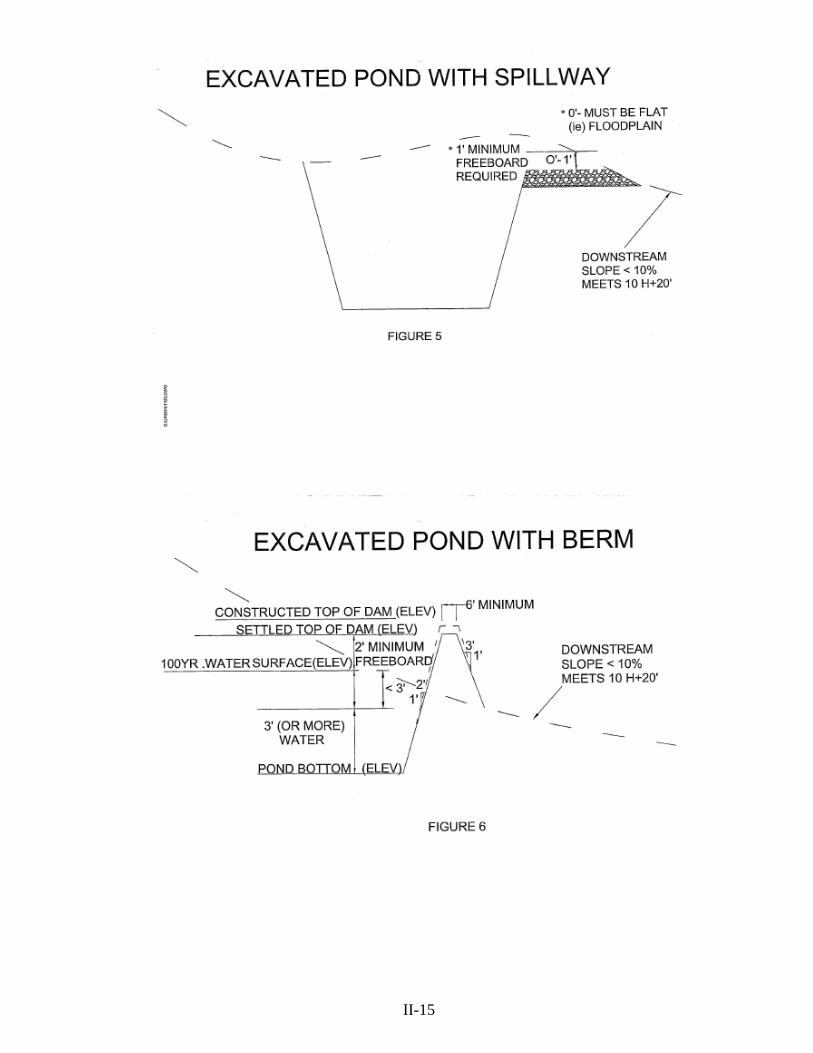
II-15
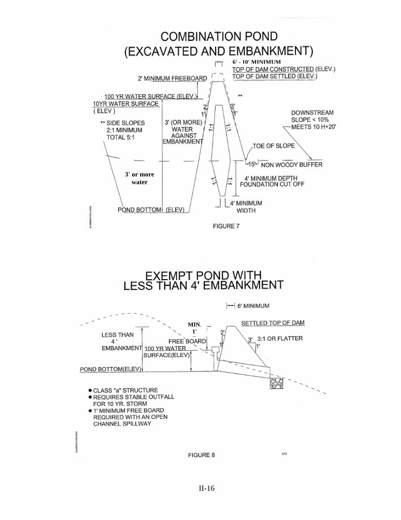
II-16
3' or more water
MIN.1'
6' - 10' MINIMUM

II-17
MIN. 1'
1' FREEBOARD

II-18

___I. MARYLAND AVERAGE RAINFALL FROM NOAA ATLAS 14
County Rainfall Depth
1 yr 24 hr 2 yr 24 hr 10 yr 24 hr 25 yr 24 hr 50 yr 24 hr 100 yr 24 hr Allegany 2.07 2.47 3.64 4.45 5.16 5.96 Anne Arundel 2.64 3.20 4.94 6.19 7.29 8.53 Baltimore 2.70 3.27 5.01 6.27 7.38 8.65 Calvert 2.73 3.32 5.17 6.48 7.63 8.93 Caroline 2.70 3.29 5.13 6.42 7.56 8.84 Carroll 2.54 3.07 4.69 5.85 6.88 8.06 Cecil 2.66 3.22 4.87 6.01 7.00 8.10 Charles 2.67 3.24 5.04 6.31 7.44 8.70 Dorchester 2.77 3.38 5.27 6.60 7.77 9.08 Frederick Catoctin 2.54 3.05 4.51 5.54 6.43 7.44 Frederick 2.54 3.07 4.63 5.77 6.78 7.94 Garrett 2.13 2.55 3.69 4.50 5.20 5.99 Harford 2.70 3.26 5.00 6.24 7.34 8.57 Howard 2.64 3.19 4.91 6.14 7.23 8.47 Kent 2.66 3.23 5.01 6.27 7.38 8.63 Montgomery 2.57 3.10 4.77 5.97 7.03 8.23 Prince George’s 2.63 3.19 4.92 6.16 7.26 8.49 Queen Anne’s 2.67 3.24 5.06 6.33 7.46 8.72 St. Mary’s 2.77 3.37 5.24 6.57 7.73 9.04 Somerset 2.65 3.22 5.01 6.28 7.40 8.64 Talbot 2.74 3.33 5.19 6.51 7.67 8.97 Washington East 2.52 3.03 4.41 5.40 6.29 7.30 West 2.37 2.84 4.11 4.94 5.64 6.40 Wicomico 2.81 3.42 5.34 6.69 7.88 9.22 Worcester 2.81 3.42 5.34 6.70 7.89 9.23 Minimum 2.07 2.47 3.64 4.45 5.16 5.96 Median 2.66 3.22 5.00 6.24 7.34 8.57 Maximum 2.81 3.42 5.34 6.70 7.89 9.23 Standard Deviation 0.18 0.24 0.46 0.62 0.77 0.94
This chart can only be used with proper NRCS software programs converted for NOAA 14 rainfall data. See below: (WinTR-55) Small Watershed Hydrology. WinTR-55 is a tool for urban hydrology for small watersheds. This version includes the NOAA 14 rainfall data and will run in the Windows 7 environment. ftp://ftp-fc.sc.egov.usda.gov/NDCSMC/Software/WinTR-55 installwindows7.exe
II-19

__ J. ENVIRONMENTAL SITE DEVELOPMENT GRADING, EROSION AND SEDIMENT CONTROL PLAN SUBMITTAL
___1. General
___ a. Environmental Site Development Grading, Erosion and Sediment Control Plans submitted to PGSCD will not be accepted for a complete review unless the submittal includes: The PGSCD Environmental Site Development Grading, Erosion and Sediment Control Transmittal Letter, PGSCD Environmental Site Development Grading, Erosion and Sediment Control Site Analysis, Environmental Site Development Supplementary Information as contained in these guidelines; the required consultant certification has been signed; the review fee has been paid; plan sheets sealed; and two sets of folded review prints included.
___ b. Environmental Site Development Grading, Erosion and Sediment Control Plan fees are payable by check or money order to Prince George's Soil Conservation District
___ c. All environmental site development grading, erosion and sediment control plans submitted for review shall contain two sets of folded (9" x 12") review
prints and one set of accompanying data. Do not submit original/sepia until PGSCD indicates the plan is ready for approval. Four sets of final prints and original/sepia shall be submitted for approval and signing. Additional or approved plans submitted for additional stamped copies will be processed at the current fee rate.
___ d. Include signed and completed consultants certification. ___ e. All Environmental Site Development Grading, Erosion and Sediment Control Plan sheets shall be sealed by a Maryland registered professional engineer, architect, landscape architect, or land surveyor (ponds require engineer seal).
___ 2. Prince George’s Soil Conservation District Environmental Site Development Grading, Erosion and Sediment Control Transmittal Letter - is required for each submittal. Include project name (same as on plan), contents listed, check reason for submittal and type of submittal (new-resubmittal-revision-update-additional stamped copy). If a revision, note what has been revised and why in comments section. Include PGSCD, Environmental Site Development Grading, Erosion and Sediment Control Plan number(SSC), once assigned, in any subsequent correspondence or resubmittals.
___3. Prince George's Soil Conservation District Environmental Site Development Grading, Erosion and Sediment Control Site Analysis – is required for each new submittal or revision. Include project name (same as on the plan); complete the plan review fee, map coordinates, area of site, and remaining items.
___4. Environmental Site Development Supplementary Information - all supplementary information shall be adequately and appropriately identified.
___ a. Drainage Area Map ___ b. Environmental Site Design Overlay ___ c. Environmental Site Design Narrative. ___ d. Preliminary Sediment Control and Pond Computations ___ e. Soils Report ___ f. Dam Hazard Classification ___ g. Offsite Soil Borrow Areas as needed. ___ h. Preliminary Small Pond Exemption(s).
II-20

___K. PRINCE GEORGE'S SOIL CONSERVATION ENVIRONMENTAL SITE DEVELOPMENT
GRADING, EROSION AND SEDIMENT CONTROL FEES ___1. Environmental Site Development Grading, Erosion and Sediment Control Plan Review Application Fee $100.00 5000 sq. ft. – 1.0 Disturbed Acre = $200.00 (minimum one acre) >1.0 – 5.0 Disturbed Acres $50.00 per acre >5.0 Disturbed Acres $25.00 per acre
Preliminary Pond(s) $50.00 Preliminary Pond Exemption(s) $25.00 (maximum $300.00)
Fees are based on an application fee and the number of acres disturbed. Compute fees above one acre to the nearest 1/10th acre.
Maximum Fee: 150 disturbed acres per plan; 250 disturbed acres on mining and landfill plans
___2. Unapproved Plans ___ a. If no activity occurs within one year, Environmental Site Development Grading, Erosion and Sediment Control plans will be considered expired and will be cancelled.
___ b. The engineer/owner may request a six month continuance in writing prior to cancellation.
___3. Plan Expiration ___ a. All Environmental Site Development Grading, Erosion and Sediment Control plans expire three years after approval. ___ b. Expired plans require a complete fee starting at the beginning of the pay scale.
___4. Updating or Extending a Plan ___ a. Plans can only be updated on or before the plan expiration date. If the plan has expired, a full fee is required.
___ b. Updates extend the plan approval for another 3 years. ___ c. Fee for the first update is $300.00 (plans not requiring design or plan concept changes). If a second update is needed, a full fee is required at that time. You are only allowed one update after a full fee is paid. For example: Original plan submission = Full Fee First Update = $300.00 Second Update = Full Fee Third Update = $300.00 Fourth Update = Full Fee ___ d. For plan view or design changes, see revisions. Revision approval dates and revision fees paid have no bearing on update fees or plan expiration.
___ 5. Revisions to approved Environmental Site Development Grading, Erosion and Sediment Control Plans
___ a. Stamped copies (must match approved plans exactly with no changes) ___ (1) Additional copies - $50.00 each. ___ b. Minor revision of $100.00 ___ (1) Owner change; ___ (2) Engineer change. ___ c. Minor revision of $300.00 ___ (1) Plan or design changes affecting up to one acre; ___ d. Partial revision ≥ to $300.00 ___ (1) Fee starting at the beginning of the pay scale for the
disturbed acreage/affected drainage area (minimum $300.00); ___ e. Major revision ___ (1) Once you exceed 50% of the original plan disturbed acreage/affected drainage area, pay complete fee starting at the beginning of the pay scale. ___ f. Revised approval does not extend expiration dates.
II-21
___6. Governmental Fees
___ a. County agencies will no longer charge each other fees. The County agencies include DER, OCS, DPW&T, MNCPPC, PGSCD and Fire/EMS Department.
___ b. Prince George’s County School Board fees for ESD Plans, after the one acre minimum ($300.00), will be reduced by 50%. ___ c. Complete fees will be required for municipalities.
___7. Dam Safety Preliminary Pond Plans
___ a. Preliminary Pond Review $50.00 each. ___ (1) Dam Hazard Classification ___ (2) Soils and Borrow areas ___ b. Preliminary Pond Exemptions Review $25.00 each (maximum $300.00) ___ (1) Pond approval does not apply to certain small urban stormwater management quality or quantity low hazard structures that meet any of the eight exemption categories.
___8. Checks Returned for Insufficient Funds
___ a. The engineer/owner shall be liable for a collection fee of $35.00. ___ b. Fees not satisfied within ten days notice given by PGSCD may result in
prosecution under the Maryland criminal code and/or withdrawal of any plan approvals and notification of permitting authorities for stop work orders.
__ c. We accept only certified checks or money orders from an engineer/owner/ applicant for payment of a returned check.
___ d. For a period of six months from the date the insufficient funds are paid, a certified check or money order will be required on any additional plans submitted.
___ 9. District Fee Return Policy
___ a. On occasion a request for a refund of plan review fees is made. The following conditions have resulted in an applicant receiving a refund:
___ (1) The owner or engineer requested a plan be withdrawn before plan review has started; ___ (2) During review a plan is found to be exempt from erosion and sediment control approval and only an exemption letter is issued;
___ (3) Evidence of overpayment has been provided by the owner or engineer; ___ (4) Transfer of payment from one plan to another by separating a plan. This
can only be done when no additional design review or overlapping of plans will occur.
___ b. A letter to the District Manager requesting return of fee and reason is required by the owner/applicant. Also, a copy of the cancelled check is required. The $100.00 application fee on all projects is not refundable.
II-22

___L. ENVIRONMENTAL SITE DEVELOPMENT GRADING, EROSION AND SEDIMENT CONTROL PLAN APPROVAL
___1. Any changes or modifications to an approved Environmental Site Development Grading, Erosion
and Sediment Control Plan, not approved by the PGSCD, shall invalidate the plan approval.
___2. PGSCD Environmental Site Development Grading, Erosion and Sediment Control Plan approval shall remain valid for a period of three years from the approval date. An expiration date will be shown on all plans.
___3. Four sets of prints and original/sepia(optional) shall be submitted for approval and signing. The
copy or copies (prints) of the Environmental Site Development Grading, Erosion and Sediment Control Plan as stamped, along with signed PGSCD approval stamp, will become an official record copy of the approved Environmental Site Development Grading, Erosion and Sediment Control Plan. Copies made from the approved mylars are approved copies as long as no changes to the plans have been made.
___4. Include the PGSCD approval stamp in close proximity to the title block (lower right hand corner)
on the first sheet of the Environmental Site Development Grading, Erosion and Sediment Control Plan. Note: Do not alter approval block. The approval stamp needs to show on the outside when the plans are folded.
___5. Revisions and updates to previously approved Environmental Site Development Grading, Erosion
Sediment Control Plans will be reviewed in accordance with PGSCD requirements in effect at time of submittal. Include an explanation of what was revised, changed, or added, and why.
___6. PGSCD reserves the right to deny the issuance of an approval where the proposed project would adversely affect the public safety and welfare.(COMAR 26.17.01.08)
II-23

PAGE LEFT INTENTIONLY BLANK
II-24
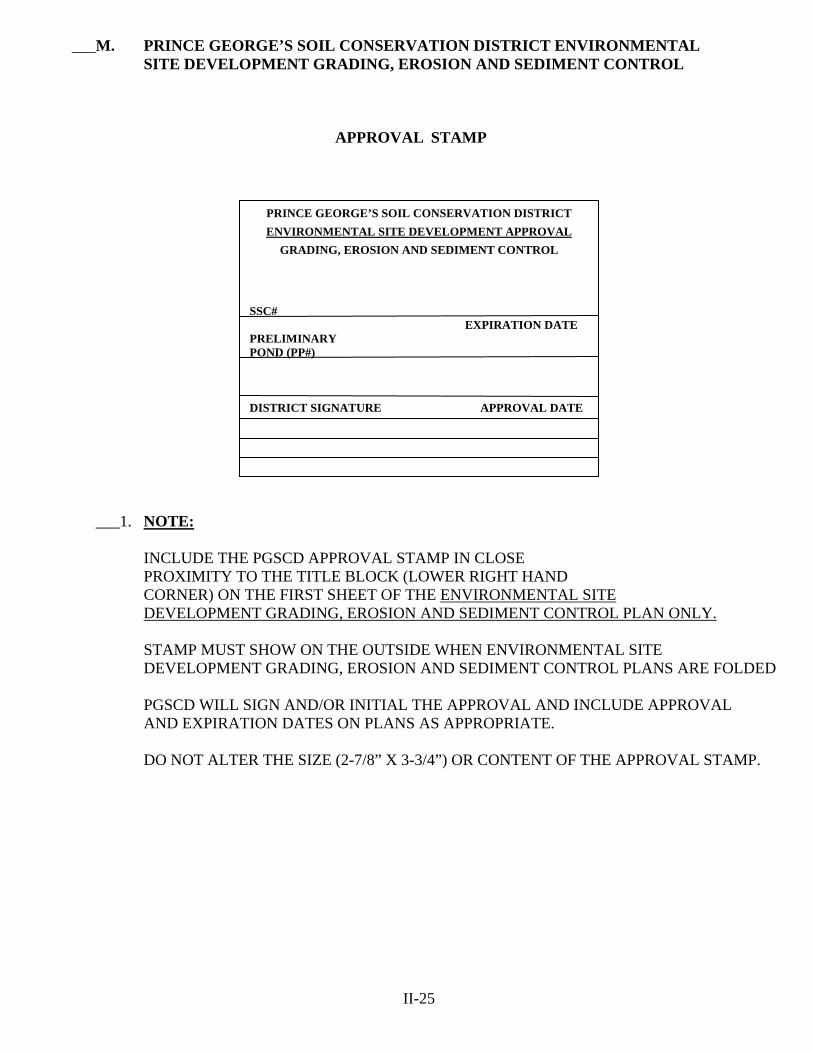
___M. PRINCE GEORGE’S SOIL CONSERVATION DISTRICT ENVIRONMENTAL SITE DEVELOPMENT GRADING, EROSION AND SEDIMENT CONTROL
APPROVAL STAMP
___1. NOTE: INCLUDE THE PGSCD APPROVAL STAMP IN CLOSE PROXIMITY TO THE TITLE BLOCK (LOWER RIGHT HAND CORNER) ON THE FIRST SHEET OF THE ENVIRONMENTAL SITE DEVELOPMENT GRADING, EROSION AND SEDIMENT CONTROL PLAN ONLY. STAMP MUST SHOW ON THE OUTSIDE WHEN ENVIRONMENTAL SITE DEVELOPMENT GRADING, EROSION AND SEDIMENT CONTROL PLANS ARE FOLDED
PGSCD WILL SIGN AND/OR INITIAL THE APPROVAL AND INCLUDE APPROVAL AND EXPIRATION DATES ON PLANS AS APPROPRIATE. DO NOT ALTER THE SIZE (2-7/8” X 3-3/4”) OR CONTENT OF THE APPROVAL STAMP.
II-25
PRINCE GEORGE’S SOIL CONSERVATION DISTRICT
ENVIRONMENTAL SITE DEVELOPMENT APPROVAL
GRADING, EROSION AND SEDIMENT CONTROL SSC# EXPIRATION DATE PRELIMINARY POND (PP#) DISTRICT SIGNATURE APPROVAL DATE

PAGE LEFT INTENTIONLY BLANK
II-26

PRINCE GEORGE'S SOIL CONSERVATION DISTRICT ENVIRONMENTAL SITE DEVELOPMENT
GRADING, EROSION AND SEDIMENT CONTROL PLAN APPROVAL STAMP
(EXAMPLES)
PRINCE GEORGE'S SOIL CONSERVATION DISTRICT ENVIRONMENTAL SITE DEVELOPMENT APPROVAL
GRADING, EROSION AND SEDIMENT CONTROL
SSC# 44-13-00
_____ 2. ENGINEER IS TO INCLUDE THE APPROVAL STAMP IN THE LOWER RIGHT HAND CORNER OF THE FIRST SHEET OF THE GRADING, EROSION AND SEDIMENT PLAN. ADD ENVIRONMENTAL SITE DEVELOPMENT GRADING, EROSION AND SEDIMENT CONTROL PLAN NUMBER SSC# WHEN ASSIGNED BY THE DISTRICT. CONCEPT, ENVIRONMENTAL SITE DEVELOPMENT AND FINAL WILL USE THE SAME NUMBER WITH A DIFFERENT PREFIX.
EXPIRATION DATE PRELIMINARY POND PP# X
DISTRICT SIGNATURE APPROVAL DATE
PRINCE GEORGE'S SOIL CONSERVATION DISTRICT ENVIRONMENTAL SITE DEVELOPMENT APPROVAL
GRADING, EROSION AND SEDIMENT CONTROL
SSC# 98-13-00
_____ 3. GRADING, EROSION AND SEDIMENT CONTROL APPROVAL AND PRELIMINARY POND APPROVAL. ADD POND NUMBER PP# WHEN ASSIGNED BY THE DISTRICT. YOU MAY HAVE MULTIPLE POND NUMBERS, ONE FOR EACH POND APPROVAL. IDENTIFY EACH POND WITH A POND # i.e.: (Pond #1) 10-13-00 (Pond #2) 11-13-00
EXPIRATION DATE PRELIMINARY POND (Pond #1) (Pond #2) PP# 10-13-00 11-13-00
DISTRICT SIGNATURE APPROVAL DATE
PRINCE GEORGE'S SOIL CONSERVATION DISTRICT ENVIRONMENTAL SITE DEVELOPMENT APPROVAL
GRADING, EROSION AND SEDIMENT CONTROL
SSC# 156-13-00
_____ 4. GRADING, EROSION AND SEDIMENT CONTROL APPROVAL AND A PRELIMINARY POND STRUCTURE REVIEWED AND MET EXEMPTION CRITERIA. ADD POND NUMBER PP# EXEMPT COMBINED CONCEPT AND ENVIRONMENTAL SITE DEVELOPMENT APPROVAL
EXPIRATION DATE PRELIMINARY POND PP# 12-13-00 EXEMPT
DISTRICT SIGNATURE APPROVAL DATE
CSC# 156-13-00
II-27

PAGE LEFT INTENTIONLY BLANK
II-28 FROM: PRINCE GEORGE'S

ENVIRONMENTAL SITE DEVELOPMENT
SOIL CONSERVATION DISTRICT GRADING EROSION AND SEDIMENT CONTROL PLAN TRANSMITTAL LETTER (Required for each submittal)
TO: PRINCE GEORGE'S SOIL CONSERVATION DISTRICT 5301 MARLBORO RACE TRACK RD. UPPER MARLBORO, MD 20772 301-574-5162 X 3 301-574-5156 Fax
DATE:
ATTENTION:
SSC# PP#
RE:
REFERENCE CSC# SUBMITTED FOR: ____Environmental Site Development Grading, Erosion and Sediment Control Plan Review (SSC) ____Preliminary Pond Plan Review (PP)
(Always submit two sets of prints for review)
TYPE OF SUBMITTAL: ___New ___Resubmission ____Revision ____Update _____ Stamped Copies ___Environmental Site Development Approval (Include originals & four prints) Do Not Send Until Requested
INFORMATION ENCLOSED: Check appropriate spaces Environmental Site Development Grading, Erosion and Sediment Control Plan Preliminary Pond Plan ___Review Fees ___2 Sets of Prints (folded) ___2 Sets of Prints (folded) ___Preliminary Computations ___Signed Certification ___Soils Report ___Plans Sealed ___Preliminary Small Pond Exemption(s) ___Site Analysis Sheet ___Dam Hazard Classification ___Soil Boundaries ___Drainage Area Map ___Drainage Area Map ___Soil Borrow Area ___ESD Overlay ___ESD Narrative COMMENTS:___________________________________________________________________________________ ________________________________________________________________________________________________
________________________________________________________________________________________________ PRINT NAME__________________________________________________PH#________________________________
EMAIL ADDRESS_______________________________________
II-29
PRINCE GEORGE’S SOIL CONSERVATION DISTRICT
COPIES DESCRIPTION
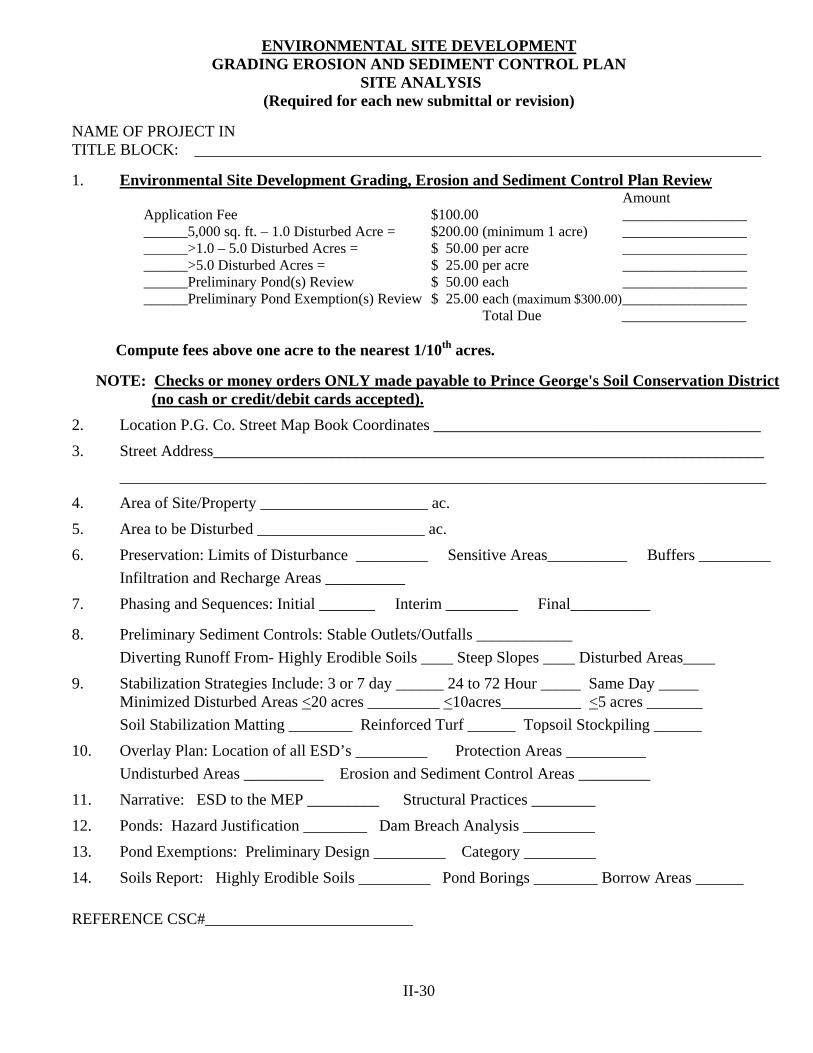
ENVIRONMENTAL SITE DEVELOPMENT GRADING EROSION AND SEDIMENT CONTROL PLAN
SITE ANALYSIS (Required for each new submittal or revision)
NAME OF PROJECT IN TITLE BLOCK: _______________________________________________________________________
1. Environmental Site Development Grading, Erosion and Sediment Control Plan Review
Amount Application Fee $100.00 _________________ ______5,000 sq. ft. – 1.0 Disturbed Acre = $200.00 (minimum 1 acre) _________________ ______>1.0 – 5.0 Disturbed Acres = $ 50.00 per acre _________________ ______>5.0 Disturbed Acres = $ 25.00 per acre _________________ ______Preliminary Pond(s) Review $ 50.00 each _________________ ______Preliminary Pond Exemption(s) Review $ 25.00 each (maximum $300.00) _________________ Total Due _________________
Compute fees above one acre to the nearest 1/10th acres.
NOTE: Checks or money orders ONLY made payable to Prince George's Soil Conservation District (no cash or credit/debit cards accepted).
2. Location P.G. Co. Street Map Book Coordinates _________________________________________
3. Street Address_____________________________________________________________________
_________________________________________________________________________________
4. Area of Site/Property _____________________ ac.
5. Area to be Disturbed _____________________ ac.
6. Preservation: Limits of Disturbance _________ Sensitive Areas__________ Buffers _________
Infiltration and Recharge Areas __________
7. Phasing and Sequences: Initial _______ Interim _________ Final__________ 8. Preliminary Sediment Controls: Stable Outlets/Outfalls ____________
Diverting Runoff From- Highly Erodible Soils ____ Steep Slopes ____ Disturbed Areas____
9. Stabilization Strategies Include: 3 or 7 day ______ 24 to 72 Hour _____ Same Day _____ Minimized Disturbed Areas <20 acres _________ <10acres__________ <5 acres _______
Soil Stabilization Matting ________ Reinforced Turf ______ Topsoil Stockpiling ______
10. Overlay Plan: Location of all ESD’s _________ Protection Areas __________
Undisturbed Areas __________ Erosion and Sediment Control Areas _________
11. Narrative: ESD to the MEP _________ Structural Practices ________
12. Ponds: Hazard Justification ________ Dam Breach Analysis _________
13. Pond Exemptions: Preliminary Design _________ Category _________
14. Soils Report: Highly Erodible Soils _________ Pond Borings ________ Borrow Areas ______
REFERENCE CSC#__________________________
II-30

SECTION III
PRINCE GEORGE’S SOIL CONSERVATION DISTRICT
FINAL
GRADING, EROSION AND SEDIMENT CONTROL PLAN


___ III. PRINCE GEORGE’S SOIL CONSERVATION DISTRICT (PGSCD) FINAL GRADING, EROSION AND SEDIMENT CONTROL PLAN (FSC)
___ A. INTRODUCTION FOR FINAL GRADING, EROSION AND SEDIMENT
CONTROL PLANS ___ 1. The following guidelines are to be considered in the preparation of a Final Grading,
Erosion and Sediment Control Plan submitted to Prince George's Soil Conservation District (PGSCD) for review and approval. All Final Grading, Erosion and Sediment Control Plans (FSC's), designs, and computations are to be in conformance with this document, the criteria established in the Code of Maryland Regulations Title 26, Subtitle 17, Chapter 01, and the publication "2011 Maryland Standards and Specifications for Soil Erosion and Sediment Control", (Standards and Specifications), dated December 2011 or later revisions and Chapter 5, Environmental Design of the 2000 Maryland Stormwater Design Manual. Erosion and Sediment Control Plans submitted to PGSCD will not be accepted for a completed design review unless the submittal includes the "PGSCD Final Grading, Erosion and Sediment Control Plan Transmittal Letter", "PGSCD Final Grading, Erosion and Sediment Control Plan Site Analysis", "Supplementary information" as contained in these guidelines; the required certifications have been signed; the review fee has been paid; plan sheets sealed; and two sets of folded review prints included.
___ 2. The “Stormwater Management Act of 2007” and COMAR 26.17.02 regulations require concept, site development and final plans. It is essential that the erosion
and sediment control plan be integrated with the stormwater management plan to address these different stages of plan development and attain effective resource protection. The final plans shall include all the information approved in the Concept and Environmental Site Development Plans.
___ 3. Acceptable erosion and sediment control plans must be designed to mitigate soil erosion, prevent increases in stormwater runoff, and minimize the discharge of pollutants. Planning for erosion and sediment control needs to start early and be integrated with stormwater management practices.
___ 4. Consultants are responsible for submitting an erosion and sediment control plan that meets the requirements established by these guidelines. The plan must include sufficient information to evaluate the site conditions, environmental characteristics of the affected areas, potential impacts of the proposed grading on water resources, and effectiveness and acceptability of measures proposed to prevent soil erosion and off-site sedimentation.
III-1

___ 5. Exemptions to the state sediment control law include construction of a single family home on a lot of two acres or more when the disturbed area is less than one half acre, and grading that involves less than 5,000 square feet and/or 100 cubic yards of earth.
___ 6. Waiver from the requirements of the Standards and Specifications may be granted if strict adherence to the specifications will result in unnecessary hardship and not fulfill the intent of the Standards and Specifications. The developer shall submit a written request for a waiver to Prince George's Soil Conservation District. The request shall state the specific waiver sought and reasons for requesting the waiver. The Prince George's Soil Conservation District shall not grant a waiver unless and until sufficient specific technical reasons justifying the waiver are provided by the developer.
___ 7. If requested the PGSCD will, by appointment, provide sediment control conceptual planning and technical assistance on specific sediment control
problems. Detailed, overall sediment control plan review will not be undertaken during these meetings. Conceptual planning advice prior to plan submittal can be provided on an hourly fee basis.
III-2
___ B. FINAL GRADING, EROSION AND SEDIMENT CONTROL PLAN DESIGN CONSIDERATIONS
___ 1. Development of Plan ___ a. Plan the development to fit the particular topography or slope, soil types,
natural drainage, and natural vegetation at a site. ___ (1) Develop during subdivision processing the soil delineation and
limitations, a grading and sediment control concept, and include on-site soils investigation when limitations warrant.
___ b. Expose the smallest practical area of land for the shortest possible time. ___ (1) Minimize grading or exposure of large or critical areas during the
season of maximum erosion potential (May 1 – September 30). ___ c. Apply practices that control erosion against on-site damage and reduce
soil movement. ___ (1) Provide aggressive stabilization schedules and sequences to meet
the 3/7 day State requirements. ___ (2) Include staged seeding for major cut slopes, fill slopes and mass
graded areas. ___ d. Apply sediment control practices to prevent off-site damage.
___ (1) Planning for sediment control should begin with first-hand knowledge of the site by the designer. Verify the accuracy of existing topography and any adjacent off-site areas affecting the site.
___ (2) Choose the best selection of sediment trapping devices in conjunction with an appropriate schedule of construction. Particular attention must be given to concentrated flows of water, to prevent "major" or "gross" types of erosion. The use of standardized approved sediment control devices makes review and approval of plans easier. These practices should be located to obtain the maximum benefit from the terrain and within the given drainage limitations. Practices must be sized to accommodate the maximum drainage that could occur at any phase of the development. Each plan must include permanent structures for conveying storm runoff, final site stabilization, and removal of temporary sediment control features with stabilization of the areas where temporary features were removed.
___ (3) Utilize the standard practice for temporary storm drain diversion to prevent sediment laden water conveyed by the storm drain system from reaching a watercourse or off-site property. This is done by redirecting a storm drain system or outfall channel to discharge into a sediment trap or basin.
___ 2. Plan Concepts ___ a. Subdivision or Whole Site Approach
___ (1) Sediment control must be provided for all phases of land disturbance from initial clearing to final stabilization. Sediment controls should be placed to be functional for as long as possible. III-3
___ (2) Initial or primary sediment controls need to allow for installation, then clearing, and any rough grading. Secondary sediment controls may become necessary for utilities or road infrastructure if not adequately covered by the primary controls. Final sediment controls for buildings or lot development should become necessary as controls for primary or secondary work usually do not remain adequate as lots are sold. ___ (3) The initial concept must consider all future development of the whole site and how it will be coordinated with future approval of utilities, roads, buildings and their phasing.
___ b. Utilizing the Maximum Drainage Area ___ (1) Divide the site into the maximum before, interim or after development drainage areas. Provide the necessary controls based on their drainage area
limitations and the topography. Maintain the initial sediment controls as long as possible with approved practices. When development or phasing alters the initial drainage, provide additional controls to cover the new drainage areas.
___ (2) Beware of utility construction, street curbing and residential lot development that will alter maximum drainage areas as an interim or final condition.
___ c. Phasing and Sequencing ___ (1) The sediment controls must be consistent with the phasing and sequencing. Sediment control phasing needs to consider the permitting to be done so that what is permitted is actually covered under the approval. ___ (2) When sediment control plans require specific sequencing to work, ensure that chronology and all phases are adequately denoted. ___ (3) Individual phases of a complete site, if on separate approvals, need to adequately cover grading, erosion and sediment control coordination between the phases. ___ (4) Sequencing of operations need to be detailed to include all pertinent aspects and timing of construction. Time frames should provide a sliding range to include the total time an activity will occur. This is most often done with a range of days or a bar graph. This type of sequence is easy to follow as to when an activity should start or be finished relative to other activities.
III-4

___ 3. Plan Format ___ a. Rough Grading Plans – are to show true rough grades only, with any
necessary permanent structural practices to prevent erosion. Rough grading plans may include sewer, water and storm drains. No final grading, streets, houses, or planned improvements should show on the plan.
___ b. Streets and Utility Construction – show all street improvements to Include all pertinent improvements. Include any road widening to existing pavement. When storm drain diversions require alterations to the approved County design plans, then a revised design plan should be
obtained to agree with the sediment control plan. Street grading must tie off to the existing grades at that phase of approval. Often a precede of the storm drains will be necessary to convey off-site controls for the storm drain construction only.
___ c. House Construction Only – when grading, roads and utilities are completed then individual lot sediment controls, or groups of 1 acre or
less with sediment controls, should be utilized. Consider the whole lot is disturbed on lots of 1/2 acre or less. Clarify limits of disturbance along the street right of way if sidewalk area is to be included.
___ d. Total Development Plans – these are the preferred types of plans that provide all phases of development with coordinated sequencing. These should usually be developed along the plan concept of subdivision or whole site approach previously mentioned. This type of plan should show the final design considerations of all other agencies for permanently designed facilities so that the temporary sediment controls can be developed to best fit the site.
___ e. Mining and Fill Sites – in most cases, these plans will last for more than 36 months, and basins shall be designed as permanent ponds to meet MD 378 specifications. Provide for adequate conveyance of water to trapping devices during mining or fill operations. Include adequate benching and designed slope drains to handle the permanent runoff. Provide adequate access for initial sediment control construction, mining or fill operations and final sediment control removal.
___ f. Supplemental Information – all information necessary for the construction and maintenance of sediment controls needs to be shown on the plans. Any drainage areas or other information necessary for the proposed phasing or concept to
function should be shown on the plans. Off-site drainage areas that are not subject to change can be shown on separate sheets. One copy of soils information, County approvals, Subdivision plans, approved street grade plans, site plans, floodplains approvals, etc., should accompany initial submittal.
___ g. Guidelines – include all general format requirements.
___ 4. Plan Coordination ___ a. If the plan being submitted in any way interacts with another plan, show
and provide status of all existing conditions and include the adjacent sediment controls. Pay attention so that the outfall areas of the one plan are not disturbed on the adjacent plan. Sediment controls cannot outlet to a disturbed area. III-5

___ b. Every erosion and sediment control plan must be complete with provisions for permanent stabilization and safe conveyance of surface water. This is especially important on rough grading plans where road or other grading will not include the final storm drain. Where needed designed channels or pipe drain systems will have to be provided to a non-erosive outlet. ___ c. When one plan is conditioned on having some phase of development completed on a previously approved plan, then show what the existing
condition should be on the plan being submitted and clearly indicate in the sequence.
___ d. Plan coordination can be utilized for SWM permanent ponds. The embankment and control structure is built under the pond plan and shown as existing on the development erosion and sediment control plan. All required information to function for sediment control is shown in the development plan. After the sediment control phase, the pond plan is implemented to complete the SWM pond. This coordination of plan SCD numbers and timing is shown in the sequence of both plans.
___ e. Temporary sediment traps and basins on rough grading or fine grading plans are not to be located where they would interfere with the construction of SWM structures or permanent ponds. Traps and basins may be utilized upstream of SWM ponds when diversion of water around the pond can easily be accomplished. When this is not possible, the permanent SWM structures or ponds must be designed, and approved to be used for sediment control. SWM ponds with a pipe outlet system shall be designed as a sediment basin not as a sediment trap.
___ 5. Plan Superseding (Rough Grading to Final Development) ___ a. Where an approved rough grading (and utility plan) is in progress and a
final grading and site development plan is submitted for review and approval, before the rough grading will be completed and stabilized, then the final plan will need to supersede the rough grading plan. This is needed to prevent multiple sediment control approvals on one area at the same time.
___ b. The rough grading plan and sequence is to be combined into the final plan. This is best done by providing phasing of the rough grading sheets and fine grading sheets.
___ 6. Temporary Construction In A Stream Channel Or Floodplain ___ a. A person who proposes to change in any manner the course, current, or
cross section of a stream or body of water within the State except tidal waters, including any changes to the 100-year frequency floodplain of free flowing streams shall obtain a permit from WRA before commencing any work. On 50 acres or greater drainage areas, or any area of County concern, County floodplain approvals are required. Also, obtain approval for fill in County floodplains. III-6
___ b. Sediment controls need to be designed to cover work in the floodplain separate from work outside the floodplain. PGSCD procedures are designed to prevent sediment already trapped from being totally inundated by the 100 year flood. Generally, this is only waived for temporary sediment basins between 50 acres and 100 acres that capture a floodplain.
___ c. Upstream areas shall be adequately diverted around or through the floodplain work. Floodplain work will normally precede other site work.
___ d. Additional sediment controls for work in the floodplain have included diversion pipe, sandbag diversion, and gabions as accepted by our office.
___ e. Include WRA in-stream closure period(s) in the sequence of construction. ___ f. Temporary Sediment Trapping Devices. The following special
requirements shall apply to plans submitted with temporary sediment trapping devices within the waters of the State during construction operations:
___ (1) Temporary sediment trapping devices shall conform to the technical requirements in the "2011 Maryland Standards and Specifications for Soil Erosion and Sediment Control";
___ (2) Earth embankments greater than 3 feet high may not be permitted; ___ (3) Temporary sediment control trapping devices may be
constructed within the 100-year frequency floodplain if all of the following conditions are met:
___ (a) Fill material may not be placed any closer to the stream than 50 percent of the distance between the 100-year frequency flood plain limit and the top of the stream bank closest to the trapping device,
___ (b) Fill material may not be placed within 25 feet of the top of the stream bank,
___ (c) Upon completion of the sediment control device, the exposed soil areas shall be stabilized within 3 days following initial disturbance,
___ (d) Care shall be taken during construction, maintenance, and removal of temporary sediment control devices to prevent unnecessary removal or damage to trees and other natural features,
___ (e) Sediment removed during maintenance of the trapping device shall be placed outside the limits of the 100-year floodplain and stabilized within 7 days,
___ (f) Upon stabilization of all areas that drain to the control device, the device shall be removed and all remaining disturbed areas returned to their original contour and permanently stabilized within 7 days. III-7

___ g. Temporary Access Crossings. The following special requirements shall apply to applications for temporary access crossings. ___ (1) Temporary access crossing shall conform to the technical
requirements in the "2011 Maryland Standards and Specifications for Soil Erosion and Sediment Control".
___ (2) Earth embankments for an access road greater than 3 feet high shall not be permitted.
___ (3) Include cross section of presently existing stream channel. ___ h. Temporary Utility Crossings. The following special requirements shall apply
to applications for utility crossings that cross streams or floodplains and are buried below the existing ground, so that they do not cause any permanent damage to the watercourse, current, or cross section of a stream or body of water, including the floodplain. ___ (1) Temporary access for utility crossing shall conform to the technical
requirements in the "2011 Maryland Standards and Specifications for Soil Erosion and Sediment Control".
___ (2) For stream crossings, the pipe or cable and any protective encasement shall be buried a minimum of 3 feet below the
stream bed. ___ (3) Buried utilities and their appurtenances, except at stream crossings, shall be located such that a 25-foot wide buffer zone is maintained between the limits of construction and the nearest top of the stream bank. ___ (4) Include cross section of existing stream channel.
___ i. Storm Drain Outfalls. The following requirements apply to applications for temporary construction in the floodplain for outfall pipes, flumes, and ditches, providing there are no permanent alterations to the course, current, or cross section of a stream or body of water. ___ (1) Construction shall conform to the technical requirements
of the "2011 Maryland Standards and Specifications for Soil Erosion and Sediment Control".
___ (2) Permanent floodplain obstructions to flow will not be permitted. ___ (3) Include cross section of existing stream channel and proposed drainage outfall. ___ (4) Include data on the velocities of flow at outfalls and site conditions
at points of discharge. III-8

___ C. FINAL GRADING, EROSION AND SEDIMENT CONTROL PLAN PREPARATION
___ 1. The scope of the grading, erosion and sediment plan is to be clearly defined and fully identified in the title block. Use phase, sections, block and lot numbers. Also, note if plan is for clearing, grading only, etc. Where appropriate, note exclusions. Houses or crowned streets shall not be shown on rough grading plans. All grading, erosion and sediment control plan sheets are to be numbered chronologically with a SC#. Include grading, erosion and sediment control in the title block.
___ 2. Plans are to be legible and shall include: scale (1"=50' maximum), two foot contour intervals, legends, and north arrow. All plan sheets must be the same size with a maximum size no larger than 30"x42". County permitted projects may require a maximum size of 24"x36". Include a site specific vicinity map to scale. Include road identification, nearest intersections and distance to site. Include
enough detail on the vicinity map so that someone unfamiliar with the site can quickly locate it in the field.
___ 3. All grading, erosion and sediment control plans submitted for review shall contain two sets of folded prints (9" x 12") and one set of accompanying data. Do not submit mylars/originals until SCD plan reviewer indicates the plan is ready for approval. Four sets of final prints and original/sepia shall be submitted for approval and signing. Additional or approved plans submitted for green stamps will be processed at the current fee rate.
___ 4. If grading or sediment control is presented on three or more sheets, provide a composite-overall drawing showing how the sediment control practices and topography, planned on individual sheets tie together. Match lines and matching sheet numbers are to be included on each sheet.
___ 5. Show property lines and names of all adjacent property owners.
___ 6. Existing features, and existing and proposed contour lines based on all grading changes are to be shown. Contours are to be adequately labeled, for ease of
review and spot elevations are to be shown. All topography, existing and proposed, shall be legible and shall tie off properly.
___ 7. Plans must include topographic data sufficiently adequate to show existing conditions adjacent to the site and downstream of all sediment control practices. This shall be a minimum 100 foot adjacent strip and minimum 100 foot downstream, or as otherwise needed to clearly reflect existing conditions.
___ 8. Provide delineation and note limits of disturbance to encompass all work including sediment controls.
___ 9. Clearly show and identify location of all existing and proposed improvements or site work (buildings, walls, parking lots, streets, storm drains, utilities, etc.).
___ 10. Show and identify existing and proposed permanent ponds. III-9

___ 11. Delineate the 100-year floodplain. Submit appropriate approvals from County or State required for any work in the floodplain. Delineate critical areas, buffer areas and tree save areas. MDE waterway construction permit or notice of intent to issue is required for disturbance of waterways, for special flood hazard areas, and for trout streams 100 acres or greater. Place appropriate WRA stream closure dates in the Sequence of Construction.
___ 12. Show onsite stockpile, borrow or spoil areas on plan. Include side slopes and maximum height of stockpile. Note: Offsite borrow or spoil areas must have an approved and active erosion and sediment control plan.
___ 13. Grading must be in conformance with both the minimum criteria established by the Standards and Specifications for Land Grading and Prince George's County Grading Ordinance Subtitle 32, whichever is the most restrictive. Place the grading specification on the plan. See 2011 Maryland Standards and Specification pages B. 5 thru B. 7.
___ 14. Show storm drainage provisions; ___ a. Velocities and quantities of flow at outfalls. ___ b. Site conditions around points of all surface water discharge from the site. (topography or profile sufficient to document a nonerosive outfall) ___ c. Include SHA riprap classification, Q10, v10, d50, dmax, length, width, depth and filter cloth. ___ d. Outlet protection must be at zero percent slope for the required
distance from pipe outfall. ___ e. Outfalls over 10 percent are considered erosive due to reconcentration of flows and high velocities encountered after the flow leaves the outlet protection and are not acceptable. ___ f. Plunge pools still require rock outlet protection and a non erosive outfall. ___ g. Areas below the outfall shall have a non-erosive velocity until flow reaches
a stable water course or stable channel.
___ 15. Show provisions to preserve topsoil and place the soil preparation, topsoiling, and soil amendments specification on the plan. See the Standards and Specification pages (B. 12 through B. 14).
___ 16. Fencing of sediment basins and traps is required by County ordinance, Subtitle 32, 136 (a) 4. Show the location and type of fence (42" high) on the plan with a detail.
___ 17. Show and properly identify all planned sediment control measures (temporary or permanent) on a plan view of the site. All aspects of the erosion and sediment
control plan are to be consistent and shall clearly depict all phases of the project including initial clearing, grading, storm drain installation, curb and gutter installation, street paving, building construction, removal of all sediment controls and final stabilization of all disturbed areas. Any plan that provides for phased development and sediment control shall also contain a separate sheet that will only show (with proper documentation): existing topography, property lines and initial measures that will provide sediment control at the start of clearing/ grubbing/grading, sediment control measures, drainage areas delineated and acres noted. III-10
___ 18. Every grading, erosion and sediment control plan must stand on its own and not be subject to some plan/action to be submitted/carried out at some future time and must contain all required information. If the erosion and sediment control plan submittal is to be coordinated with, a previously approved plan, show specifics of how this coordination will take place on the plan being submitted. Show and provide status of existing conditions for the previously approved site and present adequacy of its sediment control measures.
___ 19. Erosion and sediment control plans for clearing only, rough grading, street grading only, etc. shall include adequate provisions for handling surface water and permanent stabilization of the site through the stage of development presented.
___ 20. Standard symbols can be used to indicate planned temporary sediment control practices as appropriate. These symbols shall not block out other pertinent information and shall include flow arrows. Additional information may be required to show that a planned practice can be built and will be functional.
___ 21. Symbols are not acceptable for permanent practices (those that require a design) nor for sediment traps and sediment basins.
___ 22. Provide design considerations and computations for all erosion and sediment control practices to verify their acceptability. The minimum data is that specified in the Standards and Specifications.
___ 23. Delineate maximum existing, interim and proposed drainage areas for all permanent and temporary sediment control structures and note acreage.
___ 24. Use full size typical drawings and/or specific detail drawings, Including construction specifications, for all sediment control practices.
___ a. Include from the Standard and Specifications Table H. 1 Geotextile Fabrics, Table H.2 Stone Size and Table H. 3 Compost on all plans.
___ 25. Show provisions for access to and maintenance of sediment control measures.
___ 26. Temporary and/or permanent vegetative stabilization shall be provided for all disturbed areas (including sediment controls) and included in the sequence of construction.
___ 27. The owner/developer is responsible for conducting routine inspection and required maintenance of all erosion and sediment control. The controls are to be inspected weekly and the next day after each rain event with a written inspection report being part of each inspection. On all plan revisions or updates include the latest month’s inspection reports per the "2011 Maryland Standards and Specifications for Soil Erosion and Sediment Control".
___ 28. All plans shall note in the Sequence of Construction that prior to any clearing and grubbing the limits of clearing must be clearly marked in the field. III-11

___ 29. Provide site specific construction schedule, sequence of operations or schedule of activities, including timing, on all plans. This schedule is to detail how and where sediment control activities or installations are to take place chronologically with respect to all phases of construction such as clearing, rough grading, storm drain installation, curb and street installation, building construction, paving, final grading, removal of all sediment controls and stabilization. The schedule must be consistent with all other plan aspects. Include timing for all activities to clearly delineate chronology or concurrency by utilizing a range of days or bar graph.
The sequence of construction, at a minimum, must include the following: ___ a. Request for a pre-construction meeting with the appropriate enforcement authority; ___ b. Clearing and grubbing as necessary for the installation of perimeter controls; ___ c. Construction and stabilization of perimeter controls; ___ d. Remaining clearing and grubbing within installed perimeter controls; ___ e. Road grading; ___ f. Grading for the remainder of the site; ___ g. Utility installation and connections to existing structure; ___ h. Construction of buildings, roads and other construction; ___ i. Final grading, landscaping and stabilization; ___ j. Installation of stormwater management measures; ___ k. Approval of the appropriate enforcement authority prior to removal of sediment controls; and ___ l. Removal of controls and stabilization of areas that are disturbed by removal of sediment controls.
___ 30. Provide the Applicant Information, when different from the owner/developer, in the following format on the plans.
Name____________________________________________________________________ Address__________________________________________________________________ Applicant ______________________________________Phone#____________________
___ 31. All erosion and sediment control plans shall include the following general notes: ___ a. The developer is responsible for the acquisition of all required easement, right and/or rights-of-way pursuant to the discharge from the erosion and sediment control practices, stormwater management practices and the discharge of stormwater onto or across and grading or other work to be performed on adjacent or downstream properties affected by this plan. ___ b. Following initial soil disturbance or redisturbance, permanent or temporary stabilization shall be completed within: a) three (3) calendar days as to the surface of all perimeter controls, dikes, swales, ditches, perimeter slopes, and all slopes greater than three horizontal to one vertical (3:1) and b) seven (7) calendar days for all other disturbed or graded areas on the project site, The in-place sediment control measures will be maintained on a continuing basis until the site is permanently stabilized and all permit requirements are met. III-12
___ c. The owner/developer or representative shall request that the inspection authority approve work completed in accordance with the approved erosion and sediment control plan, the grading or building permit and shall obtain written inspection approvals by the Inspector at the following stages in the development of the site: ___ (1) Prior to the start of earth disturbance; ___ (2) Upon completion of installation of tree protection devices, followed by the installation of perimeter erosion and sediment controls, prior to proceeding with any other earth disturbance or grading. Other building or grading inspection approvals may not be authorized until initial approval by the Inspector is made; ___ (3) Upon completion of stripping, the stockpiling of topsoil, the construction of temporary sediment and erosion control facilities, disposal of all waste material and preparation of the ground; ___ (4) Upon completion of rough grading, but prior to placing topsoil, permanent drainage or other site development improvements and ground covers; ___ (5) Prior to the start of another phase of construction or opening of another grading unit; ___ (6) Prior to the removal of sediment control practices; and ___ (7) Upon completion of final grading, reforesting, permanent drainage and erosion control facilities including established ground covers and planting, and all other work of the building permits. Reference 29 c. in all sequence of construction. ___ d. Approval shall be requested upon final stabilization of all sites with disturbed areas in excess of two acres before removal of controls. ___ e. All permits under an erosion and sediment control plan must and can only be issued to the owner/developer that signs the certification on the plan. The owner/developer that signs the certification on an erosion and sediment control plan is the responsible party regardless of any sale of the property or work of subcontractors. Erosion and sediment control plans are approved for one owner/developer only. ___ f. PGSCD approval of a erosion and sediment control plan, pursuant to meeting local permit requirements for grading, building or street permits, etc., is valid only when the work to be performed under the permit is the same as (no more/no less than) that contained in the plan as approved by the PGSCD. ___ g. Any changes or modifications to an approved erosion and sediment control plan, not approved by the PGSCD, shall invalidate the plan approval. ___ h. Offsite borrow or spoil areas must have an approved and active erosion and sediment control plan. ___ i. Temporary designed sediment basins shall be removed within 36 months after the beginning of construction of the basin. III-13

___ j. On small pond approvals: ___ (1) The owner or engineer will notify PGSCD promptly in writing when construction is begun and when construction is completed. ___ (2) The project shall be constructed under the supervision of the engineer-in-charge. Within 30 days of the completion of construction, the engineer-in-charge that designed the structure shall provide PGSCD with an As-Built plan and shall certify, with the engineer's seal, that the MD378 pond was constructed as shown on the As-Built plans. ___ (3) The approval is valid only for use by the applicant and may not be transferred to another unless written approval for such transfer is obtained from PGSCD.
___ k. Disturbed surface area Vegetatively stabilized area
Volume of spoil material Volume of cut
Volume of borrow material Volume of fill ___ l. List Predominant soil types and general description per PGSCD soil survey:
___ 32. All certifications shall be signed at time of plan submittal. The following certifications shall be used on all plans. Include on the first sheet and do not alter the wording.
OWNER'S/DEVELOPER'S CERTIFICATION "I/We hereby certify that I/we have reviewed this erosion and sediment control plan and that any clearing, grading, drainage, construction and/or development will be done pursuant to this approved plan, including inspecting and maintaining controls and that any responsible personnel involved in the construction project will have a Certificate of Training at a Maryland Department of the Environment approved training program for the control of erosion and sediment before beginning the project. Prince George’s Soil Conservation District and the enforcement authority shall have the right of entry for periodic on-site evaluations." Signature________________________________________Date Name(printed)________________________________Title____________ Ph#___________________Firm__________________________________ Complete address_____________________________________________ III-14

CONSULTANT'S CERTIFICATION "I certify that this plan of erosion and sediment control represents a practicable and workable plan based on my personal knowledge of the site, and that this plan was designed and prepared in accordance with the requirements of the Prince George's Soil Conservation District and "Standards and Specifications for Soil Erosion and Sediment Control". I have reviewed this erosion and sediment control plan with the owner/developer". Signature___________________MD License#__________Date____ Name_________________________(printed)___________________ (Include seal, company name, address and phone number if not included elsewhere on plan).
___ 33. All plan resubmittals shall include a point-by-point response (narrative) to PGSCD's previous erosion and sediment control plan review comments. The point-by-point response needs to include the item number being addressed, the action taken (example: "note added to general notes, additional information submitted", etc.) and the location of the change, addition or deletion (example: "see plan sheet 2 of 2 - general notes," "see comps sheet 3 of 6," etc.). Plans submitted without a point-by-point response to previous PGCSD comments will be returned unreviewed.
___ 34. After initial approvals, note all erosion and sediment control plan revisions in revision block on subsequent plan resubmittals.
___ 35. USDA-NRCS runoff methodology for all runoff computations shall be used.
___ 36. The Prince George’s Soil Conservation District may grant a written waiver from the requirements of the 2011 Maryland Standards and Specifications if strict adherence to the specifications will result in unnecessary hardship and not fulfill the intent of the COMAR. The applicant shall submit a written request for a waiver to the Prince George’s Soil Conservation District. The request shall state the specific waiver sought and reasons for requesting the variance. The Prince George’s Soil Conservation District shall not grant a waiver unless and until sufficient specific technical reasons justifying the waiver are provided by the applicant. III-15

___ D. FINAL SOIL REPORT REQUIREMENTS
___ 1. A soils investigation should be required under any of the following conditions: ___ a. The site for development contains soils prone to movement and failure.
These include the Christiana soil complexes, Marlboro Clay formations, and Howell soils. These soils have severe limitations for foundation development according to the Prince George’s County Soil Survey.
___ b. The ponding of water above the Marlboro Clay formation or other unstable soil is not recommended as this can accelerate slope failure. Traps and basins
should be lined with an impervious lining and the drainage pipe outfalling below the Marlboro Clay formation. Septic systems and infiltration devices or ponds are not recommended for placement above the Marlboro Clay formation.
___ c. Presence of sulfidic soils (cat clays) on site. ___ d. Presence of diatomaceous soils on site. ___ e. Placement of fill on existing 4:1 slopes or steeper. ___ f. Construction of a pond. Provide a final soils investigation for the pond
areas, embankment, core trench and borrow areas. ___ g. A field investigation shows visual signs of slope failure or potential
slope failure. ___ 2. The report needs to address and include recommendations for: ___ a. Existing and proposed grades. ___ b. Fill being placed on steep slopes. ___ c. The impact of sediment controls. ___ d. Type of sediment controls used. ___ e. Location of traps or basins and types of outfalls. ___ f. Foundations development. ___ g. Perched water tables. ___ h. Drainage systems. ___ i. Streets. ___ j. A safety factor of l.3 or more must be achieved, and engineering recommendations presented to ensure that safety and slope stability can be maintained. ___ 3. Test borings: ___ a. Provide enough borings to adequately address stability concerns and represent the size of the site. ___ b. All borings shall be numbered and shown on a topographical site plan. ___ c. Show existing and proposed grades. ___ d. The borings shall penetrate into and below the unstable material. ___ e. All soil borings shall have a description in accordance with the unified soil system. ___ f. Include all geologic information. ___ g. Note the presence of all slickensided joints. ___ h. Note the location and time of encountering ground water.
III-16

___ 4. Laboratory analysis (as appropriate) All tests should be done in accordance with ASTM (American Society of Testing and Material) criteria. ___ a. Particle size determination ___ b. Natural water content ___ c. Sensitivity ___ d. Atterberg Limits ___ (1) Shrinkage Limit ___ (2) Plastic Limit ___ (3) Liquid Limit ___ (4) Plasticity Index ___ e, Residual shear angle and shear strength ___ f. Residual Cohesion – pfs ___ g. Compressibility ___ h. Triazial shear test ___ i. Compaction ___ j. Permeability ___ k. Standard penetration test ___ l. Bearing capacity
III-17
___E. FINAL GRADING, EROSION AND SEDIMENT CONTROL PRACTICES REVIEW CHECKLIST
___ 1. Stabilized Construction Entrance B-1 ___ a. Practice meets purpose and design criteria. ___ b. Must be located at all points of construction ingress and egress. ___ c. Stabilized construction entrances cannot be installed over pavement. ___ d. Minimum length is 50 feet and minimum width is 10 feet. ___ e. All surface water flowing to SCE must be piped under the entrance.
___ 2. Land Grading B-3 ___ a. Practice meets purpose and design criteria. ___ b. Maximum slope of 2:1 (area requiring regular maintenance – 3:1 maximum). ___ c. Provisions for protecting cut/fill slopes from surface runoff (swale or diversion). ___ d. Cut and fill slope reverse bench interval as required (divide slope face equally). ___ e. Benches six feet minimum width, 6:1 or flatter reverse slope, minimum one foot depth, 2-3 percent gradient, and 800' maximum length (show proper grading on plan). ___ f. Stable bench outlet condition – adequacy, documented (use designed pipe structures or gabions where needed). ___ g. Fill material and compaction specification. __ h. Provisions for excess cut or required borrow material (Noted on plan). ___ i. Detail and construction specifications provided.
___ 3. Vegetative Stabilization B-4 ___ a. Practice meets purpose and conditions. ___ b. Site preparation. ___ c. Soil amendments (fertilizer and lime specifications). ___ d. Seedbed preparation. ___ e. Seed preparations. ___ f. Methods of seeding. ___ g. Mulch specifications. ___ h. Mulching seeded areas (include anchoring method). ___ i. Securing straw mulch (mulch anchoring). ___ j. Incremental stabilization – cut slopes. ___ k. Incremental stabilization of embankments – fill slopes. ___ l. Temporary seeding (mix and rate) – include method of application – include completed chart. ___ m. Permanent seeding (mix and rate) – include method of application – include completed chart. ___ n. Sod – specifications, installation and maintenance. ___ o. Turfgrass establishment – mixture, seeding times, irrigation, repairs and maintenance.
___ 4. Topsoil B-4-2 ___ a. Practice meets purpose, conditions and design criteria. ___ b. Provisions to preserve topsoil. ___ c. Topsoil specifications. ___ d. Soil amendments (per soil test). ___ e. Topsoil application.
III-18

___ 5. Earth Dike C-1 ___ a. Practice meets purpose, conditions, and design criteria. ___ b. Maximum drainage area delineated - acres noted (See table C.2)*. ___ c. Slope of dike (See table C.2) 1 – 10 percent only. ___ d. Positive drainage is maintained (existing through final grades). ___ e. Required cross-section can be installed (not across steep slopes). ___ f. Flow area of dike properly stabilized and delineated (See table C.2) - provide dike type and lining along the flow area for each reach (both sides if appropriate). ___ g. Outlet to sediment trapping device (non-erosive velocity) or onto stable outlet, documented by labeling the field conditions. ___ h. Provisions for traffic crossings shown and stabilized. ___ i. Stabilization (See table C.2). ___ j. Detail and construction specifications provided.
___ 6. Temporary Swale C-2 ___ a. Practice meets purpose, conditions, and design criteria. ___ b. Maximum drainage area delineated, on the plan with acreage noted (See tables C.4 & C.5). ___ c. Slope of swale (See tables C.4 & C.5) 1 -10 percent only. ___ d. Positive drainage is maintained. Show spot elevations. ___ e. Required cross-section can be installed (not across steep slopes). ___ f. Flow area of swale properly stabilized and delineated (See tables C.4 & C.5) - provide swale type and lining along the flow area for each reach. ___ g. Outlet to sediment trapping device (non-erosive velocity) or onto stable outlet, documented by labeling the field conditions. ___ h. Provisions for traffic crossing shown and stabilized. ___ i. Stabilization (See tables C.4 & C.5). ___ j. Detail and construction specifications provided.
___ 7. Perimeter Dike/Swale C-3 ___ a. Practice meets purpose, conditions, and design criteria. ___ b. Maximum drainage area of two acres not exceeded (delineate on plan with acreage noted). ___ c. Slope of dike/swale not to exceed 10 percent. ___ d. Positive drainage is maintained. Show spot elevations. ___ e. Required cross-section can be installed (not across steep slopes). ___ f. Flow area of dike/swale properly stabilized and delineated – provide dike/swale type along the flow area for each reach. ___ g. Outlet to sediment trapping device (non-erosive velocity) or onto stable
outlet, documented by labeling the field conditions. ___ h. Provisions for traffic crossing shown and stabilized. ___ i. Stabilization (See design criteria). ___ j. Detail and construction specifications provided.
___ 8. Temporary Asphalt Berm C-5 ___ a. Practice meets purpose and design criteria. ___ b. To be used across paved areas to divert clear water or divert sediment laden water to a sediment control device. ___ c. The maximum contributory slope is 10 percent. ___ d. The maximum berm slope is 10 percent. ___ e. Minimum height is 8 inches and 3½ foot width. III-19
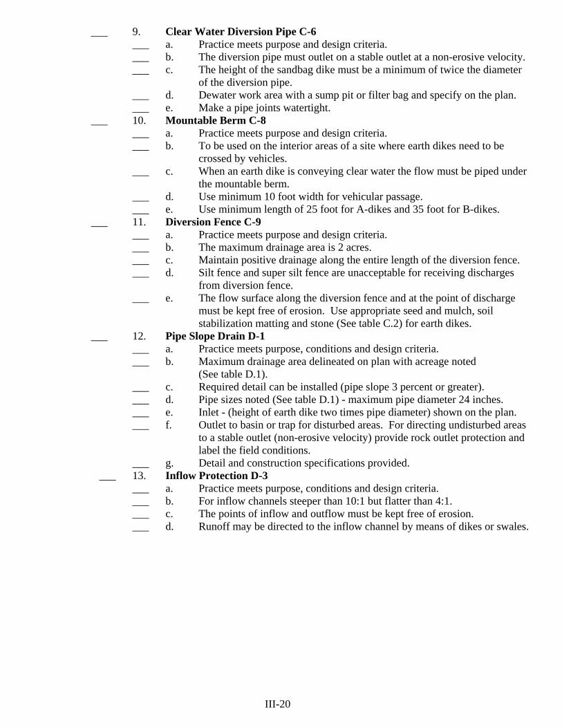
___ 9. Clear Water Diversion Pipe C-6 ___ a. Practice meets purpose and design criteria. ___ b. The diversion pipe must outlet on a stable outlet at a non-erosive velocity. ___ c. The height of the sandbag dike must be a minimum of twice the diameter of the diversion pipe. ___ d. Dewater work area with a sump pit or filter bag and specify on the plan. ___ e. Make a pipe joints watertight.
___ 10. Mountable Berm C-8 ___ a. Practice meets purpose and design criteria. ___ b. To be used on the interior areas of a site where earth dikes need to be crossed by vehicles. ___ c. When an earth dike is conveying clear water the flow must be piped under the mountable berm. ___ d. Use minimum 10 foot width for vehicular passage. ___ e. Use minimum length of 25 foot for A-dikes and 35 foot for B-dikes.
___ 11. Diversion Fence C-9 ___ a. Practice meets purpose and design criteria. ___ b. The maximum drainage area is 2 acres. ___ c. Maintain positive drainage along the entire length of the diversion fence. ___ d. Silt fence and super silt fence are unacceptable for receiving discharges from diversion fence. ___ e. The flow surface along the diversion fence and at the point of discharge must be kept free of erosion. Use appropriate seed and mulch, soil stabilization matting and stone (See table C.2) for earth dikes.
___ 12. Pipe Slope Drain D-1 ___ a. Practice meets purpose, conditions and design criteria. ___ b. Maximum drainage area delineated on plan with acreage noted (See table D.1). ___ c. Required detail can be installed (pipe slope 3 percent or greater). ___ d. Pipe sizes noted (See table D.1) - maximum pipe diameter 24 inches. ___ e. Inlet - (height of earth dike two times pipe diameter) shown on the plan. ___ f. Outlet to basin or trap for disturbed areas. For directing undisturbed areas to a stable outlet (non-erosive velocity) provide rock outlet protection and label the field conditions. ___ g. Detail and construction specifications provided.
___ 13. Inflow Protection D-3 ___ a. Practice meets purpose, conditions and design criteria. ___ b. For inflow channels steeper than 10:1 but flatter than 4:1. ___ c. The points of inflow and outflow must be kept free of erosion. ___ d. Runoff may be directed to the inflow channel by means of dikes or swales. III-20
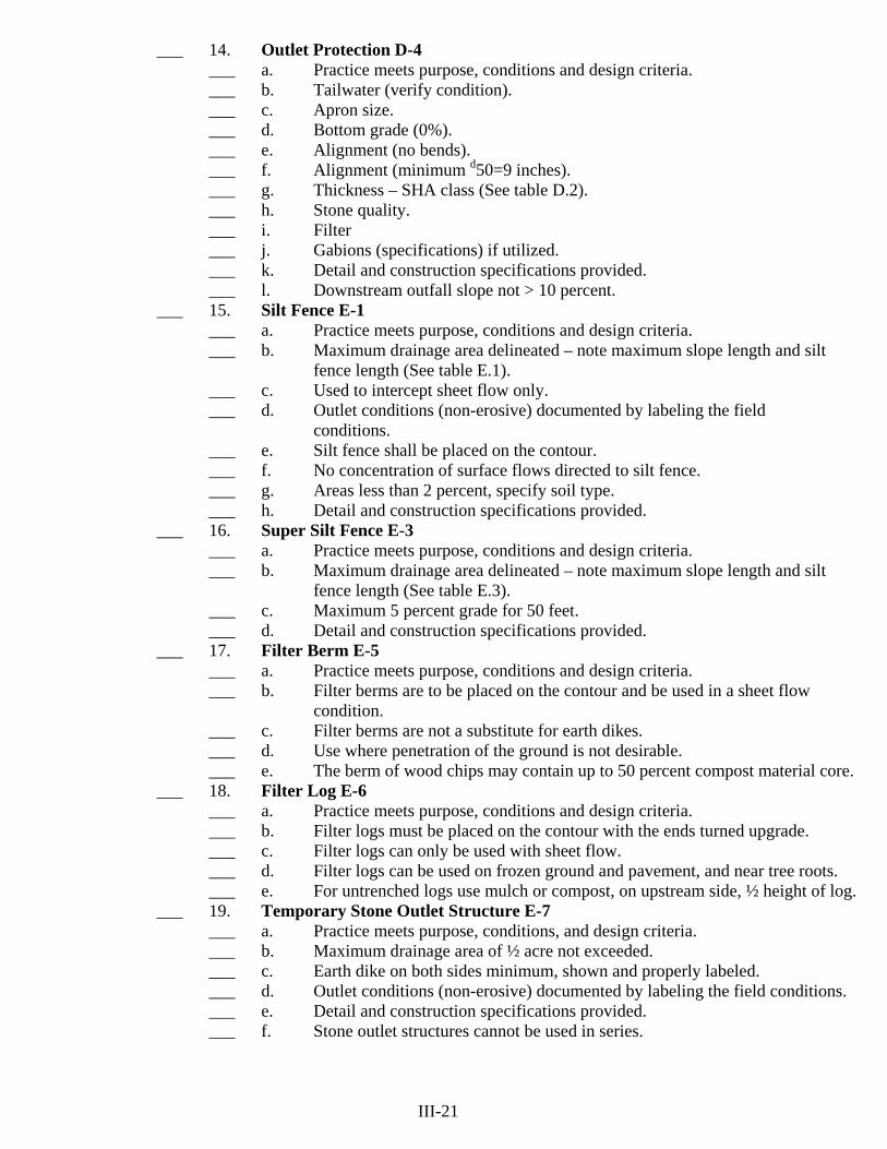
___ 14. Outlet Protection D-4 ___ a. Practice meets purpose, conditions and design criteria. ___ b. Tailwater (verify condition). ___ c. Apron size. ___ d. Bottom grade (0%). ___ e. Alignment (no bends). ___ f. Alignment (minimum d50=9 inches). ___ g. Thickness – SHA class (See table D.2). ___ h. Stone quality. ___ i. Filter ___ j. Gabions (specifications) if utilized. ___ k. Detail and construction specifications provided. ___ l. Downstream outfall slope not > 10 percent.
___ 15. Silt Fence E-1 ___ a. Practice meets purpose, conditions and design criteria. ___ b. Maximum drainage area delineated – note maximum slope length and silt fence length (See table E.1). ___ c. Used to intercept sheet flow only. ___ d. Outlet conditions (non-erosive) documented by labeling the field conditions. ___ e. Silt fence shall be placed on the contour. ___ f. No concentration of surface flows directed to silt fence. ___ g. Areas less than 2 percent, specify soil type. ___ h. Detail and construction specifications provided.
___ 16. Super Silt Fence E-3 ___ a. Practice meets purpose, conditions and design criteria. ___ b. Maximum drainage area delineated – note maximum slope length and silt fence length (See table E.3). ___ c. Maximum 5 percent grade for 50 feet. ___ d. Detail and construction specifications provided.
___ 17. Filter Berm E-5 ___ a. Practice meets purpose, conditions and design criteria. ___ b. Filter berms are to be placed on the contour and be used in a sheet flow condition. ___ c. Filter berms are not a substitute for earth dikes. ___ d. Use where penetration of the ground is not desirable. ___ e. The berm of wood chips may contain up to 50 percent compost material core.
___ 18. Filter Log E-6 ___ a. Practice meets purpose, conditions and design criteria. ___ b. Filter logs must be placed on the contour with the ends turned upgrade. ___ c. Filter logs can only be used with sheet flow. ___ d. Filter logs can be used on frozen ground and pavement, and near tree roots. ___ e. For untrenched logs use mulch or compost, on upstream side, ½ height of log. ___ 19. Temporary Stone Outlet Structure E-7 ___ a. Practice meets purpose, conditions, and design criteria. ___ b. Maximum drainage area of ½ acre not exceeded. ___ c. Earth dike on both sides minimum, shown and properly labeled. ___ d. Outlet conditions (non-erosive) documented by labeling the field conditions. ___ e. Detail and construction specifications provided. ___ f. Stone outlet structures cannot be used in series. III-21

___ 20. Storm Drain Inlet Protection E-9 ___ a. Practice meets purpose, conditions, and design criteria. ___ b. Maximum drainage area delineated, on the plan with acreage noted. ___ c. Curb inlets (maximum drainage area = ¼ acre). ___ d. Yard inlets (total in series must be 1 acre or less with the drainage area
slope flatter than 5 percent). ___ e. No other practice feasible. ___ f. Detail and construction specifications provided.
___ 21. Removable Pumping Station F-1 or Sump Pit F-2 ___ a. Practice meets purpose, conditions, and design criteria. ___ b. Dewatering for traps and basins. ___ c. Standpipe minimum 12 inches above wet storage elevation. ___ d. Discharge hose to stabilized downslope area (non-erosive). ___ e. Detail and construction specifications provided.
___ 22. Filter Bag F-4 ___ a. Practice meets purpose, conditions and design criteria. ___ b. Use for dewatering of sediment laden waters from excavations, trenches, cofferdams, sediment traps or basins. ___ c. Properly dispose filter bag and sediments upon completion of use. ___ d. Place filter bag on suitable base and located on less than 5 percent slope. ___ 23. Sediment Trap G-1
___ a. Practice meets purpose, conditions, and design criteria. ___ b. Maximum drainage area delineated on plan with acreage noted. ___ c. Plan view of trap and storage area (top and bottom area and side slopes),
drawn to scale (worst case existing through final). Trap must show on one plan sheet.
___ d. Minimum length and width bottom dimensions, elevations for top of embankment, clean-out and outlet elevations, crest elevation, weir length, shown on the plan view.
___ e. Outlet conditions (non-erosive) documented by labeling the field conditions. ___ f. Summary schedule/table provided (on same sheet as trap). ___ (1) Trap number(s). ___ (2) Type of trap (ST-I, ST-II, or ST-III). ___ (3) Drainage area (initial, interim and final). ___ (4) Storage volume required (wet, dry and total). ___ (5) Storage volume provided (wet, dry and total). ___ (6) Elevations (bottom, wet storage, dry storage, outlet and cleanout). ___ (7) ST-I: riser and barrel diameters and outlet protection dimensions. ___ (8) ST-II: weir length, existing elevation at end of outlet. ___ (9) ST-III: outlet depth (a) and width (b). ___ (10) Embankment height, width, and elevation. ___ (11) Bottom dimensions. ___ g. Points of surface water entry protected (for trap slopes >4:1 use pipe slope drain). Use top of slope diversion. ___ h. Elevation of any dike to trap ≥ top of trap embankment. ___ i. Required length to width ratio of 2:1. Use baffles as needed. ___ j. Include location of sump pit for dewatering. ___ k Maximum embankment height is 4 feet. (ST-II and ST-III). ___ l. Sediment disposal area. ___ m. Show final grades for trap removal. ___ n. Vegetative stabilization. ___ o. All needed detail(s), trap data sheet(s) and construction specifications provided. ___ p. For any trap design criteria that cannot be met see sediment basin requirements.
III-22

___ 24. Sediment Basin G-2 ___ a. Practice meets purpose, conditions, and design criteria. ___ (1) Failure would not result in loss of life, damage to homes or buildings,
or interruption of use or service of public roads or utilities. Provide documentation (such as breach analysis, adjacent floodplains, wetlands, PMA's, etc.).
___ (2) The drainage area does not exceed 100 acres. ___ (3) The maximum embankment height does not exceed 15 feet. ___ (4) The basin is to be removed within 36 months after beginning of
construction of the basin. (Note in the Sequence). ___ (5) Where these criteria cannot be met, design to NRCS MD378 Ponds.
___ b Maximum drainage area delineated on plan with acreage noted. ___ c. Plan view of basin, constructed height of embankment, storage area, and emergency spillway showing existing and proposed contours. Bottom dimensions necessary to obtain basin volume. Basin must show on one
plan sheet. ___ d. Profile along centerline of embankment and a profile along centerline of emergency spillway. ___ e. Cross-section of embankment, including elevations for constructed and
settled heights, principal spillway and emergency spillway. ___ f. NRCS TR55 Urban Hydrology runoff calculations and documentation for
the 10 year frequency storm assuming the worst case conditions. ___ g. Calculations showing design of pipe and emergency spillway. ___ h. Design data sheet properly completed (Table G. 6) and included on same
sheet as basin with basin(s) numbered. ___ i. SWM ponds used as sediment basins must meet the minimum requirements for basins. Include all designs and details necessary to meet basin criteria. (Add details for watertight blocking of SWM low flow openings). ___ j. Provisions for sediment control during basin construction, removal, final
grading and stabilization. Include upstream diversion and toe of slope protection. Include sediment disposal site.
___ k. Details (with dimensions and elevations) of barrel, riser, rise base, riser to pipe connections, pipe connections, anti-seep collar(s), trash rack, antivortex device, draw-down device, baffle boards, precast riser connector, projection collar and cleanout elevation clearly marked on riser.
___ l. Required length to width ratio of 2:1 (use baffles as needed), side slopes combined maximum 5:1, embankment minimum 8 foot width, minimum constructed height 10 percent above design height, minimum barrel 8 inches, and minimum riser crest elevation one foot below emergency spillway. Freeboard shall be at least one foot for temporary basin designs and two feet for permanent designs.
___ m. Points of surface water entry protected (for basin slopes >4:1 use pipe slope drains). Use top of slope diversion.
___ n. Access for construction and maintenance equipment shown on plan. ___ o. Outlet protection, design and details, with downstream outfall conditions
(non-erosive) documented by labeling the field conditions.
III-23

___ p. Include location of sump pit(s) for dewatering and include a sediment disposal area on the plans.
___ q. Surface area is to be based on the worst case condition from the inflow Q of a 10 year storm.
___ r. Risers over 10 feet in height require anti-flotation calculations. ___ s. Emergency spillway must be in cut (existing ground) for the full flow depth,
25 foot minimum level section, and a straight exit channel. ___ t. Anti-seep collars shall be a minimum 2 feet from pipe joints and have a
2 foot minimum projection. ___ u. Cutoff trench minimum depth of 4 feet below existing ground. For created
embankment the 4 feet is below the pond bottom. ___ v. Vegetative stabilization – use NRCS MD-342 for a temporary basin and for
permanent designs. ___ w. All needed details and construction specifications provided. ___ x. Embankment fill material for impervious core and cut off trench must conform to Unified Soil Classes GC, SC, CH or CL.
___ 25. Temporary Access Waterway Crossing H-4 ___ a. Access Bridge – preferred method (include restriction dates). ___ b. Culvert – must carry normal stream flows (2 year storm) (include restriction dates). *See “2011 Maryland Standards and Specifications for Soil Erosion and Sediment Control for Figures and Tables”. III-24

___ F. B-4 VEGETATIVE STABILIZATION
___ 1. Sediment control practices must remain in place during grading, seedbed preparation, seeding, mulching, and vegetative establishment.
___ 2. Inspect seeded areas for vegetative establishment and make necessary repairs, replacements and reseeding within the planting season. ___ a. Adequate vegetative stabilization requires 95 percent groundcover. ___ b. If an area has less than 40 percent groundcover, restabilize following the original recommendations for lime, fertilizer, seedbed preparation and seeding.
___ c. If an area has between 40 and 94 percent groundcover, over-seed and fertilize using half of the rates originally specified. ___ d. Maintenance fertilizer rates for permanent seeding are shown below in Table B.6.
Table B.6: Maintenance Fertilization for Permanent Seeding
Seeding Mixture Type lb/ac lb/100 Time Mowing Tall fescue makes up 70 percent or more of cover
10-10-10- Or 30-10-10
500 400
11.5 9.2
Yearly as needed. Fall
No closer than 3 inches, if occasional mowing is desired.
Red & chewing fescue, Kentucky Bluegrass, hard Fescue mixtures.
20-10-10
250 100
5.8 2.3
September, 30 days later. December, May 20, June 30, if needed.
Mow no closer than 2 inches for red fescue and Kentucky bluegrass, 3 inches for fescue.
___ 3. B-4-1 Incremental Stabilization ____ a. Cut Slopes ___ (1) Excavate and stabilize cut slopes in increments not to exceed 15 feet in height. Prepare seedbed and apply seed and mulch on all cut slopes as the work progresses. ___ (2) Note: Once excavation has begun the operation shall be continuous from grubbing through completion of grading and placement of topsoil (if required) and permanent seed and mulch. Any interruptions in the operation or (completing the operation out of the seeding season) will necessitate the application of temporary stabilization. ___ b. Fill Slopes ___ (1) Construct and stabilize fill slopes in increments not to exceed 15 feet in height. Prepare seedbed and apply seed and mulch on all slopes as the work progresses. ___ (2) Stabilize slopes immediately when the vertical height of a lift reaches 15 feet, or when the grading operation ceases as prescribed in the plans. ___ (3) At the end of each day, install temporary water conveyance practice(s), as necessary, to intercept surface runoff and convey it down the slope in a non-erosive manner. ___ (4) Note: Once the placement of fill has begun the operation shall be continuous from grubbing through the completion of grading and placement of topsoil (if required) and permanent seed and mulch. Any interruptions in the operation or completing the operation out of the seeding season will necessitate the application of temporary stabilization.
III-25
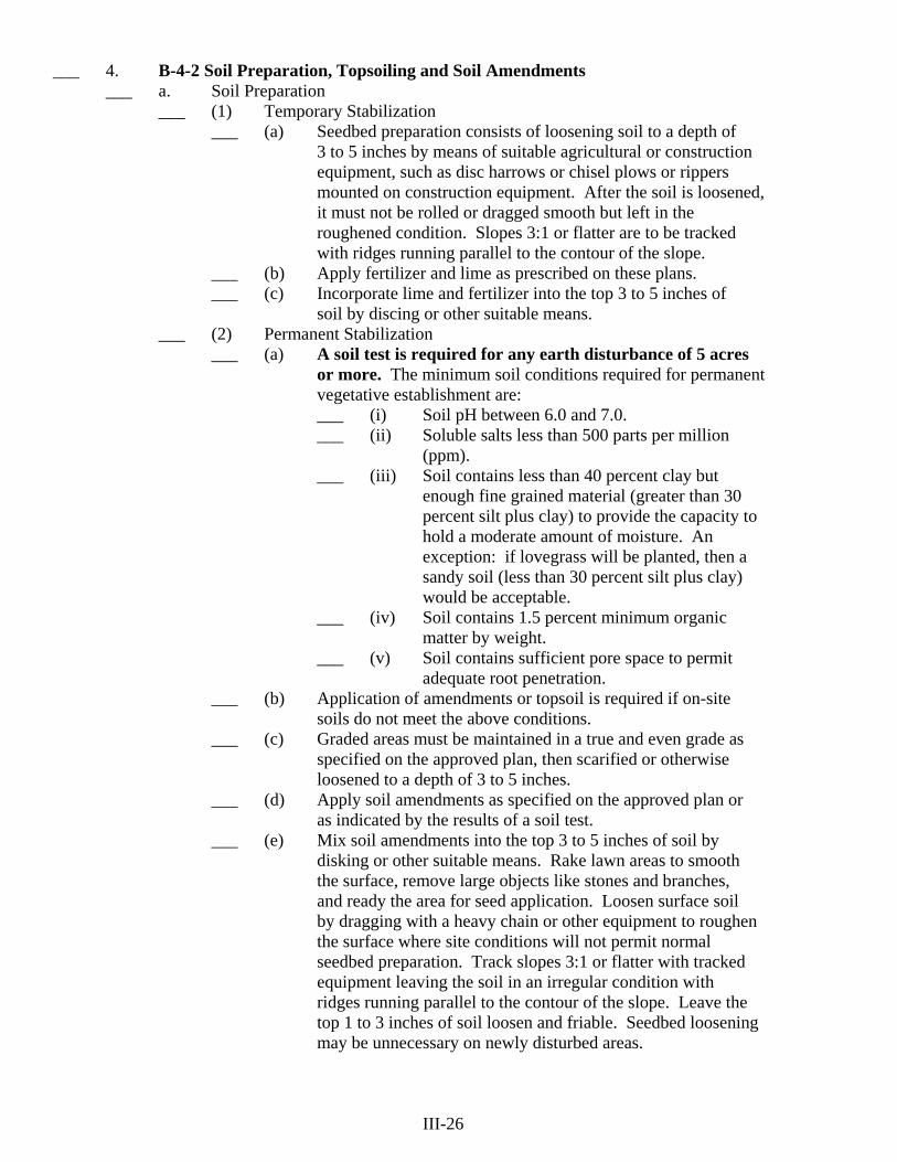
___ 4. B-4-2 Soil Preparation, Topsoiling and Soil Amendments ___ a. Soil Preparation ___ (1) Temporary Stabilization ___ (a) Seedbed preparation consists of loosening soil to a depth of 3 to 5 inches by means of suitable agricultural or construction equipment, such as disc harrows or chisel plows or rippers mounted on construction equipment. After the soil is loosened, it must not be rolled or dragged smooth but left in the roughened condition. Slopes 3:1 or flatter are to be tracked with ridges running parallel to the contour of the slope. ___ (b) Apply fertilizer and lime as prescribed on these plans. ___ (c) Incorporate lime and fertilizer into the top 3 to 5 inches of soil by discing or other suitable means. ___ (2) Permanent Stabilization ___ (a) A soil test is required for any earth disturbance of 5 acres or more. The minimum soil conditions required for permanent vegetative establishment are: ___ (i) Soil pH between 6.0 and 7.0. ___ (ii) Soluble salts less than 500 parts per million (ppm). ___ (iii) Soil contains less than 40 percent clay but enough fine grained material (greater than 30 percent silt plus clay) to provide the capacity to hold a moderate amount of moisture. An exception: if lovegrass will be planted, then a sandy soil (less than 30 percent silt plus clay) would be acceptable. ___ (iv) Soil contains 1.5 percent minimum organic matter by weight. ___ (v) Soil contains sufficient pore space to permit adequate root penetration. ___ (b) Application of amendments or topsoil is required if on-site soils do not meet the above conditions. ___ (c) Graded areas must be maintained in a true and even grade as specified on the approved plan, then scarified or otherwise loosened to a depth of 3 to 5 inches. ___ (d) Apply soil amendments as specified on the approved plan or as indicated by the results of a soil test. ___ (e) Mix soil amendments into the top 3 to 5 inches of soil by disking or other suitable means. Rake lawn areas to smooth the surface, remove large objects like stones and branches, and ready the area for seed application. Loosen surface soil by dragging with a heavy chain or other equipment to roughen the surface where site conditions will not permit normal seedbed preparation. Track slopes 3:1 or flatter with tracked equipment leaving the soil in an irregular condition with ridges running parallel to the contour of the slope. Leave the top 1 to 3 inches of soil loosen and friable. Seedbed loosening may be unnecessary on newly disturbed areas. III-26

___ b. Topsoiling ___ (1) Topsoil is placed over prepared subsoil prior to establishment of permanent vegetation. The purpose is to provide a suitable soil medium for vegetative growth. Soils of concern have low moisture content, low nutrient levels, low pH, materials toxic to plants and/or unacceptable soil gradation. ___ (2) Topsoil salvaged from an existing site may be used provided it meets the standards as set forth in these specifications. Typically, the depth of topsoil to be salvaged for a given soil type can be found in the representative soil profile section in the Soil Survey published by USDA-NRCS. ___ (3) Topsoiling is limited to areas having 2:1 for flatter slopes where: ___ (a) The texture of the exposed subsoil/parent material is not adequate to produce vegetative growth. ___ (b) The soil material is so shallow that the rooting zone is not deep enough to support plants or furnish continuing supplies of moisture and plant nutrients. ___ (c) The original soil to be vegetated contains material toxic to plants growth. ___ (d) The soil is so acidic that treatment with limestone is not feasible. ___ (4) Areas having slopes steeper than 2:1 require special consideration and design. ___ (5) Topsoil Specifications: Soil to be used as topsoil must meet the following criteria: ___ (a) Topsoil must be a loam, sandy loam, clay loam, silt loam, sandy clay loam, or loamy sand. Other soils may be used if recommended by an agronomist or soil scientist and approved by the appropriate approval authority. Topsoil must not be a mixture of contrasting textured subsoils and must contain less than 5 percent by volume of cinders, stones, slag, coarse fragments, gravel, sticks, roots, trash, or other materials larger than 1½ inches in diameter. ___ (b) Topsoil must be free of noxious plants or plant parts such as Bermuda grass, quack grass, Johnson grass, nut sledge, poison ivy, thistle, or others as specified. ___ (c) Topsoil substitutes or amendments, as recommended by a qualified agronomist or soil scientist and approved by the appropriate approval authority, may be used in lieu of natural topsoil. ___ (6) Topsoil Application ___ (a) Erosion and sediment control practices must be maintained when applying topsoil. III-27
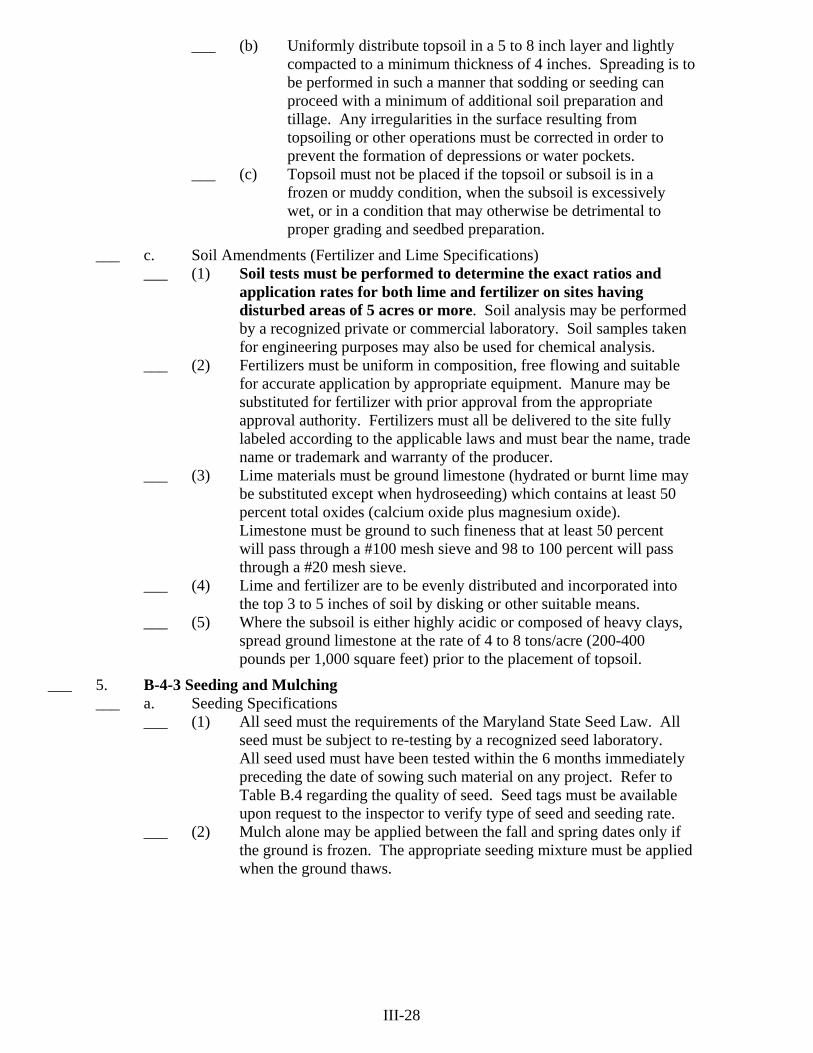
___ (b) Uniformly distribute topsoil in a 5 to 8 inch layer and lightly compacted to a minimum thickness of 4 inches. Spreading is to be performed in such a manner that sodding or seeding can proceed with a minimum of additional soil preparation and tillage. Any irregularities in the surface resulting from topsoiling or other operations must be corrected in order to prevent the formation of depressions or water pockets. ___ (c) Topsoil must not be placed if the topsoil or subsoil is in a frozen or muddy condition, when the subsoil is excessively wet, or in a condition that may otherwise be detrimental to proper grading and seedbed preparation.
___ c. Soil Amendments (Fertilizer and Lime Specifications) ___ (1) Soil tests must be performed to determine the exact ratios and application rates for both lime and fertilizer on sites having disturbed areas of 5 acres or more. Soil analysis may be performed by a recognized private or commercial laboratory. Soil samples taken for engineering purposes may also be used for chemical analysis. ___ (2) Fertilizers must be uniform in composition, free flowing and suitable for accurate application by appropriate equipment. Manure may be substituted for fertilizer with prior approval from the appropriate approval authority. Fertilizers must all be delivered to the site fully labeled according to the applicable laws and must bear the name, trade name or trademark and warranty of the producer. ___ (3) Lime materials must be ground limestone (hydrated or burnt lime may be substituted except when hydroseeding) which contains at least 50 percent total oxides (calcium oxide plus magnesium oxide). Limestone must be ground to such fineness that at least 50 percent will pass through a #100 mesh sieve and 98 to 100 percent will pass through a #20 mesh sieve. ___ (4) Lime and fertilizer are to be evenly distributed and incorporated into the top 3 to 5 inches of soil by disking or other suitable means. ___ (5) Where the subsoil is either highly acidic or composed of heavy clays, spread ground limestone at the rate of 4 to 8 tons/acre (200-400 pounds per 1,000 square feet) prior to the placement of topsoil.
___ 5. B-4-3 Seeding and Mulching ___ a. Seeding Specifications ___ (1) All seed must the requirements of the Maryland State Seed Law. All seed must be subject to re-testing by a recognized seed laboratory. All seed used must have been tested within the 6 months immediately preceding the date of sowing such material on any project. Refer to Table B.4 regarding the quality of seed. Seed tags must be available upon request to the inspector to verify type of seed and seeding rate. ___ (2) Mulch alone may be applied between the fall and spring dates only if the ground is frozen. The appropriate seeding mixture must be applied when the ground thaws. III-28

___ (3) Inoculants: The inoculants for treating legume seed in the seed mixtures must be a pure culture of nitrogen fixing bacteria prepared specifically for the species. Inoculants must not be used later than the date indicated on the container. Add fresh inoculants as directed on the package. Use four times the recommended rate when hydroseeding. Note: It is very important to keep inoculants as cool as possible until used. Temperatures above 75 to 80 degrees Fahrenheit can weaken bacteria and make the inoculants less effective. ___ (4) Sod or seed must not be placed on soil which has been treated with soil sterilants or chemicals used for weed control until sufficient time has elapsed (14 days min.) to permit dissipation of phyto-toxic materials. ___ b. Seeding Application ___ (1) Dry Seeding: This includes use of conventional drop or broadcast spreader. ___ (a) Incorporate seed into the subsoil at the rates prescribed on Temporary Seeding Table B.1, Permanent Seeding Table B.3 or site-specific seeding summaries. ___ (b) Apply seed in two directions, perpendicular to each other. Apply half the seeding rate in each direction. Roll the seeded area with a weighted roller to provide good seed to soil contact. ___ (2) Drill or Cultipacker Seeding: Mechanized seeders that apply and cover seed with soil. ___ (a) Cultipacking seeders are required to bury the seed in such a fashion as to provide at least ¼ inch of soil covering. Seedbed must be firm after planting. ___ (b) Apply seed in two directions, perpendicular to each other. Apply half the seeding rate in each direction. ___ (3) Hydroseeding: Apply seed uniformly with hydroseeder (slurry includes seed fertilizer). ___ (a) If fertilizer is being applied at the time of seeding, the application rates should not exceed the following: nitrogen, 100 pounds per acre total of soluble nitrogen; P202 (phosphorous), 200 pounds per acre; K20 (potassium), 200 pounds per acre. ___ (b) Lime: Use only ground agricultural limestone (up to 3 tons per acre may be applied by hydroseeding). Normally, not more than 2 tons are applied by hydroseeding at any one time. Do not use burnt or hydrated lime when hydroseeding. ___ (c) Mix seed and fertilizer on site and seed immediately and without interruption. ___ (d) When hydroseeding do not incorporate seed into the soil. III-29

___ c. Mulch Materials (in order of preference) ___ (1) Straw consisting of thoroughly threshed wheat, rye, oat, or barley and reasonably bright in color. Straw is to be free of noxious weed seeds as specified in the Maryland Seed Law and not musty, moldy, caked, decayed, or excessively dusty. Note: Use only sterile straw mulch in areas where one species of grass is desired. ___ (2) Wood Cellulose Fiber Mulch (WCFM) consisting of specially prepared wood cellulose processed into a uniform fibrous physical state. ___ (a) WCFM is to be dyed green or contain a green dye in the package that will provide an appropriate color to facilitate visual inspection of the uniformly spread slurry. ___ (b) WCFM , including dye, must contain no germination or growth inhibiting factors. ___ (c) WCFM materials are to be manufactured and processed in such a manner that the wood cellulose fiber mulch will remain in uniform suspension in water under agitation and will blend with seed, fertilizer and other additives to form a homogeneous slurry. The mulch material must form a blotter- like ground cover, on application, having moisture absorption and percolation properties and must cover and hold grass seed in contact with the soil without inhibiting the growth of the grass seedings. ___ (d) WCFM material must not contain elements or compounds at concentration levels that will be phyto-toxic. ___ (e) WCFM must conform to the following physical requirements: fiber length of approximately 10 millimeters, diameter approximately 1 millimeter, pH range of 4.0 to 8.5, ash content of 1.6 percent maximum and water holding capacity of 90 percent minimum. ___ d. Mulch Application ___ (1) Apply mulch to all seeded areas immediately after seeding. ___ (2) When straw mulch is used, spread it over all seeded areas at the rate of 2 tons per acre to a uniform loose depth of 1 to 2 inches. Apply mulch to achieve a uniform distribution and depth so that the soil surface is not exposed. When using a mulch anchoring tool, increase the application rate to 2.5 tons per acre. ___ (3) Wood cellulose fiber used as mulch must be applied at a net dry weight of 1,500 pounds per acre. Mix the wood cellulose fiber with water to attain a mixture with a maximum of 50 pounds of wood cellulose fiber per 100 gallons of water. ___ e. Mulch Anchoring ___ (1) Perform mulch anchoring immediately following application of mulch to minimize loss by wind or water. This may be done by one of the following methods (listed by preference), depending upon size of the area and erosion hazard: III-30

___ (a) A mulch anchoring tool is a tractor drawn implement designed to punch and anchor mulch into the soil surface a minimum of 2 inches. This practice is most effective on large areas, but is limited to flatter slopes where equipment can operate safely. If used on sloping land, this practice should follow the contour. ___ (b) Wood cellulose fiber may be used for anchoring straw. Apply the fiber binder at a net dry weight of 750 pounds per acre. Mix the wood cellulose fiber with water at a maximum of 50 pounds of wood cellulose fiber per 100 gallons of water. ___ (c) Synthetic binders such as Acrylic DLR(Agro-Tack), DCA-70, Petroset, Terra Tax II, Terra Tack AR or other approved equal may be used. Follow application rates as specified by the manufacturer. Application of liquid binders needs to be heavier at the edges where wind catches mulch, such as in valleys and on crests of banks. Use of asphalt binders is strictly prohibited. ___ (d) Lightweight plastic netting may be stapled over the mulch according to manufacturer recommendations. Netting is usually available in rolls 4 to 15 feet wide and 300 to 3,000 feet long.
___ 6. B-4-4 Temporary Stabilization ___ a. Exposed soils where ground cover is needed for a period of 6 months or less. For longer duration of time, permanent stabilization practices are required. ___ (1) Select one or more of the species or seed mixtures listed in Table B.1 for the appropriate Plant Hardiness Zone (from Figure B.3), and enter them in the Temporary Seeding Summary below along with application rates, seeding dates and seeding depths. If this Summary is not put on the plan and completed, then Table B.1 plus fertilizer and lime rates must be put on the plan. ___ (2) For sites having soil tests performed, use and show the recommended rates by the testing agency. Soil tests are not required for Temporary Seeding. ___ (3) When stabilization is required outside of a seeding season, apply seed and mulch or straw mulch alone and maintain until the next seeding season. III-31

Temporary Seeding Summary
Hardiness Zone (from Figure B.3):_________ Seed Mixture (from Table B.1):_________
Fertilizer Rate (10-20-20)
Lime Rate
No.
Species
Application Rate (lb/ac)
Seeding Dates
Seeding Depths
436 lb/ac (10 lb/1,000 sf)
2 tons/ac (90 lb/1,000 sf)
___ 7. B-4-5 Permanent Stabilization ___ a. Exposed soils where ground cover is needed for 6 months or more. ___ b. Seed Mixtures ___ (1) General Use ___ (a) Select one or more of the species or mixtures listed in Table B.3 for the appropriate Plant Hardiness Zone (from Figure B.3) and based on site condition or purpose found on Table B.2. Enter selected mixture(s), application rates and seeding dates in the Permanent Seeding Summary. The summary is to be placed on the plan. ___ (b) Additional planting specifications for exceptional sites such as shorelines, stream banks, or dunes or for special purposes such as wildlife or aesthetic treatment may be found in USDA-NRCS Technical Field Office Guide, Section 342-Critical Area Planting. ___ (c) For sites having disturbed area over 5 acres, use and show the rates recommended by the soil testing agency. ___ (d) For areas receiving low maintenance, apply urea form fertilizer (46-0-0)at 3½ pounds per 1,000 square feet (150 pounds per acre) at the time of seeding in addition to the soil amendments shown in the Permanent Seeding Summary. ___ (2) Turfgrass Mixtures ___ (a) Areas where turfgrass may be desired include lawns, parks, playgrounds and commercial sites which will receive a medium to high level of maintenance. ___ (b) Select one or more of the species or mixtures listed below based on the site conditions or purpose. Enter selected mixture(s), application rates and seeding dates in the Permanent Seeding Summary. The summary is to be placed on the plan. ___ (i) Kentucky Bluegrass: Full Sun Mixture: For use in areas that receive intensive management. Irrigation required in the areas of central Maryland and Eastern Shore. Recommended Certified Kentucky Bluegrass Cultivars Seeding Rate: 1.5 to 2.0 pounds per 1,000 square feet. Choose a minimum of three Kentucky bluegrass cultivars with each ranging from 10 to 25 percent of the total mixture by weight. III-32

___ (ii) Kentucky Bluegrass/Perennial Rye: Full Sun Mixture: For use in full sun areas where rapid establishment is necessary and when turf will receive medium to intensive management. Certified Perennial Ryegrass Cultivars/Certified Kentucky Bluegrass Seeding Rate: 2 pounds mixture per 1,000 square feet. Choose a minimum of three Kentucky bluegrass cultivars with each ranging from 10 to 35 percent of the total mixture by weight. ___ (iii) Tall Fescue/Kentucky Bluegrass: Full Sun Mixture: For use in drought prone areas and/or for areas receiving low to medium management in full sun to medium shade. Recommended mixture includes: Certified Tall Fescue Cultivars 95 to 100 percent, Certified Kentucky Bluegrass Cultivars 0 to 5 percent. Seeding Rate: 5 to 8 pounds per 1,000 square feet. One or more cultivars may be blended. ___ (iv) Kentucky Bluegrass/Fine Fescue: Shade Mixture: For use in areas with shade in Bluegrass lawns. For establishment in high quality, intensively managed turf area. Mixture includes; Certified Kentucky Bluegrass Cultivars 30 to 40 percent and Certified Fine Fescue and 60 to 70 percent. Seeding Rate: 1½ to 3 pounds per 1,000 square feet. Notes: Select turfgrass varieties from those listed in the most current University of Maryland Publication, Agronomy Memo #77, “Turfgrass Cultivar Recommendation for Maryland”. Choose certified material. Certified material is the best guarantee of cultivar purity. The certification program of the Maryland Department of Agriculture, Turf and Seed Section, provides a reliable means of consumer protection and assures a pure genetic line. ___ (c) Ideal Times of Seeding for Turf Grass Mixtures Central MD: March 1 to May 15, August 15 to October 15 (Hardiness Zone: 6b) Southern MD, Eastern Shore: March 1 to May 15, August 15 to October 15 (Hardiness Zones: 7a) ___ (d) Till areas to receive seed by discing or other approved methods to a depth of 2 to 4 inches, level and rake the areas to prepare a proper seedbed. Remove stones and debris over 1½ inches in diameter. The resulting seedbed must be in such condition that future mowing of grasses will pose no difficulty. ___ (e) If soil moisture is deficient, supply new seedings with adequate water for plant growth (½ to 1 inch every 3 to 4 days depending on soil texture) until they are firmly established. This is especially true when seedings are made late in the planting season, in abnormally dry or hot seasons, or on adverse sites. III-33

Permanent Seeding Summary
Hardiness Zone (from Figure B.3):_________ Seed Mixture (from Table B.3):_________
Fertilizer Rate (10-20-20)
Lime Rate
No.
Species
Application Rate (lb/ac)
Seeding Dates
Seeding Depths
N
P202
K20
2 tons/ac (90 lb/ 1,000 sf)
45 lb/ac (1.0 lb/ 1,000 sf)
90 lb/ac (2 lb/ 1,000 sf)
90 lb/ac (2 lb/ 1,000 sf)
___ c. Sod: To provide quick cover on disturbed areas (2:1 grade or flatter). ___ (1) General Specifications ___ (a) Class of turfgrass sod must be Maryland Certified. Sod labels must be made available to the job foreman and inspector. ___ (b) Sod must be machine cut at a uniform soil thickness of ¾ inch, plus or minus ¼ inch, at the time of cutting. Measurement for thickness must exclude top growth and thatch. Broken pads and torn or uneven ends will not be acceptable. ___ (c) Standard size sections of sod must be strong enough to support their own weight and retain their size and shape when suspended vertically with a firm grasp on the upper 10 percent of the section. ___ (d) Sod must not be harvested or transplanted when moisture content (excessively dry or wet) may adversely affect its survival. ___ (e) Sod must be harvested, delivered, and installed within a period of 36 hours. Sod not transplanted within this period must be approved by an agronomist or soil scientist prior to its installation. ___ (2) Sod Installation: ___ (a) During periods of excessively high temperature or in areas having dry subsoil, lightly irrigate the subsoil immediately prior to laying the sod. ___ (b) Lay the first row of sod in a straight line with subsequent rows placed parallel to it and tightly wedged against each other. Stagger lateral joints to promote more uniform growth and strength. Ensure that sod is not stretched or overlapped and that all joints are butted tight in order to prevent voids which would cause air drying of the roots. ___ (c) Wherever possible, lay sod with the long edges parallel to the contour and with staggering joints. Roll and tamp, peg or otherwise secure the sod to prevent slippage on slopes. Ensure solid contact exists between sod root sand the underlying soil surface. ___ (d) Water the sod immediately following rolling and tamping until the underside of the new sod pad and soil surface below the sod are thoroughly wet. Complete the operations of laying, tamping and irrigating for any piece of sod within eight hours. III-34

___ (3) Sod Maintenance ___ (a) In the absence of adequate rainfall, water daily during the first week or as often and sufficiently as necessary to maintain moist soil to a depth of 4 inches. Water sod during the heat of the day to prevent wilting. ___ (b) After the first week, sod watering is required as necessary to maintain adequate moisture content. ___ (c) Do not mow until the sod is firmly rooted. No more than 1/3 of the grass leaf must be removed by the initial cutting or subsequent cuttings. Maintain a grass height of at least 3 inches unless otherwise specified. ___ d. Note: Use of this information does not preclude meeting all of the requirements of the 2011 Maryland Standards and Specifications for Soil Erosion and Sediment Control – B-4 Vegetative Stabilization. III-35

III-36
III-37

III-38

III-39

III-40

III-41

III-42

III-43
III-44

III-45

III-46

III-47

III-48

III-49

III-50

III-51

III-52

III-53

III-54

III-55

III-56
III-57

III-58

III-59

III-60

III-61

III-62

III-63

III-64

III-65

III-66

___ I. FINAL ROUGH GRADING PLAN CHECKLIST
___ 1. As enumerated in the supplemental Memorandum of Understanding among Prince George’s County, the Prince George’s Soil Conservation District and the
USDA-Natural Resources Conservation Service, PGSCD will provide technical review and concurrence of all rough grading plans as part of the grading, erosion and sediment control plan review in accordance with State sediment control law, Section B-3 of the Standards and Specifications, and the county grading ordinance. To meet minimum County requirements for a rough grading approval the following items will need to be addressed on the grading, erosion and sediment control plans.
___ a. Final rough grading plans are subject to the three step review process and will require a Concept (CSC) and Environmental Site Development (SSC)
review and approval. An approved NRI and SWM plan will also be required.
___ b. It will be to your benefit to concurrently apply for your G-permit grading, erosion and sediment control approval. This will expedite the process since Final Rough Grading Plan review and approval by PGSCD is required
before a Final Grading, Erosion and Sediment Control Plan can be approved.
___ c. Revisions to G-permits will be referred to PGSCD when there are changes to the disturbed area or a significant technical change in grading.
___ d. When PGSCD approves a Final Rough Grading, Erosion and Sediment Control Plan, the original (optional) and three green stamped copies will
be returned to the applicant, along with two standard memorandum. The applicant will transmit plan packages directly to the DPIE inspector and the DPIE Permit Section.
___ e. PGSCD approval stamp has been combined with the County’s grading stamp.
___ 2. General Requirements:
___ a. Obtain PGSCD review and approval of a Concept and Environmental Site Development Grading, Erosion and Sediment Control Plan.
___ b. Submit a Final Rough Grading, Erosion and Sediment Control Plan with fee paid.
___ c. The following signed certifications are required on the plans:
___ (1) “I certify that I have inspected this site and that drainage onto this site from properties, and from this site onto other downgrade properties, has been addressed in substantial accordance with applicable codes”.
___ (2) “I hereby certify that this plan conforms to Subtitle 32, Division 2 of the Grading Ordinance of Prince George’s County, Maryland”.
___ d. A plat reference number, or deed recordation number must be included on the plans.
___ e. A disturbed area statement must be added to the plans. III-67

___ f. Utilities must be shown with easements delineated. Include MISS UTILITY note on each sheet. ___ g. The following wetland note is required on the plans: It is the applicant’s responsibility to obtain any state permits, if required,
for any construction activity covered by this plan which impacts a State regulated wetland. Any changes to plans for this development whether required by the State or initiated by the applicant to meet State requirements, must be approved by PGSCD.
___ h. Approved floodplain must be delineated on the plan. Submit appropriate plans and letters of floodplain approval. ___ i. Include permission for offsite grading. A recorded grading easement is required for all areas of offsite grading. If offsite areas are to be disturbed,
but existing grades maintained, a notarized letter of permission is acceptable. ___ j. Submit a letter of permission from WSSC for grading and/or disturbance within the existing WSSC easement. ___ k. Include DPW&T street approval file number on the plans. ___ 3. Design Requirements: ___ a. The maximum slope on a residential site is 3:1. ___ b. The minimum acceptable yard slope is 2.5%. Verify flat areas with spot elevations. ___ c. The minimum acceptable slope in a vegetated swale is 2.0%. Verify flat
areas with spot elevations. ___ d. Proposed slopes steeper than 4:1 must be set back from the property line as detailed in the Grading Ordinance, Subtitle 32, Division 2, 32-161. ___ e. The limits of all proposed class 1 fill must be delineated on the plans. ___ f. A soils report is required for the placement of class 1 fill, the placement of
fill on slopes steeper than 4:1, and where Marlboro Clays may be present. Submit a detailed soils report indicating recommendations for construction for these conditions.
III-68

___ J. FINAL GRADING, EROSION AND SEDIMENT CONTROL PLAN SUBMITTAL ___ 1. General ___ a. Fees are payable by check or money order to Prince George's Soil Conservation District ___ b. All Final Grading, Erosion and Sediment Control Plans submitted for review
shall contain two sets of folded (9" x 12") review prints and one set of accompanying data. Do not submit original/sepia until PGSCD indicates the plan is ready for approval. Four sets of final prints and original/sepia (optional) shall be submitted for approval and signing. Additional or approved plans submitted for green stamping will be processed at the current fee rate.
___ c. Include signed and completed owner/developer and consultants certification. ___ d. All Final Grading, Erosion and Sediment Control Plan sheets shall be sealed by a registered professional civil engineer, architect, landscape architect,
or land surveyor. ___ 2. PGSCD Final Grading, Erosion and Sediment Control Plan Transmittal Letter – is required for each submittal. Include project name (same as on plan), contents listed, check reason for submittal (sediment control - pond – asbuilt) and type of submittal (new-resubmittal-revision-update-green stamp). If a revision, note what has been revised and why in comments section (include copy of violation notice/inspection report if revision is due to violation). Include PGSCD sediment control number, pond number, and grading permit number, once assigned, in any subsequent correspondence or resubmittals. ___ 3. PGSCD Final Grading, Erosion and Sediment Control Plan Site Analysis - is required for each new submittal or revision. Include project name (same as on the plan); complete the plan review fee, map coordinates, area of site, area to be disturbed and remaining items. ___ 4. Final Supplementary Information - all supplementary information shall be
adequately and appropriately identified. ___ a. Final soils report with soils, soil boundaries and soil survey sheet number from Soil Survey, Prince George's County Maryland-December 2009 or
later revisions. Provide a photocopy of the appropriate soil survey sheet with the site boundaries clearly outlined.
Website for soil survey for Prince George's County is: http://websoilsurvey.nrcs.usda.gov/app/homepage.htm
___ b. Final drainage area map of site, including off-site contributory areas. Delineate drainage divides and note acres to all sediment control devices. Note-existing topography is required.
___ c. Copy of DPW&T approved Final Storm Water Management Plan. ___ d. Site Plan, in accordance with Prince George's County Grading Ordinance,
Subtitle 32, Division 2, Section 32-130. ___ e. Limits/property lines for entire site to be eventually developed if greater
than that for which sediment control plan approval is requested.
III-69

___K. PRINCE GEORGE'S SOIL CONSERVATION FINAL GRADING, EROSION AND SEDIMENT CONTROL FEES
___1. Final Grading, Erosion and Sediment Control Plan Review
Sediment Control Plan Review Pond Review Application Fee $100.00 Pond(s) $100.00 5000 sq. ft. – 1.0 Disturbed Acre = $200.00 (minimum 1 acre) Pond exemption(s) 50.00 >1.0 – 5.0 Disturbed Acres $100.00 per acre Pond As-Built(s) 100.00 >5.0 Disturbed Acres $ 50.00 per acre
Fees are based on an application fee and the number of acres disturbed.
Compute fees above one acre to the nearest 1/10th acre. Maximum Fee: 300 disturbed acres per plan; 500 disturbed acres on mining and landfill plans. NOTE: Fees are payable by check or money order ONLY (no cash). Make check(s) payable to Prince George’s Soil Conservation District.
___2. Exemptions to the State Sediment Control Law ___ a. Letter of Exemption – No Charge ___ b. Construction of a single family home on a lot of two acres or more when disturbed area is less than one half acre. ___ c. Grading that involves less than 5,000 square feet and/or 100 cubic yards of earth. ___ d. Exempt plans are normally processed on a walk-thru basis (call for appointment).
___3. Unapproved Plans ___ a. If no activity occurs within one year, plan will be considered expired and
will be cancelled. ___ b. The engineer/owner may request a six month continuance in writing prior to cancellation.
___4. Plan Expiration ___ a. All plans expire two years after approval per State law (five years for mining and landfills). ___ b. Expired plans require a complete fee starting at the beginning of the pay scale.
___5. Updating or Extending a Plan ___ a. Plans can only be updated on or before the plan expiration date. If the plan has expired, a full fee is required.
___ b. Updates extend the plan approval for another 2 years (5 years for mining, landfills and Class III fills). (See section III-P for grandfathered plans). ___ c. Fee for the first update is $300.00 (plans not requiring design or plan concept changes). If a second update is needed, a full fee is required at that time.
You are only allowed one update after a full fee is paid. For example: Original plan submission = Full Fee First Update = $300.00 Second Update = Full Fee Third Update = $300.00 Fourth Update = Full Fee ___ d. Pond fees are required to update a plan. ___ e. For plan concept or design changes, see revisions. Revision approval dates and revision fees paid have no bearing on update fees or plan expiration. III-70

___ 6. Revisions to Approved Erosion and Sediment Control Plans ___ a. Stamped copies (must match approved plans exactly with no changes) ___ (1) Additional copies - $50.00 each. ___ b. Minor revision of $100.00 ___ (1) Owner change; ___ (2) Engineer change. ___ c. Minor revision of $300.00 ___ (1) Plan or design changes affecting up to one acre; ___ (2) Rough grading permit review (after sediment control approval). ___ d. Partial revision ≥ to $300.00 ___ (1) Fee starting at the beginning of the pay scale for the
disturbed acreage/affected drainage area (minimum $300.00); ___ e. Major revision ___ (1) Fee starting at the beginning of the pay scale for the disturbed acreage/affected drainage area (minimum $300.00); ___ (2) Once you exceed 50% of the original plan disturbed acreage/affected drainage area, pay complete fee starting at the beginning of the pay scale. ___ f. Revised approval does not extend expiration dates.
___7. Governmental Fees
___ a. County agencies will no longer charge each other fees. The County agencies include DER, OCS, DPW&T, MNCPPC, PGSCD and Fire/EMS Department.
___ b. Prince George’s County School Board fees after the one acre minimum ($300.00), will be reduced by 50%. ___ c. Complete fees will be required for municipalities. 8
___8. Standard Erosion and Sediment Control Plans (Not for Use in Actively Developing Subdivisions)
___ a. 5,000 – 30,000 sq. ft. disturbed area = $300.00; ___ b. Form to be completed and signed by the Owner/Developer; ___ c. Revisions or updated = $300.00
___9. Dam Safety Preliminary Pond Plans
___ a. Pond Approval $100.00 each. ___ (1) To construct, reconstruct, or repair any dam or reservoir approval is required when: ___ (a) The contributory drainage area is less than one square mile; ___ (b) The dam is not greater than 20 feet in height; ___ (c) The pond is a low hazard structure (see pond guidelines). ___ b. Pond Exemptions - $50.00 each ___ (1) Pond approval does not apply to certain small urban stormwater management quality or quantity low hazard structures that meet
any of the eight exemption conditions – (see pond guidelines). ___ c. Pond As-builts - $100.00 each ___ (1) Required within 30 days of construction of the principal spillway and embankment – (see pond guidelines).
___10. Forest Harvest Erosion and Sediment Control Plans
___ a. $100.00 per plan; ___ b. Revisions or updates = $100.00. III-71

___11. Optional Conceptual Review (prior to plan submittal)
___ a. $75.00 per hour, or portion (minimum one hour charge); ___ b. By appointment only.
___12. Checks Returned for Insufficient Funds
___ a. The engineer/owner/applicant shall be liable for a collection fee of $35.00. ___ b. Fees not satisfied within ten days notice given by PGSCD may result in
prosecution under the Maryland criminal code and/or withdrawal of any plan approvals and notification of permitting authorities for stop work orders.
__ c. We accept only certified checks or money orders from an engineer/owner/ applicant for payment of a returned check.
___ d. For a period of six months from the date the insufficient funds are paid, a certified check or money order will be required on any additional plans submitted.
___ 13. District Fee Return Policy
___ a. On occasion a request for a refund of plan review fees is made. The following conditions have resulted in an applicant receiving a refund:
___ (1) The owner or engineer requested a plan be withdrawn before plan review has started; ___ (2) During review a plan is found to be exempt from erosion and sediment control approval and only an exemption letter is issued;
___ (3) Evidence of overpayment has been provided by the owner or engineer; ___ (4) Transfer of payment from one plan to another by separating a plan. This can only be done when no additional design review or overlapping of plans will occur. ___ b. A letter to the District Manager requesting return of fee and reason is required by the owner/applicant. Also, a copy of the cancelled check is required. The $100.00 application fee on all projects is not refundable.
___14. Freedom of Information Act – Copies
___ a. Review of plan files is by appointment only. ___ b. All requests for copies must be in written form to the District Manager and Include: ___ (1) Reference the Freedom of Information Act; ___ (2) Clear indication of what materials and/or information is being requested; ___ (3) Statement of willingness to pay for costs associated to the request. ___ c. Fees are based upon reproductive costs, handling and administrative costs, and are on a case by case basis. ___ d. PGSCD costs are determined and fees received from applicant before
copies will be made. Allow at least one week for requests to be processed. ___15. Prince George’s Soil Conservation Soil Erosion and Sediment Control -Pond
Safety Reference Manual ___ a. Website – http://www.PGSCD.org = free.
III-72

___ L. FINAL GRADING, EROSION AND SEDIMENT CONTROL PLAN APPROVAL
___ 1. Final Grading, Erosion and Sediment Control Plans are approved for one owner/developer only. All permits under an erosion and sediment control plan must and can only be issued to the owner/developer that signs the certification on the plan. If a plan is returned to the PGSCD office with a new owner/developer, the new or revised plan must contain a new certification signed by the new owner/developer. ___ 2. The owner/developer that signs the certification on an erosion and sediment control plan is the responsible party regardless of any sale of the property or work of subcontractors. ___ 3. PGSCD approval of an erosion and sediment control plan, pursuant to meeting local permit requirements for grading, building or street permits, etc., is valid only when the work to be performed under the permit is the same as (no more/no less than) that contained in the plan as approved by the PGSCD. ___ 4. Any changes or modifications to an approved erosion and sediment control plan, not approved by the PGSCD, shall invalidate the plan approval. ___ 5. PGSCD erosion and sediment control plan approval shall remain valid for a period of two years from the approval date. Mining and landfills remain valid for five years from the approval date. An expiration date will be shown on all plans. ___ 6. Four sets of final prints and original/sepia shall be submitted for approval and signing. The copy or copies (prints) of the erosion and sediment control plan as green stamped, along with the signed PGSCD approval stamp, will become an official record copy of the approved erosion and sediment control plan. Copies made from the approved mylars are approved copies as long as no changes to the plans have been made. ___ 7. Include the PGSCD approval stamp in close proximity to the title block (lower right hand corner) on the first sheet of the erosion and sediment control plan. Note: Do not alter approval block. The approval stamp shall show on the outside when the plans are folded. ___ 8. Revisions and updates to previously approved erosion and sediment control plans shall be processed as a new submittal. Plans so submitted will be reviewed in accordance with PGSCD requirements in effect at time of submittal. Include an explanation of what was revised, changed, or added, and why. ___ 9. A soil conservation district shall withhold approval when it determines that the provisions of any outstanding order affecting the developer have not been complied with, or there is a violation of the terms of an existing erosion and sediment control plan. (COMAR 26.17.01.08) ___ 10. A soil conservation district by written notice may suspend approval of the erosion and sediment control plan. The county shall also suspend the grading or building permit related to it. (COMAR 26.17.01.08) ___ 11. PGSCD reserves the right to deny the issuance of an approval where the proposed project would adversely affect the public safety and welfare. (COMAR 26.17.01.08)
III-73

PAGE LEFT INTENTIONLY BLANK
III-74
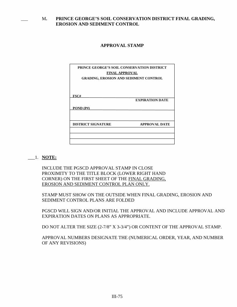
___ M. PRINCE GEORGE’S SOIL CONSERVATION DISTRICT FINAL GRADING,
EROSION AND SEDIMENT CONTROL
APPROVAL STAMP
___1. NOTE: INCLUDE THE PGSCD APPROVAL STAMP IN CLOSE PROXIMITY TO THE TITLE BLOCK (LOWER RIGHT HAND CORNER) ON THE FIRST SHEET OF THE FINAL GRADING, EROSION AND SEDIMENT CONTROL PLAN ONLY.
STAMP MUST SHOW ON THE OUTSIDE WHEN FINAL GRADING, EROSION AND SEDIMENT CONTROL PLANS ARE FOLDED PGSCD WILL SIGN AND/OR INITIAL THE APPROVAL AND INCLUDE APPROVAL AND EXPIRATION DATES ON PLANS AS APPROPRIATE. DO NOT ALTER THE SIZE (2-7/8” X 3-3/4”) OR CONTENT OF THE APPROVAL STAMP.
APPROVAL NUMBERS DESIGNATE THE (NUMERICAL ORDER, YEAR, AND NUMBER OF ANY REVISIONS)
III-75
PRINCE GEORGE’S SOIL CONSERVATION DISTRICT
FINAL APPROVAL
GRADING, EROSION AND SEDIMENT CONTROL FSC# EXPIRATION DATE POND (P#) DISTRICT SIGNATURE APPROVAL DATE

PAGE LEFT INTENTIONLY BLANK
III-76

PRINCE GEORGE'S SOIL CONSERVATION DISTRICT FINAL
GRADING, EROSION AND SEDIMENT CONTROL PLAN APPROVAL STAMP
(EXAMPLES)
PRINCE GEORGE'S SOIL CONSERVATION DISTRICT FINAL APPROVAL
GRADING, EROSION AND SEDIMENT CONTROL
FSC# 44-13-00
_____ 2. ENGINEER IS TO INCLUDE THE APPROVAL STAMP IN THE LOWER RIGHT HAND CORNER OF THE FIRST SHEET OF THE GRADING, EROSION AND SEDIMENT PLAN. (THIS SIZE ONLY) ADD FINAL GRADING, EROSION AND SEDIMENT CONTROL PLAN NUMBER FSC# WHEN ASSIGNED BY THE DISTRICT GRADING, EROSION AND SEDIMENT CONTROL APPROVAL WITH ROUGH GRADING PERMIT COMBINED CONCEPT, SITE DEVELOPMENT AND FINAL APPROVAL
EXPIRATION DATE POND P# X DISTRICT SIGNATURE APPROVAL DATE
PERMIT 1084-2013-G
SSC# 44-13-00 CSC# 44-13-00
PRINCE GEORGE'S SOIL CONSERVATION DISTRICT
FINAL APPROVAL GRADING, EROSION AND SEDIMENT CONTROL
FSC# 98-13-00
_____ 3. GRADING, EROSION AND SEDIMENT CONTROL APPROVAL AND SMALL POND APPROVAL. ADD POND NUMBER P# WHEN ASSIGNED BY THE DISTRICT. ADD DPWT FOR COUNTY ACCEPTED PONDS YOU MAY HAVE MULTIPLE POND NUMBERS, ONE FOR EACH POND APPROVAL. IDENTIFY EACH POND WITH A POND # i.e.: (Pond #1) 10-13-00 (Pond #2) 11-13-00
EXPIRATION DATE POND (Pond #1) (Pond #2) P# 10-13-00 DPWT 11-13-00 DPWT DISTRICT SIGNATURE APPROVAL DATE
PRINCE GEORGE'S SOIL CONSERVATION DISTRICT
FINAL APPROVAL GRADING, EROSION AND SEDIMENT CONTROL
FSC# 156-13-00
_____ 4. GRADING, EROSION AND SEDIMENT CONTROL APPROVAL AND A S.W.M. POND STRUCTURE REVIEWED AND MET EXEMPTION CRITERIA. ADD POND NUMBER P# EXEMPT
EXPIRATION DATE POND
P# 12-13-00 EXEMPT
DISTRICT SIGNATURE APPROVAL DATE
III-77

PRINCE GEORGE'S SOIL CONSERVATION DISTRICT FINAL
GRADING, EROSION AND SEDIMENT CONTROL PLAN APPROVAL STAMP
(EXAMPLES)
PRINCE GEORGE'S SOIL CONSERVATION DISTRICT FINAL APPROVAL
GRADING, EROSION AND SEDIMENT CONTROL
FSC# 101-13-00
_____ 5. PGSCD GRADING, EROSION AND SEDIMENT CONTROL APPROVAL AND POND APPROVED BY STATE OF MARYLAND DEPARTMENT OF THE ENVIRONMENT ADD MDE FOR POND NUMBER EXPIRATION DATE
POND P# MDE DISTRICT SIGNATURE APPROVAL DATE
PRINCE GEORGE'S SOIL CONSERVATION DISTRICT
FINAL APPROVAL GRADING, EROSION AND SEDIMENT CONTROL
FSC# 131-13-00
_____ 6. GRADING, EROSION AND SEDIMENT CONTROL APPROVAL AND SMALL POND APPROVAL THAT HAS REVISED APPROVAL. ADD REVISION# GRADING, EROSION AND SEDIMENT CONTROL APPROVAL AND SMALL POND APPROVAL THAT HAS UPDATE APPROVAL FOR ADDITIONAL 2 YEARS. (NOTE: MINING AND FILL SITES HAVE A 5 YEAR APPROVAL). ADD UPDATE#
EXPIRATION DATE POND P# 54-13 DISTRICT SIGNATURE APPROVAL DATE
REVISION #1
UPDATE #1
PRINCE GEORGE'S SOIL CONSERVATION DISTRICT
FINAL APPROVAL GRADING, EROSION AND SEDIMENT CONTROL
FSC# 272-13-00
_____ 7. GRADING, EROSION AND SEDIMENT CONTROL APPROVAL AND A SMALL POND APPROVAL WITH AN ACCEPTED POND AS-BUILT FOR MULTIPLE PONDS INDENTIFY WHICH PONDS AND POND NUMBERS ARE AS-BUILTS
EXPIRATION DATE POND P# 60-13-00 DISTRICT SIGNATURE APPROVAL DATE
AS-BUILT
III-78

FROM: PRINCE GEORGE'S
SOIL CONSERVATION DISTRICT FINAL
GRADING, EROSION AND SEDIMENT CONTROL PLAN TRANSMITTAL LETTER
(Required for each submittal) TO: PRINCE GEORGE'S SOIL CONSERVATION DISTRICT 5301 MARLBORO RACE TRACK RD. UPPER MARLBORO, MD 20772 301-574-5162 x 3 301-574-5156 Fax
DATE:
ATTENTION:
FSC#
RE:
REFERENCE SSC#
SUBMITTED FOR: ____Final Grading, Erosion and Sediment Control Plan Review (FSC) ____Pond Review (P) ____Pond As-Built Review (AB) (Always submit two sets of prints for review)
TYPE OF SUBMITTAL: ___New ___Resubmission ____Revision ____Update ___ Green Stamp Copies ____Final Approval (Include originals & four prints) Do Not Send Until Requested
COPIES DESCRIPTION
INFORMATION ENCLOSED: Check appropriate spaces
Final Grading, Erosion and Sediment Control Plan Final Pond Plan As-Builts ___Review Fees ___2 Sets of Prints (folded) ___2 Sets of Prints (folded) ___2 Sets of Prints (folded) ___Signed Certifications ___Signed Certifications: ___Signed Certifications ___Computations As Built Cert ___Plans Sealed ___Soils Report Geotech Cert ___Site Analysis Sheet ___Hazard Class Vegetative Cert ___Soil Boundaries ___Drainage Area Map: ___Red-Lined ___Drainage Area Map TC, RCN, Soils, etc. ___Boxed or Checked ___SWM Concept Plan & ___Small Pond Approval Letter (2) ___All Supporting Info Approval Letter ___MD-378 Pond Summary (2) and Comps ___Site Plan ___O&M Plan (2) ___Limits/Property Lines ___Landscape Plan ___SC Plan ___Final Small Pond Exemption COMMENTS:________________________________________________________________________________________ _____________________________________________________________________________________________________ _____________________________________________________________________________________________________ _____________________________________________________________________________________________________ PRINT NAME____________________________________________________________PH#________________________ EMAIL ADDRESS____________________________________________________
III-79
III- III-

PRINCE GEORGE'S SOIL CONSERVATION DISTRICT FINAL GRADING, EROSION AND SEDIMENT CONTROL PLAN
SITE ANALYSIS (Required for each new submittal or revision)
NAME OF PROJECT IN TITLE BLOCK: _______________________________________________________________________________
1. Final Grading, Erosion and Sediment Control Plan Review Amount
Application Fee $100.00 ________________ ______5,000 sq. ft. – 1.0 Disturbed Acre = $200.00 (minimum 1 acre) ________________ ______>1.0 – 5.0 Disturbed Acres = $100.00 per acre ________________ ______>5.0 Disturbed Acres = $ 50.00 per acre ________________
Pond Review
______Pond(s) $100.00 (each) ________________ ______Pond exemption(s) $ 50.00 (each) ________________ ______Pond As-Built(s) $100.00 (each) ________________ Total Due ________________ Compute fees above one acre to the nearest 1/10th acre.
NOTE: Checks or money orders ONLY made payable to Prince George's Soil Conservation District (no cash or credit/debit cards accepted).
2. Location P.G. Co. Street Map Book Coordinates ____________________________________
3. StreetAddress________________________________________________________________ ___________________________________________________________________________
4. Area of Site/Property _____________________ ac.
5. Area to be Disturbed _____________________ ac.
6. Area to Vegetatively Stabilized ____________________ ac.
7. Existing Site Conditions: Wooded __________ Grass ___________ Cropland _________
Disturbed/Graded ______________ Other ______________ 8. SWM Permit/Inspection Agency 9. Sediment Control Permit/Inspection Agency ___________M.D.E. __________M.D.E. ___________Prince George's County __________Prince George's County ___________City of Bowie __________City of Bowie __________City of Greenbelt __________City of Laurel __________Other ____________________
10. Utilities Proposed: Storm Drain _________ Sewer __________ Water _______ Septic________ Gas ____________ Electric ___________
Utilities Existing: Storm Drain _________ Sewer __________ Water _______ Septic ________ Gas ____________ Electric ___________
11. SWM Events Attenuated _________________________________________________________
12. Storm Drainage Approval Agency __________________________________________________ 13. 100-year Flood Plain on site? _________ Yes _______________ Elevations __________ No
14. Critical Area Requirements? _____________________ Yes ________________ No
15. Wetlands On-Site? ____________Yes __________ No __________Approval Agency
REFERENCE SSC#________________________________________ III-80
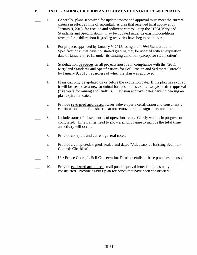
___ P. FINAL GRADING, EROSION AND SEDIMENT CONTROL PLAN UPDATES ___ 1. Generally, plans submitted for update review and approval must meet the current criteria in effect at time of submittal. A plan that received final approval by
January 9, 2013, for erosion and sediment control using the “1994 Maryland Standards and Specifications” may be updated under its existing conditions (except for stabilization) if grading activities have begun on the site. ___ 2. For projects approved by January 9, 2013, using the “1994 Standards and Specifications” that have not started grading may be updated with an expiration date of January 8, 2015, under its existing condition (except for stabilization). ___ 3. Stabilization practices on all projects must be in compliance with the “2011 Maryland Standards and Specifications for Soil Erosion and Sediment Control” by January 9, 2013, regardless of when the plan was approved. ___ 4. Plans can only be updated on or before the expiration date. If the plan has expired it will be treated as a new submittal for fees. Plans expire two years after approval (five years for mining and landfills). Revision approval dates have no bearing on plan expiration dates. ___ 5. Provide re-signed and dated owner’s/developer’s certification and consultant’s certification on the first sheet. Do not remove original signatures and dates. ___ 6. Include status of all sequences of operation items. Clarify what is in progress or completed. Time frames need to show a sliding range to include the total time an activity will occur. ___ 7. Provide complete and current general notes. ___ 8. Provide a completed, signed, sealed and dated “Adequacy of Existing Sediment Controls Checklist”. ___ 9. Use Prince George’s Soil Conservation District details if those practices are used. ___ 10. Provide re-signed and dated small pond approval letter for ponds not yet constructed. Provide as-built plan for ponds that have been constructed. III-81

PAGE LEFT INTENTIONLY BLANK
III-82

___ Q. ADEQUACY OF EXISTING SEDIMENT CONTROLS CHECKLIST (Use for All Revisions, Updates, or Supersedes)
When plans are submitted for revision, update, or supersede approval the engineer shall include the following checklist. The completed checklist is to be based on field observations of any existing sediment controls. Include comments or corrective action as needed on the check list and in the plan sequence. Include any inspection reports or stop work orders related to the plan submittal issued by the sediment control inspector. Plan Name ____________________________________________ FSC#______________________ GRADING AND STABILIZATION ____ B.1 Stabilized Construction Entrance
_____ a. Location per plan _____ b. Proper materials (stone size and filtercloth) _____ c. Proper length and width _____ d. Adequate diversion of water flows _____ e. Proper maintenance and removal of mud _____ f. Wash rack properly installed and maintained
____ B.3 Benching _____ a. Location per plan _____ b. Proper outlets installed _____ c. Proper grading, slope and depth _____ d. Incremental stabilization ____ B.4 Vegetative Stabilization _____ a. Soil testing, site over 5 acres disturbed _____ b. Adequate topsoil stockpiles _____ c. Proper topsoil application _____ d. Proper water conveyance practices for incremental stabilization _____ e. Proper soil stabilization matting on channels and slope >3:1
_____ f. Adequate 95% cover for sediment controls _____ g. Adequate 95% cover for steep slopes >3:1 _____ h. Mulch and anchoring (for non seeding dates) _____ i. All other areas within 1 week of grading (95% cover)
WATER CONVEYANCE ____ C.1 Earth Dikes
_____ a. Positive drainage is maintained _____ b. Maximum slope is not steeper than 10% _____ c. Flow area of dike stabilized
_____ (1) Required flow width _____ (2) Seed and mulch _____ (3) Seed and matting _____ (4) 4" – 7" stone
_____ d. Compacted with no inappropriate materials _____ e. Stabilized outlet – non-erosive _____ f. Adequate vegetative stabilization (95% cover)
III-83
____ C.5 Temporary Asphalt Berm _____ a. Location per plan _____ b. Proper height and width _____ c. Positive drainage is maintained _____ d. Proper outlet ____ C.6 Clear Water Diversion _____ a. Location per plan _____ b. Proper materials (pipes, sandbags and sheeting) _____ c. Proper height sand bags _____ d. Proper outlet protection _____ e. Proper dewatering ____ C.8 Mountable Berm _____ a. Location per plan _____ b. Proper materials (stone, filter cloth and piping) _____ c. Proper length, width and height _____ d. Adequate conveyance of water flows ____ C.9 Diversion Fence _____ a. Proper slope >10% _____ b. Proper materials and installation _____ c. Proper flow channel protection _____ d. Proper nonerosive outlet EROSION CONTROL ____ D.1 Pipe Slope Drain _____ a. Location per plan _____ b. Proper materials (pipe, stone and geotextiles) _____ c. Proper points of inflow and outlet _____ d. Slope drain properly anchored _____ e. Proper height of berm over pipe ____ D.3 Inflow Protection _____ a. Slopes >4:1 for riprap _____ b. Slopes >2:1 for gabions _____ c. Proper materials (stone, geotextile and baskets) _____ d. Proper Entrance and Exit sections _____ e. Proper 0% outlet slope ____ D.4 Outlet Protection _____ a. Proper dimensions (length, width and depth) _____ b. Proper materials (stone and geotextile) _____ c. Proper 0% slope _____ d. Non-erosive downstream channel III-84
FILTERING ____ E.1 Silt Fence
_____ a. Proper size and materials _____ b. No concentrated flows _____ c. Parallel to contours _____ d. Adequately embedded into ground _____ e. No disturbance downstream
____ E.3 Super Silt Fence _____ a. Proper size and materials _____ b. No concentrated flows _____ c. On contour, no section over 5% more than 50' _____ d. Adequately embedded into ground _____ e. No disturbance downstream ____ E.5 Filter Berm _____ a. Proper size and materials _____ b. No concentrated flows _____ c. On contour, no section over 5% more than 50' _____ d. No disturbance downstream ____ E.6 Filter Log _____ a. Proper size and materials _____ b. No concentrated flows _____ c. Proper trenching and staking _____ d. Placed on the contour ____ E.9 Storm Drain Inlet Protection _____ a. Proper materials and construction _____ b. No flow bypass _____ c. Proper trenching and staking _____ d. Clogging – needs cleaning DEWATERING ____ F.2 Sump Pit _____ a. Clogging – needs cleaning _____ b. Proper size and materials _____ c. Proper discharge to non-erosive area _____ d. Location per plan ____ F.4 Filter Bag _____ a. Proper materials _____ b. Proper base (size and materials) _____ c. Clogging – needs cleaning _____ d. Proper slope and discharge III-85

SEDIMENT TRAPPING
____ G.1 Sediment Trap(s) #
_____ a. Outlet Structure _____ (1) Proper size _____ (2) Proper materials
_____ b. Check structure for leaking _____ (1) Between barrel and riser (pipe outlet) _____ (2) Trap not holding water _____ (3) At riser base (pipe outlet) _____ (4) Piping along barrel (pipe outlet)
_____ c. Embankment conditions _____ (1) Adequate vegetative stabilization (95% cover) _____ (2) Proper side slopes and top width _____ (3) Inappropriate material in embankment (roots, rocks) _____ (4) Trees growing on embankment
_____ d. Storage of trap _____ (1) Proper dimensions _____ (2) Needs cleaning out
_____ e. Proper relative elevations _____ (1) Between weir crest and top of embankment (1 foot)
_____ f. Dewatering (pipe outlet) _____ (1) 1⁄2" hardware cloth and geotextile fabric _____ (2) Clogging – needs cleaning
_____ g. Trash rack/anti-vortex device existing per plan design (pipe outlet) _____ h. Baffle adequate (if required)
_____ (1) Proper material and location _____ (2) 6" above weir crest _____ (3) 6" minimum in ground
_____ i. Pipe slope drain (into trap where necessary) _____ 1) Geotextile inflow apron _____ (2) Anchors _____ (3) Rip-rap outlet protection
_____ j. Rip-rap outlet protection (pipe outlet) _____ (1) Filter cloth _____ (2) Adequate length and width _____ (3) Silted up (needs cleaning)
_____ k. Safety fence adequate (if required or utilized) _____ (1) Proper materials _____ (2) Does not interfere with weir outlet
____ G.2 Basin(s) #
_____ a. Barrel and riser _____ (1) Proper size _____ (2) Proper materials
_____ b. Check structure for leaking: _____ (1) Between barrel and riser _____ (2) Basin not holding water _____ (3) At riser base III-86

_____ c. Embankment conditions _____ (1) Adequate vegetative stabilization (95% cover) _____ (2) Proper side slopes and top width _____ (3) Inappropriate material in embankment (roots, rocks) _____ (4) Trees growing on embankment
_____ d. Storage of basin _____ (1) Proper dimensions _____ (2) Cleanout elevation marked on riser _____ (3) Needs cleaning out
_____ e. Condition of emergency spillway _____ (1) Proper dimensions _____ (2) Proper stabilization _____ (3) Proper 25 foot level section
_____ f. Proper relative elevations _____ (1) Between riser crest, emergency spillway and top of dam (one foot
minimum freeboard to top of embankment-two foot for permanent ponds)
_____ g. Dewatering device _____ (1) Proper material and size _____ (2) Proper elevation _____ (3) Watertight end cap _____ (4) Support rod _____ (5) 1⁄2" hardware cloth and geotextile fabric _____ (6) Clogging-needs cleaning
_____ h. Trash rack/anti-vortex device existing per plan design _____ i. Baffle adequate (if required)
_____ (1) Proper materials and location _____ (2) 6" above riser crest _____ (3) 6" minimum in ground
_____ j. Pipe slope drain (into basin where necessary) ____ (1) Geotextile inflow apron _____ (2) Anchors _____ (3) Rip-rap outlet protection
_____ k. Rip-rap outlet protection _____ (1) Filter cloth _____ (2) Adequate length and width _____ (3) Silted up (needs cleaning)
_____ l. Safety fence adequate (if required or utilized) _____ (1) Proper materials _____ (2) Does not interfere with emergency spillway
_____ m. Permanent ponds utilized as basins _____ (1) Accepted As-Built _____ (2) Opening(s) blocked (watertight) to basin riser crest elevation
____ H. Miscellaneous Signature Seal Date
III-87

PAGE LEFT INTENTIONLY BLANK
III-88

___ R. MINOR PLAN CHANGES ___ 1. Minor changes are made in the field with the approval or direction of the inspector. Such changes are not required to be approved by the Prince George’s Soil Conservation District. These include: ___ a. Adjustment of sediment control feature to meet field contours. ___ (1) No change allowed in storage capacity or minimum criteria. ___ b. Adjustments to allow for positive drainage. ___ c. Increase size of sediment control feature from minimum design. ___ (1) No change allowed in pipe size. ___ d. Addition of earth dikes, SOS, straw bales or silt fence where needed - not replacement for another required practice or poor phasing. ___ e. Addition of stabilized construction entrance where needed or devices to allow crossing of berms and swales. ___ f. Addition to trapping devices greater than minimum requirements; does not relate to riprap changes. ___ g. Emergency measures needed to minimize/eliminate a problem needing immediate attention. Emergency measures of a major plan change nature shall be referred to the Prince George’s Soil Conservation District. ___ h. Alternate method of stabilization of disturbed areas and/or sediment control practices as taken from the Standards and Specifications. ___ i. Incidental disturbance beyond approved limit of disturbance that are immediately stabilized. ___ j. Addition of stockpiles incidental to installation of sediment control practices. ___ 2. Minor plan changes to a District approved Final Grading, Erosion and Sediment Control Plan are to be shown on the plan, initialed and dated by the appropriate inspector. (i.e., Prince George’s County, City of Bowie, City of Laurel and City of Greenbelt). ___ 3. Revisions to the approved minor plan changes list cannot be made unless approved by the Prince George’s Soil Conservation District and the Maryland Department of the Environment. III-89
___ S. MAJOR PLAN CHANGES ___ 1. Major changes require revised plans submitted to the Prince George’s Soil Conservation District from Prince George’s County, City of Bowie, City of Laurel and City of Greenbelt. ___ a. Recommending practices when the plan has not been followed. ___ b. Phasing change on the plan. ___ c. Changing size of practices. ___ (1) Eliminating or decreasing storage area. ___ d. Substituting for required practices. ___ e. Allowing temporary seeding when permanent seeding is required. ___ f. Decreasing minimum size of trap, berm, stone outlet, size and type of stone, pipes, etc. ___ g. Allowing on-site grading changes which: ___ (1) Alter drainage area, e.g., retaining walls, benches, storm drain, etc.; ___ (2) Steepen slopes, lengthen slopes; ___ (3) Concentrate flows; ___ (4) Extend grading beyond disturbed limits. ___ h. Any sediment control practice not included in the Standards and Specifications for Soil Erosion and Sediment Control. ___ 2. Revisions to the approved major plan changes list cannot be made unless approved by the Prince George’s Soil Conservation District and the Maryland Department of the Environment. III-90
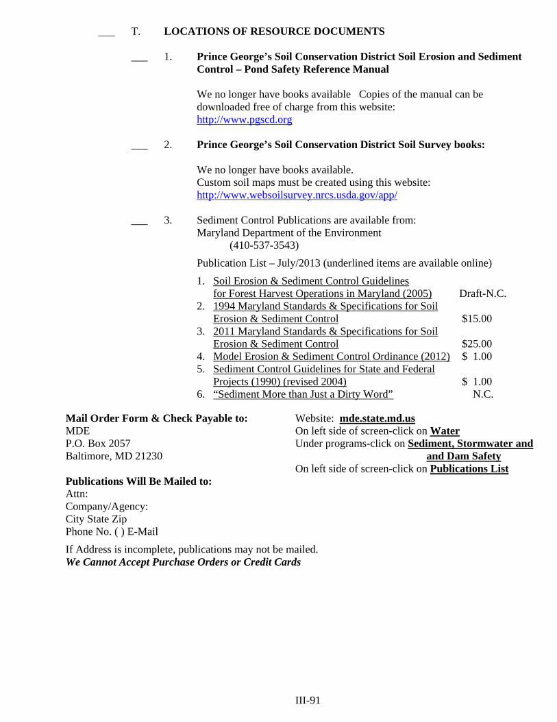
___ T. LOCATIONS OF RESOURCE DOCUMENTS ___ 1. Prince George’s Soil Conservation District Soil Erosion and Sediment Control – Pond Safety Reference Manual We no longer have books available Copies of the manual can be downloaded free of charge from this website: http://www.pgscd.org ___ 2. Prince George’s Soil Conservation District Soil Survey books: We no longer have books available. Custom soil maps must be created using this website: http://www.websoilsurvey.nrcs.usda.gov/app/ ___ 3. Sediment Control Publications are available from: Maryland Department of the Environment (410-537-3543)
Publication List – July/2013 (underlined items are available online)
1. Soil Erosion & Sediment Control Guidelines for Forest Harvest Operations in Maryland (2005) Draft-N.C.
2. 1994 Maryland Standards & Specifications for Soil Erosion & Sediment Control $15.00
3. 2011 Maryland Standards & Specifications for Soil Erosion & Sediment Control $25.00
4. Model Erosion & Sediment Control Ordinance (2012) $ 1.00 5. Sediment Control Guidelines for State and Federal
Projects (1990) (revised 2004) $ 1.00 6. “Sediment More than Just a Dirty Word” N.C.
Mail Order Form & Check Payable to: Website: mde.state.md.us MDE On left side of screen-click on Water P.O. Box 2057 Under programs-click on Sediment, Stormwater and Baltimore, MD 21230 and Dam Safety On left side of screen-click on Publications List Publications Will Be Mailed to: Attn: Company/Agency: City State Zip Phone No. ( ) E-Mail
If Address is incomplete, publications may not be mailed. We Cannot Accept Purchase Orders or Credit Cards III-91

PAGE LEFT INTENTIONLY BLANK
III-92

SECTION IV
PRINCE GEORGE’S SOIL CONSERVATION DISTRICT
STANDARD
GRADING, EROSION AND SEDIMENT CONTROL PLAN


___ A. STANDARD EROSION AND SEDIMENT CONTROL PLAN CHECKLIST The following information is presented to assist with the preparation of Standard Erosion and Sediment Control Plan Form ___ 1. Form Preparation ___ a. The standard erosion and sediment control plan shall not be used in actively developing subdivisions and can only be approved by Prince George’s Soil Conservation District. ___ b. Exemption to the State Sediment Control Law. No sediment control plan is needed for: ___ (1) Construction of a single family home on a lot of two acres or more when the disturbed area is less than ½ acre. ___ (2) Grading that involves less than 5,000 square feet and/or 100 cubic yards of earth. ___ c. Provide Prince George’s County approved SWM plans showing ESD to the MEP or exemption/wavier. ___ d. Include PGSCD soils map and identify any highly erodible soils. ___ e. The Standard Erosion and Sediment Control Plan review fee will be required before processing the plan. ___ f. Include four copies of the site plan in accordance with Prince George’s County Building Code, Subtitle 32, Division 2,
Section 32.130 with enough information to show that the minimum required conditions are met as stated on the Standard Erosion and Sediment Control Plan form. Include four completed copies of the form. The form may be included on the site plan.
___ g. Ensure that all the blocks on the Standard Erosion and Sediment Control Plan form are completed except Part C. Sediment Controls and the Prince George’s Soil Conservation District approval block. Sediment control requirements will be filled out by the District reviewer. ___ h. The form must be signed and dated by the owner/developer. Note: Representative must have a letter of authorization. IV-1

___ B. PRINCE GEORGE’S COUNTY NONTIDAL WETLANDS OF SPECIAL STATE CONCERN ___ 1. Beck Woods Laurel ___ 2. Belt Woods Lanham ___ 3. Beltsville Airport Bog Laurel ___ 4. Beltsville Bottomland Forest Laurel, Beltsville ___ 5. Beltsville Forest and Meadow Laurel ___ 6. Beltsville Seasonal Bog Laurel ___ 7. Buck Lodge Road Bog Beltsville ___ 8. Chews Lake Bristol ___ 9. Fort Ravine Mount Vernon ___ 10. Johnson’s Gully Mount Vernon ___ 11. Huntington Park Woods Laurel ___ 12. Patuxent Maple Swamp Bowie ___ 13. Patuxent W.R.C. Laurel ___ 14. Route I-95 Bog Beltsville ___ 15. Southwest Branch Bottomland Forest Lanham Upper Marlboro ___ 16. Suitland Bog Anacostia ___ 17. Watkins Regional Park Lanham ___ 18. Zekiah Swamp Brandywine NONTIDAL WETLANDS OF SPECIAL STATE CONCERN LOCATED IN THE CRITICAL AREA ___ 19. Magruder Ferry Seep Lower Marlboro ___ 20. Mockley Swamp Mount Vernon ___ 21. Upper Patuxent Marshes Natural Heritage Area Bristol
• No earth disturbance shall occur within 25 feet of any nontidal wetland or within 100 feet of any nontidal wetland of special State concern.
• 1989 Nontidal Wetlands Guidance Maps 1:24000 are available by appointment
only for viewing within the office. IV-2

PRINCE GEORGE'S SOIL CONSERVATION DISTRICT STANDARD EROSION AND SEDIMENT CONTROL PLAN
(Not for use in actively developing subdivisions) See checklist to complete form – www.PGSCD.org
Project Name________________________________________________Lot________Block_______________ Site Address_____________________________________________________________________________ Street City State Zip Owner/Developer_____________________________________________________________________ Name Phone ___________________________________________________________________________________
Address State Zip
Lot Area_________________square feet Area Disturbed_______________square feet I (We) certify that the following conditions will be met: A. Grading
1. Attached signed and sealed site plan (with vicinity map) showing proposed development with grades and/or flow arrows. Include a narrative/sequence of construction. Include soils map.
2. No contiguous lots are undergoing development. 3. Total disturbed area does not exceed 30,000 square feet 4. No cut or fill will exceed 3 feet (existing to final grade). 5. Volume of grading or earth disturbance involved does not exceed 1,000 cubic yards. 6. No earth disturbance shall occur within the limits of the 100-year floodplain of any stream, or
100 feet of any perennial stream, water body, Mean High Water Line of any water body affected by tidal action, or tidal wetland.
7. No earth disturbance shall occur within 25 feet of any nontidal wetland or within 100 feet of any Nontidal Wetland of Special State Concern.
8. No earth disturbance shall occur on highly erodible soils and steep slopes 15% or greater. 9. The proposed work is not located in High Quality (TIER II) waters in Prince George’s County per
COMAR 26.08.02.04. 10. The proposed work is not located in Water Impaired Stream Segments and Tributaries for sediments in Prince George’s County. 11. The proposed work does not require a State Waterway or Wetland Permit. 12. There will be no final graded slope steeper than 3:1. 13. No fill will be placed on any existing slope steeper than 5:1. 14. Initial earth disturbance shall be limited to installing sediment controls. 15. All fills will be free of any organic or other deleterious material and will be compacted.
All areas to receive fill will have the ground surface prepared by removing all existing vegetation. 16. The proposed grading will not impair existing surface drainage, constitute a
potential erosion hazard, or a source of sedimentation to any adjacent property or right-of-way.
B. Stormwater Management Coordination with Sediment Controls 1. Provide Prince George’s County approved Stormwater Management Plan showing environmental
site design (ESD) practices are used to the maximum extent practicable (MEP). 2. Final grading for ESD practices should not take place until the surrounding site is stabilized. If
this cannot be accomplished, runoff from disturbed areas shall be diverted around proposed ESD practices using approved water conveyance practices (i.e.: Earth Dikes or Diversion Fence) to a safe outlet.
IV-3

C. Sediment Controls
Provide sediment controls below disturbed area to prevent sediment from being transported off-site. For details, specifications, and maintenance for sediment controls and vegetative stabilization, refer to the "2011 Maryland Standards and Specifications for Soil Erosion and Sediment Control" or any subsequent revisions. Any controls that are damaged or disturbed shall be restored or repaired before the end of each day. Any pumping of water must be filtered through an approved filtering device.
Stabilized Construction Entrance___________ ____________Super Silt Fence_____________________ Stone Outlet Structure____________________________Earth Dikes_____________________________ Diversion Fence_________________________________Filter Berm_____________________________ Filter Log __________________________Storm Drain Inlet Protection___________________________ Other________________________________________________________________________________ _____________________________________________________________________________________ _____________________________________________________________________________________ _____________________________________________________________________________________ D. Stabilization 1. Following initial soil disturbance or redisturbance, permanent or temporary stabilization shall be
completed within: a. Three calendar days for surface of all perimeter controls, and all perimeter slopes.
b. Seven calendar days for all other disturbed or graded areas. 2. Provide topsoil uniformly 5 to 8 inches deep, lightly compacted to a minimum thickness of 4 inches prior to establishment of permanent vegetation. Topsoil stockpiled from the existing site may be used if the material meets the standards. I certify that I have the authority to make the foregoing application; that the information above and on the attached site plan is correct; and that I have the ability to meet all the limitations and conditions set forth by this agreement. Nothing herein relieves the applicant from complying with any and all Federal, State, and local requirements (e.g., Stormwater Management, Chesapeake Bay Critical Area, Forest Conservation, State Waterway or Wetland Permit, Grading, etc.) Owner/Developer's Signature__________________________________________Date______________________________ Owner/Developer's Name_______________________________________________________________________________ (Please Print) Email Address and/or Phone Number Prince George's Soil Conservation District Upper Marlboro, Maryland 20772 Phone: (301)574-5162 x3 Approved by:________________________________________________ S#____________________ Approval Date______________________________ Expiration Date____________________________
(Revised 7/2013)
IV-4

SECTION V
PRINCE GEORGE’S
SOIL CONSERVATION DISTRICT
PGSCD DETAILS
GRADING, EROSION AND SEDIMENT CONTROL PLAN


V-1

PAGE LEFT INTENTIONLY BLANK
V-2
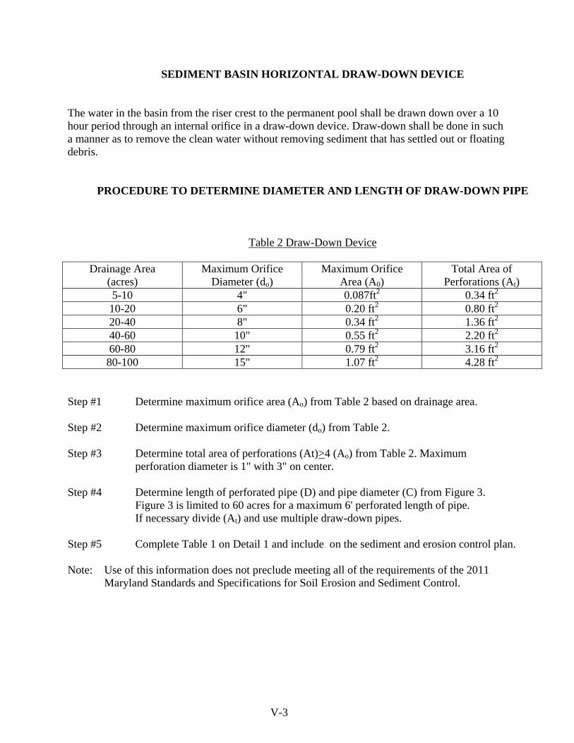
SEDIMENT BASIN HORIZONTAL DRAW-DOWN DEVICE
The water in the basin from the riser crest to the permanent pool shall be drawn down over a 10 hour period through an internal orifice in a draw-down device. Draw-down shall be done in such a manner as to remove the clean water without removing sediment that has settled out or floating debris.
PROCEDURE TO DETERMINE DIAMETER AND LENGTH OF DRAW-DOWN PIPE
Table 2 Draw-Down Device
Drainage Area (acres)
Maximum Orifice Diameter (do)
Maximum Orifice Area (A0)
Total Area of Perforations (At)
5-10 4" 0.087ft2 0.34 ft2 10-20 6" 0.20 ft2 0.80 ft2 20-40 8" 0.34 ft2 1.36 ft2 40-60 10" 0.55 ft2 2.20 ft2 60-80 12" 0.79 ft2 3.16 ft2 80-100 15" 1.07 ft2 4.28 ft2
Step #1 Determine maximum orifice area (Ao) from Table 2 based on drainage area. Step #2 Determine maximum orifice diameter (do) from Table 2.
Step #3 Determine total area of perforations (At)>4 (Ao) from Table 2. Maximum
perforation diameter is 1" with 3" on center.
Step #4 Determine length of perforated pipe (D) and pipe diameter (C) from Figure 3. Figure 3 is limited to 60 acres for a maximum 6' perforated length of pipe. If necessary divide (At) and use multiple draw-down pipes.
Step #5 Complete Table 1 on Detail 1 and include. on the sediment and erosion control plan. Note: Use of this information does not preclude meeting all of the requirements of the 2011
Maryland Standards and Specifications for Soil Erosion and Sediment Control. V-3
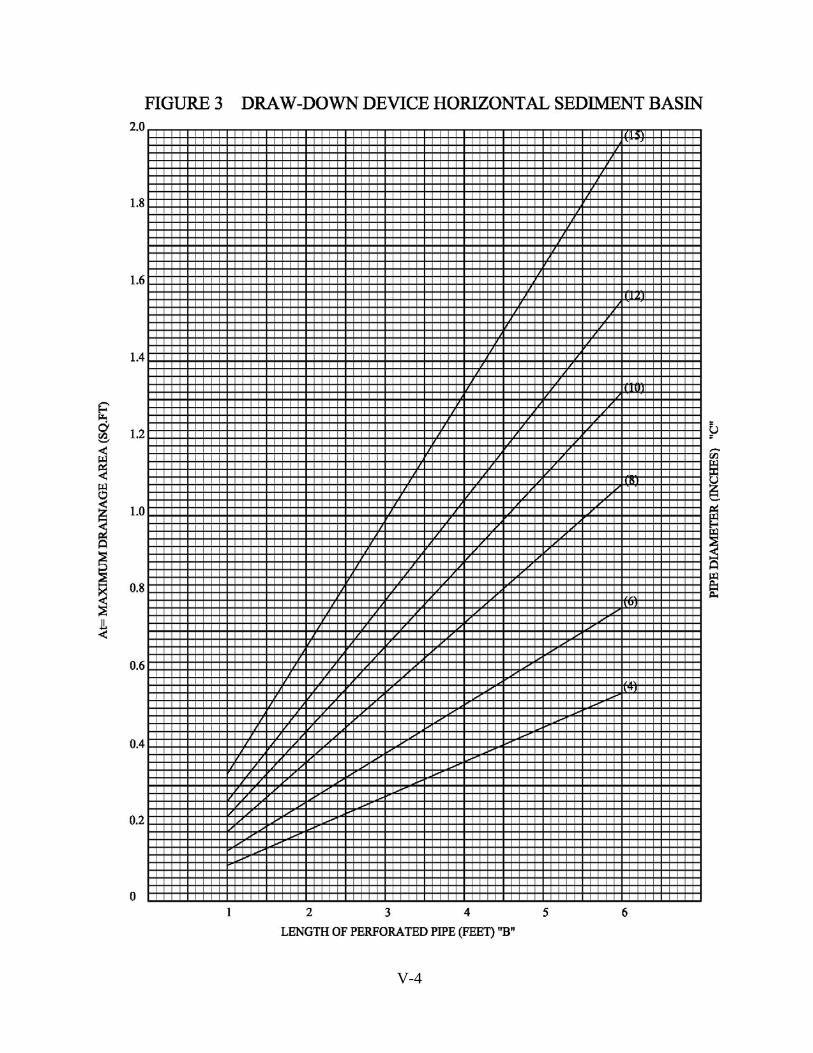
V-4

PAGE V-5

PAGE LEFT INTENTIONLY BLANK
V-6
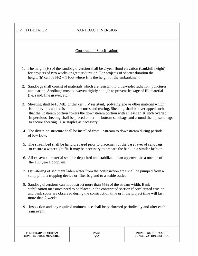
PGSCD DETAIL 2 SANDBAG DIVERSION
Construction Specifications
1. The height (H) of the sandbag diversion shall be 2-year flood elevation (bankfull height) for projects of two weeks or greater duration. For projects of shorter duration the height (h) can be H/2 + 1 foot where H is the height of the embankment. 2. Sandbags shall consist of materials which are resistant to ultra-violet radiation, punctures and tearing. Sandbags must be woven tightly enough to prevent leakage of fill material (i.e. sand, fine gravel, etc.). 3. Sheeting shall be10 MIL or thicker, UV resistant, polyethylene or other material which is impervious and resistant to punctures and tearing. Sheeting shall be overlapped such that the upstream portion covers the downstream portion with at least an 18 inch overlap. Impervious sheeting shall be placed under the bottom sandbags and around the top sandbags to secure sheeting. Use staples as necessary. 4. The diversion structure shall be installed from upstream to downstream during periods of low flow. 5. The streambed shall be hand prepared prior to placement of the base layer of sandbags to ensure a water tight fit. It may be necessary to prepare the bank in a similar fashion. 6. All excavated material shall be deposited and stabilized in an approved area outside of the 100 year floodplain. 7. Dewatering of sediment laden water from the construction area shall be pumped from a sump pit to a trapping device or filter bag and to a stable outlet. 8. Sandbag diversions can not obstruct more than 55% of the stream width. Bank stabilization measures need to be placed in the constricted section if accelerated erosion and bank scour are observed during the construction time or if the project time will last more than 2 weeks. 9. Inspection and any required maintenance shall be performed periodically and after each rain event.
TEMPORARY IN-STREAM CONSTRUCTION MEASURES
PAGE V-7
PRINCE GEORGE’S SOIL
CONSERVATION DISTRICT

PAGE LEFT INTENTIONLY BLANK
V-8
SECTION VI
PRINCE GEORGE’S
SOIL CONSERVATION DISTRICT
FOREST HARVEST
EROSION AND SEDIMENT CONTROL PLAN


___ A. GUIDELINES AND CRITERIA FOR FOREST HARVEST OPERATIONS EROSION AND SEDIMENT CONTROL PLAN PREPARATION AND PLAN REVIEW ___ 1. The Code of Maryland Regulations (COMAR) 26.17.01 Erosion and Sediment Control, has removed forest harvest operations from the agricultural land management practice exemption. Yet, timber harvesting activities have been exempt from the permitting requirements of the Clean Water Act only provided that Best Management Practices (BMPs) are used. The ways in which timber harvests disturb soil are different from typical urban construction. The forest harvest industry therefore, has its own special set of erosion and sediment control measures. A sediment control plan is required for all harvests exceeding 5,000 sq. ft. of disturbed soil area. All sediment control plans submitted to PGSCD for review and approval are to be in conformance with this document and the criteria established in the publication, Maryland’s Erosion and Sediment Control Standards and Specifications for Forest Harvest Operations 2005 Draft, or subsequent revisions. The latest standards represented the first update in over 30 years. Our understanding of how best to protect watersheds during timber harvest activities continues to grow. Recent research into the nature of erosion on forest harvest sites has shown that the vast majority of sedimentation occurs at three primary locations: a) entrance to the site, b) forest access system (haul roads, skid trails and landings), and c) adjacent to watercourses. Proper installation and maintenance of BMPs can effectively counter this disturbance, and the Erosion and Sediment Control Plan’s focus must be on protecting these areas. ___ 2. Review of an erosion and sediment control plan by PGSCD will not be scheduled unless the plan submitted includes the following: Standard Plan and Application Form, Site Plan, Vicinity Map, Tax Map, USGS Topographic map covering the site, copy of deed, Soil Survey Map and Zoning/Agricultural Assessment Information. The PGSCD review fee must be paid upon application. ___ 3. If requested, the PGSCD will, by appointment, continue to provide sediment control planning and technical assistance on specific control problems. Detailed overall sediment control plan review will not be undertaken during these meetings. ___ 4. For sites on which the following conditions are met, the Standard Erosion and Sediment Control Plan alone may be sufficient for approval: ___ a. Road cuts or fills are less than 3 feet. ___ b. Grades for haul roads are less than 15 percent. ___ c. Grades for skid trails are less than 20 percent. ___ d. Landings are located on slopes less than 10 percent. ___ e. Site does not include any Waters of the State or will maintain an uncut and undisturbed Streamside Management Zone. ___ f. Provide a copy of a type II TCP for areas not zoned for open space or residential agriculture. VI-1
___ 5. Sites for which any of these conditions will not be met require preparation of a Custom Grading Erosion and Sediment Control Plan for Forest Harvest. The custom plan must list, detail, and address the strategy behind selection of Best Management Practices used to mitigate the condition and show their proposed locations on the site plan. The custom plan must be prepared by a Maryland licensed Forester. Plans involving non-tidal wetlands, Chesapeake Bay Critical Areas, stream crossings must be of this type.
Whether Standard or Custom Plans are utilized, a Streamside Management Zone Plan (formerly “Buffer management Plan”) is required for harvesting or any disturbance within streamside management zones.
___ 6. Provide the following for Standard Erosion and Sediment control review and approval. Include 7 copies. An erosion and sediment control plan must include:
___ a. Sediment control plan application (VI - C) – Completed site information, landowner and operator information, signed agreement and PGSCD review fee ($100.00).
___ b. Site Plan – Limits/property lines for the entire site. This could be by survey, record plat, or tax map to scale. Provide the following on the site plan.
___ (1) Site Access – stabilized with corduroy logs, wood chips, mats or a stone construction entrance. Indicate method and length (50' minimum).
To prevent blocking of road drainage, pipe culverts shall be installed. Show location and size.
___ (2) Streamside Management Zone – A minimum 50 ft. SMZ buffer is to be shown on all sides of perennial or intermittent streams and waters of the State in accordance with appropriate specifications in the current manual.
The governing relationship is: 50 feet + (2 feet x % slope) = SMZ
Average Percent Slope To Watercourse
Width of SMZ (feet) on Each Side of Watercourse
0 50 5 60 10 70 15 80 20 90
___ (3) Haul Road – delineate any major haul roads and skid trails. ___ (4) Landings – delineate landing areas on reasonably level, well drained ground (between 3-10 percent slope). Use the maximum slope area if site is less than 3%.
___ (5) Harvest Area – delineate limits of harvest. ___ (6) Show stream crossings and provide detail of method to be used. ___ (7) Provide detail and/or specification for each Best Management Practice to be used. VI-2

___ c. Vicinity Map – site specific, to scale, include road identification, and
nearest intersections and distance to. Include enough detail on the vicinity map so that someone unfamiliar with the site can quickly locate it in the field. A photocopy of the P.G. Co. street map from A.D.C. with sheet number will suffice.
___ d. USGS Topo – United States Geological Survey 7.5 Minute Series (topographic) quadrangle map with property boundaries and all perennial or intermittent streams, rivers, lakes, ponds, bogs or marshes delineated. Include quadrangle name. Delineate harvest area.
___ e. Soils Information – Soil Survey map must be created via the Web Soil Survey. Maps should delineate the site as the “Area of Interest” (AOI) as closely as possible. With area properly outlined, navigate to the Soil Data Explorer tab. Continue on to select, Suitablities and Limitations for Use>Land Management>Construction Limitations for Haul road and Log Landings. Submit the color printout of the resulting soil map, ensuring site plan and practices agree with the information it contains.
___ f. Stabilization – To ensure appropriate revegetation provide seeding and mulching specifications for the reestablishment of cover for all disturbed areas (exposed soil) having slopes 10 percent or greater after harvesting VI-E). See NRCS/MD Code 342 for full requirements.
___ g. Standard Erosion and Sediment Control Plan (VI-D).
___ h. (MDE – WMA) General Waterway Construction Permit required for all stream crossings.
___ i. For use of a county maintained road, see Bond and Special Permit Requirements below.
___ 7. Custom Erosion and Sediment Control Plans for Forest Harvest Operations. *Written narrative explaining sediment control precautions required.
___ a. Streamside Management Zone Plan Requirements ___ (1) Meet all the requirements of the Standard Erosion and Sediment
Control Plan for Forest Harvest Operations. ___ (2) Location of SMZ and all sediment controls properly shown on the site plan.
___ (3) Be very specific in describing which trees are to be cut. Trees scheduled for removal are to be individually marked.
___ (5) Method of removal noted. ___ (6) Roads, trails and stream crossings in streamside areas are to be avoided. ___ (a) No new roads or trails shall be permitted within SMZ except to access an authorized stream crossing. ___ (b) Usage of skid trails are to be minimized within SMZ and damage is to be repaired in accordance within the Specification. ___ (7) Basal areas to be removed and retained shall be stated, as well as method of harvest and provision to ensure that sufficient regeneration is established. VI-3

___ (8) Exposed soil within the buffer shall be seeded. Include specifications. ___ (9) Any additional activities shall be explicitly detailed in SMZ plan designed by the Forester. ___ (10) PGSCD may require additional controls where deemed necessary for certain site limitations.
___ b. Non-Tidal Wetland Logging Requirements ___ (1) Meet the requirements of the Standard Erosion and Sediment
Control Plan for Forest Harvest Operations. A Custom plan is recommended and may be required.
___ (2) Wetland area delineated on the plan. (SCD may assist in delineation or review). ___ (3) Written description for sediment control precautions needed. ___ (4) Best Management Practices are listed and shown on the plan. BMP details to be included with plan. ___ (5) Minimize disturbance to the non-tidal wetland hydrology. ___ (6) Exposed soil within the wetland shall be seeded.
Include specifications. ___ (7) Nontidal Wetland BMP checklist (VI-G).
___ 8. Chesapeake Bay Critical Area Forest Harvest Operations
The Chesapeake Bay Critical Area is the land within 1,000 feet of the Chesapeake Bay and its tidal waters or tidal wetlands. Timber harvests in the Chesapeake Bay Critical Area which are regulated by the Critical Area Criteria are one acre or more in size and occur within a one-year interval. The Timber Harvest Plan is to be approved by the District Forestry Board in conjunction with the Prince George’s Soil Conservation District’s approved Standard Erosion and Sediment Control Plan for Forest Harvests.
___ a. Custom Erosion and Sediment Control Forest Harvest Plan ___ (1) Include all requirements as stated above.
___ b. Timber Harvest Plan – for details see Appendix F-2 of Maryland’s Erosion and Sediment Control Standards and Specifications for Forest Harvest Operations 2005 Draft.
___ (1) Meet Forest and Woodland Protection requirements. ___ (2) Include Habitat Protection Areas requirements with,
___ (a) Buffers, ___ (b) Non-tidal wetlands, ___ (c) Habitat for threatened or endangered species, ___ (d) Anadromous fish spawning areas, ___ (e) Other plant and wildlife habitat.
___ 9. County Road Bond ___ a. If accessing logging site from a county road, an entrance permit from the
Dept. of Public Works & Transportation. (VI-H).
*Maryland’s Erosion and Sediment Control Standards and Specifications for Forest Harvest Operations 2005 Draft. VI-4

VI-5

___ B. LOGGER ASSISTANCE FORM County: PRINCE GEORGE’S SOIL CONSERVATION DISTRICT CITY, STATE, ZIP CODE UPPER MARLBORO, MARYLAND 20772 PHONE NUMBER 301-574-5162 x3 CONTACT PERSON URBAN STAFF Inspection Agency for the County: DNR-Forest Service Enforcement Agency: Prince George's Department of Environmental Resources _____________________________________________________________________________________ _____________________________________________________________________________________ Procedure: What steps does a logger need to take to have a Standard/Custom Plan processed? FOLLOW PGSCD FOREST HARVEST EROSION AND SEDIMENT CONTROL GUIDELINES:
Step 1 SUBMIT PLANS FOR REVIEW AND APPROVAL
OFFICE ADDRESS CITY, STATE, ZIP CODE PHONE NUMBER CONTACT PERSON FEE
PRINCE GEORGE’S SOIL CONSERVATION DISTRICT UPPER MARLBORO, MARYLAND 20772 (301) 574-5162 X3 URBAN STAFF $100.00 FOR PLAN REVIEW - PAYABLE TO PGSCD
Step 2: SUBMIT APPROVED PLANS
OFFICE ADDRESS CITY, STATE, ZIP CODE PHONE NUMBER CONTACT PERSON
DEPT. of Permits Inspection and Enforcement (DPIE) 9400 PEPPERCORN PL LARGO, MD 20774 301-883-5776 PERMITS Counter
Step 3: CALL 48 HRS PRIOR TO STARTING
OFFICE ADDRESS CITY, STATE, ZIP CODE PHONE NUMBER CONTACT PERSON
DNR-FOREST SERVICE 6904 Hallowing Lane Prince Frederick, MD 20678 410-595-1303 FOREST SERVICE STAFF
Additional Comments: A standard plan or a modified plan by a registered professional forester will need to be submitted for review and approval. Prince George’s County Critical Area Offices: 301-731-8790 For additional information you may also consult: Guide to Maryland Regulation of Forestry and Related Practices VI-6

VI-7

VI-8

VI-9

VI-10

VI-11
VI-12

VI-13
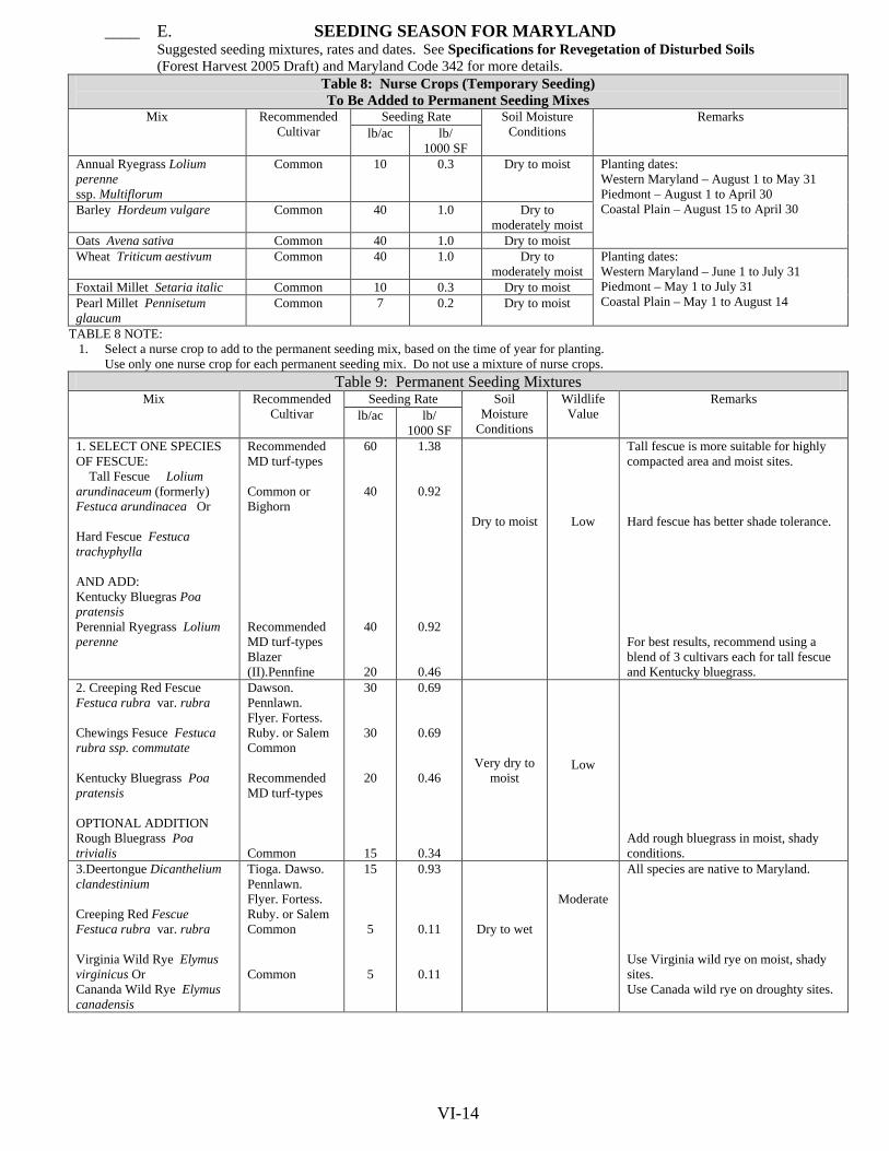
____ E. SEEDING SEASON FOR MARYLAND Suggested seeding mixtures, rates and dates. See Specifications for Revegetation of Disturbed Soils (Forest Harvest 2005 Draft) and Maryland Code 342 for more details.
Table 8: Nurse Crops (Temporary Seeding) To Be Added to Permanent Seeding Mixes
Mix Recommended Cultivar
Seeding Rate Soil Moisture Conditions
Remarks lb/ac lb/
1000 SF Annual Ryegrass Lolium perenne ssp. Multiflorum
Common 10 0.3 Dry to moist Planting dates: Western Maryland – August 1 to May 31 Piedmont – August 1 to April 30 Coastal Plain – August 15 to April 30 Barley Hordeum vulgare Common 40 1.0 Dry to
moderately moist Oats Avena sativa Common 40 1.0 Dry to moist Wheat Triticum aestivum Common 40 1.0 Dry to
moderately moist Planting dates: Western Maryland – June 1 to July 31 Piedmont – May 1 to July 31 Coastal Plain – May 1 to August 14
Foxtail Millet Setaria italic Common 10 0.3 Dry to moist Pearl Millet Pennisetum glaucum
Common 7 0.2 Dry to moist
TABLE 8 NOTE: 1. Select a nurse crop to add to the permanent seeding mix, based on the time of year for planting.
Use only one nurse crop for each permanent seeding mix. Do not use a mixture of nurse crops. Table 9: Permanent Seeding Mixtures
Mix Recommended Cultivar
Seeding Rate Soil Moisture
Conditions
Wildlife Value
Remarks lb/ac
lb/
1000 SF 1. SELECT ONE SPECIES OF FESCUE: Tall Fescue Lolium arundinaceum (formerly) Festuca arundinacea Or Hard Fescue Festuca trachyphylla AND ADD: Kentucky Bluegras Poa pratensis Perennial Ryegrass Lolium perenne
Recommended MD turf-types Common or Bighorn Recommended MD turf-types Blazer (II).Pennfine
60
40
40
20
1.38
0.92
0.92
0.46
Dry to moist
Low
Tall fescue is more suitable for highly compacted area and moist sites. Hard fescue has better shade tolerance. For best results, recommend using a blend of 3 cultivars each for tall fescue and Kentucky bluegrass.
2. Creeping Red Fescue Festuca rubra var. rubra Chewings Fesuce Festuca rubra ssp. commutate Kentucky Bluegrass Poa pratensis OPTIONAL ADDITION Rough Bluegrass Poa trivialis
Dawson. Pennlawn. Flyer. Fortess. Ruby. or Salem Common Recommended MD turf-types Common
30
30
20
15
0.69
0.69
0.46
0.34
Very dry to moist
Low
Add rough bluegrass in moist, shady conditions.
3.Deertongue Dicanthelium clandestinium Creeping Red Fescue Festuca rubra var. rubra Virginia Wild Rye Elymus virginicus Or Cananda Wild Rye Elymus canadensis
Tioga. Dawso. Pennlawn. Flyer. Fortess. Ruby. or Salem Common Common
15
5
5
0.93
0.11
0.11
Dry to wet
Moderate
All species are native to Maryland. Use Virginia wild rye on moist, shady sites. Use Canada wild rye on droughty sites.
VI-14

VI-15

PAGE LEFT INTENTIONLY BLANK
VI-16

___ G. NONTIDAL WETLANDS BEST MANAGEMENT PRACTICES
FOR FOREST HARVEST OPERATIONS
The following is a checklist for your use in determining which best management practices may be appropriate for your project. To meet the requirements of the Nontidal Wetlands Protection Act please submit this checklist and the following information along with the Erosion and Sediment Control Plan: • a wetland delineation • an acknowledgement/approval of landowner • name/address/RPF # of registered professional forester Check when appropriate: ____ Major skid trails, wherever feasible, will be located on soils that resist compaction and ruts,
or other disturbances that adversely impact nontidal wetland hydrology.
____ Appropriate equipment to skid logs will be selected based on slope and the ability of the soil to resist erosion or other disturbances.
____ Truck roads, wherever feasible will be located on uplands or on the highest available ground available as to minimize impact to nontidal wetlands.
____ Truck roads will be of minimum dimensions necessary to accomplish their purpose and minimize impacts to nontidal wetlands.
____ Truck roads will follow the natural contour of the land, wherever feasible, and shall be stabilized to minimize erosion.
____ Wetland hydrology will be maintained by constructing diversion ditches at the minimum depth to maintain flow of water.
____ Wooden mats, filter cloth or similar temporary structures will be used to reduce compaction or creation of ruts.
____ Fill material will be used only when absolutely necessary to maintain or construct a road. If needed, fill shall be excavated from uplands and shall be free from state or federally designated toxic pollutants.
____ Intermittent and perennial streams, sloughs, or channels will not be crossed unless absolutely necessary. When necessary crossings will be at the shortest distance feasible, of appropriate design and allow unrestricted movement of aquatic life in the stream.
NOTE: A WATERWAY CONSTRUCTION PERMIT MAY BE REQUIRED VI-17

_____ Log decks will be, (a) located prior to road layout, (b) located in uplands as far from streams and/or nontidal wetlands as practicable or on the highest available ground if uplands are unavailable, (c) kept to minimum size and number necessary for the operation, and (d) diversion ditches will be installed to direct water away from the deck during use.
_____ Trash, debris, and chemicals will be collected and disposed of outside wetlands areas. _____ Utilization of low ground pressure equipment (i.e.) high flotation tire, wide tracks, etc.) will be used when nontidal wetland soils are unable to support conventional equipment.
_____ Scheduling of forest harvest operations will be during periods when wetland soils are dry or
frozen and are capable of supporting conventional equipment to prevent compaction, ruts, or other significant disturbances to nontidal wetland soils or hydrology.
_____ All forest harvest operations will be conducted so as to prevent impoundment of water or increase runoff in the nontidal wetland, unless the change is recommended in a sediment and erosion control plan.
_____ Harvesting will be conducted during dry periods or at times that enhance natural regeneration.
_____ Natural regeneration will be utilized where feasible and will be the preferred method of regeneration in wetland areas.
_____ Other (Describe additional practices) _________________________________________________________________________________________ _________________________________________________________________________________________ _________________________________________________________________________________________ _________________________________________________________________________________________ _________________________________________________________________________________________ _________________________________________________________________________________________ VI-18

___ H. SPECIAL PERMIT REQUIREMENTS & RESTORATION
OF EXISTING ADJACENT ROADWAYS
The Department of Public Works and Transportation hereby grants permission, which will enable the property owner, or the _______________________________(Agent), to obtain "Special Permit" Number _______________________for transporting approximately_________________ loads of logs per day with commercial/industrial vehicles over a ___________month period. Approximately__________acres of timber will be harvested on the property owned by_______________________________(Parcel/Lot_________Block___________Liber______ Folio_______) Located at _______________________________________________________. (address) Permission, however, to use_______________________________________which is a rural/ (Name of Roadway) urban residential roadway, as a temporary commercial/industrial hauling route, is subject to the operator/applicant following the conditions and adhering to the responsibilities described in the Prince George's County Code, Subtitle 23, Divisions 1 and 2, Sections 23-103 (g), 23-105 (a) (b) (c), 23-107 (b), 23-109(a) (b), and 23-116(a) (d) (e) (1) (A) (ii):
1. Performance Bond Required Because of possible damage to the existing County-maintained roadway, a Performance Bond, or some other form of security in the amount of $5,000, will be required. The Performance Bond will assure restoration of any damage to the existing residential roadway surface, shoulders, side ditches, adjacent shrubbery/trees located within the public right-of-way, underground/above ground utilities, culverts, bridges, underground storm drainage system, curb and gutter, etc., caused by the temporary commercial industrial hauling operation. The Performance Bond shall be held by the DPW&T throughout the duration of the permit and until documentation has been produced by the County which states that said Performance Bond may be released. The security posted to ensure performance shall be certified as discharged upon acceptance of the termination of the use of the specified hauling route and, if applicable, acceptance of the restoration of damage that may have resulted within the public rights-of-way during the performance of the DPW&T issued "Special Permit". However, discharge of the security posted to ensure performance shall not operate as a discharge of any other bonds. In the event that the bond amount collected is not sufficient to cover the damage, if any should result, the operator/permittee, or their agent, should be aware that the County is entitled to bill for any additional costs required for corrective action. The Performance Bond and associated permit fees are to be posted at the DPW&T's Permits counter, located on the 6th floor, 9400 Peppercorn Place, Landover, Md. 20785 (301) 883-5972. 2. Permit Fees Required
A permit fee in the amount of $50 is required. The permit fee is non-refundable and shall be charged to offset the administrative costs incurred.
VI-19

3. Use and Restoration of Existing Adjacent Roadways All adjacent road surfaces should be kept clean of dirt and debris, at all times, attributable to the use of the haul road, as directed by the DPW&T. In order to protect the traveling public at all times, especially during any type of commercial/industrial hauling, flagmen, temporary barricades equipped with flashing lights, traffic cones, and temporary portable signs, shall be required at any time to temporarily regulate traffic, if deemed necessary by the DPW&T Construction Regulation Inspector. It shall be the responsibility of the operator/permittee to notify the DPW&T Construction Regulation Inspector, assigned to the area, 48 hours in advance of commencing with the hauling operations. The Inspector may be reached at (301) 883-5730. The DPW&T Construction Regulation Inspector will immediately review the existing street conditions to monitor visible problems, and will continue to monitor the hauling route at least twice a week throughout the duration of the permit. At the termination of the timber harvest and/or hauling operation, it shall be the responsibility of the operator/permittee to repair any damage determined to be a result of the performance of this permit. The public right-of-way, shall be returned to its original condition or better, as directed by the DPW&T. 4. Other Requirements
The DPW&T permit is issued for the purpose of enabling a legal haul activity within the County-maintained (public) right-of-way. The permit does not authorize the use of private driveways, private right-of-way, State-maintained right-of-way, etc., nor does it authorize public road work other than construction of a temporary stabilized construction entrance (SCE). Every precaution is to be taken to protect adjacent properties from damage through the performance of this permit. Prince George's County assumes no responsibility for any suits or actions resulting from any work executed under this permit. Failure to comply with the conditions and requirements will result in revocation of the permit. Failure to comply will also be considered a violation of the Road Ordinance and the operator/permittee will be subject to penalty.
NOTE: Where applicable, the application submitted for the permit shall be accompanied by a letter, from adjacent property owners, which provides the written consent to temporarily use/cross private property/private road with commercial/industrial vehicles. I, the undersigned, do hereby certify that I have read the above requirements/general specifications, and I do understand that I am obligated to comply and obtain a permit. _________________________________ ______________________________ WITNESS PERMITTEE VI-20

SECTION VII
PRINCE GEORGE’S SOIL CONSERVATION DISTRICT
DAM SAFETY POND PLAN


___ A. PRINCE GEORGE'S SOIL CONSERVATION DISTRICT (PGSCD) GUIDELINES AND CRITERIA FOR STORMWATER MANAGEMENT, POND PLANS
___ 1. Prince George's Soil Conservation District Pond Review Limits ___ a. The following sections are the minimum acceptable criteria to be adhered to in the preparation of stormwater management pond plans or designs to be submitted to the Prince George’s Soil Conservation District (PGSCD) for review and approval. These conditions apply to all pond plans or designs submitted that may be required by federal, state or local agencies including those covered under the Prince George’s County and City of Bowie
Stormwater Management Ordinances. ___ b. In accordance with the Annotated Code of Maryland, Environment
Article 5-503 a person may obtain approval from the Prince George’s Soil Conservation District to construct, reconstruct, or repair any dam or reservoir in lieu of obtaining State of Maryland Department of Environment – (MDE) approval when:
___ (1) the contributory drainage area is less than one square mile (640 acres);
___ (2) the dam is not greater than 20 feet in height measured vertically from the lowest point on the top of the dam to the lowest point on the upstream toe of the dam; ___ (3) the pond is a low hazard structure, the failure of which is unlikely to cause loss of life or property damage (class "a" by PGSCD, class "b" and "c" by WMA Dam Safety); and ___ (4) the pond is not a wastewater stabilization pond.
___ 2. WMA Dam Safety Division Small Pond Review and Approval Criteria The following criteria are established for the WMA Dam Safety Division small pond review and approval:
___ a. If any of the following apply, a permit is required from the WMA Dam Safety Division:
___ (1) Drainage area of the pond is greater than 640 acres. ___ (2) Dam embankment height is greater than 20 feet (top of dam
to lowest point on the upstream toe). ___ (3) Pond is an intermediate or high hazard structure the failure of which is likely to cause damage to homes, public transportation, loss of life or property (NRCS Class b & c).
___ b. If the pond is in a USE III watershed, a permit is required if the pond will be:
___ (1) Capturing a flowing stream during May through September (base flow), or ___ (2) Capturing any spring, or ___ (3) A wet pond, or ___ (4) Located within 100 feet of a flowing stream, or ___ (5) Designed with extended detention > 12 hours.
___ c. If the pond is to be constructed across a stream, excluding USE III waters, the Prince George’s Soil Conservation District may approve the pond with verification that the 100 year pool based on ultimate development with current zoning does not increase flooding on adjacent properties or is in a
floodplain easement. The in-stream closure period must be noted on the plans.
VII-1

___ d. If the pond is in the floodplain, an WMA Nontidal Wetlands and Waterways Permit may be required. The pond will be evaluated for potential impacts in the floodplain and to nontidal wetlands. However, the pond construction plans may be approved by the Prince George's Soil Conservation District.
* "Base Flow" or "Dry Weather Flow" - Stream flows originating from groundwater or spring contributions that are not influenced by storm events. Base flow measurements should not be made within two days of a storm event.
___ 3. Small Pond Review Flow Chart This flow chart is intended to determine whether WMA or PGSCD will review construction plans. PGSCD pond approval does not relieve the applicant from obtaining other necessary approvals associated with pond construction such as impacts to nontidal wetland.
Yes No Yes Yes No No Yes No No No Yes Yes
VII-2
DETERMINE IF ANY OF THE FOLLOWING APPLY: 1. Drainage area greater than 640 acres. 2. Embankment height greater than 20 feet at upstream toe. 3. Structure hazard class b or c.
Determine if pond is: 1. Capturing flowing water during May through September ("base flow"), or 2. Capturing any spring, or 3. A wet pond
Determine if pond is in a USE III watershed.
Determine if pond is constructed across a stream.
Pond is in the regulated 100 year floodplain (COMAR 26.17.04.03) or impacts nontidal wetlands.
PGSCD pond Approval only
WMA approval for project impacts.
SCD Approval with: 1. Verification that the 100 year pool does not increase flooding on adjacent properties. 2. In-stream closure period* noted on plans. Note: Other WMA approvals (i.e., Nontidal Wetlands) may be required.
Determine if pond is: 1. Located within 100 feet of a flowing stream, or 2. Designed with extended detention greater than 12 hours
WMA DAM SAFETY PERMIT REQUIRED
*Instream Closure Periods: Use I, I-P March 1 through June 15, Inclusive Use III, III-P - October 1 through April 30 Inclusive Use IV, IV-P - March 1 through May 31, Inclusive
Effective: January 6, 1993 Revised: February 5, 2007

___ B. POND PLAN SUBMITTAL AND COORDINATION
___ 1. Method of Submittal
___ a. When obtaining joint County storm water management pond and PGSCD small pond approval, the plans submitted are to include the sediment control plans first followed by the pond plan sheets. When the plan contains sediment control for work other than the pond construction, then those sheets should be separable from the pond design sheets.
___ b. The plans submitted to the County are to include the storm water management pond plan separate from the storm drain plan sheets.
___ c. All plans are to be consecutively numbered. Plans for PGSCD are to be prefixed by SC 1 of _____, etc. Those plans for the County are to be numbered SD 1 of ____, etc. This will require the pond plan sheets to have separate numbering for each agency.
Plan submitted to PGSCD Plan submitted to County
___ d. PGSCD approval for SWM ponds will be given after County final design approval is obtained.
___ e. Revisions shall adhere to the same joint review process. ___ 2. SWM Pond Plan Coordination with Erosion and Sediment Control
Plan Procedure for using a SWM pond (under separate PGSCD approvals) for sediment control of disturbed areas is as follows: Make sure the pond has not been finaled or turned over to the County.
___ a. The sediment control sequence needs to reference that the embankment and principal spillway are existing from
SC#__________. ___ b. Embankment and principal spillway are to be shown on the plan
view as existing. ___ c. In the sequence refer back to the SWM pond plan SC#____ to
complete the pond after being used for sediment control. ___ d. Include pond cross-section and profile and all information
necessary to maintain the pond for sediment control. ___ e. Include a basin design data sheet to verify adequate storage and spillway design for the 10-year storm.
___ f. Include a cleanout elevation on the profile.
VII-3
Erosion and Sediment Plan Sheets
SWM Pond Plan Sheets Storm Drain
Plan Sheets

___ g. Check length to width ratio, add baffles if necessary. ___ h. Provide slope protection where appropriate.
___ i. Delineate the size of basin if it differs from existing pond delineation and include slope symbols to show extent of basin which must be maintained. ___ j. Include basin specifications for safety, maintenance, and disposal. ___ k. Include blocking or dewatering of low flows and all openings up to the 10 year storm elevation to meet minimum basin volume requirements. Check for adequate freeboard for dam safety design storm. Include all necessary details. ___ l. Coordinate or revise pond plan sequence to be used for sediment control for SC#______________. ____3. Sediment Control Methods for SWM Structures that Obtain an
Exemption ____ a. Requires diversion of runoff during construction of core
trench, principal spillway and embankment. ____ b. Include sump pit detail to dewater any wet areas. ____ c. Modification of riser structure to serve as sediment control
structure (i.e., dewatering devices on low flow openings, blocking of low flow openings, increasing height of riser crests, or extra excavation for meeting the sediment storage requirements). Adequate details of the modifications must be provided which maintain the required freeboard.
____ d. Note at end of sequence to dewater, if necessary, and remove sediment from SWM facility and grade to design grades.
____ e. If structure serves as sediment control for another plan, the plans must be “coordinated”.
____ f. Provide toe of slope sediment control. ____ g. Check outfalls for Q and V and protection. ____ h. Water quality first inch runoff systems that back up and that use
control at the inlet will not work for sediment control unless a separate storm drain diversion is used.
____ i. Make sure all sediment control outlets meet or exceed the design criteria for the 10 year storm.
____ j. Meet minimum criteria for standard practice (i.e., basin or trap) for any modified structure.
VII-4

___ C. POND PLAN PREPARATION
___ 1. All plans and specifications for pond designs submitted for review and approval by the Prince George’s Soil Conservation District must conform with USDA-Natural Resources Conservation Service, Conservation Practice Standard for Pond, Code 378, January 2000, or TR-60, third edition. The principal and emergency spillways must adhere to MD-378, Table 1. Any emergency spillway must be sized according to the latest USDA-NRCS standards (EFM, Chapter 11) if it is to convey any portion of the design storms. All stormwater management ponds shall be designed using urban
criteria.
___ 2. Topographic data is to be sufficiently adequate to show conditions of the site and show adjacent properties at a minimum of 100 feet downstream of the barrel outlet. Show the outlet velocities and discharges for the design storm events on the plans (10 and 100 year). Contours are to be adequately labeled and easily identified (spot elevations are to be shown). Existing and/or proposed improvements (building, walls, parking lots, etc.) in the immediate vicinity and downstream of the proposed pond are to be shown. All plan sheets must be the same size with a maximum size no larger than 30" x 42". County permitted projects may require maximum size of
24" x 36".
___ 3 The scope of the plan is to be clearly delineated and identified in the title block. Number the pond plan sheets consecutively with the sediment control sheets first. Plans are to be referenced SC 1 of ________, etc.
___ 4. Provide an erosion and sediment control plan adhering to the PGSCD Erosion and Sediment Control Guidelines with the pond plan. (Must include PGSCD site analysis sheet and PGSCD standard transmittal letter).
___ 5. The pond construction is to be included in the sediment control construction sequence, and shall depict the best method to divert the existing watercourse with the least disturbance during installation of the principal spillway structure and embankment. The following items, in addition to those asked for in the PGSCD Erosion and Sediment Control Guidelines, must be specifically noted in the construction sequence: construction of the core trench; spillway installation; embankment construction; location of and
unified class of borrow area; and clearing, stripping, and stockpiling of topsoil for embankment and for the remainder of the pond. The construction sequence must state how the pond will be dewatered during core construction and the grading of the pond bottom. Provide an adequate dewatering detail (e.g. sump pit). If the pond is to be used temporarily as a sediment basin for any other sediment control plan, then the construction sequence of the pond must be properly coordinated with the other sediment control plan construction sequence.
___ 6. Submit two completed small pond approval letters for each pond.
___ 7. Submit two completed pond summary sheets (MD-378, Rev. 10/2000) for each pond.
___ 8. Submit two completed Operation and Maintenance Plans (See O&M Guidelines).
VII-5

___ 9. Provide the following completed and signed engineer certification at the time of plan submittal:
"I certify that this design plan for the construction of the embankment and/or excavated pond represents a practical and workable plan based on my knowledge of the site and was designed in accordance with the requirements of the Natural Resources Conservation Service – Maryland Conservation Practice Standard for Ponds, (MD-378). I have reviewed this plan with owner/developer". Signature_____________________________Date Name (printed)_______________________MD License Number Address Phone Number______________________P.E. Seal
___ 10. Provide a completed small pond approval letter and a completed pond summary sheet on the plan.
___ 11. All existing and/or proposed utilities (surface and subsurface) are to be properly shown on the plans, identified and described. A specific note is required on all plans to notify "Miss Utility" at (800) 257-7777 before beginning construction.
___ 12. The 100-year floodplain delineation, (county or FEMA, whichever is greater) based on existing and ultimate development of the watershed,
is to be shown on the plan.
___ 13. State and justify the hazard classification of the pond according to MD-378 utilizing approved USDA-NRCS methods. The classification of a dam is the responsibility of the designer, and subject to review and concurrence by PGSCD. (As accepted during Environmental Site Development review). Also, no buildings are allowed on the dam embankment or in the design storm pool area.
___ 14. Provide soil borings information in the Unified Soil Classification System at the following minimum locations: at the control structure, along the
centerline at the embankment, in the emergency spillway location, and in the borrow area for the embankment. Identify the borrow area on the plans. The soils investigation report needs to include boring locations, soil logs, findings and recommendations. Include soil log profiles and boring locations on the plans. (Include soils information as approved during Environmental Site Development review).
___ 15. Include a project narrative with sufficient general information to include, but not limited to: total drainage area, location, purpose, storms attenuate, and classifications. ___ 16. All computations must be based on the USDA-NRCS acceptable method.
Provide documentation of input information. ___ a. The following are the acceptable storm routing methods:
___ (1) NRCS "Engineering Field Manual" ___ (2) NRCS NEH Section 4, "Hydrology" ___ (3) Current version of NRCS, WINTR-55, "Urban Hydrology for
Small Watersheds" storm routing methods VII-6

___ (4) Current version of NRCS, WINTR-20 "Computer Program for Project Formulation – Hydrology". Input and output must be adequately labeled. A schematic may be required by the reviewer.
___ b. Computations must clearly show that each pond component (e.g., anti-seep collars, anti-flotation, emergency spillway, outfall protection) was designed according to standards. Computations shall include a table of contents with all pages numbered.
___ c. Also, for safety analysis assume full blockage of low flow orifices if less than 6" in diameter. Routing for storage will start at next higher outlet. Include blocked 100 year design storm elevations on the plan.
___ 17. For public safety, the Prince George’s Soil Conservation District will require that pond designs be based on ultimate hydrologic conditions of the watershed rather than present conditions. Ultimate hydrologic conditions shall be based on land uses as specified in Prince George’s County General Plan, current zoning, or local Area Master Plan, whichever indicates the highest runoff.
___ 18. An emergency spillway is required unless the cross-sectional area of the principal spillway is 3 square feet or more and has a hooded non-clogging trash rack. The minimum difference in elevation between the crest of the emergency spillway and the settled top of the dam shall be 2.0 feet. The earth spillway shall be located in undisturbed ground with a minimum bottom width not less than 8 feet. The inlet channel may be curved. The level section shall be 25 feet in length, rectangular or square, and at the centerline of the dam. The exit channel shall be perpendicular to the level section and straight for the required design distance before curving to the receiving channel away from the downstream toe of dam.
___ 19. Normal freeboard required without an emergency spillway (open channel spillway) is two feet from top of settled dam to the (100 year) design storm for an embankment pond and one foot for an excavated pond. Use 100 year design storm elevation with low flow backed when openings are 6" or smaller.
___ 20. An adequate stage discharge table must be provided which takes into account all flow conditions. Equations must be provided with references and all variables shown. Flow capacities must be computed at a maximum of one foot increments. The table must be neat and legible. Each column must show the discharge value and the H value used to compute it. Two columns must be provided for each discharge component (e.g., low flow openings, low flow slots, riser), one column must show the weir flow, and the other must show the orifice flow. This will prove which flow/condition governs. The inlet or riser size for pipe drops shall be such that the flow through the structure goes from weir-flow control to pipe flow control without going into orifice flow control in the riser. Two other columns must be provided for the barrel, one for the inlet control and one for the outlet control.*
Another column must show the water surface elevation inside the riser. Finally provide a column which shows the total discharge at the barrel outlet. A stage discharge chart must also be provided showing the stage discharge curves for each flow and condition. Provide a stage storage table. VII-7

*Account for tailwater or measure the H value from the centerline of the outlet pipe. If the outlet is connected to an existing storm drain system (or to be connected in the future) at a particular junction, measure the H value from the 100-year hydraulic gradient at the junction. Provide 100-year hydraulic gradient profiles and computation from a free outlet.
___ 21. Provide a summary table which shows the following pre- and ultimate
information: storm event, storm peak elevation, peak discharges, and peak storage values.
___ 22. Any current PGSCD approved pond construction specifications must be shown on the plans. Any additional construction specifications must be shown adjacent to, but separate from, the acceptable construction specifications and will be reviewed separately.
___ 23. Vegetation permissible for dam embankments is provided in NRCS Standards and Specifications for Critical Area Planting, MD-342. Include adequate vegetative stabilization specifications on the plans.
___ 24. Point-by-point responses to review comments must specify where changes were made. Any other changes or additions made to the plans or computations must be mentioned in the response letter. If the changes were not specified, the review may be terminated and the plans returned.
___ 25. Four sets of the final prints are to accompany the original drawing submitted for signing. Also provide, adjacent to the title block, PGSCD approval stamp. Any unapproved changes to an approved PGSCD approved pond plan will invalidate the small pond approval.
___ 26. As-Built plans shall be required for all PGCSD approved ponds. Plans shall show "redlined" or boxed and checked construction elevations, cross-sections, and profiles on the approved plan and shall be accompanied by a certification signed and sealed by a registered professional engineer. As-Built plans shall be provided to the Prince George’s Soil Conservation District by the landowner within 30 days after completion of construction. Non-compliance with the preceding item shall be cause for withdrawal of PGSCD approval, and notification to the Maryland Department of Environment Dam Safety Division of the action taken. When delegated County stormwater management pond and PGSCD small pond approval have been granted, As-Built plans will be reviewed by the County for acceptance and forwarded to the PGSCD. (See As-Built Plans Checklist)
___ 27. For As-Builts the constructed height of the dam embankment must be shown and verified. If the height does not meet the minimum construction height required, additional fill is required.
___ 28. With As-Built acceptance, one set of the final As-Built prints and the original sepia set (to include the original approval stamp sheet) are to be submitted for signing.
VII-8

___ D. POND PLAN PREPARATION CHECKLIST
___ 1. Plan View of Pond at Scale of 1" = 50' or Less ___ a. Existing and final contours (2' interval maximum and
clearly labeled) ___ b. Scale, north arrow, and vicinity map ___ c. Property lines, right of way, ownership ___ d. Pond bottom dimensions for construction ___ e. Emergency spillway and outfall channel – include stations ___ f. Limits of core trench along dam centerline ___ g. Stationing along centerline dam and core trench ___ h. Outfall pipe, outlet protection, outfall channel (show peak
discharges and velocities) ___ i. Outfall protection, inflow channels and low flow channels
(include detail) ___ j. Locations of test borings ___ k. Dam breach area delineation and elevations ___ l. Drainage area to pond stated in acres ___ m. Existing and proposed utilities ___ n. Maintenance and safety benches ___ o. Areas to be sodded (if applicable) ___ p. Access road ___ q. SWM easement ___ r. Approved floodplain and elevations ___ s. Delineate approved wetland areas ___ t. Limits of non-woody buffer
___ 2. Hazard Classification (as accepted during Environmental Site Development)
___ a. Documentation and justification ___ b. Peak breach discharge ___ c. Acceptable Programs – TR-66 Third Edition 9/85, TR-20,
or HEC-1
___ 3. Soil Investigation (as accepted during Environmental Site Development) ___ a. Location map of borings ___ b. Boring log locations shown along centerline of dam, at the
control structure, at emergency spillway location and in the borrow area
___ c. Boring logs are to be plotted (with elevations) and materials classified according to the Unified Soil Classification System. Include log on dam profile with soil classifications on log and on the plan. Center of embankment and cutoff trench shall conform to Unified Soil Classification GC, SC, CH, or CL
___ d. Delineate borrow area
___ 4. Drainage Area Map (1" = 200' scale or less) ___ a. Show delineation of pre-and ultimate development drainage
areas with 2' existing and proposed contours ___ b. Delineate the ultimate development drainage area on a copy
of the soil survey sheet. Identify the hydrologic soil groups of each soil type by clearly shading each group differently on a separate copy of the soil survey sheet.
VII-9
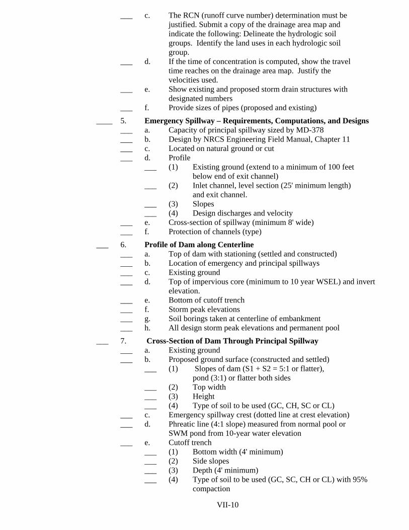
___ c. The RCN (runoff curve number) determination must be justified. Submit a copy of the drainage area map and indicate the following: Delineate the hydrologic soil groups. Identify the land uses in each hydrologic soil group.
___ d. If the time of concentration is computed, show the travel time reaches on the drainage area map. Justify the velocities used.
___ e. Show existing and proposed storm drain structures with designated numbers
___ f. Provide sizes of pipes (proposed and existing)
____ 5. Emergency Spillway – Requirements, Computations, and Designs ___ a. Capacity of principal spillway sized by MD-378 ___ b. Design by NRCS Engineering Field Manual, Chapter 11 ___ c. Located on natural ground or cut ___ d. Profile
___ (1) Existing ground (extend to a minimum of 100 feet below end of exit channel)
___ (2) Inlet channel, level section (25' minimum length) and exit channel.
___ (3) Slopes ___ (4) Design discharges and velocity
___ e. Cross-section of spillway (minimum 8' wide) ___ f. Protection of channels (type)
___ 6. Profile of Dam along Centerline ___ a. Top of dam with stationing (settled and constructed) ___ b. Location of emergency and principal spillways ___ c. Existing ground ___ d. Top of impervious core (minimum to 10 year WSEL) and invert elevation. ___ e. Bottom of cutoff trench ___ f. Storm peak elevations ___ g. Soil borings taken at centerline of embankment ___ h. All design storm peak elevations and permanent pool
___ 7. Cross-Section of Dam Through Principal Spillway ___ a. Existing ground ___ b. Proposed ground surface (constructed and settled)
___ (1) Slopes of dam (S1 + S2 = 5:1 or flatter), pond (3:1) or flatter both sides
___ (2) Top width ___ (3) Height ___ (4) Type of soil to be used (GC, CH, SC or CL)
___ c. Emergency spillway crest (dotted line at crest elevation) ___ d. Phreatic line (4:1 slope) measured from normal pool or
SWM pond from 10-year water elevation ___ e. Cutoff trench
___ (1) Bottom width (4' minimum) ___ (2) Side slopes ___ (3) Depth (4' minimum) ___ (4) Type of soil to be used (GC, SC, CH or CL) with 95% compaction
VII-10

___ f. Impervious core
___ (1) Height ___ (2) Top width ___ (3) Side slopes ___ (4) Type of soil to be used (GC, CH, SC or CL)
___ g. Riser or similar structure ___ (1) Inside diameter or dimensions ___ (2) Gauge (or thickness if concrete) ___ (3) Depth of embedding in base (if concrete) ___ (4) Connecting strap detail for pre-cast structures
___ h. Riser base ___ (1) Length, width, thickness, gauge, if metal ___ (2) Anti-flotation computations (factor of safety = 1.2:1
or greater) ___ i. Low flow orifice or similar structure
___ (1) Diameter ___ (2) Non-clogging trash rack ___ (3) Method and instruction for plugging while
operating as a sediment control device ___ j. Pipe (round, except for cast in place reinforced concrete
box culverts) ___ (1) Inside diameter, length, material and gauge ___ (2) First joint within 4 feet from riser ___ (3) Saturated length ___ (4) Slope
___ k. Bedding (detail must meet Md-378) ___ l. Seepage control
___ (1) Foundation, abutment or embankment drains (include detail)
___ (2) Reservoir blanketing ___ m. Anti-seep collars (include detail)
___ (1) Size (Minimum 2' projections) ___ (2) Spacing and location on pipe (locate collar
minimum two feet from joints) ___ n. Trash racks – (include detail) ___ o. Anti-vortex device (in trash rack detail) ___ p. Outlet protection
___ (1) Median rip rap size (d50) ___ (2) Length, width, and depth 2.25 x d50 (shown on plan
view and cross section) ___ (3) Filter cloth ___ (4) Cross-section
____ q. Filter and drainage diaphragm (include detail) ___ (1) Per MD-378 or TR-60 designs ___ (2) SM, ML soils used in embankment
___ r. Width of maintenance and safety bench VI-16 VII-11

___ s. Elevations
___ (1) Top of dam [constructed (unsettled) and settled height with required freeboard]
___ (2) Crest of emergency spillway ___ (3) Crest of riser and other openings ___ (4) All design storm peak elevations and permanent pool elevations ___ (5) Top of impervious core ___ (6) Bottom of cutoff trench ___ (7) Inlet and outlet inverts of pipe ___ (8) 100-year tailwater or 100-year HGL ___ (9) Low flow channel inverts at 50' intervals ___ (10) Pond bottom
___ 8. Outfall Study
___ a. Cross-sections at critical points (in improved and existing channel or waterway)
___ b. Flow rates and velocities, after development ___ c. Existing vegetation and condition
___ 9. Certifications (on the pond plans)
___ a. Engineer certification (signed and sealed) at the time of plan submittal.
___ b. County acceptance block (when applicable) ___ c. Small Pond Approval letter (completed and signed by
owner) ___ 10. Construction Specification for Pond
___ a. Per MD-378 ___ b. Joint approved County/PGSCD Specifications ___ c. TR-60 specifications
____ 11. Other Details
___ a. Pond access road cross sections and percent slope ___ b. Riser structure reinforcement detail (Design loading, if
applicable) ___ c. Landscaping plan required by all agencies (No trees or
shrubs on or within 15' of the embankment) ___ d. For dry SWM ponds, a minimum of 25' radius around
structures shall be cleared
VII-12
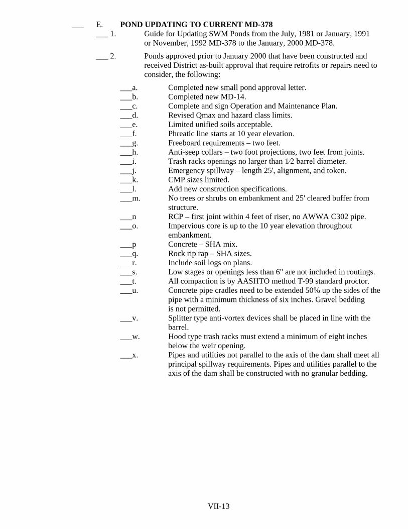
___ E. POND UPDATING TO CURRENT MD-378
___ 1. Guide for Updating SWM Ponds from the July, 1981 or January, 1991 or November, 1992 MD-378 to the January, 2000 MD-378.
___ 2. Ponds approved prior to January 2000 that have been constructed and received District as-built approval that require retrofits or repairs need to consider, the following:
___a. Completed new small pond approval letter. ___b. Completed new MD-14. ___c. Complete and sign Operation and Maintenance Plan. ___d. Revised Qmax and hazard class limits. ___e. Limited unified soils acceptable. ___f. Phreatic line starts at 10 year elevation. ___g. Freeboard requirements – two feet. ___h. Anti-seep collars – two foot projections, two feet from joints. ___i. Trash racks openings no larger than 1⁄2 barrel diameter. ___j. Emergency spillway – length 25', alignment, and token. ___k. CMP sizes limited. ___l. Add new construction specifications. ___m. No trees or shrubs on embankment and 25' cleared buffer from
structure. ___n RCP – first joint within 4 feet of riser, no AWWA C302 pipe. ___o. Impervious core is up to the 10 year elevation throughout
embankment. ___p Concrete – SHA mix. ___q. Rock rip rap – SHA sizes. ___r. Include soil logs on plans. ___s. Low stages or openings less than 6" are not included in routings. ___t. All compaction is by AASHTO method T-99 standard proctor. ___u. Concrete pipe cradles need to be extended 50% up the sides of the
pipe with a minimum thickness of six inches. Gravel bedding is not permitted.
___v. Splitter type anti-vortex devices shall be placed in line with the barrel.
___w. Hood type trash racks must extend a minimum of eight inches below the weir opening.
___x. Pipes and utilities not parallel to the axis of the dam shall meet all principal spillway requirements. Pipes and utilities parallel to the axis of the dam shall be constructed with no granular bedding.
VII-13

___ F. GENERAL REQUIREMENTS FOR POND CONSTRUCTION
___ 1. General ___ a. Require that inspectors do more than just test fill compaction, i.e.,
observe foundation preparation, pipe installation, riser construction, filter installation, etc. See checklists in NRCS Pond Standards (MD-378) The latest MD-378 is January 2000 and can be downloaded from NRCS web site.
___ b. Entire dam site must be cleared of trees, roots and other organic or deleterious materials to area at least 15 feet beyond limits of the embankment. Old stream channels and pockets of sand or gravel
should be excavated and backfilled with compacted fill. Site should then be proof-rolled under direction of geotechnical engineer (or his inspector). Any soft or excessively wet areas should be undercut and backfilled with compacted soil, not gravel. Avoid the use of "bridge lifts".
___ c. Where possible, avoid using road embankments as dams or stormwater management structures. This helps to minimize future problems with ownership, maintenance and repair. This also minimizes problems with utilities in dams, since the utilities are usually located along the roadways.
___ 2. Pipe Spillways
___ a. Many pond failures occur along the principal spillway because of the difficulty in compacting soil along a pipe. Consider use of alternative spillway structures, such as weirs and drop boxes.
___ b. Never allow pipe placement in a vertical trench excavated through the embankment or foundation.
___ c. Do not use gravel under pipe, riser or outlet structure. Do use a working slab or mud-mat (4 to 6 inches thick) of concrete or flowable fill in bottom of riser excavation and pipe trench. If water is a problem, contractor should use pumps and sumps to keep excavation dry. Undercut areas should be backfilled with compacted fill, concrete, or flowable fill, depending on type structure.
___ d. The inspector must be knowledgeable in pipe standards. For example, does inspector know why reinforced concrete pipe (RCP) conduit labeled "ASTM C-76, Class V" is not acceptable for pond construction?
___ e. All spillway joints must be watertight to prevent infiltration of embankment soil into the conduit. All joints must be constructed as designed by pipe manufacturer. "Field joints", where the ends of the pipes are cut off in the field are not acceptable
___ f. Gaskets for concrete pipe (ASTM C-361) should be o-rings (with circular cross section) seated in a groove. Alternative joint design (shoulders and "profile gaskets") should not be installed without prior approval of the design engineer and the owner.
___ g. The pipe manufacturer shall submit certification that pipe meets plan requirements for design load, pipe thickness, joint design, etc. to the design engineer for approval prior to installation.
VII-14

___ h. All pipe gaskets must be properly lubricated with the material
(vegetable grease or soap) provided by pipe manufacturer. Use of incorrect lubricant may cause deterioration of gasket material. The gasket should be properly "tensioned". Failure to do this may result in improper joints that are not watertight, or may cause pipe failure.
___ i. Use concrete cradle under RCP up to springline. Cradles should be poured against undisturbed earth. Or, they can be formed if there is enough room along the outside of forms for proper compaction.
___ j. Corrugated metal pipe (CMP) spillways must meet or exceed the minimum requirements in NRCS MD-378. Check for metal thickness (compare manufacturer’s certification that should accompany pipe shipment with plans), corrugation size, number of re-rolled end corrugations, proper connecting bands, and gasket type. Note that the engineer may specify a heavier gauge than MD-378 for increased design life.
___ k. The pipe manufacturer shall properly label and "match mark" their pipe sections. CMP is typically custom fabricated for each job as one long piece and then cut into shipping lengths. By consecutively labeling each piece, the pipe can be re-assembled in the same order as it was manufactured. (Also, the manufacturer shall ship the longest sections possible-the fewer joints the better. Avoid use of short sections with anti-seep collars in the middle, as this increases the number of joints.)
___ l. Six-inch hugger bands and "dimple bands" are not acceptable for CMP conduits. Thirteen-inch bands with either o-ring or flat neoprene gaskets are allowed for pipes less than 24-inches in diameter. Larger pipes require 24-inch wide bands with 24-inch wide flat gaskets and four "rod and lug" type connectors. Note that flanged pipe ends with gaskets are also permitted.
___ m. Maximum allowable deflection of CMP conduits is 5 percent of pipe diameter. However, with the larger pipe sizes, it may be
difficult to get acceptable joints even if deflection is less than this amount. No more than 1-inch difference in diameter is allowable between adjacent sections.
___ n. Flat gaskets for CMP must be factory welded or solvent glued into circular ring, with no overlaps or gaps in gasket allowed.
___ o. Use "flowable fill" under CMP up to springline. Caution: pipe will float, so must be held down. Also, flowable fill shrinks, so make at least 2 separate pours. Second pour on top of first fills voids.
___ p. The first pipe joint should occur within four feet of riser in order to accommodate differential movements of riser and pipe yet maintain a watertight connection.
___ q. Precast risers cannot be substituted if plans call for cast-in-place structure, unless reviewed by design engineer and approved by Prince George's Soil Conservation District or County before construction. Sections of precast structures must be anchored together for stability and flotation requirements. Watertight joints between the riser sections and the barrel are required.
___ r. Structural engineer must evaluate shop drawings for pipe, precast structures, or other fabricated appurtenances before fabrication or installation.
VII-15

___ s. Cinder block, brick and masonry riser structures are not allowed. ___ t. Precast box culverts are not approved, as they do not have watertight
joints. ___ 3. Embankment Construction
___ a. Do perform frequent tests of compaction effort. Typically, plan to conduct at least one test per 5,000 square feet on each layer of fill. Test frequency may be reduced on large projects where the material is uniform after the contractor proves that a certain compactive effort will consistently achieve specified density.
___ b. Use Standard Proctor (AASHTO Method T-99) for compaction criterion, not Modified Proctor. Standard Proctor results in slightly wetter, more flexible, fill that can better settle without formation of cracks.
___ c. A new Proctor test is required if material changes from that previously tested. ___ d. Do not rely on nuclear density gauge without correlation with
traditional methods like sand cone and oven-dry moisture content. Otherwise, dry density and moisture content may not match those obtained in the lab.
___ e. Use sheepsfoot type roller for cohesive soils like clay, silt, clayey sands.
___ f. Use smooth drum vibratory roller on clean sands and gravels. ___ 4. Filters and Drainage layers
___ a. Filters are critical for control of seepage. Aggregate size for filter is dependent on embankment soil. If contractor proposes different borrow source than used for filter design, then filter must be redesigned for new soil.
___ b. Clean sands cannot be adequately compacted by tamping alone, because water sets up surface tension between particles that may prevent achieving maximum density. Must flood filter with clean (potable) water, and vibrate just after water drops below sand surface.
___ c. Filter material should be placed in layers no more than a foot thick. ___ d. A maximum of four feet of dam embankment on top of lower
portion of the filter and then excavated down with a backhoe to expose previous layers. After removing any unsuitable materials, the trench is then filled in one foot layers, flooded and vibrated as above, until the top of adjacent fill is reached.
___ e. Filter fabric (geotextiles) cannot be used in lieu of sand and gravel layers within the dam embankment.
___ f. Do not wrap filter fabric tightly around perforated pipes used to collect seepage. Because the area of water flow through the fabric is effectively reduced to the area of the perforations, it will clog rapidly. Fabric should be held away from the pipe surface by a layer of gravel or three dimensional geotextile.
VII-16

___ 5. Utilities
___ a. Utilities that run through dam or foundation from upstream to downstream should be avoided. If they cannot be moved, then the conduit must meet the requirements for spillways, i.e., water tight joints, no gravel bedding, encasement in concrete or flowable fill, and restrained to prevent joint separation due to settlement.
___ b. Utilities that run along the axis of the dam (such as water and sewer under a roadway) should also be avoided. No gravel backfill is allowed, as this may allow groundwater to flow into dam embankment from abutments, resulting in seepage and stability problems with the slopes.
___ c. No manholes allowed in dam embankments, unless carefully designed and constructed to be watertight.
___ d. Utility repairs in dam embankment require approval by Prince George's Soil Conservation District.
VII-17

___ G. AS BUILT PLANS CHECKLIST
___ 1. The owner or the engineer will notify the Prince George's Soil
Conservation District in writing when construction is completed. Within 30 days of the completion of construction, the engineer-in-charge that designed the structure shall provide PGSCD with an As-Built plan. Noncompliance with the preceding items shall be cause for withdrawal of PGSCD approval, and notification to the Maryland Department of the Environment of the action taken. The supervision during construction of a pond by the engineer-in-charge is required to meet the minimum requirements of an acceptable As-Built plan. This supervision must be sufficient to provide certification of all design elevations and materials.
___ 2. Method of Submittal ___ a. Submit two print copies of the As-Built plan. ___ b. PGSCD will review and comment on As-Built plan.
___ c. PGSCD will issue As-Built acceptance once specified requirements are met.
___ d. With As-Built acceptance one set of the final As-Built prints and the original sepia set (to include original approval stamp sheet) is to be submitted for signing.
___ 3. Method of Documentation ___ a. The minimum constructed information shall be shown on the
approved prints or mylars and shall be drawn in ink and in a box, or shown in red. A boxed value and check mark (√) may be made if the planned values were the actual constructed values. For changed values, single line out the planned value and enter the actual value boxed or shown in red next to the planned value.
___ b. A field survey with bench marks included is needed to verify constructed values. Elevations to the nearest 0.1' are sufficiently accurate except where higher accuracy is needed to show positive
flow.
___ 4. Minimum Information ___ a. Profile of dam along centerline to include elevation of top of
constructed dam. ___ b. Cross-section of dam through principal spillway, extending at least
100 feet downstream of the fill. ___ c. Cross-section of the emergency spillway at the control section. ___ d. Profile along the centerline of emergency spillway. ___ e. The elevation of the principal spillway crest or top of structure
elevations. ___ f. The elevation of the principal spillway inlet and outlet inverts. ___ g. Riser diameter/dimensions, and riser base size. ___ h. Barrel diameter, length and slope (Include cradle when applicable). ___ i. Type of materials used. ___ j. Outfall protection; length, width, depth, size of rip rap (d50 and
class), and filter cloth. ___ k. Proper size and type of anti-vortex and trash rack device; height,
diameter, elevations, spacing. VII-18

___ l. Proper location, size and number of anti-seep collars.
___ m. The diameter, invert elevation and sizes of any stage orifices, weirs or drain pipes.
___ n. Core trench limits, side slopes, and elevation of bottom of cut off trench (required during construction).
___ o. Show the length, width, and depth or contours of the pool area so that design volume can be verified.
___ p. The following certification statement is required to be placed on the approved print or sepia:
"I hereby certify that the facility was constructed as shown on this "As-Built" plan and meets or exceeds the requirements of the Natural Resources Conservation Service – Maryland Conservation Practice Standard for Ponds (MD-378) and the approved pond plans and specifications". __________________________________________________________________ Signature Engineer-in-charge Date Md. PE Seal and No.
Certify means to state or declare a professional opinion based upon onsite inspections and material tests which are conducted during construction. The onsite inspections and material tests are those inspections and tests deemed sufficient and appropriate by commonly accepted engineering standards. Certify does not mean or imply a guarantee by the engineer nor does an engineer’s certification relieve any other party from meeting requirements imposed by contract, employment, or other means, including meeting commonly accepted industry practices.
Note: The paragraph following the signature is optional.
___ q. Certification of vegetative cover and fencing (if applicable). ___ r. A certification by a Geotechnical Engineer of compaction and unified soil classes. ___ s. Notes and measurements to show that any special design features were met. ___ t. Show location of planted landscaping.
VII-19

___ 5. Acceptable Construction
___ a. The pipe conduit diameter, length, materials, cradle and elevations must be correct.
___ b. Riser must be as designed with correct orifice dimensions and elevations. ___ c. Trash racks must meet design requirement. ___ d. The number, size, and location of the anti-seep collars must be correct. ___ e. Emergency spillway may be 1-2% steeper, but no flatter than design, no
narrower than design, and located as shown on the approved plans with property alignment.
___ f. Embankment top elevations must be no less than design elevation plus allowance for settlement (as shown on plans).
___ g. Top width and side slopes of embankment must meet design requirement. ___ h. There must be the proper relationship between the principal spillway crest,
emergency spillway crest, and the top of the dam. All elevations must be equal to the design elevations or relative to each other and the required volumes.
___ i. The structure must have an acceptable outlet as provided on the plans. ___ j. Construction shall be in strict accordance with the approved plans and
criteria for the pond(s), unless approval for any proposed changes are approved by the Prince George’s Soil Conservation District prior to the construction.
___ k. Location of vegetation as per landscape plan. ___ l. The compaction requirements as directed. VII-20

___ H. MAJOR/MINOR POND PLAN CHANGES
___ 1. Major Pond Plan Changes
The following items represent field conditions which require a revision of the original approved plan and must be submitted to PGSCD for review and approval.
___ a. Change of pond storage by decreasing volume
___ b. Changing of pond slopes or lengthening of slopes
___ c. Changing of benches or other safety features
___ d. Changing size and/or class of inlet/outlet pipe
___ e. Changing of site grades and/or drainage area to pond ___ f. Changing elevation and/or size of orifice/weir in riser ___ g. Changing of slope and/or length of inlet/outlet pipe ___ h. Changing location or addition of borrow areas ___ i. Changing rip-rap design ___ j. Changing or addition of trash rack and/or anti-vortex device ___ k. Changing size and/or location of anti-seep collars ___ l. Changing dam or emergency spillway dimension, location, and/or elevation ___ m. Changing riser dimensions ___ n. Changing size, grade and/or spacing or structural steel ___ o. Change in soil or water conditions ___ 2. Minor Pond Plan Changes
The following items represent field conditions which result in minor changes in the approved pond plan that may be approved as directed by the County inspector.
___ a. Shift in location or addition of landscaping not on embankment or in storage area or emergency spillway.
___ b. Small adjustment in the horizontal location of pond to accommodate such things as utilities providing rights-of-way and/or easements are not crossed and storage volume is unchanged.
___ c. Undercutting of core trench as per geotechnical engineer's recommendation (no less than minimum requirements).
___ d. Additional rip-rap in outfall provided rights-of way and/or easements are not crossed (no change in size).
VII-21

___I. HYDROLOGIC SOIL GROUPS FOR PRINCE GEORGE’S COUNTY
Map symbol and soil name
Pct. of map unit
Hydrologic group
AaB: Adelphia 75 C AcA: Adelphia 50 C Aquasco 30 C AdA: Adelphia 60 C Holmdel 25 C AdB: Adelphia 55 C Holmdel 25 C AdC: Adelphia 55 C Holmdel 25 C AeB: Adelphia 30 C Homdel 30 C Urban land 30 D AfA: Annapolis 80 B AfB: Annapolis 80 B AfC: Annapolis 80 B AfD: Annapolis 75 B AfE: Annapolis 80 B AfF: 75 B Annapolis 75 B AnB: Annapolis 50 B Urban land 40 D AnD: Annapolis 50 B Urban land 35 D ApA: Aquasco 80 C ApB: Aquasco 75 C AuB: Aquasco 65 C Urban land 30 D
VII-22

Map symbol and soil name
Pct. of map unit
Hydrologic group
BaA: Beltsville 75 C BaB: Beltsville 70 C BaC: Beltsville 70 C BgB: Beltsville 35 C Grosstown 30 B Woodstream 15 C BuB: Beltsville 50 C Urban land 40 D BuD: Beltsville 50 C Urban land 30 D BwC: Brinklow 85 B BwD: Brinklow 85 B ByD: Brinklow 50 B Blocktown 35 B ByF: Brinklow 50 B Blocktown 40 C CaB: Chillum 75 B CaC: Chillum 75 B CaD: Chillum 75 B CbB: Chillum 40 B Urban land 40 D CbD: Chillum 50 B Urban land 30 D CdE: Chillum 50 B Urban land 25 D
VII-23

Map symbol and soil name Pct. of
map unit
Hydrologic group CcC: Christiana 45 C Downer 30 B CcD: Christiana 50 C Downer 35 B CcE: Christiana 45 C Downer 35 B CcF: Christiana 45 C Downer 35 B CdD: Christiana 30 C Downer 25 B Urban land 20 D CdE: Christiana 35 C Downer 30 B Urban land 20 D CF: Codorus 40 C Hatboro 40 D Ch: Codorus 30 C Hatboro 30 D Urban land 30 D CkA: Colemantown 80 C/D CnA: Collington 60 B Wist 25 B CnB: Collington 50 B Wist 35 B CnC: Collington 45 B Wist 35 B CnD: Collington 45 B Wist 30 B CnE: Collington 60 B Wist 25 B
VII-24

Map symbol and soil name Pct. of
map unit
Hydrologic group CnF: Collington 60 B Wist 25 B CoB: Collington 30 B Wist 30 B Urban land 25 D CoD: Collington 30 B Wist 30 B Urban land 25 D CoE: Collington 40 B Wist 30 B Urban land 25 D CrB: Croom 80 B CrC: Croom 75 B CrD: Croom 75 B CrE: Croom 75 B CsD: Croom 50 B Collington 25 B Howell 25 C CsE: Croom 50 B Collington 25 B Howell 25 C CsF: Croom 50 B Collington 25 B Howell 25 C CuD: Croom 40 B Howell 25 C Urban land 25 D CwC: Croom 60 B Marr 25 B
VII-25

Map symbol and soil name Pct. of
map unit
Hydrologic group CwD: Croom 50 B Marr 30 B CwE: Croom 50 B Marr 30 B CwG: B Croom 50 B Marr 30 B CxD: Croom 45 B Marr 30 B Urban land 20 D CxE: Croom 45 B Marr 30 B Urban land 20 D CzB: Croom 60 B Urban land 30 D CzD: Croom 70 B Urban land 20 D CzE: Croom 70 B CzE: Urban land 20 D Dam: Dam, concrete 100 D DfA: Dodon 70 B DfB: Dodon 70 B DfC: Dodon 75 B DnA: Donlonton 60 C DnB: Donlonton 60 C
VII-26

Map symbol and soil name Pct. of
map unit
Hydrologic group DoB: Downer 55 B Hammonton 25 B DoC: Downer 50 B Hammonton 25 B DoD: Downer 50 B Hammonton 25 B DuB: Downer 35 B Hammonton 25 B Urban land 20 D DuD: Downer 35 B DuD: Hammonton 25 B Urban land 20 D EkA: Elkton 85 C/D EnA: Elkton 60 C/D Urban land 30 D EsA: Elsinboro 95 B EsB: Elsinboro 95 B EuB: Elsinboro 65 B Urban land 30 D EwB: Eveboro 40 A Downer 30 B EwC: Evesboro 40 A Downer 30 B EwD: Evesboro 40 A Downer 30 B EwE: Evesboro 40 A Downer 30 B VII-27

Map symbol and soil name
Pct. of map unit
Hydrologic group
FaA: Fallsington 75 B/D FbB: Fallsington 50 B/D Urban land 30 D GaB: Gaila 85 B GaC: Gaila 85 B GbB: Galestown 60 A Urban land 30 D GbD: Galestown 65 A Urban land 25 D GbB: Glenelg 85 B GcC: Glenelg 85 B GfB: Glenelg 45 B Wheaton 30 B Urban land 25 D GfC: Glenelg 45 B Wheaton 30 B Urban land 25 D GgA: Grosstown 90 B GgB: Grosstown 80 B GgC: Grosstown 90 B GhC: Grosstown 50 B Hoghole 45 A GkB: Grosstown 35 B Hoghole 35 A Urban land 25 D GmD: Grosstown 30 B Marr 30 B Hoghole 15 A Dodon VII-28
10 B

Map symbol and soil name Pct. of
map unit
Hydrologic group GmF: Grosstown 30 B Marr 30 B Hoghole 15 A Dodon 10 B GuB: Grosstown 60 B Urban land 30 D GuD: Grosstown 60 B Urban land 30 D Woodstown 5 C GwD: Grosstown 30 B Woodstown 30 C Beltsville 20 C HaA: Hammonton 75 B HgB: Hoghole 45 A Grosstown 30 B HnB: Howell 50 C Annapolis 35 B HnC: Howell 50 C Annapolis 40 B HOD: Howell 60 C Annapolis 30 B HOE: Howell 50 C Annapolis 40 B HwB: Howell 45 C Dodon 35 B HwC: Howell 45 C Dodon 40 B HZD: Howell 45 C Dodon 40 B
VII-29

Map symbol and soil name Pct. of
map unit
Hydrologic group HZE: Howell 50 C Dodon 30 B HZF: Howell 50 C Dodon 30 B InA: Ingleside 85 B Is: Issue 80 C Iu: Issue 60 C Urban land 30 D LQA: Lenni, undrained 50 D Quindocqua, undrained 30 C/D LsA: Leonardtown 75 D LxD: Liverpool 45 C Piccowaxen 40 C LY: Longmarsh 65 D Indiantown 25 D MaB: Magnolia 80 B MbB: Magnolia 50 B Urban land 30 D McC: Manor 85 B McD: Manor 90 B MfF: Manor 55 B Brinklow 30 B
VII-30

Map symbol and soil name Pct. of
map unit
Hydrologic group MIS: Miscellaneous Water 100 ___ MnA: Marr 80 B Dodon 20 B MnB: Marr 45 B Dodon 35 B MnC: Marr 50 B Dodon 35 B MnD: Marr 45 B Dodon 40 B MnE: Marr 50 B Dodon 35 B MoB: Marr 40 B MoB: Dodon 30 B Urban land 30 D MoD: Marr 40 B Dodon 30 B Urban land 30 D MpA: Matapeake 85 B MpB: Matepeake 85 B MT: Mispillion 40 D Transquaking 40 D NM: Naticoke 45 D Mannington 40 D PoA: Piccowaxen 55 C Liverpool 45 C PoB: Piccowaxen 55 C Liverpool 40 C
VII-31

Map symbol and soil name
Pct. of map unit
Hydrologic group
PrB: Piccowaxen 50 C Urban land 30 D PT: Pits, gravel 100 A Px: Potobac 70 D Issue 25 C RcA: Russett 45 C Christiana 25 C RcB: Russett 40 C Christiana 35 C RuB: Christiana 30 C Russett 30 C Urban land 30 D SaA: Sassafras 80 B SaB: Sassafras 80 B SaC: Sassafras 80 B ScC: Sassafras 45 B Croom 35 B SdD: Sassafras 35 B Croom 30 B Urban land 25 D SnB: Sassafras 45 B Urban land 35 D SnD: Sassafras 55 B Urban land 30 D SnE: Sassafras 55 B Urban land 25 D SOD: Sassafras 45 B Croom 35 B
VII-32

Map symbol and soil name Pct. of
map unit
Hydrologic group SOE: Sassafras 40 B Croom 35 B SOF: Sassafras 40 B Croom 35 B SrA: Shrewsbury 75 C/D SwB: Swedesboro 45 B Galestown 35 A UdaF: Udorthents, highway 100 D UdhB: Udorthents, loamy 90 B UdbD: Udorthents, loamy 90 B Urban Land 10 D UdbE: Udorthents, loamy 100 C UdcB: Udorthents, reclaimed clay pits
95 C
UdcD: Udorthents, reclaimed clay pits
95 C
UdgB: Udorthents, reclaimed gravel pits
100 C
UdgD: Udorthents, reclaimed gravel pits
100 C
UdgE: Udorthents, reclaimed gravel pits
100 C
UdrF: Udorthents, refuse substratum
100 D
VII-33

Map symbol and soil name
Pct. of map unit
Hydrologic group
UduB: Udorthents, reclaimed gravel pits
70
C
Urban land 30 D UduD: Udorthents, reclaimed gravel pits
55
C
Urban land 30 D Un: Urban land 100 D UraB: Urban land 75 D Adelphia 15 C UrbB: Urban land 80 D Beltsville 15 C UrcD: Urban land 75 D Christiana 15 C Downer 10 B UrdB: Urban land 80 D Collington 15 B Wist 5 B UreB: Urban land 80 D Elsinboro 20 B UrgB: Urban land 80 D Grosstown 15 B UrkB: Urban land 85 D Issue 15 C UrmB: Urban land 80 D Dodon 10 B Marr 10 B UrrB: Urban land 80 D Christiana 10 C Russett 10 C UrsB: Urban land 80 D Sassafras 15
B
VII-34

Map symbol and soil name Pct. of
map unit
Hydrologic group UruB: Urban land 80 D Udorthents 20 C UrwB: Urban land 80 D Woodstown 20 C UrzA: Urban land 80 D W: Water 100 --- WDF: Westphalia 45 B Dodon 40 B WDG: Westphalia 45 B Dodon 40 B WE: Issue 40 C Widewater 40 D WoA: Woodstown 80 C WoB: Woodstown 75 C WoC: Woodstown 65 C Grosstown 20 B WuB: Woodstown 50 C Urban land 35 D Zn: Zekiah 40 D Urban land 30 D ZS: Issue 40 C Zekiah 40 D
VII-35

___ J. USDA NRCS CONSERVATION ENGINEERING TOOLS AND DOCUMENTS, JULY/2013
NRCS Pond MD-378 references may be accessed via USDA’s eDirectives: National Engineering Handbook. See in particular the following:
NATIONAL ENGINEERING MANUAL
SUBJECT AREA
NEW NRCS REF
OLD NRCS #
TITLE
VERSION/RELEASE DATE
210-V-NEM 210-V-NEM National Engineering Manual
Amend 23. March 1997
NATIONAL ENGINEERING HANDBOOK Soils Engineering
Part 633 H_210_NEH_633
210-VI-NEH-633.26
Chapter26, Soil Engineering Gradation Design of Sand and Gravel Filters
May 2008
Hydraulic Engineering
Part 630 H_210_NEH_5
210-VI-NEH-5
Section 5, Hydraulics
May 2008
Hydraulic Engineering
Part 630 H_210_NEH_11
210-VI-NEH-11
Section 11, Drop Spillways
May 2008
Hydraulic Engineering
Part 630 H_210_NEH_14
210-VI-NEH-14
Section 14, Chute Spillways (incl. Amendment 1)
May 2008
ENGINEERING FIELD HANDBOOK H_210_NEH_650
Hydrology Part 650
210-VI-NEH650.11
Chapter 11, Ponds & Reservoirs
(Amend. 48) January 2012
Hydrology
Part 650
210-VI-NEH650.11
Chapter 6, Structures
(Amend. 48) January 2012
VII-36

TR-210 Engineering Technical Releases [May 2008]: http://directives.sc.egov.usda.gov/24937.wba
VII-37
TECHNICAL RELEASES SUBJECT AREA
NRCS DIRECTIVE
OLD NRCS NO. TITLE VERSION/ RELEASE DATE
Dams TR-210-18
TR-18 Computation of Joint Extensibility Requirements
(8/1/1969)
Dams TR-210-56
TR-56 A Guide for Design and Layout of Vegetative Wave Protection for Earth Dam Embankments
(12/1/1974)
Dams TR-210-60 TR-60 Earth Dams and Reservoirs
(7/1/2005)
Dams TR-210-69
TR-69 Riprap for Slope Protection Against Wave Action
(2/1/1983)
Structural Engineering
TR-210-30
TR-30 Structural Design of Standard Covered Risers (including Notice TR 30-1)
(4/1/1965)
Hydrology 210-9-27 TR-210-20 Project Formulation Hydrology User Guide & Computer Program WinTR-20, Version 1.11, (3 MB ) - WinTR-20 version 1.00
(7/2004) last updated 3/2009)
Hydrology 210-10-30 TR-210-55 Small Watershed Hydrology User Guide & Computer Program WinTR-55, Version 1.00.09
(1/2009)
TR-210-55 Small Watershed Hydrology Windows 7 Version for 32 and 64 bit PCs WinTR-55, Version 1.00.10 (18.5 MB) -
last updated (2/7/2013) *includes the NOAA 14 rainfall data
TECHNICAL NOTES Soils Engineering
TN_210_SMN_03 SMN-3 Soil Mechanics Considerations for Embankment Drains
(05/1971)
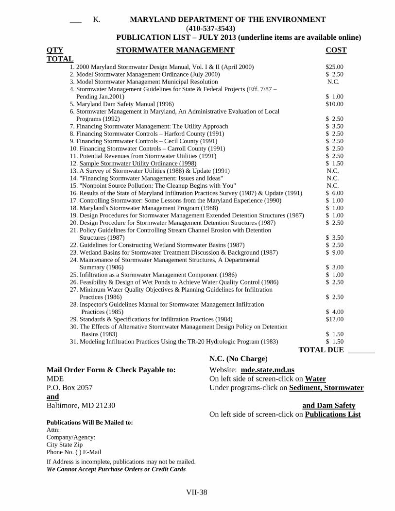
___ K. MARYLAND DEPARTMENT OF THE ENVIRONMENT
(410-537-3543) PUBLICATION LIST – JULY 2013 (underline items are available online)
QTY STORMWATER MANAGEMENT COST TOTAL
1. 2000 Maryland Stormwater Design Manual, Vol. I & II (April 2000) $25.00 2. Model Stormwater Management Ordinance (July 2000) $ 2.50 3. Model Stormwater Management Municipal Resolution N.C. 4. Stormwater Management Guidelines for State & Federal Projects (Eff. 7/87 – Pending Jan.2001) $ 1.00 5. Maryland Dam Safety Manual (1996) $10.00 6. Stormwater Management in Maryland, An Administrative Evaluation of Local Programs (1992) $ 2.50 7. Financing Stormwater Management: The Utility Approach $ 3.50 8. Financing Stormwater Controls – Harford County (1991) $ 2.50 9. Financing Stormwater Controls – Cecil County (1991) $ 2.50 10. Financing Stormwater Controls – Carroll County (1991) $ 2.50 11. Potential Revenues from Stormwater Utilities (1991) $ 2.50 12. Sample Stormwater Utility Ordinance (1998) $ 1.50 13. A Survey of Stormwater Utilities (1988) & Update (1991) N.C. 14. "Financing Stormwater Management: Issues and Ideas" N.C. 15. "Nonpoint Source Pollution: The Cleanup Begins with You" N.C. 16. Results of the State of Maryland Infiltration Practices Survey (1987) & Update (1991) $ 6.00 17. Controlling Stormwater: Some Lessons from the Maryland Experience (1990) $ 1.00 18. Maryland's Stormwater Management Program (1988) $ 1.00 19. Design Procedures for Stormwater Management Extended Detention Structures (1987) $ 1.00 20. Design Procedure for Stormwater Management Detention Structures (1987) $ 2.50 21. Policy Guidelines for Controlling Stream Channel Erosion with Detention Structures (1987) $ 3.50 22. Guidelines for Constructing Wetland Stormwater Basins (1987) $ 2.50 23. Wetland Basins for Stormwater Treatment Discussion & Background (1987) $ 9.00 24. Maintenance of Stormwater Management Structures, A Departmental Summary (1986) $ 3.00 25. Infiltration as a Stormwater Management Component (1986) $ 1.00 26. Feasibility & Design of Wet Ponds to Achieve Water Quality Control (1986) $ 2.50 27. Minimum Water Quality Objectives & Planning Guidelines for Infiltration Practices (1986) $ 2.50 28. Inspector's Guidelines Manual for Stormwater Management Infiltration Practices (1985) $ 4.00 29. Standards & Specifications for Infiltration Practices (1984) $12.00 30. The Effects of Alternative Stormwater Management Design Policy on Detention Basins (1983) $ 1.50 31. Modeling Infiltration Practices Using the TR-20 Hydrologic Program (1983) $ 1.50
TOTAL DUE _______ N.C. (No Charge)
Mail Order Form & Check Payable to: Website: mde.state.md.us MDE On left side of screen-click on Water P.O. Box 2057 Under programs-click on Sediment, Stormwater and Baltimore, MD 21230 and Dam Safety On left side of screen-click on Publications List Publications Will Be Mailed to: Attn: Company/Agency: City State Zip Phone No. ( ) E-Mail
If Address is incomplete, publications may not be mailed. We Cannot Accept Purchase Orders or Credit Cards VII-38

Prince George’s Soil Conservation District 5301 Marlboro Race Trace Road, Suite 100 - Upper Marlboro, MD 20772
Phone (301) 574-5162 – Fax (301) 574-5162
SMALL POND APPROVAL 7/2013
________________________________________________ SC#__________ P#_________ PROJECT NAME As authorized by Section 5-503, Environment Article, Annotated Code of Maryland, the Prince George's Soil Conservation District hereby approves the plans and specifications for ____________________ ___________________________________________________, hereinafter referred to as Owner, to construct a pond located at __________________________________________________________. This approval is issued under the following conditions and is subject to all laws, regulations, and criteria adopted by Maryland Department of the Environment (MDE) or the Prince George's Soil Conservation District. Non-compliance with these conditions shall be cause for withdrawal of our approval and notification to MDE: 1. The approval is valid only for use by the applicant and may not be transferred to another unless
written approval for such transfer is obtained from PGSCD. 2. The approval shall be null and void if the construction under the approval has not begun within
two years from the date of the approval except that this time limit may be extended at the discretion of PGSCD. 3. Construction shall be in strict accordance with USDA-Natural Resources Conservation Service
criteria for pond construction and terms of this approval. The location, dimensions and type of all structures, as well as any excavation or filling shall be in accordance with the aforementioned plans submitted by the applicant, unless written approval for any proposed change is granted by PGSCD.
4. The owner, or the engineer, will notify PGSCD promptly in writing when construction is begun and when construction is completed.
5. The owner shall engage a registered professional engineer experienced and qualified in the field of dam design and construction and shall be designated as the engineer-in-charge.
The project shall be constructed under the supervision of the engineer-in-charge. Within 30 days of the completion of construction, the engineer-in-charge that designed the structure shall provide PGSCD with an As-Built plan and shall certify, with the engineer's seal, that the pond was constructed as shown on the As-Built plans, unless written approval for any proposed change is granted by PGSCD. 6. It is the applicant's responsibility to develop and implement a plan to control erosion and
sedimentation during pond construction. A grading, erosion and sediment control plan adhering to the PGSCD Erosion and Sediment Control Guidelines shall be approved in conjunction with the pond design plans. The approved plan shall be implemented prior to the start of construction.
CONSERVATION – DEVELOPMENT – SELF-GOVERNMENT
VII-39

_______________________________________ SC#_____________ P#__________ NAME 7. The owner shall be responsible for operating and maintaining the pond in the approved completed
condition so as to ensure proper functioning of the structure and protection of adjoining properties. (O & M plan is to be attached to this approval letter)
8. The owner is responsible for the safety of the dam, the necessary surveillance and inspections as
detailed in the approved operation and maintenance plan. The owner shall promptly notify MDE or PGSCD of significant changes in conditions.
9. If the dam is not constructed, operated or maintained in full compliance with this approval, the
owner shall remove or repair all or any part of the structure at the owner’s sole cost and expense as may be directed by MDE or PGSCD.
ACCEPTANCE CLAUSE
1. This approval and its conditions are accepted. 2. Permission is hereby granted to representatives of PGSCD to enter in or upon the subject premises at any reasonable time for the purpose of conducting a preliminary feasibility investigation, observing construction progress and reviewing the completed structure. 3. Designate Engineer-in-charge below. ________________________________________________________________________________ Name (printed) Engineer-in-charge PE# Date ________________________________________________________________________________ Company ________________________________________________________________________________ Address Phone Accepted by:______________________________________________________________________________ Owner (Print Name) Date ________________________________________________________________________________ Owner (Signature) ________________________________________________________________________________ Address Phone
PRINCE GEORGE'S SOIL CONSERVATION DISTRICT Supervisor:_______________________________________________________ ______________ Signature Date VII-40

MD-ENG-14 U.S. Department of Agriculture (Rev. 10/2000) Natural Resources Conservation Service Reference: POND SUMMARY SHEET NRCS MD-378 Note: This form to be used for NRCS Class “a” ponds only. Other ponds require permit from Maryland Department of Environment, Dam Safety Division PROJECT INFORMATION
Project Name: ____________________________ SCD File No: _____________________________ Pond No: ________________________________
OWNERS INFORMATION
Name: ____________________________ TYPE OF POND: Excavated Address: ____________________________ Embankment ____________________________ Both City, State, Zip ____________________________ Drainage Area: ______ Acres
Surface Area: ______ Acres Normal Depth: ______ Feet
Design Storm Frequency: ______ Years Storage at Design High Water (DHW): ______ Ac-ft
Will embankment serve as a public roadway? ___ S. OPERATION AND MAINTENANCE PLAN GUIDELINES
___ 1. The following are items to be considered in the preparation of an Operation and ___ N. OPERATION AND MAINTENANCE PLAN GUIDELINES
Maryland Coordinates (to nearest 1000 feet)
East _________________ North _________________ County _________________ ADC Map/grid _____/______
PURPOSE OF POND (check all that apply) Stormwater Management. – Wet Sediment Control Wetland Mitigation Stormwater Management. – Dry Livestock Wildlife/Fish Infiltration/Water Quality Flood Control Fire Control Water Supply/Irrigation Recreation Other (specify below): Sand & Gravel Wash Pond Borrow Material
EMBANKMENT Maximum Fill Height: ______Feet Top Elevation: ______ Feet.. Top Width: ______Feet
Normal Pool Elevation: ______ Feet. Side Slopes: U.S. ______ : 1 DHW Water Elevation: ______ D.S. ______ : 1
PRINCIPAL SPILLWAY Barrel Size: _______Inches Design Capacity at DHW: _______ Cfs BCCMP Alum (CAP) RCP PVC Cast-in-Place Box Culvert Weir Channel Other: __________________________________ EMERGENCY SPILLWAY Design Capacity at DHW: _______ Cfs Velocity: _______ Ft/sec Bottom Width: _______ Feet Crest Elev: _______ Ft Side Slope: _______ :1 Spillway Protection: Grass Riprap Gabions Other ________________
DISTANCES BELOW POND TO Property Line: ______________ Feet Public Road: ______________ Feet
Soil Conservation District (Name): ______________________________________________________________
District Manager Signature:____________________________________Date:____________________________ The following line to be completed and form is to be resubmitted after As-Built certification has been accepted by the District.
Date As-Builts Accepted:_____________________ _______________________________________________ District Representative Signature
VII-41

PAGE LEFT INTENTIONLY BLANK
VII-42

___ N. OPERATION AND MAINTENANCE PLAN GUIDELINES
___ 1. The following are items to be considered in the preparation of an Operation and Maintenance plan (O&M). These guidelines may be used as a standard O&M plan if deemed appropriate by the design engineer by checking boxes of applicable items, or may be used in the preparation of a custom O&M plan. O&M is to be designed to ensure that the facility continues to operate in a safe and effective manner and that problems are prevented or quickly identified and corrected. The O&M is to be in conformance with this document, NRCS MD 378, and the Maryland Dam Safety Manual published by the Maryland Department of the Environment.
___ 2. In general, operation items are required for the following major areas: support data, inspections, and emergency procedures. The maintenance items required cover the following major areas: embankment, reservoir, spillway and outlet works.
___ 3. Operations ___ a. Support Data
___ (1) Background Information – The owner should maintain a complete up-to-date “as-built” plan and design specifications for the dam. Also, a copy of the completed Small Pond Summary Sheet (MD-14) should be available.
___ (2) Record Keeping - Written records of maintenance and observations should be kept. Photographs are
valuable for recording observations and changes. ___ b. Inspections
___ (1) Inspection Guidelines - Owners are to make a visual inspection at least twice a year – once in the summer after mowing, and once in the winter when the vegetative cover is dormant. Inspections are to be made after extreme
rainfall events. Owners are encouraged to have an inspection by a registered professional engineer at least once every 5 years.
___ (2) Dam Inspection Checklist – Shall be included as part of the operation and maintenance plan and completed at least annually. See Appendix A of NRCS MD Standards and Specifications Pond (Code 378) for the check list.
___ c. Emergency Procedures ___ (1) Surveillance – Inspect daily or more often under adverse
conditions of heavy or extended rainfall, flash flood warnings or snow melt. Inspect for overtopping failures, piping or seepage failures, and structural failures. If any of the following conditions are noted, emergency procedures are warranted: muddy water is flowing from the downstream slope or toe; cracks or depressions are forming on the embankment; or flood flow overtopping of the embankment is imminent.
___ (2) Mitigation – Provide for lowering the reservoir or sand bagging before overtopping. Action to be taken for piping includes lowering the pool and attempting to plug the upstream end with suitable material.
VII-43
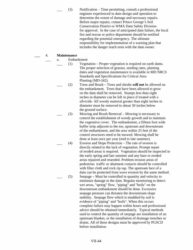
___ (3) Notification – Time permitting, consult a professional
engineer experienced in dam design and operation to determine the extent of damage and necessary repairs. Before major repairs, contact Prince George’s Soil
Conservation District or WMA Dam Safety Division for approval. In the case of anticipated dam failure, the local fire and rescue or police department should be notified regarding the potential emergency. The ultimate
responsibility for implementation of a warning plan that includes the danger reach rests with the dam owner. ___ 4. Maintenance
___ a. Embankment ___ (1) Vegetation – Proper vegetation is required on earth dams.
The proper selection of grasses, seeding rates, planting dates and vegetation maintenance is available in MD NRCS Standards and Specifications for Critical Area
Planting (MD-342). ___ (2) Trees and Brush – Trees and shrubs will not be allowed on
the embankment. Trees that have been allowed to grow on the dam shall be removed. Stumps less than eight inches in diameter can be left in place if treated with a
silvicide. All woody material greater than eight inches in diameter must be removed to about 30 inches below
the ground surface. ___ (3) Mowing and Brush Removal – Mowing is necessary to
control the establishment of woody growth and to maintain the vegetative cover. The embankment, a fifteen foot wide buffer strip adjacent to the toe, upstream and downstream of the embankment, and the area within 25 feet of the
control structures need to be mowed. Mowing shall be done at least once per year (mid to late summer).
___ (4) Erosion and Slope Protection – The rate of erosion is directly related to the lack of vegetation. Prompt repair of eroded areas is required. Vegetation should be inspected in the early spring and late summer and any bare or eroded areas repaired and reseeded. Problem erosion areas of pedestrian traffic or abutment contacts should be controlled with filter cloth and rock rip rap. The upstream face of a dam can be protected from wave erosion by the same method.
___ (5) Seepage – Must be controlled in quantity and velocity to minimize damage to the dam. Regular monitoring to detect
wet areas, "spring" flow, "piping" and "boils" on the downstream embankment should be done. Excessive
seepage pressure can threaten the downstream slope stability. Seepage flow which is muddied by soil is evidence of "piping" and "boils". When this occurs complete failure may happen within hours and professional advice should be obtained immediately. Typical methods used to control the quantity of seepage are installation of an upstream blanket, or the installation of drainage trenches or drains. All of these designs must be approved by PGSCD before installation.
VII-44

___ (6) Stability – Large cracks, slides, sloughing and excessive settlement are signs of embankment distress and indicate an
embankment must be properly "keyed" into the base material. Repair of these conditions is not considered
routine maintenance and must be approved by PGSCD. ___ (7) Rodent – Control of rodents such as beaver, groundhog And muskrats is required as they can damage the structural integrity and performance of the embankment and spillway. Groundhog and muskrat burrows serve as pathways for
seepage. Beavers may plug the spillway and raise the pool level. Rodent removal and elimination of burrow are
required where encountered. ___ (8) Crest of Dam – Should be graded to direct all surface
drainage into the impoundment. Where access roads cross the dam any ruts that develop should be repaired as soon as possible.
___ b. Spillway and Outlet Works ___ (1) Conduits – All conduits should be inspected thoroughly
once a year. Inspect for improper alignment (sagging), elongation and displacement at joints, cracks, leaks, surface wear, loss of protective coatings, corrosion and blockage.
___ (2) Trash Racks – The trash rack unit should be checked periodically and especially after storm events.
Accumulated debris should be removed and maintenance performed if necessary. Under no circumstances should the
trash rack be removed for an extended period. Annual maintenance for corrosion protection should be provided.
___ (3) Concrete – Surfaces should be inspected for cracking, spalling, displacement or movement, and deterioration by weathering, chemical reactions or leaching. Extensive cracking, slab or wall movement, large areas of exposed
reinforcing steel and severe undermining require professional advice and PGSCD approval before repairs can be made. Minor repairs of patching, grouting, and coatings can be performed during routine maintenance.
___ (4) Vegetated Earth Spillways – An emergency spillway is designed to pass infrequent large flood flows around the
dam to prevent overtopping. The vegetative cover should be maintained the same as the embankment to provide a vigorous grass cover. Prompt repair of erosion damage and
removal of flow obstructions are required. ___ (5) Outlet – Erosion at the spillway outlet is a common maintenance problem. Severe undermining, displacement
of pipes and dam failure can occur. Often the outlet is adequate for normal flow but not for extreme storm flows.
Periodically, and especially after storm events, the stilling basin, plunge pool, or rip rap energy dissipater should be inspected. Provide prompt repair of damages.
VII-45

___ (6) Drains/Mechanical Equipment – Drains should always be operable to provide draw down in the case of an emergency
or for necessary repairs. The gate or valve controlling the drain should be operated fully at least once each year or as recommended by the manufacturer. It should be inspected and all appropriate parts lubricated and repaired before
operation. Annual maintenance of metal operating mechanisms should be performed by keeping parts greased or painted to prevent corrosion. All equipment controls should be checked for proper security to prevent vandalism.
___ c. Reservoir ___ (1) Pool Level – When it is necessary to draw down the pool
level, it should be done gradually to prevent slope failures. An annual inspection of the lake perimeter should be done. Potentially damaging fallen trees, debris and sediments should be removed. Periodic removal of floating debris to
prevent clogging of the spillways should be done. During extended periods of severe freezing weather inspection for
ice damage or ice formation at the spillways and outlets should be performed.
___ d. Additional Requirements _____________________________________________________________ _____________________________________________________________ _____________________________________________________________ ______________________________________________________________ ______________________________________________________________ Prepared by: ______________________________________________________________
Engineer-in-charge P.E.# Date Signature
______________________________________________________________
Address Telephone # Accepted by: ________________________________________________________________
Owner Signature Date ________________________________________________________________
Address Telephone # PGSCD: ________________________________________________________________ Signature Date VII-46
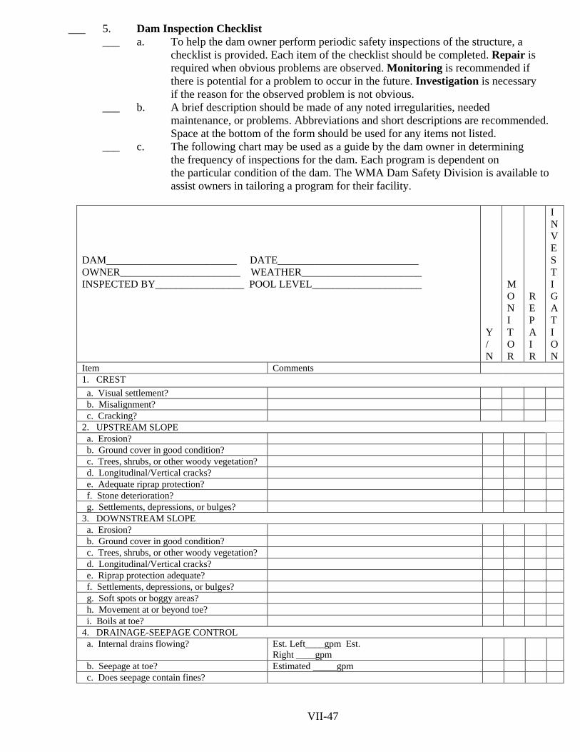
___ 5. Dam Inspection Checklist
___ a. To help the dam owner perform periodic safety inspections of the structure, a checklist is provided. Each item of the checklist should be completed. Repair is required when obvious problems are observed. Monitoring is recommended if there is potential for a problem to occur in the future. Investigation is necessary if the reason for the observed problem is not obvious.
___ b. A brief description should be made of any noted irregularities, needed maintenance, or problems. Abbreviations and short descriptions are recommended. Space at the bottom of the form should be used for any items not listed.
___ c. The following chart may be used as a guide by the dam owner in determining the frequency of inspections for the dam. Each program is dependent on the particular condition of the dam. The WMA Dam Safety Division is available to assist owners in tailoring a program for their facility.
DAM_________________________ DATE___________________________ OWNER_______________________ WEATHER_______________________ INSPECTED BY_________________ POOL LEVEL_____________________
Y / N
M O N I T O R
R E P A I R
I N V E S T I G A T ION
Item Comments 1. CREST a. Visual settlement? b. Misalignment? c. Cracking? 2. UPSTREAM SLOPE
a. Erosion? b. Ground cover in good condition? c. Trees, shrubs, or other woody vegetation? d. Longitudinal/Vertical cracks? e. Adequate riprap protection? f. Stone deterioration? g. Settlements, depressions, or bulges? 3. DOWNSTREAM SLOPE a. Erosion? b. Ground cover in good condition? c. Trees, shrubs, or other woody vegetation? d. Longitudinal/Vertical cracks? e. Riprap protection adequate? f. Settlements, depressions, or bulges? g. Soft spots or boggy areas? h. Movement at or beyond toe? i. Boils at toe? 4. DRAINAGE-SEEPAGE CONTROL a. Internal drains flowing? Est. Left____gpm Est.
Right ____gpm
b. Seepage at toe? Estimated _____gpm c. Does seepage contain fines?
VII-47

INSPECTION CHECKLIST – PAGE 2 INSPECTED BY _____________________ DATE_________________________
Y / N
MON I T OR I N G
R E P A I R
I N V E S T I G A T I O N
Item Comments 5. ABUTMENT CONTACTS a. Erosion? b. Differential movement? c. Cracks? d. Seepage? Estimated ______ gpm e. Adequate erosion protection for ditches? 6. INLET STRUCTURE Concrete or Metal Pipe (circle one) a. Seepage into structure? b. Debris or obstruction? c. If concrete, do surfaces show: 1. Spalling? 2. Cracking? 3. Erosion? 4. Scaling? 5. Exposed reinforcement? 6. Other? d. If metal, do surfaces show: 1. Corrosion? 2. Protective Coating deficient? 3. Misalignment or split seams? e. Do the joints show: 1. Displacement or offset? 2. Loss of joint material? 3. Obstructed? f. Are the trash racks: 1. Broken or bent? 2. Corroded or rusted? 3. Obstructed? 4. Operational? g. Sluice/Drain gates: 1. Broken or bent? 2. Corroded or rusted? 3. Leaking? 4. Not seated correctly? 5. Periodically maintained? 6. Operational? VII-48
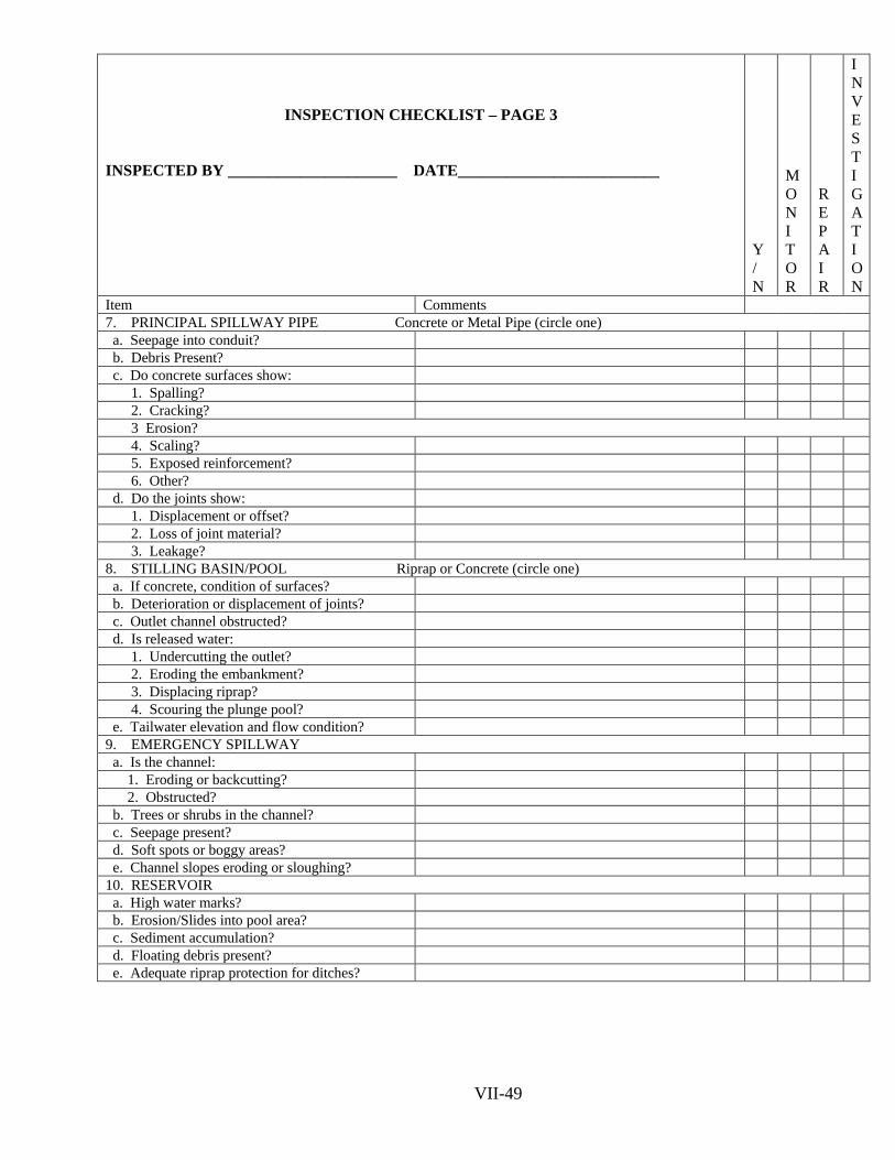
INSPECTION CHECKLIST – PAGE 3 INSPECTED BY _____________________ DATE_________________________
Y / N
MON I T OR
R E P A I R
I N V E S T I G A T ION
Item Comments 7. PRINCIPAL SPILLWAY PIPE Concrete or Metal Pipe (circle one) a. Seepage into conduit? b. Debris Present? c. Do concrete surfaces show: 1. Spalling? 2. Cracking? 3 Erosion? 4. Scaling? 5. Exposed reinforcement? 6. Other? d. Do the joints show: 1. Displacement or offset? 2. Loss of joint material? 3. Leakage? 8. STILLING BASIN/POOL Riprap or Concrete (circle one) a. If concrete, condition of surfaces? b. Deterioration or displacement of joints? c. Outlet channel obstructed? d. Is released water: 1. Undercutting the outlet? 2. Eroding the embankment? 3. Displacing riprap? 4. Scouring the plunge pool? e. Tailwater elevation and flow condition? 9. EMERGENCY SPILLWAY a. Is the channel: 1. Eroding or backcutting? 2. Obstructed? b. Trees or shrubs in the channel? c. Seepage present? d. Soft spots or boggy areas? e. Channel slopes eroding or sloughing? 10. RESERVOIR a. High water marks? b. Erosion/Slides into pool area? c. Sediment accumulation? d. Floating debris present? e. Adequate riprap protection for ditches? VII-49

PAGE LEFT INTENTIONLY BLANK
VII-50

SECTION VIII
PRINCE GEORGE’S SOIL CONSERVATION DISTRICT
POND MD-378

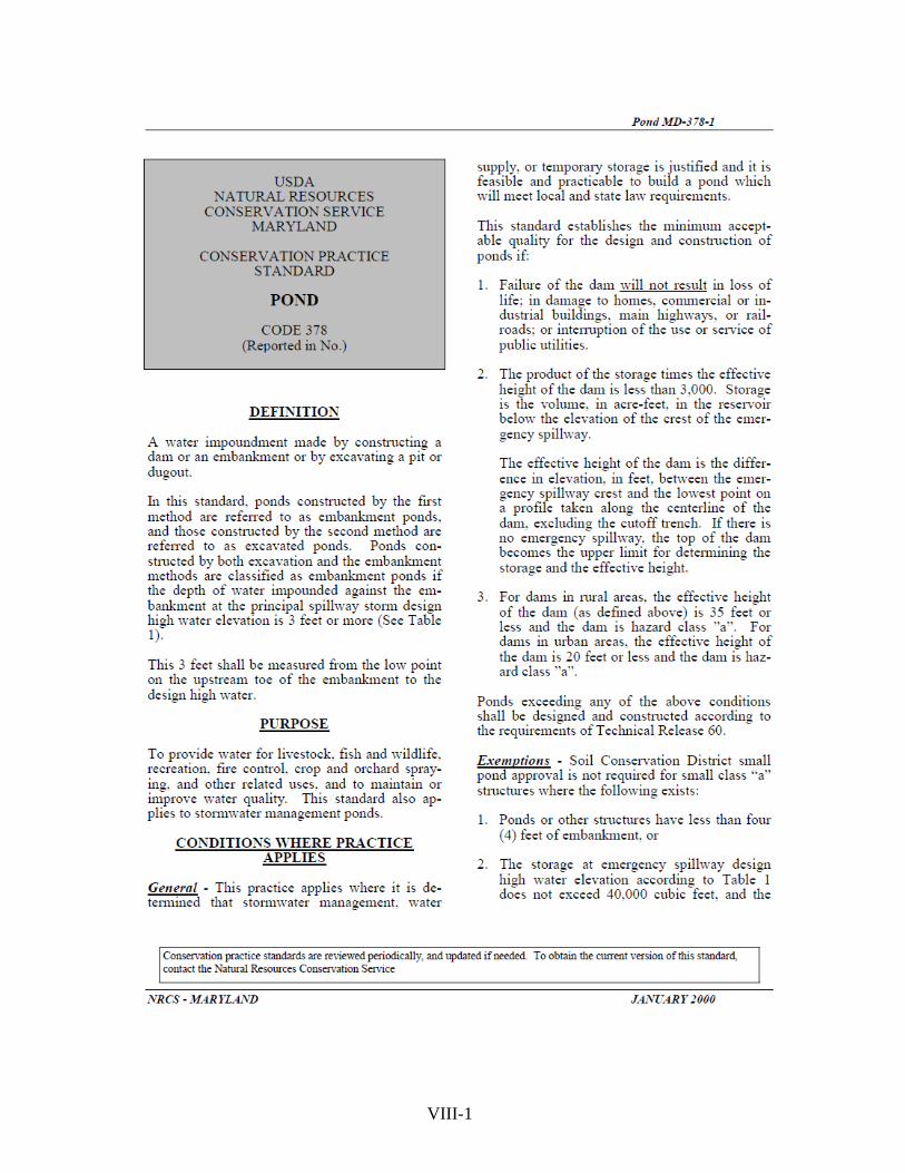
VIII-1

VIII-2
VIII-3

VIII-4

VIII-5

VIII-6
VIII-7

VIII-8

VIII-9

VIII-10

VIII-11
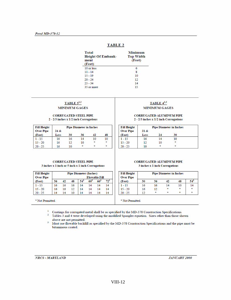
VIII-12
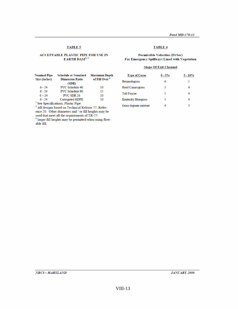
VIII-13

VIII-14

VIII-15

VIII-16

VIII-17

VIII-18

VIII-19

VIII-20
VIII-21

VIII-22

VIII-23

VIII-24

VIII-25

VIII-26

VIII-27

PAGE LEFT INTENTIONLY BLANK
VIII-28

From: Stahl, Allan – Annapolis, MD Sent: Thursday, October 06, 2005 To: MD-NRCS
Effective immediately, profile joints and gaskets are acceptable for design pressure up to 25 feet of head. They meet all the requirements of ASTM C361 and are acceptable for use in MD-378 ponds.
Attached is the approval letter from the Committee C13 on Concrete Pipe. Please inform designers, reviewers, and inspectors in your respective counties of this acceptance. Allan H. Stahl, P.E. State Conservation Engineer VIII-29

VIII-30

VIII-31

PAGE LEFT INTENTIONLY BLANK
VIII-32

SECTION IX
PRINCE GEORGE’S
SOIL CONSERVATION DISTRICT
POND MEMORANDUM


MEMORANDUM OF UNDERSTANDING – POND REVIEW
Effective January 17, 1996 Updated July/2013
The Prince George’s Soil Conservation District, the Natural Resources Conservation
Service and Prince George’s County have a three way agreement concerning technical plan review of County permitted stormwater management ponds. Based on similar agreements in Montgomery and Carroll Counties, successful implementation will eliminate any actual or perceived duplication of services. Stormwater Management Ponds
PGSCD will delegate its review of ponds (dam safety), up to a certain size, to the County. In accordance with State law, PGSCD will give final approval to these ponds based solely on the County’s review. Ponds larger than the delegated County limit and up to PGSCD’s limit, will still be reviewed by the County with a final review and approval by PGSCD. This process is enumerated in attachment "A". Pond As-Builts
According to State regulations, PGSCD guidelines require an as-built submitted within 30 days of pond construction. Ponds used for sediment control are considered complete when initially constructed. The permittee should submit a pond as-built to the County for approval and subsequent acceptance by PGSCD.
To obtain dam safety as-built approval for a pond being used as a sediment basin, the permittee must submit, as a minimum, an as-built topographic survey of the pond embankment, soils report is necessary, ground spot elevations and as-built elevation and the dimensions of pond structure, including functional components associated with the sediment basin design (see PGSCD Dam Safety Pond Guidelines for as-built plans checklist). Along with the stormwater management design storm elevations and freeboard, the 10-year sediment control elevation should be shown. The following notation is to be shown on the plan prior to its approval: “This pond is currently being used for sediment control approved by PGSCD, SC#_______”.
A follow-up inspection is not required once the pond’s dam safety as-built plan is approved under this requirement. This dam safety as-built approval is not applicable to any permittee’s bond reduction request and is considered a final as-built plan by PGSCD. The County is not required to submit the final County as-built plan to PGSCD after this dam safety pond as-built plan is approved and forwarded. Exemptions, Pond Hazard Classification and Pond Soil Interpretations
The PGSCD's small pond approval does not apply to certain small urban stormwater management quality or quantity structures. PGSCD will provide technical review and approval for all pond exemptions and soil interpretations. PGSCD will provide technical review and acceptance of all pond hazard classifications. This process is enumerated in attachment "A".
IX-1

Attachment A
Prince George’s SWM Ponds Only
I. Standards County will review ponds for PGSCD in accordance with the following: A. State Pond Law/Regulations B. Md-378 Soil Conservation Service Maryland Standards and Specifications for
Ponds C. MASCD Pond design manual D. PGSCD Soil Erosion and Sediment Control/Pond Safety Reference Manual E. County approval limit – Class “a”, 48 inches or less barrel conduit diameter,
embankment less than 15 feet, and drainage area less than 200 acres. This approval includes weir structures where the design storm height does not exceed five feet.
F. Ponds that exceed 20 feet in height, 640 acre drainage area, or are Class “b” or Class “c” require approval and as-built from Maryland Department of the Environment.
II. Pond Review and Approvals
A. Ponds up to County approval limits (1) County will ask applicant for PGSCD grading, erosion and sediment
control plan number, hazard classification, soil determination and/or pond exemptions before second review of all ponds. PGSCD will review grading, erosion and sediment control, hazard classification, soil determination and/or pond exemption aspects of all ponds.
(2) County sends copy of approved plans with delegated Professional Engineer certification (on plans), computations, owner signed PGSCD small pond approval letter and completed MD-14 pond summary sheet
(3) PGSCD signs small pond approval letter, MD-14, transmits to State, County and owner
(4) Pond revisions follow same procedure as above. B. Ponds above County approval limits
(1) County reviews for all aspects of pond design County notifies PGSCD when all SWM requirements are adequate (i.e. storm attenuation, hydrology and hydraulics)
(2) PGSCD does final review and approval
III. As-Builts A. All SWM ponds approved by the County/PGSCD
(1) County sends PGSCD a copy of accepted as-built and computations as appropriate (to include original PGSCD approval stamp sheet)
(2) County sends completed MD-14 to PGSCD (3) PGSCD signs MD-14 and transmits to MDE and the County
IV. Exemptions A. All pond exemptions approved by the County.
(1) County sends PGSCD copy of approved SWM pond exemptions with documentation
IX-2

DELEGATED PROFESSIONAL ENGINEER CERTIFICATION
IX-3
PRINCE GEORGE’S SOIL
CONSERVATION DISTRICT SMALL POND APPROVAL
Prince George’s County, Maryland
Department of Permits Inspections & Enforcement: Site/Road Plan Review
( ) Certifies Water Quality Structure Exempt From MD-378 Approval ___________________________ Signature Date ( ) Certifies Pond Meets MD-378 & Recommend PGSCD Approval __________________________ Signature Date ( ) Certifies Pond Meets MD-378 & Forward For Final PGSCD Review & Approval _________________________ Signature Date ( ) As Built Meets All Requirements of MD-378 _________________________ Signature Date

PAGE LEFT INTENTIONLY BLANK
IX-4