2009_Structural style and decollement levels in the Llanos Orientales basin (Colombia)
8
Petroleum System Variations In The Llanos Basin (Colombia). ISABELLE MORETTI, Cepsa E.P, Madrid, Spain, CESAR MORA, Gem’s, Bogota Colombia, WILZON ZAMORA, Gem’s, Bogota Colombia, MAURICIO VALENDIA, Cepcolsa, Bogota, Colombia, MARCELA MAYORGA, Cepcolsa, Bogota, Colombia, GERMAN RODRIGUEZ, Cepcolsa, Bogota © Copyright 2009 ACGGP. This paper was prepared for presentation at the X Simposio Bolivariano Exploración Petrolera en Cuencas Subandinas held in Cartagena, Colombia, July 2009. This paper was selected for presentation by the X symposium Technical Committee following review of information contained in an abstract submitted by the author(s). 1. Introduction The Llanos Basin located in the eastern side of Colombia (Fig. 1) contains some of the top 10 biggest Colombian oil fields discovered during the 80´s (Caño Limon) and 90´s (Cusiana-Cupiagua). With 2,900 MBOE (Million barrels of Oil Equivalent) of cumulative production to December 2007, remaining reserves of about 1,500 MBOE and a potential for giant and medium size in reserves discoveries, the Llanos basin is very attractive for E&P interests. Figure 1. Location map of the Llanos Basin Classical Petroleum System recognized for this basin corresponds to Cretaceous Source rock – Oligocene reservoirs. The main reservoir is the Mirador Fm, when exist, but reserves have been also reported in Une Fm (Upper Cretaceous), Barco Fm (Paleocene) and Carbonera Fms (Oligocene), see fig 2. As shown by the diversity of the oil geochemical characterization in the central foothills and foreland areas, other source rock intervals are active. The aim of the presented work was to quantify the potential of the various potential source rocks, that include the Paleozoic, the Cretaceous, and all the Tertiary shale, and to model their evolutions through time. 2. Geological setting The basement of the Llanos is cover by Paleozoic series, not all very well dated but that include siliciclastic Siluro- Devonian deposits. Strong unconformities separate locally highly deformed series from the Cretaceous deposit. The Lower Cretaceous series known in the Eastern Cordillera and deposited in an extensional context are restricted to the western side of Guaicaramo Fault and are absent in the Llanos Foreland. In the West of Colombia the compression that leads to the Andes formation began during the Cretaceous times, the first accretion started during the Aptian whereas subsidence continued eastward with the deposition of the Une, Gacheta and Guadalupe Fms in the Llanos (Sarmiento, 2001). Subsequent accretion took place westward at the end of the Maastrichian resulting in the beginning of uplift of the Central Cordillera and the first inversion in the now Magdalena Valley. In the Llanos subsidence continues in a very poorly tectonised basin (Barco, Cuervos and Mirador Fms deposits). A compressive context predominates in the Eastern Cordillera since the Eocene. After the inversions of the Mesozoic extensional grabens, a thrust regime developed, the Llanos Orientales became a classical, but rather external, foreland (Carbonera and Leon Fm deposit). The Eastern Cordillera is a double verging mountain belt: the western flank in the Magdalena Valley was initially the more active one but the active compressive front has now shifted to the Llanos Orientales where the Miocene foreland is currently affected by the compression that propagates eastward. The structure that corresponds to the former Early Cretaceous basin edge is the Guaicaramo fault.
-
Upload
systemes-electroniques -
Category
Documents
-
view
0 -
download
0
Transcript of 2009_Structural style and decollement levels in the Llanos Orientales basin (Colombia)

Petroleum System Variations In The Llanos Basin (Colombia). ISABELLE MORETTI, Cepsa E.P, Madrid, Spain, CESAR MORA, Gem’s, Bogota Colombia, WILZON ZAMORA, Gem’s, Bogota Colombia, MAURICIO VALENDIA, Cepcolsa, Bogota, Colombia, MARCELA MAYORGA, Cepcolsa, Bogota, Colombia, GERMAN RODRIGUEZ, Cepcolsa, Bogota
© Copyright 2009 ACGGP. This paper was prepared for presentation at the X Simposio Bolivariano Exploración Petrolera en Cuencas Subandinas held in Cartagena, Colombia, July 2009. This paper was selected for presentation by the X symposium Technical Committee following review of information contained in an abstract submitted by the author(s).
1. Introduction
The Llanos Basin located in the eastern side of Colombia (Fig. 1) contains some of the top 10 biggest Colombian oil fields discovered during the 80´s (Caño Limon) and 90´s (Cusiana-Cupiagua). With 2,900 MBOE (Million barrels of Oil Equivalent) of cumulative production to December 2007, remaining reserves of about 1,500 MBOE and a potential for giant and medium size in reserves discoveries, the Llanos basin is very attractive for E&P interests.
Figure 1. Location map of the Llanos Basin
Classical Petroleum System recognized for this basin corresponds to Cretaceous Source rock – Oligocene reservoirs. The main reservoir is the Mirador Fm, when exist, but reserves have been also reported in Une Fm (Upper Cretaceous), Barco Fm (Paleocene) and Carbonera
Fms (Oligocene), see fig 2. As shown by the diversity of the oil geochemical characterization in the central foothills and foreland areas, other source rock intervals are active. The aim of the presented work was to quantify the potential of the various potential source rocks, that include the Paleozoic, the Cretaceous, and all the Tertiary shale, and to model their evolutions through time.
2. Geological setting
The basement of the Llanos is cover by Paleozoic series, not all very well dated but that include siliciclastic Siluro-Devonian deposits. Strong unconformities separate locally highly deformed series from the Cretaceous deposit. The Lower Cretaceous series known in the Eastern Cordillera and deposited in an extensional context are restricted to the western side of Guaicaramo Fault and are absent in the Llanos Foreland. In the West of Colombia the compression that leads to the Andes formation began during the Cretaceous times, the first accretion started during the Aptian whereas subsidence continued eastward with the deposition of the Une, Gacheta and Guadalupe Fms in the Llanos (Sarmiento, 2001). Subsequent accretion took place westward at the end of the Maastrichian resulting in the beginning of uplift of the Central Cordillera and the first inversion in the now Magdalena Valley. In the Llanos subsidence continues in a very poorly tectonised basin (Barco, Cuervos and Mirador Fms deposits). A compressive context predominates in the Eastern Cordillera since the Eocene. After the inversions of the Mesozoic extensional grabens, a thrust regime developed, the Llanos Orientales became a classical, but rather external, foreland (Carbonera and Leon Fm deposit). The Eastern Cordillera is a double verging mountain belt: the western flank in the Magdalena Valley was initially the more active one but the active compressive front has now shifted to the Llanos Orientales where the Miocene foreland is currently affected by the compression that propagates eastward. The structure that corresponds to the former Early Cretaceous basin edge is the Guaicaramo fault.

‐ 2 ‐ MORETTI, I., C., MORA, W., ZAMORA, M., VALENDIA, M., MAYORGA, G., RODRIGUEZ
Figure 2. Llanos Basin, Stratigraphic Column (Modified from Cooper, 1995).
3. Petroleum systems
3.1 Traps and reservoirs: The more productive reservoirs are Une, Guadalupe, Mirador and Carbonera C7 Fms. The producing structures are the nose of subtle faulted blocks due to normal faulting, often eastverging, that affect the Upper Cretaceous and Tertiary series (Ramon et al., 2006; Moretti et al., 2009 this issue). The small offset on these faults result on small size fields. At the contrary, near or within the foothills, large compressive structures have been successfully drilled and host almost all the large fields of the area (Cusiana, Cupiagua, Volcanera). Eastward, at the wedge of the basin, not structural traps have been also successfully drilled; they may contain large reserves (Rubiales).
3.2 Source rock and fluids: The Llanos Basin is a prolific petroleum province where there are different source rocks intervals, and also numerous reservoirs. The marine calcareous intervals of the Fomeque Formation and the marine shales of Gacheta Formation, are considered as the main source rocks of the basin. Traditionally Gacheta-Mirador has been considered as the major petroleum system in the area (Hernandez et al, 1996,
Mora, 2000), but a large majority of the fields has more than one reservoir and, as we will discuss here, apparently were connected to more than one source rocks.
Four mayor oil families have been recognized in the Llanos Basin (Mora et. al, 2007). Most of these families correspond to mixture oils where is possible to identify HC generated from organic facies deposited in marine siliciclastic (Chipaque Formation?), marine carbonatic (Fomeque Formation ?) and marine deltaic environment (Gacheta and Cuervos Formation ?). Northward, abnormal characteristics of the oil found in Cañon Limon suggest, by correlation to the Venezuelan cases, a pre-Cretaceous SR (Mora et al., 2007). The HC display a large variability of ºAPI gravity from condensate to biodegraded oils. The Llanos basin is the current foreland of the northern part of the Andes, as a result the sediments, particularly source rocks and carrier beds, get thinner eastward, except the Leon Shale that displays a rather constant thickness and constitutes the regional seal. Therefore, eastward the basin remains thin, the reservoirs are at shallow depths and biodegradation may happens heavy oils are found every where eastward, like in Rubiales. However the correlation ºAPI-reservoir temperature is far for being simple in the Llanos. At the same depth one may find oil from º10 to º15 API. A general model of maturation-migration-accumulation is required to frame data understanding in an acceptable pattern.
4. Basin Modeling
To better understand the thermal evolution and the hydrocarbon generation and expulsion processes in the Llanos Basin a 3D model has been carried out. The calibration of the thermal history has been done on 40 wells. Sixteen stratigraphic units were defined with lithology also calibrated on wells. Burial history reconstruction took into account measured thickness of formations drilled in the wells, erosion estimations and the chronostratigraphic framework of the basin based on regional studies (Gems, 2007).
Burial history for the foreland area, represent a geological evolution starting with a thermal subsidence phase (related with the Late Jurassic – Early Cretaceous rifting) during Late Albian to Santonian (Fig. 3). This tectonic episode was followed by a flexural subsidence phase from Late Cretaceous to Recent. Quaternary erosion quantification is based on paelothermometers (namely Vitrinite Reflectance data). There are no steps in the maturity trend from the bottom Guayabo Fm to the Cretaceous deposits. At the
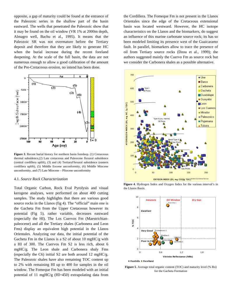
opposite, a gap of maturity could be found at the entrance of the Paleozoic series in the shallow part of the basin eastward. The wells that penetrated the Paleozoic show that it may be found on the oil window (VR 1% at 2000m depth, Almagro well, Bachu et al., 1995). It means that the Paleozoic SR was not overmature before the Tertiary deposit and therefore that they are likely to generate HC when the burial increase during the recent foreland deepening. At the scale of the full basin, the data are not numerous enough to allow a good calibration of the amount of the Pre-Cretaceous erosion, no intend has been done.
Figure 3. Recent burial history for northern basin foredeep. (1) Cretaceous thermal subsidence,(2) Late cretaceous and Paleocene flexural subsidence (central cordillera uplift), (3) and (4) TertiaryFlexural subsidence (eastern cordillera uplift), (5) Middle Eocene unconformity, (6) Middle Miocene unconformity, and (7) Late Miocene – Pliocene unconformity
4.1. Source Rock Characterization
Total Organic Carbon, Rock Eval Pyrolysis and visual kerogene analyses, were performed on about 400 cutting samples. The study highlights that there are various good source rocks in the Llanos (fig 4). The “official” main one is the Gacheta Fm from the Upper Cretaceous however its potential (Fig 5), rather variable, decreases eastward (especially the HI). The Los Cuervos Fm (Maestrichian-paleocene) and all the Tertiary shales (Carbonera and Leon Fms) display an equivalent high potential in the Llanos Orientales. Analyzing our data, the initial potential of the Gacheta Fm in the Llanos is a S2 of about 10 mgHC/g with a HI of 300. The Cuervos Fm S2 is less rich, about 6 mgHC/g. The Leon shale and Carbonera shaly Fms (especially the C6) initial S2 are both around 12 mgHC/g. The Paleozoic shales have also remaining TOC content up to 2% with remaining HI up to 400 for samples in the oil window. The Fomeque Fm has been modeled with an initial potential of 11 mgHC/g (HI=450) extrapolating data from
the Cordillera. The Fomeque Fm is not present in the Llanos Orientales since the edge of the Cretaceous extensional basin was located westward. However, the HC isotope characteristics on the Llanos and the biomarkers, do suggest an influence of this marine carbonate source rock; its has so been modeled limiting its presence west of the Guaicaramo fault. In parallel, biomarkers allow to trace the presence of oil from Tertiary source rocks (Dzou et al., 1999); the authors suggested mainly the Cuervo Fm as source rock but we consider the Carbonera shales as a possible alternative.
0
100
200
300
400
500
600
700
0 50 100 150 200
OXYGEN INDEX (OI, mg CO2/g TOC )
HYDROGEN INDEX (HI, m
g H
C / g TOC)
Une
Barco
C arbonera
Gacheta
Guadalupe
Guayabo
Leon
Los C uervos
Mirador
P aleoz oico
P ujamana
Tubara
Type IOil Prone
Type II (usu. marine)Oil Prone
Mixed Type II / IIIOil / Gas Prone
Type IIIGas Prone
Type IVGas Prone
Humble Geochemical Services
Figure 4. Hydrogen Index and Oxygen Index for the various interval’s in the Llanos Basin.
0
2
4
6
8
10
0 0,6 1,2 1,8
Vitrinite Reflectance (%Ro)
% T
OC
Foothills Forelland
Poor to Fair
Very Good
Excellent
Inmature Oil Window Dry GasAnaconda-1
Leticia-1
La M aria-1
M edina-1
Golconda-1
Pomarroso-1
Figure 5. Average total organic content (TOC) and maturity level (% Ro) for the Gacheta Formation
‐ 4 ‐ MORETTI, I., C., MORA, W., ZAMORA, M., VALENDIA, M., MAYORGA, G., RODRIGUEZ
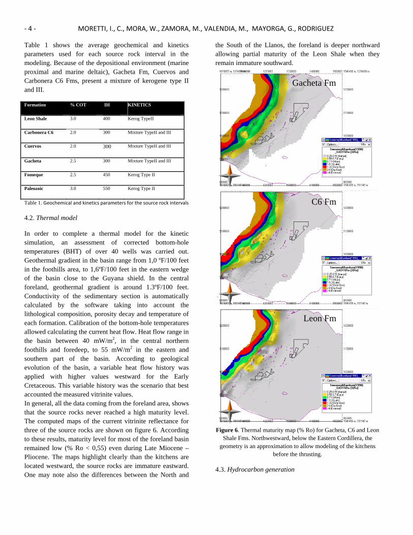
Table 1 shows the average geochemical and kinetics parameters used for each source rock interval in the modeling. Because of the depositional environment (marine proximal and marine deltaic), Gacheta Fm, Cuervos and Carbonera C6 Fms, present a mixture of kerogene type II and III.
Formation % COT IH KINETICS
Leon Shale 3.0 400 Kerog TypeII
Carbonera C6 2.0 300 Mixture TypeII and III
Cuervos 2.0 300 Mixture TypeII and III
Gacheta 2.5 300 Mixture TypeII and III
Fomeque 2.5 450 Kerog Type II
Paleozoic 3.0 550 Kerog Type II
Table 1. Geochemical and kinetics parameters for the source rock intervals
4.2. Thermal model
In order to complete a thermal model for the kinetic simulation, an assessment of corrected bottom-hole temperatures (BHT) of over 40 wells was carried out. Geothermal gradient in the basin range from 1,0 ºF/100 feet in the foothills area, to 1,6ºF/100 feet in the eastern wedge of the basin close to the Guyana shield. In the central foreland, geothermal gradient is around 1.3ºF/100 feet. Conductivity of the sedimentary section is automatically calculated by the software taking into account the lithological composition, porosity decay and temperature of each formation. Calibration of the bottom-hole temperatures allowed calculating the current heat flow. Heat flow range in the basin between 40 mW/m2, in the central northern foothills and foredeep, to 55 mW/m2 in the eastern and southern part of the basin. According to geological evolution of the basin, a variable heat flow history was applied with higher values westward for the Early Cretaceous. This variable history was the scenario that best accounted the measured vitrinite values. In general, all the data coming from the foreland area, shows that the source rocks never reached a high maturity level. The computed maps of the current vitrinite reflectance for three of the source rocks are shown on figure 6. According to these results, maturity level for most of the foreland basin remained low (% Ro < 0,55) even during Late Miocene – Pliocene. The maps highlight clearly than the kitchens are located westward, the source rocks are immature eastward. One may note also the differences between the North and
the South of the Llanos, the foreland is deeper northward allowing partial maturity of the Leon Shale when they remain immature southward.
Gacheta Fm
C6 Fm
Leon Fm
Figure 6. Thermal maturity map (% Ro) for Gacheta, C6 and Leon Shale Fms. Northwestward, below the Eastern Cordillera, the
geometry is an approximation to allow modeling of the kitchens before the thrusting.
4.3. Hydrocarbon generation
16 Myr 10 Myr
5 Myr 0 Myr
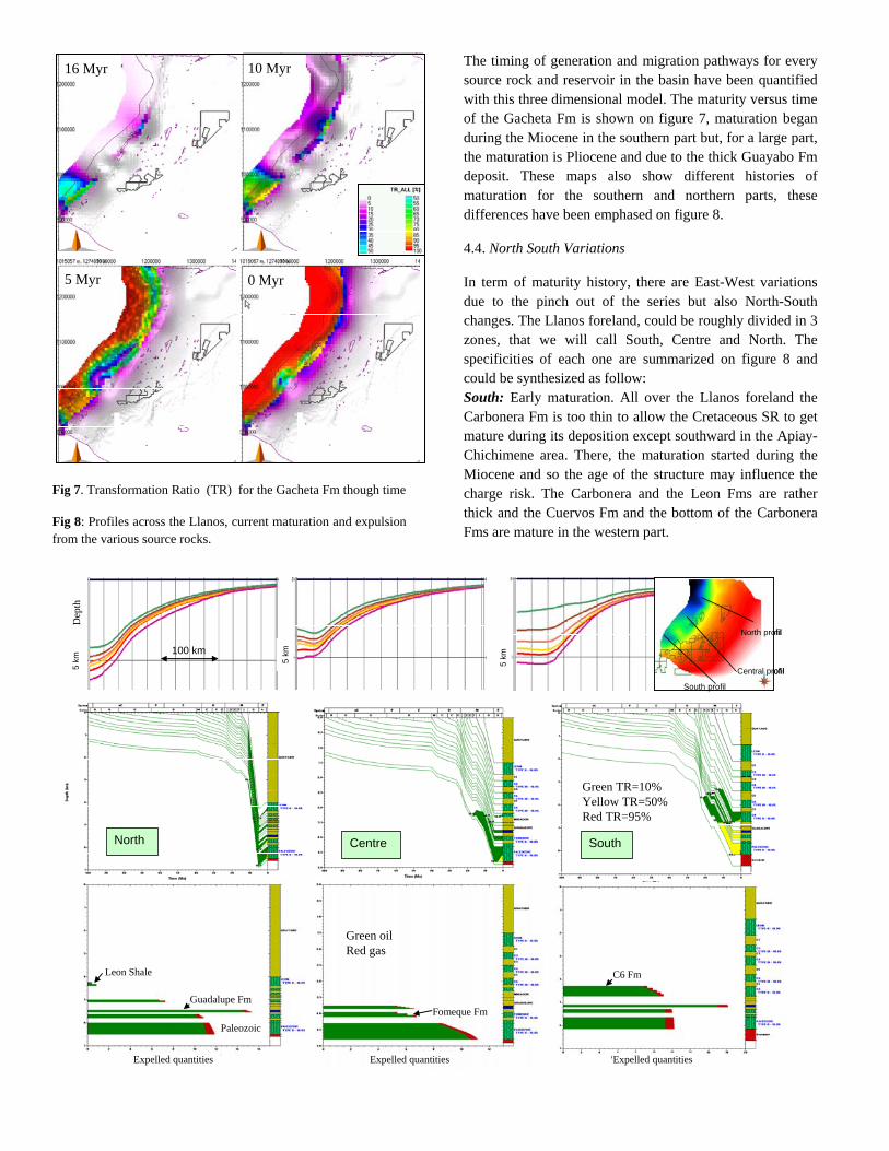
Fig 7. Transformation Ratio (TR) for the Gacheta Fm though time
Fig 8: Profiles across the Llanos, current maturation and expulsion from the various source rocks.
The timing of generation and migration pathways for every source rock and reservoir in the basin have been quantified with this three dimensional model. The maturity versus time of the Gacheta Fm is shown on figure 7, maturation began during the Miocene in the southern part but, for a large part, the maturation is Pliocene and due to the thick Guayabo Fm deposit. These maps also show different histories of maturation for the southern and northern parts, these differences have been emphased on figure 8.
4.4. North South Variations
In term of maturity history, there are East-West variations due to the pinch out of the series but also North-South changes. The Llanos foreland, could be roughly divided in 3 zones, that we will call South, Centre and North. The specificities of each one are summarized on figure 8 and could be synthesized as follow: South: Early maturation. All over the Llanos foreland the Carbonera Fm is too thin to allow the Cretaceous SR to get mature during its deposition except southward in the Apiay-Chichimene area. There, the maturation started during the Miocene and so the age of the structure may influence the charge risk. The Carbonera and the Leon Fms are rather thick and the Cuervos Fm and the bottom of the Carbonera Fms are mature in the western part.
SouthCentreNorth
100 km
5 km 5
km
5 km
North profil
Central profil
South profil
North profil
Central profil
South profil
Expelled quantities Expelled quantities Expelled quantities
Leon Shale C6 Fm
PaleozoicFomeque Fm
Guadalupe Fm
Dep
th
Green TR=10%Yellow TR=50%Red TR=95%
Green oilRed gas
‐ 6 ‐ MORETTI, I., C., MORA, W., ZAMORA, M., VALENDIA, M., MAYORGA, G., RODRIGUEZ
Centre: Thinner tertiary burial and limited current kitchen. The Carbonera and the Leon Fms are thin in the central part. Maturation of the Cretaceous source rocks started at the Lower Miocene. During the Quaternary, due to the shortening, the Yopal thrust bound the drainage area of the central structures. North: Leon Shales partially mature. Northward, the Guayabo Fm is up to 4km thick and therefore thick enough to allow the bottom of the Leon Fm to be mature, and the deepest source rocks are in the gas window. Most of maturation processes happens during the Guayabo deposition, i.e. during the last 15 Myr. The Tertiary being there more than 5 km thick, the probability of increase of the maturation within the Paleozoic SR is very high. 4.4. Timing of expulsion and risk of biodegradation
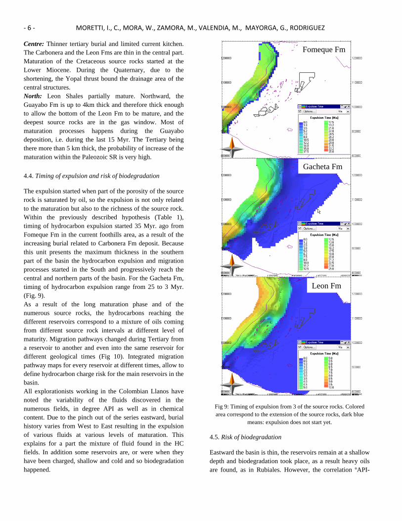
The expulsion started when part of the porosity of the source rock is saturated by oil, so the expulsion is not only related to the maturation but also to the richness of the source rock. Within the previously described hypothesis (Table 1), timing of hydrocarbon expulsion started 35 Myr. ago from Fomeque Fm in the current foothills area, as a result of the increasing burial related to Carbonera Fm deposit. Because this unit presents the maximum thickness in the southern part of the basin the hydrocarbon expulsion and migration processes started in the South and progressively reach the central and northern parts of the basin. For the Gacheta Fm, timing of hydrocarbon expulsion range from 25 to 3 Myr. (Fig. 9). As a result of the long maturation phase and of the numerous source rocks, the hydrocarbons reaching the different reservoirs correspond to a mixture of oils coming from different source rock intervals at different level of maturity. Migration pathways changed during Tertiary from a reservoir to another and even into the same reservoir for different geological times (Fig 10). Integrated migration pathway maps for every reservoir at different times, allow to define hydrocarbon charge risk for the main reservoirs in the basin. All explorationists working in the Colombian Llanos have noted the variability of the fluids discovered in the numerous fields, in degree API as well as in chemical content. Due to the pinch out of the series eastward, burial history varies from West to East resulting in the expulsion of various fluids at various levels of maturation. This explains for a part the mixture of fluid found in the HC fields. In addition some reservoirs are, or were when they have been charged, shallow and cold and so biodegradation happened.
Gacheta Fm
Fomeque Fm
Leon Fm
Fig 9: Timing of expulsion from 3 of the source rocks. Colored area correspond to the extension of the source rocks, dark blue
means: expulsion does not start yet.
4.5. Risk of biodegradation
Eastward the basin is thin, the reservoirs remain at a shallow depth and biodegradation took place, as a result heavy oils are found, as in Rubiales. However, the correlation ºAPI-

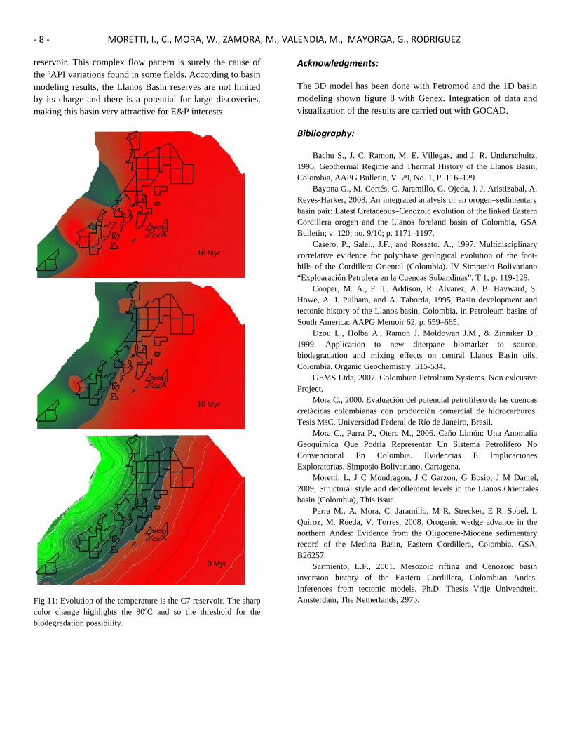
reservoir temperature is far to be simple in the Llanos. The presented regional model allows us predicting the temperature in the reservoirs when the fluids arrived. Many of the low ºAPI may be explained by a paleobiodegradation that took place during the Miocene. Although the subsidence is rather continue in the Llanos Orientales overall the Tertiary, the regional tectonic events responsible for the eastward propagation of the compression during Middle Miocene, allows separating two acceleration phases within the hydrocarbon expulsion and migration processes. The first one occurred during the Late Oligocene-Early Miocene times (Carbonera Fom deposit) and the last one approximately coincides with the Guayabo Fm deposit (Late Miocene to Pliocene). The temperature in the C7 reservoir through time is shown on figure 11. The areas with a high risk of biodegradation, it means when the temperature is less than 80ºC, are shown in red. When the first pulse arrived, during the Early Miocene, all the Llanos Orientales was poorly buried and so biodegradation may have took place. Today only the eastern part is cold enough to allow biodegradation. In a particular field, one may so find biodegraded heavy oil mixes with a lighter one coming from the current flow.
5. Exploration Issue
Basin Modeling applied to the Llanos Basin allows pro-posing a hydrocarbon generation and migration model for the basin and it´s relation with the Petroleum System variations. According to the modeling results some points could be outstanding: First hydrocarbon charge pulse occurred during Late Oligocene-Early Miocene, involved source rock intervals from Cretaceous to older. Strong biodegradation processes affected most of the oil accumulations related with this pulse. A second hydrocarbon charge pulse occurred during Late Miocene-Pliocene, involved Cretaceous source rocks and Tertiary ones. Biodegradation and preservation processes of the second pulse are also controlled by the thermal history of the reservoir units but result in the refreshing of HC in the traps. Light oil, eventually no biodegraded is mixed with the heavy ones in the now deep reservoirs westward.
Combining preservation and flowpaths migration maps at different geological times is possible to predict more efficiently hydrocarbon charge and preservation risk. The migration model presented here is simple, the HC follow the carrier beds and may only pass to a youngest one in case of contact at the edge eastward. Reaching shallower reservoirs in the sand-shale intercalation context of the Carbonera Fm
requires migration pathway through faults, such a more complex pathway is not modeled in the presented 3D model.
16 Myr
5 Myr
0 Myr
Fig 10: Migration pathways through time within the Mirador Fm. The pathways that seem to start eastward are due to the arriving of HC from deeper reservoirs due to the pinchout of the corresponding layers.
Intends done internally, in a 2D complex modeling with fault, using the hypothesis of seal characteristic due to capillarity pressure in the faults, have convinced us of the strong level of mixture. Very often, except in the basal sands, the fluids are sourced by at least 3 source rocks and short as well as long distance migrations result in the presence of early and late mature HC within the same
‐ 8 ‐ MORETTI, I., C., MORA, W., ZAMORA, M., VALENDIA, M., MAYORGA, G., RODRIGUEZ
reservoir. This complex flow pattern is surely the cause of the ºAPI variations found in some fields. According to basin modeling results, the Llanos Basin reserves are not limited by its charge and there is a potential for large discoveries, making this basin very attractive for E&P interests.
Fig 11: Evolution of the temperature is the C7 reservoir. The sharp color change highlights the 80ºC and so the threshold for the biodegradation possibility.
Acknowledgments:
The 3D model has been done with Petromod and the 1D basin modeling shown figure 8 with Genex. Integration of data and visualization of the results are carried out with GOCAD.
Bibliography:
Bachu S., J. C. Ramon, M. E. Villegas, and J. R. Underschultz, 1995, Geothermal Regime and Thermal History of the Llanos Basin, Colombia, AAPG Bulletin, V. 79, No. 1, P. 116–129
Bayona G., M. Cortés, C. Jaramillo, G. Ojeda, J. J. Aristizabal, A. Reyes-Harker, 2008. An integrated analysis of an orogen–sedimentary basin pair: Latest Cretaceous–Cenozoic evolution of the linked Eastern Cordillera orogen and the Llanos foreland basin of Colombia, GSA Bulletin; v. 120; no. 9/10; p. 1171–1197.
Casero, P., Salel., J.F., and Rossato. A., 1997. Multidisciplinary correlative evidence for polyphase geological evolution of the foot-hills of the Cordillera Oriental (Colombia). IV Simposio Bolivariano “Exploaración Petrolera en la Cuencas Subandinas”, T 1, p. 119-128.
Cooper, M. A., F. T. Addison, R. Alvarez, A. B. Hayward, S. Howe, A. J. Pulham, and A. Taborda, 1995, Basin development and tectonic history of the Llanos basin, Colombia, in Petroleum basins of South America: AAPG Memoir 62, p. 659–665.
Dzou L., Holba A., Ramon J. Moldowan J.M., & Zinniker D., 1999. Application to new diterpane biomarker to source, biodegradation and mixing effects on central Llanos Basin oils, Colombia. Organic Geochemistry. 515-534.
GEMS Ltda, 2007. Colombian Petroleum Systems. Non exlcusive Project.
Mora C., 2000. Evaluación del potencial petrolífero de las cuencas cretácicas colombianas con producción comercial de hidrocarburos. Tesis MsC, Universidad Federal de Río de Janeiro, Brasil.
Mora C., Parra P., Otero M., 2006. Caño Limón: Una Anomalía Geoquímica Que Podría Representar Un Sistema Petrolífero No Convencional En Colombia. Evidencias E Implicaciones Exploratorias. Simposio Bolivariano, Cartagena.
Moretti, I., J C Mondragon, J C Garzon, G Bosio, J M Daniel, 2009, Structural style and decollement levels in the Llanos Orientales basin (Colombia), This issue.
Parra M., A. Mora, C. Jaramillo, M R. Strecker, E R. Sobel, L Quiroz, M. Rueda, V. Torres, 2008. Orogenic wedge advance in the northern Andes: Evidence from the Oligocene-Miocene sedimentary record of the Medina Basin, Eastern Cordillera, Colombia. GSA, B26257.
Sarmiento, L.F., 2001. Mesozoic rifting and Cenozoic basin inversion history of the Eastern Cordillera, Colombian Andes. Inferences from tectonic models. Ph.D. Thesis Vrije Universiteit, Amsterdam, The Netherlands, 297p.
10 Myr
16 Myr
0 Myr