2004 Speth (The Henderson Site CHAPT 2)
21
Museum of Anthropology, University of Michigan Memoirs, Number 37 Life on the Periphery Economic Change in Late Prehistoric Southeastern New Mexico edited by John D. Speth Ann Arbor, Michigan 2004
Transcript of 2004 Speth (The Henderson Site CHAPT 2)

Museum of Anthropology, University of Michigan Memoirs, Number 37
Life on the Periphery Economic Change in Late Prehistoric Southeastern New Mexico
edited by
John D. Speth
Ann Arbor, Michigan 2004

©2003 by the Regents of the University of Michigan The Museum of Anthropology All rights reserved
Printed in the United States of America ISBN 0-915703-54-8
Cover design, by Katherine Clahassey, inspired by the painting Trading at the Pecos Pueblo, by Tom Lovell.
The University of Michigan Museum of Anthropology currently publishes three monograph series: Anthropological Papers, Memoirs, and Technical Reports, as well as an electronic series in CDROM form. For a complete catalog, write to Museum of Anthropology Publications, 4009 Museums Building, Ann Arbor, MI 48109-1079.
Library of Congress Cataloging-in-Publication Data
Life on the periphery : economic change in late prehistoric southeastern New Mexico I edited by John D. Speth.
p. em. -- (Memoirs ; no. 37) Includes bibliographical references.
ISBN 0-915703-54-8 (alk. paper) I. Henderson Site (N.M.) 2. Pueblo Indians--Antiquities. 3. Pueblo
pottery--Pecos River Valley (N.M. and Tex.) 4. Plant remains (Archaeology)--Pecos River Valley (N.M. and Tex.) 5. Animal remains (Archaeology)--Pecos River Valley (N.M. and Tex.) 6. Pecos River Valley (N.M. and Tex.)--Antiquities. I. Speth, John D. II. Memoirs of the Museum of Anthropology, University of Michigan; no. 37. GN2.M52no.37 L55 2003 [E99.p9] 978.9'4--dc21
2003010294
The paper used in this publication meets the requirements of the ANSI Standard Z39.48-1984 (Permanence of Paper)

2 The Henderson Site
John D. Speth University of Michigan
Introduction
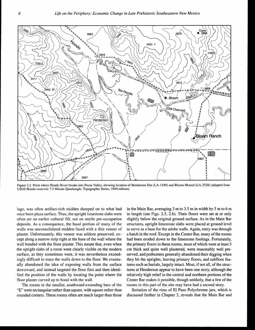
The Henderson Site (LA-1549) is a moderate-sized E-shaped pueblo-like community located about 10.5 mi (17 km) southwest of the modem city of Roswell in Chaves County, southeastern New Mexico (Fig. 2.1). 1 The site, which dates to the late thirteenth and fourteenth century, is situated at an elevation of 3,890 ft (1,186 m) on the easternmost of a series of low, northeast-trending limestone ridges that form the western border of the broad Pecos Valley lowlands. The Hondo River, a major western tributary of the Pecos, breaks through this last limestone ridge just north of the site and then flows northeast through Roswell before turning southeast and joining the Pecos (Fig. 2.2).
Since a previous report on the Henderson Site burials (Rocek and Speth 1986) has already described the nature and layout of the site in some detail, and has also provided basic information on excavation and recording techniques, only a brief review of these issues will be provided here, with emphasis given to those aspects that are new or that have been revised since the appearance of the first report. Some repetition is necessary, however, in order to put the new material in context.
Excavations were conducted at Henderson by the University of Michigan Museum of Anthropology during two threemonth field seasons in the summers of 1980 and 1981. Renewed excavations at the site, in six-week seasons, were undertaken again in 1994, 1995, and 1997. An area of 314m2 was opened in the five seasons, amounting to less than 14% ofthe total site area (including the room blocks and the two plazas enclosed between the arms of the "E"). Of this total, 236 m2 were excavated in the room blocks themselves, and 78 m2 in plaza and
4
other non-room areas. Excavations were conducted using a onemeter grid system. A permanent (cement) base datum (datum A) was arbitrarily placed just off the site near its southwest comer. The grid system was laid out with one axis roughly parallel to the long bar of the "E" (Main Bar), and the other parallel to the short bars (West Bar, Center Bar, and East Bar). Datum A was assigned coordinates 500N500E (i.e., 500 m north of, and 500 m east of, an arbitrary, and imaginary, reference point far to the southwest of the site). This was done to simplify recording procedures by keeping all of our excavation units within the same quadrant (to the northeast of the imaginary zero-zero reference point). Each one-meter grid unit received its designation from the coordinates of its northeast corner (e.g., grid square 500N500E is the one-meter unit immediately southwest of datum A). Datum A was also arbitrarily assigned an elevation of + 100.00 m. All elevations (including artifact proveniences) were shot in with a transit and recorded in meters above or below datum A.2
Early in the 1980 season, every item was individually labeled with complete provenience information. This quickly ·proved to be far too cumbersome and time-consuming, and a new procedure was adopted in which every discrete provenience, such as a bag of material from a single level in a single one-meter grid square, was assigned a unique, sequential lot number. For example, lot number 274 was assigned to grid square 515N534E, levellOl.00-100.90 m). Only these lot numbers were then written on each object. By the end of the 1981 field season, we had used a total of 2,333 lot numbers. We continued to use this system in subsequent field seasons, beginning arbitrarily at 3,000 in 1994, continuing without a break to 4,112 by the end of the 1995 season, beginning again at 5,000

The Henderson Site-Speth 5
NEW MEXICO
Figure 2.1. Location of Henderson Site (LA-1549), Bloom Mound (LA-2528), Rocky Arroyo (LA-25277), and Garnsey Bison Kill (LA-18399) in southeastern New Mexico.
in 1997 and terminating the Henderson lot numbers at 5,669 at the end of the 1997 season. In 2000 we commenced work at the nearby quasi-contemporary site of Bloom Mound, and arbitrarily began the lot number system there at 6,000.
The lot number system greatly streamlined the labeling of artifacts, but has the obvious limitation that should the lot number records be lost or destroyed, most of the basic provenience information would also be lost. To prevent this from happening, we decided to create a permanent record of the lot numbers by publishing the complete file. The first 2,027 lot numbers were originally published as an appendix in Rocek and Speth (1986). Since the appearance of that publication, a number of errors have been noted. In addition, we decided that it would be useful to publish the full provenience information for each lot number, including our spatial designations, such as East Bar, Main Bar, etc. In Appendix 2 at the end of the chapter (Table A2.1) we present all 5,669 lot number records for Henderson, including the corrected and updated entries for the first 2,027 numbers. The lot numbers for Bloom Mound will be published elsewhere.
Henderson is an E-shaped, adobe village containing perhaps as many as 100 to 130 rooms (Fig. 2.3, the problems with estimating the number of rooms at Henderson is addressed in Chapter 21). The Main Bar is oriented approximately 60° west of true north, with the short bars (West, Center, East) extending out to the southwest or away from the Hondo. The open spaces
enclosed between the Main Bar and the short bars form two roughly square plazas, the West Plaza between the West and Center Bars, and the East Plaza between the Center and East Bars. The pueblo, including plazas, covers a maximum area of approximately 2,640 m2 (0.26 ha or 0.65 acres). The area occupied just by the room blocks is about 1,830 m2 (0.18 ha or 0.45 acres). Since room outlines were often very difficult to determine from the surface, even with extensive shovel-stripping, the area occupied by rooms was estimated from the contour map of the site, arbitrarily selecting as the structure's perimeter the point where the ground surface first rises appreciably above the surrounding terrain. Since portions of rooms may have collapsed or eroded outward, the actual area of the structure is probably less than 1,830 m2• Reducing this figure by 20% produces a more conservative and probably more realistic areal estimate of about 1,460 m2 (0.15 ha or 0.38 acres) for the architectural portion of the site. The plazas occupy an additional 810m2 (West Plaza 390 m2 ; East Plaza 420 m2).
The discovery in 1994 that much of the Main Bar may consist of small, square, semi-subterranean structures rather than large, rectangular, above-ground dwellings, and the discovery of several such "pit structures" in areas we thought were plaza, may suggest that the architectural portion of the site is somewhat larger than 1,460 m2• Reducing the 1,830 m2 figure by 20% may be excessive.
The area and volume of sediment excavated in the five seasons of work at the site, broken down by major proveniences, are summarized in Table 2.1. These data provide an important baseline for standardizing count data in terms of items per cubic meter of sediment, and are relied upon extensively in later sections of this report.
Most of the rooms in the Main Bar of the "E" appear to be nearly square, with slightly rounded corners, and average about 3 m to 4 m on a side (see Fig. 2.4). The floors of these rooms were set well below the original ground surface (generally more than 25 em), giving them the appearance of shallow pitrooms. Four upright posts set near the corners supported the roof. Upright limestone slabs were set at ground level and served as the base for the adobe superstructure. Sometimes these footings consisted of double rows of upright slabs oriented parallel to the wall, but at other times the stones were placed in a single line, either oriented perpendicular to the wall or lying flat. Fragments of deliberately broken metates (invariably made of limestone) were sometimes incorporated into these footings. The roofs appear to have been flat and entry was through a hatch. We encountered no unambiguous traces of doorways. Most rooms had multiple floors, each separated from the floor beneath by 5 em to 10+ em of deliberately introduced ashy fill. At least two of the excavated structures in the Main Bar started out as domestic dwellings (as suggested by the presence of a hearth in each) and were then converted into storage structures that lacked fireplaces.
Interestingly, what constituted the "original ground surface" at Henderson, both in the Main Bar and elsewhere in the vi!-
6 Life on the Periphery: Economic Change in Late Prehistoric Southeastern New Mexico
-==~~---·-·-· ~
807~11 n II II II
" II II II
Figure 2.2. Point where Hondo River breaks into Pecos Valley, showing location of Henderson Site (LA-1549) and Bloom Mound (LA-2528) (adapted from USGS Hondo reservoir 7.5 Minute Quadrangle, Topographic Series, 1949 edition).
lage, was often artifact-rich midden dumped on to what had once been plaza surface. Thus, the upright limestone slabs were often set on earlier cultural fill, not on sterile pre-occupation deposits. As a consequence, the basal portion of many of the walls was unconsolidated midden faced with a thin veneer of plaster. Unfortunately, this veneer was seldom preserved, except along a narrow strip right at the base of the wall where the wall bonded with the floor plaster. This meant that, even when the upright slabs of a room were clearly visible on the modem surface, as they sometimes were, it was nevertheless exceedingly difficult to trace the walls down to the floor. We eventually abandoned the idea of exposing walls from the surface downward, and instead targeted the floor first and then identified the position of the walls by locating the point where the floor plaster curved up to bond with the wall.
The rooms in the smaller, southward-extending bars of the "E" were rectangular rather than square, with square rather than rounded comers. These rooms often are much larger than those
in the Main Bar, averaging 3 m to 3.5 min width by 5 m to 6 m in length (see Figs. 2.5, 2.6). Their floors were set at or only slightly below the original ground surface. As in the Main Bar structures, upright limestone slabs were placed at ground level to serve as a base for the adobe walls. Again, entry was through a hatch in the roof. Except in the Center Bar, many of the rooms had been eroded down to the limestone footings. Fortunately, the primary floors in these rooms, most of which were at least 5 em thick and quite well plastered, were reasonably well preserved, and pothunters generally abandoned their digging when they hit the uprights, leaving primary floors, and subfloor features such as burials, largely intact. Most, if not all, of the structures at Henderson appear to have been one story, although the relatively high relief in the central and northern portions of the Center Bar makes it possible, though unlikely, that a few of the rooms in this part of the site may have had a second story.
Seriation of the rims of El Paso Polychrome jars, which is discussed further in Chapter 3, reveals that the Main Bar and

The Henderson Site-Speth 7
Table 2.1. Area and volume of principal excavation units at Henderson Site.'
Excavation Unit Area Volume (m2\ (mJ)
TOTAL EXCAVATION 314.0 182.6 Great Deoression (trench K) 12.0 9.1 East Plaza (trenches B C D\ 35.0 16.2
trench B 4.0 0.8 trench C 23.0 11.9 trench D 8.0 3.5
East Plaza (East) 14.0 11.3 East Plaza (South) 2.0 0.6 West Plaza (trench G) 8.0 1.9 North Plaza (trench N test A) 7.0 4.3 Main Bar East (trenches E J) 58.0 37.0
Room M-1 10.1 10.9 RoomM-2 9.2 6.2 Room M-3 5.4 3.4
Main Bar West_(trench Ol 8.0 3.9 West Bar (trench M) 12.0 6.8 Center Bar (trench Fl" 41.0 25.8
Room C-1 5.0 2.1 Room C-2 11.2 4.9 Room C-3 7.0 3.1 RoomC-4 8.3 6.7 RoomC-5 9.1 8.8 Room C-6" 0.5 0.2
East Bar (trench A) 117.0 65.7 Room E-1 16.0 5.1 Room E-2 14.9 5.1 Room E-3 13.2 5.1 Room E-4 18.3 10.0 Room E-5 18.2 8.1 Room E-6 5.5 1.6 Room E-7 7.2 6.2 Room E-8 9.5 5.3
Flotation (1980-1981)' - 1.2 Flotation (all seasons)d - 2.5 'Areas given for rooms refer to portiOn excavated, not to total floor area of original room; room volumes exclude subfloor features. "Excludes large "pothunter's" pit (centered on Room C-6) at north end of trench F (Room C-6 values given are for grid square 520N533E only). 'A total of303 flotation samples were taken in 1980-1981 (1,174.51iters; average 3.88 liters per sample; range 0.2-19.0 liters). Proveniences sampled included most excavation levels, floor contacts, and all features. d A total of 782 flotation samples were taken in all five seasons of excavation (2,51 1.4 liters; average 3.21 liters per sample; range 0.2-19.0 liters). Proveniences sampled included most excavation levels, floor contacts, and all features.
"Great Depression," and possibly also the West Bar, predate the Center Bar and East Bar, as well as the fill in the East Plaza. Over time the village shifted from a linear, or L-shaped, room block (Main Bar and perhaps West Bar) consisting of small, square, pitroom-like dwellings, to an E-shaped community, and several (most?) Main Bar structures were converted to store rooms. The large, rectangular Center Bar and East Bar rooms were then used as dwellings. The seriation also suggests that the East Bar is the youngest room block at the site, probably remaining in use after occupation declined sharply, or ceased altogether, in other parts of the site.
Four, and sometimes six, upright posts, each roughly 10 em in diameter, supported the roof of each structure. According to Archer (1994), most structural beams were ash (Fraxinus sp.), although a few were Acer (either box elder, A. negundo, or bigtooth maple, A. grandidentatum). Hearths tended to be located along the midline of the rooms, though often not at their geometric center. At least one hearth was found in each of the rooms we tested. Ash pits or heating pits were also found along the midline axis, again offset from the center. Several of the hearths in the East Bar had distinct adobe collars, while elsewhere in the site hearths were either semi-spherical, with no trace of a collar, or less formal, shallow, basin-shaped pits. The occurrence of collared hearths in the East Bar, the last portion of the site to be occupied, and at Bloom Mound, which appears to postdate Henderson slightly, suggest that this form of fireplace may have chronological significance in the Roswell area. None of the hearths in the rooms was lined by stones and no ventilator shafts or deflectors (adobe or stone) were found.
Most of the rooms had evidence of multiple floors separated by up to several centimeters of trash or sterile fill. Primary floors typically were well made, whereas younger floors tended to be thin and poorly plastered. Many of these younger floors, in fact, were so ephemeral that we often had to establish their reality in profile before attempting to trace them horizontally. In many instances, walls showed evidence of replastering and rebuilding, with additions not uncommonly using adobe that differed in color and composition from the original wall segments. No traces of paint or colored plaster were found on walls or floors. Only one of the sampled rooms, a badly eroded structure at the south end of the Center Bar (Room C-2), showed clear evidence of burning. The evidence consisted of charred roofing beams and reeds lying more or less directly on the floor.
The sampled rooms had not been abandoned hastily; none had useable items left in situ on the floor. Even metates were seldom left in place. In fact, most metates, despite their mas
. sive size and limited wear, had been deliberately broken and either discarded or incorporated as uprights in the walls (see Chapter 17). Floors were generally clean, "floor-contact" artifacts were usually materials that had been dumped into the structures soon after their abandonment. Stubs of unburned upright support beams in Room E-4 in the East Bar remained in place; in most of the other rooms that we sampled, the beams had apparently been salvaged prehistorically as no trace of decayed wood was found in the postholes.
Most of the sampled rooms had one or more burials beneath the floors in ovoid, steep-sided pits. Some of the burial pits had been deliberately sealed beneath the primary floor, while others showed no trace of a plaster seal and may have been intrusive from a younger floor in the room. Subfloor pits, other than those used for burials, were not very common. Moreover, most of the non burial pits were small, cylindrical features that would have been unsuitable for large-scale storage of foods. Some of these in fact may have been postholes that were abandoned and sealed under a new floor when a room was remodeled. A few of

8 Life on the Periphery: Economic Change in Late Prehistoric Southeastern New Mexico
+ +
560 +
535
510
+ +
+
6 I I If I I I I 1 1~m
Contour lnterval25 em
+
+
+
+
Site Elevation ca. 1186 m (3890 It)
4oo~~~I····------~·~~ __ _j+~·----~-~~--~4L---L_~-I~~---+~-----~+~--~+~--~iL---~~+~--!===============~ 465 490 515 540 585
Figure 2.3. Contour map of Henderson Site (LA-1549), showing all major excavation units.
these cylindrical pits had been deliberately "plugged" by placing a piece of adobe near the top of the pit. The plug was largely or entirely symbolic, however, as it was normally much smaller than the diameter of the mouth of the pit and it never formed a clear bond with the surrounding floor surface or with the adjacent walls of the pit. While most of these pits were empty, a few contained items that had been cached, most notably grooved stone axes and manos.
The subfloor burials recovered in 1980 and 1981 (all from the Center Bar and East Bar) were the primary focus of the previous monograph on the Henderson Site (Rocek and Speth
1986), and only a brief summary is presented here.3 Eleven bodies were found in ten discrete burial features in the Center and East Bars (one feature contained two individuals-an adult female and a fetus). The burials include one fetus, two infants, and eight adults. Of the adults, four were male, four were female. The immature individuals could not be reliably sexed. Six of the ten burial features were found in a single room (E-4) in the East Bar. Most of the burials were placed on their right sides or their backs, with legs flexed. One individual was placed on his left side, another on his back and left side. No clear association was found between burial orientation and age, sex, spa-

The Henderson Site-Speth 9
540N, ~\ ' '@>.
539N
538N
537N
536N
535N
+
+ + \+ + + 534 E 535 E 536 E 537 E
534N
I·
533N
+ 538£.
+
·~~. ' ' ' ' ·., IJ~
~~ ',
'·o;q \ + \ i;.
539£
+ +
•7p"
~...&3~~ ,--~
+ ...,. 541 E 542E 543E .... 545E 546 E
Figure 2.4. Main Bar East (trenches E and J), showing excavated rooms and features.
tial placement, or stratigraphic placement, although this may simply be a result of small sample size. Bodies tended to be placed relatively close to and parallel to walls. At least seven of the individuals bore traces of some sort of mat wrapping. The absence of matting on the remaining four may be an artifact of preservation.
Six individuals were accompanied by grave goods, including: pottery vessels (a small Lincoln Black-on-red bowl, small Chupadero Black-on-white jar nested within the Lincoln bowl, large Heshotauthla Polychrome bowl); coiled basketry; a variety of disc-shell beads, pendants, and other personal ornaments; caches of projectile points, many of archaic stylistic affiliation and made on Plains lithic materials including Alibates and Edwards Plateau chert (one, a "turkey-tail," was made on Tiger chert derived from southwestern Wyoming-see Whittaker et al. 1988); bone "awls" or "hairpieces" and tortoise-shell "gaming pieces"; and miscellaneous lithic items. Two wooden "prayer
sticks" were also encountered; one was rod-like with a round or square cross-section to which were attached numerous Olivella beads, the other was thin and flat and cut into the form of a stylized corn plant. Grave goods were absent with the two youngest individuals (fetus and a roughly 3- to 6-month-old infant) and with the oldest individual (more than 40 years old), and most abundant with a 2.5- to 3.5-year-old child.
Chronology
While the general temporal placement of the Henderson Site is reasonably clear, there are several chronological issues that could not be resolved at the time of the publication of the first monograph on the site (Rocek and Speth 1986:8-23). These issues are discussed more thoroughly here and a series of new radiocarbon dates, all run on the accelerator, are presented and

10 Life on the Periphery: Economic Change in Late Prehistoric Southeastern New Mexico
... East Bar + f 533N @'?J ,-------, N ..
+ + 0 1m + I + + + rzl®+~ F218 Hearth
532N ., . l -+·- j -+- -+
((\' •• j + + • E-8 531 N • • ·<~'~!>
+ + -i- + ~ ·~7-r-I'~' ' .
530N ,------? + ''•
' 529N
+ ·r + -r--· + + + + . • F13 C9 528N . Hearth . +" + •+ I + + I + + + + T -r-
Q E-3 E-4 527N E-6 F35
Hearth
+ + + _j_ + I -t- + + -+- + 526N • •• • -+ + + .J. -+ + + 525N
+ + + + + + + + 524N
+ + + + + + + + E-2
523N E-1
+ -+- + + + + + + + + + + 522N
+ -r- + -t- + + + + + + + + + + 521 N
+ + + + + + + 558E 559 E 560 E 581 E 552E 583E 564E 565 E 566 E 567 E 588E 569 E 570 E 571 E 572E 573E 574 E
Figure 2.5. East Bar (trench A). showing excavated rooms and features.
evaluated. We also find it necessary to revise the phase terminology presented in the 1986 publication.
As discussed in Rocek and Speth (1986), the site's ceramic assemblage, as well as fourteen conventional radiocarbon dates and six archaeomagnetic dates, all clearly bracketed the age of the site between roughly AD. 1200/1250 and 1400/1450. The ceramics are dominated by El Paso Polychrome, Chupadero Black-on-white, and Lincoln Black-on-red, typical of so-called "Lincoln phase" sites in southeastern New Mexico (Kelley 1984; Wiseman 1976), with lesser amounts of Three Rivers Red-onterracotta, Gila Polychrome, Corona Corrugated, Heshotauthla Polychrome, St. Johns Polychrome, and trace amounts of several other types (see Chapter 3).
The abandonment date is compatible with the projectile point assemblage, in particular the virtual absence of Harrell points, small triangular side-notched arrow points with a third notch
located centrally in the base (Belll958; Parry and Speth 1984). Out of several hundred identifiable arrow points and point fragments, only a single Harrell base was recovered-in the East Bar area-and it was encountered in the upper few centimeters of highly disturbed surficial deposits (see Chapter 15). In the Southern Plains area of southeastern New Mexico and the Texas panhandle, Harrell points probably do not become common until about A.D. 1450 (Parry and Speth 1984:31-32).
The fourteen conventional radiocarbon dates, all run by Beta Analytic, Inc., were 13C fractionation-corrected and then calibrated using several different schemes available at the time (Ralph et al. 1973; Damon et al. 1974; Stuiver 1982; Klein et al. 1982). While all of the calibration schemes led to similar conclusions, we relied most heavily on the Stuiver calibration because it seemed to provide the most internally consistent results. The radiocarbon dates appeared to fall into two clusters,

The Henderson Site-Speth 11
+ + + 524N ?
I
+' I + + 523N
?I c-e
522N
+ 52 IN ''-------
520N
~, 519N
518N
517N
F.12 518N
Figure 2.6. Center Bar (trench F), showing excavated rooms and features.
515N F.45
514N
HENDERSON SITE 513N (LA-1549)
I
\t-, TRENCH F (CENTER BAR)
512N '$A ~1 C-3
KEY C-2
+ -fl.~, + • Posl
511N ? ? (J Limestone Slab
+ + e~ + + F Featurt>
51 0N 0 .5 1 F.4 (Hearth)
~ 530E 531E 532E 533E 534E 535E
the first prior to about A.D. 1300, the second in the late 1300s or early 1400s.
In 1986 we referred to these two clusters of dates as the "Early" and "Late" phases of occupation, although we stressed the tentative nature of these designations. One obvious source of uncertainty stemmed directly from the calibration process itself. Some of the radiocarbon dates when calibrated corresponded to two or more calendrical dates, and it became necessary to draw on other information to decide which of the possible outcomes was the most reasonable. Another source of uncertainty stemmed from the fact that we were forced in several instances to date structural beams which may have
been recycled prehistorically and which may also have been missing a substantial number of outside rings. Thus, the dates provided by these samples may be older than the events we sought to date (the so-called "old wood" problem discussed by Smiley 1985). Moreover, in a few cases we were forced to pool dispersed pieces of charcoal from arbitrary excavation levels to obtain sufficient material for dating. The reliability of these pooled samples was also open to question.
To circumvent the problems arising from "old wood" and "pooling," we submitted eight additional samples, seven consisting of burned maize cob fragments and one consisting of a single burned maize kernel, for accelerator (AMS) dating. These

12 Life on the Periphery: Economic Change in Late Prehistoric Southeastern New Mexico
Table 2.2. New accelerator dates from Henderson Site: provenience and sample description.
Lab. No.• Grid Sq./ Locus Sample Description Level Elev. (m)
Beta-16126 509N549E East Burned maize cob fragment from lower half of East Plaza 99.70-99.60 Plaza trash deoosit.
Beta-16127 509N550E East Burned maize cob fragment from lower half of East Plaza 99.60-99.50 Plaza trash deoosit.
Beta-16128 509N549E East Burned maize cob fragment from lower half of East Plaza 99.80-99.70 Plaza trash deposit.
Beta-20116 509N547E East Burned maize cob fragment from upper half of East Plaza (ETH-2908) 100.00-99.90 Plaza trash deposit. Beta-20117 508N551E East Burned maize cob fragment from upper half of East Plaza CETH-2909\ 100.10-100.00 Plaza trash deoosit. Beta-25362 526N566E East Single burned maize kernel from till between Floors I and (ETH-3783) 101.25-101.15 Bar 2 Room E-4. Beta-25363 528N567E East Burned maize cob fragment from fill on or directly above (ETH-3784) 101.35-101.25 Bar Floor 2 Room E-4. Beta-25364 527N567E East Burned maize cob fragment from fill above Floor 2, Room (ETH-3785) 10 1.40-101.30 Bar E-4. •An samples for accelerator datmg were submitted to Beta Analytic, Inc., Coral Gables, Florida where they were assigned "Beta-" sample numbers; samples were then forwarded to the Eidgenossische Technische Hochschule in Zurich for accelerator dating and assigned separate "ETH-" numbers (those provided to the authors by Beta Analytic are included in table). Chemical pretreatment and target material preparation were done at Beta Analytic.
new samples and their dates are summarized in Tables 2.2 and 2.3. The first table presents the relevant contextual information for the newly dated samples; the second summarizes the actual dates obtained by accelerator dating, calibrated in June 1999 according to the most recent calibration scheme (Stuiver and Reimer 1993; Stuiver and Becker 1993; Stuiver et al. 1998). For completeness, the fourteen previously published conventional radiocarbon dates are also included in the second table, and recalibrated according to Stuiver and Reimer (1993) to make them comparable to the accelerator determinations.
Before discussing the chronological implications of these dates, certain of the calibration results shown in Table 2.3 deserve specific comment. Beta-3333, for example, yielded three possible calibrated dates: 1334, 1336, and 1400. In subsequent discussion, we use only the A.D. 1400 date, because Beta-3332, which came from the same hearth, yielded a single calibrated date of A.D. 1406. The contents of the hearth-burned twigswere divided and submitted to Beta as two separate samples. Beta-8320 from the East Plaza midden accumulation also yielded three possible calibrated dates: 1302, 1369, and 1382. In this case, we use the earliest of the three, A.D. 1302, because numerous other samples from the same deposits show that the midden accumulated between about A.D. 1260 and A.D. 1300. Similarly, Beta-14067, from the fill of a shallow hearth on the primary floor of Room C-5, produced three calibrated dates, and we again use the earliest one (A.D. 1304) because other dates from the fill of the structure clearly show that it was in use and abandoned sometime close to A.D. 1300. Finally, Beta-14071, pooled charcoal from the East Plaza, also produced three possible calibrated dates (1163, 1173, 1180), and in this case all appear to be too early. While the sample contained twigs, which should not have posed an "old wood" problem, the sample also incor-
porated larger "chunks" of wood charcoal that might have been interior fragments of construction beams, perhaps even beams that had been recycled from elsewhere. Hence, in subsequent discussion, Beta-14071 is treated as an outlier.
Turning now to the implications of the results shown in Table 2.3, it is clear that the majority of dates, regardless of provenience, fall within the middle to late thirteenth century. Moreover, the archaeomagnetic dates presented in Rocek and Speth ( 1986:23) remain entirely consistent with these recalibrated radiocarbon determinations. Thus, it seems safe to conclude that a major occupation at the Henderson Site did, in fact, take place during the last third of the thirteenth century, the period we referred to in 1986 as the "Early phase" (Rocek and Speth 1986).
The existence of a more ephemeral "Late phase" occupation (or reoccupation) is also supported by the recalibrated dates. Two radiocarbon dates from Feature 31, a rock-encircled hearth sitting atop, and immediately postdating, the massive trash accumulation in the East Plaza (see Fig. 15 in Rocek and Speth 1986:32), as well as two radiocarbon dates from East Bar Room E-4 and one archaeomagnetic date from Center Bar Room C-2, all date within the first few decades of the fifteenth century. Whether the site was abandoned entirely between the two occupational episodes cannot be determined with the data at hand.
Since the majority of the dates appear to fall within a relatively brief span of time in the thirteenth century, and for the most part within the latter half of that century, the calibrated average of the radiocarbon dates should provide a more precise estimate of the temporal placement of the East Bar, Center Bar, and East Plaza. The average can actually be calculated in several different ways, each providing a slightly different estimate for the mean age of the site (see Table 2.4). For example, one can average just the eight new AMS dates, thereby circumvent-

The Henderson Site-Speth
Table 2.3. Conventional and accelerator dates from Henderson Site (LA-1549): uncalibrated and calibrated dates.
Lab. No." Grid Sq./ Locus Uncal. Calibrated Elev. (ml (BP ± 1cr)b (+loY
Beta-2851 528N567E Room 460±80 1410 (1436) 1480 101.05 (F. 18) E-4
Beta-3332 512N550E East 550±30 1331 (1406) 1418 100.13-100.00 Plaza !F. 31)
Beta-3333 512N550E East 570±30 1326 (1334,1336,1400) 1410 100.13-100.00 Plaza iF. 31)
Beta-3334 526N564E Room 1000±40 1000 (1021) 1145 100.64 E-3
Beta-3335 526N564E Room 700±30 1281 (1290) 1298 100.64 E-3
Beta-3336 527N567E Room 530±30 1402 (1412) 1427 101.06 E-4
Beta-3337 528N562E Room 740±30 1266 (1280) 1288 100.75-100.70 E-3
Beta-8320 508N549E East 640±40 1295 (1302,1369,1382) 1393 99.50-99.40 Plaza
Beta-14067 515N534E Room 630±40 1297 (1304,1367,1385) 1396 100.60 IF. 43) C-5
Beta-14068 511N532E Room 1080±110 784 (981) 1029 101.15-101.05 C-2
Beta-14069 516N535E Room 750±40 1259 (1278) 1288 101.00-100.80 C-5
Beta-14070 527N566E Room 850±40 1161 (1212) 1242 101.00 IF. 24\ E-4
Beta-14071 509N549E East 880±40 1059 (1163,1173,1180) 1216 99.80-99.70 Plaza
Beta-14072 516N535E Room 690±40 1282 (1293) 1379 101.20-101.00 C-5
*Beta-16126 509N549E East 680±80 1276 (1296) 1393 99.70-99.60 Plaza
*Beta-16127 509N550E East 750±80 1218 (1278) 1298 99.60-99.50 Plaza
*Beta-16128 509N549E East 670±80 1278 ( 1297) 1396 99.80-99.70 Plaza
*Beta-20116 509N547E East 900±80 1024 (1160) 1221 (ETH-2908) 100.00-99.90 Plaza *Beta-20117 508N551E East 730±85 1222 (1282) 1380 (ETH-2909) 100.10-100.00 Plaza *Beta-25362 526N566E Room 795±85 1163 (1257) 1287 (ETH-3783) 101.25-101.15 E-4 *Beta-25363 528N567E Room 815±80 1160 (1222) 1282 (ETH-3784) 101.35-101.25 E-4 *Beta-25364 527N567E Room 710±80 1259 (1287) 1385 (ETH-3785) I 0 I. 40-101.30 E-4 "All samples submitted for accelerator (AMS) datmg (Beta lab numbers preceded by astensks) were submitted to Beta Analytic, Inc., Coral Gables, Florida where they were assigned "Beta-" sample numbers; samples were then forwarded to the Eidgenossische Technische Hochschule in Zurich for accelerator dating and assigned separate "ETH-" numbers (those provided to the authors by Beta Analytic are included in table). Chemical pretreatment and target material preparation were done at Beta Analytic. bUncalibrated BP dates. Conventional dates corrected for 13C-fractionation; half-life (5,570 years), age referenced to AD 1950 (see Rocek and Speth 1986 for fractionation data for conventional radiocarbon determinations). 'Calibrated AD dates. Each date includes the calibrated one-sigma range, separated by actual calibration date(s) in parentheses. For example, the date of AD 1295 (1302, 1369, 1382) 1393 indicates three possible calibrations (AD 1302, 1369, 1382) and a one-sigma range of AD 1295-1393. Calibrations were performed in June 1999 using The University of Washington, Quaternary Isotope Lab, Radiocarbon Calibration Program, Revision 4.1.2 for the Macintosh (Stuiver and Reimer 1993; Stuiver et at. 1998).
13

14 Life on the Periphery: Economic Change in Late Prehistoric Southeastern New Mexico
Table 2.4. Conventional and accelerator dates from Henderson Site (LA-1549): calibrated average dates.
Calibrated A veraee Samples n AD ±Ia" AD ±Icf All AMS dates 8 1216 0277) 1297 1260 (1277) 1284 East Plaza AMS dates 5 1219 (1279) 1298 1261 (1279) 1288 East Bar AMS dates 3 I 194 (1267) 1293 1220 (1267) 1283 All AMS and conventional dates 22 1258 ([282) 1297 1278 (1282) 1285 Excludin!! 2 oldest dates !Beta-3334 14068) 20 1276 11289) 1380 1284( 1289) 1295 Excluding dates pre-AD 1250 (Beta-3334, 14068, 17 1282 (1297) 1389 1294 (1297) 1377 14070 14071 20116) Excluding dates pre-AD 1250 and 4 youngest dates 13 1264 (1285) 1378 1281 (1285) 1292 (Beta-2851, 3332, 3333, 3334, 3336, 14068, 14070, 14071 20116) • Average sigma used in calibration calculated by taking Simple grand mean of mdlVldual sigmas. Each date mcludes the calibrated onesigma range, separated by actual calibration date in parentheses. For example, a date of AD 1276 (1289) 1380 indicates a calibrated date of AD 1289 and a one-sigma range of AD 1276-1380. Calibrations were performed using The University of Washington, Quaternary Isotope Lab, Radiocarbon Calibration Program, Revision 4.1.2 for the Macintosh (Stuiver and Reimer 1993; Stuiver eta!. 1998). b Average sigma used in calibration calculated according to method described in Long and Rippeteau (1974:209). Calibrations were performed using The University of Washington, Quaternary Isotope Lab, Radiocarbon Calibration Program, Revision 4.1.2 for the Macintosh (Stuiver and Reimer 1993; Stuiver et a!. 1998).
ing the problems of "old wood" and pooled samples. The calibrated average of these dates points to occupation of the East Plaza and East Bar centered on A.D. 1277. The five AMS dates from the East Plaza by themselves yield a calibrated average date of A.D. 1279, while the three from the East Bar produce a slightly older average of A.D. 1267. If one takes the least conservative approach, which is to average all 22 of the radiocarbon dates run thus far from Henderson, to ignore the possible existence of two occupational phases at the site, but to include two obvious outliers (Beta-14068, A.D. 981, and Beta-3334, A.D. 1021) that are almost certainly too old, the result-A.D. 1282-is very similar to the AMS-based estimates. A more reasonable approach is to exclude the two outliers, computing the average on the remaining 20 dates. This precaution nevertheless produces a very similar estimate of A.D. 1289. An even more cautious approach is to drop the two outliers plus the other three samples with dates prior to A.D. 1250 (Beta-3334, 14068, 14070, 14071, 20116). The new estimate is A.D. 1297. However, if there are in fact two distinct phases of occupation at the site, then it would make sense to also drop the four early fifteenth-century dates (Beta-2851, 3332, 3333, 3336). The remaining 13 dates yield a calibrated average for the Henderson "Early phase" occupation of A.D. 1285. In sum, ifthe calibration curves are reasonably on target, it seems safe to conclude that the principal ("Early phase") occupation at Henderson falls between about A.D. 1260 and A.D. 1300, with some brief use, or reuse, of the site around A.D. 1400. The actual duration of these two occupations is unknown, but neither is likely to have lasted more than about 35 to 50 years.
In 1996 we began experimenting with the seriation of Henderson's El Paso Polychrome jar rims, initially simply to see whether our rims had similar profiles to rims from sites of broadly comparable age in the El Paso area, where seriation of
this ceramic type was first shown to have chronological significance (Carmichael1985, 1986; Seaman and Mills 1988; West 1982; Whalen 1993; see also discussion on El Paso Polychrome in Chapter 3). Not only were our rim profiles very similar to those from the El Paso area more than 200 km to the southwest of Roswell, an interesting finding in its own right, but to our surprise our rim profiles, when quantified by a "rim sherd index" (RSI) that expresses the ratio of maximum rim thickness to minimum vessel wall thickness, fell into two distinct clusters, the later one including the rims from the Center Bar, East Bar, and East Plaza, and the earlier one including the rims from the Main Bar, Great Depression, and perhaps also the West Bar and West Plaza. 4 This made it clear that a major occupation had occurred at Henderson prior to what we had referred to as the "Early phase" on the basis of the 1980-1981 excavations (Rocek and Speth 1986). Thus, in order to avoid confusion in the future, we find it necessary to revise the phase sequence (see Table 2.5). Henceforth, "Late " will refer to the occupation that took
Table 2.5. Revised phase nomenclature for Henderson Site.
Rocek and Speth This Volume Provenience (1986) - "Early phase" Main Bar, West Bar(?), West
Plaza(?). Great Denression "Early phase" "Late phase" Center Bar, East Bar, East
Plaza Main Bar" "Late phase" "Terminal Center Bar, East Bar, East
Phase" Plaza 'Some structures m the Mam Bar apparently contmued in use into the Late phase.

The Henderson Site-Speth 15
place during the latter part of the thirteenth century (ca. A.D.
1270-1300+ ), and "Terminal phase" will refer to the ephemeral occupation (or reoccupation) of the village around A.D. 1400. The temporal placement of the newly defined "Early phase" remains uncertain , but almost certainly falls within the mid-1200s (perhaps ca. A.D. 1250-1270). Additional 14C dates will be submitted in the near future to clarify the chronological placement of the Main Bar, Great Depression, West Bar, and other
Figure 2.7. East Plaza (trenches B and C) earth oven complex, showing sloping bedrock floor of depression and large quantities of fire-cracked rock.
Figure 2.8. Close-up of East Plaza (trench C) earth oven complex, showing large quantities of fire-cracked rock and bison bone.
proveniences and features thought to date largely or entirely to the newly defined "Early phase."
Plaza vs. Room Block Trash Deposits
During the nearly three months of fieldwork at Henderson in 1980, excavation concentrated almost entirely on the East

16 Life on the Periphery: Economic Change in Late Prehistoric Southeastern New Mexico
Bar and Center Bar room blocks, and yielded only limited deposits of stratified trash. While the burials that we found beneath the floors of several of the rooms provided extremely valuable information about mortuary practices, essential chronological data, and some tantalizing insights into the diet and subsistence practices of the village's inhabitants (Rocek and Speth 1986), one of our principal objectives in excavating at Henderson was to recover economic data. Adequate data were clearly not forthcoming from the rooms, with the notable exception of Room C-5, which produced nearly a meter of ashy stratified trash. Moreover, while there was clear evidence of extensive sheet midden on the slope behind (to the north of) the pueblo, we did not sample these deposits because they appeared to be shallow and disturbed by erosion, trampling by grazing cattle, and burrowing rodents.
Thus, in 1981 we began to sample several obvious depressions around the site in the hope of finding one or more trashfilled kivas or pitrooms. Unfortunately, most of these depressions proved to be shallow natural swales in the underlying limestone bedrock that were nearly devoid of cultural material. The one exception was a large depression at the southern end of the East Plaza which supported a relatively large mesquite bush (East Plaza, trenches B and C). Robert H. Leslie, an avocational archaeologist from Hobbs, New Mexico, pointed out that in his experience a mesquite of this size would require a considerable amount of subsurface fill to accommodate its deep root system. Given the location of the depression within the East Plaza, we thought it would be an excellent candidate for a kiva.
Testing proved otherwise, and instead revealed a deep, elongated natural depression (very likely a shallow karstic sink hole) in the limestone bedrock that had repeatedly served as the locus for a massive earth oven complex. The depression was filled with nearly a meter of dark black ashy midden, thousands of kilograms of fire-cracked rock (mostly limestone), and thou-
Figure 2.9. Heavy-duty limestone tools associated with bison bone in East Plaza earth oven complex.
sands of bison, antelope, smaller mammal, bird, and fish bones, as well as ceramics, lithics, and other trash (see Figs. 2.7, 2.8). Because the East Plaza earth oven complex contained such an abundance of economic data, much of our effort during the 1981 season was devoted to sampling this important deposit.
The East Plaza midden contained a very distinctive assemblage of expedient "heavy duty" limestone chopperlike and cleaverlike tools, many of which had been used and then tossed into the earth oven feature and burned (see Figs. 2.9, 2.1 0). These tools included many rounded limestone cobbles that had been flaked along part of their perimeter, sometimes unifaciall y, sometimes bifacially, resulting in tools very similar to classic Oldowan choppers. Others were large, irregular chunks and blocks oflimestone, with a few flakes removed from one of their naturally more acute edges. Unretouched limestone flakes also occurred in the midden. Some of these appear to have been deliberately removed, perhaps in the preparation of the choppers, while others are more likely just spalls that were detached from a block of limestone while it was being used. A few of the more massive flakes may be by-products of metate manufacture, which we believe occurred on site, utilizing the local bedrock limestone (see Chapters 16, 17). Although with the data at hand we cannot demonstrate that the chopper- and cleaver like tools were used for butchering the huge quantities of bison and antelope in the midden, this is the most plausible explanation for their presence and abundance. Tools of this sort were only rarely encountered elsewhere on the site, the only notable exceptions being in the middens overlying the former plaza surface exposed beneath Room C-5 in the Center Bar (particularly at the base of grid square 517N534E), and in the Great Depression just north of the Main Bar.
We opened a total of 27 m2 in the East Plaza depression, comprising 23 contiguous one-meter squares (trench C) and a small adjacent block of four one-meter squares (trench B). Be-

The Henderson Site-Speth 17
Figure 2.1 0. Limestone flakes associated with bison and antelope bones in East Plaza earth oven complex.
Feature 31 Hearth (1 00.13 · 100.00) Henderson Site (LA-1549)
Trenches B - C (East Plaza) t
' ' ' ' ' ' ' 'llo '
z : .<6 : ~ : Beta : :
f 832Q I I
' ' ' 549 E
i B'
Beta 3332 Beta 3333
551 E 552 E
b ' " '''' ''~m Horizontal + Vertical
Contour lines show bedrock configuration (Interval = 5 em) Elevations in meters above or below Datum A [100.30] = Elevation of Ground Surface (100.15) = Elevation of base of Excavation Unit
Hatched areas not excavated to bedrock AA', B B' denote location of transects
N I
Trench B /.,lb <§>'?<&.
" '%-+----.J--.---+~ 'q,
z '
·•o {::'- ~ ' 'Oo ..,. ~s ,
~
~ bedrock , :
§ ~ ~ z
1!1 ll: ' ~ '
' bedrock '
+- A'
' 553 E 554 E l'?oo $- 556E 557E ..,.
"%- ~
Figure 2.11. Plan of trenches B and C in East Plaza (see Fig. 2.3 for location of trenches).
cause of their proximity, these two trenches are treated as a single unit in all subsequent discussion. The layout of these trenches is shown in Figure 2.11, and stratigraphic sections are shown in Figure 2.12. Only 14 of the squares were excavated down to bedrock. The remaining 13 squares were terminated prior to completion because of unusually heavy rains that nearly filled
the trench with water, although most of these squares stopped within 10-20 em of bedrock.
The processes by which the East Plaza depression came to be filled with trash and fire-cracked rock are fascinating, as subsequent sections of this report will make evident. The nature of the problem can be briefly summarized as follows . Some

18 Life on the Periphery: Economic Change in Late Prehistoric Southeastern New Mexico.
East-West Transect
546 E 547 E 548 E 549E 550 E 551 E
North-South Transect
B B'
552 E 553E 554E
Henderson Site (LA-1549) Trenches B - C (East Plaza)
I I ill I I I I I I 0 1m
Horizontal+ Vertical
{j§) Dark brown fine sandy loam
@ Fire-cracked rock midden
X Approx. stratigraphic position of 14C samples (Beta Lab. Nos.)
Figure 2.12. A. Transverse stratigraphic section through trenches B and C in East Plaza. B. Longitudinal stratigraphic section through trench C in East Plaza.
classes of cultural material occur in nearly identical proportions in both Plaza trash and room trash. This implies that trash from the same, or at least very similar, sets of activities sometimes ended up in abandoned rooms, while on other occasions it found its way into the East Plaza depression. Since the distance separating the East Plaza from adjacent room blocks is only 10m to 15 m, this is hardly surprising. There are also some classes of material that are found only, or predominantly, in the East Plaza midden, suggesting that certain activities were carried on primarily in or around the earth oven complex, or at least that their residues tended to be disposed of there. Most notable among these are fire-cracked rock and bison bones. Both were rare in the rooms, so much so that if we had not sampled the East Plaza we might have concluded (erroneously) that bison hunting was an insignificant subsistence activity of the Henderson villagers.5 Again, this result may not be particularly surprising, as one would hardly expect the butchering and processing of an animal that weighs in excess of 500 or 600 kg to have occurred in the rooms. But there are many other differences between the trash from the two contexts that are subtle and interesting, and underscore the fact that the fill in the earth oven complex is not merely a carbon copy of the fill that ended up in nearby abandoned structures. For example, even among the smaller-bodied animal taxa, there are significant differences in skeletal completeness, burning frequency, average marrow utility, and average body size. These and other differences point to the more "public" and "communal" nature of the activities and events that took place in and around the East Plaza earth oven complex.
Augering and small-scale testing in the West Plaza revealed no evidence of deposits like those encountered in the East Plaza. Instead, everywhere we sampled we encountered bedrock within 15-20 em of the modem surface. However, in 1994 we explored a large, nearly circular depression north of the Main Bar near its west end that also proved to be filled with over a meter of fire-cracked rock and animal bones (Figs. 2.13, 2.14). Dubbed the "Great Depression" (trench K), this massive earth oven complex appears to have been contemporary with the "Early phase" occupation of the Main Bar. Like its later counterpart in the East Plaza, this earth oven complex also contained masses of fire-cracked rock and bison bones, as well as bones of smaller mammals, birds, and fish, plus substantial quantities of ceramics and lithics. Limestone choppers and other heavy-duty butchering tools were also common. Interestingly, at the base of the Great Depression, we encountered the unburned, articulated burial of a human infant (which we reburied within the basal deposits), as well as two complete unburned turkey (Meleagris gallopavo) burials, presumably "closure offerings" that were interred at the time the earth oven complex was abandoned. Birds were also used as closure offerings elsewhere on the site. For example, an unburned articulated skeleton, not yet formally identified but probably turkey (Meleagris gallopavo ), was found at the base of a fire-cracked rock-filled earth oven or drying complex directly adjacent to, and stratigraphically beneath, Room M-2 in the Main Bar. In addition, the unburned articulated skeleton of a red-winged blackbird (Agelaius phoeniceus) was found beneath a small ash deposit placed directly upon the

The Henderson Site-Speth 19
Figure 2.13. "Great Depression" (trench K) excavation, showing sloping bedrock floor of depression and large quantities of fire-cracked rock.
East-West Transect (555N)
99.70
99.50
99.30
99.10
98.90
98.70
Henderson Site (LA· 1549) Great Depression
0 Horizontal +Vertical
(/fiJ Dark brown line sandy loam
© Fire Cracked rock midden bedrock 98.50 1-----=sw::cE::----~~---:-,c:c,E::----~----=:,-:-:, .,-------,----:::,,:-:,E:------.----:::,,:-:.,-------.---::-,,.:-::E-----.---,:::,.:-::E---1
Figure 2.14. Transverse stratigraphic section through trench Kin "Great Depression."
limestone slab seal of a cylindrical storage pit located in a plaza surface stratigraphically beneath Room M-2.
We encountered no comparable closure offerings in the East Plaza earth oven complex but, as we sampled less than 30% of this feature, it is entirely possible that similar offerings occurred there as well.
Synopsis
The Henderson Site (LA-1549) is a small E-shaped adobe pueblo situated on a ridge that borders the western edge of the Pecos River valley, about 17 km southwest of Roswell, Chaves County, southeastern New Mexico. The Hondo River, a major
western tributary of the Pecos, cuts through this ridge directly north of the site. Excavations were conducted there in 1980 and 1981 and again in 1994, 1995, and 1997, by the University of Michigan. A preliminary report on the burials recovered in 1980-1981, but which also provides an overview of the site and the excavations, has already appeared (Rocek and Speth 1986). This volume expands on this preliminary overview, focusing particularly on evidence relating to the subsistence practices of the villagers.
Based on an extensive series of both conventional and AMS radiocarbon dates, as well as on several archaeomagnetic dates and the ceramic assemblage, the major Henderson occupation can be placed with some confidence in the last third of the 1200s.

20 Life on the Periphery: Economic Change in Late Prehistoric Southeastern New Mexico
There is also evidence for a second, somewhat later occupation at Henderson, dating to the late 1300s and perhaps extending into the first decade or so of the 1400s. This second occupation appears to have been more ephemeral than the earlier one, but this may be a function of the portions of the site that have been sampled to date.
Work at Henderson in 1994, 1995, and 1997 revealed that the Main Bar of the "E" was occupied prior to the construction of the Center Bar and East Bar (the internal site chronology is based largely on the seriation of El Paso Polychrome jar rims). Based on the results of the newer excavations, we have found it necessary to revise the phase designations to avoid problems in future publications. Hence, the period when the Main Bar was constructed we now designate as the "Early phase" (ca. A.D.
1250-1270). The occupation in the latter part of the thirteenth century, which we previously called the "Early phase," we now rename the "Late phase" (ca. A.D. 1270-1300). And the ephemeral occupation (or reoccupation) of Henderson around A.D.
1400, which we called the "Late phase," we now refer to as the "Terminal phase."
The pueblo, which covers an area of about 0.65 acres (0.26 ha), contained perhaps as many as 100 to 130 adobe rooms. Most if not all of the pueblo was one story. Rooms in the Main Bar tend to be square with rounded corners, averaging 3-4m on a side, with primary floors set well below the original ground surface. Rooms in the Center Bar and East Bar are rectangular with square corners, averaging about 3 m in width by 5 and sometimes even 6 m in length, with primary floors set at or only slightly below ground level. In all rooms, entry appears to have been through a hatch in the roof. Too little work was done in the West Bar to determine the nature of the rooms in this part of the village. No kiva or other special-purpose structure was found. Rooms appear to have been abandoned systematically, leaving little or no cultural material on the floor. Only one of the sampled rooms showed evidence of extensive burning.
The burials recovered in the 1994, 1995, and 1997 field seasons have not yet been studied in detail. Most were infants or young children buried in subfloor pits. None were buried with ornaments or other accompaniments. In 1980 and 1981, 10 subfloor burial features were found containing a total of 11 bodies (I fetus, 2 infants, and 8 adults, of which 4 are male, 4 female). Bodies were flexed, usually on their right side or back, and often wrapped in matting. Grave goods included personal ornaments of marine shell, turquoise, and other materials, as well as pottery, basketry, bone tools, projectile points (many of Ali bates and Edwards Plateau chert from west Texas and one of Tiger chert from southwestern Wyoming), and two wooden "prayer sticks," one a plain rod wrapped in a strand of Olivella shells, the other flat and cut into the shape of a stylized corn plant. Grave offerings were absent with the youngest (fetus and 3- to 6-month-old) and oldest (40+ year-old) individuals, and were most numerous with a 2.5- to 3.5-year-old child.
Deeply stratified trash deposits were not common at Henderson, but a deep natural karstic depression in the bedrock
underlying the south end of the East Plaza (trenches B/C), and another near the northwest end of the Main Bar (Great Depression, trench K), contained almost a meter of dark ashy midden filled with masses of fire-cracked rock, thousands of bison bones, and crude limestone chopperlike tools, as well as large quantities of other trash, including bones of deer, antelope, lagomorphs, birds, fish, and thousands of sherds, Iithics, occasional mollusks, and so forth. Several radiocarbon dates, both conventional and accelerator, from the East Plaza complex demonstrate that this feature dates to the latter half of the thirteenth century, and is therefore a Late phase feature associated with the Center Bar and East Bar room blocks. No absolute dates have been run as yet on materials from the Great Depression, but seriation of El Paso Polychrome jar rims suggests that this feature predates the one in the East Plaza and is contemporary with the Early phase occupation of the Main Bar. The formation processes that produced the deposits in the East Plaza and Great Depression are not entirely clear, but their contents differ in numerous subtle but significant ways from the contents of fill deposited in abandoned rooms. These differences underscore the more public or communal nature of the activities and events that took place in and around these large earth oven complexes.
Notes
1. Although we use the term "pueblo" to refer to the Henderson community, as well as to other quasi-contemporary communities in the Roswell area, we do so only in the architectural sense of a village composed oftightly packed rooms sharing adjacent walls. Our use of this term does not imply ethnic, linguistic, or biological affiliation with historically known Puebloan groups farther to the west in New Mexico or Arizona.
2. A second datum point (datum D) was also permanently established with cement. This datum is located at 535N525E at an elevation of 100.89 m relative to datum A. Other datum points were employed during the excavations, but were not permanently set in cement.
3. The burials from the 1994, 1995, and 1997 field seasons have yet not been fully studied, but consisted mostly of infants and children, and a single unusually (pathologically?) small adult male (in a shallow pit directly beneath the primary floor in Room M-2 in the Main Bar East). None of these burials were interred with grave goods or ornaments of any sort.
4. In its original formulation, the RSI was the ratio of the maximum thickness of the rim, taken 2 mm from the edge, divided by the minimum thickness of the sherd body, taken 15 mm from the edge (Carmichael1985, 1986; Whalen 1993). Because so many of our rim sherds are small, the 15-mm rule would have forced. us to exclude many of the El Paso rims, making it difficult to date several of Henderson's major proveniences. Thus, to maximize our sample sizes for as many areas of the site as possible, we employed a less-thanideal variant of the index. We divided the maximum thickness of the rim, wherever that occurred on the rim, by the minimum thickness of the body of the sherd, again regardless of distance from the edge. This version of the RSI is "noisier" than the original formulation, because on the smallest sherds the minimum thickness is seldom uniform near the rim, but instead decreases the farther one moves from the edge. Nevertheless, the seriation results are matched closely by a subsample

The Henderson Site-Speth 21
of rims measured according to the original guidelines published by Carmichael and Whalen. Moreover, we obtain nearly identical results when we use only maximum rim thickness, a parameter that can be measured with reasonable confidence regardless of sherd size (see Chapter 3, for a more detailed discussion of the seriation).
5. Driver ( 1991 :200ff) observed a similar spatial distribution of larger mammal bones at the Robinson Site, a roughly contemporary Lincoln phase pueblo located on the eastern slopes of the Sacramento Mountains north of Capitan, New Mexico. At Robinson, deer and antelope-the most common larger mammals-were found primarily in contexts outside of the main room block, particularly in the village's central plaza area and in various external trash deposits. The rooms had higher frequencies of lagomorphs and prairie dogs.
References Cited
Archer, S. 1994 Species Identification of Large Wood Samples from
Henderson Pueblo (LA-1549), Chaves County, New Mexico. Unpublished manuscript.
Bell, R. H. 1958 Guide to the Identification of Certain American Indian
Projectile Points. Special Bulletin 1. Oklahoma City, OK: Oklahoma Anthropological Society.
Carmichael, D. L. 1985 Transitional Pueblo Occupation on Dona Ana Range, Fort
Bliss, New Mexico. In: VIews of the Jornada Mogollon: Proceedings of the Second Jornada Mogollon Conference, edited by Colleen M. Beck, pp. 45-53. Eastern New Mexico University, Contributions in Anthropology 12. Portales, NM: Eastern New Mexico University Press.
Carmichael, D. L. 1986 Archaeological Survey in the Southern Tularosa Basin of
New Mexico. Historic and Natural Resources Report 3. (University of Texas at El Paso, El Paso Centennial Museum, Publications in Anthropology 10.) Fort Bliss, TX: United States Army Air Defense Artillery Center, Directorate of Engineering and Housing, Environmental Management Office.
Damon, P. E., C. W. Ferguson, A. Long, and E. I. Wallick 1974 Dendrochronologic Calibration of the Radiocarbon Time
Scale. American Antiquity 39(2):350-66.
Driver, J. C. 1991 Assemblage Formation at the Robinson Site (LA46326). In:
Mogollon V, edited by P. H. Beckett, pp. 197-206. Las Cruces, NM: COAS Publishing and Research.
Kelley, J. H. 1984 The Archaeology of the Sierra Blanca Region of Southeast
ern New Mexico. Anthropological Paper 74. Ann Arbor, MI: Museum of Anthropology, University of Michigan.
Klein, J., J. C. Lerman, P. E. Damon, and E. K. Ralph 1982 Calibration of Radiocarbon Dates: Tables Based on the
Consensus Data of the Workshop on Calibrating the Radiocarbon Time Scale. Radiocarbon 24(2): 103-50.
Long, A., and B. E. Rippeteau 1974 Testing Contemporaneity and Averaging Radiocarbon Dates.
American Antiquity 39(2, Part 1):205-15.
Parry, W. J., and J.D. Speth 1984 The Garnsey Spring Campsite: Late Prehistoric Occupation
in Southeastern New Mexico. Technical Report 15. Ann Arbor, MI: Museum of Anthropology, University of Michigan.
Ralph, E. K., H. N. Michael, and M. C. Han 1973 Radiocarbon Dates and Reality. MASCA Newsletter 9:1-20.
Rocek, T. R., and J.D. Speth 1986 The Henderson Site Burials: Glimpses of a Late Prehistoric
Population in the Pecos Valley. Technical Report 18. Ann Arbor, MI: Museum of Anthropology, University of Michigan.
Seaman, T. J., and B. J. Mills 1988 What Are We Measuring? Rim Thickness Indices and Their
Implications for Changes in Vessel Use. In: Fourth Jornada Mogollon Conference (October 1985): Collected Papers, edited by M. S. Duran and K. W. Laumbach, pp. 163-94. Tularosa, NM: Human Systems Research, Inc.
Smiley, F. E. 1985 The Chronometrics of Early Agricultural Sites in Northeast
ern Arizona: Approaches to the Interpretation of Radiocarbon Dates. Ph.D. dissertation, University of Michigan, Ann Arbor, ML
Speth, J.D. 1991 Some Unexplored Aspects of Mutualistic Plains-Pueblo Food
Exchange. In: Farmers, Hunters, and Colonists: Interaction Between the Southwest and the Southern Plains, edited by K. A. Spielmann, pp. 18-35. Tucson, AZ: University of Arizona Press.
Spielmann, K. A. 1991 Interdependence in the Prehistoric Southwest: An Ecological
Analysis of Plains-Pueblo Interaction. New York: Garland.
Stuiver, M. 1982 A High-Precision Calibration of the A.D. Radiocarbon Time
Scale. Radiocarbon 24(1): 1-26.
Stuiver, M., and B. Becker 1986 High-Precision Decadal Calibration of the Radiocarbon Time
Scale, A.D. 1950-2500 B.C. Radiocarbon 28(2B):863-910.
Stuiver, M., and B. Becker 1993 High-Precision Decadal Calibration of the Radiocarbon Time
Scale, A.D. 1950-6000 B.C. Radiocarbon 35(1):35-65.
Stuiver, M., and G. W. Pearson 1986 High-Precision Calibration of the Radiocarbon Time Scale,
A.D. 1950-500 B.C. Radiocarbon 28(2B):805-38.
Stuiver, M., and P. J. Reimer 1986 A Computer Program for Radiocarbon Age Calibration.
Radiocarbon 28(2B):1022-30.

22 Life on the Periphery: Economic Change in Late Prehistoric Southeastern New Mexico
Stuiver, M., and P. J. Reimer 1993 Extended 14C Data Base and Revised CALIB 3.0 14C Age
Calibration Program. Radiocarbon 35(1):215-30.
Stuiver, M., P. J. Reimer, E. Bard, J. W. Beck, G. S. Burr, K. A. Hughen, B. Kromer, F. G. McCormac, J. v. d. Plicht, and M. Spurk 1998 INTCAL98 Radiocarbon Age Calibration 24,000-0 cal B.P.
Radiocarbon 40:1041-83.
West, K. 1982 A Study of El Paso Brown Rim Form. Master's thesis,
Department of Sociology and Anthropology, University of Texas at El Paso. El Paso, TX.
Whalen, M. E. 1993 El Paso Plain Brown Rims As Chronological Markers? New
Data on an Old Question. Kiva 58(4):475-86.
Whittaker, J. C., A. Ferg, and J.D. Speth 1988 Arizona Bifaces of Wyoming Chert. Kiva 53(4):321-34.
Wiseman, R. N. 1976 Multi-Disciplinary Investigations at the Smokey Bear Ruin
(lA-2112), Lincoln County, New Mexico. Monograph 4. Las Cruces, NM: COAS Publishing and Research.