1983_10_00 - Ian Lawlor (Archaeological Site Management in Waiuku State Forest 186: A Summary...
51
ARCHAEOLOGY FRANKLIN: Wsiuku
Transcript of 1983_10_00 - Ian Lawlor (Archaeological Site Management in Waiuku State Forest 186: A Summary...

ARCHAEOLOGY FRANKLIN: Wsiuku

This is an unpublished internal report.
approved for restricted circulation only.
It should not be cited in print without
permission from the Director-General of
Forests, Private Bag, Wellington.
The cover design. by Jill Pierce, is based
on a prehistoric Maori petroglyph (site N44/121),
Briers Block, Whangapoua State Forest.

ARCHAEOLOGICAL SITE MANAGEMENT
IN NAIUKU STATE FOREST 186 :
A SUMMARY REPORT 1983
OCTOBER
1983
IAN LAN LOR
Conservancy Archaeologist
Auckland.
.11

, .,o/!!
.. ~
"fJjl
WAIUKU S,F, 186
ARCHAEOLOGICAL SITE MANAGEMENT
SUMMARY REPORT 1983
Copies of this report have been distributed as follows:-
Auckland Institute and Museum Library
N.Z. Archaeological Association Auckland Filekeeper
N.Z. Forest Service, Auckland Archaeofile
Sample Plot File
N.Z. Forest Service, Waitemata District Office
N.Z. Forest Service, Waiuku Forest H.Q.
N.Z. Forest Service, Wellington, Head Office (Environmental)
University of Auckland, Department of Anthropology Library
N.Z. Historic Places Trust, Wellington and Auckland
N.Z. Steel Limited (David Buist, Garry Hanley, John Hogan)
Managing Director, Huakina Development Trust, Pukekohe

'1
)111
Section
1.0
2.0
2.1
2.2
2.2.1
2.2.2
2.3
2.3.1
2.3.2
3.0
3.1
3.1.1
3.1.2
3.1. 3
3.2
4.0
5.0
6.0
6.1
6.2
CONTENTS
Title
Note on restricted circulation and citation.
Report circulation list
Contents
List of figures
INTRODUCTION
HISTORY
Archaeological History
European History
Introduction
Early Land Deals and Confisoations
Land Reclamation and Forest~d
Tangata Whenua
Submission Extraot
(by Mrs Nganeko Minhinnick)
Auckland Regional Authority's submission
SITES WITHIN WAIUKU STATE FOREST
Traditional Sites
Historio Waahi Tapu
Traditional Waahi Tapu
Dismission
Archaeological Sites
SUMMARY AND RECOMMENDATIONS
REFERENCES
APPENDICES
Appendix 1
Appendix 2
1
2
2
3
3
4
5
6
6
9
11
11
11
11
12
14
18
19
22
22
26

--------- --------------------------
LIST OF FIGURES
Number Title After Page
Map showing land subdivision within Waiuku State 1
Forest 186.
2 Time chart of Waiuku History. 4
3 1853 hydrographic chart of the Waikato River. 4
4 1867 plan of Waiuku No.3 Block, Manukau District. 4
Maori Deeds No. 290.
, \:111 5 Forest Service compartment map of Waiuku State enclosed
Forest showing historic places and archaeological investigations. ;"-
i"'--(;:W 6 Map showing the location of historic and traditional 11
:-~ waahi tapu (burial grounds).
i '"!;Jl]
7 Table showing names, areas, and allotment numbers of 11
l,- Maori waahi tapu within Waiuku State Forest.
i ~ I
8 Stratigraphic section of midden site N51/114. 16
r
I" i v~--
f· ;}ll
i ~-
I'"~ L i
f'" i
~., f> 61 I
r b~
~"
b ,t'\\

1.0 INTRODUCTION
This report is a summary statement about archaeological site management in Waiuku State
Forest 186 (Fig 1). The history of the area is outlined and both archaeological and
traditional sites are described. Recommendations are made for their future management.
The management of sites within \'laiuku Forest is complicated by the fact that N.Z. Steel Ltd
is progressively mining the forest sands for iron are. It is therefore very important
that archaeological sites and traditional sites are identified, and if need be, protected.
They can then be incorporated into both Forest Service and N.Z. Steel Ltd management
proposals.

FIG.1. MAP SHOWING LAND SUBDIVISION WITHIN WAIUKU STATE FOREST 186 (Source NZMS 177 Cadastral Map).
9 1 km. 2 , !
NORTH AUCKLAND FRANKLIN COUNTY. MAlaRa.
WAIUKU WEST
PAR S H
* ... '* .t • * '* t .. t
1 '* l * * ! '* *... * j
'I', I~< fjj:: :\Oii.. __
t." t. t t • • t ..
t t • • • t • •
.. t •
• • .t
. ,
o ~~;~~~ ;~~te j\t!*~,il Maori Land
~ Waahi Tapu m1 ( Buria I Grounds)
CD Lot. 361 ® Te Papawhero (Lot. 362)
® Waiaraponia @ Te Kuo (Lot.98 ) tLot.99)
® Tangi tanginga

------------------
2
2.0 HISTORY
2.1 Archaeological History
This section has been included in this report so as to place the investigations
at l'laiuku State Forest within a regional context. A more detailed discussion of
archaeology within the lcider Auckland Region can be found in Davidson (1982).
Archaeological investigations within the Manukau Harbour and Waikato Heads region
has included site surveys and excavations.
Steve Edson, the New Zealand Archaeological Association filekeeper fOT Waikato, has
examined site distributions on early aerial photographs and these have been field-
checked by Fox (1982:53) and N.Z. Forest Service archaeologists (see this report,
Section 3.2). Janet Davidson, writing a regional perspective of the Auckland
Region archaeology, states south of the Manukau ... on the Awhitu Peninsula, the
density of sites more ~losely resembles that of South Kaipara. Between the Manukau
and i'laikato Heads there are marlY ~omplexes of large storage pits, as well as poo
and other sites (1982:34). The other sites include undefended or open settlement
areas (terraces) and middens (shell refuse heaps),
Three archaeological excavations have been undertaken within the region. They
investigated sites located at Manukau South Head (Ambrose 1961), Maioro (Fox 1982)
and Waitete Point (Bulmer n.d. and 1983 and Davidson 1982). Of the sites located
at the Manukau South Head, Davidson states that their locations are typical
of the situations often ohosen by early settZers throughout New Zealand. Artefacts
oollected from one or more sites in the eroding sandhills represent a fuZler range
of typical East Polynesian or archaic artefaots than is known elsewhere in the
region. These were almost certainly assooiated with moa bones, including those
of Dinornis species. A small controlled' excavation in one of these sites (N46-47/16)
in 1961 yielded sparse remains of small moa, fishbones, and a beautiful ~hi8el of
Archaic type (1982:35; also see Ambrose 1961). This is the only site in the
Auckland region that has evidence of possible pre A.D. 1300 human occupation.
Excavations at Maioro site (N51/5) were undertaken by Roger Green in 1965-66 and
have recently been described and interpreted by Aileen Fox and Green(1982). The
investigations of this small scarped knoll revealed four different occupations based
upon a succession of storage pits. Occupations ranged from an open or undefended
settlement, to a palisaded enclosure with pits and possibly a house, working floor
and cooking shed. The site was occupied as an open area, possibly as early as the

1''1 3
12th century, and as a defended settlement in the 15th to 16th centuries (Fox pers.
comm. 1933). The absence of European artefacts indicated the site was not occupied
in the 19th century (Fox 1982:78). Waitete Point is a paa (1) site (N46/14) which
was excavated in 1978 by Susan Bulmer, the N.Z. Historic Places Trust Archaeologist
for the Auckland Region (Bulmer 1983). Bulmer states that Waitete paa was a
seasonal fishing paa established by the Ngati Whatua~ the residents of the Auckland
isthmus~ for the pta>pose of asserting territoPiality -in the Waiuku region. It
stood on the main trade and communication route from north to south. The fortification
was built in 1835~ the same year that the Ngati Whatua returnee to permanent
residence in Auckland after exile during the Nga Puhi raids. The fortification
covered an area of about 2 ha on a cliff edge overlooking the Waiuku inlet and it
was divided into two areas. The outer area was a palisaded gru.'den, with zig-zag
double palisades that would have prevented effective musket fire.
The inner area of the paa was protected by double ditch-and-bank earthwo2'ks about
50 m apar-t, and the majority of the evidence of habitation (midden, pit and house
sites) is within the inner ditch-and-bank~ which is the larger of the two ...
The stratigraphic sequence ... shows three periods of human activity ... : the
construction and use of the paa
presumably for seasonal camping
; followed by the sporadic use of the site,
; and European faPlming activity ... (1983:47-51).
In summary, the region between the Manukau South Head and the Waikato River contains
a wide variety of evidence for former Maori occupation. The sites range from large
complex defended paa which were probably occupied many times, to small discrete heaps
of shell, which probably represent the remains of single meals. Artefacts 'and radio
carbon age estimates indicate that the region contains some of the earliest evidence
for human occupation in the Auckland area.
2.2 European History
2.2.1 Introduction
The history of the Waiuku area has been recorded in a number of publications
(including Morris 1965 : Muir 1957; Muir and Muir 1980; Waiuku Centenary
Committee, Brochure Committee 1954; and Westhead 1949). Of these, Morris's
book Early Days in Franklin provides the most comprehensive discussion of
early land deals between Maori and European.
(1) The double vowel (eg: aa) is used in this report to identify the long vowel and to assist with the
correct pronunciation of Maori words.

2.2.2
4
Historical events have been summarised in this report as a time chart
(Fig 2) to facilitate discussion.
IVaiuku Forest on the northern side of the i'laikato River mouth comprises
1508 hectares (3725 acres) (Fig 1). This headland at the time of
European arrival was characterised by extensive wind-blown coastal sand
dunes and areas of high maanuka and fern. An 1853 hydrographic chart
(Fig 3) shows the area as sand hills with wooded summits about 500 feet
high. The main features to note upon the chart are the locations of
Native Settlement. Mission Station, \fuite Shell Summit, and the 1917 coast
line on the North Head (Tatamoerua).
Gum in the soil and logs within swamps indicate that the area was originally
covered with Kauri forest.
Early Land Deals and Confiseations
Reference to Figure 2 will be helpful in the following dicussion.
The land upon which l'Iaiuku Forest is situated was part of the Waiuku
Peninsula Block which was to be purchased by the Crown from the Ngati Te Ata
tribe in November 1864 for the sum of£5,250 (Fig 4) (Turton 1877:350-353).
In this Deed (No. 288) 5153 acres were set aside for the Ngati Te Ata tribe
as waahi rahui (native reserves) and 1253 acres, the waahi tapu (burial grounds)
of the Maoris, were excluded from the purchase (Turton 1877:352-351). The
Deed records four waahi tapu which are located within the Waiuku State Forest
area: Te Papawhero (509 acres), Waiaraponia (30 acres), Te Kuo (123 acres)
and Tangitanginga (63 acres). These waahi tapu are defined on Lands and Survey
cadastral maps as allotments 362,98,99 and 100 respectively (Fig 1).
Payments for the Waiuku Peninsula Block were to be spread over four years
but in December 1864 the whole area was confiscated by the Government
under the N.Z. Settlements Act (1863) because of local Maori involvement
in war and rebellion. In 1865 the area was gazetted and set aside for
settlement and colonization (N.Z. Gazette 1865:2): During the same year
Maori claims against the confiscation were heard and approximately 4705
acres was returned to the Waiuku and Awhitu Maoris (Deeds Index Book8~
Vol. 170:779-794; also see Supplement to N.Z. Gazette~ No. 56, of
19 October 1876). These grants included the four Waiuku State Forest
•

FIG, 2 TIME CHART OF WAIUKU HISTORY
1793-1820's Ngapuhi raids on Auckland Isthmus, Waikato and Thames. "T~
?1824 Captain J.R, Kent moved to Waikato under the patronage of Tewhereowhero and traded
for cargoes of flax,
pre -1830 Captain (?) Payne recorded as a resident trader at Waikato Heads,
1830 Charles Narshall landed at Waikato Heads to exchange muskets for flax.
1835 Waikato tribes under Tewherowhero reoccupied Waiuku area after Ngapuhi raids,
Armed with muskets.
1836 Missionaries arrive and set up a station at Moeatoa,
1839 Alexander Dalziel bought land at Waiuku. When the claim went before the
Land Commissioners the claim was disallowed. No compensation was paid to
Dalziel (N.Z. Gazette~ No.1 1841),
1842-1843 First land offered to Crown for sale by the Ngati Te Ata in Franklin County
(Pukekohe Block).
1843 First white people at Waiuku.
1850 Maoris trading large quantities of produce to Onehunga and Auckland,
E, Constable living at Waiuku.
1851 Government offered allotments for sale at Waiuku,
1852 Alexander Kennedy journeyed to Waiuku and up Awaroa Creek.
1854-1856 Waiuku is an established settlement with five European families living in
the area, .. ~ 1854 Waiuku No,1 Block purchased by the Crown (43,700 acres) but Ngati Te Ata chiefs
Aihepene Kaihau and Katipa did not sign (Turton 1877: 329) ,
Okokeka No,1 Block Waiuku (same area as above) purchased by the Crown
for &1100 (Turton 1877:331).
Whakaupoho Block (same area as above) purchased by Crown again (Turton 1877:332).
1855 Settlers required more land. The Chief Commissioner of the Waste and Board
reports that relevant to the Waiuku Block he received enquiries from as far away
as Sydney. The Surveyor was well ahead with the survey of this block, The
Commissioner reported that there are 45,000 acres of land of which it is estimated
one third is swamp and bad ground and the rest is of highly fertile land. He
suggested that, from its position in regard to water carriage and proposed tramway,
all that is available will be rapidly sold.
(1) Time chart is based up?n a number of publications (see text).
.. . /2

FIG. 2 cont.
1856 Seven reserves of land were made on account of the Maoris, by the general
Government or by the natives themselves in the Waiuku Block :
1. Puhetahi (100 acres) 5. Aka Aka (300 acres)
2. Putumahoe (700 acres) 6. Codlins Block (283 acres)
3. Auaunga, Purupuru (1,000 acres) 7. Waiuku Village (1 acre 3 roads)
4. Purupuru (2 acres)
1858 Ferdinand von Hochstetter visited area.
1860 Ngati Tarnaoho warrior killed at Patumahoe. Maori-Settlerrelations unsettled.
1863 British forces invade the Waikato. Ngati Te ~ta, under Aihepene Kaihau, helped
to protect Waiuku township from molestation by Maori King's forces. A few of
Aihepene'smen joined the rebel forces and were captured during fighting at
Rangiriri .
1864 (November) A further Land Deed (No.288, see Turton 1877:350-353) was signed
by the Ngati Te Ata tribe at Waiuku for the whole of the Waiuku Peninsula and the
area west of the Awaroa Creek. Although much of this land had already been sold
in the 1850's (see above), a further payment of &5,250 was made. Installments
were tobe spread over four years. In this Deed 5153 acres were set aside for the
Ngati Te Ata tribe and 1253 acres, the bu.ria1 grounds of the Maoris, were excluded
from the purchase (see 1867).
(December) A proclamation was 'issued saying that the Governor would retain all the
land in the Waikato taken by His Majesty's forces and that all lands north of this
and up to the waters of the Manukau and Waitemata belonging to the Rebel Natives or
tribes be confiscated. Some 146,000 acres were confiscated in the Franklin County area.
The Ngati Te Ata lost nearly all their land except for 6,000 acres at Waiuku (SO acres
at Pokeno, 4,594 acres at Waipipi and 1913 acres at Maioro were retained).
1865 (January) Waiuku North and South Blocks gazetted and set aside for settlement and
colonization under the N.Z. Settlements Act (1863) (N.Z. Gazette 1865:2).
(April-May) Judge Fenton heard land claims by Maoris against land confiscations.
Immigrant families recruited by the Government arrive to occupy lands in Waiuku area.
(October) Crown Grants of 4705 acres 8 roods awarded to Waiuku and Awhitu Maoris.
Grants include four allotments wi thin the area of Waiuku State Forest (No's. 362, 98, 99
and 100) (Ueeds Inde~ Books~ Volume 17D:786-794).
1867 Land Deed No. 290 (see Turton 1877:355-358) for the Waiuku Peninsula was signed
and £5,250 paid by the Crown. (see 1864).
1873 Disposal of land within the Waiuku Blocks was as follows :
about one fifth was taken up by immigrants, a little more than one fifth had
been sold, approximately one fifth was native land, and the remainder was undisposed of.
1876 Waiuku Native Grants Act passed. Crown Grants of 1865 cancelled and scheduled and
reallocated because of difficulties which arose from carrying out the Trusts in the
original grant (Supplement to the N.Z. Gazette, No.56, 1876). This Act includes four
allotments within the area of Waiuku State Forest (No's. 362, 98, 99 and 100) .
.. . /3
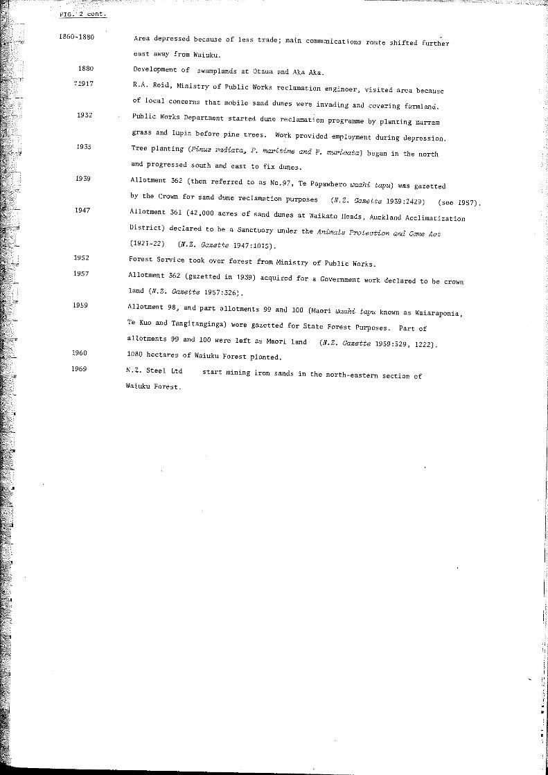
FIG. 2 cont.
1860-1880 Area depressed because of less trade; main communications route shifted further
east away from Waiuku.
1880 Development of swamplands at Otaua and Aka Aka. NT"
?1917 R.A. Reid, Ministry of Public Works reclamation engineer, visited area because
of local concerns that mobile sand dunes were invading and covering farmland.
1932 Public Works Department started dllile reclamation programme by planting marram
grass and lupin before pine trees. Work provided employment during depression.
1935 Tree planting (Pinus radiata~ P. maritime and P. murieata) began in the north
and progressed south and east to fix dunes.
1939 Allotment 362 (then referred to as No.97, Te Papawhero waahi tapu) was gazetted
by the Crown for sand dune reclamation pUrposes (N.Z. Gazette 1939;2429) (see 1957). 1947
Allotment 361 (42,000 acres of sand dunes at Waikato Heads, Auckland Acclimatization
~"T! District) declared to be a Sanctuary under the Animats Protection and Game Act
(1921-22) (N.Z. Gazette 1947:1015).
1952 "8
Forest Service took over forest from Ministry of Public Works.
1957 Allotment 362 (gazetted in 1939) acquired for a Government work declared to be crown
land (D.Z. Gazette 1957:326). ';"!l' 1959
Allotment 98, and part allotments 99 and 100 (Maori waahi tapu known as Waiaraponia,
Te Kuo and Tangitanginga) were gazetted for State Forest Purposes. Part of
allotments 99 and 100 were left as Maori land (N.Z. Gazette 1959:529, 1222). 1960 lOBO hectares of Waiuku Forest planted.
1969 N . Z. Steel Ltd start mining iron sands in the north-eastern section of
Waiuku Forest.

-'" ,...
, .
.~,---, .. -. '----,
, !
'""
---
w • .... " . •
J
i !
i.
• • • ~ .
s;'
j ::
-----

FIG.4
~.
1867 PLAN OF WAIUKU NO.3 BLOCK, MANUKAU DISTRICT MAORI DEEDS NO. 290, (TURTON 1877, VOL.2).
AUCKLAND
/JI/iNU/fIlU ..
OISTRICT;
J- Jan", - J{J67 /
WEST c. 0 A S'T
VVAIUKU' BlOC.K
;)l i. 1,
.t;\ F iL __ -==-- - H{
:::"' . ...;;:..~.::;-~ 'l!. , ,,",
,I.
I' ,,'~ . .
i, ~ /l / ~4
" " , ~' ,< >
.\1
.. ~>.. J; ("
~ . ~::'--'-
" - ::::s: ~~~'-;~"!{~-. "j
• _--~- '"--"c_~'-:.~-';"::_ ~. ! -j - -- .:; .. ~'-.; ·1 •••. :E .. - .. ~ •• .-... -,~,P. ~,. j" .
-- g! '-'-~"'r~'.':~'~I' . ~~ ..... r ,_ .. -.,/ < C ' Ij H ~ ~ ~ ;1
. II r ~ Ii » 1 . ~ z • o ; Scau " ./;fIle.t tq ..... .b~cJ.
•
-~~-------~~~~~~~~~~~
2.2.3
5
waahi tapu described above.
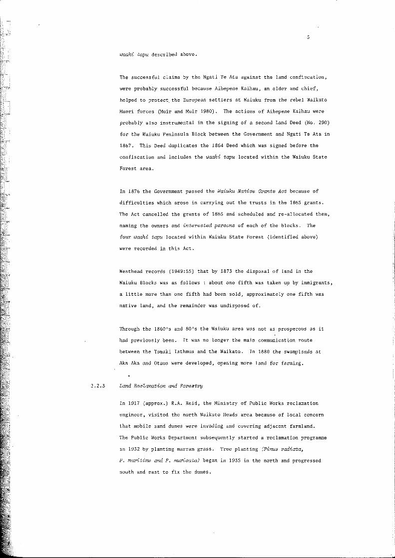
The successful claims by the Ngati Te Ata against the land confiscation,
were probably successful because Aihepene Kaihau, an elder and chief,
helped to protect, the European settlers at Waiuku from the rebel Waikato
Maori forces (Muir and Muir 1980). The actions of Aihepene Kaihau were
probably also instrumental in the signing of a second Land Deed (No. 290)
for the Waiuku Peninsula Block between the Government and Ngati Te Ata in
1867. This Deed duplicates the 1864 Deed which was signed before the
confiscation and includes the waahi tapu located within the Waiuku State
Forest area.
In 1876 the Government passed the Waiuku Native Grants Aet because of
difficulties which arose in carrying out the trusts in the 1865 grants.
The Act cancelled the grants of 1865 and scheduled and re-allocated them,
naming the owners and -interested persons of each of the blocks. The
four waahi tapu located within Waiuku State Forest (identified above)
were recorded in this Act.
Westhead records (1949:55) that by 1873 the disposal of land in the
Waiuku Blocks was as follows: about one fifth was taken up by immigrants,
a little more than one fifth had been sold, approximately one fifth was
native land, and the remainder was undisposed of.
Through the 1860 l s and 80 l s the Waiuku area was not as prosperous as it
had previously been. It was no longer the main communication route
between the Tamaki Isthmus and the Waikato. In 1880 the swamplands at
Aka Aka and Otaua were developed, opening more land for farming.
Land RecZamation and Forestry
In 1917 (approx.) R.A. Reid, the Ministry of Public Works reclamation
engineer. visited the north Waikato Heads area because of local concern
that mobile sand dunes were invading and covering adjacent farmland.
The Public Works Department subsequently started a reclamation progranune
in 1932 by planting marrarn grass. Tree planting (Pinus radiata~
P. ma1'itime aY'4 P. mur'ioata) began in 1935 in the north and progressed
south and east to fix the dunes.
F
p
L
p
r r I ,
[
l ......... l~ •...••.
~
6
It was from the early 1930 ' s through to the 60's that most of the
blocks of land \dthin the Waiuku Forest were acquired by the Crown (see Fig 2).
The north-eastern part of the forest has been progressively mined since
1969 by N.Z. Steel Ltd for iron ore from the sand (SF file 20/186,
19 January 1981) (Fig 5 enclosed). The ore is extracted by a magnetic and
centrifugal separation process using water from the Waikatb River.
The non-magnetic tailings and water are piped to bunds where the solids
are deposited and the water percolated back into the river. Pine forests
cover has been re-established upon the old tailings. It was estimated
in 1981 that the forest will be mined at the rate of 11 hectares per year.
Both forestry and mining operations are potential sources of disturbance
to archaeological and traditional sites within the Waiuku Forest.
2.3 Tangata Whenua
One of the most important aspects of the management of Maori sites, on all land, is
the concerns and wishes of the local community. The following section of the report
has been included because it expresses these concerns and wishes. The past history
of alienation of Maori land, outlined above, explains to a large extent the anxieties
of the Maori community regarding current landuse proposals.
This section of the report is based upon a submission, by Mrs Nganeko Minhinnick of
the Ngati Te Ata hapu of Waikato, to the Commission for the Environment on the
Proposed N.Z. Steel Mill Environmental Impact Report (SF file 20/186, 11 September 1980).
Although the submission was directed at N.Z. Steel Mill Expansion operations, there
are many points which should be the concern of Forest Service. Mrs Minhinnick is a
shareholder in the Maori land wi thin Waiuku Forest.
2.3.1. Submission Ext~act
The Ngati Te Ata hapu of Waikato have been associated with the area between
the Manukau HCC1'bou~ and the Waikato River since the arrival of the Tainui
Canoe back in 1350 AD. At this time the hapu was known as Te Rua Kai Whare.
Te Rua Whare~ a tribal. taniwha, is guardian of the Manuka:u, a faet which is
acknowledged in the Auckland Harbour Board's policy document fo~ this harbour
(Manukau Harbou~ Pl.an~ Part Two, Supplementary Papers 1978:119).

7
We became known as Ngati Te Ata after our anee8tre88~ T8 Ata-i-Rehia, who
lost her life in battle~ but in doing so, saved the tribe.
The Manukw.A. Harbour and the Waikato River is as important to us as the
air' we breathe. The ancestral- land and waters of OUT' forefathers, nOW
drastioally reduoed, the trees, the plant life, and all- that has been
given by nature and our Almighty Father, shares equal status of i;nportance.
Our Marae, papakainga were established throughout Awhitu and waiuku, the
more recent ones being Rangiriri, Moeatoa and Tahuna.
In the 1920's, at Moeatoa Marae (oommonZ-y known as liThe Needles"), over
90 families were either imprisoned or forced to leave the Marae and their
waahi tapu (including the cemetery) by the Public T~8tee. This action
resulted in the people from Moeatoa Marae joining their whanaunga at
Tahuna Marae.
Tahuna Marae still remains today and is located on the western shores of
the Manukau Harbour~ opposite the N.Z. Steel Mill at Glenbrook~ Waiuku.
The Whare puni (meeting house) at Tahuna Marae is named Teuwira. It i3
about 11? years old and it is only here within its tranquil setting that
we continue the traditions of our tupuna (ancestors). It is her>e~ too~
that we continue the pledges of loyalty made by our tupuna to the King-itanga.
These submissions are based on our concerns for the r>etention of our> social
cultural and traditional environment.
An Environmental Impact Report has been prepared and it states that the
proposed expansions (of N.Z. Steel Mill) is seen to be in the "National
interest ll• However~ full appreciation and understanding of Maori cultural
values are not evident in the Repor>t.
Consultation with the affected Maori people is an essential part of
assessing the social and environmental implication of the proposed expansion
rye believe that the methods of consultation used in this process are vital.
Maori cultural values are not always immediately obvious to the pakeha
observer for they involve intangible qualities of life - spiritual and
secular. Also~ environmental impacts may be interpreted differently~
depending on the culturg interpreting them.
Under Section 3 of the Town and Country Planning Act 1977:
The relationship of the Maori people
and their cu Z- ture and tradi tions wi th
their ancestral land
8
are declared to be of national importance. Therefore we take this
(1) oPPol·tunity as a community to present our concePrlS and submissions
We are concerned with the effect that water
discharges would have on the seafood. (2)
With the present set up~ at times kaimoana
(seafood) is dying from water pollution and this
must became more pronounced when the proposed
scheme is put into effeot with the acknowledged
increase in water discharges and accompanying
pollution.
Thus~ our traditional fishing grounds3
which we
have used for centuries3 will be unusable _
these same fishing grounds and rights were supposed
to be protected under the terms of the Treaty of
Waitangi.
Schemes for monitoring environmental impacts need to be
extended and their findings be made public and
open to further discussion. This would serve as
a reminder of their existence and demonstrate
their usefulness to both community and environment.
Protection for and aaoess to our waahi tapu (sacred
places) must be ensured.
The Auokland District Maori Council be included
on the ~utomatio mailing list.
(1) Many submissions relate directly to the N.Z. Steel Mill Expansion and its effects on the
environment. The submissions listed here relate to traditional sites within Waiuku Forest.
(2) This submission has been included because it relates to the Maori owned block within
Waiuku Forest called Tangitanginga (see Section 3.1 below).

2.3.2
9
Our local kaumatua, Mr Joseph Takanini Wirihana, must be
co-opted immediately by N.Z. Steel Ltd as a kaumatua
consultant to advise and liaise between our people
and the development authorites.
In any future developments, access to our lands and
traditional fishing grounds must be ensured.
We had 80 much and like Moeatoa Marae it is sloWly but surely being
stripped from us.
With no regard whatsoever to us the tangata whenua nor to our ancient
waahi tapu, upupa or land, the land which we owned is now used for
State Forest purposes. In 1959 what land we had within the forest was
stripped from us under the Public Works Act 1928, and it is known now
as the "Nne Si te.
Now we are faced with another loss. Once again the resources of the
Waikato River are being called upon.
The Waikato River and the Manukau Harbour to us is like the Ganges River is
to the Hindus. It is sacred.
We wish to remind the Commission that~ although the proposals may be
/lin the national inter>ests" it has been ou!' e:r;perience~ based on the
Waahi3 Waiau Paa QPA Ohaaki communities~ that the Mao!'i is not neceasarily
part of that national interest3 and that it is because of the geneloaZ
uncer>tainty and ambiguity of the Report3 together with past experience~
that we formally convey to you our objections to the proposed scheme.
Auckland Regional Authority's Submission
The Auckland Regional Authority also made a submission to the Commission
for the Environment which refers to Maori interests within the mine site
and forest area. Submission 7.1, entitled Mine Site. is quoted in full:
There are a number of urupa (Maori burial grounds) within the mine site~
not just one as shown in the r>epor>t. The report contains no disG~ssion as
to protection measures except to sqy that mining elsewher>e talks of the

10
Taharoa experience and N.Z. Steet should be able to draw on this
experienoe in managing the mine site. A detailed survey of the
mine site is obviously necessary before an expanded mining prograrrone
begins 3 and the assistanae of an archaeologist should be obtained for
thie survey. A Komatua aonsultant from among the local Maori tribes
should be appointed to give advice on sacred matters. The Waahi tapu
should be protected from mining and access to urupa should be guaranteed
for tangata whenua. Access shouZd not be made too diffiault~ ie: sites
should not be left as "islands" with the sides mined away. The sides
should be battered and protected against erosion by wind and water.
11
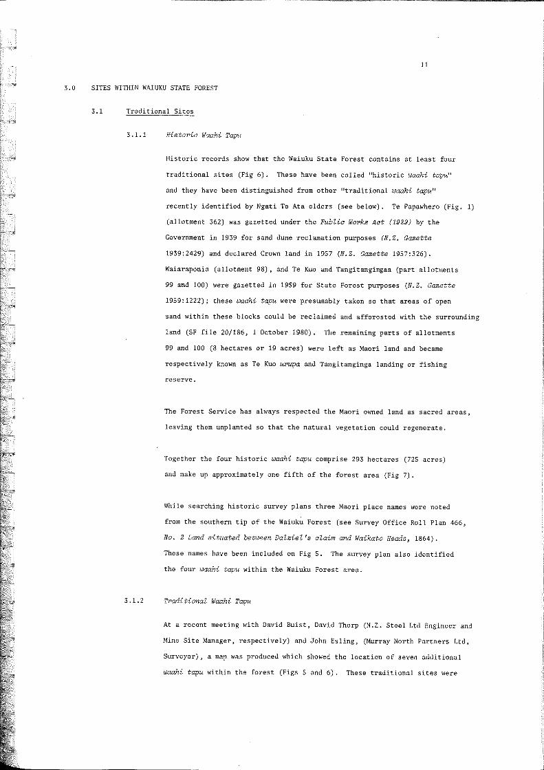
3.0 SITES WITHIN WAIUKU STATE FOREST
3.1 Traditional Sites
3.1.1
3.1.2
HistoY'ie rlaahi Tapu
Historic records show that the Waiuku State Forest contains at least four
traditional sites (Fig 6). These have been called "historic waahi tapu"
and they have been distinguished from other "traditional waahi tapu ll
recently identified by Ngati Te Ata elders (see below). Te Papawhero (Fig. 1)
(allotment 362) was gazetted under the Public WOr>ks Act (1929) by the
Government in 1939 for sand dune reclamation purposes (N.Z. Gazette
1939:2429) and declared Crown land in 1957 (N.Z. Gazette 1957:326).
Waiaraponia (allotment 98), and Te Kuo and Tangitangingaa (part allotments
99 and 100) were gazetted in 1959 for State Forest purposes (N.Z. Gazette
1959:1222); these waahi tapu were presumably taken so that areas of open
sand within these blocks could be reclaimed and afforested Iv-ith the surrounding
land (SF file 20/186, 1 October ]980). The remaining parts of allotments
99 and 100 (8 hectares Dr 19 acres) were left as Maori land and became
respectively known as Te Kuo upupa and Tangitanginga landing or fishing
reserve.
The Forest Service has always respected the Maori owned land as sacred areas,
leaving them unplanted so that the natural vegetation could regenerate.
Together the four historic waahi tapu comprise 293 hectares (725 acres)
and make up approximately one fifth of the forest area (Fig 7).
While searching historic survey plans three Maori place names were noted
from the southern tip of the Waiuku Forest (see Survey Office Roll Plan 466,
No.2 Land situated bevween Dalziel's claim and Waikato Heads~ 1864).
These names have been included on Fig 5. The survey plan also identified
the four waahi tapu within the Waiuku Forest area.
Tradi tional f.laahi Tapu
At a recent meeting with David Buist, David Thorp (N.Z. Steel Ltd Engineer and
Mine Site Manager, respectively) and John Esling, (Murray North Partners Ltd,
Surveyor), a map lv-as produced which showed the location of seven additional
waahi tapu within the forest (Figs 5 and 6). These traditional sites were

o I
FIG 6 MAP SHOWING THE LOCATION OF HISTORIC AND TRADITIONAL
WAAHI TAPU (BURIAL GROUNDS)
NORTH AUCKLAND FRANKLIN COUNTY, MAlaRa,
1 km, 2 , ,
WAIUKU WEST
PAR S H
.. +
• • t
•
• t
*0+ +
* • ~
t
f
* t • t +
* '" • .. • • ..
• + fi1~ .. II' .l .. ~
Waiuku Forest
•
State 186
Maori Land
., " ... '-'/ "; ,
I" ,,' I' ".., I f .. ~'
I ~,.1 J I ~, / /
, .' I II
-:> ""'" / - ,., I J
"',,1 1 ( / ;~ (:" I I , *,""" r, .. J,J .... \,
.... L'
~ Historic ~ Waahi Tapu (Source: Historic Records)
::J'~\\ Tradit ional :;,::/- Waahi Tapu
(Source: Ngati Te Ata Elders)

•
FIG. 7 TABLE SHOWING NAMES, AREAS, AND ALLOTMENT NUMBERS OF MAORI iI'AAHI TAPU WITHIN WAIUKU STATE FOREST
Allotment Approximate Area Percentage Number Name Number Area of (See FIG.5) Hectares Acres Forest
WAIUKU FOREST 1 361 1132 2798 75
RESIDUAL
HISTORIC 2 Te Papawhero 362 206 509 13.7 WAAHI TAPU 3 Waiaraponia 98 12 30 0.8
4a Te Kuo Pt 99 44 109 2.9 4b Te Kuo (Maori Land) Pt 99 6 14 0.4 Sa Tangi tanginga PtlOO 23 58 1.5 5b Tangi tanginga Pt100 2 5 0.1
(Maori Land)
TRADITIONAL W4AHI TAPU 6 13 32 0.9
7 17 42 1.1 8 10 25 0.7 9 9 22 0.6
10 15 37 1.0 11 6 15 0.4 12 13 32 0.9
TOTAL 1508 3725 100 I -- I
3.1.3
12
located on a map by a Tohunga (teacher or priest) of the Ngati Te Ata
tribe at the request of N.Z. Steel Ltd in 1980 (see SF file 6/186/21/1,
7 November 1982).
A further meeting between N.Z. Steel Ltd Liaison Conooittee, representatives
of the Huakina Development Trust Board, Ngati Te Ata ~epresentatives. and
N.Z. Forest Service was held (SF file 6/186/21/1, 13 December 1982). The
waahi tapu areas, including the two blocks of Maori land, were visited
and a round table discussion was held.
Four points were discussed at the meeting:
(1) identification of waahi tapu during the fieldtrip;
(2) future recognition and identification;
(3) access; and
(4) a future meeting.
The major problems which arose from the discussions focussed upon defining
the extent of the waahi tapu and their future protection. It was hoped
that these pro'blems could be resolved at a future meeting when forest
management could also be considered.
Disoussion
A number of communications within the Auckland Conservancy files indicate
that staff members were aware that other sacred sites were located within
the forest,
(The Officer in Charge at Waiuku) says the two
areas of Maori land are not marked on the ground
(other than by Survey Pegs in case of Te Kuo UrupaJ
although they are marked on Cadastral maps(l).
There is a controversy over the exact location of
the urupa. The looal Maoris ... regard the burial
ground as being a quarter a mile away (from the
gazetted area) in an area planted in pines which
nobody will touch.
(1) A note on the minute sheet states pegged in the 1960's. This presumably means that the
urupa and reserve were pegged by surveyors in the 1960 1s.
No other Maori sites have been recorded in
the area nor have any artefacts been found. (1)
(SF file 20/186, 24 September 1980)
The urupa site as defined at the time (of gazettal)
was left unptanted. Howevel'~ its exact location
is unknown and there is disagreement amongst
local Maoris as to the site's precise whereabouts.
Some believe it to be a planted area about 50am
from the mapped site and have made the area tapu.
(SF file 20/186. 1 October 1980)
Two officers of the Department of Maori Affair'S
visited the forest ... They inspected the block
of Maori land on Loop Road (urupa) and ... an
area in Compartment 34, south of Tapu Road,
immediately to the west of the large clay pan.
This is an area believed by some to be a burial
ground. There is a body of opinion which suggests
that this is lIthe u'l'Upa ff in pr>eference to the si te
officially set aside as MaoPi land on Loop Road, but I
inferred from Tuesday IS meeting that it was in
addition to this one ...
In a discussion with Carter Mer>chants bush boss
I learnt that ther>e was also considered to be a
13
burial ground (along the river boundary of Compartment
32) •
This was also known to one of the Mao!i Affairs
people who also referred to the rumoured existence
of a fourth, the location of which was not known
to her.
This visit was in the nature of a reconnaissance
and I understood they intended to retura to
locate them more positively. It is my opinion
(1) Bob Jolly, a registered collector of Maori artefacts, has some artefacts from the Waiuku Forest
area. They were collected before the forest was established (peTS. comm. John Coster 1982).

however, that drifting sand~ up untit the time these
areas were stabiZised in the late 1940's would most
likely have obscured all indication of their location.
14
(SF file 6/186, 3 October 1980)
These communications identify the location of at least three waahi tapu
which coincide "lith traditional sites recently located by the Ngati Te
Ata Elders (see Fig 5 "Maori Waahi Tapu tl• numbers 7. 9 and 10).
3.2 Archaeological Sites
Two archaeological surveys have been undertaken within Waiuku Forest. On
29 October 1982, two Conservancy archaeologists (Jill Pierce and Helen Charters)
surveyed the southern coastal strip of the forest. The recorded sites and the
route taken during the survey are marked on Fig 5.
The results of this survey were presented in an interim report (Charters 1981).
Five sites were recorded; four middens (N.l. Archaeological Association site
numbers N51/101 to 104) and one possible terrace (N51/100). The position of
these middens coincides very closely with the white shell summit which was
located upon the 1853 hydrographic chart (Fig 3). If the North Head (Tatamoerua)
coastline was washed away by 1917, as the chart shows, many of the middens
are probably recent additions to the landscape.
The recorded sites were all given a C grade because they were considered to be
damaged. isolated or insignificant sites, and an Authority for modification was
requested from the N.l. Historic Places Trust (NlHPT). (For a description of
site grades and management, see Coster 1979:92).
A decision on this application was deferred by the NZHPT until they had more
information on the sites.
On 8 June 1982, two Conservancy Archaeologists (Helen Charters and Robert Pollock)
and a NZHPT Staff Archaeologist (Kevin Jones) visited four areas within the forest
(Fig 5):
(1) The exposed dune face within the N.l. Steel
Ltd sand extraction area (Compartment 21) was
examined. No sites were found;
•
(2) Compartment 23, a future sand extraction area was
examined. No sites were visible because of the
dense ground cover of marram grass and mature pines;
(3) Several potential sites within the northern half of
the forest were examined. These sites were recorded
by Stephen Edson (Waikato Art Museum) from early aerial
photographs of the region. The approximate location
of these sites has been recorded on Figure 5. No
surface evidence for these sites was recorded during
the inspection; and
(4) Sites N51/100 to 104 were reinspected and three
additional midden sites were recorded (NSl/114 to 116).
15
The archaeologist in charge of the second survey concluded that these sites
should cause no obstruction to forest management, but an archaeologist should
be present during clearfelling operations to record any further details of
the middens which may be exposed (SF file 6/186/21/1, 7 July 1981). The sites
were subsequently given a B grade .
Two Authorities (numbers 1982/13 and 1982/14) for the modification of sites
NSl/100 to 104 and NS1/114 to 116 were subsequently issued by the NZHPT, with the
condition that a suitable archaeologist be notified before ~ogging operations
commenced so that the sites could be monitored as the work proceeded and
archaeologically important information recorded (SF file 6/186/21/1, 21 July
and 6 October 1982).
On 4 November 1982, two Conservancy Archaeologists (Ian Lawlor and Helen Charters)
carried out an inspection of both traditional and archaeological sites within
Waiuku Forest.
An inspection of the two Maori owned Blocks of land within the southern half of
the forest revealed that the Tangitanginga Reserve had been covered by the
dumping of tailings by N.Z. Steel Ltd. Mr David Thorp, N.Z. Steel Ltd Mining
Site Manager, was not aware that there was a 2 hectare Maori owned Fishing Reserve
within the area of mining operations, but he did identify a small knoll within the
vicini ty as a Maori lookout (pers. carom. 1982).

16
A 1980 NZFS report entitled Environmental Impact Report~ N.Z. Steel Mining
Waiuku Forest states that the reserves shall not be interfered with by mining
operations and be preserved in their present state. Any mining beyond the
looam radius (see Fig 5 in this report) must leave ample buffer zones around
the reserves (SF file 20/186, 8 October 1980).
The reserves were not to be disturbed in any way. The 1980 report fails to
mention that the Tangitanginga Reserve lies within the raOOm radius economic
distance limit, and was as a result under direct threat of disturbance. It does
state that the reserve had a very ancient and practically forgotten history
and that it was not used in any way.
Site N51/114 was inspected at the request of the Officer in Charge (Ian Currie),
because the construction of a skid and logging operations was going to significantly
alter the site. The site was recorded as a thin cap of shell midden on top of
the east bank of Reid Road No. 60. Although some damage had occurred to the site
when the road was constructed, it is possible to suggest that it initially covered
an area of approximately 100 square metres.
The bank was excavated and the stratigraphic section recorded (Fig 8). There
were two distinct layers (numbers 2 and 4) of pipi (Paphies australis) separated
by mottled grey iron sand (layers I, 3 and 5). The sand between the shell
layers also contained a few pipi shell fragments.
A 300 gram sample of shell was extracted for radiocarbon age determination
from Nithin the lower midden layer 40 to 45cm beloN the surface. A feN small
unidentifiable fragments of decomposed fish bone and water-worn rounded pumice
pebbles were noted amongst the shell.
Areas of the site exposed by skid construction were examined. A scatter of pipi
shell and charcoal fragments, and a single scallop (Pecten novaezelandiae)
valve were all that was found. During operations, workmen had noted at least
one concentration of haangi stones and charcoal blackened sand among the
scattered shells.
I

FIG. 8 WAIUKU SF 186
Stratigraphic section from site N51/114
o
10
20
30
40
"' '" 50 ...
'" E
- 60 c
'" u
70
---- -""'\.. ~-,- - -- --- --" ---::---- - -- -.... r ~
-------=---:® (. •
,-, l
-- -::"".: = - r--~:- -- ~-:- ---_ - - - r- -_-:::--_=...- __ - _-_ -c _ - ... --:. = ;:-_ = ,-(14 - -:. _ '-<-;:. __ - sample--(Do - - --, --. .:. -- : -~ :: -- .:: -:'--. - -- - --- - ..,. -- - - - - -- ---,...,.,-::-... - - "- - - ~ -.............. , ' ........ :.~--- ..... -.""-.-"""
80 ®
90
100
scatter"d broken sh,,11 on su rf ac,,~
dark brown silty a f"w lumps of charcoal.
sand fragm"nted
who I" a nd bra ke n pipi shell
dark grey with a f"w fragments
conc"nt ra t"d shell
iron sand pi pi. shell
whol" pipi
som" fragments of pi pi a nd charcoal
dark gr"y stain at bas" of shell
mo ttled grey sand
Q) = layer

-17
Both stratigraphy and surface features indicated that the site initially functioned
as a cooking and refuse dumping area. A large quantity of pipi was consumed. as
well as fish and scallop. This kaimoana was most likely gathered from local sources
within a 2 kilometre radius of the site.
The fact that the lower midden layer was covered by sand indicates the site was
occupied when adjacent dune surfaces were mobile. The presence of pipi fragments
within the sand between the shell layers suggests some adjacent areas of the
site were possibly occupied at this time. The upper midden indicates a second
period of cooking and refuse dumping.
t I
t I:
t I
t Ii Ii
[ I [ !
!
~
l
r !
t
[
t 'i l
4.0
18
SUMMARY AND RECOMMENDATIONS
4.1 All archaeological sites have been recorded as grade B sites.
In future, when forestry or mining operations threaten sites, (N51/100 to
104 and 114 to 115) the Conservancy archaeologist should be notified
before operations commence (see NZHPT Authority No. 1982/13 and 1982/14).
4.2 Five potential archaeological sites (numbers 1, 3, 4, 5 and 7, Fig. 5) in
4.3
4.4
4.5
the northern half of the forest (compartments 12, 8, 4 and 6, 5 and 2
respectively) have been recorded from early aerial photographs. Although
no surface evidence was noted during a brief inspection of some of these
areas, there is good reason to believe that these sites did once exist.
Forestry staff should be made aware that during future operations within
these areas, evidence of Maori occupation could be uncovered.
To preserve the two blocks of Maori land from future damage, post, wire and
batten fences should be erected. A vehicle sized gate should provide access
into the blocks. This is the only way that protection for, and access to,
the waahi tapu can be ensured.
An archaeological survey and assessment, and a tacheometric survey have
established that tailings from N.l. Steel Ltd mining operations have been
deposited on the waah-i tapu Tangitanginga Reserve (Appendix 1). Additional
damage to the southern section of the Reserve has occurred through the erosive
actions of the I'laikato River. The Maori owners and N.Z. Steel Ltd should
be informed of the surveys and assessment and asked for comments. The
Maori owners should be notified of the results because they have requested
that access to their land and traditional fishing grounds be ensured. To
this end a list of names and addresses of owners has been included as
Appendix 2.
Waiuku Forest contains four historic waahi tapu and seven traditional
waahi tapu. Altogether the burial grounds comprise one quarter of Waiuku
Forest. The location of the waahi tapu should be made known to the staff
of the Forest Service and N.l. Steel Ltd. The Forest Service and N.l, Steel Ltd
need to liaise with the local Maori elders to come to management decisions
regarding the use of the burial areas for State forest purposes and mining
operations.
u

5.0 REFERENCES
Ambrose, W. 1961
Bulmer, S. Nid.
Bulmer, S. 1983
Charters, H. 1981
Coster, J. 1979
Davidson, J. 1982
Deeds Index Books 1865
Fox, A. 1982
19
Excavations at Wattle Bay, Manukau
South Head. New Zealand Arohaeological
Association Newsletter 4(2):52-53.
Preliminary report on excavations at
Waitete Point Pa, South Manukau.
Typescript 2 pp. N.Z.H.P.T. (1978).
Waitete paa: an early nineteenth century
fishing fortification. In A lot of
Spadework To be Done N.Z. Archaeological
Association Monograph No. 14 edited by
S. Bulmer, G, Law and D. Sutton.
Unpublished Interim report to N.Z. Forest
Service and N.Z. Historic Places Trust,
N.Z.F,S. Auckland.
Exotic forestry and site management in
the Auckland region, In Archaeological
Resouroe Management in Australia and
Ooeania~ edited by J.R. McKinlay and K. Jones,
N.Z. Historic Places Trust Publication No. 11,
Wellington.
Auckland. In The First Thousand Years:
Regional Perspeotives of New Zealand Archaeology.
Edited by Nigel Prickett, The Dunmore Press,
Palmerston North.
Deeds Index Book~ Volume 170, Lands and
Deeds, Private ,Bag, Auckland.
Excavations at Maioro, N51/5, South Auckland,
1965-66. Records of the Auckland Institute
and Museum 19:53-80.

Hydrographic Chart
Manukau Harbour PZan
Morris, N.M.
Muir, B.
/l'fuir, B.D and
V.M. Muir
New Zealand Gazette
N.Z.M.S. 1977 Cadastral Map
State Forest (SF) Files
1853
1978
1965
1957
1980
1841
1865
1939
1947
1957
1959
1959
20
Hydrographic Chart (reprinted 1978)
of the Waikato River. On the N.Z. North
Island Sheet VI, 2535 Manukau Harbour to
Cape Egmont.
Wellington.
Government Printer,
Part Two, supplementary Paper~.
Early Days in FrankZin. Percy Salmon,
Wills and Grainger Limited, Auckland.
Waiuku and DistPict. Waiuku News.
OZd Waiuku and District. Amba Graphics
Limited, Auckland.
No. 1 page 8
No. 1 page 2
No. 1-5 page
No. '6 page
No. 15 page
No. 23 page
No. 53 page
6/186
6/186/21/1
20/186
2429
1015
326
529
1222
3 October 1980
2. September 1980
1 October 1980
7 July 1981
21 July 1982
6 October 1982
7 November 1982
13 December 1982
11 September 1980
October 1980
8 October 1980

Supplement to the N.Z. Gazette
Survey Office Roll Plan 466
Turton, H.H.
l'Iaiuku Centenary Conuni ttee
Brochure Subcommittee
Waiuku News
Westhead, B.
1876
1864
1877
1954
1949
21
No. 56 Waiuku Native Grants Act.
No.2 land situated be~ween DaZziel's
CZaim and Waikato Heads. Surveyed by
R.C.L. Reay, 8 December 1964. Lodged
with the Chief Surveyors Office,
Auckland.
Maori Deeds and Land PtU'chases in the
North Island of New Zealand. (2 volumes).
Government Printer, Wellington.
The Waiuku Story 1854-1954.
West of the Manukau. Waiuku News.


6.0 APPENDIXES
6.1 Appendix
6/186/21/1
IL:ms
13 October 1983
NZ Forest Service
Auckland
F I L E NOT E
MAORI LMW (Lot PT 100 - TANGITANGINGA) WAIUKU S.F. 186 SURVEY AND ASSESSMENT
1.0 INTRODUCTION
On 26 September the Conservancy Archaeologist inspected Lot Pt 100
located on the north-eastern edge of Waiuku S.F. 186 (Fig. 1), with
Conservancy Surveyors (Paul Smith and Paul Buckley).
The inspection of Pt 100 was to:-
1 redefine and stake the boundary
2 assess the extent of damage, and
3 make a series of recommendations regarding futur~ protection and
management.
2.0 BRIEF HISTORY
Lot Pt 100, otheTldse known as Tangitanginga Fishing Reserve aT waahi tapu
(sacred area), is one of two blocks of Maori land that remain in Waiuku S.F.
Since 1969 N.Z. Steel Ltd has mined iron are sand from within Waiuku S.P.
The tailings from these operations have covered a significant portion of
the Reserve.
A summary report on ~Archaeological Site Management in Waiuku State
Forest 186' (Lawlor 1983) recommended that both areas of Maori land be
re-surveyed. An assessment of the extent of damage to the Tangitanginga
Fishing Reserve was to be mad'e.

= 23
During an inspection of sites within Waiuku S.P. (10 December 1982) with
N.Z. Steel Ltd and Maori elders a representative of the tangata whenua
(Tahuna Minhinnick) requested that UTangitanginga Reserve be resurveyed
and set aside from any future disturbance by mining operations II (see file
note 6/186/21/1, 13 December 1982).
3.0 INSPECTION
Lot Pt 100 was redefined by Conservancy Surveyors 10 September 1983
(Fig. 2). This work confirmed earlier observations that the northern
half of the Reserve had been affected by N.Z. Steel Ltd mining operations
(see file note 11/3!1, 16 September 1983).
3.1 Survey - On the 26th September 11 temporary red-painted stakes were surveyed
in and placed on the tailings to mark the old boundary of the Reserve (Fig. 2).
3.2 Extent of Damage - Damage to the Reserve has resulted from ~iver erosion
and the dumping of a 15 m thick (approx) deposit of sand tailings by
N.Z. Steel Ltd. Sand tracks cross the Reserve in several places (Fig. 2).
4.0 DISCUSSION AND RECOMMENDATIONS
401 Discussion - Tangitanginga Fishing Reserve (Lot Pt 100) originally formed
part of a much larger (approx 23 ha or 58 acres) waahi tapu (Lot 100)
which was set aside for the Maori owners in 1876 under the Waiuku Grants Act. (1)
This area was important to the Maori people because it gave them direct
access to the Waikato River and it contained important fish resources.
The Tangitanginga waahi tapu protected their ancestral fishing rights to the apea.
Prior to Ministry of Works sand dune reclamation operations a small creek
(including a small lagoon approximately half an acre in area) flowed through
this area out to the Waikato River. The creek was used for eeling. In the
1930 1 s the Ministry of Works inadvertently planted the waahi tapu with pine
trees. The creek and lagoon dried up. In 1959 most of Lot 100 was
acquired by the Crown under the Public Works Act for State forest purposes
and a chain strip (approx 2 ha or 5 acres) along the bank of the Waikato River
was left in Maori ownership. Since 1969 the Reserve has become covered with
tailings from N.Z. Steel mining operations. Submissions were made to
N.Z. Steel Ltd in 1980 by the local Maori Elders, the Auckland Regional
Authority and the N.Z. Forest Service (see section 2.3 of summary report).
These submissions requested protection and access to waahi tapu.
(1) Land Deeds record that the Reserve was first set aside in 1865 (see Lawlor 1983).

24
4.2 Recommendations _ The following recommendations have been made in the
light of the history of the Tangitanginga Fishing Reserve (discussed above).
4.201
4.2.2
4.2.3
4.2.4
4.2.5
4.2.6
4.2.7
4.2.8.
4.2.9
N.l. Steel Ltd operations cease within the Reserve area. This
includes the use of sand tracks which pass through the Reserve.
Bare sand tailings behind the Reserve should be contoured with
earthmoving machinery and a lupin (Lupinus arboreus) and/or marram
(Ammophila arenaria) cover established to maintain sand stability
around the Reserve.
A buffer zone of at least SO m should be left around the Reserve.
A post, wire and batten fence should be erected around the Reserve
and a vehicle sized gate should- provide access into the Reserve.
The present sand track down to the Waikato River should remain
accessible to vehicle traffic.
Since it would be highly impracticable to remove the N.l. Steel Ltd
tailings which cover the Reserve, a programme should be initiated
to re_establish a vegetation cover of native species.
Since the damage to the Reserve has come about through N.Z. Steel Ltd
mining operations, it is recommended that the Forest Service gain
the active co-operation of N.l. Steel Ltd to fulfill the other
recommendation (listed above). N.l. Steel Ltd is to bear the costs
that are incurred though the implementation of these recommendations.
Discussions should be held by N.Z. Steel Ltd with the Waikato Valley
Authority and the Auckland Regional Authority on the feasibility of
protecting the southern section of the Reserve from wind and water
erosion.
This recommendation follows a previous submission made by the Auckland
Regional Authority (see section 2.3.2. of summary report.
The Maori owners of the Tangitanginga Reserve should be informed of the
management strategies that have been recommended in this file note.
Ii

IAN LAWLOR
Contact address:-
The Managing Director
Huakina Development Trust
PO Box 534
PUKEKOHE
CONSERVANCY ARCHAEOLOGIST
encl.
2S

FIG.l. MAP SHOWING LAND SUBDIVISION WITHIN WAIUKU STATE FOREST
Q
(?ource NZMS 177 Cadastral Map).
1 km. 2 I I
NORTH AUCKLAND FRANKLIN COUNTY MAlaRa
WAIUKU WEST
PAR S H
* * t .t ~
1 t t • ~ * .t 1 ~ ..... J *
.. CD *." J * j • t I • : : :~: : :. I
1 1 • l • t • • •
.. .t. ,. • J • •
• • •
r:-l Waiuku State 1\\i!:·'.:??1 Maori Land ~ Forest 186 !'!K;i,'t:
<D ®
Lot. 361
m Waahi TapGu . 1 r:a ( Buria I rounds
Te Papaw hero (Lot. 362)
Te Kuo Waiaraponia ( Lot.9a) (Lot.99)
® Tangi tanginga

~'
::
N -z. steel Sand Trock5
Sand Cliff
D Pt. 100. Maori land
LAND DISTRICT NORTH SURVEY BLK.& DIST. VII
AUCKLI\ND
MAIORO NZMS SH EEl N°·
)9 200
JNTY
Area riled In
t of registered rveyor and holder of an annual preetisl (or who may ct as 8 registered sUlVeyor pUrsU81 to the proviso to sec n 33 (2) of the SUlVeyors Act 19 6) hereby certify that this n has been made from SUIV s executed by me or under my ections, and that both pi and survey 8r8 correct and have b n made in accordance ith the Survey Regulations 1972.
Dated at
01
Field Book
Reference Plans
Examined
p. p.
Approved al t
Depolite
Fil ceived
1nsfructions
th il day of
Diltrict La~Jle~~
IBt)/2-
FIG. 2

26
6 . 2 APPENDIX 2
List of people who have interests in the Maori land · and Waahi tapu within l'laiuku
State Forest.
This list was compi led from the Waikato-Maniapoto District ~ 130ri Land Court records of
Waiuku West Parish Part Allotment 100. It has subsequently been updated by
Mrs Nganeko Minhinnick (personal communication "1982). (*/Deceased, m/male, and f/female).
1. (m) Aihepene Kaihua *
2. (m) Ngakoroko Moeatoa •
3. (m) I'li hemu Tauroa *
4. (f) Wh eriko Kaihau
5. (m) RangiNhakaeNa Kaihau
(or Paraone) •
6. (m) Stewart Oiroa Kaihau *
7. (m) Te Kurirangaunu Kaihau
8. ( f ) Kimlyn Urikore
9. (m) Te Mahau Kaihau •
10. (m) Aehepene Kaihau
(or Henare III )
11. (f) Hera Kaihau
(or Nepia)
12. (f) Rongorua Kaihau
(or Taylor)
13. (m) Hohepa Kaihau
14. (m) Tuherea Kaihau
15. ( f) Nganeko Minhinnick
16. (f) ~larino Kaihau
(or Peita)
17. (m) Te Pou Kaihau
18. (m) Whititera Kaihau
19. (f) Reta Hariata Kaihau
20. (f) Jackie Ka ihau
(Puke)
21. (m) Mark Tohera Ao tearoa Puke
(Refer Mr J. Thompson, Von Sturmer and
and Ringer, Solicitors, Queen Street,
Waiuku.)
(Refer Mr E . Brough, Mason, Munro and
Brough, Solicitors, Queen Street. Waiuku.)
(As for 5.)
11 Cedar Heights. Massey , Auckland 8.
51 Smiths Avenue, Papakura.
44 King Street , Waiuku.
33 m11ais Street, Grey Lynn,
Auckland 2.
R. D. 3, \Vaiuku.
15 Jordan Road, ~langere.
78 King Street, Waiuku .
48 Co lumbo Road, Waiuku.
32A Favant Street , Christchurch 4 .
18 Doughty Place , East Tamaki, Auckland 6.
(As for 19.)
(As for 19.)
27
22. (m) Kerry Puke (As f or 19 .)
23. Te Mahau Kaihau •
(or Kipi Kaihau)
24. (m) Douglas Kaihau S1 Sm i ths Avenue, Papakura .
2S. (£) Te Puah"a Kaihau 36 Victoria Street, Pukekohe .

=- --=- ----
fODS PI8!J
.. . , 0
,e paleo 'lL6J suo/1l1/n6ay
UI
___ '""'Tr-='-
--
000/:/ alell
fW;P1/(f "y}.'w/.d ~q pa~aAJnl
)Nll>1N\i~::J ' AlI~OHlnV mOl
;: :
::. : ' .' ::, " •• .• '
- - -
___ ~_ --=--:zrr::-: - -
--
'381 JS3C10~ lLIIJ!; n>lnlVM
';01'7 FJfS' Z N - e;vV bi./I'i~Ij/,.loew 00/ fd
o.(21/eM ( A~All:l '"~ D1A~ )
~ ,.J '3 f': \?:l UOI+OLU!OI?"~
••
: ••
: .: : : .: ., : . •••
\ ' : ••
,. i , : .
••• •
• •• • •
••
•• ••
•
.. : ••
: . •
••••• ••
• • .•• ' •• •••
:
••
• • ••. :.
•• • •
. : ••
•
• ••
• • . .... . •
'oN lHHS SWIN
080i'ltWIIA 'lSla rm A3ms <IN\:il>Dn'tf HI~ON Dlmla am
:H!lJ pUbS IT]]
"'P"" '"" I~" 2N ~
: .• • ::.
..' • ••
•

z: '81.:l
61 )0 A£P
1£ poAOJddV pau/wex]
sue/d i3U8JBjBU
'd ~oo8 P/Bii
1° 18 paleo
'U6t suo/lf!/n6ay 1--="",
[!J·g·o/ 01£0 ooo/:! ol£lS
RP;{)tg J I'YFIVf} Aq poAwns
,uNnO'}NIl>lN\f~.:f HI~OHlnv mOl
OOI~U!II'M ·A ..... ms pili ipu81 jO IUiUHHHhl(j '1IlaU!!!)-JoAUhJllS ~
----------------------------,-----------------------------~
'381 JS3C:JO.J ]jllj!; n)fnlVM
';017 I~JjS' Z N - eV!7 by)t.;~1j /,./oew 00/ fd
, .
. ' ., ' ,. '. ,
:
, :- .
: •• '
, .' ',," .
" .. , ' '
" ':,.' ,:."
" :( , .. ~~, .. ~, .
::: , ~::; .
'':: C
:: :: ::; , : .. : ·:H . ~ •.. ••
,: .• : H ~ ..
•
, H ' , :::
:::
' . .~~~ • ::: "
, ::: :
'oN lBHS HUN
O~OII;.iW IIA 'iSIO n18 Amns dN8l>Dn\i Hl'tlON DlmlO ONVl
~ ~
:H!tJ pUbS IT]]
~,~, "'''' ,n" 2N ~
:
••
,: .. •
..,: , .~~ ~~~
,-- -.. , ' ';::
•
: ~~ /
•• ~.

FIG. 5
':.
.. • .. §
?paa (N51 210017)
100
Go drlQht OTM8S
• I 10_
o
N
\ I
./
/
- --G I ht
OT 868 -r . •
1
.. • • 8
95110
.
WAIUKU HISTORIC LACES
•
Serra OTM732

s. F. 186 AND ARCHAEO OGICAL
.. • .. g '
, 0
"
t
M Bo"
OPEN CAST. PIT
21
1 .... ........
(
.. • • 0 0 0
Mlneslte 'Woter Intoke
T lUNGS DUMP
"
51-/17
"
,
•
(

an Sea
, . • "
CD
-, 1000m radiuseconom\c distance limit (1980) for NZ Steers mining operations / Potential archaeological sites recorded from early aerial photographs
~
"
(N51 236010) Site grid refere nce
Maori land
0_0-- _._ Archaeological survey routes 1981 ( October!
.......... ... u ..... Archaeological survey routes 1982 (June! 1-4
• N51/116 Sit e and NZAA number
---------
•
25 (N.P
,-I I ] r ]
1 [ . I
- 1 I
, , .c@c

. t Jt?1l104 u~ midden
, Whakomoe
/
/ /
X.
,
N51 1101 midden
N51/10~d N51 1 1831
en midden
I 0
~ \
~ 0
0 \
L
EP.'~~£1~lin ~ .,., Maori "lookout"
MAORI WAAHI TAPU
12 Number ( See FIG. 7)
• ClJ ~ Historic ~'~::" ~
:.\ . ... / 1
Tradit ional - , II...! I
( approximate boundar ies )
Jldditions to compartment species map
by Ian Lawlor 1 Decemb er 1982.