![API RP 2GEN - 7 Structures Verret Wisch[1]](https://static.fdokumen.com/doc/165x107/577cc9e31a28aba711a4e168/api-rp-2gen-7-structures-verret-wisch1.jpg)
Tectonostratigraphy and Structures of Eastern Seram satuan paraotokton dan alokton disebut sebagai...
9
85 Naskah diterima: 16 November 2010, revisi kesatu: 24 Februari 2011, revisi kedua: 14 Maret 2011, revisi terakhir: 16 Mei 2011 Jurnal Geologi Indonesia, Vol. 6 No. 2 Juni 2011: 85-93 Tectonostratigraphy and Structures of Eastern Seram Tektonostratigrafi dan Struktur Seram Bagian Timur S. BACHRI Geological Survey Institute, Geological Agency, Jln. Diponegoro 57, Bandung 40122 ABSTRACT The eastern Seram is part of the Outer Banda Arc consisting of para-autochthonous and allochthonous units which are unconformably overlain by the autochthonous units. The para-autochthonous units are derived from the outer margin of the Australian NW Shelf. This sequence comprises Permian metamorphic rocks of the Kobipoto Complex and its cover of Triassic - Jurassic to Cretaceous - Tertiary age. The allochthonous unit, or the pre-collisional Banda fore-arc sequence was overthrusted onto the NW Shelf sequence. The sediments overlying unconformably the allochthonous and para-autochthonous units are referred to as autochthonous units. These autochthonous units comprise sediments deposited post-Neogen collisional event between the Australian Continent and the Banda subduction zone. Structures develop in the eastern Seram are thrust, normal faults, folds, and cleavages. The thrusts are verging to the northeast suggesting that the deformation occurred before Seram was rotated in an E-W direction. Keywords: para-autochthonous, allochthonous, autochthonous, Outer Banda Arc, Australian NW Shelf SARI Seram bagian timur adalah bagian Busur Banda Luar yang tersusun oleh satuan-satuan paraotokton dan alokton yang ditindih tidak selaras oleh satuan otokton. Satuan-satuan paraotokton berasal dari tepian luar paparan barat laut Benua Australia. Runtunan ini terdiri atas batuan malihan Kompleks Kobipoto yang berumur Perem beserta batuan penutupnya yang berumur Trias - Jura hingga Kapur - Tersier. Satuan alokton, atau runtunan Busur Banda Luar pra-tumbukan Neogen, terdiri atas batuan ultrabasa yang tersesar- sungkupkan di atas runtunan Paparan Australia Barat Laut. Batuan sedimen yang menindih tidak selaras di atas satuan paraotokton dan alokton disebut sebagai satuan otokton. Satuan otokton ini terdiri atas sedimen yang terbentuk setelah tumbukan Neogen antara Benua Australia dan zona tunjaman Banda. Struktur yang terbentuk di Seram bagian timur adalah sesar naik, sesar normal, lipatan, dan belahan bidang sumbu. Sesar naik memiliki kecondongan struktur ke timur laut yang mengindikasikan deformasi terjadi sebelum Seram terputar ke arah barat-timur. Kata kunci: paraotokton, alokton, otokton, Busur Banda Luar, paparan barat laut Australia INTRODUCTION Geological Setting The Seram Island is part of the Outer Banda Arc forming a nonvolcanic arc, metamorphic belt, and acretionary terranes (Figure 1). This area, the continuation of Timor, is previously located in the collision zone between the Australian Continent and the Banda Subduction Zone, where the NW margin of Australia moved towards the Banda Subduction Zone. The NW shelf of Australia itself was generated due to the break-up of the Gondwana Land during Jurassic (Powel, 1976; Veevers, 1982). The Banda Subduction Zone was resulted from the oceanic crust subduction beneath the Banda Volcanic Arc that was located to the north of Australia, during the Eocene time (Hartono, 1990). The time of collision between the Australian Continent and the Banda Arc is still controversial. Carter and Audley-Charles (1976) and Hartono
-
Upload
truongkhanh -
Category
Documents
-
view
221 -
download
0
Transcript of Tectonostratigraphy and Structures of Eastern Seram satuan paraotokton dan alokton disebut sebagai...

85
Naskah diterima: 16 November 2010, revisi kesatu: 24 Februari 2011, revisi kedua: 14 Maret 2011, revisi terakhir: 16 Mei 2011
Jurnal Geologi Indonesia, Vol. 6 No. 2 Juni 2011: 85-93
Tectonostratigraphy and Structures of Eastern Seram
Tektonostratigrafi dan Struktur Seram Bagian Timur
S. Bachri
Geological Survey Institute, Geological Agency, Jln. Diponegoro 57, Bandung 40122
AbstrAct
The eastern Seram is part of the Outer Banda Arc consisting of para-autochthonous and allochthonous units which are unconformably overlain by the autochthonous units. The para-autochthonous units are derived from the outer margin of the Australian NW Shelf. This sequence comprises Permian metamorphic rocks of the Kobipoto Complex and its cover of Triassic - Jurassic to Cretaceous - Tertiary age. The allochthonous unit, or the pre-collisional Banda fore-arc sequence was overthrusted onto the NW Shelf sequence. The sediments overlying unconformably the allochthonous and para-autochthonous units are referred to as autochthonous units. These autochthonous units comprise sediments deposited post-Neogen collisional event between the Australian Continent and the Banda subduction zone. Structures develop in the eastern Seram are thrust, normal faults, folds, and cleavages. The thrusts are verging to the northeast suggesting that the deformation occurred before Seram was rotated in an E-W direction.
Keywords: para-autochthonous, allochthonous, autochthonous, Outer Banda Arc, Australian NW Shelf
Sari
Seram bagian timur adalah bagian Busur Banda Luar yang tersusun oleh satuan-satuan paraotokton dan alokton yang ditindih tidak selaras oleh satuan otokton. Satuan-satuan paraotokton berasal dari tepian luar paparan barat laut Benua Australia. Runtunan ini terdiri atas batuan malihan Kompleks Kobipoto yang berumur Perem beserta batuan penutupnya yang berumur Trias - Jura hingga Kapur - Tersier. Satuan alokton, atau runtunan Busur Banda Luar pra-tumbukan Neogen, terdiri atas batuan ultrabasa yang tersesar-sungkupkan di atas runtunan Paparan Australia Barat Laut. Batuan sedimen yang menindih tidak selaras di atas satuan paraotokton dan alokton disebut sebagai satuan otokton. Satuan otokton ini terdiri atas sedimen yang terbentuk setelah tumbukan Neogen antara Benua Australia dan zona tunjaman Banda. Struktur yang terbentuk di Seram bagian timur adalah sesar naik, sesar normal, lipatan, dan belahan bidang sumbu. Sesar naik memiliki kecondongan struktur ke timur laut yang mengindikasikan deformasi terjadi sebelum Seram terputar ke arah barat-timur.
Kata kunci: paraotokton, alokton, otokton, Busur Banda Luar, paparan barat laut Australia
IntroductIon
Geological SettingThe Seram Island is part of the Outer Banda
Arc forming a nonvolcanic arc, metamorphic belt, and acretionary terranes (Figure 1). This area, the continuation of Timor, is previously located in the collision zone between the Australian Continent and the Banda Subduction Zone, where the NW margin of Australia moved towards the Banda Subduction
Zone. The NW shelf of Australia itself was generated due to the break-up of the Gondwana Land during Jurassic (Powel, 1976; Veevers, 1982). The Banda Subduction Zone was resulted from the oceanic crust subduction beneath the Banda Volcanic Arc that was located to the north of Australia, during the Eocene time (Hartono, 1990).
The time of collision between the Australian Continent and the Banda Arc is still controversial. Carter and Audley-Charles (1976) and Hartono

86 Jurnal Geologi Indonesia, Vol. 6 No. 2 Juni 2011: 85-93
(1990) interpreted the collision occurred during Pliocene; Charlton et al. (1991) presumed to be Late Miocene - Pliocene; whilst Berry and Grady (1981) supposed it to be Miocene. All these opinions point to Neogene time collisional event between arc and continent.
The continent - volcanic arc collision has over-thrust as part of the pre-collisional Banda fore-arc onto the rocks derived from the Australian shelf. The first can be considered as allochthonous sequence, and the latter may be regarded as a para-autochto-nous sequence. The sediments that were deposited during and after the collision can be categorized as the autochthonous sequence.
The Neogene tectonic setting of the Banda Arc is a result of an interaction between three major plates, i.e. the Eurasian Plate moving eastward, the Pacific Plate moving westward, and the Australian Plate moving northward. Seram is believed to be a frag-ment of the Australian continental fragment (Ham-ilton, 1979; Pigram and Panggabean, 1984). Previ-ously, during Miocene, the Banda Arc was located to the northeast of Tanimbar Islands (Linthout et al., 1996) and later on moved northwestward approach-ing the SW Pacific Plate along a NNW transform forming the eastern boundary of the Banda Sea Plate (Linthout and Helmers, 1994). In the Early Pliocene, Seram was block-faulted and rotated into an E-W
orientation, and afterwards Seram migrated westward to the present position (Linthout et al., 1996).
MethodologyThe present paper is prepared on the basis of
fieldwork along several gravity lines of Kufpec (Indonesia) Ltd running NNE-SSW, radar-landsat image interpretation, and literature studies.
tectonostrAtIgrAphy
The similarities of the Seram Island and Timor Is-land in the tectono-genesis imply that the stratigaph-ic grouping or tectonostratigraphy shall be similar, i.e. subdivision of the rock units into allochthonous, para-autochthonous and autochthonous sequences. Unfortunately, interpretation on the origin of each rock unit in this collision zone is still controversial up to now, particularly in distinguishing the Asiatic facies (allochthonous) from the Australian facies (para-autochthonous). Basically, the allochthonous sequence shall have a volcanic - island arc affinity, whilst the para-autochthonous sequences are rep-resenting a continental crust or sediments having a continental affinity.
The NW Shelf sequence is called para-autochtho-nous unit since this sequence is interpreted still lying
Study area
0
2
4
6
8
10
o12 S
o134 E130126122120 124 128 132
SULAWESI
Timor
Flores
Sumba
AUSTRALIA
TIMOR SEA
BANDA SEA
B AA
N D O E R
U T
R C
A
AUSTRALIA CONTINENTAL PLATE
PAPUA
Sorong Fault
Timor Trough
ubt
Sduc ion
SeramBuru
B A N D A I N N E R
A R C
0 80 160 km
Figure 1. Regional tectonic setting of the Seram Island and its surrounding area, modified after Silver (1979).

87Tectonostratigraphy and Structures of Eastern Seram (S. Bachri)
on its original (initial) basement rather than tectoni-cally separated and/or transported from the basement.
Based on the time of arc-continent collision, all the rock units of older than Neogene age should be regarded nonautochtonous, either allochtonous or para-autochtonous. The occurrence of overthrusts is a conclusive evidence for the allochthonous facies. The existing geological map of the eastern Seram (Gafoer et al., 1984a) does not subdivide the rock units on the basis of their origin, and therefore it is necessary to identify the rock units on the basis of the age and to compare then to the stratigraphy of the Eastern Timor (Bachri, 1995). Figure 2 shows the distribution of the allochthonous, para-autoch-thonous, and autochthonous units.
Para-autochthonous SequenceThe oldest unit in the para-autochthonous se-
quence is the Permian Kobipoto Complex which is composed of mica schist, tremolite-actinolite schist, chlorite schist, marble, epidote schist, am-phibole schist, and gneiss (Gafoer et al., 1984a). This metamorphic rock is unconformably overlain by the Triassic-Jurassic Kanikeh Formation. The Triassic - Jurassic sediments consist of flysch-type sediments of the Kanikeh Formation and limestone
of the Manusela Formation. The two formations interfinger each others. The Kanikeh Formation is composed of alternating sandstone, siltstone, and claystone. The sandstone is poorly sorted, micaceous and carbonaceous, with parallel lamination, wavy lamination, cross-lamination, graded bedding, and erosional surface structures (Gafoer et al., 1984b). Wanner (in van der Sluis, 1950) mentioned the pres-ence of Lovcenipora vinassai (Giatt), Halonella, Monotis salinaria Br, and Amonites of Triassic age. This formation is supposed to be not less than 100 m thick. Fragments of this formation are found in the Salas Complex as exotic blocks or olistolith (Gafoer et al., 1984b).
The Manusela Formation is well bedded to mas-sive limestones, contains algae and foraminifers of Triassic to Jurassic age (Shell, 1977, in Gafoer et al., 1984b), and deposited in a shallow marine environ-ment. The thickness is up to 700 m. The Manusela Limestone and the Kanikeh Formation are uncon-formably overlain by the Cretaceous - Late Miocene Nief Formation and the Cretaceous Sawai Formation.
The Nief Complex (Gafoer et al., 1984b) or Nief Bed (Audley-Charles et al., 1976) is strongly de-formed and sheared, consisting of calcilutite, shale, and marl of Late Cretaceous - Late Miocene age.
Figure 2. Simplified geological map of the eastern Seram showing distribution of the para-autochthonous, allochthonous, and autochthonous sequences.
Figure 2. Simplified geological map of the eastern Seram showing distribution of the para-autochtonous, allochtonous and autochtonous sequences.
Autochthonous unit(Wahai Formation, Fufa Formation, Raised Coral Reef, Alluvium)
Allochthonous unit(Ultrabasics)
Para-autochthonous unit(Kanikeh Formation, Manusela Limestone, Nif Formation, Selagor Formation, Salas Complex)
Para-autochthonous basement (Kobipoto Complex)
LEGENDS:o3 00’S o3 00’S
o130 15’ o130 30’o130 45’o130 00’E
o3 15’ o3 15’
o3 30’ o3 30’
0 5 10 15 20 25 30 Km
S er a m S e a
Bula
Banda Sea
Eastern Seram

88 Jurnal Geologi Indonesia, Vol. 6 No. 2 Juni 2011: 85-93
The presence of chert and manganese nodules sug-gests a deep marine environment, probably bathyal. Probably this unit was deposited in the continental rise of the Australian continental margin.
The Sawai Formation consists of calcilutite with thin intercalations of chert containing radiolaria. The foraminifers and radioalaria indicate a deep marine environment and Late Cretaceous age (Sudijono, 1976, in Gafoer et al., 1984b). The thickness is up to 500 m. The Sawai Formation is conformably overlain by the Hatuolo Formation.
The Hatuolo Formation consists of reddish brown sandy shale, well bedded, with intercalations of red and light grey marl and chert lenses containing radiolaria. The foraminifers content indicates Paleo-cene age (Sudijono, 1976, in Gafoer et al., 1984b), but Van der Sluis (1950) mentioned the presence of Eocene foraminifers. The thickness is probably more than 500 m. This formation is unconformably overlain by the Selagor Formation.
The Selagor Formation consists of limestone, marl and intercalation beds of of shale. The fora-minifer assemblage indicates Late Oligocene to Middle Miocene (Karmini, 1976, in Gafoer et al., 1984b) whereas the depositional environment is probably shallow marine as indicated by the pres-ence of algae and larger foraminifers. Boulders of this formation are also found in the chaotic rocks of the Salas Complex, suggesting that the formation was deposited pretectonically with respect to the Neogene arc - continent collision. This formation is overlain unconformably by the Salas Complex of the autochthonous sequence.
Allochthonous SequenceThe base of the allochthonous sequence in the
Eastern Seram is the Permian ultrabasic rocks. The rocks have tectonic contacts with the other units in many places (Gafoer et al., 1984b). The ultrabasic rocks seem to be comparable to the ophiolite rocks in the eastern Timor that was also interpreted to be the Banda allochthon derived from the Banda oceanic crust (Bachri and Partoyo, 1995). The ophiolitic rocks in the eastern Timor and in the eastern Seram may be comparable to the ophiolite of the Mutis Complex in the western Timor. The Mutis Com-plex in western Timor consists of schist gneiss, and dismembered ophiolite which are interpreted to be allochtonous (Brown and Earl, 1983).
Autochthonous SequenceThe Salas Complex is a chaotic rock unit con-
sisting of scaly clay matrix and boulders (up to 10 m) of older formations. The foraminifer content indicates Middle Pliocene age ( PT Shell, in Gafoer et al., 1984b), whereas Audley-Charles et al. (1976) mentioned an Early Miocene age. The depositional environment is presumed to be deep marine.
The nature of the Salas Formation is similar to the Bobonaro Complex in Timor that was also deposited in a deep marine environment as olisto-stromal deposits during Middle Pliocene (Bachri and Partoyo, 1995). The Bobonaro Complex has a multiple genesis, i.e. (1) mainly as olistostrome, (2) tectonic melange, and (3) due to shale diapirism and mud volcanoes activity (Bachri et al., 1995). The similarities in the nature between the Salas Complex and the Bobonaro Complex suggest that probably the Salas Comples is mainly composed of olistostrome deposits resulting from submarine landslide during the Neogene arc-continent col-lision. The possibilities of the tectonic melange occurrence and shale diapirs in the Salas Complex are also plausible.
Since the Salas Complex is regarded as syn-collisional deposits occurring in the Seram area, consequently this unit can be categorized as the autoctonous deposits. This unit is overlain, probably conformably, by the Wahai Formation.
The Wahai Formation consists of marl, yellowish white to light grey, thinly to very thickly bedded, with intercalation beds of sandy limestone and fine sandstone at the upper part (Gafoer et al., 1984b). The foraminifer content indicates Pliocene age, whereas the depositional environment is supposed to be relatively deep marine to neritic in the upper part.
The Wahai Formation is overlain conformably by Fufa Formation that was deposited during Pleis-tocene, consisting of sandstone, siltstone, claystone, lenses of conglomerate, and peat. Limestone Mem-ber can be found in several places. The lithological associatian suggests a deltaic environment, probably a delta plain, to shelf environment as represented by the occurrence of the Limestone Member.
The youngest units in the autochthonous sequence are the uplifted Quaternary coral reef and alluvium that were deposited unconformably over the older units.
The tectonostratigraphic subdivision of the east-ern Seram is summarized in Figure 3.

89Tectonostratigraphy and Structures of Eastern Seram (S. Bachri)
CR
ET
AC
EO
US
JUR
AS
SIC
TR
IAS
SIC
PE
RM
IANP
aleo
cen
e
Eoc
ene
Oli
goce
ne
Miocene
NEOGENE PALEOGENE
TERTIARYQUATERNARY
Pli
ocen
e Ear
ly
Mid
dle
La
te
Ple
isto
cen
e
Hol
ocen
e
Au
toch
thon
ous
Un
itS
yste
mE
poc
hP
ara-
Au
toch
thon
ous
Un
itA
lloc
hth
onou
s U
nit
Leg
end
s:
Nif
For
mat
ion
Saw
aiF
orm
atio
n
Kob
ipot
o C
ompl
ex
Kan
ikeh
F
orm
atio
n
Man
usel
a L
imes
tone
Ult
raba
sics
Hat
uolo
For
mat
ion
Sel
agor
For
mat
ion
Sal
asC
ompl
ex
Wah
aiF
orm
atio
n
Fuf
aF
orm
atio
n
Rai
sed
Cor
al R
eef
and
All
uviu
m
Tm
ms
Tm
ms
Tom
s
Tom
s
Tm
pw
Tm
pw
Qp
f
Qp
f
Qh
aQ
ha
Pk r
Pk
R
TJk
R
TJk
R
TJu
R
TJu
R
TJm
R
TJm
R
Ks
Ks
Kh
Kh
Ktn
Ktn
Figu
re 3
. Tec
tono
stra
tigra
phic
uni
t of t
he e
aste
rn S
eram
.
90 Jurnal Geologi Indonesia, Vol. 6 No. 2 Juni 2011: 85-93
structures
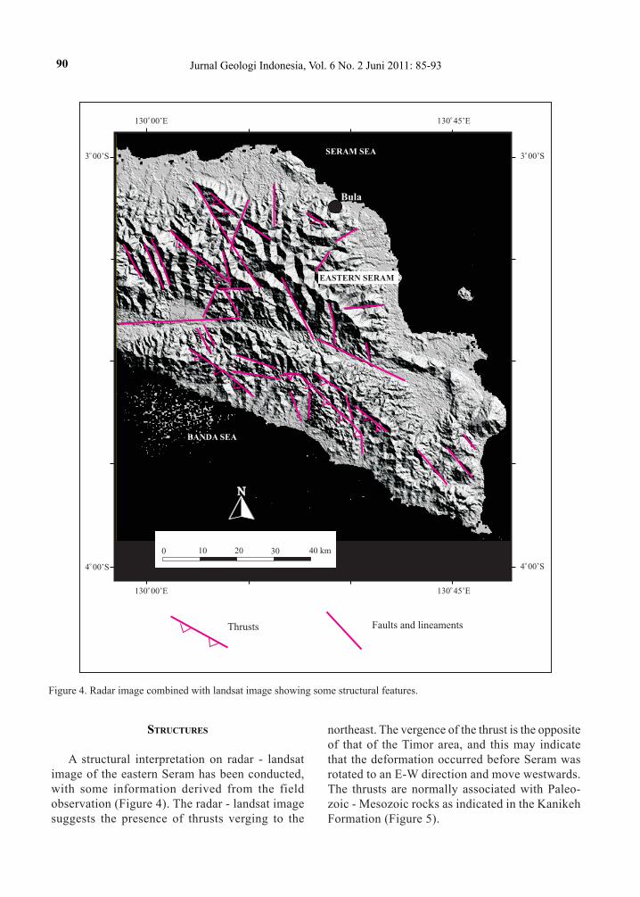
A structural interpretation on radar - landsat image of the eastern Seram has been conducted, with some information derived from the field observation (Figure 4). The radar - landsat image suggests the presence of thrusts verging to the
northeast. The vergence of the thrust is the opposite of that of the Timor area, and this may indicate that the deformation occurred before Seram was rotated to an E-W direction and move westwards. The thrusts are normally associated with Paleo-zoic - Mesozoic rocks as indicated in the Kanikeh Formation (Figure 5).
Figure 4. Radar image combined with landsat image showing some structural features.
N
EASTERN SERAM
SERAM SEA
BANDA SEA
o 130 00’E
o 130 00’E
o 130 45’E
o 130 45’E
o 3 00’S
o 3 00’S
o 4 00’So 4 00’S
Thrusts Faults and lineaments
Bula
0 10 20 30 40 km

91Tectonostratigraphy and Structures of Eastern Seram (S. Bachri)
Figure 5. Some field structural features.
Locality 1: A serie of minor normal faults in the Kanike Formation.
Locality 2: Thrust fault verging to NE associating with several normal faults, in the Kanikeh Formation.
Locality 3: S1 and S2 cleavages in the Kobipoto Complex. All the notations follow dip direction/amount of dip: So: Bedding S1: Cleavage of the first generation S2: Cleavage of the second generation FP : Fault Plane.
Locality of field structural features
Seram Island
Sketch of river bank
NE
NE
NE
SW
SW
10 m
10 m
10 m
S2: 215/85
1
2
3
So: 210/39
So: 195/36 FP: 210/74 FP: 210/74 S1: 240/62
200/25
Sketch of road cut
FP: 245/82
S2: 245/61
S1: 290/15
N
o 130 00’E
o 3 00’So
3 00’S
o 3 45’S
0 10 20 30 40 km
o 130 00’E
o 130 45’E
o 130 45’E
o 3 45’S
Bula12
3
Sketch of outcrop
SW
92 Jurnal Geologi Indonesia, Vol. 6 No. 2 Juni 2011: 85-93
Meanwhile, fold axes are not recognizable from the image, however from the existing geological map (Gafoer et al., 1984a) they can be identified relatively parallel to the long axis of the island trending from nearly east - west to nearly northwest - southeast, which are normally involving either the Quaternary rocks or the older units.
The presence of folds in the Quaternary autoch-thonous rocks indicates that tectonically Seram is still active. The structural orientation suggests a north-south or northeast-southwest maximum com-pressive stress that may be related to a subduction in the Seram Trough.
Several lateral faults and normal faults are also found to cut across the autochthonous sequence indicating that the structures were generated post - Neogene arc-continent collision.
conclusIons
The tectonostratigraphy of Eastern Seram is rep-resenting an interaction between three major plates, i.e. the Indo-Australian Plate, the Eurasian Plate, and the Pacific Plate, resulting in the presence of several rock units of different tectonic affinities.
The para-autochthonous sequence was derived from outer margin of the Australian NW Shelf which migrated to Banda Outer Arc. The allochthonous sequence comprises ultrabasic rocks which repre-sent oceanic crust of the Pre-collisional Banda Arc. Meanwhile, the post-orogenic sequence is composed of sediments deposited during and after the arc - continent collision, and unconformably overlies the para-autochthonous and allochthonous sequences.
The Neogene collisional event has played an important role in stratigraphic setting of the eastern Seram, or in the Banda Outer Arc in general.
The Neogene compressional tectonics is inter-preted to be an orogenic event in eastern Seram resulting in the uplift of eastern Seram and develop-ment of major structures, particularly the thrust fault. The post-Neogene tectonics has been responsible for the formation of structures in the autochthonous units.
Acknowledgement---The author would like to thank Dr. Rachmat Heryanto, Mr. Dharma Satria, and Dr. Wahyu Gunawan for cooperation during the fieldwork in Seram.
references
Audley-Charles, M.G., Carter, D.J., and Norvick, M.S., 1976. Reinterpretation of the geology of Seram. Report to BP Petroleum Developemnt Ltd., unpubl.
Bachri, S., 1995. The origin of the Aileu and Maubisse For-mations in the East Timor area, Indonesia. Proceedings of the 31st of CCOP Annual Session, p.232-241.
Bachri, S., Hermanto, B., and Partoyo, E., 1995. Genesa Kompleks Bobonaro di Timor Timur. Jurnal Geologi dan Sumberdaya Mineral, 5 (45), p.17-22.
Bachri, S. and Partoyo, E., 1995. Geology of the eastern Timor. Pertamina - Mobil Oil - GRDC East Indonesia Project, East Timor; unpubl.
Berry, R.F. and Grady, A.E., 1981. Deformation and meta-morphism of the Aileu Formation, North Coast, East Timor, and its tectonic significance. Journal of Structural Geology, 3, p.143-167.
Brown, M. and Earl, M.M., 1983. Cordierite bearing schist and gneisses from Timor, eastern Indonesia: PT con-ditions of metamorphism and tectonic implications. Journal of Metamorphic Geology, 1, p.183-203.
Carter, D.J., Audley-Charles, M.G., 1976. Stratigraphical analysis of an island arc-continental margin collision zone in eastern Indonesia. Journal of Geological Society, London. 132, p.179-198.
Charlton, T.R., Barber, A.J. and Barkham, S.T., 1991. The structural evolution of the Timor Collision Complex, Eastern Indonesia. Journal of Structural Geology, 13 (13), p.489-500.
Gafoer, S., Suwitodirdjo, K., and Suharsono, 1984a. Peta Geologi Lembar Bula dan Kepulauan Watubela, Seram, skala 1 : 250.000. Puslitbang Geologi, Bandung.
Gafoer, S., Suwitodirdjo, K., and Suharsono, 1984b. Lapo-ran Geologi Lembar Bula dan Kepulauan Watubela, skala 1 : 250.000. Puslitbang Geologi, Bandung.
Hamilton, W.,1979. Tectonic of the Indonesian region. U.S. Geological Survey; Professional paper, 1078pp.
Hartono, H.M.S., 1990. Terbentuknya Busur Volkanik Banda. Geology Indonesia, 13 (2), p.105-112.
Linthout, K. and Helmers, H.,1994. Pliocene obducted, rotated and migrated ultramafic rocks and obduction induced anatectic granite, SW Seram and Ambon, Eastern Indonesia. Journal of Southeast Asian Earth Science, 6, p.335-342.
Linthout, K., Helmers, H., Wijbrans, J.R., and Van Wees, J.D.A.M., 1996. 40Ar/39Ar constraints on obduction of the Seram ultramafic complex: consequences for the evolution of the evolution of the southern Banda Sea. In: Hall, R. and Blundell, D. (eds.), Tectonic Evolution of Southeast Asia, Geological Society Special Publica-tion, 106, p.445-464.
Paten, R.J. and Zilman, N.J., 1975. Exploration and petro-leum prospects Bula Basin, Seram, Indonesia. Pertamina /Associated Australia Resources N.L. Unpubl.
Pigram, C.J. and Panggabean, H.,1984. Rifting on the eastern margin of the Australian continent the origin
93Tectonostratigraphy and Structures of Eastern Seram (S. Bachri)
of some microcontinents in Indonesia. Tectonophysics, 107, p.331-353.
Powel, D.E., 1976. The geological evolution of the continen-tal margin of Northwest Australia. Journal of Australian Petroleum Exploration Association, 10, p.13-23.
Silver, E.A.,1979. A new tectonic map of the Molluca Sea and East Sulawesi, Indonesia, with implications for hy-drocarbon potential and metallogenesis, paper presented
at the Ad Hoc Working Group Meeting on the Geology and Tectonics of Eastern Indonesia, Study of East Asian Transect and Resources, Bandung Indonesia, July 9-14.
Van der Sluis, J.P.,1950. Geology of Seram. University of Utrecht.
Veevers, J.J.,1982. Western and northwestern margins of Australia. In : Nairn, A.E.M., and Stehli, F., Oceanic Basin, p.513-544.