PT. KARANA LINEkarana.co.id/e_features/surabaya_gresik/General_Port_Info.pdf · PT. KARANA LINE Oil...
12
PT. KARANA LINE Oil and Bulk Carriers Member of INSA No : 216 / INSA / VIII / 1990 054 / DPC INSA SBY/ XI/94 Surabaya Branch: Jl. Perak Timur No. 482 Surabaya 60165 INDONESIA Telp: 031-329710 (Hunting), Fax: 031-329423 E-mail: [email protected]; [email protected] BMS (JIIPE AKR ) – MANYAR 1. Name of Operator : PT. PELABUHAN INDONESIA III GRESIK BRANCH 2. Pilot Station : 06 o 52.30’ S / 112 O 44.38’ E 3. Port Location : 7* - 05’ 10.52” / 112* - 39’ 12.47 7* - 05’ 18.51” / 112* - 39’ 12.17” 4. Density of Harbour water : Abt. 1.0250 T/M3 5. Season, Two season : Rainy season on Oct. – Mar. And dry season on April – Sep. 6. Cnannal : a. Old channel : - Entering point : 06* 52’30” S / 112* 44’43” E - Depth /Width/Length : 8.4 M LWS / 100 M / 25 Sea Miles - Channel dues : NIL - Max vsl draft : 8.4 M b. New Channel : - Entering point : 06* 51’25.766” S / 112* 44’51.384” E - Depth/Width/length : 13.0 M LWS / 150 M / 25 Sea Miles - Channel dues : 1) Foreign flag : a) Running rate : US$.0.4 – US$.0.5/GRT/ONE PASS b) New rate : Rp.3,500 / MT of cargo discharged or loaded (Effective : Still wait confirmation from the Minister of Communication) 2) Indonesian flag : a) Running rate : RP.1,500 – RP.2,500 / GRT/ONE PASS b) New rate : Rp.1,500/ MT of cargo discharged of loaded (Effective: Still wait Confirmation from the Minister of Communication) c. Berth & Facilities: No. Item Description 1 Jetty Outer berth : 250 M length / 14 M LWS Depth Inner berth : 170 M length / 12 M LWS Depth 2 Facility Grabs = 5 units / cap 10 T Hopper = 7 units / cap 15 T Forklift = 2 units / capt 32 T & 3 T Truck scale = 1 unit / cap 60 T 6 Pilot & Port controll VHF : Channel 12 & 14 7 Security Level : Level 1
Transcript of PT. KARANA LINEkarana.co.id/e_features/surabaya_gresik/General_Port_Info.pdf · PT. KARANA LINE Oil...
PT. KARANA LINE Oil and Bulk CarriersMember of INSA No : 216 / INSA / VIII / 1990
054 / DPC INSA SBY/ XI/94Surabaya Branch:Jl. Perak Timur No. 482 Surabaya 60165 INDONESIATelp: 031-329710 (Hunting), Fax: 031-329423E-mail: [email protected]; [email protected]
BMS (JIIPE AKR ) – MANYAR
1. Name of Operator : PT. PELABUHAN INDONESIA III GRESIK BRANCH
2. Pilot Station : 06o 52.30’ S / 112O 44.38’ E
3. Port Location : 7* - 05’ 10.52” / 112* - 39’ 12.477* - 05’ 18.51” / 112* - 39’ 12.17”
4. Density of Harbour water : Abt. 1.0250 T/M3
5. Season, Two season : Rainy season on Oct. – Mar. And dry season on April – Sep.
6. Cnannal :a. Old channel :
- Entering point : 06* 52’30” S / 112* 44’43” E- Depth /Width/Length : 8.4 M LWS / 100 M / 25 Sea Miles- Channel dues : NIL- Max vsl draft : 8.4 M
b. New Channel :- Entering point : 06* 51’25.766” S / 112* 44’51.384” E- Depth/Width/length : 13.0 M LWS / 150 M / 25 Sea Miles- Channel dues :
1) Foreign flag :a) Running rate : US$.0.4 – US$.0.5/GRT/ONE PASSb) New rate : Rp.3,500 / MT of cargo discharged or loaded (Effective : Still wait
confirmation from the Minister of Communication)2) Indonesian flag :
a) Running rate : RP.1,500 – RP.2,500 / GRT/ONE PASSb) New rate : Rp.1,500/ MT of cargo discharged of loaded (Effective: Still wait
Confirmation from the Minister of Communication)
c. Berth & Facilities:No. Item Description1 Jetty Outer berth : 250 M length / 14 M LWS Depth
Inner berth : 170 M length / 12 M LWS Depth2 Facility Grabs = 5 units / cap 10 T
Hopper = 7 units / cap 15 TForklift = 2 units / capt 32 T & 3 TTruck scale = 1 unit / cap 60 T
6 Pilot & Port controll VHF : Channel 12 & 14
7 Security Level : Level 1
PT. KARANA LINE Oil and Bulk CarriersMember of INSA No : 216 / INSA / VIII / 1990
054 / DPC INSA SBY/ XI/94Surabaya Branch:Jl. Perak Timur No. 482 Surabaya 60165 INDONESIATelp: 031-329710 (Hunting), Fax: 031-329423E-mail: [email protected]; [email protected]
8 Fresh water supply : Available (By Truck / barge)
9 Working time 24 hours with the following arrangement:a. Working shift : Shift 1 (08:00 – 16:00), Shift 2 (16:00 – 24:00), Shift 3 (00:00 – 08:00)b. Rest time : 11:30 – 13:00, 17:30 – 19:00, 23:30 – 01:00, 05:00 – 08:00
Thanks,WiknyoPT. Karana Line, Jl. Perak Timur No. 482 SurabayaPh: 62-31-3293710, Fax: 62-31-3294231, Hp. 62-81-3300 16629Email: [email protected]
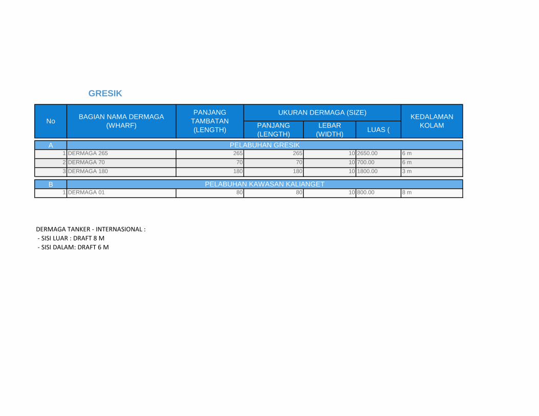
PANJANG
(LENGTH)
LEBAR
(WIDTH)LUAS (
A1 DERMAGA 265 265 265 10 2650.00 6 m
2 DERMAGA 70 70 70 10 700.00 6 m
3 DERMAGA 180 180 180 10 1800.00 3 m
B1 DERMAGA 01 80 80 10 800.00 8 m
DERMAGA TANKER - INTERNASIONAL :
- SISI LUAR : DRAFT 8 M
- SISI DALAM: DRAFT 6 M
PELABUHAN GRESIK
PELABUHAN KAWASAN KALIANGET
GRESIK
NoBAGIAN NAMA DERMAGA
(WHARF)
PANJANG
TAMBATAN
(LENGTH)
UKURAN DERMAGA (SIZE)KEDALAMAN
KOLAM
PT. KARANA LINE Oil and Bulk Carriers Member of INSA No : 216 / INSA / VIII / 1990 054 / DPC INSA SBY/ XI/94
Surabaya Branch: Jl. Perak Timur No. 482 Surabaya 60165 INDONESIA Telp: 031-329710 (Hunting), Fax: 031-329423 E-mail: [email protected]; [email protected]
PETRO KIMIA JETTY – GRESIK
1. Name of Operator : PT. PETRO KIMIA
2. Pilot Station : 06o 52.30’ S / 112O 44.38’ E
3. Port Location : 07o – 08’ – 45” S / 112O – 39’ – 00” E
4. Density of Harbour water : Abt. 1.0250 T/M3
5. Season, Two season : Rainy season on Oct. – Mar. And dry season on April – Sep.
6. Cnannal : a. Old channel :
- Entering point : 06* 52’30” S / 112* 44’43” E - Depth /Width/Length : 8.4 M LWS / 100 M / 25 Sea Miles - Channel Charge : NIL - Max vsl draft : 8.5 M
b. New Channel : - Entering point : 06* 51’25.766” S / 112* 44’51.384” E - Depth/Width/length : 13.0 M LWS / 150 M / 25 Sea Miles - Channel dues :
1) Foreign flag : a) Running rate : US$.0.4 – US$.0.5/GRT/ONE PASS b) New rate : Rp.3,500 / MT of cargo discharged or loaded (must be efff 1 Dec 16)
2) Indonesian flag : a) Running rate : RP.1,500 – RP.2,500 / GRT/ONE PASS b) New rate : Rp.1,500/ MT of cargo discharged of loaded (must be eff 1 Dec. 16)
7. Berth :
a. Jetty 1 - Outer Jetty (Tanker ship): 210 M length / 12 M depth / 60,000 DWT cap / Marine Loading Arm (MLA 10”) year 2010 for NH3, max flow 330 T / hr, max press 5.5 kg/cm2 - Inner Jetty : 210 M length / 11 M depth / 30,000 DWT cap b. Jetty 2 - Outer Jetty (Conv ship) : 610 M length / 12 M depth / 60,000 DWT cap - Inner Jetty (Conv ship) : 600 M length / 11 M depth / 30,000 DWT cap
8. Pilot & Port controll VHF : Channel 12 & 14
9. Security Level : Level 1
10. Fresh water supply : Available
11. Working time 24 hours with the following arrangement:
PT. KARANA LINE Oil and Bulk Carriers Member of INSA No : 216 / INSA / VIII / 1990 054 / DPC INSA SBY/ XI/94
Surabaya Branch: Jl. Perak Timur No. 482 Surabaya 60165 INDONESIA Telp: 031-329710 (Hunting), Fax: 031-329423 E-mail: [email protected]; [email protected]
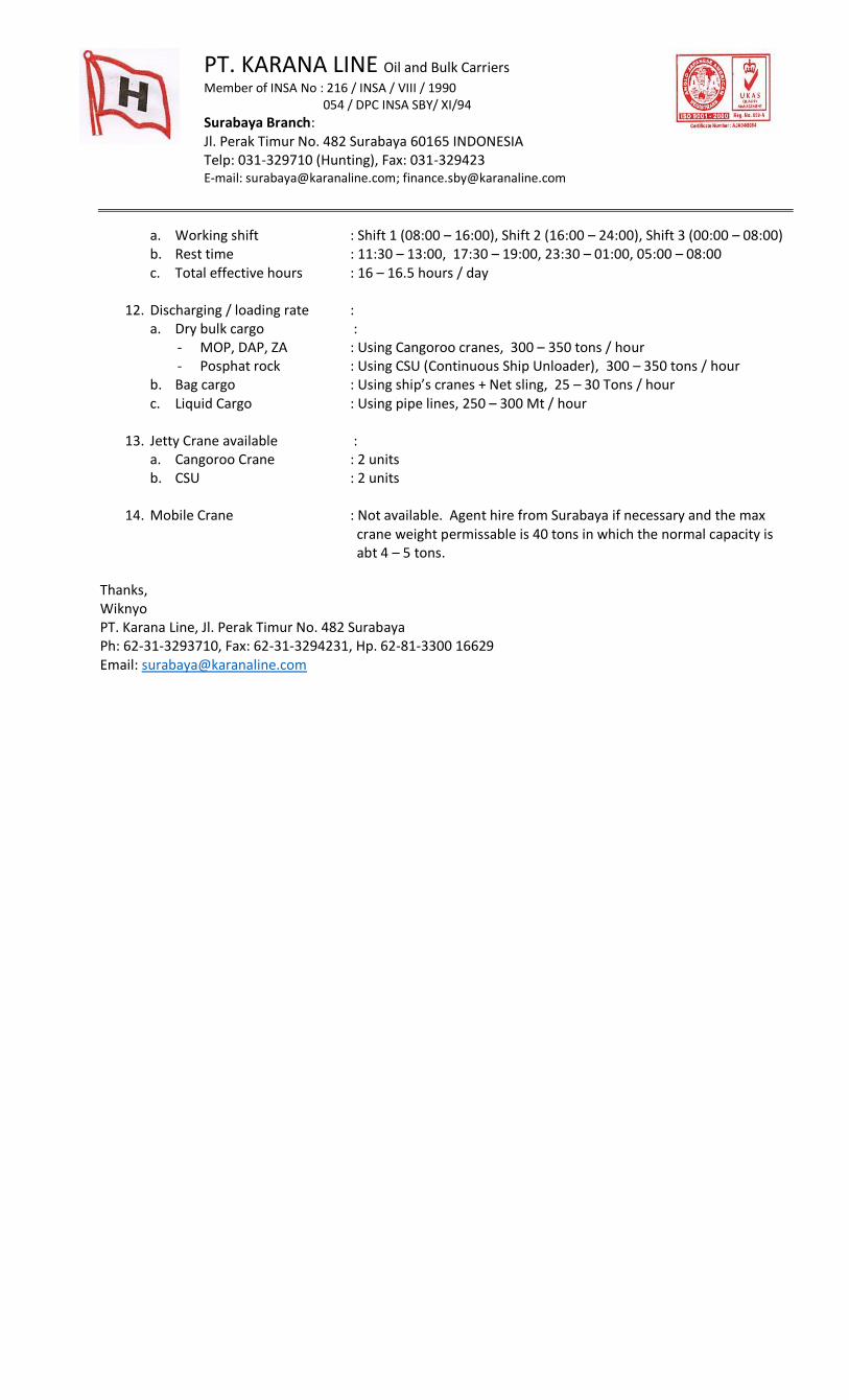
a. Working shift : Shift 1 (08:00 – 16:00), Shift 2 (16:00 – 24:00), Shift 3 (00:00 – 08:00) b. Rest time : 11:30 – 13:00, 17:30 – 19:00, 23:30 – 01:00, 05:00 – 08:00 c. Total effective hours : 16 – 16.5 hours / day
12. Discharging / loading rate :
a. Dry bulk cargo : - MOP, DAP, ZA : Using Cangoroo cranes, 300 – 350 tons / hour - Posphat rock : Using CSU (Continuous Ship Unloader), 300 – 350 tons / hour
b. Bag cargo : Using ship’s cranes + Net sling, 25 – 30 Tons / hour c. Liquid Cargo : Using pipe lines, 250 – 300 Mt / hour
13. Jetty Crane available :
a. Cangoroo Crane : 2 units b. CSU : 2 units
14. Mobile Crane : Not available. Agent hire from Surabaya if necessary and the max
crane weight permissable is 40 tons in which the normal capacity is abt 4 – 5 tons. Thanks, Wiknyo PT. Karana Line, Jl. Perak Timur No. 482 Surabaya Ph: 62-31-3293710, Fax: 62-31-3294231, Hp. 62-81-3300 16629 Email: [email protected]
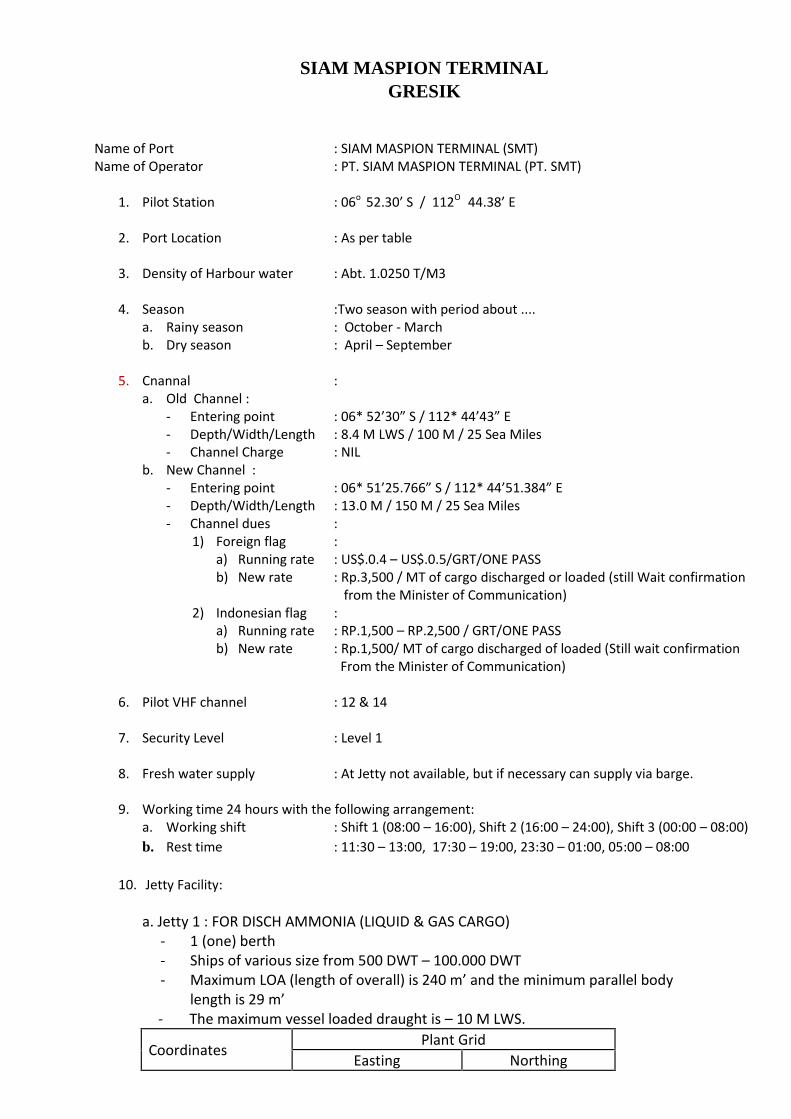
SIAM MASPION TERMINALGRESIK
Name of Port : SIAM MASPION TERMINAL (SMT)Name of Operator : PT. SIAM MASPION TERMINAL (PT. SMT)
1. Pilot Station : 06o 52.30’ S / 112O 44.38’ E
2. Port Location : As per table
3. Density of Harbour water : Abt. 1.0250 T/M3
4. Season :Two season with period about ....a. Rainy season : October - Marchb. Dry season : April – September
5. Cnannal :a. Old Channel :
- Entering point : 06* 52’30” S / 112* 44’43” E- Depth/Width/Length : 8.4 M LWS / 100 M / 25 Sea Miles- Channel Charge : NIL
b. New Channel :- Entering point : 06* 51’25.766” S / 112* 44’51.384” E- Depth/Width/Length : 13.0 M / 150 M / 25 Sea Miles- Channel dues :
1) Foreign flag :a) Running rate : US$.0.4 – US$.0.5/GRT/ONE PASSb) New rate : Rp.3,500 / MT of cargo discharged or loaded (still Wait confirmation
from the Minister of Communication)2) Indonesian flag :
a) Running rate : RP.1,500 – RP.2,500 / GRT/ONE PASSb) New rate : Rp.1,500/ MT of cargo discharged of loaded (Still wait confirmation
From the Minister of Communication)
6. Pilot VHF channel : 12 & 14
7. Security Level : Level 1
8. Fresh water supply : At Jetty not available, but if necessary can supply via barge.
9. Working time 24 hours with the following arrangement:a. Working shift : Shift 1 (08:00 – 16:00), Shift 2 (16:00 – 24:00), Shift 3 (00:00 – 08:00)b. Rest time : 11:30 – 13:00, 17:30 – 19:00, 23:30 – 01:00, 05:00 – 08:00
10. Jetty Facility:
a. Jetty 1 : FOR DISCH AMMONIA (LIQUID & GAS CARGO)- 1 (one) berth- Ships of various size from 500 DWT – 100.000 DWT- Maximum LOA (length of overall) is 240 m’ and the minimum parallel body
length is 29 m’- The maximum vessel loaded draught is – 10 M LWS.
Coordinates Plant GridEasting Northing
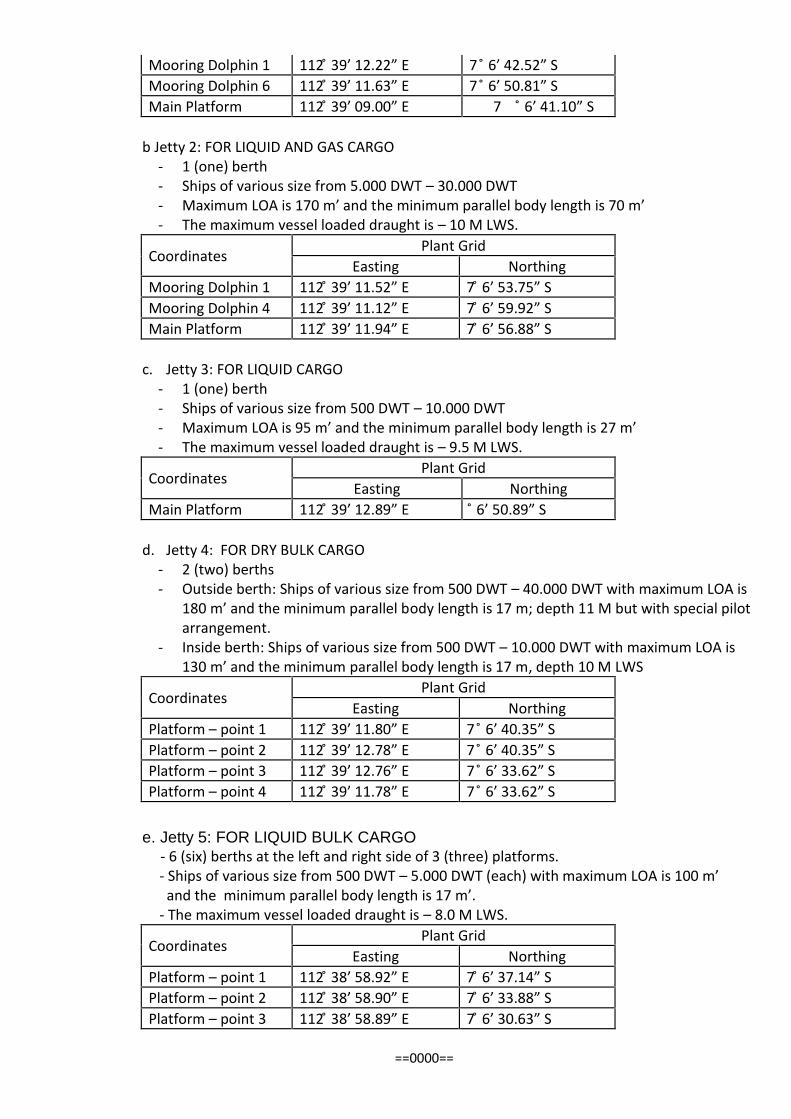
Mooring Dolphin 1 112 ̊39’ 12.22” E 7 ̊ 6’ 42.52” SMooring Dolphin 6 112 ̊39’ 11.63” E 7 ̊ 6’ 50.81” SMain Platform 112 ̊39’ 09.00” E 7 ̊ 6’ 41.10” S
b Jetty 2: FOR LIQUID AND GAS CARGO- 1 (one) berth- Ships of various size from 5.000 DWT – 30.000 DWT- Maximum LOA is 170 m’ and the minimum parallel body length is 70 m’- The maximum vessel loaded draught is – 10 M LWS.
Coordinates Plant GridEasting Northing
Mooring Dolphin 1 112 ̊39’ 11.52” E 7 ̊ 6’ 53.75” SMooring Dolphin 4 112 ̊39’ 11.12” E 7 ̊ 6’ 59.92” SMain Platform 112 ̊39’ 11.94” E 7 ̊ 6’ 56.88” S
c. Jetty 3: FOR LIQUID CARGO- 1 (one) berth- Ships of various size from 500 DWT – 10.000 DWT- Maximum LOA is 95 m’ and the minimum parallel body length is 27 m’- The maximum vessel loaded draught is – 9.5 M LWS.
Coordinates Plant GridEasting Northing
Main Platform 112 ̊39’ 12.89” E ̊ 6’ 50.89” S
d. Jetty 4: FOR DRY BULK CARGO- 2 (two) berths- Outside berth: Ships of various size from 500 DWT – 40.000 DWT with maximum LOA is
180 m’ and the minimum parallel body length is 17 m; depth 11 M but with special pilotarrangement.
- Inside berth: Ships of various size from 500 DWT – 10.000 DWT with maximum LOA is130 m’ and the minimum parallel body length is 17 m, depth 10 M LWS
Coordinates Plant GridEasting Northing
Platform – point 1 112 ̊39’ 11.80” E 7 ̊ 6’ 40.35” SPlatform – point 2 112 ̊39’ 12.78” E 7 ̊ 6’ 40.35” SPlatform – point 3 112 ̊39’ 12.76” E 7 ̊ 6’ 33.62” SPlatform – point 4 112 ̊39’ 11.78” E 7 ̊ 6’ 33.62” S
e. Jetty 5: FOR LIQUID BULK CARGO- 6 (six) berths at the left and right side of 3 (three) platforms.- Ships of various size from 500 DWT – 5.000 DWT (each) with maximum LOA is 100 m’and the minimum parallel body length is 17 m’.
- The maximum vessel loaded draught is – 8.0 M LWS.
Coordinates Plant GridEasting Northing
Platform – point 1 112 ̊38’ 58.92” E 7 ̊ 6’ 37.14” SPlatform – point 2 112 ̊38’ 58.90” E 7 ̊ 6’ 33.88” SPlatform – point 3 112 ̊38’ 58.89” E 7 ̊ 6’ 30.63” S
==0000==
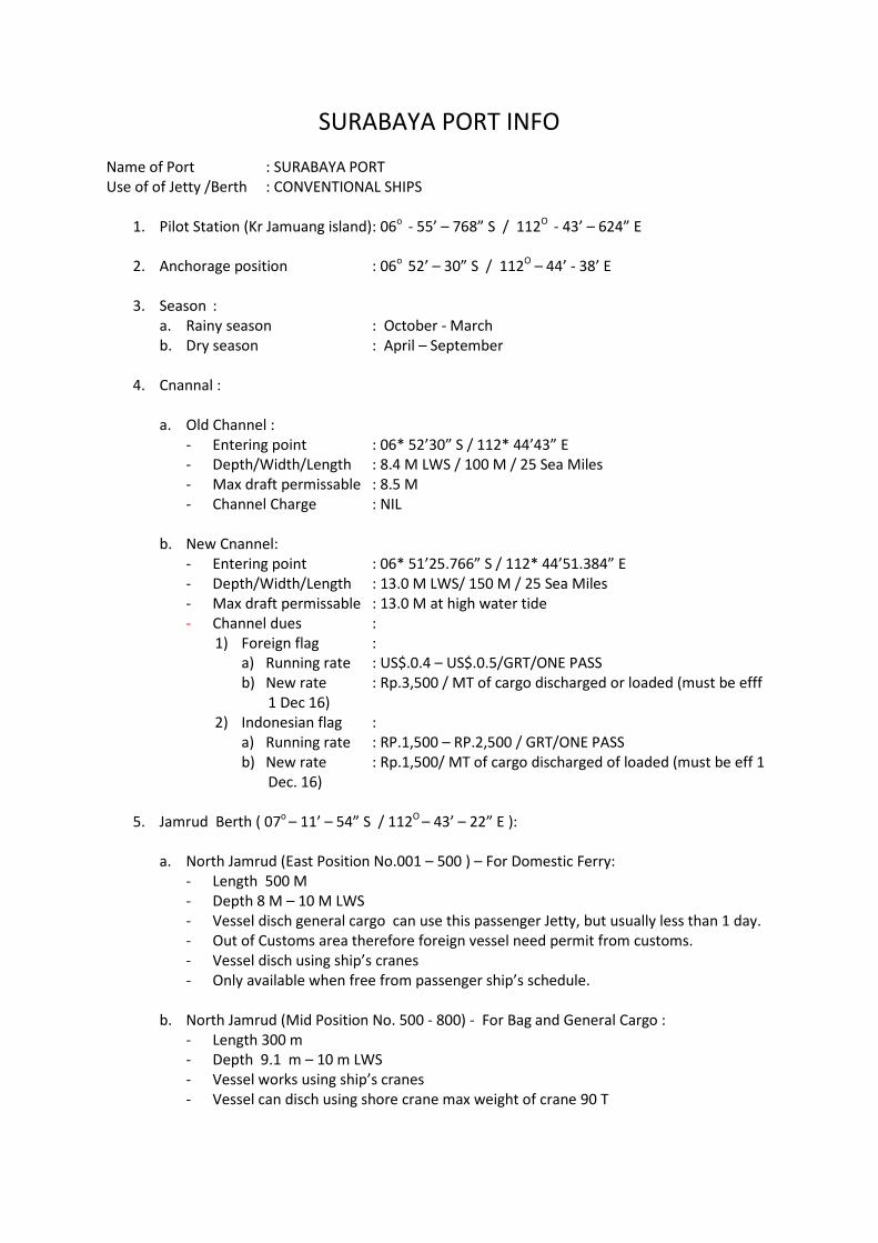
SURABAYA PORT INFOName of Port : SURABAYA PORTUse of of Jetty /Berth : CONVENTIONAL SHIPS
1. Pilot Station (Kr Jamuang island): 06o - 55’ – 768” S / 112O - 43’ – 624” E
2. Anchorage position : 06o 52’ – 30” S / 112O – 44’ - 38’ E
3. Season :a. Rainy season : October - Marchb. Dry season : April – September
4. Cnannal :
a. Old Channel :- Entering point : 06* 52’30” S / 112* 44’43” E- Depth/Width/Length : 8.4 M LWS / 100 M / 25 Sea Miles- Max draft permissable : 8.5 M- Channel Charge : NIL
b. New Cnannel:- Entering point : 06* 51’25.766” S / 112* 44’51.384” E- Depth/Width/Length : 13.0 M LWS/ 150 M / 25 Sea Miles- Max draft permissable : 13.0 M at high water tide- Channel dues :
1) Foreign flag :a) Running rate : US$.0.4 – US$.0.5/GRT/ONE PASSb) New rate : Rp.3,500 / MT of cargo discharged or loaded (must be efff
1 Dec 16)2) Indonesian flag :
a) Running rate : RP.1,500 – RP.2,500 / GRT/ONE PASSb) New rate : Rp.1,500/ MT of cargo discharged of loaded (must be eff 1
Dec. 16)
5. Jamrud Berth ( 07o – 11’ – 54” S / 112O – 43’ – 22” E ):
a. North Jamrud (East Position No.001 – 500 ) – For Domestic Ferry:- Length 500 M- Depth 8 M – 10 M LWS- Vessel disch general cargo can use this passenger Jetty, but usually less than 1 day.- Out of Customs area therefore foreign vessel need permit from customs.- Vessel disch using ship’s cranes- Only available when free from passenger ship’s schedule.
b. North Jamrud (Mid Position No. 500 - 800) - For Bag and General Cargo :- Length 300 m- Depth 9.1 m – 10 m LWS- Vessel works using ship’s cranes- Vessel can disch using shore crane max weight of crane 90 T
c. Nort Jamrud (West Position No. 800 – 1200) - For Dry Bulk Cargo :- Length 400 m- Depth 9.1 m – 10 m LWS- Vessel compulsory works using min 1 unit Harbour mobile crane for one gang.
Other gangs can use Ship’s cranes.
d. West Jamrud ( No. 000 – 220 ) - For Dry Bulk Cargo- Length 210 m- Depth 6.0 – 7.0 m LWS- Vessel compulsory works using min 1 unit Harbour mobile crane for one gang. Other
gangs can use ship’s cranes.
e. South Jamrud (No.000 – 200 ) - For Dry Bulk Cargo- Length 200 m- Depth 8.0 m LWS- Vessel compulsory works using min 1 unit Harbour mobile crane for one gang. Other
gangs can use ship’s cranes.- Out of customs area, therefore foreign vessel need permit from customs.- Non ISPS area.
6. Teluk Lamong Jetty : New Wharf For Multi Purpose- Length 500 M (250 m for container & 250 m for dry bulk)- Depth 13 M LWS- Now is under installation of conveyors for dry bulk cargo, but already start to give
service by trucking.
7. BA Chart No : NEED 2 DAYS FROM DATE OF ORDER
8. Density of Harbour water : Abt 1.0250 T/M3
9. Pilot VHF channel : 12. 14
10. Port Controll VHF Channel : 16
11. Security Level : Level 1 (Watchmen are recomended when ship alongside,unless the ship’s crews must be full aware)
12. Fresh water supply : Available
13. Fuel Oil/ Lub Oil : Available
14. Working time 24 hours with the following arrangement:a. Shift : Shift 1 (08:00 – 16:00), Shift 2 (16:00 – 24:00), shift 3 (00:00 – 08:00)b. Rest time : 11:30 – 13:00, 17:30 – 19:00, 23:00 – 01:00, 05:00 – 08:00
===o0 00o ===
WINA Gresik – SHIPPING Dept.
1 Berth DetailsJetty F-Type named: Jetty A, B and CJetty A (A1-A2-A3) Max LoA 200 mtrDimension: 200 x 33 mtr Max Draft 12 mtr
Max Beam 30 mtrAir Draft No RestrictionLength of berth 270 mtr
Jetty B (B1-B2) Max LoA 160 mtrMax Draft 10 mtrMax Beam 20 mtrAir Draft No RestrictionLength of Berth 195 mtr
Jetty C-1 Max LoA 60 mtrDimension: 43 x 3 mtr Max Draft 4.5 mtr
Max Beam 10 mtrAir Draft No RestrictionLength of Berth 43 mtr
Jetty C-2 Max LoA 70 mtrDimension: 50 x 18 mtr Max Draft 5 mtr
Max Beam 10 mtrAir Draft 6 mtrLength of Berth 50 mtr
Jetty C-3 Max LoA 60 mtrDimension: 10 x 10 mtr Max Draft 6 mtr
Max Beam 10 mtrAir Draft No RestrictionLength of Berth 10 mtr
REMARKS:Channel depth : Old channel 8.4 M depth, New Channel 13 M depth.
2 Loading and Discharge FacilitiesLiquid CargoPipe Line CPO 2 x 10 inch MS
2 x 8 inch MSLauric Product 1 x 8 inch MS
PORT INFORMATION
with Coordinat 7̊ 10’ 43’’ S ; 112˚ 40’
WINA-Port is a Multi Purpose Private Terminal owned by PT. Wilmar Nabati Indonesia-Gresik,Located at Side of Surabaya West Marine Transportation Channel (APBS), East Java
PFAD 1 x 12 inch MSROL 1 x 12 inch MSRPS 1 x 12 inch MSOleo 2 x 8 inch SSMethanol 1 x 10 inch MSBiodiesel 1 x 12 inch MSAir P'line 1 x 6 inch MSN2 P'line 1 x 4 Inch MS
Propose new P'Line Olefin 1 x 10 inch MSButane 1 x 10 inch MS
1 x 6 inch MSFA Low IV 1 x 8 inch MSME 1 x 10 inch MSCaustic 1 x 6 inch MSMolasses 1 x 10 inch MS
Flexible Hose SS 8' x 6 mtr 29 pcsSS 6' x 6 mtr 13 pcsRubber 6" x 6 mtr 40 pcs
Hose in ordering SS 8" x 6 mtr 30 pcsSS 6" x 6 mtr 10 pcs
Steger 2 pcs
Bulk and in Bags CargoHeavy Equipment 25 ton Telescopic shore crane 2 units
5 ton Forklift 1 unitBelt conveyor for Kernel and fertilizer 1 setHopper 5x7 mtr 4 unitpkm loader 1 setGrab cap 5 ton 3 unitsGrab cap 7 ton 3 unitsgrab cap 3.5 ton 2 unitsFix Crane with Cap 5 ton each 2 units
3 Loading RateLoading rate for Palm Oil Product (ROL, RPS, PFAD) 400 TPHLoading rate for PKM 2000 TPDDisch rate for PK 700 TPDDisch rate for pertilizer in bulk 9000 TPDLoading Pertilizer in bag 700 TPD
4 Other Facilities- Oil Boom Bridgestone Oilboom with length +/- 360 mtr- Yokohama Fender 2 set Yokohama Fender with dimension 1.5 x 3 mtr
for STS Operation- Speed Boat Patrol S.boat with L: 6.5 mtr and 85 HP Yamaha engine- Blackmer Pump 2 units- bosster pump cpo 4 units 75 KW In proggress installation- Horbour tug in order
5 Tank Capacity (Storage and Production)Bounded Zone Refinary 81,500 MT
Biodiesel 68,000 MTOleo chem 48,780 MT
Non Bounded Zone Refinery 15,000 MT
6 Distance to Shore TankBounded Zone 1700 mtrNon Bounded Zone 1500 mtr
7 Tidal RestrictionOuter Berth The Vessel is berthed and unberthed at any time on
Favourable CurrentInner Berth The vessel is permitted to berth only when high tide and
tidal stream moving to south
8 Navigation Sign WINA port are equiped with 2 Spar bouy,2 Beacon Pile and 1 Light Tower
9 General Information - Pilotage and Tug boat is mandatory during berthing/unberthing process
Supervisor- Safety Gear must be worn (Helmet, Safety Shoes,life jacket) while a shore- This Port is accomply with ISPS Code- This Port is 24 hrs working hrs including Sunday andPublic Holiday- FW bunker is permitted using truck loosing
- Ships crew not allowed to go a shore withoutescorted by the agent & Permitted by WINA Port