PENGANTARGEOMORFOLOFI
13
GEOMORFOLOFI GEOMORFOLOFI PENDAHULUAN PENDAHULUAN
-
Upload
priyo-adi-nugroho -
Category
Documents
-
view
11 -
download
0
Transcript of PENGANTARGEOMORFOLOFI

GEOMORFOLOFIGEOMORFOLOFI
PENDAHULUANPENDAHULUAN
DEFINISIDEFINISI
Geomorfologi dari bahasa Yunani kuno, Geomorfologi dari bahasa Yunani kuno, geo = bumi, morfo = bentuk, logos = ilmu, geo = bumi, morfo = bentuk, logos = ilmu, (“(“landscapelandscape”).”).
Mula-mula digunakan istilah fisiografi.Mula-mula digunakan istilah fisiografi.Di Eropa fisiografi diartikan sebagai ilmu Di Eropa fisiografi diartikan sebagai ilmu yang mempelajari rangkuman tentang iklim, yang mempelajari rangkuman tentang iklim, meteorologi, oceanogcafi dan geografi. meteorologi, oceanogcafi dan geografi.
Akan tetapi para Akan tetapi para pakar pakar Amerika tidak Amerika tidak sependapat karena sependapat karena bidang bidang ilmu yang ilmu yang mempelajari roman muka bumi erat mempelajari roman muka bumi erat hubungannya dengan ilmu geologi, mereka hubungannya dengan ilmu geologi, mereka lebih cenderung memakai istilah lebih cenderung memakai istilah Geomorfologi.Geomorfologi.

REFERENSI REFERENSI DEFINISIDEFINISI
GeomorphologyGeomorphologyFrom Wikipedia, the free encyclopediaFrom Wikipedia, the free encyclopediaJump to: Jump to: navigation, , search Surface of the EarthSurface of the EarthGeomorphologyGeomorphology is the study of is the study of landforms, including their origin , including their origin and evolution, and the processes that shape them. The underlying and evolution, and the processes that shape them. The underlying question is: Why do question is: Why do landscapes look the way they do? The term is look the way they do? The term is derived from the Greek derived from the Greek γη, geγη, ge, meaning , meaning EarthEarth, and , and μορφή, morféμορφή, morfé, , meaning form. Geomorphologists seek to understand landform meaning form. Geomorphologists seek to understand landform history and dynamics, and predict future changes through a history and dynamics, and predict future changes through a combination of field observation, physical experiment, and combination of field observation, physical experiment, and numerical numerical modeling. The discipline is practiced within . The discipline is practiced within geology, , geodesy, , geography, , archaeology, and , and civil and environmental and environmental engineering. Early studies in geomorphology are the foundation engineering. Early studies in geomorphology are the foundation for pedology, one of two main branches of soil science.for pedology, one of two main branches of soil science.Landforms evolve in response to a combination of natural and Landforms evolve in response to a combination of natural and anthropogenic processes. The landscape is built up through anthropogenic processes. The landscape is built up through tectonic uplift and volcanism. Denudation occurs by erosion and tectonic uplift and volcanism. Denudation occurs by erosion and mass wasting, which produces sediment that is transported and mass wasting, which produces sediment that is transported and deposited elsewhere within the landscape or off the coast. deposited elsewhere within the landscape or off the coast. Landscapes are also lowered by subsidence, either due to Landscapes are also lowered by subsidence, either due to tectonics or physical changes in underlying sedimentary deposits. tectonics or physical changes in underlying sedimentary deposits. These processes are each influenced differently by climate, These processes are each influenced differently by climate, ecology, and human activity.ecology, and human activity.Practical applications of geomorphology include landslide Practical applications of geomorphology include landslide prediction and mitigation, river control and restoration, coastal prediction and mitigation, river control and restoration, coastal protection, and assessing the presence of water on Mars.protection, and assessing the presence of water on Mars.PaleogeomorphologyPaleogeomorphology is the study of the geomorphology of all or is the study of the geomorphology of all or part of the earth's surface at some time in the earth's pastpart of the earth's surface at some time in the earth's past
SEJARAH (1)SEJARAH (1)
Dimulai pakar-pakar filsafat Yunani dan Itali, Dimulai pakar-pakar filsafat Yunani dan Itali, HerodatusHerodatus (485-425 SM) (485-425 SM) ((bapak "Sejarahbapak "Sejarah" ) " ) Aristoteles, Plato dll Aristoteles, Plato dll yang semuanya berusaha yang semuanya berusaha menjelaskan gejala-gejala alam di muka bumi menjelaskan gejala-gejala alam di muka bumi (geologi) termasuk perubahan muka air laut (geologi) termasuk perubahan muka air laut dinyatakan sebagai suatu kutukan Tuhan atau dinyatakan sebagai suatu kutukan Tuhan atau dikenal dengan dikenal dengan teori malapetakateori malapetaka. .
Selanjutnya dikenal Teori Selanjutnya dikenal Teori KatastrofismaKatastrofisma ( (Cuvier)Cuvier) : :Gejala gejala morfologi terjadi secara Gejala gejala morfologi terjadi secara mendadak, mendadak, didukung oleh kejadian geologi seperti letusan didukung oleh kejadian geologi seperti letusan gunung api, longsor, aliran lahar, begitu juga gunung api, longsor, aliran lahar, begitu juga dataran-dataran terjadi secara demikiandataran-dataran terjadi secara demikian..
James HuttonJames Hutton (1726 - 1797) (1726 - 1797) sebagai "sebagai "Bapak Bapak Geologi ModernGeologi Modern" pendapatnya bertentangan " pendapatnya bertentangan dengan teori Katastrofisma: dengan teori Katastrofisma: Proses pembentukan morfologi bekerja sepanjang Proses pembentukan morfologi bekerja sepanjang waktu secara perlahan tetapi mampu membentuk waktu secara perlahan tetapi mampu membentuk bentuk-bentuk yang sekarang. Bahkan banyak bentuk-bentuk yang sekarang. Bahkan banyak perubahan yang terjadi pada masa lalu terjadi pada perubahan yang terjadi pada masa lalu terjadi pada masa sekarang dan seterusnya.masa sekarang dan seterusnya."masa sekarang adalah kunci membuka tabir "masa sekarang adalah kunci membuka tabir masa lampau”masa lampau”
("("The present is Key toThe present is Key to the pastthe past").").
SEJARAH (2)SEJARAH (2)
Pada masa sekarang geomorfologi bukan Pada masa sekarang geomorfologi bukan hanya meliputi hal-hal yang statis, tetapi hanya meliputi hal-hal yang statis, tetapi juga mencakup hal yang dinamis yang juga mencakup hal yang dinamis yang dapat diramalkan kejadiannya di alam dapat diramalkan kejadiannya di alam sebagai hasil interpolasi. Selain itu bentuk sebagai hasil interpolasi. Selain itu bentuk roman muka bumi roman muka bumi dapat dinyatakan dapat dinyatakan dengan besaran dengan besaran matematika seperti kita matematika seperti kita kenal dalam Geomorfologi Kwantitatifkenal dalam Geomorfologi Kwantitatif

REFERENSI REFERENSI SEJARAHSEJARAH
GeomorphologyGeomorphologyFrom Wikipedia, the free encyclopediaFrom Wikipedia, the free encyclopediaJump to: navigation, searchJump to: navigation, search
HistoryHistoryGeomorphology was not originally differentiated from Geomorphology was not originally differentiated from the rest of geography. The first geomorphic model the rest of geography. The first geomorphic model was the was the geographical cyclegeographical cycle or the or the cycle of erosioncycle of erosion, , developed by William Morris Davis between 1884 developed by William Morris Davis between 1884 and 1899. The cycle was inspired by theories of and 1899. The cycle was inspired by theories of uniformitarianism which were first formulated by uniformitarianism which were first formulated by James Hutton (1726-1797). Concerning valley forms, James Hutton (1726-1797). Concerning valley forms, the cycle was depicted as a sequence by which a the cycle was depicted as a sequence by which a river would cut a valley more and more deeply, but river would cut a valley more and more deeply, but then erosion of side valleys would eventually flatten then erosion of side valleys would eventually flatten out the terrain again, now at a lower elevation. The out the terrain again, now at a lower elevation. The cycle could be started over by uplift of the terrain. cycle could be started over by uplift of the terrain. The model is today considered too much of a The model is today considered too much of a simplification to be especially useful in practice.simplification to be especially useful in practice.Walther Penck developed an alternative model in the Walther Penck developed an alternative model in the 1920s, based on ratios of uplift and erosion, but it 1920s, based on ratios of uplift and erosion, but it was also too weak to explain a variety of landforms. was also too weak to explain a variety of landforms. G. K. Gilbert was an important early American G. K. Gilbert was an important early American geomorphologist.geomorphologist.
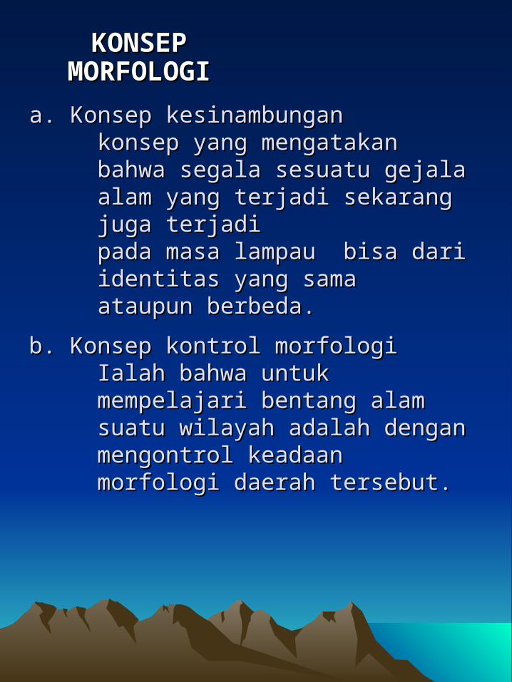
KONSEP KONSEP MORFOLOGIMORFOLOGI
a. Konsep kesinambungana. Konsep kesinambungankonsep yang mengatakan bahwa konsep yang mengatakan bahwa segala sesuatu gejala alam yang segala sesuatu gejala alam yang terjadi sekarang juga terjaditerjadi sekarang juga terjadipada masa lampau bisa dari pada masa lampau bisa dari identitas yang samaidentitas yang samaataupun berbeda.ataupun berbeda.
b. Konsep kontrol morfologib. Konsep kontrol morfologiIalah bahwa untuk mempelajari Ialah bahwa untuk mempelajari bentang alam suatu wilayah adalah bentang alam suatu wilayah adalah dengan mengontrol keadaan dengan mengontrol keadaan morfologi daerah tersebut.morfologi daerah tersebut.
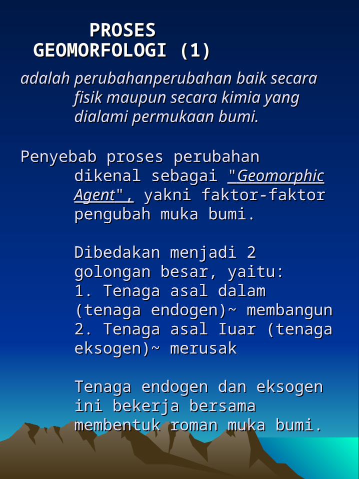
PROSES PROSES GEOMORFOLOGI (1)GEOMORFOLOGI (1)
adalah perubahan perubahan baik secara adalah perubahan perubahan baik secara fisik maupun secara kimia yang fisik maupun secara kimia yang dialami permukaan bumi. dialami permukaan bumi.
Penyebab proses perubahan dikenal Penyebab proses perubahan dikenal sebagai sebagai ""GeomorphicGeomorphic AgentAgent",", yakni yakni faktor-faktor pengubah muka bumi.faktor-faktor pengubah muka bumi.
Dibedakan menjadi 2 golongan Dibedakan menjadi 2 golongan besar, yaitu:besar, yaitu:1. Tenaga asal dalam (tenaga 1. Tenaga asal dalam (tenaga endogen)~ membangunendogen)~ membangun2. Tenaga asal Iuar (tenaga 2. Tenaga asal Iuar (tenaga eksogen)~ merusakeksogen)~ merusak
Tenaga endogen dan eksogen ini Tenaga endogen dan eksogen ini bekerja bersama membentuk roman bekerja bersama membentuk roman muka bumi. muka bumi.

1. Tenaga endogen1. Tenaga endogen, dibedakan , dibedakan a. teramati prosesnya; vulkanisme. a. teramati prosesnya; vulkanisme. b. tak teramati prosesnya; b. tak teramati prosesnya; pembentukan pegunungan, pembentukan pegunungan, lipatan, patahan, dsb, lipatan, patahan, dsb,
PROSES PROSES GEOMORFOLOGI (2)GEOMORFOLOGI (2)
2. 2. Tenaga eksogenTenaga eksogen, proses dapat diamati, , proses dapat diamati, dibedakan dibedakan a. Degradasi : pelarutan, erosi, gerak a. Degradasi : pelarutan, erosi, gerak massa batuan, organik, dll.massa batuan, organik, dll.b. Degradasi – agradasi :b. Degradasi – agradasi : banjir, banjir, gerakan tanah, dll.gerakan tanah, dll.c. Agradasi : akumulasi sedimen c. Agradasi : akumulasi sedimen hasil pelapukan oleh air, angin, hasil pelapukan oleh air, angin, gravitasi, vulkanik, organik, dll.gravitasi, vulkanik, organik, dll.d. Ekstra terestrial : crater meteoricd. Ekstra terestrial : crater meteoric
Untuk memperlihatkan adanya suatu proses Untuk memperlihatkan adanya suatu proses perlu dilakukan perlu dilakukan peragaan peragaan Geomorfologi *)Geomorfologi *)

REFERENSI PENGELOMPOKAN REFERENSI PENGELOMPOKAN LANDSCAPELANDSCAPE
GeomorphologyGeomorphologyFrom Wikipedia, the free encyclopediaFrom Wikipedia, the free encyclopediaJump to: navigation, searchJump to: navigation, search
TaxonomyTaxonomyDifferent geomorphological processes dominate at different Different geomorphological processes dominate at different spatial and temporal scales. To help categorize landscape spatial and temporal scales. To help categorize landscape scales some geomorphologists use the following scales some geomorphologists use the following taxonomy:taxonomy:1st - Continent, ocean basin, climatic zone (~10,000,000 1st - Continent, ocean basin, climatic zone (~10,000,000 km²) km²) 2nd - Shield, e.g. Baltic shield, or mountain range 2nd - Shield, e.g. Baltic shield, or mountain range (~1,000,000 km²) (~1,000,000 km²) 3rd - Isolated sea, Sahel (~100,000 km²) 3rd - Isolated sea, Sahel (~100,000 km²) 4th - Massif, e.g. Massif Central or Group of related 4th - Massif, e.g. Massif Central or Group of related landforms, e.g., Weald (~10,000 km²) landforms, e.g., Weald (~10,000 km²) 5th - River valley, Cotswolds (~1,000 km²) 5th - River valley, Cotswolds (~1,000 km²) 6th - Individual mountain or volcano, small valleys (~100 6th - Individual mountain or volcano, small valleys (~100 km²) km²) 7th - Hillslopes, stream channels, estuary (~10 km²) 7th - Hillslopes, stream channels, estuary (~10 km²) 8th - gully, barchannel (~1 km²) 8th - gully, barchannel (~1 km²) 9th - Meter-sized features 9th - Meter-sized features Its use, however, is rare and may be misleading - the Its use, however, is rare and may be misleading - the nature of landscape change may be better viewed as a nature of landscape change may be better viewed as a continuum of coupled processes.continuum of coupled processes.
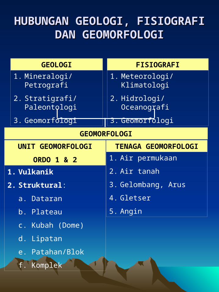
HUBUNGAN GEOLOGI, HUBUNGAN GEOLOGI, FISIOGRAFI DAN GEOMORFOLOGIFISIOGRAFI DAN GEOMORFOLOGI
GEOLOGI
1. Mineralogi/Petrografi
2. Stratigrafi/Paleontologi
3. Geomorfologi
FISIOGRAFI
1. Meteorologi/Klimatologi
2. Hidrologi/Oceanografi
3. Geomorfologi
TENAGA GEOMORFOLOGI
1. Air permukaan
2. Air tanah
3. Gelombang, Arus
4. Gletser
5. Angin
UNIT GEOMORFOLOGI
ORDO 1 & 2
1. Vulkanik
2. Struktural:
a. Dataran
b. Plateau
c. Kubah (Dome)
d. Lipatan
e. Patahan/Blok
f. Komplek
GEOMORFOLOGI

HUBUNGAN UNIT HUBUNGAN UNIT GEOMORFOLOGI, TENAGA GEOMORFOLOGI, TENAGA
GEOMORFOLOGI DAN PROSES GEOMORFOLOGI DAN PROSES GEOMORFOLOGIGEOMORFOLOGI
TENAGA GEOMORFOLOGIUNIT GEOMORFOLOGI
GEOMORFOLOGI
PELAPUKAN
1. Mekanis/Fisika
2. Kimia
3. Biologi
GERAK MASSA BATUAN
1. Rayapan
2. Aliran
3. Longsorlahan
4. Terban
EROSI
1. Fluvial
2. Abrasi
3. Ablasi
4. Glasiasi
PROSES GEOMORFOLOGI
TANAH DENUDASI
1. Vulkanik
2. Struktural
3. Denudasional
BENTUKLAHAN/LANDFORM ORDO 3
4. Fluvial
5. Marine
6. Angin
7. Glasial
8. Karst
9. Organis

Cari tahu dan diskusikan dengan Cari tahu dan diskusikan dengan temanmu tentang :temanmu tentang :
LATIHAN UNTUK QUIZ !!!LATIHAN UNTUK QUIZ !!!
2.2. SIKLUS GEOMORFOLOGISIKLUS GEOMORFOLOGI
KAITAN PERUBAHAN KAITAN PERUBAHAN BENTUKLAHAN (LANDFORM) BENTUKLAHAN (LANDFORM) MENURUT WAKTU DAN IKLIMMENURUT WAKTU DAN IKLIM
PERBEDAAN BENTUKLAHAN PERBEDAAN BENTUKLAHAN (LANDFORM) DENGAN (LANDFORM) DENGAN BENTANGALAM (LANDSCAPE)BENTANGALAM (LANDSCAPE)