Menimbang : a. bahwa dalam Peraturan Menteri Nomor 14...
71
KEMENTERIAN PERHUBUNGAN DIREKTORAT JENDERAL PERHUBUNGAN UDARA PERATURAN DIREKTUR JENDERAL PERHUBUNGAN UDARA NOMOR :KP 308 TAHUN 2015 TENTANG STANDAR TEKNIS DAN OPERASI (MANUAL OF STANDARD CASR 170 - 01) PELAYANAN PENGAMATAN PENERBANGAN (MANUAL ON SURVEILLANCE SERVICE) DENGAN RAHMAT TUHAN YANG MAHA ESA DIREKTUR JENDERAL PERHUBUNGAN UDARA, Menimbang : a. bahwa dalam Peraturan Menteri Nomor 14 Tahun 2009 tentang Peraturan Keselamatan Penerbangan Sipil Bagian 170 (Civil Aviation Safety Regulation Part 170) tentang Peraturan Lalu Lintas Penerbangan (Air Traffic Rules) mengenai Provision of radar and ADS-B diatur lebih lanjut dengan Peraturan Direktur Jenderal; b. bahwa untuk melaksanakan ketentuan sebagaimana dimaksud dalam huruf a, dipandang perlu mengatur Standar Teknis dan Operasi (Manual of Standard CASR 170- 01) Pelayanan Pengamatan Penerbangan (Manual On Surveillance Service), dengan Peraturan Direktur Jenderal Perhubungan Udara; Mengingat : 1. Undang-undang Nomor 1 Tahun 2009 tentang Penerbangan (Lembaran Negara Republik Indonesia Tahun 2009 Nomor 1 Tambahan Lembaran Negara Republik Indonesia Nomor 4956); 2. Peraturan Presiden Nomor 47 Tahun 2009 tentang Pembentukan Organisasi Kementerian Negara sebagaimana diubah terakhir dengan Peraturan Presiden Nomor 7 Tahun 2015; 3. Peraturan Presiden Nomor 24 Tahun 2010 tentang Kedudukan, Tugas, dan Fungsi Kementerian Negara serta Susunan Organisasi, Tugas, dan Fungsi Eselon I Kementerian Negara sebagaimana telah diubah dengan Peraturan Presiden Nomor 135 Tahun 2014; 4. Peraturan Menteri Perhubungan Nomor KM 14 Tahun 2009 tentang Peraturan Keselamatan Penerbangan Sipil Bagian 170 {Civil Aviation Safety Regulation Part 170) tentang Peraturan Lalu Lintas Penerbangan (Air Traffic Rules);
Transcript of Menimbang : a. bahwa dalam Peraturan Menteri Nomor 14...

KEMENTERIAN PERHUBUNGANDIREKTORAT JENDERAL PERHUBUNGAN UDARA
PERATURAN DIREKTUR JENDERAL PERHUBUNGAN UDARA
NOMOR :KP 308 TAHUN 2015
TENTANG
STANDAR TEKNIS DAN OPERASI (MANUAL OF STANDARD CASR 170 - 01)PELAYANAN PENGAMATAN PENERBANGAN (MANUAL ON SURVEILLANCE
SERVICE)
DENGAN RAHMAT TUHAN YANG MAHA ESA
DIREKTUR JENDERAL PERHUBUNGAN UDARA,
Menimbang : a. bahwa dalam Peraturan Menteri Nomor 14 Tahun 2009tentang Peraturan Keselamatan Penerbangan Sipil Bagian170 (Civil Aviation Safety Regulation Part 170) tentangPeraturan Lalu Lintas Penerbangan (Air Traffic Rules)mengenai Provision of radar and ADS-B diatur lebih lanjutdengan Peraturan Direktur Jenderal;
b. bahwa untuk melaksanakan ketentuan sebagaimanadimaksud dalam huruf a, dipandang perlu mengaturStandar Teknis dan Operasi (Manual of Standard CASR 170-01) Pelayanan Pengamatan Penerbangan (Manual OnSurveillance Service), dengan Peraturan Direktur JenderalPerhubungan Udara;
Mengingat : 1. Undang-undang Nomor 1 Tahun 2009 tentang Penerbangan(Lembaran Negara Republik Indonesia Tahun 2009 Nomor 1Tambahan Lembaran Negara Republik Indonesia Nomor4956);
2. Peraturan Presiden Nomor 47 Tahun 2009 tentangPembentukan Organisasi Kementerian Negara sebagaimanadiubah terakhir dengan Peraturan Presiden Nomor 7 Tahun2015;
3. Peraturan Presiden Nomor 24 Tahun 2010 tentangKedudukan, Tugas, dan Fungsi Kementerian Negara sertaSusunan Organisasi, Tugas, dan Fungsi Eselon IKementerian Negara sebagaimana telah diubah denganPeraturan Presiden Nomor 135 Tahun 2014;
4. Peraturan Menteri Perhubungan Nomor KM 14 Tahun 2009tentang Peraturan Keselamatan Penerbangan Sipil Bagian170 {Civil Aviation Safety Regulation Part 170) tentangPeraturan Lalu Lintas Penerbangan (Air Traffic Rules);

5. Peraturan Menteri Perhubungan Nomor KM 24 Tahun 2009tentang Peraturan Keselamatan Penerbangan Sipil Bagian139 (Civil Aviation Safety Regulation Part 139) tentangBandar Udara (Aerodrome) sebagaimana diubah terakhirdengan Peraturan Menteri Perhubungan Nomor PM 47Tahun 2013;
6. Peraturan Menteri Perhubungan Nomor 60 Tahun 2010tentang Organisasi dan Tata Kerja KementerianPerhubungan sebagaimana diubah terakhir denganPeraturan Menteri Perhubungan Nomor PM 68 Tahun 2013;
7. Peraturan Menteri Perhubungan Nomor 57 Tahun 2011tentang Peraturan Keselamatan Penerbangan Sipil Bagian171 (Civil Aviation Safety Regulation Part 171) tentangPenyelenggara Pelayanan Telekomunikasi Penerbangan(Aeronautical Telecommunication Service Provider)sebagaimana diubah terakhir dengan Peraturan MenteriPerhubungan Nomor PM 38 Tahun 2014;
8. Peraturan Menteri Perhubungan Nomor PM 44 Tahun 2015tentang Peraturan Keselamatan Penerbangan Sipil Bagian173 (Civil Aviation Safety Regulation Part 173) tentangPerancangan Prosedur Penerbangan (Flight ProcedureDesign);
9. Peraturan Direktur Jenderal Perhubungan Udara NomorSKEP/25/II/2009 tentang Advisory Circular (AC 170-02)Manual ofAir Traffic Services Operational Procedures.
MEMUTUSKAN:
Menetapkan : PERATURAN DIREKTUR JENDERAL PERHUBUNGAN UDARATENTANG STANDAR TEKNIS DAN OPERASI (MANUAL OFSTANDARD CASR 170-01) PELAYANAN PENGAMATANPENERBANGAN (MANUAL ON SURVEILLANCE SERVICE).
Pasal 1
Memberlakukan ketentuan-ketentuan Standar Teknis dan
Operasi Bagian 170-01 (Manual of Standard Part 170-01)Pelayanan Pengamatan Penerbangan (Manual On SurveillanceService) sebagaimana tercantum dalam lampiran danmerupakan bagian tidak terpisahkan dari Peraturan ini.
Pasal 2
Direktur Navigasi Penerbangan mengawasi pelaksanaanPeraturan ini.

Pasal 3
Dengan berlakunya Peraturan ini, ketentuan mengenai RadarServices yang diatur dalam Peraturan Direktur JenderalPerhubungan Udara Nomor SKEP/25/II/2009 tentang AC 170-02 Manual of Air Traffic Services Operational Proceduresdinyatakan tidak berlaku.
Pasal 4
Peraturan ini berlaku pada tanggal ditetapkan.
Ditetapkan di JAKARTAPada tanggal 8 Mei 2015
DIREKTUR JENDERAL PERHUBUNGAN UDARA
ttd
SUPRASETYO
SALINAN Peraturan ini disampaikan kepada :1. Menteri Perhubungan;
2. Sekretaris Jenderal, Inspektur Jenderal dan Para Kepala Badan di
lingkungan Kementerian Perhubungan;
3. Para Direktur di Lingkungan Ditjen Perhubungan Udara;
4. Para Kepala Kantor Otoritas Bandar Udara di Lingkungan DitjenPerhubungan Udara;
5. Para Kepala Bandar Udara di Lingkungan Ditjen Perhubungan Udara;6. Kepala Balai Besar Kalibrasi Penerbangan;7. Kepala Balai Teknik Penerbangan;
8. Direktur Utama Perum LPPNPI.
Salinan sesuai dengan aslinya
KEPALA BAGIAN HUKUM DAN HUMAS
^ pHEKTORATJE$IHiWUBUNGAN i//Kra i
HEMI PAMURAHARJO
: Pembina Tk I (IV/b)NIP. 19660508 199003 1 001
Lampiran Peraturan Direktur Jenderal Perhubungan UdaraNomor : KE 308 TAHUN 2015Tanggal : g MEJ 2Q15
STANDAR TEKNIS DAN OPERASI (MANUAL OFSTANDARD CASR 170-01) PELAYANANPENGAMATAN PENERBANGAN (MANUAL ONSURVEILLANCE SERVICES)
REPUBLIC OF INDONESIA - MINISTRY OF TRANSPORTATIONSDIRECTORATE GENERAL OF CIVIL AVIATIONJAKARTA - INDONESIA

RECORD OF AMENDMENTS
AMENDMENTS
No. Date of Issue Date of Entered Entered By

TABLE OF CONTENTS
RECORD OF AMENDMENTS i
TABLE OF CONTENTS ii
CHAPTER I. Definitions 1
CHAPTER II. ATS Surveillance System Capabilities 16
CHAPTER III. Situation Display 18
CHAPTER IV. Communications 19
CHAPTER V. Provision of ATS Surveillance Services 20
CHAPTER VI. Use of SSR Transponders and ADS-B Transmitters 216.1 General 21
6.2 SSR code management 216.3 Operation of SSR transponders 226.4 Operation of ADS-B transmitters 236.5 Level information based on the use of pressure-altitude information 23
CHAPTER VII. General Procedures 26
7.1 Performance checks 26
7.2 Identification of aircraft 26
7.3 Transfer of identification 29
7.4 Position information 30
7.5 Vectoring 317.6 Navigation assistance 327.7 Interuption of termination of ATS surveillance service 337.8 Minimum levels 33
7.9 Information regarding adverse weather 337.10 Reporting of significant meteorological information to meteorologicaloffices 34
CHAPTER VIII. Use of ATS Surveillance Systems in The Air Traffic ControlService 35
8.1 Functions 35
8.2 Separation application 358.3 Separation minima based on ATS survaillance systems 378.4 Transfer of control 39
8.5 Speed control 41
n

CHAPTER IX Emergencies, Hazards and Equipment Failures 429.1 Emergencies 429.2 Collision hazard infromation 43
9.3 Failure of equipment 439.4 ATS surveillance system failure 459.5 Degradation of aircraft position source data 459.6 Ground radio failure 45
CHAPTER X. Use ATS Surveillance Systems in The Approach ControlService 47
10.1 General provisions 4710.2 Functions 47
10.3 General approach control procedures using ATS surveillance systems10.4 Vectoring to pilot-interpreted final approach aid 4810.5 Vectoring for visual approach 48
CHAPTER XI. Use ATS Surveillance Systems in The Aerodrome ControlService 50
11.1 Functions 50
11.2 Use of ATS surveillance systems for surface movement control 50
CHAPTER XII. Use ATS Surveillance Systems in The Flight InformationService 52
12.1 Functions 52
APPENDDC I. ATS Surveillance Service Phraseologies 53a. General ATS surveillance phraseologies 53b. Radar in approach control service 56c. Secondary Surveillance Radar (SSR) and ADS-B Phraseologies 58
APPENDLX II. Flight Plan 60a. Flight Plan form 60b. Instructions for the completion of the flight plan form 60
in

CHAPTER I
DEFINITIONS
Note 1.— Throughout the text of this document the term "service" is used as anabstract noun to designate functions, or service rendered; the term "unit" is usedto designate a collective body performing a service.
Accepting unit/controller. Air traffic control unit/air traffic controller next totake control of an aircraft.Note.— See definition of "transferring unit/controller".
Aerodrome. A defined area on land or water (including any buildings,installations and equipment) intended to be used either wholly or in part for thearrival, departure and surface movement of aircraft.Note.— The term "aerodrome" where used in the provisions relating to flight plansand ATS messages is intended to cover also sites other than aerodromes whichmay be used by certain types of aircraft, e.g. helicopters or balloons.
Aerodrome control service. Air traffic control service for aerodrome traffic.
Aerodrome control tower. A unit established to provide air traffic controlservice to aerodrome
traffic.
Aeronautical Information Publication (AIP). A publication issued by or withthe authority of a State and containing aeronautical information of a lastingcharacter essential to air navigation.
Aircraft. Any machine that can derive support in the atmosphere from thereactions of the air other than the reactions of the air against the earth'ssurface.
Aircraft address. A unique combination of 24 bits available for assignment toan aircraft for the purpose of air-ground communications, navigation andsurveillance.
Aircraft identification. A group of letters, figures or a combination thereofwhich is either identical to, or the coded equivalent of, the aircraft call sign to beused in air-ground communications, and which is used to identify the aircraft inground-ground air traffic services communications.
Aircraft proximity. A situation in which, in the opinion of a pilot or air trafficservices personnel, the distance between aircraft as well as their relativepositions and speed have been such that the safety of the aircraft involved mayhave been compromised. An aircraft proximity is classified as follows:Risk of collision. The risk classification of an aircraft proximity in which seriousrisk of collision has existed.
Safety not assured. The risk classification of an aircraft proximity in which thesafety of the aircraft may have been compromised.

No risk of collision. The risk classification of an aircraft proximity in which norisk of collision has existed.Risk not determined. The risk classification of an aircraft proximity in whichinsufficient information was available to determine the risk involved, orinconclusive or conflicting evidence precluded such determination.
Air-ground communication. Two-way communication between aircraft andstations or locations on the surface of the earth.
AIRPROX. The code word used in an air traffic incident report to designateaircraft proximity.
Air-report. A report from an aircraft in flight prepared in conformity withrequirements for position, and operational and/or meteorological reporting.
Air traffic. All aircraft in flight or operating on the manoeuvring area of anaerodrome.
Air traffic control clearance. Authorization for an aircraft to proceed underconditions specified by an air traffic control unit.Note J.— For convenience, the term "air traffic control clearance" is frequentlyabbreviated to "clearance" when used in appropriate contexts.Note 2.— The abbreviated term "clearance" may be prefixed by the words "taxi","take-off, "departure", "en-route", "approach" or "landing" to indicate theparticular portion offlight to which the air traffic control clearance relates.
Air traffic control instruction. Directives issued by air traffic control for thepurpose of requiring a pilot to take a specific action.
Air traffic control service. A service provided for the purpose of:a) preventing collisions:1) between aircraft, and2) on the manoeuvring area between aircraft and obstructions; andb) expediting and maintaining an orderly flow of air traffic.
Air traffic control unit. A generic term meaning variously, area control centre,approach control unit or aerodrome control tower.
Air traffic flow management (ATFM). A service established with the objectiveof contributing to a safe, orderly and expeditious flow of air traffic by ensuringthat ATC capacity is utilized to the maximum extent possible, and that the trafficvolume is compatible with the capacities declared by the appropriate ATSauthority.
Air traffic management (ATM). The dynamic, integrated management of airtraffic and airspace including air traffic services, airspace management and airtraffic flow management — safely, economically and efficiently — through theprovision of facilities and seamless services in collaboration with all parties andinvolving airborne and ground-based functions.

Air traffic management system. A system that provides ATM through thecollaborative integration of humans, information, technology, facilities andservices, supported by air and ground- and/or space-based communications,navigation and surveillance.
Air traffic service (ATS). A generic term meaning variously, flight informationservice, alerting service, air traffic advisory service, air traffic control service(area control service, approach control service or aerodrome control service).
Air traffic services unit. A generic term meaning variously, air traffic controlunit, flight information centre or air traffic services reporting office.
Airway. A control area or portion thereof established in the form of a corridor.
ALERFA. The code word used to designate an alert phase.
Alerting service. A service provided to notify appropriate organizationsregarding aircraft in need of search and rescue aid, and assist suchorganizations as required.
Alert phase. A situation wherein apprehension exists as to the safety of anaircraft and its occupants.
Allocation, allocate. Distribution of frequencies, SSR codes, etc. to a State,unit or service. Distribution of 24-bit aircraft addresses to a State or common
mark registering authority.
Alternate aerodrome. An aerodrome to which an aircraft may proceed when itbecomes either impossible or inadvisable to proceed to or to land at theaerodrome of intended landing where the necessary services and facilities areavailable, where aircraft performance requirements can be met and which isoperational at the expected time of use. Alternate aerodromes include thefollowing:Take-off alternate. An alternate aerodrome at which an aircraft would be able toland should this become necessary shortly after take-off and it is not possible touse the aerodrome of departure.En-route alternate. An alternate aerodrome at which an aircraft would be able to
land in the event that a diversion becomes necessary while en route.Destination alternate. An alternate aerodrome at which an aircraft would be able
to land should it become either impossible or inadvisable to land at theaerodrome of intended landing.Note.— The aerodrome from which a flight departs may also be an en-route or adestination alternate aerodrome for that flight.
Altitude. The vertical distance of a level, a point or an object considered as apoint, measured from mean sea level (MSL).
Approach control service. Air traffic control service for arriving or departingcontrolled flights.

Approach control unit. A unit established to provide air traffic control serviceto controlled flights arriving at, or departing from, one or more aerodromes.
Approach sequence. The order in which two or more aircraft are cleared toapproach to land at the aerodrome.
Apron. A defined area, on a land aerodrome, intended to accommodate aircraftfor purposes of loading or unloading passengers, mail or cargo, fuelling, parkingor maintenance.
Area control centre (ACC). A unit established to provide air traffic controlservice to controlled flights in control areas under its jurisdiction.
Area control service. Air traffic control service for controlled flights in controlareas.
Area navigation (RNAV). A method of navigation which permits aircraftoperation on any desired flight path within the coverage of ground- or space-based navigation aids or within the limits of the capability of self-contained aids,or a combination of these.
Area navigation route. An ATS route established for the use of aircraft capableof employing area navigation.
Assignment, assign. Distribution of frequencies to stations. Distribution of SSRcodes or 24-bit aircraft addresses to aircraft.
ATIS. The symbol used to designate automatic terminal information service.
ATS route. A specified route designed for channelling the flow of traffic asnecessary for the provision of air traffic services.Note 1.— The term "ATS route" is used to mean variously, airway, advisory route,controlled or uncontrolled route, arrival or departure route, etc.Note 2.— An ATS route is defined by route specifications which include an ATSroute designator, the track to or from significant points (waypoints), distancebetween significant points, reporting requirements and, as determined by theappropriate ATS authority, the lowest safe altitude.
ATS surveillance service. A term used to indicate a service provided directly bymeans of an ATS surveillance system.
ATS surveillance system. A generic term meaning variously, ADS-B, PSR, SSRor any comparable ground-based system that enables the identification ofaircraft.
Note.— A comparable ground-based system is one that has been demonstrated,by comparative assessment or other methodology, to have a level of safety andperformance equal to or better than monopulse SSR.
Automatic dependent surveillance — broadcast (ADS-B). A means by whichaircraft, aerodrome vehicles and other objects can automatically transmitand/or receive data such as identification, position and additional data, asappropriate, in a broadcast mode via a data link.

Automatic dependent surveillance — contract (ADS-C). A means by whichthe terms of an ADS-C agreement will be exchanged between the ground systemand the aircraft, via a data link, specifying under what conditions ADS-C reportswould be initiated, and what data would be contained in the reports.Note.— The abbreviated term "ADS contract" is commonly used to refer to ADSevent contract, ADS demand contract, ADS periodic contract or an emergencymode.
Automatic terminal information service (ATIS). The automatic provision ofcurrent, routine information to arriving and departing aircraft throughout 24hours or a specified portion thereof:Data link-automatic terminal information service (D-ATIS). The provision of ATISvia data link.
Voice-automatic terminal information service (Voice-ATIS). The provision of ATIS bymeans of continuous and repetitive voice broadcasts.
Broadcast. A transmission of information relating to air navigation that is notaddressed to a specific station or stations.
Ceiling. The height above the ground or water of the base of the lowest layer ofcloud below 6 000 m (20 000 ft) covering more than half the sky.
Clearance limit. The point to which an aircraft is granted an air traffic controlclearance.
Code (SSR). The number assigned to a particular multiple pulse reply signaltransmitted by a transponder in Mode A or Mode C.
Common point. A point on the surface of the earth common to the tracks of twoaircraft, used as a basis for the application of separation (e.g. significant point,waypoint, navigation aid, fix).
Control area. A controlled airspace extending upwards from a specified limitabove the earth.
Controlled aerodrome. An aerodrome at which air traffic control service isprovided to aerodrome traffic.Note.— The term "controlled aerodrome" indicates that air traffic control service isprovided to aerodrome traffic but does not necessarily imply that a control zoneexists.
Controlled airspace. An airspace of defined dimensions within which air trafficcontrol service is provided in accordance with the airspace classification.
Controlled flight. Any flight which is subject to an air traffic control clearance.
Controller-pilot data link communications (CPDLC). A means ofcommunication between controller and pilot, using data link for ATCcommunications.

Control zone. A controlled airspace extending upwards from the surface of theearth to a specified upper limit.
Cruise climb. An aeroplane cruising technique resulting in a net increase inaltitude as the aeroplane mass decreases.
Cruising level. A level maintained during a significant portion of a flight.
Current data authority. The designated ground system through which aCPDLC dialogue between a pilot and a controller currently responsible for theflight is permitted to take place.
Current flight plan (CPL). The flight plan, including changes, if any, broughtabout by subsequent clearances.Note.— When the word "message" is used as a suffix to this term, it denotes thecontent and format of the currentflight plan data sent from one unit to another.
Data convention. An agreed set of rules governing the manner or sequence inwhich a set of data may be combined into a meaningful communication.
Data link initiation capability (DLIC). A data link application that providesthe ability to exchange addresses, names and version numbers necessary toinitiate data link applications.
Data processing. A systematic sequence of operations performed on data.Note.— Examples of operations are the merging, sorting, computing or any othertransformation or rearrangement with the object of extracting or revisinginformation, or of altering the representation of information.
Decision altitude (DA) or decision height (DH). A specified altitude or heightin the precision approach or approach with vertical guidance at which a missedapproach must be initiated if the required visual reference to continue theapproach has not been established.Note 1.— Decision altitude (DA) is referenced to mean sea level and decisionheight (DH) is referenced to the threshold elevation.Note 2.— The required visual reference means that section of the visual aids or ofthe approach area which should have been in view for sufficient time for the pilotto have made an assessment of the aircraft position and rate ofchange ofposition,in relation to the desired flight path. In Category III operations with a decisionheight the required visual reference is that specified for the particular procedureand operation.Note 3.— For convenience where both expressions are used they may be written inthe form "decision altitude/ height" and abbreviated "DA/H".
Dependent parallel approaches. Simultaneous approaches to parallel or near-parallel instrument runways where radar separation minima between aircraft onadjacent extended runway centre lines are prescribed.

DETRESFA. The code word used to designate a distress phase.
Discrete code. A four-digit SSR code with the last two digits not being "00".
Distress phase. A situation wherein there is reasonable certainty that anaircraft and its occupants are threatened by grave and imminent danger orrequire immediate assistance.
Downstream data authority. A designated ground system, different from thecurrent data authority through which the pilot can contact an appropriate ATCunit for the purposes of receiving a downstream clearance.
Elevation. The vertical distance of a point or a level, on or affixed to the surfaceof the earth, measured from mean sea level.
Emergency phase. A generic term meaning, as the case may be, uncertaintyphase, alert phase or distress phase.
Estimated elapsed time. The estimated time required to proceed from onesignificant point to another.
Estimated off-block time. The estimated time at which the aircraft willcommence movement associated with departure.
Estimated time of arrival. For IFR flights, the time at which it is estimatedthat the aircraft will arrive over that designated point, defined by reference tonavigation aids, from which it is intended that an instrument approachprocedure will be commenced, or, if no navigation aid is associated with theaerodrome, the time at which the aircraft will arrive over the aerodrome. For VFRflights, the time at which it is estimated that the aircraft will arrive over theaerodrome.
Expected approach time. The time at which ATC expects that an arrivingaircraft, following a delay, will leave the holding fix to complete its approach for alanding.Note.— The actual time of leaving the holding fix will depend upon the approachclearance.
Filed flight plan (FPL). The flight plan as filed with an ATS unit by the pilot ora designated representative, without any subsequent changes.Note.— When the word "message" is used as a suffix to this term, it denotes thecontent and format of the filed flight plan data as transmitted.
Final approach. That part of an instrument approach procedure whichcommences at the specified final approach fix or point, or where such a fix orpoint is not specified,a) at the end of the last procedure turn, base turn or inbound turn of a racetrackprocedure, if specified; orb) at the point of interception of the last track specified in the approachprocedure; andends at a point in the vicinity of an aerodrome from which:1) a landing can be made; or2) a missed approach procedure is initiated.

Flight information centre. A unit established to provide flight informationservice and alerting service.
Flight information region (FIR). An airspace of defined dimensions withinwhich flight information service and alerting service are provided.
Flight information service. A service provided for the purpose of giving adviceand information useful for the safe and efficient conduct of flights.
Flight level. A surface of constant atmospheric pressure which is related to aspecific pressure datum, 1 013.2 hectopascals (hPa), and is separated fromother such surfaces by specific pressure intervals.Note 1.— A pressure type altimeter calibrated in accordance with the StandardAtmosphere:a) when set to a QNH altimeter setting, will indicate altitude;b) when set to QFE altimeter setting, will indicate height above the QFE referencedatum;c) when set to a pressure of 1 013.2 hPa, may be used to indicate flight levels.Note 2.— The terms "height" and "altitude", used in Note 1 above, indicatealtimetric rather than geometric heights and altitudes.
Flight path monitoring. The use of ATS surveillance systems for the purpose ofproviding aircraft with information and advice relative to significant deviationsfrom nominal flight path, including deviations from the terms of their air trafficcontrol clearances.
Note.— Some applications may require a specific technology, e.g. radar, to supportthe function offlight path monitoring.
Flight plan. Specified information provided to air traffic services units, relativeto an intended flight or portion of a flight of an aircraft.Note.— Specifications for flight plans are contained in Annex 2. A Model FlightPlan Form is contained in Appendix 2 to this document
Flow control. Measures designed to adjust the flow of traffic into a givenairspace, along a given route, or bound for a given aerodrome, so as to ensurethe most effective utilization of the airspace.
Heading. The direction in which the longitudinal axis of an aircraft is pointed,usually expressed in degrees from North (true, magnetic, compass or grid).
Height. The vertical distance of a level, a point or an object considered as apoint, measured from a specified datum.
Holding fix. A geographical location that serves as a reference for a holdingprocedure.
Holding procedure. A predetermined manoeuvre which keeps an aircraft withina specified airspace while awaiting further clearance.
Human performance. Human capabilities and limitations which have animpact on the safety and efficiency of aeronautical operations.
Identification. The situation which exists when the position indication of aparticular aircraft is seen on a situation display and positively identified.
IFR. The symbol used to designate the instrument flight rules.
IFR flight. A flight conducted in accordance with the instrument flight rules.
IMC. The symbol used to designate instrument meteorological conditions.
INCERFA. The code word used to designate an uncertainty phase.
Incident. An occurrence, other than an accident, associated with the operationof an aircraft which affects or could affect the safety of operation.Note.— The type of incidents which are of main interest to the International CivilAviation Organization for accident prevention studies can be found athttp:// www. icao. int/ anb/ aig.
Independent parallel approaches. Simultaneous approaches to parallel ornear-parallel instrument runways where radar separation minima betweenaircraft on adjacent extended runway centre lines are not prescribed.
Independent parallel departures. Simultaneous departures from parallel ornear-parallel instrument runways.
Initial approach segment. That segment of an instrument approach procedurebetween the initial approach fix and the intermediate approach fix or, whereapplicable, the final approach fix or point.
Instrument approach procedure (IAP). A series of predetermined manoeuvresby reference to flight instruments with specified protection from obstacles fromthe initial approach fix, or where applicable, from the beginning of a definedarrival route to a point from which a landing can be completed and thereafter, ifa landing is not completed, to a position at which holding or en-route obstacleclearance criteria apply. Instrument approach procedures are classified asfollows:
Non-precision approach (NPA) procedure. An instrument approach procedurewhich utilizes lateral guidance but does not utilize vertical guidance.Approach procedure with vertical guidance (APV). An instrument procedure whichutilizes lateral and vertical guidance but does not meet the requirementsestablished for precision approach and landing operations.Precision approach (PA) procedure. An instrument approach procedure usingprecision lateral and vertical guidance with minima as determined by thecategory of operation.Note.— Lateral and vertical guidance refers to the guidance provided either by:a) a ground-based navigation aid; orb) computer-generated navigation data.

Instrument meteorological conditions (IMC). Meteorological conditionsexpressed in terms of visibility, distance from cloud, and ceiling, less than theminima specified for visual meteorological conditions.Note 1.— The specified minima for visual meteorological conditions are containedin Chapter 3 ofAnnex 2.Note 2.— In a control zone, a VFR flight may proceed under instrumentmeteorological conditions if and as authorized by air traffic control.
Location indicator. A four-letter code group formulated in accordance withrules prescribed by ICAO and assigned to the location of an aeronautical fixedstation.
Manoeuvring area. That part of an aerodrome to be used for the take-off,landing and taxiing of aircraft, excluding aprons.
Meteorological information. Meteorological report, analysis, forecast, and anyother statement relating to existing or expected meteorological conditions.
Meteorological office. An office designated to provide meteorological service forinternational air navigation.
Meteorological report. A statement of observed meteorological conditionsrelated to a specified time and location.
Mode (SSR). The conventional identifier related to specific functions of theinterrogation signals transmitted by an SSR interrogator. There are four modesspecified in Annex 10: A, C, S and intermode.
Multilateration (MLAT) system. A group of equipment configured to provideposition derived from the secondary surveillance radar (SSR) transpondersignals (replies or squitters) primarily using time difference of arrival (TDOA)techniques. Additional information, including identification, can be extractedfrom the received signals.
Near-parallel runways. Non-intersecting runways whose extended centre lineshave an angle of convergence/divergence of 15 degrees or less.
Next data authority. The ground system so designated by the current dataauthority through which an onward transfer of communications and control cantake place.
Normal operating zone (NOZ). Airspace of defined dimensions extending toeither side of an ILS localizer course and/or MLS final approach track. Only theinner half of the normal operating zone is taken into account in independentparallel approaches.
NOTAM. A notice distributed by means of telecommunication containinginformation concerning the establishment, condition or change in anyaeronautical facility, service, procedure or hazard, the timely knowledge of whichis essential to personnel concerned with flight operations.
10

No transgression zone (NTZ). In the context of independent parallelapproaches, a corridor of airspace of defined dimensions located centrallybetween the two extended runway centre lines, where a penetration by anaircraft requires a controller intervention to manoeuvre any threatened aircrafton the adjacent approach.
Obstacle clearance altitude (OCA) or obstacle clearance height (OCH). Thelowest altitude or the lowest height above the elevation of the relevant runwaythreshold or the aerodrome elevation as applicable, used in establishingcompliance with appropriate obstacle clearance criteria.Note j.— Obstacle clearance altitude is referenced to mean sea level and obstacleclearance height is referenced to the threshold elevation or in the case of non-precision approaches to the aerodrome elevation or the threshold elevation if thatis more than 2 m (7 ft) below the aerodrome elevation. An obstacle clearanceheight for a circling approach is referenced to the aerodrome elevation.Note 2.— For convenience when both expressions are used they may be written intheform "obstacle clearance altitude/height" and abbreviated "OCA/H".
Operator. A person, organization or enterprise engaged in or offering to engagein an aircraft operation.
Pilot-in-command. The pilot designated by the operator, or in the case ofgeneral aviation, the owner, as being in command and charged with the safeconduct of a flight.
Position indication. The visual indication, in non-symbolic and/or symbolicform, on a situation display, of the position of an aircraft, aerodrome vehicle orother object.
Position symbol. The visual indication in symbolic form, on a situation display,of the position of an aircraft, aerodrome vehicle or other object, obtained afterautomatic processing of positional data derived from any source.
Pressure-altitude. An atmospheric pressure expressed in terms of altitudewhich corresponds to that pressure in the Standard Atmosphere.** As defined in Annex 8.
Primary radar. A radar system which uses reflected radio signals.
Primary surveillance radar (PSR). A surveillance radar system which usesreflected radio signals.
Procedural control. Term used to indicate that information derived from an
ATS surveillance system is not required for the provision of air traffic controlservice.
Procedural separation. The separation used when providing proceduralcontrol.
PSR blip. The visual indication, in non-symbolic form, on a situation display ofthe position of an aircraft obtained by primary radar.
11

Radar. A radio detection device which provides information on range, azimuthand/or elevation of objects.
Radar approach. An approach in which the final approach phase is executedunder the direction of a controller using radar.
Radar clutter. The visual indication on a situation display of unwanted signals.
Radar contact. The situation which exists when the radar position of aparticular aircraft is seen and identified on a situation display.
Radar separation. The separation used when aircraft position information isderived from radar sources.
Receiving unit/controller. Air traffic services unit/air traffic controller to whicha message is sent.Note.— See definition of "sending unit/controller".
Repetitive flight plan (RPL). A flight plan related to a series of frequentlyrecurring, regularly operated individual flights with identical basic features,submitted by an operator for retention and repetitive use by ATS units.
Reporting point. A specified geographical location in relation to which theposition of an aircraft can be reported.
Required navigation performance (RNP). A statement of the navigationperformance necessary for operation within a defined airspace.Note.— Navigation performance and requirements are defined for a particular RNPtype and/or application.
RNP type. A containment value expressed as a distance in nautical miles fromthe intended position within which flights would be for at least 95 per cent of thetotal flying time.Example.— RNP 4 represents a navigation accuracy of plus or minus 7.4 km (4NM) on a 95 per cent containment basis.
Runway. A defined rectangular area on a land aerodrome prepared for thelanding and take-off of aircraft
Safety management system (SMS). A systematic approach to managing safety,including the necessary organizational structures, accountabilities, policies andprocedures.
Secondary radar. A radar system wherein a radio signal transmitted from theradar station initiates the transmission of a radio signal from another station.
Secondary surveillance radar (SSR). A surveillance radar system which usestransmitters/receivers (interrogators) and transponders.
Segregated parallel operations. Simultaneous operations on parallel or near-parallel instrument runways in which one runway is used exclusively forapproaches and the other runway is used exclusively for departures.
12

Sending unit/controller. Air traffic services unit/air traffic controllertransmitting a message.Note.— See definition of "receiving unit/controller".
SIGMET information. Information issued by a meteorological watch officeconcerning the occurrence or expected occurrence of specified en-route weatherphenomena which may affect the safety of aircraft operations.
Significant point. A specified geographical location used in defining an ATSroute or the flight path of an aircraft and for other navigation and ATS purposes.Note.— There are three categories of significant points: ground-based navigationaid, intersection and waypoint. In the context of this definition, intersection is asignificant point expressed as radials, bearings and/or distances from ground-based navigation aids.
Situation display. An electronic display depicting the position and movementof aircraft and other information as required.
Slush. Water-saturated snow which with a heel-and-toe slap-down motionagainst the ground will be displaced with a splatter; specific gravity: 0.5 up to0.8.
Note.— Combinations of ice, snow and/or standing water may, especially whenrain, rain and snow, or snow is falling, produce substances with specific gravitiesin excess of 0.8. These substances, due to their high water/ice content, will have atransparent rather than a cloudy appearance and, at the higher specific gravities,will be readily distinguishable from slush.
Snow (on the ground).a) Dry snow. Snow which can be blown if loose or, if compacted by hand, will fallapart upon release; specific gravity: up to but not including 0.35.b) Wet snow. Snow which, if compacted by hand, will stick together and tend toor form a snowball; specific gravity: 0.35 up to but not including 0.5.c) Compacted snow. Snow which has been compressed into a solid mass thatresists further compression and will hold together or break up into lumps ifpicked up; specific gravity: 0.5 and over.
Special VFR flight. A VFR flight cleared by air traffic control to operate within acontrol zone in meteorological conditions below VMC.
SSJ? response. The visual indication, in non-symbolic form, on a situationdisplay, of a response from an SSR transponder in reply to an interrogation.
Standard instrument arrival (STAR). A designated instrument flight rule (IFR)arrival route linking a significant point, normally on an ATS route, with a pointfrom which a published instrument approach procedure can be commenced.
Standard instrument departure (SID). A designated instrument flight rule(IFR) departure route linking the aerodrome or a specified runway of theaerodrome with a specified significant point, normally on a designated ATSroute, at which the en-route phase of a flight commences.
13
Surveillance radar. Radar equipment used to determine the position of anaircraft in range and azimuth.
Taxiing. Movement of an aircraft on the surface of an aerodrome under its ownpower, excluding take-off and landing.
Taxiway. A defined path on a land aerodrome established for the taxiing ofaircraft and intended to provide a link between one part of the aerodrome andanother, including:a) Aircraft stand taxilane. A portion of an apron designated as a taxiway andintended to provide access to aircraft stands only.b) Apron taxiway. A portion of a taxiway system located on an apron andintended to provide a through taxi route across the apron.c) Rapid exit taxiway. A taxiway connected to a runway at an acute angle anddesigned to allow landing aeroplanes to turn off at higher speeds than areachieved on other exit taxiways thereby minimizing runway occupancy times.
Terminal control area (TMA). A control area normally established at theconfluence of ATS routes in the vicinity of one or more major aerodromes.
Threshold. The beginning of that portion of the runway usable for landing.
Time difference of arrival (TDOA). The difference in relative time that atransponder signal from the same aircraft (or ground vehicle) is received atdifferent receivers.
Total estimated elapsed time. For IFR flights, the estimated time requiredfrom take-off to arrive over that designated point, defined by reference tonavigation aids, from which it is intended that an instrument approachprocedure will be commenced, or, if no navigation aid is associated with thedestination aerodrome, to arrive over the destination aerodrome. For VFR flights,the estimated time required from take-off to arrive over the destinationaerodrome.
Touchdown. The point where the nominal glide path intercepts the runway.Note.— "Touchdown" as defined above is only a datum and is not necessarily theactualpoint at which the aircraft will touch the runway.
Track. The projection on the earth's surface of the path of an aircraft, thedirection of which path at any point is usually expressed in degrees from North(true, magnetic or grid).
Traffic avoidance advice. Advice provided by an air traffic services unitspecifying manoeuvres to assist a pilot to avoid a collision.
Traffic information. Information issued by an air traffic services unit to alert apilot to other known or observed air traffic which may be in proximity to theposition or intended route of flight and to help the pilot avoid a collision.
Transfer of control point. A defined point located along the flight path of anaircraft, at which the responsibility for providing air traffic control service to theaircraft is transferred from one control unit or control position to the next.
14

Transferring unit/controller. Air traffic control unit/air traffic controller in theprocess of transferring the responsibility for providing air traffic control serviceto an aircraft to the next air traffic control unit/air traffic controller along theroute of flight.Note.— See definition of "accepting unit/controller".
Uncertainty phase. A situation wherein uncertainty exists as to the safety of anaircraft and its occupants.
Vectoring. Provision of navigational guidance to aircraft in the form of specificheadings, based on the use of an ATS surveillance system.
VFR. The symbol used to designate the visual flight rules.
VFR flight. A flight conducted in accordance with the visual flight rules.
Visibility. Visibility for aeronautical purposes is the greater of:a) the greatest distance at which a black object of suitable dimensions, situatednear the ground, can be seen and recognized when observed against a brightbackground;b) the greatest distance at which lights in the vicinity of 1 000 candelas can beseen and identified against an unlit background.Note 1.— The two distances have different values in air of a given extinctioncoefficient, and the latter b) varies with the background illumination. The former a)is represented by the meteorological optical range (MOR).Note 2.— The definition applies to the observations of visibility in local routine andspecial reports, to the observations ofprevailing and minimum visibility reported inMETAR and SPECI and to the observations ofground visibility.
Visual approach. An approach by an IFR flight when either part or all of aninstrument approach procedure is not completed and the approach is executedin visual reference to terrain.
Visual meteorological conditions. Meteorological conditions expressed interms of visibility, distance from cloud, and ceiling, equal to or better thanspecified minima.Note.— The specified minima are contained inAnnex2, Chapter 4.
VMC. The symbol used to designate visual meteorological conditions.
Waypoint. A specified geographical location used to define an area navigationroute or the flight path of an aircraft employing area navigation. Waypoints areidentified as either:
Fly-by waypoint. Awaypoint which requires turn anticipation to allow tangentialinterception of the next segment of a route or procedure, orFlyover waypoint. Awaypoint at which a turn is initiated in order to join the nextsegment of a route or procedure.
15
—
CHAPTER II
ATS SURVEILLANCE SYSTEMS CAPABILITIES
2.1 ATS surveillance systems used in the provision of air traffic services shallhave a very high level of reliability, availability and integrity. Thepossibility of system failures or significant system degradations which maycause complete or partial interruptions of service shall be very remote.Backup facilities shall be provided.
2.2 ATS surveillance systems should have the capability to receive, processand display, in an integrated manner, data from all the connected sources.
2.3 ATS surveillance systems should be capable of integration with otherautomated systems used in the provision of ATS, and should provide foran appropriate level of automation with the objectives of improving theaccuracy and timeliness of data displayed to the controller and reducingcontroller workload and the need for verbal coordination between adjacentcontrol positions and ATC units.
2.4 ATS surveillance systems should provide for the display of safety-relatedalerts and warnings, including conflict alert, minimum safe altitudewarning, conflict prediction and unintentionally duplicated SSR codes andaircraft identification.
2.5 DGCA should, to the extent possible, facilitate the sharing of informationderived from ATS surveillance systems in order to extend and improvesurveillance coverage in adjacent State control areas.
2.6 DGCA should, on the basis of regional air navigation agreements, providefor the automated exchange of coordination data relevant to aircraft beingprovided with ATS surveillance services, and establish automatedcoordination procedures.
2.7 ATS surveillance systems, such as primary surveillance radar (PSR),secondary surveillance radar (SSR), ADS-B and MLAT systems may beused either alone or in combination in the provision of air traffic services,including in the provision of separation between aircraft, provided:a) reliable coverage exists in the area;b) the probability of detection, the accuracy and the integrity of the ATS
surveillance system(s) are satisfactory; andc) in the case of ADS-B, the availability of data from participating aircraft
is adequate.
2.8 PSR systems should be used in circumstances where other ATS surveillancesystems alone would not meet the air traffic services requirements
2.9 SSR systems, especially those utilizing monopulse techniques or havingMode S capability or MLAT, may be used alone, including in the provisionof separation between aircraft, provided:a) the carriage ofSSR transponders is mandatory within the area; andb) identification is established and maintained.
16
—

2.10 ADS-B shall only be used for the provision of air traffic control serviceprovided the quality of the information contained in the ADS-B messagefigure of merit (FOM) exceeds the value of four.
2.11 ADS-B may be used alone, including in the provision of separationbetween aircraft, provided:a) identification of ADS-B-equipped aircraft is established and maintained;b) the data integrity measure in the ADS-B message is adequate to
support the separation minimum;c) there is no requirement for detection of aircraft not transmitting ADS-B;
and
d) there is no requirement for determination of aircraft positionindependent of the position-determining elements of the aircraftnavigation system.
2.12 The provision of ATS surveillance services shall be limited to specifiedareas of coverage and shall be subject to such other limitations as havebeen specified by DGCA. Adequate information on the operating methodsused shall be published in aeronautical information publications, as wellas operating practices and/or equipment limitations having direct effectson the operation of the air traffic services, information on the area or areaswhere PSR, SSR, ADS-B and MLAT systems are in use as well as ATSsurveillance services and procedures will be provided in accordance withCASR Part 175.
2.12.1 The provision of ATS surveillance services shall be limited whenposition data quality degrades below a level specified by DGCA
2.13 Where PSR and SSR are required to be used in combination, SSR alonemay be used in the event of PSR failure to provide separation betweenidentified transponder-equipped aircraft, provided the accuracy of the SSRposition indications has been verified by monitor equipment or othermeans.
17

CHAPTER III
SITUATION DISPLAY
3.1 A situation display providing surveillance information to the controllershall, as a minimum, include position indications, map informationrequired to provide ATS surveillance services and, where available,information concerning the identity of the aircraft and the aircraft level.
3.2 The ATS surveillance system shall provide for a continuously updatedpresentation of surveillance information, including position indications.
3.3 Position indications may be displayed as:a) individual position symbols, e.g. PSR, SSR, ADS-B or MLAT symbols, or
combined symbols;b) PSR blips; andc) SSR responses.
3.4 Distinct symbols shall be used for presentation of:a) unintentionally duplicated SSR codes and/or aircraft identification that
are unintentionally duplicated;b) predicted positions for a non-updated track; andc) plot and track data.
3.5 Where surveillance data quality degrades such that services need to belimited, symbology or other means shall be used to provide the controllerwith an indication of the condition.
3.6 Reserved SSR codes, including 7500, 7600 and 7700, operation of IDENT,ADS-B emergency and/or urgency modes, safety-related alerts andwarnings as well as information related to automated coordination shall bepresented in a clear and distinct manner, providing for ease ofrecognition.
3.7 Labels associated with displayed targets should be used to provide, inalphanumeric form, relevant information derived from the means ofsurveillance and, where necessary, the flight data processing system.
3.8 Labels shall, as a minimum, include information relating to the identity ofthe aircraft, e.g. SSR code or aircraft identification and, if available,pressure-altitude-derived level information. This information may beobtained from SSR Mode A, SSR Mode C, SSR Mode S and/or ADS-B.
3.9 Labels shall be associated with their position indications in a mannerprecluding erroneous identification by or confusion on the part of thecontroller. All label information shall be presented in a clear and concisemanner.
18

CHAPTER IV
COMMUNICATIONS
4.1 The level of reliability and availability of communications systems shall besuch that the possibility of system failures or significant degradations isvery remote. Adequate backup facilities shall be provided.N0te_— the requirement of system reliability and availability are containedin CASR Part 171
4.2 Direct pilot-controller communications shall be established prior to theprovision of ATS surveillance services, unless special circumstances, suchas emergencies, dictate otherwise.
19

CHAPTER V
PROVISION OF ATS SURVEILLANCE SERVICES
5.1 Information derived from ATS surveillance systems, including safety-related alerts and warnings such as conflict alert and minimum safealtitude warning, should be used to the extent possible in the provision ofair traffic control service in order to improve capacity and efficiency as wellas to enhance safety.
5.2 The number of aircraft simultaneously provided with ATS surveillanceservices shall not exceed that which can safely be handled under theprevailing circumstances, taking into account:a) the structural complexity of the control area or sector concerned;b) the functions to be performed within the control area or sector
concerned;c) assessments of controller workloads, taking into account different
aircraft capabilities, and sector capacity; andd) the degree of technical reliability and availability of the primary and
backup communications, navigation and surveillance systems, both inthe aircraft and on the ground.
20

CHAPTER VI
USE OF SSR TRANSPONDERS AND ADS-B TRANSMITTERS
6.1 General
To ensure the safe and efficient use of ATS surveillance services, pilotsand controllers shall strictly adhere to published operating proceduresand standard radiotelephony phraseology as prescribed on appendix 1of this regulation shall be used. The correct setting of transponder codesand/or aircraft identification shall be ensured at all times.
6.2 SSR code management
6.2.1 Codes 7700, 7600 and 7500 shall be reserved internationally foruse by pilots encountering a state of emergency, radiocommunication failure or unlawful interference, respectively.
6.2.2 SSR codes are to be allocated and assigned in accordance with thefollowing principles:
6.2.2.1DGCA allocate codes to areas in accordance with regionalair navigation agreements, taking into account overlappingradar coverage over adjacent airspaces.
6.2.2.2DGCA shall establish a plan and procedures for theallocation of codes to ATS units.
6.2.2.3The plan and procedures should be compatible with thosepracticed in adjacent States.
6.2.2.4 The allocation of a code should preclude the use of thiscode for any other function within the area of coverage ofthe same SSR for a prescribed time period.
6.2.2.5To reduce pilot and controller workload and the need forcontroller/pilot communications, the number of codechanges required of the pilot should be kept to theminimum.
6.2.2.6 Codes shall be assigned to aircraft in accordance with theplan and procedures laid down by DGCA
6.2.2.7 Where there is a need for individual aircraft identification,each aircraft shall be assigned a discrete code whichshould, whenever possible, be retained throughout theflight.
6.2.2.8 Except for aircraft in a state of emergency, or duringcommunication failure or unlawful interference situations,and unless otherwise agreed by regional air navigationagreement or between a transferring and an accepting ATCunit, the transferring unit shall assign Code A2000 to acontrolled flight prior to transfer of communications.
21

6.2.3 SSR codes shall be reserved, as necessary, for exclusive useby medical aircraft operating in areas of internationalarmed conflict. SSR codes shall be allocated by ICAOthrough its Regional Offices in coordination with Statesconcerned and should be assigned to aircraft for use withinthe area of conflict.Note.— The term "medical aircraft" refers to aircraftprotected under the Geneva Conventions of 1949 andunder the Protocol Additional to the Geneva Conventions of12 August 1949, and relating to the protection of victims ofinternational armed conflicts (Protocol I).
6.3 Operation of SSR transponders
6.3.1 When it is observed that the Mode A code shown on the situationdisplay is different to what has been assigned to the aircraft, thepilot shall be requested to confirm the code selected and, if thesituation warrants (e.g. not being a case of unlawful interference),to reselect the correct code.
6.3.2 If the discrepancy between assigned and displayed Mode A codesstill persists, the pilot may be requested to stop the operation ofthe aircraft's transponder. The next control position and any otheraffected unit using SSR and/or MLAT in the provision of ATS shallbe informed accordingly.
6.3.3 Aircraft equipped with Mode S having an aircraft identificationfeature shall transmit the aircraft identification as specified inItem 7 of the ICAO flight plan as described on Appendix II of thisregulation or, when no flight plan has been filed, the aircraftregistration.Note.— All Mode S-equipped aircraft engaged in international civilaviation are required to have an aircraft identification feature(Annex 10, Volume IV, Chapter 2, 2.1.5.2, refers).
6.3.4 Whenever it is observed on the situation display that the aircraftidentification transmitted by a Mode S-equipped aircraft isdifferent from that expected from the aircraft, the pilot shall berequested to confirm and, if necessary, re-enter the correctaircraft identification.
6.3.5 If, following confirmation by the pilot that the correct aircraftidentification has been set on the Mode S identification feature,the discrepancy continues to exist, the following actions shall betaken by the controller:a) inform the pilot of the persistent discrepancy;b) where possible, correct the label showing the aircraft
identification on the situation display; andc) notify the erroneous aircraft identification transmitted by the
aircraft to the next control position and any other interestedunit using Mode S for identification purposes.
22

6.4 Operation of ADS-B transmitters
Note 1.— To indicate that it is in a state of emergency or to transmitother urgent information, an aircraft equipped with ADS-B might operatethe emergency and/or urgency mode as follows:a) emergency;b) communication failure;c) unlawful interference;d) minimum fuel; and/ore) medical.Note 2.— Some aircraft equipped with first generation ADS-B avionics donot have the capability described in Note 1 above and only have thecapability to transmit a general emergency alert regardless of the codeselected by the Pilot
6.4.1 Aircraft equipped with ADS-B having an aircraft identificationfeature shall transmit the aircraft identification as specified inItem 7 of the ICAO flight plan or, when no flight plan has beenfiled, the aircraft registration.
6.4.2 Whenever it is observed on the situation display that the aircraftidentification transmitted by an ADS-B-equipped aircraft isdifferent from that expected from the aircraft, the pilot shall berequested to confirm and, if necessary, re-enter the correctaircraft identification.
6.4.3 If, following confirmation by the pilot that the correct aircraftidentification has been set on the ADS-B identification feature,the discrepancy continues to exist, the following actions shall betaken by the controller:a) inform the pilot of the persistent discrepancy;b) where possible, correct the label showing the aircraft
identification on the situation display; andc) notify the next control position and any other unit concerned
of the erroneous aircraft identification transmitted by theaircraft.
6.5 Level information based on the use of pressure-altitude information
6.5.1 Verification Of Level Information
6.5.1.1 The tolerance value used to determine that pressure-altitude-derived level information displayed to thecontroller is accurate shall be ±60 m (±200 ft) in RVSMairspace. In other airspace, it shall be ±90 m (±300 ft).Geometric height information shall not be used forseparation.
23

6.5.1.2 Verification of pressure-altitude-derived level informationdisplayed to the controller shall be effected at least onceby each suitably equipped ATC unit on initial contactwith the aircraft concerned or, if this is not feasible, assoon as possible thereafter. The verification shall beeffected by simultaneous comparison with altimeter-derived level information received from the same aircraftby radiotelephony. The pilot of the aircraft whosepressure-altitude-derived level information is within theapproved tolerance value need not be advised of suchverification. Geometric height information shall not beused to determine if altitude differences exist.
6.5.1.3 If the displayed level information is not within theapproved tolerance value or when a discrepancy inexcess of the approved tolerance value is detectedsubsequent to verification, the pilot shall be advisedaccordingly and requested to check the pressure settingand confirm the aircraft's level.
6.5.1.4 If, following confirmation of the correct pressure settingthe discrepancy continues to exist, the following actionshould be taken according to circumstances:a) request the pilot to stop Mode C or ADS-B altitude
data transmission, provided this does not cause theloss of position and identity information, and notifythe next control positions or ATC unit concerned withthe aircraft of the action taken; or
b) inform the pilot of the discrepancy and request thatthe relevant operation continue in order to preventloss of position and identity information of the aircraftand, override the label-displayed level informationwith the reported level. Notify the next controlposition or ATC unit concerned with the aircraft of theaction taken.
6.5.2 Determination Of Level Occupancy
6.5.2.1 The criterion which shall be used to determine that aspecific level is occupied by an aircraft shall be ±60 m(±200 ft) in RVSM airspace. In other airspace, it shall be±90 m (±300 ft).
Note.— For a brief explanation of the considerations underlyingthis value, see the Air Traffic Services Planning Manual(Doc 9426).
6.5.2.2 Aircraft maintaining a level. An aircraft is considered tobe maintaining its assigned level as long as the pressure-altitude-derived level information indicates that it iswithin the appropriate tolerances of the assigned level,as specified in 6.5.2.1.
6.5.2.3 Aircraft vacating a level. An aircraft cleared to leave a24

level is considered to have commenced its manoeuvreand vacated the previously occupied level when thepressure-altitude-derived level information indicates achange of more than 90 m (300 ft) in the anticipateddirection from its previously assigned level.
6.5.2.4 Aircraft passing a level in climb or descent. An aircraft inclimb or descent is considered to have crossed a levelwhen the pressure-altitude-derived level informationindicates that it has passed this level in the requireddirection by more than 90 m (300 ft).
6.5.2.5 Aircraft reaching a level. An aircraft is considered to havereached the level to which it has been cleared when the
elapsed time of three display updates, three sensorupdates or 15 seconds, whichever is the greater, haspassed since the pressure-altitude-derived levelinformation has indicated that it is within the
appropriate tolerances of the assigned level, as specifiedin 6.5.2.1.
6.5.2.6 Intervention by a controller shall only be required ifdifferences in level information between that displayed tothe controller and that used for control purposes are inexcess of the values stated above.
25

CHAPTER VII
GENERAL PROCEDURES
7.1 Performance checks
7.1.1 The controller shall adjust the situation display(s) and carry outadequate checks on the accuracy thereof, in accordance with thetechnical instructions prescribed by the appropriate authority forthe equipment concerned.
7.1.2 The controller shall be satisfied that the available functionalcapabilities of the ATS surveillance system as well as theinformation presented on the situation display(s) is adequate forthe functions to be performed.
7.1.3 The controller shall report, in accordance with local procedures,any fault in the equipment, or any incident requiringinvestigation, or any circumstances which make it difficult orimpractical to provide ATS surveillance services.
7.2 Identification of aircraft
7.2.1 Establishment of identification
7.2.1.1 Before providing an ATS surveillance service to an aircraft,identification shall be established and the pilot informed.Thereafter, identification shall be maintained untiltermination of the ATS surveillance service.
7.2.1.2 If identification is subsequently lost, the pilot shall beinformed accordingly and, when applicable, appropriateinstructions issued.
7.2.1.3 Identification shall be established by at least one of themethods specified in 7.2.2, 7.2.3, 7.2.4 and 7.2.5.
7.2.2 ADS-B identification procedures
Where ADS-B is used for identification, aircraft may be identifiedby one or more of the following procedures:a) direct recognition of the aircraft identification in an ADS-B
label;b) transfer of ADS-B identification (see 8.6.3); andc) observation of compliance with an instruction to TRANSMITADS-B IDENT.
Note 1.— Some aircraft equipped with first generation ADS-Bavionics do not have the capability of squawking IDENT while theemergency and/or urgency mode is selected.Note 2.— In automated systems, the "IDENT" feature may bepresented in different ways, e.g. as a flashing of all or part of theposition indication and associated label.
26
7.2.3 SSR and/or MLAT IDENTIFICATION PROCEDURES
7.2.3.1 Where SSR and/or MLAT is used for identification, aircraftmay be identified by one or more of the followingprocedures:
a) recognition of the aircraft identification in an SSRand/or MLAT label;Note.— The use of this procedure requires that thecode/call sign correlation is achieved successfully.taking into account the Note following b) below.
b) recognition of an assigned discrete code, the setting ofwhich has been verified, in an SSR and/or MLAT label;and
Note.— The use of this procedure requires a system ofcode assignment which ensures that each aircraft in agiven portion of airspace is assigned a discrete code(see 6.2.2.7).
c) direct recognition of the aircraft identification of a ModeS-equipped aircraft in an SSR and/or MLAT label;Note.— The aircraft identification feature available inMode S transponders provides the means to identifydirectly individual aircraft on situation displays andthus offers the potential to eliminate ultimately therecourse to Mode A discrete codes for individualidentification. This elimination will only be achieved ina progressive manner depending on the state ofdeployment of suitable ground and airborneinstallations.
d) by transfer of identification (see 7.3);
e) observation of compliance with an instruction to set aspecific code;
f) observation of compliance with an instruction to squawkIDENT.
Note 1.— In automated radar systems, the "IDENT"feature may be presented in different ways, e.g. as aflashing of all or part of the position indication andassociated label.
Note 2.— Garbling of transponder replies may produce"IDENT'-type of indications. Nearly simultaneous"IDENT' transmissions within the same area may giverise to errors in identification.
7.2.3.2 When a discrete code has been assigned to an aircraft, acheck shall be made at the earliest opportunity to ensurethat the code set by the pilot is identical to that assignedfor the flight. Only after this check has been made shallthe discrete code be used as a basis for identification.
27

7.2.4 PSR identification procedures
7.2.4.1 Where PSR is used for identification, aircraft maybe identified by one or more of the followingprocedures:
a) by correlating a particular radar positionindication with an aircraft reporting itsposition over, or as bearing and distance from,a point shown on the situation display, and byascertaining that the track of the particularradar position is consistent with the aircraftpath or reported heading;
Note 1.— Caution must be exercised whenemploying this method since a positionreported in relation to a point may not coincideprecisely with the radar position indication ofthe aircraft on the situation display.Note 2.— The term "a point" refers to ageographical point suitable for the purposes ofidentification. It is normally a reporting pointdefined by reference to a radio navigation aidor aids.
b) by correlating an observed radar positionindication with an aircraft which is known tohave just departed, provided that theidentification is established within 2 km (1 NM)from the end of the runway used. Particularcare should be taken to avoid confusion withaircraft holding over or overflying theaerodrome, or with aircraft departing from ormaking a missed approach over adjacentrunways;
c) by transfer of identification (7.3);
d) d) by ascertaining the aircraft heading, ifcircumstances require, and following a periodof track observation:
— instructing the pilot to execute one or morechanges of heading of 30 degrees or moreand correlating the movements of oneparticular radar position indication with theaircraft's acknowledged execution of theinstructions given; or
— correlating the movements of a particularradar position indication with manoeuvrescurrently executed by an aircraft having soreported.
When using these methods, the controllershall:
28

i) verify that the movements of not more thanone radar position indication correspondwith those of the aircraft; and
ii) ensure that the manoeuvre(s) will not carrythe aircraft outside the coverage of theradar or the situation display.
Note 1.— Caution must be exercised whenemploying these methods in areas where routechanges normally take place.Note 2.— With reference to ii) above, see also7.5.1 regarding vectoring ofcontrolled aircraft.
7.2.4.2 Use may be made of direction-finding bearings toassist in identification of an aircraft. This method,however, shall not be used as the sole means ofestablishing identification,
7.2.5 Additional identification method
When two or more position indications are observed in closeproximity, or are observed to be making similar movementsat the same time, or when doubt exists as to the identity ofa position indication for any other reason, changes ofheading should be prescribed or repeated as many times asnecessary, or additional methods of identification should beemployed, until all risk of error in identification iseliminated.
7.3 Transfer of identification
7.3.1 Transfer of identification from one controller to another shouldonly be attempted when it is considered that the aircraft iswithinthe accepting controller's surveillance coverage.
7.3.2 Transfer of identification shall be effected by one of the followingmethods:a) designation of the position indication by automated means,
provided that only one position indication is thereby indicatedand there is no possible doubt of correct identification;
b) notification of the aircraft's discrete SSR code or aircraftaddress;Note 1.— The use of a discrete SSR code requires a system ofcode assignment which ensures that each aircraft in a givenportion of airspace is assigned a discrete code (see 6.2.2.7).Note 2.— Aircraft address would be expressed in the form ofthe alphanumerical code of six hexadecimal characters.
c) notification that the aircraft is SSR Mode S-equipped with anaircraft identification feature when SSR Mode S coverage isavailable;
d) notification that the aircraft is ADS-B-equipped with anaircraft identification feature when compatible ADS-Bcoverage is available;
e) direct designation (pointing with the finger) of the positionindication, if the two situation displays are adjacent, or if acommon "conference" type of situation display is used;
29

Note.— Attention must be given to any errors which mightoccur due to parallax effects,
f) designation of the position indication by reference to, or interms of bearing and distance from, a geographical position ornavigational facility accurately indicated on both situationdisplays, together with the track of the observed positionindication if the route of the aircraft is not known to bothcontrollers; „ rNote- Caution must be exercised before transferringidentification using this method, particularly if other positionindications are observed on similar headings and in closeproximity to the aircraft under control. Inherent radardeficiencies, such as inaccuracies in bearing and distance ofthe radar position indications displayed on individual situationdisplays and parallax errors, may cause the indicated positionof an aircraft in relation to the known point to differ betweenthe two situation displays,
g) where applicable, issuance of an instruction to the aircraft by' the transferring controller to change SSR code and the
observation of the change by the accepting controller; orh) issuance of an instruction to the aircraft by the transferring
controller to squawk/transmit IDENT and observation of thisresponse by the accepting controller.Note.— Use of procedures g) and h) requires priorcoordination between the controllers, since the indications tobe observed by the accepting controller are of short duration.
7.4 Position information
7.4.1 An aircraft provided with ATS surveillance service should beinformed of its position in the following circumstances:a) upon identification, except when the identification is
established:i) based on the pilot's report of the aircraft position or within
one nautical mile of the runway upon departure and theobserved position on the situation display is consistentwith the aircraft's time of departure; or
ii) by use of ADS-B aircraft identification, Mode S aircraftidentification or assigned discrete SSR codes and thelocation of the observed position indication is consistentwith the current flight plan of the aircraft; or
iii) by transfer of identification;b) when the pilot requests this information;c) when a pilot's estimate differs significantly from the
controller's estimate based on the observed position;d) when the pilot is instructed to resume own navigation after
vectoring if the current instructions had diverted the aircraftfrom a previously assigned route (see 7.5.5);
e) immediately before termination of ATS surveillance service, ifthe aircraft is observed to deviate from its intended route
30
7.4.2 Position information shall be passed to aircraft in one of thefollowing forms:a) as a well-known geographical position;b) magnetic track and distance to a significant point, an en-
route navigation aid, or an approach aid;c) direction (using points of the compass) and distance from a
known position;d) distance to touchdown, if the aircraft is on final approach; ore) distance and direction from the centre line of an ATS route.
7.4.3 Whenever practicable, position information shall relate topositions or routes pertinent to the navigation of the aircraftconcerned and shown on the situation display map.
7.4.4 When so informed, the pilot may omit position reports atcompulsory reporting points or report only over those reportingpoints specified by the air traffic services unit concerned. Unlessautomated position reporting is in effect (e.g. ADS-C), pilots shallresume voice or CPDLC position reporting:a) when so instructed;b) when advised that the ATS surveillance service has been
terminated; orc) when advised that identification is lost.
7.5 Vectoring
7.5.1 Vectoring shall be achieved by issuing to the pilot specific headingswhich will enable the aircraft to maintain the desired track. Whenvectoring an aircraft, a controller shall comply with the following:a) whenever practicable, the aircraft shall be vectored along tracks
on which the pilot can monitor the aircraft position withreference to pilot-interpreted navigation aids (this will minimizethe amount of navigational assistance required and alleviate theconsequences resulting from an ATS surveillance systemfailure);
b) when an aircraft is given its initial vector diverting it from apreviously assigned route, the pilot shall be informed what thevector is to accomplish, and the limit of the vector shall bespecified (e.g. to ... position, for ... approach);
c) except when transfer of control is to be effected, aircraft shall notbe vectored closer than 4.6 km (2.5 NM) or, where the minimumpermissible separation is greater than 9.3 km (5 NM), a distanceequivalent to one-half of the prescribed separation minimum,from the limit of the airspace for which the controller isresponsible, unless local arrangements have been made toensure that separation will exist with aircraft operating inadjoining areas;
d) controlled flights shall not be vectored into uncontrolled airspaceexcept in the case of emergency or in order to circumnavigateadverse meteorological conditions (in which case the pilot shouldbe so informed), or at the specific request of the pilot; and
31

e) when an aircraft has reported unreliable directional instrumentsthe pilot shall be requested, prior to the issuance ofmanoeuvring instructions, to make all turns at an agreed rateand to carry out the instructions immediately upon receipt.
7 52 When vectoring an IFR flight and when giving an IFR flight a directrouting which takes the aircraft off an ATS route, the controllershall issue clearances such that the prescribed obstacle clearancewill exist at all times until the aircraft reaches the point where thepilot will resume own navigation. When necessary, the relevantminimum vectoring altitude shall include a correction for lowtemperature effect.
Note 1.— When an IFR flight is being vectored, the pilot may beunable to determine the aircraft's exact position in respect toobstacles in this area and consequently the altitude which providesthe required obstacle clearance. Detailed obstacle clearance criteriaare contained in Manual ofStandard Part 173. See also 6.8.2.Note 2.— It is the responsibility of DGCA to provide the controllerwith minimum altitudes corrected for temperature effect.
7 5 3 Whenever possible, minimum vectoring altitudes should besufficiently high to minimize activation of aircraft ground proximitywarning systems.Note.— Activation of such systems will induce aircraft to pull upimmediately and climb steeply to avoid hazardous terrain, possiblycompromising separation between aircraft.
7.5.4 In terminating vectoring ofan aircraft, the controller shall instructthe pilot to resume own navigation, giving the pilot the aircraft'sposition and appropriate instructions, as necessary, in the formprescribed in 7.4.2 b), if the current instructions had diverted theaircraft from a previously assigned route.
7.6 Navigation assistance
7.6.1 An identified aircraft observed to deviate significantly from itsintended route or designated holding pattern shall be advisedaccordingly. Appropriate action shall also be taken if, in the opinionof the controller, such deviation is likely to affect the service beingprovided.
7.6.2 The pilot of an aircraft requesting navigation assistance from anair traffic control unit providing ATS surveillance services shallstate the reason (e.g. to avoid areas ofadverse weather or unreliablenavigational instruments) and shall give as much information aspossible in the circumstances.
32

7.7 Interruption or termination of ATS surveillance service
7.7.1 An aircraft which has been informed that it is provided with ATSsurveillance service should be informed immediately when, for anyreason, the service is interrupted or terminated.Note.— The transition of an aircraft across adjoining areas of radarand/or ADS-B and/or MLAT systems coverage will not normallyconstitute an interruption or termination of the ATS surveillanceservice.
7.7.2 When the control of an identified aircraft is to be transferred to acontrol sector that will provide the aircraft with proceduralseparation, the transferring controller shall ensure that appropriateprocedural separation is established between that aircraft and anyother controlled aircraft before the transfer is effected.
7.8 Minimum levels
7.8.1 The controller shall at all times be in possession of full and up-to-date information regarding:a) established minimum flight altitudes within the area of
responsibility;b) the lowest usable flight level or levels determined in accordance
with AC 170-02 Chapters 4 and 5; andc) established minimum altitudes applicable to procedures based
on tactical vectoring.
7.8.2 Unless otherwise specified by DGCA, minimum altitudes forprocedures based on tactical vectoring with any ATS surveillancesystem shall be determined using the criteria applicable to tacticalradar vectoring.Note.— Criteria for the determination of minimum altitudesapplicable to procedures based on tactical radar vectoring arecontained in Manual of Standard Part 173.
7.9 Information regarding adverse weather
7.9.1 Information that an aircraft appears likely to penetrate an area ofadverse weather should be issued in sufficient time to permit thepilot to decide on an appropriate course of action, including that ofrequesting advice on how best to circumnavigate the adverseweather area, if so desired.Note.— Depending on the capabilities of the ATS surveillancesystem, areas of adverse weather may not be presented on thesituation display. An aircraft's weather radar will normally providebetter detection and definition of adverse weather than radarsensors in use by ATS.
33

7.9.2 In vectoring an aircraft for circumnavigating any area of adverseweather, the controller should ascertain that the aircraft can bereturned to its intended or assigned flight path within the coverageof the ATS surveillance system and, if this does not appearpossible, inform the pilot of the circumstances.Note.— Attention must be given to the fact that under certaincircumstances the most active area of adverse weather may not bedisplayed.
7.10 Reporting of significant meteorological information to meteorologicaloffices
Although a controller is not required to keep a special watch for heavyprecipitation, etc., information on the position, intensity, extent andmovement of significant meteorological conditions (i.e. heavy showers orwell-defined frontal surfaces) as observed on situation displays should,when practicable, be reported to the associated meteorological office.
34

CHAPTER VIII
USE OF ATS SURVEILLANCE SYSTEMS IN THE AIR TRAFFIC CONTROLSERVICE
Note.— The procedures in this Section are general procedures applicable whenan ATS surveillance system is used in the provision of area control service orapproach control service. Additional procedures applicable in the provision ofapproach control service are detailed in Section 9.9.
8.1 Functions
The information provided by ATS surveillance systems and presented on asituation display may be used to perform the following functions in theprovision of air traffic control service:a) provide ATS surveillance services as necessary in order to improve
airspace utilization, reduce delays, provide for direct routings and moreoptimum flight profiles, as well as to enhance safety;
b) provide vectoring to departing aircraft for the purpose of facilitating anexpeditious and efficient departure flow and expediting climb to cruisinglevel;
c) provide vectoring to aircraft for the purpose of resolving potentialconflicts;
d) provide vectoring to arriving aircraft for the purpose of establishing anexpeditious and efficient approach sequence;
e) provide vectoring to assist pilots in their navigation, e.g. to or from aradio navigation aid, away from or around areas of adverse weather;
f) provide separation and maintain normal traffic flow when an aircraftexperiences communication failure within the area of coverage;
g) maintain flight path monitoring of air traffic;h) when applicable, maintain a watch on the progress of air traffic, in
order to provide a procedural controller with:i) improved position information regarding aircraft under control;ii) supplementary information regarding other traffic; andiii) information regarding any significant deviations by aircraft from the
terms of their respective air traffic control clearances, including theircleared routes as well as levels, when appropriate.
8.2 Separation application
Note.— Factors which the controller using an ATS surveillance systemmust take into account in determining the spacing to be applied inparticular circumstances in order to ensure that the separation minimumis not infringed include aircraft relative headings and speeds, ATSsurveillance system technical limitations, controller workload and anydifficulties caused by communication congestion. Guidance material onthis subject is contained in the Air Traffic Services Planning Manual (Doc9426).
35
8 2 1 Except as provided for in 8.2.8, 8.2.9 and 9.2.2, the separationminima specified in 8.3 shall only be applied between identifiedaircraft when there is reasonable assurance that identification willbe maintained.
8.2.2 When control of an identified aircraft is to be transferred to acontrol sector that will provide the aircraft with proceduralseparation, such separation shall be established by thetransferring controller before the aircraft reaches the limits of thetransferring controller's area of responsibility, or before theaircraft leaves the relevant area of surveillance coverage.
8.2.3 Separation based on the use of ADS-B, SSR and/or MLAT, and/orPSR position symbols and/or PSR blips shall be applied so thatthe distance between the centres of the position symbols and/orPSR blips, representing the positions of the aircraft concerned, isnever less than a prescribed minimum.
8.2.4 Separation based on the use of PSR blips and SSR responses shallbe applied so that the distance between the centre of the PSR blipand the centre of the SSR response is never less than a prescribedminimum.
8.2.5 Separation based on the use ofADS-B position symbols and SSRresponses shall be applied so that the distance between the centreof the ADS-B position symbol and the centre of the SSR responseis never less than a prescribed minimum.
8.2.6 Separation based on the use of SSR responses shall be applied sothat the distance between the centres of the SSR is never lessthan a prescribed minimum.
8.2.7 In no circumstances shall the edges of the position indicationstouch or overlap unless vertical separation is applied between theaircraft concerned, irrespective of the type of position indicationdisplayed and separation minimum applied.
8.2.8 In the event that the controller has been notified of a controlledflight entering or about to enter the airspace within which theseparation minima specified in 8.3 is applied, but has notidentified the aircraft, the controller may, continue to provide anATS surveillance service to identified aircraft provided that:a) reasonable assurance exists that the unidentified controlled
flight will be identified using SSR and/or ADS-B and/or MLATor the flight is being operated by an aircraft of a type whichmay be expected to give an adequate return on primary radarin the airspace within which the separation is applied; and
b) the separation is maintained between identified flights and anyother observed ATS surveillance system position indicationsuntil either the unidentified controlled flight has beenidentified or procedural separation has been established.
36

8.2.9 The separation minima specified in 8.3 may be applied between anaircraft taking off and a preceding departing aircraft or otheridentified traffic provided there is reasonable assurance that thedeparting aircraft will be identified within 2 km (1 NM) from theend of the runway, and that, at the time, the required separationwill exist.
8.2.10 The separation minima specified in 8.3 shall not be appliedbetween aircraft holding over the same holding fix. Application ofATS surveillance system separation minima based on radarand/or ADS-B and/or MLAT systems between holding aircraftand other flights shall be subject to requirements and proceduresprescribed by DGCA.
8.3 Separation minima based on ATS surveillance systems
8.3.1 Unless otherwise prescribed in accordance with 8.3.2, 8.3.3 or8.3.4, or AC 170-02 Chapter 6 (with respect to independent anddependent parallel approaches), the horizontal separationminimum based on radar and/or ADS-B and/or MLAT systemsshall be 9.3 km (5.0 NM).
8.3.2 When authorized by DGCA the separation minimum in 8.3.1 maybe reduced, but not below:
a) 5.6 km (3.0 NM) when radar and/or ADS-B and/or MLATsystems'capabilities at a given location so permit; and
b) 4.6 km (2.5 NM) between succeeding aircraft which areestablished on the same final approach track within 18.5 km(10 NM) of the runway threshold. A reduced separationminimum of 4.6 km (2.5 NM) may be applied, provided:i) the average runway occupancy time of landing aircraft is
proven, by means such as data collection and statisticalanalysis and methods based on a theoretical model, not toexceed 50 seconds;
ii) braking action is reported as good and runway occupancytimes are not adversely affected by runway contaminantssuch as slush, snow or ice;
iii) an ATS surveillance system with appropriate azimuth andrange resolution and an update rate of 5 seconds or less isused in combination with suitable displays;
iv) the aerodrome controller is able to observe, visually or bymeans of surface movement radar (SMR), MLAT system or asurface movement guidance and control system (SMGCS),the runway-in-use and associated exit and entry taxiways;
v) distance-based wake turbulence separation minima in 8.3.4,do not apply;
37
vi) aircraft approach speeds are closely monitored by thecontroller and when necessary adjusted so as to ensure thatseparation is not reduced below the minimum.
vii) aircraft operators and pilots have been made fully aware ofthe need to exit the runway in an expeditious mannerwhenever the reduced separation minimum on finalapproach is applied; and
viii) procedures concerning the application of the reducedminimum are published in AIPs.
8.3.3 The separation minimum or minima based on radar and/or ADS-Band/or MLAT systems to be applied shall be according to thecapability of the particular ATS surveillance system or sensor toaccurately identify the aircraft position in relation to the centre ofa position symbol, PSR blip, SSR response and taking into accountfactors which may affect the accuracy of the ATS surveillancesystem-derived information, such as aircraft range from the radarsite and the range scale of the situation display in use
8.3.4 The following distance-based wake turbulence separation minimashall be applied to aircraft being provided with an ATS surveillanceservice in the approach and departure phases of flight in thecircumstances given in 7.3.4.1.
Aircraft category
Precedingaircraft
HEAVY
MEDIUM
Succeeding aircraft
HEAVY
MEDIUM
LIGHT
LIGHT
Distance-based
wake turbulence
separation minima
7.4 km (4.0 NM)9.3 km (5.0 NM)
11.1 km (6.0 NM)
9.3 km (5.0 NM)
Note.— The provisions governing wake turbulence aircraft categorizationare set forth in AC 170-02 Chapter 4, Section 4.9.
8.3.4.1 The minima set out in 8.3.4 shall be applied when:a) an aircraft is operating directly behind another aircraft at
the same altitude or less than 300 m (1 000 ft) below; orb) both aircraft are using the same runway, or parallel
runways separated by less than 760 m (2 500 ft); orc) an aircraft is crossing behind another aircraft, at the
same altitude or less than 300 m (1 000 ft) below.Note.— See Figures 1A and IB.
38

8.4 Transfer of control
84 1 Where an ATS surveillance service is being provided, transfer ofcontrol should be effected, whenever practicable, so as to enablethe uninterrupted provision of the ATS surveillance service.
84 2 Where SSR and/or ADS-B and/or MLAT is used and the display ofposition indications with associated labels is provided for, transferofcontrol ofaircraft between adjacent control positions or betweenadjacent ATC units may be effected without prior coordination,provided that:a) updated flight plan information on the aircraft about to be
transferred, including the discrete assigned SSR code or, withrespect to Mode S and ADS-B, the aircraft identification, isprovided to the accepting controller prior to transfer;
b) the ATS surveillance system coverage provided to the acceptingcontroller is such that the aircraft concerned is presented onthe situation display before the transfer is effected and isidentified on, but preferably before, receipt ofthe initial call;
c) when the controllers are not physically adjacent, two-way directspeech facilities, which permit communications to beestablished instantaneously, are available between them at alltimes;Note.— "Instantaneous" refers to communications whicheffectively provide for immediate access between controllers.
d) the transfer point or points and all other conditions ofapplication, such as direction of flight, specified levels, transferof communication points, and especially an agreed minimumseparation between aircraft, including that applicable tosucceeding aircraft on the same route, about to be transferredas observed on the situation display, have been made thesubject of specific instructions (for intra-unit transfer) or of aspecific letter of agreement between two adjacent ATC units;
e) the instructions or letter of agreement specify explicitly that theapplication of this type of transfer of control may be terminatedat any time by the accepting controller, normally with an agreedadvance notice;
f) the accepting controller is informed of any level, speed orvectoring instructions given to the aircraft prior to its transferand which modify its anticipated flight progress at the point oftransfer.
39

8 4 3 The minimum agreed separation between aircraft about to betransferred (8.4.2 d) refers) and the advance notice (8.4.2 e) refers)shall be determined taking into account all relevant technical,operational and other circumstances. If circumstances arise inwhich these agreed conditions can no longer be satisfied,controllers shall revert to the procedure in 8.4.4 until the situationis resolved.
844 Where primary radar is being used, and where another type of ATSsurveillance system is employed but the provisions of 8.4.2 are notapplied the transfer of control of aircraft between adjacent controlpositions or between two adjacent ATS units may be effected,provided that:
a) identification has been transferred to or has been establisheddirectly by the accepting controller;
b) when the controllers are not physically adjacent, two-waydirect-speech facilities between them are at all times availablewhich permit communications to be establishedinstantaneously;
c) separation from other controlled flights conforms to the minimaauthorized for use during transfer of control between thesectors or units concerned;
d) the accepting controller is informed of any level, speed orvectoring instructions applicable to the aircraft at the point oftransfer;
e) radio communication with the aircraft is retained by thetransferring controller until the accepting controller has agreedto assume responsibility for providing the ATS surveillanceservice to the aircraft. Thereafter, the aircraft should beinstructed to change over to the appropriate channel and fromthat point is the responsibility of the accepting controller.
40

8.5 Speed control
With consideration of aircraft performance limitations, a controller may,in order to facilitate sequencing or to reduce the need for vectoring,request aircraft to adjust their speed in a specified manner.Note.— Procedures for speed control instructions are contained in AC170-02 Chapter 4, Section 4.6.
7.4 km (4.0 NM) - HEAVY behinda HEAVY9.3km (5.0 NM) - MEDIUM behind a HEAVY
11.1 km(6.0NM) —LIGHT behind a HEAVY9 3 km (5.0 NM) —LIGHT behind a MEDIUM
*-
7 4/9.3/11.1/9 3 km(4 0/5.0/6 0/5 0 NM)
B^Figure 8-1A. Operating directly behind (see 8.7.3.4and 8.7.3.4.1)
7.4km(4 0NM) - HEAVY behind a HEAVY9.3km(5 0NM) —MEDIUM behinda HEAVY
11.1 km (6.0 NM) —LIGHT behind a HEAVY9 3 km (5.0NM) —LIGHT behind a MEDIUM
7 4/9 3/11 1/9 3 km
(4.0/5 0/6 0/5 0 NM)
*"
Figure 8-1B. Crossing behind (see 8.7.3.4 and 8.7.3.4.1)
41

CHAPTER IX
EMERGENCIES, HAZARDS AND EQUIPMENT FAILURES
Note.— See also AC 170-02 Chapter 15.
9.1 Emergencies
9.1.1 In the event of an aircraft in, or appearing to be in, any form ofemergency, every assistance shall be provided by the controller,and the procedures prescribed herein may be varied according tothe situation.
9.1.2 The progress of an aircraft in emergency shall be monitored and(whenever possible) plotted on the situation display until theaircraft passes out of coverage of the ATS surveillance system,and position information shall be provided to all air traffic servicesunits which may be able to give assistance to the aircraft.Transfer to adjacent sectors shall also be effected whenappropriate.Note.— If the pilot of an aircraft encountering a state ofemergency has previously been directed by ATC to select a specifictransponder code and/or an ADS-B emergency mode, thatcode/mode will normally be maintained unless, in specialcircumstances, the pilot has decided or has been advisedotherwise. Where ATC has not requested a code or emergencymode to be set, the pilot will set the transponder to Mode A Code7700 and/or the appropriate ADS-B emergency mode.
9.1.3 Whenever a general ADS-B emergency alert is observed on thesituation display and there is no other indication of the particularnature of the emergency, the controller shall take the followingaction:a) attempt to establish communication with the aircraft to verify
the nature of the emergency; orb) if no response is received from the aircraft, the controller shall
attempt to ascertain if the aircraft is able to receivetransmissions from the air traffic control unit by requesting itto execute a specified manoeuvre which can be observed on thesituation display.Note 1.— Some aircraft equipped with first generation ADS-Bavionics have the capability to transmit a general emergencyalert only, regardless of the code selected by the pilot.Note 2.— Some aircraft equipped with first generation ADS-Bavionics do not have the capability of squawking IDENT whilethe emergency and/or urgency mode is selected.
42

9.2 Collision hazard information
9 2 1 When an identified controlled flight is observed to be on aconflicting path with an unknown aircraft deemed to constitutea collision hazard, the pilot of the controlled flight should:a) be informed of the unknown aircraft, and if so requested by
the controlled flight or if, in the opinion of the controller thesituation warrants, a course of avoiding action should besuggested; and
b) be notified when the conflict no longer exists.
922 When an identified IFR flight operating outside controlledairspace is observed to be on a conflicting path with anotheraircraft, the pilot should:a) be informed as to the need for collision avoidance action to be
initiated, and ifso requested by the pilot or if, in the opinionof the controller, the situation warrants, a course ofavoidingaction should be suggested; and
b) be notified when the conflict no longer exists.
9 2 3 Information regarding traffic on a conflicting path should begiven, whenever practicable, in the following form:a) relative bearing of the conflicting traffic in terms of the 12-
hour clock;b) distance from the conflicting traffic in kilometres (nautical
miles);c) direction in which the conflicting traffic appears to be
proceeding;d) level and type of aircraft or, ifunknown, relative speed ol the
conflicting traffic, e.g. slow or fast.
9 2 4 Pressure-altitude-derived level information, even when unverified,should be used in the provision of collision hazard informationbecause such information, particularly if available from anotherwise unknown aircraft (e.g. a VFR flight) and given to thepilot of a known aircraft, could facilitate the location of acollision hazard.
9.2.4.1 When the pressure-altitude-derived level information hasbeen verified, the information shall be passed to pilots ina clear and unambiguous manner. If the levelinformation has not been verified, the accuracy of theinformation should be considered uncertain and thepilot shall be informed accordingly.
9.3 Failure of equipment
9.3.1 Aircraft radio transmitter failure
9.3.1.1 If two-way communication is lost with an aircraft, thecontroller should determine whether or not the aircraft'sreceiver is functioning by instructing the aircraft on thechannel so far used to acknowledge by making a specified
43

manoeuvre and by observing the aircraft's track, or byinstructing the aircraft to operate IDENT or to make SSRcode and/or ADS-B transmission changes.Note 1.— Transponder-equipped aircraft experiencingradiocommunication failure will operate the transponderon Mode A Code 7600.Note 2.— ADS-B-equipped aircraft experiencingradiocommunication failure may transmit the appropriateADS-B emergency and/or urgency mode.
9.3.1.2 If the action prescribed in 9.3.1.1 is unsuccessful, it shallbe repeated on any other available channel on which it isbelieved that the aircraft might be listening.
9.3.1.3 In both the cases covered by 9.3.1.1 and 9.3.1.2, anymanoeuvring instructions shall be such that the aircraftwould regain its current cleared track after havingcomplied with the instructions received.
9.3.1.4 Where it has been established by the action in 9.3.1.1 thatthe aircraft's radio receiver is functioning, continuedcontrol can be effected using SSR code/ADS-Btransmission changes or IDENT transmissions to obtainacknowledgement of clearances issued to the aircraft.
9.3.2 Complete aircraft communication failure
When a controlled aircraft experiencing complete communicationfailure is operating or expected to operate in an area and at flightlevels where an ATS surveillance service is applied, separationspecified in 8.3 may continue to be used. However, if the aircraftexperiencing the communication failure is not identified,separation shall be applied between identified aircraft and allunidentified aircraft observed along the expected route of theaircraft with the communication failure, until such time as it isknown, or can safely be assumed, that the aircraft withradiocommunication failure has passed through the airspaceconcerned, has landed, or has proceeded elsewhere.
9.3.3 Aircraft transponder failure in areas where the carriage of afunctioning transponder is mandatory
9.3.3.1 When an aircraft experiencing transponder failure afterdeparture is operating or expected to operate in an areawhere the carriage of a functioning transponder withspecified capabilities is mandatory, the ATC unitsconcerned should endeavour to provide for continuation ofthe flight to the aerodrome of first intended landing inaccordance with the flight plan. However, in certain trafficsituations, either in terminal areas or en-route,continuation of the flight may not be possible, particularlywhen failure is detected shortly after take-off. The aircraftmay then be required to return to the departure aerodromeor to land at the nearest suitable aerodrome acceptable tothe operator concerned and to ATC.
44

9 3 3 2 In case of a transponder failure which is detected beforedeparture from an aerodrome where it is not practicable toeffect a repair, the aircraft concerned should be permittedto proceed, as directly as possible, to the nearest suitableaerodrome where repair can be made. When grantingclearance to such aircraft, ATC should take intoconsideration the existing or anticipated traffic situationand may have to modify the time of departure, flight levelor route of the intended flight. Subsequent adjustmentsmay become necessary during the course of the flight.
9.4 ATS surveillance system failure
9 4 1 In the event of complete failure of the ATS surveillance systemwhere air-ground communications remain, the controller shallplot the positions of all aircraft already identified, take thenecessary action to establish procedural separation between theaircraft and, if necessary, limit the number of aircraft permittedto enter the area.
9.4.2 As an emergency measure, use of flight levels spaced by half theapplicable vertical separation minimum may be resorted totemporarily if standard procedural separation cannot beprovided immediately.
9.5 Degradation of aircraft position source data
In order to reduce the impact of a degradation of aircraft position sourcedata, for example, a receiver autonomous integrity monitoring (RAIM)outage for GNSS, DGCA shall establish contingency procedures to befollowed by control positions and ATC units in the event of datadegradation.
9.6 Ground radio failure
9.6.1 In the event of complete failure of the ground radio equipmentused for control, the controller shall, unless able to continue toprovide the ATS surveillance service by means of other availablecommunication channels, proceed as follows:a) without delay inform all adjacent control positions or ATC
units, as applicable, of the failure;b) apprise such positions or units of the current traffic
situation;c) request their assistance, in respect of aircraft which may
establish communications with those positions or units, inestablishing and maintaining separation between suchaircraft; and
d) instruct adjacent control positions or ATC units to hold or reroute all controlled flights outside the area of responsibilityof the position or ATC unit that has experienced the failureuntil such time that the provision of normal services can beresumed.
4S

962 In order to reduce the impact of complete ground radioequipment failure on the safety of air traffic, DGCA shouldestablish contingency procedures to be followed by controlpositions and ATC units in the event of such failures. Wherefeasible and practicable, such contingency procedures shouldprovide for the delegation of control to an adjacent controlposition or ATC unit in order to permit a minimum level otservices to be provided as soon as possible, following the groundradio failure and until normal operations can be resumed.
46

CHAPTER X
USE OF ATS SURVEILLANCE SYSTEMS IN THE APPROACH CONTROLSERVICE
10.1 General provisions
10 1 1 ATS surveillance systems used in the provision of approachcontrol service shall be appropriate to the functions and levelof service to be provided.
10 12 ATS surveillance systems used to monitor parallel ILSapproaches shall meet the requirements for such operationsspecified in AC 170-02 Chapter 6.
10.2 Functions
The position indications presented on a situation display may be usedto perform the following additional functions in the provision ofapproach control service:a) provide vectoring of arriving traffic on to pilot-interpreted final
approach aids;b) provide flight path monitoring of parallel ILS approaches and
instruct aircraft to take appropriate action in the event of possibleor actual penetrations of the no transgression zone (NTZ);Mote.— See AC 170-02 Chapter 6, Section 6.7.
c) provide vectoring of arriving traffic to a point from which a visualapproach can be completed;
d) provide vectoring of arriving traffic to a point from which a precisionradar approach or a surveillance radar approach can be made;
e) provide flight path monitoring of other pilot-interpreted approaches;f) in accordance with prescribed procedures, conduct:
i) surveillance radar approaches;ii) precision radar (PAR) approaches; and
g) provide separation between:i) succeeding departing aircraft;ii) succeeding arriving aircraft; andiii) a departing aircraft and a succeeding arriving aircraft.
10.3 General approach control procedures using ATS surveillance systems
10.3.1 DGCA shall establish procedures to ensure that the aerodromecontroller is kept informed of the sequence of arriving aircraft,as well as any instructions and restrictions which have beenissued to such aircraft in order to maintain separation aftertransfer of control to the aerodrome controller.
10.3.2 Prior to, or upon commencement of, vectoring for approach, thepilot shall be advised of the type of approach as well as therunway to be used.
47
10 3 3 The controller shall advise an aircraft being vectored for aninstrument approach of its position at least once prior tocommencement of final approach.
10 3 4 When giving distance information, the controller shall specifythe point or navigation aid to which the information refers.
10 3 5 The initial and intermediate approach phases of an approachexecuted under the direction of a controller comprise thoseparts of the approach from the time vectoring is initiated forthe purpose of positioning the aircraft for a final approach,until the aircraft is on final approach and:a) established on the final approach path of a pilot-interpreted
aid; orb) reports that it is able to complete a visual approach; orc) ready to commence a surveillance radar approach; ord) transferred to the precision radar approach controller.
10 3 6 Aircraft vectored for final approach should be given a headingor a series of headings calculated to close with the finalapproach track. The final vector shall enable the aircraft to beestablished in level flight on the final approach track prior tointercepting the specified or nominal glide path if an MLS, ILSor radar approach is to be made, and should provide anintercept angle with the final approach track of 45 degrees or
Note.— See AC 170-02 Chapter 6, Section 6.7.3.2, concerningvectoring of independent parallel approaches.
10.3.7 Whenever an aircraft is assigned a vector which will take itthrough the final approach track, it should be advisedaccordingly, stating the reason for the vector.
10.4 Vectoring to pilot-interpreted final approach aid
10.4.1 An aircraft vectored to intercept a pilot-interpreted finalapproach aid shall be instructed to report when established onthe final approach track. Clearance for the approach should beissued prior to when the aircraft reports established, unlesscircumstances preclude the issuance of the clearance at suchtime. Vectoring will normally terminate at the time the aircraftleaves the last assigned heading to intercept the final approachtrack.
10.4.2 The controller shall be responsible for maintaining separationspecified in 8.3 between succeeding aircraft on the same finalapproach.
10.4.3 Transfer of communications to the aerodrome controllershould be effected at such a point or time that clearance toland or alternative instructions can be issued to the aircraft ina timely manner.
48

10.5 Vectoring for visual approach
Note.— See also AC 170-02 Chapter 6, Section 6.5.3.
10.5.1 The controller may initiate vectoring of an aircraft for visualapproach provided the reported ceiling is above the minimumaltitude applicable to vectoring and meteorological conditionsare such that, with reasonable assurance, a visual approachand landing can be completed.
10.5.2 Clearance for visual approach shall be issued only after thepilot has reported the aerodrome or the preceding aircraft insight, at which time vectoring would normally be terminated.
49

CHAPTER XI
USE OF ATS SURVEILLANCE SYSTEMS IN THE AERODROME CONTROLSERVICE
11.1 Functions
11.1.1 ATS surveillance systems may be used in the provision ofaerodrome control service to perform the following functions:a) flight path monitoring of aircraft on final approach;b) flight path monitoring of other aircraft in the vicinity of the
aerodrome;c) establishing separation specified in 8.3 between succeeding
departing aircraft; andd) providing navigation assistance to VFR flights.
11.1.2 Special VFR flights shall not be vectored unless specialcircumstances, such as emergencies, dictate otherwise.
11.1.3 Caution shall be exercised when vectoring VFR flights so as toensure that the aircraft concerned does not inadvertently enterinstrument meteorological conditions.
11.1.4 In prescribing conditions and procedures for the use of ATSsurveillance systems in the provision of aerodrome controlservice, DGCA shall ensure that the availability and use of anATS surveillance system will not be detrimental to visualobservation of aerodrome traffic.Note.— Control of aerodrome traffic is in the main based onvisual observation of the manoeuvring area and the vicinity ofthe aerodrome by the aerodrome controller.
11.2 Use of ATS surveillance systems for surface movement control
Note.— Requirements concerning surface movement guidance andcontrol systems (SMGCS) are contained in Annex 14, Volume I, Chapter9. Guidance on the use of surface movement radar (SMR) and otheradvanced functions is contained in the Manual of Surface MovementGuidance and Control Systems (SMGCS) (Doc 9476) and in the AdvancedSurface Movement Guidance and Control Systems (A-SMGCS) Manual(Doc 9830).
11.2.1 General provisions
11.2.1.1 The use of SMR should be related to the operationalconditions and requirements of the particularaerodrome (i.e. visibility conditions, traffic density andaerodrome layout).
11.2.1.2 SMR systems shall to the extent possible enable thedetection and display of the movement of all aircraft andvehicles on the manoeuvring area in a clear andunambiguous manner.
50

112 13 Aircraft and vehicle position indications may bedisplayed in symbolic or non-symbolic form. Wherelabels are available for display, the capability should beprovided for inclusion of aircraft and vehicleidentification by manual or automated means.
11.2.2 Functions
11.2.2.1 SMR should be used to augment visual observation oftraffic on the manoeuvring area and to providesurveillance of traffic on those parts of the manoeuvringarea which cannot be observed visually.
11.2.2.2 The information displayed on an SMR display may beused to assist in:a) monitoring of aircraft and vehicles on the
manoeuvring area for compliance with clearancesand instructions;
b) determining that a runway is clear of traffic prior toa landing or take-off;
c) providing information on essential local traffic on ornear the manoeuvring area;
d) determining the location of aircraft and vehicles onthe manoeuvring area;
e) providing directional taxi information to aircraftwhen requested by the pilot or deemed necessaryby the controller. Except under specialcircumstances, e.g. emergencies, such informationshould not be issued in the form of specific headinginstructions; and
f) providing assistance and advice to emergencyvehicles.
11.2.3 Identification of aircraft
Where an ATS surveillance system is used, aircraft maybe identified by one or more of the following procedures:a) by correlating a particular position indication with:
i) an aircraft position visually observed by thecontroller;
ii) an aircraft position reported by the pilot; oriii) an identified position indication displayed on a
situation display;b) by transfer of identification when authorized by DGCA;
andc) by automated identification procedures when
authorized by DGCA.
51

CHAPTER XII
USE OF ATS SURVEILLANCE SYSTEMS IN THE FLIGHT INFORMATIONSERVICE
Note— The use of an ATS surveillance system in the provision of flightinformation service does not relieve the pilot-in-command of an aircraft ofany responsibilities, including the final decision regarding any suggestedalteration of the flight plan.
12.1 Functions
The information presented on a situation display may be used to provideidentified aircraft with:
a) information regarding any aircraft observed to be on a conflicting pathwith the identified aircraft and suggestions or advice regarding avoidingaction;
b) information on the position of significant weather and, as practicable,advice to the aircraft on how best to circumnavigate any such areas ofadverse weather (see 7.9.2, Note);
c) information to assist the aircraft in its navigation.
52

APPENDIX I
ATS SURVEILLANCE SERVICE PHRASEOLOGIES
a. General ATS Surveillance Phraseologies
CIRCUMSTANCES
IDENTIFICATION OF AIRCRAFT
POSITION INFORMATION
VECTORING INSTRUCTIONS
TERMINATION OF VECTORING
PHRASEOLOGIES
a) REPORT HEADING [AND FLIGHT LEVEL (orALTITUDE)];
b)FOR IDENTIFICATION TURN LEFT (or RIGHT)HEADING (three digits);
c)TRANSMIT FOR IDENTIFICATION ANDREPORT HEADING;
d) RADAR CONTACT [position];
e) IDENTIFIED [position];
f) NOT IDENTIFIED [reason], [RESUME (orCONTINUE) OWN NAVIGATION].
POSITION (distance) (direction) OF (significant point)(orOVER or ABEAM (significant point)).
a) LEAVE (significant point) HEADING (three digits);
b) CONTINUE HEADING (three digits);
c) CONTINUE PRESENT HEADING;
d) FLY HEADING (three digits);
e) TURN LEFT (orRIGHT) HEADING (three digits)[reason];
f) TURN LEFT (orRIGHT) (number ofdegrees)DEGREES [reason];
g) STOP TURN HEADING (three digits);
h) FLY HEADING (three digits), WHEN ABLEPROCEED DIRECT (name) (significantpoint);
i) HEADING IS GOOD.
a) RESUME OWNNAVIGATION (position ofaircraft) (specific instructions);
53

MANOEUVRES
... (in case ofunreliable directionalinstruments on board aircraft)
Note.— When it is necessary tospecifya
reasonfor vectoring orfor the abovemanoeuvres, thefollowing
phraseologiesshould be used:
a) DUE TRAFFIC;b) FOR SPACING;
c) FOR DELAY;d) FOR DOWNWIND (or BASE, or
FINAL).
SPEED CONTROL
b) RESUME OWN NAVIGATION [DIRECT](significant point) [MAGNETIC TRACK (threedigits) DISTANCE (number) KILOMETRES (orMILES)].
a) MAKE ATHREE SIXTY TURN LEFT (or RIGHT)[reason];
b) ORBIT LEFT (or RIGHT) [reason];
c) MAKE ALL TURNS RATE ONE (or RATE HALF,or (number) DEGREES PER SECOND) STARTAND STOP ALL TURNS ONTHE COMMAND"NOW";
d)TURN LEFT (or RIGHT) NOW;e) STOPTURN NOW.
a) REPORT SPEED;
*b) SPEED (number) KILOMETRES PER HOUR (orKNOTS);
c) MAINTAIN (number) KILOMETRES PER HOUR(or KNOTS) [OR GREATER (or OR LESS)][UNTIL (significantpoint)];
d) DO NOT EXCEED (number) KILOMETRES PERHOUR (or KNOTS);
e) MAINTAIN PRESENT SPEED;
f) INCREASE (or REDUCE) SPEED TO (number)KILOMETRES PER HOUR (or KNOTS) [ORGREATER (or OR LESS)];
g) INCREASE (or REDUCE) SPEED BY (number)' KILOMETRES PER HOUR (or KNOTS);
h) RESUME NORMAL SPEED;
i) REDUCE TO MINIMUM APPROACH SPEED;
54

j) REDUCE TO MINIMUM CLEAN SPEED;
k) NO [ATC] SPEED RESTRICTIONS.* Denotes pilot transmission.
POSITION REPORTING
... to omit position reports
TRAFFIC INFORMATION ANDAVOIDING ACTION
... (if known)
... to request avoidingaction
...when passing unknown traffic
... for avoiding action
a) OMIT POSITION REPORTS [UNTIL (specify)];
b)NEXT REPORT AT (significantpoint);
c) REPORTS REQUIRED ONLY AT (significantpoint(s))\
d) RESUME POSITION REPORTING.
a) TRAFFIC (number) O'CLOCK (distance) (directionofflight) [any other pertinent information]:
1) UNKNOWN;2) SLOW MOVING;3) FAST MOVING;4) CLOSING;5)OPPOSITE (or SAME) DIRECTION;6) OVERTAKING;7) CROSSING LEFT TO RIGHT (or RIGHT TO
LEFT);8) (aircraft type);9) (level);
10) CLIMBING (or DESCENDING);*b) REQUEST VECTORS;
c) DO YOU WANT VECTORS?;
d) CLEAR OF TRAFFIC [appropriate instructions];
e) TURN LEFT (or RIGHT) IMMEDIATELYHEADING (three digits) TO AVOID[UNIDENTIFIED] TRAFFIC (bearing by clock-reference anddistance);
f) TURN LEFT (or RIGHT) (number ofdegrees)DEGREES IMMEDIATELY TO AVOID[UNIDENTIFIED] TRAFFIC AT (bearing by clock-reference anddistance).
* Denotes pilot transmission.
COMMUNICATIONS AND LOSSOF COMMUNICATIONS
a) [IF] RADIO CONTACT LOST (instructions);
b) IF NO TRANSMISSIONS RECEIVED FOR(number) MINUTES (or SECONDS) (instructions);
c) REPLY NOT RECEIVED (instructions);
55

if loss of communications suspected
TERMINATION OF RADARAND/OR ADS-B SERVICE
RADAR AND/OR ADS-BEQUIPMENT DEGRADATION
d) IF YOU READ [manoeuvre instructions orSQUA WK (code or IDENT)];
e) (manoeuvre, SQUAWK or IDENT) OBSERVED.POSITION(position ofaircraft), [(instructions)].
a) RADAR SERVICE (or IDENTIFICATION)TERMINATED [DUE (reason)] (instructions);
b) WILL SHORTLY LOSE IDENTIFICATION(appropriate instructions or information);
c) IDENTIFICATION LOST [reasons] (instructions).a) SECONDARY RADAR OUT OF SERVICE
(appropriate information as necessary);
b) PRIMARY RADAR OUT OF SERVICE(appropriate information as necessary);
c) ADS-B OUT OF SERVICE (appropriate informationas necessary).
b. Radarin approach control service
CIRCUMSTANCES
VECTORING FOR APPROACH
VECTORING FOR ILS ANDOTHER PILOT-INTERPRETED
AIDS
... when a pilot wishes to bepositioned a specific distance from
PHRASEOLOGIES
a) VECTORING FOR (type ofpilot-interpreted aid)APPROACH RUNWAY (number);
b) VECTORING FOR VISUAL APPROACHRUNWAY (number) REPORT FIELD (orRUNWAY) IN SIGHT;
c) VECTORING FOR (positioning in the circuit);
d) VECTORING FOR SURVEILLANCE RADARAPPROACH RUNWAY (number);
e) VECTORING FOR PRECISION APPROACHRUNWAY (number);
f) (type) APPROACH NOT AVAILABLE
a) POSITION (number) KILOMETRES (or MILES)from (fix). TURN LEFT (or RIGHT) HEADING(three digits);
b) YOU WILL INTERCEPT (radio aid or track)(distance) FROM (significant pointorTOUCHDOWN);
*c) REQUEST (distance) FINAL;
56

touchdown
... instructions and information
MANOEUVRE DURINGINDEPENDENT AND
DEPENDENT PARALLELAPPROACHES
d) CLEARED FOR (type ofapproach) APPROACHRUNWAY (number);
e) REPORT ESTABLISHED ON [ILS] LOCALIZER(or ON GBAS/SBAS/MLS APPROACH COURSE);
f) CLOSING FROM LEFT (or RIGHT) [REPORTESTABLISHED];
g) TURN LEFT (or RIGHT) HEADING (three digits)' [TO INTERCEPT] or [REPORT ESTABLISHED];
h) EXPECT VECTOR ACROSS (localizer course orradio aid) (reason);
i)THIS TURN WILL TAKE YOU THROUGH(localizer course orradio aid) [reason];
j) TAKING YOU THROUGH (localizer course orradio aid) [reason];
k) MAINTAIN (altitude) UNTIL GLIDE PATHINTERCEPTION;
1) REPORT ESTABLISHED ON GLIDE PATH;
m) INTERCEPT (localizer course or radio aid)[REPORT ESTABLISHED],
* Denotes pilot transmission.
a) CLEARED FOR (type ofapproach) APPROACHRUNWAY (number) LEFT (or RIGHT);
b) YOU HAVE CROSSED THE LOCALIZER (orGBAS/SBAS/MLS FINAL APPROACH COURSE).TURN LEFT (or RIGHT) IMMEDIATELYANDRETURN TO THE LOCALIZER (orGBAS/SBAS/MLS FINAL APPROACH COURSE);
c) ILS (orMLS) RUNWAY (number) LEFT (orRIGHT) LOCALIZER (or MLS) FREQUENCY IS(frequency);
d)TURN LEFT (or RIGHT) (number) DEGREES (orHEADING) (three digits) IMMEDIATELY TOAVOID TRAFFIC [DEVIATING FROMADJACENT APPROACH], CLIMB TO (altitude);
e) CLIMB TO (altitude) IMMEDIATELY TO AVOIDTRAFFIC [DEVIATING FROM ADJACENTAPPROACH] (further instructions).
for avoidance action when
an aircraft is observedpenetrating the NTZ
... for avoidance action below120 m (400 ft) above the runway
threshold elevation where parallelapproach obstacle assessmentsurfaces (PAOAS) criteria are
being applied
57

B. Secondary Surveillance Radar (SSR) and ADS-B Phraseologies
CIRCUMSTANCES PHRASEOLOGIES
TO REQUEST THE CAPABILITYOF THE SSR EQUIPMENT
a) ADVISE TRANSPONDER CAPABILITY;
*b) TRANSPONDER (as shown in theflight plan);
*c) NEGATIVE TRANSPONDER.
* Denotes pilot transmission.TO REQUEST THE CAPABILITY
OF THE ADS-B EQUIPMENT
a) ADVISE ADS-B CAPABILITY;
*b) ADS-B TRANSMITTER (data link);
*c) ADS-B RECEIVER (data link);
*d)NEGATIVE ADS-B.
* Denotes pilot transmission.
TO INSTRUCT SETTING OFTRANSPONDER
TOREQUEST THEPILOT TORESELECT THE ASSIGNED
MODE AND CODE
TO REQUEST RESELECTION OFAIRCRAFT IDENTIFICATION
TO REQUEST THE PILOTTOCONFIRM THE CODE SELECTED
ON THE AIRCRAFT'STRANSPONDER
TO REQUEST THE OPERATIONOF THE IDENT FEATURE
TO REQUEST TEMPORARYSUSPENSION OF TRANSPONDER
OPERATION
TO REQUEST EMERGENCYCODE
a) FOR DEPARTURE SQUAWK (code);
b) SQUAWK (code).a) RESET SQUAWK [(mode)] (code);
*b) RESETTING (mode) (code).
* Denotes pilot transmissionRE-ENTER [ADS-B or MODE S] AIRCRAFTIDENTIFICATION.
a) CONFIRM SQUAWK (code);
*b) SQUAWKING (code).
* Denotes pilot transmission.
a) SQUAWK [(code)] [AND] IDENT;
b) SQUAWK LOW;
c) SQUAWK NORMAL;
d) TRANSMIT ADS-B IDENT.
SQUAWK STANDBY.
SQUAWK MAYDAY [CODE SEVEN-SEVEN-ZERO-ZERO].
TO REQUEST TERMINATION OFTRANSPONDER AND/OR ADS-B
a) STOP SQUAWK [TRANSMIT ADS-B ONLY];
58
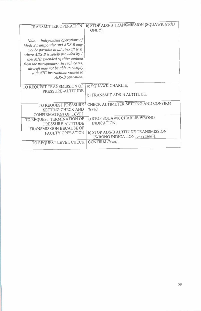
TRANSMITTER OPERATION
Note.— Independent operations ofMode S transponder andADS-B may
not be possible in all aircraft (e.g.where ADS-B is solelyprovided by1
090MHz extended squitter emittedfrom the transponder). In such cases,
aircraft may not be able to complywithATC instructions related to
ADS-B operation.
TO REQUEST TRANSMISSION OFPRESSURE-ALTITUDE
TO REQUEST PRESSURESETTING CHECK AND
CONFIRMATION OF LEVELTOREQUEST TERMINATION OF
PRESSURE-ALTITUDETRANSMISSION BECAUSE OF
FAULTY OPERATION
TO REQUEST LEVEL CHECK
b) STOP ADS-B TRANSMISSION [SQUAWK (code)ONLY].
a) SQUAWK CHARLIE;
b)TRANSMIT ADS-B ALTITUDE.
CHECK ALTIMETER SETTING AND CONFIRM(level).
a) STOP SQUAWK CHARLIE WRONGINDICATION;
b) STOP ADS-B ALTITUDE TRANSMISSION[(WRONG INDICATION, orreason)].
CONFIRM (level).
59

APPENDIX II
FLIGHT PLAN
1. Flight Plan Form
•©c•tmaraiMM
C£mmmit^—m
><sg
•.SSSSSOSSRSSSSSSSSSiXKSa^^am,
"T.IILfffi S [1 S —HI /"S E E Emmm ma*
:>«s
2. Instructions for the completion of the flight plan form
a. Aircraft operators complying with the ADS-B requirements are to indicate the appropriateADS-B designator in Item 10 of the ICAO flight plan:
E - Transponder — Mode S, including aircraft identification, pressure-altitude and extendedsquitter (ADS-B) capability OR
L - Transponder — Mode S, including aircraft identification, pressure-altitude, extendedsquitter (ADS-B) and enhanced surveillance capability
Together with:
Bl ADS-B with dedicated 1090 MHz ADS-B "out" capability OR
B2 ADS-B with dedicated 1090 MHz ADS-B "out" and "in" capability
60

h Aircraft Identification (ACID) not exceeding 7characters must be accurately indicated in Item7ofte! ICAO"flight plan and replicated exactly when set in the aircraft aviomcs (fortransmission as Flight ID) asfollows: CeitherThe three-letter ICAO designator of the aircraft operator followed by the flight number (e^gGIA234 QFA234 SIA234), when radiotelephony callsign consists of the associated ICAOSelony debtor for the aircraft operator followed by the flight number (e.g.INDONESIA234, QANTAS234, SINGAPORE 234).
or
The aircraft registration (e.g. PKABC, VHABC, 9V234) when the radiotelephony callsignconsists of the aircraft registration.Important- ACID entered should not have any leading zeros unless it is part of the flightnumber as indicated in Item 7ofthe ICAOflight plan. Hyphens, dashes or spaces are NOT tobe used.
ITEM 10: EQUIPMENT AND CAPABILITIES
Capabilities comprise the following elements:a) presence of relevant serviceable equipment on board the aircraft;b) equipment and capabilities commensurate with flight crew qualifications; andc) where applicable, authorization from the appropriate authority.
Radiocommunication, navigation andapproach aid equipment and capabilities
INSERT one letter as follows:N ifno COM/NAV/approach aid equipment for the route to be flown is carried, or
the equipment isunserviceable, .OR Sif standard COM/NAV/approach aid equipment for the route to be flown is earned
and serviceable (see Note I),
AND/OR
INSERT one or more of the following letters to indicate the serviceableCOM/NAV/approach aid equipment and capabilities available:
61

A
B
C
D
El
G
H
1
Jl
GBAS landing systemLPV(APV with SBAS)LORAN C
DMEFMC WPR ACARS
E2 D-FIS ACARSE3 PDC ACARSF ADF
GNSS (See Note 2)HFRTFInertial Navigation
. CPDLC ATN VDL Mode 2 (See Note 3)J2 CPDLC FANS 1/AHFDLJ3 CPDLC FANS 1/A VDL Mode 4J4 CPDLC FANS 1/A VDL Mode 2J5 CPDLC FANS 1/A SATCOM
(INMARSAT)
.16
J7
K
L
Ml
M2
M3
O
T
U
V
w
X
Y
Z
CPDLC FANS 1/A SATCOM (MTSAT)CPDLC FANS 1/A SATCOM (Iridium)MLS
ILSATC RTF SATCOM (INMARSAT)ATC RTF (MTSAT)ATC RTF (Iridium)VOR
P1-P9 Reserved for RCPR PBN approved (See Note 4)
TACAN
UHF RTF
VHF RTFRVSM approvedMNPS approvedHFwith 8.33 kHzchannel spacing capabilityOther equipment carried orother capabilities(See Note 5)
Any alphanumeric characters not indicated above are reserved.
Note 1- I[the letter Sis used, standard equipment is considered to be VHF RTF VORand ILS unless another combination is prescribed by the appropriate ATSauthority.
Note 2-I[the letter Gis used, the types of external GNSS augmentation, if any arespecified in Item 18 following the indicator NAV/ and separated by aspace.
Note 3- See RTCA/EUROCAE Interoperability Requirements Standard for ATNBaseline 1 (ATN Bl INTEROP Standard - DO-280B/ED-110B) for datalink services air traffic control clearance and information/air trafficcontrol communications management/air traffic control microphone check.
Note 4- Ifthe letter Ris used, the performance-based navigation levels that can be metare specified in Item 18following the indicator PBN/. Guidance materialon the application ofperformance-based navigation to a specific routesegment, route or area is contained in the Performance-based Navigation(PBN) Manual (Doc 9613).
Note 5- Ifthe letter Zis used, specify in Item 18 the other equipment carried or othercapabilities, preceded by COM/, NAV/and/or DAT, as appropriate.
Note 6._ Information on navigation capability is provided to ATC for clearance androuting purposes.
62

Surveillance equipmentand canabilities
INSERT N if no surveillance equipment for the route to be flown is carried, or theequipment is unserviceable,
ORINSERT one or more of the following descriptors, to a maximum of20 characters,
to describe the serviceable surveillance equipment and/or capabilities onboard:
SSR Modes A and C
A Transponder — Mode A(4 digits —4 096 codes)C Transponder —Mode A(4 digits —4 096 codes) and Mode C
SSR Mode S
E Transponder —Mode S, including aircraft identification, pressure-altitude andextended squitter (ADS-B) capability
H Transponder — Mode S, including aircraft identification, pressure-altitude andenhanced surveillance capability
I Transponder —Mode S, including aircraft identification, but no pressure-altitudecapability
L Transponder — Mode S, including aircraft identification, pressure-altitude,extended squitter (ADS-B) and enhanced surveillance capability
P Transponder —Mode S, including pressure-altitude, but no aircraft identificationcapability
S Transponder — Mode S, including both pressure altitude and aircraftidentification capability
X Transponder —Mode S with neither aircraft identification nor pressure-altitudecapability
Mote— Enhanced surveillance capability is the ability of the aircraft to down-linkaircraft derived data via a ModeS transponder.
ADS-B
Bl ADS-B with dedicated 1 090 MHz ADS-B "out" capabilityB2 ADS-B with dedicated 1 090 MHz ADS-B "out" and "in" capabilityU1 ADS-B "out" capability using UATU2 ADS-B "out" and "in" capability using UATVI ADS-B "out" capability using VDL Mode4V2 ADS-B "out" and "in" capability using VDL Mode 4
63

ADS-C
DI ADS-C with FANS 1/A capabilitiesGl ADS-C with ATN capabilities
Alphanumeric characters not indicated above are reserved.
Example: ADE3RV/HB2U2V2G1
Mote.— Additional surveillance application should be listed in Item 18following theindicator SUR/.
DIREKTUR JENDERAL PERHUBUNGAN UDARA
ttd
SUPRASETYO
Salinan sesuai dengan aslinyaKEPALA BAGIAN HUKUM DAN HUMAS
^ /3'REKTORAT\f"~MHIBUNGAN
HEMI PAMURAHARJO
PerrrbinaTkl (IV/b)NIP. 19660508 199003 1 001
64