08128080622019//JUAL HARGA MURAH LEICA 900>>>>
4
Leica GPS900 Big ambitions on a budget ... in one case
-
Upload
jual-beli-alat-survey -
Category
Business
-
view
178 -
download
1
Transcript of 08128080622019//JUAL HARGA MURAH LEICA 900>>>>

Leica GPS900Big ambitions on a budget
...in one case
754090en_GPS900.qxd 17.5.2006 17:00 Uhr Seite 2
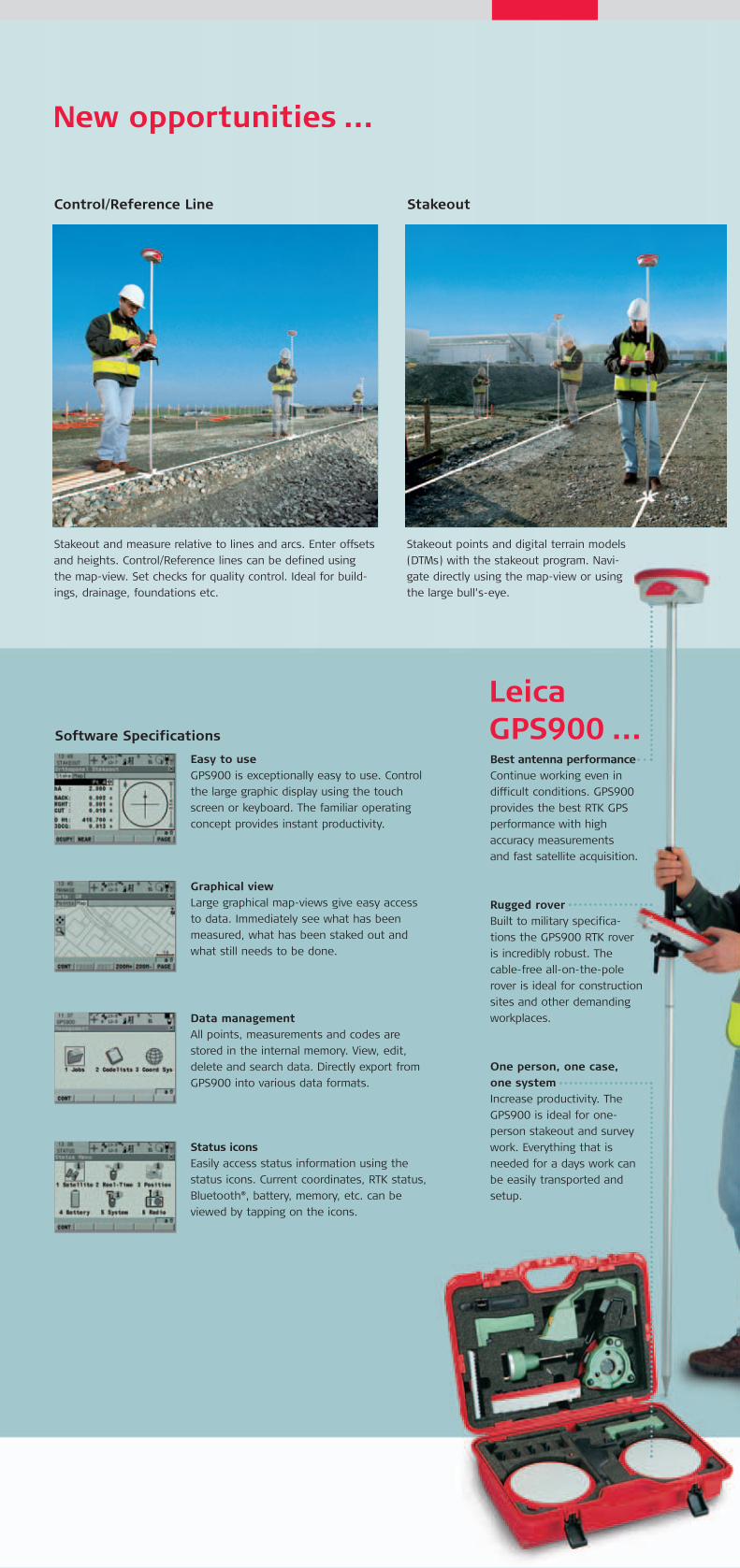
New opportunities ...
LeicaGPS900 ...
Stakeout and measure relative to lines and arcs. Enter offsets
and heights. Control/Reference lines can be defined using
the map-view. Set checks for quality control. Ideal for build-
ings, drainage, foundations etc.
Stakeout points and digital terrain models
(DTMs) with the stakeout program. Navi-
gate directly using the map-view or using
the large bull’s-eye.
Easy to useGPS900 is exceptionally easy to use. Control
the large graphic display using the touch
screen or keyboard. The familiar operating
concept provides instant productivity.
Software Specifications
Data managementAll points, measurements and codes are
stored in the internal memory. View, edit,
delete and search data. Directly export from
GPS900 into various data formats.
Graphical viewLarge graphical map-views give easy access
to data. Immediately see what has been
measured, what has been staked out and
what still needs to be done.
Status iconsEasily access status information using the
status icons. Current coordinates, RTK status,
Bluetooth®, battery, memory, etc. can be
viewed by tapping on the icons.
Reco
tion.
surve
Surve
Control/Reference Line Stakeout Top
Best antenna performanceContinue working even in
difficult conditions. GPS900
provides the best RTK GPS
performance with high
accuracy measurements
and fast satellite acquisition.
Rugged roverBuilt to military specifica-
tions the GPS900 RTK rover
is incredibly robust. The
cable-free all-on-the-pole
rover is ideal for construction
sites and other demanding
workplaces.
One person, one case,one systemIncrease productivity. The
GPS900 is ideal for one-
person stakeout and survey
work. Everything that is
needed for a days work can
be easily transported and
setup.
754090en_GPS900.qxd 17.5.2006 17:00 Uhr Seite 3
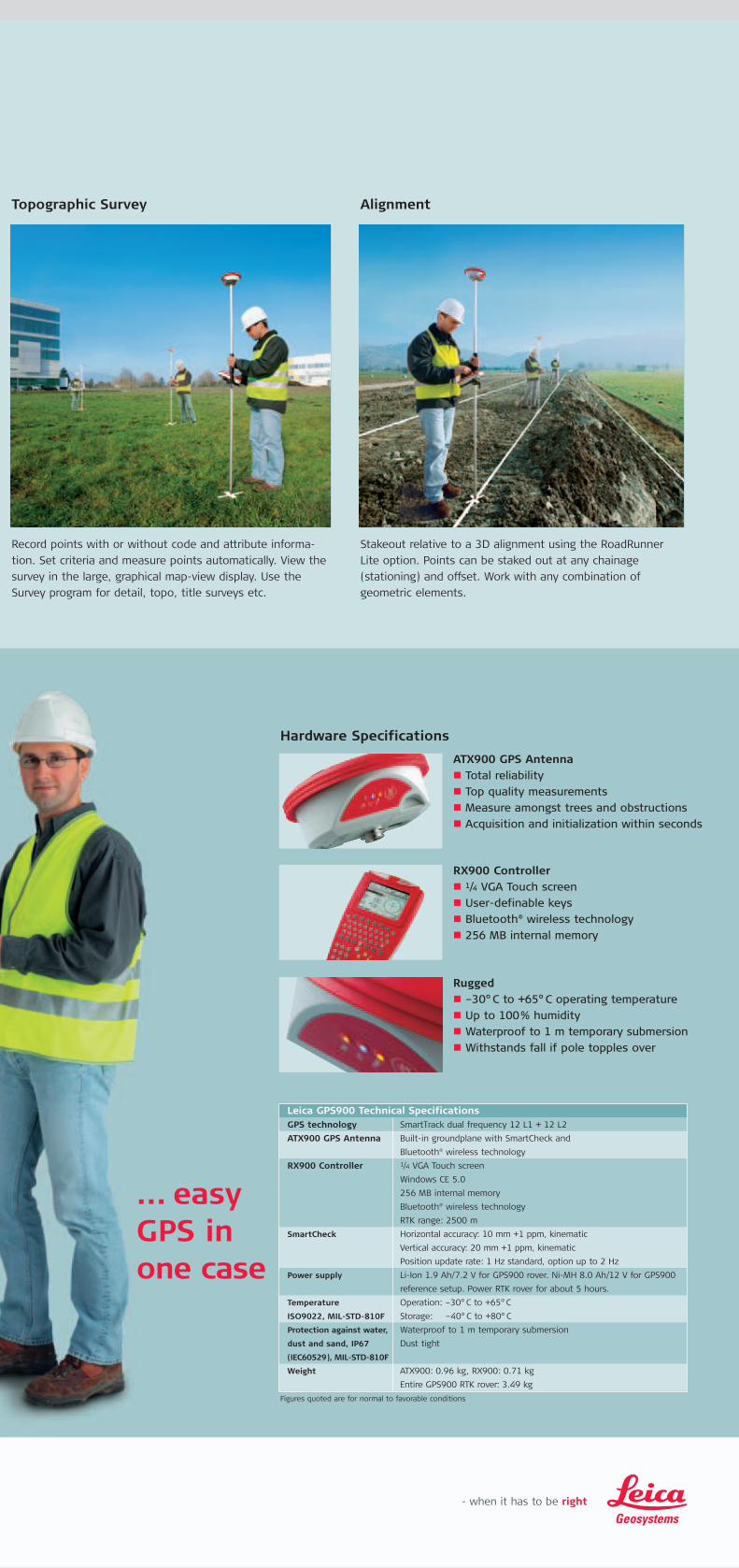
ATX900 GPS Antenna� Total reliability
� Top quality measurements
� Measure amongst trees and obstructions
� Acquisition and initialization within seconds
... easyGPS in one case
Stakeout relative to a 3D alignment using the RoadRunner
Lite option. Points can be staked out at any chainage
(stationing) and offset. Work with any combination of
geometric elements.
Rugged� –30° C to +65° C operating temperature
� Up to 100% humidity
� Waterproof to 1 m temporary submersion
� Withstands fall if pole topples over
RX900 Controller� 1/4 VGA Touch screen
� User-definable keys
� Bluetooth® wireless technology
� 256 MB internal memory
Hardware Specifications
Record points with or without code and attribute informa-
tion. Set criteria and measure points automatically. View the
survey in the large, graphical map-view display. Use the
Survey program for detail, topo, title surveys etc.
Topographic Survey Alignment
Leica GPS900 Technical SpecificationsGPS technology SmartTrack dual frequency 12 L1 + 12 L2
ATX900 GPS Antenna Built-in groundplane with SmartCheck and
Bluetooth® wireless technology
RX900 Controller 1/4 VGA Touch screen
Windows CE 5.0
256 MB internal memory
Bluetooth® wireless technology
RTK range: 2500 m
SmartCheck Horizontal accuracy: 10 mm +1 ppm, kinematic
Vertical accuracy: 20 mm +1 ppm, kinematic
Position update rate: 1 Hz standard, option up to 2 Hz
Power supply Li-Ion 1.9 Ah/7.2 V for GPS900 rover. Ni-MH 8.0 Ah/12 V for GPS900
reference setup. Power RTK rover for about 5 hours.
Temperature Operation: –30°C to +65°C
ISO9022, MIL-STD-810F Storage: –40°C to +80°C
Protection against water, Waterproof to 1 m temporary submersion
dust and sand, IP67 Dust tight
(IEC60529), MIL-STD-810F
Weight ATX900: 0.96 kg, RX900: 0.71 kg
Entire GPS900 RTK rover: 3.49 kg
Figures quoted are for normal to favorable conditions
754090en_GPS900.qxd 17.5.2006 17:00 Uhr Seite 4
Leica TPS800 Product brochureut labore et.
Whether you want to survey a parcel of land or objects on a
construction site, determine measured points on facades or in
rooms, gather the coordinates of a bridge or a tunnel – Leica
Geosystems’ surveying instruments provide the right solution
for every application.
They unite reliable results with easy operation and user-friendly
applications. They are designed to meet your specific requirements.
Modern technology enables you to work fast and productively, thanks
to the straightforward and clearly structured range of functions.
When it has to be right.
Illustrations, descriptions and technical specifications are not binding and may change. Printed in Switzerland – Copyright Leica Geosystems AG, Heerbrugg, Switzerland, 2006. 754090en – V.06 – RDV
Leica Geosystems AGHeerbrugg, Switzerland
www.leica-geosystems.com
The Bluetooth® word mark andlogos are owned by Bluetooth SIG,Inc. and any use of such marks byLeica Geosystems AG is under license.Windows CE is a registered trade-mark of Microsoft Corporation.Other trademarks and trade namesare those of their respective owners.
Total Quality Management –our commitment to totalcustomer satisfaction.
Ask your local Leica Geosystemsdealer for more informationabout your TQM program.
754090en_GPS900.qxd 17.5.2006 17:00 Uhr Seite 1