


Bahasa
Halaman
Hukum

Waikato Regional Council Technical Report 2017/19
Surf breaks of regional significance in the Waikato region www.waikatoregion.govt.nz ISSN 2230-4355 (Print) ISSN 2230-4363 (Online)
Prepared by: Ed Atkin and Shaw Mead eCoast For: Waikato Regional Council Private Bag 3038 Waikato Mail Centre HAMILTON 3240 June 2016 Document #: 10591505

Document # 10591505
Peer reviewed by: Date June 2017 Hannah Jones and Stephen Hunt
Approved for release by: Date July 2017 Dominique Noiton
Disclaimer This technical report has been prepared for the use of Waikato Regional Council as a reference document and as such does not constitute Council’s policy. The accuracy of information and model simulations presented in this document is entirely reliant on the accuracy and completeness of available information. Furthermore, the models described in this document may not be suitable for any purpose(s) other than those specified. Council requests that if excerpts or inferences are drawn from this document for further use by individuals or organisations, due care should be taken to ensure that the appropriate context has been preserved, and is accurately reflected and referenced in any subsequent spoken or written communication. While Waikato Regional Council has exercised all reasonable skill and care in controlling the contents of this report, Council accepts no liability in contract, tort or otherwise, for any loss, damage, injury or expense (whether direct, indirect or consequential) arising out of the provision of this information or its use by you or any other party.


Executive summary
Surf breaks are unique and valuable components of the coastal environment. They have cultural, spiritual, recreational, and sporting value to many people in New Zealand. These values depend on the integrity of natural processes which influence surf break environments, and on a variety of aspects important to surf break users including accessibility and environmental health Surf breaks of National Significance were identified in the New Zealand Coastal Policy Statement 2010. Of 17 surf breaks identified in the NZCPS as being nationally significant, four are located in the Waikato Region – Manu Bay, Whale Bay and Indicators at Raglan on the west coast, and Whangamata Bar on the east coast. Policy 16 of the NZCPS 2010 requires local government to protect the nationally significant surf breaks, but Policy 13 also mentions surf breaks in the context of preservation of natural character. There is a need, therefore, to compile information on all surf breaks in the Waikato region. This report describes the systematic identification and characterisation of surf breaks that are assessed as being of regional significance, i.e. those surf breaks that are high quality, have a dependent population, high frequency of use, and/or are of outstanding natural character. Also included is a first-order assessment of the swell corridors for the surf breaks, and a preliminary assessment of the potential risks to the surf breaks. This report identified 38 surf breaks of regional significance in the Waikato Region. The surf breaks were identified using available surf guides (e.g. the Wave Track New Zealand Surf Guide), in combination with information from public consultation and the expert opinion of the authors. The surf breaks have been described in the report, and delineated in GIS (Geographic Information System) files. An uncalibrated numerical model was used to estimate the swell corridors for each of the surf breaks, which showed that much of the Waikato Region’s coastal marine area is likely to be in the swell corridor of a regionally significant surf break. The swell corridors are mapped in this report and have also been delineated in GIS files. A preliminary assessment of potential risks to surf breaks at a regional scale included consideration of the impacts of development within the surf break and surrounding area, water quality, access, development within swell corridors, sea level rise, changes in sediment supply and tidal currents. Understanding the actual impacts of these types of pressures on individual surf breaks would require more in-depth site-specific assessments, however. It is recommended that the surf breaks of regional significance are re-evaluated over a time frame consistent with Policy or Plan reviews, or with population growth. This is because changes in the patterns of use (and therefore the significance of the surf break at a regional scale) are expected to occur as population changes, and as the popularity of surfing and patterns of use change as well.

Surf Breaks of Regional Significance in the Waikato Region
Prepared for

Surf Breaks of Regional Significance in the Waikato Region
Report Status
Version Date Status Approved by V1 9/3/2016 Draft STM V2 11/4/2016 Draft STM V3 26/4/2016 Final Draft EAA V4 2/5/2016 Publishing Draft EAA V5 1/6/2016 Publishing Final EAA
It is the responsibility of the reader to verify the version number of this report.
Authors
Ed Atkin, HND, MSc (Hons)
Shaw Mead, BSc, MSc (Hons), PhD
Waikato Region Surf Breaks
i
Contents Contents ................................................................................................................................ i
Figures .................................................................................................................................. iii
1 Introduction .................................................................................................................... 1
2 Methodology .................................................................................................................. 4
2.1 Introduction ................................................................................................ 4
2.2 Identification and Characterisation ............................................................. 4
2.3 Determination of Swell Corridors ................................................................ 7
2.4 Risk Assessment ..................................................................................... 12
3 Identification and Characterisation of Surf Break Areas ............................................... 14
3.1 Waikawau Bay ......................................................................................... 15
3.2 New Chums ............................................................................................. 16
3.3 Whangapoua ............................................................................................ 17
3.4 Matarangi ................................................................................................. 18
3.5 Rings........................................................................................................ 19
3.6 Kuaotunu ................................................................................................. 20
3.7 Otama ...................................................................................................... 21
3.8 Opito ........................................................................................................ 22
3.9 Whitianga ................................................................................................. 23
3.10 Hahei ....................................................................................................... 24
3.11 Hot Water Beach ...................................................................................... 25
3.12 Sailors Grave ........................................................................................... 26
3.13 Tairua....................................................................................................... 27
3.14 Pauanui .................................................................................................... 28
3.15 Opoutere .................................................................................................. 29
3.16 Onemana ................................................................................................. 30
3.17 Whangamata ............................................................................................ 31
3.18 Whiritoa .................................................................................................... 32
Waikato Region Surf Breaks
ii
3.19 Homunga Bay .......................................................................................... 33
3.20 Mokau ...................................................................................................... 34
3.21 Awakino ................................................................................................... 35
3.22 Kiritehere ................................................................................................. 36
3.23 Marokopa ................................................................................................. 37
3.24 Albatross Point ......................................................................................... 38
3.25 Aotea Reef ............................................................................................... 39
3.26 Ruapuke .................................................................................................. 40
3.27 Raglan Points ........................................................................................... 41
3.28 Ngarunui Beach (Wainui) ......................................................................... 42
3.29 Raglan Bar ............................................................................................... 43
3.30 Mussel Rocks ........................................................................................... 44
3.31 Te Akau ................................................................................................... 45
3.32 Port Waikato ............................................................................................ 46
4 Swell Corridors............................................................................................................. 47
5 Risk Assessment ......................................................................................................... 50
5.1 Development within a SBA ....................................................................... 50
5.2 Water Quality and Access ........................................................................ 50
5.3 Swell Corridors ......................................................................................... 50
5.4 Sea Level Rise (SLR) ............................................................................... 52
5.5 Changes in Sediment Supply and Tidal Currents ..................................... 52
6 Conclusions and Recommendations ............................................................................ 54
7 References .................................................................................................................. 55
Glossary.............................................................................................................................. 60
Appendix A. Model Levels Breakdown ......................................................................... 62

Waikato Region Surf Breaks
iii
Figures Figure 2.1: Google Earth image with Territorial Sea (red) and LINZ Coastline (white) overlays
............................................................................................................................................. 8
Figure 2.2: Google Earth image of New Zealand with Level 1 (white) and Level 2 (blue) grid
domains overlaid. .................................................................................................................. 9
Figure 2.3: Google Earth image of the Waikato Region with Level 2 (blue), Level 3 (yellow)
and Level 4 (red) grid domains overlaid. ............................................................................. 10
Figure 2.4: Google Earth image of part of the Coromandel Peninsula with Level 3 (yellow) and
Level 4 (red) grid domains overlaid. .................................................................................... 11
Figure 3.1: Location of 38 RSSBs on the west (left) and east (right) coasts of the Waikato
Region. ............................................................................................................................... 14
Figure 4.1: Google earth image with swell corridors (red) and buffers zones (amber) of the
Surf Breaks of Regionally Significance in the Waikato region, with the regional boundary
(blue). ................................................................................................................................. 47
Figure 4.2: Google earth image with swell corridors (red) and buffers zones (amber) of the
Surf Breaks of Regional Significance on the Waikato region’s west coast, and the regional
boundary (blue). .................................................................................................................. 48
Figure 4.3: Google earth image with swell corridors (red) and buffers zones (amber) of the
Surf Breaks of Regional Significance on the Waikato region’s east coast, and the regional
boundary (blue). .................................................................................................................. 49
Waikato Region Surf Breaks
1
1 Introduction Surf breaks are unique and valuable components of the coastal environment. They have
cultural, spiritual, recreational, and sporting value to more than 200,000 people in New
Zealand (Sport and Recreation New Zealand, 2008; Graham, 2011). Surf breaks are
becoming increasingly recognised in New Zealand coastal resource management, which is
consistent with developments occurring internationally (see Ball (2015) and references there
in). An increased focus on mechanisms to protect surf breaks has resulted from numerous
cases of degradation worldwide (Scarfe et al., 2009a, 2009b). The argument of those who
openly wish to protect and preserve the integrity of surf breaks, such as the Surfbreak
Protection Society, Save the Waves and Surfrider Foundation, recognises that a range of
benefits are associated with these unique places that transcend the recreational value of riding
waves. These values depend on the integrity of natural processes which influence surf break
environments, and on a variety of aspects important to surf break users including accessibility
and environmental health (Perryman and Orchard, 2013).
The New Zealand Coastal Policy Statement (NZCPS; Department of Conservation, 2010)
provides guidance to local government for the management of the coastal environment
(Rosier, 2004). The scheduled 10-yearly revision of the NZCPS 1994 included a
comprehensive review process and input from stakeholder groups (Young, 2003; Rosier,
2004, 2005). The process attracted input from surfers and surfing organisations, and the
resulting submissions provided recommendations for the definition of a “surf break” and
provisions for surf break protection (Board of Inquiry, 2009a). These recommendations were
largely adopted within the final NZCPS 2010 as Policy 16.
Policy 16: Surf Breaks of National Significance:
Protect the surf breaks of national significance for surfing listed in Schedule 1, by:
(a) ensuring activities in the coastal environment do not adversely affect the surf breaks;
and
(b) avoiding adverse effects of other activities on access to, and use and enjoyment of the
surf breaks.
Schedule 1 of the NZCPS defines a surf break as:
A natural feature that is comprised of swell, currents, water levels, seabed morphology, and
wind. The hydrodynamic character of the ocean (swell, currents and water levels) combines
with the seabed morphology and winds to give rise to a ‘surfable wave’. A surf break includes
the ‘swell corridor’ through which the swell travels, and the morphology of the seabed of that

Waikato Region Surf Breaks
2
wave corridor, through to the point where waves created by the swell dissipate and become
non-surfable. ‘Swell corridor’ means the region offshore of the surf breaks where ocean swell
travels and transforms to a ‘surfable wave’. ‘Surfable wave’ means a wave that can be
caught and ridden by a surfer. Surfable waves have a wave breaking point that peels along
the unbroken wave crest so that the surfer is propelled laterally along the wave crest.
Policy 16 explicitly identifies 17 Surf Breaks of National Significance, four of which are located
within the Waikato Region, namely:
• Whangamata Bar – Coromandel Peninsula, East Coast
• Indicators– Raglan, West Coast
• Whale Bay – Raglan, West Coast
• Manu Bay – Raglan, West Coast
Policies 13 and 15 of the NZCPS provide a mandate to preserve and/or protect surf breaks of
regional or local significance or importance (Perryman, 2011). Local authorities are
responsible for implementing NZCPS policies and an essential first step is to understand the
features of the surf breaks in their area. To date, the characterisation of New Zealand surf
breaks for management purposes has not yet been extensively researched (Skellern et al.,
2013). There is an urgent need for a better understanding of resources in relation to the values
derived by the community and consideration of the mechanisms by which degradation can
occur.
The basis for the selection of Surf Breaks of National Significance in the NZCPS 2010 was
the Wavetrack New Zealand Surfing Guide (WNZSG; Moorse and Brunskill, 2004), with
breaks rated 9 or 10 out of 10 being selected as nationally significant. For this study, it is
considered that all Waikato region surf breaks listed in the guide are regionally significant. The
breaks listed with in the WNZSG are there primarily because they are well known surf breaks.
For this study, surf breaks are evaluated to be regionally significant if they have: a dependent
population, whether it be local, non-local, foreign or a mix of all; high frequency of use; and/or,
are of outstanding natural character/quality.
This report describes the identification and characterisation of Surf Breaks of Regional
Significance (SBRS) in the Waikato Region, a first-order approximation of their swell corridors,
and a preliminary assessment of the risks to these SBRS. Thereby, this document provides
information relevant to Policies 15, 16 and 13 of the NZCPS with regard to the natural features
that comprise surf breaks, their protection and their associated natural character, respectively.
The swell corridors and surf break areas identified in this study have been compiled in GIS
format. Similar to regional scale coastal hazard zoning, the information and data produced in
this study can be applied as a first order assessment, but a more in depth site-specific

Waikato Region Surf Breaks
3
assessment should be undertaken for developments proposed at or near surf breaks, in their
swell corridors, or in areas that may pose a risk to the surf break (e.g. development inside an
estuary where the surf break is created by the ebb-tidal delta of that estuary).
Section 2 of this report describes the methods used to identify and characterise the region’s
surf breaks, carry out a first-order approximation of their swell corridors, and consider potential
risks to the surf breaks. Section 3 characterizes the SBRS in the Waikato Region, Section 4
presents their swell corridors, and Section 5 considers the potential risks to surf breaks in the
Waikato. Section 6 provides conclusions and recommendations for further research; after
which follows a glossary, to describe the surfing and surf science related terminology, and
relevant appendices.
Waikato Region Surf Breaks
4
2 Methodology
2.1 Introduction
There are three major components to this study:
1) Identification and characterisation in terms of the type of break, length of ride,
conditions required, etc., for each SBRS;
2) Numerical modelling of waves to estimate swell corridors and the construction of file
formats compatible with Geographical Information Systems (GIS), and;
3) A preliminary assessment of the potential risks to SBRS in the Waikato region.
The methodology of these components are described in the following sections.
2.2 Identification and Characterisation
In this report, all Waikato region surf breaks listed in the Wavetrack New Zealand Surf Guide
are considered regionally significant. This is consistent with the method used to identify SBRS
in the Auckland Region (Coombes and Scarfe, 2010), the Taranaki Region (TRC, 2010), and
the Greater Wellington Region (Atkin et al, 2015). It is recognised that there is a measure of
subjectivity as to whether a surf break is listed in the WNZSG. However, until an objective
methodology has been developed and applied to determine the significance of NZ’s surf
breaks, and since the guide was used to identify the Surf Breaks of National Significance in
the NZCPS 2010, this approach is considered the most appropriate currently available.
It is also noted that a number of surf breaks only receive a mediocre score in the WNZSG.
The rating in the WNZSG subjectively considers wave quality, but does not consider the high
amenity value that “town breaks”, such as Raglan’s Ngarunui Beach, provide. These town
breaks are of high importance as noted at the Board of Inquiry to the NZCPS regarding their
“nursery” surf break status (Board of Inquiry, 2009b). Local knowledge and public consultation
is used to determine the importance of surf breaks locally and identify any SBRS that are not
listed within the WNZSG.
At many surfing locations there is more than one recognised surfable break within a small
area. It is difficult to determine the spatial extent of a surf break in these cases, particularly
where the seabed substrate is mobile, such as on long sandy beaches, and the general
position of a surfing area can change. Often surf breaks in close proximity require similar or
the same meteorological and oceanographic conditions to become surfable. In addition, the
wider area, hosting multiple surf breaks, holds the economic, social and amenity value. For
these reasons, here we have delineated Surf Break Areas (SBAs), where the SBA may host

Waikato Region Surf Breaks
5
a single surf break or multiple surf breaks. The SBA is estimated using a combination of
historical aerial photographs (e.g. Google Earth historical imagery), any apparent wave
breaking patterns, existing bathymetric data, published information and knowledge gained
from local consultation. The landward extent of the SBA is delineated using Land Information
New Zealand’s 1:50,000 coastline polygon. The offshore extent is either far enough from the
shore to encompass the identified breaking areas or roughly follows the 5 m depth contour.
2.2.1 Identification
To identify where surfable waves break and where surfers ride the waves at each surf break,
a combination of the maps in the WNZSG, Google Earth imagery and knowledge gained from
local consultation were used. From these information sources SBAs have been delineated.
The common names for the surf breaks have been used in this report, it should be noted that
surf breaks can be referred to under a range of colloquial names, and that this document is
not an exhaustive list of these references.
2.2.2 Characterisation
For each surf break or SBA the following characteristics which define the surfable conditions
are presented. Much of the data is based primarily on the information in WNZSG, however
this is supplemented with the NZSurf Guide (2013; www.nzsurfguide.co.nz), New Zealand
Surfing Guide (Bhana, 1996), The New Zealand Good Beach Guide: North Island (Rainger,
2011), local consultation and surf break assessments made as part of this study.
Wave Type:
Wave type relates to whether it breaks to the left or to the right as viewed from the perspective
of the surfer1; and, the physical composition of the surf break, whether it is a rocky reef, a point
break, a beach break, a rock ledge break, a river/estuary bar/delta or mix of these surfing
break types (Mead, 2000)2.
Minimum Wave Height:
The wave height that is considered surfable is both break dependent and user subjective. The
WNZSG provides sporadic detail on wave heights concerning surf breaks in the Waikato
Region, the minimum wave reported however is 0.5 m. It is unclear whether the wave heights
reported in the WNZSG, and other surf guides, refer to incident swell wave height or wave
breaking height.
1 See Glossary 2 See Glossary

Waikato Region Surf Breaks
6
Hutt et al., (2001) reported surfer skill levels in relation to wave heights as low as 0.3 m for top
professional surfers. Other studies and literature state waves greater than 0.5 m are
considered surfable (Walker, 1974; Ranasinghe et al., 2001; Surfers Against Sewage, 2009;
Kimura et al., 2014; Atkin et al., 2015). Mortensen et al., (2015) use a minimum significant
wave height of 0.8 m in a study of surfing conditions conducted at Lyall Bay, Wellington; and
MetOcean Solutions (2008) have previously used a surfable wave height of 0.75 m concerning
a surf break in Napier. Pattiaratchi et al., (1999) consider a minimum significant wave height
of 1.5 m as a prerequisite for surfable waves; following the surfable criteria used by Dally
(1990; 1.25 m and 1.5 m).
Given the range of reported minimum wave size (0.3-1.5 m), and the detail provided in the
aforementioned studies; the ambiguity of reported heights in surf guides; that the highest 10%
of waves are more readily utilised by surfers (Dally, 1990); and, a requirement to strike a
balance between a conservative approach (Department of Conservation, 2010) and
implementable coastal management (e.g. not choosing zero as a minimum wave height), for
this study, a minimum wave height estimate for all breaks of 0.75 m is used, with the exception
of Aotea Reef and Raglan Bar (see Sections 3.25 and 3.29 , respectively).
Wave heights for Aotea Reef were determined using the breaker depth index (e.g. McCowan,
1894), which is discussed in detail in Camenen and Larson (2005). Wave height at breaking
is determined by:
γb = Hb/hb
Where, γb is the breaker depth index; Hb is wave height at the point of incipient breaking and
hb is the water depth at the point of incipient breaking. Numerous studies have considered the
value of γb, and reported values range from 0.5 to 1.2 (Iribarren and Nogales, 1949: cited in
Battjes, 1974; Shand et al., 2007). The range of these values are a function of the different
incident wave conditions and bed slopes. As slope increases, γb decreases. Because Aotea
Reef is a relatively small, isolated feature it is assumed that it rises steeply from the sea floor
(images of plunging waves breaking show no waves breaking adjacent to the reef), a relatively
low value for γb is considered appropriate – 0.7. Furthermore, lower values provide a
conservative approach, with respect to breaking wave height.
Wave Shape/Description:
Refers to the shape of the wave and the nature of its breaking (Hutt et al., 2001; Mead and
Black, 2001a). Waves can be fast/slow, walled up, barrelling, heavy, powerful etc.3.
3 See Glossary
Waikato Region Surf Breaks
7
Optimal Swell Direction:
The wave direction that produces optimal surfing wave conditions for a particular surf break.
Optimal Wind Direction:
The best wind direction for a given surf break such that the wind does not degrade the surfing
wave quality, and may improve it (generally offshore or very light winds).
Optimal Tide:
Tidal height and state that is considered to produce the best surfable conditions (e.g. high,
low, mid, dropping, rising, etc.).
Skill Level:
A general guide for the competency rating a surfer should have before attempting to surf
waves at a particular break (see Hutt et al., 2001). Taken here as suitable for beginner,
intermediate, expert, or all.
Wavetrack New Zealand Surfing Guide Stoke Meter Rating System:
The Wavetrack New Zealand Surfing Guide rates surf break on their wave quality under
optimal conditions. Surf breaks are not rated on their swell consistency. This is to ensure the
guide offers an accurate appraisal of each surf break’s potential. The stoke meter rating does
not relate to factors such as ease of access or high amenity value; e.g. an inner-city nursery
surf break that has a stoke rating of three may be strategically important to that region’s next
generation of surfers.
Approx. Max Ride Length:
Maximum length a surfable wave can be ridden for under optimum conditions
2.3 Determination of Swell Corridors
The NZCPS 2010 is a national policy statement under the Resource Management Act (RMA,
1991). The RMA has jurisdiction over the Territorial Sea (TS) of New Zealand. Therefore, the
spatial definition of swell corridors is considered up to and including the TS that Waikato
Regional Council is responsible for (Figure 2.1).

Waikato Region Surf Breaks
8
Figure 2.1: Google Earth image with Territorial Sea (red) and LINZ Coastline (white) overlays
To determine the swell corridor for each break, the area that encompasses a break, the Surf
Break Area (SBA), must be defined, as the swell corridor is an offshore extension of the SBA.
To establish the region offshore of a surf break where ocean swells theoretically travel and
transform in to surfable waves, the numerical model SWAN (Simulating WAves Nearshore)
was used to simulate a range of offshore wave conditions. SWAN is an industry-standard and
globally utilised third generation ocean wave propagation model, incorporating the generation,
propagation and transformation of wave fields in both deep water and nearshore regions.
SWAN solves the spectral action density balance equation for frequency-directional spectra.
This means that the growth, refraction, and decay of each component of the complete sea
state, each with a specific frequency and direction, is solved, giving a comprehensive
description of the wave field as it changes in time and space (Holthuijsen et al., 2004).
Numerical model domains are constructed by interpolating latitudinal, longitudinal and
depth/elevation (XYZ), data on to rectilinear grids using a Kriging technique. Kriging is a
geostatistical gridding method that attempts to express trends that are suggested in the data,
so that, for example, high points might be connected along a ridge, rather than isolated by
bull's-eye type contours. Kriging always uses the measured value exactly (known as an “exact”
interpolator) when it coincides with the grid node in the gridded data file. Mathew et al. (2000)
undertook tests to verify the correspondence between the bathymetry surveys and bathymetry

Waikato Region Surf Breaks
9
grids created via kriging interpolation. These tests indicated that values for known points in
the data and grids were identical.
The XYZ data used to construct gridded domains is compiled from Global Bathymetric Chart
of the Oceans (GEBCO; Becker et al., 2009), digitized nautical charts4, Shuttle Radar
Topography Mission (Jarvis et al., 2008), and localised bathymetric survey data from WRC
and eCoast, where available.
Two modelling frameworks are undertaken, both of which employ a nesting scheme to
increase the spatial resolution closer to the study sites and areas of interest. The first
framework models 10 years of hind-casted, 2-dimensional wave spectra from the European
Centre for Medium-Range Weather Forecast’s (ECMWF) ERA Interim 1°x1° resolution
database (Berrisford et al., 2011) modelled at the New Zealand scale, with a spatial resolution
of 0.05°. Nested within the New Zealand scale domain is a 2nd level regional scale domain,
with a spatial resolution of 0.01° (Figure 2.2).
Figure 2.2: Google Earth image of New Zealand with Level 1 (white) and Level 2 (blue) grid domains overlaid.
The second modelling framework simulates schematised wave boundary conditions on the
regional scale domain (Figure 2.2; Figure 2.3), nested within which is 4 sub-regional nests,
4 This data is derived from Land Information New Zealand’s online data portal – available at https://data.linz.govt.nz/
Waikato Region Surf Breaks
10
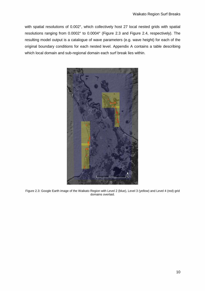
with spatial resolutions of 0.002°, which collectively host 27 local nested grids with spatial
resolutions ranging from 0.0002° to 0.0004° (Figure 2.3 and Figure 2.4, respectively). The
resulting model output is a catalogue of wave parameters (e.g. wave height) for each of the
original boundary conditions for each nested level. Appendix A contains a table describing
which local domain and sub-regional domain each surf break lies within.
Figure 2.3: Google Earth image of the Waikato Region with Level 2 (blue), Level 3 (yellow) and Level 4 (red) grid domains overlaid.

Waikato Region Surf Breaks
11
Figure 2.4: Google Earth image of part of the Coromandel Peninsula with Level 3 (yellow) and Level 4 (red) grid domains overlaid.
The range of schematised wave boundary conditions modelled include wave directions (Dm)
from 10° to 360° in 10° increments, wave period (Tm) from 7 s to 20 s in 1 s increments and
significant wave heights (Hs) from 1 m to 11 m in 0.5 m increments. This provides a total of
10584 model cases. The extreme end of the idealised wave boundary conditions (Hs of 11 m
and Tm of 20 s) were determined by extracting the maximum wave height and period from the
Level 1 model domain from a 10-year hindcast of spectral wave data. All model scenarios
were undertaken with a water level approximate to Mean Sea Level (MSL).
Each SBA has been designated a minimum wave height (Hsf). This value is evaluated against
the resulting model conditions within an SBA to determine whether the offshore conditions are
conducive to surfing at a particular break, that is greater than or equal to Hsf. The methodology
used here has not considered period and/or direction within an SBA to determine whether the
offshore conditions are conducive to surfing at a particular break. For the purpose of this study,
wave height is the single limiting factor in terms of surfability and all other modelled parameters
(wave period and direction) are considered surfable. It should be noted that, in reality, wave
period and direction can in some cases be limiting factors for surfability, however these are
site, or surf break, specific parameters. This methodology is considered conservative and
therefore suitable for creating the information for a first order assessment.
For each surf break the catalogue of wave parameters was processed using the following
procedure:
Check maximum wave height (Hmax) within the SBA:
If Hmax >= Hsf keep idealised condition case
If Hmax < Hsf discard idealised condition case
Waikato Region Surf Breaks
12
From the boundary of each SBA, for each of the remaining idealised condition cases, a trace
is made to determine the swell origin; this is analogous with wave orthogonal, or wave ray,
plotting, i.e., the trace is the path along which the wave propagates. The multiple traces
(resulting from the remaining cases) result in a point cloud of trace marks.
Because combinations of Hs, Tp and Dm developed from the idealised conditions may or may
not occur (e.g. an 11 m wave with a period of 20 s from the North is an unlikely event), the
Probability of Occurrence (PO) for these events is determined. The PO for each case is
evaluated using the output from the 2-dimensional wave spectra model. At the location each
trace meets the TS boundary, a PO analysis of the idealised conditions using the hindcast
model output at the same location (closest grid node) is undertaken. Those traces providing a
PO of 0, a condition that never occurs within the modelled record, are discarded.
The remaining traces are used to define the footprint of the swell corridor and a buffer zone.
A PO of ~0.003 % indicates a condition that occurs once in the 10-year record, similarly, a PO
~0.03 % indicates a once a year event, ~0.33 % once per month, and so forth. Those traces
with a PO of 0.33% or greater, that is, occurring on average once per month in the 10-year
record, are used to construct the main swell corridor. Those traces with a PO of less than 0.33
% to 0.003% are used to construct a surrounding buffer zone.
Buffer zones have been created for the following reasons, in no specific order: it is in line with
Policy 3 of the NZCPS: A precautionary approach (Department of Conservation, 2010); while
numerical modelling is an appropriate tool for studies such as this, the model used here has
not been calibrated; numerical modelling is always limited by some form of grid resolution;
and, any developments proximal to an established SBA have the potential to affect wave
conditions within that SBA (e.g. a seawall adjacent to, but not inside an SBA may cause wave
reflections and alterations to wave breaking properties within the SBA).
The overall buffer zone is a merged combination of the offshore zone designated by the PO
method described above, and a zone with a width of ~250 m around the SBA. The zone around
the SBA is included to adhere to the NZCPS’s objective of “avoiding adverse effects of other
activities on access to, and use and enjoyment of the surf breaks”, and lends itself to
safeguarding natural features covered by Polices 13 and 15. The width of the zone aims to
cover not only access to surf breaks, but also features such as dynamic dune fields, and the
lower reaches of tidal inlets, rivers and streams, on which many breaks are reliant.
2.4 Risk Assessment
While there are the obvious risks to surf breaks through development within a surf break’s
swell corridors (as recognised in the NZCPS; e.g. construction of offshore structures such as
Waikato Region Surf Breaks
13
wind-farms or for aquaculture, but also resource extraction, dredging and dredge disposal),
there are a variety of other potential risks that may impact on the surf breaks themselves. The
existence of many surf breaks is can be attributed to natural features and coastal processes
which can be impacted on by both marine and terrestrial developments, both distal and
proximal to a surf break. Developments may also impact on access to, use and enjoyment of
surf breaks, which also must be protected as per the NZCPS.
Physical impacts on the surf breaks have been considered (Section 5), which include:
• Development within a SBA
• Water quality and access
• Swell corridors
• Sea Level Rise (SLR)
• Changes in sediment supply and tidal currents
When considering these potential impacts, it is important to consider the geomorphology of
the surf break, since the type of break as well its location on the coast influences the impacts
of a particular risk. A surf break’s geomorphology fits into one, or in some cases a combination
of, the following types; coral reefs, rocky reefs, point breaks, rock ledges, river and estuarine
deltas, and beaches (Mead, 2000; Mead and Black, 2001b). All these types of breaks occur
in the Waikato region, except for coral reefs. For example, if the break is a beach break in a
pocket beach, which does not have a major catchment/water course feeding into it (such as
many on the Coromandel), then impacts due to SLR and changes to sediment supply and tidal
currents are likely lower than say the impact of SLR on a submerged reef break that will not
physically respond to changes in water depth.

Waikato Region Surf Breaks
14
3 Identification and Characterisation of Surf Break Areas
The WNZSG describes 34 surf breaks in the Waikato Region (Figure 3.1). Local knowledge
and public consultation have identified other frequented surf breaks within the Waikato Region.
Of these breaks only four have been considered regionally significant, namely, Raglan Bar,
Aotea Reef, Marokopa and Otama (which receives a brief mention in the WNZSG; Figure 3.1).
Other surf breaks have been included here by ensuring the SBA encompassed the associated
surfing area. For example, Kuaotunu West is not in the WNZSG but has been identified
through local consultation, as a frequented surf break, and as part of the larger Kuaotunu
beach system, it has therefore been included in the Kuaotunu SBA.
Figure 3.1: Location of 38 RSSBs on the west (left) and east (right) coasts of the Waikato Region.
A total of 32 Surf Break Areas (SBAs) that host the 38 Surf Breaks of Regional Significance
(SBRS) are described here. In most cases the SBA includes just one SBRS, and many SBRS

Waikato Region Surf Breaks
15
have multiple surfing options with in them. The SBAs are presented here starting in the north
east of the Coromandel Peninsula, heading south (clockwise) toward the Bay of Plenty, then
across to the southern extent of Waikato west coast, and then north up to the boundary
between the Waikato and Auckland Regions.
The data presented in the following subsections has been largely compiled from information
contained within the WNZSG (Moorse and Brunskill, 2004), but supplemented by information
from the NZSurf Guide (2013), New Zealand Surfing Guide (Bhana, 1996) and The New
Zealand Good Beach Guide: North Island (Rainger, 2011), combined with information
obtained during public consultation and expert opinion (based on experience, qualifications,
resource consent hearings and/or Environment Court knowledge). As the point of reference
for the NZCPS to date, information from the WNZSG has been given priority over other
sources, unless over ruled by author expert opinion.
3.1 Waikawau Bay
Wave Type (s)
Optimum Swell Direction
Optimum Wind Direction
Optimum Tide
Max Ride (m)
Stoke Rating
Shape/ Description
Right Point; Beach
NE SW All 100 4 Punchy
Waikawau has a sand bottom beach break and a rocky reef/point. The beach has several
peaks along its length with both right and left handers. The right point is located at the south-
eastern end of the bay. Considered suitable for all skill levels. Streams discharge on to both
ends of the beach.
Waikato Region Surf Breaks
16
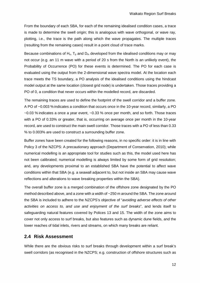
3.2 New Chums
Wave Type (s)
Optimum Swell Direction
Optimum Wind Direction
Optimum Tide
Max Ride (m)
Stoke Rating
Shape/ Description
Right Point; Beach NE SW Mid 150 6 Punchy
Powerful
New Chums, or Wainuiototo Bay, has a sand bottom beach break and a right-hand point at
the south-eastern end. This point is also reported as a sand bar (Bhana, 1996), and is likely
to be somewhat reliant on sandy seabed morphology. There are peaks central to the beach
with both right and left handers. Considered suitable for all levels of surfing.

Waikato Region Surf Breaks
17
3.3 Whangapoua
Wave Type (s)
Optimum Swell Direction
Optimum Wind Direction
Optimum Tide
Max Ride (m)
Stoke Rating
Shape/ Description
Left Point; Right Point; Beach
NE SW All 150 6 Hollow; Powerful
Whangapoua has a range of breaks with in the bay, including a sand bottom beach break with
several peaks with both right and left handers; Whangapoua Point at the north end of the bay;
Whangapoua Island, in the lee of Pungapunga Island; and, Whangapoua South Point at the
southern end of the beach. Considered suitable for all skill levels of surfer. A stream
discharges on to the northern end of the beach.
Waikato Region Surf Breaks
18
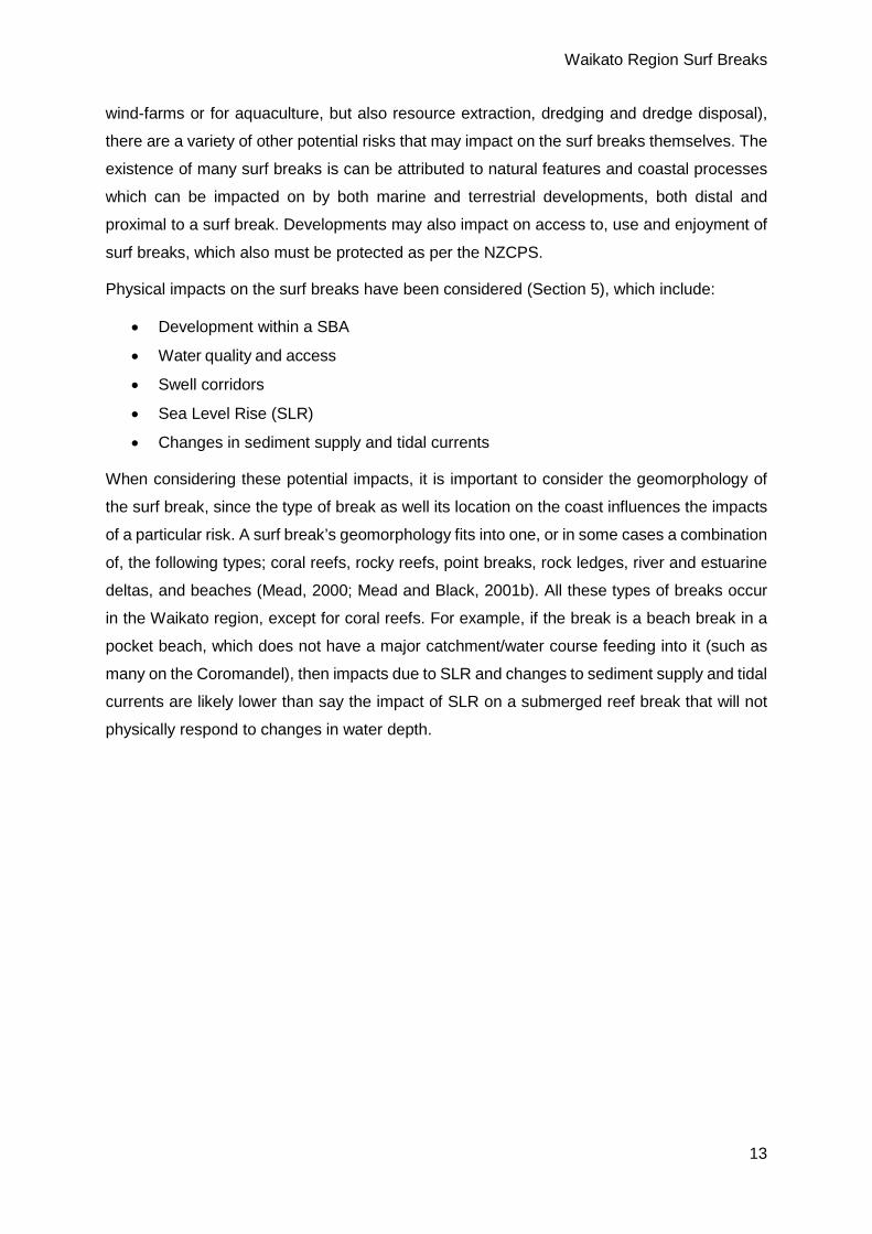
3.4 Matarangi
Wave Type (s)
Optimum Swell Direction
Optimum Wind Direction
Optimum Tide
Max Ride (m)
Stoke Rating
Shape/ Description
Beach; Bar N S Mid >250 3 Fast
Matarangi beach break extends some 4 km to the east from the mouth of the Whangapoua
Harbour. Matarangi Beach has several peaks along the beach to choose from with both right
and left handers. The Ebb Tidal Delta (ETD) at the entrance to Whangapoua Harbour also
provides both lefts and rights. Considered suitable for all skill levels.

Waikato Region Surf Breaks
19
3.5 Rings
Wave Type (s)
Optimum Swell Direction
Optimum Wind Direction
Optimum Tide
Max Ride (m)
Stoke Rating
Shape/ Description
Beach; N S Mid 200 4 Punchy
Rings is a sandy bottom beach with both lefts and rights, however the most consistent waves
break either as a left or a right off the rocky outcroppings at the western and eastern ends of
the beach, respectively. Another right hander is located central to the bay, and breaks towards
the rocky outcropping at the western end. Considered suitable for learner surfers.

Waikato Region Surf Breaks
20
3.6 Kuaotunu
Wave Type (s)
Optimum Swell Direction
Optimum Wind Direction
Optimum Tide
Max Ride (m)
Stoke Rating
Shape/ Description
Right Point; Beach; N S Mid >200 7
Powerful; Hollow;
Barrelling, Fast;
Shallow
The SBA at Kuaotunu is host to several surfing options. A central rocky outcropping separates
two beaches. Kuaotunu West, while not listed in the WNZSG, is included here as the two
beach sections are only partially split (not closed systems) and are likely to share sandy
material. Kuaotunu West is recognised as a beach break with lefts and rights. To the eastern
side of the rocky out cropping the scenario is similar until at the far eastern end of the bay
where a right reef/point breaks in to the bay onto the sandy beach – to which the above
characterisation applies (Stoke Rating). Considered suitable for competent and advanced
surfers only. The beaches are considered suitable for all levels. Streams discharge on to both
section of Kuaotunu, centrally and at the eastern end on the west and east sections,
respectively.

Waikato Region Surf Breaks
21
3.7 Otama
Wave Type (s)
Optimum Swell Direction
Optimum Wind Direction
Optimum Tide
Max Ride (m)
Stoke Rating
Shape/ Description
Black Jacks:
Left Point N S Mid >250 6
Walled Up; Long;
Barrels; Fast
Otama Beach:
Beach N S All 150 7-95 Hollow, Powerful
The Otama SBA hosts Black Jacks, a left point break that terminates onto the sandy beach,
located at the western end of the beach; and Otama Beach. Otama is not explicitly identified
in the WNZSG, but was one of the premier surf breaks during Cyclone Pam in 2015, with
multiple peaks along the length of the beach, each providing barrelling A-frames. During
Cyclone Pam, the NZ-hosted Ultimate Waterman competition selected Otama Beach to hold
one of the shortboard surfing division. It is considered a high quality surf break. Both spots are
considered good for beginners to experts, depending on the conditions. A stream discharges
on to the eastern end of the beach.
5 Otama does not receive a Stoke Rating in the WNZSG, but based on local consultation and internet searches, whilst comparing to other beach breaks within the WNZSG, the estimated Stoke Rating is provided.
Waikato Region Surf Breaks
22
3.8 Opito
Wave Type (s)
Optimum Swell Direction
Optimum Wind Direction
Optimum Tide
Max Ride (m)
Stoke Rating
Shape/ Description
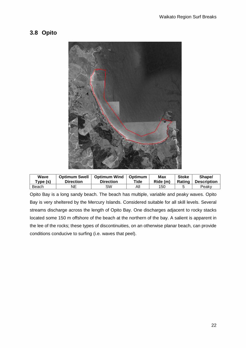
Beach NE SW All 150 5 Peaky
Opito Bay is a long sandy beach. The beach has multiple, variable and peaky waves. Opito
Bay is very sheltered by the Mercury Islands. Considered suitable for all skill levels. Several
streams discharge across the length of Opito Bay. One discharges adjacent to rocky stacks
located some 150 m offshore of the beach at the northern of the bay. A salient is apparent in
the lee of the rocks; these types of discontinuities, on an otherwise planar beach, can provide
conditions conducive to surfing (i.e. waves that peel).

Waikato Region Surf Breaks
23
3.9 Whitianga
Wave Type (s)
Optimum Swell Direction
Optimum Wind Direction
Optimum Tide
Max Ride (m)
Stoke Rating
Shape/ Description
Beach; Bar; Left Point
NE SW Mid >200 2 Soft, Mushy, Fat
Whitianga SBA has a beach break on Buffalo Beach, mostly surfed adjacent to the boat club;
a left hander breaking in toward the tidal inlet at the southern end of the beach known as the
Pipi Bank; and a right point break on the eastern side of the inlet breaking adjacent to
Whakapenui Point, the break is known as Cemetery Point. Whitianga is very sheltered and
needs larger than average swells to form surfable waves. The surf break is considered suitable
for all skill levels. The Stoke Rating of 2 is associated with the generally low grade beach
breaks, however the Pipi Bank and Cemetery Point when surfable are long, high performance
waves and merit a much higher rating (e.g. 5-8).
Waikato Region Surf Breaks
24
3.10 Hahei
Wave Type (s)
Optimum Swell Direction
Optimum Wind Direction
Optimum Tide
Max Ride (m)
Stoke Rating
Shape/ Description
Beach; Bar; Left Point
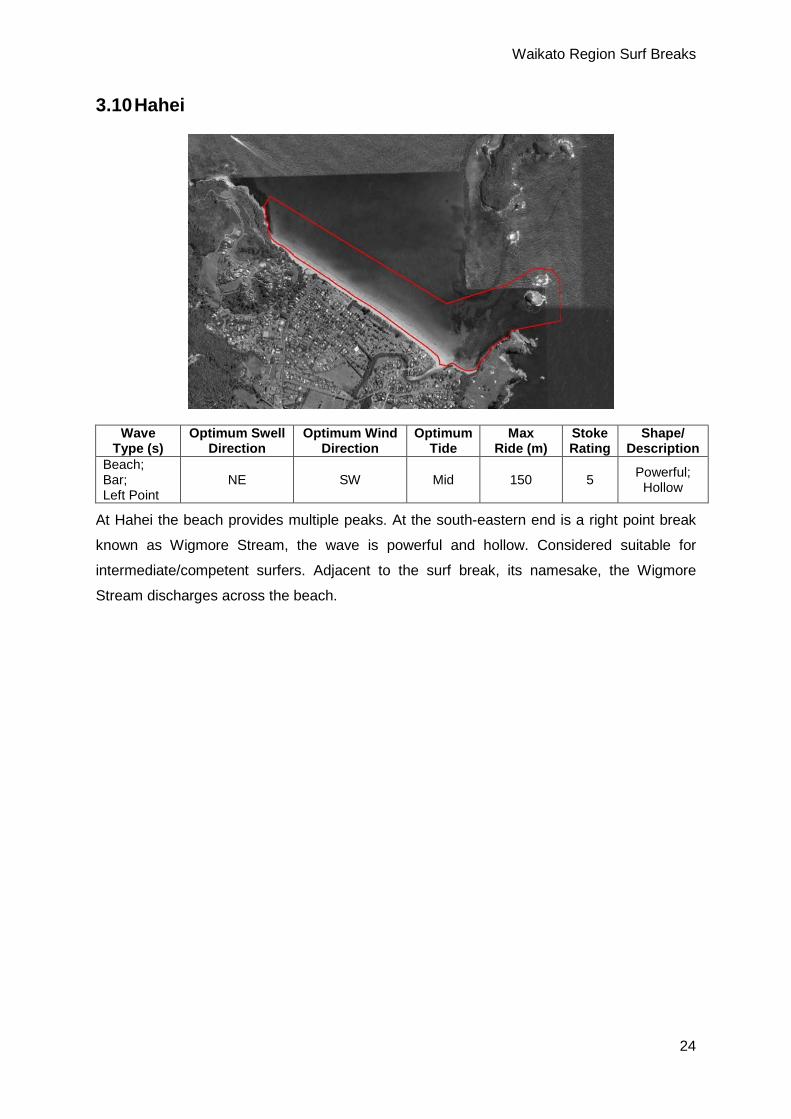
NE SW Mid 150 5 Powerful; Hollow
At Hahei the beach provides multiple peaks. At the south-eastern end is a right point break
known as Wigmore Stream, the wave is powerful and hollow. Considered suitable for
intermediate/competent surfers. Adjacent to the surf break, its namesake, the Wigmore
Stream discharges across the beach.
Waikato Region Surf Breaks
25
3.11 Hot Water Beach
Wave Type (s)
Optimum Swell Direction
Optimum Wind Direction
Optimum Tide
Max Ride (m)
Stoke Rating
Shape/ Description
Right Point; Left Point; Beach; Bombora
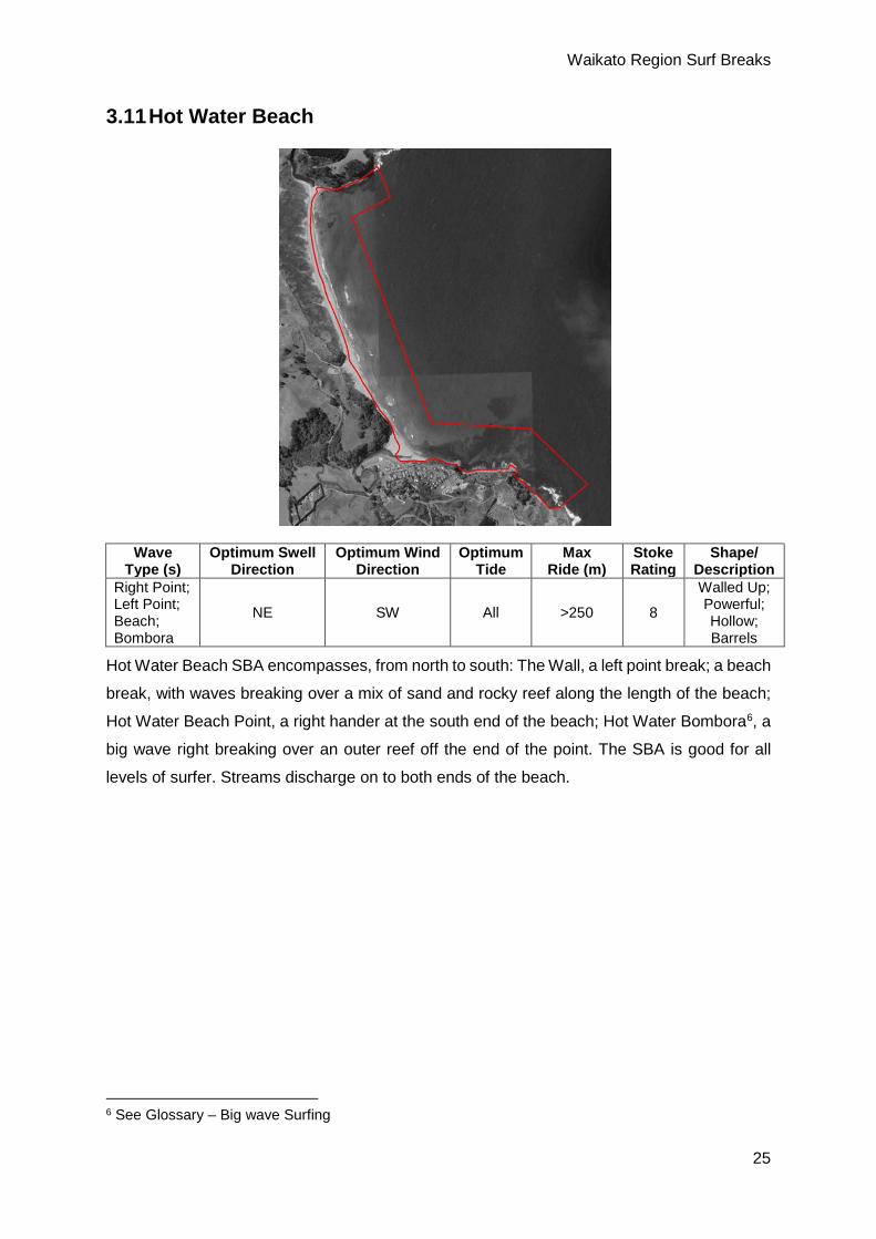
NE SW All >250 8
Walled Up; Powerful; Hollow; Barrels
Hot Water Beach SBA encompasses, from north to south: The Wall, a left point break; a beach
break, with waves breaking over a mix of sand and rocky reef along the length of the beach;
Hot Water Beach Point, a right hander at the south end of the beach; Hot Water Bombora6, a
big wave right breaking over an outer reef off the end of the point. The SBA is good for all
levels of surfer. Streams discharge on to both ends of the beach.
6 See Glossary – Big wave Surfing

Waikato Region Surf Breaks
26
3.12 Sailors Grave
Wave Type (s)
Optimum Swell Direction
Optimum Wind Direction
Optimum Tide
Max Ride (m)
Stoke Rating
Shape/ Description
Beach; Reef NE SW Mid to
High >150 8 Punchy; Hollow
Sailors Grave at Te Karo Bay has several peaks to choose from along the beach with both
right and left handers, and a right reef at the south end of the beach and left hander reef at
the north end of the beach. Considered suitable for competent surfers and upwards. Minor
streams discharge on to the beach at both ends Te Karo Bay.

Waikato Region Surf Breaks
27
3.13 Tairua
Wave Type (s)
Optimum Swell Direction
Optimum Wind Direction
Optimum Tide
Max Ride (m)
Stoke Rating
Shape/ Description
Beach; Right Point NE SW Mid to
Low >200 8 Powerful; Hollow; Peaky
Tairua SBA has a long beach break on a sandy beach, with several peaks with both right and
left handers. The wave is powerful and hollow. Also within the SBA, at the southern end of the
beach is Kina Point, a right hander breaking down the north side of Tokoroa Point. Considered
suitable for intermediate to expert surfers.
Waikato Region Surf Breaks
28
3.14 Pauanui
Wave Type (s)
Optimum Swell Direction
Optimum Wind Direction
Optimum Tide
Max Ride (m)
Stoke Rating
Shape/ Description
Bar Left; Bar Right Beach; Right Point
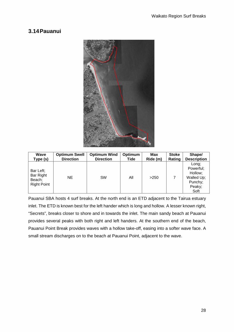
NE SW All >250 7
Long; Powerful; Hollow;
Walled Up; Punchy; Peaky;
Soft
Pauanui SBA hosts 4 surf breaks. At the north end is an ETD adjacent to the Tairua estuary
inlet. The ETD is known best for the left hander which is long and hollow. A lesser known right,
“Secrets”, breaks closer to shore and in towards the inlet. The main sandy beach at Pauanui
provides several peaks with both right and left handers. At the southern end of the beach,
Pauanui Point Break provides waves with a hollow take-off, easing into a softer wave face. A
small stream discharges on to the beach at Pauanui Point, adjacent to the wave.

Waikato Region Surf Breaks
29
3.15 Opoutere
Wave Type (s)
Optimum Swell Direction
Optimum Wind Direction
Optimum Tide
Max Ride (m)
Stoke Rating
Shape/ Description
Beach; Bar NE SW Mid >150 6 Hollow;
Walled Up
The beach at Opoutere is ~5km long offering multiple peaks with lefts and rights, starting at
the northern end with Ohui Beach, coming south to the entrance to the Wharekawa Estuary.
The ETD in front of the inlet provides a right hand bar break, when at its best provides surfable
waves from the shoreward side of Hikunui Island. Considered suitable for surfers of all levels.
A stream discharges on to the beach at Ohui.
Waikato Region Surf Breaks
30
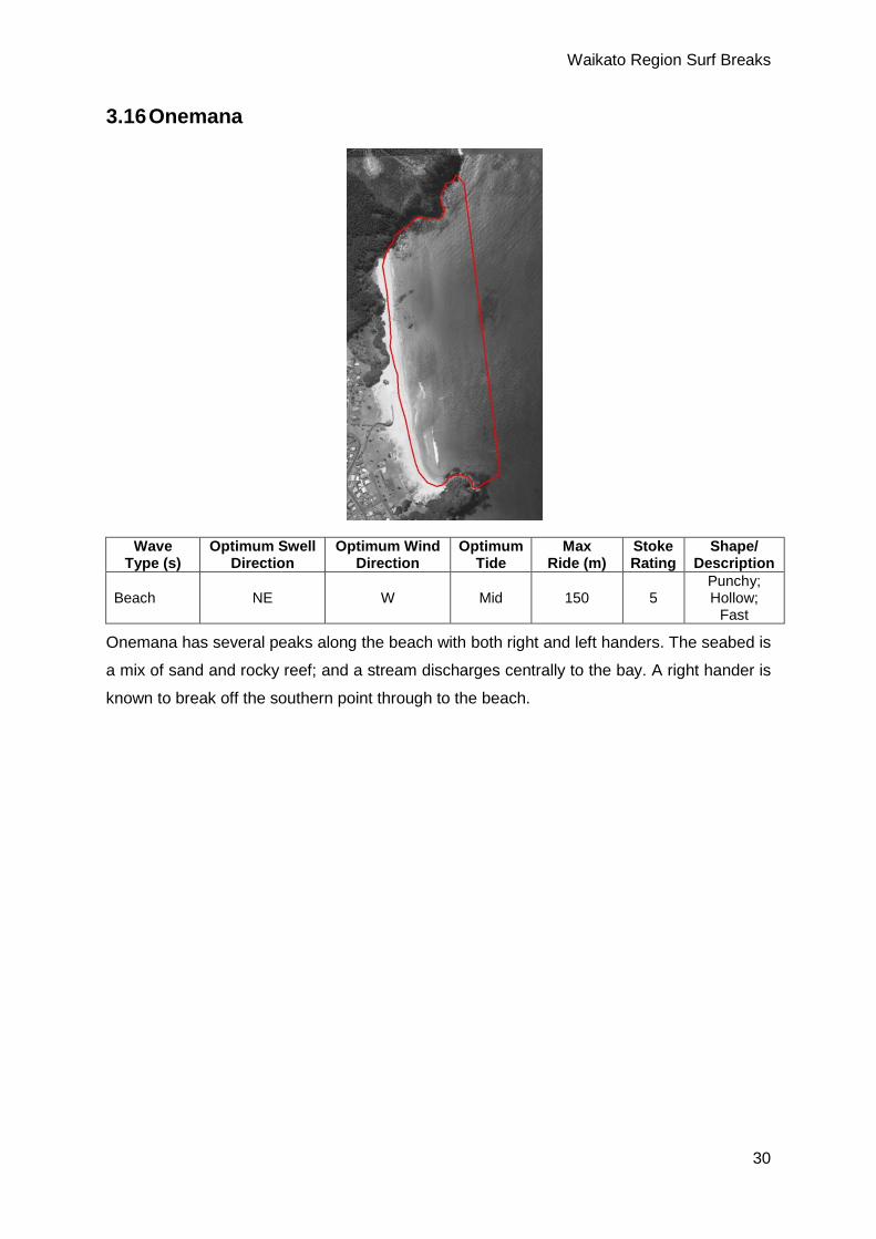
3.16 Onemana
Wave Type (s)
Optimum Swell Direction
Optimum Wind Direction
Optimum Tide
Max Ride (m)
Stoke Rating
Shape/ Description
Beach NE W Mid 150 5 Punchy; Hollow;
Fast
Onemana has several peaks along the beach with both right and left handers. The seabed is
a mix of sand and rocky reef; and a stream discharges centrally to the bay. A right hander is
known to break off the southern point through to the beach.

Waikato Region Surf Breaks
31
3.17 Whangamata
Wave Type (s)
Optimum Swell
Direction
Optimum Wind
Direction Optimum
Tide Max
Ride (m) Stoke Rating
Shape/ Description
Whangamata Bar:
Bar NE SW Low >300 m 10
Hollow; Barrel; Long; High
Performance; Fast
Walled Up; Steep
Whangamata Beach:
Beach NE SW All >150 8
Peaky; Long; Fast;
Walled Up; Workable;
Heavy Hollow Long
Whangamata Estuary:
Bar NE SW High >250 m 6 Hollow; Wall; Long
The Whangamata SBA is host to multiple waves and surfing options. The premier wave in the
area is “The Bar” and is regarded as one of the best waves in New Zealand. The left hander
can have barrel and high performance surfing sections. The beach at Whangamata produces
lefts and right peaks along its length. The waves can be hollow and fast, with a powerful shore
break. At the southern end of the bay is another bar break known as Whangamata Estuary.

Waikato Region Surf Breaks
32
This break forms on the ETD at the entrance to the Otahu Estuary. The wave is a right hander
breaking from a small rocky outcropping extending north form the southern headland. The
reefs surrounding Hauturu Island (central to the bay), particularly the seaward side, are known
to produce both lefts and rights in larger swells.
3.18 Whiritoa
Wave Type (s)
Optimum Swell Direction
Optimum Wind Direction
Optimum Tide
Max Ride (m)
Stoke Rating
Shape/ Description
Beach; Reef NE W Low to
Mid 50 7 Powerful; Hollow
Whiritoa is known for being a very powerful and hollow surf break. There are multiple peaks
along the length of the sandy beach with both right and left handers. Mataora Reef, a right
hander, is located round the cliffs, south toward Mataora Bay, but few details are available.
Considered suitable for intermediate to expert surfers. Streams discharge on to both ends of
the beach. The northern stream is more persistent in its flow across the beach. The southern
stream is largely coastally trapped, but is known to discharge during storm events (Utting,
2017; Whiritoa, 2017).

Waikato Region Surf Breaks
33
3.19 Homunga Bay
Wave Type (s)
Optimum Swell Direction
Optimum Wind Direction
Optimum Tide
Max Ride (m)
Stoke Rating
Shape/ Description
Beach; Bombora NE SW Low Unknown 7 Powerful;
Hollow
Homunga Bay has several peaks with both right and left handers. A bombora breaks central
to the bay in larger swells. Rated as a 7, however this rating is for Orokawa to the south (which
features more defined surf breaks). However, Orokawa is located within the jurisdiction of the
Bay of Plenty Regional Council.

Waikato Region Surf Breaks
34
3.20 Mokau
Wave Type (s)
Optimum Swell Direction
Optimum Wind Direction
Optimum Tide
Max Ride (m)
Stoke Rating
Shape/ Description
Beach; River Bar SW E Mid to
High 150 5 Powerful; Punchy; Barrels
Mokau is the first, from south to north, of the West Coast surf breaks in the Waikato Region.
The river mouth at Mokau provides lefts and right. Further north, in front of St Peters church
the sand banks produce lefts and rights. The surf break is dependent on the ever-changing
sand bars around the tidal inlet. Approximately halfway between Mokau and Awakino to the
north, opposite to a holiday park, is a surfing area referred to a “Chillies”. For this reason, the
SBA at Mokau extends ~2 km to the north to meet up with the Awakino SBA which
incorporates the Chillies area. This area is considered suitable for intermediate to expert
surfers.

Waikato Region Surf Breaks
35
3.21 Awakino
Wave Type (s)
Optimum Swell Direction
Optimum Wind Direction
Optimum Tide
Max Ride (m)
Stoke Rating
Shape/ Description
Beach; River Bar SW E Mid 100 5 Powerful;
Punchy
The conditions and set ups for Awakino are the same as Mokau. The SBA at Awakino extends
~2 km to the south to incorporate the Chillies surfing area.

Waikato Region Surf Breaks
36
3.22 Kiritehere
Wave Type (s)
Optimum Swell
Direction
Optimum Wind
Direction Optimum
Tide Max Ride (m)
Stoke Rating
Shape/ Description
Left Point; Boulder/Pebble/Sand Beach
SW E High >250 m 7
Walled Up; Punchy;
Long Hollow
Kiritehere SBA hosts a rocky, left point break at the southern end of the beach. Rainger (2011)
states that the inside and outside sections of the point break are referred to as Kenny’s and
Kinas, respectively. Various peaks are found in front of the Kiritehere Stream on the shingle
Kiritehere Beach. Considered suitable for expert surfers.
Waikato Region Surf Breaks
37
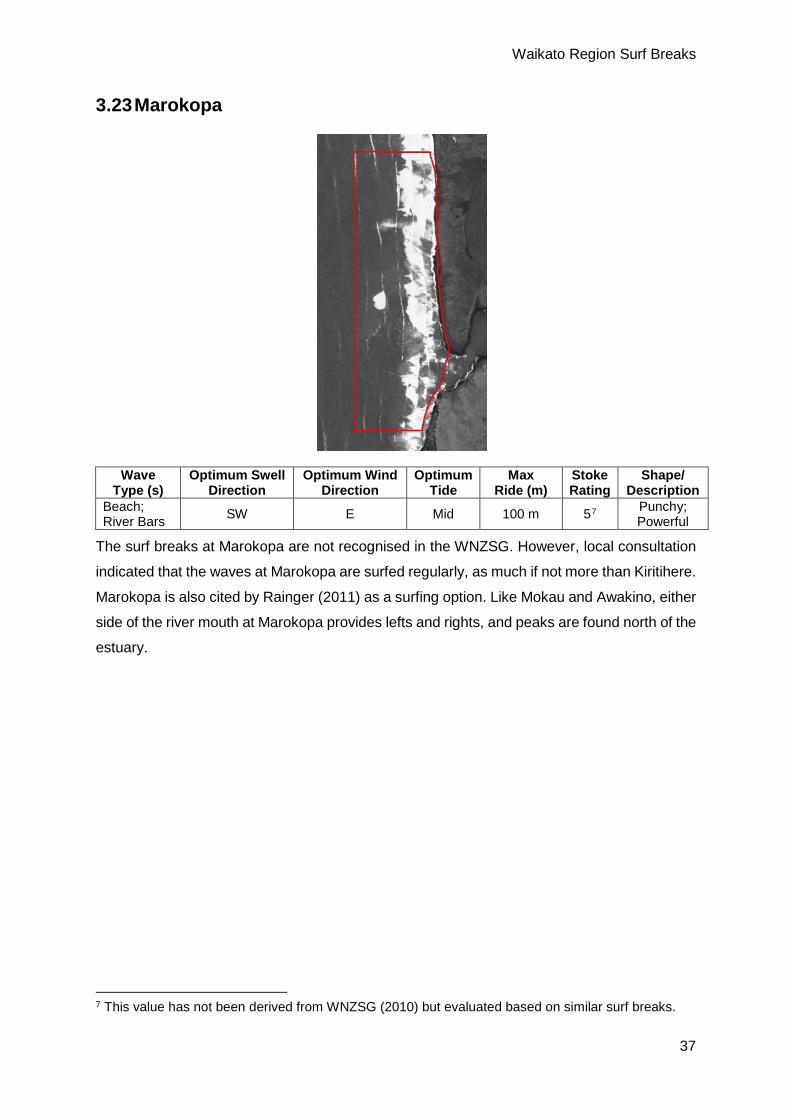
3.23 Marokopa
Wave Type (s)
Optimum Swell Direction
Optimum Wind Direction
Optimum Tide
Max Ride (m)
Stoke Rating
Shape/ Description
Beach; River Bars SW E Mid 100 m 57 Punchy;
Powerful
The surf breaks at Marokopa are not recognised in the WNZSG. However, local consultation
indicated that the waves at Marokopa are surfed regularly, as much if not more than Kiritihere.
Marokopa is also cited by Rainger (2011) as a surfing option. Like Mokau and Awakino, either
side of the river mouth at Marokopa provides lefts and rights, and peaks are found north of the
estuary.
7 This value has not been derived from WNZSG (2010) but evaluated based on similar surf breaks.

Waikato Region Surf Breaks
38
3.24 Albatross Point
Wave Type (s)
Optimum Swell Direction
Optimum Wind Direction
Optimum Tide
Max Ride (m)
Stoke Rating
Shape/ Description
Left Point; Beach SW S All >250 m 8
High performance; Punchy; Walled Up; Long
Albatross Point SBA hosts 4 or more left hand point breaks. Sediment movement is considered
important to wave quality, and local consultation indicates the waves break on the sand, as
opposed to the rocky outcroppings. Surfing also takes place at the beach at the eastern end
of the set of points. The SBA is essentially boat access only, or explicit permission is required
by the local surfing community and land owners before accessing these breaks by land. This
surf break is considered suitable for experts only.

Waikato Region Surf Breaks
39
3.25 Aotea Reef
Wave Type (s)
Optimum Swell
Direction
Optimum Wind
Direction Optimum
Tide Max
Ride (m) Stoke Rating
Shape/ Description
Bombora SW E Unknown Unknown Unknown Big Wave; Hollow; Powerful
Aotea Reef is not included in the WNZSG, is not a well-known or frequently surfed location,
but is mentioned in Rainger (2011). It is included here as a SBRS as it is, to date, the west
coast’s only recognised big wave surf break. The reef is located some ~1800 m from the shore
and requires very large swells to break properly. With little to no data available for this surf
break, and only coarse, nautical chart data, the SBA has been made conservatively around
the surfing area. Considered suitable for experts. The minimum wave height selected for Aotea
was 3.5 m, as per the methodology described in Section 2.
Waikato Region Surf Breaks
40
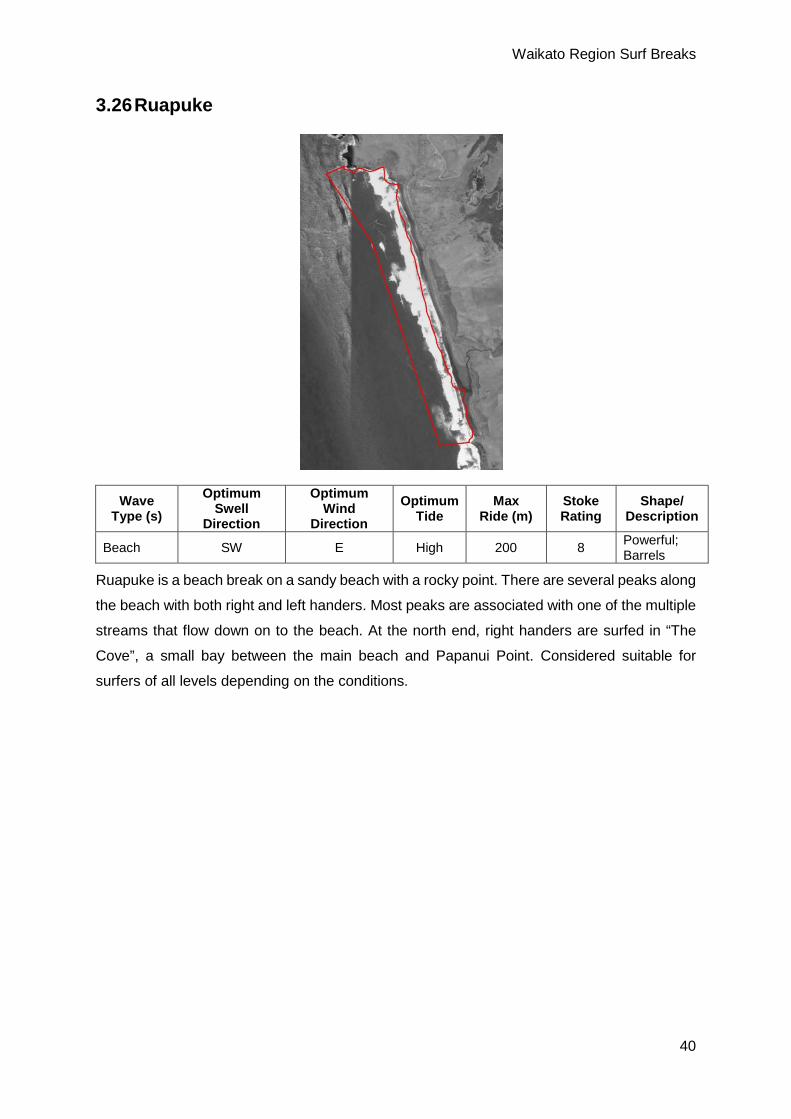
3.26 Ruapuke
Wave Type (s)
Optimum Swell
Direction
Optimum Wind
Direction Optimum
Tide Max
Ride (m) Stoke Rating
Shape/ Description
Beach SW E High 200 8 Powerful; Barrels
Ruapuke is a beach break on a sandy beach with a rocky point. There are several peaks along
the beach with both right and left handers. Most peaks are associated with one of the multiple
streams that flow down on to the beach. At the north end, right handers are surfed in “The
Cove”, a small bay between the main beach and Papanui Point. Considered suitable for
surfers of all levels depending on the conditions.

Waikato Region Surf Breaks
41
3.27 Raglan Points
Wave Type (s)
Optimum Swell
Direction
Optimum Wind
Direction Optimum
Tide Max
Ride (m) Stoke Rating
Shape/ Description
Indicators:
Left Point SW SE All >800 m 10
Powerful; Hollow; Fast; Walled Up; Long
Whale Bay:
Left Point SW SE All >350 m 10 Walled Up; Long
Manu Bay:
Left Point SW SE All >300 m 10 Barrels; Walled Up; Long
The Raglan Points SBA includes three Surf Breaks of National Significance. Indicators, the
mostly westerly and outer surf break is a left hand boulder point break. The wave has multiple
sections that link up, starting from Outsides, which offers two recognised peaks that link up,
namely, Outside Waterfall (aka 2nd Boil), which works on larger swells, and the more consistent
Outside Boil, through to Indicators and on to the Valley (from west to east). The waves are
high performance providing the opportunity for barrels and an array of manoeuvres.
The second of Raglan’s Surf Breaks of Nationally Significance, Whale Bay is another left hand
point break. The seabed is made up of rocky reef outcroppings and boulders. Under optimal
conditions, Indicators and Whale Bay link up providing rides in excess of 1 km.
The WNZSG states that Indicators is best from low to mid tide, and Whale Bay best on the
low tide. While tidal state can affect smaller wave conditions, the waves at these surf breaks
are high quality regardless, with the tide providing different opportunities, particularly during
optimum swell conditions.
Manu Bay, or The Point, is the innermost of Raglan’s three nationally significant, left hand
point breaks. The Point hosts national and international surfing competitions. During the lower

Waikato Region Surf Breaks
42
tides the eastern end of the point provides very hollow barrels, this section of the wave is
known as “The Ledge”.
Further west from Manu Bay, before Whale Bay, is Boneyards: a shorter wave that can link
up with The Point in larger swells. East of the boat ramp, in to Halfmoon Bay, is also a popular,
but temporal, sand bottom, A-frame peak providing lefts and rights during large swells.
3.28 Ngarunui Beach (Wainui)
Wave Type (s)
Optimum Swell
Direction
Optimum Wind
Direction Optimum
Tide Max
Ride (m) Stoke Rating
Shape/ Description
Beach SW E Mid to High 100 7 Walled Up
Ngarunui Beach has numerous peaks with both right and left handers which are largely formed
by transient rips along its length. A left hander can be found at the southern end, largely
dependent on the amount of sand in the area. Suited to surfers of all levels depending on
conditions.
Waikato Region Surf Breaks
43
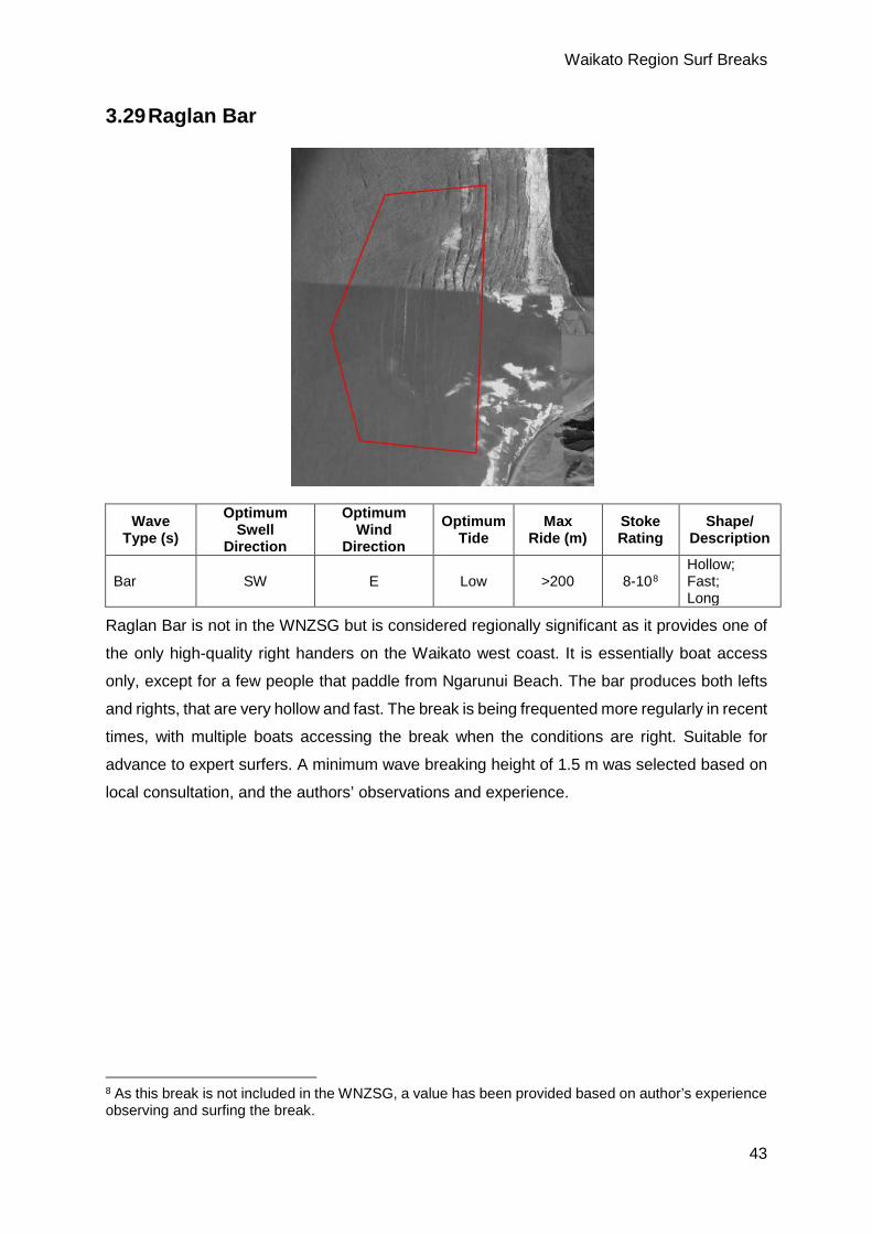
3.29 Raglan Bar
Wave Type (s)
Optimum Swell
Direction
Optimum Wind
Direction Optimum
Tide Max
Ride (m) Stoke Rating
Shape/ Description
Bar SW E Low >200 8-108 Hollow; Fast; Long
Raglan Bar is not in the WNZSG but is considered regionally significant as it provides one of
the only high-quality right handers on the Waikato west coast. It is essentially boat access
only, except for a few people that paddle from Ngarunui Beach. The bar produces both lefts
and rights, that are very hollow and fast. The break is being frequented more regularly in recent
times, with multiple boats accessing the break when the conditions are right. Suitable for
advance to expert surfers. A minimum wave breaking height of 1.5 m was selected based on
local consultation, and the authors’ observations and experience.
8 As this break is not included in the WNZSG, a value has been provided based on author’s experience observing and surfing the break.

Waikato Region Surf Breaks
44
3.30 Mussel Rocks
Wave Type (s)
Optimum Swell
Direction
Optimum Wind
Direction Optimum
Tide Max
Ride (m) Stoke Rating
Shape/ Description
Bar SW E High 200 7 Powerful
Mussel Rocks SBA includes the beach north of the Raglan Harbour entrance up to Te Kaha
Point (Mussel Rocks), and north, along the beach known locally as Tauterei, up to Te Hara
Point. Tauterei is included as more often than not, when conditions are right for surfing north
of Raglan Harbour, surfers will nearly always be found from Te Kaha to Te Hara. Surfing
occurs on the sandy beach north and south of Te Kaha Point, with both left and right handers
available. Most of the best peaks occur in front of the multiple streams that flow on to the
beaches. The WNZSG states tides are best from mid to low tides. While good banks are
formed periodically that are surfable on lower tides, the majority of surfing occurs under high
tide conditions. Good for surfers of all levels depending on conditions.

Waikato Region Surf Breaks
45
3.31 Te Akau
Wave Type (s)
Optimum Swell
Direction
Optimum Wind
Direction Optimum
Tide Max
Ride (m) Stoke Rating
Shape/ Description
Bar SW E High 100 7 Powerful
Like Mussel Rocks, Te Akau surfing is over sandy beaches with both left and right handers
available. Most of the best peaks occur in front of the streams that flow on to the beach.

Waikato Region Surf Breaks
46
3.32 Port Waikato
Wave Type (s)
Optimum Swell
Direction
Optimum Wind
Direction Optimum
Tide Max
Ride (m) Stoke Rating
Shape/ Description
The Reef:
Left Point Reef SW E All >400 m 8
Walled Up; Powerful; Steep; Long Barrels
Sunset Beach:
Beach SW E Mid to High Unknown 6 Unknown
Within Port Waikato SBA there is The Reef and Sunset Beach. The Reef is a left point/reef
breaking off the headland south of the Waikato River entrance. The surf break is exposed and
“heavy” (powerful), with shallow rocks and considered suitable for advanced to expert or
experienced surfers. Sunset Beach has lefts and rights breaking on a sand bottom from the
south end of the beach to the north. The quality of waves is largely dependent on the shifting
sandy seabed, and considered suitable for surfers of all levels. Surfing is reportedly possibly
around the ETD of the Waikato River (Rainger, 2011). This has not been corroborated, but
surfing is known to occur on the landward side of the bar, against the northern edge of the
inlet (not on the offshore side of the ETD). However, local consultation indicates this is an
extremely ephemeral feature that can be good for surfing at times.
Waikato Region Surf Breaks
47
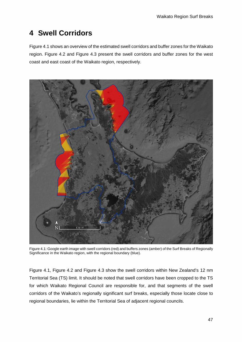
4 Swell Corridors Figure 4.1 shows an overview of the estimated swell corridors and buffer zones for the Waikato
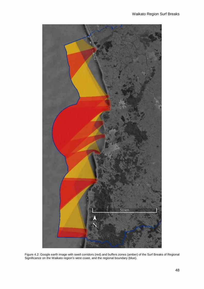
region. Figure 4.2 and Figure 4.3 present the swell corridors and buffer zones for the west
coast and east coast of the Waikato region, respectively.
Figure 4.1: Google earth image with swell corridors (red) and buffers zones (amber) of the Surf Breaks of Regionally Significance in the Waikato region, with the regional boundary (blue).
Figure 4.1, Figure 4.2 and Figure 4.3 show the swell corridors within New Zealand’s 12 nm
Territorial Sea (TS) limit. It should be noted that swell corridors have been cropped to the TS
for which Waikato Regional Council are responsible for, and that segments of the swell
corridors of the Waikato’s regionally significant surf breaks, especially those locate close to
regional boundaries, lie within the Territorial Sea of adjacent regional councils.
Waikato Region Surf Breaks
48
Figure 4.2: Google earth image with swell corridors (red) and buffers zones (amber) of the Surf Breaks of Regional Significance on the Waikato region’s west coast, and the regional boundary (blue).

Waikato Region Surf Breaks
49
Figure 4.3: Google earth image with swell corridors (red) and buffers zones (amber) of the Surf Breaks of Regional Significance on the Waikato region’s east coast, and the regional boundary (blue).
Waikato Region Surf Breaks
50
5 Risk Assessment Other than obstruction of swell corridors, there are a range of risks from physical impacts to
the breaks in the Waikato Region. These include development within the Surf Break Area
(SBA), degraded water quality, restricted access, changes to sediment supply and tidal
currents.
As described in the introductory text of this document, this risk assessment is a first order
assessment of the risks to SBRS at a regional scale. Should the surf break GIS database
highlight the potential for degradation to a SBRS, SBA; or swell corridor, a more in-depth site-
specific assessment may be required.
5.1 Development within a SBA
Development may directly change wave propagation (refraction/diffraction) and breaking
characteristics within an SBA though interactions between the waves and any structure added
to the SBA or buffer zone. Developments inside and outside an SBA may influence water
quality, sediment supply and access.
5.2 Water Quality and Access
The focus of this sect ion of the report is on the physical impacts to the Waikato’s SBRS.
However, water quality and access to each of these breaks should also be considered as
part of Policy 16 of the NZCPS is to protect them by “avoiding adverse effects of other activities
on access to, and use and enjoyment of the surf breaks”.
Poor water quality within an SBA can potentially reduce the enjoyment or prevent the use of
surf break areas (NZCPS, 2010), by posing a health and safety risk. Those SBAs that are
proximal to terrestrial water courses, both naturally occurring (e.g. river, streams estuaries) or
anthropogenic (e.g. storm water outfall, wastewater outfall) are at particular risk. While there
are currently few data on water quality for many of the Waikato’s surf breaks and open coasts,
water quality monitoring programmes for the open coast of the Waikato Region are currently
being developed by WRC. Access risks essentially lie with obstruction of direct access through
construction of physical structures, privatisation of access routes, and a lack of suitable
infrastructure (e.g. parking) for people to participate in surfing.
5.3 Swell Corridors
All surf breaks in the Waikato Region can potentially be impacted by development
within their swell corridor. In this report, the swell corridors for Waikato’s SBRS have

Waikato Region Surf Breaks
51
been determined and mapped out to the 12 nautical mile (nm) limit of the Territorial Sea
(TS), since that is the boundary of the WRC’s jurisdiction. Developments outside the
Waikato region, both beyond the 12 nm limit and in the TS of neighbouring regions, may also
have potential to impact on surf breaks in the Waikato region.
Impacts in the swell corridors are caused by disruption to waves propagating through the
swell corridors to the surf breaks. There are two main ways that waves can be disrupted
or reduced due to developments in the swell corridor. Firstly, by direct interference with
the wave-trains due to structures on the surface and/or through the water column (e.g.
breakwaters or other offshore structures, wave-farms, wind-farms and large-scale
aquaculture). Secondly, by changes to the seabed morphology (e.g. seabed mining and
associated tailing disposal; maintenance dredging and associated disposal, etc.). Structures
on the surface of, and/or through the water column, may disrupt and reduce waves due to forming
a barrier, as well as refraction/diffraction around the structure. Modification of the seabed
c a n impact on swells through the processes of refraction/diffraction, which in simple terms
means that because waves travel slower the shallower the water depth, wave height gradients
and wave directions are changed as waves propagate across a modified seabed (see Pond
and Pickard, 1983; Butt and Russel, 2002; Mead et al., 2003, 2011).
The amount of disruption to and attenuation of waves is dependent on the configuration of the
development and the wave period, height and direction, as well as the spectral width, which
is the ‘cleanliness’ of the swell. Structures that are present throughout the whole water
column (e.g. wind-turbine foundations) and changes to the seabed (e.g. large-scale seabed
mining) have relatively greater impacts on longer period waves during ‘clean’ swell conditions.
Higher wave periods have a greater potential for refraction, and disruptions caused by offshore
structures or seabed modification can occur 10’s of kilometres before refraction and
diffraction reduce the disturbance (e.g. Black, 2007; Mead, 2013). In simple terms, the
processes of refraction and diffraction are dependent on period. Longer period waves ‘feel’ the
seabed at greater depths than short period waves. This means that longer period waves refract
more than short period waves, which leads to comparatively bigger changes in wave direction
and any height gradients (along the wave crest) in longer period waves. Consequently, a
greater distance is required before the waves re-conform to a pre-disturbance condition.
With respect to structures on the surface of the water column, or in the water column, that do
not form a complete barrier to waves (e.g. large-scale aquaculture, wave-power generation
devices), impacts to waves propagating through these developments is also largely
dependent on wave period. For example, shellfish aquaculture on long-lines dissipate and
dampen short period wave energy, but long period waves can travel through these
developments with little impact on the waves (Stevens et al., 2008). In November 2001,

Waikato Region Surf Breaks
52
Pegasus Bay Aquaculture Ltd applied for resource consent to operate a 10,664 ha marine
farm some 10 km off the coast of the Waimakariri River in Pegasus Bay. Since the
Christchurch beach surf breaks work best during the summer with short period swell from the
northeast, the large offshore farm has the potential to impact on surfing wave quality at the
coast (Pegasus Bay Mussel Farm Limited, 2001).
5.4 Sea Level Rise (SLR)
A future risk to surf breaks is sea level rise (SLR); especially rocky reef breaks, since unlike
sandy breaks which can respond to changes in sea level, rocky reefs cannot. Actual impacts of
SLR on surf breaks have not yet been studied in detail, and there is potential for new surf breaks
to form as others are lost due to increased water depth. Indeed, Reineman et al., (2017)
presents the result of a surf community engagement study that projects by 2100 SLR will
endanger, threaten/change and possibly improve 16, 18 and 5% of 105 Californian surf breaks,
respectively.
To date, no broad, quantitative study on surfing wave quality and its relationship to SLR has
been conducted. This is primarily due to a lack of sufficient surfing wave quality data. The
closest analogy to the effects on SLR on surfing wave quality can be taken from relatively
rapid tectonic events. However, any conclusions drawn from such events will be based on
(potentially) anecdotal evidence (no quantitative data). There are cases of rapid subsidence
in known surfing areas (e.g. Meltzner et al., 2006; Borrero et al., 2011), but again, no
qualitative or quantitative data regarding surfing wave quality are available.
5.5 Changes in Sediment Supply and Tidal Currents
Many SBAs on both coasts of the Waikato region contain estuaries, tidal inlets, rivers and/or
streams, with associated catchments, that can influence surf breaks. Changes in sediment
supply and tidal currents can impact on beach and bar surf break types. Damming of rivers
and/or tributaries, marina developments, reclamation, dredging for navigation, dredging for
building industry materials, etc., can impact on the morphology of ETDs through changed
sediment supply, changed current velocities and directions, and changed inlet
morphology/tidal prism volume. Other breaks may rely on sediment via land-based sources
such as transverse dune systems, the stabilisation of which can lead to negative impacts on
surf breaks that rely on them for supply.
While there are surf breaks associated with estuaries, tidal inlets, rivers and/or streams on
both Waikato coasts, the east coast surf breaks are likely to be more susceptible to this
potential risk. The beach breaks, bar breaks, point breaks and reef breaks in the SBA’s of the
Waikato Region’s west coast are exposed to extreme wave conditions, and so are both very
Waikato Region Surf Breaks
53
variable and likely to be very robust. The Waikato west coast beach system is very large,
relatively shallow and relatively connected between littoral cells (Mead et al., 2010) compared
to the Waikato’s east coast. Therefore, while these impacts should be considered for the west
coast of the Waikato Region, it is likely that significant impacts on sediment supply and tidal
currents would only be caused by significant large-scale developments.
On the east coast of the Waikato Region, there are a number of breaks that depend on
catchment sediments and tidal currents that form the ebb-tidal deltas (bars). Development
within an estuary, training of the entrance, and changes to the tidal prism (e.g. development
of a causeway road, reclamation, marina construction, etc.) have the potential to impact on
sediment supply and tidal currents, and consequently surfing amenity. There are several SBAs
that are associated with barrier spit beaches (e.g. Whangapoua, Matarangi, Whitianga and
Pauanui), which are dependent on estuary hydrodynamics and sediment supply.
Several other east coast breaks are bar breaks and depend on the sediment supply and shape
of the ebb-tidal delta, the latter of which can be impacted by changes in tidal currents. For
example, the ebb-tidal delta that is “The Bar” at Whangamata is influenced by the
hydrodynamics and sediment transport in and out of the Whangamata Estuary, and so any
developments within the estuary and its catchment have the potential to impact on the break.

Waikato Region Surf Breaks
54
6 Conclusions and Recommendations Uncalibrated numerical models using adequate, but non-site specific, bathymetric data have
been used to produce a first order approximation of the swell corridors for the Waikato region’s
Surf Breaks of Regionally Significance. The swell corridors and associated buffer zones were
determined using a probability of occurrence method. Surf Break Areas (SBA) have been
defined and provided with a 250 m buffer zone.
During local consultation for this study it was found that the number of frequented surf breaks
is well in excess of that described in the WNZSG. Not all these breaks were considered
regionally significant. To address this, it is recommended that these Known Surfing Areas or
Known Surfing Coastlines are documented to ensure that these surf breaks are
acknowledged.
This document provides a comprehensive list of Surf Breaks of Regional Significance in the
Waikato Region based on current data sources and local consultation. The number of
participants using surf breaks continues to grow (see references in Section 1). The result is
more pressure on the known surfing resources. It is presumed that this will result in a change
of use, whereby users frequent lesser known surf breaks to reduce user numbers. It is
therefore recommended that the list of SBRSs in the Waikato should be revaluated prior to
each iteration of the coastal plan and/or at a time frame deemed suitable by Waikato Regional
Council that allows for breaks to be included on time scales consistent with population growth.
It is very difficult, if not impossible, to manage resources that are not well understood. An
understanding of natural resources comes from data collection, monitoring and further study.
For example, Aotea Reef is unique to the Waikato, yet it is difficult to determine the precise
extent of its SBA due to a lack of data. In addition, the break is reliant on a reef that, while
depicted on a nautical chart, the true extent and shape of the reef is unknown, as are the
morphological changes that occur around the reef; and how both of these factors influence
surfing wave quality. In this case, hydrographic surveys of the reef and surrounding area would
be required to establish a baseline, and repeat surveys required to determine morphological
changes. Therefore, the final recommendation is that knowledge gaps regarding the Waikato’s
Surf Breaks of Regional Significance are identified and addressed.

Waikato Region Surf Breaks
55
7 References Atkin, E. A., Gunson, M. and Mead. S. T., 2015. Regionally Significant Surf breaks in the
Greater Wellington Region. eCoast technical report for Greater Wellington Regional Council.
Ball, S., 2015. The Green Room: A Surfing-Conscious Approach to Coastal and Marine
Management. UCLA Journal of Environmental Law and Policy, 33 (2).
Battjes, J. 1974. Surf similarity. In: Proceedings of the 14th International Conference on
Coastal Engineering (Copenhagen, Den-mark, ASCE), pp. 1050–1061.
Becker, J. J., D. T. Sandwell, W. H. F. Smith, J. Braud, B. Binder, J. Depner, D. Fabre, J.
Factor, S. Ingalls, S-H. Kim, R. Ladner, K. Marks, S. Nelson, A. Pharaoh, R. Trimmer, J. Von
Rosenberg, G. Wallace, P. Weatherall., (2009), Global Bathymetry and Elevation Data at 30
Arc Seconds Resolution: SRTM30_PLUS, Marine Geodesy, 32:4, 355-371, DOI:
10.1080/01490410903297766
Berrisford, P., Dee, D.P., Poli, P., Brugge, R., Fielding, K., Fuentes, M., Kållberg, P.W.,
Kobayashi, S., Uppala, S., Simmons, A., 2011. The ERA-Interim Archive Version 2.0: ERA
Report Series. European Centre for Medium-Range Weather Forecasts.
Bhana, M., 1996. New Zealand Surfing Guide. Revised ed. Auckland: Reed Books.
Black, K. P., 2007. Review of Wave Hub Technical Studies: Impacts on inshore surfing
beaches. Prepared for South West of England Regional Development Agency, North Quay
House’ Sutton Harbour, Plymouth.
Board of Inquiry, 2009a. Proposed New Zealand Coastal Policy Statement 2008 Report and
Recommendations Volume 2: Working Papers. Accessed 1 October 2014 from
http://www.doc.govt.nz/upload/documents/getting-involved/consultations/closed-
consultations/nzcps/NZCPS-2008-board-of-inquiry-vol-2.pdf
Board of Inquiry, 2009b. Proposed New Zealand Coastal Policy Statement 2008 Report and
Recommendations Volume 1: Findings, Recommendations and Recommended New Zealand
Coastal Policy Statement (2009). Accessed 1 October 2014 from
http://www.doc.govt.nz/upload/documents/getting-involved/consultations/closed-
consultations/nzcps/NZCPS-2008-board-of-inquiry-vol-1.pdf
Borrero, J.C., Mcadoo, B., Jaffe, B., Dengler, L., Gelfenbaum, G., Higman, B., Hidayat, R.,
Moore, A., Kongko, W., Lukijanto, Peters, R., Prasetya, G., Titov, V., and Yulianto, E., 2011.
Field Survey of the March 28, 2005 Nias-Simeulue Earthquake and Tsunami. Pure and
Applied Geophysics, 168(6):1075-1088.Butt, T. and Russel, P., 2002. Surf Science: An
Introduction to Waves for Surfing. Penzance: Alison Hodge.
Waikato Region Surf Breaks
56
Camenen, B. and Larson, M., 2007. Predictive Formulas for Breaker Depth Index and Breaker
Type. Journal of Coastal Research, 23(4), 1028–1041.
Coombes, K. and Scarfe, B., 2010. Draft Auckland Regional Policy Statement Background
Report – Surf Breaks. Auckland Regional Council. http://www.surfbreak.org.nz/wp-
content/uploads/2014/06/APPENDIX_I_Surf-breaks-schedule-and-background-report-v2-
final-2010-03-08.pdf
Dally, W., 1990. Random Breaking Waves: A Closed-Form Solution for Planar Beaches.
Coastal Engineering, 14, 233-263.
Department of Conservation, 2010. New Zealand Coastal Policy Statement 2010. Wellington:
Department of Conservation.
Graham, S., 2011. Sport New Zealand’s Young People’s Survey 2011 – In-depth Report.
Retrieved 3 October 2014 from http://www.srknowledge.org.nz/researchproject/sport-new-
zealands-young-peoples-survey-2011-in-depth-report
Holthuijsen, L.H., Booij, N., Ris, R.C., Haagsma, I.J.G., Kieftenburg, A.T.T.M., Kriezi, E.E.,
Zijelma, M., and van der Westhyusen, A.J. 2004. SWAN User Manual Cycle III version 40.41.
Delft University of Technology, Delft.
Hutt, J.; Black, K. and Mead, S., 2001. Classification of Surf Breaks in Relation to Surfing Skill.
Special Issue 29, Journal of Coastal Research p66-81.
Jarvis, A., H.I. Reuter, A. Nelson, E. Guevara, 2008, Hole-filled SRTM for the globe Version
4, available from the CGIAR-CSI SRTM 90m Database (http://srtm.csi.cgiar.org).
Kimura, A., Yamashita, K. and Kakinuma, T., 2014. Surf Points Using a Set of Structures to
Amplify Ship Generated Waves. Coastal Engineering Proceedings 2014.
Mathew, J., Black, K.P., Mead, S.T. and Beamsley, B., 2000. Lake Surveys and Volume
Predictions. Technical Report and Software for Watercare Services Ltd.
McCowan, J. 1894. On the Highest Wave of Permanent Type. Philosophical Magazine, Series
5, 38, 351-357.
Mead, S. T., 2000. Incorporating High-Quality Surfing Breaks into Multi-Purpose Reefs. Doctor
of Philosophy in Coastal Oceanography and Surfing Reefs thesis. University of Waikato. Pp
209 + appendices.
Mead, S. T., 2013. Potential Effects of Trans-Tasman Resources Mining Operations on
Surfing Breaks in the Southern Taranaki Bight. Report prepared for NIWA, October 2013.
Mead, S. T. & K. P. Black, 2001a. Predicting the Breaking Intensity of Surfing Waves. Special
Issue of the Journal of Coastal Research on Surfing p51-65.
Waikato Region Surf Breaks
57
Mead, S. T. & K. P. Black, 2001b. Field Studies Leading to the Bathymetric Classification of
World-Class Surfing Breaks. Special Issue of the Journal of Coastal Research on Surfing p5-
20.
Mead, S. T., K. P. Black, J. Frazerhurst and B. Scarfe, 2003. The Effects of Wave Focussing
on Surfing Reef Site Selection, Surfing Wave Quality and ASR Design at Scales of Inner
Continental Shelf to Sub-Tidal Reef. 3rd International Artificial Surfing Reef Symposium,
Raglan, New Zealand 23-25 June 2003. ISBN 0-473-09801-6 2003.
Mead, S. T, Grant, D. and Lebreton, L., 2010. Scoping Study of the New Zealand West Coast
Physical Marine Environment. Prepared for Golders, March 2010.
Mead, S. T., Atkin, E. and Phillips, D. J., 2011. Preliminary Investigation of Offshore Focussing
Reefs. UNITEC Research Fund, August 2011.
Meltzner, A., Sieh, K., Abrams, M., Agnew, D., Hudnut, K., Avouac, J.-P., and Natawidjaja, D.,
2006. Uplift and Subsidence Associated with The Great Aceh-Andaman Earthquake Of 2004,
Journal of Geophysical Research, 111, B02407.
MetOcean Solutions Limited, 2008. Westshore Reef Surf Conditions: Predicted Effects from
the Proposed Whakarire Ave Breakwater. MetOcean Solutions Limited Technical Report.
Moorse and Brunskill, 2004. Wavetrack New Zealand Surfing Guide. Greenroom Surf Media
Ltd, Mount Maunganui.
Mortensen, S., Tree, M. and Tuckey, B., 2015. Wellington Airport Runway Extension Surf
Break Impact Assessment: Numerical Modelling, Preliminary Mitigation Investigations and
Feasibility Study. DHI Technical Report prepared for Wellington International Airport Limited.
NZSurf Guide, 2013. NZ Surf Guide. [online] Available at: http://www.nzsurfguide.co.nz/
[Accessed 2016].
Pattiaratchi, C.B., Masselink, G. and Hurst, P., 1999. Surfability of the Perth Metropolitan
Coastline: An Assessment. Ports & Coasts 1999 Conference, Perth.
Pegasus Bay Mussel Farm Limited, 2001. RMA Authorization Number CRC021368,
Environment Canterbury, [2001]).
Perryman, B., 2011. Surf Break Identification and Protection in the Gisborne District. Gisborne
District Council Report.
Perryman, P. B., & Orchard, S., 2013. Understanding the Values and Management Needs of
New Zealand Surf Breaks. Lincoln Planning Review, 4(2).
Pond, S. and Pickard, G. L., 1983. Introductory Dynamical Oceanography. Oxford:
Butterworth-Heinemann.

Waikato Region Surf Breaks
58
Rainger, T., 2011. The New Zealand Good Beach Guide: North Island. Raglan: Clean Media
Ltd.
Ranasinghe, R., Hacking, N. and Evans, P., 2001. Multi-functional Artificial Surf Breaks: A
Review. Parramatta: Centre for Natural Resources, NSW Department of Land and Water
Reineman, D. R., Thomas, L. N. and Caldwell, M. R., 2017. Using Local Knowledge to Project
Sea Level Rise Impacts on Wave Resources in California. Ocean & Coastal Management,
138, 181-191.
RMA 1991. The Resource Management Act.
Rosier, J., 2004. Independent Review of the New Zealand Coastal Policy Statement. A report
prepared for the Minister of Conservation. Accessed 1 October 2014 from
http://www.doc.govt.nz/upload/documents/conservation/marine-and-coastal/coastal-
management/nzcps-review-2004.pdf
Rosier, J., 2005. Towards better national policy statements: NZCPS review. Planning
Quarterly, March 2005: 26-28.
Scarfe, B. E., Healy, T. R., Rennie, H. G., & Mead, S. T., 2009a. Sustainable management of
surfing breaks: an overview. Reef Journal, 1(1), 44–73.
Scarfe, B. E., Healy, T. R., Rennie, H. G., & Mead, S. T., 2009b. Sustainable Management of
Surfing Breaks: Case Studies and Recommendations. Journal of Coastal Research, 25(3),
684–703.
Shand, T., Peirson, W. L and Cox, R. J., 2007. Wave Group Effects on Breaker Height on a
Uniform Slope. Journal of Coastal Research, SI 50, 767-772.
Skellern, M., Perryman, P., Orchard, S. & Rennie, H., 2013. Planning approaches for the
sustainable management of surf breaks in New Zealand. Report prepared for University of
Auckland, Auckland Council, Bay of Plenty Regional Council and Surf Break Protection
Society. 87pp.
Sport and Recreation New Zealand, 2008. Sport, Recreation and Physical Activity
Participation Among New Zealand Adults: Key Results of the 2007/08 Active NZ Survey.
Wellington: SPARC.
Stevens, C., D. Plew, N. Hartstein and D. Fredriksson, 2008. The Physics of Open-Water
Shellfish Aquaculture. Aquacultural Engineering, 38(3): 145-160.
Surfers Against Sewage, 2009. Guidance on Environmental Impact Assessment of Offshore
Renewable Energy Development on Surfing Resources and Recreation. St Agnes (UK):
Surfers Against Sewage.
Waikato Region Surf Breaks
59
TRC, 2010. Regional Policy Statement for Taranaki, Taranaki Regional Council.
http://www.trc.govt.nz/assets/Publications/policies-plans-strategies/regional-policy-
statement/rps-full.PDF
Utting, J., 2017. Breach of Whiritoa Lagoon. [Online image] Available from:
https://www.facebook.com/photo.php?fbid=1776824435968018&set=pcb.101584850903000
68&type=3&theater [Accessed 5/3/2017].
Walker, J.R., 1974, Recreational Surf Parameters. University of Hawaii Look Laboratory.
Report. No.30.
Whiritoa, 2017. Breach of Whiritoa Lagoon – Comparison. [Online image] Available from:
https://www.facebook.com/whiritoa/photos/a.627662837440011.1073741833.597861093753
519/627663197439975/?type=3&theater [Accessed 5/3/2017].
Young, D., 2003. Monitoring the Effectiveness of the New Zealand Coastal Policy Statement:
Views of Local Government Staff. Wellington: Department of Conservation, Conservation
Policy Division.

Waikato Region Surf Breaks
60
Glossary A-Frame – a wave that peels both left and right from the same peak.
Barrel/Tube – when a wave breaks and a hollow space is created between the breaking lip
and the wave face this is referred to by surfers as a barrel or tube. One of the most highly
regarded manoeuvres in surfing is to ride inside the barrel or tube. When a wave is described
as being hollow it provides the opportunity to get “barrelled” or “tubed”; the wave is therefore
barrelling. Alternatively, if the wave is steep but not barrelling it may be described as walled up. Often associated with the descriptions wave shape are terms such as powerful and
heavy, which are adjectives surfers are known to use to describe the feeling and consequence
of surfing waves.
Big wave surfing – a sub-discipline of surfing focussed on riding the largest of waves
available, and for this reason it is often considered very dangerous. This sometimes requires
the use of larger than average surf boards or for surfers to be towed-in to the wave by a jets
ski (personal water craft). Big wave surfers undertake specialist training and the sub-discipline
has fewer dedicated participants. Big wave surfing locations are relatively sparse with very
particular seabed configurations and incident swell conditions required. A big wave surf break
can be referred to as Bombora.
Clean – refers to a swell with a dominant wave direction and period from a distant generation
source. In most cases these are the best conditions for surfing and occur in conjunction with
light or offshore winds (i.e. there are no local winds creating additional swell components).
Mixed swells occur when there are several wave direction and period components occurring
at the same time. Clean swell has a narrow spectral width, while mixed seas have wide spectral
width.
A Left – a wave peeling from right to left as viewed by a person facing the shore.
Lip – the breaking crest of the wave.
Offshore wind – wind direction and strength is a very important factor with respect to surfing
wave quality. Typically, light local winds provide ideal surfing conditions. Offshore winds, that
is a direction heading out to sea, perpendicular to wave crests, can “clean” waves faces
making for improved surfing conditions, the direction of offshore wind, which is always stated
as direction coming from (e.g. southerly), is considered the optimum wind condition. It should
be noted that preferred wind direction is as subjective as surfing wave quality and comes down
to participant choice.
Waikato Region Surf Breaks
61
Peak – the part of the wave which breaks first and so is also known as the take-off. Wandering
or shifting peaks means that there is no defined take-off zone.
Peel – surfers require a clean unbroken wave face for performing surfing manoeuvres. In order
to ride the wave for as long as possible, the wave must peel where the breaking part of the
wave crest translates laterally across the face of the wave. This is opposed to a wave that
breaks simultaneously along its length, which is referred to as a “close-out”. Waves can peel
fast or slow.
A Right – a wave peeling from left to right as viewed by a person facing the shore.
Surf break – a natural feature that is comprised of swell, currents, water levels, seabed
morphology, and wind (New Zealand Coastal Policy Statement, 2010). Surf breaks can be
classified with reference to their substrate and morphology; and may be one, or a combination,
of the following types:
Point break – waves break directly adjacent to a headland feature, which may have a
sand, gravel, boulder or rock seabed.
Bar break – waves break on sand and/or gravel deposits (ebb tidal deltas) offshore of
rivers, inlets and estuaries.
Rock ledges – very sharp/steep rocky reefs where waves break along the steep edge
of the ledge.
Rock reefs – solid rock or boulder reef substrate, which may or may not extend
shoreward to the beach/coast.
Sand beaches – also known as beach breaks, surf breaks at sandy beaches.
Surfable wave – a wave that can be caught and ridden by a surfer. Surfable waves have a
wave breaking point that peels along the unbroken wave crest so that the surfer is propelled
laterally along the unbroken face of the wave.
Swell corridor – the region offshore of a surf break where ocean swell travels and transforms
to a surfable wave.
Waikato Region Surf Breaks
62
Appendix A. Model Levels Breakdown
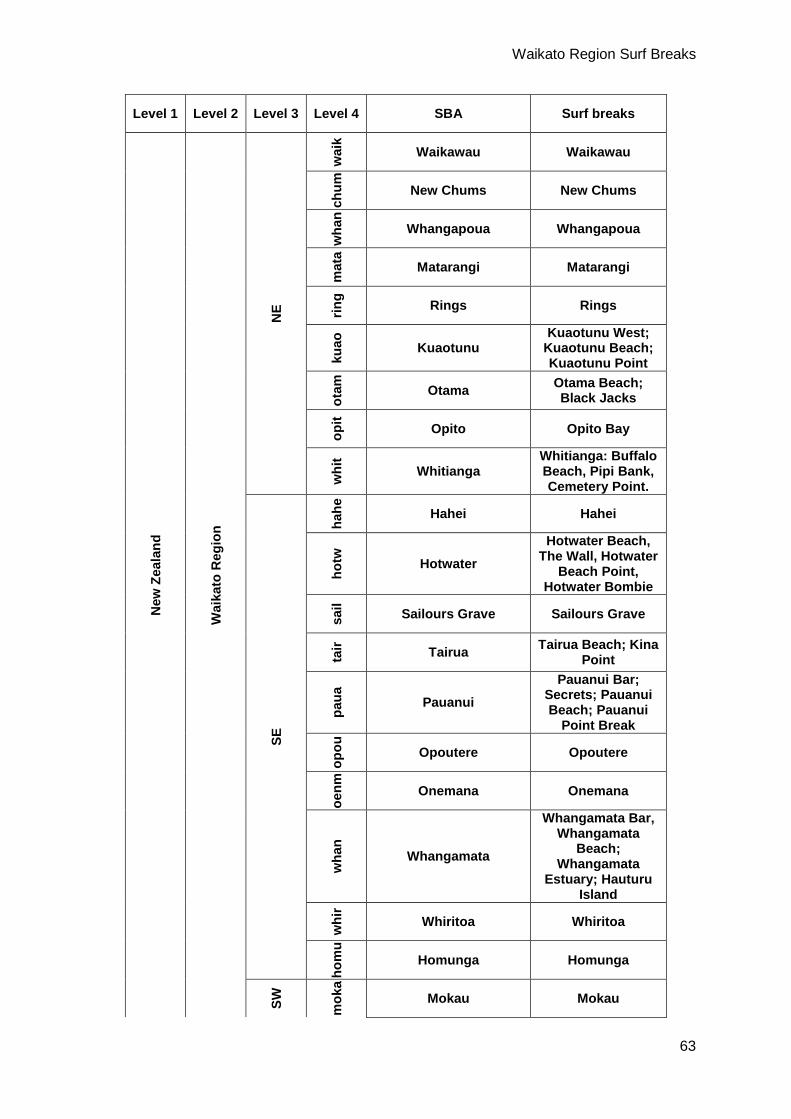
Waikato Region Surf Breaks
63
Level 1 Level 2 Level 3 Level 4 SBA Surf breaks
New
Zea
land
Wai
kato
Reg
ion
NE
wai
k
Waikawau Waikawau
chum
New Chums New Chums
wha
n
Whangapoua Whangapoua
mat
a
Matarangi Matarangi
ring Rings Rings
kuao
Kuaotunu
Kuaotunu West; Kuaotunu Beach; Kuaotunu Point
otam
Otama Otama Beach; Black Jacks
opit Opito Opito Bay
whi
t
Whitianga Whitianga: Buffalo Beach, Pipi Bank, Cemetery Point.
SE
hahe
Hahei Hahei
hotw
Hotwater Hotwater Beach,
The Wall, Hotwater Beach Point,
Hotwater Bombie
sail Sailours Grave Sailours Grave
tair Tairua Tairua Beach; Kina
Point
paua
Pauanui Pauanui Bar;
Secrets; Pauanui Beach; Pauanui
Point Break
opou
Opoutere Opoutere
oenm
Onemana Onemana
wha
n
Whangamata
Whangamata Bar, Whangamata
Beach; Whangamata
Estuary; Hauturu Island
whi
r
Whiritoa Whiritoa
hom
u
Homunga Homunga
SW
mok
a
Mokau Mokau
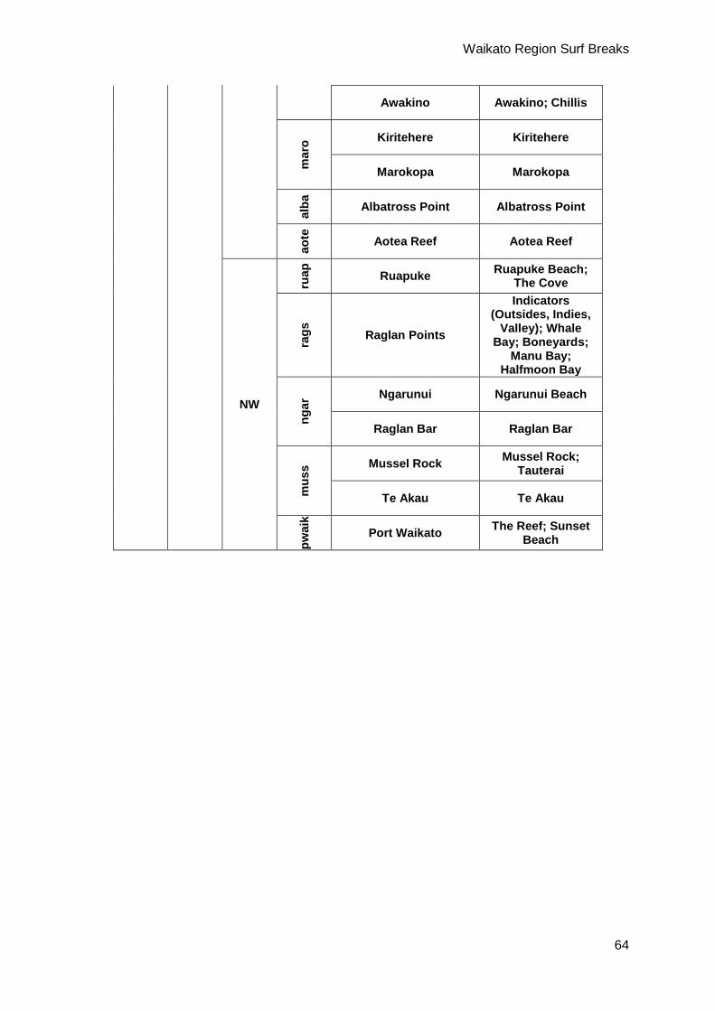
Waikato Region Surf Breaks
64
Awakino Awakino; Chillis
mar
o Kiritehere Kiritehere
Marokopa Marokopa
alba
Albatross Point Albatross Point
aote
Aotea Reef Aotea Reef
NW
ruap
Ruapuke Ruapuke Beach; The Cove
rags
Raglan Points
Indicators (Outsides, Indies,
Valley); Whale Bay; Boneyards;
Manu Bay; Halfmoon Bay
ngar
Ngarunui Ngarunui Beach
Raglan Bar Raglan Bar
mus
s Mussel Rock Mussel Rock; Tauterai
Te Akau Te Akau
pwai
k
Port Waikato The Reef; Sunset Beach
Top Related
Copyright © 2022 FDOKUMEN

