


Bahasa
Halaman
Hukum

Across Space and Time
Papers from the 41st Conference on Computer Applications and Quantitative
Methods in ArchaeologyPerth, 25-28 March 2013
Edited byArianna Traviglia
AMSTERDAM UNIVERSITY PRESS
Cover design: Ian Kirkpatrick
Cover image: Wanmanna archaeological site and computer renderings of reconstructed 3D surfaces and rock art. Original images copyright: CRAR+M (Centre for Rock Art Research + Management: The University of Western Australia). Images courtesy of Paul Bourke, iVEC@UWA (The University of Western Australia). Images reproduced with permission from Niyarpirli traditional custodians, Newman.
Lay-out: IzaRomanowska
Amsterdam University Press English-language titles are distributed in the US and Canada by the University of Chicago Press.
ISBN 9789089647153 (hardback)
e-ISBN 9789048524433 (pdf)
NUR 682
© Computer Applications and Quantitative Methods in Archaeology (CAA) / Amsterdam University Press, Amsterdam 2015
All rights reserved. Without limiting the rights under copyright reserved above, no part of this book may be reproduced, stored in or introduced into a retrieval system, or transmitted, in any form or by any means (electronic, mechanical, photocopying, recording or otherwise) without the written permission of both the copyright owner and the author of the book.
Every effort has been made to obtain permission to use all copyrighted illustrations reproduced in this book. Nonetheless, whosoever believes to have rights to this material is advised to contact the publisher.
This book is published in the CAA series Computer Applications and Quantitative
Methods in Archaeology.
Table of Contents9 Preface
15 Across Space and Time Arianna Traviglia
23 DATA ACQUISITION25 Remote Sensing in Maritime Archaeology, from the Slide Rule to the Supercomputer* Jeremy N. Green
36 Remote Sensing (Short and Long Range)
36 The Story Beneath the Canopy: an Airborne Lidar Survey Over Angkor, Phnom Kulen and Koh Ker, Northwestern Cambodia Damian Evans, Kasper Hanus, Roland Fletcher
45 GeOBIA Approaches to Remote Sensing of Fossil Landscapes: Two Case Studies from Northern Italy Armando De Guio, Luigi Magnini and Cinzia Bettineschi
54 Palmyra Revisited from Space – High-Resolution Satellite Prospection of a UNESCO World Heritage Site Roland Linck, Jörg W. E. Fassbinder, Stefan Buckreuss
64 ClassificationofGeophysicalDataofAngkor,CambodiaanditsPotentialasanOnline Source Till F. Sonnemann
70 Field and Laboratory Data Recording
70 The Accuracy of the Field Survey Results and its Implications in the Correct Understanding of Past and Present Practices Luis Antonio Sevillano Perea and Victorino Mayoral Herrera
80 ArbitraryOfflineDataCaptureonAllofYourAndroids:TheFAIMSMobilePlatform Adela Sobotkova, Brian Ballsun-Stanton, Shawn Ross, Penny Crook
89 Creating a Paperless Recording System for Pilbara Rock Art StaffordSmith,JoMcDonald,JaneBalme,GlenMacLaren,AlistairPaterson
97 Beyond Tablet Computers as a Tool for Data Collection: Three Seasons of Processing and Curating Digital Data in a Paperless World John Wallrodt, Kevin Dicus, Leigh Lieberman, Gregory Tucker
104 Applying Low Budget Equipment and Open Source Software for High Resolution Documentation of Archaeological Stratigraphy and Features Undine Lieberwirth, Bernhard Fritsch, Markus Metz, Markus Neteler, Kerstin Kühnle
120 Old Problems and New Challenges in Archaeological Sites Data Management. The REVEAL Experience at Ammaia (Portugal) Cristina Corsi, Eben Gay, Eleftheria Paliou, Donald Sanders
129 The Parnassus Project: Archaeology and Engineering Collaboration for 3D Data Collection and Analysis Dina D’Ayala, Penny Copeland, Yasemin Didem Aktas, Graeme Earl, Aykut Erkal, James Miles, Elizabeth Richley, Victoria Stephenson, Kris Strutt
144 Photogrammetry and RTI Survey of Hoa Hakananai’a Easter Island Statue James Miles, Mike Pitts, Hembo Pagi, Graeme Earl
156 Some Methodological Considerations and Suggestions for Good Practice in Diagnosticsand Visualizations of Complex Archaeological Sites: the Experience of the Radio-Past Project Frank Vermeulen, Cristina Corsi
167 DATAANALYSISANDMANAGEMENT169 Reflections Upon 30+ Years of Computing and Field Archaeology in the ValeyofPickering,NorthYorkshireUK.* Dominic Powlesland
192 Computational Modelling and GIS
192 Competition and Culture Change in Prehistoric Socio-Environmental Systems Carolin Vegvari, Robert A. Foley
203 Agent-based Modelling and Archaeological Hypothesis Testing: the Case Study of the European Lower Palaeolithic Iza Romanowska
215 Sailing the Simulated Seas: a New Simulation for Evaluating Prehistoric Seafaring ⊗ Benjamin Davies, Simon H. Bickler
224 Agricultural Territories and GIS Modelling: the Long-Term Case Study of Menorca Monica De Cet, Rainer Duttmann, Vicente Lull, Rafael Micó, Johannes Müller, Cristina Rihuete Herrada, Roberto Risch, Philip Verhagen
239 Systemic Approach and Spatial Organization: from the City to Networks of Cities Xavier Rodier, Lahouari Kaddouri, Pierre Garmy
249 Detection of Spatio-Morphological Structures 0n the Basis of Archaeological Data with Mathematical Morphology and Variogaphy. Application to Syrian Archaeological Sites Johanna Fusco
261 Least Cost Path Analysis for Predicting Glacial Archaeological Site Potential in Central Europe Stephanie R. Rogers, Claude Collet, Ralph Lugon
276 Spatial Statistic Analysis of Dating Using Pottery: an Aid to the Characterization of Cultural Areas in West Central France Lise Bellanger, Philippe Husi, Yassine Laghzali
283 Scale Dependent Patterns in South-Eastern Norway Mieko Matsumoto, Espen Uleberg
289 Estimation of Archaeological Potential with a Page Rank Based Predictive Model: the Urban Area of Pisa Nevio Dubbini, Gabriele Gattiglia
298 Kolmogorov-Smirnov Statistics in the Context of Centuriation John William Michael Peterson
303 Data Management and Analysis
303 Integration of CIDOC CRM with OGC Standards to Model Spatial Information Gerald Hiebel, Martin Doerr, Øyvind Eide
311 Reality Bites: Reviewing a Decade of Online Collaboration Susan Hamilton, Peter McKeague
319 An Empirical Approach to the Analysis of Archaeological Discourse Patricia Martín-Rodilla
326 Expressing Temporal and Subjective Information about Archaeological Entities Cesar Gonzalez-Perez, Patricia Martín-Rodilla, Rebeca Blanco-Rotea
336 FromdBaseIII+totheSemanticWeb:Twenty-FiveYearsoftheCoin Hoards of the
Roman Republic Database Ethan Gruber, Kris Lockyear
347 Higeomes: Distributed Geodatabases in an Archaeological Joint Research Project Frank Boochs, Kai-Christian Bruhn, Christophe Cruz, Ashish Karmacharya, Tobias Kohr
358 The Archaeological Resource Cataloging System (ARCS): A Better Way of Working with Digital Archives Jon M. Frey, Timothy E. Gregory, Lita Tzortzopoulou-Gregory 365 DATA DISSEMINATION
367 Reimagining Archaeological Publication for the 21st Century * Eric C. Kansa
379 3D Modelling and Visualisation
379 Playing Angkor: Exploring the Historical and Archaeological Themes of the Khmer Empire through Game Engine Technologies Tom Chandler
386 The Virtual Archaeology Project - Towards an Interactive Multi-scalar 3D Visualisation in Computer Game Engines Arian Goren, Kay Kohlmeyer, Thomas Bremer, Arie Kai-Browne, Wiebke Bebermeier, Dennis Öztürk, Stefan Öztürk, Tobias Müller
401 A Roman Street at the Time of Constantine: Interactive Visit with Access to Ancient Source Materials Philippe Fleury, Sophie Madeleine, Nicolas Lefèvre
408 Fortress City Saarlouis: Development of an Interactive 3D City Model Using Web Technologies Kristian Sons, Georg Demme, Wolfgang Herget, Philipp Slusallek
415 An Interactive Virtual Roaming System for Beijing Hutong Guoguang Du, Zhongke Wu, Mingquan Zhou, Kang Wang, Chongbin Xu, Ziyang Li, Pengfei Xu, Dongcan Jiang and Xingce Wang
423 A Documentation System for Digital Reconstructions with References to the Mausoleum of the Tang-Dynasty at Zhaoling, in Shaanxi Province, China Mieke Pfarr-Harfst
430 3D Modelling Technologies in Humanities. A Literature-Based Survey about Reconstruction and Visualisation of Historic Objects Sander Münster, Thomas Köhler, Stephan Hoppe
442 A 3D Assessment Tool for Precise Recording of Ceramic Fragments Using Image Processing and Computational Geometry Tools Fernando Zvietcovich, Benjamin Castaneda, Luis Jaime Castillo, Julio Saldana
453 Eigen Paicas: A 3D Reconstruction of Entire Vessels Using Information of a Single Fragment and a Database Fernando Zvietcovich, Benjamin Castaneda, Luis Jaime Castillo, Julio Saldana
463 Towards the Automatic Classification of Pottery Sherds: Two Complementary Approaches Chiara Piccoli, Prashant Aparajeya, Georgios Th. Papadopoulos, John Bintliff, Frederic Fol Leymarie, Philip Bes, Mark van der Enden, Jeroen Poblome, Petros Daras
475 Shape and Technological Organisation of Lithic Solutrean Points from Iberia: a Computational Approach for Exploring the Diversity of Shapes Isabell Schmidt, Vincent Mom
482 Cultural Heritage Management and Interpretation
482 Is the use of GIS in Cultural Heritage Outdated? Claire Reeler
488 The End Game: As Scotland’s Historic Land-Use Assessment Project Reaches Completion What Have We Learned? Kirsty Millican and Mike Middleton
494 A 21st Century Record: Maintaining a Modern Monuments Record Susan Hamilton
501 Preserving Lost Industrial Heritage: Newcastle Australia Tessa Morrison, Helen Giggins, Nicholas Foulcher
508 Uncovering the Missing Routes: an Algorithmic Study on the Illicit Antiquities Trade Network Christos Tsirogiannis, Constantinos Tsirogiannis
*: Keynote Address⊗: Nick Ryan Award
475
1. Introduction
The study of archaeological objects relies at its very base (and though at any higher level of inference) on criteria and variables chosen to systematise and categorise the record. Typologies have frequently been used in Paleolithic research on stone tools (Bordes 1961; 1967; Laplace 1962; 1972; Sonneville-Bordes and Perrot 1954). Notwithstanding their success, they were frequently questioned and discussed (e.g. Semonov 1970). Two methodological problems became apparent almost from their initial introduction into alaeolithic research rstly the inconsistent selection o de ning variables and secondly their vulnerability to subjectivity during analysis. These aspects still play an important role in current discussions (see for example Aubry et al. 2008 and contributions therein; Schmidt and Mom 2012; Shott 2003) and shall be addressed in the following by two case studies conducted on lithic tools deriving from the Solutrean technocomplex of the Iberian Peninsula.
Corresponding author: [email protected]
2. Solutrean Points and Typological Classification
The Solutrean technocomplex occurs in south-western France and Iberia and lasts from about 25 to 19 ky cal BP (calibrated before present). It was originally de ned by the presence o invasively shaped artefacts, summarised as ‘Solutrean points’, which were produced using pressure retouch or soft-hammer direct percussion to shape one or both surfaces. Being distinct from artefacts occurring in the earlier (Gravettian) and subsequent (Badegoulian, Magdalenian) technocomplexes,
olutrean points ere used as inde ossils to de ne and internally subdivide the cultural succession of the Solutrean (Smith 1966). Spatially and temporally restricted occurrences of several Solutrean point types are recorded during the Upper Solutrean (Banks 2009; Jordá Cerdá 1955; Soler 1986; Straus 1983; Zilhao 1997).
Some of these well-established point types are of similar or equal shape, but are conventionally
Shape and Technological Organisation of Lithic Solutrean Points from Iberia: a Computational Approach for Exploring the Diversity of Shapes
Isabell SchmidtUniversity of Cologne and Neanderthal Museum, Germany
Vincent MomDigital Preservation Projects (DPP) Foundation, The Netherlands
Abstract:This paper presents results of a shape analysis conducted on lithic Solutrean points from the Iberian Peninsula. By using SECANTO, a computer application especially designed for this purpose, the variability of shapes between and within selected Solutrean point types is explored and discussed. Shape has always been considered an important variable in the analysis of prehistoric lithic Solutrean points, namely in typologicalapproaches. o e er, esides eingrarelyo jecti edand uanti a lymeasured,littleefforthas eenmadetounderstandinterrelation et eenmorphologyandtechni uesappliedduringproductionprocesses,ortheeffectso use li eonthearte acts shape.Thestudyin estigatestheseinterrelationsanddemonstratesthepotentialo ano jecti edcomputationalapproacho shapeanalysis.Theanalysiscanbe used to identify and explore methodological problems in existing typologies as well as to set up new models on shape variability in lithic tools.
Keywords:Computer Applications, Shape Analysis, Solutrean Points, Typologies, Lithic Technology
Across Space and Time. Papers from the 41st Conference on Computer Applications and Quantitative Methods in Archaeology. Perth, 25-28 March 2013
476
distinguished because o different technological strategies applied during production. In the following case studies, we concentrate on these speci c types. hey directly allo investigating relations between shape and technological organisation of tool production and use, as well as spatial distribution. Morphometric studies often ignore effects o technological choices during production and use-life of tools, but we argue that this interplay must be considered a key concern in morphometric analysis in general (Schmidt and Mom 2012). Morphometric studies which do not consider the processes of production, function, and use will hardly be able to pose and answer relevant questions to the prehistoric records.
3. Materials and Methods
3.1 Studied material
Data presented in this study were obtained within the framework of a techno-functional analysis of almost 1500 Solutrean points – including preforms and fragments – deriving from 63 Spanish and Portuguese sites. The sample comprises about ell preserved and nearly nished specimens, attributed to Upper Solutrean contexts. Out of this database, four point types were selected for the present study. Classically they are referred to as unifacial points, Laurel Leaf points, ‘Franco-Cantabrian shouldered points’ and ‘Mediterranean’ shouldered points. In total, the subsample comprises 231 specimens.
The common distinction between ‘unifacial points’ and bifacial ‘Laurel Leaf’ points (cf. Sonneville-Bordes and Perrot 1954) proved to be of chronological signi cance or the Early to iddle Solutrean context in France and Iberia (Smith 1966;
Zilhao 1997). However, within the Iberian Upper Solutrean context, this technological dichotomy already proved to be irrelevant for several point types e.g. tanged and inged points iffagom 2006; concave based points, Schmidt 2013), but remained uncontested so far in the case of leaf-shaped points.
Shouldered points from the Iberian Solutrean are generally distinguished into two types, the Franco-Cantabrian and the Mediterranean shouldered points (Fortea Pérez and Jordá Cerdá 1976; Jordá Cerdá 1955), which, as the names suggest, did show distinct spatial distributions (see below). To avoid these geographical names, they will be referred to as shaped shouldered points (‘Franco-cantabrian shouldered points’) and abrupt retouched shouldered points (‘Mediterranean shouldered points’).
3.2 Comparing shapes using SECANTO
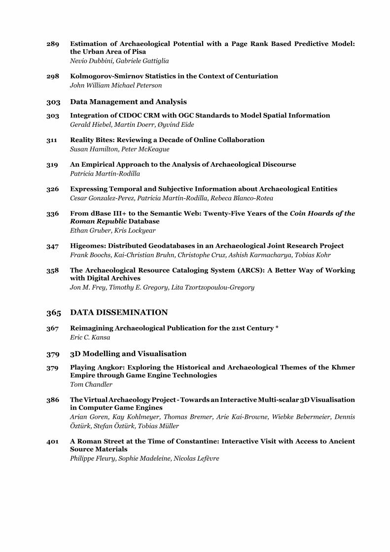
The use of computer programs improves ob ectivity e ciency and reproducibility in the area of shape analysis considerably. We used the computer program E om Schmidt and Mom 2012) to objectify and quantify the differences in shape bet een each analysed specimen. Fig. 1 shows how the ‘shape distance‘ between two points is measured.
The two points are scaled along the vertical a is to e ual height. ubse uently the differences (distances) between the outer boundaries of the two projected shapes are measured. Both the left side and the right side of the shapes contribute 150 values. he differences are s uared and summed after which the square root of the sum is taken. The value o the resulting uanti er is a measure or
Figure 1. Comparing the shape of two Solutrean points: a. measuring the differences (tanged and winged points) and b. finding the lowest distance value (shouldered points).
Shape and Technological Organisation of Lithic Isabell Schmidt and Vincent Mom
477
the difference in shape bet een the t o points c . Schmidt and Mom 2012).
Repeating this calculation for all pairs of points in the data set, results in a symmetric distance matrix with values of zeros along the diagonal axis. This distance matrix is the basis for subsequent statistical analyses of the data set.
3.3 Explorative statistics
ifferent statistical methods can be used or the exploratory analysis of the distance matrix. For our purpose, we use the Principal Coordinate Analysis (PCoA), also known as metric multidimensional scaling (MDS). The calculations were done with the free statistical package PAST (Hammer, Harper and Ryan 2001).
The PCoA positions the objects within a space o reduced dimensionality based on the E distance values. The eigenvalues (“importance of a given dimension in accounting for variation in inter-point distances”, Shennan 2004, 347) and percentages (“percentage of the inter-point distance in the data accounted for by that dimension”, ibid.) are provided for the 1st and 2nd principal coordinate. For interpretation of the two-dimensional scatter plot, it is necessary to re-examine the structuring factors of the distribution, as calculation in this case starts from a single distance value, not from several variables de ning each specimen. o do so the distribution has to be checked against morphological characteristics of the individual points.
4. Case Studies
To test and evaluate the exploratory potential o shape analysis using E e per ormed
two case-studies on lithic Solutrean points. These analyses demonstrate the ability and potential that lies in an ob ecti ed computational approach. t enables a working hypothesis about the reasons for different ranges and patterns o variability in shape.
4.1 First case study: shapes and technological strategies
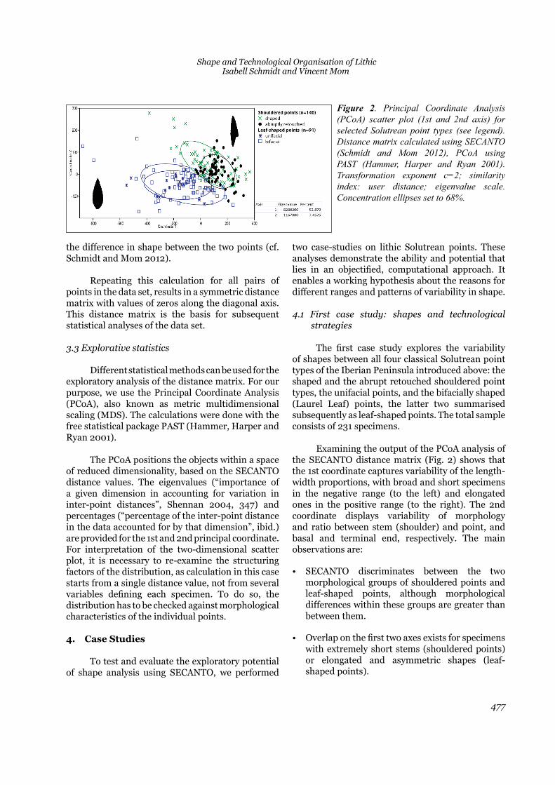
he rst case study e plores the variability of shapes between all four classical Solutrean point types of the Iberian Peninsula introduced above: the shaped and the abrupt retouched shouldered point types, the unifacial points, and the bifacially shaped (Laurel Leaf) points, the latter two summarised subsequently as leaf-shaped points. The total sample consists of 231 specimens.
E amining the output o the o analysis o the E distance matri ig. sho s that the 1st coordinate captures variability of the length-width proportions, with broad and short specimens in the negative range (to the left) and elongated ones in the positive range (to the right). The 2nd coordinate displays variability of morphology and ratio between stem (shoulder) and point, and basal and terminal end, respectively. The main observations are:
• E discriminates bet een the t o morphological groups of shouldered points and leaf-shaped points, although morphological differences ithin these groups are greater than between them.
• verlap on the rst t o a es e ists or specimens with extremely short stems (shouldered points) or elongated and asymmetric shapes (leaf-shaped points).
Figure 2. Principal Coordinate Analysis (PCoA) scatter plot (1st and 2nd axis) for selected Solutrean point types (see legend). Distance matrix calculated using SECANTO (Schmidt and Mom 2012), PCoA using PAST (Hammer, Harper and Ryan 2001). Transformation exponent c=2; similarity index: user distance; eigenvalue scale. Concentration ellipses set to 68%.
Across Space and Time. Papers from the 41st Conference on Computer Applications and Quantitative Methods in Archaeology. Perth, 25-28 March 2013
478
• ased on shape alone no differentiation can be made between the unifacial points and Laurel Leaf points.
• ased on shape alone no differentiation can be made between the two technologically distinct types of shouldered points (shaped and abruptly retouched).
• difference in morphological variation e ists between shouldered and leaf-shaped points: the latter cover almost the same variability of shapes, while there is a distinct pattern among shouldered points.
• For leaf-shaped points, the results suggest that the distinction between unifacial points and Laurel Leaf points – which involves distinct technological strategies of blank production and modi cation has little effect on the nal shape in the Iberian Upper Solutrean context. It also indicates that possible resharpening processes similarly affected the morphology o both types, although short and broad specimen
ith short terminal ends most likely affected by resharpening) tend to be bifacially shaped points (Fig. 2, upper left area). Our working hypothesis based on the E analysis is that the two technological strategies were applied interchangeably to obtain identical morphological tools.
Contrarily, abrupt retouched and shaped shouldered points show distinct patterns: the
spectrum o shapes is much more de ned among abrupt retouched than among shaped shouldered points (Fig. 2). The former are in general more elongated and thin, with a tendency towards specimen with very short stems (shoulders) compared to the terminal (pointed) part. The latter show a greater heterogeneity which includes a number of points with very short pointed ends in relation to the size of their stems. Two hypotheses can be proposed based on the observations made on shouldered points. Firstly, technological strategies chosen during production do have an in uence on the extent of shape variability of the tools. Secondly, shaped shouldered points were probably more intensely resharpened than abrupt retouched ones.
However, other than in leaf-shaped points, the two technological types show regionally distinct distributions across the Iberian Peninsula. This leads us to the second case study that looks at the geographical variability of their shapes.
4.2 Second case study: shape, technology, and geographical distribution
For shouldered points, we would like to test hether the differences in shape variability represent geographical phenomena related to the technological strategy used during production.
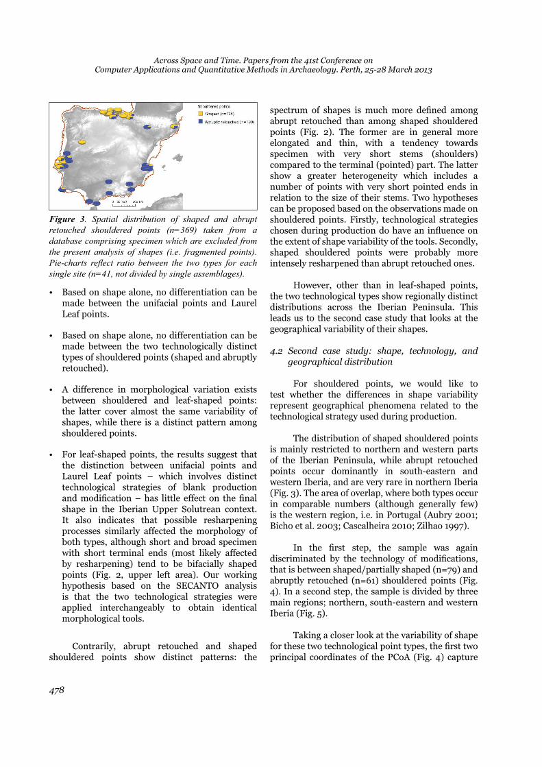
The distribution of shaped shouldered points is mainly restricted to northern and western parts of the Iberian Peninsula, while abrupt retouched points occur dominantly in south-eastern and western Iberia, and are very rare in northern Iberia (Fig. 3). The area of overlap, where both types occur in comparable numbers (although generally few) is the western region, i.e. in Portugal (Aubry 2001; Bicho et al. 2003; Cascalheira 2010; Zilhao 1997).
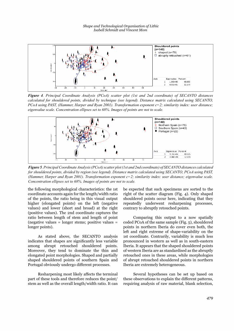
n the rst step the sample as again discriminated by the technology o modi cations that is between shaped/partially shaped (n=79) and abruptly retouched (n=61) shouldered points (Fig. 4). In a second step, the sample is divided by three main regions; northern, south-eastern and western Iberia (Fig. 5).
Taking a closer look at the variability of shape or these t o technological point types the rst t o
principal coordinates of the PCoA (Fig. 4) capture
Figure 3. Spatial distribution of shaped and abrupt retouched shouldered points (n=369) taken from a database comprising specimen which are excluded from the present analysis of shapes (i.e. fragmented points). Pie-charts reflect ratio between the two types for each single site (n=41, not divided by single assemblages).
Shape and Technological Organisation of Lithic Isabell Schmidt and Vincent Mom
479
the following morphological characteristics: the 1st coordinate accounts again for the length/width ratio of the points, the ratio being in this visual output higher (elongated points) on the left (negative values) and lower (short and broad) at the right (positive values). The 2nd coordinate captures the ratio between length of stem and length of point (negative values = longer stems; positive values = longer points).
s stated above the E analysis indicates that shapes are signi cantly less variable among abrupt retouched shouldered points. Moreover, they tend to dominate the thin and elongated point morphologies. Shaped and partially shaped shouldered points of southern Spain and
ortugal obviously undergo different processes.
esharpening most likely affects the terminal part of these tools and therefore reduces the point/stem as well as the overall length/width ratio. It can
be expected that such specimens are sorted to the right of the scatter diagram (Fig. 4). Only shaped shouldered points occur here, indicating that they repeatedly underwent resharpening processes, contrary to abruptly retouched points.
Comparing this output to a now spatially coded PCoA of the same sample (Fig. 5), shouldered points in northern Iberia do cover even both, the left and right extreme of shape-variability on the 1st coordinate. Contrarily, variability is much less pronounced in western as well as in south-eastern Iberia. It appears that the shaped shouldered points of western Iberia are as standardised as the abruptly retouched ones in these areas, while morphologies of abrupt retouched shouldered points in northern Iberia are extremely heterogeneous.
Several hypotheses can be set up based on these observations to e plain the different patterns requiring analysis of raw material, blank selection,
Figure 5. Principal Coordinate Analysis (PCoA) scatter plot (1st and 2nd coordinate) of SECANTO distances calculated for shouldered points, divided by region (see legend). Distance matrix calculated using SECANTO, PCoA using PAST, (Hammer, Harper and Ryan 2001). Transformation exponent c=2; similarity index: user distance; eigenvalue scale. Concentration ellipses set to 68%. Images of points are not to scale.
Figure 4. Principal Coordinate Analysis (PCoA) scatter plot (1st and 2nd coordinate) of SECANTO distances calculated for shouldered points, divided by technique (see legend). Distance matrix calculated using SECANTO, PCoA using PAST, (Hammer, Harper and Ryan 2001). Transformation exponent c=2; similarity index: user distance; eigenvalue scale. Concentration ellipses set to 68%. Images of points are not to scale.
Across Space and Time. Papers from the 41st Conference on Computer Applications and Quantitative Methods in Archaeology. Perth, 25-28 March 2013
480
point production, and use-life. Variability could emerge rom different availability o good uality ra material in the areas. Technologically, the material suggest that the selection of more standardised blanks during the process of manufacture of shouldered points in western and southern Iberia – be they shaped (west) or abruptly retouched (west and south-eastern) – led to more standardised morphologies. Also, points from northern Iberia underwent resharpening processes more frequently than those in other areas. Such longer use-life cycles could also account for the overall less frequent occurrence of shouldered points in northern Iberian sites.
5. Final Remarks
Our study demonstrates the potential for ob ecti ed computational approaches to the analysis of shapes. It shows that such data can be used to identify and subsequently explore problematic methodological issues in existing typological systems. Moreover, we hope we showed its usefulness as a tool to develop hypothesis on shape variability of lithic points. It stimulates research questions on technological organisation of prehistoric hunter gatherers, and provides insights into regional and temporal variability.
Acknowledgements
We sincerely thank G. Koert for processing images. The work on Solutrean points of I.S. is part of her PhD thesis written at the Institute of Prehistoric
rchaeology niversity o ologne nancially supported by the German National Academic Foundation (Studienstiftung des Deutschen Volkes), the German Research Foundation (DFG) within the
ur ay to Europe and the eandthal Museum, Mettmann, Germany. Many institutions and excavators in Spain and Portugal provided access to collections; we owe our sincere thanks to: Museu Arqueológic Comarcal de Banyoles, Museo Arqueologico de Santander, Arkeologi Museoa Bilbao, Museo Altamira (Santillana del Mar), Centro de custodia y gestión de materiales arqueológicos y paleontológicos de Gipuzkoa (San Sebastian), Museo Nacional de Ciencias Naturales (Madrid), Universidad de Salamanca, Museo Nacional de Arqueologia Lisboa, Universidade do Algarve (Faro), Museo de Cádiz, Universidad de Cádiz,
Museo Arqueologico Almeria, Museu de Prehistória de Valéncia, and Museo Arqueologico de Oviedo.
Bibliography
Aubry, T. 2001. “L’occupation de la basse vallée du Côa pendant le Paléolithique supérieur.” In Les premiers hommes modernes de la P ninsule ri ue. Actes duCollo ue de la Commission de l SPP ila o ade Foz Côa, 22–24 Octobre 1998), edited by J. Zilhão, T. Aubry, and A. Faustino Carvalho, 253–273. Lisboa: Instituto Português de Arqueologia.
ubry . . . lmeida . . ra o and . iffagom eds. 2008. Space and time: which diachronies, which synchronies, which scales? Typology vs. Technology. Oxford: Archaeopress.
anks . E. . ilh o . d Errico . ageyama . ima and A. Ronchitelli. 2009. “Investigating links between ecology and bi acial tool types in estern Europe during the Last Glacial Maximum.” Journal of Archaeological Science 36:2853–2867.
Bicho, N., M. Stiner, J. Lindly, C. Ferring, and J. Correia 2003. “Preliminary results from the Upper Paleolithic Site of Vale Boi, southwestern Portugal.” Journal of Iberian Archeology 5:51–65.
Bordes, F. 1961. Typologie du Pal olithi ue ancien etmoyen. aris Editions. riginally published as TypologieduPal olithi ueancien etmoyen. Bordeaux: Publications de l’Institute de Préhistoire de l’Université de Bordeaux.
Bordes, F. 1967. “Considérations sur la typologie et les techniques dans le Paléolithique.” Quartär 18:25–55.
Cascalheira, J. M. M. 2010. Tecnologia Líthica Solutrense do Abrigo de Vale Boi (Vale do Bispo). Faro: UNIARQ.
Fortea Pérez, F. J., and F. Jordá Cerdá 1976. “La Cueva de Les Mallaetes y los problemas del Paleolítico superior del Mediterráneo español.” Zephyrus 26-27:129–166.
Hammer, Ø., D. A. T. Harper, and P. D. Ryan. 2001. “PAST: Paleontological Statistics Software Package for Education and ata nalysis. Palaeontologia Electronica 4 (1):37–66. Accessed September 26, 2012. http://palaeo-electronica.org/2001_1/past/issue1_01.htm.

Shape and Technological Organisation of Lithic Isabell Schmidt and Vincent Mom
481
Jordá Cerdá, F. 1955. El Solutrense en España y sus problemas. Oviedo: Servicio de Investigación Arqueológica de la Diputación Provincial de Asturias.
Laplace, G. 1962. “Solutréen et foyers solutréens. Essai de typologie analyti ue sur le ph nom ne de Solutréanisation.” Munibe 14:414–455.
Laplace, G. 1972. “La Typologie analytique et structurale: Base rationnelle d’étude des industries lithiques et osseuses. Banques de données archéologiques.” Collo uesNationaux . aris Editions.
om . . E the E tion alysis ol. In The world is in your eyes. CAA2005. Computer Applications and Quantitative Methods in Archaeology. Proceedings of the 33rd Conference, Tomar, March 2005, edited by A. Figueiredo and Gonçalo Velho, 95–101. Tomar: CAA Portugal.
Schmidt, I. 2013. “The Solutrean Concave Based Points from northern Spain: Analysis of Production, Hafting, Maintenance, and Recycling.” In Pleistocene foragers: Their culture and environment. Festschrift in honour o Gerd Christian eniger,edited by A. Pastoors and B.
uffermann . Mettmann: Neanderthal Museum.
Schmidt, I., and V. Mom 2012. “Computer-aided classi cation o archaeological ob ects methodological issues in comparing shapes of Solutrean points.” In Proceedings of the IV Conference of Jovens em n estiga o Ar ueol gica, ni ersidade do Algar e,
Faro (Portugal) from 11th to 14th May 2011, edited by J. Cascalheira and C. Gonçalves, 39–46. Faro: Núcleo de Arqueologia e Paleoecologia.
Semonov, S. 1970. “The form and functions of the oldest tools. (A reply to Prof. F. Bordes).” Quartär 21:1–20.
Shennan, S. 2004. Quantifying archaeology. Edinburgh University Press.
Shott, M. 2003. “Time as sequence, Type as Ideal: Whole-Object Measurements of Biface Size and Form in Midwestern North America.” In Multiple Approaches to the Study of Bifacial Technologies, edited by M. Soressi and H. Dibble, 251–271. Pennsylvania: Museum of Archaeology and Anthropology.
mith . E. . Le Solutréen en France. Bordeaux: Imprimeries Delmas.
Soler, N. 1986. “Les indústries del Paleolitic Superior en el nord de Catalunya.” PhD diss., Universitat de Barcelona.
Sonneville-Bordes, D., and J. Perrot 1954. “Lexique typologique du Paléolithique supérieur. Outillage lithique: I Grattoirs - II Outils solutréens.” Soci t Pr histori ueFrançaise 51:327–335.
Straus, L. G. 1983. lSolutrense asco Cant rico unaNueva Perspectiva. Altamira: Centro de Investigación y Museo de Altamira.
iffagom . . DelaPierre l homme. ssaisurunePaléoanthropologie Solutréenne. i ge E .
Zilhão, J. 1997. O Paleolítico Superior da Estremadura Portuguesa. isbon Edi es olibri.
Top Related
Copyright © 2022 FDOKUMEN

