


Bahasa
Halaman
Hukum

TS 23 – Planning Urban Space Yaw A. Twumasi, Andrew Manu, Tommy L. Coleman and Albert J. Osei TS23.3 Role of Geo-spatial Information Management as a Decision Support Tool in Land Use Planning: A Case of Ghana Promoting Land Administration and Good Governance 5th FIG Regional Conference Accra, Ghana, March 8-11, 2006
1/10
Role of Geo-spatial Information Management as a Decision Support Tool in Land Use Planning: A Case of Ghana
Yaw A. TWUMASI, Andrew MANU, Tommy L. COLEMAN and Albert OSEI, U.S.A.
Key words: Geo-spatial information management, GIS, Remote Sensing, Land use Planning SUMMARY In the developing countries, lack of data covering most land use and land cover especially in Africa have necessitated the need to develop an information management to cover most of these important land resources. This paper highlights the importance of using geo-spatial information systems as tools to managing natural resources in Ghana. It uses historical data from Landsat Thematic Mapper (TM) and Enhanced Thematic Mapper Plus (ETM+), and topographical data to demonstrate how management could use these data as decision-support tools for natural resources management.
TS 23 – Planning Urban Space Yaw A. Twumasi, Andrew Manu, Tommy L. Coleman and Albert J. Osei TS23.3 Role of Geo-spatial Information Management as a Decision Support Tool in Land Use Planning: A Case of Ghana Promoting Land Administration and Good Governance 5th FIG Regional Conference Accra, Ghana, March 8-11, 2006
2/10
Role of Geo-spatial Information Management as a Decision Support Tool in Land Use Planning: A Case of Ghana
Yaw A. TWUMASI, Andrew MANU, Tommy L. COLEMAN and Albert OSEI, U.S.A.
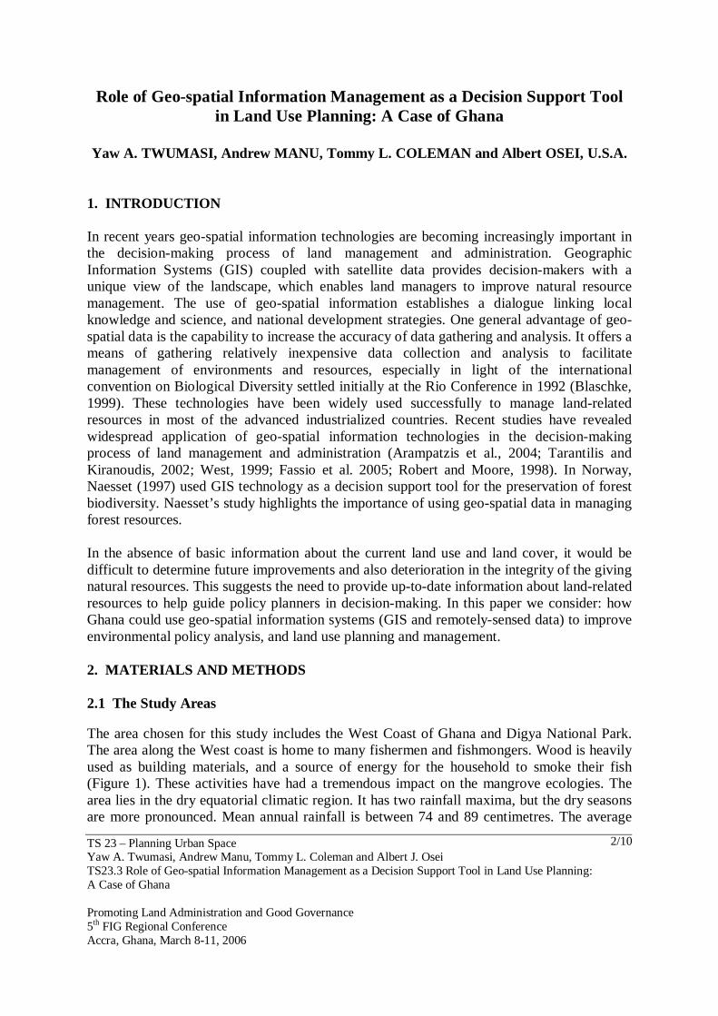
1. INTRODUCTION In recent years geo-spatial information technologies are becoming increasingly important in the decision-making process of land management and administration. Geographic Information Systems (GIS) coupled with satellite data provides decision-makers with a unique view of the landscape, which enables land managers to improve natural resource management. The use of geo-spatial information establishes a dialogue linking local knowledge and science, and national development strategies. One general advantage of geo-spatial data is the capability to increase the accuracy of data gathering and analysis. It offers a means of gathering relatively inexpensive data collection and analysis to facilitate management of environments and resources, especially in light of the international convention on Biological Diversity settled initially at the Rio Conference in 1992 (Blaschke, 1999). These technologies have been widely used successfully to manage land-related resources in most of the advanced industrialized countries. Recent studies have revealed widespread application of geo-spatial information technologies in the decision-making process of land management and administration (Arampatzis et al., 2004; Tarantilis and Kiranoudis, 2002; West, 1999; Fassio et al. 2005; Robert and Moore, 1998). In Norway, Naesset (1997) used GIS technology as a decision support tool for the preservation of forest biodiversity. Naesset’s study highlights the importance of using geo-spatial data in managing forest resources. In the absence of basic information about the current land use and land cover, it would be difficult to determine future improvements and also deterioration in the integrity of the giving natural resources. This suggests the need to provide up-to-date information about land-related resources to help guide policy planners in decision-making. In this paper we consider: how Ghana could use geo-spatial information systems (GIS and remotely-sensed data) to improve environmental policy analysis, and land use planning and management. 2. MATERIALS AND METHODS 2.1 The Study Areas The area chosen for this study includes the West Coast of Ghana and Digya National Park. The area along the West coast is home to many fishermen and fishmongers. Wood is heavily used as building materials, and a source of energy for the household to smoke their fish (Figure 1). These activities have had a tremendous impact on the mangrove ecologies. The area lies in the dry equatorial climatic region. It has two rainfall maxima, but the dry seasons are more pronounced. Mean annual rainfall is between 74 and 89 centimetres. The average
TS 23 – Planning Urban Space Yaw A. Twumasi, Andrew Manu, Tommy L. Coleman and Albert J. Osei TS23.3 Role of Geo-spatial Information Management as a Decision Support Tool in Land Use Planning: A Case of Ghana Promoting Land Administration and Good Governance 5th FIG Regional Conference Accra, Ghana, March 8-11, 2006
3/10
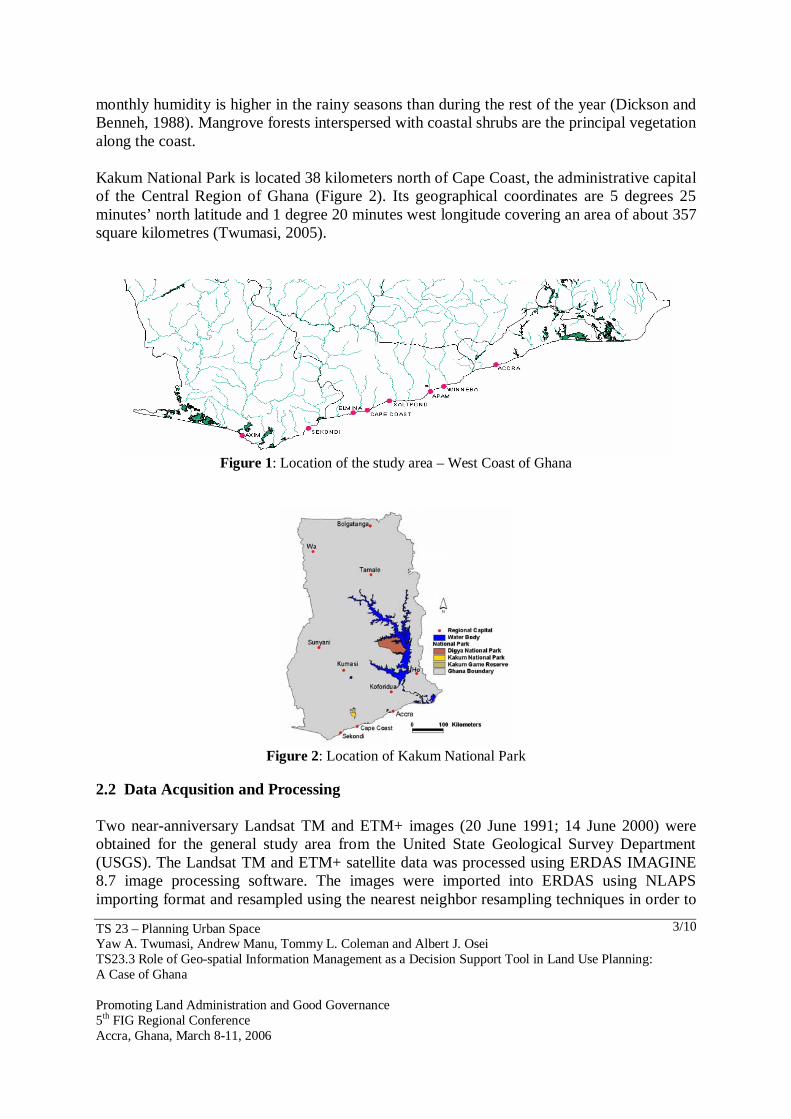
monthly humidity is higher in the rainy seasons than during the rest of the year (Dickson and Benneh, 1988). Mangrove forests interspersed with coastal shrubs are the principal vegetation along the coast. Kakum National Park is located 38 kilometers north of Cape Coast, the administrative capital of the Central Region of Ghana (Figure 2). Its geographical coordinates are 5 degrees 25 minutes’ north latitude and 1 degree 20 minutes west longitude covering an area of about 357 square kilometres (Twumasi, 2005).
Figure 1: Location of the study area – West Coast of Ghana
Figure 2: Location of Kakum National Park
2.2 Data Acqusition and Processing Two near-anniversary Landsat TM and ETM+ images (20 June 1991; 14 June 2000) were obtained for the general study area from the United State Geological Survey Department (USGS). The Landsat TM and ETM+ satellite data was processed using ERDAS IMAGINE 8.7 image processing software. The images were imported into ERDAS using NLAPS importing format and resampled using the nearest neighbor resampling techniques in order to
TS 23 – Planning Urban Space Yaw A. Twumasi, Andrew Manu, Tommy L. Coleman and Albert J. Osei TS23.3 Role of Geo-spatial Information Management as a Decision Support Tool in Land Use Planning: A Case of Ghana Promoting Land Administration and Good Governance 5th FIG Regional Conference Accra, Ghana, March 8-11, 2006
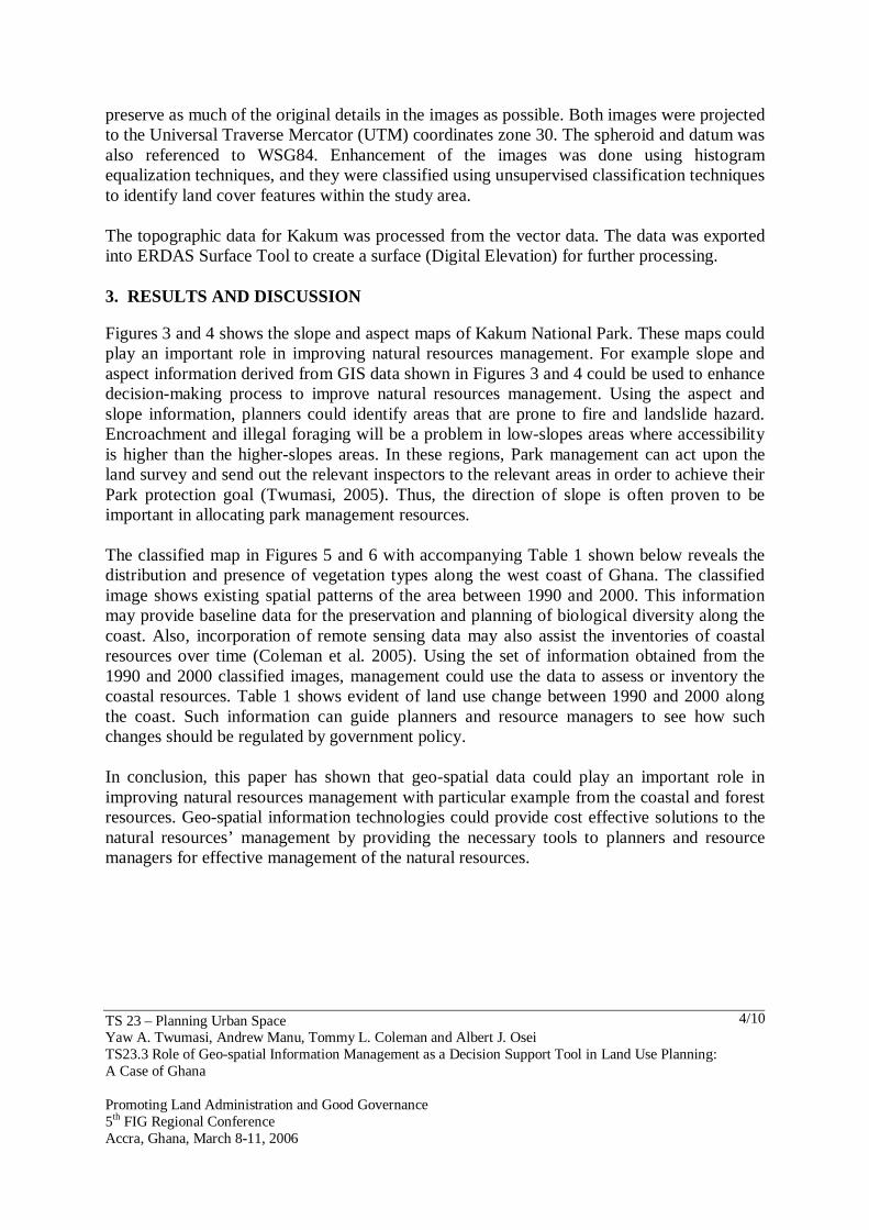
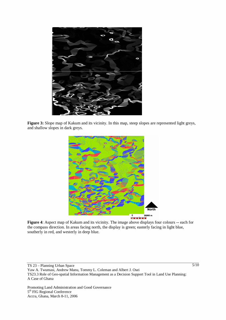
4/10
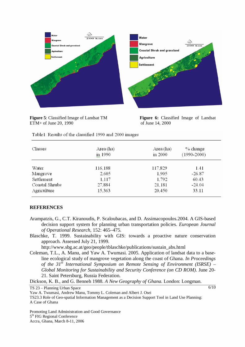
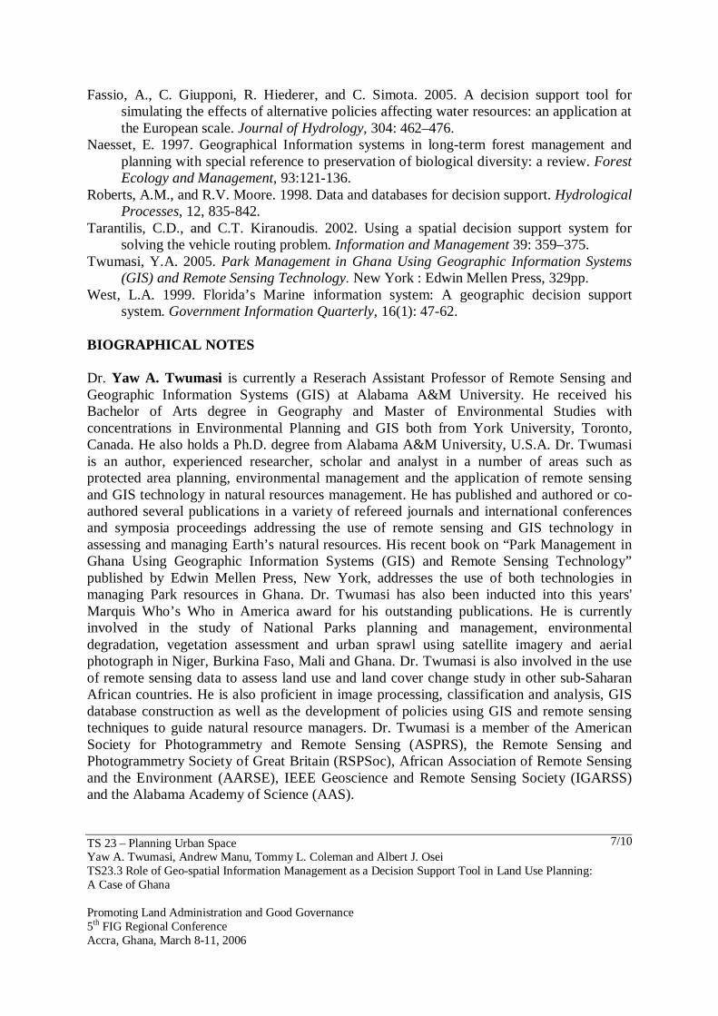
preserve as much of the original details in the images as possible. Both images were projected to the Universal Traverse Mercator (UTM) coordinates zone 30. The spheroid and datum was also referenced to WSG84. Enhancement of the images was done using histogram equalization techniques, and they were classified using unsupervised classification techniques to identify land cover features within the study area. The topographic data for Kakum was processed from the vector data. The data was exported into ERDAS Surface Tool to create a surface (Digital Elevation) for further processing. 3. RESULTS AND DISCUSSION Figures 3 and 4 shows the slope and aspect maps of Kakum National Park. These maps could play an important role in improving natural resources management. For example slope and aspect information derived from GIS data shown in Figures 3 and 4 could be used to enhance decision-making process to improve natural resources management. Using the aspect and slope information, planners could identify areas that are prone to fire and landslide hazard. Encroachment and illegal foraging will be a problem in low-slopes areas where accessibility is higher than the higher-slopes areas. In these regions, Park management can act upon the land survey and send out the relevant inspectors to the relevant areas in order to achieve their Park protection goal (Twumasi, 2005). Thus, the direction of slope is often proven to be important in allocating park management resources. The classified map in Figures 5 and 6 with accompanying Table 1 shown below reveals the distribution and presence of vegetation types along the west coast of Ghana. The classified image shows existing spatial patterns of the area between 1990 and 2000. This information may provide baseline data for the preservation and planning of biological diversity along the coast. Also, incorporation of remote sensing data may also assist the inventories of coastal resources over time (Coleman et al. 2005). Using the set of information obtained from the 1990 and 2000 classified images, management could use the data to assess or inventory the coastal resources. Table 1 shows evident of land use change between 1990 and 2000 along the coast. Such information can guide planners and resource managers to see how such changes should be regulated by government policy. In conclusion, this paper has shown that geo-spatial data could play an important role in improving natural resources management with particular example from the coastal and forest resources. Geo-spatial information technologies could provide cost effective solutions to the natural resources’ management by providing the necessary tools to planners and resource managers for effective management of the natural resources.
TS 23 – Planning Urban Space Yaw A. Twumasi, Andrew Manu, Tommy L. Coleman and Albert J. Osei TS23.3 Role of Geo-spatial Information Management as a Decision Support Tool in Land Use Planning: A Case of Ghana Promoting Land Administration and Good Governance 5th FIG Regional Conference Accra, Ghana, March 8-11, 2006
5/10
Figure 3: Slope map of Kakum and its vicinity. In this map, steep slopes are represented light greys, and shallow slopes in dark greys.
Figure 4: Aspect map of Kakum and its vicinity. The image above displays four colours -- each for the compass direction. In areas facing north, the display is green; easterly facing in light blue, southerly in red, and westerly in deep blue.
TS 23 – Planning Urban Space Yaw A. Twumasi, Andrew Manu, Tommy L. Coleman and Albert J. Osei TS23.3 Role of Geo-spatial Information Management as a Decision Support Tool in Land Use Planning: A Case of Ghana Promoting Land Administration and Good Governance 5th FIG Regional Conference Accra, Ghana, March 8-11, 2006
6/10
Figure 5: Classified Image of Landsat TM Figure 6: Classified Image of Landsat ETM+ of June 20, 1990 of June 14, 2000
REFERENCES Arampatzis, G., C.T. Kiranoudis, P. Scaloubacas, and D. Assimacopoulos.2004. A GIS-based
decision support system for planning urban transportation policies. European Journal of Operational Research, 152: 465–475.
Blaschke, T. 1999. Sustainability with GIS: towards a proactive nature conservation approach. Assessed July 21, 1999.
http://www.sbg.ac.at/geo/people/tblaschke/publications/sustain_abs.html Coleman, T.L., A. Manu, and Yaw A. Twumasi. 2005. Application of landsat data to a base-
line ecological study of mangrove vegetation along the coast of Ghana. In Proceedings of the 31st International Symposium on Remote Sensing of Environment (ISRSE) – Global Monitoring for Sustainability and Security Conference (on CD ROM). June 20-21. Saint Petersburg, Russia Federation.
Dickson, K. B., and G. Benneh 1988. A New Geography of Ghana. London: Longman.
TS 23 – Planning Urban Space Yaw A. Twumasi, Andrew Manu, Tommy L. Coleman and Albert J. Osei TS23.3 Role of Geo-spatial Information Management as a Decision Support Tool in Land Use Planning: A Case of Ghana Promoting Land Administration and Good Governance 5th FIG Regional Conference Accra, Ghana, March 8-11, 2006
7/10
Fassio, A., C. Giupponi, R. Hiederer, and C. Simota. 2005. A decision support tool for simulating the effects of alternative policies affecting water resources: an application at the European scale. Journal of Hydrology, 304: 462–476.
Naesset, E. 1997. Geographical Information systems in long-term forest management and planning with special reference to preservation of biological diversity: a review. Forest Ecology and Management, 93:121-136.
Roberts, A.M., and R.V. Moore. 1998. Data and databases for decision support. Hydrological Processes, 12, 835-842.
Tarantilis, C.D., and C.T. Kiranoudis. 2002. Using a spatial decision support system for solving the vehicle routing problem. Information and Management 39: 359–375.
Twumasi, Y.A. 2005. Park Management in Ghana Using Geographic Information Systems (GIS) and Remote Sensing Technology. New York : Edwin Mellen Press, 329pp.
West, L.A. 1999. Florida’s Marine information system: A geographic decision support system. Government Information Quarterly, 16(1): 47-62.
BIOGRAPHICAL NOTES Dr. Yaw A. Twumasi is currently a Reserach Assistant Professor of Remote Sensing and Geographic Information Systems (GIS) at Alabama A&M University. He received his Bachelor of Arts degree in Geography and Master of Environmental Studies with concentrations in Environmental Planning and GIS both from York University, Toronto, Canada. He also holds a Ph.D. degree from Alabama A&M University, U.S.A. Dr. Twumasi is an author, experienced researcher, scholar and analyst in a number of areas such as protected area planning, environmental management and the application of remote sensing and GIS technology in natural resources management. He has published and authored or co-authored several publications in a variety of refereed journals and international conferences and symposia proceedings addressing the use of remote sensing and GIS technology in assessing and managing Earth’s natural resources. His recent book on “Park Management in Ghana Using Geographic Information Systems (GIS) and Remote Sensing Technology” published by Edwin Mellen Press, New York, addresses the use of both technologies in managing Park resources in Ghana. Dr. Twumasi has also been inducted into this years' Marquis Who’s Who in America award for his outstanding publications. He is currently involved in the study of National Parks planning and management, environmental degradation, vegetation assessment and urban sprawl using satellite imagery and aerial photograph in Niger, Burkina Faso, Mali and Ghana. Dr. Twumasi is also involved in the use of remote sensing data to assess land use and land cover change study in other sub-Saharan African countries. He is also proficient in image processing, classification and analysis, GIS database construction as well as the development of policies using GIS and remote sensing techniques to guide natural resource managers. Dr. Twumasi is a member of the American Society for Photogrammetry and Remote Sensing (ASPRS), the Remote Sensing and Photogrammetry Society of Great Britain (RSPSoc), African Association of Remote Sensing and the Environment (AARSE), IEEE Geoscience and Remote Sensing Society (IGARSS) and the Alabama Academy of Science (AAS).
TS 23 – Planning Urban Space Yaw A. Twumasi, Andrew Manu, Tommy L. Coleman and Albert J. Osei TS23.3 Role of Geo-spatial Information Management as a Decision Support Tool in Land Use Planning: A Case of Ghana Promoting Land Administration and Good Governance 5th FIG Regional Conference Accra, Ghana, March 8-11, 2006
8/10
Dr. Andrew Manu is an Associate Professor in Soil Science, Remote Sensing and Environmental Pedology at Iowa State University. Dr. Manu received a BS. degree in Soil Science from the University of Ghana. He received his MS. And PhD degrees from Iowa State University. Seven years after graduating from Iowa State University, Dr. Manu served as Research Director on a regional project in West Africa through Texas A&M University and the United States Agency for International Development. His activities included soil resource inventory using remote sensing technologies and the restitution of degraded tropical lands. He joined Alabama A&M University in Huntsville, where he taught courses in soil science and carried out research in the use of passive microwave remote sensing to detect surface soil moisture. Dr. Manu has been with Iowa State University for the past four years where he teaches the applications of digital soil information in agronomy, landscape architecture and horticulture. He has adapted an innovative multimedia technology as a system of instruction and has received several teaching awards and recognition. His research activities include: (1) Use of Digital Elevation Models in Landscape Modeling; (2) Use of statistical models as well as neural networks to model and predict the growth of cities; (3) Impact of urbanization of urban soil quality; and (4) Remote sensing of earth processes. Dr Manu has published over 30 refereed articles in reputable journals and served as Associate Editor for the Journal of Natural Resources and Life Sciences Education from 2002 – 2004. He is a member of the following Associations and Organizations: Gamma Sigma Delta, Phi Beta Delta, Sigma Xi, American Society of Agronomy, Soil Science Society of America, International Society of Soil Science, The Institute of Electrical and Electronics Engineers, Association for International Agriculture and Rural Development; Soil and Water Conservation Society and African Association of Remote Sensing and the Environment. Dr. Manu currently serves as Chair of the International Agriculture Division of the American Society of Agronomy. Dr. Tommy L. Coleman is the Director of the Center for Hydrology, Soil Climatology and Remote Sensing (HSCaRS) at Alabama Agricultural and Mechanical University, Normal, AL. He earned a Bachelor of Science Degree from Fort Valley State College in Agronomy in 1974; a Master of Science Degree from the University of Georgia in Soil Morphology and Classification in 1977; and a Doctor of Philosophy Degree from Iowa State University in Soil Morphology and Genesis in 1980. He acquired additional training in remote sensing and geographic information systems applications from the University of Southern Mississippi and The Ohio State University from 1985 through 1987. Dr. Coleman has been employed at AAMU since 1981 and has earned the rank of Professor of Soil Science and Remote Sensing. He has received several honors for his contributions to the field of soil science and remote sensing and GIS. Some of the awards include the NAFEO Distinguished Leadership Research Achievement Award 1999; elected as a Soil Science Society of America Fellow 1998; elected as an American Society of Agronomy Fellow 1997; the Morrison-Evans Outstanding Researcher Award 1997 given by the 1890 Association of Research Directors, and a three-time recipient of the School of Agricultural and Environmental Sciences Outstanding Researcher Award, 1996, 1995 and 1992. His current duties are to serve as the primary University Administrator who is responsible for the financial management, staffing operations, and evaluation of the HSCaRS Center. His duties
TS 23 – Planning Urban Space Yaw A. Twumasi, Andrew Manu, Tommy L. Coleman and Albert J. Osei TS23.3 Role of Geo-spatial Information Management as a Decision Support Tool in Land Use Planning: A Case of Ghana Promoting Land Administration and Good Governance 5th FIG Regional Conference Accra, Ghana, March 8-11, 2006
9/10
involve working closely with other University Administrators and units to achieve and/or develop a broad-based hydrology and remote sensing research capability at AAMU. The mission of HSCaRS is fourfold: (1) to develop a research program that will foster new science and technology concepts; (2) To expand the nation's base for hydrology and remote sensing research development; (3) To develop mechanisms for increased participation by faculty and students in mainstream research, and (4) to increase the production of under-represented minorities who are U.S. citizens with advance degrees in NASA-related scientific fields. The Center’s main research and technology topics are focused on the development of a multi-frequency approach for studying the Earth's terrestrial ecosystems using remote sensing technology and the applications of remote sensing and GIS technology in soil science and water resource management. Specifically, his work addresses investigations of hydrologic processes, with emphasis on remote sensing measurements and modeling of soil moisture; development of spectral signatures for assessing vegetation health; using GIS to understand spatial variability in the chemical and physical properties of soils; and the development of robust spectral algorithms for analyses of multispectral and hyperspectral data. Dr. Albert J. Osei is an Associate Professor of Physics in the Department of Mathematics, Physics and Computer Sciences at Oakwood College in Huntsville, Alabama. He obtained his BS degree in Physics from the University of Science and Technology in Ghana and his MS and Ph.D. degrees in Physics from Queen’s University (Canada) and Alabama A&M University respectively. During his tenure at Oakwood College, he has taught a range of courses in Physics, Mathematics and Computer Science. Dr. Osei has received several summer research fellowships which have made it possible for him to work with high caliber scientists and engineers in reputable national laboratories in the United States. He has also received grants from federal and private agencies for research and educational purposes. Dr. Osei’s research interests include: (1) Modeling of ecosystems for sustainability (2) Monitoring of urban growth using remote sensing, GIS and spatial metrics (3) Optical methods for monitoring soil moisture (4) Remote sensing of ocean and atmosphere properties and (5) Use of remote sensing and GIS technology in managing natural resources. Dr. Osei has published in refereed journals and made several presentations. He is a member of the Optical Society of America (OSA), The International Society for Optical Engineering (SPIE), Biophysical Society, American Mathematical Association (AMS) and the Alabama Academy of Science (AAS).
TS 23 – Planning Urban Space Yaw A. Twumasi, Andrew Manu, Tommy L. Coleman and Albert J. Osei TS23.3 Role of Geo-spatial Information Management as a Decision Support Tool in Land Use Planning: A Case of Ghana Promoting Land Administration and Good Governance 5th FIG Regional Conference Accra, Ghana, March 8-11, 2006
10/10
CONTACTS Dr. Yaw A. Twumasi Alabama A&M University Center for Hydrology, Soil Climatology, and Remote Sensing Department of Plant and Soil Science P.O. Box 1208 Normal, AL 35762 U.S.A. Tel. + 1 256 372 8021 Fax + 1 256 372 5429 Email: [email protected] Web site: http://saes.aamu.edu/sps/people/faculty/ytwumasi.html
Top Related
Copyright © 2022 FDOKUMEN

