


Bahasa
Halaman
Hukum


TABLE OF CONTENTS Page RECORD OF DECISION ...................................................................................................ROD-1 RESOURCE MANAGEMENT PLAN AMENDMENT .................................................................1 INTRODUCTION ...................................................................................................................1 PURPOSE AND NEED FOR THE PLAN AMENDMENT......................................................1 PLANNI NG AREA .................................................................................................................2 PLANNI NG ISSUES..............................................................................................................2 ALTERNATIVES/ISSUES ELIMINATED FROM DETAILED STUDY ...................................2 PLANNI NG CRITERIA/LEGISLATIVE CONSTRAINTS........................................................3 PLANNI NG PROCESS .........................................................................................................4 RELATED PLANS .................................................................................................................5 MANAGEMENT DECISIONS................................................................................................5 Land & Realty ...............................................................................................................5 Minerals ........................................................................................................................7 Mineral Materials.........................................................................................................14 Alternative Energy.......................................................................................................14 Soils ............................................................................................................................14 Water Resources ........................................................................................................14 Floodplains, Air Quality, Hazardous Materials ............................................................15 Vegetation...................................................................................................................15 Non-Native and Invasive Species ...............................................................................19 Livestock Management ...............................................................................................21 Standards for Public Land Health and Guidelines for Livestock Grazing....................22 Wildlife – Special Status Species................................................................................23 Fire Management........................................................................................................25 Cultural Resources .....................................................................................................26 Paleontology ..............................................................................................................26 Recreation...................................................................................................................26 Off-Highway Vehicles..................................................................................................27 Visual Resources ........................................................................................................30 Special Management Areas........................................................................................30 Environmental Justice.................................................................................................31 BEST MANAGEMENT PRACTICES...................................................................................31 PUBLIC INVOLVEMENT.....................................................................................................31 MANAGEMENT PLAN AMENDMENT IMPLEMENTATION ...............................................32 PLAN EVALUATION ...........................................................................................................32 APPENDICES Appendix 1 Reclamation and Best Management Practices ..............................................AP1-1 Appendix 2 Monitoring and Implementation ......................................................................AP2-1 Appendix 3 Habitat Suitability Criteria for Lesser Prairie-Chicken ....................................AP3-1 Appendix 4 Grazing Allotments within the Planning Area .................................................AP4-1
i
GLOSSARY..........................................................................................................................GL-1 REFERENCES ....................................................................................................................... R-1 INDEX ................................................................................................................................. IN-1
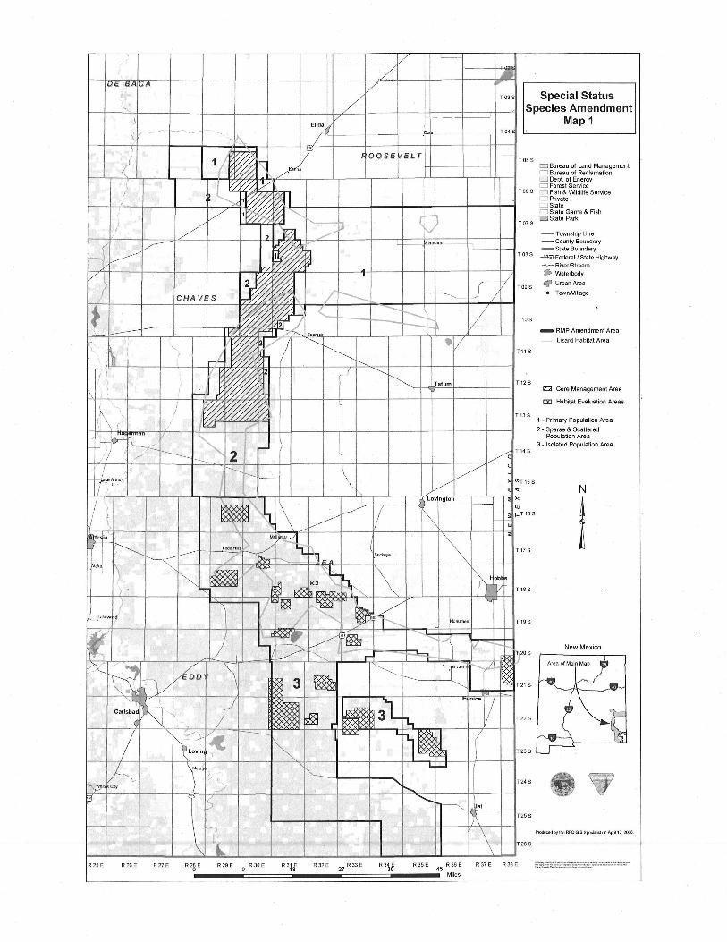
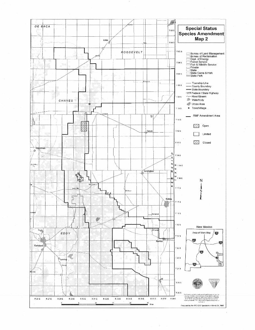
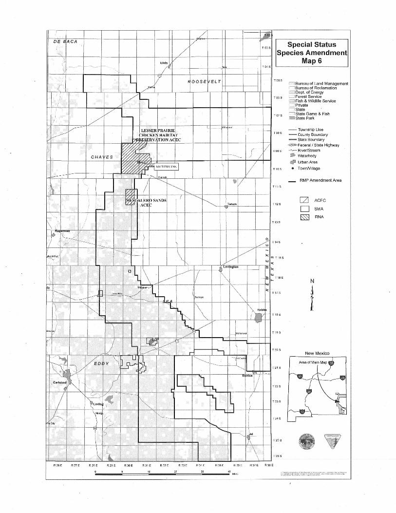
MAPS NOTE: All maps are found in the Map Section located at the back of this document. Map 1 Special Status Species Amendment..............................................................................M-1 Map 2 Special Status Species Amendment..............................................................................M-2 Map 3 Special Status Species Amendment..............................................................................M-3 Map 4 Square Lakes OHV Area ...............................................................................................M-4 Map 5 Leased and Unleased Federal Minerals in the PPA ......................................................M-5 Map 6 Special Status Species Amendment..............................................................................M-6 Map R-1 Preliminary Road Network .........................................................................................M-7 Map U-1 Interstate Utility Corridors...........................................................................................M-8 TABLES 1 Land Ownership in the Planning Area...................................................................................2 2 Acres of Leased and Unleased Federal Minerals .................................................................8 3 Robel Impact Distances ......................................................................................................10 4 Unleased Federal Minerals in the Primary Population Area................................................10 5 Vegetation Management – Grassland Community..............................................................16 6 Vegetation Management – Shinnery Oak-Dune..................................................................17 7 Vegetation Management – Mixed Desert Shrub Community ..............................................17 FIGURES 2-1 Vegetation Treatment Buffers and Dispersal Corridors for Occupied and Suitable Sand Dune Lizard Habitat .....................................................................................19
ii
Reco
rd o
f Decisio
n

SPECIAL STATUS SPECIES RESOURCE MANAGEMENT PLAN AMENDMENT
RECORD OF DECISION Bureau of Land Management
Pecos District Roswell, New Mexico
COOPERATING AGENCIES
New Mexico State Land Office New Mexico Department of Game and Fish Eddy County
DECISION
New Mexico Department of Agriculture Chaves Count)' Lea County
This ifocument-records the decisions made by the Bureau of Land Management (BLM) for managing all resources and uses on approximately 850,000 surface acres of puolic lands and approximatel~ 1, 150,000 acres of Feaeral mineral estate in the Planning Area. e Planning Area comprises parts of Chaves, Eddy, Lea, and Roosevelt Counties in southeastern New Mexico.
The decision is to select and approve the Preferred Alternative ofthe Special Status Species proposed Resource Management Plan Amendment (RMPA) for the Pecos District, which has been refined from the draft RMPA based on public comment and the needs of special status species. In order to meet the goals and objectives of this RMPA, an additional component will be implemented with the Preferred Alternative. Tne L will estaolish the 58,000 acre Lesser Prairie-CHicken Haoitat Preservation Area of Critical Environmental Concern (ACEC). The purpose of this ACEC is to maintain and enhance habitat for the lesser Rrairie-chick:en and sand dune lizard.
One of the goals of the Preferred Alternative is to reclaim two previously disturbed acres for everyone acre of new disturbance. To achieve this goal, the BLM will consider employing off-site mitigation on a "case-by-case" basis. Onsite mitigation will continue to be the BLM' s preferred action.
This Plan was prepared according to regulations implementing the Federal Land Policy and Management Act (FLPMA) of 1976, which are located in Title 43 of the Code of Federal Regulations (CFR) in Part 1600. The Environmental Impact Statement (EIS) was prepared in accordance with the National Environmental Policy Act (NEPA) of 1969 and its implementing regulations in Title 40 of the CFR, Part 1500.
This RMPA amends decisions made in the 1988 Carlsbad RMP, the 1997 Carlsbad RMPA, and the 1997 Roswell RMP that guides the management of all public lands resources and uses in the Planning Area. The Plan amend's decisions concerning oil and gas and other minerals; land ownership adjustments; livestock grazing; vegetation management; rights-of-way and access; outdoor recreati<?n; off-highway-vehicle designation; special status wildlife species; and wildlife habitat. All previous land use plans and decisions in the Planning Area are amended by this RMPA.
1-t----1--..,yI/ /
OEBACA /
---. --.-
,\
!
/ Elida V
"'~ /:
T 03 S Special Status Species Amendment
Map 1
;m 7 1 J1 ~ ''\ ~ ~ 0 <:> S E ~ E L r 1+----1----1 f-- T 05 S 0 Bureau of Land Management ( I ~ / ' CJ Bureau of Reclamation
l!:// "% l]/ §~~~~~;~T~Y / L< ~/~V;:1 T OO S 0 Fish & Wldlife Service
/ 'i"'//~rY;J - o Private I-+-'--+--+--I-~ / ~~~~/~ /v;;:41~+--+--+--+--+-+--+--+-I B~!:::Game & Fish
// ' ,/,/: 'S<.~.-I """',- _ (f-J T 07S State Park , .'
/
/
~ 'f!i" COy
~
R25 E R26 E R27 E
/ , ? ~ /" V - TownshipLine
~ - County Boundary / / J - State Boundary
~/. / /. T 08 S ~Federal l State Highway 77' ~ ~ ~ River/Stream
~. ~ ~;0~ V .. Walerbody "////- lfI <? Urban Area ;Y/~ T09S
C HA V S $ ~ / ____ - ----~ / . TownNillage
\/o,~Ia '
)
\
~~ ~,~-r----+_--_l~ V T l OS
_ RMP Amendment Area
- Lizard Habitat Area
J "--./( "-j
)
L 1 R29E R30E
9 R3ll R 32E 27 R33E
T 11 S
T 135
e::a Core Management Area
[Xl Habitat Evaluation Areas
1 - Primary Population Area 2 - Sparse & Scattered
Population Area 3 - Isolated Population Area /0 T145
/v N
T 17 S ~ '" ~ I-T16S
r- ",
L ~ .~~
T24 S ~
........ ...........
, ~ al
\ T 25S
\ . Pfoducedby the RFOGIS Spacia!ist on Aplil 13, 2006.
T26S
R35 E 45 R36E R37E R38E
Miles
, I / H
DE S ACA V Special Status , / T 03 S
"- Species Amendment , v -~ Map 2 ) Elida , --- -- -~-~ - I T04 S , --
L 1 I QOSE ~ELT - 1 05 S o Bureau of Land Management (, ? U Bureau of Reclamation
o Dept. of Energy \ V r--, T 06S o Forest Service
) o Fish & Wildlife Service - u Private
/ o State
J / I--- T07 S o State Game & Fish , = State Park
,/ ~ - Township Line ; ~ T08S - County Boundary
- State Boundary
~ V --l"l€-Federall State Highway
Lf/ T09 S ....rv-- River/Stream
C H A ES r-~ .. Waterbody
V (;J Urban Area
r l T 10 S • TownNiliage
~ I /'-. Cap<Ock /
/ -------' V - RMP Amendment Area
;} "
~ T 11 S
r- ~ I'----I
J --.! -------
[2Zl Open \ ~ ~ I , Tatum T 12 S
D Limited
r- '-. I [2Zl
~ , ) T 13 S Closed
/
" ~ , l .- - A ,-/
--------T 14 S
-~
, !---. \ / -~lurf - / >< CI) T 15 S
'" "" , ~ ~ 1 ' Lov ngton :!; ><
I i ~ l ~ '" \ / I--- f~ \ T 16 S l- N
~~ '" ~ ~ " i Loco HIs- -<:::: ( T17S
~ f---'" t---. """1 J" A Buckeye
1\ "~ r 11 "6.. ~ 1\ /r0bt
) T 18 S
~ 1;}= \
2 ~ ,. j V D Jonument T 19 S ~
~I
~ ~ ,-L( ....., ---' ~ .r 1
T208 ) New M exico ~
~ VcD Y,\ ~ ,/ ---: -I Co::n t
~V: f\V -------
T21 S
~Kl' I L, L nee
carls ba~ ' .....
- it" II T22 S
L1v~ r
~ ~ -- L
~ /
I~ T238 ) )
~ ~'''~ 1"--L f-J
) . ~ /,
"-T24 S
City / ~ "i P ............
1-------.... P" '='o::::::::!"
'\ T258 -) \
"
\ 1. T268 MWilfl>n)· .. r. ... (\,:l»·tlcl!; ...... c.(t.r.dM~ma'IC ... 1l:l1h<
.,,>" ..... ,y.,dlOb.~!)·. (>f"""'f4d.cn:s.s"r.""'.<I>.'" r.T"I<1"ru.I
R 26 E R 27 E R 28 E R 29 E R 30E R 31 E R 32 E R 33 E R 34 E R 35 E R 36 E R 37 E R 38 E ... ~tVqolllcu .. "'L .. "'''''r d4 ... ,.. f<'<I"'!p<'On'''-'' i .. <nXd b)'II:~BL~t ~po!liIli"'-'fI:Uflcnrn.'},""'~S.""""M"I'
0 9 18 27 36 45 Ao=-.~· sw.wru. Th";;:;:-;::.,:""",-,,,,,,,omqe"'L'toot
Mije s Produced by the RFO GIS SpeciaUst on March 31 , 2005.
c L Frf) OE f ACA / Special Status / , / T 03 S
"- Species Amendment ~ Elida V Map 6 , --- -~ --~~
- - - ,I T04 S
\ --- L 11 f OOSE il ELT c-- 105 S
D Bureau of Land Management ( /' D Bureau of Reclamation D Dept. of Energy
) / n T06S D Forest Service D Fish & Wildlife Service , - D Private {
V D State
I / "'""'"-- T 07 S D State Game & Fish ~State Park
" \~ ~ LESSER PRAIRIE
T08 S - Township Line
, HICKE~I HABITA[f - County Boundary ~I!RESERVi\TlON AGEC - State Boundary
~ ~ -0 tI ~-Federall State Highway
> T09 S -.rv-- River/Stream
CHA 'ES ~ ~ -I---- .. Waterbody
~ ~ MAHIERSRNA / Q UrbanArea
T lO S • TownNi liage
------- 7'-- Ca rock
I ~ - / - RMP Amendment Area
;~ ,
~ T 11 S {
r- I? '--I
I J ~ AL~RgSANDS ~
~ [2] ACEC I ( AC E Tatum T 12 S c D SMA
- -., ~ RNA
~ ,) I T 13 S
/
Ij~ 0 I----- r- /u T 14 S ,-/ r------ '1 -,(
---------- \ V -fYud ~
V >< (I) T 15 S
"' '" G~ 1 • Lov ngton :! ><
(
~ .~ V I ~ "' \ f- S:: T 16S N ...
" ...
~ ~ J
~~ tl ::e LacoHl s -<- T 17 S
~ --- ~".4 Buckaye
1\ ~'"
"b.. ~ \ lri ob~
I T 18S
k'~~) ~ "~ )=
/' r- ~nl,lll1efl t T 19 S
r:l
~ ~ p
1 ..., T20 S
) ~ r 1 New Mexico - ' -~ /eo ~y '\ ~)l ~ --: "tCen! ! -p ~ r\V "'- T21 S C
~c~ ~Kl / L, L n ce
carlsb~ _ r, II T225 -, r f.,/".
~ --- L
~ ~ /
~ ~ T23 S )
.~ \",,,: i'-
L i-I
?/';-. T24 S ~ ) ,-/ "'-I'--.. ~ ...........
------Val '::::='O:::--T258 7 1\ ' I,.
" \ \ 1- T26 S
R 26 E R 27 E R 28 E R29 E R 30E R 31 E R 32 E R 33E R 34 E R 35 E R 36 E R 37 E R 38 E
0 9 18 27 36 45 Miles ;:::Z~;~~:~~;:~j~.:~::::.;-.. ,:,::.~:::~~::.:; "
Top Related
Copyright © 2022 FDOKUMEN

