


Bahasa
Halaman
Hukum

DOCUMENT 03: Project Note
4 Laning of Ramban Banihal Section of NH 44 at CRITICAL LOCATIONS (km 151 to km 187) 1
1.0 PROJECT BACKGROUND
The National Highway Authority of India (NHAI) under the Ministry of Road Transport &
Highways (MoRT&H), Government of India has been entrusted the assignment of study of the
existing DPR/ contract provisions for 4 laning of Ramban Banihal Section of NH-1A from Km
151 to Km 187 under implementation and prepare revised DPR for critical locations to make
project road all weather traffic worthy and safe in the Union Territory of Jammu & Kashmir on
EPC mode. With a view to this, it has been proposed to conduct a “Consultancy Services
for studying the existing DPR/contract provisions for 4 laning of Ramban Banihal
section (Km 151 to Km 187) under implementation and prepare revised DPR for
critical locations to provide realignments/alternate solutions to the extent required
in the form of tunnels/viaducts etc., to make such locations all weather traffic
worthy and safe for operations”.
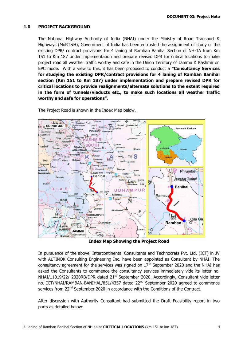
The Project Road is shown in the Index Map below.
Index Map Showing the Project Road
In pursuance of the above, Intercontinental Consultants and Technocrats Pvt. Ltd. (ICT) in JV
with ALTINOK Consulting Engineering Inc. have been appointed as Consultant by NHAI. The
consultancy agreement for the services was signed on 17th September 2020 and the NHAI has
asked the Consultants to commence the consultancy services immediately vide its letter no.
NHAI/11019/22/ 2020RB/DPR dated 21st September 2020. Accordingly, Consultant vide letter
no. ICT/NHAI/RAMBAN-BANIHAL/851/4357 dated 22nd September 2020 agreed to commence
services from 22nd September 2020 in accordance with the Conditions of the Contract.
After discussion with Authority Consultant had submitted the Draft Feasibility report in two
parts as detailed below:
DOCUMENT 03: Project Note
4 Laning of Ramban Banihal Section of NH 44 at CRITICAL LOCATIONS (km 151 to km 187) 2
S. No. Description of Section Date of Submission Remarks
1 Existing Ch. 148+047 (NB)/Ch. 150+056 to Ch. 153+122 (NB)/Ch. 154+850 (SB) and from Ch. 171+860 (NB)/ Ch. 173+350 to Ch. 180+282 (NB)/Ch. 181+750 (SB) (Total length 13.194 Km)
On 29th December 2020, vide letter No. ICT/RAMBAN-BANIHAL/851/6025
FOR COS under ongoing Project
2 Existing Ch. 153+122 (NB)/Ch. 154+850 (SB) to Ch. 163+545 (NB)/Ch. 165+300 (SB) and from existing Ch. 163+545 (NB)/ Ch. 165+300 (SB) to Ch. 171+860 (NB)/ Ch. 173+350 (SB)
On 17th February, 2021, vide letter No. ICT/RAMBAN-BANIHAL/851/6025
For award of New tenders
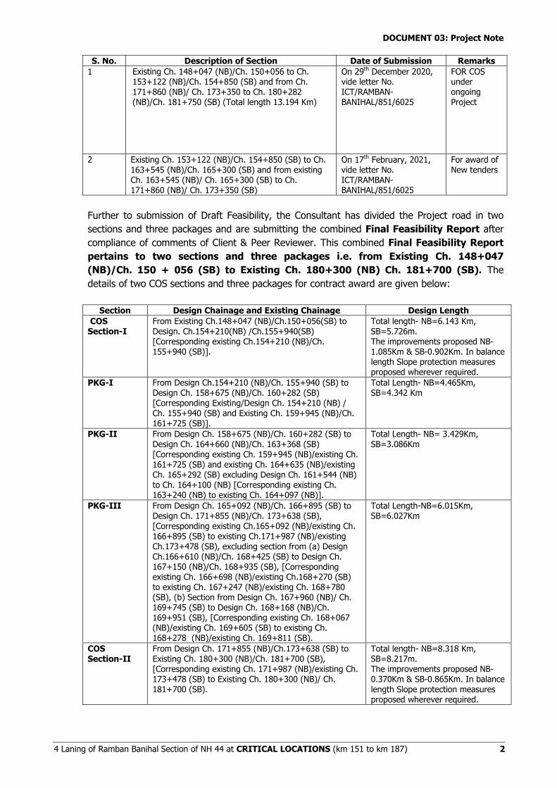
Further to submission of Draft Feasibility, the Consultant has divided the Project road in two
sections and three packages and are submitting the combined Final Feasibility Report after
compliance of comments of Client & Peer Reviewer. This combined Final Feasibility Report
pertains to two sections and three packages i.e. from Existing Ch. 148+047
(NB)/Ch. 150 + 056 (SB) to Existing Ch. 180+300 (NB) Ch. 181+700 (SB). The
details of two COS sections and three packages for contract award are given below:
Section Design Chainage and Existing Chainage Design Length
COS Section-I
From Existing Ch.148+047 (NB)/Ch.150+056(SB) to Design. Ch.154+210(NB) /Ch.155+940(SB) [Corresponding existing Ch.154+210 (NB)/Ch. 155+940 (SB)].
Total length- NB=6.143 Km, SB=5.726m. The improvements proposed NB-1.085Km & SB-0.902Km. In balance length Slope protection measures proposed wherever required.
PKG-I From Design Ch.154+210 (NB)/Ch. 155+940 (SB) to Design Ch. 158+675 (NB)/Ch. 160+282 (SB) [Corresponding Existing/Design Ch. 154+210 (NB) / Ch. 155+940 (SB) and Existing Ch. 159+945 (NB)/Ch. 161+725 (SB)].
Total Length- NB=4.465Km, SB=4.342 Km
PKG-II From Design Ch. 158+675 (NB)/Ch. 160+282 (SB) to Design Ch. 164+660 (NB)/Ch. 163+368 (SB) [Corresponding existing Ch. 159+945 (NB)/existing Ch. 161+725 (SB) and existing Ch. 164+635 (NB)/existing Ch. 165+292 (SB) excluding Design Ch. 161+544 (NB) to Ch. 164+100 (NB) [Corresponding existing Ch. 163+240 (NB) to existing Ch. 164+097 (NB)].
Total Length- NB= 3.429Km, SB=3.086Km
PKG-III From Design Ch. 165+092 (NB)/Ch. 166+895 (SB) to Design Ch. 171+855 (NB)/Ch. 173+638 (SB), [Corresponding existing Ch.165+092 (NB)/existing Ch. 166+895 (SB) to existing Ch.171+987 (NB)/existing Ch.173+478 (SB), excluding section from (a) Design Ch.166+610 (NB)/Ch. 168+425 (SB) to Design Ch. 167+150 (NB)/Ch. 168+935 (SB), [Corresponding existing Ch. 166+698 (NB)/existing Ch.168+270 (SB) to existing Ch. 167+247 (NB)/existing Ch. 168+780 (SB), (b) Section from Design Ch. 167+960 (NB)/ Ch. 169+745 (SB) to Design Ch. 168+168 (NB)/Ch. 169+951 (SB), [Corresponding existing Ch. 168+067 (NB)/existing Ch. 169+605 (SB) to existing Ch. 168+278 (NB)/existing Ch. 169+811 (SB).
Total Length-NB=6.015Km, SB=6.027Km
COS Section-II
From Design Ch. 171+855 (NB)/Ch.173+638 (SB) to Existing Ch. 180+300 (NB)/Ch. 181+700 (SB), [Corresponding existing Ch. 171+987 (NB)/existing Ch. 173+478 (SB) to Existing Ch. 180+300 (NB)/ Ch. 181+700 (SB).
Total length- NB=8.318 Km, SB=8.217m. The improvements proposed NB-0.370Km & SB-0.865Km. In balance length Slope protection measures proposed wherever required.
DOCUMENT 03: Project Note
4 Laning of Ramban Banihal Section of NH 44 at CRITICAL LOCATIONS (km 151 to km 187) 3
2.0 PROJECT DESCRIPTION
The project road under this contract for preparation of Detailed Project Report starts from
existing Km 151.000 at end of Ramban bypass and ends at existing Km 187.000 on the
outskirts at the start of Banihal town. The project road is part of the North-South corridor
connecting Srinagar in Jammu & Kashmir to Kanyakumari in Tamil Nadu, State. The existing
road is of 2-lane configuration with earthen shoulders on both side and having flexible
pavement.
Four Lanning of Ramban-Banihal section of NH-44 from existing Km 151.000 to
existing Km 187.000 is in progress under NHDP Phase-II through an Engineering, Procurement
and Construction (EPC) Contract.
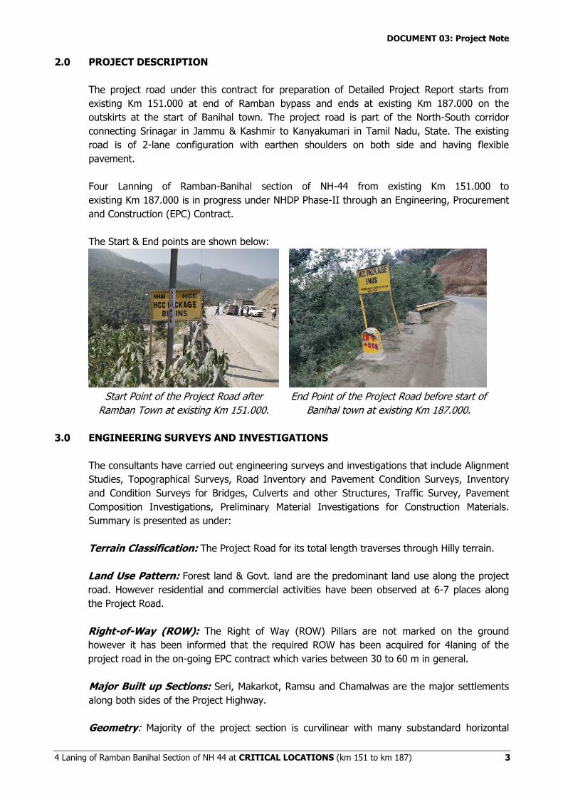
The Start & End points are shown below:
Start Point of the Project Road after
Ramban Town at existing Km 151.000.
End Point of the Project Road before start of
Banihal town at existing Km 187.000.
3.0 ENGINEERING SURVEYS AND INVESTIGATIONS
The consultants have carried out engineering surveys and investigations that include Alignment
Studies, Topographical Surveys, Road Inventory and Pavement Condition Surveys, Inventory
and Condition Surveys for Bridges, Culverts and other Structures, Traffic Survey, Pavement
Composition Investigations, Preliminary Material Investigations for Construction Materials.
Summary is presented as under:
Terrain Classification: The Project Road for its total length traverses through Hilly terrain.
Land Use Pattern: Forest land & Govt. land are the predominant land use along the project
road. However residential and commercial activities have been observed at 6-7 places along
the Project Road.
Right-of-Way (ROW): The Right of Way (ROW) Pillars are not marked on the ground
however it has been informed that the required ROW has been acquired for 4laning of the
project road in the on-going EPC contract which varies between 30 to 60 m in general.
Major Built up Sections: Seri, Makarkot, Ramsu and Chamalwas are the major settlements
along both sides of the Project Highway.
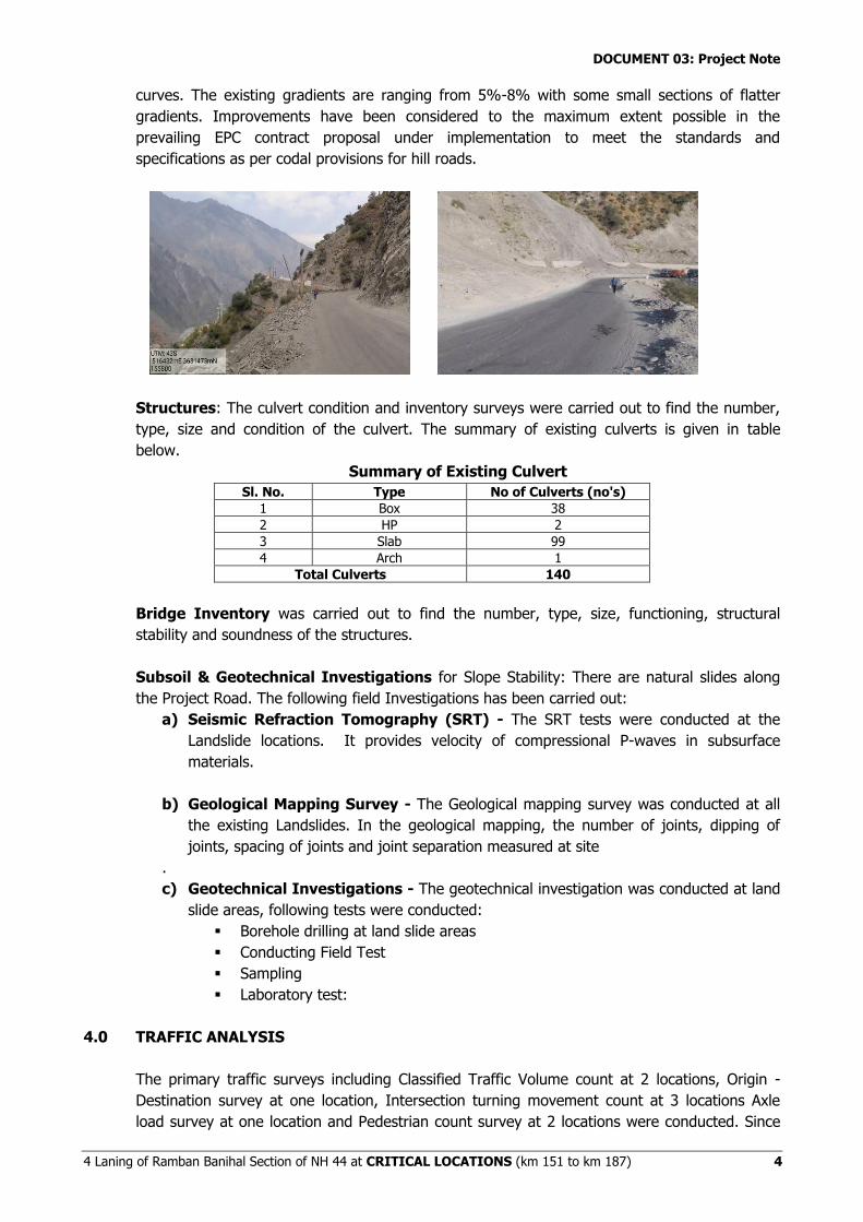
Geometry: Majority of the project section is curvilinear with many substandard horizontal
DOCUMENT 03: Project Note
4 Laning of Ramban Banihal Section of NH 44 at CRITICAL LOCATIONS (km 151 to km 187) 4
curves. The existing gradients are ranging from 5%-8% with some small sections of flatter
gradients. Improvements have been considered to the maximum extent possible in the
prevailing EPC contract proposal under implementation to meet the standards and
specifications as per codal provisions for hill roads.
Structures: The culvert condition and inventory surveys were carried out to find the number,
type, size and condition of the culvert. The summary of existing culverts is given in table
below.
Summary of Existing Culvert
Sl. No. Type No of Culverts (no's)
1 Box 38
2 HP 2
3 Slab 99
4 Arch 1
Total Culverts 140
Bridge Inventory was carried out to find the number, type, size, functioning, structural
stability and soundness of the structures.
Subsoil & Geotechnical Investigations for Slope Stability: There are natural slides along
the Project Road. The following field Investigations has been carried out:
a) Seismic Refraction Tomography (SRT) - The SRT tests were conducted at the
Landslide locations. It provides velocity of compressional P-waves in subsurface
materials.
b) Geological Mapping Survey - The Geological mapping survey was conducted at all
the existing Landslides. In the geological mapping, the number of joints, dipping of
joints, spacing of joints and joint separation measured at site
.
c) Geotechnical Investigations - The geotechnical investigation was conducted at land
slide areas, following tests were conducted:
Borehole drilling at land slide areas
Conducting Field Test
Sampling
Laboratory test:
4.0 TRAFFIC ANALYSIS
The primary traffic surveys including Classified Traffic Volume count at 2 locations, Origin -
Destination survey at one location, Intersection turning movement count at 3 locations Axle
load survey at one location and Pedestrian count survey at 2 locations were conducted. Since
DOCUMENT 03: Project Note
4 Laning of Ramban Banihal Section of NH 44 at CRITICAL LOCATIONS (km 151 to km 187) 5
there are no major dispersal nodes along the 36 km stretch, the project road has been
considered as one homogenous section for further analysis.
4.1 Axle Load Survey
The axle load survey was carried out using the electronic static axle load pad on the project
road and after analysis of the data collected from site, the VDF factors worked out are
presented in table below:
Vehicle Type Vehicle Damage Factor (VDF)
Up Down
LCV 0.03 0.02
2-axle Truck 3.90 2.54
3-axle Truck 5.85 4.68
MAV 6.96 4.94
Note: UP = Ramban to Banihal, DN = Banihal to Ramban.
4.2 Existing Traffic
The AADT (Without COVID-19 Correction) is presented below:
Annual Average Daily Traffic (AADT)
Vehicle Category
ATCC-1 at Km 165+000 at Khooni Nallah on NH-44
ATCC-2 at Km 172+500 at Rashtriya Rifle on NH-44
Veh. PCUs Veh. PCUs
Car / Taxi 3216 3216 3052 3052
Mini Bus 163 244 143 215
Bus 35 104 34 102
LGV 4-Wheeler 581 872 667 1000
2-axle Truck 2488 7465 2721 8162
3-axle Truck 1130 3391 1061 3183
4-6 axle Truck 659 2966 668 3005
Total Tollable Traffic 8272 18258 8348 18730
Toll Exempt Vehicles 43 109 42 115
LGV 3-Wheeler 4 6 19 28
3-Wheeler (Passenger) 4 4 3 3
2-Wheeler 77 38 92 46
Tractor 3 4 5 7
Tractor With Trailer 6 26 4 17
Bicycle 0 0 0 0
Cycle Rickshaw 0 0 0 0
Hand Cart 0 0 0 0
Animal Drawn Cart 0 0 0 0
Total Non-
Tollable Traffic 137 188 165 216
Total Traffic 8409 18445 8513 18946
The Consultant has also studied the effect of COVID-19 on the traffic and accordingly COVID-
19 correction has been applied and the comparison of AADT data with & without COVID-19 is
presented below:
S. No. AADT at Km 165+000 AADT at Km 172+500
Remarks Veh. PCU Veh. PCU
1 8409 18445 8513 18946 Before COVID-19 Correction
2 9245 20279 9360 20829 After COVID-19 Correction
The Construction of Jammu-Baramulla Railway link is in progress and expected to complete by
year 2022.The Consultant has also assessed the diversion of traffic from the project road to
DOCUMENT 03: Project Note
4 Laning of Ramban Banihal Section of NH 44 at CRITICAL LOCATIONS (km 151 to km 187) 6
Jammu-Baramulla Rail link. Diversion of 20% for all modes has been assumed based on
results arrived from the analysis. This have been added in three stages i.e. 30% in Year 2022,
30% in Year 2023 and 40% in Year 2024.
4.3 Projected Traffic
The projected traffic for the project road is presented below:
S. No. Year Projected Traffic
Vehicle PCU
1 2020-2021 9360 20829
2 2025-2026 9682 21359
3 2030-2031 13090 28613
4 2035-2036 16750 36285
5 2040-2041 20658 44404
6 2045-2046 24629 52590
7 2050-2051 29370 62298
8 2054-2055 33820 71351
As can be seen from above, the project road has already crossed 20,000 PCU/day traffic
corresponding to level of service B as per IRC:SP:84-2019 and will reach 30,000 PCU/day
within 5 to 6 years of opening the improved road to traffic. However, since the existing EPC
contract is for 4 laning so the same has been followed in current proposals after due
consultations with the Authority.
5.0 Improvement Proposals
5.1 Carriageway
For improving the horizontal geometry of the existing road and to provide a better horizontal
geometry to the new 2lane carriageway, 2 project chainage systems has been provided. One
chainage runs all along the Northbound (NB) carriageway (i.e. improvement of existing
carriageway) and other chainage runs all along the southbound (SB) carriageway (new two
lane road, generally on hill side of existing road. The respective lengths for improvement
proposal of North Bound and South Bound carriageways are given in the below table.
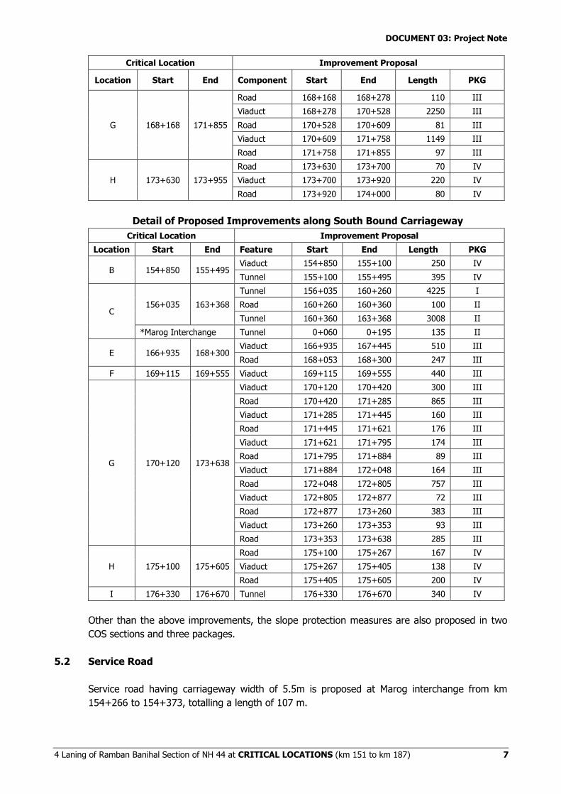
Detail of Proposed Improvements along North Bound Carriageway
Critical Location Improvement Proposal
Location Start End Component Start End Length PKG
A 150+904 151+384
Road 150+904 151+043 139 IV
Viaduct 151+043 151+343 300 IV
Road 151+343 151+384 41 IV
B 153+200 153+565 Road 153+200 153+565 365 IV
C 154+415 161+350
Tunnel 154+415 158+650 4235 I
Road 158+650 158+678 28 II
Tunnel 158+750 161+350 2600 II
D 164+140 164+570 Tunnel 164+140 164+570 430 II
E 165+095 166+610 Viaduct 165+095 165+913 818 III
Road 165+913 166+610 697 III
F 167+150 167+960
Road 167+150 167+310 160 III
Viaduct 167+310 167+760 450 III
Road 167+760 167+960 200 III
DOCUMENT 03: Project Note
4 Laning of Ramban Banihal Section of NH 44 at CRITICAL LOCATIONS (km 151 to km 187) 7
Critical Location Improvement Proposal
Location Start End Component Start End Length PKG
G 168+168 171+855
Road 168+168 168+278 110 III
Viaduct 168+278 170+528 2250 III
Road 170+528 170+609 81 III
Viaduct 170+609 171+758 1149 III
Road 171+758 171+855 97 III
H 173+630 173+955
Road 173+630 173+700 70 IV
Viaduct 173+700 173+920 220 IV
Road 173+920 174+000 80 IV
Detail of Proposed Improvements along South Bound Carriageway
Critical Location Improvement Proposal
Location Start End Feature Start End Length PKG
B 154+850 155+495 Viaduct 154+850 155+100 250 IV
Tunnel 155+100 155+495 395 IV
C 156+035 163+368
Tunnel 156+035 160+260 4225 I
Road 160+260 160+360 100 II
Tunnel 160+360 163+368 3008 II
*Marog Interchange Tunnel 0+060 0+195 135 II
E 166+935 168+300 Viaduct 166+935 167+445 510 III
Road 168+053 168+300 247 III
F 169+115 169+555 Viaduct 169+115 169+555 440 III
G 170+120 173+638
Viaduct 170+120 170+420 300 III
Road 170+420 171+285 865 III
Viaduct 171+285 171+445 160 III
Road 171+445 171+621 176 III
Viaduct 171+621 171+795 174 III
Road 171+795 171+884 89 III
Viaduct 171+884 172+048 164 III
Road 172+048 172+805 757 III
Viaduct 172+805 172+877 72 III
Road 172+877 173+260 383 III
Viaduct 173+260 173+353 93 III
Road 173+353 173+638 285 III
H 175+100 175+605
Road 175+100 175+267 167 IV
Viaduct 175+267 175+405 138 IV
Road 175+405 175+605 200 IV
I 176+330 176+670 Tunnel 176+330 176+670 340 IV
Other than the above improvements, the slope protection measures are also proposed in two
COS sections and three packages.
5.2 Service Road
Service road having carriageway width of 5.5m is proposed at Marog interchange from km
154+266 to 154+373, totalling a length of 107 m.
DOCUMENT 03: Project Note
4 Laning of Ramban Banihal Section of NH 44 at CRITICAL LOCATIONS (km 151 to km 187) 8
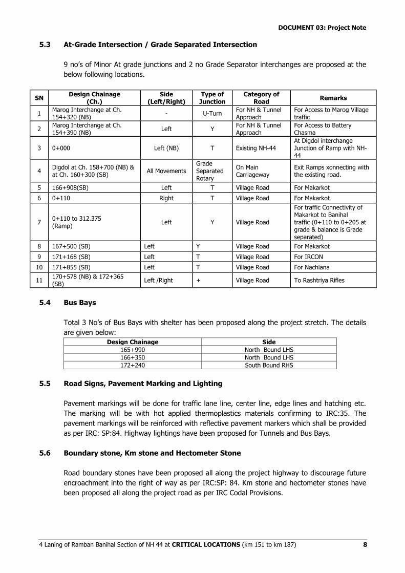
5.3 At-Grade Intersection / Grade Separated Intersection
9 no’s of Minor At grade junctions and 2 no Grade Separator interchanges are proposed at the
below following locations.
SN Design Chainage
(Ch.) Side
(Left/Right) Type of Junction
Category of Road
Remarks
1 Marog Interchange at Ch. 154+320 (NB)
- U-Turn For NH & Tunnel Approach
For Access to Marog Village traffic
2 Marog Interchange at Ch. 154+390 (NB)
Left Y For NH & Tunnel Approach
For Access to Battery Chasma
3 0+000 Left (NB) T Existing NH-44 At Digdol interchange Junction of Ramp with NH-44
4 Digdol at Ch. 158+700 (NB) & at Ch. 160+300 (SB)
All Movements Grade Separated Rotary
On Main Carriageway
Exit Ramps xonnecting with the existing road.
5 166+908(SB) Left T Village Road For Makarkot
6 0+110 Right T Village Road For Makarkot
7 0+110 to 312.375 (Ramp)
Left Y Village Road
For traffic Connectivity of Makarkot to Banihal traffic (0+110 to 0+205 at grade & balance is Grade separated)
8 167+500 (SB) Left Y Village Road For Makarkot
9 171+168 (SB) Left T Village Road For IRCON
10 171+855 (SB) Left T Village Road For Nachlana
11 170+578 (NB) & 172+365 (SB)
Left /Right + Village Road To Rashtriya Rifles
5.4 Bus Bays
Total 3 No’s of Bus Bays with shelter has been proposed along the project stretch. The details
are given below:
Design Chainage Side
165+990 North Bound LHS
166+350 North Bound LHS
172+240 South Bound RHS
5.5 Road Signs, Pavement Marking and Lighting
Pavement markings will be done for traffic lane line, center line, edge lines and hatching etc.
The marking will be with hot applied thermoplastics materials confirming to IRC:35. The
pavement markings will be reinforced with reflective pavement markers which shall be provided
as per IRC: SP:84. Highway lightings have been proposed for Tunnels and Bus Bays.
5.6 Boundary stone, Km stone and Hectometer Stone
Road boundary stones have been proposed all along the project highway to discourage future
encroachment into the right of way as per IRC:SP: 84. Km stone and hectometer stones have
been proposed all along the project road as per IRC Codal Provisions.
DOCUMENT 03: Project Note
4 Laning of Ramban Banihal Section of NH 44 at CRITICAL LOCATIONS (km 151 to km 187) 9
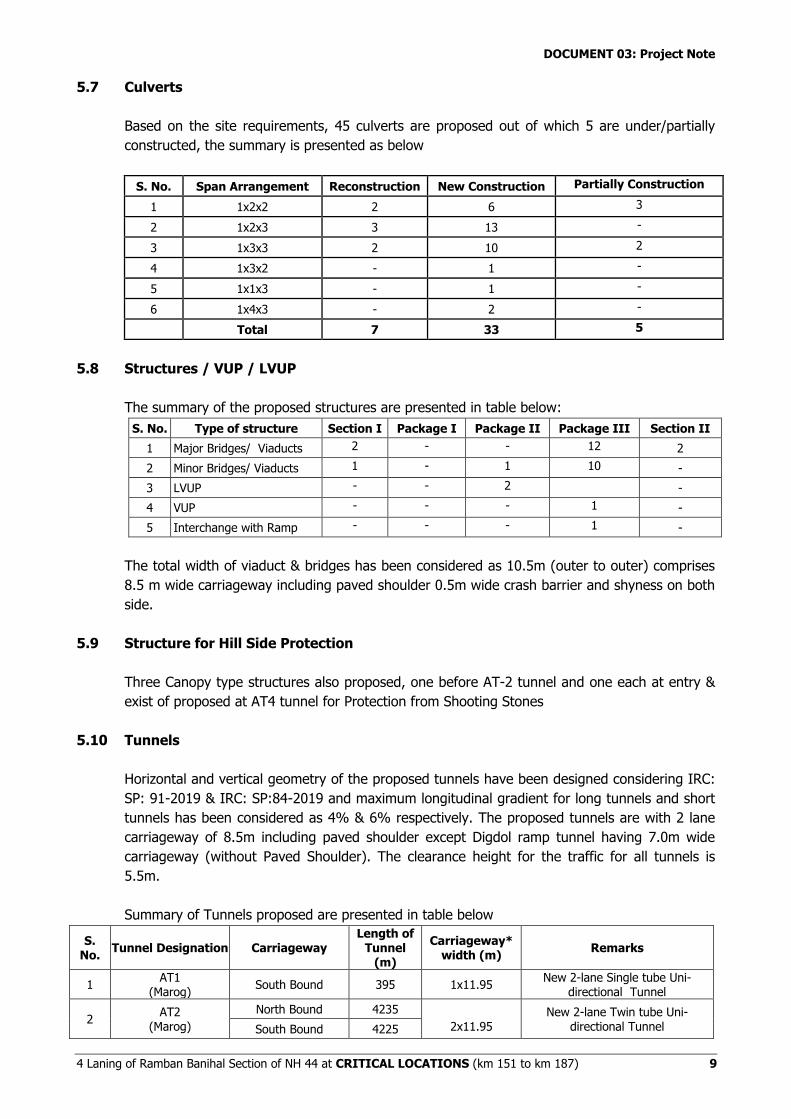
5.7 Culverts
Based on the site requirements, 45 culverts are proposed out of which 5 are under/partially
constructed, the summary is presented as below
S. No. Span Arrangement Reconstruction New Construction Partially Construction
1 1x2x2 2 6 3
2 1x2x3 3 13 -
3 1x3x3 2 10 2
4 1x3x2 - 1 -
5 1x1x3 - 1 -
6 1x4x3 - 2 -
Total 7 33 5
5.8 Structures / VUP / LVUP
The summary of the proposed structures are presented in table below:
S. No. Type of structure Section I Package I Package II Package III Section II
1 Major Bridges/ Viaducts 2 - - 12 2
2 Minor Bridges/ Viaducts 1 - 1 10 -
3 LVUP - - 2 -
4 VUP - - - 1 -
5 Interchange with Ramp - - - 1 -
The total width of viaduct & bridges has been considered as 10.5m (outer to outer) comprises
8.5 m wide carriageway including paved shoulder 0.5m wide crash barrier and shyness on both
side.
5.9 Structure for Hill Side Protection
Three Canopy type structures also proposed, one before AT-2 tunnel and one each at entry &
exist of proposed at AT4 tunnel for Protection from Shooting Stones
5.10 Tunnels
Horizontal and vertical geometry of the proposed tunnels have been designed considering IRC:
SP: 91-2019 & IRC: SP:84-2019 and maximum longitudinal gradient for long tunnels and short
tunnels has been considered as 4% & 6% respectively. The proposed tunnels are with 2 lane
carriageway of 8.5m including paved shoulder except Digdol ramp tunnel having 7.0m wide
carriageway (without Paved Shoulder). The clearance height for the traffic for all tunnels is
5.5m.
Summary of Tunnels proposed are presented in table below
S. No.
Tunnel Designation Carriageway Length of
Tunnel (m)
Carriageway* width (m)
Remarks
1 AT1
(Marog) South Bound 395 1x11.95
New 2-lane Single tube Uni-directional Tunnel
2 AT2
(Marog)
North Bound 4235 2x11.95
New 2-lane Twin tube Uni-directional Tunnel South Bound 4225
DOCUMENT 03: Project Note
4 Laning of Ramban Banihal Section of NH 44 at CRITICAL LOCATIONS (km 151 to km 187) 10
S. No.
Tunnel Designation Carriageway Length of
Tunnel (m)
Carriageway* width (m)
Remarks
3 AT3
(Digdol-Khuni Nallah - Panthal)
North Bound 2600 2x11.95
New 2-lane Twin tube Uni-directional Tunnel South Bound 3008
4 AT4
(Panthal) North Bound 430 1x11.95
New 2-lane Single tube Uni-directional Tunnel
5 AT5
(Chamalwas) South Bound 340 1x11.9
New 2-lane Single tube Uni-directional Tunnel
6 AT6
Digdol Ramp Digdol Interchange
Ramp 135 1x10.4
New 2-lane , Bi- directional Single tube Tunnel
* including Footpath & Walkway
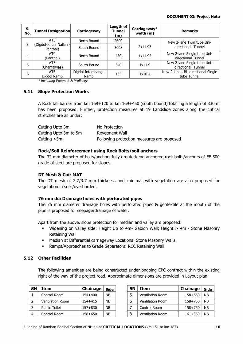
5.11 Slope Protection Works
A Rock fall barrier from km 169+120 to km 169+450 (south bound) totalling a length of 330 m
has been proposed. Further, protection measures at 19 Landslide zones along the critical
stretches are as under:
Cutting Upto 3m No Protection
Cutting Upto 3m to 5m Revetment Wall
Cutting >5m Following protection measures are proposed
Rock/Soil Reinforcement using Rock Bolts/soil anchors
The 32 mm diameter of bolts/anchors fully grouted/end anchored rock bolts/anchors of FE 500
grade of steel are proposed for slopes.
DT Mesh & Coir MAT
The DT mesh of 2.7/3.7 mm thickness and coir mat with vegetation are also proposed for
vegetation in soils/overburden.
76 mm dia Drainage holes with perforated pipes
The 76 mm diameter drainage holes with perforated pipes & geotextile at the mouth of the
pipe is proposed for seepage/drainage of water.
Apart from the above, slope protection for median and valley are proposed:
Widening on valley side: Height Up to 4m- Gabion Wall; Height > 4m - Stone Masonry
Retaining Wall
Median at Differential carriageway Locations: Stone Masonry Walls
Ramps/Approaches to Grade Separators: RCC Retaining Wall
5.12 Other Facilities
The following amenities are being constructed under ongoing EPC contract within the existing
right of the way of the project road. Approximate dimensions are provided in Layout plan.
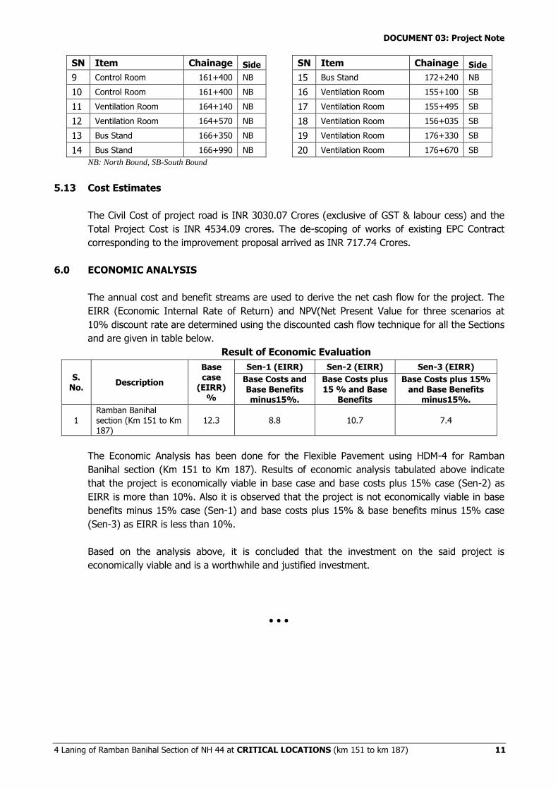
SN Item Chainage Side
1 Control Room 154+400 NB
2 Ventilation Room 154+415 NB
3 Public Toilet 157+830 NB
4 Control Room 158+650 NB
SN Item Chainage Side
5 Ventilation Room 158+650 NB
6 Ventilation Room 158+750 NB
7 Control Room 158+750 NB
8 Ventilation Room 161+350 NB
DOCUMENT 03: Project Note
4 Laning of Ramban Banihal Section of NH 44 at CRITICAL LOCATIONS (km 151 to km 187) 11
SN Item Chainage Side
9 Control Room 161+400 NB
10 Control Room 161+400 NB
11 Ventilation Room 164+140 NB
12 Ventilation Room 164+570 NB
13 Bus Stand 166+350 NB
14 Bus Stand 166+990 NB
SN Item Chainage Side
15 Bus Stand 172+240 NB
16 Ventilation Room 155+100 SB
17 Ventilation Room 155+495 SB
18 Ventilation Room 156+035 SB
19 Ventilation Room 176+330 SB
20 Ventilation Room 176+670 SB
NB: North Bound, SB-South Bound
5.13 Cost Estimates
The Civil Cost of project road is INR 3030.07 Crores (exclusive of GST & labour cess) and the
Total Project Cost is INR 4534.09 crores. The de-scoping of works of existing EPC Contract
corresponding to the improvement proposal arrived as INR 717.74 Crores.
6.0 ECONOMIC ANALYSIS
The annual cost and benefit streams are used to derive the net cash flow for the project. The
EIRR (Economic Internal Rate of Return) and NPV(Net Present Value for three scenarios at
10% discount rate are determined using the discounted cash flow technique for all the Sections
and are given in table below.
Result of Economic Evaluation
S. No.
Description
Base case
(EIRR) %
Sen-1 (EIRR) Sen-2 (EIRR) Sen-3 (EIRR)
Base Costs and Base Benefits minus15%.
Base Costs plus 15 % and Base
Benefits
Base Costs plus 15% and Base Benefits
minus15%.
1 Ramban Banihal section (Km 151 to Km 187)
12.3 8.8 10.7 7.4
The Economic Analysis has been done for the Flexible Pavement using HDM-4 for Ramban
Banihal section (Km 151 to Km 187). Results of economic analysis tabulated above indicate
that the project is economically viable in base case and base costs plus 15% case (Sen-2) as
EIRR is more than 10%. Also it is observed that the project is not economically viable in base
benefits minus 15% case (Sen-1) and base costs plus 15% & base benefits minus 15% case
(Sen-3) as EIRR is less than 10%.
Based on the analysis above, it is concluded that the investment on the said project is
economically viable and is a worthwhile and justified investment.
Copyright © 2022 FDOKUMEN

