


Bahasa
Halaman
Hukum


i
IMPROVING THE LAND DELIVERY SYSTEM FOR THE URBAN POOR – A CASE STUDY OF KUMASI
by
Agyei – Boateng George BSc. Land Econ. (Hons)
A Thesis submitted to the Board of Graduate Studies Kwame Nkrumah University of Science and Technology (KNUST), Kumasi in partial
fulfilment of the requirements for the degree
of
MASTER OF PHILOSOPHY IN LAND MANAGEMENT
College of Architecture and Planning
February, 2010

ii
DECLARATION
I hereby declare that this submission is my own work towards the M.PhIL and that, to
the best of my knowledge it contains no material previously published by another
person nor material which has been accepted for the award of any other degree of the
university, except where due acknowledgement has been made in the text.
Agyei-Boateng George ……………………………………. ……………
Certified by
Dr. Callistus Mahama ………………………………………. ………….. (Supervisor)
Certified by
Dr. T. J. Bugri ………………………………………. ………….... (Head of Department)

iii
ACKNOWLEDGEMENT
All praise and glory to God Almighty for His unfailing love, which has brought me this
far. With all my heart, mind and soul, I am thankful to God for the spirit of patience,
endurance and zeal which enabled me to successfully complete this thesis.
I would like to register my sincere gratitude to all whose assistance and encouragement
have helped me to undertake this study. I would like to express my profound
appreciation to my supervisor Dr. Callistus Mahama, whose constructive criticisms,
useful suggestions and direction have enabled me successfully complete this study. I
also thank all who gave me the needed information during the field work as well as
authors whose works I have made reference to.
Special thanks go to Daniel Osei-Boakye and Lloyd Quagraine for their invaluable
contribution and assistance for this study.
Special thanks to my beloved wife Mrs. Regina Boateng and the children, my brothers-
Paul Agyei Boateng, Agyei Yeboah, Samuel Anini, Benjamain Quaye, George
Asafo Mireku and Owusu Poku for their moral support throughout the course.
Any errors, substantial or marginal which may be found in the text are mine.

iv
ABSTRACT
Urban land development has always been and still is a problem facing the world in
general and Africa in particular. Throughout history, the competition for natural
resources has made people to move and converge at areas where these resources are
abundant. Rural-urban migration plays a vital role in this direction. The resultant effect
is that several urban areas have expanded and continue to grow thus providing fertile
grounds for land use conflicts. The environmental effects of this continuous movement
of people from the rural areas to the urban centres are illegal developments at
unapproved sites leading to slums and squatter settlements. The urban poor live with
many deprivations such as access to employment, land, adequate housing and
infrastructure, social protection, lack of access to health, education and personal
security. They survive through their own initiative and yet most of their initiatives are
deemed illegal.
Three slum areas and a squatter settlement were randomly selected within the Kumasi
Metropolitan Area. The areas were chosen based on the multi-ethnic and socio-
economic background and the type of residential properties they occupy. Four Hundred
respondents being residents were purposively selected from the four suburbs. Eight
government institutions connected with land delivery were also selected for the study.
The grand sample size for the study was the multi-stage sampling involving a three stage
sampling procedure. Interviewing and questionnaire schedules were adopted as data
collection technique for the study.
Institutional capability to help the urban poor was discovered to be constrained
by inadequate staffing, poor remuneration and monitoring. It was also realized that there
is no programme which is developed to cater for the land needs of the urban poor. In

v
most cases the housing projects and others that are developed as low-cost are beyond the
reach of the urban poor.
Based on the strength of the findings of the study, it was concluded that the
housing situation of the urban poor should involve all interest groups especially the
institutions connected with land management and seek to identify and solve problems
before they arise. There should be a policy (on the part of the government) to introduce
the urban poor into the formal land market. This can be done in two ways. Firstly, there
is the need to increase the supply of land for the urban poor through the provision of site
and services. The second intervention is to increase the effective demand for land for the
urban poor. It has been argued that subsidizing the poor is not sustainable. To increase
effective demand for the urban poor, there is the need for community-based organization
and increasing savings and providing access to finance.
.

vi
TABLE OF CONTENTS
TITLE PAGE...............................................................................................................................I
DECLARATION ............................................................................................................. II
ACKNOWLEDGEMENT ............................................................................................ III
ABSTRACT ................................................................................................................... IV
TABLE OF CONTENTS .............................................................................................. VI
LIST OF TABLES ........................................................................................................ XI
LIST OF FIGURES ..................................................................................................... XII
LIST OF PLATES ..................................................................................................... XIII
LIST OF ACRONYMS ............................................................................................. XIV
LIST OF ACRONYMS ............................................................................................. XIV
LIST OF STATUTES ................................................................................................ XVI
CHAPTER ONE .............................................................................................................. 1
INTRODUCTION ............................................................................................................ 1 1.1. BACKGROUND TO THE PROBLEM ............................................................ 1 1.2. STATEMENT OF THE PROBLEM ................................................................. 4 1.3. OBJECTIVES OF THE STUDY ....................................................................... 7 1.4. RESEARCH QUESTIONS ............................................................................... 8 1.5. JUSTIFICATION FOR THE STUDY............................................................... 8 1.6. SCOPE OF THE STUDY .................................................................................. 9 1.7. ORGANISATION OF THE REPORT .............................................................. 9 1.8. LIMITATIONS OF THE STUDY ................................................................... 10
CHAPTER TWO ........................................................................................................... 12
LAND MANAGEMENT SYSTEMS AND ITS IMPACT ON URBAN POVERTY .......................................................................................................................................... 12
2.1. INTRODUCTION ........................................................................................... 12 2.2. THE LAND DELIVERY SYSTEM ................................................................ 12 2.3. PRINCIPLES OF GOOD LAND ADMINISTRATION ................................. 15
2.3.1. Definition, Role and Components of Land Administration ......................... 15 2.3.1.1. Land Tenure ........................................................................................ 16 2.3.1.2. Utility of the System ........................................................................... 18 2.3.1.3. Cadastral Infrastructure ........................................................................ 19 2.3.1.4. Relevant External Conditions .............................................................. 20

vii
2.3.2. Unification of Customary and Formal Land Rights ................................... 22 2.3.2.1. Justification .......................................................................................... 22 2.3.2.2 Structure of Registry ........................................................................... 24 2.3.2.3 Process of Unification ......................................................................... 24
2.3.3. Organisational Structure ............................................................................ 25 2.3.4. Culture and Human Resources ................................................................... 25
2.4. URBAN POVERTY ........................................................................................ 26 2.4.1 Urbanization ................................................................................................ 27 2.4.2. Rural – Urban Migration ............................................................................. 28 2.4.3. Search for Shelter ......................................................................................... 31 2.4.4. Services ........................................................................................................ 33
2.5. CAUSES OF URBAN POVERTY .................................................................. 34 2.6. VICIOUS CYCLE OF POVERTY .................................................................. 35 2.7. THE MILLENNIUM DEVELOPMENT GOALS .......................................... 38 2.8. CONCLUSION ............................................................................................... 39
CHAPTER THREE ....................................................................................................... 41
LAND TENURE SYSTEM AND LAND MARKETS IN KUMASI ......................... 41 3.1. INTRODUCTION ........................................................................................... 41 3.2. LAND OWNERSHIP AND INTERESTS ...................................................... 41
3.2.1. Land Ownership Classification ............................................................... 41 3.2.2. Interests in Land ...................................................................................... 44
3.3. LAND ACQUISITION PROCEDURES ........................................................ 46 3.3.1. Acquiring State/Vested Lands................................................................. 46 3.3.2. Acquisition of Stool Land ........................................................................ 48
3.4. PROBLEMS OF LAND TENURE ................................................................. 49 3.4.1. Land Prices .............................................................................................. 49 3.4.2. Unclear Acquisition Procedures ............................................................... 50 3.4.3. Land Litigation ......................................................................................... 51 3.4.4. Ineffective land administrative system..................................................... 52
3.5. PROFILE OF LAND DELIVERY INSTITUTIONS ...................................... 53 3.5.1. LANDS COMMISSION ......................................................................... 53 3.5.2. OFFICE OF THE ADMINISTRATOR OF STOOL LANDS ................ 56 3.5.3. TOWN AND COUNTRY PLANNING DEPARTMENT ..................... 56 3.5.4. METROPOLITAN, MUNICIPAL AND DISTRICT ASSEMBLIES ... 57 3.5.5. CHIEFTAINCY AND TRADITIONAL COUNCILS ........................... 58
3.6. URBAN LAND MARKETS AND ITS IMPACT ON ACCESS TO LAND BY THE URBAN POOR .................................................................................................... 59
THE INFORMAL LAND MARKET…………………………………………..62 3.7. THE NATIONAL LAND POLICY ................................................................. 62 3.8. LAND ADMINISTRATION PROGRAM ...................................................... 63
3.8.1. Success Requisites of LAP ........................................................................... 64 3.8.2. Challenges of LAP ...................................................................................... 65
3.9. CONCLUSION ............................................................................................... 65

viii
CHAPTER FOUR .......................................................................................................... 67
RESEARCH METHODS AND METHODOLOGY .................................................. 67 4.1. INTRODUCTION ........................................................................................... 67 4.2. RESEARCH DESIGN ..................................................................................... 67 4.3. UNIT OF ANALYSIS ..................................................................................... 68 4.4. RESEARCH TYPE AND STRATEGY .......................................................... 68 4.5. METHODS OF DATA COLLECTION .......................................................... 70
4.5.1. Desk study ................................................................................................... 70 4.5.2. Selection of respondents .............................................................................. 71 4.5.3. Research Instrument.................................................................................... 72
4.6. DATA PROCESSING AND ANALYSIS....................................................... 73 4.7. OPERATIONAL DEFINITIONS ................................................................... 74
CHAPTER FIVE ............................................................................................................ 75
PRESENTATION AND ANALYSIS OF RESEARCH DATA ................................. 75 5.1. INTRODUCTION ........................................................................................... 75 5.2. THE NATURE OF URBAN POVERTY ........................................................ 75
5.2.1 THE STUDY AREA ...................................................................................... 75 5.2.1. SOCIAL BACKGROUND ........................................................................... 77 5.2.2. AGE STRUCTURE ...................................................................................... 78 5.2.3. EDUCATIONAL LEVEL ............................................................................. 79 5.2.4. ACCESS TO SERVICES/FACILITIES ........................................................ 82 5.2.5. FINANCIAL ACCESS TO SERVICES/FACILITIES ................................... 82 5.2.6. HOUSE TYPE ............................................................................................. 84 5.2.7. TYPE OF BUILDING MATERIALS ........................................................... 87 5.2.8. AVAILABILITY OF TOILETS FACILITIES................................................ 92 5.2.9. AVAILABILITY OF BATHROOM FACILITIES ......................................... 96
5.3. ACCESS TO LAND THROUGH ENCROACHMENT OF NATURE RESERVES IN KUMASI .......................................................................................... 100 5.4. CHARACTERISTICS OF URBAN POVERTY ........................................... 109
5.4.1. SLUMS ...................................................................................................... 109 5.5. LAND DELIVERY APPROACHES ............................................................. 109 5.6. MAIN CHARACTERISTICS AND PROBLEMS OF INSTITUTIONS INVOLVED IN LAND DELIVERY ......................................................................... 111
5.6.1. Characteristics of Current Land Delivery Institutions. ............................ 111 5.6.2. Problems of Land Delivery Institutions. ................................................... 113
5.6.2.1. Public and Vested Land Management Division (PVLMD) ............... 113 5.6.2.2. Survey and Mapping Division (SMD) ............................................... 117 5.6.2.3. Land Registration Division (LRD) .................................................... 117 5.6.2.4. Office of the Administrator of Stool Lands. (OASL) ......................... 118

ix
5.6.2.5. Land Valuation Division (LVD) ........................................................ 118 5.6.2.6. Town and Country Planning Department (TCPD) ........................... 119 5.6.2.7. Kumasi Metropolitan Assembly ........................................................ 121
CHAPTER SIX ............................................................................................................ 123
SUMMARY OF FINDINGS, CONCLUSIONS AND RECOMMENDATIONS .. 123 6.1. INTRODUCTION ......................................................................................... 123 6.2. SUMMARY OF FINDINGS ......................................................................... 123
6.2.1. Income ....................................................................................................... 123 6.2.2. Maintenance of Buildings ......................................................................... 124 6.2.3. Provision of Services ................................................................................. 124
6.2.3.1. Water ................................................................................................. 124 6.2.3.2. Electricity .......................................................................................... 124 6.2.3.3. Health. ............................................................................................... 125 6.2.3.4. Education .......................................................................................... 125
6.2.4. Land Tenure .............................................................................................. 125 6.2.5. Housing ..................................................................................................... 126 6.2.6. Urban Migration ....................................................................................... 126 6.2.7. Financial Constraints ............................................................................... 126 6.2.8. Court Cases ............................................................................................... 127 6.2.9. Institutional Problems ............................................................................... 127 6.2.10. Time Management ................................................................................ 129 6.2.11. Legal Framework .................................................................................. 130 6.2.12. The Role of the Land Administration Projects (LAP) .......................... 132
6.3. CONCLUSIONS ........................................................................................... 133 6.4. RECOMMENDATIONS .............................................................................. 135
6.4.1. Acquisition of Nature Reserve sites .......................................................... 135 6.4.2. Conservation of Nature Reserves .............................................................. 136 6.4.3. Learning from the Urban Poor ................................................................. 136 6.4.4. Slum and squatter settlement upgrading ................................................... 137 6.4.5. Promoting Community-Based Safety-Nets ................................................ 137 6.4.6. Bringing the Poor into Formal Land Market ............................................ 138 6.4.7. Institutional Problems ............................................................................... 139 6.4.8. Development of Rural Areas ..................................................................... 141 6.4.9. Housing ..................................................................................................... 142 6.4.10. Increasing Access to Information ........................................................ 143 6.4.11. Land Tenure ......................................................................................... 144 6.4.11. Increase Funding ................................................................................. 144
6.5. SUGGESTION FOR FURTHER RESEARCH............................................. 144
REFERENCES ......................................... 145ERROR! BOOKMARK NOT DEFINED.
APPENDIX 1 ................................................................................................................ 156
APPENDIX 2 ................................................................................................................ 161
APPENDIX 3 ................................................................................................................ 163

x
APPENDIX 4 ................................................................................................................ 165

xi
LIST OF TABLES
TABLE 5:1 AVERAGE AGE DISTRIBUTION OF PEOPLE IN HOUSES ................................... 78
TABLE 5.2 EDUCATIONAL LEVELS OF RESPONDENTS ...................................................... 79
TABLE 5.3 SOURCES OF HEALTH CARE OF RESPONDENTS .............................................. 83
TABLE 5.4 HOUSE TYPE OCCUPIED BY RESPONDENTS .................................................... 85
TABLE 5.5 BUILDING MATERIALS USED FOR HOUSES OCCUPIED BY RESPONDENTS ........ 87
TABLE 5.6 NUMBERS OF TOILETS IN A HOUSE ................................................................ 92
TABLE 5.7 NUMBER OF BATHROOMS IN A HOUSE ........................................................... 96
xii
LIST OF FIGURES
FIGURE 2.1. VICIOUS CYCLE OF POVERTY FOR THE URBAN POOR ...................................... 37
FIGURE 5.1 MAP SHOWING KUMASI AND THE STUDY AREAS .......................................... 76
FIGURE 5.2 EDUCATIONAL LEVELS OF THE RESPONDENTS .............................................. 80
FIGURE 5.3 SOURCES OF HEALTH CARE IN THE STUDY AREAS ........................................ 84
FIGURE 5.4 HOUSE TYPES OCCUPIED BY THE RESPONDENTS........................................... 86
FIGURE 5.5 BUILDING MATERIALS USED IN THE STUDY AREAS ...................................... 88
FIGURE 5.6 BUILDING MATERIALS USED IN THE STUDY AREAS ...................................... 90
FIGURE 5.7 NUMBER OF TOILET FACILITIES IN THE STUDY AREAS .................................. 93
FIGURE 5.8 NUMBER OF TOILET FACILITIES IN THE STUDY AREA ................................... 95
FIGURE 5.9 NUMBER OF BATHROOM FACILITIES IN THE STUDY AREA ............................ 97
FIGURE 5.10 NUMBER OF BATHROOM FACILITIES IN THE STUDY AREA ........................... 99

xiii
LIST OF PLATES
PLATE 5.1 TYPE AND STATE OF BUILDING MATERIALS IN STUDY AREAS ..... 91
PLATE 5.2 A SHALLOW SIDE OF ABOABO STREAM THROUGH ABOABO....... 102
PLATE 5.3: SUBIN STREAM IN ITS CONCRETE CHANNEL ................................... 103
PLATE 5.4: WOODEN STRUCTURES IN RESHIGA MARKED BY K.M.A .............. 105
PLATE 5.5: SISAI STREAM THROUGH ANLOGA .................................................... 106
PLATE 5.6: ATONSU STREAM FLANKED BY UNAUTHORISED STRUCTURES 107
PLATE 5.7: WEEDY BANKS OF KWADASO STREAM WITH ENCROAHED
STRUCTURES ............................................................................................ 108

xiv
LIST OF ACRONYMS
ALS Asantehene’s Land Secretariat BHC Bank for Housing and Construction BRRI Building and Road Research Institute CF Common Fund CG Capitation Grant DACF District Assembly Common Fund DHPR Department of Housing and Planning Research ECG Electricity Company of Ghana ERP Economic Recovery Programme FCUBE Free Compulsory Universal Basic Education FE Financial Encumbrance FGBS First Ghana Building Society GLSS Ghana Living Standards Survey GOG Government of Ghana GPRS Ghana Poverty Reduction Strategy GSS Ghana Statistical Service HFC Home Finance Company IGF Internally Generated Fund IRS Internal Revenue Service KMA Kumasi Metropolitan Assembly KNUST Kwame Nkrumah University of Science and Technology KP Kumasi Polytechnic KTC Kumasi Traditional Council KTI Kumasi Technical Institute KVIP Kumasi Ventilated Improved Pit LAP Land Administration Project LC Lands Commission LP Land Policy LRD Land Registration Division LSA Land Sector Agencies LTR Land Title Registry LVD Land Valuation Division MDA’s Ministry Department Agencies MDG Millennium Development Goals MOFA Ministry of Food and Agriculture MOH Ministry of Health MP Member of Parliament NDC National Democratic Congress NGO’s Non Governmental Organizations NLP National Land Policy PAMSCAD Programme of Action to Mitigate the Social Cost of Adjustment PNDC Provisional National Defence Council PVLMD Public and Vested Land Management Division OASL Office of the Administrator of Stool Lands SAP Structural Adjustment Programme

xv
SMD Survey and Mapping Division SHC State Housing Corporation SIC State Insurance Company SIF Social Investment Fund SS Statistical Service SSNIT Social Security and National Insurance Trust TCPD Town and Country Planning Department WHO World Health Organization WB World Bank WC Water Closet UNDP United Nations Development Programme

xvi
LIST OF STATUTES
Administration of Lands Act, 1962 (Act 123)
Ashanti Stool Lands Act 1958 (Act 25)
Conveyancing Decree 1973 (NRCD 175)
Internal Revenue Act 2000 (Act 592)
Kumasi Town boundary ordinance 1902 (CAP 143)
Local Government Act 1993(Act 462)
Lands Commission Act 1994(Act 483)
Land Title Registration Law 1986 (PNDCL 152)
Lands (Statutory Way Leaves) Act 1963 (Act 186)
Land Title Registration Law 1986 (PNDCL 152)
National Building Regulation 1996 – LI 1630
National Development Planning (System) Act 1994 (Act 480)
Office of the Administrator of Stool Lands Act 1994(Act 481)
Public Conveyancing Act, 1965 (Act 302)
Rent Act 1962(Act 220)
State Lands Act, 1962 (Act 125)
Survey Act, 1962 (Act 127)
Town Planning Ordinance 1951 (CAP 84)

1
CHAPTER ONE
INTRODUCTION
1.1. BACKGROUND TO THE PROBLEM
“Rapid population growth and its concentration in cities around the world constitute a
crucial element affecting the long-term outlook for humanity” (UN-HABITAT, 2003).
Urban population in particular is growing at a faster rate than the rural population. For
instance, it is estimated that by 2030, the rural population of the less developed countries
will grow at only about 0.1 per cent per annum (UN-HABITAT, 2003). Most urban
dwellers that are not capable of taking advantage of the opportunities presented by this
rising population will become poor.
In Africa, it said that, the continent has the world’s highest urbanization rates of about 4
per cent, almost two times faster than Latin America and Asia. According to the UN-
HABITAT (2003), 37 per cent of the total population of the continent lives in cities and
that by 2030 the urban population is expected to rise to 53 per cent of the total
population. The pattern of this phenomenon is not different in Ghana. For example,
Ghana’s population as at the 2000 population census stands at 18.9 million which is an
increase of 53.8 percent over the 1984 population figure of 12.3 million (Ghana
Statistical Service (GSS), 2002). This represents an annual growth rate of 2.7 percent per
annum. Urban growth on the other hand averaged 3.6 percent (5.3 percent for Accra and
3.0 percent for other urban areas). In 2000, 43.8 percent of the population lived in urban
areas (Population and Housing Census, 2000). This is almost about half the total

2
population. It is believed that this figure is much higher as the population has grown more
by 2007.
The impact of these trends is the urbanization of poverty especially in developing
countries. Poverty in developing countries which has for a long time been associated with
rural areas has increasingly become urbanized. It is estimated that between 40 and 80 per
cent of urban dwellers in the world are living in poverty, with very little or absolutely no
access to shelter, basic urban services and social amenities. In Africa, it is estimated that
41 per cent of urban residents live in poverty with two out of five of these residents living
in circumstances deemed to be life and health threatening and that the most persistent
poverty and widest gap remain in Sub-Saharan Africa (UN-HABITAT, 2003).
The effects of urbanization of poverty on access to land and housing is seen in the light of
rising social needs which will exceed the tax base and the resultant shortage of public
funds to finance service provision. This in itself will lead to scarcity of
urbanized/serviced lands and the subsequent over-appreciation of urban land and
inevitably the non-affordability by the urban poor. This will in turn imply illegal or
irregular land occupations and high cost of living resulting in increased urban poverty
(Cenecorta & Smolka, 2000)
Urban poverty is a multidimensional phenomenon. The urban poor live with many
deprivations. Their daily challenges may include;
• limited access to employment opportunities and income,

3
• inadequate and insecure housing and services,
• violent and unhealthy environments,
• little or no social protection mechanisms, and
• limited access to adequate health and education opportunities.
But urban poverty is not just a collection of characteristics; it is also a dynamic condition
of vulnerability or susceptibility to risks. (www.worldbank.org/urban/poverty.htm).
In rural and urban areas of Ghana, growing population, the diminishing supply of land,
intra-regional migration and urbanization have contributed strongly to a growing demand
for land throughout the country. These pressures have resulted in inflationary increases
to the price of a piece of land and property; uncertainty in the land delivery system, lack
of transparency and distortions in the land market. Corruption and the failure of the
public land agencies to develop and implement policies and regulations to improve the
land management have undermined national and international investor confidence in the
land and other sectors of the economy. Perversely the situation has arisen of rapid rising
land prices especially in Accra and Kumasi which is having an inflationary impact on
land market, compounding existing social and environmental problems and reducing
access to land to only wealthy residents and expatriate Ghanaians (LAP 2000).
The poor housing conditions of most urban dwellers and the environmental problems are
reflection of poverty. Houses are poorly built, overcrowded, lack of service facilities such
as electricity, water, roads and poor drainage system. This range of land use problems
which are associated with the low income groups deserves attention by the city

4
authorities. The rural-urban migration results in rapid population growth in the urban
areas which leads to increase in housing stock and urban services. This continuous
movement by the migrants often leads to illegal developments at unapproved sites
leading to slums and squatter settlements. To reduce some of these problems, human
settlements should be controlled and well managed by the city authorities. This calls for
effective urban policies which could go a long way to contribute to reduction in incidence
of urban poverty.
It is evident that urban poverty grew after the economic recovery and structural
adjustment programmes, as the groups most affected were the redeployed and the
retrenched workers and the urban unemployed. The urban poor in most cases have a
harsh life; they live in slum areas, and have poor sanitation, unreliable water supply and
have poor nutrition.
1.2. STATEMENT OF THE PROBLEM
One of the significant constraints faced by governments in the cities of developing
countries and in Ghana in particular has been the failure to ensure the delivery of
affordable land for the low income groups to meet their housing needs (Sandhu, 2004).
Rapid urbanization has brought in its wake challenging demand for urban land and as the
urban areas expand, agricultural lands are continuously being converted into residential
and commercial developments to the detriment of the urban poor. There is growing
mismatch between the supply and demand for urban land. This has resulted in spiralling
land prices and speculations in the land markets further constraining the urban poor legal

5
access to residential land regardless of how minimal their land needs may be (Sandhu,
2004).
It has since been recognized that formal land markets conditioned by formal land delivery
systems have been unsuccessful in providing affordable land to the urban poor (UNCHS,
1996). Formal land markets and land delivery systems tend to serve the rich who can
afford the high land prices, leaving the urban poor to obtain land in the informal land
markets. Meanwhile, there is no doubt the urban poor continue to play important role in
the urban economy and therefore recognizing that their existence in urban areas forms an
integral part of cities in developing world, it becomes imperative that alternative ways
and means are devised to ensure access to affordable urban land (Sandhu, 2004). Access
to land and security of tenure for the urban poor thus become significant in creating
inclusive cities that cater for the need of all income groups.
In Ghana, despite the existence of several laws passed to regulate and control
development in urban areas, there are illegal constructions and other activities which do
not conform to planning schemes. Efforts by government agencies to manage these
problems are inadequate due to lack of logistics and human resources. The immigrants in
Kumasi often live at the periphery of the city such as waterlogged areas and wet lands.
The poor majority grouped themselves in such areas creating congestion, slums and
illegal settlements. These structures were built without title to land and approved building
permits due to the problems of land acquisition and the bureaucratic bottlenecks in the
processing of building permits.

6
Poverty related issues have long been of critical concern to the Government of Ghana
.The number one item on the Millennium Development Goals (MDG) is eradicating
extreme poverty and hunger. Accordingly, it is expected that by 2015 the proportion of
people whose income is less than one dollar per person is to be reduced by half.
According to the Ghana Poverty Reduction Strategy (GPRS), the national poverty level is
to be reduced from 39% in 2000 to 32% in 2004. The Government through economic
reforms has implemented a number of programmes aimed at poverty alleviation. Some
of the programmes were the Economic Recovery Programme (ERP) and the Structural
Adjustment Programme (SAP) implemented during the PNDC/NDC regime. Thus, in an
effort to better identify poverty issues for redress, government has also initiated a number
of policies and undertook programmes and projects especially aimed at assisting the poor
and vulnerable sectors of the population to improve their standard of living. Such
policies, strategies and programmes include:
• the Programme of Action to Mitigate the Social Cost of Adjustment
(PAMSCAD) in 1986
• the Current Free Compulsory Universal Basic Education (FCUBE)
• the District Assembly Common Fund (DACF)
• the National Poverty Reduction Programme with its component Social
Investment Fund (SIF), and
• the Land Administration Project (LAP)
Non-governmental organizations (NGOs) and donor support have also contributed
towards poverty reduction in Ghana by their initiatives aimed at helping the poor in
society especially women and the vulnerable in society. A critical assessment of the

7
policies, programmes and strategies adopted by the government and non-governmental
organizations has revealed that, the efforts made at poverty reduction has been piecemeal,
adhoc and often of short term duration without a mark of success. There has been the
creation of new institutions and District Assemblies, the District Assemblies Common
Fund (DACF), etc; poverty is still entrenched in the society. It is in the light of the short
coming of the various interventions in tackling the poverty situation that the study seeks
to investigate the role that land delivery systems can play in enhancing access to land by
the urban poor.
1.3. OBJECTIVES OF THE STUDY
The main goal of this study is to investigate the role of the land delivery institutions in
reducing urban poverty levels in Kumasi. Specifically the following objectives have
been set:
1. To identify the nature and characteristics of poverty with respect to land
access and development
2. To assess the land delivery institutions and their approaches with respect
to urban poor and their ability to improve access to land within the
Kumasi Metropolitan Area (KMA)
3. To examine the problems encountered in the land delivery system.
4. To propose and recommend alternative management strategies to enhance
access to land by the urban poor

8
1.4. RESEARCH QUESTIONS
1. What is the nature and characteristics of urban poverty with respect to access to
land and development?
2. What approaches do land delivery agencies adopt to ensure that the urban poor
have equal access to land?
3. What problems are encountered by land delivery agencies in their quest to ensure
access to land for the urban poor?
1.5. JUSTIFICATION FOR THE STUDY
Increased access to land and efficient land delivery system can reduce urban poverty
thereby fulfilling the MDGS. Secondly, the vulnerable groups in urban areas with regard
to access to land and control of productive resources coupled with the imperative to earn
more income in the face of rising cost of living calls for a revaluation of their access to
productive resources such as land to enable them play this role effectively.
Their marginalisation by the formal institutions and their consequent resort to informal
institutions has implications for production, income levels and family welfare as well as
the overall growth of the national economy. Informal access to land by the poor has
served to fill the gap created by formal land delivery institutions. Until the formal land
delivery institutions measure up to the demands of the poor, informal access which are
highly patronised by the poor in urban areas constitute a potential which ought to be
examined to ascertain their role of providing land to the poor.

9
Finally, the study would assist academicians and trainers to strategize to improve the
management skills of the land delivery institutions to effectively communicate and
address the needs of the urban poor.
1.6. SCOPE OF THE STUDY
The study covers developments along the water courses and slum areas within the
Kumasi Metropolis where the urban poor live. A comprehensive study was undertaken in
three slum areas and a squatter settlement within Kumasi. Simple random sampling was
adopted for the raw data used in the study.
Kumasi was chosen for the study because it is the second largest city in Ghana and its
geographical location makes it more attractive to migrants. Aboabo, Akwatialine and
Anloga were chosen due to the presence of multi-ethnic and socio-economic background
of the residents, and the type of buildings they occupy. The only squatter settlement
studied is located at Asokwa behind Cocoa Marketing Board sheds (now being used by
Reshiga-a cocoa buying company as their warehouse). The study covers only Kumasi,
but it is important to note that its findings could be applied to any urban town in Ghana.
1.7. ORGANISATION OF THE REPORT
The rest of the report is organized as follows:
Chapter two contains a review of literature on the topic. Chapter three presents the land
tenure system and land market in Kumasi. Chapter four presents the research methods
10
and methodology of the study. Chapter five deals with the analysis of research data and
chapter six concludes with the summary of findings, conclusions and recommendations.
1.8. LIMITATIONS OF THE STUDY
The information gathered for the study is a representative of the problem at hand; it was
not able to cover all areas the author wished. This is due to the limitations enumerated
below;
• There was the problem of time frame and inadequate funds. This study is
expected to be completed within a given time frame, but considering
collecting data from four different settlements, the time frame was
inadequate. This called for the use of the simple random sampling method
for the data collection. The source of funding was the inadequate
postgraduate thesis grant. However, the author managed to complete the
project work with help from family and friends.
• The unwillingness of the respondents to give information about their
housing conditions. Landlords feared to give information because most of
them are illegal squatters or do not have approved development and building
permits. Likewise, the tenants feared that, they would face ejection from
their landlords. This compelled the author to spend much time to explain the
objectives of the study before they responded.
• Lack of data from the land delivery institutions. There was no data on
migration, population growth, land dispute and the land market in general.
The author had to resort to articles and seminar reports for data which was

11
mainly based on projections. A contact was made to the Kumasi office of
the Statistical Service for population census reports.
• Lastly, some chiefs and some officials of the land delivery institutions were
not co-operative during the study.
Despite these limitations, the author was successful in carrying out the study. This was
done through frequent visits to the study area and the assistance I received from my
supervisor and friends. The study is a true representative of the conditions in the area
sampled for the survey.

12
CHAPTER TWO
LAND MANAGEMENT SYSTEMS AND ITS IMPACT ON URBAN POVERTY
2.1. INTRODUCTION
This chapter discusses the emerging view on land services delivery which is increasingly
recognizing the importance of access to land by the economically poor in poverty
reduction programmes. Key issues discussed in this chapter include, land delivery
system, principles of good land administration, the concepts of urban poverty and
characteristics and nature of urban poverty.
2.2. THE LAND DELIVERY SYSTEM
Land with all its potential must be provided in the right quantity for the right use at the
right place and at the right price. Service providers in land service delivery may be
categorized broadly under key thematic areas as they affect the entire spectrum of the
land development process. These are legal services, adjudication services, land surveying
services, valuation services, estate management services, real estate financial services,
planning services, construction services etc. These services are provided by the private
sector and others by the public sectors some of which are provided by individuals and
others by institutions. This study is limited to public sector land service delivery
institutions.
Larbi (2006) defines quality land service delivery as the most efficient and cost –
effective response time (real time) used by a service provider in responding to client’s
requests or attending to clients needs. It may also be the maximum desirable time used
by a service provider to meet a client’s request at the least cost. This implies the

13
optimum combination and use of resources to achieve a desired end. Larbi (2006)
identified five dimensions of client request for land services. These are
Decision making sometimes within critical time – bound limits, involving huge
sums of money;
Confirmation of tenure/ownership;
Recording of land transactions, ownership and tenures
Adjudication of rights and title to land in cases of disputes; and
Analysis and research
Specific services that clients may require include the following:
Existing information about parcels of land through searches
Preparation of cadastral/parcel plans
Recording of land transactions in official records
Registration of deeds affecting land
Registration of title
Valuation services for all purposes such as stamping of land documents, to meet
financial obligations and registration requirements; sales, rentals, taxation
Request for consent for mortgage, subleases, assignments etc.
Request for concurrence to stool/skin land transactions;
Request for leases over state lands; and
Requests for planning permission, environmental and building permit.

14
The response time in declining with these requests and for decisions to be communicated
to the clients determines the efficiency and effectiveness of the service delivery system.
In order to provide the type of service needed by clients the basic information about land
units must be available. This means there must be a large – scale accurate and up to date
documentation of land units in maps and records. Such land information system forms
one of the major infrastructures for an efficient and effective land service delivery
system. (Larbi, 2006).
The conditions for successful quality land service delivery as noted by Larbi (2006) are
Appropriate legal framework
Quality human resource base; well – trained human resource, results oriented,
client focused and adequately remunerated,
Good infrastructure
Appropriate policies for data sharing
Ease of storage and retrieval of information
A good working environment
Quick resolution of dispute eg commercial/fast track courts and
A listening and learning organisation – an organisation that provides opportunities
for ploughing back clients and staff constructive suggestions into the
organisation’s development and goals. Gambrah (2002) identified three
duplications in the current land service delivery. These are;
• Deeds Registration vrs. Title Registration,
• Site inspection by the LSAs,

15
• Preparation of plans by SMD and T&CPD.
2.3. PRINCIPLES OF GOOD LAND ADMINISTRATION
The purpose of this section is to formulate a framework for appropriate land
administration in the study area.
2.3.1. Definition, Role and Components of Land Administration
The UN – ECE (1996) guidelines describe land administration as: “processes of
recording and disseminating information about the ownership, value and use of land and
its associated resources. Such processes include determination of rights and other
attributes of the land, the survey and description of these, their detailed documentation
and the provision of relevant information in support of land markets.
Muggenhuber (1998) defines land administration as” overall term for functions provided
by land registry, cadastre, valuation and others which are influenced and controlled by
the state.” Manthorpe (1998) adds to Muggenhuber’s definition the components of
national mapping, land use, lawyers, estate agents, etc and clients. All these definitions
indicate that land administration encompasses the “cadastre”. Nevertheless, viewing a
cadastre even in its simplest form as being multi – purpose (Larsson, 1991).
It is well recognized that land administration systems are essential to promote security of
tenure, improve access to land, promote sustainable economic development, reduce
poverty, support environmental management and to support national development in
16
general (Larsson, 1991, Hensen, 1994; IFAD, 1995, Williamson; 1997). Further, Brzeski
(1998) suggests that “changing ownership in productive investments as well as
consumption assets is a critical factor in sustaining economic growth. Land and property
(real estate), therefore, serves in an economy as a factor of production, an object of
consumption, and an investment vehicle for storing wealth”.
Williamson (1997) explains that, the debate has shifted from the question of whether land
administration systems are important, to what constitute an appropriate system from a
technical, legal, institutional, administrative, economic and social perspective for each
particular country. The point of departure here is that though the actual constituent’s
features of the administrative systems vary between countries, it is possible to formulate a
general, logical framework based on generic principles that underline the best practices
and attendant features. The following sections, therefore try to identify these principles
under four broad headings, - land tenure, utility of system, cadastral infrastructure and
external conditions.
2.3.1.1. Land Tenure
The term Land Tenure implies the various laws, rules and obligations governing the
holding and /or ownership rights and interest in land. The system provides a
superstructure within which the rights and interests are exercised or left dormant in the
case of development and transfer of land. (Kasanga, 1988). Land tenure defines the
relationship between individuals and group of individuals in which rights and obligations
with respect to land are specified (Talle, 1990; Bromley, 1991; Birgegard, 1993). Land

17
tenure systems include the entire scope of tenure relationships and as such set the
framework for implementing land policy and land related objectives (GTZ, 1998).
International conventions such as Agenda 21 (UNCED – Conference, Rio, 1992) Habitat
II Conference (Istanbul, 1996) and World Food Summit (Rome, 1996) have taken note of
the importance of land tenure in land administration and land development.
The GTZ (1998) study provides a detailed account of how deficiencies in land tenure
systems hinder economic growth, poverty alleviation, environmental preservation,
employment, socio – political stability and participation. Failure to redistribute land and
uncertain rights affect both alleviation of poverty and protection of resources. It is well
recognized that land issue is also a power issue. When people with economic and
political power amass large areas of land, they further develop their power and can skew
politics in their favour. The urban and rural poor are thus left marginalized, unable to
participate in both political and economic change. To support economic growth, poverty
alleviation and participation, land tenure systems should;
Ensure fair distribution of land
Ensure secure rights over land
Cater for diversified functions of land
Support participation and economic integration of all sectors of societies, and
Clarify and define uniformly the aspired ownership model (or property regime)
The evaluation for successful tenure systems as identified in the GTZ (1998) study are:
18
Certainty of law and reforms: Legal security for the transfer and use of land
institutional enforcement of claims must exist, whilst the law must be
unambiguous, clear reliable.
Role of law and human rights: The law should ensure that decision – making and
land administration processes are transparent and controllable, thus limiting the
arbitrariness of government and private activities and should ensure institutional
enforcement of legal claims.
Participation in the design of tenure systems: Different actors and interest groups
should be involved in the formulation of reformed legislation in order to reflect
the complexities and differentiation of current land tenure.
Meaning of property: Property should be uniformly defined and codified in the
constitution where codification is done hand in hand with other related public
laws such as family law and inheritance law.
2.3.1.2. Utility of the System
This refers to the number of applications the system supports. This is particularly
important with respect to the cost of its development and operation. The broadening role
of land administration as due to the changing humankind – land relationship driven by
global drivers such as sustainable development, globalization, urbanization, economic
reform and technology (Williamson and Ting, 200l).
Larsson (1991) further argued that these activities require detailed information about
ownership, occupation and use of land that land administration is able to provide.

19
“Transparency will facilitate community confidence and understanding of the processes,
facilitate community input and smooth the way for any cultural and social adjustments
which may emerge” (Monteah, 1996). Fourie (1998) explains further that in terms of who
should manage or control land administration, there is global support for decentralization
to local levels as a way to increase local participation, transparency and accountability.
The Bathurst Declaration on Land Administration for Sustainable Development (UN –
FIG, 1999) recommends improving security of tenure for all areas including those under
customary or informal tenure.
2.3.1.3. Cadastral Infrastructure
Cadastral infrastructure is the entire set of instruments for the development, operation and
maintenance of land administration. This includes organizational, legal, financial and
technical arrangements. The aspired tenure model should meet exactly the kind of
infrastructure required to ensure the objectives of land administration. Other thoughts on
infrastructure identified by Feder and Nishio (1998) indicate that introduction of an
improved or modern cadastral system, if not properly done, can produce undesirable and
unattended outcomes such as inequity and poverty. It may provide opportunities for land
grabbing from the socially weaker groups by those who are better informed, are more
familiar with formal process and have better access to officials and financial means to
undertake procedures for registration.

20
2.3.1.4. Relevant External Conditions
Certain external conditions influence the operation and maintenance of land
administration systems. These conditions may be political, economical or social.
Political conditions relates to the general policy environment including governance,
institutional, financing, inter–ministerial co-ordination, privatisation and poverty
alleviation. These include the general legal framework, the party manifestos and the
constitution. Important factors identified as those dealing with government commitment,
quality and stability of policies. Ratanabirabongse et al (1998) indicate that one of the
difficulties experienced in Thailand land Titling Project, was the failure of the Thai
Parliament to pass valuation legislation. This affected the progress of the valuation
component of the project.
In Ghana, there is no law regulating the practice of Estate Agency. The failure of this is
affecting Estate Agency practice in the country. Economic conditions relates to the way
the national economy operates such as trade liberation, privatization, financial markets
and land markets. Since a land market operates in the general economic environment, it
may be constrained by or benefit from it.
Feder and Nishio, (1998) noted that a land administration system would not be
economically viable, unless certain conditions exist. These prerequisites are identified
as;
Reasonably, well – functioning, financial markets that can extend long – term
credits when land is used as collateral should exist

21
Clear incentives to increase output per unit area, through land improvement, in
terms of economic opportunities should be available
Demand for land transactions should be sufficient
Laws and regulations for land registration should be socially acceptable, provide
clear incentives to register, define clear procedures and should be simple.
Social conditions, which may have a bearing on a land administration system, include
demographic changes, mobility and social values.
Needham, Kruijt and Koenders (1993) have noted that a reduction in size of households
may lead to significant increases in separate dwellings, land use and a more differentiated
housing market. Rural – urban migration and social values, such as preference for
separate co – habitation, may equally lead to increased demand for housing and land use.
Increased society awareness about issues such as relating to the environment is also
important in shaping land administration.
Some of the conditions may be changed, whilst others may be difficult or impossible to
change. Those that can be changed, prior to implementation, should be changed.
However, those that may be difficult or impossible to alter, have to be accepted as such
e.g. political and traditional beliefs and culture. Land administration have to be designed
in such a way that the system is able to operate under such conditions and adapting to
them as they change.

22
2.3.2. Unification of Customary and Formal Land Rights
Dale and Mc laughlin, (1999) define customary rights as rights held under customary law
or tenure. The latter refers to unwritten law, assumed to be well – known by a social
group where the ultimate or allodial rights to land are usually held. Formal rights refer to
rights held under statutory law where all the rules and regulations are written and
codified. Issues discussed under unification are the justification, structure of registry and
the process of unification.
2.3.2.1. Justification
Literature on formalisation indicates that benefits fall under three components;
Fiscal (taxation, income for government, facilitation of credit etc)
Juridical (security of tenure, facilitation of transfers and dispute settling etc)
Regulatory/Planning land to land use planning and public administrations etc)
Recent studies in Africa attest that formalisation can be achieved through:
Security of tenure: Ouedraogo et al. (1996) noted that land rights in Burkina
Fasso, were found to be generally quite stable and secure in the absence of
formal land titles. Payne (2001) argues that while perceived security of tenure
is a precondition for investment, full titles are not the only means of achieving
acceptable levels of it.
Connection between title and benefits: Payne (2001), Firmin – Sellers and
Sellers, (1999); Ouedraogo et al (1996) have observed that there is little
apparent connection between private titles and improvements in productivity,

23
investments, access to formal credit, public revenue and efficiency and equity
of land markets. Coclough (1991) arguing that where there are serious markets
imperfections, liberalization can actually make matters worse and that under
such conditions the market itself is the problem to address. This suggests that
provision of titles alone is not sufficient to achieve improvements in benefits
if other supporting instruments are inadequate or non – existent.
Process of Privatization: Lastarria – Cornhiel, (1995) has observed that when
informal land is privatised, most of the land rights become concentrated in the
hands of a minority and that the less clear or indirect rights, such as women
and poor minority groups were severed. Payne (2001) reports that, the World
Bank land titling programmes in Tanzania became a process of registering the
more powerful and influential land owners at the expense of the poor. Firmin
Sellers and Sellers (1999) report a similar finding in case of Cameroon.
Caution is therefore advisable in effecting major changes in tenure systems in
order to minimize market distortions.
Nature of tenure systems: Payne (2001) and Dujon, (1997) report that the tenure
systems, especially customary, are based on a wide range of cultural and
historical influences, and sustain a broad range of needs including social and
food security. In addition, Payne (2001) and Dubois (1997) have noted that if
each form of tenure has its advantages and disadvantages, the best alternative
tenure is the one that builds on the existing form rather than replacing one
with another. In countries where formal and customary tenure co – exist,
unification offers the possibility to build on existing customary tenure.

24
2.3.2.2 Structure of Registry
A registry is recording/systems of rights, use and value of land. Nichol, (1993) has
observed that registries record only ownership, some interest and parcel information. If
land rights are secure and the records are easily accessible, the rights may be transferred
easily and facilitate the economic use of land. Bugaerts and Zevenbergen (2001) point to
the need to know who owns the land, on which activities take place as a way to provide
legal protection. The registry should cater for all kinds of rights related to land and all
land resources, not just records of parcel boundaries, ownership and a limited set of
interest, as in the traditional registries (Riddel and Palmer, 1999). Once the property right
is established, then the holder assumes access to certain uses or functions of land. The
property right may carry with it certain obligations, such as tax or conservation
requirements (Mulolwa, 2002).
2.3.2.3 Process of Unification
Process of unification is based on adapting indigenous land rights to modern
circumstances and follows Mathieu’s approach (cited in Dubios)
Progressive -tenure practices, regulations and institutions should adapt to
stakeholders’ needs and wishes.
Selective- registration for instance may not first concern all tenure rights but only
those related to transactions
Pragmatic, supporting and improving rather than replacing existing practices and
Continuous learning process, to allow for experimentation, confidence building
and maturation of effective policies.
25
2.3.3. Organisational Structure
Institutions are inextricably bound up with normative considerations, that is why they
cannot be constructed mechanically like a hydroelectric dam (Uphoff, 1986) and much
still remains to be done in the design of institutions (Serageldin 1995). De Toro and
McCabe (1997) emphasize that organisations should rely more heavily on horizontal or
process management. It is impossible to create a process and customer – centred
organisation if people are measured and rendered in a traditional fashion (Hammer,
1990).
Therefore, a radical change from traditional personality – based top – down, command –
control hierarchies to flatter, process and team – oriented structures will be required.
(Chang and Powell,1998). However, Uphoff (1986) recommends a learning process for
local institutional development. Building on existing accepted institutions and roles are
more preferable than creating new ones. Legal framework, decentralization and staff re –
orientation are necessary to support any sustainable change in an organisation. For
decentralization to be effective, it should not only involve a change in structures but
should also delegate authority, and control of technical, financial and human resources.
Re – orientation involves both structural and behavioural aspects and helps the
bureaucracy become more clients – oriented.
2.3.4. Culture and Human Resources
Culture defines the general atmosphere of an organisation, the rules and regulations for
awarding performance, for employee development and internal and external interaction.

26
It also includes employee backgrounds, skills, motivation and aspirations. Literature
abounds with revelation that many IT changes have failed not because of technology but
because of cultural difficulties. Covey (1996) emphasize that the only way to have an
enduring competitive advantage is to create a culture that continuously produces the next
technology by promoting learning and innovation. There should be a move towards
promoting leadership, teamwork, empowerments, entrepreneurship and risk taking.
Uphoff (1986) indicates that for training to be effective within an organisation, it should
not be concentrated in a few individuals, and should be directed at problem solving.
Goss, (1991) found out that the culture of decentralization and employee involvement
promotes innovation, motivation and performance and creates an environment of
ownership. Management support is needed in cultural transformation. Changes in
organisational culture should also entail changes in overall human resource management.
Availability of skilled manpower is necessary for successful implementation of any
technological change. Developing countries should seriously look at improving working
conditions, which include career promotion, employer – worker relations and financial
incentives. Improving technology or training and education is not a sufficient condition
to retain staff, when promotion paths are unclear or blocked, relations are suppressive and
financial rewards are minimal.
2.4. URBAN POVERTY
The urban poor usually live with many deprivations such as inadequate access to
employment opportunities, land, housing and basic infrastructure. In addition, social

27
protection, health, education and personal security become a luxury and very difficult to
access by these class of urban dwellers. Land for housing is competitively demanded in
urban areas where a growing number of poor people live. Within the urban economy, the
cost of land for shelter, economic enterprises and for provision of basic service is rapidly
increasing. Typically, the demand for settlement is always in excess of the supply of
suitable land. Migrants are the worst affected as they find it difficult to get safe, secure
and affordable land. These have primarily resulted from poor polices inappropriate legal
framework and weak land administration system. Akrofi (2006;) observes thus “Many
poor people have no choice but to take what land they can get through informal or illegal
means. Conditions in poor areas of cities are unsafe and unhealthy, services are
inadequate and people face a continual threat of eviction.
2.4.1 Urbanization
Migration and the creation of towns began in Africa before the arrival of the colonial
rulers. Prime factors leading to migration were wars, the creation of nations and trade
(Toure et al 1992), (Fadayomi et al 1992). Economic functions such as trading and
handicraft manufacturing necessitated the creation of towns which subsequently
developed as capital cities or administrative, cultural or religious centres for the growth
of kingdoms. These centres became important meeting places for different ethnic and
social groups where new values and ideas were generated and propagated (Toure et al
1992).

28
According to Toure (1992) a dominant feature of population dynamics was a series of
internal and international migrations all over the continent. A case in point is the
exploitation of natural resources in the coppered belt region of Zambia and gold in the
Western Region of Ghana.
2.4.2. Rural – Urban Migration
The poor are increasingly migrating from the rural areas to settle in urban areas due to
absence of income generating opportunities and poor agricultural productivity in the
farming communities. It is expected that very soon majority of mankind will live in the
cities. A clear case of this exodus as given by Adarkwa and Owusu Akyaw (2001) is
that, the 1998 land use plans for Kumasi were all exceeded due mainly to rapid
population growth and massive influx of people from various parts of the country. These
factors however also contributed to the attainment of metropolitan status.
According to Butterworth and Chance (1981), common push factors that encourage the
rural-urban migration are lack of sufficient productive agricultural lands, absence of
alternative employment opportunities, sanitation and medical services, poor educational
facilities and in some instances a lack of security and natural disasters. The presence of
these opportunities relatively acts as pull factors in the urban areas hence the attraction.
Bjeren (1971) however points out that the decision as to whether a person will migrate or
not is a personal choice and conditioned by the attitudes and social values of the
particular individual.

29
A rapidly growing population, decreasing soil fertility and land fragmentation due to
inheritance practices creates an imbalance between the rural population and the economic
resources available (De Wit. 1998). This causes an influx of the rural poor into urban
areas in search of new livelihood which tends to create pressure on urban land and
subsequently the emergence of informal settlements. In Lesotho as reported by
Sembajire and Makatsjane (1992), Massive Rural Exodus and the shifting of population
from the highlands to the low lands resulted in serious congestion in the urban centres.
This was attributed to population pressure on land, declining agricultural production and
increasing poverty amongst rural households. Selabalo (1997) cites the landlessness
factor as a major reason for the migration of people from rural areas of Lesotho into
informal settlements within peri-urban areas. It is there envisaged that the rural-urban
migration phenomenon will continue for sometime to come and the best thing policy
makers can do in the interim is to remove the bottlenecks in formal land delivery systems
and incorporate the needs of the rural poor migrants who constitute majority of the urban
poor.
The migrant population was previously dominated by men but with time female
representation has increased. There are few alternatives open to women in rural areas
especially where agriculture is commercialized and mechanized (Lastaria – Corhiel.
1995). Women do not usually find employment as itinerant labourers to the extent that
males can. Hence for women, the city becomes the surest way and most available source
of employment. Blacakden (1999) puts it that “women are largely unskilled and more
poorly educated than men in sub-Saharan Africa. They are not therefore able to find

30
secured employments. Most women migrants thus end up as domestic servants or with
informal jobs. The plight of the urban poor is therefore much pronounced with the case
of women, who constitute a substantial portion of the informal population.
In Ghana, the issue of migrant labour is commonly identified with children as reported by
the Ghana Statistical Service (2003). This is reflected in the number of street children in
most of the large cities. The rate of rural – urban migration is quoted high even though it
is a well – known fact among the rural communities and prospective migrants that a large
number of the urban poor are unemployed. The world development report observes that
countries that have distributed rural property equitably before urbanizing have developed
more democratic societies than those that put assets in the hands of a relatively few rural
elites (World Bank 2003; 84). By this view point countries that concentrate land in the
hands of a few rich urbanize prematurely, educate a few and develop undemocratic
societies. Poelhekke (2000) describes such societies as undergoing hyper growth which
is characterized by rapid population growth through migration and natural causes, an
economy heavily dependent on the informal sector with widespread poverty and
widespread informal housing areas, basic problems of the environment and public health
become difficult governance issues.
Durand Lassevue (1998) summed up the issue of urbanization and urban poverty by
noting that “the high rate of urbanization coupled with the general worsening of
economic crises that most West African States experienced lead to a dramatic
deterioration in living conditions in most urban areas. Governments are rarely able to

31
satisfy the demand for formal land and housing at prices affordable to majority of the
urban community.
2.4.3. Search for Shelter
There are many ways through which poor people find accommodation in urban areas. It
may be through building or buying a shack in an illegal settlement (Hardoy and
Satterthwaite, 1995). Others may rent a room – a cheap boarding house or in a house in
an informal settlements. Whole families or group of friends may share just one room to
keep down cost. Others may live and sleep in public places, parks, in front of shops,
railway stations and other such places. The urban poor will always want to find
accommodation within easy reach of where income can be earned but when this is not
possible they would want to live in places where they can easily travel to their place of
work.
The urban poor who cannot afford urban land and housing are forced into informal
settlements, thus breaking the urban planning laws (Sida and Swedesurvey, 1998), Payne,
1997; Davies and Fourie, 1999). Informal settlements are overcrowded in most urban
areas with appalling consequences as far as housing and sanitation are concerned. The
overcrowding is especially critical in the peri – urban areas where the majority of the
urban poor reside. Mitullah and Kibwana (1998) argue that informal settlements are
characterized by poor locations, low incomes, high population densities, housing
constructed largely with temporary materials, poor sanitary conditions, minimal or non –
existent services and quasi – legal tenure.

32
Budlender (1992) cautioned that the landless and homeless will never accept their state
and that if the law is in conflict with their basic and fundamental needs all they can do is
to break the law. Rapid urbanization has placed the urban poor in situations where their
struggle for survival is constantly in conflict with formal laws.
Land for informal settlements may be acquired in several ways. Firstly, land may be
acquired through a group of families organising an invasion in which land is occupied
without the consent of the legal owner (Hardoy and Satterthwaite, 1995; Cross et al
1994). Areas chosen for invasion are carefully selected. These are normally areas where
squatters are likely to encounter little resistance as the land may belong to the state,
abandoned or its owners have died intestate. Secondly, land may be acquired through
quiet encroachment where a few households move onto a wasteland, river bank or some
other vacant site (Hardoy and Satterthwaite, 1995). Thirdly, permission to build a house
may be received from the landowner or the person or family who traditionally has the
right to give such permission (Hardoy and Satterthwaite, 1995).
These arrangements may include defective land tenure from the original landowner to the
sub divider, defective tenure conveyed from sub divider to buyer, subdividing in an area
where it is not a permitted land use or failure of the sub divider to adhere to subdivision
regulations concerning minimum lot size. In all the above cases the urban poor have to
break one rule or another to meet their basic need for shelter. As a result, the urban poor
live in a constant threat of eviction and have no secure tenure besides their settlements
lack basic urban services.

33
2.4.4. Services
Informal settlements have serious problems. First is the problem of lack of tenure
security, which leads to lack of public services like water, sanitation, policing and
emergency services. Secondly, inhabitants are not eligible for formal loans to develop
their homes or to start or expand a business since their illegal land site is not registered
and therefore cannot be accepted as collateral (Hardoy and Satterthwaite, 1995).
Again Hardoy and Satterthwaite (1995) have noted that informal settlements usually
develop in small clusters dotted around the urban area, consequently it is expensive to
extend infrastructural facilities to these areas. Informal settlements are found in swampy
areas, hillsides and unsuitable environments.
The Global Urban Observatory of the United Nation Centre for Human Settlement
(UNCHS, 1997) observed that in Sub – Sahara Africa 62.8% of the urban population
have no water connection to their homes, 31% do not have safe potable drinking water
located within 200m of their dwellings, 57.5% lack electricity, 87.1% lack sewerage and
89.2% lack telephones in their homes. Thus the urban poor lack basic services and they
survive through their own initiative, yet these utilities are deemed illegal.
The urban poor get water from unauthorized sources such as rivers and illegal dry wells
or water drawn illegally from the main water lines. Electricity is often obtained by illegal
connections from nearby power lines. Unhygenic food supplies are obtained from
scavenging the garbage of the richer residents or from rubbish deemed unhealthy for
34
human consumption by food inspectors. Thus the urban poor therefore find themselves
in a vicious cycle as indicated in Figure 2.1
2.5. CAUSES OF URBAN POVERTY
Poverty is a multi-dimensional issue and the phenomenon cannot be attributed to a simple
cause. Elimination of poverty means identifying the root causes of the phenomenon and
applying appropriate solutions to eradicate it. Some of the factors responsible for poverty
in society are:
(i) Inadequate access or control over income-generating assets is a
contributory factor to poverty. Individuals and households need to
generate some income to overcome the poverty syndrome. The urban
poor is disadvantaged with regard to access to land for farming and
housing.
(ii) High illiteracy rates among the urban poor limits their access to productive
information and interaction with the political process. These factors could
result in an endemic social and political marginalization of poor
households.
(iii) High fertility and rapid population growth tend to perpetuate urban
poverty by increasing pressures on productive resources, social services
and employment opportunities.
(iv) Degradation of the environment through poor cultural practices induces
poverty at both the rural and urban areas with its attendant negative
effects.

35
(v) Inappropriate governance systems and structures leading to social strifes
and corruption which tend to retard development assistance aimed at
reducing poverty at all levels.
(vi) Unequal allocation and ownership of resources leading to uneven
distribution of income and wealth causing pronounced disparities in
poverty situation.
(vii) Spiritual attachment to unproductive cultural norms and traditional
believes which contributes to consolidating poverty amongst particular
groups of people.
(viii) Absence of opportunities for personal growth and development is
synonymous to poverty.
2.6. VICIOUS CYCLE OF POVERTY
Human poverty is high among the growing population in sub-Sahara Africa. Mabogunje
(1992) sees human poverty as “The denial or deprivation of opportunities and choices to
live a long, health, creative life and to enjoy a decent standard of living, freedom, dignity,
self-respect and the respect of others”. In assessing the intensity of poverty, Butterworth
and Chance (1991) report that the urban poverty means struggling to meet and maintain
the basic physiological needs of food, water, shelter, temperature regulation and safety.
They posit that to the urban poor, education and social advancement for their children is
secondary. This results in a vicious cycle of poverty for the urban poor.
36
Figure 2.1 shows a vicious cycle of poverty for the urban poor as portrayed by Burkey
(1993). He explains that increased urban population leads to pressure on urban land such
population increases result from rural-urban migration, high birth rates and to some
extent international migration.
The excess population creates the problem of unemployment which in turn results in low
income and creates informal settlements. Planning controls and land registration
procedures also block formal land delivery and hence push the urban poor into informal
settlements. Informal settlements do not provide security of tenure because of their
unplanned nature which also makes if impossible to register inherent interests. This lack
of security of tenure implies that informal settlers cannot access credit for development
and expansion of their businesses due to collateral constraints
This affects productivity since many pressing needs for shelter, food, health and
investments in education are given low priority. This results in illiteracy and ignorance
among the urban poor. A lack of acceptability for family planning issues results in high
birth rates thus increasing the poor urban population and therefore continuing the vicious
cycle.

37
Figure 2.1. Vicious cycle of poverty for the urban poor
Source: Adapted from Buckey (1993)

38
2.7. THE MILLENNIUM DEVELOPMENT GOALS
The Millennium Development Goals (MDGs) were derived from United Nations
Millennium Declaration, adopted by 189 nations in September, 2000. Leaders from these
countries agreed on a vision for the future – a world with less poverty, hunger and
disease, greater survival prospects for mothers and their infants, better educated children,
equal opportunities for women and a healthier environment, a world in which developed
and developing countries worked in partnership for the betterment of all (United Nation
Development Report: 2000)
This vision took the shape of eight Millennium Development Goals which are providing
countries around the world a framework for development and time-bound targets by
which progress can be measured .Declaration one (1) emphasizes on the eradication of
extreme poverty and hunger. Within countries, poverty is greatest for rural areas, though
urban poverty is also extensive, growing, and under reported by traditional indicators.
Sub - Saharan Africa is the epicentre of crisis, with continuing food insecurity, a rise of
extreme poverty stunningly high child and maternal mortality, and large number of
people living in slums and a widespread shortfall for most of the MDGs (U.N
Millennium Project 2006). Key issues in declaration one is to:
• Reduce by half the proportion of people living on less than one US dollar a day.
• Reduce by half the proportion of people who suffer from hunger and
• Increase the amount of food for those who suffer from hunger.

39
However, the attainment of these goals and objective have been severely stifled with lack
of commitment and inadequate resources by implementing nations of which developing
countries account for the bulk. Therefore the target year to meet these goals is being
pushed forward because of the inability of the developing countries to meet the minimum
requirements on yearly basis so as to be able to achieve the targets as originally planned.
2.8. CONCLUSION
Land administration vary from country to country, thus developing land administration
using a feature – based framework, that is, one based on isolating specific features from
so – called “successful” systems is unworkable. From literature, it is observed that fair
land distribution, secure rights, diverse functions of land and uniform definition of
ownership are important basic tenets of a land tenure system. In terms of the utility of the
land administration system, it is contended that the system should support multiple uses,
cover all land including customary areas and should be decentralized. Infrastructure was
discussed in terms of organisation, legal, financial and technical principles.
Organizational principles range from the need to keep the system in line with culture and
resources, accessible, visible and simple, to maintaining a well – trained and motivated
staff. Legal principles include the uniform definition of rights, coverage of legislation
spatially and in terms of right.
Wealth distribution, stable property prices and cost effective methods are covered under
financial principles. The technical principles cover uniform geo – referencing, adaptation

40
of methods to local conditions, timely supply of land, maintenance of secure, up – to –
date information and fitting of technology within institutional contexts.
To enhance innovation, motivation, performance and a sense of ownership, a culture of
decentralization and employee involvement should be established by encouraging
problem solving, leadership, teamwork, empowerment, entrepreneurship and risk taking.
Poverty is a multidimensional in character. Poverty exists when one or more persons fail
to attain a level of well – being that are deemed to constitute a reasonable minimum by
the standard of society. Urbanization, rural – urban migration and search for shelter are
some of the forces affecting urban poverty. Many of these are partly related to the
function of urbanization in the development of capitalism and the operation of the urban
land market.
Investment decisions to a large extent depend on the quality of services provided through
abstract infrastructure. Abstract infrastructure includes a well established legal system
that provides a good environment for enforcement of contracts, and quick adjudication of
cases in dispute situation, accurate and up to date spatial as well as records information
about units of land parcels, client – focused and service delivery oriented institutions.
The next chapter discusses land tenure systems and land markets in Kumasi. It outline the
land tenure regimes in Kumasi and discusses the acquisitions problems and the
distortions in the land market brought about by inefficient land delivery structures.

41
CHAPTER THREE
LAND TENURE SYSTEM AND LAND MARKETS IN KUMASI
3.1. INTRODUCTION
This chapter provides a basic overview of land tenure systems, their interrelations and
institutions charged with land delivery within the K.M.A.
3.2. LAND OWNERSHIP AND INTERESTS
Traditionally, land ownership is based on Allodial title from which all other lesser titles
to, interest in or right over land derive. Customary ownership of land is characterized by
religious beliefs and practices which affect not only the ownership scheme but its use as
well. Customary land tenure recognizes land as a spiritual entity and a divine heritage.
The existing land tenure system is strongly influenced by the notion of traditional land
ownership where land is concerned of as;
“…….. belonging to the whole community, a vast majority are dead, few are
living and a countless host are yet unborn” Ollenu (1962).
3.2.1. Land Ownership Classification
This section discusses land ownership regime in Kumasi. The provision in the Kumasi
Town Boundary Ordinance 1902 (Cap 143) statutorily classified Kumasi land into two
categories, via Part One and Part Two lands. The boundaries for each category were
accordingly fixed by the provisions in the Ordinance.

42
3.2.1.1. Part One Lands The British Colonial government passed the Ashanti Administration Ordinance in 1902
after the Yaa Asantewaa war of 1900. This Ordinance vested Kumasi Town Lands in the
British Crown. The land included all lands within a mile radius from the Kumasi Fort. In
1943, Kumasi Lands Ordinance (Cap 145) was passed to re – vest all the Kumasi Town
Lands in the Asantehene to be administered by a lands office to be established. This
Ordinance gave Asantehene the authority to grant one lease to any subject of the stool at
a peppercorn rent of one shilling; this was known as “free plot”. All land transactions
were to be registered in the registry of records which was established; and this later
became the Asantehene Lands Office (Hammond, 2001).
In 1958, there was riot in Kumasi and Justice Sarkodie – Addo and others were charged
to study and report on Kumasi Lands Affairs. The report of Justice Sarkodie – Addo
committee led to the passing of the Ashanti Stool Lands Act 1958 (No. 28) by
Parliament. This Act re – vested the lands again in the Governor- General to be held in
trust for the Golden stool and the natives of Kumasi. The legal interest in the land was
absorbed by the state whilst the Golden Stool retained only the beneficial interest. These
provisions were later embodied in sections 5 and 7 of the Administration of Lands Act,
1962, (Act 123).
In a suit between the Golden Stool and Kumasi State acting per Otumfour Osei Tutu II
Asantehene and the Lands Commission in the Superior Court of Judicature, the Fast
Track High Court sitting in Kumasi on Monday, the 10th day of July 2006 gave

43
judgement in favour of plaintiff / applicant (Suit No EI/220/06). The following
declarations were also made in favour of the plaintiff / applicant.
• That all that piece and parcel of land encompassing one mile square radius from
the Kumasi Fort and commonly known as Kumasi Town Lands (KTL) or
Part One Lands in Kumasi is vested in the plaintiff / applicant as the lawful
owner.
• That by operation of the law the plaintiff / applicant is entitled to accrued rents
exacted overtime on the aforementioned parcel of land.
• An order that the defendant / respondent to render account of all the rents they
have collected over the years, relative to part one lands to the plaintiff /
applicant.
• The defendant / respondent will pay to the plaintiff / applicant any or all
outstanding rents relative to Part 1 Land and flowing from the paragraph
above.
• An order that the defendant/respondent to furnish the plaintiff/applicant with
data on the property portfolio inclusive of all encumbrances on all the
properties within Part 1 Land area in Kumasi.
The Lands Commission has filed an appeal at the Kumasi Fast Track High Court against
its decision dated 10th July 2006. However, the case has been resolved out of court by the
main stakeholders – Lands Commission and the Asantehene and his elders. The common
understanding now is that the land is still a vested land and therefore Lands Commission
has control and manages the land on behalf of the Golden Stool.

44
Interestingly, one would have thought that once the Lands Commission still has control
over the lands, a mechanism should have been put in place by the Commission to ensure
that the urban poor have reasonable access to those lands especially the indigenous
people. However, these lands are been leased out purely on economic basis following the
principles of highest and best use to the detriment of majority of the urban poor who find
shelter in this prime area. It can therefore be said that land delivery agencies of which the
chiefs are leading members are not helping the delivery of land for the economically
disadvantaged people since they have allowed the delivery of land purely on the
economic principles of ‘who can pay’.
3.2.1.2. Part Two Lands The rest of all other lands in Kumasi apart from part one lands are called Part Two Lands.
These lands are stool lands vested in the Golden stool for the natives of Kumasi.
Caretaker chiefs who are the occupants of the various sub – paramount or divisional
stools in the Kumasi traditional area manage these lands. These caretaker chiefs grant
stool lands with the Asantehene as the confirming party.
3.2.2. Interests in Land
There are various interests held in land within the customary and legal framework. These
are Allodial, Usufructuary (Customary Freehold), Leasehold and License. These
interests are discussed in turns.
45
3.2.2.1. Allodial Interest This interest is also referred to as paramount or absolute. It is the highest interest legally
recognized in land in Ghana. In Kumasi, the allodial interest is vested in the Golden stool
and the government, acquired through State Lands Act, 1962 (Act 125); Lands (Statutory
Way leaves) Act, 1963 (Act 186) and Public Conveyance Act, 1965 (Act 302). Caretaker
chiefs and the Golden stool manage stool lands. The statutory requirement is that consent
and concurrence should be sought from the Lands Commission.
On the other hand, the Lands Commission manages public lands on behalf of the
Government of the Republic of Ghana by virtue of Article 258 (1) (a) of the 1992
Constitution. Article 257 (2) defines public land to include any land which, immediately
before the coming into effect of this Constitution, was vested in the Government of
Ghana on behalf of and in trust for, the people of Ghana for the public service of Ghana,
and any other land acquired in the public interest, for the purposes of the Government of
Ghana before, on or after that date.
3.2.2.2. Customary Freehold This customary interest is referred to as “usufructuary interest” in the law textbooks and
law reports until it was re – designated as customary freehold by section 19 of the Land
Title Registration Law, 1985 (PNDCL 152). As an interest within the traditional land
tenure regime, it is granted to a subject of the group that owns the allodial interest in the
land. It may also be granted to a stranger (non – subject of the land owning group).
Indeed it is obtainable as of right by a subject who therefore cannot be refused without
good reason. The grant to a subject of this interest is not subject to a contractual

46
arrangement but rather based on the subject’s inalienable right. However, a grant to a
stranger is subject to the terms of the contractual arrangements.
3.2.2.3. Leasehold Interest This interest was unknown to the land tenure system in its pristine form. Today, they are
regulated by the Conveyancing Decree 1973 (NRCD 175) as amended. In Kumasi, both
subject and stranger can avail themselves of the use of the land under the customary
freehold. Today leases have replaced this interest, as the 1992 Constitution [Article 267
(5)] states that “…………… no interest in or right over, any stool land in Ghana shall be
created which vests in any person or body of persons a freehold interest howsoever
described”. In all cases involving both state and stool lands, preparation of the lease
document are prepared by the Lands Commission, followed by registration, stamping and
land titling processes.
3.3. LAND ACQUISITION PROCEDURES
Access to land is dictated by an acquisition process, which depends on the nature of
ownership of the land; that is whether the land to be acquired is state/vested land or stool
land.
3.3.1. Acquiring State/Vested Lands
Land acquisition begins with the identification of the legitimate owner. This owner has
the right and authority to make a valid grant of land. In respect of state land, ownership
poses no problem since the land belongs to the state and administered by the Lands

47
Commission by virtue of Article 258 (1) of the 1992 Constitution and the Lands
Commission Act, 2008 (Act 767).
Access to public and vested lands within Kumasi Metropolis is by a written application to
the Ashanti Regional Lands Commission through the Regional Lands Officer. The
Technical Committee of the Commission reviews the application and allocates land
depending on its availability. As public land is usually offered subject to the payment of
an economic value of the land, the process promotes rent seeking and acquisition by
those with privileged access to information, knowledge of the Commission’s procedures
or influence. If the Technical Committee of the Commission accepts the application and
approved by the Regional Lands Commission, an offer letter is issued. The applicant
communicates his acceptance to the Lands Commission, which then causes a lease to be
engrossed after payment of economic value of land and other fees have been made. The
lessee is given the opportunity to study the terms (standardized in form) in the proposed
lease before appending his signature. The proposed lease then goes to the Chairman of
the Regional Lands Commission for execution on behalf of the government.
The original copy of the lease is released to the lessee for stamping and registration.
Registration of the deed is therefore the final process meant to guarantee the authenticity
and security of the grantee’s title deed and the interest acquired. Now title registration
has been introduced in Kumasi, it is required for the grantee to register the grant at the
Land Registration Division of the Commission as well.

48
State lands were compulsorily acquired in the public interest, for specific public use and
therefore to ensure equitable allocation of these lands after the state no longer intends to
use for that specified purpose, it would be reasonable to ensure that mechanisms are put
in place for everyone irrespective of the social and economic status to have reasonable
access to those lands. But sadly enough, these lands are rather being allocated to the ‘big
shot’ in society, the politicians, businessmen and influential people in society who have
the wherewithal to acquire any land at any location to the detriment of the poor and
disadvantaged urban poor.
3.3.2. Acquisition of Stool Land
The procedure for acquiring land in Kumasi follows the following steps. Firstly, the
prospective grantee needs to identify the custodian (caretaker chief) of the land. He then
conducts further enquiries with the local people or the ALS or the Regional Secretariat of
the L C. Chiefs and their council of elders play a central role in customary land
allocation. Access to stool lands is by negotiation between the chief and his elders on one
hand and the prospective land developer. Purchasers of customary land pay drink money
which traditionally is a token of schnapps to the traditional authorities and currently this
amount represents the capital value of land which the urban poor cannot afford. The
resultant effect is that the urban poor participate in the informal land market.
After payment of drink money, an “allocation note” (a written consent from the caretaker
chief indicating the terms of the grant and parties involved) duly executed by the parties
with an annexed site plan is issued to the allotee. The next step is to send the allocation

49
note accompanied by a cadastral plan, a statutory declaration and one – third of the drink
money to the A.L.S. for approval. The ALS sends a copy of cadastral plan with an
enquiry letter to the Lands Commission requesting a search to verify whether the land is
encumbered or not. If the land is encumbered the application is returned to the grantee.
If the land is free from any encumbrances the processing of the grant will continue. The
prospective grantee presents the endorsed allocation note with an application to the Lands
Commission for the preparation of the lease.
The caretaker chief and the Asantehene on one hand and the grantee on the other prepare
a deed with the normal covenants for execution. The lease is then concurred in by the
Lands Commission. The rest of the procedure, including stamping and registration is the
same as that of public land described above.
3.4. PROBLEMS OF LAND TENURE
The major problems identified in the land tenure system are land prices, unclear
acquisition procedures, land litigation and ineffective land administration system.
3.4.1. Land Prices
Rapid increase in demand for land in urban areas has put severe pressure on land delivery
in both the centre of the metropolis and the peri – urban areas. In the central business
district and along arterial routes in the metropolis, residential properties are being
converted into commercial use. The resultant effect is the high land prices in the urban
land market. The industrial sector is not an exception from this price increase in the land

50
market. However, the priority of the urban poor is to be able to obtain access to
livelihood opportunities which is usually in this prime central business district where
competition for land is greatest and prices are correspondingly high.
Land prices in Kumasi depend on the demand, size, user, location and the availability of
infrastructure. In Adum, the price of land is quoted in Dollars. It is usual to find a higher
sum being demanded because of the identity of the prospective grantee. Due to the high
demand for land, most caretaker chiefs in Kumasi are not keen to grant land to the subject
who is therefore forced to compete with strangers in the land market.
The high price of land, particularly for residential uses has pushed most urban dwellers
out of the land market. Although, public land is not as expensive as stool land, they are
inaccessible by lower income people (urban poor) because the supply is limited and the
process of allocation favours the privileged.
3.4.2. Unclear Acquisition Procedures
Most prospective land developers especially the urban poor do not know the procedures
discussed in section 3.3 above and do not also seek professional assistance. The
procedure is also fraught with many problems. The land delivery system is slow and
prospective developers lack the requisite information on land market.
It is often difficult for a prospective grantee to know where to start and who to deal with.
In the absence of formal source of information, the poor may rely on friends, relatives

51
and at times “land contractors” posing as estate agents. Bureaucracies in the system tend
to slow the acquisition process and make it more cumbersome to the detriment of
prospective grantees. At times caretaker chiefs may exploit this delay, by invoking their
right of entry after two years and re-grant the same piece of land to another person. As a
result of delays in the system, most prospective grantees have developed their plots
without the requisite security of title to land and the necessary development permits.
3.4.3. Land Litigation
Litigation tends to slow down the acquisition process. Litigation occurs between stools,
because of indeterminate boundaries, wrong survey of land and chieftaincy disputes
leading to conflicting claims to the occupation of land. Courts at times grant injunctions
to processing of a lease or development pending the resolution of the matter. A case in
point was the protracted litigation between the Kaasehene and the Asantehene.
Judgement went in favour of Kaasehene. Thereafter all grantees in the Kaase area were
invited to call on the Kaasehene for fresh negotiation. This pushes land prices high and
subsequently increases development cost, not to mention the time factor involved. The
role and conduct of chiefs are so crucial to the acquisition process. Most chiefs do not
keep records of earlier grants thereby leading to double allocation on the same piece of
land.
Finally the issue of large unused acquired land also adds to land – holding conflicts. The
National Land Policy (1999) identifies the problem of compulsory acquisition of large
tracts of lands which have not been utilized and for which payment of compensation has

52
been delayed. By this (practice) landowners have been left almost landless, denied their
source of livelihood and have become tenants on their own lands, giving rise to poverty
and dispute between the state and the stools as well as within the private land sector.
These lands are later sold to the rich urban residents. The practice of state institutions
sitting on large tracts of unutilized land, for which compensation has not been paid leads
to encroachments on such lands. Examples include the Owabi Catchment area, Osei
Kyeretwie Senior Secondary School, Site for Kumasi Girls secondary school, and the site
for Ministry of Food and Agriculture at Asokwa. At times government institutions grant
portion of their land to private developers without the consent of the Lands Commission.
Recently the Kwame Nkrumah University of Science and Technology incurred the
displeasure of the Lands Commission and the Traditional Council when it granted
portions of the University land to some Oil Companies along the Kumasi – Accra
highway.
3.4.4. Ineffective land administrative system
The land delivery institutions are plagued with bottlenecks which tend to affect their
effective performance. Some of these are
Insufficient logistics (equipment and accommodations)
Inadequate trained personnel
Lack of co – ordination among institutions
Poor working conditions
Lack of co – operation between chiefs and the institutions and
Management style.

53
3.5. PROFILE OF LAND DELIVERY INSTITUTIONS
This section is devoted to the profile of the land delivery institutions in Kumasi. These
institutions include the Lands Commission which now have four divisions - Land
Valuation, Survey and Mapping, Land Registration and Pubic and Vested Lands
Management (Lands Commission Act, 2008, Act 767). The Office of the Administrator
of Stool Lands (OASL), and Town and Country Planning Department (TCPD) now stand
as independent institutions. In addition to these formal land sector agencies, there also
exist other institutions that play critical roles in land administration. Some of these
institutions are the customary land authorities, the metropolitan, municipal and district
assemblies, the Environmental Protection Agency and the courts of judicature.
3.5.1. LANDS COMMISSION
The Lands Commission operates under the Lands Commission Act 2008 (Act 767) which
has the following as its primary objectives;
• To promote the judicious use of land by the society and ensure that land use is in
accordance with sustainable management principles and the maintenance of a
sound eco-system; and
• Ensure that land development is effected in conformity with the nation’s
development goals.
The functions of the Lands Commission according to Act 767 are as follows;

54
• Manage public lands and any other lands vested in the President by the
constitution or any other law and any lands vested in the Commission on behalf of
government
• Advised the government, local authorities and traditional authorities on the policy
framework for the development of particular areas of the country to ensure that
the development of individuals pieces of land is coordinated with the relevant
development plan for the area concerned;
• Formulate and submit to government recommendations on national policy with
respect to land use suitability or capability;
• Advise on, and assist in the execution of, a comprehensive programme for the
registration of title to land throughout the country;
• Register deeds and instrument that affect land throughout the country;
• Facilitate the acquisition of land on behalf of government;
• Establish standards for and regulate survey and mapping of the country;
• Provide surveying and mapping services where necessary;
• License practitioners of cadastral surveys;
• Provide land and land related valuation services;
• Ensure that through sound, sustainable land use planning, socio-economic
activities are consistent with sound land use through sustainable land use planning
in the long term national development goals;
• In collaboration with other bodies instil order and discipline into the land market
through curbing the incidence of land encroachment, unapproved development

55
schemes, multiple or illegal land sale, land speculation and other forms of land
racketeering;
• In collaboration with other bodies minimise or eliminate, where possible, the
sources of protracted land boundary disputes, conflicts and litigations in order to
bring their associated economic costs and socio-political upheavals under control;
• Promote community participation and public awareness at all levels in sustainable
land management and development practices to ensure the highest and best use of
land;
• Promote research into all aspects of land ownership, tenure and the operations of
the land market and the land development process;
• Impose and collect levies, fees, charges for services rendered;
• Establish and maintain a comprehensive land information system; and
• Perform other functions the Minister may assign to it.
These functions actually embody the functions of the four divisions set up by the Act. For
the first time, the issue of community participation and public awareness creation has
been highlighted. In times past, many land use decisions were carried out without the
consultation of some key stakeholders. Chiefs and their elders and the Lands Commission
made decision on land use without allowing community members to participate. Even
where they were involved, it was mainly done by informing the usufructs on what has
been decided and not to take their respective opinions in the land development process.
Also the general awareness of the public on the lands issues was severely limited as many
people depended solely on agents or chiefs and the commission to get information of land

56
related issues. Therefore, by including this in the Act, it will go a long way to help
resolving land allocation and development problems.
3.5.2. OFFICE OF THE ADMINISTRATOR OF STOOL LANDS
This office was established in 1994 with the enactment of the Office of the Administrator
of Stool Lands Act 1994 (Act481). In effect, this law seeks to ensure the proper
management of stool land particularly stool land revenue. Its main functions include;
Establishing of a stool land account for each stool into which shall be paid all
rents, dues, royalties, revenues or other payments whether in the nature of income or
capital from the stool lands.
Collection of all such rents, dues, royalties, revenues or other payments whether
in the nature of income or capital and to account for them to the beneficiaries and
Disbursement of such revenues as may be determined in accordance with the
provision of the constitution.
3.5.3. TOWN AND COUNTRY PLANNING DEPARTMENT
The Town and Country Planning Department is currently one of the decentralized
departments under the Metropolitan, Municipal and Districts Assemblies charged with
the preparation of planning schemes. The Department operates under the National
Development Planning (System) Act, 1994 (Act 480), the Town Ordinance, 1951 (Cap
86), Town and Country Planning Ordinance, 1945 (Cap 84) and the Local Government
Act, 1993 (Act 462).

57
The Department has core responsibility for settlement planning and land use controls to
guide development and growth of settlements and their surrounding countryside. Its
major responsibilities are the formulation of national human settlement development
policy, formulation of legislation and technical standards to regulate the use and
development of land, the preparation of plans and proposals to direct growth and
development of settlements and the co-ordination of the diverse types of physical
development initiated by public agencies and private individuals as well as provision of
various forms of planning services to public agencies and private developers, aimed at
securing the highest possible measure of health, efficiency and order in the physical
environment. It has offices in all the district capitals of the country.
3.5.4. METROPOLITAN, MUNICIPAL AND DISTRICT ASSEMBLIES
The Metropolitan, Municipal and District Assemblies were created under the Local
Government Law, 1988 (PNDCL 207). This law operated until the coming into force of
the 1992 Constitution and subsequently the passing of the Local Government Act, 1993
(Act 462). The Assemblies have both political and administrative powers to plan for
overall development, improvement and management of human settlements and the
environment in the district. In land administration, the assemblies have legislative
powers to make bye-laws in respect of buildings, sanitation and the environment. The
preparation and approval of planning layouts, the granting of planning permission and
development permits and the enforcement of regulations and sanctions for non-
compliance are some of their functions. They also have the power to acquire land under

58
Section 84 of Act 462, service it and re-allocate it to prospective public or private
developers for development.
3.5.5. CHIEFTAINCY AND TRADITIONAL COUNCILS
There is no gainsaying the significance of the role of indigenous institutions in land
administration specifically chieftaincy and cognate headship. Chieftaincy had been the
sole institution in land management until formal state institutions were introduced into
the system by the colonial government (Hammond, 2001). It has been noted that
traditional customary land holding is over 80% of the total land area (238,539 square km)
of Ghana: Kasanga (1988). Edmondson (1975) also estimates stool land in Kumasi at
over 68%. This re-enforces the important role the traditional authorities play in the land
market. The 1992 Constitution, Article 267 recognizes that all stool lands shall vest in
the appropriate stools on behalf of and in trust for the subjects of the stool in accordance
with customary law and usage.
The stool is symbolized by the Chief as occupant of the stool and the elders (Kasanga,
1988). The Chief and the elders therefore exercise management responsibilities on behalf
of the community. Some of the traditional authorities have established offices, which
manage the lands on their behalf. One of such offices is the Asantehene’s Land
Secretariat in Kumasi.

59
3.6. URBAN LAND MARKETS AND ITS IMPACT ON ACCESS TO LAND
BY THE URBAN POOR
The above institutions help condition the performance of the land market in Kumasi.
Once land is traded as a commodity, a land market is considered to exist. According to
(ESCAP, 1987) a well – functioning land market could be defined as one which is;
• Efficient – the system governing the land market encourages quick development
and transaction of land.
• Equitable – the system governing the land market provides reasonable access to
all income group
• Environmentally sound – the system governing the land market protects its
sustainable use for the good of both current and future users
• Compatible – the system governing the land market is integrated with other laws
and regulations governing land such as planning, taxation and provision of public
infrastructure and services.
Distortions in the land markets allow land speculation which often prices the urban poor
out of the formal land markets into the informal land markets which are exemplified by
slums, squatter settlements and illegal sub–divisions in urban areas. This leads to longer
commuting time and costs, very poor living conditions caused by lack of adequate
infrastructure and services causing poor health and greater expenditure thereby
entrenching the cycle of poverty. These difficulties have compelled the urban poor to
obtain access to land and services through alternative and sometimes clandestine means.
The alternatives have given rise to what is now termed as informal urban land markets.
60
3.6.1. THE INFORMAL LAND MARKET
It is common knowledge that the vast majority of the urban poor and indeed the very
poor, live in dire physical conditions, crowded dwellings and a deficiency or absolute
lack of urban services are the most apparent features. Indeed access to land by the poor is
often on marginal lands which might be prone to environmental and health hazards.
Mostly, the urban poor have no other alternatives but to live in poor housing structures
with deplorable conditions. Of all the types of housing the urban poor engaged in, slums,
squatter settlement and illegal subdivisions constitute the vast majority of housing for the
poor and are frequently termed informal settlements due to lack of property titles and non
– conformity to urban plans, norms, and regulations. These three informal settlements
are discussed in turns.
Slums are legal but substandard settlements, with a lack of adequate services and
overcrowding. Slum dwellers could be both renting the shelter or the land or they could
be owners of the land and dwelling. Slums are normally found in the centres of cities,
although it is common to find slums where land is rented in urban periphery. Slum
settlements in Kumasi include Aboabo, Akwatialine, Anloga, Sawaba among others.
Besides, squatter settlements are settlements where land has been occupied illegally.
They are often found on marginal or environmentally hazardous lands, such as the buffer
of railway tracks, along rivers and canals and sometimes around refuse dump sites.
In their early stages squatter settlements are characterized by haphazard settlements
patterns, poor quality of housing and an absence of public infrastructure and services

61
such as pipe borne water supply, sewerage, roads and electricity. Overtime, squatters find
ways of accessing basic services. In some squatter settlements water is bought through
vendors and some areas are known to illegally tap into the main pipe lines to access
water. Community based organisation lobby government agencies to provide stand –
pipes or water tanks to these settlements.
Similarly electricity is either accessed legally through lobbying with government
agencies or is stolen from electric lines or is brought from neighbouring formal
dwellings. What is often ignored is sanitation and paved access. Squatter settlements are
found in Reshiga area, Atonsu ‘s’ line, east of Ahinsan / Kaase industrial area which is
located along the Aboabo stream and the area south of Adiembra (TUC), Odeneho
Kwadaso which is along the Kwadaso stream. The resultant effect is that these areas
experienced frequent severe flooding after rainstorms over the years. It is also a
manifestation of the difficulties the urban poor face with access to land which is
affordable.
While squatter settlements are spontaneous and disorganized, illegal subdivisions are
planned and organized. These usually occur in cities where illegal settlements are started
by unscrupulous land developers in league with corrupt government officials and chiefs.
Housing conditions are often better than in squatter settlements because the perception of
secure tenure is higher. With the protection of these corrupt people, these developers
occupy government land, level it and subdivide it, according to government planning
regulations, planning space for hospitals, schools, recreation areas etc.

62
Furthermore, some of these settlements were planned by planners in government agencies
after office hours to earn extra income. They sell these plots at almost nominal prices
without services to low – income households in desperate need for shelter. The
developers also ensure that the families will not be evicted by using their political
connections and through bribing the officials concerned. Services such as water and
electricity are often illegally tapped from existing government infrastructure. Another
example of illegal subdivision is when landowners subdivide and sell their plots in
contravention of government subdivision regulations. Such subdivisions often pay little
attention to health and fire safety. Since the motive of some chiefs is to maximize
financial returns within the shortest possible time, important land uses such as open
spaces, play grounds, schools, markets, refuse dump etc. are subdivided to augment the
supply of building plots. Examples in Kumasi are site for garages at Santasi, Kumasi
Girls Secondary School at Abrepo, Osei Kyeretwie Secondary School at Tafo Breman,
Government Secretariat School at Asuoyeboah, the Owabi Waterworks Catchments Area
and so many other areas
3.7. THE NATIONAL LAND POLICY
The above problems with access to land by all income groups in the country led to the
development of a land policy in order to deal with the problems adequately. The process
of developing a Land Policy dates back to 1973 by the Law Reform Commission. The
final report of the Commission was submitted to government in 1994. National
workshops were organized to discuss the draft policy in April 1997. The outcome of the

63
workshops led to the formulation of the Ghana National Land Policy document which
was approved in June 1999 and adopted by the government with some amendments to the
strategy to improve upon land administration in the country to support socio – economic
development. The two main issues in the land policy objectives which are in line with
this study are:
• Facilitating equitable access to land and
• Ensuring security of tenure and protection of land rights.
These two objectives were also highlighted in the Policy Guidelines and Policy Actions.
The mechanism for addressing these issues is the Land Administration Reform Program
(LAP).
3.8. LAND ADMINISTRATION PROGRAM
The Land Administration Program offers a platform for improving the basis of land
delivery system and to re – orientate institutional structures to be client focused and
service delivery oriented among other things. The Program’s long term (15 – 25 years)
goal is to stimulate economic development, reduce poverty and promote social stability
by improving security of tenure, simplifying the process of accessing land and making it
fair, transparent and efficient, developing the land market and fostering land management
(LAP: Project Appraisal Document, 2003). The first phase of this program is the Land
Administration Project, which is running from 2004 – 2008.

64
The specific objective of the project is to develop a sustainable and well functioning land
administration system that is fair, efficient, cost effective, decentralized and that enhances
land tenure security. It seeks to:
• Harmonize land policies and the legislative framework with customary law for
sustainable land administration.
• Undertake institutional reform and capacity building for comprehensive
improvement in the land administration system.
• Establish an efficient, fair and transparent system of land titling, registration, land
use planning and valuation and
• Issue and register land titles in selected urban and rural areas as a pilot to test and
innovate methodologies, including community level and dispute resolution
mechanisms
3.8.1. Success Requisites of LAP
The critical factors that will ensure the success of LAP have been identified as follows;
Political Commitment: the willingness of government to provide financial resources and
its ability to implement the public sector reforms which will strengthen public
institutions including the land sector agencies is key to the success of the programme
Institutional Co – operation: collaboration and cooperation of the various land sector
agencies and their ability to share land information on regular basis as well
commitment by these institution to charter a common course will go a way to sustain
the programme.

65
Active engagement by Civil Society Organizations: the active participation and
consultation of the civil society organizations and the general public especially the
usufructs in land use and development decisions are another important critical area if
the programme will succeed.
Co – operation of Customary Authorities: active cooperation on the part of the
customary land ownerships and their active engagement in the land allocation and
development as well their willingness to obey the rules of the game irrespective of
any financial gains will help the programme to succeed in the long run.
Staff Commitment: staff motivation and capacity building and their commitment,
dedication, loyalty and willingness to work together as a team will help the
programme to meet its targets.
3.8.2. Challenges of LAP
The main challenges are:
LAP is big and quite ambitious – about six implementing Agencies and a number
of beneficiaries.
Capacity to undertake the various activities
Mainstream project – staff availability and
Development Partners Co – operation
3.9. CONCLUSION
The problems with our land tenure system are attributable to the absence of a well
defined Land Policy over the years. There are no up – to – date records on land

66
ownership and interests in Kumasi. This has contributed enormously in exacerbating land
disputes between various parties and thereby compounding the ever growing poverty
situation. The problems identified are high land prices, unclear acquisition procedures,
land litigation and ineffective land administration system. The institutions established for
land service delivery play dualistic roles thus making the entire process of land
acquisition cumbersome, slow and costly which renders their services inaccessible to the
urban poor. Besides, the urban land market does not favour the urban poor; therefore
they resort to the informal land market to meet their housing needs. Slums are legal but
overcrowded and under–serviced settlements. Squatter settlements are unplanned, often
un-serviced illegal settlements. Illegal subdivisions are organized and planned squatter
settlements.
The National Land Policy has provided the mechanism which will facilitate the judicious
and optimum development of the land for the benefit of all; fair access to land and
security of tenure must be guaranteed. The Land Administration Project seeks to achieve
this; however its success depends on the attitudes of people working currently in the
existing agencies, their orientation, understanding and commitment to change and
preparedness to learn, political commitment, co – operation of customary authorities and
active engagement of civil society organizations.
67
CHAPTER FOUR
RESEARCH METHODS AND METHODOLOGY
4.1. INTRODUCTION
This chapter deals with the research procedures used in the collection of field data for the
study. The chapter also describes the research methodology before presenting the study
population, sampling and sampling method, and research instrument used for the study.
The techniques of data collection and data analyses procedures are also discussed.
4.2. RESEARCH DESIGN
The study uses both quantitative and qualitative research design approaches. It involves
the review of relevant literature on urban land management systems and how access to
land by the urban poor is influenced by these management systems. This was necessary
because of the need to set testable research questions which identified shortcomings of
the previous researches in this field so that appropriate research questions could be
formulated consistent with related studies. In other words, the review of relevant
literature provided the basis on which research questions were set and a conceptual
framework that described a full but realistic range of topics considered adequate for the
study. The choice of this design was influenced by the need for the researcher to
understand both the phenomenon of urban poverty with respect to access to land and the
context in which urban land delivery systems affect urban poverty.

68
4.3. UNIT OF ANALYSIS
The unit of analysis include households living in informal settlements in Kumasi and all
land sector agencies within the study areas as well as chiefs and their elders and other
institutions connected with land delivery/management within the city of Kumasi.
4.4. RESEARCH TYPE AND STRATEGY
The study is both descriptive and explanatory because it seeks to provide the picture of
the phenomenon of urban poverty with respect to access to land as it naturally occurs and
also the causal relationships that may exist between improved land delivery systems and
urban poverty reduction.
The research uses two strategies to provide answers to the research questions. These are;
survey and case study strategies. The survey and case study strategies are used because
(1) the research seek to answer the ‘what’ and ‘how’ research questions, (2) the
researcher has no control over actual behavioural events, (3) it also focuses on
contemporary issue of improving land delivery systems for poverty reduction which has
engaged the attention of international development agencies for some time now. This
matches Yin’s criteria for survey and case study strategies (Yin, 1991). The use of two
strategies is adapted because of different research questions which require different
strategies and also to enable triangulation to be used. Besides, because of time and
resource constraints, the study adopts the cross-sectional design approach where data is
collected at one point in time. According to Gray (2004), cross-sectional studies often use

69
a survey methodology and this explains the reason behind the choice of the survey
strategy.
The survey strategy collects quantifiable data through questionnaires based on
predetermined indicators. It is able to deal with a phenomenon and its context as well. It
tries to limit the number of variables so as to keep the number of questions to a
manageable size for the respondents (Yin, 1991). It is used to collect quantitative data
from respondents. However, it is limited by the fact it is not able to investigate both the
phenomenon land delivery systems and the context of urban poverty. This limitation
made the researcher to choose a second strategy, the case study strategy so as to manage
this limitation.
The case study deals with detailed studies of a specific unit, in this case, Kumasi
Metropolitan Area. It seeks to provide an interpretation of the process involved in urban
land management and its impact on improving access to land by the urban poor. It
however, does not seek to prove the impact of land delivery systems on urban poverty
reduction. It has the advantage that, it is able to explain the presumed causal relationship
between improved land delivery systems and its effects on urban poverty. It does this by
trying to explain how improved land delivery system will affect the urban poverty
reduction which may be complex for the survey strategy. It also helps to describe the land
delivery systems and the context in which it can be implemented to reduce urban poverty
emanating from lack of access to land.

70
Based on the above pros and cons of these two strategies, the researcher decided to use a
combination of the two strategies since they best help to measure the research questions.
The survey strategy is used to collect quantifiable data from random sample households
in three randomly selected suburbs in the city of Kumasi with regards to their access to
land. The case study is used to find out the approaches the land delivery agencies in
Kumasi adopt to ensure equitable access to land for the urban poor.
4.5. METHODS OF DATA COLLECTION
The data collection for the study involved an examination of both primary and secondary
sources of data. The primary data collection techniques used was interview and
questionnaire schedules.
4.5.1. Desk study
Desk studies were carried out from the libraries of the universities particularly Kwame
Nkrumah University of Science and Technology (KNUST), Planning and Social Science
Departments libraries. Some of the published materials included field reports of Ghana
Living Standards Survey (GLSS), publications of the World Bank (WB) on urban
poverty reduction, seminars and workshop materials on land delivery, operational
manuals and annual reports of the Ministries, Departments and Agencies (MDAS) among
others. The internet facility was also widely used to gather data and information
especially on the literature review.

71
4.5.2. Selection of respondents
Two criteria were used to select the study area. These include; (a) level of urbanization
and the extent of land transactions and development and; (b) type of tenurial regime and
land management systems that ensures access to land. Kumasi was chosen as the case
study area because of its rapid urbanization and as one of the major destination centres
for most immigrants from the northern part of Ghana. These immigrants’ first point of
call is the informal settlements in the city. Again Kumasi has a unique traditional land
management system where the Asantehene, the overlord of the Asantes plays a crucial
role in land delivery. This traditional system of land management is meant to ensure that
land is made available for development for all inhabitants of the city and its environs.
Three slums areas and an informal (squatter) settlement (Anloga, Reshiga Area,
Akwatialine and Aboabo) were randomly selected. Respondent house heads were
selected in a systematic manner where the researcher identified the main street in these
areas in either north-south or east-west direction. Starting from one end of the street and
at the first house on the right, houses were selected on an ‘every other house’ basis. Half
the respondents were selected from one side of the street and the other from the other side
of the street. This method was chosen because of the need to ensure that the element of
periodicity did not influence the data collected. In all 400 heads were interviewed with
survey questionnaires. This sample size was arrived via a formula (see appendix 4).
Proportionally representative samples of households were selected in a systematic
manner from the selected communities. Thus, Aboabo - 311, Reshiga – 51, Anloga – 10,
and Akwatialine -28. In addition eight (8) land delivery agencies within the Kumasi were

72
interviewed. The institutions include the four divisions within the Lands Commission,
Office of the Administrator of Stood Lands, Town and Country Planning Department,
Asantehene Customary Lands Secretariat and Kumasi Metropolitan Assembly.
4.5.3. Research Instrument
The research instruments used was a combination of questionnaire, interview guide and
personnel observations and it reflected a richer and more reliable data than if only one
instrument had been used. The researcher designed the questions in the questionnaire and
the interview schedule. Close ended as well as open ended questions were used to elicit
information needed. The instrument elicited the impressions of respondents on their
access to land and the nature of normal services provided by the land delivery
institutions.
Questionnaire items were formulated to reveal the nature and extent of the problem to be
solved; the selected respondents were briefed on the aims and objectives of the study.
Items bordered on category of houses, occupation, health, access to land and services,
building materials used etc were recorded on a questionnaire which was code – numbered
for each person. The interviews were conducted in English, Hausa, Ewe and Twi, the
main language spoken and understood by the people of the study area, care being taken
where necessary, to ensure that the questions were not subjective. Observations on the
behavioural manners of some of the people during the interviews periods were also made
where possible to validate the answers. Suggestions of solutions for effective access to
land by the urban poor were sought in the questionnaire.
73
Questionnaire schedules were sent to institutions involved in land delivery and
urban poverty alleviation in the study area. These were
– Lands Commission (LC)
– Office of the Administrator of Stool Lands (OASL)
– Town and Country Planning Department. (T & CPD)
– Asantehene Lands Secretariat (ALS)
– Kumasi Metropolitan Assembly (KMA)
4.6. DATA PROCESSING AND ANALYSIS
Data gathered from the field study was edited and coded to ensure that all interviewing
schedules were complete and contained accurate information. All questionnaires were
given serial numbers to facilitate easy identification.
Analysis of the data was done through the use of a computer-aided program called the
Statistical Package for Social Science (S.P.S.S) version 15. Data from the primary source
was carefully grouped and sorted to ensure that they all contained the accurate
information after which it was coded into the software. The result, being the analysis of
the primary data, were presented using descriptive statistics usually in tables and graphs
with absolute figures and their corresponding frequencies and percentages.

74
4.7. OPERATIONAL DEFINITIONS
Urban poor: people living in slums with inadequate and insecure land, housing and basic
services like roads, regular supply of water and electricity as well as people with
limited employment opportunities and income.
Formal institutions: these comprise the land delivery institutions and government
agencies which enable access to land through land management practices.
Informal institutions: these include indigenous traditional land authorities who control
and manage land for the benefit of the people who have no capacity to deal with land
but because of financial gains, persuade prospective land developers to access land
from their end.
75
CHAPTER FIVE
PRESENTATION AND ANALYSIS OF RESEARCH DATA
5.1. INTRODUCTION
This section seeks to outline the characteristic features within slums and squatter
settlements in the study area with a view to understanding where the urban poor live. It
also assesses the challenges and problems confronting the land delivery institutions in the
study area and presents respondents’ views on improving land delivery system for the
benefit of the urban poor.
5.2. THE NATURE OF URBAN POVERTY
5.2.1 THE STUDY AREA
This section discusses the general characteristics of the study area, the Kumasi
Metropolitan Area in the Ashanti Region of Ghana. Kumasi is an urban area with a
human population of 1,170,270 (Statistical Services – Ashanti, 2000 population census).
It occupies a total area of 254km2 and the second biggest city to Accra, in terms of
population, social life and economic activities. Kumasi is a fast growing metropolis with
over 90 suburbs many of which are engulfed into the city through the process of growth
and public physical expansion. Some of the study areas in Kumasi are Anloga,
Akwatialine, Reshiga and Aboabo and these areas are shown in the map below

76
Figure 5.1 Map showing Kumasi and the Study Areas
Source: www.maplandia.com/ashanti/kumasi/kumasi (July 2008)
77
5.2.1. SOCIAL BACKGROUND
The residents of Aboabo, Reshiga Area, Akwatialine and Anloga cannot be termed to be,
rich though there are few residents who live above the general average poverty line. The
poor majority within these areas live from hand to mouth particularly those along streams
(squatter settlements). In fact their daily activities are centred on what to eat for survival.
Children are the worst victims of this urban poverty crisis. Most of them fend for
themselves at a very tender age.
The effect of this situation is that instead of these children being enrolled in academic
institutions rather they form part of the working population. The resultant effect of this
financial deprivation is that the educated among these children end their education after
completing the Junior Secondary School, which is virtually free for those in government
institutions. The introduction of the Capitation Grant (C.G), in addition to the Free
Compulsory Universal Basic Education (FCUBE) policy of the Government of Ghana
has not caught up with the people, especially the urban poor in particular.
In Aboabo, Reshiga Area and Akwatialine, the Arabic Schools popularly known, as
“Makaranta” is preferred to secular schools. Currently there are English-Arabic schools
in these areas, but the children are fluent in the recitation of the Koran than the English
Language. On the other hand, in Anloga, children of school going age are seen carrying
benches, tables and other furniture pieces around for sale.

78
There are virtually no recreational facilities for children in these communities visited.
This has led to a situation where children are found swimming in streams and playing
football and other games in refuse dumps and other areas including railway lines. Social
gatherings and conversation among peer group are the main source of entertainment for
inhabitants, which result in early marriage and teenage pregnancy.
In all these communities some residents have television sets, cinema palaces and video
centres. Children patronised these centres at night. The resultant effects of these activities
are that children become rebellious and fight one another to exhibit what they have
watched from these centres.
5.2.2. AGE STRUCTURE
Table 5:1 Average Age Distribution of people in houses
AREAS
AGE (years) Aboabo Reshiga Area Akwatialine Anloga
No Percentage No Percentage No Percentage No Percentage
0 – 9 52 17 13 25 2 7 1 10
10 – 19 80 26 11 22 5 18 2 20
20 – 29 101 34 10 20 10 36 1 10
30 – 39 40 13 6 12 6 21 4 40
40 – 49 32 10 5 10 2 7 1 10
50 – 59 3 1 4 8 3 11 1 10
60 and above 3 1 2 4 0 0 0 4
TOTAL 311 100 51 100 28 100 10 100
Source: Survey Data, July, 2008
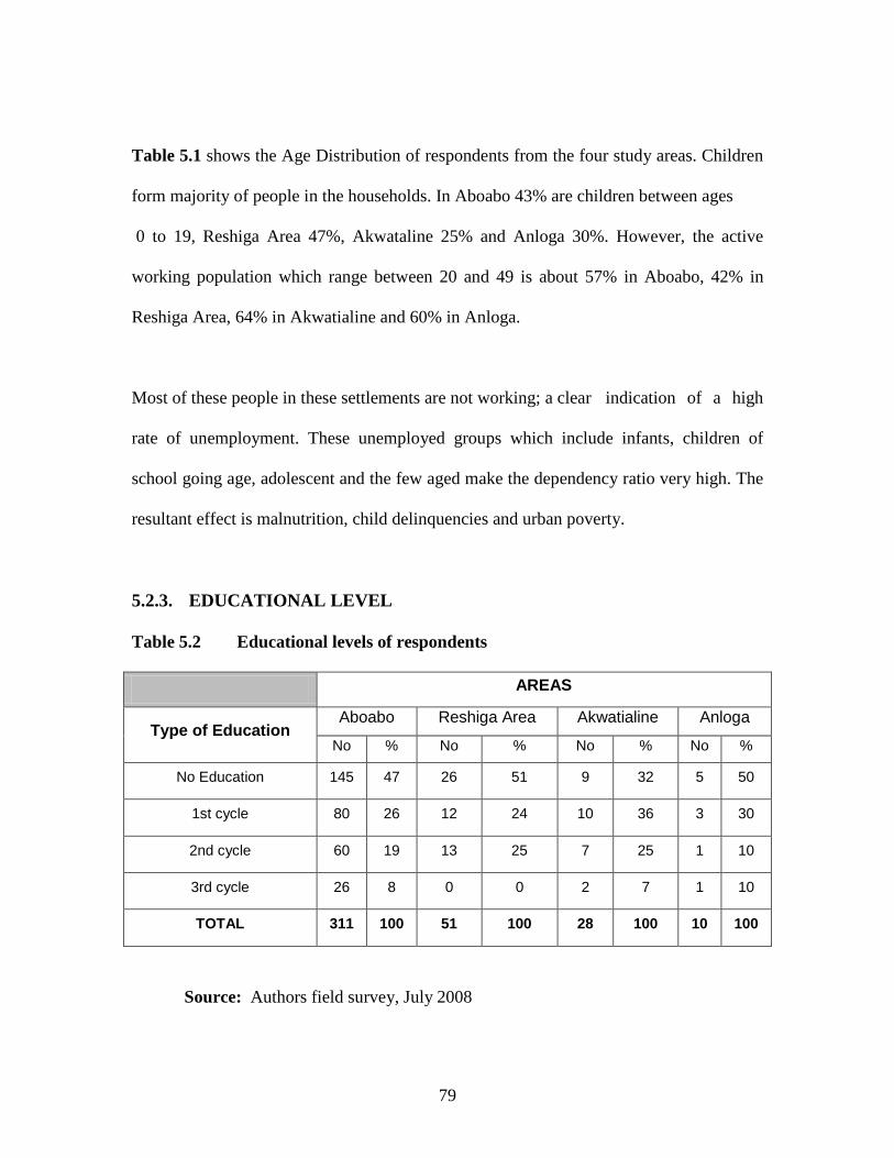
79
Table 5.1 shows the Age Distribution of respondents from the four study areas. Children
form majority of people in the households. In Aboabo 43% are children between ages
0 to 19, Reshiga Area 47%, Akwataline 25% and Anloga 30%. However, the active
working population which range between 20 and 49 is about 57% in Aboabo, 42% in
Reshiga Area, 64% in Akwatialine and 60% in Anloga.
Most of these people in these settlements are not working; a clear indication of a high
rate of unemployment. These unemployed groups which include infants, children of
school going age, adolescent and the few aged make the dependency ratio very high. The
resultant effect is malnutrition, child delinquencies and urban poverty.
5.2.3. EDUCATIONAL LEVEL
Table 5.2 Educational levels of respondents
AREAS
Type of Education Aboabo Reshiga Area Akwatialine Anloga
No % No % No % No %
No Education 145 47 26 51 9 32 5 50
1st cycle 80 26 12 24 10 36 3 30
2nd cycle 60 19 13 25 7 25 1 10
3rd cycle 26 8 0 0 2 7 1 10
TOTAL 311 100 51 100 28 100 10 100
Source: Authors field survey, July 2008

80
The table above shows the educational level of the people in the four study areas-
Aboabo, Reshiga, Akwataline and Anloga. The researcher tried to analyze the
educational level from the ‘No Education’ level through the 1st cycle to the 3rd cycle
educational level.
Figure 5.2 Educational Levels of the Respondents
EDUCATIONAL LEVEL
47
51
32
50
26
24
36
30
19
25
25
10
8
0
7
10
0% 20% 40% 60% 80% 100%
Aboabo
Reshiga Area
Akwatialine
Anloga
AR
EAS
PERCENTAGES
No Education
1st cycle
2nd cycle
3rd cycle
Source: Authors field survey, July 2008
In Aboabo, out of the 311 responses, 47% of people indicated that they had no education.
The next highest number which is 80 people representing 26% also indicated that the
only education they have is that of the ‘1st cycle’ type. 8% of the respondents in Aboabo
stated that they have had 3rd cycle education.

81
In Reshiga Area, just like that in Aboabo, 26 of the people representing 51% of the total
respondents indicated that they have “No Education” and this forms the majority in the
Area. The next highest number of people that is 12 which represents 24% also stated that
they only have “1st cycle education”. For that of Akwatialine Area, 10 out of the 28
respondents stated that they had no education and this represents 36% and this is the
highest recorded percentage in the Akwatialine line. Next to follow in Akwatialine is that
of 10 people representing 36% of the total responses indicated that they only have 1st
cycle education. None of the respondents in this area indicated that they had 3rd cycle
education.
In Anloga, the last of the four study Areas 5 people forming 50% stated that they had no
education whiles 3 of them representing 30% indicated that they had 1st cycle education.
But out of 10 respondents, 1 of them representing 10% each indicated that they have 2nd
cycle and 3rd cycle education
Generally, the level of illiteracy is high in all the four communities and more pronounced
in Reshiga as 51% of the respondents had no education. The number of people with the
1st cycle education is also low in all the areas but it is better in the Akwatialine Area as
36% of them had 1st cycle education and just 7% with 3rd cycle level education.
The Member of Parliament (M.P) for Asawase constituency, which includes Aboabo, and
Akwatialine, has decided to use his share of the Common Fund (C F) to educate people in

82
his constituency (Daily Graphic-13/9/06). This move by the MP goes to confirm the
figures in Table 5.2 that illiteracy is a problem in these communities surveyed.
5.2.4. ACCESS TO SERVICES/FACILITIES
With the exception of the residents in the Reshiga Area all the three hundred and forty-
nine respondents of the survey admitted that they are provided with drinkable water
facility. This water facility is either pipe-borne or a borehole. Roads serving the survey
areas are tarred and have developed portholes, which endanger both vehicular and
human. In terms of electricity supply, Reshiga Area has no power. The other
communities are limited to the public mains provided by the Electricity Company of
Ghana (ECG). In all the communities in the survey area, there is no public health facility.
However, the nearest health post is the Manhyia Polyclinic where these communities can
attend when they are sick. Apart from Reshiga Area Government has provided basic
schools for all the communities.
5.2.5. FINANCIAL ACCESS TO SERVICES/FACILITIES
All the respondents of the study area admitted that financial access to either pipe borne
water or bore hole is a problem. Some of the houses within the communities surveyed
have had their source of power disconnected by the Electricity Company of Ghana. When
the Author probed into it, some of the reasons assigned were; they could not afford the
monthly electricity bill, the landlord and family do not pay for electricity, money
collected for payment of electricity bill has been misappropriated etc. As a result they use
hurricane lantern when the night fall. In terms of financial access to health care, one

83
hundred and sixty-eight of the respondents representing 40% answered that they buy
drugs from local stores for self-medication when they are sick. One hundred and sixty-
four of the respondents representing 41% resort to traditional medicine, while 17% attend
the clinic. The self medicated and traditional medicine respondents indicated that care at
the clinic is expensive and therefore it is the last resort when complications develop. It
was surprised to note that none of the respondents have registered with the National
Health Insurance Scheme. The table below shows the various responses with respect to
the sources of health care.
Table 5.3 Sources of Health Care of Respondents
Source of Health Care No of Respondents % Distribution
Self Medication 168 42
Traditional Medicine 164 41
Clinic Attendance 64 17
TOTAL 400 100
Source: Author’s Field Survey, July 2008
The Pie Chart below simply indicates the various health sources in the study areas.
Graphically Self-Medication is the main source of Heath care in these areas as it
constitutes 42% percent, followed by Traditional Medicine and the least popular being
the Clinic Attendance.

84
Figure 5.3 Sources of Health Care in the Study Areas
SOURCES OF HEALTH CARE
42%
41%
17%
Self Medication
Traditional Medicine
Clinic Attendance
Source: Author’s Field Survey, July 2008
For financial access to education for their children, 90% of the respondent answered that
they are not able to pay school fees. When the Author drew their attention to the
Government Capitation Grant, they responded that there were other materials to be
provided for their children which they cannot afford. These include school inform, school
sandals/shoes, books, reading material at home etc.
5.2.6. HOUSE TYPE
The house types occupied by respondents are Compound House (Rented type);
Compound House (Family type); Owner-Occupier and Semi Detached house. Of the 400
respondents, 196 representing 49% live in Compound House (Rented type). 24 of the
people representing 6% of total respondents live in their own houses with their families.
One hundred and twelve respondents representing 28% live in compound house (family

85
type). Table 6.4 below shows the tabular representation of the house type occupied by the
respondents.
Table 5.4 House Type occupied by Respondents
Type of House Number of Respondents Distribution (%)
Compound House (Rented type) 196 49
Compound House (Family type) 112 28
Owner Occupied house 24 6
Semi Detached house 68 17
TOTAL 400 100
Source: Author’s Field Survey, July 2008
The various figure obtained with respect to the Type of Houses occupied in the various
study areas are represented below.

86
Figure 5.4 House Types Occupied by the Respondents
HOUSE TYPE OCCUPIED
49%
28%
6%
17%
Compound house (rented type)
Compound house (family type)
Owner occupied house
Semi detached house
Source: Author’s Field Survey, July 2008
With 196 respondents out of a total of 400 respondents all indicating that they occupy
Compound Houses (Rented Type), clearly it is the main type of house found in the study
area as it constitutes a majority of 49% of all the different type of houses in the study.
The owner occupied type of House is the least popular in these areas as only 6% of them
are found in these areas

87
5.2.7. TYPE OF BUILDING MATERIALS
Table 5.5 Building Materials used for houses occupied by respondents
AREAS
TYPE OF MATERIALS Aboabo Reshiga Area Akwataline Anloga
Number % Number % Number % Number %
Landcrate 103 33 0 0 13 45 3 30
Sandcrate 65 21 0 0 8 27 4 40
Burnt Bricks 27 9 0 0 3 9 1 10
Mass Swish 76 24 0 0 4 14 2 20
Wooden 40 13 51 100 1 5 0 0
TOTAL 311 100 51 100 28 100 10 100
Source: Author’s Field Survey, July 2008
In all the four study areas, the type of materials used in the construction of houses is
significant as it contributes to the grouping of the areas into the various classes. Data
from the table is further graphically represented in the figure below to simplify the
analysis with respect to the various study areas.

88
Figure 5.5 Building Materials used in the Study Areas
BUILDING MATERIALS
33
0
45
38
21
0
27
44
9
0
9
6
24
0
14
12
13
100
5
0
0% 20% 40% 60% 80% 100%
Aboabo
Reshiga Area
Akwataline
Anloga
AREA
S
PERCENTAGES
Land Crete
Sand Crete
Burnt Bricks
Mass Swish
Wooden
Source: Author’s Field Survey, July 2008
The table shows the various building materials used in the construction of houses in the
study areas- Aboabo, Reshiga, Akwataline and Anloga Area. The materials include; Land
Crete, Sand Crete, Burnt Bricks Mass Swish and Wooden type of houses.
In Aboabo, a total of 311 responses were recorded and out of that a majority of 103
houses representing 33% indicated that their houses were constructed with landcrate
material. The next highest building material employed in the construction of houses in
Aboabo is the mass Swish type of house. This is evident in the fact that 76 out of 311
houses indicated that the house was made with the mass swish and this represents 24% of
the total respondents in Aboabo. The least patronized building material is the burnt bricks

89
since out of the 311 houses; only 27 of them were made with this burnt brick material in
Aboabo forming a percentage of 9 out of the total.
In Reshiga Area, of all the building materials available for construction, only wooden
materials were used in most of their houses. This is evident in the fact that all the 51
houses sampled were all constructed using this building material. In Akwataline a total of
28 houses were sampled. And out of this number, a majority of 13 houses representing
45% of the total number of houses sampled, indicated landcrate as their building material.
From the table the next highest building material used in Akwataline is the sandcrete
since 8 out of the 28 houses indicated that. This forms 27% of the houses sampled in
Akwataline.
For an area like Anloga, 4 houses out of a total of 10 houses indicated sand crete as their
building material for their houses. This is the highest building materials in the area
because it forms 40% of the material used in building in the area. The next popular type
of building material used in the area is the sandcrete type because about 30% of these
materials are used in construction in the area. This is particularly true as 3 out of the 10
houses emphatically indicated that. The least popular material in the area is the burnt
brick since it only forms just 10% of the total sample space.
In analyzing the various figures that was gathered for the various areas, a line graph was
used. This seeks to amplify the various figures in graphical terms to make it easier in
identifying the areas with predominant figures. Generally, land crate type of building

90
material is widely used in all the four study areas but it is more pronounced in the
Akwataline area as more of their houses are constructed with them.
Figure 5.6 Building Materials used in the Study Areas
BUILDING MATERIALS
33
0
4538
21
0
27
44
90
9 6
24
0
14 1213
100
500
20
40
60
80
100
120
Aboabo Reshiga Area Akwataline Anloga
AREAS
RESP
OND
ENTS Land Crete
Sand Crete
Burnt Bricks
Mass Swish
Wooden
Source: Author’s Field Survey, July 2008
It was evident during the survey that most of the houses have not been maintained over a
long period of time. Some of the buildings have been rendered or painted. However, the
paint and rendering of most houses are peeling off.
The doors, windows and roofing materials used in the construction of houses in the
communities surveyed need replacement. This state of affair indicates that, slum and
squatter settlers are relatively the urban poor forming the low-income group.

91
Plate 5.1 TYPES AND STATE OF BUILDING MATERIALS IN STUDY AREAS
Source: Authors field survey, July 2008

92
5.2.8. AVAILABILITY OF TOILETS FACILITIES
Apart from defecating in bush and refuse dumps, four types of toilets are identified in
Kumasi. These are Aqua privies-locally known as bombers; Kumasi ventilated improved
pit (K V I P), the bucket latrine and water closet (WC). Currently public toilets in Kumasi
are poorly managed. According to users services have worsened since the Assembly
Members assumed control in 1997. The bucket latrine is officially forbidden in Kumasi.
Table 5.6 Numbers of Toilets in a House
AREAS
No. of TOILETS Aboabo Reshiga Area Akwatialine Anloga
No % No % No % No %
0 207 67 - - 19 68 6 60
1 65 21 - - 5 18 3 30
2 26 8 - - 3 9 1 10
3/more 13 4 - - 1 5 2 20
TOTAL 311 100 - - 28 100 10 100
Source: Authors field survey, July, 2008.
The table above shows a survey of the number of toilets facilities within houses in the
various study areas. This ranged from ‘No Toilets’ at all to about ‘3 or more’ toilet
facilities present in a house. This is graphically represented below.

93
Figure 5.7 Number of Toilet Facilities in the Study Areas
NUMBER OF TOILETS IN A HOUSE
67
0
68
63
21
0
18
19
8
0
9
6
4
0
5
13
0% 20% 40% 60% 80% 100%
Aboabo
Reshiga Area
Akwatialine
Anloga
AREA
S
PERCENTAGES
NO TOILET
ONE(1) NO.OF TOILET
TWO(2) NO.OF TOILETS
THREE(3) OR MORE NO.OF TOILETS
Source: Authors field survey, July, 2008.
For the Aboabo Areas, a total of 311houses was gathered for the survey. Out of this
number 207 houses representing 67% stated that they don’t have any toilets at all in the
houses. The next high number of houses responding to the question of number of toilets
in the house was 65 houses representing 21% of the sample space, all indicating that they
have only 1 toilet facility in the house. The houses with 3 or more toilet facilities were the
least popular in the area since they only represented 4% of the 311 houses sampled.
In Reshiga Area, the situation was rather strange since none of the responding houses
indicated that they had any toilet facility. In Akwataline Area, the percentage responds to
the number of toilet facilities were almost the same as that of Aboabo but the actual
number of responses was vastly great. As 311 houses responses were gathered in Aboabo

94
only 28 responses were obtained for Akwataline area. With this number, 19 number of
the houses indicated that they had no toilets in their houses this form 68% of the total
sample space whiles just 5 respondents representing only 1% indicated that they had
three (3) or more toilet facilities in the house. This is the smallest figure recorded in the
Akwatialine area.
From areas in Anloga, out of a total of 10 houses, 6 of them which form 60% indicated
that they had no toilets in them. This forms the majority of the sample. 3 out of the 10
which forms 30% indicated the availability on only 1 toilet facility in the houses. The 2
number of toilet facilities in the house was considered the least because the researcher
had only 1 houses which represented 10% to that effect.
In general, majority of the houses without toilets and those houses with only 1 toilet
facility can be found in Aboabo. In that same vain, it can also be seen that, significantly a
considerable number of houses with ‘3 or more’ toilet facilities can also be found in the
same Aboabo. This is also shown in the line graph shown below.
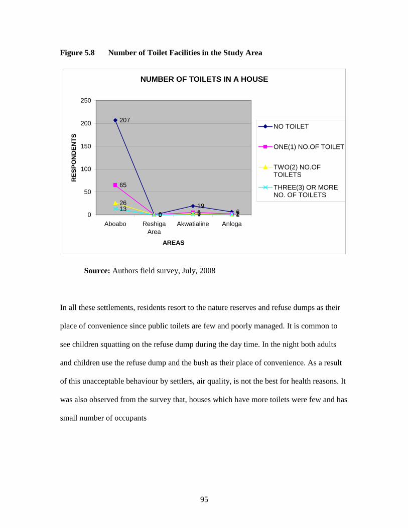
95
Figure 5.8 Number of Toilet Facilities in the Study Area
NUMBER OF TOILETS IN A HOUSE
207
019
6
65
0 5 2
26
0 3 113
0 1 10
50
100
150
200
250
Aboabo ReshigaArea
Akwatialine Anloga
AREAS
RES
PON
DEN
TS
NO TOILET
ONE(1) NO.OF TOILET
TWO(2) NO.OFTOILETS
THREE(3) OR MORENO. OF TOILETS
Source: Authors field survey, July, 2008
In all these settlements, residents resort to the nature reserves and refuse dumps as their
place of convenience since public toilets are few and poorly managed. It is common to
see children squatting on the refuse dump during the day time. In the night both adults
and children use the refuse dump and the bush as their place of convenience. As a result
of this unacceptable behaviour by settlers, air quality, is not the best for health reasons. It
was also observed from the survey that, houses which have more toilets were few and has
small number of occupants

96
5.2.9. AVAILABILITY OF BATHROOM FACILITIES
Table 5.7 Number of bathrooms in a House
AREAS
No of
BATHROOMS
Aboabo Reshiga Area Akwatia line Anloga
No % No % No % No %
0 52 17 26 50 6 23 3 30
1 103 33 26 50 8 32 4 40
2 65 21 0 0 5 18 2 20
3/more 91 29 0 0 7 27 1 10
TOTAL 311 100 51 100 26 100 10 100
Source: Author’s Field Survey; July 2008
The table above shows the number of bathrooms in houses in the study areas. Bathroom
in this contents include blocks systematically arranged in the form of a rectangle or a
square and wooden structure for purposes of washing oneself. Information gathered from
the study areas is graphically represented below.

97
Figure 5.9 Number of Bathroom Facilities in the Study Area
NUMBER OF BATHROOOMS
17
50
23
25
33
50
32
38
21
0
18
19
29
0
27
19
0% 20% 40% 60% 80% 100%
Aboabo
ReshigaArea
Akwatialine
Anloga
AREA
S
PERCENTAGES
NO BATHROOM
ONE(1) NO.OFBATHROOMSTWO(2) NO.OFBATHROOMSTHREE(3) OR MORE NO.OF BATHROOMS
Source: Author’s Field Survey; July 2008
In Aboabo, out of a total number of 311, 103 houses representing a majority of 33%
indicated the availability of only 1 bathroom facility. The house with 3 or more
bathrooms formed the next highest in the survey. 91 numbers of houses representing 29%
of the total sample indicated that there were 3 or more bathrooms in their premise. But
the least number was recorded for houses with no bathrooms and this formed 17%
because only 52 out of the 311 houses indicated that.
For the area in Reshiga, out of a total if 51 houses, 26 representing 50% indicated that
they had no bathrooms and the same number also indicated that they had only one
bathroom facility. This also represents 50% of the sample space.

98
For that of Akwataline, out of a total of 26 houses, 8 of them representing 32% stated that
they only had 1 bathroom facility. But 7 of the houses forming 27% also indicated that
they had 3 or more bathroom facility, thus forming the second highest in this group. A
least number of 18% of the total sample space was recorded because only 5 respondents
in the Akwatia area indicated that they had 2 numbers of bathrooms. But the figures were
different in Anloga. Out of a total of 32 houses, 12 of them representing 37% indicated
that they have only one bathroom. A number of 6 houses indicated that they have 2
bathrooms and another 6 number of houses also indicated that they have 3 or more
bathroom. All together 6 houses representing 19% each of the total sampled houses
In conclusion, Reshiga Area has more houses with ‘No Bathrooms’ facility. But
significantly areas in Anloga have a number of houses with 2 and 3 or more bathrooms in
them. The graph below shows the number of bathrooms with emphasis to their
percentages.

99
Figure 5.10 Number of Bathroom Facilities in the Study Area
NUMBER OF BATHROOMS
52
26
6 2
103
26
84
65
05 2
91
07
20
20
40
60
80
100
120
Aboabo ReshigaArea
Akwatialine
Anloga
AREAS
RESP
OND
ENTS
NO BATHROOM
ONE(1) NO.OFBATHROOMSTWO(2) NO.OFBATHROOMSTHREE(3) OR MORENO. OF BATHROOMS
Source: Author’s Field Survey; July 2008
The survey also revealed that most of the children take their bath in the open whilst some
adults bath in the open during the early part of the day and late in the night. However
some residents queue in the morning to take their bath. This is due to the fact that the
bathroom facilities provided are not enough in the houses surveyed.
The survey has shown that some of these bathrooms are owned by individual residents
for their private use. Most of the bathrooms are cleaned every morning, but the
management of the waste-water outside presents environmental problems. The houses
have P.V.C pipes connected from the bathrooms to the outside of the building. Buckets
and waste cans are used to collect waste water from the bathrooms. These buckets and

100
cans are not emptied regularly, and when they are emptied, the waste water is poured
around the house. The waste water produces offensive scent to the residents and visitors
to these communities alike. The number of houses using three bathrooms or more was
significant in the survey work. The percentages for three bathrooms or more for the four
communities are 29% for Aboabo, 0% for Reshiga Area, 27% for Akwatialine and 10%
for Anloga.
5.3. ACCESS TO LAND THROUGH ENCROACHMENT OF NATURE
RESERVES IN KUMASI
The main nature reserves within the KMA are along the Owabi and Oda streams and their
tributaries. The tributaries of Owabi stream are Asuaboa, Sikubri, Achianponi and Akosu.
The Aboabo, Wewe, Danyan, Subin, Sisai and Kwadaso are the tributaries of Oda all
located on the southern part of Kumasi (Lands Commission Kumasi, 2008).
All these nature reserves are prone to flooding during the rainy season. The Subin valley
is well drained and flows through the Central Business District of Kumasi. Almost all
developments on the banks of Subin are legal up to the Asafo interchange. Thereafter all
other developments are considered illegal because of their lack of the necessary
development and building permits. This tendency fuelled the establishment of slum and
squatter settlements in the locality by some members of the urban poor.
Information available indicates that as much as sixty percent of areas within the nature
reserves had been encroached upon. It was also noted that seventy-five percent of the

101
nature reserves in Kumasi metropolis have been occupied by illegal squatters (Source:
TCPD-Kumasi, 2008).
5.3.2. ACCESS TO LAND THROUGH ENCROACHMENT OF MAJOR
STREAMS
THE ABOABO STREAM
This stream stretches from Buokrom through Dichemso to Oforikrom and Asokwa before
traversing through Atonsu. The banks of this stream have been encroached upon because
it flows through a densely populated part of Kumasi. Wooden structures have been
constructed along the banks and the railway line which passes through Aboabo. One
hundred and fifty squatter settlements were counted within the area. These squatter
settlements suffer from flooding and it is common to see completed and uncompleted
structures which have been abandoned by their owners.

102
Plate 5.2 A SHALLOW SIDE OF ABOABO STREAM THROUGH ABOABO
Source: Survey Data, July, 2008
The railway bridge on the Aboabo stream is often choked with domestic waste and the
valley along the stream serves as a place of convenience for the squatters. It was evident
that these squatter settlements have been in existence for some time and no effort is being
made by the KMA to eject them as their continued existence poses danger to health,
environmental and aquatic life. However, a portion the banks of Aboabo stream are used
for other activities including gari processing, woodwork and refuse dump. This was
visible as the stream crosses the Accra-Kumasi trunk road at Anloga.
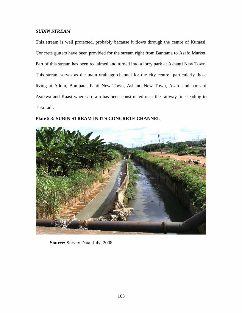
103
SUBIN STREAM
This stream is well protected, probably because it flows through the centre of Kumasi.
Concrete gutters have been provided for the stream right from Bantama to Asafo Market.
Part of this stream has been reclaimed and turned into a lorry park at Ashanti New Town.
This stream serves as the main drainage channel for the city centre particularly those
living at Adum, Bompata, Fanti New Town, Ashanti New Town, Asafo and parts of
Asokwa and Kaasi where a drain has been constructed near the railway line leading to
Takoradi.
Plate 5.3: SUBIN STREAM IN ITS CONCRETE CHANNEL
Source: Survey Data, July, 2008

104
Commercial activities can be found along the course of the stream near the Kumasi
Railway Station and opposite the Kumasi Central Market. A three story Sandcrate block
structure has been constructed on the drains provided for the stream to serve as shops.
After the Asafo Interchange, fishmongers also parade along the stream smoking their
fish. This area serves as a major fishing processing zone within the KMA. The banks of
this stream have been encroached upon at the Reshiga structures and near the Electricity
Company of Ghana sub- station. Squatter settlements numbering two hundred and fifteen
have encroached this part of the stream. The materials used by the squatters are mainly
wooden boards. These structures have been numbered as Kiosk 1 – Kiosk 215. It was
evident that KMA has issued an ultimatum for the squatters to vacate the place. A red
mark on some of these structures read “remove by 30th June 2006”. Even though the
deadline set by KMA has expired, nothing concrete has been taken by the city authorities
to back their words with action.

105
Plate 5.4: WOODEN STRUCTURES IN RESHIGA MARKED BY K.M.A
Source: Survey Data, July, 2008
Unlike the squatter settlement at Aboabo, those here are well organized under a leader.
Any prospective squatter will have to see the leader directly or through an aide. Upon
payment of few cedis a plot is allocated and the squatter is ready to build and occupy.
When some of the squatters saw the researcher and his assistants, they thought that we
were officials from KMA and started casting insinuations such as “your effort will yield
nothing”; “we will stay there as long as we wish”; “our political connection is strong”
and such other comments. However, with the help of their leader and a few enlightened
ones among them we were able to conduct our interview.

106
SISAI STREAM
This stream is a tributary to the Aboabo at Asokwa and runs through the city from
Bomso, Oforikrom New Site and to Adukrom. There are a lot of unauthorized properties
built along the stream at Oforikrom New Site and Anloga. Here a few illegal squatter
settlements were cited at their prime stage. At Bomso, portions of the banks have been
used for cultivation of plantain. Poku Transport workshop abuts this stream and
sometimes used fuel product find their way into the stream.
Plate 5.5: SISAI STREAM THROUGH ANLOGA
Source: Survey Data, July, 2008
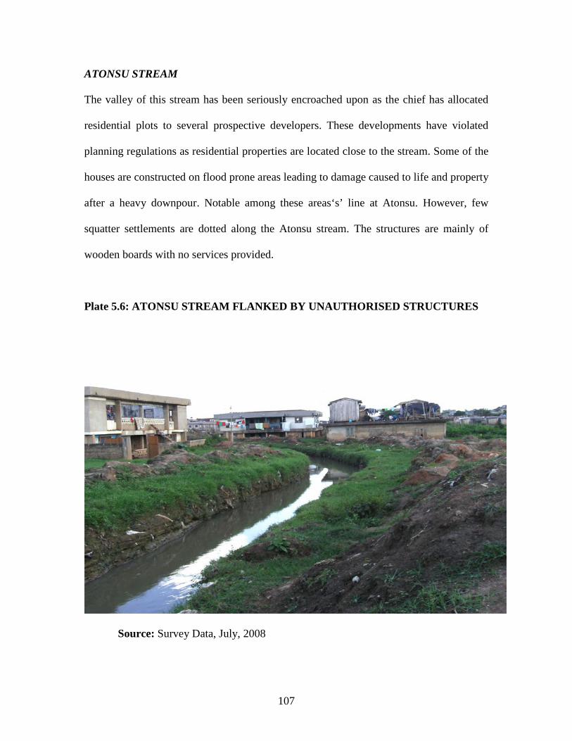
107
ATONSU STREAM
The valley of this stream has been seriously encroached upon as the chief has allocated
residential plots to several prospective developers. These developments have violated
planning regulations as residential properties are located close to the stream. Some of the
houses are constructed on flood prone areas leading to damage caused to life and property
after a heavy downpour. Notable among these areas‘s’ line at Atonsu. However, few
squatter settlements are dotted along the Atonsu stream. The structures are mainly of
wooden boards with no services provided.
Plate 5.6: ATONSU STREAM FLANKED BY UNAUTHORISED STRUCTURES
Source: Survey Data, July, 2008
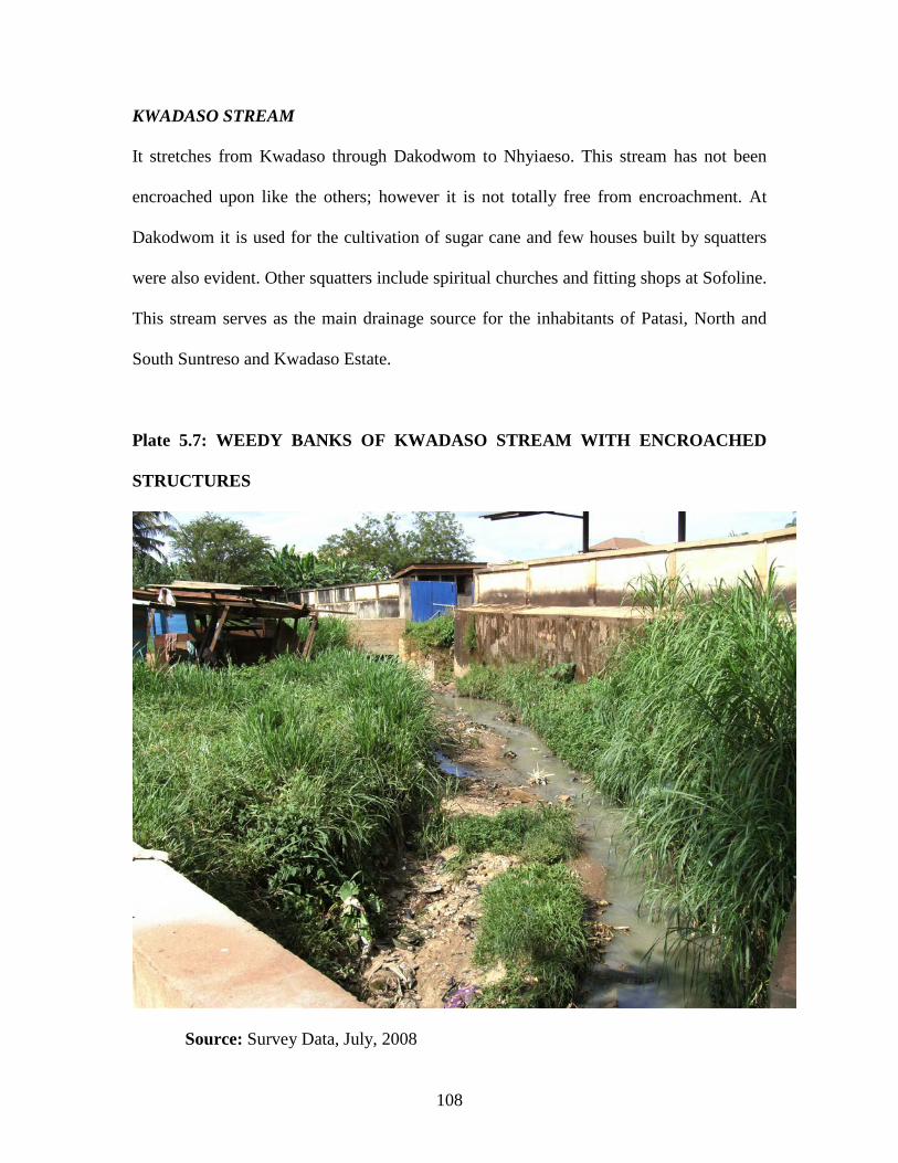
108
KWADASO STREAM
It stretches from Kwadaso through Dakodwom to Nhyiaeso. This stream has not been
encroached upon like the others; however it is not totally free from encroachment. At
Dakodwom it is used for the cultivation of sugar cane and few houses built by squatters
were also evident. Other squatters include spiritual churches and fitting shops at Sofoline.
This stream serves as the main drainage source for the inhabitants of Patasi, North and
South Suntreso and Kwadaso Estate.
Plate 5.7: WEEDY BANKS OF KWADASO STREAM WITH ENCROACHED
STRUCTURES
Source: Survey Data, July, 2008

109
5.4. CHARACTERISTICS OF URBAN POVERTY
5.4.1. SLUMS
Almost all the slum areas in Kumasi are cosmopolitan settlements. Inhabitants in these
areas are mainly aliens whose ancestors migrated from Northern Ghana and other
countries like Nigeria, Togo, Benin, Mali, Niger and Burkina Faso. These areas are
Aboabo (No.1 and 2), Reshiga Area and Akwatialine. Inter marriages have unified these
settlers into the indigenous Kumasi township to the extent that it is difficult to identify
who is a Ghanaian and who is not.
Aboabo (No.1 and 2), Reshiga Area and Akwatialine are predominantly Hausas,
Wangaras, Moshies and other tribes from Northern Ghana. Anloga is also predominantly
the Ewe speaking from Benin, Togo and Ghana. The responses from the people
interviewed in each of the settlements showed that, in Aboabo, 218 of the respondents
(representing 70%) were born in Ghana and trace their ancestral lineage to other West
African countries. The respective figures for Reshiga Area, Akwatialine and Anloga are
33, 24 and 7 (representing 65%, 86% and 70% respectively). In Aboabo, Reshiga Area
and Akwatialine, most of the people cannot speak their native languages and have
adopted Hausa as their first language. In Anloga, the situation is different as most of them
could speak their native language in addition to the Twi language.
5.5. LAND DELIVERY APPROACHES
The survey revealed that the current approaches adopted by land sector agencies for
improving the delivery of land for the urban poor include legal and institutional reforms.

110
The legal reforms include amendments of obsolete acts and statutes that impede land
administration and management and thereby making the land acquisition and
development cumbersome, slow and costly and therefore unaffordable especially to the
urban poor. To this effect, the land sector agencies are currently undergoing legal reforms
in which land policies and land laws and customary laws are being harmonized through
the LAP. It is believed that, if there is harmonization in the various land laws and
customary procedures and rules for accessing land, then everybody can have access to
land irrespective of their status in life.
Besides, the land sector agencies are also undergoing institutional reforms where some of
the institutions have been put under one umbrella so as to facilitate the free flow of land
related information. This is to enhance the delivery of land in an efficient and expeditious
manner. As a result the Lands Commission Act,( Act 767) was passed by parliament. The
Act has broadened the functions of the then Survey Department, Land Valuation Board,
Land Title Registry and the then Lands Commission under a new Lands Commission.
Again, institutional capacity building and logistical problems are being tackled by the
institutional reforms component of LAP. Furthermore, to ensure the effective
management and coordination of customary lands, Customary Lands Secretariats are
being set up in the various land owning communities.
Another approach adopted by land delivery agencies is land banking. This is done in
conjunction with Metropolitan, Municipal and District Assemblies and Traditional
Authorities, where chiefs have been encouraged to set aside some parcels of peri-urban

111
land for future development. The import of land banking is to make land affordable to
prospective developers so that, the issues of land speculation which fuel up the price of
land does not affect these land banks. This will help keep the price of peri-urban
agricultural land down and also to ensure that the effect of urbanization does not take
away much land at the expense of future development. In effect, land banking is trying to
slow down the operation of market forces of supply and demand of land for development.
While these approaches are laudable in facilitating access to land and development, what
is apparent is that, access to land is still based on economic principles. That is the forces
of supply and demand determine who gets the right to use land so that in the end, the
process of accessing land might be efficient and less cumbersome but as to whether this
will lead to land being affordable to the urban poor is another issue.
5.6. MAIN CHARACTERISTICS AND PROBLEMS OF INSTITUTIONS
INVOLVED IN LAND DELIVERY
5.6.1. Characteristics of Current Land Delivery Institutions.
The institutions involved in land service delivery operate in monopoly positions because
the service they provide is limited to their institution only. The staffs of these agencies
are usually indifferent to the interest of their customers though a large proportion of their
income is from the fees/fines/charges of their services. There is little attention paid to
customer interest. The implementation of policies and decisions are primarily based on
budget output relations and compliance with procedures and processes rather than outputs
and results (Larbi, 2006).
112
The main characteristics of the land service delivery system was revealed in the survey
are as follows;
1. Land delivery is scattered among eight main institutions namely the Lands
Commission, Office of the Administrator of Stool Lands, Internal Revenue
Service, Town and Country Planning Department and District Assemblies.
2. Land information system is paper-based, manual, outmoded and very difficult
to update
3. Response time to clients request takes a long time as information storage and
retrieval is done manually.
4. Unclear roles, which sometimes confuses the public as to where to go.
5. Little or no coordination among the service providers resulting in duplication of
some activities in relation to clients’ requests.
The above characteristics have created perception among clients of the land service
delivery agencies which can be summarized as: frustration, undue delay, slow or non-
response, high transaction cost, rent seeking behaviour, corrupt, poor client services
delivery, manipulation and mutilation of records, low integrity of land records etc. The
resultant effect is that the quality of the land delivery system is poor and the urban poor
cannot participate. Clients therefore tend to ignore the information provided in the
records and resort to self-help in many cases or take decision without any valuable
information base.

113
5.6.2. Problems of Land Delivery Institutions.
5.6.2.1. Public and Vested Land Management Division (PVLMD)
Lands Commission –Kumasi is located in one of the Old Ministerial buildings. The
strategic location of the Land Commissions makes it accessible to all clients who may
need their services. The Commission disclosed that its main challenge to accelerated
poverty reduction effort is budgetary constraints. Funding for the activities of the
Commission through the Financial Encumbrance (FE) was woefully inadequate and not
released in good time. The last quarter allocation for 2008 was for example, even not
received from the government.
Secondly the staffing position of the Commission is not the best. Currently the
Commission needs cartographers to strengthen the records and drawing office, lands
officers and Inspector of lands to man the rent management unit and encroachment
prevention exercise and computer specialist to be in charge of Information Technology
Section.
Third is the problem of office accommodation. It was disclosed by all respondent that the
Commission has only eighteen (18) office rooms, which are woefully inadequate. There
is therefore congestion in the records office, the files room and national service personnel
office. The Chairman of the Commission also has no office at the Division for the smooth
performance of his duties. In addition to these difficulties, the Regional Lands Officer’s
Office is separated from the rest of the offices making supervision and communication
very difficult.

114
The fourth problem is internal communication. The intercom facilities provided in the
office have suffered from irregular power supply leading to intermittent breakdowns.
Besides, networking of computer could not be put into full operations for lack of
adequate computers and accessories and deficiency in computer skills of some of the staff
members.
The fifth problem disclosed by a staff at the records office of this division is records
management. The manual data storage methods, space constraints and staff shortage are
creating serious problems with records management. The Accountant also reported that
the accounts and rent ledgers are getting bulky and worn - out.
The sixth problem as given by the Principal State Attorney is Court Cases; the
Commission is saddled with nineteen (19) court cases some of which are old but still
being pursued by their respective plaintiffs. The four current cases worth mentioning are;
a. Akua Achiaa Ossei, aka Cathy Ossei vrs Harry Ossei, Lands Commission and 2
others. The Commission is the 4th defendant. Both plaintiff and first defendant are brother
and sister. The 1st defendant allegedly submitted an application to the Commission
requesting that since plot number 18 Block “P” Bomso, Kumasi was vested
exclusively in him; all other names relative to the plot must be deleted. The plaintiffs
deny having inter alia disposed of their interest and are therefore seeking an injunction to
restrain the Commission from further processing of the document relative to the said plot
until the case is finally determined. Secondly, Obaapanin Akua Druwaa, Apagyafie,
Ashanti New Town vrs Unilever Ghana Limited, Lands Commission and

115
other. The plaintiff’s claims that she is the Obaapanin of Apagyafie and her family
originally held usufructuary title to all parcel of land now presently known and numbered
as plot No 1 – 3 and 10 – 12 Krobo, Kumasi (Part One lands). The plaintiffs are
aggrieved because the Commission has consented to the Assignment of the property but
refused to recognize the interest of her family. Thirdly, Nana Twumasi Aboabio,
Pinsanhene and 2 others Vrs Attoney General, Land Valuation Division, PVLMD and
Ghana Education Service. The plaintiffs are chiefs who are the custodians of all that
parcel of land measuring 256.8 acres which Ghana Government has since 1959 acquired
for Yaa Asantewaa Secondary School, Tanoso-Kumasi. The plaintiffs have jointly asked
for prompt payment of fair and adequate compensation for the acquisition of the site. The
court has given judgment to the plaintiffs and filed for Assessment of Compensation.
Meanwhile, the Executive Instrument (E I) of the acquisition has still not been published.
Finally, in the Republic Vrs Gertrude Adoma Afranie the accused person is wilfully in
occupation of public land at T.U.C junction, Kumasi. The Commission as part of its
mandate to check encroachment on public land found the defendant occupying public
land without any authorization and decided to prosecute her.
The rest of the cases as disclosed by the Principal State Attorney touched on application
for an order to cancel lease documents, application for order of mandamus, injunction,
and declaration of title and unlawful occupation of state land. The Principal State
Attorney disclosed that the effect of court procedures on the activities of the Commission
is enormous. Court procedures waste time, money, unnecessary adjournments etc.

116
The eighth problem is chieftaincy disputes. All the respondents agreed that chieftaincy
dispute has negative implications on the work of the Commission. Currently there is a
dispute between Chiefs of Daaban and Sokoban over a 254 square kilometre land. The
problem here relates to boundary dispute and the resultant effect is that all land
documents coming from this disputed area cannot be processed at the Lands
Commission.
The ninth problem has to do with travels of Otumfour. It was disclosed by all the
respondents that when Otumfour travels, no one can sign a document on his behalf. This
situation tends to prolong the time to be used in processing the documents.
The tenth problem has to do with delays of documents by the Kumasi Traditional
Council. Documents sent to the Kumasi Traditional Council for endorsement by the
caretaker chiefs and Otumfour tend to delay despite the existence of Asantehene’s
Lands Secretariat.
The last problem as disclosed by the respondents has to do with fees and charges by the
Kumasi Traditional Council. Fees are charged without reference to any formula. Within
the Kumasi Traditional Area caretaker chiefs are supposed to present one-third (1/3) of the
drink money on any land granted to Otumfour. This arrangement is not complied with by
the caretaker chiefs, so when a prospective land owner presents his allocation note to
Otumfour for endorsement, he/she is made to pay for the one-third which the caretaker
chief has refused to pay. The resultant effect is that the cost of processing lease document
in Kumasi is very high and time consuming.

117
5.6.2.2. Survey and Mapping Division (SMD)
The Survey and Mapping Division has its own building strategically located in Kumasi.
The Division in its role to reduce poverty in the region faces some problems as
catalogued by the respondents. The Division faces the problem of inadequate funding
from the Government of Ghana (G O G) to undertake its day-to-day functions. There is
also shortage of trained staff and equipment resulting in slow preparation of base maps.
This situation has led to land transactions and development in areas where base maps
have not been prepared. This has resulted in multiple land sales, haphazard development
and land disputes. Again, the presence of quack surveyors in the regions is a problem to
the Division. Most chiefs have their own unqualified surveyors who do surveying on
their behalf. Their activities lead to wrongful demarcation of plots. A respondent
indicated that at times buildings are put on roads, open spaces and in between plots.
5.6.2.3. Land Registration Division (LRD)
The Land Registration Division, though the youngest among the Land Sector Agencies is
beset with a number of problems. The problems facing the Division as disclosed by the
respondents are; severe shortages of qualified staff like the other institutions, non-
existence of Adjudication Committee. This Committee, according to the Land Title
Registration Law, 1986 (P N D C L 152) is to adjudicate on all matters brought before the
Land Registry. This Committee has not been formed despite its provision in the law.
Also, inadequate resources for Title Registration, inadequate public education on Title
Registration procedures, and non-compliance with section 13 of P N D C L 152 on
conversion of deeds to title certificate.

118
5.6.2.4. Office of the Administrator of Stool Lands. (OASL)
This office is in the same Ministerial block with the Public and Vested Land Division of
the Lands Commission and therefore accessible to their clients. However, the challenges
or constraints facing the office towards poverty reduction include lack of a Legislative
Instrument to facilitate the operation of Act 481. Failure of Kumasi Metropolitan
Assembly to use revenue for development projects for the benefit of communities,
chieftaincy dispute, inadequate boundaries between stools leading to conflicts, inadequate
logistical support, and inadequate skilled manpower. This has led the office to employ
“commission collectors” to collect stool land revenue on behalf of the office. This
practice is in line with the government’s policy of public/private partnership. Besides,
difficulty of some chiefs getting their share of the stool land revenue from the Kumasi
Traditional Council (KTC) and some chiefs do collect ground rent and farm tribute direct
from their tenants were general problems encountered by OASL.
5.6.2.5. Land Valuation Division (LVD)
The Land Valuation Division occupies the same building with the Public and Vested
Land Management Division and therefore accessible to their clients. The problems
encountered by this division were not different from those discussed above.

119
5.6.2.6. Town and Country Planning Department (TCPD)
This department occupies its own building located within the Ministerial area and
therefore accessible by all clients. The challenges or constraints of this department effort
at ensuring access to land by urban poor, as suggested by respondents were as follows.
There is lack of human and logistic capacity of the agencies involved in development
control to collate and guide the activities of the multiple individual private developers.
This is characterized by lack of up-to-date maps for quick and reliable plan preparation
and land use conflict resolution, as well as accurate ground demarcation and survey of
approved plans, immobility of inspectorate and field monitoring staff for day-to-day
supervision and monitoring of development, with resultant weakening or abandonment of
statutory supervision of developments. For example, the Building Inspectorate Section of
the Metro Engineers Department has no vehicle for field operations and likewise the
Metro Planning Unit of the Town and Country Planning Department has only one old
pick-up truck. Besides, there are insufficient middle level technicians with expertise in
building and construction technology in Kumasi Metropolitan Assembly (KMA) for
statutory supervision of construction in the metropolis. The current crop of Building
Inspectors of K. M. A were employed as Building Draughtsman, and without any form of
training, were converted, promoted and designated as “Building Inspectors”. Also,
dependence on obsolete and manual methods for plan preparation and information
management for monitoring and supervision of development in the metropolis is
hampering enforcement of development control.

120
Secondly delays in granting permits for development and construction to applicants
coupled with the ever-escalating construction costs in the economy, push prospective
developers to commence construction ahead of processing the necessary permits. This
problem is a result of applicant inability to satisfy all the requirements for grant of
permits especially “certificate of good title to land.” Low number of the required
meetings and irregular sittings of the Statutory Planning Committee of the Assembly -
the body with statutory responsibility for granting permits for development, cumbersome
and time consuming permits approval process, delays by the final signatory to the
Building Permit- the Metro Chief Executive. This is not a statutory requirement but for
some reason, was imposed by the then Kumasi Municipal Council in the early 1960’s,
and adopted by the subsequent councils and Assembly respectively. Furthermore, KMA
is not applying the simplified procedure for granting Development and Building Permit
provided by the provisions of the National Building Regulations 1996-LI 1630.
Thirdly, traditional land owners’ refusal to succumb to approved plans proposal as some
land owners unilateral rejection of certain proposals in approved plans reserving sizable
tracts of land for public community facilities and services (for example schools, public
parks) and surreptitiously sub-dividing into dwelling plots and allocating same for private
development. Also, impatience on the part of some traditional land owners to wait for
completion of planning scheme for their stool lands and without technical guidance sub-
divide the land and allocate for predominately residential development and land litigation
resulting from conflicting claims to stool land. Finally, the engagement of quack persons

121
who designate themselves as planners and surveyors, by some land owners to prepare and
implement land use sub-division plans has also not helped the situation.
Fourthly, the Building Inspectorate Section of the Metro Engineers, Department- KMA is
not performing its statutory functions of supervising building construction to ensure
compliance with the requirements of development and building regulations. Rather it
concentrates on checking unauthorized developments. The only evidence of its existence
and operation is the occasional discriminatory “STOP WORK PRODUCE PERMIT”
notice or “REMOVE-BY ORDER OF KMA” inscriptions on a few structures in the
metropolis.
Fifthly, ignorance of some developers of the regulatory requirements for development
in the metropolis and KMA’s inability to enforce sanction provisions of development
regulations as well as the general indiscipline and lawlessness of the actors in the
development management system has frustrated the efforts of the development control
unit of KMA.
5.6.2.7. Kumasi Metropolitan Assembly
The main activity of the Kumasi Metropolitan Assembly (KMA) as disclosed by
respondents is the alleviation of poverty in the metropolis. The Government of the
Republic of Ghana through the Metropolitan, Municipal and District Assemblies has
embarked on a programme towards eradication of urban poverty. This programme was

122
initiated in 2003. In this regard KMA collaborates with other institutions in solving the
problem of urban poverty. These institutions as disclosed by respondents are:
a. Ministry of Health (MOH)
b. Ministry of Food and Agriculture (MOFA)
c. Social Investment Fund (SIF)
d. Non-Formal Education Division of the Ministry of Education
e. Department of Social Welfare and
f. Non-Government Organizations (NGO’s) involved in poverty reduction.
The challenges facing the KMA in its efforts at urban poverty reduction as revealed by
respondents are:
a. Lack of qualified staff, especially field workers
b. Lack of funds to implement programmes that aim at reducing urban poverty in
the metropolis.
c. Lack of logistics and other equipment such as vehicles
d. Poor community participation in poverty reduction programmes.
e. Land litigation and chieftaincy disputes, affects developmental efforts of the
Assembly.

123
CHAPTER SIX
SUMMARY OF FINDINGS, CONCLUSIONS AND RECOMMENDATIONS
6.1. INTRODUCTION
This chapter presents a summary of the main findings; the conclusions arrived at and the
recommendations for the study. The study was undertaken to assess how the land
delivery system could be improved for the benefit of the urban poor within the Kumasi
Metropolitan Area. The study also sought to find out the problems among the land
delivery institutions and the role of the Land Administration Project (LAP) in land
service delivery in the country as a whole.
6.2. SUMMARY OF FINDINGS
Based on the stated objectives, the study used statistical procedures, to analyze data
collected by interviewing people living in slums and squatter settlements (urban poor)
and land delivery institutions including the Kumasi Metropolitan Assembly. The main
findings of the study are summarised as follows;
6.2.1. Income
An attempt was made to get the income earned by the residents (both tenants and
landlords) but this proved futile as people were not willing to give information on their
income. It was also observed that most of them could not estimate the average income
they receive every month. Looking at their present status, one could conclude that
majority of the people are poor and live from hand to mouth.

124
6.2.2. Maintenance of Buildings
The culture of maintenance is lacking in the country and worse in slum areas. In all the
communities surveyed, most of the buildings have major cracks on walls, paints peeling
off and the foundations of some buildings hanging due to erosion. It was observed that
most of the buildings have not been maintained since they were constructed/built up. The
general drainage system in these areas is poor leading to creation of gullies between
buildings. Most of the houses would need a lot of improvements to make them really safe
for human habitation.
6.2.3. Provision of Services
6.2.3.1. Water
Despite the presence of pipe borne water in these communities, most of the houses do not
have standpipes. They rely solely on buying water at 20GHp per bucket from nearby
houses which have water. It was observed that the public stand pipes in these
communities are broken down. A few houses have constructed boreholes and use the
water for washing and cleaning.
6.2.3.2. Electricity
Apart from the Reshiga Area, all the houses in the other communities have access to
electricity, but some have been disconnected for non-payment of bills. This may arise as
a result of the landlord and family being excluded from paying the bill or the money for
payment is squandered by a member of the household particular landlord and family.

125
6.2.3.3. Health.
Health facility is close to these residents, but the local residents do not patronize their
services. This may be due to the fact that the residents have not registered with the
National Health Insurance Scheme. They prefer to seek medical attention from herbalists
or self-medication when they are sick.
6.2.3.4. Education
Due to the reasons given in chapter 5 item 5.2.3 poor parents find it difficult to sponsor
their wards in school. Although basic education has been made fee-free in addition to
provision of meals, hidden cost (such as cost of school uniforms, tables and chairs, books,
printing fees and others) may still discourage the urban poor from sending their children
to school.
6.2.4. Land Tenure
The main problems identified under the land tenure system in Kumasi today include high
land prices which do not give fair access to land, particularly the urban poor.
Cumbersome procedure has also made land acquisition slow and costly while protracted
litigation retards land delivery. Above all, the ineffective land administrative machinery
has failed to respond to the changing condition. Corruption and illicit practices often
hamper the land delivery system for the urban poor. Finally the role of chiefs in land
administration leaves much to be desired.

126
6.2.5. Housing
Government efforts to improve housing in Kumasi have mostly been in the form of estate
housing for low-to middle-income households and bungalows for senior public sector
employees. Unfortunately the estates in Kumasi failed to solve the housing problems of
the low-income households both because the supply was too limited and because the
urban poor cannot afford to buy or even rent such houses.
6.2.6. Urban Migration
People from communities who migrate to Kumasi tended to congregate together in
new settlements so that they could preserve and practice their culture. Thus within a
generally accepted culture and traditional practices of a dominant ethnic group could be
found other local cultures and traditional practices resulting in the plurality of cultures.
On arriving in Kumasi, the migrant with little or no formal education or skills finds that
life is not as anticipated. There are no readily available jobs, and majority find themselves
in the informal sectors with low incomes. Decent accommodation is beyond their reach
and most migrants end up in informal settlements with insecure tenure and lacking basic
urban services.
6.2.7. Financial Constraints
The Kumasi Metropolitan Assembly (KMA) depends mainly on the 20% District
Assembly Common Fund (DACF) for poverty alleviation in the metropolis. K. M. A. has
to use this money to fund renovation of old school buildings, and construction of new
ones, provision of portable water, employment creation, health post etc. This makes the

127
fund allocated not enough to cater for all the functions of the Assembly towards poverty
eradication. The Internally Generated Funds (IGF) of KMA come from property rate,
basic rate, building permit, store rent, timber sales, hotels and restaurants, commercial
vehicles, market tolls, lorry park toll, abattoirs fees, court fines, artisan fees, cemetery
fees, marriage registration, stool land revenue etc. Despite the existence of all these
revenue sources, K. M. A. is unable to meet their financial obligations effectively due to
high level of delinquency encountered in their collection.
6.2.8. Court Cases
It was found out that court cases retard the progress of work of some of the land delivery
institutions. For example the Public and Vested Land Management Division of the Lands
Commission had nineteen (19) cases to deal with and at the time of writing this report
only one case had been disposed off. Court proceedings are costly in terms of time and
money.
6.2.9. Institutional Problems
Most of the land delivery institutions do not have enough skilled staff. The various
agencies involved are poorly coordinated and the office accommodation situations do not
encourage any meaningful work.
♦ Skilled Staff: The institutions do not have the quality and quantity of staff they
need. The shortage of managerial skills, reluctance to take risks, ignorance of
the true need of users of the system, inability of the system to respond to the

128
demand, failure of the agencies to treat information as a resource is among the
many complaints.
♦ Lack of Co-ordination: There is often no coordination mechanism among the
relevant agencies to deal with land registration.
♦ Office Accommodation: All the land delivery institutions occupy an old building
being used as office. These buildings have seen little or no maintenance since
they were built. The office rooms were found to be congested. Tables and
chairs were not in good conditions, as most of them need repairs and polishing.
Most of the louvers were broken, electrical wires hanging, faulty plug system,
and P. V. C tiles were peeling off. The sanitary wings are not comfortable for
human use. The scent emanating from this area is very offensive when one
uses the staircase. This current situation is attributable to the intermittent flow
of water to the buildings. The environment of the offices is characterized by
noise coming from vehicles, petty traders, and at times clients who patronize
their services. These petty traders at times move from one office room to the
other enticing officers to buy from them. The worse offenders are insurance
agents and those sellers who classify their goods as sales promotion.
♦ Financial problems: Government budgetary allocations to these institutions are
woefully inadequate and revenue generated internally is low as land
registration is considered to be a public good.
♦ Logistical Support- The institutions are saddled with the problem of inadequate
logistics such as vehicles, computers and office equipment. Most of the work is
done manually.

129
♦ Records Keeping: The records management system of these agencies leaves much
to be desired. Records keeping are done manually with ink in files, ledger
books and maps/sheets. The system of recording is very laborious, slow and
prone to mistakes. There is the risk of loss of records in case of fire outbreak.
Most of the files, ledgers, records sheets/maps are torn and some pages missing
and at times a whole file, ledger or sheet/map cannot be traced. Shelves and
cabinets provided for the storage of information materials are at times at the
mercy of mice and cockroaches leading to loss of vital information compiled at
a very high cost.
♦ Training: Some of the staffs of these agencies have remained on their schedules
for far too long without any form of training. It was disclosed that most of the
junior staffs of these agencies have no form of training since they were
employed.
6.2.10. Time Management
Nickell et al. (1975) have noted that time available to every one in a day is 24 hours; no
more no less. Time is already provided by nature. People can only manage how to use
time as it comes to them and passes away. Mackenzie’s (1972) proposal that time wasters
are available in all organization/institutions comes to the fore.
Some of the time wasters in the institutions studied were:
♦ Telephone Interruptions
♦ Misused Meetings
♦ Crisis Management

130
♦ Lack of clear daily objectives
♦ Self-indiscipline (with time)
♦ Ineffective Delegation
♦ Procrastination
♦ Inability to say “no”
♦ General anxiety at work
♦ Lateness to work and
♦ Attempting too much work at a time.
6.2.11. Legal Framework
Laws are viewed as the formal part of the business of acquiring and exercising power.
There are too many laws, particularly in the area of land administration. Most of these
laws are outmoded and do not meet any perceived need of society in modern times.
Provisions in some of the laws have not been brought into operation. For example section
6 of the Conveyancing Decree 1973 (N. R. C. D.175) enjoins the Chief Justice in
consultation with the Chief Lands Officer to make “regulations providing generally for
the administration of the scheme for recording oral customary transfers”.
These regulations have not yet been published despite the existence of the law 35 years
ago. Section 18 of the Decree states that “the court shall have power to set aside or
modify any arrangement to convey or a conveyance of an interest in land on the grounds
of “unconscionability”. The decree however, did not define “unconscionability”. This
means that the courts may set some conveyances aside for reasons no one knows for

131
certain. This introduces some amount of uncertainty in land conveyance.
Lastly Section 16 of the Office of the Administrator of Stool Lands Act 1994 (Act 481)
states that “the Minister may in consultation with the Administrator by Legislative
Instrument make such regulations as are necessary to give full effect to the provision of
this Act”. Currently there is no Legislative Instrument in place to give full effects to the
provisions of the law. The adjudication process has its problems as well, mainly in the
area of efficiency and effectiveness. In Kumasi, the High Courts are bringing land
administration to a virtual halt through their adjournment of cases brought before them.
When the courts finally do reach a decision, the situation at times become worse off as
boundaries are described in relation to old landmarks and therefore impossible to locate
on up-to-date maps.
Other issues have to do with access to and the “user-friendliness of the courts. Land cases
are normally handled by the High Courts. These courts are few in number and more
expensive to use. Court procedures create additional problems for the litigants. The
language of the courts is not the language of the majority of the population and their
decisions can be appealed to the court, which merely adds one more layer to the
adjudication hierarchy.

132
6.2.12. The Role of the Land Administration Projects (LAP)
The overall goal of the LAP is aimed at improving land service delivery. Some of the
specific activities are:
♦ Legislative reforms which aims at reducing all the laws on land into one divided
into four parts namely: Land Tenure (or Land Administration), Land
Management, Survey and Mapping and Land use Planning. This will eliminate
ambiguities and duplications, thus making the laws clearer for implementation.
♦ Support to the judiciary to enable them adjudicates land cases faster.
♦ Institutional Reform, which aims at reorganizing the five land sector agencies
under the Ministry of Lands, Forestry and Mines into three divisions of one
corporate body called the Lands Commission. The divisions are: Land
Registration Division, Land Service Division and Surveying and Mapping
Division. The new agency will be a merit-based, subvented organization which
will operate outside the civil service with the powers to hire and fire its own staff.
To further enhance service delivery the various divisions of the new agency will
be co-located in a modern building. It is anticipated that the new organization
will be listening and learning organization.
♦ Development of a computerized Land Information System, which will eventually
link into the e-Ghana Project and a National Spatial Data Infrastructure.
♦ A comprehensive human resource development to equip the staff with the
requisite skills and orientation to deliver timeous services to the public. All other
issues affecting service delivery will be addressed in a listening and learning
organisational environment.

133
♦ Support to the professional associations to build their capacity to meet client’s
demands and;
♦ Support to customary landowners to improve the capacity for land management
through Customary Land Secretariats.
6.3. CONCLUSIONS
On the strength of the findings of the study, conclusions can be drawn that:
Many communities depend on nature reserve areas leading to over use in the face of rapid
population growth and extreme poverty. These communities need help to restore the
nature reserve and employ measures for their own sustainable livelihood.
The housing situation of the urban poor should involve all interest groups and seek to
identify and solve problems before they arise. The poor migrants are exposed to lack of
shelter and other essential basic human needs, are forced to accommodate themselves at
the periphery of urban areas creating slums, and squatter settlements. In the communities
studied, there are problems of inadequate housing stock and poor housing quality,
indiscriminate dumping of refuse, high population growth rate, poor drainage system,
children not attending school and unemployment.
The land delivery institutions lack both financial and logistical support to work. The
institutional capacity for poverty reduction must be strengthened by equipping these
agencies with more financial and human resources, streamlining laws that impede the
work of these agencies providing qualified manpower and logistics and ensuring that

134
their activities for poverty reduction must identify and assist the urban poor to move
away from the poverty net. Urban poverty alleviation would therefore require a holistic
approach involving all stakes holders-the Central Government, the Metropolitan
Assembly, and the Land Delivery Institutions Social Investment Fund. Department of
Social Welfare, Statistical Service, Research Institutions, Banks and other financial
institutions, the NGO’s and the urban poor must operate in a collective action. Such
action should address problems of lack of access to land and services, income
distribution, education, ignorance and other factors, which affect the urban poor.
The current system of land service delivery is inefficient and expensive, creating a very
uncertain environment for decision making. Response time to clients request is
undesirably high. Improving land service delivery must therefore be one of the key
reforms that must be undertaken in order to attract investment, experience sustained
economic growth, reduce poverty and improve the functioning of human settlements.
Implementation of the LAP activities is by the people working with the land delivery
institutions which operate in inefficient system. This is a big challenge to the reforms.
The infrastructure and human factor needs to be closely monitored to ensure that
unwritten issues are addressed to provide job assurance and guarantees to the staff in
order to create the human environment needed for optimum service delivery. The success
of LAP to a large extent depends on the attitudes of the people working currently in the
existing LSAs, their orientation, understanding and commitment to change and
preparedness to learn. Creating a quality land service delivery for the benefit of the urban

135
poor is a must for the country and strong commitment backed by the political will should
be able to deliver the required changes.
6.4. RECOMMENDATIONS
Based on the findings of the study, the following recommendations are made.
6.4.1. Acquisition of Nature Reserve sites
The study revealed that all the nature reserve sites within Kumasi Metropolitan Area are
being encroached upon by squatters. Most of the time city planners come out with
beautiful ideas on land use for the metropolis but forget about who owns the land.
Landowners in their own proper sense will not put their land to use where no income will
be accrued. In such situation there is the need to compulsorily acquire such sites to ensure
protection of our water bodies. The city planners and the Department of Parks and
Garden should come out with an appropriate land use and develop the reserves for public
use with funding from the Kumasi Metropolitan Assembly. The people living around the
reserve areas should be educated on the importance of the nature reserve and by-laws
should also be in place to protect the reserve. The people should also participate and
contribute their ideas to the restoration of the reserve.
This education can take the form of local language programmes on the FM Stations,
television, print media etc. Environmental campaigns in the form of poster should be
displaced at vantage points for all to see. The youth should be encouraged to form group
to help restore degraded lands.

136
6.4.2. Conservation of Nature Reserves
Little or no attention has been paid to the conservation of our nature reserves. There is the
need to promote alternative livelihood appropriate for the urban poor whose existence are
threatened by conservation initiatives. Measures aimed at protecting our nature reserve
should take account of the social economic cultural and land tenure structure of the
people involved. In most cases compensation are given which makes the people (urban
poor) worse off. Any conservation measures adopted should take account of human
welfare, intensive dialogue between the planning authorities (Land Sector Agencies) and
the local people in the initial stage of the project. There is the need also to consider the
Social Impact Assessment vis – a – vis Environmental Impact Assessment. In doing so
there will be the need to; identify potential conflict areas and ways of resolving them,
consider how local people respond when their livelihoods or interest are affected, assess
what the social groups stand to win or lose from particular project and explore alternative
livelihood support for the group affected by the project. These steps when followed will
not only address the needs of the urban poor; but also ensure that nature reserves are
protected in practice.
6.4.3. Learning from the Urban Poor
The design of more appropriate urban policies for the poor requires that a set of elements
be culled from the experience of the poor themselves. This must include the
acknowledgement of the role played by sweat equity, the acceptance of the gradual nature
in which the housing and the settlements of the poor grow, guided by the changes in

137
family structure, clear definition of property right, the creation of mechanism to support
collective action and control externalities.
6.4.4. Slum and squatter settlement upgrading
There is the need for measures to be in place towards the improvement of existing
informal settlements. These measures consist of a number of initiatives aimed at
correcting negative externalities in these settlements, planning their future growth,
providing urban services, rectifying and/or providing property titles and providing
technical assistance and micro-credits to improve individual housing units. Communities
are to be involved in the upgrading process with funding from the central government.
The upgrading process should be cost effective, simple and down to earth. Components
to improve land tenure had to be carefully implemented to enhance the perceived land
tenure security, as well as to recover cost. Participatory approaches in all stages should be
adopted ranging from: concept development, planning of layout, decision making on
level of services and implementation.
6.4.5. Promoting Community-Based Safety-Nets
Government subsidy programmes established to protect the urban poor often do not reach
them. Community-based safety-net systems, such as community-based health, life and
unemployment insurance and scholarship funds, may be more effective in protecting the
poor from economic hardship, illness or death in the family.

138
6.4.6. Bringing the Poor into Formal Land Market
The key to sustainable poverty alleviation is to enable the urban poor to operate in formal
land markets like other citizens. This can be done in two ways. First there is the need to
increase the supply of land for the urban poor. Experience has shown that urban migrants
and squatter settlements were treated with open hostility. They were generally considered
as slowing down the process of development and their illegal settlements were often
flattened with the help of bulldozers. Currently this idea has changed and many initiatives
have been undertaken. One of such initiative is the provision of site and services. This
will provide the target group with a plot and basic infrastructure such as water, roads and
sanitation facilities. The second initiative is land sharing. Both the landowner and the
squatters benefit from land sharing in that the squatter get to stay on the land legally
while the landowner can sell or develop a portion of the land and avoid land legal battle.
The second intervention is to increase the effective demand for land for the poor. It has
been argued that subsidizing the poor is not sustainable. This is because government’s
resources have not been able to subsidize all the poor who need housing. To increase the
effective demand for the poor there is the need for:
Community Organization- the urban poor as an individual is seldom able to afford land
and housing. Coming together as a group will enable them afford not only land but also
housing. They are also able to negotiate with the government or private sector as a group
rather than as individuals. Community based organizations can take the form of welfare
association or slum-dwellers association or coalition of the poor. Non-governmental
139
organisations can play a major role in organizing the poor. However, the NGO’s should
not make the poor communities to depend solely on them, as this will not help the poor.
Increasing savings and providing access to finance Community-based organization
take place when the poor feel threatened or have to satisfy a common need. The problem
of sustaining community organization once the threat is removed or the need is satisfied
is through community based saving-and-credit schemes. These credit schemes not only
organize communities but also increase the effective demand of the poor by increasing
their savings and providing access to credit. The poor are not without income, what they
lack is capital. They cannot access money from the banks because they lack collateral.
The urban poor are also unable to deal with banking procedures which require high levels
of literacy. Moreover, the amounts that they want to borrow are often too small that the
banks do not find it profitable to lend them the money. Government should assist this
process of community credit scheme by creating finance facilities which act as reserve
banks for these “mini banks of the poor”
6.4.7. Institutional Problems
Sustaining and intensifying efforts to alleviate urban poverty require substantial capacity
building, particularly in the public or governmental sector, among the organization of the
poor and among the civil society organizations that work towards empowering the poor.
Capacity building includes both institutional change and human resource development.

140
Institutional Change- this change include regulatory, fiscal and organizational
framework, need to focus on creating an environment that empowers the poor to address
their problems and become an integral part rather than a marginal part of the city. This
involves removing barriers that restrict their access to finance, housing infrastructure,
education and other urban services. It also includes encouraging the poor to acquire skills
and information to enable them enter into equitable partnership with other actors. The
role of government in this direction is to ensure fair playing field for the urban poor. This
requires strategies that are in harmony with the culture and economies of the poor such as
community-based saving and credit scheme.
Developing such innovative mechanisms requires research and experimentation. The
officials in the land service delivery should be encouraged to learn from the poor.
Moreover, governmental institutions can only become “pro-poor” if the poor are able to
influence decision-making.
Human Resource Development at the Government or Public Sector-This requires
both attitudinal change and skills development among government official. Government
officials need to regard the poor as clients and partners, rather than the “governed” and
ignorant who need to be taken care of. They have to realize that the poor know how to
solve their own problems and they succeed if a supportive institutional environment
exists. Government officials should regard their job as a facilitator for the creation of
such institutions. Officials should also learn from the situation on the ground rather than
develop polices based on imported models and theories from other countries. The success

141
of urban poverty alleviation depends on officials studying the existing situation,
identifying ways and means of improving upon existing market delivery mechanisms in
partnership with the poor.
Government officials should also develop their skills to provide technical assistance
required to address the problems faced by the urban poor and to improve their working
environments. Capacities of technical institutions like Kwame Nkrumah University of
Science and Technology (KNUST), Kumasi Polytechnic (KP) and Kumasi Technical
Institute (KTI) need to be enhanced to tackle the demand for human resources
development in the public sector.
Human Resources Development among the poor and their partners: There is the
need to train new community organizers and developing the skills of existing ones.
Moreover, the poor and their partners need skills in transparent management of
community-based organization including knowledge on financial and operational
management. The poor and their partners also need skills in advocacy, analyzing and
disseminating information.
6.4.8. Development of Rural Areas
More often than not, the planners/city authorities tend to forget that the urban poor will
have to be accommodated when they migrate from the rural areas and therefore their
settlements plans should include them. These migrants normally have no money to access
land from the land market. They tend to settle at the outskirts of the city and with the help

142
of friends and relatives; they build any type of structure on the land. These structures tend
to be a squatter settlement in the long run. There is the need to improve the infrastructure
facilities at the villages. These facilities should include social services, water, health care,
housing, education etc.
Secondly since the rural migrants are basically farmers the District Assemblies, Ministry
of Food and Agriculture and the District Director for Agriculture should subsidize
imputes for agricultural production, introduce high yielding varieties of cash crops to
farmers, constant interaction with farmers by extension officers to educate farmers on
modern farming techniques, create market for farm products, improvement in road
network and storage facilities and preservation methods in times of bumper harvest.
These measures will reduce drastically the problem of rural-urban migration. The rural
folk should also be assisted in the form of soft loans to establish their own small-scale
industries to process their farm products locally. The current poverty alleviation loans
given by the District Assemblies is woefully inadequate. This loan ranges between
GH¢20.00 and GH¢100.00 per person. The Agricultural Development Bank should have
a special loan facility for farmers in the rural areas at a reduced rate of interest. This will
serve as an incentive to encourage the rural folk to stay in their villages.
6.4.9. Housing
The emphasis to be given to housing the poor depends on the income levels, rate of
urbanization and proportion of the poor. In Kumasi, the formal commercial housing
sector produces a diverse range of commercial solutions that respond to the price
143
demands of the rich. However, historical experience in Kumasi shows that the range of
solutions is in fact very limited, to the urban poor. The housing industry operates above
both the capacity and the willingness to pay by the urban poor. This explains why the
poor house themselves. Measures that contribute to lowering the average costs of housing
production would then permit the poor at the margin of the formal housing markets to
jump such frontiers to be served by a supply of low-costs formal finished housing units.
In addition to regularization of existing settlements, it is important to plan for low-income
housing for the urban poor, population increase in existing slums and squatter settlements
and relocation of informal settlements from marginal, private land or from land needed
for key infrastructure developments. The success of such schemes depends on
communities’ involvement in planning, design and implementation and also the scheme
should seek to preserve and improve the economic, social and cultural mechanisms and
community support structures of the poor.
6.4.10. Increasing Access to Information
One of the key components of power and wealth creation is access to information and
knowledge and the ability to use that information or knowledge for economic or social
gain. Programmes and initiatives that seek to provide information to the poor in easily
understood media and forms greatly contribute to their empowerment. A free flow of
information also contributes to transparency in decision making. Equipped with such
information will enable poor communities to resist projects that are either unnecessary or
whose negative impacts would be far greater than their potential benefits.

144
6.4.11. Land Tenure
The land tenure regime within the Kumasi Metropolis needs a reform. The main tenural
problem is who has the capacity to deal with the land as different clans, families and
chiefs are strongly attached to their lands. Whatever forms the tenural arrangements in
place there should be a mechanism to protect prospective land users on their land right.
This can be done if all those who own and control land register their interest with the
Land Registration Division as provided by section- 13 of the Land Title Registration Law
1986 (PNDCL 152).
6.4.11. Increase Funding
It is recommended that the 20% District Assembly Common Fund for poverty alleviation
should be increased to enable Kumasi Metropolitan Assembly to implement programmes
with the aim of reducing urban poverty. Kumasi Metropolitan Assembly must explore
other economic ways of mobilizing more funds internally to support urban poverty
alleviation programmes
6.5. SUGGESTION FOR FURTHER RESEARCH
In order to ensure an improvement in land management practices in the country there is
the need for further research to be carried out in the under mentioned areas: the Role of
the Land Administration Project (LAP) in Land management in Ghana, the effects of
Land Tenure on Land Development in Ghana and improving security of Tenure for the
rural poor in Ghana.

145
REFERENCES
Adarkwa, K. K. and Owusu-Akyaw, K.(2001) A paper presented at a seminar for
Planning and Managing the Development of Kumasi.
Akrofi, E.O (2006) Urbanisation and the Urban Poor in Africa; Paper presented at the 5th
FIG Regional Conference, Accra –Ghana, March 18-19, 2006.
Birgegard, L. E (1993), Natural Resource Tenure;: A Review of Issues and Experiences
with emphasis on sub-Saharan Africa. Swedish University of Agricultural
Sciences, International Rural Development Centre, Uppsala pp. I –IV
Bjeren ,G. (1971) Research Report No. 9: Some Theoretical and Methodological Aspects
of the study of African Urbanization, Scandinavian Institute of African
Studies, Uppsala
Blacakden, C. M. (1999) ; Gender, Growth and Poverty Reduction, Findings # 129
Bromley, D.W .(1991), Environment and Economy, Property Rights and Public Policy,
Blackwell, Oxford
Brzeski, W.J. (1998); Real Property Rights, Registration and Economic Growth in
transforming countries. International Conference on the Development and
Maintenance of Property Rights for Central, Eastern and Baltic Europe,
World Bank.

146
Budlender G. (1992);The Land Issue in South Africa and the Legacy of the past; Some
Fundamental Legal Issues, in E. M. Conradie, D.E. de Villiers and J.
Kinghorn (eds); Church and Land, Working Documents of the Post-
Apartheid Economy No. 4. The Stellenbosch Economic
Project,University of Stellenbosch.
Bugaerts, T. and J. Zevenbergen (2001), Cadastral Systems –Alternatives. Computers,
Environment and Urban Systems. Pergamon 25 (2001) pp 325 -337
Burkey, S (1993); People First: A Guide to Self- Reliant Participatory Rural
Development, Zed Books, London.
Butterworth, D and J.K Chance (1981);Latin American Urbanization, Cambridge
University Press
Chang L.J and P. Powell (1998); Towards a Framework for Business Progress.
Re-engineering in small and medium –sized enterprises. Journal of
Information Systems. Blackwell Science Ltd. Vol. 8 (1998) PP 199 0215

147
Coclough, C. (1991); Structuralism verses Market Neo-Liberalism in C. Coclough,J.
Manor (eds), States or Markets; Neo – Liberalism and the
DevelopmentPolicy Debate. Oxford, Clarendon Press
Covey, S (1996) Making Change Count. Incentive, 12(170) P. 21.
Cross, C.,.S Bekker and C. Clark (1994); Migration into DFR, Informal Settlements. An
overview of Trends, in Hindson, D. and J. Mc Carthy (eds, Here to Stay,
Informal Settlements in KwaZulu Natal, Indicator, University of Natal
Dale P.F and J.D McLaughlin (1999), Land Administration, Oxford University Press pp
169.
Davies, C. and C. Fourie,(1999); A Land Management Approach for Informal Settlement
in South Africa; Paper presented at Tenure Security Policies in South
African, Brazilian, Indian and sub-Saharan African Cities; A Comparative
Analysis, Centre of Applied Legal Studies, 27-28th July,1999,
Johannesburg.
De Toro, I. and T. Mc. Cabe (1997). How to stay flexible and elude fads. Quality
Progress, 3 March (30) PP 55 -60

148
De Wit, P.V (1998); Our land Our Future: Private Decision Making on Future Land
Resources Management, FAO –UNEP Approach, TCP/GHA 67151
Dubois, O.(1997), Rights and Wrongs of Rights to Land and Forest Resources in sub-
Saharan Africa; Bridging the Gap between Customary and Formal Rules,
Forestry and Land Use Programme, International Institute for
Environmental and Development, London pp 34.
Dujon, V. (1997) Commercial Property and Land Markets: Agricultural Development
Policy in St. Lucia, World Development 25(9), pp 1529 – 1540 Elsevier
Science Ltd.
Durand –Lassevue, A. (1998) Trends and Issues in E Fernandez and A Varley (eds),
Illegal Cities, Law and Urban Change in Developing Countries, Zed,
London
ESCAP (1997) Urban Land Policy for the Uninhabited (www.unesbap.org)
Fadayomi, T.O, S.O, Titilola, B. Oni and J Fapohunda (1992) Migration and
Development Polices in Nigeria, in M Toure and T. O. Fadayomi (eds);
Migrations Developments and Urbanization Polices in sub-Saharan Africa
CODESRIA Book Series, Dakar

149
Feder, G. and Nishio A (1998), The Benefits of Land Registration and Titling, Economic
and Social Perspectives, Land Use Policy, Elsevier, Vol. 15 (1) pp 25 – 43
Firmin – Sellers, K and P. Sellers (1999) Expected Failures and Expected Successes of
Land Titling in Africa, World Development 27(7) pp 1115 – 1128 Elsevier
Science Ltd.
Fourie, C (1998), The Role of Local Land Administrators, An African Perspective. Land
Use Policy, Elsevier. Vol. 15 (1) pp 55 - 56
Gambrah, A.(2002) Improving Land Transfer Procedures in Ghana. Journal of the
KNUST, Kumasi. Vol.22. Nos. 1, 2 and 3, 2002. p.22.
Ghana Statistical Services, (2003) Ghana Child Labour Survey
Ghana Statistical Services (1992) Ghana Living Standards Survey, Accra, Ghana
Ghana Statistical Service (1995) Ghana Living Standards. Survey: Report of the Third
Round GLSS 3rd September 1991 – September 1992, Accra.
Goss, D. (1991); Small Business and Society, Routledge London
Gray D.E (2004). Doing Research in the Real World. Sage Publication Ltd. London
150
GTZ (1998) Land Tenure in Development, Guiding Principles, GTZ GmbH, Eschbon
Germany, No. 264 pp 252.
Hammer, H. (1990) Re-engineering Work. Don’t Automate, Obliterate.; Harvard
Business Review vol.. 4 (64) pp 104 – 122
Hammond, D..N..A .(2001) Land Tenure and Land Policy, in Kwafo K. Adarkwa and
Johan Post (eds). The Fate of the Tree- Planning and Managing the
Development of Kumasi, Ghana. Woeli Publishing Services, Accra.
Hardoy, J and D Satterthwaite (1995) Squatter Citizen;: Life in the Urban Third World,
Earthscan Publications, London
Hensen ,J. (1994) Cadastral Information, An Important Land Management Tool, Summer
Course ITC, Enschede.
IFAD (1995) Common Property Resources and the Rural Poor in sub-Saharan Africa.
International Fund for Agriculture, Rome pp 1-14
Kasanga, R.K.(1988) Land Tenure and the Development Dialogue; The Myth
Concerning Commercial Landholding in Ghana. Occasional Paper 19,
Department of Land Economy, Cambridge.

151
Land Administration Program: Project Appraisal Document (2000); Washington D.C.
The World Bank.
Lands Commission Kumasi (2008): A Survey conducted by Lands Commission on
Encroachment of Water Bodies in Kumasi.
Larbi , W.O.(2006) Quality Land Service Delivery; The Role of the Land Administration
Project, Paper presented at the Lands Commission Annual Conference
2005, March 27,2006 at Volta Hotel, Akosombo.
Larsson, G. (1991) Land Registration and Cadastral Systems, Longman, U. K
Lastaria – Cornhiel, S (1995) Impact of Privatisation on Gender and Property Rights in
Africa; Paper prepared for Gender – Prop, an International email
Conference on Gender and Property Rights, May – December 1995
Mabogunje, A.L (1992); Security of Tenure for the Urban Poor: An African Regional
Perspective, keynote Addresss delivered at the third Conference of the
International Forum on Urban Poverty (IFUP), October 12-14, 1999
Nairobi
Mackenzie, R.A (1972), The Time Trap: How to Get More Done in Less Time, New
York: Mc Graw – Hill

152
Manthorpe, J (1998), Land Registration -Organisational Design and Institutional Issues,
International Conference on the Development and Maintenance of
Property Rights for Central, Eastern and the Baltic Europe World Bank,
Vienna.
Mitullah, W.V and K. Kibwana (1998), A Tale of Two Cities: Policy, Law and Illegal
Settlements in Kenya, in E. Fernandes and A Varley (eds), Illegal Cities,
Law and Urban Change in Developing Countries, Zed, London
Monteah, J,(1996);Overview of Proceedings of Conference on Land and Rural/ Urban
Linkages in the Twenty-First Century, FIABCI-FIG, Istanbul, Turkey,
June 6, 1996.
Muggenhuber, G (1998) ;Public Land Administration – Cost Issues and Alternatives,
International Conference on the Development and Maintenance of
Property Rights for Central, Eastern and Baltic Europe, World Bank,
Mulolwa Vienna., A (2002); Appropriate Tenure for sub-Saharan Africa. Proceeding of
FIGXXII International Congress, Washington D.C, USA, April 19- 26.
National Land Policy,(1999); Ministry of Lands and Forestry- Accra.
Needham, B, Koenders P, and Kruijjt, B.(1993), Urban and Property Markets in the
Netherlands, UCL Press London

153
Nickell, P, Rice, A.S and Tucker, S.P. (1975) Management in Family Living, New York,
MacGraw –Hill
Ollenu, N.A.(1962),Principles of Customary Land Law in Ghana, Sweet and Maxwell,
London.
Ouedraogo R.S. et al (1996) Tenure, Agricultural Practices and Land Productivity in
Burkina Faso; Some Recent Empirical results. Land Use Policy vol. 13(3)
pp 229-232, Elsevier Science Ltd.
Payne, G (2001) Urban Land Tenure and Policy Options: Titles or Rights; Habitat
International 25 (2001) pp 415-429.
Payne, G (1997) Urban Land Tenure and Property Rights in Developing Countries;
A Review, I.T Publications/ODA
Ratanabirabongse, V., Eddington, R.A Burns A.F. and Nettle, K.G. (1998). The Thailand
Land Titling Project- Thirteen years of experience .Land Use policy
Elsevier, Vol. . . .15 (1) pp 3-23.
Riddel J and D. Palmer (1999); The Importance of Co-ordinated Land Administration in
the Next Millennium.
154
Sembajire. I and T. Makatsjane (1992) Migration and Rural Crisis in a Labour Reserve
Economy, Lesotho; in M. Toure and T.O.Fadayomi(eds),Migrations
Developments and Urbanisation Policies in sub-Saharan Africa
CODESRIA Book Series, Dakar.
Serageldin, I (1995), Forward in Hanna, S.M. Munasinghe (eds), Property Rights and the
Environment, Beijer International Institute of Ecological Economics,
World Bank.
Sida and Swedesurvey (1998) Urban Growth and Cadastral Development; A Manual for
the Development of appropriate Cadastral Methods for Cities and Towns,
September1998, Gavle, Sweden .
Talle, A. (1990) Land and Tree Tenure in Babati District, Tanzania; An Anthropological
Perspective, Working Paper 194, IRDC, Uppsala.
Toure, M,.S. Ouattara and E. Annan- Yao (1992) Population Dynamics and Development
Strategies in the Ivory Coast, in M. Toure and T. O. Fadayomi (eds),
Migrations, Developments and Urbanization Policies in sub-Saharan
Africa CODESRIA Book Series Dakar
UN Millennium Priject,(2006); Historic Site-UN Development Group.

155
United Nations Centre for Human Settlement (UNCHS) (1997); Global Urban
Observatory Monitoring Human Settlements with Urban Indicators (Draft)
Nairobi, Kenya.
UN-ECE (1996) Land Administration Guidelines: with special reference to countries in
transition, UN, Geneva.
UN-FIG (1999) the Bathurst Declaration on Land Administration for Sustainable
Development.
Uphoff, N (1986) Local Institutional Development; An Analytical Source Book with
cases, Kumarian Press, Connecticut
Williamson, I.P. and L. Ting (2001) Land Administration and Cadastral Trends- a
Framework for Re-engineering. Computers, Environment and Urban
Systems 25 (2001) pp 339 – 366.
Williamson ,I. (1997); The Justification of Cadastral Systems in Developing Countries,
Geomatica, Vol. 51 (1) pp21-36.
World Bank, (2003) World Bank Development Report,Oxford University Press, New
York.
www.maplandia.com/ashanti/kumasi/kumasi (July 2008)
Yin R.K (1991) Case Study Research; Design and Method, Sage Newsbury Park

156
APPENDIX 1
QUESTIONNAIRES
DEPARTMENT OF LAND ECONOMY
COLLEGE OF ARCHITECTURE AND PLANNING
KWAME NKRUMAH OF SCIENCE AND TECHNOLOGY (KNUST) - KUMASI
COURSE: MPhil. Land Management
THESIS TITLE: IMPROVING THE LAND DELIVERY SYSTEM FOR THE
URBAN POOR-CASE STUDY OF KUMASI
Interview Guide (individual key informants)
Name of Interviewer:……………………….
Date of Interviewer: ………………………….
A. PERSONAL DATA
(1) Full Name:………………………………………..Age:
Sex: ………….Place of Birth: ………………………… District:……………
Region:…………………………………………………………………………..
(2) Marital Status: (Tick where applicable) Married Single
Divorced Separated Widowed
Number of children: …………………………………..

157
(3) Are all your children attending school? (Yes/No)
(4) If No, why? ……………………………………………………
(5) Are there any other members of the household? (Yes/No)
(6) If Yes, how many? ……………………………………………………..
(7) Educational Level (Tick where applicable) Primary J.S.S/Middle
Secondary Other (Specify)
B. OCCUPATION
(1) What work do you do?
- Fishing
- Farming
- Trading
- Others (Specify)
(2) What skills are needed for your work? ……………………………………..
…………………………………………………………………………………
(3) How did you learn the skills for this work? ………………………………….
(a) through apprenticeship
(b) through family training
(c) through vocational training
(d) others (Specify)

158
C. ORGANIZATION OF WORK
(1) Do you team up with other persons to do your work?
If yes, indicate number of persons? ……………………………………………….
Indicate relationship with workmates
( i ) children
( ii ) wives
( iii ) husband
( iv ) friends
( v ) siblings
( vi) others (specify)
(2) Is your work undertaken throughout the year? …………………………………
(3) If no, give reasons…………………………………………………………………
………………………………………………………………………………….
(a) Which month(s) are the busiest month(s)? Why? ………………………
(b) Which month(s) are the slack period for your work? ……………………
……………………………………………………………………………
(4) Are there times when you do not go to work at all? …………………………
(5) If yes, give reasons ……………………………………………………………
…………………………………………………………………………………
(6) How much do you earn at the end of the month? ……………………………
(7) What other source(s) of income do you have? ……………………………………

159
E. ACCESS TO SERVICE/FACILITIES
(1) What services/facilities are provided in your community?
(a) water
(b) roads
(c) schools
(d) clinic
(e) electricity
(f) postal services
(g) banking services
(h) Storage facilities (i.e. silos/coldstores)
(i) Others (specify)
(2) What proportion of your income do you spend on services?
(a) ½ (b) 1/3 (c) 2/3 (d) Others (specify)
(3) Do you regard access to these services expensive? (Yes/No)
(4) If yes why? ……………………………………………………………
…………………………………………………………………………
F. RESIDENTIAL STATUS
(1) Which one of the following household types do you live in?
(a) compound house (rented type)
(b) compound house (family type)
(c) owner occupied house

160
(d) self contained rented apartment
(e) Others (specify)
(2) What type of building do you live in?
(i) cement block
( ii) mud and thatch
(iii) others (specify)
(3) Do you have the following facilities in your house?
standby pipe-borne water
borehole water facility
electricity
water closet toilet facility
pit latrine
others (specify)
(4) How many times do you and your family eat in a day? ………………………
(5) What is the staple food of your household? ………………………………………
(6) How much of your income do your spend on food? ……………………………
(a) ½ (b) ¼ (c) 1/3 (d) 2/3 (e) ¾
(f) Others (Specify)

161
APPENDIX 2 CHIEFS AND ELDERS
Land Acquisition and Delivery
1. How do prospective developers acquire land from you and how much do they
pay for a plot of land? 2. How long do you expect developers to commence and complete development
after acquisition of the land?
3. How often do you re-enter or re-allocate somebody’s plot and why?
4. What are the steps you take for the re-entry or re-allocation?
5. Is there any hindrance to allotees of plot to obtain a lease?
6. How long does it take an allottee to obtain a registered lease on the land?
7. Do you screen those you allocate plots to?
8. What criteria do you use if any?
9. Do you use land guards to protect your land? Why? Layout Plans/Surveying
10. Do you make all your allocations based on layout plans? Yes/No. 11. Who prepares the layouts for your stool?
12. What is the average percentage cost per plot?
13. Do you ensure that these layouts are approved by the statutory planning
authorities or meet environmental standards? Yes/No.
14. Do you have a way of checking whether developers are conforming to the layout or not or building in line with E.P.A.’s guidelines?
15. Do developers always build in conformity to the layout? Yes/No.
16. Who does the demarcation and survey of your land?
17. What is the average percentage cost of the demarcation and survey per plot?

162
18. What services do you provide for your area to enhance development?
19. Do you have any chieftaincy or land dispute in your traditional area? Yes/No.
Compulsory Acquisition
20. Has government acquired any portion of your land compulsorily for any project? Yes/No.
21. Did the government pay adequate compensation for the land?
22. Has the acquired land been developed or effectively utilized by the government?
23. Have you encroached on any part of the acquired land?
24. What prompted you to encroach on the land?
25. Do you know there are sanctions for encroaching on government land?
26. To what extent has the government’s compulsory acquisition created
landlessness to the people? General Questions
27. How do you assess the public land sector agencies like the Lands
Commission?
28. Do you accept the view that there is widespread corruption in the land market?
29. If yes, who are the culprits and what accounts for this?

163
APPENDIX 3
THE KUMASI METROPOLITAN ASSEMBLY (PLANNING, ENGINEER’S AND SANITATION DEPARTMENTS)
PLANNING AND ENGINEER’S DEPARTMENTS
Building Permit
1. What are the procedures that developers need to go through before developing their land?
2. How long does it take for a plan to be approved?
3. In your opinion, are all development plans submitted for approval before
commencement of building?
4. If no, what accounts for this and what are the steps being taken to avert this situation?
5. What are the requirements a prospective developer has to fulfil before his plan
is approved and permit issued to him? Do you consider environmental issues?
6. How often does the Planning Committee meet to consider development applications?
7. How often do you go round to ensure that all developers have obtained
permits?
8. How do you check that those who have building permits are developing in conformity with the permit issued?
9. What is the current situation regarding unauthorized developments in the
Metropolis and what accounts for this?
10. What are the sanctions for developing without a building permit?
11. How often do you invoke these sanctions?
12. What has been the hindrance in applying these sanctions?
13. Who are the most guilty of unauthorized developments?

164
Layout Plans
14. Who are responsible for the preparation of layout plans in the Metropolis?
15. What goes into the preparation of layouts? 16. Are the layout plans subjected to public scrutiny before approval?
17. What roles do traditional authorities and landowners play in the preparation of
layouts?
18. Do landowners and developers comply with the provisions of the layout?
19. What are the sanctions for failing to comply with the layout?
20. To what extent are these sanctions applied?
21. What hinder the application of such sanctions?
22. What steps are being taken to ensure that all perpetrators are brought to book?
23. What problems do you encounter in performing your duties?
24. In your opinion, what can be done to stop unauthorized developments and violation of provisions of planning schemes?
25. Do you share the view that there is widespread corruption in the land market?
26. If yes, who are the culprits and what accounts for this?

165
APPENDIX 4
COMPUTATION OF SAMPLE SIZE
Sample Size Formula
N = n 1+(n)(x)2
Using Confidence Level of 5%
Total No. of Houses = 67,434
N = 67,434__ 1+67,434(5%)2
= 67,434_____ 1+67,434(0.0025)
= 67,434_
1+168.59
= 67,434 169.59
= 397.63
= Say 400
Copyright © 2022 FDOKUMEN

