Williams Neighbourhood Plan (No. 5335).pdf - Township of ...
124
Page | 1
-
Upload
khangminh22 -
Category
Documents
-
view
0 -
download
0
Transcript of Williams Neighbourhood Plan (No. 5335).pdf - Township of ...

Page | 1
W I L L I A M S N E I G H B O U R H O O D P L A N
Page | 2
Page | 3
THE CORPORATION OF THE TOWNSHIP OF
LANGLEY
Schedule W-10 Willoughby Community Plan
Williams Neighbourhood Plan
Bylaw No. 5335

W I L L I A M S N E I G H B O U R H O O D P L A N
Page | 4

Page | 5
THE CORPORATION OF THE TOWNSHIP OF LANGLEY
LANGLEY OFFICIAL COMMUNITY PLAN BYLAW 1979 NO. 1842 AMENDMENT (WILLOUGHBY COMMUNITY PLAN) BYLAW 1998 NO. 3800
AMENDMENT (WILLIAMS NEIGHBOURHOOD PLAN) BYLAW 2018 NO. 5335
Adopted by Council October 1, 2018
CONSOLIDATED FOR CONVENIENCE ONLY
THIS IS A CONSOLIDATED BYLAW PREPARED BY THE CORPORATION OF THE TOWNSHIP OF LANGLEY FOR CONVENIENCE ONLY. THE TOWNSHIP DOES NOT
WARRANT THAT THE INFORMATION CONTAINED IN THIS CONSOLIDATION IS CURRENT. IT IS THE RESPONSIBILITY OF THE PERSON USING THIS CONSOLIDATION
TO ENSURE THAT IT ACCURATELY REFLECTS CURRENT BYLAW PROVISIONS.
AMENDMENTS
BYLAW NO.
BYLAW NO. / NAME MAP / TEXT
CHANGE DATE OF ADOPTION

W I L L I A M S N E I G H B O U R H O O D P L A N
Page | 6
Page | 7
WILLIAMS NEIGHBOURHOOD PLAN
TABLE OF CONTENTS 1. INTRODUCTION .................................................................................................................... 10
1.1 Context ............................................................................................................................ 12
1.2 Purpose ........................................................................................................................... 12
1.3 Plan Area ........................................................................................................................ 13
1.4 Plan Process ................................................................................................................... 14
2. BACKGROUND AND PLANNING CONTEXT ....................................................................... 16
2.1 Site Planning Context ...................................................................................................... 18
2.1.1 Land Use Context ..................................................................................................... 18
2.1.2 Environmental Context ............................................................................................. 18
2.1.3 Heritage Context ...................................................................................................... 19
2.1.4 Mobility Context ........................................................................................................ 20
2.1.5 Infrastructure Context ............................................................................................... 21
2.1.6 Energy Context ......................................................................................................... 22
2.2 Policy Framework ............................................................................................................ 23
2.2.1 Metro Vancouver Regional Growth Strategy ............................................................ 23
2.2.2 Official Community Plan ........................................................................................... 23
2.2.3 Willoughby Community Plan .................................................................................... 24
3. NEIGHBOURHOOD VISION AND GOALS ............................................................................ 26
3.1 Vision Statement ............................................................................................................. 28
3.2 Goals ............................................................................................................................... 28
4. NEIGHBOURHOOD URBAN DESIGN CONCEPT ................................................................ 30
4.1 Neighbourhood Design Concept ..................................................................................... 32
4.2 Residential Neighbourhood Urban Form ......................................................................... 34
5. LAND USE ............................................................................................................................. 38
5.1 Overview ......................................................................................................................... 40
5.2 Land Use Designations and Policies ............................................................................... 40
5.3 General Land Use Policies .............................................................................................. 40
5.4 Single Family Mixed Residential ..................................................................................... 43
5.5 Rowhouse / Townhouse .................................................................................................. 47
5.5.1 Rowhouse / Townhouse (20-37 uph / 8-15 upa) ...................................................... 47
5.5.2 Townhouse Strata (20-54 uph / 8-22 upa) ............................................................... 48

W I L L I A M S N E I G H B O U R H O O D P L A N
Page | 8
5.6 Commercial ..................................................................................................................... 51
5.6.1 Neighbourhood Convenience Commercial ............................................................... 52
5.6.2 Mixed Use Commercial ............................................................................................ 53
5.7 Work and Business ......................................................................................................... 54
5.7.1 Gateway ................................................................................................................... 54
5.7.2 Business Park .......................................................................................................... 56
5.8 Conservation Areas ......................................................................................................... 58
5.9 Watercourse Compensation Areas ................................................................................. 59
5.10 Housing and Population Estimates ................................................................................. 62
6. COMMUNITY FACILITIES ..................................................................................................... 64
6.1 Parks And Open Spaces ................................................................................................. 66
6.1.1 Neighbourhood Park ................................................................................................ 66
6.1.2 Williams View Park ................................................................................................... 66
6.1.3 Pocket Park .............................................................................................................. 68
6.1.4 Wildlife Habitat Patch ............................................................................................... 69
6.1.5 Neighbourhood Forested Mews ............................................................................... 71
6.2 Greenways and Pedestrian Connections ........................................................................ 72
6.2.1 Street Greenways ..................................................................................................... 72
6.2.2 Off-Street Recreational Greenways ......................................................................... 73
6.2.3 Creek Greenways ..................................................................................................... 74
6.2.4 Enhanced Sidewalks ................................................................................................ 75
6.2.5 Pedestrian Links ....................................................................................................... 75
6.2.6 Greenways, Pedestrian Links & Enhanced Sidewalk Standards ............................. 76
6.3 SChools ........................................................................................................................... 77
7. NEIGHBoURHOOD CHARACTER AND IDENTITY .............................................................. 78
7.1 Neighbourhood Place Making ......................................................................................... 80
7.2 Neighbourhood Landmarks ............................................................................................. 80
7.2.1 Public Art .................................................................................................................. 83
7.3 Stormwater Facilities as Amenities ................................................................................. 83
7.4 Green Roofs .................................................................................................................... 84
7.5 Landscape Buffers .......................................................................................................... 85
7.6 Local Road Gateways ..................................................................................................... 86
7.7 Utility Boxes and Vaults .................................................................................................. 87
7.8 Retaining Walls ............................................................................................................... 87
7.9 Heritage ........................................................................................................................... 88
7.10 Crime Prevention Through Environmental Design .......................................................... 91

Page | 9
7.11 Lighting Design ............................................................................................................... 93
8. MOBILITY ............................................................................................................................... 94
8.1 Street Network ................................................................................................................ 96
8.2 Pedestrian and Bicycle Circulation .................................................................................. 98
8.3 Transit Service ................................................................................................................ 99
8.4 Traffic Control and Traffic Calming ............................................................................... 100
8.5 Parking and Transportation Demand Management ...................................................... 101
9. INFRASTRUCTURE AND ENERGY .................................................................................... 102
9.1 Engineering Services Plan ............................................................................................ 104
9.2 Water ............................................................................................................................. 104
9.2.1 Existing Context ..................................................................................................... 104
9.2.2 Future Conditions ................................................................................................... 105
9.3 Sanitary Sewer .............................................................................................................. 105
9.3.1 Existing Context ..................................................................................................... 105
9.3.2 Future Conditions ................................................................................................... 105
9.4 Stormwater .................................................................................................................... 106
9.4.1 Existing Context ..................................................................................................... 106
9.4.2 Future Conditions ................................................................................................... 106
9.5 Hydro, Telephone, Street Lighting and Other Utilities ................................................... 107
9.6 Energy ........................................................................................................................... 107
10. FINANCIAL STRATEGY ...................................................................................................... 108
11. IMPLEMENTATION ............................................................................................................. 112
11.1 Introduction ................................................................................................................... 114
11.2 General Prerequisites ................................................................................................... 114
11.3 Development Prerequisites in the Employment District ................................................ 115
11.4 Development Prerequisites in the Residential District................................................... 116
11.5 Specific Development Prerequisites ............................................................................. 117
LIST OF MAPS
Map 1 – Williams Land Use Plan .……………………….…………………………………...…….. 121
Map 2 – Williams Watercourse Setbacks …………………….…………….……………………… 122
Map 3 – Williams Circulation Concept Plan ………………………………………………………… 123

W I L L I A M S N E I G H B O U R H O O D P L A N
Page | 10
1. INTRODUCTION

Page | 11

W I L L I A M S N E I G H B O U R H O O D P L A N
Page | 12
Figure 1.1 | Township of Langley Planning Framework
Introduction
1.1 CONTEXT
The Williams Neighbourhood Plan, which
forms part of the Willoughby Community
Plan, which in turn forms part of the
Township of Langley Official Community
Plan (OCP; see Figure 1.1), provides a
detailed land use plan to guide change,
growth and development in the area. The
Williams neighbourhood is a distinct part of
Willoughby, and contributes to the building
of a sustainable, complete community.
1.2 PURPOSE
The Williams Neighbourhood Plan seeks to establish a high quality of life for residents, business
owners and employees. The Plan is based on a strategy of “completeness” and livability,
complementing other neighbourhoods plans in Willoughby, to establish key employment centre
lands adjacent to the 216 Street interchange that supports the community, and to include a range
of housing, commerce, recreational and public spaces that provide physical and social
environments where residents can live, learn, work and play.
An accompanying Engineering Services Plan identifies the location and capacity of existing and
proposed future infrastructure, including transportation, water, sewer, and stormwater
management facilities.
Official Community
Plan
Willoughby Community Plan
Williams Neighbourhood
Plan
Page | 13
Figure 1.2 | Williams Neighbourhood Plan Area
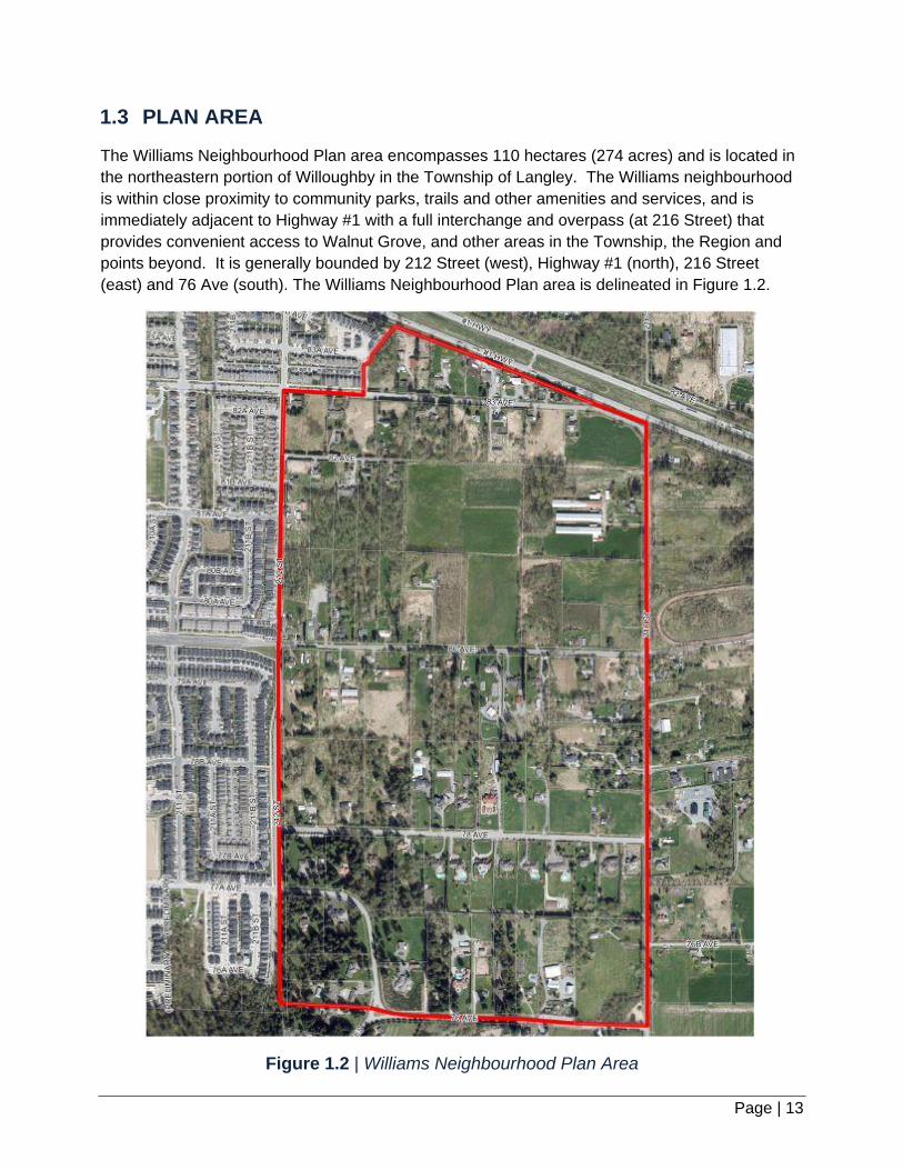
1.3 PLAN AREA
The Williams Neighbourhood Plan area encompasses 110 hectares (274 acres) and is located in
the northeastern portion of Willoughby in the Township of Langley. The Williams neighbourhood
is within close proximity to community parks, trails and other amenities and services, and is
immediately adjacent to Highway #1 with a full interchange and overpass (at 216 Street) that
provides convenient access to Walnut Grove, and other areas in the Township, the Region and
points beyond. It is generally bounded by 212 Street (west), Highway #1 (north), 216 Street
(east) and 76 Ave (south). The Williams Neighbourhood Plan area is delineated in Figure 1.2.
W I L L I A M S N E I G H B O U R H O O D P L A N
Page | 14
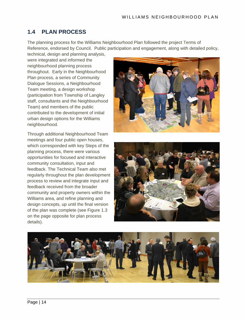
1.4 PLAN PROCESS
The planning process for the Williams Neighbourhood Plan followed the project Terms of
Reference, endorsed by Council. Public participation and engagement, along with detailed policy,
technical, design and planning analysis,
were integrated and informed the
neighbourhood planning process
throughout. Early in the Neighbourhood
Plan process, a series of Community
Dialogue Sessions, a Neighbourhood
Team meeting, a design workshop
(participation from Township of Langley
staff, consultants and the Neighbourhood
Team) and members of the public
contributed to the development of initial
urban design options for the Williams
neighbourhood.
Through additional Neighbourhood Team
meetings and four public open houses,
which corresponded with key Steps of the
planning process, there were various
opportunities for focused and interactive
community consultation, input and
feedback. The Technical Team also met
regularly throughout the plan development
process to review and integrate input and
feedback received from the broader
community and property owners within the
Williams area, and refine planning and
design concepts, up until the final version
of the plan was complete (see Figure 1.3
on the page opposite for plan process
details).
Page | 15
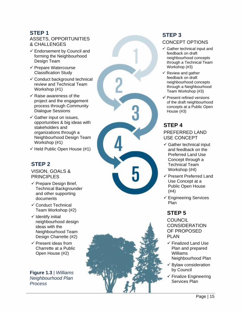
Figure 1.3 | Williams Neighbourhood Plan Process
STEP 1
ASSETS, OPPORTUNITIES & CHALLENGES
Endorsement by Council and forming the Neighbourhood Design Team
Prepare Watercourse Classification Study
Conduct background technical review and Technical Team Workshop (#1)
Raise awareness of the project and the engagement process through Community Dialogue Sessions
Gather input on issues, opportunities & big ideas with stakeholders and organizations through a Neighbourhood Design Team Workshop (#1)
Held Public Open House (#1)
STEP 2
VISION, GOALS & PRINCIPLES
Prepare Design Brief, Technical Backgrounder and other supporting documents
Conduct Technical Team Workshop (#2)
Identify initial neighbourhood design ideas with the Neighbourhood Team Design Charrette (#2)
Present ideas from Charrette at a Public Open House (#2)
STEP 3
CONCEPT OPTIONS
Gather technical input and feedback on draft neighbourhood concepts through a Technical Team Workshop (#3)
Review and gather feedback on draft neighbourhood concepts through a Neighbourhood Team Workshop (#3)
Present refined versions of the draft neighbourhood concepts at a Public Open House (#3)
STEP 4
PREFERRED LAND USE CONCEPT
Gather technical input and feedback on the Preferred Land Use Concept through a Technical Team Workshop (#4)
Present Preferred Land Use Concept at a Public Open House (#4)
Engineering Services Plan
STEP 5
COUNCIL CONSIDERATION OF PROPOSED PLAN
Finalized Land Use Plan and prepared Williams Neighbourhood Plan
Bylaw consideration by Council
Finalize Engineering Services Plan

W I L L I A M S N E I G H B O U R H O O D P L A N
Page | 16
2. BACKGROUND AND PLANNING CONTEXT

Page | 17

W I L L I A M S N E I G H B O U R H O O D P L A N
Page | 18
Background and Planning Context
2.1 SITE PLANNING CONTEXT
2.1.1 LAND USE CONTEXT
Within the Williams neighbourhood, the predominant
existing land use is rural residential and some
established single family estates on small acreage
parcels. The neighbourhood is bordered by the urban
neighbourhoods to the west and north (separated by
Highway #1) and rural lands in the Agricultural Land
Reserve to the east and south. Existing parcels of land
range from 0.17 to 7.73 hectares (0.42 acres to 19.11
acres) in size, with more than three-quarters having a lot
size of between 0.8 and 1.0 hectares (2 and 2.5 acres).
This evolving subdivision pattern dates from over a
century ago (1913 to 2008).
2.1.2 ENVIRONMENTAL CONTEXT
Geotechnical and Hydrogeological Conditions:
One of the defining features of the Williams area is the
terrain, specifically the Willoughby Escarpment, that
skirts along the southern edge, adjacent to the Milner
Valley. The highest elevation in the Williams
neighbourhood is along the western edge. From there,
the elevation for most of the Williams area gently and
generally declines in an easterly and south easterly
direction. A key exception in the Williams area is south
of 78 Avenue, where the elevation change is more abrupt
and contributes to the most visible part of the Willoughby
Escarpment from the Milner Valley, with nearly a 70 metre vertical fall from 212
Street in the southwest corner of Plan area to the confluence of 76 Avenue and
216 Street in the southeast corner. The combined orange, yellow and green colour shades and 5
metre contour lines, as illustrated on the Map in Figure 2.1, highlights this change in the terrain.
Aquatic Resources:
As part of the planning process for the Williams neighbourhood, the Township updated its
information pertaining to watercourse locations and watercourse classifications, in accordance
with the provisions for the Streamside Protection Development Permit Areas in the Township of
Langley Official Community Plan. This information is used to identify and incorporate
watercourse setbacks into the development of the neighbourhood plan. There are a number of
Figure 2.1 | Elevation in Williams

Page | 19
Class ‘B’ (yellow coded) watercourses and other wetted features in the Williams area, which
provide a significant source of food, nutrient, and cool water supplies to downstream fish
populations and discharge into two Guy Creeks; one that drains northward and the other that
drains southward.
Vegetation and Forest Cover:
The Williams neighbourhood habitat primarily consists of forests and grassland areas. Much of
the vegetated habitat is fragmented and interspersed throughout the neighbourhood due to
historic agriculture activities and more recently, suburban ‘estate’ development. As outlined in
the Township’s Wildlife Habitat Conservation Strategy (WHCS), coniferous forests represent the
priority habitat for the Township’s ecosystem yet is determined to be the least common habitat
type found in the Township. Through the Williams neighborhood planning process, a small
coniferous forest was identified as having the potential for preservation through establishment
of a future Wildlife Habitat Patch along an upper portion of the Willoughby Escarpment in the
southwest corner of the plan area.
2.1.3 HERITAGE CONTEXT
The community of Willoughby falls within the asserted traditional territories of the Coast Salish
peoples that encompasses the Township and other neighbouring municipalities within the
region. Although Willoughby would have been relatively remote from the earliest known
transportation routes and navigable streams within the greater vicinity, early Willoughby
residents have recalled reports of First Nations lithic material being found along the upper
ridges of Yorkson Creek. The original woodlands that characterized Willoughby may also have
provided refuge for cultural activities of the Coast Salish peoples for a time; however, the forest
fires of the early nineteenth century, and subsequent logging and land clearing associated with
late nineteenth century settlement would have destroyed any potential evidence of such
activities. The neighbourhood of Williams defines the eastern edge of Willoughby, a historically
expansive rural area located to the north-west of the original Hudson’s Bay Company farmlands
that were cultivated in the 1830s.
During the late 1800s, Willoughby’s gently rolling hills rising to the west of the flat prairie
farmlands of Langley Prairie attracted European settlers that gradually moved farther to the
west. Although Willoughby’s poor soils, relative isolation and woodland scrub forests provided
for subsistence farming only, the area gained value as a place where people with modest
means could settle, and by 1890 all the land in the area had been pre-empted.
These settlers established a small community centered on Alexander Road (208 Street) and
Scholes Road (83 Avenue), and by 1921 the growing community had its first post office.
Several community and commercial buildings came to define this centre built to serve the
primarily rural population, including a church, community hall, school, and general store.
The Williams neighbourhood, bounded by the Trans-Canada Highway to the north, 76 Avenue
to the south, 212 Street to the west, and 216 Street to the east, has three historic roads within
its boundaries that formed part of Willoughby’s early transportation infrastructure. Townline
Road (216 Street) remains the central north-south spine running along the divide between

W I L L I A M S N E I G H B O U R H O O D P L A N
Page | 20
Milner’s agricultural lands and the Willoughby Escarpment to the west. Williams Road (78
Avenue) was built in 1927 and named after the A.J. (Bert) Williams, a local landowner in the
area. The eastern end of McLarty Road (80 Avenue) which ran from what is now 196 Street to
216 Street was named after Peter McLarty who had large land holdings in Willoughby, west of
the Williams neighbourhood.
From its inception to well into the modern era, the rural nature of the area came to define
Willoughby as a place characterized by function and necessity. Many of the early buildings
located on 208 Street that defined it as a community have been restored as a tribute to the
area’s early history, and although Willoughby remains centred on the historic corridor of 208
Street, the area is in a process of rapid densification and the small mixed farms that historically
defined it are largely gone. Willoughby today is a mixture of residential infill and undeveloped
rural land, with a new Willoughby Town Centre at its centre to support the changing needs of its
new residential populations of which Williams forms a part.
2.1.4 MOBILITY CONTEXT
Network Overview:
The objective of the Township’s
transportation network is to support mobility
for all modes of travel, including general
purpose traffic, goods movement, and
transit, walking, and cycling. Within the
Williams neighbourhood, the transportation
network consists of one north-south corridor
along 216 Street and a partial along 212
Street, and three east-west corridors along
76 (Morrison Crescent), 78 and 80 Avenues
not being a complete through road. The local
road network has served the rural nature of
the area and historically has not had a direct
route to the north over or onto Highway #1.
Currently main access to Willoughby Town
Centre in Yorkson is on 80 Avenue, and
access to Highway 10 (Glover Road) is from
216 Street. The remaining road network in
the Williams area is characterized by a
disconnected grid street network that serves
large blocks. Significant improvements are
planned to the road network with the
construction of the 216 Street interchange, the 80 Avenue Extension and 212 Street Connector
that will improve north-south and east-west connections.

Page | 21
Transit Overview:
Transit service in Langley and throughout Metro Vancouver is planned and funded by
TransLink. Half a dozen transit routes currently provide regional connections through the
Willoughby area, from Langley Centre and Langley South. The Carvolth Transit Exchange
located at 202 Street and 86 Avenue provides transit service both east and west, connecting
Township residents to other transit hubs in the region such as the Lougheed Skytrain Station
in Burnaby and points east to Abbotsford. Public transit service is currently not provided within
the Williams neighbourhood. However, it is anticipated as development occurs service could
likely serve the area, possibly along 80 Avenue and the 212 Connector.
Pedestrian and Cycling Facilities:
Currently, dedicated cycling facilities (i.e. bicycle lanes or multi-use pathways) are not available
in the Williams neighbourhood. The Township’s Cycling Plan, adopted in 2015, defines cycling
facilities and identifies on- and off-street community and recreational cycling facilities along all
arterials in the Williams neighbourhood (80 Avenue, 212 Street Connector, and 216 Street). In
addition to this key component of the cycling network, there are numerous opportunities to
incorporate greenways and cycling routes through the neighbourhood plan.
Walking is the most fundamental form of transportation. Due to the current rural nature of the
Williams neighbourhood, there are partial to no pedestrian facilities within the area, such as
sidewalks. There is a need, as the neighbourhood develops, to improve the cycling and
pedestrian infrastructure.
2.1.5 INFRASTRUCTURE CONTEXT
The availability and capacity of municipal infrastructure will influence the cost and feasibility to
develop the Williams neighbourhood. Stormwater management, sewer, water, and energy
systems have all been assessed.
Stormwater Management:
The existing drainage system in the Williams neighbourhood is consistent with a rural
environment and consists primarily of open ditches and driveway culverts located along
roadways and some property lines. Tributaries of two Guy Creeks, one in the north and
another in the south of the Plan area, eventually drain to Salmon River through a culvert under
Glover Road. Rainwater management facilities in many forms will be required to support the
development. The application of on-site best management practices (BMPs) to maintain
contact of rainwater with permeable ground, in combination with centralized detention ponds
and piped conveyance networks will be employed to protect both Guy Creek systems and
manage flood risk within the planned neighbourhood and downstream.
W I L L I A M S N E I G H B O U R H O O D P L A N
Page | 22
Water:
The existing water distribution network is adequate in the rural setting of Williams
Neighbourhood Plan area and currently includes connection to the Greater Vancouver Water
District main with the associated Jericho Reservoir and Willoughby Pump Station located at
73A Avenue and 204 Street and mains associated with conveyance to properties in the Plan
area. A few residents retain private wells as a water source. As the neighbourhood transitions
into an urban area, water services will require extensions to meet urban standards.
Sanitary Sewer:
Given its rural character, the Williams Neighbourhood Plan area does not include any existing
sanitary sewer infrastructure. Existing lots are serviced by individual septic systems. Any
development will require infrastructure improvements, including upsizing or other upgrades, in
order to accommodate changes in the sanitary sewerage loading for the area. Existing
sanitary sewer system connections are located along 212 Street in the Yorkson
neighbourhood; one at 77A Avenue and the other at 83 Avenue. Two pump stations and
associated sanitary force mains, along with additional sanitary sewer conveyance systems
will need to be installed as development occurs.
2.1.6 ENERGY CONTEXT
The general topography of the Williams area includes south-facing slopes that are ideal for
implementing energy conservation and greenhouse gas emission management measures
through neighbourhood, street and block patterns and design, and the siting of buildings and
other features that optimize energy performance. The implementation of policies and
guidelines that promote the conservation and efficient use of energy in buildings and the
reduction of building generated greenhouse gas emissions (GHGs) will contribute to the
development of an energy efficient and sustainable neighbourhood and community.
Page | 23
2.2 POLICY FRAMEWORK
2.2.1 METRO VANCOUVER REGIONAL GROWTH
STRATEGY
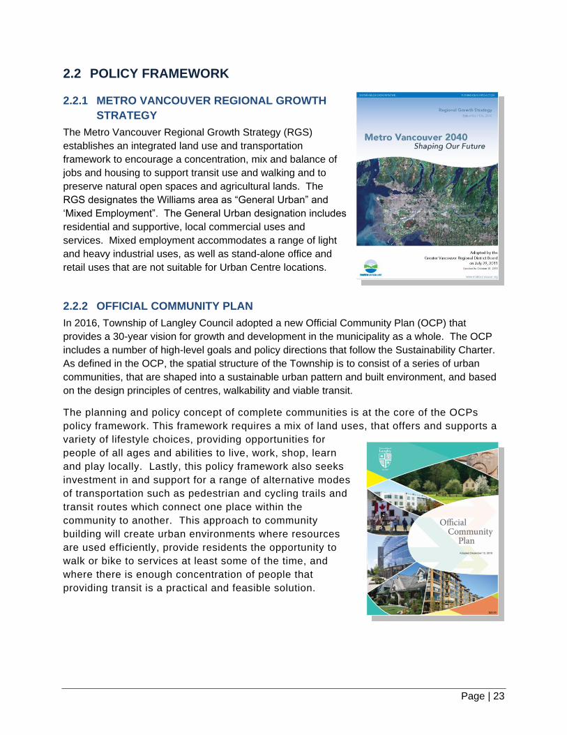
The Metro Vancouver Regional Growth Strategy (RGS)
establishes an integrated land use and transportation
framework to encourage a concentration, mix and balance of
jobs and housing to support transit use and walking and to
preserve natural open spaces and agricultural lands. The
RGS designates the Williams area as “General Urban” and
‘Mixed Employment”. The General Urban designation includes
residential and supportive, local commercial uses and
services. Mixed employment accommodates a range of light
and heavy industrial uses, as well as stand-alone office and
retail uses that are not suitable for Urban Centre locations.
2.2.2 OFFICIAL COMMUNITY PLAN
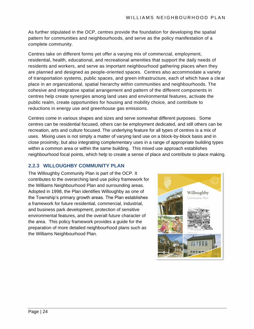
In 2016, Township of Langley Council adopted a new Official Community Plan (OCP) that
provides a 30-year vision for growth and development in the municipality as a whole. The OCP
includes a number of high-level goals and policy directions that follow the Sustainability Charter.
As defined in the OCP, the spatial structure of the Township is to consist of a series of urban
communities, that are shaped into a sustainable urban pattern and built environment, and based
on the design principles of centres, walkability and viable transit.
The planning and policy concept of complete communities is at the core of the OCPs
policy framework. This framework requires a mix of land uses, that offers and supports a
variety of lifestyle choices, providing opportunities for
people of all ages and abilities to live, work, shop, learn
and play locally. Lastly, this policy framework also seeks
investment in and support for a range of alternative modes
of transportation such as pedestrian and cycling trails and
transit routes which connect one place within the
community to another. This approach to community
building will create urban environments where resources
are used efficiently, provide residents the opportunity to
walk or bike to services at least some of the time, and
where there is enough concentration of people that
providing transit is a practical and feasible solution.
W I L L I A M S N E I G H B O U R H O O D P L A N
Page | 24
As further stipulated in the OCP, centres provide the foundation for developing the spatial
pattern for communities and neighbourhoods, and serve as the policy manifestation of a
complete community.
Centres take on different forms yet offer a varying mix of commercial, employment,
residential, health, educational, and recreational amenities that support the daily needs of
residents and workers, and serve as important neighbourhood gathering places when they
are planned and designed as people-oriented spaces. Centres also accommodate a variety
of transportation systems, public spaces, and green infrastructure, each of which have a clear
place in an organizational, spatial hierarchy within communities and neighbourhoods. The
cohesive and integrative spatial arrangement and pattern of the different components in
centres help create synergies among land uses and environmental features, activate the
public realm, create opportunities for housing and mobility choice, and contribute to
reductions in energy use and greenhouse gas emissions.
Centres come in various shapes and sizes and serve somewhat different purposes. Some
centres can be residential focused, others can be employment dedicated, and still others can be
recreation, arts and culture focused. The underlying feature for all types of centres is a mix of
uses. Mixing uses is not simply a matter of varying land use on a block-by-block basis and in
close proximity, but also integrating complementary uses in a range of appropriate building types
within a common area or within the same building. This mixed use approach establishes
neighbourhood focal points, which help to create a sense of place and contribute to place making.
2.2.3 WILLOUGHBY COMMUNITY PLAN
The Willoughby Community Plan is part of the OCP. It
contributes to the overarching land use policy framework for
the Williams Neighbourhood Plan and surrounding areas.
Adopted in 1998, the Plan identifies Willoughby as one of
the Township’s primary growth areas. The Plan establishes
a framework for future residential, commercial, industrial,
and business park development, protection of sensitive
environmental features, and the overall future character of
the area. This policy framework provides a guide for the
preparation of more detailed neighbourhood plans such as
the Williams Neighbourhood Plan.

Page | 25
The Willoughby Community Plan outlines a number of key goals that are relevant to more
detailed neighbourhood plans, that complements the policies of the OCP. For example, the
Plan promotes the evolution of distinct but interrelated neighbourhoods, each of which is
marked by a clear focal point and is defined primarily by current or proposed grid roads and
supporting green space. Each neighbourhood within the Willoughby area is intended to be of
sufficient size to support a variety of land use elements such as an elementary school and
neighbourhood park, neighbourhood convenience shopping, and a mix of housing with a
range of densities, which may also include supporting employment opportunities. As well,
neighbourhoods are intended to be well-linked, providing for pedestrian and bicycle
movements within green corridors.
Another key policy feature of the Willoughby Community Plan that informs the planning and
guides the spatial structure of the Williams neighbourhood is escarpment and viewscape
preservation and enhancement. The policy goal is to protect the scenic and ecological resources
associated with lands characterized by steep slopes, ridgelines and Agricultural Land Reserve
edge transition areas, also known as the Willoughby Escarpment, in a manner that allows for
carefully designed, low-impact and integrated development. This poses a challenge for the
Williams area as the Escarpment broadens out topographically (less steep terrain relative to other
parts of the Escarpment), the most visible portions are not in the Agricultural Land Reserve (as
with other neighbourhood areas to the southwest), and much of the Escarpment is void of trees,
particularly high value trees such as evergreen, coniferous species.
The Willoughby Community Plan delineates predominantly two distinct land uses in Williams; a
business park and employment district in the north portion (north of 80 Avenue), and a
residential district in the south portion (south of 80 Avenue). The Community Plan also includes a
significant greenway network within the Williams area and connections to adjacent
neighbourhoods and the Willoughby community more broadly.
W I L L I A M S N E I G H B O U R H O O D P L A N
Page | 26
3. NEIGHBOURHOOD VISION AND GOALS

Page | 27

W I L L I A M S N E I G H B O U R H O O D P L A N
Page | 28
Neighbourhood Vision and Goals
Designing a neighbourhood begins with a Vision Statement and a set of goals that set a direction
for Neighbourhood Plan policies. The Vision Statement and Goals represent the aspirations of the
neighbourhood and are an outcome of community input and feedback, policy and technical
analysis, and best planning practices.
3.1 VISION STATEMENT
The Vision Statement, that was developed in consultation with property owners and the broader
community, describes the desired future state of the neighbourhood and serves as an inspiring
declaration for the Williams neighbourhood. All of the Goals, policies, and guidelines set forth in
this Neighbourhood Plan contribute to the realization of this Vision.
“The Williams Neighbourhood is a vibrant, walkable and connected community
that maintains its natural assets and views. As a gateway to the Township and
Willoughby community, it provides jobs close to home while maintaining a quiet
and family friendly neighbourhood. Green spaces blend the neighbourhood into
adjacent agriculture lands and a mix of affordable and accessible housing for
families, individuals, and those wanting to age in place is offered.”
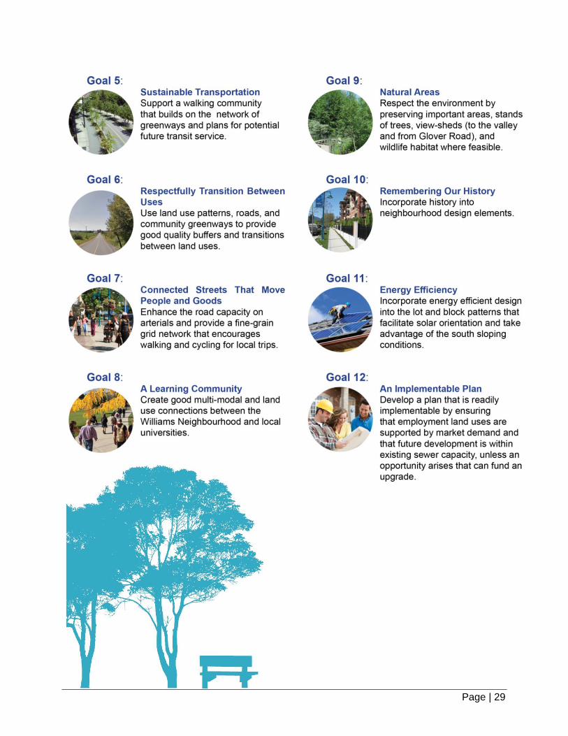
3.2 GOALS
Goals are broad statements that provide direction for the development and implementation of the
detailed policies and guidelines of the Neighbourhood Plan. They express a common
understanding of how to ultimately realize the Vision for the neighbourhood and are intended to
influence and guide future growth and development in the Williams neighbourhood. The goals for
the Williams Neighbourhood Plan area are as follows:
Page | 29
W I L L I A M S N E I G H B O U R H O O D P L A N
Page | 30
4. NEIGHBOURHOOD URBAN DESIGN CONCEPT

Page | 31

W I L L I A M S N E I G H B O U R H O O D P L A N
Page | 32
Neighbourhood Urban Design Concept
4.1 NEIGHBOURHOOD DESIGN CONCEPT
Williams is the most eastern neighbourhood in the Willoughby community and is strategically
located for businesses, employees and future residents. Located on the eastern terminus of
the Willoughby Escarpment and west of the University District, Williams hillside setting offers
superb views of the Milner Valley, Mount Baker and vistas beyond. The Williams area benefits
from key transportation linkages to Willoughby, Walnut Grove, University District, and other
Township communities, and serves as an important gateway to the Township.
Based on the Plan’s Vision and Goals, the Williams neighbourhood urban design concept
establishes a mixed-use, pedestrian/cyclist-friendly, and transit-supportive neighbourhood. The
urban design concept accommodates housing and employment areas within this ‘peripheral’
setting, preserves and enhances the natural environment and integrates with existing and future
development in adjacent neighbourhoods, rural/agricultural areas and the community beyond.
The Employment District, the Transition District and the Residential District are the key
elements that define the spatial structure of the Williams neighbourhood (See Figure 4.1 -
opposite page). The Employment District is a strategic location which supports commercial and
business employment, that will provide jobs close to home, will be an attractive place to invest
and run a business and will provide commercial services for local residents, employees,
students and the travelling public. Proximity to the University District (to the east of 216 Street)
will further complement the employment and business opportunities, and support commercial
services that are accommodated in the Williams neighbourhood.
The Employment District accommodates a range of business and employment activities that
contribute to the development of a complete community in both the Williams and the broader
Willoughby area. Given this strategic location, these business and employment lands are key
generators for job growth that will provide significant contributions to the local economy.
The Employment District is located adjacent to the Highway #1 interchange and will also
accommodate commercial establishments that provide services to motorist, and for non-
pedestrian-oriented retail and services. Uses in this District include those that meet the needs
of the travelling public such as a gas station, restaurants, overnight accommodations, vehicle
repair and other comparison retail, that also serve the needs of workers and business owners in
adjacent and nearby employment areas, including the neighbouring (eastward) University
District. The Employment District will also provide a modestly-sized shopping area and
destination that will contribute to a distinct ‘sense of place’ for the Williams area. Shops and
services, including a grocery outlet, with retail at grade and office space above, provide local
residents and neighbouring employees and students with access to daily goods and services.
The Transition District provides a linear band of single family forms of residential development
along 212 Street and 83 Avenue, followed eastward by rowhomes and townhomes, a greenway

Page | 33
Figure 4.1 | Neighbourhood Urban Design Concept
and environmental conservation areas that combine to create a multi-feature transition between
existing residential areas in Yorkson and the Employment District in Williams.
The Residential District includes predominantly a range of lower-density, compatible forms of
residential development including single-family and semi-detached homes on compact and
more traditional lot sizes, as well as townhouse forms of housing along the 80 Avenue and 212
Street corridors. Park spaces, greenways and trails, conservation and watercourse
compensation areas that provide fish and wildlife habitat as well as protect and enhance the
‘treed’ character of the Willoughby Escarpment. An elementary school and other public
amenities will contribute to establishing a highly-livable neighbourhood.
Benefiting from these strategic opportunities and context, Williams will ultimately become a
distinct neighbourhood in the Willoughby community, and is projected to accommodate
approximately 4,600 residents in 1,470 dwelling units at full build out.

W I L L I A M S N E I G H B O U R H O O D P L A N
Page | 34
4.2 RESIDENTIAL NEIGHBOURHOOD URBAN FORM
The urban environment of a residential neighbourhood is composed of several “building blocks”
that shape the built character. These building blocks include: block structure and street
patterns, street design characteristics, lot patterns and building placement, building forms and
types, vegetation, landscaping, natural features and open spaces, and distinctive place elements.
Each of these building blocks contributes to shaping the neighbourhood environment and
influences how places are experienced.
Block structure and street patterns provide the urban framework, or “bones,” of the
neighbourhood;
Street design characteristics and their configuration within the street right of way, such as
sidewalks, medians and curbs, roadway width, pavement and surface materials, street trees
and landscaping, are among the many physical elements that contribute to the character and
sense of place;
Lot patterns and building placement, along with size and shape, establish the “grain” of the
neighbourhood fabric and the “rhythm” of the development along the street and other public
spaces that contribute to defining the physical character of a place;
Building forms and types, including the scale of structures and architectural characteristics,
can provide places with distinct identities;
Vegetation, landscaping, natural features and open spaces are neighbourhood features
that integrate and accommodate nature to enhance neighbourhood livability; and
Distinctive place elements are neighbourhood amenities such as play fields, trails and
greenways, schools and other public spaces that further complement neighbourhood “assets”
and experiences.
The block and street structure, sometimes called the DNA or ‘genetic makeup’ of a
neighbourhood, is the setting for buildings and forms the basic, fundamental unit or building block
of the neighbourhood arrangement and pattern. The neighbourhood block structure and street
patterns influence the shape and location of development, define how people move about, and
influence which travel modes are most effective in a given place.
The block is defined by the street and open space network that surrounds it, and the character of
the street network is a function of the form, character, and the intensity of the block that front it.
The lot is the fundamental component of the building blocks. The configuration of lots, particularly
for residential areas, often contributes to how buildings are situated on said lots and the
sustainable spatial pattern for the neighbourhood. Policies throughout this Plan provide guidance
to address each of the urban form building blocks. However, the following policies are intended
to specifically guide the design and development of the block and street patterns in residential
areas of the neighbourhood.
Page | 35
Policies:
1. Design block perimeters and block face lengths that result in a street network with high
connectivity, that balances pedestrian and bicycle comfort and mobility, emergency
response times, transit accessibility, freight delivery, and automobile movement.
2. Layout the block and local road patterns in the Residential and Transition Districts with a
maximum block size length of 160 metres between street intersections and on average
between 130 and 150 metres. Blocks that front arterial streets can extend beyond this
maximum block size length provided they incorporate Pedestrian Links between the arterial
street and local and collector roads at a spacing similar to the average block length of
between 130 and 150 metres.
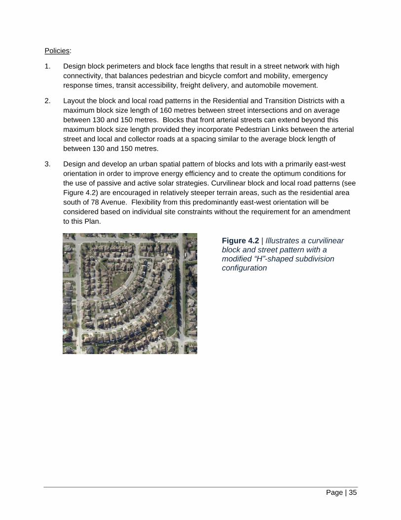
3. Design and develop an urban spatial pattern of blocks and lots with a primarily east-west
orientation in order to improve energy efficiency and to create the optimum conditions for
the use of passive and active solar strategies. Curvilinear block and local road patterns (see
Figure 4.2) are encouraged in relatively steeper terrain areas, such as the residential area
south of 78 Avenue. Flexibility from this predominantly east-west orientation will be
considered based on individual site constraints without the requirement for an amendment
to this Plan.
Figure 4.2 | Illustrates a curvilinear block and street pattern with a modified “H”-shaped subdivision configuration

W I L L I A M S N E I G H B O U R H O O D P L A N
Page | 36
4. Develop an interconnected local road network that conforms to the arterial, collector and
local street hierarchy of roads in Williams as delineated in the Circulation Concept Plan
(Map 3).
5. Design residential areas with a network of walkable streets on a modified grid road and
block pattern to increase route options and connections. Avoid subdivision layouts that
incorporate single-access block and street patterns (cul-de-sacs and P-loops), and/or
include crescent and T-intersection road configurations. Limited consideration will be given
to these urban form patterns where the subdivision layout in question borders an arterial
street or the urban / Agricultural Land Reserve boundary (e.g., 76 Avenue), or is adjacent to
areas designated as Rowhouse/Townhouse, Conservation and Watercourse Compensation
Areas.
6. Establish a configuration of blocks and lots that include rear lanes, particularly in areas
designated as Single Family Mixed Residential and Rowhouse / Townhouse, in order to
access off-street parking. The “H”-shaped configuration for rear lanes is preferred and is
intended to provide an opportunity for short end blocks to feature fronting units (see Figure
4.3). Particular emphasis shall be given to arterial and collector streets identified in this
Plan.
Figure 4.3 | Illustrates a “H”-shaped street and block pattern

Page | 37

W I L L I A M S N E I G H B O U R H O O D P L A N
Page | 38
5. LAND USE
Page | 39

W I L L I A M S N E I G H B O U R H O O D P L A N
Page | 40
Land Use
5.1 OVERVIEW
The neighbourhood Vision and Goals for the Williams area are embodied in the Williams Land
Use Plan (see Map 1). The Land Use Plan identifies the residential and employment land use
designations in the Neighbourhood Plan area, as well as future transportat ion corridors,
protected areas, trails, parks, and other community amenities and infrastructure. The land use
policies describe in detail the location, types, and density of uses for the Williams area. The
designations and policies, which represent a balanced outcome of public input and feedback,
technical analysis, existing policy and best planning practices, will be used to guide the
development approvals process through to full build out of the neighbourhood.
5.2 LAND USE DESIGNATIONS AND POLICIES
This section describes the land use designations in the Land Use Plan (see Map 1).
Included in each designation is a description of intent, as well as an identification of
appropriate building typologies and development densities. Also included are general and
specific policies for land use. General policies that apply across multiple designations are
provided in Section 5.3. Policies unique to individual designations are provided in Sections
5.4 to 5.9. If there is a conflict between a general policy and a specific policy in a land use
designation, the specific policy shall take precedence.
5.3 GENERAL LAND USE POLICIES
The following policies apply across multiple land use designations in the Williams neighbourhood.
Policies:
All Land Use Designations:
1. Obtain a Development Permit in accordance with Section 488 (1) (e), (f), (h) and (j) of the
Local Government Act (LGA) for development on lands within the Williams Neighbourhood
as outlined by the Development Permit Areas on Map 4 and Map 4A of the Willoughby
Community Plan, in order to achieve high quality and energy efficient architectural and site
design.
2. Obtain a Development Permit in accordance with Section 488 (1) (c), (e) and (f) of the Local
Government Act (LGA) for development on lands within the vicinity of the urban/Agricultural
Land Reserve edge in the Williams Neighbourhood as outlined by the Development Permit
Areas on Map 4 of the Willoughby Community Plan, for the protection of farming
(Development Permit Area “I”). Incorporate appropriate subdivision design, building
setbacks and landscape buffers for lands along the east and south portions of the Williams

Page | 41
neighbourhood that are adjacent to the Agriculture Land Reserve boundary in order to
clearly establish the edge between the urban and rural areas, to enhance the viability of
farming on adjacent agricultural lands, and mitigate and minimize the impacts of farming on
urban lands. Variations to the buffer size will be considered when the retention of buildings
of historic or heritage value are preserved.
3. Consider lower densities for developments, as applicable, in cases where they cannot be
achieved due to site constraints (e.g. topography or riparian setback requirements).
Maximum permitted density may not be achievable on all properties.
4. Ensure development and infrastructure projects build with the slope to minimize cut and fill
excavations and to help preserve the natural topography of hillside areas. Also, buildings
should be ‘stepped’ on sloping sites to reduce the height and massing of the development
and reduce the need for retaining walls, wherever possible, in order to establish a
complementary, pedestrian-friendly streetscape and to support site and neighbourhood
design efforts to retain and enhance the treed character of the Willoughby Escarpment.
5. Design appropriate building transitions between different land uses and distinct building
types that are respectful of views, densities, traffic, and noise. Building massing, placement
of glazing, site design and landscaping should mitigate overlook and address privacy
implications.
6. Provide for inclusion of electric vehicle charging infrastructure as part of residential,
commercial, industrial and institutional developments to contribute to a sustainable
transportation network.
Residential Land Use Designations:
7. Provide for a variety of housing forms, sizes, floor layouts and tenures within the Williams
Neighbourhood Plan area to address a range of housing needs and stages of life, subject to
the form and density provisions of the applicable land use designation, including the
following:
a. Incorporate a diversity of housing choices to assist in achieving housing affordability
through the provision of smaller-lot single family homes, duplexes, rowhouses,
townhouses, secondary suites and coach homes.
b. Encourage a variety of tenures, such as fee simple, strata and rental, as well as a
diverse range of housing options, such as co-housing, pocket neighbourhoods (a small
group of cottage style housing units with shared parking), single-level housing and
rowhouses and townhouses with ‘master’ bedrooms on the ground level.
c. Permit seniors housing facilities, such as community care facilities, assisted living
residences and supportive housing in townhouse development forms.
d. Foster the development of non-market housing.

W I L L I A M S N E I G H B O U R H O O D P L A N
Page | 42
e. Encourage development of secondary suites and coach homes as rental opportunities to
achieve affordability objectives and provide housing options for college and university
students.
8. Calculate the land area density on the basis of gross developable land area where the
minimum or maximum density is expressed in terms of units per hectare (units per acre).
Gross developable land area includes land dedicated for new roads, land above the top-of-
bank protected for watercourses, and land secured for transmission lines and other utilities
provided they are upgraded as a linear park system. Gross developable land area does not
include land dedicated for stormwater detention ponds.
9. Include adaptable housing requirements for a minimum of 5 percent of Single Family Mixed
Residential and Rowhouse/Townhouse units per development, in accordance with Section
3.1.9 of the OCP (see Table 5.1), as amended from time to time. Adaptable housing
requirements are modest improvements to provide and enhance accessibility, making it
easier for residents to remain in place as they age and/or experience illness or injury.
10. Incorporate row(s) and stands of trees, along with the retention and integration of existing
significant trees, as part of project design, as outlined in the Township’s Subdivision and
Development Servicing Bylaw Schedule I – Tree Protection. Planting of evergreen,
coniferous trees shall be part of project design, wherever feasible.
11. Provide a viewscape analysis of the Willoughby Escarpment, from various points in the
Milner Valley (Glover Road), in the preparation of Comprehensive Development Plans
(CDPs; Policy 1 and 2, Sub-Section 11.4) and for all proposed developments, south of 80
Avenue.

Page | 43
12. Require new single family developments to enter into an exterior design control agreement.
The agreement should address the following general guidelines for new developments:
a. retain existing significant trees, especially evergreen, coniferous trees.
b. incorporate high quality design and employ an architectural approach that is harmonious
with the community context (e.g. low scale, pedestrian-friendly buildings).
c. require developments to complement adjacent developments in terms of siting, form, and
character, but individual architectural expression is encouraged both within and between
street blocks.
d. encourage all visible building elevations to provide architectural interest, especially those
that are visible from public streets, lanes, walkways, parks and trails.
e. provide a strong street presence through street facing buildings that include elements
such as extended front porches. Single family dwellings should not back onto a public
road.
5.4 SINGLE FAMILY MIXED RESIDENTIAL
The Single Family Mixed Residential designation accommodates a range of single family housing
on a variety of lot sizes (R-1, R-2 and R-CL; defined in the Township of Langley Zoning Bylaw),
semi-detached, duplexes, and rowhomes, as well as accessory forms of housing such as
secondary suites and coach homes.
This variety of housing types are intended to primarily accommodate street-oriented housing with
rear lane access in order to maximize parking opportunities, provide a high-quality pedestrian
environment, and improve energy efficiency through the siting and alignment of homes. The
accessory forms are to provide opportunities for rental housing, particularly for students in the
nearby university.
Densities within this designation will range from 15 units per hectare (6 units per acre) to 25
units per hectare (10 units per acre). Policies specific for this designation are as follows:
Policies:
1. Provide for a variety of single family housing and compatible housing forms on a variety of
lot sizes (R-1 and R-CL; defined in the Township of Langley Zoning Bylaw), semi-detached,
duplex, and rowhomes at a minimum density of 15 units per hectare (6 units per acre) to a
maximum density of 25 units per hectare (10 units per acre).
2. Foster the development of accessory housing including secondary suites or coach homes
(R-1 and R-CL[CH]; defined in the Township of Langley Zoning Bylaw) with a single family
home, along with the provision of an additional, non-tandem parking space on the lot for the
secondary suite or coach home.
W I L L I A M S N E I G H B O U R H O O D P L A N
Page | 44
3. Design street, block and lot patterns to accommodate rear-loaded parking off of
lanes. Although this rear-loaded pattern is the dominant (defined by land area or
units) design form, front loaded lots will be considered when fronting along local
roads if topographic or other site constraints make rear lane access difficult to
achieve. In such cases, garages shall be recessed and comprise less than 50 percent
of the front building face, in order to maintain a strong, pedestrian-oriented
streetscape.
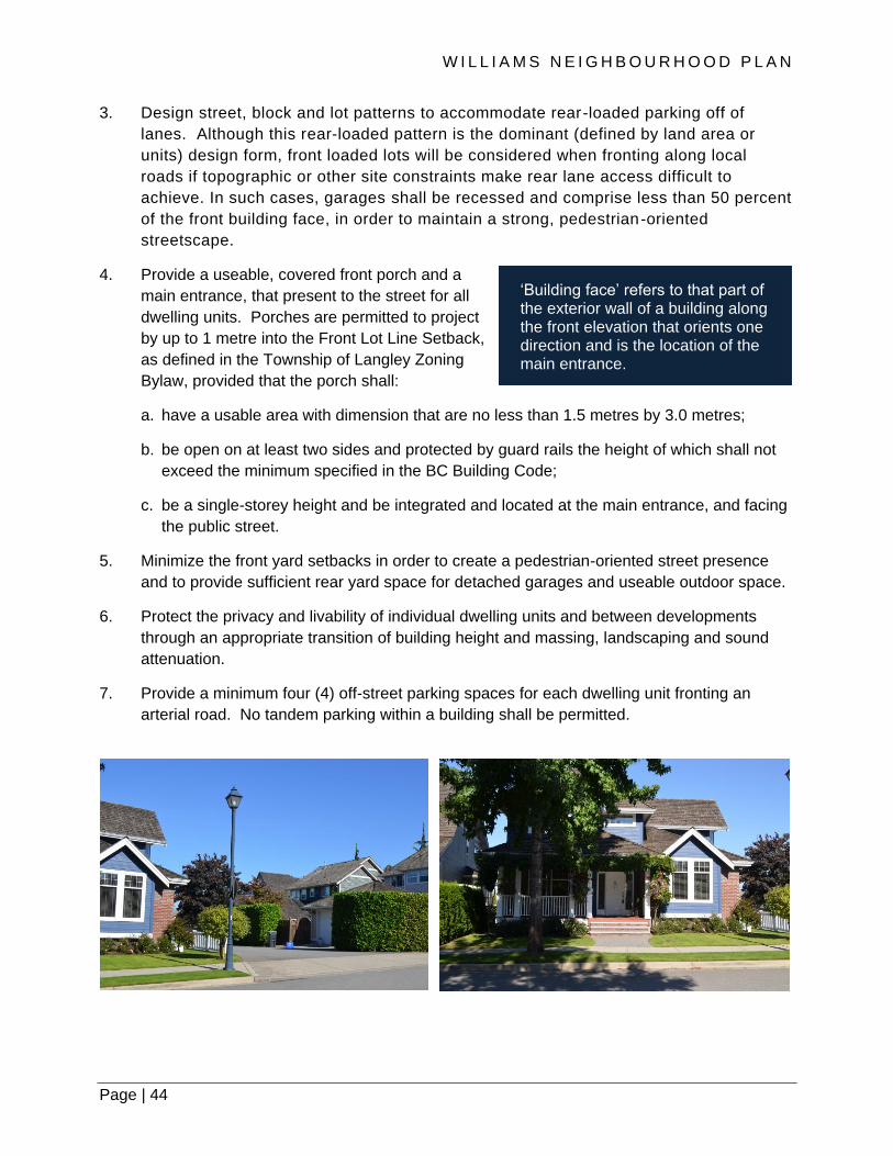
4. Provide a useable, covered front porch and a
main entrance, that present to the street for all
dwelling units. Porches are permitted to project
by up to 1 metre into the Front Lot Line Setback,
as defined in the Township of Langley Zoning
Bylaw, provided that the porch shall:
a. have a usable area with dimension that are no less than 1.5 metres by 3.0 metres;
b. be open on at least two sides and protected by guard rails the height of which shall not
exceed the minimum specified in the BC Building Code;
c. be a single-storey height and be integrated and located at the main entrance, and facing
the public street.
5. Minimize the front yard setbacks in order to create a pedestrian-oriented street presence
and to provide sufficient rear yard space for detached garages and useable outdoor space.
6. Protect the privacy and livability of individual dwelling units and between developments
through an appropriate transition of building height and massing, landscaping and sound
attenuation.
7. Provide a minimum four (4) off-street parking spaces for each dwelling unit fronting an
arterial road. No tandem parking within a building shall be permitted.
‘Building face’ refers to that part of the exterior wall of a building along the front elevation that orients one direction and is the location of the main entrance.

Page | 45
8. Limit the quantity of single family development in the form of detached Residential Compact
Lots, as defined in the Township of Langley Zoning Bylaw, to no more than 50 percent of
the units for any development for lands south of 80 Avenue, in order to ensure that a range
and mix of housing in the Single Family Mixed Residential designation is provided.
Accommodate single and two family development in the form of traditional sized lots, as
defined as R-1 and R-2 in the Township of Langley Zoning Bylaw, for the remainder of the
development. This requirement can be waived for developments that dedicate at least 25
percent of the gross site area for tree protection and tree enhancement areas that
contribute to and enhance the treed character of the Willoughby Escarpment, provided that:
a. these areas are identified, as part of development application review, through
i. a viewscape analysis from the Milner Valley (various key points along Glover Road);
and
ii. a Tree Management Plan as specified by the Subdivision and Development Servicing
Bylaw, as amended.
b. these areas are situated, where feasible and appropriate, and informed by the above-
noted development application review analysis:
i. along contour lines to contribute to and enhance the treed character of the Willoughby
Escarpment; or
ii. adjacent to Watercourse Compensation Areas, Conservation Areas, the Wildlife
Habitat Patch, Williams View Park, and/or Greenways, to further enhance and form a
network of treed spaces; and
c. these areas are not part of the 5 percent parkland dedication or cash-in-lieu, as required
as part of subdivision.
9. Encourage the development of semi-detached (fee-simple and/or strata tenures)
Residential Compact Lots, as defined in the Township of Langley Zoning Bylaw [e.g., R-
CL(SD)], provided that:
a. Siting of semi-detached and duplex housing forms on corner lots shall align the main
entrance for each dwelling unit to face each of the streets;
b. Design the off-street parking with no tandem spaces within a building;
c. Accommodate a minimum of one on-street parking space in the front of each dwelling
unit.
d. Reflect or complement the architectural character of single family developments in
the design of semi-detached and duplex housing; and

W I L L I A M S N E I G H B O U R H O O D P L A N
Page | 46
e. Comply with the development parametres as delineated in Policy 8 above. The semi-
detached and duplex housing forms, on Residential Compact Lots, or equivalent sized
lots, are considered as part of the 50 percent maximum provided for any development as
outlined in policy 8 above.
10. Provide for the development of Residential Compact Lots, as defined in the Township of
Langley Zoning Bylaw, to accommodate rowhomes, provided that:
a. Rowhouse developments are designed in a single row, fronting a road and serviced by a
rear lane;
b. Design each building that contains no more than four units;
c. Provide adequate space between the interior sides of buildings to accommodate tree-
planting;
d. Design the off-street parking with no tandem spaces within a building;
e. Accommodate a minimum of one on-street parking space in the front of each dwelling
unit; and
f. Comply with the development parametres as delineated in Policy 8 above. The rowhome
housing forms, on Residential Compact Lots, or equivalent sized lots, are considered as
part of the 50 percent maximum provided for any development as outlined in policy 8
above.

Page | 47
5.5 ROWHOUSE / TOWNHOUSE
The Williams Neighbourhood Plan includes the Rowhouse / Townhouse designation and the
Townhouse Strata designation, each with different densities. The two designations together will
provide a mix of affordable, ground-oriented housing for families with children, seniors, and
“empty nesters” and serve as a land use transition between predominantly low density, residential
neighbourhoods and employment uses. The emphasis is on ground-oriented neighbourhood
character of the Williams neighbourhood, ensuring a good relationship of the units to the street
and compatibility of form and scale to other residential areas. Access to vehicle parking will be
provided via rear lanes or internal driveways/strata roads. Dwelling units that front a public street
will have direct pedestrian access to/from said street.
5.5.1 ROWHOUSE / TOWNHOUSE (20-37 UPH / 8-15 UPA)
The Rowhouse / Townhouse designation accommodates both rowhouse and townhouse
developments, where all units front and have direct pedestrian access from/to the public street.
This designation is located in the northwest portion of the Plan area, between a predominately
single family neighbourhood in the Yorkson area and the employment lands to the immediate
east. This lower density multi-family designation will provide a land use, form and massing
transition between these two land use conditions as well as a form of affordable, ground-oriented
housing. Densities within this designation will range from 20 units per hectare (8 units per acre)
to 37 units per hectare (15 units per acre). Policies specific to this designation are as follows:
Policies:
1. Provide for rowhouse or townhouse, as well as semi-detached dwellings on Residential
Compact Lots, as defined in the Township of Langley Zoning Bylaw and duplexes, at a
minimum density of 20 units per hectare (8 units per acre) to a maximum density is 37 units
per hectare (15 units per acre).
2. Limit the maximum height of buildings to three (3) storeys.
3. Establish block and street patterns that include a public lane or strata road, and provide
continuous on-street parking along the public street that is not interrupted by driveway let-
downs.
4. Design buildings and dwelling units, to include:
a. Street-facing, pedestrian-oriented dwelling units that provide a useable, covered front
porch along and a main entrance, that present to the pubic street. Porches are permitted
to project by up to 1 metre into the Front Lot Line Setback, as defined in the Township of
Langley Zoning Bylaw, provided that the porch shall have a usable area with dimension
that are no less than 1.5 metres by 3.0 metres; be open on at least two sides and
protected by guard rails the height of which shall not exceed the minimum specified in
the BC Building Code; and be a single-storey height and be integrated and located at the
main entrance, and facing the public street;

W I L L I A M S N E I G H B O U R H O O D P L A N
Page | 48
b. Off-street parking for the dwelling units shall be accessed from a rear lane or internal
strata road. Provide a minimum of four (4) off-street parking spaces for these dwelling
units. All parking spaces within a building shall be non-tandem; and
c. Four (4) or fewer dwelling units contained within each building.
d. Rear entrances for all dwelling units in the form of ‘swing doors’ that is separate from
vehicular parking and access points.
5.5.2 TOWNHOUSE STRATA (20-54 UPH / 8-22 UPA)
The Townhouse Strata designation accommodates townhouse developments. This designation
is located along the south and east sides of the 212 Street Connector, and at the northeast corner
of 212 Street and 80 Avenue, and north of 83 Avenue, between predominately single family
neighbourhoods in the Yorkson area and the Business Park and the Single Family Mixed
Residential lands in Williams. This townhouse designation provides affordable, ground-oriented
housing for households with children, seniors and ‘empty-nesters’. The Townhouse Strata land
use designation is situated and adjacent to schools and parks, urban greenways, local-serving
commercial services, future transit and other destinations, and provides a land use, form and
massing transition between land use conditions. Densities within this designation will range from
20 units per hectare (8 units per acre) to 54 units per hectare (22 units per acre). Policies specific
to this designation are as follows:

Page | 49
Policies:
1. Provide for townhomes, including those with a master bedroom on the ground floor, at a
minimum density of 20 units per hectare (8 units per acre) to a maximum density of 54 units
per hectare (22 units per acre).
2. Limit the maximum height of townhomes to two (2) storeys for buildings fronting 212 Street,
including the mid-block greenway links between 80 Avenue and the 212 Street cul-de-sac
and 83 Avenue and the Highway #1 (in the Transition District) in neighbouring Yorkson.
Three (3) storeys could be considered if the first storey is entirely below the finished grade
of any greenways. The maximum height for buildings for the remainder of the development
is three (3) storeys.
3. Design buildings and dwelling units fronting 212 Street, the 212 Street cul-de-sac, north of
80 Avenue, 83 Avenue and mid-block Greenway link between 83 Avenue and the Highway
#1 Greenway in neighbouring Yorkson, in order to provide a high quality pedestrian
environment and to create a complementary form and scale of housing to those across the
street from and adjacent to neighbouring Yorkson (mimicking existing single-family, duplex
and rowhome development), to include:
a. pedestrian-oriented dwelling units and building forms, that are street- or greenway-
facing, that provide a useable covered front porch along with the primary unit entrance
adjacent to and facing a public street or pedestrian route (including the opposite side of
the street); Porches are permitted to project by up to 1 metre into the Front Lot Line
Setback, as defined in the Township of Langley Zoning Bylaw, provided that the porch
shall have a usable area with dimension that are no less than 1.5 metres by 3.0 metres;
be open on at least two sides and protected by guard rails the height of which shall not
exceed the minimum specified in the BC Building Code; and be a single-storey height
and be integrated and located at the main entrance, and facing the public street;

W I L L I A M S N E I G H B O U R H O O D P L A N
Page | 50
b. Off-street parking for the dwelling units that is accessed from a rear lane or internal
strata road, for those units that front an arterial street. Provide a minimum of four (4) off-
street parking spaces for these dwelling units. All parking spaces within a building shall
be non-tandem; and
c. No more than four (4) dwelling units are contained within each building that directly fronts
a public street.
d. Rear entrances for all dwelling units in the form of ‘swing doors’ that is separate from
vehicular parking and access points.
4. Provide direct, publicly-accessible connections in the form of Pedestrian Links (see Section
6.2.5) through Townhouse developments – from public road to public road – in areas
designated Townhouse Strata, in the approximate locations delineated on Map 1 to support
pedestrian connectivity along 212 Street Corridor.
5. Incorporate appropriate site design and townhouse building setbacks to accommodate a
continuous evergreen, coniferous tree row, that integrates with site design requirements for
street fronting dwelling units and comprised of retained and/or new tree plantings, along the
south side of townhouse development sites that front 80 Avenue and along the east side of
townhouse development sites that front 212 Street. This can be accomplished through both
tree retention and/or new tree plantings, and are considered different than street trees in the
public boulevard.

Page | 51
5.6 COMMERCIAL
The Williams Neighbourhood Plan incorporates a commercial area located at the northeast
corner of 214 Street and 80 Avenue and includes a Neighbourhood Convenience Commercial
designation and a Mixed Use Commercial designation. The two designations together will
provide range a commercial services and amenities for local residents, employees, students
and the travelling public. Policies that apply to both the Neighbourhood Convenience
Commercial and Mixed Use Commercial designations are as follows:
Policies:
1. Site and design buildings to be street-fronting and pedestrian-focused, and oriented
towards a public road to result in generally consistent active street frontages along 214 and
216 Streets, and 80 and 81 Avenues. Include design elements on building façades as well
as landscaping elements and design features between buildings that front 214 Street and
80 Avenue that further support pedestrian orientation along the public street.
2. Landscape surface parking lots and locate them away from public street frontages by
orientating and siting buildings and appropriate landscaping treatments in such a way as to
create and/or give the appearance of a continuous, active street frontage, specifically along
214 and 216 Streets and 80 and 81 Avenues.
3. Require the scale and design character of the buildings and landscapes in these
Commercial designations to integrate and be of high quality to complement the design and
scale of the multi-family residential development on the south side of 80 Avenue. Design
character should consider siting, setbacks, exterior finish, landscaping and parking areas, in
relation to adjacent residential and agricultural/rural areas. Façade and roofline articulation
with clear building entrances and other projecting elements are required. Blank or
undifferentiated façades shall be avoided. Where drive-through services are permitted,
drive isles and service windows shall be interior to the commercial development, not
adjacent to and directly visible from the public street, and accommodated and integrated
with the site design features for pedestrians throughout the Commercial designations and
links to Greenways.

W I L L I A M S N E I G H B O U R H O O D P L A N
Page | 52
4. Orient and design buildings to maximize solar exposure and to limit shadowing on adjacent
roads, sidewalks, other public spaces, and properties.
5. Incorporate internal pedestrian linkages within and across surface vehicle parking areas
that also conveniently connect to public pedestrian areas such as Greenways. Provide
continuous weather protection for pedestrians on all buildings with commercial frontages.
6. Consider the integration of childcare floorspace that could provide services to employees
working in the neighbouring business park areas.
7. Include varied cladding materials of complementary colours and textures, visual elements,
appropriate ornamental and energy efficient lighting, landscaping and other features for
building frontages other than the front building face.
5.6.1 NEIGHBOURHOOD CONVENIENCE COMMERCIAL
Neighbourhood Convenience Commercial designation, is allocated for commercial
establishments that are local-serving, pedestrian-oriented, street facing and street fronting
buildings, some of which are mixed-use (e.g., retail and office) that address the arterial roads and
have a high quality building design, landscaping and finishes. Permitted convenience commercial
uses in this designation include cafés, medical and professional offices, grocery, and other goods
and services serving residents of Williams residential neighbourhoods. The Neighbourhood
Convenience Commercial designation will also accommodate outdoor display spaces (e.g.,
Christmas Trees, flower, fruit and vegetable stands) and public gathering/seating areas and serve
as a key destination for the neighbourhood. Policies specific to this Neighbourhood Convenience
Commercial designation are as follows:
Policies:
8. are local-serving, such as financial institutions, retail stores, convenience stores,
delicatessens, bakeries, barber shops, beauty salons, restaurants and cafés, and fitness
centres (excluding service stations, vehicle servicing and drive-throughs). These types of
retail and service commercial uses (not including the one [1] anchor grocery store) shall be
located at-grade and shall be included in buildings that have a maximum floor-plate size of
1,000 m2 (~11,000 ft2). Incorporate frequent entrances into commercial frontages with a
maximum spacing of 15 metres. Where tenants require somewhat larger frontages, design
considerations will be required to maintain the character and appearance of frequent
entrances.
9. Provide space for business, medical and professional offices on the second and third
storeys of at least an equivalent amount of floor area dedicated for retail commercial uses
that are provided on the first storey. The office space component must be built in
conjunction with the retail commercial space component of a building.

Page | 53
10. Accommodate one (1) grocery establishment in the Neighbourhood Convenience
Commercial designation with a maximum size of 3,700 m2 (~40,000 ft2) that serves local
residents and neighbouring employment uses, provided that the neighbourhood public
plaza space (see Policy 12 below) and purpose-built office floor space, of a minimum size
of 500 m2 in a multi-storey, mixed-use retail/office building, are built in this precinct in
conjunction with or before the development of the grocery building/space.
11. Design buildings in the Neighbourhood Convenience Commercial designation to be a
minimum of two storeys in height. The building that accommodates the grocery
establishment (Policy #10 above) is excluded from this height requirement, yet must
incorporate architectural design details that ‘mimic’ and give the appearance of a two
storey building. The maximum building height in the Neighbourhood Convenience
Commercial designation is 3 storeys, and the maximum total floor area is 5,570 m2
(~60,000 ft2), which includes a maximum total floor area for a grocery use of 3,700 m2
(~40,000 ft2), a maximum total floor area for office uses of 935m2 (~10,000 ft2), and a
maximum total floor area for other retail uses of 935m2 (~10,000 ft2).
12. Incorporate a neighbourhood public plaza space in this precinct with a minimum size of 450
m2 (~4,850 ft2) that provides an open space for a variety of activities such as socializing,
resting, and eating, and serves as a focal point for the neighbourhood. The plaza space
should be integrated with adjacent buildings and the broader precinct, include a
combination of hard and soft design and landscaping features, accessibility, direct solar
access, distant views, vehicle noise and light attenuation measures, a variety of seating and
other furnishings, lighting, weather protection, and spatial variety.
5.6.2 MIXED USE COMMERCIAL
The Williams Neighbourhood Plan incorporates a work and business area that supports limited
commercial and a broad range of business and employment activities that contribute to the
development of a sustainable and complete community in both the Williams and the broader
Willoughby area. This work and business area will provide jobs close to home and will be an
attractive place to invest and run a business and includes a Gateway designation, located at the
northwest corner of 216 Street and 80 Avenue, and a Business Park designation, primarily
situated between 80 Avenue and Highway #1.
Policies:
13. Incorporate retail and service commercial uses that serve the needs of both the residential
areas and the employment generating, business park lands, as well as the travelling public,
such as restaurants and cafés, financial institutions, and personal and business services
(excluding service stations and gas bars). These types of retail and service commercial uses
(not including an anchor grocery store) shall be located at-grade and shall have a maximum
size of 1,000 m2 (~11,000 ft2) per unit.

W I L L I A M S N E I G H B O U R H O O D P L A N
Page | 54
14. Accommodate one (1) large-format retail and service establishment in the Mixed Use
Commercial designation with a maximum size of 5,600 m2 (~60,000 ft2) that is limited to a
home hardware/improvement type of use that could also include the servicing of vehicles
less than 5,000 kg GVW. The maximum building height in the Mixed Use Commercial
designation is 2 storeys, and the maximum total floor area is 7,000 m2 (~75,000 ft2), which
includes maximum total floor area for a hardware/improvement type use of 5,600 m2
(~60,000 ft2) and a maximum total floor area for other office and retail uses of 1,400 m2
(15,000 ft2).
5.7 WORK AND BUSINESS
The Williams Neighbourhood Plan incorporates a work and business area that supports limited
commercial and a broad range of business and employment activities that contribute to the
development of a sustainable and complete community in both the Williams and the broader
Willoughby area. This work and business area will provide jobs close to home and will be an
attractive place to invest and run a business and includes a Gateway designation, located at the
northwest corner of 216 Street and 80 Avenue, and a Business Park designation, primarily
situated between 80 Avenue and Highway #1.
5.7.1 GATEWAY
The Gateway designation is intended to include buildings and associated uses that visually
‘frame’ and ‘wrap’ the street corners of 80 and 81 Avenues, at and along 216 Street. Permitted
uses in this Gateway designation include those that meet the needs of the travelling public such
as a gas/service station, restaurants, overnight accommodations, and multi-storey office
buildings. Careful attention to quality building design, siting, as well as landscaping to ensure that
this precinct provides a key entry point to the Williams neighbourhood, the Willoughby community
and the municipality more broadly. Policies specific to this Gateway designation are as follows:
Policies:
1. Provide one (1) hotel in the Gateway designation that could include guest rooms, lobby,
conference and meeting rooms, restaurant, pub, guest amenities (etc., pool, exercise
room), and limited retail space located in one building. Site and orient the building toward
216 Street and 80 Avenue.
2. Accommodate a maximum of one (1) gas bar, as defined in the Township of Langley
Zoning Bylaw. Siting, design and access of the gas bar shall be oriented towards a non-
arterial public road and shall include landscaping and design features along public
frontages that support pedestrian orientation and give the appearance of an active use.
3. Incorporate retail and service commercial uses that meet the needs of the travelling public,
such as restaurants, including drive-throughs, recreation, entertainment and instruction
(e.g., yoga, dance, martial arts, fitness facilities), and the retail sale of goods and other
services. The maximum size of any retail commercial use shall be 500 m2 (~5,400 ft2).

Page | 55
4. Include purpose-built buildings that provide space for business, medical and professional
offices, provided that purpose-built office floor space is built in conjunction with or before the
development of at least 600 m2 (6,500 ft2) of commercial retail floorspace in the Gateway
designation and that the gross office floorspace component cannot be less than 1.5 times
the gross commercial retail floorspace. Accommodate limited retail services on the ground
floor that complement office uses in the building (e.g., small pharmacy that supports
medical offices). For purposes of calculating gross floor area, retail commercial uses
permitted as part of a hotel use defined above and built within the hotel building as well as
the gas bar use shall not be considered as retail commercial floorspace.
5. Design distinctive buildings to emphasize the gateway functionality of the area within the
vicinity of 216 Street and 80 Avenue that signifies the east entry into the Williams
Neighbourhood and the broader Willoughby Community. High quality building design and
landscaping will be required to assist in the creation of this gateway character. Except for a
gas bar and stand-alone buildings for restaurant uses, the minimum building height shall be
four (4) storeys for any building sited immediately adjacent to an Arterial street. Distinct roof
lines and roof features should be considered, including active and planted/landscaped
spaces. Stand-alone buildings for restaurant uses must incorporate architectural design
details that ‘mimic’ and give the appearance of a taller building (1.5 storeys or higher). The
maximum building height in the Gateway designation is 4 storeys, and the maximum total
floor area is 16,735 m2 (~180,000 ft2), which includes a maximum total floor area for a
hotel/hospitality use of 8,000 m2 (~86,000 ft2), a maximum total floor area for office uses of
7,800 m2 (~84,000 ft2), and a maximum total floor area for service and retail commercial
uses of 935 m2 (~10,000 ft2).

W I L L I A M S N E I G H B O U R H O O D P L A N
Page | 56
5.7.2 BUSINESS PARK
The lands designated as Business Park are immediately adjacent to the 216 Street Interchange
with primary access provided directly off 216 Street at approximately 81 Avenue and 80 Avenue
at 214 Street. Given this strategic location, these business and employment lands are key
generators for job growth that will provide significant contributions to the local economy. As such,
the Business Park designation emphasizes high quality office and business uses, including a mix
of light manufacturing, distribution warehousing, office, research and development and similar
uses. The interface and transition between Business Park and neighbouring residential areas
consist of a variety of treatments, including a Creek Greenway, a Watercourse Compensation
Area and landscaping requirements associated with Business Park development. Policies
specific to this Business Park designation are as follows:
Policies:
1. Encourage and provide for a range of employment and business activities in the Business
Park designation including warehousing, wholesaling and distribution, technical and
educational, instructional and recreational, research and development, film studio and
post-studio production, information technology, business and professional offices, mini-
storage, micro-breweries, distillery and private utilities. Allow for light-impact
manufacturing uses provided that the business activities have no emissions (e.g.,
emissions from furnaces, boilers or process heaters, and automotive or similar refinishing
facilities or other activity regulated by the Air Quality Regulatory Program of Metro
Vancouver). Bulk storage of hazardous or flammable materials or substances, salvage,
ready-mix concrete plants, and processing, manufacturing or repair of heavy machinery,
equipment, and heavy transportation products are not permitted.
2. Accommodate both multi-tenant complexes and freestanding, single-tenant buildings. High
standards of building and site design, incorporating quality architectural building expression,
superior landscaping, and appropriate vehicular and pedestrian circulation are required.

Page | 57
3. Contain all business and employment activities wholly enclosed within buildings with no
open storage.
4. Provide small outdoor open spaces for employee seating and recreation, with appropriate,
all-season weather protection, that take advantage of south-facing exposure, and are part
of site planning and building design.
5. Provide the business population with sidewalks, pathways and other facilities, as part of site
design of development and road and subdivision patterns, vehicular access, parking and
circulation design, that bisect the Business Park lands and link key area destinations, such
as the commercial node, the area Greenway network, neighbouring park spaces and other
recreational areas, in order to improve accessibility and provide amenities for employees.
On-site pedestrian facilities and walkways should be linked to the public sidewalks by well-
defined paths to minimize and manage conflict with vehicular traffic.
6. Locate business and professional offices, mini-storage – including multi-storey formats –
micro-breweries, technical and educational, and instructional and recreational (e.g., first aid
training, martial arts and dance studios, trampoline, climbing, go-karts, skate, ice rinks)
types of uses along 80 Avenue given the active nature of the business that can provide
ease-of-access to neighbouring residential areas and also serve as a transition to the
residential uses along the south side of 80 Avenue.
7. The primary entrance(s), for both employees and visitors, and office uses shall be located
and oriented to the street, with no surface parking between the face of building and the
greenway for all developments along 80 Avenue and 216 Street as well as adjacent to
adjoining intersections of 214 Street and 81 Avenue.
8. Allow restaurants as a permitted use in the Business Park designation, provided that it is
incorporated into a building containing one or more of the principal uses. Drive-through
features are not permitted.
9. Restrict parking, loading, access and circulation adjacent to Watercourse Compensation
Areas.
10. Design buildings to be street-fronting and pedestrian-focused. Avoid generic, ‘big box’
building designs that exhibit little façade interest and transparency to the street. Variations
in massing and changes in height and horizontal planes are encouraged; long and non-
articulated buildings should be avoided. All exterior mechanical units or equipment,
including roof top units that may be visible from a public street and adjacent residential
areas, should be enclosed or sufficiently screened.
11. Landscape surface parking lots and locate them to the rear of buildings that front 80
Avenue or 216 Street. Surface parking at the side of buildings is permitted elsewhere in the
Business Park lands. If side parking is provided, design elements shall be applied to
ensure it is partially screened from view from the adjacent public road and sidewalk to
create a separation between public/private space along roads and sidewalks.
W I L L I A M S N E I G H B O U R H O O D P L A N
Page | 58
12. Include secure, weather-protected bicycle parking for employees.
13. Incorporate a 6 metre wide Interface Buffer, in addition to landscaping and setback
requirements as stipulated in other municipal bylaws, that includes plantings, a berm and a
sound attenuation fence in between lands designated for Townhouse Strata (north of 83
Avenue) and Business Park.
5.8 CONSERVATION AREAS
The Conservation Areas designation seeks to protect important fish and wildlife habitat in the
Williams area through the Streamside Protection and Enhancement Development Permit Area
policies and guidelines, as stipulated in the Township of Langley Official Community Plan. Such
spaces include sensitive environmental areas that protect not only fish and wildlife habitat, but
other environmental benefits such as rainwater conveyance, open space for existing and new
native plants, including native evergreen, coniferous trees, and passive recreation opportunities.
The intent of the Conservation Areas designation is habitat protection and enhancement, and
restoration works that improve instream and riparian habitats for fish and wildlife species, as well
as rainwater management and area hydraulics.
As shown on Map 1 of this Plan, one Conservation Area has been identified that accommodates
and includes a Class B watercourse. However, this should only be considered as a guide. Other
watercourses could be identified in the Williams area that are deemed to be a Conservation Area
by a qualified environmental professional. Therefore, further environmental assessment may be
required to verify the accuracy of the classification, the location of watercourses or the presence
of watercourses that may not be shown. Policies specific to this designation are as follows
Policies:
1. Protect, enhance and apply restoration works that improve the quality of instream and
riparian habitats for fish and wildlife species in the Conservation Areas through the
development and subdivision approval processes based on the Township’s Streamside
Protection and Enhancement Areas (SPEAs), as described in the Township of Langley
Official Community Plan (OCP).
2. Redirect flows, as determined from a Qualified Environmental Professional, from
constructed stream channels in Watercourse Compensation Areas to Conservation Areas,
or other watercourses or drainage channels within and outside the Plan area, to contribute
to the provision of high habitat values for fish and wildlife.
3. Include a fish passable culvert crossing with the redesign and upgrade of 76 Avenue, as
part of off-site works and services associated with adjacent development.
4. Manage watercourses and associated riparian areas in accordance with the requirements
of Section 3.13.19 of the Township of Langley Official Community Plan.

Page | 59
5.9 WATERCOURSE COMPENSATION AREAS
The intent of the Watercourse Compensation Areas designation is to accommodate the relocation
of Class B (yellow-coded) watercourses in the Williams area and re-establish higher-value habitat
areas for fish and wildlife, that would be subsequently protected under the Township’s Streamside
Protection and Enhancement Areas (SPEAs), as delineated in the Langley Official Community
Plan. This will involve the relocation of Class B watercourses for both the north and south
tributaries of Guy Creek through redevelopment. The objectives achieved from this approach
include:
• Improved fish and wildlife habitat that is currently comprised of fairly degraded stream
channels that are fragmented and consist of barriers that restrict fish and wildlife movement;
• Retention and enhancement of trees and native vegetative plantings along the Watercourse
Compensation Areas of the southern Guy Creek tributaries that will retain and enhance the
‘treed’ character of the Willoughby Escarpment;
• Reduce and eliminate the need for culverts and other vehicular crossings of the watercourses
associated with the riparian compensation areas;
• Contribute to a buffer between residential and employment uses for the northern Guy Creek
• promote groundwater recharge and reduce flood risk;
• benefit air quality and contribute to the absorption of greenhouse gases; and
• provide passive recreation opportunities.
The Class B watercourses identified in the Williams neighbourhood and accommodated through
relocation and compensation in the Watercourse Compensation Areas should only be used as a
guide for determining fisheries habitat values and siting areas for relocation and compensation for
a given watercourse.

W I L L I A M S N E I G H B O U R H O O D P L A N
Page | 60
Further environmental assessment may be required to verify the accuracy of the classification, the
location of watercourses or the presence of watercourses that may not be shown. Policies specific
to this designation are as follows:
Policies:
1. Manage all Class B (yellow-coded) watercourses in accordance with requirements of
Section 3.13.19 of the Township of Langley Official Community Plan.
2. Relocate and reconstruct Class B watercourses and establish associated riparian habitats,
to the Watercourse Compensation Areas as depicted in Map 1 and prescribed in policies
below, based on best and required practices, as part of development and subject to
municipal, provincial and federal government regulatory approval processes.
3. Design the Watercourse Compensation Area in the Employment District area of Williams
(refer to Figure 4.1), as depicted in Map 1, to include a reconstructed stream channel, a 15
metre wide planted buffer on either side of the ordinary high water mark, approximately 500
metres in length, for a total compensation area of approximately 15,871 m2 (not including
channel areas within culverts). The reconstructed stream channel within this Watercourse
Compensation Area shall be surface-connected to Guy Creek (at 216 Street, immediately
south of the Highway #1 interchange) through another reconstructed stream channel,
resulting in an additional Watercourse Compensation Area, with a minimum total area of
approximately 25,497 m2 (not including the channel itself and areas within culverts), a
minimum length of approximately 782 metres and a 15 metre wide planted buffer on either
side of the ordinary high water mark, shall be identified and designed as part of the
development of lands in the Employment District between 80 and 83 Avenues. Also,
compensation of existing pond[s] will require additional watercourse channel and result in
an extension of this minimum length. The number of culverts for the reconstructed stream
channels in the north portion of the Williams area, to accommodate road crossings (not
including separate, clear-span pedestrian crossings), shall be kept to a maximum of three.
4. Design the Watercourse Compensation Area in the Residential District area of Williams
(refer to Figure 4.1), as depicted in Map 1, to include a reconstructed stream channel, a 15
metre wide planted buffer on either side of the ordinary high water mark, approximately 433
metres in length, for a total area of 12,081 m2 (not including channel areas within culverts).
The reconstructed stream channel within this Watercourse Compensation Area should be
connected to the water channel retained within the Conservation Areas designation and
other surface drainage along 216 Street, as determined by Qualified Environmental
Professionals.
An additional Watercourse Compensation Area, with a total of approximately 5,849 m2
(required compensation for existing ponds) and a 15 metre wide planted buffer on either
side of a stream channel (not including the channel itself and areas within culverts),
shall be added to or located south of this Watercourse Compensation Area, between
216 Street and lands designated as Conservation Areas in this Plan, as determined by
Qualified Environmental Professionals, arborists and BC Land Survey professional.
Page | 61
Modifications to the exact location of any or all of the Watercourse Compensation Areas
in the Residential District can be considered and will not ultimately require a Plan
amendment, provided that they remain in the general area south of 78 Avenue and that
the combined goals of providing fish and wildlife habitat and contributions toward the
retention and enhancement of the ‘treed’ character of the Willoughby Escarpment are to
be upheld and not compromised with this additional Watercourse Compensation Area.
The total number of culverts for the reconstructed stream channels in the south portion
of the Williams area, to accommodate road crossings (not including separate, clear-span
pedestrian crossings), shall be kept to a maximum of three.
5. Identify and confirm the exact location and the extent of the SPEA through a survey
undertaken by a BC Land Survey professional, per the requirements of the SPEA
provisions of the Township of Langley Official Community Plan. Changes to the
Watercourse Compensation Areas as depicted in Map 1 and delineated in policy above
may be considered in accordance with the SPEA requirements, provided other policy
provisions of this Plan, such as the retention and enhancement of the ‘treed’ character of
the Willoughby Escarpment, are upheld and not compromised.
6. Complete at the time of development the watercourse relocations and compensations as
depicted in Map 1 and delineated in policy above. Additional municipal, provincial and
federal government regulatory approval processes may apply. The depiction of watercourse
locations in the Neighbourhood Plan area should not be interpreted as final approval /
endorsement by municipal or senior government regulatory agencies. Additional
considerations include:
a. A minimum habitat balance applies to each relocated Watercourse Compensation Area
as depicted in Map 1 and delineated in policy above, with an overall minimum habitat
balance threshold (59,298 m²; in addition to the retained watercourse immediately north
of 76 Avenue) to be met for the entire plan area. Any additional watercourses found on-
site will increase the habitat totals accordingly and if relocated, they shall be integrated
into the watercourse concept depicted in Map 1 and delineated in policy above.
b. Lands containing a watercourse being located off-site will be required to provide funds
for the equivalent land and reconstruction costs of their portion of the relocated
watercourse as well as temporarily pipe the watercourse(s) if they are unable to provide
the equivalent reconstructed watercourse as depicted in Map 1 and delineated in policy
above.
c. Where a watercourse is relocated to lands not currently containing a watercourse or
SPEA, the owner of said lands will not be responsible for the cost of watercourse
construction. Land with these relocated watercourses shall be compensated for the land
and construction costs of the watercourse relocation as funds become available.
d. Where watercourse relocations cannot be completed at time of development, interim
solutions may be considered until such time that watercourse relocations, as depicted in
W I L L I A M S N E I G H B O U R H O O D P L A N
Page | 62
Table 5.1 | Distribution of Dwelling Units and Population
Map 1 and delineated in policy above, can be fully completed. Interim solutions will be
subject to municipal, provincial and federal government regulatory approval processes
and, upon completion of watercourse relocations, interim solutions will be removed at the
developer’s expense.
7. Align Creek Greenways adjacent to and within the outer six (6) metres of the Watercourse
Compensation Areas, or SPEA, in consideration of connectivity to other Greenways,
Enhanced Sidewalks, Wildlife Habitat Patch and public park spaces. The design of the
Creek Greenways must conform to the requirements of the Streamside Protection and
Enhancement Development Permit Area. Access from new development to Greenways or
environmental areas may be restricted if the access is deemed detrimental to the overall
biological integrity and viability of the compensation or other environmental sensitive areas.
Tree removal shall be avoided and additional native plants may be needed to enhance
Creek Greenways. The locations of future Creek Greenways are shown in Map 1.
5.10 HOUSING AND POPULATION ESTIMATES
At full build-out, it is estimated that the Williams neighbourhood will accommodate approximately
4,600 people in 1,470 dwelling units. Table 5.1 provides an estimate of the future population in
the neighbourhood at full build-out.

Page | 63

W I L L I A M S N E I G H B O U R H O O D P L A N
Page | 64
6. COMMUNITY FACILITIES

Page | 65

W I L L I A M S N E I G H B O U R H O O D P L A N
Page | 66
Community Facilities
6.1 PARKS AND OPEN SPACES
This Plan establishes a network of parks and open
spaces that contributes to a complete and livable
neighbourhood in the Williams area. These parks
and open spaces provide the neighbourhood with
active and passive outdoor recreational opportunities
to meet the needs of residents, employees and
visitors alike.
6.1.1 NEIGHBOURHOOD PARK
A Neighbourhood Park is to be accommodated in the initial phase of implementing and
developing the Williams neighbourhood. This neighbourhood park will provide a variety of
recreational opportunities, including sports fields, play grounds and natural areas, along with an
Elementary School. The intent of these policies is to provide direction to ensure that the
Neighbourhood Park site, along with the Elementary School, are appropriately located, sized and
configured, and that necessary access and connectivity to and from the park-elementary school
site is sufficient and appropriate for the needs of the users. Policies specific to a neighbourhood
park are as follows:
Policies:
1. Provide a Neighbourhood Park (minimum 2 hectares [5 acres] in size), which will form part
of a joint neighbourhood park-elementary school site with a minimum size of 4 hectares (10
acres), within the vicinity of 214 Street and 78 Avenue, as indicated on Map 1.
2. Identify and secure the Neighbourhood Park site along with the rezoning of all lands
designated for residential development, as outlined in Policy 1, Subsection 11.2, General
Prerequisites.
3. Ensure that the Neighbourhood Park and the adjoining Elementary School that comprise
the joint park-elementary school site, are appropriately located to serve the intended
purpose and to the acceptance of the Township of Langley and the Langley School District.
6.1.2 WILLIAMS VIEW PARK
The Williams View Park is at least 2 hectares (5 acres) in size and takes advantage of one of the
highest points of the Willoughby Escarpment in the Williams area and one of the most visible from
the Milner Valley. It is located in the vicinity of Morrison Crescent and 76 Avenue, and provides
public open space for the neighbourhood and community, within an urban forest that is
established through retention and enhancement.

Page | 67
The Williams View Park will be a combined passive and active open space with recreational
activities carefully woven into the urban forest context. The View Park will help maintain and
enhance the forest character of the Willoughby Escarpment from the Milner Valley and view
opportunities to the valley below. The intent of these policies is to establish an important place-
making feature that contributes to the character and identity of the Williams neighbourhood.
Policies specific to the Williams view park are as follows:
Policies:
1. Provide and develop the Williams View Park that is approximately 2 hectares (5 acres) in
size and is in the vicinity of Morrison Crescent and 76 Avenue, as indicated on Map 1.
2. Prepare a Williams View Park design as conceptually illustrated in Figure 6.1, that has
approximate dimensions of 100 metres by 200 metres, and includes extensive tree
plantings, strategic view opportunities to the Milner Valley and Mount Baker, connections to
the Arbour Ribbon, integration of informal adventure play grounds that provide a space for
children to engage in unstructured play and exploration of their surroundings, outdoor
exercise circuits and other compatible recreational activities.
3. Fund the Williams View Park through the Williams Amenity Zoning Policy.
Figure 6.1 | Williams View Park Illustrative Design
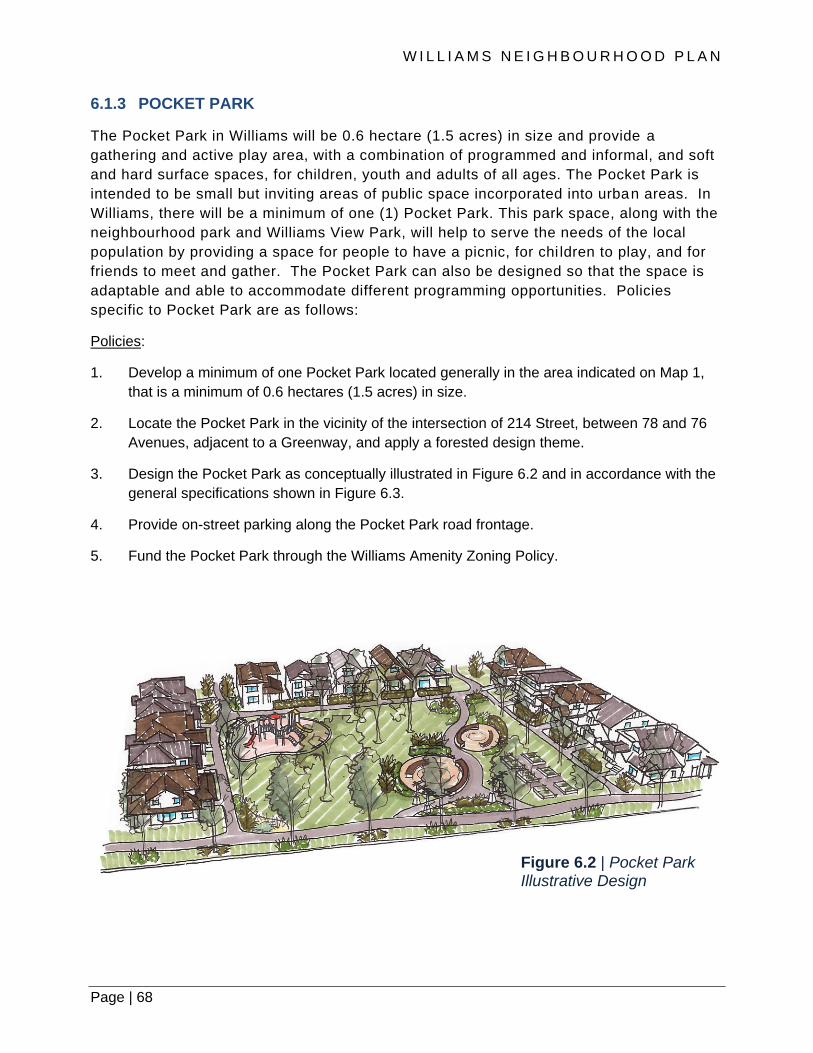
W I L L I A M S N E I G H B O U R H O O D P L A N
Page | 68
6.1.3 POCKET PARK
The Pocket Park in Williams will be 0.6 hectare (1.5 acres) in size and provide a
gathering and active play area, with a combination of programmed and informal, and soft
and hard surface spaces, for children, youth and adults of all ages. The Pocket Park is
intended to be small but inviting areas of public space incorporated into urban areas. In
Williams, there will be a minimum of one (1) Pocket Park. This park space, along with the
neighbourhood park and Williams View Park, will help to serve the needs of the local
population by providing a space for people to have a picnic, for chi ldren to play, and for
friends to meet and gather. The Pocket Park can also be designed so that the space is
adaptable and able to accommodate different programming opportunities. Policies
specific to Pocket Park are as follows:
Policies:
1. Develop a minimum of one Pocket Park located generally in the area indicated on Map 1,
that is a minimum of 0.6 hectares (1.5 acres) in size.
2. Locate the Pocket Park in the vicinity of the intersection of 214 Street, between 78 and 76
Avenues, adjacent to a Greenway, and apply a forested design theme.
3. Design the Pocket Park as conceptually illustrated in Figure 6.2 and in accordance with the
general specifications shown in Figure 6.3.
4. Provide on-street parking along the Pocket Park road frontage.
5. Fund the Pocket Park through the Williams Amenity Zoning Policy.
Figure 6.2 | Pocket Park Illustrative Design

Page | 69
6.1.4 WILDLIFE HABITAT PATCH
In accordance with the Township Wildlife Habitat Conservation Strategy, an approximate 1,563
m² (0.4 acre) Wildlife Habitat Patch shall be secured, enhanced and maintained for education and
recreation opportunities near the vicinity of Morrison Crescent and 77A Avenue. The Wildlife
Habitat Patch is intended to provide food and foraging opportunities for wildlife and serve as a
small node in a network of greenways and watercourse riparian areas within the Williams area,
that connect and extend throughout Willoughby.
The intent of these policies is to facilitate the establishment of a Wildlife Habitat Patch for the
preservation of open space, the preservation of mature trees, and for the purposes of ensuring
ecological integrity and the strengthening of connections between natural areas and public
connections and spaces. Policies specific to Wildlife Habitat Patch are as follows:
Figure 6.3 | Pocket Park General Specifications

W I L L I A M S N E I G H B O U R H O O D P L A N
Page | 70
Policies:
1. Provide a Wildlife Habitat Patch, along with associated Off Street Greenway and Enhanced
Sidewalks with connections to neighbouring Creek Greenway and Enhanced Sidewalks,
within the vicinity of the intersection at Morrison Crescent and 77A Avenue, as illustrated on
Map 1.
2. Prioritize the location, configuration and vegetation enhancement of the Wildlife Habitat
Patch based on the five habitat types – coniferous, broadleaf and mixed tree species,
dense understorey shrubs and ferns, and wetland areas – that are deemed most capable of
supporting wildlife in an urban setting.
3. Protect intrusion into the Wildlife Habitat Patch to preserve ecological integrity, as
warranted.
4. Include interpretive signage and additional amenities, as and where appropriate, while
keeping the overall protection of the area the priority.
5. Fund the Wildlife Habitat Patch and the connecting Off-Street Greenway and Enhanced
Sidewalks through the Williams Amenity Zoning Policy.

Page | 71
6.1.5 NEIGHBOURHOOD FORESTED MEWS
The Neighbourhood Forested Mews is a former and decommissioned municipally -owned
street and/or road right-of-way that is currently not used for vehicular traffic, has had
unnecessary utility infrastructure removed and all asphalt, concrete and other surface
material removed, as relevant. The area has been reassigned and replaced with
pedestrian-accessible, forested open spaces. The Neighbourhood Forested Mews will
contribute unique ‘place making’ feature for neighbourhood design in the low -density
residential areas in Williams. This concept provides an opportunity to meet one of the
planning principles and design features in Williams that supports integrating natural
features and systems into new neighbourhoods to create a sense of place and to preserve
and enhance the ‘treed’ character of the Willoughby Escarpment, while at the same time,
creating a pedestrian-oriented, public amenity-rich neighbourhood. Policies specific to the
Neighbourhood Forested Mews are as follows:
Policies:
1. Provide and develop the Neighbourhood Forested Mews at the locations as indicated on
Map 1. The Neighbourhood Forested Mews will encompass the entire width –
approximately 20 metres - of the existing dedicated public right of way.
2. Incorporate appropriate soils along the Forested Mews to support long-term, stable rooting
for trees as well as rainwater detention and nutrient holding capacity.
3. Retain and include new trees, with a focus on coniferous, evergreens, and integrate a 3.0m
wide shared-use, asphalt trail.
4. Consider relocation of the Neighbourhood Forested Mews provided that the area is the
same or greater and there is a clear net benefit (e.g., retention of mature trees).
5. Consider the orientation of adjacent residences to front the Neighbourhood Forested
Mews, if deemed appropriate and feasible. Provide these residences with pedestrian
access to the Mews, yet include measures to differentiate public and private space, and
provide a minimum of four (4) off-street parking spaces for each dwelling unit that fronts
the Mews. No tandem parking within a building shall be permitted.
6. Require development to fund the removal and/or relocation of infrastructure, and any soil
remediation, as part of Works and Services requirements of the Township’s Subdivision
and Development Servicing Bylaw.
7. Fund the reforestation of the Neighbourhood Forested Mews from existing and appropriate
Township of Langley sources.
8. Fund the 3.0 metre wide shared-use, asphalt trail through the Williams Amenity Zoning
Policy.

W I L L I A M S N E I G H B O U R H O O D P L A N
Page | 72
6.2 GREENWAYS AND PEDESTRIAN CONNECTIONS
The network of greenway and pedestrian connections in Williams is an important component of
the mobility network for both pedestrians and cyclists and a key recreational amenity. Along with
the sidewalk and cycle lane network described in Section 8, street greenways, creek greenways
(trails), enhanced sidewalks, and pedestrian links provide continuous pedestrian connections
between destinations within and beyond the plan area, and a range of easily accessible,
recreational experiences. Some greenways also provide opportunities to integrate unique
landscape and stormwater management features such as raingardens into the public realm. The
specific locations of planned greenways and pedestrian connections are illustrated on Map 1.
6.2.1 STREET GREENWAYS
Street Greenways are wide landscaped boulevards along major roads which provide
attractive and safe pedestrian and cyclist connections throughout the community. Street
Greenways connect pedestrians and cyclists with parks, natural areas, commercial nodes,
neighbourhood amenities and services, as well as the integration with greenways in
adjacent neighbourhoods, and connections to destinations beyond. Policies specific to
street greenways are as follows:
Policies:
1. Provide contiguous Street Greenways in the locations identified on Map 1;
2. Construct Street Greenways in accordance with the standards provided in Table 6.1 and
illustrated in Figure 6.4;
Figure 6.4 | Street Greenway Illustrative Design

Page | 73
3. Incorporate tree species, such as cedar and other evergreen, coniferous varieties,
that complement the usual deciduous street trees;
4. Discourage the crossings of Street Greenways by driveways. Where no alternative exists,
driveways should be consolidated and intersections with greenways shall be designed for the
safety of greenway users;
5. Provide safe street crossings for pedestrians and cyclists at key intersections; and
6. Fund Street Greenways through the Williams Amenity Zoning Policy.
6.2.2 OFF-STREET RECREATIONAL GREENWAYS
Off-Street Recreational Greenways are trails that provide pathway connections between other
pedestrian and cycling facilities. These multi-use pathways accommodate both pedestrians and
cyclists and can be used for both recreation and commuting purposes. Policies specific to off-street
greenways is as follows:
Policies:
1. Provide Off-Street Greenways in the locations identified on Map 1.
2. Construct Off-Street Greenways in accordance with the standards provided in Table 6.1 and
illustrated in Figure 6.5.
3. Fund Off-Street Greenways through the Williams Amenity Zoning Policy.
Figure 6.5 | Off-Street Recreational Greenway Illustrative Design

W I L L I A M S N E I G H B O U R H O O D P L A N
Page | 74
6.2.3 CREEK GREENWAYS
Creek Greenways are off-street trails that run adjacent to existing watercourses, Conservation
and Watercourse Compensation Areas. These multi-use pathways accommodate both
pedestrians and cyclists and can be used for both recreation and commuting purposes. Policies
specific to creek greenways are as follows:
Policies:
1. Provide Creek Greenways in the locations identified on Map 1.
2. Construct Creek Greenways in accordance with the standards provided in Table 6.1 and
illustrated in Figure 6.6.
3. Locate Creek Greenways generally adjacent to the riparian areas and Watercourse
Compensation Areas. Consideration will be given to locating the Creek Greenways within
the outer edges of the Riparian Areas and Watercourse Compensation Areas provided that
they do not negatively impact the habitat value or biological integrity of said areas.
4. Build appropriate ‘connections’ where the Creek Greenways intersect with other pedestrian
and cycling facilities and other types of Greenways.
5. Fund Creek Greenways through the Williams Amenity Zoning Policy.
Figure 6.6 | Creek Greenway Illustrative Design
Page | 75
6.2.4 ENHANCED SIDEWALKS
Enhanced sidewalks are suitable in areas where short on-street pedestrian and cyclist
connections are required adjacent to the riparian areas or in order to connect greenways.
Enhanced Sidewalks are designed to accommodate a 3-metre wide multi-use pathway. Policies
specific for Enhanced Sidewalks are as follows:
Policies:
1. Provide Enhanced Sidewalks in the locations identified on Map 1.
2. Construct Enhanced Sidewalks in accordance with the standards provided in Table 6.1.
3. Fund Enhanced Sidewalks through the Williams Amenity Zoning Policy.
6.2.5 PEDESTRIAN LINKS
Pedestrian Links are to be provided to connect through developments and subdivisions, to and
from greenways and trails, schools and bike routes within and outside the plan area as well as
through areas where public access along a road is widely spaced. The location for the
Pedestrian Links, as shown on Map 1, is not intended to be interpreted literally but approximately.
The intent of these policies is to secure, through development, additional connection points
through development to increase the walkability and permeability of the neighbourhood and to
improve connections with adjacent neighbourhoods and destinations. Policies specific for the
pedestrian links are as follows:
Policies:
1. Provide Pedestrian Links, which are a minimum three (3) metre wide concrete shared use,
hard-surface (e.g., concrete, asphalt) pathway, in the locations identified on Map 1.
2. Design entrances to Pedestrian Links, adjacent to Greenways, Enhanced Sidewalks, and
other public rights-of-way, so that they are visible and will be interpreted as a ‘public’
pathway.
3. Pedestrian Links are not funded through the Williams Amenity Zoning Policy.

W I L L I A M S N E I G H B O U R H O O D P L A N
Page | 76
Table 6.1 | Greenways, Pedestrian Links, and Enhanced Sidewalk Standards
6.2.6 GREENWAYS, PEDESTRIAN LINKS & ENHANCED SIDEWALK STANDARDS
Table 6.1 provides a summary of the Greenways, Pedestrian Links and Enhanced Sidewalk
Standards.
TYPE STANDARDS
Street Greenways 4.5m wide dedication (5.5m wide dedication along 216 Street, between 76 and 80 Avenues)
3.0m wide shared use, concrete pathway
Off-Street Recreational Greenways
6.0m to 10.0m wide dedication, depending on location
3.0m wide shared use, concrete pathway
Creek Greenways 3.0m wide shared use, asphalt trail located in the outer 6.0m of the required riparian area
Pedestrian Links 3.0m wide shared use concrete pathway
Enhanced Sidewalks Within the road dedication
2.0m wide buffer between the curb and sidewalk
3.0m wide concrete sidewalk
1.0m wide buffer between

Page | 77
6.3 SCHOOLS
At present there are no elementary schools in the Williams neighbourhood. At full buildout it is
estimate that the Williams neighbourhood will contribute approximately 530 elementary school
students (i.e. kindergarten to grade 5), 220 middle school students (i.e. grades 6 to 8), and 251
senior high school students (i.e. grades 9 to 12).
A future elementary school site in Williams is anticipated to accommodate this growth in the
number of students in the neighbourhood. It is anticipated that approximately 2 hectares (5
acres) of land for a new school site will be required. School District 35 will acquire the new school
site, which would be developed at such time that the population growth warrants the
establishment of the new school. Rezoning of lands for development will require that school sites
be secured as outlined in Section 11.2.1.
The number, location and grade configurations of schools referred to in this plan are projected
based on information available at the time of plan preparation. The future actual number, location
and grade configurations may differ from those of this plan. The School District has developed a
Long Term Facilities Plan which has a requirement to hold public consultation on grade
configurations in particular areas of the Township. In addition, as the School District has limited
ability to raise funding for capital projects, it relies heavily on funding from the Ministry of
Education for the acquisition of land and the construction of schools. Funding requests are made
annually though the submission of a five-year capital plan. Ministry decisions to support projects
in that plan are dependent on many factors, including the needs of other school districts.
The intent of these policies is to provide guidance, in terms of the size and approximate location
for a future joint use park-elementary school site:
Policies:
1. Accommodate an Elementary School, which will form part of a joint neighbourhood park-
elementary school site with a minimum total size of 4 hectares (10 acres; 5 acres
neighbourhood park and 5 acres elementary school), within the vicinity of 214 Street and 78
Avenue, as indicated on Map 1.
2. Identify and secure the Elementary School site along with the rezoning of all lands
designated for residential development, as outlined in Policy 1, Subsection 11.2 General
Prerequisites.
3. Ensure that the Elementary School and the adjoining Neighbourhood Park that comprise
the joint park-school site are appropriately located to serve the intended purpose and to the
acceptance of the Township of Langley and the Langley School District.

W I L L I A M S N E I G H B O U R H O O D P L A N
Page | 78
7. NEIGHBOURHOOD CHARACTER AND IDENTITY
Page | 79

W I L L I A M S N E I G H B O U R H O O D P L A N
Page | 80
Neighbourhood Character and Identity
7.1 NEIGHBOURHOOD PLACE MAKING
The Williams neighbourhood is envisioned to be an urban, compact neighbourhood characterized
by an active public realm. Within the streetscape, a variety of amenity features will help to further
animate public spaces, promote walking, encourage community interaction and contribute to a the
identity of the neighbourhood and the making of place.
The neighbourhood is expected to include an elementary school, employment lands in the form of
a business park, a local-serving commercial node, a variety of park and open spaces, as well as
pedestrian and cycling connections. Access to all of these should be possible via sidewalks,
greenways and trails with appropriate crosswalks provided at controlled intersections.
View corridors from the neighbourhood to the south and southeast to the Milner Valley and vistas
beyond (Mount Baker), are also provided in strategic locations. Neighbourhood, subdivision and
building designs will also contribute to the retention and enhancement of the treed character of
the Willoughby Escarpment, as seen and viewed from various points along the Milner Valley,
specifically along Glover Road.
7.2 NEIGHBOURHOOD LANDMARKS
Within the Williams neighbourhood, there are two Neighbourhood Landmarks that serve as area
gateway features that announce entrance into the Williams area, create civic focal points, and
enhance the network of visual reference points throughout the Willoughby community. The
locations, as denoted on Map 1, include:
• Intersection of 212 Street and 80 Avenue (see Figure 7.1)
• 216 Street and Highway #1 interchange (see Figure 7.2)
The Neighbourhood Landmark at 212 Street and 80 Avenue is approximately 3,802 m2 (0.95
acre) in size and provides a predominantly hard landscaped urban public open space at the
physical confluence of Street Greenway networks in Williams, connections with Smith and
Yorkson neighbourhoods and areas beyond, and is located within former dedicated roads and will
be maintained by the Township. The space for the Neighbourhood Landmark is on both the north
and south corners at the west side of the re-aligned intersection at 80 Avenue and the 212
Connector. These spaces are highly visible to pedestrians, cyclists, transit riders and motorist
along both directions of 80 Avenue and those heading north on the 212 Connector, as well as
residents and workers within its vicinity.
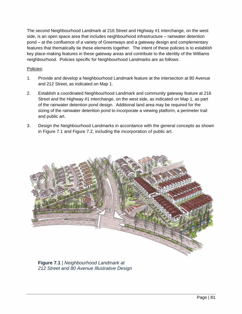
Page | 81
Figure 7.1 | Neighbourhood Landmark at 212 Street and 80 Avenue Illustrative Design
The second Neighbourhood Landmark at 216 Street and Highway #1 interchange, on the west
side, is an open space area that includes neighbourhood infrastructure – rainwater detention
pond – at the confluence of a variety of Greenways and a gateway design and complementary
features that thematically tie these elements together. The intent of these policies is to establish
key place-making features in these gateway areas and contribute to the identity of the Williams
neighbourhood. Policies specific for Neighbourhood Landmarks are as follows:
Policies:
1. Provide and develop a Neighbourhood Landmark feature at the intersection at 80 Avenue
and 212 Street, as indicated on Map 1.
2. Establish a coordinated Neighbourhood Landmark and community gateway feature at 216
Street and the Highway #1 interchange, on the west side, as indicated on Map 1, as part
of the rainwater detention pond design. Additional land area may be required for the
sizing of the rainwater detention pond to incorporate a viewing platform, a perimeter trail
and public art.
3. Design the Neighbourhood Landmarks in accordance with the general concepts as shown
in Figure 7.1 and Figure 7.2, including the incorporation of public art.

W I L L I A M S N E I G H B O U R H O O D P L A N
Page | 82
Figure 7.2 | Neighbourhood Landmark at 216 Street and Highway #1 Illustrative Design
4. Fund the Neighbourhood Landmark at 80 Avenue and 212 Street through the Williams
Amenity Zoning Policy.
5. Fund the Neighbourhood Landmark at 216 Street and Highway #1 through the Williams
Amenity Zoning Policy (not including the stormwater detention pond and associated
plantings and landscaping).
Page | 83
7.2.1 PUBLIC ART
In Williams, Public Art will form part of the two Neighbourhood Landmark locations. Public art is
intended to improve the character and vibrancy of the public realm and to encourage community
interaction amongst residents and visitors. The intent of these policies is to establish Public Art
that will serve to create local identity and attractive neighbourhood spaces, and will enrich the
everyday experience in the Williams area. Policies specific for Public Art are as follows:
Policies:
1. Include Public Art as part of Neighbourhood Landmarks at the locations identified on Map 1.
2. Require the Township of Langley to manage, maintain and insure all Public Art in
accordance with Council’s Public Art Policy (No. 06-024).
3. Ensure that an appropriate collection management system is in place and those
documentation standards and inventory practices are implemented.
4. Encourage the incorporation of additional on-site Public Art in the design of buildings or
landscape as part of development. Public Art should be located in publically accessible
spaces or commercial spaces that members of the public often frequent.
5. Fund Public Art for the public locations identified on Map 1 through the Williams Amenity
Zoning Policy.
7.3 STORMWATER FACILITIES AS AMENITIES
Stormwater facilities (including detention ponds) are intended to serve a dual purpose. The
primary use is functional with recreation and aesthetics serving as a secondary function. In their
role as an amenity efforts shall be made to design ponds with these goals in mind. Two (2)
detention ponds shall be located in the vicinity of 216 Street in the Williams Neighbourhood Plan
area: one at the northeast corner of the Plan area and another at the southeast corner. Policies
specific for stormwater facilities as amenities are as follows:
Policies:
1. Incorporate pedestrian access around all or part of the edge/perimeter of stormwater
facilities and link this pedestrian feature with nearby Greenways.
2. Provide safe access and seating along the inner slope of detention ponds. It is understood
that pedestrians do not have access to all areas of the facilities.
3. Include aesthetic considerations as part of the design of stormwater detention pond,
including but not limited to exposed walls and slopes visible by the public. This shall
include hard and soft landscape design solutions, where appropriate. Incorporate
evergreen, coniferous tree plantings around the perimeter of the detention pond to
contribute to the treed character of the Willoughby Escarpment.

W I L L I A M S N E I G H B O U R H O O D P L A N
Page | 84
4. Design fencing to be aesthetically pleasing and thematically aligned with the design
features of the Neighbourhood Landmark spaces. Acoustic barriers should be considered
and included where traffic noise or adjoining uses negatively impacts the enjoyment of the
amenity space and views to and from the facility.
7.4 GREEN ROOFS
Green roofs (also known as “living roofs”) can also promote effective stormwater management,
reduce energy use, as well as provide communities with additional spaces for amenity and
recreation uses. They consist of various roofing layers topped with a soil-like growing medium
and specific plant species that have the ability to withstand dramatic swings in climatic conditions.
The intent of these policies is to encourage the application of green roofs as part of development
in the Employment District.
Policies:
1. Encourage new commercial and industrial buildings to incorporate green roofs to mitigate
stormwater impacts and improve energy efficiency. Green roofs are to be utilized to the
greatest extent possible for all non-residential development.
2. Consider the provision of employee accessible outdoor space on the green roof to
accommodate both recreational and ecological needs.
3. Encourage the use of plant species that are native and non-invasive and appropriate to the
climatic conditions of the Williams Neighbourhood Plan area.
4. Design green roofs in accordance with the BC Green Building Code.
5. Adhere to Township policy regarding, among other items, the management, maintenance
and insurance/liability related to green roofs. Green roofs are to be kept in perpetuity.
Irrigation and maintenance of the green roof are the responsibility of the building and/or
property owner.

Page | 85
Figure 7.3 | Landscape Buffer Locations
7.5 LANDSCAPE BUFFERS
A Landscape Buffer is a linear feature with plantings, earthen berms and hardscaping (e.g.,
fencing) that provides visual and noise attenuation between different land uses and transportation
infrastructure. In the Williams area, a ‘freeway’ version of the Landscape Buffer will be applied
between the Townhouse land use designation north of 83 Avenue and Highway #1. An ‘interface’
version of the Landscape Buffer will be applied between the Townhouse land use designation
north of 83 Avenue and the areas east and south, designated as Business Park. Policies specific
to Landscape Buffers is as follows:
Policies:
1. Provide a ‘freeway’ Landscape Buffer that is 15 metres wide, that includes retained and
additional tree plantings, understorey plantings and ground cover, an earthen berm, and a
3 metre wide trail, and is located adjacent to Highway #1 as illustrated in Figure 7.3.
2. Provide an ‘interface’ Landscape Buffer at the location between the Townhouse land use
designation north of 83 Avenue and the areas east and south, designated as Business
Park, as illustrated in Figure 7.3, that is 6 metres deep and that extends the full length of the
east property line. This buffer feature is in addition to landscaping requirements and
setbacks treatments required in the Township of Langley Zoning Bylaw, Subdivision and
Development Servicing Bylaw (as amended from time to time) and other relevant Township
bylaws.
3. Fund the provision of the ‘Freeway’ Landscape Buffers through the Williams Amenity
Zoning Policy.
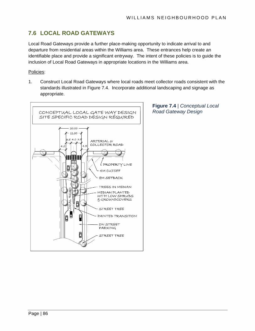
W I L L I A M S N E I G H B O U R H O O D P L A N
Page | 86
Figure 7.4 | Conceptual Local Road Gateway Design
7.6 LOCAL ROAD GATEWAYS
Local Road Gateways provide a further place-making opportunity to indicate arrival to and
departure from residential areas within the Williams area. These entrances help create an
identifiable place and provide a significant entryway. The intent of these policies is to guide the
inclusion of Local Road Gateways in appropriate locations in the Williams area.
Policies:
1. Construct Local Road Gateways where local roads meet collector roads consistent with the
standards illustrated in Figure 7.4. Incorporate additional landscaping and signage as
appropriate.

Page | 87
7.7 UTILITY BOXES AND VAULTS
Urban communities include a variety of supporting infrastructure, some of which is visible and
others are not. Siting and finishes of these at-grade or above-grade infrastructure are necessary
and careful location and placement is warranted such that they do not interfere with mobility or
the aesthetic qualities of the Williams area. The intent of these policies is to guide the location
and appearance of at-grade utility boxes and vaults.
Policies:
1. Plan and coordinate the location of utility boxes (e.g.
telephone hubs and electrical transformers), ventilation
equipment or other at-grade mechanical equipment to
minimize their impact on the public realm, including
placing them underground or inside buildings wherever
possible.
2. Place existing overhead utilities underground as part of
new development and upgrades to infrastructure.
3. Apply appropriate ‘wraps’ on utility boxes and other at-
grade mechanical equipment as part of off-site and on-
site works and services associated with development in
order to reduce graffiti and improve the visual aesthetic
of the neighbourhood. Appropriate imagery will need to
be investigated with heritage (built or natural), cultural
events or topics, and art being possible options.
7.8 RETAINING WALLS
Developing a pedestrian friendly, visually attractive neighbourhood in a setting characterized by
sloping sites is a key aim of the Plan. The southern portion of the Williams Plan has a sloping
terrain that could result in significant grading and use of retaining walls to create suitable
development sites. The intent of these policies is to encourage new development to work with the
land to create viable high-quality developments.
Policies:
1. Ensure development and infrastructure projects build with the slope to help preserve the
natural topography of hillside areas and minimize cut and fill excavations.
2. Integrate landscaping, apply texture treatments and use a ‘stepped-approach in the design
of retaining walls where they are located along any public right-of-way, in a public space or
area visible to the public, in order to provide visual interest and help integration with the
surrounding area.

W I L L I A M S N E I G H B O U R H O O D P L A N
Page | 88
7.9 HERITAGE
In 2012, Township Council endorsed a Heritage Strategy that outlines the strategic goals and
actions for heritage to 2022. The Strategy recognizes the importance of Langley’s historic and
archaeological resources, its rural lands, and its natural and cultural landscapes, in developing
complete sustainable communities, and identifies nine goals and a number of actions to be
implemented over ten years. The following actions would apply to resources identified in the
Williams Neighbourhood:
• Identify built, natural and cultural landscape heritage sites, and policies for conserving them
during the neighbourhood plan process;
• Preserve, protect and celebrate significant historical resources that illustrate Langley’s range
of heritage values;
• Encourage retention of existing building stock, where feasible, by demonstrating flexibility in
the assessment of adaptive re-use projects;
• Encourage and support salvage efforts in the deconstruction of existing buildings;
• Provide grants for the restoration of heritage buildings through the Heritage Building Incentive
Program; and
• Investigate extending conservation incentives for heritage building owners in the form of
permissive or property tax exemptions.
Archaeological Resources
Although there are no previously recorded archaeological sites within the plan boundaries, there
are reports that some lithic materials have been found within the Yorkson Creek area, indicating
that the possibility of archaeological potential within the area cannot be ruled out. The provincial
Archeology Branch maintains and oversees the legislative processes for the management of
archaeological sites, and landowners, occupants and service providers are required to conform to
provincial process and permitting requirements with respect to both known and unknown sites.

Page | 89
Natural and Cultural Landscapes
The Willoughby escarpment that runs along the eastern edge of the Williams neighbourhood is a
prominent geographical feature. This natural feature, which forms a natural division between the
Milner Valley and upland areas, includes some large stands of trees both within Williams and its
adjacent rural areas to the south and southeast. The escarpment additionally provides for scenic
views of the location of the historic 1830s Hudson Bay Company Farm in Milner, and in some
locations longer views to Mount Baker, the Golden Ears and other peaks in the Coast Mountain
Range.
Protection of the escarpment’s visual and historical significance as viewed from the Milner area
can be achieved through a combination of tree protection and tree replacement strategies.
Implementation of these strategies will be
emphasized for areas along the Agricultural Land
Reserve boundaries, along the east and south
boundaries of the plan. Given that the urbanization
process will occur over a number of years and
decades, the escarpment’s image and character will
evolve and regenerate as new trees grow and mature
along the within the neighbourhood.
Built Resources
The historic resources in Willoughby that remain today reflect the community’s rural history and
community life near the turn of the twentieth century. As part of the Willoughby Heritage Study
undertaken in 2005, historic assessments were completed for several buildings within the plan
boundaries, although none of the sites identified have been added to the Township’s Heritage
Inventory to date.
The intent of these policies is to guide the preservation, restoration and commemoration of built
and archaeological resources and natural and cultural landscapes that have heritage values as
they relate to the Williams area.
Policies:
Protect Archaeological Sites and Areas
1. Discourage unauthorized damage to archaeological sites by encouraging landowners and
service providers to fulfill their obligations under the Heritage Conservation Act through the
provincial Archaeology Branch.
The low-lying, flat lands surround Milner comprise the original 1830s Hudson’s Bay Company commercial farm, a unique cultural landscape that has retained its historic configuration, agricultural use, and valley viewscapes since the early 1800s.
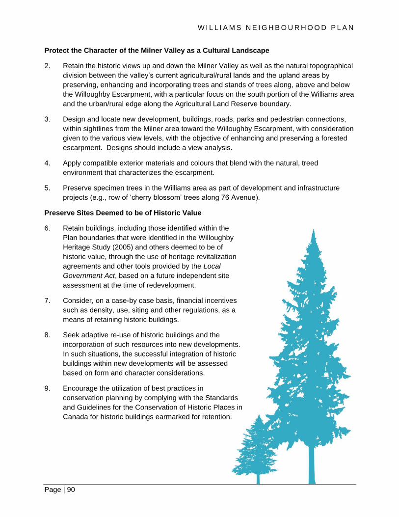
W I L L I A M S N E I G H B O U R H O O D P L A N
Page | 90
Protect the Character of the Milner Valley as a Cultural Landscape
2. Retain the historic views up and down the Milner Valley as well as the natural topographical
division between the valley’s current agricultural/rural lands and the upland areas by
preserving, enhancing and incorporating trees and stands of trees along, above and below
the Willoughby Escarpment, with a particular focus on the south portion of the Williams area
and the urban/rural edge along the Agricultural Land Reserve boundary.
3. Design and locate new development, buildings, roads, parks and pedestrian connections,
within sightlines from the Milner area toward the Willoughby Escarpment, with consideration
given to the various view levels, with the objective of enhancing and preserving a forested
escarpment. Designs should include a view analysis.
4. Apply compatible exterior materials and colours that blend with the natural, treed
environment that characterizes the escarpment.
5. Preserve specimen trees in the Williams area as part of development and infrastructure
projects (e.g., row of ‘cherry blossom’ trees along 76 Avenue).
Preserve Sites Deemed to be of Historic Value
6. Retain buildings, including those identified within the
Plan boundaries that were identified in the Willoughby
Heritage Study (2005) and others deemed to be of
historic value, through the use of heritage revitalization
agreements and other tools provided by the Local
Government Act, based on a future independent site
assessment at the time of redevelopment.
7. Consider, on a case-by case basis, financial incentives
such as density, use, siting and other regulations, as a
means of retaining historic buildings.
8. Seek adaptive re-use of historic buildings and the
incorporation of such resources into new developments.
In such situations, the successful integration of historic
buildings within new developments will be assessed
based on form and character considerations.
9. Encourage the utilization of best practices in
conservation planning by complying with the Standards
and Guidelines for the Conservation of Historic Places in
Canada for historic buildings earmarked for retention.

Page | 91
Document Buildings Approved for Removal
10. Provide photo documentation for archival purposes or alternatively prepare an ‘As-Found
Report’ to the satisfaction of the Township prior to the removal of any building that has been
deemed to be of heritage interest based on previous documentation, such as the
Willoughby Heritage Study or other sources.
Commemorate Williams History
11. Commemorate early and historic places, where appropriate, with historic place names or
interpretive signage and through complementary public realm design and signage projects
that recognize and celebrate the tangible and intangible aspects of Williams’s history.
7.10 CRIME PREVENTION THROUGH ENVIRONMENTAL DESIGN
The safety and security of residents are an important component of any liveable community.
Safety and security are considered not only in terms of personal physical safety (i.e. crime and
threats to personal property), but also in terms of safety for pedestrians, vehicles and cyclists.
Traffic safety is addressed further in Section 8.
The way in which we design our communities and public spaces, allow for new development and
encourage interaction amongst the public can impact personal safety and the ability of law
enforcement to reduce crime within a community. This approach to development planning, which
seeks to reduce opportunities for crime, is called “Crime Prevention through Environmental
Design” (CPTED), the principles of which include the following:
• Territoriality - fostering residents’ interaction, vigilance, and control over their neighbourhood
• Surveillance - maximizing the ability to spot suspicious people and activities
• Activity support - encouraging the intended use of public space by residents
• Hierarchy of space - identifying ownership by delineating private space from public space
through real or symbolic boundaries
• Access control/target hardening - using physical barriers, security devices and tamper-
resistant materials to restrict entrance
• Environment - making a design or location decision that takes into account the surrounding
environment and minimizing the use of space by conflicting groups
• Image/Maintenance - ensuring that a building or area is clean, well-maintained, and graffiti-
free
The intent of the policies aligns with the spirit of the CPTED principles. As development within
Williams occurs over time, planning staff should verify that land development proposals comply
with CPTED principles prior to approval.

W I L L I A M S N E I G H B O U R H O O D P L A N
Page | 92
Policies:
1. New developments should be designed to provide “eyes on the street” through the
placement of windows, porches, balconies, and street-level uses. Blank walls should be
avoided. Design should allow for casual surveillance of all streets, parks, children’s play
areas and other public spaces.
2. Adequate lighting should be provided for all streets, lanes, parking areas, parks, trails, as
appropriate, and building entrances to enhance the sense of safety and personal security.
In places with high pedestrian traffic, pedestrian scale lighting should be provided.
3. Landscaping and fencing should be designed to avoid the creation of blind spots or hiding
places.
4. Site design should allow for clear sightlines between parking areas, public sidewalks, and
building entrances.

Page | 93
7.11 LIGHTING DESIGN
In Williams, neighbourhood-specific on-street and off-street lighting for vehicle travel lanes,
parking and pedestrian areas will be provided at the commercial node, located at 80 Avenue and
216 Street. The integration of this lighting will help to create pedestrian-friendly character, and
desirable and active streetscapes in key areas of Williams. The intent of these policies is to
establish neighbourhood-specific lighting in Williams that will serve to create local identity and
attractive neighbourhood spaces, and will enrich the everyday experience in the Williams area.
Policies:
1. Provide ornamental street lighting fixtures at the Williams commercial node, located at 80
Avenue and 216 Street, for both on-street and off-street areas.
2. Locate and space on-street and off-street lighting elements based on the industry standard
modeling and requirements, CPTED principles, BC Building Code, Township of Langley’s
Subdivision and Development Servicing Bylaw specifications and standards and the
Exterior Lighting Impact Policy, as amended from time to time.
3. Include pedestrian scale lighting along all streets, street greenways, creek greenways and
other pedestrian areas and connections.

W I L L I A M S N E I G H B O U R H O O D P L A N
Page | 94
8. MOBILITY

Page | 95

W I L L I A M S N E I G H B O U R H O O D P L A N
Page | 96
Mobility
8.1 STREET NETWORK
As the Williams area develops, the street network will link various parts of the neighbourhood
together and will be functional, safe and efficient for all modes of travel. The Williams street
network is predicated on the Township’s street network hierarchy, which classifies roads based
on function, traffic service, land access, and traffic volumes. The following road types are included
within Williams:
• Arterial Roads have the primary function of accommodating longer-distance, regional travel,
with limited access to individual parcels. The Williams neighbourhood has 80 Avenue, 212
Street and 216 Street as arterial roads.
• Collector Roads are intended to connect traffic from local roads to arterial roads and place
equal importance on traffic movement and access to properties. The collector roads within
Williams form an alternative grid network that will help distribute traffic throughout the area.
The collector roads for Williams are 76, 78, 79A and 81 Avenues and 212A (including
Morrison Crescent), and 214 Street.
• Local Roads are intended to provide access to individual properties and are not intended for
through travel.
• Lanes are intended to provide access to individual properties from the rear. They are included
in the Circulation Concept Plan at a conceptual level only.
This section outlines the street network within the Williams area and harmonizes the need for
motor vehicle movement and parking with the needs of pedestrian, cyclists and transit users. The
street network is designed to support a modified grid pattern where possible, combined with a
‘fine-grained’ block and lot structure that reflects the topography and grades of the area and
supports the development of energy efficient neighbourhoods. The street network is appropriately
sized for the anticipated amount of traffic. It will distribute vehicular traffic through multiple routes
provided within the Williams area, and is connected with the broader Willoughby area, and
destinations beyond. The Circulation Concept Plan (Map 3) outlines the planned street network.
Substantial compliance with the street network established in the Circulation Concept Plan is
required; however, there is some flexibility.

Page | 97
Policies:
1. Develop the street network, including arterial, collector, local roads, as illustrated in the
Circulation Concept Plan (Map 3). The alignment of the collector route of 78 Avenue to 77A
Avenue is required to ensure connectivity. The local road alignment as illustrated in the
Circulation Concept Plan that provides connection between 76 Avenue and 79A Avenue
shall be incorporated as part of subdivision design. Flexibility will be considered without
amendment to this Land Use Plan where the local road cannot conform entirely to the
concept due to site constraints.
2. Design the layout of residential areas with a block-based network of walkable streets on a
modified grid with an east-west orientation (see Section 4.0) and aligns with the arterial and
collector network as illustrated in the Circulation Concept Plan (Map 3). The “H”-shaped
configuration for rear lanes is intended to provide an opportunity for short end blocks to
feature fronting units. Single-access street patterns (culs-de-sac) shall be avoided; where this
is impractical, safe and functional pathway connections that accommodate pedestrians and
cyclists shall be provided to link with the mobility network in Williams and points beyond.
3. Incorporate low impact design features for rainwater management into street designs within
the Williams area, to facilitate the infiltration of stormwater.
4. Require all residential development fronting on arterial and collector streets, all Greenways,
and areas with Enhanced Sidewalks to provide rear lane or internal strata road access. The
“H”-shaped configuration for rear lanes is intended to provide an opportunity for short end
blocks to feature fronting units.
5. Secure statutory rights-of-way for all category of streets, including arterial, collector, local and
lanes. A right-of-way includes sidewalks, travel and parking lanes, boulevards and utility
allowances. The details are included within the Engineering Services Plan for transportation.
6. Locate multi-family amenity spaces away from arterial streets.
7. Apply modest grade-separation features that are appropriate and in keeping with the goal of
walkable streets – such as an elevated main entrance of the dwelling unit from the finished
grade, retaining walls along the property line – for all residential development along arterial
streets to provide sound attenuation.
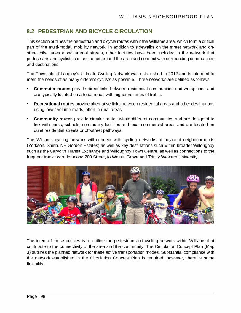
W I L L I A M S N E I G H B O U R H O O D P L A N
Page | 98
8.2 PEDESTRIAN AND BICYCLE CIRCULATION
This section outlines the pedestrian and bicycle routes within the Williams area, which form a critical
part of the multi-modal, mobility network. In addition to sidewalks on the street network and on-
street bike lanes along arterial streets, other facilities have been included in the network that
pedestrians and cyclists can use to get around the area and connect with surrounding communities
and destinations.
The Township of Langley’s Ultimate Cycling Network was established in 2012 and is intended to
meet the needs of as many different cyclists as possible. Three networks are defined as follows:
• Commuter routes provide direct links between residential communities and workplaces and
are typically located on arterial roads with higher volumes of traffic.
• Recreational routes provide alternative links between residential areas and other destinations
using lower volume roads, often in rural areas.
• Community routes provide circular routes within different communities and are designed to
link with parks, schools, community facilities and local commercial areas and are located on
quiet residential streets or off-street pathways.
The Williams cycling network will connect with cycling networks of adjacent neighbourhoods
(Yorkson, Smith, NE Gordon Estates) as well as key destinations such within broader Willoughby
such as the Carvolth Transit Exchange and Willoughby Town Centre, as well as connections to the
frequent transit corridor along 200 Street, to Walnut Grove and Trinity Western University.
The intent of these policies is to outline the pedestrian and cycling network within Williams that
contribute to the connectivity of the area and the community. The Circulation Concept Plan (Map
3) outlines the planned network for these active transportation modes. Substantial compliance with
the network established in the Circulation Concept Plan is required; however, there is some
flexibility.

Page | 99
Policies:
1. Incorporate pedestrian facilities and networks such as Street Greenways, Creek Greenways,
Enhanced Sidewalks, and Pedestrian Links in the Williams neighbourhood that conform to
Township standards and in accordance with the Circulation Concept Plan (Map 3) as
illustrated.
2. Design cycling facilities and networks, including commuter, recreational and community
routes, in the Williams neighbourhood that conform to Township standards and in
accordance with the Circulation Concept Plan (Map 3) as illustrated.
8.3 TRANSIT SERVICE
The 2007 South of Fraser Area Transit Plan provides a long-term vision for transit to 2031. This
vision includes 200 Street in the Willoughby area as a Frequent Transit Network (FTN) route in the
short and medium term and 208 Street as a Frequent Transit Network (FTN) route candidate. Over
the long term, 200 Street is envisioned to be part of TransLink’s Rapid Transit Network, with
potential for the corridor to accommodate bus or light rail rapid transit service within a dedicated
median.
TransLink’s South Fraser Area Transit Plan does not currently indicated any specific new transit
routes through the Williams neighbourhood. Williams is located 3km from the Carvolth Exchange,
a major transit exchange that connects riders to Langley City, Maple Ridge, Abbotsford, and
Millennium and Expo SkyTrain lines. In the future, transit ridership is expected to grow and it is
reasonable to assume conventional transit services will likely operate on major arterial roads such
as 216 Street, 212 Street and 80 Avenue. It is reasonable to assume that some transit services
could operate on collector roads as well.
An objective for the Williams Neighbourhood Plan is to enable active transportation by
implementing a convenient pedestrian and cycle network. The goal is that, among other things,
these pedestrian and cycling facilities will connect residents’ homes or jobs to transit stops; at
least in the short and medium term until such time as bus transit is provided in the Williams area.

W I L L I A M S N E I G H B O U R H O O D P L A N
Page | 100
Policies:
1. Accommodate future bus transit routing and stops in the Williams area along arterial streets
through appropriate street design standards.
2. Provide a street design standard along the 78 Avenue to integrate future community shuttle
transit service.
3. Design transit stops to include suitably sized landing pads for passengers, as well as
amenities such as shelters and benches, where appropriate.
8.4 TRAFFIC CONTROL AND TRAFFIC CALMING
The Township has a generalized approach to intersection control which is delineated as follows:
Intersection Type Traffic Control Type
Arterial/ arterial Traffic signals
Arterial/ collector Traffic signals
Collector/ collector Roundabouts
These intersection control types are used as a starting point in the development of the Circulation
Concept Plan (Map 3) for Williams.
Policies:
1. Incorporate traffic control and traffic calming infrastructure in the Williams neighbourhood, in
accordance with the Circulation Concept Plan (Map 3), as illustrated.
2. Require a detailed transportation assessment as part of development review process for
individual sites, as deemed appropriate, to confirm intersection control types that are applied
to any particular intersection.
3. Apply additional traffic calming elements, as outlined in Council Policy 05-110 Neighbourhood
Traffic Calming, for collector and local roads, as determined through a transportation
assessment as part of the development review process. Particular attention for additional
traffic calming measures will be given to north/south collector and local streets on steeper
terrain and intersections along 76 Avenue (e.g., at 214 Street).
4. Limit ‘right-in / right-out’ turning movements at the intersection of 76B Avenue at 216 Street.
As part of development review process, consider as part of the detailed transportation
assessment the need and technical appropriateness of pedestrian activated signal at 78B
Avenue at 212 Street.
Page | 101
8.5 PARKING AND TRANSPORTATION DEMAND MANAGEMENT
Parking management in Williams is intended to ensure sufficient on- and off-street parking supply.
On-street parking is permitted on both sides of collector roads and local roads and should be
incorporated into the design of the transportation network. Off-street parking requirements differ by
land use and is provided in accordance with Township of Langley Zoning Bylaw 1987 No. 2500, as
amended.
Policies:
1. Accommodate on-street parking on both sides of all local and collector streets.
2. Design front-loaded residential development to include double-wide driveways and enough
space for one vehicle to park on-street in front of each dwelling unit in order to provide
adequate parking, except for dwelling units that front arterial streets.
3. Design residential subdivisions with rear lanes and rear loaded lots for single family, semi-
detached and rowhouse dwelling units, as defined in the Township of Langley Zoning Bylaw,
in order to support a high quality pedestrian environment. Rear-loaded residential
development must have space for one vehicle to park on-street in front of each dwelling unit,
except for dwelling units that front arterial streets.
4. Provide a minimum four (4) off-street parking spaces for each dwelling unit fronting an
arterial road. No tandem parking within a building is permitted.

W I L L I A M S N E I G H B O U R H O O D P L A N
Page | 102
9. INFRASTRUCTURE AND ENERGY

Page | 103

W I L L I A M S N E I G H B O U R H O O D P L A N
Page | 104
Infrastructure and Energy
9.1 ENGINEERING SERVICES PLAN
The Engineering Services Plan is not an adopted document and is provided to serve as a framework
for preparing servicing plans for individual developments.
The servicing strategies aim for efficiency, cost effectiveness and the equitable distribution of costs.
There may, however, be alternative servicing strategies to those presented in the ESP as a result
of the ability to secure land or rights-of-way for infrastructure, the timing of development of specific
properties, or simply, a different engineering approach.
Alternative servicing strategies may be considered and implemented by the Township provided
that a new scheme meets the spirit and intent of the Williams Neighbourhood Engineering
Services Plan and in the opinion of the Township, does not adversely impact servicing
requirements for property owners.
9.2 WATER
9.2.1 EXISTING CONTEXT
The Williams Neighbourhood Plan area is
supplied with water from a Greater Vancouver
Water District (GVWD) main on 204 Street
through a number of connections and
Pressure Reducing Valve (PRV) Stations.
Pressure is maintained through the
Willoughby Pump Station. The plan area is
currently serviced internally by a coarse
network of watermains given the largely rural
nature of the area. The existing system
indicates that the plan area lies within two (2)
separate pressure zones: Pressure Zone
110m and Pressure Zone 131m.
The GVWD supply main and the existing internal network are understood to have sufficient
capacity to provide adequate flows to meet domestic demands and fire flows for the planned
neighbourhood. The Engineering Services Plan completed as part of the Williams Neighbourhood
Plan process provides an updated water distribution strategy to support the neighbourhood, and
outlines pressure zone boundaries.
Page | 105
9.2.2 FUTURE CONDITIONS
A water system analysis has been completed to determine peak demands and fire flow
requirements, and identify water infrastructure improvements required to support projected growth
in the neighbourhood. However, analysis is limited to the larger grid mains and did not include
review or sizing of smaller local mains.
The analysis has identified the need for expanding and upgrading of the existing system to meet
water and fire suppression flows for peak demands based on projected growth. Additional
information can be found in the Williams Engineering Services Plan that accompanies this
neighbourhood plan. All works will need to be confirmed through detailed design as part of the
subdivision process.
9.3 SANITARY SEWER
9.3.1 EXISTING CONTEXT
There is currently no existing sanitary sewer infrastructure within the Williams Neighbourhood Plan
area. Given its largely rural character, existing properties are serviced by individual septic systems.
Land use changes will require sanitary sewer collection and conveyance system for the area. The
Engineering Services Plan for the Williams neighbourhood will confirm details of sanitary
requirements, including requirement and location of pump stations, forcemains and/or downstream
infrastructure upgrades.
9.3.2 FUTURE CONDITIONS
Sewer system analysis has been completed to determine peak sewage flows and identify sewer
infrastructure required to support projected growth for the Williams neighbourhood. Analysis is
limited to trunk infrastructure only and does not include alignments or sizing of local sewer mains.
The analysis has identified the need for additional trunk sewer mains throughout the neighbourhood
to accommodate the increase in sewer loading, which are proposed to generally align with major
transportation corridors. Flows will gravity feed either to the northeast or southeast corners of the
Williams due to topography variations across the neighbourhood. Two sanitary pump stations will
be needed in the vicinity of the 216 Street corridor: one in the north and one in the south. Sanitary
forcemains will then carry the flows to connect inlets at 83 and 77A Avenues respectively.
The Williams Engineering Services Plan has been completed to update the sanitary sewer strategy
for the Williams neighbourhood. Servicing should follow the catchment areas shown and all works
will need to be confirmed through detailed design as part of the subdivision process.

W I L L I A M S N E I G H B O U R H O O D P L A N
Page | 106
9.4 STORMWATER
9.4.1 EXISTING CONTEXT
The Williams neighbourhood is part of the Salmon River Watershed, adjacent to the Yorkson Creek
and Upper Nicomekl Watersheds. Given its largely rural character, the current drainage system is
dominated by the natural and augmented watercourses, branches, tributaries and drainage
channels of the ‘two’ segments of Guy Creek, located in the northern and southern areas of
Williams, as well as a coarse network of road-side ditches and culverts, and partially piped sections.
This drainage network eventually drains into Salmon River.
9.4.2 FUTURE CONDITIONS
As part of the Williams Neighbourhood Plan process, the Williams Engineering Services Plan
has been completed to update the stormwater management strategy for the Williams
neighbourhood. All works will need to be confirmed through detailed design as part of the
subdivision process.
The significant change in land use will affect the hydrology of the area, requiring
compensatory actions to stave off increased risk to erosion and flooding. These actions
include three primary components. The first component is the application of on-site best
management practices (BMPs) such as infiltration trenches and absorbent landscaping to the
greatest extent practical to retain rainwater on site and recharge it to ground. BMPs will be
applied both on private sites as well as off-street public corridors, particularly the pedestrian
greenways to help reduce the impervious area.
The second component is the conveyance systems, largely piped, to convey generated runoff to
communal detention ponds. Preliminary routing and sizing of trunk storm sewers has been
identified in the Engineering Services Plan. Detention ponds and associated outlets to the
Salmon River system represent the final component of the management system. Within the
Williams area, two (2) new detention ponds are proposed. The location of these ponds have been
identified in general terms only on Map 1, as the specific siting will be subject to more
comprehensive development planning and land agreements. The exact location and size of these
ponds are to be verified at the time of a development application. The number and size of
detention ponds may vary based on the ability to secure land or rights-of-way for infrastructure,
the timing of development of specific properties, or a different engineering approach.
Integration of stormwater ponds and associated conveyance systems as an amenity feature
incorporated into the neighbourhood is important. As an amenity, stormwater systems shall be
considered for multiple purposes including, but not limited to ecological, recreational, education,
and aesthetic value. Considerations will be given to hard and soft landscaping in urban and
naturalized settings. Apply the policy guidance as outlined in Section 7.3 of this Plan in the design
of detention ponds.

Page | 107
9.5 HYDRO, TELEPHONE, STREET LIGHTING AND OTHER UTILITIES
As stipulated in the Township of Langley Subdivision and Development Servicing Bylaw, new hydro
and telecommunication lines are to be provided underground. Street lighting shall be provided on
all streets and lanes in accordance with the Subdivision and Development Servicing Bylaw. As
outlined in Section 7.11 of this Neighbourhood Plan, unique lighting standards apply to the
commercial node, located in the vicinity of 80 Avenue and 216 Street.
In support of the objective of fostering distinctive, attractive communities with a strong sense of
place, utility boxes throughout the neighbourhood shall be wrapped with appropriate material in
order to reduce graffiti and to improve the visual aesthetic of the neighbourhood. Appropriate
imagery will need to be investigated with heritage (built or natural), cultural events or topics, and
art being possible options.
9.6 ENERGY
As part of the Neighbourhood Plan process, an Energy Conservation Development Permit Area
(DPA) was developed. This DPA is designed to promote the conservation and efficient use of
energy in buildings, reduce building generated greenhouse gas emissions (GHGs) and lead to the
development of an energy efficient and sustainable community. Energy Conservation guidelines
are provided, in the Willoughby Community Plan.
W I L L I A M S N E I G H B O U R H O O D P L A N
Page | 108
10. FINANCIAL STRATEGY
Page | 109

W I L L I A M S N E I G H B O U R H O O D P L A N
Page | 110
Infrastructure and Energy
The Williams Neighbourhood Plan financial strategy is intended to assist in the orderly, cost
effective, and equitable development of the neighbourhood. It is based on principles that the
Township will not finance, nor assume a financial risk, in the provision of engineering services
required for development. As such, water, sanitary sewer, drainage, highway services, and parks
are to be solely funded through the collection of Development Cost Charges (DCCs) or other
appropriate cost recovery mechanisms. Finally, it is the responsibility of property owners and/or
the proponents of development to frontend the construction of engineering services and parks. To
assist in this regard, the Township may consent to enter into cost recovery agreements.
DCCs are levied against new development to assist in the financing of new servicing
infrastructure and amenities required by, and benefiting, new development. The Township’s
Development Cost Charge Bylaw sets DCC rates for each engineering service and for parks and
describes when and how they are to be paid. Rates are uniform across the Township so that
similar developments are levied the same rate regardless of their location. In principle, DCCs
collected must balance with required expenditures. However, in the Township’s context, they may
exceed or be in deficit within an individual neighbourhood.
Infrastructure which is eligible to be funded with DCC revenue is identified in the Township of
Langley’s 20-year DCC program.
The Township has infrastructure financing policies in place and has previously negotiated specific
agreements to permit property owners to receive DCC credits to assist in the cost recovery of
DCC works that they have constructed. Given the high cost of the sanitary sewer, drainage,
highway, and municipal water facilities required to permit development, the Township may
provide opportunities to the property owners to achieve cost recovery.
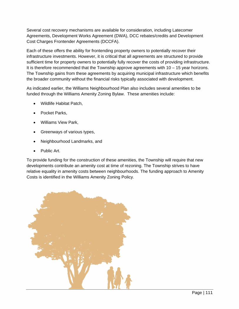
Page | 111
Several cost recovery mechanisms are available for consideration, including Latecomer
Agreements, Development Works Agreement (DWA), DCC rebates/credits and Development
Cost Charges Frontender Agreements (DCCFA).
Each of these offers the ability for frontending property owners to potentially recover their
infrastructure investments. However, it is critical that all agreements are structured to provide
sufficient time for property owners to potentially fully recover the costs of providing infrastructure.
It is therefore recommended that the Township approve agreements with 10 – 15 year horizons.
The Township gains from these agreements by acquiring municipal infrastructure which benefits
the broader community without the financial risks typically associated with development.
As indicated earlier, the Williams Neighbourhood Plan also includes several amenities to be
funded through the Williams Amenity Zoning Bylaw. These amenities include:
Wildlife Habitat Patch,
Pocket Parks,
Williams View Park,
Greenways of various types,
Neighbourhood Landmarks, and
Public Art.
To provide funding for the construction of these amenities, the Township will require that new
developments contribute an amenity cost at time of rezoning. The Township strives to have
relative equality in amenity costs between neighbourhoods. The funding approach to Amenity
Costs is identified in the Williams Amenity Zoning Policy.

W I L L I A M S N E I G H B O U R H O O D P L A N
Page | 112
11. IMPLEMENTATION

Page | 113
W I L L I A M S N E I G H B O U R H O O D P L A N
Page | 114
Implementation
11.1 INTRODUCTION
Development of the Williams neighbourhood shall proceed based on drainage catchment areas,
and the need for the elementary school and neighbourhood park.
11.2 GENERAL PREREQUISITES
Prior to the adoption of a zoning bylaw amendment in the Williams Neighbourhood Plan as
identified on Map 1, the following general prerequisites shall be completed to the satisfaction of
the Township:
1. Identify and secure a joint elementary school and neighbourhood park site to the
acceptance of the Township of Langley and the Langley School District, subject to other
provisions of this Plan, before any development may occur in that area, with the exception
of non-residential developments
2. Prior to each phase opening up for development the required community stormwater
detention site to serve that area must be secured and must be located to serve the entire
storm catchment area to the acceptance of the General Manager of Engineering. Interim
on-site detention will not be allowed.
3. Major roads and engineering services, including drainage, water, and sanitary sewer, storm
detention ponds, and road dedications, widenings and rights-of-way must be provided and
extended (at no cost to the Township) to accommodate the proposed development. Various
means of recovering servicing costs, such as Latecomer Agreements, Development Works
Agreement (DWA), DCC rebates/credits and Development Cost Charges Frontender
Agreements (DCCFA) may be considered, where applicable, to the acceptance of the
Township.

Page | 115
Figure 11.1 | Illustrates the location of the Employment District in the Williams Neighbourhood
11.3 DEVELOPMENT PREREQUISITES IN THE EMPLOYMENT
DISTRICT
Prior to Council’s consideration of first and second reading of a zoning bylaw amendment in the
areas designated for Commercial (Section 5.6), and Work and Business (Section 5.7) in this Plan,
the following shall be completed to the satisfaction of the Township:
1. Prepare a Comprehensive Development Plan (CDP), at the expense of the proponent, that
aligns with the Vision, Goals and policies of this Neighbourhood Plan for the entire
Employment District (see Figure 11.1). The CDP will include, but is not limited to, an
illustrative plan and associated statements that detail the spatial structure and design
features of the Employment District including building types and tenures, access and
movement, building massing, form, layout and height, streetscape design and landscaping,
parking and loading, watercourse compensation areas, stormwater detention, integration of
greenways and other amenities, energy conservation measures and development and
servicing.
2. Conduct a Transportation Impact Assessment (TIA) to determine the transportation impact
associated with the CDP and identify necessary infrastructure upgrades and phasing of said
improvements that are tied to development and servicing of the CDP. The TIA will be paid
for in full by the proponent, and carried out independently by a qualified Engineering
Consultant to be selected and managed by the Township.

W I L L I A M S N E I G H B O U R H O O D P L A N
Page | 116
Figure 11.2 | Illustrates the location of the North and South areas of the Residential District in the Williams Neighbourhood
11.4 DEVELOPMENT PREREQUISITES IN THE RESIDENTIAL
DISTRICT
Prior to Council’s consideration of first and second reading of a zoning bylaw amendment in the
areas designated for Single Family Mixed Residential and Townhouse Strata in this Plan (see
Figure 11.2 below), the following shall be completed to the satisfaction of the Township:
1. Prepare a Comprehensive Development Plan (CDP) and at the expense of the proponent,
that aligns with the Vision, Goals and policies of this Neighbourhood Plan, for either or both
of the North or South portions of the Residential District, as determined appropriate by the
General Manager of Community Development (see Figure 11.2). The CDP will include, but
is not limited to, an illustrative plan and associated statements that detail the spatial
structure and design features of the North and/or South Residential District, including
building types, access and movement, building massing, form, layout and height,
streetscape design and landscaping, Conservation and Watercourse Compensation Areas,
stormwater detention, integration of greenways and other amenities, energy conservation
measures and development and servicing phasing.
2. Conduct a viewscape analysis of the Willoughby Escarpment as part of the preparation of
this CDP.
3. Conduct a Transportation Impact Assessment (TIA) to determine the transportation impact
associated with the CDP and identify necessary infrastructure upgrades and phasing of said
improvements that are tied to the development and servicing phasing of the CDP. The TIA
will be carried out independently by a qualified Engineering Consultant to be selected and
managed by the Township of
Langley. The TIA will be paid for in
full by the proponent.

Page | 117
11.5 SPECIFIC DEVELOPMENT PREREQUISITES
The following development prerequisites must be resolved to the satisfaction of the Township
prior to adoption of a zoning bylaw amendment. This list is not deemed to be exhaustive, as other
requirements may be added based on site specific conditions and changes to Township bylaws,
policies and procedures.
1. Enter into a servicing agreement with the Township to secure required road and utility
upgrades/extensions, and a stormwater management plan in accordance with the servicing
provisions of this neighbourhood plan together with existing servicing standards as set out
in the Township of Langley Subdivision and Development Servicing Bylaw, as amended
from time to time.
2. Compliance with the Erosion and Sediment Control Bylaw, as amended from time to time,
including provision of an erosion and sediment control plan, to the acceptance of the
Township.
3. Secure road dedications and widening, in accordance with the Subdivision and
Development Servicing Bylaw, and the Master Transportation Plan, as amended from time
to time, to the acceptance of the Township.
4. Compliance with Schedule I (Tree Protection) of the Subdivision and Development
Servicing Bylaw as amended from time to time, including provision of a final tree
management plan incorporating tree retention, replacement and protection details, to the
acceptance of the Township.
5. Transfer any designated greenway, trail, or any other greenspace as shown on the land use
plan to the Township, or as determined by the Township.
6. Where green space or public amenity is designated on the subject lands, security must be
provided within the Servicing Agreement for all approved Greenways, Pocket Park, Wildlife
Habitat Patch, Interface Landscape Buffers, Neighbourhood Landmark Amenity Features,
Urban Forested Mews and Public Art construction.
7. Implementation of environmental protection as outlined within the plan and/or by
Department of Fisheries and Ocieans (DFO) including transfer of environmental non-
disturbance areas to the Township for environmental protection purposes.
8. Provide a Stage 1 Preliminary Site Investigation (Environmental), to the acceptance of the
Township, where land is proposed to be transferred or provided by right-of-way to the
Township for conservation, park, greenway and/or trail use. If any indicators of site
contamination are found during this initial assessment, further investigation will be required
to confirm the existence, type and extent of contamination, and provide recommendations
regarding remedial work. A Certificate of Compliance (or equivalent) will be required to be
submitted to and accepted by the Township. All remedial work will be at the sole cost of the
proponent.

W I L L I A M S N E I G H B O U R H O O D P L A N
Page | 118
9. Incorporate secure (through the Servicing Agreement) and appropriate fencing for all
developments that abut the greenways, parks, ecological buffers, and environmental area
to municipal standard and to the acceptance of the Township.
10. Secure an age friendly amenity area in accordance with the Township’s Zoning Bylaw as
amended from time to time and to the acceptance of the Township.
11. Restore/relocate, or use other means of treatment of heritage resources listed within the
plan to the satisfaction of the Township
12. Secure public access right-of-way through detached condominium strata developments for
green links, roads, and sidewalks only. Public access shall not extend to on-street parking.
No public access is to be granted for private entrances onto the green links.
13. Register a restrictive covenant on title preventing detached condominium strata
developments from constructing or placing any barriers – physical or psychological (i.e.
fences, gates, signage. etc.).
Page | 119
14. Register of restrictive covenants that may include, but are not limited to:
a. Non-disturbance setbacks,
b. Driveway access/ location,
c. Building setback restrictions,
d. Restriction of on-street parking, and
e. Exterior Design Control Agreement for single family developments.
15. Register a restrictive covenant on title for the maintenance of the Pedestrian Links and
Interface Buffers. The covenant shall address preventing developments construction or
placement of any barriers – physical or psychological (i.e. fences, gates, signage, etc.) that
would prevent or discourage public access through the Pedestrian Links;.
16. Pay rezoning, development permit and neighbourhood planning fees and amenity fees in
accordance with the Williams Amenity Zoning Policy as amended from time to time.

W I L L I A M S N E I G H B O U R H O O D P L A N
Page | 120
MAPS

Page | 121
Map 1 | Williams Land Use Plan
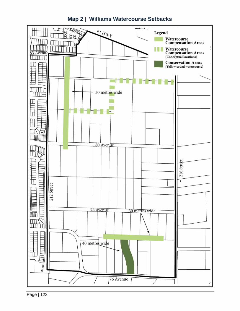
W I L L I A M S N E I G H B O U R H O O D P L A N
Page | 122
Map 2 | Williams Watercourse Setbacks

Page | 123
Map 3 | Williams Circulation Concept Plan

W I L L I A M S N E I G H B O U R H O O D P L A N
Page | 124