What Happens when Teacher Training in Digital Geomedia is over? Case Studies Analyzing Levels of...
10
437 What Happens when Teacher Training in Digital Geomedia is over? Case Studies Analyzing Levels of Pedagogical Integration Thomas BARTOSCHEK 1 and Vânia CARLOS 2 1 Institute for Geoinformatics, Münster/Germany · [email protected] 2 CIDTFF, Aveiro/Portugal This contribution was double-blind reviewed as full paper. Abstract The increasing interest in the educational potential of digital geomedia has heightened the need for a better understanding of how the integration of this technology can be enhanced. Previous research has generated a great discussion about the reasons for the low levels of digital geomedia integration in educational contexts, despite its recognized pedagogical interest by teachers. Being teacher training largely mentioned as an essential tool to help improving digital geomedia pedagogical integration, after the training course is over, the question arises: Are teachers integrating this technology in their teaching practice? How? The most widely accepted conceptual framework for assessing the level of pedagogical technology integration is TIM (Technology Integration Matrix). As result from an exchange initiative between previous research from CIDTFF (University of Aveiro) and the Institute of Geoinformatics (University of Münster), a questionnaire is conceived, based on TIM´s levels, and applied to several case studies of German teachers who attended different kinds of teacher training courses related to digital geomedia. First results show a rather high level of technology integration und positive correlations with the number of attended trainings. 1 Introduction Digital geomedia have ‘made their way’ to the general public. Despite its potential for Geographic Education, studies reveal low levels of digital geomedia integration in edu- cational contexts (HÖHNLE et al. 2010). Education systems in many different countries have already realized its relevance and potential and have therefore developed new strategies to implement its use as an integral part of the curricula (MILSON et al. 2011). While the integration into the educational standards, curricula and even workbooks in geography education mostly took place in the last decade (i.e. GERMAN ASSOCIATION FOR GEOGRAPHY 2007) a gap in the geography teacher education arised. The pool of active geography teachers needs additional trainings to apply these new technologies, while the future teachers still have to wait for an appropriate higher education. The integration of digital geomedia into the geography teacher education has mostly been optional and entered the curricula some years later (SCHUBERT et. al. 2010) as higher education systems are rather inflexible bodies. This makes teacher trainings in digital geomedia indispensable as al- Jekel, T., Car, A., Strobl, J. & Griesebner, G. (Eds.) (2013): GI_Forum 2013. Creating the GISociety. © Herbert Wichmann Verlag, VDE VERLAG GMBH, Berlin/Offenbach. ISBN 978-3-87907-532-4. © ÖAW Verlag, Wien. eISBN 978-3-7001-7438-7, doi:10.1553/giscience2013s437. This article is an open access article distributed under the terms and conditions of the Creative Commons Attribution license (http://creativecommons.org/licenses/by/3.0/).
-
Upload
uni-muenster -
Category
Documents
-
view
0 -
download
0
Transcript of What Happens when Teacher Training in Digital Geomedia is over? Case Studies Analyzing Levels of...
437
What Happens when Teacher Training in Digital Geomedia is over? Case Studies Analyzing Levels of
Pedagogical Integration
Thomas BARTOSCHEK1 and Vânia CARLOS2
1Institute for Geoinformatics, Münster/Germany · [email protected] 2 CIDTFF, Aveiro/Portugal
This contribution was double-blind reviewed as full paper.
Abstract
The increasing interest in the educational potential of digital geomedia has heightened the need for a better understanding of how the integration of this technology can be enhanced. Previous research has generated a great discussion about the reasons for the low levels of digital geomedia integration in educational contexts, despite its recognized pedagogical interest by teachers. Being teacher training largely mentioned as an essential tool to help improving digital geomedia pedagogical integration, after the training course is over, the question arises: Are teachers integrating this technology in their teaching practice? How? The most widely accepted conceptual framework for assessing the level of pedagogical technology integration is TIM (Technology Integration Matrix). As result from an exchange initiative between previous research from CIDTFF (University of Aveiro) and the Institute of Geoinformatics (University of Münster), a questionnaire is conceived, based on TIM´s levels, and applied to several case studies of German teachers who attended different kinds of teacher training courses related to digital geomedia. First results show a rather high level of technology integration und positive correlations with the number of attended trainings.
1 Introduction
Digital geomedia have ‘made their way’ to the general public. Despite its potential for Geographic Education, studies reveal low levels of digital geomedia integration in edu-cational contexts (HÖHNLE et al. 2010). Education systems in many different countries have already realized its relevance and potential and have therefore developed new strategies to implement its use as an integral part of the curricula (MILSON et al. 2011). While the integration into the educational standards, curricula and even workbooks in geography education mostly took place in the last decade (i.e. GERMAN ASSOCIATION FOR GEOGRAPHY 2007) a gap in the geography teacher education arised. The pool of active geography teachers needs additional trainings to apply these new technologies, while the future teachers still have to wait for an appropriate higher education. The integration of digital geomedia into the geography teacher education has mostly been optional and entered the curricula some years later (SCHUBERT et. al. 2010) as higher education systems are rather inflexible bodies. This makes teacher trainings in digital geomedia indispensable as al- Jekel, T., Car, A., Strobl, J. & Griesebner, G. (Eds.) (2013): GI_Forum 2013. Creating the GISociety. © Herbert Wichmann Verlag, VDE VERLAG GMBH, Berlin/Offenbach. ISBN 978-3-87907-532-4. © ÖAW Verlag, Wien. eISBN 978-3-7001-7438-7, doi:10.1553/giscience2013s437. This article is an open access article distributed under the terms and conditions of the Creative Commons Attribution license (http://creativecommons.org/licenses/by/3.0/).
T. Bartoschek and V. Carlos 438
ready found out in several works (eg. AUDET & PARIS 1997, DE LANGE 2006). However, the understanding of how to train teachers for the integration of digital geomedia in educational formal contexts, changing teacher´s educational practices, requires more elaboration and is thus worthy of investigation.
2 Digital Geomedia and Pedagogical Integration
2.1 Lifelong Learning and competences in digital geomedia
Lifelong learning (LL) is defined as “all general education, vocational education and training, non-formal education and informal learning undertaken throughout life …” (EU 2006, p. 50). The joint progress report of the Council and the Commission on the implementation of the 'Education & Training 2010' work programme stresses that no other in-school aspect influences student performance more than the quality of teacher education and points that the current systems of teacher education and training often fail to give teachers the training they need, particularly for continuing teacher training and professional development (CEU 2008). One of the four key activities of the LL Programme, is the promotion of ICT for learning (EACEA 2009). The same document stresses that actions in LL should promote the use of ICT tools to enhance learning environments and experiences, including “…enabling learning outside the school environment and bridging the 'digital divide' between those with access to technologies and relevant skills, and those without” (EACEA 2009). The Europe 2020 agenda reinforces the ICT relevance in education, including on the digital agenda the importance of ICT for jobs (EUROPE2020 2013), by arguing that Europe is still not producing enough digitally skilled professionals.
Several authors agree that LL, through teacher training, is critical to support teachers’ use of technological tools in the classroom (SCHEUERMANN & PEDRÓ 2009, HIGGINS 2008). Furthermore, ALLSOPP & HOHLFELD (2007) and RINGSTAFF & KELLEY (2002) stress the association of the increase of student´s learning outcomes and changes in teacher’s beliefs and practices, catalyzed mostly by technology pedagogical integration. The key condition for enabling change is, for ALLSOPP & HOHLFELD (2007, p. 2) “having skilled and knowl-edgeable educators”.
Since teacher training is a central to integrate digital geomedia in secondary education, one can find a plethora of projects and research on training in digital geomedia (e.g. GATRELL
2007, GENEVOIS 2011), focused on integrating GIS into geography classes and on generally promoting spatial thinking. Moreover, a survey with 65 participants from 20 countries con-ducted by the digital.earth.eu European network, analyzing the situation of teacher trainings on digital geomedia in Europe, revealed that in-service teacher training is provided mostly by universities with 93% of face-to-face courses and that the most used technologies were GIS, followed by Virtual Globes and WebMapping applications (LINDNER-FALLY &
ZWARTJES 2012).
HÖHNLE et al. (2010) found out that teacher training in GI(S) does not show any effect on the usage of GI(S) in the geography classroom so far, due to a training focus on the technical domains rather than on the pedagogical ones. Furthermore, SCHUBERT et al. (2012) analyzed the effect of teacher training’s on the changes of perception of GI(S) usage in the classroom with the same group of teachers. They found out that a short training in GI(S) does not have much effect, but longer and thus more intense training in GI(S) do.
What Happens when Teacher Training in Digital Geomedia is over? 439
A question still remains, as early posted by PÜSCHEL (2006): how many teachers actually will use Geomedia in the classroom after participating in a teacher training? The process of transforming the content of these courses, mostly developed in universities (DE LANGE 2006), into actual classroom practice, however, has not been studied extensively yet.
2.2 Assessing teacher´s changing educational practices by levels of pedagogical integration of technology
Developing teacher´s levels of proficiency in using ICT and digital geomedia is recognized as a basic stepping stone to enhance the pedagogical integration of this technology (HIGGINS 2008, SCHUBERT et. al. 2012). However, studies on the analysis of how professio-nal development programs challenge teacher´s beliefs and “how the activities and experi-ences translate into ongoing improvements in practice” are rare (HIGGINS 2008, p. 520).
Concerning the need to assess teacher’s pedagogical technology integration in the class-room and the existent lack of opportunities for teachers to observe exemplary technology integration practices (CHOY et al. 2006, RINGSTAFF & KELLEY 2002), an online multimedia assessment tool was developed by the Florida Department of Education: the Technology Integration Matrix (TIM) (ALLSOPP & HOHLFELD 2007). On the website, its visualization and possible applications are mentioned, namely: i) “provides a framework for defining and evaluating technology integration”; ii) “sets a clear vision for effective teaching with techn-ology”; iii) “gives teachers and administrators a common language for setting goals”; iv) “helps target professional development resources effectively” (http://fcit.usf.edu/matrix/).
This instrument is based on a social constructivist theoretical framework, where learner’s interactions are key constructs of learning. It is based on:
The substantiated models of social constructivist theory, namely JONASSEN ET AL. Constructivist Learning Environments (2003) (students learn best when they engage in active, constructive, collaborative, intentional, complex, contextual, conversational, and reflective learning activities), that derive the “Characteristics of the Learning Environment”: active; collaborative; constructive; authentic; goal directed;
Combined with the ACOT “Levels of Technology integration in the curriculum”, that details the mentioned evolutionary process of technology integration on instructional practices, in 5 stages: entry, adoption, adaptation, appropriation and invention (ALLSOPP & HOHLFELD 2007).
The result of this correlation is a matrix with twenty five cells of five characteristics of meaningful learning environments: active, constructive, goal directed (intentional, reflec-tive, and responsible), authentic (complex and contextual) and collaborative (conversa-tional), cross-referenced to the levels of technology integration: entry, adoption, adaptation, infusion, and transformation (ALLSOPP & HOHLFELD 2007).
This model applies to teacher´s teaching practices as well as to student´s learning processes. In each cell are available videos illustrating possible integrations of technology in the class-room. Additionally, the role of the teacher, the student learning process and the instruct-tional setting is described. It also supplies a grade level index, listing proper examples of re-sources for each Level of Technology Integration in the curriculum (Entry; Adoption; Adaptation; Infusion; and Transformation), according to grade levels.
T. Bartoschek and V. Carlos 440
The expected relevance of using this tool relies, concerning the aim of this study, on the argument that once the teachers discover their level of technology integration, it may influence the conception of lesson plans to achieve a higher level. It can therefore be used for teacher´s self-reflexivity and self-evaluation on their own abilities to integrate techno-logy in teaching, as well as for targeting improvements and monitoring progress towards those objectives in the integration of digital geomedia for learning improvement.
3 Methodology
3.1 Survey as a research method
Survey research can be defined as “a systematic set of methods used to gather information to generate knowledge and to help make decisions” (LAVRAKAS 2008). Two main charac-teristics emerge on a survey, according to LAVRAKAS (2008): a sample of the population and be based on a systematic instrument, frequently a structured questionnaire.
Every survey process starts with survey design, in which is decided, before data collection (BETHLEHEM 2009): the target population (to which the conclusions apply); the research questions (which determine the contents of the questionnaire); and the selection of an adequate sample. Web surveys are emergent instruments of data collection (COUPER 2008, p. 2) referring simply “to any survey in which the data are collected via the Internet”. The design approach adopted “should be influenced by factors such as the target audience, the purpose of the survey, the content or topic of the questions, the importance of data quality, whether the Web is the sole medium of data collection, and so on” (COUPER 2008, p. 4).
3.2 Context of application
The setting of the presented survey is within a German geomedia initiative: the GI@School Lab at the Institute for Geoinformatics, University of Münster. The GI@School Lab aims to foster spatial learning by a transdisciplinary integration of geoinformation and digital geomedia into (K-12) education through various research and development activities, individual school projects and mainly in-house and in-school teacher trainings. GI@School was launched in 2006 as a student initiative (GUNDELSWEILER & BARTOSCHEK 2007) and has strongly evolved in the last 6 years. GI@School offers two kinds of teacher trainings:
The in-house training is a 1.5 day course consisting of 6 modules in 2 tracks. The modules are technology-oriented (i.e. “Virtual Globes in Geography Education”) and the participants can choose which modules to attend during the course. Therefore, several participants attend these courses more than once. Each module introduces the functionalities of the technology by using authentic classroom examples, based on curricular content. During the course teachers get enough time to practice and receive additional material for further practice at home. Since the trainings runs for 6th years the content and used technologies evolved over the time but can be grouped into the following categories: Virtual Globes, WebGIS, Desktop-GIS, GPS and WebMapping tools. Since 2007, 396 participants attended 9 of these in-house trainings. 114 of them attended the course more than once, which makes a number of 284 individual teachers.
The in-school training is a shorter training. The length of the course is decided by the school and ranges from two hours to a full day (8h) course. The most chosen course

What Happens when Teacher Training in Digital Geomedia is over? 441
length is a 3-4h course in one afternoon. The content and the used technologies are being chosen in advance by the teachers, depending on their interests and the school’s technical equipment and possibilities. The technology categories mentioned above can be applied here as well, mostly the courses focused on just one of them, sometimes on two technologies and their use in the classroom. Since 2008, 19 in-school trainings were performed with a total number of 213 participants.
4 The Questionnaire
A web questionnaire was designed to assess the teacher´s pedagogical integration of technology in the classroom, after concluding the teacher training course. The Question-naire entitled: “Learning and teaching with digital geomedia – Teacher Training Question-naire”, was sent to all 284 teachers ever attended the GI@School in-house teacher training. Furthermore it was sent to 19 contact teachers that established the in-school trainings, asking them to forward the inquiry to the former participants as no email addresses were collected during the trainings. In total 269 teachers received the mailing, as 34 e-mail addresses were not valid anymore. This survey instrument, conducted in an online survey tool, is composed of four main parts, in order to collect data on different aspects of the research questions of the present study (“Are teachers integrating the technology in their teaching practice? How?).
Part I of this questionnaire aims at characterizing the teacher training format teachers attended. It comprises nine closed multiple choice questions, about the quantity, last attendance, duration, type, place, content, quality and impact of the teacher trainings. Part II relates to the self-assessment of geotechnology skills (not related to teaching skills) and comprises two closed questions aiming on the usage experience with concrete geotechnology products and the self-assessment of skills in the geotechnology categories. Part III is an adaptation of the TIM matrix presented in chapter 2.2. In five closed multiple choice questions, the teacher is asked to rank the level of their geotechnology use in class, to promote specific learning environments, namely: active, collaborative, constructive learning, authentic and goal-directed learning. Finally, Part IV, aims to collect voluntary teacher´s personal information, such as gender, age, type of school and teaching subjects.
5 Results
To present a main frame of the characteristics of the teachers that participated in this study, from 269 receivers, 58 teachers answered the questionnaire, producing a response rate of 22%. 36% of the participants were female, while 60% were male (4% did not answer this question). The mean age was 43 years, which is lower than the mean age of German teachers (48,1 years in 2006/7). 46 were teachers of geography and a second subject. Other relevant main subjects were: social science, biology and computer science.
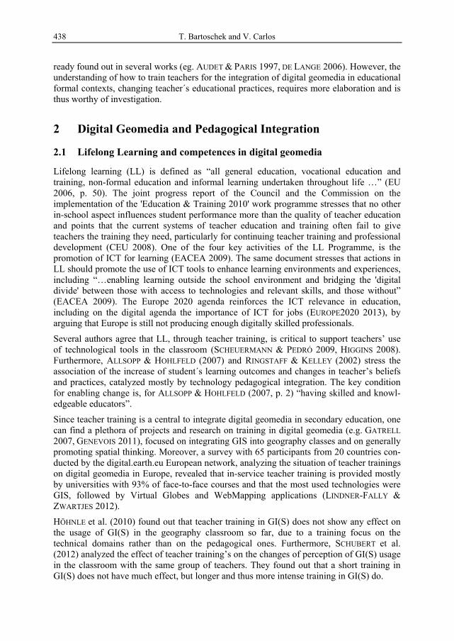
About the teacher trainings. Part I of the questionnaire results reveal that 47% of the teachers participated only in one teacher training, while 34% participated twice and 16% three or more times (see figure 1). For 2/3 of the participants, their last teacher training on
T. Bartoschek and V. Carlos 442
digital geomedia was more than one year ago (see figure 1). Also 2/3 of the participants had the in-house training at a university, the other third had the training in school. All participants attended a face-to-face seminar as a block course. The length of courses differed between max. 9-24hours (41%), 5-8h (34%) and 1-4h (25%). The technology categories that were used most in the courses were “Virtual Globes” and “WebGIS with predefined data” (both chosen by 42 participants), followed by Deskop GIS (34 participants). The rather new technology of WebMapping was chosen only by 18 teachers. Mobile GIS, GeoApps or other categories were not trained. This reflects the concepts of the GI@School trainings.
Fig. 1: Number of attended trainings and how long ago the last one took place (n=58)
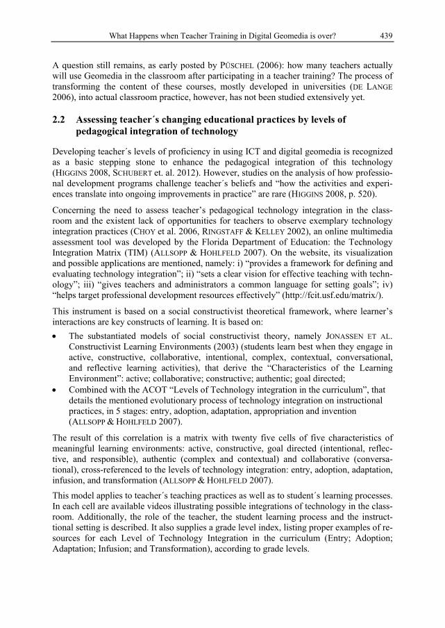
On a five-point Likert-scale from irrelevant (1) to relevant (5) the participants rated the benefits of the training for their teaching practice with a mean of 3,3 and a standard deviation of 1,12 as rather relevant (see figure 2). The quality of the teacher trainings was rated as quite high: 3,93 (standard dev. of 1,04, scale from low (1) to high (5)), see figure 2.
Fig. 2: Five-point Likert scale for the relevance (left) and quality (right) of the trainings.
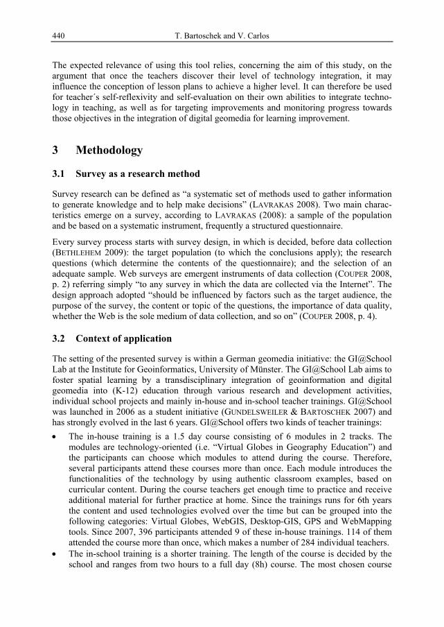
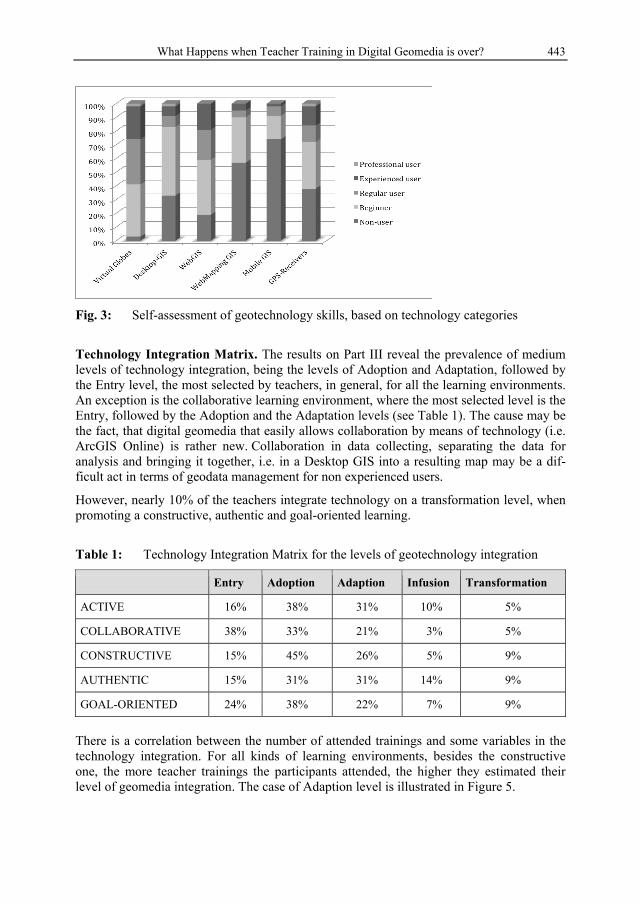
Self-assessment of geotechnology skills. The self-assessment of geotechnology skills consequently revealed that 60% of the participants count themselves into the group of regular, experienced or professional users of Virtual Globes. For WebGIS (with predefined content) 40% of the participants assess themselves to be regular or experienced, but anyone sees himself as a professional user. The group of non-users and beginners is nearly the same (90%) in WebGIS for WebMapping and Mobile GIS and similar products, but the group of non-users in Mobile GIS is much higher with 71% to 57% (for WebMapping). The use of GPS-receivers is quite interesting, as 60% of the participants are at least beginners in this use-case and it is the third largest group of regular, experienced and professional users with 28% (see Figure 3).
What Happens when Teacher Training in Digital Geomedia is over? 443
Fig. 3: Self-assessment of geotechnology skills, based on technology categories
Technology Integration Matrix. The results on Part III reveal the prevalence of medium levels of technology integration, being the levels of Adoption and Adaptation, followed by the Entry level, the most selected by teachers, in general, for all the learning environments. An exception is the collaborative learning environment, where the most selected level is the Entry, followed by the Adoption and the Adaptation levels (see Table 1). The cause may be the fact, that digital geomedia that easily allows collaboration by means of technology (i.e. ArcGIS Online) is rather new. Collaboration in data collecting, separating the data for analysis and bringing it together, i.e. in a Desktop GIS into a resulting map may be a dif-ficult act in terms of geodata management for non experienced users.
However, nearly 10% of the teachers integrate technology on a transformation level, when promoting a constructive, authentic and goal-oriented learning.
Table 1: Technology Integration Matrix for the levels of geotechnology integration
Entry Adoption Adaption Infusion Transformation
ACTIVE 16% 38% 31% 10% 5%
COLLABORATIVE 38% 33% 21% 3% 5%
CONSTRUCTIVE 15% 45% 26% 5% 9%
AUTHENTIC 15% 31% 31% 14% 9%
GOAL-ORIENTED 24% 38% 22% 7% 9%
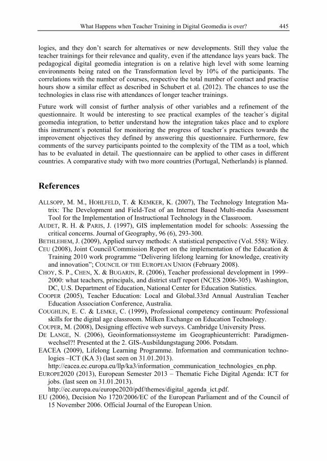
There is a correlation between the number of attended trainings and some variables in the technology integration. For all kinds of learning environments, besides the constructive one, the more teacher trainings the participants attended, the higher they estimated their level of geomedia integration. The case of Adaption level is illustrated in Figure 5.
T. Bartoschek and V. Carlos 444
Fig. 5: Adaption level of TIM, based on number of attended trainings (n=58)
5 Discussion
The results show interesting insights into teacher self-assessment and their integration of digital geomedia in teaching. More than half of the participants are still quite frequent users of Virtual Globes and WebGIS, two very potential systems for the use in the classroom. This is supported by the teacher’s technology integration as reported through the adapted TIM. The majority of teachers see themselves on the Adoption and Adaption level in all learning environments of the Matrix. Very high integration numbers are reported for the authentic learning environment, being the highest value on the Adaption, Infusion and Transformation levels. This may be due to the possibility of working with local data and on local questions through the availability of imagery and the integration of self collected data. The correlations between the number of teacher trainings and better integration of digital geomedia is obvious as more practice makes the teachers feel more secure in the use of digital geomedia, and leads to the integration in the classroom. All in all the results are better than expected, the integration is advanced after participating in teacher trainings.
The adaption of TIM is a feasible tool for the analysis and evaluation of the integration of digital geomedia. Nevertheless some issues were recognized, as the original version of the TIM aims on a very general understanding of technology. Different kinds of technological areas may be referred to when answering the questions. The original questions about goal-oriented learning environments seem to aim on the use of learning management systems and were difficult to transfer to the use of digital geomedia. Some participants also reported about a high complexity of the tool and difficulties in understanding the terminology (i.e. “constructive learning environment”).
6 Conclusions and Further Development
This work reveals insights into the integration of digital geomedia in different learning environments after attending teacher trainings in digital geomedia, but also on more general conditions of these trainings. After attending the teacher trainings the teachers focus their work with digital geomedia on the learned technologies, their scope stays on these techno-
What Happens when Teacher Training in Digital Geomedia is over? 445
logies, and they don’t search for alternatives or new developments. Still they value the teacher trainings for their relevance and quality, even if the attendance lays years back. The pedagogical digital geomedia integration is on a relative high level with some learning environments being rated on the Transformation level by 10% of the participants. The correlations with the number of courses, respective the total number of contact and practise hours show a similar effect as described in Schubert et al. (2012). The chances to use the technologies in class rise with attendances of longer teacher trainings.
Future work will consist of further analysis of other variables and a refinement of the questionnaire. It would be interesting to see practical examples of the teacher´s digital geomedia integration, to better understand how the integration takes place and to explore this instrument´s potential for monitoring the progress of teacher´s practices towards the improvement objectives they defined by answering this questionnaire. Furthermore, few comments of the survey participants pointed to the complexity of the TIM as a tool, which has to be evaluated in detail. The questionnaire can be applied to other cases in different countries. A comparative study with two more countries (Portugal, Netherlands) is planned.
References
ALLSOPP, M. M., HOHLFELD, T. & KEMKER, K. (2007), The Technology Integration Ma-trix: The Development and Field-Test of an Internet Based Multi-media Assessment Tool for the Implementation of Instructional Technology in the Classroom.
AUDET, R. H. & PARIS, J. (1997), GIS implementation model for schools: Assessing the critical concerns. Journal of Geography, 96 (6), 293-300.
BETHLEHEM, J. (2009), Applied survey methods: A statistical perspective (Vol. 558): Wiley. CEU (2008), Joint Council/Commission Report on the implementation of the Education &
Training 2010 work programme “Delivering lifelong learning for knowledge, creativity and innovation”; COUNCIL OF THE EUROPEAN UNION (February 2008).
CHOY, S. P., CHEN, X. & BUGARIN, R. (2006), Teacher professional development in 1999–2000: what teachers, principals, and district staff report (NCES 2006-305). Washington, DC, U.S. Department of Education, National Center for Education Statistics.
COOPER (2005), Teacher Education: Local and Global.33rd Annual Australian Teacher Education Association Conference, Australia.
COUGHLIN, E. C. & LEMKE, C. (1999), Professional competency continuum: Professional skills for the digital age classroom. Milken Exchange on Education Technology.
COUPER, M. (2008), Designing effective web surveys. Cambridge University Press. DE LANGE, N. (2006), Geoinformationssysteme im Geographieunterricht: Paradigmen-
wechsel?! Presented at the 2. GIS-Ausbildungstagung 2006. Potsdam. EACEA (2009), Lifelong Learning Programme. Information and communication techno-
logies –ICT (KA 3) (last seen on 31.01.2013). http://eacea.ec.europa.eu/llp/ka3/information_communication_technologies_en.php. EUROPE2020 (2013), European Semester 2013 – Thematic Fiche Digital Agenda: ICT for
jobs. (last seen on 31.01.2013). http://ec.europa.eu/europe2020/pdf/themes/digital_agenda_ict.pdf.
EU (2006), Decision No 1720/2006/EC of the European Parliament and of the Council of 15 November 2006. Official Journal of the European Union.
T. Bartoschek and V. Carlos 446
GATRELL, J. D. (2007), Making Room: Integrating Geo-technologies into Teacher Educa-tion. Journal of Geography, 103 (5), 193-198.
GENEVOIS, S. (2011), Teacher Training for Using Geoinformation in Secondary Education – Experiences from the Pairform@nce Project. In: JEKEL, T., KOLLER, A., DONERT, K. & VOGLER, R. (Eds.), Learning with GI 2011. Wichmann Verlag.
GERMAN ASSOCIATION FOR GEOGRAPHY (2007), Educational Standards in Geography for the Intermediate School Certificate. http://www.geographie.de/docs/geography_education.pdf (last viewed: 31.01.2013).
GROVES, R. M., FOWLER Jr, F. J., COUPER, M. P., LEPKOWSKI, J. M., SINGER, E. & TOU-RANGEAU, R. (2009), Survey methodology (Vol. 561). Wiley.
GUNDELSWEILER, G. & BARTOSCHEK, T. (2007), GI@School: Kooperationsmodell Schule – Universität fur den Einsatz digitaler Geoinformation im Schulunterricht. In: JEKEL, T., KOLLER, A. & DONERT, K. (Eds.), Learning with Geoinformation II. Wichmann Verlag.
HIGGINS, T. E. & SPITULNIK, M. W. (2008), Supporting teachers’ use of technology in science instruction through professional development: A Literature Review. Journal of Science Education and Technology, 17 (5), 511-521.
HÖHNLE, S., SCHUBERT, J. C., UPHUES, R. (2010), The Frequency of GI(S) Use in the Geography Classroom – Results of An Empirical Study in German Secondary Schools. In: JEKEL, T, KOLLER, A., DONERT, K. & VOGLER, R. (Eds,), Learning with Geoinfor-mation V. Wichmann Verlag.
JONASSEN, D., HOWLAND J., MOORE, J. & MARRA, R. (2003), Learning to solve problems with technology: A constructivist perspective (2nd ed.). Upper Saddle River, NJ, Merrill Prentice Hall.
LAVRAKAS, P. J. (2008), Encyclopedia of survey research methods (Vol. 1): Sage Publica-tions, Incorporated.
LINDNER-FALLY, M. & ZWARTJES, L. (2012), Learning and Teaching with Digital Earth – Teacher Training and Education in Europe. In: JEKEL, T., CAR, A., STROBL, J. & GRIES-EBNER, G. (Eds.), GI_Forum 2012: Geovisualization, Society and Learning. Conference Proceedings. Wichmann Verlag, 272-282.
MILSON, A., DEMIRICI, A. & KERSKI, J. (2011), International Perspectives on Teaching and Learning with GIS in Secondary Schools. Springer-Verlag.
PÜSCHEL, L. (2006), GIS fur Schulen in Rheinland-Pfalz. In: JEKEL, T., KOLLER, A., STROBL, J. (Eds.), Lernen mit Geoinformation. Wichmann Verlag.
RINGSTAFF, C. & KELLEY, L. (2002), The learning return on our educational technology investment: Online report at: http://rtecexchange. edgateway. net/learningreturn.pdf.
SCHEUERMANN, F. & PEDRÓ, F. (2009), Assessing the effects of ICT in education: Indica-tors, criteria and benchmarks for international comparisons: Publications Office of the European Union.
SCHEUREN, F. (2004), What is a Survey? Alexandria, VA. American Statistical Association. http://www.amstat.org/sections/srms/pamphlet.pdf (last viewed: 31.01.2013).
SCHUBERT, J. & BARTOSCHEK, T. (2010), Geoinformation im Geographieunterricht – Kon-zeption eines fachdidaktischen Seminars an der Universität Münster. In: JEKEL, T. et al. (Eds.), Learning with Geoinformation V. Wichmann Verlag.
SCHUBERT, J. C., HÖHNLE, S. & UPHUES, R. (2012), Which chances do teachers see in GI(S) usage in the classroom? Selected results from a survey of geography teachers in Germany. In: JEKEL, T., CAR, A., STROBL, J. & GRIESEBNER, G. (Eds.), GI_Forum 2012: Geovisualization, Society and Learning. Conference Proceedings. Wichmann Verlag, 283-291.