WATCHING COWS AND FIGHTING DEVIL-FISH: AN OVERVIEW OF HISTORY AND ARCHAEOLOGY AT THE SITE OF THE...
9
WATCHING COWS AND FIGHTING DEVIL-FISH: AN OVERVIEW OF HISTORY AND ARCHAEOLOGY AT THE SITE OF THE S.S. POMONA FT. ROSS STATE HISTORIC PARK John W. Foster California Council for the Promotion of History Conference Long Beach, California Oct. 27, 2001 Introduction St. Patrick's Day, 1908, was a typical brisk - spring afternoon on the north coast of California. A rising wind swept the sea from the northwest, and a large swell was running. There was an uncomfortable chop caused by wind waves and whitecaps. It was into this sea that Capt. Swansen cleared Pt. Bonita from the Pacific Coast Steamship Company docks in San Francisco, and set course for Eureka. He stood at the helm of the Steamship Pomona . His vessel had made this run many times, but he could not have suspected that the great ship, known as the "Pride of the Coaster Fleet," would never again cross the Humboldt bar. Its 147 passengers and crew were about to become witness to maritime history and underwater archaeology. Sixty-seven years had passed since the Russians had given up their foothold in California and sold to John Sutter. Ft. Ross had become a center for shipping lumber products under a loading chute. Local ranching operations also played an important part in the regional economy. Fishing was also important, and it was not uncommon to see a dozen or more turn-of-the-century vessels moored in the cove. But March 17, 1908 was a date that would forever be remembered on the Sonoma coast.
Transcript of WATCHING COWS AND FIGHTING DEVIL-FISH: AN OVERVIEW OF HISTORY AND ARCHAEOLOGY AT THE SITE OF THE...

WATCHING COWS AND FIGHTING DEVIL-FISH: AN OVERVIEW OF HISTORY AND ARCHAEOLOGY AT THE SITE OF THE S.S. POMONA
FT. ROSS STATE HISTORIC PARK
John W. Foster
California Council for the Promotion of History Conference Long Beach,
California Oct. 27, 2001
Introduction
St. Patrick's Day, 1908, was a typical brisk - spring afternoon on the north coast
of California. A rising wind swept the sea from the northwest, and a large swell
was running. There was an uncomfortable chop caused by wind waves and
whitecaps. It was into this sea that Capt. Swansen cleared Pt. Bonita from the
Pacific Coast Steamship Company docks in San Francisco, and set course for
Eureka. He stood at the helm of the Steamship Pomona. His vessel had made
this run many times, but he could not have suspected that the great ship, known
as the "Pride of the Coaster Fleet," would never again cross the Humboldt bar.
Its 147 passengers and crew were about to become witness to maritime history
and underwater archaeology.
Sixty-seven years had passed since the Russians had given up their foothold in
California and sold to John Sutter. Ft. Ross had become a center for shipping
lumber products under a loading chute. Local ranching operations also played an
important part in the regional economy. Fishing was also important, and it was
not uncommon to see a dozen or more turn-of-the-century vessels moored in the
cove. But March 17, 1908 was a date that would forever be remembered on the
Sonoma coast.
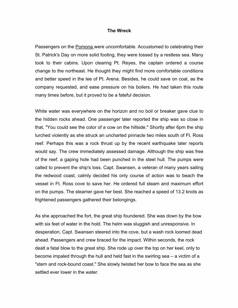
The Wreck
Passengers on the Pomona were uncomfortable. Accustomed to celebrating their
St. Patrick's Day on more solid footing, they were tossed by a restless sea. Many
took to their cabins. Upon clearing Pt. Reyes, the captain ordered a course
change to the northeast. He thought they might find more comfortable conditions
and better speed in the lee of Pt. Arena. Besides, he could save on coal, as the
company requested, and ease pressure on his boilers. He had taken this route
many times before, but it proved to be a fateful decision.
White water was everywhere on the horizon and no boil or breaker gave clue to
the hidden rocks ahead. One passenger later reported the ship was so close in
that, "You could see the color of a cow on the hillside." Shortly after 6pm the ship
lurched violently as she struck an uncharted pinnacle two miles south of Ft. Ross
reef. Perhaps this was a rock thrust up by the recent earthquake later reports
would say. The crew immediately assessed damage. Although the ship was free
of the reef, a gaping hole had been punched in the steel hull. The pumps were
called to prevent the ship's loss. Capt. Swansen, a veteran of many years sailing
the redwood coast, calmly decided his only course of action was to beach the
vessel in Ft. Ross cove to save her. He ordered full steam and maximum effort
on the pumps. The steamer gave her best. She reached a speed of 13.2 knots as
frightened passengers gathered their belongings.
As she approached the fort, the great ship foundered. She was down by the bow
with six feet of water in the hold. The helm was sluggish and unresponsive. In
desperation, Capt. Swansen steered into the cove, but a wash rock loomed dead
ahead. Passengers and crew braced for the impact. Within seconds, the rock
dealt a fatal blow to the great ship. She rode up over the top on her keel, only to
become impaled through the hull and held fast in the swirling sea – a victim of a
"stern and rock-bound coast." She slowly twisted her bow to face the sea as she
settled ever lower in the water.

SS Pomona impaled on a wash rock in Fort Ross cove, Sonoma county. The salvage
vessel Greenwood is also shown.
Young Carlos A. Call had seen the black smoke from her stack and raced to
assist the stricken vessel. Seven years prior, in 1901, he had saved six seamen
from the schooner J. Eppinger by swimming a rescue line out to the distressed
ship before she was smashed to pieces on the rocks of Ft. Ross cove. When he
reached the bluff edge, the Pomona had begun to settle into her grave.
Passengers were in a near panic as Capt. Swansen ordered the boats away. A
guide boat carried a lantern to shore, marking the route for other boats. They
disembarked in the growing twilight as Carlos took photos. With considerable
seamanship, all passengers were safely landed on shore, with Capt. Swansen
arriving in the last boat. Thus began an underwater archaeological site that
brings us together today.
Initial Salvage Efforts
Initial salvage efforts of the S.S. Pomona were soon commenced. The Coast
Wrecking Company purchased rights to the 'wreck and began work. The plan
was to remove most of the cargo and refloat the vessel by inflating canvas bags
throughout the hull. Then the ship could be towed back to San Francisco to dry
dock for repairs.
This hardhat diving was begun in earnest, but not without its dangers, as
reported by the San Francisco Chronicle (Sept. 28, 1908):
Diver Fights With Octopus
"Martin Lund, a diver for the Pacific Coast Wrecking Company, had a terrible
experience with a monster devil fish while he was in seven fathoms of water
Saturday afternoon at Fort Ross cove, working on the Pomona, which was
wrecked some months ago. Lund was in the hold of the wrecked vessel, when he
was seized about the leg by the tentacle of a devilfish. He slashed at the fish with
his knife and gave the signal to be hoisted. The devil fish had too strong a hold
on him, and he had to signal the helpers to ease their efforts to haul him to the
surface because his helmet was giving way. Another tentacle grasped him about
the waist, and still another about the neck. Then another grasped him about the
legs and he had to fight hard for life. After cutting two of the tough tentacles that
grasped him in a deathlike embrace, Lund saw the creature preparing to strike
with its beak, and made a lunge for the head just in time to deal a death blow."
It finally became apparent that the Pomona would never leave Ft. Ross cove. Her
prop was salvaged, along with her triple expansion steam engine. Salvage
master Capt. Whitelaw, using his steam schooner Greenwood, did the recovery.
Many salvageable steam valves, pipes, fittings, tools and instruments were no
doubt removed. Finally, she broke in two on Nov. 21st and slipped forever
beneath the waves.

SS Pomona underway in 1888. She was the first passenger vessel on the Pacific coast fitted with a triple expansion steam engine.
Sports Divers Raise Relics
For 51 years, the bones of the steamer were the exclusive realm of abalone,
fishes and devil-fish. In 1959, a group of skin divers discovered the site. Led by
Robert Lanham, the divers explored the Pomona wreckage and recovered many
nautical treasures. Over the next decade, portholes were wrenched from hull
plates and brass keys, teacups and fittings were raised. Some of these items
were given to the new Ft. Ross State Historic Park, but most were carried off as
treasures from the site (Anonymous: 1971). As SCUBA diving became more
popular, the Pomona site gave up many more brass pieces and small artifacts.
Archaeological Research Efforts In April, 1981, the first systematic underwater survey conducted by State Parks
took place at Ft. Ross cove. This was a combined effort using the Navy Diving
Salvage Team, State Park divers, and many interested divers and supporters. It
began with a magnetometer survey of most of both coves from shoal water to the
120-ft. contour. A 200-ft. grid spacing was established by marker buoys. Lanes
were run in the research vessel from a north-south and east-west direction. As
anomalies were located, they were marked by a chase boat and investigated by
dive teams. Position was maintained by LORAN, and anomalies were charted by
transit from two stations on the bluff above (Foster 1981).
In conjunction with the electronic surveillance, a systematic swim survey was
conducted for this project over a 200 x 1000-ft. anchorage area inside north
point. Historical documentation indicated this was the lumber chute anchorage.
Using a 10-foot tag line, dive teams covered the bottom in a systematic survey.
April visibility averaged about 10 feet or less.
A total of 55 separate anomalies were distinguished by the magnetometer. These
could be grouped Into six "clusters" ranging in depth from 100 to 40ft. SCUBA
investigation of these targets found four of them occurred on sand bottoms
without visible metal artifacts. They may have been false readings or buried in
the sand. Cluster 5 was identified as the Regia, a 45ft. fishing vessel. Cluster 6
was a very good approximation of the Pomona's wreckage. Although no
systematic mapping was attempted, a brief record of the wreck elements was
made. The drive train, boilers, forward hull and individual artifacts were noted
and photographed. The overall condition and distribution of wreckage was
documented. It became apparent that a more concentrated mapping effort was
needed.
The swim survey resulted in the documentation of two large anchors that
presumably formed part of the lumber schooner anchorage system. They were
"admiralty style" with 6-ft. shafts and 4 feet between the flukes. The anchors
were accompanied by six-in. stud-link chain, wrapped around large boulders.

They appeared to be intentionally set as part of the mooring system (Foster:
1984). Our 1981 survey was a success. Many targets were identified, and the
Pomona's location was charted for the first time. As anthropologists, of course,
we did our best to interview the locals in order to give proper context to our
survey findings. This fellow seemed knowledgeable, but we were never able to
understand him.
New information on the Pomona shipwreck site accumulated slowly over the
years. Using State Park divers and with the help of Jim Delgado, maritime
historian from GGNRA, incremental progress was made. The drive train details
were documented and measured, but the rest of the vessel remained mysterious.
The next research effort came with Jack Hunter's 1988 survey. Lacking the
divers necessary to carry out a mapping effort with underwater, Hunter was
asked to perform a mapping exercise using underwater video. The concept was
to tag important features and to thoroughly document the wreck from above by
video camera. Using still images from the video, an attempt was made to piece
together a composite map. Scale and compass orientation were to come from
traditional measurements. The concept was sound, but diving conditions would
never allow for adequate detail to be documented by video alone. Between the
constant surge, bull kelp canopy and murky conditions, repeated video mapping
efforts were frustrated. Hunter and his team were able to make some advances.
A site record was completed and assigned the number SON-1704H, but the
Pomona wreck site remained poorly defined (Hunter and Fisher 1989).
The project effort reported today was designed and led by Charles Beeker from
Indiana University. Working with students from USD, CSU Northridge, San Jose
State University and Sonoma State, an efficient collaboration made possible a
great leap forward in the understanding of the site. From their 1998 field work,
not only was a detailed map prepared, but the shipwreck remains were used to
prepare drawings of the breakdown of the Pomona itself as she slowly broke her
back on the wash rock. The site formation process was illustrated. This has
brought to life, the watery history of Ft. Ross cove.
One other aspect is worthy of mention for those who may be contemplating
similar undertakings. Using Indiana University resources, a web site was
established in advance. Then, as the project progressed, daily information was
posted on the site. Each student was assigned to write in a "Scientist's Log"
giving their own personal account of the Work and its meaning. Maps, photos
and historical details were placed in cyberspace. This effort allowed others at the
university, and potentially anywhere, to stay connected to the project, ask
questions, and be partners in the expedition. We did this before in the Dominican
Republic, and it does provide a much greater opportunity for public involvement.
Summary and Conclusions
Part of our charge in managing this site is to find ways of involving the public in
its stewardship and protection. We believe the Pomona is eligible for inclusion in
the National Register of Historic Places. It deserves recognition as one of the
most significant and complete iron-hulled steamers of its type along the California
coast. It will be the responsibility for State Parks to continue research efforts,
intensify interpretation of the site and involve local divers in its long-term
management. Most of the brass and small souvenirs have been removed.
Through the construction of a blufftop interpretive station, installation of marker
buoys, and recruitment of "site stewards," we hope to perpetuate the Pomona
shipwreck site within an expanded underwater park at Ft. Ross.
References Cited
Anonymous
1971 Skin Divers Explore Wreck of SS Pomona. Marine Digest 49 (51):
20, 34.
Foster, John W.
1981 Diving in Dogholes: the Prospects for Investigating Submerged
Cultural Resources in Ft. Ross Cove.
1984 "Schooners, Steamers and Spilled Cargo: A Preliminary
Underwater Survey of Ft. Ross Cove, California." In: Underwater
"Archaeology: The Proceedings of the 13th Conference on
Underwater Archaeology, Donald H. Keith, editor. pp. 86-94.
Hunter, Jack and Franklin Fisher
1989 A Shipwreck Mapping and Recordation Reconnaissance of the
Remains of the Steam Ship S.S. Pomona, Fort Ross State Historic
Park, Sonoma County, California. MS on file with California State
Parks, Sacramento.