
Vernal Pool Habitat Restoration, Eastgate Mall, NAS Miramar, San Diego , California
40
Vernal Pool Habitat Restoration Eastgate Mall, NAS Miramar, San Diego, California Prepared by: Ellen T. Bauder, PhD Department of Biology San Diego State University San Diego, CA 92182-0057 Prepared for: California Department of Fish and Game Natural Heritage Division Endangered Plant Program 1416 Ninth Street Sacramento, CA 95814-2090 Funded by: Emergency Drought Relief Project Contract # CA HER 02249 June 1994
Transcript of Vernal Pool Habitat Restoration, Eastgate Mall, NAS Miramar, San Diego , California

Vernal Pool Habitat RestorationEastgate Mall, NAS Miramar, San Diego, California
Prepared by:
Ellen T. Bauder, PhDDepartment of Biology
San Diego State UniversitySan Diego, CA 92182-0057
Prepared for:
California Department of Fish and GameNatural Heritage DivisionEndangered Plant Program
1416 Ninth StreetSacramento, CA 95814-2090
Funded by:
Emergency Drought Relief ProjectContract # CA HER 02249
June 1994

ii
TABLE OF CONTENTS
TABLES ............................................................................................................................................ i i i
FIGURES........................................................................................................................................... i i i
ACKNOWLEDGMENTS....................................................................................................................... i v
EXECUTIVE SUMMARY ..................................................................................................................... v
CHAPTER 1. INTRODUCTION........................................................................................................... 1
1.1 PURPOSE OF THIS STUDY ............................................................................................ 1
1.2 BACKGROUND............................................................................................................... 1
1.2.1 Prior Land Use ............................................................................................. 1
1.2.2 Historical Pool and Floral Surveys.............................................................. 5
CHAPTER 2. METHODS.................................................................................................................... 1 1
2.1 PREPARATORY SITE SURVEYS (1993)....................................................................... 1 1
2.2. RESTORATON/ENHANCEMENT OF BASIN HYDROLOGY................................................. 1 1
2.3 MOUND SEEDING.......................................................................................................... 2 0
2.4. INOCULATION OF POOLS.............................................................................................. 2 0
2.5. ASSESSMENT OF THE SEED INOCULUM....................................................................... 2 2
2.6. PHYSICAL CHARACTERISTICS OF THE RESTORED POOLS........................................... 2 2
2.7. RESTORED POOL PLANT SURVEYS .............................................................................. 2 4
2.8. EXOTIC PLANT CONTROL MEASURES/TRASH REMOVAL.............................................. 2 4
CHAPTER 3. RESULTS..................................................................................................................... 2 4
3.1. PHYSICAL ATTRIBUTES............................................................................................... 2 4
3.1.1. Water Retention .......................................................................................... 2 4
3.1.2. Extent of Pool Area Restored....................................................................... 2 6
3.2. BIOLOGICAL ATTRIBUTES............................................................................................ 2 6
3.2.1. Pool Basins.................................................................................................. 2 6
3.2.2. Seed inoculum.............................................................................................. 2 6
3.2.2.1. Pogogyne abramsii and Eryngium aristulatum ssp. parishii...... 2 6
3.2.2.2. Other species................................................................................ 3 1
3.2.3. Mounds......................................................................................................... 3 1
CHAPTER 4. CONCLUSIONS/RECOMMENDATIONS .......................................................................... 3 1
LITERATURE CITED.......................................................................................................................... 3 2

iii
TABLES
TABLE1. PRE-RESTORATION SURVEY FOR VERNAL POOL/WETLANDS INDICATOR SPECIES ........ 1 4
TABLE 2. PRE-RESTORATION SOIL TEST DIGS............................................................................... 1 9
TABLE 3. DONOR (SOURCE) AND RECIPIENT POOLS...................................................................... 2 3
TABLE 4. WATER RETENTION CHARACTERISTICS .......................................................................... 2 5
TABLE 5. ESTIMATED DIMENSIONS AND AREA OF RESTORED POOLS ............................................ 2 7
TABLE 6. PLANT SURVEYS OF RESTORED POOLS ........................................................................... 2 8
TABLE 7. SOIL INOCULUM TESTS ................................................................................................... 3 0
FIGURES
FIGURE 1. LOCATION MAP .............................................................................................................. 2
FIGURE 2. USGS MAP,1901-2 (1903 edition)............................................................................ 3
FIGURE 3. CALIFORNIA DEPARTMENT OF RESOURCES MAP (1957)............................................ 4
FIGURE 4. USGS MAP, 162 (photorevised 1975) ........................................................................ 6
FIGURE 5. AERIAL PHOTO OF RESTORATION SITE (1973)............................................................ 7
FIGURE 6. AERIAL PHOTO OF RESTORATION SITE (1979)............................................................ 8
FIGURE 7. AERIAL PHOTO OF RESTORATION SITE (1993)............................................................ 9
FIGURE 8. AERIAL PHOTO OF RESTORATION SITE (1994)............................................................ 1 0
FIGURE 9. PRE-RESTORATION COMPUTER DRAWN MAP OF SITE................................................. 1 2
FIGURE 10. MAP OF RESTORED BASINS AND RECONSTRUCTED MOUNDS ..................................... 2 1

i v
ACKNOWLEDGMENTS
This project was funded by the Emergency Drought Relief Project. I would like to thank Mr.Michael Golden and Ms Diane Steeck, Administrators of the Drought Relief Project for The NatureConservancy, for their support, attention to detail and efficiency. Mr. Jim Dice, Regional PlantEcologist for the Department of Fish and Game, provided effective local oversight of the project andwas always available to find solutions when the inevitable problems associated with sensitive planthabitat restoration developed. This project would not have been possible without the permissionand support of the Commanding Officer of Naval Air Station Miramar and Captain R. F. Haas, StaffCivil Engineer. Ms Coralie Hull, botanist for NAS Miramar, was exceptionally helpful with allphases of this project, but especially in securing all the permissions and permits. She alsoarranged for military personnel to remove from the site 103 tons of illegally dumped trash andconstruction debris. I am also grateful to Ms Nancy Gilbert of the US Fish and Wildlife Service. Shewas responsible for the salvage of the seed and soil material that we used to restore the pools, aswell as expediting the environmental review and permitting process.
Ms Bree Buckner was my primary field assistant in this work. She was responsible formany of the details which she handled with great efficiency. She assisted in the mapping andidentification of plants, soil testing and water depth monitoring. She also took responsibility forassembling and supervising the paid and volunteer laborers on the project. Mr. Jim Stodola and Mr.Kevin McElroy, undergraduate students at SDSU, carried out special studies projects at the site.Mr. Dave Egger, the bulldozer operator, did a superb job of removing fill and shaping mounds, allthe while dodging rare plants. Reproduction of the aerial photographs was made possible bypermission of Mr. Oscar Weser, owner of Aerial Fotobank Incorporated. Finally, we owe atremendous thanks to the many volunteers and low-paid laborers who brought their own skills anddedication to this project.

v
EXECUTIVE SUMMARY
The purpose of this study was to 1) restore damaged pools to augment habitat for sensitiveand endangered temporary wetlands species and 2) place salvaged vernal pool seed and soil materialin a suitable environment. Vernal pool plants are dependent on ponding water to eliminate uplandshrubs and herbaceous species from pool basins. Some of the species also require fully saturatedsoils or ponding water to germinate. During long periods of drought, non-pool plants can becomedominant in vernal pool habitats. Even in years of average precipitation, pools with disruptedhydrology may not retain water long enough to favor pool plant and animal species.
The site chosen for vernal pool restoration is part of Naval Air Station Miramar in central,coastal San Diego County. The 120-acre parcel had been severely degraded by unauthorized off roadvehicle activity in the 1970’s and probably by ranching or farming in the first half of the century.It was added to NAS Miramar in 1982. Vernal pool surveys in 1979, 1986 and 1991 indicated thatsome functioning vernal pools were present on the site. The topography and soils suggested thatadditional pools may have existed prior to the period of intense disturbance. A combination of plantsurveys, soil test digs and mapping of ponding water indicated that numerous filled clay-linedbasins still remained.
In July of 1993, a bulldozer removed fill from 30 basins. The fill material was used toreconstruct Mima mounds and the local watershed of the pools. During the winter/spring of 1994,the depth of water in the basins ranged from <1 cm to 22 cm, with a mean depth of 13.5 cm. Thetotal precipitation for the year was 25.20 cm, approximately equal to the long term mean. The areaof the restored basins averaged 50 m2, with the largest pool 137.5 m2 and the smallest 16.5 m2.The total restored pool area was 1508 m2 (140 ft2).
Plant surveys conducted in early summer of 1994, indicated that the restored basins all hadsome vernal pool indicator plants, and that many of the pools had substantial diversity. The twoplant species on the state and federal endangered species lists—Pogogyne abramsii and Eryngiumaristulatum ssp. parishii—germinated and survived to flowering. Pogogyne abramsii established atleast a small population in every restored basin into which it was seeded (10 pools). It was foundin two of the three natural pools into which it was seeded, but one pool had only one floweringindividual. Eryngium aristulatum ssp. parishii became established in 21 pools and was not found inseven pools that received inoculum that came from pools with Eryngium. Seed germination tests ofthe inoculum from six of the 33 source pools showed good correspondence with the presence andabundance of both Pogogyne and Eryngium in recipient pools. This suggests that depauperateinoculum may have been a factor in the lack of establishment in some pools. Unfavorable soils orhydrology may have played a role as well. Surveys in subsequent years would reveal if the seed wasin the soil but remained dormant in 1994.

1
CHAPTER 1. INTRODUCTION
1.1 PURPOSE OF THIS STUDY
The purpose of this study was to restore damaged vernal pools to augment habitat forsensitive and endangered temporary wetlands species and to use salvaged seed and soil material froma nearby group of pools scheduled for development. Vernal pools sustain a variety of plant andanimals with restricted distributions, and a number of species are endemic to the pools. In SanDiego County these include two species of the plant genus Pogogyne (Pogogyne abramsii andPogogyne nudiuscula); Orcuttia californica, a grass; Eryngium aristulatum ssp. parishii, a memberof the carrot family; and the montane species, Downingia concolor ssp. brevior, a diminutive plantin the bellflower family. Two rare species of fairy shrimp are also endemic to Southern Californiapools (Streptocephalus wootoni and Branchinecta sandiegoensis). Both species of Pogogyne,Orcuttia and Eryngium are state and federal endangered species. Streptocephalus is federalendangered and Branchinecta is proposed for federal endangered status
Vernal pools, once common on San Diego’s coastal terraces and inland valleys, have beendestroyed primarily by development. In 1986, Bauder estimated that over 93% of the historicalvernal pool habitat had been destroyed and that many of the remaining pools had been disturbed(Bauder 1986). In the 8 years since that report, additional pools have been lost and lack ofprotection for many of the remaining pools has led to reduced populations of sensitive species,invasion by exotics and disruption of the pool hydrology upon which all these organisms depend.As pools have been lost or degraded, the threat to continued survival of the species dependent onthem has increased. Prolonged drought conditions exacerbate the human-caused impacts that arethreats to the vernal pool habitat (Bauder 1987).
I
1.2 BACKGROUND
1.2.1 Prior Land Use
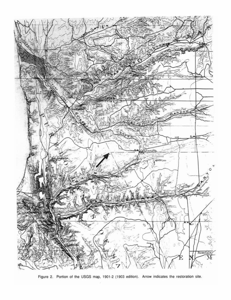
The Eastgate Mall vernal pools (Fish and Game identification # I-7)(Bauder 1986) occuron a 120-acre parcel that was severely degraded by unauthorized off road vehicle activity in the1970’s and probably by ranching or farming in the first half of the century. This property wasadded to NAS Miramar in 1982 (Hull Pers. comm.)(Figure 1). It is in the USGS 7.5’ Del Mar,California quadrangle, Range 3 West, Township 15 South, Section 9.
Aerial photographs were consulted to assess the land use history. A photograph taken in1928 is of poor quality (Aerial Fotobank Incorporated). It shows very little shrubby vegetationand the condition/existence of pools is impossible to determine. A US Department of the InteriorGeological Survey map dated 1901-02 (1903 edition) indicates one building was present on thesite, in the midst of what is recognized today to be a pool grouping at the southeast corner of theparcel (Figure 2). Two roads connected the building to the Old Miramar Road (now Eastgate MallRoad). Revisions of the USGS map in the 1930’s (1901-02 survey, partially revised in 1930;1938-39 survey, 1943 edition) indicate no roads or buildings. A map produced in 1957 by theState of California Department of Natural Resources, Division of Forestry, indicates new roadwaysin the area—but not on the property—and other features such as Naval Air Station Miramar to theeast and Camp Mathews Naval Reservation to the west (Figure 3). The USGS 7.5 minute quadrangleof 1967 (photorevised 1975) indicates two unpaved roads (one is possibly one of the two roadsshown in 1901-2; the other parallels the high power line) and also two buildings along MiramarRoad in the north central part of the property, neither one of which is the building indicated on the1 9 0 1 - 2


5
map (Figure 4). In 1993, the only reminders of this early use are two clumps of eucalyptus trees,some fencing remnants and dirt road beds.
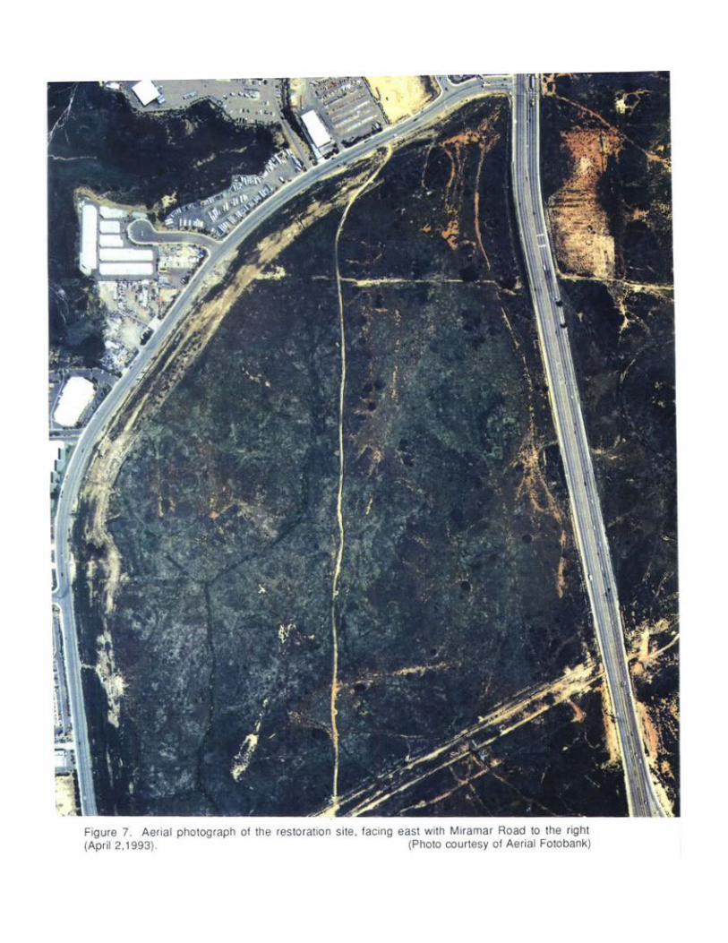
Aerial photographs taken in 1973 and 1979 reveal extensive off road vehicle damage to thesoils and vegetation (Figures 5 and 6)(courtesy of Aerial Fotobank Incorporated). Three clustersof pools can be identified on these photos and their correspondence established to pools now inevidence (Figures 7 and 8)(courtesy of Aerial Fotobank Incorporated).
1.2.2 Historical Pool and Floral Surveys
Beginning in 1979, the area has been the subject of five surveys of vernal pools (Balko1979, Beauchamp and Cass 1979, Villasenor and Riggan 1979, Bauder 1986 and Bauder and Wier1991). Complete floral surveys were not taken in any of these efforts, but the presence/absence ofsensitive taxa such as Pogogyne abramsii and Eryngium aristulatum ssp. parishii was noted in allfive. The Balko report indicated only the presence of Eryngium . Beauchamp and Cass mapped threepool clusters containing a total of 5 pools. They reported that Eryngium was present on the site butPogogyne was absent. Villasenor and Riggan (1979) mapped 30 pools, 11 of which containedEryngium. They found no Pogogyne. Seventeen of these pools appear to coincide with Beauchamp andCass's three clusters. In 1986, Bauder visited the pools to assess their status compared to the two1979 surveys. She confirmed the presence of 5 pool clusters containing abundant Eryngium but noPogogyne. In a 1990 field assessment, Bauder and Wier (1991) identified 6 large and 2 smallpools. This survey recorded the presence of Pogogyne on site at low abundance in less than half ofthe pool area and Eryngium was abundant in over one half of the pools.


1 1
CHAPTER 2. METHODS
2.1 PREPARATORY SITE SURVEYS (1993)
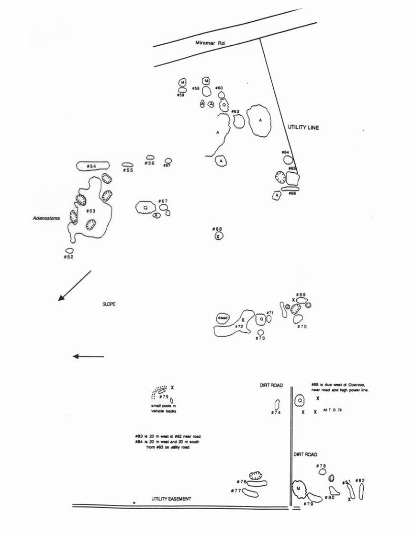
In the winter of 1992/93, the entire site was surveyed for areas that ponded water or hadsaturated soil. The small mesa in the north central part of the property had shallow basins andMima mound topography, but the majority of the wet areas were on the mesa covering the southernhalf of the site. A decision was made to concentrate the limited resources for restoration in thisarea. A total of 91 saturated/ponding areas was mapped, and their general outlines delineated withvinyl and wire flags (Figure 9). Each area was given a number. Two of these areas were quitelarge and clearly corresponded to the pool groupings mentioned in all the earlier surveys (Figure9; Pools 40 and 53). I did not subdivide these into separate pools. A third pool cluster wasprobably mapped by Beauchamp and Cass (1979) as a single large pool and by Villasenor and Rigganas three pools (1979; pools 23, 23 and 25). We were able to outline about 14 pools and wet areasin this cluster, and we numbered them individually (Figure 9; Pools 3-8, 14 and 15).
A custom aerial photograph was taken on April 2, 1993 and color prints were produced at ascale of 1: 1200 (1 inch = 100 feet)(Figure 7, courtesy of Aerial Fotobank Incorporated). Thephoto was mounted on foam core board and covered with a sheet of acetate. The outline of everymapped basin/wet area was drawn on the acetate. When the mapping was completed, the acetatesheet was removed and photocopied, producing an outline map of the pools/wet areas. Combinedwith the vegetation surveys (See below), this outline was used to draw in the grading lines for thepools to be restored.
Vegetation surveys of all of the mapped areas were made in March and May, 1993 (Table 1).No attempt was made to identify every species present in these wet areas, but special attention waspaid to vernal pool species and sensitive plant species known to occur or with the potential to occuron the site. Eryngium was found in a total of 19 basins, but it was very abundant in and around thetwo large marsh/pond areas (Figure 9; Pools 38, 40 and 53). Pogogyne was present in only onelarge pool group (Figure 9; Pool 40) located near the center of the mesa. Where present, it wasabundant.
Soil profiles were analyzed through a series of 28 test holes, primarily in areas withsaturated soil but little or no ponding of water (Figure 9). Nearly all of these holes revealed a toplayer of loose soil underlain by a red/brown or whitish clay layer 1-2 ft beneath the surface(Table 2). In approximately one half of the test holes, the clay stratum was underlain by a hardpanlayer of cemented alluvial cobbles. Several of these holes revealed hard pan very close to thesurface and no evidence of fill.
2.2. RESTORATON/ENHANCEMENT OF BASIN HYDROLOGY
Based on the information gathered in the mapping, vegetation, and soil surveys, I chose areasfor grading to remove fill and resculpt basins and mounds. In some cases, previously numberedareas were divided into two or more basins, and in others, separate wet areas were consolidated intoone basin. I completely avoided the basin/marsh with Pogogyne (Figure 9; Pool 40) and basins thatcontained an Eryngium population (Figure 9; Pools 8, 14 and 38). I also removed fromconsideration areas where the hardpan was close to the surface and no fill material was evident(Table 2; Test Digs 58, 72 and 75) or there was no clay layer (Table 2; Test Digs 58, 68, 69, 72and 81). Area 81 was reshaped to remove road ruts, but was not ripped or bladed. Several areaslooked promising, but they were isolated. To restore them would have required the bulldozer totravel some distance just to work on single pools (Figure 9; Test Digs 40, 43, 64, 75 and 85). Forthis reason, they, too, were eliminated from consideration. In some cases, Eryngium occurred at


PR
E-R
ES
TOR
ATI
ON
PO
OL
#
SPEC
IES
12
34
56
78
91
01
11
21
4A
14
15
16
17
18
19
20
21
Ana
galli
s m
inim
usX
XX
XX
XX
XX
XX
XX
Bro
diae
a or
cutt
iiX
Cal
litri
che
mar
gina
taX
XX
XX
XX
XX
XX
XX
XX
XX
Cot
ula
coro
nopi
folia
XX
XC
rass
ula
aqua
tica
XX
XX
XX
XX
XX
XX
XX
XX
XX
XC
rass
ula
erec
taX
X
Des
cham
psia
dan
thon
ioid
esX
XX
XX
XD
owni
ngia
cus
pida
taX
XX
XX
XX
Ela
tine
brac
hysp
erm
aX
XX
XX
Ele
ocha
ris m
acro
stac
hya
XX
XX
XX
XX
Ery
ngiu
m a
rist
ulat
umX
XX
XX
XX
Gas
trid
ium
ven
tric
osum
XX
XX
XX
Isoe
tes
how
ellii
XX
X?
XIs
oe
tes
orc
utt
iiX
XX
XX
XX
X
Junc
us s
ppX
XX
XX
XX
XJu
ncus
buf
oniu
sX
XX
XX
XX
XX
XX
XX
XX
XX
XX
X
Lila
ea s
cillo
ides
XX
XX
XLy
thru
m h
ysso
pifo
liaX
XX
XX
XX
XX
XX
XX
XX
X
Mui
lla m
ariti
ma
Nav
arre
tia h
amat
aX
Pilu
laria
am
eric
ana
XX
Pla
giob
othr
ys s
pp.
XX
XX
Pla
ntag
o bi
gelo
vii
XX
XX
XX
Pog
ogyn
e ab
ram
sii
Pol
ypog
on m
onsp
elie
nsis
XX
XX
XP
silo
carp
hus
brev
issi
mus
XX
XX
XX
XX
XX
XX
XX
XX
XX
XP
silo
carp
hus
tene
llus
XX
XX
Rum
ex c
rispu
sX
XX
XX
Tab
le 1
. P
re-r
esto
ratio
n su
rvey
for
ver
nal
pool
/wet
land
s in
dica
tor
spec
ies.
Pag
e 14

PR
E-R
ES
TOR
ATI
ON
PO
OL
#
SPEC
IES
22
23
24
25
26
27
A2
7B
28
29
30
31
32
33
34
35
36
37
38
39
40
42
Ana
galli
s m
inim
usX
XX
XX
XX
XX
XX
XX
XX
XX
XX
XX
Bro
diae
a or
cutt
iiX
XX
XX
Cal
litri
che
mar
gina
taX
XX
XX
XX
XX
XX
XX
XX
XX
XX
Cot
ula
coro
nopi
folia
XX
XX
XC
rass
ula
aqua
tica
XX
XX
XX
XX
XX
XX
XX
XX
XX
XC
rass
ula
erec
taX
XX
Des
cham
psia
dan
thon
ioid
esX
XX
XX
XX
XX
XX
XX
XD
owni
ngia
cus
pida
taX
XX
XX
Ela
tine
brac
hysp
erm
aX
XX
XE
leoc
haris
mac
rost
achy
aX
XX
XX
XX
XX
XX
Ery
ngiu
m a
rist
ulat
umX
XX
X
Gas
trid
ium
ven
tric
osum
XX
XX
XX
XX
XX
Isoe
tes
how
ellii
XX
Iso
ete
s o
rcu
ttii
XX
X
Junc
us s
ppX
XX
XJu
ncus
buf
oniu
sX
XX
XX
XX
XX
XX
XX
XX
XX
XX
X
Lila
ea s
cillo
ides
XX
XX
XX
Lyth
rum
hys
sopi
folia
XX
XX
XX
XX
XX
XX
XX
XX
XX
XX
X
Mui
lla m
ariti
ma
XX
Nav
arre
tia h
amat
a
Pilu
laria
am
eric
ana
XX
XX
XX
Pla
giob
othr
ys s
pp.
XX
XX
XX
Pla
ntag
o bi
gelo
vii
XX
XX
XX
XX
XX
XX
XP
ogog
yne
abra
msi
iX
XP
olyp
ogon
mon
spel
iens
isX
XX
XX
Psi
loca
rphu
s br
evis
sim
usX
XX
XX
XX
XX
XX
XX
XX
XP
silo
carp
hus
tene
llus
XX
XX
XX
X
Rum
ex c
rispu
sX
XX
XX
Tab
le 1
(p.
2).
P
re-r
esto
ratio
n su
rvey
for
ver
nal
pool
/wet
land
s in
dica
tor
spec
ies.
Pag
e 15

PR
E-R
ES
TOR
ATI
ON
PO
OL
#
SPEC
IES
43
44
45
46
47
48
49
50
51
52
53
54
55
56
57
58
59
60
61
62
63
Ana
galli
s m
inim
usX
XX
XX
XX
XX
XX
XX
XX
XX
X
Bro
diae
a or
cutt
iiX
XX
X
Cal
litri
che
mar
gina
taX
XX
XX
XX
XX
XX
XC
otul
a co
rono
pifo
liaC
rass
ula
aqua
tica
XX
XX
XX
XX
XX
XX
XX
XX
XX
XC
rass
ula
erec
ta
Des
cham
psia
dan
thon
ioid
esX
X?
XX
XX
XX
Dow
ning
ia c
uspi
data
XX
XX
XX
Ela
tine
brac
hysp
erm
aX
XX
XX
XX
XX
Ele
ocha
ris m
acro
stac
hya
XX
XX
XX
XE
ryng
ium
ari
stul
atum
X-1
XX
Gas
trid
ium
ven
tric
osum
XX
XX
XX
XX
XX
XX
XX
Isoe
tes
how
ellii
XIs
oe
tes
orc
utt
iiX
X?
Junc
us s
ppX
XX
Junc
us b
ufon
ius
XX
XX
XX
XX
XX
XX
XX
XX
XX
X
Lila
ea s
cillo
ides
XLy
thru
m h
ysso
pifo
liaX
XX
XX
XX
XX
XX
XX
XX
X
Mui
lla m
ariti
ma
X
Nav
arre
tia h
amat
aX
XX
X
Pilu
laria
am
eric
ana
XX
XX
Pla
giob
othr
ys s
pp.
XP
lant
ago
bige
lovi
iP
ogog
yne
abra
msi
iP
olyp
ogon
mon
spel
iens
isX
XX
XX
XX
XX
Psi
loca
rphu
s br
evis
sim
usX
XX
XX
XX
XX
XX
XX
XX
XP
silo
carp
hus
tene
llus
XX
XX
XX
Rum
ex c
rispu
sX
X
Tab
le 1
. P
re-r
esto
ratio
n su
rvey
for
ver
nal
pool
/wet
land
s in
dica
tor
spec
ies.
Pag
e 16

PR
E-R
ES
TOR
ATI
ON
PO
OL
#
SPEC
IES
64
65
66
67
68
69
70
71
72
73
74
75
76
77
78
79
80
81
82
83
84
Ana
galli
s m
inim
usX
XX
XX
XX
XX
XX
XX
XX
XX
Bro
diae
a or
cutt
ii
Cal
litri
che
mar
gina
ta?
XX
?X
XX
XC
otul
a co
rono
pifo
liaX
XC
rass
ula
aqua
tica
XX
XX
XX
XX
XX
XC
rass
ula
erec
ta
Des
cham
psia
dan
thon
ioid
esX
XX
XD
owni
ngia
cus
pida
taX
XX
Ela
tine
brac
hysp
erm
aX
XE
leoc
haris
mac
rost
achy
aX
X?
XX
Ery
ngiu
m a
rist
ulat
um
Gas
trid
ium
ven
tric
osum
XX
XX
XX
XX
Isoe
tes
how
ellii
XIs
oe
tes
orc
utt
ii
Junc
us s
ppX
XJu
ncus
buf
oniu
sX
XX
XX
XX
XX
XX
XX
XX
XX
XX
XX
Lila
ea s
cillo
ides
Lyth
rum
hys
sopi
folia
XX
XX
XX
XX
XX
XX
XX
X
Mui
lla m
ariti
ma
XX
XX
Nav
arre
tia h
amat
aX
X
Pilu
laria
am
eric
ana
Pla
giob
othr
ys s
pp.
X?
?X
Pla
ntag
o bi
gelo
vii
XX
XX
Pog
ogyn
e ab
ram
sii
Pol
ypog
on m
onsp
elie
nsis
XX
XX
XP
silo
carp
hus
brev
issi
mus
XX
XX
XX
XX
XX
XX
XX
XP
silo
carp
hus
tene
llus
XX
Rum
ex c
rispu
sX
Tab
le 1
. P
re-r
esto
ratio
n su
rvey
for
ver
nal
pool
/wet
land
s in
dica
tor
spec
ies.
Pag
e 17

PR
E-R
ES
TOR
ATI
ON
PO
OL
#
SPEC
IES
85
86
87
88
Ana
galli
s m
inim
usX
XX
Bro
diae
a or
cutt
ii
Cal
litri
che
mar
gina
taX
Cot
ula
coro
nopi
folia
XC
rass
ula
aqua
tica
XX
XC
rass
ula
erec
taX
Des
cham
psia
dan
thon
ioid
esX
Dow
ning
ia c
uspi
data
X
Ela
tine
brac
hysp
erm
aX
XX
Ele
ocha
ris m
acro
stac
hya
XX
Ery
ngiu
m a
rist
ulat
umX
Gas
trid
ium
ven
tric
osum
X
Isoe
tes
how
ellii
Iso
ete
s o
rcu
ttii
Junc
us s
ppX
Junc
us b
ufon
ius
XX
XX
Lila
ea s
cillo
ides
Lyth
rum
hys
sopi
folia
XX
X
Mui
lla m
ariti
ma
X
Nav
arre
tia h
amat
aX
XX
Pilu
laria
am
eric
ana
Pla
giob
othr
ys s
pp.
Pla
ntag
o bi
gelo
vii
Pog
ogyn
e ab
ram
sii
Pol
ypog
on m
onsp
elie
nsis
XP
silo
carp
hus
brev
issi
mus
XX
XP
silo
carp
hus
tene
llus
X
Rum
ex c
rispu
s
Tab
le 1
. P
re-r
esto
ratio
n su
rvey
for
ver
nal
pool
/wet
land
s in
dica
tor
spec
ies.
Pag
e 18

TEST DIG # NATURE/DEPTH OF TOPSOIL DEPTH OF CLAY DEPTH TO HARDPAN WATERHOLDING QUALITIES
1 Sandy fill for 24" 24" -32" 3 2 " Held water from approx. 3/26-4/52 Soft dark soil for 12" 12" -15" 1 5 "4 Dark soil for 10" 10" -16" 1 6 "
8 A Dark soil to 12" 12"-24"+ none Stayed damp for approx 2 weeks8B sandy/gravel for 12" 12"-36"+ none Same as 8A1 5 Sandy dry surface for 6" 6" -24"+ none1 6 Sandy dark soil for10" 10"-24"+ none Clay becomes red at 18"1 8 Dark to light sandy&rocky 10"-24"+ none2 2 Dark brown for12" 15"-30"+ none Clay very wet with rocks2 3 Sandy brown topsoil 12"-24"+ none2 8 Topsoil layer 12" 15" -18" 1 8 " Held large quantity of water 3/26-4/163 1 Red soil for 6" 6" -12" 1 2 "
38A Clay almost at surface 24"+ none Sticky, white clay38B Same as above 14"+ none Dry white clay;8C Clayey sand w/small rocks 3 " + none Increasingly clay-like for 12"+38D Clay almost at surface 24"+ none3 9 Sandy clay 6"-15"+ none4 0 Dk brown, rocky to4" 4" -24" 2 4 "4 3 Dk sandy surface to 12" 18"-36"+ none Light sandy /clay layer 12"-18"5 8 Sandy for 6" none 6 "6 4 Sand to light clay 6" down 7" -12" 1 4 " Light clay gives way to red clay at 6"6 8 Dark red soil/clay mixture not distinct 2 4 "6 9 Dark red soil/clay mixture not distinct 1 2 "7 2 Dark brown surface soil none 4 "7 5 Sandy 6 " 8 "7 8 Dk red soil 4 " -20" 2 2 "8 1 Sandy red soil none 1 1 "8 5 Sandy 6" -24" 2 4 "
Table 2. Pre-restoration soil test digs.
Page 19

2 0
basin edges as well as within pools. We flagged the individual plants that occurred at the edges—butnot in targeted restoration basins—in order to avoid damaging them when the basins were graded.
Proposed edges for finished basins were staked and areas were chosen for the reconstructionof mounds. In some cases I placed the mounds where stoney, barren spots suggested they hadpreviously occurred, but the primary purpose of the mounds was to reconstruct the localwatersheds. A surveyor's level was used to determine the pre-grading low point of each pool and asgrading proceeded to ensure that the proper depth and slope were being achieved.
On July 26-28, 1993 the fill was removed from thirty pool basins with a D-4 caterpillar-type bulldozer using a blade and ripper (Figure 10). The blade was lowered and the surface soil andplant material were scraped aside into a pile. Then the surface was ripped, the blade was loweredagain, but more deeply, and the fill was pushed out of the basin into the areas staked for theartificial mounds. After each basin was excavated and the mound or mounds created, the bulldozertreads were run back and forth over the loose soil on the mounds to compact it. The stockpiledsurface soils were shoveled back into the basins, and the pool basins were raked to remove furrowsand ridges remaining from the grading. Cobbles were collected from disturbed areas on site anddistributed on the pool bottoms. Strips of jute cloth 1-m wide were placed along the lower edges ofthe artificial mounds to prevent soil from washing down into the pool basins. Additional jute clothwas placed across the tops of the mounds on June 10, 1994.
2.3 MOUND SEEDING
As part of a student special study project completed by Mr. Jim Stodola, a mini-experimentwas conducted to test four mound revegetation treatment combinations. The treatment combinationswere seeded with and without weeding and unseeded with and without weeding. There were threereplicates of each treatment combination. During the early fall of 1993, seeds of seven nativespecies were hand collected on site and returned to the lab at SDSU where they were kept dry and atroom temperature. The species collected were: Adenostoma fasciculatum, Eriogonum fasciculatum,Hemizonia fasciculata, Holocarpha virgata, Isocoma menziesii, Malosma laurina, Quercus cf.dumosa, and Nassela pulchra.
Twelve reconstructed, artificial mounds (Figure 10) were chosen for the experiment. A1.7 x 2.5 m plot was marked on the more or less level surface across the top of each mound. Priorto seeding, the seeds of each species were divided into six equal volumes. Each seeded plot received aone-sixth measure of each of the seven species. Seed was scattered over the soil surface, raked inand tamped. Plots were weeded once a week between January and March. Weed species removedwere primarily Hypochoeris glabra and Erodium botrys, two exotics native to Asia and abundant indisturbed California grass and shrublands. In May, the cover of each plot was estimated using theBraun-Blanquet cover-abundance scale (Mueller-Dombois and Ellenberg 1974). Plots weresubdivided into 12 rectangles 41 cm x 83 cm which were scored individually. The mean of the 12subplots was calculated for each plot. No statistical analysis was preformed on the data.
2.4. INOCULATION OF POOLS
In October of 1991, seed and duff were salvaged by ERC Environmental and Energy ServicesCompany (now Ogden) from 31 pools (Fish and Game identification # I 6A)(Bauder 1986) thatwere to be destroyed by development. These pools were located approximately 1.5 kilometers eastof the Eastgate Mall site. They ranged in size from 74-12,388 ft2. Seven pools had only Pogogyne,17 had Eryngium but no Pogogyne, and the remaining seven had both species. Because onlyPogogyne was a federal endangered species at the time of salvage, it alone was hand collected andplaced in separate bags. There were 14 bags of Pogogyne seed material available. They werecollected from 13 different pools.


2 2
The 363 cartons of salvage material were retrieved from the US Fish and Wildlife Servicewarehouse and trucked to the site on February 5, 1994. Boxes were unloaded, sorted by source-pool number and stacked on tarpaulins. Source and recipient pools were matched so that materialfrom one source pool was distributed in more than one recipient pool (if the quantity was too greatto be placed in a single pool), but no recipient pool would receive material from more than onesource pool (Table 3). On February 5 and 6, 1994, half of the hand picked seed of Pogogyne wasscattered in three natural pools where Pogogyne plants had not been observed in the last 15 years(Figure 9; 8, 14 and 53). Boxed duff and seed material were carried to the recipient pools andhand scattered or shoveled into enhanced pool basins. Material was raked to distribute it evenly andto incorporate it into the soil surface. In nine pools, the soil inoculum was augmented with hand-collected Pogogyne seed (Table 3). One box of soil material from each of six source pools wasreserved as was half of the hand picked Pogogyne so that inoculum would be available in case ofunforeseen problems. Some of the soil inoculum was used to test for the species in the soil seedbank and their relative abundances (See Section 2.5 below).
In September, 1994, after the pool plants had ceased flowering and set seed, pools werelightly raked to redistribute the current season’s seed crop. The reserved boxes of inoculum werescattered as before, and the remainder of the hand picked Pogogyne was distributed.
2.5. ASSESSMENT OF THE SEED INOCULUM
The quality of the seed inoculum was assessed by an undergraduate special studies projectconducted by Mr. Kevin McElroy. Soil from the source pools numbers 1-4, 15 and 30 were tested.Soils in the storage boxes were stirred to homogenize the seeds. Small samples of soil from eachsource pool were then passed through 4 mm soil sieves to remove organic debris and rocks. Plasticplant trays 18 x 13 x 6 cm were two-thirds filled with a mixture of sand and UC mix #2, and a 75g-sample of each of the six source pool soils was scattered onto the surface. Two replicates of eachsource pool were prepared. Trays were placed in an unperforated flat, with one replicate of eachsource pool in each flat. The two flats were filled with de-ionized water up to the level of the soilsurface in the trays, and the flats were placed in a growth chamber set for 11 hr-days and constant15 degrees C.
To aid in the identification of the seedlings, a week before the trays were prepared for thegrowth chamber, 20 seeds of each of 11 vernal pool taxa were placed in seed germination boxes onblue germination paper. The seeds had been collected for an unrelated project. These boxes wereplaced in the growth chamber that was to house the soil trays. Seed germination boxes and soiltrays were monitored weekly. Pogogyne abramsii and Eryngium aristulatum ssp. parishiiseedlings were counted weekly, because of their importance as state and federal endangered speciesand also the ease of certain identification. When seeds of these two species began to germinate in thesoil trays, they were identified, tallied and removed. For other species, seedlings were identifiedand counted when most had matured sufficiently, to allow more certain identification. Grasses werenot identified, with the exception of Deschampsia danthonioides.
2.6. PHYSICAL CHARACTERISTICS OF THE RESTORED POOLS
At the time of inoculation, pools did not have standing water. A substantial rainstorm beganthe evening of February 6. As a result, the pools ponded water. Beginning with the first week ofMarch, all restored pools were monitored every week until they had drained. On June 10-11,1994, the low point of each pool was identified using a surveyor’s level, and a permanent stake andnumbered tag (numbers 1-30 in sequence) were placed there.

NEW # PRE-RESTORATION POOL# DONOR POOL# INOCULUM° RESTORED POOL # Pog Ery
EASTGATE MALL boxes & bags
^= Pogogyne+= Eryngium
1 1 1
2 2 2
3 * 3 * 13, 14^ 4 & 2 bags 3 * X
4 * 4-7* (consolidated) 30+ 101 (Divided up) 4 * X
5 * 14A* 30+ " 5 * X
6 8 5, 6^ 2 Bags only 6 X(1)
7 * 14B* 30+ 101 (Divided up) 7 * NF
8 1 4 7, 9^ 2 Bags only 8 NF
9-12 9-12 9-12
13*-16* 8 A*, B*, C*, and D* 30+ 101 (Divided up) 13*-16* X
1 7 * 1 5 * 1 + ^ 49 & 1 Bag 1 7 * X NF
1 8 * 1 6 * 4 ^ 33 & 1 Bag 1 8 * X X
1 9 * 17* North 11^, 10^+ 7 & 1 Bag 1 9 * X X
2 0 17 South 2 0
2 1 1 8 2 1
8 9 1 9 8 9
9 1 2 0 9 1
9 0 2 1 9 0
2 2 * 2 2 * 18+,19+, 20+ 8 2 2 * X
2 3 * 21* West (to west of 21) 5-7^+, 9^+ 1 0 2 3 * X X
2 4 2 3 2 4
2 5 * 2 4 * 17+ 3 2 5 * X
2 6 * 2 5 * 33+ 2 2 6 * X
2 7 * 2 6 * 24+ 2 2 7 * NF
2 8 * 27* A,B (consolidated) 2 ^ + 26 & 1 Bag 2 8 * X X
2 9 * 2 8 * 26+ 4 2 9 * X
3 0 * 29*-30 (consolidated) 27+ 5 3 0 * X
3 1 * 3 1 * 28+ 6 3 1 * NF
3 2 3 2 3 2
3 3 * 3 3 * 16+ 5 3 3 * X
3 4 * 34* + 36 (consolidated) 1 5 ^ 49 & 1 Bag 3 4 * X
3 5 * 3 5 * 25+ 9 3 5 * X
3 6 * 39* East (not on map) 3 ^ + 12 & 1/2 Bag 3 6 * X X
3 7 3 7
3 7 3 9 * 3 ^ + 11 & 1/2 Bag 3 8 * X X
3 8 * 3 8 3 9
4 0 4 0
8 8 4 1
42-52 42-52
3 9 5 3 1 5 ^ 2 Bags only 5 3 X
54-73 54-73
7 4 * 1 2 ^ + 11 & 1 Bag 7 4 * X X
75-78 75-78
7 9 * 21+ 7 7 9 * X
8 0 * 32+ 6 8 0 * NF
8 1 8 1
8 2 * 22+, 23+ 4 8 2 * NF
83-87 83-87
8 8 * 72 No.east* (not on map) 31+ 1 9 8 8 * NF
* Restored pool ° Does not include material witheld.
Table 3. Donor and recipient pools.
Page 23

2 4
The total area of each restored pool was estimated by measuring the longest axis and thewidest axis perpendicular to the main axis. Where there was clearly more than one lobe to a basin,they were measured separately then added together.
2.7. RESTORED POOL PLANT SURVEYS
Each time ponding was monitored in the restored pools, they were examined for Pogogyneabramsii and Eryngium aristulatum ssp. parishii seedlings. The three natural pools into whichPogogyne had been seeded were also surveyed for Pogogyne seedlings. During the bloom period, thepresence of Downingia cuspidata was noted because it is difficult to locate after it flowers and poolsbegin to dry. Pools were surveyed on June 6 1994 for the presence of other vernal pool taxa.These surveys were not intensive, but meant to indicate, by the presence or absence of indicatortaxa, the functioning of the basins as pools
2.8. EXOTIC PLANT CONTROL MEASURES/TRASH REMOVAL
Volunteer crews met at the site on June 10-11 and June 17-18 to remove exotic plantsfrom the restored pool basins and immediately adjacent areas. Typha spp., Lolium perenne, Cotulacoronopifolia and Polypogon monspeliensis were hand weeded from all the restored basins throughnumber 35. A weed whip was used to cut extensive stands of Lolium perenne around Pools # 5-13.Selected upland areas were weeded of Mesembryanthemum nodiflorum, Centaurea melitensis, andChrysanthemum coronarium. An olive tree was sawn down and removed as were a number of smalleuclayptus trees that appeared to be recruits from the nearby mature eucalypts.
The site was littered with trash which, although it occurred throughout the site, wasconcentrated at the east and west edges. Most of the trash consisted of construction debris,primarily chunks of concrete, that was dumped on the site at some time in the past, prior to the1986 survey by Bauder. The western edge of the southern mesa is currently being used for somesort of dumping/salvage operation. Volunteers collected trash and carried it to designated areas. USNavy personnel loaded it, along with the concrete, into trucks and removed it from the site. A totalof 103 tons of trash was removed, including much of the construction debris.
CHAPTER 3. RESULTS
3.1. PHYSICAL ATTRIBUTES
3.1.1. Water Retention
Most of the 30 restored basins held water after the storm of February 6-7, 1994. Duringthe 50-day period they were monitored, there was a wide range among pools in the total number ofdays water ponded, the number of water retention episodes, the rate of drop in water level and themaximum depth (Table 4 ). Only one pool (#88) essentially failed to hold water. It was not arestored basin, but a borrow used to build a small dam below another shallow pool (Pre-restoration # 72; Figure 9). Pool 31 held only a small amount of water for two brief periods. In ayear with greater precipitation, it might retain water for longer periods, because immediatelyadjacent basins held water for up to 50 days (Pools 26-35), and the test dig indicated a clay layerunderlain by hardpan (Table 2). Precipitation for the 1993/1994 rainfall year was 25.20 cm, orapproximately equal to the long term mean (US Weather Service, Lindbergh Field).

Poo
l Num
ber
3/1
/94
3/1
0/9
43
/17
/94
3/2
4/9
43
/26
/94
3/3
1/9
44
/7/9
44
/14
/94
4/2
0/9
44
/29
/94
Max
. D
epth
(cm
)3
XX
TX
XX
00
00
13
4X
XX
XX
XX
X0
01
95
XX
XX
XX
X0
0T
13
7X
XX
XX
XX
XX
X2
21
3X
XT
XX
XX
XT
T1
51
40
XX
XX
X0
00
01
31
5X
X0
XX
X0
00
01
01
6-
X0
XX
X0
00
01
11
7-
XX
XX
XX
00
T1
71
8-
XX
XX
XX
00
01
31
9-
X0
XX
X0
00
01
02
2-
XX
XX
XX
00
01
22
3-
X0
?X
XT
00
00
92
5-
XX
XX
XX
00
01
72
6X
XX
XX
XX
X0
01
32
7-
X0
XX
T0
00
T1
92
8-
XX
XX
XX
XX
X1
82
9-
XX
XX
XX
00
01
23
0-
X0
XX
X0
00
01
23
1-
X0
0X
00
00
0-
33
XX
TX
XX
00
00
11
34
-X
XX
XX
TT
00
12
35
-X
XX
XX
X0
00
16
36
-X
XX
XX
XX
TT
17
38
-X?
XX
XX
XX
TT
17
74
-X
TX
XX
?0
00
12
79
-X
TX
XX
?0
00
12
80
-X
0X
XX
?0
00
14
82
-X
00
XX
?0
00
11
88
-0
00
T0
?0
00
<1
Tab
le 4
.
Wat
er r
eten
tion
char
acte
ristic
s.
X =
>1/
4 fu
ll; T
= t
race
; 0
= n
o w
ater
; -
= n
o da
ta.
Pag
e 25

2 6
At the other end of the spectrum, Pool 7 held water over most of the basin for in excess of50 days. It still had water nearly a month after essentially undisturbed natural pools in nearbyNAS Miramar locations had drained completely (Bauder, unpublished data). About half of therestored pools drained once and refilled—or partially refilled—during the 50-day monitoringperiod. All pools had some suspended soil material in the water, but they cleared with time. Pool 7was especially cloudy and remained so the entire season until it had drained completely.
3.1.2. Extent of Pool Area Restored
An estimated 1507 m2 (140 ft2) of vernal pool habitat was restored. The pools variedgreatly in size, with the smallest basin approximately 17 m2 and the largest 137 m2 (Table 5).The mean pool size was approximately 50 m2.
3.2. BIOLOGICAL ATTRIBUTES
3.2.1. Pool Basins
Pre-restoration plant surveys indicated a number of vernal pool indicator plant species inthe areas with potential for restoration (Table 1). Seed of these was salvaged prior to grading (SeeSection 2.2). The two most sensitive plant species, Pogogyne abramsii and Eryngium aristulatumssp. parishii, were confined primarily to three areas of disturbed but essentially natural pools. Inrestored pools that received soil and duff from a source pool that had Pogogyne, all 10 had seedlingsthat reached maturity. However, in two disturbed natural pools (Figure 10; Pools 6 and 8), noseedlings were observed and only one flowering Pogogyne plant was found. In the third natural poolthat received Pogogyne seeds (Figure 10; Pool 53), approximately fifty plants reached theflowering stage. Of the 27 pools that received inoculum from source pools that had Eryngium , 7failed to produce seedlings that survived to maturity (Table 6). In two of these pools, the inoculumtest indicated little or no Eryngium in the soil or duff (See Section 3.2.2.1 below). In Pool 18,Eryngium established even though it had not been documented in the source pool (#4). Pool 7 hadcompletely opaque water for the 2 months it retained water. In pools where Eryngium did survive,it was frequently abundant.
3.2.2. Seed inoculum
3.2.2.1. Pogogyne abramsii and Eryngium aristulatum ssp. parishii
In the two trays with soil inoculum from Source Pool (SP) 1, no Eryngium or Pogogynegerminated (Table 7), although the pool had both species before the salvage operation. Pogogynewas hand collected from SP1 and introduced into the recipient pool (RP) 17 along with the duff.This recipient pool had a modest population of Pogogyne that reached flowering, but no Eryngium .Both Pogogyne and Eryngium germinated in trays from SP2, which had both species prior tosalvage. The soil trays had a small number of Pogogyne seedlings and a high number of Eryngiumseedlings. In the field, the inoculum was augmented with seed hand collected from Pogogyne.Substantial populations of both species were observed in RP 28. There was a similar outcome in RP36 and RP 38 which received inoculum from SP 3 plus additional hand-collected Pogogyne seed.Trays from SP 4 had high numbers of both Pogogyne and Eryngium , and the inoculum was againaugmented with hand-collected Pogogyne seed. Eryngium had not been documented in this sourcepool at the time of soil collection. RP 18 had a substantial population of both species. SP 15 hadonly Pogogyne at the time of collection. The soil trays had modest numbers of Pogogyne seedlingsand no Eryngium seedlings. The inoculum was augmented with hand-collected Pogogyne, and the RP34 had a substantial Pogogyne population but no Eryngium . SP 30 contributed 101 boxes of soilinoculum that was divided among six pools (RP 4, 7, 13, 14, 15 and 16). At the time of salvage, noPogogyne was observed, but Eryngium was present in this pool. Pogogyne was absent from the

RESTORED POOL # LENGTH (m) WIDTH (m) TOTAL AREA (m2)
3 1 0 7 6 64 east lobe 1 3 7
west lobe 1 1 3 1275 7 4 2 87 7 7 5 2
1 3 east lobe 9 6west lobe 1 1 3 9 2
1 4 1 3 1 1 1391 5 1 1 5 5 51 6 1 1 3 3 61 7 2 3 6 1371 8 1 1 5 5 11 9 6 5 2 92 2 1 0 5 5 12 3 7 4 3 22 5 9 4 3 22 6 8 5 3 72 7 6 4 2 12 8 north lobe 3 3
south lobe 7 4 3 52 9 1 1 5 5 43 0 8 4 2 73 1 8 3 2 53 3 6 3 1 73 4 east lobe 9 4
west lobe 6 4 6 23 5 1 0 5 4 73 6 1 2 4 4 13 8 8 5 4 07 4 7 5 3 17 9 1 1 5 5 28 0 6 3 1 78 2 9 3 2 38 8 8 7 5 1
TOTAL POOL AREA 1,508MEAN AREA PER POOL 50.26
Table 5. Estimated dimensions and area of restored pools.
Page 27

PO
ST-
RE
STO
RA
TIO
NP
OO
L #
SPEC
IES
34
56
78
13
14
15
16
17
18
19
22
23
25
26
27
28
29
30
Ana
galli
s m
inim
usX
XX
XN
FX
NF
NF
XX
NF
NF
XX
XX
X
Cal
litric
he m
argi
nata
XX
XX
XN
FX
XX
XX
XX
XX
Cot
ula
coro
nopi
folia
XX
XX
XX
Cra
ssul
a aq
uatic
aX
XX
XN
FX
XX
XX
XX
XX
XX
XX
X
Des
cham
psia
dan
thon
ioid
esX
XX
XX
XX
XX
XX
XX
Dow
ning
ia c
uspi
data
X1
XX
X
Ela
tine
brac
hysp
erm
aX
XX
NF
XX
NF
XX
XX
XX
X
Ele
ocha
ris m
acro
stac
hya
XX
XX
Ery
ngiu
m a
rist
ulat
umX
XX
NF
XX
XX
XX
XX
XX
XX
XX
Gas
trid
ium
ven
tric
osum
XX
X
Hem
izon
ia f
asci
cula
taX
XX
XX
NF
XX
XN
FX
XX
X
Hol
ocar
pha
virg
ata
XX
Isoe
tes
spp.
XX
X?
X?
Junc
us b
ufon
ius
XX
XX
XX
XX
XX
XX
XX
XX
XX
XX
Lila
ea s
cillo
ides
XX
XX
XX
X
Loliu
m p
eren
neX
XX
XX
XX
X
Lyth
rum
hys
sopi
folia
XX
XX
XX
XX
XX
XX
XX
XX
XX
X
Mui
lla m
ariti
ma
XX
XX
Nav
arre
tia h
amat
aX
XX
NF
Pilu
laria
am
eric
ana
XX
X?
XX
XX
Pla
giob
othr
ys s
pp.
??
XX
X
Pla
ntag
o bi
gelo
vii
X
Pog
ogyn
e ab
ram
sii
XX
NF
XX
XX
X
Pol
ypog
on m
onsp
elie
nsis
XX
XX
XX
XX
XX
X
Psi
loca
rphu
s br
evis
sim
usX
XX
XX
XX
XX
XX
NF
XX
XX
XX
XX
Psi
loca
rphu
s te
nellu
sX
NF
X
Rum
ex c
rispu
sX
XX
Tab
le 6
. S
peci
es o
bser
ved
in r
esto
red
pool
s.
Bol
d en
trie
s si
gnify
pre
senc
e in
ino
culu
m t
est
tray
s. X
= p
rese
nt,
NF
= n
ot f
ound
.
Pag
e 28

PO
ST-
RE
STO
RA
TIO
NP
OO
L #
SPEC
IES
31
33
34
35
36
38
72
74
79
80
82
88
Ana
galli
s m
inim
usX
XX
XX
X
Cal
litric
he m
argi
nata
XX
XX
X
Cot
ula
coro
nopi
folia
XX
X
Cra
ssul
a aq
uatic
aX
XX
XX
X
Des
cham
psia
dan
thon
ioid
eX
XX
XX
XX
Dow
ning
ia c
uspi
data
XX
X?
Ela
tine
brac
hysp
erm
aX
XX
XX
XX
X
Ele
ocha
ris m
acro
stac
hya
X
Ery
ngiu
m a
rist
ulat
umX
XX
XX
XX
xx
Gas
trid
ium
ven
tric
osum
XX
Hem
izon
ia f
asci
cula
taX
XX
XX
Hol
ocar
pha
virg
ata
Isoe
tes
spp.
XX
Junc
us b
ufon
ius
XX
XX
XX
XX
XX
XX
Lila
ea s
cillo
ides
XX
Loliu
m p
eren
ne
Lyth
rum
hys
sopi
folia
XX
XX
XX
XX
x
Mui
lla m
ariti
ma
Nav
arre
tia h
amat
aN
FX
X
Pilu
laria
am
eric
ana
Pla
giob
othr
ys s
pp.
X
Pla
ntag
o bi
gelo
vii
XN
FN
FN
F
Pog
ogyn
e ab
ram
sii
XX
XX
X
Pol
ypog
on m
onsp
elie
nsis
XX
X
Psi
loca
rphu
s br
evis
sim
usX
XX
XX
XX
XX
Psi
loca
rphu
s te
nellu
sX
NF
NF
X
Rum
ex c
rispu
s
Tab
le 6
(p.
2).
S
peci
es o
bser
ved
in r
esto
red
pool
s.
Bol
d en
trie
s si
gnify
pre
senc
e in
ino
culu
m t
est
tray
s.
X=
pre
sent
, N
F=
not
fou
nd.
Pag
e 29

PO
ST-
RE
STO
RA
TIO
NP
OO
L #
SPEC
IES
34
56
78
13
14
15
16
17
18
19
22
23
25
26
27
28
29
30
Ana
galli
s m
inim
usX
XX
XN
FX
NF
NF
XX
NF
NF
XX
XX
X
Cal
litric
he m
argi
nata
XX
XX
XN
FX
XX
XX
XX
XX
Cot
ula
coro
nopi
folia
XX
XX
XX
Cra
ssul
a aq
uatic
aX
XX
XN
FX
XX
XX
XX
XX
XX
XX
X
Des
cham
psia
dan
thon
ioid
esX
XX
XX
XX
XX
XX
XX
Dow
ning
ia c
uspi
data
X1
XX
X
Ela
tine
brac
hysp
erm
aX
XX
NF
XX
NF
XX
XX
XX
X
Ele
ocha
ris m
acro
stac
hya
XX
XX
Ery
ngiu
m a
rist
ulat
umX
XX
NF
XX
XX
XX
XX
XX
XX
XX
Gas
trid
ium
ven
tric
osum
XX
X
Hem
izon
ia f
asci
cula
taX
XX
XX
NF
XX
XN
FX
XX
X
Hol
ocar
pha
virg
ata
XX
Isoe
tes
spp.
XX
X?
X?
Junc
us b
ufon
ius
XX
XX
XX
XX
XX
XX
XX
XX
XX
XX
Lila
ea s
cillo
ides
XX
XX
XX
X
Loliu
m p
eren
neX
XX
XX
XX
X
Lyth
rum
hys
sopi
folia
XX
XX
XX
XX
XX
XX
XX
XX
XX
X
Mui
lla m
ariti
ma
XX
XX
Nav
arre
tia h
amat
aX
XX
NF
Pilu
laria
am
eric
ana
XX
X?
XX
XX
Pla
giob
othr
ys s
pp.
??
XX
X
Pla
ntag
o bi
gelo
vii
X
Pog
ogyn
e ab
ram
sii
XX
NF
XX
XX
X
Pol
ypog
on m
onsp
elie
nsis
XX
XX
XX
XX
XX
X
Psi
loca
rphu
s br
evis
sim
usX
XX
XX
XX
XX
XX
NF
XX
XX
XX
XX
Psi
loca
rphu
s te
nellu
sX
NF
X
Rum
ex c
rispu
sX
XX
Tab
le 6
. S
peci
es o
bser
ved
in r
esto
red
pool
s.
Bol
d en
trie
s si
gnify
pre
senc
e in
ino
culu
m t
est
tray
s. X
= p
rese
nt,
NF
= n
ot f
ound
.
Pag
e 28

PO
ST-
RE
STO
RA
TIO
NP
OO
L #
SPEC
IES
31
33
34
35
36
38
72
74
79
80
82
88
Ana
galli
s m
inim
usX
XX
XX
X
Cal
litric
he m
argi
nata
XX
XX
X
Cot
ula
coro
nopi
folia
XX
X
Cra
ssul
a aq
uatic
aX
XX
XX
X
Des
cham
psia
dan
thon
ioid
eX
XX
XX
XX
Dow
ning
ia c
uspi
data
XX
X?
Ela
tine
brac
hysp
erm
aX
XX
XX
XX
X
Ele
ocha
ris m
acro
stac
hya
X
Ery
ngiu
m a
rist
ulat
umX
XX
XX
XX
xx
Gas
trid
ium
ven
tric
osum
XX
Hem
izon
ia f
asci
cula
taX
XX
XX
Hol
ocar
pha
virg
ata
Isoe
tes
spp.
XX
Junc
us b
ufon
ius
XX
XX
XX
XX
XX
XX
Lila
ea s
cillo
ides
XX
Loliu
m p
eren
ne
Lyth
rum
hys
sopi
folia
XX
XX
XX
XX
x
Mui
lla m
ariti
ma
Nav
arre
tia h
amat
aN
FX
X
Pilu
laria
am
eric
ana
Pla
giob
othr
ys s
pp.
X
Pla
ntag
o bi
gelo
vii
XN
FN
FN
F
Pog
ogyn
e ab
ram
sii
XX
XX
X
Pol
ypog
on m
onsp
elie
nsis
XX
X
Psi
loca
rphu
s br
evis
sim
usX
XX
XX
XX
XX
Psi
loca
rphu
s te
nellu
sX
NF
NF
X
Rum
ex c
rispu
s
Tab
le 6
(p.
2).
S
peci
es o
bser
ved
in r
esto
red
pool
s.
Bol
d en
trie
s si
gnify
pre
senc
e in
ino
culu
m t
est
tray
s.
X=
pre
sent
, N
F=
not
fou
nd.
Pag
e 29

TOTAL NUMBER OF SEEDLINGS
DONOR POOL #
POOL 1
Pogogyne 00
Eryngium 00
POOL 2
Pogogyne 1 31 1
Eryngium 144149
POOL 3
Pogogyne 41 1
Eryngium 154181
POOL 4
Pogogyne 6 7167
Eryngium 122217
POOL 15
Pogogyne 6 85 4
Eryngium 00
POOL 30
Pogogyne 00
Eryngium 2 62 2
Table 7. Number of seedlings of Pogogyne and Eryngium in soil inoculum trays.Two replicates per pool.
Page 30

3 1
germination trays, but Eryngium germinated in small numbers. All six recipient pools hadEryngium but no Pogogyne.
3.2.2.2. Other species
A total of 12 other species were positively identified in the soil inoculum trays. Most ofthese species were found in the recipient pools (Table 6). However, they may have been presentbut escaped notice because the post-restoration survey was not intensive.
3.2.3. Mounds
Weeding reduced cover in both seeded and unseeded plots, but cover was low (<25%) in allplots regardless of treatment, with the exception of one unseeded/unweeded plot that had cover of25-50%. Most of this cover resulted from dense growth of weeds such as Hypochoeris glabra,Erodium botrys and Avena barbata. Seed may have washed from the mound tops because extensivestands of Holocarpha virgata and Hemizonia fasciculta were observed in late summer on the lower“slopes” of the mounds.
CHAPTER 4. CONCLUSIONS/RECOMMENDATIONS
Although most of the restoration effort involved no experimentation or use of alternativetreatments, the general conclusion at this point is that the methods employed resulted in successfulrestoration of vernal pool habitat. It is recommended that 5 years of monitoring be done of restoredpool hydrology, species diversity within pool basins and the abundance of the two state/federalendangered plant species, Pogogyne abramsii and Eryngium aristulatum var. parishii. Thismonitoring would be able to establish more firmly to what extent the basins are providing habitatfor the target species and functioning as vernal pools. It would also help to identify the necessity—or lack of—for remedial work. Some basins might need to be deepened and additional cobbles mightimprove water quality if it does not improve on its own.
Efforts at vegetating the raw soil of the mounds were of limited success, particularly thetops of the mounds. In the summer of 1994, jute cloth was added to the mound tops to reduceerosion and to assist in the establishment of vegetation. There are plans to set out seedlings ofnative plants grown from seed collected on site in the summer of 1994. Additional removal of weedswill be carried out in 1994/95. Weed removal and enhancement of populations of natives should bedone indefinitely to reduce competition with native vernal pool species and improve wildlife habitat.Sightings of birds, deer and coyote as well as scat and tracks suggest high animal use of the shrubstands that remain on site.

3 2
LITERATURE CITED
Balko, Mary Lee. 1979. The biological evaluation of vernal pools in the San Diego region. Environmental Quality Division, City of San Diego. San Diego, CA.
Bauder, Ellen T. 1986. San Diego vernal pools: recent and projected losses; their condition; and threats to their existence, 1979-1990. Endangered Plant Project, California Department of Fish and Game. Sacramento, CA.
Bauder, Ellen T. 1987. Threats to San Diego vernal pools and a case study in altered pool hydrology. pp. 209-213 In Elias, Thomas S., ed. Conservation and management of rare andendangered plants. Proceedings of a California conference on the conservation and management of rare and endangered plants. California Native Plant Society. Sacramento, CA.
Bauder, Ellen T. and Harold A. Wier. 1991. Vernal pool management plan: Naval Air Station Miramar. Michael Brandman Associates for Southwest Division, Naval Facilities Engineering Command. San Diego, CA.
Beauchamp, R. Mitchel and T. Cass. 1979. San Diego regional vernal pool survey. California Department of Fish and Game. Sacramento, CA.
Jacks, Paula. 1991. Miramar auto center vernal pool salvage. Memo to Nancy Gilbert, US Fish andWildlife Service. ERC Environmental and Energy Services Company. San Diego, CA.
Mueller-Dombois, Dieter and Heinz Ellenberg. 1974. Aims and methods of vegetation ecology. John Wiley and Sons, New York.
Villasenor, Ricardo, Jr. and Royce B. Riggan, Jr. 1979. Kearny Mesa vernal pool survey. RECON.San Diego, CA.

3 3
Figure 1. Location of the restoration site.
Figure 2. Portion of the USGS map, 1901-2 (1903 edition). Arrow indicates the restoration site.
Figure 3. Portion of the San Diego County map, California Department of Natural Resources(1957). Arrow indicates the restoration site.
Figure 4. Portion of the Del Mar 7.5’ Quadrangle, USGS (1967. photorevised 1975). Arrowindicates the restoration site.
Figure 5. Aerial photograph of the restoration site, facing southeast with Old Miramar Road (nowEastgate Mall Road) to the left (September 27,1973). (Photo courtesy of Aerial Fotobank)
Figure 6. Aerial photograph of the restoration site, facing east with Miramar Road to the right(August 22,1979). (Photo courtesy of Aerial Fotobank)
Figure 7. Aerial photograph of the restoration site, facing east with Miramar Road to the right(April 2,1993). (Photo courtesy of Aerial Fotobank)
Figure 8. Aerial photograph of the restoration site, facing east with Miramar Road to the right(March 1,1994). (Photo courtesy of Aerial Fotobank)
Figure 9. Computer drawn map based on hand drawn map of the pre-restoration site in spring,1993.
Figure 10. Restored pools and mounds. Computer map scanned from Figure 8.


![mani square mall [post covid-19 lockdown]](https://static.fdokumen.com/doc/165x107/63229557aa6c954bc707c2f9/mani-square-mall-post-covid-19-lockdown.jpg)