Writing Chinese art history in early twentieth-century China
Upload
independentCategory
view
8download
0
124 Classic Readings in Urban Planning
Twentieth Century Land Use Planning
Edward J. Kaiser
David R. Godschalk
Copyright: Reprinted with permission from the Journal of the American Planning
Association, 61, 3, 1995 ©, pp. 365-385.
This selection presents the evolution of comprehensive land-use planning in thetwentieth century. Using the metaphor of a tree, the authors move from the history("roots") to the first 50 years into the mid-century period ("new growth") and finally tonewer contemporary plans ("incorporating new branches") to illustrate how thetwentieth century land-use plan has now become an intricate combination of design,policy, and management.
How a city's land is used defines its character, its potential for development, the role it can
play within a regional economy and how it impacts the natural environment.- Seattle Planning Commission 1993
During the twentieth century, community physicaldevelopment plans have evolved from elite, CityBeautiful designs to participatory, broad-basedstrategies for managing urban change. A review ofland use planning's intellectual and practice histo-ry shows the continuous incorporation of newideas and techniques. The traditional mappedland use design has been enriched with innova-tions from policy plans, land classification plans,and development management plans. Thanks tothis flexible adaptation, local governments can usecontemporary land use planning to build consen-sus and support decisions on controversial issuesabout space, development, and infrastructure. Ifthis evolution persists, local plans should continueto be mainstays of community development poli-cy into the twenty-first century.
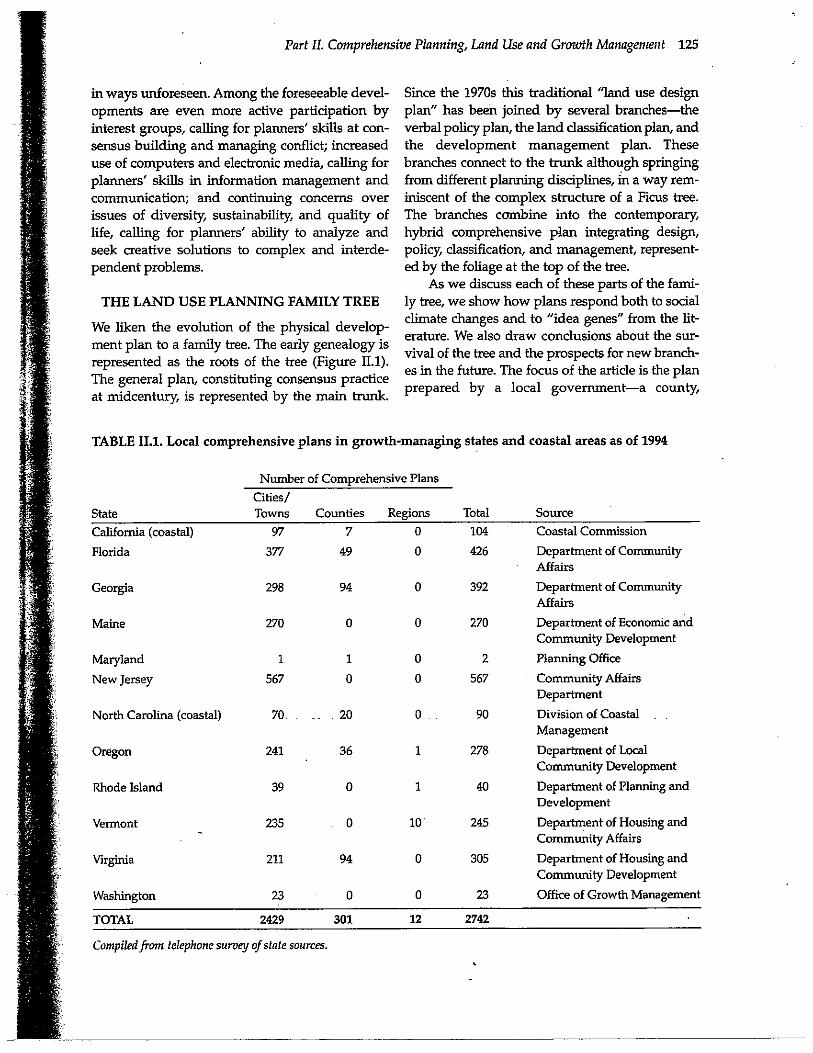
Unlike the more rigid, rule-oriented modemarchitecture, contemporary local planning doesnot appear destined for deconst ruction by a post-modem revolution. Though critics of comprehen-sive physical planning have regularly predicted itsdemise (Perin 1967, Perloff 1980, Jacobs 1992,Friedmann 1993); the evidence demonstrates thatspatial planning is alive and well in hundreds ofUnited States communities. A 1994 tabulationfound 2,742 local comprehensive plans preparedunder state growth management regulations intwelve states. (See Table 11.1.) This figure of course
significantly understates the overall nationwidetotal, which would include all those plans pre-pared in the other thirty-eight states and in thenoncoastal areas of California and North Carolina.It is safe to assume that most, if not all, of theseplans contain a mapped land use element: Notonly do such plans help decision makers to man-age urban growth and change, they also provide aplatform for the formation of community consen-sus about land use issues, now among the mostcontroversial items on local government agendas.
This article looks back at the history of landuse planning and forward to its future. It showshow planning ideas, growing from turn-of the-century roots, culminated in a midcentury consen-sus on a general concept-the traditional land usedesign plan. That consensus was stretched asplanning branched out to deal with public partici-pation, environmental protection, growth man-agement, fiscal responsibility, and effective imple-mentation under turbulent conditions. To meetthese new challenges, new types of plans arose:verbal policy plans, land classification plans, andgrowth management plans. These in turn becameintegrated into today's hybrid comprehensiveplans, broadening and strengthening the tradi-tional approach.
Future land use planning will continue toevolve in certain foreseeable directions, as well as
Part IL Comprehensive Planning, Land Use and Growth Management 125
in ways unforeseen. Among the foreseeable devel-opments are even more active participation byinterest groups, calling for planners' skills at con-
sensus building and managing conflict; increaseduse of computers and electronic media, calling forplanners' skills in information management andcommunication; and continuing concerns overissues of diversity, sustainability, and quality oflife, calling for planners' ability to analyze andseek creative solutions to complex and interde-pendent problems.
THE LAND USE PLANNING FAMILY TREE
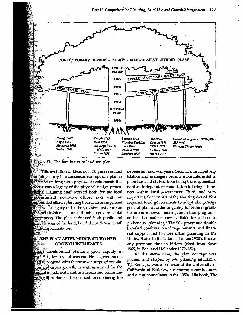
We liken the evolution of the physical develop-ment plan to a family tree. The early genealogy isrepresented as the roots of the tree (Figure 11.1).The general plan, constituting consensus practiceat midcentury, is represented by the main trunk.
Since the 1970s this traditional "land use designplan" has been joined by several branches-theverbal policy plan, the land classification plan, andthe development management plan. Thesebranches connect to the trunk although springingfrom different planning disciplines, in a way rem-iniscent of the complex structure of a Ficus tree.The branches combine into the contemporary,hybrid comprehensive plan integrating design,policy, classification, and management, represent-ed by the foliage at the top of the tree.
As we discuss each of these parts of the fami-ly tree, we show how plans respond both to socialclimate changes and to "idea genes" from the lit-erature. We also draw conclusions about the sur-vival of the tree and the prospects for new branch-es in the future. The focus of the article is the planprepared by a local government-a county,
TABLE II.1. Local comprehensive plans in growth-managing states and coastal areas as of 1994
Number of Comprehensive Plans
Cities/State Towns
Counties
Regions
Total
Source
California (coastal)
97
7
Florida
377
49
Georgia
298
94
Maine 270 0
Maryland
1
1
New Jersey
567
0
North Carolina (coastal)
70
20
Oregon
Rhode Island
Vermont
Virginia
Washington
0
104
Coastal Commission
0
426
Department of CommunityAffairs
0
392
Department of CommunityAffairs
0
270
Department of Economic andCommunity Development
0
2
Planning Office
0
567
Community AffairsDepartment
0
90
Division of CoastalManagement
1
278
Department of LocalCommunity Development
1
40
Department of Planning andDevelopment
10
245
Department of Housing andCommunity Affairs
0
305
Department of Housing andCommunity Development
0
23
Office of Growth Management
36241
039
235
94211
023
TOTAL 2429
301 12
2742
Compiled from telephone survey of state sources.
126 Classic Readings in Urban Planning
municipality, or urban region-for the long-termdevelopment and use of the land'
ROOTS OF THE FAMILY TREE: THE FIRST 50YEARS
New World city plans certainly existed before thiscentury. They included L'Enfant's plan forWashington, William Penn's plan for Philadelphia,and General Oglethorpe's plan for Savannah.These plans, however, were blueprints for unde-veloped sites, commissioned by unitary authori-ties with power to implement them unilaterally(Reps 1965).
In this century, perhaps the most influentialearly city plan was Daniel Burnham's plan forChicago, published by the Commercial Club ofChicago (a civic, not a government entity) in 1909(Schlereth 1981). The archetypical plan-as-inspira-tional-vision, it focuses only on design of publicspaces as a City Beautiful effort.
The City Beautiful approach was soon broad-
ened to a more comprehensive view. At the 1911National Conference on City Planning, FrederickLaw Olmsted, Jr., son of the famous landscapearchitect and in his own right one of the fathers ofplanning, defined a city plan as encompassing alluses of land, private property, public sites, andtransportation. Alfred Bettman, speaking at the1928 National Conference of City Planning, envi-
sioned the plan as a master design for the physicaldevelopment of the city's territory, including "thegeneral location and extent of new publicimprovements ... and in the case of private devel-opments, the general distribution amongst variousclasses of land uses, such as residential, business,and industrial uses... designed for...the future,twenty-five to fifty years" (Black 1968, 352-3).Together, Olmsted and Bettman anticipated thedevelopment of the midcentury land use plan.
Another early influence, the federal StandardCity Planning Enabling Act of 1928, shapedenabling acts passed by many states. However, theAct left many planners and public officials con-fused about the difference between a master planand a zoning ordinance, so that hundreds of com-munities adopted "zoning plans" without havingcreated comprehensive plans as the basis for zon-ing (Black 1968, 353). Because the Act also did notmake clear the importance of comprehensiveness
or define the essential elements of physical devel-opment, no consensus about the essential contentof the plan existed.
Ten years later, Edward Bassett's book, TheMaster Plan (1938), spelled out the plan's subjectmatter and format-supplementing the 1928 Act,and consistent with it. He argued that the planshould hale seven elements, all relating to landareas .(not buildings) and for public buildings,public reservations, routes for public utilities, pier-head and bulkhead lines (all public facilities), andzoning districts for private lands. Bassett's viewswere incorporated in many state enabling laws(Haar 1955).
The physical plans of the first half of the cen-tury were drawn by and for independent commis-sions, reflecting the profession's roots in theProgressive Reform movement, with its distrust ofpolitics. The 1928 Act reinforced that perspectiveby making the planning commission, not the leg-islative body, the principal client of the plan, andpurposely isolating the commission from politics(Black 1968, 355). Bassett's book reinforced thereliance on an independent commission. He con-ceived of the plan as a "plastic" map, kept withinthe purview of the planning commission, capableof quick and easy change. The commission, not the
plan, was intended to be the adviser to the locallegislative body and to city departments (Bassett1938).
By the 1940s, both the separation of the plan-ning function from city government and the plan'sfocus on physical development were being chal-lenged. Robert Walker, in The Planning Function inLocal Government, argued that the "scope of cityplanning is properly as broad as the scope of citygovernment (Walker 1941, 110). The central plan-ning agency might not necessarily do all the plan-ning but it would coordinate departmental plan-ning in the light of general policy considerations-creating a comprehensive plan but one without aphysical focus. That Idea was not widely accepted.Walker also argued that the independent planningcommission should be replaced by a departmentor bureau attached to the office of mayor or citymanager (Walker 1941, 177). That argument didtake hold, and by the 1960s planning in most com-munities was the responsibility of an agency with-in local government, though planning boards stilladvised elected officials on planning matters.'
Part II. Comprehensive Planning, Land Use and Growth Management 127
CONTEMPORARY DESIGN - POLICY - MANAGEMENT .HYBRID PLANS
LAND USEDESIGN
MANAGEMENT PLANI990s DEVEIAPMENT
1980$
1970s
GENERAL.PLAN
Perlo$1980
Chapin 1965
Beaman 1928Fagan 1959
Kent 1964
Planning EnablingMeyerson 1956
701 Requiiententr
Act 1928Walter 1941
1949,1954
Olmsted 1910Bassett 1938
Burnham 1909
All 1976
Growth Management 1970j, 80sOregon 1973 ALI 106C MA 1972
Planning Theory 19606McIarg 1969Hawaii 1961
- This evolution of ideas over 50 years resultedataiidcentury in a consensus concept of a plan as`ocuse3' on long-term physical development; this'ocus was a legacy of the physical design profes-
f was a legacy of the Progressive insistence onEtas public interest as an anti-dote to governmental
depression and war years. Second, municipal leg-islators and managers became more interested inplanning as it shifted'from being the responsibili-ty of an independent commission to being a func-tion within local government. Third, and veryimportant, Section'701 of the Housing Act of 1954required local governments to adopt along-rangegeneral plan in order to qualify for federal grantsfor urban renewal, housing, and other programs,and it also made money available for such com-prehensive planning5 The 701 ;program's doublebarreled combinations of requirements and. finan-cial support led to more urban planning in theUnited States in the latter half of the 1950's than atany previous time in history (cited from Scott1969, in Beal and Hollander 1979,159).
At the same time, the plan concept waspruned and shaped by two planning. educators.T.J. Kent, Jr., was a professor at the University ofCalifornia at Berkeley, a planning commissioner,and a city councilman in the 1950s. His book, The
bits.I Planning staff worked both for the localovernment executive officer and with an
pointed citizen planning board, an arrangement
eruption. The plan addressed both public andvate'uses of the land, but did not deal in detailith implementation.
THE PLAN AFTER MIDCENTURY: NEWGROWTH INFLUENCES
al development planning grew rapidly ine1950s, for several reasons. First, governmentsd'to contend with the postwar surge of popula-
on and urban growth, as well as a need for theital investment in infrastructure and commum-
facilities that had been postponed during the
128 Classic Readings in Urban Planning
Urban General Plan (1964), clarified the policy roleof the plan.' R Stuart Chapin, Jr., was a TVA plan-ner and planning director in Greensboro, NC inthe 1940s, before joining the planning faculty atthe University of North Carolina at Chapel Hill in1949. His contribution was to codify the method-ology of land use planning in the various editionsof his book, Urban Land Use Planning (1957, 1965).7
What should the plan look like? What shouldit be about? What is its purpose (besides the cyni-cal purpose of qualifying for federal grants)? The701 program, Kent, and Chapin all offeredanswers.
The "701" Program Comprehensive PlanGuidelinesIn order to qualify for federal urban renewal aid-and, later, for other grants-a local' governmenthad to prepare a general plan that consisted ofplans for physical development, programs forredevelopment, and administrative and regulato-ry measures for controlling and guiding develop-ment. The 701 program specified what the contentof a comprehensive development plan shouldinclude:
• A land use plan, indicating the locationsand amounts of land to be used for residential,commercial, industrial, transportation, and publicpurposes
• A plan for circulation facilities• A plan for public utilities• A plan for community facilities
T. J. Kent's Urban General Plan
Kent's view of the plan's focus was similar to thatof the 701 guidelines: long-range physical devel-opment in terms of land use, circulation, and com-munity facilities. In addition, the plan mightinclude sections on civic design and utilities, andspecial areas, such as historic preservation orredevelopment areas. It covered the entire geo-graphical jurisdiction of the community, and wasin that sense comprehensive. The plan was avision of the future, but not a blueprint; a policystatement, but not a program of action; a formula-tion of goals, but not schedules, priorities, or costestimates. It was to be inspirational, uninhibitedby short-term practical considerations.
Kent '(1964, 65-89) believed the plan shouldemphasize policy, serving the following functions:
• Policy determination-to provide aprocess by which a community would debate anddecide on its policy
• Policy communication-to inform thoseconcerned with development (officials,developers, citizens, the courts, and others) andeducate them about future possibilities
• Policy effectuation-to serve as a generalreference for officials deciding on specific projects
• Conveyance of advice-to furnishlegislators with the counsel of their advisors in acoherent, unified form
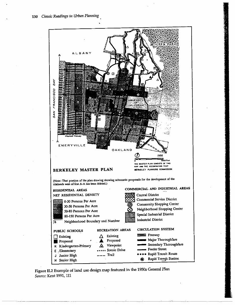
The format of Kent's proposed plan includeda unified, comprehensive, but general physicaldesign for the future, covering the whole commu-nity and represented by maps. (See Figure 11.2.) Italso contained goals and policies (generalizedguides to conduct, and the most important ingre-dients of the plan), as well as summaries of back-ground conditions, trends, issues, problems, andassumptions. (See Figure 11.3.) So that the planwould be suitable for public debate, it was to be acomplete, comprehensible document, containingfactual data, assumptions, statements of issues,and goals, rather than merely conclusions and rec-ommendations. The plan belonged to the legisla-tive body and was intended to be consulted indecision-making during council meetings.
Kent (1964, 25-6) recommended overall goalsfor the plan:
• Improve the physical environment of thecommunity to make it more functional, beautiful,decent, healthful, interesting, and efficient
• Promote the overall public interest, ratherthan the interests of individuals or special groupswithin the community
• Effect political and technical coordinationin community development
• Inject long-range considerations into thedetermination of short-range actions
• Bring professional and technical
knowledge to bear on the making of politicaldecisions about the physical development of thecommunity
F. Stuart Chapin, Jr.'s Urban Land Use Plan
Chapin's ideas, through focusing more narrowlyon the land use plan, were consistent with Kent's
Part II. Comprehensive Planning, Land Use and Growth Management 129
in both the 1957 and 1965 editions of Urban LandUse Planning, a widely used text and referencework for planners. Chapin's concept of the planwas of a generalized, but scaled, design for thefuture use of land, covering private land uses andpublic facilities, including the thoroughfare net-work (Chapin 1957, 275-7, 378).
Chapin conceived of the land use plan as thefirst step in preparing a general or comprehensiveplan. Upon its completion, the land use planserved as a temporary general guide for decisions,until the comprehensive plan was developed.Later, the land use plan would become a corner-stone in the comprehensive plan, which alsoincluded plans for transportation, utilities, com-munity facilities, and renewal, only the generalrudiments of which are suggested in the land useplan (Chapin 1957, 277, 388). Purposes of the planwere to guide government decisions on publicfacilities, zoning, subdivision control, and urbanrenewal, and to inform private developers aboutthe proposed future pattern of urban develop-ment.
The format of Chapin's land use plan includ-ed a statement of objectives, a description of exist-ing conditions and future needs for space andservices, and finally the mapped proposal for thefuture development of the community, togetherwith a program for implementing the plan (cus-tomarily including zoning, subdivision control, ahousing code, a public works expenditure pro-gram, an urban renewal program, and other regu-lations and development measures) (Chapin 1957,280-3).
The Typical General Plan of the 1950s and 1960s
Influenced by the 701 program, Kent's policyvision, and Chapin's methods, the plans of the1950s and 1960s were based on a clear andstraightforward concept: The plan's purposeswere to determine, communicate, and effectuatecomprehensive policy for the private and publicphysical development and redevelopment of the
city. The subject matter was long-range physicaldevelopment, including private uses of the land,circulation, and community facilities. The stan-dard format included a summary of existing andemerging conditions and needs; general goals; anda long-range urban form in map format, accompa-
nied by consistent development policies. The cov-erage was comprehensive, in the sense of address-ing both public and private development and cov-ering the entire planning jurisdiction, but quitegeneral. The tone was typically neither as "inspi-rational" as the Burnham plan for ChiLago, nor asaction-oriented as today's plans. Such was thewell-defined trunk''of the family tree in the 1950sand 1960s, in which today's contemporary planshave much of their origin.
CONTEMPORARY PLANS:INCORPORATING NEW BRANCHES
Planning concepts and practice have continued toevolve since midcentury, maturing in the process.By the 1970s, a number of new ideas had takenroot .8 Referring back to the family tree in Figure II.1,we can see a trunk and several distinct branches:
• The land use design, a detailed mapping offuture land use arrangements, is the most directdescendant of the 1950s plan. It still constitutes thetrunk of the tree. However, today's version is morelikely to be accompanied by action strategies, alsomapped, and to include extensive policies.
• The land classification plan, a more generalmap of growth policy areas rather than a detailedland use pattern, is now also common, particular-ly for counties, metropolitan areas, and regionsthat want to encourage urban growth in designat-ed development areas and to discourage it in con-servation or rural areas. The roots of the land clas-sification plan include McHarg's Design With
Nature (1969), the 1976 American Law Institute(ALI) Model Land Development Code, the 1972Coastal Zone Management Act, and the 1973Oregon Land Use Law.
• The verbal policy plan de-emphasizesmapped policy or end-state visions and focuses onverbal action policy statements, usually quitedetailed; sometimes called a strategic plan, it isrooted in Meyerson's (1956) middle-range bridgeto comprehensive planning, Fagin s (1959) policiesplan, and Perloff's (1980) strategies and policiesgeneral plan.
-• The development management plan lays
out a specific program of actions to guide devel-opment, such as a public investment program, adevelopment code, and a program to extend infra-structure and services; and it assumes public sec-
130 Classic Readings in Urban Planning
BERKELEY MASTER PLAN
1955
® FFH
THE MASTER PLAN 2NSISTS OF THIS
MAP AND THE ACCOMPANYING TEAT
BERKELEY PLANNING COMMISSION
(Note: That portion of the plan drawing showing schematic proposals for the development of the
tidelands west of line A-A has been deleted.)
RESIDENTIAL AREAS
NET RESIDENTIAL DENSITY
0.30 Persons Per Acre30-50 Persons Per Acre50-80 Persons Per Acre80-150 Persons Per Acre
Neighborhood Boundary and Number
COMMERCIAL AND INDUSTRIAL AREAS
Central DistrictCommercial Service DistrictCommunity Shopping CenterNeighborhood Shopping Center
Special Industrial District
Industrial District
PUBLIC SCHOOLS
0 Existing
0 Proposed
K Kindergarten-Primary
E Elementary
J Junior High
H Senior High
RECREATION AREAS
A Existing
A Proposed® Viewpoint
GGGGD Scenic Drive_-_ Trail
CIRCULATION SYSTEM
Freeway
Major Thoroughfare
smaso n Secondary Thoroughfare- Feeder Street.... Rapid Transit Route
0 Rapid Transit Station
Figure II.2 Example of land use design map featured in the 1950s General Plan
Source: Kent 1991, 111
Part II. Comprehensive Planning, Land Use and Growth Management 131
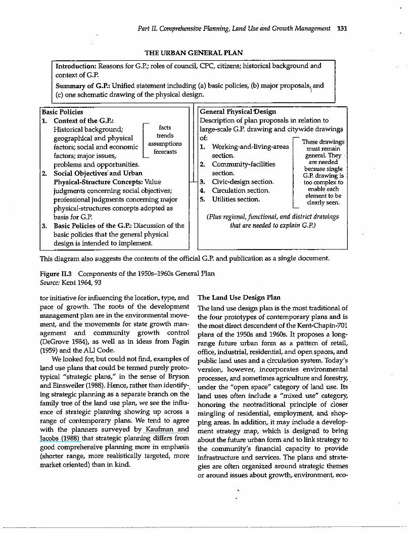
THE URBAN GENERAL PLAN
Introduction: Reasons for G.P.; roles of council, CPC, citizens; historical background andcontext of G.P.
Summary of G.P.: Unified statement including (a) basic policies, (b) major proposals,, and(c) one schematic drawing of the physical design.
Basic Policies1. Context of the G.P.:
Historical background;geographical and physicalfactors; social and economicfactors; major issues,problems and opportunities.
2. Social Objectives and UrbanPhysical-Structure Concepts: Valuejudgments concerning social objectives;professional judgments concerning majorphysical-structures concepts adopted asbasis for G.P.
3. Basic Policies of the G.P.: Discussion of thebasic policies that the general physicaldesign is intended to implement.
General Physical DesignDescription of plan proposals in relation tolarge-scale G.P. drawing and citywide drawingsof:1. Working-and-living-areas
section.2. Community-facilities
section.3. Civic-design section.4. Circulation section.5. Utilities section.
(Plus regional, functional, and district drawingsthat are needed to explain G.P.)
factstrends
assumptionsforecasts
These drawingsmust remaingeneral. They
are neededbecause singleG.P. drawing istoo complex to
enable eachelement to beclearly seen.
This diagram also suggests the contents of the official G.P. and publication as a single document.
Figure 11 .3 Components of the 1950s-1960s General PlanSource: Kent 1964, 93
tor initiative for influencing the location, type, andpace of growth. The roots of the developmentmanagement plan are in the environmental move-ment, and the movements for state growth man-
agement and community growth control(DeGrove 1984), as well as in ideas from Fagin(1959) and the ALI Code.
We looked for, but could not find, examples ofland use plans that could be termed purely proto-typical "strategic plans," in the sense of Bryson
and Einsweiler (1988). Hence, rather than identify-.ing strategic planning as a separate branch on thefamily tree of the land use plan, we see the influ-ence of strategic planning showing up across arange of contemporary plans. We tend to agreewith the planners surveyed by Kaufman andJacobs (1988) that strategic planning differs fromgood comprehensive planning more in emphasis(shorter range, more realistically targeted, moremarket oriented) than in kind.
The Land Use Design Plan
The land use design plan is the most traditional ofthe four prototypes of contemporary plans and is
the most direct descendent of the Kent-Chapin-701plans of the 1950s and 1960s. It proposes a long-range future urban form as a pattern of retail,office, industrial, residential, and open spaces, andpublic land uses and a circulation system. Today's
version, however, incorporates environmentalprocesses, and sometimes agriculture and forestry,under the "open space" category of land use. Itsland uses often include a "mixed use" category,honoring the neotraditional principle of closermingling of residential, employment, and shop-ping areas. In addition, it may include a develop-ment strategy map, which is designed to bringabout the future urban form and to link strategy tothe community's financial capacity to provideinfrastructure a nd services. The plans and strate-gies are often organized around strategic themesor around issues about growth, environment, eco-

132 Classic Readings in Urban Planning
nomic development, transportation, or neighbor-hood/community scale change.
Like the other types of plans in vogue today,
the land use design plan reflects recent societalissues, particularly the environmental crisis, theinfrastructure crisis, and stresses on local govern-ment finance.' Contemporary planners no longerview environmental factors as development con-straints, but as valuable resources and processes tobe conserved. They also may question assump-tions about the desirability and inevitability ofurban population and economic growth, particu-larly as such assumptions stimulate demand forexpensive new roads, sewers, and schools. Whileat midcentury plans unquestioningly accommo-dated growth, today's plans cast the amount, pace,location, and costs of growth as policy choices tobe determined in the planning process.
The 1990 Howard County (Maryland) GeneralPlan, winner of an American Planning Association(APA) award in 1991 for outstanding comprehen-sive planning, exemplifies contemporary land usedesign. (See Figure 11.4.) While dearly a directdescendent of the traditional general plan, theHoward County plan adds new types of goals,policies, and planning techniques. To enhancecommunication and public understanding, it isorganized strategically around six themes/chap-ters (responsible regionalism, preservation of therural area, balanced growth, working with nature,community enhancement, and phased growth),instead of the customary plan elements. Alongwith the traditional land use design, the planincludes a "policy map" (strategy map) for eachtheme and an overall policies map for the years2000 and 2010. A planned service area boundary isused to contain urban growth within the easternurbanized part of the county, home to the well-known Columbia New Town.'0 The plan lays outspecific next steps to be implemented over thenext two years, and defines yardsticks for measur-ing success. An extensive public participationprocess for formulating the plan involved a 32-member General Plan Task Force, public opinionpolling to discover citizen concerns, circulation ofpreplan issue papers on development impacts,and consideration of six alternative developmentscenarios."
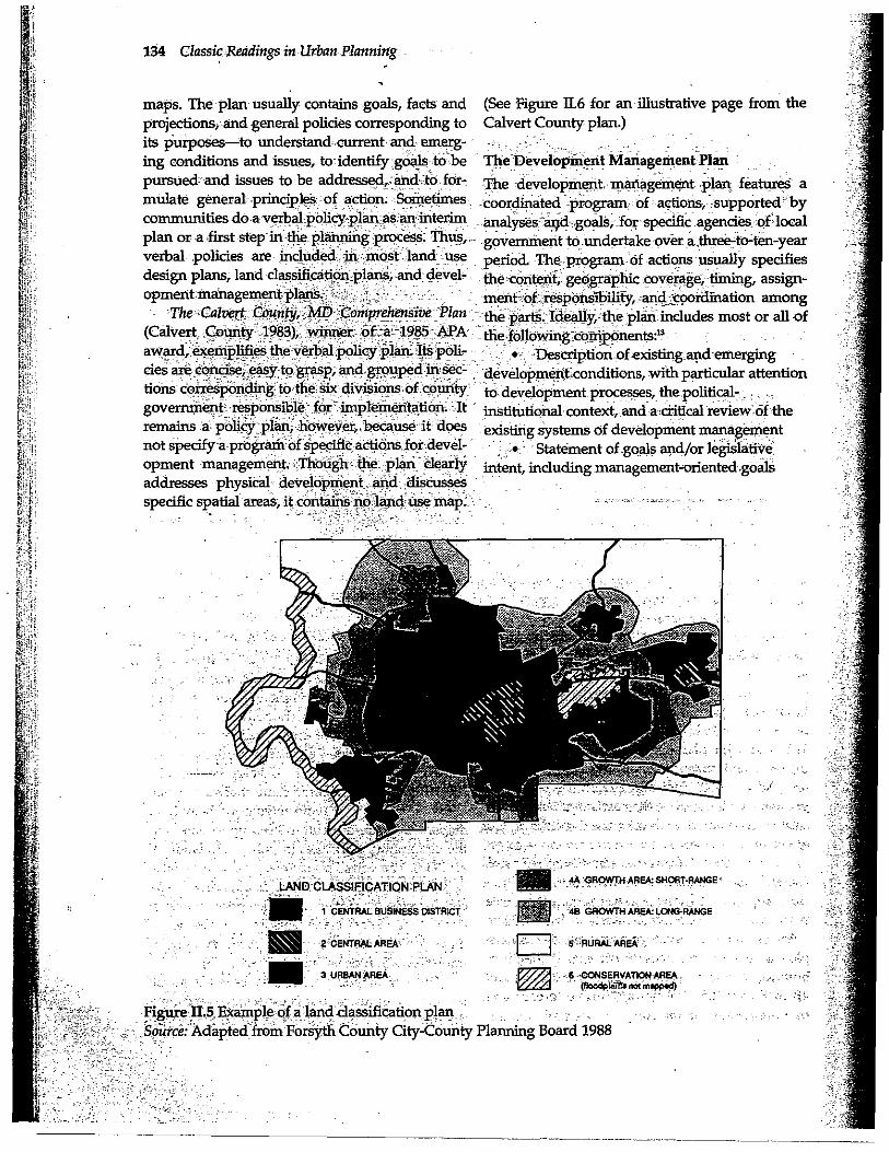
The Land Classification Plan
Land classification, or development prioritiesmapping, is a proactive effort by government tospecify where and under what conditions growthwill occur. Often, it also regulates the pace or tim-ing of growth. Land classification addresses envi-ronmental protection by designating "nondevel-opment" areas in especially vulnerable locations.Like the land use design, the land classificationplan is spatially specific and map-oriented.However, it is less specific about the pattern ofland uses within areas specified for development,which results in a kind of silhouette of urban form.On the other hand, land classification is more spe-cific about development strategy, including tim-
ing. Counties, metropolitan areas, and regionalplanning agencies are more likely than cities to usea land classification plan.
The land classification plan identifies areaswhere development will be encouraged (calledurban, transition, or development areas) and areaswhere development will be discouraged (openspace, rural, conservation, or critical environmen-tal areas). For each designated area, policies aboutthe type, timing, and density of allowable devel-opment, extension of infrastructure, and develop-ment incentives or constraints apply. The planningprinciple is to concentrate financial resources, util-ities, and services within a limited, prespecifiedarea suitable for development, and to relieve pres-sure on nondevelopment areas by withholdingfacilities that accommodate growth."
Ian McHarg's (1969) approach to lard plan-ning is an early example of the land classificationconcept. He divides planning regions into threecategories: natural- use,-production, and urban.
Natural use areas, those with valuable ecologicalfunctions, have the highest priority. Productionareas, which include agriculture, forestry, and fish-ing uses, are next in priority. Urban areas have thelowest priority and are designated after allocatingthe land suitable to the two higher-priority uses.McHarg's approach in particular, and land classi-fication generally, also reflect the emerging envi-ronmental consciousness of the 1960s and 1970s.
As early as 1961, Hawaii had incorporated theland classification approach into its state growthmanagement system (DeGrove 1984). The devel-opment framework plan of the Metropolitan

Part II. Comprehensive Planning, Land Use and Growth Management 133
Figure II.4 Howard County, Maryland, General Plan, Land Use 2010
Source: Adapted from Howard County 1990
Council of the Twin Cities Area defined "planningtiers," each intended for a different type and inten-sity of development (Reichert 1976). The conceptsof the "urban service area," first used in 1958 inLexington, Kentucky, and the urban growthboundary," used throughout Oregon under its1973 statewide planning act, classify land accord-ing to growth management policy (Abbott, Howe,and Adler 1994). Typically, the size of an urbangrowth area is based on the amount of land neces-sary to accommodate development over a periodof ten or twenty years.
Vision 2005: A Comprehensive Plan for ForsythCounty, North Carolina exemplifies the contempo-rary approach to land classification plans. Theplan, which won honorable mention from APA in1989, employs a six-category system of districts,plus a category for activity centers. It identifiesboth short- and long-range growth areas (4A and4B in Figure 11.5). Policies applicable to each dis-trict are detailed in the plan.
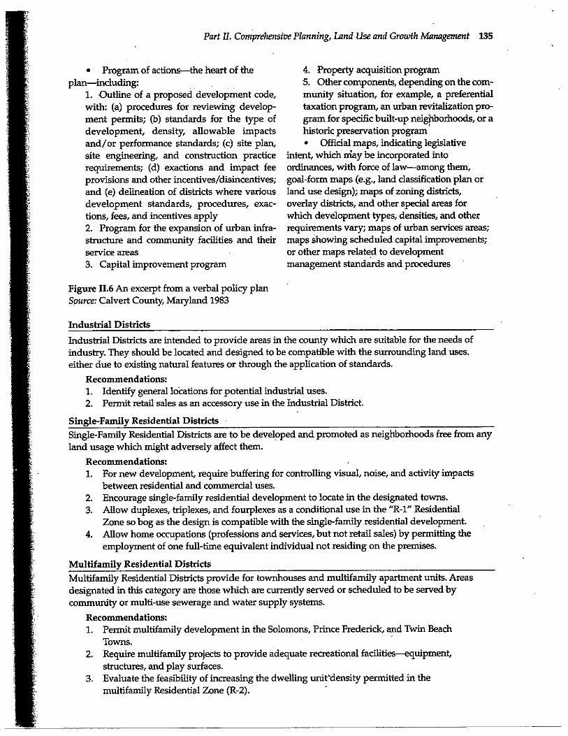
The Verbal Policy Plan Shedding the Maps
The verbal policy plan focuses on written state-ments of goals and policy, without mapping spe-cific land use patterns or implementation strategy.Sometimes called a policy framework plan, a ver-bal policy plan is more easily prepared and flexi-ble than other types of plans, particularly forincorporating nonphysical development policy(Perloff 1980, 233-8). Some claim that such a planhelps the planner to avoid relying too heavily onmaps, which are difficult to keep up to date withthe community's changes in policy (Hollander etal. 1988). The verbal policy plan also avoids false-ly representing general policy as applying to spe-cific parcels of property. The skeptics, however,claim that verbal statements in the absence ofmaps provide too little spatial specificity to guideimplementation decisions (Reichert 1976).
The verbal policy plan may be used at anylevel of government, but-is especially common atthe state level, whose scale is unsuited to land use
134 Classic Readings inUrbanPlanning
maps. The plan usually contains goals, facts and (See Figure 11.6 for an illustrative page from theprojections, and general policies corresponding to Calvert County plan.)its purposes to understand current and emerg-ing conditions and issues, to identify goals tote The Development Management Planpursued- and issues to be addressed,. and to for- The development. management plan features amulate general principles of action. Sometimes coordinated program of actions, -supported-bycommunities doa verbal policyplan as;an interim analyses ar)d goals, for specific agencies of localplan or a-first step in the planning process. Thus, .government to, over a three-to-ten-yearverbal policies are included in most land use period. The program of actions usually specifiesdesign plans, land classification-plans,and devel- the-cos tent, geographic coverage, timing, assign-opmentmanagementplans•
ment'of responsibility,-and coordination amongThe Calvert-.,County MD Comprehensive Plan the parts. Ideally,=the plan includes most or all of
(Calvert„County 1983), winner ot.:a 1985 APA the following components:award,exemplifiestheverbalpolicyplan.Itspoli- - .: Description ofexisting apdemergingcies arecQncise, easyto'grasp, and grouped'in sec- development condition, with particular attentionlions corresponding to the six divisions of county to development. processes, the political-government responsible for-implementation. It institutional context, and acritical ieview;oftheremains a policy plan, however„because it does existing systems of development managementnot specify a program of specific actions for.devel-
Statement of -goals and/or legislativeopment management. Though the plan clearly intent, including management-oriented goalsaddresses physical development, and discussesspecific spatial areas, it contains no land use map:.
3 URSAN AREA
4oNsERVATION AREA...(HOO41 ftS not m.ppedj
Figure 11.,5, Example of a landdassification plan.Source: Adapted. from Forsyth County City-County Planning Board 1988
Part II. Comprehensive Planning, Land Use and Growth Management 135
• Program of actions-the heart of theplan-including:
1. Outline of a proposed development code,with: (a) procedures for reviewing develop-ment permits; (b) standards for the type ofdevelopment, density, allowable impactsand/or performance standards; (c) site plan,site engineering, and construction practicerequirements; (d) exactions and impact feeprovisions and other incentives/disincentives;and (e) delineation of districts where variousdevelopment standards, procedures, exac-tions, fees, and incentives apply2. Program for the expansion of urban infra-structure and community facilities and theirservice areas3. Capital improvement program
Figure 11 .6 An excerpt from a verbal policy planSource: Calvert County, Maryland 1983
4. Property acquisition program5. Other components, depending on the com-munity situation, for example, a preferentialtaxation program, an urban revitalization pro-gram for specific built-up neighborhoods, or ahistoric preservation program• Official maps, indicating legislative
intent, which may be incorporated intoordinances, with force of law-among them,goal-form maps {e.g., land classification plan orland use design); maps of zoning districts,overlay districts, and other special areas forwhich development types, densities, and otherrequirements vary; maps of urban services areas;maps showing scheduled capital improvements;or other maps related to developmentmanagement standards and procedures
Industrial Districts
Industrial Districts are intended to provide areas in the county which are suitable for the needs ofindustry. They should be located and designed to be compatible with the surrounding land uses.either due to existing natural features or through the application of standards.
Recommendations:1. Identify general locations for potential industrial uses.
2. Permit retail sales as an accessory use in the Industrial District.
Single-Family Residential DistrictsSingle-Family Residential Districts are to be developed and promoted as neighborhoods free from anyland usage which might adversely affect them.
Recommendations:1. For new development, require buffering for controlling visual, noise, and activity impacts
between residential and commercial uses.2. Encourage single-family residential development to locate in the designated towns.3. Allow duplexes, triplexes, and fourplexes as a conditional use in the "R-1" Residential
Zone so bog as the design is compatible with the single-family residential development.4. Allow home occupations (professions and services, but not retail sales) by permitting the
employment of one full-time equivalent individual not residing on the premises.
Multifamily Residential DistrictsMultifamily Residential Districts provide for townhouses and multifamily apartment units. Areasdesignated in this category are those which are currently served or scheduled to be served bycommunity or multi-use sewerage and water supply systems.
Recommendations:1. Permit multifamily development in the Solomons, Prince Frederick, and Twin Beach
Towns.2. Require multifamily projects to provide adequate recreational facilities-equipment,
structures, and play surfaces.3. Evaluate the feasibility of increasing the dwelling unit density permitted in the
multifamily Residential Zone (R-2).
-
136 Classic Readings in Urban Planning
The development management plan is a dis-tinct type, emphasizing a specific course of action,not general policy. At its extreme the managementplan actually incorporates implementation meas-ures, so that the plan becomes part of a regulativeordinance. Although the spatial specifications forregulations and other implementation measuresare included, a land use map may not be.
One point of origin for development manage-ment plans is Henry Fagin's (1959, 1965) conceptof the "policies plan," whose purpose was to coor-dinate the actions of line departments and providea basis for evaluating their results, as well as toformulate, communicate, and implement policy(the traditional purpose). Such a plan's subjectmatter was as broad as the responsibilities of thelocal government, including but not limited tophysical development. The format included a
"state of the community" message, a physicalplan, a financial plan, implementation measures,and detailed sections for each department of thegovernment.
A more recent point of origin is A Model Land
Development Code (American Law Institute 1976),intended to replace the 1928 Model PlanningEnabling Act as a model for local planning anddevelopment management. The model plan con-sciously retains an emphasis on physical develop-ment (unlike Fagin s broader concept), but stress-es_a short-term program of action, rather than a
long-term, mapped goal form. The ALL modelplan contains a statement of conditions and prob-lems; objective, policies, and standards; and ashort-term (from one to five years) program ofspecified public actions. It may also include landacquisition requirements, displacement impacts,development regulations, program costs and fundsources, and environmental, social, and economicconsequences. More then other plan types, thedevelopment management plan is a "course ofaction" initiated by government to control thelocation and timing of development."
The Sanibel, Florida, Comprehensive Land UsePlan (1981) exemplifies the development manage-ment plan. The, plan outlines the standards andprocedure of regulations (i.e., the means of imple-mentation), as well as the analyses, goals, andstatements of intent normally presented in a plan.Thus, when the local legislatures adopts the plan,it also adopts and ordinance for its implementa-
tion. Plan and implementation are merged intoone instrument, as can be seen in the content of itsarticles:
Article 1: Preamble: including purposesand objectives, assumptions, co6rdination withsurrounding areas, and implementation
Article 2: * Elements of the Plan: Safety,Human Support Systems, Protection of NaturalEnvironmental, Economic and Scenic Resources,Intergovernmental Coordination, and Land Use
Article 3: Development Regulations:Definitions, Maps, Requirements, PermittedUses, Subdivisions, Mobile Home andRecreation Vehicles, Flood and StormProofing, Site Preparation, and EnvironmentalPerformance Standards
Article 4: Administrative Regulations (i.e.,procedures): Standards, Short Form Permits,Development Permits, Completion Permits,Amendments to the Plan, and Notice, Hearing andDecision Procedures on Amendments
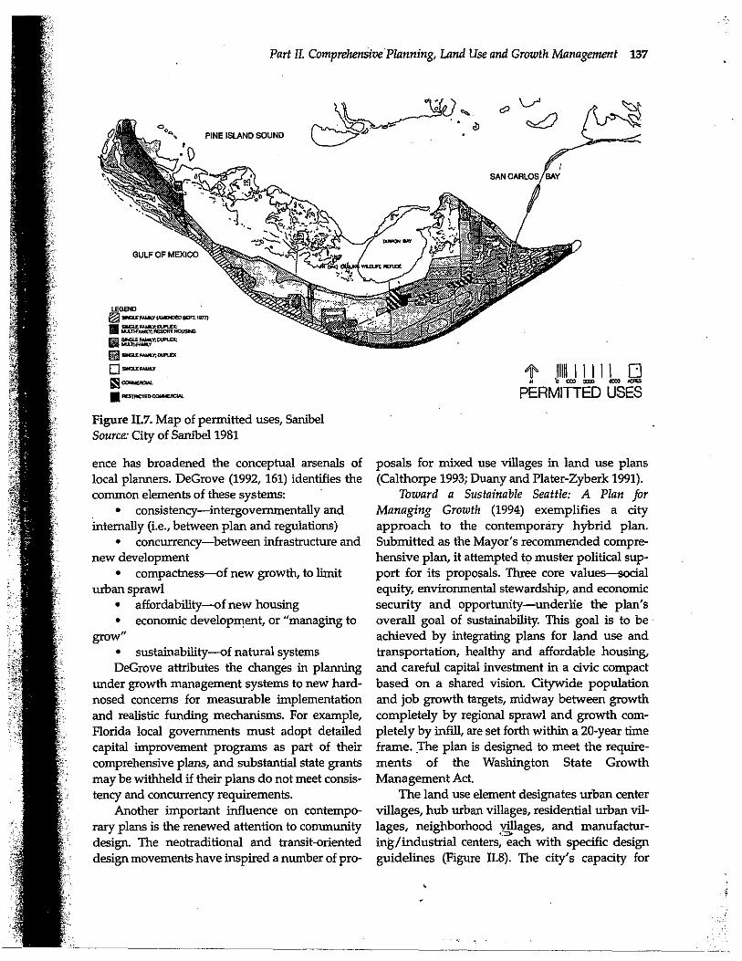
Figure 11.7 shows the Sanibel plan's map ofpermitted uses, which is more like a zoning planthan a land use design plan, because it showswhere regulations apply, and boundaries areexact.
THE CONTEMPORARY HYBRID PLAN:INTEGRATING DESIGN, POLICY, AND
MANAGEMENT
The rationality of practice has integrated the usefulparts of each of the separate prototypes reviewedhere into contemporary hybrid plans that not onlymap and classify land use in both specific and gen-eral ways, but also propose policies and manage-ment measures. For example, Gresham, Oregon(1980) combined land use design (specifying resi-dential, commercial, and industrial areas, and com-munity facilities and public lands) with an overlayof land classification districts (developed, develop-ing, rural, and conservation), and also includedstandards and procedures for issuing developmentpermits (i.e., a development code). Prepared withconsiderable participation by citizens and interestgroups, such plans usually reflect animated politi-cal debates about the costs and benefits of land usealternatives.
The states that manage growth have creatednew land use governance systems whose influ-
Part IL Comprehensive Planning, Land Use and Growth Management 137
LEGEND
®- r ,Imo wt IPP)
BfAERWY. LYlF1Ec
wt1WAMO F SCSI
xgnwo
W3¢ru*S OU S
®mwr"cw
Figure II.7. Map of permitted uses, SanibelSource.' City of Sanibel 1981
ence has broadened the conceptual arsenals oflocal planners. DeGrove (1992, 161) identifies thecommon elements of these systems:
• consistency-intergovernmentally andinternally (i.e., between plan and regulations)
• concurrency-between infrastructure andnew development
• compactness-of new growth, to limiturban sprawl
• affordability-of new housing• economic development, or "managing to
grow,,
• sustainability-of natural systemsDeGrove attributes the changes in planning
under growth management systems to new hard-nosed concerns for measurable implementationand realistic funding mechanisms. For example,Florida local governments must adopt detailedcapital improvement programs as part of theircomprehensive plans, and substantial state grantsmay be withheld if their plans do not meet consis-tency and concurrency requirements.
Another important influence on contempo-rary plans is the renewed attention to communitydesign. The neotraditional and transit-orienteddesign movements have inspired a number of pro-
t
111NIIII1
O'a tm sm mw .
PERMITTED USES
posals for mixed use villages in land use plans(Calthorpe 1993; Duany and Plater-Zyberk 1991).
Toward a Sustainable Seattle: A Plan forManaging Growth (1994) exemplifies a cityapproach to the contemporary hybrid plan.Submitted as the Mayor's recommended compre-hensive plan, it attempted to muster political sup-
port for its proposals. Three core values-- socialequity, environmental stewardship, and economicsecurity and opportunity-underlie the plan'soverall goal of sustainability. This goal is to beachieved by integrating plans for land use andtransportation, healthy and affordable housing,and careful capital investment in a civic compactbased on a shared vision. Citywide populationand job growth targets, midway between growthcompletely by regional sprawl and growth com-pletely by infill, are set forth within a 20-year timeframe. The plan is designed to meet the require-ments of the Washington State GrowthManagement Act.
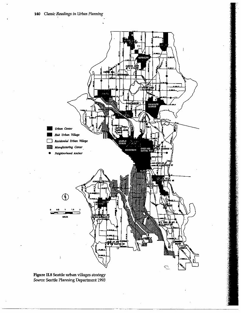
The land use element designates urban centervillages, hub urban villages, residential urban vil-lages, neighborhood villages, and manufactur-ing/industrial centers, each with specific designguidelines (Figure 11.8). The city's capacity for
138 Classic Readings in Urban Planning
growth is identified, and then allocated accordingto the urban village strategy. Future developmentis directed to mixed-use neighborhoods, some ofwhich are already established; existing single-fam-ily areas are protected. Growth is shaped to buildcommunity, promote pedestrian and transit use,protect natural amenities and existing residentialand employment areas, and ensure diversity ofpeople and activities. Detailed land use policiescarry out the plan.
Loudoun County Choices and Changes: General
Plan (1991), which won APA s 1994 award for com-prehensive planning in small jurisdictions, exem-plifies a county approach to the contemporaryhybrid plan. Its goals are grouped into three cate-gories:
1. Natural and cultural resources goals seekto protect fragile resources by limiting develop-ment or mitigating disturbances, while at the sametime not unduly diminishing land values.
2. Growth management goals seek to accom-modate and manage the county's fair share ofregional growth, guiding development into theurbanized eastern part of the county or existingwestern towns and their urban growth areas, andconserving agriculture and open space areas in thewest. (See Figure 11.9.)
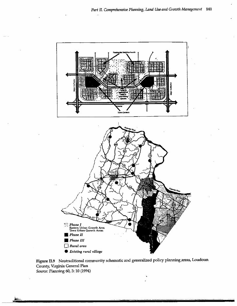
3. Community design goals seek to concen-trate growth in compact, urban nodes to createmixed-use communities with strong visual identi-ties, human-scale street networks, and -a range ofhousing and employment opportunities utilizingneotraditional design concepts (illustrated inFigure 11.9).
Three time horizons are addressed: the "ulti-mate" vision through 2040, the 20-year, long-rangedevelopment pattern, and the five-year, short-range development pattern. The plan uses theconcept of community character areas as an organ-izing framework for land use management.Policies are proposed for the overall county, aswell as for the eastern urban growth areas, townurban growth areas, rural areas, agd existing rural
village areas. Implementation tools include capitalfacility and transportation proffers by developers,density transfers, community design guidelines,annexation guidelines, and an action schedule ofnext steps.
SUMMARY OF THE CONTEMPORARYSITUATION
Since midcentury, the nature of the plan has shift-ed from an elitist, inspirational, long-range visionthat was based on fiscally innocent implementa-tion advice, to a framework for community con-sensus on future growth that is supported by fis-
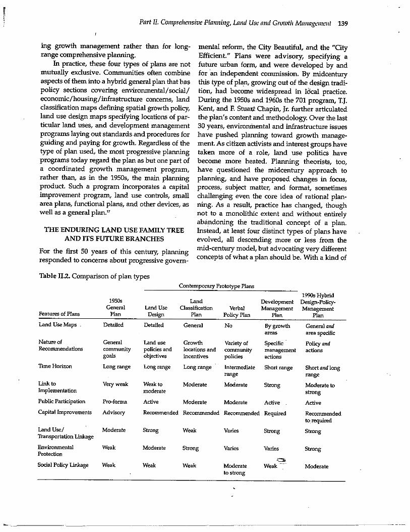
cally grounded actions to manage change.15Subject matter has expanded to include the natu-ral as well as the built environment. Format hasshifted from simple policy statements and a singlelarge-scale map of future land use, circulation, andcommunity facilities, to a more complex combina-tion of text, data, maps, and time tables. In a num-ber of states, plans are required by state law, andtheir content is specified by state agencies (Bollens1993). Table 2 compares the general plan of the1950s-1960s with the four contemporary prototypeplans and the new 1990s hybrid design-policy-management plan, which combines aspects of theprototype plans.
Today's prototype land use design continuesto emphasize long-range urban form for land uses,community facilities, and transportation systemsas shown by a map; but the design is alsoexpressed in general policies. Land use design isstill a common form of development plan, espe-cially in municipalities "
The land classification plan also still empha-sizes mapping, but of development policy ratherthan policy about a pattern of urban land uses.Land classification is more specific about develop-ment management and environmental protection,but less specific about transportation, communityfacilities, and the internal arrangement of thefuture urban form. County and regional govern-ments are more likely than are municipalities touse land classification plans.
The verbal policies plan eschews the spatialspecificity of land use design and land classifica-tion plans and focuses less on physical develop-ment issues. It is more suited to regions and states,or may serve as an interim plan for a city or coun-ty while another type of plan is being prepared.
The development management plan repre-sents the greatest shift from the traditional landuse plan. It embodies a short-to-intermediate-range program of governmental actions for ongo-
Part II. Comprehensive Planning, Land Use and Growth Management 139
ing growth management rather than for long-range comprehensive planning.
In practice, these four types of plans are notmutually exclusive. Communities often combineaspects of them into a hybrid general plan that haspolicy sections covering environmental/social/economic/housing/infrastructure concerns, landclassification maps defining spatial growth policy,land use design maps specifying locations of par-ticular land uses, and development managementprograms laying out standards and procedures forguiding and paying for growth. Regardless of thetype of plan used, the most progressive planningprograms today regard the plan as but one part ofa coordinated growth management program,rather than, as in the 1950s, the main planning
product. Such a program incorporates a capitalimprovement program, land use controls, smallarea plans, functional plans, and other devices, aswell as a general plan."
THE ENDURING LAND USE FAMILY TREEAND ITS FUTURE BRANCHES
mental reform, the City Beautiful, and the "CityEfficient." Plans were advisory, specifying afuture urban form, and were developed by andfor an independent commission. By midcenturythis type of plan, growing out of the design tradi-tion, had become widespread in local practice.During the 1950s and 1960s the 701 program, T.J.Kent, and F. Stuart Chapin, Jr. further articulatedthe plan's content and methodology. Over the last30 years, environmental and infrastructure issueshave pushed planning toward growth manage-ment. As citizen activists and interest groups havetaken more of a role, land use politics havebecome more heated. Planning theorists, too,have questioned the midcentury approach toplanning, and have proposed changes in focus,process, subject matter, and format, sometimeschallenging even the core idea of rational plan-ning. As a result, practice has changed, thoughnot to a monolithic extent and without entirelyabandoning the traditional concept of a plan.Instead, at least four distinct types of plans haveevolved, all descending more or less from themid-century model, but advocating very differentconcepts of what a plan should be. With a kind of
For the first 50 years of this century, planningresponded to concerns about progressive govern-
Table 11.2. Comparison of plan typesContemporary Prototype Plans
1950s
LandGeneral
Land Use
ClassificationFeatures of Plans
Plan
Design
Plan
Land Use Maps .
Detailed
Detailed
General
Nature of
General
Land use
GrowthRecommendations
community
policies and
locations andgoals
objectives
incentives
Time Horizon
Long range
Long range
Long range
Link to
Very weak
Weak to
ModerateImplementation
moderate
Public Participation
Pro-forma
Active
Moderate
Capital Improvements Advisory
Recommended Recommended
Land Use/
Moderate
Strong
WeakTransportation Linkage
Environmental
Weak
Moderate
StrongProtection
Social Policy Linkage
Weak
Weak
Weak
1990s HybridDevelopment Design-Policy-
Verbal
Management ManagementPolicy Plan
Plan
Plan
No
By growth
General andareas
area specific
Variety of
Specific
Policy andcommunity
management actionspolicies
actions
Intermediate Short range
Short and longrange
range
Moderate
Strong
Moderate tostrong
Moderate
Active
Active
Recommended Required
Recommendedto required
Varies
Strong
Strong
Varies
Varies
Strong
shy
Moderate
Weak
Moderate
to strong
140 Classic Readings in Urban Planning
Figure 11 .8 Seattle urban villages strategySource: Seattle Planning Department 1993
c a 21 EMUNMI-Wit Ear
II-S66F ^^ ^^t3^($C9
E^ 'G'
I
ft
1 17^^v
IR Fb61
Part II. Comprehensive Planning, Land Use-and Growth Management 141
Tarn Gruen
Phase IEastern Urban Growth AreaTown Urban Growth Areas
i Phase II
Phase III
q Rural area
® Existing rural village
Figure II.9 Neotraditional community schematic and generalized policy planning areas, LoudounCounty, Virginia General PlanSource: Planning 60, 3: 10 (1994)
142 Classic Readings in Urban Planning
self-correcting common sense, the plans of the1990s have subsequently incorporated the usefulparts of each of these prototypes to create today'shybrid design/policy/management plans.
To return to our analogy of the plan's familytree: Roots for the physical development planbecame well established during the first half ofthis century. By 1950, a sturdy trunk concept haddeveloped. Since then, new roots and branches
have appeared-land classification plans, verbalpolicy plans, and development managementplans. Meanwhile development of the main trunkof the tree-the land use design-has continued.Fortunately, the basic gene pool has been able tocombine with new genes in order to survive as amore complex organism-the 1990s design-policymanagement hybrid plan. The present family treeof planning reflects both its heredity and its envi-ronment.
The next generation of physical developmentplans also should mature and adapt without aban-doning their heritage. We expect that by the year2000, plans will be more participatory, more elec-tronically based, and concerned with increasinglycomplex issues. An increase in participation seemscertain, bolstered by interest groups' as well asgovernments' use of expert systems and computerdatabases. A much broader consideration of alter-native plans and scenarios, as well as a more flex-ible and responsive process of plan amendment,will become possible. These changes will call uponplanners to use new skills of consensus buildingand conflict management, as more groups articu-late their positions on planning matters, and gov-ernment plans and interest group plans compete,each backed by experts (Susskind and Cruikshank1987).
With the advent of the "information high-way," plans are more likely to be drafted, commu-nicated, and debated through electronic networksand virtual reality images. The appearance ofplans on CD ROM and cable networks will allowmore popular access and input, and better under-standing of plans' three dimensional conse-quences. It will be more important than ever forplanners to coihpile information accurately andensure it is fairly communicated. They will need tocompile, analyze, and manage complex databases,as well as to translate abstract data into under-standable impacts and images.
Plans will continue to be affected by dominantissues of the times: aging infrastructure and limit-ed public capital, central city decline and subur-ban growth, ethnic and racial diversity, economicand environmental sustainability, global competi-tion and interdependence, and land use/trans-portation/air quality spillovers. Many of these areunresolved issues from the last thirty years, nowgrown more complex and interrelated. Some are
addressed by new programs like the IntermodalSurface Transportation Efficiency Act.(ISTEA) andHUD's Empowerment Zones and EnterpriseCommunities. To cope with others, planners mustdevelop new concepts and create new techniques.
One of the most troubling new issues is anattempt by conservative politicians (see thePrivate Property Protection Act of 1995 passed bythe U.S. House of Representatives) and "wise use"(Jacobs 1995) groups to reverse the precedence ofthe public interest over individual private proper-ty rights. These groups challenge the use of feder-al, state, and local regulations to implement landuse plans and protect environmental resourceswhen the result is any reduction in the economicvalue of affected private property. Should theirchallenge succeed and become widely adopted infederal and state law, growth management plansbased on regulations could become toothless.Serious thinking by land use lawyers and plannerswould be urgently needed to create workable newimplementation techniques, setting in motion yetanother planning evolution.
We are optimistic, however, about the futureof land use planning. Like democracy, it is not aperfect institution but works better than its alter-natives. Because land use planning has adaptedeffectively to this century's turbulence andbecome stronger in the process, we believe that thetwenty-first century will see it continuing as amainstay of strategies to manage communitychange.
NOTES
1. Each critic puts forth his or her own alter-native to comprehensive physical planning. Somemake radical recommendations, such as doingaway with the mapped land-use general plan(Perloff 1980, 233-4) or even with Ion- range plan-ning for Euclidean space based on straight and
Part U. Comprehensive Planning; Land Use and Growth=ManagemSzt 143
parallel lines and angles of plane triangles
(Friedmann -1993, 482). However, -the principlesembodied in3heir solutions tend to turn up inlanduse planning.practice::over time. Thus; we findthat some comprehensive plans, such as Sanibel's,include land use regulations as recommended byPerin (1967, 337),: Perloff's (1980) call.-for policyplanning has been-heeded by nearly, aall contempo-rary plans, though not to the exclusion of-land use
maps. Actually, no one could have foreseen in 1980the extent-to which GIS-has tied policy: analysis toland use mapping, suitability studies, sketch plan-rung, and scenario development (Harris andBatty1993). Friedmann (1993) calls for planning that isnormative, innovative, political, transactive, andbased on social learning. Arguably, all of thesequalities may be found in leading edge examplesof contemporary land use planning. Jacobs (1992)sees land use planning as:a modernist conceptionchallenged by postmodern phenomena, includinga populist citizen movement, a redefinition of pri-vate property rights, and growing computer liter-acy."Again, these factors affect land use planningwithout rendering it obsolete.
2. In growth-managing states, regulations forlocal comprehensive plans typically specify thecontent of the land use elements. For example,Florida's 9J-5 rules require maps of existing andproposed land use in all local plans prepared inthat state. Not only are local plans mandatory in
Florida, but also they must include realistic capitalimprovement programs, be adopted by the gov-erning body, and be revised every five years.There is evidence that state planning mandatesimprove the quality of local plans (Berke andFrench, 1994).
3. The land use plan typically is one elementof a comprehensive or general plan, which alsoincludes other elements, such as transportation,community facilities, and economic development.We acknowledge that these are related to land usedecisions, but here we limit our attention to landuse.
4. In the late 1940s more than 50 percent of allplanning directors in cities with populations over2000 were still appointed by planning commis-sions. The commission was the client for the plan,and therefore the plan was not seen as somethingtied closely to implementation. By 1971 only 18percent of planning directors were appointed by
such commissions; most being appointe&msteadby.:chief executives;- and working directly'in theexecutive: branch (sometimes- workingcfor -theplanning commissionas a second boss) (reportedin Brooks, 1988). It was onlynatural.that planningbecame more closely: linked to decision-making,and the role -of--plans was increasingly seen- asmore closely linked to decisions and implementa-tion.
;5. Through the end-of 1964; the 701 program
had allocated $79 million in grants for planning in4,462 localities (cited in-Black 1968) _=By its peak,
1971 through 1975,-the program was -allocating .approximately $100 million a year. At its rescind-ment in 1981, the program-thad-appropriated over$1 billion to comprehensive planning (Feiss 1985,182).
6. Kent's book Was later summarized by AlanBlack, who worked -originally with Kent, in achapter on the "The: Comprehensive plan- in the1968 edition of Principles and Practices-qf UrbanPlanning (the planner's "big -green bible")- whichsummarizes: the -state of the art of planning prac-tice in -the 1960s (Black 1968). In testimony to thestaying power of Kent's concept of the plan, thebook was republished in 1991, virtuallyunchanged
7. Chapin's ideas, like those of Kent, hadstaying power. However, to keep pace withadvances in methodology, his book appeared in athirdedition in 1979 and in a fourth edition in 1995(Chapin and Kaiser 1979; Kaiser, Godschalk, andChapin 1995). -
8. A late 1970s survey, "The State -of the Art inLocal Planning," looked at 27 communities nomi-nated by consulting firms and HUD staff as-hav-iing "especially interesting or effective-masterplans" (Fishman 1978, appendix to.chapter 5).Examples of our prototypes included Philadelphia
(land use design), Boulder and Petaluma (growthmanagement plan), Cleveland and Dallas (policiesplan). The report -looked at a number of distin-guishing plan features, including whether theywere top down or bottom up, the-physical versussocial nature of their goals, the inclusion of maps,the processes for plan preparation and revision,implementation strategies, and citizen participa-tion approaches.
9. Social issues, such as segregation, unem-ployment, crime, and community disintegration,
144 Classic Readings in Urban Planning
are primarily addressed through the housing andeconomic development elements of comprehen-sive plans, although there are linkages to land usethrough neighborhood plans, community facilityprograms, and public investment strategies.
10. In this respect, the Howard County Planalso has some similarities to the prototype landclassification plan.
11. For an account of the politics behind theplan (the plan was adopted but the county execu-tive and planning director lost their positions) andan assessment of the lessons of the planningprocess, see Avin and Mennitto (1992).
12. Classification plans usually include morethan just the two basic types of districts-develop-ment and nondevelopment. For example, theurban area might be divided into a "developed"area, consisting of the built-up central city andolder suburbs, and a "transition" area, which isundeveloped or only partially developed at thetime of the plan. The transition area might bedivided into districts to be developed earlier (e.g.,first 10 years) and districts to be developed later(e.g., years 10-20). A "rural" area might be dividedinto agricultural districts with a policy of long-range commitment to agricultural and forest uses,and less critical rural districts that could becomeurban transition in the future. "Environmentallycritical" areas might be divided into areas withspecific critical environmental processes, e.g., wet-lands being designated as separate from watersupply watersheds, width each having its ownpolicies and development standards.
13. Adapted from plans for Breckenridge,Colorado, 1977, 1987; Gresham, Oregon, 1980;Sanibel, Florida, 1981; and Hardin County,Kentucky, 1985; see also Fagin 1959, 1965;American Law Institute 1976.
14.The idea of plan as course of action origi-nated in the 1960s as planning theory incorporat-ed notions from policy analysis and businessadministration into the rational planning model,broadening the design concept of, a plan. Thesenew concepts stressed means as much as ends,and shifted the role of government from facilitat-ing private development to proactive guidance ofgrowth.
15. Codification of the action requirements ofland use plans can be found in the regulationsimplementing the Florida and Oregon growth
management acts. Florida requires the provisionof infrastructure "concurrently" with future devel-opment (DeGrove 1992, 16-7). Oregon requiresthat communities delineate and enforce urbangrowth boundaries (Howe 1993).
16. See, for example, the Cleveland Civic Vision2000 Citywide, Plan (Cleveland City PlanningCommission 1991), successor to Cleveland's oft-described 1975 Policy Planning Report.
17. Growth management programs are relatedto the notion of the urban development guidancesystem, introduced by Chapin (1963). His conceptfeatured the general plan as the organizing ele-ment, backed by an "urban development policiesinstrument," a public works program (to be fol-lowed up with a more detailed capital improve-ments program), an urban development code (uni-fying most development regulations), and a civiceducation/participation program.
Author's Note: We appreciate the constructive com-ments on earlier drafts of this article by a numberof colleagues, especially Alan Black, Linda Dalton,and Kem Lowery, and by the journal' s reviewersand editors. Matthew Goebel conducted the sur-vey of comprehensive plans in growth-managingstates.
REFERENCES
Abbott, Carl, Deborah Howe, and Sy Adler. 1994.Planning the Oregon Way: A Twenty YearEvaluation. Corvallis, OR: Oregon StateUniversity Press.
._American Law Institute (ALI). 1976. A Model Land
Development Code. Washington, DC: TheAmerican Law Institute.
Avin, Uri, and Donna Mennitto. 1992. HowardCounty General Plan: The Politics of-GrowthManagement. American Institute of CertifiedPlanners, Planners' Casebook (Winter): 1-8.
Bassett, Edward M. 1938. The Master Plan. NewYork: Russell Sage Foundation.
Beal, Frank, and Elizabeth Hollander. 1979. CityDevelopment Plans. In The Practice of LocalGovernment Planning edited by Frank S. So,Israel Stollman, Frank Beal, and David S.Arnold. Washington;: DC: International CityManagement Association, in cooperation withthe American Planning Association.
Part II. Comprehensive Planning, Land UseandGrowtkManagemeht=
Berke, Philip; and Steven P. French. 1994. TheInfluence of Stater Planning Mandates on LocalPlan Quality.'. Journal of Planning Education andResearch 13:237-50.
Black, Alan. 1968. The Comprehensive Plan.In Principles and Practice of Urban Planningedited by William I. Goodman and Eric C.Freund. Washington, DC: International CityManagers' Association, 349-78.
Bollens, Scott A. 1993. Restructuring Land UseGovernance. Journal of Planning Literatum 7,3:211-26.
Breckenridge, Town of, Comprehensive PlanningProgram..1977. Land Use Guidance System.Breckenridge, CO: The Harris St. Group.
Breckenridge, Town of. 1987. Land Use Guidelines.Breckenridge, CO: Department of CommunityDevelopment.
Brooks, Michael P. 1988. Four Critical Junctures inthe History of the Urban Planning Profession:An Exercise in Hindsight. Journal of theAmerican Planning Association 54,2: 241-8.
Bryson, John M., and Robert C. Einsweiler, eds.1988. Strategic Planning: Threats andOpportunities for Planners. Chicago: PlannersPress.
Calthorpe, Peter. 1993. The NextMetropolis. Princeton, NJ:Architectural Press.
Calvert County, MD. 1983. Comprehensive Plan,Calvert County, Maryland. Prince Frederick,MD: Calvert Country.
Chapin, F. Stuart, Jr. 1957. Urban Land UsePlanning. New York: Harper and BrothersPublishers.
Chapin, F. Stuart, Jr. 1963. Taking Stock ofTechniques for Shaping Urban Growth.
-Journal of the American Institute of Planners 29,2:76-87.
Chapin, F. Stuart, Jr. 1965. Urban Land Use
Planning. 2d edition. Urbana; IL: TheUniversity of Illinois Press.
Chapin, F. Stuart, Jr., and Edward J. Kaiser. 1979.. Urban Land Use Planning. 3d edition. Urbana,
IL: The.University of Illinois Press.Cleveland City Planning Commission. 1975. Policy
Planning Report. Cleveland, OH: ClevelandCity Planning Commission.
Cleveland City Planning Commission. 1991.Cleveland Civic Vision 2000 Citywide Plan.
Cleveland, OH: Cleveland City Planr"g
Commission,
'...'
DeGrove, John M. 1984. Land, Growth and Politics.Washington, DC: Planners Press.
DeGrove, -John M. 1992. Planning and ,GrowthManagement in. the States. Cambridge, MA:Lincoln Institute-of Land Policy.
Duany, Andres, and Elizabeth Plater-Zyberk. 1991.Towns and Town-Making Principles. New York:Rizzbli International Publications.
Fagin, Henry. 1959. Organizing and Carrying OutPlanning Activities Within 'UrbanGovernment. Journal of the American Institute ofPlanners 25,3: 109- 14.
Fagiri, Henry. 1965. The Policy Plan: Instrumentalityfor a Community Dialogue. Pittsburgh, PA:Institute of -=Local Government, GraduateSchool of Public and International Affairs,University of Pittsburgh.
Feiss, Carl. 1985. The Foundations of FederalPlanning Assistance. Journal of the AmericanPlanning Association 51,2: 175-89.
Fishman, Richard P., ed. 1978. Housing for AllUnder Law: New Dimensions in Housing, LandUse and Planning Law. Cambridge, MA:Ballinger Publishing Co.
Forsyth County City-County Planning Board.1988. Vision 2005: A Comprehensive Plan forForsyth County, North Carolina. Winston Salem,NC: Forsyth County.
Friedmann, John. 3993. Toward a Non-EuclideanMode of Planning. Journal of the AmericanPlanning Association 59,4: 482-5.
Gresham Planning Division. 1980. GreshamCommunity Development Plan. Gresham, OR:Gresham Planning Division.
Gurwirt, Rob. 1994. War Over Urban Villages.Governing 8,2: 50-6.
Haar, Charles M. 1955. The Content of the GeneralPlan: A Glance at History. Journal of theAmerican Institute of Planners 21,2-3: 66-70.
Hardin County, Kentucky. 1985. DevelopmentGuidance System. Elizabethtown, KY: HardinCounty Planning and DevelopmentCommission.
Harris, Britton, and Michael Batty. 1993.Locational Models, Geographic Informationand Planning Support Systems. Journal ofPlanning Education and Research 12,3: 184-98.
American
Princeton
146 Classic Readings in Urban Planning
Hollander, Elizabeth, Leslie S. Pollock, Jeffry D.
Reckinger, and Frank Beal. 1988. GeneralDevelopment Plans. In The Practice of LocalGovernment Planning, 2d edition, edited byFrank S. So and Judith Getzels. Washington,
DC: ICMA Training Institute, InternationalCity Management Association.
Howard County Department of Planning andZoning. 1990. The 1990 General Plan... a sixpoint plan for the future. Ellicott City, MD:Howard County Department of Planning andZoning.
Howe, Deborah A. 1993. Growth Management inOregon. In Growth Management: The PlanningChallenge of the 1990's, edited by Jay M. Stein.Newbury Park, CA: Sage Publications.
Jacobs, Harvey M. 1992. Exposing and Refrainingthe Unspoken Assumptions of Land UsePlanning: A Postmodern View. Paper present-ed at the Annual Meeting of the Association ofCollegiate Schools of Planning, Columbus,OH.
Jacobs, Harvey M. 1995. The Anti-Environmental'Wise Use' Movement in America. Land UseLaw and Zoning Digest 47, 2: 3-8.
Kaiser, Edward J., David R. Godschalk, and F.Stuart Chapin, Jr. 1995. Urban Land UsePlanning. 4th edition. Urbana, IL: TheUniversity of Illinois Press.
Kaufman, Jerome L., and Harvey M. Jacobs. 1988.A Public Planning Perspective on StrategicPlanning. In Strategic Planning: Threats andOpportunities for Planners, edited by JohnBryson and Robert Einsweiler. Chicago:Planners Press.
Kent, T. J., Jr. 1991. The Urban General Plan. SanFrancisco, CA: Chandler PublishingCompany, 1964. Reprint, Chicago: APAPlanners' Press.
Loudoun County General Plan. 1994. Planning 60,3 (March): 10-11.
Loudoun County Planning Commission. 1991.Loudoun County General Plan: Choices andChanges. Loudoun County, VA: LoudounCounty Planning Commission.
McHarg, Ian 1969. Design with Nature. GardenCity, NY: Natural History Press.
Meyerson, Martin. 1956. Building the Middle-Range Bridge for Comprehensive Planning.Journal of the American Institute of Planners 22,2:58-64.
Perin, Constance. 1967. The Noiseless Secessionfrom the Comprehensive Plan. Journal of theAmerican Institute of Planners 33,5: 336-47.
Perloff, Harvey 5.1980. Planning the Post-IndustrialCity. Washington, DC: Planners Press.
Reichert, Peggy A. 1976. Growth Management in theTwin Cities Metropolitan Area: The DevelopmentFramework Planning Process. Saint Paul, MN:Metropolitan Council of the Twin Cities Area.
Reps, John. 1965. The Making of Urban America: AHistory of City Planning in the United States.Princeton, NJ: Princeton University Press.
Sanibel, City of. 1981. Comprehensive Land Use Plan.Sanibel, Florida: City of Sanibel.
Schlereth, Thomas J. 1981. Burnham's Plan andMoody's Manual. Journal of the AmericanPlanning Association 47,1: 70-82
Scott, Mellier G. 1969. American City Planning Since1890 Berkeley, CA: University of CaliforniaPress.
Seattle Planning Department. 1993. A Citizen'sGuide to the Draft Comprehensive Plan. Toward aSustainable Seattle: Seattle's Plan for ManagingGrowth. Seattle, WA: Seattle PlanningDepartment.
Seattle Planning Department. 1994. The Mayor'sRecommended Comprehensive Plan. Toward aSustainable Seattle.'._ Seattle, WA: 'SeattlePlanning Department.
Susskind, Lawrence, and Jeffrey Cruikshank. 1987.Breaking the Impasse: Consensual Approaches toResolving Public Disputes. New York BasicBooks.
Walker, Robert. 1941. The Planning Function inUrban Government. Chicago: University ofChicago Press.

Copyright © 2022 FDOKUMEN