The World Bank
-
Upload
khangminh22 -
Category
Documents
-
view
1 -
download
0
Transcript of The World Bank

Document of
The World Bank
Report No. 15085-ES
STAFF APPRAISAL REPORT
EL SALVADOR
LAND ADMINISTRATION PROJECT
JANUARY 31, 1996
Natural Resources and Rural Poverty DivisionCountry Department IILatin America and the Caribbean Region
Pub
lic D
iscl
osur
e A
utho
rized
Pub
lic D
iscl
osur
e A
utho
rized
Pub
lic D
iscl
osur
e A
utho
rized
Pub
lic D
iscl
osur
e A
utho
rized

CURRENCY EQUIVALENTS(as of November 1, 1995)
Currency Unit= ColonesUS$1.00= Col 8.75Col 1.00= US$0.11
GOVERNMENT FISCAL YEAR
January 1- December 31
WEIGHTS AND MEASURES
The metric system is usedthroughout this report

GLOSSARY OF ACRONYMS AND ABBREVIATIONS
CNR National Registry Center (Centro Nacional de Registros)
GDP Gross Domestic Product
GOES Government of El Salvador
GPS Global Positioning System
IBRD International Bank for Reconstruction and Development
ICB International Competitive Bidding
IDB Interamerican Development Bank
IGN National Geographic Institute (Instituto Geogrdfico Naciona!)
ILD Liberty and Democracy Institute (Instituto Libertady Democracia)
ILP Liberty and Progress Institute (Instituto Libertady Progreso)
IMF International Monetary Fund
LIS Land Information System
NCB National Competitive Bidding
NGO Nongovemment Organization
NRP National Reconstruction Plan (Plan Nacional de Reconstruccion)
PPF Project Preparation Facility
PRISA Agricultural Sector Reform and Investment Project (Proyecto de Reformae Inversi6n Sectorial Agropecuario - Loan 3576-ES)
RPRH Land and Mortgage Registry (Registro de la Propiedad RaIz e Hipotecas)
RSI Social Land Registry (Registro Social de Inmuebles)
SAL Structural Adjustment Loan
TORs Terms of Reference
UE Executing Unit (Unidad Ejecutora)
UNDP United Nations Development Programme

EL SALVADOR
LAND ADMINISTRATION PROJECT
STAFF APPRAISAL REPORT
Table of Contents
1. BACKGROUND ............................................. 1
A. COUNTRY OVERVIEW AND MACROECONOMIC BACKGROUND . ............................................. IB. AGRICULTURE, RURAL POVERTY, AND NATURAL RESouRCES ............................................. 2C. LAND REFORM .............................................. 2D. THE NEW AGRARIAN POLICY .............................................. 3E. LAND REGISTRY AND CADASTRAL INST TIONS ............................................ 5F. CONSTRAINTS IN LAND REGISTRY AND CADASTRAL SERVICES ............................................. 6G. LESSONS FROM PAST OPERATIONS .............................................. 7
2. THE PROJECT .............................................. 9
A. ORIGINS OF THE PROJECT ............................................. 9B. RATIONALE FOR BANK INVOLVEMENT ............................................. 9C. PROJECT OBJECTIVES ............................................ 10
D. PROJECT DESCRIPTION ......................................................................................................................... 10
E. PROGRAM OBJECTIVES CATEGORIES .......................... 15F. SUSTAINABILITY ................................................................... 15G. ENVIRONMENTAL ISSUES ........... 15H. PARTICIPATION APPROACH ......................... 16
3. PROJECT COST, FINANCING PLAN AND FINANCIAL ANALYSIS ....................................... 16
A. PROJECT COST ......................................................... 16B. FINANCING PLAN ........................................................ 17C. FINANCIAL ANALYSIS ........................................................ 17
4. PROJECT IMPLEMENTATION, PROCUREMENT, DISBURSEMENT AND REPORTING ... 18
A. IMPLEMENTING AGENCY ........................................................ 18B. IMPLEMENTATION SCHEDULE ........................................................ 20C. PROCUREMENT ......................................................... 20D. DISBURSEMENT ........................................................ 23E. ACCOUNTS AND AUDITING ........................................................ 24F. PROJECT REPORTING, MONITORINO AND EVALUATION ......................................................... 24G. SUPERVISION BY THE BANK ......................................................... 25H. EXPECTED BENEFITS AND RISKS ........................................................ 25
5. SUMMARY OF AGREEMENTS AND RECOMMENDATION ..................................................... 27
A. AGREEMENTS ........................................................ 27B. RECOMMENDATION ......................................................... 27
This report is based on the findings of preappraisal and appraisal missions which visited El Salvador inMarch and June of 1995 respectively, comprising Messrs./Mmes. Cora Shaw (Task Manager), JacquesGastaldi, Roger Pipe, Bernard Samoullier (Consultants) and Eugene Versluysen (LA1NR). EdilbertoSegura is the Department Director and Michael Baxter is the Division Chief.

-ii-
TABLES:
TABLE 1: PROJEC CosT ....................................................... . 16TABLE 2: FINANCINO PLAN ........................................................ 17T.ABLE 3: PROCUREMENT METHODS ........................................................ 22TABLE 4: LIMITS ON TYPES OF PROCUREMENT AND PRIOR REVIEW THRESHOLDS ........................................ 23
ANNEXES:
Annex A: Institutional Analysis of the National Registry CenterAl Registry Division MapA2 Registry Staff TableA3 Organigram for National Registry Center
Annex B: Institutional Strengthening and Decentralization ComponentB I Plan of Action to Consolidate CNRB2 Timetable for National ProjectB3 Training PlanB4 Proposal for CNR Document StandardizationB5 CNR Financial SustainabilityB6 Tariff Review - TOR
Annex C: The Pilot ProjectC1 Data from Experimental PhaseC2 Timetable for Pilot ProjectC3 Pilot vs. National ProjectsC4 Pilot Implementation and Impact Indicators
Annex D: Land Data Acquisition ComponentDI Mapping - TORD2 Field Work - TORD3 Registry Teams - TOR
Annex E: Project Administration ComponentEl Quality Control Team - TORE2 Supervision MilestonesE3 Procurement PlanE4 Organigram for Executing Unit (UE)E5 Summary of Design Alternatives Considered
Annex F: Cost Tables, Financing Plan and Disbursement Schedule
Annex G: Project Implementation, Indicators and ReportingGI Impact IndicatorsG2 Implementation Indicators - InputsG3 Implementation Indicators - OutputsG4 Status of Legal CovenantsG5 Baseline Field Survey - TOR
Annex H: Documents in Project FileHI Project Implementation Plan (PIP) Contents
MAP: IBRD No. 26940R

EL SALVADOR
LAND ADMINISTRATION PROJECT
LOAN AND PROJECT SUMMARY
Borrower: The Republic of El Salvador
Implementing Agency: National Registry Center under the Ministry of Justice
Beneficiary: Not applicable.
Poverty: Program of Targeted Interventions against poverty because,although all land will be regularized and benefits will accrueto all, of the currently unregistered parcels, more than threequarters are sinall.
Amount: US$50 million equivalent
Terms: Seventeen years, including four years of grace, at thestandard variable rate for currency pool loans.
Commitment Fee: 0.75 percent on undisbursed loan balances, beginning 60days after signing, less any waiver
Financing Plan: See para. 3.2
Net Present Value: Not applicable. See para. 3.5
Staff Appraisal Report: 15085-ES
Map: IBRD No. 26940R

EL SALVADOR
LAND ADMINISTRATION PROJECT
STAFF APPRAISAL REPORT
1. BACKGROUND
A. Country Overview and Macroeconomic Background
1.1 Peace was restored to El Salvador in 1989, and the 1992 Peace Accords formallyended the 12-year civil war. The effort to consolidate the peace centers on the NationalReconstruction Plan (NRP) and the Peace Accords. The NRP is designed to lay thefoundation for national unity while creating the conditions for economic and socialrecovery in the 115 municipalities most affected by the conflict. The plan's firstcompleted phase was designed to meet urgent needs in health, education, environment,and democratic initiatives. The ongoing second five-year phase includes investments ineducation and training, social services for low-income groups, infrastructure andenvironmental management, and actions to strengthen democratic institutions, inparticular the judiciary and civilian police force. The Peace Accords also mandatedspecific programs to support the economic and social reintegration of the demobilizedsectors and of the population most affected by the conflict, including land transfers.
1.2 El Salvador's economic performance since 1989 has been impressive.Stabilization and adjustment programs and trade liberalization led to an estimated realGDP growth of 7 percent for 1995. Inflation has been declining annually, and it isestimated at 7.5 percent for 1995, down from 8.9 percent in 1994, 12 percent in 1993and 20 percent in 1992. Other macroeconomic indicators are in line with LMF standbytargets. The 1995 current account deficit (excluding official grants) is projected at 2.8percent of GDP, down from 3.7 percent of GDP in 1994. This downtum reflects aslightly larger merchandise trade deficit (15.7 percent of GDP in 1995), which was morethan offset by private remittances (US$ 1.0 billion, equivalent to about 11 percent ofGDP in 1995). Overall fiscal performance for 1994 was significantly better thanprogrammed. The nonfinancial public sector deficit (excluding grants) is estimated at 2percent of GDP for 1994. Successive administrations have reformed the public sector toincrease efficiency and foster private-sector growth.
1.3 Although El Salvador has skillfully managed the transition to democracy andsignificantly improved its macroeconomic framework, it has much more to do to addressthe largest potential obstacle to continued peace and economic growth: poverty. Povertyreduction requires economic growth, particularly in agriculture. A prerequisite foragricultural inv- tment is secure land tenure.

-2-
B. Agriculture, Rural Poverty, and Natural Resources
1.4 Agriculture is the most important sector in the economy. It generates 50 percentof exports, one third of employment, and in 1994 it contributed about 9 percent of GDP.The sector reacted strongly to economic adjustment, contributing to tl 'recovery with agrowth rate of 3.1 percent in 1991-94. This growth, however, only represented arecovery to pre-1980 performance, and it has since declined owing to drought and (until1994) falling coffee prices. Investment is badly needed to improve production methodsand diversify production so the sector can continue to grow. An Agriculture SectorStrategy report is scheduled for joint execution with the Government and a SalvadoranNGO. The report is to provide a wel: articulated diagnosis of the causes of the relativelypoor performance of agriculture and to develop a strategy to increase the sector's globalcompetitiveness, while simultaneously addressing the related issues of rural poverty andenvironmental degradation.
1.5 Rural Poverty. Because 70 percent of the rural population rely on agriculture fortheir livelihoods, increasing agricultural productivity is vital to generate employment andraise rural incomes. The Poverty Assessment (Report 12315-ES, June 1994) found thatpoverty is largely a rural phenomenon. While 48 percent of the population are classed aspoor and the urban/rural split is about even, the majority of poor (61 percent) andextremely poor (67 percent) live in rural areas, largely due to skewed land ownership andlack of employment opportunities. Eighty-seven percent of farms have fewer than 3hectares and account for only 25 percent of the area under agricultural production. The 3percent of farms larger than 30 hectares account for 44 percent of farmed area. Thisinequality of land distribution means that much of the rural population requires off-farmemployment. However, seasonal jobs in coffee, cotton picking, and sugarcane cuttinghave shrunk because of low coffee prices worldwide (until 1994), the abandonment ofcotton production due to declining competitiveness, and collectivization of sugarplantations and other large holdings.
1.6 Natural Resources. Poverty and insecure land tenure have led to low investmentin agriculture, inadequate land management, and severe environmental degradation. TheNatural Resources Management Study (Report 12355-ES, January 1994) showed thatsoil erosion, mainly from farming on slopes without mitigative measures, affects 75percent of the country. Deforestation, topography, climate, and soils also contribute tosoil erosion. Improving land tenure would provide greater security for farmers who wantto invest in improved land management techniques or permanent crops.
C. Land Reform
1.7 The Government of El Salvador (GOES) recognized in the late 1970s that landwas a serious issue, but it sought to address the issue solely by redistribution, rather thantaking a more comprehensive view that would include improved incentives as well astenure security, land management, and raising agricultural productivity. About 275,000

-3-
hectares were distributed (about 14 percent of the country's area), but the reformprogram paralyzed land markets, deterred investment, distorted incentives, and did littleto improve tenure security because many transfers could not be completed due toincomplete land records.
1.8 The 1970s reform was to be implemented in three phases. Phase I expropriatedfarms larger than 500 hectares to collectively owned cooperatives. Landowners werecompensated by agrarian reform bonds. The cooperatives were given 30 years to repaythe government at a rate of 6 percent a year with a four-year grace period. Phase II wasintended to expropriate farms in the range of 100-500 hectares, but it was virtuallyannulled by the 1983 Constitution, which mandated a maximum holding size of 245hectares and allowed excess holdings to be sold over two years. This phase was alsointerrupted by the civil war. Phase III issued titles' to people who rented land or hadother informal contracts with landowners; 90 percent of beneficiaries received plotssmaller than 2 hectares, and landowners were again compensated with bonds. Thebeneficiaries had the same repayment terms as the cooperatives. Phases I and Imdistributed 275,000 hectares to 533,000 beneficiary families.
D. The New Agrarian Policy
1.9 Recognizing the need to improve agricultural policy, combat poverty, andincrease employment and incomes through better land use and secure tenure, GOESformulated a new agrarian policy in 1994. The Bank helped organize a land policyoptions seminar in February 1994 so that the new policy could take into account theviews and needs of those involved in the agricultural sector. A wide range ofstakeholders participated, including representatives of political parties, small and largeagricultural producers, agricultural workers, universities, and nongovernmentalorganizations. After the seminar, a Salvadoran agrarian policy working group drafted anagrarian policy focusing on market-based incentives and poverty alleviation. This policywas approved by the highest government authorities as the policy context for theproposed project. Another seminar, in which the Bank also participated in May 1994,discussed international experience in land registry2 and cadastral3 systems. A furtherseminar, on alternative conflict resolution methods, was jointly delivered in March 1995by the Ministry of Justice and the Bank.
1. "Title" is an instrnment, such as a deed, that is evidence of a right.
2 . A "land registry" is the official record book that carries the entry of ownership rights, or title, andencumbrances on these rights.
3. "Cadastral" is of or related to a cadastre, an official register of the quantity, value, and ownershipof real estate used in apportioning taxes.

4-
1.10 The new agrarian policy aims to (a) finalize, as quickly and efficiently as possible,the land transfers agreed on in the Peace Accordse and complete the parcelizationsrequested by agrarian reform cooperatives; (b) ensure security of tenure to promoteinvestment and enable transfer of land; (c) streamline state agrarian reform institutions;(d) consolidate and restructure agrarian debt; (e) create a free market for land tofacilitate access and create employment opportunities for the rural poor; and (f) designand install an efficient rural finance system.
(a) Finalizing Land Transfers. The two ongoing land transfer programs havesuffered delays. The Peace Accord land transfers were speeded up in May1994, and legislation approved in September 1994 enabled the distributionof land coupons to beneficiaries in lieu of direct government adjudication.Distribution was stalled, however, by a lack of clear rights to holdings. InNovember 1994 the Land and Mortgage Registry (Registro de laPropiedadRaiz e Hipotecas-RPRH), the Social Land Registry (RegistroSocial de Inmuebkes-RSI) and the Liberty and Progress Institute(Instituto Libertad y Progreso-ILP) were assigned to help acceleratetitling and registration, and in January 1995 the Bank approved a ProjectPreparation Facility (PPF P-264-ES) for US$2 million to support thisprocess by financing land titling, registry, and cadastral activities.
(b) Ensuring Tenure Security. The proposed project is designed to implementthe new agrarian policy's tenure security plank. It would consolidate andmodernize land registry and the cadastre, drawing on a pilot land registryand cadastre subproject financed under the 1993 Agricultural SectorReform and Investment Program (PRISA) project (Loan 3576-ES) in theDepartment of Sonsonate. The pilot involves the following:
(i) Land registry activities covering over 100,000 hectares-includingaerial photography, field updating of the land registry and cadastre(regularization), including mechanisms for alternative disputeresolution in cases of conflicting land claims and establishment ofa consolidated legal and cadastral registry office in Sonsonate anddata stations in several municipalities. These activities have beencompleted in two municipalities (about 5,800 hectares). Thefindings from these municipalities were used to design theproposed project.
(ii) A study of legal and institutional requirements to combine nationalland registry and cadastre information in single records within thenewly created National Registry Center (CNR) under the Ministryof Justice and keep the records updated after regularization.
4. The 1992 Peace Accords committed the government to distribute 166,000 hectares to 47,500excombatants and squatters by December 1995.

-5-
(c) Streamlining State Agrarian Reform Institutions. The government isconsolidating its three agrarian reform agencies into the Land Bank,which is implementing the Peace Accord land transfers.
(d) Consolidating and Restructuring Agrarian Debt. A proposal has beendrafted to consolidate and restructure agrarian debt by transferring it tothe tax-collection sector of the Treasury and linking it to property ratherthan debtors. Collection would be similar to that of taxes, and incentiveswould be given to speed the resolution of debt, including discounts forthose who pay on time.
(e) Creating a Free Market for Land. GOES has approved changes thatwould allow agrarian reform beneficiaries to sell or rent their land toanyone; existing law limits such transfers to agrarian reform beneficiariesor landless peasants. This limitation has reduced land demand to a low-income market, leading to lower prices and illegal transactions.
(f) Designing and Installing an Efficient Rural Finance System. The Bank'sSeptember 1993 Second Structural Adjustment Loan (3646-ES) and anIDB grant of US$3 million are supporting mral finance reforms. In June1994 the government submitted to the Bank and IDB an action plan thatis now being implemented.
1.11 In April 1991 the Legislature enacted a law allowing Phase I agrarian reformbeneficiaries to opt for individual land tenure rights (rather than ownership by thecooperative), base on findings that yields on lands affected under Phase III-whichrequired individual ownership---.re substantially higher than under Phase I cooperativeownership. In 1995 the Presides. .pproved measures allowing cooperatives to sell partof their land to repay their agrarian debt (see para. 1. O(e)). The proposed project wouldassist agrarian reform and Peace Accord property owners in voluntarily parceling theirholdings under optional property regimes.
E. Land Registry and Cadastral Institutions
1.12 Three institutions have been involved in land mapping, cadastre, andregistration-the National Geographic Institute (Instituto Geogrdfico Nacional: IGN),the RPRH and its subsidiary the RSI. The proposed project would support thegovernment in consolidating, reforming, and streamlining these agencies to create asingle land registry under the new National Registry Center (Centro Nacional deRegistros: CNR). Property legal records need to be updated and unified to the cadastreto ensure reliable registration of property titles. For a detailed institutional analysis, seeAnnex A.

-6-
1.13 The government created CNR in December 1994 by executive decree, mergingRPRH, RSI, and IGN for the purpose of institutionalizing RSI's success. Prior tonegotiations, the Legislature approved Decree No. 462 on October 5, 1995,consolidating the functions of RPRH, RSI, and IGN and bringing the functions and theresponsibility for land registry, regularization, and cadastre under one institution, theCNR. The legislative decree also dictates that the CNR must establish tariffsguaranteeing self-financing and bars fee waivers. The Legislature must approve tariffchanges.
1.14 The cadastre lies with IGN, which is also in charge of national cartography. Thecadastre is the physical parcel registry, but it was last (and only partially) updated in thelate 1970s. IGN has 11 departmental offices. There has been little functionalrelationship between the cadastre and the registry, and one of the objectives of theproject would be to overcome problems resulting from this lack of coordination.
1.15 RPRH's system is essentially a nineteenth century Napoleonic Civil Code system,a deed registry that is grantee-based rather than land-based (folio personal rather thanfolio reaI).' The RPRH is a public registry with 10 departmental offices. RPRHprocedures are not transparent, providing registrars ample discretion to reject or delayregistration applications. All RPRH operations are manual because the institution lacksthe resources to acquire modern equipment and the procedures to respond to increasingdemand for diversified services, including land distribution programs, new settlements,and urban sprawl. In spite of surplus revenues, low salaries levels and other internalproblems have driven many of RPRH's qualified staff away, and the quality of its serviceis low and unreliable.
1.16 RPRH has become so unsuited to modern circumstances that the governmentitself was obliged to bypass it by creating (in 1991) RSI under RPRH to register titles insquatter settlements. RSI uses an automated folio real system. RSI's purview wasexpanded in 1994 to the plots distributed under the Peace Accords, and the anpliaci6nor transactions requiring boundary changes, e.g. housing developments and parcelfragmentations, raising the demand for RSI services some 40 percent, particularly frominstitutions financing housing developments.
F. Constraints in Land Registry and Cadastral Services
1.17 El Salvador's land registry and cadastral system suffers from out-of-date landrecords, an inappropriate legal and institutional framework, and low managerial capacity.
1.18 Land records are updated by RPRH and RSI, and cadastral records by IGN. Theinstitutional arrangement between RPRH and IGN for providing and verifying cadastralinformation is dysfunctional. Only about 40 percent of El Salvador's properties are
S. Except San Salvador, which uses thefolio real system.

-7-
registered, and of those, less than a third have cadastral references (see para. 1.23). Manyproperties with valid registrations cannot be located. Property owners with titlecertificates that are not registered cannot use their titles as security for mortgages orother collateral. Some properties are registered by municipalities, but this practice doesnot guarantee their legal rights before third parties.
1.19 RPRH's legal and institutional inadequacy became a critical issue, given the needto formalize rights in squatter settlements resulting from war and urban in-migration. Itsprocedures for inscription are cumbersome, and it has no standardized deed formatrequirements. Procedures were also hampered because RPRH had to verify payment ofwealth and estate taxes. Registration is not obligatory, and despite the legal security itprovides, substantial transaction costs were stacked against registering land. Theabolition of the wealth and estate taxes has eliminated some of these barriers, althoughthe Land Registry must still collect evidence of payment of the less onerous municipaltaxes and personal transit fee (Vialidad 'C'). A draft law is before the legislature toabolish these requirements.
1.20 RSI-the registry pilot for CNR's future land registry operations-is more agilethan RPRH, and it is allowed to retain its fee revenues to buy equipment and hire higher-paid staff. After four years of operation, RSI's number of inscriptions is up to 40 percentthat of RPRH (even recording cadastral data, unlike RPRH), with a third of the staff andonly three locations. Its records are folios reales, automated and can be computersearched by owner name or parcel location. In addition to automation, RSI has two otherinnovative features: massive registration, because it was designed to address the needs ofsquatter settlements, and a requirement to present plat drawings to complete the landrecord. RSI can also control its work flow, because it is permitted to set priorities amongpotential clients and does not have a backlog, which reduces document losses. Thisfeature will be retained under the proposed project; registration priority will be assignedbefore accepting registration requests and supporting documentation helping alsominimize documents losses.
G. Lessons from Past Operations
1.21 For more than two decades the Bank has been involved in land reform and landtenure issues under its poverty-oriented rural development strategy. In 1975 the Bankpublished a land reform paper. Evaluation of projects in Thailand and Kenya6 and recentexperience suggest that land reform programs are most cost-effective and contribute toequity objectives when they are areawide and combined with agile conflict-resolutionmechanisms. The projects showed that land titling is an important step in increasing ruralproductivity in areas where (a) population densities are high; (b) freehold tenure is areality; (c) traditional systems of land allocation and dispute adjudication have brokendown; and (d) formal credit systems are willing and able to lend to small farmers against
6. Hans P. Binswanger and Klaus Deininger, "World Bank Land Policy: Evolution and CurrentChallenges." This paper was prepared for the World Bank Agricultural Sector Symposium, 1994.,

-8-
the security of land titles. Except for the credit link-which is being addressed under theSAL II Project (see para. 1.10(f)) and the Agricultural Sector Strategy Study (see para.1.4)-these conditions accurately describe the situation in El Salvador. There issignificant synergy between titling and credit, and titling land can lead to productivityincreases from better access to formal credit.
1.22 A review of World Bank experience with rural titling projects throughout theworld reported that, except for the Thailand Land Titling I and II projects (Loans 2440-TH and 3254-TH, respectively), the 12 operations surveyed performed poorly.7 Themain problems were: lack of political support; conflicting bureaucratic priorities; lack ofinstitutional capacity or support; and complex multiple objectives of which titling wasonly an adjunct. By contrast, the Thailand projects were relatively successful due to: fullpolitical and institutional support; Government commitment to adequate resources; singletitling objective; and relatively favorable land policy environment. The mutualcooperation between the Land Agency and the World Bank must also be considered afactor of the success so far. The proposed project is also characterized by full political,institutional and financial support, single land regularization objective, a favorableagrarian policy environment, as well as successful pilot experience, as described below.
1.23 The proposed project draws lessons from the beginning of implementation of thepilot project under PRISA (Loan 3576-ES) which covered 5,800 hectares in theSonsonate Department municipalities of Santa Catarina Mazahaut and Santo DomingoGuzman. This first phase showed that the registration program was highly popular, andenhanced when adequate local publicity was given before visits by field teams. It alsodemonstrated the effectiveness of the mapper/notary field verification teams, but showedup institutional weaknesses that led to slow data entry, underscoring the need tostreamline and computerize the CNR. It also provided the first set of hard data on themagnitude of the problem and target group. Based on data from these municipalities,GOES estimates that, at most, about 40 percent of properties nationwide are registered,and less than a third have cadastral references; of the unregistered parcels, most weresmall (76 percent of the urban were below 500 m2 and 91 percent of the rural were below3 hectares). This data confirmed the poverty reduction potential of the proposed project.(see Annex CI). Furthermore, the pilot experience in cost minimization yielded muchlower costs per hectare for the proposed project than recent similar experiences in EastAsia (see Annex E5).
1.24 Finally, .he project also draws from the experiences of the Peace Accordmandated land transfers, financed mainly by USAID and the European Union. Thesetransfers were delayed due to deficiencies in the legislation and in registry records. Oncethe CNR was included in the land transfer effort -financed by a US$ 2.0 million ProjectPreparation Facility (PPF-264-ES), two transitory decrees allowed streamlinedprocedures for adverse possession and other preventive annotations that allowedregistration.
7 Environment Department, Research and Policy Division Working Paper No. 1992-35, March 1992.

-9-
2. THE PROJECT
A. Origins of the Project
2.1 The proposed project is based on the agrarian policy dialogue and the first phaseof its 1994 pilot subproject under PRISA. As emerged from the agrarian policy dialogue,the Government of El Salvador (GOES) realized that land administration problems wereamong the largest challenges facing the country, as made evident by delays in PeaceAccord mandated land transfers (see para. 1.10). Moreover, the GOES realized that landtenure insecurity was one of the brakes preventing investment and modernization of theagricultural sector as well as better management of the natural resource base. Thecritical role of legally secure land ownership in El Salvador's peace consolidation andenvironmental management was set out in the Country Assistan,ce Strategy (CAS, ReportP-6108-ES). The review invoked the need to establish a comprehensive land titling andregistration program to provide the foundations for a modem land market. The 1994Poverty Assessment (Report 12315-ES) pointed out the need to increase the poor'saccess to assets through strengthening the agencies responsible for land financing, titling,and registration. The pilot project under PRISA provided a catalytic experienceconvincing the GOES that modernization of the land registry and cadastre could be donewithin reasonable cost parameters (see para. 1.23). To backstop these findings, underPPF 264-ES, the project supported land regularization and registration of Peace Accordsland transfers.
B. Rationale for Bank Involvement
2.2 The proposed project is fully consistent with the the Bank's Group's CASdiscussed by the Board on September 14, 1993, including support for land transfersmandated by the Peace Accords. This project would modernize the public land registryand cadastral services under a streamlined agency with full financial sustainability;alleviate poverty by addressing the needs of smallholders without land security so theycan sell and rent at full price and use land registered titles as collateral; enable privatesector growth by allowing investments on land obtaining secure tenure; and strengthennatural resource and environmental management by providing the security needed forlonger-horizon investment decisions. The Bank has been supporting the Government inthree key areas leading to the proposed project: agrarian policy formulation, PeaceAccords land transfers and the pilot project under PRISA.

-10-
C. Project Objectives
2.3 The proposed project's major objectives are to regularize' land registration for ElSalvador's estimated 1.6 million parcels9 of rural and urban land and to create anefficient, streamlined, and financially self-sustaining nationwide cadastral mechanism formapping and land registration-the new National Registry Center. Land registrationwould provide land owners-particularly the vast majority of smallholders who lack cleartenure-with the security that will enable them to sell or rent at fair market prices, andpass on their holdings as inheritances. Improving tenure security would also increasesmallholder access to credit, raising incentives to invest and to manage land properly.
D. Project Description
2.4 The El Salvador Land Administration project would finance a six-year, US$70million program (including US$14.0 million in physical and price contingencies) to (a)consolidate, strengthen, and decentralize the CNR so that it can keep records updated;(b) acquire land data to regularize the national land registry and cadastre; and (c) carryout project administration. The project would cover all 14 departments of El Salvador.The project design draws lessons from pilot project now being carried out based on fieldwork in Sonsonate Department under the PRISA project (Loan 3576-ES) (For a detaileddescription of the pilot program, see Annex C).
Institutional Strengthening and Decentralization
2.5 This component (US$10.6 million) would include two subcomponents (for adetailed description of the component, see Annex B).
(a) Institutional Strengthening (US$6. 1. million). This subcomponentwould finance civil works rehabilitation, vehicles, equipment, furnitureand recurrent costs on a declining basis to consolidate and strengthen theCNR, by merging RPRH/RSI, and IGN headquarters offices into a singleCNR headquarters. Prior to negotiations, the Legislature has approved asatisfactory law to effect the institutional merge into CNR (Decree No.462, dated October 5, 1995), and the Government has submitted asatisfactory time-bound action plan (see Annex B1). Among the functionsto be strengthened during the CNR consolidation plan are the defining ofaccounting norms and procedures, staffing and skills mix, managementinformation systems (see para. 4.17), fee and revenue-sourcesdiversification and marketing (see Annex B6), and training. On January25, 1996 the Legislature approved changes in the Cadastre Law to make
s Land regularization makes ownership rights public knowledge by perfecting registration proceduresand making all records public.
9 It is estimated that there are 1.8 million parcels in El Salvador. This 1.6 million estimate excludesthe estimated 200,000 parcels in Sonsonate, which are being regularized under PRISA.

-11-
registration obligatory. In addition the Government has scheduled todisseminate guidelines spelling out obligations of notaries and registarswith respect to standardizing documentation for registration afterregularization by mid- 1996.
The subcomponent would also provide training and technical assistance toinstall staff from these agencies into their new functions and backstopCNR's new activities. The consolidation of the CNR requires upgradingits staff to respond rapidly to the transition to new functions and workmethods. The project would support training to adapt RPRH/RSI andIGN staff skills to the new integrated legal and cadastral records and tothe computerized management of land information. A training plan isincluded in Annex B2. The subcomponent would also provide technicalassistance to establish a national automated land information system(LIS) by expanding the one being established under the pilot program.The LIS is an automated database being designed under the PRISAproject to identify owners, parcels, and their descriptions, rights, andencumbrances. The entries will be geographically referenced usinginformation obtained in the photogrammetric process. Each parcel willhave a unique identifier and records. The system would keep track of allsupporting documentation required to establish, change, or extinguish realrights. The CNR land registry would receive the verified files obtainedunder the land data acquisition component for registration.
(b) Institutional Decentralization (US$4.5 million). This component wouldfinance civil works, rehabilitation, vehicles, equipment, furniture andrecurrent costs on a declining basis to decentralize CNR's legal andcadastral services in regional offices. The implementation phase followingthe consolidation would decentralize CNR functions to one central officeand three regional offices. The headquarters/Central Region office will bein San Salvador and the regional offices in Sonsonate for the WesternRegion, San Vicente for the Northern Region and San Miguel for theEastern region (depending on the availability of reliable telephone trunklines or radio communications). Out of these four offices land registry andcadastre operations will be further decentralized to 52 municipal offices.To compensate for reducing the number of field offices from 10 RPRHoffices and 11 IGN offices into 4 CNR regional offices, the proposedlocation plan would provide the following:
(i) An electronic network linking the 52 groups of five to sixmunicipalities, connecting all 262 municipalities in El Salvador.The users would have access to the most common and simpleservices ( i.e., land records consultation and certification-read-only services-reception windows for service requests and, forthe larger municipalities, document submission).

-12-
(ii) One-stop windows at each of the four regional offices offering acomplete menu of services, including verification and recordationof instruments elaborated by private notaries and topographers.Cadastral staff in the regional offices would revise parceldelimitations to reflect boundary changes. The proposedfunctions of the national, regional, and municipal offices aredescribed in Annex B.
Land-Data Acquisition
2.6 The land-data acquisition component (US$48.7 million) would carry out thebarrido, that is, establish new land information for cadastral purposes, verify andregularize land rights on identified parcels, consolidate the data for input in the LIS (seepara. 2.5(a)), and establish mechanisms to resolve conflicts. The component would bedivided into three subcomponents: (a) mapping; (b) land records regularization, and (c)alternate dispute resolution mechanisms (for a detailed description of the component, seeAnnex D):
(a) Mapping (US$15.1 million). This subcomponent would finance worksand technical assistance to assist the government in conducting mappingactivities to establish a parcel-based database describing every parcel'slegal rights, geographic location, and boundary lines. These activitieswould include aerial photography at scales of 1/20,000 for rural areas and1/4,000 for urban areas, using a global positioning system (GPS). Thephotogrammetric, digital information would be used to produce basemaps for field verification at scales of 1/5,000 for rural areas, 1/2,000 forperiurban areas, and 1/1,000 for urban areas. Areas not clearly captured inthe aerial photography would be subjected to topographic complementarysurveys to complete basic maps. The subcomponent would financetechnical assistance to train IGN photogrammetry staff on numericrestitution and using GPS equipment (also see TORs in Annex DI).
(b) Land Records Regularization (US$35.4 million including the $2 millionPPF). While base maps are being produced, this subcomponent wouldfinance information campaigns, training, local consultants, andincremental recurrent costs to carry out the steps described below, as wellas the completion of the Sonsonate pilot program. '0 The updating of thisinformation after regularization would be ensured by legislative changesthat make registration by notaries compulsory and universal. (seeParagraph 2.5 (a)). During negotiations, the GOES has agreed tomaintain a legal registry and cadastral framework satisfactory to the Bank(see para. 5.2(a)).
'° These are not cost overruns; the financing available for the pilot in PRISA (US$5.6 million) wassubstantially below the required to complete the pilot (US$8.5 million).

-13-
* Research and input every registry book to establish parcel-based filesto start the conversion from folio personal to folio real. This workconsists of identifying current records with their annotations;identifying cadastral references, if they exist; and establishing a database with parcel-based files (see TORs in Annex D3).
* Carry out national and local publicity campaigns, with theparticipation of mayors, to announce the upcoming arrival of fieldteams and their purpose.
* Field verify geographic boundaries and legal rights with existingrecords in newly-established file, seeking confirmation with neighbors.Under the US$2 million PPF this task was carried out prior to titlingPeace Accord land transfers. Under the proposed project, this effortwould be carried out by local consultants and IGN staff who wouldvisit every parcel with the updated area-based map and parcel-basedfiles on every parcel identified in the aerial photo. As in the pilot phasein Sonsonate, each field verification team would be composed of atrained photoidentifier and a fourth-year law student; they would eachverify boundaries and the type and accuracy of propertydocumentation (certificates of adverse possession, private and publicdeeds, titles or other instruments) together with the parcel holder (seeTORs in Annex D2).
Hire notaries in each municipality to supervise legal aspects of fieldverification (e.g., note discrepancies in the legal or physicaldescriptions of properties and create documents when needed). Theproject would provide notaries training in dispute resolutiontechniques (see (c) below, and Annex C, paras. 20-22).
* Desk-verify legal and physical information in parcel-based files, assignit a unique cadastral number, and submit for final registration in theCNR's automated land registry (LIS). This activity would provide thebuilding blocks of the new national legal cadastral map. Parcel-basedfiles that present discrepancies between the documentation and legalinscription or physical description would be provisionally registered.Title holders would be advised of the assignation of the parcel numberafter the effort is completed.
* Train staff and local consultants to carry out the field andregulariza;on activities (photoidentifiers, law students, notaries, andland registrars).

-14-
(c) Alternate Dispute Resolution Mechanisms (USso.1 million). Thisparticular subcomponent would finance technical assistance, aninformation campaign and training field notaries and other staff inalternate (nonjudicial, judicial and administrative) dispute resolutionmechanisms. Rights to some parcels are expected to be unclear orcontested. These properties would be subject to, at the request ofconcerned parties, a mediation process. If agreement is reached undermediation or other means, the notary could formalize the parties'agreement,1 ' or request confirmation by local judges or justices of thepeace.
2.7 Because the component is national in scope, the government would submit to theBank evidence of agreement by neighbor country (on both area and activity) prior toinitiating any project activity in corresponding border area.(see para 5.2 (e)).
Project Administration
2.8 This third component (US$8.7 million) would finance the project's management,including vehicles and equipment, technical assistance and training, and incrementalrecurrent costs. The project would finance the operation and expansion of the executingunit (Unidad Ejecutora-UE), which was created to manage the pilot program underPRISA. It has proven extremely effective, but it will need strengthening to take on theproposed project (see Annex E4). The UE would be in charge of managing informationcampaigns and communications. In each region, the UE will contract out work to firmsand will supervise the firms and their implementation of the project. A monitoring andevaluation system for the project established under PRISA will be expanded for thisproject (see para. 4.18). The UE would be responsible also for auditing requirements andhiring external auditors (for a detailed description of the component, see Annex E).
2.9 Because of the national project's complexity, the UE would include a QualityControl Team at least with two main consultants in charge of technical implementationand training (see TORs in Annex El) before June 30, 1996 (see para. 5.2(d)). Thecomplexity arises from the need to integrate and unify technical and legal procedures andmanage dovetailed operations in different locations and time frames. The team wouldsupervise fieldwork of contract firms and be in charge of following up theimplementation of project activities by the consultant teams. The Quality Control Teamwould report to the head of the UE.
2.10 Most of the technical assistance and training to be provided under the project isrelated to skills not available in the government in sufficient depth or quantity.Intemational technical assistance (i.e., photogrammetry, land information systems) is tobe used mainly for developing system design and training local users. Local technical
11. Under the law of voluntary jurisdiction (see Annex H).

-15-
assistance refers to skills in ample supply in the private sector (topographers, notaries) tohandle outsourced volume services that will not increase the size of the public sector.
E. Program Objectives Categories
2.11 The project would indirectly support the private-sector development objective byenhancing property rights and by financing outsourced activities. It is expected that theland security provided by regularized titles and well-defined boundaries will increaseincentives for investment and land management. The project is included in the Bank'sprogram of targeted interventions against poverty because a significant majority of itsbeneficiaries would be among El Salvador's rural poor (see para. 1.23 and Annex C1).
F. Sustainability
2.12 Participatory processes have and will continue to support project preparation andimplementation and have been designed for financial self-sustainability. Three seminars(Land Policy Options, Registry and Cadastre Experiences and Alternative ConflictResolution Mechanisms) were held during preparation with a wide range of Governmentand nongovernment participants. Prior to the pilot project field work, broad informationcampaigns and consultations with elected Mayors were conducted. Such consultationswill continue throughout project implementation and are expected to sustain governmentcommitment. Moreover, the project is designed to make the new National RegistryCenter financially self-sustaining. The Legislature has approved CNR autonomy includingself-financing by its ability to allow CNR to retain the revenues it collects and bar any feewaiver. A cash-flow study carried out for the project shows that the fees to be collectedby CNR will be sufficient to defray its costs, including those for servicing the Bank loan(see Annex B5). The study also shows anticipated revenue and expense streams underthat study's base case, beginning with its 1994 experimental phase under PRISA. On thedemand side, initial parcel-based land regularization, while compulsory, will be free; CNRfees-which are now set at levels which allow for self-sustainability-are expected toincrease under universal registration of land transfers, as coverage increases.
G. Environmental Issues
2.13 The project has been rated 'C" because it would not have negative environmentaleffects and is expected to contribute to better land management. In the Bank's NaturalResources Management Study (Report No. 12355-ES), soil erosion was identified as oneof El Salvador's main environmental problems (see para. 1.6). By improving landsecurity for owners and renters, the project should improve farmer incentives to applysoil conservation techniques and invest in perennial crops and other attached investments.

-16-
H. Participation Approach
2.14 Participatory processes have and will continue to support project preparation andimplementation. Three seminars (Land Policy Options, Registry and CadastreExperiences and Alternative Conflict Resolution Mechanisms) were held duringpreparation with a wide range of Government and nongovermnent participants. Prior tothe pilot project field work, broad information campaigns and consultations with electedMayors were conducted. Such consultations will continue throughout projectimplementation.
3. PROJECT COST, FINANCING PLAN AND FINANCIAL ANALYSIS
A. Project Cost
3.1 Total project cost is estimated at US$70 million. Project base cost is US$56million (see Table 1 below). Physical contingencies are calculated on the basis of 10percent for works, information campaigns, and operating costs, and 5 percent forequipment and vehicles. Price contingencies are estimated as 8 percent for local costs (asestimated by government) and 2.2 percent for foreign costs.
Table 1: Project Cost (US$ million)a
PROJECT COSTS LOCAL FOREIGN TOTAL
Inafitutional Strengthening andDecentralization
(a) Institutional strengthening 14 41 5.5
(b) Lnsfitutional decentralization 1.5 2.0 3.5
Land Data Acquisition
(a) Mapping 6.4 6.3 12.7
(b)Land records regularization 22.8 2.3 25.2
(c) Alternative conflict resolution 0.1 0.0 0.1
Project Preparation Facility (P-264-ES) 1.8 0.2 2.0
Project Administration 4.6 2.4 7.0
Total Base Cost 38.7 17.3 56.0
Physical contingencies 1.4 1.0 2.5
Price contingencies 10.7 0.8 11.5
Total Project Cost 50.9 19.1 70.0
a. Column and row totals may not add due to rounding.

-17-
B. Financing Plan
3.2 Total project cost is US$70 million. The proposed loan would provide US$50million, including refinancing of the US$2 million PPF-264-ES, and the Governmentwould be responsible to provide the balance of US$20 million (see Table 2). Of the totalproject cost, US$60.8 million would involve investment and US$9.2 million incrementalrecurrent costs over six years. The proposed loan would fund US$4.2 million (about 46percent) of incremental recurrent costs (salaries, operation, and maintenance costs) on adeclining basis: 100 percent up to the category withdrawals of US$2.0 million (estimatedby the end of 1999); thereafter, 75 percent up to the category of withdrawals of(US$ 3.0million (estimated by the end of 2000); and 50 percent thereafter. The proposed loanwould finance about 67 percent of total local costs, a level warranted by El Salvador'stransition to peace, its financing commitments under the Peace Accords, and thesubstantial share of project costs while implementing a program of fiscal austerity. Toensure the maintenance of momentum achieved during project preparation, the PPF, andpilot activities under PRISA, retroactive financing up to US$5 million (10 percent ofBank loan) is recommended for eligible expenditures incurred after July 1995.
Table 2: Financing Plan
(US$ millions)
Local Foreign Total
IBRD 30.9 19.1 50.0
GOES 20.0 0.0 20.0
Total 50.9 19.1 70.0
C. Financial Analysis
3.3 As part of the financial analysis of the land administration project, a cash-flowanalysis was prepared of the institutions involved in the project, whose budgets have nowbeen merged into the CNR's. During preparation, four scenarios were analyzed. Thescenarios varied in the assumptions governing the income-generating capacity of theCNR, as well as the number of years required to complete the project. In all fourscenarios, net financing (including annual quotas for loan repayment) proved positivethroughout the period of analysis. This finding suggested that, even based onconservative assumptions, the CNR should have sufficient liquidity to finance itsoperations throughout the six years of the proposed Land Administration Project.Additionally, the CNR should prove to be financially sustainable once the project ends inthe year 2002 (see Annex B5).

-18-
3.4 The key to the financial strength of the project lies in the revenue-generatingcapacity of the CNR through its registry activities. Even prior to project start-up (i.e.,. in1995), the annual revenues from combined RPRH, RSI, and IGN activities equaled anestimated s55.3 million (US$6.3 million). Upon project completion (2002), annual CNRrevenues total 4l19.5 million in nominal terms, or US$8 million in constant 1995 dollars.This 26 percent increase in the revenue-generating capacity of registry and cadastralactivities is generated by the registry services provided to new properties that will beregistered as a result of the process of the ampliaci6n (see para. 1.16), which occursregardless of and independently from the proposed project. However, the project willprovide the institutional development support allowing CNR to respond to this demand.The additional revenue that is directly attributable to the project, measured by theincremental revenue generated directly by the activities associated with the national landregularization plan totals US$12.2 million between 1996-2003 and at least US$2.6million each year thereafter.
Cost Minimization Analysis
3.5 No economic analysis of this project was carried out as a meaningful cost-benefitanalysis cannot be expected for this type of project. Instead, a cost minimization analysisconsidered several aspects to ensure that the objectives of the project are achieved in themost economic manner. The resulting cost of $40/ha for institutional development andland regularization of the whole country compares very favorably with similarexperiences in the rest of the world. The key aspects considered focused on registryinvestigation and analysis, and field verification (half of total project costs) (see AnnexE5).
4. PROJECT IMPLEMENTATION, PROCUREMENT, DISBURSEMENT ANDREPORTING
A. Implementing Agency
4.1 The project implementing agency would be the CNR. The CNR is decentralizedagency under the Ministry of Justice with administrative and financial autonomy. TheCNR's governing body is its Board, headed by the Minister of Justice and composed ofthe Executive Director of the CNR, the Vice Ministers of Planning, Housing and PublicWorks, and the Project Coordinator. The Board is expected to be expanded to includethe Vice Ministers of Economy and Finance. The CNR currently implements both thebarido and the Sonsonate records integration of the pilot project through its ExecutingUnit (UE-Unidad Ejecutora). This set up, which has been successful during the pilot,would continue under the proposed project; the CNR Directorate would implement theinstitutional strengthening and decentralization component.

-19-
4.2 The UE is composed of an international manager who reports to the CNRExecuting Director through a National Coordinator appointed by the CNR Board. Thiscoordinator ensures day to day relations with the Government and private professionalassociations. For current organization of EU, see Annex E4. Under the project, the UEwould be strengthened with a Quality Control team (see para. 2.9 and Annex El). TheQuality Control Team, composed at least two experts, will follow-up on the technicalquality of the works, and on coordination with the institutional component. The twoexperts will assist in monitoring compliance of contractors with technical specificationsand timely completing of works. In addition the UE will be in charge of training of localconsultant staff to ensure staff in sufficient quantity and with proper training are broughtin for the timely completion of the activities. Hiring of the Quality Control Team wouldtake place on June 30, 1996 (see para.5.2 (d)).
4.3 The UE would carryout the public information functions of the project, namelypublic dissemination campaigns, contact with the mayors, and coordination with otheragencies.
4.4 The UE would also supervise consultants. It is currently supervising a Dutch-based international consortium headed by KADASTRE. KADASTRE is theinternational arm of the Dutch Legal Cadastre, a world leader in innovating andregularizing land records. The consortium is carrying out all technical aspects of thePRISA-financed pilot project, including aerial photography, mapping, land regularizationfield and registry work, as well as providing technical assistance for the institutional andlegal framework requirement of the CNR, including setting up the land informationsystem and making recommendations on institutional organizational issues.
4.5 In the national program, and based on the larger volume of works, the contractswould be organized differently than the pilot. For instance, in the pilot program theinternational firm entered into local contracts for the legal work. This was justified giventhe lack of managerial experience to implement similar complex and dovetailed activitiesin El Salvador. In the national program, however, the aerophotogrammetry and mappingwould be tendered separately to international firms, which would work under thesupervision of the UE. Local consultants would take on surveying and amalgamation ofthe parcel-based records. Updating the LIS (see para. 2.6(b)) would be handled byinternational consultants, following on the development of the computer-based registryprocedures and establishing the LIS under the pilot project. The verification of integratedcadastral and legal data would be carried out by CNR registrars. All international firmswould work under the UE, whose quality control team will be responsible for supervisingthe collection of basic information, technical standards, reporting requirements andcoordination with other contractors.
4.6 The UE would also carry out project administration, procurement, disbursements,monitoring and evaluation (M&E) audits and other reporting. The CNR's UE wouldcontinue to carry out project administration, procurement and disbursement procedures.To streamline financial flows, the GOES would agree during negotiations to make

-20-
available to the project, from CNR revenues or otherwise, funds required according to ayearly budgeting process. As a condition of effectiveness, the government will open acounterpart funds local currency account (see para. 5.3(a)). The UE would implementan agreed Management Information System (MIS) for performance, monitoring andevaluation (see para. 4.18). The UE will also carry out regular audits (see para. 4.16),and submit information to the Bank as required to carry out effective supervision. TheBank has identified key junctures where technical supervision would be appropriate (seeAnnex E2) and will schedule supervision missions with these milestones.
B. Implementation Schedule
4.7 The UE will schedule and coordinate with the CNR the legal steps required toformalize regularization data. Under the proposed legislative framework, prior to startingwork on an area, the site would be classed as "cadastral area" by executive decree. Oncompletion of regularization (formally entering the data into the LIS), the area would beclassed as "cadastred area" by the same means, thereby making the new records officialand start enforcing the registration obligations. For the proposed project, the legalframework for land registry and cadastre is being revised to streamline these procedures(see para. 1.19).
4.8 Coverage will be sequenced, beginning with the Central and Western regions(Phase 1), and then moving to the Northern and Eastern regions (Phase 2). This areasequencing will balance the workload of the 115 field verification teams by combining thesmallest region (Western) with the largest (Central, which includes the San Salvadormetropolitan area).
4.9 During Phase 1, technical assistance will need to be more intense to anchor thelearning process, and because it includes the more difficult departments, such asChalatenango, which has Peace Accord tasks and only a partial cadastre. This phase willalso include San Salvador, because it is both strategically important to the program'scredibility to advance rapidly in a high-profile metropolitan area and also has the highestrevenue-generating potential due to its larger number of parcels and the velocity of theirturnover. The revenue generated in the first phase would be available to defraycounterpart costs of the project (see para. 2.12) for the second phase. A preliminarytiming of program activities is included in Annex B2.
C. Procurement
4.10 A procurement assessment, conducted by the Bank in 1992, concluded that thereare no major conflicts between local procurement procedures and Bank policies andguidelines. In 1992 the government amended the procurement law to lift restrictions onthe participation of foreign companies in civil works. The CNR will carry out allprocurement under the proposed operation following the January 1995 Guidelines:

-21-
Procurement under IBRD Loans and IDA Credits, with technical assistance from UNDPunder a cost-sharing agreement satisfactory to the Bank and similar to the one beingsuccessfully implemented for the PRISA project. Under that cost-sharing agreement,UNDP assists the government in procuring goods, works, and services financed by theproject-using standardized procurement documents satisfactory to the Bank. As acondition of effectiveness the government would present evidence of having entered intoa similar mechanism for the proposed project (see para. 5.3 (b); for procurement plan,see Annex E3).
4.11 Works and Service Contracts. The project would finance civil works andservice contracts. For small civil works to rehabilitate the San Salvador CNR offices andthe other regional and municipal offices, national competitive bidding (NCB) would beused to the extent possible for procurement. However, since these works are widelyscattered, most minor works, estimated to cost less than US$350,000 per contract andup to an aggregate amount of US$2 million, are expected to be procured under lumpsum fixed price contracts awarded on the basis of three quotations. For servicecontracts, international competitive bidding (ICB) would be used, primarily for mapping(aerial photography, stereo plotting preparation, and aerotriangulation) and restitution,including complementary topographic surveys (about US$14.0 million), in packagesvalued above US$1 million. Below this amount, service contracts would be awardedthrough NCB, up to an aggregate amount of $1.0 million. For the informationcampaign, direct contracting will be used for the with newspapers and radio stations, atprices not higher than prevailing rates for comparable services, as well as for smallcontracts for the distribution of leaflets and local announcements, up to an aggregateamount of $3.5 million.
4.12 Goods. Vehicle purchases would be packaged into contracts valued at more thanUS$250,000 and procured through Limited International Bidding (LIB) from supplierswith service and maintenance facilities in El Salvador and neighboring countries. Othergoods, including computers, office equipment and furniture, would be procured throughICB. Packages of similar equipment valued between US$50,000 and $250,000, up to anaggregate amount of US$250,000, would be procured through national competitivebidding (NCB). Miscellaneous equipment items valued under US$50,000, up to anaggregate amount of US$600,000, would be procured using national and internationalshopping procedures.
4.13 Consultant Services. All consultant services will be procured according to theguidelines, Use of Consultants by World Bank Borrowers and by the World Bank asExecuting Agency (August, 1981). For prior review limits, see Table 4.
4.14 Review Requirements. Prior review by the Bank would be required for (a) allcontracts awarded through ICB and LIB, (b) the first two contracts for goods, worksand service contracts (if any) awarded under NCB, and (c) all contracts for consultingservices, with the exceptions noted in Table 3 below. All other contracts would besubject to ex-post review by the Bank during supervision. These arrangements would

-22-
ensure prior review by the Bank of about 85 percent of the value of all Bank-financedcontracts. All procurement documentation would be kept by the UE for periodicsupervision by Bank staff. Table 3 summarizes procurement arrangements by categoryand Table 4 highlights the thresholds for each procurement method and for prior review.
Table 3: Procurement Methods(USS Million)
Ca_tory interaUonm National Other TOT_ALCompetve Competitive
.Mdln B.d.ngA. Civil Works 0.5 1.5 b/ 2.0
(0.4) (1.4) (1.4)Service Contracts 14.0 1.0 15.0
(11.2) (0.8) (12.0)
B. Goods 2.8 0.3 2.6c/ 5.7(2.8) (0.3) (2.5) (5.6)
C. ConsultantsLmoal 27.9 d/ 27.9
(17.7) (17.7)International 3.2 d/ 3.2
(3.0) (3.0)
D. Training 1.6d/ 1.6(1.5) (1.5)
E. Infonnation Campaign 3.5e/ 3.5e/(2.8) (2.8)
F. Incementsa Recunret Cods i 9.0 9.0(4.0) (4.0)
G. PPF 0.1 2.0 2.1(0.1) (1.9) (2.0)
Tobl 16.S 1.4 51.8 70.014.0) (I.2) (4.8) 50.0
Note: Figu in pawntis refpent amounts, including contingencies, eligible to be financed by the Bank. Rows and colunm mayndt add due to ounding.
A. Includes salies and operating cost.b. Three quotatian procedures for small civil works satisfactory to the BanLc. LIB (UJSS2.0 million) for vehicles nd shopping procedure for goods (USS0.6 million).d. Cmutlting services.e. Direct Contacting.

-23-
Table 4: Limits on Types of Procurement and Prior Review Thresholds
(US$ thousands)................................................................................................................................................................................................................................
Category Procurement Method Contacts Subject to Prior Contract ValueReview
WORKS NCB First two contracts 2350Three quotations a None <350
SERVICE CONTRACTS ICB All >1,000NCB First two contracts <1,000Direct Contracting None NA
GOODS ICB and LIB (vehicles) All 2250NCB First two contracts 50 to 250Three quotations a/ None <50
CONSULTING Local and foreign consulting All >100SERVICES and TRAINING firms TORs only (except sole <100
sourcing, assigmnents ofcritical nature and foramendments to contractsraising original contract valueabove US$100)
Local and foreign individual Same as above >50consultants <50
fl At least three price quotations.
D. Disbursement
4.15 Disbursements would occur over the project's six-year life. The loan closing datewould be six years after effectiveness, estimated to occur in June 1996. The borrower,GOES, would establish a Special Account for the project in a commercial bank. underconditions satisfactory to the Bank, in US currency, with an authorized allocation of US$2.0 million and an initial deposit of US$0.5 million, equal to about four months ofestimated disbursements under the loan not covered under costs sharing agreement withUNDP (see para. 4.10). Disbursement requests to the Bank would be made by the CNRand processed by the UE. Disbursements against contracts for goods under US$250,000,civil and mapping works under US$350,000, consultants firms under US$100,000 andindividuals under US$50,000; information campaign and incremental recurrentexpenditures would be made on the basis of statements of expenditure (SOEs).Disbursements against all civil works, works and goods contracts above the set limits,would be made against full documentation submitted to the Bank. As indicated in thedisbursement schedule (see Annex F), disbursement would be at the rate of 80 percentfor works, service contracts and information campaign, 60 percent for local consultantservices, 100 percent for intemational consultant services and training, 100 percent forforeign costs for equipment and fumiture and 87 percent for local goods purchasedlocally-in all cases excluding taxes and for eligible expenses only. The projected eight

-24-
year schedule of Bank disbursements (see Annex F) reflects the historical El Salvadordisbursement profile (for all sectors), which spans eight years; the profile was adjusted toreflect the best estimate of expected Bank disbursements. To ensure a smooth transitionfrom activities programmed under the proposed project and the ongoing PRISA-fundedpilot project, retroactive financing of up to US$5.0 million is recommended forexpenditures incurred after July 1, 1995.
E. Accounts and Auditing
4.16 The CNR would maintain separate central project accounts, includingconsolidation of accounts from regional offices. Each of its four regional offices wouldalso maintain separate project accounts for project expenditures incurred by them. Allaccounts would adequately reflect project expenditures made in accordance with soundaccounting practices. Financial documents (procurement, disbursement requests, budgetsaudit reports) would be reviewed by the UE before submission to the Bank. A certifiedcopy of the project audit by independent auditors acceptable to the Bank and inaccordance with the Guidelines for Financial Reporting and Auditing of ProjectsFinanced by the World Bank (March, 1982), would be submitted to the Bank not morethan six months after the completion of each financial year. The audit report wouldinclude a separate opinion by the auditor on disbursements against certified Statements ofExpenditures (SOEs) and the Special Account. SOEs would be made available to theBank and reviewed by supervision missions. The implementing agency has a clearunderstanding of the scope and format of project financial reports required by the Bank,which they have been complying satisfactorily under the PRISA project.
F. Project Reporting, Monitoring and Evaluation
4.17 Reporting, monitoring and evaluation would be the responsibility of CNR. Theproject would be managed by the UE under the CNR (see para. 4.1). Projectmanagement would be backstopped by a management information system (MIS),described below to carry out the project M&E to enable the CNR timely follow-up ofimplementation.
4.18 The main vehicle for M&E would be quarterly reports prepared by the EU for theCNR Board and Bank supervision. M&E indicators are part of the MIS system. TheUE would complete the MIS design, which would include periodic reports on impact,and quarterly reports on financial, implementation, and legal indicators of projectprogress (based on indicators in Annexes G1-4). The main features of this system are themonitoring of activities in reference to the objectives of the project, namely land securityand institutional development. These impact indicators refer to the improvements in landsecurity as measured by the number of regularized parcels and credit granted to newlyregistered parcels. The financial indicators would monitor the financial health of the CNRas well as the counterpart funds availability for the project as per yearly budgeting

-25-
process (see para. 4.6). Progress would be monitored through the implementationindicators would monitor progress on updating legal and cadastral information; numberof parcels regularized; the legal evolution of the CNR; training; and technical assistance.Legal indicators would monitor compliance with legal covenants. Formats were agreedduring negotiations (see para. 5.2(b)) First quarterly report would be due July 1996.Terms of reference for establishing baselines are in Annex G5.
G. Supervision by the Bank
4.19 Intense supervision would be required during the first phase because of thebreadth of the proposed project and the difficulty involved in a massive deployment offield teams. A supervision plan has been prepared, identifying key junctures wheresupervision would be appropriate (see Annex E2). Major tools for supervision would be:(a) quarterly reports with M&E information generated by the MIS (see para. 4.18 andAnnex G), including impact, financial, implementation, and legal indicators; (b) periodicindependent studi.i and (c) a midterm review.
(a) Periodic Independent Studies. During negotiations, assurances are to beobtained that the Government would carry out periodic independentstudies to review aspects of implementation and modernization. The firstsuch study would be a review of tariffs to reconfirm self-financing andindicator baseline survey (see TORs in Annex B6 and G5). Other suchstudies would be on the effectiveness of the new CNR, project impactsurveys, evaluation of administrative decentralization on role ofmunicipalities, prospective property valuation system, property rights andfarm productivity and others to be agreed with the Bank.
(b) Midterm Review. During negotiations, assurances are to be obtained thatthe government would hold a midterm review no later than November 30,1998. In addition to the points normally covered in annual reviews, thereview would analyze the need to restructure or redesign any aspect ofthe project and the financial health of the CNR. It would also look at theneed to modify the following year's work plan, if necessary, to achieveproject objectives more efficiently.
H. Expected Benefits and Risks
4.20 Project Benefits. The project would enhance land security-and value-andcontribute to better land use and enhanced collateral. Secure property rights achievedthrough a process of field adjudication and non judicial conflict resolution are animportant contributor to peace and a significant step toward creating a fluid land market.Also, because land is a store of value, land holders not currently regularized (mostlyrural and poor) who obtain registered titles under the project will be able to save in landand convey to others their interest in land assets at the full market value. Finally, the

-26-
establishment of a consolidated and self-financing CNR consolidating land registry andcadastre functions, able to maintain records updated, is the condition for projectsustainability.
4.21 An economic analysis of this project was not carried out because a meaningfulcost/benefit analysis cannot be expected from this type of project. A description of majortechnical choices involved in the design of the land data acquisition component (half ofthe project costs) is in Annex E5 (see also para. 3.5).
4.22 Risks. The main risk lies in the difficulty of strengthening the CNR to modernizethe tasks of constituent agencies, RPRH/RSI and IGN. The difficulty stems from twoaspects, financial resources and human resources. Financial resources are expected to besufficient because historically, fees generated by RPRH have generated revenues for theTreasury and new CNR financial autonomy allows it retain all of its revenues. Inaddition, land regularization and universal registration effectively double its clientbase.Technical staff are not sufficient but CNR will upgrade it by retrenching unnecessary(mainly support or outdated) staff and hiring more technically qualified staff at highersalaries with the salary savings. Legislative Decree No. 471 allowing civil serviceretrenchment with enhanced indemnizations was approved on October 12, 1995, andCNR shed 350 positions in December 1995. Administrative unrest is not expected afterthese separations are completed. Some of the retrenched staff will be contracted by theproject for specific, temporary tasks.
4.23 A secondary risk is that the magnitude of the demand for field teams (115)required under the project exceeds the available local capacity. An intensive trainingprogram has been designed to train staff and contractors and the government has agreedto hire the Quality Control Team before June 30, 1996. (see para. 5.2 (d)).
4.24 Civil unrest is not a risk. Aided by a growing economy and substantialremittances, the peace process has been relatively successful. Crime-related insecurityremains, however, and being addressed by the recently installed civil police.

-27-
5. SUMMARY OF AGREEMENTS AmD RECOMMENDATION
A. Agreements
5.1 On January 25, 1996, the Legislature approved changes to the Cadastre Law thatmake land registration by notaries compulsory and universal (see para. 2.5 (a)).
5.2 During negotiations, the government agreed to:
(a) make no changes to the CNR or Cadastre Laws which may adverselyaffect project activities (see paras. 1.13 and 2.5(a));
(b) establish monitoring and evaluation indicators satisfactory to the Bank,including agreed formats for performance indicators (see Annexes G1-4;also para. 4.18) and produce quarterly reports;
(c) hold a midterm review no later than November 30, 1998 (see para. 4.19Cb));
(d) hire the UE Quality Control Team before June 30, 1996 (see para. 4.2 andAnnex El); and
(e) prior to initiating any project activity in a border area, submit evidencesatisfactory to the Bank, of bordering country's agreement to bothactivity and area involved (see para. 2.7).
5.3 As a condition of effectiveness, the GOES would agree to:
(a) establish a counterpart funds local currency account (see para. 4.6); and
(b) enter into an agreement with UNDP, or any other agency satisfactory tothe Bank, to assist CNR in the carrying out procurement of goods, worksand consultant services (see para. 4.10).
B. Recommendation
5.4 With these agreements and conditions, the project would be eligible for a Bankloan of US$50.0 million equivalent with a term of 17 years and a grace period of fouryears.
January31 1996

ANNEXES
Annex A: Institutional Analysis of the National Registry Center
D Al Registry Division Map* A2 Registry Staff Table3 A3 Organigram for National Registry Center

Annex APage 1 of 6
EL SALVADOR
LAND ADMINISTRATION PROJECT
INSTITUTIONAL ANALYSIS OF THE NATIONAL REGISTRY CENTER
1. This annex describes the current institutional setup of the National Registry Center(CNR), including its history, current status, size, functions, and organization. Annex Bdescribes the activities envisaged under the project to strengthen and decentralize the CNR.
Current Institutional Setup
2. National Registry Center. The Government of El Salvador (GOES) created CNR byExecutive Decree no. 62 of December 7, 1994. More recently, CNR was established as anautonomous agency by Legislative Decree No. 462, approved October 5, 1995. With this act,GOES was able to combine the lines of authority and take the first step to streamline proceduresand establish a consolidated land registry and cadastral system. This consolidation builds on thesuccess of the Social Land Registry (RSI) in rationalizing and automating procedures for theregistration of land in marginal areas, mainly in San Salvador. By integrating the functions of RSIwith those of the Land and Mortgage Registry (RPRH) and the National Geographic Institute(IGN), the GOES laid the foundation for creating an efficient, streamlined and financially self-sustaining national cadastre and land-registration mechanism
3. CNR is overseen by a Board composed of the Minister of Justice (chair); the viceministers of the Housing and Urban Development, Planing and Public Works; and the head ofthe National Family Secretariat (currently the First Lady of the Republic and a notary by training).Directly under the council, and reporting to it, is an executive director. The director of registries(land and commerce) and the executive director of the IGN report to the executive director of theCNR. (See Annexes Al, A2 and A3.)
4. Land and Mortgage Registry. The Registro de la Propriedad Real e Hipotecas(RPRH)-4and and mortgage registry system-draws on the principles of the nineteenth centuryNapoleonic Civil Code prevalent in most countries in Latin America. The Napoleonic deedregistry is grantee-based rather than land-based (folio personal rather than folio reat.' RPRHhas ten departmental offices. The RPRH operates as a public registry. Consequently, the publiccan access all inforrnation in the registry.
1. Except San Salvador, which uses thefolio real system

Annex APage 2 of 6
5. The present land registration system is bureaucratic and leads to delays. Notaries are notobliged to register, procedures for insciption are discretionary with no standardized deed fornatrequiements and supporting document reqirements cumbersome. Therefore, the San Salvadorregistry-the main one in the country-has a backlog of 8 to 10 years, mainly in problemdocuments (staled registrations) requiring supplementary documentation, court orders, and thelike. Registration is not obligatory, and despite the legal security it provides, the incentives werestacked against registering land. Hence, RPRH cannot cope efficiently with increasingdemand for diversified services, including land distribution programs, new settlements, andurban sprawl. A current review of registry and cadastral legislation aims at establishing newrules to expedite processing of problem cases.
6. RPRfIs procedures for inscription are discretionary, lack transparency and areinefficient. This system gives registrars excessive autonomy in decisions to reject or delaycertain registration applications. The registrar can stop the process because of a superficialmistake or oversight (i.e.,spelling/typing error, lack of second surname). Because RPRHalso lacks the resources to acquire modern office technology and computer software, allregistration operations are manual.
7. Supporting documentation required for registration often does not relate to thetransaction taking place, often stalling the process for extraneous reasons. In the past,procedures were also hampered because RPRH had to verify payment of wealth and estate taxes.The abolition of the wealth and estate taxes has emminated these barriers, but the land registrymust still collect evidence of payment of the less onerous municipal taxes and personal transitroads fee (vialidad clase 'C');2 these certificates can be lost, and when they are, theprocess is stopped until new copies can be obtained. The Ministry of Finance does not allowrepayment if taxes have already been paid, and copies of old records take a very long time toobtain (due to backlogs at the Corte de Cuentas (Controllers), there are cases of eight-yearwaits).
2 Draft legislation is now before the Legislature to abolish these requirements.

Annex APage 3 of 6
8. Other bottlenecks stemming from the current registration system are the low level ofregistry services (not enough registrars), a document presentation system that does notguarantee priority (first to register is recognized as having legitimate right, but priority canbe abused or ignored)-therefore preventive annotations on the registry volumes are notsufficient to guarantee rightful ownership security. Also, because some deeds are ancient,the literal description of the property in the deeds does not coincide with describedboundaries and the property's actual area and location. Furthermore, the neighbors mayhave changed and there is no recollection of true area or boundaries. This operation isaggravated by the lack of a single national identification document, although lately GOEShas expanding the use of the taxpayer number or NIT (numero de identificaci6n tributaria).
9. Examples of current problems in the legal procedures are the following:
* Properties without prior registration, because no cadastre exists in the area, orwithout updated information.
* Broken successive tract because an inheritance was not registered, thus thegrandchildren cannot register their right inherited from the registeredgrandparent.
* Deeds not registered, even if legitimattely established because notaries are notnow obliged to present deeds to the registry.
* Adverse possession laws: require 30 years of occupancy before a title of adversepossession (titulo supletorio) can be granted.
* De facto collective property (Proindivisos de facto) successively parceled andnot registered.
* Leases with purchase options. Such an agreement is not a 'teal" right, and itcannot be registered at the present time. But this practice is a common means ofpurchasing property for small urban developments, in the absence of access to along-term mortgage market. An estimated 350,000 families currently in thissituation are at risk of developer fraud.
10. RPRH's legal and institutional inadequacy became a critical issue, given the need tofonnalize rights in squatter settlements that resulted from civil war and urban in-migration. Forinstance, there is no back-up documentation. Only the San Salvador registry established amicrofiche backup, located in the same building as the original documents; If a fire or an act ofGod occurs, both copies could be destroyed. During the civil war, the FMLN destroyed land

Annex APage 4 of 6
records in some conflict areas. This inforrnation would be restored under the proposed project.The proposed project includes decentralized back-up systems for the four offices.
11. Staffing. RPHR has about 300 staft of which too many are support staff and notenough are technical and managerial staff The consolidation of the CNR requires supporttraining to adapt RPRH/RSI and IGN staff skills to the new integrated legal and cadastral recordsand to the computerized management of land information. More registrars skilled on automatedprocedures will be required to move on to the successful RSI system (see para. 12).
12. The Social Land Registry. Because RPRH was not able to handle large-scale landregistration, such as the kind needed in marginal areas, GOES decided in 1991 to bypass RPRHand create RSI. After four years in operation RSI already shows promising results, and it is moreagile and efficient than RPRH. On average it takes RSI three days to clear and register a title andintegrate title registration with cadastre information-it is computerizing all cadastre data in itsareas of operation-and its computerized title inscriptions permit easy searches and data retrieval.Because of its innovative procedures, RSI's inscription volume is already 40 percent that ofRPRH, even though it also records cadastre data, has only a third of RPRH's staff and operates inonly two locations.
13. The original establishment of the RSI was supported by AID in 1986, with the technicalassistance of the Peruvian Instituto Libertady Democracia (ILD). The ILD pioneered the 'tocialregistry' concept to register marginal lands in Lima, Peru, and to circumvent legal bottlenecksthat had precluded titling before it created the Registro Predial, managed by ILD, an NGO. TheRSI is a similar concept, with the Instituto Libertady Progreso (ILP) performing a similar roleas the Peruvian ILD. The contentious issues related to the Registro Predal have been thepotential for moral hazard created by (a) the 'Witness verification" of adverse possession claims,(b) the parallel nature of the Registro Predial, because it had no links with the traditional registry,and (c) the lack of properly georeferenced cadastral information that the Registro Predialattaches to itsfolio reales (because this information is not available). The RSI has remedied theseissues by restricting its regularization to preventive annotations when the claims are not frillysupported (instead of fill registration) and by subordinating the RSI to the traditional registry as abranch for specified clients (social interest properties so designated by ILP), including cadastraldata to its parcel records, the latter will be properly georeferenced when cadastral information isupdated under the proposed project. The RSI assesses that, although the ILD concepts wereuseful, less than 5 percent of the original ILD design is left. The proposed project also addressesissues not included in the Registro Predial model (i.e., conflict resolution mechanisms, serviceand revenue diversification).
14. RSI will provide some key institutional elements for CNR's future land registryoperations. RSI operates as an autonomous agency under RPRH. It has a defined mandate, toregister titles in squatter settlements and handle large-scale title registrations for, inter alia,
-- -- -- -- --~ ~~ ~ ~ ~~ ~ ~ ~ ~ ~ ~ ~ ~~ ~ ~~ ~ ~~ ~ ~~ ~ ~~ ~ ~~ ~ ~~ ~~~ ~~~ ~~~ ~~~ ~~~ ~

Annex APage 5 of 6
FONAVIPO, the social housing fund. RSI's purview has recently been expanded to register plotsdistributed under the Peace Accords and the ampliaci6n, i.e., all transactions requiring boundarychanges are registered by RSL, housing developments and parcel fragmentation. Recent additionto RSI's portfolio raised demand for RSI services some 40 percent, particularly from institutionsfinancing housing developments. Another key element to RSI's success is that it is allowed toretain its fee revenues to buy equipment and hire higher-paid staff without outside ex ardeclearance. RSI has a 'bne-stop window'receiving both legal and cadastral information. BecauseRSI can also control its work flow and set priorities among potential clients, it does not have abacklog. This substantially reduces document losses. These operating procedures will beincorporated under the proposed project; registration priority will be assigned before acceptingregistration requests and supporting documentation will be scanned.
15. The National Geographic Institute (IGN). The cadastre lies with IGN, which is also incharge of national cartography. IGN operates under the terms of the national cadastre law. Oneof its roles is to complement land registries with cadastral dates to ensure the accuracy of landrecords.
16. IGN's budget has been insufficient to finance its operation. More than 90 percent of thebudget is slated for salaries. Available equipment is outdated and/or out of order, including anairplane in disrepair and with no global positioning system (GPS) mounted on it. Only one or twocadastral teams will be needed in the new CNR configuration, where all cadastral updating workwill be the responsibility of the land owners. CNR cadastral teams will only issue guidelines onhow the work will need to be presenter to ensure trouble-free inclusion in to the new folio realsystem and its automated land information system (LIS).
17. Because current legislation relating to land registries establishes no technical-legalcorrllements between those registries and cadastral data, updating the latter has suffered fromexccssive delays. Consequently, there has been a breakdown in the functional relationshipbetween the cadastre and the registry, these problems have often resulted in confusion ascadastral data are not always available to support land registration procedures. Only about 40percent of El Salvador's properties are registered, and of those tracts, less than a third havecadastral references. NMany properties with valid registrations cannot be located. Cadastralinformation sent by the land and social registries to IGN are not systematically updated.During the appraisal mission (July 1995), an IGN official categorized as 'yesterday's" thecadastral backlog dating back to 1992. A key activity of the project will be to overcomeproblems resulting from this lack of coordination.
Other Institutions Involved in Registration and Cadastral Procedures
18. Complementing the functions of the various public-sector agencies described above arenotaries, topographers, and municipal offices. Notaries are private-sector specialized lawyers

Annex APage 6 of 6
whose role is to intermediate and provide legally binding effect to all acts and transacdonsaffecting real property, such as sales, mortgages, leases, conveyance by inheritance. There is no'hotaries monopoly"( i.e., there is free entry for all lawyers into the notary profession by passingan exam). Notanes' fees are regulated, but because of the abundance of notaries, these fees areceilings and rarely attained. A major flaw of the present system is that notaries have no legalobligation to register titles or any of the transactions affecting properties. This weakness hasadded to the conusion of the present system. Only registration at the land or social registriesmakes the registration information public, with universal access, and provides good faith to thetransactions.
19. Topography is an unchartered profession in El Salvador. There is no guild, no qualitycontrol, no licensing. Most technicians worldng as topographers are civil engineers (or relatedprofession) or are technicians graduated from technical schools, notably the IDB-supportedInstituto Tecnolgico Centoamerino (ITCA).
20. Municipal offices can grant title to municipal lands, but these titles, if not registered intothe land registry, arc inot legally binding before third parties.
Twpc YowNan= HaeM:\SVANWAR\YCXA)INST.DOCSeptuIbfr 15, 1995 11:05 AM

Annex Al
DIVISION DEL REGISTROEN RAZON DEL TERRITORIO
-Dptos-b. de San; An Do. de Ahuach_ 1
________< 3a. r.cif -ciie: l..l§1R \\Seci6 .C _ _
Dpto. ~ v de} S,.cat e -pos -a Salvador-
la. Secclon Oc.>en:-z 5 a. Seccion Occer.:rDpto. deSna An Dpto. deChuachapang
-~~ I~a. Seoz.on Cen r. <\ y a. Sec-:' on Cn:r
'-~ ' ;:zs. 3.'n '1:.-: * Dpto. se is___r
/Z~~':<r

EL SALVADOR Annex A2
LAND ADMININSTRATION PROJECT
National Registry CenterStaff Positions (September, 1995)'
AgencyField RSI DGR IGNManagement 5 1Technkal 48 165 323Administrative 12 19 39Support 37 182 218
Subtotal 102 388 581TOTALI 1049
Notes:RSI: Social Land RegisbyDGR: General Dictorate of Registries (Land has 307 saff
and Commrnce ha 59 stff).IGN: Natonal Geogaphic InstutTechnical staff include Cadste and Cartography
CNR shed 350 saff upon consolIdion andeffetcvenes of Decre 471(Public Sector Retrenchenent) in December 1995.

Annx A3Page 1 of 2
711
E~
~~~~~~ Q~~~~~~~~
~~_

Annex U3Page 2 o f 2
*s I :- ~ORGANICRGI pNCOAL CKNTRIO AW LDElCliOS ;
~~~~~~~~~Ia. =F_ 1
.~~~~~~~~~~~~~~~~~~~~~~~~~~~LPM_' m mo_.__ __ ,a,"
r 1 | 1 I rl~~-irO-2K ,UL_1 1 O d 1
4 I I ̂ 1i- ' q " I d1 {" F~~~~~~~~~~ _ L W M I%
e iS H1

Annex B: Institutional Strengthening and Decentralization Component
3 B 1 Plan of Action to Consolidate CNR3 B2 Timetable for National Project3 B3 Training Plan- B4 Proposal for CNR Document Standardization3 B5 CNR Financial Sustainability* B6 Tariff Review - TOR

Annex BPage 1 of 7
EL SALVADOR
LAND ADMINISTRATION PROJECT
INSTITUTIONAL STRENGTHENING AND DECENTRALIZATION COMPONENT
1. This annex describes the activities and implementation process of the institutionaldecentralization and strengthening component of the proposed project. This componentwill finance the establishment of the institutional framework, structure and procedures forthe introduction of an integrated, nationwide mapping and land registration system.' Theobjective is to achieve institutional capacity to maintain records up to date afterregularization takes place.
Background
2. El Salvador's land registry and cadastral system's legal and institutionalinadequacy is creating serious problems at a time when the Government of El Salvador(GOES) is trying to formalize property rights. Of particular concern for the project aresquatter settlements (usually the result of the civil war and migration from poor ruralareas) and land transfers as part of the Peace Accords.
3. To move from the present, archaic, and inefficient system to one that is bothefficient and financially self-sustaining, it will be necessary to consolidate, restructure, andstreamline the agencies that implement the current system-RPRH, RSI, and IGN. Theend result will be an integrated "universal register," managed by the National RegistryCenter (Centro Nacional de Regis&ros-CNR; see Annex A). CNR's legal status is that ofan autonomous agency under the purview of the Ministry of Justice. To achieve maximumefficiency in land-registration and cadastral procedures, CNR's activities will bedecentralized to regional and municipal levels. Establishing the new registry system willalso involve other agencies (such as the commerce registry, which falls under the purviewof the CNR but not under the proposed project).2
Actions Required for Institutional Consolidation
4. With help from the Bank and a team of international consultants-KADASTERBV-CNR has prepared a detailed institutional development plan. It describes the actions
1. The history and organization of El Salvador's current land-registration and cadastre system aredescribed in Annex A.
2. The Bank-proposed Competitiveness Enhancement Technical Assistance Project (Loan 3946-ES) issupporting institutional development activities for the commerce registry.

Annex BPage 2 of 7
(and stages) that will be required for CNR to evolve into a single institution, including themerger of RPRH, RSI, and IGN. The development plan includes
(a) a plan of action to be carried out to achieve the consolidation of RPRH,RSI, and IGN into CNR (see below) and Annex BI;
(b) a timetable for implementation (see Annex B2); and
(c) a training plan (see Annex B3).
Institutional Aspects and Regional Decentralization
5. The main functions of CNR are defined in Executive Decree No. 62 datedDecember 7, 1994 and ratified by Legislative Decree No. 462, approved on October 5,1995. Approved legislation states CNR's administrative and financial autonomy, role anddetailed functions and technical aspects and identifies the services and products to beprovided as well as the functions of each of its component. Approval of this decree is acondition of negotiations. To carry out this consolidation and other aspects of the project,CNR is working in close cooperation with KADASTER's consultants who will be in ElSalvador for as long as two years under the PRISA- (Loan 3576-ES) financed pilotproject.
6. After the existing agencies have been restructured under a single umbrella (CNR),the next step is to select staff for CNR's new role and functions. Legislative Decree No.471, approved on October 12, 1995, provides authority and resources for public agenciesto retrench redundant staff. The following phase of implementation (January 1996-June1996) will be the transition phase after retrenchment, when training or remaining staff andnew hires will start (see Annex B3, Training Plan).
7. The final phase of implementation will start in late 1996 and involve decentralizingCNR's functions into one central office and three regional offices, respectively: SanSalvador's metropolitan area and Santa Ana/Sonsonate, San Vicente, and San Miguel. Assoon as each of the four new offices has introduced the unified, computerized land registryand cadastre system, operations will be further decentralized to 52 municipal offices.
8. The functions of each municipal office will be dual. First, each will be equippedwith "read only" data retrieval systems to service local clients by informing them of thestatus of registration and cadastration. Second, each municipal office will act as acollecting point of data on new transactions affecting properties within their respectivecatchment areas. Each office will transmit this information to their regional office forprocessing.
9. The reason CNR's functions will be decentralized only after completing theconsolidation of existing agencies is twofold. First, full consolidation under CNR willintegrate working procedures and establish a central management structure. Without this

Annex BPage 3 of 7
framework, it will not be possible to introduce the new system of folio real registration ona phased basis. The new integrated computerized registry and cadastre systems will bebrought on line sequentially in the four regions after data from aerial photography and on-site verifications have been reconciled and digitalized. This phasing procedure, in turn, willmake the institutional development process easier to implement because each regionaloffice will be able to learn from the experience of others.
10. The project execution unit for the pilot project in Sonsonate will work with theexecutive committee of CNR to develop organizational charts, work-flow charts, and jobdescriptions for the new CNR system. This task will include defining the respectiveresponsibilities of the management council (Consejo de Direcci6n-CD) and executivedirector (Director Ejecutivo-DE). The following functions are anticipated:
* Acting under the authority of the Minister of Justice, the CD will determineCNR's general orientation, business policies, operating procedures, and budget.The CD will also appoint CNR's senior managers.
- Acting under the authority of the CD, the DE will be responsible forsubcontracting of services, determining personnel policies and internalregulations, and representing CNR at its official functions. DE will also setCNR's annual business plans and be responsible for delegations of authority toCNR's component bodies. Acting under the DE are the director of registries(land and commerce) and the executive director of the IGN.
Operational Aspects of Functional Decentralization
11. Under the decentralization, functions under the new structure would be as follows:
(a) Central Level Functions. A first tier, the central-level functions to beprovided by CNR will be managerial and administrative. These tasks willinclude, among other things, the general orientation, planning,programming and budgeting, financial management and accounting, humanresource management, relations with other organizations, and follow-up ofoperations.
(b) Technical Functions.These duties to be provided at the central level byCNR will include
* maintaining relationships with related professions;* elaborating technical instructions and legal, topographic, and system
norms;* elaborating terms of reference for contractors (firms) and receiving and
controlling the quality of their works and services;* elaborating model documents for procedures for document updating,
certifications, and topographic surveys;
Annex BPage 4 of 7
* carrying out technical works of national interest: technologydevelopment, geodesic surveys, general topography;
* improving legal procedures, technical and systems works;* training; and* safeguarding the national land registry and cadastre documentation.
(c) Regional Level Functions. A key regional responsibility will be to updatethe national land registry and cadastre. Also, CNR's regional offices willensure personnel management of human resources and other resources ofthe regional center. Regional offices will also provide technical support by
* issuing cadastral extracts for preparing deeds and other documents,including modifications of real rights;
* issuing legal information for the preparation of deeds and otherdocuments; issuing summaries of registry information;
v accepting documents, including registration and modification of realrights; maintaining legal control of documentation and cadastralsurveys;
* employing automated updating of the national land registry andcadastre; and
* carrying out requested technical works (e.g., topographic surveys).
(d) Municipal Level Functions. The responsibilities of the municipalities in thenew organizational setup will be twofold. They will consist first, ininforming the registry of any real right transactions and second, inproviding information to users on the land registry and cadastreinformation. This will be provided either visually or by issuing a summaryor a copy of records. Records provided by municipalities will bestandardized nationwide and will, in each case, be adapted to the needs ofthe party requesting the information. By definition, notaries and registrarswill primarily carry out their functions at the municipal level, incoordination with regional offices. In each case, the latter will verifydocuments issued by these professionals. Other traditional municipalfunctions-statistics, marriage licenses, birth and marriage certificates-will remain unchanged.
Operating Procedures and Manuals
12. CNR is in the process of elaborating operating procedures for the central andregional levels, as well as for operations at the municipal levels. These procedures willinclude definitions and guidelines to be set out. The procedures will cover such areas as(a) accounting plan, contracting, budget and controls; (b) territorial organization andfunctions as per para. 11.); (c) relations with municipal officers and reporting guidelinesfor such officers to CNR's regional offices; and (d) relations with other public sector

Annex BPage 5 of 7
agencies, the private sector, NGOs, professional associations, and academic institutions. Ir.this context, CNR has already established formal contacts with universities and locallawyer and notary associations to inform them of the new structure taking shape in landregistration and cadastre services.
Personnel Management, Planning, and Training
13. CNR has prepared a complete inventory of the physical assets (plant, equipment,and databases) of each agency to be absorbed. It is also mapping future requirements forpersonnel and skills against current staff. Working with the international team of cadastreconsultants and the project coordinating unit, CNR is preparing a list of physicalrequirements (office space, vehicles, computer hardware and software, GPS). In bothcases, CNR is taking both a short-term and medium-term (six-year) horizon.
14. Personnel policies will include modalities for hiring, training and contracting out.
15. For training, CNR's organizational chart provides for an in-house training center.Establishment of the training center is under way. The center will train its own instructorsin new computer and GPS techniques that will be the basis for CNR's future work.Thereafter, the training center will prepare training curricula and courses for the CNR'skey required skills. The objective of all training programs will be to (a) prepare existingstaff for the changeover; (b) familiarize staff with new technologies and reportingguidelines; and (c) ensure that managerial and technical competence will be adapted to theplanning and implementation of the proposed project. Where necessary, training will beoutsourced to universities or technical training centers. The Pilot project-providedtraining has already trained six key management and technical staff at the offices ofKADASTER in Holland (see Training Plan in Annex B3). The national project willexpand training to cover needs of regional and municipal offices.
External Relations and Relations with Notaries
16. All contacts with outside agencies and associations will be governed by rules ofconfidentiality. Operating procedures will also determine the documents and informationto be provided by notaries in registration procedures, as well as formats and guidelines forsubmissions and authentications of all relevant documents for land transactions inregularized areas.
17. Timely and open relations with notaries will be essential to the success of theproposed reform of land registration. Notaries are a key element in that system. They areprivate agents who prepare basic land-titling and other property-related documents, andonly they can authenticate the legal validity of documents submitted to CNR.

Annex BPage 6 of 7
Settlement of Disputes
18. A massive, nationwide reform of the land registration and cadastre system willinevitably raise legal disputes over title, boundaries, and other aspects. To that effect,CNR will carry out an information campaign and training on dispute settlement andmediation procedures. In all instances the priority will be for mediation, rather thanresorting to courts of law.
Readiness of the Institutional Development Component
19. Though no serious problems are expected in implementing this component, in theinitial phase, there could be some resistance from certain vested interests. The reasons forsuch resistance are discussed in this section.
20. Implementing this component will require consolidating the activities of threeexisting agencies; one of them, IGN was, up to December 19194, part of another ministry,the Ministry of Public Works. Experience with civil-service reform in other countriesshows that restructuring ministries and shifting operating agencies between ministries canpresent logistical and labor problems, affect staff morale, and result in slower or poorerquality output. A second source of resistance may come from RSI itself, as its employeesmay fear that they will loose some of their autonomy, privileges, and pride of place bybeing absorbed into a larger system.
21. The initial consolidation phase will raise the delicate question of retrenchingredundant staff, which is underway.
22. The second phase of decentralization involves regrouping the existing office ofIGN (11) and RPRH (10) and RSI (3) under four regional offices. The change willinevitably involve relocating staff (which can be disruptive for families and may meet withhousing shortages in certain localities. This possibility could create labor unrest and will, inany case, meet with opposition from trade unions.
23. More generally, regrouping and blending staff from various preexisting units, asweli as the rapid introduction of new computerized recording techniques and systems, willraise the problems of further redundant functions, skill obsolescence, and skillrequirements. These problems would be mitigated by intensive training (see Annex B3)and the flexibility to extend contracts to groups of qualified retrenched staff for fieldwork.
24. Squatters and slum dwellers may misinterpret sight visits from field teams from theMinistry of Justice-to verify cadastral information-and deny access to their property.The experience proved the opposite during the experimental phase, where peoplevoluntarily presented their documents to the field staff and submitted to mediationprocedures before the project notary and if necessary, to the local Justice of the Peace,free of charge.

Annex BPage 7 of 7
25. A final source of resistance may come from notaries who, until now, have not beenobliged under law to register titles. One the one hand, legislation approved by the NationalAssembly on January 25, 1996 will oblige them to do so, thus imposing greater qualitycontrol and responsibility on them. The commission hired to review the legislation iscomposed of El Salvador's most respected notaries in registration issues, and their stampof approval is expected to smooth acceptance of changes. On the other hand, the processwill be streamlined and notaries' work will be facilitated after regularization.
26. It is unlikely that any of the problems listed above would have a significant orlasting impact on the project's implementation. First, a detailed action plan and timetable(see Annex B I and B2) already exist. Second, the new integrated system should be able toprove itself through efficiency gains, greater reliability (no risk of loss of documents, easydata retrieval and updating) and, hopefully, greater access to formal credit for smallholderswhose titles have been regularized and registered.
27. One way of reducing initial opposition to the new system will be to mount anational advertising campaign to show the success of the Sonsonate pilot project and theearly phases of this component. This has been contemplated in project design.
M:\SV\LAND\SAR\BC\(XB)IDS.DOC

Amex BlPae I of 2
EL SALVADORLAND ADMWfrRATION PROJCT
PLAN OF ACrlON TO CONSOLInDATE THE CNR
Items Product E Staus/TbiueItam , ,, , , , ,, , ............................ ct RespoSbk silg~~~~~~~~~~~~~~........-'::.1 . , ::,,: 1- -:,:--:::-:::- .- : .: -- .......::::Establishmeut of the Pilot Project: Identify the fmuncions of the exeuting Executive decree MJustice Completedunit (UE) for establishing pilot project and CNR's monitoring of works.Hiring of Mnaer for Pilot Project:. Hiring of qualihed Manager for UE. International Contract MJusticetCNR CompletedCNR Functons and Resources: Legislative transfer of RPRH, RSI and IGN's Legislative Decree No. 462 CNR Completedfunctions to CNR as per Execufive Decree no. 62 of December 7, 1994, and approved (approval is condition ofesfablishing fnancal autonomy to manage own revenues from fees negotiations)Persod Inventory: List personnel, their status, qualifications, relevance to Actual and required staffing plan CNR CompletedCNR'S new rolesCNR Re_gory Framework: All real rights transctions in regularized areas Legislative Approval of Cadastre MJustice/UE Completedmust be registered. Law Changes (approval is a
condition of negotiations)Plan of Action to Consolidate the CNR (this plan). CNR Council Approval (approval CAN/CNR Completed
is condition of negotiations)Responsibilities: Define detailed duties of board of directors and executive CNR Council Approval CNR/CAN/UE Completeddirector. Define rules for delegating signing authority.Monitoring and Evaluation of Pilot Project: Implement monitor and Project monitoring and evaluation EU/CNR Completedevaluation of pilot's methods and results. Establish baselines. With CNR, set system (to be agreed duringtechnical M&E within MIS system for national project. negotiations)-2 c e be mn e Deceme:19'5 t-,::ne 1996 : : _.- . .National Planning: Identify needs for developing CNR skills long term and Report to CNR board CNR Completedshort term. Establish criteria for setting priorities for needs.Identification of Resources: Analyze human/physical resources available and Report to CNR board CNR Completedadjust CNR programs accordingly.Set Up of Data-Procesing Plan: Assess the pilot's proposals and data- CNR Council Approval CNR/EU February 1996processing system. Set rules for developing procedures.Accounting Plan: Establish CNR's new accounting plan, contracting rules, Resolution by MJustice & CNR/CAN/UE February 1996budget and accounting controls. Define CNR cost centers. MFinanceFunctional Organization: Identify CNR structure responsible for training. Cycles CNR March 1996Conclude agreements for all ad hoc functions. I I

Annex B1Page 2 of 2
Items Product Responsible Status/TimingGeneral Information: Organize training of all personnel. CNR Council Approval EU/CNR April 1996CNR Territorial Organization: Set up and define CNR organization, its CNR Council Approval CNR/CAN/UE April 1996services and subdivisions and their functions.Detailed Services of CNR: Identify nature of services and production. CNR Council Approval CNR May 1996CNR Administrative/Technical Organization: Define by regulation CNR CNR Council Approval CNR/CAN/UE June 1996structure, units, and services. _Updating of Cadastral Register: Prepare technical rules for permanent Regulations stemming from EU/CNR June 1996updating of land records. Identify CNR functions for updating. Evaluate Cadastre Law Legislative changeshuman, technical resources.Setting Up Document Submission Formats: Elaborate norms for CNR Council Approval EU/CNR June 1996standardarization of legal and cadastre document to be submitted to the CNRfor all land transactions in regularized areas. __Municipality Relations: Establish modalities of mutual help between Protocols CNRICAN/UE June 1996municipalities and CNR for updating after regularization.External Relations: List CNR's potential relations with public establishments Protocols CNR/CAN/UE June 1996and universities. Set agreements with these entities.Promotion of CNR: Establish publicity and information campaign for CNR Contracting information agency CNR/CAN/UE June 1996activities through groups in real estate, infrastructure, physical planning,lawyers and notaries and financial sector..Training: Plan and administer basic training. Courses and Seminars CNR During 1996____________________________________________________________
________________ and 1997
Premises: Inventory buildings and facilities. Cite rules of use. CNR Council Approval CNR January 1997CShswM:ASVUANDAR\BCM1)2&docJamuiay 30, 1996

EL SALVADORLAND ADMINISTRATION PROJECT
19" n197 190 190 2000 2001 2Sub-Component Activity Tak 01 02 01 02001 02 02030 4 02 Q203 04 01 02 03 04 01 C2 Q3Mappin Photography Plannig S EstabIhi Control Points
Aeria Photograph 8 Production
Aedrotriangtion
Resattuiton Map Pronduc (urban araau)
Orwphdo map poduon (nxal .nas)
Updsin otMape(basedonfleldvertfication) * *
Land Record Infonmation Campaign D_ g ti _ _ 1 Reguh1zalon Phase I Bwri _ ___
Ug aSupportFol*Wu
Registry Investigation Study of Registry Inscrptons l1 1 1& Analysis Phase 2 ldentify and Corpterize Inscripio
FiedIestid alo
Updatin Database
Lego support and follw-up
Fusion of Registry and Cadaser
Authrtin of Inscrip_ions
Infomation Campaign Diagnostic I m ii mPhase 2 Barrido
Lega Support Foldw-up
Annex B2Page 1 of 3

EL SALVADORLAND ADMINISTRATION PROJECT
I1 133 1 1S 12 201Sub-Component Activity Task 01 021031 04 01 0210304 1 102!03 04 01 02 03 04 01 02 Q34 030 II 0 Q20Q3Land Record Registry Inmesigaton Study f Registry lnscrtipons *
Regubrion S Analysis Phase 2 IderI and Computze Insac ons
Field Investgation bI 0,041_ 1Updating Database I
Fusion of Registr and Cdaster : .I |
Auoraion of Inscripfions
Training of Registrars in Computers & Databases
Training of Field Vefcation Tearm
Instituton Buiding Rehaibemtlon NCR |
Strengthening
Traning NCR Computer Training
GPS Training IInt raining in Mapping Techniques i i
Int'l brinin in Photgrammetric Unit
Inr trainng in Reglutry/Cadaster Management
Intl legal trahing & Research
int'l Geodeti & Photograrnetr Trainin
Organizatonal Consolldabion Inmple dmerton of New procedures and Funictions1 1 1 1Of NCR
Annex B2Page 2 of 3

EL SALVADORLAND ADMINISTRATION PROJECT
19 197 1 9 11f 20 2001 2Sub-Component Activity Task 0102031 IQ|Q2103104 0 1 0040110 21 020304011 02 Q304 Q 02030401 0203Insdljuonal Building Rehabilbiton Regkxa Offkces i _ - --
DevelopCommunicaion Syw D I
System aias iofSystem Phase I I
Training Municipal Users Phase 1
Municipal Usrs Phase 2
Regional Office Users Phasel I
Regional Office Users Pha 2
Project Management Planning and Management Acivity Design and Programming I_ Uni Matr of AciMbt
Design of Procurement Pol c -
Facilite Consolao of NCR
Prepartion of Terms of Reference
Preparation of Techncial Specfictions _ _
Participation in Negobatbons with Suppliers
Preparation of Contracts
Preparabon of Fiancial and Technical Reports -I
Project Tennhiton I IIT
Annex B2Page 3 of 3

Annex B3Page 1 of 5
EL SALVADOR
LAND ADMINISTRATION PROJECT
TRAINING PLAN
1. The creation of CNR leads to an sole function for cadastral registry, replacingthree separate institutions. This requires provision of general information to all personneland also bringing those with new positions up to the required professional level. Thetraining project must include these different objectives. The training will be related todifferent competency levels and at different stages of the project. It will be performedessentially by the country's own resources. Some training will be provided abroad forhighly specialized equipment and methods. Specialized training will be into orspecialization in information technology. Individuals external from CNR (notaries,lawyers) who will work for the project will receive also special training.
2. The preparation of programs, search for instructors and conducting and evaluationthe training require recruitment of a specialized training coordinator by early 1996.
3. The national project must start the training program as of the second half of 1996. Thepurpose of this program is to:
(a) prepare the staff for the technical changes; and
(b) enable performance of the project activities in accordance with a schedule thatis compatible with the programming of the project, which will require rapidmobilization of necessary resources.
4. The following training plan comprises six items, for CNR staff and privateprofessionals. The table at the end of this section summarizes estimated training costs for thisitems.
Institutional Information and General Familiarization
5. Objective. The autonomy and consolidation of the CNR is designed to establishone single function that will take the place of those performed to date by three separateinstitutions. The establishment of this new center entails introduction of new workingmethods and adoption of a new attitude. This new situation means that generalinformation must be made available to all CNR personnel on the functions of theestablishment, the purpose of the activities it will be carrying out and the role of each ofthem in the new system.

Annex B3Page 2 of 5
6. A seminar will have to be prepared on this subject, based on the knowledge andmessage of the creators of the CNR and of the cadastral registry modernization projectand targeting the management of staff and those performing new activities. This newseminar will take place in early 1996.
7. An audiovisual presentation will also have to be prepared, intended for allpersonnel taking into account the number of persons working in the different institutions-even if this number were to be reduced, it would appear that this seminar would have to berun several times (with a total of about 1,300 attendants). This audiovisual presentationwould also be suitable for showing to the public who use the center at the regional andmunicipal offices.
Data Processing
8. This training will be defined by the pilot project information technology studyaccording to the modification of procedures that will result and the training that theequipment suppliers will include and that which may be received from other sources.Training would start in early 1996 and:
(a) basic program (Windows, database use programs) for 50 new staff or asrefresher training in different phases of the project; and
(b) specialized programs covering languages and the UNIX system, designedfor the future data processing chiefs of the regional centers (4 + 2 insecurity and for the central structure of the CNR).
New Specialized Equipment
9. This will be for the specialized personnel need to use the following needequipment:
(a) restitution equipment;
(b) GPS; and
(c) electronic theodolites.
Currently, IGN staff is not familiar with those capabilities, which will be installed forsupervision of contract staff carrying out regularization (early 1996) and for carrying outupdating activities (starting in 1997).
10. For point (a), four engineers will be needed with special training by themanufacturers for the numerical stereo restitution functions and for operating theorthoimage production system; two of these will require additional training inaerotriangulation.
Annex B3Page 3 of 5
11. For (b), the training will require the services of a foreign specialist who will haveto spend two weeks in El Salvador.
12. For (c), the operators will have to be trained in the Central AmericanTechnological Institute (ITCA) for one week.
13. In addition, IGN topographic teams will be trained in stereo preparation methods.It can be considered that the firm entrusted with work of this nature under the bidding forthe national project, will integrate this equipment with its own and will provide training, inthe form exchange, for all who can use the equipment already referred to.
Field Teams
14. The IGN has begun already training for the photoidentifiers and law students (inpreparation for the field phase of the pilot project). This training is being done in theUniversity of El Salvador's School of Agronomy. It consists of a week in work for thephotoidentifier and one week of applied law for identifying the property rights. Thistraining covers both the photoidentifiers and the law students hired for this work. Theduration of the training (15 days) is sufficient for personnel with some photoidentificationexperience, but longer training will be needed for less qualified personnel.
15. The training will have to be programmed in two phases, even if the photoidentifiershave experience in dealing with legal problem (which are included in the second phase forthe training), since the law students have no experience as photoidentifiers. The staffingnumbers are based on the needs identified for the national plan's two implementationphases.
Notaries, Proofreaders, Registrars and Surveyors
16. Two types of public notaries have to be distinguished:
(a) the notaries, proofreaders and registrars involved in the work of thenational project; and
(b) the notaries forming the corps of professionals who perform, on a privatebasis, the preparation of the deeds, and also the surveyors who will berequired to identify the boundaries resulting from future physical changes ina given property.
17. For (a), the first purpose of the training will be to inform the notaries, proofreadersand registrars regarding the new legislative and regulatory provisions that set theobligations, powers and responsibilities required by the new registry system. Anotherpurpose will be to train the notaries in the necessary mediation and conciliation techniques,in view of their central role in this field, after the first selection of disputed cases identifiedby the field teams. On the basis of 115 field teams and one notary for roughly four teams,it will be necessary to train 30 notaries for the first phase of the national project and 30more for the second (assuming that these specialists will not be transferred around). It

Annex B3Page 4 of 5
should be noted that basic training is based on the assumption of training 30 notaries and47 registrars for the first phase and then 30 notaries and 30 registrars for the secondphase. The number of proofreaders will be based on a ratio of four per registrar.
18. For (b), it must be observed that more generally and outside of the project itself,the two main groups of private professionals, notaries and surveyors, will tend to havereceived training in data updating and standardization, with a view to obtaining a specificregistry approval. In view of the number of professionals involved, the organization workwill require considerable logistic capability and will benefit from project managementexperience. In any event, the training will have to be funded by those concerned in orderto be up to date with the development of cadastral registry procedures. The CNR trainingschool is being established to provide this training with the bilateral assistance from Spain.
General Training Management
19. The setting up of programs, the general organization of the courses and seminars,the search for instructors, and the evaluation of the instruction given will require apermanent staff person for the training needed for each of the phases. This person, whowill be responsible for the administration of the training plan and its development willwork with the UE Training Coordinator.

Annex B3Page 5 of 5
TRAINING COSTS
lunitutinnal and Gentral Fn utl itAudioviwual 600,000s £minrnmn 2 id comgs 10,000Sub | __________ _ 610,000
* Dat PrcessingI1 h.vic 2t....M -E IlihCS rnugrr>w:rvvaF,
*(50 pcrnlin I UMonth s 1JI0O) . 1,000 50,000
(6 jcrsonn a 2 mon1huzx i2.4 tPL,, .- e e$ 2,000 24,000
............. .. .~ ". .............0New Specialkied Equipaeat
(4 persons z 7,00(1) + (1 X 20000) + flud gftte 48,000 417,000(2 perunna a 7,IM)N) t (I s 201100) + fised pi*e 34,000 295,800
I *;se(443.j C(;S) 2 2 monitors i 1 moith(2 a 185000) 4 (2 £ 3,0W0) 42,000 265,000Thrn,doI*e. (one woek JCTA)
a 400) + 1J21 oviehead 9 : 400 6,000............. .,,, .. .... 1,084,800
. Field leamslirst Phas.(N munirns S I mo1 thX :6,00) 8,000 64,000ISdind Phas.e(4 monItors 1 ninanib x 8.0 8,000 32,000
-..... - uhta4ul -______ _ F96,000i Nntarfru, Proofreadern. R-glutrarmFi krart Pta.,1 36 aaatanen, month - 2 a 25 u ) s ;.8,pQ() {> < < 8,000 16,000248 prwofreaden, I mowlb7fthtk1S 17$ S 8,000 136,00062 regi4rersu I mnouth- 4s 15"4 10,000 40,000Overlneud (10%) * . 17,000Serand >Pha.e
1I34 nolaricis 2 : o,000 8,000 16,00022 rgistrar- 2 I£ 10,000 10,000 20,000|Ni proorreaders ' 6 a 6,000 8,000 48,000O v crh e a yS t U % ), _ _ _ _ _ _ _ _ _ _ _ _ _.. _... _ _.._ _ _ _D _ _ _ 9 ,0 0 0
†0 ,, . ,., _ _________, ,, ..;_ _.... .0.. 276,000. 1raining Managenwuot..: .. Fi1l ,l,,,,,,,,,,,t,-,,;....... . .............;.;;66-0;'-Yt^1,O 8 0IN !nn.ithhWO &1.0 10,000 180,000
[_ "_- ~~~~~~. .. .. .. .. .. .I....... ----.----.-.-- ____________ 180,000
2,308,000
M:I\SV'lAND\SAR\YC\(XB3)TRN.DOC

Annex B4
EL SALVADOR
LAND ADMINISTRATION PROJECT
Proposal for CNR Document Standardization
FORMULARIO PARA OTORGAMIENTO DE ESCRITURAS PUBLICAS U OTRODOCUMENTO INSCRIBIBLE EN REGISTRO (que se adapten a este modelo)
(deberan ir en este orden)(1) Encabezamiento: lugar, hora, fecha, notario o funcionario autorizante
(2) Identificaci6n de todos comparecientes u otorgantes: en este ordena) vendedor, arrendante - acreedor, etc.b) comprador, arrendatario - deudor, etc.c) puede ser apoderado (se relacionara personeria al final)Deberi contener nombre y apellido
domicilioedadprofesi6nNIT o fecha de nacimiento
(3) parte dispositiva transfiere (compra, venta, permuta y demas)modifica - rectificaci6nconstituye- carga o gravamen (hipoteca,servidumbre y demas)
(4) cita de antecedentes matricula - RSI o RPRH S. Salv. (Finata)registrales inscripci6n - RPRH del interior del pais
(5) situaci6n del inrueble naturaleza, ubicaci6n, area, medidas, descripci6ntecnica (si es demembraci6n o primera inscripci6nen RSI o RPRH
(6) otras condiciones precioplazocondiciones especiales
(7) relaci6n de personeria a) si es persona juridica (credencial relac. deconstituci6n de sociedad, punto de acta deaprobaci6n, poder especial o generalb) persona natural - poder especial o general,partidas de nacimiento, matrimonio, defunci6n, etc.
(8) cierre
(XB4)F0RXDOC

Annex B5Page 1 of 11
EL SALVADOR
LAND ADMINISTRATION PROJECT
CNR Financial Sustainability
Financial Analysis
1. As part of the financial analysis of the land administration project, a cash-flowanalysis was prepared of the institutions involved in the project. During preparation, fourscenarios were analyzed. The scenarios varied in the assumptions governing the income-generating capacity of the CNR, as well as the number of years required to complete theproject. In all four scenarios, net financing (including annual quotas for loan repayment)proved positive throughout the period of analysis. This finding suggested that, even basedon conservative assumptions, the CNR should have sufficient liquidity to finance itsoperations throughout the six years of the proposed land administration project.Additionally, the CNR should prove to be financially sustainable once the project ends inthe year 2002 (see also Annex B5).
2. The most conservative of the four scenarios analyzed in the study combined a lowincome-generating assumption together with a project time horizon of six years. Thisconservative scenario was selected as the base-case scenario for an analysis predicatedupon the final project cost estimates. If the cash-flow proves positive and the projectfinancially sustainable under conservative conditions, then under the more moderatecircumstances likely to prevail, no serious financial obstacles should be encountered. Theremainder of this section discusses the findings based on the revised project cost estimates.
Financial Synopsis
3. The revised total cost of the land administration project is US$70 million (o612.7million), with US$50 million (*37.9 million) provided by World Bank financing andUS$20 million (oI74.8 million) from counterpart finding. According to the base-casescenario (see Annex B5, Table 1), the projected net income after financing is positive in allproject years (1996-2002). It should be noted that this result supposes an additionalcontribution (besides counterpart finds) from GOES in the project's first two years (1996and 1997), when some 38 percent of the project's investment purchases are expected to bemade.
Extracted from Roger Davis Pipe, Andlisis Financiero del Flujo de Caja, May 15, 1995. The studyexamined a base case and three alternative scnarios--lower demand for ttlingfcadastal services,slower project execton, and lower demand + slower execution. Each of the four shows positive netcash flows over the life of the project; the flows are positive in all but one year of the first three cases,and all but two years of the worst-case scenario.

Annex B5Page 2 of 11
4. In years 4 and 6 of the project (1999 and 2001), the net income after financing isgreater than the counterpart contribution in the following year. Similarly, net income afterfinancing in year 5 is almost equal to the counterpart contribution in year 6 (net income is¢42.1 million in 2000 compared with a counterpart contribution of ¢43.5 million in 2001).This comparison implies that, in years 5 through 7,2 the counterpart contribution may begenerated entirely, or in large measure, from the activities of the CNR; additional financingfrom the national budget would not be required.
5. Additional financing from the national budget will, however, be required beginningin 2003 to meet loan repayment obligations. In that year, projected net income beforefinancing is o34.3 million in nominal terms (US$2.3 million in 1995 dollars). The annualloan repayment (principal plus interest) will amount to 044.5 million in nominal terms(US$3 million in real terms).3 Thus, an additional o8.7 million (nominal), or US$0.6million (real) will be required by GOES in 2003 to supplement CNR revenues. Insubsequent years, the GOES contribution toward loan repayment will be around ¢10.2million (US$0.7 million).4 In other words, the CNR will be able to contribute 035 milliontoward annual repayment quotas, or more than 75 percent of annual requirements. Inaddition, cumulative net income after financing generated by the CNR throughout theperiod from 1996 to 2003 totals o143.8 million, which can also be applied toward loanamortization.
6. The key to the financial strength of the project lies in the revenue-generatingcapacity of the CNR through its registry activities. Even prior to project start-up (i.e,. in1995), the annual revenues from combined RPRH, RSI, and IGN activities equaled anestimated ¢55.3 million (US$6.3 million). Upon project completion (2003), annual CNRrevenues total ¢19.5 million in nominal terms, or US$8 million in constant 1995 dollars.This 26 percent increase in the revenue-generating capacity of registry and cadastralactivities is not entirely due to the project, however. Part of the increased revenue stemsfrom the registry services provided to new properties that will be registered as a result ofthe process of the ampliaci6n which occurs regardless of and independently from theproposed project. The additional revenue that is directly attributable to the project,measured by the incremental revenue generated directly by the activities associated withthe plan totals US$12.2 million between 1996-2003 and at least US$2.6 million each yearthereafter.
2 Although the land administration plan is a six-year project, it takes place over seven calendar years,beginning in mid-1996 and running through mid-2002.Principal and interest payments were calculated using blended quotas, assuming a 7 percent annualrate of interest with a 17 year repayment period.
4 A final loan dibrsement of US$3.9 million is made in 2003; CNR net income before the GOEScontribution will thus be US$6.3 million plus US$3.9 million in the year 2004, assuming that incomeand expenses remain constant.

Annex BSPage 3 of 11
Financial Sustainability
7. CNR proves financially sustainable under the conservative assumptions of the basecase.5 Broadly defined, financial sustainability is the ability to finance fixed and variablecosts, as well as to finance the amortization of investment loans. A narrower definitionmight exclude the loan amortization criterion. In considering the financial sustainability ofthe CNR, both definitions are relevant. In the short run, the CNR should prove financiallysustainable according to the narrow definition. That is, the revenues generated from theCNR registry and cadastral activities will be sufficient (in tandem with extemal financing)to support the center's operating costs. Moreover, the income-generating capacity of theCNR should be sufficient to contribute significantly each year to the loan amortization. Inthe long-run, the CNR should also be self-sufficient, according to the broad definition ofthe term.
8. As mentioned above, cumulative income generated by plan-related activities from1996 through 2003 totals 4182 million. In 2003, estimated annual revenues directlyattributable to the proposed project (i.e, from the national land regularization activities orbarrido and new services) total around ¢41 million. Assuming these annual revenues aremaintained, the CNR should be able to amortize the entire loan in 17 years.
9. Another way to gauge the financial sustainability of the CNR is to compareprojected annual operating costs upon project completion with projected annual revenues.Annual revenues must be equal to or greater than operating costs if the entity is to provefinancially sustainable in the long run. The annual operating costs of the CNR in 2003 areestimated to be US$5.7 million in current (1995) dollars, including registry, cadastre, andadministration costs. Projected annual CNR revenue for the same year is US$8 million(current dollars). This surplus of $2.3 million dollars will contribute to the loan'samortization and ensure the long-run sustainability of the CNR.
10. Incremental recurrent costs during the life of the project are calculated to equalUS$8.9 million (see Annex F). These costs may be divided into two categories: (a)recurrent costs that occur exclusively during the life of the project; and (b) recurrent coststhat continue after project completion. For the purpose of gauging the long-term financialsustainability of the project, the recurrent costs that continue after project completion areof particular interest. It is important to ascertain whether annual revenues will financerecurrent costs.
11. Recurrent costs that will continue after project completion include those associatedwith the institutional strengthening and decentralization component (US$2 million), andthe portion of the land record regularization component corresponding to vehicleoperation and maintenance (US$1.6 million). The remainder of recurrent costs associatedwith the land record regularization component (US$5.4 million), the recurrent costs of the
5 These assumptions do not take into account Legislative Decree No. 471, approved on October 12,1995, allowing staff retrenchment with indemnization defrayed by the Treasury.

Annex B5Page 4 of 11
project management unit (US$1.7 million), and those of the Project Preparation Facility(US$0.2 million) will not continue after project completion. Thus, of the total recurrentcosts incurred during the project, only US$3.5 million will be required on an annual basisupon project completion in 2002. Note, however, that this projection only represents theincremental recurrent costs attributable directly to the project. Additional operating costswill be incurred by the CNR. As mentioned, total CNR annual costs are projected to beUS$5.7 million in 2002.
12. The CNR should prove self-financing through the increased revenues generatedfrom:
* broader user base as a result of having all parcels regularized, barrido nacional,* new services, and* higher volume of the processing capacity (currently there is a significant
backlog of unprocessed files for want of institutional capacity to processapplications in a timely fashion).
Timeliness of Financial Flows
13. The annual cash flow analysis discussed above does not reveal the timeliness of thefinancial flows. A quarterly cashflow analysis indicates that the cumulative net incomeafter financing is positive in all quarters. Table 2 shows that (a) this criterion is satisfied;and (b) the timeliness of the financial flows ensures adequate liquidity in all quarters.Quarterly cash flow information provides a better basis for discerning whether the inflowsare appropriately timed to outflows to ensure positive liquidity at all moments. For theland administration project, the initial years are the most problematic. Most of theprocurement of goods occurs during the first three years of the project, whereas theincremental income-generating capacity of the CNR is lagged by several years. But this lagdoes not seem to present a financing problem on an annual basis. To determine whetherthe distribution of outflows and inflows was appropriate on a more disaggregated level, aquarterly cash flow breakdown was created for the initial six months of the project, whenmany of the larger purchases of vehicles, computers, and equipment are expected to bemade. If no cashflow problems are detected during this critical period (assuming a onesemester lag in Bank disbursements), then the timeliness of the financial flows wiDl beconsidered adequate. To avoid this cash crunch, the CNR will request direct payment tosuppliers.
14. Table 2 provides the results of the quarterly cash flow analysis for 1996. Revenueestimates are derived from Table 1. It is assumed that revenue is evenly distributedbetween quarters. The expenses reported for the CNR are the combined expenses of theRPHP, RSI, and IGN-again, distributed evenly between quarters. The expenses shownunder the Land Administration Project are the programmed expenses during the first sixmonths of the project. In the financing section of the Table, it is assumed that the Bank'sfirst disbursement does not take place until 1997. In practice, it may be possible for a firstdisbursement to be made in the final quarter of 1996, if the procurement work is well

Annex B5Page 5 of 11
advanced by the project management unit before the project begins in earnest. The analysisassumes zero disbursement in 1996 to explore the cashflow repercussions. Financing fromGOES is assumed to equal s64 million for both counterpart contribution and the normalallocation from the ordinary budget to defray all three constituent agencies' staff cost.This has proven conservative given 1995 legislative public sector staff retrenchment.
15. Those items in Table 2 marked with an asterisk would be procured through aUnited Nations Development Programme (UNDP) cost-sharing agreement. For thisreason, they do not appear in the column totals; from the project's perspective, theprocurement of these items does not represent a cash outflow. Instead, UNDP willpurchase the items with its own funds, and then be reimbursed directly by the World Bankupon submission of the disbursement requests. This arrangement is key to the financialliquidity of the project in its start-up phase. Without the assistance of UNDP, additionalfunding would be required by GOES from its ordinary budget during the project's firstyear.
Methodology and Assumptions
16. A complete description of the methodologies and assumptions used to derive thecashflow projection is detailed in the Analisis Financiero. Following is a summary of themethodology used to derive the revenue estimates. Since the revenue from registryservices will provide most of the income to the CNR6, the discussion focuses on themethodology used to estimate the registry revenues. Annual registry revenues arecalculated by multiplying the estimated demand for registration services by the fee for eachservice. The methodology used to derive the demand estimates is discussed first, followedby an explanation of the fee calculations.
17. Demand for registration services befall on: RPRH and the RSI. In turn, demand forRSI services comes from two sources: (a) demand resulting from the ampliaci6n process(by which properties registered under folio personal are transferred to folio real); (b)demand resulting from the barrido, National Land Regularization component.
6. In 1994, combined registry and cadastral income was i59.3 million; of this amount, registry income(RPRH and RSI) was o58.5 million.

Annex BSPage 6 of 11
Table 1: Land Administration Project Cash Flow (Estimate)(millions of colones, nominal)
1 194 195 1996 | 1997 19W 1999 2000 1 2001 | 2002 | 2003 I TOTAL
Txuid9nuReg1ftr(RHIRF) 53.5 23.6 17.8 14.4 10.4 5.6
initial 5.0Anpliaci6n 30.3 36.0Now Savines 0.0 0.7Toal Socdl Regle7 5.0 30.3 36.7Nadol GeopaphlcIdtue 0.8 0.9 1.0
Nedoai Registy Caeter (CNR)1.1 1.3 1.6 1.9 2.3 2.7 2.7
New RagiqzyApilicn 42.9 50.3 53.3 66.9 70.9 75.1 75.1New Savice 0.9 1.0 1.2 1.4 1.4 1.5 1.5 9.0Banido 3.6 3.0 17.2 28.1 36.5 40.1 40.1 173.5
£LEMIDIL'3 59.3 55.3 55.5 62.9 71.1 33.9 96.2 111.1 119.5 119.5
Tr.d1d Regpby 24.0 27.0 21.8 17.7 14.3 11.6Sodal Rot" 2.9 5.5 7.1Nobe_l Geograpli 11wu*e 23.5 24.3 26.3
Nstonl Reglstry CaderNew Registry 9.9 13.4 18.7 25.3 30.9 35.8 35.8Cadar 28.4 30.6 31.2 35.7 38.6 41.7 41.7Adoixration 3.8 4.4 5.0 6.1 6.9 7.7 7.7Totl NRC 42.1 48.4 S49 67.1 76.4 85.2 85.2
Land Ad_dmisru" ProjectProject Prepation Facility 17.8 17.8mapping 37.3 43.5 45.7 5.9 0.0 0.0 0.0 132.4l.androordregularizcan 15.1 34.7 52.5 57.2 61.1 63.9 7.8 292.4Altanative Conflict Reolution 0.3 0.3 0.0 0.4 0.0 0.0 0.0 1.0InAbafitcer Stmohwi_g 29.5 11.9 7.2 1.3 1.4 1.5 0.9 53.7Inditbdona D lowAmikation 0.0 5.2 2.S 15.2 10.5 3.9 1.4 39.0Projed Adninixtration 3.4 13.2 13.9 12.1 12.2 10.4 6.2 76.4Total LadAdmloldtration Pr.jac 17.3 90.7 108.3 122.2 92.1 35.2 79.7 16.3 612.7
_gIau 50.4 74.6 145.8 164.8 130.5 153.6 146.2 156.1 101.5 35.2
NET INCOME BEFORE 6.9 -19.3 -90.4 -101.8 -109.4 -69.7 48.0 45.0 18.0 343FINANCING
Wodd BakDi_bursiuit 52.0 97.0 92.5 77.S 55.0 42.7 19.5 1.5 437.9Conwnitmat Fee -1.6 -2.9 -2.2 -1.5 -0.9 -0.5 -0.2 0.0RMaymnnt of Prinipl -6.9 -14.5 -15.6Iwisd Paym-AB -15.3 -29.9 -28.9
New Worl Bank Fbacing 50.4 94.1 903 76.3 54.1 19.9 -25.1 -43.0
GOESCNRCowtapt 4.4 19.0 27.1 31.5 36.0 43.5 13.3 0.0 174.3Ordinary Budget 64.0
Total GOES 61.4 19.0 27.1 31.5 36.0 43.5 13.3 0.0
£L1DIM I 113.8 113.1 117.4 107.8 90.1 63.4 -11.8 -43.0Netwo wlAlhtFmcbug 23.4 11.3 .0 38.1 42.1 18.5 6.2 -3.7
Cm_aUye Ndet l_ weit F _ancna 28.4 39.7 47.7 35. 127.8 146.3 152.5 143.8

Annex B5Page 7 of 11
Table 2: Land Administration Project Quarterly Cash Flow 1996(miNlions of colones)
Q1 Q2 Q3 Q414.2 14.2 14.2 14.2
Natlonal Registry Centre 14.3 14.3 14.3 14.3
Land Administration Project101 Mapping
Investment costs *8.4 *8.4Recurrent costs 0.2 0.3
102 Land Record RegularizationSonsonate Pilot Completion 14.8Recurrent costs 0.1 0.2
103 Alternative Conflict 0.3201 Institutional Strengthening
Buildings 0.7 0.8Vehicles *11.7Computers *6.6Geographic Equipment *5.9Office Equipment 0.8Training 2.9Recurrent costs 0.1 0.4
301 Project Management UnitVehicles *1.2Office Equipment 0.1 0.1Project Video 0.3 0.4Int'l Consultants *1.5 *1.6Local Consultants 0.5 0.8Recurrent costs 0.4 0.5
TOTAL COSTS 14.3 14.3 31.5 21.8
NEW INCOME BEFORE -0.1 -0.1 -17.3 -7.8FINANCING
A
World BankDisbursementsCommitment Fee -1.6
GOESCounterpart 5.9Ordinary Budget 14.5 14.5 14.5 14.5
TOTAL FINANCING 20.4 14.5 12.9 14.5
Quarterly Net Income 20.3 14.4 -4.4 6.9
" Hwig I IA u zll l_ 20.3 34.8 30.4 37.3

Annex B5Page 8 of 11
Demand from the Ampliacidn
18. The starting point in calculating the total number of requests presented each yeardue to the ampliaci6n is to estimate the total number of properties in El Salvador for theperiod of analysis. To calculate the total number of properties, the initial or base numberof properties and the annual growth rate in new properties must be known. Unfortunately,the base number of properties in El Salvador is unknown. However, the 1992 householdcensus reported 1.2 million houses, including urban and rural areas. The question is: howmany rural properties without housing and commercial properties exist? For the cashflowprojections reported in the Andlisis Financiero, two scenarios were hypothesized: the firstassumed a total property base of 1.8 million, while the second assumed a base of 1.4million properties. The base-case scenario summarized above is based on this lowerassumption.
19. Similarly, two scenarios were assumed for the annual growth rate of newproperties. The first scenario assumed an annual increase of 60,000 properties, while thesecond assumed an increase of 30,000. The first estimate of 60,000 units is based on thecurrent rate of property creation. Using the methodology described above (whereby 40percent of total requests are estimated to correspond to real estate transactions, and 50percent of these transactions are estimated to correspond to new lotification), theestimated number of new properties in 1994 can be calculated as follows:
NEW PROPERTIES = 268,000 * 0.4 * 0.5 = 53,600
There are two reason why new property creation in 1995 and beyond may be somewhathigher than 53,600 units. On the one hand, the Plan Nacional is expected to stimulateinvestment in property development. On the other hand, a strong demand for new housingis likely to result over the next decade due to the existing demographics (a high proportionof the Salvadorian population is under age 24). For these two reasons, an annual increaseof 60,000 new properties is not unrealistic. Thus, the alternate scenario of 30,000 newproperties should prove to be a very conservative estimate. This lower assumption wasused for the base-case scenario.
20. Number of Properties. The scenario for the base-case cash flow conservativelyassumes a low initial base of 1.4 million properties together with the low annual growthestimate of 30,000 new properties. If the CNR proves financial sustainable under this low-demand assumption, then there is good reason to suppose that the goal of financialsustainability can be achieved.
21. Registry Service Demand Index. With the number of properties projected, thenext step in calculating the demand for registry services is to derive a demand index basedon historical data. The demand index is defined as the percentage of registry requestsgenerated per hundred properties. The index is calculated by dividing total requests by

Annex B5Page 9 of 11
total properties. Assuming the initial base of 1.4 million properties, and given theestimated total number of requests in 1995, the demand index for 1995 is 19. The cash-flow projections reported in the previous Andlisis Financiero assume that the demandindex remains constant throughout the period of analysis. In point of fact, there are tworeasons why the index might actually increase: on the one hand, because of the increasedefficiency of the modernized registry; and on the other hand, due to new services that willbe offered through the modernized registry. However, to ensure conservative revenueestimates, the demand index is held constant.
22. Estimated Demand from Ampliaci6n. Using these three elements-base numberof properties, annual property growth, and the demand index-the estimated number ofrequests from the process of the ampliacion was calculated (i.e., the requests that willresult from the normal process of growth in the demand for services of the modernizedregistry, regardless of the project.
Demand Due to the Bamdo
23. In addition to the demand for registry services due to the ampliaci6n process,demand for services will also be created due to the barrido nacional. To estimate thedemand created by the barrido, calculate the number of properties that will beincorporated into the modernized registry as a result of the barrido. This number, in turn,is equal to the number of properties covered by the barrido in a given year, minus thenumber of those properties that are already registered in the RSI.
24. Number of Properties. The annual universe of the barrido was calculated byestimating the number of properties in each departamento (based on the 1992 householdcensus, the proportional weight of each departamento in that census, and the estimatedtotal property base of 1.4 million in the conservative scenario).
25. The number of requests already registered in the RSI in a given year is estimated asthe total number of properties registered in the RSI in a given time period multiplied bythe estimated proportion of those properties that fall within the targeted area of thebarrido in a given year. In turn, the estimated number of properties registered in the RSIin a given time period is equal to the initial number of properties in the RSI (currentlythere are 77,800 properties registered in the RSI) plus the number of properties that enterthe RSI through the process of the ampliaci6n. It was assumed that (a) 90 percent of theinitial RSI registries and 59 percent of new RSI registries fall in the central and westernzones (1 and 2)7; and (b) these existing RSI properties are equally distributed throughoutthe two zones. It was also assumed that one-third of the total existing and new RSI
7. The majority of properties that are at present registered in the RSI are in the departamentos that makeup the central and western zones; hence the assignation of 90 percent. The distribution of propertiesthat enter the RSI through the process of the ampliaci6n is based on the weighted percentage ofrequests presented in 1994 by the departamentos that make up each of the two phases of the barrido.The departamentos in phase 1 (comprising zones 1 and 2) were responsible for 59 percent of the totalrequests in 1994.

Annex B5Page 10 of 11
properties will fall within the programmed barrido territory in a given year. For thenorthern and eastem zones (3 and 4), it was assumed that (a) the proportions of initial andnew RSI registries were 10 percent (existing ) and 41 percent (new); and (b) one half ofthese existing registries will fall within the barrido territory of each zone in each of thetwo years that the barrido is expected to take.
26. In each year of the project a certain geographic area will be covered. Subtractingthe number of requests already existing in the RSI in this area from the total number ofproperties in that area will reveal the number of properties that will enter the RSI eachyear as a result of the barrido. These properties will in turn generate demand for RSIservices in subsequent years. The cashflow projections assume that the demand index forservices is equal to 15. That is, the number of requests generated by the barrido isassumed to be 15 percent of the cumulative total of properties that entered into the RSIregistry as a result of the barrido. Thus, for example, the number of requests generated bythe barrido in year 3 is equal to 15 percent of the properties entered into the RSI registryin years I plus 2.
27. To recapitulate, the total number of requests presented to the RSI in a given yearis equal to the sum of requests derived from the ampliaci6n plus those derived from thebarrido. The above paragraphs described the methodology used to derive the estimatednumber of requests-in other words, the estimated demand for registry services. Thisestimated demand provides one element of the information needed to calculate the revenuegenerated from registry services. The other element required is the price of those services,or the tariffs associated with each registry service.
Tariffs
28. Each service has a specific fee associated with it. However, in order to simplify thecalculation of revenues, an average tariff was derived by dividing the total revenuereceived from registration services by the total number of service requests. For the cash-flow projections, the 1993 revenues of the RPRH were used.8 In that year, revenues forregistry services totaled o41.6 million, and there were 219,000 requests, resulting in anaverage tariff of j?1 90. This average tariff of 4190 was used as the basis for calculating theprojected revenues from registry services. An annual inflation rate on tariff revenues wasassumed to be half of the local cost inflation rate (4 percent tariff inflation versus 8 percentcost inflation). Total revenues from registry services were then calculated by multiplyingthe projected number of requests by the average tariff.
8. The year 1994 was considered to be an anomaly because a disproportionate number of largeproperties were recorded. The average tariff of the requests was therefore higher than it was in 1993,and since the observed and expected tendency is toward smaller lotification, it was felt that 1993 wasa more representative year.

Annex BSPage 11 of 11
Need for Maintaining the Average Tariff
29. The revenue-generating capacity of the CNR depends on both the demand forservices (number of requests) and the tariffs charged for each service. Since veryconservative assumptions were used to estimate the number of requests for registryservices, it is reasonable to believe that these projections are achievable. However, for theprojected CNR revenue to be achieved, the average tariff level assumed in the cashflowanalysis would have to maintained or surpassed. If the demand for registry services provesto be higher than the base-case scenario, then the projected revenues could be achievedwith an average tariff level lower than the one used in the analysis. But assuming that thebase-case demand scenario is accurate, then the tariff structure for registry services will bea key factor in CNR's financial sustainabilty.
30. One possible means of ensuring adequate revenue is to include in the loancovenant a specific conditionality concerning the maintenance of average tariff levels. Thismethod, however, is not recommended, because it would prove awkward to implement,given the wide range of services provided. In addition, because the proportional mix ofservices varies from year to year, it would be impossible to predict the average tariff in anygiven year. In any event, there is some evidence that the tendency is for the average tariffto rise, rather than fall. To the extent that tariffs are based on property values, the averagetariff is likely (at least) to keep pace with inflation, since in the long run the rate ofincrease in property prices outpaces the general rate of inflation. Offsetting this possibility,however, is the tendency toward smaller property divisions in urban areas, which couldhave a downward tendency on the average tariff. On the other hand, subdivided propertiesgenerally have a higher market value than the initial property, so-while the impact ofsubdivision on the average tariff may be negative-the impact on overall revenuegeneration should be positive
31. Another way of ensuring sustainable cash flow for CNR would be to include alegal covenant requiring that the GOES provide annual supplementary financing (i.e.,above and beyond counterpart contributions) as required, based on an annual review ofbudgetary projections. Such a requirement would encourage GOES to adopt a tariffregime that helps ensure CNR's financial fluidity. This requirement, however, woulddupublicate the legal requirement established in Legislative Decree No. 462 establishingthe CNR that it have tariffs that ensure its self-financing and barring fee waivers.

Annex B6Page 1 of 3
EL SALVADOR
LAND ADMINISTRATION PROJECT
SUMMARY TERMS OF REFERENCE FOR TARIFF AD Hoc REVIEW
Background
1. El Salvador's Land Administration Plan has established an administratively andfinancially autonomous National Registry Center (NRC) responsible for all registry andcadastre activities throughout the country. As a part of this process, the tariff structure for theregistry and cadastral services needs to be reviewed from time to time. The purpose of thisreview is two-fold:
* to ensure the financial viability of the NRC by identifying a progressive tariffstructure that will provide universal access to services, while ensuring financialsustainability,
* to simplify the existing tariff structure if warrented.
2. Traditionally, the institutions which provide registry and cadastre services have notfunctioned on a financially autonomous basis. As a result, the tariff structure for services is notpredicated upon the criterion of overall cost recovery. . Recently, it has been approved that theCNR have financial autonomy, which provides an excellent opportunity to review its tariffstructure. And while a progressive tariff structure will likely include the cross-subsidization ofcertain services, or graduated tariffs based on the economic capacity of clients, it is essentialthat the tariff structure as a whole follow a financial logic that will permit the CNR's long-termsustainability.
3. The existing tariffs structure for registry services consists of a myriad of differenttariffs, leading to confusion in their application and high administrative costs. Simplification ofthis structure should be reviewed.
Objective
4. The objective of the study is review how to systematize and simplify the tariff structure,in order to ensure both the accessibility of the cadastral and registry services and the financialviability of the National Registry Center.
Activities
5. Develop an overall tariff strategy for cadaster and registry services based on theconcepts of financial sustainability and universal coverage. Identify the profile of the targetedclient base and determine tariff thresholds for the various services, identifying which services

Annex B6Page 2 of 3
should be subsidized by surpluses generated by other registry services, and which should besubject to a progressive structure based on graduated tariffs.
6. Identify all the registry and cadastral services, including existing services as well as anynew services resulting from the modernization of the registry. Calculate the costs associatedwith each service. Review the present administrative process concerning the provision ofservices. Where appropriate, recommend organizational arrangements that will simplifyingtheir administration and ensure the provision of services on a least-cost basis.
7. Compare current tariffs with the real costs of each service and recommend a new tariffstructure that will balance the accessibility criterion (according to which tariffs are set inaccordance with the users' ability to pay) along with the criterion of financial sustainability.Explore ways to simpify the tariff structure, identifying criteria for grouping tariffs into related"families", and developing recommendations for a streamlined structure. Group tariffs by class(i.e. cost recovery; subsidized, fixed-rate, variable-rate, or progressive). Estimate the demandfor new registry and cadaster services that the will be provided. Identify a tariff strategy forthese new services, encompassing governmental and municipal users of registry information.
8. Prepare a seven-year cashflow analysis for the institutions involved in the registry andcadaster services, using the World Bank's SAR financial projections and other relevant data asa basis. Undertake sensitivity analysis to explore the irnplications of different assumptionsregarding costs and revenues. The purpose of the analysis is to validate the recommended tariffstructure, and provide evidence of its ability to ensure the NCR's financial sustainability.
9. Define the role that municipalities will play within the context of decentralized landregistry services. Explore the advantages and disadvantages of altematives for distributingrevenues to municipalities that will encourage their active participation. Based on this analysisand consultation with stakeholders, recommend the most appropriate revenue-sharingmechanism.
Expected Product
10. The study will include recommendations on a new registry and cadastral tariffstructure; a complete list of recommended tariffs together with an explanation and a financialand/or social justification, cash-flow projections will include a sensitivity analysis; as well as adescription of problems and advantages of the recommended structure, including summarytables and statistical annexes.
11. The final product will be presented at a meeting with the CNR Board.
Duration: 25-30 days

Annex B6Page 3 of 3
Reporting Relationship
12. The contractor will report to the Executive Director ofthe CNR
Counterpart: CNR Financial Unit
Minimum Requirements
Graduate in Economics, Finance, Business Administration or some otherrelevant discipline.
* Experience in the registry and cadastral tariffs.
* Ability to work independently and to perform primary research.

Annex C: The Pilot Project
* C1 Data from Experimental Phase* C2 Timetable for Pilot Project* C3 Pilot vs. National Projects* C4 Pilot Implementation Indicators

Annex CPage 1 of 7
EL SALVADOR
LAND ADMINISTRATION PROJECT
The Pilot Project Experience
Pilot Project Activities
1. The pilot project's activities financed by PRISA (Loan 3576-ES) are the following:
(a) Works, equipment, consultant services and training, salaries and operatingcosts to carry out land registry and cadastral activities covering all 16municipalities (122,600 hectares) in Sonsonate Department. This missionincludes aerial photography, office and field updating of the land registryand cadastral records, and establishment of a parcel-based land registry andcadastre system. As part of project preparation, an experimental phase wascarried out. It included land regularization field surveys in twomunicipalities (about 5,800 hectares) using 1980 cadastral maps (i.e.,without the aerial photography). The findings from this experimental phasewere used to design the pilot and national projects (see paras. 16-27).
(b) Equipment, consultant services, and training to establish a consolidatedoffice of legal and cadastral registry in Sonsonate and data stations inseveral municipalities.
(c) Consultant services to carry out a study of legal and institutionalrequirements of the new National Registry (CNR), including mechanismsfor alternative dispute resolution to resolve registration and cadastralconflicts.
(b) Consultant services, salaries, operating costs for the project implementationunit (LIE), which is responsible for project supervision, monitoring andevaluation and administration.
Detailed Project Description
2. As indicated above, the pilot project consists of three subcomponents. They aredescribed in this section.
3. Land Registry and Cadastral Activities. This subcomponent includes the landdata acquisition activities. These activities include all steps to capture information from theSonsonate land registry's 1,800 land-record volumes, digitalize the IGN-maintainedcadastre and link the grantee-based records (folios personales) to the individual parcel-

Annex CPage 2 of 7
based registry records (folios reales), and establish new cadastral maps from aerial photos.See Flowchart 1 on page 8. The product of this subcomponent are the field-verified foliosreales (i.e., parcel-based files for each parcel identified in the aerial photography) ready tobe integrated into an automated land information system (LIS).
4. Establishment of a Consolidated Legal and Cadastral Registry Office. Thissubcomponent includes the institutional development activities to transform the Sonsonateregistry and the IGN office into a consolidated cadastral registry ( i.e., constituted ofparcel-based unified alphanumeric and graphic records). These activities range from (a)training registry staff in the capture of thefoliospersonales in digital form and replacingthe traditional folio personal system by installing an automated RSI unit (thusextinguishing the traditional RPRH system) to (b) receiving the field-verified folios realesinto the LIS for the completed verified area. The product of this subcomponent is anoperating RSI unit handling the LIS unified (alphanumeric) legal and graphic (cadastral)folios reales. Once the LIS is installed and the records are uploaded, the project financesthe training of computer operators and the installation of municipal computer stationslinked by modem to the LIS. These stations will have 'read-only" capabilities and will beable to provide certifications of information in the LIS and receive service requests for theregional office.
5. Study of CNR's Legal and Institutional Requirements. This subcomponentincludes the hiring of consultants to carry out the detailed work to consolidate theoperation of the CNR. Because the CNR is the agglomeration of the National Registry(land and commerce), including the RSI and IGN, its operations need to be streamlined.As such, its legal mandate remains the same as that of its original institutions and thereforeneeds no new laws or regulations to operate. However, under a single authority, it canstreamline its operations and avoid duplications (i.e., at present, there are cadastral officesin the registry and in the IGN as well). The study will identify ways to make CNR moreefficient and recommend further legal and institutional changes.
6. Project Executing Unit. This subcomponent includes financing for equipment,consultants, staff, and operating costs to manage the project. The activities of thissubcomponent include the management, supervision, quality control, monitoring andevaluation, procurement, accounting and disbursement, as well as coordination with otherexecuting units within CNR (directorate of CNR, RSI, RPRH) or other agencies (UNDP,Ministry of Justice, MIPLAN, ILP).
Project Implementation, Procurement, and Disbursement
7. The executing unit (UE) will manage project implementation, procurement anddisbursements.
8. Project Implementation Unit. The UE was created to manage this pilot project.The unit is currently composed of a project manager and nine technical

Annex CPage 3 of 7
administrative staff, as well as four support staff. (see organizational chart 1 in Annex E4).This unit will be bolstered by a team of three resident consultants from an internationalfirm (KADASTER) hired to carry out the bulk of the subproject, under terms of referenceand international competitive procedures satisfactory to the Bank. The team willtemporarily be supported with short-term international staff with specific technicalspecialties, as required.
9. Based on the lessons learned from the experience (see para. 15)., the project UEwill prepare terms of reference for the works to be done in-house and the work to becontracted out to private firms. Flow chart 1 presents the steps involved. The work to bedone in-house includes (a) establishing a database with all Sonsonate land registryinformation (a first step to constituting parcel-based records); (b) strengthening CNR staff(i.e., training, equipment) to receive the folios reales; (c) establishing the municipal datastations after the LIS is operational; and (d) preparing project management,administration, and supervision of work functions to be continued-at a larger scale-inthe national project. The works contracted to an international firm include (a) establishingthe updated cadastral maps based on aerial photography; (b) processing the fieldregularization steps to convert the database information from the Sonsonate registry tofolios reales; (c) designing and establishing an automated LIS; (d) building the institutionalcapacity (i.e., training, technical assistance) to receive the folios reales and integrate themin the LIS; and (e) carrying out the study of legal and institutional requirements noted inpara. 5. This process requires intense management and close coordination due todovetailed activities.
10. The firm is responsible for the work of local subcontractors, including qualitycontrol of all tasks.
11. Implementation Schedule. A timetable for project implementation was agreedwith the firm. The pilot project started in October 1994, and it is slated to finish in March1997. Timetable 1 in Annex C2 summarizes the steps and time required to complete thepilot project.
12. Procurement. Procurement will be conducted in accordance with Bank guidelines.Because UE is part of a decentralized agency of the Ministry of Justice, it must operateunder archaic GOES procurement procedures. In order to accelerate projectimplementation, CNR has requested UNDP support for procurement and hiring ofconsultants under a cost-sharing agreement. UNDP has been supporting the Bank-supported PRISA project from the beginning, favorably contributing to its execution of 32disbursements. Again, under the UNDP agreement, UNDP prefinances the project'sdisbursements.
13. Accounts and Auditing. The project keeps separate accounts and a separatespecial account from the other PRISA components under the Ministry of Agriculture.

Annex CPage 4 of 7
14. Project Management and Information System. The project is preparing amanagement and information system (MIS) to monitor progress of implementation andidentify problems. In addition, as part of the PRISA implementation and impact indicators,the project will establish indicators and baselines before the end of 1995. The proposedland administration project will have the same MIS and indicators as this pilot (see AnnexG).
Lessons of Experience from the Experimental Phase of Pilot Project in SonsonateDepartment
15. Implementing the experimental phase and planning the pilot phase taught theproject executing unit several important lessons that are being applied in the planning andprogramming of the pilot phase and national project. The 1994 experimental phase-fromOctober 1994 to March 1995-covered 5,800 hectares in two municipalities in SonsonateDepartment: Santa Catarina Mazahaut and Santo Domingo Guzman. The rest of the pilotproject-from March 1995 to March 1997-covers Sonsonate's remaining 94,000hectares. The lessons were particularly useful in the definition of tasks to be completed bythe UE and the international firm or its subcontractors.
Lessons Learned for Design of National Project
16. The experimental phase served as a learning experience to (a) better define theactivities required for planning, programming, budgeting, and contracting the finalizationof land regularization activities for the remainder of the department; (b) identify the legaland institutional requirements for incorporating the resulting parcel-based information intoa unified legal and cadastral land registry in Sonsonate; and (c) identify ways to avoidpitfalls in the pilot and national projects.
17. Implementation of the experimental phase has led to changes in almost every facetof program implementation, from records examination and compilation in municipalregistries to the organization of fieldwork and dispute resolution.
18. The first step in moving from a land registration system tied to a grantee-basedfolio personal record of properties to a parcel-based folio real system requires a massivesearch through land registration volumes (some dating back to the 1880s). Each parcelmust be tracked through its successive owners (inscriptions on the volumes aresequential). The original plan was to hire outside personnel to photocopy the record ofeach parcel as it moved through the 200 registry volumes (for the two municipalities in theexperimental phase-the pilot phase includes 1,800 volumes). Next, the plan was toarrange the copies by municipality and parcel. These steps proved extremely timeconsuming, and the executing unit began experimenting with taking advantage of the"know-how" of registrar assistants (confrontadores) by training them to use computersand enter registration data directly into a database programmed to carry out the sortingfunction. The database is shared in a computer network; this system allows not only the

Annex CPage 5 of 7
use of confrontadores to enter data in the database it also allows the keeping of books inthe registry for simultaneous consultation by the public. These changes greatly speededrecord conversion, while providing the registrars skills that will greatly increase theiremployment prospects as the entire land registration system is modernized; the 17registrars who participated in the experimental phase have been hired as trainers for thepilot phase. Once the required information in these volumes has been transcribed, thetraditional registry expires and the automated procedures of the "social registry" take over.The staff for this unit of the RSI is constituted by the on-the-job trained staff that preparedthe records-the confrontadores-and staff from the RSI.
19. Cadastral fieldwork underwent a similar evolution. Promotion campaigns provedeffective in preparing municipalities and outlying agricultural areas for visits by mappingteams. But the original plan of inserting seven-person teams of mappers and law studentsinto a 50 square kilometer area for four weeks did not work well. Progress was slowbecause plot owners were often off-property when the teams visited. The procedure wasaltered to schedule each area for two visits of 14 days each. During the first visit, and afterthe information campaign, the teams stayed in the municipal center so landowners couldcome to them to show their land property documentation; this strategy gave the teams apicture of the properties that faced mapping or legal problems. It also allowed the teamsto draw up an efficient program and schedule used by additional cadastral and legal teamstwo months later during a follow-up, 14-day visit.
20. Informal dispute adjudication, one of the project's other key functions, alsobenefited from being centralized in municipalities. At the beginning of the experimentalphase notary teams were sent into the countryside. This effort caused many problemsbecause claimants often lacked necessary papers, or the parties to disputes were not allavailable. The system was revised to include newspaper announcements that gave thedetails of each dispute and the days that the notaries would be available in municipalcenters to attempt to mediate them.
21. The notary offices in the municipalities have also undertaken promotional work byoffering guidance and advice to landholders who lack the proper papers to register theirproperties (i.e., on procedures to obtain adverse possession certification and formalizingsuccessions).
22. The experimental phase also led to some organization simplification expected tobenefit the project's later phases. When it began, the project executing unit took on almostall coordinating responsibility, hiring consultants to carry out cadastral mapping, as well aslaw students and notaries to handle the legal aspects of land regularization. The unit soonfound the burden of organizing and coordinating schedules too great, and the system waschanged to make the mapping engineers the leaders of self-contained teams that includedthe notaries and law students.
23. Another lesson was the timing required for completion of procurement procedures.International competitive bidding (ICB) took about six months, and national competitive

Annex CPage 6 of 7
bidding (NCB) about four months. Because the Ministry of Justice's budget lacked aninvestment category, the budgetary resources could not be expended; thus implementationprefinanced by the UNDP facilitated payments for the purchase and hiring of consultants.
Achievements vs. Expectations, So Far
24. The pilot project is programmed to be completed in March 1997. Theachievements so far key on operational, technical, and administrative aspects. Theoperational aspects include lessons learned from the following activities: (a) planning andcarrying out the information campaign preceding fieldwork for the two municipalities inthe experimental phase; (b) training and hiring field staff; (c) carrying out the fieldregularization surveys; (d) collecting and analyzing primary data on the actual fieldsituation; (e) communicating with beneficiaries on their perception of benefits and costs ofthe program; (f) defining terms of reference and carrying out an actual competition forselection of the international firm, including the selection, negotiation, and contractingprocess; and (g) carrying out the internal budgeting and processing to obtain the PRISAloan (Loan 3576-ES) amendment approved by the Bank and the Legislature, with thebudget allocated and the procurement and disbursement staff and procedures in place.
25. Although the achievements were many, so were the disappointments. After theexperimental phase' s fieldwork, all verified parcel-based files were sent to the UE andIGN for calculation of the parcel area and updating of the legal and cadastral records. TheIGN was not able to update the cadastre and it was found that deeds were also registeredat the Santa Ana office. Consequently, the land market in the two municipalities followedits usual course, and since there was no graphic section of the record to guide thesubstitution of the traditional registry to the RSI system for the two municipalities, theverified parcel-based records were not integrated into the RSI database. Thus the recordsare being updated but cannot be entered into the registry. This experience pointed out theneed to install the RSI unit at the levantamiento phase and the impossibility to regularizeonly partial areas reporting to more than one registry office.
26 Costs. The experimental phase of the pilot project provided tested estimates ofthe cost of fieldwork, team productivity, and skill mix required. The negotiation of thecontract for the pilot phase provided cost estimates of the photogrammetry, equipment,and other inputs. The costs derived from the contract negotiation with the main firm wereused for the cost estimates of the national program.
27. Data Acquired by the Experimental Phase. Only by actually carrying out thework can a fact-based assessment of the magnitude of the problem be made. Theexperimental phase in two Sonsonate municipalities-Santa Catarina Mazahuat and SantoDomingo Guzman-provided some of the data, which is in Annex C 1.
M:SVULAND\SAR\BC<XC)PILDOC
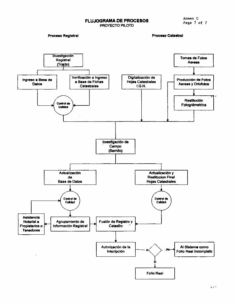
FLUJOGRAMA DE PROCESOS Annex CPROYECTO PILOTO Page 7 of 7
Proceso Registral Proceso Catstral
Registrgalion Tomas de Fotos
(Trcto)Aereas
Ingreso Base doVerlficaci6n e Ingreso Digitallzaci6n doIngreso a Be lea Base do Fichas HoJas Catastrales Producci6n de Fotos
D toe Catastral ls I.G.N. l _ Aereas y Ortofotos
RestItucl6nFotborimetrica
Investgacl6n deCampo(Barrido)
Actualizacl6n I Actualkacion yde Restdtudion Final
.oBose de Datos Hoeas Catastrales
CorhsoAuorzal6 do Iaro Aldeeracm
d Cd;
Asistencia T INotarial a Agrupamiento d e_Fuslon de Regkstro y4
Propietarios o Inforrnaci6n Registral CatasiroTenedores
IAutorizacion de la ' Al Slstema omo Inscripcion '<\ Folio Real Incomrpleto
Folio Real

EL SALVADOR Annex Cl
LAND ADMINISTRATION PROJECT
Data for Experimental Phase
Region (in) h Nuhber ofj With- WKhoWa_Region l;_Area_(m__ ______a (Ra)l | RaI
Santa Catarina Masahuat |Urban 0-100 1 35 18 17
100-200 . 134 70 64200-300 114 84 30300-400 66 46 20400-500 49 41 8500-600 20 13 7600-700: 26 21 5700-800 I 9 6 3800-900: 10 6 4
900-1000l . 7 4 31000-20001 14 8 62000-3000! 1 9 5 4
<3000! 6 0 6TOTALJ....... ___ 1 ____7
Rural - ° 3 1085 645 4403-5 35 281 7
5-10 32 25 7_ 10-200 60 60 0
TOTAL_ ,_ _2121 mlSanto Domingo de Guzman
Urban 100-200 67 31 36200-300 53 21 32300-400 43 18 25400-500 0. 4 8 12500-2000 21 16 5600- 7'M 16 8 8700-800 X 15 5 10800-900 .4 1 3
900-1000 :...4 3 11000-2000 -.... 21 12 92000-30C0 13 10 3
TOTALI 2" 7___ 7777__Rural 0-3 586 320 268
3-5 132 86 461 5-10 53 40 13
* *~=.==..= 10-200 79 7 0TOTi I 0I SE41

Annex C2Page 1 of 8
EL SALVADOR
LAND ADMINISTRATION PROJECT
Pilot Program Plan and Chronogram

PlAN PIELIn[uAR YCRONGWIA DE ACTIVIDADES PLAN PIL0NIIECIO: M DE 1995
Cronogauma de actvdaca 2 3 4 5 a 7 a OtlOfti 121 1 12 3 4 5 678 to 10 11 12il preparaci6n de fologtda aemes2 cdocacr6n de puno ode oontrd - aes twb w-3 levantanienlo y cMci o de punlas de control utbsnos I4 fologralna s tea5 procesamnbo de ptculas6 verNlwic¢Tn de calidal* _ 17 iangLacl6n asoea8 Identillcca6n/levantaniento/cAkulo do puntc de
control aeas rutaks9 alustb de boques 10 mpllmi6n deolotogrAas areas rundes _ [I I producci6n do resVIItclones utbanas12 produccidnde olos__21 crepiaci6n do ttormcI6n exislents22 irvestigaciones 9i e ternno_23 lXvanlamlento terrsre de Iniles24 producclbn de maps calastrabs dgllaHzados25 Droduccidn de b bale do dulos alanumdicos26 produccldn de bhnws de kvsllgaclIn31 Dreoaraci6n de inloonacidn edslente32 ccmparac6n deo maas calastrales con .do,_s
reslitdldj33 identicacion etrresv/oollecckin de inlrdomci6n34 bevantarnento do Wiles35 producci6n de la bee de dabs allanurnwr_co;36 producci6n do ani catsrates|r37 producci6n de Inlotnes/msullados de invesligadones |_;51 diseo de un plan isrm una nueva organtzaci6n
de nmentuntrnbnb |52 esblocikninrto deo nmaeva oe||izac_6n de
manbe.inl nto53 dbeto de un nusv{isbtef tcabsbrlaukonlzad ii54 desmrrolo, ensayi aprobacl6n del nuvo sisbleo U i | | 55 enttaga del nuevo ibtrma catasiral56 .,PiereelaciIn

Annex C2Page 3 of 8
Actividad.s do Produccift
NOT& No hay ngmemr 13-20. 28-30 y 38-S0.
JL Preparacift de un plan de fotngrafa Ai=aProduccin de un plan de vuelo, plmnificaci6n de posicifn de punto. do control en el terreno.(ver la parte de KLM Acocar)
L Colocaci6n de DuMntos de controlEstablecimio de pum. de control ean 1 tarono ptm la fotograZa aim. Puntos de controlserin colocados an. del vuelo ilcamcru en lu areas urban, siryesido la fuografla aimde scala l: 4000. Pam la fotografla do 1:20,000 los putoa de control satin idaficadosdesde los fotos. Eat actividad micame so reflmor as al aizmcl6n en .l cao - no,dlevantamento de los punts mismos, por quo la acividad tia quc sor tan corto en el tiempoquo posible.Locaci6n de la actividad; an todo .l depanamanto, airodoor do los 16 arear pam la fotograffade 1: 4,000.(var ls pan de KLM Aerocarto)
Levanamiento I calculo de 2ro de controlCoordenada do los puntos do conmol deberin se conocidos a tra de lde aiomo . Seoeajcutado con tanologJa GPS. Esto acdvdad debe soa ejecucado awn del ajuse do bloques.Locaci6n: levantamiento on todo el Damm cOiuos: a detwminar.(ver Ia parts de KLM Aerocao)
£ FotoQZaU ALImplemeontacif de la fotogfla.Antosdel ampi.zo de Isa porada de lluvia( abril - ayo 199S). ionerode tipo decamera. pelicula, esoa de fotogafa. ec.L4cwi6n de ls ectividad: todo .1 Dp(ver la parte de KLM Aecarto)
1L h:mi~mQLI sJdl1gjlaVa sor bhcho en E1 Salvador.(ver la parte de KLM Arocaro)
L Control t6cnieo v mili..r
Cotrol de la calldad de la fotogmfla y control militarLocaci6n: El Salvador(ver la parto do KLM Amrt o)
Inmediawmnem despuis de la fotograffa a6r la triangulacifn a6rea podri arrancarse. Lascoordenadas de los punros de control dobezin conocorm despud do a trngulacion 6eo yantes del ajusto de bloques.(ver la parts de KLM Aerocao)

Annex C2Page 4 of 8
.. .s
A. R1 levantamlent de los punLos de cgntrol en el area rural, sirviondo 1 20.000 fotoerraffa ninav el calculo de los coordenad=(ver la parte de KLM Acrocarto)
9. BE ajuste de bloques a la actividad ultiuma en el procodtminho fotogrametico awes quo clmapeopuede empezrse. (resdtuciones o producci6n de orrofotos)LacaMn de la actividad: Holanda.(ver la parte de KLM Asrocarto)
10. Prodtcc6n dMfladones fatog cgs na los areas rumba.Identficaci6n do Ilndzes se huuin an los fatog por imnpeccif en ol campo, pam finoscatlaes. Pan east. fse dl rabajo no .s ccaario dc toner dspoolblos ortofotos..Locac6n do la acdvidad: Holanda.(vet la parts de KLM Arocarto)
I,ocac6n de las acividade: Holanda y El Salvador: Alpnos do s imumo anilogos dWION ain convertidos hacia instrumns do tipo digital. Duram1 e proceco de produci6nde In ruttulories oste capcidad de producci6n act usado.. depqndom del progruesopimamme sai usdo de manara experinal y mas tarde poublemeto pam la producci6n
(ver la pam do KLM Acrocarw)
12. Noduel6n de Lou GE Ram IDALocaCl6n de It aividad: Holands(vew Ia parti de KLM Aerocato)
21. de la infoMMW6n existente ants da e eu ocmo defican en al ta
Rsdo deo:- wapas catules- informac6n camsral (ficha camtms)- idrmw del regtro pfiblico- infornucln del Folo Roil.Luge de la actividad: oficina de los cunsultores en la capi
22. 1 n en el La=- Idontificacif do Jos lmitos- rwcolecci6n de a informaci6n alfanum6fica de las parcelm, propiedades, tubos, etc.- decisione sobrm aquelos lnmites que no se dilstipg en 1 focogmfa y quo tiemn quo sa
dofinidos an el terrenoLug do la actividad: todo el deran
'23. Lsvantanlonw diffital de los lfmitea auo no to di tnguen en lam fotoraffSe rflers a los limitt de l parcela rurale qut no se detea en lm oros; la cantdad sriprobablmeo muy limicadlaSe reflae tambls a In pequelimAmas residencies rules. que cambiun conuisten depeques parcWla.

Annex C2Page 5 of 8
Lugar de la actividad: todo el depanmo.
24. Produccifn del mapa catastral automatizado. con lfmiltes v nimeros relaclonados con Ia basede daos alfanumrricosLugar de la aividad: oficina de los consulcomes en la caphaVSosonaco.
25. Producci6n do la 2arte alfanum6rica dc la base dc datos: el Polio Real automatizadoLugar de la actividad: oficina de los consultores en la capital/Sonsow.
26. Produccidn de los informes de los estdiosPars cada parcobl so producirS un documemuxo, quo condone coda Ia infornacifn recolectadaen el tabajo de campo sobre las parcelsu. durantel prceso de atudio, levantamzio, etc.Lugar de la actividad: oficina de los consultoros en la capital/Sonsonate.
27. Entren deol Mits a basg de d= tosla iinuva entidaLd camtascade regiatr de dearruJA. r i LE CAibLjIUl
a acividad puedc umpozar imn ediae despu del inicio del proycto.Lugar de la actividad: oficina do los consultors en la capital/Sonsonate.
32. CgM2arcJ6n de los m catastrales existntes con las rettuciones f_to MMdrcaEste proceso de comparacifn generar& la infornii6n, relaclonada a continuaci6n, antes do quocmpic s actividados de campo:
indicaciones de bs lu doode los lInmtes existentes catstruics no coinciden exacumenocon las linass topogrficu, pero en donde la diferencia es pequafa.
- indicaciones sobro las pamels cuyos lfmites no pudion scr mapados en la fotogrametrfa.- indicaciones de las areas donde los limit. catastrales y la topogrffa claramente no
corresponden, lo que pu¢dc significar que pueden esperarse problemas sobre los limitecdo las propiedadsdapondiewto do la situaci6n t6cica actual, so pueen dtgitalizar pate do los mascasasales o los mapas cawsales mnteros. y ser introducidos on la nueva baso do datos.Lugr de la activiad: oficina do lot consahorus an la capltallSonsonato.
33. Idendficaci6n del terreno. recolecc*6n de infoMaciftLugr do la actividad: todo el doparumenwo.
34. Eabieclmiento de los imites de las nacelasLugar do la actividad: todo el dep o.
35. Producci6n de 1 base de datos alfaln icou (Polio ReaalLugar de la acividad: todo el daparmmnz.
36. Producci6n de los manas catastrals dIJliLUzadoLugar de la actividad: todo el departamnmo.
nmr-cso de trabawo dg camnto (invesrEgAci6n an el teario- ley n=anenros- atc')

* ii

Annex C2Page 7 of 8
Diagram relaional de actividades
preparac!6n dofotograafa aersa (1)
M,7u do puntos doM, =-. - areas urbanos (2)
Wlvantamiento y fotograffa aea (4)ci6culo de puntos l _ _ _
de control procelanenwourbanos (3) do pelIculas (5)
Iverificaci6n do1~~~~~~~~~~caildad (6)__ _ _ _ _ _ _ _
triangulacl6n |identficaci6nplevanta-aerea (7) miento/cilculo de
puntos de controlareas ruralso (8)
r~~~- I. I.
-,. aJuste de bloques (9) -- ampIlaci6n de[ t~ 7s I-T:L-7j-T T M
produccl6n do resti- producci6n detuc=on_s urbanas (1 1) ortofoto's (12)

Annex C2Page 8 of 8
Dagrma relaci de acdvid us- ..
proparacl6n de infor- ampi an de fotogrm-maci6n xlnomnb (21) ff. aras rural.s (10)
I lgaones eprod n deIdawrolo, ensayo y *I tbrreno (22) | (12)
obaci6n dolnuvo sisema
t.rrosbe do llmb. (23)
produool6n d. la prodwol6n debs de dalb mapa calsetaalfanumerloos (25) i digSllado (24)
prosuedo6n do mrUoamde Invulgacn a28d)\
ontoga de Ia base dedato haola la nuov*nddad _aiwV (M)

ANNEX C3
EL SALVADOR
LAND ADMINISTRATION PROJECT
Pilot Project vs. National Project
Pilot Project National ProjectTotal Cost US$8.5 million US$70 milionBank Financin,g US$5.6 million US$50 milionDepartme Sonsonate Rest of theCountryNo. of Municipalities 16 246Area to regularze 122,600 ha 1,900,000 haNo. of parcels 160,000 to 200,000 1,600,000 to 1,800,000Land Information System Establish the new automated Expand the LIS to the rest of the
registration system country, with regional a centralback up and 3 regional back-upsystems in the Central and 3regional offices, for securityreasons.
COMPI e 30 190 (estimate)Legal framework adequacy within present legal framework,
law established the requirementto move from folio personal tofolio real (San Salvador Registryared onfolio real)
Legal Framework changes Oblige notaries to register Legislative change approved.required transactions
Simplify procedures to fonnalizenewfolios reales fromPresidential Decree to CNRAdministrative Decision
Problem cases Preventive annotations wil be Streamline requirements tomade onfolios reales facilitate resolution of problem
cases, minimizing use ofpreventive annotations.
Institutional Framework Framework allowed project Strengthen CNR as autonomousactivities but, to streamline the agency.process the Legislature hasapproved the transfer ofconstitutive agencies (Registry,RSI and IGN) to CNR
CNR Decentralization Sonsonate Registry and IGN Current 10 Registry Offices andoffices have been merged; 11 IGN offices wil be mergedrevamped office holds all into 1 Central Office (SanSonsonate records Salvador) and 3 regional offices.
52 municipal consultation officeswill be opened.

Annex C4EL SALVADOR LAND ADMNISrRATioN PROJCr
IMPLEMENTATION INDICATORS
0WART iN S OCEM ' JUE 1inSON9ONATE OIKAL
MAPPING o50 100Map Production (urban) Km2 1 177 40 100Orthophoto map production (rural) Km2
LAND RECORD REGULAIZATIONInfbrmation campaignNumber of radio announcements (spots) 9,536 25 90 100Press announcements 192 25 90 100Flold InvestIgatIon (barrido)Km2 investigated urban 50 20 55 100Km2 investigated rural 1,177 20 55 100Training Notarios de Campo (person weeks) 10 100Field Teams so 100ALTERNATiVE CONFLICT RESOLUTiONTraining Notaries and Legal Tutorial (6 notaties) 10 50 100(person weeks)Information radio campaign (tutorial) spots 6,556 15 50 100Press Announcements 120 15 50 100INSTITUTIONAL STRENG3THENING3TrainingCNR/UEP: International Training (person weeks) 267 50 100CNR/UEP: Local Training (person weeks) 30 40 100INSTITUTIONAL DECENTRALZATiONRegional and Municipal OfficesRegional offices established (number) 1 100Municipal offices established (number) 5 100Communications systemsRegional offices connected (number) 1 100Municipal offices connected (number) 5 100TrainingRegional users trained (person weeks) 10 100Municipal users trained (person weeks) 45 100ADMINISTRATIONProcurement (Committed)Intemational bidding complete (US$S000) 5470.1 100Local bidding complete (US$S000) 450.5 s0 100Intemational Deliverables (US$'000) 77.3 100Local Deliverables (USS'000) 648.0 90 100ConsultanciesIntemational (person months) 26 40 70 100Local (person months) 421 32 70 100

Annex D: Land Data Acquisition Component
* DI Mapping - TORo D2 Field Work - TORo D3 Registry Teams - TOR

Annex DPage 1 of 7
EL SALVADOR
LAND ADMINISTRATION PROJECT
LAND DATA ACQUISITION COMPONENT
1. This Annex describes the objectives, activities, and management of the land dataacquisition component. The design of this component imbeds the lessons learned of thepilot project for the land administration project, financed under the Agricultural SectorReform and Investment Loan (3576-ES), described in Annex C.
Objectives
2. The objectives of the component is to regularize land registration for El Salvador'srural and urban land. The newly established parcel-based land records will become theonly official land registry in El Salvador. These records will be installed in the landinformation system and registration methodologies being established under the pilotdescribed in Annex C.
National Program
3. Component activities would be national, except for Sonsonate. The table belowindicates areas to be covered.
Table 1: Department Areas (kMn2)
;aA4uM.wAipuI, 886 171 19
jI:ISilWA' *.756 146 16
IAlAUuR1 * 1653 318 22
i~YAt4Y!3.MIPP 1928 370 33
tAWTAANAi .... . ... ' ^ * : 1954 376 13
iAJIEI4AV4f2WUUA4 1240 239 12
I.|)PA3^l :-: 1224 236 22
j!AIIAIA3 1104 213 9
10745 2069 146
2077 400 201286 243 26
I'h ; * m;> * 1961 378 18
1184 228 13
*--y ; 2130 410 23
8638 1659 100
fO4Ej *<-^ 19383 3728 246
j "dIRuui~b~ru 1226 236 16
Source: IGN

Annex DPage 2 of 7
Technical Aspects
4. This section provides the bases for the technical recommendations included inproject design, including draft terms of reference. The sections are (a) activitiesprogramming; (b) mapping; and (c) land registry system and automated land informationsystem (LIS).
5. Activities Programming. Project activities are divided into three aspects:barrido, ampliaci6n, and institutional strengthening. The barrido is the landregularization; ampliacion is the coverage of all boundary changes by the RSI; andinstitutional development is the CNR evolution necessary to integrate the barrido into theLIS and keep it up to date. The land data acquisition component deals with the barrido,the institutional strengthening and decentralization component with the ampliaci6n andCNR strengthening, and the project administration component with the management of theentire process.
6. The barrido would take place in two large phases, covering two zones everyphase. The two zones in the first phase are the Central (San Salvador, La Libertad,Cuscatlan) and Western (Ahuachapan, Chalatenango, Santa Ana, and Sonsonate). The twozones in the second phase are the Northern (San Miguel, Cabarias, and San Vicente) andEastern (Morazan, La Union, Usulutan). The phasing was decided on the bases ofrequired number of field verification teams, so that the same number (115) was requiredfor each phase. Requirement was based on number of orthoimages and percentage ofurban area in each region, difficulty of the fieldwork (with urban and noncadastrednorthern border areas considered most difficult), and road network facilities for logisticpurposes (i.e., team drop-off and pickup, lodging proximity).
7. The amplfaci6n is not directly supported by the project. It is a self-financedactivity of the RSI. It creates in parallel, and in areas not yet covered by the barrido,updated land records with legal and physical information for small perimeters that involvedboundary changes. These small perimeters need not be revisited during the barrido. Thesmall-scale handling by RSI of these boundary changes and fragmentations in an integratedlegal/cadastral manner creates experience in the institution to prepare it for the massiveverification/registration process of files established under the barrido.
8. Institutional strengthening has started under the pilot phase financed under PRISA.The international firm hired to conduct the technical activities of the pilot phase will alsodesign the automated land information system (LIS) required by the Salvadoranregistration process. The firm will also conduct the institutional study to consolidate theCNR. These tasks are programmed to be completed prior to entering the massiveSonsonate barrido data into the LIS in late 1996 or early 1997.
9. Mapping. This task is the framework of the land register, which allows thelocalization of the parcel rights. The task is complex and will require close supervision by

Annex DPage 3 of 7
project management. Moreover, the terms of reference in Annex DI can be improved inlight of the experience in the pilot Sonsonate phase financed under PRISA (Loan 3576-ES). The CNR is aware that it is critical to realize the aerophotogrammetry as soon aspossible, at best no later than the 1996 rainy season (May to November).
10. By mid-1995, IGN has published official and detailed technical specifications forall the topographic and cartographic works. The layout of the maps will be the same asthose already produced by IGN. As per IGN estimates, aerial photographs will need to beproduced at scale 1:20000 (19200 kn2) for 1:5000 in rural areas and 1:2000 maps-production (orthoimages)-and at scale 1:4000 (400 km2) for 1:1000 maps production inurban areas. The flight will carry a global positioning system (GPS) on board because it isfundamental for at least the small scale (1:20000); it is particularly needed to avoidsystematic placement of control points to determine field coordinates. Theaerotriangulation phase is the best way to evaluate the ground control quality andtherefore the success of the tasks cited in the next four paragraphs.
11. For rural areas, orthoimage production would be used to produce raster images,but the final production will be made within vector format. IGN will be able to participatein this production mainly for the maps at scale 1:2000.
12. For urban areas, the stereoplotting production would be used to produce contourimages. IGN would be able to participate in this production. The difficulty will be to adopta realistic density of details to assure the best identification of the properties and buildings.
13. Next, the process to integrate topographic complementary survey data into thedigital data has to be put in place. Particular attention, control, and coordination must beassigned to this task in respect to the time schedule and the quality of the result.
14. For map production, IGN needs to develop a typology of expected maps withcodes for volumes that reflect the de facto situation in objects on parcels on cadastralmaps, including physical volumes representable in the aerial photography. Altimetry is notneeded for cadastral purposes. No additional training is needed for this task.
15. Mapping Equipment. The project would procure mapping equipment to conforma single mapping production unit at IGN. This unit would be sufficient for land recordsmaintenance works required after the barrido. This equipment will allow IGN toparticipate efficiently in the project without creating excess capacity for the future (seeTable 3).
16. The recommended equipment consists of (a) stereoscopes and small topographicequipment for field identification teams; (b) theodolites and GPS for topographic surveyorteams (topographic complementary survey and ground control); (c) a modem laboratoryto develop the b/w photographs from photogrammetric data; and (d) restitutionequipment, including one basic system to make orthoimages (raster rectified images for

Annex DPage 4 of 7
rural area) and to introduce the complementary survey results and one analyticalstereoplotter to produce contour images for urban areas and DTM (digital terrain model).
Table 2: Mapping-Estimated Costs (colones)
Om Itb If U1*lt GM C SUb tlbt TotalMa n TOTALF - - _1 _ _ 1_
AERIAL PHOTO _ r_ _
Aerial photography Ikm2) _ _ _ ___
1:20000 19,200 190 3,648,000 _ 1
1:4000 400 4,800 1,920,000
mob/demob 1 700,000 700,000 r _
TOTAL 7 | _ 6,268,000 _
Photo production (kMM2' _ _ 1
1:20000 19,200 40 768,000 ____ ____
1:4000 4001 200 80,000 _ 1
TOTAL 848.000 1
TOTAL AAL PHOTO - 7.116.000RESTITUTION
Ground control (points) _
1:20000 j 300 10,000 3,000,000
1:4000 1,600 6,000 9,600,000
TOTAL 1 _ 12,600,000
Aerotriangulation (models)1:20000 4,600 1,000 4,600,000
1:4000 2,000 1,000 2,000,000
TOTAL 6,600,000Ortholmages (images)
Scanning 4,600 1,000 4,600,000
Images rectification 1:5000 2,300 4,500 10,350,000
DTM production 2,300 1,000 2,300,000
Plotting at 1:5000 2,300 500 1,150,000
Image rectification 1:2000 230 3,000 690,000
Completion transfer 2,530 700 1,771,000
Plotting at 1:2000 230 1,000 230,000
TOTAL 21,091,000
Stereoplotting (km2 ) _
Stereoplotting 400 45,000 18,000,000
Completion 400 6,000 2,400,000
Completion transfer 400 2,000 800,000
Edition 400 4,000 1,600,000
TOTAL RESTITUTION 22,800.000
WEAL PMW - .. ...... -- -_ _____--J 63.091,000

Annex DPage 5 of 7
17. The number of the vehicles (50) is calculated and optimized for 115 fieldphotoidentification teams and 10 topographic complementary survey teams.
18. Land Registry System. The Government is implementing an action plan toconsolidate the CNR (see Annex BI). An important element is the design of the landregistry system, and the coding of this system into the automated land information system(LIS). This registry system must reflect the documentation flow required by Salvadoranlegislation and custom. The system must be designed and in place to process the parcel-based files that will be generated by the Sonsonate barrido.
Automated Land Information System
19. As explained above, the land information system (LIS) must be designed andimplemented to receive the files from the Sonsonate barrido under the pilot project. Underthe proposed national project, the government will adjust the LIS to a national systeminstalled in a network constituted by a central office in San Salvador and 3 regional offices,with reading access to 52 municipal consultation stations. This network requires a study ofthe appropriate data transfer technology, including cost, security, and trainingconsiderations.
20. Consequently, the national project will be dedicated to the effective generalizationof procedures as validated through the pilot project. This generalization will also bevalidated at the moment the national project starts up.
21. The pilot project ought to
(a) define information technology procedures that would assure recording in asingle file by lot of all topographical and legal information concerning theparticular lot and would assure their actualization and extraction; and
(b) train personnel in the new procedures.
22. As defined in the pilot project, the procedures should permit the management of allthe data for the entire national project. The structure for the information technology willrepresent an unique national configuration; it should permit:
(a) file reading
* from the information identifying the owner, and* from the topographic data (lot); and
(b) use of public terminals to transfer, but not modify, information betweenregional centers and between regional centers and the national center.

Annex DPage 6 of 7
23. Combination of Information. After the fieldwork, including the complementarysurvey, the mapping system will contain all the numerical topographical data with theboundaries. This digitalized system will be given to the confrontador.
24. The confronfador, under this system,
(a) attributes a new cadastral number to each lot;
(b) opens a corresponding folio real;
(c) inscribes the rights concerning the lot, as well as the origin of these rights;and
(d) creates new digitalized information by combining all the topographical andlegal information (this step constitutes the provisionalfolio real).
25. If necessary, the registrador would modify the provisional folio real or make itdefinitive by validation.
W:\SVULANWAR\YC(XD)LDADOC

EL SALVADORLAND ADMINISTRATION PROJECT
Table 3: Recommended Equipment for IGN
Item Q Unit cost(C) Total
Supplementary field equipment
Pocket stereoscopes 25 1,760 44,000Mirrors stereoscopes 4 25,000 100,000
~~~~~~~~~~~~~~~~~~~~~~~~.............. ................... ,,,,,.
GPSDual-frequency receivers (1 cm + 1 ppm) with geodetic and battery options 3 380,000 1,140,000
Mono-frequency receiver (2cm + 2ppm) with antenna kit and battery options 3 180,000 540,000
............................................................... | ,.,., 0~~~~~~~~~~~~~~~~~~~~~~~~~~~~~~~~~~~~~~~~~~~~~~.. . . .--
TheodolitesTotal station( 0,2mgr-5mm + 3ppm- accessories). 2 280,000 560,000
Total station (2mgr-5mm + 3ppm-accessories). 10 165,000 1,650,000
-: .ER -- ,,,,,,,,, "' 'te 'te . S '=.i.t. .. ' 'i't Sll: _ M~~~~~~~~~~~~~~~~~~~~.. . .. .. .. .. .... .12
Photogrammetric production unit
1. Analytical stereoplotting equipment with data acquisition system compatible with the CNR software and the 1 1,650,000 1,650,000orthoimage production system. Aerotriangulation and DTM production software. Output with Ethernet-TCP/IP. __________________ ______... ....2. Orthoimage production system with vectorisation rnodule and including: Workstation operating system 1UNIX, X-Windows, X-Motif. (32 MB RAM, 2 GB disk drives(minimum). Ethernet-TCP/IP. 17" color monitor1152x960 pixels. CD ROM and streamer device. Digitizer AO. Scanner 400 dpi (minimum). Inkjet, thermic (orothers) vector/raster plotter AO compatible with the system (option for 1 500 dpi resolution). Output will be 1,600,000 1,600,000compatible with CNR system. Software radiometric preprocessing, geometrics rectification (projections), dataand system management, DTM processing, rectification, mosaicking and vectorisation process. (Option forradiometric analysis).tPower supply equipment for above equipment for above items. 1 50,000 50,000
Laboratory equipment for processing b/w aerial photographs 1 1,070,000 1,070,000
TOTAL EQUIPMENT FOR IGN =8,404,000
2 xcvo
0_

Annex DlPage I of 3
EL SALVADORLAND ADMMIISTRATION PROJECT
SUMMARY TERM OF REFERENCE FOR MAPPING
1. Prior to all phases of project execution described below, the consultant willprovide a Quality Control Plan. The results will comply with the National GeographicInstitute norms.
Aerial Photography
2. Standard quality rules for photography shall apply along with recommendationsthat take into account the characteristics of the works to be undertaken in El Salvador.Photography will be programmed according to favorable meteorological periods. Flightand photography permits should be obtained with the least delay and taking into accountalso any other formalities, including those of bordering countries.
3. Two photography takings have been determined in order to minimize field costs,obtain maximum profit from the availability of the plane and to permit the most flexibilityfor the works that foliow.
4. Scale: 1/20,000 with a 150mm focus and a signal compensation margin. This scalewill be maintained to cover the entire territory with the exception of the areaphotographed in the Pilot Project. This scale will permit also the restitution in 1/5,000 and1/2,000 scales for those complex zones requiring it.
5. Photography of urban areas will not be required since they will be affected by a1/4,000 coverage. It provides no significant savings and may create '#aps." Small scalecoverage over the urban centers (for example, San Salvador) can be used for restitutionfor ordering. It would be best suited for defining zones to be included in larger scale.
6. Particular care should be taken to define flight plans, taking into account reliefs soas not to create major differences in scales and to ensure stereoscopy. In order tomaximize the trajectory and the number of photographs, flights will be oriented, a priori,from East to West. Black and white photographs will be developed, unless an option forcolor photography is included in the contract bid. Color orthoimages must be anticipated.Photographs will be realized with an onboard GPS. The consultant will develop the aerialphotographs in cases offorce majeure to ensure immediate quality control.
7. It is estimated that the number of photographs taken will be: of 20,000km2/S.2km2
by pair, equaling 3,846 pairs. For a safety margin, an additional 20% will be added for atotal of 4,600 pairs.
8. The scale will be 1/4,000 with a focus of 150mm or 300mm for the moreimportant locations that require it (building heights, street widths). This scale will be

Annex DlPage 2 of 3
applied to cover the more important urban zones that will be restituted at a scale of1/1,000. Flight plans will depend on the locations and the reliefs founds. Delimitationusing SPOT images could offer a degree of certainty. These photographs would be blackand white for later restitution. The onboard GPS will be used and the labwork will beundertaken in El Salvador.
9. Developed Photographs. The consultant will develop the aerial photographs in ElSalvador according to specifications and given standards. No enlargements are requiredcurrently, however, the option for scanning will be available so as to provide quality paperprints with the scales required to complete field research. Aerial photography flights shalluse existing maps of El Salvador (1:50,000 and 1:15,0000). All developed photographsshall be deposited with the IGN. El Salvador shall be the sole proprietor of thephotographs.
Stereopreparation and Aerial Triangulation
10. Stereopreparation of the photographs scaled 1/20,000 will be done using the GPSmethod. Predemarcation is not mandatory since it may delay aerial photography. Precisionshould be compatible with the final products. Each point will be determined with aprecision of 5 cm in order to guarantee the 1/2,000 scale. The estimated number of pointsis 250. The flight plans will permit a better approximation. The existing geodesic networkmust be analyzed for eventual use of actual points and its integration into the GPSnetwork.
11. Stereopreparation of the photographs scaled 1/4,000 will be done also using theGPS with a precision of 2 cm. Predemarcation is highly recommended. The number ofpoints will depend on the flights, with determinations at the ends of each band.
12. The results will be in the coordinate system for El Salvador (Lambert, Clarkeellipsoidal 1880) that will used in the restitution tasks. At the least, the consultant shouldprovide these coordinates in the UTM and WGS systems.
13. Leveling will use the current network after a quality analysis of the pointsaccording to the conventional methods used.
14. The preceding tasks will be undertaken in close collaboration with IGN. AU theGPS points should be tumuli and will be included in the demarcation fiches according toIGN standards. All the observations and calculations will be presented to the CNR. ElSalvador shall be the sole proprietor.
15. Aerial triangulation shall be done in homogenous blocks and according to theprogramming of the restitution works. The results will demonstrate the compensationresidues that should be compatible with specific data sought in the final documents. Thiscontrol will permit validating the stereopreparation operations. As mentioned earlier, the

Annex DlPage 3 of 3
results will be provided in the different systems and El Salvador shall be the soleproprietor.
Restitution
16. The actual cadastre record shall be maintained according to the entire topographicplates. A coding system compatible with the general computing of the national plan shouldbe adopted in agreement with the CNR.
17. Rural Areas. The scale for rural areas is 1/5,000. For the majority, the scale of1/5,000 will be adopted and photographic production will be through orthoimaging (ornumeric orthophotoplans). Aerial photographs should be scan with a resolution of 25mmthat would permit having a resolution compatible with scales from 1/5,000 to 1/20,000.With these characteristics, isolated details should be identified from 5 to 6 cm off theground. The contrast of the pixels will provide better definition of linear details (streets,fencing). In this phase of production, the consultant will provide a first edition scaled to1/5,000 for photoidentification. This provisional hard copy could be avoided if goodcoordination permits photoidentification immediately after the production of orthoimages.Rectifying orthoimages will be done by individual pixel after the orthoimages are traced inthe coordinate references for the given projection of the aerial triangulation points. Inorder to achieve this rectification, it will be necessary to know the field numeric modelwith precision compatible with data for curves at an equidistant level of 5 meters. Theconsultant may use existing maps for a large part of the territory. It would be convenient,however, verifying the quality of this information beforehand. If there are any doubts, itwould be convenient to re-form a numeric model by automatic correlation from the newaerial coverage. A mosaic of the images will be done automatically.
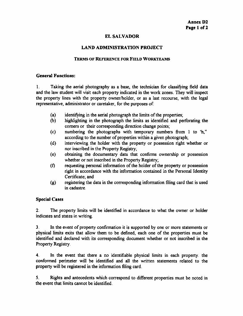
Annex D2Page 1 of 2
EL SALVADOR
LAND ADMINISTRATION PROJECT
TERMS OF REFERENCE FOR FIELD WORKrEAMS
General Functions:
1. Taking the aerial photography as a base, the technician for classifying field dataand the law student will visit each property indicated in the work zones. They will inspectthe property lines with the property owner/holder, or as a last recourse, with the legalrepresentative, administrator or caretaker, for the purposes of:
(a) identifying in the aerial photograph the limits of the properties;(b) highlighting in the photograph the limits as identified and perforating the
comers or their corresponding direction change points;(c) numbering the photographs with temporary numbers from 1 to 'h,"
according to the number of properties within a given photograph;(d) interviewing the holder with the property or possession right whether or
nor inscribed in the Property Registry;(e) obtaining the documentary data that confimns ownership or possession
whether or not inscribed in the Property Registry;(f) requesting personal information of the holder of the property or possession
right in accordance with the information contained in the Personal IdentityCertificate; and
(g) registering the data in the corresponding information filing card that is usedin cadastre.
Special Cases
2. The property limits will be identified in accordance to what the owner or holderindicates and states in writing.
3. In the event of property confirmation it is supported by one or more statements orphysical limits exits that allow them to be defined, each one of the properties must beidentified and declared with its corresponding document whether or not inscribed in theProperty Registry.
4. In the event that there a no identifiable physical limits in each property. theconformed perimeter will be identified and all the written statements related to theproperty will be registered in the information filing card.
5. Rights and antecedents which correspond to different properties must be noted inthe event that limits cannot be identified.

Annex D2Page 2 of 2
6. If a property owner or holder has sold one or more parts of the property, then:
(a) any information must be registered in accordance to paras. 2. and 3 if thelimits are defined in the aerial photograph; and
(b) if the new limits cannot be identified, the perimeter must be outlined in thephotograph; a numbered sketch of how the divisions are configured mustbe done and data from the owners or holders will be registered in theinformation filing card.

Annex D3Page 1 of 4
EL SALVADOR
LAND ADMINISTRATION PROJECT
TERMS OF REFERENCE FOR REGISTRY PERSONNEL
1. Objectives. The Ministry of Justice, through the Project Executing Unit forProperty Registry and Cadastre Services Improvement, seeks to revise, identify andactualize the registry of all properties in the Sonsonate Department with the aim offulfilling the Project and establishing the Computerized Folio Real Registry to substitutethe existing Personal Property Registry.
2. In order to obtain this goal, all the outstanding property records in the RealProperty and Mortgage Registry and the folio real as well as the records corresponding toencumbrances and gravamens found in the respective registry books must be selected.
3. To these ends, registry personnel will be contracted. The registry personnel willprovide the following services:
(a) Registry study of each record contained in the registry book and foliosreales that the Sonsonate Property and Mortgage Registry maintains;
(b) Digitization of all essential information that must be included in a record,whether it be mortgaged property, judgments, liens, outstandingprovisional notations, declaration of heirships and testaments (even whenthe transfer to the heirs has not been completed), usufruct, bare legal title,leasings, etc.
4. To accomplish these services, a minimum of 90 calendar days will be required fromthe date of contracted date. The contractor will be responsible for the digitization of allessential data for the outstanding records contained in all the registry books and foliosreales through the following procedures: (a) automatic system distribution of thecorresponding registry books to each analyst; (b) the analyst will study each assignedregistry book and determine, if possible, the outstanding nature of each record; (c) eachanalyst will be assigned an identification number for the digitization system in order toaccess it for capturing existing outstanding record data in each of the registry books; (d)each analyst will process the information contained in the registry books beginning withthe first registry book assigned.
5. For the transfer records without marginal annotations, the following data will bedigitized: (a) record number; (b) registry book number; (c) property number; (d) propertydata (antecedents, nature, location and area); (e) type of ownership act or contract; (f)price and payment (either cash or term); (g) method of transfer: simple sale, sellback;

Annex D3Page 2 of 4
homestead ties; (h) general information' about the seller and buyer; (i) contract date; ()record date; and (k) name of notary or officer.
6. For those records with marginal annotations, the following data will be digitized:(a) record number; (b) registry book number; (c) property number2; (d) property data(antecedents, nature, location and area); (e) type of ownership act or contract; (f) priceand payment (either cash or term); (g) general information about the seller and buyer; (h)type of marginal annotation: (i) partial or complete transfers; (ii) partial or completemortgages; (iii) liens; (iv) declaration of heirships; (v) leasings; (vi) judgments; (vii)rectifications; (viii) usufruct; (ix) actions for recovery; (x) filings; (xi) easements; (xii)others; (i) registry book number with the marginal annotation; 0) record number of themarginal annotation; (k) area (for partiaOly transferred or mortgaged properties andproperties with easements, etc.); (I) contract date; (m) record date; (n) name of notary orofficer.
7. In order to verify the succession of property in those records that have beentransferred to different ownership, the following data must be digitized: (a) record andregistry book number; (b) property data (antecedents and location); (c) type of ownershipact or contract; (d) general information about the seller and buyer; (e) inactive status ofthe record as inactive (in the event that this cannot be determined, al the data must beincluded as if it were a record in force and wait for the system to determine the recordstatus); and (f) transfer annotation.
8. In the event that a record has been repeated or replaced: (a) the recordingsequence must be sought; (b) all the data corresponding to the record must be entered as ifthe record were in force; (c) the repetition or replacement number must be digitized; (d)the margins must be annotated with a reference to the repetition number.
9. For repeated records, the folowing data must be digitized: (a) complete theantecedent number; (b) type of ownership act or contract. For cases involvingrectifications: (a) record number; (b) registry book number; (c) antecedent number; (d)type of ownership act or contract; (e) record date; (f) deed date; (g) name of notary orofficer.
10. In cases of gravamens or encumbrances affecting the property, the data from themortgage abstract or the encumbrance. This refers to aOl the marginal information found inthe record corresponding to the property. It is extremely important that the analyst takecare in relating each marginal annotation for the property.
11. In cases of gravamens, the following data must be digitized: (a) record number; (b)registry book number; (c) general information about the creditor/antichretic creditor; (d)general information about the debtor; (e) mortgagor; (f) mortgage amount, interest,
I Age, civil status, business.2 In the event that there is more than one property, the information must be digitized independenly (one
folio per property)
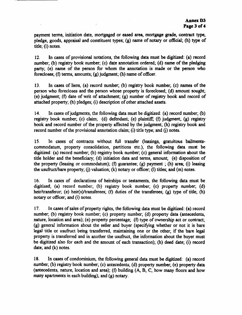
Annex D3Page 3 of 4
payment terms, initiation date, mortgaged or eased area, mortgage grade, contract type,pledge, goods, appraisal and constituent types; (g) name of notary or official; (h) type oftitle; (i) notes.
12. In cases of provisional notations, the following data must be digitized: (a) recordnumber; (b) registry book number; (c) date annotation ordered; (d) name of the pledgingparty; (e) name of the person for whom the annotation is made or the person whoforecloses; (f) terms, amounts; (g) judgment; (h) name of officer.
13. In cases of liens, (a) record number; (b) registry book number; (c) names of theperson who forecloses and the person whose property is foreclosed; (d) amount sought;(e) judgment; (f) date of writ of attachment; (g) number of registry book and record ofattached property; (h) pledges; (i) description of other attached assets.
14. In cases of judgments, the following data must be digitized: (a) record number; (b)registry book number; (c) claim; (d) defendant; (e) plaintiff (f) judgment; (g) registrybook and record number of the property affected by the judgment; (h) registry book andrecord number of the provisional annotation claim; (i) title type; and 0) notes.
15. In cases of contracts without full transfer (leasings, gratuitous bailments-commodatum, property consolidation, partitions etc.), the following data must bedigitized: (a) record number; (b) registry book number; (c) general information about thetitle holder and the beneficiary; (d) initiation data and terms, amount; (e) disposition ofthe property (leasing or commodatum); (f) guarantee; (g) payment ; (h) area; (i) leasingthe usufruct/bare property; (.) valuation; (k) notary or officer; (1) titles; and (m) notes.
16. In cases of declarations of heirships or testaments, the following data must bedigitized; (a) record number; (b) registry book number; (c) property number; (d)heir/transferor; (e) heir(s)/transferees; (f) duties of the transferees; (g) type of title; (h)notary or officer; and (i) notes.
17. In cases of sales of property rights, the following data must be digitized: (a) recordnumber; (b) registry book number; (c) property number; (d) property data (antecedents,nature, location and area); (e) property percentage; (f) type of ownership act or contract;(g) general information about the seller and buyer (specifying whether or not it is barelegal title or usufruct being transferred, maintaining one or the other; if the bare legalproperty is transferred and in another the usufruct, the information about the buyer mustbe digitized also for each and the amount of each transaction); (h) deed date; (i) recorddate; and (k) notes.
18. In cases of condominium, the following general data must be digitized: (a) recordnumber; (b) registry book number; (c) antecedents; (d) property number; (e) property data(antecedents, nature, location and area); (f) building (A, B, C, how many floors and howmany apartments in each building); and (g) notary.

Annex D3Page 4 of 4
19. In cases of easements, the following data must be digitized: (a) record number; (b)registry book number; (c) easement area; (d) type and description of easement; (e) registrybook and record number for servient and dominant tenement (may be various); (f) recorddate; (g) deed date; and (h) notary.
20. In cases of dependent properties, the following data must be digitized: (a) recordnumber; (b) registry book number; (c) antecedent number and tome; (d) property data(antecedents, nature, location, area, capacity (m 3 ), percentage); (e) type of ownership actor contract; (f) general information about the seller and buyer; (g) deed date; and (h)record date.
21. It is important to announce when a new registry applications are made. These mustbe recorded accordingly in their respective registry book and included in the data base. thedigitized entry would be placed inactive if all is completed, otherwise the remainder mustbe actualized. When the area of the property is not included in the recorded document inthe registry, the analyst must calculate the area of the property according to thedetermined formula. When it is not possible to determine area because of the descriptiongiven of the property, area may not be assigned.
22. The enumerated tasks must be realized also during the transition period from theold to the new registry.
23. Quality control. From the entries made the supervising registrars and theExecuting Unit will select randomly records that will be compared with the entries in theregistry books. If the digitized book contains wrong or missing information, or other erroror omission that could effect the digitization process, the book will be rejected. Thecontractors will review and correct immediately at their own cost.
24. Inputs to be provided by Executing Unit. The Executing unit will provide: (a)training for the registry personnel; (b) network computers; (c) data base with the requisiteinformation for data entry; and (d) access to the registry offices during the contract period,including Saturdays, Sundays and holidays.

Annex E: Project Administration Component
o El Quality Control Team - TOR* E2 Supervision Milestoneso E3 Procurement Plan* E4 Organigram for Executing Unit (UE)* E5 Summary of Design Alternatives Considered

ANNEX EPage 1 of 3
EL SALVADORLAND ADMINISTRATION PROJECT
Project Administration Component
1. This Annex provides details of the project administration component, includingmanagement of the project activities, projet supervision plan, the procurement plan, and theterms of reference for the quality control team.
Activities to be Financed
2. The project administration component (US$7.0 million) would finance theproject's management, including vehicles and equipment, technical assistance and training,and incremental recurrent costs. The project would finance the executing unit (UnidadEjecutora-UE), which was created to manage the pilot program under PRISA. The UEis within the CNR, which is managed by a council headed by the Minister of Justice. The UEhas proven to be extremely effective, but it will need strengthening to take on theproposed project.
3. The UE would be in charge of managing information campaigns andcommunications, auditing, and project reportingm, including monitoring and evaluation ofimplementation. A monitoring and evaluation system for the project was established underPRISA by the end of 1995.
4. Because of the national project's complexity, the UE would include a QualityControl Team with two main consultants in charge of technical implementation. Thecomplexity arises from the need to integrate and unify technical and legal procedures, aswell as manage dove-tailed operations in different locations and time frames. The qualitycontrol team would report to the head of the UE and be in charge of following up theimplementation of project activities by the consultant teams.
5. Most of the technical assistance and training to be provided under the project isrelated to skills not available in the government in sufficient depth or quantity.International technical assistance (i.e., photogrammetry, land information systems) is to beused mainly for developing system design and training local users. Local technicalassistance refers to skills in ample supply in the private sector (topographers, notaries) tocarry out outsourced volume services that will not increase the size of the public sector.Technical assistance will also backstop ad hoc studies to review project impact and CNReffectiveness. Funds would also be available for studies agreed with the Bank, translatingthe SAR and other project documents, for project evaluations and auditing, as well aspreparing other documentation relevant to the project.

ANNEX EPage 2 of 3
Activities to be Managed
6. Activities to be managed:
(a) Once the Sonsonate pilot phase is finished and the basic data is obtained, itwill be necessary to formulate modifications in the legal framework thatwill be the basis for modernization throughtout the country. Thisframework will be analyzed in terms of the applicable norms that may befound in the pilot phase and the recommendations from the expertsredesigning the registry system software (LIS).
(b) Subsequently, it will be necessary to contract firm for aerial photographyfor the entire country in accordance with the procedures and scalesdetermined through the Sonsonate Pilot Project. These firms will enlargeand restore the aerial photographs and eventually, the country will beprovided with the restoration equipment necessary for maintaining theregistry system nationwide.
(c) Once the aerial photographs are enlarged, local firms will photoidentifylots. These firms will also conduct the corresponding searches for the rightsthat the titleholders may possess. They will be also responsible for hiringnotaries for alternative conflict resolution and will report to the Justices ofthe Peace or other judges those conflicts that cannot be resolvedadministratively. Two teams would work simultaneously in order tocomplete these activities in the a reasonable amount of time. Accordingthe estimates, the firms shouls have at least 112 photoidentifiers at workthrough both phases of the project. An equal number of students will workalong with them as well as 15 notaries at each base operation city.
(d) Each one of the firms will coordinate its activities with a legal firm that willundertake the registry studies according to the specific Department inwhich modernization is taking place.
(e) Finally, the legal, graphic and field analyses will be placed in a singledocument to as to fulfill the transfers from the old to the new registrysystem.
(f) When the preceeding have been accomplished, the old registry offices andthe National Geographic Institute offices will become either regional ormunicipal offices in those Departments. There will be four departmentaloffices for the new Registry and Cadastre System. Subsequently, there willbe 52 presentation and consulting tables.

ANNEX EPage 3 of 3
Phasing of the regularization activities
7. The first phase groups two zones (see map in Annex Al). The first zone consistsof the La Libertad, San Salvador and Cuscatlan Departments. The Registry Office (FirstSection of the Center located in San Salvador) furnished registry services for theDepartments of San Salvador and Cuscatlan. The Departments of San Salvador and LaLibertad contain the highest urban populations for which they are known as 'Greater SanSalvador." This would define with greater precision those aspects related to municipallimits. The execution of this phase will begin in mid-1996 and completed in at thebeginning of the year 2000.
8. The first phase also includes the Western Zone, consisting of the Santa Ana,Chalatenango, Ahuachapan and Sonsonate Departments. The first two are undergoingdelimitation with Honduras. The execution of the first phase for these departments willbegin in mid-1996 and be completed at the end of 1999.
9. The second phase also consists of two zones. The first zone comprises the SanMiguel, Morazan and La Uni6n Departments. The Registry Office (First Western Sectionlocated in San Miguel City) provides registry services for all three departments, which willfacilitate recompiling primary registry data. Two of the Departments are undergoing alsodelimitation with Honduras. The execution of this phase will begin in early 1998 and becompleted in early 2001.
10. The second phase also includes the Eastern Zone. It consists of the La Paz,Usulutan, Cabafias and San Vicente Departments. The Registry Office (Second Sectionlocated in San Vicente City) provides services to the latter two. The execution of thisphase will begin in mid- 1999 and be completed at the end of the year 2000.
Organization
11. The attached charts show the composition of the UE and the work flow as presentlyorganized for the implementation of the pilot project.
Monitoring and Evaluation, Inpact Indicators
12. Project progress would be monitored according to the monitoring and evaluationprocedures and implementation and impact indicators in Annex G.

Annex ElPage 1 of 4
EL SALVADOR
LAND ADMISTRATION PROJECT
SUMMARY TERMS OF REFERENCE FOR QUALITY CONTROL TEAM
1 Under the guidance of the executing unit (UE), the quality control team willsupervise the execution of the regularization (establishing the folio real, conductingfieldwork, and integrating the records into the LIS). The team is needed because of thecomplexity of integrating and unifying technical and legal procedures and managingdovetailed operations in different locations and time frames. All these tasks will beimplemented by consultant teams. The quality control team would report to the head ofthe UE and would consist of two main consultants.
2. Most of the technical assistance and training to be provided under the project isrelated to skills not available in the government in sufficient depth or quantity.International technical assistance (i.e., photogramnmetry, land information systems) will beused mainly for developing system design and training local users. Local technicalassistance refers to skills in ample supply in the private sector (topographers, notaries) toperform outsourced volume services that will not increase the size of the public sector.
3. The Quality Control Team will consist of two technical advisors: (a) mappingexpert; and (b) Registry process expert. The mapping expert will supervise the mappingand land regularization components. The Registry expert will supervise the institutionalstrengthening and decentralization components. Detailed terms of reference are givenbelow.
(a) Mapping Expert
* The expert will prepare detailed terms of reference and monitor the completion ofcontracts with specialized firms.
* The expert will be responsible for:
(a) aerial photograph and aerialtriangulation;(b) adjustments to photogrammetric blocks for aerial photography and land
photogrammetry;(c) two dimensional adjustments and subsequent procedures for adjustment;(d) verifying field, land surveying and establishing support points;(e) measuring terrestrial support;(f) urban restitution and rural orthophotography production operations;

Annex ElPage 2 of 4
(g) supporting the land surveying personnel in charge of orthophotographsproduction and restitution;
(h) urban and rural digital map production; and(i) processing land survey data.
* Each of the indicated points may be divided into more specific categories according tothe institution's needs and its technical areas. In all cases, the technical knowledgemust be identified in which the expert has and demonstrates experience and scientificknowledge.
(b) Registry Process Expert
* The Registry expert will provide technical and scientific support for institutionaldevelopment and will be responsible for: (a) preparing the terms of reference forbidding and contracting of firms; (b) quality control of products rendered; (c)elaborating the quality and efficiency control norms and standards; and (d) providinginstitutional organization support to the different sectors of the CNR at all times.
* Analyze the current institutional situation:
(a) evaluate the tasks of the key existing agencies;(b) evaluate the human resources structure (qualifications, duties, age groups,
etc..) and training proposals;(c) evaluate of the organizational structure and work procedures; and(d) consult with key personnel on expected constraints for the new
organization.
v Support and assist in implementation and reengineering.
(a) basic organization structure (units/sections) and work procedures, impactand operation of the organizational database, new processes and tasks, etc.;
(b) degree of decentralization of the regional centers in relationship to thecentral CNR office;
(c) design of flows/channel of information and communication; and(d) develop a range of options and alternatives.
* Review and formulate training programs for new staff.
* Define and propose features of the CNR promotional and informational campaigns.
* Support a proposed CNR Special Work Group to reach agreement on theorganizational and structural concepts of the new agency and support the GeneralDirector in preparing CNR's detailed institutional agenda and development objectives.

Annex ElPage 3 of 4
* Support the new organization management:
(a) support new sections and units;(b) follow-up in quality of CNR operations and services;(c) make recommendations for improving work procedures and services, etc.;
and(d) make recommendations for extrapolating or replicating the project pilot
results.
* Design the technical specifications and monitor fulfilling of the temporary execution ofcontracts and their results.
* Other principal areas that this expert will consider include:
(a) operation and maintenance of the CNR central information system;(b) design of the telecommunications system and network between regional
systems with the central CNR system;(c) design and operation of the integrated regional registry systems;(d) design of organizational structures, control and responsibility lines within
the information technology organization (regional centers and central CNRoffice);
(e) operation and maintenance integrated databases for Property Registry,Cadastre, Commercial and Intellectual Property;
(f) computerized accounting and management systems for CNR and itsregions;
(g) design and optimization of CNR communication systems;(h) alphanumeric and vector databases for operating the Land Information
System (LIS);(i) operation and maintenance of the LIS, vector thematic maps, ties with/and
sales of services to third parties;(j) evaluation and configuration of technical alternatives for operations of
cadastral systems;(k) linking photogrammetry with field work;(I) evaluation of hardware needs, specifications and preliminary budgets;(m) delineation and specifications of requirements for personnel training; and(n) design of training modules in relation to the institutional organization;
Note: Given the broad knowledge required to fulfill this TOR, it may be necessary fortwo consultants to complete these tasks

Annex ElPage 4 of 4
Training Coordinator
* Although not part of the Quality Control Team a training coordinator will providesupport on technical expertise and training needs. The technical coordinator will beresponsible for preparing specific technical work terms of reference and designing mid-and long term training programs (in conjunction with the institution and the CNRtraining center). The coordinator will develop training programs and quality controlmethods for those receiving training and locate trained staff for timely project input.Accordingly, trained staff may serve in the CNR training center to guide and trainothers in their specialty.
* Long term training. The coordinator will prepare training programs and identify thelocations where specialists that the CNR requires will be trained. Training will beoffered to licensed professionals with degrees from local universities to obtainspecializations at the master's level. In principal, the specializations to consider wouldbe:
(a) Land surveying and Cadastre;(b) Notary and Registry Sciences (specialized legal training);(c) Registry Administration and Management; and(d) Systems Development and Operations, Databases and Geographic
Information Systems.
3 Specific training. This type of training wilH be applied to registry staff to raise thequality and efficiency of their services. It will be based upon refresher courses orseminars by area of interest and as a function of the responsibilities of each individual.Training will be orientated towards using existing national or international courses thatcontribute to achieving the stated goals.
(a) Legal Registry;(b) Topography and Land Surveying;(c) Administration Systems;(d) Information Technology and Database Management;(e) Administrative and Accounting Systems;(f) Operation of Cadastre, Aerial Photography, Orthophotograph Production
and Restitution; and(g) Civil Law with emphasis on registry law (property and business) and
related legislation.
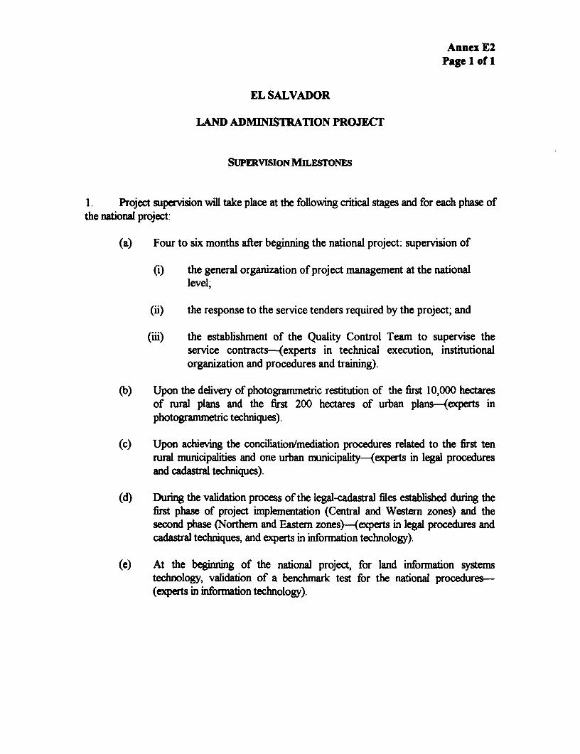
Annex E2Page 1 of 1
EL SALVADOR
LAND ADNMIISTRATION PROJECT
SUPERVISION MILEsroNEs
1. Project supervision will take place at the following critical stages and for each phase ofthe national project:
(a) Four to six months after beginning the national project: supervision of
(i) the general organization of project management at the nationallevel;
(-i) the response to the service tenders required by the project; and
(iii) the establishment of the Quality Control Team to supervise theservice contracts--(experts in technical execution, institutionalorganization and procedures and training).
(b) Upon the delivery of photogrammetric restitution of the first 10,000 hectaresof rural plans and the first 200 hectares of urban plans-(experts inphotogrammetric techniques).
(c) Upon achieving the conciliation/mediation procedures related to the first tenural municipalities and one urban municipality-(experts in legal procedures
and cadastral techniques).
(d) During the validation process of the legal-cadastral files established during thefirst phase of project implementation (Central and Western zones) and thesecond phase (Northern and Eastern zones)-(experts in legal procedures andcadastral techniques, and experts in information technology).
(e) At the beginning of the national project, for land information systemstechnology, validation of a benchmark test for the national procedures-(experts in information technology).

Annex E3Page 1 of 5
EL SALVADORLAND ADMINISTRATION PROJECT
Procurement Plan
I . According to the time schedule of the project, the preparation of the tenders has tobegin at the end of 1995, at least seven months before the start of the proposed landadministration project (estimated to begin in June 1996). Based on this timetable, theprocurement plan includes the following key tenders:
(a) Mapping for El Salvador, including aerial photography, ground control,aerotriangulation, restitution (scales are 1:1000, 1:2000, 1:5000), andtopographic complementary survey. The first phase is the writing of themapping tenders documents. (see Annex DI).
(b) Legal research (levantamiento) operations, field photoidentification, andmerging for the first phase covering he West Zone (Santa Ana,Chalatenengo, Ahuachapan) and the Central Zone (San Salvador, laLibertad, Cuscatlan). The tender for the second phase-the Northem-Central Zone (Usulutan, la Paz, San Vincente, Cabanas) and the East Zone(San Miguel, La Union, Morazan)-will be launched seven months beforethe starting of the second phase on October 1, 1998 (InternationalCompetition Bidding-ICB) (see Annexes D2 and D3).
(c) Extension and adjustment of the land information system (LIS) software. Ifthis step is necessary, it could be launched as soon as the design madeduring the pilot phase is ready and accepted. To ensure the best integration,the tender could include the hardwaie (ICB).
(d) Technical equipment. Separate tenders or one or two tenders f-ir differentequipment types will be necessary. Because there is not a sole supplier forall of the required equipment, a single tender would be inorG *.sqpensive buteasier to handle administratively (ICB). The equipment needed ir.cludes
(i) total stations, small topographic equipment, including stereoscopes;
(ii) GPS and accessories and computer for calculations;
(iii) analytical stereoplotter with power supply unit;
(iv) orthoimages production equipment with power supply unit; and
(v) laboratory equipment for aerial photographs with power supplyunit.

Annex E3Page 2 of 5
(e) Vehicles- ICB or Limited International Bidding (LIB).
(f) Audio visual support for training-(National Competitive Bidding).
(g) Technical supervision. (Jse of Consultants by World Bank, Borrowersand World Bank as Executing Agency, August 1981).
2. For the ICB, insertion in Development Business and the prequalification procedureshould start at the end of 1995 to allow sufficient time between the bidding and thecontract implementation.
M:ASVVAMAR\BOx.3)proc.doc
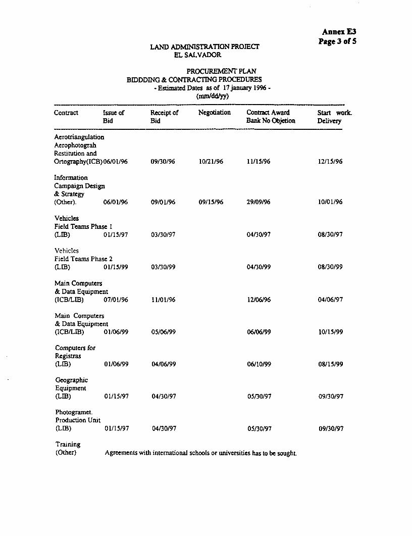
Annex E3
LAND ADMINISTRATION PROJECT Page 3 of 5EL SALVADOR
PROCUREMENT PLANBMDDDING & CONTRACTING PROCEDURES
-Estimated Dates as of l7 january 1996 -(mn/ddlyy)
Contract Issue of Receipt of Negotiation Contract Award Start workBid Bid Bank No Objetion Delivery
AerotriangulationAerophotograhRestitution andOrtography(ICB)06/01/96 09/30/96 10/21/96 11/15/96 12/15/96
InformationCampaign Design& Strategy(Other). 06/01/96 09/01/96 09/15/96 29/09/96 10/01/96
VehiclesField Teams Phase I(LIB) 01/15/97 03/30/97 04/30/97 08/30/97
VehiclesField Teams Phase 2(LIB) 01/15/99 03/30/99 04/30/99 08/30/99
Main Computers& Data Equipment(ICB/LIB) 07/01/96 11/01/96 12/06/96 04/06/97
Main Computers& Data Equipment(ICB/LIB) 01/06/99 05/06/99 06/06/99 10/15/99
Computers forRegistras(LIB) 01/06/99 04/06/99 06/10/99 08/15/99
GeographicEquipment(LIB) 01/15/97 04/30/97 05/30/97 09130/97
Photogramet.Production Unit(LIB) 01/15/97 04/30/97 05/30/97 09/30/97
Training(Other) Agreements with international schools or universities has to be sought.

Annex E3Page 4 of S
BIDDDING & CONTRACTING PROCEDURES-Estimated Dates as of 17 january 1996.
(mmld/yy)
Contract Issue of Receipt of Negotiation Contrac Award Start wodLBid Bid Bankl No Objedon Delivery
Building RehabOccid. Region.(NCB) 06/01/97 09/15/97 12115/97 01/15/98
Building Rebab.Paracentral Reg.(NCB) 01/07/99 04/15/99 05/15/99 06/15/99
Building Rehab.Oriental Reg.(NCB) 06/01/99 09/15/99 10/15/99 11/15/99
Building Rehab.Cental Reg.(NCB) 06/01/99 09/15/99 10/15/99 11/15/99
VehiclesRegional Off.(LIB). 06/01/98 09/15/98 10/15/98 02/15/99
VehiclesRegional Off.(LIB). 06/01/2000 09/15/2000 10/15/2000 12/15/2000
ComputersOcc. Region.(LIB). 01/07/97 04/30/97 05/30/97 08/30/97
Computersfor ParacentralRegion.(LIB) 01n/99 05/15/99 06/15/99 09/15/99
Computersfor CentralRegion(LIB). 01/7/2000 05/15/2000 06/15/2000 09/15/2000
Computersfor OrientalRegion(LIB). 06/01/2001 10/15/2001 11/05/2001 12/05/2001

Annex E3
BIDDDING & CONTRACTING PROCEDURES Page 5 of 5- Estimatod Dates as of 17 january 1996 -
(mm/dd/yy)
Contract Issue of Receipt of Negotiation Contract Award Stant WodBid Bid Bank No Objetion Delivery
LOCALCONSULT.
RegistrvInvestigation Individual contracts should be signed, work will be done in all existing Registry Off.
the investigation will produce data bases extracted from all existing Registry Books
*"Barrido"Fase I,Zone I(Other) 08/10/96 11/01/96 11/20196 12/20/96 02/15/97
*"Barrido"Fase I,Zone I(Other) 01/06/98 04115/98 04/30/98 05/20/98 07/15/98
* "Barrido"Fase II,Zone I(Other) 06/01/99 09/01/99 09/20/99 10/20/99 12/15/99
* "Barrido"Fasell,Zone II(Other) 06/01/2000 09/0112000 09/20/2000 10/20/2000 12/15/2000
PROJECTMANAGEMENTOFFICE
Intern.Consult.,Local Consult.& Project Mngt.Staff (Other). To be hired as needed, Technical Mngr.; Int. Quality Control Team &
8 Local Consult. will be hired stardng on July 1996.
Vehicles 07/01/96 10/20/96 11/20/96 12/10/96

Annex E4
EL SALVADORLand Administration Project
National Registry CenterExecuting Unit
MINISTRY OFJUSTICE
NAllONAI.REQSTRY (NTER
_not_ALPROJECT
COORDNATORI
INTERNATIONALPROJECTMANAGER
COMMLINCATOR
.Cadkl Am Re9istry Arw Pirairg, Evlskton U" 1rtma< hiw oCaordmft Corcinatr and Foflo UpArea Arm Cooirdmtc Akm Cocidirtr AdmNivistan
\WAD Co YCmA FNNEX PccinwS.SupeAor SUWsr kd wshtet
As1tarb
M:\SV\IAND\SAR\YC\ANNE)M4 PPT

Annex E5Page 1 of 2
EL SALVADOR
LAND ADMINISTRATION PROJECT
SUMMARY OF DESIGN ALTERNATmES CONSIDERED
Design Issues
I. Topographic Surveys, Aerial Photography and GPS. The topographicalternative was the first considered given the lack mastery of other technologies in thecountry, but discarded because it was too expensive and cumbersome. GPS-onlytechnology is very exact but very expensive and labor intensive (about 10 minutes perpoint). Also, GPS accuracy is random because of some satellites' jamming, so it requiresconsiderable adjustments. The chosen technology combines all three technologiescomplimentarily: GPS capability, mounted on the plane and aerial photography to createdigital maps and topographic surveys to complement as needed to cloud or other cover.
2. Why Orthophotomaps only in the Rural Areas? Orthophotomaps are imagesfrom digitalized data. They are accurate on a plane but do not capture images well in thepresence of heights (for example, tall buildings). For this reason the digital data needsstereoplotting to produce urban cadastral maps (to capture information hidden by shadowscreated by high buildings).
Cost Minimization Alternatives: Some Design Elements from the Pilot'sExperimental Phase
3. Registry Investigation and Analysis. The initial pilot project design includedphotocopying all the registry books so that the work to establish initial folio reales couldbe contracted out. Given the expense and the lack of notaries familiar with folio reales toestablish the new folio reales database, it was decided to hire Registry staff to input thedata directly. Registry staff are more familiar with folio reales because some govermentprograms (that is, San Salvador Registry, FINATA) use them. This allowed the registryvolumes to be kept in the Registry to ensure their continued availability to the public aswell as on-the-job training for data input clerks in the new automated system. Thissolution increased staff ownership, saved the expense of photocopying and acceleratedimplementation by about four months (contracting and training a different team).
4. Field Verification Teams. Initially, teams were to be composed of an IGNphotoidentifier with a notary. But notaries were not willing to participate in the field workfor the salary offered. Therefore it was decided to place one notary per municipality fordocument formulation and use fourth year Law students to review the property documentsin the field. This allowed to focus the role of notaries in non-judicial dispute resolution(mainly mediation) and establishing documents, and reduced the cost of the field documentreview.

Annex E5Page 2 of 2
5. Recent Indonesia and Thailand Bank projects yield a per hectare cost ofUS$200/ha and US$80/ha (including institutional development), explained by their higherurban land composition.

Annex F: Cost Tables, Financing Plan and Disbursement Schedule

Annem FPage 1 of 10
EL SALVADOR
LAND ADMINISTRATION PROJECT
COST TABLES, BANK DisBURsEMENTs AND SCHFDULE
1. Components Project Cost Summary
2. Project Component per Year
Detailed Cost Tables
3. Institutional Strengthening
4. Institutional Decentralization
5. Project Management Unit Mapping
6. Mapping
7. Land Records Regularization
8. Alternative Conflict Resolution
9. Project Preparation Facility
10. Estimated Bank Disbursements
11. Disbursement Schedule

Anne FPage 2 of 10
*1 SalvadorLand miaistration (Six ear Prejoetion)
Prejqt cost _rq
I I Total(Colam Klflion) (US$ Xl4uonI Foreign Sae
Local Foreaaa Total Local foreian Total bxhama __qL..
A. project Preparation Facility 15.6 1.3 17.7 1.S 0.2 2.0 10 4S. imA Data, Agniitla
Napping 56.4 S4.7 111.1 6.4 6.3 12.7 49 23Lua record regularization 200.1 20.4 220.5 22.9 2.3 25.2 9 45ALtacnative Conflict 9Asolutioan 0.9 - 0.9 .i - 0.1 - -
*eetal Z_ Data ~~.ait*. 257.3 75.1 332.4 29.4 6.6 35.0 23 66C. a __mtgattme ad St_amgthmAg
Snatitutioal Steagtheain 12.2 35.9 45.1 1.4 4.1 5.5 75 10lnatitutioal Dec atraliLstion 13.1 17.3 30.4 1.5 2.0 3.5 57 1
_t.t l aeintaaL.iatLa Stunlei_ _ ag 25.2 53.3 78.5 2.9 6.1 9.0 44 160. Project ?ainmstration 40.5 21.0 61.5 4.6 . .4 7.0 34 . 3
tetaj. COn s 338.9 151.2 490.1 38.7 17.3 56.0 31 100Physical Comtingcieg 12.4 9.1 21.5 1.4 1.0 2.5 42 4Price Cmtingencie 93.7 7.0 100.7 10.7 0.5 11.5 7 21
tetal CO 00S 445.0 161.2 612.2 s5.9 19.1 70.0 27 12S
Thu Sep 23 13:14s25 1995
I1 SalvadorLmad Ainimtration (Six Yor Proj ectioni
_uejet C0me_t by TOM(US Million)
bass Cost1996 1997 199 1999 2000 2001 2002 ZEsi
A. Prect Preparatian recility 2.0 - - - - - - i.0B. Lan Dat Aoqt&L
Nappig 3.3 4.2 4.2 0.5 - - - 12.7Land record regularixetian 1.5 3.5 4.9 S.0 4.9 4.0 0.5 25.2Altecnative Cnflic t esoutioan 00 0 0 - 0 0 - - - .
tetaL Le" Data Aa ti_ 5.4 7.7 9.1 5.5 4.9 4.5 0.5 33.0C. DeewtvaaUmation and atomsge ag
Institutional Steogtbeanin 3.2 1.2 0.7 0.1 0.1 0.1 0.1 5.5Inatitutiaoal Dacentralixatioa - 0.5 0.3 1.* O.9 0.3 0.1 3.5
_teeWa DoeataaMaM and St_aithin* e 3.2 1.3 1.0 1.5 1.0 0.4 0.1 9.00. Project Ainistratioan 09 14 1.4 1.1 1.0 O.J 0.4 7.0
Petal, BAin 00823 11.5 10.9 l1.5 5.1 7.0 6.0 1.1 S.0Physicul Coantinenciem 0.7 0.6 O.S 0.3 0.2 0.1 0.1 2.5Price Continqencie 0.2 ..... I.J2 1.9 2. 30 0.7 11.5
linea : COin 002 12.4 12.4 13.9 10.5 9.7 0.1 1.9 70.0
TAXe 0.4 0.7 0.o 0.; 0.3 0.7 0.2 4.4Foreign Sachnge 6.3 4.6 4.1 2.0 1.2 0.7 0.2 19.1
Thu Sep 20 15:19:27 1995

Annex FPage 3 of 10
11 SalvadorLa.nd >diniztration (Six Year Projection)
Table 101. KappingDetajed Ceots
US. Million)
Totals ,ncludinp Contingenciey1996 1997 1996 1999 2000 2001 2002 Total
x. 3k ot t CoetsA. Aerotrianqulation (models) IS - - - - - - 1.SS. Aerial photography a production 2.7 - - - - - - 2.7
C. Map Production (urban) - 3.7 3.9 - - - - 7.5D. Orthophoto map production (rural) - 1.2 1.3 0.7 - - - 3.21. International Technical Assistanco /a 0.1 0.1 0.1 - - - - 02
TOtal 4.3 5.0 5.2 0.7 - - - 1S.1
\a Includes travel and per di_e (US$750 p/d)
Thu Sep 28 17:07:32 1995

x1 Salva dLaud Adaietratiam (Six Y-ee Fro ection)
Sablo 102. Land e eerd rgularilaticmDetaild Cmete
(MR Willicam
TOtal. Iecludie Cemtieencir1994 1197 I"I 19l9 200 200l 2L02 tal
I. hee tm CaA. Scmmata Filet rolect CeWpltiam 1. 1.7*. h.nqtim ae1ga
1. Initial caaeia - 0.* 0.* 0.1 6.7 0.6 - 3.62. Felln-- em in - -: * 1-1 e 1 e a e I I e
abdta Ma_Us C _eiga 6.5 6.6 0.6 6.6 0.9 0.1 3.SC. sae-
1. tiig for lel Pereme a - 0.0 - 0.0 _ _ _ .2. Sralalag for pboto-idetitfiecs /b - 60 - 0.0 - _ * 6
a*eta .-. 6.0 6.0 - - - 0.1e. ee" C mltta
1egitzy iweetigatim G Anlysis Jc _ 0.3 0.1 5e6 6.6 0.1 0.1 2.5rield vritieatiam team _d - 1.0 2.2 2.4 2.6 2.6 - 11.0legal vield lk Corditot - 0.1 0.1 0.1 0.1 0.1 - 0.3Caetre Oporatiom Nbmagamet /a - 0.2 0.2 6.2 0.2 0.2 - 1.1tapo eaphic team t - 0.3 0.7 6.7 0.6 0.6 - 3.3otedt.i 2 - 0.2 0.2 0.2 0.2 0.2 - 1.0
09S ri _d l - 0.1 0.1 6.1 0.1 0.1 - 0.Saistcrat tor final veriticatiom/registry _ S 0 0 7 0.S 0. - 3.1
_1te_ Lee" 0nlt-t - 2 7 4 S 4j 1 1 . 4 0.1 22 .total Sb _ te 1.7 3.2 5.1 5.6 6.0 6.2 0.2 26.4
A. field Ottice Operatics - 0.3 0.3 0.3 0.3 0.3 - 1.IS. Office & staff fat teni cal Supervisor 0.0 0.1 0.1 0.1 0.1 0.1 0.1 0.6C. Land Record Agulariation *elleup office In. - - 0.0 0.1 0.1 0.0 0.6 0.2D. Vehicle Naintasae A Insurance /I - 0.3 0.4 0.4 0.4 0.1 0.e 2.4S. Vehicle Operatio n1 - 0.i 1 0.1 0.1 . 0.1 0.1 0 7
total _nut C*ete 0 7 *J 10 1.0 1.1 0.7 5.4seta 1.7 4.0 6.0 6.5 7.0 7.3 0.9 33.4
S- Iclude. notaries, cefzr.tadozee. registerslb Include. pboto-idestifiers a eurvyors'c Includes evinien de L bree{ (ceaframtadres) ad Digitacide de Infermaci6a de CampoXd gaeb team include I photo-interrter (C 4,656 ) I legal student (c 4.20) includinog visticom and prestaciones. Asums average cov age of 3.2 equare kn./aoth/tan., eacept San Salvador (1.15 Sq. km.) y
La Libertad 42.4 sq. ka.)e Include Garact Tacoico, S.cretsria, Aocostant, Ceauffar, + Overead
'f Eacb tea cmeists of topqrato + 2 assisteate'S Asru_a* I notary per 10 field veritiers + 2 tor San Salvador'b Your brigade caaistin oft I tpagrato and I assistant1i Asmas ISt ot purchae price for maintenance coats * St inaureae%S lncluds Fuel & Oil. clculated *r 1.200 colonealmothlvbhicla far 270 daysl yet. Total of 61 vaeicles tran 1196 am foa Tield Verificetiom Sem 7 for Land Record Segularlnatiam Pallo-up.
Tbu Sap 26 17:67:4 199S
3-1 Led record rgulariaatiom

Annex FPage S of 10
01 SalvadorLand Admnitration (Sia Y"r Projection?Table 103. Alatsnativo Conflict Rasolution
(US$ Nililn)
Totals tncludinu Continaci.,j3i- 1997 1999 1ttt 2000 2001 2002 Total
A. ?ra 0.00.
D. Information campaign - 0.0 - 0.0 - - - 0.1Total 0.0 0.0 - 0.0 - - - 0.1
Thu Se 2t 17:07:59 1995

SI SalvadorLend Admiistration (Six Year lrojection)
Table 201. lstitutianl Strengtb.eingDetailad ma0te(US$ Million)
Totals Including Continneaia1996 1997 1096 1t 2C00 2001 20e2 oatal
X. Zn_sMamt Ceats
A aildiag aibabLi_Ake1. SW Main Building /a 0.2 - 0.2
*. Viel1. Veicles for field teem lb 1.2 - - - - - - 1.22. Land Record asuarization 7eileup 0.1 0.1
Xl-tntl 1-ie3 1.3 … … … … … … 1.3C. /UtUfe /a
1. Nain CqWuter and Data Squipmont 0.5 - 0.2 - - - - 0.o2. Registry Analysis and Invewtigation 0.1 0.0 - -- …0.13. C"puters for gs gistrar 0.1… … … … … …- 0.1
utotal e _*Awg 0.7 0.0 0.2 - - 0.9D. Maegpusgh mwai~t
1. TSbodolitas 0.3 - -…… 0.32. cn d 0.o - - _… 0.43. Vtotograaatric 7roduction Unit - 0.6 - - - -- 0.66. Supplamntary field quip nt 0.0 - .-.- -_.- - 0.0
maatal _ ieagha miguet 0.7 0.6 … … … ……1.23. ai_ euimt e tia itte
1. Office Squipment / ' -0.1…… …… 0.1W. Tainiag
MCR Couter training It 0.0 -… … ……0.0G#S trainin …0.0… … … … … … 0.0
Matatal taslain 0.0 0.0…0.0. Iamttiemal Trani
Intl Trg in Mapping Techniques - 0.1 0.1 - 0.2Intl Trg for Obotogrmtric Uait - 01 01 - 0.2Intl Training Registry/Cadastr Management 0.2 0.1 0.1 - 0.5Intl Leal Training A rrsach 0.1 0.1 -… ……0.2IDtl aeodatic A 7intograotric Training - 0.1 0.0 - - - 0.1Intl GIS Training 0.1 0.1 - - 0.3
Stotal International raiing 3 0.6 0.5 - 1.4fatal IVat_t Cot. 3.3 1.2 0.7 - - 5.2II. __m t Coats
A. NBC building rantal 0.0 0.0 0.0 0.0 0.0 0.1 0.1 0.3D. ICR Support Staff 0.0 0.0 0.1 0.1 0.1 0.1 0.0 0.3C. persi" Coots
NRC /g 00 0.0 0 0.0 0.0 0.0 0 0 0 2total asonvet Cets 0.1 0.1 0.1 0.1 0.1 0.2 0.1 0.6
fetal 3 4 1 3 0 . 0 1 0 1 0 2 0 1 6 1
1a Includes rdaabilitation of space for 34 rgisters and their support staff. Assues tenting b9 bmilding\b 25 vebicles par some, 2 zones running ainultaneously; plus I veicla tor tehnical supervisor and 3 for Internmtieal Accerdslc Ineludas ce puters and printers%d Ineludes equipment for international accords with basa cost of 1.3 illion colasa Furniture. tan nodem, printer, photocapier, phoen system, air cnditiners. etc
'f Include bae programs a language trainingIg Includs Oficin Rgioal de San Salvador
Thu Sap 20 17:00:06 1995
° a
5-1 Institutional Strengthening
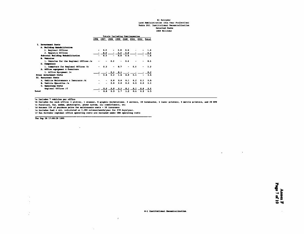
I1 SalvadorLand Adinistration (Six Year Projection)Table 202. Institutional Dcsntrslinztion
Detailed Cat-
(USW Million)
Totals Including Contingencies
1996 1997 1996 1999 2000 2001 2002 Total
Investmet Cato
A. bulie Ushabilitatim
1. Regional Ottic.. - 0.2 - 0.5 0.6 - - 1.6
2. Agi2tro Offices - 0.0 - 0.0 0.0 - - 0.0
Atot.tal &ldia We Uabilitatig - 0.2 - 0.6 0.6 - - 1.6
D. Vehial.s1. Vehicls for the Regional Offices /a - - 0.2 - 0.4 - - 0.5
C. Cmauter
1. Ccoputers for Regional Offices /b - 0.3 - 0.7 - 0.1 - 1.2
O.D ice eO t i_ t I tl itue
1. Office Squipent /c - - 0.1 0.1 - - - 0.2
Total Investet Casts - 0 6 0 2 1.6 0.9 0 1 - 3.5
xI. 240.rtest Coste
A. Vehicle Maintenance a lnsurnc /d - - 0.0 0.0 0.1 0.2 0.1 0.5
S. Vehicle Operation /a - - 0.0 0.0 0.0 0.0 0.0 0.1
C. Operating Casts
Regional Offices /f 0.0 0.0 0.1 0.1 0.1 0.0 0.4
etal - 0.6 0.3 1.7 1.2 0.4 0.2 4.5
\a Includes 7 vehicle per office
\b Includes for each office. 1 plotter, I scanner, 6 graphic ,orkststions, 3 servers, 10 tereinmles, 4 lsec printers, 4 matrix printers, end 26 UPS
\c Furniture, ft, mod, pbotocopier, phone system, air conditioners, etc
kd Aessues 15 of purchase price for aintenance cats * 5 insurance
\1 Include fuel oil, calculated as 1,200 colones/month/year for 270 daYs/year.
\f San Salvedor regional office onprating costs are included under CIR operating costs
Thu Sep 26 17:08:29 1995
6-1 Institutional Decentralization

U SalvadorLead WiIeitrati (Ste Tea Projectiea)
table 301. Project Maagemnet UnitDetailed coo"(Us$ Hillin)
Totals lacl'dine Cctiaee iee190S 197 1995 1999 2000 2001 2002 otal
A. Veicles 0.1 - - - - - - 0.1D. Office mqitnt /a 0.0 0.0 0.0 - - - - 0.1C. T7bodolites - 0.0 - - - - 0.0D. Project video a Sesiare /b 0.1 - - - - - - 0.1C. C_nalt_t.
Technicel Ikagert (Int1) /c 0.1 0.2 0.2 0.2 0.2 0.2 0.1 1.0Project Neogemmt Staff 0.1 0.4 0.4 0. 0S 0.6 0.3 2.6lItrnatiLeal coRNaWtLta /d 0.3 0. 0. 0.2 0.1 - - 1.5Local Consultants 0 1 0 2 0 2 0X 0. 3 0.2 -
^teta cinitita 0.6 1.3 1 1.1 1.1 0.9 0.4 tow Zaveem. costs 0.9 1.3 1.4 1.1 1 0.9 0.4 7.1is. Dem4 eo"
A. Project Suport Staff 0.0 0.1 0.1 0.1 0.1 0.1 0.1 0.5S. Office peetiLe /. 0-1 0.2 0.2 0-2 0-2 0I 0o 1-2
Seta a_ t Cete 0.1 0.2 e2 0.3 0.3 03 0.3 1.7Set 1.0 1.0 1.6 1.4 1.4 1.2 0.7 6.7
%& tnludes all office equi_ ent & icbiary cept ctputerslb Iecludes 2 esmma: at S0000 coloen per smina%c Include superviaLce of pboto-idotificatiLm team a lao1l tame\d loclude travel and por diS (UN650/dayl\e Includes wvbieles opecation a einttoence
Thu Sap 29 17:09:43 1990
7-1 Project Neneg.t (Mit

Si SalvadorALad dIniatzeatio (Sin Year Frojectim)Table 401. Project Preparation facility
OetaIad ~eata(UU SKillion
totals Includinag Coatiaeacies1994 1997 199 nlnL 2eee 200l 202 Total
5. a_ t egoA. Office end coAte equitaet 0.1 - 0.1S. Vehicles 0.1 - 0.1C. CasultenciLe 0.O - 0.00. field Cedatrol and Registry Costs 1._ - - - 1.6
set" zv~tmt ete I.6 - 1.5Ux. e_wut coots
A. Opereting costs 0.2 - 0.2Total &emw mt cots 0.2 - 0.2etLS 2.0 - 2.0
tbu Sep 26 17:07:21 1995
1-1 Proeact Pcepazation Facility

Annex FPage 10 of 10
Table 10: Estimated Bank Disbunements
Bank FY 19961 1997 1998 1999 2000 2001 2002 2002
Annual 5.9 11.0 10.5 8.9 6.3 4.9 2.3 0.2
Curmnulative 5.9 11.6 27.4 36.3 42.6 47.5 49.8 50.0
a. Column and row totals may not add due to rounding.
b. Includes US$2 million financed under the Project Preparation Facility (P-264-ES), as well as up toUS$5.0 million of retroactive financing for expenditures incurred since July 1995.
Table 11: Disbursement Schedule
Category millon IBRD Disbursement Percentage(US mlion)
100 percent of foreign expenditures, 100 percent of local1. Goods 5.2 expenditures (exfactory cost) and 87 percent of local
expenditures for other items procured locally.
2. Works, Service Contracts and 14.4 80 percent.Information Campaing
3. Consultant services 20.2 60 percent of local expenditures and100 percent of foreign expenditures
4. Training 1.5 100 percent
5. Incremental recurrent costs 4.2 100 percent until withdrawals in this category havereached an aggregate amount equivalent to US$2.0million; thereafter, 75 percent until withdrawals havereached an aggregate amount equivalent to US$3.0million; and 50 percent thereafter
6. PPF refinancing 2.1 Amounts due
7. Unallocated 2.4
Total 50.0
M:\SVULANAR\GC\(a)O8.DOC

Annex G: Project Implementation, Indicators and Reporting
3 GI Impact Indicators- G2 Implementation Indicators - Inputs- G3 Implementation Indicators - Outputs- G4 Status of Legal Covenants- G5 Baseline Field Survey - TOR

Annex GPage 1 of 2
EL SALVADOR
LAND ADMINISTRATION PROJECT
PROJECT REPORTING, MONITORING, AND EVALUATION
1. To support the Government's management of implementation and theestablishment of a monitoring and evaluation (M&E) system to enable this, the projectfinances necessary personnel, equipment, and training under the project administrationcomponent to: (a) generate and disseminate information as a management tool and tostreamline administrative procedures; (b) track indicators to guide adjustments duringimplementation; and (c) evaluate success relative to defined objectives and criteria.Indicators are listed in Annexes GI-G4. A project implementation timetable for thenational project by year has already been prepared by the government (Annex B2),Because the importance for project administration, the project supervision milestone forcritical activities is outlined in Annex E2. The Procurement Plan is in Annex E3. TheDisbursement Schedule is in Annex F, page 10.
2. Monitoring and Evaluation. This phase of the project would be the responsibilityof the CNR and will be carried out by the Executing Unit (UJE), supported by a QualityControl Team that consists of three principal consultants. This team would report directlyto the head of the UE and be in charge of quality control, so the system would provideproject management with monitoring and evaluating data for activities carried out by thelocal consultant teams. The UE would complete the design of the managementinformation system (MS) to generate, among others, the draft indicators in Annexes GIto G4 and based on terms of reference in G5 (see also SAR, para. 4.18.). The MIS wouldenable the UE to track implementation (inputs and outputs), impact and legal indicators.
3. Reporting. Quarterly reports based on project implementation planning would beprepared by the UE. The quarterly reports would provide evaluations of implementationprogress and impact. This information would enable the UE to adjust activities, ifnecessary, in agreement with the Bank. These reports would be summarize and submittedto the Bank 30 days before the annual reviews. Each review would take place aboutSeptember 30 of each year. Bank supervision would review implementation progress andproposed budget and work plans for the following year.
4. Each quarterly report would be composed of completed tables on:(a) implementation indicators:
(i) inputsa. financial i. revenues and expenses
ii. budget execution (standard format)uii. loan disbursements (standard format)
b. and physical;(ii) outputs (physical);

Annex GPage 2 of 2
(b) impact indicators; and
(c) status of legal covenants.
5. Project supervision input would be based on the MIS's M&E indicatorsestablished under the project. These indicators would be agreed upon during negotiations.
6. Independent Studies. Project management will carry out periodic andindependent studies to both monitor implementation and impact and visit an specificaspect of the project. These studies include the studies to establish the baseline fieldsurvey for the establishment of the impact indicators (see TORs in Annex G5) and theperiodic client evaluations and surveys to report on these. The studies also includeindependent studies to review tariffs (see TORs in Annex B6), evaluation of effectivenessof administrative decentralization and role of municipalities, prospective propertyvaluation system, property rights and farm productivity and others to be agreed with theBank.
M:\SV\LAND\SAR\YCX(XG)IM&R.DOCDecember 3, 1995

EL SALVADOR Annex GlPage 1
LAND ADMINISTRATION PROJECT
Impact Indicators
Baselne Feb 96 Year 2 Year 4 Year 6SAR SAR SAR SAR
Obcthis Target REV. ACT. CUM. Target REV. ACT. CUM. Target REV. ACT. CUM. Target REV. ACT. CUM. Source
1. Improve Land SecurityLandInformation
Parcels Regularized System
Parcels Cadastered LIS
Access to Credit (Mortgages):Registered Properties prior toregularization with Mortgages _ Survey
Regularized Properties with Mortgages Survey
Investment in land improvements SurveyLikelihood to invest after regularizationthrough mortage classification inRegistry(a) diversifying sources of revenue(b) in capital investments(c) in land management(d) others Survey
II. Institutional StrengtheningRatings of Capacity to perform1 = excellent; 2 = very good;3 = average; 4 = poor User's
User'sCNR Regional Offices evaluation
User'sMunicipal Offices evaluation
CNR's Financial sustainability AuditorsLength of time for successful resolutionof disputesSpeed of registration(at RPRH) assumingproblem-free documentation
Mortgage _ LIS
Inheritance LIS
Certification _ LIS
Preventive Annotation LIS
Inscriptions . _ . LIS

EL SALVADOR Annex G2LAND ADMINISTRATION PROJECT Page 1 of 7
Implementation Indicators
INPUTS Q3 Q4
SAR SAR AnnualFJnnrx; i/hputs (US S mAronsi Target IREV. ACT. CUM. Target REV. ACT. CU.||Targot
gi - = = YEAR 1CadastreExisting servicesNew ServicesLand registry (ampliaci6n)Existing services 2.06 2.06 4.11New Services 0.04 0.04 0.08Land registry (barrido nacional)
___~~~ _\\N\C = _______
Project Preparation FacilityInvestment Costs 0.9 0.9 1.8Recurrent Costs 0.1 0.1 0.2MappingInvestment Costs 2152.15 4Land record regularizationInvestment Costs 0.85 0.85 1.7Recurrent CostsAlternative Conflict ResolutionInvestment Costs 0.025 0.025 0.05Institutional StrengtheningInvestment Costs 1.65 1.65 3.3Recurrent Costs 0.05 0.1Institutional decentralizationInvestment CostsRecurrent CostsProject management unit
Investment Costs 0.45 0.45 0.9
Recurrent Costs 0.05 0.05 0.1
3.15 = 3.15 6.31
Procurement (CommittedJ =)=_=International bidding complete(USS')000
Local bidding complete (US$'000)
International Deliverables (US$'000)
Local Deliverables (US$'000)
Consultancies
International (person months) __
Local (person months) _

EL SALVADOR Annex G2LAND ADMINISTRATION PROJECT Page 2 of 7
Implementation Indicators
____________________________ 01 a2 03 04
INPUTS Target REV. ACT. CUM. Target REV. ACT. CUM. TarTaret REV. ACT. CUM. TagIetAkencb wipts fUS nmmsl
-Y iAR 2
Cadastre _ _Existing servicesNew Services 0.03 3___ __ 0.03 0.03 ___0.13Land registry fampliaci6n) __ _ _ _ _ _ _ _ _ _ _ _ _ _ _ _ __ _ _ _ _ _ _ _ _ _Existing services 0.03 0 03 0.03 | 0.03 _ 0.10New Services 1.23 3 __ 1.23 _ _ 1.23 _4_ _| 0_ 4.90Ljgtr (ba rrido nacional) 0.10 ___ 0.10 0 1 0| 0.10 _ 0.41
Project Preparation Facility _ __
Investment Costs ____-
Recurrent CostsMapping
____Investment Costs 1.25 1 25 1.25 1_ _ 125 .5 00Land record regulanization _ _ _ ____I_IInvestment Costs 0.80 = 080 _0 80 __ | 080 3_ 320Recurrent Costs 0.1180 18 _0 18 |0 18 0 0 70Altemative Conflict Resolution I _ |____ |____Investment Costs 0.01 0.01_ 0.01 .0 01 0_ 005Institutional Strengthening _ _ _ _ I_____Investment Costs 03030 0.30 0 301 0 30 _1.20 30 __L= _12Recurrent Costs | 0_03 0 0 03 _ 0.03 | 0.03 _ _ 0.10Institutional decentralization
I____Investment Costs |__ ____ 0.15 |. - 01 5 - _ 015 _ 0 60Recurrent Costs |_ 018_ 0 18_ _ 0.18 _ _ _ 0.70Project management unit _ _ | _ _____Investment Costs _0_33_ 0_33 0.33 1 0_33 1 30Recurrent Costs | _0 03 j 0 03 j__ 0.03 __ 003 0.10
____ 1.71 1.71 _683p h - -t ,_I_ I_ I_ I_ I_
Procurement (CommittediInternational bidding complete (US'o000) | _ _ _ |Local bidding complete (US'000) _ _ _ ____|International Deliverables (US$'000)Local Deliverables (USS'000) _ _ ________Consuitancies _ _ ___
International (person months) ________
Local (person months) _ _ _ _ I _I

EL SALVADOR Annex G2LAND ADMINISTRATION PROJECT Page 3 of 7
Implementation Indicators
Q1 02 03 04 ____
|_ SARR SAR r SAR SAR AnnualINPUTS | Targe~~~~~~~t REV. ACT, CUM. Tar t REV. ACT. CUM. Target REEV. ACT. CUM. Target RE.ATCU.|are
Fkhancbt Inputs /USS m0ons) I_YiEAR 3_
Cadastre TExisting services _New Services 0.04 0.04 0.041 0.04 0.15Land registry (ampfiaci6n) - __1I___
Existing services 0.03 0.03 0.03 0.03 0.11New Services 1.44 1.44 1.44 1.44 5.75Land registry (barrido nacional) 0.23 0.23 _ 0.23 _ 0.23 0.91
Project Preparation Facl7ityInvestment CostsRecurrent CostsMapping
Investment Costs 1.30 1.30 1.30| 1.30 5.20Land record regularizationInvestment Costs 1.28 1.28 1.28 | 1.28 5.10
Recurrent Costs 0.23 0.23 0.23 _ 0.23| 0.90Altemative Conflict ResolutionInvestment CostsInstitutional Strengthening I
Investment Costs 0.18 0.18 0.18 0.18 ____0.70
Recurrent Costs 0.03 0.03 0.03 0.03 0.10Institutional decentralization
Investment Costs 0.05 0.051 0.05 0.05 0.20Recurrent Costs 0.03 . 0.03 0.03 0.03 0.10Project management unit
Investment Costs 0.35 0.35 _ 0.35 0.35 1.40Recurrent Costs 0.05 0.05 0.05 0.05 0.20
. - n 1.79 1.79 1.79 1.79 _ _ 7.17
Procurement (Committed_International bidding complete (USS'000)Local bidding complete (US$'000)International Deliverables (US$'000l - _ _ i
Local Deliverables (US$'000)ConsultanciesInternational (person months) _ _ _____ I _ _ _
Local (person months) _ _ t___ __l__ I I

EL SALVADOR Annex G2LAND ADMINISTRATION PROJECT Page 4 of 7
Implementation Indicators
____ ____ ___ _ _Q_ 01 Q2 CQ3 04l | ~~~ ~ ~ ~~~~~SAR .ICM SAR - - SAR _ SAR _ |AnnualINPUTS Target REV. ACT. CUM. Target REV. ACT. CUM. TarTetar REV. ACT. CUM. TargetAkm=Wvw tV m)W$ _ -_- YEAR 4
CadastreExisting services _ _ =New Services 0.05 0.05 _ _ 0.05 _ 0.05 _ 0.18Land registry (amplfaci6n) _ _ _Existing services 0.03 0.03 _ _ 0.03 _ _ 0.03 0.14New Services 1.67 1.67 _ _ 1.67 _ - 1.67 6.66Land registry (barrido nacional) 0.49 0.49 1 _ 0.49 _ - 0.49 1.97
Project Preparation Facility ______
Investment CostsRecurrent Costs
_ ___mappingInvestment Costs 0.18 0.18 0.18 0.18 0.70Land record regularizationInvestment Costs 1.40 1.40 1.40 1.40 1 5.60Recurrent Costs 0.25 _ 0.25 _ _ 0.25 0.25 1.00Altemative Conflict Resolution _ _ _Investment Costs 0.01 0.01 0.01 0.01 0.05Institutional StrengtheningInvestment CostsRecurrent Costs 0.03 0.03 0.03 0.03 1 0.10Institutional decentralizationInvestment Costs 0.40 0.40 0.40 - 0.40 _ 1.60Recurrent Costs 0.00 0.00 _ __ 0.00 - 0.00 0.01Project management unit _ ____T__Investment Costs 0.28 _ 0.28 _ _ 0.28 0.28 _ 1.10Recurrent Costs 0.08 0.08 _ 0.08 _ 0.08 _ 0.30_illajm. 1.90 _ 1.90 _ _ 1.90 - 1.90 7.60ph*10104 I IProcurement (CommittedJInternational bidding complete (USt'000)Local bidding complete (US$'000)International Deliverables (US*'000) | _____Local Deliverables (US*'000) ____ r=___ConsultanciesInternational (person months) ___ _ _____Local (person months)

EL SALVADOR Annex G2LAND ADMINISTRATION PROJECT Page 5 of 7
Implementation Indicators
01 02 Q3 (4
INPUTS T(r et mEREV. SAR REV. I ACT. I CT. CUM Target T REV. ACT. CUM. Tar et REV. ACT. CUM. AaFihancial hq,ots /VS $ mPbns/ YEAR 5
Cadastre - -Existing servicesNew Services 0.05 0.05 0.05 _ 0.05 0.22Land registry (ampliaci6n) _ ..Existing services 0.04 0.041 _ 0.04 0.04 0.16New Services 1.91 1.91 _ . 1.91 1.91 7.65Land registry (barrido nacional) 0.80 0.80 _ 0.80 _ 0.80 3.21
_ I_Project Preparation FacilityInvestment CostsRecurrent CostsMappingInvestment CostsLand record regularization _Investment Costs 1.50 1.50 1.50 1.50 6.00Recurrent Costs 0.25 0.25 _ 0.25= 0.25 1.00Altemative Conflict ResolutionInvestment CostsInstitutional StrengtheningInvestment CostsRecurrent Costs 0.03 0.03 0.03 0.03 0.10Institutional decentralizationInvestment Costs 0.02 0.02 _ 0.02 0.02 0.09Recurrent Costs 0.05 0.05 0.05 _ 0.05 _ 0.20Project management unitInvestment Costs 0.28 0.28 0.28 _ 0.28 1.10Recurrent Costs 0.08 0.08 0.08 0.08 0.30
_ _ s _ = 1.92 1.92 1.92 1.92 7.67
Procurement (Committed)International bidding complete (US$'000)Local bidding complete (US$'000) T_IInternational Deliverables (US$'000)Local Deliverables (US$'000)ConsultanciesInternational (person months)Local (person months) l _ _ l l

EL SALVADOR Annex G2LAND ADMINISTRATION PROJECT Page 6 of 7
Implementation Indicators
Q 1 Q2 Q3 Q4INKTSSA ISAR SAR SAR RE._ AnnualINPUTS | Target REV. ACT. CUM. Target R REV. ACT. CUM. Target REV. ACT. CUM. Target
hianOchSIlopuft b USS mKVns;l 7 77 7 7 YEAR 6 =
CadastreExisting servicesNew Services 0.07 0.07 0.07 0.07 _ _ 0.26Land registry (ampliaci6n) _______
Existing services 0.04 _ _ 0.04 0.04 0.041 0.16New Services 2.03 _ _ 2.03 1 2.03 2.03 8.10Land registry (barrido nacional) 1.04 _ _ 1.041 1.04 1.04 4.17
Project Preparation FacilityInvestment CostsRecurrent CostsMapping _______
Investment CostsLand record regularizationInvestment Costs 1.55 1.55 1.55 1.55 _ _ 6.20Recurrent Costs 0.28 0.28 _ 0.28 _ 0.28 _ _ 1.10Alternative Conflict ResolutionInvestment CostsInstitutional StrengtheningInvestment Costs | | _ __Recurrent CostsInstitutional decentralization
Investment Costs 1 0.031 0.03 0.03 0.03 0.10Recurrent Costs 1 0.081 1 1 1 0.08 0.08 0.08 0.30Project management unit | l l l llll l l_Investment Costs | 0.23_ _ _ | 0.23 _ | 0.23 0.23 0.90Recurrent Costs 1 0.081 l l | 0.08 0.08 0.08 | ___ 0.30
______ 2.181 2.18 2.18 _ _ 8.73Physkailngiw*t*___Procurement (Committed)International bidding complete (US$'000) _ _I__.
Local bidding complete (US$'000) _______
International Deliverables (USS'000) - ___________ __I I I ILocal Deliverables (USS'000)ConsultanciesInternational (person months) _ _ _ ________Local (person months) _ __I I II I

EL SALVADOR Annex G2Page 7 of 7
LAND ADMINISTRATION PROJECT
Implementation Indicators
INPUTS GI |2
............... ...... : |SAR | | SAR AnnualFlhaaddr11ts gi$ j .in,W Target IREV. ACT. CUM. Target REV. ACT. CUM. Target
-------- -- -R 7
CadastreExisting servicesNew Services 0.15 0.15 0.31land registry (ampliacionlExisting servicesNew Services 0.09Land registry (barrido nacional) 4.29 4.29 _ 8.58
Project Preparation FacilityInvestment CostsRecurrent CostsMappingInvestment Costs
land record regulafization_ _ _
Investment Costs 0.1 0.1 0.2Recurrent Costs 0.35 0.35 0.7Altemative Conflict RlesoAition_Investment Costs_Institutional Strengthening _Investment Costs 0.05 0.05 0.1Recurrent Costsinstitutional decentralizationInvestment CostsRecurrent Costs 0.1 0.1 0.2Project management unitInvestment Costs 0.2 0.2 0.4Recurrent Costs 0.15 0.15 0.3
__ 4.87 4.87 9.74
t ~~~I __ _ __
Procurement (Committed) i I _ i_i
International bidding complete(USS'I000l I
Local bidding complete (USS'000)
International Deliverables (US$'000)
Local Deliverables (USS'000) 1 i i j
Consultancies I I _ t 1 j IInternational (person months) f i _ i _ -
Local (person months) j j t |
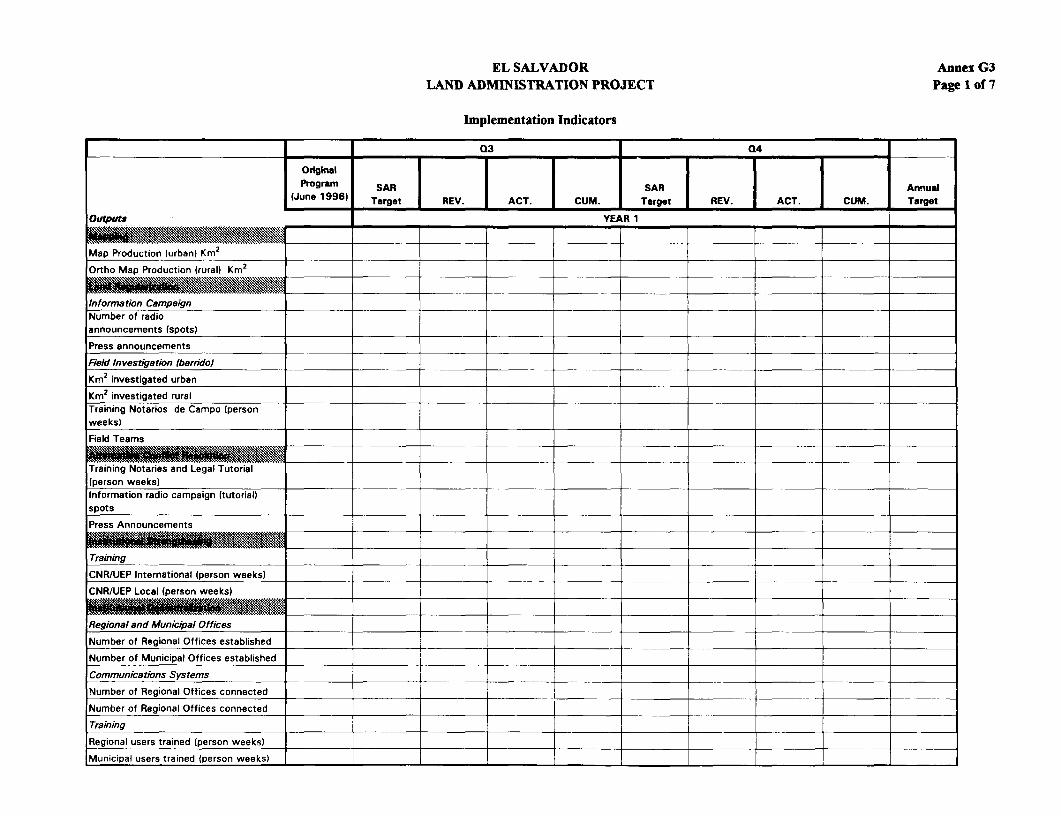
EL SALVADOR Annex G3LAND ADMINISTRATION PROJECT Page 1 of 7
Implementation Indicators
Q3 Q4
Original|l
Program SAR SAR Annual
(June 1996) Target REV. ACT. CUM. Target REV. ACT. Target
Ortps YEA R 1
Map Production (urban) Km2 l
Ortho Map Production (rural) Km2
Information CampaignNumber of radioannouncements (spots)
Press announcements
Field Investigation (barndo)
Km2 investigated urban
Km2 investigated rural
TraKnivng Notaros de Campo (personweeks)
Field Teams
Training Notaries and Legal Tutorial(person weeks)Information radio campaign (tutorial)spots
Press Announcements
Training
CNR/UEP International (person weeks)
CNR/UEP Local (person weeks)
Regional and Municipal Offices
Number of Regional Offices established
Number of Municipal Offices established _
Communications Systems __
Number of Regional Offices connected I
Number of Regional Offices connected
Training
Regional users trained (person weeks)
Municipal users trained (person weeks) l l

EL SALVADOR Annex G3LAND ADMINISTRATION PROJECT Page 2 of 7
Implementation Indicators
I --1 -Q- - 02 03 04
Original j - -I- -- I-Program SAR | SAR | SAR SAR | j Annual
(June 1996) Target REV. ACT. CUM. Target REV. ACT. CUM. Target REV. ACT. CUM. Target
0 58 YEAR 2
Map Production (urban) Km2
Ortho Map Production (rural) Km2
Infoimation Campaign (pesoNumber of radio
a nnouncements (spots)edPress announcements_.
Field Investigation {oaarido)
Km2 investigated urban_
Km2 investigated ruralTraining Notarios de Campo (personweeks)
Field Teams
Training Notaries and Legal Tutorial(person weeks)_Information radio campaign (tutorial)
Press Announcements
Training
CNR/UEP International (person weeks)
CNR/UEP Local (person weeks)
Regional and Municipal Offices_ _Number of Regional Offices established
Number of Municipal Offices established
Communications Systems
Number of Regional Offices connected_
Number of Regional Offices connected ii
Training__
Regional users trained (person weeks)= == =
,Municipal users trained (person weeks)

EL SALVADOR Annex G3LAND ADMINISTRATION PROJECT Page 3 of 7
Implementation Indicators
I_______ Q1 Q2 Q3 Q4
Original I II1 '_ _ _ _ _ __ SAR r SAR SASAR t Annual
June 1996 Taret REV. ACT. CUM. Target ACT. CUM. REV. ACT. CUM. Target REV. ACT. CUM. Target
0 *F t YEAR 3
Map Production (urban) Km2
Ortho Map Production (rural) Km2
Infommation CampaignNumber of radioannouncements (spots)
Press announcements
Field Investigation (barrido)
Km2 investigated urban
Km2 investigated ruralTraining Notarios de Campo (personweeks)
Field Teams
Training Notaries and Legal Tutorial(person weeks)Information radio campaign (tutorial)spots
Press Announcements
Training
CNR/UEP International (person weeks)
CNR/UEP Local (person weeks)
Regional and Municipal Offices
Number of Regional Offices established __________
Number of Municipal Offices established
Communications SystemsI I I II_I
Number of Regional Offices connected
Number of Regional Offices connected
Training
Regional users trained (person weeks)
Municipal users trained (person weeks) _ _ - _ . _ F _ - -

EL SALVADOR Annex G3LAND ADMINISTRATION PROJECT Page 4 of 7
Implementation Indicators
01 Q2 03 Q4
Original 1I II Ij___Program SAR j - SAR | .l .l SAR | i SAR | l A(June 1996) Target REV. ACT. CUM. Target
PUP" = = _- =YEAR 4
eap Production (urban) Km2
Orto Map Production (rural) Kr2
Information CampoaggnNumber of radioannouncements (spotst
Press announcements
FieAd Investigation fioarrido/
Km2 investigated urban= == = == == = =Km2 investigated ruralTraining Noterios de Campo (personweeks)
Field Teamsl
Training Notaries and Legal TutorialRperson weeks)
Information radio campaign (tutorialOspots R O e _Pmess Announcements
Trainkig
CNReiEP Intersational (person weeks)
MNR/UEP Loca i (person weeks)
Regional and Munkicial Offices_l_
Number of Regional Offices establishedlNumber of Municipal Offices established__|_
Communications Systemns_l
Number of Regional Offices connectedl_Number of Regional Offices connectedlTrainingl_
Regional users trained (person weeks) [Municipal users trained (person weeks)

EL SALVADOR Annex G3LAND ADMINISTRATION PROJECT Page 5 of 7
Implementation Indicators
Q1 02 03 04
Original f JI II Program SAR SAR | SAR SAR J T Annal
(June 1996) Target REV| ACT.. |CUM. Target REV. ACT. CUM. Target | REV. ACT. CUM. Target
O~fs_ YEAR 5
__ _ _ _ __ _ = _ _ __ _ _ _ _ __ _ _ _ ___ ____ _ _ _ _ ___ _ ___ _ __ _ _ __ _ _ - _-_ _ _ __ _ _ _
Map Production (urban) Km2
Ortho Map Production (rural) Km
Inf ormati on Campaign wesNumber of radioannouncements (spotsa O es_bisePress announcements_
F ield Investigation SbartidoeNKm2 investigated urban
Km2 investigated rural O cTraining Notarios de Campo (person
e seweeks) -- _ _
Field Teams t ( w
Training Notaries and Legal Tutorial (person weeks)_ _|_ Information radio campaign (tutorial) spots [ -Press Announcements I
Training
CNR/UEP International (person weeks) |CNR/UEP Local (person weeks)
Regional and Municipal Offices|
Number of Regional Offices established| |
Number of Municipal Offices established ll\|_
Communications Systems _| |_.|
Number of Regional Offices connected
Number of Regional Offices connected l| | _|
Training||_| | |
Regional users trained (person weeks)
IMunicipal users trained (person weeks) ; l l l l l l[

EL SALVADOR Annex G3LAND ADMINISTRATION PROJECT Page 6 of 7
Implementation Indicators
-1 - - ~~~~~Qi j 2 03 04
_ _ _ _ _ _ _ _ I - I -I ~ I -O rig-n-l-I-Program S - - SR SAR SAR Annual(June 19961 Target REV. ACT. CUM. Target REV. ACT. CUM. Target REV. ACT. CUM. Target REV. ACT. CUM. Target
Outps YEAR 6
Map Production (urban) Km2Ortho Map Production (rural) Km2
Information Campaign __________Number of radioannouncements (spots)
Press announcements
Field Investigation (barrido)
Km2 investigated urban
Km2 investigated rural _ ITraining Notarios de Campo (personweeks)
Field Teams
l~~Nme of Reinl Ofie connected
Training Notaries and Legal Tutorial eion uerst(person weeks) i i
Information radio campaign (tutorial) i_i_i_i_i_i_i_i
spots
Press Announcements i
Training
CNR/UEP International (person weeks) | |_ CNR/1JEP Local (person weeks) I III I I I
Rfegional and Municipal Offices _ | |
Number of Regional Offices established i I II II I I INumber of Municipal Offices established l l| _
Communications Systemns
Number of Regional Offices connected I I II I II II
Number of Regional Offices connected
Training | |
Regional users trained (person weeks)
Municipal users trained (person weeks) I I

EL SALVADOR Annex G3LAND ADMINISTRATION PROJECT Page 7 of 7
Implementation Indicators
Q _Q2
Original
Program SAR SAR Annual(June 1996) Target REV. ACT. CUM. Target REV_ . ACT. CUM. Target
outputs YEA R 7
Map Production (urban) Km2 _ _ | _
Ortho Map Production (rural) Kmt
Information CampaignNumber of radioannouncements (spots)
Press announcements
Field Investigation (barridol
Km2 investigated urban
Km2 investigated rual __..__._Training Notarios de Campo (personweeks)
Field Teams
Training Notaries and Legal Tutorial(person weeks)Information radio campaign (tutorial)spots
Press Announcements
Training
CNR/UEP International (person weeks)
CNR/UEP Local (person weeks)_-IUPLoa (personwes)&s:.s..iss __________
Regional and Municipal Offices _ _____
Number of Regional Offices established .. __|_|
Number of Municipal Ottices established __I
Communications Systems
|Number of Regional Offices connected|
Number of Regional Offices connected _ _ _ __|_|_--_
Training _ | | _ _ | _ _
Regional users trained (person weeks) __ | - | | I
Municipal users trained (person weeks)

Annex G4
EL SALVADOR
LAND ADMINISTRATION PROJECT
Status of Legal Covenants
Agreement Section Covenant Present Original Revised Description CommentsType Status Fulfillment Fulfillment of
Date Date Covenant
Covenant types: Present Status:
I = Accounts and audits C = covenant complied with2 = Financial performance/revenue generation from beneficiaries CD = complied with after delay3 = Flow and utilization of project funds CP = complied with partially4 = Counterpart funding NC = not complied with5 = Management aspects of the project executing agency6 = Environmental covenants7 = Involuntary resettlement8 = Indigenous peoples9 = Monitoring, review and reporting10 = Project implementation not covered by categories 1- 911 = Sectoral or cross-sectoral budgetry or other resource allocation12 = Sectoral or cross-sectoral policy/regulatory/institutional actions13 = Other
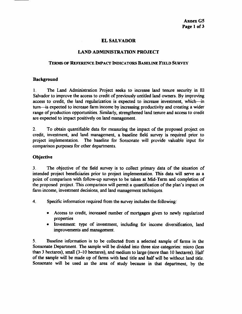
Annex G5Page 1 of 3
EL SALVADOR
LAND ADMINISTRATION PROJECT
TERMS OF REFERENCE IMACT INDICATORS BASELINE FIELD SURVEY
Background
1. The Land Administration Project seeks to increase land tenure security in ElSalvador to improve the access to credit of previously untitled land owners. By improvingaccess to credit, the land regularization is expected to increase investment, which-inturn-is expected to increase farm income by increasing productivity and creating a widerrange of production opportunities. Similarly, strengthened land tenure and access to creditare expected to impact positively on land management.
2. To obtain quantifiable data for measuring the impact of the proposed project oncredit, investment, and land management, a baseline field survey is required prior toproject implementation. The baseline for Sonsonate will provide valuable input forcomparison purposes for other departments.
Objective
3. The objective of the field survey is to collect primary data of the situation ofintended project beneficiaries prior to project implementation. This data will serve as apoint of comparison with follow-up surveys to be taken at Mid-Term and completion ofthe proposed project. This comparison will permit a quantification of the plan's impact onfarm income, investment decisions, and land management techniques.
4. Specific information required from the survey includes the following:
* Access to credit, increased number of mortgages given to newly regularizedproperties
* Investment: type of investment, including for income diversification, landimprovements and management.
5. Baseline information is to be collected from a selected sample of farms in theSonsonate Department. The sample will be divided into three size categories: micro (lessthan 3 hectares), small (3-10 hectares), and medium to large (more than 10 hectares). Halfof the sample will be made up of farms with land title and half will be without land title.Sonsonate will be used as the area of study because in that department, by the

Annex G5Page 2 of 3
project's completion year (2002), sufficient time will have elapsed for the modernizationprocess to produce measurable results.
Activities
6. Assembling a Field Survey Team. The survey team will consist of a fieldsupervisor/coordinator and four field surveyors. Team members should be from theSonsonate area, and they should have an agricultural background and a strong knowledgeof crop and livestock production parameters. Surveyors should be very personable andshould be able to work independently. Women surveyors are strongly recommended.
7. Training a Survey Team in Field Survey Techniques. The survey team willprobably require specific training (2-3 days) in field survey techniques. Team membersmust understand how to properly solicit information without distorting the respondents'answers. Also, they must learn the inviolate nature of the information that is collected (nochanges should be made to the recorded answers). The quality of the survey process isenhanced when the surveyors understand how the information they are collecting will beused; this process should be carefully explained to them.
8. Finalizing a Field Survey. Review and prepare a version of the field surveyquestionnaire for testing purposes. Undertake field testing of questionnaire with at least 20questionnaires (four per surveyor and the coordinator). Finalize the field survey based onthe results of the testing.
9. Preparing the Data Entry Module. Prepare the data collection module in a waythat reflects as closely as possible the visual presentation of the field survey (this practicefacilitates data entry and reduces entry error).
10. Selecting a Sample and Planning the Survey Route.
(a) Select the communities within Sonsonate for surveying. As a start, weproposed Santo Domingo Guzman and Santa Catarina Mazahuat becausefield work has already been carried out there.
(b) Select sample. From regularized properties, stratification required is 50 ofeach urban >500 m, urban <500 m, rural > 3 ha and rural < 3 ha.Information from registry sources and local extentionists will help identifyinitial lists of target farms or contacts in target communities.
(c) Plan the survey route.
11. Undertaking the Survey. Conduct the survey based on the route plan. The goalshould be an average of five questionnaires per surveyor per day. The field coordinator is

Annex G5Page 3 of 3
responsible for ensuring the integrity of data collected, including periodic revision duringthe day, and a compiete review of all questionnaires at the end of the day. Prior to eachday's survey activities, the coordinator will review problems and questions that the surveyteam may have about the previous day's activities. The coordinator will also discuss andcorrect methodological discrepancies and/or deviations that may develop.
12. Entering Data and Cleansing and Preparing Summary Tables. Data will beentered into the data collection module. This transfer should be done at least once a week.Data entry will be performed by members of the field survey team. This practice willmaintain continuity between data collection and data entry and will help ensure theintegrity of the data collected.
13. Data cleansing will be performed by using the SPSS data cleansing routine. Datacleansing will also be carried out through the preparation and analysis of summary tables.
Expected Product
14. A total of 200 field surveys will be collected from Sonsonate, from farms with thefollowing characteristics:
PROPERTY SIZE UNTITLEDurban > 500m 50urban c 500 m 50rural > 3 ha 50rural<3ha 50
Note: Original surveys and a diskette with data file will be provided.
Duration
15. Time frame for the survey is six weeks, including three weeks of fieldwork.
Dependency
16. The major responsibility for carrying out the survey will be in the hands of theexecuting unit.
January 30, 1996

Annex H: Documents in Project File
* HI Project Implementation Plan (PIP) Contents
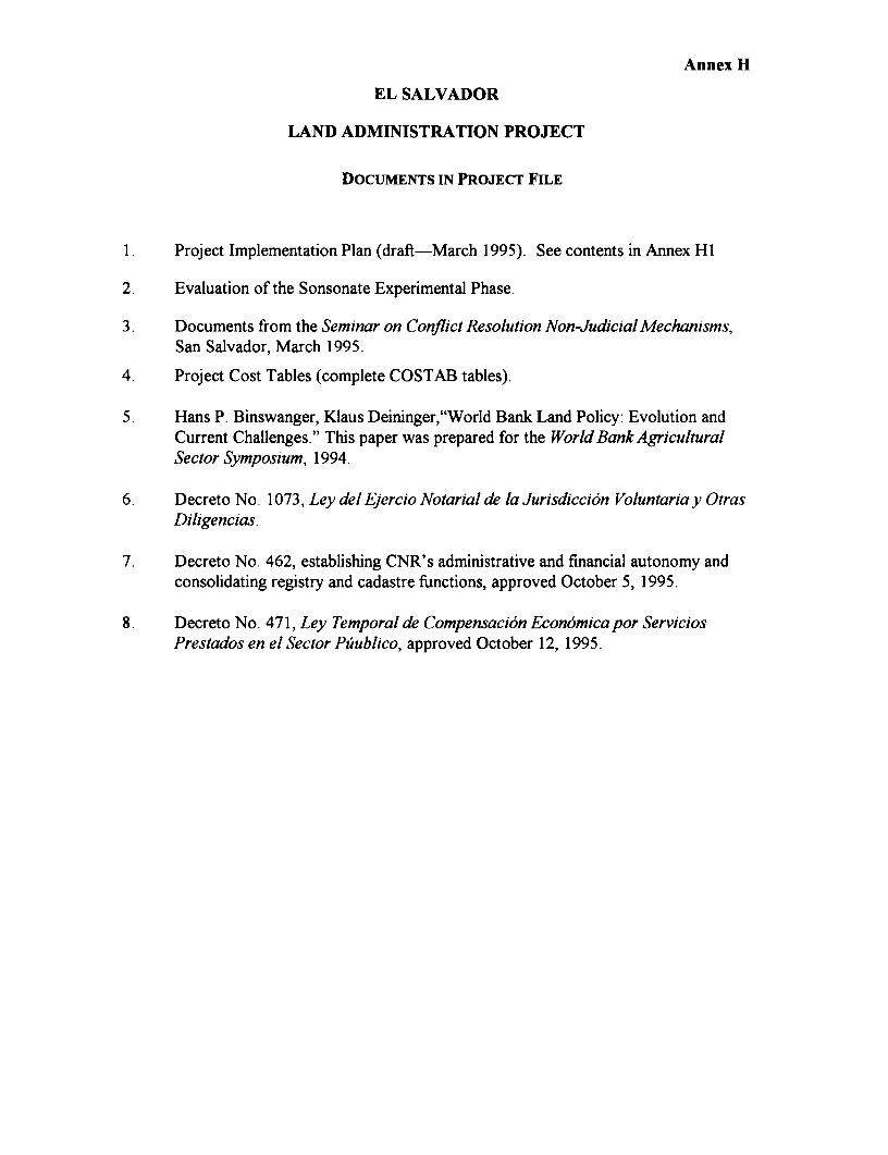
Annex H
EL SALVADOR
LAND ADMINISTRATION PROJECT
DOCUMENTS IN PROJECT FILE
1. Project Implementation Plan (draft-March 1995). See contents in Annex HI
2. Evaluation of the Sonsonate Experimental Phase.
3. Documents from the Seminar on Conflict Resolution Non-Judicial Mechanisms,San Salvador, March 1995.
4. Project Cost Tables (complete COSTAB tables).
5. Hans P. Binswanger, Klaus Deininger,"World Bank Land Policy: Evolution andCurrent Challenges." This paper was prepared for the World Bank AgriculturalSector Symposium, 1994.
6. Decreto No. 1073, Ley del Ejercio Notarial de la Jurisdicci6n Voluntaria y OtrasDiligencias.
7. Decreto No. 462, establishing CNR's administrative and financial autonomy andconsolidating registry and cadastre functions, approved October 5, 1995.
8. Decreto No. 471, Ley Temporal de Compensacion Economica por ServiciosPrestados en el Sector Puublico, approved October 12, 1995.

Annex Hi
EL SALVADOR
LAND ADMINISTRATION PROJECT
DRAFT PROJECT IMPLEMENTATION PLAN (PIP)
TABLE OF CONTENTS
Antecedentes y Programaci6n de las actividades:
(a) cronograma de actividades a nivel nacional, y(b) cronograma de actividades a nivel regional
2. Costos del proyecto
3. Aspectos tecnicos:
(a) costos detallados del mapeo;
(b) equipo recomendado para el IGN;
(c) terminos de referencia tecnicos (mapping);
(d) terminos de referencia para los equipos de trabajo de campo; y
(e) demarcaci6n internacional.
4. Aspectos institucionales:
(a) consolidaci6n institucional,
(b) nota para el estudio de las funciones del CNR a cada nivel regional,
(c) capacitaci6n, y
(d) infrastructura del CNR.
5. Administraci6n del proyecto:
(a) supervision del project;
(b) indicadores de monitoreo e impacto; y
(c) organizacion de los concursos de consultorias.
6. Anexos tecnicos:
(a) pautas para el establecimiento de escrituras y su inscripci6n en el registro;obligaciones del notario y del registrador;
(b) analisis financiero de los flujos estimados de caja del CNR; y
(c) conclusiones del seminario sobre mecanismos no judiciales de soluci6n deconflictos.

ERD COTSSr3
N,' -' ' -i EL SALVADOR
V -KL ) \\ s<>2: LAND ADMINISTRATION PROJECT
K\ ? - FIRST POASE S sELECTED CITIES AND. TO.NS
IT D~~~~~~~~~~~~~ ~ ~~ ~~~~~~~~~ONE ICENTRAKI DEPARTMENT CAPITALS
R REGIONAL OFFICE i NATIONAt CAPITAL
G U A T E M A L A - ZONE 2 CwESTERNT - OARED ROADS
GUATEMALA _ REOIONAW OFFICE - - SECECNDARY ROADs
7~~~~~~~~> _ v ,> a 4 ^ - , l 2~~~~~~~~~~~~~~~~~~~~~~~~~~~~~~~~~~A,LROADS
Al Z X . Aa N a , f * t'- :.*0 S 0z ONE 3 1bJQ2THE2NW - REIVERS
j tcc-'.lo C, 1 > j t ; C h .......... Pt /< R OEGIONAL OFFICE = . DEPART.ENT BOuNDARIES
- ( '~ ~ ~~~~~p ZONE A EA$TERNI NTERNATIONAL BOUNDARIES
R rEGONAL OFFICE
-W~~~~~~~~~~~~~~~~~~~
Al"/.CoTE.MA,Y - T %
\ H ! ,1 _ < L B+/>AO R ' i < -r~ - - > f ~ : . 30..,0.0 ' , L 2 A ' LA 7
' ~~~~~~~~~~~~~ X t X ~~~~~~~~~~~~~~~~~~~~~~~~~~i_ S ror -L7 or
- , L | SONAE SoR, I( 9v
0 ww t 9 t t 0 ~~~~~~~~~~~~~~~~~~~~~~~~~~~~~~~~~~~U N_
,N,TED STATES OF AMERICA
GWAIESA~~~~~~~~~~~~~~~~~~~~~~~~~~~~~~~ L.,ad.o T ET- 0 ,
TIlE SRA.A.M C -0'
CU IITRA
_ , CA..GUA ,K(ILO.ETE.S _ elGCG ~~ - -
_. , 0bt lQe 10 20 T. .g0 or -- -.- -o.- Fa:COSTA .RIAc,
iETEC _ A _ ' d.000,M 3o.0
'ANAMA' ~~~~~~ C 00 ~~~~ OTTO OTTOOTO TO 00001104 1A .00.0Ro,. S'o,o~~~~~~~~~~~~~~~~~~S

IMAGING
Report No: 15085 ESType: SAR

