The spatialisation of an ethno-political migrant identity: - UCL ...
379
1 The spatialisation of an ethno-political migrant identity: appropriation, adaptation, and contestation of Muhajir space in Karachi. by Sadaf Sultan Khan A thesis submitted for the degree of Ph.D. in Urban Morphology and Contested Urbanism May 2016 Space Syntax Laboratory Bartlett School of Architecture University College London
-
Upload
khangminh22 -
Category
Documents
-
view
0 -
download
0
Transcript of The spatialisation of an ethno-political migrant identity: - UCL ...
1
The spatialisation of an ethno-political migrant identity:
appropriation, adaptation, and contestation of Muhajir space in
Karachi.
by
Sadaf Sultan Khan
A thesis submitted for the degree of Ph.D. in Urban Morphology
and Contested Urbanism
May 2016
Space Syntax Laboratory
Bartlett School of Architecture
University College London

2
“I Sadaf Sultan Khan confirm that the work presented in this thesis is my own.
Where information has been derived from other sources, I confirm that this has
been indicated in this thesis.”

3
Abstract
Karachi today, is a city of migrants where both space and ethnicity are
politicised and contested. The Muhajir community is the city’s largest and
politically most significant migrant group. The development of community
identity and their political trajectory has been extensively documented but little
has been written about the spatialisation of this ethno-political identity and its
impact on the city. This study endeavours to analyse the settlement patterns of
the Muhajir community from their arrival in the city in 1947 to the present and
how political mobilisation and subsequent access to power has shaped their
post-colonial identity, their spaces and, their interactions with the city today.
Due to the dearth of ethnographic data, this multi-scalar, diachronic, socio-
spatial investigation of Muhajir presence in Karachi uses a combination of
quantitative and qualitative data sources. Master-plans, urban planning
documents, historical and journalistic accounts were used to build space syntax
models of the city, combining this information with open-content collaborative
mapping sources, on-site interviews, questionnaires and observations to build a
picture of the community’s socio-spatial behaviour and their patterns of
occupation.
The study shows that whilst the Muhajir community clusters and that these
clusters have persisted and aided their political re-imagining which in turn has
enabled them to influence urban development in the city to their strategic spatial
advantage, the community is in fact not completely introverted and does engage
and overlap with Karachi’s diverse array of communities through their socio-
economic interactions. And, that the term Muhajir encompasses a myriad of
identities; a homogenous political block offset at the neighbourhood scale by
spatial clustering determined by place-based, linguistic and religious solidarities.
This socio-spatial analysis shows this to be a complex community identity that
engages with the urban environment at varying degrees of definition to preserve
and secure the rights of its members.

4
Acknowledgements
“Then which of the blessings of your Lord will you both deny.”
Ar-Rehman (55.16)
Karachi is a difficult city in so many ways, and making it the subject of a
research project makes one realise this even more so especially when data is
either unavailable or inaccessible. I am eternally grateful to a small army of
people who have gone out of their way to help facilitate and overcome these
research hurdles. Thanks are due to Dr. Syed Jamil Kazmi of the Department of
Geography at the University of Karachi for so generously sharing a large cache
of GIS data on Karachi without which the mapping of the city could have been
so much more arduous. Thank you to Mrs. Nasreen Jalil of the MQM for
facilitating access to MQM related data and personnel. I am indebted to Farhan
Anwar for his endlessly useful insight into the workings of Karachi’s urban
planning and development proposals and providing access to hard to find
municipal maps, masterplan documents and development reports. Thanks are
due to Saeeduddin Ahmed for not only introducing me to PIB Colony but for
sharing his contacts thus making fieldwork in the area infinitely easier.
To my friends and friends of friends in Karachi, especially Imran and Subia, who
conducted much of my fieldwork by proxy, agreeing to map, photograph and
document various aspects of the city as and when the need arose, to them I am
so very thankful for their ‘volunteered’ services.
To Dr. Kayvan Karimi and Professor Laura Vaughan I am so very grateful for
their patience and guidance through the process of putting this study together. I
thank them for weathering some extreme highs and lows with me; it would not
have been possible without their encouragement and support.
To Aisha for always being my sounding board and cutting through the haze
inside my head and to my Father and Iqbal for both being my self-appointed
research assistants during hot summer days spent in the field in Karachi, thank
you. To my PhD family, especially Fani, thank you for the light at the end of the
tunnel.
And to my family, especially Sameen and Ammi, thank you for your patience,
support and unwavering belief in me.
5
Table of Contents Abstract .................................................................................................................................... 3
Acknowledgements ................................................................................................................ 4
Glossary ................................................................................................................................... 9
1. ............................................................................................................................................. 10
Introduction ............................................................................................................................ 10
1.0 Introduction ................................................................................................................. 10
1.1 The Muhajireen as an anomalous migrant community. ....................................... 14
1.2 Problem definition ...................................................................................................... 20
1.3 Structure of this thesis .............................................................................................. 23
2. ............................................................................................................................................. 27
Literature Review ................................................................................................................. 27
2.0. Introduction ................................................................................................................ 27
2.1. Social process of identity formation ....................................................................... 28
2.1.1 Language, Ethnicity, Nationalism and ‘the other’ .............................................. 29
2.1.2 Promised Land to Homeland: the transition from Nationalism to ethno-
nationalism ........................................................................................................................ 32
2.1.3 Postcolonial identity and the city .......................................................................... 36
2.2. Spatial aspects of community building. ................................................................. 38
2.2.1 Territoriality: Appropriation, adaptation and contestation of a space. ............ 39
2.2.2 Ethnic enclaves: Location, Structure, and other such relationship. ................ 43
2.2.3 Role of public space in the ethnic enclave ......................................................... 45
2.2.4 Militarisation of identity and space: Ethnic conflict and communal policing .. 46
2.3 Spatialisation of ethno-political identities ............................................................... 49
3. ......................................................................................................................................... 56
Methodology: data, mapping and process ................................................................... 56
3.1 Data Source: shortage, scarcity and resolution of urban and socio-economic
data ..................................................................................................................................... 61
3.1.1 Historical development related documentation .................................................. 61
3.1.2 Broad Statistical data sources .............................................................................. 61
3.1.3 Social media and open-content mapping ........................................................... 62
3.1.4.1 Interviews ............................................................................................................. 63
3.1.4.2 Questionnaires .................................................................................................... 64
3.2.1 Historical Timeline .................................................................................................. 65
3.2.2 Diachronic Spatial network models ..................................................................... 66
6
3.2.3 GIS mapping of communal institutions ............................................................... 67
3.2.4 GIS mapping of politically motivated acts of violence ....................................... 68
3.2.5 Mapping ethno-political boundaries using political propaganda ..................... 69
3.3.1 Thematic mapping .................................................................................................. 74
3.3.2 Cluster analysis and the establishment of cluster centroids ............................ 75
3.3.3 Space syntax analysis ........................................................................................... 76
3.4. Limitations of the research ...................................................................................... 79
4. ................................................................................................................................................. 83
The development and growth of Muhajir Karachi: A Diachronic study of the spatial
distribution and the politicisation of identity and space of the Muhajir community in
Karachi. ...................................................................................................................................... 83
4.0 Introduction ................................................................................................................. 83
4.1 Data and Methodology .............................................................................................. 84
4.3 The Muhajir City: from migrants to masters and back again. ........................... 112
4.3.1 - 1949: Muhajir arrival and inner city spatial clustering .................................. 112
4.3.2 - 1958-69: The urban “golden age” and Muhajir marginalisation .................. 115
4.3.3 - 1972-74: Muhajir re-imagining and spatial expansion ................................. 119
4.3.4 - 2001-11: A Muhajir City: political domination and spatial control ............... 123
4.4 Spatial clustering of a modern community: the use of socio-spatial proxies to
define Muhajir space ...................................................................................................... 127
4.4.1 – Language: The Lowest Common Denominator. .......................................... 131
4.4.2 - Politics: The Re-awakening & Re-imagining of a Community. ................... 132
4.4.3 - Religion: Minority Specificity within religious commonality .......................... 137
4.5 Further Clustering: Muhajir “Hotspots”. ................................................................ 143
4.6 Discussion ................................................................................................................. 150
4.7 Conclusion ................................................................................................................ 151
5. ............................................................................................................................................... 153
Muhajir space and its urban interfaces: Spatial characterisation of the Muhajir areas of
influence and the nature of their socio-spatial interface from the macro to the micro
scale. ........................................................................................................................................ 153
5. 0 Introduction. ............................................................................................................. 153
5.0.1 Data and Methodology ........................................................................................ 154
5.1. Political Dominance and Urban Development: the relationship of key
infrastructure and service related urban features to ethno-spatial form ................ 156
5.1.1 Major roads and the Construction of flyovers .................................................. 161
5.1.2 Location of Commercial Centres ........................................................................ 165
7
5.1.3 Proximity to Nine Zero and the politics of the city. .......................................... 169
5.1.4 The Scale of Political influence: The political logic of location ...................... 175
5.2. Muhajir Settlement Typologies ............................................................................. 180
5.2.1 Housing type and Plot size as Economic Markers of a Community. ............ 181
5.2.2 Categorisation of Muhajir centres by their position in the spatial network .. 186
5.2.3 Towards a more detailed understanding of ‘Muhajirness’: selection of case
studies .............................................................................................................................. 187
5.3. Functional proximities and spatial hierarchies: the embeddedness of Muhajir
areas within their immediate urban surroundings ..................................................... 190
5.3.1 The accessibility of the settlement ..................................................................... 191
5.3.1.1 Proximity to thoroughfares ............................................................................... 191
5.3.2 External associations of commercial and political communal spaces.......... 203
5.4 Discussion ................................................................................................................. 213
5.5 Conclusion ................................................................................................................ 215
6. ............................................................................................................................................... 217
The ‘Muhajir-ness’ of space: The spatialisation of an ethno-political culture within the
settlement. ............................................................................................................................... 217
6. 0 Introduction. ............................................................................................................. 217
6.0.1 Data and methodology ........................................................................................ 219
6.1 Internal ethno-spatial boundaries. ......................................................................... 223
6.1.1 Ethno-religious community clustering. .............................................................. 225
6.1.2 Political propaganda and the articulation of ethno-political boundaries....... 231
6.2 Spaces of overlap and interface: shopping streets and chai khanas .............. 247
6.2.1 The Shopping Street. ........................................................................................... 248
6.2.2 Comparative spatial analysis of shopping streets ........................................... 257
6.2.3 Chai-Khanas ......................................................................................................... 266
6.3 Spaces of identity and social solidarity: Religious institutions .......................... 270
6.3.1 Barelvi Mosques, Imambargahs and other mosques ..................................... 271
6.4 Comparative analysis of communal institutions. ................................................. 280
6.5 Discussion ................................................................................................................. 282
6.6 Conclusion ................................................................................................................ 284
7. ........................................................................................................................................... 285
Discussion and conclusion ............................................................................................... 285
7.1 Introduction: .............................................................................................................. 285
7.2 Clustering and establishment of a community .................................................... 287
8
7.3 Re-imagining the Promised homeland. ................................................................ 290
7.4 Spaces of interface: dialogue or dispute .............................................................. 292
7.5 The role of communal institutions in boundary building. ................................... 295
7.6 Implications of the limitations of the data ............................................................. 297
7.7 Conclusion ................................................................................................................ 299
Bibliography ........................................................................................................................ 305
Appendix A: Source Maps ................................................................................................ 320
Appendix B: Questionnaires, interview sheets, on-site documentation ..................... 335
Appendix C: Historical Timeline. ...................................................................................... 379
9
Glossary
Barelvi A sect of Sunni Islam that emerged in Northern India in
the early 20th century
Chai-khana South Asian Tea house
Imambargah Shi’a community centre, often with an associated
prayer space/mosque
Jama Masjid Friday mosque
Muhajir Migrant/refugee, commonly used to identify Urdu-
speaking communities resident in Urban Sindh
Muhajireen Plural of Muhajir
10
1.
Introduction
1.0 Introduction
This study began as a result of an interest in migration and the impact the
convergence of multiple communities on one city has on the spaces they
occupy. An earlier study conducted by the researcher explored the definition
and settlement patterns of the South Asian diaspora in London and concluded
that Indians, Pakistanis and Bangladeshis exhibited both distinct patterns of
integration as well as occupying discrete spatial clusters (Khan, 2003). But, in
the context of London, to be South Asian is to be visibly different and the host
community occupies the position of the majority. Being from Karachi, this led
the author of this study to question whether this occupation of space would
differ in the context of Karachi, Pakistan, where the visible difference is minimal
and most of its population of 24 million today identify as migrants of one sort or
another. It is important to note that whilst Karachi and its migrant population is
unique in many respects, the issues of contested space, migration and politics
this study investigates are features common to the urban experience of
emergent post-Colonial megacities, a discourse that this study hopes to engage
with and add to.
Karachi today is Pakistan’s premier economic hub and home to myriad migrant
communities of both ‘native’ as well as international origin. This is the result of
numerous waves of in-migration triggered by, as this thesis argues, political
events and the implementation of development policies that were designed to
benefit Pakistan’s agriculture-based economy. Possibly the most significant of
these events were the partition of the Indian sub-continent in1947 and the
11
arrival of over a million refugees in the city. This has become the turning point in
Karachi’s socio-spatial history whereby a previously small vibrant colonial port
of 450,000 people was transformed into a megacity of over 24 million in just
under 70 years. This accelerated growth, both in terms of space and population,
has resulted in the city being labelled an ‘instant city’ (Inskeep, 2012).
Simultaneously, as a result of its vast and diverse migrant population, it has
also been referred to as ‘the most dangerous megacity’ (Khan, 2013). This latter
title is often attributed to the violent encounters between migrant groups
resident in the city, the outcome of the politicisation of ethno-religious migrant
identities and the associated contest for electoral votes and land.
In the context of Karachi’s violent ethno-political narrative, the lynchpin is most
often considered to be the Muhajir community and their dominant political
representatives, the Muttahaida Quami Movement (MQM). The term muhajir
literally means migrant or refugee in the Urdu language but in the context of
Karachi it refers primarily to first wave Urdu-speaking migrants from urban
centres in the north Indian provinces of Uttar Pradesh (UP), Central Provinces
(CP & Berar), Hyderabad Deccan, Rajputana and Gujrat, and their
descendants, i.e. the Muslim refugees who arrived in the city shortly after
Partition and their descendants. It was the arrival of these refugees in 1947 that
initiated a demographic shift in the city, transforming it irreversibly ethnically,
culturally and politically. The ethno-linguistic definition of the city has diversified
since through subsequent waves of migration and over time, ethno-linguistic
solidarities have evolved into ethno-political identities with socio-spatial
implications on the city.
It is within this context of a city divided by politicised ethno-religious identities
and the resultant contestation of space that this study is placed and, in which it
attempts to answer the question ‘What has been the nature and dynamics of
spatial, social and political interactions between the Muhajir community
and the city in Karachi?’. The hypothesis in this case being that the
spatialisation of political agendas and the promulgation of specific ethno-
political policies by the state over time have influenced the establishment and
development of Muhajir identity. This identity in turn has, over the last 65 years,
concretised and politicised to further appropriate and adapt the space of the city

12
to the community’s advantage whilst simultaneously giving their spaces an
identifiable Muhajir character thereby suggesting a reciprocity in the manner by
which Muhajir presence and urban form interact in Karachi. Therefore the key
elements of this study are ethnicity, politics and how these play out in the
context of what may be termed as Muhajir space.
In order to investigate the spatial, social and political impacts the Muhajir
community has had on the city and vice versa, there was a need to firstly
understand the processes by which both the city and the community have
developed in Karachi’s post-Partition environment. This led to the development
of a diachronic approach to this study. Secondly, in order to study Muhajir
space, there was a need to establish that there are in fact Muhajir spaces in the
city to be studied. It should be noted as stated earlier that the Muhajir
community was originally conceived as an amalgamation of Urdu-speaking
migrant communities that has over time become synonymous with the MQM,
one of Karachi’s primary political players. As a result of this transformation from
migrant classification to political presence, the Muhajir identity today is often
projected or perceived as being synonymous with an ethnic identity. This study
seeks to investigate whether this perceived/projected ethno-political Muhajir
identity persists at all scales of community presence and interaction with the city
thereby superseding all other current ethno-religious affiliations or, if the nature
of community identity, how it manifests in space and how the community then
engages with their urban environment changes from the public scale of the city
to the intimate scale of the individual settlements. The notion that community
identity could manifest differently in space across the scales at which a city
functions resulted in a multi-scalar spatial analysis. This intention to analyse the
evolution and range of Muhajir presence across the changing scales of the
urban environment of the city and the decision to apply a diachronic, multi-
scalar approach to understanding the spatial, social and political interaction of
the community and the city resulted in the development of a series of sub-
questions that address diminishing scales of space, and the changing definition
of what constitutes Muhajir space and identity and their interface with the city.
These questions are as follows:

13
Are the Muhajir community clustering, as minority communities tend to
do, in Karachi? If so, is there any significance to where they are
clustering? And, how have these spaces and the community’s identity
been transformed through time and their changing socio-political and
socio-economic circumstances?
How has continued spatial clustering in the localities that the community
has claimed impacted their relationship with the city? And, as these
Muhajir areas of influence interface with the city, what form do these
spaces of interface take and are there identifiable socio-spatial
characteristics to the spaces beyond these interfaces that the community
occupy that defines them as Muhajir?
How are the various groups that comprise Muhajir majority settlements
organised spatially? Are the various ethno-political entities spatially
identifiable? What kind of spaces form the interface where these
identities overlap and interact as well as help to build and maintain these
discrete ethno-political identities, solidarities and divisions within the
context of the Muhajir settlement?
The assumption being that the Muhajir community does cluster and that this
clustering has persisted from their earliest settlements established in Karachi
shortly after Partition. Secondly, this thesis hypothesises that as the Muhajir
community has become more politically dominant within the city, the MQM (the
Muhajir community’s dominant political representative) has exercised its ability
to influence infrastructure and urban development in the city so as to pursue a
Muhajir-centric spatio-political agenda that impacts the manner in which the
community interface with both the city and its other residents. Additionally, this
thesis proposes that there is a specificity to the economic and spatial definition
to a politically active, Muhajir dominant settlement. And finally, that upon closer
analysis of individual settlements, despite majority Muhajir presence, each
settlement is a microcosm of the city; a socio-spatial patchwork of communities
both Muhajir as well as non-Muhajir, where some communal spaces define and
segregate, maintaining sub-community boundaries, whilst others play the role of
14
an interface, allowing for the various communities to come together as spaces
of dialogue.
Previous research has found that particularly in large cosmopolitan cities that
migrant groups that share an ethnic background tend to cluster and adapt the
space around them to cater to the speciality needs of their culture, often
organising themselves around religious/communal institutions and speciality
markets (Waterman and Kosmin, 1988, 1987). It has also been seen that a
people that had the bare minimum in common, when forced into close proximity
in difficult socio-spatial circumstances, have developed a form of group identity
in order to engage with greater parity with the host community (Sennett, 1996 ).
This study posits that in the context of the Muhajir community, a group identity
that has evolved as a result of various socio-spatial reasons that will be
discussed further in this thesis, the spatial manifestation of this manufactured
ethno-political identity is similar to those of established ethnic communities that
cluster, establish communal institutions and mobilise politically to preserve and
protect their cultural practices.
This introductory chapter begins by articulating the anomalous nature of the
Muhajir community within Karachi’s migrant milieu and why this uniqueness
makes them an appropriate subject for a study on the interface of space,
society and politics. This is followed by the rationale for why this particular study
should be considered a valid investigation outlining the key areas that previous
studies on the community and Karachi have failed to address through an
overview of studies undertaken on the Muhajireen thus far. The chapter
concludes with a brief outline of the contents of each of the following chapters of
this thesis, providing an overview of how the project has been undertaken.
1.1 The Muhajireen as an anomalous migrant community.
The selection of the Muhajir community as the primary subject of this study was
in part due to their role as the supposed instigators of the socio-spatial
transformation of the city but also the fact that within the spectrum of migrant
communities resident in Karachi they are unique. Their social profile, patterns
and processes of migration and resettlement and subsequent trajectory of post-
15
Partition social transformation within the city’s ethno-spatial environment has
also been quite dissimilar to their non-Muhajir counterparts. Hence, this section
gives a brief overview of the fundamental differences between the Muhajir
community and other migrant groups which has formed the basis of their
selection and makes them an appropriate indicator of an enquiry into the mutual
impact of ethno-politics and space in a post-Colonial, South Asian megacity.
1.1.1 Community profile
With regard to the community’s socio-economic profile, it may be posited that
the Muhajir identity is the post-Partition evolution of the politicised Indian Muslim
identity, mobilised by the All-India Muslim League to petition the British
government for a separate homeland for the Muslims of India in 1940. It should
be noted that the land mass that makes up Pakistan today was delimited on the
grounds that these Indian provinces had Muslim majority populations, whilst
many of those who migrated to Karachi were Indian Muslims from cities in an
array of Hindu majority provinces in India. Hence whilst these migrant
communities shared religious and political solidarities, they were essentially
from geographically diverse urban backgrounds. Thus Muhajir identity is
inherently political, urban and an union of various smaller sub-groups making it
anomalous in its very inception within the migrant environment of Karachi where
subsequent migrant groups were native to the wider area, rural with clear broad
ethno-territorial identities.
Additionally a by-product of being long-term city dwellers, at Partition the
community professed to being better educated than their rural counterparts and
engaged in professional occupations (doctors, lawyers, engineers, clerks and
civil servants). Those from lower income groups were often skilled labour
(weavers, cobblers, embroiderers) and/or small business owners (shopkeepers
etc.). Hence, upon arrival in Pakistan, many of the Muhajireen had the
necessary education and skills for white collar occupations. This was the
primary reason behind them taking up 20% of all civil service positions in the
early years whilst making up only 8% of the then population (Wright, 1991). On
the other hand, most rural migrants had little or no education, thus taking on
blue collar jobs as daily wage earners on construction sites and factories.
16
1.1.2 Processes of migration and resettlement: en masse family relocation
Urban industrialisation and rural mechanisation has resulted in migration from
rural communities, these communities still have strong ties to ancestral villages
and lands in the Punjab, Khyber Pakhtun Khwah, Baluchistan and interior Sindh
which has given rise to several differences beyond a simple urban/rural
distinction between Muhajir and non-Muhajir migrant groups in the city. Initial
migration from rural areas was primarily of single men that subsequently led to
chain migration processes within their kinship systems and finally the
establishment of complete family units. But the intent at the outset often has
been to earn in the city and send remittances home with the hope of returning to
farm their lands at some later date once a small fortune had been earned. This
has resulted in initial settlements of just single men, in some cases sleeping
under the open sky giving the impression of a population in transit in makeshift
spaces, encouraging no sense of belonging or ownership of the city in this
section of the migrant populace.
Conversely, the Muhajir experience was on the whole neither incremental nor
built around the hope of returning to a distant homeland once an individual’s
fortune had been built. Migration was much more akin to refugee movements
and consisted of the relocation of the whole family (rather than just the male
adults) which were often multi-generational units and it was a one-way process
with many families giving up or losing their ancestral homes and fortunes as a
result of their intention to not return home.
This willingness to relinquish ancestral lands and wealth for a political cause
has been viewed with great suspicion by the native communities of Pakistan for
whom to be landless people who have forsaken their roots is a dishonourable
situation. This resulted in a plethora of derogatory nicknames for the community
including panahgir, Hindustani, and tiliyar1, the use of which was to identify
them as not of this land, bringing into question both their sense of loyalty and
1 Whilst Panahgir –Asylum/refuge seeker- Hindustani- an Indian national – and tiliyar – a small
migratory bird - were all considered derogatory labels, panaghir implying that one in need of asylum is in need of pity, Hindustani implied that the migrants’ loyalties actually laid with India, and tiliyar suggested that this was not a place of permanent residence (Siddiqi, 2008). The term Muhajir on the other hand, whilst still a term for ‘migrant’, drew religious parallels to the migration of Meccans to Medina so as to avoid religious persecution in 632 AD. Their counterparts in Medina were given the title of ansar meaning “friend”.
17
belonging. This was in stark contrast to their self-image as a people who saw
themselves as being on an ideological quest, undertaking great loss and
sacrifice in order to make their new homeland a reality and therefore the rightful
inheritors of this “promised land” for the Muslims of India (Verkaaik, 1994).
An interesting dichotomy exists within the Muhajir phenomenon resulting in a
split personality of sorts; the community today makes up just under 50% of the
population of Sindh’s major urban centres of Karachi and Hyderabad, whilst at
the same time their numbers comprise of only 6% of the total population of
Pakistan, all concentrated in a few urban centres in Sindh This awareness of
being a highly localised majority with limited access to ancestral homes has had
far reaching effects on their self-image, political outlook and association with
Karachi. They claim to represent the urban underdog in a political environment
controlled by feudal landlords and is also reflected in the vehemence with which
they claim Karachi as theirs, with graffiti across the city proclaiming it to be
shehr-e-Altaf (the city of Altaf), Altaf Hussain being the chairman of the MQM.
Therein lays the importance of public space or the physical possession of land
for the Muhajireen: the fact that space and belonging are for them
fundamentally tied to land and power. The placelessness of their initial years as
an actual physical phenomenon may no longer exist but the resultant sense of
insecurity persists even today despite the community being physically
entrenched in Sindh’s urban culture for more than 60 years.
1.1.3 Post-Partition social transformation
The Muhajir community describes themselves as a very specific section of
Pakistani society; primarily middle-income, Urdu-speaking, first wave migrants
from India and their descendants. The last 60 years have seen the evolution of
their circumstance from one of plight; a people in need of charity thus playing on
the religious connotations of the word muhajir as ‘refugee’, correspondingly
elevating the position of the host community to that of ansar2- to that of
demanding what they perceive as their right as citizens of Pakistan where
muhajir implied ‘migrant’ (Saigol and (SDPI) 2002), to one where they govern
2 ‘Friends’ or helpers of the migrants. A term used to describe the people of Medina who took in
people who migrated with the Prophet Mohammad from Mecca in 622 CE
18
Sindh’s urban centres and have even been known to lobby for a separate
province for the Muhajir people (Jinnahpur in the early 1990s3 and again in
2011 along with the call for a separate Saraiki-speaking province). In light of this
last development, it could be argued that the term now connotes a new ethnicity
akin to a nation where the status of nationhood, in their view, implies a certain
degree of ethno-geographic sovereignty.
This transition from a refugee community to an ethnic group may be seen as a
means of re-imagining themselves so as to alter public perception of the
community, there have been changes within the community of what it means to
be Muhajir too. Whilst most ‘native’ communities reverted to their ethno-
religious solidarities shortly after Partition, the Muhajir community remained the
greatest proponents of the Pakistani nation state, voting for the pan-ethnic,
religious parties in the early years. The implementation of various pro-Sindhi
and Pakhtun policies in Sindh by various governments eventually resulted in the
emergence of a Muhajir-centric political movement and a generational a schism
within the community; the older generation continuing to support an all-Pakistan
ideology whilst second generation Muhajireen were advocating various Muhajir-
centric political groups (Hasan, 1999; Verkaaik, 1994).
Verkaaik (1994) argues that urbanism is a fundamental element of Muhajir
identity and as already discussed this is a critical feature that differentiates them
from most other migrant groups in the city. But this notion has had an impact on
the socio-economic definition of the community. At partition the Muhajir
community consisted of civil servants, professionals (doctors, lawyers,
engineers, etc.), the literati, small traders, and artisans and craftsmen. Whilst
many of these may be considered distinctly urban middle-class professions,
today the number of Muhajir practitioners of craft-based and artisanal trades,
skills that are often passed down through generations, are rapidly declining. In
many cases, these have been discarded and replaced with professions that
second and third generation Muhajireen consider to be more in keeping with
3 “Jinnahpur” was the name given to the Muhajir state, the call for which stated appearing as
graffiti in the early 1990s in Karachi and Hyderabad. This is an aspect of the Muhajir movement that is more frequently patronised by the Muhajir diaspora as opposed to that resident in the city of Karachi.
19
being an urbanite, i.e. clerical or office-based occupations. This phenomenon is
seen especially in the case of blue collar jobs, where an added motivation
behind this change in profession has often been the fact that migrants from rural
areas have taken on these jobs and pushed the Muhajirs out of the market. The
higher income rate afforded by salaried professions as well as the dying out of
certain arts/crafts/skills has potentially resulted in both a reorganisation of the
layout of these earlier settlements as well as investment by the community into
and the development of these areas. Hence, it has been suggested that, what
may have originally been low and lower-middle income areas housing primarily
working class citizens, today house doctors, engineers, college and school
teachers (many of them women), IT professionals, bank managers, etc. (Hasan,
2007) giving the impression of being middle-class neighbourhoods.
Many Muhajir-centric studies explore the role of young men in defining the
ethno-political identity of this community, and the use of violence and gang
mentality as a means of acquiring respect as well as material wealth (Khan
2011; Khan 2007; Ahmad 2011). But perhaps the best measure of the changing
urban character of the community is the increased public presence of the
women of this community in both political and professional spheres. The
presence and movement of women in the public realm from other communities
is generally rare and restricted if these women have accompanied their menfolk
to the city. On the other hand, a growing number of Muhajir women are working
in white collar positions or as skilled labour in the leather and tailoring
industries. This venturing out has often led to them being accosted and
reprimanded in public spaces, especially on public transport - the transport
industry being dominated by the Pakhtun community ( Ali, 2011).
Rapid urban development, the rising cost of urban living and the appearance of
women in the workplace have resulted in both the possibility and the need for
more than one breadwinner per family. This in turn has led to a shift in family
structure, and with the emergence of Karachi’s flat culture - the preference of
middle-income families to live in high-density, medium-rise apartment
complexes - that offers a more affordable means of home ownership. This has
been accompanied by a shift away from the more traditional multi-generational
family structure - often referred to as the ’joint family’ system - towards a
20
preference for the nuclear family unit. It can thus be hypothesised that the
increased visibility and participation of women in the public realm is an
indication of a number of shifts within the dynamics of the community as well as
a transformation of the use of public spaces.
1.2 Problem definition
This thesis argues that space, society and ethnic politics have a synergistic
relationship in the context of Karachi. Simultaneously, the investigation attempts
to provide an insight into the manner that numerous post-Colonial megacities,
magnets for post-industrial in-migration, function.
In the case of the Muhajir community and Karachi, a lot has been written about
the community and its politics, but very little literature speaks of the relevance
and the role played by space in the emergence and development of their
community identity or the impact their presence and particular brand of ethno-
politics has had on the growth and development of the city.
Literature pertaining to the Muhajir community in Karachi seems to overlook
three key aspects of the community’s presence and relationship with the city.
Firstly how the community manifests itself in the spaces they occupy on a day-
to-day basis and the manner in which they engage with the spaces and
residents of the city in both a political and non-political manner. Secondly, while
ethno-political upheavals in the city have regularly been attributed to the political
exploits of the Muhajir community, no study lays out the relationship between
the politics of community and the politics of urban development. Finally, the
community is regularly portrayed as a homogenous political entity with very little
discourse related to the fact that it is in fact an amalgamation of multiple post-
Partition, Urdu-speaking migrant groups. Thus very little academic discourse is
found on the internal socio-spatial nuances and hierarchies of Muhajir space
and identity.
As has been stated previously, in the context of Karachi, the Muhajir community
is best known for its engagement in the political arena but it should be noted
that, prior to the emergence of any kind of Muhajir-centric political movement, a
distinct Muhajir cultural existed (Samad, 2002) based in a commonality of
21
language and literature, religious beliefs and practices and an urban outlook.
The overwhelming and transformative nature of their urban material culture
were aspects of Muhajir occupation that historians and memoirists like Vazira F-
Y Zamindar, Sarah Ansari and A.R.Siddiqi touched upon in their accounts of a
fledgling post-Partition Karachi where streets selling north Indian delicacies
emerged, the Urdu press became a civic voice to be contended with and
downtown Karachi began to resemble neighbourhoods in Lucknow and Agra,
cities from whence they came. Unfortunately such accounts and spatial
references to Muhajir culture and occupation are found primarily for the early
years of their occupation, shortly after Partition.
In more recent times studies have focused on very specific localities such as
Liaquatabad and Golimar, Baldia, Korangi, Lines Area and Khokrapar (Baig,
2008; Dowall, 1991, 1989; Mahmood, 1999) to analyse the emergence of
violent ethno-political Muhajir culture and/or the State’s motivation behind
development in the city. A departure from the above trend is seen in the work of
Laurent Gayer (2014, 2007, and 2003) who focuses on the use of violence in
the political arena and illustrates this through his documentation of the
hungamay or troubles between the Pakhtun and Muhajireen in the mid-1980s
and again in 2010-2011. In this case, his work begins to engage with space
through the mapping of troubled hotspots and broad ethno-political clusters to
demonstrate the relationship between ethnic violence and political control But
here too, references to space and mapping are broad and only at the city scale.
Academics such as Feroz Ahmed (1998) and Korejo (2002) place the
emergence and politicisation of Muhajir identity and the community’s
contentious relationship with the State in the context of Pakistan’s long history
of ethno-political, separatist and labour movements dating as far back as 1952
with the instigation of the Bengali Language movement shortly after Partition.
This seems to suggest that in the context of Pakistan, political awareness and
protest has been a fundamental part of civic life and that the forced union of the
various ethno-religious entities that comprise Pakistani society today has
always been a tenuous one. The works of local journalists too have focused
primarily on the political life of this community and their impact on issues of
urban conflict, turf war and extortion motivated by a need to build a vote bank
22
which in turn feeds into their popularly perceived role in recent times as
Karachi’s political lynchpin and the kingmakers of provincial politics. But yet
again there is only a passing reference to the spaces they occupy and control
and the impact this spatial occupation has on the politics and mechanics of
urban development and the growth of the city.
As discussed earlier, the Muhajir community is in essence an amalgamation of
multiple, primarily Urdu-speaking, migrant communities coming from a diverse
array of geographical and sectarian backgrounds. Whilst a fair amount of
anthropological research and documentation has been carried out within the
private spaces and settlements of the Muhajir community in both Karachi and
Hyderabad, such as the works of Oskar Verkaaik, Laurent Gayer, Nicola Khan,
and Laura Ring, focusing primarily on the politicization and the emergence of
paramilitary culture amongst Muhajir youths in the 1980s and 1990s within
Muhajir settlements. These studies argue that the emergence of this form of
masculine bravado was in part a reaction to the limited access to public sector
jobs and education facilities given to many second generation Muhajireen – a
situation created by the promulgation of various state sponsored policies - but
was also a response to the popularly held stereotype of the supposedly
effeminate Urdu-speaking male (Verkaaik 1994; Khan 2012). Yet, despite the
intimacy of access to Muhajir settlements and apartment complexes, these
studies focussed on the political and treated the community as a homogenous
unit, which politically they may be, but culturally, religiously and of course
spatially this thesis posits, more nuanced identities and solidarities persist that
have not been spatially explored.
It should be noted too that, perhaps due to this lack of interest in the spatial
aspect of community and identity building, there is a notable lack of published
ethnographic spatial data on the location of this community within the city. This
study therefore has attempted to develop alternative methodologies of mapping
communities through the use of religious, political and cultural spatial proxies in
an environment where data is limited and/or out dated.
23
1.3 Structure of this thesis
The segregation of migrant communities in the urban context is both a social
and a spatial phenomenon; Chapter 2 highlights and discusses literature
pertaining to issues of identity and community building through commonalities of
language, ethnicity and politics. It goes on to discuss how often this leads to
spatial clustering of those viewed as the ‘other’ and how hyper segregation
results in the politicisation of space and urban conflict. It discusses how
traditional tribal/feudal systems of hierarchy commonly found in Pakistan’s rural
societies have been translated into political powerbases, how these differ from
those of urban based communities and how these political affiliations have
manifested in the urban context of Karachi. The chapter concludes by
discussing literature on the clash of urban and rural ethno-political structures
resulting in a militarisation of identity and, from a spatial point of view, in the
transformation of the urban character of the city.
Chapter 3 lays out the methodology for this multi-scalar diachronic study. The
chapter begins by providing a brief overview of where and how space syntax
methodologies have been used in previous studies of urban segregation,
showing how these methodologies are appropriate for the study of urban
segregation across changing scales. It goes on to describe and justify the
proxies or surrogate data used in this investigation as a result of conducting a
study in an environment where there is a severe dearth of detailed, up-to-date
ethnographic data. It details how both quantitative as well as qualitative data
sources have been used to describe and analyse how the Muhajir community
appropriate, adapt and contest space in Karachi from the scale of the city to that
of their settlements.
Chapter 4 addresses the historical development of the city and the evolution of
Muhajir identity from a small colonial port town in 1947 to the megacity it is
today. The analysis highlights the synergistic relationship between major
political events, plans and policies for urban growth and infrastructure
development and the political affiliations of the city’s residents and its
administrators. Through a series of spatial network maps charting the
chronological growth of the city, the analysis then goes on to focus on both the
24
urban development of the city and the initial settlement patterns of the Muhajir
community. Using proxy data sources, the chapter concludes with the
identification of Muhajir clusters in the city.
Whilst chapter 4 focused on the evolution of the city and the identification of
Muhajir spaces, the discussion in chapter 5 attempts to analyse the impact that
the political dominance of the community in recent times has had on the spatial
development of the city and Muhajir space. As stated above, this is a multi-
scalar study and whilst the previous chapter dealt with the city-wide presence of
the community, chapter 5 investigates the nature of the interface between
Muhajir space and the city. The chapter concludes with a deconstruction and
socio-spatial description of the Muhajir settlement.
The last of the analysis chapters examines the socio-spatial role that
communally shared public spaces such as markets, chai-khanas, and
communal institutions play in community and identity building and what a
Muhajir settlement actually looks like socio-spatially from the inside out. This
chapter studies the notion of boundaries and what this means in the context of
the Muhajir settlement. Whilst politically the Muhajireen argue that they are the
‘fifth ethnicity’ of Pakistan, due to the circumstances under which this identity
emerged, the community is actually an amalgam of displaced ethnic identities.
Through a detailed analysis of the case studies, the discussion in chapter 6
shows that in many cases subgroups maintain discrete sub-settlements within
the larger Muhajir settlement/cluster. This has been investigated through the
demarcation of the catchment of communal institutions and the mapping of
various types of political propaganda.
The discussion section of this study presented in Chapter 7 combines correlates
and presents the findings of the investigation and responds to the question
stated in the introduction. It attempts to show how a spatial approach to an
issue of identity and politics in a complex, migrant-based urban environment
provides insights into planning decisions, inter-community relationships and
intra-community hierarchical structures. The concluding remarks of this chapter
present a summation of the findings, the conclusions drawn and potential
further work this study may contribute to.

25
This document includes three appendices: Appendix A providing additional map
related data including masterplan maps, guide maps, maps sourced from
various newspaper articles, and municipal maps of the case study areas,
Appendix B contains copies of the questionnaires and interviews forms as well
as information retrieved from the interviews and questionnaires completed on
site and examples of images of on-site documentation carried out during the
fieldwork period and Appendix C is a detailed historical timeline.

26
Fig. 1.01. Map of Karachi 2007-09 showing streets and areas relevant to this study.

27
2.
Literature Review
2.0. Introduction
The Muhajir community of Karachi has been resident in the city for over 60
years. Many of the earliest settlers now have at least three generations born
and bred in the city and since 1947, this community has greatly outnumbered
both the indigenous population as well as other, more recent migrant groups
moving in. This trend has only recently begun to shift with the permanent
settlement of various domestic, labour related migrants in the city. Hence, this is
a study of the processes and spatial impacts of the migration and resettlement
of an urban migrant community.
Historical accounts suggest that the decision by the majority of Urdu-speaking
Indian Muslim refugee communities to settle in Sindh’s urban centres was less
a choice and more a compulsion. Settlement of non-Punjabi refugees in the
Punjab – the largest province and most able to absorb the influx of migrants –
was actively discouraged by the Punjabi oligarchy (Alavi, 2011). Baluchistan
and the North West Frontier Province (today Khyber Pakhtun Khwah), the
underdeveloped frontiers of the empire had limited appeal for an urban
population and, whilst Biharis like their eastern Punjabi counterparts due to their
underlying similarity in culture and language, moved and were absorbed into
East Bengal (East Pakistan), the bulk of Urdu-speaking refugees were, through
a process of elimination left with limited choices and were thus encouraged to
settle in Sindh (Siddiqi, 2008). This seems to illustrate that from the out-set, the
Muhajir narrative has been coloured by processes of State sponsored

28
segregation, and hence another key aspect of this study is the spatial
segregation of a community.
As discussed in the introduction, the Muhajir identity is a composite entity; whilst
the term literally means migrant or refugee, in today’s ethno-politically charged
Karachi it specifically refers to first wave Urdu-speaking Indian Muslim migrants
and their descendants (Siddiqi, 2008). This definition is often expanded to
include the assumption that they align themselves politically with the Muttahaida
Quami Movement (MQM) and therefore this is a community defined primarily by
a shared language, a degree of religiosity and a political affiliation. These
features of their ethno-political identity in turn imply some shared cultural and
religious practices and a shared history of political participation ranging from pre
to post Partition through to the modern day and become the social elements of
their identity around which this enquiry is built. Hence this chapter will engage
with some of the key discourse surrounding the socio-spatial processes of
migration and resettlement, the spatial segregation of migrant groups and the
evolution of migrant identities and spaces in an urban environment. These are
processes that are both social and spatial in nature and therefore the discussion
will be divided in this manner for the purposes of this discussion.
Additionally, as stated above, the Muhajir identity is an ethno-political entity that
is situated within a much wider, varied migrant environment where structures
are radically different from one another and political expression is fervent and
often volatile. Hence the final section of this review engages with literature
pertaining to the physical expression that communal appropriation and
contestation of space takes in the context of complex urban situations like
Karachi.
2.1. Social process of identity formation
Segregation, as an urban phenomenon, is the outcome of various socio-
economic factors. It may be the result of forced separation of a minority from the
majority so as to maintain the majority’s sense of superiority and a preservation
of ‘purity’ of both self and space (Sibley, 1992). Often it is a chosen separation
by a minority community for the purposes of preserving and perpetuating their

29
distinctive culture in a new environment, or also be the outcome of the land and
housing markets that render certain sections of the city inaccessible to those of
a lower-income bracket (Johnston, Forrest and Poulson, 1996). This is often the
economic bracket that many migrants or refugees fit into in their initial stages of
urban settlement. Whatever the reason may be, the practice has a way of
labelling or identifying the residents of these ghettoes, enclaves or colonies as
different from the majority; native vs. colonial, Jew vs. gentile, blue-collar vs.
white-collar, thereby giving rise to a collective identity shared by all the
inhabitants. Thus it can be said that whilst urban segregation manifests itself as
a spatial phenomenon, it is in most circumstances, a socially motivated
occurrence.
Notions of both identity and community, like the city, comprise of varying scales
- from concepts of what defines a nation or nationality that speak of
geographical borders and territoriality (Ahmed, 1998), through to local
solidarities and affiliations of religion, trade, caste, etc. Whilst the individual may
experience simultaneous solidarities and associations and belong to several
communities across these scales of identity, this particular discussion will focus
on notions of ethnic identities and communities hence the following sections
discuss the elements that build this kind of communal identity.
2.1.1 Language, Ethnicity, Nationalism and ‘the other’
When addressing issues of urban segregation and group identity, one of the key
factors is the definition of the community being studied. Whilst a community
may be defined by a myriad of shared associations, the focus of this study is a
community defined by its ethno-politics. Whilst ethnicity may be considered in
terms “of relationships between groups whose members consider themselves
distinctive” (Eriksen 2002, p. 7), it is further defined as “a social group … set
apart or bound together by common ties of race, language, nationality or
culture” (Ahmed, 1998). Therefore, not only is it a perception of self, but also a
solidarity built around tangible commonalities. In the case of the Muhajir
community, as discussed earlier, this was the label given to primarily Urdu-
speaking, Indian Muslim migrants and their descendants who today are often
associated with the MQM, the key shared elements of this particular group are
30
religion, language and political affiliation, all features that in light of the above
definition, may define an ethnic group. Interestingly, the definition of ethnicity
makes no reference to a shared territorial association.
Whilst religion may be one of the broadest forms of social solidarities –
Anderson states that “The great sacral cultures incorporated conceptions of
immense communities” (Anderson, 2006, p. 12), these trans-ethnic religious
solidarities have through history often proven to be tenuous; once the need for
such solidarities has been removed members often revert to previously held
dynastic fealties and tribal and kinship loyalties. Each of these came with its
own perception of who was part of the in-group and who, of their previous
compatriots were to be classified as the other, and this process of
categorisation was often based on their ethnic biases. Benedict Anderson
(2006) argues that the persistence of religious solidarities for as long as they
lasted was due to the control exerted by religious communities and institutions
over knowledge and written material. With the advent of the printing press and
the increased accessibility of written material, these monopolies and solidarities
were dismantled to be replaced by linguistic nationalism. This suggests that
language has played a pivotal role in the emergence of nationalism and
nationalistic identities. It is the interaction of people that creates a sense of
identity (Reetz, 1993), this interaction in the modern world has been primarily
through oral and printed media, thus language, after religion, appears to
become one of the most important factor in the formation of any
identity(Rahman, 1997).
Language is often used as the lowest common denominator around which to
build an ethnic identity as it is assumed that it is demonstrative of shared
cultures and traditions which in turn may connect people from similar
geographical backgrounds. Yet this is not always the case. Some languages
have been used to facilitate larger political agendas more far reaching than
simple ethnicity. This has been the case with the revival of Hebrew for Israelis
and the Jewish Diaspora, Urdu for the Indian Muslims of the Indian
Subcontinent, the development of Afrikaans in what is today South Africa, and
the promotion of minority languages as a part of an ethno-political identity in the
case of Welsh, Basque etc. Hence Rahman’s (1997) suggestion in his text
31
charting the various ethno-political movements in post Partition Pakistan, that
the association of language and identity has been used as a means of political
mobilization seems valid. He goes on to suggest that this kind of ethno-linguistic
nationalism is a modern phenomenon. William Safran (2005) expresses this
association of language and politics quite succinctly:
“Languages are not only tools of nation-building but also means of political
control. That is why ethnic minorities use language - for example, the demand
for bilingualism - as a political strategy - as ‘a form of protest against political
domination.’” (Safran and Laponce, 2008, p. 4)
Benedict Anderson (1983) argues that nationalism itself is a modern
phenomenon as it is a significant departure from the dynastic, tribal, kinship and
religious solidarities that predated this kind of ethno-nationalistic community.
Though these solidarities may not necessarily be organic, he argues that most
successful revolutions since World War II have defined themselves in “national
terms”, the overarching factor being a commonality of language. Safran (2005)
suggests that these new, language-centric solidarities have, in a few cases, led
to the emergence of wholly new ethnicities as in the case of Afrikaners in South
Africa, Bosnians in the former Yugoslavia and the Muhajirs in Pakistan.
The possible reasons for socio-spatial segregation outlined at the beginning of
this discussion as well as the political implications of linguistic solidarities
suggest that certain social hierarchies and power structures come into play
when analysing the structure - both social and physical - of multi-ethnic
societies. These will often be relationships of domination of an in-group or a
majority over a minority group which will be viewed or termed as the other.
Where different communities have distinctive physical appearances, those who
do not fit a specific physical description are easily identified as the other, but
often, in multi-ethnic societies where most inhabitants ‘appear’ to be the same,
language or accent become the differentiating factors thus the notion of the
“visible” and “non-visible” other (Walter, 2000).
What makes the idea of the other, both visible and non-visible, relevant to this
particular study of migrant settlement patterns is that the group under study –
the Muhajir community - may have arrived as a migrant population hence they
32
should have traditionally inhabited the minority category but, due to their large
numbers (over a million arrivals from 1947-51), they took up the role of the
majority in a few select cities. This was a social shift; from being a Muslim
minority in Hindu majority areas this community suddenly became a migrant
majority in an already established city, and thus changed the cultural face of the
city. Yet despite their numeric and cultural majority presence, the settlement
process was very much that of a migrant population; occupation of peripheral
areas of the city and infill and vacant sites in inner city areas (Hasan, 1999).
Eriksen (1994) provides an explanation for this phenomenon; the transformation
of ethnic identities into political ones,
“Research on ethnic identity formation and boundary maintenance has indicated
that ethnic identities tend to attain their greatest importance in situations of flux,
change, resource competition and threat against boundaries. It is not surprising
therefore, that political movements based on cultural identity are strong in
societies undergoing modernisation” (Eriksen, 1994, p. 99)
This suggests that the spatial aspect of identity plays out not only in the initial
clustering of a community, but the subsequent consolidation of this clustering
upon the realisation of this ethno-political identity through processes of
challenging and defending both identity and space. So through a process of
shared language and shared experiences and identity, the migrant community
despite its majority presence, ends up establishing enclaves; a sharing and
consolidation of space.
2.1.2 Promised Land to Homeland: the transition from Nationalism to
ethno-nationalism
In many processes of migration, the destination often assumes a paradisiacal
status, embodying all the characteristics that are diametrically opposite to those
of the place from which the migrant community is leaving. The ‘Promised Land’
is conceived as a place of abundance and opportunity or place of purity and
hence where ideals and values held dear by the migrant community are
safeguarded and upheld. The reality of the new homeland often falls short and
33
thus arises the clash between myth and reality. This encounter of the perceived
and the real shapes not only the psyche of the migrant community but also the
built environment they inhabit.
“The myth of a promised land is a fundamental narrative in many identity
constructs. Whether it be an imaginary place or a real country, a mythic
elsewhere always presents itself in the image of a lost paradise, a land of
abundance and a better world.” (Anteby-Yemini, 2004, p. )
These disparities between the notional and the physical realisation of this ideal
state, can be best described in the case of two migration processes dealing
specifically with a migrant population ‘returning’ to a promised home land; the
Jewish Diaspora’s ‘return’ to Israel and the migration of Muslims and Hindus
from India to Pakistan and vice versa, after the Partition of the Indian
Subcontinent. In both cases, history shows how upon arrival, the migrants found
that the host community was far less awed by the appeal of a Promised Land;
the day-to-day realities of life and the state - provision and management of
infrastructure, security and safety of the populace, etc. - very quickly
overshadowed the achievements of various Independence movements for the
host communities. And, especially in the case of Israel previously central
religious texts and ideals were relegated to become issues of lesser
importance; despite the fact that these had been anticipated by the migrants to
be key points of reference within governance. This shift from the religious to the
secular added to the deconstruction of the notion of the ideal state (Safran,
2005).
In the case of Pakistan, this shift between secular and the religious may have
worked in reverse; whilst the state may have been envisioned as a homeland
for the Indian Muslim, it was perhaps never intended as an Islamic state. Its
political imagining was conceived as more of a federation of nations similar to
the Soviet Union or the United States, with the aim of acknowledging the
different peoples that made up the territory that was to become Pakistan whilst
limiting their right to territorial sovereignty (Devji, 2013). In his first address to
the constituent assembly of Pakistan, M.A. Jinnah – Pakistan’s first Governor
General - stated that “You are free; you are free to go to your temples, you are
34
free to go to your mosques or to any other place or worship in this State of
Pakistan. You may belong to any religion or caste or creed - that has nothing to
do with the business of the State.” Yet despite this, Pakistan’s constitution of
1956 proclaims it as the ‘Islamic Republic of Pakistan’ illustrating the schism
between the notional homeland for the Indian Muslim where due to their
experience as a persecuted minority all were free of religious persecution and
the physical realisation of it, where definitions of identity were sharpened and
took on an orthodox interpretation.
To add to this idea of actualisation of identity, whilst the Muhajireen saw
themselves as the only true Pakistanis due to their often traumatic migration
and sacrifices for Muslim independence, thus theirs was a community to be
celebrated yet, their experience upon arrival was quite different (Verkaaik, 1994;
Zamindar, 2010). In this case, though religion may have been a uniting factor
and suggested a natural solidarity between all adherents to the belief but, upon
arrival, the diasporic communities were considered as migrants or viewed as
the other by the host communities due to linguistic or ethnic distinctions.
“They came to the promised land torn and broken in body and soul but still
hoping for a secure future. Treated and accepted as a refugee at the outset,
they earned a variety of brand names - panahgir [asylum seeker], mohajir
[refugee/migrant], tilyar [a small migratory bird], makkar [locust], Hindustani -
each carrying a different shade of commiseration or pity or scorn if only by way
of a joke.” (Siddiqi, 2008, p.119)
Thus, this sense of disillusionment and a betrayal of sorts experienced by the
new arrivals, coupled with the host community’s desire to distinguish between
the so called sons of the soil and migrants who were often economically
weakened due to the processes of migration they experienced, has been pivotal
in the isolation - both cultural and physical - of migrant communities in their
respective Promised Lands. Hence, despite the proposition in the opening of
this review that ethnic segregation is primarily of three distinct types: forced due
to externally applied social prejudices, chosen by the minority community for
cultural preservation and a default outcome due to economic limitations of the

35
migrant group, it seems that often, segregation is a combination of all three
factors.
To assume that the only party affected by this migration is the migrant
community seems simplistic, there are expectations on the part of both migrants
as well as their host community. This sense of expectation is summed up
below;
“Because both migrants and hosts anticipate that the diasporic return of co-
ethnics will be less problematic than other types of immigration, the mutual
ethnic and social alienation that results is all the more disorienting, forcing both
migrants and hosts to fundamentally reconsider their ethnic identities.”(Tsuda,
2009, p. 7).
The hosts often expect an immediate assimilation or at least a conformist
approach to life on the part of the new migrants, sometimes going as far as to
provide services - language classes and equivalency training for professionals -
to facilitate this transition (Remennick, 2009). Yet despite this desire to have
migrants assimilate, often, as has been the case with both Jewish returnees
and Indian Muslim refugees, due to their large numbers, concentrated in a few
urban centres, migrants have gone through a process of restricted assimilation.
This resistance to assimilation is possibly due to their numeric strength, the
establishment of institutions within their settlements to safeguard their cultural
identity and liaise where necessary with the state, and the degree to which they
consider themselves to be distinct from the host community (Safran, 2005).
Their reluctance to assimilate and in fact the emergence of a parallel ethno-
nationalism different to that of the state has often resulted in a certain degree of
resentment on the part of many host communities. The outcome of the rise of
migrant ethno-nationalism, especially in the case of the host population of
Sindh, Pakistan who received the Muhajir settlers at Partition, has been
reactionary ethno-nationalistic movements of their own that are often (but not
always), if not instigated, then at least supported by the state. The above
mentioned political reactions are often seen by migrants as lopsided state
policies. These coupled with the above mentioned occurrences of numeric
strength concentrated in a few localities, Coakley (2003) suggests, are key in a
36
community going from asking for their rights and an acknowledgement of their
distinctness as a community from the host population to demarcating a territory
of their own whether that is in the form of enclaves, ghettoes or actual
sovereignty.
2.1.3 Postcolonial identity and the city
Whilst both Karachi and the Muhajir community are unique in the manner in
which they have grown and engaged with the various migrant communities
present, there is a need to acknowledge that the case under study shares
certain characteristics that can be attributed to the processes of postcolonial
urban development found in many postcolonial cities in Africa and South Asia.
For the purposes of this study it is important to identify what these are so as to
be able to systematically differentiate between the unique features of city
development and identity and those that are similar as a result of a shared
postcolonial trajectory.
In many cases, cities in Africa and South Asia had been used as colonial
administrative hubs and therefore had a significant military presence, developed
as composite entity exhibiting what may be described as the ‘Dual city’
phenomenon (Lari and Lari, 1998). These ‘dual cities’ showed two distinct urban
fabrics developing simultaneously, one usually the grid-iron ‘European’ city
comprised of the Civil Lines, Saddar (cantonment) bazaar and barracks area,
whilst the other consisted of a system of narrow, congested, meandering streets
favoured in the ‘native’ city (Lari and Lari, 1998). Additionally, as the description
above suggests, the ‘European’ city was laid out in distinct functional districts –
administrative, commercial, communal/recreational and residential – with limited
overlap between functions. The ‘native’ city on the other hand was often
organised into neighbourhoods defined by the trades of their residents (Lowder,
1986) where marketplaces, communal spaces and residential areas overlapped
creating a vibrant 24 hour environment. It should be noted that the two parts of
the city would typically be highly segregated from one another, stemming from a
desire to separate ‘native’ and ruling populations (Nightingale, 2012). Added to
this spatial diversity was an additional layer of social diversity often associated
with colonisation; many colonial towns were strategic administrative and trade
37
hubs within the various colonial networks and thus attracted various domestic -
and in some cases international - communities related to the services and
business sectors thus making these towns reasonably diverse ethnically, at the
time of their independence. Karachi was no different, annexed in 1839 as a
means to transport agricultural goods from the Punjab in the north via the
railway to the port and outwards across the empire thus making it a small but
diverse and vital colonial centre (Hasan, 1999).
Post-independence, most of these cities have grown exponentially both in terms
of land area and population. In most cases, this mushrooming can be attributed
to administrative drives towards agricultural mechanisation and nationwide
industrialisation with old colonial centres being the epicentre of this industrial
development due to the availability of an established trade and transport
infrastructures. Postcolonial administrations undertook these monumental
development projects from a desire to modernise and have these cities become
national economic hubs whilst simultaneously rebranding the city, and by
extension the nation, as postcolonial powerhouses of development, throwing off
the yoke of their old imperial masters. The quote below encapsulates this ethos
of iconic postcolonial development and the emergence of new national
identities;
“In much of the postcolonial literature following the departure of colonial rule, a
moment of euphoria among postcolonial elites who had hoped that colonial
cities in Africa would be transformed into engines of national development, not
just for the individual countries but for the continent as a whole. Modernisation
projects such as airports, universities, hospitals, expansion of highways,
hydroelectric projects, the construction of new civic buildings, new apartment
buildings, banks, insurance companies as well as national theatres were
undertaken by the postcolonial states and private individuals as markers of
modernity and modernisation.”(Demissie, 2007, p. 2)
Additionally, in many cases, grand new capital cities were designed and built at
a distance from the existing centres of colonial rule. The planning of these cities
was in keeping with the perceived postcolonial identity of these new nations,
with broad boulevards named after heroes of the various independence
38
movements and grand governmental buildings, whilst in the older parts of the
city, administrations renamed streets, almost as if they were giving space a
duality of identity (King, 2006).
The simultaneous State-sponsored processes of mechanisation and
industrialisation resulted in the push/pull factors that have become so familiar to
the narratives of postcolonial development today: mechanisation of
landholdings meant fewer jobs in rural areas pushing the rural populace off of
the land whilst industrialisation in urban centres has produced a need for cheap
labour thus creating a pull towards the cities. As Demissie states above,
projects undertaken were primarily of a civic scale and thus, in the case of many
major postcolonial centres, limited provision was made for the resultant migrant
influx into these cities. Lack of housing and infrastructure to manage this deluge
of people led to overcrowding of existing housing and the establishment and
growth of the informal housing sector. This has often led to the development of
two parallel forms of development and governance: large scale formal sector
projects sponsored by the state and the informal sector stepping in to bridge the
gap between demand and supply of everyday services and facilities often
functioning through a form of shadow administration with back alley deals and
kickbacks which in turn has become the foundation of the complex relationship
between land, voter base and political power in many developing urban centres.
2.2. Spatial aspects of community building.
Coakley (2003) suggests most ethno-nationalistic movements go through three
phases; asking for the rights of the individual ‘other’, followed by an official
acknowledgement of the distinctiveness of the group from the majority and
finally the right to territory. This section of the review will look at literature
associated with that appropriation, adaptation and contestation of a territory
associated with a particular community. The discussion will also look at the
socio-spatial implications of ethnic segregation - both good and bad - that are
often the outcome of location within the city fabric and their spatial
configuration.

39
Space syntax – a theory of space and society developed at the Bartlett -
research suggests that most people belong to communities that are both spatial
and transpatial in nature (Hanson & Hillier, 1987); inhabitants of an area are
bound to the people, spaces and places that they physically inhabit whilst
simultaneously being part of a larger network that is independent of the
immediate physical context. The city-wide spatial structure of an organically
developed city enables not only the cultivation of a sense of community where
one lives but also allows for chance encounters with a larger virtual community4
thereby ensuring variety and security. Whilst this may be true of the spatial
structure of the city and its general population, the focus of this study is
specifically on what may be termed as the ‘urban ethnic enclave’ hence, the
interest of this study lies primarily in communities that share both social as well
as spatial solidarities. It will be seen through the process of the literature
reviewed here, that despite a working correspondence between social and
spatial solidarities, marginalised communities and locations often experience
isolation that triggers discontent and conflict with the state, other communities
as well as within the community itself.
2.2.1 Territoriality: Appropriation, adaptation and contestation of a space.
As stated earlier, the segregation of a community from the majority may be the
result of force, choice or economic constraints. In the case of both forced
segregation or segregation of choice, separation of a community is often the
outcome of concerns of purity and contamination of space whether it is the case
of purging the spaces of the majority by expelling or containing the other or the
avoidance of contamination and dilution of one’s culture by distancing the group
from the majority culture. These notions of forced or chosen separation appear
to have nuances of positive and negative features to them; Peach (1996)
suggests that there may be positive processes to be found in what is often seen
as forced segregation as well as drawbacks to a segregation by choice. For
example, what may have started out as a “fear of touching” and thus resulted in
confining the Jewish community in Venice to the Ghetto, transformed into a
4
The virtual community is “the pattern of natural co-presence brought about through the influence of spatial design on movement and other related aspects of space use. (Hillier, 1996 2007, p. 141)
40
place where the community realised their uninhibited self with a degree of
externally provided protection and without fear of persecution within the
confines of the ghetto. The community established the very first permanent
synagogues in Europe here where people dressed, interacted and worshipped
as they pleased (Sennett, 1996).
Shirlow and Murtagh (2006), like Sennett, suggest that spatial segregation
helps to manifest with greater clarity belief structures and other such cultural
solidarities. In fact Sennett seems to posit that it was the physical proximity
provided by the Jewish Ghetto that was instrumental in consolidating the Jewish
identity of otherwise disparate groups whose only commonality was their Jewish
faith in its broadest and most varied definition. This issue of proximity as a key
factor in the emergence of identity seems to apply to the Muhajir community. As
discussed earlier, this is a community formed of an amalgamation of refugee
groups from diverse geographical backgrounds brought together under
extenuating circumstances in a few choice locations, the socio-spatial outcome
of which will be analysed and discussed further in this study. It should also be
noted at this stage that this discussion does not claim that all proximities in a
closed system will result in a natural sense of community. In fact, the literature
seems to suggest that it simply facilitates a consolidation of ideas and values
that the community in question already have in common; as in the case of both
Catholic and Protestant communities in Belfast and the Jewish and German
communities in Venice, thereby manifesting an apparent correspondence
between social and spatial structures, which is only there by virtue of
circumstance (or conflict, or force).
Communities where both social and spatial structures coincide are perhaps
what has given rise to the misconception that placing people within a closed
system will automatically give rise to a ‘community’ that will live and socialise
together, coming together to defend their territory should they be threatened by
an external force. Oscar Newman goes as far as to suggest that where society
and space do not correspond, society deteriorates into a combative
environment. Conversely, it has been argued that territorial warfare is a social
issue of perceptions of difference, and not one of non-correspondence of space
and society; “Thus segregated spaces are representational and designed

41
through exaggerated notions of social difference and complex patterns of
exclusion that are tied to those who conform to defined symbolic and cultural
codes within the ‘home’ territory.” (Shirlow and Murtagh, 2006), thus suggesting
that spatial segregation is in fact the outcome of a social desire to maintain a
distinct identity.
Whilst language, religion, politics etc., may give a community an ideology to
band around, where numbers reach a critical mass, communities may establish
and commandeer institutions and spaces to safeguard and perpetuate the
above mentioned commonalities of culture and ideological thought as well as
anchor them in and to a space, as these institutions now become viable and
sustainable entities (Waterman and Kosmin, 1987). These communal
institutions may include religious and political institutions, places of commerce -
shops catering to specific cultural needs - places of recreation such as playing
fields, local ‘hang-outs’ etc. - and educational institutions (Suttles, 1968). In fact,
Vertovec (1995) argues, as seen in the case of Indian migrants to the
Caribbean, the establishment of communal institutions for the preservation and
perpetuation of a community’s culture is a critical part of the resettlement
process and becomes a stepping stone to the self-actualisation of the
community both spatially and politically within the host environment. These
institutions become critical to the maintenance of perceived differences; often
facilities not available within the enclave, residents will either forgo or seek out
in locations similar or sympathetic to the ideology of the user or in neutral
territory (Shirlow and Murtagh, 2006). This preference of patronage is often
driven by a fear of being confronted by an opposing group and in so doing;
residents consolidate this sense of segregation and in turn, establish the edges
of the group’s territory whilst this quest for resources raises an awareness of
their larger trans-spatial community.
Whilst Newman’s ‘theory of defensible space’ may not apply to all communities,
those communities tied together through affiliations of ethnicity, language,
religion and/or politics may be seen to demarcate and protect their spaces. This
may be through both physical markers such as flags, murals and graffiti,
boundary walls, as well as rituals and traditions in the form of parades and
processions. Like institutions, these are ‘events’ around which the community is
42
seen to rally and build its identity (Shirlow and Murtagh, 2006). Where numbers
allow - and where both political and economic power lie in the hands of the
community in question - transpatial ties of sympathetic communities may be
further consolidated through various forms of media; newspaper, electronic
media networks etc. The ability of any community to be able to establish these
transpatial institutions ties back to Coakley’s initial claim that any community will
go from identification of the self as different, to the collective’s demand for
official acknowledgement of their distinctiveness from those that may be
considered the ‘norm’.
Through a process of ‘chain migration’; a process of kinship based in-migration,
segregated ethnic enclaves become self-sustaining systems where, even if the
community is losing members through assimilation or out-migration, newer
members of the community are being periodically inducted (Ballard, 2003). The
enclave may serve as a place of acclimatisation where new-comers can find
their feet yet have the advantage of doing so in a sympathetic environment.
Seeing as chain migration is facilitated through kinship ties established in the
homeland, often the spatial outcome of this process within the enclave is a
replication of spatial proximities ‘at home’. Over time, these self-sustaining
systems have been seen to densify both spatially and population wise, but this
periodic influx is only partially responsible for the densification ad persistence of
many migrant enclaves. In many cases these enclaves are densifying due to
the low income jobs and poor living conditions of inhabitant of these
settlements. These aspects that are linked to the spatial configuration of the
area as well as an informal biased applied to the housing market make the
ethnic enclave increasingly difficult to leave for older residents (Phillips, 2006).
Although the beginning of such an ethno-religious enclave may lie in the
commonality of some fundamental ideas for the inhabitants, Shirlow and
Murtagh (2006) suggest that this sense of spatial enclosure facilitates a
conceptual control of ideas. They posit that a closed system used by a fixed
group of people, means that surveillance becomes easier, facilitating the
monitoring and removal of strangers. This in turn becomes the perfect
environment for the cultivation of a paramilitary culture; domestic security
groups take on the task of safeguarding ideologies under the pretext of ensuring
43
the safety of their fellow residents. Despite this policing of ideology and space,
this does not imply that culture, identity and space are immutable and fixed. In
fact Werbner (2005) suggests that herein lies the paradox; whilst new migrants
feel the need to set themselves apart from their host community for the
purposes of preservation of their culture, the definition of culture within these
communities is fluid and constantly undergoing additions and amendments. In
the case of the Muhajireen, this fluidity of migrant identities and ethnic definition
is a feature that they use to their political advantage. The term generally applies
to the Urdu-speaking city dweller but may just as easily be applicable to the
‘oppressed middle-class’ or anyone who has sacrificed “blood and lives for the
sake of Muslim unity” (Verkaaik, 1994) thereby allowing for inclusions and
exclusions at the whim of the minority group in question.
2.2.2 Ethnic enclaves: Location, Structure, and other such relationship.
The reasons for urban segregation of a particular kind and the socio-spatial
outcomes have been discussed in the previous section. This section will discuss
literature that looks at the physical form that segregation may take. This entails
looking at the location at which these systems are often established within the
urban fabric, their structure and finally the kind of relationships both of these
factors perpetuate.
In the 1920s, Robert Park of the Chicago School of Sociology proposed that
migrant communities undergo a three-phase, three generational process of
assimilation; ghetto to enclave and finally out to the suburbs. The argument
being that, with their upwardly mobile outlook to migration, within a few
generations, migrant communities become 100% assimilated, and thus difficult
to identify, within the host community. The persistence of various ethnic
enclaves - Chinatowns, Little Italys, Bradistan5, etc. - and particularly the
apparent permanence and preference of the African-American ghetto has,
Peach suggests, resulted in a serious need to re-evaluate theories of
assimilation and urban segregation (Peach, 2005).
5 This is a colloquial term for Bradford, a city in West Yorkshire, so named due to the
concentration of a large number of residents of Pakistani descent.
44
The physical presence of an enclave can be said to potentially be the
manifestation of a power relationship. Sibley (1995) states that the marginalised
are often pushed to the peripheries or residual spaces of society, Madanipour
(2004) similarly argues that whilst the rich can live wherever they choose,
having access to all kinds of resources and services, the poor are compelled to
live together in the marginal spaces available to them. Such spaces often but
not always, seem to manifest themselves in the kind of marginalised locations in
which one finds enclaves and ghettos that often house the poor (Vaughan and
Geddes, 2009); isolated inner city sites that have been vacated by the native
population for whatever reasons and/or at the city’s periphery. Both of these
seem to exemplify spaces and places where the majority will not be forced into
a chance encounter with the other essentially making them invisible to the host
community or quite literally occupying the peripheries of the host communities
consciousness. It should be noted again that the process of spatial segregation
is a complex issue with many variables.
As stated earlier, whilst the will of the majority may be one of the reasons that
determine the location of ethnic enclaves, market forces too are often partially
responsible for the location migrants may decide to settle in. As migration is
often a search for better opportunities, migrant communities often gravitate
towards established employment centres, hence the high migrant populations in
various industrial and commercial cities. Resources are often limited, so
accommodation is sought in locations that are both cheap and in close proximity
to their place of employ so as to save on transport costs (Charalambous &
Hadjichristos, 2011). This often has given rise to the establishment of migrant
communities in inner city locations and/or at the periphery of the city, often in
close proximity to industrial sites.
Vaughan & Geddes note that Charles Booth in his research on the East End of
London often mentions that “larger scale obstacles in the urban fabric” (2009,
p.7) such as railway lines impeded the movement of people through the city
creating isolated pockets of settlement. This isolation gave rise to varying levels
of social and economic well-being. This was further substantiated through
spatial analysis carried out (Vaughan et al., 2005; Vaughan, 2007) that
concluded that “interruptions in the grid structure significantly influence the
45
spatial configuration of a poverty area, giving rise to condition of spatial and
social segregation” (Vaughan and Geddes, 2009, p. 10). Legeby (2009) in her
work on the distribution of public facilities and shared public resources states
that spatially segregated localities often have limited resources provided to
them and concludes from this that, due to the lack of accessibility; the only
users of these facilities are the residents of the area and not a mix of residents
and visitors one would find in more integrated areas of the city. It appears that
due to the finite nature of the users, the state often sees no reason to invest in
the provision of public facilities, thus suggesting that urban segregation is
further compounded by the unequal distribution of state provided resources,
thereby assisting in the perpetuation of poverty in many migrant localities.
2.2.3 Role of public space in the ethnic enclave
Legeby’s work took into account the location of the residents’ work place and
the ‘urban life’ of the area; the interaction of people in public spaces, which
suggests that segregation is so much more than simply residential separation.
As stated above, it appeared that the people frequenting and penetrating the
area were primarily residents of the area. This suggests that similar to Hanson
and Hillier’s (1987) critique of the modern European housing estate, the
segregated nature of these areas did not lend itself to the movement through
these areas of non-residents. Thus the urban life of the area was dependent
almost holistically - and insufficiently so - on the presence and movement into
the area of only the residents thereby further segregating the inhabitants and
heightening the sense of isolation of the residential community.
As Legeby states, segregation is not simply associated with the residential
zone, public spaces within an enclave become important too as this is where
the public cultural life of the community is enacted. Madanipour (2004) suggests
that this may be simply because the community’s own residences are small;
hence the public domain is seen as an extension of their homes. Or conversely,
it may be a space or means of showing dominance, or defiance, with regard to
either the host community or other communities in proximity that may be vying
for the same space (Shirlow & Murtagh, 2006). Often, where public spaces are
used by multiple communities, there is a spacio-temporal partitioning of ‘shared’

46
space and its use (Charalambous & Hadjichristos, 2011). Additionally public
spaces or publicly accessed functions within the enclave become pivotal to the
sense of community that pervades an enclave. This is applicable to the role
played by the eruv and synagogue in the case of Jewish quarters , the role of
the church for the Italian, Puerto Rican and Irish enclaves in Chicago of the
1950s, the Gurdwara in Southall or a football pitch in Karachi’s football crazed
Lyari district. These spaces become repositories of collective memory and
places for the re-enactment of myths and rituals important to the community,
possessing a history unto themselves (Rossi, 1984).
As distance from these key communal spaces increases, it seems reasonable
to posit that the influence of community identity should wane unless of course
the community is spatially bound by a tangible urban edge such as a wall,
railway, motorway, sea-front, etc. Where ‘edges’ between areas are not so well
defined, one could speculate that ideology will dissipate, and there will be
greater mixing of inhabitants. These ambiguous edges have the potential to
become spaces of both dialogue between communities as well as a spaces of
maximum vulnerability. It is here that maximum aggression against the other is
prone to happen as these are spaces of minimum policing by the home
community.
2.2.4 Militarisation of identity and space: Ethnic conflict and communal
policing
The multiple features that result in socio-spatial segregation often lead to
competition between minority groups for a finite set of resources. This
competition may in turn lead to aggression between communities.
“Often forgotten, however, are the public spaces on the margins of the
European city, on the urban periphery or the inner city. In poorer
neighbourhoods, problems of living together in extremely difficult circumstances
bring to the surface the harshness of disadvantage and difference. Here the
inability of the residents to live together peacefully, and the failure of public
organisations to deliver the necessary services, mean public spaces are at
times major battlegrounds ...” (Madanipour, 2004, p 267)

47
The intention of this section is to build on social theories already touched upon
regarding ethnic conflict and to now address the spatial aspects of this kind of
combative urban encounter and the features of the configuration of the space
that make policing by outsiders difficult. It should be noted here that ethnic
conflict and urban violence are neither synonymous nor is the latter an
escalation of the former, in fact, urban violence is a different mode of agitation
altogether (Brubaker & Laitin, 1998). The widespread escalation in recent times
of ethnic conflict and urban violence may be attributed to a number of factors;
the politicisation of ethnic identities, the weakening and fragmentation of many
states in a postcolonial world and thus their inability to maintain order through
the legitimate use of force and the emerging spatiality of some ethno-political
organisations - such as Sinn Fein in Northern Ireland and the MQM in Pakistan
- to protect the rights of their people.
Whilst traditionally enclaves or ghettos are often the physical manifestation of a
power relationship between communities as stated earlier, whether it is a
majority vs. a minority or between two or more dissimilar communities, the
above factors seem to suggest that a slow inversion of this power relation is
taking place in certain environments. Often, within the enclave with the
increased numbers and thus densities of occupants, politicisation of the ethnic
identity due to hostility from either a majority group or other groups vying for the
same resources, there is a militarisation of both identity and space. When this
happens, the power relationship of majority to minority group is often inverted
within the confines of the enclave where, in times of heightened agitation, state
security forces can do little more than police the peripheries of the enclave - as
was seen in the case of the Bradford riots in 2001. In that particular case, police
were barred from entering British Asian majority areas in Bradford, Oldham and
Burnley by rioting Muslim youths. As Peach states, “Segregation also provides
a defensive protection from attack and it reverses the power structure of outside
authority.” (Peach, 1996, p. 267). Madanipour (2004) suggests that this is the
result of a “sense of entrapment” in an environment that is limited both spatially
- congested and with high densities - as well as with regard to the resources
available to the inhabitants of the area. Shirlow and Murtagh (2006) argue that

48
in an ever changing urban context, ethnic violence is often a tool in the
maintenance of communal differences and spatial segregation.
“Ultimately, division is not static but is being maintained within a world that
constantly alters. Similarly, finding new ways in which to offend and be offended
is crucial for the survival of disconnection between oppositional groups.”
(Shirlow and Murtagh, 2006, p.)
Whilst images one associates with ethnic conflict are often those of riots and
petrol bomb wielding youths in Belfast, Bradford, the West Bank etc., ethnically
charged aggression is far more varied as a socio-spatial event (Brubaker &
Laitin, 1998). The nature of the act i.e. riots, targeted attacks, suicide bombings,
rallies and parades etc. are as diverse as the groups they target. These may
include the state or an opposing community or even turned inwards towards
one’s own community in an act of rabble rousing or disciplining deviant
members. These, like all other aspects of a community’s public life, take place
in the public domain, and like all other social behaviours, it seems reasonable to
suggest that the nature of the act would respond to the configuration of the
space in which it is to take place. For instance political rallies may take place in
parks and squares so as to accommodate larger groups of people, processions
and riots are associated with the streets so as to allow for mobility and hit and
runs and target killings are occurrences often associated with the narrow,
winding alleyways of slum areas where a perpetrator can disappear, as was in
the case of the rookeries of 19th century London (Evans 1996). These brief
examples suggest that scale, accessibility, the ease, speed and means of
movement within the space would be some of the factors that determine the
kind of event that would play out in a public space.
As these are often acts of political intimidation, often against the state, one can
speculate that they may occur in spaces that would be internally reasonably
accessible, whilst being just out of the reach of official security forces. This
could, in theory, be similar to the locations identified in housing estates in
London frequented by teenaged youths for the purposes of intimidation and
anti-social behaviour (Hillier, 1996).
49
As stated earlier, one of the features that further isolate migrant communities is
the fact that both movement through and to these locations is interrupted, thus
giving rise to spatially segregated pockets within the urban fabric. This seems to
imply that there are a limited number of connections or means into and
subsequently through the enclave. This impediment to accessibility would
hinder the ease with which external security forces may be able to police an
area. Thus, whilst these locations may be advantageous in hiding the other from
the gaze of the majority, the same features afford protection and enable
aggression that cannot be policed.
Often ethnic conflict and violence is a process of power politics over land and
votes; land is real estate for development and the community occupying the
area are a potential vote bank. Where possible, depending upon the strength of
the community in question, the value of the land they occupy or the need for
votes, political/community leaders will assist a community in acquiring public
services and infrastructure.
2.3 Spatialisation of ethno-political identities
“Cities were often shaped by a survival instinct resulting in a tendency to
exclude weak minorities, a need to reinforce group identity, and a desire for
collective, passive defence.” (Calame and Charlesworth 2009)
The above quote seems to suggest that most communities that consider
themselves distinct in some regard will project a sense of solidarity for the
purposes of protection and as a show of some kind of power or control. As has
already been discussed, in the urban context, this display of power politics often
unfolds in the use, appropriation and manipulation of public space. This
unspoken interplay between built/designed form and the manner in which
people use these spaces can be described by distinguishing between the social
production of space and the social construction of space, where the former is
the material production of the space, i.e. the design of the built form, and the
latter, the transformation of the space through people’s interaction and
exchange which attribute the space with symbolic meaning (Low, 2000). This
transformation of space in the realm of urban segregation and political

50
expression is often in the form of appropriation of space and the marking of the
limits of a group’s influence/jurisdiction. This may be achieved through a
number of tangible means within the built environment, a few of which may
include the above mentioned institutions and their built form, walls, gates and
barricades, rituals and processions, and monuments and iconography.
Institutions, as discussed above, are fundamental to the development and
perpetuation of a community’s identity and are both notional as well as occupy
physical space within the built environment of any community; a location from
which they operate and from which they impact both the spatial and trans-
spatial communities associated with them. Rossi refers to this physicality of
architecture and space as the ‘urban artefact’ and suggests that through it the
relationship of space and society is a didactic one. Whilst the urban artefact is
an object designed and formed by communities for their use, its permanent
presence within the physical environment of the community ensures that it
impacts the manner in which its users perceive and encounter both it, the space
around it, and the happenings within it. These institutions may be as diverse as
religious or political beliefs or events, a preferred newspaper, a community
sports team, dietary needs and speciality food stores etc. When these occupy
space, this spatial dimension, it could be argued is as important a manifestation
of identities and their boundaries as the notion itself. They may provide a
connection between the diaspora and the community at ‘home’ - a cultural and
religious connection between the centre and the periphery so to speak (Eade
and Garbin 2007) . They often provide charitable support to both older, needy
members of the community as well as familiarising new arrivals with their new
environment (Kershen and Vaughan, 2013). In many situations, they take on
the role of articulating and securing the rights of their members within their host
environment. Their presence on the ground often becomes the physical centre
for the community to congregate whether it is in the form of a religious building
or community centre or a specialised market/cafe, depending on the nature of
the community (Suttles, 1970; Vaughan, 2015).
In Karachi, the locations in which members of the community gather are often
determined by age and gender; most public spaces are commandeered by men
with limited spaces for women. The daily communal life of men will play out in
51
places such as the mosque, the local tea house - the eastern equivalent of the
local pub, and/or spaces appropriated for local party meetings. Due to the
density of the built environment and limited access to public open spaces, the
street often plays the role of the playground where, after school, one often finds
games of gulley cricket being played by the neighbourhood children whilst,
during the day especially in lower income communities, this space becomes an
extension of the domestic domain.
Walls, gates and barricades are a physical means of segregating and defining
the “other”. These may take on the form of the “freedom walls” found in Belfast,
designed and erected for the purposes of limiting interaction and thereby
preventing violent clashes between communities or, as in the case of
Johannesburg as described by Dawson (2006) of the “militarised laagerisation6”
of affluent, white, suburban communities. In both cases, the erection of walls or
“urban fortification” demarcate territory and boundaries often with the intention
of safeguarding residents, taking on the task of “urban policing” but
unconsciously physically reinforcing notions of social and psychological
segregation(Calame and Charlesworth 2009).
The idea of the gated community as well as the erection of gates and
barricades around ‘sensitive’ sites is familiar in the context of a politically and
religiously charged city like Karachi; due to ethnic and sectarian tension in the
city, barricades and cordons can be found around imambargahs, mosques, and
shrines, particularly during high religious occasions where large crowds are
anticipated - majalis7 during the first ten days of the month of Muharram, large
congregational prayers including the Friday prayers, urs8 celebrations held at
significant shrines - military offices, the homes and offices of political figures,
and the gated communities of the elite.
Rituals and processions may be either civic or religious in nature but in both
circumstances they are a public expression of a group identity irrespective of
6 A laager is an Afrikaans term for a defensive encampment encircled by armoured vehicles,
thus this term in the modern context refers to the excessive securitisation of affluent gated communities in South Africa. 7 A gathering to remember Imam Hussain and the Ahl al-Bayt (family of the Prophet
Muhammad) especially during Muharram. 8Feast day or festival commemorating a saint.
52
whether they are to encourage participation such as a carnival parade or induce
a sense of submissiveness and awe as is often the intent of a military parade. In
the case of migrant communities, these may be rituals or processions in some
way associated with the country of origin or a display showing a conscious
break from old traditions as in the case Polish, Congolese and Bangladeshi
migrants in London (Eade and Garbin 2007; Garbin 2005). This public display in
space is a projection of a collective identity in a public arena and is often used
for the purpose of community building and generating a sense of solidarity.
Simultaneously, appropriation of space in the public domain is a show of power
or, as in the case of migrant communities, a momentary inversion of an
established power structure, where the community in question has tacit
permission to commandeer a public space for the purposes of their ritual
(Turner, 1995). Whilst in some cases this appropriation may be considered a
challenge or a threat, Madanipour (2004) suggests that when public spaces are
used as sites of display and performance and allow for the simultaneous and
public display of difference, they provide for the well-being of the resident
population of the area.
The Muharram processions in both Karachi and Mumbai are good examples of
a situation where a minority is given precedence in a space; both processions
take place in the inner city areas of both cities, main thoroughfares are
cordoned off and public access to non-participants is limited. City officials
provide security so as to allow the procession the right of passage. These
processions are held primarily by the various Shiite communities of the city with
limited participation by other religious sects as a mark of respect (Inskeep 2011,
Masoudi). Similarly, the commandeering of streets and parks for the purposes
of political rallies and meetings are a common occurrence where the scale of
such meetings range from the neighbourhood level, where the street is the only
option for public gathering as the domestic space is limited, to a city level where
party leaders address large crowds of followers. The use of significant public
spaces in Karachi such as Jinnah Park, Nishtar Park, the grounds of the
Quaid’s Mazaar and M.A. Jinnah Road - one of the city’s main thoroughfares
leading to the port - for the purposes of rallies, is a means of not only making
ones presence felt, but also a show of strength - a means of saying “we can

53
occupy this space if we wish to”. The use of the grounds of Mohummad Ali
Jinnah9’s shrine - also known as Quaid-i-Azam ka Mazaar10 - being particularly
significant in the political context as this becomes a means of establishing a
sense of continuity with the original political cause. This gives weight to the
notion that spaces like parks and recreational grounds, locations that are
perhaps not as well integrated as the market place, become ideal ceremonial
locations, providing the perfect platform for spectacle and the development of a
socio-cultural identity.
Monuments and iconography may be associated with religious events or
political jurisdiction in the form of flags and banners, the appearance of graffiti
and the display of other forms of political propaganda incorporating
recognisable party imagery, and commemorative landmarks in the urban
landscape. Often a greater concentration of such interventions implies a similar
concentration of adherents to the cause and as such reflects readable shifts in
power as one moves through the urban environment.
Again in the context of the commemorative events associated with Muhharam,
Masoudi refers to the increased use of flags, decorations, and sabils -
refreshment stands - the closer one gets to the ceremonial centres of the Dongri
area in Bombay. This is the area where most Shiite rituals are carried out
commemorating the massacre of Imam Hussain and his family at Kerbala
during the month of Muharram. Similarly, especially during election time and
significant dates within a party’s own calendar, one finds loyal localities decked
out in party colours and billboards depicting party leaders in inspirational poses.
In light of the above discussion, one may posit that political expression in space
may be divided into a few broad actions; a physical political presence as part of
the built environment in the form of offices, barricades and other security
measures, political propaganda in the form of flags, banners and iconography,
and a political activity within the built environment in the form of meetings,
rallies, and “patrols” by armed youths – often found in low income
neighbourhoods - that make a show of safeguarding a neighbourhood as a form
9 Considered the founder of the nation and Pakistan’s first Governor General after Partition.
10 “The tomb of the great leader”

54
of vigilante justice (Smith and Low 2006) whilst the intent may be more in the
way of discouraging behaviour that may in anyway undermine the supremacy of
the local authority (Brubaker and Laitin 1998), whatever form that authority may
take be it secular or religious.
As has been seen by this review, the spatial clustering of a community is a
multifaceted urban phenomenon where the establishment, maintenance and
persistence of the ghetto, ethnic enclave and the gated community have as
much to do with socio-cultural and socio-economic reasons as they do with
space. The inherent qualities of these spaces and how they relate to the city as
a whole are critical to the ‘where’ and the ‘how’ of the processes of
establishment and persistence of spatial clusters, and proximities, densities and
separations in and of space bare an impact on community identity. Space
syntax as a theory attempts to objectively and mathematically describe and
analyse these inherent characteristics of spatial patterns in a system
independently of any other variables such as economics or culture, viewing the
system as a set of relationships between all spaces and all other spaces.
Space syntax is a theory and a set of tools developed to describe and analyse
architectural and urban space by modelling spatial relationships as a continuous
spatial network in the form of the fewest and longest intersecting lines of
visibility and permeability. This means of modelling spatial networks facilitates a
mathematical analysis of the relative accessibility between all spaces and all
other spaces within a system. Those with the highest accessibility are termed
as being highly integrated whilst those with the lowest accessibility are regarded
as segregated. For the purposes of graphic representation, these mathematical
values have been placed within a colour spectrum of red to blue where highly
accessible or integrated line segments appear as red and those that are
segregated appear as blue.
Space syntax research has shown that spatial configuration has had an impact
on a wide array of urban phenomenon; urban segregation and deprivation in the
East End of London (Vaughan et al, 2005, Vaughan and Geddes, 2009),
unequal urban development and the lack of co-presence in public space in
migrant localities in Stockholm (Legeby, 2010), the distribution of landuses in
55
informal settlements and spatial distinctions between co-present ethnic
communities (Khan, 2003; Raman, 2003, Charalambous and Hadjichristos,
2011). This shows how social phenomena can be investigated through space
and be analysed as spatial phenomena. In this study too, space syntax has
played a key role in deconstructing the relationship between the social
behaviours and spatial patterns of Muhajir presence in Karachi.

56
3.
Methodology: data, mapping and process
3.0 Introduction
In the case of this study, it is important to keep in mind that this research was
being conducted on and in an environment where up-to-date ethnographic data
is limited. Hence, alternative methods of describing and analysing the mutual
spatial, social and political impact the Muhajir community and the city have had
on each other had to be devised. In a sense, this study may be considered an
exercise in mapping the spatial identity of a community and understanding the
implications of this spatialisation on urban form and vice versa. It should be
noted that the city’s history of ethnic politics and violence and the increasing
securitisation of urban space especially in and around the MQM’s headquarters
suggests that this is a community that believes itself to be under threat. Where
an urban environment is divided along ethno-political fault lines and social
differences are exploited by political players, it seems reasonable to suggest
that urban features that assist in the building and maintenance of identities and
notions of jurisdiction, catchment, boundaries and disputed territories become
significant features of both the social and spatial landscape. It is these aspects
of the space-society relationship that this study has focused on in order to
compensate for the lack of comprehensive, conventional ethnographic data
sets, thus developing a methodology that layered different categories of
information to present as complete a spatial picture of Muhajir presence and
activity as was possible.
The interdependent nature of the relationship between space and society in a
study on contested space and spatialised ethno-political identities lends itself to
a space syntax approach, where the methods developed make it possible to
57
correlate social data with spatial configuration. Simultaneously space syntax
tools allow for the analysis and identification of the inherent qualities of spatial
configuration that make one space more attractive to certain functions and
features than others. In this particular case space syntax analysis was used to
analyse not only the transformation of the city but also to investigate and
understand the role played by spatial configuration in the emergence of socio-
spatial behaviours within the settlement.
This chapter is divided into three sections. The first of these deals with the data
sources used, the second describes the structuring and preparation of data and
the third describes the analyses used. Table 3.1 shows this process and how it
relates to the questions posed in each chapter of this study.
3.0.1 Socio-political background to the methodology
Before engaging with the methodological choices made in this study, it is
important to provide some socio-political background on both the structure of
Pakistan’s several major ethnic groups, all of which have a sizeable presence in
the city, and Karachi’s electoral patterns.
Whilst the idea of Pakistan has often been presented as a homeland for the
‘Indian Muslim’ giving a distinctly Islamic undertone but, as stated earlier, it was
envisioned as a federation of multiple nations (Devji, 2013). It was composed of,
at the time of Partition, four broad nationalities where the characteristics of a
nationality are defined as “common territory, language, mentality, cultural
features and customs and traditions.” (Ahmed 1998). By this definition the
Baluch, Pakhtun, Punjabi, and Sindhi are all to be considered nationalities and
Pakistan may thus be considered a multinational state. Both Ahmed and Devji
argue that ethnicity is not contingent upon an association to a territory as
opposed to notions of nationality and statehood. Thus, in recent times, the
Muhajireen have argued that there is a need to acknowledge and add the
Muhajir quam as Pakistan’s fifth ethnic group. This identity, they believe has
developed on the grounds of their shared language (Urdu) and profile as
middle-class, professional urbanites, and further consolidated through their

58
shared sense of sacrifice and subsequent victimisation as a skilled minority
group11, through Pakistan’s short history.
On closer examination, it can be seen that Pakistan’s other ethno-territorial
units have historically been structured quite differently from both the Muhajireen
as well as each other, being predominantly rural, clan/tribe-based societies. The
Baluch owes ultimate loyalty to his tribal chief or Sardar thus making Baluchi
society quite hierarchical where the final decision of all tribe related concerns
lies with the Sardar. The Pakhtun is independent and egalitarian with decisions
taken through consensus by a council of elders known as a Jirga. Whilst
historically, the Baluch have been pastoral nomads, the Pakhtun on the other
hand are farmers and are therefore tied to the lands they farm; hence the old
local saying that a Pakhtun without land cannot be considered a true Pakhtun
(Titus 1998). Feudalism has been the dominant structure in rural Sindh, where
the farmer or hari is not only tied to the land but also bonded to his landlord or
Wadera/Jagirdaar thus giving rise to the traditional portrayal of Sindhis as
submissive, intellectually slow, and lazy (Verkaaik 2004). In addition to this, in
the case of the Sindhis prior to Partition, there appeared to be a rural/urban split
on the grounds of religion; urban Sindh was the territory of Sindhi Hindus whilst
rural areas were primarily Muslim. Hence upon Partition, the professional and
cultural void left in urban society by the departing Sindhi Hindu population was
filled by the already urbanised Muhajir population, many of whom subscribed to
the Barelvi Sunni Muslim school of thought or hailed from Shiite backgrounds.
As discussed earlier, types of communal institution are pivotal in the building
and/or maintaining of an identity and a community. Vertovec argues that the
establishment of the Indian community in the Caribbean went through a four
phase process of “social and cultural development”, these were; (i) migration
and settlement, (ii) the establishment of ethnic/religious institutions, (iii) the
crystallisation of their aspirations in party politics and finally, (iv) after a period of
decline, the identity went through a phase of rejuvenation(Vertovec, 1995) thus
highlighting both the importance of the establishment of institutions to the
11
Muhajirs make up only 6% of Pakistan’s total population despite the fact that they comprise just under 50% of Karachi’s current population
59
process of integration as well as the natural transformation of a minority identity
into a political one.
In the political context, most Pakistanis use religion and ethnicity as their
primary motivators of self-definition. Thus in Karachi, the major political players
at the time that this project was undertaken were the Muttehaida Quami
Movement (MQM) representing the Muhajir community, the Pakistan People’s
Party (PPP) representing the Sindhi/Baluchi speaking communities and the
Awami National Party (ANP) representing the Pakhtun community, and the
Pakistan Muslim League (PML) generally favoured by the Punjabi community
(Hasan, 2005, Gazdar and Mallah, 2013).
Several types of parties exist; elite-based, mass-based, ethnicity-based,
electoralist parties, and movement parties (Gunther and Diamond 2003). From
this understanding, political parties in Pakistan can be slotted into perhaps two
broad categories; mass-based parties - both religious and secular - and
ethnicity-based parties. The MQM started as a secular ethnic party; i.e. where
the particular concerns of a certain ethnic group are central to the interests of
the party (Chandra 2011). In recent times though, MQM has attempted to make
a concerted effort towards becoming a party that appeals to the underprivileged,
urban masses irrespective of ethnicity but this has been to limited success. A
characteristic of most mass-based parties is that the bulk of their vote bank
comprises of the working class - (Gunther and Diamond, 2003) which has been
important to a political group whose primary voter base is middle-income city-
dwellers.
Finally it should be noted that the MQM has – until recently – a strict three-tier
political hierarchy. Nine Zero, their country-wide/city-wide headquarters located
in a middle-income residential neighbourhood in central Karachi, at the top of
the political pyramid, under which there are twenty-six Sector office located
across the city, each of which oversee up to ten Unit offices which are active at
the neighbourhood scale. The sector and Unit have a physical presence within
the communities they represent making them an appropriate, mappable proxy
for Muhajir presence in an area.

60
Question Data source Data preparation Data analysis
Are the Muhajir community clustering, as
minority communities tend to do, in Karachi? If so, is there any significance to where they are clustering? And, how have these spaces and the community’s identity been transformed through time and their changing socio-political and socio-economic circumstances?
Historical documentation Development reports Historical accounts Masterplan documents Guide Maps Broad statistical data sets Census data Electoral results Open content mapping Google Earth and Wikimapia
Timeline Diachronic spatial network models GIS mapping results at a district scale GIS mapping communal institutions
Space syntax analysis NAIN Thematic mapping Cluster analysis
How has continued spatial clustering in the localities that the community has claimed impacted their relationship with the city? And, as these Muhajir areas of influence interface with the city, what form do these spaces of interface take and are there identifiable socio-spatial characteristics to the spaces beyond these interfaces that the community occupy that defines them as Muhajir?
Open content mapping Google Earth and Wikimapia Historical documentation Masterplan docs Development reports Newspaper articles Masterplan docs
GIS Mapping communal institutions GIS mapping
Industrial sites Commercial streets Flyovers Bombings and shootings Diachronic spatial network Models
Establishing cluster centroids Correlation with cluster and centroid analysis and NACH>1.35 Space syntax analysis NAIN, NACH, Step depth Morphological description of Muhajir
centres
How are the various groups that comprise Muhajir majority settlements organised spatially? Are the various ethno-political entities spatially identifiable? What kind of spaces form the interface where these identities overlap and interact as well as help to build and maintain these discrete ethno-political identities, solidarities and divisions within the context of the Muhajir settlement?
Historical and on-site documentation Municipal maps of individual settlements On-site documentation Questionnaires and in-depth interviews
GIS mapping
Ethno-religious sub-groups Religious institutions Local shopping streets Political propaganda Chai khanas Tabulation and GIS Mapping
Space syntax Analysis primarily NACH values
Table 3.1 shows the methodological processes from data sources used to analysis performed for each set of questions posed in each of the analysis chapters of this thesis.
61
3.1 Data Source: shortage, scarcity and resolution of urban and socio-
economic data
As stated earlier, Pakistan is a research environment in which there is a severe
shortage of accurate and detailed data, as a result in order to conduct this
study, the research had to bring together a diverse array of source materials,
identifying and documenting a series of socio-spatial proxies as being
demonstrative of Muhajir presence and using both quantitative and qualitative
methods. These sources can broadly be placed in four categories; historical
documentation, broad statistical data sources, social media and open-content
mapping and on-site observations and documentation
3.1.1 Historical development related documentation
Two different kinds of historical documentation was utilised; official plans and
maps and historical and anecdotal accounts. Plans and maps included
documentation pertaining to four of Karachi’s five masterplan proposals,
municipal plans showing the location of amenities, plot sizes and street layouts,
and old guide and tourist maps for the city. References to the development of
places and communities were also taken from historical accounts and the
personal memoirs of long-time Karachi dwellers.
3.1.2 Broad Statistical data sources
For administrative purposes, Karachi has been divided into five districts – East,
West, Central, South and Malir. Electoral constituencies, both national and
provincial, are determined on the basis of this delimitation which is revisited
after each census and prior to each general election. Published census results
for the most recent census conducted in 1998 and electoral data12 for Karachi
was aggregated and made available at the scale of these five large districts. For
the purposes of this study census data pertaining to mother-tongue spoken per
household has been used from both the census conducted in 1951 and 1998.
Urdu as a mother-tongue has been considered indicative of a Muhajir
household in this study. Voting in Karachi, as has been described earlier in this
12
www.ecp.gov.pk/
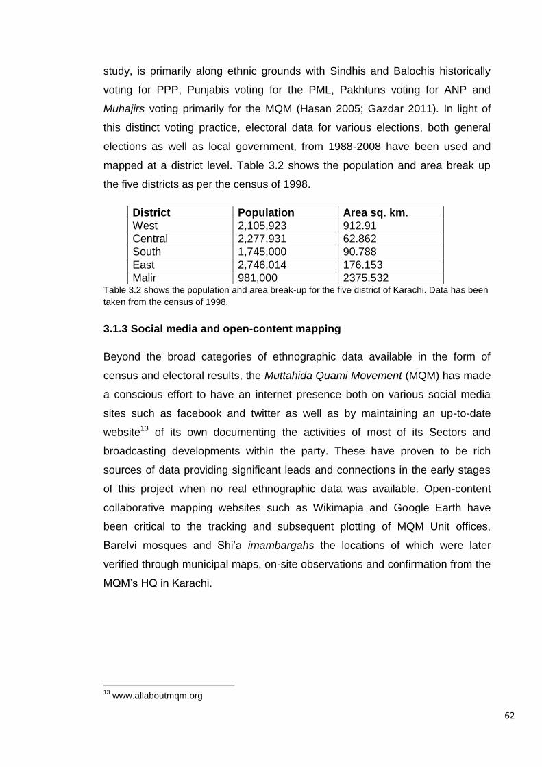
62
study, is primarily along ethnic grounds with Sindhis and Balochis historically
voting for PPP, Punjabis voting for the PML, Pakhtuns voting for ANP and
Muhajirs voting primarily for the MQM (Hasan 2005; Gazdar 2011). In light of
this distinct voting practice, electoral data for various elections, both general
elections as well as local government, from 1988-2008 have been used and
mapped at a district level. Table 3.2 shows the population and area break up
the five districts as per the census of 1998.
District Population Area sq. km.
West 2,105,923 912.91
Central 2,277,931 62.862
South 1,745,000 90.788
East 2,746,014 176.153
Malir 981,000 2375.532 Table 3.2 shows the population and area break-up for the five district of Karachi. Data has been
taken from the census of 1998.
3.1.3 Social media and open-content mapping
Beyond the broad categories of ethnographic data available in the form of
census and electoral results, the Muttahida Quami Movement (MQM) has made
a conscious effort to have an internet presence both on various social media
sites such as facebook and twitter as well as by maintaining an up-to-date
website13 of its own documenting the activities of most of its Sectors and
broadcasting developments within the party. These have proven to be rich
sources of data providing significant leads and connections in the early stages
of this project when no real ethnographic data was available. Open-content
collaborative mapping websites such as Wikimapia and Google Earth have
been critical to the tracking and subsequent plotting of MQM Unit offices,
Barelvi mosques and Shi’a imambargahs the locations of which were later
verified through municipal maps, on-site observations and confirmation from the
MQM’s HQ in Karachi.
13
www.allaboutmqm.org
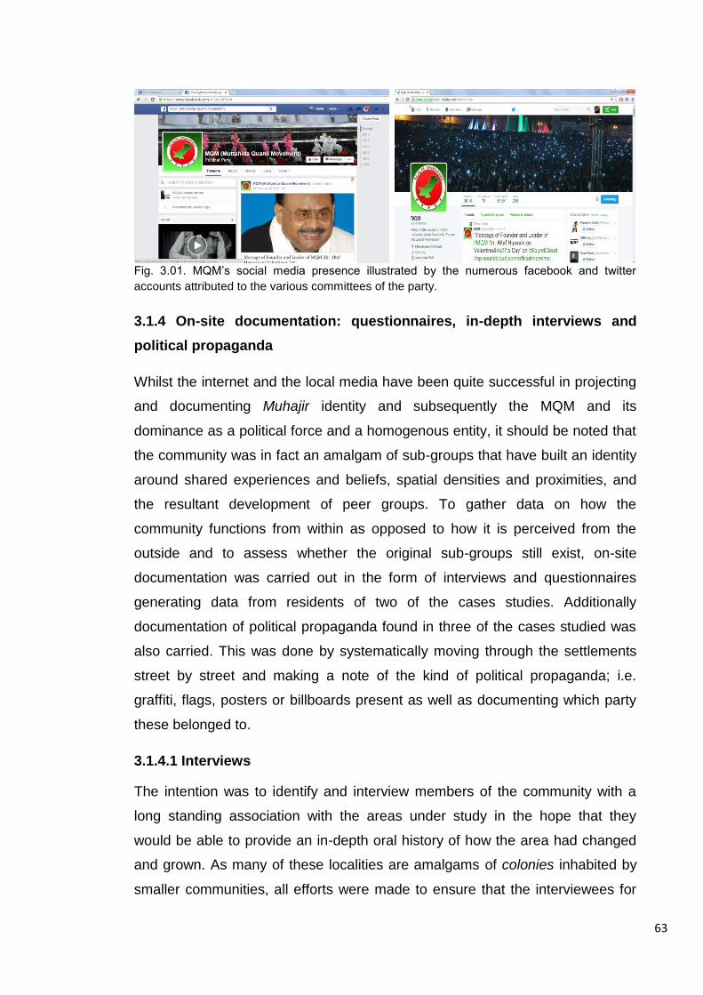
63
Fig. 3.01. MQM’s social media presence illustrated by the numerous facebook and twitter
accounts attributed to the various committees of the party.
3.1.4 On-site documentation: questionnaires, in-depth interviews and
political propaganda
Whilst the internet and the local media have been quite successful in projecting
and documenting Muhajir identity and subsequently the MQM and its
dominance as a political force and a homogenous entity, it should be noted that
the community was in fact an amalgam of sub-groups that have built an identity
around shared experiences and beliefs, spatial densities and proximities, and
the resultant development of peer groups. To gather data on how the
community functions from within as opposed to how it is perceived from the
outside and to assess whether the original sub-groups still exist, on-site
documentation was carried out in the form of interviews and questionnaires
generating data from residents of two of the cases studies. Additionally
documentation of political propaganda found in three of the cases studied was
also carried. This was done by systematically moving through the settlements
street by street and making a note of the kind of political propaganda; i.e.
graffiti, flags, posters or billboards present as well as documenting which party
these belonged to.
3.1.4.1 Interviews
The intention was to identify and interview members of the community with a
long standing association with the areas under study in the hope that they
would be able to provide an in-depth oral history of how the area had changed
and grown. As many of these localities are amalgams of colonies inhabited by
smaller communities, all efforts were made to ensure that the interviewees for
64
this purpose were representative of this sense of ‘communities within the
community’. Interviewees included long established traders, local educators,
and community elders - people associated with local residents’ committees and
political leaders – the local ‘Sector Incharge’14 -. To provide a more holistic view
of this development, the study also benefitted from an ‘outsider’ perspective;
many of these settlements are bordered by different ethnic communities that in
some cases are older than the settlement itself. Under the current political
situation in the city, the relationships that have developed over time between
these communities due to these adjacencies oscillate between mutually
beneficial to all out gang warfare within a matter of days. Hence their view as an
outsider provided an insight into the counter argument for the prevalent ethnic
animosities in the city.
3.1.4.2 Questionnaires
The questionnaires were designed to develop a socio-spatial/socio-economic
description of the study areas as they are experienced and perceived by the
residents of the settlements today. This entailed respondents completing a
questionnaire that provided some basic details about themselves (gender, age,
educational background, etc.) as well as some spatial data related to how they
perceived their environment. On a map included in the questionnaire,
respondents were requested to demarcate the following a la Dalton (2007):
Their home,
The edge of ‘their neighbourhood’ or mohalla,
Local market areas they frequent,
Sites they socialise outside of their own homes.
Parts of the settlement they frequent,
Areas they feel unsafe/threatened and hence avoid,
Institutions/places they believe to be the “centre” of community activity, if
any.
For a copy of the questionnaire distributed on site and the interview questions
please see Appendix B.
14
The Sector Incharge is a senior MQM activist who heads up the local Sector office and is local to the area and therefore familiar with its residents and mechanics.
65
The questionnaire had to be translated into Urdu for the ease of the
respondents and was designed to be completed in 10-12 minutes The
questions were designed so as to help develop a spatial description of the
various neighbourhoods through a consensus of perceptions of the residents
that would then be analysed through a correlation of these polygons to the
segment analysis of the settlement. Whilst this onsite means of mapping
perceptions of space seemed innocuous to the researcher, the results of this
part of the survey suggest otherwise as respondents were reluctant to answer
this question.
The intention behind the use of questionnaires and interviews as a means of
data collection was to address the issue of boundaries and edges between
communities. This is a feature of the city, like the study itself that functions at
changing scales; in this case it not only relates to zones that demarcate Muhajir
vs. non-Muhajir, but also speaks to the notion of sub-communities within the
larger umbrella of both Muhajir identity as well as Muhajir space. This aspect of
the study was designed to not only help to begin identifying discrete socio-
spatial zones but also to begin discussing whether these boundaries are
absolute both socially as well as spatially or ‘fuzzy’ thereby giving rise to spaces
of physical and ideological ambiguity and negotiation.
3.2 Data preparation
Many of these data sources were in a format that they could not provide any
spatial insight into the presence and activities of the Muhajir community or their
relationship to the city and urban form. Thus this data had to be synthesised
into a mappable format (see Appendix B for examples of on-site documentation
in the study areas).
3.2.1 Historical Timeline
This aspect of the study was designed to highlight the overlaps between the
intangible government agencies/institutions/political entities whose decision
making powers have impacted the growth and development of the city, the
physical urban outcomes of these decisions and, significant ethno-political

66
events ranging from the local, to the internationally. In order to capture the
simultaneity and reciprocity of these events, a timeline charting Karachi’s ethno-
political, spatial and developmental histories from Partition to the present day
was developed. The choice of political events represented was determined by a
process where in the case of national or international events, if it was felt that
there was a knock-on effect in Karachi such as the Soviet occupation of
Afghanistan that resulted in the arrival of Afghan refugees, such events/policies
were included. With regard to Karachi’s local politics, if events/policies were
repeatedly referred to in literature discussing the Muhajir community and the
emergence of this ethno-political identity such the Language Riots of 1972 or
the Pakhtun/Muhajir clashes of 1985/86, these were included and are therefore
subjective to a degree. The spatial and development aspect of this timeline
includes proposed masterplans, housing policies, and the development of
housing and transport projects. For complete timeline, see Appendix C
3.2.2 Diachronic Spatial network models
A diachronic approach to spatial network modelling in order to analyse the
changing structure of the city as it grows over time has previously been applied
to space syntax analysis of cities as diverse as New York and Barcelona (Al
Sayed et al., 2009), Dhaka (Khan and Nilufar, 2007) and Izmir (Can et al.,
2015). In the context of Karachi,
In order to develop a similar series of models for Karachi, at the outset of this
project an extensive cache of GIS files was obtained from the Department of
Geography at the University of Karachi. This included a partial road centre line
map of the city in 2007-09 as well as land-use data documented at the scale of
the neighbourhood block. Upon comparison of this road centre line map to
images from Google Maps, it could be seen that whilst most streets in the city’s
centrally located planned settlements and major thoroughfares had been
documented, many of the city’s informal and low-income areas were missing
and had to be added to the spatial network model using the accompanying
land-use model and verified by satellite images of the areas. It should be noted
too that upon comparing the amended spatial network model to open street
map data found at the tail end of this study, it was found that the model
67
developed for the purpose of this study was more comprehensive than that
currently available online. This completed spatial network model for Karachi
2007-09 became the basis of a subsequent series of models documenting the
growth of the city from 1949 to 2009. These spatial network models were built
through a subtractive process known as map regression as described by Serra
(2014) to mimic the structure of the city as seen at various points in its evolution
in images taken from land-use and transport network maps from Karachi’s five
masterplan proposals and old tourist and guide maps for the city dating back to
1949 (See Appendix A for images of the reference maps used). The presence
of many of the city’s areas in these models was further verified through
references made to these localities in development reports and historical and
anecdotal accounts.
3.2.3 GIS mapping of communal institutions
This is a study of the spatial manifestation of an ethno-political identity. Hence
in order to capture the societal aspect of this community and, in the absence of
detailed, accurate, up-to-date ethnographic data, the mapping of communal
institutions particular to this community were seen as the best proxies for
Muhajir presence. Waterman and Kosmin (1987) note that in the case of the
migration of the Jewish community to north London, whilst the presence of a
synagogue may not have been the initial catalyst for the emergence of a
community cluster, once a critical mass was established, the presence of a
synagogue, speciality food stores etc., became an eventuality and motivation
for subsequent to migration to the area and hence a means of locating a Jewish
cluster. Similarly, in the case of this study, it was assumed that the presence of
key communal institutions in an area were indicative of Muhajir presence.
These institutions were identified through literature pertaining to the community
and the various ideological features that make-up the community’s identity; i.e.
language (addressed through census data), religion and politics. Using a
combination of open-content mapping sources – Google Earth and Wikimapia –
as well as on-site observations, municipal maps and official sources, Barelvi
mosques, Shi’a imambargahs, as well as MQM Sector and Unit offices were
located and mapped in an effort to identify Muhajir areas. When using Google
68
Earth and Wikimapia, imambargahs and Barelvi mosques were identified using
search terms and titles commonly associated with either of the communities
being studied; i.e. the use of terms such as imambargah and Barelvi or Barelwi
as suffixes to mosque names as well as terms such as Qadri, Madani and Quba
as part of the name of the mosque.
A total of 98 imambargahs, 132 Barelvi mosques, 115 MQM units and 26 Sector
offices were mapped. These were located on the street segment for which an
address was available. In the absence of an official address, especially in the
case of religious buildings, the institution was located on the street segment that
satellite images or municipal maps of the area showed that the building
appeared to be fronting on to.
In addition to the above mentioned communal institutions, it was felt that whilst
the party office and religious buildings speak of institutionalised affiliations and
formal interactions between ‘in-group’ members, places such as the local
shopping area and the chai-khana or the south Asian tea-house provided
spaces for social interactions of a non-institutional and informal nature. The
intention was to capture the potential of such spaces for the co-presence and
unmonitored interaction of both Muhajir and non-Muhajir residents in the area.
3.2.4 GIS mapping of politically motivated acts of violence
In the run up to as well as after the last general elections on the 11th of May
2013, ethno-political tensions in Karachi were high and various localities were
hotly contested. As a result a number of politically motivated violent events took
place with political groups targeting both individuals and institutions in an effort
to gain the political advantage. This sadly is a common feature of the political
process in South Asia and much has been written on the intimate connection
between violence, politics and electioneering in the South Asian context where
armed political activists and violent clashes between competing groups are the
norm rather than an anomaly (Tambiah, 1996, Khan, 2010, Staniland, 2013).
These events range from political rallies consisting of thousands of people that
are monitored by riot police to target killings of political activists, politician and
sectarian leaders - a form of drive by shooting common to the political
69
environment of Pakistan, to coordinated explosions at strategic urban locations.
The occurrence of such events brings to light not only the relevant political
actors and political rivalries but also, where these incidents take place within the
physical geography of the city is of significance and the intention of plotting
these occurrences was to identify potential troubled localities in the city giving
political conflict a mappable spatiality.
For the purposes of this study, newspaper reports from three English dailies15 in
Karachi were used to map bombings executed between 1st January 2013 to 31st
December 2013 as well as shootings from 1st May 2013 to 31st July 2013.
These reports included information pertaining to the type of attack, location,
time and political affiliations of the victims, thereby making it possible to map
with reasonable accuracy the occurrence of such events for the time period
identified given.
3.2.5 Mapping ethno-political boundaries using political propaganda
Political graffiti, billboards, posters, and party colours and symbols adorning the
city’s thoroughfares and roundabouts are a common sight in Karachi. The
paraphernalia of political campaigns in the Pakistani context is often used as a
means of a party marking its constituencies or as a show of a neighbourhood’s
allegiance to a particular political group. The intention of including the
documentation of such outward displays of political affiliation was another
aspect of boundary demarcation; developing a tangible means of mapping the
intangible notion of political jurisdiction of the various political groups active in
areas under study. In the case of the MQM, depending on its size, settlements
are often further sub-divided so that several Units are active within the same
settlement but each with its own neighbourhood to manage, all in turn overseen
by a Sector office.
15
The Express Tribune http://tribune.com.pk/, Dawn http://www.dawn.com/ and The News http://www.thenews.com.pk/. The choice of these particular newspapers was due to the linguistic limitations of the research English being the researcher’s first language and her grasp of written Urdu and other local languages being poor. Reference to local language papers may have further highlighted inter-group tensions and biases that English language dailies sometimes are not tuned in to.
70
Political propaganda was mapped at two scales; that of the city and that of the
settlement. In the case of the former mapping was carried out along the city’s
major thoroughfares. Due to the area that needed to be covered and the pace
of traffic along these thoroughfares, only broad political graffiti, major billboards
and clusters of party flags were documented. On the other hand, in the case of
the settlement, mapping for three of the four case studies was carried out from
a street to street basis within the settlement, documenting graffiti, billboards,
posters and flags. This data was then mapped in GIS softwares.
Table 3.2 summarises the main data sources used, how and where the data
was gathered or accessed, and how complete and up-to-date it is.

71
Data Source Where was it sourced from?
How was it captured? How complete is it? How up to date is it?
Digitised map of Karachi
University of Karachi – Department of Geography
GIS shapefiles that included a partial road centre line map and land use map of the city at a block level.
Partial road centre line mapped most of the city’s planned areas and documented main streets in informal areas. The mapping of large informal settlements was completed by tracing over the land use map and images from Google Earth.
2007-09
Historical digital maps
Regression mapping using past masterplans and city guide maps accessed from a map archive at www.arifhasan.org See Appendix A for a complete set of images of maps referenced.
Applying a subtractive process to the 2007-09 spatial network model and using the historical/development maps as visual references, 3 additional spatial network models were developed.
Due to scaling issues related to the original maps, the use of these maps was purely visual to identify and confirm areas or development and growth in the city therefore historical spatial models may not be 100% accurate but give an idea of how the city and case study areas have developed.
1949, 1958-60, and 1972-74.
Electoral Census data
www.ecp.gov.pk Electoral results from 1988-2008 Last census conducted in 1998.
Data aggregated at the district level. Where used, data was aggregated at the district level and normalised by population, e.g. in the case of ‘mother-tongue’ spoken/household.
Complete at both Federal and provincial level. Census data is complete but 13 years out of date at the time of initiation of this study.
1988-2008 and now results for general elections held in 2013 are also available. Census data is complete but 13 years out of date at the time of initiation of this study.
Religious Institutions Mosques/Imambargahs Political offices Sectors Units
Google earth and Wikimapia www.allaboutmqm.org Party HQ and Google Earth/Wikimapia
Points located as close to the location/address identified.
Case studies- Complete City-wide- Incomplete Sectors - Complete Units, Case studies– complete City-wide – 60% complete
Religious institutions and political offices plotted using online maps from 2011-2013 and verified on-site and through official sources obtain during fieldwork in 2013.
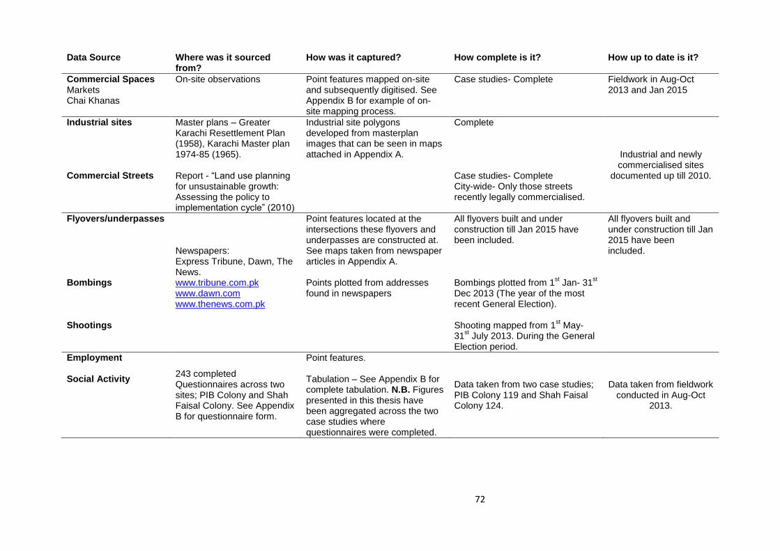
72
Data Source Where was it sourced from?
How was it captured? How complete is it? How up to date is it?
Commercial Spaces Markets Chai Khanas
On-site observations Point features mapped on-site and subsequently digitised. See Appendix B for example of on-site mapping process.
Case studies- Complete
Fieldwork in Aug-Oct 2013 and Jan 2015
Industrial sites Commercial Streets
Master plans – Greater Karachi Resettlement Plan (1958), Karachi Master plan 1974-85 (1965). Report - “Land use planning for unsustainable growth: Assessing the policy to implementation cycle” (2010)
Industrial site polygons developed from masterplan images that can be seen in maps attached in Appendix A.
Complete Case studies- Complete City-wide- Only those streets recently legally commercialised.
Industrial and newly commercialised sites
documented up till 2010.
Flyovers/underpasses Bombings Shootings
Newspapers: Express Tribune, Dawn, The News. www.tribune.com.pk www.dawn.com www.thenews.com.pk
Point features located at the intersections these flyovers and underpasses are constructed at. See maps taken from newspaper articles in Appendix A. Points plotted from addresses found in newspapers
All flyovers built and under construction till Jan 2015 have been included. Bombings plotted from 1
st Jan- 31
st
Dec 2013 (The year of the most recent General Election). Shooting mapped from 1
st May-
31st July 2013. During the General
Election period.
All flyovers built and under construction till Jan 2015 have been included.
Employment Social Activity
243 completed Questionnaires across two sites; PIB Colony and Shah Faisal Colony. See Appendix B for questionnaire form.
Point features. Tabulation – See Appendix B for complete tabulation. N.B. Figures presented in this thesis have been aggregated across the two case studies where questionnaires were completed.
Data taken from two case studies; PIB Colony 119 and Shah Faisal Colony 124.
Data taken from fieldwork conducted in Aug-Oct
2013.

73
Data Source Where was it sourced from?
How was it captured? How complete is it? How up to date is it?
Political Propaganda On-site observations Mapping was carried out by hand along the city’s main thoroughfares and the internal streets of the case study areas. See Appendix B for example of mapping process.
Case studies – street by street documentation complete for 3 out of 4 areas City-wide – Main roads only.
Data taken from fieldwork in Aug-Oct 2013 and Jan
2015
Table 3.2 summarises the main data sources used, how and where the data was gathered, and how complete and up-to-date it is.

74
3.3 Data Analysis
Due to the kind of data and the manner in which it was gathered, the process of
pinpointing Muhajir presence and their socio-spatial impact was multi-tiered.
This began with thematic mapping to provide the broad strokes, followed by
cluster analysis to identify hotspots of Muhajir activity and finally establishing
the centroids of these clusters to identify high concentration Muhajir
neighbourhoods. Space syntax analysis was then carried out on selected
centres to analyse spatial impacts and socio-spatial behaviours.
3.3.1 Thematic mapping
Thematic mapping was used as a first tier analysis in identifying Muhajir
localities in Karachi. The aggregation of census and electoral data at the scale
of the district lent itself to this particular kind of spatial mapping.
As stated earlier, census data was one of very few sources of ethnographic
data available to the researcher at the onset of this study. For the purposes of
this study, data used focused primarily on the Muhajir community otherwise
categorised as households with Urdu as their mother-tongue, a linguistic
categorisation that has been used as a proxy for ethnicity in this study. Further
limitations of this data source will be discussed at the end of this chapter.
As discussed earlier in chapter 2, voting patterns in Karachi are broadly
determined by ethno-linguistic affiliations and, from 1988-2013 Pakistan has
had six general elections. Hence, whilst aggregation may have been broad for
this particular data set, it spanned a fair amount of time and thus allowed for the
identification of emergent voting patterns across the city. By generating
thematic maps of electoral results for successive general and local elections
across this 25 year period, it was possible to ascertain which districts exhibited
a consistent or growing MQM majority.
Similar district level thematic maps were generated using the number of
communal institutions per district. This process was used as a means of
verifying ethnic and political spatial overlaps within the community.

75
3.3.2 Cluster analysis and the establishment of cluster centroids
GIS heatmaps or cluster analysis was used to articulate and examine
concentrations of communal institutions. Heatmaps and hotspot analysis is
often used to analyse the clustering patterns and occurrence of criminal activity
and road accidents (Anderson, 2007) as well as estimating the optimum
catchment for medical services etc. (Gibin, Longley, Atkinson, 2007). The
heatmap feature in GIS geographically visualises densities of features/activities
within a prescribed search radius. Thus this tool was used to generate a
polygon that gave areas with high densities of Muhajir features a mappable
form. Search radii tested were based upon the potential catchment and
accessibility of each cluster of communal institutions, thus analysis for individual
institutional types ranged in catchment from 800m in the case of religious
buildings and 1500m in the case of political offices, and the final form was
generated by merging all communal features. These heatmaps were then
converted into contour maps where contours denoted areas of similar feature
densities. This process provided a means of describing Muhajir clusters in the
city and thus became the second tier of spatial analysis pertaining to Muhajir
space. This was further refined to pinpoint Muhajir centres within this form by
demarcating the centroids of the polygon where centroids are the geometric
centres of the masses which in this case coincide with centres of the highest
density of Muhajir communal institutions. Figure 3.02 and 3.03 are examples of
the processes described above of using the mapping of communal institutions
to generate thematic maps, cluster analysis and the establishment of centroids
to describe Muhajir presence in the city.
A similar process was used for the mapping and identification of flashpoints of
violent activity in the city for the election period in 2013. Cluster analysis was
used to pinpoint high concentration areas and produce mappable outlines of
troubled localities in the city.

76
Fig. 3.02. Left: Thematic map of Karachi’s five district showing the number of imambargahs per
district. Right: Shows a heatmap image of communal institution clusters.
Fig. 3.03. Left: A contour map generated from the clustering of communal institutions in Karachi
pertaining to the Muhajir community overlaid on a spatial network model of the city for 2007-09.
Right: Shows the outer edge of the contour map above and the centroids of polygon
demarcating Muhajir centres within this area.
3.3.3 Space syntax analysis
As stated earlier, the use of space syntax analysis in this study is both multi-
scalar and diachronic, being used to analyse both the growth and development
of the city over the 65 years of its post-Partition history as well as to investigate
the changing definitions, scales and relationships of Muhajir spaces in the city.
Through the subtractive process described above, a series of axial maps were
developed documenting the growth and development of the city from 1949 to
2009. An axial map is a representation of a spatial network where intersecting
axial lines - the longest and fewest lines of visibility and permeability in an urban
grid - are drawn through all the spaces of the network. Using DepthMap

77
software, these axial models were converted into segment maps where axial
lines are broken down into segments, a segment being a length of line from one
intersection to the next, and a segment analysis was then run on these
systems.
This analysis includes a number of space syntax measures, the most relevant
to this study are Integration, Choice and step depth. Integration is the relative
depth of each line segment from each other segment in the system within a
prescribed radius. In simpler terms, it is the spatial accessibility of the segment,
the more accessible the segment the higher the integration value and the lower
the spatial depth. Choice (similar to mathematical Betweenness) is the potential
of a segment to lie on the shortest and simplest path between all pairs of
spaces in a system within a prescribed radius. Hence it is the ‘through
movement’ potential of a space. Due to this, Choice often picks up the major
through routes or thoroughfares in a spatial network, a feature that was
frequently used in this research. The mathematical values attributed to each line
segment for these measures are assigned, for the purposes of graphical
representation, a colour within a spectrum from red to blue where high
accessibility or integration appears as red whilst highly segregated lines appear
as blue (for an example of this colour range see Fig. 3.04). In the context of this
study, normalised Integration and Choice measures were used as this made it
possible to compare results across spatial systems of varying size and scale.
Step Depth calculates the shortest route from the selected segment to all other
segments in the spatial network in terms of angular deflection of the segment –
or turnings away from - where a 90 degree angular change is equal to 1. The
weighting used in this measure is cumulative and therefore greater the angular
change or greater the number of turnings away from the point of origin, higher
the step depth value.
Space syntax analysis was used to investigate the transformation of the city;
normalised Integration (NAIN) at radius ‘n’ (Rn) – the maximum scale of the city
- was used to analyse the changing accessibility of various areas of the city
over time as it grew and similarly normalised Choice (NACH), again at Rn, was
used to analyse the change in the city’s superstructure. At the scale of the
settlement, space syntax analysis has been used to investigate the accessibility
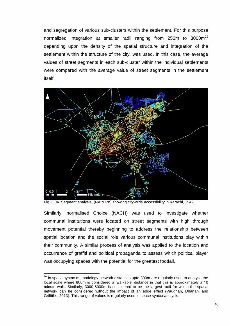
78
and segregation of various sub-clusters within the settlement. For this purpose
normalized Integration at smaller radii ranging from 250m to 3000m16
depending upon the density of the spatial structure and integration of the
settlement within the structure of the city, was used. In this case, the average
values of street segments in each sub-cluster within the individual settlements
were compared with the average value of street segments in the settlement
itself.
Fig. 3.04. Segment analysis, (NAIN Rn) showing city-wide accessibility in Karachi, 1949.
Similarly, normalised Choice (NACH) was used to investigate whether
communal institutions were located on street segments with high through
movement potential thereby beginning to address the relationship between
spatial location and the social role various communal institutions play within
their community. A similar process of analysis was applied to the location and
occurrence of graffiti and political propaganda to assess which political player
was occupying spaces with the potential for the greatest footfall.
16
In space syntax methodology network distances upto 800m are regularly used to analyse the local scale where 800m is considered a ‘walkable’ distance in that this is approximately a 10 minute walk. Similarly, 3000-5000m is considered to be the largest radii for which the spatial network can be considered without the impact of an edge effect (Vaughan, Dhanani and Griffiths, 2013). This range of values is regularly used in space syntax analysis.

79
Whilst the cluster analysis provided a means of identifying probable Muhajir
majority areas and centres, by relating the location of the urban communal
elements to the space syntax model of the city, it was also possible to study the
relationship of the societal role of the type of communal institution with the
spatial configuration of both the city and the settlement. This process allowed
for the examination of the relevance of catchment areas, territorial demarcation,
proximity and density of features and inter-feature relationships for the
communal institutions studied; Barelvi mosques, Shi’a imambargahs, MQM
Sector and Unit offices, the local shopping street and chai-khanas. Hence this
form of analysis enabled an objective spatial analysis of Muhajir space whereby
underlying patterns of occupation, proximity, spatial configuration of settlements
and functional distribution of land-uses were identified and explored in an
attempt to describe the relationship between society and space.
3.4. Limitations of the research
During the course of this study, much of the development of the methods and
data used has been the outcome of one major factor, the dearth of accurate,
detailed ethnographic data. Whilst considerable information related to the initial
settlement patterns of the community were found in the form of anecdotal and
historical accounts and various development reports referencing the early post-
Partition development of Karachi, little documentation was available on the
current spatiality of the Muhajir community. As has been seen in the preceding
discussion, some official data sources that could provide broad mappable
statistical data pertaining to the Muhajir community were available in the form of
census data and electoral results, but little else could be found. As will be
illustrated in this study, these broad sources have been useful in charting and
establishing changes in the city’s demographic make-up and voting patterns
but, due to the scale at which it was aggregated and the fact that the most
recent census is quite outdated having been conducted in 1998, it was of little
use in providing a detailed understanding of the spatialisation of Muhajir
presence in the city. This resulted in the development of a methodology that
identified and utilised alternative identity-markers as the primary means of
tracking the Muhajir community. As mentioned earlier, Vertovec refers to the

80
establishment of socio-cultural institutions as an essential part of the process of
migration and resettlement and both Vertovec and Coakley speak of the
politicisation of migrant identities as a key step to resettlement. Additionally
Waterman and Kosmin (1987) refer to the mapping of socio-cultural features
such as synagogues and food stores particular to a minority as a means of
tracking the presence of minority community as a form of ‘surrogate data’ or
‘mappable proxies’ as they will be referred to in the context of this study - to be
used in lieu of detailed ethnographic data. As a result, the mapping of ethno-
religious and ethno-political communal institutions became the primary means
of locating the Muhajir community in the city today.
It should be noted that due to the processes by which these communal
institutions have been mapped – using open-content data sources, on-site
observations and local municipal maps – the cataloguing of institutions is
unlikely to be exhaustive. Additionally this mapping should be viewed as a
documentation of a snapshot in time; the establishment of communal
institutions in the city is a dynamic process, new mosques etc. are set-up as the
need arises, mosques change their sectarian affiliation depending upon the
strength of the community resident in the area and Units may change location
depending on the political stability of the locality in which they are situated. This
is not to say that the use of these institutions to map the presence of the
community is hugely flawed as correlations with historical data and the author’s
own understanding and experience of these areas suggest a reasonable
accuracy to the method.
Whilst the issue of gender differences are an important topic in studying the use
of public space, this thesis focuses on male-dominated space. This is due to the
manner in which space is used and allocated for women’s use in the context of
a majority Muslim state. The spatial segregation of gender, a feature of many
eastern cultures, is something that both Verkaaik (2004) and Ring (2006) refer
to with regard to settlements in Karachi; men in the streets and entrance ways
to the mohalla17 and other public spaces such as the community park or gym,
whilst women inhabit spaces closer to the home; what Ring calls ‘increased
17
The neighbourhood.

81
concerns with purdah18 in the city, combined with this class of women’s limited
geographic mobility’ (Ring, 2006). Hence the presence of women in the public
realm could be considered transient if at all and therefore difficult to monitor.
Issues of gender also impacted how and where the researcher was able to go in
the city. Whilst being a woman made the researcher a less threatening entity in
the field making conversations with most informants easier, it allowed access to
environments that may otherwise have been considered off-limits to male
researchers – private residences during daytime when only women are home
and women only beauty salons - but simultaneously it hindered movement in
male-dominated public spaces. In such cases an older male was required to
escort the researcher to places like MQM HQ (Nine Zero) and other ‘sensitive’
areas of this study to provide a sense of protection and security.
Personal security and consequential access to fieldwork sites and informants
was another unforeseen limitation to the study. In September 2013, a federal
cabinet charged the Pakistan Rangers, a paramilitary force to conduct a
security operation in Karachi. The rangers were to target individuals that military
and civilian agencies alleged were involved in target killings, kidnappings for
ransom, extortion and acts of terrorism in the city. Whilst the mandate of the
operation was to target terrorists, many of the areas targeted were specifically
MQM strongholds including a raid on MQM HQ Nine Zero in Azizabad resulting
in the party claiming that there was a certain bias to the manner in which the
operation was conducted.
One of the primary motivations behind sanctioning the operation was the rapid
decline of general safety and security in the city in the months leading up to this
exercise. This pervading sense of danger was to become worse once the
operation was initiated especially in MQM held areas. This resulted in certain
key localities for this study becoming inaccessible during the time allotted for
fieldwork thereby limiting the quantity and quality of data gathered. This
pervasive sense of instability was further reflected in the reluctance of
respondents to answer questions pertaining to areas in their settlement that
18
Segregation of women from the public realm, both spatially where men and women will occupy the same physical space or by simply taking the veil (hijaab) whereby women are ‘hidden’ from the male view.
82
they considered safe and unsafe with many claiming that there was no safe
space to be found outside of their own homes. Whilst observations and
snapshots of public spaces in the case study areas were initially programmed,
these had to be abandoned due to the volatility of the security situation in the
city; a stranger taking notes in public spaces in a small settlement was liable to
attract a fair degree of unwanted attention with an added threat to the safety of
the researcher.
83
4. The development and growth of Muhajir Karachi: A Diachronic study of the spatial distribution and the politicisation of identity and space of the Muhajir community in Karachi.
4.0 Introduction
This chapter will look at how the city has grown and developed through the last
65 years, argue that in the context of Karachi, ethnicity, politics and space are
intrinsically linked and that this synergistic relationship has influenced the
manner in which the city has developed and, through this process of articulating
Karachi’s socio-spatial and ethno-political histories, track the settlement
patterns of the Muhajir community into and around the city so as to answer
three fundamental questions about the Muhajir presence in the city. Are the
Muhajir community clustering, as minority communities tend to do, in Karachi? If
so, where are they clustering? And, how have these spaces and the
community’s identity been transformed through time and their changing socio-
political and socio-economic circumstances? The hypothesis being that the
Muhajir community does cluster and that this clustering has persisted from their
earliest settlements established in Karachi shortly after Partition. And that
through a combination of forced spatial proximity and real as well as perceived
socio-political marginalisation by the State, this disparate group of political
migrants have been able to generate and develop a cohesive ethno-political
identity that today claims to be Pakistan’s ‘fifth ethnicity’.
This part of the study will provide an understanding of the impact the Muhajir
community has had on the spaces and development of the city as a whole but,
in order to do so, there is a need to i) provide a view of the context of the city in
which they were initially located both spatially and socially, ii) appreciate the
nature of the community and the various identity-markers that are unique to the
community, iii) understand and track the decisions, whether political, social, or

84
developmental, that resulted in the city taking the form it has today and, iv)
identify the role that the Muhajir played in this development and change.
This chapter will begin by presenting the data and methodology used for this
part of the study; this section will identify and discuss the data and processes
used to map and describe the evolution of the city, its people, their spaces and
their politics as seen through the lens of the Muhajir community. The following
section will describe the spatial transformation of the city and the synergistic
relationship of politics and city development. The next section will elaborate on
the evolution of Muhajir space and identity in the city since Partition. The last
two sections focus on describing Muhajir presence in the city in its most recent
iteration, attempting to define Muhajir majority areas and centres of Muhajir
activity in the city today.
4.1 Data and Methodology
As stated above, this chapter is essentially divided into two sections, the first
half dealing with the selection and development of appropriate spatial network
models of the city and a discussion of the chronological development of both
the city and its people, and the second half focuses on developing and
implementing a means of mapping and describing Muhajir presence in the city
today.
When discussing the kind of data used for the purposes of an ethno-spatial
study such as this one, it is important at the outset to outline the limitations of
the data available. In the case of post-Partition Karachi, despite the fact that five
censuses have been carried out19 and just as many masterplan proposals have
been sanctioned for which extensive background research was needed, there is
still a shortage of available, up-to-date ethnographic data for the purposes of a
community-based study such as this one. Census data is broad and outdated;
the last census was held in 1998 and published findings of this census related
to ethnicity such as mother tongue and place of birth of respondents are
19
Censuses were carried out 1951, 1961, 1972 (delayed due to civil war which resulted in emergence of Bangladesh), 1981 and 1998.
85
presented at a district level where ’districts’ are large administrative divisions20
the delimitation of which is revisited after each census and before each general
election often making this re-evaluation of boundaries a highly politicised
process. Data aggregated at the scale of these large land parcels lacked the
more nuanced communal divisions often found at smaller urban scales and that
were required by this study. Hence, this had to be further supplemented with
multiple alternative indicators of community presence each with varying degrees
of accuracy. That being said, despite these limitations, the census data sets and
administrative divisions have been used in the initial stages of this study to
establish both broad cultural and electoral patterns and identify the broader
regions of clustering for the Muhajir community. The use of spatial networks and
the additional mapping of spatial identity-markers has provided a means of
examining not only the city-wide distribution of the community but also a way of
investigating the changing nature of their occupation as the city has grown and
developed over time.
The chapter begins by looking at the chronological development of the city and
argues that there is an intimate relationship between city development and
national and local politics. For this purpose, data was drawn from multiple
sources such as city’s various masterplan proposals, development reports,
newspaper articles, anthropological and historical studies, and anecdotal
writings and memoirs. This data was used to develop a timeline plotting the
occurrence of political events – international, national and local – as well as
urban planning and development related interventions in Karachi. This helped to
illustrate and identify the simultaneity and knock-on effect that political events
have had on the development of the Karachi as well as identifying time periods
when such events were clustering. This process became the rationale for
developing a series of spatial network models of Karachi that most appropriately
captured the city’s growth and development from 1947-2011. The process of
actually constructing the models themselves was informed by various guide
maps and masterplan drawings from different periods of the city’s history;
20
Districts vary in area and population, the smallest, District Central being only 69 sq km and housing the largest population of over 2.25 million as per the 1998 census whilst the largest in area, District Malir is 2375 sq km and is comprised primarily of agricultural land and has a population of just over 980,000.

86
beginning with a GIS model of the city in its most current manifestation and
working backwards through a subtractive process known as map regression,
four maps showing the city at various points in its development to date were
finalised. These periods are 1949, 1958-60, 1972-74, and finally 2007-09 (Fig.
4.01).
The latter half of the chapter deals specifically with the settlement patterns of
the Muhajir community and again for this purpose, masterplan documents,
historical studies, and anecdotal writings and memoirs were referenced as
these showed that there was a discernible spatial pattern to the manner in
which the Muhajir community was initially settling or being settled.
In order to gauge whether these initial clusters have persisted or if new patterns
have emerged since their earliest settlements were established in the late
1940s and 50s, further analysis was required but as stated above, there is a
lack of ethnographic data and whatever data is available ties ethnic-markers to
large, administrative land parcels. Hence, in order to refine the definition of
these clusters to smaller land parcels, reasonable ‘mappable’ proxies had to be
identified from the community’s socio-cultural practices. This approach was
informed by previous research such as Vertovec’s description of a four phase
process of social and cultural development of Hindu migrants in Trinidad; i)
migration, ii) establishment of socio-cultural institutions, iii) political mobilisation
and iv) political decline and rejuvenation (Vertovec, 1995)21. Initial research on
the Muhajir community suggested that this community too followed a similar
process of migration and resettlement. Hence, upon further investigation
through literature chronicling the community’s ethno-political exploits, three
such proxies were identified; language, religion and politics.
21
The initial phases outlined by Vertovec with regard to Indian Hindu migrant communities in the Caribbean whereby they established socio-cultural institutions are processes that Waterman and Kosmin’s work shows have physical spatial manifestations in the form of religious buildings, speciality markets etc. These spatial proxies have been successfully used to identify minority community clusters.
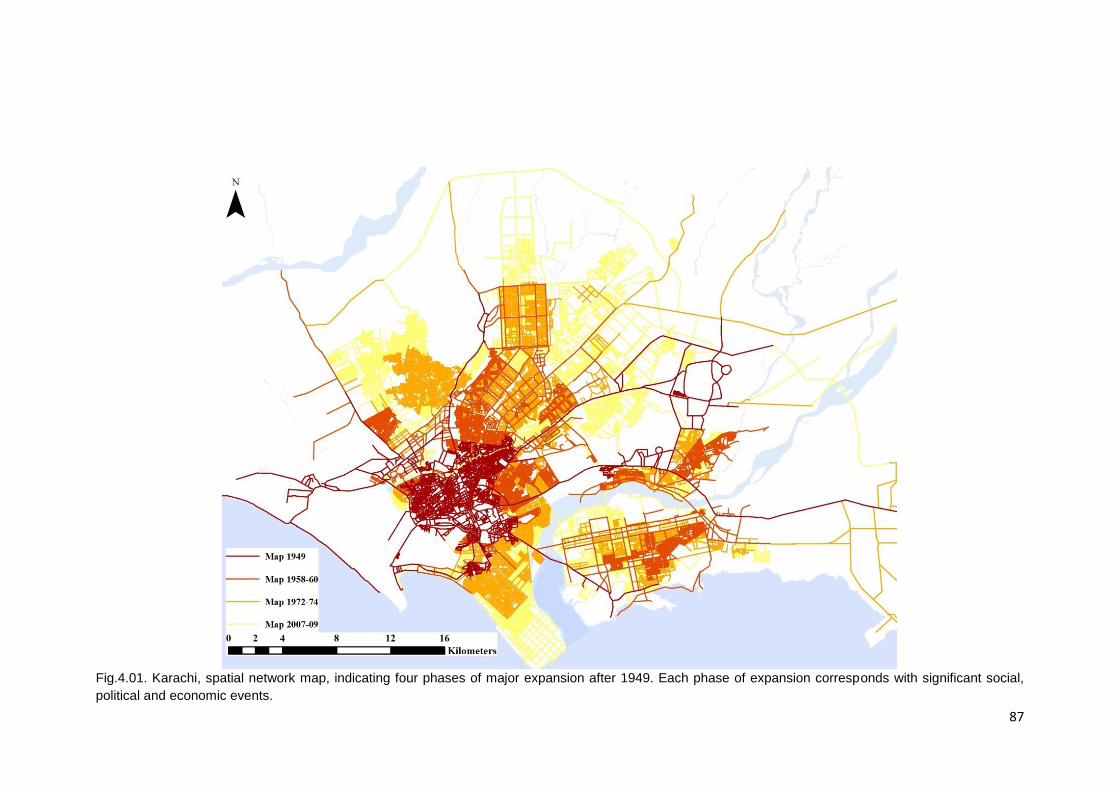
87
Fig.4.01. Karachi, spatial network map, indicating four phases of major expansion after 1949. Each phase of expansion corresponds with significant social,
political and economic events.
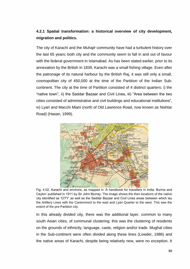
88
4.2.1 Spatial transformation: a historical overview of city development,
migration and politics.
The city of Karachi and the Muhajir community have had a turbulent history over
the last 65 years; both city and the community seem to fall in and out of favour
with the federal government in Islamabad. As has been stated earlier, prior to its
annexation by the British in 1839, Karachi was a small fishing village. Even after
the patronage of its natural harbour by the British Raj, it was still only a small,
cosmopolitan city of 450,000 at the time of the Partition of the Indian Sub-
continent. The city at the time of Partition consisted of 4 distinct quarters: i) the
“native town”, ii) the Saddar Bazaar and Civil Lines, iii) “Area between the two
cities consisted of administrative and civil buildings and educational institutions”,
iv) Lyari and Macchi Miani (north of Old Lawrence Road, now known as Nishtar
Road) (Hasan, 1999).
Fig. 4.02. Karachi and environs, as mapped in ‘A handbook for travellers in India, Burma and
Ceylon’ published in 1911 by Sir John Murray. The image shows the then locations of the native
city identified as ‘CITY’ as well as the Saddar Bazaar and Civil Lines areas between which lay
the Artillery Lines with the Cantonment to the east and Lyari Quarter to the west. This was the
extent of the pre-Partition city.
In this already divided city, there was the additional layer, common to many
south Asian cities, of communal clustering; this was the clustering of residents
on the grounds of ethnicity, language, caste, religion and/or trade. Mughal cities
in the Sub-continent were often divided along these lines (Lowder, 1986) and
the native areas of Karachi, despite being relatively new, were no exception. It

89
was into this environment that the Muhajireen were introduced; and whilst they
were geographically and therefore culturally and linguistically different to the
various communities already resident in the city, they could not as yet be
classified as a cohesive ’ethnic group’ for all they had in common with each
other, broadly speaking, was language (Urdu), religion (Islam) and a shared
sense of sacrifice for a much awaited homeland and subsequent sense of
marginalisation, victimisation and disappointment. That being said, the story of
post-Partition Karachi is a narrative that comprises of numerous characters,
whether migrant, ‘native’ or the state, and the politics of space and ownership of
this economic hub and migrant city.
Fig. 4.03. (Clockwise from top left) a. the ‘Native Town’, b. Saddar Bazaar and Civil Lines, c.
Administrative and educational centre, d. Lyari and Macchi Miani.
As stated above, in order to understand the role that has been played by the
Muhajir community in the growth and development of Karachi, it is important to
get an idea of how, why, and when the city has grown from a small,
cosmopolitan colonial port city of 450,000 people to a highly contested, teaming
metropolis of 24 million people today. For this purpose there was a need to
identify when and where major spatial expansion took place, when major
infrastructure and development projects were undertaken and what were, if any,
90
the social and political circumstances that induced these spatial responses. Any
overlap between these features would in turn not only identify critical time
periods in Karachi’s history but also begin to articulate the possibility of a
relationship between the development of space, the politics of that same space
and the emergence of an identifiable socio-spatial Muhajir identity. This process
of plotting the simultaneity of social, spatial and political events in the city’s
history became the basis upon which the diachronic study of the city was
developed.
Graph 4.01, shows the plotting of the occurrence of four parallel sets of events:
i) political events (international, national and city level), ii) Karachi based, large-
scale administrative planning and development initiatives, iii) housing initiatives,
and iv) transport developments. This graphic process articulated the fact that
events across the four categories outlined above were clustering in certain time
periods i.e. a number of events/projects took place or were initiated within a
short time frame suggesting a possible knock-on effect e.g. Bangladeshi
independence led to the influx of migrants leading to the rise in housing and
development projects and inter-group tensions. The highest concentration of
events (both political and developmental) occurred between 1956-61, then
again between 1971-81 and finally between 2001-11. On looking closer, it
became apparent that within these time frames Pakistan underwent major
political changes; 1958 brought the imposition of Martial Law, 1971-81 saw the
election of the first civil government in over a decade, the secession of East
Pakistan and the birth of Bangladesh, and finally the return of Martial Law, and
2001-11 saw the arrival of ‘moderate enlightenment’ under another military
government. Each new political wave sought to bring with it a slew of
developmental initiatives.
As can be seen from Graph 4.01, at various intervals in its post-Partition history,
a total of five master plans have been proposed for the development and growth
of Karachi, none of which were ever entirely implemented. This began with the
MRV plan of 1951 (named after the Swedish firm that authored it, Merz Rendall
Vatten), and was never implemented, followed by Doxiades’ Greater Karachi
Resettlement Plan (GKRP) proposed in 1958 at the beginning of Field Marshal
Ayub Khan’s eleven-year martial law. This was not fully implemented and

91
eventually abandoned in 1964 only to be followed by the Karachi Master-Plan
1974-85, proposed in 1968. Of the master-plans proposed thus far, this was
probably the most insightful, seeing Karachi’s growing housing and
transportation issues as its key focus. Sadly, this too was abandoned to be
replaced in 1989 by the Karachi Development Plan 2000 and finally the most
recent being the Master-Plan 2020 proposed in 2007. For graphic reproductions
of these maps, see Appendix A.
These events have been further synthesised in Table 4.1 to identify the periods
of socio-spatial significance in the city’s history and show the synergistic
relationship between the growth of the city, urban development processes and
projects and the ethno-politics of both those in government as well as the
residents of the city.
As illustrated in both Graph 4.01 and Table 4.1, each master-plan was initiated
by a new government and each proposal came with a new vision for the city
that articulated the then government’s ambitions for Karachi. It should also be
noted that with almost each decade since Partition, Karachi has seen the arrival
of a fresh wave of migrants; Partition brought the Muhajireen, the agricultural
and industrial reforms of the late 1950s and 60s brought upcountry rural
economic migrants from Pakhtun and Punjabi backgrounds, the birth of
Bangladesh in 1971 brought the Bihari refugees during the 1970s, the Soviet
occupation of Afghanistan in 1979 triggered the mass migration of Afghan
refugees fleeing the war in the 1980s and finally the most recent influx, that of
internally displaced people (IDPs) from Swat and Waziristan, the result of
military operations in the area targeting terrorist organisations there.

92
Graph 4.01. Karachi’s timeline, simultaneity of political events, planning policies and urban and infrastructure development projects. Highlighting clusters between
1956-61, 1971-81, and 2001-11

93
Year Political Evolution of the city Urban development outcomes. Ethno-political outcome 1947-58 A Dichoto-mous Entity
Politically erratic, 7 Prime Ministers in a period of 11 years. Many hailing from migrant backgrounds until Martial Law is declared by Iskander Mirza, Oct 1958.
Influx of refugees, City as the Federal Capital. Karachi’s 1
st
master-plan proposed in 1951; the MRV Plan which was never implemented. A 2
nd
master-plan proposed by Greek urban planner Doxiades at the request of Ayub Khan in 1958, the GKRP.
Formal developments made in the north and north-east of Karachi to settle Muhajireen. Settlements can be broadly classified as, Relief & Transit camps, Gov. sponsored Housing Schemes, Community initiated Housing Societies &, Informal squatter settlements. The Relief & transit camps and informal settlements were based in the city centre whilst new developments were located towards the north and north-east of the city centre.
Muhajireen were clustering in Northern and North-Eastern areas of the city; e.g. Liaquatabad, Nazimabad, North Nazimabad, Federal B Area, the housing societies of PECHS, Sindhi Muslim, Bahadurabad etc. and the squatter settlements on the northern banks of the Lyari River- Golimar, Lalukhet etc.
1958-69 The Golden Age
Field Marshal Ayub Khan/Martial Law
The so called “Golden Age”, the city goes from being the Federal capital to the economic/industrial hub of the country. 3
rd master-plan
proposal in 1968; Karachi Master-plan 1974-85.
Industrialisation results in influx of up country migrants into the city, Gov. decides to “decentralize population” and hence pushes squatters out of the city centre to new industrial sites at the periphery (Landhi-Korangi & New Karachi).
Transport monopolies emerge with preferential treatment of Pukhtoons exacerbating ethnic tensions. N.B. Pathan presence in the city can be confirmed by ethnic riots after the 1965 elections;Gohar Ayub leads a Pathan victory parade through Lalukhet and Golimaar.
1970-77 Cosmo-politan Or Divided City
Z.A.Bhutto Bhutto envisions Karachi as a cosmopolitan international city similar to those being developed in the Middle-East due to the oil boom.
Coastal development projects, changes in FAR for certain areas to boost commercial activity and the emergence of the high-rise building,
Growth of squatter settlement with the influx of Bengali/Biharis after the “Fall of Dhaka”. Politics of ethnicity kicks into over drive; Nationalisation, Quota System, Language riots, student politics takes hold of educational institutions, resulting in the emergence of the Muhajir student union, APMSO in 1978 at KU.
1977-87 General Zia-ul-Haq/Martial Law
Limited development, influx of Afghan refugees which in turn brings drugs and arms through and to the city.
Regularisation of informal settlements (1978). The development of high-rise apartment complexes in Gulshan-e-Iqbal and Gulistan-e-Jauhar by private developers; funded by ex-pats remittances from the Gulf States.
Establishment of MQM (1984).Ethnic tensions rise resulting in clashes between Muhajirs and Pakhtuns especially in the squatter settlements of Orangi west of the city between 1985-86.
1988-97 (‘99)
Multiple Civil Governments
4th master-plan proposed in
1989; Karachi Development Plan 2000. Ethnic politics,
Development of Gulshan-e-Iqbal, Scheme 45, Taiser Town and Gulzar-e-Hijri.
Operation “Clean-up” instigated (1992-94), MQM’s top brass goes “underground”, party chairman Altaf Hussain leaves Pakistan.
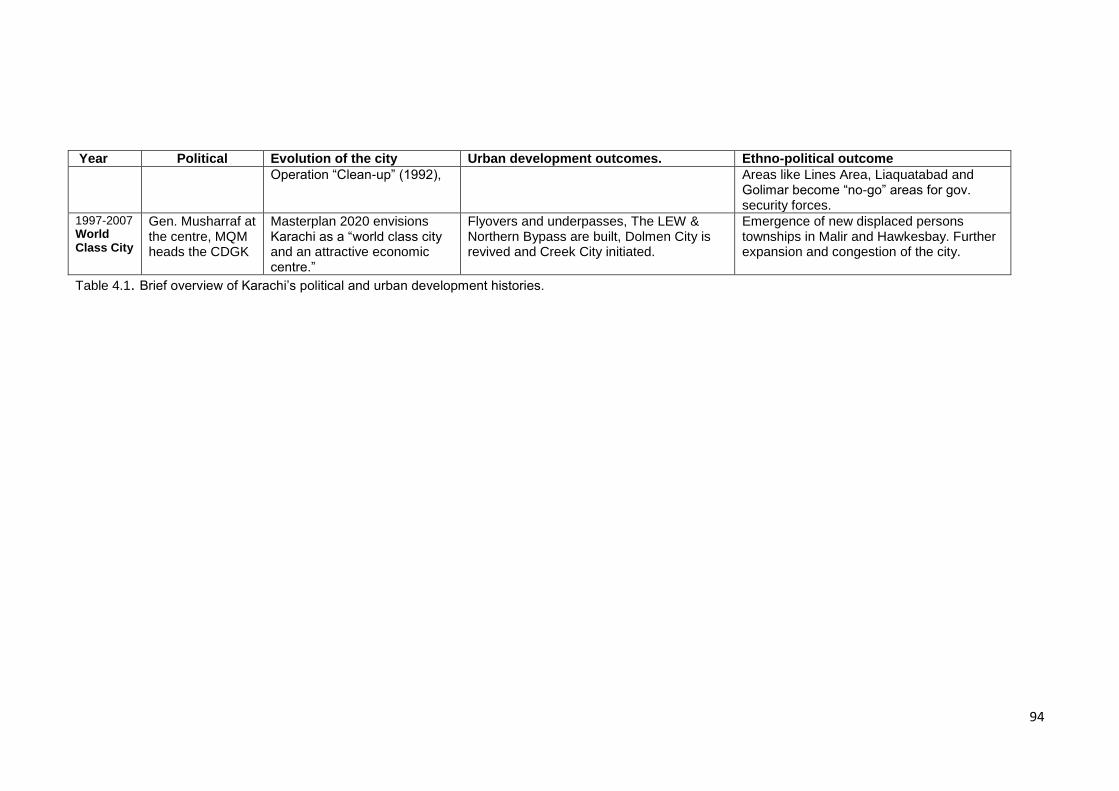
94
Year Political Evolution of the city Urban development outcomes. Ethno-political outcome
Operation “Clean-up” (1992), Areas like Lines Area, Liaquatabad and Golimar become “no-go” areas for gov. security forces.
1997-2007 World Class City
Gen. Musharraf at the centre, MQM heads the CDGK
Masterplan 2020 envisions Karachi as a “world class city and an attractive economic centre.”
Flyovers and underpasses, The LEW & Northern Bypass are built, Dolmen City is revived and Creek City initiated.
Emergence of new displaced persons townships in Malir and Hawkesbay. Further expansion and congestion of the city.
Table 4.1. Brief overview of Karachi’s political and urban development histories.
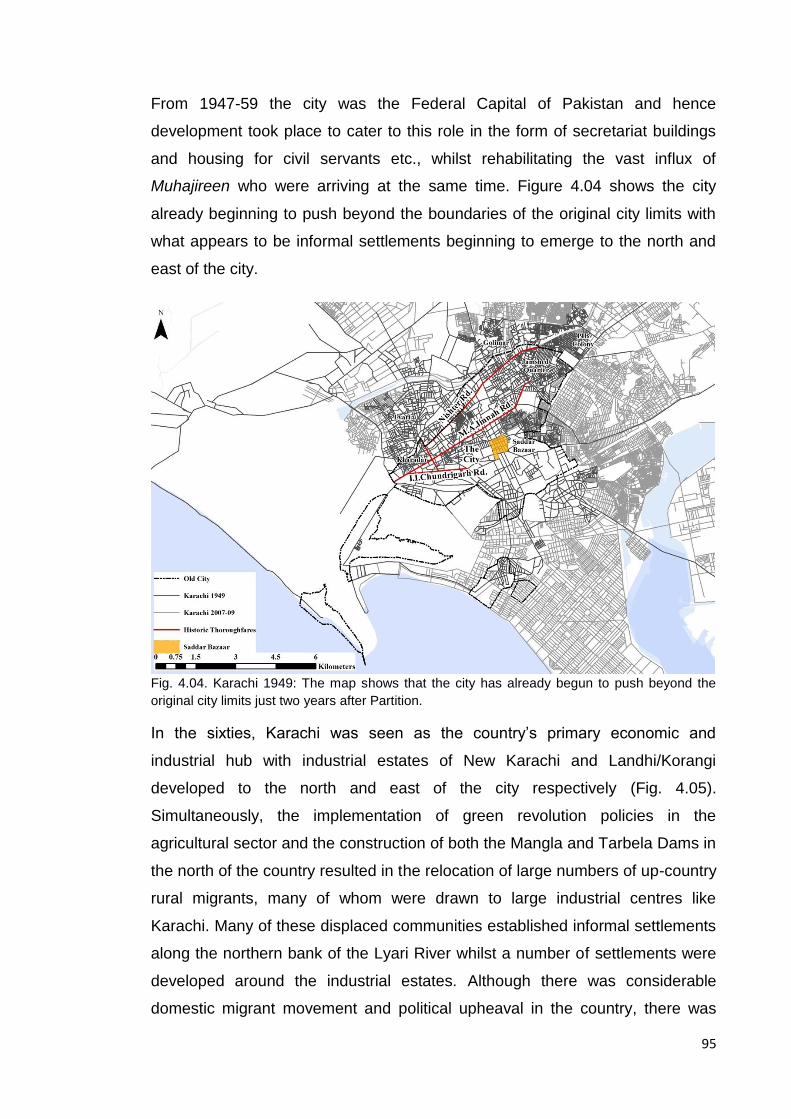
95
From 1947-59 the city was the Federal Capital of Pakistan and hence
development took place to cater to this role in the form of secretariat buildings
and housing for civil servants etc., whilst rehabilitating the vast influx of
Muhajireen who were arriving at the same time. Figure 4.04 shows the city
already beginning to push beyond the boundaries of the original city limits with
what appears to be informal settlements beginning to emerge to the north and
east of the city.
Fig. 4.04. Karachi 1949: The map shows that the city has already begun to push beyond the
original city limits just two years after Partition.
In the sixties, Karachi was seen as the country’s primary economic and
industrial hub with industrial estates of New Karachi and Landhi/Korangi
developed to the north and east of the city respectively (Fig. 4.05).
Simultaneously, the implementation of green revolution policies in the
agricultural sector and the construction of both the Mangla and Tarbela Dams in
the north of the country resulted in the relocation of large numbers of up-country
rural migrants, many of whom were drawn to large industrial centres like
Karachi. Many of these displaced communities established informal settlements
along the northern bank of the Lyari River whilst a number of settlements were
developed around the industrial estates. Although there was considerable
domestic migrant movement and political upheaval in the country, there was
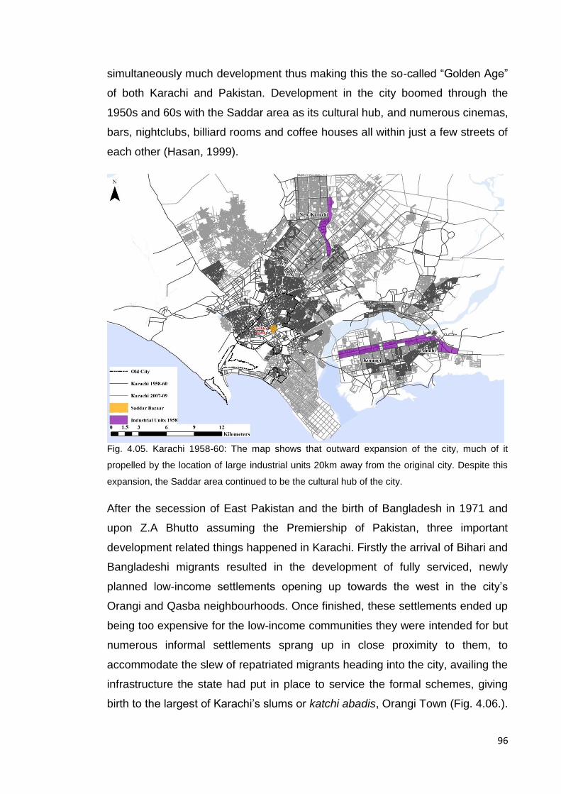
96
simultaneously much development thus making this the so-called “Golden Age”
of both Karachi and Pakistan. Development in the city boomed through the
1950s and 60s with the Saddar area as its cultural hub, and numerous cinemas,
bars, nightclubs, billiard rooms and coffee houses all within just a few streets of
each other (Hasan, 1999).
Fig. 4.05. Karachi 1958-60: The map shows that outward expansion of the city, much of it
propelled by the location of large industrial units 20km away from the original city. Despite this
expansion, the Saddar area continued to be the cultural hub of the city.
After the secession of East Pakistan and the birth of Bangladesh in 1971 and
upon Z.A Bhutto assuming the Premiership of Pakistan, three important
development related things happened in Karachi. Firstly the arrival of Bihari and
Bangladeshi migrants resulted in the development of fully serviced, newly
planned low-income settlements opening up towards the west in the city’s
Orangi and Qasba neighbourhoods. Once finished, these settlements ended up
being too expensive for the low-income communities they were intended for but
numerous informal settlements sprang up in close proximity to them, to
accommodate the slew of repatriated migrants heading into the city, availing the
infrastructure the state had put in place to service the formal schemes, giving
birth to the largest of Karachi’s slums or katchi abadis, Orangi Town (Fig. 4.06.).

97
Secondly, Prime Minister Z. A. Bhutto vision for Karachi was that of a
“cosmopolitan international hub” (Hasan, 2002), feeding off of the Oil boom22 in
the Gulf states resulting in the building of a number of up-market hotels in
Karachi’s city centre, initiating a higher-income coastal residential development
along with the construction of a large casino complex by the sea, and the
sanctioning of middle-income, mid to high-rise apartment complexes in the city’s
north and north-east sectors starting the trend for apartment living in the city.
Simultaneously, the government encouraged the development of Karachi’s
industrial ‘eastern corridor’ beyond Korangi and Landhi by laying the
groundwork for a second, smaller port; Port Qasim, and the Export Promotion
Zone (EPZ), (Fig. 4.06). As the city expanded during this period, commercial
trends shifted away from the traditional market spaces of the old city centre to
shopping centres, leading to the emergence of newer commercial districts in
places like Tariq Road just north of the old city centre and Hyderi in the city’s
new North Nazimabad locality, thus possibly bringing on the decline of the old
city.
22
The Oil Boom in the Gulf gave large numbers of migrant workers from South Asia the opportunity to work abroad, many of whom were single men living in austere conditions in order to remit as much of their salaries as possible to their families at home. Many eventually invested these remittances in the property market. Simultaneously, the Bhutto government saw Karachi’s proximity to the Gulf as advantageous, sanctioning large projects with the intention of catering to the entertainment needs of foreigners looking for a weekend away (Hasan, 2002). Both factors together resulted in a building boom in Karachi.

98
Fig. 4.06. Karachi 1972-74: The salient development features of the period were the growing
informal settlements towards the periphery of the city, the industrial expansion to the east and
west of the city and the movement of commercial activity out of the old Saddar Bazaar area.
General Zia-ul-Haq’s military coup in 1977 brought this formal development to
sharp halt. Bhutto was arrested on charges of complicity in political
assassination, the constitution of 1973 was suspended, assemblies were
dissolved and Pakistan’s 4th Martial Law was imposed. The period 1978-88 saw
not only the imposition of the Hudood Ordinances23 and the subsequent decline
of the city’s cultural activities with bars, clubs and cinemas being forced to shut
down, but also a massive influx of Afghan refugees, the result of the Soviet
occupation of Afghanistan. During this period, whilst very little development
work was took place in the formal sector, in order to deal with the latest influx of
migrants, the informal sector once again stepped in to bridge the gap left by the
state in the realm of housing and transport so much so that a Presidential order
regularising katchi abadis was issued in 1978 (Gazdar and Mullah, 2011). Thus
lead to the growth of informal settlements to the west of the city – Orangi Town,
Baldia and most recently Ittehad Town.
23
Hudood Ordinances are Islamic Laws promulgated in 1979 by General Zia-ul-Haq’s regime. These laws advocate the implementation of Islamic forms of punishment for criminal offenses, addressing issues as diverse as property disputes to blasphemy.
99
The introduction of many waves of migrants each in close succession, vying for
their share of the ever-diminishing resources of Karachi led to increased ethno-
political tensions in the city during the mid-1980s especially in Karachi’s north
western areas; i.e. Qasba and Aligarh Colony, where this mix of communities
came into daily contact. The Afghan War meant that drugs and arms were
readily available in the city, the stockpiling of which was encouraged by the
political leaders of the time leading to the militarisation of political parties and
their student groups and a period of bloody ethno-politics and turf wars.
The decade following General Zia-ul-Haq’s assassination (1988-99) was
politically tumultuous for the country and city politics was marred by ethnic
conflict between Sindhis, Pashtuns, and Muhajirs. This political upheaval was
off-set by developmental stagnation; during this period the only notable
development effort by the state appears to be the proposal of Karachi
Masterplan 2000. General Musharraf’s presidency from 1999-2007 led to
political stability and encouraged urban development; a noticeable building
boom seen in the form of numerous apartment complexes mushrooming in the
city’s central localities of Gulistan-i-Jauhar and Gulshan-e-Iqbal, and the
extensive development of the transport networks - signal free corridors, Lyari
expressway, Northern and Southern By-passes - facilitating rapid movement
between the city’s peripheries and the centre (Fig. 4.07). It should be noted that
often due to where such urban mega-projects are inserted i.e. often very dense,
informal, central areas of the city, the lack of availability of land and potential
displacement of communities are critical hurdles to overcome. These issues
have therefore made some of these transport projects quite political resulting in
the resettlement of many inner-city communities to peripheral under-developed
localities (Gazdar and Mullah, 2011) leading to loss of employment and
education opportunities (Sattar, 2012) as well as issues of severance within
communities that were permitted to remain.
Simultaneously this period saw the continued growth of informal settlements to
the east and west of the city to a point where some estimates suggest that up to
50% of Karachi’s population resides in informal settlements or katchi abaadis
today (Hasan and Mohib, 2003), as well as increasing economic segregation
that can be seen with the rise of gated communities in wealthier areas, as well
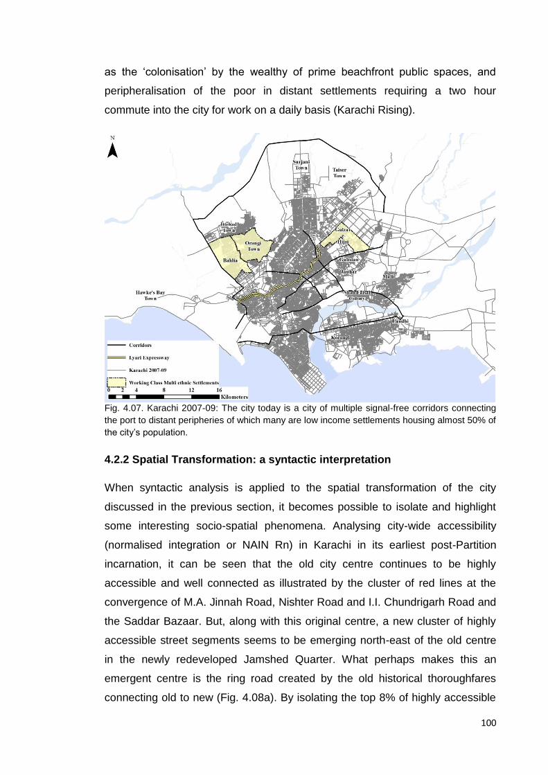
100
as the ‘colonisation’ by the wealthy of prime beachfront public spaces, and
peripheralisation of the poor in distant settlements requiring a two hour
commute into the city for work on a daily basis (Karachi Rising).
Fig. 4.07. Karachi 2007-09: The city today is a city of multiple signal-free corridors connecting
the port to distant peripheries of which many are low income settlements housing almost 50% of
the city’s population.
4.2.2 Spatial Transformation: a syntactic interpretation
When syntactic analysis is applied to the spatial transformation of the city
discussed in the previous section, it becomes possible to isolate and highlight
some interesting socio-spatial phenomena. Analysing city-wide accessibility
(normalised integration or NAIN Rn) in Karachi in its earliest post-Partition
incarnation, it can be seen that the old city centre continues to be highly
accessible and well connected as illustrated by the cluster of red lines at the
convergence of M.A. Jinnah Road, Nishter Road and I.I. Chundrigarh Road and
the Saddar Bazaar. But, along with this original centre, a new cluster of highly
accessible street segments seems to be emerging north-east of the old centre
in the newly redeveloped Jamshed Quarter. What perhaps makes this an
emergent centre is the ring road created by the old historical thoroughfares
connecting old to new (Fig. 4.08a). By isolating the top 8% of highly accessible
101
street segments at the city scale, this emergent pattern becomes more apparent
as seen in Figure 4.08b.
The form of the city as seen in the plan of 1958-60 was in part the result of the
partial implementation of Doxiades’ Greater Karachi Resettlement Plan1958-60.
This proposal took into account the fact that the city at the time was to be the
federal capital and hence broad boulevards and avenues were laid out to
connect the northern areas where many of the civil servants and their families
were to be housed proximate to the city centre. Again, an analysis of city-wide
accessibility (NAIN Rn) shows that this superstructure appears to be the most
accessible and well connected, connecting the centre to the peripheries of the
city in the form of a deformed wheel (Hillier, 1989). It also seems to show that
whilst the old city centre persists, the increasing connectivity and accessibility of
the newer centre to its north-east appears to be pulling some of the structural
emphasis away from the older centre. Additionally, the newer, peripheral
informal settlements of Malir, Landhi and Korangi to the east and Baldia to the
west, as well as inner city informal settlements along the Lyari River (many
established by up-country migrants displaced by the construction of large dams
in both Punjab and Khyber Pakhtun Khwah provinces) appear to be highly
segregated, appearing as blue lines in Figure 4.09a. Interestingly, emergent
affluent neighbourhoods in the north-west and south of the city, appear to be
similarly segregated suggesting that the extreme ends of the economic
spectrum appear to be living in similarly inaccessible localities. These patterns
of accessibility and segregation of the spatial configuration of the city are better
illustrated by isolating the street segments with the highest 8% of NAIN Rn
values as well as those with values in the bottom 25%24 as seen in Figure
4.09b.
24
Whilst using the highest 10% of globally integrated lines to isolate the integration core of a city has been previously used (Khan and Nilufar, 2009), in this particular case using the top 8% and the bottom 25% of street segments for NAIN_Rn in this section was a decision that was reached through a process that may be considered a sensitivity test of sorts; a range of values at both ends of the spectrum were tested ( the highest 10% inclusive) in order to see if it was possible to isolate i) the city’s integration core and ii) the city’s informal/unplanned/slum settlements thereby making it possible to study and understand the configurational and functional differences between the city’s most integrated and least integrated street segments.
102
As discussed in the previous section, by 1972, whilst the old centre still housed
considerable commercial activity, newer commercial centres had begun to
emerge in localities further afield catering to a growing population living in the
‘suburbs’ of the city. These newer commercial streets seemed to gravitate to
locations along the city’s highly accessible superstructure. Simultaneously, as
commercial and cultural activity went into decline in the old city centre, and
newer commercial locations became more popular, this shift appeared to be
mirrored by the movement of the integration core (a cluster of highly accessible
street segments) away from the old city centre towards the north of the city
illustrated by Figures 4.10a and 4.10b.
A NAIN Rn analysis of Karachi in 2007-09 as seen in Figures 4.11a and 4.11b
brings to light the persistence of another socio-spatial phenomenon; the similar
level of segregation of both the urban slum and the affluent gated community.
Figure 4.11b highlights the street segments that fall into the bottom 25% of
NAIN Rn values; i.e. the least accessible street segments in the system and, as
seen in the analysis for the year 1958-60, the bulk of the street segments
highlighted are to be found in the city’s low-income informal settlements to the
west and the affluent – in some cases gated – settlements to the south. Hence
what was an emergent phenomenon in the early 1960s in the city, has
persisted, encompassing larger sections of the city.
Finally by arranging Figures 4.12a-12d side by side, the shift and growth of the
integration core to the north of the city becomes quite apparent. Historically, this
shift coincides with the shift of population, the decline of the inner city’s cultural
nightlife and commercial activity where much of the city centre today is
warehousing and wholesale markets. This is not necessarily an unusual
phenomenon. This shift and growth of the integration core was identified in a
similar diachronic space syntax study conducted on Dhaka for the period 1953-
2007 (Khan and Nilufar, 2007) where the city’s post-Partition expansion and
shifting core are mirrored as above by the shift of socio-economic activity from
the old city areas to the newer developments.
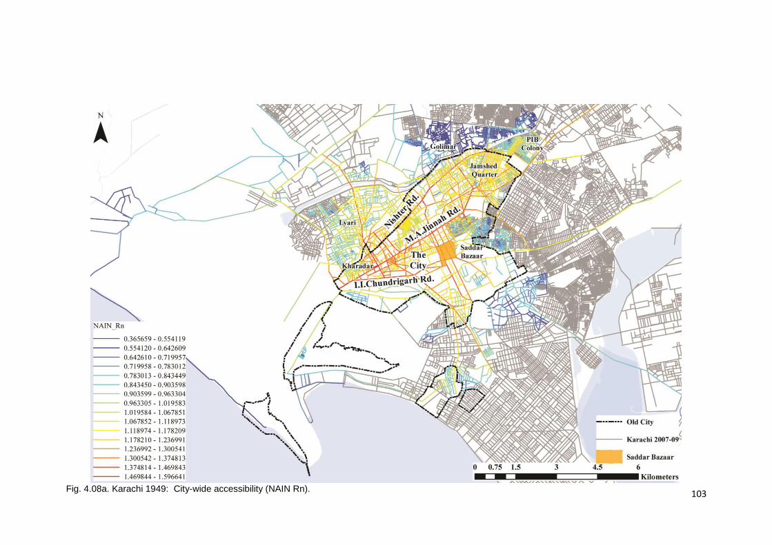
103
Fig. 4.08a. Karachi 1949: City-wide accessibility (NAIN Rn).
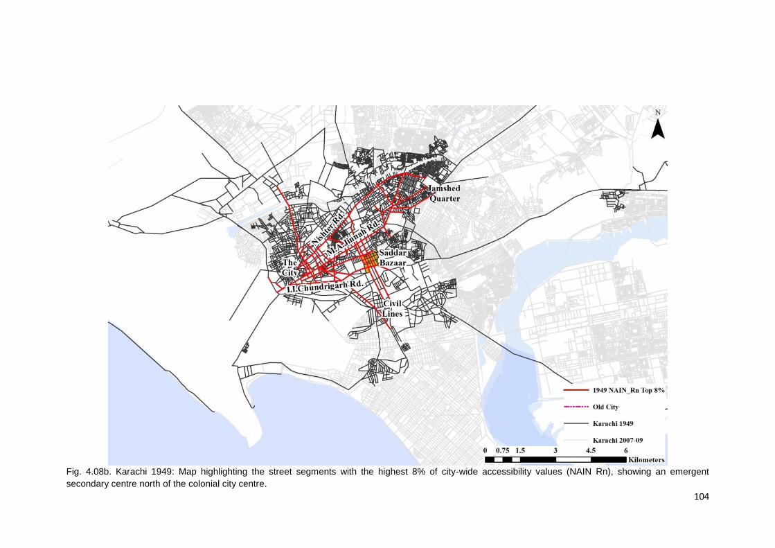
104
Fig. 4.08b. Karachi 1949: Map highlighting the street segments with the highest 8% of city-wide accessibility values (NAIN Rn), showing an emergent
secondary centre north of the colonial city centre.
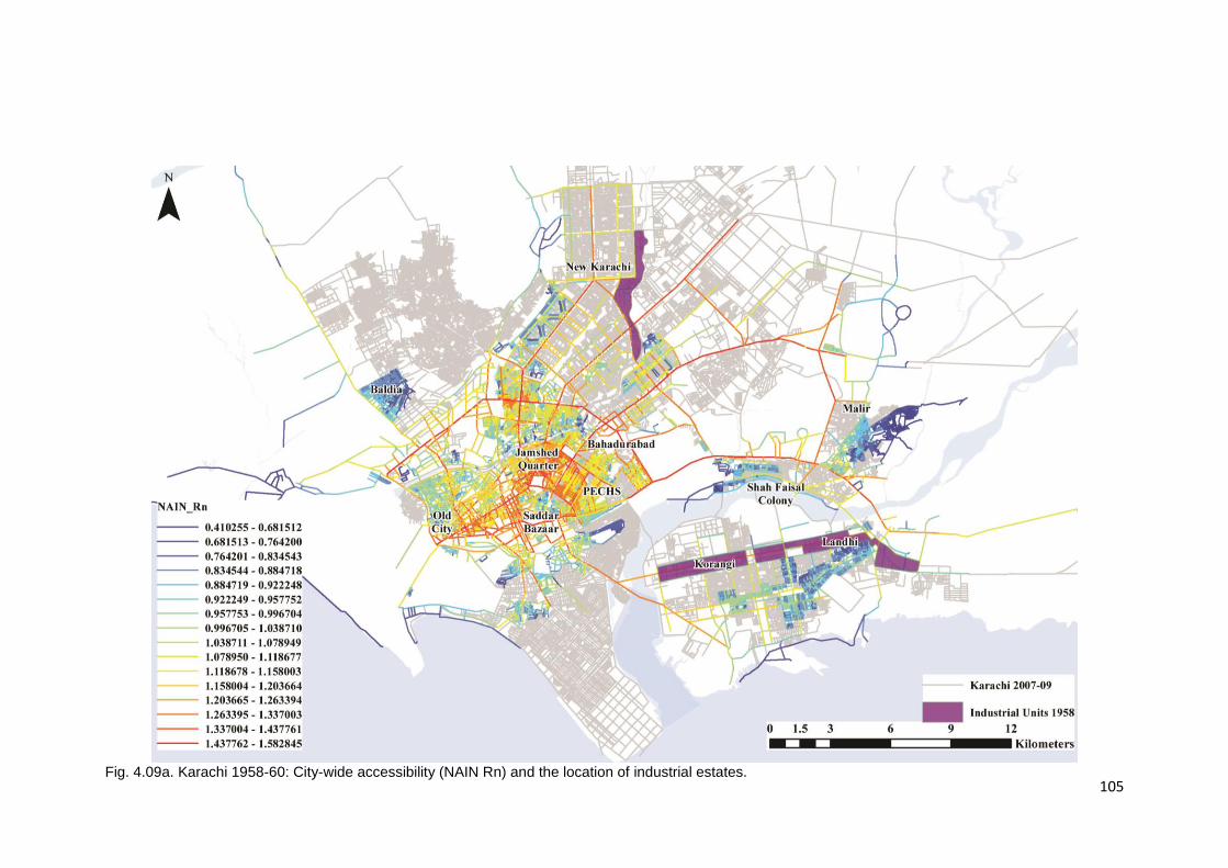
105
Fig. 4.09a. Karachi 1958-60: City-wide accessibility (NAIN Rn) and the location of industrial estates.

106
Fig. 4.09b. Karachi 1958-60: The map illustrates how the integration core is shifting towards the secondary centre shown by the increased clustering of street
segments with the highest 8% of values for city-wide accessibility (NAIN Rn) around the secondary centre. Additionally lowest 25% of NAIN Rn street
segments show the high segregation of peripheral informal settlements and some affluent areas.
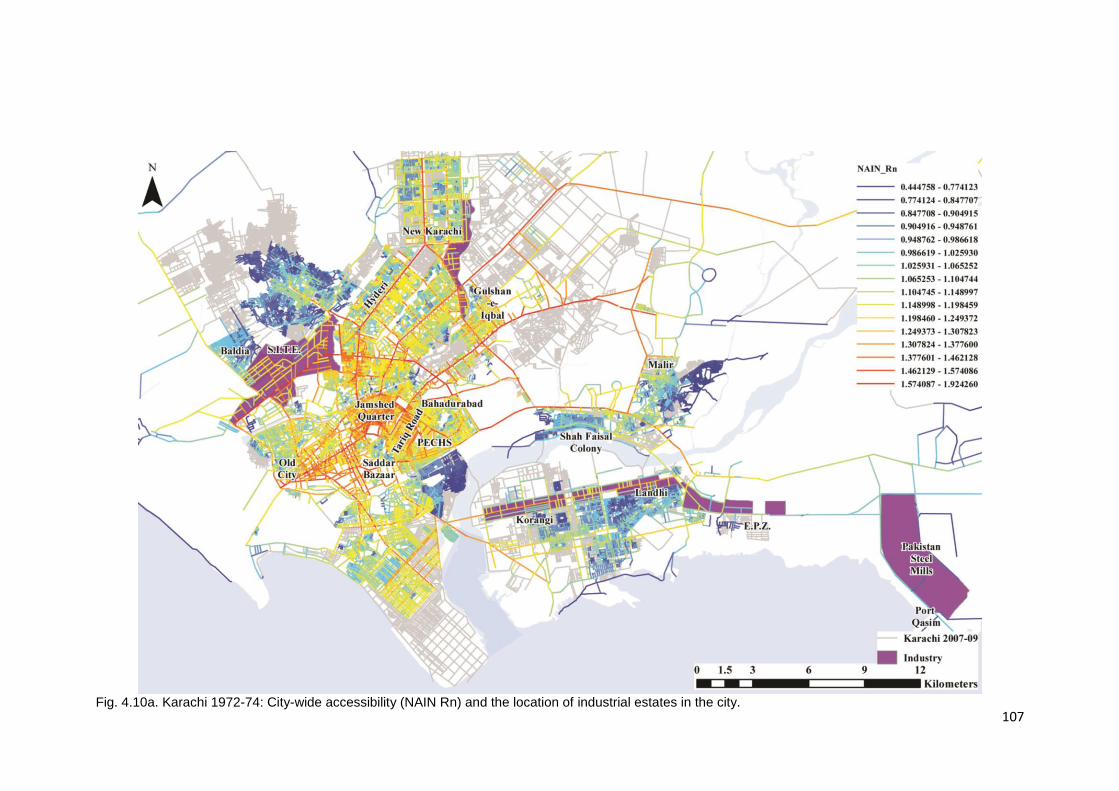
107
Fig. 4.10a. Karachi 1972-74: City-wide accessibility (NAIN Rn) and the location of industrial estates in the city.
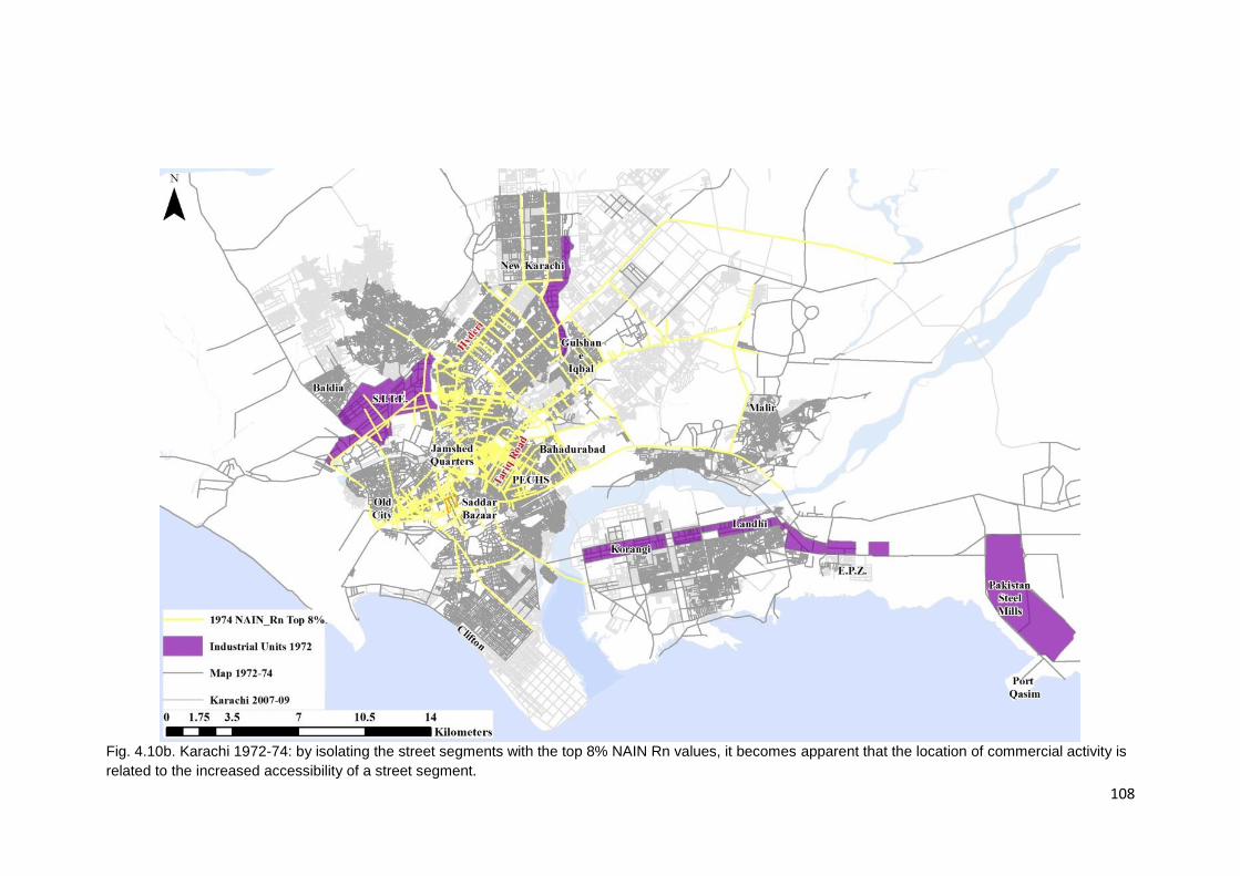
108
Fig. 4.10b. Karachi 1972-74: by isolating the street segments with the top 8% NAIN Rn values, it becomes apparent that the location of commercial activity is
related to the increased accessibility of a street segment.

109
Fig.4.11a. Karachi 2007-09: City-wide accessibility (NAIN Rn).
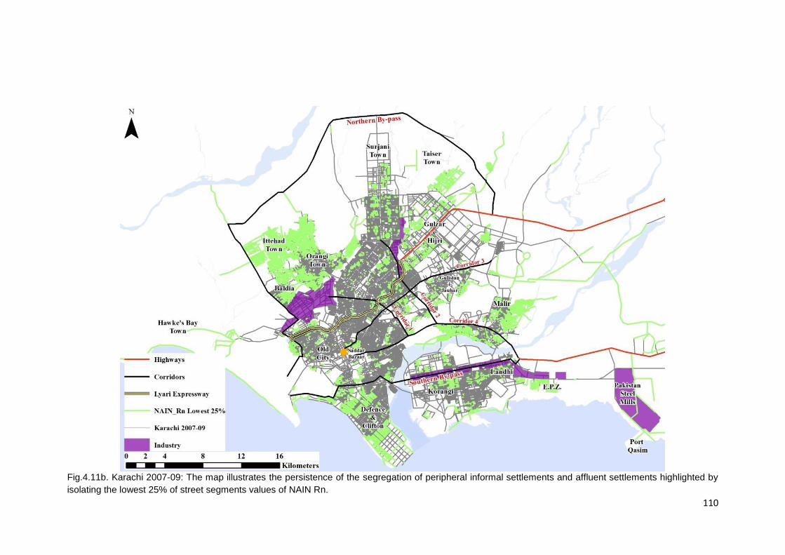
110
Fig.4.11b. Karachi 2007-09: The map illustrates the persistence of the segregation of peripheral informal settlements and affluent settlements highlighted by
isolating the lowest 25% of street segments values of NAIN Rn.
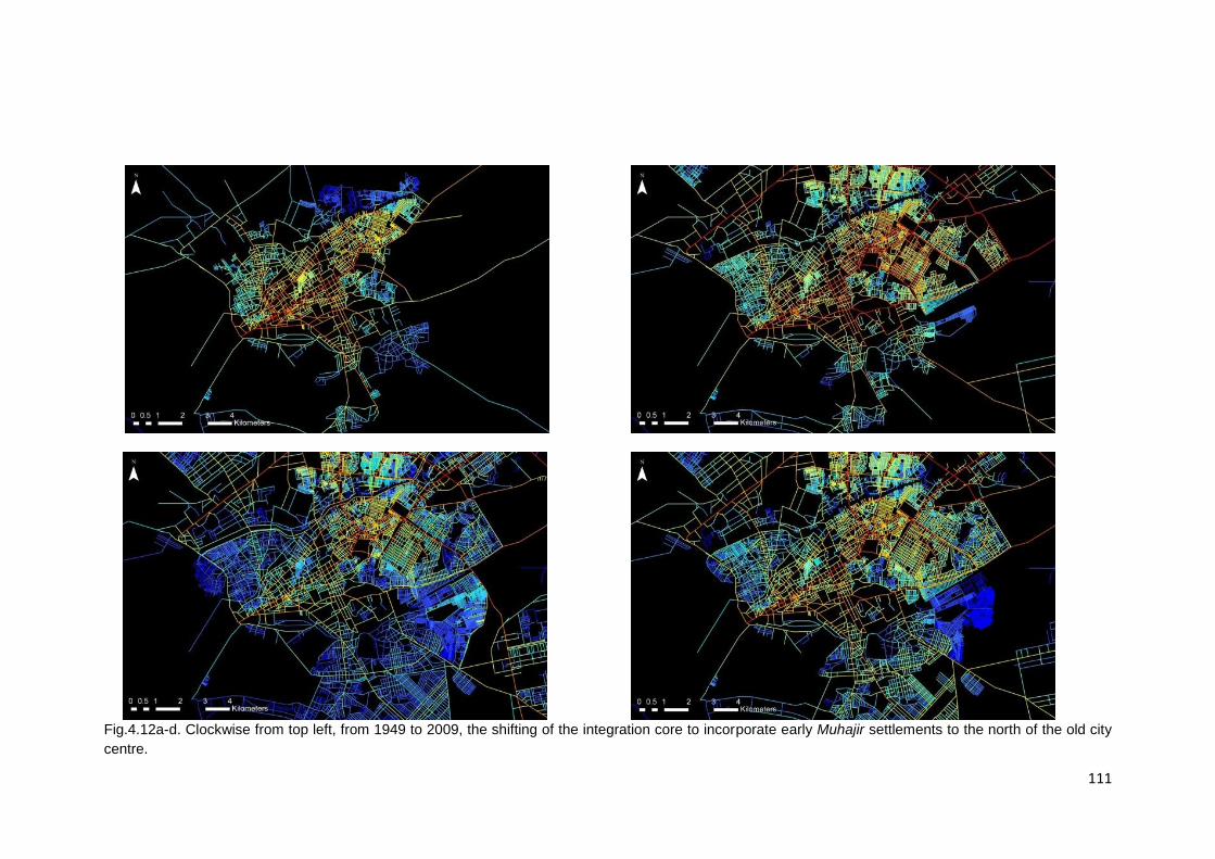
111
Fig.4.12a-d. Clockwise from top left, from 1949 to 2009, the shifting of the integration core to incorporate early Muhajir settlements to the north of the old city
centre.
112
4.3 The Muhajir City: from migrants to masters and back again.
The previous section analysed the spatial transformation of the post-Partition
city in light of urban development decisions, migration into the city and national
politics. This section will explore the impact that the same urban policies, in-
migration and national politics had on the Muhajir presence in the city for the
same time periods.
4.3.1 - 1949: Muhajir arrival and inner city spatial clustering
The new government did not expect the kind of refugee influx that Karachi
experienced and whilst it was dealing with setting up the machinery of the state,
refugees took up residence in whatever empty buildings and vacant plots they
could find in and around the city centre. Inner city refugee squatter settlements
included areas in and around Burns Road, Frere Road and parts of the native
city of Kharadar (Gayer, 2014) and, peripheral areas comprising of relief and
transit camps in Lines Area to the north east of the city centre and Agra Taj and
Bihar Colonies in the city’s Lyari neighbourhood and squatter settlements in
Lalukhet (later to be known as Liaquatabad) and Golimar (later to become
Gulbahar), north of the Lyari River (Fig. 4.13a). The influx of Muhajir refugees
led to a cultural transformation of the city scape; the emergence of the Burns
Road as food street selling specifically North Indian specialities such as Nihari
and Payas and the mushrooming of tea houses and book shops in the Saddar
area and the emergence of the Urdu press as a formidable proponent of Muhajir
rights (Ansari, 2005).
Interestingly, as seen in Figure 4.13b, most of the inner-city neighbourhoods the
refugees of means initially occupied were proximate to streets that were highly
accessible at the city scale. On the other hand, many of the relief and transit
camps and informal squatter settlements established for and by the neediest of
refugees were set-up outside the old city limits and, as the figure shows, were
the most segregated additions to the system. This seems to suggest the
beginnings of a centre-periphery wealth divide in the city.
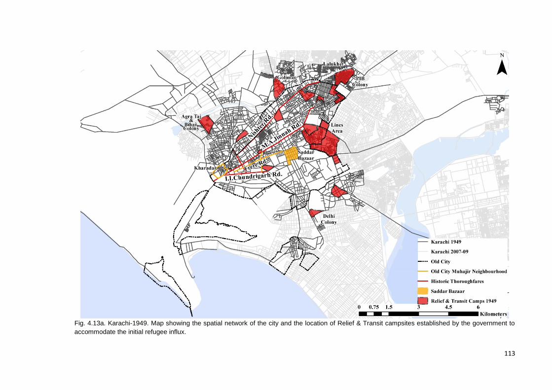
113
Fig. 4.13a. Karachi-1949. Map showing the spatial network of the city and the location of Relief & Transit campsites established by the government to
accommodate the initial refugee influx.
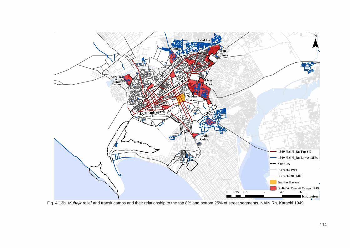
114
Fig. 4.13b. Muhajir relief and transit camps and their relationship to the top 8% and bottom 25% of street segments, NAIN Rn, Karachi 1949.

115
4.3.2 - 1958-69: The urban “golden age”25 and Muhajir marginalisation
Between 1947 and 1958, the State’s primary objective appeared to be the
establishment of government machinery and the rehabilitation of refugees
though it was not equipped or even expecting the kind of influx and upheaval
Partition generated. As a result, by the late fifties four broad kinds of housing
settlements had emerged catering, more-or-less exclusively to the first wave of
Muhajir migrants; i) State sponsored housing schemes primarily to the north of
the Lyari River, i.e. Nazimabad, North Nazimabad & Federal ‘B’ Area, ii)
community driven co-operative housing societies that generally catered to
homogenous communities to the north east of the old city centre such as
Hyderabad Colony, Bahadurabad, P.E.C.H.S., Delhi Mercantile Housing
Society, iii) State sponsored low income housing settlements generally attached
to industrial estates in Landhi-Korangi etc., and finally iv) informal squatter
settlements or katchi abaadis such as Lines Area, Lalukhet (Liaquatabad) and
Golimaar (Gulbahar). In this instance, housing in the city for the Muhajireen was
a combination of state sponsored and community driven housing initiatives
across income brackets that had been trying to tackle Karachi’s housing crisis
from very early on in Karachi’s development history (Fig.4.14a).
This process of settlement laid the groundwork for a city organised in a manner
so as to perpetuate socio-economic segregation, compounded further by Ayub
Khan’s interpretation of Doxiades’ Greater Karachi Resettlement Plan; satellite
industrial estates and their residential units, i.e. New Karachi to the north and
Landhi-Korangi to the east were established at a distance of 20km from the city
centre with the intention of housing residents of inner city squatter settlements
that had been bulldozed, planned middle-class housing schemes extending
towards the north of the city centre, satellite settlements emerging for lower-
middle income settlers in the form of Shah Faisal Colony and Malir to the east
and Baldia in the west and ‘Housing Societies’ for the city’s wealthy just north
east of the city centre. This essentially created a centre-periphery wealth
25
Pakistan’s first martial law period (under Field Marshall Ayub Khan) is often referred to with a sense of nostalgia as the ‘golden age’ despite the fact that the nation was helmed by a military leader. This is due to the amount of nationwide industrial, agricultural and urban development that took place during this period (Daechsel, 2011).
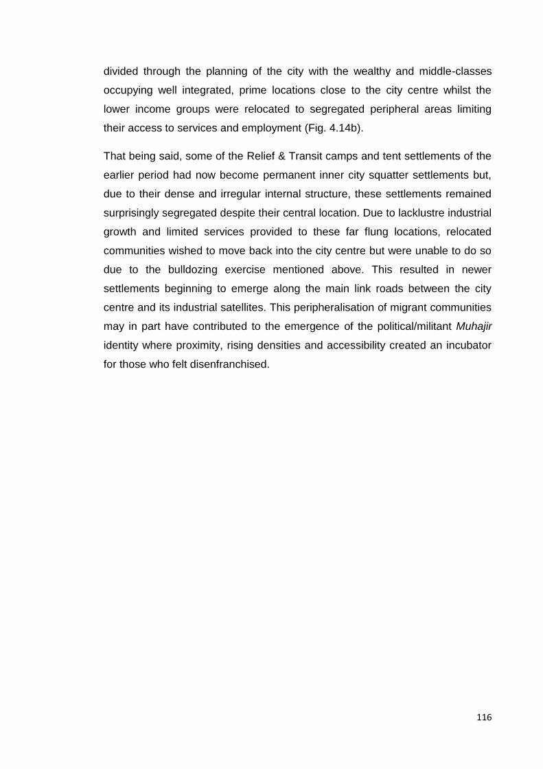
116
divided through the planning of the city with the wealthy and middle-classes
occupying well integrated, prime locations close to the city centre whilst the
lower income groups were relocated to segregated peripheral areas limiting
their access to services and employment (Fig. 4.14b).
That being said, some of the Relief & Transit camps and tent settlements of the
earlier period had now become permanent inner city squatter settlements but,
due to their dense and irregular internal structure, these settlements remained
surprisingly segregated despite their central location. Due to lacklustre industrial
growth and limited services provided to these far flung locations, relocated
communities wished to move back into the city centre but were unable to do so
due to the bulldozing exercise mentioned above. This resulted in newer
settlements beginning to emerge along the main link roads between the city
centre and its industrial satellites. This peripheralisation of migrant communities
may in part have contributed to the emergence of the political/militant Muhajir
identity where proximity, rising densities and accessibility created an incubator
for those who felt disenfranchised.
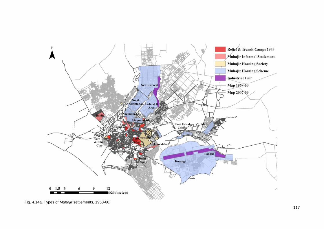
117
Fig. 4.14a. Types of Muhajir settlements, 1958-60.
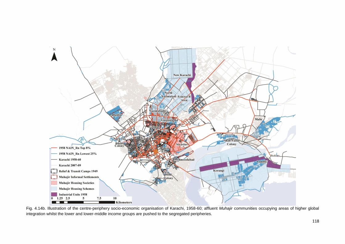
118
Fig. 4.14b. Illustration of the centre-periphery socio-economic organisation of Karachi, 1958-60; affluent Muhajir communities occupying areas of higher global
integration whilst the lower and lower-middle income groups are pushed to the segregated peripheries.
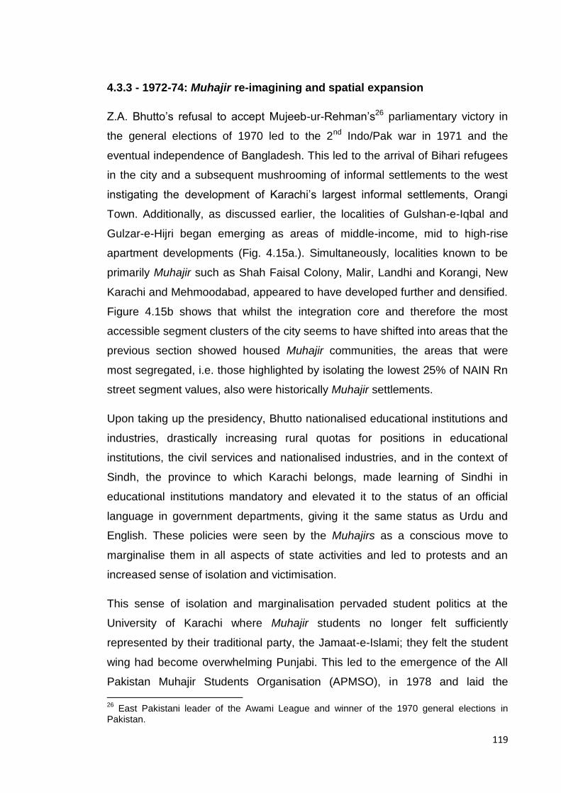
119
4.3.3 - 1972-74: Muhajir re-imagining and spatial expansion
Z.A. Bhutto’s refusal to accept Mujeeb-ur-Rehman’s26 parliamentary victory in
the general elections of 1970 led to the 2nd Indo/Pak war in 1971 and the
eventual independence of Bangladesh. This led to the arrival of Bihari refugees
in the city and a subsequent mushrooming of informal settlements to the west
instigating the development of Karachi’s largest informal settlements, Orangi
Town. Additionally, as discussed earlier, the localities of Gulshan-e-Iqbal and
Gulzar-e-Hijri began emerging as areas of middle-income, mid to high-rise
apartment developments (Fig. 4.15a.). Simultaneously, localities known to be
primarily Muhajir such as Shah Faisal Colony, Malir, Landhi and Korangi, New
Karachi and Mehmoodabad, appeared to have developed further and densified.
Figure 4.15b shows that whilst the integration core and therefore the most
accessible segment clusters of the city seems to have shifted into areas that the
previous section showed housed Muhajir communities, the areas that were
most segregated, i.e. those highlighted by isolating the lowest 25% of NAIN Rn
street segment values, also were historically Muhajir settlements.
Upon taking up the presidency, Bhutto nationalised educational institutions and
industries, drastically increasing rural quotas for positions in educational
institutions, the civil services and nationalised industries, and in the context of
Sindh, the province to which Karachi belongs, made learning of Sindhi in
educational institutions mandatory and elevated it to the status of an official
language in government departments, giving it the same status as Urdu and
English. These policies were seen by the Muhajirs as a conscious move to
marginalise them in all aspects of state activities and led to protests and an
increased sense of isolation and victimisation.
This sense of isolation and marginalisation pervaded student politics at the
University of Karachi where Muhajir students no longer felt sufficiently
represented by their traditional party, the Jamaat-e-Islami; they felt the student
wing had become overwhelming Punjabi. This led to the emergence of the All
Pakistan Muhajir Students Organisation (APMSO), in 1978 and laid the
26
East Pakistani leader of the Awami League and winner of the 1970 general elections in Pakistan.
120
foundation for the eventual establishment of the Muhajir Quami Movement
(MQM) in 1984.

121
Fig. 4.15a. Refugee Settlements to the west and apartment developments to the east of the Muhajir areas, 1972-74.
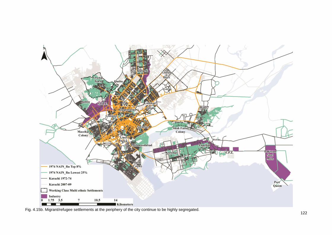
122
Fig. 4.15b. Migrant/refugee settlements at the periphery of the city continue to be highly segregated.

123
4.3.4 - 2001-11: A Muhajir City: political domination and spatial control
The map from 2007-09 shows the growth and expansion of informal settlements
to the west of the city centre to absorb the last wave of migration, i.e. Afghan
refugees after the Soviet occupation of Afghanistan. Both Orangi and Baldia
townships have expanded so much so that they now abut each other, the
boundaries between townships are no longer clear. This vast stretch of informal
settlements makes up the entire western wing of the city.
Continued development towards the north-east of the city was, as discussed
earlier in this chapter, an outcome of the building boom of the 1980s and 90s
that was fuelled by remittances from the Gulf States and a change in building
bye-laws introduced by the Bhutto government in 1972. The development of this
area of the city was a combination of state sponsored settlements or colonies -
Shah Latif Town, Gulzar-e-Hijri, Scheme 33 - and initiatives undertaken by the
private commercial sector, private developers applying for and constructing mid
to high-rise apartment complexes (Mahmood, 1999) (Fig. 4.16a).
The post Zia period (1988 onwards) saw the rise of the MQM in city politics; a
party that claimed to be the one true voice of the Muhajir peoples of urban
Sindh. Since 1988 they have been part of every provincial and local body
government bringing the Muhajir cause back into the limelight, their presence
once again impacting the development and growth of the city. The
transportation links needed to connect the city as it grew, a product of the late
1990s and 2000s, have been hugely impacted by Muhajir politics. An example
of the MQM’s political clout can be seen in the fact that the building of the
Northern and Southern by-passes, both proposed as part of the Karachi Master-
plan 1974-85 in 1968, as well as the later addition of the Lyari Expressway
which was initially proposed as an alternative to the construction of the Northern
By-pass were eventually sanctioned and built between 2001-07, a time when
the City District Government was dominated by the MQM, with significant
backing from the Federal government presided over by General Pervez
Musharraf, himself considered a Muhajir. Whilst these major transport links
along with the construction of 4 signal-free corridors through the central and
eastern districts of the city have now enhanced connections between the

124
satellite towns of the 1960s (Shah Faisal colony, Malir and Landhi and Korangi)
and the city (Fig.4.16a), they have simultaneously displaced a number of
communities, some of which have been relocated to the outlying townships of
Taiser Town and Hawkes Bay Town.
As noted in section 4.2.1 these kinds of urban mega-projects are often located
in dense, informal central areas of the city, where there is a severe shortage of
large available tracts of land required for these projects. Karachi is not unique in
this, Follmann states that this insertion of urban mega-projects into what he
refers to as an ‘omnipresent informality’ (Follmann, 2015, p. 214) is a common
feature that needs to be acknowledged in many cities of the Global South today.
Roy’s work on Indian cities shows that local politics plays a major role in making
the land required for these projects available. Using the often informal nature of
the settlements and their lack of land deeds to their advantage, political parties
may either exercise the principle of eminent domain or orchestrate often violent
evictions in order to repossess the land required (Roy, 2009).
The role these transportation links have played in making Karachi more a
muhajir city than before will be explored further in following sections of this
chapter. That being said, something to consider is that despite the construction
of numerous flyovers and underpasses since 1993, the western and southern
portions of the city still remain highly segregated; the former housing the poor
and the latter, the wealthy of the city. Interestingly, it can be seen that as the
city has grown, those areas that in 1949 sat at the edge of the then city and
appear in the lowest 25% of street segments for NAIN Rn and were therefore
the most segregated regions of the city, today as the city has grown, form part
of the top 8% of street segments at NAIN Rn, i.e. the most integrated sections
of the city. Figure 4.16b brings an interesting phenomenon to light; in Karachi
today it appears that the low-income informal settlements to the west and the
affluent areas to the south are equally segregated.
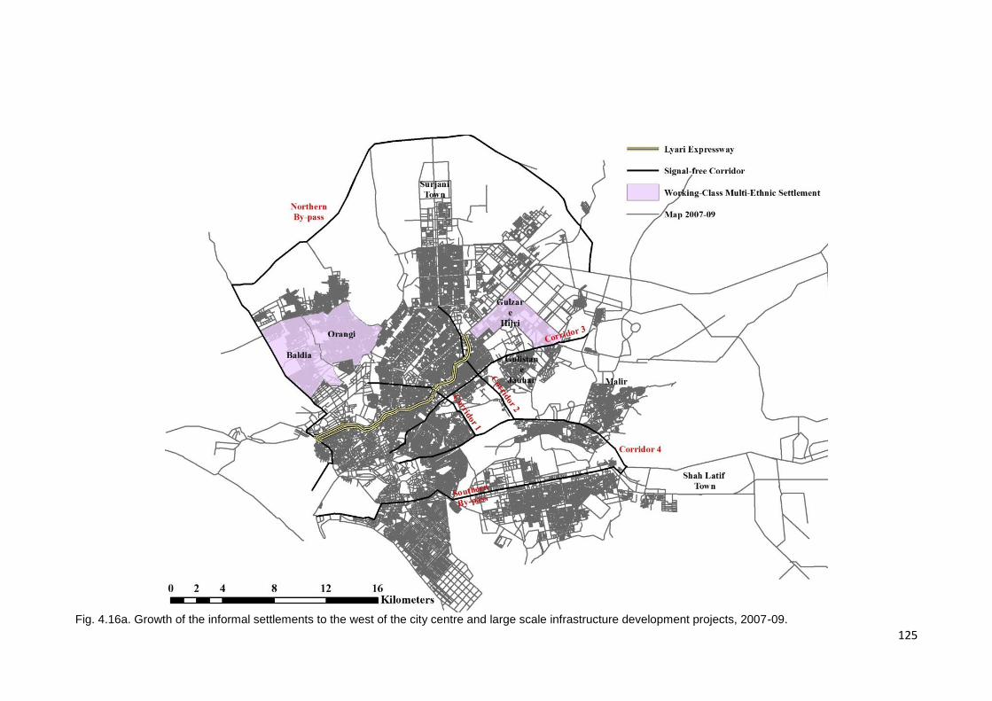
125
Fig. 4.16a. Growth of the informal settlements to the west of the city centre and large scale infrastructure development projects, 2007-09.

126
Fig. 4.16b. Both informal settlements to the west and affluent settlements to the south are highly segregated and the previously segregated earliest Muhajir
settlements at the edge of the old city now occupy the most integrated areas of the city.
127
4.4 Spatial clustering of a modern community: the use of socio-spatial
proxies to define Muhajir space
The above discussion shows how i) the city has developed and ii) where the
Muhajireen were initially settled. But as can be seen by the number of different
waves of migration that have come into Karachi, the city’s ethnic make-up is
today far more complex than it was in this earlier period, hence in order to track
the community today, there is a need to understand and identify ethnic markers
that are particular to their identity and practices today.
Whilst the Muhajir identity may seem to be a reasonably recent phenomenon, it
may actually be considered the evolution of the pre-Partition Indian Muslim
identity that was the crux of the Pakistan Movement. This call for a separate
homeland for the Muslims of India was essentially the politicisation of communal
differences between Hindus and Muslims of the Indian Sub-continent. Hence
one may argue that the Muhajireen were predisposed in a way to political
mobilisation. Whilst religion was the primary unifying factor in politically
mobilising the disparate Indian Muslim communities, language - in this case
Urdu - played a critical role as the necessary Lingua Franca understood by
most across the spectrum of communities that made up the Indian Muslim
conglomerate. Urdu was in fact politicised well before the Pakistan movement in
that whilst Hindi and Urdu have the same root; i.e. Hindvi/Dehlvi, through
Mughal patronage and subsequently Muslim separatism, there was a conscious
push to “Arabicise/Persianise” Urdu both through the form of its text as well as
the hybridity of its vocabulary, borrowing heavily from Persian and Arabic
(Rahman, 2011).
This Pre-Partition linguistic necessity became critical to Post-Partition
community identities as language became a means for the State to differentiate
between “sons of the soil” and migrant peoples or ‘old’ and ‘new’ Sindhis.
Simultaneously, for the Muhajireen it became a badge of honour; being dubbed
‘Urdu-speaking’ was representative of ones sacrifice for and commitment to a
Muslim homeland. As stated above, in Karachi linguistic association will
generally determine one’s ethnicity which in turn will broadly determine for who
one will vote for in an election. The city’s older ‘native’ Sindhi and Balochi
128
communities, many of whom are resident in old inner city areas, will speak
Sindhi and Balochi respectively, but will vote primarily for the Pakistan Peoples
Party (PPP), with some votes going to Baloch separatist groups. The Pakhtuns
who are originally from Khyber Pakhtun Khwah in Pakistan’s North West are
primarily Pashto speaking, and up until the last election, voted for the secular
Pakhtun-centric Awami National Party (ANP). Migrants from the Punjab may
speak a number of different languages that include Punjabi, Seraiki, and
Hindkoh etc., but will generally vote for the Pakistan Muslim League (PML), and
finally the Muhajir population, colloquially identified as ‘Urdu-speaking’, consider
Urdu as their “mother-tongue” – a term used in the census when referring to
respondents’ primary language - and have historically voted for the Muttahaida
Quami Movement (MQM) in elections since 1988 when the party first contested
the elections. This phenomenon provides two socio-spatial markers that help
identify Muhajir localities, that of language and politics.
Again, as mentioned earlier, the Indian Muslim identity and resultant Pakistan
Movement were built around a broad religious solidarity which was by no means
indicative of a homogenous religious identity. Amongst the myriad of Muslim
sects that make up the Muhajir community today in Pakistan, two are of
particular interest to this study, the Sunni Barelvi sect and various Shi’a
communities. Both sects had large populations of adherents in the provinces
and cities from where the Muhajireen migrated and both have a distinctive
urban presence in the form of identifiable religious institutions in the areas in
which they settled. This provides the third socio-spatial marker that may help to
identify Muhajr spaces in the city today completing Vertovec’s triad; linguistics,
cultural and religious institutions, and political mobilisation.
As the city has grown, for the purposes of governance, it has gone through a
number of different delimitations each with its own local government structures
Most commonly this has taken the form of large ‘districts’, the number and
extent of which has changed over time from four to five and then most recently
six districts after the general elections of 2013. For a period between 2002-07,
Karachi was divided up into 18 towns that were further subdivided into 178
union councils. With elections in 2008, this delimitation was again revised and
the city government reverted to its pre-2002 composition of 5 large districts.

129
Whilst these districts are large, varying in size, population density and built-up
area (see Table 3.2 and Fig.4.17), these administrative boundaries have been
used in conjunction with data pertaining to language and voting practices in
order to identify broad regions – if that is the case – of Muhajir settlement in the
city today.
Today, Karachi’s 5 districts are; District South which consists of the port areas,
much of the old city centre, Mehmoodabad and the cantonment areas of
Defence Housing Authority and Clifton, District East includes the industrial
estates in Landhi-Korangi and their adjoining residential areas, Shah Faisal
Colony, and the various housing societies and peripheral areas of the old city.
District Central is made up completely of post partition developments north of
the Lyari River, i.e. Liaquatabad, Nazimabad, North Nazimabad, New Karachi,
and North Karachi, it is the smallest of the 5 districts with the highest population
density. District West comprises of all the areas west of Manghopir Road that
connects the city centre to the various industrial estates that lie to the west of
the city; SITE industrial estate, Baldia, Orangi Town and Qasba. Finally District
Malir, the largest of the 5 districts and most sparsely populated and comprises
of areas north of Shahra-e-Faisal which include Malir, Malir Cantt, the airport,
land belonging to the Pakistan Air Force and various villages (Goths) and their
surrounding agricultural land (Fig.4.17)

130
Fig. 4.17. District boundaries Karachi, 2009.

131
4.4.1 – Language: The Lowest Common Denominator.
As discussed earlier, the Muhajir identity is a development of the Indian Muslim
identity that was key to the emergence of Pakistan. Most refugees who
relocated to Karachi came from one of five Hindu majority regions in India; i)
Uttar Pradesh (primarily the cities of Delhi, Agra and Lucknow), ii) Central
Provinces & Berar, iii) Hyderabad Deccan and Madras, iv) Bombay and Gujarat,
and v) Ajmer and Rajputana. The movement of refugees to Sindh was primarily
one of people moving from urban centres in India to urban locations in Pakistan.
Despite varied geographical backgrounds, in most cases, the migrants’ primary
language was Urdu and this became their lowest common denominator. The
magnitude of their numbers and the movement out of the city of the Sindhi-
speaking Hindu urban population, transformed the cultural landscape of the city
centre at Partition with the percentage of the population speaking Sindhi
dropping to 8.6% in 1951 from 61.2% just a decade earlier whilst
simultaneously, the percentage of Urdu speakers grew from 6.3% in 1941 to
constitute 50% of the city’s total population in 195127. Subsequent censuses
have shown that this figure has held more-or-less steady at 50%, only recently
dropping to 48% of the population of the city (Hasan and Mohib, 2003). These
figures suggest that Urdu is the language most commonly spoken in the city as
opposed to Sindhi or Gujerati as was previously the case. The quote below from
the memoirs of a young army major who came to Karachi to visit his family for
the first time shortly after Partition provides an insight into the kind of
transformation the city went through.
“On the whole Karachi might have been a leaf from Delhi or Lucknow- the same
language, the same dress, and the same paan-chewing good Samaritans…
Between the Bundar Road and the Marriot Road shopping areas and Saddar,
one would find almost everyone one might have known or cared for. The men
from Delhi and UP had turned the city into a replica of their native Delhi and
Lucknow.” (Siddiqi, 2008, p. 64)
Despite historical and anecdotal accounts describing how the Muhajireen
occupied and transformed the old city areas upon their arrival (Siddiqi 2008
27
Government of Pakistan Population Census Report 1951
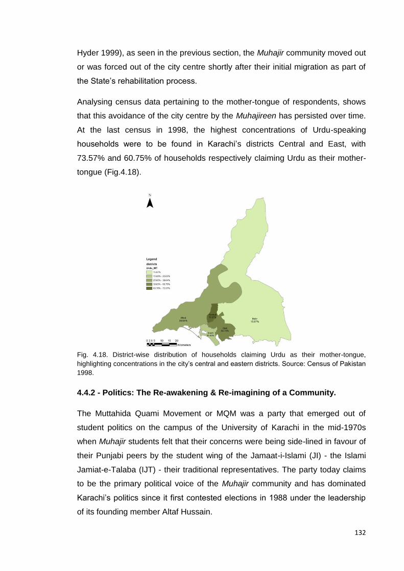
132
Hyder 1999), as seen in the previous section, the Muhajir community moved out
or was forced out of the city centre shortly after their initial migration as part of
the State’s rehabilitation process.
Analysing census data pertaining to the mother-tongue of respondents, shows
that this avoidance of the city centre by the Muhajireen has persisted over time.
At the last census in 1998, the highest concentrations of Urdu-speaking
households were to be found in Karachi’s districts Central and East, with
73.57% and 60.75% of households respectively claiming Urdu as their mother-
tongue (Fig.4.18).
Fig. 4.18. District-wise distribution of households claiming Urdu as their mother-tongue,
highlighting concentrations in the city’s central and eastern districts. Source: Census of Pakistan
1998.
4.4.2 - Politics: The Re-awakening & Re-imagining of a Community.
The Muttahida Quami Movement or MQM was a party that emerged out of
student politics on the campus of the University of Karachi in the mid-1970s
when Muhajir students felt that their concerns were being side-lined in favour of
their Punjabi peers by the student wing of the Jamaat-i-Islami (JI) - the Islami
Jamiat-e-Talaba (IJT) - their traditional representatives. The party today claims
to be the primary political voice of the Muhajir community and has dominated
Karachi’s politics since it first contested elections in 1988 under the leadership
of its founding member Altaf Hussain.

133
MQM has a unique three tier party structure; Nine Zero28 which is MQM’s
nationwide, as well as Karachi-wide headquarters situated in Azizabad, a lower-
middle income neighbourhood in District Central, under which there are 26
Sector offices distributed city-wide, each of which oversees between eight to ten
Unit offices in their immediate vicinity. These Units are embedded within the
community with the intention of both serving the community and disseminating
the party’s political message. In an environment where public sector services
often fail to deliver, this is a case of non-state actor filling voids left by the state
(Gazdar & Mallah, 2013). These social facilitators are embedded both physically
and socially within the community they serve; Unit offices are generally located
within the neighbourhood they serve and recruitment of party workers/activist is
from the same area - proof of residence in the area has to be produced in order
for a potential recruit to be eligible to sign up to a particular unit. This familiarity
of space and community serves as the party’s grassroots strength; the
Unit/Sector facilitates everything from access/provision of services such as
water and electricity to the neighbourhood they serve to resolving
neighbourhood disputes whilst simultaneously policing the community from
within. The intention behind this kind of neighbourhood philanthropy is that this
social capital automatically converts into a willing vote bank in an election year.
This informal arrangement suggests that the presence of a Unit office within a
neighbourhood implies that the population- whether willingly or unwillingly-
subscribes to the MQM’s agenda. Figure 4.19 shows the distribution of Unit
Offices across the city and their concentrations per district.
Hence the political aspect of this community can be divided into two mappable
features; i) electoral results, and ii) physical presence on the ground in the form
of unit offices. Whilst housing and development initiatives in the first decade
after Partition helped to track the initial Muhajir clusters in the city, with the
MQM being a more recent phenomenon, the plotting of the above mentioned
features has made it possible to track the presence of the Muhajir community
over the last 25 years. This in turn has made it possible to assess whether the
28
Nine Zero takes its name from the last two digits of the landline number allocated to the original 120 sq yd dwelling that was owned by Altaf Hussain’s family in Azizabad and used by MQM’s founders as a meeting place.
134
initial Muhajir clusters have persisted and what impact this has had on the city
as it has grown.
As stated above, MQM first participated in the general elections in 1988; whilst
MQM has had a strong showing across Karachi in all general and provincial
elections that they have contested since (1988, 1990, 1993, 1997, 2002, 2008,
and 2013), the party has also won 100% of the assembly seats in districts
Central and East for the same, and the numbers of seats they have taken in
district West have increased over time (Fig. 4.20).
The mapping of both the party’s physical presence within the community in the
form of Unit offices and Karachi’s ethno-specific voting history from 1988-2013
when combined; broadly identify Muhajir clusters in the city that coincides with
the areas identified through linguistic concentrations; Districts Central and East.
Thus 25 years of provincial electoral results (1988-2013) suggest that there is a
strong correlation between language and politics as a means of ethnic and
political identification.
It should be noted that the thematic maps shown here have been normalised by
the area of the district in which they are situated.

135
Fig. 4.19. City-wide distribution of MQM Unit Offices. Inset: Thematic map showing district-wise concentrations of MQM Units.

136
Fig. 4.20. District-wise MQM provincial assembly electoral results for the years 2002 and 2008.

137
4.4.3 - Religion: Minority Specificity within religious commonality
As already discussed, Pakistan was envisioned as the homeland for the Muslim
minority communities of India, thus the majority of migrants to Pakistan were
Muslim. Under the broad definition of Indian Muslims at the time were certain
minority sects that were more commonly found amongst the migrants
communities from undivided India; the Shi’a community and those who
subscribe to the Barelvi School of Islamic thought are two such communities
(Verkaaik, 2004).
The Shi’a sect are followers of the 4th Caliph, Ali-ibn-Abi-Talib, the sect really
took root after the events of the succession of the Caliphate at Karbala in Iraq in
680 AD. The mosques or Imambargahs of the Shi’a community today can
generally be identified within the fabric of the city through the display of Shi’a
Alams - a combination of the icon for the Panjetan-e-Pak29 and a pennant - atop
the mosque. These institutions may be seen as community centres where
religious rites such as those associated with the commemoration of the
martyrdom of Imam Hussain and his family in the month of Muharram are
practiced and religious artefacts are stored, often with an attached prayer
space. These are spaces where the community comes together, including
women - a section of society who are often excluded from traditional mosque
spaces in Pakistan.
The Barelvi sect is a sect of Sunni Islam that was founded in the Northern
Indian town of Bareilly by Ahmed Raza Khan at the end of the 19th century and
centres around the glorification of the Prophet Mohammad. It tends more
towards the Sufi traditions familiar to the Sub-continent rather than the reformist
versions of Islam such as Wahabism and the Deobandi Movement. Subscribers
to the Barelvi tradition are discernible by their distinctive Green turbans, also
often painting the domes of their mosques a similar shade of green; this is
commemorative of the dome of the Masjid-i-Nabvi in Medina. Due to their roots
in regions of the Sub-continent from which large numbers of Muslims migrated,
29
Translates into the ‘five purified ones’ and refers to the Prophet Mohammad, his daughter Fatima, his son-in-law and cousin Ali ibn Abi Talib and their sons Hassan and Hussain and is often depicted as a five-fingered hand.
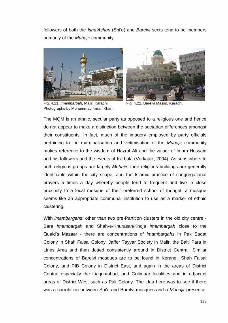
138
followers of both the Isna’Ashari (Shi’a) and Barelvi sects tend to be members
primarily of the Muhajir community.
Fig. 4.21. Imambargah, Malir, Karachi. Fig. 4.22. Barelvi Masjid, Karachi.
Photographs by Mohammad Imran Khan.
The MQM is an ethnic, secular party as opposed to a religious one and hence
do not appear to make a distinction between the sectarian differences amongst
their constituents. In fact, much of the imagery employed by party officials
pertaining to the marginalisation and victimisation of the Muhajir community
makes reference to the wisdom of Hazrat Ali and the valour of Imam Hussain
and his followers and the events of Karbala (Verkaaik, 2004). As subscribers to
both religious groups are largely Muhajir, their religious buildings are generally
identifiable within the city scape, and the Islamic practice of congregational
prayers 5 times a day whereby people tend to frequent and live in close
proximity to a local mosque of their preferred school of thought, a mosque
seems like an appropriate communal institution to use as a marker of ethnic
clustering.
With imambargahs; other than two pre-Partition clusters in the old city centre -
Bara Imambargah and Shah-e-Khurasan/Khoja Imambargah close to the
Quaid’s Mazaar - there are concentrations of imambargahs in Pak Sadat
Colony in Shah Faisal Colony, Jaffer Tayyar Society in Malir, the Balti Para in
Lines Area and then dotted consistently around in District Central. Similar
concentrations of Barelvi mosques are to be found in Korangi, Shah Faisal
Colony, and PIB Colony in District East, and again in the areas of District
Central especially the Liaquatabad, and Golimaar localities and in adjacent
areas of District West such as Pak Colony. The idea here was to see if there
was a correlation between Shi’a and Barelvi mosques and a Muhajir presence.

139
Again here there appears to be an overlap of the areas that vote MQM and
where the Shi’ite and Barelvi communities reside. (Figs. 4.23 and 4.24
respectively.)
The district scale results from this triad of identity-markers seems to confirm that
the community is clustering primarily in Karachi’s central and eastern districts.
But these municipal boundaries enclose large parcels of land and thus this
process of identifying Muhajir residential clusters is broad and prone to overlook
the finer scale nuances of ethnic residential clustering due to their scale and the
fact that municipal boundaries are not necessarily indicative of community
boundaries. Hence, by overlaying the location of these identity-markers on the
housing schemes etc. that the Muhajireen were originally allocated certain finer
grain patterns begin to emerge. A degree of overlap and locational persistence
in their settlement patterns becomes apparent, whilst simultaneously, there
appears to be some spill over into adjacent and proximate localities suggesting
a degree of colonisation and out movement to areas that are close to but not
within the original central hub of rehabilitation and resettlement (Fig. 4.25). The
specificity of this clustering is explored further in the following section.
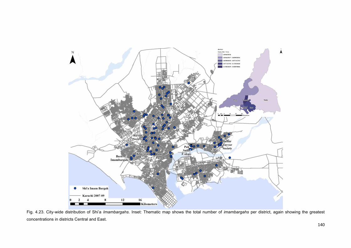
140
Fig. 4.23. City-wide distribution of Shi’a Imambargahs. Inset: Thematic map shows the total number of imambargahs per district, again showing the greatest
concentrations in districts Central and East.

141
Fig. 24. City-wide distribution of Barelvi Mosques. Inset: Thematic map shows the total number of Barelvi mosques per district, showing the greatest
concentrations in districts Central and East.

142
Fig. 4.25. City-wide distribution of Muhajir communal institutions relative to early Muhajir settlements.

143
4.5 Further Clustering: Muhajir “Hotspots”.
Using geographical information systems heatmap feature to map and analyse
the clustering of Muhajir communal institutions, it was possible to highlight
clusters of mosques, imambargahs and political offices within a specified radius,
these specified distances in the case of this part of the study being as the crow
flies as opposed to network distances. The raster image produced through the
heatmap analysis showed that where clusters appeared to be denser, hotspots
or brighter areas appeared (Fig. 3.02. These raster images were then converted
into contour maps as a means of geographically visualising communal
institution densities. After testing various radii for each feature, it became
apparent that a radius of 800m (or about 10 minutes’ walk) most accurately
represented the catchment of Barelvi mosques and Shi’a imambargahs – 800 m
being a comfortable walkable distance for regular users of these facilities that
may frequent these spaces up to five times a day. This particular radius seemed
to be able to define certain neighbourhoods or settlements with the densest
clusters appearing in Golimaar/Gulbahar, Liaquatabad, PIB Colony, and Martin
Quarters, Shah Faisal Colony and Malir Colony (Jaffar Tayyar Society), and
inner city areas like Soldier Bazaar, Kharadar and Lines Area (Fig. 4.26.), whilst
interestingly not showing any institutional clustering in the “Society” area –
localities that were initially settled by the wealthier Muhajir communities. It
should be noted at this point that clusters of imambargahs in Kharadar and
Soldier Bazaar are amongst the oldest in the city and pre-date Muhajir presence
in the form that we recognise it today. These particular imambargahs play an
important role in the city’s Muharram activities every year hence whilst they are
significant to the Shi’a community in general, they are not necessarily
specifically indicative of Muhajir presence. Additionally, this method of
identifying ‘hotspots of features’ seems to also pick up newer Muhajir areas that
were developed post the initial rehabilitation drive of 1947-60; i.e. Gulshan-e-
Iqbal in the north, Mehmoodabad in the east, and Qasba Colony in the west.
Whilst mosques and imambargahs seem to function understandably at a
smaller radius of 800m, where there may be more than one mosque or
imambargah serving a neighbourhood, after testing multiple radii (500-2000m) it
appears that MQM unit offices are distributed at one unit per neighbourhood;

144
they seem to be serving a catchment radius of about 1500m (about 20 minutes
walk), or the size of a neighbourhood. It should be noted that at a radius of
1500m, the clusters form continuous district-wide contours that appear to
encompass most sector offices which is significant as the party structure
encourages a direct link between the Sector office and the units under it with
limited lateral interaction between units in the same sector (Fig. 4.27.).
Simultaneously it should be noted that whilst the unit clusters seem to be
highlighted at a radius of 1500m, the individual units still seem to be located on
streets that are quite segregated but this may be due to the fact that the
relationship of the unit is to the neighbourhood rather than the global city
structure. This local level locational significance of the unit relative to the
structure of the neighbourhood it serves will be analysed further in the following
chapters.
The religious and political institutions appear to be functioning at different local
radii, possibly the result of the difference in concentrations of the two types of
communal institutions. Upon combining the various communal institutions and
the radii at which they seem to be functioning, it appears that as a collective
entity, the elements seem to highlight the most significant clusters at a radius of
1000m as seen in Figure 4.28. This compound feature that combines all identity
markers may be interpreted as giving a cartographic form to the Muhajir “area of
influence” or Muhajir majority areas in the city (Fig. 4.29).
By overlaying the four original categories of Muhajir settlements on this form of
Muhajir presence in the city today as seen in Figure 4.30, it becomes apparent
that many of the original clusters have persisted over the last 60 years. In
addition to this spatio-temporal continuity, there appears to be a spill-over and
colonisation of adjacent localities as the community has grown and their original
clusters have densified. Simultaneously there appears to be some areas within
the Muhajir cooperative housing society block in which no identity markers were
found and therefore are not highlighted as part of this current day Muhajir
presence. This may be due to the fact that the data sets used are not
exhaustive but simultaneously, the lack of all three indicators may suggest an
absence of Muhajir presence, a movement out of these areas of Muhajir settlers
or a different religio-political definition to the communities resident there in.

145
Fig. 4.26. Contour-map showing Barelvi mosque and Imambargah clusters at a radius of 800m.
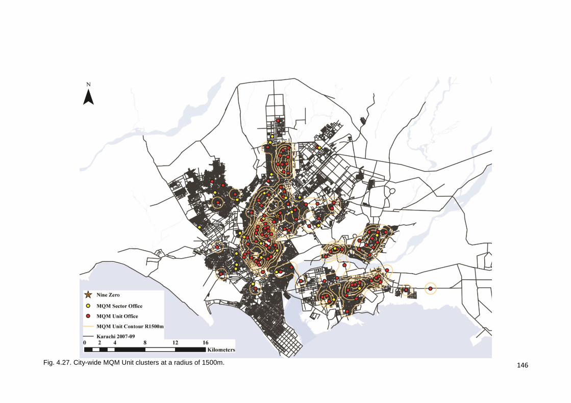
146
Fig. 4.27. City-wide MQM Unit clusters at a radius of 1500m.
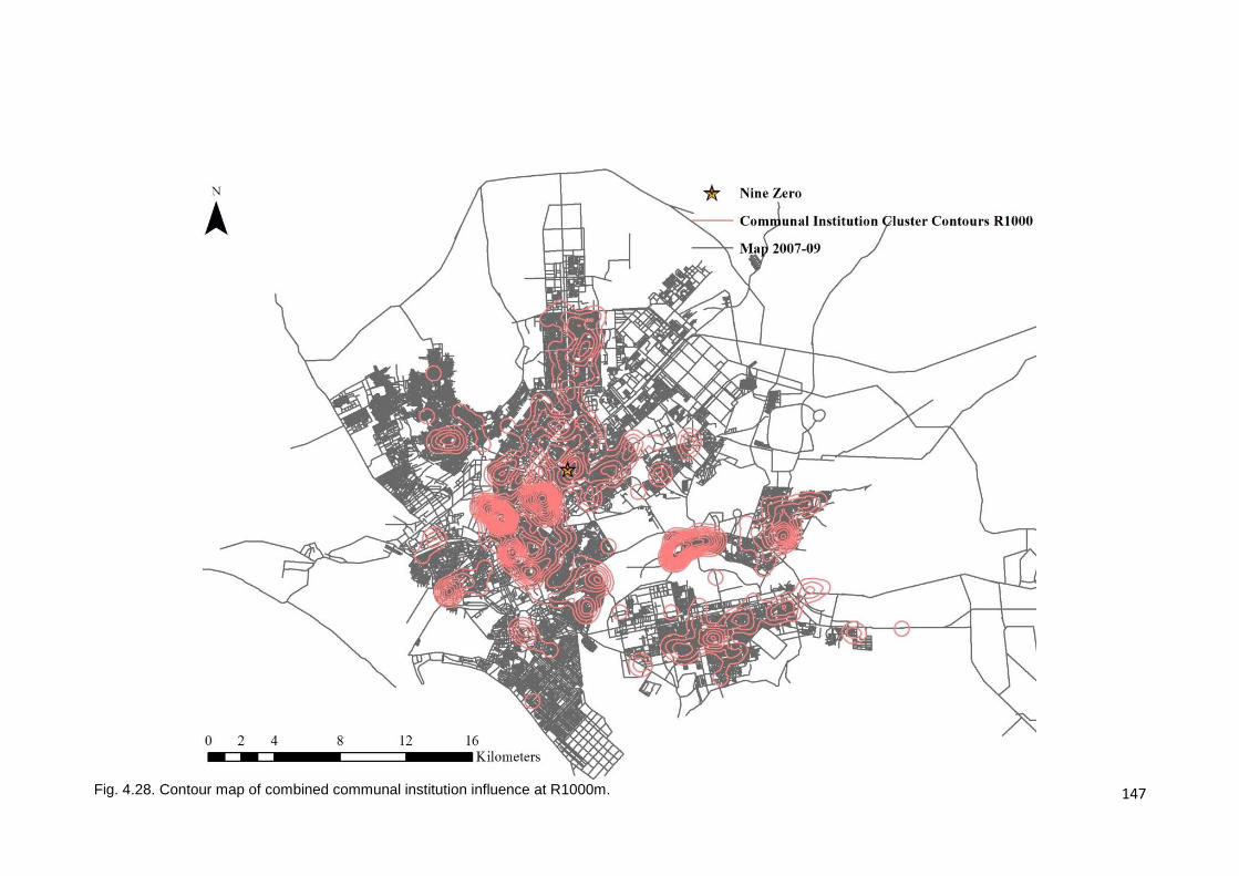
147
Fig. 4.28. Contour map of combined communal institution influence at R1000m.

148
Fig. 4.29. The polygon demarcates Muhajir ‘areas of influence’ or Muhajir dominated areas as determined by the clustering of Muhajir socio-spatial markers.
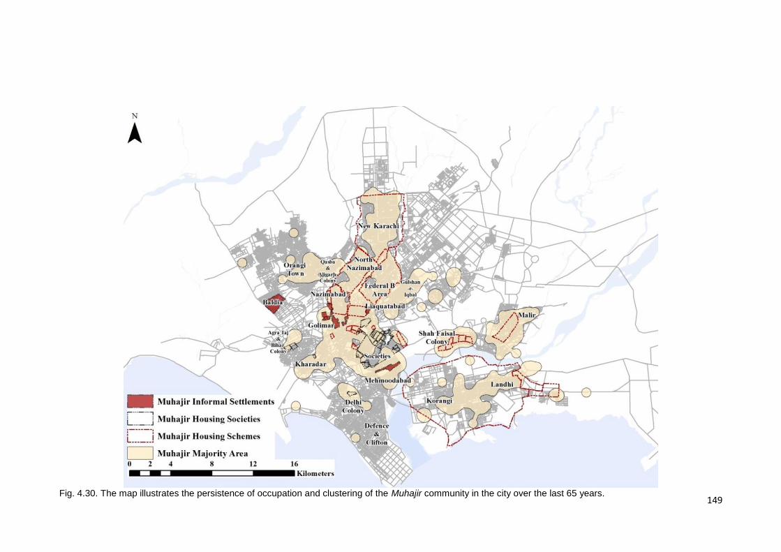
149
Fig. 4.30. The map illustrates the persistence of occupation and clustering of the Muhajir community in the city over the last 65 years.

150
4.6 Discussion
Whilst analysis of historical and masterplan documents showed that Muhajir
settlers were clustering, or being forced to cluster by the State in certain
localities of the city shortly after Partition, it appears that over time, these
clusters have persisted, densified and spilled over into adjoining localities as
these areas have developed. Interestingly, as a result of this persistence of
settlement and as the city has developed and sprawled inland, the refugee
community that was originally settled at the city’s peripheries today occupies the
geographical centre. On closer inspection it can be seen that whilst the
Muhajireen occupy the centre, the wealthy Muhajir communities that initially
commandeered the spaces closest to the old city centre today occupy Karachi’s
segregated southern peninsula of Defence and Clifton, suggesting a partial
inversion of the initial economic geography of the city. What has remained
consistent is the fact that the poor and disenfranchised by the State continue to
occupy the segregated fringes of the city, a space initially allocated to the
earliest Muhajireen. This socio-spatial continuity too speaks of a role reversal;
to be Muhajir no longer implies a state-less rootless and disenfranchised
existence. This space – both spatially and politically - is now occupied by more
recent migrants to the city, and today the Muhajireen have taken on the role of
the State’s representatives in the city.
With regard to this role reversal, it may be worth considering that the
community’s spatial clustering, locational persistence and spatial proximity may
have as much to do with the emergence of an ethno-political identity as would
be expected from commonalities of traditions and language, and the State’s
supposed early policies of social, political and spatial marginalisation. And,
whilst electoral results suggest that the Muhajir community holistically views the
MQM as their political representatives and there appears to be a general
persistence of place, there may also be some schisms within the group; as
stated earlier, the original Muhajir settlements included the various co-operative
housing societies situated near the city centre, the clustering of communal
institutions - or lack thereof in this case - seems to suggest that either the
Muhajir community has moved out of these areas or, that there is a split within
151
the community. To begin with, one can hypothesise that the split is along
economic lines as many of the housing societies were established by and for
the wealthier members of the community, but that this split includes political and
sectarian preferences too, i.e. the wealthy do not perhaps subscribe to the
same religious/political ethos as those that occupy the middle and lower-middle
income areas of Districts Central and East. Hence there is a need to perhaps
make a slight distinction between cultural Muhajireen and political Muhajireen.
Whilst in many cases they may be one and the same, in the case of those who
have moved out of Muhajir majority areas to more affluent parts of the city, or
those who have always been more affluent such as the original residents of the
Housing Societies, their political affiliation is no longer clear as these areas tend
to be both ethnically and politically more diverse. An example of this is the city’s
southern neighbourhoods of Defence and Clifton that have over the last six
provincial elections, never voted for the same party in successive elections.
And in the case that wealthy communities have moved out, many of these
initially low-rise areas have been redeveloped and, whilst the communities
moving in may still be culturally Muhajir, the economic bracket and political
association if often different to those who have moved out; the housing societies
were previously higher income areas where many of the original residents were
supporters of the Jamaat-i-Islami. Today, due to the rise of apartment living,
many of these areas have been redeveloped as middle-income, mid-rise areas
This seems to suggest that, whilst this study argues that segregation and
clustering in the city persists along ethnic/political lines, ethnicity appears in turn
to have some association with the economic status of the community, a feature
that will be explored further in the following chapter.
4.7 Conclusion
The above analysis and discussion shows that despite the fact that the
community began as a disparate group of refugee communities, many of whom
had lost most of their material wealth, they have through time and circumstance
developed an identifiable material culture that can be mapped and shows that
they do indeed cluster as a community and have come to dominate the politics
and space of the city. Whilst much of their early clustering was the result of the
152
government’s efforts to rehabilitate Muhajir refugees as soon as possible after
Partition, these clusters have persisted and densified since their inception with
the addition of newer contiguous areas, as the community has grown physical,
economically and politically.
What the mapping of the diachronic processes of the growth and development
of Karachi has shown is that space, ethnicity and politics are intrinsically linked,
the changing fortunes of a community can quite literally be mapped through the
history of the city. And this has been the case with the Muhajir community, as
the community and their self-image and perception has changed, so too has
their spatial location within the city; from rehabilitation and bureaucratic
backbone, to spatial and political marginalisation, to political powerhouse
occupying the central areas of the city.
By mapping and analysing the clustering of the community’s socio-spatial
proxies in the city, it has been possible to give Muhajir presence in the city
today a mappable, bounded form that was a feature previously unavailable.
Muhajir dominance and influence appear to pervade the geographic and
integration core of the city, and what the implications of this centralised
occupation have on the services, facilities and other residents of the city will be
explored in the following chapter.

153
5. Muhajir space and its urban interfaces: Spatial characterisation of the Muhajir areas of influence and the nature of their socio-spatial interface from the macro to the micro scale.
5. 0 Introduction.
Thus far we have seen that the Muhajir community initially clustered in certain
areas of the city, the location of many of these early settlements determined
largely by State led planning, housing projects and the availability of land.
Thereafter, through a process of mapping socio-political institutions, it has been
seen that these initial clusters have persisted with some spill-over into adjacent
localities as the community has grown and the initial settlements have densified.
During the time that has lapsed between their initial settlement and their current
day mapping, the Muhajir community’s initial influence on the space and politics
of the city went into rapid decline as the community was systematically
marginalised. This has been followed by a more recent period of political re-
awakening and involvement in city politics, resulting eventually in a period of
political dominance and, as this chapter will argue, a period of spatial control
and manipulation. As the discussion continues to narrow down to the specific
spatiality of Muhajir identity in Karachi, this chapter attempts to address the
questions of how continued spatial clustering in the localities claimed by the
community has impacted their relationship with the city. Furthermore, this
chapter intends to identify the form the spaces of interface between Muhajir
areas and the city take and, whether there are identifiable socio-spatial
characteristics to the spaces which the community occupy beyond these points
of interface that would define them as Muhajir.
The hypothesis here is that as the Muhajir community has become more
politically dominant within the city, the MQM has exercised its ability to influence
154
infrastructure development in the city so as to pursue a political agenda of
controlled surveillance that pervades the urban system across scales within
their area of influence, a control that is potentially being challenged at the
peripheries of this influence. Whilst this area of influence is wide and
encompasses an array of communities and spaces, there is a specificity to the
economic and spatial definition to a politically active, Muhajir dominant
settlement.
Whilst the previous chapter analysed the growth and development of the city in
order to identify if and how the Muhajir community were clustering, the analysis
and discussion in this chapter shifts to focus specifically on the articulation and
definition of Muhajir space or the Muhajir-ness of space – i.e. the idea that this
culturally similar minority group reproduces spatially similar environments
despite variations in other circumstances - during their later period of political
dominance. The intention here is to explore how the community and its spaces
interact and interface with the city and thus this discussion is divided into three
sections. Section one deals with the relationship of Muhajir dominant areas with
the various aspects of the city including transportation networks and commercial
and industrial centres and the spatial implications of political dominance. Whilst
the previous chapter provided a mappable form to Muhajir influence in the city,
there is a need to identify and focus on Muhajir centres to truly analyse the
spatiality of the community, hence section two identifies Muhajir centres and
attempts to establish some socio-economic and socio-spatial similarities
between these centres that in turn may assist in identifying a space as Muhajir.
And finally, section three focuses on specific case studies that are
demonstrative of the range of Muhajir settlements and the manner in which
these interface with the city at large. The chapter concludes with a discussion
outlining the key findings of the above mentioned three sections.
5.0.1 Data and Methodology
As stated above, the analysis and discussion in this chapter is divided into three
sections, each section developing a view of the relationship of the community to
the space it occupies within a series of diminishing scales from that of the city to
that of the settlement itself.

155
Using the outline of Muhajir dominant areas developed in the previous chapter
as the base layer for this analysis, in the first section the data obtained from
newspaper articles, development reports and masterplans were overlaid so as
to analyse the relevance and relationship of key infrastructural and service
related urban features to this ethno-spatial form. These features were then
tested against their spatial network values within the system to ascertain
whether there was a consistent spatial logic to the manner in which these
features had been laid out within the city’s spatial configuration.
The second section identifies and develops the definition of Muhajir centres. By
establishing the centroids of the cluster analysis discussed in the previous
chapter and using data from masterplan documents, as well as spatial network
measures, centres were classified spatially and economically in order to
develop a categorisation of Muhajir settlements. This categorisation took into
account the settlements’ morphologies, spatial proximities and socio-economic
features in an attempt to present a holistic description. From these categories,
specific case studies were selected for the purpose of in-depth exploration of
Muhajir space, attempting to make this selection representative of the cross-
section of Muhajir settlements in the city seen thus far in this investigation.
Focusing on the case studies, the third section seeks to analyse the interface
between the settlement and the city and how the integration of the interface
impacts the manner in which the settlement and its residents interact with the
city. Here, using space syntax methodologies, proximity to streets that are most
likely to be used for movement through the city (high Choice streets) and the
accessibility of the settlements’ public spaces to the city-wide network are
investigated and the potential impact that these features may have on the
integration of the community into the wider population of the city is assessed
using employment data taken from 243 questionnaires completed by residents
of two of the case studies. This completes the discussion on the interface
between Muhajir space and the city.
156
5.1. Political Dominance and Urban Development: the relationship of key
infrastructure and service related urban features to ethno-spatial form
This section will analyse how the development of key services and
infrastructure relate to the Muhajir community and their spaces of influence. It is
also important at this stage in the discussion to acknowledge the MQM as a key
political player in any discussion pertaining to Muhajir space and the
community’s relationship with the city. In brief, they have dominated Karachi’s
politics since 1988 when they first contested an election, going on to become
the target of a State backed paramilitary operation to clean up Karachi between
1992-94. Despite this, they have always been viewed as the kingmakers in
provincial politics. They re-emerged stronger than ever between 2002-08 with
the political and financial support of the Federal Government with the city’s
mayor from 2005-2010 being a member of the party.
As the earlier discussion related to language, politics and communal institutions
shows, many of the initial Muhajir clusters have persisted but, in order to
develop the discussion in its specificity, there is a need now to establish the
potential centres of the community today and the relationship of these localities
to the city and how it functions. For this purpose, the contour map discussed in
the previous chapter that articulate Muhajir communal institutional densities and
potential catchment was used to define an outline of what may be considered
as the area of influence of Muhajir presence or, space of Muhajir dominance in
the city. This provides a mappable ‘boundary’ that seems to include not only
areas that have historically been held by the Muhajireen from Partition, but also
highlights newer Muhajir settlements and certain adjacencies and proximities
that are of interest to this study. In the latter category, there are areas like
Gulshan-e-Iqbal, which lies across the Lyari River, to the east of Federal B
Area, Qasba and Aligarh colonies west of North Nazimabad, and
Mehmoodabad lying just south of the area earlier allotted to the housing
societies and Delhi colony and Defence Phase 4. Simultaneously this area of
influence seems to extend to incorporate the old city centre (Fig. 5.01.).
This seems to suggest that despite the fact that historically the city centre had
supposedly been emptied of Muhajir squatter settlements by Ayub Khan’s
157
government in the late 1950s, the CBD and many of the wholesale markets now
clustered in the old city centre and other commercial areas may still come under
Muhajir influence. This may be attributed to the presence of a large number of
Gujerati-owned businesses and Gujerati-speaking communities in the old city
centre. Whilst these communities may not be Urdu-speaking, they have
historically identified with the Muhajireen. This influence over commercial
activity in and around the old city centre seems to extend to absorb the newer
shopping districts of Tariq Road and Bahadurabad that have developed over
time as part of the housing society cluster which will be discussed further in this
chapter.
Whilst discussing the housing societies, it can be seen that the boundary
established at the walkable scale of 1000m, the area of influence whilst
proximate to, excludes wealthier parts of the housing society cluster. This, as
discussed earlier can be seen by a noticeable absence of Muhajir identity-
markers in the area and may be attributed to either the movement out of this
locality of the Muhajireen, or a religio-political schism within the community
whereby wealthier members subscribe to a different religio-political ethos than
their economically weaker brethren. So whilst these areas may still be home to
various ethnically Muhajir communities, the MQM’s presence is less substantial,
demonstrated by the lack of MQM Unit offices. This shift away from the MQM is
illustrated by some of the wealthier, conservative communities resident in this
centrally located affluent area reverting to their political roots, voting in the
Jamiat-i-Islami in Local Body elections in 2005 in this area.
The contour map used to establish the boundaries of the area of influence
discussed above can be used to further isolate and define areas that may be
considered major centres of Muhajir-related activity today. These centroids, as
discussed in the methodology section of this study, mark the geometric centres
of the polygon generated from a cluster analysis of Muhajir socio-spatial
markers. These centres include six in District Central, five in District East, one in
the old city in District South - the area of Kharadar - and one centred on the
Shi’a settlement in Malir Colony in District Malir. Despite Muhajir presence in
Qasba and Aligarh colonies in the west, there is also a noticeable absence of a
Muhajir ‘centre’ in this area possibly suggesting a wider mix of ethnic groups in
158
the western district of the city (Fig. 5.02.). What this process brings to light is
that whilst Muhajir influence seems to extend beyond the original areas of
settlement, the ‘centres’ still appear to be situated in the older post-Partition
settlements of the city, i.e. Liaquatabad, Golimar, Nazimabad, Federal ‘B’ Area,
North Nazimabad, Shah Faisal Colony and Malir.
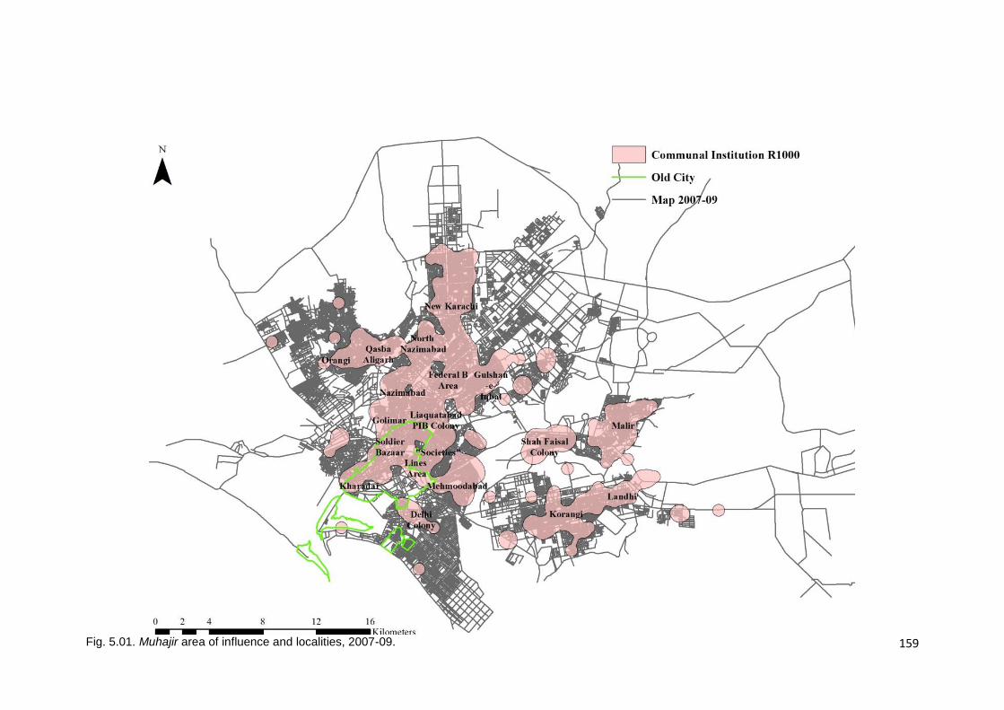
159
Fig. 5.01. Muhajir area of influence and localities, 2007-09.
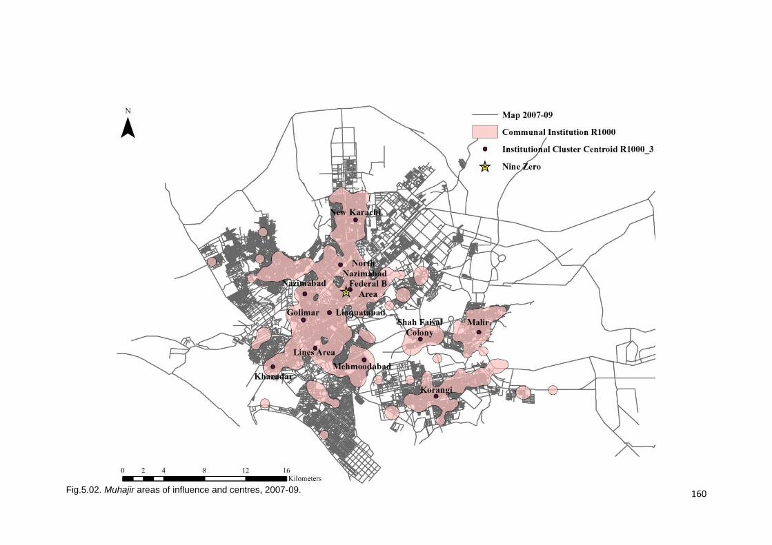
160
Fig.5.02. Muhajir areas of influence and centres, 2007-09.
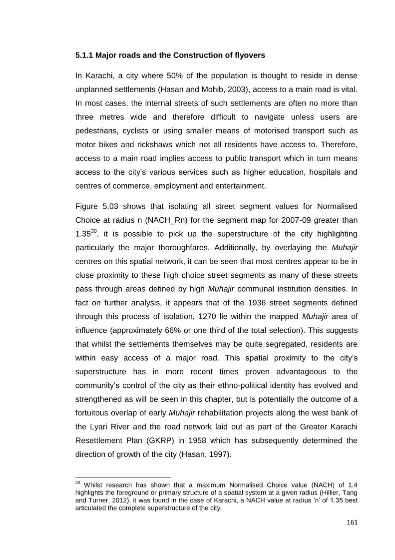
161
5.1.1 Major roads and the Construction of flyovers
In Karachi, a city where 50% of the population is thought to reside in dense
unplanned settlements (Hasan and Mohib, 2003), access to a main road is vital.
In most cases, the internal streets of such settlements are often no more than
three metres wide and therefore difficult to navigate unless users are
pedestrians, cyclists or using smaller means of motorised transport such as
motor bikes and rickshaws which not all residents have access to. Therefore,
access to a main road implies access to public transport which in turn means
access to the city’s various services such as higher education, hospitals and
centres of commerce, employment and entertainment.
Figure 5.03 shows that isolating all street segment values for Normalised
Choice at radius n (NACH_Rn) for the segment map for 2007-09 greater than
1.3530, it is possible to pick up the superstructure of the city highlighting
particularly the major thoroughfares. Additionally, by overlaying the Muhajir
centres on this spatial network, it can be seen that most centres appear to be in
close proximity to these high choice street segments as many of these streets
pass through areas defined by high Muhajir communal institution densities. In
fact on further analysis, it appears that of the 1936 street segments defined
through this process of isolation, 1270 lie within the mapped Muhajir area of
influence (approximately 66% or one third of the total selection). This suggests
that whilst the settlements themselves may be quite segregated, residents are
within easy access of a major road. This spatial proximity to the city’s
superstructure has in more recent times proven advantageous to the
community’s control of the city as their ethno-political identity has evolved and
strengthened as will be seen in this chapter, but is potentially the outcome of a
fortuitous overlap of early Muhajir rehabilitation projects along the west bank of
the Lyari River and the road network laid out as part of the Greater Karachi
Resettlement Plan (GKRP) in 1958 which has subsequently determined the
direction of growth of the city (Hasan, 1997).
30
Whilst research has shown that a maximum Normalised Choice value (NACH) of 1.4 highlights the foreground or primary structure of a spatial system at a given radius (Hillier, Tang and Turner, 2012), it was found in the case of Karachi, a NACH value at radius ‘n’ of 1.35 best articulated the complete superstructure of the city.

162
Furthermore, when overlaying this information on the Muhajir area of influence,
an interesting pattern emerges; most major thoroughfares pass through the
boundary of Muhajir influence, with these connections becoming particularly
important to connecting outlying, segregated areas to the global network of the
city, Mehmoodabad and Korangi via the Shaheed-e-Millat Expressway, Shah
Faisal Colony and Korangi through the Malir River Bridge and Shah Faisal
Colony to the central areas of the city through the Signal-free Corridor 2. This
becomes particularly apparent when the global choice network from 1972-74 is
compared to that of the city today. In this case, whilst the network has extended
outwards as the city has grown, the most significant connections have been
those between the central Muhajir settlements and the outlying settlements
mentioned above (Fig. 5.04). This close relationship between Muhajir areas,
infrastructure development and high choice segments seems to be reinforced
by the fact that there has been limited public works in the large squatter
settlements to the west of the city in Orangi/Baldia Town as well as in the high-
income districts of Defence and Clifton to the south, both areas that have been
shown earlier in this study to be ethnically, and subsequently politically, mixed
localities of the city.
Another side of this political monopolisation of development projects is the
aspect of surveillance and control of movement through the city; major through
routes connecting the city centre to the periphery all pass through Muhajir
majority areas. This strategic control of the city’s major street network has
afforded the community, and therefore their political representatives, through
their location and the development of key infrastructure projects is key to the
manner in which MQM controls activity in the city; the political party has been
known to barricade major thoroughfares as a means of political protest thereby
obstructing the flow of people and produce in and out of the city, limiting
commercial activity and, essentially bringing the city to a standstill. This ability to
control the commercial activities of the city will be further explored in the
following section.
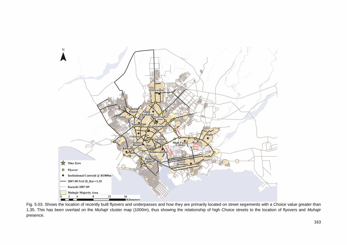
163
Fig. 5.03. Shows the location of recently built flyovers and underpasses and how they are primarily located on street segements with a Choice value greater than
1.35. This has been overlaid on the Muhajir cluster map (1000m), thus showing the relationship of high Choice streets to the location of flyovers and Muhajir
presence.

164
Fig. 5.04. Shows a comparative study of the extent of the superstructure of the city for the years 1972-74 and 2007-09. The threshold being a value of 1.35 for
Normalised Choice at Rn.
165
5.1.2 Location of Commercial Centres
Whilst the historical discussion earlier in this chapter showed that many of the
earliest industrial settlements at the periphery of the city were developed in
order to decant Muhajir squatters from the old city centre they occupied thus
resulting in a considerable Muhajir presence in these areas today, much of the
earliest commercial activity was confined to the old city centre. This has
obviously changed as the city has grown, with commercial areas naturally
developing outside the old city centre, with retail activity in the old city declining
and many of these old colonial commercial areas gradually being replaced by
wholesale markets, warehouses and medium rise apartment complexes
(Hasan, 1999). The emergence of many of the newer commercial areas has
been quite organic and informal with categorisations of plots from residential to
commercial being initially carried out on a plot to plot and case to case basis
when applying for planning permission and amendments to the floor area ratios
(FAR) in the building by-laws being a long and arduous process with numerous
political hurdles. That being said, seventeen key commercial areas have been
officially categorised as ‘Commercial’ in 2003 in a two phase process; six major
roads initially followed by eleven more in the second phase (Anwar, 2010) .
Whilst the process was drawn out, what is of particular interest to this study are
the areas in which these streets are located and when this amendment was
eventually passed and by whom, as the political jurisdictions these areas fall
into are critical to the economic and political life of the city.
As stated above, many of these were streets that had informally developed as
commercial centres over time with the categorisation of individual plots being
changed as and when needed and amendments to building bye-laws being
made periodically to accommodate this emerging trend, e.g. increases in the
allowable Floor Area Ratio (FAR) in 1978 and again in 1990. The building bye-
laws were finally amended in 2003-04 post the implementation of the Local
Body Ordinance 2002 by the Musharraf government, when the mayor of
Karachi and much of the City District Government was run and/or backed by the
MQM. This was followed by the Sindh High-density Development Act in 2010.
By marking these newly commercialised streets on a map of Karachi today and

166
overlaying the Muhajir areas of influence (Fig. 5.05.), it can be seen that of the
seventeen streets only two fall outside the Muhajir areas today. These are both
in the city’s elitist districts of Defence and Clifton, one of them being a beach
front avenue and part of the city’s coastal re-development project.
It could be argued that a number of the streets identified are major
thoroughfares through the city and serve high-density localities and hence are
ideal for commercialisation. That being said, there are commercial spaces that
serve high-density, lower-income communities or provide blue-collar city-wide
services, such as furniture and spare parts markets, which function as part of
the informal sector that have not been identified for change. This may simply be
due to the fact that these are either of lesser commercial significance or serve a
populace that is of a lesser political significance as the incentive and initiation of
the legal process is as much a political one as it is an economic one.
Whilst we are looking at commercial areas, it is perhaps also relevant to locate
Karachi’s major industrial hubs relative to this modern day Muhajir boundary.
Figure 5.06 shows that though these industrial areas were originally established
at a time when the inner-city Muhajir population was being decanted to
industrial estates at the periphery of the city, today these industrial sites appear
to be located at the fringes of Muhajir occupation. Upon adding the location of
large Pakhtun31 settlements in the city (see Appendix A for the original
published map) and inter-city transport hubs an interesting pattern begins to
appear; the industrial areas are located at the fringes of Muhajir presence but at
the same time, more often than not, located at the edges of an industrial site is
a large Pakhtun settlement. These adjacencies are relevant and play and
important role in the politics of space in the city, an issue that will explored
further.
31
The mapping of Pakhtun settlements was informed by mapping exercises published by the Express Tribune, an English language daily in Pakistan. Hussain. N. (2015) Shahi Syed: Rise of a political rookie. The Express Tribune. 29
th July, 2015 (See Appendix A) as well as newspaper
references to Pakhtun presence in Sohrab Goth, Mingopir, Kunwari Colony, Pashtunabad and New Sultanabad (Ur Rehman, 2012) and Benaras, Waziristan Colony, Naziamabad and Numaish (Tribune, 8
th May, 2010).

167
Fig. 5.05. Streets commercialised in 2003 overlaid on Muhajir clusters R1000m. Source: Anwar, F., “Land use planning for unsustainable growth: Assessing the
policy to implementation cycle.
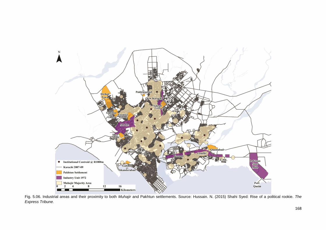
168
Fig. 5.06. Industrial areas and their proximity to both Muhajir and Pakhtun settlements. Source: Hussain. N. (2015) Shahi Syed: Rise of a political rookie. The
Express Tribune.

169
5.1.3 Proximity to Nine Zero and the politics of the city.
Whilst it has been important to analyse the relationship between Muhajir space
and integral urban features of Karachi that make it Pakistan’s premier
commercial centre, it is equally important to analyse the relationship between
Muhajir space and its political hub; Nine Zero in Federal B Area’s Azizabad
neighbourhood indicated in Figure 5.07. All access points into this
neighbourhood have been cordoned off with armed sentries posted by the party
at all major entrance/exit points. Due to this level of surveillance, for the
purposes of this study the entire neighbourhood has been considered as MQM
HQ rather than just the one street segment where the secretariat building is
located. Thereafter, a topological step-depth analysis was run, this essentially
counts the number of turns away from a selected axial line in an axial map all
other spaces are. As this is an analysis of an axial map, the system is viewed
as the fewest and longest lines as opposed to line segments. For the purposes
of this particular part of the study, topological step-depth has been considered
due to the area of the city, the distribution of Muhajir centres and the preference
of Karachiites to use motorised means of transport to get around the city
(Qureshi and Lu, 2007)32 therefore the analysis considers longer stretches of
linear space. Again, as in the case of segment analysis, step depth analysis
colours up the map on a similar spectrum, i.e. red for fewer turnings away from
the point of origin to blue representing the greatest number of turnings away in
the system.
Figure 5.06 shows that in the step-depth analysis for 2007-09 that many of the
centrally located and older Muhajir settlements at the periphery of the old city
centre, as well as much of the newer developments towards the north and
north-east of the city today that have been captured by the cluster analysis
shown earlier are up to only 10 steps away from Azizabad. Whilst this does not
capture the outlying settlements, it has been seen earlier that attempts appear
32
Using data on the manner in which a trip is made in Karachi – public transport, private/para transit, walking/cycling – and comparing data from 1987 and 2004, Qureshi and Lu (2007) show that trips taken using public transport have dropped from 57% to 52% whilst trips made using private /para transit have risen from 31% to 48% and whilst data on walking/cycling for 2004 was not available, this suggests that most trips are conducted using motorized means of transport.

170
to have been made to connect these areas to the central block of the city by
introducing the Shaheed-e-Millat Expressway, Malir River Bridge and converting
Rashid Minhas Road into a signal-free corridor.
Again, whilst the many transport development projects may not have
dramatically changed the city-wide connectivity of Korangi, Shah Faisal Colony
and Malir, when comparing step-depth for Azizabad in 1972-74, there is a
noticeable increase in the reach of the 10-step limit applied earlier that these
transportation links have facilitated. Previously this influence seemed to be
limited to only those areas within the District Central municipal boundary, the
Lyari River forming a natural break in the urban fabric. Again this seems to add
to the notion that perhaps political clout has been used to extend physical reach
within the city (Fig. 5.08.).
Whilst the discussion here has focussed on the relationship of Muhajir spaces
to the centre, another aspect of the spatialisation of ethno-politics in the city that
perhaps this process of mapping can shed light on is the nature of the
peripheral areas of Muhajir presence and the kind of interface this space
becomes with the rest of the city and its residents. The Muhajir community may
occupy and control the central areas of the city but the peripheries appear to be
a different case. As has already been seen, Karachi’s major industrial sites are
located at the fringes of Muhajir areas of influence which in turn appear to be
flanked by low-income Pakhtun settlements, most of which are understandably
inter-city transport hubs, transport being an industry monopolised by the
Pakhtun community since the 1960s and Ayub Khan’s patronage. Additionally,
as seen in chapter 4, as the city grew in response to the influx of up-country
migrants and Afghan and Bihari refugees, these peripheral regions absorbed
these new arrivals resulting in vast multi-ethnic, low-income settlements. Hence,
whilst the centre appears to be strongly Muhajir and specifically voting for the
MQM, the peripheries appear to be home to a myriad of communities.
As discussed earlier, Karachi is a city where the politics of space and ethnicity
often result in violent encounters between competing ethno-political groups.
These encounters often take the form of targeted drive-by shooting or bombings
of public events and spaces. Analysing the locations in which these encounters
171
and violent events take place and cluster may be a means to further describe
the nature of these peripheral, ethnically mixed spaces. During the election
period in May-August of 2013, ethno-political tensions in the city were
understandably at a fever pitch and this situation formed a morbidly ideal
environment for politically motivated acts of violence.
Figure 5.09 shows the cluster analysis for shootings and bombings mapped in
the city as described in the methodology section of this study for this time
period. The cluster radius for this particular analysis was set at 1000m; the
cluster size increasing every time another event was encountered within this
radius. What can be seen here is that there appears to be two kinds of locations
in the city for the clustering of violent activity; peripherally located clusters and
those located within the body of Muhajir majority presence and highly proximate
to Muhajir centres. Interestingly one feature remains consistent across these
clusters; the fact that these flashpoints of violent activity all appear to be within
Muhajir space.
On closer investigation of the ethnic mix of these peripheral areas and the
groups engaged in these encounters, it becomes apparent that most politically
motivated violent encounters can be distributed into two categories; Muhajir vs.
Muhajir conflicts or Muhajir vs. non-Muhajir conflicts. The former in localities
such as Korangi and New Karachi are the outcome of ‘tit-for-tat’ killings
between the MQM and their splinter faction MQM Haqiqi in Korangi and MQM
and JI in New Karachi. Lyari and Qasba/Kati Pahari illustrate the latter category;
Muhajir vs. non-Muhajir. The Lyari conflict is considered to the result of a proxy
war between the PPP and MQM played out in the form of a gang war between
two Baloch factions – the Peoples’ Amn Committee (PAC) and the Kutchi
Raabta Committee (KRC) (Yusuf, 2012). The situation in Qasba/Kati Pahari is a
Muhajir vs. Pakhtun rivalry that dates back to 1985 and has been simmering
since. Both instances seem to illustrate the diminishing hold that the MQM has
on its space as distance from their political centre increases, suggesting that the
peripheries become spaces of greater contestation than other localities in the
city by virtue of their diverse ethnic definition.
172
Fig. 5.07. Muhajir area of influence and centres and their location relative to topological stepdepth from Azizabad, 2007-09.
173
Fig. 5.08. Topological Step-depth from Azizabad, showing the impact of added transport infrastructure to the MQM’s 10-step reach.

174
Fig. 5.09. Location of flashpoints of violence and Pakhtun settlements relative to Muhajir presence.
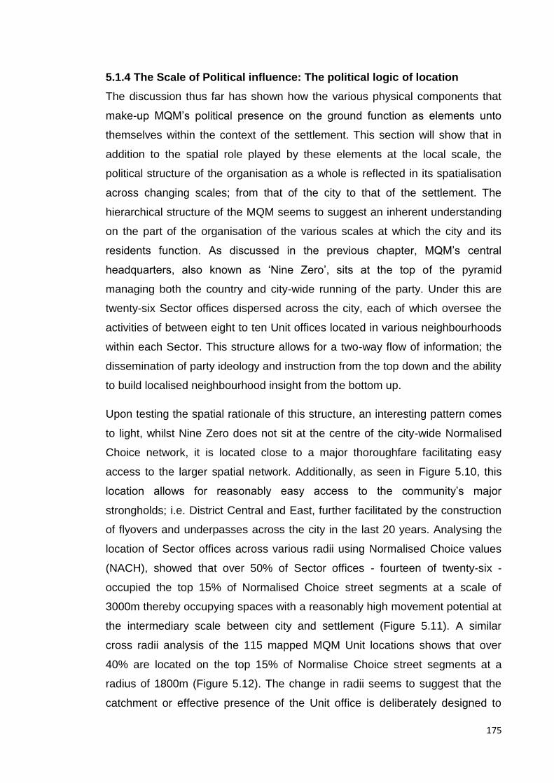
175
5.1.4 The Scale of Political influence: The political logic of location
The discussion thus far has shown how the various physical components that
make-up MQM’s political presence on the ground function as elements unto
themselves within the context of the settlement. This section will show that in
addition to the spatial role played by these elements at the local scale, the
political structure of the organisation as a whole is reflected in its spatialisation
across changing scales; from that of the city to that of the settlement. The
hierarchical structure of the MQM seems to suggest an inherent understanding
on the part of the organisation of the various scales at which the city and its
residents function. As discussed in the previous chapter, MQM’s central
headquarters, also known as ‘Nine Zero’, sits at the top of the pyramid
managing both the country and city-wide running of the party. Under this are
twenty-six Sector offices dispersed across the city, each of which oversee the
activities of between eight to ten Unit offices located in various neighbourhoods
within each Sector. This structure allows for a two-way flow of information; the
dissemination of party ideology and instruction from the top down and the ability
to build localised neighbourhood insight from the bottom up.
Upon testing the spatial rationale of this structure, an interesting pattern comes
to light, whilst Nine Zero does not sit at the centre of the city-wide Normalised
Choice network, it is located close to a major thoroughfare facilitating easy
access to the larger spatial network. Additionally, as seen in Figure 5.10, this
location allows for reasonably easy access to the community’s major
strongholds; i.e. District Central and East, further facilitated by the construction
of flyovers and underpasses across the city in the last 20 years. Analysing the
location of Sector offices across various radii using Normalised Choice values
(NACH), showed that over 50% of Sector offices - fourteen of twenty-six -
occupied the top 15% of Normalised Choice street segments at a scale of
3000m thereby occupying spaces with a reasonably high movement potential at
the intermediary scale between city and settlement (Figure 5.11). A similar
cross radii analysis of the 115 mapped MQM Unit locations shows that over
40% are located on the top 15% of Normalise Choice street segments at a
radius of 1800m (Figure 5.12). The change in radii seems to suggest that the
catchment or effective presence of the Unit office is deliberately designed to
176
address the scale of the settlement or neighbourhood as opposed to a wider
catchment as seen in the case of the Sector. The use of 15% of the top NACH
values for both the Sector and unit analysis as opposed to 10% as seen earlier
in this discussion seems to suggest that whilst both functions exhibit a
propensity to be located on streets with reasonably high movement potential,
they are not necessarily the busiest segments at their respective scales. Whilst
these results are not all inclusive, they do suggest that the political hierarchy
has an important spatial element that acknowledges the changing scales at
which the community interacts with the city.
177
Fig. 5.10. Relationship of Nine Zero to the top 3% of NACH_Rn street segments.

178
Fig. 5.11. Relationship of Sector Offices to the top 15% of NACH_R3000 street segments.

179
Fig.5.12. Relationship of Unit Offices to the top 15% of NACH_R1800 street segments.

180
5.2. Muhajir Settlement Typologies
This section will argue that there appear to be spatial similarities between these
centres beyond the clustering of communal institutions and their proximity to
major thoroughfares that may be interpreted as being indicative of a socio-
economic profile for the community. Thus this section describes and defines the
socio-economic, and morphological similarities of the Muhajir centres identified
thus far using spatial network analysis and categorisations from masterplan
listings of plot size and prevalent economic bracket in a settlement.
As seen in the previous chapter, the primary objective of various government
agencies immediately after Partition was the rehabilitation of refugees resulting
in the establishment of colonies and townships for displaced persons and
housing schemes through a process of plot allocation initially through the
Karachi Improvement Trust (KIT) and later through the Karachi Development
Authority (KDA). The KDA classifies and regulates the allotment of residential
plots in the following manner:
i) Plots less than 100 square metres are reserved for jhuggies
(temporary reed huts) and are classified as ‘small plots’.
ii) ‘Medium’ sized plots range in size from 100-335 square metres
where 20% of the plots are reserved for government employees, 10%
for defense personnel, 35% for construction companies and 35% for
the general public.
iii) ‘Large’ plots; i.e. those larger than 335 square metres in area, where
20% reserved for government employees, 10% for defense personnel
and the remaining for the public sector (Dowall, 1991b).
This process of allocation suggests an in-built socio-economic stratification
by plot size, i.e. where larger the plot the greater the affluence of the
residents. Hence for the purpose of this section of the study, the average
residential plot size of a settlement has been used as a measure of
affluence of the settlement. This process of socio-economic and
morphological profiling has been used to select case studies for further
detailed investigation.
181
5.2.1 Housing type and Plot size as Economic Markers of a Community.
The centroids used to mark the geometric centre of the form derived from the
heatmap analysis of Muhajir communal institutional densities and thus
indicating centres within the Muhajir area of influence when overlaid on a map
of Karachi coincided with identifiable Muhajir neighbourhoods. Many of these
had come up in literature pertaining to the political exploits of the community
referred to earlier in this study. Figure 5.13 shows the municipal boundaries of
these neighbourhoods and the location of the centroids.
It should be noted that in this section, there is a noticeable absence of elements
of Muhajir-ness and therefore Muhajir centres in higher income areas of the city,
i.e. Defence and Clifton to the south. Additionally, of the twelve centres defined
(Table 5.1), the average plot sizes in eight of these is 100 square metres or
less, with most of these neighbourhoods being categorised as either “low” or
“lower-middle” income in the Karachi Land and Housing Study (1989) (See
Appendix A for complete masterplan listing). Many of these centres are to be
found in the older, denser, post-Partition neighbourhoods of the city; the images
suggest that in many cases structures have been added to incrementally over
time, a fact that was confirmed by interviewees in the field, as and when the
need arose and the individual households’ finances allowed. This in turn has led
to a densification over time of these areas suggesting a reluctance of families to
move out of these localities, another observation confirmed by respondents in
interviews carried out in the field.
This densification is further illustrated by the prevalence in most of these
localities of apartment living, Karachi’s signature Flat Culture with the built-up
area covering more-or-less the entire plot area; the images in Table 5.1 are
illustrative of how many of these localities consist of mid-rise walk-ups or
squatter settlements where the built form extends from plot line to plot line, in
many cases encroaching on the public spaces of the streets narrowing them in
some case to a width of less than 2 metres. Discrete bungalow style homes with
open spaces are generally to be found only in higher income areas. This seems
to suggest that most Muhajir areas that exhibit typically Muhajir spatial
characteristics and are politically active fall into the low-middle income range,
182
the well-to-do appear to be either less politically active or live in ethnically more
diverse areas.
Table 5.1 shows the spatial network maps and images as well as socio-
economic categorisation of the Muhajir centres identified and seems to suggest
that there are 3 broad categories of Muhajir centres; i) middle-income, centrally
located centres where individual plots are larger than 100 square meters
(Nazimabad, Federal ‘B’ Area, North Nazimabad, ii) lower-middle income,
peripherally located centres where plots area largely smaller than 100 square
meters (Shah Faisal colony, Malir and Mehmoodabad), and iii) low-income,
informal or and industrial settlements where plot sizes again are primarily less
than 100 square metres (Golimar, Lines Area and Korangi) with Liaquatabad
behaving as an anomaly being centrally located, planned yet small plots and
lower-middle income. The above categorisation seems to suggest that there is
some correlation between plot size and the economic bracket of the occupant
with larger plots generally being associated with higher-income
neighbourhoods.
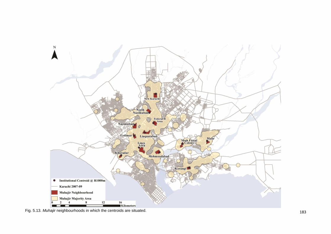
183
Fig. 5.13. Muhajir neighbourhoods in which the centroids are situated.
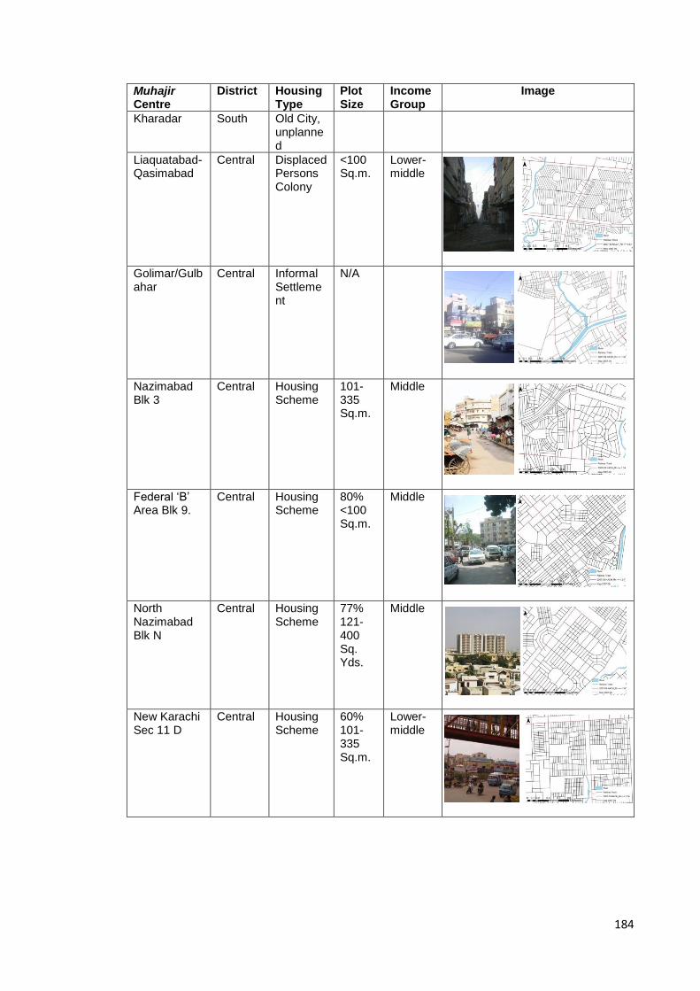
184
Muhajir Centre
District Housing Type
Plot Size
Income Group
Image
Kharadar South Old City, unplanned
Liaquatabad- Qasimabad
Central Displaced Persons Colony
<100 Sq.m.
Lower-middle
Golimar/Gulbahar
Central Informal Settlement
N/A
Nazimabad Blk 3
Central Housing Scheme
101-335 Sq.m.
Middle
Federal ‘B’ Area Blk 9.
Central Housing Scheme
80% <100 Sq.m.
Middle
North Nazimabad Blk N
Central Housing Scheme
77% 121-400 Sq. Yds.
Middle
New Karachi Sec 11 D
Central Housing Scheme
60% 101-335 Sq.m.
Lower-middle
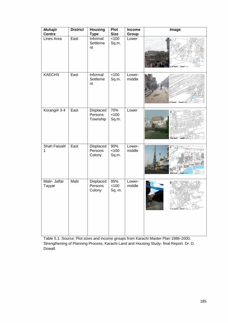
185
Muhajir Centre
District Housing Type
Plot Size
Income Group
Image
Lines Area East Informal Settlement
<100 Sq.m.
Lower
KAECHS East Informal Settlement
<100 Sq.m.
Lower-middle
Korangi# 3-4 East Displaced Persons Township
70% <100 Sq.m.
Lower
Shah Faisal# 1
East Displaced Persons Colony
90% <100 Sq.m.
Lower-middle
Malir- Jaffar Tayyar
Malir Displaced Persons Colony
95% <100 Sq. m.
Lower-middle
Table 5.1: Source: Plot sizes and income groups from Karachi Master Plan 1986-2000,
Strengthening of Planning Process, Karachi Land and Housing Study- final Report. Dr. D.
Dowall.

186
5.2.2 Categorisation of Muhajir centres by their position in the spatial
network
Whilst the analysis above shows that there are certain economic and
morphological similarities between settlements that make it possible to organise
them into these categories, further syntactic analysis shows that accessibility
(integration) varies across centres and does not appear to be determined by the
economic or morphological classification of the centres as defined above.
Graph 5.2. Shows normalised integration for Muhajir centres for radius n, 1000m, & 500m.
As can be seen from Graph 5.2, by grouping the centres based on when they
were established and therefore using the maturity of the settlement as a means
of decoding its syntactic behaviour, a different set of similarities seems to
emerge. Plotting NAIN values for the centres for radius n, 1000m – the radius at
which the centres were most effectively articulated in the original cluster
analysis - and 500m (a smaller neighbourhood scale), the graph brings to light a
number of interesting phenomena. The oldest, centrally located centres of the
city, i.e. those areas established in 1949 such as Golimar, Lines Area and
Liaquatabad, have higher accessibility (NAIN) than the average for the
complete system at a city scale whilst underperforming at the scale of the
neighbourhood. Those areas that were developed in the second phase, i.e.
0
0.5
1
1.5
2
2.5
3
Inte
gra
tio
n
Muhajir Centres
NAIN for Muhajir Centres, 2007-09
Phase
NAIN_Rn Muhajir Centre
NAIN_Rn Karachi
NAIN_R1000 Muhajir Centre
NAIN_R1000 Karachi
NAIN_R500 Muhajir Centre
NAIN_R500 Karachi
Phase I
1949
Phase II 1958-60
Phase IV 2007-09
Phase III 1972-74
187
1958-60, and were peripherally located, and therefore appear to be highly
segregated at the city scale, exhibited higher accessibility at smaller,
neighbourhood scales. This suggests that these localities are quite introverted
and function as neighbourhood centres as opposed to exhibiting great city scale
connectivity.
Centres developed in phase III, 1972-74, again seem to be more accessible at
the city scale than at the neighbourhood scale, exhibiting higher accessibility
(NAIN) at Rn than at R1000m. This return to the earlier pattern of global to local
behaviour may be attributed to the fact that many of these areas were
proposed- but not built- at the time of Karachi’s 2nd master plan, the GKRP, in
1958, and hence not only lie in close proximity to the original superstructure of
city laid out in this proposal that dates back to phase II of Karachi’s
development but also exhibit greater accessibility. Thus these phase III centres
appear to exhibit better connectivity to the city’s structure despite the relative
newness of the settlement itself. And finally, localities like the Karachi
Administration Employees Housing Society (KAECHS) and Jaffar Tayyar
Society in Malir, which are both peripheral; i.e. not proximate to elements of the
superstructure, new and seem to be highly segregated across all scales as
they.
This analysis suggests that the age of the centre and its proximity to the earliest
superstructure of the city have considerable bearing on the global accessibility
of the centres; those centres that have developed at a greater distance from this
early superstructure seem to have turned inwards and function as centres at a
neighbourhood scale.
5.2.3 Towards a more detailed understanding of ‘Muhajirness’: selection
of case studies
Keeping in mind the information deduced thus far about the nature of Muhajir
centres, for a more meaningful understanding of the spatialisation of this
community, there is a need to zoom into their spaces at the scale of the
settlement. For such a study the selection of a representative number of cases
across the city becomes an important task. The cases selected each fit into one

188
of the categories of Muhajir settlements as outlined at the end of section 5.2.1;
Pir Ilahi Buksh is a middle-income, centrally located settlement comprising of
medium sized plots, Shah Faisal Colony is a lower-middle income, peripherally
located settlement consisting of small plots, and Lines Area is a low-income,
informal settlement. By selecting one case to illustrate each of the categories,
the intention is to show that this particular, culturally similar minority community
reproduces spatially similar environments despite variations in other
circumstances thereby giving tangible form to the ‘Muhajir-ness’ of space. The
case of Liaquatabad is an anomaly within this in that it is a primarily lower-
middle income settlement that is centrally located where the plots are small and
thus does not fit into any of the above categories but presents an interesting
case in that it is situated at the heart of the Muhajir community’s stronghold. All
case studies selected fall into the earliest periods of settlement ensuring a
certain degree of maturity to settlement patterns and development. Table 5.2
shows the most recent recorded figures for population and area for the case
study areas distributed across the Union Councils that make up each area and
the extent of the selected areas is shown in Figure 5.14.
Union Council Name
Area (acres) Area (Sq Km)
Population 2005 Population Density
PIB Colony 236.5 0.957 57,224 59795.19ppl/Km2
Shah Faisal Colony
Natha Khan Goth 548.1 2.218 86065
Drigh Colony 127.6 0.516 67683
Pak Sadaat Colony 399.8 1.618 71,842
Morio Khan Goth 114.5 0.585 71593
Total 1190.0 4.937 297183 60195.06ppl/Km2
Lines Area
Jutland Lines 167.4 0.677 104,708
Jacob Lines 416.3 1.685 99,144
Total 583.7 2.362 203852 86304.83ppl/Km2
Liaquatabad
Supermarket 167.2 0.677 79,066
Qasimabad 215.4 0.872 101,452
Bandhani Colony 173.8 0.703 81,500
Commercial Area 201.8 0.817 94,847
Total 758.2 3.069 356865 116280.55ppl/Km2
Table 5.2 shows the most recent record figures for population and area of the selected case
studies. Source: Karachi Master Plan 2020.
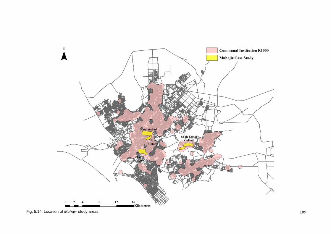
189
Fig. 5.14. Location of Muhajir study areas.

190
5.3. Functional proximities and spatial hierarchies: the embeddedness of
Muhajir areas within their immediate urban surroundings
This section will focus on the intermediary scale and spaces that mediate
between the city and the public life of the settlement; features, spatial
relationships and spaces that address notions of interface and ease of
accessibility to the settlement. The analysis here addresses previously
discussed issues of proximity to transport link, commercial activity and the
political presence of the MQM and investigates their relationship and impact on
the selected case studies. The analysis also considers the changing degrees of
public-to-private exposure at which the various communal elements within the
settlement function. The discussion is divided into two parts; i) the accessibility
of the settlement from the surrounding area and therefore the manner in which
Muhajir settlements respond to their urban surroundings and ii) the internal
spatial hierarchies of communal spaces. Part one analyses proximity of each
case study to major thoroughfares and major commercial centres as defined
earlier, i.e. street segments with a NACH Rn value greater than or equal to
1.35. It should be noted that the proximity of these settlements to and access to
major thoroughfares is highly pertinent to this discussion as in lower and lower-
middle income urban neighbourhoods in Pakistan, this proximity implies an
ease of access to public transport systems that in turn allow for access to
employment and other city-wide services such as education and healthcare.
Additionally, whilst the useage of private modes of transport is on the rise, in
Karachi up to 50% of all trips taken are by public transport (Qureshi and Lu,
2007). Therefore, in this section, the number of points of entrance into the
settlement and whether there is a hierarchy to these entrances will also be
addressed, and how this notion of accessibility impacts access to employment
for the settlements’ residents. Part two investigates the location and depth of
communal areas like the local marketplace and the sector and unit office from
the main points of entry into the settlement and the spatial relationships, if any,
between communal spaces.

191
5.3.1 The accessibility of the settlement
It has already been established that this community tends to cluster, choosing
to reside in certain central and older parts of the city. Whilst ethno-political
clustering with regard to their places of residence suggests a degree of socio-
spatial segregation from Karachi’s wider community, the proximity of the
settlements to major thoroughfares may be a measure of the degree of city-
wide socio-economic integration. This section analyses the degree of
accessibility and spatial integration of the settlement and economic integration
of its residents.
5.3.1.1 Proximity to thoroughfares
As can be seen from the Figure 5.15, all four case studies appear to be in close
proximity to a major thoroughfare. Of the four cases, Figure 5.15 shows that
Liaquatabad and PIB Colony appear to be better connected to the global
network than either Shah Faisal Colony or Lines Area in that both exhibit
accessibility to the greatest number of high choice street segments of the four
cases.
In the case of PIB Colony, whilst Ghosia Road to the north abuts the informal
settlement at its northern end, the closest roads from which access to the
settlement is possible are Jamshed Road and Shaheed-e-Millat/University Road
to the east; the former connecting the settlement to the old city centre whilst
also being a popular centre of employment for residents of PIB Colony, and the
latter connecting it to the newer parts of the city to the north and east,
particularly to the commercial districts of Tariq Road and Bahadurabad just east
of the area shown in Figure 5.16a. Whilst the location of the settlement within
the global network locates it very close to the integration core of the system,
PIB Colony itself is quite segregated; the settlement initially being a bus route
terminus. This segregation is heightened by the fact that it is bounded to the
north by the Lyari River and now the Lyari Expressway, the construction of
which has eliminated any makeshift pedestrian crossings between PIB Colony
and Liaquatabad on the northern bank of the river.
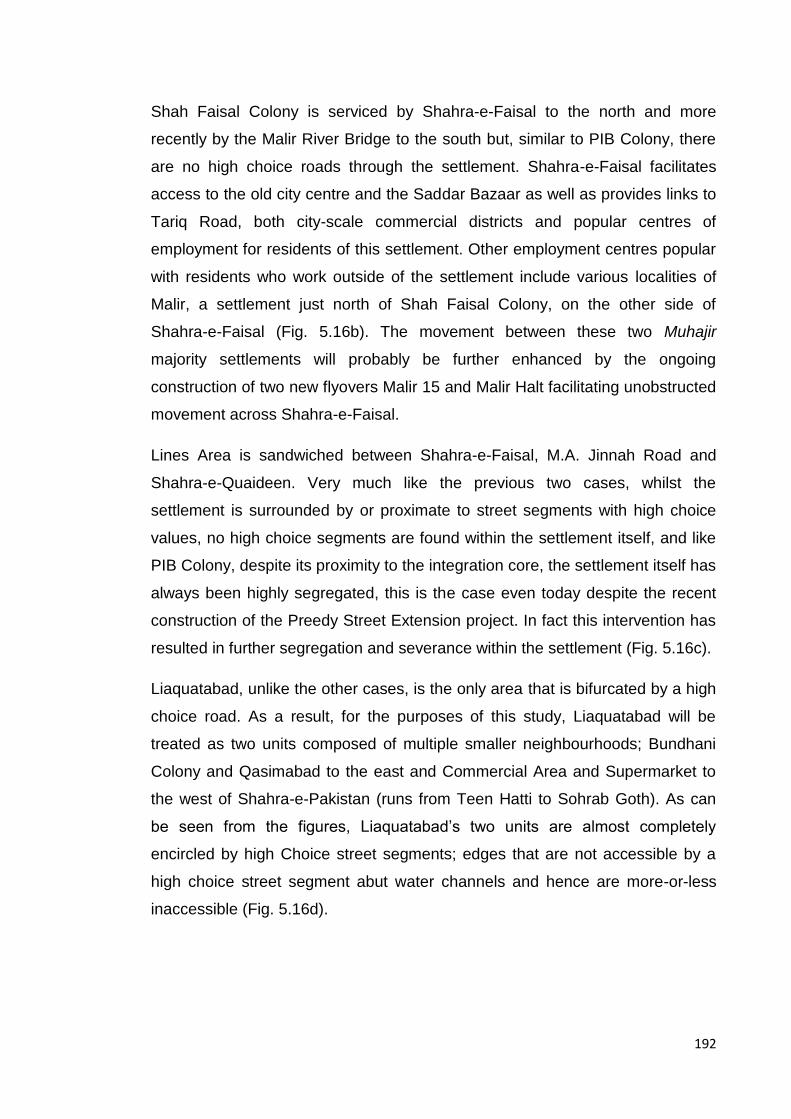
192
Shah Faisal Colony is serviced by Shahra-e-Faisal to the north and more
recently by the Malir River Bridge to the south but, similar to PIB Colony, there
are no high choice roads through the settlement. Shahra-e-Faisal facilitates
access to the old city centre and the Saddar Bazaar as well as provides links to
Tariq Road, both city-scale commercial districts and popular centres of
employment for residents of this settlement. Other employment centres popular
with residents who work outside of the settlement include various localities of
Malir, a settlement just north of Shah Faisal Colony, on the other side of
Shahra-e-Faisal (Fig. 5.16b). The movement between these two Muhajir
majority settlements will probably be further enhanced by the ongoing
construction of two new flyovers Malir 15 and Malir Halt facilitating unobstructed
movement across Shahra-e-Faisal.
Lines Area is sandwiched between Shahra-e-Faisal, M.A. Jinnah Road and
Shahra-e-Quaideen. Very much like the previous two cases, whilst the
settlement is surrounded by or proximate to street segments with high choice
values, no high choice segments are found within the settlement itself, and like
PIB Colony, despite its proximity to the integration core, the settlement itself has
always been highly segregated, this is the case even today despite the recent
construction of the Preedy Street Extension project. In fact this intervention has
resulted in further segregation and severance within the settlement (Fig. 5.16c).
Liaquatabad, unlike the other cases, is the only area that is bifurcated by a high
choice road. As a result, for the purposes of this study, Liaquatabad will be
treated as two units composed of multiple smaller neighbourhoods; Bundhani
Colony and Qasimabad to the east and Commercial Area and Supermarket to
the west of Shahra-e-Pakistan (runs from Teen Hatti to Sohrab Goth). As can
be seen from the figures, Liaquatabad’s two units are almost completely
encircled by high Choice street segments; edges that are not accessible by a
high choice street segment abut water channels and hence are more-or-less
inaccessible (Fig. 5.16d).

193
Fig. 5.15. Location of case studies relative to highest 3% of NACH_Rn street segments.
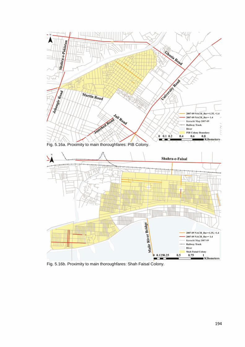
194
Fig. 5.16a. Proximity to main thoroughfares: PIB Colony.
Fig. 5.16b. Proximity to main thoroughfares: Shah Faisal Colony.
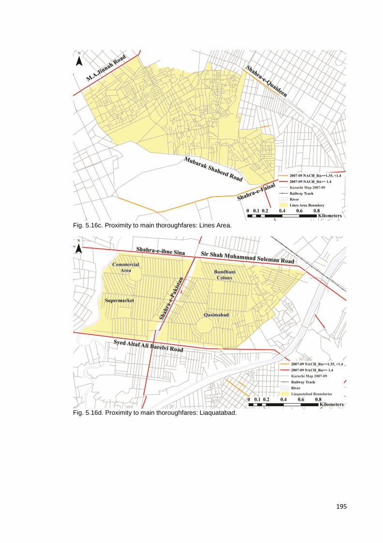
195
Fig. 5.16c. Proximity to main thoroughfares: Lines Area.
Fig. 5.16d. Proximity to main thoroughfares: Liaquatabad.

196
5.3.1.2 Points of entry (Hierarchy of entrances)
PIB Colony: Despite its central location, PIB Colony is primarily accessed by 1
entrance with 2 secondary entrances, one of which is primarily a pedestrian
access. The main route into the settlement is via Jail Road which in turn
becomes the main market street of the settlement once it enters the settlement.
Jail Road may be accessed both from Nishtar Road and Jamshed Road from
the city centre, or University Road/Shaheed-e-Millat from the east. The
secondary entrances to the settlement lie off of Martin Road and University
Road.
Shah Faisal Colony: There are three routes into the settlement; the oldest of
which lies off of Shahra-e-Faisal north of the settlement, passes under the
railway tracks at Drigh Road Station and through Natha Khan Goth (a pre-
Partition informal Pukhtun settlement) situated at the western edge of Shah
Faisal Colony. A newer and more heavily used access is via a flyover and
connects the settlements directly to Shahra-e-Faisal. The third is the newly
constructed Malir River Bridge that connects the colony from the south to the
Korangi industrial estate.
Lines Area: despite being situated at the centre of the city and thus surrounded
on almost all sides by major thoroughfares, this informal settlement is highly
segregated as can be seen from the segment analysis, hence whilst there may
appear to be many more means of access into the settlement as can be seen,
navigation is difficult once inside unless the user is a regular visitor. The level of
permeability of the area can be gauged by how deep public transport goes into
the settlement with public transport only being accessible on peripheral roads
and some tertiary roads being services by small three-wheel rickshaws33. This
has been used in the past when Lines Area was one of the city’s no-go areas,
its unintelligible spatial structure being used to the advantage of both political
activists and criminals to disappear when being pursued by the police.
33
This was information taken from the report generated for the Comprehensive Environmental Design project (CED) conducted as part of a 4
th urban design studio at NED University’s
Department of Architecture in Karachi in 2010 on Lines Area.

197
Liaquatabad: Despite appearing to be very dense, Liaquatabad, like the other
settlements discussed thus far, has a few controlled points of access from the
surrounding main roads into the settlement. Primary entrances to the various
neighbourhoods that make-up Liaquatabad are all located off of Shahra-e-
Pakistan with secondary entrances located on streets to the north and south of
the settlement. The peripheral blocks of the settlement are comprised primarily
of medium rise, mixed-use buildings with city-scale specialist markets on the
ground floor and apartments above, thereby creating a buffer of sorts between
the residential settlement and the main road. Markets catering to the local
population are located within the settlement.
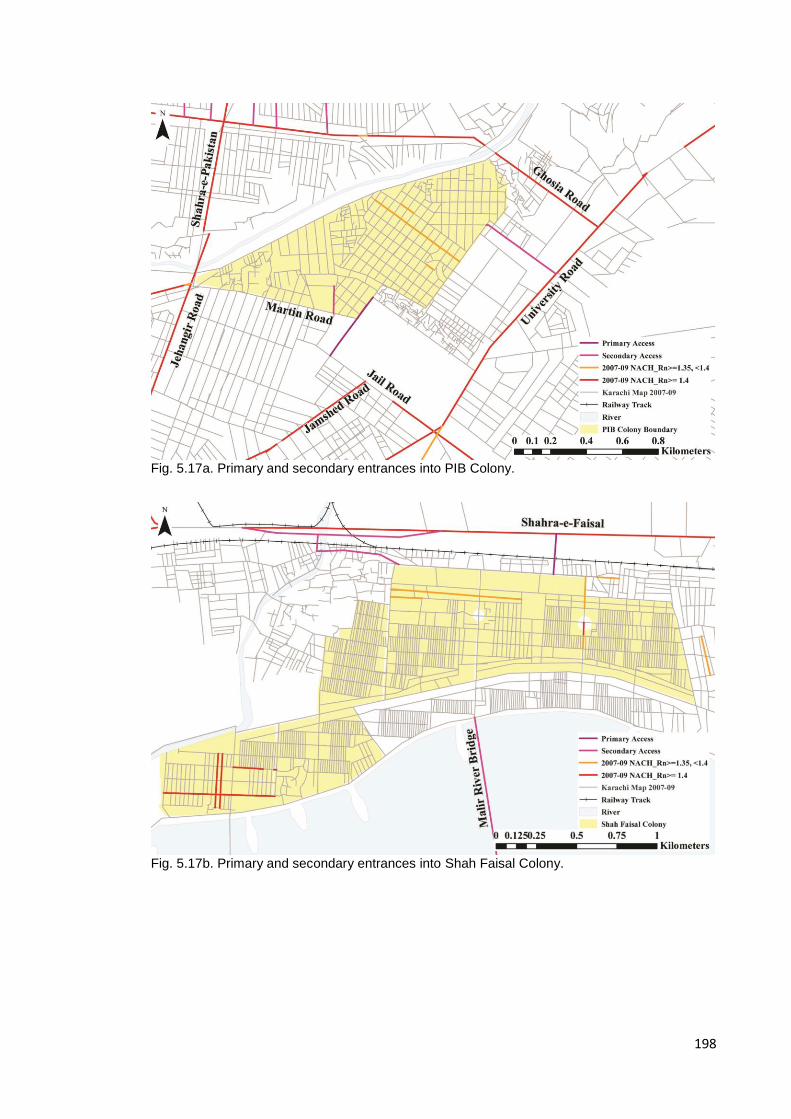
198
Fig. 5.17a. Primary and secondary entrances into PIB Colony.
Fig. 5.17b. Primary and secondary entrances into Shah Faisal Colony.
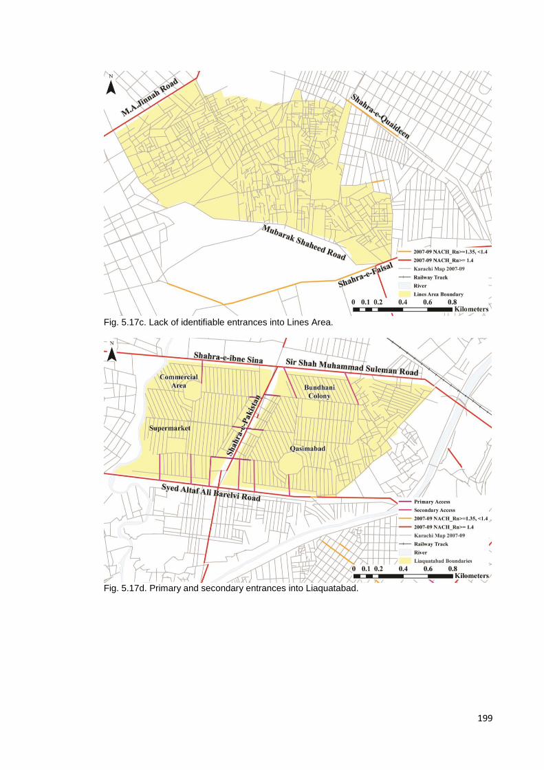
199
Fig. 5.17c. Lack of identifiable entrances into Lines Area.
Fig. 5.17d. Primary and secondary entrances into Liaquatabad.
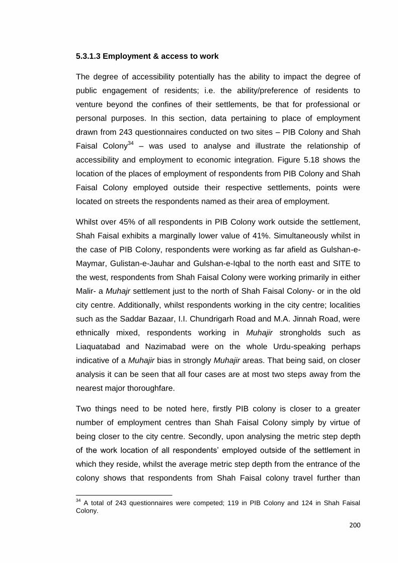
200
5.3.1.3 Employment & access to work
The degree of accessibility potentially has the ability to impact the degree of
public engagement of residents; i.e. the ability/preference of residents to
venture beyond the confines of their settlements, be that for professional or
personal purposes. In this section, data pertaining to place of employment
drawn from 243 questionnaires conducted on two sites – PIB Colony and Shah
Faisal Colony34 – was used to analyse and illustrate the relationship of
accessibility and employment to economic integration. Figure 5.18 shows the
location of the places of employment of respondents from PIB Colony and Shah
Faisal Colony employed outside their respective settlements, points were
located on streets the respondents named as their area of employment.
Whilst over 45% of all respondents in PIB Colony work outside the settlement,
Shah Faisal exhibits a marginally lower value of 41%. Simultaneously whilst in
the case of PIB Colony, respondents were working as far afield as Gulshan-e-
Maymar, Gulistan-e-Jauhar and Gulshan-e-Iqbal to the north east and SITE to
the west, respondents from Shah Faisal Colony were working primarily in either
Malir- a Muhajr settlement just to the north of Shah Faisal Colony- or in the old
city centre. Additionally, whilst respondents working in the city centre; localities
such as the Saddar Bazaar, I.I. Chundrigarh Road and M.A. Jinnah Road, were
ethnically mixed, respondents working in Muhajir strongholds such as
Liaquatabad and Nazimabad were on the whole Urdu-speaking perhaps
indicative of a Muhajir bias in strongly Muhajir areas. That being said, on closer
analysis it can be seen that all four cases are at most two steps away from the
nearest major thoroughfare.
Two things need to be noted here, firstly PIB colony is closer to a greater
number of employment centres than Shah Faisal Colony simply by virtue of
being closer to the city centre. Secondly, upon analysing the metric step depth
of the work location of all respondents’ employed outside of the settlement in
which they reside, whilst the average metric step depth from the entrance of the
colony shows that respondents from Shah Faisal colony travel further than
34
A total of 243 questionnaires were competed; 119 in PIB Colony and 124 in Shah Faisal Colony.

201
those from PIB (Shah Faisal is 9649.18m whilst PIB colony is approximately
half that distance at 4855.68m), the difference between the furthest and least
distance travelled is greater in the case of PIB than in Shah Faisal. This is
perhaps not surprising as PIB Colony by virtue of being located in the city
centre is proximate to far more centres of employment than Shah Faisal Colony,
thus respondents in the former had less distance to travel and a greater choice
of places of employment. The analysis also shows that in both cases almost
half the total number of respondents’ were employed outside the settlement
suggesting a reasonably high degree of economic integration.

202
Fig. 5.18. Relationship of employment clusters to closest high choice street segments.

203
5.3.2 External associations of commercial and political communal spaces
Whilst proximity and access to major thoroughfares, employment centres and
public transport may impact the degree of socio-economic integration of a
community, similar external accessibility of communal spaces within the
settlement, i.e. their relationship to the point(s) of entry and exit and the space
beyond, may impact the roles played by communal spaces within the
settlement. This section analyses these spatial relationships in the case of
commercial activity or shopping streets and the sector and unit offices of each
of the four case studies.
5.3.2.1 Shopping Streets
Using a step depth analysis from the closest major road to local market spaces
each of the 4 case studies brings to light certain similarities as well as highlights
certain anomalies; in the case of the three planned settlements, i.e. PIB and
Shah Faisal Colonies and Liaquatabad, the main local market spaces are no
more than three tunings away from the closest major road, with the exception of
the small market area around the roundabout in the Shah Faisal#5
neighbourhood - the southern-most neighbourhood of Shah Faisal colony - and
the market space embedded at the rear of Commercial Area in Liaquatabad.
Though on further investigation, the latter can be accessed from a secondary
entrance on Shahra-e-Ibne Sina to the north of the settlement.
Upon first glance, Lines Area, due to its informal status, appears to be
functioning a little differently in that the location of markets appear to be a more
arbitrary and the form far less orthogonal. That being said, analysis shows that
like the markets in the planned localities, these markets too are located so as to
be easily accessed from a main road, again no more than 3 steps away; the
market in Abyssinia Lines being accessed from Shahra-e-Faisal, those in Jacob
Lines accessed from Shahra-e-Quaideen and the most extensive one in Jutland
Lines being accessed from Mubarak Shaheed Road (though this road isn’t
picked up in the global choice analysis, street segments exhibit higher values at
radii of 5000 and 3000m suggesting it has greater local value).
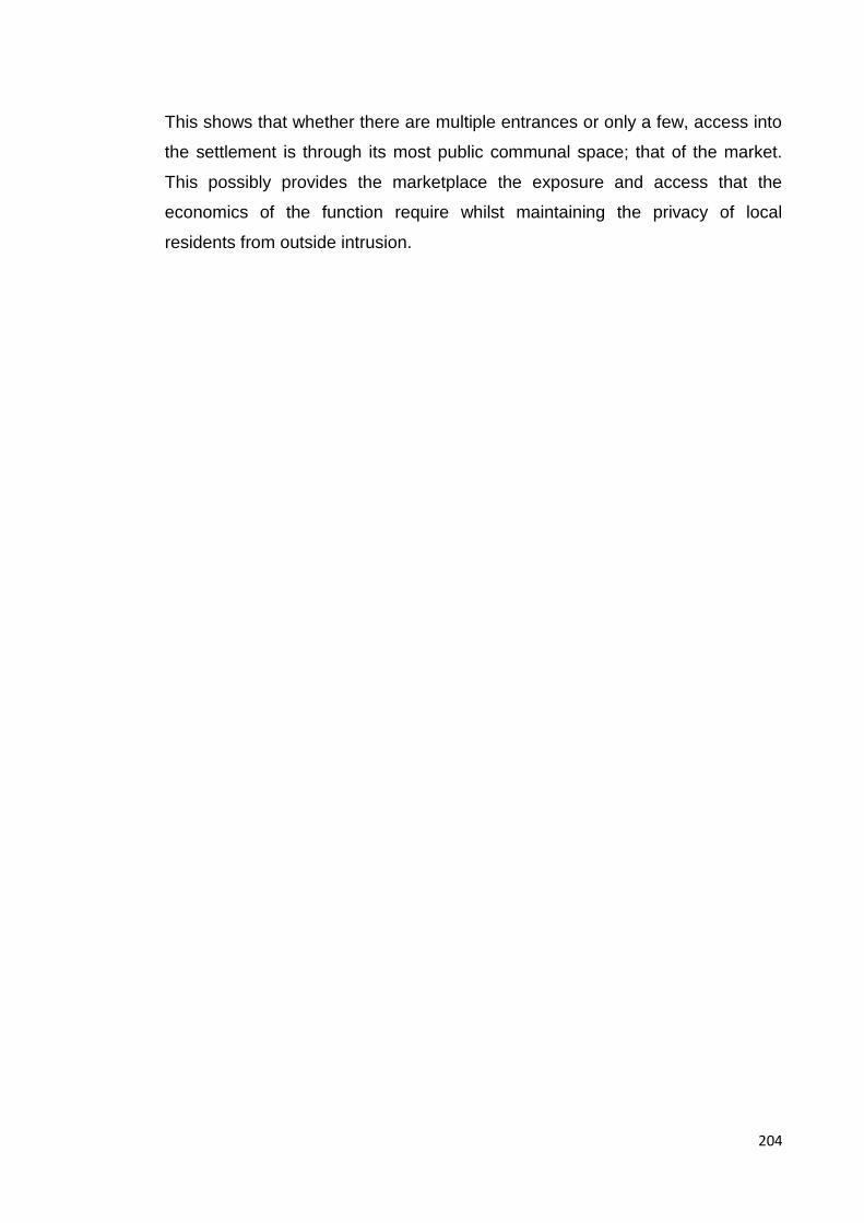
204
This shows that whether there are multiple entrances or only a few, access into
the settlement is through its most public communal space; that of the market.
This possibly provides the marketplace the exposure and access that the
economics of the function require whilst maintaining the privacy of local
residents from outside intrusion.
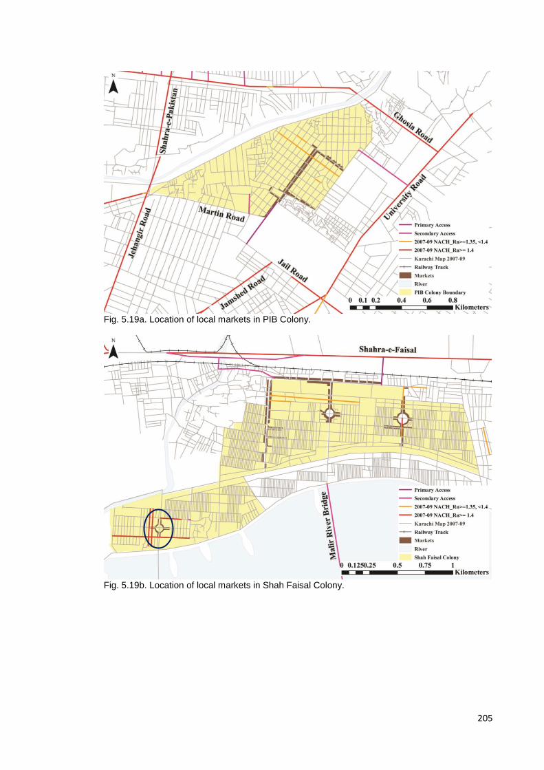
205
Fig. 5.19a. Location of local markets in PIB Colony.
Fig. 5.19b. Location of local markets in Shah Faisal Colony.
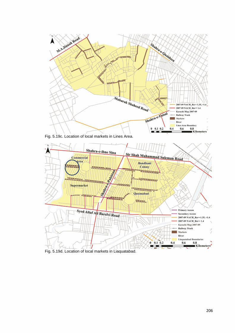
206
Fig. 5.19c. Location of local markets in Lines Area.
Fig. 5.19d. Location of local markets in Liaquatabad.

207
5.3.2.2 Sector Offices
As stated earlier, the Sector office sits mid-way within MQM’s political hierarchy
coming directly under Nine Zero and each managing a number of Unit offices.
The role of the Sector office within the community it serves is that of complaint
centre where residents of the area can bring all manner of problems ranging
from access to services and utilities to legal advice and the resolution of
neighbourhood disputes. The nature of its role as an area-wide complaint centre
suggests that the institution should be reasonably visible and accessible.
Of the 4 sector offices analysed for this section of the study, offices overseeing
units located in Liaquatabad and PIB Colony were actually located outside the
settlement itself. Whilst this may sound peculiar, it should be noted that analysis
of the complete set of Sector offices shows that the description of the catchment
of the Sector offices is best illustrated at a radius of 2500-3000m as seen in
Figure 5.11 earlier; at these radii, eleven of the twenty-seven sector offices are
located on the highest 10% of NACH street segments and up to 50% of Sector
offices are located on the top 15% of NACH street segments, therefore whilst
these radii may describe the location and catchment of the majority of Sector
offices, in some cases catchment exceeds the size of the settlement studied.
Additionally, step-depth analysis shows that in the case of the four case studies,
of the 36 unit offices considered - ten under the PIB Sector, eight under the
Shah Faisal Sector, eleven under the Liaquatabad Sector and seven under the
Lines Area Sector - only four units fall outside this 3km catchment of their
respective sector offices; three in Shah Faisal and one under the PIB Sector
suggesting that the Sector is functioning at this intermediary scale (Fig. 5.20). At
this scale, as seen in section 5.1.4 where it was shown that over 50% of sector
offices occupy the top 15% of street segments for NACH_R3000 adds to this
notion of catchment and accessibility at an intermediary urban scale.

208
Fig. 5.20. Sector Catchment radius 2500-3000m.

209
5.3.2.3 Unit offices
Whilst the Sector office is an area-wide complaint centre, the Unit office is the
neighbourhood point of contact of the MQM in most Muhajir majority areas,
disseminating the party agenda at the grassroots level. Activists engaged within
the unit are young men resident in the neighbourhood they serve, the logic of
this familiarity being that residence provides intimate and vital socio-spatial
knowledge of the area.
This particular analysis brought to light some unexpected results; whilst units in
3 of the 4 cases exhibited similar spatial patterns with regard to the location of
unit offices relative to their proximity to the closest local commercial area, 1
case demonstrated what appears to be anomalous behaviour. In the case of
Shah Faisal Colony, Liaquatabad and even Lines Area- the only informal
settlement included in this study where the structure of the settlement itself is
far from regulated- unit offices were located within 4 steps from a local
commercial area. Those units that are situated deeper appear to compensate
by exhibiting a lower angular step depth value- values of less than 1- as is the
case with Units 105 and 108 in Shah Faisal Colony, or a lower metric distance
as is the case for units 106 and 107 also in Shah Faisal Colony. Units in PIB
Colony on the other hand appears to behave differently; all active units within
the settlement (the unit located within Nishter Basti at the northern edge of the
settlement is currently closed) appear to be embedded deep within the
settlement at a distance of over 350m from the local commercial area (Fig. 21a-
d).
That being said, informants resident in the area spoke of how PIB’s local market
served a much wider population than simply the residents of the settlement
alone as is the case with the three other cases; the market caters to the
adjascent localities of Martin Quarters and Clayton Quarters as well as Usmania
and Hyderabad Colonies, all old Muhajir settlements. In addition to its wider
catchment, PIB’s main market is also known for speciality products catering
specifically to the Hyderabadi community (families migrating from Hyderabad
Deccan), i.e. clothing, jewllery and food items thus extending the catchment of

210
the market to an even wider transpatial community. Perhaps this wider appeal
has some bearing on the proximity and visiblity of Unit offices in this locality.
As has been seen from the analysis above, whilst most Sector offices are found
in relatively public locations functioning at an intermediary scale, i.e. 2500-
3000m, Unit offices though proximate to the local commercial area are
reasonably embedded within the neighbourhood they serve. Proximity of the
unit office to the main commercial area of the settlement potentially allows for
convenient access whilst simultaneously facilitating the policing of the
settlements’ most public spaces. Their location, often close to the entrance of
the market place, allows for the monitoring of movement from the outside into
the settlements as well as maintaining economic control within the settlement.
Type Total Park Religious Institution
Educational Institution
Community Centre
Public non-commercial
35 22 5 7 1
Commercial 10
Industrial 3
Residential 58 1 is proximate to a park
5 are proximate to a religious institution
Table 5.3 shows the type of locations MQM Unit offices are situated in.
Additionally as a Table 5.3 shows that of the 116 MQM Units offices for which
locations are known and mapped – of which most were official addresses
supplied by the party itself - a total of 48 (41.38%) were in non-residential
locations of which 35 were in publically accessible non-commercial spaces like
parks, religious and educational institutions and a community centre. Amongst
those located in residential areas, several are located in close proximity to
either a mosque or a park. This seems to be in keeping with both the idea of the
MQM Unit as an embedded feature at the neighbourhood scale allowing for
intimate knowledge of the area whilst monitoring for potential threats and
discontent and simultaneously, as Verkaaik (2004) suggests, the selection of
location targets spaces that are frequented by the young men of a
neighbourhood optimising the organisations chances of local recruitment.

211
Fig. 5.21a. Location of MQM Sector and Unit offices and local markets in PIB Colony.
Fig. 5.21b. Location of MQM Sector and Unit offices and local markets in Shah Faisal Colony.
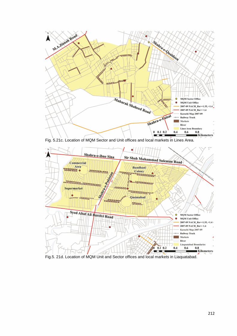
212
Fig. 5.21c. Location of MQM Sector and Unit offices and local markets in Lines Area.
Fig.5. 21d. Location of MQM Unit and Sector offices and local markets in Liaquatabad.
213
5.4 Discussion
The analysis thus far brings to light a number of themes pertaining to the
occupation and adaptation of Muhajir space in the city and the community’s
interactions with a non-Muhajir Karachi both city wide as well as locally. Firstly,
through a process of legalisation and development as seen in the case of the
commercialisation of certain key streets and the development of Karachi’s
signal-free road network, the political elements of the community seem to have
been able to bring major commercial activity and Karachi’s major intra-city road
links under their surveillance and strengthening their spatial control of central
areas of the city. Whilst consolidating the centre, these processes also appear
to have consciously attempted to improve the catchment radius of the political
centre and improve the connectivity of various Muhajir satellites to the central
hub of Muhajir presence as shown by the use of both step-depth analysis and
Normalised Choice measures in this chapter. That being said, as seen through
the presence of large Pakhtun and ethnically mixed settlements located at the
edges of this Muhajir presence and at the termini of various major road links out
of the city and the fact that Karachi’s major areas of conflict lie at the interface
between Muhajir and non-Muhajir space seems to suggest that the political
strength of the centre dissipates as the distance from the political centre
increases. The borderlands become more ethnically fluid and control of space
becomes negotiable.
Though there is a certain degree of spatio-temporal continuity to Muhajir
occupation as seen in the previous chapter, there appears to be a certain
degree of differentiation between Muhajir cultural identity and Muhajir political
identity. The mapping of Muhajir majority areas has shown that certain known
Muhajir neighbourhoods do not appear to support the MQM, this is illustrated by
the lack of MQM unit offices today in the various co-operative housing societies
established early on by affluent Muhajir communities. Additionally it can be seen
that the mixed and affluent areas of Defence and Clifton to the south too do not
fall into the Muhajir/MQM’s purview. What both these areas have in common is
the affluence of the residents which begins to suggest that perhaps the affluent
do not identify politically as Muhajir. Additionally, the analysis relating to plot
214
size and economic categorisation of settlements shows that Muhajir centres are
primarily planned, lower-middle and middle income settlements. Hence through
a process of elimination and categorisation it is possible to say that there is a
certain economic specificity to politically active Muhajir areas; the community
that identifies directly with the MQM today is composed of middle and lower-
middle income Urdu-speaking Karachiites, occupying small to medium sized
plots or medium-rise apartment buildings across Karachi’s central and eastern
areas.
These similarities extend beyond the broad socio-economic patterns of the
community to the spatial organisation of the settlements; as seen by the initial
analysis of the case studies, most Muhajir centres are in close proximity to at
least one major thoroughfare if not more. Analysis of responses from a limited
sample of residents in two settlements suggest that the greater the number of
connections to the global spatial network of the city, the more likely residents
are to venture beyond the confines of the settlement in search of employment,
having access to both a greater number of employment centres as well as being
able to travel further. Entrances into the settlement are often few but always off
the main thoroughfares directly into the local market spaces of the settlement.
This transition from the extreme public nature of a city scale thoroughfare to the
relative privacy of the local market off of which the residential areas of the
settlement are arranged is, in most cases, mirrored by a similar public to private
arrangement of MQM Sector and Unit offices with Sectors located on high
choice streets at an intermediary scale whilst the location of the Unit office is
intimately tied to the location of the local commercial area. These locations
provide a constant sense of surveillance in many of these areas where political
activists appear to be placed so as to be able to monitor activity in the
settlements’ most public areas without risking too much exposure. This
suggests that there may be something distinctly Muhajir about the spatial
configuration of the settlement and the location and orientation of communal
spaces, more so than just the economic and political classification of its
residents.
215
5.5 Conclusion
The intention of this chapter was to analyse the impact that the Muhajir
community’s continued clustering has had on their relationship with the city;
their impact on the major services of the city, the notion and nature of the socio-
spatial interface between space they have claimed and those of other
communities and the socio-spatial characteristics of Muhajir space. The findings
of this chapter have shown that the community occupies what may be
considered the heartland of the city today and, perhaps due to both the location
and high population densities of these areas, these areas have become the
natural focus for infrastructure development projects. That being said, with the
increasing dominance of the MQM in city politics in the last 20 years, there
appears to be a concentration and acceleration of development works primarily
in Muhajir majority areas as seen by the location of recently built flyovers and
the legalisation of commercial activity on key shopping streets within
Muhajir/MQM jurisdiction. Thereby resulting in a consolidation and expansion of
their space with a noticeable absence of such projects in the city’s peripherally
located, equally dense, disputed poorer settlements where Muhajir presence
and power wanes.
With regard to the manner and nature of the community’s interface with the city,
whilst development and dominance continues in the city and community’s
heartland, the borderlands appear to be spaces of contestation. Interestingly,
this contestation is both internal, between rival factions within the Muhajir
community as well as with other communities living in the ethnically mixed
peripheries of the city. At the scale of the settlement, these interfaces with the
wider city are formed by the most public of communal spaces within the
settlement; the shopping street.
This combination of infrastructure development and extensive political presence
on the ground is demonstrative of the nature of Karachi’s political character;
development to appease and entice constituents whilst simultaneously
monitoring the community at multiple levels for the purposes of both being able
to identify the needs of their constituents at the area-wide scale of the Sector
whilst policing the community from within at the neighbourhood scale of the unit.
216
Hence just as the community engages both economically and spatially with the
city across varying scales, so too does their political presence.
Thus far the analysis has focussed on the city-wide presence of the community
and the manner in which their spaces interact with the surrounding urban areas;
in essence this has been an analysis of the public socio-spatial presence of the
community. The following chapter shifts the focus from the externalities of
Muhajir presence in the city to the internal socio-spatial dynamics of the Muhajir
settlement addressing issues of sub-group clustering, boundary making and
spatial co-presence.
217
6. The ‘Muhajir-ness’ of space: The spatialisation of an ethno-political culture within the settlement.
6. 0 Introduction.
The previous chapters have shown that there are certain communal elements
that appear consistently across most Muhajir settlements and identify them as
Muhajir majority areas irrespective of the morphological or economic status of
these settlements. Chapter 5 has also shown that there is a certain socio-
economic profile, reflected in the morphology of these areas that seems to
appear consistently across politically active localities occupied by this
community. Additionally, we have seen that there appears to be a deliberate
spatial logic to the manner in which the community has given its political
presence a physicality in the city, influencing the development of infrastructure
networks to the advantage of its majority areas as well as developing a network
of political offices on the ground negotiating and monitoring the activities of their
activists and constituents from the scale of the city to that of the neighbourhood.
Whilst the analysis thus far has addressed the community’s city-wide presence,
its socio-spatial profile and the interface between the community and the city,
this chapter will address the socio-spatial patterns within the settlement. Hence
the questions posed here are how are the various groups that comprise Muhajir
majority settlements organised spatially? Are the various ethno-political entities
spatially identifiable? What kind of spaces form the interface where these
identities overlap and interact as well as help to build and maintain these
discrete ethno-political identities, solidarities and divisions within the context of
the Muhajir settlement? This brings the study of Muhajir presence and
interaction across the changing scales of urban life down to the micro-scale of
the settlement.
218
Earlier in the study, analysis of post-Partition Karachi showed that the manner
in which it has developed and grown was, amongst other things, the outcome of
the resettlement processes of both the various elements that made up the
Muhajir community as well as the various waves of non-Muhajir in-migration.
Whilst this analysis helped to define the Muhajir majority areas in the city, and
subsequently Muhajir centres that have then become the micro-scale focus of
this study, it brought to light the fact that Karachi broadly is very much a
patchwork of migrant communities interspersed by small ‘native’ settlements.
What this broad scale analysis perhaps overlooks in an effort to give Muhajir
presence a mappable form is the fact that the Muhajir community itself was
initially an amalgam of communities and that Muhajir majority areas have been
defined as majority areas as exclusivity was difficult to confirm by the processes
used thus far. Thus, using information taken from a range of sources including
in-depth interviews, municipal maps and on-site documentation of political
propaganda, this part of the study will engage with the socio-spatial
complexities of the Muhajir settlement. Additionally, using space syntax
methodologies to analyse the accessibility and clustering of various communal
spaces, most of which have played a role in the analysis thus far, the discussion
will focus on the social roles these communal spaces play within the
community. The intention being to address how accessibility and clustering are
reflective of the role these communal features play within the community,
investigating whether there are consistent spatial patterns across the
settlements with regard to the location, accessibility and use of the various
communal spaces? And, whether location and accessibility impact the role
played by the communal space within the community, and whether this is
indicative of social hierarchies within the settlement? The hypothesis being that
upon closer analysis of individual settlements, despite majority Muhajir
presence, each settlement is a microcosm of the city; a patchwork-like
composition of communities both Muhajir as well as non-Muhajir, where some
communal spaces define and segregate, maintaining sub-community
boundaries, whilst others play the role of an interface, allowing for various
communities to come together as spaces of dialogue.

219
As stated earlier, this chapter explores the spatialisation of ethno-political
identities within the context of what to this point has been termed ‘the Muhajir
settlement’. In order to do so, this chapter has been divided into 3 sections; the
first deals with the internal ethno-spatial structure of the settlement and
attempts to establish that these settlements are not homogenous and are
therefore ethno-politically far more complex than earlier anticipated. Due to the
complex ethno-political composition of the settlements, the second section
addresses the idea that such settlements must have spaces of communal
overlap and social interface and argues that such spaces are to be found in the
form of the settlements’ commercial areas. Whilst the second section addresses
spaces of overlap that allow the various communities to be at the very least co-
present in the public realm, the third section investigates spaces that help to
build ethno-religious identities and assist in the perpetuation of socio-spatial
divisions within the settlement. This layered socio-spatial means of analysing
the spaces occupied by the Muhajir community, assist in building a more
accurate picture of the community through the structure of the spaces they
occupy and their spatial behaviours.
6.0.1 Data and methodology
It should be noted that this chapter will continue to focus on the small number of
case studies introduced to the discussion in the previous chapter; the localities
of PIB Colony, Shah Faisal Colony, Lines Area and Liaquatabad, each selected,
as stated previously, on the grounds that they are demonstrative of the 3 broad
Muhajir settlement types as defined by the analysis of the previous chapter. As
stated earlier, due to the uncertainty of the security situation in Karachi at the
time that fieldwork was carried out; a para-military operation targeting ‘criminals’
and ‘terrorists’ was initiated in September 2013 with much of the focus it
appeared, on MQM held areas of the city, it was only possible to complete a
series of in-depth interviews and questionnaires for only two of the four case
studies, i.e. PIB Colony and Shah Faisal Colony, as these were considered
safer and easier to access whilst Lines Area and Liaquatabad were more
“sensitive”, volatile and historically notorious as flashpoints of politically
motivated aggression. That being said, some on-site documentation was

220
possible in the case of Liaquatabad. In the case of Lines Area, some off-site
interviews were conducted with residents of the area and some information
pertaining to the location of markets and settlement accessibility has been taken
from the CED report on the area compiled by the students of NEDUET’s
Department of Architecture (2010).
In an attempt to unpick the intricate composition and inter-dependencies, the
study thus far has been a systematic process of layering of elements related to
the Muhajir community in order to achieve a finer grain of detail and
understanding of the manner in which this community occupies space as the
scale of the analysis becomes more detailed. Building on this process, at the
intimate scale of the settlement, this chapter too will utilise this process of
layering information on the space syntax model of the settlement to construct a
more comprehensive view of the settlement and its residents.
In order to analyse the sub-communities and the establishment of possible sub-
community clusters within the settlement, a combination of both qualitative and
quantitative data sources were used. These consisted primarily of municipal
maps showing official neighbourhood boundaries and names (see Appendix A
for these reference maps) as well as information drawn from on-site in-depth
interviews and questionnaires pertaining to the location and nature of sub-
community clusters within the settlements. In-depth interviews consisted of
semi-structured discussions with long-time residents of the areas about how
and when the spaces of the settlements had changed and evolved and what
forces they felt propelled these changes, whilst the questionnaires, amongst
other things, asked respondents to indicate on a map where they lived and
localities within the settlement where they felt threatened. Whilst very few
respondents agreed to answer the last of these questions claiming that Karachi
as a city is unsafe and one can only be truly safe in one’s own home, answers
from those who did have been used as part of this study (See Appendix B for
questionnaire and interview sheet used).
Although interviews have been a great source of local information, events,
communities and boundaries needed to be rigorously tested. This led to the
inclusion of political propaganda in the array of identity-markers mapped in this
221
study. Due to the overly political nature of Karachi’s population, political
propaganda is encountered, in one format or another, across the city
irrespective of the area’s political affiliations. It has become a real-time visual
marker of the city’s changing political landscape as residents move through the
city, providing an insight into spaces of dominance, dispute, and dialogue.
Hence to further analyse whether ethno-religious boundaries overlap with
political boundaries in the context of the settlement and in a way corroborate the
interconnectedness of language, ethnicity and politics in the context of Karachi,
on site documentation of political propaganda within the settlements was carried
out. This included the mapping of the type of propaganda, i.e. graffiti, billboards
and posters, flags etc. as well as the party to which it was dedicated. This
process has been outlined in the methodology chapter of this study.
In the context of spaces of communal overlap and interface, the local shopping
street or bazaar will be discussed, not only with regard to its location and spatial
structure but also with regard to the role it plays as a communal bridge; a space
that allows for the co-presence of the various communities that make up these
settlements. This section too utilised both municipal maps, space syntax
methodologies and the researcher’s own on-site observations of the settlements
to analyse how the location of the shopping street within the settlement and the
various communal elements along them assist in making the shopping street a
place of communal overlap. In addition to analysing the shopping streets as a
complete entity in themselves, this section also discusses the mapping and
significance of the location and accessibility of the chai-khana (South-Asian tea
house) and bus-stops within and around the settlement and how they contribute
to this notion of spaces of communal overlap and interface.
These elements are an interesting off-set to elements used thus far to identify
these case studies, i.e. religious buildings and political party offices, in that both
religious buildings and MQM Unit offices have prescribed behaviours and
encourage if not demand certain religious or political affiliations of their users.
The chai-khana in South Asia on-the-other-hand is today similar to the local
‘caff’ or pub in the British context in that it is most often a working-class
establishment, serving a limited menu to a wide range of regulars who live
222
and/or work in the area. The chai-khana became popular in Karachi with the
arrival of the Muhajireen at Partition as these were considered the real tea
drinkers of the sub-continent (Ansari, 2005). Historically, the old tea-houses in
the Saddar area of the old city-centre were spaces frequented by intellectuals
and members of the political left, many of which have closed down in recent
years. Today, the chai-khana is far more working class as an institution, often
owned and run by a member of the Pakhtun community (Khan, 2010) and not a
Muhajir. It is perhaps this ethnic overlap of proprietor and user that makes this a
space that is far less discerning with regard to ethnic, religious and political
beliefs and thus is a communal feature found in most settlements irrespective of
the ethnic-political leanings of the area.
The locations of chai-khanas as well as the mapping of internal political
propaganda for three of the four case studies- PIB Colony, Shah Faisal Colony,
and Liaquatabad- were obtained through first-hand documentation carried out
on site during fieldwork conducted in the summer of 2013 and winter of 2015
and as such, especially in the case of political propaganda, may be influenced
by the most recent political/religious events at the time and hence should be
considered a snapshot of sorts.
The last section of this chapter reverts to data used earlier in this study, i.e. the
location of Barelvi mosques, Shi’a imambargahs and MQM unit offices. As
stated earlier, these communal institutions demand a degree of ethno-political
or religious specificity of their members and users, quite in contrast to the
informal inclusiveness of the shopping street, chai khana or bus stop. One could
say that there is a degree of ‘programmed’, exclusivist formality to these
spaces, where they not only exclude the ‘other’ but also, build and maintain
community identities and solidarities, many of which, as has already been seen
at the city-scale, connect to a much wider trans-spatial network.
Due to the uneven nature of the data used across the four case studies, Table
6.1 shows the type of data collected and used in each section of this chapter
and the case study for which this data was available.

223
Feature Case Study
PIB Colony Shah Faisal Colony
Lines Area Liaquatabad
6.1.1 Ethno-religious community clustering
Complete data set
Complete data set
Sufficient data for discussion
-
6.1.2 Political propaganda
Complete on-site mapping
Complete on-site mapping
- Complete on-site mapping but not referred to.
6.2.1 Shopping streets
Complete on-site mapping
Complete on-site mapping
Complete mapping – data drawn from CED report 2010 NEDUET
Complete on-site mapping
6.2.3 Chai- khanas
Complete on-site mapping
Complete on-site mapping
- Complete on-site mapping
6.3.1 Religious institutions - Barelvi mosques
Complete mapping – on-site and google maps.
Complete mapping – on-site and google maps.
Complete mapping – google maps and municipal drawings.
Complete mapping – on-site and google maps.
6.3.1 Religious institutions -Imambargahs
Complete mapping – on-site, municipal maps and google maps.
Complete mapping – on-site, municipal maps and google maps.
Complete mapping – google maps and municipal drawings.
Complete mapping – on-site, municipal maps and google maps.
Table 6.1. shows the array of data that was available and used per case study across the sub-
sections of this chapter.
In this chapter, through a process of overlaying specified identity markers on the
space syntax model of the individual case studies, the intention has been to
relate the social behaviour of the community to the spatial configuration of the
individual settlements. This will in turn assist in describing the socio-spatial
hierarchies of communal spaces within the settlement and through them, the
social hierarchies of the sub-communities that occupy these areas.
6.1 Internal ethno-spatial boundaries.
As stated in the introduction of this chapter, the Muhajir community themselves
are an amalgam of smaller communities all hailing from a diverse geo-linguistic
background, thrown together by a shared faith and belief in the ideology of a
post-colonial homeland for the Indian Muslim community. Secondly, whilst
Karachi rapidly became a pre-dominantly Muhajir city, due to the development
of the port during colonial rule, it was home to a diverse array of ethnic and
religious communities, the stratification far more complex both socially and
spatially than a simple demarcation of British and native quarters. In Pre-
224
Partition Karachi Goan and Parsi housing societies near the Saddar Bazaar,
Sindhi and Balochi quarters in Lyari and goths (villages) in peripheral areas of
the city, and quarters in the inner city areas of Kharadar and Meethadar defined
by trade as well as ethnicity, all developed alongside the gridded layout of the
Civil Lines areas of the British administration. Hence upon their arrival in the
city, the refugees had to fit themselves into this diverse pre-existing ethno-
religious landscape of the city both socially as well as spatially (Hasan 1999,
Ansari, 2005).
As discussed earlier in this study whilst much early settlement was dependent
upon where migrants found vacant land or property, a lot of subsequent
settlement was driven by locational solidarities or place based communities in
that families from the same cities or localities in Pre-Partition India tended to
cluster. The wealthier of these communities established co-operative housing
societies, whilst the economically less fortunate set up informal settlements
often named after the city, town or village they had left behind. Thus in Karachi
today we see the proliferation of neighbourhoods named after places in Pre-
Partition India such as CP & Berar Society, Delhi Colony, Hyderabad Colony,
Shah Jahanabad, and Sikanderabad (Ansari, 2005).
This process of clustering based on ethnicity, religion and trade has been
perpetuated by each subsequent wave of migration. Clusters have often
developed through a process of chain-migration with kinsmen being housed
either with or in close proximity to their more established brethren whilst
simultaneously often being inducted into the same profession or trade. This
process has led to, in some cases, not only ethnic clustering but also to the
emergence of trade monopolies. Access and proximity to the city’s services and
employment has often also meant that, unless facilitated by the State, such
clusters will develop as an infill of sorts within the existing urban fabric of the
city, similar to the manner in which the Muhajireen initially occupied the spaces
of Karachi at Independence. Hence in Karachi today, one often finds different
ethno-linguistic clusters of varying political affiliation and economic definition
side-by-side, all part of the patchwork like definition of the ethno-spatial fabric of
the city.
225
It should be noted that as competition for resources increased with each
subsequent wave of migrants and, as State-sponsored support moved from one
ethno-religious group to another depending upon the allegiances of policy
makers, ethno-religious tensions in the city have risen and waned. This has
resulted not only in the politicisation of ethnicity in the context of Karachi but,
with each political group engaging in violent and targeted paramilitary activity,
there has been a change in the ethnic definition of the city’s various
neighbourhoods. In a number of interviews respondents spoke of the hungamay
(public disturbances and riots) of the 1980s and 90s that resulted in the
movement of families out of one locality to another for ‘security’ reasons. This
may have led to greater ethno-religious homogeneity of neighbourhoods and an
unconscious concretisation of both social and spatial boundaries between
communities.
6.1.1 Ethno-religious community clustering.
In light of this process of settlement and growth, this section seeks to analyse
this ‘patchwork’ in the context of the case studies identified. As stated earlier,
whilst these settlements are situated within Muhajir majority areas, many of
them being Muhajir centres, upon closer analysis, they appear to be far more
complex both socially as well as spatially than earlier representations of these
areas suggested. Using information taken from fourteen in-depth interviews
conducted on site in PIB Colony and Shah Faisal Colony, as well as municipal
maps of the two study areas analysed for this part of the study, certain sub-
community clusters are identifiable and some similarities across settlements
begin to emerge.
Figure 6.01 is a map of PIB Colony showing areas identified by interviewees, as
well as local municipal maps, as neighbourhoods belonging to sub-communities
that may be identified as Muhajir. These include the localities of ‘J’ Block
(named after Jabalpur, a city in Madhya Pradesh), ‘N’ Block (named after
Nagpur, a city in Maharashtra) and Amynabad within PIB as well as Hyderabad
Colony, Usmania Muhajir Colony and Bihar Colony; all Muhajir localities in close
proximity to main PIB Colony. In the case of blocks ‘J’ and ‘N’, plot numbers
were used to identify the extent of the block, i.e. plots were numbered using the
226
block as a suffix, e.g. J37 and N40. Block edges were defined by where such
numbering patterns changed.
PIB’s ‘J’ and ‘N’ Blocks have an interesting social history; these localities were
claimed and named shortly after Partition by the Gujerati-speaking communities
that originally settled here; i.e. people from Jabalpur and Nagpur. But
respondents in the area claimed that many of these early settlers have today
moved out, their properties being bought by two other Gujerati-speaking
communities; the Khatri community in J Block and members of the Ghanchi
community in the N Block area, both business communities with a significant
presence on PIB’s main shopping street. In fact the Khatri community’s
presence in ‘J’ Block is further confirmed by the establishment of the Khatri
Masjid within the block, whilst a Ghanchi community centre has been
established just off of the shopping street, near the bus stop.
Whilst movement into or out of other settlements has been attributed to the
political turmoil in Karachi in the 1980s and 90s, in the case of PIB Colony
respondents claimed this shift in occupation came about in the 1960s with the
establishment of the old Sabzi Mundi (wholesale vegetable market), situated
close to PIB Colony as seen in Figure 6.01. This brought an influx of Pakhtun
traders and transporters from Pakistan’s north-western province; single men
who set up bachelor accommodation in Nishtar Basti, an informal settlement
north of PIB Colony. Wealthier residents in the settlement’s J and N blocks
moved out as the character of the settlement began to change due to its
proximity to the wholesale market and their properties were bought up by other
communities looking to ‘move-up’.
Whilst some post-Partition neighbourhoods saw this kind of turn-over, others
have persisted such as the Ismaili neighbourhood of Amynabad. Though the
settlement has persisted, with many of the original families still resident in the
area, the neighbourhood has undergone a transformation too. Due to a rise in
the incidence of burglaries and the uncertain security situation in the city – the
Ismaili community being a minority Shi’a sect - in recent years the community
has erected a boundary wall around the settlement and a security check-post at
the entrance to monitor all those entering the neighbourhood.
227
Though large sections of PIB consists of sub-groups that may be considered to
be Muhajir as is the case with the afore mentioned Gujerati-speaking
communities, not all ethnic clusters belong to communities that may be seen as
such suggesting that whilst these ‘centres’ are high concentration areas, they
are not ethnically homogenous. In the case of PIB Colony we see two such
clusters; Nishtar Basti, a Pakhtun settlement to the north of PIB that developed
in the 1960s as an informal settlement of Pakhtun transporters and vegetable
traders, and the Baloch Para, a pre-Partition Baloch settlement around which
PIB was laid out.
Similarly, in Shah Faisal Colony, as can be seen in Figure 6.02, the Muhajir
neighbourhoods are flanked by a pre-Partition Pakhtun settlement to the east
known as Natha Khan Goth. This developed due to its proximity to Drigh Road
Station, one of pre-Partition Karachi’s main railway stations, and Green Town
and Rifah-e-Aam Society, primarily Punjabi settlements to the west, developed
in the 1970s to accommodate migrants from the Punjab. As mentioned earlier,
interviewees in Shah Faisal colony spoke of how in the past when ethno-
political tensions were high in the city, Punjabi families moved out of Muhajir
localities, relocating to Green Town and vice versa with Muhajir households
settled in Punjabi majority areas selling up and moving to Muhajir localities they
considered to be ‘safe’ due to their ethnic homogeneity and lack of exposure to
an ‘other’. Other respondents claimed that reputable families had moved out of
Shah Faisal Colony due to the social stigma attached to the use of the term
‘colony’ in Karachi which is often used to refer to lower and lower-middle
income localities. Additionally, several respondents referred to the increasing
presence of the Bihari community, with members moving in and buying up
properties and businesses in the area whilst displacing older residents.

228
Fig. 6.01. Sub-community clusters in PIB Colony.
Fig. 6.02. Sub-community clusters in Shah Faisal Colony.

229
Fig. 6.03. Sub-community clusters as identified through interviews in Karachi’s Lines Area.
The limited data obtained with regard to this aspect of the study in the context of
both Liaquatabad and Lines Area from a very small sample of interviews
conducted off-site, suggests that similar sub-community clusters do exist within
these settlements as well. Respondents claimed that clustering in Lines Area
was dictated by both ethnicity and occupation, where occupations were often
synonymous with ethnicity; e.g. people of Rajput and Mughal descent were
known to be dhobis (washer men), taking in and doing people’s laundry for a
living, and the Qureshi community who were known to be butchers or qasaiis.
These were communities that were built around both ethnic and trade based
solidarities where both social and spatial clusters appear to have persisted
perhaps due to the space specific nature of these professions. Neighbourhoods
and local landmarks are named after these occupations even today, e.g. one of
Lines Areas major commercial streets is known as Qasaii Galli, whether there
were butchers’ shops on this in the past is not known, similarly many of the
dhobi ghats (areas used for laundering clothes) still exist today and are located
in close proximity to what used to be the main source of water in the area, the
Tanki Ground – a large open space that housed the areas main water reservoir
also known as a tanki.
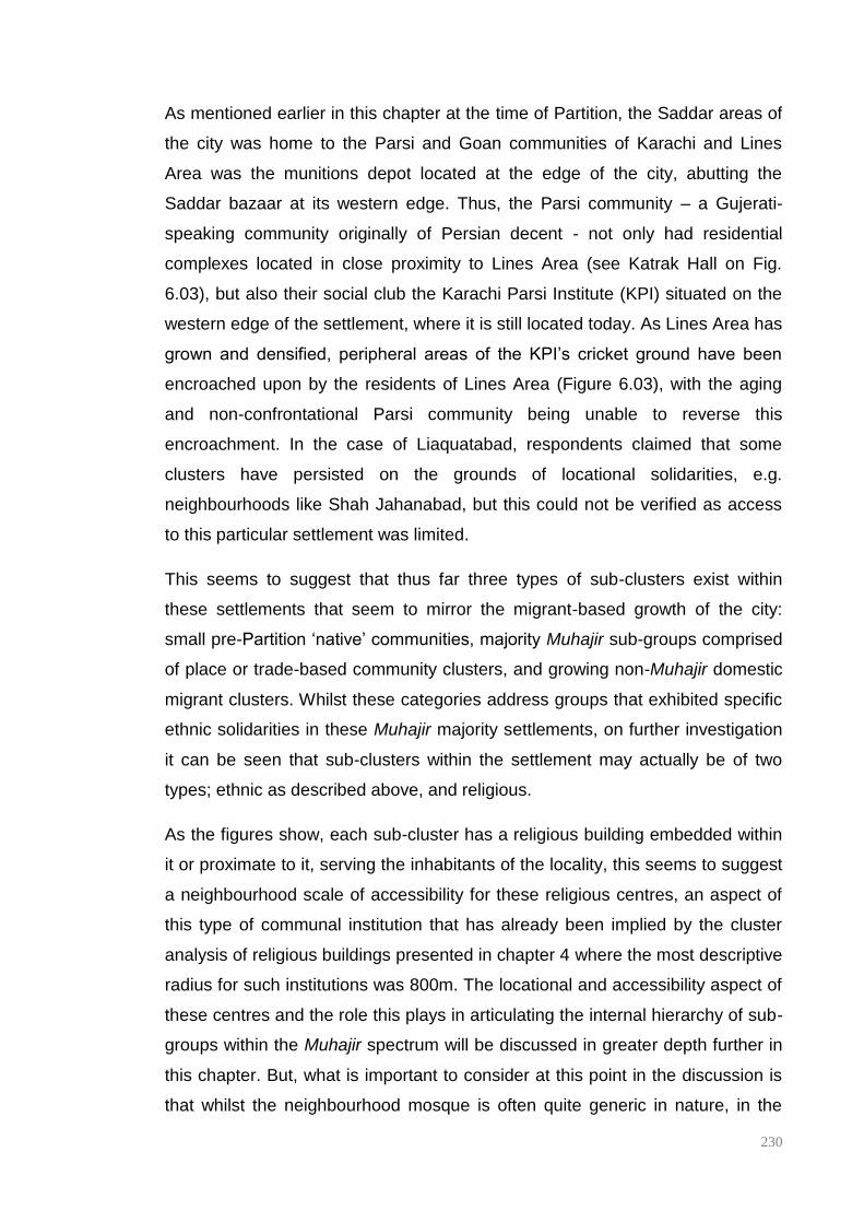
230
As mentioned earlier in this chapter at the time of Partition, the Saddar areas of
the city was home to the Parsi and Goan communities of Karachi and Lines
Area was the munitions depot located at the edge of the city, abutting the
Saddar bazaar at its western edge. Thus, the Parsi community – a Gujerati-
speaking community originally of Persian decent - not only had residential
complexes located in close proximity to Lines Area (see Katrak Hall on Fig.
6.03), but also their social club the Karachi Parsi Institute (KPI) situated on the
western edge of the settlement, where it is still located today. As Lines Area has
grown and densified, peripheral areas of the KPI’s cricket ground have been
encroached upon by the residents of Lines Area (Figure 6.03), with the aging
and non-confrontational Parsi community being unable to reverse this
encroachment. In the case of Liaquatabad, respondents claimed that some
clusters have persisted on the grounds of locational solidarities, e.g.
neighbourhoods like Shah Jahanabad, but this could not be verified as access
to this particular settlement was limited.
This seems to suggest that thus far three types of sub-clusters exist within
these settlements that seem to mirror the migrant-based growth of the city:
small pre-Partition ‘native’ communities, majority Muhajir sub-groups comprised
of place or trade-based community clusters, and growing non-Muhajir domestic
migrant clusters. Whilst these categories address groups that exhibited specific
ethnic solidarities in these Muhajir majority settlements, on further investigation
it can be seen that sub-clusters within the settlement may actually be of two
types; ethnic as described above, and religious.
As the figures show, each sub-cluster has a religious building embedded within
it or proximate to it, serving the inhabitants of the locality, this seems to suggest
a neighbourhood scale of accessibility for these religious centres, an aspect of
this type of communal institution that has already been implied by the cluster
analysis of religious buildings presented in chapter 4 where the most descriptive
radius for such institutions was 800m. The locational and accessibility aspect of
these centres and the role this plays in articulating the internal hierarchy of sub-
groups within the Muhajir spectrum will be discussed in greater depth further in
this chapter. But, what is important to consider at this point in the discussion is
that whilst the neighbourhood mosque is often quite generic in nature, in the
231
case of minority groups, religious buildings are generally quite distinctive. This
can be illustrated in the case of the settlements studied; Amynabad mentioned
above is an Ismaili gated community with a Jama’at khana – prayer hall and
community centre – along with other communal facilities situated within the
settlement, the Karachi Parsi Institute and its adjoining residential complex
Katrak Hall in Lines Area are situated in close proximity to the Zorastrian
Temple shown in Figure 6.03 and, in all three Muhajir settlements, a cluster of
Imambargahs is situated within areas that have been identified as Shi’a
localities. Many of these faith-based neighbourhoods have been named
thereby suggesting a local acknowledgement of the religious specificity of their
residents; e.g. Plot Chowdah (Plot 14) and Amynabad in PIB, Pak Sadat Colony
in Shah Faisal and Baltistani Society and KPI in Lines Area.
Whilst the faith-based groups identified above seem to have distinct boundaries
to their localities, the Barelvi community despite appearing to have an
identifiable presence in Muhajir settlements as seen by the abundance of their
distinctive mosques in these areas, the community’s boundaries are perhaps a
little more fluid than the definite edges of the sub-groups discussed above.
Although this Sunni sub-group is primarily a religious sect, their urban presence
identified by the sects green domed mosques and its male adherents are often
also seen in green turbans, the community formed the Pakistan Sunni Tehreek
(PST), a religio-political organisation established to advocate for the Barelvi
community’s interests in the political arena in 1990. So although religious
buildings within the settlement indicate a Barelvi presence, as in the case of the
Shi’a imambargahs, in order to identify potential spatial boundaries, it is the
political aspect of this community that can potentially provide an additional layer
of information in the form of political propaganda that can be utilised to map this
community’s occupation of space.
6.1.2 Political propaganda and the articulation of ethno-political
boundaries.
As discussed earlier in this study, language, ethnicity and politics are intimately
connected in Karachi; the various Muhajir communities (primarily Urdu and
Gujerati-speaking communities) vote for the MQM, Sindhis and Balochis
232
historically have voted for the Pakistan Peoples Party (PPP), Punjabis vote for
the Pakistan Muslim League (PML) and Pakhtuns have until recently voted for
the Awami National Party (ANP) (Hasan, 2005). In recent times, Karachi has
seen the aggressive re-emergence of various right-wing Sunni groups such as
the Ahle-Sunnat-Wal-Jamaat (ASWJ), the Tehreek-e-Taliban-Pakistan (TTP),
the Pakistan Sunni Tehreek (PST) and the Jamaat-i-Islami (JI). These groups
have been using their base in the city for the purposes of recruitment and
raising funds for their various operations (Yusuf, 2012). The TTP appears to
have made inroads into the Pakhtun community basing their presence in
Pakhtun settlements and using these as places of recruitment (Rodrigez, 2010),
whilst the PST and JI are looking to break into the Muhajir vote base (Khan,
2012). This section will show that political propaganda found within the study
areas often reflects these trends as well as assists in demarcating political
territories within the settlement.
As stated earlier, in the context of Karachi, graffiti, billboards and banners
located on the main arteries of the city are quite common place. Walls lining
main roads, especially in commercial settings, have long been used as free
advertisement space in the Indian Sub-continent as described by Urdu satirist
Ahmad Shah Bukhari Patras in an essay about Lahore written in 1927 (Dadi,
2007) in which he claims: “The wall is initially erected with brick and lime, over
which a plaster of advertisements is placed that slowly continues to increase in
thickness.” This ethos of appropriation of public space for the purposes of all
kinds of public announcements has also permeated the realm of political
propaganda. Graffiti, billboards and flags are often used to express a sense of
political solidarity. Their festive nature is useful in generating a sense of
community identity (Shirlow and Murtagh, 2007), whilst simultaneously
demarcating urban territories (Ley, 1974) as a show of power and ownership in
the public domain. It is this aspect of political territoriality and spatial
demarcation embodied by political propaganda that this section of the study will
utilise.
In the case of the individual settlements the content, political mix and type of
propaganda used varies from settlement to settlement depending upon the
communities’ resident therein as the study will show. Additionally, political

233
groups appear to be utilising the natural qualities of public spaces to their
advantage; billboards and flags are primarily used on the approach to the
settlement as well as on flyovers and dual carriageways. These broad and
bright landmarks serve to indicate the main political players in the community
and are meant to be viewed by fast moving traffic. The main thoroughfares
through the settlement and the local commercial areas appear to be ‘prime real-
estate’, with multiple parties vying for space and representation. These spaces
are often festooned with banners and flags, with billboards or large banners
located at the end of important visual axes.
In residential neighbourhoods, the primary form of political propaganda found is
graffiti, and in most cases this will be representative of one or two parties active
in the neighbourhood. This generally consists of familiar slogans and icons that
are often territorial in nature. Where two or more groups mark-up residential
areas, the manner in which these graffiti are displayed is often indicative of the
nature of the relationship between the groups. If the graffiti of both groups exist
intact in simultaneity, there is generally an ‘understanding’ between groups as
seen in a number of neighbourhoods between the MQM and the Barelvi group
the Pakistan Sunni Tehreek. Where markings have been overwritten, plastered
over or erased, this may be indicative of a space that is disputed with groups
engaged in some kind of turf battle. This was seen to be the case between the
MQM and the Jamaat-i-Islami, long-term political rivals in Muhajir areas (Fig.
6.04).
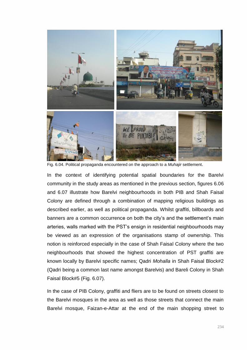
234
Fig. 6.04. Political propaganda encountered on the approach to a Muhajir settlement.
In the context of identifying potential spatial boundaries for the Barelvi
community in the study areas as mentioned in the previous section, figures 6.06
and 6.07 illustrate how Barelvi neighbourhoods in both PIB and Shah Faisal
Colony are defined through a combination of mapping religious buildings as
described earlier, as well as political propaganda. Whilst graffiti, billboards and
banners are a common occurrence on both the city’s and the settlement’s main
arteries, walls marked with the PST’s ensign in residential neighbourhoods may
be viewed as an expression of the organisations stamp of ownership. This
notion is reinforced especially in the case of Shah Faisal Colony where the two
neighbourhoods that showed the highest concentration of PST graffiti are
known locally by Barelvi specific names; Qadri Mohalla in Shah Faisal Block#2
(Qadri being a common last name amongst Barelvis) and Bareli Colony in Shah
Faisal Block#5 (Fig. 6.07).
In the case of PIB Colony, graffiti and fliers are to be found on streets closest to
the Barelvi mosques in the area as well as those streets that connect the main
Barelvi mosque, Faizan-e-Attar at the end of the main shopping street to

235
Faizan-e-Madina, the Barelvi community’s HQ, a complex housing offices as
well as the studios for their cable channel.
Even though, as was to be expected, the dominant presence in all the case
study areas, especially in residential neighbourhoods, is the MQM, there is a
significant presence of other political parties especially on commercial streets
and thoroughfares. These range from representatives of right-wing Sunni
parties such as the Ahle-Sunnat-Wal-Jammat (ASWJ) and the Jamaat-i-Islami
(JI) to small ethnic parties such as the Punjabi Students Association (PSA) (Fig.
6.08 & 6.09). This variation in the number of political actors present in the
various spaces of the settlement from the commercial areas to the residential
neighbourhoods perhaps suggests a difference in the ownership and
occupation of these spaces; commercial spaces with a diverse array of political
presence seem more neutral whilst residential areas are spaces ‘claimed’ and
monitored by a particular group making them ‘safe’ or ‘no-go’ zones depending
on the affiliation of those accessing the space. Thus this means of marking
spaces provides both residents and visitors with visual cues, helping them to
read and negotiate potentially volatile environments.
Two cases demonstrate this articulation of ethno-political boundaries
particularly effectively; Thana Street, this is the double road that separates
Green Town, a Punjabi neighbourhood from Shah Faisal Block 3, a
predominantly Muhajir neighbourhood and the route to the Baloch Para from the
main shopping street in PIB Colony. In the case of the former, unlike Shah
Faisal’s other double roads which are primarily commercial, this particular
street, along which a wide storm drain has been constructed, is seen to be
primarily residential. It is poorly maintained with most street-facing facades
being largely blank in that there are a limited number of door and window
openings. These long blank facades provide the perfect surface for graffiti, both
political as well as general advertising, with both sides of the street reflecting
the affiliations of the settlement beyond; i.e. MQM on the side that backs onto
Shah Faisal Block#3 and Punjabi parties on the Green Town side. As figure
6.06 below shows, PIB Colony is predominantly MQM with pockets of PST and
JI activity, yet the streets that provide access from the main shopping street to

236
the Baloch Para are the only spaces that PPP graffiti is to be found in the
settlement. As stated earlier, the Baloch have traditionally voted for the PPP.
Fig. 6.05. Left to right: PPP graffiti located on the approach to Baloch Para, PSA graffiti on one
side of the street dividing Punjabis areas from Muhajir areas with MQM graffiti on the other side.
What this wide range of political representation shows is that there are two
types of political parties active in these settlements; ethnicity-based groups like
the MQM and the PSA as well as religious groups with a political presence such
as the Jamaat-i-Islami, PST and the ultra-right-wing Sunni ASWJ. This
increasing visibility of right-wing Sunni groups in the public realm of the
settlement is indicative of the rising sectarianism in the city which in turn
appears to impacts how religious minorities locate and safeguard their
neighbourhoods and religious institutions.
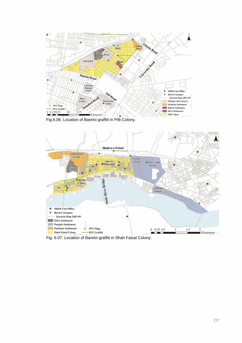
237
Fig.6.06. Location of Barelvi graffiti in PIB Colony.
Fig. 6.07. Location of Barelvi graffiti in Shah Faisal Colony.
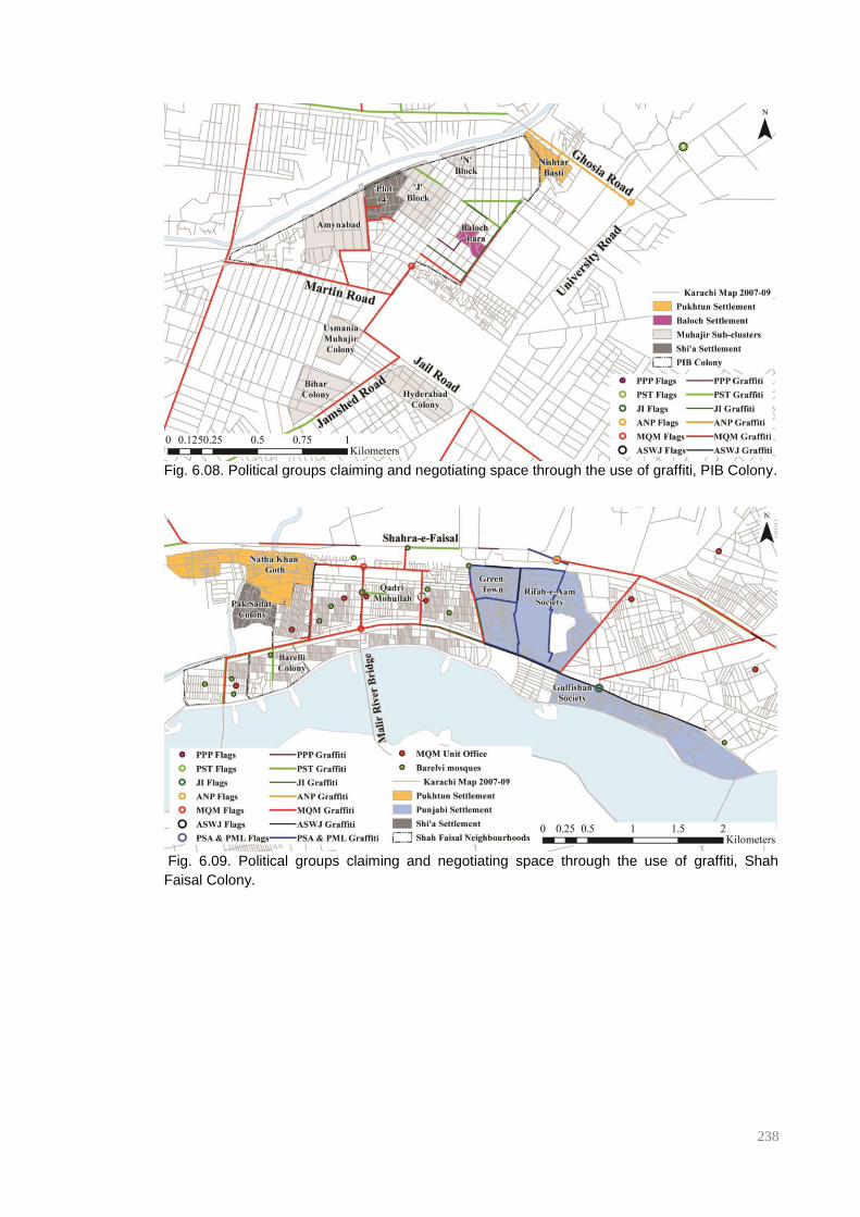
238
Fig. 6.08. Political groups claiming and negotiating space through the use of graffiti, PIB Colony.
Fig. 6.09. Political groups claiming and negotiating space through the use of graffiti, Shah
Faisal Colony.

239
6.1.3 Internal ethno-political boundary, an overview.
What can be ascertained from the analysis thus far is that there appears to be
two broad kinds of community sub-clusters within the settlement; those defined
by ethnicity and those defined by religious affiliations, with political
representation present for both types of communities. Within the former
especially there are further sub-groups of Muhajir and non-Muhajir clusters.
Using both the formal (municipal maps) and the informal (political propaganda)
as a means of demarcating space, space syntax analysis has been used to
measure the relative accessibility (NAIN) and location of the various sub-group
clusters with PIB Colony, Shah Faisal Colony and Lines Area. Additionally, the
location of political propaganda within the settlement was compared to the
likelihood of various streets being used as routes through the settlement at
various local scale radii (NACH) to assess whether there is a correlation
between high movement potentials and political visuals.
Graphs 6.01-6.03 show the average NAIN values for all identifiable sub-clusters
within PIB Colony, Shah Faisal Colony and Lines Area. The Analysis in all
cases illustrates that Pakhtun and Shi’a settlements are both quite segregated,
where the Pakhtun clusters appear to be even more segregated than their Shi’a
counterparts. Time, or the age of the sub-cluster, should potentially be
considered as a factor in the relative integration of sub-community clusters into
the larger system at least in the case of PIB Colony where the oldest parts of
the settlement are the Baloch Para and ‘J’ Block, both exhibiting the highest
local integration values, followed by Amynabad and ‘N’ Block, both of which
were established early in the settlement’s history, and finally Plot 14 and Nishter
Basti, the latter emerging in the 1960s. A similar pattern can be seen in Shah
Faisal Colony, where Shah Faisal Blocks 1-5 are the oldest parts of Shah Faisal
Town, followed by Green town in the 1970s and then Punjab Town and
Gulfishan Society. The anomalies in this case are Pak Sadat Colony which saw
an influx of people in the late 1970s and early 1980s and therefore places its
expansion and development contemporaneous to that of Green Town (the
Punjabi settlement) and Natha Khan Goth which is a Pre-Partition Pakhtun
settlement and therefore one of the oldest localities of the settlement.

240
The graphs begin to illustrate that there may be some kind of internal socio-
spatial hierarchy within the larger settlement showing that smaller minorities and
non-Muhajir community clusters exhibit lower integration values or accessibility.
The segregated nature of these sub-community clusters can be more
expressively articulated through the syntax maps for each settlement as shown.
Figures 6.10 and 6.11 show that smaller ethnic and religious minorities not only
occupy the more segregated areas of both PIB Colony and Shah Faisal Colony
as illustrated by the graphs, but that they appear to be located towards the
peripheries of the settlement as well. This is particularly apparent in the case of
both the Shi’a and Pakhtun settlements, both of which also appear to take on
the form of an informal settlement; a noticeable departure from the gridded
formality of the main body of the settlement.
As discussed earlier, the boundaries of these sub-clusters are often highlighted
by the use and change in the political graffiti displayed. By comparing the
location of sub-community clusters and political graffiti to NACH values of street
segments in these areas – where high NACH values identify street segments
exhibiting the highest potential to be used as part of routes through the
settlement - , some interesting patterns begin to emerge. Political graffiti appear
to be working at two scales within the settlement; that of the wider settlement
indicated by the clustering of political graffiti along market streets and major
thoroughfares, and that of the individual neighbourhoods where artists/activists
instinctively appear to be choosing locally significant streets that may be
frequented by residents for internal, neighbourhood scale movement. These
scales appear to vary depending on the size, density and block size of the
settlement as a whole. Hence, whilst graffiti targeting the wider settlement scale
audience in both PIB Colony and Shah Faisal Colony is found primarily on
streets that exhibit high choice values (NACH) at 2500m and 3000m
respectively (Figures 6.12b and 6.13b). Local area graffiti – MQM graffiti in the
back streets of Plot 14 in PIB Colony and PSA/PML graffiti on the twisting
streets of Green Town – are highlighted at 800m and 1800m respectively
illustrated (figures 6.12c and 6.13c).
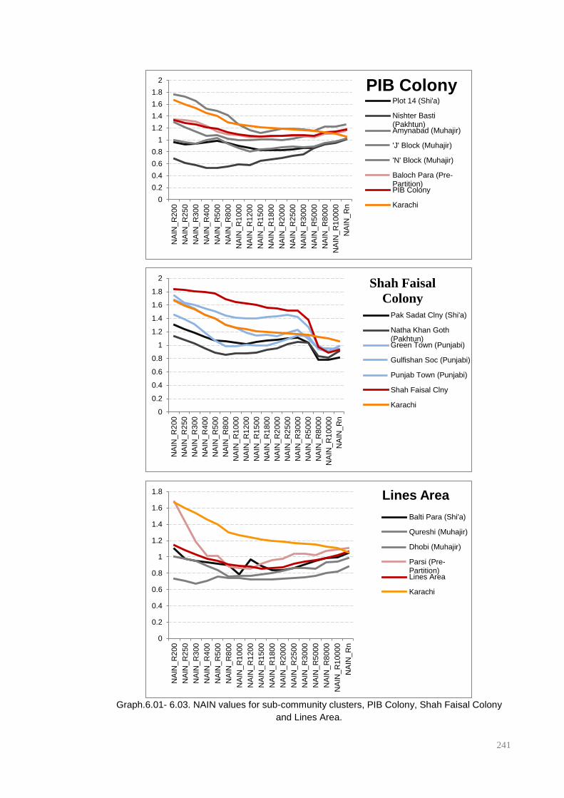
241
Graph.6.01- 6.03. NAIN values for sub-community clusters, PIB Colony, Shah Faisal Colony
and Lines Area.
0
0.2
0.4
0.6
0.8
1
1.2
1.4
1.6
1.8
2
NA
IN_R
200
NA
IN_R
250
NA
IN_R
300
NA
IN_R
400
NA
IN_R
500
NA
IN_R
800
NA
IN_R
1000
NA
IN_R
1200
NA
IN_R
1500
NA
IN_R
1800
NA
IN_R
2000
NA
IN_R
2500
NA
IN_R
3000
NA
IN_R
5000
NA
IN_R
8000
NA
IN_R
10000
NA
IN_R
n
PIB Colony Plot 14 (Shi'a)
Nishter Basti(Pakhtun)Amynabad (Muhajir)
'J' Block (Muhajir)
'N' Block (Muhajir)
Baloch Para (Pre-Partition)PIB Colony
Karachi
0
0.2
0.4
0.6
0.8
1
1.2
1.4
1.6
1.8
2
NA
IN_R
200
NA
IN_R
250
NA
IN_R
300
NA
IN_R
400
NA
IN_R
500
NA
IN_R
800
NA
IN_R
1000
NA
IN_R
1200
NA
IN_R
1500
NA
IN_R
1800
NA
IN_R
2000
NA
IN_R
2500
NA
IN_R
3000
NA
IN_R
5000
NA
IN_R
8000
NA
IN_R
10000
NA
IN_R
n
Shah Faisal
Colony
Pak Sadat Clny (Shi'a)
Natha Khan Goth(Pakhtun)Green Town (Punjabi)
Gulfishan Soc (Punjabi)
Punjab Town (Punjabi)
Shah Faisal Clny
Karachi
0
0.2
0.4
0.6
0.8
1
1.2
1.4
1.6
1.8
NA
IN_R
200
NA
IN_R
250
NA
IN_R
300
NA
IN_R
400
NA
IN_R
500
NA
IN_R
800
NA
IN_R
1000
NA
IN_R
1200
NA
IN_R
1500
NA
IN_R
1800
NA
IN_R
2000
NA
IN_R
2500
NA
IN_R
3000
NA
IN_R
5000
NA
IN_R
8000
NA
IN_R
10000
NA
IN_R
n
Lines Area
Balti Para (Shi'a)
Qureshi (Muhajir)
Dhobi (Muhajir)
Parsi (Pre-Partition)Lines Area
Karachi

242
Fig. 6.10. Sub-community clusters overlaid on NAIN R2500m, PIB Colony.
Fig. 6.11. Sub-community clusters overlaid on NAIN R3000m, Shah Faisal Colony.
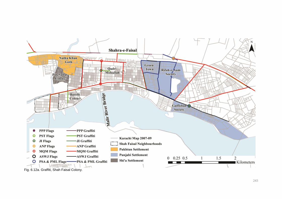
243
Fig. 6.12a. Graffiti, Shah Faisal Colony.

244
Fig. 6.12b. Top10% NACH R3000 of street segments appear to correspond to political
propaganda located on major local thoroughfares, Shah Faisal Colony.
Fig. 6.12c. Top15% NACH R1800 of street segments appear to coincide with political
propaganda located on significant neighbourhood roads, Shah Faisal Colony
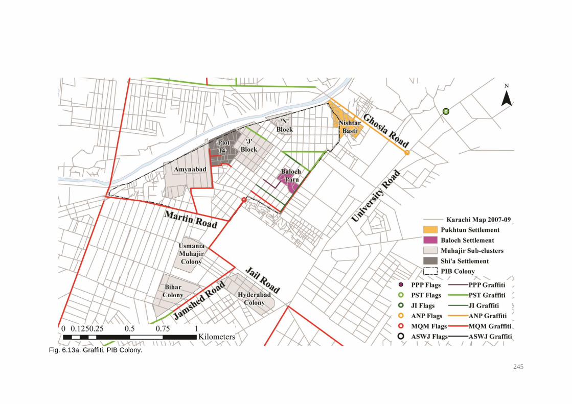
245
Fig. 6.13a. Graffiti, PIB Colony.
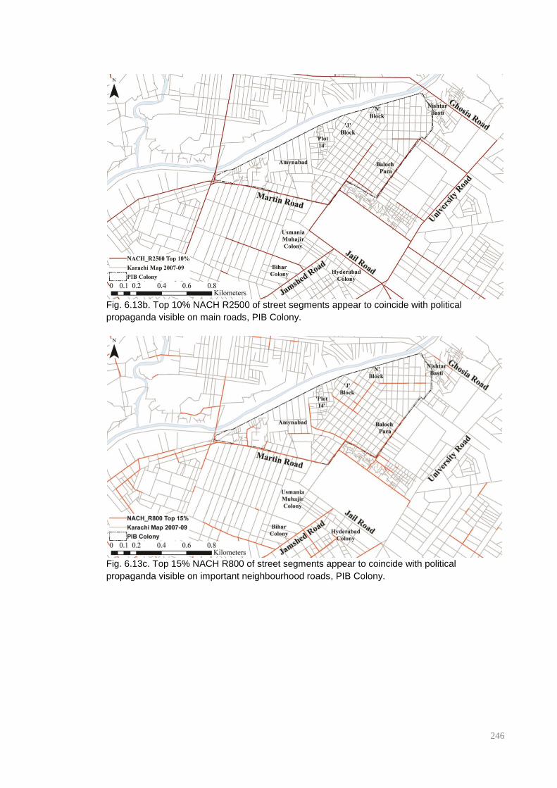
246
Fig. 6.13b. Top 10% NACH R2500 of street segments appear to coincide with political
propaganda visible on main roads, PIB Colony.
Fig. 6.13c. Top 15% NACH R800 of street segments appear to coincide with political
propaganda visible on important neighbourhood roads, PIB Colony.
247
6.2 Spaces of overlap and interface: shopping streets and chai khanas
As can be seen in the previous section, ‘Muhajir’ settlements are complex
spaces where a myriad of communities and political players exist and exercise
varying degrees of control over sections of society and space in simultaneity.
Although the spatial structure and relative segregation of residential
neighbourhoods facilitates the maintenance of ethno-cultural homogeneity and
the perpetuation of religious and cultural practices and political control, there
are still spaces within the settlement that allow for the overlap and co-presence
of the various sub-groups that make up these communities. As the distribution
of political propaganda across the settlements has shown in the previous
section, these spaces are to be found in the public domain in the form of the
settlements’ major thoroughfares and commercial areas, which are essentially
spaces that are occupied and utilised by all sub-groups. The overlap in these
areas of graffiti, billboards and fliers belonging to the different political players
active in these settlements may suggest a competition for ownership but it also
reflects an understanding that these are spaces that allow for a relatively
peaceful, and at times mutually beneficial, co-presence of the various elements
of these so-called ‘Muhajir’ settlements.
As stated above, the relative segregation of residential neighbourhoods helps in
maintaining and perpetuating ethno-religious cultures, this is generally
orchestrated through mosques, community centres, and in this particular case,
political party offices. The rituals and markings of these communal institutions
give a certain local spatiality to these cultural institutions that also speak of
connections to larger trans-spatial, imagined, or virtual communities. Local
commercial areas on the other hand are very much of the space they occupy
and the day-to-day interactions and practices of the inhabitants of the
settlement and the relationships and networks that are built between shoppers,
traders, neighbours and the generally co-present.
In addition to the shopping street as a complete entity, this section analyses the
occurrence and role played by the chai-khana within the settlement. The South
Asian chai-khana is not dissimilar to the British pub or caffe though more closely
associated to the Turkish coffeehouse in that it is a space for lower and lower-
248
middle income men to congregate outside of the home and, like the commercial
area of the settlement, is a space where male members of the community mix
irrespective of their religious and ethnic affiliations. Although their rise in Karachi
is attributed to the arrival of the Muhajir community in the city at Partition, today
these outlets are often owned and run by members of the Pakhtun community,
serving sweet tea and parathas (fried flatbread), both staples of most truck
depots menus. It should be noted that both inter and intra-city transportation in
Karachi is primarily owned and managed by the Pakhtun community hence their
monopoly on such associated functions should not be surprising.
6.2.1 The Shopping Street.
Local commercial areas in these settlements are complex spaces both in the
variety of commercial activity and the kind of ethno-political presence in the
space. The street is generally lined by formal shops, shopkeepers often
extending the display of their wares to encroach on the pavement thereby
effectively extending their commercial space into the public realm of the street.
These may be replaced in the evening by seating, or a barbeque grill organized
by restauranteurs in the vicinity. Hawkers and their stalls then line the edge of
the street selling a range of goods from fresh fruit and vegetables to plastic
containers and cheap children’s toys (Figure 6.14). Though these stalls may
appear to be mobile with hawkers often choosing locations that take advantage
of high footfall within a settlement; e.g. near entrances to public institutions
fronting on to the commercial street or bus stops, spaces where people
naturally tend to gather, in actuality their places in the commercial area are
generally fixed by virtue of them paying some form of ‘rent’ or protection money
on a weekly or monthly basis to local enforcers who in turn are associated with
one of multiple political groups functioning in the area.
As has already been seen in the previous chapter, market spaces within the
settlements are generally located in close proximity to the main points of access
into the settlements thereby facilitating the easy transportation of goods into the
settlement. Additionally the proximity of MQM unit offices to the market place
seems critical to the party’s monitoring of the economic transactions of the
community facilitating the ‘shutter down’ strike - an often used means of political
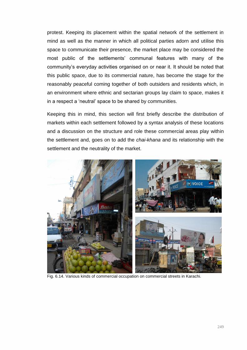
249
protest. Keeping its placement within the spatial network of the settlement in
mind as well as the manner in which all political parties adorn and utilise this
space to communicate their presence, the market place may be considered the
most public of the settlements’ communal features with many of the
community’s everyday activities organised on or near it. It should be noted that
this public space, due to its commercial nature, has become the stage for the
reasonably peaceful coming together of both outsiders and residents which, in
an environment where ethnic and sectarian groups lay claim to space, makes it
in a respect a ‘neutral’ space to be shared by communities.
Keeping this in mind, this section will first briefly describe the distribution of
markets within each settlement followed by a syntax analysis of these locations
and a discussion on the structure and role these commercial areas play within
the settlement and, goes on to add the chai-khana and its relationship with the
settlement and the neutrality of the market.
Fig. 6.14. Various kinds of commercial occupation on commercial streets in Karachi.
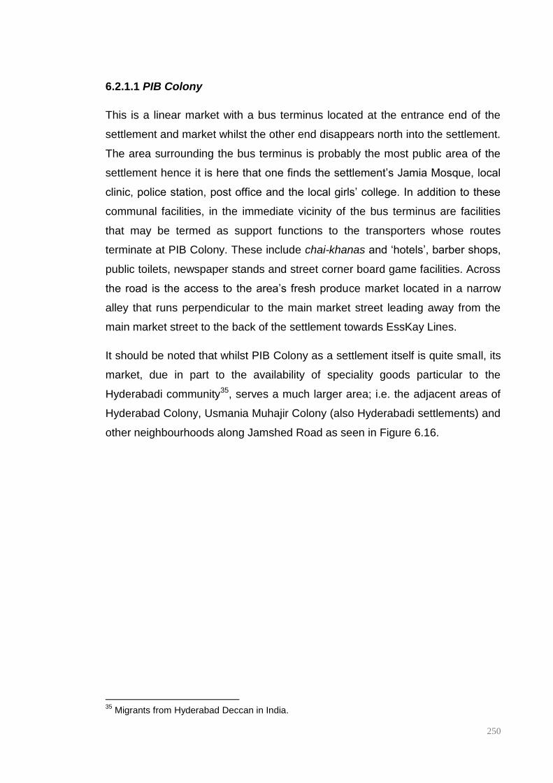
250
6.2.1.1 PIB Colony
This is a linear market with a bus terminus located at the entrance end of the
settlement and market whilst the other end disappears north into the settlement.
The area surrounding the bus terminus is probably the most public area of the
settlement hence it is here that one finds the settlement’s Jamia Mosque, local
clinic, police station, post office and the local girls’ college. In addition to these
communal facilities, in the immediate vicinity of the bus terminus are facilities
that may be termed as support functions to the transporters whose routes
terminate at PIB Colony. These include chai-khanas and ‘hotels’, barber shops,
public toilets, newspaper stands and street corner board game facilities. Across
the road is the access to the area’s fresh produce market located in a narrow
alley that runs perpendicular to the main market street leading away from the
main market street to the back of the settlement towards EssKay Lines.
It should be noted that whilst PIB Colony as a settlement itself is quite small, its
market, due in part to the availability of speciality goods particular to the
Hyderabadi community35, serves a much larger area; i.e. the adjacent areas of
Hyderabad Colony, Usmania Muhajir Colony (also Hyderabadi settlements) and
other neighbourhoods along Jamshed Road as seen in Figure 6.16.
35
Migrants from Hyderabad Deccan in India.
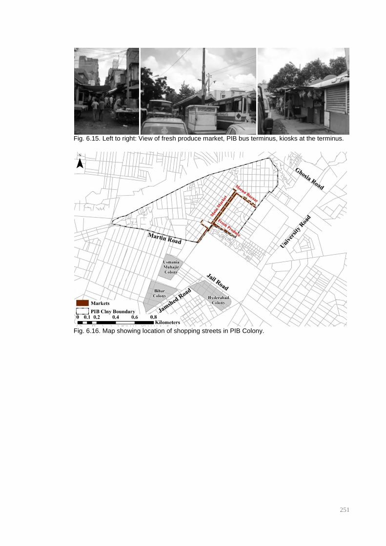
251
Fig. 6.15. Left to right: View of fresh produce market, PIB bus terminus, kiosks at the terminus.
Fig. 6.16. Map showing location of shopping streets in PIB Colony.
252
6.2.1.2 Shah Faisal Colony.
Shah Faisal colony unlike PIB, is made up of multiple neighbourhoods, amongst
them are Shah Faisal Block # 1-5 that are the primary area of study for this
particular locality. Each ‘Block’ or neighbourhood has its own local commercial
area consisting of neighbourhood staples such as general stores (the equivalent
of a corner store), milk shops – these sell milk, bread, eggs and yoghurt,
bakeries and chai khanas. Larger, shared amenities are situated on the ‘main
market’ located at the entry point of the settlement. Here one can find the local
hospital, boys’ undergraduate college, sports club, playing field, cinema, petrol
pump and large ‘shopping centre’ for women’s wear.
It should be noted that, similar to PIB Colony there is a separation of fresh
produce and dry goods in commercial areas. In this case the area’s fresh
produce can be bought at Sabzi Galli (vegetable alley), a street that runs almost
the entire length of the settlement, connecting neighbourhood to
neighbourhood. Similarly, running parallel to this is Resham Galli (Silk Alley) so
named as this is where the locality’s ladies tailors are to be found along with
small outlets selling buttons, laces, ribbons and other tailoring products.
Eateries and chai-khanas are often found at the various roundabouts in the
settlement. The widening of the street at these intersections allows for users to
park their vehicles close to the eatery of their choice and order their meal, often
eating in their parked vehicle. The roundabout in the settlement at the centre of
Shah Faisal Block#5 like PIB Colony, is a transport terminus where minivans
(often known in Karachi as ‘yellow devils’ due to their yellow paintwork and the
speed at which they are driven) and rickshaws end their routes. Again as in the
case of PIB Colony, one sees the clustering of a number of chai-khanas around
this roundabout possibly for the purposes of providing a cheap meal to drivers
and conductors between routes.
The neighbourhood nature of commercial activity having been established, it is
important to note that the market in Shah Faisal Block#1 is actually the oldest
market in the locality more so than the ‘main market’ and thus appears more
developed than the other neighbourhood commercial areas. Vendors here sell a
wide variety of products ranging from gold jewellery to electrical goods.

253
Fig. 6.17. Left to right: View of ShahFaisal Block#1 Market, view of Sabzi Galli, Parked ‘yellow
devils’ in Shah Faisal Block#5.
Fig. 6.18. Map showing location of commercial areas in Shah Faisal Colony.
6.2.1.3 Liaquatabad
Liaquatabad, like Shah Faisal Colony, is composed of multiple neighbourhoods.
For the purposes of this study, the focus will be primarily on four areas, the
neighbourhoods of Bundhani Colony and Qasimabad to the east of Shahrah-e-
Pakistan and Commercial Area and Supermarket to the west of the same
thoroughfare (Figure. 6.20). Due to its location; i.e. proximate to some of the
city’s major thoroughfares as seen in the previous chapter, peripheral blocks
fronting on to these thoroughfares house city-scale furniture and electrical
goods markets but internally, similar to Shah Faisal Colony, each of these
neighbourhoods have their own local commercial streets. The area’s main meat

254
market is located in Bundhani Colony, a narrow street lined with butchers on
both sides just past the neighbourhood library and primary school. One block
away, running parallel to this is the dry goods market.
Across the main road in the neighbourhood known as Supermarket (named
after the purpose built supermarket complex commissioned by Z A Bhutto at the
entrance to the neighbourhood), the same format is applied as that found in
Bundhani Colony; two market streets, one for fresh produce and a parallel
market street for dry goods. It should be noted that whilst commercial street
widths are consistent across the four neighbourhoods in Liaquatabad, fresh
produce market streets appear far narrower and poorly maintained as
compared to their dry goods counterparts. This is often due to the
encroachment by vendors of the edge of street for the purposes of both display
as well as the storage of their produce. This casual encroachment of the public
realm seems to suggest that vendors view the street and its environs as an
extension of their private space. These streets either do not have pavement
areas or these spaces have been extensively encroached upon hence
pedestrians, motorised vehicles and carts used to transport goods utilise the
road in an unintentional form of shared use.
Whilst other neighbourhoods in Liaquatabad Town are old informal settlements,
the localities being studied are high density planned settlements hence at the
centre of each neighbourhood is a school, playing field and
mosque/imambargah. These services are located on the main commercial
street for each neighbourhood. Interestingly, as seen in the previous chapter, it
is within these public facilities situated on the commercial streets and at the
centre of the neighbourhood that MQM unit offices can often be found
particularly in Liaquatabad.

255
Fig. 6.19. Left to right: A market street in Commercial Area, Central communal area, Fresh
produce market in the Supermarket neighbourhood.
Fig. 6.20. Map showing location of commercial areas in Liaquatabad
6.2.1.4 Lines Area
Information pertaining to activities within this particular settlement is limited due
to lack of access during the fieldwork period hence the analysis here is based
on a study carried out by students of the Department of Architecture at NED
UET in Karachi in 2010. The data presented as part of the study was broad,
indicating only where commercial streets are located but giving no indication as
to the kind of products sold therein. Lines Area is an informal settlement
composed of seven smaller neighbourhoods; Central Jacob Lines, Jacob Lines,
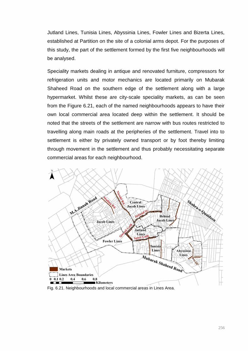
256
Jutland Lines, Tunisia Lines, Abyssinia Lines, Fowler Lines and Bizerta Lines,
established at Partition on the site of a colonial arms depot. For the purposes of
this study, the part of the settlement formed by the first five neighbourhoods will
be analysed.
Speciality markets dealing in antique and renovated furniture, compressors for
refrigeration units and motor mechanics are located primarily on Mubarak
Shaheed Road on the southern edge of the settlement along with a large
hypermarket. Whilst these are city-scale speciality markets, as can be seen
from the Figure 6.21, each of the named neighbourhoods appears to have their
own local commercial area located deep within the settlement. It should be
noted that the streets of the settlement are narrow with bus routes restricted to
travelling along main roads at the peripheries of the settlement. Travel into to
settlement is either by privately owned transport or by foot thereby limiting
through movement in the settlement and thus probably necessitating separate
commercial areas for each neighbourhood.
Fig. 6.21. Neighbourhoods and local commercial areas in Lines Area.

257
6.2.2 Comparative spatial analysis of shopping streets
What can be seen from the discussion so far is that each settlement is a
composition or patchwork of neighbourhoods, some more ethnically or
religiously specific whilst others are more generically Muhajir. The previous
chapter saw the discussion touch upon the shopping street as an interface
between the settlement and the city. This section will argue that the spatial role
of interface extends further to include the manner in which the shopping street
behaves within the settlement.
As can be seen in Figures 6.18 and 6.21 previously, in the case of both Shah
Faisal Colony and Lines Area, shopping streets appear to be located at the
physical interface between neighbourhoods, i.e. the streets that form the
municipal boundary between neighbourhoods. Whilst this may be seen as a
planned urban intervention in Shah Faisal Colony, this is clearly not the case in
Lines Area simply by virtue of the fact that the settlement is unplanned and
informal. Hence this occurrence seems intriguing. This can perhaps be explored
through a syntactic analysis of all shopping streets in the study areas. Graphs
6.04 to 6.08 show Normalised Choice (NACH) values for shopping streets
within the case study settlements across the changing radii at which this study
has been conducted compared to the average Normalised Choice value for
each settlement as a whole. This kind of comparative graphical analysis of
syntax values makes it possible to identify and isolate the radii at which each
shopping street exhibits the highest NACH value whilst simultaneously
illustrating how the shopping streets behave relative to the settlement as a
whole.
Beginning the discussion with shopping streets located in Shah Faisal Colony
and Lines Area, in both cases we see that the shopping streets exhibit higher
choice values than the average value of the settlement with Shah Faisal Colony
exhibiting a peak at a radius of 3000m whilst Lines Area exhibits a similar peak
at 1800m. Figures 6.22 and 6.23 show syntax maps of Shah Faisal Colony and
Lines Area at 3000m and 1800m respectively, these figures illustrate how at
these radii, NACH identifies the local commercial streets. This can be further
highlighted by isolating all street segments above a particular value. In the case
258
of Lines Area by isolating the top 15% of NACH_R1800m street segments – the
peak radius indicated in Graph 6.06 for this locality - most of the shopping
streets are highlighted whilst in the case of Shah Faisal Colony, isolating the top
10% of NACH street segments at a radius of 3000m, shopping streets and high
Choice street segments seem to coincide here too. This seems to suggest that
in both cases local commercial areas naturally gravitate towards high Choice
street segments and that, in these two cases, these high Choice streets seem
to coincide with neighbourhood boundaries suggesting that the ethno-political
neutrality of the shopping street may be partially dependent upon its strategic
positioning within the structure of the settlement.

259
Graph 6.04-6.06. Average NACH values for shopping streets and the settlement; PIB Colony, Shah Faisal Colony & Lines Area
0
0.2
0.4
0.6
0.8
1
1.2
1.4
1.6Shah Faisal
Colony SF Main Market
Shah Faisal Block#1
Shah Faisal Block#2
Shah Faisal Block#3
Shah Faisal Block#5
Shah Faisal Colony
0
0.2
0.4
0.6
0.8
1
1.2
PIB Colony
Shopping Street
PIB Colony Average
0
0.2
0.4
0.6
0.8
1
1.2
1.4
Lines Area
Abyssinia Lines
Central Jacob Lines
Behind Jacob Lines
Jutland Lines
Tunisia Lines
Lines Area

260
Graph 6.07 & 6.08. Average NACH values for wider area shopping streets and the settlement, Liaquatabad.
0
0.2
0.4
0.6
0.8
1
1.2
1.4
1.6
1.8
Liaquatabad Comm_Area#2
Qasimabad#3
Bundhani Clny#2
Liaquatabad Average
0
0.2
0.4
0.6
0.8
1
1.2
1.4
1.6
1.8
2 Liaquatabad Comm_Area#1
S & Comm Area
Supermarket
Qasimabad#2
Qasimabad#1
B&Q#1
Bundhani Clny#1
Liaquatabad Average
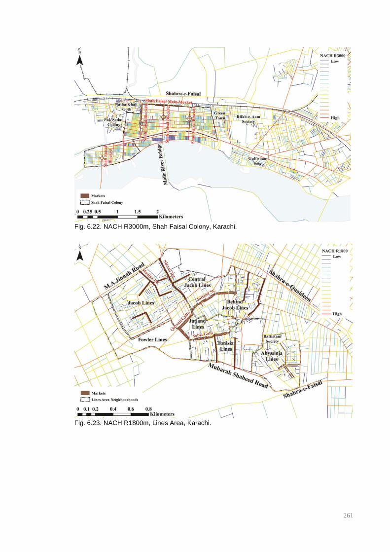
261
Fig. 6.22. NACH R3000m, Shah Faisal Colony, Karachi.
Fig. 6.23. NACH R1800m, Lines Area, Karachi.

262
Fig. 6.24. Top 10% of street segments, NACH R3000m, Shah Faisal Colony, Karachi.
Fig. 6.25. Top 15% of street segments, NACH R1800m, Lines Area, Karachi.
In the case of PIB Colony, the smallest and oldest of the four settlements, the
shopping street appears to be embedded within the settlement as opposed to
being located at the edge of a neighbourhood; the market is situated in such a
way that it appears to be equidistant from most parts of the settlement, with
blocks adjacent to it appearing to not ‘belong’ to any one sub-group as can be
seen in the previous section. Graph 6.04 shows that the shopping street not
263
only has a higher Choice value than the average for the settlement but that it
appears to peak at a radius of 2500m. Similar to both Shah Faisal Colony and
Line Area, upon isolating the top 10% of street segments at NACH R2500m, it
can be seen that most of the commercial spaces within the settlement are
highlighted (Fig. 6.27). In PIB Colony similar to Lines Area, the commercial area
developed organically over time as the settlement matured and was not a space
earmarked for commercial activity when the settlement was first laid out. This
seems to suggest that commercial activity in these settlements naturally
gravitates towards street segments with the highest local choice values.
Whilst this may not be particularly unexpected, what is intriguing though is the
relatively large radius at which PIB’s commercial area seems to peak for such a
small settlement. It should be noted that at its inception PIB Colony sat at the
edge of the city, at a distance from the city’s commercial district and, over time
other Muhajir settlements (Usmania Muhajir Colony, Hyderabad Colony, Bihar
Colony) developed in close proximity to it. Additionally due to the large number
of Hyderabadi residents to be found amongst its earliest residents and in
proximate localities, the commercial area has developed a reputation as a
speciality market selling Hyderabadi jewellery, formal clothing and food. These
elements seem to speak to the wider catchment to which this market appears to
be statistically catering.
Liaquatabad seems to be a combination of the two shopping street types
outlined above; the ‘edge market’ and the ‘embedded market’. Simultaneously it
appears that some neighbourhoods within the settlement are highly integrated
at mid-range radii whilst others are quite segregated causing the shopping
streets to behave in a varied manner. Shopping streets located one step away
from main thoroughfares exhibit reasonably stable, high Choice values – values
above 1.3 – between NACH R800 to NACH R2000m as seen in Graphs 6.07
and 6.08, with NACH R1000m capturing this one-step process most
successfully as seen in figures 6.28 and 6.29. These high choice streets
generally house markets that cater to the wider area whilst shorter, more
segregated commercial areas embedded within the settlement appear to cater
to a much smaller catchment area; these street segments appear to be
highlighted as the top 10% of NACH R200m street segments.
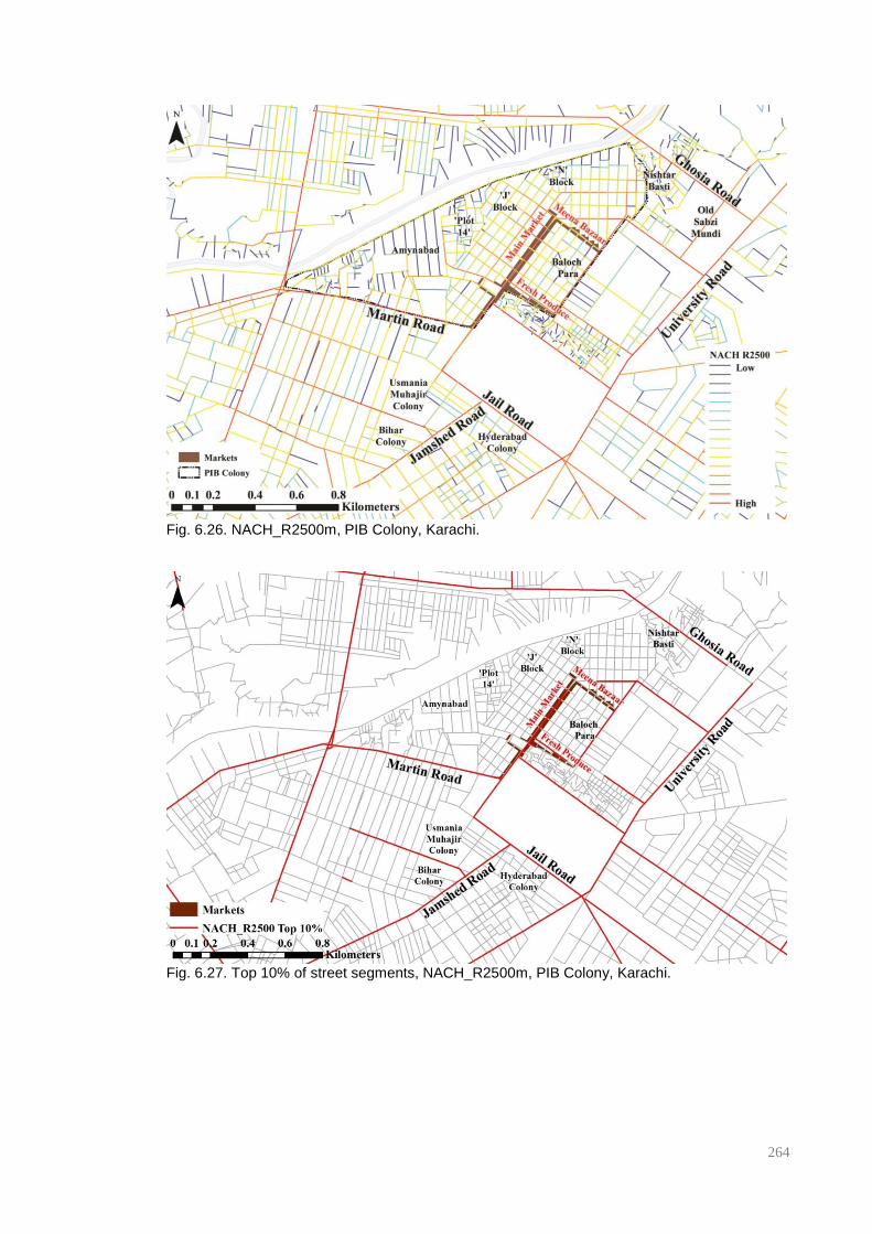
264
Fig. 6.26. NACH_R2500m, PIB Colony, Karachi.
Fig. 6.27. Top 10% of street segments, NACH_R2500m, PIB Colony, Karachi.
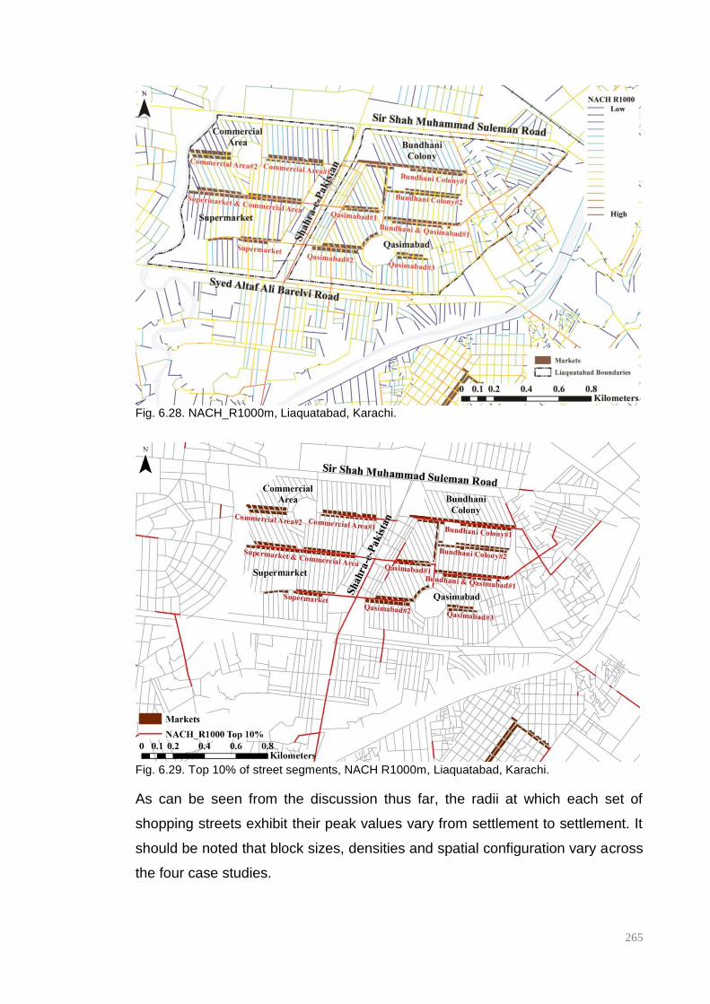
265
Fig. 6.28. NACH_R1000m, Liaquatabad, Karachi.
Fig. 6.29. Top 10% of street segments, NACH R1000m, Liaquatabad, Karachi.
As can be seen from the discussion thus far, the radii at which each set of
shopping streets exhibit their peak values vary from settlement to settlement. It
should be noted that block sizes, densities and spatial configuration vary across
the four case studies.

266
6.2.3 Chai-Khanas
It is important to note that the chai-khana is a common feature of lower-middle
and lower-income areas and is not dissimilar to the coffeehouses of eighteenth
century Istanbul in that often due to the lack of space within the domestic realm,
the coffeehouse became an extension of the domestic space for men, whist the
home was the social sphere of women (Mikhail, 2007). This is reflected in the
manner in which the pavement and street outside the chai-khana is often
appropriated by the proprietor as an extension of the shop to accommodate
patrons as an urban lounge of sorts. This appropriation of outdoor space blurs
the boundaries between the inside and outside of the shop thus opening up the
view of the street from within whilst simultaneously allowing passers-by a view
into the depths of the chai-khana making it very much part of the happenings of
the street.
Fig.6.30. The front façade of a chai-khana is often open to the street allowing for a casual
occupation of the street.
When addressing this issue of location and accessibility, two features of the
chai-khana come to light upon closer examination of the detailed maps of the
study areas (Figures 6.31-6.33): it can be seen that chai-khanas are situated
primarily on the main market streets of the settlements and that they tend to
cluster. The markets streets as has already been seen, generally occupy the
most integrated street segments at the neighbourhood scale – most often the
top 10% of NACH street segments - and are easily accessible from city level
major thoroughfares outside the settlements along which access to public
transport is available. This proximity to main thoroughfares and access to
transportation seems particularly important to the location of chai-khanas; of the

267
98 chai-khanas plotted in the 3 settlements, 67% were situated on street
segments with a NACH Rn higher than 1.3 and, there appears to be a higher
concentration of chai-khanas on streets that are closer to a bus stop (indicated
on the maps below as orange squares) than on those that are not. This is
particularly evident in the case of Liaquatabad and PIB Colony: there is a
noticeable clustering around the bus stop at the entrance to the settlement in
PIB whilst in Liaquatabad commercial streets closest to the Nairang and
Number 10 stops show a clustering of chai-khanas.
The second point of them appearing to cluster is also interesting as they seem
to cluster specifically at intersections; with a number being located either at a
roundabout as in the case of Shah Faisal Colony or at either end of the market
streets as seen in the case of PIB Colony. In the case of both PIB Colony and
Shah Faisal Colony, these intersections are the termini of bus routes in which
case these chai-khanas are supported by the presence of these locations and
this particular function seems to play the role of an interface between varying
degrees of public and private within the settlements whilst simultaneously taking
advantage of the increased footfall required of their commercial nature. The fact
that it caters to a wide range of ethnic and sectarian groups adds to its role as
an interface or a possible place of dialogue.
Fig. 6.31. Location of chai-khanas and bus stops in PIB Colony.

268
Fig. 6.32. Location of chai-khanas and bus stops in Shah Faisal Colony
Fig. 6.33. Location of chai-khanas and bus stops in Liaquatabad.
Graphs 6.09-6.11 show that when plotting the average NACH values of chai-
khanas with the average values for shopping streets and the average of the
settlement, in all cases both chai-khanas and shopping streets out-perform the
average NACH values for the settlement. In the case of PIB, the chai-khanas
appear to out-perform the shopping street possibly due to the fact that they are
primarily located at the entrance of the settlement, proximate to the bus
terminus.

269
Graph. 6.09-6.11. Average NACH values for chai-khanas for 3 case studies.
0
0.2
0.4
0.6
0.8
1
1.2
1.4
PIB Colony
Chai Khanas
Market
PIB Colony Average
0
0.2
0.4
0.6
0.8
1
1.2
1.4
1.6
Liaquatabad
Chai Khanas
Shopping Streets
Liaquatabad Average
0
0.2
0.4
0.6
0.8
1
1.2
1.4
1.6
Shah Faisal Colony
Chai Khanas
Shopping Streets
Shah Faisal Colony
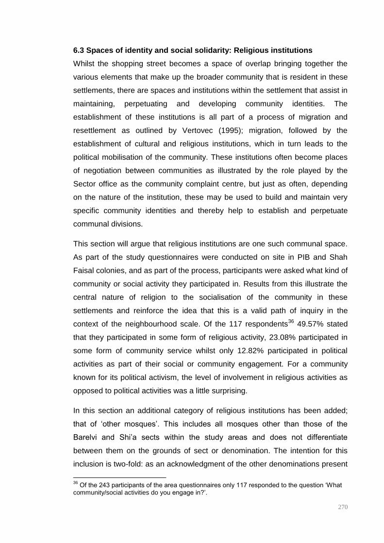
270
6.3 Spaces of identity and social solidarity: Religious institutions
Whilst the shopping street becomes a space of overlap bringing together the
various elements that make up the broader community that is resident in these
settlements, there are spaces and institutions within the settlement that assist in
maintaining, perpetuating and developing community identities. The
establishment of these institutions is all part of a process of migration and
resettlement as outlined by Vertovec (1995); migration, followed by the
establishment of cultural and religious institutions, which in turn leads to the
political mobilisation of the community. These institutions often become places
of negotiation between communities as illustrated by the role played by the
Sector office as the community complaint centre, but just as often, depending
on the nature of the institution, these may be used to build and maintain very
specific community identities and thereby help to establish and perpetuate
communal divisions.
This section will argue that religious institutions are one such communal space.
As part of the study questionnaires were conducted on site in PIB and Shah
Faisal colonies, and as part of the process, participants were asked what kind of
community or social activity they participated in. Results from this illustrate the
central nature of religion to the socialisation of the community in these
settlements and reinforce the idea that this is a valid path of inquiry in the
context of the neighbourhood scale. Of the 117 respondents36 49.57% stated
that they participated in some form of religious activity, 23.08% participated in
some form of community service whilst only 12.82% participated in political
activities as part of their social or community engagement. For a community
known for its political activism, the level of involvement in religious activities as
opposed to political activities was a little surprising.
In this section an additional category of religious institutions has been added;
that of ‘other mosques’. This includes all mosques other than those of the
Barelvi and Shi’a sects within the study areas and does not differentiate
between them on the grounds of sect or denomination. The intention for this
inclusion is two-fold: as an acknowledgment of the other denominations present
36
Of the 243 participants of the area questionnaires only 117 responded to the question ‘What community/social activities do you engage in?’.
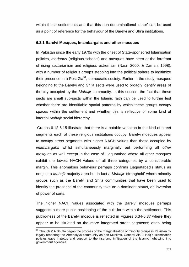
271
within these settlements and that this non-denominational ‘other’ can be used
as a point of reference for the behaviour of the Barelvi and Shi’a institutions.
6.3.1 Barelvi Mosques, Imambargahs and other mosques
In Pakistan since the early 1970s with the onset of State-sponsored Islamisation
policies, madaaris (religious schools) and mosques have been at the forefront
of rising sectarianism and religious extremism (Nasr, 2000, & Zaman, 1998),
with a number of religious groups stepping into the political sphere to legitimize
their presence in a Post-Zia37, democratic society. Earlier in the study mosques
belonging to the Barelvi and Shi’a sects were used to broadly identify areas of
the city occupied by the Muhajir community. In this section, the fact that these
sects are small sub-sects within the Islamic faith can be used to further test
whether there are identifiable spatial patterns by which these groups occupy
spaces within the settlement and whether this is reflective of some kind of
internal Muhajir social hierarchy.
Graphs 6.12-6.15 illustrate that there is a notable variation in the kind of street
segments each of these religious institutions occupy. Barelvi mosques appear
to occupy street segments with higher NACH values than those occupied by
imambargahs whilst simultaneously marginally out performing all other
mosques as well except in the case of Liaquatabad where all other mosques
exhibit the lowest NACH values of all three categories by a considerable
margin. This anomalous behaviour perhaps confirms Liaquatabad’s status as
not just a Muhajir majority area but in fact a Muhajir ‘stronghold’ where minority
groups such as the Barelvi and Shi’a communities that have been used to
identify the presence of the community take on a dominant status, an inversion
of power of sorts.
The higher NACH values associated with the Barelvi mosques perhaps
suggests a more public positioning of the built form within the settlement. This
public-ness of the Barelvi mosque is reflected in Figures 6.34-6.37 where they
appear to be situated on the more integrated street segments; often being 37
Though Z.A.Bhutto began the process of the marginalisation of minority groups in Pakistan by legally rendering the Ahmediyya community as non-Muslims, General Zia-ul-Haq’s Islamisation policies gave impetus and support to the rise and infiltration of the Islamic right-wing into government agencies.
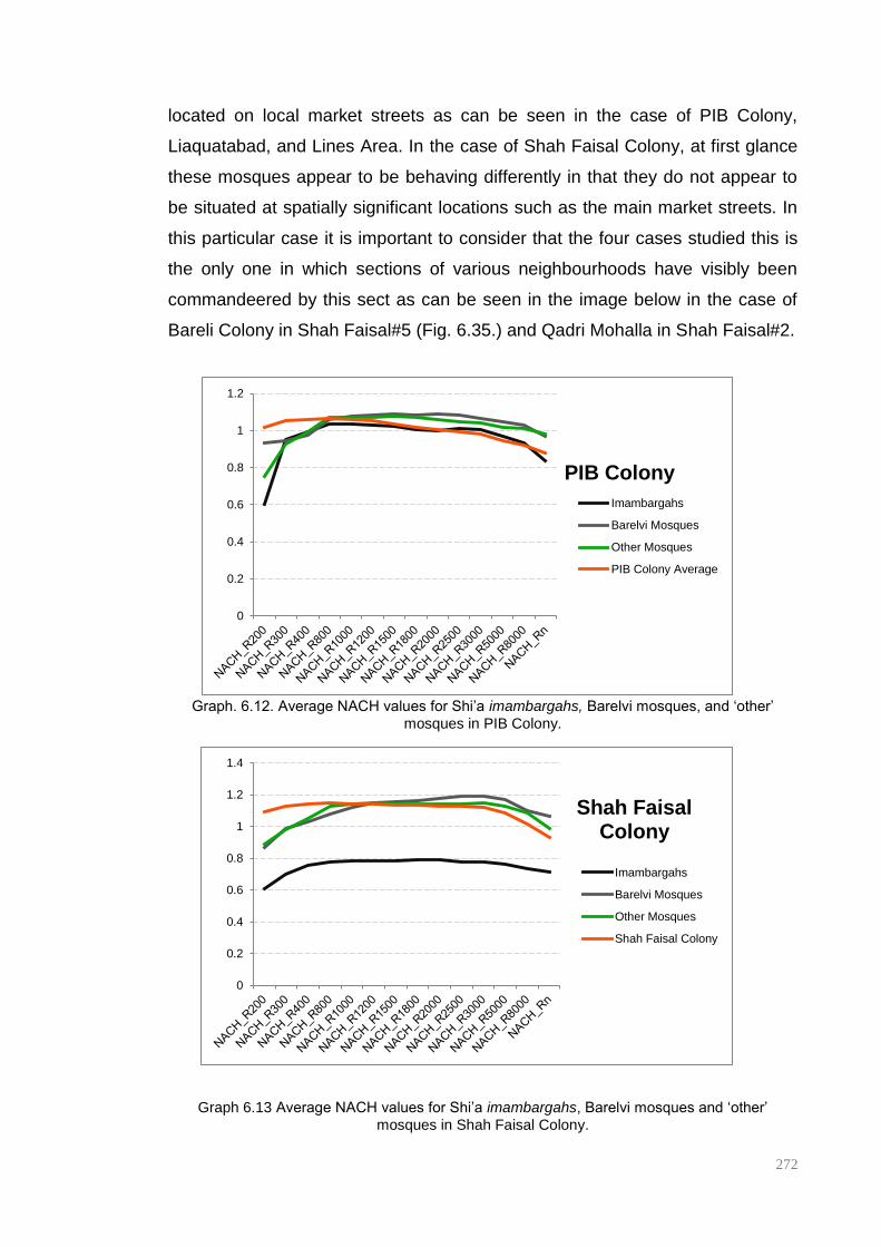
272
located on local market streets as can be seen in the case of PIB Colony,
Liaquatabad, and Lines Area. In the case of Shah Faisal Colony, at first glance
these mosques appear to be behaving differently in that they do not appear to
be situated at spatially significant locations such as the main market streets. In
this particular case it is important to consider that the four cases studied this is
the only one in which sections of various neighbourhoods have visibly been
commandeered by this sect as can be seen in the image below in the case of
Bareli Colony in Shah Faisal#5 (Fig. 6.35.) and Qadri Mohalla in Shah Faisal#2.
Graph. 6.12. Average NACH values for Shi’a imambargahs, Barelvi mosques, and ‘other’
mosques in PIB Colony.
Graph 6.13 Average NACH values for Shi’a imambargahs, Barelvi mosques and ‘other’
mosques in Shah Faisal Colony.
0
0.2
0.4
0.6
0.8
1
1.2
PIB Colony
Imambargahs
Barelvi Mosques
Other Mosques
PIB Colony Average
0
0.2
0.4
0.6
0.8
1
1.2
1.4
Shah Faisal Colony
Imambargahs
Barelvi Mosques
Other Mosques
Shah Faisal Colony

273
Graph 6.14Average NACH values for Shi’a imambargahs, Barelvi mosques and ‘other’
mosques in Liaquatabad.
Graph 6.15 Average NACH values for Shi’a imambargahs, Barelvi mosques and ‘other’
mosques in Lines Area.
It should be noted that the imambargah differs in its role within the community
from that of a mosque in that it is more a community centre where religious rites
such as those associated with the commemoration of the martyrdom of Imam
Hussain and his family in the month of Muharram are practiced as well as being
a place where religious artefacts are stored. Often there is a prayer space
attached to this community space. It is a space where the community comes
together, this includes women, members who are generally excluded from the
mosque in the South Asian context.
0
0.2
0.4
0.6
0.8
1
1.2
1.4
Liaquatabad
Imambargahs
Barelvi Mosques
Other Mosques
Liaquatabad
0
0.2
0.4
0.6
0.8
1
1.2
Lines Area
Imambargahs
Barelvi Mosques
Other Mosques
Lines Area Average
274
As has already been seen in the case of both PIB Colony and Shah Faisal
Colony earlier in this chapter, this sub-group’s clustering seems more apparent
than in the case of the Barelvi community. This sense of clustering is
heightened by the fact that these sub-settlements have locally been named
giving them an identity of their own; Plot Chowdah (Plot 14) in PIB Colony, Pak
Sadat Colony in Shah Faisal Colony and Baltistani Society in Lines Area. Local
Shi’a imambargahs, as opposed to the public positioning of Barelvi mosques, in
three out of the four case studies are found to be embedded deep within these
well-defined sub-settlements. Whilst this kind of relationship is not identifiable in
Liaquatabad, there is a noticeable absence of imambargahs outside the
Commercial Area neighbourhood suggesting a possible clustering of the
community in this particular locality of Liaquatabad (Figs. 6.38-41).

275
Fig. 6.34. Location of Barelvi mosques in PIB Colony, NACH R2500m
Fig. 6.35. Location of Barelvi mosques in Shah Faisal Colony, NACH R3000m.
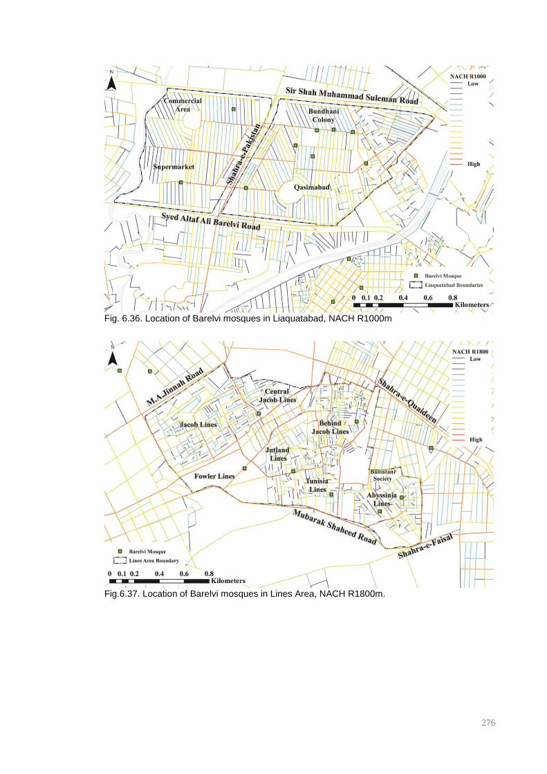
276
Fig. 6.36. Location of Barelvi mosques in Liaquatabad, NACH R1000m
Fig.6.37. Location of Barelvi mosques in Lines Area, NACH R1800m.

277
Fig. 6.38. Location of Imambargahs at NACH R2500m, PIB Colony.
Fig. 6.39. Location of imambargahs at NACH R3000m, Shah Faisal Colony.
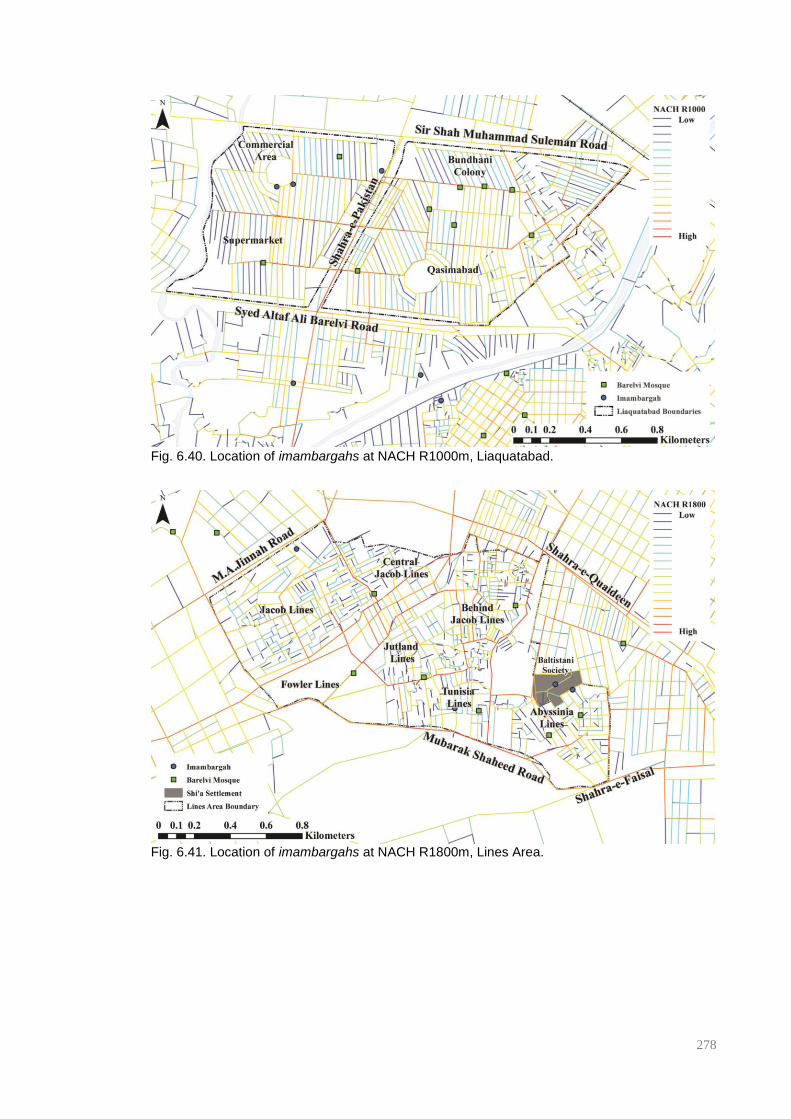
278
Fig. 6.40. Location of imambargahs at NACH R1000m, Liaquatabad.
Fig. 6.41. Location of imambargahs at NACH R1800m, Lines Area.

279
The spatially segregated nature of the Shi’a sub-settlement, and the introverted
form of the imambargah within the settlement is perhaps indicative of the social
space this religious group occupies within Pakistan. The Shi’a community is a
group that has been persecuted as a by-product of State-sponsored
Islamisation that was formally instituted in the early 1970s. Over the years,
there has been a systematic targeting of the community’s intelligentsia and well
positioned professionals, a trend that is changing in recent times to more ‘rank-
and-file members of the society’ (Khan, 2012). These attacks are carried out
primarily by right-wing Sunni factions such as the ASWJ and the Lashkar-e-
Jhangvi (L-e-J). In recent years there has been an escalation of sectarian
violence where since 2009 a number of religious buildings and events have
been bombed to devastating effect. These kinds of targeted nationwide attacks
of the community are perhaps partially responsible for their preference for
segregated, defensible localities where imambargahs are located deep within
the settlement and, if they appear to be located with higher accessibility – and
therefore greater vulnerability to attack - entrances are often turned away from
the main street thereby limiting direct access. Additionally, in recent years, there
has been an increase in the amount of security and surveillance measures put
in place by the community in the vicinity of imambargahs, a change visible
across the city with barricades and metal-detectors erected around entrances
and police mobiles on patrol on the run up to high and holy days.
The obvious difference in the location of Barelvi mosques and Shi’a
imambargahs as discussed above is potentially indicative of the place these
communities occupy within Pakistani society; in a country where the majority is
Sunni and extremism is on the rise, the very public location of Barelvi mosques
against the embedded nature of the imambargah seems to suggest one
community that is growing in strength (both political and militant) whilst the other
is threatened, facing a growing number of challenges as society becomes less
and less tolerant and secular.
This analysis has shown that broad community identities appear to be useful for
political mobilisation at the city scale as seen in the previous chapter, enabling
the community’s political representatives to appropriate space and manipulate
urban development in the city to their advantage. But at the
280
settlement/neighbourhood scales, it appears that people revert to specific ethnic
and sectarian solidarities.
6.4 Comparative analysis of communal institutions.
When all communal spaces similarly arrayed for each settlement are studied,
certain similarities emerge with regard to the location and spatial behaviour of
each communal space within the spatial structure of the settlement.
The Graphs 6.16-19 show that the average NACH values for shopping streets
in each of the case study areas are higher than the average NACH value for
their corresponding settlement. Imambargahs consistently appear as the least
accessible of communal institutions across settlements, whilst Barelvi mosques
and chai-khanas appear to be located on higher choice streets. This brings to
light a consistent gradation of accessibility of communal institutions within the
settlement with imambargahs, and Shi’a settlements by extension, being highly
introverted and segregated, whilst Barelvi mosques are almost as public as
chai-khanas and local shopping streets. This seems to suggest that the Barelvi
community is perhaps more confident in their occupation of space where they
have a religious presence in the most public of communal spaces within the
settlement; the main commercial area, and a political presence in the form of
graffiti displayed in the back streets of the settlement and close to their religious
centres. This perhaps suggests a significant religious confidence but also a
slow political emergence that at present is not perceived as a real threat to the
political dominance of the MQM as suggested by the simultaneous presence of
MQM slogans and PST graffiti in the back streets of the settlements.
Interestingly MQM Units show no settlement scale consistency, spatial
behaviour changing from settlement to settlement, the only consistency being
that they appear to exhibit higher NACH values than even the local shopping
streets at higher radii. This is perhaps not so surprising, as this suggests that
despite proximity to the shopping street in most cases as seen earlier, the
statistical distribution of the political structure of the party seems to relate more
to the city-scale occupation and dominance of space than to the local scale of
the neighbourhood.

281
Graph. 6.16. Average NACH values for all communal institutions in PIB Colony.
Graph. 6.17. Average NACH values for all communal institutions in Shah Faisal Colony
0
0.2
0.4
0.6
0.8
1
1.2
1.4
PIB Colony
PIB Colony Average
Shopping Street
Chai Khanas
Unit
Barelvi Mosques
Imambargahs
0
0.2
0.4
0.6
0.8
1
1.2
1.4
1.6 Shah Faisal Colony
Shah Faisal Colony
Shopping Streets
Chai Khanas
Units
Barelvi Mosques
Imambargahs

282
`Graph. 6.18. Average NACH values for all communal institutions in Liaquatabad .
Graph. 6.19. Average NACH values for all communal institutions in Lines Area.
6.5 Discussion
Through a process of mapping and analysing the presence and location of
religious institutions, political propaganda and sub-group clusters, this chapter
has brought to light is the fact that these ‘Muhajir’ settlements are far from
ethnically or even politically for that matter, homogenous. Whilst the Muhajir
community is by far the largest ethnic group resident within these settlements,
other ethno-political communities also reside within these areas and have been
0
0.2
0.4
0.6
0.8
1
1.2
1.4
1.6
Liaquatabad
Liaquatabad Average
Shopping Streets
Chai Khanas
Units
Barelvi Mosques
Imambargahs
0
0.2
0.4
0.6
0.8
1
1.2
1.4
Lines Area
Lines Area Average
Shopping Streets
Units
Barelvi Mosques
Imambargahs

283
resident there for quite some time, forming an integral part of the socio-spatial
culture of these areas with some communities being resident on these sites well
before the arrival of the Muhajireen. This process of mapping and analysis has
also shown that the Muhajir community itself is an amalgam of sub-groups
defined by their place of origin and/or religious affiliation. that the spatial
network analysis of ethno-religious enclaves within the settlement and the
location of religious buildings therein has shown that smaller minorities within
the Muhajir spectrum like the Shi’a and Ismaili communities choose to almost
cloister themselves in peripheral areas of the settlements.
With regard to spaces of communal overlap and interaction, the shopping street
not only plays a role in shaping the local interface between the city and the
settlement as seen in the previous chapter but, along with the chai-khana, acts
as an interface between communities within the settlement: operating as a
mediator between the politically monitored private realm of the residential
neighbourhood and the relatively neutral space of the public realm of the
settlement and beyond. This has been seen by the manner in which commercial
areas often occupy spaces between neighbourhoods, thereby catering to more
than one neighbourhood. Where shopping streets are embedded within the
settlement, these spaces appear to be equidistant from all identifiable sub-
community clusters, thereby essentially placing them in the neutral spaces of
the settlement. This has been further illustrated by the variety of political parties
that have a visual presence on these streets, ranging from small ethno-specific
groups to large right-wing religious outfits.
Of the spaces of identity building and social solidarity, mosques and
imambargahs appear to be more neighbourhood-based, on average serving an
area within an 800m radius as seen in chapter 4. This has been further
substantiated by the fact that each identifiable ethno-religious sub-cluster
seems to have its own religious building situated within the enclave. These
religious buildings appear to be more neighbourhood-based than the Unit
offices discussed in the previous chapter, which appeared to be serving a larger
catchment of 1800m. Between the imambargah and the Barelvi mosque, the
imambargah appears to be more inward looking than the Barelvi mosque
despite the fact that both represent smaller sub-sets of the Islamic faith.

284
Imambargahs were generally found to be set deep within the settlement and
often embedded within an acknowledged Shi’a sub-settlement that in turn
appeared to be highly segregated whilst community boundaries around Barelvi
mosques appeared to be more fluid generally indicated simply by the presence
of graffiti supporting the Pakistan Sunni Tehreek. This perhaps speaks of an
internal Muhajir hierarchy whereby smaller minorities either choose or are
pushed to both the spatial and social peripheries of the community, the main
space of both identity and the settlement being occupied by more main-stream
sub-identities.
6.6 Conclusion
This chapter sought to investigate the internal ethno-spatial structure of the
settlement and examine the spaces of ethno-political overlap and interaction, as
well as spaces that build and maintain discrete ethno-spatial identities within the
settlement. Though the term Muhajir has been used to describe this community
as a whole from very early in their history, giving the impression of a
homogenous entity, the above analysis has shown that despite over 60 years of
spatial proximity, political marginalisation and a political re-awakening built
around their common experiences as migrants, internal sectarian and ethnic
sub-divisions have persisted and manifested themselves in the spaces of the
settlement. This suggests that whilst political rhetoric and public opinion projects
this community to be monolithic, the everyday spaces they occupy are far more
nuanced; here sub-divisions are manifest and maintained spatially through the
strategic positioning of ethnic, religious and political institutions that monitor the
everyday occurrences of the settlement. The simultaneous existence of
communal and spatial sub-divisions of both Muhajir and non-Muhajir groups as
well as spaces of mixed use such as the market, the chai-khana, and, in some
cases, the local bus stop or transport terminus, all within the same settlements
suggests that despite externally perceived ethnic homogeneity and a degree of
political cohesion, dialogue and negotiation between communities is a daily
event at the micro-scale of the settlement.
285
7.
Discussion and conclusion
7.1 Introduction:
The purpose of this study was to analyse the spatial presence of the Muhajir
community; a unique ethno-political entity that is a minority group at a national
scale whist forming the local majority in the city of Karachi, and the primary
question this study sought to investigate was ‘What has been the nature and
the dynamics of spatial, social and political interactions between the
Muhajir community and the city in Karachi?’. The intention was, through an
analysis of the development of the community’s identity and spaces over time,
to investigate the impact their presence has made on the space and spatial
politics of the city and vice versa. The formulation of this overarching question
was based in an instinctive understanding as a ‘Karachiite’ that the spatial
organisation of the city and the manner in which it functions was intrinsically
linked to the ethno-politics of its myriad migrant groups. But this subjective
observation had to be systematically investigated across the various scales of
the city to truly understand and articulate the spatial nature of ethno-politics in
the city. Hence, this broad research question was further refined into sub-
questions that facilitated a diachronic, multi-scalar approach to the analysis.
These questions are as follows:
Are the Muhajir community clustering, as minority communities tend to
do, in Karachi? If so, is there any significance to where they are
clustering? And, how have these spaces and the community’s identity
been transformed through time and their changing socio-political and
socio-economic circumstances?

286
How has continued spatial clustering in the localities that the community
has claimed impacted their relationship with the city? And, as these
Muhajir areas of influence interface with the city, what form do these
spaces of interface take and are there identifiable socio-spatial
characteristics to the spaces beyond these interfaces that the community
occupy that defines them as Muhajir?
How are the various groups that comprise Muhajir majority settlements
organised spatially? Are the various ethno-political entities spatially
identifiable? What kind of spaces form the interface where these
identities overlap and interact as well as help to build and maintain these
discrete ethno-political identities, solidarities and divisions within the
context of the Muhajir settlement?
By charting the various elements of the Muhajir experience, this thesis has
shown that there is a clear political element to their ethno-spatial identity. This
can be deconstructed into five distinct socio-spatial phases: their arrival and
initial spatial clustering, followed by a period of socio-political and spatial
marginalisation by the state resulting in a political re-imagining and spatial
expansion to appropriate adjoining areas to their initial settlements, at which
point state sponsored political suppression resulted in spatial fortification and
socio-political militarisation, and finally political domination and spatial control.
Simultaneously, this multi-scalar, diachronic, socio-spatial analysis has shown
that within this process of Muhajir migration, resettlement and re-imagining, a
few broad themes have emerged; the role played by clustering in the
emergence of an ethno-political identity, the re-imagining of Karachi as a
promised/homeland for the Muhajireen, the nature of spaces of interface as
zones of both dispute as well as dialogue in an evolving migrant environment
and, the key role played by communal institutions in building and maintaining
the ideological as well as the spatial nature of communal identities. These
themes will be discussed in further detail in the following sections.
287
7.2 Clustering and establishment of a community
This particular theme relates to the questions posed in chapter 4 pertaining to
issues of spatial clustering, whether there is any significance to where the
community is located and the temporal transformation of the community and
their spaces. The analysis in chapter 4 has shown that the Muhajir community
clustered and have continued to cluster through its Post-Partition history as
shown by the overlapping of initial Muhajir settlements and today’s demarcation
of Muhajir majority areas. The driving force behind this clustering has varied
across the community’s various economic brackets and through the
community’s history in the city. Their earliest settlements were a combination of
choice and enforced clustering depending on the economic bracket; the wealthy
were able to negotiate the allotment of centrally located real estate with the
state (Ansari, 2005) whilst the lower and lower-middle income groups were
cleared out of the inner-city and forcibly relocated to the then peripheries of the
city. As has been discussed earlier, this displacement took the form in some
cases of planned housing schemes for civil servants etc., whilst others were
relocated to far flung industrial estates as their dissatisfied presence close to
the civic and administrative centres of the fledgling government proved to be
un-nerving for the state. Over time, economic constraints in the form of rising
real estate values and diminishing access to public sector education and jobs
for Sindh’s urban residents, and self-preservation have become the primary
motivation behind the persistence of clustering. Low and lower-middle income
areas have densified as families have grown and been unable to move out and,
as the community’s cultural identity has become synonymous with their political
identity, this in turn has been systematically targeted by the state, resulting in
wealthy Muhajir communities moving away to distance themselves from the city
heartland, their places quickly taken by those eager for the protection and
sense of belonging this affiliation provides.
These socio-economic limitations appear to be mirrored by spatial constraints
within their settlements. The dense street networks, small plot sizes, limited
number of points of entry and the location of major thoroughfares or
topographical features (Large scale obstacles in the urban fabric) (Vaughan
288
and geddes, 2009) that make it difficult to integrate their settlements into the
wider locality seems to have created a socio-spatially closed environment.
As discussed earlier, it has been posited that spatial proximity facilitates not
only the consolidation of identity but also gives greater clarity to belief structures
(Shirlow and Murtagh, 2006, Sennett, 1996). In the case of cities like Belfast,
such a close system not only leads to the realisation of various cultural and
religious ideologies, but allows for the emergence of paramilitary cultures as
well (Shirlow and Murtagh, 2006). In the case of the Muhajir community, this
enforced spatial proximity has in part facilitated the emergence of the Muhajir
phenomenon; the concretisation of an ethno-political Muhajir identity and its
subsequent militarisation are in part the result of a closed system where
communities from disparate geo-cultural backgrounds that have been similarly
marginalised by the state have been forced into close proximity. The idea that
enforced proximity and spatial densities facilitate the militarisation of ethnic
identities is further supported by the fact that the MQM as a movement found its
greatest traction in the dense Urdu-speaking neighbourhoods of Lines Area,
Golimar and Liaquatabad (Baig, 2005), localities that the cluster analysis
identified as areas exhibiting high densities of Muhajir identity markers as well
as being some of the oldest informal Muhajir settlements and the areas
highlighted as flashpoints of violent activity as shown in chapter 5.
As stated above, the reasons for continued clustering have changed as the
community and its identity have matured. Similarly, as described by the spatial
transformation of the city in chapter 4, as the city has grown, the geographical
location of the spaces allotted to the Muhajir community too have changed
whereby today they no longer occupy the peripheries of the city. In fact, as can
be seen through this analysis, Muhajir majority areas today occupy the
geographical centre as well as the integration core of the city making them not
only centrally located but easily accessible and highly connected as well. By
mapping the chronological development of the community both spatially as well
as politically a correlation between political strength and physical presence
becomes apparent. The analysis has shown that as newer migrants have
arrived or as communities in inner-city squatter settlements are displaced and
relocated, the result of ongoing infrastructure development projects in the city,

289
the highly segregated peripheries are moving steadily inland and further away
from the city centre, and being occupied by these newly displaced migrant
communities. Simultaneously, many of the affluent communities earlier situated
in close proximity to the highly integrated city centre have now relocated to the
spatially segregated, ethnically and politically mixed southern peninsula of
Defence and Clifton. The latter is an area comprised of a patchwork of military
managed housing schemes and affluent gated communities. This relocation and
reorganisation of the city’s various socio-economic groups speaks of two kinds
of ghettoisation; that of the ghetto for the urban poor and the exclusivist enclave
for the affluent (Marcuse, 1997). Both whilst equally segregated are the result
completely different processes and have different socio-economic implications
for their residents. The peripheralisation of affluent communities was a process
of choice, the movement out of the old city centre and segregated nature of
their areas allows these communities a degree of security and protection from
the ethno-political upheavals associated with the central areas of the city. On
the other hand, the state imposed peripheralisation of poor inner-city
communities has had a negative impact on accessibility to employment and
education – up to 50% of working women in relocated communities have lost
their jobs and young men have had to give up their education to find work so as
to compensate financially (Sattar, 2012) - as well as added cost of a longer
more complicated commute to and from work.
These socio-spatial urban inequalities where the two ends of the economic
spectrum occupy the segregated peripheries of the city helps to reconfirm the
economic definition of the areas occupied by the Muhajireen as middle-income
localities. It is important to note that these centrally occupied middle-income
areas are not only culturally Muhajir but more specifically, as illustrated by the
presence of MQM units and electoral results since 1988, are politically Muhajir.
These socio-spatial features demonstrate the transition of the community from
its rag-tag refugee status to that of a middle-income, politically active, urban
entity, and speak of an inversion of power whereby a national minority, through
spatial proximity and densities has capitalised on its local majority status. What
impact this power politics has had on the space of the city will be discussed in
the following section.
290
7.3 Re-imagining the Promised homeland.
As posited by Coakley (2003), minority groups go through a three part self-
actualisation process; i) asking for the rights of the individual, ii) official
acknowledgement of the distinctiveness of the group from the host community,
and iii) demanding the right to ‘territory’. The Muhajir community are no different
in that State sponsored clustering of this community led to a self-awareness
whereby the definition of the label ‘Muhajir’ has evolved; from migrant or
refugee to connoting an ‘ethnicity’ that in turn has evolved into a formidable
political entity eager to stake their claim on land and votes in the city.
As discussed in the literature review, one of the most commonly used means of
breaking with old colonial patterns and reclaiming the post-colonial city has
been the renaming of city streets and public spaces to commemorate local
heroes, leaders, and events. Karachi was no different; Queens Road became
Moulvi Tamizuddin Khan Road, Victoria Road became Abdullah Haroon Road
and Lawrence Road became Nishtar Road to name but a few examples. In the
case of the Muhajir community we see a similar desire to stake a claim whilst
simultaneously establishing a connection to the towns and cities they had left
but still considered ‘home’. This they did in the initial phase of their settlement
by naming their newly occupied areas after these towns, hence Karachi saw the
emergence of settlements named Hyderabad Colony, Bangalore Town and
Bahadurabad (Ansari, 2005), and continues today in the form of Muhajir
monuments commemorating ‘martyrs’ of their cause and the use of political
propaganda to mark ‘their space’.
This demand for territory has at various points in recent times surfaced as a
literal demand for sovereignty in the form of ‘Jinnahpur’, a Muhajir breakaway
state for which documents were allegedly recovered during paramilitary raids in
1992 on Nine Zero, and more recently in the call for the secession of Karachi
and other urban centres in Sindh from Pakistan in one of Altaf Hussain’s
telephonic addresses to MQM activists. But, perhaps the most effective
manifestation or interpretation of this notion of a demand for territory is the
consolidation, adaptation and control of Muhajir occupied space in Karachi’s
central and eastern districts as has been seen in this study. This in part
291
responds to the questions posed in chapter 5 regarding the impact the
continued spatial clustering of the community in certain localities has had on
their relationship with the city.
The spatio-temporal continuity of Muhajir clusters as the community’s political
strength increased has meant that as the city has grown and sprawled inland,
the community has colonised contiguous localities. Thus this once marginalised
community now occupies the strategic geographic centre allowing them access
to and control of all major routes connecting the port – the city’s main economic
draw - to the peripheries of the city. Access to political power has meant that
they have been able to consolidate this centrally located stronghold,
strengthening transport links within the main Muhajir block as well as
addressing the global accessibility of their peripherally located satellites. Whilst
this process may not have been able to holistically integrate the Muhajir satellite
areas to the east, the comparative analysis between 1974 and 2007 has shown
that it has extended the physical access from Nine Zero – their political hub -
considerably. Within the confines of this strong core, the MQM are able to erect
and maintain barricades and look-outs with impunity, call for strikes - shutting
down all major commercial centres within their jurisdiction and commandeering
major thoroughfares for protests and rallies - effectively bringing the city to a
standstill. This manoeuvring of both the political and planning will of the city has
essentially established the centre as socio-economic citadel for the community.
This consolidation of resources at the centre becomes even more apparent
when juxtaposed against the lack of state sponsored development and
provision of services to the outer limits of the city, home to newer, poorer
migrants. This lop-sided treatment of migrant areas is not uncommon where
residential exclusion is often accompanied by limited access to services and
facilities (Legeby, 2009) only heightening the sense of isolation and disregard
by the state. In some cases the local government has taken it one step further
where, by the strategic location of flyovers and by-passes as seen by the
construction of a flyover at Bachcha Khan/Banaras Chowk and the Qasba North
Nazimabad Link Road, two connections between North Nazimabad and Orangi
town, there has been a concerted effort to not only serve their own community
but to by-pass other migrant communities in the vicinity altogether, thereby

292
isolating these areas further and making them the perfect incubators for
extremist/separatist activities. This brings Shirlow and Murtagh’s notion of highly
spatially segregated and ideologically divided communities becoming the
perfect breeding ground for paramilitary identities full circle, whereby those that
were marginalised now impose this marginalisation on others and thus establish
a vicious cycle of militarised politics as seen in Karachi today.
7.4 Spaces of interface: dialogue or dispute
This multi-scalar analysis has shown that not only does the nature of the
Muhajir cluster change across the various scales of the city, the nature and
scale of the interface between the community and the city changes as well.
The historical analysis showed that the Muhajir majority areas seemed to be
formed through the development of mostly contiguous neighbourhoods with a
few outlying satellites, all generated outwards from the earliest Muhajir
settlements located at the edges of the old city. As has been seen through the
spatial network analysis in chapter 5, today the centre of this Muhajir block
appears to have shifted both geographically as well as ideologically further
north of the old centre closer to Nine Zero and its environs. This political shift is
significant when discussing how and where the community interfaces with the
rest of the city and its residents.
At the scale of the city, as has already been seen, the interface lies at the
peripheries of the Muhajir block; these are spaces of potential conflict as seen
by the clustering of violent incidents in chapter 5. As already discussed, these
violent incidents are the eventual outcome of an ongoing process of migration
and settlement. The continued in-migration of both domestic and international
migrant groups resulting in the spatial clustering of these dissimilar ethnic
groups in segregated peripheral areas which in turn has led to increasing
competition amongst these groups for a limited supply of space, employment
and access to services, resulting in the subsequent emergence of ethno-
political identities to facilitate access to the above. As competition has become
tougher, these identities in turn have been militarised, a process made easy
through the ready access to arms and ammunition in the city since the 1980s.
293
The concentration of violent incidents in certain areas of the city – many of
which are areas that have been historically troubled regions of the city with both
Muhajir and non-Muhajir communities - seems to suggest that the greater the
distance from the ‘centre’ –in this case it is the political centre of the community
– the higher the probability of inter-community tension. This shows that as
distance from the political centre increases, political power diminishes and the
borderlands become spaces of contestation and conflict. It should be noted that
this contestation of space and votes is primarily of two types, the first being
internal Muhajir political conflicts between the MQM and other political groups
vying for the Muhajir vote such as the Jamaat-e-Islami and the MQM-H, with the
second being communal tension between the MQM and other ethno-political
entities, the Pakhtun community in particular. Whilst this is fundamentally an
issue of land, votes and power, in the case of inter-community conflict, it is
important to note that this clash of communities is not only of space and
resources but also of conflicting societal structures; Muhajir urbanism clashes
with rural, tribal migrant social structures.
The intermediary interface, where the individual settlement meets the city, is an
interesting strategic combination of proximity to major through movement
streets and an underlying sense of control. As discussed in chapter 5, most
Muhajir settlements are proximate to - up to 2 turnings away – from a main
thoroughfare or a street most likely to be used for movement through the city,
this allows them easy access to both the city-wide street connections as well as
to public transport. The work/home analysis also showed that whilst the
community tends to cluster in the residential neighbourhoods they originally
occupied (with some of the newer contiguous areas thus being quite introverted
at the residential scale), economically they are quite integrated, with residents
venturing out into the city’s many commercial centres for work.
With respect to the issue of control mentioned above, whilst these settlements
are proximate to high choice streets (close to major through movement routes
across the city), as has been seen in chapter 5, the numbers of entrances or
access points into the settlements are limited and provide access to the main
commercial area of the settlement, shielding the residential spaces from direct
exposure to the city. Additionally, through the strategic positioning of the MQM
294
Sector offices near or on main roads close to the primary point of entry to the
settlement, there is a constant, underlying sense of surveillance and potential
for control at this point of transition and interface between the city and the
settlement.
This study has shown through the mapping and analysis of distinct sub-group
clusters and the presence of political propaganda belonging to multiple ethno-
political groups that even at the scale of the settlement, these localities are
complex ethno-spatial entities where a multiplicity of communities, both Muhajir
as well as non-Muhajir, live and work. Thus here too, within the ‘Muhajir
settlement’, critical spaces of interface are to be found primarily in the form of
the shopping street and its various elements, i.e. chai-khanas, tobacconists and
other commercial activities. It should be noted that these are complex spaces
not only commercially with all manner of products and ethnicities present, but
also politically diverse, as has been demonstrated in chapter 6 by the presence
of an array of graffiti and political propaganda representing everyone in the local
political arena from small ethnic parties to pan-ethnic, extreme right-wing
religious groups.
Again, much like the intermediary scale interface, these spaces are a
combination of supposed peaceful co-presence with an underlying sense of
control and surveillance. Whilst the shopping streets provide a sense of
egalitarian concurrent occupation, the location and proximity of the MQM unit
offices situated either on or just off of the settlements’ main shopping streets are
a constant reminder of the presence and power of the Party in the area.
In summation, whilst the borderlands are places of potential dispute, markets,
urban gathering points such as chai-khanas become spaces of potential
dialogue, although, as can be seen by the proximity of the unit and sector
offices to these spaces, this is not the complete story. This shift from dispute at
the peripheries to dialogue in the heartland may have something to do with the
play of numbers; where the community feels they have the numeric advantage
they are open to ‘dialogue’ or amicable co-presence whilst covertly
safeguarding their turf. On the other hand, where this numeric advantage is
either marginal or does not exist, these spaces become zones of potential

295
dispute where each community is looking for an opportunity to muscle out the
other both spatially as well as politically.
7.5 The role of communal institutions in boundary building.
Like so much else in this study, the role of communal institutions is multi-scalar;
at the scale of the city, the institution was seen as indicative of Muhajir
presence and the greater the concentration of institutions, the higher the density
of the Muhajir community as it is this presence and density that makes
communal institutions such as those used in this study, viable (Waterman and
Kosmin, 1987). Simultaneously, whilst they helped to identify high density
areas, they were also used to capture the geographical spread of the
community across the city making it possible to generate a mappable boundary
to the Muhajir majority areas in the city. And finally, at the scale of the
settlement, in a situation where return to an ancestral homeland is not an option
or possibility as is the case with the Muhajireen, and with the rise of the political
facet of Muhajir identity, the neighbourhood embeddedness of communal
institutions such as the Unit or the mosque/imambargah provide social, political
and religious connections to a physical and ideological ‘centre’. This process of
establishing a centre to periphery network appears to be very similar to the role
played by migrant churches in England, connecting Congolese and Polish
migrant communities in turn to ‘home’ (Eade and Garbin, 2007), thus
establishing a sense of continuity and history.
Within the settlement as the earlier analysis has shown, location is critical to the
role the institution plays within the community. Analysis has shown that the
MQM Unit is generally located on or proximate to the main commercial area of
the locality or in a public park. This facilitates not only surveillance and control
of the settlement’s commercial space but, in the case of the park, recruitment of
young Muhajir men (Verkaaik, 2004). The chai-khana needs to be located in
politically neutral, publically accessible spaces with high footfall simply because
they function as the locality’s community notice-board where everything from
employment to a quick cup of tea on the way to work can be found.

296
Whilst there was a certain degree of consistency pertaining to location and
social role played by commercial and political institutions, religious institutions
provided the most diverse array of results. The study showed that whilst
religious institutions function very much at the neighbourhood scale, the extent
of the ‘neighbourhood’ differed from community to community. Where the
community was under threat, as is the case with the Ismai’li and Shi’a sects,
these institutions tended to be embedded within the neighbourhood, organising
the community around them and generally exhibiting definite boundaries. Where
the community appeared confident of both its ideological and spatial security,
institutions were located in more public spaces and the edges of the
neighbourhood became harder to define. Hence spatial accessibility seems to
be directly related to social acceptability and security.
This study has shown that the purpose, the stake holder as well as the nature of
the public space being appropriated or commandeered are all of significance; it
may be a case of simple residential functions spilling out into the street due to
the small size of dwellings (Madanipour, 2004) in these areas as in the case of
women using the porch or men congregating at street corners thereby using
public space as a social space and yet remaining close to home. Conversely
appropriation may become a means of establishing dominance or showing
defiance (Shirlow and Murtagh, 2006); this includes the appropriation of local
public parks or street corners by MQM activists for the purpose of public
meetings and rallies, erecting barricades and lookouts without official consent
such as those found around Nine Zero in Azizabad, or conducting processions
and rituals along publicly accessed routes through both the city as well as the
settlement on high and holy days especially in the case of the Shi’a community.
As this discussion suggest, the impact of the communal institution is not
restricted to the physical limits of the institutions themselves but in fact they
impact the community’s collective consciousness in that the institutions and the
spaces they occupy form a repository of communal myths, beliefs and practices
(Rossi, 1981). They impact and alter the spaces around them whether it is the
spill-over of the chai-khana into the street or the cordoning off of a thoroughfare
for the purposes of a political corner meeting or a religious procession or the
organisation of a sub-settlement around a religious building. Thus, the space
297
around a communal space becomes a zone of negotiation, where the internal
power politics of communities are played out on a daily basis. And, whilst the
market and chai-khana allow and facilitate co-presence and dialogue between
communities, the analysis has shown that communal institutions like the Unit
office or the mosque/imambargah perpetuate socio-cultural distinctions and
appear to encourage the persistence of spatial boundaries. In the guise of
protection and cultural preservation, they perpetuate the surveillance and
control of members from within.
Whilst barricades, look-out posts and physical encroachment of space form
recurrent features of the increasing militarisation of Karachi’s urban landscape,
it can be said that this kind of urban fortification is further assisted by the
demarcation of softer more permeable boundaries or edges in the form of
political propaganda. In the context of Karachi this may be seen as an
interpretation of Lynch’s notion of physical characteristics forming thematic
continuations within the urban fabric that distinguishes one district from another
(Lynch, 1960). These visual cues, whilst more permeable than the Peace walls
of Belfast and Separation Barriers of Jerusalem , They are no less indicative of
the boundaries that separate communities and the ownership and control of
spaces by distinct ethno-political entities, functioning as a visual narrative for
those familiar with the city’s ethno-political landscape. As Ley (1974) suggests,
‘the visible walls articulate in-visible sentiments’.
This exercise of space and identity brings to light a few key points: whilst the
term Muhajir may today be an acknowledged ethno-political entity, this study
shows that it is an umbrella term that encompasses and simplifies a far more
complex and nuanced coalition of sub-groups, most often for political gain.
Today, to a degree, many of these sub-groups exhibit identifiable spatial
patterns and boundaries that speak of internal social hierarchies within the
Muhajir amalgam based on specific religious, political and linguistic affiliations.
7.6 Implications of the limitations of the data
This multi-scalar diachronic analysis of the social, spatial and political
relationship of the Muhajir community and the city of Karachi has brought to

298
light a number of interesting issues and whilst this multi-layered process has
made it possible to analyse the community in considerable detail, it is necessary
to acknowledge that the limitations of the data will have had some impact on the
outcome of this study. As stated earlier, the mapping of communal institutions
was by no means exhaustive and, especially in the case of the religious
institutions; these spaces serve religious communities and are expressions of
religious solidarities where most members may identify as Muhajir, to be
Muhajir is not an essential requirement for congregants.
Additionally, even though this process of mapping and the subsequent cluster
analysis provided a means of identifying the denser clusters of institutional
activity, areas of the city for which documentation of communal institutions was
either sparse or missing altogether were excluded from the analysis by default
and therefore this dataset should be considered incomplete. Although multiple
additional measures were used to confirm whether the areas identified in this
study truly had a high potential for Muhajir presence – census language data,
electoral results, anecdotal and newspaper references etc., despite this multi-
layered process of verification, the incompleteness of the communal institution
dataset used to generate a mappable boundary to Muhajir space has meant
that this boundary potentially misses some of the finer grain nuances of defining
Muhajir clusters in the city.
The use of political propaganda and politically motivated acts of violence as
ethno-political features in this study was in part for the purpose of beginning to
describe the presence and places of occupation of other communities in the
city. A shortcoming of this particular approach is that these features only
describe inter-community interactions in the realm of competition and conflict
and define the presence of other communities relative to their relationship with
the Muhajireen/MQM and not as discrete independent entities with a unique set
of socio-spatial patterns. Had the data been available to map and analyse the
post-Partition settlement trajectories of other migrant communities resident in
the city today, this study would have benefitted from the comparative aspect.
This additional data would have made it possible to compare and contrast
Muhajir socio-spatial patterns to those of other communities making it possible
to truly ascertain whether their process of socio-spatial occupation and ethno-
299
political evolution is unique or anomalous in the context of Karachi or whether
these are processes that all migrant communities have gone through.
7.7 Conclusion
The study has shown that the Muhajir community does indeed cluster and has
continued to do so throughout their presence in the city. This spatial clustering
has been critical to the emergence of their political persona and equally
important to their geo-political dominance of the city’s central districts. In recent
times, through increased access to political power and funds, and by virtue of
their majority presence, they have been able to adapt the various spatial,
economic and political features of the city to their advantage, in a way
refashioning Karachi to suit their needs and claiming an ownership that is
contested by most other migrant groups present in the city. This contestation is
political and economic as well as spatial, where spatial dominance implies
access to a sitting vote bank that facilitates both economic and political power in
any given area of the city.
Whilst much media coverage has been given to spatial contestation that
involves various forms of violent ethno-religious encounters, especially in
spaces where two or more communities come together, there is also an uneasy
realisation that despite their numeric dominance, and their desire for political
control, the economic fortunes of the Muhajir community are tied to those of the
myriad other communities present in the city. This economic interdependence
has been illustrated by the presence of multiple ethno-political groups in the
various commercial spaces of the Muhajir settlements studied as well as the
fact that a large proportion of Muhajireen find employment and utilise services
outside their settlements, in the city’s multi-ethnic central commercial areas.
This seems to illustrate the spectrum of socio-spatial interface between
communities in Karachi; from zones of social-economic monopolies and spatial
dominance and dispute to spaces of socio-economic interdependence and
spatial dialogue.
The study shows that the task of building and maintaining the identities of these
distinct ethno-political and sectarian communities falls to the various communal

300
institutions functioning in their constituent areas. The institutions not only
provide a connection between the population of the settlement and the wider
transpatial community but also provide a socio-spatial centre to the community
within the settlement, managing and monitoring interpretations of identity as
well as organising communal and residential spaces around themselves. In
short, the communal institutions ensure the persistence of both sub-community
identities and spatial clusters within the larger settlement. This seems to
illustrate that whilst the Muhajir community may claim to be Pakistan’s fifth
ethnic group, they are in fact a coalition of communities that come together for a
larger political purpose but, at the scale of the settlement, this constructed
Muhajir identity disassembles into its original socio-spatial parts with an in-built
hierarchy.
This perhaps then begs the question ‘what next for the Muhajir community?’ In
an environment where there is a growing recent trend towards non-ethnicity
based parties in the political realm in the form of the re-emergence of right-wing
religious groups or the rise of the pan-ethnic Pakistan-Tehreek-i-Insaaf (PTI)
fronted by one of Pakistan’s most beloved cricket captains both of which have
received significant traction in the city, the relevance of an ethnicity-centric
political group is perhaps questionable. The MQM’s significance currently as a
national political player lies in that it is today still the dominant presence in
Karachi, and the city is the country’s premier financial hub. But, if as
extrapolated, by the 2020s 50% of Pakistan’s population will live in cities
(Kugelman and Hathaway, 2011) this has the potential to shift the central role of
both Karachi and the dominance of the Muhajir community away from both
these entities to an urban power sharing situation with greater ethnic equality.
Currently the Muhajir vote bank is a finite one where there will be no further in-
migration from India in the foreseeable future thereby impacting the
community’s ability to retain their numeric advantage. That being said, perhaps
the fact that the Muhajir/MQM phenomena being an urban one and that it is a
coalition of communities can be turned to their advantage in a rapidly urbanising
society. Should their agenda and appeal cater to a wider definition of urban
resident, the potential to remain relevant to political and developmental
discourse in the city would potentially greatly improve.
301
Whilst this study places Karachi within the discourse around divided cities and
contested space where the iconic examples are cities with long histories of
communal and sectarian violence such as Jerusalem, Belfast, and Beirut, it has
shown that i) the contestation of space is nuanced and manifests not only in the
socio-spatial realm but has political and economic implications, ii) that where
ethno-religious differences persist, spatial segregation seems to persist as well,
iii) that the contestation of space is very much an everyday lived occurrence
that goes beyond acts of sectarian or ethno-politically motivated violence and iv)
that in parallel to contestation, life in Karachi continues to be a matter of
negotiating life in a normative way, just as is the case in the aforementioned
cities which are supposedly in conflict. This seems to place Karachi within
Robinson’s discourse of ‘ordinary cities’ (2006) where she argues that labels
such as ‘global cities’ and ‘world-class cities’ diminish the richness and
importance of everyday lived experiences and negotiations that all cities bring to
the discourse of urbanism to a point that we are only conversing about and
learning from a few choice examples most of which are placed in the west.
Spatial segregation is often the result of perceived differences between
communities and socio-spatial boundaries are often maintained by the
communities themselves but, analysis in this study suggests that in the case of
Karachi, the State should also be considered as an active third party in the
perpetuation and persistence of communal difference and ethno-political
violence. The State’s involvement whether formal or informal, places itself
‘outside the law to practice development’ (Roy, 2009, p. 81). In Karachi, the role
of the State in the city’s current ethno-political strife ranges from a distant
patronage of one or more communities from the political centre, as was found to
be the case of the Pakhtun and Sindhi populations in the past or, as has been
the case of the Muhajir community in recent times, where the political
representatives of the community become the local representatives of the State,
manipulating and manoeuvring the machinery of the State to their advantage,
leading to an uneven distribution of services. It should be noted that this
process of patronage and intervention is a reciprocal one and cannot be termed
as either top-down or bottom-up in that access to resources is a reward for
political loyalty but simultaneously political loyalty is dependent upon at least the

302
partial fulfilment of election time promises. The work of Roy (2009) and Simone
(2004) show that these are not unique processes of urban development but in
fact issues common to many cities of the Global South.
Additionally, this exercise in spatially mapping identity has shown that whilst
ethno-political clusters persist in the urban context and edges and boundaries
take on a more concrete form, in many cases over time resulting in heightened
securitisation and urban fortification and the emergence of entities such as
gated communities, yet the identity that they enclose and claim to protect is an
entity that is in a state of flux and constant negotiation. To claim a Muhajir
association in the city today no longer implies that one is the descendant of
Urdu-speaking, north Indian migrants; the definition today includes Gujerati-
speaking business communities, repatriated Bihari migrants and anyone who
identifies as the urban other. And, in the same way as identity is negotiable,
including and excluding as it suits the greater objective of representation, power
and land, so too are ethno-political rivalries; depending on what each party has
to offer or gain from a coalition or an alliance, communal rivalries are
renegotiated and spatial delimitations redrawn.
Whilst this study places Karachi within the discourse around divided cities and
contested space, it also addresses these issues of ethnicity, politics and space
within the context of accelerated urban growth and the emergent post-Colonial
megacity. The processes of socio-spatial mapping used show that the
relationship between urban development and the evolution of ethno-political
identities in these emergent economies is a synergistic one, where ethno-
political agendas impact development and vice versa and often results in a very
real, everyday forms of uneven urban development and socio-economic
marginalisation of migrant groups. This process, if left unacknowledged and
unaddressed, has the potential to result in extreme forms of socio-spatial
marginalisation which in turn have the potential of evolving into highly divided
volatile environments. This we are seeing being played out most recently in the
form of riots coloured by issues of ethnicity, religion and deprivation in
marginalised communities in Bradford, Oldham and Burnley in 2001 and the
banlieues in Paris in 2005 and again in Tottenham in 2011. Media coverage
emphasizes such places as ‘spaces of the threatening “other”’ (Laachir, 2009,
303
p. 102) and they are today perceived by the authorities as breeding grounds for
fundamentalist activity and their residents as potential terrorists, when in fact
perhaps efforts at greater integration should be made.
What this state sponsored socio-economic marginalisation and portrayal of the
threatening other fails to acknowledge or deliberately overlooks is the inherent
adaptability and resourcefulness of migrant and minority communities and their
determination to survive in their new environments. This study has shown how
an otherwise marginalised national minority turned their otherness to their
political and economic advantage, mobilising politically to dominate and control
one of Pakistan’s key economic hubs. This is a testament to their creativity and
ingenuity and has become a means of safeguarding their role in national
politics.
In the context of the current refugee crisis in Europe, this ability to adapt and
determination to survive is apparent and something to consider when
discussing refugee/migrant resettlement and rehabilitation. Studies exploring
the nature of the multi-ethnic high street in the UK today show that migrant and
minority groups exhibit similar industrious qualities; through their experiences of
the processes of migration, settlement and in some cases resettlement,
migrants acquire a wealth of knowledge and a variety of skills (Hall, 2013, Hall,
et al., 2016). Most are multilingual, the result of multiple migrations, many have
acquired some knowledge of visa/asylum/business regulations and, due to
exclusion from or limited access to conventional forms of employment, they
have learnt to quickly identify niche markets for their particular skillsets thus
either being absorbed into existing ethnic businesses or establishing their own.
Hence while these socio-spatial margins may be commonly viewed as spaces
of discontent and social malaise often forgotten by the infrastructure of the
state, they are also the site of robust informal economies as well as spaces of
competition, cooperation and social support (Hall, et al., 2016, Vaughan, 2015).
As stated earlier, this study would have benefitted from a comparative angle to
the analysis placing the Muhajir community’s socio-spatial response within the
spectrum of migrant spatial patterns in Karachi. Similarly with respect to future
works, this is a study that would benefit from being part of a larger comparative
304
analysis that would place it within a spectrum of urban environments that may
be culturally diverse but simultaneously similarly ethnically complex as well as
dealing with the multiple traumas of post-Colonial development. This would not
only allow for a systematic means of identifying the socio-spatial commonalities
but also the cultural differences in the evolution of these complex urban
environments through the processes of spatial appropriation, adaptation and
contestation. This in turn could inform policy and planning decisions pertaining
to the rehabilitation and resettlement of refugee communities that are currently
either resident in or making their way to Europe as a result of the political
upheaval in the Middle-East and North Africa.

305
Bibliography
Aftab, I., Hanson, J. and Vaughan, L. (2005) The spatial form of Bangladeshi
community in London’s East End. In Proceedings of the Fifth International
Space Syntax Symposium. 2. p. 129-144.
Ahmad, S., Budhani, A. A., Gazdar, H. and Mallah, H. B. (2008) The Open City:
Social networks and violence in Karachi.
Ahmad, T. (2011) Bystander tactics: Life on turf in Karachi. In Lama-Rewal, S.
T., and Marie-Hélène Zérah. (eds.) South Asia Multidisciplinary Academic
Journal, (5). Rethinking Urban Democracy in South Asia (December 30).
http://samaj.revues.org/index3267.html.
Ahmed, F. (1998) Ethnicity and politics in Pakistan. Karachi: Oxford University
Press.
Alavi, H. (2011) Politics of ethnicity in India and Pakistan. In Visweswaran, K.
(ed.) Perspectives on Modern South Asia: A Reader in Culture, History and
Representation. Blackwell Publishing.
Ali, K. A. (2012) Women, Work and Public Spaces: Conflict and Coexistence in
Karachi’s Poor Neighbourhoods. International Journal of Urban and Regional
Research. 36 (3). p. 585-605
Ali, N., (2012). Changing trends in sectarian killings. Dawn [Online]. 15th March.
Available at http://www.dawn.com/news/702889/changing-trends-in-
sectarian-killings
Ali, S. R. (2011) For Karachi’s Strife, Closure Needed. DAWN. [Online] 30th
August. Available from: http://www.dawn.com.

306
Al Sayed, K., Turner, A. and Hanna, S., (2009). Cities as emergent models: the
morphological logic of Manhattan and Barcelona.
Anderson, B. (2006) Imagined Communities: Reflections on the Origin and
Spread of Nationalism. Revised. Verso.
Anderson, K., and Gale, F., (eds.) (1992) Inventing Places: Studies in Cultural
Geographies. Melbourne: Longman Cheshire.
Anderson, T., (2007). Comparison of spatial methods for measuring road
accident ‘hotspots’: a case study of London. Journal of Maps, 3(1), pp.55-63.
Aneteby-Yemini, L. (2004) Promised Land, Imagined Homelands: Ethiopian
Jews’ Immigration to Israel. In Markowitz, F., and Stefansson, A. H. (eds.).
Homecomings: unsettling paths of return. Lanham: Lexington Books. p.146-
164.
Ansari, S. (2005) Life After Partition: Migration, Community and Strife in Sindh
1947-1962. Karachi: Oxford University Press.
Anwar, F. (2010) Land Use Planning for Unsustainable Growth: Assessing the
Policy to Implementation Cycle. Commercialisation of roads in Karachi: A
case study.
Anwar, N. H. (2014) The Postcolonial City in South Asia. Singapore Journal of
Tropical Geography. 35 (1). pp. 22-38.
Baig, N. (2008) From Mohallah to Mainstream: The MQM’s Transformation from
an Ethnic to a Catch-All Party. University of Victoria. Masters Dissertation.
Ballard, R. (2003) The South Asian presence in Britain and its transnational
connections. In Parekh, B., Singh, H. and Vertovec, S. (eds.). Culture and
Economy in the Indian Diaspora. London: Routledge.
Brubaker, R., and Laitin, D. (1998) Ethnic and Nationalist Violence. Annual
Review of Sociology. 24. p. 423–452.
Calame, J., and Charlesworth, E. R. (2009) Divided Cities: Belfast, Beirut,
Jerusalem, Mostar, and Nicosia. University of Pennsylvania Press.

307
Carter, H. (1995) The Study of Urban Geography. Edward Arnold.
Can, I., İnce, İ. and Yamu, C., (2015). The rationale behind growth patterns. In
Proceedings of the 10th International Space Syntax Symposium, London.
CED 2010 Report: Lines Area. (Unpublished) Department of Architecture &
Planning, NED University
Chandra, K. (2011) What Is an Ethnic Party? Party Politics. 17 (2). p. 151.
Changing Face of Militancy in Karachi. The Express Tribune [Online]. 8th May
2010. Available at http://tribune.com.pk/story/11626/changing-face-of-
militancy-in-karachi/
Charalambous, N., and Hadjichristos, C. (2011) Overcoming Division in
Nicosia’s Public Space. Built Environment. 37 (2). p. 170-182.
Coakley, J. (2003) The Territorial Management of Ethnic Conflict. Psychology
Press.
Dadi, I. (2007) Political Posters in Karachi, 1988-1999. South Asian Popular
Culture. 5 (1). p. 11-30.
Daechsel, M. (2011) Sovereignty, Governmentality and Development in Ayub’s
Pakistan: The Case of Korangi Township. Modern Asian Studies. 45 (1). p.
131-157.
Dawson, A., 2006. Geography of fear: crime and the transformation of public
space in post-apartheid South Africa. In Smith, N. and Low, S. (eds.) The
politics of public space, pp.123-42.
Demissie, F. (2007) Postcolonial African Cities: Imperial legacies and
postcolonial predicaments. Routledge.
Devji, F. (2013) Muslim Zion: Pakistan as a political idea. London: C. Hurst &
Co.
Dowall, D., (1989). Karachi Land and Housing Study. Karachi Development
Authority Master Plan & Environmental Control Department
308
Dowall, D. E. (1991) Comparing Karachi’s informal and formal housing delivery
system. Cities. 8 (3). p. 217-227.
Dowall, D. E. (1991) The Karachi Development Authority: Failing to Get the
Price Right. Land Economics. 67 (4). p. 462-471.
Eade, J., and Garbin, D. D. (2007) Reinterpreting the Relationship Between
Centre and Periphery: Pilgrimage and Sacred Spatialisation Among Polish
and Congolese Communities in Britain. Mobilities. 2 (3). p. 413–424.
Eriksen, T. H. (1994) Ethnicity and Nationalism: Anthropological perspectives.
Pluto Press.
Evans, R., Difford, R. and Middleton, R., 1997. Translations from drawing to
building and other essays (pp. 119-152). London: Architectural Association.
Ferati, A. (2009) Spatial Ethnic Patterns: The interface between ‘majority’ and
‘minority’ in Macedonia. In Proceedings Space Syntax. 7th International
Space Syntax Symposium.
Follmann, A., 2015. Urban mega-projects for a ‘world-class’ riverfront–The
interplay of informality, flexibility and exceptionality along the Yamuna in
Delhi, India. Habitat International, 45, pp.213-222.
Garbin, D. (2005) Bangladeshi Diaspora in the UK: Some Observations on
Socio-cultural Dynamics, Religious Trends and Transnational Politics. In
Human Rights and Bangladesh Conference, SOAS, London. 17.
Gayer, L. (2014) Karachi: Ordered Disorder and the Struggle for the City.
London: Hurst & Company.
Gayer, L., (2007). Guns, slums, and “yellow devils”: a genealogy of urban
conflicts in Karachi, Pakistan. Modern Asian Studies, 41(03), pp.515-544.
Gayer, L., (2003), March. A divided city: ‘ethnic’ and ‘religious’ conflicts in
Karachi, Pakistan. In 1st Pakistan Seminar (pp. 1-22).
309
Gazdar, H. (2011) Karachi’s Violence: Duality and Negotiation. In Round Table
Forum" Sustainable Development for Sustainable Peace", organized by
Strengthening Participatory Organization (SPO) in Karachi.
Gazdar, H., and Mallah, H. B. (2013) Informality and Political Violence in
Karachi. In Urban Studies. Special Issue Article: Cities, Conflict and State
Fragility in the Developing World. 50 (15). p. 3099-3115.
Gazdar, H., and Mallah, H. B. (2011) The Making of a ‘Colony’ in Karachi and
the Politics of Regularisation. South Asian Multidisciplinary Academic
Journal. 5.
Gibin, M., Longley, P. and Atkinson, P., (2007), April. Kernel density estimation
and percent volume contours in general practice catchment area analysis in
urban areas. In the Proceedings of GISRUK (pp. 11-13).
Gunther, R., and Diamond, L. (2003) Species of Political Parties. Party Politics.
9 (2). p. 167–199.
Hall, S., 2013. Multilingual citizenship. Discover Society, (1), pp.1-3.
Hall, S., King, J. and Finlay, R., 2016. Migrant infrastructure: Transaction
economies in Birmingham and Leicester, UK. Urban Studies,
p.0042098016634586.
Hanson, J., and Hillier, B. (1987) The architecture of community: some new
proposals on the social consequences of architectural and planning
decisions. Architecture et Comportement/Architecture and Behaviour. 3 (3).
p. 251–273.
Hasan, A. (1999) Understanding Karachi: Planning and reform for the future.
Karachi: City Press.
Hasan, A. (2005) The Political and Institutional Blockages to Good Governance:
The Case of the Lyari Expressway in Karachi. Environment and Urbanization.
17 (2). p. 127-141.
Hasan, A. (2007) Changes in Values, Lifestyles. DAWN. [Online] 24th
September. Available from: http://www.dawn.com.

310
Hasan, A., (2010). The growth of a metropolis. In H. Khuhro and A. Mooraj
(eds). 2010. Karachi: megacity of our times (pp 145-169). Oxford University
Press.
Hasan, A. (2014) Whither Karachi? The Express Tribune. [Online] 3rd October.
Available from: http://tribune.com.pk.
Hasan, A. and Mohib, M., (2003). The case of Karachi, Pakistan.
Hasan, S. (2012) What’s in a name? Everything, says this neighbourhood for
new Banaras flyover. The Express Tribune. [Online] 13th January. Available
from: http://tribune.com.pk.
Hillier, B. (1989) The Architecture of the Urban Object, Ekistics, 334/335, 5-21.
pp.10
Hillier, B. (1996) Space is the Machine: A Configurational Theory of
Architecture. Cambridge: Cambridge University Press.
Hillier, B. and Hanson, J. (1984) The social logic of space. Cambridge
University Press.
Hillier, B., Turner, A., Yang, T. and Park, H. (2007) Metric and Topo-Geometric
Properties of Urban Street Networks: some convergences, divergences and
new results. In Proceedings Space Syntax. 6th International Space Syntax
Symposium, Istanbul.
Hillier, B., and Vaughan, L. (2007) The City as One Thing. Progress in Planning.
67 (3). p. 205-230.
Hillier, W.R.G., Yang, T. and Turner, A., 2012. Normalising least angle choice in
Depthmap-and how it opens up new perspectives on the global and local
analysis of city space. Journal of Space syntax, 3(2), pp.155-193.
Horowitz, E. (1989) Coffee, coffeehouses, and the nocturnal rituals of early
modern Jewry. AJS Review. 14 (1). p.17-46.
Hussain. N. (2015). Shahi Syed: Rise of a political rookie. The Express Tribune.
29th July.
311
Hyder, Q. (1999) A Season of Betrayals: A Short Story and Two Novellas.
Naim, C. M. (ed.) Kali for Women.
Inskeep, S. (2011) Instant City: Life and death in Karachi. Penguin Books.
Jamal, K. (1989) The “Present” of the past: Persistence of Ethnicity in Built
Form. Massachusetts Institute of Technology. Masters Dissertation.
Johnston, R., Forrest, J. and Poulsen, M. (2001) The Geography of an
EthniCity: Residential Segregation of Birthplace and Language Groups in
Sydney, 1996. Housing Studies. 16 (5). p. 569-594.
Jones, J. (2007) The Shi’a Muslims of the United Provinces of India, c.1890-
1940. Pembroke College, University of Cambridge. Doctoral Dissertation.
Karachi Master Plan 2000 Report. (1988). Karachi Development Authority
Master Plan & Environmental Control Department.
Karachi Development Plan 2000. (1990).
Karachi Strategic Development Plan 2020. (2007).
Karimi, K. (1997) The Spatial Logic of Organic Cities in Iran and the United
Kingdom. In Proceedings Space Syntax. First International Symposium. p. 1-
17.
Karimi, K., Amir, A., Shafiei, K., Raford, N., Abdul, E., Zhang, J. and Mavridou,
M. (2007). Evidence-Based Spatial Intervention for Regeneration of Informal
Settlements: the case of Jeddah central unplanned areas. In Proceedings
Space Syntax. 6th International Space Syntax Symposium, Istanbul.
Kershen, A. (2005) Mother Tongue as a Bridge to Assimilation?. In Kershen, A.
(ed.) Stranger, Aliens and Asians. Aldershot: Routledge.
Kershen, A. and Vaughan, L. (2013) “There was a priest, a rabbi and an
imam…”: an analysis of urban space and religious practice in London's east
end, 1685–2010. Material Religion. 9 (1). p.10-35.
Khan, F. (2013) Where law enforcers fear to tread. The Express Tribune.
[Online] 23rd March. Available from: http://tribune.com.pk.

312
Khan, N. (2007) Mobilisation and Political Violence in the Mohajir Community of
Karachi. Economic and Political Weekly. p. 2435–2443.
Khan, N. (2008) Eruption of Violence: The Locality. Crises of Governance.
International Institute for Asian Studies. 49. p. 10.
Khan, N. (2012) Between Spectacle and Banality: Trajectories of Islamic
Radicalism in a Karachi Neighbourhood. International Journal of Urban and
Regional Research. 36 (3). p. 568-584.
Khan, N. and Nilufar, F., (2009). Spatial Logic of Morphological Transformation:
A paradigm of planned-unplanned areas in Dhaka city. In Proceedings of the
7th International Space Syntax Symposium, Stockholm [Online].
Khan, S. S. (2003) Patterns of Settlement: The South Asian Communities in
London. Bartlett School of Graduate Studies, University College London.
Masters Dissertation.
Khan, T. (2013) Cooking in Karachi: The world’s most dangerous megacity is
the next frontier in the global meth trade. Foreign Policy. [Online] 3rd
September. Available from: http://foreignpolicy.com.
King, A. D. (2006) Postcolonial cities, postcolonial critiques. Negotiating urban
conflicts: Interaction, space and control. p.15-28.
Korejo, M.S., (2002). A Testament of Sindh: Ethnic and Religious Extremism a
Perspective. Oxford University Press.
Kugelman, M. and Hathaway, R.M., (2011). Pakistan’s Demographics:
Possibilities, Perils, and Prescriptions. Reaping the Dividend: Overcoming
Pakistan’s Demographic Challenges (Wilson Center, 2011).
Laachir, K., (2007). France's ‘Ethnic’Minorities and the Question of Exclusion.
Mediterranean Politics, 12(1), pp.99-105.
Lari, Y. and Lari, M. (1998) The Dual City: Karachi During the Raj. Karachi:
Oxford University Press.
313
Legeby, A. (2009) Accessibility and Urban Life: Aspects on Social Segregation.
In Koch, D., Marcus, L. and Steen, J. (eds.) Proceedings Space Syntax.
Seventh International Space Syntax Symposium, Stockholm. 064. p. 1-11.
Ley, D. and Cybriwsky, R. (1974) Urban graffiti as territorial markers. Annals of
the association of American geographers. 64 (4). p.491-505.
Linden, J. Van Der (1977) The Bastis of Karachi, Types and Dynamics.
Amsterdam: Free University.
Low, S. M. (2000) On the Plaza: The Politics of Public Space and Culture.
University of Texas Press.
Lowder, S. (1986) Inside Third World Cities. Routledge.
Lynch, K. (1960) The Image of the City. MIT Press.
Madanipour, A. (2004) Marginal public spaces in European cities. Journal of
Urban Design. 9 (3). p. 267–286.
Maher, M. (2013) Fall sick with the healing: The ‘killer’ history of Karachi’s first
flyover. The Express Tribune. [Online] 2nd December. Available from:
http://tribune.com.pk.
Maher, M. (2013) The Day the Music Died- Why Karachi Lost its Groove During
Zia-ul-Haq’s Regime. The Express Tribune. [Online] 3rd November. Available
from: http://tribune.com.pk.
Maher, M., and Shah, F. (2010) In the Shadow of a mountain, shades of grey
for the small folk. The Express Tribune. [Online] 6th August. Available from:
http://tribune.com.pk.
Mahmood, S. (1999) “Shelter Within my Reach”: Medium Rise Apartment
Housing for the Middle Income Group in Karachi, Pakistan. MIT. Masters
Dissertation.
Marcuse, P. (2005) Enclaves Yes, Ghettos No: Segregation and the State. In
Varady, D. (ed.) Desegregating the city. p. 15-30.
Masoudi, R. (Unpublished) Practising Fractal Shia Identity.
314
Mikhail, A., 2014. The heart’s desire: Gender, urban space and the Ottoman
coffee house. In Sajdi, D. (ed.).Ottoman Tulips, Ottoman Coffee: Leisure and
Lifestyle in the Eighteenth Century, p.133.
Murtagh, B. (2011) Ethno-Religious Segregation in Post Conflict Belfast. Built
Environment. 37 (2). p. 213-225.
Nasr, S.V.R., 2000. The rise of Sunni militancy in Pakistan: The changing role
of Islamism and the Ulama in society and politics. Modern Asian
Studies, 34(01), pp.139-180.
Nasser, N. (2004) Southall’s Kaleido-scape: A study in the changing
morphology of a West London suburb. Built Environment. 30 (1). p. 76-103.
Nightingale, C.H. 2012. Segregation: A global history of divided cities.
University of Chicago Press.
Peach, C. (2005) The ghetto and the ethnic enclave. In Varady, D. (ed.)
Desegregating the city. p.31-48.
Peach, C. (1996) Good segregation, bad segregation. Planning perspectives.
11 (4). p. 379–398.
Phillips, D. (2006) Parallel Lives? Challenging discourses of British Muslim self-
segregation. Environment and Planning D: Society and Space. 24 (1). p. 25-
40.
Qureshi, I.A. and Lu, H., (2007). Urban transport and sustainable transport
strategies: a case study of Karachi, Pakistan. Tsinghua Science &
Technology, 12(3), pp.309-317.Rahman, T. (2011) From Hindi to Urdu: A
Social and Political History. Karachi: Oxford University Press.
Rahman, T. (1997) Language and Ethnicity in Pakistan. Asian Survey. 37 (9). p.
833-839.
Raman, S. (2003) Communities and the Spatial Culture in a Communally
Diverse City: Ahmedabad, India. In Proceedings Space Syntax. 4th
International Space Syntax Symposium, London, University College.
315
Reader, J. (2005) Cities. Vintage.
Reetz, D., (1993). Ethnic and religious identities in colonial India (1920s–
1930s): A conceptual debate. Contemporary South Asia, 2(2), pp.109-122.
Rehman, F. (2014) 11 Minutes to Karachi Central Jail: Another Taliban and Al
Qaeda Jailbreak in the Making. The Express Tribune. [Online] 22nd
February. Available from: http://tribune.com.pk.
Remennick, L. (2009) Former Soviet Jews in Their New/Old Homeland:
Between Integration and Separatism. Diasporic Homecomings: Ethnic Return
Migration in Comparative Perspective. p.208-26.
Richards, J. J. (1993) Mohajir Subnationalism and the Mohajir Quami
Movement in Sindh Province, Pakistan. University of Cambridge. Doctoral
Dissertation.
Ring, L. A. (2006) Zenana: Everyday Peace in Karachi Apartment Building.
Indiana University Press.
Robinson, F. (2014) Introduction: The Shi’a in South Asia. Journal of the Royal
Asiatic Society. 24 (3). p. 353-361.
Robinson, J., (2006). Ordinary cities: between modernity and development (Vol.
4). Psychology Press.
Rodriguez, A., (2010). Taliban finds room to hide in Karachi. Los Angeles Times
[Online]. 2nd March. Available at
http://articles.latimes.com/2010/mar/02/world/la-fg-karachi-taliban2-
2010mar02
Rossi, A. (1984) The Architecture of the City. MIT Press.
Roy, A., (2009). Why India cannot plan its cities: Informality, insurgence and the
idiom of urbanization. Planning theory, 8(1), pp.76-87.
Safran, W. (2005) The Jewish Diaspora in a Comparative and Theoretical
Perspective. Israel Studies. 10 (1). p. 36-60.

316
Safran, W. and Laponce, J. A. (eds.) (2005) Language, Ethnic Identity and the
State. 1st ed. Routledge.
Said, E. (1978) Orientalism. India: Penguin.
Saigol, R. (2014) The Partitions of Self Mohajir Women's Sense of Identity and
Nationhood (W-77). Policy, 2013. p.2012.
Sattar, N., (2012). A tale of two expressways. Dawn [Online]. 23rd April.
Available at http://www.dawn.com/news/712711/a-tale-of-two-expressways
Sennett, R. (1996) Flesh and stone: the body and the city in Western
civilization. London: Faber and Faber Limited.
Serra, M.L.A., (2014). Diachronic axial modelling in GIS. The Journal of Space
Syntax, 5(1), pp.133-145.
Shafiei, K. (2007) Internal Commercial Streets and the Consolidation of Large
Informal Neighbourhoods: the case of Zahedan, Iran. In Proceedings Space
Syntax. 6th International Space Syntax Symposium, Istanbul.
Shaheed, F. (1990) The Pathan-Muhajir Conflicts, 1985-6: A National
Perspective. In Das, V. (ed.). Mirrors of Violence: Communities, Riots, and
Survivors in South Asia. p. 194–214.
Shirlow, P., and Murtagh, B. (2006) Belfast Segregation, Violence and the City.
Ann Arbor: Pluto Press.
Sibley, D., 1992. Outsiders in society and space. In Anderson, K. and Gale, F.
(eds). Inventing places: Studies in cultural geography, pp.107-122. Longman
Cheshire.
Sibley, D. (1995) Geographies of Exclusion. London: Routledge.
Siddiqi, A. R. (2008) Partition and the Making of the Mohajir Mindset: A
Narrative. Karachi: Oxford University Press.
Siddiqi, F. H. (2010) Intra-ethnic fissures in ethnic movements: the rise of
Mohajir identity politics in post-1971 Pakistan. Asian Ethnicity. 11 (1). p. 25-
41.
317
Smith, N. and Low, S. (eds.) (2006) The Politics of Public Space. Routledge.
Suttles, G. D. (1970) The Social Order of the Slum: Ethnicity and Territory in the
Inner City. University of Chicago Press.
Talbot, I. and Thandi, S. S. (2004) People on the Move: Punjabi Colonial, and
Post-colonial Migration. Oxford University Press.
Tambiah, S. J. (1996) Leveling crowds: ethnonationalist conflicts and collective
violence in South Asia. 10. University of California Press.
Titus, P. (1998) Honor the Baloch, Buy the Pushtun: Stereotypes, Social
Organization and History in Western Pakistan. Modern Asian Studies. 32 (3).
p. 657–687.
Tsuda, T. (ed.) (2009) Diasporic homecomings: ethnic return migration in
comparative perspective. Stanford University Press.
Turner, A., (2007). From axial to road-centre lines: a new representation for
space syntax and a new model of route choice for transport network
analysis. Environment and Planning B: Planning and Design, 34(3), pp.539-
555.
Turner, V. (1995) The ritual process: Structure and anti-structure. Transaction
Publishers.
Ur Rehman, Z.,. Taliban bringing their war to streets of Karachi. The Friday
Times. 10-16th August, 2012, Vol. XXIV, No. 26 [Online]. Available at
http://www.thefridaytimes.com/beta3/tft/article.php?issue=20120810&page=2
Ur Rehman, Z., Karachi: Enter TTP. Dawn [Online] 9th March, 2014. Available at
http://www.dawn.com/news/1091918
Varady, D. (ed.) (2005) Desegregating the City: Ghettos, Enclaves, & Inequality.
New York: State University of New York University Press.
Vaughan, L. (2007) The spatial form of poverty in Charles Booth’s London. In
Vaughan, L. (ed.) The Spatial Syntax of Urban Segregation. p. 231-250.
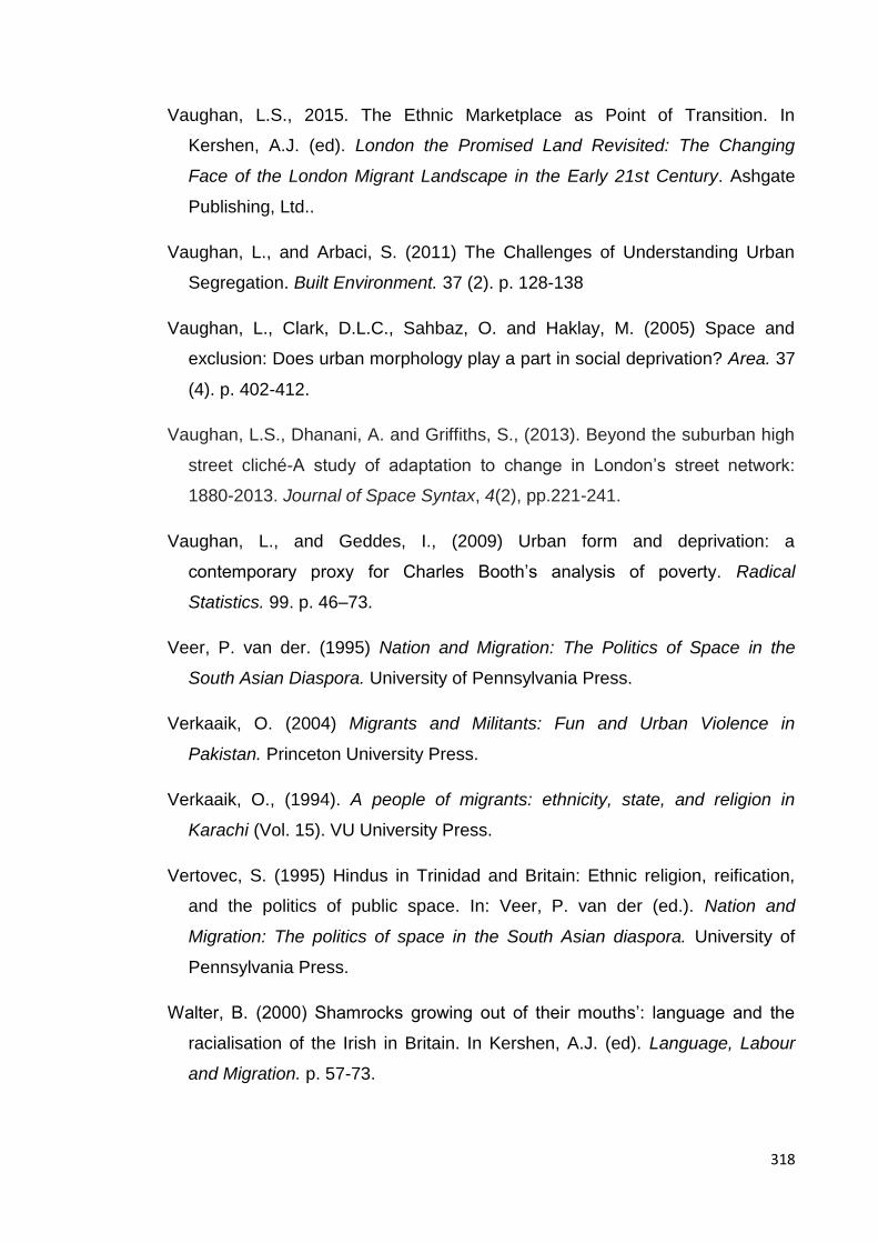
318
Vaughan, L.S., 2015. The Ethnic Marketplace as Point of Transition. In
Kershen, A.J. (ed). London the Promised Land Revisited: The Changing
Face of the London Migrant Landscape in the Early 21st Century. Ashgate
Publishing, Ltd..
Vaughan, L., and Arbaci, S. (2011) The Challenges of Understanding Urban
Segregation. Built Environment. 37 (2). p. 128-138
Vaughan, L., Clark, D.L.C., Sahbaz, O. and Haklay, M. (2005) Space and
exclusion: Does urban morphology play a part in social deprivation? Area. 37
(4). p. 402-412.
Vaughan, L.S., Dhanani, A. and Griffiths, S., (2013). Beyond the suburban high
street cliché-A study of adaptation to change in London’s street network:
1880-2013. Journal of Space Syntax, 4(2), pp.221-241.
Vaughan, L., and Geddes, I., (2009) Urban form and deprivation: a
contemporary proxy for Charles Booth’s analysis of poverty. Radical
Statistics. 99. p. 46–73.
Veer, P. van der. (1995) Nation and Migration: The Politics of Space in the
South Asian Diaspora. University of Pennsylvania Press.
Verkaaik, O. (2004) Migrants and Militants: Fun and Urban Violence in
Pakistan. Princeton University Press.
Verkaaik, O., (1994). A people of migrants: ethnicity, state, and religion in
Karachi (Vol. 15). VU University Press.
Vertovec, S. (1995) Hindus in Trinidad and Britain: Ethnic religion, reification,
and the politics of public space. In: Veer, P. van der (ed.). Nation and
Migration: The politics of space in the South Asian diaspora. University of
Pennsylvania Press.
Walter, B. (2000) Shamrocks growing out of their mouths’: language and the
racialisation of the Irish in Britain. In Kershen, A.J. (ed). Language, Labour
and Migration. p. 57-73.

319
Waterman, S. and Kosmin, B.A., 1988. Residential patterns and processes: a
study of Jews in three London boroughs. Transactions of the Institute of
British Geographers, pp.79-95.
Waterman, S. and Kosmin, B.A., 1987. Residential change in a middle-class
suburban ethnic population: a comment. Transactions of the Institute of
British Geographers, pp.107-112.
Werbner, P. (2009) Chains of Migrants: Culture, value and the housing market.
In Kalra, V. S. (ed.). Pakistani Diasporas: Culture, conflict, and change. USA:
Oxford University Press.
Werbner, P. (2005) The translocation of culture: ‘community cohesion’ and the
force of multiculturalism in history. The Sociological Review. 53 (4). p. 745-
768.
Whyte, W. F. (1993) Street Corner Society: The Social Structure of an Italian
Slum. 4th Ed. London: The University of Chicago Press.
Wirth, L. (1964) Louis Wirth on Cities and Social Life: Selected Papers.
University of Chicago Press.
Wright, T.P., (1991). Center-periphery relations and ethnic conflict in Pakistan:
Sindhis, Muhajirs, and Punjabis. Comparative Politics, 23(3), pp.299-312.
Yusuf, H.,(2012). Conflict dynamics in Karachi. US Institute of Peace.
Zaman, F. (2013) Eight most violent flashpoints in Karachi. DAWN. [Online] 4th
September. Available from: http://www.dawn.com.
Zaman, F., and Ali, N. S. (2013) Taliban in Karachi: the real story. DAWN.
[Online] 31st March. Available from: http://www.dawn.com.
Zaman, M.Q., 1998. Sectarianism in Pakistan: The Radicalization of Shi ‘i and
Sunni Identities. Modern Asian Studies, 32(03), pp.689-716.
Zamindar, V. (2010) The Long Partition and the Making of Modern South Asia:
Refugees, Boundaries, Histories. New York: Columbia University Press.

320
Appendix A: Source Maps
Master plan maps
Doxiades’ Greater Karachi Resettlement Plan-1958.
Karachi Master-plan 1974-85. Land use plan. Source: arifhasan.org
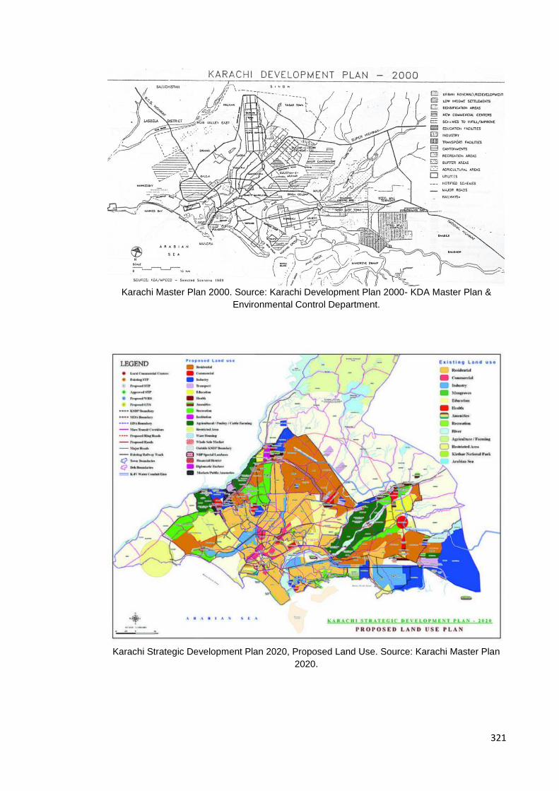
321
Karachi Master Plan 2000. Source: Karachi Development Plan 2000- KDA Master Plan &
Environmental Control Department.
Karachi Strategic Development Plan 2020, Proposed Land Use. Source: Karachi Master Plan
2020.

322
List of Group of Localities, Karachi
Lower-Income Lower-middle Income
Middle-Income Upper-Income
Korangi Model Colony North Nazimabad Clifton
Scheme:33 North Karachi Gulshan-e-Iqbal Defence
Aleemabad Liaquatabad F.B. Area KDA Scheme No. 1
Bostan-e-Raza Ahsanabad Nazimabad PECHS
Gulistan-e-Rafiq Firdous Colony Rizvia Society Garden East & West
Kauser Town Al-Falah Society Unions Area
Orangi Lyari/Naval Personnel Housing Society
Jacob Lines
Qasba/Sultanabad Malir Colony Gulistan-e-Jauhar
Surjani Town/Scheme No. 41
Malir Extension Rafah-e-Aam Society
Baldia Drigh Colony KACHS
Metroville I, II, III Mehmoodabad PIB Colony
Malir Cantt PIAC Society
Shirin Jinnah Colony
Landhi/Shah Latif Town
Delhi Colony Table showing economic classification of settlements in Karachi. Reproduced from ‘Karachi Land and
Housing Study: Final Report, June 1989’.
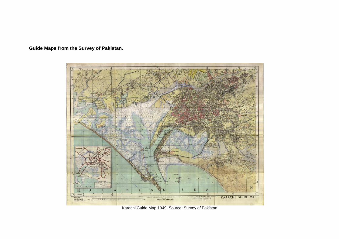
Guide Maps from the Survey of Pakistan.
Karachi Guide Map 1949. Source: Survey of Pakistan

Karachi Guide Map 1972-74. Source: Survey of Pakistan

Karachi Guide Map 1984. Source: Survey of Pakistan

Source maps from newspapers.
Location of Karachi’s flyovers and underpasses. Source: Fall sick with the healing: The ‘killer’ history of Karachi’s first f lyover. The Express Tribune. 2nd
December, 2013.
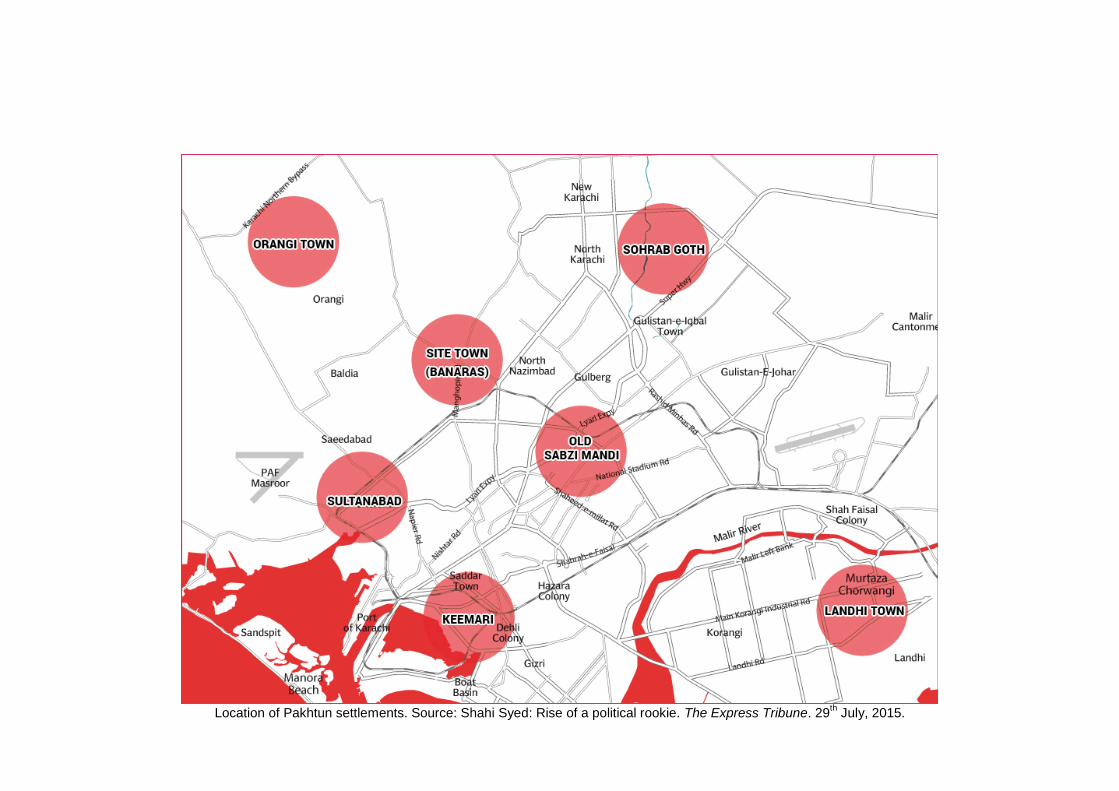
Location of Pakhtun settlements. Source: Shahi Syed: Rise of a political rookie. The Express Tribune. 29th July, 2015.
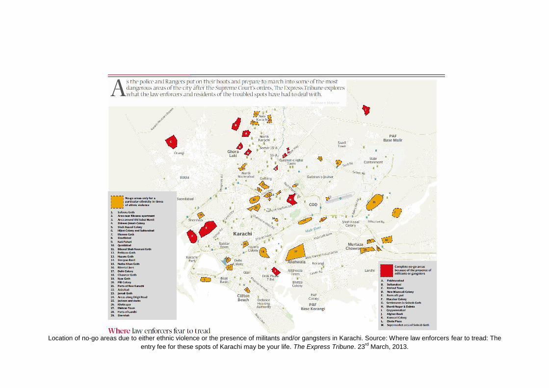
Location of no-go areas due to either ethnic violence or the presence of militants and/or gangsters in Karachi. Source: Where law enforcers fear to tread: The
entry fee for these spots of Karachi may be your life. The Express Tribune. 23rd
March, 2013.
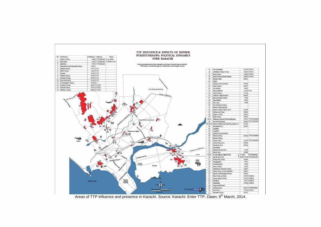
Areas of TTP influence and presence in Karachi. Source: Karachi: Enter TTP. Dawn, 9th March, 2014.
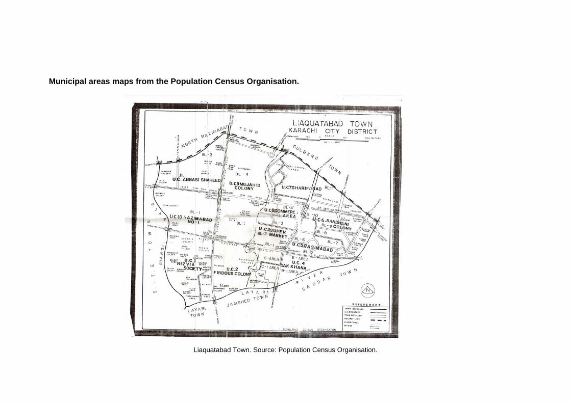
Municipal areas maps from the Population Census Organisation.
Liaquatabad Town. Source: Population Census Organisation.
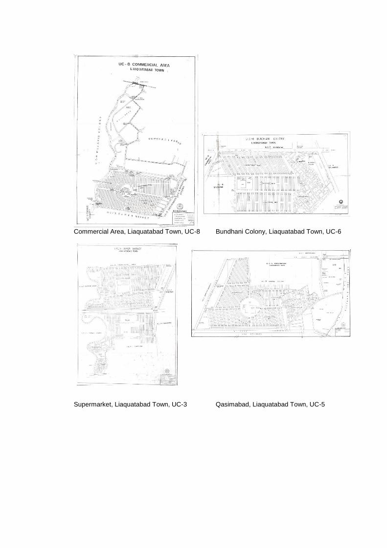
Commercial Area, Liaquatabad Town, UC-8 Bundhani Colony, Liaquatabad Town, UC-6
Supermarket, Liaquatabad Town, UC-3 Qasimabad, Liaquatabad Town, UC-5
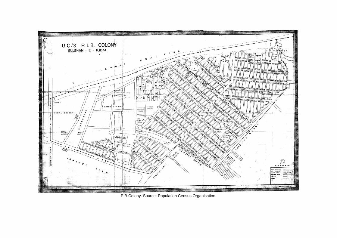
PIB Colony. Source: Population Census Organisation.
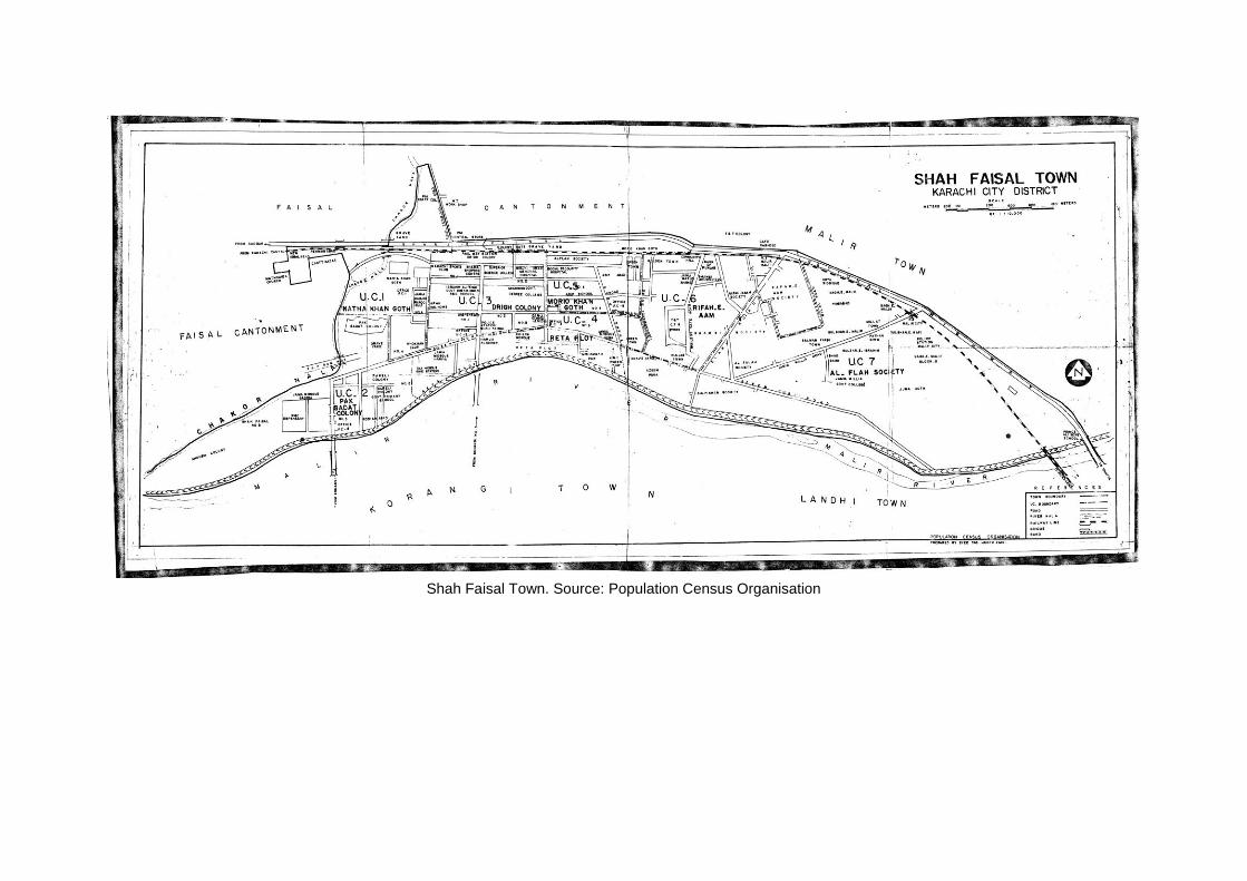
Shah Faisal Town. Source: Population Census Organisation

Pak Sadat Colony, Shah Faisal Town, UC-2
Natha Khan Goth, Shah Faisal Town, UC-1 Drigh Colony, Shah Faisal Town, UC-3 Morio Khan Goth, Shah Faisal Town, UC-5

Appendix B: Questionnaires, interview sheets, on-site
documentation Questionnaire: Date:
Do you live locally?
Respondent #: Gender: Area:
1. Age
a. Under 18
b. 19-35
c. 36-65
d. 65+
2. What is your highest level of qualification? ______________
3. What is your occupation? ______________
4. Name the area in which you work/go to study?
5. Were you born in the area?
Yes No
6. If “No”, when did you move into the area? (i.e. PIB, ShahFaisal etc)
7. Where did you live previously?
8. List your primary and secondary reasons for moving? E.g. marriage, work, security,
financial.
9. How many generations back has your family been in Karachi?
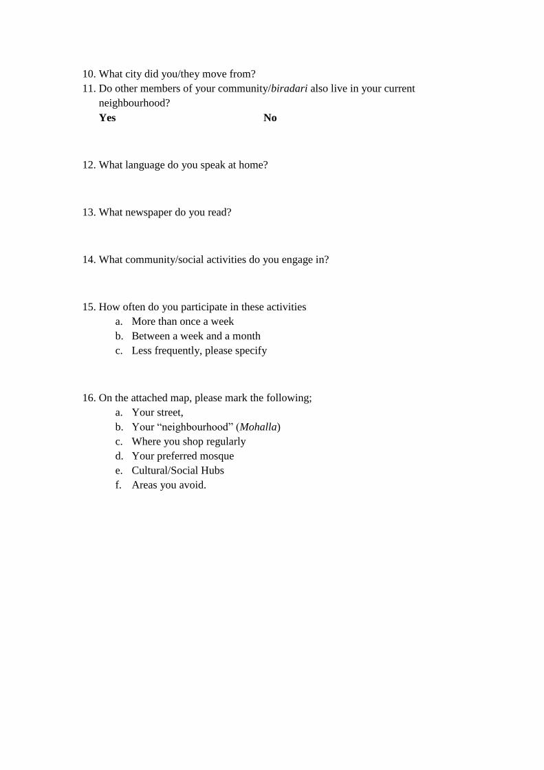
10. What city did you/they move from?
11. Do other members of your community/biradari also live in your current
neighbourhood?
Yes No
12. What language do you speak at home?
13. What newspaper do you read?
14. What community/social activities do you engage in?
15. How often do you participate in these activities
a. More than once a week
b. Between a week and a month
c. Less frequently, please specify
16. On the attached map, please mark the following;
a. Your street,
b. Your “neighbourhood” (Mohalla)
c. Where you shop regularly
d. Your preferred mosque
e. Cultural/Social Hubs
f. Areas you avoid.
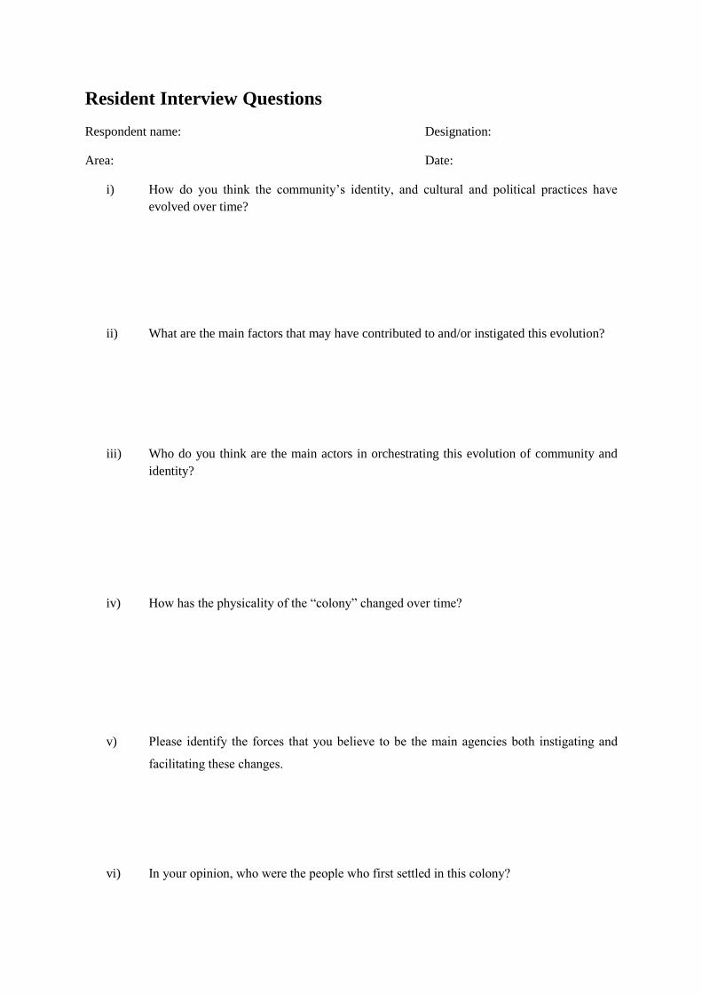
Resident Interview Questions
Respondent name: Designation:
Area: Date:
i) How do you think the community’s identity, and cultural and political practices have
evolved over time?
ii) What are the main factors that may have contributed to and/or instigated this evolution?
iii) Who do you think are the main actors in orchestrating this evolution of community and
identity?
iv) How has the physicality of the “colony” changed over time?
v) Please identify the forces that you believe to be the main agencies both instigating and
facilitating these changes.
vi) In your opinion, who were the people who first settled in this colony?
vii) Where had they migrated from?
viii) Have there been subsequent waves of migration both into and out of the colony?
ix) If “Yes”, when and why did these take place?
x) By what process; e.g. “chain migration”?
xi) Are there areas within the settlement that you may consider to be the jurisdiction of sub-
communities within the Muhajir fold?
xii) If so, where are they situated and what sub-community is settled there?
xiii) Is there an aspirational movement out of the settlement or are people investing in the
settlement and consolidating the holdings here?

On-site documentation.
Examples of on-site mapping chai khanas and political propaganda, PIB Colony. October 2013.

Examples of on-site mapping of commercial streets, chai khanas and religious institutions, Shah Faisal Colony. September, 2013.
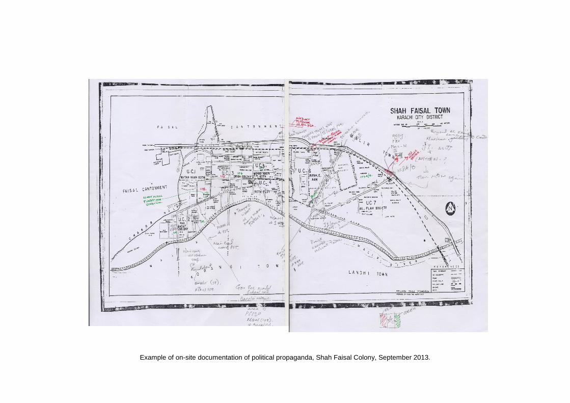
Example of on-site documentation of political propaganda, Shah Faisal Colony, September 2013.
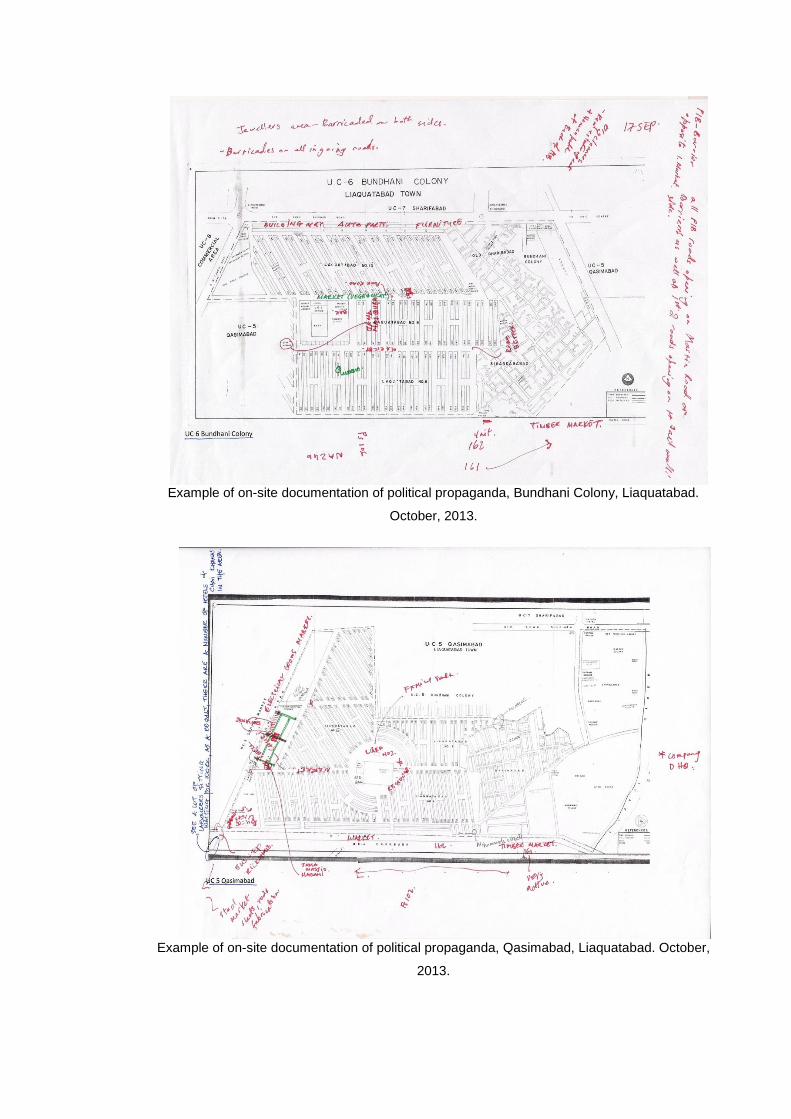
Example of on-site documentation of political propaganda, Bundhani Colony, Liaquatabad.
October, 2013.
Example of on-site documentation of political propaganda, Qasimabad, Liaquatabad. October,
2013.

PIB Colony: Questionnaire Tabulation
Respondent# 1 2 3 4 5 6
Gender F F F F F F
1 2 2 1 2 2 1
2 4 4 3 5 5 4
3 beautician Housewife Beautician Housewife Salon Owner Student
White vs. Blue B B W
4 PIB PIB PIB - PIB PIB
5 Y N Y Y N Y
6 - 7 yrs ago - - 20 yrs ago -
7 - Malir - - Hyderabad, Sindh Liaquatabad
8 - Marriage - - Father's Business -
9 1947 1948 1947 20 Yrs Ago 19 yrs
10 Wazirabad, Sialkot India - Dehli Hyderabad Hyderabad
11 Y N Y Y Y N
12 Punjabi Urdu Urdu Urdu Urdu Bihari
13 Digest Any - Sunday Magazine/ Akhbar-e-Jahan Jung Akhbar-e-Jahan
14 Park w/Friends Milaad - - Eating out w/Friends -
15 3 3 - - 2 -
Housewife 54 outside 45%
Own Business
Teacher
Skilled Labour
Sales
White Collar
Nursing etc.
Unskilled Labour
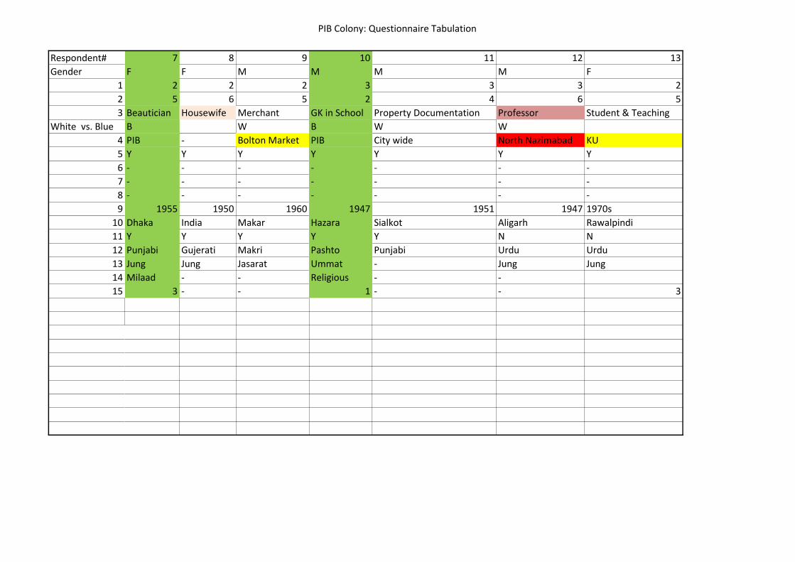
PIB Colony: Questionnaire Tabulation
Respondent#
Gender
1
2
3
White vs. Blue
4
5
6
7
8
9
10
11
12
13
14
15
7 8 9 10 11 12 13
F F M M M M F
2 2 2 3 3 3 2
5 6 5 2 4 6 5
Beautician Housewife Merchant GK in School Property Documentation Professor Student & Teaching
B W B W W
PIB - Bolton Market PIB City wide North Nazimabad KU
Y Y Y Y Y Y Y
- - - - - - -
- - - - - - -
- - - - - - -
1955 1950 1960 1947 1951 1947 1970s
Dhaka India Makar Hazara Sialkot Aligarh Rawalpindi
Y Y Y Y Y N N
Punjabi Gujerati Makri Pashto Punjabi Urdu Urdu
Jung Jung Jasarat Ummat - Jung Jung
Milaad - - Religious - -
3 - - 1 - - 3

PIB Colony: Questionnaire Tabulation
Respondent#
Gender
1
2
3
White vs. Blue
4
5
6
7
8
9
10
11
12
13
14
15
14 15 16 17 18 19
M M M F M M
1 2 1 3 3 4
3 2 3 4 4 3
Student - Student Housewife Shopkeeper (Cloth) Shopkeeper (Cloth)
RETAIL RETAIL
PIB PIB Gulshan - PIB PIB
N N N Y N N
2000 8 yrs ago 1998 - 1988 1951
Gulshan-e-I Hijrat Colony - Nawabshah Bombay Bazaar Kharadar
Family Reason Studies Family Reason - Haalaat
1947 1947 - 1952 1948
Dubai Mansehra Hyderabad Deccan Punjab Gujerat M.P. (India)
Y N Y Y Y Y
Urdu Pashto Urdu Urdu/Punjabi Khatri Malawa
Dawn - Dawn Jung Express Jung
Football Cricket Football/Tuition Shopping and meeting relatives - Chatting to friend
1 1 Daily/1 1 - 1
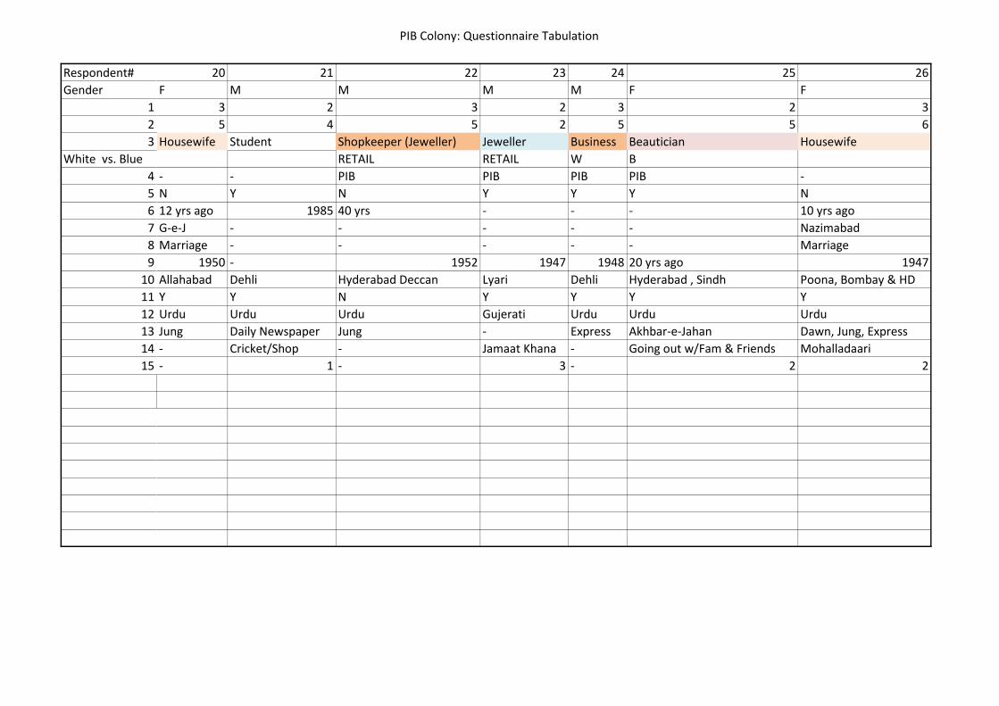
PIB Colony: Questionnaire Tabulation
Respondent#
Gender
1
2
3
White vs. Blue
4
5
6
7
8
9
10
11
12
13
14
15
20 21 22 23 24 25 26
F M M M M F F
3 2 3 2 3 2 3
5 4 5 2 5 5 6
Housewife Student Shopkeeper (Jeweller) Jeweller Business Beautician Housewife
RETAIL RETAIL W B
- - PIB PIB PIB PIB -
N Y N Y Y Y N
12 yrs ago 1985 40 yrs - - - 10 yrs ago
G-e-J - - - - - Nazimabad
Marriage - - - - - Marriage
1950 - 1952 1947 1948 20 yrs ago 1947
Allahabad Dehli Hyderabad Deccan Lyari Dehli Hyderabad , Sindh Poona, Bombay & HD
Y Y N Y Y Y Y
Urdu Urdu Urdu Gujerati Urdu Urdu Urdu
Jung Daily Newspaper Jung - Express Akhbar-e-Jahan Dawn, Jung, Express
- Cricket/Shop - Jamaat Khana - Going out w/Fam & Friends Mohalladaari
- 1 - 3 - 2 2
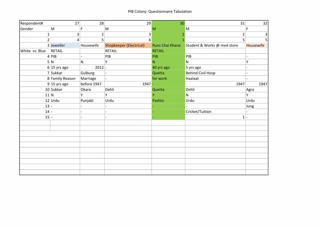
PIB Colony: Questionnaire Tabulation
Respondent#
Gender
1
2
3
White vs. Blue
4
5
6
7
8
9
10
11
12
13
14
15
27 28 29 30 31 32
M F M M M F
3 2 3 2 2 3
4 5 6 1 5 5
Jeweller Housewife Shopkeeper (Electrical) Runs Chai Khana Student & Works @ med store Housewife
RETAIL RETAIL RETAIL
PIB - PIB PIB PIB -
N N Y N N Y
15 yrs ago 2012 - 40 yrs ago 5 yrs ago -
Sukkar Gulburg - Quetta Behind Civil Hosp -
Family Reason Marriage - for work Haalaat -
15 yrs ago before 1947 1947 - 1947 1947
Sukkar Okara Dehli Quetta Dehli Agra
N Y Y Y N Y
Urdu Punjabi Urdu Pashto Urdu Urdu
- - - - - Jung
- - - - Cricket/Tuition -
- - - - 1 -
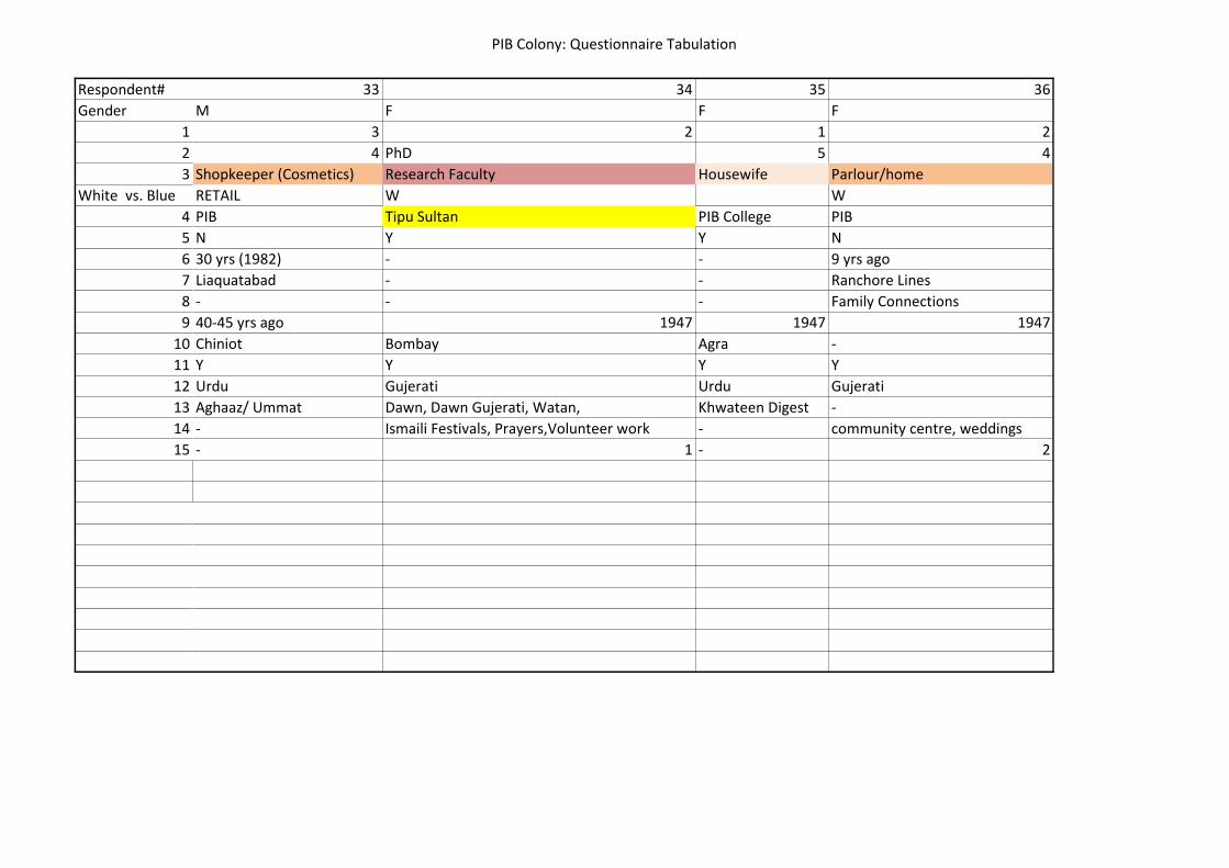
PIB Colony: Questionnaire Tabulation
Respondent#
Gender
1
2
3
White vs. Blue
4
5
6
7
8
9
10
11
12
13
14
15
33 34 35 36
M F F F
3 2 1 2
4 PhD 5 4
Shopkeeper (Cosmetics) Research Faculty Housewife Parlour/home
RETAIL W W
PIB Tipu Sultan PIB College PIB
N Y Y N
30 yrs (1982) - - 9 yrs ago
Liaquatabad - - Ranchore Lines
- - - Family Connections
40-45 yrs ago 1947 1947 1947
Chiniot Bombay Agra -
Y Y Y Y
Urdu Gujerati Urdu Gujerati
Aghaaz/ Ummat Dawn, Dawn Gujerati, Watan, Khwateen Digest -
- Ismaili Festivals, Prayers,Volunteer work - community centre, weddings
- 1 - 2

PIB Colony: Questionnaire Tabulation
Respondent#
Gender
1
2
3
White vs. Blue
4
5
6
7
8
9
10
11
12
13
14
15
37 38 39 40 41 42 43
F M M M M M M
2 4 2 3 2 2 4
3 5 5&7 4 5 4 5
Sewing and embroidery Press Salesman Waterboard Phillips Co His own business KMC Hospital Lab
B W W W W W W
PIB Community Centre PIB PIB Gulshan SherShah PIB PIB
Y Y Y Y Y Y Y
- - - - - - -
- - - - - - -
- - - - - - -
1947 1947 1947 1947 1947 1947 1947
Shahjahanpur Mirzapur Mirzapur Bareili Dehli New Dehli Dehli
Y Y Y Y Y Y Y
Urdu Urdu Urdu Urdu Urdu Urdu Urdu
Pakeezah, Akhbaar-e-Jahan Jung Jung Jung Jung Jung Jung
Community workshop - Religious gatherings Politics - - -
1 - 3 1 - - -
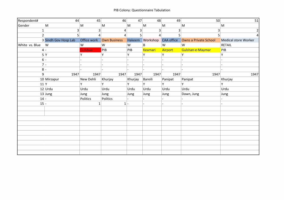
PIB Colony: Questionnaire Tabulation
Respondent#
Gender
1
2
3
White vs. Blue
4
5
6
7
8
9
10
11
12
13
14
15
44 45 46 47 48 49 50 51
M M M M M M M M
3 3 4 3 3 3 3 2
5 4 4 5 4 5 5 4
Sindh Gov Hosp Lab Office work Own Business Hakeem Workshop CAA office Owns a Private School Medical store Worker
W W W W B W W RETAIL
- Gulshan PIB PIB Keamari Airport Gulshan-e-Maymar PIB
Y Y Y Y Y Y Y Y
- - - - - - - -
- - - - - - - -
- - - - - - - -
1947 1947 1947 1947 1947 1947 1947 1947
Mirzapur New Dehli Khurjay Khurjay Bareili Panipat Panipat Khurjay
Y Y Y Y Y Y Y Y
Urdu Urdu Urdu Urdu Urdu Urdu Urdu Urdu
Jung Jung Jung Jung Jung Jung Dawn, Jung Jung
- Politics Politics - - - - -
- 1 1 - - - - -

PIB Colony: Questionnaire Tabulation
Respondent#
Gender
1
2
3
White vs. Blue
4
5
6
7
8
9
10
11
12
13
14
15
52 53 54 55 56 57 58 59
M M M M F M M M
2 2 2 4 3 3 1 2
4 4 4 5 4 5 2 5
Sr Officer @ PSO Transporter PSO Office worker Press Nursing Own Business Tailor General Store
W B W W W W B B
PIB PIB Keamari PIB Tariq Road Tariq Road PIB PIB
Y Y Y Y Y Y Y Y
- - - - - - - -
- - - - - - - -
- - - - - - - -
1947 1947 1947 1947 - - -
Dehli Bareili Panipat Mirzapur - - -
Y Y Y Y Y Y Y Y
Urdu Urdu Urdu Urdu Urdu Urdu Urdu Urdu
Jung Jung Jung Jung Jasarat Jung Jasarat Jasarat
- - - - - Religious Activities - Community work
- - - - - 3 - 3
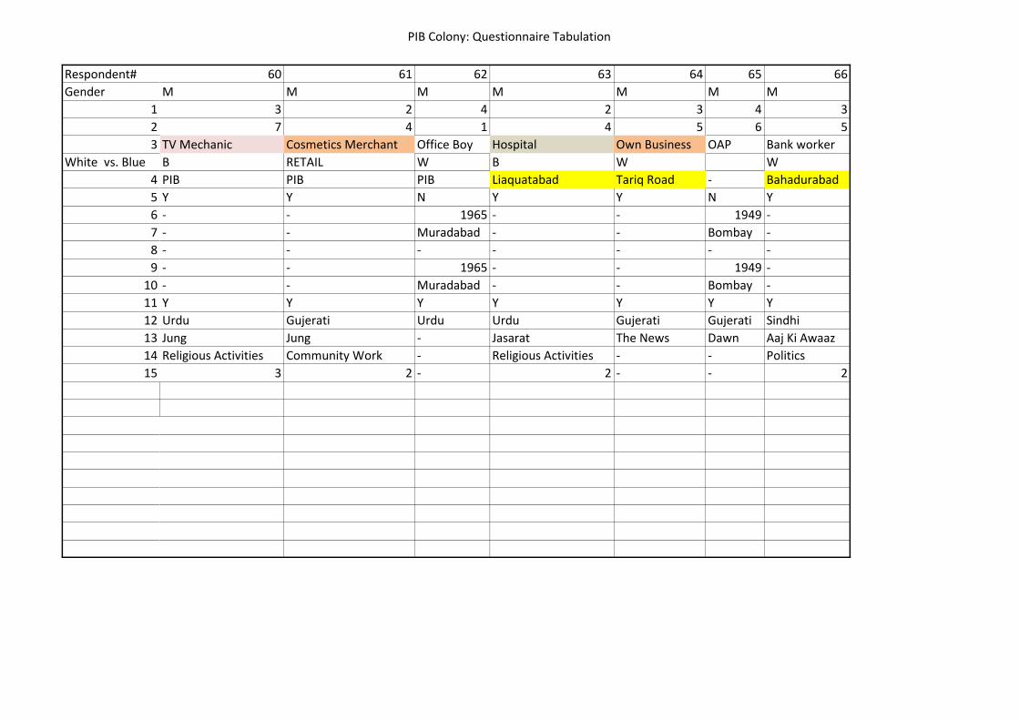
PIB Colony: Questionnaire Tabulation
Respondent#
Gender
1
2
3
White vs. Blue
4
5
6
7
8
9
10
11
12
13
14
15
60 61 62 63 64 65 66
M M M M M M M
3 2 4 2 3 4 3
7 4 1 4 5 6 5
TV Mechanic Cosmetics Merchant Office Boy Hospital Own Business OAP Bank worker
B RETAIL W B W W
PIB PIB PIB Liaquatabad Tariq Road - Bahadurabad
Y Y N Y Y N Y
- - 1965 - - 1949 -
- - Muradabad - - Bombay -
- - - - - - -
- - 1965 - - 1949 -
- - Muradabad - - Bombay -
Y Y Y Y Y Y Y
Urdu Gujerati Urdu Urdu Gujerati Gujerati Sindhi
Jung Jung - Jasarat The News Dawn Aaj Ki Awaaz
Religious Activities Community Work - Religious Activities - - Politics
3 2 - 2 - - 2
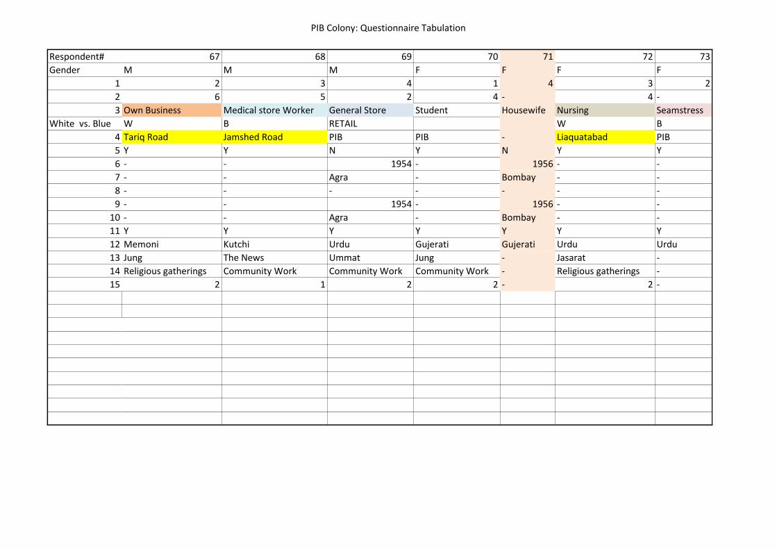
PIB Colony: Questionnaire Tabulation
Respondent#
Gender
1
2
3
White vs. Blue
4
5
6
7
8
9
10
11
12
13
14
15
67 68 69 70 71 72 73
M M M F F F F
2 3 4 1 4 3 2
6 5 2 4 - 4 -
Own Business Medical store Worker General Store Student Housewife Nursing Seamstress
W B RETAIL W B
Tariq Road Jamshed Road PIB PIB - Liaquatabad PIB
Y Y N Y N Y Y
- - 1954 - 1956 - -
- - Agra - Bombay - -
- - - - - - -
- - 1954 - 1956 - -
- - Agra - Bombay - -
Y Y Y Y Y Y Y
Memoni Kutchi Urdu Gujerati Gujerati Urdu Urdu
Jung The News Ummat Jung - Jasarat -
Religious gatherings Community Work Community Work Community Work - Religious gatherings -
2 1 2 2 - 2 -
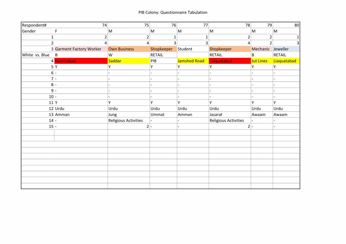
PIB Colony: Questionnaire Tabulation
Respondent#
Gender
1
2
3
White vs. Blue
4
5
6
7
8
9
10
11
12
13
14
15
74 75 76 77 78 79 80
F M M M M M M
2 2 1 1 2 2 1
4 4 3 3 4 2 3
Garment Factory Worker Own Business Shopkeeper Student Shopkeeper Mechanic Jeweller
B W RETAIL RETAIL B RETAIL
Nazimabad Saddar PIB Jamshed Road Liaquatabad Jut Lines Liaquatabad
Y Y Y Y Y Y Y
- - - - - - -
- - - - - - -
- - - - - - -
- - - - - - -
- - - - - - -
Y Y Y Y Y Y Y
Urdu Urdu Urdu Urdu Urdu Urdu Urdu
Amman Jung Ummat Amman Jasarat Awaam Awaam
- Religious Activities - - Religious Activities - -
- 2 - - 2 - -
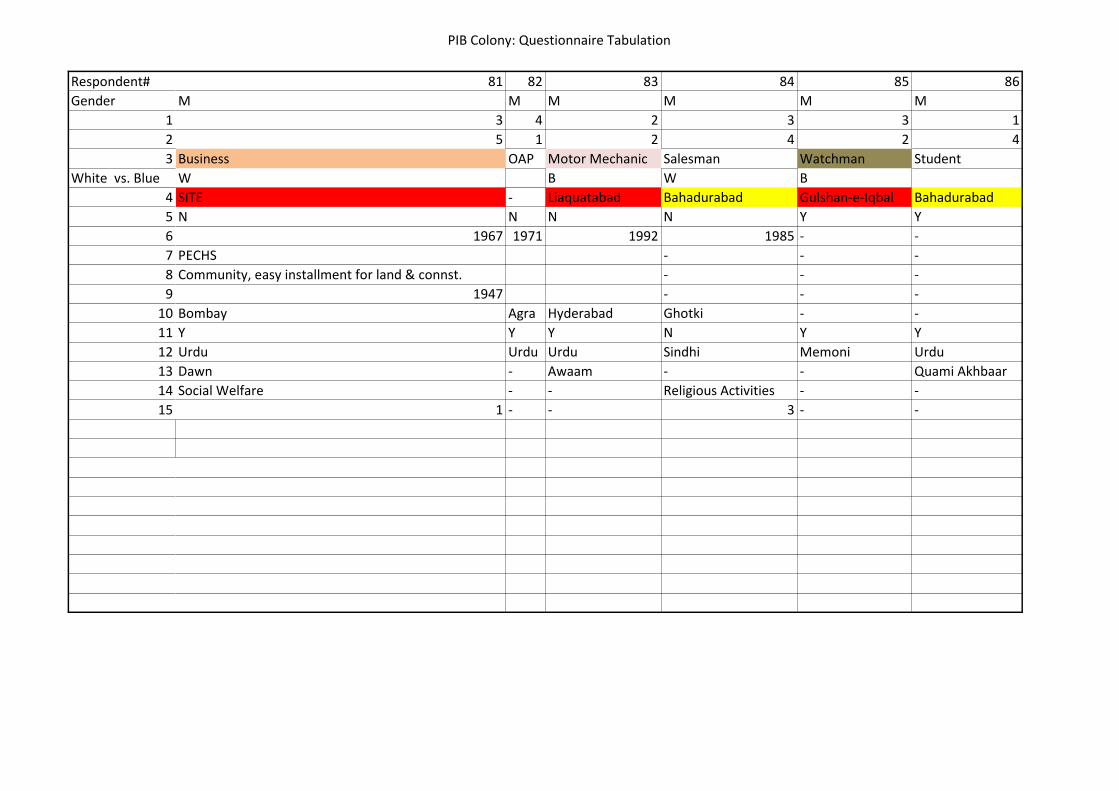
PIB Colony: Questionnaire Tabulation
Respondent#
Gender
1
2
3
White vs. Blue
4
5
6
7
8
9
10
11
12
13
14
15
81 82 83 84 85 86
M M M M M M
3 4 2 3 3 1
5 1 2 4 2 4
Business OAP Motor Mechanic Salesman Watchman Student
W B W B
SITE - Liaquatabad Bahadurabad Gulshan-e-Iqbal Bahadurabad
N N N N Y Y
1967 1971 1992 1985 - -
PECHS - - -
Community, easy installment for land & connst. - - -
1947 - - -
Bombay Agra Hyderabad Ghotki - -
Y Y Y N Y Y
Urdu Urdu Urdu Sindhi Memoni Urdu
Dawn - Awaam - - Quami Akhbaar
Social Welfare - - Religious Activities - -
1 - - 3 - -

PIB Colony: Questionnaire Tabulation
Respondent#
Gender
1
2
3
White vs. Blue
4
5
6
7
8
9
10
11
12
13
14
15
87 88 89 90 91 92 93
M M F F M M M
2 3 2 1 2 3 1
6 5 5 4 1 5 4
Travel Agency Office work Teacher Student Plumber Computer Shop Teacher
W W W B RETAIL W
Saddar I I Chundrigarh PIB Nazimabad Where ever Tariq Road Liaquatabad
Y Y Y Y N Y Y
- - - - 1982 - -
- - - - - - -
- - - - - - -
- - - - - - -
- - - - Lahore - -
Y Y Y Y N Y Y
Urdu Memoni Urdu Kutchi Memoni Punjabi Memoni Urdu
Jung The News Jung Akhbar-e-Jahan - Nawaii Waqt Jasarat
Religious Activities Community Work - Religious Activities - Religious Activities Community Work
2 2 - 2 - 2 3

PIB Colony: Questionnaire Tabulation
Respondent#
Gender
1
2
3
White vs. Blue
4
5
6
7
8
9
10
11
12
13
14
15
94 95 96 97 98 99 100
M M M F F M M
4 2 3 3 3 3 3
2 4 6 4 5 1 1
Shop in house TV Mechanic Coaching Centre School Job Office work Rickshaw Drver Labourer
RETAIL B W W W B B
PIB PIB Nazimabad Jamshed Quarters Tower Where ever Bolton Market
N N Y Y Y Y N
1950 1985 - - - - 1971
- - - - - - Quetta
- - - - - - -
- - - - - - -
Ahmedabad Sargodha - - - - -
Y N Y Y Y Y Y
Memoni Punjabi Memoni Urdu Gujerati Balochi Balochi
Ummat Riyaasat Dawn Various Magazines Dawn - -
- Religious Activities Community Work Religious Activities Community Work - -
- 3 2 3 3 - -
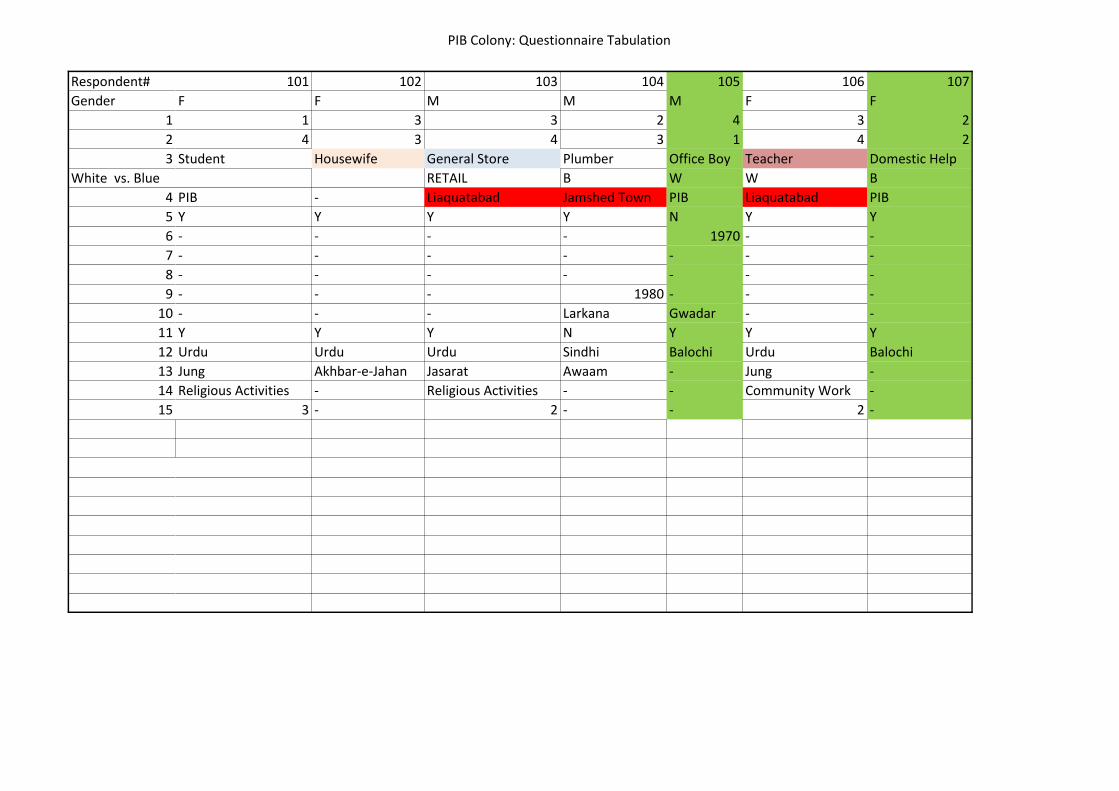
PIB Colony: Questionnaire Tabulation
Respondent#
Gender
1
2
3
White vs. Blue
4
5
6
7
8
9
10
11
12
13
14
15
101 102 103 104 105 106 107
F F M M M F F
1 3 3 2 4 3 2
4 3 4 3 1 4 2
Student Housewife General Store Plumber Office Boy Teacher Domestic Help
RETAIL B W W B
PIB - Liaquatabad Jamshed Town PIB Liaquatabad PIB
Y Y Y Y N Y Y
- - - - 1970 - -
- - - - - - -
- - - - - - -
- - - 1980 - - -
- - - Larkana Gwadar - -
Y Y Y N Y Y Y
Urdu Urdu Urdu Sindhi Balochi Urdu Balochi
Jung Akhbar-e-Jahan Jasarat Awaam - Jung -
Religious Activities - Religious Activities - - Community Work -
3 - 2 - - 2 -

PIB Colony: Questionnaire Tabulation
Respondent#
Gender
1
2
3
White vs. Blue
4
5
6
7
8
9
10
11
12
13
14
15
108 109 110 111 112 113 114
M F M M M M F
1 4 2 3 1 3 3
1 1 3 5 3 4 1
Labourer Housewife Crockery Shop Cosmetics Merchant Embroiderer General Store Domestic Help
B RETAIL RETAIL B RETAIL B
Where ever - Liaquatabad Bolton Market Liaquatabad PIB Tariq Road
Y N Y Y Y N Y
- 1963 - - - 1981 -
- - - - - - -
- - - - - - -
- - - - - - -
- Dehli - - - Pindi -
Y Y Y Y Y N Y
Balochi Urdu Urdu Memoni Urdu Punjabi Urdu
- - Jasarat Jung - Ummat -
- - - Community Work Religious Activities Religious Activities -
- - - 2 3 2 -

PIB Colony: Questionnaire Tabulation
Respondent#
Gender
1
2
3
White vs. Blue
4
5
6
7
8
9
10
11
12
13
14
15
115 116 117 118 119
F M M M M
2 3 4 1 4
4 2 4 2 2
Nursing Watchman OAP Motor Mechanic Shop in house
W B B RETAIL
Gulshan-e-Iqbal Kashmir Road - Jahangir Road PIB
Y Y N Y N
- - 1963 - 1954
- - - - -
- - - - -
- - - - -
- - Lucknow - Hyderabad Deccan
Y Y Y Y Y
Memoni Urdu Urdu Urdu Urdu
Urdu Digest - - - Ummat
- - - - Religious Activities
- - - - 3

Shah Faisal Colony: Questionnaire Tabulation
Respondent# 1 2 3 4 5
Gender F F F F F
1 2 3 3 1 1
2 5 5 6 3 3
3 Teacher Teacher Teacher Student Student
WHITE Vs BLUE W W W
4 Shah Faisal Shah Faisal Shah Faisal Shah Faisal#2 Shah Faisal#2
5 N Y Y Y Y
6 1998 - - - -
7 Islamabad - - - -
8 Marriage - - - -
9 40 yrs 1948 1956 1947 1947
10 Islamabad/Rawalpindi - Lucknow India India
11 N Y Y Y Y
12 Urdu Urdu Urdu Urdu Urdu
13 Jung/Ummat Jung Jung - -
14 - Shaadi/Milaad Local Mohalla activities Milaad/Qurankhwani/Tuition Milaad/Qurankhwani/Tuition
15 - 3 3 3 2
Housewife 52 Outside 41%
Own Business
Teacher
Skilled Labour
Sales
White Collar
Nursing etc.
Unskilled Labour
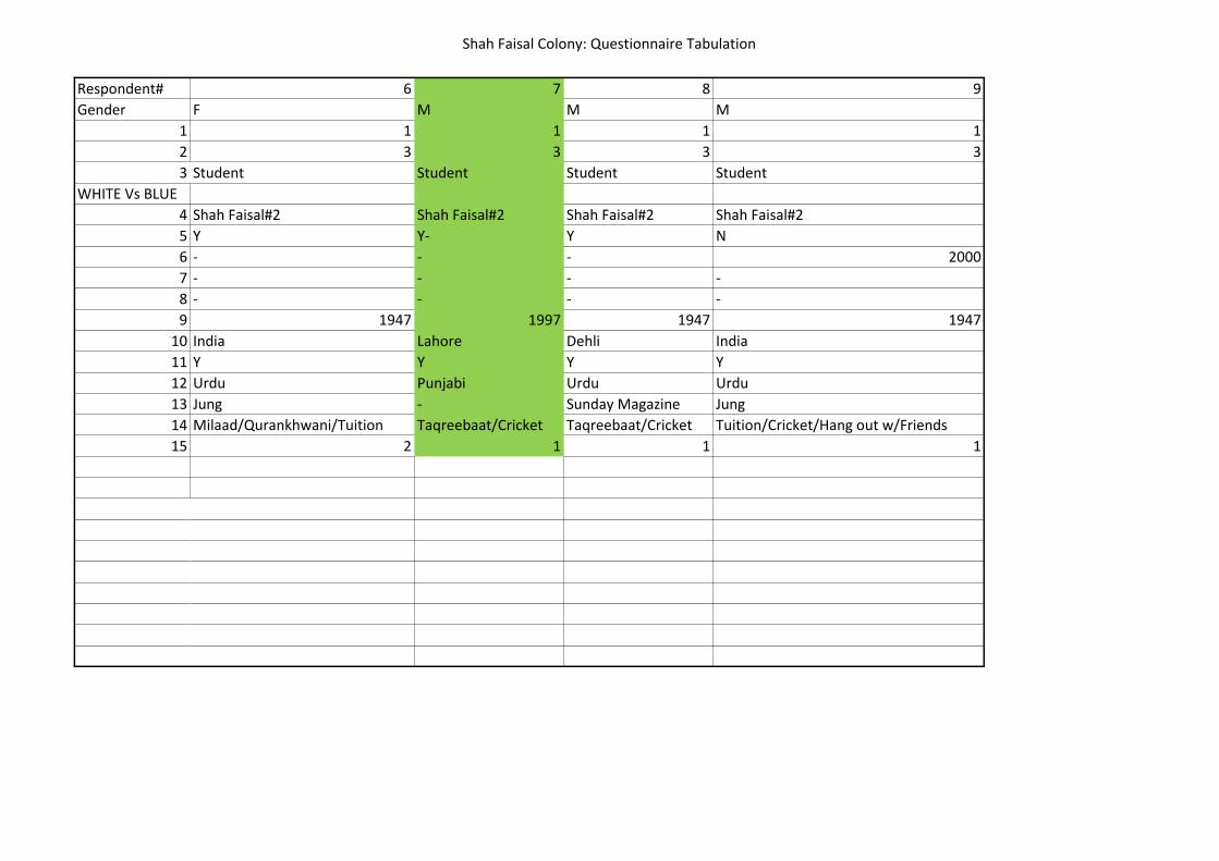
Shah Faisal Colony: Questionnaire Tabulation
Respondent#
Gender
1
2
3
WHITE Vs BLUE
4
5
6
7
8
9
10
11
12
13
14
15
6 7 8 9
F M M M
1 1 1 1
3 3 3 3
Student Student Student Student
Shah Faisal#2 Shah Faisal#2 Shah Faisal#2 Shah Faisal#2
Y Y- Y N
- - - 2000
- - - -
- - - -
1947 1997 1947 1947
India Lahore Dehli India
Y Y Y Y
Urdu Punjabi Urdu Urdu
Jung - Sunday Magazine Jung
Milaad/Qurankhwani/Tuition Taqreebaat/Cricket Taqreebaat/Cricket Tuition/Cricket/Hang out w/Friends
2 1 1 1

Shah Faisal Colony: Questionnaire Tabulation
Respondent#
Gender
1
2
3
WHITE Vs BLUE
4
5
6
7
8
9
10
11
12
13
14
15
10 11 12 13 14
F F M M M
1 3 4 2 4
3 4 5 2 1
Student Housewife Int Designer PTV Shopkeeper Tailor
W RETAIL B
Shah Faisal#2 - PTV Shah Faisal #1 Shah Faisal#1
Y N N Y N
- 1970 1980 - 1978
- Airport colony Lahore - Hazara
- Proximity to work of Father in CA Marriage - Job Opportunity
1947 1947/1970 - 1967 1978
Dehli Dehli Lahore Multan Hazara
Y Y N Y N
Urdu Urdu Urdu Punjabi Pashto
Jung Jung/Dawn Jung/Dawn Ummat Jaan Baaz
Milaad/Shaadi/Tuition/Park Darus Durud Khatam - -
1 1 1 - -
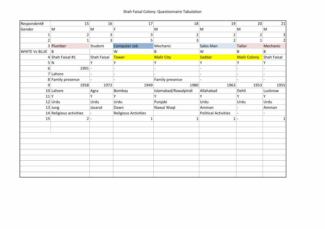
Shah Faisal Colony: Questionnaire Tabulation
Respondent#
Gender
1
2
3
WHITE Vs BLUE
4
5
6
7
8
9
10
11
12
13
14
15
15 16 17 18 19 20 21
M M F M M M M
2 3 3 2 2 2 3
1 3 5 3 2 1 2
Plumber Student Computer Job Mechanic Sales Man Tailor Mechanic
B W B W B B
Shah Faisal #1 Shah Faisal Tower Malir City Saddar Malir Colony Shah Faisal
N Y Y Y Y Y Y
1991 - - - - - -
Lahore - - - - - -
Family presence - - Family presence - - -
1958 1972 1949 1980 1963 1953 1955
Lahore Agra Bombay Islamabad/Rawalpindi Allahabad Dehli Lucknow
Y Y Y Y Y Y Y
Urdu Urdu Urdu Punjabi Urdu Urdu Urdu
Jung Jasarat Dawn Nawai Waqt Amman - Amman
Religious activities - Religious Activities Political Activities - -
2 - 1 1 1 - 1
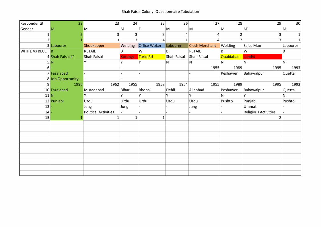
Shah Faisal Colony: Questionnaire Tabulation
Respondent#
Gender
1
2
3
WHITE Vs BLUE
4
5
6
7
8
9
10
11
12
13
14
15
22 23 24 25 26 27 28 29 30
M M M F M M M M` M
2 3 3 3 4 4 2 3 1
1 3 3 4 1 4 2 3 1
Labourer Shopkeeper Welding Office Woker Labourer Cloth Merchant Welding Sales Man Labourer
B RETAIL B W B RETAIL B W B
Shah Faisal #1 Shah Faisal Korangi Tariq Rd Shah Faisal Shah Faisal Quaidabad Landhi -
N Y Y Y N N N N N
- - - - 1955 1989 1995 1993
Fazalabad - - - - Peshawer Bahawalpur Quetta
Job Opportunity - - - - - - -
1995 1962 1955 1958 1954 1955 1989 1995 1993
Fazalabad Muradabad Bihar Bhopal Dehli Allahbad Peshawer Bahawalpur Quetta
N Y Y Y Y Y N Y N
Punjabi Urdu Urdu Urdu Urdu Urdu Pushto Punjabi Pushto
- Jung Jung - - Jung - Ummat -
- Political Activities - - - - - Religious Activities -
1 1 1 1 - - - 2 -
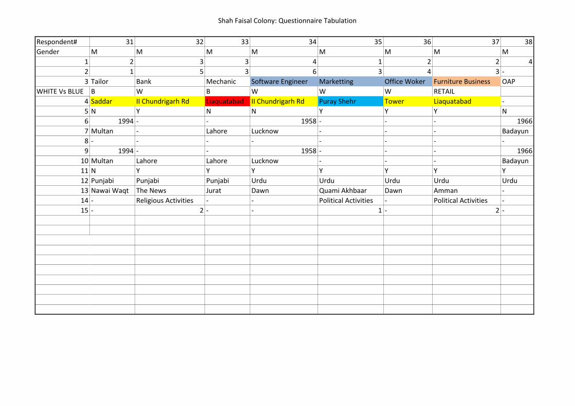
Shah Faisal Colony: Questionnaire Tabulation
Respondent#
Gender
1
2
3
WHITE Vs BLUE
4
5
6
7
8
9
10
11
12
13
14
15
31 32 33 34 35 36 37 38
M M M M M M M M
2 3 3 4 1 2 2 4
1 5 3 6 3 4 3 -
Tailor Bank Mechanic Software Engineer Marketting Office Woker Furniture Business OAP
B W B W W W RETAIL
Saddar II Chundrigarh Rd Liaquatabad II Chundrigarh Rd Puray Shehr Tower Liaquatabad -
N Y N N Y Y Y N
1994 - - 1958 - - - 1966
Multan - Lahore Lucknow - - - Badayun
- - - - - - - -
1994 - - 1958 - - - 1966
Multan Lahore Lahore Lucknow - - - Badayun
N Y Y Y Y Y Y Y
Punjabi Punjabi Punjabi Urdu Urdu Urdu Urdu Urdu
Nawai Waqt The News Jurat Dawn Quami Akhbaar Dawn Amman -
- Religious Activities - - Political Activities - Political Activities -
- 2 - - 1 - 2 -
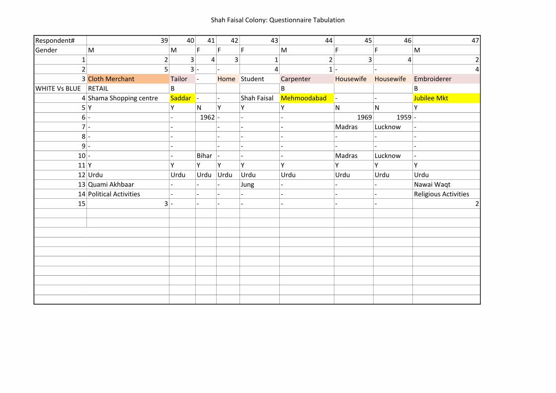
Shah Faisal Colony: Questionnaire Tabulation
Respondent#
Gender
1
2
3
WHITE Vs BLUE
4
5
6
7
8
9
10
11
12
13
14
15
39 40 41 42 43 44 45 46 47
M M F F F M F F M
2 3 4 3 1 2 3 4 2
5 3 - - 4 1 - - 4
Cloth Merchant Tailor - Home Student Carpenter Housewife Housewife Embroiderer
RETAIL B B B
Shama Shopping centre Saddar - - Shah Faisal Mehmoodabad - - Jubilee Mkt
Y Y N Y Y Y N N Y
- - 1962 - - - 1969 1959 -
- - - - - Madras Lucknow -
- - - - - - - -
- - - - - - - -
- - Bihar - - - Madras Lucknow -
Y Y Y Y Y Y Y Y Y
Urdu Urdu Urdu Urdu Urdu Urdu Urdu Urdu Urdu
Quami Akhbaar - - - Jung - - - Nawai Waqt
Political Activities - - - - - - - Religious Activities
3 - - - - - - - 2
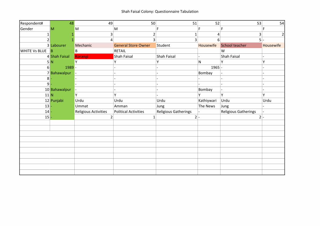
Shah Faisal Colony: Questionnaire Tabulation
Respondent#
Gender
1
2
3
WHITE Vs BLUE
4
5
6
7
8
9
10
11
12
13
14
15
48 49 50 51 52 53 54
M M M F F F F
1 3 2 1 4 3 2
1 4 3 3 6 5 -
Labourer Mechanic General Store Owner Student Housewife School teacher Housewife
B B RETAIL W
Shah Faisal Korangi Shah Faisal Shah Faisal - Shah Faisal -
N Y Y Y N Y Y
1989 - - - 1965 - -
Bahawalpur - - - Bombay - -
- - - - - - -
- - - - - - -
Bahawalpur - - - Bombay - -
N Y Y - Y Y Y
Punjabi Urdu Urdu Urdu Kathiywari Urdu Urdu
- Ummat Amman Jung The News Jung -
- Religious Activities Political Activities Religious Gatherings - Religious Gatherings -
- 2 1 2 - 2 -

Shah Faisal Colony: Questionnaire Tabulation
Respondent#
Gender
1
2
3
WHITE Vs BLUE
4
5
6
7
8
9
10
11
12
13
14
15
55 56 57 58 59 60 61 62
F M F M M M M M
3 4 1 3 2 2 3 2
3 7 4 4 1 3 5 3
School teacher OAP College student Sales Man Carpenter Mechanic Private job Student
W W B B W
Shah Faisal - Shah Faisal Tariq Rd Tariq Rd Malir City Saddar Shah Faisal
Y N Y Y Y Y Y Y
- 1966 - - - - - -
- Gujerat - - - - - -
- - - - - - - -
- - - - - - - -
- Gujerat - - - - - -
Y Y Y Y Y Y Y Y
Urdu Gujerati Urdu Urdu Urdu Urdu Urdu Urdu
- Dawn Jung Nawai Waqt - Jung Naii Jat Jung
- - Religious Gatherings Political Activities - Religious Activities - Religious Activities
- - 3 3 3 - 3
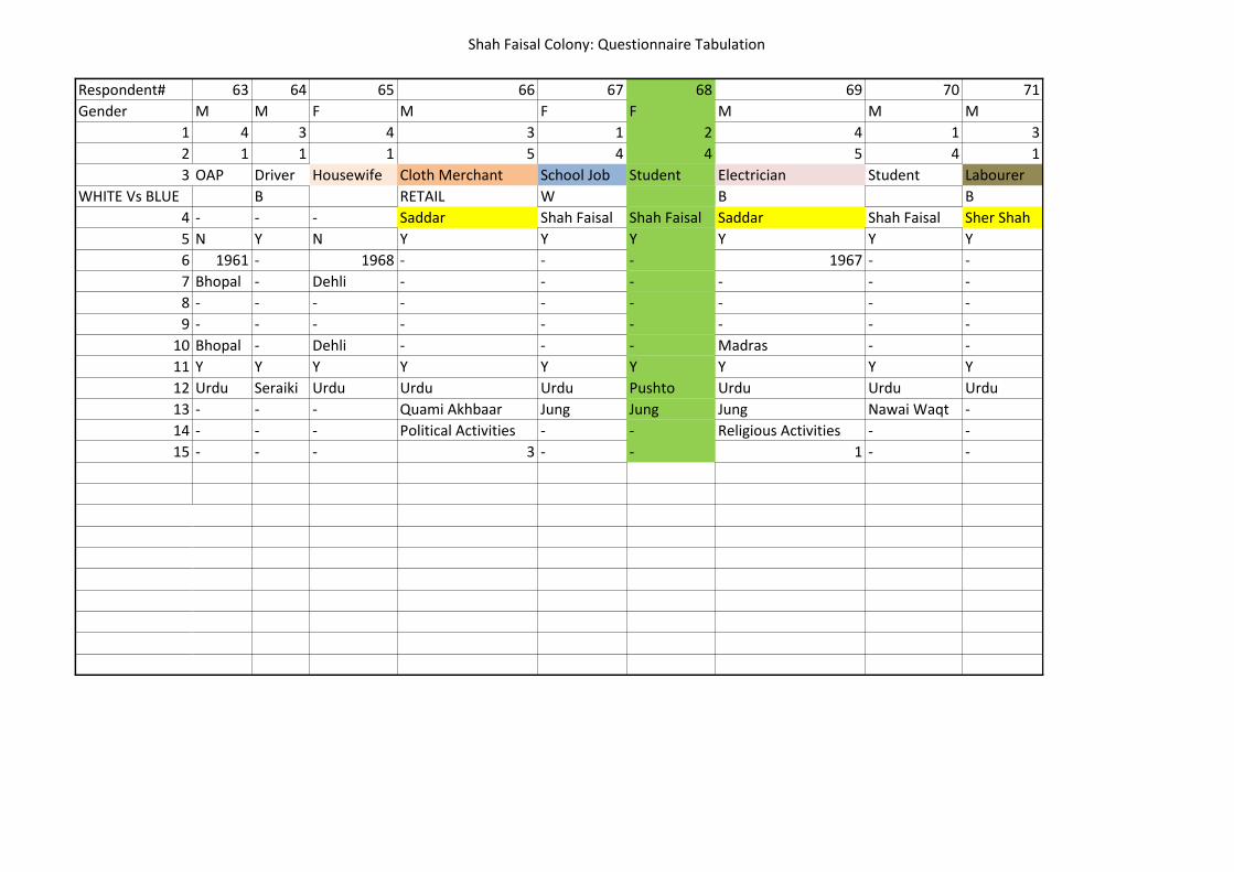
Shah Faisal Colony: Questionnaire Tabulation
Respondent#
Gender
1
2
3
WHITE Vs BLUE
4
5
6
7
8
9
10
11
12
13
14
15
63 64 65 66 67 68 69 70 71
M M F M F F M M M
4 3 4 3 1 2 4 1 3
1 1 1 5 4 4 5 4 1
OAP Driver Housewife Cloth Merchant School Job Student Electrician Student Labourer
B RETAIL W B B
- - - Saddar Shah Faisal Shah Faisal Saddar Shah Faisal Sher Shah
N Y N Y Y Y Y Y Y
1961 - 1968 - - - 1967 - -
Bhopal - Dehli - - - - - -
- - - - - - - - -
- - - - - - - - -
Bhopal - Dehli - - - Madras - -
Y Y Y Y Y Y Y Y Y
Urdu Seraiki Urdu Urdu Urdu Pushto Urdu Urdu Urdu
- - - Quami Akhbaar Jung Jung Jung Nawai Waqt -
- - - Political Activities - - Religious Activities - -
- - - 3 - - 1 - -
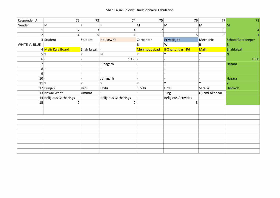
Shah Faisal Colony: Questionnaire Tabulation
Respondent#
Gender
1
2
3
WHITE Vs BLUE
4
5
6
7
8
9
10
11
12
13
14
15
72 73 74 75 76 77 78
M F F M M M M
2 3 4 2 1 3 4
4 5 1 1 5 3 1
Student Student Housewife Carpenter Private job Mechanic School Gatekeeper
B W B B
Malir Kala Board Shah faisal - Mehmoodabad II Chundrigarh Rd Malir Shahfaisal
Y Y N Y Y Y N
- - 1955 - - - 1980
- - Junagarh - - - Hazara
- - - - - - -
- - - - - - -
- - Junagarh - - - Hazara
Y Y Y Y Y Y Y
Punjabi Urdu Urdu Sindhi Urdu Seraiki Hindkoh
Nawai Waqt Ummat - - Jung Quami Akhbaar -
Religious Gatherings - Religious Gatherings - Religious Activities - -
2 - 2 - 3 - -
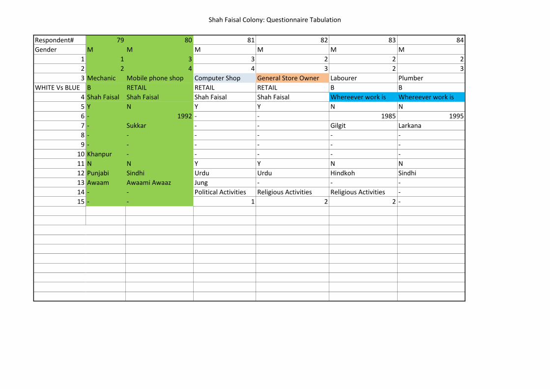
Shah Faisal Colony: Questionnaire Tabulation
Respondent#
Gender
1
2
3
WHITE Vs BLUE
4
5
6
7
8
9
10
11
12
13
14
15
79 80 81 82 83 84
M M M M M M
1 3 3 2 2 2
2 4 4 3 2 3
Mechanic Mobile phone shop Computer Shop General Store Owner Labourer Plumber
B RETAIL RETAIL RETAIL B B
Shah Faisal Shah Faisal Shah Faisal Shah Faisal Whereever work is Whereever work is
Y N Y Y N N
- 1992 - - 1985 1995
- Sukkar - - Gilgit Larkana
- - - - - -
- - - - - -
Khanpur - - - - -
N N Y Y N N
Punjabi Sindhi Urdu Urdu Hindkoh Sindhi
Awaam Awaami Awaaz Jung - - -
- - Political Activities Religious Activities Religious Activities -
- - 1 2 2 -

Shah Faisal Colony: Questionnaire Tabulation
Respondent#
Gender
1
2
3
WHITE Vs BLUE
4
5
6
7
8
9
10
11
12
13
14
15
85 86 87 88 89 90 91
M M F M F F M
2 3 2 1 3 2 2
4 5 4 3 5 4 5
Sales Man Bank School teacher Student Office Woker Nurse Hospital Cashier
W W W W W W
Tariq Rd Shah faisal Model Town Shah Faisal Bahadurabad Rafa-e-aam Nazimabad
Y Y Y Y Y N Y
1986 - - - - 1985 -
- - - - Multan -
- - - - - -
- - - - - -
Pindi - - - - - -
N Y Y Y Y N Y
Punjabi Urdu Sindhi Urdu Urdu Seraiki Urdu
Jung Dawn Jung Amman Jung - Jasarat
Community work Community Work Community work Political Activities Religious Gatherings - -
2 1 3 2 2 - -

Shah Faisal Colony: Questionnaire Tabulation
Respondent#
Gender
1
2
3
WHITE Vs BLUE
4
5
6
7
8
9
10
11
12
13
14
15
92 93 94 95 96 97 98
M F F M M M M
3 2 1 2 3 3 2
6 - 4 4 7 6 4
Computer Worker Housewife Student Electrician Computer College Teacher TV Mechanic
W B W W B
Saddar - Shah Faisal Whereever work is II Chundrigarh Rd Rafa-e-aam Azeem Pura
N Y Y Y Y Y Y
1995 - - - - 1970 -
Lala Musa - - - - - -
- - - - - - -
- - - - - - -
Lala Musa - - - - Gujranwala -
Y Y Y Y Y Y Y
Punjabi Urdu Urdu Urdu Urdu Punjabi Urdu
Jung - Akhbaar-e-Jahan Jasarat Jung Jasarat Jung
Community work Milaad Religious Activities - Community work Religious Activities Community work
2 2 1 - 3 2 3
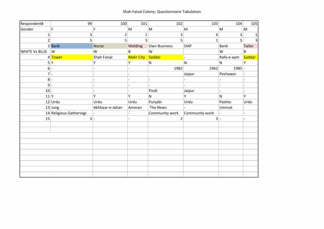
Shah Faisal Colony: Questionnaire Tabulation
Respondent#
Gender
1
2
3
WHITE Vs BLUE
4
5
6
7
8
9
10
11
12
13
14
15
99 100 101 102 103 104 105
F F M M M M M
3 2 1 3 4 3 1
5 5 3 5 1 5 3
Bank Nurse Welding Own Business OAP Bank Tailor
W W B W W B
Tower Shah Faisal Malir City Saddar - Rafa-e-aam Saddar
Y Y Y N N N Y
- - - 1982 1962 1985 -
- - - Jaipur Peshawer -
- - - - - - -
- - - - - - -
- - - Pindi Jaipur - -
Y Y Y N Y N Y
Urdu Urdu Urdu Punjabi Urdu Pashto Urdu
Jung Akhbaar-e-Jahan Amman The News - Ummat -
Religious Gatherings - - Community work Community work - -
3 - - 2 3 - -
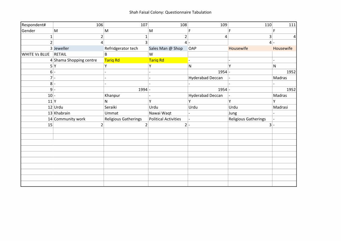
Shah Faisal Colony: Questionnaire Tabulation
Respondent#
Gender
1
2
3
WHITE Vs BLUE
4
5
6
7
8
9
10
11
12
13
14
15
106 107 108 109 110 111
M M M F F F
2 1 2 4 3 4
4 3 4 - 4 -
Jeweller Refridgerator tech Sales Man @ Shop OAP Housewife Housewife
RETAIL B W
Shama Shopping centre Tariq Rd Tariq Rd - - -
Y Y Y N Y N
- - - 1954 - 1952
- - - Hyderabad Deccan - Madras
- - - - - -
- 1994 - 1954 - 1952
- Khanpur - Hyderabad Deccan - Madras
Y N Y Y Y Y
Urdu Seraiki Urdu Urdu Urdu Madrasi
Khabrain Ummat Nawai Waqt - Jung -
Community work Religious Gatherings Political Activities - Religious Gatherings -
2 2 2 - 3 -

Shah Faisal Colony: Questionnaire Tabulation
Respondent#
Gender
1
2
3
WHITE Vs BLUE
4
5
6
7
8
9
10
11
12
13
14
15
112 113 114 115 116 117 118
M M M F F M M
3 1 2 3 2 2 3
1 4 5 - 4 1 3
Milk Shop Student Own Business Housewife Hospital Worker Lathe Welding General Store Owner
RETAIL W B B RETAIL
Shah Faisal SF Shama Shopping centre - Azeem Pura Malir City SF
N Y Y N Y Y Y
1980 - - 1951 - - -
Okara - - Lucknow - - -
- - - - - - -
- - - 1951 - 1984 -
- - - Lucknow - Multan -
N Y Y Y Y N Y
Punjabi Urdu Punjabi Urdu Sindhi Punjabi Urdu
- Jasarat Ummat - Quami Akhbaar - Awaam
- Religious Gatherings Community work - - - -
- 2 2 - - - -
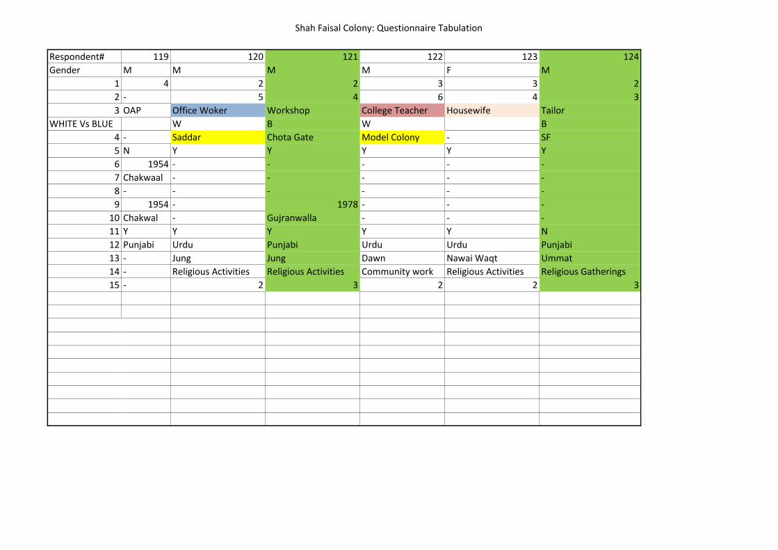
Shah Faisal Colony: Questionnaire Tabulation
Respondent#
Gender
1
2
3
WHITE Vs BLUE
4
5
6
7
8
9
10
11
12
13
14
15
119 120 121 122 123 124
M M M M F M
4 2 2 3 3 2
- 5 4 6 4 3
OAP Office Woker Workshop College Teacher Housewife Tailor
W B W B
- Saddar Chota Gate Model Colony - SF
N Y Y Y Y Y
1954 - - - - -
Chakwaal - - - - -
- - - - - -
1954 - 1978 - - -
Chakwal - Gujranwalla - - -
Y Y Y Y Y N
Punjabi Urdu Punjabi Urdu Urdu Punjabi
- Jung Jung Dawn Nawai Waqt Ummat
- Religious Activities Religious Activities Community work Religious Activities Religious Gatherings
- 2 3 2 2 3