The Social and Ideological Role of Crannogs in Early Medieval Ireland. Vol. 1, PhD thesis, NUI...
433
/ NUIMAYNOOTH Ollscoil na bÉireann Ma Nuad THE SOCIAL AND IDEOLOGICAL ROLE OF CRANNOGS IN EARLY MEDIEVAL IRELAND by AIDAN O’SULLIVAN THESIS FOR THE DEGREE OF PH.D. DEPARTMENT OF MODERN HISTORY NATIONAL UNIVERSITY OF IRELAND MAYNOOTH HEAD OF DEPARTMENT: Professor R.V. Comerford Supervisor of Research: Mr. John Bradley Volume One of Two TEXT March 2004
Transcript of The Social and Ideological Role of Crannogs in Early Medieval Ireland. Vol. 1, PhD thesis, NUI...

/
NUIMAYNOOTHOllscoil na bÉireann Ma Nuad
THE SOCIAL AND IDEOLOGICAL ROLE OF CRANNOGS
IN EARLY MEDIEVAL IRELAND
b y
AID AN O’SULLIVAN
THESIS FOR THE DEGREE OF PH.D. DEPARTMENT OF MODERN HISTORY NATIONAL UNIVERSITY OF IRELAND
MAYNOOTH
HEAD OF DEPARTMENT: Professor R.V. Comerford Supervisor of Research: Mr. John Bradley
Volume One of Two
TEXT
March 2004

Frontispiece: R econstruction draw ing o f an early m edieval crannog based on
archaeological evidence from W estm eath.


Contents
Frontispiece........................................................................................................................................ iiTable o f contents........................................................................................................................ iiiList o f Tables.................................................................................................................................... viiList o f F igures............................................................................................................................... viiiList o f A ppendices........................................................................................................................ xvAcknowledgements.......................................................................................................................... xvi
C hap ter 1. In troduc tion .................................................................................................................. 1Introduction..........................................................................................................................................1The archaeology and history o f crannogs in early medieval Ireland...................................... 1Aims and objectives o f this thesis....................................................................................................8Regional and local perspectives....................................................................................................... 10Exploring island life in the early Middle Ages..............................................................................13Outline o f thesis chapters...................................................................................................................13
C hapter 2. Islands and the scholarly im agination:a historiography o f crannog studies........................................................................................ ...19Introduction...... ..............................................................................................................19From peasant folklore to antiquarian respectability, 1750-1857................................................21
A forgotten tradition - before ‘crannogs’, 1750-1810................................................. 21The first antiquarian recognition o f islands and houses in lakes, 1810-1839.......... 24Collecting objects from the ‘bone-heap’ o f Lagore, 1839-48......................................27The Commission for Arterial Drainage and Inland Navigationand the ‘Strokestown crannogs’, Co. Roscommon, 1843-1852................................ 30William Wilde’s ‘Catalogue o f Antiquities’, 1857....................................................... 33
Early antiquarian surveys, excavations, and syntheses, 1860-1932.......................................... 36George Morant, George Kinahan and William Wakemanand other antiquarians, 1860-1886....... 36Discoveries at Lisnacrogher and Lough Moume, Co. Antrim.....................................41Wood-Maitin’s The lake dwellings o f Ireland, 1886.................................................... 42George Buick, Rev. D’Arcy, George Coffeyand the new century, 1890-1920....................................................................................... 45
The impact o f the Harvard Archaeological Mission, 1932-1970.............................................. 48The Harvard Archaeological Mission in the 1930s and 1940s.................................. 48Oliver Davies and crannog excavations in Northern Ireland, 1940-1950................ 53The County Down Archaeological Surveyand crannog studies in Northern Ireland, 1950-1966................................................... 54Discoveries at Lough Gara in the 1950s.......................................................................... 56
Archaeological survey, excavation and changing ideas, 1970-2002.........................................60The Fermanagh crannog surveyand dendrochronological studies in the 1970s................................................................ 60Re-thinking old sites and the Wood-Martin crannog conference, 1986.................. 61Treasure hunters and the state, 1980-1987...................................................................... 63

The Crannog Archaeological Project 1983-1993.......................................................... 65The Archaeological Survey o f Ireland 1980-2002........................................................ 69The Moynagh Lough excavations, 1980-2002...............................................................70The Discovery Programme and ‘The lake settlement project, 1997-....................... 73The Lough Gara ‘Crannog Research Programme’........................................................75
Conclusions........................................................................................................................................ 79
Chapter 3. Interpreting islands:approaches to the archaeology and history of early medieval crannogs................... 80Introduction....................................................................................................................................... 80Multidisciplinary approaches: objects, texts and meanings.................................................... 80
Places and objects: archaeological evidence.............................................................. 80Plants, animals and lifeways: palaeoenvironmental reconstruction....................... 81Texts and contexts: early Irish historical evidence.................................................... 82Multidisciplinary approaches: problems and potential.............................................. 84
Theoretical and methodological approaches to settlement and landscape............................ 87Introduction: approaches to settlement and landscape in archaeological thought... 87Processual approaches to settlement and landscape.......................................................88Postprocessual approaches to settlement and landscape............................................... 89
Reconstructing settlement and landscape in early medieval Ireland........................................ 90Introduction...........................................................................................................................90Early medieval settlement and landscape, sixth to eighth century A D................... 91Early medieval settlement and landscape, ninth to eleventh century AD.................. 96
Interpretative approaches to early medieval crannogs in Ireland........................................... 98Interpreting crannogs in the early medieval landscape............................................... 98Interpreting crannogs as early medieval island dwellings.............................................100Place, memory and belonging....................................................................................... 102People, islands and social identity.................................................................. 103
Conclusions........................................................................................................................................ 104
Chapter 4. Islands and social identity in the early medieval imagination.....................105Introduction.................................................................................................................................... 105Islands and the early medieval imagination.............................................................................. 108
Introduction................................................................................................................. 108Islands as places apart from, and at the centre of, the w orld.................................... 112Islands, negotiating boundaries, edges and liminalities.............................................. 125Islands, j oumeys, movement and arrival..................................................................... 127
Islands and social identity in the early Middle Ages............................................................... 129Introduction......................................................................................................................... 129Interpreting early medieval social identities................................................................. 130Islands, ethnicity and identity in early medieval Ireland............................................ 132Islands, kinship, community and the tualh in early medieval Ireland...................... 137Islands, social hierarchy and status in early medieval Ireland......................................142Islands, gender, sexuality and age in early medieval Ireland.................................. 158
Conclusions........................................................................................................................................ 169

C hapter 5: Islands in w atery worlds:a landscape perspective on early m edieval crannogs..............................................................170Introduction..........................................................................................................................................170Landscape, settlement and society in early medieval. W estmeath........................................ 170
Introduction......................................................................................................................... 170Physical landscape and environment in W estmeath.................................................... 172Physical landscape and environment on Lough Derravarragh..................................... 185Early medieval politics and people in W estmeath..........................................................196Early medieval settlement and landscape in W estmeath.............................................. 207
Regional and local landscape perspectives on crannogs in early medieval W estmeath 215Introduction....................................................................................................................... 215Siting in relation to topography, geology and soils.................................................. 216Siting in relation to drainage, lakes and rivers................................................................217Siting in relation to other archaeological sites................................................................ 218Siting in relation to early medieval settlement landscapes........................................... 220Siting in relation to early medieval political boundaries............................................ 221
Islands, landscapes and society in early medieval W estmeath...................................................224Introduction....................................................................................................................... 224Islands, power and performance in the social and ideological landscape.................. 224Islands, lordship, community and territorial defence.................................................. 235Islands, social marginality and ‘living at the edge’..................................................... 241
Islands, agriculture and working the land in early medieval W estmeath............................... 252Introduction....................................................................................................................... 252The role o f crannogs in early medieval agriculture and economy........................... 253Crannogs, agriculture and the land in early medieval W estmeath........................... 256Living by lakeshores and the routines o f agricultural labour..................................... 259
Islands, landscape and movement in early medieval W estmeath.............................................. 261Introduction....................................................................................................................... 261Crannogs and movement along watery routeways..................................................... 262Crannogs and movement along esker roads and pathways........................................ 264Movement through early medieval lakeshore topographies o f power..................... 267
Conclusions......................................................................................................................................... 269
C hapter 6. Islands and architectures:the building, occupation and perception o f early m edieval crannogs............................. 271Introduction......................................................................................................................................... 271Island histories: crannogs, time and social memory................................................................... 272
Introduction...................................................................................................................... 272Crannogs and chronology in Westmeath......................................................................... 273Crannogs and chronology in Ireland.................................................................................280‘Remembering’: crannogs as symbols o f the past in the early Middle Ages 291‘Lifecycles’ : site maintenance practices, renewal and alteration................................ 297‘Forgetting’: site destruction, abandonment and desertion...........................................301
Islands apart: the architecture: and insularity o f crannogs.......................................................... 307Introduction...........................................................................................................................307The building o f a crannog as an event in the community............................................. 307
v

Building islands on water: the morphology o f cairns, mounds and platforms 314Building crannogs in Westmeath: cairns, mounds and platforms................................316Palisades, revetments kerbs and walls in Westmeath: enclosing and excluding.... 335Causeways and pathways on Westmeath: journeying and arriving............................ 344Landing stages, harbours and jetties in W estmeath....................................................... 348Dugout boats......................................................................................................................... 350
Conclusions..........................................................................................................................................353
C hap ter 7: Island life:in terpreting the social organisation o f space on early m edieval crannogs..................... 354Introduction......................................................................................................................................... 354Reconstructing the social organisation o f space within early medieval crannogs.............. 355Entering the island: entrances and pathways............................................................................... 356
Introduction............................................................... 356Entrances, gates and pathways...................................................................................... 357
Living on an island: observing work and daily life on early medieval crannogs................ 360Introduction....................................................................................................................... 360Understanding social hierarchy and status by observing labour on crannogs 361Understanding gender by observing labour on crannogs..............................................362Wood working.................................................................................................................. 362Bone, antler and leatherworking................................................................................... 363Iron working and non-ferrous metalworking.............................................................. 363Early medieval metal working and Moynagh Lough crannog................................ 364Early medieval iron working islands: Bofeenaun and Sroove crannogs................ 368
Feasting space: food, dirt and the social role o f middens on early medieval crannogs 372Introduction....................................................................................................................... 372Interpreting patterns o f rubbish and discard on crannogs................................ 375Human bones in m iddens....................................................................................................377Middens outside houses...................................................................................................... 380Middens at the palisades...................................................................... 380Cesspits......................................................... 384
Houses and dwellings on early medieval crannogs: theatres for social encounters 385Introduction...........................................................................................................................385Lifecycles o f early medieval houses............................................................................... 387Interpreting houses on early medieval crannogs.......................................................... 388House form, size and location............................................................................................389Doorways and entrances................................................................................................... 395Floor surfaces: palimpsests of human history.............................................................. 396Hearths and fireplaces: symbols o f the household ................................. 406
Conclusions................................................................................................................. 407
Chapter 8. Conclusions 408

List of tables
Table 6:1: Chronology of artefacts recovered from crannogs in Westmeath..................................................................................................................
Table 6.2: Dendrochronological and radiocarbon dates from Irish crannogs

List of Figures
Fig. 1.1 Map showing distribution of crannogs in Ireland, based on records of the Archaeological Survey of Ireland and the Environment and Heritage Service, Northern Ireland. (Source: Aidan O’Sullivan, Crannogs: Lake dwellings o f early Ireland).
Fig. 1.2. Reconstruction drawing of a hypothetical early medieval crannog, based on evidence from sites in the north midlands. The crannog is a cairn of stone laid over a wooden foundation, with sand and clay spread across its upper surface. It is accessed by a stone causeway which leads through the shallow water to the entrance and is enclosed within an ‘inner’ roundwood palisade, while the remnants of an ancient, rotting palisade revets the cairn edge at the water level, Out in the water, there is another ‘outer’ palisade, defining a watery space around the island. Internally, the crannog has a roundhouse, an outside hearth and working spaces. It will be proposed in this thesis that all this architecture can be interpreted in social and ideological terms (drawing: Aidan O’Sullivan).
Fig. 2.1 View across northwest shore of Donore townland, Lough Derravarragh, Co. Westmeath. A local folktale recorded by William Wilde in 1860 described how a crannog on this shore known as ‘The Castle’ (probably Castlewatty) was the venue for a fantastic encounter between two fishermen and a woman of the underworld. By the 1930s, Lough Derravarragh’s crannogs had been forgotten locally and there is little mention of them in the Folklore Commissions School’s Manuscripts (CUCAP AHH 43).
Fig. 2.2 One of the earliest depictions of an Irish crannog, in a drawing of an ‘artificial island and old fort’ at Ballymacpeake, Co. Londonderry in 1836. (Source: Royal Irish Academy Ordnance Survey Memoirs, Parish of Maghera; C.S. Briggs, ‘A historiography of the Irish crannog’, p. 350).
Fig. 2.3 Engineer’s cross-section drawing of an early medieval crannog at Ardakillen, Co.Roscommon, illustrating the quality of these early records. (Source: Wood-Martin, The lake dwellings o f Ireland).
Fig. 2.4 Kinahan’s remarkable reconstruction drawing of an Irish crannog, based on his surveys of sites on Lough Naneevin, Co. Galway and perhaps inspired by ethnography. He imagined a circular house with a central courtyard, probably based on his observation of multiple palisades on sites (source: Kinahan. ‘Notes on a crannoge in Lough Naneevin’, p. 1).
Fig. 2.5 Wakeman’s site plan and landscape perspective of a crannog on Lough Eyes, Co. Fermanagh in 1870 and drawing of a late medieval everted rim-ware pot from the same lake, completed as part of his indefatigable surveys in the northwest. Wakeman’s drawings served to embed images of Irish crannogs in the antiquarian sensibility (source: Wood-Martin, The lake dwellings o f Ireland)
Fig. 2.6 William Wakeman’s iconic and enduring reconstruction drawing of an Irish crannog, reproduced as the frontispiece of Wood-Martin’s The lake dwellings o f Ireland, ‘ideally restored from inspection of numerous sites’. (Source: Wood-Martin, The lake dwellings o f Ireland).
Fig. 2.7 The Harvard Archaeological Expedition archaeologists, Hallam L. Movius and Hugh O’Neill Hencken, with Dr. Adolf Mahr, director of the National Museum of Ireland, at their first summer’s excavations at the early medieval crannog of Ballinderry No. 1, Co. Westmeath. The Harvard Mission aimed to provide powerful new narratives about the ‘origins of the Irish.’ (Source: Hencken, ‘Ballinderry no. 1’.).

Fig. 2.8a Early medieval crannog at Tonymore crannog, Lough Kinale, Co. Longford. (Source:National Museum of Ireland).
Fig. 2.8b Reconstructed eighth-century bookshrine found by treasure hunters beside Tonymore crannog, Lough Kinale, Co. Longford in 1980s. In these years the century-old tradition of collecting antiquities from crannogs came up against the growing legislative power of state archaeologists.(Source: National Museum of Ireland).
Fig. 2.9 Aerial photograph of early medieval Croinis crannog and Dun na Sciath ringfort, on the southwest shore of Lough Ennell, Co. Westmeath. This lake was the main location of the Crannog Archaeological Survey’s still largely unpublished underwater surveys, between 1983 and 1993 (CUCAP AVH 20).
Fig. 3.1 An early medieval multivallate ringfort and an early medieval crannog at Lisleitrim, Co. Armagh. It is likely that this is a royal settlement complex, with prominent siting and impressive architecture being used to project a normative image of power in the landscape (Source: Aidan O’Sullivan, The archaeology o f lake settlement in Ireland (Dublin, 1998), p. 137, pi. 44).
Fig. 3.2 Aerial photograph of three early medieval ringforts in Loughanstown townland in the barony of Corkaree, Co. Westmeath, between Lough Derravarragh and Lough Owel. These ringforts with their enclosed spaces, banks and ditches, prominent siting and proximity to each other illustrate the locally dense early medieval settlement on the good agricultural soils of Westmeath (CUCAP AVO 61, after Stout 1997, plate 8).
Fig. 3.3 Stout’s hypothetical model of the social organisation of the early medieval settlement landscape (i.e. sixth-ninth century AD) in the southwest midlands. The lord’s (aire forgill) multivallate ringfort is located in a commanding site, near an important routeway and is surrounded by the simple, univallate forts of his ocaire tenants. The ringfort of the aire deso lord is on level terrain near the tuath boundary, indicating his role in territorial defence. The ringforts of the boaire farmers are further away, indicating that these independent farmers owned their own land. A significant church site is located on the routeway and some land is either farmed in common or is in woodland. (Source: Stout, The Irish ringfort, p. 126).
Fig. 3.4 A hypothetical model of social and settlement continuity and change towards the end of the early Middle Ages. This suggests that in the ninth and tenth century, there was a shift away from a ‘dispersed’ settlement pattern as ringforts were being abandoned, with a emergence of ‘nucleated’ settlements in the eleventh and twelfth century, focused on lordly sites (i.e. raised raths) and significant church settlements. Although archaeologists and historians have traced some evidence for this change, it remains largely unsubstantiated. (Source: Tadhg O’Keeffe, Medieval Ireland: an archaeology (Stroud, 2000), p. 25, Fig. 7).
Fig. 4.1 Early medieval island monastery of Inishmurray, Co. Sligo. While the monastery had churches, beehive cells, and leachta, it was also a significant destination for medieval pilgrims, who visited the island’s hostels, public churches and saint’s tomb. (Source: Peter Somerville Large, Ireland’s Islands: Landscape, life and legends (Dublin, 2000), p. 47.
Fig. 4.2 Early medieval island hermitage on Church Island, Ballycarbery West, off Valentia Island, Co. Kerry, with its beehive hut, oratory and burials inside a stone enclosure. Some of these small island hermitages were hardly larger than a midlands crannog (Source: A. O’Sullivan and J. Sheehan The Iveragh Peninsula: An archaeological survey o f south Kerry (Cork, 1996), p. 254, 257, PI. XVHA.
Fig. 4.3 Early medieval crannog on Lough Hackett, Co. Galway, probably a royal site. This island is the venue for various supernatural encounters in the tenth-century life of Mochua of Balia and the Annals o f the Four Masters states that it was damaged by a storm in AD 990. (Source: O. Alcock, K. de hOra and P. Gosling, Archaeological inventory o f County Galway. Vol. II: North Galway (Dublin, 1999), PI. IHa, p. 119).
Fig. 4.4. The early medieval island of the dead, Tech Dorn, known today as Bull Rock, the furthest island off Dursey Island, Beara Peninsula, Co. Cork. In early Irish literature dating from the ninth to the twelfth century, this island was viewed as the place ‘where the dead assemble’, co tech nDuind frisndalait mairb. (Source: Peter Somerville Large, Ireland's Islands: Landscape, life and legends (Dublin, 2000), p. 105.
Fig. 4.5 Plan of the early medieval crannog of Ballinderiy No. 1, Co. Westmeath. The site was occupied from the late-tenth century to the late-eleventh century AD, and the distinctive Hibemo-Norse character of the crannog’s houses and material culture suggests significant Scandinavian influences, if not even a presence, in the north Irish midlands at the end of the early Middle Ages. (Source: Hencken,‘Ballinderry No. 1’, PI. XIII).
Fig. 4.6 Early Irish historical sources indicate that both early medieval crannogs and islands were occasionally used as prisons or as places to hold slaves (e.g. Dalkey Island, Co. Dublin). These possible slave chains or hostage collars were found with human remains beside the early medieval crannog of Ardakillen, Co. Roscommon (Source: National Museum of Ireland).
Fig. 4.7 Early medieval monastic island of Scattery Island, situated at the mouth of the Shannon estuary. In the tenth-century life of Senan, the island’s sanctity was threatened by the arrival of a female saint, who only by a miracle gains the privilege of burial on the island. (Source: A. O’Sullivan, Foragers, farmers andfishers in a coastal landscape, (Dublin, 2001), p. 6, PI. 3.
Fig. 5.1 Westmeath is a lowlying county in the north Irish midlands. This map illustrates its principal towns, routeways, lakes, rivers and general topography. (Source The Encyclopedia o f Ireland, p. 1131).
Fig. 5.2 Westmeath’s lakelands, with distribution map of county’s crannogs.
Fig. 5.3, Westmeath, map illustrating quaternary geology, drumlins, eskers and glacial drifts (Source: T.F. Finch Soils of Co. Westmeath (Dublin, 1977), Fig.4).
Fig. 5.4. Percentage summary arboreal and herbaceous pollen taxa from Comaher Lough, south of Newtownlow crannog, Co. Westmeath (Source: Heery, ‘The vegetation history of the Irish midlands’, Fig. 2.8b, Fig. 2.8c).
Fig. 5.5. Aerial photograph of Lough Derravarragh, Co. Westmeath. In the foreground, the hills of Knockbrody, Knockross and Knockeyon rise steeply from the narrow, deep, southeast end of the lake.In the middle distance, there are gentle slopes, while in the distance, the broad, shallow northwest end of the lake is fringed by raised bogs and fens (Photo: Aerofilms Ltd)
Fig. 5.6 Distribution map of early medieval monuments (ringforts, crannogs, churches and holy wells) around Lough Derravarragh, Co. Westmeath. The lough’s crannogs are typically found at the shallow, northwest end, adjacent to good agricultural land, avoiding raised bogs and fens along the River Inny and the steep slopes of Knockeyon, Knockbrody and Knockross, at the opposite, deep end of the lake.
Fig. 5.7 Early medieval dynasties and population groups in Westmeath, c. AD 800. Between the seventh and the eleventh century, this region was situated within the early medieval over-kingdom of Mide, which was largely controlled by the southern Ui Neill dynasty of the Clann Cholmain.
Fig. 5.8 Early medieval settlement and landscape in Westmeath. Map illustrating the density and distribution of ringforts, crannogs, souterrains, churches, holy wells, bullaun stones and crosses.(Source Westmeath RMP, Duchas - the Heritage Service and this author’s surveys).
x

Fig. 5.9 Early medieval churches in Westmeath. Most of the county’s parishes have one early church site suggesting that parish boundaries have their origins in the early Middle Ages. (Source: F.H. A.Allen et al eds. The Atlas o f the Irish rural landscape (Cork, 1997), p. 52)
Fig. 5.10 Distribution of Westmeath’s crannogs in relation to modem barony boundaries, indicating that as much as 79 per cent of the county’s crannogs are on or close to potential early medieval tuath boundaries.
Fig. 5.11 Map of early medieval settlement landscape at Dun na Sciath ringfort and Croinis crannog, on Lough Ennell, Co. Westmeath. These were the royal residences of the Clann Cholmain kings of Mide between the eighth and the eleventh centuries AD.
Fig. 5.12 Map of early medieval ringforts and crannogs at Coolure Demesne, Lough Derravarragh. Archaeological and historical evidence suggests that this was a royal or lordly settlement complex of the early medieval population group, the Ui Fiachrach Cuile Fobair. The probable high-status crannog is situated in a small bay, overlooked by several other sites around the lakeshore and could have served as an island ‘stage’ to symbolise the king’s central role in the community.
Fig. 5.13 Map illustrating landscapes of a possible early medieval lordly crannog at Dryderstown,Lough Annala, Co. Westmeath, 3km southwest of the early medieval royal site of the Ui Fhindallain at Telach Cail (Delvin).
Fig. 5.14 Aerial photograph of early medieval crannog (ninth-century date from palisade) of Goose Island in its local landscape at Rochfort Demesne, on the east shore of Lough Ennell, Co. Westmeath in 1968. The crannog is surrounded by several small low-caim and platform crannogs all along this shoreline (Rochfort Demesne 1-9). These were probably the lake dwellings of ordinary or poor’ people living and working on their lord’s estates (CUCAP AVH 13).
Fig. 5.15 Map of small, low-caim crannogs atKiltoom, Lough Derravarragh, Co. Westmeath, situated on the shoreline to the west of an early medieval church (Cell Toma), possibly a proprietary site of the Ui Fiachrach Cuile Fobair. These small crannogs may have been the dwellings of monastic tenants or labourers.
Fig. 5.16 Photograph showing landscape atNewtownlow crannog, Co. Westmeath, from the steep esker slopes overlooking the site. Travellers along this probable early medieval routeway would have looked down upon the tenth-century crannog and ringfort at the edges of a small lake. In the twelfth century, an Anglo-Norman timber castle or motte was probably built on the ridge overlooking the crannog, deliberately appropriating this local power centre, thus revealing social and political changes to all those moving along the esker.
Fig. 5.17 Photograph of Dun na Sciath ringfort and Croinis crannog in the water beyond it, on Lough Ennell, Co. Westmeath. This early medieval settlement complex is situated at some remove from the early medieval ringforts and churches at Dysart to the north, at the end of a promontory into the lake,An early medieval visitor would only have seen the crannog at the last minute, when he had reached the ringfort on the ridgeline, thus enhancing the social and symbolic significance of the distant island.
Fig. 6.1a Early medieval bronze enamelled mount (fifth to seventh century AD) found on Coolure Demesne 1 crannog, on Lough Derravarragh, Co. Westmeath. (Source: National Museum of Ireland).
Fig. 6.1b Early medieval hoard of Viking silver armlets (ninth to tenth century AD) found on Coolure Demesne 1 crannog, on Lough Derravarragh, Co. Westmeath. Most of the finds recovered from Westmeath’s crannogs date to the early medieval period. (Source: National Museum of Ireland).
Fig. 6.1c Early medieval silver ingots (ninth to tenth century AD) found on Coolure Demesne 1 crannog, on Lough Derravarragh, Co. Westmeath. It is likely that this silver was obtained as political

tribute, loot or plunder from Hibemo-Norse Dublin and distributed through the kingdom of Mide as gifts or within socially and politically binding agreements (source: National Museum of Ireland).
Fig. 6.2 Plan and cross-section of early medieval royal crannog of Croinis, Lough Ennell, Co. Westmeath. The crannog was enclosed within an ‘outer’ roundwood palisade dated to the ninth century AD, while an ‘inner’ oak plank palisade was dated to AD 1107 ± 9 years, suggesting re-fortification in the early twelfth century AD. The ruins of a stone structure on the crannog may be the remains of a fifteenth-century towerhouse which was modified as a summer house in the nineteenth century AD (Source: Kelly, ‘Observations on Irish lake dwellings’).
Fig. 6.3. Cairn types of Westmeath’s crannogs.
Fig. 6.4 Cairn heights of Westmeath’s crannogs
Fig. 6.5 Cairn diameters of Westmeath’s crannogs
Fig. 6.6 Edge boundary features on Westmeath’s crannogs
Fig. 6.7 Distance to shoreline amongst Westmeath’ crannogs
Fig. 6.8 Depth of water in which crannogs were built in Westmeath
Fig. 6.9 View of Coolure Demesne 1 crannog, Lough Derravarragh, Co. Westmeath. It was probably an early medieval royal or lordly site of the Ui Fiachrach Cuile Fobair. This large, high-caim crannog (36m in diameter, 5m in height) enclosed within an oak plank and roundwood palisade was immensely rich in artefactual evidence, with mounts, pins and armlets dating from the sixth to the tenth century AD.
Fig. 6.10 Early medieval Ballynakill 1 crannog, Lough Derravarragh, Co.. Westmeath. This site has produced early medieval bronze mounts, brooch fragments and animal bone. It is a small, isolated low- caim crannog (8m in diameter, lm in height) built on a gravelly shoal, but is submerged during the winter. It may have been the early medieval island habitation or seasonal dwelling of a ‘middle class’, farming community.
Fig. 6.11a Possible early medieval low-caim crannog atKiltoom 7, Lough Derravarragh. These intriguing sites (there are 8 similar crannogs along this shoreline) are small, stony crannogs (ll-15m diameter, lm in height), built in ankle deep water on the east shore of the lake. They are reached by short, narrow causeways and could be interpreted as small lake-shore dwellings of ‘poor people’ associated with the nearby church of Cell Toma (Kiltoom).
Fig. 6.11b View of fabric of stone on Kiltoom 7. These sites are similar in size, form and appearance to the early medieval crannog of Sroove, Co. Sligo On the shore side, the site appears to be a low cairn of small stones. In contrast, the massive kerb stones on the lakeward side give it a much more impressive façade for people looking at it from boats (Photo: Rob Sands).
Fig 6,12 Location and distribution of crannogs on Lough Ennell, Co. Westmeath
Fig. 6.13 View of Lough Lene, Co. Westmeath from north. There are two natural islands, Turgesius Island and Nun’s Island. The small islet to the west (towards distant shore) is Castle Island, a rocky cairn crannog dendrochronologically dated to the ninth century AD that has produced ecclesiastical metalwork (a bronze basin and hand-bell) and may have been a ‘church crannog’.
Fig. 6.14 Early medieval palisade on Ballinderry crannog No. 2, Co. Offaly. In Westmeath, crannogs have a range of enclosing features and boundaries, including inner and outer palisades, kerbs and stone walls. It is probable that all of these were socially significant, physically and symbolically demarcating it and defining the island space occupied by the social group.

Fig. 6.15 This small, low-caim crannog at Derrya 1, Lough Derravarragh is accessed by a narrow causeway of stones. This pathway does not come out from the closest shoreline, but instead appears to deliberately lead a person to it from a more distant part of the shoreline, thus providing him with a constant view of the nearby early medieval royal crannog at Coolure Demesne 1 across the water.
Fig. 6.16 Donore 1 crannog, a high-caim site in shallow water at the boggy northwest end of Lough Derravarragh. The site appears to have been connected to the Clonava Island shoreline by a wooden ‘causeway’ of rows of posts, running for 600m to the northwest. (Source: National Museum of Ireland Top. Files, Derrya, 1968:197).
Fig. 6.17 An early medieval dugout boat lying between the inner and outer palisade on the ninth century crannog of Ballinderry No. 2, Co. Offaly. In Westmeath, dugouts have been found around various lakeshores, particularly on Lough Derravarragh, providing both a means of access to crannogs and a way of controlling who could approach them.
Fig. 7.1. The entrance gap and causeway into the Phase 3 (early to mid-eleventh century AD) ‘primary crannog’ at Ballinderry No. 1, where a carefully constructed passageway ‘encourages’ people to move directly towards the middle of the enclosure. This ‘entrance’ was closed in the Phase 4 reconditioned crannog, when it is blocked by an oak plank palisade and the quay on the opposite side becomes the main entrance. (Source: Hencken, ‘Ballinderry No. 1’, PI. IV).
Fig. 7.2 The palisade and entrance gap at the early eighth-century Phase X levels at Moynagh Lough crannog. Co. Meath. (Source: J. Bradley, Excavations at Moynagh Lough. 1980-84, pp 29-30.)
Fig. 7.3 Plan of early medieval Phase X (c. AD 720-748) at Moynagh Lough, outlining metalworking areas 1 and 2. The pits and furnaces were occasionally filled with clean sand, probably so that they could be returned to and re-used on the next visit to the island by the smith, (source: J. Bradley, ‘Excavations at Moynagh Lough, Co. Meath’ in R.S.A.I. Jn., 121(1991), pp 5-26, Fig. 8).
Fig. 7.4 Clay mould fragments used for casting copper-alloy rings and brooches from the early medieval Phase X levels at Moynagh Lough, along with a pennanular brooch with bird’s head terminals from Phase W (source: J. Bradley, ‘Excavations at Moynagh Lough, Co. Meath’ in R.S.A.I. Jn., 121(1991), pp 5-26, Fig. 8).
Fig. 7.5 View of early medieval iron-working crannog at Bofeenaun (Lough More) crannog, Co. Mayo. The islet was situated in an isolated mountain valley location and was seemingly devoted (at least in its early ninth-century occupation) to the processing of iron ore, the smithing of bloom and the forging of iron objects. An island location may have enabled the smith to preserve the arcane secrets of his trade (Photo: Christy Lawless, 1991).
Fig. 7.6 Plan of early medieval iron-working crannog at Bofeenaun, Co. Mayo. The distribution of slag, stone mortars and other waste indicates that the main industrial activities took place against the palisade, to the right as one entered the site. This is similar to the copper-alloy working activities on Moynagh Lough (to the right, inside the entrance and beside the palisade), while at Lagore, metalworking activity was also concentrated at the edge of the site. (Source: M. Keane, ‘The crannog’ in Irish Archaeological Wetland Unit Transactions, 4 (1995), pp 167-82, Fig. 15).
Fig. 7.7 Most excavated early medieval crannogs have produced deep and rich middens of animal bone, rubbish and broken and discarded artefacts. These middens were often located outside the palisades, close to the entrances of the sites. In Westmeath, middens of deposits of animal bone can be identified on many sites (e.g. Newtownlow, Ballinderry No. 1, Ballynakill, Dryderstown). At the early medieval crannog at Coolure Demesne 1, on Lough Derravarragh, there is an extensive spread of animal bone in the water beside the oak plank palisade.

Fig. 7.8 Detail of broken and animal bone (cattle, pig, sheep/goat and some horse)on early medieval crannog at Coolure Demesne 1, Lough Derravarragh.
Fig. 7.9 The Phase 2 ‘Primary Crannog’ house at the early medieval crannog of Ballinderry No. 1, Co. Westmeath. This house (dated to the mid eleventh century AD) was 5m in diameter, with a floor of brushwood and clay. It was surrounded by a horse-shoe shaped timber walkway, and was located inside a modestly-sized, palisaded (15m diameter) crannog (Source: Hencken, ‘Ballinderry No. 1’, PI. XIII).
Fig. 7.10 View of Phase Y mid eighth-century) house at Moynagh Lough crannog, Co. Meath. (Photo: lohn Bradley).
Fig. 7.11a Plan of Phase Y (mid eighth-century) house at Moynagh Lough crannog, Co. Meath. The house saw frequent re-use of its central hearths, and re-layering of its floors with clay, gravel and bone. (Source: J. Bradley, Excavations at Moynagh Lough. 1980-84, pp 29-30).
Fig.7.11b Reconstruction of Phase Y (mid eighth-century) house at Moynagh Lough crannog, Co. Meath. Internally, there were beds and benches, and the distribution of food debris, metalworking waste and personal objects and equipment hints at the social organisation of its internal spaces (Source: J. Bradley, Excavations at Moynagh Lough. 1980-84, pp 29-30).
Fig. 7.12 Distribution of ‘domestic finds’ (e.g. pottery, whetstones, knives) within the Moynagh Lough house, indicating that such activity was predominantly carried out in the southern half of the house, a zone seemingly associated amongst many societies with daily, ‘bright’ or domestic life (Source: J. Bradley, Excavations at Moynagh Lough. 1980-84, Fig. 22).
Fig 7.13 Distribution of ‘personal objects’ (e.g. bronze pins, bone pins, glass beads, comb, drinking horn terminal) with the Moynagh Lough house, indicating a slightly wider dispersal of objects, but still with a trend to the south. It is possible that the use of beds and benches there may have led to the occasional loss of personal items of adornment. (Source: J. Bradley, Excavations at Moynagh Lough. 1980-84, Fig. 25).
Fig. 7.14 Distribution of ‘ironworking finds’ (e.g. iron blobs, ingots, furnace bottoms, slag) within the Moynagh Lough house, indicating a striking emphasis on the northern half of the house. Amongst many societies, this is the dark half, associated with cold, night and wintertime. It is possible that ironworking waste, associated with danger and otherworldly forces, was consigned to this zone when the house floors were being relaid. (Source: J. Bradley, Excavations at Moynagh Lough. 1980-84, Fig, 24).
Fig. 7.15 Distribution of ‘miscellaneous finds’ (e.g. iron pieces, flint, stone and bone objects) within the Moynagh Lough house. The iron finds are again found in the north, while flint objects were typically found around the central hearth or fireplace. Being used to light fires, it would be natural for such objects to fall there. Perhaps, thereafter when people were re-lighting the fire they could search the floor around them for ‘strike-a-lights. Some flint objects (especially prehistoric arrowheads) may also have been considered as magical items, used for preserving food and protecting the house. (Source: J. Bradley, Excavations at Moynagh Lough. 1980-84, Fig. 23).
xiv

Appendix 1: A select bibliography of early medieval references to
crannogs, islands and lakes
Appendix 2: A catalogue of crannogs in Westmeath
Appendix 3: A gazetteer of early medieval crannogs in Ireland
Abbreviations
Bibliography
List of Appendices (in volume 2)
XV

AcknowledgementsFirst and foremost, I would like to warmly thank John Bradley, my supervisor for all his
advice, encouragement and comments, both in the research for this thesis over the years, and
for his work on the final text. I am also very grateful to Prof. R.V. Comerford, Head of
Department, for all his patience, comments and support, and to all the lecturers and staff o f the
Dept, o f Modem History, NUI Maynooth, particularly Colmain Etchingham, Cathy Swift and
Anne Murphy. I would also like to express my gratitude to the Irish Research Council for
Humanities and Social Sciences (IRCHSS) for the award o f a Senior Research Scholarship in
2002/2003, which truly enabled me to finally finish this Ph.D. I also want to thank Prof.
Gabriel Cooney for his advice, personal encouragement and practical support throughout the
year o f my sabbatical from the Dept, o f Archaeology, UCD, making me all the more eager to
get back.
Many people have offered comments, provided me with articles or access to their unpublished
reports, engaged with me in discussions and inspired me with their ideas. They include Barry
Raftery, Gabriel Cooney, Rob Sands, Jo Briick, Tadhg O ’Keeffe, Dorothy Kelly, Mel Giles,
Graeme Warren, Stephen Harrison, Sharon Greene, Mairin Ni Cheallaigh (Dept, of
Archaeology, UCD), Conor Newman, Kieran O ’Conor, Billy O ’Brien, Elizabeth Fitzpatrick
(Dept, o f Archaeology, NUIG), Barra O Donnabhain (Dept, o f Archaeology, UCC), Charles
Doherty, Elva Johnston (Dept, o f Medieval History, UCD), Edel Bhreathnach (Michael O
Cleirigh Centre, UCD), Finbar McCormick, Dave Brown, John O ’Neill, Ian Armit, Niki
Whitehouse, Eileen Murphy and Emily Murray (School o f Archaeology and Palaeoecology,
Queen’s University Belfast), Colin Breen, Rory Quinn (Centre for Maritime Archaeology,
University o f Ulster at Coleraine), Fraser Mitchell (Dept, o f Botany, Trinity College, Dublin),
Annaba Kilfeather, Niall Brady and Christina Fredengren (The Discovery Programme), Claire
Foley and Brian Williams (Built Heritage, Environment and Heritage Service (DoENI,
Belfast) and Angele Smith (Dept, o f Anthropology, UNBC, Canada), Richard Warner and
Cormac Bourke (Ulster Museum), Noel Dunne (Kildare County Council) and David Blair
Gibson.
I also thank Steve Mandal (CRDS), Emmett Byrnes (Forestry Service), Jim Boyle (New York
University), Niall Gregory (Valerie J. Keeley and Co.), Jon Henderson (Nottingham
University), Alex Hale (RCHMS, Edinburgh), Tony Brown, Bryony Coles, John Coles and
xvi
Robert van de Noort (School o f Geography and Archaeology, University o f Exeter), Niamh
Whitfield, Aideen Ireland (National Archives), Fergus Kelly (Dublin Institute o f Advanced
Studies), and Michael Ryan (Chester Beatty Library), Victor Buckley, Tom Condit and
Fionbarr Moore (National Monuments Section, Dept, o f Environment and Local Government).
I also thank the many students o f my second-year early medieval settlement and society
courses, m y third-year lake-dwellings and wetland archaeology courses, as well as MA
students in landscape archaeology for what I have learned from them.
During my usually solitary archaeological fieldwork in Westmeath in Summer 2002 and
Summer 2003, I was occasionally but ably assisted by Rob Sands (on Lough Derravarragh)
and by my father, John O ’Sullivan (on Lough Ennell), and also during a useful winter fieldtrip
to Lough Derravarragh by Graeme Warren, Mel Giles and Mark Edmonds. In previous years, I
was greatly assisted in crannog surveys and underwater diving by Donal Boland (Management
for Archaeology Underwater). In Westmeath, I was also kindly helped by Richard McCabe, of
Coolure Demesne (who brought me on a boat tour o f the Lough Derravarragh one summer’s
day, giving me a native’s perspective on its islands and shoreline. I also thank local
landowners for permission to cross their lands on the way to the lakes, particularly Lady
Pakenham, Tullynally Castle, Castlepollard who provided me with permission to work within
the Pakenham estates. I thank Paul Smith (Donore) and Jim Gavigan (Liliput) for renting me
boats for use on the lakes, and for advice on weather, winds and practicalities o f boat usage.
During my fieldwork, I lived for months with the Irish Archaeological Wetland Unit (UCD) in
Mullingar, and would like to thank Conor MacDermott, Cara Murray, Cathy Moore and
Michael Stanley for their help and commentary on my sites, as well as their friendly company.
Many people have helped me in different practical ways with my research. I am very grateful
to the director and staff o f the Dept, o f Antiquities, National Museum o f Ireland, particularly
Eamonn Kelly, Mary Cahill, Ragnaill O Floinn and Andrew Halpin. I also want to thank
Annaba Kilfeather, who provided me with information from her own, parallel research on
NMI finds registers. I also thank the staff o f the National Monuments Section, Dept, of
Environment and Local Government, particularly Geraldine Crowley, for her help with my
use o f the Westmeath RMP archives and files. I thank Siobhan O ’Rafiferty (Royal Irish
Academy), Colette O ’Riordain (Royal Society o f Antiquaries o f Ireland), the staff o f UCD
library and the librarians o f the Westmeath County Library, Mullingar for their assistance. I
also thank John Bradley for access to the Moynagh Lough crannog excavations archives and I

would like to especially thank Barry Raftery for providing me with access to the unpublished
Rathtinaun site archive, and for discussing various aspects o f this fascinating site.
I thank Rob Sands (UCD) and Niklas Parsson for their help with Macintosh computers,
memory, scanning procedures and advice about Adobe Photoshop and Adobe llustrator
images. I am very grateful to Anthony Cairns (The Discovery Programme) for his help with
GIS and for generously providing me with background digital map images o f Westmeath, as
well as scans o f Ordnance Survey six-inch maps. I thank Nick Maxwell (Wordwell) for
providing me with the original scanned images from m y archaeology o f lake settlement
monograph, some o f which are used again in this thesis. I am most grateful to Conor
MacDermott (Irish Archaeological Wetland Unit, UCD) for his time and patience in helping
me with reducing sizeable map images, for help in re-drawing m y original site plans and for
introducing me to the intricacies o f Adobe Illustrator. I also thank Michael Potterton for his
advice and comments on thesis format, bibliographies and general advice about the final
production o f the thesis.
Finally, during the long haul o f writing this thesis, I have been supported in many real ways
by the humour, encouragement and kindness o f my friends, including Fergal Doyle, Seamus
Taaffe, Miriam MacAllinney, Caroline Casey, John Bradley, Colin Breen, Aoife Daly, Rob
Sands, as well as my parents John O ’Sullivan and Kathleen O ’Sullivan. Finally, I thank my
best friend, Mary B. Deevy, for all her support and humour in the writing and completion of
this PhD. Now, we can finally get on with tearing our house apart and all the shed building,
wall painting and lawn mowing that has been put off.
Aidan O ’Sullivan,November 1st, 2003 Longwood Avenue, Dublin.
xviii

Chapter 1
Introduction
IntroductionIn early medieval Ireland, people built and lived on small islets o f stone, earth and wood
situated in the watery shallows o f lakes. These artificial islands, known to modem
scholars as crannogs, are amongst the most remarkable and evocative features o f the
Irish archaeological landscape, mysterious, tree-clad islands often situated on isolated
lakeshores. Over the years, Irish crannog studies have waxed and waned, but their
contribution to our understanding o f the past has been immeasurable. Since the
nineteenth century, they have been the focus o f antiquarian and archaeological
investigation, and various twentieth-century archaeological excavations have revealed
evidence for their form, structures, houses, pathways, fences, pits, working areas, and the
debris of crafts, domestic activity and industrial production. Archaeological surveys have
indicated their diversity o f size, morphology, siting and location, while also producing
literally thousands of objects from their wave-eroded surfaces.
But crannogs remain peculiar places. To modem eyes, these islets were awkward o f
access, damp and uncomfortably exposed to the rain, wind and waves, and seemingly
illogical in their location. Faced with this odd choice o f dwelling place, scholars have
interpreted crannogs using a modem view of environment and landscape, or with the
perception o f what were the main concerns o f early medieval society. Thence, scholars
have tended to see crannogs as places used for defensive refuge or safety at times o f
conflict (military or strategic roles), or as places used to display power and wealth to the
wider community (i.e. social display). However, while these explanations are often
reasonable and partly true, scholars rarely attempt to understand what early medieval
communities where doing when they constructed and used these islands, or reconstruct a
sense o f how people perceived or understood them.
The archaeology and history of crannogs in early medieval IrelandWhat is the current state o f knowledge and understanding o f crannogs in early medieval
Ireland? It is certainly true that crannogs have had a long history o f antiquarian and
archaeological scholarship in Ireland, with previous academic debates revolving around
1

questions o f origins, chronology, morphology and their diverse social and economic
roles in the early Irish landscape.1 In terms o f definition or categorisation, crannogs
have traditionally been defined as artificial islets o f stone, timber and soil, usually
circular or oval in plan, enclosed within a wooden palisade. However, recognising that
modem archaeological classifications are more about the ordering o f information than
the reality o f life in the past, it might be useful to adopt a broader definition o f the term
‘crannog’ and consider those stone caims without palisades, deliberately enhanced
natural islands, as well as caims, mounds and rock platforms situated along lakeshore
edges (i.e. not necessarily surrounded by water). In fact, it will be argued in this study that
a more fruitful approach is to explore what early medieval communities thought about
islands, and to move from their perceptions and imagination to an archaeological
discussion o f crannogs as islands made by people.
The ‘origins’ and ‘chronology’ o f crannogs have been discussed in terms o f tracing the
earliest dates for crannog construction and thereafter the apparent sequence o f their use
across time. It has largely been reconstructed through the use o f archaeological
excavations, artefactual studies and latterly, radiocarbon and dendrochronological
dating.2 In the nineteenth and twentieth centuries, the use o f crannogs in Ireland was
usually seen as a long-lived phenomenon (dating back to prehistory) but with a
particularly intensive phase o f activity in the Middle Ages. In recent decades,
dendrochronological dates from Ulster crannogs, allied with Lynn’s influential paper on
‘early crannogs’ led to the widespread belief in the 1980s that crannogs, as narrowly
defined, were only first constructed in the sixth and seventh centuries AD.3 These early
medieval crannogs were believed to be quite different from Bronze Age lake dwellings,
1 For recent overviews of crannogs in Ireland, see E.P. Kelly, ‘Observations on Irish lake-dwellings’ in Catherine Karkov and Robert Farrell (eds.), Studies in insular art and archaeology. American Early Medieval Studies 1, (Cornell, 1991), pp 81-98; E.P. Kelly, ‘Crannogs’ in Michael Ryan (ed.), The illustrated archaeology o f Ireland, (Dublin, 1991), pp 120-3; R.B. Warner, ‘On crannogs and kings: (part 1)’ in U.J.A., 57 (1994), pp 61-9; Aidan O’Sullivan, The archaeology o f lake settlement in Ireland (Dublin, 1998); Aidan O’Sullivan, Crannogs: Lake-dwellings in early Ireland (Dublin, 2000); Aidan O’Sullivan, ‘Crannogs in late medieval Gaelic Ireland, C.1350-C.1650’ in P.J. Duffy, D. Edwards and E. Fitzpatrick (eds.), Gaelic Ireland: land, lordship and settlement, c. 1250-C.1650 (Dublin, 2001), pp. 397-417; Christina Fredengren, Crannogs: A study o f people’s interaction with lakes, with particular reference to Lough Gara in the north-west o f Ireland , (Bray, 2002).2 For the debate about the origins and chronology of crannogs, see CJ. Lynn, ‘Some ‘early’ ring- forts and crannogs’ in .In. Ir. Archaeol., 1 (1983), pp 47-58; B.A. Crone, ‘Crannogs and chronologies’ in S.A.S. Proc., 123 (1993), pp 245-54; Margaret Keane, ‘Lough More, Co. Mayo: the crannog’ in Irish Archaeological Wetland Unit Transactions: 4 (Dublin, 1995), pp 167-82; O’Sullivan, The archaeology o f lake settlement, pp 131-3; Christina Fredengren, ‘Iron Age crannogs in Lough Gara’ in Arch. Ire. 14, no. 2, (2000), pp 26-8.3 Of course, this raises the obvious point that defining crannogs in a particular way, then arguing about the earliest use of what you have just defined, is ultimately an academic debate in more ways than one. Much of the debate about crannog chronology revolves around such semantics.
2

which were seen to be lake-edge enclosures rather than artificial islets (although several
authors pointed out that this distinction was not at all apparent in the archaeological
evidence).4 Some archaeologists suggested that the origins o f the idea o f crannogs were
an outcome o f the strong cultural connections between Ireland and Scotland (where
crannogs appear to have been built a few centuries before) in the early Middle Ages.
However, recent studies have shown that crannogs - small palisaded islets in open-water -
were also being built in the Late Bronze Age, early Middle Ages and late medieval period.
Nevertheless, it is still clear from a wide range o f archaeological, artefactual and
dendrochronological evidence, and even from the most recent dating programmes, that
the most intensive phases o f crannog building, occupation and abandonment were usually
within the early Middle Ages. It is now also clear that crannogs were built or certainly re
occupied in the later Middle Ages, variously being used as lordly sites, prisons,
ammunition stores and as places to keep silver and gold plate. Some smaller crannog
islets and platfor ms may have been peasant seasonal dwellings or refuges for the poor or
hideouts for outlaws, some being used as late as the eighteenth century.5 However, this
simple recitation o f sequences or periods o f intensity hardly begins to explore the
dynamic use o f the past and the role o f memory in past societies.
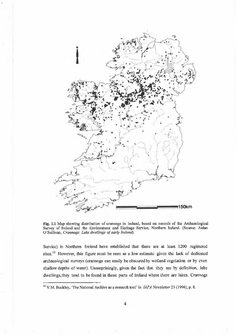
The geographical distribution o f Irish crannogs is now broadly understood (Fig. 1.1).
Since the pioneering crannog surveys o f Wakeman in the north-w est,6 Kinahan in the
west,7 and Davies in south U lster,8 the more recent work o f the Archaeological Survey
o f Ireland in the Republic (conducted by National Monuments Section, Duchas - the
Heritage Service)9 and the county surveys (conducted by the Environment and Heritage
4 In a previous review, it was pointed out that ‘the structural differences between (Bronze Age lake settlements) and crannogs could be overstated, some early Historic sites were quite small with little evidence for houses, while some Bronze Age settlements were in contrast constructed of large amounts of timber, brushwood, stone paving and peats with substantial house platforms’, Aidan O’Sullivan, ‘Interpreting the archaeology of Bronze Age lake settlements’ in Jn. Ir. Archaeol., 8(1998), pp 115-121, at p. 115.
Recent discussions of late medieval use of crannogs include, O’Sullivan, ‘Crannogs in late medieval Gaelic Ireland’, pp 397-417; Aidan O’Sullivan, ‘Crannogs -places of resistance in the contested landscapes of early modem Ireland’ in Barbara Bender and Margot Winer ( e d s Contested landscapes: landscapes o f movement and exile (Oxford, 2001), pp 87-101.6 See, for example, W.F. Wakeman, ‘The crannogs in Lough Eyes, Co. Fermanagh’ in R.S.A.I. Jn. ,11 (1870-1871), pp 553-64; W.F. Wakeman, ‘Observations on the principal crannogs of Fermanagh’ in R.S.A.I. Jn., 2 (1872), p. 216.7 G.H. Kinahan, ‘On crannoges in Lough Rea’ in R.J.A. Proc., 8c (1861-1864), pp 412-27.8 Oliver Davies, ‘Contributions to the study of crannogs in south Ulster’ in U.J.A., 5 (1942), pp 14- 30.9 Recent archaeological surveys that include sections on crannogs include, Anna Brindley, Archaeological inventory o f County Monaghan (Dublin, 1986); Paul Gosling, Archaeological inventory o f County Galway: Volume I - West Galway (Dublin, 1993); O. Alcock, C. de hOra and P. Gosling, Archaeological Inventory o f County Galway: Volume II-North Galway, (Dublin, 1999); Patrick O’Donovan, Archaeological inventory o f County Cavan (Dublin, 1995).
3
150km
Fig. 1.1 Map showing distribution of crannogs in Ireland, based on records of the Archaeological Survey of Ireland and the Environment and Heritage Service, Northern Ireland. (Source: Aidan O’Sullivan, Crannogs: Lake dwellings o f early Ireland).
Service) in Northern Ireland have established that there are at least 1200 registered
sites.10 However, this figure must be seen as a low estimate given the lack o f dedicated
archaeological surveys (crannogs can easily be obscured by wetland vegetation or by even
shallow depths o f water). Unsurprisingly, given the fact that they are by definition, lake
dwellings, they tend to be found in those parts o f Ireland where there are lakes. Crannogs
10 V.M. Buckley, ‘The National Archive as a research tool’ in IAPA Newsletter 23 (1996), p. 8.

are widely distributed across the midlands, northwest, west and north o f Ireland. They are
particularly concentrated in the drumlin lakes o f Cavan, Monaghan, Leitrim and
Roscommon and Fermanagh. Crannogs are more dispersed across the west and northeast,
although concentrations can be identified, such as in Lough Conn, Lough Cullin and
around Castlebar Lough, Co. Mayo. Crannogs are known in every county o f Northern
Ireland, in a belt stretching from Fermanagh, through south Tyrone and Armagh to mid-
Down, with particular concentrations in Monaghan and Cavan. Other regions have
smaller numbers widely dispersed, but a few crannogs have been identified in the south
and east.
Crannogs tend to be found on the smaller lakes, being infrequent or rare on large midland
lakes o f the River Shannon system (e.g. Lough Ree and Lough Derg), while there are also
few on Lower Lough Erne and Lough Neagh. There are particular concentrations o f
crannogs on Lough Carra and Lough Conn, Co. Mayo, Lough Gara, Co. Sligo,
Drumhallow Lough, Co. Roscommon and Lough Oughter, Co. Cavan. Smaller lakes can
have either one crannog or a small group o f them, such as on Lough Eyes and Drumgay
Lough, Co. Fermanagh. On some larger lakes, such as Lough Derravarragh, Co.
Westmeath and Lough Sheelin, Co. Cavan, they are distributed along the shoreline at
regular intervals. Crannogs are situated in various different types o f modem
environment, both deep and shallow lake-waters, lakeshore and peatlands. A smaller
number o f crannogs have been found in rivers, estuaries and in coastal wetlands.
Recent archaeological surveys indicate that crannogs vary widely in morphology and
construction, ranging in size from relatively large sites 18-25m in diameter, to smaller
mounds 8-10m in diameter. Crannogs o f various sizes and types can be located in close
proximity, suggesting variously, sequences o f development or contemporaneity o f usage.
There appears to be both regional and local variations in constmction, but most appear
to have been built o f layers o f stone boulders, small to medium-sized cobble stones,
branches and timber, lake-marl and other organic debris. Crannogs also produce evidence,
from both archaeological survey and excavation, for a wide range o f other structures,
such as cairns, level upper platforms, houses, working spaces, middens, wooden
revetments, palisades, and stone walls, defined entrance s, jetties, pathways and stone
causeways (Fig. 1.2). Crannogs have also produced large assemblages o f artefacts, both as
a result o f archaeological excavation and as discoveries made both accidentally or by
design (e.g. treasure hunters in the 1980s). These material assemblages have included
items o f clothing (shoes, textiles), personal adornment (brooches, pins, rings), weaponry
(swords, spearheads, axes, shields), domestic equipment (knives, chisels, axes).
5
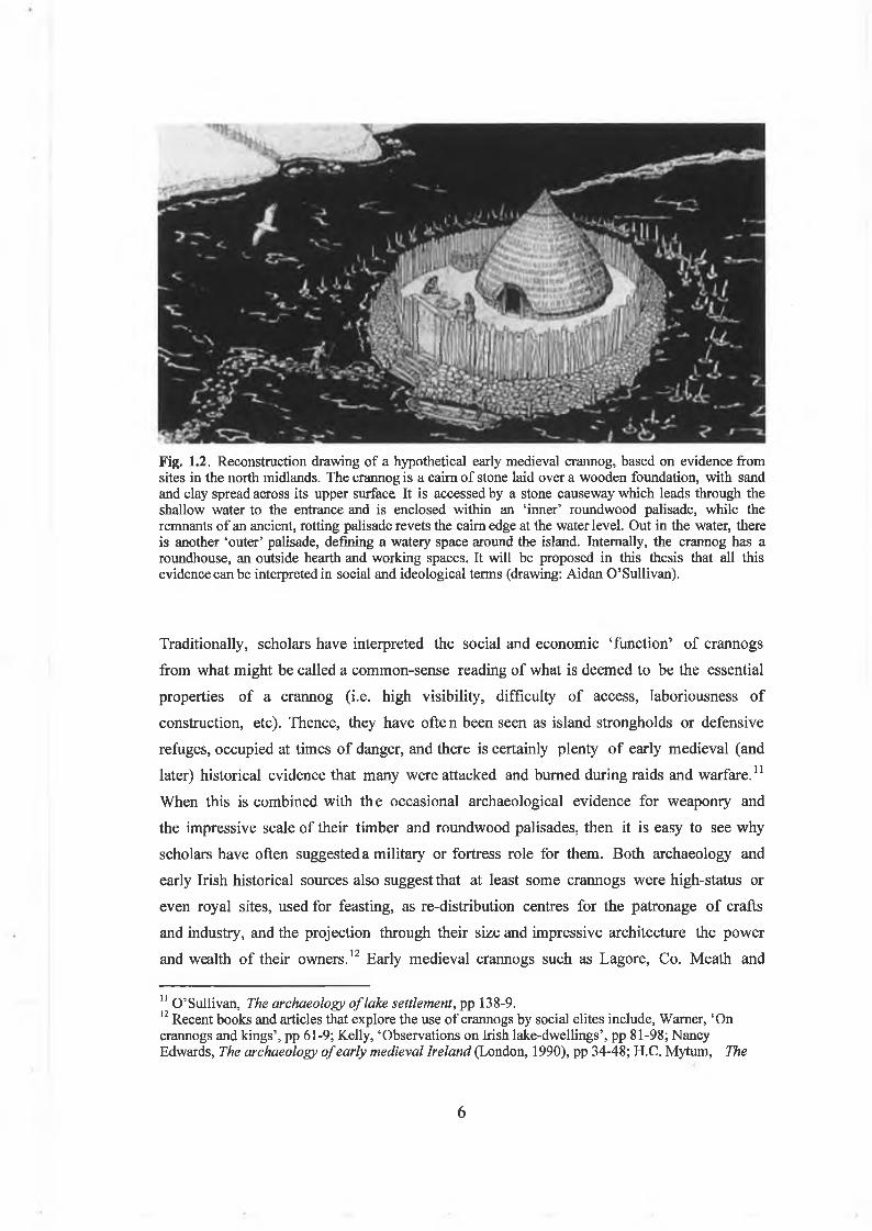
Fig. 1.2. Reconstruction drawing of a hypothetical early medieval crannog, based on evidence from sites in the north midlands. The crannog is a cairn of stone laid over a wooden foundation, with sand and clay spread across its upper surface It is accessed by a stone causeway which leads through the shallow water to the entrance and is enclosed within an ‘inner’ roundwood palisade, while the remnants of an ancient, rotting palisade revets the cairn edge at the water level. Out in the water, there is another ‘outer’ palisade, defining a watery space around the island. Internally, the crannog has a roundhouse, an outside hearth and working spaces. It will be proposed in this thesis that all this evidence can be interpreted in social and ideological terms (drawing: Aidan O’Sullivan).
Traditionally, scholars have interpreted the social and economic ‘function’ o f crannogs
from what might be called a common-sense reading o f what is deemed to be the essential
properties o f a crannog (i.e. high visibility, difficulty o f access, laboriousness of
construction, etc). Thence, they have ofite n been seen as island strongholds or defensive
refuges, occupied at times o f danger, and there is certainly plenty o f early medieval (and
later) historical evidence that many were attacked and burned during raids and warfare.11
When this is combined with the occasional archaeological evidence for weaponry and
the impressive scale o f their timber and roundwood palisades, then it is easy to see why
scholars have often suggested a military or fortress role for them. Both archaeology and
early Irish historical sources also suggest that at least some crannogs were high-status or
even royal sites, used for feasting, as re-distribution centres for the patronage o f crafts
and industry, and the projection through their size and impressive architecture the power
and wealth o f their owners.12 Early medieval crannogs such as Lagore, Co. Meath and
11 O’Sullivan, The archaeology o f lake settlement, pp 138-9.12 Recent books and articles that explore the use of crannogs by social elites include, Warner, ‘On crannogs and kings’, pp 61-9; Kelly, ‘Observations on Irish lake-dwellings’, pp 81-98; Nancy Edwards, The archaeology o f early medieval Ireland (London, 1990), pp 34-48; H.C. Mytum, The
6

Island MacHugh, Co. Tyrone certainly could be interpreted as the island residences o f
kings or nobles, perhaps being used as summer lodges, public assembly places and as
places o f refuge at times o f danger. Early medieval crannogs have also been associated
with the patronage and control o f craft production (typically metalworking). For
instance, Moynagh Lough, Co. Meath, a probable lordly crannog, particularly during its
mid-eighth century occupation phase, was clearly a place where various specialist craft
workers resided and worked, while Bofeenaun crannog, on Lough More, Co. Mayo
appears to have been devoted to the processing o f iron ore.13 On the other hand, it is
clear from archaeological surveys that most crannogs were essentially small island or
lakeshore dwellings, occupied at various times by different people, not necessarily o f
high social status. Recent archaeological excavations at Sroove, on Lough Gara, Co.
Sligo have suggested that some small crannogs were the habitations o f social groups or
households who had little wealth or political power.14 In this and other archaeological
surveys around Ireland, it has also been demonstrated that many crannogs were small
islets situated in shallow water, quite unlike the classic image presented by the larger
early medieval ‘royal sites’. Indeed, several crannogs have produced relatively modest
material assemblages and could be interpreted as the island homesteads o f the ‘middle
classes’.15 In other words, different types o f crannogs were built, used and occupied by
various social classes in early medieval Ireland.
Moreover, while there is commonly an image o f early medieval crannogs as secular
dwellings, given the significant role o f the church in the early medieval settlement
landscape, it is also likely that many were used by ecclesiastical communities. It is
possible that discoveries in recent decades o f early medieval ecclesiastical metalwork
(handbells, crosses and bookshrines) on some midlands crannogs (occasionally in
proximity to actual church sites and monasteries) suggests their use as safe or restricted
storage places for relics or perhaps even as island herm itages.16 Others may have been
fishing or industrial platforms, used periodically, seasonally or for particular specific
tasks. Finally, it should be allowed that some early medieval crannogs might not have
origins o f Early Christian Ireland (London, 1992); O’Sullivan, Crannogs, pp 43-5.13 John Bradley, ‘Excavations at Moynagh Lough, Co. Meath’ in R.S.A.I. Jn. , 111 (1991), pp 5-26; John Bradley, ‘Moynagh Lough: an insular workshop of the second quarter of the 8th century’ in R.M. Spearman and J. Higgitt (eds.), The age o f migrating ideas (Edinburgh, 1993), pp 74-81; Keane ‘Lough More’, pp 167-182.14 Christina Fredengren, ‘Poor people’s crannogs’ in Arch. Ire., 15, no. 4, (2001), pp 24-5.15 O’Sullivan, The archaeology o f lake settlement, pp 129-47; A.E.P. Collins and B. Proudfoot, ‘A trial excavation at Clea Lakes crannog, Co. Down’ in U.J.A., 22 (1959), pp 92-101; A.E.P. Collins, ‘Excavations at Lough Faughan crannog, Co. Down, 1950-51’ in U.J.A., 18 (1955), pp 45-82;George Coffey, ‘Craigywarren crannog’ inR.I.A. Proc., 26c (1906), pp 109-118.16 O’Sullivan, The archaeology o f lake settlement, pp 139-40; O’Sullivan, Crannogs, p. 30.
7

been dwellings at all. Some may have been boundary or routeway markers, cairns or
burial mounds to commemorate battles, persons or significant events, or even by
products o f other activities (e.g. temporary quarries for building stone, field clearance,
etc). On the other hand, virtually every detailed site investigation o f an Irish early
medieval crannog has revealed at least some evidence for what might be called
‘settlement activity’. In other words, while there are several traditional and useful
explanations o f the uses o f early medieval crannogs, largely revolving around ideas of
‘island refuges’, the ‘social display o f power’ and o f ‘island dwellings’, it is likely that
depending on their size, location and history of use, different crannogs were used in
different ways.
Aims and objectives of this thesisThe aims and objectives o f this thesis are to move these debates onwards and to attempt
to explore the social and ideological role o f crannogs within early medieval society.
Briefly stated, the aims and objectives o f this thesis are,
1) To evaluate and critique previous research on early medieval crannogs in Ireland, and to suggest innovative approaches to them based on recent developments in archaeology, early Irish history, anthropology and sociology
2) To explore the social and ideological role o f crannogs in early medieval Ireland by reconstructing how they were understood, used and experienced as island dwellings in the early medieval landscape.
3) To explore these ideas and approaches in the context o f landscape, local and site- oriented archaeological and historical research within a defined regional study area in the Irish midlands.
What is meant by the ‘social role’ o f crannogs? It is clear from historical and
archaeological evidence that people in early medieval Ireland lived in a world where
different social relationships and social identities profoundly structured and influenced
the progress o f their lives. Scholars o f early medieval Ireland have long been familiar
with the social hierarchies and inequalities o f power and status described in the historical
sources. It is also true that their ethnicity, gender, kinship, social role, collective sense
o f history and the past and their identification with place shaped people’s social
identities. In recent years, archaeologists influenced by developments in archaeological
theory, sociology and anthropology have sought to explore how people in the past had
(or did not have) the ability to construct, negotiate and resist these social identities
through their dynamic and active use and manipulation o f places, objects and other
forms o f material culture.
8

This thesis will explore how early medieval crannogs, as distinctive bounded island
spaces, were used by people to construct and negotiate such social relationships and
identities (in terms of social hierarchy, status, gender, kinship and age) within the
communities in which they lived. This is certainly a subject o f growing interest in
settlement and landscape studies. For instance, it has recently been suggested that late
medieval castles, while also significant both in terms o f military and social ostentation,
can usefully be interpreted as theatre ‘stages’ for the control o f social encounters and as
‘backdrops’ before which, and around, the social identities o f both inhabitants and
visitors were performed or ‘played out’ in the late Middle Ages.17 Johnson argues that
just as theatre stages are ordered to manipulate people’s perception o f a play, so the
individual architectural features (i.e. deceptively defensive moats and walls, impressive
gateways to manipulate people’s experiences upon arrival, halls for formal reception,
and so on) and furniture o f a castle were used to manage social encounters. Indeed, as the
social identities o f the actors changed (i.e. in terms o f social status or gender), so did the
meanings o f the physical structures, as different people (men, women, lords, lords and
labourers, etc.) understood the world in different ways. It might be suggested that early
medieval crannogs could also be thought about as places or venues for the enactment and
negotiation of social relationships. Indeed they are essentially similar to late medieval
castles, being deliberately built islands o f timber and stone, with palisades, causeways,
gateways and watery surrounds, all serving to enclose or define various social, domestic
and economic spaces.
However, to understand the social role o f crannogs in early medieval Irish society, it will
be necessary to also explore the ideological role o f crannogs. In this thesis, it will be
argued that this can be achieved by reconstructing how early medieval communities
perceived and understood islands, and by investigating how such knowledge and
perceptions could have been used to construct and negotiate the social identities o f the
people that built, used and saw them - king, lord, labourer and slave, husband and wife,
warrior, craftsman and farmer. Ideology could be described as the set o f beliefs or
imaginary speculations by which a society orders reality so as to render it intelligible. In
socio-political terms, it could also be described as the body of ideas that reflect the
beliefs and interests o f a society, or particular social group within it, often forming the
basis for political action. Marxist archaeologists have suggested that ideological beliefs
17 Matthew Johnson, Behind the castle gate: from medieval to Renaissance (London, 2002), p 3;Ideas about architecture as an arena for managed social encounters are common in recent archaeologica literature, see Michael Parker Pearson and Colin Richards (ed.) Architecture and order: approaches to social space (London and New York, 1994).
9

were typically used by powerful elites in the past (and in the present) to mask
inequalities, or to present the existing social order as something timeless, ‘natural’ or
inevitable, in other words to legitimate their interests and contemporary social
hierarchies.18 This is certainly one way of interpreting people’s ideas about islands in the
early Middle Ages, as there is often an emphasis in the historical sources on heroes,
kings and saints who used islands to promote their own social and economic positions.
However, other scholars have doubted whether ideas can ‘dupe’ an entire population.
Instead, ideologies may serve to enhance the solidarity o f distinct social groups.19 It will
also be argued in this study that different early medieval social groups had a range o f
beliefs about islands in the early Middle Ages, occasionally using them to challenge and
resist the social order.
By adopting interpretative approaches to crannogs in the early medieval period, this
thesis will attempt a broader study o f how social identities were created, contested and
negotiated within early medieval communities. It will also investigate the different ways
that people in early medieval Ireland perceived and understood the settlement landscape
in which they lived, how this would have been contingent on social rank, kinship and
gender and how it may have changed across time. This thesis aims to adopt new
theoretical and methodological approaches to the early Middle Ages and re-introduce
people into the archaeological narratives that are written about settlements and dwelling
places.
Regional and local perspectivesThis thesis will study crannogs at a range o f geographical scales, island-wide, regional and
local. In recent years, landscape archaeologists have suggested that this use o f shifting
scales o f analysis can enable understanding o f both the intim ate and wider scales o f social
life and experience. The island-wide perspective is the one which archaeologists usually
use, assessing national distributions, regional clusterings, attempting the large sweeping
overviews o f a subject. In particular, the detailed literature review carried out here will
enable a critical re-use o f previously published crannog excavations and surveys from
around the country (or at least those regions where crannogs are found). However, this
national or island-wide scale will not itself be a primary scale o f analysis. Despite the
fact that a concept of ‘Ireland’ as an island had emerged amongst an educated élite by
the early Middle Ages, few people experienced or perceived the world at that essentially
18 Matthew Johnson, Archaeological theory: an introduction (Oxford and Malden, 1999), pp 94-5.19 Julian Thomas, ‘Introduction: the polarities of post-processual archaeology’ in Julian Thomas (ed.)
10

abstract scale. The thesis through integrated and detailed studies o f regional and local
study areas, will interpret crannogs at the geographical scales at which they would have
been seen, used and understood in early medieval Ireland.
While different regional studies will be discussed, the thesis will concentrate on
Westmeath, in the north midland lakeland region. This region roughly corresponds to
the early medieval kingdom o f Mide (particularly between the sixth and the tenth
centuries AD). It is an interesting region for a number o f reasons. Certainly, it is often
thought o f as a place that is dominated by its lakelands, but it also has a significant
topographical variability, with a physical landscape ranging from low hills, to rolling
eskers and grasslands, down to its raised bogs, fens and lakes. In building and using
crannogs in this landscape, people were deliberately choosing to live on islands instead o f
the drylands. The use o f crannogs in this region has as much to do with human choice
and agency, as with the realities o f the physical landscape (in contrast to Leitrim, Cavan
or Monaghan, say, where there are so many lakes, that island life would have been
almost inevitable).
It is also useful that the region is richly provided for in a long-standing tradition of
historical research on the early medieval period. Previous historical and placename
studies on the origins o f the baronies, parishes and townlands o f the region provide much
information on early population groups.20 Most studies have concentrated on the
emergence and political activities o f the Clann Cholmain, one o f the dominant ruling
lineage amongst the dynasties o f the Southern Ui Neill between the eighth and the
eleventh centuries AD. There has also been some research on ecclesiastical settlement
and politics. For example, it has long been known that the twelfth-century saint’s life,
Betha Colmain maic Luachain, describes much of the early medieval settlement
landscape around Lough Ennell, with several references to its crannogs and islands.21
The region also has great potential in terms o f the early medieval archaeological
Interpretive archaeology: a reader (London and New York, 2000), pp 10-12.20 For general introductions to early medieval history of Westmeath, see FJ. Byrne Irish kings and high-kings (London 1973) pp 87-105; for historical studies of the Westmeath region see, Paul Walsh The placenames o f Westmeath, (Dublin 1957); for recent studies, see A.S Mac Shamhrain ‘Nebulae discutiuntur? The emergence of Clann Cholmain, sixth-eighth centuries’ in A.P. Smyth (ed.), Seanchas: studies in early and medieval Irish archaeology, history and literature in honour of Francis J. Byrne. (Dublin, 1999), pp 83-97; C.E. Karkov and J. Ruffing ‘The southern Ui Neill and the political landscape of Lough Ennell in Peritia 11 (1997), pp 336-358; Thomas Charles-Edwards, ‘The Ui Neill 695-743: the rise and fall of dynasties’ in Peritia 16 (2002), pp 396-418.21 Kuno Meyer (ed. andtrans.), Betha Colmain maic Luachain, Todd Lect Ser 17 (Dublin 1911); Paul Walsh, ‘The topography of Betha Colmain’ in Z.C.P. 8 (1912), pp 568-82.
11
record.22 Previous archaeological surveys in Westmeath have produced evidence for a
rich early medieval archaeological landscape, particularly in terms o f ringforts, churches,
monastic islands, holy wells and other sites. Unfortunately, there have been surprisingly
few publications on the early medieval archaeology o f Westmeath, so this thesis reviews
for the first time the previously unpublished archival sources held by the Archaeological
Survey o f Ireland. The extensive finds’ catalogues and topographical archives held in the
National Museum of Ireland will also be used to indicate the region’s long-lived human
history.
However, although regional studies are important, providing a sense o f the broader,
historical patterns and political developments across a geographical area, it must be
remembered that they still do not always engage with the reality o f life for people in the
past. In the early Middle Ages, it was at the local geographical scale that people would
have spent most o f their time; living and working around the dwelling, moving out into
the fields to work the land, or occasionally travelling further afield for public occasions
such as fairs and assemblies. People dwelled in, moved through and understood worlds
that were barely a few miles across. It is at this local scale that social identities were
constructed, community relationships negotiated. For this reason, local and site studies
will be o f primary importance in this thesis. The primary local study presented in this
thesis is an analysis o f the early medieval settlement landscapes around Lough
Derravarragh, Co. Westmeath. The lake is useful to study for a number o f reasons.
Although it is not particularly large, it has an unusually variable local geology, soils,
topography (bogs, level grassland, steep slopes and hills), while the lakebed itself ranges
from extensive shallows ( lm in depth at north end) to a deep, steep-sided trough (30m
depth) at the southern end. It has extensive archaeological evidence for long-term
settlement around the lake, ranging in date from the Late Mesolithic (c.4500 BC),
Bronze Age, early Middle Ages, late medieval and post-medieval periods. The early
medieval settlement evidence is also rich, including a number o f early medieval crannogs,
ringforts and churches, all o f which have produced artefacts o f early medieval date.
Lough Derravarragh is also interesting, because it is on a significant regional political
boundary, between the kingdoms o f the Clann Cholmain and those o f north Tethbae.
Moreover the congruence o f three baronial boundaries along the lake (Fore, Moygoish
and Corkaree) hint that the lake itself also served as an early medieval boundary between
kingdoms. As will be argued in this thesis, important things happen at boundaries, and
crannogs and islands were often places at the edge o f people’s worlds.
22 D.L. Swan, ‘The Early Christian ecclesiastical sites of county Westmeath’ in John Bradley (ed.),
12

Exploring island life in the early Middle AgesThis thesis aims to explore the social and ideological role o f crannogs within the early
medieval period (i.e. AD 400-1100), reconstructing the temporal rhythms of crannog
building, habitation and abandonment from the sixth to the twelfth centuries AD. This
will be in contrast to the two recent major studies that have discussed the ways that
crannogs and lake dwellings were used in Ireland from prehistory up until modem
tim es.23 Multi-period archaeological landscape narratives that span thousands o f years
are immensely interesting and useful studies, often revealing patterns in how radically
different cultures and societies understood and shaped their worlds. They can reveal
aspects o f long-term social and environmental change, as well as the deep, underlying
rhythms and structures o f life in particular landscapes. However, in sprawling across vast
time-spans (i.e. from the Mesolithic to the post-medieval period), multi-period studies
can tend to produce culturally ‘thin’ and ultimately unsatisfying interpretations o f the
past. Each chapter becomes a small discussion o f a particular period, without really
getting to grips with the society, beliefs and practices o f that time.
It is hoped that by concentrating in this thesis on a particular era and society (i.e. that
o f early medieval Ireland), and by using multidisciplinary approaches (archaeology, early
Irish history, sociology and anthropological studies) to a specific aspect o f that society
(the building and inhabitation o f islands), it will be possible to write a different history o f
Irish crannogs. This thesis aims for what the cultural anthropolog ist, Clifford Geertz
famously referred to as the ‘thick’, multi-layered description o f a culture.24 In the case
o f this thesis, this ‘thick description will explore the social and ideological uses o f islands
amongst the early medieval Irish; through the integration o f many different strands of
evidence about social identity, power and ideology, mentalités, economy and symbolic
beliefs.
Outline of thesis chaptersThe thesis will be organised in the following manner. Chapter 1 (this chapter) introduces
the thesis, briefly discussing the present state o f knowledge, outlining the problems and
potential for research, before describing the aims and objectives o f the study. It also
Settlement and society in medieval Ireland (Kilkenny, 1988), pp 3-31.23 O’Sullivan, The archaeology o f lake settlement, pp 37-178; Fredengren, Crannogs, pp 112-281.24 Clifford Geertz, The interpretation o f cultures (New York, 1973, London, 1993, reprint), pp 9-10.
13

outlines the original interpretative and methodological approaches that will be adopted
in this thesis.
Chapter 2 will provide a comprehensive historiography of crannogs scholarship.25 It will
trace the attempts o f scholars to re-create and invent the memory o f Irish crannogs
from a forgotten cultural tradition. It will also place this scholarship within its social,
political and historical context, from the work o f the earliest antiquarian practitioners
(e.g. the Ordnance Survey, Wood-Martin, Wakeman, Coffey), to the impact o f the
Harvard Archaeological Mission (in the 1930s to 1950s) and on to the archaeological
surveys and excavations o f the modem era (e.g. Rathtinaun, Moynagh Lough, Lough
Gara, the Archaeological Survey o f Ireland). In brief, it will explain how scholarship has
proceeded to the current state o f knowledge, thereby setting the stage for new
interpretative and theoretical perspectives.
Chapter 3 will describe the theoretical and methodological approaches to be adopted in
this study. It will argue that multidisciplinary perspectives (using early medieval saints’
lives, annals, laws and sagas, as well as archaeology and palaeoecology), although
challenging and bringing their own interpretative problems, are now required to provide
different and original insights into the social and ideological role o f crannogs in early
medieval Ireland. It also provides a brief discussion o f previous rationales behind
multidisciplinary approaches. It will argue that a more critical approach to both texts
and objects reveals that both were used as means o f communication in the past to
construct, resist and re-invent social structures in the early Middle Ages. Recognising this
dynamic should allow modem scholars to break through to a more exciting
multidisciplinarity. It will outline the methodological and theoretical approaches to
settlement and landscape in early medieval Ireland. It will also argue that traditional
landscape archaeological approaches (using maps, documents, aerial photography,
archaeological surveys o f regions and localities) can now be combined with sociology,
anthropology and postprocessual archaeological theory to enable new insights into the
perception, understanding and use o f islands and crannogs in the social, cultural,
economic and ideological landscapes o f early medieval Ireland.
25 The bibliography compiled for the historiography in Chapter 2 includes most books and articles published on Irish crannogs, from c. 1830s until 2003. It will also be based on original research in archaeological survey and museum archives, as well as studies of previously unpublished site excavations and surveys. It will consider the social and political context and practice of Irish archaeology across time, from its antiquarian origins to its present professional context.
14

Chapter 4 explores the perception and role o f islands in the early medieval imagination.
This is because it will be argued in this study that early medieval crannogs were built islets
o f stone, earth and timber, intended to provide people with a defined, water-bounded
piece o f land separated from the shore. They were, in both reality and effect, islands.
Significantly, early medieval writers did not distinguish between different types o f island;
artificial, natural or fantastic For instance, they used the Irish words oilean and inis
interchangeably in the early medieval saints’ lives, annals and narrative literature to
refer to both natural islands and crannogs. The distinctive and well-known word used to
describe them today, crannog (crannoc ) is never used in the early Middle Ages. In fact,
the word crannog was not first used in the annals until the mid-thirteenth century, after
the Anglo-Norman invasion.26 Thence, early Irish texts reveal what people were doing
when they built and occupied crannogs - they were making and inhabiting islands. It is
vital then to explore how people imagined, experienced and understood islands in early
medieval Ireland and how they might have used islands to create, negotiate and maintain
social and ideological relationships.
The chapter will provide the first att empt to reconstruct the role and perception o f
islands in the early medieval imagination. It will be inspired by descriptions, motifs and
incidents in the early medieval saint’s lives (generally dated to the seventh to twelfth
centuries AD), the voyage tales, adventure tales and sagas (typically eighth to tenth
centuries AD) as well as annalistic references (typically from the seventh to the twelfth
century AD) to battles, murders and deaths on crannogs. It will explore how early
medieval society understoo d islands as distant and isolated places, bounded by water, to
which access could be controlled. It will also reveal that islands were often seen as places
o f symbolic and ideological potential, being liminal places close to the supernatural
otherworld, where fantastic monsters, otherworldly people, women, experiences and
phenomena could be expected. These beliefs and projections can also be revealing about
early medieval mentalités, social structures, symbolic and cultural values and people’s
ideas about landscape, boundaries and social norms. The chapter will then move on to
explore how islands could have been used in the performance and structuring o f social
identities (i.e. in terms o f ethnicity, social hierarchy, status and role, gender, age and
26 The earliest annalistic use of the word ‘crannog’ is in the Annals o f the Four Masters for AD 1247 (A.F.M. 1247.6), when ‘Miles Mac costello took possession of Feadha Conmaicne, and expelled Cathal Mac Rannal from thence: the crannog of Claenlough was also taken for him ( crannocc clainlocha do gabail), and he left those who had taken it to guard it for him’. It is interesting then that the word ‘crannog’ only comes into use in the late medieval period, after the Anglo-Norman invasion, perhaps suggesting that they only become ‘strange’ when both the Anglo-Normans and Gaelic Irish realised that they were culturally distinctive.
15

kinship) within the community. Paradoxically, at the same time as they were places ‘at
the edge’, it will also be revealed that islands were often socially and culturally significant
centres. Islands could variously be the residences o f powerful elites (e.g. saints, kings),
distinctive social groups (e.g. clerics, hermits, and women) as well as the socially
marginalised (male youths, landless wanderers, the poor). It is hoped that this discussion
o f social identity in the early Middle Ages will itself be a useful contribution, but it is
mostly intended that this chapter will enable new interpretative perspectives to be
brought to the landscapes, architecture and insularity o f early medieval crannogs in
Ireland.
Chapter 5 will explore the potential social, economi c and ideological role o f crannogs
within the early medieval landscape. This chapter, the first o f two original empirical
studies, will be based on regional and local analyses o f crannogs in Westmeath, in the
Irish north midlands (the location o f the early medieval over-kingdom of Mide). This
landscape study, the first to draw together the evidence from sites within the county, will
be based on this author’s own archaeological surveys, particularly those on Lough
Derravarragh.27 It will also be based on research on early medieval artefacts previously
found within Co. Westmeath. 28 The chapter also synthesises for the first time,
previously unpublished site surveys conducted by the Archaeological Survey o f Ireland in
the early 1980s around Westmeath, as well as the work o f the Crannog Archaeological
Project in the 1990s.29 The chapter will first describe the physical, environmental and
vegetational history o f Westmeath, a region famous for its lakelands. It will then
provide a political and historical narrative o f the population groups o f the region,
between the fifth and the twelfth centuries AD. This will trace how some of the region’s
peoples (the Clann Cholmain dynasty of the southern Ui N6ill in particular) achieved
regional and island-wide political power, while others (e.g. the Fir Tulach, the Cenel
Fiachach, the Ui Fiachrach Cuile Fobair) were also involved in political and dynastic
struggles within the overkingdom of Mide. Significantly, it will be shown that there is
both archaeological and historical evidence that crannogs were often key places for
these and other peoples. The chapter will then describe the archaeological evidence for
early medieval settlement in Westmeath, providing the backdrop for a range o f
27 Appendix 2: Catalogue of crannogs in Westmeath.28 N.M.I. Top. Files. = National Museum of Ireland Topographical files: currently archived in Dept, of Antiquities, N.M.I., Kildare St., Dublin29 A.S.I. Files, Westmeath RMP = Archaeological Survey of Ireland: Register of Monuments and Places for Co. Westmeath, currently archived in the National Monuments Service, Duchas - the Heritage Service, 51 St. Stephen’s Green, Dublin 2. Most of the Crannog Archaeological Project’s work is unpublished and was never entered into the A.S.I. files. Therefore, this author conducted his own archaeological survey of the Lough Ennell crannogs.
16

landscape studies o f its crannogs. The chapter will explore the physical location and
potential role o f crannogs in relation to regional and local topographies, geology, soils,
lakes, rivers and drainage. They will also be explored in relation to other early medieval
settlements (ringforts, churches, and holy wells) as well as to early medieval political and
territorial boundaries, to explore their potential diverse social, economic and ideological
roles. A series o f local case studies or ‘scenarios’ will then sketch out how particular
crannogs may have been used in terms o f social identity (especially in terms o f political
power, royal performance, lordship, territorial defence, and as dwellings for lower social
classes, such as the poor and labourers). In conclusion, Westmeath crannogs will also be
explored in terms o f agriculture, economy, movement and travel, all significant aspects
of people’s lives, routines and experiences during the period.
Chapter 6 will then explore how crannogs were built, altered and inhabited as islands
throughout the early medieval period. It will again be a largely empirical study, based on
this author’s original research and archaeological surveys o f crannogs in Westmeath
(particularly around Lough Derravarragh and Lough Ennell). However, it will also utilise
the results o f other published, and often overlooked, county and regional crannog
surveys (e.g. in Down, Fermanagh, Cavan, Monaghan, north and west Galway and south
Mayo). It will discuss how early medieval communities may have used the physical
architecture o f crannogs, their cairns, palisades, causeways, to manage and control
various social encounters. It will begin by discussing early medieval crannogs in terms o f
chronology, time and social memory, exploring how they were often seen as symbols o f
the past, how they were used, altered and changed across time and the social and cultural
values involved in their ultimate site abandonment. This will be based on a synthesis o f
previously unpublished radiocarbon dates, dendrochronological dates and artefactual
evidence in both Ireland and Westmeath. Inspired by the study’s prior analysis o f how
islands were perceived by early medieval communities (e.g. in terms o f insularity, island
boundaries, distant views, and movement across water), it will then attempt to show how
people may have understood and used their visible physical or architectural differences in
terms of crannog size, location, form and appearance.
Chapter 7 will then explore the social and ideological organisation o f space within early
medieval crannogs, showing how such places shaped people’s sense o f themselves and
the communities they lived in, and how these island dwelling places were themselves
created by daily life, labour, practices and habitual activities. It will be argued that early
medieval crannogs can usefully be seen as intensely bounded spaces, within which
different social encounters, identities and roles were played out. Using archaeology, early
17
Irish history, anthropology and ethnological studies, it will aim for a detailed
consideration o f such internal physical features as palisades, entrances, working areas,
houses and rubbish heaps or middens. This chapter will be based on a re-interpretation of
some classic Irish early medieval crannogs (moving back out from Westmeath to sites
around the midlands and north). Although some o f these previously excavated crannogs
are often considered as difficult and intractable sites to interpret, it will be shown here
that a close and careful reading o f the original published site plans, cross-sections and
finds’ reports enables new insights into life on islands in the early medieval period.
Chapter 8 will conclude the thesis, summarising the results o f the study and will offer
comments on the potential for future research. In volume 2, the thesis’ appendices will
include a select bibliography o f historical references to crannogs, islands and lakes
(Appendix 1), a catalogue o f crannogs in Westmeath (Appendix 2) and a gazetteer of
both published and unpublished crannog excavations. It will also include the abbreviations
and bibliography of references used in this PhD thesis.
18
Chapter 2
Islands and the scholarly imagination
A historiography of crannog studies
IntroductionBy the beginnings o f the nineteenth century, crannogs that had been occupied
periodically since the Middle Ages had been long abandoned and forgotten. The concept
o f building and living on an artificial island had largely passed out o f the Irish collective
memory. Through the nineteenth century, this memory was re-invented through the
scholarly use o f early historical texts and the archaeological investigatio n o f crannogs. It
was a work o f memory building, a collective gathering o f traces o f the past preserved in
texts and objects. Interestingly, it was also a work o f the imagination, as could be argued
that the Irish crannog, as currently understood by both academics and the general public,
is an invention bom of scholarly research and creativity. It has literally been imagined
and created by scholars o f the modem age.
In fact, behind all our recent interpretations o f Irish crannogs, there lies almost two
hundred years o f antiquarian and archaeological speculation. Indeed, a postmodernist
literary critic might suggest that all these discourses are essentially an endless re-writing
and re-creation o f an established scholarly canon.1 In other words, when the history o f
past approaches to crannogs is reviewed, a distinct sense emerges o f the ways that Irish
archaeologists have unconsciously worked within an orthodoxy o f crannog scholarship.
Now, this does not mean that the validity o f previous work should be dismissed. A recent
writer on Scottish crannogs asserted that all the years o f antiquarian and early twentieth
century work was more or less useless. In his opinion, the only way forward was for
modem archaeologists to do proper surveys and excavations, amassing new, original
empirical data, and then and only then, offer interpretations. 2 This is a wrong-headed
approach for two main reasons. Firstly, it is indeed possible to use the results o f past
11 certainly got a disconcerting sense of this a few years ago, when I re-read my own ancient, battered copy of William Wood-Marlin’s The lake dwellings o f Ireland, published in 1886 (a copy, I suspect, that was owned and annotated by another crannog scholar, George Kinahan). It was a chastening experience. I could see how in the past, I have certainly offered as original insights, interpretations of the history and uses of crannogs that were originally proposed by him. But I am not the only one - revealing that while Wood-Martin is frequently cited, he seems to be rarely actually read, by Irish archaeologists.
19
investigations o f Irish crannogs, albeit carefully. Secondly, it is also true that a constant
exploration of, and engagement with, the intellectual, cultural and political origins o f our
past ideas about crannogs enables the construction o f new and interesting ones about the
perception and use o f crannogs in early medieval Ireland.
This historiography o f Irish crannog studies,3 like others on the history o f Irish
archaeology, draws attention to the influence o f contemporaiy cultural and political
movements, such as the development o f antiquarianism through the nineteenth century,
the Celtic Revival o f the late nineteenth century and the early twentieth century, and
the competing nationalisms o f the Irish Free State and Northern Ireland in the 1930s
and 1940s.4 Another important theme will be the inherent tensions in the production o f
knowledge between local communities, antiquities collectors and academic scholars. The
‘crannog idea’ (with its classic image o f an isolated, palisaded island) was developed by
antiquarians, and other potentially useful explanations o f artificial islands may have been
subsumed or ignored (recent studies o f folklore reveal different, hidden memories o f
island life). In particular, some opinions (typically those o f antiquarians, archaeologists
and academics) have been promoted, while others (e.g. local farmers and labourers, or
modem treasure hunters, etc) have been ignored or forgotten. In a sense, crannogs have
played a key role in the specialisation and professionalisation o f archaeology as a pursuit
in Ireland.
It is also worth reflecting on the ways that scholars work between the disciplines of
archaeology, history and folklore (between object, word and voice), and the tendency
that there has been to give historical texts the pre-eminent position. It is clear that
from quite an early stage, Irish antiquaries and archaeologists have attached an unusual
importance to historical texts in their interpretations o f Irish crannogs. Originally, this
2 M.W. Holley, The artificial islets/crannogs o f the central Inner Hebrides (Oxford, 2000), pp 1-4.3 Recent historiographical reviews of Irish crannog studies include Bryony Coles and John Coles, People o f the wetlands: Bogs, bodies and lake-dwellers (London, 1989), pp 9-51 ; John Coles, ‘Irish wetland archaeology: From opprobrium to opportunity’, in Barry Raftery and Joyce Hickey (eds.), Recent developments in wetland research (Dublin, 2001), pp 1-12; O’Sullivan, The archaeology o f lake settlement, pp. 7-35; C.S. Briggs, ‘A historiography of the Irish crannog: The discovery of Lagore as prologue to Wood-Martin’s Lake Dwellings o f Ireland of 1886’ in Antiquaries Journal, 79(1999), pp 347-377; Fredengren Crannogs, pp 28-62.
Most recent discussions of the development of Irish archaeology have focused on the role of nationalism, see Elizabeth Crooke, Politics, archaeology and the creation o f a National Museum o f Ireland (Dublin and Portland 2000); Gabriel Cooney, ‘Theory and practice in Irish archaeology’ in P.J. Ucko (ed.), Theory in archaeology (London, 1995), pp 263-77; Jerry O’Sullivan, ‘Nationalists, archaeologists and the myth of the Golden Age’ in M.A. Monk and J. Sheehan (eds.), Early medieval Munster: archaeology, history and society, (Cork, 1998), pp 178-89; Michael Tiemey, ‘Theory and politics in early medieval Irish archaeology’ in Monk and Sheehan (eds.), Early medieval Munster, pp 190-9.
20
may well have been due to the extraordinary vigour o f historical studies in the mid
nineteenth century, when early Irish annals, law texts and legends were all being edited
and published by Celtic scholars. This led scholars like O’Donovan, Wilde, Petrie and
others to believe that history could be used to identify monuments and explain the
functions o f both objects and sites. In contrast, contemporary antiquaries in Denmark
were often working in a text-free environment, perhaps explaining the more
sophisticated approaches to chronology and classification.5
From peasant folklore to antiquarian respectability, 1750-1857A forgotten tradition - before ‘crannogs’, 1750-1810In the late eighteenth century and the early nineteenth century, Irish society was
experiencing profound change, partly due to the social and economic uncertainty
brought about by the French wars and the intellectual insecurity o f both Irish and
continental revolutions. A rapidly rising peasant population in the countryside lead local
communities to seek an income wherever they could find it. The decline in traditional
religious beliefs meant that one source of income was the hidden treasures that could be
recovered from places previously considered out-of-bounds.6 Ancient ringforts were dug
into, abandoned church sites quarried and cairns were taken apart in search o f gold and
silver treasure. These objects were then sold on to travelling rag-and-bone men, tinkers
and jewellers for cash. Indeed, this nascent antiquities trade was to lead to some
goldsmiths and silversmiths adding‘antiquities collector’ to their job-descriptions. While
the poor were discovering this source o f income, the educated elite was also developing
an interest in antiquities, for reasons o f personal gain or for scholarship.
Interestingly, while it is evident that large-scale drainage operations were exposing stone
and wooden structures in lake sediments, there seems not to have been any concept o f
the crannog as an ancient residence. We might take this to suggest that by the late
eighteenth century, crannogs were a forgotten tradition. This is odd. In the sixteenth
century, crannogs were used as royal lodges, military strongholds, prisons, hospitals,
ammunition stores, and places to hoard gold and silver plate. In the wars o f the
seventeenth century, they were occasionally used as fortified rebel bases and as locations
to make bullets, rest and recuperate. There are also hints that they served as dwellings of
the poor and as hideouts for vagabonds, freebooters, robbers and other ‘malcontents’ in
the eighteenth century. It is also true that crannogs were used for more prosaic tasks in
5 John Waddell, The prehistoric archaeology o f Ireland (Dublin, 1998), p. 2.6 G.M. Smith, ‘Spoliation of the past: The destruction of monuments and treasure-hunting in
21

the late eighteenth century, as ‘kale gardens’ (places isolated from browsing animals that
could be used for growing vegetables) or as fishing and fowling places. But, by the late
eighteenth century, this tradition seems to have been fading out, with the islands
abandoned. It seems that any collective memory o f the past use o f crannogs had
vanished.
Moreover, while ideas about the supernatural origins o f ‘fairy forts’ provided some level
o f superstitious protection for ringforts, artificial islands appear to have been merely
seen by local people as a source o f bog timber, stone, organic-rich soil and bone for
manuring land. This suggests that such communities had actually forgotten about the
existence o f such artificially constructed crannogs. There are various potential
explanations for why this happened. Lacking the distinctive surface appearance o f a
ringfort or church, crannogs may have simply been seen as natural, unremarkable islets
rather than ancient places. More interestingly, it is possible that people in actively
switching their allegiance to the new English and Scots Planter political and social order
o f the seventeenth century, were deliberately disregarding the remnants (i.e. crannogs)
o f the displaced Gaelic lordships. Alternatively, in the newly commercialised society and
economy of the eighteenth century, places (i.e. crannogs) previous associated with
feudal ties and obligations were simply incomprehensible and ultimately forgettable.
Or perhaps, they were remembered but no t openly discussed in front o f the gentry. It is
difficult to pick up threads o f local people’s ideas about crannogs in nineteenth century
folklore, much o f which is bowdlerised and sentimentalised in contemporary books. It
certainly seems barely credible that local people were unaware of, or didn’t have
opinions about, the historicity o f such places in their landscape. Writing much later,
William Wilde described how quite distinctive ideas about ‘drowned islands’ existed
amongst local communities. In the summer o f 1860, he transcribed an account o f local
folklore about supernatural incidents on a crannog at Donore, Lough Derravarragh, Co.
Westmeath. (Fig. 2.1).
In the beautiful lake of Derravarra, County Westmeath, so well-known to all followers of the green-drake, and so much frequented every June, there are remains of a crannoge about three or four feet under summer-water near what is called the Port - on the Donore shore. The stones of this crannoge, evidently arranged by the hand of man, are placed in a circle, and the place itself is called “The Castle”. Once up a time - as the legend goes, and as Jack Nally, or any of the boatmen so admirably portrayed by Erskine Nicol, will relate - a fisherman and Iris son went out to spear eels; when a terrible storm arose, and tire waves threatened to leap into
nineteenth-century Ireland’ in Peritia, 13 (1999), pp 154-72.
22

the boat. “Strike”, says the father, who managed the oars, “strike your spear, my son, into the ninth wave that rises upon us or we are lost”. With unerring aim, the son plunged his sharp trident into the rising billow, “when, in the turn of your eye, it was whipped out of his hand; but the storm ceased, the waves subsided, and the men returned to their cottage beside the shore. Not long after, while drying themselves by the fire, a strange man came in, and beckoned the son to follow him. “They entered the boat and passed over to the castle, where the usual scenery, paraphernalia and phraseology common to Irish fairy-lore commences in the narration, but which, having been so frequently described by myself and others, it is unnecessary to detail. The young man was finally led into the presence of a lady, which it appears was mistress of the waves and from whose hands he alone could extract the spear.7
Fig. 2.1 View across northwest shore of Donore townland, Lough Derravarragh, Co. Westmeath. A local folktale recorded by William Wilde in 1860 described how a crannog on this shore known as ‘The Castle’ (probably Castlewatty) was the venue for a fantastic encounter between two fishermen and a woman of the underworld. By the 1930s, Lough Derravarragh’scrannogs had been forgotten locally and there is little mention of them in the Folklore Commissions School’s Manuscripts (CUCAP AHH 43).
7 W. R. Wilde, ‘Irish crannogs and Swiss Pfahlbanten’ in The Athenaeum, no. 1729 (15th December , 1860), pp 831-2; The crannog described in this tale is probably that one depicted as “Castlewatty” on the second edition Ordnance Survey maps situated off Donore twd, Lough Derravarragh, Co. Westmeath. The tale itself is remarkably similar to many of the early medieval Irish echtrae, which describe the hero’s descent to the underworld through an island in a lake. He also describes a ‘sunken island’ at Kylemore Lough, Co. Galway, again a site normally submerged even during the summer. This island was reputed to rise every night, but if “anyone was to land on it with fire and salt, it never could go down again”. Wilde recommended that it would be ‘interesting to collect the legends relating to Crannoges, both in this country and in Scotland’.
23

On the other hand, Wood-Martin was later to be o f the rather narrow-minded opinion
that without scholarly recognition o f such places, local people with their simple ideas did
not have a frame o f reference to understand the human origins o f these islands.
The sites of many lacustrine settlements, or villages built in the water, called in Irish crannogs, are often designated by the peasantry “drowned islands”, for bawtha, signifying “drowned” is applied, by the country people to places or objects submerged in water....If till lately people, otherwise well informed, were totally ignorant on the subject of these “drowned” dwellings, it is the less surprising that the simple Irish fisherman, gliding in his skiff over the placid surface of the waters, and peering into their clear depths, should have failed to recognize that the mouldering piles projecting from the oozy bottom were traces of the love of security of his predecessors in the country; and that in the mud of the ever- accumulating lacustrine deposit are preserved material evidences of a state of primitive society long since passed away.8
The first antiquarian recognition of islands and houses in lakes, 1810-1839Nevertheless, an awareness o f the existence o f artificial islands in lakes was emerging
amongst the educated elite, as can be seen in many early topographical accounts. As
early as 1784, the lowering o f water in Lough Deehan, Kilmacduagh, Co. Galway lead to
the discovery o f ‘a house in mud at the bottom, formed of oak timber o f great thickness,
the sides and roof o f which were formed of wattle-work o f the same substance; it
appeared as if intended to float, and the timber o f which it was constructed was perfectly
sound’. Samuel Lewis first published this account in 1837, in his Topographical
Dictionary o f Ireland, probably based on information obtained from local inform ants.9
Edward Wakefield, writing in 1812 provides the earliest contemporary account. After
the drainage in 1810 of Lough Nahinch, at Ballynahinch, near Roscrea, Co. Tipperary, a
Mr Trench observed a large circular plank-built structure that resembled ‘the top o f an
immense tub, about sixty feet (18.29m) in diameter’. Although it was not recognised as a
crannog at the time, this almost certainly was the timber palisade o f a stone-built
crannog with palisade and causeway that survives today, recently dendrochronologically
dated to AD 1026-1061. 10 Similarly, there are references in 1809 to the discovery o f a
8 W.G. Wood-Martin, Traces o f the elder faiths o f Ireland: a folklore sketch : A hand-book o f Irish pre-Christian traditions (London, 1902), p. 220.
S.A. Lewis, A topographical dictionary o f Ireland (London 1837), vol. II, p.163 ; J.H. Andrews, ‘Lewis’s Topographical dictionary’ in Brian Lalor (ed.) The encyclopedia o f Ireland (Dublin, 2003), p. 627.0 E. Wakefield, An account o f Ireland, (London, 1812); H.B. Trench and G.H. Kinahan, ‘Notes on a
24

log-boat with four paddles on a ‘stratum o f burnt oak’ (waterlogged oak when exposed to
air turns black) at Ardbrin, Co. Down, but little sense o f any recognition o f an artificial
island.11
The idea o f houses in lakes seems to have been strengthening by the 1830s.
Occasionally both local labourers and landlords recognised these sites as habitations of
some type. For example, in his manuscript journal for 1833, Roger Chambers Walker
described how he had heard about ‘a curious description o f the remains o f an ancient
house discovered the year before in draining a small lak e ...’ near Freshford, Co.
Roscom m on.12
It is also evident that the surveyors working for the Ordnance Survey were becoming
aware o f the idea o f ‘artificial islands.’ In the Memoirs o f the Ordnance Survey for
County Londonderry, compiled about 1836, there are several descriptions o f artificial
islands in lakes.u At Ballygruby, they refer to an ‘artificial island’ on Lough Lug, ‘of
earth and gravel and stones, raised on a frame o f timber’, 38 yards (34.75m) in diameter
with a substantial stone causeway leading from the island to an ‘unfinished fort’. At
Ballymacombs Beg, there is a reference to ‘those artificial islands found in bogs and
lakes’ and a brief description o f ‘a wooden frame, morticed into upright stakes’. At
Calmore, there was the ‘ruins o f an artificial island, composed o f large logs and planks
bound together by mortices and wooden pins... enclosed by long poles standing upright’,
with finds including wooden barrels, bowls and other items.
There are similar accounts o f islands in Loughnagolagh and at Shillin Lough
(Loughinshollin). C.W. Ligar’s description o f an artificial island at Ballymacpeake (in
Magherà, east Co. Londonderry), prepared about 1836, gives a good sense o f how
Ordnance Survey officers viewed these sites (and also reveals that there was a local
tradition o f treasure in them at about 1796) (Fig. 2.2).
crannoge in Lough Nahinch’ in R.I.A. Proc. 9C, (1864-66), pp 176-9; M.P. Cahalan and A.M.G. Hyland ‘Lough Nahinch crannog in Lower Ormond’ in Tipperary Historical Journal, no vol. number (1988), pp 15-21; Jean Farrelly and Caimin O’Brien, Archaeological Inventory o f County Tipperary: Vol. I-N orth Tipperary (Dublin, 2002), p. 53.11 Coles and Coles, People o f the wetlands, p. 13.12 Niamh Whitfield, ‘A filigree panel and a coin from an Irish crannog at Alnwick Castle, with an appendix on the discovery of crannogs at Strokestown, Co. Roscommon’ in Jn. Ir. Archaeol., 10 (2001), pp 49-71; W.G. Wood-Martin, Pagan Ireland: An archaeological sketch: A handbook o f Irish pre-christian antiquities (London, 1895), p. 658.
25

* / tA-e *+%jf ^4iZJfcrf-
Fig. 2.2 One of the earliest depictions of an Irish crannog, in a drawing of an ‘artificial island and old fort’ at Ballymacpeake, Co. Londonderry in 1836. (Source: Royal Irish Academy Ordnance Survey Memoirs, Parish of Maghera; C.S. Briggs, ‘A historiography of the Irish crannog’, p. 350).
'Old Island and fortThere is in the townland of Ballymacpeak a small lake containing the remains of what was once a well-constructed artificial island, but was nearly destroyed about 40 years since by a person who had an idea that treasures were concealed in it. From the ruins now to be seen the island appears to have been about 20 or 30 feet in diameter. It was formed by upright oak stakes driven into the ground and mortised into a series of horizontal ones, which formed a floor or platform on which was laid earth mixed with bog. This is the account given of it by persons who live in the vicinity and who remember when it stood undisturbed, and who say that there was formerly a narrow footway leading from the island to the shore of the lake opposite to the old fort situated on its borders. The footpath was formed of stakes similar to the island. The waters of the lake have been drained and vegetation is rapidly encroaching into it, and to all appearancewill soon replace the water with a kind of soft bog. A few of the stakes which formed the island still remain standing.’14
Other scholars were also noting island fortresses. Samuel Lewis’ previously mentioned
Topographical Dictionary o f Ireland, published in 1837, refers to various houses in
lakes, including the following construction in Lough Armagh, Co. Offaly.
13 Briggs, ‘A historiography of the Irish crannog’, pp 368-71.14 Angélique Day and Patrick McWilliams, Ordnance Survey Memoirs o f Ireland vol. eighteen: Parishes o f County Londonderry V, 1830, 1833, 1836-7: Maghera and Tamlaght O ’Crilly (Belfast, 1993), pp 10-11.
26

‘in the middle of this lake, where it is most shallow, certain oak framing is yet visible and there is a traditional report that in the war of 1641 a party of insurgents had a wooden house erected on this platform, whence they went out at night in a boat and plundered the surrounding country’.15
This local folklore was to be subsequently confirmed in 1868, when seventeenth-century
armour, an iron halberd, iron swords, a matchlock and a gun-barrel o f small calibre were
some o f the finds made on ‘an island-like patch rising a little above the water level, o f
piles’, with broken querns, burnt brick and stone in the v icin ity .16
Collecting objects from the ‘bone-heap’ of Lagore, 1839-48The discovery o f Lagore crannog is commonly taken to represent the beginnings o f
crannog scholarship in Ireland. In reality, the earliest work at Lagore by Irish
antiquarians largely involved merely the recovery o f antiquities and most subsequent
negotiations relate to the collecting, dispersal and sale o f these objects in Ireland, Britain
and Denmark. William W ilde’s first publication o f it refers to merely a ‘bone-heap’.
There is virtually no contemporary account of the site’s appearance and no effort was
made to record location, structure or stratigraphical evidence.17
It is also now clear that the site was discovered first by local labourers, then recognised as
significant by a rag-and-bone man, and only latterly did Irish antiquarians become
involved. In fact, the early accounts illustrate as clearly the occasionally strained
relationships between the antiquarians, collectors and landowners involved.18 Historians
15 Lewis, A topographical dictionary, vol. n, p. 175.16 General Dunne, ‘Notices of a cranog in Lough Annagh, King’s County’ in R.S.A.I. Jn. 10 (1868-1869), pp 154-7; T. Stanley, ‘Notice of the cranoge in Lough Armagh’ in R.S.A.I. Jn. 1 (1868-9), pp 156-7; W.G. Wood-Martin, The lake dwellings o f Ireland or ancient lacustrine habitations o f Erin commonly called crannogs (Dublin, 1886), pp 209-11.17 Lagore crannog, Co. Meath is amongst the most significant and influential early medieval archaeological sites investigated in Ireland. Its most intensive phase of occupation dates to between the seventh and the tenth centuries AD, when it served as the ‘royal’ residence of the early medieval kings of southern Brega. The earliest antiquarian descriptions of the site include W.R. Wilde,‘Animal remains and antiquities found at Dunshaughlin’ in R.I.A. Proc., lc (1836-41), pp 420-6; J. Talbot (de Malahide), ‘Memoir on some ancient arms and implements found at Lagore, near Dunshaughlin, County of Meath; with a few remarks on the classification of northern antiquities’ in Arch. Jn. 6 (1849), pp 101-9; Wood-Martin, lake dwellings, pp 23-5; The site was subsequently excavated by the Harvard Archaeological Mission; Hugh O’Neill Hencken, ‘Lagore crannog: an Irish royal residence of the seventh to tenth century A.D’ in R.I.A. Proc. 53c (1950), pp 1-248; for a recent summary, see George Eogan, ‘Life and living at Lagore’ in A.P. Smyth (ed.), Seanchas: Studies in early and medieval Irish archaeology, history and literature in honour o f Francis J. Byrne (Dublin, 2000), pp 64-82.18 Briggs, ‘a historiography of the Irish crannog’ provides the most recent analysis of the various antiquarians involved in the Lagore discovery; see also Siobhan De h6ir, ‘A letter from W.F. Wakeman to James Graves in 1882’ in R.S.A.I. Jn ., 120 (1990), pp 112-9.
27

familiar with the Annals o f Ulster, with its frequent references to Loch Gabor would have
known of the existence o f a place called Lagore that was an early medieval royal site.
Significantly, the site was also apparently represented as a tumulus on a map o f Meath
dated to 1659, so the topographical feature must have been the subject o f some local
folklore.19 However, there is little sense that anybody had made a connection between
historical accounts and this particular place.
In the late 1830s, local men began either turf-cutting or drain-digging beside, or on, a
tumulus on the edge o f a bog (a dried out lake east o f the town o f Dunshaughlin).20 They
uncovered huge amounts o f animal bones and about one hundred and fifty cartloads o f
bones had apparently been removed and exported to Scotland for fertiliser by the time it
came to the notice o f collectors. Apparently, the diggers were initially uninterested in
the metal and other objects exposed by the work, most o f which they simply threw
aside. Later on, as they became more experienced in artefact identification, and aware o f
the potential financial rewards, they collected these objects and sold them to rag-and-
bone men or gave them to the local landlord’s (a Mr Bamewall) steward.
The first and most influential collector to visit the site was a James Henry Underwood, a
rag-and-bone man, who collected the antiquities and sold them to the Topographical
section o f the Ordnance Survey o f Ireland, the Royal Irish Academy, as well as to
wealthy collectors such as Dean Dawson, Lord Talbot de Malahide and George Petrie.
Petrie was intrigued and visited the site in the company o f William Wilde and found,
thrown on the floor o f a bam at Lagore House, a large collection o f antiquities including
iron swords, daggers, spears, axes, saws, chains, shears, pins and brooches o f bronze and
bone and wooden objects. In the absence o f his master, the local steward was unwilling to
part with any of the items and by the time Petrie returned, the collection had been
widely scattered, although a few made their way into the collection o f the Royal Irish
Academy.
The academy appears to have requested George Petrie and William Wilde (then a young
man o f 24 years) to record the site and publish their findings, but although Wilde
published papers on the animal bones, an overall account never appeared. Both
19 Briggs, ‘A historiography of the Irish crannog’, p. 351.20 Another account of the first discovery is contained in a letter from Dean R. Butler of Trim to Dean Dawson (a well-known antiquities collector), where a description is given of ‘a small tumulus on the edge of a bog.. .an enclosure of piles of wood, within which lay a human skeleton.. .animal bones in layers - with earth between them as well as brass, iron and bone artefacts; see G.F. Mitchell,‘Voices from the past; three antiquarian letters’ in R.S.A.I. Jn ., 113 (1983), pp 47-52.
28

Wakeman and MacAlister were later to imply that some quarrel or (in W akeman’s
words) ‘the mutual jealousies o f Petrie and W ilde’ prevented a more detailed
publication.21 Indeed, it seems that James Talbot irritation at the lack o f a complete,
methodical publication o f the site directly led him to publish his own notes.22 W ilde’s
publications o f his visit to the site (in the first volume of the Proceedings o f the Royal
Irish Academ y), describe the site, its environs and some o f the exposed structures. He
saw the crannog as consisting o f a circular mound 520 feet in diameter, slightly raised
above the surrounding bog or marsh, with upright posts defining the circumference.23
The second main phase o f activity at Lagore came several years later. Between 1846
and 1849, cleaning o f the small river beside the site and tu rf cutting on it lead to the
discovery o f more amounts o f bone, wooden palisades and wooden hut structures. The
latter were described in the later (in 1882) reminiscences o f William Wakeman who
visited the site almost daily over a month in the summer o f 1848.24 He saw an apparent
rectangular wooden sub-structure or house built o f sill-beams, grooved uprights and plank
cladding caulked with moss and gathered a range o f finds from the site himself. In his
later publication o f the Lagore excavations, Hugh O ’Neill Hencken reckoned that
W akeman’s account o f the rectangular structures was a mistaken description o f part o f
the palisade.25 However, despite the brief descriptions o f the site as exposed, it is
interesting that the dominant picture that emerges from the antiquarian activity at
Lagore is o f the anxiety to secure a collection o f antiquities, rather than a scientific
excavation or a systematic evaluation o f the site. It was not to be until later years, with
the work o f such scholars as George Kinahan, Morant, Robert Munro, William
Wakeman that this perspective was to emerge.26
Other artificial islands were noted around the same time, many associated with military
campaigns o f the sixteenth and seventeenth century. About the year 1839, the lowering
o f the water levels at Roughan Lake, near Dungannon, Co. Tyrone, meant that ‘an
island artificially formed was exposed to view’. The island produced large amounts o f
21 De hOir, ‘A letter from W.F. Wakeman’, p. 112 ; R.A.S. Macalister, The archaeology o f Ireland (London, 1928), p. 301.2 Talbot (de Malahide), ‘Memoir on some ancient arms’.
23 Wilde, ‘Animal remains and antiquities found at Dunshaughlin’, pp 420-624 W.F. Wakeman, ‘On certain recent discoveries of ancient crannog structures, chiefly in the County of Fermanagh’ in R.S.A.I. Jn. 15 (1879-1882b), pp 324-39, at p. 325; Wood-Martin, lake dwellings o f Ireland, p. 24; De h6ir, ‘A letter from W.F. Wakeman’, pp 112-116.2 Mencken, ‘Lagore crannbg’, p. 46.26 Briggs, A historiography of the Irish crannog’, p.368 draws attention, for example, to the fact that all the key figures (e.g. Petrie, Wilde, even Wakeman, were involved themselves in the sale and dispersal of the Lagore antiquities to England, and even to Denmark, through the offices of Worsaae.
29
pottery, bones, a bronze pin, a few bronze spearheads and a decorated upper-stone o f a
rotary quern.27 This may have been the Gaelic Irish crannog captured by the English
general, Lord Mountjoy, on July 1st 1602, on Lough Roughan, near Dungannon, Co.
Tyrone. Richard Bartlett’s well-known cartographic depiction o f an attack on a Ulster
crannog may actually be a representation o f this incident.28 Intriguingly, there are also
later historical references to one Raghan Isle being the last retreat o f Sir Phelim O’Neill
in 1641, the island holding out against English forces until boats were brought to the lake
in 1653 by William Lord Charlemount to aid in the attack. 29 About the same time
(1839), a stone-built island was discovered at Lough Gur, Co. Limerick. Locals knew the
site and had gathered antiquities from it, again with large amounts o f bone being seen, but
no palisade was recognised. This crannog had been attacked by English forces in 1599.30
In 1844, the draining o f the extensive Ballinderry Lough, near Moate, Co. Westmeath
revealed the remains o f one large crannog (later to be known as Ballinderry crannog No.
2). The site was dug into by locals, producing vast quantities o f bones and a range o f
antiquities, including two dugout boats.31 One Mr. Hayes who sent William Wilde a
description o f the site along with a plan and a map o f its location initially recorded the
site. It is also evident from the files o f the National Museum that a wide range o f
archaeological objects was being recovered from the bogs in the environs of the site. The
Harvard Archaeological Mission subsequently excavated Ballinderry crannog No. 1, Co.
Westmeath, and Ballinderry crannog No. 2, Co. Offaly, in the 1930s.32
The Commission for Arterial Drainage and Inland Navigation and the ‘Strokestown crannogs’, Co. Roscommon, 1843-1852By the early nineteenth century, land drainage schemes, carried out locally by improving
landlords, were exposing increasing numbers o f archaeological sites. About 1843, the
Board o f Works began a more ambitious programme o f drainage works. The Board o f
Works’ officers anticipated that "the arterial drainage works would afford opportunities
rarely possessed fo r obtaining antique remains from places under water, which remains,
27 Wood-Martin, lake dwellings, p. 88.28 G.A. Hayes-McCoy, Ulster and other Irish Maps, c. 1600 (Dublin, 1964).29 Wood-Martin, lake dwellings, p. 88, p. 148.30 Wood-Martin, Lake dwellings, p. 25, p. 2731 W.R. Wilde, A descriptive catalogue o f the antiquities o f stone, earthen and vegetable materials in the Museum o f the Royal Irish Academy (Dublin 1857), p. 223; J. Graves, ‘ Stone and bone antiquities, some with oghamic inscriptions, found at a crannog in Ballinderry Lough’ in R.S.A.I. Jn. 16, no. 6, (1883-1884), pp 196-202; J.F.M. ffrench, ‘Notes on three bone pins found at the bottomof the Ballinderry lake in the county Westmeath’ in R.S.A.I. Jn. 32 (1902), pp 153-157.32 Hugh O’Neill Hencken, ‘Ballinderry crannog no. 1’ in R.I.A. Proc. 43c (1936), pp 103-239; Hugh O’Neill Hencken, ‘Ballinderry crannog no. 2’ in R.I.A. Proc. 47c (1942), pp 1-76.
30

Fig. 2.3 Engineer’s cross-section drawing of an early medieval crannog at Ardakillen, Co. Roscommon, illustrating the quality of these early records. (Source: Wood-Martin, The lake dwellings o f Ireland).
i f faithfully described, would be useful adjuncts to our local history’. It is clear that a
concerted effort was to be made to record both sites and objects in a coherent fashion.
William Mulvany, M.R.I.A., the member of the Board o f Public Works in charge o f the
department o f Arterial Drainage and Inland Navigation, recommended in a circular letter
to local engineers that ‘ in cases where islands o f artificial construction, raths, or other
works, have been discovered or cut into, descriptive drawings and sections will be o f the
greatest importance and you are requested to forw ard them \ 33 It was also considered
important to record the context o f individual objects. Mulvany also suggested that
‘An object of great importance is to have the antiquities identified with the locality where they were found, and we therefore wish to have attached to each thing found, a card, with a description on one side of the place where found, name of townland, parish, barony, and county ... and on the other side of the card a description of the precise locality, the material in which imbedded, its depth, allusion to other antiquities found with it, and such other matters of interest as occur to you to record’.
In fact, for its tim e, this was an extraordinarily sophisticated approach to the
investigation o f archaeological sites. For example, at Ardakillen Lough, Co.
Roscommon, a narrow, rectangular box 6 feet in length was hammered into the side of
the ditch cutting through a crannog. Carefully removed, it provided a direct sample o f
the site’s stratigraphy. There are probably few archaeological excavations today which
retain such quality samples (Fig. 2.3).
33 W.T. Mulvany, ‘Collection of antiquities presented to the Royal Irish Academy’ in R.I.A. Proc. 5c (1850-1853), Appendix, pp xxxi-xliii.
31

Between 1843 and 1852, 25 crannogs and 377 objects were discovered by the drainage
schemes, mostly in Roscommon and Leitrim, with smaller numbers in Cavan,
Monaghan, Limerick, Meath, Westmeath, Down, Offaly and Tyrone. In 1852 after nine
years o f these works, these antiquities were gathered together and presented to the
Museum o f the Royal Irish Academy along with a detailed paper written by W.T.
Mulvany for its proceedings. Much attention appears to have been focused on the
crannogs found on Ardakillen Lough, Fin Lough (Cloonflnlough townland) and
Cloonfree Lough, near Strokestown, Co. Roscom mon.34 Undoubtedly, they had an added
antiquarian interest because, as William Wilde (1815-1876) stated, they were in
proximity to the ‘royal residences o f Connaught, and in the vicinity o f Cam Free, the
crowning places o f its kings, and of Rathcroghan, the Tara o f the west’.35 Moreover
they were in a region close to W ilde’s own heart, as he had spent part o f his boyhood
there. In some ways, his own subsequent publications on them were to promote their
im portance.36
The engineer in charge o f the Strokestown works, John O ’Flaherty itemised (in a letter
dated 9 January, published in Mulvany’s 1852 paper), the discoveries there. At least 12
artificial islands were exposed by about 1850. Inevitably, there was a similar free-for-all
as had happened at Lagore.37 Local people removed tons o f bone for manuring, while
numerous private collectors and traders in antiquities visited the sites for their own ends.
Nevertheless, as the engineers lowered the water levels and cut drainage ditches through
the mounds, they prepared site plans and cross-section drawings o f the crannogs,
depicting in ink the stratigraphic layers o f stone, clay and peat. Large numbers o f finds
were also gathered and were later presented to the museum o f the Royal Irish Academy.
At Finlough (Cloonflnlough twd), two crannogs were exposed, one was found to have
palisades, a radial arrangement o f timbers in the foundations, a wooden jetty or a pier,
and layers o f stone, black earth and animal bone. A human skull and two dugout boats
were recovered from the periphery of the site, along with early medieval bronze, iron
and stone artefacts, as well as late medieval and post-medieval coins.38
34 For a recent historiography of the discovery and recording of the Strokestown crannogs, see Whitfield, ‘A filigree panel and a coin from an Irish crannog’, pp 49-72.35 Wilde, A catalogue o f antiquities, p. 26.36 For brief a biography of Wilde, see R.M. Kavanagh, ‘Sir William Wilde 1815-1876: His contribution to Irish archaeology’ in Roscommon Hist. Archaeol. Soc. Jn ., 4 (1992), pp 1-12.37 While most commentators expressed regret at the pillaging of antiquities, they made little reference to the recent suffering of people in the Strokestown region, Co. Roscommon during the recent famine. The general lack of acknowledgement of those larger events by many antiquarians perhaps reveals much. It can be contrasted with Wilde’s rather more trenchant denunciation of landlords and their agents; W.R. Wilde, Irish popular superstitions (Dublin and London, 1852).38 D.H. Kelly, ‘On certain antiquities recently discovered in the lake of Cloonfree, Co. Roscommon’
32

One of the four crannogs at Ardakillen was also trenched by the engineers, revealing that
it was constructe d o f lower layers o f peat, clay and stones, intermingled with ash and
bone. A wooden palisade defined the islet and there was an enclosing stone wall
constructed on the upper levels o f the site. The largest crannog at Ardakillen produced
up to fifty tons o f animal bone, much o f which was removed for manure. Near this
crannog was a large dug-out canoe with a human skull, a bronze spearhead and a bronze
pin, near this was a twenty foot long iron chain and collar.
The work o f the engineers during the 1840s’ drainage schemes was little short of
astonishing. It should be remembered that in recording the sites to such detail, they were
essentially employing the stratigraphical and contextual recording system that is the
standard in modem archaeological excavatio ns. Despite that, it does not seem to have
been adopted by Irish antiquarians. It is worth pointing out that well into the twentieth
century, Irish antiquarians were happily digging through sites, recording nothing but the
weather and the names o f local visitors.
William Wilde’s ‘Catalogue of antiquities’, 1857By 1857, Wilde had been interested in Irish crannogs for some 17 years. He had
published his own notes on the animal bones from Lagore in the Proceedings o f the
Royal Irish Academy for 1840,39 and was later to be involved in several crannog
surveys.40 Wilde also wrote a tantalisingly brief, but fascinating, account o f ‘crannog
folklore’ around Lough Derravarragh, Co. Westmeath that is revealing about ordinary
people’s perception o f these islands.41 Indeed, it were his various notes on Irish
crannogs, later to be abridged in Ferdinand Keller’s account o f European lake dwellings,
that drew their attention to a wider audience.42
However, it is probable that it is W ilde’s A descriptive catalogue o f the antiquities in the
museum o f the Royal Irish Academy that was most influential on crannog studies.43
These catalogues were intended to present the Academy’s collections at the proposed
meeting o f the British Association for the Advancement o f Science in 1857. Although
in R.I.A. Proc., 5 (1850), pp. 208-214 ; Wood-Martin lake dwellings, pp 233-9.39 Wilde, ‘Animal remains and antiquities recently found at Dunshaughlin’, pp 420-6.40 W.R. Wilde, ‘Account of three crannoges’ in R.I.A. Proc., 7 (1857-1861), pp 147-53 ; W.R. Wilde, ‘On a crannoge in the county of Cavan’ in R.I.A. Proc., 8 (1861-1864), pp 274-8.41 Wilde, ‘Irish crannogs and Swiss Pfahlbanten’, pp 831-2.42 Ferdinand Keller, The lake-dwellings o f Switzerland and other parts o f Europe (London, 1866), pp 380-388.
W.R. Wilde, A descriptive catalogue.
33

initially the responsibility o f a committee under the direction o f George Petrie, lack o f
progress meant that the task was handed over to William Wilde. Left with only four
months to describe 10,000 artefacts, he abandoned the more difficult attem pt to describe
the material on a chronological basis and went for a Linnean classification based on raw
material, function and use.44 Part I catalogued articles o f stone, earthenware, and
vegetable m atter,45 while Part II dealt with copper, bronze and organic matter, while
Part III was to describe gold, silver and iron.
Wilde stated that 46 crannogs were known. He noted that although they were alluded to
since the ninth century, it was remarkable that it was not until 1839 that a crannog was
first examined by antiquarians. Wilde stated that the clusters o f lakes in the areas of
Strokestown, Co. Roscommon, Keshcarrigan, Co. Leitrim, and Castleblaney, Co.
Monaghan, were the districts where many crannogs were to be found. He described then-
typical form and made suggestions as to their defensive function.
‘They were not strictly speaking, artificial islands, but cluans, small islets or shallows of clay or marl, in these lakes, which were probably dry in summertime, but submerged in winter; these were enlarged and fortified by piles of oaken timber, an in some cases by stone-work. A few were approached by moles or causeways, but generally speaking they are completely insulated, and only accessible by boat; and it is notable that in almost every instance an ancient canoe was discovered in connexion with the crannoge.Being this insulated, they afforded secure places of retreat from the attacks of enemies, or were the fastnesses of predatory chiefs or robbers, to which might be conveyed the booty of a marauding exclusion, or the product of a cattle raid’.46
Wilde followed the catalogue up with a short, well-illustrated article published in 1860,
describing a ‘crannoge’ in Toneymore Lough, at Cloneygonnell td, Co. Cavan.47 Situated
in a small lake overlooked by ringfort -topped drumlin hills, the island was cut through by
a railway line and was the subject o f antiquarian excavations by the local Lord Famham.
Two smaller stockaded forts were noted in the shallows to the north. The various
excavations exposed layers o f tim ber (laid out in a complex fashion), bone and ash,
retained within several palisades (120ft to 90ft in diameter). Wilde noted that the
hillock was uneven, with mounds and possible hearths. The objects found included rotary
querns, crucibles (possibly for metal-working) and polishing stones.
44 Since the development of the ‘Three Age System’ (i.e. Stone Age, Bronze Age, Iron Age) by the Danish antiquarian, Worsaae, a chronological approach would certainly have been more fashionable ai the time.45 It was completed on August 24 th 1857, two days before the commencement of the British Association meeting. It is arguably the first scientific museum catalogue produced in these islands and it won him the Cunningham Gold Medal of the R.I.A. and an international reputation.46 Wilde, A descriptive catalogue, p. 221.47 Wilde, ‘On a crannoge in the county of Cavan’, pp 274-278.
34

In another short article published in 1861, he described three crannoges, or stockaded
islands, bringing the number o f known Irish crannogs to forty-nine. It included an
account o f a crannog at Lough Rinn, Co. Leitrim (an islet with an artificial, built-up
floor enclosed by very narrow wooden piles), a crannog at Derryhollow, Co. Antrim
(with piles, stone hearths, weapons, tools and iron implements, copper, bronze and
wooden dishes and bronze pins, as well as a coin o f Charles II), and finally a crannog in
the River Shannon at Castleforbes, Co. Longford. He complained o f the poor
preservation o f dugout boat discoveries, noting that many had been broken up for
firewood since their recovery. Wilde concluded this article with an important and
perhaps highly influential statement on the culture and chronology o f Irish crannogs,
based on his comparisons with Scottish and Swisslake dwellings.
‘I think, I am warranted in stating, that the remains of flint and stone weapons and tools, in the Swiss crannoges, show that they were constructed by a people in a less advanced state than those who made the Irish crannoges, and that they were chronologically much anterior. Certainly the evidences derived from the antiquities found in ours, and which are chiefly of iron, refer them to a much later period than the Swiss; while we do not find any flint arrows, or stone celts, and but very few bronze weapons in our crannoges. Moreover, we have positive documentary evidence of the occupation of many of these fortresses in the time of Elizabeth, and some even later.48
Wood-Martin was later to write that this statement, claiming that Irish crannogs never
produced stone artefacts, and only occasionally bronze, and were thus to be dated to
between the ninth and the seventeenth centuries AD, was crucially influential.49 In his
opinion, it led Irish antiquarians to believe that little o f prehistoric value could be found
in Ireland’s crannogs (and perhaps detracted from any nascent interest amongst scholars
solely interested in remote antiquity).
Other antiquaries were also active at the time. Rev. Dr. William Reeves published several
historical references to crannogs {insula fortificata) in the Ulster Inquisitions o f 1605.
He noted that these sites were the ‘headquarters o f a little territorial chieftaincy’ or
‘little primitive capitals’ o f the neighbouring tuaths. He tentatively linked each named
place to known crannog sites.50 In a second paper he discussed some genealogical notes
for the inhabitants o f a crannog at Inishrush, Co. A ntrim .51
48 Wilde, ‘Account of three crannoges’, p. 152.49 Wood-Martin, lake dwellings, p. 26.50 W. Reeves, ‘On certain crannoges in Ulster’ in R.I.A. Proc. , 7c (1857-1861), pp 153-9.51 W. Reeves, ‘An account of the crannôge of Inishrush, and its ancient occupants’ in R.I.A. Proc. , 7
35
Early antiquarian surveys, excavations and syntheses, 1860-1932George Morant, George Kinahan, William Wakeman, and other antiquarians, 1860-1886
By the 1860s, the deaths o f Petrie, O ’Donovan and O’Cuny arguably lead to a loss of
impetus in Irish archaeology.52 However, the growing antiquarian interest in crannogs
was to lead to campaigns o f survey and excavation by such workers as George Morant,
the geologist George Kinahan and most importantly, William Wakeman. These
fieldworkers were responsible for the publication o f site descriptions, historical notes and
folklore in diverse journals and newspapers, not all o f them published in Ireland. For
example, a crannog discovered at Drumkeery Lough, Co. Cavan was described along with
its finds in a paper in the English journal Archaeologia. 53
In 1867, George Morant excavated an unusual wooden floor and hearth in a bog at
Caragaghoge, near Carrickmacross, Co. Monaghan. This was a platform (17ft 6 inches
across) o f logs and planks laid closely together, with a hearth o f ‘blue clay’ and stones at
the centre. The platform was approached by a timber trackway. The only finds consisted
o f considerable quantities of broken hazelnut shells, ‘very rude’ pottery and some small
worked flints (rounded at one end). There was also a stone which Morant took to be a
‘small com-crusher’. Aware o f the importance o f stratigraphy, he closely examined the
layers next to the floor in the hope o f making finds and also showed a concern for the
preservation o f the structure, directing it to be covered with sods during the warm
summer weather. The site was probably an early prehistoric wetland occupation site.54
The use o f historical references to specific sites was also increasingly common. While
the Caragahoge probably dated to the Neolithic or Bronze Age, a crannog investigated in
1868 at Lough Armagh, Co. Offaly was clearly shown to be occupied in the seventeenth
century. The site and its finds was described by General Dunne and Thomas Stanley, who
usefully marshalled historical references to a battle between English and Irish forces on
the neighbouring hill in 1691 to explain the occurrence o f seventeenth-century objects
on the site.55 Another publication in 1870 o f a sixteenth-century description o f an
assault by English troops on a crannog near Omagh also strengthened the recognition
(1857-1861), pp 163-215.2 Michael Herity and George Eogan, Ireland in prehistory (London, 1977), p. 11.
53 Robert Harkness, ‘On a crannoge found in Drumkeery Lough, near Bailieborough, co. Cavan, Ireland’ in Archaeologia, 39 (1863), pp 483-90.54 George Morant, ‘Remains of an ancient oak structure found beneath a peat bog at Cargaghoge near Carrickmacross’ inR.S.A.I. Jn. , 10 (1868-1869), pp 269-70.55 Dunne, ‘Notices of a cranog in Lough Armagh’, pp 154-7.
36

that these islands were occupied in the period.56 An brief debate was also published about
this time in The Irish Builder concerning the etymology o f the word ‘crannog’, with
short notes on the subject by Rev. W. Kilbride57 and J.B. Crowes.58
Several antiquarians also now emerge who based their ideas on their own surveys and
excavations. A good example is George Henry Kinahan (1829-1908), son o f a Dublin
barrister and holder of a Trinity College Diploma in Engineering. He joined the
Geological Survey o f Ireland in 1829. His early work, largely carried out in the west, was
o f a high standard and his Manual o f Geology o f Ireland is still considered a minor
classic o f Irish geology.59 In later years, his apparent black moods and jealousy o f his
colleagues (particularly o f Edward Hull, appointed over Kinahan’s head as director o f the
Geological Survey in 1869) lead to his gradual marginalisation within the survey.
Despite this, Kinahan is recognised today as a major figure in the history o f Irish
geological studies. Less well-known is his contribution to crannog studies, to which he
brought to an appreciation o f geology, stratigraphy and the recognition o f site and
environmental change across time. This can be seen in his brief synthesis o f Irish
crannogs in his Manual o f geology o f Ireland published in 1868. It is a masterful,
concise account that engages with diversity o f form, structure and the idiosyncrasies o f
site occupation and abandonment. Much o f his crannog studies undoubtedly occurred
during his early geological fieldwork in the west, particularly in Donegal, Mayo and
Galway. He excavated crannogs on Lough Rea, Co. Galway,60 Ballinlough, Co. Galway,61
and Lough Naneevin, Co. Galway,62 and worked with Mr. Trench on a crannog on Lough
Nahinch, Co. Tipperary. 63
Indeed, Kinahan was also one o f the first to be truly interested in the practical and social
aspects o f the construction details o f a crannog, urging others to closely record the
details o f a crannog’s floor, its internal structures and the location o f the hearth, as well
as any stratigraphical or environmental (e.g. water level changes) evidence for different
56 Dr. Caulfield, ‘Assault on a crannog’ in R.S.A.I. Jn ., (1870), pp 14-25.57 W. Kilbride, ‘Etymology of “crannog”’ in The Irish Builder, 2 (1869), pp 192-3.58 J. O’B. Crowes, ‘Etymology of “crannog”’ in The Irish Builder, 2 (1869), p. 201.59 G.H. Kinahan, A manual o f geology o f Ireland (London, 1868); some biographical notes on Kinahan’s career in the survey are provided in G.L. Herries Davies, Sheets o f many colours (Dublin, 1983), pp 216-22.60 Kinahan, ‘On cranndges in Lough Rea’, pp 412-27.61 G.H. Kinahan, ‘Notes on cranndges in Ballin Lough’ in R.I.A. Proc., 9c (1864-1866), pp 172-6.62 G.H. Kinahan, ‘Notes on a crannoge in Lough Naneevin’ in R.I.A. Proc., 10c (1866-1869), pp 31- 3.63 Trench and Kinahan, ‘Notes on a crannoge in Lough Nahinch’, pp 176-9
37

i d e a l s k e t c h o p t h e c r a m n o g e ,*Fig. 2.4 Kinahan’s remarkable reconstruction drawing of an Irish crannog, based on his surveys of sites on Lough Naneevin, Co. Galway and perhaps inspired by ethnography. He imagined a circular house with a central courtyard, probably based on his observation of multiple palisades on sites (source: Kinahan. ‘Notes on a crannogein Lough Naneevin’, p. 1).
phases o f occupation. Kinahan also noted that the reason that some crannogs were
larger was because they had been built on again and again, while smaller crannogs may
have been abandoned at an earlier stage. He suggested that investigators needed to
provide a site-plan and an account o f any secondary stone structures.64 He also
attempted to interpret the nature o f dwellings found on crannogs, wondering whether
houses were to be found at the centre o f crannogs or around the edges. In a remarkable
reconstruction drawing (one o f the first published o f an Irish crannog) o f Lough
Naneevin, his artist depicts an unusual circular structure which occupies most o f the
island, enclosing an open-roofed central courtyard (Fig. 2 .4 ).65
However, o f all the antiquarians working on Irish crannogs in the latter half o f the
nineteenth century, it is to William Wakeman (1822-1900) that is due most credit. I f
William Wood-Martin had not published his 1886 book The lake dwellings o f Ireland
(often largely based on W akeman’s notes and advice) it would undoubtedly be Wakeman
64 G.H. Kinahan, ‘Observations on the exploration of crannogs’ in R.S.A.I. Jn ., 11 (1870-1871), pp 459-61.65 Kinahan, ‘Notes on a crannóge in Lough Naneevin’, p. 31; Indeed, this reconstruction seems so similar to the communal dwellings centred around a circular courtyard of the Yanomo indians of Venezuela, that one wonders if he or the unnamed artist was inspired by an ethnographic text or public lecture they had seen.
38

Fig. 2.5 Wakeman’s site plan and landscape perspective of a crannog on Lough Eyes, Co. Fermanagh in 1870 and drawing of a late medieval everted rim-ware pot from the same lake, completed as part of his indefatigable surveys in the northwest. Wakeman’s drawings served to embed images of Irish crannogs in the antiquarian sensibility (source: Wood-Martin, The lake dwellings o f Ireland)
that w ew ouldm ost associate today with nineteenth century crannog studies. Wakeman’s
earliest encounter with a crannog was his own visit to Lagore in 1840, when he was a
young draughtsman with the Topographical Section o f the Ordnance Survey. By 1887,
he had published a dozen articles on them. After the section collapsed, he studied for
four years as an art student in London, before becoming drawing master at St. Columba’s
College, Stackallen, Co, Meath. Based there and between 1846-49, at a time when the
famine was wreaking its worst ravages around Co. Meath, he re-visited Lagore crannog
39

and collected objects from the site. Years later, his compilation o f a catalogue for the
museum o f the Royal Irish Academy was to include many o f these same objects.
In the 1870s, when he was based at Portora Royal School, he also conducted excavations
and surveys around Fermanagh, in particular, and illustrated them in various articles.
Indeed, one o f the most attractive aspects o f Wakeman’s work is his ability to convey
in site plan, scenic view and object illustration, the essence o f many of these sites. By
the early 1880s, he had struck up a friendship with Wood-Martin, and was to pass on to
the younger man (Wakeman was 64, Wood-Martin was 39), much o f his knowledge and
experience, while also providing most o f the site and object illustrations for his book
(Fig. 2.5).
Wakeman himself published various accounts o f crannogs at Ballydoolough, Co.
Fermanagh,66 Drumgay Lake, near Enniskillen,67 Lough Eyes, Co. Fermanagh,68
Comagall, Co. Cavan,69 and at Drumdarragh, (Trillick) and Lankhill, Co. Fermanagh.70
At Ballydoolough, Co. Fermanagh, either drainage or long-term drought revealed a
submerged forest on the bed o f a small lake, as well as a small island with post-medieval
pottery, wooden artefacts and animal bone scattered around the surface. An unusual
rectangular wooden structure was also exposed at the centre o f the island. There were
several crannogs exposed on Lough Eyes and these appeared to be linked by peat and
wooden causeways, leading Wakeman and later Wood-Martin to conjecture that these
were once the settlements o f a lake village com m unity.71 Wakeman published several
significant regional reviews o f crannogs in Fermanagh, noting at one point the existence
o f 29 different crannogs in eighteen different places in the county.72 Wood-Martin, who
later summarised much of these surveys and discoveries, was similarly aware o f the
importance o f the lake islands in the wars o f the sixteenth and seventeenth centuries and
66 W.F. Wakeman, ‘On the crannog at Ballydoolough, Co. Fermanagh’ in R.S.A.I. Jn. , 11 (1870- 1871), pp 360-71.67 W. F. Wakeman, ‘Remarks upon three hitherto unnoticed crannogs in Drumgay Lake, near Enniskillen’ in R.S.A.I. Jn ., 11 (1870-1871), pp. 232-235; W.F. Wakeman, ‘Crannogs in Drumgay Lake, near Enniskillen’ in The Irish Builder, 250 (1870), p. 12.68 Wakeman, ‘The crannogs in Lough Eyes, Co. Fermanagh’, pp 553-64.69 W.F. Wakeman, ‘On some iron tools discovered in the crannog of Comagall, Co. Cavan’ in R.S.A.I. Jn ., 11 (1870-1871), pp 461-5.70 W.F. Wakeman, ‘The crannogs of Drumdarragh, otherwise Trillick, and Lankhill, Co. Fermanagh’ in R.S.A.I. Jn., 17 (1885-1886), pp 372-89.71 Wood-Martin, Traces o f the elder faiths o f Ireland, pp 222-4.72 Wakeman, ‘Observations on the principal crannogs of Fermanagh’, p. 216; W.F. Wakeman, ‘On certain recent discoveries of ancient crannog structures’, pp 324-39; W.F. Wakeman, ‘Bronze pin and a carved wooden vessel, Co. Fermanagh’ in R.S.A.I. Jn ., 15 (1879-1882), pp 97-9.
40
would suggest Medieval and Post-Medieval occupation phases for some o f them 73. Other
scholars active at the time included S.F. Milligan who described the crannogs or lake
dwellings o f Cavan in a paper presented to the Royal Historical and Archaeological
Association o f Ireland, which was also published in The Irish Builder ,74
Discoveries at Lisnacrogher and Lough Mourne, Co. AntrimEvents in early 1882 revealed the essential character o f antiquarian collecting in Ireland,
a pursuit devoted to enhancing either personal or institutional collections. W orkmen
cutting tu rf on the bed o f a drained lake at Lisnacrogher, Co. Antrim, uncovered a
massive hoard o f Iron Age artefacts. The finds, which included bronze scabbards, iron
swords, bronze spearheads, spearbutts, bronze ornaments, iron tools, and a range o f other
high-status objects were found somewhere in, or on the border between, Carcoagh and
Lisnacrogher townlands. However, one o f the problems o f Irish archaeology is
understanding the relationship between the metalwork and a mysterious wooden structure
seemingly exposed at the same time. Unfortunately, the site was mostly destroyed by
the time Irish antiquarians had realised its importance and in any case, it was jealously
guarded by its owner. R.A.S. Macalister later described in bitter tones the destruction o f
the site, stating that,
Every scholar must feel, when this place is mentioned, that a periodical act of humiliation should be performed in the shrine of Irish archaeology ... Let it suffice to say that Lisnacrogher was the site of a lake-dwelling which had the misfortune to lie close at hand to the dwelling of a collector of whom it was said, among other virtues recorded in an obituary notice, that “he made it a rule never to leave his house without carrying back something to enrich his collection”. The lake-dwelling of Lisnacrogher was for such a man a gold-mine, and he spent much of his spare time in looting it (to use the only adequate expression).75
Wakeman visited the site and has provided the most complete contemporary
accounts.76 He described it as being situated within the boundary o f a formerly drained
lough in the townland o f Lisnacroghera and noted large quantities o f timber, some with
mortised ends, and encircling stakes and also noted possible post-and-wattle. Although it
may have been an Iron Age structure, it seems more likely that it was an early medieval
73 Wood-Martin, lake dwellings, p. 181-3.74 S.F. Milligan, ‘On crannogs in county Cavan’ in R.S.A.I. Jn. ,17 (1885-1886), pp 148-52; S.F. Milligan, ‘Crannogs or lake-dwellings in the county Cavan’ in The Irish Builder 27, (1885), p. 229.75 Macalister, The archaeology o f Ireland, p. 242.76 W.F. Wakeman, ‘Trouvaille of the Bronze and Iron Age finds from the crannog at Lisnacroghera, Co. Antrim’ in R.S.A.I. Jn ., 16 (1883-1884), pp 375-408; W.F. Wakeman, ‘On the crannog and antiquities of Lisnacroghera, near Broughshane, Co. Antrim’ in R.S.A.I Jn ., 19 (1889), pp 96-106; W.F. Wakeman, ‘On the crannog and antiquities of Lisnacroghera, near Broughshane, Co. Antrim’ in R.S.A.I Jn ., 21 (1890-1891), pp 673-5.
41

crannog coincidentally exposed at the time near the hoard site. Certainly this was the
explanation proposed by the Scottish antiquary and crannog expert, Robert Munro, on
his visit in 1886.77 In any case, even if it was a crannog, it hints at the continuing
symbolic importance o f the place into the early Middle Ages.
Other crannogs were being explored at this time elsewhere in Co. Antrim. At Lough
Ravel, Loughmagarry and Loughtarmin, crannogs had been known since earlier in the
century and numerous finds had been taken from Toome Bar, at the mouth o f the River
Bann on Lough Neagh. A particularly interesting group, which inspired much Irish and
Scottish antiquarian interest, was found in 1882 at Lough Moume, near Carrickfergus. A
temporary lowering o f water levels in a lake near the sea exposed a group o f four small
stone caims, a larger crannog and a wooden canoe. The cairns were built o f mounds o f
stone laid over wooden foundations and piling. The larger crannog lay in deeper water
and was built in a fashion reminiscent o f Scottish types, with timbers radiating from the
centre and mortised at their outer ends to vertical piles.78
Wood-Martin’s The lake dwellings o f Ireland, 1886By 1886, there were at least 220 known crannogs in Ireland. In this year, the Sligo
landlord and antiquary, William Gregory Wood-Martin (1847-1917) published his
synthesis The lake dwellings o f Ireland or ancient lacustrine habitations o f Erin
commonly called crannogs. It crystallised nineteenth-century thinking about the
origins, history, technology and functions o f Irish crannogs and was to shape the ways
that all subsequent authors wrote about the subject. Although Wood-Martin contributed
relatively little else to crannog studies (a single article and notes in other books), his
book could ‘still be regarded as a seminal work. There has been little synthesis since’.79
William Gregory Wood-Martin (1847-1917) was bom in Sligo, educated in Ireland,
Switzerland and Belgium and joined the Royal Military Academy at Sandhurst in 1866,
before leaving in the same year to join the 24th Regiment.80 By the time he was married
77 R. Munro, ‘The structural features of lake-dwellings’ in R.S.A.I. Jn ., 24 (1894), pp 105-14, pp 210-21; Barry Raftery, Pagan Celtic Ireland (London, 1994), p. 184.78 Wood-Martin, lake dwellings, pp. 171-3; W. Gray, ‘The crannogs of Lough Moume’ in R.S.A.I.Jn., 16 no 6, (1883-1884), p. 177; W. Gray, ‘A crannoge canoe from Lough Moume, county of Antrim’ in R.S.A.I. Jn ., 16 (1883-1884), pp. 371-2; W J. Lockwood, ‘The examination of crannogs in Lough Mourn, near Carrickfergus’ in R.S.A.I. Jn. , 16 (1883-1884), pp 194-195; Robert Munro ‘Notes of lake-dwellings in Lough Mourn, Co. Antrim. Ireland’ in S. A. S. Proc., 8 (1885-1886), pp 321-330; G.E. Reilly, ‘The crannoges of Lough Mourn, Co. Antrim’ in U.J.A., 8 (1902), pp 1-4.79 Edwards, The archaeology o f early medieval Ireland, p. 35.80 For a recent biography of Wood-Martin, see A.M. Ireland, ‘Colonel William Gregory Wood- Martin: Antiquary, 1847-1917’, Jn. Ir. Archaeol., 10(2001),pp 1-11.
42

with a family, he returned to Sligo to serve as High Sheriff, which provided him with
both income and time to write his numerous books. He was active in various historical
associations (such as the Royal Irish Academy), although he was to have a troubled
relationship in later life with the Royal Historical and Archaeological Association, based
in Kilkenny.81 He was to be a prolific author. His first major archaeological work was
The Rude Stone Monuments o f Ireland (1888), to be followed by the History o f Sligo,
County and Town (1882-1892), Pagan Ireland (1895) and Traces o f the Elder Faiths o f
Ireland (1902) with the latter including a section on lake dwellings.
However he is best remembered for his classic work on Irish crannogs, The lake dwellings
o f Ireland. The book was largely based on a review o f the many articles and notes by
then published in Irish journals. Wood-Martin made particular use o f the work and advice
o f his fellow antiquaries; George Kinahan and William Wakeman (Fig. 2.6). He was
partly inspired, like many o f his contemporaries, by contemporary European work
particularly Ferdinand Keller’s The lake dwellings o f Switzerland and other parts o f
Europe (1866, translated in 1878) and Robert Munro’s Ancient Scottish lake dwellings
or Crannogs (1882). In a letter to James Fergusson, he expressed a wish to write an Irish
work, as there had been a lake dwellings book on
Switzerland out quite lately, Scotland has had their chroniclers on the subject whilst Ireland in which these lacustrine remains were first discovered remains unrecorded except in scattered paper in various scientific publications.82
The book was divided into two parts. In Part I, Wood-Martin described on a thematic
basis the many structures and finds known from Irish crannogs. In Part II, he provided a
descriptive catalogue o f crannogs, organised on a province and county basis. The book
begins with an introductory chapter that attempted to describe the wooded and wild
nature of ancient Ireland. The succeeding chapters describe the structure o f wooden and
stone crannogs, their siting, palisades, gangways and canoes. There were ten chapters on
the finds from crannogs, including stone, bronze and iron finds, food and vegetable
remains, objects o f household economy, personal ornaments, musical instruments,
gaming pieces, ogham inscriptions, money, horse pieces and other miscellaneous articles.
There was an extensive chapter on historical references to chapters. William Wakeman
illustrated the book, with forty-one crannog reconstruction drawings, site plans and
sections and one hundred and ninety-seven drawings o f artefacts. The Lake dwellings o f
Ireland became the standard reference work for all subsequent crannog research.
81 The ancestor of the Royal Society of Antiquaries of Ireland.
43

Ftvn/ii/ttee. To facr Title pagr
I R I S H L A K E D W E L L I N G O F T H E I S O L A T E D T Y P E . Id tally rutoredfrom iru/eetion o f numtroHt si/rt.
Fig. 2.6 William Wakeman’s iconic and enduring reconstruction drawing of an Irish crannog, reproducedas the frontispiece of Wood-Martin’s The lake dwellings o f Ireland, ‘ideally restored from inspection of numerous sites’. (Source: Wood-Martin, The lake dwellings o f Ireland).
Wood-Martin subsequently published other accounts o f Irish crannogs.83 One reader of
his book, Owen Smith, contacted Wood-Martin with information about a crannog near
Nobber, Co. Meath. In June 1887, Wood-Martin exhibited objects from the crannog at
the Royal Society o f Antiquaries o f Ireland museum. These were later sent to the Royal
Irish Academy museum. Wood-Martin obtained a grant from the Royal Irish Academy
to further investigate the site. He apparently completed a paper on these excavations,
but inexplicably it was not published. Wood-Martin’s main contribution lay in synthesis
rather than fieldwork, and his subsequent works were to display an ability to use
archaeology, history, geology and folklore. He strongly emphasised the importance o f
archaeology as providing its own insights into the past, in the face o f his contemporaries
who were more willing to see it as a mere side-light to their more fanciful uses of texts.
82 National Library of Ireland, MS 10,80n.d .; quoted in Ireland, ‘Wood-Martin’, p. 4.83 W.G. Wood-Martin, ‘Description of a crannog site in the county Meath’ in R.I.A. Proc. , 16 (1886), pp 480-4; There were also sections on crannogs (including an illustration of flints from Moynagh Lough) in W.G. Wood-Martin’s Pagan Ireland (London, 1895) and in his Traces o f the elder faiths o f Ireland (London, 1902).
44
George Buick, Rev. D’Arcy, George Coffey and the new century, 1890-1920As often happens, Wood-Martin’s book did not necessarily improve the quality o f
subsequent crannog investigations. Between 1887 and 1893, George Buick carried out
five summer’s worth o f digging on a crannog at Moylarg, near Cullybackey, Co.
A ntrim .84 The excavations were certainly exhaustive in one sense, as Buick claimed that
‘every spadeful o f material’ was closely examined for finds. Unfortunately, despite the
previous high quality work achieved by Kinahan and Wakeman, the recording strategies
employed at Moylarg were appalling. It is not evident that any site plans or sections
were drawn, the only illustrations included in the report are photographs, so the site is
difficult to assess in terms o f its structural appearance and chronology. As with many
Irish crannogs, there are hints o f some Neolithic and Bronze Age occupation. Finds from
a spread o f ash and bone at the centre included a stone axe, pottery, flint scrapers and a
hollow-based arrowhead, while a large number o f flint cores, scrapers and flakes and two
stone axe fragments were found elsewhere about the site.85 Unfortunately, the
stratigraphy o f this possible hearth is unclear, even contradictory. In other respects,
Moylarg appears to have been a classic early medieval crannog, even a high-status one.
It produced such early medieval finds as a decorated bronze ladle o f eighth-century date,
a pennanular brooch, a bronze ingot with its stone mould, a crucible fragment and stones
for sharpening bronze pins, a barrel padlock and spindle whorls, glass beads and bracelets,
leather objects and iron knives. The pottery appears to have been largely souterrain
ware o f early medieval date, although some prehistoric pottery and post-m edieval may
also have been present. It seems to have been enclosed by a large timber palisade or ring
o f posts and horizontal timber planks and beams were also noted in the internal areas.
The end o f the century witnessed a flurry o f activity. It is also evident that a much wider
range o f individuals became involved in the identification o f sites. In 1894, the Scottish
crannog expert, Robert Munro wrote two papers in the Journal o f the Royal Society o f
Antiquaries o f Ireland on the subject o f Swisslake dwellings, in particular describing their
structural features.86 Scholars now also described stone forts on islands and speculated on
their essentially crannog nature. A stone-fort in Lough-na-Cranagh, Co. Antrim on the
coast at Fair Head had already been investigated in 1885.87 In 1897, E.L. Layard
described‘fortified stone lake dwellings in Lough Skannive, Connemara and subsequently
84 G.R. Buick, ‘The crannog of Moylarg’ in R.S.AJ. Jn. , 23 (1893), pp. 27-43 ; G.R. Buick, ‘The crannog of Moylarg’ in R.S.A.I. Jn ., 24 (1894), pp 316-31.85 Buick, ‘The crannog of Moylarg’ (1893), pp. 28-39.86 Munro, ‘The structural features of lake-dwellings’, pp 105-114, pp. 210-221.87 A. M’Henry, ‘Crannog of Lough na Cranagh, Fair Head, Co. Antrim’ in R.I.A. Proc., 16 (1886), pp. 462.
45

for a stone fort on an island in Lough Cullen, Co. M ayo.88 In the same year, George
Kinahan referred to stone forts on Lough Bola, in Gorten Lough, Co. Donegal, and to
forts on islands in Lough Mask, Lough Corrib and Lough Cong.89 W J. Knowles described
a number o f finds from Carcoagh crannog, Co. Antrim, adjacent to the Lisnacrogher
Iron Age hoard.90 In 1898, the Rev. William Falkiner described an early medieval
crannog with bronze and bone artefacts, timbers and animal bone at Lough-a-Trim, Co.
Westmeath. 91 Rev. D ’Arcy published the results o f his crannog excavations in Killy villa
Lake, Co. M onaghan92, followed by an account o f his excavations o f two lake dwellings
at Drumacrittin, Co. Fermanagh.93 Bardan described crannogs at Lough-a-Trim and
White Lough, Co. Westmeath. 94
In 1901, George Coffey and W J. Knowles and a team o f nine assistants excavated a
crannog at Craigywarren, Co. Antrim , over a two-week period in September-August
(where incidentally they were assisted by the Rev. George Buick.95 The site was a small
early medieval crannog located at a depth o f about six feet in a bog, about eighty yards
out from the former western shore o f the original lake and about half a mile south o f
Lisnacrogher crannog, the reputed nineteenth-century findspot o f an assemblage o f La
Tdne metalwork. The crannog was small and circular, measuring only about 14m in
diameter, defined at its edge by a lightly built palisade. The habitation was constructed o f
a primary layer o f heather and small branches on the underlying black mud, followed by
an second layer o f horizontal trunks and branches, followed by another layer o f heather.
Spreads o f stone and several adzed planks and mortised timbers were found within, and
on, this surface. A spread o f mortised beams adjacent to the ‘kitchen-midden’ on the
northeast comer o f the crannog was interpreted as the remains o f a house. The site
produced a range o f lithic finds, including flint flakes, scrapers, an arrowhead, three
polishing stones, spindle whorls and a stone axe fragment. The excavators decided that
the flints were not strike-a-lights. However, because there were no cores to indicate on
88 E.L. Layard, ‘Fortified stone lake-dwellings on islands in Lough Skannive, Connemara’ in R.S.A.I. Jn ., 27 (1897), pp 373-8; E.L. Layard, ‘On a fortified stone lake-dwelling on an island in Lough Cullen, County Mayo’ in R.S.A.I. Jn ., 29 (1899), pp. 32-4.89 G.H. Kinahan, ‘Stone cranndge in Lough Bola’ in R.S.A.I. Jn ., 27 (1897), p. 438.90 W.J. Knowles, ‘Portion of a harp and other objects found in the crannoge of Camcoagh, Co.Antrim’ in R.S.A.I. Jn ., 27 (1897), pp. 114-5.91 W. Falkiner, ‘Notice of a crannog at Loughatrim, Killucan, county of Westmeath’ in R.I.A. Proc.21, (1898-1900), pp. 216-7.92 S.A. D’Arcy, ‘A crannog near Clones’ in R.S.A.I. Jn ., 27 (1897), pp 205-20, pp 389-403.93 S. A. D’Arcy, ‘An account of the examination of two lake-dwellings in the neighbourhood of Clones’ in R.S.A.I. Jn ., 30 (1900), pp 204-44.94 P. Bardan, ‘Lough-a-Trim crannoge, Co. Westmeath’ in R.S.A.I. Jn ., 27 (1898), p. 276 ; P.Bardan, ‘WMte Lough crannoge, Co. Westmeath’ in R.S.A.I. Jn ., 27 (1898), pp 275-6.95 Coffey, ‘Craigywarren crannog’, pp 109-18.
46

site flint working, they felt that the flints were introduced on to the site with stone and
gravel during its construction. It is also possible that there were deliberately brought onto
the site in the early Middle Ages. Early medieval finds included a silvered, plain
pennanular brooch, a brooch pin fragment, bracelet, disc and ring. An early medieval
iron sword was found below the timbers and other iron finds included a possible spear
butt, two billhooks, a chisel, an iron pan and an unknown object, which may have been a
barrel-padlock key. Plain souterrain pottery and clay crucibles were recovered, one o f
the latter had red vitreous matter on its surface, possibly the remains o f melted enamel.
Animal bone from the site included red deer, cattle, sheep/goat, pig and three horse
skulls. The finds indicated to the excavators the presence o f both craft-workers and
relatively wealthy inhabitants and the site was dated, on the basis o f the pennanular
brooch, to the tenth centuiy AD. It is likely that this date is much too late. Th e brooch,
sword, plain souterrain pottery and the decorated leather shoes probably date to the
sixth to seventh century AD.96
Another crannog at Loughgall, Co. Armagh was noted at the same time by R.G. Berry.97
W.J. Knowles described several crannog sites in Antrim and Derry, including that o f
Inishrush, Co. A ntrim .98 The crannog on Loughbrickland, Co. Down was also described,
where a palisaded island produced charcoal and ash, coarse pottery and iron slag.99
Crannogs were found at Mountcashel, Co. Clare, Drum cliff and Clareen, Co. Clare.100
H.T. Knox described worked stone on one crannog.101 R.A.S. Macalister, George
Armstrong and Lloyd Praeger excavated a medieval ‘crannog’ or marshland settlement
at Loch Pairc, Co. Galway. Indeed this was the first Irish archaeo logical excavation on
which it could be said that palaeoenvironmental studies played an active role in the
interpretations. 102 Lyttleton has recently re-interpreted Loch Pairc crannog. He has
suggested that it was probably a late medieval encampment or campaign stronghold
96 See Michael Ryan, ‘Native pottery in Early Medieval Ireland’ in R.I.A. Proc. , 73c (1973), pp. 619- 45, at p. 625, for the suggestion that the site could be sixth to seventh-century AD in date.99 R.G. Berry, ‘Crannoge at Loughgall, County of Armagh’ in U.J.A. , 12 (1906), p. 16.9S W.J. Knowles, ‘Crannôgs or artificial islands in the counties of Antrim and Derry’ in U.J.A. , 9 (1903), pp 168-76; W.J. Knowles, ‘Crannogs or artificial islands in the counties of Antrim and Derry’ in U.J.A. , 10 (1904), pp 26-32, pp 49-56.99 H.W. Lett, ‘The island in Lough Bricklan (Loughbrickland, County Down)’ in R.S.A.I. Jn. , 35 (1905), pp 249-54.100 T.J. Westropp, ‘Crannoge at Mountcashel, County Clare’ in R.S.A.I. Jn. , 31 (1901), pp 433-4 ;D. Parkinson, ‘Some notes on the Clare crannôgs of Drumcliff and Clareen’, R.S.A.I. Jn. , 35 (1905), pp 391-401.
H.T. Knox, ‘Carved stone found in a crannog’ in R.S.A.I. Jn. , 38 (1908), pp 280-1.102 R.A.S. Macalister, E.C.R. Armstrong and R.L. Praeger, ‘The excavation of LochPairc crannog near Tuam’ in R.I.A. Proc. 32c, (1914), pp 147-51.
47

situated in marshlands, rather than an early medieval crannog.103 Oddly, at this stage,
crannog research appears to fall away. In his book, The archaeology o f Ireland,
published in 1928, R.A.S. Macalister commented about crannog studies: ‘A field untilled,
almost fallow, awaits the systematic student o f this later lake-dwelling civilisation, the
available literature o f which is painfully amateurish and unsystematic’. It was to change
dramatically in the 1930s, mainly through the work o f the Harvard Archaeological
Expedition to Ireland.
The impact of the Harvard Archaeological Mission, 1932-1970The Harvard Archaeological Mission in the 1930s and 1940sThe Harvard Archaeological Expedition to Ireland was one o f the major developments
o f Irish archaeology. It constituted one part o f the Harvard Irish Survey which co
ordinated by Prof. Earnest Albert Hooton and Lloyd W armer o f the Dept, of
Anthropology, Harvard University and funded from a Rockefeller grant, as well as
contributions by Harvard University and the Irish government. The Harvard Irish Survey
aimed to combine physical anthropology, social anthropology and archaeological
investigations to explore the “origins and development o f the races and culture o f the
Irish, so that the combined disciplines would ‘contribute to a single unified
anthropological history and analysis o f this gifted and virile nation’. 104 The
archaeologists aimed to explore the prehistory and proto-history o f the island. The
social anthropologists intended a survey o f a typical Irish county (Clare), while the
physical anthropologists embarked on an adequate sampling o f the Irish population in
every part o f the island to establish their racial origins and ‘constitutional proclivities’.
The hopes for the publication o f an integrated study ultimately proved impossible, as
funding dried up and individual researchers obtained paid employment elsewhere.
The archaeological aspects o f the survey, carried out over a continuous five-year
programme between 1932 and 1936, were led by the young American archaeologists
Hallam L. Movius and Hugh O’Neill Hencken (then in his early 30s). Hallam L. Movius
(1907-1987) bom in Newton, Massachusetts, was a Professor at Harvard University
from 1930 to 1977. He is widely regarded as the most distinguished Palaeolithic
103 James Lyttleton, ‘Loughpark ‘crannog’ re-visited’ in Galway. Archaeol.Hist. Soc. Jn. , 50 (1998), pp 151-83.
For a brief history of the Harvard Irish survey, see A. Byrne, R. Edmondson and T. Varley, ‘Introduction to the third edition’ in C.M. Arensberg and S.T. Kimball, Family and community in Ireland (Harvard, 1940, re-print 2001), pp i-ci; For my previous discussion of the political background to the Harvard Archaeological Mission, see Aidan O’Sullivan, ‘The Harvard Archaeological Mission and the politics of the Irish Free State’ in Arch. Ire. , 63 (2003), pp 20-3.
48
archaeologist o f his generation for not only his pioneering research on human evolution
in southeast Asia, but also for his work on the Upper Palaeolithic o f south-west France.
It has been clamed that ‘Movius laid the foundation for m odem archaeologists by
introducing techniques and methodologies that are used today.’ 105 Hugh O’Neill Hencken
(1902-1981), then assistant curator o f European Archaeology at Harvard University,
was also widely regarded later as one o f the most eminent European prehistorians o f his
time. His undergraduate work saw him studying in Cornwall, and he was also to direct
projects in Slovenia and Italy, where he studied the nature and origin o f the Etruscans.106
The Harvard Archaeological Expedition began fieldwork in 1932 and 17 archaeological
sites were investigated in 5 years. Major programmes o f archaeological excavation were
carried out on three crannogs; the neighbouring sites o f Ballinderry crannog No. 1, Co.
Westmeath 107 and Ballinderry crannog No. 2, Co. Offaly,108 and Lagore, Co. M eath .109
The archaeological programme sought and received support from Irish professional
archaeologists, government officials, National Museum of Ireland employees, as well as
the ‘physical labour of Ireland’s unemployed’. The Irish government contributed funding
for labour and research, channelled through the Board o f Works and the National
Museum. There was some initial controversy and resistance amongst some professional
and amateur archaeologists, who had to be assured by the Harvard Irish Survey that its
intentions were solely scientific and that all objects would remain the property o f the
state (many were subsequently sold by Harvard University to the National Museum of
Ireland. The Rev. Larry Murray (editor o f the County Louth Archaeological Journal)
was particularly concerned about the disturbance o f ancient burial grounds. He pointed
out that local beliefs about the ill-luck o f disturbing ancient sites effectively provided
protection for them, but that the Harvard Survey’s ‘ghoulish performances...will blunt
the susceptibilities o f the ordinary people, and thereby hasten the work o f the
destruction’. 110
105 For a biography of Movius, seehttp://emuseum.mnsu.edu/mformation/biography/klmno/movius_hallam.html106 For a biography of Hencken, see Paul Ashbee, ‘Hugh O’Neill Hencken (1902-1981) and his Archaeology of Cornwall and Scilly and beyond’ in Cornish Archaeology, 21 (1982), pp 179-82.107 Hugh O’Neill Hencken, ‘Ballinderry crannog no. 1’ in R.I.A. Proc. 43c, (1936), pp 103-239; for a recent structural reinterpretation of the site, see Ruth Johnson, ‘Ballinderry crannbg No. 1: a reinterpretation’ in R.I.A- Proc. 99 c (1999), pp 23-71.108 Hencken, ‘Ballinderry crannog no. 2’, pp 1-76.109 Hencken, ‘Lagore crannog’, pp 1-248.
49

Fig. 2.7 The Harvard Archaeological Expedition archaeologists, Hallam L. Movius and Hugh O’Neill Hencken, with Dr. Adolf Mahr, director of the National Museum of Ireland, at their first summer’s excavations at the early medieval cramog of Ballinderry No. 1, Co. Westmeath. The Harvard Mission aimed to provide powerful new narratives about the ‘origins of the Irish.’ (Source: Hencken, ‘Ballinderry no. 1’.).
Otherwise, the investigations seem to have been broadly supported by the archaeological
community, who welcomed the new discoveries, the experience o f new fieldwork
methodologies and the prospect o f publications. Dr. A dolf Mahr, director o f the
National Museum, certainly supported it. He himself recommended that the expedition
should investigate Ballinderry crannog No. 1, where he had him self found a Viking sword
in 1935, and he subsequently sent Hencken a barrel o f wood preservative from the
museum to enable on-site artefact conservation.
It is fairly clear that a ‘Celtic origins’ ethos lay behind the Harvard Archaeological
Expedition, as might be expected o f the times. In 1932 (the first year o f archaeological
fieldwork), the Irish Free State was in the hands o f Fianna Fail (with definite prospects
o f a renewed Civil War) and was in the initial stages o f the economic war with England.
The Gaelic language and games were being renewed, the Catholic church was at the
height o f its power and there was a strong cultural movement to promote an Irish
identity and resist outside (particularly English) influences. It is evident, for example,
110 L.P. Murray, ‘The cemetary caim at Knockast’ in Louth Arch. Soc. Jn. , 8, no. 1, (1933), pp 65-8.
50

that there was little or no attempt to explore any archaeological topics dating to after
the early Middle Ages. Archaeological objects o f later periods (e.g. seventeenth and
eighteenth century coins) found on sites were frequently ignored and occasionally not
even included in reports. The Harvard Irish Survey, aware o f potential animosity to the
programme in Ireland, engaged in a public relations and press campaign on both sides o f
the Atlantic (Fig. 2.7).
A sense o f how successful this was can be traced from contemporary local and national
newspaper accounts such as The Irish Times, The Irish Independent and The Irish Press.
Several articles were published about the crannog excavations. The highly scientific
approaches employed, and the high quality and cultural uniqueness o f the finds, were
both lauded. In late September 1932, Hencken and Movius spoke to the press at a
reception at the National Museum o f Ireland, Dublin, before going home to America, on
their first summer season at Ballinderry crannog No. I . 11 M ost attention was drawn to
the discovery on the crannog o f the tenth century wooden gaming board (possibly for
the board game H nefa tq fl)'12 and bronze hanging lamp. Praising Ireland’s archaeological
heritage, Hencken him self apparently opined to a reporter from The Irish Independent
(a newspaper with nationalist, i f strongly Free State, credentials) that “Outside a classical
country, say Italy or Greece, it is seldom you find such an enormous quantity o f material
and o f such a very high calibre as was found at Ballinderry” . Revealingly, the paper also
reported that the site could be taken as representing the life at the time in ‘Christian
Gaelic Ireland a couple o f centuries before the English invasion’. As revealing perhaps,
was the fact that The Irish Times (a newspaper with broadly British or Unionist
sympathies) also reported (alone o f the newspapers) that very many other things were
found in the crannog, including ‘Elizabethan coins and even James II co ins’.113
The Harvard Irish Survey also conducted a series o f interviews with Irish politicians
(including the Taoiseach, Eamon de Valera) and clerics, seeking their support and
approval. The success o f this can be seen in a letter (currently held in the topographical
archives o f the National Museum) written by the M inister for Education, Tomas O
Deirg, to Hencken (then resident at Hibernian Hotel, in Dawson Street) dated to 24 th
111 Anon. ‘Discovering the hidden Ireland: American scientists striking finds: A 1000 year old lamp’, The Irish Independent, 29 th September, 1932. Various other press reports about the Ballinderry crannog No. 1 finds are included in the N.M.I. Top. Files: Kilcumeragh twd, Co. Westmeath, n.M.I. 1932:6582;112 Hugh O’Neill Hencken, ‘A gaming board of the Viking Age’ in Acta Archaeologica 4 (1933), pp 85-104.113 Anon. ‘Moate finds in Museum: An interesting collection: Dr Hencken tells of his work’, The Irish Times, 10th October, 1932.
51

September 1932. He congratulated him on the success o f the Ballinderry crannog
excavations and stated that,
I consider it my duty also to request you to convey an expression of the appreciation and gratitude of the Govt, of the Irish Free State to the Authorities of Harvard University for their generous action in sending an expedition under your able direction to assist in bringing to light and disclosing to the world the treasures buried in the historic sites of our country, and thus contributing to a fuller knowledge of its ancient civilisation.114
It is undeniable that the Harvard expedition had a major impact on Irish archaeology.115
Certainly, one reason for this was the fact that the excavation reports were fully
published in the Proceedings o f the Royal Irish Academy and in the Journal o f the Royal
Society o f Antiquaries o f Ireland, usually in great detail. It is also commonly stated that
the expedition introduced systematic excavation techniques to Irish archaeology, though
the crannog sites were hardly dug well.
There was little attempt to tap the rich potential o f the waterlogged deposits for detailed
archaeological and palaeoen vironmental investigations. John Coles has recently
convincingly argued that the crannogs were dug in essentially a nineteenth-century
fashion, with only a poor record kept o f each site’s stratigraphy and their structural
evolution.116 There was also little real attempt to explore the sites’ environmental
contexts or domestic economies. Knud Jessen and Frank Mitchell did carry out some
pollen analysis at Ballindeny crannog No. 2 and there was a brief experiment with tree-
ring studies at Ballinderry crannog No. 1, abandoned due to a perceived lack o f success. It
could be argued that the intimidating scale o f the excavations stifled the subsequent
development of wetland archaeology in Ireland, and that the publication o f its objects
actually contributed to the overarching interest o f Irish archaeologists in typological, art
and ornament studies between 1930-1960. The Ballindeny and Lagore crannog
excavations produced huge artefactual assemblages, which were to provide the wellspring
o f many subsequent typologic al and artefactual studies. The Harvard Mission’s results
may also have encouraged Irish archaeology was to concentrate on cultural-historical
interpretations, when archaeologists in other countries (in America in particular) were
embarking on multidisciplinary settlement and landscape studies.
114N.M.I. Top. Files: Kilcumeragh Iwd, Co. Westmeath, N.M.l, 1932:6582.115 Cooney, ‘Theory and practice in Irish archaeology’, pp 263-273.116 Coles, ‘Irish wetland archaeology: From opprobrium to opportunity’, pp 5-6; In his favour, Hencken was unlucky in his choice of sites to excavate. Both Lagore and Ballinderry No. 2 had been badly damaged by antiquarian diggings into the mounds, making his task all the more difficult.
52

The Harvard expedition inspired much interest and confidence amongst Irish
archaeologists. Adolf Mahr and Harold Leask used its impetus to persuade Irish
politicians to establish funding for other large-scale excavations, partly as a solution to
the chronic unemployment situation.117 Joseph Raftery obviously gained much
experience by being a supervisor on the Ballinderry excavations, as he directed his own
excavations in 1937 at a Bronze Age lake settlement at Knocknal appa, Co. Clare,118
and subsequently the major, multi-period crannog excavations at Rathtinaun, Co.
Sligo.119 Similarly, archaeological excavations were also carried out about this time by
Sean P. Ô Riordain and A.T. Lucas o f a Late Neolithic lake settlement at Rathjordan,
Co. Lim erick.120 Indeed, the impact o f the Harvard expedition and the continuing
interest in crannogs can also be seen in the chapter devoted to them in Ô Riordâin’s
Antiquities o f the Irish Countryside, published in 1942.121
Oliver Davies and crannog excavations in Northern Ireland, 1940-1950From about 1940, archaeologists in Northern Ireland became active in crannog research.
Oliver Davies, an archaeologist in the Classics Department, Queens University Belfast,
made a particularly important contribution. He carried out both archaeological survey
and excavation o f a large number o f crannogs across Ulster. In 1940, he began four
seasons o f excavations at the complex, multi-period crannog at Island MacHugh, Co.
Tyrone. This was subsequently published under the auspices o f the Belfast Natural
History Society}12
Oliver Davies carried out extensive archaeological survey during the war years along and
across the border with the Republic. Indeed, it is part o f the folklore o f modem Irish
archaeology that his presence there may have had as much to do with his involvement
with British Intelligence on the Free State border during W W II.123 After fieldwork for
the Irish Tourist Association in the summer o f 1941 in Cavan, Leitrim, western
Monaghan and south Donegal, he wrote a major regional review o f crannogs in south
U lster124. This article is important in that it is one o f the first to explore the landscape
setting o f these crannogs. He noted that the distribution o f crannogs was not necessarily
117 Joseph Raftery, ‘A backward look’ in Arch. ¡re. 2, no. 1, (1988), pp 22-24.118 Joseph Raftery, ‘Knocknalappa crannog, Co. Clare’ in N. Munster Antiq. Jn. , 3 (1942), pp 53-72.119 Joseph Raftery, ‘Lake-dwellings in Ireland’ in Scientific Service, 4, no. 3 (1957), pp 5-15.120 S.P. Ô Riordain and A.T. Lucas, ‘Excavation of a small crannog at Rathjordan, Co. Limerick’ in N. Munster Antiq. Jn. , 5 (1946-1947), pp 68-77.121 S.P. Ô Riordain, Antiquities o f the Irish countryside (Cork, first ed., 1942).122 Oliver Davies, Excavations at Island MacHugh (Belfast, 1950).123 This idea is part of the folklore of Irish archaeology, but has never really been substantiated.124 Davies, ‘Contributions to the study of crannôgs in south Ulster’, pp 14-30.
53

complementary to that o f lakes (the Donegal lakes have relatively few) and that the
distribution o f crannogs and monastic islands were mutually exclusive in their
distribution, He reviewed the Mesolithic and Neolithic finds from crannogs, the
occasional Bronze Age artefa cts from lake islands and the frequency o f Medieval castles
and tower-houses on rocky lake islands.
Like his contemporaries, A dolf Mahr and Joseph Raftery, Oliver Davies was interested
in the formal similarities with Swiss lake settlements. He discussed the various types o f
lake settlement sites, such as crannog-caims (circular piles o f stone retained by a
palisade), clay mounds, log-platforms (timber beams laid radially in the manner o f
Scottish crannogs) and the Packwerk-crannog, built o f layers o f branches, twigs, sand and
pegged by piles, but having little other formal structure. The article also reviewed his
excavations o f a crannog at Hackelty, Co. Cavan. It also contained notes on a Bann
flake from Mahanagh, Lough Allen, Co. Leitrim, as well as accounts o f unpublished
crannog excavations from Co. Cavan, such as Corraneary Lough, Rivory Island,
Aghavoher, Killywilly and Deredis Upper. Oliver Davies also excavated a settlement on
a natural island at Lough Eske, Co. Donegal.125
At Deredis Upper, Co. Cavan, he investigated a number o f crannogs on Lough Inchin
andFam ham Lough.126 On Famham Lough, he discovered three crannogs, one o f which
produced a sixteenth-seventeenth century Bellarmine jar, a clay pipe and a rotary quern
fragm ent.127 On Lough Inchin, a crannog at the narrow north end o f the lake produced
only scanty habitation remains, which he compared to the ‘small Neolithic crannogs on
which Bann flakes may be found; o f these several have been identified in the Monaghan-
Cavan area’. 128 He excavated a larger multi-period crannog at the southwest comer of
Lough Inchin in 1942. Its earlier phase produced wooden beams, wattle-work, flint, chert
and animal bone and some fragments o f iron. This may have been an Early Medieval
crannog. The later period o f occupation was on a platform o f stone, wood and clay. The
associated finds included eighteenth-century pottery, iron objects and bird and animal
bone. This was taken to be the scanty remains o f a Post-Medieval settlement site.
The County Down Archaeological Survey and crannog studies in Northern
Ireland, 1950-1966
125 Oliver Davies, ‘Excavations around Lough Eske, Co. Donegal’ in U.J.A. , 9 (1946), pp 91-100.126 Oliver Davies, ‘Excavation of a crannog at Deredis Upper in Lough Inchin, Co. Cavan’ in R.S.A.I. Jn., 76 (1946), pp 19-34.127 Davies, ‘Deredis Upper’, p. 19
54

The emphasis shifted to County Down in the early 1950s, when several early medieval
crannogs, amongst other sites, were excavated in the Barony of Lecale by the
Archaeological Survey o f Northern Ireland. In 1951 and 1952, Pat Collins excavated an
early medieval crannog at Lough Faughan, Co. Down.129 The site was explored primarily
because of the antiquarian discovery o f a 13 th century glazed pottery jug on the site
leading to the hope that it would produce late medieval occupation evidence.130
However, the excavations indicated that the site was mostly early medieval in date,
occupied at some unknown period between the seventh and tenth centuries AD.
The crannog was constructed on a purely substructural substratum of hazel, alder, birch
brushwood and peat over a marshy deposit. The upper surface o f this substructure was
covered with woven wattle panels, interpreted as the beginning o f the occupation layer.
This consisted o f brown peaty deposits within which there were several clay hearths
surrounded by stone kerbing and associated with spreads o f timbers. Some of the hearths
were industrial rather than domestic, as iron and bronze slag, crucibles and a clay mould
for casting bronze pins were found in them. There were some finds in the substructural
levels probably derived from domestic refuse from another settlement transported onto
the site. The crannog occupation layer produced iron tools, axes, knives, shears, two
bronze pins, bone pins, glass and amber beads, spindle whorls and numerous sherds o f
plain, cordoned and decorated souterrain ware and some imported Samian ware. There
was also some medieval pottery on the site, probably dated to the thirteenth century,
while an early thirteenth-century coin was later found on the crannog. Rotary querns and
whetstones were used on-site. Animal bone included mostly cattle, with some pig, fish
and bird (possibly from a fighting cock). One slightly rectangular platform may have
been either occupational or a building platform. A layer o f burnt material, containing
carbonised oats and barley, covered much of the site suggesting a widespread fire. The
site economy was based on mixed farming in the surrounding landscape, with the
slaughtering o f cattle at a young age probably indicating a preponderance o f dairying.
However, the site had a largely industrial function, with several hearths and little
evidence for house structures.
In June 1956, Pat Collins and Bruce Proudfoot carried out trial excavations on a crannog
at Clea Lakes, Co. Down.131 These excavations were mostly carried out by means o f test
Davies, ‘Deredis Upper’, p. 19129 Collins, ‘Lough Faughan crannog,’, pp 45-82.130 Wood-Martin, lake dwellings, p. 92.131 Collins and Proudfoot, ‘Clea Lakes crannog’, pp 92-101.
55

trenches or small sample areas, and thereby differed from the more extensive Harvard
excavations o f the 1930s. Nevertheless, much interesting material was produced and
these studies were the first to be carried out within a broader research design, in this case,
the investigation o f historic settlement in south Down. The crannog was situated in a
small lake lying in the drumlins to the west o f Strangford Lough. It had already been
excavated in the nineteenth century, when finds including bronze pins, a stone disc and
both early medieval souterrain ware and medieval coarse ware were found. The site was
artificially constructed by depositing sub-soil, freshly quarried rock-chips and a thin layer
o f peat over the natural boulder clay. The occupation layer comprised a three feet thick
deposit o f rubbish, within which were the footings o f a stone building and most o f the
artefactual finds. This was covered by a brown loam and stone, within which there was a
hearth with ash. The uppermost surface o f the crannog was enclosed by a stone wall in
the manner o f a cashel. The artefactual assemblage from the modem excavation was all
o f early medieval date. It included souterrain ware, two crucibles used for bronze working
as indicated by their staining, a bronze fragment, an iron socketed gouge, three bone
pins, a glass bead, lignite bracelets, a stone rotary quern, a perforated stone disc, two
spindle whorls, a whetstone, thirty-six pieces o f flint (including a thumbnail scraper and
Mesolithic Lamian flakes), a tracked stone and a stone pebble used as a ‘linen polisher’.
Although the size and status o f the original crannog is unknown, these are finds typical
o f other sites. It is interesting that bronze working in some scale was being practised on
the site.
The ongoing impact o f modem drainage works and agricultural developments also lead
to other lake settlement investigations in the 1950s. In 1952 Pat Collins and William
Seaby investigated an unusual Bronze Age lakeshore settlement complex at Lough
Eskragh, Co. Tyrone. 132 In the dry summer o f 1956, W.H. Hodges also excavated a
small lake settlement at Cullyhanna Lough, Co. Armagh (subsequently dated to the
Middle Bronze Age).133
Discoveries at Lough Gara in the 1950sThe next discoveries in the republic were also caused by arterial drainage. In 1952, the
lake levels o f Lough Gara on the Sligo/Roscommon border, were lowered by over two
metres by a drainage scheme. An astonishing wealth o f archaeology was exposed to view
132 A.E.P. Collins and W.A. Seaby, ‘ Structures and small finds discovered at Lough Eskragh, Co. Tyrone’ in U.J.A., 23 (I960), pp. 25-37.13 H.W.M. Hodges, ‘A hunting camp at Cullyhanna Lough near Newtown Hamilton, Co. Armagh’ in U.J.A. , 21 (1958), pp 7-13; Jennifer Hillam, ‘The dating of Cullyhanna hunting lodge’ in Ir.
56

on the lake foreshore 134 Initially, two archaeological surveys were carried out, the first
done by R.E. Cross, chief engineer o f Public Works, who published his map o f identified
‘crannogs’. This was followed by a more detailed survey by Padraig O hEailidhe around
the mouth o f the Boyle River (in Tivannagh, Derrymaquirk and Coolnagranshy
townlands especially). There were also large concentrations o f sites along the eastern
shore o f the lake, at Emlagh, Derrymore Island and Ross townlands. Recent
archaeological surveys and excavations on Lough Gara by Christina Fredengren’s
Crannog Research Programme have confirmed that sites can also be located around the
western shore o f the lake and have also established a much deeper understanding o f the
archaeology o f the lake.135
Although the Lough Gara archaeology was not published in detail like the Harvard
investigations, it quickly entered the Irish archaeological consciousness, through
correspondence and the experience o f individual researchers. Joseph Raftery claimed
that there were at least 360 individual spreads o f stone, large stone cairns, crannogs and
wooden post alignments, but it is uncertain now how many of these were o f geological
origin. Local people and archaeologists gathered large assemblages o f finds from the
foreshore and up to forty dugouts boats were identified. The finds included early
prehistoric stone axes and other lithics, Bronze Age tools, weaponry and ornaments,
Iron Age swords, spearheads and spearbutts, early medieval iron axes and high-status
metalwork (such as copper-alloy finger rings, belt-buckles and pennanular brooches and
ringed-pins).
It seems that most o f the crannog sites discovered in the 1950s were small, low flat
spreads o f stone often reached by narrow causeways. These sites, (typically termed
‘metalling sites’ because they were made o f spreads o f small stones) were mostly found
on the reedy flats o f lower Lough Gara. Cross stated that in every instance, these smaller
sites produced ‘pre-Bronze Age m aterial’, such as Bann flakes, as well as animal bone and
charred wood.136 The larger crannogs consisted o f large cairns o f stones with horizontal
timbers and encircling palisades, often reached by stone causeways. These larger sites
often produced Bronze Age artefacts, and also common were Bann flakes, cores,
Archaeol Research Forum 3, no. 1, (1976), pp 17-20.134 R.E. Cross, ‘Lough Gara: a preliminary survey’ in R.S.A.I. J n ., 83 (1953), pp 93-6; Anon.‘Crannog finds at Lough Gara’ in R.S.A.I. Jn ., 82 (1952), pp 182-3; Raftery ‘Lake-dwellings in Ireland’, pp 5-15; Joseph Raftery ‘Drainage and the Past’ in Oibre, 4 (1966), pp 11-3.135 Christina Fredengren, ‘Lough Gara through time’ in Arch. Ire. 12, no. 1, (1998), pp 31-3;Christina Fredegren ‘Islands as crannogs’ in Aktuell Arkologi, 6 (1998), pp 125-42; Fredengren, ‘Poor people’s crannogs’, pp 24-5.36 Cross, ‘Crannog finds at Lough Gara’, p. 94
57

hammerstones, stone axes and saddle quems. A t Coolnagranshy, Co. Roscommon (on
the Boyle River), probable Late Mesolithic Bann flakes, stone axes and hammerstones
were taken from an exposed cairn or mound retained by vertical birch piles. At Ross, Co.
Sligo (at the southeast comer o f the large lake), Late Bronze Age metalwork was
gathered from one probable lake settlement site. A fifth to sixth-century copper-alloy
finger ring was picked up on ‘Crannog 88’ at Derrycoagh, Co. Roscommon. Joseph
Raftery excavated two crannogs in Lough Gara. Crannog No. 124 at Tivannagh, Co.
Roscommon, located at the mouth o f the River Boyle, produced archaeological evidence
for both prehistoric and Early Medieval occupation.
Crannog 61 at Rathtinaun, Co. Sligo, was totally excavated between 1952 and 1955
revealing a complex, multi-period site dated from the Late Bronze Age to the latter part
o f the early Middle Ages. It originally appeared as a large caim or mound, 36m by 29m
and 2.5m in height, situated in a sheltered bay on the eastern side o f the lake, about 30m
from the drylands. Initial discoveries o f some Late Bronze Age artefacts on the site
indicated a late prehistoric association. The site was totally excavated between 1953 and
1955 by Joseph Raftery. The site had two Late Bronze Age phases o f occupation
(Period 1 and Period 2), followed by a period o f abandonment and concealment by lake
sands. The early medieval occupation began with the Period III occupation level, the
richest period o f activity, probably dating from between AD 600-750. A large mound of
stones 11.5m in length was placed on the sands and was retained by a wooden revetment.
Peat, logs and stone heaped against and around the sides o f this mound which was in turn
retained by a timber revetment, increasing the size o f the crannog to 28.5m by 21m. A
layer o f brushwood, gritty yellow sand, flagstones and timber were laid over this at about
the same time. A vertical pile palisade, probably built in two phases retained the
crannog. There were no recognisable houses, but a large centrally placed hearth was in
use over an extended period while a layer o f brushwood and peat may have served as a
house floor. Finds from the Period III occupation included various stone objects,
including two polished stone axes, bronze brooches, pins, rings and an armlet, an iron
spearhead, a shield-boss, iron ferrules, iron skillets, a bill-hook and an iron barrel padlock
fragment. There were also clay crucibles and bone pins, combs, beads and spindle whorls.
Glass pieces included a fragment of a Merovingian glass vessel, greenish-yellow in colour.
A layer o f sand indicated lake flooding and temporary abandonment o f the crannog,
which itself had slumped to the south.
The Period IV occupation began with the levelling o f the crannog surface by placing
grassy turves and stones over the Period III remains, all held in position by a stout
58

revetment and two rows o f squared oak posts running along the eastern side o f the
crannog. It is interesting to note that the strongest defences faced the land. The latter
stages o f Period IV produced definite house evidence, in the form of a large round house,
10.5m in diameter. There was a central hearth area and a possible entrance to the east,
facing the land. In its final years, the crannog was extended to the southwest. Finds from
the Period IV occupation included stone hammerstones, scrapers, flakes and a rotary
quern, iron pins, ferrules, knives and a hoard consisting o f a rotary quern, an iron horse-
bit and a wooden pin. Pins o f bone and antler handles were common, as were stave-built
and lathe-turned wooden vessels. There was also clay mould fragments for casting
copper-alloy rings. Period IV occupation was ended by a lake flood which deposited
water-washed sands over the site.
The Period V occupation began with the raising o f the level o f the Period IV crannog,
with a solid deposit o f stone heaped over the whole site. This deposit was 1.5m thick,
measuring 26 metres north-south and 20.5m east-west forming an oval plan. However,
all superficial features had all but disappeared. A small stone setting, 10m in length, may
have been the curving arc o f a wall, while a tight concentration o f fourteen narrow
stakes may have formed some structure. A layer o f clay and ash could have been a floor.
The Period V finds included the usual stone axes, pebbles, scrapers, hones, rotary querns
and flint strike-a-lights, a bronze ring-pin and strap, as well as an iron socketed
spearhead, shield-boss, knives, nails, sickles, bone pins, combs and spindle whorls.
Wooden vessels included stave-built buckets, bases, barrel hoops, carved tubs and a
spoon. The Period V crannog was then abandoned for a considerable period, allowing the
build-up o f a tu rf layer and natural vegetation across the site, forming a 10-15cm depth
o f dark soil.
In Period VI, the inhabitants o f the local area decided to re-use the old crannog site by
extending it with a heap o f stones, twigs, peat and grassy sods on the existing mound and
beyond the perimeter o f its eastern side. It was supported by a double-row revetment of
wooden posts along its eastern side, strengthened on its outer side by a layer o f sandy and
peaty material sloping down to the water’s edge. This may have been a palisade, rather
than a revetment, the lines o f posts ran for about 31m along the side o f the site. The
western side o f the crannog had been largely washed away by wave erosion. Traces of
occupation were meagre, apart from artefacts and a layer o f ash and clay on the
northeast side o f the site. Finds included the usual stone objects, as well as bronze
decorated discs and ring-pins, and iron socketed spearheads, knives, nails, rings, slag,
bone pins, combs (PI. 36) and wooden artefacts. The final phase o f occupation, Period
59

VII, was scanty and barely traceable. A small area on top o f the mound had a thin layer
o f black soil over it, which was covered by small, angular stones, with an array o f stone,
bone, bronze and iron artefacts. The full interpretation o f the chronology, function and
economy o f Rathtinaun will await its publication. It is evident that the site was actively
used by generations o f local people, who re-built it, modified its size and appearance,
before abandoning it for periods o f time.
Archaeological survey, excavation and changing ideas, 1970-2002The Fermanagh crannog survey and dendrochronological studies in the 1970sIn 1973, artificially reduced water levels at Lough Eskragh, Co. Tyrone, exposed the
foreshore peats and clays. Fissuringof the lake bed peats threatened the Bronze Age sites
recorded there in 1952, so these were re-investigated by a team lead by Brian Williams
through the wet and windy months o f November and December.137
In 1977, Claire Foley carried out a crannog survey in the lakelands o f Fermanagh, as
part o f the ongoing county archaeological survey by the Department o f Environment,
Northern Ireland. The summers o f 1976-1977 in Ireland were amongst the hottest and
driest in living memory and lake levels were considerably lower than usual. Many
previously identified crannogs became visible after many years o f submergence, including
some of the sites (e.g. Ballydoolough) originally described by William Wakeman. Claire
Foley and an assistant, using a small rubber dinghy and oars, visited at least 120 sites
through the long, hot summer o f 1977. Although there was no attempt at underwater
survey, it was possible to gently float around sites and identify piles and wooden
structures lying in the shallow water. The crannogs were found to be mostly in the small
lakes in the vicinity of upper and lower Lough Erne and in the drumlin lakes to the south
o f the county.
The crannogs avoided the large lakes with their open stretches o f water, but were
typically found in small isolated lakes drained by unnavigable streams in the vicinity of
upper and lower Lough Erne and in the drumlin lakes to the south o f the county.. I f the
lakes were small, the crannogs were found to be centrally placed, thus making them as
inaccessible as possible. In larger lakes such as Lough MacNean, they were closer to the
shore, often found in sheltered bays and inlets. Crannogs were found in clusters in six
lakes. The Fermanagh crannogs ranged in diameter from 8m to 34m and typically stood
from the water level to 3m height above its surface. Horizontal and vertical timbers were
60

commonly found, along with stony layers. Early medieval and post-medieval finds from
Fermanagh crannogs (during nineteenth-century investigations and the crannog survey)
included fragments o f rotary querns and crannog ware pottery, iron slag, crucible and
mould fragments, bronze pins, je t bracelets and beads, iron tools and weapons. Some
crannogs were dated to between the ninth and the eleventh centuries AD, while sixteen
radiocarbon dates from the fifteenth to the seventeenth centuries were also obtained,
supporting the model o f extensive Post-Medieval crannog activities in Fermanagh.
At the same time, Michael Baillie at the Palaeoecology Centre at Queens University,
Belfast was taking dendrochronological samples from oak timbers from numerous
archaeological structures, including many crannogs, in an attempt to establish a long oak
chronology for Ireland.138 Several northern crannogs proved to have construction dates
between the late sixth and early seventh centuries AD, suggesting that a particularly
intensive phase o f crannog construction in Ireland. A second important discovery was
the number o f Fermanagh crannogs that produced firm dating evidence in the fifteenth
and sixteenth centuries AD.
Re-thinking old sites and the Wood-Martin crannog conference, 1986The early 1980s saw a renewal o f interest in crannog archaeology in Ireland, leading to
survey and excavation projects, a number o f important publications and a crannog
conference in Dublin. In 1983 Beaver Press and Dublin University Press printed a
facsimile o f Wood-Martin’s The Lake dwellings o f Ireland, making this seminal text
available to more than just bibliophiles and university students.
There were also a number o f important papers published in the Journal o f Irish
Archaeology . Chris Lynn produced a highly influential critique o f the supposed early
dating o f Irish crannogs. He distinguished Bronze Age and suspected Iron Age lake
settlements from the classic early medieval crannog.139 Lagore crannog became again
the focus o f interest after a seminar on the site in the Royal Society o f Antiquaries o f
Ireland in December 1984, chaired by Frank Mitchell. Two papers emerged immediately
from that seminar. Chris Lynn re-interpreted the structure and stratigraphy o f Lagore
B.B. Williams, ‘Excavations at Lough Eskragh, Co. Tyrone’ in U.J.A., 41 (1978), pp 37-48.138 M.G.L. Baillie, ‘An interim statement on dendrochronology at Belfast’ in U.J.A., 42 (1979), pp 72-84; M.G.L. Baillie, Tree ring dating and archaeology (London, 1982); M.G.L. Baillie, ‘Irish dendrochronology and radiocarbon calibration’ in U.J.A., 4 (1985), pp 11-23; M.G.L. Baillie, A slice through time: dendrochronology and precision dating (London, 1995).139 Lynn, ‘Some ‘early’ ring-forts and crannogs’, pp 47-58.
61

and Ballinderry 1 crannogs140, while Richard W arner re-assessed the dating o f Lagore141.
A number o f survey and excavation projects started in the early 1980s. They included
Victor Buckley archaeological surveys o f the crannogs o f Westmeath, Cavan, Louth and
Monaghan, John Bradley’s excavations at Moynagh Lough, Co. Meath, Cormac
Bourke’s excavations at Newtownlow, Co. Westmeath, and the work o f the Crannog
Archaeological Project on Lough Ennell. The crannog o f Island MacHugh was also
briefly re-excavat ed by Richard Ivens and Derek Simpson in 1985 and 1986.142
This renewed archaeological interest set the stage for an Irish crannog conference
commemorating the centenary o f the publication o f William Wood-Martin’s The lake
dwellings o f Ireland. The conference, organised by Victor Buckley, was held in
December 1986 in Trinity College. It was the first time that the results o f modem
archaeological surveys, excavations, finds studies, scientific dating techniques and
historical studies were brought together through the presentation o f eighteen papers in
one forum .143
Victor Buckley presented a history o f crannog research since Wood-Martin’s work in
1886. Aideen Ireland gave a biography of William Wood-Martin’s life and work. S6amus
Caulfield reviewed the impact o f the Harvard Archaeological Expedition on Irish
archaeology, in particular illustrating the circular arguments in the dating o f Ballinderry
crannog No. 1, Ballinderry crannog No. 2 and Lagore. He asserted that the historical
documentation could no longer be judged as a reliable source. Joseph Raftery reviewed his
work at Lough Gara. Brian Williams outlined the results o f the Fermanagh crannog
survey. Michael Gibbons, then o f the Sites and Monuments Record office, presented new
evidence from Connemara, not for wooden palisaded crannogs, but stone duns and
‘watercashels’. Excavation summaries were provided from the tenth to thirteenth-
century AD crannog at Newtownlow, Co. Westmeath (by Cormac Bourke) and the Island
MacHugh crannog excavations, where ninth-century BC and seventh-century AD
evidence was revealed (by Richard Ivens and Derek Simpson). John Bradley described the
evidence for metalworking at the early medieval crannog at Moynagh Lough, Co.
Meath, exploring its spatial distribution across the site. Ian Morrison reviewed Scottish
140 C.J. Lynn, ‘Lagore, County Meath and Ballinderry No. I, County Westmeath crannogs: some possible structural reinterpretations’ in Jn. Ir. Archaeol.,3 (1985-86), pp 69-73.41 R.B. Warner, ‘The date of the start of Lagore’ in Jn. Ir. Archaeol., 3 (1985-1986), pp 75-7;
Briggs, ‘A historiography of Irish crannogs’, also derived from this seminar.142 R.J. Ivens, D.D.A. Simpson and D. Brown, ‘Excavations at Island MacHugh 1985 - interim report’ in U.J.A. , 49 (1986), pp 99-103.14 John Bradley, ‘Conference: Irish crannogs 1986’ in NewsWARP, 2 (1987), pp 23-4.
62

crannog research. Richard Warner examined the complexity o f the relationships
between royalty and crannogs in early Ireland. Raymond Gillespie reviewed the
previously little known historical evidence for the use o f crannogs in the sixteenth and
seventeenth centuries AD. He suggested that crannogs were mainly fortified strongholds,
but that they were occasionally used as places to store munitions, prisons, storehouses
for wealth, places for refuge and as hospitals. Michael Baillie reviewed the evidence of
dendrochronology, which suggested to him that the construction o f crannogs was mostly
based in the late sixth and early seventh-centuries AD. The animal bone evidence from
Moynagh Lough was discussed by Finbar McCormick. Ragnaill O Floinn suggested that
crannog ware was a response to thirteenth-century market forces. There were two
further papers on the interaction o f archaeology with the public. Etienne Rynne
described the construction o f the replica crannog at Craggaunowen and Robert Farrell
spoke about the importance o f involving sports divers in crannog investigations. John
Bradley suggested that four main points emerged from the conference.144 Firstly, there
was the necessity o f refining the term ‘crannog’. Secondly, there was a need to compile
an inventory o f different crannog types. Thirdly, it was now thought necessary to
excavate crannogs o f all periods, but particularly prehistoric and later medieval sites.
Finally, the importance o f work in western Ireland was stressed, where crannog features
differ greatly from those in the midlands and east.
Treasure hunters and the State, 1980-1987In years to come, archaeologists may well see the early years o f the 1980s as the period
o f most intense activity on Irish lake settlements since the late nineteenth century. This
was the period when amateur treasure hunters with metal detectors explored
archaeological sites throughout the Irish landscape.145 Metal detectors had been used in
Ireland since the 1970s, but the discovery o f a hoard o f early medieval metalwork at
Derrynaflan, Co. Tipperary lead to a surge in their popularity after 1980.
By the early 1980s, divers and other interested parties using metal detectors were
regularly searching crannogs. Intriguingly, many divers and treasure hunters began to
recognise significant patterns in the settlement landscape, so that only the richest sites
(not all o f them obvious) were being chosen by them for investigation.
144 Bradley “ Conference: Irish crannogs 1986’, p. 24.145 E.P. Kelly, ‘Treasure-hunting in Ireland - its rise and fall’ in Antiquity, 67 (1993), pp 378-81;E.P. Kelly, ‘Investigation of ancient fords on the River Suck’ in Inland Waterways, 20, no. 1 (1993), pp 4-5; E.P. Kelly ‘Protecting Ireland’s archaeological heritage’ in International Journal o f Cultural
63

Fig. 2.8a Early medieval crannog at Tonymore crannog, Lough Kinale, Co. Longford. (Source: National Museum of Ireland).
Fig. 2.8b Reconstructed eighth-century bookshrine found by treasure hunters beside Tonymore crannog, Lough Kinale, Co. Longford in 1980s. In these years the century-old tradition of collecting antiquities from crannogs came up against the growing legislative power of state archaeologists. (Source: National Museum of Ireland).
Property 2, no. 3, (1994), pp 213-25.
64

Indeed, the discoveries o f the treasure hunters indicated that it was possible for
experienced fieldworkers to trace social hierarchies and site functions in the Irish early
medieval settlement landscape. They made a range o f spectacular archaeological
discoveries (such as an early medieval bookshrine at Lough Kinale, Co. Longford and
processional cross at Tully Lough, Co. Roscommon) but it is apparent that many other
objects were sent out o f the country through illegal exporting and an illicit antiquities
trade. In summer 1986 an underwater diver searching near a crannog in Lough Kinale,
Co. Longford, picked up several fragments o f a large eighth-century AD bookshrine in
two metres o f water (Fig. 2.8a; Fig. 2.8b). A three-week season o f survey was carried out
by the National Museum o f Ireland on this crannog in 1987.146
By July 1987, the enactment o f the National Monuments (Amendment) Act made it
illegal to search for archaeological objects, using metal detectors, magnetometers or
other electronic detecting devices, without a licence. Police powers were included in the
act which would enable police to conduct searches, under warrant, for looted antiquities.
Since then the main phase o f the metal detecting era seems to have ended, although it is
undoubtedly still going on. Through a process o f both co-operation and occasional legal
action, the National Museum has now taken thousands o f these archaeological objects
into the care o f the state and many collectors have provided vital information on the
provenances o f these artefacts.
It is worth pointing out that not all treasure hunters were solely motivat ed by the
prospect o f monetary reward, for many it had as much to do with a personal sense of
discovery, as to do with the obtaining and owning objects from the distant past. On the
other hand, harm was certainly done to many archaeological sites. Metal detector
surveys were carried out on literally hundreds, and more probably thousands, o f Irish
archaeological sites. It is clear that crannogs bore the brunt and many must have been
damaged by illegal digging and the removal o f important artefactual from the ir contexts.
The Crannog Archaeological Project, 1983-1993Since the 1960s, local diving groups (The Mullingar sub-aqua club, for example) had been
diving in Ireland’s lakes, occasionally finding dugout canoes and other finds.
146 E.P. Kelly, ‘The Lough Kinale book-shrine’ In R. M. Spearman and J. Higgitt (eds.), The age o f migrating ideas: Early Medieval art in northern Britain and Ireland (Edinburgh, 1993), pp 168-74; R. Farrell, E.P. Kelly and M. Gowan, ‘The crannog archaeological project (CAP), Republic of Ireland I: a pre-preliminary report’, I.J.N.A. U.E. 18, no. 2 (1989), pp 123-36.
65

Fig. 2.9 Aerial photograph of early medieval Croinis crannog and Dun na Sciath ringfort, on the southwest shore of Lough Ennell, Co. Westmeath. This lake was the main location of the Crannog Archaeological Survey’s still largely unpublished underwtier surveys, between 1983 and 1993 (CUCAP AVH20).
With the growing use o f m etal detectors, many o f these divers became adept at
exploring crannogs. Some of them (notably Donal Boland, later to be director o f the
first Irish underwater archaeological company) joined with the National Museum to
begin underwater surveys in the midlands lakes in 1983.
This led to the establishment of the Crannog Archaeological Project, carried out by a
team o f American archaeologists lead by Robert Farrell from Cornell University, in
tandem with Eamonn P. Kelly and Michael Ryan from the National Museum o f Ireland
and Victor Buckley from the Archaeological Survey o f Ireland.147 In 1983, the Crannog
Archaeological Project was formed. Its broad aim was to encourage amateur divers to
become involved in systematic, professional archaeological projects. It started out with a
brief survey o f sites in Lough Ennell (Fig. 2.9) and Lough Annalla, Co. Westmeath.
147 Robert Farrell, ‘The crannog survey project: the lakes of the west midlands in, Arch. Ire. , 4, no. 1, (1990), pp 27-9; Robert Farrell, ‘Crannog archaeology project’ in I. Bennett (ed.), Excavations 1989 (Dublin, 1990), p. 56.
66

Wooden structures were located underwater at the crannog o f Croinis.148 The survey
continued in Lough Oughter, Co. Cavan, Lough Kinale, Co. Longford, Lough Ennell and
Lough Lene, Co. Westmeath, with the help o f Eamonn Kelly and Nessa O ’Connor from
the National Museum o f Ireland. Underwater survey in Lough Lene lead to the discovery
o f wooden structures at Castle Island.149
Lough Ennell, Co. Westmeath gradually became the focus o f all the surveys. There is
certainly evidence for prehistoric activity around Lough Ennell. Several small, heavily
concreted, cairns o f stone measuring 10-12m in diameter at Inchacrone, Wren Point and
Goose Island, as well as similar stone cairns, platforms and jetties located underwater
around several crannogs along the eastern shore may be prehistoric in date. Both
archaeological and historical evidence suggests that between the ninth and twelfth
centuries AD, the lake was the focus o f a significant political territory around the lake.
Historical references suggest that several o f the ringforts and crannogs were used as royal
sites or high-status settlements, while the monastic sites (at Dysart, Lynn) acted as
elements in this lake settlem ent system as well. It is suggested that in the eighth or ninth
century, the Clann Cholmain kings o f the southern Ui Neill, moved their base from the
Hill o f Uisneach to Lough Ennell. It was o f move o f some miles, but Lough Ennell was
certainly more strategically placed. It is on the River Brosna/River Inny drainage, which
leads to the River Shannon and lies north o f the major dryland routeways o f the Slige
Mor.
Croinis, the best known crannog in Lough Ennell is historically attested as the royal
residence o f Mdelsechlainn II, o f the Clann Cholmain o f the southern Ui Neill dynasty.
The crannog lies on the south-west shore and Dun na Sciath, a multivallate ringfort also
historically identified as a royal seat o f the Clann Cholmain, is located on the
neighbouring dryland.150 Croinis was briefly excavated by R.A.S Macalister in 1938, who
discovered a large stone structure, a boat slipway, a stone pavement and a pit associated
with an ash spread.151 The Crannog Archaeological Project’s investigations in the
vicinity o f the site revealed two to three concentric rows o f roundwood partly enclosing
148 Robert Farrell and Victor Buckley, ‘Preliminary examination of the potential of offshore and underwater sites in Loughs Ennell and Analla, Co. Westmeath, Ireland’, I.J.N.A. U.E. 13, no. 4, (1984), pp 281-5.149 Robert Farrell, ‘The crannog archaeological project (CAP), Republic of Ireland II: Lough Lene - offshore island survey' LJN.A.U.E. , 18, no. 3, (1989), pp 221-8.150 Kelly, ‘Observations on Irish lake-dwellings’, pp 81-98; Kelly, ‘Crannogs’, pp 120-3; Warner, ‘On crannogs and kings’, pp 61-9.151 R.A.S. Macalister, ‘On an excavation conducted at Cro-Inis, Loch Ennell’ in R.I.A. Proc., 44c (1938), pp 248-51.
67

the site, dated to c. AD 850 and a plank palisade dendrochronologically dated to c. AD
1100-1125. Eleventh to twelfth-century bronze pins were also found in the muds.152 It
has been suggested that the site was first constructed in the ninth century, re-fortified in
the twelfth and a tower-house built on the island in the fifteenth century. Three Viking-
Age silver hoards have been recovered on Dysart Island and a hoard o f three silver ingots
was recovered from a ‘submerged crannog’ at D ysart.153
An early medieval crannog at Goose Island crannog, on the eastern shore o f Lough
Ennell, was also investigated. It is built up o f boulders and smaller stones with an
encircling roundwood palisade, open towards the mainland. Timbers provided
radiocarbon dates between the late-ninth and mid-tenth centuries A D .154 Some form of
medieval stone building or tower-house may have stood on the island, as worked stone is
presently scattered around its surface. Two ringforts which command good views o f the
crannog and its neighbouring stone platforms are situated on the adjacent dryland in
Belvedere.
An early medieval stone cashel, o f spectacular dimensions and intriguing design, is also
located on Cheny Island (an enhanced natural island), situated at the southern end of
Carrick Bay on the south-eastern shore o f the lough. The island may be Inis na Cairrge,
which is linked in historical references to Dun na Cairrge, a stronghold or fort on the
shore o f Carrick Bay. Both sites were known to have been residences o f the kings o f Fir
Tulach. Viking Age silver has been found on Cherry Island and a Viking-Age silver hoard
was found on the dryland at Carrick.
There are also early medieval crannogs at Rushy Island and School Boy Island, at the
mouth o f the River Brosna at the north end o f the lake. Archaeological surveys in this
area have also indicated similar associations between settlements on the dryland and the
lake archaeology. At Rushy Island, a possible crannog now set in marshy ground has
produced Viking-Age silver and a possible bone midden. Two crannogs, two islands, two
underwater cairns, a few stone platforms and one partially submerged platform have been
recorded in the vicinity o f School Boy Island, while it is known that two Viking Age
ecclesiastical handbells were found in the water o ff School Boy island. It has been
152 Farrell and Buckley, ‘Preliminary examination of...Loughs Ennell and Analla’, pp 281-5.153 M. Ryan, R. O Floinn, N. Lowick, M. Kenny and P. Cazalet, ‘Six silver finds of the Viking period from the vicinity of Lough Ennell, Co. Westmeath’ in Peritia, 3 (1984), pp 334-81.54 Farrell, Robert, ‘The Crannog Archaeological Project (CAP). Archaeological field research in the
lakes of the west midlands of Ireland’ in C. Karkov and R. Farrell ( eds.) Studies in insular art and archaeology. American early medieval studies 1, (Cornell, 1991), pp 99-110, at. 104.
68

suggested that Rushy Island and School Boy Island were defensive sites at the outlet of
the River Brosna and that there were links between these crannogs and the early
monastery o f Lynn that is situated at the northeast comer o f the lake. Lynn was
certainly an important monastic and economic centre in the region, as claimed by the
twelfth-century hagiography o f its founder Colmain Maic Luachain.
The Crannog Archaeological Project was important in that it effectively introduced
systematic underwater surveys to Irish archaeology. As the project was primarily focused
on survey, only two small-scale excavations were carried out, one o f them a stone cairn
on the lake foreshore at Robinstown.155 Because o f this, the chronology and function o f
most o f the Lough Ennell sites remain poorly understood, although all dating evidence
suggests activity in the early Middle Ages.
The Archaeological Survey of Ireland 1980-2002The Office o f Public Works began archaeological surveys o f sites and monuments in the
1960s, but in these early stages crannogs were not included. In 1980, an archaeologist
Victor Buckley was employed to remedy this situation. A boat and lifejackets were
obtained and a team o f four archaeologists and surveyors started to record the crannogs
o f Westmeath, Louth, Meath, and Monaghan. The results o f these crannog surveys
subsequently appeared as numerous site descriptions in the county inventories for
Cavan,156 M eath ,157 M onaghan158 and the county survey o f Louth .159 The Sites and
Monuments Record (SMR) under the direction o f Michael Gibbons and Geraldine Stout
carried out paper surveys for other counties, and the completion o f these and others in
the current Record o f Monuments and Places (RMP) provide the basis for virtually all
current archaeological activity. They have been amongst the most influential pieces o f
work carried out and have transformed our knowledge o f the archaeology o f Ireland. The
paper surveys included archival and journal reviews, artefact research, detailed
cartographic research and a programme of air photograph analysis. The sites recorded
from these sources included large numbers o f potential lake settlement sites (including
crannogs, monastic islands, island cashels, castles, tower-houses and lake promontory
forts).
155 Niall Brady, ‘Report on the excavation of a stone platform in Robinstown, Co. Westmeath’, (Unpublished report for OPW, (Dublin, 1994)156 O’Donovan, Cavan.157 Michael Moore, Archaeological Inventory o f County Meath (Dublin, 1987).I5S Brindley, Monaghan.159 V.M. Buckley and P.D. Sweetman Archaeological Survey o f County Louth (Dublin, 1991)
69

The records o f the National Monuments Service, Düchas - the Heritage Service and the
Environment and Heritage Service now indicate that there are at least 1045 known
‘crannogs’ in the republic and about 200 crannogs in the north. 160 There is little or no
evidence for the date o f the vast majority o f these sites, but they undoubtedly date from
early prehistory to the post-medieval period. Indeed, as this figure is based on paper
surveys, not all o f them are confirmed archaeological monuments. Many may be natural
islands. They are mainly distributed in the midlands and the north and west o f the
country. Particular concentrations are found in the lakes o f the upper River Shannon
drainage, upper and lower Lough Erne, Co. Fermanagh and on Lough Corrib, Co. Galway.
The smaller lakes o f the drumlin belt across Cavan and Monaghan also have high
numbers o f crannogs. Crannogs are also known in west Galway and Donegal where they
have been mainly found to be constructed o f stone.
The Moynagh Lough crannog excavations, 1980-2002The major crannog excavation o f recent years has been the sustained campaign at
Moynagh Lough crannog, Co. Meath. The crannog was first identified in the 19th
century, and briefly described by William G. Wood-Martin. 161 Since its re-discoveiy in
the 1880s, it has continued to be the subject of sustained archaeological excavations by
John Bradley.162 The site has produced material dating to the Late M esolithic, Neolithic,
Early, Middle and Late Bronze Age and early Middle Ages. In the early medieval period,
there were several phases o f occupation from the late sixth to the ninth century AD,
with a sequence o f palisades, circular houses and evidence for on-site metalworking, the
trade o f exotic goods, diet and economy. 163 Historical research suggests that Moynagh
Lough may be identified as the place known as Loch De Mundech and that its crannog
may well have been a royal or lordly site o f the M ugdome.164
“ V.M. Buckley, ‘The National Archive as a research tool’, JAP A Newsletter 23 (1996), p. 8.161 Wood-Martin, Pagan Ireland, pp 225-8.162 The site has been the subject of several interim reports. See John Bradley, ‘Excavations at Moynagh Lough, Co. Meath 1980-81: interim report’ in Riocht na Midhe, 7, no. 2, (1982-1983), pp 12-32; J. Bradley, ‘Excavations at Moynagh Lough, Co. Meath 1982-83: interim report’ in Riocht na Midhe, 7, no. 3 (1984), pp 86-93; J. Bradley ‘Excavations at Moynagh Lough, Co. Meath 1984: a summary report’ in Riocht na Midhe, 1, no. 4 (1985-1986), pp 79-82; J. Bradley, ‘Excavations at Moynagh Lough, Co. Meath, 1985 and 1987’ in Riocht na Midhe, 8, no. 3, (1990-1991), pp 21-35;J. Bradley, ‘Excavations at Moynagh Lough, Co. Meath’ in Riocht na Midhe, 9, no. 1, (1994-1995), pp 158-69; J. Bradley, ‘Archaeological excavations at Moynagh Lough, Co. Meath 1995-96’ in Riocht na Midhe 9, no. 3 (1997), pp 50-61. The eighth-century levels are also described in detail in an unpublished archive report, J. Bradley, Excavations at Moynagh Lough, Co. Meath 1980-1984 , Unpublished site archive report (Dublin, 1984).163 The key interpretative articles are, Bradley, ‘Excavations at Moynagh Lough, Co. Meath’ (1991), pp 5-26; Bradley, ‘Moynagh Lough: an insular workshop’, pp 74-81.
Edel Bhreathnach, ‘Topographical note: Moynagh Lough, Nobber, Co. Meath’ in Riocht na Midhe, 9, no. 4, (1998), pp 16-9.
70

There were at least five phases o f occupation in the early medieval period, each marked
by a re-deposited layer o f peat and possibly representing a generation o f activity. The
crannog varied in form through these five phases o f occupation, but in general terms it
measured 40m east-west and 32m north-south. The sub-structure consisted o f stones,
gravelly earth, timbers, brushwood and redeposited peat. Piles were driven into the
ground both outside the crannog (to a distance o f 10m out from the western side) and
within to retain the foundation layers.
The earliest phase, denoted Phase V, is represented by a group o f refuse layers, but no
structures are yet reported. Finds included a rim-sherd o f E-ware, a bronze disc-pendant
pin, a bronze pennanular brooch with birds head terminals, bone combs, glass beads and a
leather shoe. The phase is now interpreted as dating to the late sixth to early seventh
century AD. The next known phase in the early medieval period, denoted Phase W
(from the late seventh to early eighth centuries AD), witnessed the use o f a pit, a hearth,
a furnace and the deposition o f refuse layers outside the crannog. A layer o f gravel was
spread over the pit and a stone-lined rectangular hearth was built upon it. The hearth was
surrounded by post-holes, probably from a spit with a pit to one side. A small, circular
wooden house, possibly a work-shop or store no more than 3m in diameter, is also
reported from these early phases. E-ware, an iron shield-boss and a bronze mount were
found near this structure. Other structures include a wooden trackway. Two Merovingian
glass vessels and a bronze spatula were found under gravel in this phase. Other finds from
Phase W included a pennanular brooch, gold filigree and a separate-bladed shovel.
In the next phase, Phase X (c. AD 720-748), a basal layer o f re-deposited peat was laid
on the site and a roundhouse was located between two metalworking areas. The house
was circular and double-walled and measured about 7.5m in diameter. A timber pathway
lead in from an entrance to the northeast, one re-used timber providing a
dendrochronological date o f AD 625. Metalworking Area 1 was situated between the
house and the entrance. Metalworking Area 2 was larger and was found to the west o f the
house. It produced four major features, a furnace, a stone-lined area o f clay, a spread of
compacted pebbles and a dump o f metalworking debris. There was also a cesspit, recut on
two occasions, which produced layers o f dung interspersed with layers o f straw and
leaves. Finds from this phase included sheet metal beating tools, crucible fragments,
heating tray fragments, hundreds o f fragments o f two-piece clay moulds and motif-
pieces. The moulds were used for the production o f brooches, mounts, studs and other
decorated objects. Ingots were introduced onto the site, placed in crucibles, melted in the
71

furnace and poured into the moulds. The furnace was used on at least eight occasions.
The moulds may have been cooled nearby on the pebbled area, post-casting work and
mould making may have been carried out on a pink clay and cobbled spread. The spatial
organisation o f the metalworkers’ areas can thus be recognised.
In Phase Y, (c. 748 - c.780) there were two roundhouses, a large oak palisade and a
fumace-pit, with finds including crucibles, a clay mould, clay nozzles and a bronze ingot.
The palisade was o f hewn and cleft oak tightly placed together in a U-shaped trench.
The palisade construction dates to AD 748 and therefore comes at least 150 years after
the first occupation o f the site. The palisade revets a layer o f redeposited peat upon
which the houses were constructed. The largest house (Roundhouse 1) was a substantial
circular structure, 11.2m in external diameter (10m internal diameter) with double walls
and a laid foundation o f reddish-brown gravel. There were at least 250 internal posts,
probably deriving from internal partitions, beds and benches. There were several phases
o f hearths, and twenty spreads o f ash and animal bone were scattered through the
occupation layer, which measured 12cm in thickness. Substantial hearths o f stone-lined
rectangular form were constructed and the spreads o f animal bone were usually in the
vicinity o f these hearths. The second house was smaller, approximately 5.2m in
diameter and it also had a stone-lined hearth, but the occupation layer was less apparent.
There was a bowl-shaped furnace to the west o f the house, lined with lake marls. Finds
from the large roundhouse included iron knives, key handles, a spearhead, stone hones,
iron nails and spindle whorls, bronze pins, bronze finger-rings, bone combs, glass beads,
je t bracelet fragments, gaming pieces and flint strike-a-lights. Finds associated with the
furnace included three complete crucibles, fifty crucible sherds, three heating trays, a
clay mould fragment, baked clay nozzles and a bronze ingot. Many of the crucibles bore
evidence o f being held by an iron tongs.
Phase Z, the uppermost surviving layers o f occupation, had been greatly disturbed by
modem bulldozing during attempted land reclamation. There were the remains o f a
palisade, a foundation layer o f re-deposited peat and a single charcoal spread. The
palisade was constructed o f young oak roundwood trunks. These posts probably had
wattles woven around them where they stood above the ground. The crannog would have
been 36-40m across. Finds from this layer included three tanged iron knives, two
complete crucibles and sherds o f others, part o f a rotary quemstone, a bone comb
fragment, a glass bead, a chunk o f amber and four je t bracelet fragments. The phase
probably dates to c. AD 780 - 810.
72

Moynagh Lough is both a well-preserved multi-period archaeological site and a
remarkable example o f an early medieval Irish crannog. Its long-term excavation has
revealed several important things about settlement continuity, domestic and industrial
activities and the status and lives o f its inhabitants. The crannog was apparently
occupied continuously between c. AD 600 - 810, a period o f some two hundred years.
Although there may have been short phases o f abandonment, it seems that every
generation or so, the entire crannog was reconstructed and ever larger houses placed
upon it. The site seems to have been used both for domestic occupation and for various
metalworking practices. The presence o f furnaces, copper-ingo ts, crucibles, heating trays
and baked clay nozzles strongly indicates on-site metal production (melting bronze and
smelting copper and tin) and the numerous clay mould fragments indicate that a wide
range o f bronze artefacts were actually being made at M oynagh Lough. Amber, gold wire
and enamel found on the site indicate the production o f fine jewellery. There was also
some iron working on the site since slag, a furnace base and hydrated ferric oxide were
found within the large house. Other crafts practice d on-site include the working o f wood,
leather, bone and antler, while there may also have been glass working, as glass rods, a
vitrified glass bracelet and an unfinished glass bead are known. The crannog dwellers
obtained several other fine items through long-distance trade networks, such as the
Merovingian glass vessels, je t bracelets, amber and tin.
The Discovery Programme and ‘The lake settlement project’, 1997-The Discovery Programme is the Irish state-funded archaeological research institute,
established in 1992 by then Taoiseach Charles Haughey with a brief to explore Ireland’s
past and to communicate the results o f this research to both academic and popular
audiences. In its initial phase o f research, the Discovery Programme concentrated on
Ireland’s ‘dark ages’, the period o f the Late Bronze Age and Iron Age, with landscape
projects in north Munster, excavations at Dun Aonghusa, Aran Islands and
Chancellorsland, Co. Tipperary and a geophysical and historical study o f the Hill of
Tara, Co. Meath. In 1997, the Discovery Programme directorate and council decided to
embark on a second phase o f research projects, namely investigations o f lake settlement
archaeology and the archaeology o f medieval rural settlement in Ireland. To that end, it
was decided to appoint two archaeologists to write two feasibility studies o f the potential
for such research projects. In 1998, these were published as monographs and the
Discovery Programme decided to proceed with both research projects, appointing those
two authors as directors to the projects.165
165 The two feasibility studies were K.D. ‘Conor, The archaeology o f medieval rural settlement in
73

Both books were written with specific aims and objectives in mind. Eogan stated that
The archaeology o f lake settlement in Ireland aimed to provide an ‘authoritative and
substantive review o f the current state o f knowledge’ along with a history o f lake
settlement studies, the identification o f themes for study, an outline o f methodologies
for future research and to provide a ‘series o f projects operating at different scales and
resources’.166 It is important to note that these monographs were intended to be the
beginnings o f research, rather than a result or end-product o f it, so they were both
deliberately written as summaries of previous work, presented in a speculative and
questioning style.
Nonetheless, the lake settlement monograph provided essentially the first overview of
the subject since Wood-Martin’s Lake dwellings, written over 110 years before. It
described the history o f lake dwelling and crannog research in Ireland, moving from the
earliest antiquarian discoveries, to the syntheses o f Wood-Martin and Wakeman, on to
the excavations o f the Harvard Archaeological Mission, the work o f Rafteiy at Lough
Gara, the archaeological surveys and excavations in Northern Ireland and the Republic,
as well as the work o f the Cranno g Archaeological Project on Lough Ennell in the 1980s
and 1990s. It could be argued that this historical overview presents a simple chronology
o f discoveries, rather than a contextual or critical historiographical study o f the subject
as presented in this study.
Most of the book was devoted to a review o f the current state o f knowledge o f lake
settlement archaeology from the Mesolithic to the post-medieval period. In terms o f
Mesolithic lakeshore archaeology, it showed that there was extensive archaeological
evidence for hunter-gatherer activity on lakeshores, particularly in the midlands and
northwest at Lough Boora, Lough Kinale, Lough Derravarragh and Lough Gara. Based on
original research in the National Museum o f Ireland files and archives, the book also
argued that this included largely forgotten mounds o f clay, gravel and stone on Lough
Kinale, upon which there were vertical wooden posts and extensive spreads o f Late
Mesolithic Bann flakes, cores and stone axes. Bradley’s excavations at Moynagh Lough,
Co. Meath were also producing similar evidence at the time, suggesting that here was an
overlooked archaeological phenomenon that required explanation in both social and
Ireland (Dublin, 1998) and Aidan O’Sullivan, The archaeology o f lake settlement in Ireland (Dublin,1998). Both authors were appointed to direct each of the ensuing research projects, although as both were subsequently then appointed to lectureships in archaeology at NUI Galway and University College, Dublin in 2000, they were replaced by Dr. Niall Brady and Dr. Eoin Grogan.
74
economic terms. The book also described the limited evidence for Neolithic lakeshore
habitation, suggesting that this represented a hiatus or shift in activity away from
lacustrine wetlands in Ireland. Bronze Age lake dwellings described included sites at
Clonfmlough, Ballinderry No. 2, Lough Eskragh, Moynagh Lough amongst others. It was
suggested that these were wetland settlements o f Bronze Age communities, who were
also engaged in symbolic and ritual activities, with the deposition o f metalwork and
human remains in the wetlands. It was also shown that there was a distinct lack o f
evidence for Iron Age lake-dwellings, but suggested that hints o f activity represented by
metalwork finds suggested that this might be forthcoming. In the early medieval section,
summaries were provided o f regional crannog surveys (e.g. in Fermanagh and on Lough
Ennell) as well as key site excavations such as those at Lagore, Moynagh Lough,
Ballinderry No. 1, Ballinderry No. 2, Craigywarren. The interpretation o f this evidence
was limited to high-status sites, but there were brief overviews o f use o f early medieval
crannogs as royal or lordly sites, as defensive refuges, craft centres and agricultural
settlements. The book also summarised (for the first time) the archaeological and
historical evidence for crannog occupation and use in the late medieval period and in the
post-medieval period (i.e. in the sixteenth and seventeenth centuries in particular).
Subsequent chapters provided an outline o f research questions, as well as a review o f
multidisciplinary approaches and concluded by arguing the future projects needed to be
multi-period landscape projects aimed at exploring long term social and environmental
change in lakelands.
Since the publication o f the monograph, the Discovery Programme has now embarked
on multi-disciplinary landscape research project (initially established by Dr. Eoin
Grogan, and since directed by Dr. Christina Fredengren).167 This project has initially
focused on the Lough Kinale, Co. Longford region and the first palaeoenvironmental
and archaeological results reveal intensive activity on the lakeshore in the Late
Mesolithic, and on the lake’s crannogs in the early medieval period (between the
seventh and the eleventh century), with ongoing re-use and re-activation o f the sites in
the fourteenth and fifteenth centuries AD. An innovative programm e o f research has
also been carried out on the perception and use in m odem folklore.
The Lough Gara ‘Crannog Research Programme’As the Discovery Programme was embarking on its own research, the single most
ambitious and sustained programme o f investigations o f crannogs was being completed
166 George Eogan, ‘Preface’ in O’Sullivan, The archaeology o f lake settlement, p xiv.
75

by Fredengren’s Crannog Research Programme on Lough Gara, Co. Sligo and
Roscommon (where previous surveys by Cross, Raftery and others had revealed a rich
archaeological landscape).168 This project was carried out as a PhD within the University
o f Stockholm and involved five years o f archaeological survey and excavations, funded
by Swedishinstitutions, the Royal Irish Academy and the National Monuments Section,
Duchas - the Heritage Service (who supported the excavations o f a crannog at Sroove)
and the Heritage Council (who funded an extensive radiocarbon dating programme).
Although focused on this region in the northwest, the Lough Gara survey has also
provided both new empirical evidence and innovative theoretical approaches to
crannogs in Ireland.169
Fredengren’s publication o f this survey is a significant addition to the literature on Irish
crannogs and is worth reviewing here in detail.170 In Part I it explores what islands do in
people’s mental, social and symbolic landscapes, arguing that previous accounts have
focused too much on the defence o f property and the exploitation o f economic
resources. In fact, throughout the book, Fredengren argues that a fixation with economic
activities reveals the capitalist and ‘economistic’ basis o f much archaeological practice.
She argues instead that archaeology can be used in ‘anti-capitalist’ debates and to
promote and bolster local and community identities in an increasingly globalised world.
In Part II, Fredengren reviews the history o f crannog research, arguing that most work
in the nineteenth and twentieth centuries was devoted to reconstructing the ethnic
origins and state o f development o f the cultures that had built crannogs. It is arguable
that this intriguing section (with overemphasises ethnicity) ignores the significant
political and historical context o f the practice o f Irish archaeology, although this is
something the author admits she was largely ignorant o f at the time. Nevertheless,
inspired by recent developments in postprocessual archaeological theory, Fredengren
convincingly argues that crannogs need to be also understood in terms o f symbolism and
ritual, and that social structures, cultural aspirations and value systems would have had a
profound influence on how people understood and lived in the landscape from prehistory
to modem times.
167 Christina Fredengren, ‘Discovery Programme in Lough Kinale’ in Arch. Ire., 62 (2002), pp 20-23.168 Cross, ‘Lough Gara: a preliminary survey’, pp 93-6; Anon. ‘Crannôg finds at Lough Gara’, pp 182-3; Raftery ‘Lake-dwellings in Ireland’, pp 5-15; Raftery ‘Drainage and the Past’, 11-3.169 Fredengren, ‘Lough Gara through time’, pp 31-3; Fredegren ‘Islands as crannogs’, pp 125-42; Fredengren, pp 24-5.170 Fredengren, Crannogs.
76

Part III discusses the modem and archaeological landscapes o f Lough Gara, describing
both previous and her own surveys around the lake. She presents a typology o f Lough
Gara’s crannogs and maps the distribution o f three different types (i.e. platform
crannogs, low-caim crannogs and high-caim crannogs) around the lake. The results o f a
radiocarbon dating programme (summarised along with other Irish dates in Table 6.2, in
this study below) are presented, suggesting the use o f platform crannogs in the
Mesolithic (based on an admittedly small sample), to the use o f low-caim crannogs in
the Bronze Age, and low-caim and high-caim crannogs in the early medieval period and
the late medieval period. Most importantly, Fredengren argues that this reflects a re-
imagining o f the role o f crannogs around the lake across time, rather than ‘settlement
continuity’. In other words, crannogs were places that had lengthy histories and would
have remained in people’s consciousness and would have been re-used long after their
construction.
Part IV explores the archaeological landscapes o f Lough Gara across time, from the
Mesolithic to the modem era. In the Mesolithic, hunter-gatherers visited the lake on a
seasonal basis, offering lithic objects to the water, and perhaps buiying their dead there.
It could be argued that these interpretations are based on minimal evidence from the
Mesolithic archaeology o f the lake (mostly now covered in grass due to lakeshore
vegetation changes since the 1950s), but it is certainly true that hunter-gatherers
symbolic perception o f landscape need to be further explored in Irish archaeology.171
During the Neolithic, the emphasis shifted away from the lake into the mountains,
towards tombs, cairns, settlements and field-systems. In the Bronze Age and Iron Age,
these ‘tribal nodes’ remained important, but there also emerged the practice o f building
crannogs on the Lough Gara lakeshore, intended as places for ritual activity, the
deposition o f metalwork and skulls in the water. Some crannogs may have been used as
metalworking sites, but this too would have been ongoing in a liminal space where metal
ores were transformed into new objects, much as human death transformed the body.
Fredengren argues that all previous discussion o f Bronze Age lake settlement sites had
put too much emphasis on their role as domestic settlements, although does not point
out that several previous Irish publications had argued precisely the same p o in t, linking
Bronze Age crannogs with ‘cult’ activities, public assemblies and the deposition o f skulls
and metalwork into watery spaces.172
171 For a recent discussion of hunter-gatherers, death and cosmology, see Aidan O’Sullivan, ‘Living with the dead amongst hunter-gatherers’ in Arch. Ire. 63, (2002), pp 10-12.172 O’Sullivan, The archaeology o f lake settlement, pp 95-6; O’Sullivan, ‘Interpreting the archaeology of Bronze Age lake settlements’, pp 115-121, at p. 118andp. 120.
77

It is in the early medieval period that there is the most intense evidence for the
construction and use o f crannogs on Lough Gara. Fredengren argues that study o f the
regional and local early medieval landscape indicates that Lough Gara’s crannogs were
situated in places that were peripheral to the main distribution o f ringforts, crannogs,
ogham stones and other ‘tribal nodes’. An early medieval, low-caim crannog was also
excavated at Sroove, probably dating from somewhere within the seventh to the tenth
centuiy A D .173 Fredengren successfully illustrates how crannogs change across time,
using the idea o f ‘interpretative drift’ to explore how people would have used this small
site firstly as a domestic structure, then as an open-air platform o f shattered stone used
for forging iron, before being abandoned. The site is usefully contrasted with larger, high-
status sites such as Lagore, indicating that poor people were also building and using
crannogs. Fredengren argues that crannogs began to be used as early medieval social and
political changes led to an increased focus on the family unit and a desire for privacy,
although it could be argued that she does not explain why some social groups actually
built islands on lakes, places which she notes were the abodes o f monsters. In the late
Middle Ages, Fredengren argues that high cairns o f stone were built largely as the
material symbols o f status, independence and power o f Gaelic lordships, as suggested by
previous reviews o f evidence elsewhere. It is arguable that the late medieval period is
only sketched out and again very little use is made o f historical evidence.174 In
conclusion, the author returns to her original discussion o f ‘anti-capitalist’ archaeology,
arguing that it can be used to bolster and support local communities’ efforts at resisting
the marginalisation o f their lives and the commodification o f their landscapes.
In brief, Fredengren’s book is a challenging and important study. Ironically however, it
could be argued that because o f her efforts to explore long-term narratives across a vast
time-span, the period in which most o f her material actually resides (i.e. the early Middle
Ages, between the sixth and the eleventh century AD) receives the least attention o f all.
The aim o f this present study is to do precisely this, to explore in detail the richest and
most intense period o f activity on Ireland’s crannogs. It could also be argued that her
minimal use o f early medieval historical sources means that much remains to be written
about the social and ideological role o f crannogs in early medieval Ireland, as will be
attempted here.
173 Radiocarbon dates cannot easily be linked to the tighter chronological framework favoured by historians, and in reality most dates have to span two or even three centuries.174 O’Sullivan, ‘Crannogs in late medieval Gaelic Ireland, C.1350-C.1650’, pp. 397-417; O’Sullivan, ‘Crannogs - places of resistance in the contested landscapes of early modem Ireland’, pp 87-101.
78

ConclusionsIn conclusion, a study o f the history o f crannog scholarship reveals the different
scholarly traditions and ideas, the range o f interpretations offered and the rich vein o f
archaeological evidence it has provided for the interpretation o f early Ireland. In the
next chapter, this study will point to the potential for adopting new theoretical and
methodological approaches to the social and ideological role o f these islands in the early
Middle Ages specifically.
79

Chapter 3
Interpreting islands: approaches to the archaeology
and history of early medieval crannogs
IntroductionIn attempting to reconstruct how people used crannogs in early medieval Ireland, this
study will adopt a multidisciplinary approach, combining archaeological evidence, early
Irish historical evidence (annals, hagiographies, narrative literature and early Irish law),
palaeoenvironmental studies, anthropology and sociological theory. It would be useful
first to reflect briefly on the relationshi ps between these disciplines (particularly between
history and archaeology) and how they offer usefully different and occasionally
contradictory insights into the early medieval use and perception o f islands and
crannogs. It would also be useful to review past and present approaches to settlement and
landscape in early medieval Ireland, prior to embarking upon the study o f crannogs in
these landscapes.
Multidisciplinary approaches: objects, texts and meanings Places and objects: archaeological evidenceA particularly significant emphasis will be placed in this study on archaeological
evidence, both in terms o f archaeological sites, landscapes and artefact studies. This
archaeological evidence will be largely interpreted within what might be termed a
postprocessual interpretative framework. It will adopt the now long-accepted view that
that material culture is meaningfully constituted and is active within society and culture.
In other words, for the people o f early medieval Ireland, material culture (i.e. dwellings,
clothing, and objects) were a primary means o f communicating ideas about identity and
belonging within their community. Places and objects, like texts, were used by people in
discourses with each other, and they themselves had biographies, changing in meaning
across time. It should therefore be possible to interpret the social meaning and contexts
o f cairns, palisades, causeways, houses and activity areas.
It has already been shown that there is a long tradition o f antiquarian and archaeological
scholarship on crannogs in Ireland, and this has produced a vast array o f evidence about
the use o f crannogs in the early Middle Ages. Archaeological surveys, excavations and
artefact studies actually provide the bulk o f our evidence about social and ideological
80

roles o f early medieval crannogs. In fact, it often provides insights that are simply not
available in historical sources, because while they have abundant descriptions o f
ringforts, houses, monastic sites and so on, there are no one historical text that provides
any real detailed insights into the building, occupation and abandonment o f crannogs.
For example, while the early Irish laws describe raths and duns in detail, they do not even
mention crannogs or island dwellings, a situation that has yet to be explained.1 On the
other hand, it will be argued here that the early medieval Irish saw crannogs as primarily
islands and did not distinguish between built islands and natural islands. Fortunately, there
is much more historical evidence for the role and perception o f islands in the early
medieval sources and these can be used to explore ideas o f ‘islandness’, bounded spaces,
marginality and edges.
The study will engage in the following chapters with a range o f archaeological evidence,
including site archaeological surveys conducted by the author in Westmeath (and
elsewhere), as well as the results o f several published local and regional archaeological
excavations and surveys conducted elsewhere in Ireland. This study will also carry out a
detailed analysis o f the architecture and social organisation o f space within some early
medieval crannogs. This will be based on a detailed review o f the published archaeological
excavations o f several significant sites, such as Lagore, Ballindeny no. 1, Ballinderry no.
2, Moynagh Lough, Sroove, Lough Faughan, Clea Lakes, Rathtinaun and Bofeenaun (see
Appendix 3). Clearly, as I have shown in Chapter 2 above, other crannogs have been
investigated over the years in Ireland. However, o f the large numbers o f crannogs that
have been ‘dug-into’ over the last one hundred and fifty years, only these ten could be
considered as ‘scientific excavations’. 2 However, some o f these site excavations can be
problematical as they vary in quality. Apart from the recent excavations at M oynagh
Lough, Bofeenaun and Sroove, most were done many years ago (e.g. the Harvard
Archaeological Expeditions work in the 1930s on Lagore, Ballinderry 1 and 2). On the
other hand, there is also much o f interest can be gleaned from a careful reading o f the
antiquarian literature, with the descriptions o f crannogs across the north midlands, the
northwest and south Ulster. I most certainly do not think that we should hold off on our
interpretations until the archaeological record is more complete. This pessimistic view
in its essence holds that some day, somebody will conduct a single brilliant crannog
excavation that will answer all our remaining questions, a m ost unlikely proposition.
Plants, animals and lifeways: palaeoenvironmental reconstruction
1 Fergus Kelly, pers. comm.
81

Palaeoenvironmental studies (taken here to also palaeozoological analyses o f animal
bone) also provide important information on environmental change, local vegetation,
landscape management and the economic resources utilised by the early Irish. Although a
detailed, modem palaeoenvironmental study o f crannog landscapes has not yet been
completed, much o f value can be assembled.3 In particular, Finbar McCormick’s analyses
o f animal (particularly cattle) bone from Moynagh Lough crannog, Co. Meath and
Lagore, Co. Meath have been informative about early Irish dairying, herd management
and the choices o f meat used for high-status feasting and assembly on some crannogs.4
Other animals were also kept and consumed on crannogs, including pig, sheep, goat,
horse. Moreover, palaeoecological indicators o f arable farming in the vicinity o f
crannogs include a deposit o f carbonised oats on Lough Faughan, Co. Down and wheaten
straw on Lagore. Most recently, Fredengren’s excavations o f a low-status crannog at
Sroove, Co. Sligo also incorporated a detailed palaeoenvironmental research programme,
including faunal studies, macrofossil studies and wood identification and tree-ring studies.
Most importantly these studies enable a reconstruction o f people’s engagement with the
natural world, their relationships with animals and the seasonal and long-term rhythms
o f rural life and inhabitation on a lakeshore.
Texts and contexts: early Irish historical evidenceIt is also clear that early Irish historical sources provide an immensely rich resource for
an understanding o f early medieval crannogs, quite apart from the understanding they
give us o f early Irish society.5 Indeed, I would argue that archaeologists have barely
begun to explore the potential o f this historical evidence to provide innovat ive insights
into the perception and role o f crannogs in the settlement landscape.
The saint’s lives or hagiographies provide insights into social organisation, the power
struggles between secular and ecclesiastical rulers and the nature o f agriculture, trade and
economy. On occasion, they also detail interesting events and phenomena relating to
2 O’Sullivan, The archaeology o f lake settlement, pp 101-27.3 The Discovery Programme’s Lake Settlement Project is presently carrying out a detailed palaeoenvironmental study of crannogs on Lough Kinale, Co. Longford; Christina Fredengren and Tony Brown, pers. comm.4 Finbar McCormick, ‘Dairying and beef production in early Christian Ireland: the faunal evidence’ in T. Reeves-Smyth and F. Hammond (eds.), Landscape archaeology in Ireland, British Archaeological Reports, British Series 116 (London, 1983), pp 253-67; Finbar McCormick, ‘Interim report on the animal bones from Moynagh Lough’ in Riocht na Midhe, 7, no. 4 (1985-1986), pp 86-90.5 Recent introductions to early medieval Irish history include; T.M. Charles-Edwards, Early Christian Ireland (Cambridge, 2000); Däibhi Ö Croinrn, Early Medieval Ireland, 400-1200 (Harlow, 1995); Colmän Etchingham, ‘Early medieval Irish history’ in Kim McCone and Katherine Simms (eds.), Progress in Medieval Irish studies (Maynooth, 1996), pp 123-54.
82

crannogs and islands on lakes, revealing significant insights into islands as marginal or
liminal places on water where the saint confronts various peoples and phenomena. 6
There are problems o f chronology with the saint’s lives. Although most were originally
composed between the seventh and the twelfth centuries AD, they were thereafter
subject to centuries o f accretion, editorial interference and political manipulation. Most
survive as extant sources in texts dated to the late Middle Irish/early modem period,
when they were compiled in such collections as the Book o f Lismore (a fifteenth-century
compilation). 7 Early Irish historians have been able to date many o f the saints’ lives,
usually on the basis o f their language and grammar (especially when written in Irish), the
use o f known historical or political events or by a careful study o f the manuscript’s
h istory .8 It could be argued that the saints’ lives present a good view o f early medieval
Irish mentalités, but it would be unwise to see them as presenting an image o f unchanging
longue durée o f monastic life.9
The earliest saints’ lives were written in Hibemo-Latin, being composed in the seventh
to eighth centuries AD. In fact, Sharpe has proposed that a substantial proportion o f the
saints’ lives in late medieval collections can be dated to the eighth to ninth century
AD.10 By the ninth century AD, there was a major shift towards the use o f the
vernacular, Irish.11 Thereafter, the bulk o f the Irish lives were written between the ninth
and the eleventh centuries AD, although there were important later texts. In this study,
the dating evidence for each Life used will be given, where possible. Thence, the Latin
Life o f Áed mac Bricc probably dates to the eighth century AD, the Life o f Senán12 and
the Life o f Mochua o f Balia can be dated to the tenth century ,13 while the Life o f
Colmáin maicc Lúacháin dates to the twelfth century AD .14
Early Irish law, (typically dated to seventh to eighth century AD) although silent on the
6 For introductions to early Irish hagiography, see Maire Herbert, ‘Hagiography’ in McCone and Simms (eds.), Progress, pp. 79-90; Richard Sharpe, Medieval Irish saints ’ Lives. An introduction to Vitae Sanctorum Hiberniae (Oxford, 1991), pp 3-75; Charles Doherty, ‘Some aspects of hagiography as a source for Irish economic history’ in Peritia, 1 (1982), pp 300-28; A.S. MacShamhrain, Church and polity in pre-Norman Ireland: the case o f Glendalough (Maynooth 1996), pp 1-35.7 Some edited collections of saint’s lives include Charles Plummer (ed.), Vitae Sanctorum Hiberniae(Oxford, 1910); Charles Plummer (ed. and trans.), Bethada Ndem nfreim: Lives o f Irish Saints (Oxford, 1922); Whitley Stokes (ed. and trans.), Lives o f the saints from the Book o f Lismore (Oxford, 1890).
Herbert, ‘Hagiography’, pp 84-6.9 Herbert, ‘Hagiography’, p. 85.1(1 Sharpe, Medieval Irish saints lives, pp 384-5." Sharpe, Medieval Irish saints lives, pp 19-20.12 Doherty, ‘Hagiography as a source for Irish economic history’, p. 307.13 Doherty, Hagiography as a source for Irish economic history, p. 310.14 Sharpe, Medieval Irish saints' lives, p. 27.
83

subject o f crannogs in particular, provides invaluable information on contemporary
settlement, social status, kinship, land-holding patterns, social role o f boundaries
(important on islands and lake-shores) and so on .15 The early Irish genealogies while not
particularly useful on the question o f crannogs, do indicate the interest that people had
with the past, relating origins o f kings and queens for distinctively ideological reasons.16
The annals, despite their brief, laconic style, provide information on political history
and genealogy, as well as on places, territories and events across the settlement
landscapes studied here (particularly within the kingdom o f Mide between the sixth and
the eleventh century AD, large because o f its political significance as a region). There
are frequent annalistic references to deaths, battles and other events on lakes, islands and
lake-fortresses that can, with caution, enable the scholar to pinpoint actual historical
crannog locations.17 The narrative literature, particularly the echtrae (adventure tales)
and immrama (voyage tales), although little used by archaeologists, provide unusual and
intriguing insights into contemporary beliefs and mentalités relating to water, journeys
and island encounters.18 For example, in the various voyage tales, islands are often as
portrayed as places o f the ‘other’, where mythical beings, monsters and unnatural
phenomena can be expected.19
Multidisciplinary approaches: problems and potent ialIn recent times, scholars have increasingly stressed the importance o f multidisciplinary
15 For general introductions to early Irish law, see Fergus Kelly, A guide to early Irish law (Dublin, 1988); Fergus Kelly, Early Irish farming (Dublin, 1997); Liam Breatnach, ‘Law’ in McCone and Simms (eds.), Progress, pp. 107-22; major editions are published in Daniel Binchy (ed.), Corpus Iuris Hibernii vols. i-vi (Dublin, 1978).16 Some genealogies are edited by M.A. O’Brien (ed.), Corpus genealogiarum Hiberniae (Dublin,1976); A genera! discussion is provided by Donnchadh Ó Corráin, ‘Creating the past: the early Irish genealogical tradition’ in Peritia 12 (1998), pp 177-208.' General introductions to the Irish annals include, Gearóid Mac Niocaill, The medieval Irish annals.
Irish History (Dublin, 1975). The main annals to be used here will be A. U.; Seán Mac Airt and Gearóid Mac Niocaill, Annals o f Ulster: Vol. i (to A.D. 1131 ) (Dublin, 1983); and for subsequent years, W.M. Hennessy and B. Mac Carthy, Annála Uladh, Annals o f Ulster 4 vols (Dublin, 1887- 1901); see also Ann. Conn., A.M. Freeman (ed.), Annála Connacht. The Annals o f Connacht (AD 1224-1544), (Dublin, 1944; reprint 1970); A.F.M, John O’Donovan Annála Rioghachta Eireann. Annals o f the kingdom o f Ireland by the Four Masters, 7 vols (Dublin, 1848-51).18 An introduction to the narrative literature is provided by Tomás Ó Cathasaigh, ‘Early Irish narrative literature’ in McCone and Simms, Progress, pp 55-64; a recent anthology of narrative literature is provided by J.T. Koch and J. Carey (eds.), The Celtic heroic age. Literary sources for ancient Celtic Europe and early Ireland and Wales (Andover, Mass., 1994); for a recent anthology on early Irish voyage tales, see J.M. Wooding (ed.), The otherworld voyage in early Irish literature: an anthology o f criticism (Dublin, 2000).19 For discussion of islands as significant places of the otherworld in the narrative literature, see Prionsias Mac Cana, ‘The sinless otherworld of Immram Brain’ in Ériu 27 (1976), pp 95-115; Thomas O’Loughlin, ‘Distant islands: The topography of holiness in the Nauigatio sancti Brendani ’ in M. Glasscoe (ed.), The medieval mystical tradition — England, Ireland and Wales (Woodbridge,1999), pp 1-20.
84

approaches in projects investigating early medieval Ireland.20 This appears to be based
on the proposition that the different sets o f evidence provided by archaeolo gy, history,
geography and palaeoenvironmental studies can be used to build more complete and
reliable explanations of past cultural histories. This is certainly an argument with some
merit. However, it might be useful to briefly critique the ideas behind multidisciplinary
approaches. Early Irish history, with its strong Germanic heritage o f scholarship, has
traditionally been written according to a strongly empiricist school (although, in recent
years, it has o f course expanded in various ways). Similarly, as stated above, most
archaeological studies o f early medieval Ireland still tend to be empirical, cultural-
historical or more recently processual narratives. The relationships between the two
have rarely been critically explored. A traditional view o f the relationship between
archaeology and history was that archaeology as a discipline was best equipped to answer
questions about economy, technology and environment, while history was considered
more suited to discuss social organisation, politics and ideology.21 Thence, many
archaeological studies will analyse in detail the evidence provided by landscapes, sites,
artefacts or palaeoenvironmental detail and then use the rich early Irish historical
sources to provide any required social interpretations. For example, Lynn’s studies o f
early medieval houses (although extremely valuable and original) have usually outlined
their formal style or place within a sequence o f architectural development, with
location, shape, size, building materials and internal features all seen as key features for
analysis. He then typically draws down upon the early Irish historical sources to enable
an understanding o f the social organisation o f domestic space. This is understandable.
The early Irish laws, in particular the eighth-cen tuiy Crith Gablach , provide a surprising
range o f commentary on house size and social status, construction details and the types
o f domestic equipment used within them.
More recently, a number o f archaeological studies written from a processual, or systems,
perspective have constructed hypothetical, anthropological models o f early Irish society
on the basis o f the historical sources (e.g. Gibson’s discussion o f the evolution from
20 For recent statements on the importance of multidisciplinary approaches to early medieval Ireland, see Michael Ryan, ‘Archaeology’ in McCone and Simms (eds.). Progress, pp 155-164; M.A. Monk and J. Sheehan, 'Research and early medieval Munster; Agenda or vacuum?’ in Monk and Sheehan (eds.), Early medieval Munster, pp 1-8; Matthew Stout, ‘Early Christian Ireland: settlement and environment’ in Terry Barry (ed.), A history o f settlement in Ireland (London and New York, 2000), pp 81-109.
Some useful recent discussions of the relationships between early medieval archaeology and history include; S.T. Driscoll, ‘The relationship between history and archaeology: artfacts, documents and power’ in S.T. Driscoll and M.R. Nieke, (eds.), Power and politics in early medieval Britain and Ireland (Edinburgh, 1988), pp 162-87; K.R. Dark, Discovery by design: the identification o f secular élite settlements in western Britain A.D. 400-700 , BAR British Series 237. (Oxford, 1994), pp 1-14.
85

chiefdoms to state societies, or Mytum’s ideas about the transformative effect o f early
Christianity). The archaeological record is then used as a kind o f ethnographic or
anthropological resource to test the various theories. Most recently this can be seen in
Stout’s distinctly processual or new geography approach to Irish ringforts. He first
carries out detailed statistical analyses to establish the range o f different types o f
ringfort. He then uses the eighth-century law-tract Crith Gablach as the prim ary means
o f constructing a model o f early Irish society. It could be argued tha t this both ignores
the socially conservative and ideological intention o f that particular law text, while also
failing to explore the true potential o f the archaeology.
Either way, the much-vaunted multidisciplinary approach typically leads to
archaeologists uncritically adopting early Irish historical sources as the main source for
interpreting the material record. This approach is a classic illustration o f the way that
archaeology is commonly seen the poorer relation o f history (i.e. ‘history tells us what
people thought, archaeology then tells us what people did’). Ironically, archaeologists
thus also ignore the real potential o f the archaeological evidence in front o f them. In
the past (and today), material culture was actively used by people as a m eans o f
communication. Recognising this, most theoretical archaeologists would certainly
consider that material culture is as amenable to sophisticated ‘readings’ o f people’s
beliefs and intentions as historical texts, and that it can be used to offer comment s on
social life during the period.
However, an even more interesting picture emerges when we consider the social and
ideological agendas behind both objects and texts. Recently, as part o f general theoretical
trends within archaeology, some early medieval archaeologists have turned to
poststructural theory to explore the past and present relationships between text and
object.22 Moreland has recently suggested that we should consider historical texts and
archaeology not merely as sources o f evidence about the past, but to consider that both
were distinct ways o f communicating meaning in the past.23 He argues that what he calls
the Word (historical records), the Voice (oral traditions) and the Object (material
culture) originally all served as different means o f communication in the Middle Ages.
21 For more recent theoretical discussions of the relationships between archaeology and history, see David Austin, ‘The proper study of medieval archaeology’ in David Austin and Leslie Alcock (eds.), From the Baltic to the Black Sea: Studies in Medieval Archaeology (London, 1990), pp 9-35; DavidAustin and Julian Thomas, ‘The proper study of medieval archaeology: A case study' in Austin and Alcock (eds.), From the Baltic to the Black Sea, pp 43-76; John Moreland, ‘The Middle Ages, theory and post-modernism’ in Acta Archaeologica 68 (1997), pp 163-82; Johnson, Archaeological theory, pp 149-61.
John Moreland, Archaeology and text (London, 2001).
86

Arguing that we live a logocentric culture because o f the iconoclasm and biblically-
centred thinking o f the early modem period, he states that we naturally tend to privilege
only the texts in our narratives about the past, seeing it as the truest version o f events.
Taking Moreland’s views on board, we would consider the early Irish documentaiy
sources as artefacts used by people in the past to communicate ideologies of power,
status and so on. Therefore, in adopting what might be considered multidisciplinary
approaches to early medieval crannogs in Ireland, we should be considering at all times
the original ideological intentions behind texts, oral narratives and material culture.
Theoretical and methodological approaches to settlement and
landscapeIntroduction: approaches to settlement and landscape in archaeologicalthoughtIn exploring the archaeology and history o f crannogs, it is important to consider how
people thought about and understood the places and landscapes that they inhabited in
early medieval Ireland. Archaeologists, historians and historical geographers have
adopted a range o f methodological and theoretical approaches while attempting to do
this, often derived from wider developments in world scholarship. In the following
sections, the various theoretical approaches to settlement and landscape archaeology
that will be used in this study will be outlined.
Settlement and landscape archaeology, broadly speaking, explore the ways that people
dwell, work, move around and understand the worlds in which they live. ‘Landscape
archaeology’ is a broad term, not focusing solely on dwellings, but incorporating the
study o f the diverse physical, cognitive, historical and social landscapes that people
inhabit. ‘Settlement archaeology’ has tended to be more focused. It has a long tradition
o f scholarship in archaeology and has traditionally been seen as the study o f dwelling
places, houses and the organisation of settlement activity across the landscape. In the
past, settlement archaeologists have sought to explore how people, based on various
social, ideological, economic, ritual and practical factors, decided to locate their dwelling
places, houses, settlements and ritual structures in the places they decided. Using th is
evidence, they then attempted to reconstruct the social, economic and ideological
relationships between different social groups and communities.24
24 For brief reviews of the history of ‘settlement archaeology’ see A.B. Knapp, The archaeology o f Late Bronze Age Cypriot society (Glasgow, 1997), pp 4-7; B.M. Fagan, In the beginning (New York, 1997), pp 321-57.
87

Processual approaches to settlement and landscape‘Settlement archaeology’ as a discipline largely emerged amongst archaeologists
working in the North Americas in the 1950s, where extensive and innovative regional
studies were carried out using survey, excavation and other sources o f information. By
the late 1960s, settlement archaeology in North America and Europe was often
commonly studied in terms o f Bruce Trigger’s three defined levels; the house or structure
(the household), the arrangement o f structures within settlements (the com m unity) and
the distribution o f communities across the landscape (regions).25 Typically in regional
research projects, the spatial relationships between contemporary settlement sites was
seen as comprising the settlement pattern, while the social, ideological and functional
relationships between these sites within that settlement pattern, was termed the
settlement system. Processual archaeologists in the 1960s and 1970s, inspired by
contemporary developments in sociology and the ‘new geography’ typically employed
various quantitative and interpretative methods in the analysis o f such settlement
patterns and systems. The locations o f settlements across geographical spaces were
analysed using site catchment analysis (providing an inventory o f the economic
resources used by a community within a defined district), site distribution m aps (locating
defined ‘sites’ within study areas), and spatial analysis, including both cluster analysis
and central-place theory. The main aim o f these processual studies was to construct
generalised hypotheses o f past human spatial behaviour within an often abstract space
represented by a map.
Interestingly, many o f these approaches remain central to the ways that archaeologists
organise, interpret and present settlement data. In particular, the organisation o f
buildings and houses are still seen as useful for understanding the social, cultural and
ideological aspects o f a household, family or other social group. The study o f the spatial
organisation o f domestic, industrial and ritual activities within and across, an individual
settlement are provide a m eans o f reconstructing the histories and social organisation o f
particular communities. Finally, regional landscape studies still provide a mainstay for
analyses o f populations and demographics, political territories and boundaries, as well as
social organisation at a broad scale. It is also evident that most settlement studies still
focus on individual ‘sites’, despite the recognition that people do not live, work, eat and
die within the confines o f any particular place, and that activities in places away from
and outside o f bounded settlements are as significant. However, it is still possible to work
25 Bruce Trigger, Time and traditions: essays in archaeological interpretation (New York, 1978), pp
88

within a ‘site-oriented’ approach, as long as these other ‘off-site’ activities are also
considered.
By the 1980s, problems were being recognised with these processual approaches to
settlement archaeology, not least the fact that they lead to universal functionalist
explanations for the organisation o f settlement space in different cultures across the
world. They ignored the fact that the use o f space is culturally and historically specific.
They also obscured the fact that settlements were not merely the backdrops to human
action, but were actively involved in the production o f social relations.
Postprocessual approaches to settlement and landscapePostprocessual archaeological critiques o f previous studies since the 1990s have gradually
led to settlement studies being largely carried out within the scope o f ‘landscape
archaeological projects’. Landscape archaeology is a usefully ambiguous term that is
difficult to define, but it encompasses a diverse range o f methodological and
philosophical approaches. It could be said that postprocessual landscape archaeology
focuses on the interaction between people and their surroundings, but particularly on the
complex social ways that people know, understand and shape the worlds in which they
live. It explores how people as knowledgeable social agents understood, experienced and
perceived the landscape and how they used places for the negotiation and contesting of
cultural, ideological and ethnic identities. Landscape archaeological projects also tend to
work at a range o f different geographical scales, exploring how people inhabited
dwellings, moved along routeways, buried their dead at significant locales and worked out
in the fields.26
In recent years, many postprocessual archaeologists have shown interest in
phenomenological perspectives, emphasising a person-centred view o f the world, often
exploring the dynamics o f how people might move through and around a landscape,
168-9.26 General introductions to landscape archaeology include; Barbara Bender ( e d Lands cape: politics and perspectives (Oxford, 1993); E. Hirsch and M. O’Hanlon (eds.), The anthropology o f landscape: perspectives on place and space (Oxford, 1995); W. Ashmore and A.B. Knapp (eds.), Archaeologies o f landscape (Oxford, ! 999); R. Layton and P.J. Ucko (eds.), The archaeology and anthropology o f landscape (London, 1999); Tim ingold, ‘The temporality of the landscape’ in World Archaeology 25 (1993), pp 152-74; A. Gramsch, ‘Landscape archaeology: of making and seeing’ in Journal o f European Archaeology A (1997), pp 19-38; Robert Johnston, ‘The paradox of landscape’ in European Journal o f Archaeology 1 (1998), pp 313-25; Robert Johnson, ‘Approaches to the perception of landscape’ in Archaeological Dialogues 5 (1998), pp 54-68; Julian Thomas, ‘Archaeologies of place and landscape’ in Ian Hodder (ed.), Archaeological theory today (Oxford, 2001), pp 165-86.
89

seeing its places from different viewpoints and experiencing it in motion. 27 It could be
argued that such phenomenological approaches, while usefully encouraging scholars to
take account o f how people perceive and think about place and space, have not
succeeded in providing many useful insights into the past. They have been accused of
being ‘presentist’ and superficial, with authors merely writing about their subjective
encounters with modem archaeological sites.28 In particular, there has been a tendency
to impose modem views o f landscape on the past and a failure to recognise that how
people perceive and think about landscape is always culturally and historically specific
and contingent on status, gender, social role, age and personal experience.29 For
example, the peoples o f early medieval Ireland would have had quite distinctively
different ‘perception’ o f their landscapes than we might be able to ‘imagine’ or
‘experience’. However, use o f the early Irish sources may allow some insights to be
gained o f how early medieval people ‘imagined’ their world.
On the other hand, there is now a broad acceptance o f the potential o f a more
theoretically informed approach to the landscapes and settlements o f past societies. It is
likely that future landscape projects will focus on the active role o f place and landscape
in social life (in terms o f power, memory, identity and community). Landscape projects
will also adopt methodological approaches that encourage the integration o f diverse
ranges o f evidence (documentary, cartographic, environmental evidence, site and
landscape survey, artefact studies) within a series o f geographical scales (place, locality,
and region), while aiming for an understanding o f long-term historical developments.
Reconstructing settlement and landscape in early medieval IrelandIntroductionI f these are the main theoretical approaches in settlement and landscape archaeology
today, then it is arguable that the study o f the settlements and landscapes o f early
medieval Ireland are still largely derived from either culture-historical30 or processual
27 For the classic example of phenomenological approaches to landscape, see Christopher Tilley, A phenomenology o f landscape: Places, paths and monuments (Oxford, 1994).8 Dan Hicks, ‘Archaeology unfolding; diversity and the loss of isolation’ in Oxford Journal o f
Archaeology, 22, no. 3 (2003), pp 315-29, at p. 319.29 For criticisms of phenomenological approaches to landscape, see Joanna Brilck, ‘In the footsteps of the ancestors: a review of Christopher Tilley’s A phenomenology o f landscape: Places, paths and monuments’ in Archaeological Review from Cambridge 15 (1998), pp 23-36; Carleton Jones, ‘Interpreting the perceptions of past people’ in Archaeological Review from Cambridge 15 (1998), pp 7-22.30 For culture-historical approaches to early medieval settlement, see Maire De Paor and Liam De Paor, Early Christian Ireland (London, 1960), pp 73-109; Edwards, The archaeology o f early medieval Ireland, pp 6-47.
90

approaches.31 For example, Stout’s recent studies o f early medieval ringforts essentially
adopt the methodology and explanatory models typically used in processual or ‘new
geography’ studies in the 1980s. He employs detailed cluster analysis o f the
morphological features o f ringforts and spatial and distribution studies o f their locations
to establish a hierarchy o f different types and then to propose social and functionalist
relationships between them. He then explains this settlement system in terms o f the
hierarchical views o f society as presented in early Irish laws.32 Stout’s studies are
immensely valuable and are already influential, but it could be argued that they barely
explore any more recent ideas about landscape, memory and identity. In fact, there have
been veiy few postprocessual studies o f early medieval landscapes. Fredengren’s recent
study o f crannogs on Lough Gara, Co. Sligo/Roscommon is arguably the first attempt to
offer interpretations that explore people’s perception o f the landscape, the active role
of place and material culture and the diachronic, historical development o f the
settlement landscape around the lake (since prehistory). However, here the problem is
the lack o f any contemporar y historical, political or social perspective or any attempt
to really integrate the early medieval crannogs with our wider understanding o f early
Irish society.
Early medieval settlement and landscape, sixth to eighth century ADIn fact, early medieval settlement and landscape studies in Ireland only rarely explore
regional landscapes, regions or places so that most models o f society are still based on
national patterns.33 Nevertheless, recent multidisciplinary reviews o f settlement
archaeology offer a general picture o f how the early medieval settlement landscape was
organised between the seventh and the tenth century AD. Inevitably, most studies tend
to concentrate on the evidence for social hierarchies, ignoring the equally important
aspects o f kinship, clientship, ceremony and labour.
31 For processual approaches to early medieval settlement and landscape, see Mytum, Origins o f Early Christian Ireland, pp 102-65; D.B. Gibson, ‘Chiefdoms, confederacies, and statehood in early Ireland’ in B.Amold. and D.B. Gibson, (eds.), Celtic chiefdom, Celtic state (Cambridge, 1995), pp116-28; D.B. Gibson, ‘Nearer my chieftain to thee: Central Place Theory and chiefdoms, revisited’ in M.W. Diehl, (ed.), Hierarchies in action: Cui bono? (Southern Illinois University, 2000), pp 241- 63.32 For example, Matthew Stout, ‘Ringforts in the south-west midlands of Ireland’ in R.I.A. Proc.91c, (1991), pp 201-43; Matthew Stout, ‘Early Christian settlement, society and economy in Offaly’ in W. Nolan and T. O’Neill (eds.), Offaly: History and society (Dublin, 1998), pp 29-92.33 Some recent regional studies include; M.A. Monk, ‘Early medieval secular and ecclesiastical settlement in Munster’ in Monk and Sheehan (eds.), Early medieval Munster, pp 33-52; Mark Clinton, ‘Settlement patterns in the early historic kingdom of Leinster’ in A.P. Smyth (ed.),Seanchas: Studies in early and medieval Irish archaeology, history and literature in honour o f Francis J. Byrne (Dublin, 2000), pp 275-98; Mark Clinton, ‘Settlement dynamics in Co. Meath: the
91

Fig. 3.1 An early medieval multivallate ringfort and an early medieval crannog at Lisleitrim, Co. Armagh. It is likely that this is a royal settlement complex, with prominent siting and impressive architecture being used to project a normative image of power in the landscape (Source: Aidan O’Sullivan, The archaeology o f lake settlement in Ireland (Dublin, 1998), p. 137, pi. 44).
It is abundantly clear from both archaeological evidence and historical sources that early
medieval Irish society was intensely hierarchical, with profound social inequalities and a
ranked social system. The powerful in society, whether they be the upper social classes,
clerics or otherwise privileged, deliberately projected normative images o f their social
position, representing their wealth and status by the inhabitation o f impressive dwellings
(such as multivallate ringforts, promontory forts, and occasionally high-status crannogs)
prominently situated in the landscape (Fig. 3.1).
Social elites also used a range o f other locations within early medieval topographies o f
power, such as public assembly places, roy al churches, ancient burial mounds and so on.
Nobles controlled land and cattle herds, loaning them to client farmers within complex
networks o f clientship and social obligation, and so did not farm their own land. In fact
lordly sites may have been prim arily located with other functions in mind, such as the
defence o f territories and so on. The powerful in society also used exotic foodstuffs (e.g.
wine, spices, as well as the pottery they were imported within) and objects, such as glass
kingdom of Loegaire’ in Peritia 14 (2000), pp 372-405.
92

vessels, clothing and personal jewellery to project an image o f wealth and status, while
they also patronised crafts to produce goods for use within complex networks o f social
obligation. The church was involved in similar activities, and secular and ecclesiastical
sites are often located in complementaiy locations, indicating that the church controlled
its own agricultural lands and had its own tenants.
Fig. 3.2 Aerial photograph of three early medieval ringforts in Loughanstown townland in the barony of Corkaree, Co. Westmeath, between Lough Derravarragh and Lough Owel. These ringforts with their enclosed spaces, banks and ditches, prominent siting and proximity to each other illustrate the locally dense early medieval settlement on the good agricultural soils of Westmeath (CUCAP AVO 61, after Stout 1997, plate 8).
However, most o f the early medieval Irish population, particularly ‘strong farmers’, the
free commoner social classes (see Chapter 4 below) or craftspeople, also inhabited
ringforts, crannogs and various types o f other enclosed settlements (Fig. 3.2). Ringforts
were primarily the homesteads o f farmers, and have produced evidence for stock-rearing
(primarily cattle, sheep and pigs) and arable agriculture (in the form of ploughs, reaping
hooks, quern stones and cereal grains). It is clear that ringforts were also located with the
practical realities o f farming in mind, as studies have shown they are predominantly
located on good, well-drained soils, close to a water source and avoiding low-lying
wetlands and mountainous uplands. They are also clearly influenced in their siting by
boundaries and routeway s. It is also suggested that ringforts generally avoid routeway s,
93

but that high-status sites tend to be located in contentious border areas.34 Ringforts have
also produced evidence for craft working associated with daily life (i.e. spinning,
weaving), as well as occasional evidence for specialist production, particularly o f iron
and bronze. Ringforts are the most common settlement form and their dense
geographical distribution across the landscape testifies to concepts o f community,
neighbourhood and land ownership and use.35 Whether these ringforts are dispersed or
clustered together, their inhabitants were certainly linked by social and economic
interaction and co-operation.
Stout has recently suggested that these ringfort morphologies and distributions reflect
the social hierarchies outlined in the early Irish laws, so that larger multivallate ringforts
may have served as lordly sites and as strategic or military strongholds, while bivallate or
univallate ringforts may have served as homesteads o f strong farmers, while simple
univallate sites clustered around larger ringforts may have been the homesteads o f base
clients or tenants. He has proposed a hypothetical model o f the social organisation o f
the early medieval settlement landscape (i.e. sixth-ninth century AD), largely based on
his own detailed studies in the south-west midlands.36 In this normative model (Fig. 3.3),
the lord’s (aire forgilT) multivallate ringfort would be located in a commanding, highly
visible site, being close to an important routeway. His ringfort would be surrounded by
the simple, univallate forts o f his ocaire tenants, who rented land from him and also
provided him with labour services on his own farm. The ringfort o f the lower-grade, aire
deso lord would be on level terrain near the tuath boundary, reflecting his role in
territorial defence and the hosting o f raids into rival territories. The ringforts o f the
boaire farmers would be located on good agricultural land, but at some remove, indicating
that these independent farmers owned and worked their own land, albeit with cattle herds
and equipment ‘rented’ from their lord (either the aire fo r gill or aire deso). A significant
church site is located on the routeway and some land is either farmed in common or is in
woodland. This model looks set to be a highly influential one in early medieval
settlement studies, although it has not been universally agreed with or yet tested by
archaeological excavation. It could also be criticised because it assumes a
contemporaneity o f sites. It also overlooks the peripatetic nature o f kingship, whereby a
king o f even a small kingdom would own several sites, moving around between them.
34 Matthew Stout, The Irish ringfort (Dublin, 1997), p. 133.35 Stout, The Irish ringfort discusses ringfort morphology, function, dating, siting and distribution.36 Stout, The Irish ringfort, p. 126; Stout, ‘Ringforts in die south-west midlands of Ireland’, pp 239.
94

Tow nlandboundaryBaronybo u n d ary
B daire
Typicalringfort
B o aire
\ •Typical ringforts^
® B o aire V
yticaire H igh-status,
m 7orB̂ Vf j aie ring;°rtdca ire j j
® Low-status, small /A * I^ ^ ¿ j p l a n d ringforts j j
I
It
Large, univallate m ulti-functional'
ringfort* / B daire
^ d )
Low er-status, low-lying platform ringforts^
Boaire
O caire \
Fig. 3.3 Stout’s hypothetical model of the social organisation of the early medieval settlement landscape (i.e. sixth-ninth century AD) in the southwest midlands. The lord’s (aire forgill) multivallate ringfort is located in a commanding site, near an important routeway and is surrounded by the simple, univallate forts of his dcaire tenants. The ringfort of the aire deso lord is on level terrain near the tuath boundary, indicating his role in territorial defence. The ringforts of the bdaire farmers are further away, indicating that these independent farmers owned their own land. A significant church site is located on the routeway and some land is either farmed in common or is in woodland. (Source: Stout, The Irish ringfort, p. 126).
The lower social classes (see Chapter 4 below), such as ‘semi-freemen’ (fuidir), cottiers
(bothach) and slaves (m ug ) presumably inhabited various dwellings that have generally
proven difficult to distinguish. These people may have lived in houses clustered around
their lord’s ringfort or crannog, enabling them to easily work on his lands, although it is
possible that serfs and slaves also lived in unenclosed dwellings or houses situated out
within field-systems, close to the actual location o f their labour. Unenclosed houses and
dwellings have been found and their sparse material culture might suggest that they were
95
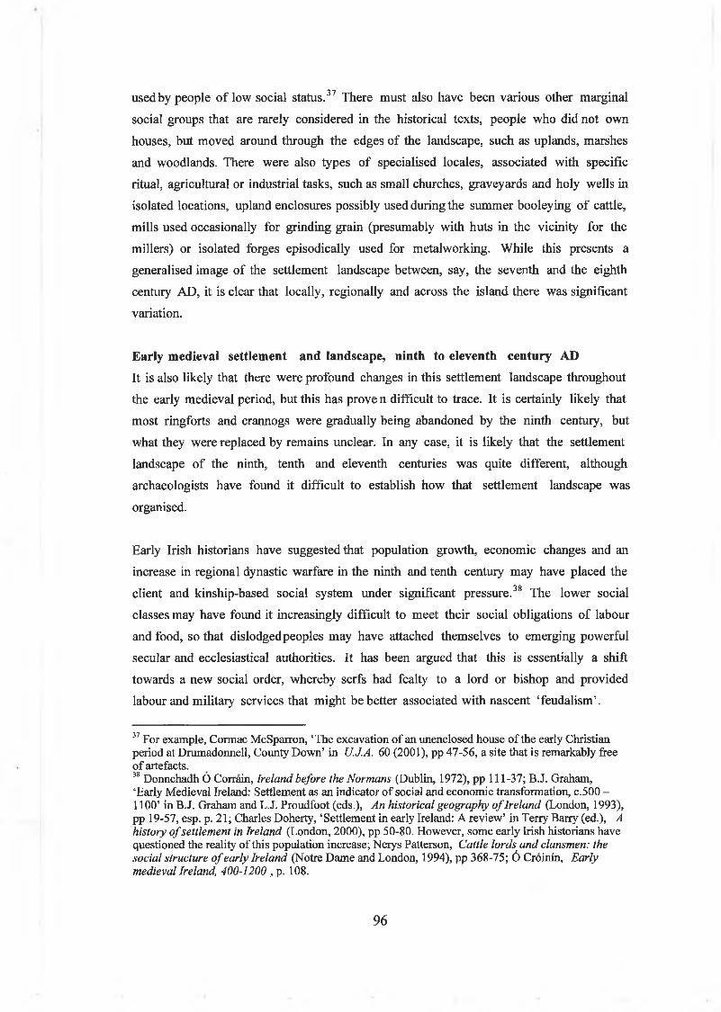
used by people o f low social status.37 There must also have been various other marginal
social groups that are rarely considered in the historical texts, people who did not own
houses, but moved around through the edges o f the landscape, such as uplands, marshes
and woodlands. There were also types o f specialised locales, associated with specific
ritual, agricultural or industrial tasks, such as small churches, graveyards and holy wells in
isolated locations, upland enclosures possibly used during the summer booleying o f cattle,
mills used occasionally for grinding grain (presumably with huts in the vicinity for the
millers) or isolated forges episodically used for metalworking. While this presents a
generalised image o f the settlement landscape between, say, the seventh and the eighth
century AD, it is clear that locally, regionally and across the island there was significant
variation.
Early medieval settlement and landscape, ninth to eleventh century ADIt is also likely that there were profound changes in this settlement landscape throughout
the early medieval period, but this has prove n difficult to trace. It is certainly likely that
most ringforts and crannogs were gradually being abandoned by the ninth century, but
what they were replaced by remains unclear. In any case, it is likely that the settlement
landscape o f the ninth, tenth and eleventh centuries was quite different, although
archaeologists have found it difficult to establish how that settlement landscape was
organised.
Early Irish historians have suggested that population growth, economic changes and an
increase in regional dynastic warfare in the ninth and tenth century may have placed the
client and kinship-based social system under significant pressure.38 The lower social
classes may have found it increasingly difficult to meet their social obligations o f labour
and food, so that dislodgedpeoples may have attached themselves to emerging powerful
secular and ecclesiastical authorities. It has been argued that this is essentially a shift
towards a new social order, whereby serfs had fealty to a lord or bishop and provided
labour and military services that might be better associated with nascent ‘feudalism’.
37 For example, Cormac McSparron, ‘The excavation of an unenclosed house of the early Christian period at Drumadonnell, County Down’ in U.J.A. 60 (2001), pp 47-56, a site that is remarkably free of artefacts.38 Donnchadh O Corrain, Ireland before the Normans (Dublin, 1972), pp 111-37; B.J. Graham,‘Early Medieval Ireland: Settlement as an indicator of social and economic transformation, c.500 -1100’ in BJ. Graham and L.J. Proudfoot (eds.), An historical geography o f Ireland (London, 1993), pp 19-57, esp. p. 21; Charles Doherty, ‘Settlement in early Ireland: A review’ in Terry Barry (ed.), A history o f settlement in Ireland (London, 2000), pp 50-80. However, some early Irish historians have questioned the reality of this population increase; Nerys Patterson, Cattle lords and clansmen: the social structure o f early Ireland (Notre Dame and London, 1994), pp 368-75; 6 Croinin, Early medieval Ireland, 400-1200 , p. 108.
96
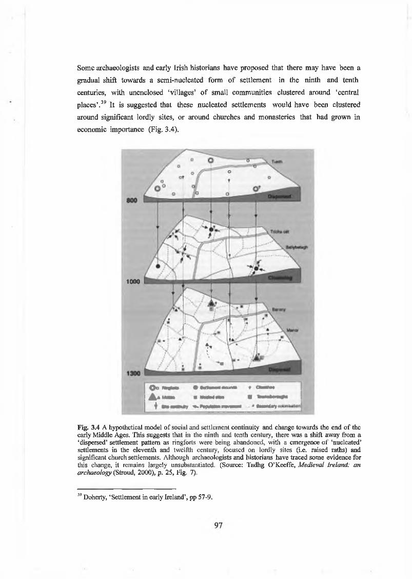
Some archaeologists and early Irish historians have proposed that there may have been a
gradual shift towards a semi-nucleated form o f settlement in the ninth and tenth
centuries, with unenclosed ‘villages’ o f small communities clustered around ‘central
places’.39 It is suggested that these nucleated settlements would have been clustered
around significant lordly sites, or around churches and monasteries that had grown in
economic importance (Fig. 3.4).
1000
Fig. 3.4 A hypothetical model of social and settlement continuity and change towards the end of the early Middle Ages. This suggests that in the ninth and tenth century, there was a shift away from a ‘dispersed’ settlement pattern as ringforts were being abandoned, with a emergence of ‘nucleated’ settlements in the eleventh and twelfth century, focused on lordly sites (i.e. raised raths) and significant church settlements. Although archaeologists and historians have traced some evidence for this change, it remains largely unsubstantiated. (Source: Tadhg O’Keeffe, Medieval Ireland: an archaeology (Stroud, 2000), p. 25, Fig. 7).
39 Doherty, ‘Settlement in early Ireland’, pp 57-9.

There is some evidence that particular ringforts, the residences o f powerful individuals
perhaps, were built up and raised into platform or raised ringforts in the ninth and tenth
centuries (sites like Rathmullan, Co. Down and Knowth, Co. Meath may have been such
lordly strongholds). However, there is no archaeological evidence as yet to show that
they were surrounded by clusters o f houses o f their tenants. In contrast, there is some
palaeoenvironmental evidence for an expans ion in agricultural activity in the ninth and
tenth century, perhaps related to the growing wealth and power o f the church.40 It is
also possible that such churches and monastic sites became the focus o f markets and
cattle ‘marts’, possibly also with input from local secular lords. For these reasons,
‘monastic towns’ may have emerged by the tenth and eleventh centuries, at the same
time as coastal towns were being established by Hibemo-Norse populations, providing
elites with high-status goods and silver.
By the eleventh century, the early medieval settlement landscape was probably
significantly different lfom what had been there before. However, as there is still
palaeoenvironmental evidence for an open, agricultural landscape, there must have been
a conti nuity o f dispersed settlements too. There may well have been many unenclosed or
‘open’ settlements scattered through fields and farms. In appearance, these may have
looked like a house or two, with their outside yards, middens and activity areas, but with
no enclosing boundary feature. Early medieval souterrains (typically dated to between
the seventh and the tenth centuries AD) occasionally provide evidence for such
unenclosed settlements, as several souterrains have produced evidence for unenclosed
houses close to the entry to the passage and chamber.41
Interpretative approaches to early medieval crannogs in IrelandInterpreting crannogs in the early medieval landscapeClearly then, there is both a wide range o f evidence and a diversity o f potential
interpretive approaches to early medieval crannogs as sites, while they also need to be
considered in terms o f their wider social and settlement landscapes. Firstly, it is
important to consider how crannogs may have been understood and used within the
social, economic and ideological landscapes o f early medieval Ireland. In the early
Middle Ages, the occupants o f a crannog would have been aware of, and familiar with,
40 M.A. Monk, ‘Early medieval secular and ecclesiastical settlement’, pp 46-9; V.A. Hall, ‘The documentary and pollen analytical records of the vegetational history of the Irish landscape, AD 200- 1650’ in Peritia 14 (2000), pp 342-71, at p. 368.41 Mark Clinton, The souterrains o f Ireland (Dublin, 2001), pp 205-6.
98

the local settlement landscape around the lake, with its ringforts, unenclosed dwellings,
churches, burial places, holy wells, as well as its fields, roads and lanes, woodlands and so
on. Although crannogs were apparently isolated island dwellings, surrounded by water, it
was the entire landscape that formed the backdrop and context o f all social, economic
and ideological relationships within the community.
In other words, crannogs were not exotic, isolated objects separated from the rest o f the
world, but places that were knitted into within the wider settlement landscapes. This can
be demonstrated by exploring their siting in relation to lake topography, local soils, and
the environment. Their role in the social landscape can also be assessed by exploring
their relationships with other early medieval sites (e.g. ringforts. churches, holy wells). It
is also possible to explore their location at potential early medieval political boundaries
and with potential early medieval routeways. In early medieval Westmeath, as elsewhere,
crannogs were located within quite densely occupied early medieval landscapes, and were
occasionally used as islands at the edge to manipulate people’s views o f them, to thereby
control access to them and manipulate how people perceived and understood the
landscape around them. For example, some early medieval crannogs in Westmeath were
built and occupied at particular types o f places (e.g. in small bays, at the ends o f
promontories and loughs adjacent to esker routeways) where they would have physically
and symbolically dominated the landscape around them. Visible from around the lake and
overlooked by settlements around them, they may have served as social ‘stages’ within
the natural theatre o f the landscape itself. On other occasions, they are extraordinarily
remote, suggesting a desire for isolation, distance and even a degree o f social marginality.
This suggests that crannogs can usefully be thought about as places (or arenas) in the
social landscape for the enactment and negotiation o f various social relationships, in
both everyday and ceremonial occasions. How might this be achieved? One approach is
to use phenomenology, exploring how people’s understanding o f their world was first
and foremost constructed by their physical and psychological experience o f it, so that
sight, smell, hearing and touch - all have to be allowed for in any reconstruction o f the
use o f a crannog. In the early Middle Ages, people’s experiences and encounters with
crannogs in the landscape could have included distant views o f them from the shore,
journeys to them across deep and dangerous water by boat or by wading across shallow
water. Upon arrival at them, closer views would have enabled inspection o f their stone
cairns, gates and entrances, enclosing palisades, middens, their houses and workshops
within. A walk around a crannog would have enabled a person to experience and witness
99

the sights and smells o f life on the island, ranging from the wood-smoke o f fires, to the
scent o f cooking food or rotting bone in the middens.
Interpreting crannogs as early medieval island dwellingsIn early medieval Ireland, the settlement or dwelling place (whether it be on a crannog,
ringfort or unenclosed settlement) was a place of enormous social and ideological
significance. While people spent much o f their time moving around, working on the
land, or engaged in various activities outside and around the landscape, the dwelling place
and the house in particular was the place where they returned to in the evening. Within
the dwelling enclosure or under the house’s sheltering roof, the household group could
have worked, slept, prepared and eaten food, gathered for particular social occasions and
extended hospitality to their wider kin and neighbours. In the darkness o f night or during
the winter, people would have gathered together within the house itself to while away
the hours around the fire. In summer too, it was the place where people rested after a
day’s labour, chatting idly about the weather, crops and local news.
There is a rich array o f potential archaeological evidence for the interpretation o f the
organisation o f settlement space in early medieval Ireland. Most studies o f internal
spaces o f early medieval settlements have tended to be quite descriptive, outlining such
formal morphological features as their enclosing features, size, construction techniques
and architectural changes.42 Early medieval houses have been the subject o f more
detailed analytical studies and Lynn has developed a good understanding o f their
location, shape, size, building materials and internal features.43 The early Irish historical
sources also frequently have accounts o f dwellings and houses and these indicate the
paramount social and symbolic importance o f such features as doorways, hearths and
seating arrangements. However, even Lynn’s studies have only briefly touched upon
aspects o f the social organisation o f house spaces. In other words, it could be argued that
the potential o f neither the archaeological nor the historical evidence has been realised.
In contrast, prehistoric archaeologists have tended to make more advances in exploring
the social and symbolic organisation o f domestic space. Some o f their major influences
have been from anthropology and sociology. In particular, the sociologist, Anthony
Gidden’s theory o f structuration and the French anthropologist, Pierre Bourdieu’s
42 For example, Edwards, The archaeology o f early medieval Ireland, pp 6-48.43 C.J. Lynn, ‘Houses in rural Ireland, A.D. 500-1000’ in U.J.A., 57 (1994), pp 81-94; C.J. Lynn, ‘Early medieval houses’ in Michael Ryan (ed.), The illustrated archaeology o f Ireland (Dublin, 1991), pp 126-31.
100

concepts o f habitus have been very influential. Gidden’s theories o f structuration and
agency envisage people as knowledgeble agents who have the ability to manipulate and
structure the world within which they live, although they are constrained and guided by
that world to that extent. Inspired by Giddens, archaeologists see the settlement space
and the domestic house in particular not merely as a backdrop for human action, but as a
space through which social relationships were ordered, produced and reproduced over
time. A house’s doors, hearth, furniture, sleeping, cooking and living areas would have
been used, consciously or unconsciously, to control and direct the actions and movement
o f both household members and outsiders. Similarly, Bourdieu’s concept o f habitus
describes how people, through their habitual, bodily encounters with space learn about
society and their place in the world. For example, children growing up in a house would
have learned from it, the nature o f social relationships between men and women,
between young and old, or between the upper and the lower social classes.
Archaeologists, inspired by these structuralist theories, have interpreted settlements and
domestic architecture as embodying a system of signs about a culture’s belief systems.
The dwelling space and the house are seen as critically important in the negotiation of
social relationships, as storehouse o f traditional knowledge and values and as artefacts o f
both practical and symbolic action. In particular, archaeologists working with
structuralist theoiy interpret domestic space as being divided up in a binary way, with
structuralist oppositions between bright/dark, front/back, clean/dirty, wet/dry,
public/private and male/female. These are all potentially rich topics to explore on an
island dwelling, with its boundaries and boggy surfaces.44 Inspired by these ideas, and
recognising formal doorway orientations, hearth and furniture arrangements, working
areas and routes o f access around a crannog, as well as structured deposits o f bone,
artefacts or other rubbish on it, it should be possible to ‘read’ something o f the cultural
meanings expressed therein.
44 Recent structuralist approaches to the social and symbolic organisation of domestic dwelling space mostly relate to Bronze Age and Iron Age Britain; Andrew Fitzpatrick, ‘Outside in: the structure of an early Iron Age house at Dunstan park, Thatcham, Berkshire’ in A. Fitzpatrick and E. Morris (eds.), The Iron Age in Wessex: Recent work (Oxford, 1994), pp 68-72; Richard Hingley, ‘Public and private space: domestic organisation and gender relations amongst Iron Age and Romano-British households’ in Ross Samson (ed.), The social archaeology o f houses (Edinburgh, 1990), pp 125-48; A. Oswald, ‘A doorway on the past: practical and mystic concerns in the orientation of roundhouse doorways’ in A. Gwilt and C. Haselgrove (eds.), Reconstructing Iron Age societies: new approaches to the British Iron Age (Oxford, 1997), pp 87-95; Michael Parker-Pearson, ‘Food, fertility and front doors in the first millennium BC’ in T.C. Champion and J.R. Collis (eds.), The Iron Age in Britain and Ireland: Recent trends (Oxford, 1996), pp 117-32; Mel Giles and Michael Parker-Pearson, ‘Learning to live in the Iron Age: dwelling and praxis’ in Bill Bevan (ed.), Northern exposure: interpretative devolution
101
However, while early medieval scholars might now become interested in these
structuralist approaches to settlement space, it is useful to point to the fact that many
archaeologists have been quite critical o f these theories. In particular, they suggest that
there is a danger o f proposing cross-cultural, ahistorical similarities between prehistoric
and medieval uses o f domestic space. It is important to recognise that the way that
people construct, order and experience space is very much culturally and temporally
determined, informed by a particular social ideology and is also an outcome o f gender,
age, social status and kinship. It is also important to remember that that individual
settlements can develop in an idiosyncratic way across time, depending on the lives,
events and processes experienced by the actual household who lived there .45 However,
there is certainly potential for working with some o f these ideas in relation to early
medieval crannogs. In this study, the architecture and internal space o f early medieval
crannogs (e.g. cairns, causeways, palisades, houses, hearths, cesspits, etc) will be
interpreted in these social term s.
Place, memory and belongingLandscapes and sites change across time. Early medieval crannogs have also then to be
interpreted in terms o f place, memory and history. It is important to consider how
individual and collective memory would have worked in early medieval people’s
understanding o f the settlement landscape. The past was used in various ways in the early
Middle Ages, to legitimate the status quo, or to provide legitimacy to those to opposed
the status quo, to understand current events and as a hugely significant means o f building
people’s sense o f identity. The community’s shared sense o f the past was used to define
appropriate behaviour and to construct a local group identity (for example, the
genealogy o f the king, or accounts o f past battles would have been narrated at public
assemblies, thus re-enforcing local power structures). However, such views o f the past
would have been continually the subject o f dialogue and debate, re-shaped to lit present
needs, resisted and subverted by individuals and groups. Whatever people’s agreement
about the truth or otherwise o f the past as presented, the past would still have been
situated in a real, contemporary landscape, the more so i f physical traces o f it were
visible. People would have known of an event that ‘it happened on that island over
there’, would have known from the black waterlogged timbers still surviving in the water
that people had lived there before. A person’s knowledge, sense o f history and the past
and the Iron Age in Britain (Leicester, 1999), pp 217-31.45 For a recent critique of these structuralist approaches to house space see, Joanna Brück, ‘Houses, life-cycles and deposition on Middle Bronze Age settlements in southern England’ in Proc. Prehist. Soc. 65 (1999), pp 145-66.
102

then, would also have strongly influenced an understanding o f the places that they were
looking at, working in, or moving around.46 In this study, the chronology and
occupation histories o f crannogs will be discussed in these terms.
People, islands and social identityBut this touches on another important aspect o f this thesis: the role o f islands in the
making and re-shaping o f social identity in the early Middle Ages. Identity is an
important concern in settlement and landscape archaeology, because it reminds us that
an people’s perception and understanding o f the landscape is usually shaped by both their
community’s and their own, ‘ego-centred’ viewpoint. Everybody who experienced and
perceived the early medieval landscape did so according to his or her own knowledge,
memory and individual identity. It would be useful then to explore how people thought
about islands in the early Middle Ages. Were they places apart from the world, by living
upon them did people similarly achieve a distinctive social identity, placing themselves
apart from the world? Were islands places where people could alter or re-negotiate their
social identities, whether this was in terms o f social status, kinship or gender and
sexuality?
In terms o f social identity, while it might be thought useful to explore how an
‘individual’ might have experienced space, place and time in the early medieval
landscape, it is worth reflecting on who this ‘individual’ was, as well as his or her place
within the larger social group. It would not be helpful to adopt the perspective o f an
‘everyman’, a ‘neutral observer’. As stated above, most phenomenological studies of
archaeological landscapes inevitably adopt the persona o f the modem observer,
unquestionably the product of modem, western society and culture.47 Instead, it might be
useful to attempt to reconstruct and imagine the mentalités o f people living in an early
medieval world (admittedly, a difficult task).
46 Recent studies of memory and the uses of the past in early medieval societies include; Yitzhak Hen and Matthew Innes (eds.), The uses o f the past in the early Middle Ages (Cambridge, 2000); Howard Williams, (ed.), Archaeologies o f remembrance: Death and memory in past societies (New York, 2003); Howard Williams, ‘Monuments and the past in early Anglo-Saxon England’ in World Archaeology 30, no. 1 (1998), pp 90-108; S.T. Driscoll, Piets and prehistory: cultural resource management in early medieval Scotland’ in World Archaeology 30, no. 1 (1998), pp 142-58; for studies of the perception and use of the past in early medieval Ireland, see Kim McCone, Pagan past and Christian present in early Irish literature (Maynooth, 1990), pp 65-83; N.B. Aitchison, Armagh and the royal centres in early medieval Ireland (Woodbridge, 1994), at pp 28-39; Conor Newman, ‘Reflections on the making of a ‘royal site’ in early Ireland’ in World Archaeology 30, no. 1 (1998), pp 127-141.
Brack, ‘In the footsteps of the ancestors’, pp 23-36
103

Admittedly, there is much that is not achievable, because it is also important to
remember that people’s own social identity(s) would have had a profound impact on how
they may have perceived islands and crannogs. It is probably impossible to reconstruct
how everybody would have thought about a crannog. One could speculate, for example,
that an early medieval serf or tenant when observing a high-status crannog from the
shore, would have seen the thatched roofs and fire-smoke above the island’s palisade,
heard the chatter o f voices, and would have felt excluded or oppressed by it. On the
other hand, this same serf or tenant could have seen the crannog as a source of
protection and safety, and as a place o f power to be identified with. Somebody else, a
visiting loyal noble perhaps, being brought across to the same island by dug-out boat,
could have viewed close-up the richly worked tim ber of a palisade wall, could have
entered through the narrow gap o f an entrance, seen flickering firelight through a door,
and felt that he was being accepted into a élite group. On the other hand, the same noble
might have been nervous o f his reception, aware o f the social obligations and agreements
shortly to be demanded of him. In any case, it would have been through such daily
experiences and encounters with a crannog’s location, physical architecture and social
space and knowledge o f its history, that a person would have understood his or her place
in the community.
ConclusionIn conclusion, this chapter has explored the sources o f evidence (archaeological,
historical and palaeoenvironmental) that will be used in this study. It has also reviewed
current understanding o f settlement and landscape in early Ireland and the potential for
innovative landscape approaches to this crannogs in particular. In the next chapter, I
will explore how people imagined and thought about islands in the early Middle Ages. I
will use this previously unexplored evidence to reconstruct how islands may then have
been used in the social and cultural construction o f identities, whether they be in terms
o f social class and status, gender, sexuality and age, ethnicity and kinship.
104

Chapter 4.
Islands and social identity in the early medieval
imagination
IntroductionIslands inspire the imagination. An observer from the outside sees a distant island as
seemingly floating on the water, remote, enigmatic, isolated. For the islander on the
other hand, an island home provides safety and security, while the outside world can be
seen in contrast as remote, overhanging and threatening. On small islands in particular,
the islander can observe the water going all the way around his abode, can watch the wind
and waves ruffle its surface and can see for great distances. For both outsider and
observer then, islands are intensely bounded places, defined by their shorelines, the water
all around them or the distance to the land. Islands then are places apart; whether they
are distant or close at hand, and are removed both physically and cognitively from the
rest o f the world. However, islands are also places that invite movement and connection,
the surrounding water providing a means o f travel in all directions. Islands are also places
in time and the island dweller can witness the passage o f time by the weather, watching
the tides, currents and winds at work. For these and other reasons, many cultures have
seen islands as places whose unusual location in space and time gives them an
extraordinary potential.
Before I explore how islands were seen in the early Middle Ages, it is worth briefly
pointing out that many eras and cultures are suffused with powerful imageiy about islands
(including our own). In the late Middle Ages, Europe was fascinated with stories o f Hy
Brasil ( Ui Bhreasail in Gaelic oral tradition), a mythical island and place o f eternal life
reputed to lie out in the Atlantic off the west coast o f Ireland. It was frequently depicted
on fourteenth to sixteenth century Portolan nautical maps, and survived as an
anachronism on maritime charts as late as the nineteenth century.1 In English and
French seventeenth and eighteenth century colonialist literature, islands have also
always been places o f adventure and potential transformation. From Shakespeare’s The
1 T.J. Westropp, ‘Brasil and the legendary islands of the North Atlantic’ in R.I.A. Proc., 30c (1912), pp 223-60; TJ. Westropp, ‘Early Italian maps of Ireland from 1300 to 1600, with notes on foreign settlers and trade’ in R.l.A. Proc. 30c (1913), pp 361-428; J.H. Andrews, Shapes o f Ireland (Dublin, 1966), Fig. 2.2; Aidan O’Sullivan, Foragers, farmers and fishers in a coastal landscape: An intertidal archaeological survey o f the Shannon estuary (Dublin, 2001), Fig. 5.
105

Tempest, to Daniel Defoe’s Robinson Crusoe or Robert Louis Stevenson’s Treasure
Island, the island (in particular) is a place freed from the normal structures o f life in the
home country. In the colonial social and political experience, whether in the Pacific or
the Caribbean, or even in seventeenth-century Ireland, islands were seen as remote,
exotic, innocent, wild places that had to be tamed, charted and mapped by men. Once
ready, these idealised spaces could then become the canvas on which new social and
economic experiments could be tried out, resources freely exploited, fantasies enacted,
wishes fulfilled, ambitions realised. The original inhabitants o f islands, on the other hand,
(themselves seen as the ‘natural product’ o f these places) were often seen either as brutal
savages, or innocent creatures, that should also be exploited and transformed by conquest
and civilisation. In this sense, islanders were also seen as exotic, occasionally even noble,
representing in their innocence, the state o f grace from which the west had fallen.2
In more recent times, and closer to home, it is possible to trace similar colonialist/post
colonialist tropes in the treatment o f islands by nineteenth and twentieth-century
English and Irish scholars, poets, writers and artists. In J.M. Synge’s essays on The Aran
Islands, in W.B. Yeat’s poetry, in Paul Henry’s paintings on Achill Island, islanders are
presented as innocents who preserved in their daily work and lives, a stoic tradition that
offered an alternative to the norm .3 From about 1910, various folklorists, scholars and
philologists seized on the Blasket Islands in particular as a place where they could
encounter an alternative, proto-communist society, with its islander’s lifeways, its
socially agreed ‘kingship’, its communal sharing o f property and resources and the
islanders’ heroic endurance o f loss and hardship. In the British Marxist Hellenist George
Thomson’s accounts o f the Blasket Islands and in Robin Flower’s book The Western
Island, a view is given o f the islanders as people who represented an ‘vanishing way of
life’. Theirs was a culture ‘on the verge o f extinction - a society, which, though not
illiterate, was still in an essentially oral stage and seemed to have retained impressive
elements o f a proto-historic, European culture’.4
Interestingly, in the ‘Blasket Island literature’ o f Tomás Ó Criomhthain, Maurice O ’
Sullivan and Peig Sayers,5 the articulate voices o f islanders themselves can he heard,
2 Nikos Papastergiadis, Dialogues in the diaspora: essays and conversations on cultural identity ^River Orams, 1998), p. 217.
Sighie Bhreathnach-Lynch, ‘The formation of an Irish school of painting: Issues of national identity’, in S.B. Kennedy Paul Henry (Dublin, 2003), pp 23-34.4 G. D. Zimmerman, The Irish storyteller (Dublin, 2001), pp 357-67, at p. 363.5 For a historical account and bibliography of the Blasket Island authors, see Muiris mac Conghail,The Blaskets: people and literature (Dublin, 1987), pp 127-47, and pp 168-69; the main memoirs in English translation are Tomas O’Crohan, The Islandman (Oxford, 1951); Maurice O’Sullivan,
106

albeit occasionally mediated through the assistance o f their editors and friends. A
striking aspect o f this literature is the way that they, as islanders, perceived the outside
world. In Tomás Ó Criomhthain’s description o f the Great Blasket, ‘the sea goes all
around it’ and that was what separated them from the people o f the mainland. Their
brief excursions off the Blasket provided them with a journey to Dingle town or the
Ballyferriter beach market, where they encountered the bizarre world o f Ireland, with its
unequal social hierarchies and money-oriented economy. For the islanders, this was their
opportunity to encounter the ‘other’, and by indulging in strong drink, they could briefly
move out from the tight social rules o f the island.6 However, these incidents were
anathema to Irish nationalists, who sought to erase in published editions any accounts o f
sexuality or alcohol, preferring to envision the islanders as pure and unadulterated.
It might be suggested that post-colonialist and nationalist attitudes to islands can be
traced in the uses o f the Blasket and Aran island literature in Irish education in the Free
State. As Zimmerman has written:
Those who needed a perfect incarnation of Irishness hoped to find it in the islands of the West. The hardships of life there could be described in epic mode, and to go to those last outposts seemed to be a journey in time, back to the pure source. John Wilson Foster has shown how the old motif of imaginary islands as meeting-points for mortal men and immortal beings combined with memories of the medieval reality of islands as Irish monks’ or hermits’ refuges against pagan darkness and temptations, and with the modern philological reputation of the same islands as places where undefiled Irish was spoken: ‘The western island came to represent Ireland’s mythic unity before the chaos of conquest: there at once were the vestige and the symbolic unity of an undivided nation.’
In the Irish school curriculum, the Blasket Island literature (particularly that o f Peig
Sayers) and the Aran Island short stories o f Liam O’Flaherty and Mairtin O Direan, were
used to project a particular sense o f Irishness.8 Certainly as a schoolboy in the early
1980s, I knew much more about Blasket Island and Aran Island life than I did about
Dublin town life.9 Kiberd has argued that, through the use o f Peig Sayers’ book and other
Twenty years a-growing (Oxford, 1953); Peig Sayers, Peig: the autobiogaphy ofPeig Sayers o f the Great Blasket Island (AthCliath, 1974).6 Declan Kiberd, Irish classics (London, 2000), pp 520-42.7 Zimmerman, The Irish storyteller, pp 360-1; Wilson Foster, ‘Certain set apart: The western island in the Irish renaissance’ in Studies 66 (1977), pp 261-70, at p. 265.8 Indeed, the original publication of Tomás O’Criomhthain’s An tOileánach (Baile Átha Cliath,1929) was an expurgated version, as the publishers removed any reference to sexuality or other vices, these being considered inappropiate for a Gaelic island race. The original, full edition was republished by his son in 1980.1 thank John Bradley for this observation.9 Unlike most of my compatriots, I never studied Peig Sayers’ reflections of the Blasket Islands, so I never understood the source of their complaints. On the other hand, for my Leaving Certificate Irish, I studied islands through the marvellous short stories of Liam O’Flaherty and Mairtin O Direáin,
107

island narratives, the Irish education authorities intended that the ‘real Irishness’ o f the
smaller islands was to be imported back into Ireland, to re-generate and renew the bigger
island and to again restore it to the state o f grace from which it had fallen.10
In other words, since the Middle Ages, islands have carried the potential o f being used to
re-order and construct the world according to the agendas o f ruling powers, while
islanders themselves have often sought to subvert and resist such powers. In other words,
islands have been used in an ideological sense, to present a view o f the world that suited a
particular elite or powerful group. Indeed, this is something that also happened in early
medieval Ireland, as powerful clerics and kings attempted to shape the worlds in which
they lived.
Islands and the early medieval imaginationIntroductionHow were islands imagined in the early Middle Ages in Ireland and what sources o f
evidence can we use to answer this question? There is archaeology, o f course, with its
abundant evidence for the use o f islands and crannogs. Undoubtedly, the physicality and
material expression o f cairns, palisades and causeways offer many insights into the ways
that early medieval communities saw islands. Indeed, in the chapters subsequent to this, I
will be concentrating on this archaeology. However, in this chapter I intend to
concentrate on the early medieval documentary sources. The saints lives, annals and
narrative literature all provide useful insights into the early Irish perception o f islands
and the ways that they were used to construct ideologically normative ideas o f social
hierarchy, gender and community. Indeed, it could be argued that these texts express
concepts similar to the postcolonial ideas discussedabove. Islands are seen as remote and
isolated, the home of the ‘other’, places o f innocence, danger and strangeness, where
society could be turned upside-down or re-structured according to the ideological stance
o f the observer, who again is usually an outsider looking in.
The Irish annals, laconic accounts o f deaths, battles and other phenomena, provide
contemporary accounts o f various political events from the seventh century onwards. In
which were mostly set on the Aran Islands.10 Declan Kiberd, lecture at TAG in Ireland archaeology conference, UCD Dublin, December 2001; It certainly worked with me! As a 13-year old school boy, I first read Robin Flower’s The Western Island (Oxford, 1944), and from there proceeded to devour the entire Blasket Island literature. I still remember my utter fascination with the Blaskets, and a summer visit I made there with my parents in 1983. Looking back, I think it’s not entirely co-incidental that at the time I was also fascinated with other nationalist Irish iconography, such as the war of independence memoirs (e.g. those of Dan
108

the annals, there is a recurring sense that islands can be built, fortified and inhabited. The
same islands can also be destroyed by fire, looted and sacked by raiders on boats and
overwhelmed by winter storms and floods. These islands can also be places for
treacherous murders, holding prisoners, feasting and the natural deaths o f powerful
individuals. Other potentially useful sources on the perception o f islands are the saints’
lives, both the earlier Hibemo-Latin versions and the later Irish examples. Saints are
frequently portrayed as confronting various forces and individuals on islands. However,
amongst the most significant sources o f evidence are the immrama (literally ‘rowings
about’) with their voyages around islands.11 Some o f the hagiographies (e.g. the seventh
and eighth century Hibemo-Latin lives o f Brendan and Ailbhe, and the later Irish lives o f
Senan and Brendan) also provide episodes and motifs o f journeys to islands similar to
those in the immrama } 2
In the past, scholars have tended to see both the hagiographies and voyage tales (and
they undoubtedly influenced each other) as historical eyewitness accounts, passive
reflections o f daily life and beliefs, or as sources o f information about maritime life.13
The frequently pagan encounters within them previously encouraged scholars to see
them as having their origins in Irish ‘Pre-Christian’ or traditional lore.14 However, in
recent years, most early Irish historians have argued that these tales were firmly written
with a Christian milieu and must be understood in the context o f the ideology of the
eighth and ninth-century church (that o f the Celi De reform movement, for example).
It is interesting, for example, that the immrama , with their stories o f pilgrimage into
the western ocean are being compiled at the same time as some island hermitages (e.g.
Aran Islands, Inishmurray) were emerging as significant fo c i o f pilgrimage, a valuable
source o f income and authority for the church (Fig. 4.1).
Breen, Tom Barry), rebel songs and so on.11 For an anthology of the early medieval Irish voyage tales, see Wooding (ed.), The otherworld voyage in early Irish literature. Incidentally, before I embark on this discussion and leave behind modem Irish ideas about islands, I would also note that Robert Tracy, ‘All them rocks in the sea: Ulysses as Imrnram’ in Irish University Review 32, no. 2 (2002), pp 225-41, suggests that James Joyce being aware of the voyage tales through the Celtic literary revival, used them as a part inspiration for his novel describing Leopold Bloom’s wandering around Dublin.12 Mdire Herbert, ‘Literary sea-voyages and early Munster historiography’ in R. Black, W. Gillies and R. O Maolaigh (eds.), Celtic connections: Proceedings o f the tenth international congress o f Celtic Studies (East Linton, 1999), pp 182-9.13 For a similar critique of scholars’ misuse of the geography of Adomnan’s De locis sanctis (written c.AD 680), see Thomas O’Loughlin, ‘The view from Iona: Adomnan’s mental maps’ in Peritia 10 (1996), pp 98-122, atpp 99-101.14 J.M. Wooding, ‘Introduction’ in Wooding (ed.), The otherworld voyage, pp. xi-xxviii, at p. xv.
109

Fig. 4.1 Early medieval island monastery of Inishmurray, Co. Sligo. While the monastery had churches, beehive cells, and leachta, it was also a significant destination for medieval pilgrims, who visited the island’s hostels, public churches and saint’s tomb. (Source: Peter Somerville Large, Ireland’s Islands: Landscape, life and legends (Dublin, 2000), p. 47.
Principal amongst the immrama is the eighth-century Nauigatio Sancti Brendani
abbatis (‘Voyage o f St Brendan the Abbott’, possibly written c. AD 800), which
describes the travels o f the sixth-century Brendan and some o f his monks on a seven-
year journey on the wide ocean, where they meet with marvellous islands, sea creatures
and other wonders.15 Its popularity may have meant that it inspired in the early ninth
century, the compilation o f a secularised derivative tale in Irish, Immram curaig Maele
Duin ( ‘The Voyage o f Mael Duin’s boat’), which also describes a hero’s journey around
islands.16 Other notable voyage tales that have survived and received critical academic
attention include the Immram curaig Ua Corra ( ‘Voyage o f the Ui Corra),17 the
Immram Brain mac Febuil ( ‘Voyage o f Bran son o f Febul’)18 and the Immram
15 Carl Selmer (ed.), Navigatio Sancti Brendani Abbatis (Notre Dame, 1959; repr. Dublin 1989); J.J. O’Meara, (trans.) The voyage o f Saint Brendan (Dublin 1976, reprint 1991); Thomas O’Loughlin, ‘Distant islands’, pp 1-20.16 H.P.A. Oskamp (ed. and trans.), The voyage o f Mael Düin: A study in early Irish voyage literature (Groningen, 1970).17 Whitley Stokes (ed. and trans.), ‘The voyage of the Hüi Corra’ in Revue Celtique 14 (1893), pp 22- 69.18 Sdamus Mac Mathuna (ed. and trans.), Immram Brain: Bran ’s journey to the Land o f Women (Tübingen, 1985).
110

Snedgusa ocus Maic Riagla ( ‘Voyage o f Snedgusand Mac Riagla’).
Although the various voyage tales share many motifs and some are clearly derived from
others (e.g. Maele Duin being strongly influenced by the Nauigatio), each provides a
distinctly different ta le .19 In Immram Brain mac Febuil, Bran travels to the otherworld
island o f Tirinna mBan (‘Land o f women’), via another island named Inis Subai ( ‘Island
o f Joy’). In Immram curaig Maele Duin the secular hero, Mael Duin, is the son o f a
warrior and nun and goes on an Odyssey-Ysks quest20 to avenge his father’s murderers,
visiting thirty-one islands before returning home in peace. In contrast, in Immram
Snedgusa ocus Maic R iagla , two monks o f the fam ilia of St Columcille (Columba) visit
eight islands, the last being Tir Tairngire ( ‘Land o f Promise’). The Immram curaig Ua
Corra is distinctly different again. It describes the journey o f three brothers on the
ocean, they having set out it as a penance for crimes o f brigandage.
In the immrama , people embark on journeys out to islands, negotiate dangers across the
boundaries o f sea and shore and encounter various beings o f sacred (e.g. saints and
hermits) or supernatural power (e.g. monsters, blacksmiths, angels). These voyage tales
thus depict islands as places o f the ‘other’, where magical personages, monsters and
unnatural phenomena would be encountered.21 The islands they depict, whether they be
Christian or pagan in tone, were often places that were literally closer to the Christian
otherworld, serving as gateways to either heaven or hell. Islands could therefore also be
places where various social boundaries could be negotiated, transgressed or crossed. For
example, in terms o f gender relations, on some mythical islands, sex was freely available
to the wandering male (such as on the ‘Land o f women’ in the ninth-century Immram
curaig Maele Duin), whilst on others it was rigorously denied (e.g. within a Christian
island monastery).
Islands are also potentially located in an altemat ive time-geography in the hagiographies
and voyage tales.22 Voyagers would go out onto the ocean, spend months or years
rowing about various islands, meeting different people, before returning to Ireland, either
much later than they expected. Quite apart from the different rhythm o f hours as lived
19 Wooding, ‘Introduction’, p. xiii20 Incidentally, it is worth noting that the idea that the Irish immrama were based on classical texts has long been discredited by early Irish historians, see Wooding ‘Introduction’, p. xix.21 For discussion of islands in the voyage tales, see Prionsias Mac Cana, ‘The sinless otherworld of Immram Brain’, pp 95-115; O’Loughlin, ‘Distant islands’, pp 1-20.22 Examples of this alternative time-geography are cited by John Carey, ‘Time, space and the otherworld’ in Proceedings o f the Harvard Celtic Colloquium 7 (1986-7), pp 1-27.
I l l

in an early medieval monastic world, or the different daily and seasonal rhythms o f work
amongst maritime and agricultural communities, time is actually depicted in an unusual
(to us) way in the narrative literature and hagiographies. O’Loughlin observes that in a
journey-narrative, we expect visits to places to follow each other in logical geographical
sequence, over a logical chronological time frame. He suggests that time itself may have
been perceived differently in the early Middle Ages than the way it is in the modem
world which has a linear chronology and Newtonian sense o f a proper sequence o f days,
weeks, months and years. In the early medieval texts, he states that we should be aware
that people are representing time according to the way they understood it, not the way
we do.23 It is clear then that islands were seen as places outside o f time, or even at the
end o f life, places where death or at least some type o f afterlife, was close at hand.
Thence, the early Irish Tech Duinn, ( ‘house o f Donn’), the island o f death where people
went to on their way to the otherworld was thought be on an island in the western ocean.
In the early medieval imagination then, islands are depicted as places o f potential
transformation. In the voyage tales, the inhabitation o f some islands, or at least a stay
upon them for some time, could transform a person, or at least provide them with
immense social power for their return to the mainland. Johnston has suggested that in
the immrama , islands were seen as a counterpoint to Ireland, and that they represented
symbols for the church o f what Irish society should either achieve or avoid in future.
Thence, the traveller would return to the mainland after these island encounters,
renewed and spiritually ready to help the church to re-generate and renew a nation that
had fallen from a state o f grace.24
Islands as places apart from, and at the centre of, the worldIntroduction
The saints’ lives and voyage tales often depict islands as remote, desolate places that are
the refuge o f a saint. On the other hand, other sources talk about these islands as places
that were teeming with life and learning. Were islands remote, or were they places at the
centre o f the world? There is abundant archaeological evidence for the use o f islands
amongst early Christian monastic communities, both on the western ocean and in the
lakelands o f the Irish midlands. The traditional view o f this phenomenon is that early
Christian monks or peregrini in sixth-century Ireland, inspired by the followers o f Saint
Anthony and the Egyptian fathers, were seeking places for self-exile, retreat and
23 O’Loughlin, ‘The view from Iona’, pp. 104-105.24 Elva Johnston, ‘Borderlands in Immram curaigMaile Duin ’, Lecture to UCD Dept, of History seminar, January 2003.
112

asceticism. Early Irish monks, embracing the peregrinatio pro amore Dei (‘wandering
exile for the love o f God’), left their homelands for isolated places or foreign lands (e.g.
Anglo-Saxon England, Merovingian France and Lombardic Italy). Others, seeking to
emulate the desert fathers, turned to find a desertum in ociano ( ‘desert in the ocean’), a
remote island as a place o f retreat, solitude and prayer.
Island monasticism was well established by the late sixth century, when St Columba left
Ireland to establish a monastery on the island o f Iona. In the seventh and eighth
centuries, most o f the islands o f the Atlantic coastline o f Ireland and Britain, in the
Orkneys and Shetlands, further north into the Faroes and perhaps as far as Iceland were
settled by monks. By the eighth and ninth centuries, some of these small island
hermitages had evolved into larger monastic settlements, initially inspired perhaps by
the church reform movement o f the Céli Dé, but no doubt supported by the church’s
increasing political and economic power. In the ninth and tenth centuries, the popularity
o f pilgrimages to places like Skellig, Co. Kerry, Inismore, Co. Galway and Inishmurray,
Co. Sligo25 also lead to their growing importance and they would have had relatively
substantial populations (swelled no doubt on saints feast days and other religious
festivals). These early medieval island settlements were enclosed within large stone walls,
within which there were oratories devoted to the founding saints and their relics,
cemeteries for men and women, public churches for masses and ceremonies, as well as
hostels for the pilgrims who arrived to carry out the m onastic turas, walking the
boundaries o f the island, visiting crosses, burials and leachta along the way.26
Island monasteries are known from many places along the western coastline. Recently
investigated early medieval sites in the southwest include those at Skellig Michael,
Illauntannig, Illaunloughaun and Church Island, Co. Kerry.27 The Aran Islands, Co.
Galway were also centres o f intense monastic activity, associated in legend with the
sixth-century St. Enda who founded a monastery on Inishmore. Enda’s m onastic rule was
one of ‘great severity, a fierce regime o f prayer, learning, austerity and mortification’. 28
25 J. O’Sullivan, N. Connolly, D. Cotton and M. Heraughty, Inishmurray: An island o ff County Sligo Arch. Ire, Heritage Guide No. 18, (Dublin, 2002).26 Michael Herity, ‘The antiquity of an turas (the pilgrimage round) in Ireland’ in Michael Herity, Studies o f the layout, buildings and art in stone o f early Irish monasteries (London, 1995), pp 91- 143.1! For a recent discussion of the context of these island hermitages, see Tomás O Carraigáin, ‘A landscape converted: Archaeology and early church organisation on Iveragh and Dingle, Ireland’ in Martin Carver (ed.), The cross goes north: Processes o f conversion in northern Europe, AD 300- 1300 (York, 2003), pp 127-152.28 John Waddell, ‘The archaeology of the Aran Islands’ in J. Waddell, J.W. O’Connell and A. Korff, The book o f Aran (Kinvara, 1994), pp 75-135.
113

The island has a large number o f early monastic settlements, with stone oratories and
churches, graveyards, bullaun stones, cross-slabs and pillars, holy wells and other
structures.29 On the Connemara coast, early medieval oratories, leachta, crosses and
graves are also known from St. Macdara’s Island, Chapel Island, Omey Island30 and High
Island (Ardoilean), Co. Galway. Recent archaeological and archite ctural investigations on
High Island have revealed that along with a small monastic settlement o f houses and
churches within its substantial enclosure, the island also had a horizontal mill. This
implies that the island had a reasonable monastic population who would have subsisted
on a diet o f cereal, vegetables and fresh fish.31 M ost archaeological studies have tended
to focus on one or other individual island (e.g. recent studies at Inishmurray, Co. Sligo,
Skellig Michael, Co. Kerry and High Island, Co. Galway make little reference to
neighbouring regions). Other studies have concentrated on particular aspects o f the
island’s material culture (e.g. the ordering o f space within monastic enclosures, church
architecture or their decorated cross-slabs).32
While there is a popular conception today o f these island hermitages as remote and
isolated (and many were), there were also other, more hard-headed factors involved, such
as the anxiety to secure more land for the church, or to place churches along busy
maritime routeways. It is probable that the islands functioned within the context o f
regional social, economic and political developments on the nearby mainland. Most
would have been linked, for example, to the paruchiae o f important monasteries on the
mainland.
Island monasteries were often established with the assistance o f local secular rulers, as
honour and status would be due to those communities or families who sustained and
supported an ideal monastic life. Indeed, it has recently been suggested that some island
monasteries may have been provided with both their islands and their stone enclosures
by secular patrons. A statistical and architectural analysis of the stone enclosures on
Illauntannig, High Island, and Inismurray suggests that they were originally secular
29 Gosling, West Galway, pp 89-112.30 Tadhg O’Keeffe ,‘Omey and the sands of time’ in Arch. Ire. 28, (1994), pp 14-17.31 C. Rynne, G. Rourke and J.W. Marshall, ‘An early medieval monastic watermill on High Island’ in Arch. Ire., 37 (1996), pp 24-7; Georgina Scally, ‘The early monastery of High Island’, Arch. Ire. , 47 (1999), pp 24-8; J.W. Marshall and G.D. Rourke, High Island: An Irish monastery in the Atlantic (Dublin, 2000).32 Michael Herity, ‘The layout of Irish early Christian monasteries’ in Proinsias Ni Chatham and Michael Richter (eds.) Ireland und Europa: Die Kirche in fruhmitteralter (Stuttgart, 1984), pp 1 OS- 16.
114

enclosures that had been given to the church by a local king or noble.33
It is well-known from the saints lives that kings and ruling families customarily gave
property, cattle, land and enclosures to the church for reasons of piety or in exchange
for miracles performed on behalf o f the family, or because a family member had joined
the monastic community. Kings would offer their fortresses to the saint, or even
occasionally grant him an entire island. According to legend, St. Columba was probably
given the island of Iona by Conall mac Comgaill o f the Scottish Dal Riata. In the Betha
Mochuda ,34 the Life of St. Mochuda o f Lismore, the king o f Munster, in gratitude for
having been healed by the saint, grants islands to Mochuda:
Extensive lands to God and Mochuda for, sell: Oiieati Cahtail and Rose-Beg and Ros-More and Inis-Pice...Mochuda himself commenced to build a church on Inis- ic and he remained there for a whole year...That island we have mentioned scil:- Inish-Pic, is a most holy place in which an exceedingly devout community constantly dwell.
In some saints’ lives, there is also evidence that early medieval crannogs were being
granted to the church, and that these islands were being provided to the church free o f
tribute or taxes in perpetuity. A lthough this would be the normal basis o f a donation to
the church, it has not been previously noted that crannogs were involved in these
negotiations. In the probable tenth-century Life o f Mochua o f Balia it is said that Cenn
F&elad mac Colgan (obit AD 682) o f the Ui Briuin Seola (the later O’Flahertys), a less
successful branch o f the Ui Briuin o f Connacht, surrendered him self and his son and his
grandson in bondage to the saint and freed the island o f Loch Cime (a crannog on Lough
Hackett, near Headford, Co. Galway) from tribute: 7 tuc he fe in 7 a mac 7 a ua a n-
daeiri dho, 7 inn inis de shoerad, 7 ro soerad iarsin.35 This happened after the saint
caused the island to be submerged in a storm. Doherty suggests that this land grant was
actually made by Cleirch6n, king o f Ui Briuin Seola in the late ninth/early tenth
century.36
Local secular communities thereafter probably supported the island monks by providing
them with agricultural tools, food and clothing. On the tiny early medieval island
hermitage o f Illaunloughaun, off Valentia Island, Co. Kerry, there was extensive use of
maritime resources, but also o f cereals, cattle, sheep and pig. Faunal studies suggest that
33 Marshall and Rourke, High Island, pp 164-73.34 Quoted in Marshall and Roiirke, High Island, p. 175.35 Stokes, Lives o f the saints from the Book o f Lismore , 1. 43.4796.36 Doherty, ‘Some aspects of hagiography as a source for Irish economic history’, p. 310.
115

young calves were slaughtered as part o f the dairying economy and given to the monks
as provisioning o f the island, perhaps as tribute or food-rent.37 If early medieval
crannogs were used as island hermitages in the midlands, then it would be expected that
similar provisioning arrangements were in place.
In early medieval writings, it is possible to glean a sense o f how islands were perceived in
contemporary ‘mental maps’.38 In early Christian writings, the islands o f Britain and
Ireland were seen as places almost at the end o f the earth, far from the homeland of
Christianity.39 The ocean surrounding th ese islands was seen as a mighty and mysterious
abyss, a place o f peculiar phenomena (e.g. tides), an abode o f monsters (such as the
whale, Leviathan) and demons. Thus, a monastery on one o f its islands was seen as being
on the frontline in the Godly war against demons.40 On the other hand, a monk standing
on the monastic island o f Iona, for example, would, o f course, have had his own island-
centred, practical understanding o f the world.41
So, when a monk stood on Iona facing south-east, he would have imagined that - once he had crossed two short areas of water (from Iona to Britain, and from Britain to Gaul, both trips frequently and easily made) - ahead of him was a vast land-mass stretching on to Jerusalem and then out to the Asiatic coast of the same ocean he was looking at. While to his back the Ocean stretched an equal distance: an impassable body of water heaving and tossing without interruption.42
Indeed, the seventh-century Vitae Columbae provides an immense amount o f detail on
the busy work and routines o f island life around Iona.43 The community saw themselves
as living on Iona, as well as the various other islands that made up the monastery,
between Britain and the northern ocean. There are descriptions o f voyages to and from
Ireland, to Skye and the Orcades (Orkney or the Shetlands, or both), and to Britain and
Gaul. There are shorter trips too around the local islands, under sail and by rowing. The
monastic community was familiar with the ocean, with its tides, whirlpools and currents,
there are storms to contend with and shipwreck was always a danger. It is worth
remembering that the early medieval occupation o f island hermitages, and later
37 J.W. Marshall and Claire Walsh. Tllaunloghan: life and death on a small monastic site’ in Arch.Ire., 30 (1998), pp 24-8 ; Emily Murray, ‘Early evidence for coastal exploitation in Ireland’. Unpublished PhD thesis (Queen’s University, Belfast, 1999), pp 230-57, p. 426. iS O’Loughlin, ‘The view from Iona’, p. 106.39 David Howiett, ‘Dicuill on the islands of the north’ in Peritia 13 (1999), pp 127-34.40 Thomas O’Loughlin, ‘Living in the ocean’ in Cormac Bourke (ed.), Studies in the cult o f Saint Columba (Dublin, 1996), pp 11-23.41 O’Loughlin, ‘The view from Iona’, pp 98-122.42 O’Loughlin, ‘Living in the ocean’, p. 17.43 A.O. Anderson and M.O. Anderson (ed. and trans.), Adomnàn’s Life o f Columba (London, 1961, revised M. Anderson, Oxford 1991).
116

pilgrimages to islands, is a phenomenon that is by no means limited to the Atlantic
coastline. Early medieval monastic sites are also known on the islands o f the western
lakes, such as on Church Island (Lough Currane), Co. Kerry, on the islands o f Lough
Corrib. Several o f the midlands lakes have island monasteries too, such as those on
Lough Derg (e.g. Iniscealtr a), Lough Ree (e.g. Inisbofin, Inchcleraun) and on the various
islands o f Lough Erne (e.g. White Island, Devenish), Co. Fermanagh.44 In terms o f the
perception and the role o f islands in early monasticism, it is interesting to note that
crannogs were occasionally constructed adjacent to larger monastic islands. Although
these have not been previously noted by archaeologists, I have identified some small
crannog-like islets immediately o ff the shores o f Devenish Island, Co. Fermanagh, beside
the island o f St. M ogue’s church, on Templeport Lough, Co. Cavan45 and beside
Iniscealtra, Co. Tipperary. 46 Indeed, it is worth raising the point here that some o f the
tiny maritime island hermitages, such as those on Church Island and Ulaunloughaun, Co.
Kerry (both off Valentia Island), are themselves hardly much larger than a crannog (Fig.
4.2).
Fig. 4.2 Early medieval island hermitage on Church Island, Ballycarbery West, off Valentia Island, Co. Kerry, with its beehive hut, oratory and burials inside a stone enclosure. Some of these small island hermitages were hardly larger than a midlands crannog (Source: A. O’Sullivan and J. Sheehan The Iveragh Peninsula: An archaeological survey o f south Kerry (Cork, 1996), p. 254, 257, PI. XVIIA.
44 O’Sullivan, The archaeology o f lake settlement, pp 147-9.45 O’Donovan, Cavan, p. 205, Fig. 40; This is a small circular crannog just offshore of the natural island that the medieval church is located upon.46 There was a crannog on the River Shannon floodplain beside the early medieval monastic site of Clonmacnoise, Co. Offaly. When it was ploughed out in the 1950s, finds included oak timbers and an early medieval iron tongs; Caimin O’Brien and P.D. Sweetman, Archaeological inventory o f County Offaly (Dublin, 1997), p. 18.
117

The presence o f church metalwork associated with early liturgical rituals on many Irish
midland crannogs also raises questions about the use o f these islands by the church. A
damaged eighth-century processional cross was found beside a crannog at Tully Lough,
Co. Roscommon. 47 An intricately decorated bronze sieve, possibly a wine strainer used
in the early mass, dated to between the eighth to ninth century AD was found on
Moylarg crannog, Co. Antrim. Two tenth century ecclesiastical handbells were found in
the water o ff School Boy Island crannog, on Lough Ennell, beside the early monastic site
of Lynn, Co. Westmeath, while an early ninth-century bronze bell and an eighth to
ninth century bronze basin was found during the nineteenth century on Castle Island
crannog on Lough Lene, Co. Westmeath. 48 Previous interpretations have suggested that
such crannogs were used as places for storing church metalwork at times o f danger (i.e.
Viking raids).
However, it is also possible that some o f these crannogs may in fact have been early
medieval hermitages or ‘shrine islands’ where precious relics were stored and venerated
by their church owners, occasionally taken off the island for use in rituals. It is possible
that one o f the crannogs on Lough Kinale, Co. Longford was one o f these early
medieval hermitages or shrine islands. In the 1980s, a disassembled eighth-centuiy
bookshrine was recovered from shallow water beside Toneymore crannog, Lough Kinale,
while a medieval silver chalice and paten was also taken from beside Bally willin crannog,
also on Lough Kinale, Co. Longford.49 It is interesting then that the Annals o f Ulster for
AD 823 refers to the death o f one bishop Sechnasach o f Loch Cendin (i.e. Lough Kinale,
Co. Longford), using a topographical reference to denote who he was, much like the
frequent associations between early medieval kings and lakes: The annals reads as
follows:
AD 823
Sechnasach of Loch Cendin, bishop and anchorite, rested.50
While it may well be that this refers to a church in the vicinity o f the lake, it is also
possible that one o f the crannogs on the lake was ‘owned’ and used by the church,
perhaps having been granted to it by a local secular authority.
47 E.P. Kelly, ‘Protecting Ireland’s archaeological heritage’, pp 213-25; E.P. Kelly, ‘The Tully Lough cross’ in Arch. Ire., 64 (2003), pp 9-10.48 Cormac Bourke, ‘Early Irish hand-bells’ in R.S.A.I. Jn., 110 (1980), pp 52-66.49 E.P. Kelly, ‘Treasure-hunting in Ireland - its rise and fall’, pp. 378-381; E.P. Kelly ‘The Lough Kinale book-shrine’, pp. 168-174; Farrell, etal, ‘The crannog archaeological project (CAP), Republic of Ireland I’, pp 123-136.
118

Islands and otherworldly encounters
Islands in the early medieval texts, whether they be Christian or pagan islands, were
often depicted as places that were literally closer to the otherworld, serving as gateways
to either heaven or hell. In early Irish literature, the otherworld is depicted as being in
various places, on islands on lakes or off the coast, underneath lakes, rivers and the sea,
beneath hills and burial mounds, or in dwellings hidden by darkness, storms or m ist.51
The otherworld could also be accessed through royal dwellings (perhaps even through
royal crannogs).52 However the location o f the otherworld was both ambiguous and
paradoxical. Firstly, in terms o f its geography, this seemingly distant, usually inaccessible
otherworld was to be encountered at local, everyday places. Secondly, in terms o f time,
the days, months and years spent there passed either slower or faster than those spent in
the present world. In other words, this was a place apart, where alternatives could be
expected.
Scholars have interpret ed the otherworldly aspects o f the saints lives, narrative literature
and poehy in various ways. Some have suggested that these are relics o f pagan belief that
are preserved within the archaic, conservative system of secular learning in early Irish
society in the seventh and eighth century. More recently, other scholars have proposed
that these narratives are firmly based on well-known classical traditions, Christian beliefs
and native lore, and that they are being concocted for profoundly contemporary
ideological purposes (i.e. projecting the power o f the church, etc). In any case, it is
possible to view the concept o f the otherworld as an active ideological use o f past
traditions within a Christian community. Carey has suggested that beliefs about the
otherworld played a significant role in early Irish society, serving to link the past (and
the dead) with the present, and using it as a source o f values and authority to be utilised
at public gatherings and assemblies. For example, he suggests that the frequent holding o f
the oenach at places redolent o f death (burial mounds, etc) was an intentional act so as
to link the public gathering with the dead and the otherworld.53
50 A. V. 823.3; Edmund Hogan, Onomasticon Godelicum (Dublin, 1910, reprint 2000), p. 496.51 In the late Middle Ages, it was believed that the pilgrimage island of Lough Derg, Co. Donegal had a cave on it which was the gateway to hell, in this case, the otherworld was accessed by means of a cave on an island.52 For discussions of the otherworld and Christianity in early medieval Ireland; John Carey, ‘The location of the otherworld in Irish tradition’ in Eigse, 19 (1982), pp 36-43; Carey, ‘Time, space and the otherworld’, pp 1-27; John Carey, ‘The Irish ‘otherworld’: Hibemo-Latinperspectives’ in Eigse, 25 (1991), pp 154-9; Liam MacMathuna, ‘The Christianization of the early Irish cosmos ?: muir mas, nem nglas, talam ce (Blathm. 258)’ in Z.C.P. , 49-50 (1997), pp 532-47.
119

Islands, lakes and otherworldly monsters
Islands and lakes were often projected in the early medieval texts as places where
powerful individuals (heroes, saints and kings) would confront otherworldly forces or
monsters, to the benefit o f the wider community. Islands were also often seen as the
abode o f malicious spirits, monsters or otherwor Idly beings, all located at the edge o f the
community.
There is a strong tradition o f kingdoms underwater.54 In the ninth-century echtra or
adventure tale, ‘The adventure o f Laeghaire son o f Crimhthann to M aghM eU’, the hero
Loegaire, son o f the king o f Connacht passes through the water o f Énloch, in Magh Ai,
to get to the otherworld realm of the plains o f M ag dà Chéo, where he battles with
otherworldly warriors.55 Battles can also be fought with otherworldly m onsters.56 In the
eighth-century ‘The saga o f Fergus mac Lèti’, Fergus the king o f Ulster breaks his geis
by swimming in Loch Rudraige (the modem sea-lough o f Dundrum Bay, Co. Down),
within his own kingdom. He encounters an underwater monster that leaves him with a
fearful facial blemish that threatens his kingship (a king had to be physically perfect). In
the end, he has to dive under the waves o f Loch Rudraige to fight and kill the monster,
leaving the waters red with blood, before he dies him self (but he has redeemed his
kingship).57 Indeed, this is a story that recalls many aspects o f the Anglo-Saxon
Beowulf, the hero o f which also fights with a hideous monster in a lake.
Saints also encounter and defeat monsters in lakes. In the ninth-century Life o f Colman
Eia, the saint defeats a water monster dwelling in Loch Eia (Lynally in the territory o f
Fir Cell, southwest o f Tullamore, Co. Offaly). He does this because he has heard that the
king o f Fir Cell would provide his with a place for his church if he succeeds in killing the
monster. With God’s assistance, he binds the monster in the lake’s reeds so that two
saints accompanying him can kill it. In terms o f gender relations, it is worth noting that
53 Carey, ‘Time, space and the otherworld’, pp 14-5.54 For a recent review of an early medieval legend of a saint’s church under the sea off the Shannon estuary, see Maire Herbert, ‘The legend of St Scothine: perspectives from early Christian Ireland’ in Studia Hibernica 31 (2000-2001), pp 27-34.55 Kenneth Jackson (ed. and trans.), ‘The adventure of Laeghaire Mac Crimhthainn’ in Speculum 17 (1942), pp 377-89; He (in note 1) identifies this lake as a place later known as Loch na nÉn (Make of the birds’). Hogan, Onomasticon Godelicum, p. 503 identifies that lake as Loughnaneane, Co. Roscommon. Interestingly, archaeological survey has identified a significant and possibly royal crannog (of the O’Connors) in this lake; John Bradley and Noel Dunne,‘A crannog at Loughnaneane, Roscommon town’ in Roscommon Hist. Archaeol. Soc. Jn. 3 (1990), pp 34-6.56 While monsters are often serpent-like creatures, another manifestation of them is the water-bull in the sea who emerges from time to time onto the shore; Bernhard Maier, ‘Beasts from the deep: the water-bull in Celtic, Germanic and Balto-Slavonic traditions’ in Z.C.P., 51 (1999), pp 4-16.57 D.A. Binchy (ed. and trans), ‘The saga of Fergus mac Lèti’ in Ériu, 16 (1952), pp 33-48.
120

the monster is o f a female form. The Life states that ‘ ...this was the description of the
monster - a small pointed gaping apparition in the shape of a woman’, (‘ Ocus ba hi so tuarusccbail
na peiste .i. fuad becc biorach bel-sgaeilte I ndeilb mna’). In a sense, this victory o f a male
saint over a female monster might be metaphorical for the victory o f the church over
the sexual temptations o f females in general. Thereafter, the saint goes to Land Ela and
builds a fortified house on an island in the marsh (Ocus doroine dun-arus innte) and
builds a causeway out to it. It is possible that this was a crannog.58
Similarly, in the tenth-century Life o f Mochua o f Balia, Mochua comes to Lough Cime
(Lough Hackett, Co. Galway), at a time when the king is hunting deer along the
lakeshore (Fig. 4.3). The deer takes shelter on a rocky island in the lake. The king’s
men are afraid to go out to this island because o f their fear o f a monster living in the
lake, but the saint protects one o f the warriors and saves him from death when the
monster swallows him .59
Fig. 4.3 Early medieval crannog on Lough Hackett, Co. Galway, probably a royal site. This island is the venue for various supernatural encounters in the tenth-century Life of Mochua of Balia and the Annals o f the Four Masters states that it was damaged by a storm in AD 990. (Source: O. Alcock, K. de hOra and P. Gosling, Archaeological inventory o f County Galway. Vol. II: North Galway (Dublin, 1999), Pi. Ilia, p. 119).
58 Plummer (ed. and trans.), BethadaNaem nErenn: Lives o f Irish saints, vol. II, pp 162-176, atpp 162-66.59 Stokes (ed. and trans.), Lives o f the saints from the Book o f Lismore , 1.4709-21, pp 284-5.
121

What was the ideological intention o f these stories? A m odem folklorist would interpret
these encounters with otherworldly monsters as cautionary stories about appropriate
behaviour in a dangerous watery environment (danger o f death from drowning), while
also providing for the community a normative or moralistic view o f sexuality, greed and
courage.60 However, the stories may have had an added social or ideological role. They
may have been intended to remind the listener that in a world o f peril, one’s friends (i.e.
kings and saints) could save one from the unfriendly powers o f nature.
It is also worth remembering that these stories are mediated through the hagiographer’s
pen. It is possible that they were originally local folktales and stories about people who
had succeeded in struggles against watery monsters. In the Middle Ages, they may have
been deliberately adapted by the writers o f the saints’ lives to portray the saint as the
real hero, while at the same time embedding the saint into local oral narratives. I f this is
true, then in appropriating local folktales, the hagiographers may also have been
effectively transforming these stories from pagan tales to ones with a Christian message,
while also at the same time promoting the notion o f the church as the real protecting
power.
Islands, death and immortality
Islands are places surrounded by water, making them difficult to reach, or to leave - both
for people and otherworldly beings. They are also seen as places o f transition into
alternative lives. In early medieval literature, islands are also occasionally associated
with death, and the dead are o f course yet another category o f person moving towards
the margins o f the community. This is particularly true o f the various mythical islands
situated to the west o f Ireland, on the ocean where the sun set at the end o f the day. The
association between islands and the dead may be an early one. O hOgain has tentatively
linked the Irish ‘island o f the dead’ with the second-century writings o f Plutarch, who
refers to a deity living in a sleepy state on an island off the land to the west o f Britain.
He refers to him using the Greek name of the god o f the dead, Cronus, and also accounts
for fishermen hearing strange boats travelling to a distant place where the names of
those who disembarked were called out. Similarly, the sixth-centur y Byzantine writer,
Procopius, described how the people o f the Breton peninsula conducted the souls o f the
dead to an island to the west, after hearing voices in the night calling them down to the
shore where boats laden with the dead were found.61
60 P. Lysaght, S. 6 Cathain and D. O hOgdin (eds.), Islanders and water-dwellers (Dublin, 1999).61 Daithi O h6gain, Myth, legend and romance: an encyclopaedia o f the Irish folk tradition (New York, 1991), p. 165; Procopius, Gothic War viii xx, 45-49; cited in Myles Dillon and Nora
122

Fig. 4.4. The early medieval island of the dead, Tech Donn, known today as Bull Rock, the furthest island (to the right), off Dursey Island, Beara Peninsula, Co. Cork. In early Irish literature dating from the ninth to the twelfth century, this island was viewed as the place ‘where the dead assemble’, co tech nDuind frisndalait mairb. (Source: Peter Somerville Large, Ireland’s Islands: Landscape, life and legends (Dublin, 2000), p. 105.
In early medieval Irish literature and recent folklore, there is an aloof figure known as
Donn (deriving from the Irish adjective donn, meaning ‘dark’). Donn is commonly
represented as a pre-Christian god of death, a manifestation o f the Daghdha, the great
Celtic ancestor deity and Lord of the Otherworld, but it may be more complicated.62 In
any case, Donn is perennially associated with the shadowy world o f the dead, but he was
also reckoned to be an ancestor figure o f all those who die (in other words, all
m ortals).63 Thence he bids his descendents, the people o f Ireland, to come to his house
when they die, co tech nDuind frisndalait mairb ( ‘to the house o f Donn where the dead
have their tryst’) . 64 In various early medieval sources, from the ninth to the twelfth
Chadwick, The Celtic realms (London, 1967), p. 136.62 It has recently been suggested that the legend of Donn and his island abode in southwest Ireland relates to concepts of the southwest as a liminal region of death/darkness, originating in Bronze Age and Iron Age belief systems and burial practices; William O’Brien, Megaliths in a mythologised landscape: South-west Ireland in the Iron Age’ in Chris Scarre (ed.), Monuments and landscape in Atlantic Europe: Perception and society during the Neolithic and Early Bronze Age (London and New York, 2002), pp 152-76.63 Ö hÖgain, Myth, legend and romance, p. 165;64 Prionsias MacCana, Celtic mythology (Feltham, 1984), pp 36-7.
123

century, his house is known as Tech Duinn and is depicted as the place ‘where the dead
assemble’. Deceased people are described as travelling to and from his house. Tech Duinn
was usually regarded as an island o ff the southwest coast o f Ireland. The island reckoned
to be it in modem tradition is known today as Bull Rock, o ff Dursey Island, Co. Cork - a
‘steep, bare, grim-looking rock-island, looming up among the Atlantic breakers like an
outpost’ (Fig. 4 .4 ).65
Islands are o f course also seen as the venues for various other types o f otherworld or
afterlife existence, for example the Tir na nOg ( ‘land o f everlasting youth’) o f the
literature and the sinless otherworlds o f the voyage tales.66 Carey has suggested that this
idea o f islands across the sea as places o f the otherworld is a concept that only develops
towards the end o f the early Middle Ages, although this is certainly not universally
accepted.67 In any case, there was also a folklore association between islands, death and
immortality in the midlands in the late Middle Ages. In the late eleventh-century Versus
sancti Patricii episcopi ( ‘the writings o f the holy Bishop Patrick), there is a description
o f one ‘wonderful island’ (i.e. de insula quadam satis admiranda )
There is also in our country a small wonderful island (mirabilis insula parua),Which is shunned by all female birds, nor will they approach it:They are unable to touch its holy ground Or its boughs: but birds of male sex can visit it.Here in this strange division birds follow the ways of men.No sinner can die there nor there be buried,But those only who lawfully may rise by their merits To Heaven, as is often proved by many examples.68
GiraldusCambrensis writing in the twelfth-century Topographia Hiberniae also describes
two marvellous monast ic islands (probably the same as above) in a lake (probably Loch
Cre, or Mona Incha, near Roscrea, Co. Tipperary) in north Munster. Women (or indeed,
any female animals or birds) could not enter the larger island without dying, while people
entering the smaller islands could not die a natural death. He also describes an island in
the sea to the west o f Connacht, consecrated by Saint Brendan, where corpses did not
putrefy, so that people could recognise their own ancestors lying out in the open.69
65 Kate Miiller-Lisowski, ‘Contributions to a study on Irish folklore’ in Béaloideas, 18 (1948), pp 142-99; Kate Miiller-Lisowski, ‘Donn Firinne, Tech Duin, an Tarbh’ in Études Celtiques, 6 (1953- 54), pp 21-9.' For example, Mac Cana, ‘The sinless otherworld of Immram Brain’, pp 95-115.
67 Carey, ‘The location of the otherworld’, pp. 118-9.68 Aubrey Gwynn, (ed. and trans.) The writings o f Bishop Patrick 1074-1084. (Dublin, 1955), 1 148- 155.69 J.J. O’Meara (ed. and trans.) Giraldus Cambrensis: The history and topography o f Ireland
124

Interestingly, islands were frequently used as burial places by the early medieval peoples
o f Ireland and western Britain. Along the Atlantic sea-board o f Ireland, island hermitages
such as Skellig Michael, Church Island, Illaunloughan, Co. Kerry, Inishmore, High Island
and Omey Island, Co. Galway and lnismurray, Co. Sligo have all produced archaeological
evidence for burials and cemeteries associated with churches. On some islands, such as
Omey Island, there is little other evidence for contemporary settlement suggesting that
corpses were brought there from the mainland for burial.70 Islands are also associated
with the burials o f saints. Both Inis Chonain - Saint Conan’s Island - in Loch Awe,
Scotland, and the Welsh island o f Bardsey Island have reputations for the large numbers
o f saints buried in their soil. Similarly, so numerous were the number o f saints associated
with Enda and Inishmore (Aran Islands, Co. Galway) that the twelfth-century Life o f St.
Ailbhe asserted that ‘No-one but God alone knows the number o f saints buried there’. 71
Local legend has it that no fewer than 120 saints are buried in his monasteiy near
Killeany.72 Islands are occasionally seen as burial places for early medieval kings in
Scotland. The Isle o f Lismore o ff the Benderloch coast in Scotland was reputedly used as
the exclusive burial place for the early Pictish kings o f the region, while Iona was also
used throughout the Middle Ages as a burial place for Scottish kings. It is intriguing too
that human remains, in the form o f skeletons, skulls and other bone fragments have
been found on early medieval crannogs, such as Lagore, Cloonfinlough, Ardakillen and
Killyvilla Lake (see Chapter 7 below).
Islands, negotiating boundaries, edges and liminalitiesIntroduction
In early medieval literature, islands were often seen as in-between places, liminally
located on significant social and spiritual boundaries. Islands may therefore have been
places where the boundaries o f social identity could be negotiated, transgressed or
crossed. Travel to an island, whether to a crannog by boat or causeway, or to an island
out at sea, often involved some level o f risk in crossing that boundary. However, the risk
was not only a physical one. In the early Irish sources, islands were often seen as
locations where some significant spiritual dangers could be encountered, and if survived a
(Mountrath, 1982, revised ed.), pp 60-1.0 O’Keeffe, ‘Omey and the sands of time’, pp. 5-17; These excavations produced at least 129 burials
of men, women and children, many associated with a potentially Iron Age/early medieval transition rectangular enclosure. Omey is reputed to have been founded by the seventh-century Feichin of Fore, Co. Westmeath, near Lough Lene.71 Marshall and Rourke, High Island, p. 4.72 Waddell, ‘The archaeology of the Aran Islands’, p. 106.
125

transformation o f the self might be expected.
In reality o f course, islands are on real boundaries. They are surrounded by water and
passage to them would have required the early medieval traveller to negotiate depths and
rocky shallows, currents, tides, winds and swells. Indeed, even the moment o f landing on
an island involved the negotiation o f treacherous surf and waves (e.g. witness the
impossibility o f landing on Skellig Michael on a breezy day). It is unsurprising then that
the water and the shore itself were often seen as a symbolic boundary, both in the
literature and in reality. For the early medieval monastic inhabitants o f the island o f
Iona, the strait o f water between it and the mainland (i.e. the ‘Sound of Iona’), was a
significant boundary that protected the community, regulating access to the island, both
physically, symbolically and spiritually. Interestingly, the shoreline o f that monastic
island was also a significant topographical feature. MacDonald has suggested from an
analysis o f Adomnan’s Life o f Columba that the island o f Iona was enclosed within a
triple boundary that delimited and defined its monastic settlement and farmland as a
sacred space. He argues that the outermost boundary was the actual shoreline o f the
island rather than any bank or ditch, while the island’s boat harbour was seen as its outer
gate.73 Similarly, in the Life o f Saint Senan, the king o f the Ui Fidgente when visiting the
saint on his island o f Inis Cathaig, on the Shannon estuary, waits at the ‘port’ o f the
island (‘the king himself came, and waited in the port o f the island, for he durst not go
from the port without Senan’s permission’) . 74 In other words, the harbour on the island
was the primary entrance across the boundary and into the sacred space o f the island.
It has already been suggested that in the early medieval literature, islands were places
where significant transformations o f the self might be expected. It is evident then that
enclosing water could also be a space or medium within which such personal
transformations could be expected. In general, water features as a powerful medium o f
symbolic transformation in early Irish sources, as well as in diverse other Christian texts
and commentaries. In the saints’ lives, Irish saints are frequently depicted as immersing
themselves in water as part o f their asceticism, thus recalling Christ’s baptism in the
Jordan. Saints would also often stand and pray while immersed in freezing cold water,
thus approaching God in their suffering 75 For example, in M uirchu’s Life o f St. Patrick
73Aidan MacDonald, ‘Aspects of the monastic landscape in Adomnan’s Life of Columba’ in John Carey, Maire Herbert and Padraig O Riain (eds.), Studies in Irish hagiography. Saints and scholars (Dublin, 2001), pp 15-30, especially pp 15-18.4 Stokes, Lives o f the saints from the Book ofLismore , 1.2350, p. 217.,s Colin Ireland, ‘Penance and prayer in water: an Irish practice in Northumbrian hagiography’ in Cambrian Medieval Celtic Studies, 34 (1997), pp 51-66; Kay Muhr, ‘Watery imagery in early Irish’
126

(written c.680), Saint Patrick and Benignus stand in a river while praying, the heat o f
the saint’s spiritual ardour raising its temperature to an uncomfortable level.76 While it
is rare that secular individuals are depicted as immersing themselves in water for religious
reasons, they certainly did so for another reason. In the early Irish sources a premium is
placed on cleanliness and personal hygiene, so that bathing was socially quite important.
Indeed, the provision o f facilities for bathing and washing and was a key aspect of early
Irish hospitality (along with food). It is worth remarking that a crannog or island in a
lake is a place that is unusually close to such bathing facilities.77
Islands, journeys, movement and arrivalIntroduction
In the early medieval imagination, a journey was often seen as a metaphor for personal
transformation and change. In particular, early medieval pilgrimage involved a journey
to a holy site, along a route that was itself marked by significant churches, crosses or
holy wells. The pilgrim would move along this route, encountering and experiencing
various places, before ultimately reaching his goal. In the early medieval saints’ lives,
voyage tales and annals, there is also a strong sense o f islands as being the places to
which one journeys to, from and around.
Indeed, the voyage tales or immrama are essentially stories about travel between islands,
relating how the saint or secular hero ultimately reaches wisdom or understanding
through the experiences that he has on islands along the way. In the eighth-century
Nauigatio Sancti Brendani abbatis (‘Voyage o f St Brendan the abbot’), Brendan travels
with his monks on a seven-year journey on the wide ocean, where they encounter
several marvellous islands, sea creatures and other wonders.78 In the early ninth century
Immram curaig Maele Duin ( ‘The Voyage o f M&el Duin’s Boat’), the secular hero,
Mael Duin journeys across the ocean, encounterin g people, animals and natural
phenomena on at least thirty-one islands. They include otherworldly personages, as well
as stranded pilgrims and hermits who inhabit small rocky islands, years after they had
first set out on their own voyages. In this tale, the hero is seeking revenge for the killing
in Celtica, 23 (1999), pp 193-210; It has been suggested that the ponds and small lakes associated with hermitages and monastic sites could have been used for ascetic immersion: Michael Herity, ‘Early Irish hermitages in the light of Lives of Cuthbert’ in Gerald Bonner et al (eds.), St. Cuthbert, his cult and his community to AD 1200 (Woodbridge, 1989), pp 45-63.76 Ludwig Bieler (ed.), The Patrician texts in the Book o f Armagh , SLH, 10 (Dublin 1979), pp. 102- 3, §i.28 (27) + B ii.3.
Ireland, ‘Penance and prayer in water’, p. 64-5; see also A.T. Lucas, ‘Washing and bathing in ancient Ireland’ in R.S.A.I. Jn., 95 (1965), pp 65-114.78 O’Meara, The voyage o f Saint Brendan; O’Loughlin, ‘Distant islands’, pp 1-20.
127

of his father, but ultimately he gains wisdom on the voyage and turns away from
violence.79 Johnston has suggestedthat the tale is a metaphor for early medieval Ireland,
whereby the compiler or story-teller is urging society to turn to the church, with islands
metaphorically representing the dangers facing society.80
In the literature, there is also often a strong sense o f islands as places that people travel
to and around (often moving around them in a clockwise direction). Accounts o f travel
in some o f the hagiographies are evidently based on, or influenced by, the immrama .
The medieval Life o f Saint Senan is a good exam ple.81 Senan’s own church was located
on Inis Cathaig (Scattery Island), at the mouth o f the Shannon estuary, usefully situated
on the major early medieval nautical routeway into the island. Indeed, there are
references in the life to pilgrims arriving by boat from the Mediterranean (i.e. latium),82
while the river also provided strong links between Inis Cathaig and Cluain maicc Nois
(Clonmacnoise), situated in the heart o f the Irish midlands. In fact, Scattery Island was
effectively the ‘port’ o f Clonmacnoise.83 In the Life o f Senan the saint first travels
around southwest Ireland, establishing churches on various islands on rivers, lakes and the
ocean (e.g. at Inis Cara (on River Lee, Co. Cork), Inis Tuaiscirt, Inis M or (Blasket
Islands, Co. Kerry), Inis Caerarch Ceoil (Mutton Island, west Clare) and Inis Connla, on
the Shannon estuary).84 He travels then to Inis Cathaig, expels a monster that had been
living on the island, walks around the island blessing it with his monks and establishes his
church there (despite the opposition o f the king o f the Ui Fidgente). As with other
medieval hagiographies, this is a political document, attempting to illustrate the
historical links between the founder’s church and other churches in the region, but the
idea about islands being linked by the journeys o f the saint is striking.
In the early medieval literature, the journey by boat (or occasionally by foot in
miraculous events) to the island was also an important motif. Occasionally, setting out
on a journey to an island in the early Middle Ages exposed the traveller to various risks:
hunger, exhaustion, exposure to weather, drowning, or even attacks by watery monsters
or otherworldly creatures. Movement out to an island also exposed one to dangers o f
inhospitality or the experience o f insecurity as one is received into the hands o f the
n Oskamp (ed. and trans.). The voyage o f Mäel Dian, pp 99-180.80 Elva Johnston, pers. comm.81 Stokes, Lives o f the Saints from the Book ofLismore , 1.1775-2501, pp 201-21.82 Stokes, Lives o f the Saints from the Book o f Lismore , 1.2069-87.85 John Bradley, ‘The monastic town of Clonmacnoise’ in H.A. King (ed.). Clonmacnoise Studies 1:Seminar Papers 1994 (Dublin, 1998), p. 47.84 Stokes, Lives o f the Saints from the Book o f Lismore , 1.2093,1.2155,1.2189,1.2190, pp 209-13
128

people living there .85 It follows then that the inhabitation o f an island provided security
and the ability to manage how visitors would access and experience your home. The idea
of movement out to and around islands (particularly those on territorial boundaries, as
crannogs and islands on rivers and lakes often were), is also important in social terms in
the early medieval period. While saints and kings (on hostings) could travel outside the
boundaries o f the tuath, the lower social classes, labourers and slaves were restricted in
their ability to cross boundaries, as they risked becoming outlaws and unprotected by law.
On the other hand, it is possible that skilled artisans, such as metalworkers, may have
had the ability to travel throughout a region, exchanging their skills for raw m aterials,
patronage and protection. It is also evident that men and women might have had
different experiences o f travel, because it is evident from the sources that women were
more restricted in their ability or freedom to move around the landscape (although this
is undoubtedly a construct o f the texts). In conclusion then, travel and movement to
islands could be something that could expose a person to different experiences, risks and
potentialities.
Islands and social identity in the early Middle AgesIntroductionIf islands were places o f significance in the early medieval imagination, then it would be
interesting to explore how people used them to negotiate different types o f social
identities and relationships within their communities. Both the archaeology and history
o f the early Middle Ages reveals that social identity was of great significance in people’s
daily lives. They ordered the houses and dwellings in which they lived, and the wider
landscapes in which they worked, so as to construct and negotiate social relationships o f
gender, age, kinship and class. They created and represented their identities by the places
they inhabited, the clothes, personal jewellery and hairstyles they wore, the food they
ate and the tasks that they did everyday. A t a local level, the identities o f different
individuals and social groups (i.e. from kings to labourers) were brought into being and
maintained by the varied public tasks they carried out, from supervising activities at a
public assembly (kings), to digging the ditches o f a ringfort (by serfs and slaves). Within
local and regional landscapes, the building, use and maintenance o f particular monuments
(e.g. churches and graveyards) and works o f architecture (e.g. houses, ringforts,
crannogs) enabled particular conceptions o f social identity to be created within the
community. At a wider level, people moving along routeways, or across territorial
85 For the experience of travel in the early Middle Ages, see G.R. Overing and M. Osborn,Landscape o f desire: partial stories o f the medieval Scandinavian world (London, 1994), pp 53-55,
129

boundaries, brought objects (pottery, glass, wine) from distant places and enabled
relationships between other communities. People’s identities would change throughout
their lives, as the rites o f passage into adulthood, marriages, deaths, transformed how
they saw themselves, and how others saw them.
Using historical sources, it is possible to see how early medieval scholars themselves
actively used texts and documents to construct and shape such social identities. In the
early Irish laws, hagiographies and narrative literature, we can see how legal jurists and
monastic scribes set down normative rules for social identity (particularly in terms o f
social ranking and kinship). Their work also speaks o f their own ideologies, prejudices
and perceptions. The early Irish laws, annals, saint s' lives and genealogies were mostly
compiled by a secular or ecclesiastical, educated elite, mostly men, who aimed to shape
the world they lived in. Thus their beliefs about social identity revolved around issues of
power, social hierarchy and Christian patronage. Texts like the eighth-century law-tract
on status, Crith Gablach, are immensely powerful artefacts, and have been hugely
influential on the ways we think about that society. For example, early Irish historians
and archaeologists have long been interested in the hierarchical character o f early Irish
society, with a particular focus on social class, kinship and changing patterns o f
communal and individual land ownership. Recent archaeological studies have also tended
to emphasise the importance o f social ranking and class differences, with an emphasis on
social elites, such as nobles, kings, abbots and bishops. However, it has to be said that
while much has been achieved in reconstructing early Irish social organisation, that the
subject o f social identity is still remarkably under theorised.86
Interpreting early medieval social identitiesIntroduction
Recent studies o f social identity in the early Middle Ages have suggested that it should be
considered as being organised around some ‘structuring principles’, such as ethnicity,
race, political organisation, kinship, gender, age, sexuality, the body, social ranking, class
74-76.86 For general introductions to identity studies in archaeology, see Lynn Meskell, ‘Archaeologies of identity’ in Ian Hodder(ed.), Archaeological theory today (Cambridge, 2001), pp 187-213; Sian Jones, The archaeology o f ethnicity: constructing identities in the past and present (London, 1997). Recent studies of identity in early medieval Britain include W.O. Frazer and A. Tyrrell (eds.), Social identity in early medieval Britain (London and New York, 2000); John Hines ‘The becoming of the English: identity, material culture and language in Early Anglo-Saxon England’ in Ango-Saxon Studies in Archaeology and History, 7 (1994), pp 49-59; John Hines, ‘Welsh and English: Mutual origins in Post-Roman Britain’ in Studia Celtica, 34 (2000), pp. 81-104.
130

and status.87 People could have had multiple identities cutting across each o f these
categories (e.g. a young, female slave of a particular kindred could have been seen by
people as having several different identities, etc). I would add some further ‘structuring
principles’. People’s ‘sense o f place’ was also significant. Through their identification
with a particular locality or region and an intimate knowledge o f its topography, people
sought to place themselves at home, with others about them. Similarly, people also drew
from their collective senchas or ‘sense o f history’, and knowledge o f events to create a
social identity. In other words, social identity should also be understood in terms o f place
and memory.
The person and the social group
That people in the early Middle Ages were literally bound around with ‘rules’ or
structures o f social identity that constrained their actions to some extent (e.g. a slave
was unlikely to have walked into a king’s house wearing expensive clothing) is a familiar
idea. However, social identity in the early Middle Ages was not always a ‘given’ or
innate, but was occasionally fluid and mutable, manipulated when the opportunity
presented itself and potentially negotiable (to some extent) by people themselves
through their lifecycles. People had the agency to make their own way, to chose and
experience many different aspects o f identity within the social group through their lives
(e.g. from childhood to aged adulthood). Gidden’s theory o f structuration helps to
explore how people as agents could have defined and created these ‘rules’ themselves by
behaving in regular and predictable ways, and occasionally also attempted to alter and re
negotiate these identities every day.88 While a person may be given some structured
identities and roles upon birth (e.g. in terms o f sexuality, class, and kinship), the
individual always has the potential o f some change (albeit within the various social,
ideological and physical limitations imposed by the social group). For example, early
Irish laws imply that in early medieval Ireland, a freeman’s family, through careful
husbandly and luck over four generations, could slowly ascend up the social ladder to
lordship.
In fact then, people actually have their identities defined by their diverse relationships
with each other. In this sense, social identity can be seen as a dynamic interaction
between the individual and the social group. Thence, recent theoretical studies o f social
87 W.O. Frazer, ‘Introduction: Identities in early medieval Britain’ in Frazer and Tyrell (eds.), Social identity in early medieval Britain, pp. 1-23.88 For a brief discussion of the theory of structuration (structure and agency), see Anthony Giddens, Sociology (Cambridge, 1989, revised ed. 2001), p. 668.
131

identity in archaeology have therefore tended to stress the importance o f seeing it as a
social process, always in a state o f becoming, rarely completed. Identity in the early
Middle Ages, as today, was a dialogue, never ending, always ‘in process’.
Identity as practice
However, uneasy with such structural approaches, some have questioned the ‘dualist’
conception o f identity that they produce, the sense that there is an actual distinction
between the individual and the social group. In many societies, and seemingly also in
early medieval Ireland, people’s identities were socio-centric and relational, defined by
interactions and encounters with others. Giles has recently argued that identity is
actually an on-going relational project, constituted through a network o f relations
between people, animals, places, things and tim es.89 In other words, identity is never an
innate property; it emerges only through performance. Identity is practice, always takes
work and is constituted by that work.
Using these ideas, archaeology has the ability to apprehend the material expression of
early medieval social identities, as individuals, households and local communities all
constituted and represented their identities by ordering the landscapes in which they
dwelled. A perspective based on the study o f material culture allows scholars to look at
those daily practices, tasks and routines that created a collective sense o f identity and
belonging, including the ordering o f houses and dwellings, objects, dress and bodily
appearance. Thus, identity in the early Middle Ages can be studied through the rhythms
o f inhabitation, and the ways that people, animals, places and things operate within the
specific historical and material context o f early medieval Ireland, between the fifth and
the eleventh centuries AD. In the following section, I am going to explore how islands
(and particularly crannogs) may have been implicated in the formation of identity in the
early Middle Ages.
Islands, ethnicity and identity in early medieval IrelandIntroduction
In early medieval Ireland, race and ethnicity was an emerging concept in the way that
people o f this island understood themselves, with a ‘sense o f Irishness’ appearing as
early as the seventh century AD. It is important to distinguish between race and
ethnicity. Race is a controvers ial and largely discredited concept within sociology,
89 Mel Giles, ‘Open-weave, Close-knit: archaeologies of identity in the later prehistoric landscape of East Yorkshire’. Unpublished PhD thesis (University of Sheffield, 2001), pp 21-52, provides a theoretical discussion on social identity as practice.
132

largely because o f the discrepancies between how it is used in science and how the general
public sees it. Giddens has argued that there are no clear-cut biologically-distinct races,
only a range o f physical variations (e.g. in genes, skin colour, physical appearance) in
human beings. The inheritance o f these ‘racial’ attributes arises from population in
breeding that will vary according to the degree o f contact between different social or
cultural groups. Thence, some sociologists argue that it is an ideological construct, based
on choices o f physical differences that are seen to be socially significant (for example,
genetic inheritance or skin colour is popularly considered to be significant, while hair
colour is not).90
Ethnicity is a concept however, which is entirely social in meaning. It refers to the
cultural practices and beliefs o f a given community o f people that see themselves as
different from other groups in a society (and that are often seen by them as different).
Thence it is emphasises difference, and ethnic groups typically distinguish themselves
from each other by language, history, ancestry (real or imagined), religion, dress and
material culture. As a social construct, ethnicity is not innate, but is produced and
reproduced across time. Through socialisation, young people assimilate the ethnic
lifestyles, norms and beliefs o f their own communities. Ethnicity provides a thread of
continuity with the past and can be kept alive by the practi ce o f cultural traditions (e.g.
through everyday routines, or periodically at gatherings or festivals). It is therefore a
powerful trope in individual and group identities. In fact o f all the aspects o f social
identity, there can hardly be a more potential ly complicated and controversial subject as
ethnicity, particularly when it is confused, as it often is, with the issues o f race and
biological genetic inheritance. Add to this theoretical confusion the contradictory
evidence provided by archaeology, history, folklore, linguistics, philology and genetics
and it could be seen that the interpretation o f race and ethnicity might be seen as a
potential morass.
How are these concepts pertinent to the study o f islands in the early Middle Ages in
Ireland? Well firstly, there still is a popular perception at least that Ireland was
populated by an homogenous ‘Celtic’ racial group until the end o f the early Middle
Ages.91 Interestingly, the scholarly interpretation o f race and ethnicity in early
90 Giddens, Sociology, pp 246-7.91 For a discussion of these issues, see T.M. Charles-Edwards, ‘Language and society among the Insular Celts, 400-1000’ in Miranda Green (ed.), The Celtic world (London, 1995), pp 703-36. For a recent critique of ‘Celticity’, see Barra O Donnabhain, ‘An appalling vista? The Celts and the archaeology of late prehistoric Ireland’ in Angela Desmond et al (eds.), New Agendas in Irish Prehistory: Papers presented in memory o f Liz Anderson (Bray, 2000), pp 189-196.
133

medieval Ireland, while rarely problematised in Ireland (at least prior to the Viking
raids), has again become a subject o f debate in Scotland (e.g. with questions as to the
validity o f concepts o f its early historic Piets, Scoti, Angles) and England (with its
Britons, Romano-B ritish, Anglo-Saxons, Scandinavians, etc).
From the fourth to fifth century, Irish communities were in close contacts with the
peoples o f the west coast o f Britain, whether through the trade o f wine and fleeces,
raiding for slaves and the arrival o f Christian populations. Indeed, it is increasingly
recognised that Ireland had long been influenced by developments in Roman and Dark
Age Britain, rather than being an isolated island. A t the very least, there were also strong
contacts between the Dal Riata kingdoms of northeast Ireland and southwest England,
and possibly between the Deisi and the peoples o f southwest Britain. In the sixth and
seventh centuries, there is also plenty o f historical and archaeological evidence for
cultural contacts between Ireland, Anglo-Saxon England, Merovingian France and
Visigothic Spain.92 In the ninth and tenth centuries, the emphasis shifts northwards,
towards the Scandinavian and North Sea countries, although various exotic objects
recovered from Hibemo-Norse Dublin suggests some trading contacts with the
Mediterranean and north Africa.93
Historians consider it likely that the early medieval Irish had developed a distinctive
sense o f ethnic identity as early as the seventh century, as educated classes worked
towards developing an elaborate origin-legend embracing all the tribes and dynasties o f
the island.94
It would appear that the Irish had developed a sense of identity and ‘otherness’ as early as the seventh century and had begun to create an elaborate origin legend embracing all the tribes and dynasties of the country. This was the work of a mandarin class of monastic and secular scholars whose privileged position in society allowed them to transcend all local and tribal boundaries.95
92 J.M. Wooding, ‘Cargoes in trade along the western seaboard’, in K.R. Dark (ed.) External contacts and the economy o f Late Roman and Post-Roman Britain (Woodbridge, 1996), pp 67-82; Ewan Campbell, The archaeological evidence for external contacts: imports, trade and economy in Celtic Britain A.D. 400-800’ in K.R. Dark (ed.) External contacts and the economy o f Late Roman and Post-Roman Britain (Woodbridge, 1996), pp 83-96.93 P.F. Wallace, ‘The economy and commerce of Viking Age Dublin’ in K Diimel, H. Jankuhn, H. Siems and D. Tiempe (eds.), Der handle der Karolinger- und Wikingzeit, part 4 of Untersuchungen zu Handel und Verker der vor-undfi ühgeschichtlichen Zeit in Mittel- und Nordeuropa , (Göttingen, 1987), pp. 200-245.94 See R.V. Comerford, Inventing the nation (London, 2003), pp 51-5, for medieval Irish ‘myths of origins’.95 Donnchadh Ö Corräin, ‘Nationality and kingship in pre-Norman Ireland’ in Historical Studies 11
134

Indeed, it is likely that the ‘islandness’ o f Ireland was a significant factor in this
development o f the idea o f the peoples o f Ireland as being a distinct bounded society,
found within a distinct bounded geographical space (i.e. an island). There was also a
growing sense amongst the powerful political dynasties o f the potential for developing
the kingship o f all Ireland, the control o f the whole island, whatever its reality, towards
the end o f the first millennium A.D.96 This sense o f Irish identity was complex, as
Thomas Charles-Edwards has pointed out.
At the beginning o f the eighth century it was still possible to think of an Irish people of diverse origins. The unity of the Irish, claimed the Primer o f the Poets, Auraicepl na nEces, lay in a unity of language, not a unity of race’...Since the Irish, in spite of a passion for genealogy, were not universally thought to be descended from one ancestor, there could be distinct cenela - here ‘races’ in the
a nsense of peoples thought to be unified by common descent.
I f an eighth-century scholar was careful to distinguish between language and race, and
defined the latter as a social group linked by common perceived ancestry, it may be
worthwhile to clarify our own ideas about ethnicity in early medieval Ireland. Indeed, the
relationships between genetic patterns, historic populations and ethnic identities have
recently become subjects o f controversy between geneticists and archaeologists.98
Slightly less controversially, recent biological and skeletal studies o f early medieval
populations have also chosen to deal with questions o f Irish and Scandinavian race,
ethnicity and identity in the period.99
Apart from being useful topics for academic scholarship, ideas about early medieval
ethnicity raise questions about people’s understanding o f Irishness and ethnicity during
the period. I f ethnicity is a social construct based on a perceived difference, then who did
the early medieval Irish (or was there even one such group) think they were different
from?
(1978), pp 1-35, at p. 35.6 Corrain, ‘Nationality and kingship in pre-Norman Ireland’, p. 35.
97 Charles-Ed wards, Early Christian Ireland, pp 579-80.98 For a recent debate about the pros and cons of genetic analyses in Irish archaeology, see Gabriel Cooney, ‘Genes and Irish origins’ in Arch. Ire., 52 (2000), p. 29; Peter Woodman, ‘Ancient DNA - don’t panic’ in Arch. Ire., 54 (2000), pp 21-22; Dan Bradley and Emmeline Hill, ‘What’s in a surname - geneticists reply’ in Arch. Ire., 54 (2000), p. 23; Gabriel Cooney, 'Is it all in the genes?'in Arch. Ire., 55 (2001), pp 19-21; Barra O Donnabhain, ‘aDNA and aRCHAEOLOGY’ in Arch. Ire., 56 (2001), pp 34-35.99 For recent genetic and biological studies of Irish early medieval populations, see J.P. Mallory and Barra 6 Donnabhain, ‘The origins of the peoples of Ireland: a survey of putative immigrations in Irish prehistory and history’ in Emania, 17 (1998), pp 47-81; Barra O Donnabhain and Benedikt Hallgrimsson, ‘Dublin: the biological identity of the Hibemo-Norse town’ in Sean Duffy (ed.), Medieval Dublin //(Dublin, 2001), pp 65-87.
135

BAUJNDgHHT CHANNOO NO I CO. WfcSTMSATW
sicat^JCTLnc or n a u a t i* I H « » • ■ K
K*J q< »It’
I
m
t
' I i'i , •
I
S # C f » » Aa
Fig. 4.5 Plan of the early medieval crannog of Ballinderry No. 1, Co. Westmeath. The site was occupied from the late-tenth centiuy to the late-eleventh century AD, and the distinctive Hibemo- Norse character of the crannog’s houses and material culture suggests significant Scandinavian influences, if not even a presence, in the north Irish midlands at the end of the early Middle Ages. (Source: Hencken, ‘Ballinderry No. I ’, PI. XIII).
For example, how did people regard or consider the ‘foreign’ or exotic imported objects
that have been found on early medieval settlements? It seems likely that people
deliberately employed the sixth to seventh-century E-ware pottery and Merovingian
glass beakers and bottles found on Moynagh Lough, Rathtinaun and Lagore crannogs100
and the Frankish swords and shields found on Lagore as exotic symbols o f far-flung
connections, emphasising the extra-territorial links that they had with other
communities.
100 Edward Bourke, ‘Glass vessels of the first nine centuries AD in Ireland’ in R.S.A.I. J n ., 124 (1994), pp 163-209.
136

It is also worth querying how Irish people in the tenth and eleventh century actually
regarded the Hibemo-Norse silver coins and ingot hoards or the Anglo-Saxon and Kufic
coins found in the Irish midlands, that had been brought there lfom Dublin, England or
the Mediterranean. Many of these ‘foreign’ objects have been recovered from crannogs
in Westmeath, suggesting that the upper social classes were deliberately making use of
imported artefacts in discourses o f power within their own communities. In fact,
questions o f ethnicity become even more interesting when settl ement sites like
Ballinderry crannog no. 1, Co. Westmeath are considered. This crannog is so
distinctively Hibemo-Norse in its ‘ethnicity’, from its distinctive rectangular house to
its Viking sword, bow, tools, personal ornaments and gaming equipment, tha t is
beginning to be regarded as possibly an Hibemo-Norse stronghold in the tenth and
eleventh century (Fig. 4.5). However, it could equally be regarded as the dwellingplace of
a Gaelic Irish community that were sufficiently fascinated or enthralled by such material
that it dominated their possessions.101 Even more problematical though, did people
regard these items as Irish, Hibemo-Norse, Dublin, eastern Irish, or what?
Islands, kinship, community and the tuath in early medieval IrelandIntroduction
It is clear that for the people o f early medieval Ireland, kinship and family was a
crucially important source o f identity for both individuals and social groups.102 By the
seventh and eighth century, early Irish laws indicate that the basic social unit was th e
fin e or kin-group. The kin-group was a much larger concept that than the modem family
o f parents and children, but included all those males with an ancestor in common, usually
up to and including second cousins. This was seen as being inherited through patrilineal
or agnatic descent from a common male ancestor and the kindred would thus be named
after this common ancestor. Thence, for example, we have the seventh and eighth
century population groups o f the kingdom of Mide; the Clann Cholmain ( ‘family o f
Colman’), the Ui Fiachrach ( ‘descendents o f Fiachrach’) and the Cenel Fiachach
( ‘kindred o f Fiachach’) . 103
101 Hencken, ‘Ballinderry crannog no. 1 ’, pp 103-239; Johnson, ‘Ballinderry crannog No. 1: a reinterpretation’, pp 23-71; O’Sullivan, ‘The Harvard Archaeological Mission and the politics of the Irish Free State’, p. 23.102 Kinship ties, in anthropological terms, are those connections between individuals that are established through the lines of descent which connect blood relatives (mothers, fathers, children, grandchildren, cousins, etc). For discussions of kinship in early medieval Ireland, see Charles- Edwards, Early Christian Ireland, pp. 84-95; T.M. Charles-Edwards, Early Irish and Welsh kinship (Oxford 1993); T.M. Charles-Edwards, ‘Anglo-Saxon kinship revisited’ in John Hines (ed.), The Anglo-Saxons from the migration period to the eighth century: An ethnographic perspective , (San Marino, 1997), pp 171-203.103 See Eoin Mac Neill, ‘Early Irish population groups: Their nomenclature, classification and
137

In the seventh and eighth century, the primary kin-group was reckoned to be the
derbfine - comprising the four generations o f descent from a common great grandfather
(i.e. the ancestor, his sons, grandsons and great-grandsons, thence including those
relations out to second cousins, etc). However, early medieval land inheritance and
kinship also involved two deeper lineages o f more distant relations (iarfme o f five
generations and indfine o f six generations). It is also thought that by the eighth century
that the derbfine was diminishing in importance to be replaced by the geljine (a
shallower kin-group, o f only three generations, o f a common grandfather).104 In other
words, there was an increasing emphasis on smaller, nuclear family units. However, some
scholars have suggestedthat the historical evidence for this has been over-stated. 105
Kinship governed many aspects o f life for early medieval people, including their
inheritance o f land, their birth into social rank (noble, commoner and slave) and their
potential for taking on a particular social role or office (such as that o f a king, lord or
poet) within the community. In fact, the fin e essentially forme d the basis for most social
and legal interactions. For example, in the law tracts Coibnes uisce thairidne
(‘judgements on the movement o f water) and Bechbretha ( ‘bee judgements’), the
ordering o f such activities as milling grain and the tending o f bees was structured around
concepts o f kinship.106 Similarly, one o f the most serious offences under Irish law was
finga l, or kin-slaying. Since murder was normally attoned for by the payment o f
compensation to the victim’s fine by the perpetrator’s fine , the killing o f one’s own kin
defeated the Irish social and legal system, so sanctions against fingal w ereveiy severe.107
Kinship, fam ilies and households
While anthropology shows that there can be variation, most societies are based around
the nuclear family, including parents and children.108 In early medieval Ireland, it is
chronology’ in R.I.A. Proc., 29c (1911), pp 59-114.104 Charles-Edwards, Early Irish and Welsh kinship; Charles-Edwards, Early Christian Ireland, pp 86-8 .105 Nerys Patterson, ‘Patrilineal kinship in early Irish society: the evidence of the law tracts’ in Bulletin o f the Board o f Celtic Studies 37, (1990), pp 133-65.106 Kelly, Early Irish law, pp 99-108.107 Kelly, Early Irish law, pp 127-8.108 Giddens, Sociology, pp 170-200, has suntmarised how, anthropologically speaking, the family can be viewed in various ways. It can be seen in functional terms as a unit of economic production that performs certain tasks fulfilling society’s basic needs (e.g. teaching children about social and cultural norms, thus helping to perpetuate the social order, etc). Feminist thinking on the nuclear family has emphasised instead the domestic division of labour, inequalities in power relationships, and the work of women within caring activities (raising of children, the elderly sick, emotional and loving support of a partner). Even more recent work focuses on the tumultuous nature of personal relationships,
138

useful to think instead o f the household (muintir). Some o f the people o f the household
were connected by blood (e.g. grandparents, parents, children, brothers and sisters, etc),
some were connected by marriage (e.g. husband and wife), while others were connected
by the social ties o f fosterage (e.g. foster-father, foster-daughter) or dependent labour
(e.g. the husband or wife’s servants and slaves - some o f whom could be the children o f
the man and his slave wom an).109 In other words, the social unions o f marriage,
fosterage and dependency connected a person to a wider range o f kinspeople. In early
Irish society, marriage between a man and a woman was a social contract whereby a
woman was ‘bound’ by her kindred to the m an’s .110 This relationship, formally agreed,
was at the heart o f the early medieval Irish household.111 The household is significant in
archaeological terms too, because it means that patterns o f activity within the house or
enclosure have to be interpreted in terms o f more people than might be expected, men
and women, children, relations, slaves and dependants.
Kinship, place and the tuath
In seventh and eighth-century Ireland, the basic territorial and socio-political unit
wherein the fine was located was the tuath , variously to be translated as ‘people’, ‘laity’,
‘tribe’, ‘territory’, or ‘petty kingdom’. The geographical and population size o f the
tuath would have varied regionally and across time, but a general size o f 15-20km across
has been suggested, while its population could have been about 3000 people.112 These
small kingdoms often had a clear topographical basis, with the territory o f a people
corresponding to a maige ( ‘plain’ o f well-cultivated land), contrasted with mountain,
bog and woodland. These latter areas were often used as commonage for grazing or
marriages and family patterns in a changing world.109 Charles-Edwards, Early Christian Ireland, pp 84-95.110 For studies of marriage in early medieval Ireland, see Donnchadh Ö Corräin, ‘Women in early Irish society’ in M. MacCurtain and D. Ö Corrdin, Women in Irish society: the historical dimension (Dublin, 1978), pp 1-13; Donnchadh Ö Corräin, ‘Marriage in early Ireland’ in Art Cosgrove (ed.), Marriage in Ireland (Dublin, 1985), pp 5-24; Donnchadh Ö Corräin, ‘Women and the law in early Ireland’ in M. O’Dowd and S. Wiehert (eds.), Chattel, servant, or citizen: Women’s status in church, state and society (Belfast, 1995), pp 45-57; Kelly, Early Irish law, pp 68-79; Bart Jaski, ‘Marriage laws in Ireland and on the continent in the early Middle Ages’ in C. Meek and K. Simms (eds.), The fragility o f her sex? Medieval Irish women in their European context (Blackrock, 1996), pp 16-42.111 Charles-Edwards, Early Christian Ireland, p. 108.1,2 For studies of the tüath, see T.M. Charles-Edwards, ‘The pastoral care of the Church in the early Irish laws’ in John Blair and Richard Sharpe (eds), Pastoral care before the parish (Leicester, 1992), pp 63-80, at p. 64, and pp 68-9; Nerys Patterson, ‘Clans are not primordial: pre-Viking Irish society and the modelling of pre-Roman societies in northern Europe’ in Bettina Arnold and David Blair Gibson (eds.), Celtic chiefdom, Celtic state. The evolution o f complex social systems in prehistoric Europe (Cambridge, 1995), pp 129-36; Gibson, ‘Cliiefdom, confederacies and statehood in early Ireland’ pp. 116-28. The estimate of the population of a typical tuath may be problemmatical, as it is ultimately based on a previous extrapolation by Liam de Paor of the figures in the English Domesday Book of the eleventh century.
139

transhum ance.113 The territorial boundaries o f the tuath could be marked by grave-
mounds, ogham stones, or by natural features such as rivers and lakes. By the eighth and
ninth century, the expansion o f major royal dynasties over weaker peoples, and the
territorialisation o f the Irish polity meant that the tuath was diminishing in
importance. 114 By the tenth and the eleventh centuries, the tuath had become a political
anachronism, with its king (r i tuaithe) considerably reduced in status and frequently
referred to merely as toisech. The social and political territory originally encompassed
by the tuath was probably beginning to be divided up into a hierarchy o f smaller units,
known as the tricha cet and the baile (which became the basis o f the townland
system ).115
Early Irish historians believe that most people would have stayed within the boundaries
o f their own tuath, giving those boundaries an extraordinary importance. 116 Although a
freeman could leave the tuath to attend an oenach (‘fair’) outside the territory, or when
he was on military service or pilgrimage, he was expected to stay within its boundaries. It
was considered dishonourable for a man to leave his tuath to marry; while in contrast
churchmen and men o f learning had more ease o f movement, A person outside his tuath
was an outlaw, termed a deorad, and until he had obtained land, he had less legal rights.
This strong link between person and tuath was due to the fact that a man inherited both
his land and kinship by being bom in that tuath , this is what gave him roots and he would
expect to be buried within his tuath. In contrast, a woman, not normally inheriting land,
could leave the tuath more easily, normally for marriage. I f she left her tuath for
marriage, she could expect to be buried outside it. A tuath , like the church or a lineage,
was a community o f the dead as well as the living.117 However, the boundary o f the tuath
was also potentially fluid and permeable, alliances between tuatha could have been
strengthened through marriage and fosterage amongst the nobility, and periodic ‘fairs’
(oenaige) also provided another opportunity for contacts. 118
113 Charles-Edwards, Early Christian Ireland, pp 12-3114 Bart Jaski, Early Irish kingship and succession (Dublin, 2000), p. 210.115 Thomas McErlean, ‘The Irish townland scheme of landscape organisation’ in Terence Reeves- Smyth and Fred Hamond (eds.), Landscape archaeology in Ireland. B.A.R. Brit. Series 116 (Oxford, 1983), pp 315-39.116 Pâdraig Ô Riain, ‘Boundary association in early Irish society’ in Studia Celtica, 1 (1972), pp 12- 29; T.M. Charles-Edwards, ‘Boundaries in Irish law’ in P.H. Sawyer (ed.), Medieval settlement: Continuity and change (London, 1976), pp 83-7; T.M. Charles-Edwards, ‘The church and settlement’ in Proinsias Ni Chatham and Michael Richter (eds.), Irland und Europa. Die kirche im Frühmittelalter (Stuttgart, 1984), pp 167-75.117 Charles-Edwards, Early Christian Ireland, p. 105.118 Charles-Edwards, Early Christian Ireland, p. 104.
140

Kinship and the ownership o f land
Early Irish historians, working principally from early Irish law, suggest that every f in e
had its own fin tiu or kin-land, within which every member potentially had a share.119
However, while the individual had autonomy over his share for his lifetime, he could not
sell or otherwise alienate that land without the consent o f the fine . Upon his death, his
share o f fin tiu was equally divided between all legal heirs (comarba ), inheritance was
partible. Individuals could also own land independently o f the fin e that could be disposed
o f at will, and upon their death could be bequeathed at their own discretion, thought the
fine had the right to a percentage o f it. Upon the death o f a father, the houses and farm-
buildingswent to the eldest son, and the land was evenly divided up between sons. I f the
father only had a daughter (banchomarba ), she inherited a life-interest in the land, but it
reverted to the kindred upon her death. I f there were no children, then the land reverted
to the fine or kindred. In any case, such custom ensured that property stayed within the
close kindred (derbfine), or after 700, within the gelfine. Movable property (tools,
personal possessions, livestock) was also divided between heirs. It is thought that there
was a gradual shift in land-ownership during the period, moving from communally owned
grazing land and woodlands towards an increased individual ownership o f land by the end
o f the period.
Interpreting kinship in the early medieval landscape
It is probably fair to say that Irish archaeologists have barely explored the potential role
o f the fine in the organisation o f dwellings, settlements and the landscape, lacking
perhaps the confidence that such complex social relationships could be observed in the
archaeological record. Perhaps the most coherent approach was Mytum’s attempt, as
part o f his study that explores the dynamic role o f the individual and the family in the
changing o f early medieval Irish society between the fifth and the ninth century A D .120
Most recently, Fredengren working from M ytum’s ideas has also suggested that ringforts
and crannogs were an outcome of this development, representing an increased desire for
privacy and an exclusively family-oriented domestic space.121
It is probable that some early medieval settlements and dwellings express in some way,
the social relationships o f closely related kin-groups and families. For example, it is
likely that the early medieval upland settlement enclosure and hut sites at Ballyutoag,
119 Kelly, Early Irish farming, pp 398-431; Charles-Edwards, Early Christian Ireland, pp 84-90.120 Mytum, Origins o f Early Christian Ireland, pp 105-14.121 Fredengren, Crannogs, pp 203-66.
1414

Co. Antrim represents the seasonal dwelling place o f akin-group (perhaps a derbfme ) o f
several related households engaged in cattle herding on communally owned upland
pasture.122 It is also likely that the identity o f the kin-group would be expressed by the
common use o f particular places that established the antiquity and status o f the
community, such as public assembly places, royal residences and family churches and
cemeteries, churches. It is also likely that ringforts situated close together express close
kindred relationships, although this is obviously complicated by the fact that they could
also represent relationships based on social ranking and status. At Moynagh Lough, Co.
Meath, there is a dense concentration o f ringforts together overlooking the early
medieval crannog, and it is surely likely that these were occupied by people o f the same
kindred, who were also socially linked to the inhabitants o f the lake-dwelling. In early
medieval Westmeath, it has also proved possible to identify significant clusters o f
ringforts and crannogs situated close together along a lakeshore (such as at Crôinis,
Coolure Demesne, Rochfort Bay and Kiltoom, see below). These sites probably represent
a physical expression o f both kindred and socially ranked relationships, as several
households herded cattle together along communally owned marshy lakeshores.
It is also likely that the use o f domestic space within settlements and houses represented
the ordering o f the smaller unit o f kin-group, the family (parents, children, foster-
children) and household (including dependant labourers and slaves). Perhaps, this would
have been particularly important on early medieval crannogs, where the island is an
intensely bounded space separated from the land by water. For example, on the crannog
o f Moynagh Lough (one o f the few with good evidence for houses), a community of
men, women and children inhabited a small island enclosed within the palisade. As
important as the site was for craft production and high-status activities such as feasting
and gift giving, it was also the venue for familial relations between parents, children and
close kin, perhaps as little as fifteen to twenty people. On many early medieval
settlements, the evidence for re-building o f houses across time (and the symbolic
deposition o f rotary querns, kneading troughs and other tools in the ruins o f the old
house, see below) also suggests a concern for the maintenance o f the family’s link to
that particular abode. The role o f crannogs (as islands) in maintaining and reproducing
these kin-based relations is certainly worth thinking about.
Islands, social hierar chy and status in early medieval IrelandIntroduction
122 B.B. Williams, ‘Excavations at Ballyutoag, County Antrim’ in U.J.A. , 47, (1984), pp 37-49.
142

Early Medieval Ireland was a society obsessed with social rank, class and status. In the
early Irish laws, sagas, genealogies and annals, it is possible to discern the constant
efforts o f early medieval scholars to define and copper-fasten normative ideas o f social
class and status. While it can be difficult in early Irish studies to see past their opinions,
they certainly provide insights into the ways that texts themselves were used
ideologically to express and order social class.123 It is also important to remember that
the texts with their emphasis on the powerful and the aristocratic can lead the modem
scholar to overlook the common folk, the poor or the enslaved. There is also the
problem o f identify ing social change. As the law texts are primarily of the seventh and
eighth century, there is the problem of identifying both contemporary and subsequent
changes in social organisation, as there are fewer similar sources for the latter part o f the
period. However, some scholars have argued in favour o f significant social changes by
the ninth and tenth century, as will be discussedbelow.124
Both archaeological and historical evidence indicate that early medieval Irish society was
strongly hierarchical, with various social grades o f kings, lords, commoners, hereditary
serfs and slaves. Pre-eminent among the sources used to explore ideas about social
ranking are the early Irish laws. Early Irish law divided the population into those who
were free or independent (soer) and unfree or dependent (doer). The free were sub
divided into those who were nemed ‘sacred’, ‘privileged’, and those who were not
nemed. The early Irish laws Bretha Nemed Toisech and Uraicecht Becc distinguish
between the soernemed ( ‘noble privileged ones’ - such as lords, clerics and pets) and the
doernemed ( ‘base privileged individuals’ - such as judges, musicians, smiths, other skilled
craftsmen and freemen). The unfree were slaves or semi-free persons who were
permanently under the authority o f a free person, and who had little legal rights.
However, in essential terms early Irish law describes a society divided up into two groups:
kings and lords; and commoners or free farmers.
Social status was closely linked with concepts o f honour, recipro city and clientship. A
person’s social rank also determined his or her rights and duties. It was measured by the
123 For analyses of social rank as represented in early Irish law; Eoin MacNeill, ‘Ancient Irish law: law of status and franchise’ in R.I.A. Proc., 36c (1923), pp 265-316; N. McLeod, ‘Interpreting early Irish law: status and currency (part 1) in Z. C.P., xli (1986), pp 46-65; N. McLeod, ‘Interpreting early Irish law: status and currency (part 2), Z.C.P., xlii (1987), pp 41-115; Kelly, Early Irish law, pp 17- 97; Charles-Edwards, Early Christian Ireland, pp 124-136; Patterson, Cattle-lords and clansmen, pp 181 -206; for specific studies of a particularly significant early Irish law tract, see D.A. Binchy (ed.), Crith Gablach (Dublin, 1941); T.M. Charles-Edwards, ‘Crith Gablach and the law of status’ in Peritia 5 (1986), pp 53-73.124 Ö Corräin, Ireland before the Normans, pp 28-32.
143

honour-price {log n-enech, literally the ‘price o f his face’) payable for any serious
offence (murder, refusal o f hospitality, theft) committed against his or her honour.
Offences against his or her property led to lesser fines. Interestingly in fact (in the
context o f the concept o f identity as performance), social status in early Irish society
was partly defined by the system o f clientship, the social and contractual relationships
based on the exchange o f capital. A lord would grant his client a fief o f livestock,
typically cattle, and would be re-paid in return by the livestock’s off-breed, food renders
and some services.
Kinship was also important in determining one’s social office and status. For example, a
man needed to be the descendant (at least a grandson) o f a king before he could be
considered him self as a potential king. Thus, he acquired social status from being o f royal
kindred. Kinship and inherited status also made it possible to move up or down the social
ladder. In principle, it took three generations to move up to a higher social rank. For
example, the descendants o f a lord o f base clients who maintained this position, could
rise after three generations, to noble kindred. Conversely, a royal kindred could lose that
social status if after three generations they had not produced a king within the
community. In other words, movement up and down the social hierarchy, if not
common, was certainly possible. In broad terms, it is reckoned that most o f the
movement was downwards towards the end o f the period.
It is important to recognise that society was changing in the early medieval period.
Between c.600 and 800 AD, it is largely agreed that Irish society was based on ties of
kinship and reciprocity between social classes. However, even within this period, some
historians have argued that we start to see an increase in the proportion o f the lower
classes, with an increasing risk o f impov erishment amongst commoners leading to an
increasingly large servile force. Between 800 and 1000 AD, early Irish society, as a
result o f various internal power dynamics, was starting to change significantly. In
particular, increasing warfare and military activity led to the restructuring o f social
obligations towards warrior service and the provision o f food to a lord, essentially
defining a shift away from reciprocity towards one o f labour services as might be seen in
a ‘feudal’ society. This is the period when it appears that ringforts began to be
abandoned as dwellings, while the landscape itself may increasingly have been organised
into new land units, the tuath gradually being replaced by the tricha cet and the baile.
The king and the performance o f pow er in the community
In the aristocratic society o f early medieval Ireland, of all the privileged (i.e. nemed)
144

persons in the community, pre-eminent in status and role was the king (ri). There are
various types o f king named in sagas, annals and law trac ts, and there are even variations
in terminology within the laws. It is generally agreed that in the seventh and eighth
century, the most common king, the ri tuaithe exerted direct rule only over the land and
people o f his own tuath. Apart from its king, people and land, some early Irish laws (e.g.
Bretha Nemed Toisech) also claimed that a tuath should also have ‘a churchman, a lord,
a poet’, so there is a sense o f a tuath being an integrated community o f various social
groups and individuals. How many ri tuaithe were there in existence in the seventh and
eighth centuries AD? It has been famously stated that there could have been ‘no less that
150 kings in the country at any given date between the fifth and twelfth centuries’, but
this obviously varied and estimates have suggested lower figures o f 100 instead.125
Some of these local kings achieved military or strategic dominance over others.
Overlords o f three to four tuath were known as ri tuath ( ‘king o f tuatha ’) or ruiri ( ‘great
king’). However, in theory, th is did not mean that the king ruled over all this land, the
sub-ordination was o f one king to another. The most eminent king in the laws, to be
equated with the king o f a province, was the ri ruirech ( ‘king o f great kings’), ollam rig
( ‘chief o f kings’) or r i bunaid each cinn (the ultimate king o f every individual’).
Although the king o f Ireland (ri Erenn) is mentioned in sagas, it is barely mentioned in
the law texts, and while it certainly was an emerging concept by the seventh century, it
had not been achieved in reality.
However, early Irish kingship was a shifting and changing institution. In terms o f
political power and regional territories, early Irish historians have traced a significant
shift in Irish society by about 800 AD, as smaller kingships were being absorbed within
much more powerful over-kingdoms, such as those o f the Ui Neill and the Eoganacht.
Through the ninth and tenth century, power was increasingly being taken into the hands
o f these major dynasties, at the expense o f smaller population groups. By the tenth
century, there were only about a dozen over-kingdoms in Ireland, now essentially
lordships. This shift towards a more ‘feudal’ society can be seen by the gradual
abandonment o f the word ri for lower, petty kings, as its connotations o f sacredness and
immemorial right diminished. The increasing use o f words such as dux (in the ninth
century), or tuisech ( ‘leader’) or tigerna (‘lord’) (in the tenth and twelfth centuries)
indicated the waning role o f small petty kings and the growing pow er o f the rulers o f the
major dynasties.
125 Byrne, Irish kings and high-kings, p. 7.
145
Some of the essences o f early Irish kingship were expected to be innate, so a perfect
body and an unblemished face were a prerequisite. However, a strong theme in the
concept o f kingship in early Ireland was also that o f performance , again an interesting
aspect o f social identity. The king was expected to carry out certain functions as a
symbol o f his leadership, some o f which typified his ability to enforce his rule. He was
expected to administer justice and exact fines for crimes carried out within his territory.
He convened the oenach (a tribal public assembly at which various social, political or
commercial activities may have taken place), as well as the airecht (‘meeting of
freemen’), at which some legal bushess was transacted. He was expected to take tributes
from his subjects and keep hostages in chains as symbols o f his power. He maintained a
warrior retinue, went on hostings (slogad) for attack or defence into rival territories. He
was also expected to supervise buildingprojects, such as road maintenance and preparing
the site for an assembly. Interestingly, the king him self was to refrain from other
perform ances, such as physical labour or the use o f a mallet, spade or axe. He also had to
avoid breaking his geisi, supernatural injunctions or taboos against particular actions,
often described in the sagas and usually specific to a particular king o f a territory.
Lords and the social ties o f clientship
Below the king were various divisions o f fla ith or aire (lord), ranging in social status and
responsibility.126 Crith Gablach claimed that there were four basic divisions o f aire or
lords, each o f whom held noble status because o f former royalty, a current strong family
relationship to royalty, or other reasons o f high status. These lords included the aire
fo r gill ( ‘lord o f superior testimony’), a class o f noble whose status was based on former
royal status or having a strong family relationship to royalty. The aire forg ill and the
aire ard ( ‘high lord’) both had military responsibilities within the community, providing
refuge or defending the tuath. Other lords included the aire tuise ( ‘lord o f leadership’)
and the aire deso ( ‘lord’). The lord gained and retained the fealty o f commoners (and
indeed, possibly other lords) through the social and economic system o f clientship. In
other words, the lord depended for his own social status on his ability to distribute fiefs
and to hold clients, and thence would inevitably be wealthy. Stout suggests that these
lords could have owned between 40 and lOOha o f land.127
There were two forms o f clientship; that o f free clients (soercheile) and base clients
126 McLeod, ‘Interpreting early Irish law (part 1)’, pp 57-65.127 Stout, ‘Early Christian settlement, society and economy in Offaly’, p. 81.
146

(doercheile), described in various different law tex ts .128 In base clientship, the lord
advanced to the client a taurchrecc (fief), which varied according to the rank o f the
individual, possibly consisting o f livestock, land or other valuable items such as farming
equipment.129 He also provided property known as so it taurchluideo (‘chattels o f
subjection’), o f the same value as the client’s honour price. In return, the client had to
provide an annual food rent (bes tige, including live animals, meat, grain, malt, bread,
milk, milk products and vegetables), winter hospitality for the lord and his entourage, a
fixed amount o f manual labour and occasionally military duties. The labour services
included joining his lord’s reaping party (meithel) in the cornfields or digging the
ramparts o f his ringfort. It could also include road maintenance, patrolling for wolves
and clearing the site for an oenach or assembly. I f the base client pays his food-rent and
carries out his duties o f labour and service for at least seven years, the fief becomes his
own property on his lord’s death. If a client failed in these duties, he could be fined, or
sink to a level o f greater dependency, that o f the semi-free fu id ir or slave. Base
clientship could only with difficulty be terminated, if both parties were agreeable. If one
wasn’t, then the other party incurred fines, which would obviously be particularly heavy
for the client.
In free clientship (considered more desirable, but possibly rarer), the client also paid an
annual rent in return for a fief, albeit at a considerably steeper rate. The free client did
not receive ‘chattels o f subjection’ and had to restore the fief to the lord’s kin upon the
latter’s death. However, the contract o f free clientship could be terminated at any time
by either party without penalty and the free client retained his own independence. It was
also possible for a free client to be o f the same social status as his lord. The free client
may have had to provide some labour services, though these may have been undertaken
by his own dependents. He was also expected to personally attend upon his lord on
various public occasions. It is also noteworthy that the church similarly had client
farmers, known in the early Irish sources as m anaig , who also provided their monastic
airchinnech with food and labour services.
Free commoners
Early Irish historians have described the lower rungs o f the free classes, beneath the
lords, being the people who comprised the various grades o f non-noble, free commoners,
128 For a discussion of base and free clientship, see Charles-Edwards, Early Irish and Welsh kinship, pp 337-63; Kelly, Early Irish law, pp 29-33; Kelly Early Irish farming, pp 445-8.
Kelly, Early Irish law, p. 446.
147

normally being the clients or tenants o f these lords.130 Early Irish laws describe various
grades o f free commoners (e.g. aire coisring, fe r fo th la i, mruigfer, boaire febsa, aithech
arathreba a deich, ocaire and fe r m idboth). In the eighth-century Crlth Gablach, the
free commoners are described as the fod la i boairech with the three main categories being
identified as the boaire, the ocaire and the fe r midboth . The highest grade amongst them
was the boaire, including various small, independent and relatively prosperous farmers,
such as the mruigfer ( ‘landman’) who owned lands worth twenty-one cumal and his own
plough (freeing him from co-operative ploughing). Being relatively prosperous and
owning his own land, the boaire may well have lived and worked on settlements and
farmlands at some distance from his lord.
Below the boaire was the ocaire, a lower grade o f freeman who held no land o f his own,
but rented it from his lord. He leased a small farm (worth seven cumals ) or tir cumaile o f
land from his lord on a yearly basis for the payment o f one cow, in addition to the
customary advance o f cattle that constituted the clientship fief for all social grades.
Owning only a single ox, he could only plough his own land by co-operating with others
o f the same social rank, sharing plough equipment and oxen. His cattle may also have
been tended in a single cattle herd, similarly making use o f co-operative farming
practices. It has been suggested that the ocaire grade farmers probably inhabited small
ringforts in close vicinity o f their lords, given the closer economic ties that they may
have had with them.
The fe r midboth ( ‘man of middle huts’, possibly referring to temporary habitations) was
a person in social transition, the male teenager who had a small honour-price in his own
right and limited legal capacity. He worked on his father’s lands, and inherited his share
of his father’s lands when he died. However, he did not acquire the full legal status o f a
landowner until he reached the age o f twenty. Indeed, even if his father still lived and he
did not inherit until he himself was old, he still did not acquire lull legal status until he
actually owned his own land.
Significant social changes were transforming these commoner classes. By the eleventh
and twelfth century, the boaire, mruigfer, fe r midboth and ocaire had been all replaced
by a more general commoner class called biatach ( ‘food-providers’). These were all
130 Charles-Edwards, Early Christian Ireland, pp 68-70; Kelly, Early Irish law, pp Kelly, Early Irish farming, pp 440-42; Stout, The Irish ringfort, ppl 10-30; MacNiocaill, Ireland before the Vikings, pp 59-66; Ö Corräin, Ireland before the Normans, pp 42-44.
148

tenants o f their lords and took the place o f the older clients or cele. The distinction
between the old base and free clientship had disappeared and the biatach now provided
their lords with food render and labour services (something that could previously be
avoided by free clients). After the Anglo-Norman invasion and colonisation, they were
to become the betaghs o f the manorial estates.131
The semi-free
Early medieval Irish scholars have paid relatively little attention to the mass o f the
population, the ‘unfree or the merely ordinary’. 132 The unlree were made up o f two
broad groups: the semi-free and the fully unfree. The former consisted o f people who
were in the economic position o f slaves, but were o f free descent. As we shall see below,
this position would become hereditary if they continued as semi-free for four
generations. It has been suggested that both the semi-free and fully unfree classes were
growing by the eighth century. It is possible that partile inheritance (i.e. too many sons
o f the boaire grades were inheriting land, but were unable to maintain status) was leading
to the impoverishment o f some free-men and their descent down the social ladder. It is
suggested that early Irish jurists dealt with this loss o f status by inventing a new grade o f
freemen, the ocaire, but some may have descended further into dependency.133
The semi-free included the fu id ir ( ‘tenants-at-will’) and the bothach ( ‘cottiers’),
essentially the same in practice. The bothach received a fief o f land, in return for
uncertain services. The fu id ir also received a fief o f land and was equally bound by
uncertain services. He may have been a tenant settled by a lord on his superfluous
lands.134 The fu id ir and bothach were not fully free, did not possess full legal rights and
economic independence and could not enter into contracts on their own without their
lord’s consent. Like freemen they performed services for their lord, mostly labour on his
lands, in return for material goods and legal protection.
Both the fu id ir and the bothach could descend further to the grade o f senchleithe . These
were people whose ancestors had been a fu id ir or bothach o f a lord for four generations.
131 Charles Doherty, ‘The Vikings in Ireland: a review’ in H.B. Clarke, M. Ni Mhaonaigh and R. 6 Floinn (eds) Ireland and Scandinavia in the early Viking Age (Dublin, 1998), pp 288-330, at p. 322.132 Even Doris Edel’s paper on the ‘common people in early Ireland’ deals largely with ‘free-men’, rather than the poor and landless semi-free and unfree Doris Edel, The Celtic west and Europe:Studies in Celtic literature and the early Irish church (Dublin, 2001), pp 51-63.133 Charles-Edwards, Early Christian Ireland, pp 68-70; Kelly, Early Irish law, pp 33-36; Kelly,Early Irish farming, pp 438-44; O Corrain, Ireland before the Normans, pp 45-48; Brady, ‘Labour and agriculture in early medieval Ireland’, pp 128-33.134 6 Corrain, Ireland before the Normans, p. 42
149

While their parents, grandparents and great grandparents had been in the economic
position o f slaves, they were not hilly unifee. However, with the passing o f the four
generations, this economic role became one o f social status, and they became
senchleithe, hereditary serfs bound to the soil, part and parcel of the appurtenances o f
the lord’s estate, holding some land in return for uncertain services. It is also clear from
the sources that the church also had semi-free dependants at the same social level as the
fuidir.
Slaves
Slavery was widely prevalent in Ireland and may have increased in importance through
the period. So much so, that Hibemo-Norse Dublin’s commerce was probably largely
based on the slave trade in the ninth and tenth centuries A .D .135 Slaves (mug for males,
cumal for females) occupied the lowest rung o f the social ladder, possessing no property
and had few legal rights o f their own. Female slaves were particularly popular as they
could be sexually exploited (despite the opposition o f the church) and would find escape
difficult. Indeed, slave women were a basic unit o f value (i.e. the term cumal), probably
implying their sale in markets.
Slaves could be bom into their class, could originate as prisoners-of-war, or were
foreigners taken in raids or people who had fallen into slavery through indebtedness. The
slave could not be armed and was responsible for most o f the physical labour required by
his lord.136 While archaeologists and historians frequently see slaves as an ‘invisible’
class, we should probably remember that they, along with the fu id ir and bothach were
responsible for much o f the work in early medieval Ireland, and no doubt, for much of
the building work on crannogs, ringfort ditches, field-walls and other features that
survive landscape today.
We also get shadowy hints in the texts o f other social groups that appear to have been
regarded as outcasts or otherwise socially marginal. For example, the early Irish laws
make reference to wanderers o f the woods and marshes. These were distrusted and seen
as totally marginal communities, arguably in the same way that the settled community
sees ‘travellers’ in Ireland today. There are other outcast social groups that are described
as living in or near monastic settlements, such as criminals, beggars and prostitutes. How
135 Paul Holm ‘The slave trade of Dublin, ninth to twelfth centuries’ in Peritia 5 (1986), pp 317-45.136 For discussion of slavery, see Charles-Edwards, Early Christian Ireland, pp. 68-71; Kelly, Early Irish farming, pp. 438-40; Niall Brady, ‘Labor and agriculture in early medieval Ireland’, in Allen J. Frantzen and Douglas Moffat The work o f work: servitude, slavery and labor in medieval England
150

might such social marginality have been materially expressed? By acts o f heavy,
dangerous labour, a lack of personal possessions or a physical location in a place at the
edge o f normal society?
Fig. 4.6 Early Irish historical sources indicate that both early medieval crannogs and islands were occasionally used as prisons or as places to hold slaves (e.g. Dalkey Island, Co. Dublin). These possible slave chains or hostage collars were found with human remains beside the early medieval crannog of Ardakillen, Co. Roscommon (Source: National Museum of Ireland).
It has been suggested that slave chains have been found on several early medieval
crannogs, reflecting the movement and trade o f slaves through the settlement landscape.
A possible slave chain was found with a skull beside a crannog at Ardakillen, Co.
Roscommom (Fig. 4.6). Two slave chains were found on Lagore crannog, Co. Meath.
However, it has to be stated that these iron chains may alternatively have been hostage
collars, used for chaining and then displaying the king’s hostages at public assemblies.
Indeed, it was a prerequisite o f early Irish kingship to have hostages in chains. It is
(Glasgow 1994), pp. 125-145.
151

interesting that in the more verbose and thence more informative annalistic references
in the thirteenth, fourteenth and fifteenth centuries, crannogs were often used as prisons
or as places where particular individuals were kept for a period as hostages. On occasion,
individuals either escaped from these prison islands killing their guards on the way, at
other times men were murdered upon them. It is possible that in the early medieval
period, islands were also used as places to maintain slaves or hostages, although the
occurrence o f slave chains at royal residences such as Rnowth, Co. Meath indicates that
some enclosed strongholds were also used for this purpose.
Islands, social status, power and performance
As might be expected, the early medieval settlement landscape o f ringforts, crannogs,
unenclosed settlements and church sites reflects aspects of these social hierarchies. Some
ringforts and crannogs display the physical signs o f prestige in their prominent siting,
massive construction, internal size and the scale o f their enclosing embankments or
timber palisades. In this way, they served as symbolic expressions o f status and power,
displaying the ability to marshal a large labour-force to construct them. Thence, it is
likely that that some crannogs were variously used as royal seats o f power, lodges
occupied by kings during a royal tour, and used as the focus for assemblies, feasting and
other social activities. On the other hand, there is also now compelling evidence that
many crannogs were the habitations o f lords, commoners and perhaps even serfs and
slaves.
There is a range o f different ways o f thinking about the role o f islands in the negotiation
o f social status, with isolation, remoteness, social distance and the control o f space all
significant aspects. Inevitably, given the emphasis within the texts, most attention has
been paid to the role o f islands as places for the performance o f power. The annals and
narrative literature, with their frequent references to kings residing, fighting and dying
on their islands, all attempt to establish a symbolic association between lakes, islands and
early Irish kingship. Indeed islands and lakes were often so significant topographical
features within a territory, that they were often used as a synonym for a king and his
people.
The Annals o f Ulster, for example refers to ‘Mael Duin, son o f Fergus, king o f Loch
Gabor’, (AD 785), 137 to ‘Cellach o f [Loch] Cime. ..king o f Connachta’ (AD703), 138 to
uv A. U. 785.1138 A. U. 703.2
152

‘Dunchad son o f Congal, king o f Loch CaV (AD 803), 139 and to ‘Artgal son o f
Cathusach, king o f Inis Cuilenrigi o f the Cendl E6gain (AD 803).’ 140 It also refers to the
destruction o f a king’s seat, in both o f the following entries; ‘Loch Bricrenn was
plundered to the detriment o f Congalach son of Eochaid and he was killed afterwards at
the ships’ (AD 833),141 and ‘Cinaed...sacked the island o f Loch Gabor, levelling it to the
ground’ (AD 8 50 ).142 It also refers to islands and lakes as places where kings were
murdered, such as ‘the killing...at Loch T reitni...of Congall, king o f Brega’ (AD 634),143
and to the event where ‘Aed ua Ruairc...and three score people...w ere burned in Inis na
Lainne’ (AD 1029).144
The Annals o f Ulster’s reference to the death o f the king o f Connachta in AD 703
simply refers to him as ‘Cellach o f Loch Cime’.145 ‘Loch Cime’ is the modem Lough
Hackett, in north Co. Galway, the location o f an impressively large crannog that still
survives today.146 This may be the island damaged during a storm in AD 990, when the
Annals o f the Four Masters state that ‘The wind sunk the island o f Loch Cimbe suddenly,
with its dreach and ram part, i.e. thirty feet’. 147 Interestingly, the island is also
mentioned in the early medieval Irish Life o f Mochua o f Balia. In one incident, the saint
arrives at the shore o f the Lough Cime at the time when Cennfaelad, son o f Colcu, king
o f Connacht, was resident on the island. The king unwisely ignores the saint’s presence,
whereupon Mochua raised the waters o f the lake so that the island was submerged (in an
event remarkably reminiscent o f the storm described above).
Mochua went to Lough Cime; and the attendants said to Cennfaelad, son of Colcu, for he was then king of Connaught’ ‘The soulfriend’, say they, of Cellach, son of Ragallach is outside’. It is nothing to us’, said Cennfaelad, ‘that he is a soulfriend of Cellach’s: he shall not enter this island’. Then Mochua brought (the waters of) the lake over the island. The king went perforce in a boat after Mochua, and he surrendered himself and his son, and his grandson in bondage to him, and the island to be freed (from tribute); and afterwards it was freed.148
There is a similar episode in the eighth-century Latin Life o f Âed mac Bricc. In common
with many o f these Latin lives, this is probably a late medieval compilation based on
39 A.U. 803.340 A. U. 803.441 A.U. 833.1242 A.U. 850.343 A.U 634.144 A.U 1029.445 A.U. 703.246 Alcock, el al, North Galway, p. 3147 A.F.M. 990.748 Stokes, Lives o f the Saints from the Book ofLismore , 1.4790-4797, pp 286-7.
153

earlier material, likely to date to the eighth century.149 It offers some insight into the
use of lake dwellings in the early medieval period. It is also significant for this study, in
that the episode took place in a king’s crannog on Lough Lene, Co. Westmeath, in the
north midlands. It relates how a man in the land o f Connachta committ ed fratricide and
was brought bound ( ligatus) to the king o f Ui Neill (ad regem Neill) to be executed. His
parents went to the saint, Aed, to plead for their son’s life in fear o f losing both their
sons. Aed went to the king to free the prisoner.
Rex autuem erat in insula stagni Lemdin et, ad portum veniens, Aidus in insulam non permitteretur intrare. Erat edictum a rege ne quis deduceret eum in insulam.‘However the king was on the island of Loch Lemdin and, reaching the harbour,Aed was not permitted to enter. There was an edict from the king that nobody should bring him to the island’.150
But Aed performed a miracle by walking on water and the king released the prisoner.
Both incidents are designed to show how the church’s power, through the saints, was
sufficient to overcome exclusion by the secular power in this way. Bhreathnach suggests
that the tale also portrays the use o f a lake dwelling by kings and their authority over
the nearby shore, perhaps the equivalent o f the maigen digona around a king’s dwelling
within which a king could offer protection or in this case hold prisoners .151
Occasionally, there are descriptions o f events or miracles that testify to the power o f
the saint, while also subtly exploring church-state relations in the ownership and use of
islands. The twelfth-century Life o f Colman o f Lynn, on Lough Ennell, Co. Westmeath
describes the visit o f the saint to the royal residence o f Onchu, king o f Fir Tulach, which
appears to have been both a fort known as Dun na Cairrge, as well as an island known as
Inis na Cairrge. In fact, the king had died on his island despite Colman’s promise that he
would not do so without the sacraments.
Araile fecht luid Coimán mac Lúacháin co Dún na Caircci hi Midi. Is ann doralae Onchú mac sárán marb sechtmain reime a n-Indsi na Caircci. Lauid Coimán chuici 7 isbert fris: ‘Rogellsam-ne ém ale na raghta-sa báss comad mesiu doberad sacarbaic duit’.‘At a certain time Coimán son of lúachán went to Dún na Cairrge in Meath. Then Onchú son of Sárán had died a week before in Inis na Cairrge. Coimán went to him and said to him: “surely we had pledged that thou wouldst not die until I had given
149 Sharpe, Medieval Irish saints ’ lives, pp 297-339.150 W.W. Heist, Vitae sanctorum Hiberniae ex codice olim Salmanricensi nunc Bruxellensi (Brussels, 1965), §176 para 31.1511 am grateful to Edel Bhreathnach for providing me with a translation and commentary on this text; to be published in Edel Bhreathnach, ‘ A Midhe is maith da bhamar : thoughts on medieval Mide’ in T. Condit, C. Corlett and P. Wallace (eds.), Above and beyond: essays in honour o f Leo Swan (Dublin, forthcoming); Kelly, Early Irish farming (Dublin, 1997), pp 568-9.
154

thee the host”.152
Onchu asks Colman to bless his inis or ‘island’, a term that he uses throughout the
conversation. Colman blesses Onchu’s island, stating that so long as people are obedient
to him (Colman) they will prosper: Cein beihir indti dom reir in n-acus, a n-etercein, n i
bia terca bid nach du at alen ard, a Oncheu ‘As long as people are obedient to me both
near and afar, there shall not be scarcity o f odd anywhere in thy noble high island.’153
The use of the term Alen ard or ’high island’ may have been significant, indicating that
the impressive height o f the island and its defences testified to the king’s status.
Moreover, the Life also hints that the king and his subjects should continue to submit to
Colman if they wished for continued prosperity on their island.
Why were kings portrayed as being resident on islands in the lives? Well obviously,
crannogs probably served as tribal strongholds, royal seats, summer lodges and as feasting
places, so that the historical sources simply reflect fact. However, the use o f islands by
kings may have been intentional in another way. It has been suggested that early
medieval Irish kingship in the seventh and eighth century retained some pagan elements
o f earlier sacral kingship, albeit within a now Christianised context. The king was
theoretically expected to symbolise the union o f land and people, and thus retained some
role as a mediator between the people and nature, between this world and the underworld.
In a just king’s reign, his realm would mirror the conditions o f the blessed otherworld, as
the locus o f sacred kingship existed simultaneously on the divine and the human
plane.154 T he stories about kings on their islands, and the fact o f his presence there, may
have been intended to illustrate the king’s role as a mediator with the forces o f the
otherworld and how this was achieved by the location o f his residence on a lake island.
While the myths and stories conveyed this ideology orally, the physical location, form
and appearance o f the crannog signalled on a day to day basis, the cosmological ordering
or ‘rightness’ o f the social structure.
There is a strong sense o f islands being associated with other powerful male figures,
whose social status and masculinity was bound together with their ability to hold onto an
island. In the ninth-century adventure tale, Tochmerc Becfeola, Becfhola, wife o f the
king Diarmait mac Aedo Slane, leaves Tara one morning to go one a tiyst with her
husband’s fosterson. She loses her way in the woods o f Dubthor Lagen (near Baltinglass,
152 Meyer, Betha Colmdin maic Lüachain, § 46,1.21-25.153 Meyer, Betha Colmain maic Lüachain, § 52,1.4-5.154 Carey, ‘Time, space and the otherworld’, p. 5.
155

Co. Wicklow), before she meets a man on the shore o f a lake. He brings her across by
boat to a mysterious island on the lake named Inis Dedaid mac in Daill, where there is a
sumptuous but empty house (another significant theme in the voyage tales). They eat a
meal, then lie side-by-side for the night, but refrain from having sex. In the morning, the
man fights with his brothers and cousins for the patrimony of the magical island. It is
worth looking at the description o f the island, as well as the ensuing incident.
... She followed him as far as the lake. There was a boat of bronze in the middle of the lake. A woven bronze chain from the boat was attached to the shore and another to the island in the middle of the lake. The warrior hauled in the boat. She goes into the boat before him. The boat was left in a boat house of clay in front of the island.
She went before him into the house. This was a fine house with both cubicles and beds. He sat down. Then she sat down beside him. He reached out his hand as he sat and brought forth a dish of food for them. They both ate and drank and neither of them was drunk. There was no one in the house. They did not speak to each other. He went to bed. She slipped in beneath his cloak, between him and the wall.However, he did not turn towards her throughout the night, until they heard the call in the early morning from the jetty of the island, i.e. ‘come out, Flann here come the men.’ He arose immediately, donned his armour and strode out. She went to the door of the house to watch him. She saw three others at the jetty, who resembled him in form, age and comeliness. She also saw four others at the jetty of the island, their shields held at guard. Then he and the three others went forth (to meet them).They smote one another until each was red with the blood of the other, then each one went his way, injured.
§ He went out to his island again.‘May you have the victory of your valour,’ said she, ‘that was an heroic combat.’‘It would indeed be good if it were against enemies,’ said he.‘Who are the warriors?’ she asked.‘The sons of my father’s brother,’ he answered, ‘the others are my own three brothers.’‘What have you been fighting about?’ asked the woman.‘For this island,’ he said.‘What is the name of the island?’ she asked.‘The island of Fedach mac in Daill,’ he said.‘And what is your name?’ she asked.‘Flann, grandson of Fedach,’ he replied. ‘It is the grandsons of Fedach who are in contention. The island is indeed bountiful. It provides a meal sufficient for a hundred men, with both food and ale, every evening without human attendance.Should there be only two people on it, they receive only what can suffice them.’ 155
However, it is not only powerful male figures who are associated with islands, powerful
women are frequently linked with them, and not fantastic creatures only in the narrative
literature. In the twelfth-century Life o f Colmhin maic Luachain, the fort o f Carrick is
stated to be the royal residence o f the kings o f Fir Tulach. The Life claims that the king
o f Mide, Conchubar Ua Maelsechlainn (who reigned between AD 1030-73), took the
fort from Cuchaille, son o f Dublaide, king o f Fartullagh, and gave it to his queen. The
155 Maire Bhreathnach, ‘A new edition of Tochmarc Becfhold in Eriu 35 (1984), pp 59-91, at p. 79.
156
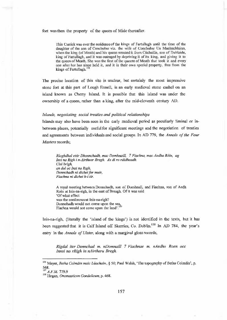
fort was then the property o f the queen o f Mide thereafter.
This Carrickwas ever the residence of the kings of Fartullagh until the time of the daughter of the son of Conchubar viz. the wife of Conehubar Ua Maelseehlainn, when the king (of Meath) and his queen wrested it from Cuchaille, son of Dublaide, king of Fartullagh, and it was outraged by depriving it of its king, and giving it to the queen of Meath. She was the first of the queens of Meath that took it and every one afier her has since held it, and it is their own special property, free from the kings of Fartullagh.156
The precise location o f this site is unclear, but certainly the most impressive
stone fort at this part o f Lough Ennell, is an early medieval stone cashel on an
island known as Cherry Island. It is possible that this island was under the
ownership o f a queen, rather than a king, after the mid-eleventh century AD.
Islands, negotiating social treaties and political relationships
Islands may also have been seen in the early medieval period as peculiarly liminal or in-
between places, potentially useful for significant meetings and the negotiation o f treaties
and agreements between individuals and social groups. In AD 779, the Annals o f the Four
Masters records;
Rioghdhal ettir Dhonnchadh, mac Domhnaill, 7 Fiachna, mac Aodha Roin, ag Insi na Righ i n-Airthear Bregh. As di ro raidheadh.Cisi brigh,an dal oc Insi na Righ,Donnchadh ni dichet for muir,Fiachna ni dichet h-i tir.
A royal meeting between Donnchadh, son of Domhnall, and Fiachna, son of Aedh Roin at Inis-na-righ, in the east of Breagh. Of it was said ‘Of what effectwas the conferenceat Inis-na-righ?Donnchadh would not come upon the sea^Fiachna would not come upon the land’.
Inis-na-righ, (literally the ‘island o f the kings’) is not identified in the texts, but it has
been suggested that it is Calf Island off Skerries, Co. Dublin.158 In AD 784, the year’s
entry in the Annals o f Ulster, along with a marginal gloss records,
Rigdal iter Donnchad m. nDomnaill 7 Fiachnae m. nAedho Roen occ Innsi na rRigh in nAirtheru Bregh.
156 Meyer, Betha Colmain maic Luachain, § 50; Paul Walsh, ‘The topography of Betha Colmdin’, p. 568.157 A.F.M. 779.9158 Hogan, Onomasticon Goedelicum, p. 468.
157

Ossi BrighIn dal occ Innsi na Righ Donnchadh ni dichet fo r muir Fiachna ni tuidhecht hi tir.
‘A royal meeting between Donnchad son of Domnall and Fiachna son of Aed R6n at Inis na Rig in eastern Brega.What is the meaningOf the meeting at Inis na Rig?Donnchad cannot go on the sea And Fiachna cannot come ashore’.159
There are various ways o f reading this text. It is possible that this is a reference to a
failed meeting, an event that did not happen, but it is more likely that it indicates that
the island o f Inis na Rig was seen as an appropriate meeting place, situated on a ‘neutral’
boundary, neither on land nor on the sea. Both individuals could come upon the island
without entering either the land or sea, thus preserving face. It raises the possibility that
some islands were not really seen as areas o f land at all. The idea that islands were used as
treaty negotiation places is well known from early medieval Scotland. Two islands in the
middle o f Loch Finlagganon the Isle o f Islay demonstrate this. The largest - Eilean M or
(‘the big island’) - was a royal settlement and perhaps a burial place while the name of
the smaller island - Eilean na Comhairle ( ‘council island’) beside it suggests that it was
used as a place for meetings, gatherings and decision m eeting.160 Both islands were
connected to the shore by a causeway, where a Neolithic burial mound and medieval
church were located at the edge o f the lake. Tradition has it that from the fourteenth
centuiy, the smaller island was the location for meetings o f the MacDonalds o f Islay, the
‘Lords o f the Isles’ up until the sixteenth century. A third small island or crannog -
Eilean Mhuirell - further away on the lake was reputedly used as a prison in the later
Middle Ages.161
Islands, gender, sexuality and age in early medieval IrelandIntroduction
In recent decades, gender has been a subject o f increased interest in historical and
archaeological studies, springing largely from the various waves o f feminist thinking
since the 1980s. Initially scholars doing ‘gender archaeology’ produced criticisms o f the
male-based construction o f knowledge and employment practices within the academy.
They then moved on to the project o f ‘finding women’ in the past, exploring gender
divisions in labour, or identifying objects or practice that provided evidence for the place
159 A. U. 784.8160 Bob Curran, Complete guide to Celtic mythology (Belfast, 2000), p. 196.161M. W. Holley, The artificial islets/crannogs o f the central Inner Hebrides (Oxford, 2000), pp
158

o f women and children. The aim was to challenge normative ideas o f gender roles (e.g.
women as passive homemakers and preparers o f food, men as active agents out in the
world, involved in specialised crafts). Some gender archaeologists have argued that, while
important and revisionist in its correction o f biases, it ignored other important related
aspects o f gender as prov iding identity difference. Since the late 1990s, gender studies
have become more wide-ranging, exploring the cultural and social construction o f gender
itself, the historical, biological, psychical and cultural variability o f sexuality , and the
cultural construction o f the body, as well as people’s subjective bodily experiences and
encounters.162 Gender archaeology has also encouraged a great interest in the small-
scale, the local and the domestic, spheres that are now recognised as being o f social,
symbolic and political importance, rather than retreats from the world.
In recent years, some early Irish historians have also written critical histories o f gender
in early medieval history, particular in terms o f labour and power. Johnston has shown
that one obstacle to writing histories o f women is the fact that most o f the sources
(hagiographies, law tracts and narrative literature) were compiled and written down by
male clerics, who used these texts as a means o f prescribing normative Christian ideas o f
female sexuality, ideas that are self-evidently m isogynistic.163 In the sagas and saint’s
lives, the woman is thus variously presented as a sexual temptress, weak, incompetent or
treacherous. Unless that is, she is the saint being celebrated within the hagiography, then
her achievements are all the more heroic given her gender and sexuality.164 Early
medieval archaeologists have traditionally shown less interest in gender studies, and in
particular it has barely been touched upon in Irish archaeology. Rather more effort has
been put into studies o f the ‘body’, gender and sexuality by archaeologists in Britain. For
example, recent archaeological studies o f Anglo-Saxon and Viking burial practice and
skeletal analysis have revealed that modern normative ideas about gender (e.g. the
polarity between male/female) do not always translate into the past. The occasional
presence o f ‘male skeletons’ with ‘female finds’ argues for the presence o f a third
gender, or at least a variable notion o f gender, in the early Middle Ages. It has also been
used to point out that biologically speaking, there may have been many people with a
208-210.162 For the history of gender studies in archaeology, see Johnson, Archaeological theory, pp 116-131.163 For recent critical studies of gender in early Irish history, see Lisa Bitel, Land o f women: Tales o f sex and gender from early Ireland (Cornell NY, 1996); Elva Johnston, ‘Transforming women in Irish hagiography’ in Peritia 9 (1995), pp 197-220; Elva Johnston, ‘Powerful women or patriarchical weapons? Two medieval Irish saints’ in Peritia 15 (2001), pp 302-10.164 Johnston, ‘Powerful women’, p. 304.
159

variable sexuality (that would be ‘corrected’ by radical surgery today) in Anglo-Saxon
England.165
The early Irish sources provide most information on gender relations in terms of
agricultural and domestic labour and less on land-ownership and property rights.166 In the
absence of land charters, it is difficult to know what women actually owned, although the
law tracts claimed that within the union o f marriage, the man normally the owned the
land, would pass it on his sons, and his dependent labourers or sencleithi went with the
land.167 The law tracts also claimed some divisions o f labour between men and women,
while presenting a general image o f co-operative labour in the domestic economy. Most
agricultural tasks, such as ploughing, reaping, tending livestock in enclosures and
fattening pigs, could be carried out by both sexes. Indeed, Bitel’s analyses o f property
and the value o f work within marriage suggest that husband and wife collaborated in
looking after cattle .168
Other tasks were divided between the two. In arable crop cultivation, men ploughed land,
sowed cereals, harvested grain and dried it in kilns, while women ground it into flour
using querns. In sheep raising, men reared and sheared the sheep, while women combed
the wool, spun it into thread, wove it into cloth and dyed it. Other tasks, such as the
herding o f pigs, sheep and calves was often the work o f children, while the preparation
o f milk products was frequently work associated with women (whether they be wife,
daughter or slave). In general, the wife was in charge o f dairying and activity relating to
milking, preparation o f butter and cheeses. Indeed, in general, women’s work is
described as being closely associated with the homestead, with the woman being in charge
o f the hearth, child rearing and housework.169 It is evident then that crannogs, with their
carpentry tools, ploughing equipment, quern stones and buckets were venues for both
male and female work and activity.
165 Andrew Tyrrell, ‘Corpus Saxonum: early medieval bodies and corporeal identity’ in W.O. Frazer and A. Tyrrell (eds.), Social identity in early medieval Britain (London and New York, 2000), pp 137-156; C. Kniisel and K. Ripley, ‘The berdache or Man-woman in Anglo-Saxon England and early medieval Europe’ in W.O. Frazer and A. Tyrrell (eds.), Social identity in early medieval Britain (London and New York, 2000), pp 157-192.166 Donnchadh Ó Corràin, ‘Early medieval law, c. 700-1200’ in Angela Bourke et al (eds).), The Field Day anthology o f Irish writing: Vol. IV, Irish women ’s writing and traditions (Cork, 2002), pp 6-43, provides an extensive overview and commentary of the perception and role of women in early Irish law tracts; see also Kelly, Early Irish farming, pp 448-51; Kelly, Early Irish law, pp 68- 79; Ó Cróinin, Early medieval Irelandpp 134-35.167 Charles-Edwards, Early Christian Ireland, p. 109.168 Bitel, Land o f women, pp 111 -37.
160

Islands, gender and sexuality
In terms o f gender, there are very striking patterns in the representation o f islands in
the early medieval literature. Islands in the early medieval texts were often be places
where boundaries in gender and sexuality could be negotiated, transgressed or crossed.
Indeed, the portrayal o f islands in the early Irish narrative literature is highly revealing
about how the church thought about gender and sexuality, and there is certainly a
conservative, and as stated above, a misogynistic tone to most o f the narratives.
A significant theme in the voyage tale or Immrama is the island o f w om en . This was a
concept that was inspired by earlier Classical works, Christian ideology and native
traditions and was seemingly used to project both male sexual fantasies and clerical ideas
o f the sexual relations between men and women. The island o f women was often, but not
always, situated in the otherworld.170 Different stories deal with this in different ways. In
the ninth-century lmmram Brain mac Febuil, the hero Bran travels with his men to the
otherworld island o f Tir inna mBan ( ‘Land o f women’). They are tricked onto the island
where they are met by a band o f women, after which they go into a large house, with
couches and unending food supplies o f food. Eventually, they leave the island and go
hom e.171
In the early ninth-century voyage tale, lmmram Mae I Duin, the secular hero Mael Duin
embarks on a voyage o f vengeance and after several encounters with fantastic islands,
discovers an island populated by a queen and her female retainers who offer him and his
companions sex and everlasting life, which they ultimately turn their back on. They first
encounter it as a large island, with a great grassy plain. On the island and near the sea,
they see a large and high fortress (dun mor ard) within which there is a great, adorned
house with couches. Seventeen grown girls are there, preparing a bath. Mael Duin and his
followers land on the island, expecting that the bath was for them. They see a rider on a
magnificent horse coming towards the fortress, and see that it was a woman. Shortly
after, one o f the girls came to them.
‘Welcome is your arrival.’ She said. ‘Come into the fort: the queen invites you.’So they entered the fort [and] they all bathed. And the queen sat on one side of the house and her seventeen girls about her. Mael Duin, then, sat on the other side, over against the queen, and his seventeen men around him. Then a platter with good food thereon was brought to Mael Duin and along with it a crystal vessel of good liquor; and there was a platter for every three and a vessel for every three of
169 Kelly, Early Irish farming, pp 448-52170 Johnston, ‘Powerful women’, p. 309.171 Mac Mathuna (ed. and trans.), lmmram Brain: Bran’s journey to the Land o f Women, § 61-4.
161

his people. When they had eaten their dinner the queen said this: ‘How will the guests sleep?’ she said.‘As you shall say.’ said Mael Duin.‘....’, she said, ‘your coming to the island. Let each of you take his woman, even her who is over against him, and let him go into the cubicle behind her.’ For there were seventeen canopied cubicles in the house with good beds set. So the seventeen men and the seventeen grown girls slept together and Mael Duin slept with the queen. After this they slumbered till the next morning. Then after dawn they arose.‘Stay here,’ the queen said, ‘and age will not fall on you, but the age that you have attained. And you shall have lasting life always; and what came to you this night shall come to you every night without any labour. And be no longer wandering from island to island in the ocean.’‘Tell is,’ Mciel Duin said, ‘how are you here?’‘That is not difficult indeed,’ she said. ‘There dwelt a good man in this island, the king of the island. To him I bore these seventeen girls, and I was their mother. And then he died and left no male successor. So I took the kingship of this island,’ she said, ‘afterhim. ‘Every day,’ she said, ‘I go into the great plain which is the island to give judgement and to settle the community.’‘But why do you leave us today?’ said Mdel Diiin.‘Unless I go,’ she said, ‘what happened to us last night will not come to us. Only stay,’ she said, ‘in your house and you need not labour. I will go to judge the folk for your sake.’Then they abode in that island for the three months of winter; and it seemed to them that it was three years. ‘We have been a long time here,’ said one of his people to Mael Duin. ‘Why do we not fare to our country?’ he said. ‘What you say is not good,’ said Mael Duin, ‘for we shall not find in our country anything better than what we find here.’His people begin to murmur greatly against Mael Duin, and they said this: ‘Great is the love which M&el Duin has for this woman. Let him stay with her if he so desires,’ said the people. ‘We will go to our country.’‘I will not stay after you,’ said Mael Duin.172
Mael Duin and his people eventually escape, after an initial unsuccessful attempt that is
foiled when the queen throws a ‘clew’ which attaches itself to the hero’s hands that
prevents him from sailing away. On the second attempt, they escape (although one of
the party looses a hand when he catches the clew, and has it struck off by the hero). The
island o f women is discussedin this voyage tale in moral terms. The island o f women is
presented as an inversion o f the norm, a place where a woman rules, where the hero
initially loses his judgment (tempted by indolence, sex and food) and from whence he
must ultimately flee he is to succeed in their quest. Indeed, the island o f woman is
probably being presented as a metaphor for what would happen to the island o f Ireland,
if its people did not turn away from temptation and back to the church. In this sense, it
is an ideologically loaded, conservative tract intended to promote church hegemony.
Occasionally women also travel to islands and have sexually charged encounters with
men. In the ninth-century adventure tale, Tochmerc Becfeola mentioned above,
Becfhola, wife o f the king Diarmait mac Aedo Slane, intends to go on a tryst with her
172 Oskamp (ed. and trans.), The voyage o f Mäel Duin, § 28, pp 153-7.
162

husband’s fosterson. Losing her way in the woods o f Dubthor Lagen, she meets a man on
the shore o f a lake who brings her out to a mysterious island. They enter a large but
empty house, where they eat a meal, then lie together on a bed for the night, but refrain
from having sex or touching each other. On this island, the theme is one of sexual
restraint (inevitably, perhaps, signalling the hero’s worth rather than the woman’s).
Interestingly, the island with its otherworldly house, harbour, abundant food and
weaponry, strongly recalls the attributes o f a high-status or royal crannog, with the
added twist that proper (in the opinion o f the church) sexual behaviour could be, but was
not, contravened there. The relevant passage in Tochmerc Becfeola (presented above,
but repeated here for ease o f reference) reads as follows:
... She followed him as far as the lake. There was a boat of bronze in the middle of the lake. A woven bronze chain lfom the boat was attached to the shore and another to the island in the middle of the lake. The warrior hauled in the boat. She goes into the boat before him. The boat was left in a boat house of clay in front of the island.
She went before him into the house. This was a fine house with both cubicles and beds. He sat down. The she sat down beside him. He reached out his hand as he sat and brought forth a dish of food for them. They both ate and drank and neither of them was drunk. There was no one in the house. They did not speak to each other.He went to bed. She slipped in beneath his cloak, between him and the wall. However, he did not turn towards her throughout the night.. .173
The church hagiographers also employed ideas o f female virginity and restraint from
sexual temptation on islands to symbolise the holiness o f female saints. In the early
medieval (probably tenth-century) Life o f Senán, Canair, a female saint, walks across the
sea to the ‘holy island’ o f Scattery Island, the location o f a significant monastic
settlement at the mouth o f the Shannon estuary, to seek burial in its holy ground (Fig.
4.7). She is refused access by the island’s saint, Senán, because he sees his island as
already notable for its virginity and chastity (unlike the ‘islands o f women’ which are
places o f sexual licence). Interestingly, he offers her a burial place at the water’s edge,
on the island’s boundary between land and sea. Canir demonstrates her holiness by
standing on water throughout their conversation, and counters his arguments until she is
finally accepted. God then granted ‘that who so visits her church before going on the sea
shall not be drowned between going and returning’.
Now, when she had reached the shore of Luftnnech (i.e the Shannon estuary) she crossed the sea with dry feet as if she were on smooth land, till she came to Inis Cathaig. Now Senán knew that thing and he went to the harbour to meet her, and he gave her welcome.‘Yea, I have come,’ said Canair.
173 Bhreathnach, ‘A new edition of Tochmarc Becfhold, pp 59-91.
163

‘Go,’ said Senan, ‘to thy sister who dwells in yon island to the east, that thou mayest have guesting therein’.‘Not for that have we come,’ saith Canair, ‘but that I may have guesting with thee in this island.’‘Women enter not this island,’ saith Senan.’‘How canst thou say that’ saith Canair. Christ is no worse than thou. Christ came to redeem women no less than to redeem men. No less did he suffer for the sake of women than for the sake of men. Women have given service and tendance unto Christ and his Apostles. No less than men do women enter the heavenly kingdom. Why then, shouldst thou not take women to thee in thine island?’.. .A place of resurrection,’ saith Sendn, ‘will be given thee here on the brink of the wave, but I fear that the sea will carry off thy remains.’‘God will grant me the spot wherein I shall lie will not be the first that the sea will bear away.’‘Thou hast leave then,’ saith Senan, ‘to come on shore.’ For thus had she been while they were in converse, standing up on the wave, with her staff under her bosom, as if she were on land. The Canair came on shore, and the sacrament was administered to her, and she straight went to heaven.’ 174
Fig. 4.7 Early medieval monastic island of Scattery Island, situated at the mouth of the Shannon estuary. In the tenth-century Life of Senan, the island’s sanctity was threatened by the arrival of a female saint, who only by a miracle gains the privilege of burial on the island. (Source: A. O’Sullivan, Foragers, farmers and fishers in a coastal landscape, (Dublin, 2001), p. 6, PI. 3.
174 Stokes, Lives o f the Saints from the Book ofLismore , 1.2416-2449f, pp 65-66; Doherty, ‘Some aspects of hagiography as a source for Irish economic history’, p. 307 suggests a tenth-century date for the Life of Sendn.
164

In the voyage tales and hagiographies, there is an occasional m otif o f islands where food
is provided to people miraculously (as in Tochmarc Becfhola above). For example, in
the ninth-century Nauigatio Sancti Brendani abbatis, the voyaging monks arrive at an
uninhabited house on an island where there is a table laid out with food and water for
them. In the same voyage tale, Paul the Hermit inhabits a small, circular island (two
hundred yards across) where he is sustained for thirty years by an otter who brings him a
fish from the sea.175 The same m otif o f a miraculous otter providing fish to people on
an island occurs in the Life o f Berach, but here it is two women who are inhabiting a
probable crannog on Lough Laegachan (probably Lough Lackagh, Co. Roscommon).
The relevant passage reads as follows,
Once upon a time great scarcity came to Erin. At that time, Laegachan was in his island on Loch Laegachan, and had no provisions (Is annsin ro boi Laeghachan ar Loch Laeghacan ina inis fein, 7 ni raibhe biadh aicce). He went then with his kemes to seek for food, and left his wife, who was pregnant, on the island with a single woman in her company; and he told her, if she would bear a child after his departure, to kill it, as they had no means of rearing it. And the woman bore a male child afterwards, and the woman who was with her asked her what was to be done with the boy. And she said ‘Kill it.’ The other woman said: ‘It is better to take it to the clerk of the church here to the west, to be baptized, and let his service be offered to him in return for his maintenance.’ (79) This plan was agreed upon by them, and the child was taken to Berach, and he baptized it, and the name given to it was Ineirge, and its service in life and death, and the service of its seed and offspring till doom was offered to Berach in return for its nurture. And Berach said: ‘Let the child be taken to its mother, and assistance of food and means will come to them.’ The child was taken to its mother as the clerk said. (80)As the women were there they heard a noise in the house. The woman went to see, but could not perceive anything there. [The same thing happened a second time.] A third time they heard the noise, and a third time the woman went to see, and there was a great salmon there and an otter dragging it to the land.And the woman went and she called the other woman, and the two of them with difficulty carried the salmon, and they dressed it, and ate their fill, and the breasts of the mother of the child were filled with milk forthwith, and thus the child was saved.176
The story contains several interesting themes reflecting life on an island; the actual
reality o f an island as a dwelling place for a household (husband, wife, child, and male and
female servants), the need to provision the islanders with food, the difficulties faced by a
pregnant woman and her female servant on the island, but the idea that this may be the
safest place during dangerous times). There is also the idea that the saint can provide for
a woman, where her husband fails. During a time of famine in Ireland, he goes out to
search for food, essentially abandoning his wife, while leaving her with the awful
175 O’Meara, The voyage o f Saint Brendan, pp. 11-12; pp 63-4.
165

instruction to kill the child as they had no food to rear it. However, it is the servant
woman who saves the child by bringing it to Berach, who thereafter manfully and
miraculously provides the women and child with sustenance (while accepting the boy
into the church’s service till death). Indeed, the provisioning o f island inhabitants with
fish by a magical otter may well even have been inspired by the voyage tales (even if it
is potentially late medieval in date). Finally, in gender terms, there is the central theme
that islands can be a place where women confront danger and negotiate with
otherworldly forces themselves.
Islands, age and social marginality
Gender studies have also tended to stress the need to consider other ways in which the
body was used for constructing social identities. It is certainly true that age was an
important means o f ordering and representing identity in the early Middle Ages in
Ireland. It has already been stated that both young women and young men are often
represented in the literature as individuals who had not yet fully joined the community.
In the case o f young men, this was particularly important in terms o f land and property
inheritance. Thence, as stated above, in the early Irish law tracts on status, the f ir
midboth (literally, ‘man of middle huts’), was a youth who had not yet graduated to full
the social ranking he would inherit on reaching adulthood.177 Young men were therefore
in a state o f transition, moving from childhood to full adulthoo d with all its rights and
responsibilities. Nagy has stated that boys on the verge o f manhood were liminal figures,
crossing from one world to the next. He argues that this state o f liminality, with all its
ambiguities in terms o f social identity, was expressed as a sacred force.178
This liminal state often led to young men being socially marginalised for a period o f
time, months or years. O Croinin has stated that some of them were the ‘landless youths
o f the aristocracy who are traditional denizens o f the forest’. 179 Nagy has also stated
that the ‘tu r f o f the flan is ‘located beyond settled, politically defined territory, is in
the wilderness o f interstitial areas, where its members live by hunting, ravaging
surrounding areas, or hiring themselves out as mercenaries’. 180 These youths seem to
have been simultaneously regarded both as violent, dangerous outlaws and the protectors
176 Plummer, Bethada Nàem nÉrenn, § xxvi, 78-80, pp 22-43.177 Kelly, Early Irish farming, pp 445.178 J.F. Nagy, ‘Liminality and knowledge in Irish tradition’ in Studia Celtica 16-17, (1981-82), pp 135-43.179 Ó Cróinin, Early medieval Ireland, 400-1200, p. 88.180 J.F. Nagy, Conversing with angels and ancients: literary myths o f medieval Ireland . (Dublin, 1997), p. 295.
166

of the tuath, although they usually attracted condemnation and were associated by the
church with paganism .181 However, it is not necessarily the case that they were o f high
social ranking; McCone has described them as property less males o f free birth who
had left fosterage but had not yet inherited the property needed to settle down as full
land-owning members o f the tuath.’ 182 In any case, these young men joined warbands
ifian) and resided for a period in forests or other isolated places, where they were
associated with hunting, earthy rites-of-passage, violence and even paganism.
There may even be archaeological evidence for crannogs and marshland sites being used
by one o f these socially marginal groups. Newman has recently suggested that the
earliest, sixth-century phase (i.e. pre-crannog occupation) o f the early medieval
Ballinderry crannog No. 2 might have been a seasonal or temporar y marshland dwelling
o f a band o f fian warriors.183 He has noted that the main activities on the site
apparently included the use o f wicker troughs for bathing, cooking or processing skins,
the butchery and consumption o f red deer meat and the processing o f deer antler and
bone. Newman suggests that the site’s inhabitants were actually engaged in deer hunting
(sedguinecht) in the woods and marshes adjacent to Ballinderry Lough. However, the
objects recovered from this phase o f activity suggested that the site’s occupants were
people o f high social status, perhaps even royalty. This is suggested by the presence o f
zoomorphic pennanular brooches, imported E-ware pottery, spearheads and large
hunting dogs, all things associated with aristocracy and with the fia n . Deer-hunting was
regarded as a sport for the aristocracy and elite o f early Irish society.184 The deer-hunt
would then be followed by a feast, at which fine clothing would display social rank or
status, after which baths would be provided, perhaps using th e fats o f the venison or deer
skins, all activities that might result in the archaeological evidence described above.
Obviously, it is impossible to prove that these were young aristocratic men (or fia n ) with
their retainers, who were living at the lake’s edge during their period o f marginalisation
from society, but it is an intriguing suggestion.
There are also hints in the annals and saints’ lives that islands were used as the dwelling
places o f these liminal, violent youths. In the Annals o f Ulster for AD 847, there is an
account o f the destruction o f the island fortress o f a fian band that had been terrorising
the tuath.
181 Charies-Edwards, Early Christian Ireland, pp 112-4.182 McCone, Pagan past and Christian present, p. 205.183 Conor Newman, ‘Ballinderry crannog No. 2, Co. Offaly: Pre-crannog early medieval horizon’ in Jn. Ir. Archaeol. 11 (2002), pp 99-124, at pp 114-6.
167

Toghal Innsi Locha Muinnremair Ia Mael Sechnaill for finlach mar do maccaibh bais Luigne ocus Galeng ro batar oc indriudh na tuath more gentilium.The sack of the island of Loch Muinremair by Mael Sechnaill against a large fian- band of sons of death of the Luigni and Gailenga who had been ravaging the tuatha in the manner of pagans.185
The entry implies that a fian -band was occupying an island or crannog on Lough Ramor,
Co. Cavan, out o f which they were raiding the local countryside. Ultimately, the king
had to go out and crush them to protect the community. Obviously a crannog would be a
particularly useful place for such a social group to live, both for its practical military and
defensive strengths and for its potential association with ‘life at the edge’.
Interestingly, there is a rather similar reference in the Irish Life o f Ciarán o f
Clonmacnoise to an incident where the saint intervenes to defeat or quell a socially
marginal group who were living on a island in a lake.
‘Robui immorro loch ifarradh ísill 7 noaitreabdais aes tuaithi 7 daescarslúag an innsi bui fair 7 dotharimiscedh nual 7 fogur in lochta-sin adtarbha um na clerchiu. Roghuidh Ciaran in Coimdi cor 'alta asa hinad in innsi 7 doronad in ni- sin, 7 atcither beos an toinad a roibi isin loch re cuimnigud in ferta-sin ’Now near ísel there was a lake, and heathens and rabble were living in the island that was upon it. And the shouting and noise of that unprofitable folk used to disturb the clerics. Ciarán entreated the Lord that the island might he moved out of its place, and that thing was done; and still for remembrance of that miracle is seen the place wherein the island was in the lake.186
It would appear again that islands were being depicted in both the annals and the saints
lives as a useful metonym for liminality, social marginality and an existence on the edge,
whether this was temporary (in the case o f the youthful and violent fia n ) or permanent
(in the case o f the poor or people who professed pagan beliefs). This would certainly fit
with what has been proposed above from the saints’ lives, sagas and annals, that islands
184 Kelly, Early Irish farming, pp 272-81.185 A. U. 847.3 translates this as ‘Mael Sechnaill destroyed the Island of Loch Muinremor, overcoming there a large band of wicked men of Luigni and Gailenga, who had been plundering the territories in the manner of the heathens.’ Here, I use Kim McCone’s more recent and more accurate translation of the words, finlach mar do maccaibh bais (literally, Targe fian-band of sons of death’); Kim McCone ‘Werewolves, cyclopes, diberga, and fianna: juvenile delinquency in early Ireland’ in Cambridge Medieval Celtic Studies 12 (1986), pp 1-22; On the other hand, Colmàn Etchingham has suggested that the actions of people are here merely being compared with true heathens, the gentiles (i.e. Vikings), Colmàn Etchingham, Church organisation in Ireland A.D. 650 to 1000 (Naas, 1999), p. 303.86 Stokes, Lives o f the saints from the Book o f Lismore , 1. 4327, p. 129; The words aes tuaithi 7
daescarsluag an could also be translated as ‘country folk and servile people’. But this still suggests the perception of islands as places for socially marginal groups, in this case, an island inhabited by poor people who were an irritation to the church authorities.
168

were often seen as places ‘at the edge’, marginal, on boundaries and even locations for
otherworldly encounters.
Is it not paradoxical though that islands could be places for male saints and kings at the
same time as they could places for seemingly socially marginalised groups, such as the
poor, the young and even monsters? However, this ignores the fact that liminality is a
fluid and mutable concept and that people could be both seeking and avoiding it,
according to their social status, gender and place in the community. In the early Middle
Ages, the king placed his royal residence on an island to achieve a social distance and a
reputation for power. A t the same time, he was at the physical and symbolic centre o f
the early medieval settlement landscape. The lord built his residence on a crannog to
emulate the powerful, and to protect his own wealth and that o f the community. The
poor and socially marginalised may effectively have been doing the same thing,
inhabiting places at the edge o f land, maintaining their own identity and sense o f place,
while perhaps also being marginalised by others. Islands were places at the edge, at the
same time as they were places at the centre o f people’s lives.
ConclusionsThis chapter has used early Irish hagiographies, voyage tales, adventure tales and annals
to begin to reconstruct the cultural understanding and symbolic role o f islands (and
therefore crannogs) in the early medieval imagination. It argued that islands were often
projected as distinctive, often liminal places where social identities could be established,
changed and manipulated in different ways. It also explored the character and
peformance o f social identity in early medieval Ireland, suggesting how people may have
used islands, places, objects, texts and memories to negotiate and ‘play out’ ideas about
power, social hierarchy, gender, kinship and social marginality. In the next chapter, this
study will begin to explore how it might be possible for archaeologists to interpret the
social and ideological role o f crannogs in the early medieval landscape.
169

Chapter 5 Islands in watery worlds:
A landscape perspective on early medieval crannogs
IntroductionIn early medieval Ireland, people lived on crannogs that they had built and maintained
out in the watery shallows o f lakes. These islands, however distinctive in appearance,
should not be viewed as exotic, isolated objects, entirely separated from the rest o f the
world that these peoples inhabited. In the early medieval period, a person standing on a
crannog could easily have seen on the nearby dryland, the domestic world o f settlements
and dwellings, the symbolic world o f churches, holy wells and graveyards, as well as field-
systems, roadways, woodlands and the rest o f the world o f daily life and work. So despite
the social distance and physical separation that was certainly achieved by placing a
dwelling place on an island on water, it was still only a task o f minutes to move out from
these islands to the surrounding landscape. It is evident that crannogs need to be
investigated within their wider social, economic and ideological landscapes, preferably
within a defined region.
Landscape, settlement and society in early medieval WestmeathIntroductionIn exploring the use o f crannogs in the early medieval landscape, this chapter focuses on
the crannogs o f the lakelands o f Co. Westmeath. This county is useful for a regional
landscape analysis o f crannogs for a number o f reasons. Firstly, although it is dominated
by lakelands, it also has a significant topographical variability, ranging from rolling hills
o f glacial till to low-lying raised bogs. The use o f crannogs in this lakelands region then
has as much to do with deliberate human choices and agency, as with the physical
landscape.1 In Westmeath, people definitely chose to build island dwellings out in lakes,
whether those lakes were small or large. It should be possible then to explore aspects o f
crannog use within a wider landscape setting. Secondly, there is rich archaeological and
historical evidence for the role o f crannogs in the early medieval settleme nt landscape,
which should enable a more nuanced social perspective.
1 For example, in the drumlin lakelands of south Ulster to the north, crannog building was an almost inevitable consequence of life in a waterlogged landscape of drumlin lakes, ponds, fens and bogs. By contrast, in the midlands, the building of a crannog was a deliberate, almost unlikely decision,
170
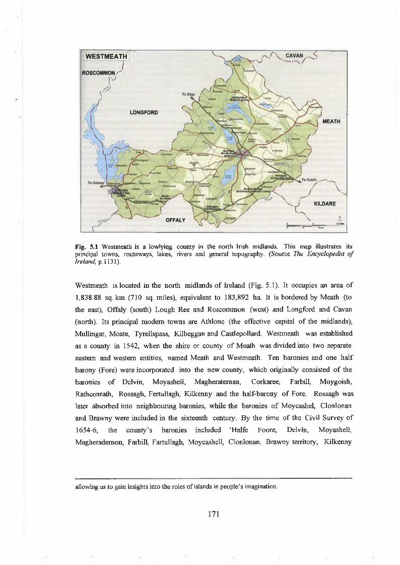
Fig. 5.1 Westmeath is a lowlying county in the north Irish midlands. This map illustrates its principal towns, routeways, lakes, rivers and general topography. (Source The Encyclopedia o f Ireland\ p. 1131).
Westmeath is located in the north midlands o f Ireland (Fig. 5.1). It occupies an area o f
1,838.88 sq. km (710 sq. miles), equivalent to 183,892 ha. It is bordered by Meath (to
the east), Offaly (south) Lough Ree and Roscommon (west) and Longford and Cavan
(north). Its principal modem towns are Athlone (the effective capital o f the midlands),
Mullingar, Moate, Tyrellspass, Kilbeggan and Castlepollard. Westmeath was established
as a county in 1542, when the shire or county o f Meath was divided into two separate
eastern and western entities, named Meath and Westmeath. Ten baronies and one half
barony (Fore) were incorporated into the new county, which originally consisted o f the
baronies o f Delvin, Moyashell, Magherateman, Corkaree, Farbill, Moygoish,
Rathconrath, Rossagh, Fertullagh, Kilkenny and the half-barony o f Fore. Rossagh was
later absorbed into neighbouring baronies, while the baronies o f Moycashel, Clonlonan
and Brawny were included in the sixteenth century. By the time o f the Civil Survey o f
1654-6, the county’s baronies included ‘Halfe Foore, Delvin, Moyashell,
Magherademon, Farbill, Fartullagh, Moycashell, Clonlonan, Brawny territory, Kilkenny
allowing us to gain insights into the roles of islands in people’s imagination.
171

West, Rathconrath, Moygoish and Corkery’, each with their own parishes and
townlands.2
In this study o f crannogs in Westmeath, reference will be made particularly to these
baronies and their boundaries. This is because it is generally thought that these early
modem baronies can be roughly equated in size and general location with the petty
kingdoms or tuatha o f early medieval Ireland.3 However, it is likely that subsequent
changes in boundaries and sizes makes generalisations with regard to the relationships
between the older tuatha and the baronies a tricky task, so each territory must be
cautiously examined on its m erits.4 In Westmeath, it is possible to identify several likely
early medieval tuatha through the use o f annalistic sources, hagiographies, placenames,
parish and barony boundaries. For example, as will be seen below, the barony o f
Fartullagh in the southeast probably corresponds broadly to the petty kingdom o f the Fir
Tulach, whose royal site lay on the shores o f Lough Ennell. It is also likely that the
barony o f Moygoish roughly corresponds to the early medieval territory o f the Ui Maicc
Uais Mide, on the shores o f Lough Derravarragh. Brief mention will also occasionally be
made o f parish and townland boundaries, both o f which now appear to have been o f pre-
Norman origins as well.
Physical landscape and environment in West meathPhysical topography, rivers and lakes
Westmeath is a low-lying county, in keeping with most o f the midlands o f Ireland. It has
only a few low hills, mostly in the northern end o f the county in the barony o f Fore
(e.g. The Hill o f Moat at 251m, Knockeyon at 215m, the Hill o f Fore at 187m), as well
as in the adjoining baronies o f Corkaree and Farbill. The rest o f the county is generally
level, broken here and there by gently rolling glacially-derived kame and kettle hills and
sandy esker ridges. There are some raised bogs, particularly in the south and east.
Most o f the county is drained by the River Shannon drainage basin. The northwest is
drained by the River Inny (which flows south-westwards into the Shannon at Lough Ree). This river lies on the county boundary with Co. Longford to the north (and was
traditionally the political boundary between early medieval Mide and Tethbae). To the
2P.W. Joyce, Phillips atlas and geography o f Ireland (London, 1883), pp 51-3, pi. 31; Walsh, The placenames o f Westmeath, pp xii-xiii; D.L. Swan, ‘The Early Christian ecclesiastical sites of County Westmeath’ in John Bradley (ed ), Settlement and society in medieval Ireland (Kilkenny, 1988), pp 3- 32, at pp 5-6.3 Stout, ‘Early Christian settlement, society and economy in Offaly’, p. 29.4 A.P. Smyth, Celtic Leinster: Towards an historical geography o f early Irish civilisation, A.D.
172

southwest, the landscape is largely drained by various rivers draining into the River
Shannon, particularly the River Brosna, which flows southwards through Co. Offaly
before flowing out into the Shannon. To the east, the county is drained by several
tributaries o f the River Boyne (e.g. River Blackwater, River Adeel).
Westmeath has long been known by travellers, artists and poets for its lakelands (Fig.
5.2).5 It has a range o f lakes, varying in location, size, depth and overall appearance. 6
Indeed, as the north midland lakelands region is essentially centred on this county,
fishing and tourism on the lakes is a significant aspect o f the modem economy. Lough
Ree, the largest lake on the upper River Shannon, lies partly on the county’s western
boundary. Near its shores, within the barony o f Kilkenny West, lie the smaller basin
lakes o f Doonis Lough, Creggan, Makeegan, W aterstown, Robin’s Lake and Twy Lough.
Crannogs are known from Doonis Lough and Twy Lough at least. In the southwest o f
the county is Lough Sewdy (formerly known as Lough Sunderlin), a small lake around
which there are several natural islands and a possible crannog.
Lough Sheelin, Lough Kinale, Lough Derravarragh and Lough Iron are all quite large
lakes in the northern part o f the county, located on the River Inny, which flows from
the north-east in a south-west direction to end up in Lough Ree. Both Lough Sheelin and
Lough Kinale lie on the county’s northern boundary, although they are mostly within
the counties o f Longford and Cavan respectively. Lough Derravarragh, surrounded by
topography ranging from raised bogs to high, steep-sided hills, is a long, narrow lough
almost 8km (5 miles) in length covering an area o f 1080 hectares. At the north, it is
broad and shallow (c.l-2m ), while its southern end is narrow and deep (i.e. c.20m water
depth). Lough Derravarragh has a rich archaeological landscape, with evidence for
lakeshore activities in the Late Mesolithic, the Late Bronze/Iron Age and the early
medieval period in particular. There are at least 18 crannogs around the lake, many o f
which show evidence for activity between the seventh and the eleventh century AD.
Lough Derravarragh will be the focus o f particular attention in this study. Lough Iron, a
long narrow lake, lies further downstream on the River Inny.
500-1600 (Dublin, 1982), p. 70.5 Henry Pier’s seventeenth-century description of Westmeath begins with a discourse about the county’s various lakes and rivers ; Henry Piers, A chorographical description o f the county o f West- Meath (Dublin, 1786, second edition, facsimile reprint, Tara, 1981), pp 3-19.6 Westmeath County Council, County Westmeath: Ireland’s undiscovered lakeland (Mullingar, 1997); Midlands-East Regional Tourism Authority Pike fishing: Midlands o f Ireland (Mullingar, n.d.); Midlands-East Regional Tourism Authority, Midland trout loughs (Mullingar, n ..d)
173

Fig. 5.2. Westm
eath's lakelands, illustrating
the distribution
of crannogs in
the county.
Lough **: ..•** t Kinale \ 'v ‘%»Derragh : LoughLough • • Bane
• %■
Lough .•*, Derravarragh
Lough •, Ree *,
DoonisLough
LoughMakeegan
\ Lough \ Garr .
*. Lough•»* Iron
MountDaltonLough
LoughOwel
Lough *Lene
•. *••• •.\ •**•* •*:
'••'Newtown ;. Johnstown Lough .•
Bishop's Lough i*Lough **. (Dysart Lakes) *.
Lough .■Analla ..A
McEvoy'sLough
White ° Lough
LoughSewdy
.TwyfordLough
/ • vm V
Ballinderry , «*• '•• Lough .*»***' s*
LoughEnnell ^
*
Newtownlow
Lough-a-Trim
• ••
.•
Cornaher ,* Lough
*•« :~ •••*
0 2.5 5 10 15 20 25
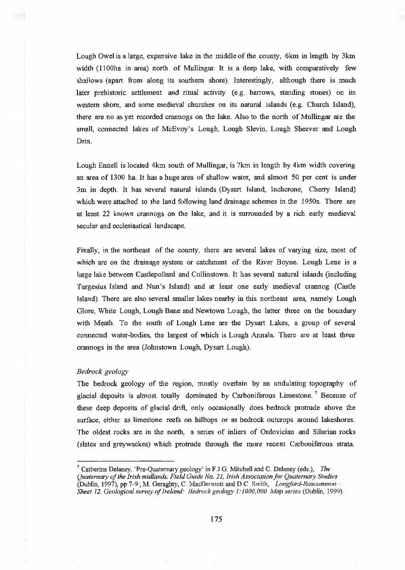
Lough Owel is a large, expansive lake in the middle o f the county, 6km in length by 3km
width (llOOha in area) north o f Mullingar. It is a deep lake, with comparatively few
shallows (apart from along its southern shore). Interestingly, although there is much
later prehistoric settlement and ritual activity (e.g. barrows, standing stones) on its
western shore, and some medieval churches on its natural islands (e.g. Church Island),
there are no as yet recorded crannogs on the lake. Also to the north o f Mullingar are the
small, connected lakes o f M cEvoy’s Lough, Lough Slevin, Lough Sheever and Lough
Drin.
Lough Ennell is located 4km south o f Mullingar, is 7km in length by 4km width covering
an area o f 1300 ha. It has a huge area o f shallow water, and almost 50 per cent is under
3m in depth. It has several natural islands (Dysart Island, Inchcrone, Cherry Island)
which were attached to the land following land drainage schemes in the 1950s. There are
at least 22 known crannogs on the lake, and it is surrounded by a rich early medieval
secular and ecclesiastical landscape.
Finally, in the northeast o f the county, there are several lakes o f varying size, most o f
which are on the drainage system or catchment o f the River Boyne. Lough Lene is a
large lake between Castlepollard and Collinstown. It has several natural islands (including
Turgesius Island and N un’s Island) and at least one early medieval crannog (Castle
Island). There are also several smaller lakes nearby in this northeast area, namely Lough
Glore, White Lough, Lough Bane and Newtown Lough, the latter three on the boundary
with Meath. To the south o f Lough Lene are the Dysart Lakes, a group o f several
connected water-bodies, the largest o f which is Lough Annala. There are at least three
crannogs in the area (Johnstown Lough, Dysart Lough).
Bedrock geology
The bedrock geology o f the region, mostly overlain by an undulating topography o f
glacial deposits is almost totally dominated by Carboniferous L im estone.7 Because o f
these deep deposits o f glacial drift, only occasionally does bedrock protrude above the
surface, either as limestone reefs on hilltops or as bedrock outcrops around lakeshores.
The oldest rocks are in the north, a series o f inliers o f Ordovician and Silurian rocks
(slates and greywackes) which protrude through the more recent Carboniferous strata
7 Catherine Delaney, ‘Pre-Quaternary geology’ in F.J.G. Mitchell and C. Delaney (eds.), The Quaternary o f the Irish midlands. Field Guide No. 21, Irish Association for Quaternary Studies (Dublin, 1997), pp 7-9; M. Geraghty, C. MacDemiott and D.C. Smith, Longford-Roscommon - Sheet 12. Geological survey o f Ireland: Bedrock geology 1:1000,000 Map series (Dublin, 1999).
175

These are overlain by Old Red Sandstone o f Lower Carboniferous age, mostly o f
sandstones and conglomerates with quartz cobbles. These ORS rocks are conformably
overlain by Lower Carboniferous Dinantian limestones. In the north, they are sandy,
while southwards they are succeeded by Waulsortian Complex limestones. This lower
limestone series is generally pure, but the middle and upper series contain a proportion
o f shale. Upper Carboniferous (Namurian) succession limestones outcrop in the east,
underlying the lakeland zone from Lough Ennell to Lough Sheelin. Particularly
prevalent across this zone are Visean Lucan formation (dark limestones and shale) and
Derravarragh cherts (cherty limestone, minor shale) limestones. In essence then,
limestone dominates Westmeath and rock exposures are infrequent. Interestingly, on
hilltops like Knockeyon, at Lough Derravarragh, chert is exposed as bands within the
limestone, and this may well have been quarried in early prehistory, perhaps even by the
Mesolithic hunter-gatherers who occupied the opposite end o f the lake.8
Quaternary geology
The topography o f Westmeath is dominated by undulating sands and gravels deposited
towards the end o f the last stage o f the Late Midlandian glaciation (c.24,000-2 0,000
BP).9 This Quaternary geology comprised an extensive suite o f glacial and glaciofluvial
depositional landforms, varying from north to south (Fig. 5.3). The readvance o f the
Midlandian glaciation covered the north o f the county, pushing as far southeast as a
moraine at Athlone and ran northeast by the Hill o f Uisnech to Bunbrosna.
In the northwest o f the county are some drumlins and elongated hills, oriented NW-SE,
indicating ice flow to the southeast. The narrow, shallow valleys in which Lough
Derravarragh, Lough Glore and Lough Lene lie also appear to be ice-gouged valleys
between the cherty harder hills on either side and seem to have been sculpted by this
iceflow. Throughout this area are also a number o f meltwater channels, all trending south
and south-eastwards.
8 This author has recently discovered a possible early prehistoric chert quarry on a limestone cliff face at the top of Knockeyon, at the southeast end of Lough Derravarragh.9 Catherine Delaney, ‘Quaternary geology’ in F.J.G. Mitchell and C. Delaney (eds.), The Quaternary o f the Irish midlands. Field Guide No. 21, Irish Association for Quaternary Studies (Dublin, 1997), pp 10-11.
176

Co. Westmeath
Limaston* Dominated Drift
Shale Dominated Drift
Shoie and Chert Dominated Drift
Direction of Ice Movement
* Morainei
t » * Drumlini
Esker»
Fig. 5.3. Westmeath, map illustrating quaternary geology, drumlins, eskersand glacial drifts (Source: T.F. Finch Soils of Co. Westmeath (Dublin, 1977), Fig.4).
To the south o f this region lies an area o f mixed fluvioglacial and till deposits left by
disintegrating ice. As the ice withdrew northwards, hummocky end moraines developed
creating small, isolated recessional moraines usually less than a kilometre in length.
These small moraines (typically oriented NW-SE) indicate water transport south-
eastwards and today are often used for local roads and lanes. Along the south o f the
county is a region o f larger eskers and kame and kettle hills, frequently lying within
raised bogs and alluvial deposits. These eskers formed in melt-water tunnels within or
under the glacier, which when the ice disappeared emerged as sand and gravel running
across the land, but bearing no relation to local topography. In general, these eskers are
oriented N-S, while to the southwest o f Lough Ennell, they are generally trending NW-
SE or E-W. These eskers were significant topographical features in the settlement
landscape o f Westmeath, often providing the basis for significant routeways, such as the
early medieval Eiscir Riada on the Offaly/Westmeath border, while smaller, bifurcated
eskers in the region o f Tyrellspass, Kilbeggan and Moate also provided routeway o f
roads, lanes and pathways through the county’s raised bogs and hummocky wetlands.
Glacial drifts across the county include shale-dominated drifts in th e middle and north
around Lough Sheelin. The ice that overran the hills around Lough Derravarragh and
177

Lough Lene (e.g. Hill o f Fore, Knockeyon, etc) became charged with cherty limestone
debris. The cherty till deposited by this ice reaches southeast o f the se lakes as far as the
east shore o f Lough Ennell. The limestone areas north o f Athlone and east across the
county are uniform in lithology, so that limestone drift predominates. 10
Soils
In Westmeath, the bedrock geology o f limestone, the presence o f a limestone-rich
glacial till and the generally good drainage has led to the formation o f good agricultural
soils across most o f the county.11 Grey-brown podzolic soils predominate (i.e. 50.4 per
cent o f total area). These are generally a good all-purpose soil, typically being a
moderately well draining, ‘heavy’ soil with significant clay content. Across the southern
half o f the county, these grey brown podzolic soils are predominantly o f the Patrickwell
series, the most common soil in the county (i.e. 30.4 per cent o f land area), suitable for
both tillage and pasture, although they need to be well managed. Across the north,
middle and northeast o f the county (around the lakes o f Lough Owel, Lough Iron, Lough
Derravarragh and Lough Lene), they are typically o f the Rathowen Cherty phase. These
have a slightly more limited use range. They are good soils when properly manured and
managed, but they have a weak structure and a high water-holding clay content. This
means that i f they are grazed when wet, they tend to break up and compact (a process
known as poaching). They are generally used for cattle and sheep pasture.
Westmeath also has relatively large areas o f peat deposits (14.29 per cent o f total area).
These are mostly raised bogs that have formed over the last 10,000 years, following
local and regional sequences o f fens, basin peats and raised bogs. These are acidic, very
waterlogged and low in nutrients and have very limited land-use suitabilities. Raised bogs,
many o f which have been cut over by traditional m ethods and modem peat production,
are extensively found along the northwest county boundary (adjacent to Co. Longford),
running northwards from Lough Derravarragh towards Lough Kinale. There are also
large areas o f bogs along the southern boundary o f the county fringing Co. Offaly and
eastwards towards Co. Meath. Around most o f the lakes, there are also extensive fen
peats, many reclaimed and used today as rough pasture. The obstacle these bogs and fens
caused to east-west travel can be seen in particular at Lough Ennell, where at both ends
o f the lake, there were once large raised bogs and fens stretching to both north and south
from the lake. There are also many small areas o f raised bog and fen in local smaller
basins around the county.
10 T.F. Finch, Soils o f Co. Westmeath (Dublin, 1977), pp 7-9.
178

There are also relatively large areas o f Mineral Soil Complex, where the delineation
between different soils cannot so easily be drawn or mapped at a small scale. These are
usually related to topographical features produced by glacial drift. For example, on
eskers, brown earths tend to be found on top, with grey brown podzolics found on the
lower slopes. Gley soils are also occasional (6.76 per cent o f land area), found in areas
with a high water-table. Other soils in the county include brown earths (0.72 per cent
land area), rendzinas (0.11 per cent land area, over limestone bedrock) and lithosols
(frequent but not extensive) found on the crests o f cherty limestone hills.
Traditionally, Westmeath has been primarily a dry-stock or beef cattle farming county,
with dairying, sheep, pigs and tillage playing a supporting role. Until recent times, calves
and yearling cattle were imported (often from the south midlands and Munster) into the
county, fattened and moved on for finishing elsewhere. The development o f intensive
cattle production farms has meant that cattle are often now raised there until slaughter
age. Dairying, never very significant, started to expand in recent times supported by EU
grants, but sheep, pig and horse raising have declined. Some tillage included the growing
o f wheat and barley.
Climate
Westmeath has a mild, wet climate today, with moist winters and cool, cloudy
summers.12 Prevailing winds are westerly to south-westerly, and often raise large stormy
waves on the county’s larger lakes (i.e. Lough Ree, Lough Derravarragh, Lough Owel,
and Lough Ennell). Average humidity is high and annual rainfall exceeds 800mm a year.
Because o f the absence o f large variations in elevation, the mean annual precipitation
varies little within the county. Rainfall tends to be higher towards the west and north and
is evenly distributed over the year, with a minimum occurring in April and a maximum in
December. This high rainfall combines with Westmeath’s general low-lying topography
and poor drainage (see above), to produce a landscape that is rich in wetland
environments, particularly those o f raised bogs, fens and lakes.
Mean daily air temperatures range from between 1.1-6.6 °C in January to between 14.8-
19°C in August. Grass growth begins in early March, stopping in the latter part o f
November. Frosts can occur from late October to early May. The climate in the early
medieval period was probably broadly similar to that o f today, although it may have
11 Finch, Soils o f Co. Westmeath, pp. 15-38.
179

been warmer and dryer in the fifth century AD, before becoming colder and wetter in the
sixth and seventh century. By the eighth century, the early medieval climate o f Ireland
may have broadly corresponded to today’s, perhaps being even better. In fact, climate
during the early medieval period was benign, permitting a long growing season that
enabled almost year around grass growth and supported the dairying economy, and cattle
could be kept out in the fields during the winter (although occasional extreme cold snaps
did cause the deaths o f livestock).
Palaeoecological history
Intriguingly, despite the abundance o f waterlogged deposits in the midland’s lakelands,
fens and bogs, there has been relatively little attempt to investigate the post-glacial
palaeoecological history o f the region.13 Previous pollen studies that have been carried
out in the region include Mitchell’s pioneering studies at Ballynakill, Co. O ffaly,14
O ’Connell’s study at Scragh Bog, Co. Westmeath (a small basin fen between Lough Owel
and Lough Ennell)15 and analyses o f the palaeoecology o f prehistoric trackways at
Corlea, Co. Longford (north o f the Westmeath/Longford border).16 However, the
Westmeath lakelands region itself is poorly covered by the Scragh Bog study, as it is not
radiocarbon-dated and it was largely focused on the evidence from the early prehistoric
levels. However, it did have some evidence for probable historic woodland clearance and
the introduction o f rye crops at the onset o f the early Middle Ages.17 Fortunately, two
PhD candidates in the Dept, o f Botany, Trinity College have recently carried out
palaeoecological studies at Comaher Lough, Co. Westmeath and Clara Bog, Co.
Offaly.18
In regional terms, all these studies broadly agree, indicating tantalising hints o f human
activity in the Mesolithic (i.e. expansion o f hazel cover and charcoal production).
Thereafter, there is a slow, gradual increase in human activity across early prehistory
12 Finch, Soils o f Co. Westmeath, pp 3-5.13 It is intriguing to note that most pollen studies in Ireland have been carried out away from the midlands, particularly towards the western and southern regions of Connacht and Munster.14 G.F. Mitchell, ‘Studies in Irish Quaternary deposits: No. T in R.I.A. Proc., 53b (1951), pp 111- 206.15 Michael O’Connell, ‘The development history of Scragh Bog, Co. Westmeath and the vegetational history of its hinterland’ in New Phytologist 85 (1980), pp 301-19.16 C. Caseldine, J. Hatton, A. Caseldine, U. Huber, R. Chiverrell and N. Woolley, ‘Palaeoecological studies at Corlea, 1988-1992’ in Barry Raftery, Trackway excavations in the Mount Dillon bogs, Co. Longford, 1985-1991: Irish Archaeological Wetland Unit Trans. 3 (Dublin, 1996), pp 379-94.1' Hall, ‘the vegetational history of the Irish landscape’, pp 359, p. 368.18 Fraser Mitchell, ‘Palaeoecology’ in F.J.G, Mitchell and C. Delaney (eds.), The Quaternary o f the Irish midlands. Field Guide No. 21, Irish Association for Quaternary Studies (Dublin, 1997), pp 15- 18.
180

following an elm decline after 4000 BC, with woodland clearance particularly noticeable
in the Middle to Late Bronze Age, followed by an Iron Age ‘lull’, to be succeeded by
increased woodland clearance and farming activity after c. AD 400. Thereafter, despite
brief periods o f woodland regrowth (for example, at about AD 1000), there is an image
o f a landscape that was progressively more clear o f woodlands, with almost complete
deforestation in the sixteenth and seventeenth century AD. In the seventeenth and
eighteenth centuries, the introduction o f new, exotic tree species, such as beech, lime
and Scots pine indicates the plantation o f woodlands on new Anglo-Irish estates.
At Clara Bog, Co. Offaly, detailed pollen analysis suggests that there was relatively little
agricultural activity or woodland clearance until later prehistory. 19 In the early
Neolithic, there is certainly evidence for a decline in Ulmus (elm) but little agricultural
indicators, suggesting that it was caused by disease. A low-level impact on woodlands
begins in the Late Neolithic/Early Bronze Age, but it is never large or consistent. In fact,
it is not until the Middle/Late Bronze Age (i.e. c.1200 BC) that there is any real
expansion in agricultural activity, when larger canopy trees decline; yet Taxus (yew) and
Corylus (hazel) remain in place. In fact, the first large-scale woodland clearance,
intensive agricultural practices and cereal cultivation only really occur in the Late
Bronze Age/early Iron Age (after c. 900 BC). There is then a 200 to 300 year period o f
woodland recovery and a low level o f human activity throughout a late Iron Age ‘lull’ (c.
AD 110-420). It is probable that farming was being practic ed during the Iron Age, as
there are cereal grains in the pollen profiles, but this tillage activity may have been
going on at a reduced scale (perhaps due to soil exhaustion, a population decrease or a
change in farming practices). Indeed, elm, ash and yew woodlands expanded. This period
o f woodland regrowth co-incides with a change in the Clara Bog peat profile from a
highly humified peat to a relatively poorly humified peat, suggesting a period o f
increased wetness and climatic deterioration. However, with the onset o f the historic
period (at c. AD 420, or c.1580 B.P.), there is palaeoenvironmental evidence for a
population increase, an intensification o f agricultural practices and a widespread
clearance o f woodland for pasture and tillage. As trees and woodland decline, there is a
corresponding rise in weeds and herbs such as Plantago spp., Rum ex , Uriica and spores
o f Pteridium , indicating an increasingly open landscape with weeds growing alongside
cultivated fields. However, oak and alder remained com m on, as did hazel, suggesting the
presence o f discrete areas o f woodland at the edges o f farmland, and perhaps also
coppice and hedgerows.
19 Andrew Connolly, ‘The palaeoecology of Clara Bog, Co. Offaly’. Unpublished PhD thesis.
181

At Comaker Lough, Co. Westmeath, a pollen study conducted by Alyson Heery is
particularly important to this study, as it was carried out within the Westmeath
lakelands, in a location known to be rich in early medieval settlement evidence (Fig.
5.4). The site was a small kettle-lake adjacent to the Long Hill esker and was located
2.2km southeast o f the early medieval crannog o f Newtownlow, Co. Westmeath (itself
located by the esker). Unfortunately, relatively little attention is paid in Heery’s study
to the historic period, but it does provide useful insights into local vegetation history in
the Middle Ages.20
In agreement with other pollen diagrams from the north midlands, the Comaher Lough
study indicates that there was an elm decline in the Neolithic (at 4400 BP), with a
coincident expansion in hazel, oak, ash and yew as other species invaded the gaps in the
woodland. There is a pine decline at 3600 BP, marking this species’ extinction.
Neolithic anthropogenic indicators include a rise in cereal type pollen and Plantago
lanceolata , corresponding with a peak in macroscopic charcoal (indicating fires in the
woodlands) and macrofossil indicators o f soil inwash into the lake (possibly due to
agricultural activity on the esker).
However, it is not until the Middle/Late Bronze Age that there is a sustained clearance o f
woodland, with oak, elm, yew and alder diminishing and a rise in plant indicators o f soil
cultivation: Poaceae , Rum ex , Artemisia, Plantago Lanceolata. There is also macrofossil
plant evidence for a climatic deterioration at end o f the Late Bronze Age, with wetter
conditions prevailing around the lake. As elsewhere, there is palynological evidence for a
marked decline in human activity and a recovery o f woodland in the Iron Age (between
c.300 BC and AD 350).
(Trinity College, Dublin, 1999), pp 241-50.Alyson Heery, ‘ The vegetation history of the Irish midlands: Palaeoecological reconstructions of
two lake sites adjacent to eskers’. Unpublished PhD thesis. (Trinity College, Dublin 1998), pp 52- 108; A preliminary pollen profile from Comaher Lough is published in Mitchell, ‘Palaeoecology’, Fig. 5.
182

Percentage summary herbaceous pollen taxa from, Cornaher Lough (LH)
4. Gyttja 3. Lnrtnottorw 2. Gytt|0 1 I . Clay
Percentage summary arboreal pollen diagram from Cornaher Lough (LH)
4. Gyttja 3 . Lamina Fiona 2 , Gyttja Clay
Fig. 5.4. Percentage summary arboreal and herbaceous pollen taxa from Cornaher Lough, south of Newtownlow crannog, Co. Westmeath (Source: Heery, ‘The vegetation history of the Irish midlands’, Fig. 2.8b, Fig. 2.8c).
183

However, at the onset o f the early medieval period (after c. AD 400), the tree and non-
arboreal pollen evidence, charcoal levels and macrofossil plant indicators all show an
explosion in the clearance o f woodland (o f hazel in particular, while oak, birch, elm, ash,
yew and alder all decrease too). At the same time, there is a contemporary increase in
Poaceae and Cyperaceae, suggesting an increase in grasses, ribwort plantain (plantago
lanceolata ), bracken and cereal type pollens. There is also evidence for soils inwashing
into the lake and an increase in fen conditions, possibly due to water eutrophication
caused by the soil inwash. Thereafter, woodlands are in continuous decline around
Comaher Lough throughout the historic period, apart from a brief period o f woodland
regeneration at c. AD 1100 (perhaps contemporary with first phase o f abandonment o f
Newtownlow crannog) and through the thirteent h or fourteenth century AD (perhaps
suggesting a decline in the Anglo-Norman colony at Newtownlow). However, this early
medieval clearance does not approach the massive impact on the woodlands in the
sixteenth and seventeenth century (possibly for local ironworks), while the eighteenth
century saw the introduction o f lime, Scots pine and beech, probably as they were being
planted on local Anglo-Irish estates.
There are a number o f points to make about even this brief palaeoecological history o f
Westmeath lakelands. Firstly, it suggests that parts o f the lakeland zone were only being
settled intensively in Middle/Late Bronze Age and the early medieval period (and
thereafter, obviously). There are hints then from the archaeological and
palaeoecological record that some parts o f the midlands lakelands zone (particularly the
lakes, woods and marshes) may largely have been an empty or abandoned landscape prior
to the fifth century AD.
It is possible that it is not until the early Middle Ages that people started to actively
colonise these places again (perhaps as the political expansion o f the southern Ui Neill
in Mide forced earlier tribal groups into marginal areas). Perhaps the building and
occupation o f crannogs were an aspect o f this renewed movement into the wetlands.
The Clara Bog and Comaher Lough study also agree with other Irish palaeoecological
studies from the early medieval period, which have confirmed this general image o f
increased agricultural activity after c. AD 400. There are occasional regenerations o f
woodland (at c. AD 1100, or AD 1350), but even then arable and pastoral agricultural
indicators continue at high values through the early medieval period. Although at some
sites, this appears to largely indicate an interest in livestock rather than tillage, it is also
clear that wheat, barley, oats and sometimes rye was being grown through the first
184

millennium AD.21 It is now evident that early medieval communities in the region were
also participating in this island-wide woodland clearance and increased agricultural
activity. Nevertheless, there must still have been places out at ‘the edge’, occasionally
including some lakeshores and boggy wildernesses. On the other hand, watery places were
not marginal, as people were clearly inhabiting both the wetlands and the esker and
hillslopes surrounding them.
Physical landscape and environment on Lough DerravarraghIntroduction
I f a regional perspective provides various insights into the use o f crannogs in early
medieval Westmeath, a local perspective on Lough Derravarragh also enables the
exploration o f the realities o f life around a particular lakeshore. My own recent
archaeological surveys indicate that there are at least 18 crannogs on Lough
Derravarragh. These vary significantly in their siting, size, morphology and appearance
(see Appendix 2). Lough Derravarragh, a distinctive and beautiful lake in north
Westmeath, has long been noted by travellers, antiquaries and poets across the Irish
midlands (Fig. 5.5).22
It is surrounded by a strikingly diverse physical landscape, with a varying topography,
geology, soils and lakebed conditions. It is a long, narrow lough almost 8km (5 miles) in
length covering an area o f over 1080 hectares (2700 acres). It is broad and shallow at its
north end, and narrow and deep at its southern end. Lough Derravarragh is also
interesting in terms o f political boundaries. It serves as the modem boundary between
the baronies o f Fore, Moygoish and Corkaree. It is possible that in the early middle ages
the lake itself served as a boundary between the early medieval tuath or petty kingdoms
o f the Ui Maccu Uais Midi (Moygoish), the Corco Roide (Corkaree) and the Coille
Follamain and Ui Fiachrach Cuile Fobair (in the barony o f Fore). In the early medieval
period, it was also on the regional boundary (effectively the River Inny) between the
Clann Cholmain controlled over-kingdoms o f Mide and those o f the Cairpre and Maine
in south Tethbae (see below for detailed discussion).
21 G.F. Mitchell and M. Ryan, Reading the Irish landscape (Dublin, 1997), pp 248-51, 281-8;Stout, The Irish ringfort, pp 39-47; Michael Ryan, ‘Furrows and browse: some archaeological thoughts on agriculture and population in early medieval Ireland’ in A.P. Smyth (ed.), Seanchas: Studies in early and medieval Irish archaeology, history and literature in honour o f Francis J. Byrne (Dublin, 2000), pp 30-6.2 See Jeremiah Sheehan, Westmeath: As others saw it (Moate, 1982) for various descriptions and
accounts of Lough Derravarragh.
185

Fig. 5.5. Aerial photograph of Lough Derravarragh. Co. Westmeath. In the foreground, the hills of Knockbrody, Knockross and Knockeyon (to the right) rise steeply from the narrow, deep, southeast end of the lake. In the middle distance, there are gentle slopes, while in the distance, the broad, shallow northwest end of the lake is fringed by raised bogs and fens (Photo: Aerofilms Ltd).
Bedrock geology on Lough Derravarragh
Lough Derravarragh is located across a regional geological boundary in north
Westmeath, albeit within the carboniferous limestones typical o f the bedrock o f
Westmeath. The northwest end o f the lake lies across a Lucan formation o f dark
limestone and shale (calp). The southeast end o f the lake lies across Derravarragh Cherts
o f cherty limestone and minor shale. These are particularly well exposed as chert bands
within the limestone cliffs that can be seen on the eroding outcrops on the uppermost
southeast side o f Knockeyon hill.23
At the north end o f the lake, there is also a local exposure o f mudbank limestones, with
23 David Drew, ‘Landforms and hydrology of the Co. Westmeath ‘ lakeland’ area’ in F. J.G. Mitchell and C. Delaney (eds.), The Quaternary o f the Irish midlands. Field Guide No. 21, Irish Association
186

massive grey micritic limestone. The original nineteenth-century geological field maps
held in the Geological Survey o f Ireland note the presence o f spectacular fossils in this
stone and there is local information about deep limestone caves beneath the surface.
This bedrock creates a large amount o f limestone blocks and stone in the soil, as can be
seen on the rocky foreshores exposed by modem drainage schemes. The presence o f this
stone had a profound affect on the crannogs o f the lake.
Quaternary geology on Lough Derravarragh
This bedrock around Lough Derravarragh is overlain by a drift mantle laid down by the
most recent ice sheets that covered the country. The Midlandian (Weichsel) Glaciation
covered north Westmeath, leaving drifts dominated by limestone, shale or shale and
chert and the boundary between these zones is again situated at the lough. The
orientation o f drumlins to the northwest, as well as various striae on the cherty
limestone hills between the lakes, indicates that ice flowed across the north o f the
county in a north-west-southeast orientation. Lough Derravarragh looks like an ice-
gouged lake between the harder cherty hills on either side. A meltwater channel flows
southwards from the lake, with which there is today a lowlying river valley surrounded by
fen peats. There is also a retreat moraine located to the southeast o f the lake, in the
vicinity o f Crookedwood.24
Soils and drainage at Lough Derravarragh
Lough Derravarragh is also situated on a boundary between different soil conditions,
although these are mostly different types o f grey brown podzolic soils. Along the
southwest shoreline, there are predominantly Grey Brown Podzolics (Patrickwells 60)
derived from limestone till. Within this area, there are also smaller pockets o f Gleys
(Street 2002), derived from shale and limestone till. Broadly similar are the soils across
the lake on the northeast side, again predominantly Grey Brown Podzolics (Rathowen
cherty phase - 200c), derived from shale, limestone and chert till. On Derrya island, to
the north, there are also poorer-quality Gleys (Street 2002), derived from shale and
limestone till. However, to the northwest and west, soil conditions are radically
different. From the north end o f Lough Derravarragh there stretches an extensive region
o f raised bog which reaches up as far as Lough Kinale, Co. Longford. These bogs flank
the River Inny, around which there are also fen peats. I f Lough Derravarragh was a
barrier to east-west travel, then these raised bogs and riverine fens effectively extend
for Quaternary Studies (Dublin, 1997), pp 64-9.24 Delaney, ‘Pre-Quaternary geology’ in Mitchell and Delaney (eds.), The Quaternary o f the Irish midlands, pp 7-9.
187

this barrier for kilometre s to the north.
Interestingly, there are also two places along the northern shore o f the lake which are
effectively islands o f soil. These are in Clonava (a large island o f grey brown podzolics
over shale and limestone till (Rathowen 200) and in Derrya (an island o f grey brown
podzolics and gleys over limestone and shale till). Former bogs and fens surround these,
and although reclamation has placed these contiguous to dryland today, in the past they
would have been wooded islands in a vast mosaic o f wetlands. There is also another
‘island’ o f local soil conditions in the southeast. This is on the top and southern sides o f
Knockeyon, the steep-sided hill that rises out o f the shores o f the lake. On top o f the
hill is a thin lithosol (Knockeyon - 204) over a chert bedrock, adjacent to a brown earth
(Ladestown 199) derived from fluvioglacial limestone, shale and chert.25
Environment on Lough Derravarragh
The modem landscape around Lough Derravarragh is mostly given over to catde and
sheep grazing, with large, rectangular fields sloping down to the shore. Owing to the
take-up o f EU grants in the 1970s, these fields have largely been reclaimed and have
been cleared o f stone and bushes and ploughed deeply. Indeed, this had a highly
significant impact on archaeology in the 1970s, as numerous earthworks and ringforts
have been removed.
Although the landscape is generally open (particularly towards the northern end), there
are also close woodlands o f alder, hazel and willow along the shore. On the steep, heavily
wooded slopes o f the hills o f Knockeyon, Knockross and Knockbrody at the southeast
end, these are largely natural oak, yew and hazel woods, densely grown and largely
unexplored.
There are also a rich flora and fauna around the lakeshore. During archaeological
fieldwork, I have often seen foxes (one o f whom stood right beside me one morning,
watching me record a crannog at Kiltoom), hares and rabbits. The lough is also a
significant habitat for wild birds. Swans are common. Indeed, during the winter, thousands
o f migratory Swans colonise the area, coming from as far away as Russia and Siberia.26
25 Finch, Soils o f Co. Westmeath, pp. 15-38.26 Lough Derravarragh, as well as its swans, is best-known to most Irish people as a venue for key events in the fifteenth-century migratory legend known as Oidheadh Chlainne Lir (‘the Tragic Fate of the Children of Lir’); 6 hOghin, Myth, legend and romance: an encyclopaedia o f the Irish folk tradition, pp 271-2; Caoimhin Breatnach, ‘The religious significance of Oidheadh Chloinne Lir’ in Eriu 50 (1999), pp 1-40. In this narrative, probably written down in the Francisan monastery of
188

The lake is also a significant wintering site for migratory species such as the Whooper
Swan as well as different species o f duck including Widgeon, Tufted Duck and Golden
Eye. The lough is also a breeding ground for resident species such as Mute Swan, the
Great Crested Grebe, Coote, Moorhen, Mallard, Teal and Heron. Other birds found by
the lakeshore and the woodlands on the surrounding hills, are the Bam Owl, Sparrow
Hawk, Kestrel and the Kingfisher.
Lough Derravarragh used to be a major brown trout fishing lake from the 1950s to the
1970s, particularly renowned for its mayfly fishing from August to September. In recent
years, brown trout stocks have declined due to the River Inny drainage scheme, the
increasing eutrophication o f its water from local farming activities and the introduction
o f roach stocks. Instead, the lough is today regarded as an exceptionally good pike
fishing lake, holding stocks o f big pike up to specimen weight. Pike angling has been the
main tourist attraction to the lake over the past ten years. The lake also holds a good
stock o f coarse fish that include roach, bream, bream hybrids and tench.
Lough Derravarragh: its shoreline, water-depths and weather conditions
Lough Derravarragh is a water-body with strikingly different ranges o f water-depths
along its length. These are mostly governed by the geological and geomorphological
topography o f the landscape. The northern part o f the lough is typically broad and
shallow. Around this shoreline, from Donore, around to Clonava, Derrya, Coolure and
Kiltoom, it is rarely deeper than 1.5m, although in the very middle o f the broader part
o f the lake, there is a ‘hole’ up to 6m in depth. Moving down the lake, towards the
southwest, the lakebed begins to deepen as the slopes o f the surrounding land get steeper.
From about Ballinphort (on the west shore) and Faughalstown (on the east side), there is
a narrow, steep-sided trough dropping to depths o f 15m. From narrow level terraces just
o ff the shore, the lakebed drops steeply down into dark water. At the deepest end o f the
Multyfamham at the northwest end of Lough Derravarragh, the king’s children are turned into swans by their jealous step-mother, Aoife. They are fated to spend three hundred years as swans on the lake (Loch Dairbhreach), where they converse during the day with the broken-hearted King and his followers (of the Bodbh Dearg and the Tuatha De Danann) who establish an encampment (a longphort) on the shore, while they entertain them with beautiful singing during the night. The sons of Milesius (i.e. the people of Ireland) also gather in encampments on the lakeshore to listen to the songs. Afterwards the children spend hundreds of years at other places, before finally encountering and being freed from their curse by the Christian saint, St. Mochaomh6g. It is possible that the accounts of the encampments were inspired by the impressive early medieval ringforts at Coolure Demesne and late medieval timber castle at Faughalstown. Intriguingly, there is also an early medieval ringfort at the north of the lake, in Lispopple townland (i.e. ‘fort of the gathering’, or ‘fort of the pavilion’) indicating public assemblies and it is also likely that the ringforts and crannogs at Coolure Demesne were venues for public gatherings in the ninth and tenth centuries AD. Was there memory of them in the late Middle Ages?
189

lake, beside the steep craggy slopes o f Knockeyon, Knockross and Knockbrody, the lake
plumbs unusual depths of25-30m .
In broad terms, in early prehistory, the lake must have been lower than it is today, with
fen peats bordering on its shoreline.27 Thereafter, it is possible the lake levels rose
slightly, perhaps being at their height in later prehistory (eroding an upper scarp on the
shoreline). However, it seems likely that early medieval water levels were not
significantly different than today’s. The location o f wooden palisades and spreads o f in-
situ animal bone around the edges o f a known early medieval crannog at Coolure must
mean that it was constructed at, or near, contemporary lake levels. On the other hand,
seasonal changes and higher winter levels may have submerged some o f these crannogs,
as happens today in winter. The water levels in Lough Derravarragh have been radically
altered at least twice in recent centuries. There may have been a first drainage
programme around 1860. In the late 1960s, the major drainage project was carried out
on the River Inny. The river was dredged, deepened and canalised, both before and after
its inflow and outlet from the northern part o f the lake. This led to a drop o f water
levels o f about 1-2 metres.
Working on and beside the lake while doing crannog surveys gives a strong sense o f the
impact o f the weather. In the summer, mornings can be bright and sunny, giving way
quickly in the afternoon to dark, overhanging clouds. Rain clouds can be seen sweeping
across the water for minutes before they break. In winter, the lake is dark, stormy and
brooding, with excessively cold water. In both summer and winter, the prevailing winds
from the southwest quickly raise a steep, choppy swell. In strong southeasterly winds,
the lake is dangerous for boats, with a strong wave pattern rolling up the entire length o f
the lake. In these conditions, it is better to keep one’s boat into the shelter o f the
southwest shoreline. Stormy weather combined with the shallowing water at the
northwest end o f the lake also leads to large waves crashing down upon the shoreline
(and the crannogs in the water). It is clear that the lake’s crannogs were occasionally
built to resist this weather, with stone kerbs and wooden palisades facing out into the
water, while they also tend to be in sheltered locations. In particular, the crannogs at
Coolure, Donore are in sheltered bays, while the crannogs at Monintown and Ballynakill
hug the sheltering southwest shore. In contrast, the Faughalstown crannog on the east
shore wouldhave been virtually uninhabitable in the worst storms.
27 Mesolithic camp sites at Clonava were only discovered when the lake was drained in the 1960s, so
190

Prehistoric and medieval settlement on Lough Derravarragh
The earliest evidence for human settlement on Lough Derravarragh dates to the Late
Mesolithic (c.4300 BC), when hunter-gatherers occupied various parts o f the northwest
and west shoreline, as indicated by the discovery o f chert Bairn flakes at Clonava,
Clonkeen, Donore, Lacken and Ballinphort. The Clonava shoreline was certainly o f
some significance in the Late Mesolithic. In the fifth millennium BC, it would have been
an island o f glacial till (some 2km in total length and 850m wide), set in a waterlogged
mosaic o f lake, fen and marshy wetlands with the River Inny flowing through it. After
the lake’s drainage in 1969, Frank Mitchell identified lithic scatters along the Clonava
shoreline, initially as stray finds on the exposed foreshore. He also excavated one site
(Clonava Site 1) which was located to the north o f Clonava island on the south bank o f
the River Inny.2S This was a small area o f undisturbed material on a knoll o f fen peat
where a scatter o f charcoal and struck chert could be traced in the fen peat and raised bog
section by the riverbank. His excavations were small-scale (4 m 2), largely oriented at
recovering environmental samples. Fen peat separated a lower, middle and top layer o f
chert waste. The basal layer was the main deposit. Two scatters o f debitage were also
found on the top and sides o f the peat knoll. The main occupation layer, the lowest, was
composed o f charcoal, wood, hazelnuts, chert implements and debitage and angular
fragments o f burnt sandstone. Charcoal provided a calibrated radiocarbon date o f 3410 ±
110 be (5360 ± 1 1 0 BP; 1-4234). At the centre o f this layer was a thicker mass o f
debitage, suggesting that there was some chert knapping. Three implements were
recovered during the excavations, along with 100 pieces o f chert debitage. W oodman
also re-inspected the site and recovered a polished stone axe, a pointed pick and a
distally trimmed Bann flake from the foreshore. 29 Cooney recovered struck chert flakes
at Clonkeen, Co. Westmeath, just to the south-west o f Clonava, further downstream on
the course o f the River Inny.30
Mitchell attempted through macrofossil studies to reconstruct the original
environmental conditions and activities on the site. Plants identified included water
sedge, hazelnuts, yellow water lily, buttercup, marsh woundvsort and guelder rose. Charred
hazelnuts and seeds o f Yellow Water lily (Nuphar luteum ) were also found. The seeds
they must have originally have been beside a lower lake.28 G.F. Mitchell, ‘Some ultimate Lamian sites at Lake Derravarragh, Co. Westmeath’ R.S.A.I. Jn. , 102, (1972), pp 160-73.29 Peter Woodman, The Mesolithic in Ireland: hunter-gatherers in an insular environment. British Archaeological Reports, International Series 58 (Oxford, 1978), p. 321.30 Gabriel Cooney, ‘North Leinster in the earlier prehistoric period’. Unpublished Ph.D. thesis. Dept, of Archaeology (N.U.I, University College, Dublin, 1987), pp 62-4.
191
and rhizomes o f this plant are both edible. The seeds were randomly distributed through
the samples suggesting that they had not naturally fallen from the flower head. Mitchell
interpreted this as being evidence for food preparation. 31 He suggested that the site was
located in a fen beside the lake, which had been dissected by numerous channels as the
River Inny entered Lough Derravarragh. He also suggested that the lithics were the result
o f wildfowlersor fishers procuring and preparing chert implements while waiting by the
lakeshore. The Clonava site is one o f the several in the north midlands.32 It could be
interpreted as the autumnal campsite o f a hunter-gatherer band moving along the River
Inny drainage system, inhabiting the island o f Clonava for a period o f time. While the
wetland resources o f the lake were undoubtedly attractive, and the outcrops o f chert on
the lakeshore and more particularly on top o f Knockeyon, would have been valued,
there are other potential explanations. It is possible that the lake was a seasonal
gathering place for hunter-gatherers in the north midlands, meeting up to exchange
stories, news, sexual partners, all aimed at providing a diversely spread community with
some sense o f identity.
Although there is no evidence for Neolithic settlement around Lough Derravarragh,
there is a sense that the Late Bronze Age sees a re-engagement with the lake by local
communities. There is also an impressive hill-top enclosure, a possible ring-ditch and a
standing stone o ff to the east o f the lake at Milltown and these could probably be
regarded as Bronze Age in date.33 Closer to the lake, but still back from its edge at
Kiltoom, on the north shoreline, there is a Middle to Late Bronze Age fulacht fiadh34
and ring-barrow35 adjacent to a boggy area. There are also Late Bronze Age finds from
Kiltoom. A Late Bronze Age sword and socketed axe was found in a raised bog in
Kiltoom, about 1km from the lakeshore. There are also at least two Late Bronze Age
swords from the lakeshore itself, both apparently found on the Kiltoom shoreline
(adjacent to the Kiltoom 10 and Kiltoom 4/5 crannogs). A Late Bronze Age spearhead
was also found in Faughalstown, on the east shore o f the lake. It is possible that this Late
Bronze Age activity relates to some settlement along the shoreline. In fact, the small,
low-caim crannogs at Kiltoom (see Appendix 2) could well be Bronze Age in origins,
although their size, morphology and proximity to an early medieval church also suggests
an early medieval date. It is also possible that there was Bronze Age ritual activity along
31 Mitchell, ‘Some ultimate Lamian sites at Lake Derravarragh’, p. 165.32 For the most recent summary of Late Mesolithic lakeshore settlement in the north midlands, see O’Sullivan, The archaeology o f lake settlement, pp 43-59.33 A.S.I. Files, Westmeath RMP WM 7:51, Milltown, WM 7:50, Milltown.34 A.S.I. Files Westmeath RMP WM 7:7, Kiltoom.35 A.S.I. Files, Westmeath RMP WM 7:6, Kiltoom.
192

this part o f the shoreline unrelated to settlement, with prestigious weaponry being cast
into the lake’s waters. Interestingly, there is also some limited evidence for Iron Age
activity on Lough Derravarragh. An Iron Age dugout boat was exposed and excavated on
the western shore at Ballinphort in 1985.36 This oak boat was 8.47m in length, with a
curved bow, a straight-ended stem, ash and willow braces, willow side tenons and a willow
stem board. A single object, a ‘wooden spear’ lay inside the boat. This boat has been
radiocarbon dated to the Iron Age at 172-51 BC (2100 ± 20 BP, GrN 20 5 51 ).37 There
are also three further, but undated dugout boats found at the north end o f Lough
Derravarragh, all on the Derrya shoreline. These boats are all o f oak, variously with
perforations, internal ridges, mast holes and perforations and nail lines. It is likely that
all are early medieval or late medieval in date. Derrya 1 was 4.35m in length, with iron
nails along its length,38 Derrya 2 was 2.75m in length with a central m asthole,39 while
Derrya 4 was poorly preserved and was featureless, apart from a crack that was stitched
together with nails.40
The richest archaeological evidence for settlement along Lough Derravarragh dates to
the early middle ages (Fig. 5.6). There are several early medieval ringforts on the
shoreline itself, particularly at Coolure Demesne at the north end o f the lake and also
along the top o f the ridge running parallel to the lake to the east (in Faughalstown and
Rinnstown). There is also a dense concentration o f early medieval ringforts to the
southwest o f the lake, with as many as 15 ringforts on higher ground in Tober,
Ballynakill and Ballinphort. Indeed, the linear distribution o f these ringforts probably
indicates that a road or pathway originally led towards the mid-point o f the lake. It may
be significant however that these ringforts tend to be situated back from the lake itself)
perhaps indicating that the crannogs served as principal residences for people inhabiting
the lakeshore between the sixth and the tenth century.
There are at least 18 crannogs on the lake, at least two o f which have produced early
medieval artefacts (i.e. Coolure Demesne 1, Ballynakill 1). There are also significant
early medieval church sites, graveyards, holy wells, at Lacken on the west shore and
particularly on the east shore, at Kiltoom, Faughalstown and possibly on the steep slopes
o f Knockeyon Hill. The Knockeyon site is a small, rectangular stone building against the
36 A.S.I. Files, Westmeath RMP WM 7:47, Ballinphort.37 Jan Lanting and Anna Brindley, ‘Irish logboats and their European context’ in J. Ir. Archaeol, 7 (1996), pp 85-95, at p. 89.SN.M.I. Top. Files, Derrya townland, Co, Westmeath: 1968:224,
39N.M.I. Top. Files, Derry townland, Co. Westmeath: 1968:225.40N.M.I. Top. Files, Derrya townland, Co. Westmeath: 1968:197-8.
193

N •« ■ ( ' / J• • \ x
k River /
À Inny ;f S • \ i (
{*^ Uspopple
Raasedbogs and fens
Coolure 0 Demesne 1-3
Derrya 1 V " \
Early Modloval monumenta
• Ringfort
• Crannog• Souterrain
Î Church/graveyard
fi Cross slab
■ Holy well
— Dugoutboat
*. —-jDerrya 2-3
Clonavatelano
Derrya 1Kiltoom 1 -8
Ÿ Killoom church m u
1
River!nny
Original lake •Revels (pre-i968]T"'’\ Donorp 1/
' “Kiltoom10-, ‘ v, .. \
m FaughalstownBaltynakill 1 ®
Bpllynakill 2 ■ church
BalUnphort
% *Lacken• •
• 1? BsiiinpbortX .̂church W , , ringforts
■ Muttyfamham^ ■ , • K • VCo
s — \ \ Yvv v 1 C \ \ i— ^ 1 ! 1 \ N _ £ X 1 1
y
> 1Monintown Knodreyon
church
(Bishops Lough)
• i
Fig. 5.6: Distribution map of early medieval monuments (ringforts, crannogs, churches and holy wells) around Lough Derravarragh.The lough's crannogs are typically found at the shallow, northwest end of the lake, adjacent to good agricultural land, avoidingraised bogs and fens along the River Inny and the steep slopes of Knockeyon, Knockbrody and Knockross at the opposite, deep end of the lake

cliffs, buried deep in the oakwoods, and sits adjacent to a holy well. It was ruinous by the
seventeenth century and may be in origins an early medieval hermitage or church.41
In the late Middle Ages, there is also archaeological evidence for a significant Anglo-
Norman timber castle on the lakeshore at Faughalstown. This site is locally known and
depicted on maps as ‘Mortimer’s Castle’.42 It is a large rectangular, earthen enclosure
(52m NE-SW, by 125m NW-SE) on a steep slope overlooking the lake. It has the
remains o f a two-storey, mortared stone tower or castle at the northwest com er o f the
site.43 There is also some evidence for late medieval activity at Faughalstown graveyard
to the east, where there are fonts and late medieval cross shafts.44 Multyfamham was
probably also o f some significance in the twelfth and thirteenth century, as witnessed by
its motte. 45 There is also a late medieval towerhouse at Williamstown, to the northeast
o f the lake.46
In the post-medieval period (i.e. the seventeenth and eighteenth century), there is a
sense o f the local landscape gradually being appropriated within the estates o f local
landlords, with large houses being constructed at Coolure Demesne, Donore and
Crookedwood. In particularly, most o f the north shore o f the lake was within the estate
o f the Pakenhams, who were based at Tullynally Castle o ff the road to Castlepollard.
There is also a possible post-medieval or nineteenth century clachan at Faughalstown,
where there is a small cluster o f houses and farm-buildings around the medieval church
and graveyard and holy well at Faughalstown. Otherwise, local settlement patterns
indicate a gradual turning away from the lake, with an increased focus on the villages and
roads at Castlepollard, Multyfamham and Crookedwood. Today, Lough Derravarragh is
largely only used for tourism (with a large caravan park at Donore) and angling, as with
much o f the north midlands lakes.
41 Piers, A chorographical description o f the county o f West-Meath, pp 12-13, provides a seventeenth-century description of this as a mined ‘ancient chapel dedicated to a saint, called Eyen or Keyon’, with a holy well beside that was the focus of local pilgrimage, to be followed by ‘lewd and obscene dancing, and in excess of drinking’.42 Piers, A chorographical description o f the county o f West-Meath, pp 67-8 states that ‘Fahatty (Mortimer’s Latium) ny its runis, for it is now little else, speaks itself to have been the residence of a prince’; Martin Pulbrook, ‘The grandeur of Mortimer’s Castle’ in The Westmeath Examiner 26”' August (2000), p. 10, reckons that it was fortress of Roger Mortimer who took the lordship of Meath in 1317.43 A.S.I. Files, Westmeath RMP WM 7:44 ; Faughalstown.44 A S.I. Files, Westmeath RMP WM 7:45 ; Faughalstown.45 A.S.I. Files, Westmeath RMP WM 7:72, Ballindurrow.
195

Early medieval politics and peoples in WestmeathIntroduction
In the early medieval period, Westmeath was within a geographical region and political
territory known as the kingdom o f Mide.47 Mide included (between the seventh and the
ninth centuries) the region covered by Co. Westmeath, northwest Offaly (the baronies
o f Garrycastle and Kilcoursey) and eastern parts o f Longford.48 Through most o f the
early Middle Ages, Mide was controlle d by the Clann Cholmain (Ui Maelsechlainn)
dynasty o f the southern Ui Neill (Fig. 5.7).49 In the eighth and ninth century, Mide was
bordered to its east by the Ui Neill kingdom o f Brega, which lay beyond the River Boyne
and Blackwater. To the north lay the Ui Neill kingdoms o f Tethbae, within the
territories o f the Cenel Coirpri (Tethbae Thuaiscirt) and the Cenel Maini (Tethbae
Deiscirt) both lying on the far o f the River Inny and its boglands. To the west o f Mide,
and across the River Shannon (and Lough Ree) lay the territories o f the Ui Maine in
Connacht. Mide also extended down through the midland corridor into the territories o f
the Cenel Fiachach and the Delbna Bethra, within the modem Offaly baronies o f
Garrycastle and Ballycowan. To the south lay the provinces and kingdoms o f the Laigin
and o f Munster.
Politics and peoples in the fifth to sixth centuries AD
The political and territorial organisation o f this midlands region is unclear in the fifth to
sixth centuries. It is probable that, like elsewhere in Ireland, there was a mix o f loose
tribal federations and growing new dynasties beginning to exert control. In the late fifth
century, there may have been a large Ui Maine kingdom straddling the River Shannon,
but this was ultimately broken up by the emerging dynastic families o f the Ui Neill and
pushed across into Connacht (while leaving small population groups o f Maine on the
46 A.S.I Files, Westmeath RMP WM 7:2, Williamstown.47 Mide (literally ‘middle area’) was originally a placename referring to a district surrounding the hill of Uisneach, in Co. Westmeath, being a geographical term applied to a physical district, without any political, tribal or dynastic connatations. With the rise of the Clann Cholmain dynasty of the southern Ui Neill in the seventh century, the term Mide became synonymous with the territorial extent of that dynasty, and was linked to their political fortunes. By the eleventh century, when the political power of the Clann Cholmain was extended over Brega to the east, Mide consequently became a larger political entity. Eventually, the Anglo-Norman Lordship of Meath took the territory of Mide at its widest extent, now represented by the diocese of Meath. In my use o f ‘Mide’, I generally refer (unless otherwise stated) to the seventh and eighth century kingdom encompassing the modem county of Westmeath, for bibliographical references for the above summary, see the following footnotes.48 Walsh, The placenames o f Westmeath, ix-xxxv.49 For general introductions to political territories in early medieval Mide, see Paul Walsh, ‘Meath in the Book of Rights’ in E6in O Riain (ed.), Fdilsgribhinn EdinMhic Niill (Dublin, 1940), pp SOS- 21; for an account of the Ui Mael sechnaill kings of Mide, see Paul Walsh, ‘The Ua Maelechlainn kings ofMeath’ in I.E.R. (series 5) 58 (1941), pp 165-83.
196

Fig. 5.7. Early medieval dynasties and population groups in Westmeath, c. AD 800. Between the seventh and the eleventh century, this region was situated within the early medieval kingdom of Mide, which was largely controlled by the southern Ui Néill dynasty, the Clann Choi main.
197

Longford/Westmeath border).50 In the early sixth century, the Cenel Fiachach (an Ui
Neill group who were later to be eclipsed by the Clann Chohnain) wrested control o f the
plain o f Mide from the kingdom o f Leinster, providing them with control o f the
strategic midland corridor down into Munster and the major east-west routeways across
the island.51 Other significant sixth-century population groups, who had possibly been
originally under the overlordship o f the Laigin (Leinster), mentioned in the annals
include the Fir Bile, Fir Tulach and Delbna, all o f whom would be o f local importance
later in the period.52
Towards the end o f the sixth century, the Ui Neill polity was beginning to be established.
The Ui Neill were essentially an agglomeration o f dynasties, linked by common claimed
ancestry, blood ties and expedient strategic links with older dynasties whose territories
had fragmented.53 The most significant Ui Neill population groups in the midlands were
to be the Clann Cholmain (who claimed descent from Colman Mar, the son o f Diarmait
mac Cerbaill), the Sil nAedo Slaine o f Brega (reputedly descended from Aed Slaine, also
son o f Diarmait mac Cerbaill), and the Coille Follamain (descended from Colman Becc,
reputedly a third son but probably a fictional figure).54 The Coille Follamain were later
to be squeezed out o f significant power, after the death o f Follaman (obit AD 766) who
was the last to attain the kingship o f Mide. In the seventh century, internecine warfare
was frequent between both older and newer dynasties in the region, and the annals also
refer to various battles between the Clann Cholmain and the Sil nAedo Slaine, as the
former attempted to establish hegemony over the midlands. Thence, in AD 602, there
was a battle on the shores o f Loch Semdidi (Lough Sewdy, north o f Ballymore, Co.
Westmeath), when Add Slaine him self and Aed Ron king o f Ui Failge o f Laigin
(Leinster) were killed by Conall son o f Suibne o f Clann Cholmain, in a place known as
‘Faethgi meic M eccnaen’ (the faithche being the royal or mensal lands adjacent to a
villa regis, thus suggesting that there was a royal site on the lake, perhaps on the large
Sally Island).55 The struggle between the two dynasties also led to a battle in AD 634 at
50 Ô Crôinin, Early medieval Ireland, 400-1200, p. 61.51 Ann. Tig. 516; A.F.M. 507.2, ‘The battle of Druim Deargaighe was gained against Foilghe Berraidhe, by Fiacha, son of Niall. From that time forward the land extending from Cluain In Dibhair to Uisneach belongs to the Cinel Fiachach’ ; A.P. Smyth, ‘The Hüi Néill and the Leinstermen in the Annals of Ulster, 431-516 AD’ in Études Celtiques 14 (1974-5), pp 121-43, at pp 137-42; FJ. Byrne Irish kings and high-kings (London, 1973), p. 93; Smyth, Celtic Leinster, p. 88.52 Gearoid Mac Niocaill, Ireland before the Vikings (Dublin, 1972), pp 35, 40.53 F. J. Byrne, The rise o f the Ui Néill and the high-kingship o f Ireland (Dublin, 1969); Byrne Irish kings and high-kings ; Charles-Edwards, Early Christian Ireland, pp 441-68.54 Me Shamhrâin ‘Nebulae discutiuntur? The emergence of Clann Cholmâin, sixth-eighth centuries’, pp 83-97.
A. U. 604.2, A. U. 604.3 ; Edel Bhreathnach, ‘A Midhe is maith da bhdmar : thoughts on medieval
198

Loch Treitni (probably Lough Drin, northeast o f Mullingar) opposite Fremainn (Frewin
Hill, overlooking Lough Owel) and ‘the killing o f two sons o f Aed Slâine by Conall son
o f Suibne(of Clann Cholm âin).56
Politics and peoples in the eighth to ninth centuries AD
By the mid-seventh century (i.e. after c. AD 728), the Clann Cholmâin had risen to
power and had established their hegemony over the midlands, and as the Sil nÂedo Slâine
descended into internal feuding, power within the southern Ui Néill dynasty shifted
westwards from the kingdom o f Brega into Mide. Between AD 728 and the death o f
Maelsechnaill II in 1022, the kingship o f the southern Ui Néill was always filled by the
Clann Cholmâin (apart from a brief period between 944 and 956). Through the eighth
and ninth century, the Ui Néill kingship o f Tara itself alternated between the Cenél
nÉogain (o f Ailech and the northern Ui Néill) and the Clann Cholmâin, with the latter
producing such kings as Domnall mac Murchada (obit AD 763),57 Donnchad mac
Domnaill (obit AD 797)58 andConchobar mac Donnchada (obit AD 833).59 However, it
was the Clann Cholmâin king o f Mide and T ara, Mâel Sechnaill mac Mâele Ruanaid
(often known as Mâel Sechnaill I, obit AD 862) described as ri érenn uile (king o f all
Ireland) upon his death in the annals, who was the first to make a reality o f the Ui
Néill’s claim o f the kingship o f Ireland.60
Mâel Sechnaill I was to achieve notable victories against the Vikings at the height o f
their raids in the midlands in the mid-ninth century.61 In AD 845, he drowned a Viking
leader Turgeis (who commanded a Viking fleet based on Lough Ree that was raiding into
Mide and Connacht) in Lough Owel.62 It is likely that this action was carried out near
one o f his own seats o f power (e.g. perhaps at the Clann Cholmâin ringfort at Ruba
Chonaill, near Mullingar). It is also possible that Lough Lene (where there are still
islands locally known as ‘Turgesius Islands’, all overlooked by a raised ringfort named
Mide’.56 A. U. 634.1 ; Paul Walsh, ‘Mullinoran and other placenames’ in Paul Walsh, Irish leaders and learning through the ages (Dublin, 2003), pp 303-9, at p. 308.57 A. U. 763.158 A.U. 797.159 A.U. 833.160 A.U. 862.5; Byrne, Irish kings andhigh-kings, p. 257; although others have suggested that this was part of a steady consolidation of Ui Néill power before the arrival of the Vikings, e.g. see Edel Bhreathnach, Tara: A select bibliography (Dublin, 1995), pp 13-14.61 A.U. 848.462 A.U. 845.3, ‘There was an encampment of the foreigners, i.e. under Turgéis, on Loch Ri and they plundered Connacht and Mide’; A. U. 845.8 ‘Tuirgéis was taken prisoner by Mael Sechnaill and afterwards drowned in Loch Uair’ (probably Lough Owel).
199

‘Turgesius Fort’) was also a centre o f Clann Cholmain power in the ninth century. 63 A
crannog at Castle Island, Lough Lene has certainly produced a contemporary, mid-ninth
century date (see Appendix 2). However, although Mael Sechaill had several residences
throughout Mide, it is likely that his main seat o f power was on the shores o f Lough
Ennell, at the ringfort o f Dun na Sciath and the crannog o f Croinis (see Appendix 2).
Significantly, a mid-ninth century date was obtained from the outer palisade o f the
crannog o f Croinis, suggesting its fortification and use at this time. That Mael Sechnaill
was extending Clann Cholmain influences into Laigin and Munster is also indicated by
the fact that he plundered Dublin in AD 84964 and negotiated a royal assembly (rigdal)
at Rahugh (Raith Aeda maic Bricc) on the borderlands o f Mide, Laigin and Munster in
AD 859.65
I f the Clann Cholmain was the dominant midland dynasty in the eighth and ninth
century, there is also good evidence for other contemporary population groups
throughout Mide (and Tethba). These included the descendants o f earlier, original tribal
groups as well as vassal peoples o f the Ui Neill. The most significant overlor ds o f minor
Ui Neill sub-kingdoms were the Cenel Fiachach and the Collie Follamain (in Mide) and
the Cairpre and Maine (in Tethba). To the north o f Mide were the Cairpre in the
kingdom o f Tethba, around Granard, occupying the territory from Lough Sheelin to
north o f the River Inny.66 The territory o f the Maine also lay within Tethba and
stretched southwards across the River Inny and eastwards to the shore o f Lough Ree.
They claimed descent from the Ui Neill, but it is thought that they may have been the
remains o f the original Maine overkingdom that preceded the Ui Neill expansion. 67
In the northeast o f Mide were the Coille Follamain (originally Clann Cholmdin Bice,
claiming descendancy from the Ui Neill ancestor, Colman Becc), who occupied the
borderlands between Mide and Brega, in the modem barony o f Fore (around Killallon),
northeast o f Lough Derravarragh and Lough Lene. They are mentioned in the annals
between the sixth and the seventh centuries, but were thereafter excluded from the
kingship o f Tara by the Clann Cholmain. In the south were the Cenel Fiachach, who
originally occupied the territories from Uisneach south into Offaly. Their ancestor
Fiachu macNeill was said to have been responsible for winning Mide from Laigin in the
63 A.P. Smyth, ‘Hui Failgi relations with the Hui Neill in the century after the loss of the plain of Mide’ in Etudes Celtiques 14 (1974-5), pp 503-23, at p. 515.64 Chron. Scot. 849.65 A. U. 859.366 O Corrain, Ireland before the Normans, p. 2167 Byrne, Irish kings and high-kings, p. 91; O Corrain, Ireland before the Normans, p. 21.
200

sixth century.68 However, the rise o f the Clann Cholm hn was to see them being pushed
southwards, into the modem baronies o f Moycashel (Westmeath), Kilcoursey and
Garrycastle (Offaly).69 A related sub-group were the Cenel nEndai, whose lands formerly
stretched from Uisnech to Lough Ennell.70
In the eighth and ninth century, there was also a bewildering range o f other small
population groups living within and between the Ui Neill lands in Mide (a fact that
contrasts with the picture in other regions), variously being vassals and subject tribes o f
‘obscure and disparate origins’.71 To the west were the Cuircne, (within the modem
barony o f Kilkenny West), a vassal kingdom on the east shores o f Lough Ree,
mentioned in the annals between the ninth and the twelfth century.72 To the south o f
them were the Bregmuine (whose name is preserved within that o f the modem barony o f
Brawny), and to the south again, the Calraige.73 Furthest to the southwest were the
Delbna Bethra, amongst the boglands, islands and eskers east o f the River Shannon, near
the monastery and churches o f Clonmacnoise in northwest Offaly. In the southeast o f
the kingdom o f Mide were the Fir Tulach ( ‘men o f the hillocks’), descendants o f an
earlier population group, which had been demoted by the Clann Cholmain. The Fir
Tulach territory (giving its name to the modem barony o f Fartullagh) lay on the east
shore o f Lough Ennell, and was enclosed on the other sides by raised bogs. Their
stronghold or royal seat was a place known as Dun na Cairrge, probably an island cashel
situated on the east side o f Lough Ennell (see Appendix 2). Their m ost significant
churches were at Lann and Clonfad, at the north and south ends o f the kingdom.74
Further to the east o f them were the Fir Bile (‘people o f the sacred tree’), whose petty
kingdom was probably co-extensive with the modem barony o f Farbill (as well as the
large parish o f Killucan).75 To the northeast o f these were the Delbna Mor (whose
kingdom’s name survives as the barony o f Delvin).76
In the northeast, were the Corco Roide (i.e. whose kingdom was probably co-extensive
with the modem barony o f Corkaree), a population group o f possible Leinster origins
68 A.F.M. 507.2; Byrne, Irish kings and high-kings, p. 93; Charles-Edwards, Early Christian Ireland, pp 451 -869 Charles-Edwards, Early Christian Ireland, pp 28, 445-6, 452-3, 554-5.70 Walsh, Westmeath, pp xxx.71 Byrne, Irish kings and high-kings, p. 69.72 A. U. 822.10, for example, referring to the ninth-century battle when ‘The Ui Garb&in, the Cuircne and the Felle routed the Delbna’; Walsh, Westmeath, pp xvi-xvii.73 Walsh, Westmeath, pp xxxii-xxxiii74 Walsh, Westmeath, xxix; Smyth, Celtic Leinster, p. 85.75 Walsh, Westmeath, p. xxviii.76 Walsh, Westmeath, p xxvii.
201

that occupied the densely settled lands bordered by Lough Derravarragh and the River
Inny to the north and Lough Owel to the west.77 Along their southern borders were the
Ui Thigemain, in the vicinity o f Loch Drin, a people who are frequently mentioned in
the saint’s Life o f Colmain maic Luachain.78 Walsh suggests that this tribe was settled
west o f Ruba Chonaill, in the barony o f Magherademan and along the western shore o f
Lough Ennell (the Ui Gussain are also mentioned as inhabiting its west shore, near
Croinis).79 To the northwest o f the Corco Roide, but probably still south o f the River
Inny and between Lough Iron and Lough Derravarragh, were the Ui Maccu Uais Midi.
Charles-Edwards suggests that their kingdom is reflected in the modem barony o f
M oygoish.80 It has been suggested that the Ui Maccu Uais Midi were a tribe o f the
Airgialla who had been incorporated into the Ui Ndill. An early medieval church at
Lacken on the northwest shore o f Lough Derravarragh probably lay within their
territory, as did Kilbixy.81 To the north lay the territory o f Breacraighe, or Magh
Breacraighe, across the River Inny, partly within the barony o f M oygoish.82
The territories o f the Ui Fiachrach (or Tir Fiachrach), the Gregraige and the Ui Beccon
lay in the northeast o f Mide, within the barony o f Fore.83 The U i Fiachrach are
mentioned in the twelfth-century Lebor na Cert ( ‘Book o f Rights’) and the genealogies
as the Ui Fiachrach Cuile Fobair (i.e ‘the Ui Fiachrach o f Coolure’) .84 They were
probably descended from, or related, to a population group known as the Cenel
Loeghaire who were by then settled in Brega, around Trim, Co. Meath but who retained
links with a locality that they had dominated in the seventh century. Walsh suggests that
the territory o f the Ui Fiachrach Cuile Fobair was located on the northern shore of
Lough Derravarragh, in the modem townland o f Coolure Dem esne.85 I f this is so, then it
is likely that their royal residences were the impressive crannog and ringfort at Coolure
Demesne, on the north shores o f the lough (see Appendix 2). There is also an early
77 Mac Shamhrain, Church and polity in pre-Norman Ireland: the case o f Glendalough, pp 52-3; Walsh, Westmeath, xxv-vi, xxx.78 Walsh, Westmeath, p. xxiii; Smyth, Celtic Leinster, pi. xiii.79 Walsh, ‘topography’, p. 573, 576.80 Charles-Edwards, Early Christian Ireland, p. 574, note 180.81 Walsh, Westmeath, p xxiv, p. 296; Byrne, The rise o f the Ui Neill, p. 13; Byrne, Irish kings and high-kings, p. 117; Charles-Edwards, Early Christian Ireland, p. 74, note 180. A ninth-century battle indicates the internecine warfare in the locality, i.e. A.U. 812.10, ‘A slaughter of the Corcu Roidi of Mide by the Ui Moccu Uais’.82 Walsh, Westmeath, p. 296, 319; A seventh-century battle with the Cairpre of Tethba may have destroyed whatever political power they held; ie, A. U. 752.14, ‘Destruction of the Brecraige by the Cenel Cairpri, in Tulach Finnin’.83 Walsh, Westmeath, p xxviii.84 Paul Walsh, ‘Meath in the Book of Rights’, at p. 15.85 Paul Walsh, ‘A fragment used by Keating’ in Archivium Hibernicum 1 (1912), pp 1-9, at p. 8 note 39; Walsh, Westmeath, p. 373-4.
202
medieval church and graveyard at Kiltoom nearby, while a ringfort on the hill within the
townland o f Lispopple (Lios an p h o ba il, ‘fort o f the gathering’ or ‘fort o f the
pavilion’) suggests periodic public fairs or markets.
Clann Cholmdin and the Ui Mdelsechnaill kings in the tenth and eleventh centuries AD
In the course o f the tenth century, the Clann Cholmain kings imposed their power
eastwards towards Hibemo-Norse Dublin and the Sil nAedo Slaine territories o f Brega,
beginning with the reign o f Flann Sinna mac Maelsechnaill (obit 916) who held the
kingship o f the Ui Neill and Tara. However, Mide was itself also subject to raids and
expeditions from rival kingdoms. Interestingly, many o f these raids were aimed at the
lakes, with their crannogs on Lough Ennell and elsewhere. Thence, in AD 961, Domnaill
Ui Neill, king o f Cenel nEogain (of the northe m Ui Neill, obit AD 980) transported
boats down into Mide to attack the crannogs o f Lough Ennell, as part o f his campaign to
weaken the Ui Maelsechlainn hold on the kingship o f Tara and the midlands.86 In AD
985, the Connachta also carried a raid across Mide as far as Lough Ennell, in retaliation
for an earlier raid by Mael Sechnaill maic Domnaill.87 There were also raids on Lough
Ennell in AD 989 by a force o f the Norse and the Leinstermen 88 and in AD 991 by
Brian Boraimhe o f the Dal gCais o f M unster.89
By the end o f the tenth century, the Clann Cholmain king, Ma& Sechnaill maic
Domnaill (often known as Mael Sechnaill II, obit AD 1022) had crushed the Sil nAedo
Slaine o f Brega and had extended the name o f the kingdom o f Mide to cover the whole
o f the north midlands, from the Shannon to the Irish Sea.90 He raided and captured
Hibemo-Norse Dublin in AD 980, 989 and 993. Interestingly, on at least one o f these
occasions he exacted a significant political tribute from the tow n’s inhabitants. The
Annals o fT igem ach claimed that when Mael Sechnaill captured Dublin in AD 989, ‘they
gave him what he wished for as long as he should be king, and an ounce o f gold from
86 A. U. 961.7; Nl nemh-ghnath do dhenamh lasin righ Domhnall, mac M uirchertaighlonga do breith dar Dabhall, tar Sliabh Fuait co Loch n-Aindind, co ro h-oirccedh oilena an locha lais. (‘An unusual thing was done by the King Domhnall, son of Muircheartach; namely he brought fleets over Dabhall, and across Sliabh Fuaid, to Loch Ainninn, so that the islands of the lakes were plundered by him’).87 A. U. 984.5; Maoil Sechlainn, mac Domhnaill, do indredh Connacht, & do thoghail a n-innsedh,& do mharbhadh a t-toiseach, 7 do-radadh Magh n-Aoi h-i luaithredh lais. Creach fo a la mhodh la Connachtaibh co Loch n-Aindind, co ro . (‘Maelseachlainn, son of Domhnall, plundered Connaught, destroyed its islands, and killed its chieftains, and reduced Magh-Aei to ashes. A depredation was committed by the Connaughtmen, in retaliation, as far as Loch-Ainninn’).88 A.F.M. 989.689 A.F.M. 991.790 Byme, The rise o f the Ui Neill, p. 20.
203

every garth (garda) on every Christmas Eve forever’. 91 This was probably part o f the
ongoing political relationship between Mide and Dublin, as there is substantial
archaeological evidence for the presence o f ninth and tenth-century hoards o f Viking
armlets, hack silver and ingots and Hibemo-Norse, Anglo-Saxon and Kufic coins in the
western part o f Mide (and yet none from Tethba). These silver hoards are typically
found in the lakelands (e.g. Lough Ennell, Derravarragh, Lene, Owel), either actually on
the lakeshores (particularly around Lough Ennell, at Dysart and Carrick) or on crannogs
or islands (e.g. Castle Island, Lough Lene, Coolure Demesne, Lough Derravarragh,
Dysart Island, Lough Ennell). They indicate a growing interest in a silver economy
amongst the Irish and probably arrived in the midlands as the result o f regional trade,
attacks and raids on Dublin, and as political tribute from Hibemo-Norse population to
the kings o f Mide.92
It is also clear that Mael SechnailTs royal residence was at the crannog o f Croinis and
the ringfort at Dun na Sciath, on the shores o f Lough Ennell (with a neighbouring
monastic site at Dysart, or Disert Maele Tuile). Upon his death in AD 1022, the Annals
o f the Four Masters claim he was on Croinis at the time, while the Annals o f
Clonmacnoise add that Croinis was ‘near his house o f Doone Sgiath’.93 The two entries
read as follows,
Maoileachlainn Mor, mac Domhnaill, mic Donnchadha, tuir ordain, & oireachais iarthair dhomhain, do ecch-i c-Cro Inis Locha h-Ainind...Maelseachlainn Mor, son of Domhnall, son of Donnchadh, pillar of the dignity and nobility of the west of the world, died on Cro-inis Locha-Aininn...94
King Myleseachlin mcDonnell mcDonogh king of all Ireland, having triumphantly reigned over all Ireland, and his enemies the Danes, died in Croinnis upon Logh
91 Ann Tig. 98892 Ryan etal, ‘Six silver finds of the Viking period from the vicinity of Lough Ennell’, pp 334-81; Michael Dolley, ‘An ex voto of eleventh-century silver coins from Co. Westmeath’ in Riocht na Midhe, 6, no. 3 (1977), pp 17-22; Michael Kenny, ‘A find of Anglo-Saxon pennies from Newtownlow’ in Riocht na Midhe, 7, no. 3 (1984), pp 37-43; Michael Kenny, ‘Hibemo-Norse and Anglo-Saxon coins from north Westmeath’ in Riocht na Midhe, 7, no. 4 (1985-86), pp 22-7; Michael Kenny, ‘Anglo-Saxon pennies from Moyvore, Co. Westmeath’ in Riocht na Midhe 8, no. 2 (1988- 89), pp 60-3; Michael Kenny, ‘The Bulghars and Ballymore: An unusual coin find in Co.Westmeath’ in Riocht na Midhe 8, no. 3 (1990-91), pp 69-71; Michael Kenny, ‘The geographical distribution of Irish Viking-Age coin hoards’ in R.I.A. Proc , 87c (1987), pp 515-7. Mary Valante, ‘Dublin’s economic relations with hinterland and periphery in the later Viking Age’ in Sean Duffy (ed.), Medieval Dublin 1 (Dublin, 2000), pp 69-83.
A possible eleventh-century poem ‘Alas for thy state, O Dun na Sciath’ bemoans the death of Maelsechlainn, referring to the playing of games, the drinking of ale and the payment of the poet on the fort; Kuno Meyer, Ancient Irish poetry (London, 1911), p. 77. John O’Donovan provides a more accurate translation, including its references to the ‘green’ on its smooth mount’ and it as being a ‘green rath of beautiful form’.
A.F.M. 1022.2
204

Innill near his house of Doone Sgiath in the 43 year of his reign in the fourth of the noones of September, the Sunday next before the feast day of St. Queran in the year of our Lord 1022. The archbishop of Armach, the cowarb of Columbkille and the cowarb of St. Queran being present, after he received the sacrament of extreme Unction, died a good death. s
In the eleventh and twelfth centuries, the Clann Cholmain dynasty was not to build on
the political achievements o f Mael Sechnaill II and ultimately they collapsed, despite the
fact that their territories were the natural hinterland o f Hibemo-Norse Dublin with its
growing wealth.96 Politically, there was to be a vacuum o f power in the midlands, and the
incipient lordship o f Mide became dominated by its neighbours. Thence, in AD 1116,
Toirdelbach Ua Conchobair (king o f Connacht) raided ‘iarthar M ide’ (west Mide), while
in AD 1130, Diarmait Ua Madl Sechlainn, king o f Mide was killed by Tigeman Ua
Ruairc, king o f Breifiie (the region in the vicinity o f modem Cavan), while in AD 1141,
Murchad ua Mael Sechlainn (obit 1153), king o f Mide submitted, at Uisnech, to Ua
Conchobair.
Anglo-Norman colonisation and continuity
By the time o f the Anglo-Norman invasion (AD 1169), the Ui Maelsechlainn were kings
o f the western part o f Mide only, and the expansion o f the colony was to reduce their
territories further, to the bogs, woodlands and marshes o f the southwest o f Co.
Westmeath (the barony o f Clonlonan).97 In April 1172, the Welsh marcher lord, Hugh
De Lacy was issued with a charter granting him the whole o f the ancient kingdom o f
Mide, ‘as Murchada U a Mael Sechnaill held it’ (i.e. in AD 1153, thus ignoring the
potential complexities o f more recent and rival claimants to the territory). 98 It has been
suggested that the Anglo-Norman lordship o f Meath itself was essentially based on pre
existing boundaries and territorial divisions, while continuity can also be seen in location
o f new centres o f power.99
In the late twelfth and early thirteenth centuries, De Lacy set about establishing control
in his lordship through subinfeudation (i.e. by granting large areas o f land to sub-tenants)
95 Ann. Cion. 1022; Warner, ‘On crannogs and kings’, p. 63, suggests that the phrase ‘near his house at Doone na sciath’ indicates that the ringfort was the main royal residence, while the crannog was merely an adjunct. However, it is more probable that the crannog was actually the most socially exclusive space within a complex of royal dwellings on the lakeshore.<x' Byrne, The rise o f the Ui Neill, p. 21; Byrne, Irish kings and high-kings, p. 268.97 Walsh, Westmeath, p xxxiii, p. 329.98 J.F. Lydon, The lordship o f Ireland in the Middle Ages (Dublin, 1972), pp 44-5 ; Michael Potterton, ‘The archaeology and history of medieval Trim, Co. Meath’. Unpublished PhD thesis, N.U.I. (Maynooth, 2002), p. 1.99 Edel Bhreathnach, ‘Authority and supremacy in Tara and its hinterland c.950-1200’ in Discovery
205

and the construction o f a network o f fortified strongholds. Mottes (large, flat-topped
mounds surmounted by timber castles) and motte-and-baileys were built at places like
Killare (AD 1184), Kilbixy, near Uisnech (AD 1192), at Fore (a significant monastic
centre), Lough Sewdy, at Ballymore (a De Lacy stronghold after AD 1187) and
Rathconrath (AD 1191).100 Most o f these, and others not mentioned in surviving
documents, were capite o f principal land grants o f the subinfeudation. It is apparent that
some o f them were constructed directly on or near pre-existing early medieval Gaelic
Irish lordly sites, such as raised ringforts and crannogs. The early medieval royal site or
caput o f the Ui Fhindallain in Delbna was at Telach Cail (Castletown Delvin, in the
barony o f Delvin). This was replaced by the Anglo-Norman ‘castle o f Talaghkuil’, a
motte and an impressive masonry castle in the modem village o f D elvin.101 Similarly,
there was an early medieval Gaelic royal site o f the Clann Cholmdin at Ruba Chonaill (at
Rathconnell, on a hill 3 km northeast o f Mullingar and southwest o f Lough Sheever),
which may originally have served in the eleventh and twelfth century as a caput or
administrative centre o f the king o f M ide.102 This site o f Ruba Chonaill was probably
taken over by the Anglo-Norman Adam de Feipo (o f Skreen, Co. Meath) who built his
motte at ‘Rathconnell’. The presence there o f a motte, castle and parish church suggests
that it was indeed appropriated by the Anglo-Norman colonists.103
Certainly, at both Lough Sewdy and Newtownlow, Co. Westmeath, these Anglo-Norman
mottes effectively appropriate the power and traditional associations o f pre-existing
early medieval Gaelic Irish crannogs. At Newtownlow, a significantly wealthy and
strategically placed (beside an esker routeway) early medieval crannog had been occupied
in the tenth and eleventh century. It appears to have been replaced by an impressive
flat-topped motte with a circular stone tower in the twelfth to thirteenth century (see
Appendix 2). Similarly, at Lough Sewdy, at Ballymore, an impressive earthen motte-
and-bailey is sited on the southern shore o f the lake, overlooking its islands, some o f
which were probably Irish royal sites since the seventh century AD (see above).
Programme Reports 5 (Dublin, 1999), pp 1-23, at p. 15-16.100 B.J. Graham, ‘The mottes of the Norman liberty of Meath’ in Harman Murtagh (ed.), Irish midland studies: Essays in commemoration ofN.W. English (Athlone, 1980), pp 39-56.101 M.T. Flanagan, ‘Anglo-Norman change and continuity: The castle of Telach Cail in Delbna’ in I.H.S., 28 (1993), pp 385-9, at p. 388.102 Doherty, ‘The Vikings in Ireland’, pp 328-9, This is the archaeological complex of motte, castle and church situated at Rathconnell (A.S.I. Files Westmeath RMP WM 019-040, WM 019-041).103 Doherty, ‘The Vikings in Ireland’, p.328; Elizabeth Hickey, Skreen and the early Normans (n.p., 1994), pp 146-7.
206

In the fourteenth century, some o f these Anglo-Norman territories were recovered
during the Gaelic resurgence.104 These included the Magawleys o f Calry, the O ’Breens o f
Brawny, the MacCoghlans o f Delvin and the Macgeoghegans o f Kinelagh (originally
Cinel Fiachach). Similarly, the border areas o f Westmeath passed out o f government
control in the latter part o f the fourteenth century with the gaelicization o f some
Anglo-Norman lordships, including the Daltons, Dillons, Tyrrells and the Delamares.
Although there is less evidence for late medieval re-occupation on crannogs in
Westmeath than elsewhere in Gaelic Ireland, it did occur. For example, a fifteenth
century towerhouse was constructed and occupied on the island o f Croinis, probably by
the O ’Coffeys.
Early medieval settlement and landscape in WestmeathIntroduction
Westmeath has rich archaeological evidence for early medieval settlement and
landscape, although it has received surprisingly little scholarly attention. The
archaeological survey o f the county completed in the 1980s is only available in archival
form (i.e. the files and maps o f the RMP) and there have been surprisingly few published
overviews o f the early medieval archaeology o f the county. Intriguingly, there have
been remarkably few archaeological excavations o f early medieval settlements in
Westmeath, including only seven or eight ringforts (apart from the high status site on
the Hill o f Uisnech, see below). Indeed, this fits with the peculiarly little attention that
has been paid to the archaeology o f the north midlands in general. This preliminary
survey o f early medieval settlement and landscape in Westmeath is intended then only
as a brief background (Fig. 5.8).
Early medieval ringforts in Co. Westmeath
Ringforts are easily the most common early medieval settlement type in Westmeath,
with at least 1326 definite ringforts (raths/cashels) identified. Their wide distribution
across the landscape testifies to their significant social and economic role, while then-
clustering and spatial relations indicates the importance o f such concepts as clientship,
neighbourhood and kinship. In general terms, it is clear that ringforts in Westmeath, as
elsewhere, were located with the practical realities o f farming in mind, as they are
predominantly located on good, well-drained soils, usually over the 100m contour, close
to a water source. They typically avoid the county’s lowlying lake marshes, bogs and
hill-tops.
104 K.W. Nicholls, Gaelic and Gaelicized Ireland in the Middle Ages (Dublin, 2003), pp 208-11.
207

Fig. 5.8 Early medieval settlement and landscape in Westmeath. Map illustrating density and distribution of ringforts, crannogs, souterrains, holy wells, churches, bullaun stones and crosses, (based on Westmeath RMP and author's surveys)
208

They are also clearly influenced in their siting by routeways, as they often are located in
proximity to the ridge-lines, moraines and eskers that are common in the region.
These ringforts vary in morphology, from simple univallate enclosures, to bivallate
ringforts in strategic locations, to the raised raths or platform ringforts (e.g. at Dun na
Sciath) that may have been lordly sites towards the end o f the period. Only a few
ringforts have been recently excavated in Westmeath (e.g. Marlinstown, Petits wood,
Portashangan 1 & 3, Lackan) and only one o f these has produced good occupation
evidence.105 At Marlinstown, near Mullingar, an oval-shaped univallate ringfort was
enclosed within a bank and ditch, with a simple entrance leading into an internal space
where there was a metalworking area (with a bowl furnace), with finds including crucible
fragments, iron slag, bronze rings and pins and animal bone. Intriguingly, the
Marlinstown ringfort was also used for human burial, with at least 14 skeletons recovered
from its ditches and surface, possibly after the digging o f an internal ditch on the site.
Other early medieval enclosures in Ireland have produced similar evidence, suggesting
that dwelling enclosures often seem to shift in function towards ritual or burial activity
across time, before reverting to a more domestic role.
The north midlands, wherein Westmeath lies, is an area o f high density o f ringfort
distribution (i.e. with a distribution o f 0.81 per km 2) in Ireland.106 In terms o f
Westmeath itself, ringforts are quite densely distributed in the centre o f the county,
particularly in the barony o f Corkaree (1.67 per km 2), while there is also relatively high
densities in the barony o f Rathconrath (1.21km per km 2) and o f Moyashel and
Magerademon (0.8 per km 2).107 The dense distribution o f ringforts in these baronies
probably relates to diverse social, political and environmental factors. It is notable that
within these baronies, ringforts are typically located on good quality, well-drained
agricultural lands, on the extensive grey brown podzolic soils. They probably represent
the settlements and socio-economic activities o f the more prosperous social classes,
including kings, nobles and free commoners, particularly the free and base client farmers.
105 V.J. Keely, ‘Marlinstown’, in I. Bennett (ed.), Excavations 1990 (Dublin, 1991), no. 113, p. 55; V.J. Keely, ‘Marlinstown’, in I. Bennett (ed.), Excavations 1991 (Dublin, 1992), no. 126, p. 46; V.J. Keely, ‘Petitswood’, in I. Bennett (ed.), Excavations 1990 (Dublin, 1991), no. 115, p. 56; VJ. Keely, ‘Portashangan 1 & 3’, in I. Bennett (ed.), Excavations 1991 (Dublin, 1992), no. 116 & 117, p. 46; Sylvia Desmond, ‘Lackan, Multyfamham’ in I. Bennett (ed ), Excavations 1999 (Dublin, 2000), no. 872, p. 300.106 Stout, The Irish ringfort, Fig. 13, pp 77-8.107 Stout, The Irish ringfort, Fig. 11.
209

There are also particular geographical patterns within these clusters that can be
discerned. There is a dense linear distribution running across the southern part o f the
barony o f Rathconrath, to the west o f Lough Ennell and to the south o f the Hill o f
Uisneach, the prehistoric and early historic symbolic and ritual centre o f Mide.
Rathconrath was originally within the territories o f the Cenel Fiachach and Cenel
nEndai, but after the sixth century was within the heartlands o f the powerful Clann
Cholmain dynasty o f the southern Ui Neill. It is likely that Uisnech, like Tara,
Rathcroghan and Emain Macha, was a significant Late Bronze Age and Iron Age ‘royal
site’. In the early medieval period, beginning as early as the fourth to fifth century, it
was clearly o f some significance to local tribal groups. By the sixth and the seventh
century, the power o f the hill appears to have been appropriated by the southern Ui
Neill, and their kings were frequently termed the ‘king o f Uisnech’. Interestingly, a large
early medieval tri vallate ringfort (which has produced houses, souterrains and a range o f
early medieval finds) was placed directly on top o f an Iron Age enclosure, thus
deliberately creating a continuity with the pagan past. Similar connections between early
medieval ringforts and prehistoric ceremonial monuments have also been identified at
Rath o f the Synods (Tara) and at Knowth, so it is likely that this was a deliberate act,
perhaps carried out by an incoming population to establish a link with the hill’s mythical„ . 108 past.
There is also a dense distribution o f ringforts in the southeast end o f the barony o f
Corkaree, in the hilly country between Lough Owel and Lough Derravarragh. This was
within the early medieval political territory o f the Corco Roide. It is also good
agricultural land, with grey brown podzolics over a limestone geology. In the barony o f
Fartullagh (the kingdom o f Fir Tulach), there is a medium density o f ringforts. Elsewhere
and around the borders o f the county, ringforts are slightly less densely distributed in the
baronies o f Kilkenny West, Brawny, Clonlonan, Moycashel, Fartullagh, Farbill, Delvin,
Fore and Moygoish (all 0.4 per km 2). There are also regions within the county where
there are few, i f any, ringforts. Occasionally, this is explicable in term s o f the presence
o f lowlying, wetland soils o f raised bogs, fens and gleys. This is particularly noticeable in
the paucity o f ringforts in Moygoish (the seventh to eighth century territories o f the Ui
Maccu Uais Midi and the Brecraige) to the northwest o f Lough Derravarragh and running
southwestwards along the River Inny. Much o f this region is essentially raised bogs and
gleys, lands typically avoided by ringfort dwellers. There is also a markedly low
108 R.A.S. Macalister and R.L. Praeger, ‘Report on the excavation of Uisnech’ in R.l.A. Proc., 38c (1928), pp 69-127; Caroline Donaghy and Eoin Grogan, ‘Navel-gazing at Uisnech, Co. Westmeath’ in Arch. Ire., 42 (1997), pp 24-6.
210

distribution to the southeast o f Westmeath, in the barony o f Farbill. This can also be
explained by the prevalence o f raised bog on the border with Co. Meath. However,
although environmental factors are important, it is clear that the densest areas o f
ringfort distributions are within the significant political territories o f the seventh to
ninth centuries, reflecting the power and wealth particularly o f the Clann Cholmain and
their vassal peoples.
Early medieval souterrains and unenclosed settlements in Co. Westmeath
Other indicators o f early medieval settle ment are souterrains, o f which there are at least
37 recorded sites in Westmeath. In terms o f their distribution, these souterrains are
found around the county but they are particularly concentrated in the barony o f
Rathconrath. There, they essentially m irror the concentrations o f ringforts found in
that barony, but with clusters around Moyvore and the Hill o f Uisneach, again within the
traditional heartlands o f the Clann Cholm ain.109 Some early medieval souterrains have
been found associated with ringforts, as at Lackan (overlooking Lough Derravarragh at
Multyfamham), Gorteen, Rathnew (Uisnech), Togherstown and Coyne, Co. Westmeath,
and with early medieval churches, as at Knockmant and Fore, Co. Westmeath. 110
However, not all are associated with ringforts. Some, such as the souterrains at Reynella
and Banagher, Co. Westmeath appear to have been associated with open or unenclosed
settlements, similar to the sites that have been located in Louth and north M eath .111 It
is possible that these souterrains also reflect the emergence o f unenclosed settlements in
the tenth and eleventh century, but this is impossible to establish.
Early medieval ecclesiastical settlement in Co. Westmeath
There is also a wide range o f evidence for early medieval churches and ecclesiastical
enclosures in Westmeath (Fig. 5.9). Within the Westmeath RMP, there are 78 churches,
27 church and graveyards, 8 ecclesiastical remains, 39 holy wells, 9 bullaun stones, 22
crosses and 4 cross-slabs. However, this is obviously a crude record, as many o f the
109 Victor Buckley, ‘Meath souterrains: some thoughts on Early Christian distribution patterns’, in Riocht naMidhe 8, no. 2, (1988-89), pp 64-7.110 E.P. Kelly, ‘A souterrain at Knockmount, Co. Westmeath’ in Riocht naMidhe 7, no. 2 (1982- 83), pp 114-18; E. Prendergast, ‘Ringfort with souterrain at Gorteen, Co. Westmeath’ in Riocht na Midhe 2, no. 1 (1959), pp 45-8; Macalister and Praeger, ‘Report on the excavation of Uisnech’; R.A.S. Macalister and R.L. Praeger, ‘The excavation of an ancient structure on the townland of Togherstown, Co. Westmeath’ in R.I.A. Proc., 39c (1929-31), pp 54-83; R.E. Glasscock, ‘Two raths in Coyne townland, Co. Westmeath’ in Journal o f the OldAthlone Society, 1 (1969-75), pp 230-1; Clinton, The souterrains o f Ireland, p. 48.111 R. Murray, ‘A souterrain near Reynella, Co. Westmeath’ in R.S.A.I. Jn. 62 (1932), pp 224-5; N.M.I. Top. Files, Banagher, Co. Westmeath; Geraldine Stout and Matthew Stout, ‘Early landscapes: from prehistory to plantation’ in F.H.A. Aalen, Kevin Whelan, Matthew Stout (eds.),
211
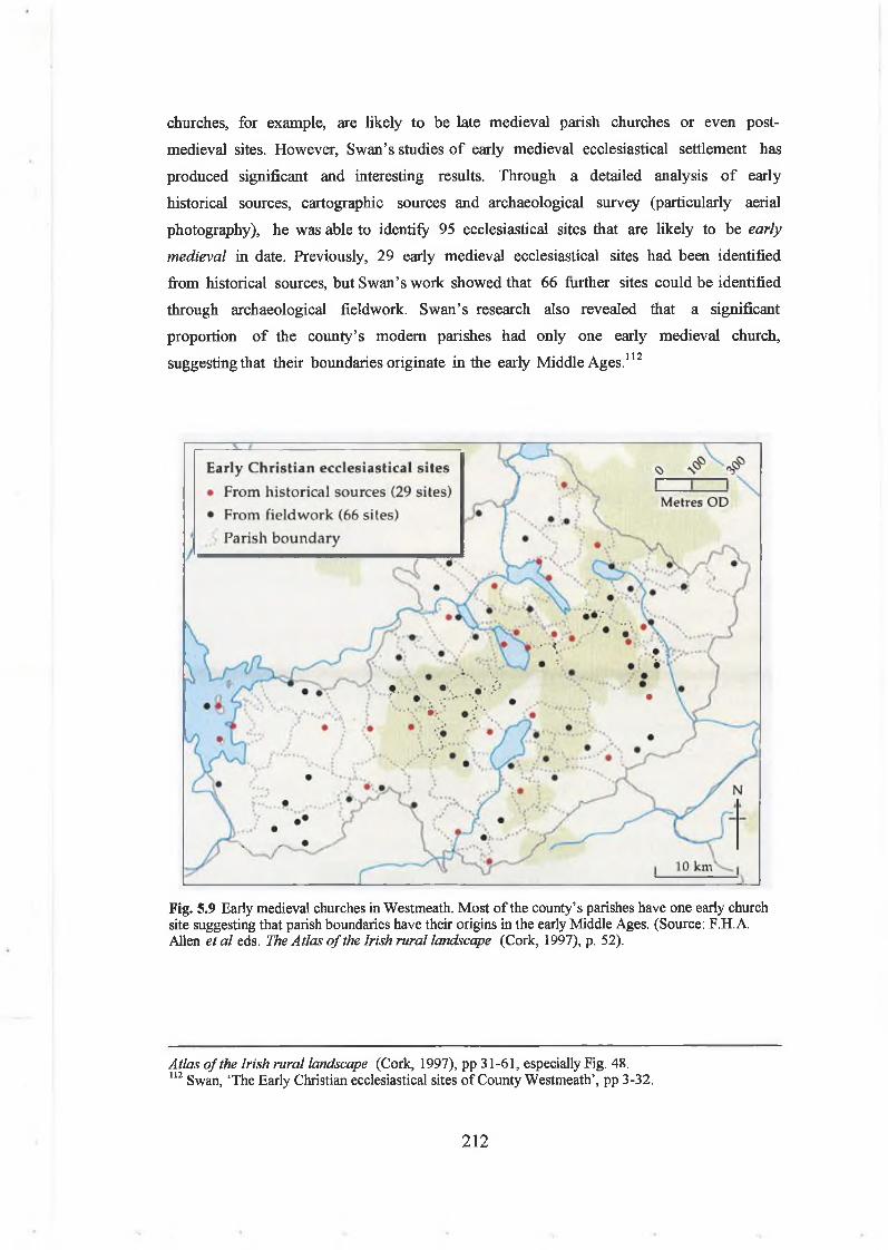
churches, for example, are likely to be late medieval parish churches or even post-
medieval sites. However, Swan’s studies o f early medieval ecclesiastical settlement has
produced significant and interesting results. Through a detailed analysis o f early
historical sources, cartographic sources and archaeological survey (particularly aerial
photography), he was able to identify 95 ecclesiastical sites that are likely to be early
medieval in date. Previously, 29 early medieval ecclesiastical sites had been identified
from historical sources, but Swan’s work showed that 66 further sites could be identified
through archaeological fieldwork. Swan’s research also revealed that a significant
proportion o f the county’s modem parishes had only one early medieval church,
suggesting that their boundaries originate in the early Middle Ages.112
Fig. 5.9 Early medieval churches in Westmeath. Most of the county’s parishes have one early church site suggesting that parish boundaries have their origins in the early Middle Ages. (Source: F.H. A. Allen e ta le ds. The Atlas o f the Irish rural landscape (Cork, 1997), p. 52).
Atlas o f the Irish rural landscape (Cork, 1997), pp 31-61, especially Fig. 48.112 Swan, ‘The Early Christian ecclesiastical sites of County Westmeath’, pp 3-32.
212
Early medieval ecclesiastical sites in Westmeath commonly have a church ruin (often
late medieval, but occasionally with Romanesque features), a burial or graveyard. Other
indicators o f early medieval origins may include the local placename (e.g. Kilpatrick) or
local folklore linking the site to a saint. Some sites have produced carved, inscribed or
decorated crosses or cross-slabs (mostly in the southwest).113 Souterrains, pillar stones,
founder’s tombs or burials are occasional, but rarer. A large (i.e. 90-120m average
diameter) oval, circular or rectilinear bank and ditch or stone enclosure may also be
present around the site, often preserved in outline in townland boundaries, field walls or
roadways.114 A holy well and bullaun stone may be found near or on the periphery o f the
site.
Only a few sites have been investigated, the most important excavations being those at
Kilpatrick (Corbettstown, barony o f Farbill, in southeast Westmeath). The Kilpatrick
excavations revealed something o f the daily life and work o f a small church settlement.
It was a church and graveyard enclosed within an oval enclosure (90m x 80m), defined
by a stone-faced bank and a deep ditch. Within this outer enclosure was found some
evidence for an inner enclosure, circular houses, hearths, pits and other structures. Finds
from within and around the circular house included a pennanular brooch, crucible
fragments, a mould for casting rings and evidence for antler working and iron working.
The site had probably been occupied from the eighth century to the thirteenth century
AD.115
In general, it has been suggested that early medieval churches and ecclesiastical
enclosures tend to be found on low-lying ground, often close to roads and rivers (which
served both as routeways and boundaries), avoiding uplands (rarely being above the 120m
contour). Stout has also strongly argued from the saints’ lives that the church’s
economy was largely based on ploughlands and tillage, although this has not received
complete acceptance. 116 It has also been suggested that churches in the midlands (i.e.
113 T. Fanning and P. Ô hÉailidhe, ‘Some cross-inscribed slabs from the Irish midlands’ in H.Murtagh (ed.), Irish midland studies (Athlone, 1980), pp 5-23.114 Swan, ‘Early Christian ecclesiastical sites of County Westmeath’, p. 4.115 D.L Swan, ‘Excavations at Kilpatrick churchyard, Killucan, Co. Westmeath 1973 and 1975’ in Riocht naMidhe, 6, no. 2 (1976), pp 89-96; Leo Swan, ‘Excavations at Kilpatrick, Killucan, Co. Westmeath’ in Riocht naMidhe, 9, no. 1 (1995), pp 1-21 ; Leo Swan, ‘Fine metalwork from the early Christian site at Kilpatrick, Co. Westmeath’ in Cormac Bourke (ed ), From the Isles o f the North: Early medieval art in Britain and Ireland (Belfast, 1995), pp 75-80.116 D.L Swan, ‘Enclosed ecclesiastical sites and their relevance to settlement patterns of the first millennium A.D.’ in T. Reeves-Smyth and N. Hammond (ed.), Landscape archaeology in Ireland, British Archaeological Reports, British Series 116 (London, 1983), pp 269-94, at p. 273; Stout, The Irish ringfort, pp 100-105; Michael Ryan, ‘The Irish ringfort: Book review’ in History Ireland, 5,
213

Offaly) are found at the periphery o f densest ringfort distributions, suggesting that
churches were being established on political boundaries and in poor agricultural lands
(perhaps being granted lands by local secular elites in precisely these locations). 117
Traditionally, it been thought the church in Ireland was organised into widely dispersed
and overlapping m onastic federations or paruchiae , but this model has now been largely
undermined.118 Recent studies suggest that the church in early medieval Ireland was
organised along local territorial lines, as elsewhere in Europe. Churches, particularly the
most important ones, controlled considerable territories in their immediate vicinity and
were affiliated with other smaller churches in the same secular kingdom as themselves. In
other words, churches should be studied in the context o f their local settlement
landscapes.119
Indeed, it is clear that the church held extensive lands across early medieval Mide. For
example, in the Life o f Col main maic Luachain, the eleventh/twelfth century lands
owned by the church o f Lynn, a monastery on the northeast shore o f Lough Ennell, are
described in detail.120 The Life indicates that the monastic lands o f Lynn were extensive
and probably included much o f the present parish o f Lynn, including the area in which
Mullingar now stands, as well as properties right across Meath and Westmeath. 121 Like
most hagiographies, the life describes the saint’s miraculous activities around Mide,
particularly in the vicinity o f Lough Ennell, and thus bolsters the founder’s reputation.
However, the detailed descriptions o f lands, churches and places were probably mainly
intended to provide documentary evidence o f the church’s land holdings and territorial
claims (at a time when the church felt threatened by twelfth century ecclesiastical
reform and the increasing influence o f the newly endowed Augustinian and Cistercian
orders).122 The life was probably also written to avoid secular taxation, as it clearly
defines the limits o f the latter on the church.
no. 4 (1997), pp 54-5.117 Stout, ‘Early Christian settlement, society and economy in Offaly’, pp 35-6.118 Etchingham, Church organisation in Ireland A.D. 600 to 1000 .119 O Carragain, ‘Early church organisation on Iveragh and Dingle’, p. 130.120 Meyer, lletha Colmain maic Luachain; Paul Walsh, ‘The topography of Betha Colmain’, pp 568- 82. The life was written in the twelfth century, after the discovery of the saint’s relics; A. U. 1122.2; Serin Cholmain m Luachain d fhoghbhail I n-ailaidh Lainne ferchubat I talmhain dia Cetain in Braith. (‘The shrine of Colman son of Luachan was found in the burial place of Lann [Ela], a man’s cubit in earth, on Spy Wednesday [22 March]’).121 Doherty, ‘The Vikings in Ireland: a review’, p. 318.122 Bhreathnach, ‘A Midhe is maith da bhdmar: thoughts on medieval Mide’
214

In general, early medieval church sites in Westmeath are quite widely distributed across
the county and there is little evidence for dense concentrations. There are slightly more
churches within the baronies o f Rathconrath, Corkaree and Fartullagh, but this mirrors
the dense early medieval settlement already represented by the ringforts and souterrains
in those baronies. The churches are also often, though by no means always, found close
to parish and barony boundaries.123 It is interesting then that several early medieval
ecclesiastical sites (with churches, graveyards and crosses) have also been found on, or
close to, lakeshores, places that might be considered to be on significant boundaries.
Early medieval churches found close to lakes include those at Lackan, Kiltoom and
Faughalstown (on Lough Derravarragh), Lynn and Dysart (on Lough Ennell), Church
Island (on an island on Lough Owel), Tristemagh (on Lough Iron), Kilnahinch (at
Ballindeny Lough), as well as Hare Island, Inchmore, N un’s Island and Inchbofin (all
monastic islands on Lough Ree).124
Regional and local landscape perspectives on crannogs in early
medieval WestmeathIntroductionThe early medieval settlement landscapes o f Westmeath are rich in archaeological
evidence for the inhabitation and use o f lakeshores, islands and crannogs. Although there
are other regions (e.g. drumlin lakelands) where crannogs are more densely distributed,
Westmeath’s crannogs have some o f the best historical and archaeological evidence in
Ireland for use in the early Middle Ages. It is interesting then to query why early
medieval people chose to build and live on crannogs in a landscape where there were
plenty o f other options. In this section, I begin to explore regional and local
perspectives to landscapes o f lake dwellings in early medieval Westmeath. Where early
medieval communities chose to build a crannog in the landscape obviously depended on a
range o f factors: social, political, economic and historical. It is possible to recognise
some o f these in the siting and location o f crannogs in the landscape. In the following
section, such factors as geology, soils, agricultural land, navigable rivers, lake type and
size, proximity or distance from local archaeological sites will be briefly considered.
There is a minimum o f 64 crannogs in Co. Westmeath. At least 19 have produced
scientific or artefactual evidence for the date o f their use or occupation. In almost all
123 Swan, ‘Early Christian ecclesiastical sites of County Westmeath’, Fig. 1.1.124 Swan, ‘Early Christian ecclesiastical sites of County Westmeath’, p. 9-31, sites no. 1, 67, 66, 31,86, 87, 36, 17, 51, 52, 53, 59.
215

cases this is in the early medieval period, between the seventh and the eleventh century
AD (for dating evidence o f crannogs in Westmeath, see Table 6.1 and also
dendrochronological dates in Table 6.2). The Westmeath RMP currently includes
records for only 29 sites, but research carried out for this study, based on both the
previous archaeological surveys o f the Crannog Archaeological Project in the 1990s and
this author’s recent surveys (June-September 2002, June-July 2003) on Lough Ennell
and Lough Derravarragh has increased this figure to 64 (which includes 22 sites on Lough
Ennell and 18 sites on Lough Derravarragh). There are probably many more crannogs
that have not been yet identified, submerged underwater or hidden in lakeshore
vegetation around the county’s other lakes. The records o f the National Museum o f
Ireland also include numerous metal-detected finds from lakes, some o f which were
probably on islands or crannogs.125 It is also likely that a much more ambitious
programme o f archaeological survey and underwater search could increase (possibly by
about up to 30 per cent, i f this study’s results on Lough Derravarragh is typical) the
number o f crannogs in the county.
Siting in relation to topography, geology and soilsIn topographical terms, Westmeath is generally a lowlying county, o f lakes, fens and
marshes set amongst low-lying, rolling hillocks and ridges deriving from its geology and
glacial geomorphology. Thence, there is not a significant variation in the altitude or
siting o f crannogs in terms o f topography (i.e there are no ‘upland crannogs’), although
most are found in the lakes and marshes o f the hilly country in the middle o f the county.
The bedrock geology is also quite similar across Westmeath, being mostly either o f
Visean Lucan formation dark limestones and shales and Derravarragh cherty limestone,
so this is hardly a locational factor. However, what is clear is that this geology has had a
profound effect on crannog construction and morphology. The easy availability o f
limestone slabs, pebbles and stones around the storm beaches and eroding terraces o f the
county’s lakes means that most crannogs in Westmeath were stone-built cairns. It is
unlikely that the limestone slabs and pebbles were deliberately quarried (bedrock
exposures are rare), but were simply gathered from surrounding fields and the exposed
muds o f lakes. Indeed, this can frequently be seen in the fabric o f the cairns themselves,
where weathered and wave-marked stones are often cast up onto the tops o f cairns.
125 Current research in the N.M.I., directed by Mr. Eamonn P. Kelly, aims to locate and clarity the underwater findspots of metal-detected artefacts in Co. Westmeath. Many of these finds and their files are still the subject of court action or ongoing confidential legal negotiations. Therefore, only information publicly available in the N.M.I. Topographical Files in the National Museum of Ireland
216
Furthermore, on some lakeshores (particularly Lough Derravarragh with its hard,
limestone glacial till) it would have been difficult to drive in palisade posts, so wooden
piles are infrequent. Towards the south and west, it appears that more boggy lakebeds
tended to be the location o f crannogs built o f organic mounds o f sods, clays and wood,
most o f which are retained within vertical piles that were easily driven into the muds
(e.g. the early medieval crannogs o f Newtownlow, Ballinderry crannog No. 1,
Knockaville and Clonickilvant were all ‘packwerk’ crannogs o f peat, timber and
brushwood, contrasting with the stony cairns o f Lough Ennell and Lough Derravarragh).
There are also interesting patterns in the siting and distribution o f crannogs in relation
to soils. Obviously, a substantial proportion o f crannogs in Westmeath are found on
waterlogged fen peats and occasionally under raised bogs are often found in close
proximity to them. As these soil types typically fringe the lakes in which they are
found, crannogs are also found adjacent to these soils (e.g. particularly at Clonickilvant,
Ballinderry no. 1, Clonsura). At some sites (e.g. Clonsura, Dryderstown, Donore, on
Lough Derravarragh), crannogs appear to be actually deliberately sited adjacent to raised
bogs and fens, suggesting that proximity to these formidable boundaries and obstacles to
travel may have been significant rather than accidental. Beyond these wetlands soils,
crannogs are generally found adjacent to well-drained, good quality soils with a high
agricultural potential and loading capacity. In Westmeath, the overall predominance o f
grey brown podzolic soils (both Rathowen and Patrickswell series) means that most
places are in proximity to these soils, so there is litt le general statistical significance in
the distribution o f crannogs in relation to soils. However, at a local scale, it is clear that
crannogs tend to be found closer to land with good agricultural potential (reckoned in
terms o f soils, drainage, slope, aspect and modem land use). This is evident at Lough
Derravarragh, where most o f the crannogs avoid those parts o f the lakeshore where
there are raised bogs (apart from Donore) or the lower-quality, limestone till soils (both
Clonava island and the area around Derrya are soils o f poorer agricultural potential and
neither have crannogs o ff their shorelines). They also avoid the steeper slopes o f the
southeast end o f the lake, where agricultural practices wouldbe difficult.
Siting in relation to drainage, lakes and riversIn drainage terms, the distribution o f crannogs within the county suggests a strong
concentration o f sites around the lakes found on the River Inny and its tributaries (e.g.
Lough Derravarragh, Lough Iron and Lough Sewdy) and on the lakes on the River
was used in this study.
217

Brosna drainage system (e.g. Lough Ennell, Newtownlow). These are the two major
navigable rivers through the region, ultimately flowing into the River Shannon, the
major routeway through the Irish midlands (as witnessed by the presence o f Viking fleets
from Limerick on Lough Ree in the ninth and tenth century). There are also several
crannogs on the lakes along the smaller River Adeel (e.g. the 3 crannogs on Johnstown
Lough and Lough Annala, collectively known as the ‘Dysart Lakes’) which drains into
the River Boyne. This is a small river today, but may have been navigable in dugouts. It
is also intriguing that some crannogs (e.g. Schoolboy Island, Rushy Island, Lady’s Island
and Bog Island on Lough Ennell, Donore on Lough Derravarragh, and Cullenhugh on
Lough Iron) are found close to local river outlets and inlets into these lakes. This
suggests an interest in observing these navigable rivers as they entered the lakes, for
strategic or defensive reasons, or for controlling movement through the landscape.
There are interesting patterns in terms o f Westmeath crannog distribution and the size
o f particular lakes. In smaller lakes (e.g. c. 500m- lkm in length; e.g. Bishops Lough,
Doonis Lough, Twy Lough, Ballinderry Lough, Lough Annala, M ount Dalton Lough,
White Lough, Newtownlow), there tends to be only a single crannog. This crannog is
usually prominently placed, typically slightly towards one end o f the lake. On slightly
larger (i.e.2-3km across), lakes (e.g. the Lough Lene, Lough Sewdy, or perhaps the
originally larger Dysart Lakes complex) there are rather more sites (2-3 sites), but they
are widely spaced apart. Indeed, it is only on the significantly larger lakes, such as Lough
Ennell (7km in length, 1300ha in area) and Lough Derravarragh (8km in length, 1080ha
in area), that there are quite large numbers o f crannogs (22 crannogs on Lough Ennell
and 18 crannogs on Lough Derravarragh). This seems to indicate that crannogs would
have effectively dominated the watery spaces o f loughs in people’s minds, so that small
lakes can only contain one or two, while larger lakes were considered to have sufficient
space to contain more sites. This is a phenomenon that has been previously noted by
archaeological surveys in Fermanagh and Sligo (e.g. Lough Gara). It suggests that
crannogs, with their high visibility and resounding, charismatic presence on the surface
o f the water had a significant impact on people’s perception o f space around lakes in
early medieval Ireland. Obviously, this also would have had somethi ng to do with the
ownership and use o f the surrounding land.
Siting in relation to other archaeological sitesIsolation or proximity to nearby settlement sites are counterbalancing themes in the
location o f crannogs in Westmeath. A brief analysis o f the nearest archaeological sites
to each crannog reveals some basic patterns. The nearest archaeological sites to a large
218

proportion (29 sites, 44.6 per cent) o f the county’s crannogs are in fact other crannogs.
This largely reflects the dense concentration o f sites at Kiltoom on Lough Derravarragh,
and at Rochfort Demesne, on Lough Ennell. At both locations, there is a cluster o f 8-10
crannogs found in close proximity, suggesting either longevity, continuity or a sequence
o f use or the presence o f a local community o f households inhabiting the same lakeshore
for a period o f time. At other locations, such as Cullenhugh, on Lough Iron, and at
Croinis/Dysart, on Lough Ennell, there are also small groups (3-4 sites) o f crannogs
situated close together, albeit separated by stretches o f water. Some early medieval
crannogs, such as Dryderstown (Lough Annala) are located on lakes where there are
other crannogs (e.g. Johnstown) at some distance (i.e. 500m).
A significantly high proportion (16 sites, 25 per cent) o f W estm eath’s crannogs are
located near early medieval ringforts. At Croinis (Lough Ennell), Coolure Demesne 1
(Lough Derravarragh), Derrynagarragh (Bishops Lough), Cherry Island (Lough Ennell)
and Newtownlow, these crannogs are situated immediately adjacent to ringforts
(typically within 200m) probably signifying that the ringfort/crannog pair served as an
early medieval settlement complex. On other sites, there are ringforts in the locality,
but not necessarily very close to the lake dwellings. Indeed, given the large number o f
ringforts in Westmeath, it is often inevitable that there are some ringforts close by.
There are also a few isolated sites, where the nearest ringfort is actually at an appreciable
distance. For example, at the early medieval crannog at Knockaville (Lough-a-Trim),
the nearest archaeological site is a ringfort 2km to the west. Similarly, an undated
possible crannog at Clonsurahas a ringfort 2.6km to the east. Both o f these have to be
seen as isolated places in the landscape, but they are also located close to barony
boundaries suggesting that they played some role in the marchlands between territories.
Other Westmeath crannogs have a range o f different types o f nearest archaeological
site. These include earthworks (13 sites, 20 per cent), churches (1 site, 1.4 per cent),
castles (4 sites, 6.2 per cent), mottes (1 site, 1.4 per cent) and a mill (1 site, 1.4 per
cent). The earthworks may occasionally have been ringforts, as the high rate o f
archaeological site destruction in Westmeath means that it is often impossible to
establish the original character o f the site when it has been ploughed out. For example,
at Kiltoom 10 (Lough Derravarragh), a crannog was situated in water o ff a lowlying
terrace, where there were four earthworks. At least two o f these were probably early
medieval ringforts, but two may have been ring barrows, suggesting a Bronze Age/Iron
Age and early medieval complex o f archaeological sites at this location. There are
certainly some crannogs that appear to be significantly isolated from other
219

archaeological sites, suggesting that they were deliberately located at places that may not
have been densely settled, for reasons o f security or to establish a presence in a region
otherwise sparsely occupied. This can be deceptive, as at the early medieval crannog at
Clonickilvant (White Lough), the nearest site is a mill at 850m distance, but there are at
least 12 ringforts within a 2km distance, a densely occupied early medieval landscape.
It is also worth stating that early medieval crannogs would have been situated within
archaeological landscape complexes, where the past histories and contemporary ideas
about social status and role, land ownership and use would have been important. For
example, there is an important archaeological landscape on the southwest shore o f
Lough Ennell, where the early medieval royal ringfort and crannog o f the Clann
Cholmain is situated within a locality where there were also several ringforts, an early
medieval church, holy well and earthworks in Dysart townland. Similarly, at the early
medieval crannog at Ballinderry no. 1, there is an early medieval church at Kilnahinch,
220m to the south, but there are also early medieval ringforts on the hills across the
bogs, 2km to the west. These early medieval settlement landscapes will be interpreted
further below.
Siting in relation to early medieval settlement landscapesIn terms o f potential early medieval settlement landscapes, it is possible to trace
patterns in the broad distribution and density o f crannogs within the county’s modem
baronies. It is likely that these baronies bear some general resemblance in location to
known early medieval political territories, although they have been undoubtedly altered.
There are higher densities within some baronies, particularly Moyashel &
Magherademon and Fartullagh (either side o f Lough Ennell), and Fore and Corkaree
(either side o f Lough Derravarragh). In other baronies, there are only a few sites, with
only 1 crannog in Clonlonan (Ballinderry crannog No. 1), 2 crannogs in Kilkenny West
(Doonis, Twyford), 2 crannogs in Rathconrath (Shinglis, Loughan), 1 site (Knockaville)
in Farbill, and 4 sites (Johnstown, Dryderstown, Kilrush Lr.) in Delvin.
It is intriguing though that crannogs often avoid those regions that seem to have been
densely settled in the early medieval period, at least as far as this is indicated by the
distribution o f early medieval ringforts. Undoubtedly, the fact that crannogs are
typically found in the more low-lying, marshy areas o f the county, with their lakes and
rivers, is a factor (normally landscapes that are low in ringfort density). In other words,
ringforts are typically found on good, well-drained agricultural soils, above the 100m
contour. Thence, the crannogs at Cullenhugh (Lough Iron) and Clonsura (Lough Bane)
220

are located in the lowlying, waterlogged landscapes o f bogs, fens and gleys found in the
north o f the county, where there are actually very few ringforts. However, there are
strong hints that crannog and ringfort distributions are actually indeed mutually
exclusive. Thence, for example in the densely settled barony o f Rathconrath, the two
crannogs o f Loughan (Mount Dalton) and Shinglis (Lough Sewdy)are situated well to the
north o f the main ringfort densities. Similarly, in the barony o f Moyashel &
Magherademon, ringforts are infrequent on its southern boundary, thus avoiding the
eastern shore o f Lough Ennell. But this is precisely the location o f the politically
significant and evidently wealthy crannogs o f the Clann Cholmain at Crbinis, Dysart,
Rushy Island and School Boy Island. Similarly, on Lough Derravarragh, a dense
distribution o f crannogs on the lake (particularly at the north end around Coolure
Demesne and Kiltoom) is matched by a low-density and scattered distribution o f
ringforts around the lake.
So, it appears that crannogs tend to be found towards the edges o f early medieval
settlement landscapes. This could be interpreted in a number o f ways. It is possible that
crannogs served the function o f ringforts, continuing early medieval settlement
landscapes out onto wetlands. Alternatively, crannogs (like churches) were expressly
serving as ‘edge’ or ‘boundary’ monuments, marking these spaces in some political or
ideological way.
Siting in relation to early medieval politic al boundariesIn fact, it is clear that crannogs tend to be found close to, or even directly on, barony
boundaries (Fig. 5.10). These barony boundaries, often running along major
topographical features, such as rivers and lakes, may broadly correspond to those o f the
early medieval tuath. As many as 50 (79 per cent) o f Westmeath’s crannogs are located
on, or close to, the barony boundaries. Indeed, it is striking that crannogs such as the
early medieval crannogs at Rnockaville (Lough-a-Trim), Clonickilvant (White Lough),
as well as the undated sites at Twyford (Twy Lough) and Kilrush Lower are actually sited
directly on the barony boundaries. Other early medieval crannogs, such as the Ballinderry
No. 1, Newtownlow, and Cullenhugh (Lough Iron) sites and the undated site at Clonsura
(Lough Bane) are also located quite close to barony boundaries (i.e. within 500m-lkm).
Most strikingly, the early medieval crannogs on Lough Ennell and Lough Derravarragh
are also situated very close (within c.500-800m) to the barony boundaries. On Lough
Ennell, the boundaries between the three baronies o f Moyashel & Magherademon,
Fartullagh and Moycashel all run down the middle o f the lake. In other words, Lough
Ennell’s crannogs are effectively overlooking a potential early medieval political
221

Fig. 5.10. Distribution of Westmeath's crannogs in relation to modem barony boundaries, indicating that as much as 79% per cent are on or close to the potential early medieval tuath boundaries.
222

boundary. Similarly, on Lough Derravarragh, the barony boundaries between the three
baronies o f Fore, Corkaree and Moygoish runs down the middle o f the lake, so that
crannogs are again sited either side o f i t .126 Similarly then, Lough Derravarragh’s
crannogs may also be sited overlooking a possible early medieval boundary between the
early medieval kingdoms o f CulFobair (in Fore), the Ui Maccu Uais Midi (in Moygoish)
and the Corco Roide (in Corkaree).
It is possible then that crannogs in Westmeath were being deliberately used on early
medieval political or territorial boundaries (in some cases, the actual boundary o f the
tuath). In early medieval Ireland, boundaries were immensely important in social,
ideological and political term s.127 Their location and extent would have been passed
down in oral traditions amongst the community and would have been identifiable by
reference to natural and built features in the landscape. In early Irish law, boundaries
could be marked by rocks, ditches, trees, roads and lanes, gravestones and burial mounds,
and particularly by water (lakes, rivers and streams).
Building crannogs on lakes (i.e. mounds by water features) may have been a m eans o f
marking the boundary, and this could have been a phenomenon that waxed and waned
even as population groups rose or fell in the eternal struggles for political power. The
crannogs could have been placed on lakes to enable people to see across these
boundaries, and additionally for them to be seen as aggressive and symbolic statements
from an opposing territory (i.e. from the opposite shores). The inhabitation o f a
crannog on a boundary could have signified the high social status o f its inhabitants (i.e.
royal sites often being at edges o f territories), or alternatively the social liminality and
marginalisation (dwellings o f the poor and landless at edge o f lands) o f its owners. They
could also have had a politically strategic function (being a defensive or aggressive
emplacement at a territorial boundary) within the community.
It is also possible that crannogs in Westmeath were located along regional and local
routeways, as represented in particular by the River Inny and River Brosna, which
ultimately connect with the River Shannon. There is not a contradiction between
126 It is true that the modem barony boundaries run down the middle of lakes as a cartographic convention, much as they run down the middle of rivers. However, this does not take away from the fact that the lake itself remains the essential, defining boundary feature, and its broad surface could be seen as a wide, fluid (!) and permeable liminal space, easily crossed by boats but still symbolically and politically important.127 O Riain, ‘Boundary association in early Irish society’, pp 12-29; Charles-Edwards, ‘Boundaries in Irish law’, pp 83-7; Kelly, Early Irish law, p. 409.
223

communications routeways and political boundaries, as routeways are often the means o f
marking a boundary (i.e. roads and lanes), while contacts are often highly significant
across territo rial boundaries. Indeed, there may be correlations in Westmeath between
the locations o f early medieval crannogs and ecclesiastical sites (also found on
routeway/boundaries). These ideas will be discussed in more detail below.
Islands, landscape and society in early medieval WestmeathIntroductionBoth historical and archaeological evidence indicates that crannogs played an important
role in the social and political landscapes o f early medieval Mide. It is possible to
explore how they were used and thought about by investigating their social and
ideological role in the landscape. This includes the use o f early medieval crannogs by the
powerful and elite (kings and lords) in society, who used crannogs to order, manipulate
and control their role in society. However, it is also possible to discuss this in terms o f
social marginality, whereby the crannogs o f the poor, the landless or dependant labourers
also utilised crannogs for safety and protection, to identify with the social group or to
gather beside their lord. This can best be achieved by sketching out scenarios in relation
to particular early medieval crannogs in Westmeath.
Islands, power and performance in the social and ideological landscapeKings and crannogs in early medieval Westmeath
In the early Middle Ages, crannogs were often used as power centres in the landscape,
serving as royal residences, craft production and redistribution centres, places o f refuge
at times o f danger and as defensive or military sites at the boundaries o f political
territories. Oddly, however, there has been little attempt to explore how this was
achieved, in both a practical or a symbolic sense, within the landscapes that people
inhabited. It wouldbe worth exploring how crannogs were actively used by social elites as
distinct places within what might be termed as topographies o f power, to establish and
negotiate power relationships within the wider early medieval landscape.
In the early Middle Ages, concepts o f kingship were closely linked to ideas about
personal status, ability and critically, perform ance. Within his own tuath , the early
medieval king was expected to carry out various tasks for the community. He was
expected to maintain peace and prosperity, to negotiate agreements with (or submit to)
other kings, to administer justice and exact fines, to convene public assemblies (including
both the tribal ¿enach and the airecht). He was also expected to periodically move with
his retinue around his territory, on a royal circuit. He also had a military role, being
224

expected to maintain a warrior retinue, to organise and go on raids and hostings into
rival territories and to build and maintain strongholds to protect the community
(although various grades o f lords also had military obligations).
It is evident from the annals, saint’s lives and narrative literature that kings were
occasionally symbolically linked to particular lakes and islands. Indeed, the building o f a
crannog on a particular well-known lake may have served to link the king with the
territory, as it denoted and established his physical presence on a significant
topographical feature within the tuath (the lake being potentially a sacred place, a
historically well-known placename synonymous with the territory itself). It has also
been argued in this chapter (see above), that the lake itself may also occasionally have
served as a physical and political boundary between early medieval tuath , so that the
king would have been representing the tuath to outsiders (another one o f his roles) as
well as projecting his power across into a rival territory. It has also been argued above
(Chapter 4) that in ideological or symbolic terms, the k ing’s crannog on a lake was
placed on a critically important symbolic boundary or liminal space between this world
and the otherworld (possibly signifying the king’s role in mediating between the
community and nature).
In building and occupying a crannog, the king (and his household) might have been
attempting to establish a certain social distinction within the local community, by
slightly removing himself, his household and retinue from the dwelling space o f lower
social classes. This social distance was achieved and manipulated both by the remoteness
and inaccessibility o f the island, as well as the island’s distinctive profile and high
visibility. In other words, the island could be witnessed, observed and wondered at by
people on the shore, but they could not experience it for themselves unless invited
(unless they were attacking it). Similarly access to the island could be regulated from a
distance, with the owner o f the island deciding who could and could not come out to it by
boat.
Identifying royal crannogs in early medieval Westmeath
Recent studies o f the archaeology o f early Irish kingship have all suggested that it should
be possible to identify early medieval royal residences by an analysis o f their architecture
and material culture. However, previous studies have been hampered by the fact that
scholars have actually been referring to sites o f quite different date and function. Wailes
was actually writing about the major Iron Age royal sites (i.e. Tara, Cruachain, Dun
Ailinne) when he suggested that they should be unusually large, with evidence for ritual
225

and residential activity and high-status living (possibly including rich burials).128 More
recently, Warner was mostly discussing early medieval royal residences when he suggested
that they should have evidence for ritual activities, a small internal enclosed area, a
complexity o f enclosing features (i.e. multivallate earthworks), and evidence for wealth,
substantial houses and industrial waste.129 Indeed, Bolger sought to remedy this when she
suggested that two different categories o f sites should be distinguished in early medieval
Brega; royal sites (e.g. prehistoric ceremonial complexes associated with early medieval
kingship, denaig, synods and assemblies, such as Tara, Tailtiu, Tlachtga) and political
centres (the domestic residences o f a king or royal dynasty).130 More recently, Warner
has suggested that because some historically attested royal crannogs (e.g. Island
MacHugh, Co. Tyrone) have not produced good evidence for occupation, that crannogs
should be regarded as secondary or supplementary residences, perhaps even merely
temporary refuges.131
However, most royal residences (like medieval palaces or the country houses o f the
upper social classes in Jane Austen’s novels) were effectively temporary, as early Irish
kings were frequently on the move on their royal circuits, travelling around their
territories with their retinues, feasting in the houses o f their clients and gathering food
rent, taxes and political tribute. Early Irish kings also had principal residences, occupied
for slightly longer periods o f time where they themselves could host feasts and
gatherings. It is evident that the really significant seats o f power o f the Clann Cholmain
kings o f Mide were the ringfort and crannog at Dun na Sciath and Croinis and a ringfort
at Ruba Chonaill, near Mullingar. In any case, it is likely that different types o f places
would be associated with the king. They could potentially include his inauguration site,
some places o f public assembly (often at prehistoric burial mounds), his various strategic
or military strongholds, the churches and monastic enclosures he patronised, along with
several residences that he inhabited at different times o f the years.
It should still be possible to identify actual royal residences, places o f major significance
to the king and his court. It is accepted that some o f these are crannogs. Using the
evidence o f historical sources and previously excavated sites (e.g. Lagore), it is possible
128 Bernard Wailes, ‘The Irish ‘royal sites’ in history and archaeology’ in Cambridge Medieval Celtic Studies, 3 (1982), pp 1-29.129 R.B. Warner, ‘The archaeology of early historic Irish kingship’ in S.T. Driscoll and M.R. Nieke (eds.), Power and politics in early medieval Britain and Ireland (Edinburgh, 1988), pp 47-68, at p.67.130 Teresa Bolger, ‘A study of settlement in the kingdom of Brega in the 7th and 8th centuries AD. Unpublished M.Phil’, N.U.I. (University College, Dublin, 1997), pp 115-6.131 Warner, ‘On crannogs and kings’, pp 67-8.
226

to suggest that an early medieval royal crannog could have some o f the following
features
A location at a politically or strategically significant place in the early medieval tuath (central place, boundary association, proximity to significant routeways).
A locally inaccessible but not truly remote siting, preferably highly visible from a distance around the shoreline.
An impressive physical architecture, possibly of a high cairn with a large internal area enclosed by multiple and multi-period stone kerbs, plank and pile palisades), possibly with a large house.
Dating, artefactual and stratigraphic evidence for prolonged occupation, occasionally exhibiting change or alteration across time (i.e. from sixth to eleventh century AD).
High-status objects, including imported pottery, glass, weaponry, horse fittings, valuable metalwork (silver, coins), high-status personal ornament (mounts, brooches, pins) and for on-site metalworking (cmcibles, moulds, furnaces).
A nearby significant church or monastic site, a large ringfort and other early medieval sites and artefacts in the vicinity, with a possible association with a pagan Bronze Age or Iron Age archaeological site (burial mound, standing stone).
An early medieval historical reference(annalistic or hagiographical) to the residence of a king or political dynasty on the lake.
Interpreting crannogs as early medieval power centres
There are several early medieval crannogs in Westmeath that meet some o f these
criteria, whether in terms o f their impressive architecture, rich artefactual assemblages,
or their location at strategically or political significant locations. However, the
identification o f an early medieval royal site, as opposed to a lordly site or site o f high
status, probably does require historical references to a king or political group residing
there. In any case, there are at least two probable royal crannogs, Croinis (Lough Ennell)
and Coolure Demesne Demesne 1 (Lough Derravarragh) in Westmeath. It is likely that
several other crannogs were also o f high status, including Castle Island (Lough Lene),
Dryderstown (Lough Annala), Clonickilvant (White Lough), Ballinderry crannog No. 1
(Ballinderry Lough) and Newtownlow. However, despite the presence there o f either
impressive architecture or high-status finds, they in no way match the previously named
two sites.
Scenarios: Crdinis - early medieval royal crannog o f the Clann Cholmdin
It is clear that the early medieval crannog at Croinis, on Lough Ennell, is one o f the
historically attested royal residences o f the Clann Cholmain dynasty o f the southern Ui
Neill, who controlled the early medieval kingdom o f Mide between the eighth and the
eleventh century AD (see above for discussion o f politics and peoples). The crannog of
227

Croinis certainly has all that might be expected on an early medieval royal crannog. It is
a massive cairn (50m diameter, 3-4m in height) o f stone in deep water, inaccessible but
in a highly visible location. There is archaeological evidence for building activity on the
site in the mid-ninth century (c. AD 850), while its inner oak plank palisade was
constructed in the early twelfth century (AD 1107 ± 9 years or later). Although the site
has not been excavated, stray finds from its surface include bronze pins o f eleventh to
twelfth-century date were found on the crannogs. In historical terms, it is likely that the
crannog was the residence o f the Clann Cholmain kings who controlled the midlands and
plundered Viking Dublin on occasion. There were also several raids by rival dynasties on
Lough Ennell and its environs throughout the tenth century (i.e. in AD 961, 985, 989,
991), all clearly aimed at the power centres o f the Clann Cholmain. It has also been
shown that Mdel Sechnaill maic Domnaill, then high-king o f Ireland, died on Croinis in
AD 1022.
However, Croinis is also situated in an interesting local early medieval settlement
complex (Fig. 5.11). It is overlooked by Dun na Sciath, an impressive raised ringfort (a
high level platform enclosed on its north side by a deep ditch and low external bank) on
the nearby land. This ringfort is the historically attested Dun na Sciath ( ‘fort o f the
shields’), which was also a royal residence o f the Clann Cholmain kings. Both ringfort
and crannog were probably used for royal dwelling, public assemblies and other
gatherings. There are other possible early medieval dwellings in the immediate vicinity,
including a small, low-caim crannog at Dysart 2), as well as three small low-caim
crannogs or platforms at Dysart 3, 4 and 5.
There is also a dense concentration o f early medieval metalwork in the vicinity o f the
crannog, particularly o f ninth and early tenth century silver. At least three hoards
(Dysart hoards 1, 3, 4) o f silver ingots, coins and other objects have been recovered
from the eastern and western shores o f Dysart Island (a large natural island to the
north). The early tenth-century Dysart 4 hoard in particular was an enormous collection
o f silver ingots, ingot fragments, pieces o f cut silver ornament, Kufic coins, and
Northumbrian and East Anglian Viking coins, making it amongst the largest found in
western Europe.132 It is likely that this silver was collected from Viking Dublin, possibly
as loot after the sack o f Dublin in AD 902. Smaller hoards o f silver ingots have also been
found on the eastern shore o f the island, at Dysart 1 and 3, while a hoard o f 3 ingots
were found in 1966 on a small, rocky crannog at Dysart Island 1 (also known locally as
132 Ryan et al, ‘Six silver finds of the Viking period from the vicinity of Lough Ennell’, pp 339-56.
228

229
# Crannog (high caim) a Crannog (low cairn) tm Crannog (platform)O Early medieval
ringfort
t Early medieval church & graveyard
L J Holywell
□ Early Medieval objects
Lough Ennell, Co. Westmeath
Ash Island
, *' T_l Dysart Island 2
“ 0 £ HDysart Dysart2Island 1 (3 ingots)
Dysart 3 (2 ingots)
Dysart 1 (5 ingots)
Dysart 4 (coin and ingots)
Dysart 2
Croinis
Fig. 5.11 Map of early medieval royal settlement complex at Dun na Sciath ringfort and Croinis crannog, on Lough Ennell, Co. Westmeath. These were the royal residences of the Clann Cholmain kings of Mide between the eighth and the eleventh centuries AD..

Rocky Island). A hoard o f silver ingots was also found on the lakeshore at Nure, to the
west o f Croinis.
This silver could be actually indicative o f a royal presence, as ingots are mentioned
amongst the lists o f tributes due to an overking from his subjects in the tenth-century
Book o f Rights.1*3 Silver ingots were also apparently used to pay ransoms, as the Annals
o f Ulster state that the king o f Brega was paid 60 ounces o f gold and 60 ounces o f silver
to release Olaf, son o f Sitric, king o f Dublin in AD 1029.134 However they were
obtained, these hoards o f early medieval ingots and coins scattered around the islands and
the lakeshore at Dun na Sciath and Croinis indicate the political and economic influence
o f the Clann Cholmain dynasty.
Croinis is also strategically placed within the local early medieval settlement landscape.
In regional political terms, it is probably on or near the borders between the early
medieval territories o f the Clann Cholmain, the Cendl Fiachach and the Fir Tulach,
although the latter two were probably sub-kingdoms or subjects o f the former. In terms
o f the local settlement landscape, it is situated at some remove from neighbouring early
medieval ringforts and churches. In Dysart townland, c. 1.5km to the northwest, there is
a surprising number (at least 10) o f ringforts. These sites are typically quite small,
univallate sites, suggesting that they were the residences o f the king’s clients and
tenants. There is also an important early medieval church at Dysart, 2km to the north.
It has a church (in ruins), a decorated cross base, a burial ground and a circular earthen
enclosure.135 The church is known in the early medieval sources as Disert Maile Tuile.
Mael Tuile was an eighth-centur y saint who was closely associated with Mael Ruain o f
Tallaght and his connection with him is a clear indication that this disert by Lough
Ennell was a Celi De church, o f the reform movement that emerged in the eighth and
ninth century.136 Other possible early medieval sites include a holy well, earthworks and
field-systems. Ash Island, to the north o f Dysart Island, is also a probable early medieval
crannog, as it has produced some early medieval objects.
This empty space between the dense concentration o f early medieval sites at Dysart and
the lakeshore royal settlement complex at Dun na Sciath/Croinis may be socially and
133 Charles Doherty, ‘Exchange and trade in early medieval Ireland’ in R.S.A.I. Jn., 110 (1980), pp 67-89, at p. 74.134 A. U. 1029.6.135 Swan, ‘Early Christian ecclesiastical sites of County Westmeath’, p. 24.
230

ideologically significant. It is possible that this open ground was the faithche ( ‘green’,
infield’) or mensal lands o f the king granted to him by nobles o f the tuath upon his
accession to the throne. Early Irish literary sources mention a faithche at such royal
sites at Tara, Navan andCruachain as the location o f public assemblies, the tribe’s sacred
tree, as well as being a location for cattle, tillage, horse-racing and ball-games.137 It may
also have been deliberately intended to maintain a social distance from the surrounding
community. There may have been a customary exclusion zone between the king’s royal
residences and the other dwellhgs (in that ordinary people were not originally permitted
to build dwelling enclosures close to the k ing’s residence). It is also clear that Dun na
Sciath and Croinis are effectively located at the end o f a promontory or ridge that is
surrounded on two sides by fens and bogs, and to the south by the lake itself. The
physical landscape itself could therefore be used to manipulate, enforce and control how
people even approached the site.
Scenarios: Coolure Demesne - an early medieval royal crannog o f the Ul Fiachrach
Cuile Fobair?
Other early medieval royal crannogs can also be identified. Historical and archaeological
evidence suggests that a previously unknown crannog at Coolure Demesne 1, Lough
Derravarragh, is probably a royal residence o f the Ui Fiachrach Cuile Fobair, whose
territory lay along the northern shore o f the lake.138 These were a relatively obscure
early medieval population group occupying the borderlands between the Clann Cholmain
kingdom o f Mide and the Sil nAedo Slaine kingdom o f Brega. Unlike, the Clann
Cholmain, there are few historical references to them, so that interpretations o f the site
have to be based on archaeology. The crannog is one o f the most physically impressive
in Westmeath, with a massive cairn (36m diam., 5m in height) enclosed within a plank
palisade and a roundwood post palisade. Although the site has not been excavated or
scientifically dated, it was investigated by midland divers with metal detectors in the
1980s. There is rich artefactual evidence for activity on the site in the fifth to sixth
century (an enamelled bronze mount, a hand-pin), through to the ninth and tenth
century (in the form o f bronze stick pins, ringed-pins, silver ingots and armlets, all
probably imported from Viking Dublin).139 Indeed, this metalwork raises questions about
136 Edel Bhreathnach, ‘A Midhe is maith da bhamar. Thoughts on medieval Mide’.137 Fergus Kelly, Early Irish farming (Dublin, 1997), pp 369-70.138 Walsh, ‘Meath in the Book of Rights’, p. 15; Walsh, ‘A fragment used by Keating’, p. 8, note 39; Walsh, Westmeath, p. 373-4.139 Eamonn P. Kelly (Keeper of Antiquities, N.M.I.) describes the Coolure Demesne crannog as one of the richest archaeological sites in the midlands in terms of the recovery of artefacts ; E.P. Kelly, pers. comm.
231

its origins. Was it obtained by the Ui Fiachrach Cuile Fobair from Hibemo-Norse Dublin
themselves, using their own trading and political connections across the north midlands,
or was it redistributed through the region by the Clann Cholm&in dynasty from their
bases on Lough Ennell?
In any case, the Coolure Demesne crannog exhibits striking similarities with the Croinis
crannog in terms o f its landscape setting (Fig. 5.12). It is located within a shallow bay or
inlet at the north o f the lake, partly enclosed by dryland to the north, east and west.
Like Croinis it is immediately overlooked by a prominent early medieval raised ringfort,
situated at the edge o f the lake. This raised ringfort has a central level platform, with a
deep enclosing ditch and bank. It is evident that both the ringfort and crannog served as
royal or high-status residences. As at Croinis, there are also several small rock platforms
and enhanced islets on the adjacent shoreline, possibly the temporary or seasonal
dwellings o f the king’s retinue, or perhaps o f his tenants.
Coolure Demesne is also strategically located in the early medieval settlement landscape.
In regional political terms, it is probably on the borders between the early medieval
territories o f the Ui Fiachrach Cuile Fobair themselves and the Ui Maccu Uais Midi
(Moygoish), the Corco Roide (Corkaree) on the opposite shore, although all o f them
were minor sub-kingdoms within Mide. In the early medieval period, it may have also
have been close to another boundary, that between the Clann Cholmain controlled
kingdoms o f Mide and the Ui Neill kingdoms o f south Tethbae (the territories o f the
Cairpre and Maine) which traditionally lay along the River Inny (which flows into and
out o f the lake).
In terms o f the local settlement landscape, the crannog is also situated at some
significant remove from neighbouring early medieval ringforts and churches. This
appears to mirror the exclusion space found at Dun na Sciath/Croinis. The nearest
archaeological sites are five ringforts about 1km to the north, situated along the
townland boundaries between Ballinealoe and Mayne. There is also a ringfort at
Lispopple, slightly closer at hand 800m to northwest. This ringfort, now destroyed, was
formerly situated on top o f a local hill. The townland name (Lispopple) in which it is
found is intriguing, possibly deriving from the Irish Lios an phoba il, or ‘fort o f the
gathering’. This might suggest a tradition o f fairs, markets or assemblies in the locality,
something potentially to be associated with early Irish kingship. Another interesting
aspect o f the siting o f these ringforts is that they are located along a natural esker
running NW-SE. This may have been the natural early medieval routeway through this
232

Fig. 5.12. Map of early medieval ringforts and crannogs atCoolure Demesne Lough Derravarragh. Archaeological and historical evidence suggests that this was a royal or lordly settlement complex of the Ui Fiachrach Cuile Fobair.The probable high-status crannog is situated in a small bay, overlooked by several other sites around the lakeshore, and could have served as an island 'stage' to symbolise the king's central role in the community.
233

occasionally boggy landscape (it carries a small, narrow winding road today). It is not
unusual that the early medieval crannog and ringfort is away from this routeway, as Stout
has suggested that early medieval royal sites occasionally appear to be slightly remote
from roads, in contrast to ordinary ringforts and churches.
There are also several early medieval churches around Lough Derravarragh that could be
potentially associated with the early medieval royal complex at Coolure Demesne,
including a possible early medieval church at Mayne, 2.2km to the north. There is an
early medieval church and graveyard site at Kiltoom, 1.5km to the east.140 Kiltoom
{Cell Tóma) is associated with the alleged sixth-century Saint Nennid (about whom little
is known), and obits o f its abbots are noted in the annals for AD 751, 768, 813, 851 and
886.141 It is likely then that the church at Kiltoom was occupied in the eighth and ninth
century AD, possibly by an hereditary church family. Further down the shoreline, there
is also an important early medieval church and graveyard at Faughalstown, reputedly
founded by the sixth-century Saint Diermit, who himself was apparently o f the Ui
Fiachrach dynasty. This appears to suggest that that Faughalstown {Fochlaid in the
early Irish sources) was a proprietory church o f the Ui Fiachrach Cuile Fobair established
by themselves (or by an ecclesiastical branch o f them), while its eighth and ninth
century abbots had links with Inis Clothrann on Lough Ree, at the western boundary o f
M ide.142 Faughalstown has a church (in ruins), burials and a broken cross-shaft within a
rectilinear enclosure, while there is also a holy well dedicated to ‘Saint Dermot’
nearby.143
Social continuity and change in landscapes o f power
Recognising social change and evolving notions o f kingship in the early medieval period,
it is interesting to query continuity and change in the use o f crannogs as royal sites. It is
140 The site at Kiltoom may have had a significantly large enclosure, in part preserved by the modem field boundary; Swan, ‘Early Christian ecclesiastical sites of County Westmeath’, p. 21; Rory Masterson, ‘Some lesser-known ecclesiastical sites in Fore, Co. Westmeath’ in Rlocht naMidhe, 9, no. 4 (1998), pp 40-8, at pp 43-44.141 The deaths of the abbots of Kiltoom (Cell Tóma or Cell Tuama) are mentioned in these annalistic entries; A.U. 751.4, ‘death ofEchaid of Cell Tóma’; A. U. 768.6, ‘Coibdenach, abbot of Cell Tóma, rests’; A U. 813.3 Cellach son ofEchaid, superior ofCell Tuama, dies’; A.U. 851.1, ‘Colgu, son of Cellach, superior of Cell Tuama ..died’; A.U. 886.2, Robartach, son of Colcu, superior of Cell Tuama, fell asleep’.142 Masterson, ‘Some lesser-known ecclesiastical sites’, pp 44-5; The abbots of Faughalstown (Fochlaid) are mentioned in these annalistic entries; A. IJ. 785.4, ‘Echaid son of Fócartach, abbot of Fochlaid and Inis Clothrann, dies’; A. U. 871.6, Cu Rai, son of aldnia, of Inis Clothrann and of Fochla of Mide, a learned abbot and the most expert in the histories of the Irish, fell asleep inChrist’.
234

possible that the earliest crannogs at these sites, dating perhaps to the sixth or seventh
centuries AD, were relatively small and perhaps partnered by a small ringfort on the
shoreline. By the ninth century, they may have been larger cairns, potentially enclosed
within outer wooden palisades that were both symbolic and defensive in intent. By the
tenth or the eleventh century, they had probably reached their current appearance. This
would have included a massive stony cairn, possibly enclosed within an oak plank
palisade. The local ringfort may also have been deliberately enhanced or raised, thus
creating a large raised ringfort. At this stage, it could be that these lordly sites were
becoming the centres for population and settlement activity. There is no dating
evidence for the small crannogs or rock platforms that surround the large crannogs, but
it is possible that they were constructed and used towards the end o f the early Middle
Ages. Thus the social role o f these settlement landscapes may have changed across the
early medieval period, reflecting the changing nature o f kingship or lordship after about
AD 1000.
Islands, lordship, community and territorial defenceIntroduction
However, there are also other early medieval crannogs in Westmeath that appear to be
o f high-social status, but not necessarily associated with royalty or kingship. Early
medieval crannogs such as Goose Island (Lough Ennell), Dryderstown (Lough Annala),
Castle Island (Lough Lene), Newtownlow, Knockaville (Lough-a-Trim), Clonickilvant
(White Lough) are good examples. Although the absence o f historical evidence is hardly
conclusive, none o f them appear to have been major centres o f political power. Indeed,
at both Goose Island and Dryderstown, it is apparent that these are not the royal sites o f
their territories, as these are elsewhere in the vicinity (Goose Island on Lough Ennell is
situated to the north o f Cherry Island, a probable royal site o f the Fir Tulach, while
Diyderstown on Lough Annalla is in a remote location to the southwest o f Telach Cail,
the royal site o f the Ui Fhindallain in Delbna).
However, the occupants o f these crannogs were certainly wealthy and reasonably
powerful. The crannogs are certainly impressively constructed high-caim sites, but tend
to be actually smaller (16-20m diam.) than the two royal sites discussed above, and they
are enclosed within slighter wooden palisades. They produce some early medieval high-
status metalwork (including ecclesiastical bells and basins), but not necessarily expensive
or high-status items. They are built in a range o f different locations, mostly quite
143 Swan, ‘Early Christian ecclesiastical sites of County Westmeath’, p. 21
235
prominent and visible, while some are located on or close to barony (and thence possibly
the tuath) boundaries. These crannogs could reasonably be interpreted as high-status
dwellings or strongholds, associated with significant members o f the community, but not
necessarily the most politically powerful. W hat role did they play in the early medieval
landscape then?
Lordship and community in early medieval Ireland
In early medieval Irish society, much o f the responsibility for protecting the tuath and
for carrying out hostings into rival territories lay with the various grades o f lord. These
social grades below the ri tuath , basically comprised four divisions o f aire, or lord,
ranging in social status and responsibility.144 In Crith Gablach, they included the aire
forgill (‘lord o f superior testimony’) and the aire ard (‘high lord’), both o f whom had
military responsibilities within the community, defending the tuath from attack from
outside. Other lords included the aire tuise (lord o f leadership) and the aire deso (lord),
who probably farmed their own land. These lords depended for their social status on their
ability to distribute fiefs o f land, livestock, to hold free and base clients and thence
should inevitably be wealthy in terms o f land and livestock. Stout suggests that the two
higher grades o f lords could have owned between about 40-100ha o f land and that some
o f this land would have been ‘rented’ to ocaire grade commoners, while their client
boaire farmers wouldhave had their own land.145 What was the lord’s own ringfort like?
Stout has suggested that the lord’s ringfort would have been a prominent, probably
bivallate or large univallate ringfort, located in an elevated or strategic location. 146 This
would have been especially important for the lord who was expected to defend the
tuath .147
In the case o f the aire forgill, who was expected to maintain a pound for distrained
livestock and to defend all parts o f the tuath, his ringfort would probably be centrally
located at the heart o f the territory. In contrast, the aire deso (the lord o f lowest status)
appears to have been expected to serve as a military leader in inter-territorial disputes
and was expected to lead hostings into rival territories. He was ‘a leader...who is left to
do feats o f arms in a [neighbouring territory] under treaty law ...to avenge an offence
against the honour o f the tuath’. 148 It might be expected that his ringfort or crannog
144 Stout, The Irish ringfort, p. I l l ; McLeod ‘Interpreting early Irish law (part 1)’, pp. 57-65.145 Stout, The Irish ringfort, p. 112; Stout, ‘Early Christian settlement, society and economy inOffaly’, p. 81.144 Stout, The Irish ringfort, p. 112147 Stout, The Irish ringfort, p. 123.148 MacNeill, ‘Ancient Irish law’, p. 297.
236

would be placed in a strategic location on the tuath boundary, perhaps close to a
routeway leading out o f it. Stout suggests that the well-defended ‘multi-functional’
ringforts found in the southwest midlands, usually peripheral to territories and close to
tuath boundaries, were the residences o f these lords with military responsibilities.149
Obviously these lords also had significant social and economic ties with the various
classes o f free commoners. For the commoners (the boaire and ocaire o f the law tracts),
access to land, buildings and farming equipment provided the wherewithal to be a farmer,
although livestock wouldbe rented from the lord. It seems likely that these fanners, with
a household o f men, women and children, usually worked their own land... perhaps in co
operation with others o f the same social class.
Interpreting crannogs as lordly strongholds in early medieval Westmeath
Obviously the identification o f one o f Westmeath’s crannogs as a lordly site is fraught
with difficulties and liable to error. Nevertheless, it remains the case that not all high-
status crannogs were royal sites, so that some interpre tation or explanation is required o f
the role o f these sites in the landscape. In this brief discussion, two case studies will be
explored, that o f the crannog as a lordly site centrally placed within a territory
(Dryderstown, in the heart o f the early medieval territory o f the Delbna) and that o f a
lordly site on a tuath boundary (Newtownlow, an early medieval crannog close to the
boundary between the early medieval territories o f the Cenel Fiachach and the Fir
Tulach).
Scenarios: Dryderstown - a lordly crannog in early medieval Delbna?
It is probable that the early medieval crannog o f Dryderstown, on Lough Annalla, is a
high-status or lordly site within the territory o f the Delbna Mor, who occupied the
eastern part o f Mide in the eighth and ninth century AD. Interestingly, although the
crannog itself is relatively impressive (being a high cairn o f stone and timber, 3.4m in
height), it is not particularly large (c,16m diam.). The site is enclosed within a double
wooden palisade (with an inner and outer concentric row). The site has also produced an
array o f early medieval artefacts, including pins, brooches, a mount, strap end, a harp
tuning peg and a silver ingot. This latter object probably dates to the early tenth century
AD, contemporary with much o f the other Scandinavian silver in the midlands.
149 Stout, ‘Ringforts in the south-west midlands’, p. 232.
237

Killadoughran
Clonyn
Johnstown 1.!*?; * A **prannog.*y*’
Johnstown 2 crannog - /
Lough/y; -T i aA n a l l a / f e ^ l i ^ ^ JJtVft.* ,rtr .i, i t , 1 - P ' f l - r y i ’/ tfh*'-»« »■ j r l t f J » V U # l - f ' ‘ A S Xf \
. □ # //Dryderstown A j g f e c r a n n o g
# Crannog (high cairn) a Crannog (tow cairn) m Crannog (platform)O Early medieval
ringfort
t Early medieval church & graveyard
rn Early Medieval objects
Dysart <?/ , ,early medieval
/ch u rch ' ,.M U #
urf W i W) W * <&- IP '7')• • W
Fig. 5.13 Map illustrating landscape of early medieval crannog at Dryderstown, on Lough Analla, Co. Westmeath. The site is located 3km southwest of the early medieval royal site of the Ui Fhindallain at Telach Cail (modem village of Delvin).
238

This is clearly an early medieval crannog and possibly a high-status site, but instead o f
thinking o f it in terms o f kingship, it is probably worth considering it as a lordly
residence or a locally strategically stronghold. It is interesting then that the site appears
to be quite isolated, remote from any other early medieval settlements (Fig. 5.13).
There is a possible early medieval church and graveyard at Dysart Tola, c.600m to the
south.150 Otherwise, there are relatively few early medieval sites in the vicinity,
including only two ringforts over a low hill at Clonyn, 1.2km to the northeast. However,
if the crannog is isolated, it is situated close to a significant early medieval power centre.
This is the early medieval royal site or caput o f the Ui Fhindallain, which was situated at
Telach Cail (the modem Castletown Delvin). This is situated c.3km northeast o f the
crannog, across a rolling hilly landscape. The important early medieval routeway, the
Slige Assail, also ran through this locality into northern M ide.151 It has already been
stated that the aire forgill was expected to defend all parts o f the tuath, so that his
residence would probably be centrally located close to or at the heart o f the territory,
potentially close to routeways. It is also possible that the crannog served as a refuge or
isolated stronghold, intended to be occupied at times o f danger.
Scenarios: Newtownlow - a lordly crannog in early medieval F ir Tulach?
Interestingly, other high-status crannogs are located close to significant routeways. This
is particularly the case at Newtownlow crannog, which is situated beside an esker in a
small lake in south Westmeath. The crannog was constructed o f a mound o f clay over a
wooden foundation, enclosed within an oak plank palisade. It probably had a centrally
placed large house that was destroyed by fire. The site produced evidence for occupation
in terms o f early medieval querns, wooden bucket staves, leather fragments, bone combs,
an iron axe and a very large quantity o f cattle, sheep, pig, goat bone, along with small
quantities o f horse, deer, hare and fox bone. The site also produced a significant hoard
o f Anglo-Saxon coins (dated to within the range AD 924-55), probably deposited on the
site about AD 955 .152 Other tenth century finds indicating a high social status included
twenty bronze stick pins, a copper-alloy plaque with inlaid Irish Ringerike ornament and
a whetstone with copper alloy attachments (possible a ceremonial sceptre). The
Newtownlow crannog could probably be interpreted as a high-status or lordly site,
occupied at least from the tenth century AD (and probably earlier).
150 Swan, ‘Early Christian ecclesiastical sites of County Westmeath’, p. 12 ; Flanagan, ‘Anglo- Norman change and continuity: the castle of Telach Cail in Delbna’, p. 388.151 Colm O Lochlainn, ‘Roadways in ancient Ireland’ in J. Ryan (ed.), Feilsgribhinn Edin mhic Neill (Dublin, 1940), pp 465-74.
239

An early medieval ringfort is situated close-by, at the west end o f the lake. Although this
is a univallate fort, it has an impressive bank and ditch enclosing a large internal area
(c.45-50m diam.) This probably suggests a pairing between the ringfort and crannog, as
is found with the previously discussed early medieval royal sites. It is evident that the
crannog was not highly defensive, as it was located close to the shoreline and the lake
itself could only have been shallow, hardly l-2m in depth. However, the crannog is
situated close to at least two major routeways. It is situated at the base o f the slope o f a
steep-sided, sinuous esker ridge, immediately to the north. This esker is surmounted by a
modem road, but it is evidently an ancient routeway (since replaced by the Dublin-
Galwayroad some km to the south). The esker runs east-west for several kilometres
through ahillocky landscape, with extensive raised bogs to the north and low-lying lakes
and fens to the south towards the Offaly border. To the west along the esker is the River
Brosna, 2.2km to the west, which is navigable up to Lough Ennell (which is only 6km to
the north) and to the south to the River Shannon.
In early medieval political terms, it is likely that the crannog was originally just within
the territory o f the Fir Tulach ( ‘men o f the hillocks), descendents o f an earlier
population group who had been demoted by the seventh century by the Clann
Cholm ain.153 In the tenth century AD, the territory o f the Fir Tulach (the origins o f the
name o f the modem barony o f Fartullagh) lay on the east shore o f Lough Ennell, and
was enclosed on the other sides by raised bogs. According to the twelfth-century Life o f
Colman maic Luachain, their stronghold or royal seat was at a place known as Dun na
Cairrge, probably an island cashel situated on the east side o f Lough Ennell.154 It is
possible that Newtownlow crannog lay close to the southwest boundary o f the early
medieval kingdom. That it was o f some political or territorial significance is probably
confirmed by the presence o f an impressive Anglo-Norman motte and masonry castle
overlooking the crannog (300m to southeast), where there is also a medieval parish
church. The motte was probably intended to appropriate the earlier power centre. In
fact, the early medieval crannog appears to have been deliberately ‘decommissioned’
towards the end o f its main occupation phase, as it was mantled under a deliberately laid,
sterile layer o f stones and clay. Thereafter, some people briefly active on the site
deposited late-twelfih century green-glazed pottery, cast bronze objects and a je t cross
152 Kenny, ‘A find of Anglo-Saxon pennies’, pp 37-43.153 Newtownlow lies today within the barony of Moyashel, a short distance west of the boundary with the barony of Fartullagh. However, that it originally lay within the latter barony is indicated by the fact that the name of the local civil and medieval parish name of ‘Newtown of Fartullagh’, see K.W. Nicholls, ‘The land of the Leinstermen’ in Peritia 3 (1984), pp 535-8, at p. 555.154 Meyer, Betha Colmain maic Luachain-, Walsh, Westmeath, xxix; Smyth, Celtic Leinster, p. 85.
240

there. Indeed, this is an intriguing aspect o f some abandoned early medieval Irish
crannogs (e.g. Lough Faughan, Clea Lakes, Moynagh Lough, Ballinderry no. 1), where
the presence o f twelfth and thirteenth century finds suggests that they remained
practically or symbolically important places to local communities (whether those people
were o f Gaelic Irish or Anglo-Norman ethnic stock).
In any case, it seems likely that Newtownlow was a strategically located and perhaps a
significant lordly or high-status site, possibly situated at the southwest comer o f the
kingdom o f Fir Tulach. It certainly would have been highly visible to travellers moving
along the esker road, a well-known and distinct landmark in its little lake or pond. Its
inhabitants and their followers would also have had rapid access to the road for the
movement o f troops, goods or animals (e.g. after a cattle raid).
Islands, social marginality and ‘living at the edge’Introduction
In early medieval Ireland, most people would have been o f the lower social classes. In
the seventh and eighth century, these lower social classes included the ‘semi-freemen’ or
‘tenants-at-will’ (fuidir) and bothach ( ‘cottiers’, literally from both, ‘living in a hut’).
These semi-freemen owned few material possessions, were tied to the land, and occupied
a kind o f servile tenancy, usually o f the wealthy and powerful. They did whatever tasks
their lord required, occasionally being granted livestock and land to be repaid by labour
and produce.155 Although early medieval sources are vague about servants and hired
labourers, there may have occasionally been some people who did servile work for
payment, including shepherds (augaire), swineherds (m uccid ) and cowherders
(;buachaill). Herdsmen were expected to protect livestock from wolves and raiders and
were expected to spend their time with the animals, perhaps mostly out o f doors. Other
early Irish texts also associate a range o f paid specialists that might be associated with a
lord or king, such as the hunter, fisherman, trapper, fence-builder, as well as jesters,
attendants, and so on .156
It has also been explained above (Chapter 4) that slaves were an important aspect o f
early Irish society (in common with other early medieval European societies), between
the fifth and the twelfth century AD. Slaves are often referred to anecdotally in laws,
155 Kelly, Early Irish farming, pp 440-2; Charles-Edwards, Early Irish and Welsh kinship, pp 307- 36; Brady, ‘Labor and agriculture in early medieval Ireland’, pp 128-9; Mytum, Origins o f Early Christian Ireland, pp 135-6.156 Kelly, Early Irish farming, pp 442-5.
241

wisdom-texts, saint’s lives and sagas, becoming slaves by birth, being captured in war (in
Ireland or abroad in Britain), or by being sold into slavery during time o f want. Most
work in well-off households (lords in particular) was done by them, including herding
cattle and sheep and heavy labouring work on the land. Male slaves (m ug) were often
associated with wood-cutting. Female slaves (cum al) were in contrast associated with the
tasks o f milking cattle, churning milk for cheeses and butter, sieving meal, grinding
grain, kneading dough, and so o n .157
In the seventh and eighth century, these unfree classes were already growing, as
previously free tenant fanners (such as those o f the dcaire grade) or semi-freemen (the
fu idri) descended down the social ladder through partile inheritance, debt or penury to
become senchleithe, hereditary serfs permanently bound to their lord and wholly
dependant upon h im .158 By the tenth and eleventh century, the servile and dependant
social classes were expanding, as part o f the general ‘feudalisation’ o f Irish society and
the constant downwardpressure on all social classes (from the ri tuatha downwards). By
the twelfth century, the lower orders o f unfree and semi-free were called by the general
term dimain ‘those o f no property’ and again these were the people who worked the
land.159
Identifying ‘poor peop le’s crannogs' in early medieval Westmeath
It is one thing to sketch out who the poor and unfree were, it is another thing to
establish how they lived and where they lived. Most studies o f early medieval settlement
landscapes have tended to emphasise the dwellings o f the upper social classes - kings (ri)
and lords (aire), or at the least the independent land-owning farmers (the boaire) or the
small tenant farmer (the dcaire). The dwellings o f the poor or dependant might be
expected to be either on those high-status sites, situated close to them, or in the
locations o f people’ s daily work (i.e. near the fields and livestock). Early medieval
houses have occasionally been found outside early medieval cashels, such as at Mooghaun
fort, Clare.160 Early medieval houses have also been found within field-systems (e.g. at
The Spectacles, Co. Limerick), and the lack o f personal wealth evident on these sites
suggests that they may have been the dwellings o f people who were living and working
157 Kelly, Early Irish farming, pp 438-40; Charles-Edwards Early Christian Ireland, pp. 68-71.158 Brady, ‘Labor and agriculture in early medieval Ireland’, pp 129.159 Doherty, ‘The Vikings in Ireland’, p. 322.160 Eoin Grogan, pers. comm.
242

on their lord’s estates.161 It is also possible that other places, such as woodlands or caves,
may have been the residences o f socially marginal groups.162
In recent studies, there has also been a growing recognition that many crannogs were
‘poor people’s’ dwellings, built, occupied and used by people with few material
possessions. O f course, it is worth stating that most o f the crannogs in early medieval
Westmeath would have been the dwelling places, work-sites and venues for social
relationships for poor and ordinary people. They lived close to and laboured for their
lords, perhaps sleeping with the household on the crannog itself. Indeed, most physical
labour on high-status early medieval crannogs like Croinis or Newtownlow, would have
been carried out by poor. In fact, the nobility were expected to avoid physical labour, as
this being seen as demeaning and inappropriate behaviour. Thence, the building o f these
crannogs, the raising o f the cairn, the hewing o f the wood for the palisade and the
movement o f these raw materials around a lake would have been carried out by lower
social classes, either clients providing labour services for their lord or dependent
labourers simply working for their keep. Similarly, other labour within a crannog,
including for example the grinding o f grain with querns, or the preparation o f food and
milk products on high-status crannogs like Lagore or M oynagh Lough, would have been
the work o f semi-free women or female slaves (cumal ) .163 Therefore, most o f the quern
stones, wooden buckets, tubs and chums that are found on high-status early medieval
crannogs were once handled by poor people or slaves. In other words, instead o f
regarding the lower social classes as archaeologically invisible, it should be recognised
that they are in plain view.
However, it is also true that some crannogs may have been the habitations or dwellings
o f the poor or the lower social classes. Fredengren’s excavations at Sroove, Co. Sligo
uncovered a small crannog, occupied between the eighth and the tenth century AD,
which was probably occupied by people o f low social status. The early medieval crannog
at Sroove was a small, circular, low-cairn crannog (15m diam.) in shallow water, joined
to the land by a stone causeway. It was re-occupied and re-used across time, gradually
changing or shifting in function. Although a small, low-caim o f stone and wood, it was
enclosed by a wooden palisade and in some phases had a house structure (with floor,
161 S.P. O’Riordain, ‘Lough Gur excavations: Carraig Aille and ‘The Spectacles’ in R.I.A. Proc. , 52C (1949), pp 39-111.162 Marion Dowd, ‘Archaeology of the subterranean world’ in Arch. Ire., 55 (2001), pp 24-9; Marion Dowd, ‘Kilgreany, Co. Waterford: Biography of a cave’ in Jn. Ir. Archaeol., 11 (2002), pp 77-98, at p.87-8.63 Bitel, Land o f women, pp 123-5; Kelly, Early Irish farming, pp 448-51.
243

hearth and doorway) on its surface. The artefactual finds from the site were meagre in
the extreme, including only a few bone pins, jet bracelets and flint artefacts.
Nevertheless, they were clearly not destitute, as the site’s occupants had access to meat,
with abundant remains o f cattle, sheep and pig bone scattered across the site. They also
had access to cereal crops, as indicated by palaeoenvironmental studies.164
There is some evidence for similar ‘poor people’s crannogs’ in early medieval
Westmeath. These crannogs are small, low-caims, situated either in quite remote
locations or in close proximity to larger, high-status sites. They produce a few early
medieval finds, but little evidence for wealth or high-status activities. Obviously the
identification and interpretation o f these sites as ‘poor people’s crannogs’ is a difficult
task. In particular, in the absence o f excavation it is difficult to establish their
chronology and occupation histories. However, a number o f possible early medieval
small, low-caim crannogs will be interpreted here in terms o f their landscape settings,
and will be discussed again below in terms o f their architecture and morphology. At
Kiltoom, on Lough Derravarragh, eight small, low-caim crannogs are interpreted as
seasonal, lakeshore dwellings, possibly occupied by labourers associated with the nearby
early medieval church site. At Coolure Demesne on Lough Derravarragh, and Cróinis and
Goose Island, Lough Ennell, there are groups o f small, low-caim crannogs and platforms
that are suggested here to be the house platforms o f tenants and serfs o f the lordly
crannogs out on the lake. Finally, it will also be suggested that a number o f small
crannogs around Westmeath may have been the dwellings o f the poor or otherwise
socially marginalised.
Scenarios: Coolure Demesne, Cróinis and Rochfort Demesne - living beside the lo rd ’s
house
In the early medieval landscape, particularly towards the end o f the period, some
scholars have proposed that lordly dwellings would have become the focus for nucleated
settlement, with serfs and tenants inhabiting the protected space around a raised ringfort
or church. However, it is hitherto proven impossible to locate archaeological evidence
for such nucleated settlement. It may be very significant then that some o f the high-
status early medieval crannogs in Westmeath, now known to have been used in the ninth
and tenth century, seem to be surrounded by low-status crannogs. These latter sites are
typically small (10-15m diam., lm in height), cairns, often enhanced natural platforms
or islets, situated down at the water’s edge (rather than in open-water). They appear to
164 Fredengren, Crannogs, pp 220-44; Fredengren, ‘Poor people’s crannogs’, pp 24-5.
244

surround the high-status sites, occasionally clustering along shorelines to provide good
views across to them.
Only one such small crannog or ‘rock platform’ has been excavated in Westmeath. This
was a crannog or ‘stone platform’ at Robinstown, on the southeast shore o f Lough
Ennell, close to the early medieval cashel on Cherry Island.165 The site was an ovoid
cairn o f stone (13m x 16m diam.), with a flat upper surface. Excavations revealed that it
was built on a natural core o f limestone drift, the glacial till o f the region. A rough stone
surface was laid across this, with larger stones forming a kerb or revetment around its
perimeter. There was some evidence for small stone-built circular structures (5m and 3m
in external diam.) in the centre, with a ‘metalled surface’ o f large stones at the northern
side (towards the lake), which merges into a rougher scattering o f rounded stones at the
southern edge o f the site. Intriguingly, there was no evidence for occupation material,
bone, artefacts o f even charcoal (although this m ay have been eroded away by the
lake).166 In fact, although these small crannogs or ‘stone platforms’ will probably be
impossible to date, the actual paucity o f finds and their local landscape settings provide
some clues. It is suggested here that some are indeed early medieval sites, probably
occupied by people working on the lord’s estates and perhaps really only used when the
lord or king was present on his crannog.
At the early medieval crannog o f Croinis, Lough Ennell, there is at least one low-caim
crannog (Dysart 2) and three ‘rock platforms’ (Dysart 3-5) on the land beside the lake.
The Dysart 2 crannog is quite similar in morphology, size and appearance to the early
medieval crannog at Sroove, Co. Sligo. The other sites are lower in profile, barely
enhanced natural mounds (indeed the presence o f large glacial erratics on Dysart 5
suggests it was originally a geomorphological feature). At the early medieval crannog o f
Goose Island, in Rochfort Bay, on the opposite shore o f the lake, there are also at least
nine rock platforms scattered around the shoreline (Fig. 5.14). These small platforms
certainly appear to be largely focused on the crannog out in the lake, which has produced
radiocarbon dating evidence from the ninth century AD.
165 These ‘stone platforms’ are also found elsewhere around the lough, usually in groups of 2-3 and typically associated with larger, early medieval crannogs.1 Niall Brady, ‘Robinstown: stone platform’, in I. Bennett (ed.), Excavations 1990 (Dublin, 1991), no. 119, p. 56; Niall Brady, ‘Robinstown: stone platform’, in I. Bennett (ed.), Excavations 1991 (Dublin, 1992), no. 129, p. 46; Niall Brady, ‘Robinstown: stone platform’, in I. Bennett (ed.), Excuvuiions 1992 (Dublin, 1993), no. 180; Niall Brady, pers. comm.
245

Fig. 5.14 Aerial photograph of early medieval crannog (ninth-century date from palisade) of Goose Island in its local landscape at Rochfort Demesne, on the east shore of Lough Ennell, Co. Westmeath in 1968. The crannog is surrounded by several small low-cairn and platform crannogs all along this shoreline (Rochfort Demesne i -9). These were probably the lake dwellings of ordinary or poor’ people living and working on their lord’s estates (CUCAP AVH 13).
There is a similar phenomenon at the early medieval settlement complex o f ringfort and
crannog at Coolure Demesne, on Lough Derravarragh. The smaller crannogs around its
bay include low-cairn crannogs (Coolure Demesne 2), a natural island (Coolure Demesne
3) and a rock platform (Derrya 1). There are also other natural geomorphological
features on the west shore o f the bay, apparently enhanced by scarping around their
edges and attached to the shoreline by narrow stony pathways or causeways. These
crannogs were evidently built on, enhanced and intended as some type o f lakeshore
activity sites. Their proximity to early medieval crannogs (with evidence for activity
between the sixth and the eleventh century AD) suggests that they too are early
medieval in date, although artefactual or radiocarbon dating evidence for this should now
be sought.
What was the role o f these smaller crannogs in these early medieval topographies o f
power? In the Life o f Colmâin maie Lüachâin, there are various descriptions o f the
movement and taxation policies o f the eleventh-century king o f Mide, implying that as
246

the king travelled around on his royal circuit collecting taxes, food renders, tribute and
troops for his retinue and hostings, he would stay at his residences, including his ringfort
at RubaConadl and his crannog at Croinis. Thus, the following two references
And neither the Ui Gusan nor the Ui Thigernan are obliged to provision the King of Meath in Cro-inis, but only in Ruba Conaill; nor yet should troops be billeted upon them in Cr6-inis, except what,.out from Ruba Conaill167
and
The king of Meath is not entitled to demand a troop from Fartullagh to accompany him on his round, except a lad for his horses, when he is in Cro-inis for the purpose of (collecting) the troop to accompany him; and they are not obliged to join a battalion on a day of battle, except with the king, and strangers and mercenaries.168
A king moving around with his court would presumably be attended by a large number o f
people, including perhaps his queen and their family, his steward (rechtaire), judge, poets,
bards and musicians, his smith, leeches, b o d y g u a r d , warrior retinue and favoured
craftsmen, as well as any nobles or clients in attendance. No doubt, although not
mentioned, there would also have been his own slaves and perhaps other dependent
labourers. At both Crriinis and Coolure Demesne, it should be expected that these places
would be a hive o f activity at certain times o f the year, and perhaps quieter at others.
The royal crannog and ringfort were undoubtedly the abodes at these times o f these
various people, but it is also likely that others, particularly o f the lower social classes
would be there doing the invisible work that kept the couxt fed and watered, the wood
cutting for fires, the preparation and serving o f food at feasts, the tending o f the king’s
horses. At other high-status crannogs, such as Cherry Island (with its rock platforms at
Robinstown) and Goose Island (with its rock platforms at Rochfort Demesne), it might
also be expected that people would be living on the lakeshore at the time of the lord’s
presence on his island.
Recent studies o f power in the Middle Ages have suggested that it is worth thinking about
as something that moved in both directions, from the top-down and from the bottom-
up.169 Essentially, people o f all social grades were actively involved in discourses o f
power, as people lived out their social roles and expressed them through dress, food,
167 Meyer, Betha Cohndin maic Luachain, § 62.168 Meyer, Belhci Colmdin maic Luachain, § 101.169 Sally Foster, ‘Before Alba: Pictish and D&l Riata power centres from the fifth to the late ninth centuries AD’ in Sally Foster, Allan Macinnes and Ranald Macinnes (eds.), Scottish power centres from the early Middle Ages to the twentieth century (Glasgow, 1998), pp 1-31; Austin, ‘The proper study of medieval archaeology’, pp 9-35; Austin and Thomas, ‘The proper study of medieval
247
labour and other performances. Intriguingly, what made a king’s or lord’s crannog
significant were the loyalty, kinship and agreement offered by other social classes,
including his clients, labourers and slaves. He was there to meet his subjects, to bestow
gifts, to dispense justice and receive tribute, while also feasting on food offered by clients
and subjects. In other words, what might have made Croinis and Coolure significant was
the presence o f other people along the shoreline who contributed in some way to the life
o f the community at that particular place and time (by their labour, presence or
approval). It might be suggested then that the ‘poor people’s crannogs’ on the lakeshore
served to create a theatre upon which power relationships were constructed, negotiated
and even resisted. After all, i f the king was present on his crannog and nobody knew,
then what was the point?
Scenarios: Kiltoom, Lough Derravarragh - dwellings o f serfs or dependant labourers?
There is also some evidence for possible early medieval lake shore dwellings occupied by
people working on agricultural lands. It is possible to compare these with the early
medieval crannog at Sroove, Co. Sligo, which was a small (15m diam.), low cairn o f
stones, originally located in shallow water (c.lm ) with a stone causeway running to the
land. A second, similar unexcavated site beside it was probably o f the same date. Other
low-caim crannogs, o f similar size, morphology and siting on Lough Gara have also
produced either artefactual or scientific evidence for activity in the early Middle Ages. It
is interesting then that quite similar crannogs are known from Westmeath, particularly
at Cullenhugh, Lough Iron (one o f which produced an early medieval buckle or mount,
suggesting activity on the site in the period) and at Kiltoom, Lough Derravarragh (see
Appendix 2).
At Kiltoom, on Lough Derravarragh, there are eight small, circular cairn o f stones (11-
15m in diameter, by 0.5-1.5m in height), situated on a straight length o f shore, at
measured intervals (c.50m apart) along the lake-edge (Fig. 5.15). The crannogs were
originally located in very shallow water (50cm depth), about 10-15m from the original
shoreline. There is no evidence for their date, occupation history or function. It is
possible that they were first constructed or used in the Late Bronze Age, as there are
local accounts o f a Late Bronze Age sword being found on this foreshore in the 1960s,
but there are no previously known finds from the crannogs themselves. 170 There are
archaeology: A case study’, pp 43-76, at p. 75.170 In the A. S.I. Files: Westmeath: RMP WM 7-21, Kiltoom, there is an annotated 6” map of the sites, on which there is the pencil-written note, ‘LBA sword found here’, adjacent to a field drain leading into the lake. Although there is no reference to this object in the N.M.I. Top. Files for
248

also some later prehistoric archaeological sites in the vicinity, including a probable
Middle to Late Bronze Age barrow and fulacht fiadh at Kiltoom, 1.1km to the northeast.
However, it is m ore likely that these are early medieval sites, given their similarity with
the Sroove and Cullenhugh crannogs, which have produced early medieval material. It
may also be significant that the nearest archaeological site is an early medieval church
and graveyard site at Kiltoom, 1.5km to the east.171 This site is located on rising ground
that overlooks this part o f the lake. The early medieval church o f Kiltoom (Cell Tóm a)
was reputedly found by the sixth-century Saint Nennid and the deaths o f its abbots are
noted in the Annals o f Ulster from the mid-eighth to the late ninth century AD (see
above).172 It is clear then that this was a fairly significant church settlement, perhaps
occupied between the sixth and the ninth century (after which it seems to drop out o f
the record). It may have been a local chinch devoted to the pastoral care o f the early
medieval communities living on the east shore o f the lake.
The Kiltoom crannogs could be interpreted as the lake-edge dwellings o f a small close-
knit community, perhap s six or seven households or families. It is clear that these were
not wealthy or powerful, although the crannogs are impressive constructions, defined by
kerb walls and providing sufficient area for houses. The crannogs were situated in an
interesting location, occupying a peripheral or marginal space along the shores o f the
lake, possibly at the edge o f the agricultural lands o f the church o f Kiltoom and at some
remove from early medieval ringforts and crannogs found elsewhere around the lake. It
might be suggested that some measure o f ‘social distance’ was achieved by this location,
albeit not to the same degree as the early medieval crannog at Coolure Demesne to the
north. On the other hand, these low crannogs would have been severely exposed to
winter storms, as high waves are raised against this low-lying shore by the prevailing
south-westerly winds on the lake. It is possible then that these were summer or seasonal
dwellings,occupied by people inhabiting the lakeshore when cattle herds were grazing the
low-lying meadows. It is also possible that these were people working the lands o f Cell
Tóm a , which although hardly a powerful monastic site, was sufficiently important for its
abbots to be noted in the annals. They may have been the residences o f the church’s
dependant labourers, people who were responsible for work on its estates.
Kiltoom, Co. Westmeath, there is a Late Bronze Age sword currently in the private ownership of Thomas Pakenham, Tullynally Castle, Co. Westmeath. The author briefly handled this sword in August 2002 and noted that there were lake marls adhering to the handle. This might suggest that the sword was buried deep in the lake marls, thus pre-dating the crannog sites.171 The church and graveyard is no longer extant, but field patterns indicate that it may have had a significantly large enclosing bank; Swan, ‘Early Christian ecclesiastical sites of County Westmeath’, p. 21; Rory Masterson, ‘Some lesser-known ecclesiastical sites in Fore, Co. Westmeath’, pp 43-44.72 See discussion of Coolure Demesne 1 crannog above for these annalistic references.
249

Kiltoom 7 Kiltoom 6
Kiltoom 5 Kiltoom 4 V -
Kiltoom 3 Kiltoom 2 m
Kiltoom 1
Including 1
Kiltoom
Kiltoom 10Faüghalstovyn
/ ' 7 ' v
Faughalstown 1Ballynakill 1
Mortimers Castle'
Ballynakill 2
9 Crannog (high cairn) Q Early medieval ringfort
2 Crannog E m " ’ T Early mS<JieVal ChUrCh & 9raV6yard□ Early medieval objects ^ Holy well © Earthwork
I Late Bronze Age sword
Fig. 5.15. Map of crannogs at Kiltoom (and also at Ballynakill and Faughalstown), Lough Derravarragh. The Kiltoom crannogs are situated on the shoreline to the west of an early medieval church (Cell Toma), possibly associated with the Ui Fiachrach Cuile Fobair. These small crannogs may have been the dwellings of monastic tenants or labourers.
250

However, it is also possible that these are the dwelling places o f monks, as physical toil
was not denied to those in religious life.173
The poor, destitute and landless: living at the edge o f society
There is also the possibility, difficult to prove, that some early medieval crannogs were
occupied by people that were really living out at the margins o f society. Early Irish
monastic and secular educated classes ignored whole elements o f their society, seeing the
poor and landless as being o f no interest. The early Irish laws regarded some o f these as
destitute or displaced people living at the margins o f society. They include references to
a type o f wandering down-and-out known as the sinnach brothlaig ( ‘fox o f a cooking
pit’) as well as the riascaire ( ‘marsh dweller’). The rfascaire was despised as a wanderer
and outlaw by both the tribe and the kindred and travelled ‘from marsh to marsh or from
mountain to mountain’. 174 Other references mention the raitech (‘man o f the road’) a
vagrant who travelled from place to place, exiled from his k in .175 Some o f these
mysterious groups o f wanderers inhabited marshes and wetlands, with these places
themselves being seen as metaphors for people living out at the edge o f the world.
It is likely that in early medieval Westmeath, there were places (particularly low-lying
marshes, bogs and impenetrable woodlands) that were regarded as marginal, uninhabited
wildernesses. It has already been mentioned that there is an account in the medieval Irish
Life o f Ciaran o f Clonmacnoise to an incident where the saint intervenes to remove
some troublesome people who were living on an island in a lake.
Now near isel there was a lake, and heathens and rabble were living in the island that was upon it. And the shouting and noise of that unprofitable folk used to disturb the clerics. Ciaran entreated the Lord that the island might be moved out of its place, and that thing was done; and still for remembrance of that miracle is seen the place wherein the island was in the lake.176
I have suggested above (see Chapter 4) that the words aes tuaithi 7 daescarsluag (i.e.
heathens and rabble) could be translated as ‘country folk and servile people’, although
there are a range o f potential meanings. In any case, it suggests that islands or crannogs
could be seen as places for socially marginal groups, in this case, an island inhabited by
poor people that were an irritation to the church authorities. There are some crannogs
in Westmeath that could be interpreted as potential dwelling places for the poor, landless
and destitute, largely because o f their small size and remote location. A small crannog on
173 Kelly, Early Irish farming, p. 454.174 C.I.H. ii 585.27-9 = A.L. iv 354.7-10; Kelly, Early Irish fanning, p. 425.175 Kelly, Early Irish farming, pp 423-6.
251
a marshy promontory at Johnstown Lough is a small (23.8m diam.), low mound o f
stone, earth and sand enclosed within a roundwood palisade. An early medieval bronze
pin is said to have been found on the site.177 The site is located in a lowlying marshy,
boggy area, with small lakes interspersed amongst fens and peats. The nearest
archaeological site (a ringfort at Clonyn) is some considerable distance (1.2km) to the
east. Other, similarly isolated small sites include the possible crannogs at Clonsura
(Lough Bane), Kilrush Lower (Newtown Lough), Johnstown, Culleenbeg (McEvoy’s
Lough) and Shinglis (Lough Sewdy) and possibly Twyford (Twy Lough). Having said
that, at least one small, low palisaded crannogs is probably a Bronze Age site, this the
crannog at Doonis Lough, in the callows o f Lough Ree.
Islands, agriculture and working the land in early medieval
WestmeathIntroductionThe early medieval Irish landscape, with its homesteads (ringforts and crannogs), field-
systems and routeways, was primarily a sophisticated and highly organised agricultural
landscape.178 In this landscape, agricultural labour was a constant in people’s daily lives.
Most o f the community, especially the ordinary and unifee members o f society, such as
the low-status commoners, hereditary serfs and slaves, would have spent most o f their
lives at work in the fields - herding cattle, sheep and pigs, ploughing, sowing and
harvesting crops or building and repairing field-walls. In the homestead, the daily lives o f
men and women would also have been dominated by domestic activities relating to
agriculture, whether this was in terms o f preparing milk and cheeses, grinding grain for
flour, smoking or salting meats and other foods for winter storage or spinning and
weaving wool. However, agriculture was not only important in subsistence terms, it was
also the key element in the organisation o f early Irish society. Whether they were a lord
or a slave, most people would have depended for their social status, subsistence and
livelihood on agricultural labour on the land. Moreov er, kinship and community, social
176 Stokes, Lives o f the saints from the Book o f Lismore , § 4327, p. 129.177 N.M.I. Top. Files, Johnstown, Co. Westmeath ; N.M.I. 1995:1586.178 For general discussions of the organisation of agriculture in the early medieval landscape, see Mitchell and Ryan, Reading the Irish landscape, pp 283-88; Ryan, ‘Furrows and browse: some archaeological thoughts on agriculture and population in early medieval Ireland’, pp 30-6; Edwards,The archaeology of early medieval Ireland, pp 52-64; Mytum, Origins o f Early Christian Ireland, pp 169-201; Stout, The Irish ringfort, 35-8; Kelly, Early Irish farming, pp 398-431. A recent palynological persepctive is also provided by D. A. Weir, ‘A palynological study of landscape and agricultural development in County Louth from the second millennium BC to the first millennium
252

identity and gender relationships were all organised around the seasonal and daily
rhythms o f land-use and agricultural work.179 For these reasons, agriculture and economy
have to be seen as key aspects in the study o f early medieval Irish society.
The role of crannogs in early medieval agriculture and economyEarly medieval crannogs have provided a range o f evidence for the character o f early
Irish farming. Cattle herding and pastoral farming were both clearly o f great social and
economic importance in the early medieval landscape. They formed the primary basis
for the ordering o f social status, for the enactment o f socio-economic relationships and
the evaluation o f land, while the herding, maintenance and care o f cattle was also a
significant aspect o f age and gender relationships. 180 Indeed, the early Irish sources also
testify to the popularity o f milk, butter, cheeses and other dairy products.181 The large
quantities o f cattle bone and dairying equipment (e.g. buckets, drinking vessels, etc)
recovered from early medieval crannogs certainly suggest that they played some
significant role in the agricultural landscape.182 McCormick has examined the faunal
assemblages from the early medieval Lagore and Moynagh Lough crannogs and has
shown that dairying was o f prime importance from the sixth century, as young male
calves were slaughtered to maintain the age and sex profile o f the dairy herd.183 In Early
Medieval Westmeath, there is also good evidence for middens o f animal bone from
crannogs (e.g. Newtownlow, Ballinderry No. 1, Croinis, Coolure Demesne, Ballynakill 1).
In particular, there were large amounts o f cattle, sheep, pig bone, as well as amounts o f
horse, red-deer, hare and fox from the early medieval (i.e. tenth-century) crannog at
Newtownlow, Co. Westmeath.
In the early Middle Ages, cattle were grazed outside throughout the year, with pastures
carefully maintained for the winter by fences and local transhumance in the summer.
The early medieval Irish did not save hay, but preserved grass on the ground for grazing
during the winter, by removing cattle from the vicinity o f settlements during the
summer (often by going to upland grazing areas for the summer months). Indeed,
lakeshore water-meadows and callows would have provided excellent grazing in the
AD’, in Disovery Programme Reports 2 (Dublin, 1995), pp 77-126.179 Kelly, early Irish farming, pp 448-52.180 Mitchell and Ryan, Reading the Irish landscape, pp 283-88; A.T. Lucas, Cattle in ancient Ireland (Kilkenny, 1989); Patterson, Cattle lords and clansmen.181 O Corrain, Ireland before the Normans, pp 55-6;182 O’Sullivan, The archaeology o f lake settlement, pp 143-45.183 Finbar McCormick, ‘Stockrearing in Early Christian Ireland’. Unpublished PhD thesis, (Queen’s University, Belfast, 1987), section 3.2; McCormick, ‘Dairying and beef production in Early Christian Ireland, the faunal evidence’, pp 253-267; Finbar McCormick, ‘Cows, ringforts and the origin of
253

summer and autumn, so that in the midlands the early medieval practice o f
transhumance or booleying may not have been carried out in far-off uplands, but in
nearby lowlying wetlands (which would perhaps be flooded during the wintertime).
Although it would have been impossible to house cattle upon crannogs themselves, it is
possible that some o f the crannogs may still have been positioned at particular parts o f
lakes to control prime pasture along the lakeshore. It is also possible tha t some o f the
ringforts found along lakeshores may not have been settlements but byres and corrals for
the protection o f the cattle (from wolves and cattle raids).184
Sheep and pig were also an important aspect o f stock-raising on crannogs, however the
large assemblages o f cattle bone on crannogs may be misrepresentative due to past
sampling techniques and the fact that cattle produce more bones than smaller animals.
At Moynagh Lough, Co. Meath, although cattle predominated slightly, there were also
large numbers o f pig and sheep/goat. Pigs were kept for pork, bacon, puddings and
sausages.185 Ballinderry crannog No. 2, Co. Offaly produced an amount o f young pigs.186
Small wicker structures have commonly been found on crannogs, these may have been
occasional pigpens for young animals. Otherwise pig-herds could have been let free in
the woodlands around the lakes. Sheep were kept for their wool, meat, milk and skins,
while goats may also have been occasionally kept on crannogs. Horses may have
occasionally been eaten, but the presence o f horse bits at Ballindeny crannog No. 1 and
Lagore and the large amount o f weaponry at Lagore may suggest their use in hunting and
warfare. Chickens may have been kept on some crannogs, as both Lagore and Lough
Faughan produced the bones from domestic fowl, though the presence o f particularly
large bird bones with well developed spurs may indicate the practice o f cock-fighting. 187
There are also indications that arable farming and tillage were an important element in
the farming landscapes around early medieval crannogs, with cereals such as wheat,
barley, oats and rye, as well as such vegetables as onions, leeks, celery, kale and peas all
grown.188 It is thought that wheat and rye were high-status foods, while oats and barley
Early Christian Ireland’ in Emania 13, (1995), pp 33-37.184 A possibility previously suggested by many archaeologists, including McCormick, ‘Cows, ringforts and the origin of Early Christian Ireland’, pp 34; perhaps also being confirmed by the amount of recent early medieval ringforts excavations that have produced no internal evidence for houses or occupation.185 McCormick, ‘Interim report on the animal bones from Moynagh Lough’, pp 86-90.186 It is also possible that these pig bones relates to high-status feasting; Hencken, ‘Ballinderry No.2’; Newman, ‘Ballinderry crannog No. 2, Co. Offaly: Pre-crannog early medieval horizon’, pp 99- 124.187 Hencken, ‘Lagore’, pp 229.188 Edwards, The archaeology o f early medieval Ireland, p. 62;
254

were more associated with poor people’s diets, although archaeology suggests that other
factors such as soil suitability, climate and uses o f grain for malting may be a stronger
influence on the growing o f different crops.189 Arable farming would have entailed the
ploughing o f lands, the sowing and harvesting o f arable crops and the storage o f grain
and flour within bams and dwellings, all activities mentioned in the early Irish law texts
and hagiographies.
It is interesting that plough irons (including both sixth to twelfth-century plough shares
and tenth to twelfth-century coulters), have been found on several crannogs, such as
Rathtinaun, Co. Sligo, Lagore, Co. Meath, Ballinderry crannog No. 1, Co. Westmeath,
Tonymore, Lough Kinale, Co. Longford as well as a crannog on Lough Meelagh, Co.
Roscom m on.190 Reaping hooks or sickles and billhooks have also been found at
Lagore.191 A wooden separate-bladed shovel is known from Moynagh Lough,192 while a
possible iron spade-tip from a wooden spade was found at Ballinderry crannog No. 2 .193
The holding o f these objects on crannogs (where, obviously they could not have been
used) is potentially intriguing, as the ownership and use o f a plough in particular would
have been a mark o f status, while ploughing itself was often a co-operative venture. It
possibly indicates that such objects were hoarded or ‘kept’ on crannogs when not in use.
Although, there have been few palaeoecological studies from the waterlogged deposits o f
crannogs to assess the presence o f cereal foods, recent studies indicate the presence o f
barley and oats on an early medieval crannog at Ballywillin on Lough Kinale (where it
was possibly being processed).194 Deposits o f carbonised oats and barley were also found
at Lough Faughan, Co. Down, suggesting that they were stored on the crannog and burnt
by accidental fire.195 Wheaten straw ( triticum spp.) was found in a mass o f organic debris
in Period la at Lagore, where it was possibly used for flooring or even human or animal
bedding.196 Stone rotary quems, whole and fragm entary, are a common find on
excavated crannogs, no doubt used for grinding flour for baking bread and the
189 Regina Sexton, ‘Porridges, gruels and breads: The cereal foodstuffs of early medieval Ireland’ in Monk and Sheehan (eds.), Early Medieval Munster, pp 76-86; Margaret McCarthy, Archaeobotanical studies and early medieval Munster’ in Monk and Sheehan (eds.), Early Medieval Munster, pp 65-75.190 Niall Brady, ‘Reconstructing a Medieval Irish plough’ in I Jornadas Internacionales sobre tecnología agraria tradicional, (Madrid, 1993), pp 31-44; Kieran O’Conor pers. comm.191 Hencken, ‘Lagore crannog’, p. 105.192 John Bradley, ‘A separate-bladed shovel from Moynagh Lough, County Meath’ in R.S.A.I. Jn., 112(1982), p p 117-22.193 Hencken, ‘Ballinderry No. 2’, p. 48, Fig. 2:402.194 Tony Brown, pers. comm.195 M.E.S. Morrison, ‘Carbonised grain from Lough Faughan crannog’, in Collins, ‘Lough Faughan crannog’, pp 75-6.
255

preparation o f gruels and porridges. The overwhelming occurrence o f only broken
fragments o f querns hints at their deliberate destruction and abandonment for some
symbolic or social reason, a topic to which I will return again. Interestingly, although
quem stones are a relatively common find on crannogs in the northwest, few quern
stones were recovered from crannogs in Westmeath.
It is evident that despite their location in wetland environments, crannog-dwellers made
little or no use o f the rich, bountiful harvests o f the surrounding wetlands, such as berries,
nuts and plant-foods. Red deer bone is fairly uncommon on excavated sites and may
have been hunted for sport. Indeed, at the sixth-century pre-crannog occupation phase
at Ballinderry No. 2, the large amounts o f red deer bone may represent high-status or
even aristocratic deer-hunting activities along the lakeshore. Bird bones are slightly
more plentiful on early medieval crannogs, suggesting at least some wildfowling on lakes
and their margins. Lagore crannog in particular produced a large amount o f bird bone,
including wild goose, wild duck, raven, swan, great-crested grebe, coot, moorhen and
corncrake. Wild geese and wild duck were the most common, indicating that the
crannog-dwellers were expert fowlers.197 Similarly, there is little archaeological evidence
for the consumption o f fish (and thence the catching o f fish in lakewaters) on crannogs,
although there is plenty o f historical and archaeological evidence for riverine and coastal
fisheries in early medieval Ireland.198
Crannogs, agriculture and the land in early medieval WestmeathIntroduction
What was the role o f crannogs in agricultural landscapes o f early medieval Westmeath?
There is a range o f potential ways o f exploring this topic. In recent years, landscape
studies o f crannogs in Scotland have tended to try and establish their role in agricultural
economy by assessing their relative proximity to good agricultural land (i.e. adjudgedby
the quality o f adjacent soils, slope aspect and gradient and local drainage).199 Dixon’s
underwater surveys on Lough Tay noted that the positions o f crannogs there
corresponded to areas o f lesser slope and land suitable for cultivation. 200 Similarly,
Morrison observed that ‘seventeen o f the twenty built-up islets in Loch Awe can be said
196 Hencken, ‘Lagore crannog’, p 242.197 Hencken, ‘Lagore crannog’, pp 229-30.198 O’Sullivan, Foragers, formers and fishers in a coastal landscape , pp 135-91.199 Ian Morrison, Landscape with lake dwellings (Edinburgh, 1985), pp 58-80; J.C. Henderson, ‘A survey of crannogs in the Lake of Menteith, Stirlingshire’ in S.A.S. P ro c ., 128 (1998), pp 273-92; Holley, The artificial islets/crannogs o f the central Inner Hebrides , pp 68-98.200 T.N. Dixon, ‘A survey of crannogs in Lough Tay’ in S.A.S. Proc ., 112 (1982), pp 17-38.
256

to lie immediately adjacent to patches o f land o f arable potential’. 201 Henderson in his
survey o f the Lake o f Menteith in the Scottish lowlands also concluded that land
unsuitable for cultivation tended to be crannog free, while good land was more likely to
have crannogs offshore. 202 Holley, in attempting to quantify these relationships more
closely carried out quite detailed statistical studies o f crannogs in the Inner Hebrides,
only to simply confirm that crannogs were indeed typically closer to good soils, at low
altitudes, and relatively sheltered from waves and winds.203
Islands, landscape and agriculture in Westmeath
In Westmeath, it is evident that broadly similar patterns o f location in terms o f
agricultural landscapes can be traced.204 In general, the county’s crannogs tend to be
associated with good agricultural land, suitable for both arable farming and grazing.
Notwithstanding this, crannogs are o f course wetland sites, so they tend to be found in
low-lying, waterlogged areas, adjacent to lake marshes, fens and raised bogs, although the
nearby dryland slopes tend to be o f grey brown podzolic soils. However, there are some
crannogs that are deliberately sited in isolated wetland landscapes.
Indeed, the siting o f crannogs beside raised bogs is certainly common in Westmeath. The
crannogs o f Ballinderry No. 1, Knockaville (Lough-a-Trim), Clonickilvant (White
Lough), Donore 1 (Lough Derravarragh), Clonsura (Lough Bane) and School Boy Island,
Rushy Island and Bog Island (all 3 on Lough Ennell) are all located immediately adjacent
to raised bogs or fens. It is possible that this relates to the role o f these bogs as
significant political or territorial boundaries, as bogs were probably not being exploited
for agricultural or economic reasons (although recent studies in Leamanaghan, Co.
Offaly, suggest the use o f bogs for iron ores). Perhaps also pertinent is their proximity
to major rivers, particularly in the case o f Donore 1 and Clonsura (River Inny), School
Boy Island, Rushy Island and Bog Island (by the River Inny, on Lough Ennell). This
suggests that some sites were not farmsteads situated adjacent to agricultural land, but
were defensive refuges, fortified islands aggressively situated on political boundaries or
islets placed to watch or monitor travel on riverine routeways.
201 Morrison, Landscape with lake dwellings, p. 74.202 Henderson, ‘Lake of Menteith’, p. 286.203 Holley, The artificial islets, p. 98.204 It would be normal practice here to prepare detailed histograms and site catchment analyses maps of crannogs in Westmeath, showing their relationships with soils, drainage and land-use capabilities. In fact, the overwhelming prevalence of good quality, grey brown podzolic soils across the county would make this a slightly pointless task. Here I will confine myself to some more qualitiative and interpretative comments instead.
257

However, in general, even where crannogs are locally sited in waterlogged environments,
the nearest agricultural land tends to be o f high quality. On Lough Ennell, most o f the
lake’s twenty-two crannogs are situated along shorelines o f grey brown podzolic soils
(Patrickswell series). Indeed, around Croinis, on the western shore, the crannogs huddle
around a narrow promontory o f grey brown podzolic soils, surrounded to the north and
south by lake alluviums (Coolalough series). On Lough Derravarragh, most o f the lake’s
crannogs are adjacent to good quality soils. Elsewhere around the county, rather similar
patterns emerge. The nearest cultivable soils to the crannogs o f Ballinderry no. 1,
Twyford, Shinglis, Cullenhugh, Knockaville, Clonickilvant, Dryderstown, Castle Island,
N un’s island, Clonsura and Derrynagarragh are grey brown podzolics whether they be o f
Patrickswell or Rathowen series.205 Other crannogs, such as Newtownlow and Loughan
are located adjacent to similar soil mineral complexes, based either on esker ridges or
other glacially derived till.
Islands, landscape and agriculture on Lough Derravarragh
In terms o f local landscapes, there is also good evidence for the choice o f location o f
crannogs in relation to agricultural exploitation around Lough Derravarragh. It is evident
that the lake’s eighteen crannogs typically avoid those parts o f the lakeshore where
there are low quality, inaccessible or difficult to work agricultural soils. There are no
crannogs adjacent to raised bogs, apart from the crannog o ff Donore townland, which is
actually directly o ff a dryland shore. This crannog (Donore 1) is overlooked by bogs to
the north, west and southwest, with the only good agricultural land at least 250m to the
southeast. Interestingly, the Donore 1 crannog may have been linked across the lake to
Clonava by a wooden causeway, which would also have blocked the navigable routeway
o f the River Inny.
There is only one crannog o ff Derry a townland, which is an ‘island’ o f heavy, wet gley
soils (Street soil series, over a shale and limestone till) surrounded by raised bog and lake
water.206 This wouldhave been poor agricultural land, prone to poaching and damage by
cattle, because o f its poor drainage. The lake’s crannogs also avoid the other ‘island’ at
the north end o f the lake at Clonava, which has grey brown podzolic soils over a
limestone shale and till. Although this would have been relatively good agricultural land,
205 Finch, Soils o f Co. Westmeath, ‘Soil Map of Co. Westmeath and ‘Suitability map for cultivation and grassland’.206 Finch, Soils o f Co. Westmeath, pp. 40-4, ‘Suitability map for cultivation and grassland’, classifies the ‘island’ of Derrya as Grassland grade D, and Cultivation grade IV, making it amongst the poorest soils in the county because of its wetness, and only just worse than raised bogs in terms of its grazing capacity.
258

it would have been quite inaccessible (as it was cut o ff by riverine marshes, fens and
bogs). The lake’s crannogs also generally avoid the southeast end o f the lake, where
there are very steep, heavily wooded slopes today, with rock outcrops. Only at
Monintown, at the south end, is there a single crannog that is overlooked by imposing,
steep slopes o f Knockbrody. This is an enigmatically isolated site, located at the base o f
a steep slope, but there are few ringforts in the area, suggesting that the site was
relatively isolated in the past too. In other words, the crannogs generally avoid both the
steep hills at the southern end o f the lake as well as the lowlying fens, bogs and riverine
marshes at the north end.
In fact, it is clear that the Lough Derravarragh crannogs tend to be found adjacent to
grey brown podzolic soils, on well-drained, level or gently sloping land with a good
southern aspect (which warms the soils and increases their productivity). This is
particularly evident in the dense concentrations o f crannogs at Coolure Demesne and at
Kiltoom townlands, at the north and northeast end o f the lake. At Coolure Demesne,
the crannogs are adjacent to excellent agricultural land, used today for cattle pasture and
woodlands. Similarly, the crannogs o f Kiltoom are adjacent to gently sloping, good
quality land wanned by its southern aspect, used today for cattle and sheep pasture.
Indeed, during the summer the livestock are moved down to the lakeshore so that they
can graze the lakeshore’s water meadows.207
Living by lakeshores and the routines of agricultural labourIn exploring the role o f crannogs in the agricultural landscape, it is important to
recognise that farming in early medieval Ireland was essentially based on social
relationships, specifically those o f social status clientship. Merely because a crannog was
close to good agricultural land, with good soils, drainage and aspect does not mean that
its inhabitants were the ones to work the land. In fact, that is one o f the major criticisms
to make o f Scottish crannog research, the idea that simple land-use models can be
established from spatial proximity. For example, the early medieval crannog at
Moynagh Lough, Co. Meath has produced good evidence for dairying and the
consumption o f meat, but almost certainly the high-status inhabitants o f the island were
not themselves involved in agricultural labour, but were being provisioned by others, as
food was brought in for feasts as render and tribute. Indeed, in this case, the siting o f the
Moynagh Lough crannog itself in relation to good land is almost irrelevant. What is
207 Finch, Soils o f Co. Westmeath, pp. 46-50, ‘Grazing capacity of Soil Series’ map, classifies this land as the best quality pasture in the county, potentially supporting 85-90 livestock units (defined as a 10.5cwt cow or equivalent), per 100 acres.
259

more important is the distribution and location o f the ringforts around its lakeshore, the
places wherein dwelled the people who worked their lord’s estates. Indeed, at Moynagh
Lough, there are several small univallate ringforts along the lake’s edge and these may
well have been the dwellings o f dcaire grade fanners who worked as tenants o f their lord,
who himself lived on the island. There are also larger ringforts on the brow o f the ridge
overlooking the lake, including an impressive raised rath and a large bivallate ringfort,
both presumably residences o f wealthier households or communities, who perhaps also
held lands around the lakeshore.
In early medieval Westmeath, it is also possible to suggest ways in which agricultural
lands were being organised and worked. At Coolure and Croinis crannogs, it is likely that
the large extent o f open land that surrounds them, defining a space around these high-
status sites, were actually royal demesnes, granted to the king upon his accession, and
used to maintain his own court and retinue. In some o f the sources, this is referred to as
the king’s fa ithche, a place adjacent to the royal residence which appears to have an
open ‘green’, being the venue for sports, horse-racing and other activities. On other
lordly or high-status crannogs like Newtownlow, Ballinderry No. 1, Clonickilvant and
Knockaville (Lough-a-Trim), or the islands o f Goose Island or Cherry Island, on Lough
Ennell, it is likely that the lands along the lakeshore were also agricultural estates, most
probably worked by the lord’s clients on occasion, and normally by his dependant
labourers and slaves. It is likely that the agricultural estates around the lakes were
organised on an ‘infield’ and ‘outfield basis, like much o f the early medieval landscape,
with field-systems, lanes or pathways and other features along the lakeshore.
Geophysical survey along the lakeshores (particularly on Lough Derravarragh and Lough
Ennell) could uncover evidence for such field-fences, lanes and enclosures.
Early Irish historical sources and other archaeological evidence suggests that the land
closest to the shore was probably used for tillage, gardens and vegetable plots, as well as
enclosures for holding livestock, including those animals brought as tribute. Indeed, on
lordly crannogs, the food eaten by the island’s inhabitants would largely have been the
fief ((aurchrecc or rath) produced on the farms o f the lord’s clients, and on occasion
large amounts o f quality meat, milk, grain, malt, bread and vegetables would have been
brought to the lakeshore. Indeed, on the occasions when people were providing winter
hospitality for their lords, or when powerful individuals were holding feasts on their
islands, cattle, sheep and pigs were probably being slaughtered on the lakeshore, and the
joints o f meat along with bread and drink were then transported out to the crannogs.
260

For the people working the land, daily life and seasonal tasks would all have been carried
out within view o f the island out on the lake. Most o f the heavy labour carried out on
the island’s farm (i.e. ditch-digging, wood-cutting and the reconstruction o f the crannog
itself after storms) wouldhave been done by the semi-free labourers (e.g. fuidir, bothaig )
and male slaves {mug), while female slaves churned milk, ground grain and kneaded
dough. Other servants, such as shepherds (dugaire) and cowherds {buachaill) also tended
to cattle, sheep and pigs around the hills and slopes overlooking the lake, or these were
tasks carried out by boys and girls. On occasion, the lord’s clients and tenants wouldhave
gathered for other tasks on the farm, such as the saving o f the harvest or the building o f
walls. In other words, instead o f seeing crannogs as exotic, isolated places, the
recognition from the archaeological evidence for rotary querns, plough parts, grain
deposits and animal bone middens that these were islands inhabited by farming
communities means that we have to imagine them as located within busy, intensively
managed landscapes.
It has already been suggested that the Kiltoom crannogs on Lough Derravarragh were
occupied by labourers or monastic tenants o f the local early medieval monastery or
chinch o f Cell Toma, mentioned in the annals in the eighth and ninth century AD. At
Kiltoom, it is possible that the lands to the west o f the church were actually ploughlands,
under tillage and used for the production o f grain. I f so, it is possible that the owners and
inhabitants o f the crannogs were labourers effectively living at the ‘edge’ o f the church’s
farmland, who were responsible for working the fields beside them.
Islands, landscape and movement in early medieval WestmeathIntroductionIt is evident from the early Irish annals, saints’ lives and narrative literature that islands
were seen as places located within landscapes o f travel and movement, both fantastic and
real. In the voyage tales and adventure tales, saints and other heroes would progress by
boat to and around islands, occasionally descending through them down into the
otherworld. It is also true that the annals show that crannogs, particularly the larger
prestige sites, were often attacked by raiding ‘fleets’ o f armies who had travelled
specifically to that lake for that purpose. It is also evident that early medieval crannogs
were placed in locations that enabled or regulated movement through the landscape,
either by locating them in proximity to riverine routeways or close to roadways along
eskers. It is also interesting that crannogs in early medieval Westmeath occasionally
seem to have been locally built in bays or inlets, where they could have best been seen by
people moving along and around the lakeshore.
261

Crannogs and movement along watery routewaysIt is evident that some early medieval crannogs in Westmeath were placed at locations
that enabled their inhabitants to use, monitor and even control the major navigable,
riverine routeways through the region, particularly the River Brosna and the River Inny.
Although both o f these rivers have been substantially altered by drainage and
canalisation (in the drainage schemes o f the 1960s), they remain navigable today in
small boats. The early medieval crannogs o f Donore (Lough Derravarragh), and
Cullenhugh (Lough Iron) are located adjacent to the outlets o f the River Inny, which
flows south from the early medieval Uí Néill territories o f Tethbae, and through the
early medieval territories o f the Uí Maicc Uais Mide (Moygoish), and along (the modem
Westmeath/Longford border) the boundaries between the early medieval territories of
the Cenél nEndai (Rathconrath), the Cuircne (Kilkenny West) and the Maine (in
Tethbae Deiscirt). It is particularly striking that the crannog at Donore, on Lough
Derravarragh seems to have been located to ‘watch’ or monitor movement along the
River Inny. Indeed, it is possible that there was a lengthy, wooden causeway or post row
running from the crannog to the natural island o f Clonava, on the north shore o f the
lake. It is conceivable that this was an early medieval ship barrier, designed to demarcate
and mark a territorial boundary and to control movement along the river.
There is even more striking evidence for the location o f crannogs on riverine routeways
on Lough Ennell. The River Brosna flows through the lake, probably there defining the
boundary between the early medieval territories o f the Clann Cholmáin (as well as the Ui
Gusáin) and the Fir Tulach, while to the south it was probably the boundary between the
Cenél Fiachach (in Moycashel) and the Fir Tulach. The River Brosna flows o ff to the
southwest, ultimately providing access to the River Shannon, the major navigable
routeway in the Irish midlands. That access to the River Shannon might be important is
reflected in th e fact that early medieval lives o f Ciarán and Senán imply that it was used
as a routeway for traders and pilgrims from Gaul, while in the ninth, tenth and eleventh
centuries, the River Shannon was the means by which both Viking and Irish fleets
attacked the territories o f Mide and Connacht.
In the ninth and tenth century, the crannogs o f Lough Ennell were obviously o f some
political, strategic and prestige importance to the Clann Cholmáin and Fir Tulach
dynasties and to the monastery o f Lynn, being used as strongholds, royal residences and
as storehouses o f wealth (e.g. silver hoards and ecclesiastical metalwork). Indeed, there
are frequent annalistic references to military raids ‘as far as Lough Aininn’, while in AD
262

961, Domhnall, son o f Muircheartach brought fleets over the Dabhall, and across Sliabh
Fuaid, to Loch Ennell and plundered the islands o f the lake.208 There is interesting
evidence for the use o f crannogs at both the inlet and outlet o f the river into the lake.
At the north end, the crannogs o f School Boy Island and Rushy Island (both o f which
have produced ninth and tenth century artefacts) are located opposite the inlet o f the
river. At the southern end o f the lake, the undated crannogs o f Bog Island and Nure
Island, also sit as a pair o f sites either side o f the main navigable routeway (the lakebed is
only l-2m below water surface at this end o f the lake). It is conceivable that both
crannogs are deliberately sited here as small, garrisoned islets, watching and controlling
movement from the distant River Shannon. On Cherry Island, a stone cashel on a
natural island on the east shore o f the lake, there is even more striking evidence for this.
In the twelfth-centuiy Life o f Colmain maic Luachain , there are various references to
Inis na Cairrge ( ‘island o f the rock’) and Port na Inse ( ‘harbour o f the island’) in
relation to Dun na Cairrge ( ‘fort o f the rock’) the stronghold or royal site o f the Fir
Tulach king. It is probable that the stone cashel on Cherry Island is an early medieval
royal fort, perhaps occupied adjacent to another significant fort on the drylands. It is
also possible (as there are no impressive sites on the adjacent dryland today) that the
island cashel is in fact, the site o f Dun na Cairrge. On the northern side o f the cashel,
there is a substantial stone-lined harbour, capable o f holding a significantly large vessel,
possibly an early medieval Nordic style warship. I f this harbour is o f early medieval date
(as seems likely), then there was placed on the lake, a ship o f sufficient size to resist and
defend the local landscape, as well as to project power anywhere along the course o f the
River Brosna (and by extension, the River Shannon, into Connacht and Munster).
Other crannogs in early medieval Westmeath were also placed on smaller, navigable
routeways. In the early medieval annals, there are references to substantial fleets o f
kings and dynasties wreaking havoc around the midlands, in Mide, Connacht and
particularly on Lough Ree (Loch Ribh). However, it is likely that these ‘fleets’ were in
reality collections o f small boats, such as leather-covered coracles or dug-out boats.
Their power lay in the armies they carried, rather than the size o f the ships themselves.
Such small boats would easily have moved along relatively small, shallow water courses,
l-2n in depth. On the River Adeel, in the eastern part o f Westmeath, there are several
crannogs situated along its length, the best-dated example being the early medieval
crannog o f Dryderstown, on Lough Annala. Although the River Adeel is a small, narrow
field-drain along its upper course, it may have been rather more impressive in the early
208 A.F.M. 961.7.
263

middle ages and thence the crannog may have been placed on a nautical routeway that
provided access to the River Boyne and into the early medieval territory o f Brega.
However, these emphases on power, military fleets and strategic control and location o f
crannogs on riverine routeways should not blind us to the fact that most journeys in the
early middle ages were local, as people moved around lands, for reasons o f economy,
trade, pilgrimage and travel between churches, public assemblies and fairs. It is likely that
the region’s crannogs also made use o f such local networks o f communication and travel.
For example, it has been suggested that early medieval churches were often located on
navigable routeways in the north midlands. On Lough Derravarragh, the early medieval
church at Kiltoom (with crannogs on the adjacent lakeshore) is linked in early Irish
sources with an early medieval monastery on Inchcleraun, on Lough Ree. Although the
two sites are separated by many miles o f overland travel, the social and economic
relationships between them is more understandable when it recognised that they are
linked by a significant riverine routeway, the River Inny, which ultimately flows into
Lough Ree.
Movement along esker roads and pathwaysRoads and pathways were defining features o f the early medieval settlement
landscape.209 In seventh-century laws, the most important routeway was the regional
road or slige, probably a linked series o f local roads rather than a national routeway in
the modem sense.210 Through early medieval Mide, the two best-known roads were the
Slige M or ( ‘the great way’) which followed the line o f eskers across the midlands from
Dublin to Galway, while the Slige Assail ran from Tara, into Mide to the north o f
Mullingar, past Uisnech and on to the northwest. 211 Other roads described in the sources
include the road {rout), the byroad (lamraite), the curved road {tograite) and the cow
track or droving road (bothar). The tenth-century Cormac’s Glossary (compiled c.900
AD) also describes the sit, the rot (road used for wheeled transport and fenced on either
side by a ditch or dyke), the ramat (or main highway, which passed by the residences o f
209 For discussions of early medieval routeways, see, A.T, Lucas, ‘Toghers or causeways: some evidence from archaeological, literary, historical and place-name sources’ R.I.A. Proc. 85C (1985), pp 37-60; Conor MacDermott, ‘A paved way in Bloomhill Bog, Counties Westmeath and Offaly’ in Irish Archaeological Wetland Unit Transactions Vol. 4 (1995), pp 59-66; Conor MacDermott, ‘The prehistory of the Offaly peatlands’ in W. Nolan and T.P. O’Neill (eds.), Offaly, history and society, (Dublin, 1998), see Fig. 1.1, pp 22-25.10 Kelly, Early Irish fanning, pp 390-93; The word slige is derived from the Old Irish verb ‘to fell’,
implying the clearance of woodland or use of felled timber to make this type of roadway.211 The location of these early medieval routeways on eskers in the midlands is discussed in 6 Lochlainn, ‘Roadways in ancient Ireland’, pp 465-74.
264

kings), the slige, lamrotae, tuagrotae and the bothar (droving road).212
In the early medieval settlement landscape, proximity to routeways increased the value
o f agricultural land. I f land was beside a road leading to a monastery or the house o f a
lord, its value was increased by three cows. I f it was a road leading to a wood, sea or
mountain, the value o f the land was increased by a cow.213 However, while proximity to
roads increased the value o f land, local client farmers living near roads also had a public
responsibility to maintain them, digging out the ditches beside them, filling in potholes
and cutting away bushes. The maintenance o f roads would have been important during
times o f winter visiting (coe) by their lords, war or movement to assemblies. However,
most common o f all are the references to wooden and earthen causeways across bogs,
known as tochar. The seventh-century Life o f Saint Brigit describes how the king issues
an edict to the people o f the tuath to construct a firm wide road, over boggy terrain ,
with branches, rocks and earth, capable o f supporting chariots, horses wagon wheels and
rushing people.214
It is generally difficult, i f not impossible, to identify early medieval routeways in the
modem landscape, as generations o f landscape alteration have removed traces o f
features that were probably not often very substantial anyway. However, it is possible to
suggest the existence o f some o f these in early medieval Westmeath by reference to
natural eskers running through settlement landscapes. At Newtownlow, an early medieval
crannog (dated to the tenth century AD) was situated immediately south o f an
prominent esker, which formed part o f the bifurcated esker known as Long Hill, west o f
Tyrellspass, Co. Westmeath (Fig. 5.16). It is likely that this was an early medieval
roadway leading through the boggy, wet and hummocky glacial landscape o f south Mide.
Indeed, it is difficult to avoid the conclusion walking along this narrow roadway today
that the crannog was deliberately sited there to provide the traveller with a view o f the
crannog, while enabling the crannog dwellers to see people moving along the routeway.
That this was a significant routeway is probably also suggested by the Anglo-Norman
motte, medieval parish church and seventeenth century church at Newtownlow. In this
scenario, it is clear that the crannog is not at all isolated, but was deliberately placed
along a regional and territorially important communications network.
212 Kelly, Early Irish farming,-p. 391, note 210.213 Gearoid MacNiocaill, (ed), ‘ Tir cumaile’ in Eritt 22 (1971), pp 81-6.214 Sean Connolly and Jean-Michel Picard (ed.), ‘Cogitosus: Life of Saint Brigit’ in R.S.A.I. Jn. 117, (1987), pp 5-27.
265

ssflB
Fig. 5.16 Photograph showing location of Newtownlow crannog, Co. Westmeath (sunlit area), from the steep esker slopes overlooking the site. Travellers along this probable early medieval routeway would have looked down upon the tenth-century crannog and ringfort at the edges of a small lake. In the twelfth century, an Anglo-Norman timber castle or motte was probably built on the ridge overlooking the crannog (to the left), deliberately appropriating this local power centre, thus revealing social and political changes to all those moving along the esker.
Other early medieval crannogs in the region are also located close to these natural esker
routeways. In particular, the early medieval (sixth and ninth century) crannog at
Ballinderry crannog No. 2, Co. Offaly was probably deliberately located close to a early
medieval routeway running along the esker nearby.
The proximity o f crannogs to early medieval routeways can also be identified elsewhere,
particularly at the early medieval ringfort and crannog o f Coolure Demesne 1, on Lough
Derravarragh. Along the north shore o f the lake, there is a low, narrow moraine or esker
running east-west and bearing the modem local roadway between the villages o f Coole
Upper and Castlepollard. The esker is typically about 10m in height and 20m in width,
and runs through hummocky, waterlogged landscape with bogs and fens. At its northwest
end, it ends at a large raised bog that runs along the Westmeath/Longford border to
Lough Kinale. Where the esker ends, a bog trackway or tochar formerly crossed the
raised bog, suggesting that the esker is indeed on an early routeway.215 Another indicator
215 N.M.I. Top. Files: Coolnagun twd ., Co. Westmeath, IA/86/68; A wooden trackway formerly crossed the raised bog and the River Inny at this point, between Coolnagun and Ballinealoe
266

that this is an early medieval routeway is the linear distribution o f medieval ringforts
along this same esker. Interestingly, the early medieval crannog and ringfort at Coolure
would be slightly at a remove from the road. However, i f (as is proposed here) the
Coolure sites were early medieval royal residences, then this slight removal from
roadway would be expected. In this case, the early medieval traveller would not
necessarily have a good view o f the power centres, but he or she would certainly be aware
o f their proximity.
Movement through early medieval lakeshore topographies of powerMovement was also an important way o f experiencing and perceiving early medieval
topographies o f power, as the observer or traveller was controlled or manipulated,
encouraging them to understand the world according to the ideology o f the elite in
society. There are two early medieval royal crannogs in Westmeath (Croinis on Lough
Derravarragh and Coolure Demesne on Lough Derravarr agh) which are situated within
local landscapes that appear to be constructed on the basis o f the control o f movement
and there are striking similarities in the settlement landscapes that surround them. Both
are surrounded by an exclusion space that enhanc es their prominence and uniqueness and
increases the social distance surrounding the king. I f we imagine how an early medieval
traveller moving through the landscape towards these royal crannogs might have
encountered and experienced it, we can gain a sense o f their importance. The early
medieval settlement landscape situated away from the crannog would have been familiar,
ringforts, churches and holy wells linked by roads and paths. However, as the traveller
moved through this landscape towards the sites, he would slowly have emerged into an
‘empty space’, out o f the norm. This landscape may well have been used for farming,
and the king’s cattle and crops would have been visible on either side o f the road,
signalling the king’s personal wealth.
Taking a phenomenological perspective to movement in these landscapes, one may
dimly discern (recognising all the problems with this theoretical approach) what an early
medieval traveller may have experienced. Walking towards these early medieval royal
power centres on Lough Ennell and Lough Derravarragh, the traveller firstly sees the
large early medieval ringforts (Dun na Sciath, Coolure Demesne, respectively) beside the
shorelines, with their enclosing banks and ditches. The surrounds o f these sites would
have served as the more accessible early medieval public spaces, associated in people’s
townlands. A wooden dish was recovered from its surface. At either ‘end’ of this trackway on the dryland there are concentrations of early medieval ringforts, suggesting that this was indeed used in the early Middle Ages.
267

minds with large public assemblies and other activities linked with hospitality and royal
ritual. It is fascinating though, that at both Coolure and particularly at Croinis, the
crannog is the last thing that the walker sees.
On Lough Ennell, when one walks southwards along the ridge towards the early medieval
settlement complex, the ringfort o f Dun na Sciath first gradually emerges above the
skyline. Indeed, on a summer’s days, its raised platform and steeply sloping sides are cast
dramatically against the sunlit, skyline to the south. Walking towards the ringfort, one is
impressed by its scale and size and it dominates the view. However, it is only when one
arrives at the ridge top, quite close to the ringfort, that the crannog o f Croinis in the
lake suddenly appears. It emerges from behind and beyond the ringfort, appearing as a
distant island out on the dark, choppy water o f the lake (Fig. 5.17). In fact, the crannog
then becomes more dramatic o f the two sites along the lakeshore. However, it is here
that the traveller must literally stop, standing on the shores o f the lake, looking out at
the crannog. Indeed, there may well have been a jetty, harbour or mooring place where
the traveller was meant to stand and wait for access to be granted. Undoubtedly, the king
may have often resided on the ringfort, but on the occasions when he was on his
crannog, he was literally out o f view.
Fig. 5.17 Photograph of Dun na Sciath ringfort and Croinis crannog in the water beyond it, on Lough Ennell, Co. Westmeath. This early medieval settlement complex is situated at some remove from the early medieval ringforts and churches at Dysart to the north, at the end of a promontory into the lake. An early medieval visitor would only have seen the crannog at the last minute, when he had reached the ringfort on the ridgeline, thus enhancing the social and symbolic significance of the distant island.
268

Indeed, this is an occasional m otif in the early medieval saint’s lives, whereby a person
must wait on the shoreline before he is invited out to the king’s island (see references in
Chapter 4 above). In the Life o f Colmain maic Luachain, the saint goes one day to
remonstrate with the king, but has to wait on the shoreline (as Colman was on his island
fortress o ff Port na hlnse, on Lough Ennell, probably Cherry Island) and the king
refused to send out a boat to collect him. The saint blesses the lake and walks across it
dryshod, in the manner o f Moses on the Red Sea.216 Similarly, in the Irish Life o f
Mochua o f Balia, the saint is kept waiting on the shores o f Lough Cime by Cennfaelad,
son o f Colcu, king o f Connaught at a time when he was resident on his crannog. In this
case, Mochua raises the waters o f the lake so that the island is submerged, whereupon the
penitent king gives him the island free from tribute. On another occasion, Mochua was
refused entry onto the island o f Inis Amalgaid, when again a boat was not brought out to
him .217 There is also a similar episode in the eighth-century Latin Life o f Aed mac Bricc,
when the king o f the Ui Neill refuses to let Aed come onto his island, whereupon the
saint walks across the water to free a prisoner.218
In both the saint’s lives and the narrative literature, there is a distinct place on the
mainland, a harbour or jetty, where the visitor was expected to wait. In the early
medieval prose tale, 'The death o f the three sons o f Diarmait mac Cerrbedil’, the hero
waits at a ‘port’ on the shoreline where the boats are kept before he goes out to Lagore,
the royal crannog o f the Sil nAeda Slaine (see Chapter 7 below).219 Similarly, in the
ninth-century tale, Tochmarc Becfhola, people wait at a ‘port’ on the mainland and call
out to the inhabitants o f the island (see Chapter 4 above).220 In other words, access to
the island was managed from the surrounding landscape, and any movement to the king’s
crannog was controlled from the shoreline first. Interestingly, at both Croinis and
Coolure Demesne, there are small crannogs at the lake’s edge and these may well have
been the ‘front gate’ o f the royal crannog, where boats were laid up.
ConclusionsThis chapter looked at the social, economic and ideological role o f early medieval
crannogs in the early medieval kingdom o f Mide, in the north Irish midlands. This
216 Meyer, Betha Colmain maic Luachain, § 64.217 Stokes, Lives o f the saints from the Book o f Lismore , § 4823, p. 287.218 Heist, Vitae sanctorum Hiberniae, §176 para 31; thanks to Edel Bhreathnach for this reference.219 Kuno Meyer (ed.), ‘The death of the three sons of Diarmait mac Cerrbeoil’, in Anecdata oxoniensia (Oxford, 1894), p. 70; cited in Liam Price, ‘The history of Lagore, from the annals and other sources’ in Hencken, Lagore, pp 18-34, at p. 32.220 Bhreathnach, ‘A new edition of Tochmarc Becfhold, pp. 59-91, at p. 79.
269

broader regional and local landscape study works with ideas o f how the settlement
landscape was organised in social ways, with cultural beliefs and ideas about islands
serving to influence and shape die ways that they were used, in landscapes o f politics,
warfare, agriculture and movement. In the next chapter, the focus will shift down
towards the islands themselves to investigate how the physical architecture o f crannogs
was used and understood by the people o f the time.
270

Chapter 6
Islands and architecture: the building, occupation and perception of early medieval crannogs
IntroductionEarly medieval crannogs were built islets o f stone, earth and timber, intended to provide
people with a defined piece o f land separated from the shore by water. They were, in
reality and effect, islands built by people. What were people attempting to achieve
when they built these islands? How did they work as social spaces, as bounded and
inhabited pieces o f land surrounded by water? What should be considered when scholars
investigate them?
Irish archaeologists have been discussing the origins, chronology, morphology and
apparent architecture o f crannogs for well over a century, as can be seen from the
publications o f Wilde, Wood-Martin, Munro, Kinahan, R aftery .1 In the 1940s, Oliver
Davies proposed a classification o f Irish crannogs based on his regional surveys in south
Ulster. He suggested that the range o f different types o f sites included crannog-caims
(circular piles o f stone retained by a palisade), clay mounds, log-platforms (timber beams
laid radially in the manner o f Scottish crannogs) and the Packwerk-crannog (built o f
layers o f branches, twigs, sand and pegged by piles, but having little other formal
structure). 2 In the 1980s, Kelly also suggested that crannogs in the north midlands were
generally cairns and mounds o f stone retained within inner and outer palisades.3 Recent
crannog studies in Scotland have also provided useful insights into crannog construction,
chronology and m orphology.4 Finally, Fredengren’s recent morphological classification
o f crannogs is based on her survey evidence from Lough Gara, Co. Sligo, but it will
probably prove useful for other regional studies as well.5 Fredengren proposes that the
various useful morphological features o f a crannog can include its type (high-caim, low-
' Early discussions of crannog chronology, morphology and architecture include Wood-Martin, lake dwellings, pp 30-4, Munro ‘The structural features of lake-dwellings’; Kinahan, ‘Observations on the exploration of crannogs’; Raftery,‘Lake-dwellings in Ireland’, pp 5-15.2 Davies, ‘Contributions to the study of crannogs in south Ulster’, pp 14-30.3 Kelly, ‘Observations on Irish lake-dwellings’, pp 81-98.* Holley The artificial islets/crannogs o f the central Inner Hebrides , pp 50-64; J.C. Henderson,‘Islets through time: the definition, dating and distribution of Scottish crannogs’ in Oxford Journal o f Archaeology, 17, no. 2 (1998), pp 227-44; B.A. Crone, J.C. Henderson and R. Sands, ‘Scottish crannogs: construction, collapse and conflation. Problems of interpretation’ in Barry Raftery and Joyce Hickey (ed.), Recent developments in wetland research (Dublin, 2001), pp 55-64.5 Fredengren, Crannogs, pp. 76-91.
271

cairn, platform), form (circular, oval/elongated, irregular), cross-section (even, mid-
caim, mid-hollow), edge slope (gradual, sharp, berm, bank), edge materials (revetment
and extern al palisade, radial timbers, drystone walls) and other features (causeways,
location in relation to original shore, bottom conditions). Her classification provides
significant information on the date o f these different types, suggesting that high-caims
will generally be early medieval in date, while low-caim crannogs can either be early
medieval or Late Bronze Age in date. Obviously, as with any classificatory scheme, it
has a few potentially problematical aspects. In particular, her distinctions between types
rests largely on her sharp, and arguably arbitrary, distinction between low-caims (0.5m-
2m in height) and high-caims (2-3.5m in height), while other structurally potentially
significant criteria, such as site diameter (or maximum internal dimensions), total
enclosed area, or even surface fabric are not really considered.
Island histories: crannogs, time and social memoryIntroductionCrannogs were built, used and abandoned over long periods, and each site has its own
individual history. Recent studies suggest that crannogs and lake-dwellings were used in
Ireland in the Late Bronze Age, the early medieval and late medieval period and even up
into the seventeenth and eighteenth century.6 However, although the long-term and
changing use o f crannogs is a significant and interesting topic, this thesis aims to explore
how they were perceived, used and understood solely within the early medieval period
(AD 400-1100), easily the era o f their most intensive use. In my experience, the writing
o f long-term, multi-period archaeological studies can reveal interesting patterns in how
different societies understood the world, but sprawling across vast time-spans, they tend
to produce culturally ‘thin’ and unsatisfying narratives. It is hoped that by concentrating
in this thesis on a particular focused period and culture (i.e. early medieval Irish society),
and by using multidisciplinary approaches (using archaeology, early Irish history and
anthropological studies), it will be possible to write a ‘richer’ history o f Irish crannogs.
As stated in the introduction, this is what the cultural anthropologist, Clifford Geertz
famously referred to as the ‘thick’ description o f a culture; the integration and
constantly contextual interpretation o f diverse evidence about social organisation,
ideology, economic practices and symbolic beliefs.7 In this section then, I will assess the
temporal rhythms o f crannog building, habitation and abandonment across the early
Middle Ages, to show how periods o f intense activity were often interspersed with years
6 O ’ Sullivan, The archaeology o f lake settlement, pp 3 7-178,7 Geertz, The interpretation o f cultures, pp 9-10.
272

o f inactivity, abandonment and silence.
Crannogs and chronology in WestmeathIn Westmeath, most crannogs appear to date to the early medieval period (between the
sixth and the twelfth centuries AD), as indicated by dendrochronological or radiocarbon
dating, artefacts or historical references. There are some crannogs in Westmeath with
radiocarbon or dendrochronological dates, such as Castle Island (AD 855± 9 years, a mid
ninth century date from timbers), Croinis (with a mid-ninth radiocarbon date from an
outer palisade and an early-twelfth century dendrochronological date o f AD 1107 ± 9
years from an inner palisade) and Goose Island (with a mid-ninth century AD from its
outer palisade). The crannogs at Ballywillin, Toneymore North and Derragh, Co.
Longford have also been dated to the early Middle Ages (see Table 6.2; Appendix 2). It
is also striking that those crannogs that have been archaeologically excavated in
Westmeath have also produced substantial early medieval artefact assemblages. It is clear
from archaeological excavations that Ballinderry crannog no. 1, Co. Westmeath, was
primarily occupied in the mid-tenth to late-eleventh century AD.8 The crannog at
Newtownlow, Co. Westmeath was also clearly occupied between the mid-tenth (it has
Anglo-Saxon coins dating to the 950s) and the twelfth century AD.9 Another early
medieval crannog in the midlands region is Ballinderry crannog no. 2, Co. Offaly site,
which had a pre-crannog occupation phase in the sixth century, followed by an palisaded
crannog dated to the ninth-century AD.
It is also possible to establish the chronology o f activity on a site by the material culture
assemblage that has been recovered from its surface. Table 6.1 indicates that virtually all
o f the archaeological artefacts recovered from Westmeath’s crannogs (19 sites in total)
are early medieval in date (with some late medieval and post-medieval objects also). In
contrast to other regions (e.g. Lough Gara), there are no crannogs that have produced
any Bronze Age or Iron Age finds. In addition, although Mesolithic lithics have been
recovered from the vicinity o f crannogs on Westmeath’s lakeshores (e.g. at Clonava,
Lough Derravarragh, or at Cullenhugh, Lough Iron), they have never been recovered
from actual crannog surfaces.
8 Hencken, ‘Ballinderry no. 1’;9 Cormac Bourke, ‘Newtownlow’ in Claire Cotter (ed.) Excavations 1985 (Dublin 1986), p. 40; Cormac Bourke, ‘Newtownlow’in Claire Cotter (ed.) Excavations 1986 (Dublin 1987), p. 37.
273

Table 6.1: Chronology of artefacts recovered from crannogs in WestmeathSiteAsh Island
LoughL. Ennell
Ballinderry no. 1 Ballinderry L.
Ballynakill 1
Castle Island
Cherry Island Clonickilvant
L. Derravarragh
L. Lene
L. Ennell White L.
Cróinis
CullenhughDerrynagarragh
Dooms
Dryderstown
L. Ennell
L. Iron Bishop’s L.
Doonis L.
L. Annalla
Dysart Island 1/2 L. Ennell
Crannog typeCairn (low)
Mound (high)
Cairn (low)
Cairn (high)
Island cashel Mound (low)
Coolure Demesne 1 L. Derravarragh Cairn (high)
Goose Island Johnstown
L. Ennell Johnstown L.
Cairn (high)
Cairn (low)Island (enhanced)
Cairn (low)
Cairn (high)
Cairn (high)
Cairn (high) Mound (low)
ArtefactsEarly medieval pins (4), stone lamp, copper-alloy finger ring, copper alloy sword pommel, iron spearh ead Early medieval iron tools (knives, coulters, nails, socketed tools), weapons (swords, spearheads, axes, archery bow), stone hones, stone linen- smoothers, bone combs, wooden buckets, wooden carding combs, wooden paddles, wooden gaming board, silver kite brooches, bronze ringed pins, blue-glass bracelets, bronze hanging lamp, iron coulters, etc (late 10th to late 11 century AD).Early medieval ring brooch, bronze mount, escutcheon, iron awl, animal bone (7lh-8th century)Early medieval bronze bell (early ninth-century), early medieval bronze basin (8,h-9lh century date), early medieval iron adze/axe head; mid-9 * century dendro. date), iron handle Post-medieval coin hoard (17th century) Early medieval clay crucible fragments with red enamel, sp indie whorl, bronze pin, comb fragments, clay moulds, bronze globule (7th-10th century)Early medieval enamelled bronze mount (5th to 7th century date), hand- pin (6*-7* cent, date?), early medieval bronze stick-pins, ringed-pins, bronze mount (9th-l l“1 century date), Viking hack silver hoard (4 armlets, 6 ingot fragments) Viking silver bracelet, pair of copper-alloy balance scales, (10*- 11U| century AD) cattle, pig, sheep boneEarly medieval stick pins (11 *-12* century types, 9* century cl4 date, 12* century dendro. date)Early medieval bronze mount Early medieval bronze pins (3), coins (9*-10* century)Early Medieval/Late Medieval iron spade, billhook, pointed iron object, 3 parts of rotary quern, perforated stone hone, cattle, pig, sheep and red deer boneEarly medieval buckles, pins, brooches, mount, strap end, harp tuning peg, ring, silver ingot, bronze scabbard mount (7*-10* century date) ‘Rocky island’ early medieval hack silver ingot (9 *-10th century AD) mid-9* century cl4 date.Early medieval bronze pin
274

Knockaville Lough-a-Trim Mound (low) Early medieval comb (9 th-12th centurytype), 2 bronze pins, bronze stick pins, bronze pennanular brooch
Newtownlow Mound (low) Early medieval crucibles, glass-makingpan, studs, mounts, slag, furnace, Anglo-Saxon pennies (AD 950-5), 20 bronze stick pins, whetstone, querns, combs, iron axe, ladle, Late medieval (12th-13th cent.) green-glazed pottery, Late Medieval cast bronze pig; cattle, sheep, pig, goat, horse, red deer, hare, fox bone (10lh-13lh century)Early medieval hack silver hoard (9 th-Rushy Island
School Boy Island
L. Ennell
L. Ennell
Cairn (high)
Cairn (high) Early medieval bronze bells (8 tl,-9,h10 century)Early medievi century AD)
Westmeath crannogs that have produced early medieval artefacts include sites at Coolure
Demesne 1, Ballynakill (Lough Derravarragh), Croinis, Rushy Island and School Boy
Island (Lough Ennell), Castle Island (Lough Lene), Derrynagarragh (Bishop’s Lough),
Cullenhugh (Lough Iron), Dryderstown (Lough Analla), Clonickilvant (White Lough),
Knockaville (Lough-a-Trim), Newtownlow and Ballinderry no. 1. These early medieval
artefacts are usually in the form o f stray finds o f iron tools, bronze ringed pins and stick
pins, brooches, bronze mounts and escutcheons, and occasional hack silver, ingot and
coin hoards. These objects can date as early as the sixth to early seventh centuries AD
(e.g. a decorated bronze mount with inset millefiori and a possible hand pin from Coolure
Demesne crannog on Lough Derravarragh). 10 However, it is striking that most o f the
objects, such as bronze ringed pins, stick pins and silver ingots, probably date to between
the ninth, tenth and eleventh centuries AD. This is certainly good dating evidence for
early medieval activity upon these islands, particularly towards the end o f the Middle
Ages.
It is also clear that some o f Westmeath crannog’s were occupied throughout the early
Middle Ages. At Coolure Demesne 1, a large crannog produced a fifth to seventh century
enamelled mount, possibly from a shrine or other high-status item. However, the same
site has also produced tenth to eleventh century bronze pins, silver ingots, bracelets,
indicating a potential sequence o f activity over several hundred years (Fig. 6.1a; Fig.
6.1b; Fig. 6.1c).
10 This is a small rectangular bronze mount, with an inset rectilinear pattern of red and yellow enamel, blue and white millefiori glass, probably datable to the late fifth to early seventh century AD; N.M.I. Top. Files, Coolure Demesne, Co. Westmeath, N.M.I. 1978:83; see Judith Carroll,‘Millefiori in the development of early Irish enamelling’ in Cormac Bourke (ed.), From the Isles o f the North: Early medieval art in Britain and Ireland (Belfast, 1995), pp 49-57, at p. 53, Fig. 2.
275

Fig. 6.1a Early medieval bronze enamelled mount (sixth to seventh century AD) found on Coolure Demesne 1 crannog, on Lough Derravarragh,Co. Westmeath. (Source: National Museum of Ireland).
Fig. 6.1b Early medieval hoard of Viking silver armlets (ninth to tenth century AD) found on Coolure Demesne 1 crannog, on Lough Derravarragh, Co. Westmeath. Most of the finds recovered from Westmeath’s crannogs date to the early medieval period. (Source: National Museum of Ireland).
276

Fig. 6.1c Early medieval silver ingots (ninth to tenth century AD) found on Coolure Demesne 1 crannog, on Lough Derravarragh,Co. Westmeath. It is likely that this silver was obtained as political tribute, loot or plunder from Hibemo-Norse Dublin and distributed through the kingdom of Mide as gifts or within socially and politically binding agreements (National Museum of Ireland).
Ballynakill crannog, also situated on Lough Derravarragh, has also produced early
medieval finds, including a seventh to eighth century bronze mount. It is also clear that
several crannogs on Lough Ennell, such as Croinis, Dysart Island, Schoolboy Island, Ash
Island, Cherry Island (Lough Ennell) amongst many others (see Appendix 2) have
produced early medieval finds.11 At Dryderstown (Lough Annalla, in the Dysart Lakes
complex), a crannog produced such diagnostic finds as early medieval pins, brooches,
mounts, a strap end, harp tuning pin, a bronze scabbard mount and most importantly, a
silver ingot o f likely ninth to tenth century date. Other crannogs with early medieval
finds include a crannog at Derrynagarragh (Bishops Lough) which produced early
medieval bronze pins. The crannog o f Castle Island (Lough Lene) has produced an early
ninth-century bronze handbell and an eighth to ninth-century bronze basin (an
ecclesiastical type, similar to the basin found at Derrynaflan, Co. T ipperary) lying in the
waters o ff the crannog, as well as an early medieval woodworking adze.
11 Mostly recovered by National Museum of Ireland staff from treasure hunters in the 1980s and 1990s.
277

Pathway
masonry•.rubble
sandbar i Pathway
Stone building (towerhouse/folly)
Landing y placo A
Summer lake levels Inner oak plank
palisade
Croinis, Lough Ennell
Possible 'water gate'
Summer Sandbar water levels
Stone walls
Pit BouldersPosts
Fig. 6.2: Plan and cross-section of early medieval royal crannog of Croinis, on Lough Ennell,Co. Westmeath. The crannog was enclosed within an 'outer' roundwood palisade dated to the ninth century AD, while an 'inner' oak plank palisade was dated to AD 1107±9 years, suggesting its refortification in the early twelfth century AD. The ruins of a stone structure on the island may be the remains of a fifteenth century towerhouse, which was modified as a summer house in the nineteenth century AD (based on: Kelly, 'Observations on Irish lake dwellings'; A.S.I files, Westmeath RMP: 25:150).
278

At Cullenhugh (Lough Iron), a small low-caim crannog produced a probable early
medieval bronze buckle or mount. Some crannogs investigated by antiquarians in the
nineteenth century also produced finds that are obviously o f early medieval date. This
includes the crannog o f Clonickilvant (on White Lough), with its early medieval bronze
pins, comb fragments, clay moulds and crucible fragments with adhering red enamel and
bronze globules. The crannog at Knockaville (Lough-a-Trim) produced an early
medieval bronze pennanular brooch, bronze stick pins and an early medieval bone comb.
The latter object has been stylistically dated to the ninth to twelfth century AD.12
There are some chronological patterns that can be discerned. It is probable that crannogs
in Westmeath were being first constructed and occupied from the sixth to seventh
century AD, as elsewhere in northwest Ireland. It also seems likely from both
dendrochronological and artefactual evidence that Westmeath crannogs were being
intensively built on and occupied from the mid-ninth century, with abundant evidence
for some type o f use in the tenth and eleventh century AD. Towards the end o f the
early Middle Ages, there is also good dendrochronological dating evidence for the
refortification o f several crannogs in the early twelfth century (e.g. at Croinis, Co.
Westmeath, and in Tonymore North, Derragh, Co. Longford) (Fig. 6 .2 ).13 Interestingly,
there appears to be significantly less evidence for activity on crannogs in Westmeath in
the late medieval period (apart from Croinis and Newtownlow). It seems likely that
within the territories o f the Anglo-Norman colony, crannogs were identified as dwellings
o f the Gaelic Irish, and were consequently abandoned for a period. Interestingly, after
the Gaelic resurgence in the fourteenth century, at least one o f these sites (i.e. Croinis)
was re-occupied and re-fortified. The early medieval crannog o f Newtownlow was also
briefly re-occupied, probably in the late twelfth or early thirteenth century with finds
including late medieval pottery, cast bronze objects and a ring brooch.14
Clearly, however, some o f the Westmeath crannogs could date to other periods. In
particular, it seems likely that the crannog at Doonis Lough, on the shores o f Lough
Ree, was originally a Bronze Age site. Intriguingly, this site has also produced an iron
12 Howard Kilbride-Jones, Zoomorphicpencmmilar brooches (London, 1980). P. 146, Fig. 50 ; Mairead Dunleavy, ‘A classification of early Irish combs’, R.I.A. Proc., 88C (1988), pp 341-422, at P.367, p. 401, Fig. 8.3 Kelly, ‘Observations on Irish crannogs’, pp 81-98 suggests that this was as a result of warfare
between Mide and Connacht, particularly under the reign of Toirdelbhach Ua conchobair. It is also possible that it relates to the shift towards high-status nucleated settlement at the end of the early Middle Ages.14 M.B. Deevy, Medieval ring brooches in Ireland (Bray, 1998), p. 102.
279

spade, billhook, rotary quern and a perfora ted stone hone, all probably o f historic date.15
However, there is no reason to think that any o f the large, high-caim crannogs in
Westmeath, built o f stones, timber and marl and enclosed within wooden palisades, are
anything but early medieval in date. However, they are likely to be multi-phase sites,
being variously occupied, rebuilt and abandoned between the seventh and the twelfth
centuries AD. Archaeological surveys and excavations elsewhere around the country now
also confirm that many o f the smaller crannogs in the region can also be dated to the
early Middle Ages. Fredengren’s work on Lough Gara, Co. Sligo indicates that small, low-
caim crannogs there can be dated to either the Late Bronze Age or the early medieval
period. Although, she can discern little strong locational or morphological distinction,
she suggests that those low-caim crannogs with more heavy flagstones on the surface are
more likely to be early medieval, while the Late Bronze Age ones are more likely to
have a surface o f ‘shattered and fire-cracked stones’. 16 Interestingly, there is now
artefactual evidence that some o f the low-caim crannogs in Westmeath are also early
medieval in date. For example, the low-caim and low-mound crannogs at Cullenhugh
(Lough Iron), Ballynakill 1 (Lough Derravarragh), Johnstown, Clonickilvant and
Knockaville have produced early medieval bronze brooches, mounts, buckles or pins,
suggesting activity on them in this period. In essence, this means that smaller crannogs
in Westmeath were also being built and occupied in the early medieval period.
Crannogs and chronology in IrelandDendrochronology and radiocarbon dates from Irish crannogs
This raises the question o f how typical the Westmeath crannogs are? How do they
compare with the chronological ranges o f crannogs in Ireland? Table 6.2 presents the
evidence o f dendrochronological and radiocarbon dates obtained from at least 71 Irish
crannogs.17 This is the largest list o f crannog dates yet assembled in Irish archaeology. It
makes it clear that crannogs can potentially be dated from the Bronze Age, early
medieval period, the late medieval period and the early modem or post-medieval period.
However, even within this broad dating range, there is significant evidence that there was
15 My recent archaeological survey indicates that some of the Doonis crannog palisade posts were cut with a Bronze Age axe (see Appendix 2; Catalogue of crannogs in Westmeath). The finds were recovered from a ‘crannog on Doonis Lough’ in 1968; (N.M.I. Top. Files, Doonis townland, Co. Westmeath; IA/59/68, D29:ll).16 Fredengren, Crannogs, p. 105.17 Table 6.2 has been amassed from various published reports and unpublished archives. In particular, I would like to thank Mr. Dave Brown for providing me with the unpublished archive of dendrochrological and radiocarbon dates produced by the School of Palaeoecology and Archaeology, Queen’s University Belfast and Ms. Claire Foley, Environment and Heritage Service for unpublished radiocarbon dates from the Fermanagh crannog survey.
280

an explosion o f crannog construction and occupation in the early Middle Ages.18 Over
half (52 per cent) o f all scientifically dated Irish crannogs were built and used in the early
medieval period. For example, o f the 30 Irish crannogs dated by dendochronology, 21
(70 per cent) showed some building activity between the sixth and the twelfth century,
suggesting that the building o f oak plank palisades was a predominantly early medieval
phenomenon. 19 The evidence from radiocarbon dates is much less unequivocal,
suggesting a much wider range o f dates, but even here there is a strong suggestion o f
intensive activity on crannogs throughout the early medieval period. O f the 41 sites
dated by radiocarbon dating, 16 (40 per cent) date between the seventh and the twelfth
century AD.
Table 6.2: Dend rochronological and radiocarbon dates from Irish crannogs
Dendrochronological datesSite name County Dendro. DateBronze Age/Iron AgeCullyhanna Lough Armagh 1526 BCMoynagh Lough Meath 922 ± 9 BCTully Lough Monaghan AD 303 ± 9 years or later
Early medievalMill Lough Fermanagh AD 553 ± 9 years or laterMidges Island, Antrim AD 570 ±9, AD 612 ± 9Ross Lough Fermanagh AD 570 ± 9 yearsTeeshan Antrim AD 581Island MacHugh, Tyrone AD 601, 602, 603, 608, 611, 614, 619Levallinree Lough Mayo AD 609-10Lough Tamin Antrim AD 618 ± 9Moynagh Lough 2 Meath AD 625 ± 9 yearsMoynagh Lough 1 Meath AD 748Kilnock Antrim AD 722 ± 9 years or laterFrenchgrove Mayo AD 733 ± 9 years or laterBallywillin Longford AD 785 ± 9 years or laterLoughmore Mayo AD 803 ± 9 years or laterSeltan Lough Leitrim AD 816 ± 9 yearsTonymore North Longford AD 818 ± 9 yearsGortermone Lough Leitrim AD 826Ballinderry No. 1 Westmeath AD 827 ± 9 years or laterCastle Island Westmeath AD 855 ± 9 years
18 These are only the ‘scientific’ dates from Irish crannogs. It should also be remembered that virtually all of the major crannog excavations produced substantial artefactual evidence for primary occupation between the seventh and the eleventh century AD, while most of the stray finds recovered from Irish crannogs, whether by past antiquarians or modern treasure hunters also date to the early medieval period; R. Warner, pers. comm (Ulster Museum), E.P. Kelly, pers. comm (National Museum of Ireland).19 It is worth noting a need for caution here, as oak palisades clearly represent only one particular building event on crannogs, not always that of the primary or even main habitation phase. It is also worth remembering that the construction of an oak palisade may have been a signifier of social rank. In the seventh and eighth century, oak was a high-status building material to which access was restricted; Aidan O’Sullivan, ‘The use of trees and woodland in early medieval Ireland’ in Botanical Journal o f Scotland, 46, no. 4 (1994), pp 674-81.
281

Garadice Lough Teeshan Lough Nahinch Derragh Lough Croinis Lough Kinale Gortermone Lough Tonymore North
Late medieval Aghnahinch Lough Corban Lough Lough Eyes Lough Island Reavy
Early modern Carrick Lough Loughinsholin
Radiocarbon dates Site name
Neolithic/Bronze Age Lough Eskragh Lough MacNean Lr. Moynagh Lough
BOYL26 (low-cairn)
KILN7:001 (low-cairn)
KILN7B:001
KILA16:001KILA16:002KILA16:003KILA16:003KILA16:004KILA16:005
KILC21:001 KILC21:002 KILC21:003 KILC21:004 KILC21:005 KJLC2LB001
KILA46:001KILA46:002
Early medieval sitesKILC20:001KILC20:002
KILC22:001KILC22:002KILC22:003
Leitrim ADAntrim ADTipperary ADLongford ADWestmeath ADLongford ADLeitrim ADLongford AD
1015 ± 9 years or later1041 ± 9 years or later1043 ± 9 years or later1050 ± 9 years1107 ± 9 years or later1107 ± 9 years or later1131 ± 9 years1183 ± 9 years
Fermanagh AD 1434 ± 9 years or laterFermanagh AD 1457Fermanagh AD 1459 ± 9 years or laterDown AD 1508 ± 9 years or later
Fermanagh AD 1544 ± 9 years or laterDerry AD 1639
County Lab. code Age (BP) Calibrated (2 sigma,
Tyrone UB-1472 2590 ± 45 833-541 BCFermanagh UB-3198 2695 ± 37 909-800 BCMeath GrN-11443 5270 ± 60 4245-3971 BC- GrN-11442 3460 ±35 1879-1688 BC- GrN-12359 2650 ± 80 1000-529 BC- OxA-4268 1660 ± 70 AD 229-561
Lough Gara - 2640 ± 45 900-760 BC
Lough Gara - 2700 ± 20 900-805 BC
Lough Gara - 2730 ±30 930-810 BC
Lough Gara _ 2690 ± 20 900-800 BC- 2170 ±30 360-110 BC- 2130 ±20 210-90 BC (88.5%)- 2220 ± 30 390-200 BC- 2220 ± 30 390-200 BC
2140 ±20 21-90 BC (81%)
Lough Gara _ 2740 ± 25 930-820 BC- 2270 ± 20 980-830 BC- 2680 ± 25 900-800 BC- 2710 ±40 930-800 BC- 2690 ±30 900-800 BC
2610 ±50 900-750 BC (73.4%)
Lough Gara _ 2210 ±20 380-190 BC- 2150 ±25 240-90 BC
Lough Gara - 1230 ±20 AD 760-890 (72.5%)- 1190 ±20 AD AD770-900
Lough Gara - 1290 ± 30 AD 660-780- 1240 ± 30 AD 680-890- 1180 ±40 AD 770-980
282

KILC22:004 - 1170 ±30 AD 770-970KILC22:005 - 1170 ±30 AD 770-970KILC22:006 - 1160 ±30 AD 770-980KILC22:007 - 1110 ± 25 AD 880-1000
KILA11:001 Lough Gara 1040 ±20 AD 970-1030KELA11:002 - 1130 ± 30 AD 810-900
KILF5:B001 Lough Gara 1180 ±20 AD 770-900KJLF12.001 - 1120 ±60 AD 770-1020KILN13:B001 - 113.8 ± 0.6 AD 1690-1920
BOYL38:B001 Lough Gara _ 970 ± 30 AD 1000-1160BOYL38:002 - 1180 ±20 AD 770-900BOYL38:003 - 970 ± 30 AD 1000-1160BOYL38:004 - 1110 ±25 AD 880-1000
KILA34:B001 Lough Gara 1190 ±60 AD 80-980
Teeshan Antrim UB-742 1495+-35 AD 529-644Teeshan Antrim UB-266 1795+-65 AD 82-388Teeshan Antrim LIB-743 1605+-30 AD 399-538
Cloverhill Lough Sligo ST-7622 1085+-90 AD 883-1024Cloverhill Lough Sligo LU-1841 1120+-50 AD 886-992
Derryhowlaght East Fermanagh UB-3719 1262 ± 38 AD 670-876Aughey (Lough Barry) Fermanagh UB-2334 1170 ±45 AD 724-981Derrycanon (Corragh L.) Fermanagh UB-2515 1105 ±30 AD 888-1000Belcoo East (L. MacNean)Fermanagh UB-2507 915 ±30 AD 1031-1207Kilturk West (Kilturk L.) Fermanagh UB-2498 890 ± 40 AD 1031-1223Kilturk North Fermanagh UB-2499 885 ±35 AD 1036-1222Killyhevlin (Lough Yoan) Fermanagh UB-2335 845 ± 40 AD 1044-1276Mill Lough Fermanagh UB-267 685+-80 AD 1193-1420Ballydoolough (Lough) Fermanagh UB-2503 580 ±55 AD 1298-1429
Late medieval/early modem sitesKeenaghan (Keenaghan L. Fermanagh UB-2509 515 ± 35 AD 1327-1445Lough Eyes Fermanagh UB-769 515+-30 AD 1330-1442Largalinny (Carrick L.) Fermanagh UB-2508 505 ± 40 AD 1325-1467Coolbuck (Lough Eyes) Fermanagh UB-2514 355 ±50 AD 1449-1639Parkhill (Parkhill L.) Fermanagh UB-2512 260 ± 40 AD 1491-1947Derraclug & Drumaa Fermanagh UB-2513 460 ± 40 AD 1335-1612Aghnaloo (Lough Corban) Fermanagh UB-2511 450 ± 45 AD 1401-1623Tattycam/Rateen Fermanagh UB-2506 340 ± 45 AD 1458-1643Lankill (Lankill L.) Fermanagh UB-2505 355 ±35 AD 1454-1636Farm (Aghnahinch L.) Fermanagh UB-2510 345 ± 40 AD 1461-1640Mullyduff (MullduffL.) Fermanagh UB-2336 325 ± 50 AD 1459-1653Tawnyreagh (L. Raymond)Fermanagh UB-2502 285 ± 40 AD 1487-1792Cackinish (Mill Lough) Fermanagh UB-2501 240 ± 40 AD 1520-1948Killyfoyle/Loughgare Fermanagh UB-2500 235 ± 60 AD 1488-1950Lenaghan (Bunnahone L.) Fermanagh UB-2333 160 ±40 AD 1662-1950Drumgay (Drumgay L.) Fermanagh UB-2504 180 ±35 AD 1652-1949Drumlone (Pad Lough) Fermanagh UB-2516 130 ±65 AD 1667-1955
283

Bronze Age crannogs and lake dwellings
It is now clear that crannogs - artificial watery islets and mounds retained within wooden
palisades- were being built as early as the Late Bronze Age in Ireland. Until recently, it
was recognised that Late Bronze Age lake settlements had been identified at Lough
Eskragh, Co. Tyrone,20 Knocknalappa, Co. Clare,21 Clonfinlough, Co. Offaly,22
Ballinderry crannog No. 2, Co. Westmeath 23, Moynagh Lough, Co. M eath,24 Island
MacHugh, Co. T yrone25 and at Crannog 61, Rathtinaun, Co. Sligo.26 Fredengren’s
recent surveys on Lough Gara have now also produced definite evidence from at least
five sites (see Table 6.2: Boyl26, Kiln7, K ilal6, Kilc21, Kila46), for small palisaded
islands constructed in lake water, with sites dated to both the Late Bronze Age and
perhaps even the early Iron Age.27 These Late Bronze Age crannogs tend to be low
caims or mounds o f small stones, clay and brushwood, occasionally enclosed within
wooden palisades. In terms o f their siting, they have variously been located in bogs, fens
and marshes, or out in the water o f lakes (particularly in Lough Gara). However, the
morphological and locational distinctions between Late Bronze Age and early medieval
crannogs have been overstated in the past, as I have previously stated and as has now
been recently confirmed.28 These Bronze Age sites have previously been interpreted as
island or wetland settlements or as places for metalworking production. They produce
the domestic or industrial debris typically associated with settlements, such as houses,
pottery, saddle quems, animal bone, tools, but they also produce swords, spearheads,
human skulls and dress ornaments. Therefore, given the lack o f distinction between the
sacred and the profane amongst Bronze Age communities, I have also previously
suggested that they may also have been significant locales for public ceremony, cult or
20 Collins and Seaby, ‘Lough Eskragh, Co. Tyrone’, pp 25-37 ; Williams, ‘Excavations at Lough Eskragh’, pp 37-48.21 Raftery, ‘Knocknalappa crannog’, pp 53-72; E. Grogan, A. O’Sullivan, F. O’Carroll and I. Hagen, ‘Knocknalappa, Co. Clare: a reappraisal’ in Discovery Programme Reports 5, (Dublin, 1999), pp 111- 24.22 A. Moloney, D. Jennings, M. Keane and C. MacDermott, Excavations at Clonfinlough, Co.Offaly (Dublin, 1993).
Hencken, ‘Ballinderry crannog No. 2’, pp 1-76.24 John Bradley, ‘Living at the water’s edge’ in Arch. Ire., 35 (1996), pp 24-26; John Bradley, ‘Archaeological excavations at Moynagh Lough, Co. Meath 1995-96’ in Riocht naMidhe, 9, no. 3(1997), pp 50-61.5 Oliver Davies, Excavations at Island MacHugh {Belfast, 1950);Ivens, etal ‘Excavations at Island
MacHugh’, pp 99-103.26 Raftery, ‘Lake-dwellings in Ireland’, pp 5-15 ; Raftery, Pagan Celtic Ireland, pp 32-5.27 Fredengren, Crannogs, pp 161-22328 O’Sullivan, ‘Interpreting the archaeology of Bronze Age lake settlements’ in Jn. Ir. Archaeol., 8(1998), pp 115-121.
284

ritual activity, such as the deliberate deposition o f human skulls and metalwork into a29watery grave.
Early medieval crannogs: late sixth to early seventh centuries AD
However, it is in the early medieval period that crannogs really start to be built (after a
significant gap in the late Iron Age). This appears to begin with an initial phase o f
crannog building activity over an eighty-year period, in the late sixth/early seventh
centuries AD. Dendrochronological dates indicate crannog building in the late sixth-
century at Mill Lough (AD 553±9), Midges Island (AD 570±9), Ross Lough (AD
570±9), Teeshan (AD 581).30 It is also interesting that several other sites, such as at
Ballinderry no. 2 ,31 and Moynagh Lough (see Appendix 3), have also produced evidence
for ‘pre-crannog’ occupation in the sixth century. At the beginning o f the seventh-
century, there are also dendrochronological dates from Island MacHugh (between AD
601-619), Levallinree, Co. Mayo (AD 610), Tamin, Co. Antrim (AD 618±9) and
Moynagh Lough, Co. Meath (AD 625±9). There are few i f any radiocarbon dates from
this early stage. The origins o f this phase o f crannog building are unclear, and
presumably relate to a whole raft o f social, economic and ideological developments at
this stage in early medieval Ireland. Crone had previously suggested that as Scottish
crannogs were being built in the late Iron Age (i.e. second to third centuries AD, when
there is still no evidence for crannog construction on this island), that the ‘crannog
concept’, the idea o f building and living on an artificial defended islet, was introduced
into northeast Ireland from southwest Scotland.32 Warner in exploring the
archaeological evidence for cultural connections between the populations o f southwest
Scotland and northern Ireland was certainly able to show that Irish type artefacts had
been found on several late Iron Age Scottish crannogs.33 However, this difiusionist
model o f explanation seems unlikely for various reasons, not least the fact that these
sixth/seventh century dates occur right across Ulster, Connacht and the north midlands.
In fact, the most recent dating evidence suggests that there was a flurry o f crannog
building in both Ireland and Scotland, in the late sixth/early seventh century AD,
suggesting a contemporary explosion o f activity. 34
29 O’Sullivan, ‘Interpreting the archaeology of Bronze Age lake settlements’, p. 12130 Baillie, ‘An interim statement on dendrochronology at Belfast’, pp 72-84.31 Conor Newman, ‘The archaeology of Ballinderry Lough’. Unpublished MA thesis, N.U.I., (Dept, of Archaeology, University College, Dublin, 1986), pp 81-119 ; Newman, ‘Ballinderry crannog No.2, Co. Offaly: Pre-crann6g early medieval horizon’, pp 99-124.32 Crone, ‘Crannogs and chronologies’, pp 245-54.33 R.B. Warner, ‘Ireland, Ulster and Scotland in the earlier Iron Age’ in A. O’Connor and D. Clark(eds) From the Stone Age to the ‘Forty-five (Edinburgh, 1983), pp 161-87.34 Anne Crone, The history o f a Scottish lowland crannog: excavations at Buiston, Ayrshire 1989-90
285
There is probably a range o f reasons why people began to build crannogs in lakes in the
late sixth/early seventh centuries AD. Previously, archaeologists have tended to resort
to explanations derived from models o f contemporary social upheaval or economic
collapse. They suggest that political upheaval, a period o f increased warfare and a
growing perception o f risk in the late sixth century were significant factors. However,
while the vigorous political expansion o f the Ui Neill dynasties out o f their west Ulster
heartlands begins in the sixth century, the late sixth/early seventh century was no more
violent than any other period in early Irish h istory.35 Crone suggested that the nobility
began building island fortresses at a time when increased economic wealth and a rising
population had created a competition for land and resources.36 However, it is now clear
that not all crannogs are high status sites, and that the poor and merely ordinary were
also building and inhabiting such islets. Admittedly, the best dating evidence for this is at
Sroove, on Lough Gara, and there not until slightly later, in the late seventh/eighth
centuries AD, but it does emphasise the importance o f not seeing crannogs as solely
defensive or militarily strategic sites.
Baillie suggested from the evidence from tree-ring studies, ice core studies and
contemporary documentation that there was a period o f significant global climatic
deterioration for a decade beginning in AD 536, leading to crop failure, famine, death
and plague. He suggested that this led to an increase in the use o f defended fortifications
amongst a fearful, perhaps even destabilised society.37 But even if it is accepted that
there was a climatic downturn between the years AD 536-550, this hardly explains the
beginning o f the construction o f crannogs some two to three decades later, in the 570s.
It seems more likely that people’s choice o f crannogs as habitations, refuges and
fortresses was dependant on a variety o f factors, social, economic and ideological, and
more often based on local events. In fact, it may most strongly relate to a growing
tendency for small social units (e.g. families and households) to inhabited enclosed
dwellings, and that crannogs were largely a watery manifestation o f other contemporary
bounded settlements (e.g. ringforts, early monastic enclosures). In other words, islands
may have been an increasingly useful means o f expressing the identity o f a small social
group, such as a family or household.
(Edinburgh, 2000), p. 161.5 MacNiocaill, Ireland before the Vikings, pp 70-101.
36 Crone, ‘Crannogs and chronologies’, pp 245-54.37 R.B. Warner, ‘Tree-rings, catastrophes and culture in early Ireland: some comments’ in Emania 11,
286

Early medieval crannogs: seventh to eighth centuries AD
There is then within the early Middle Ages, the suggestion o f an apparent gap or hiatus
in crannog construction between AD 625 and c. AD 720. This corresponds to a general
lack o f other building activity with oak trees (i.e. in horizontal mills, etc), at least as far
as can be shown by dendrochronological studies. Again, the spectre o f plague, population
decrease and social upheaval might be invoked, as the annals mention plagues in AD 664
and 668. This is a highly debatable explanation, but it is interesting that the radiocarbon
dates also suggest a similar lack o f crannog construction activity in the late seventh to
early eighth century. Only the early medieval crannogs at Derryhowlaght East, Co.
Fermanagh (with a radiocarbon date o f between AD 670-726) and KILC22, on Lough
Gara (two calibrated radiocarbon dates o f AD 660-780 and AD 680-890) have produced
dates that even partially span this era. Within the vagaries o f radiocarbon dating (i.e. the
potential broad time span when a radiocarbon date is calibrated to 95 per cent or two
sigma), their occupation levels could easily be post c. AD 720). This hiatus may be more
apparent than real. In the early medieval phase W, occupation levels at Moynagh Lough
crannog, Co. Meath (stratigraphically dated to the late seventh to early eighth century),
there was a circular house with an internal rectangular hearth, while there was also
activity relating to pits, gravel spreads and a furnace, suggesting that at this site at least
there was a continuity o f occupation.38 There are also two annalistic references to the
building o f island fortresses in AD 703 and AD 725 (see discussion o f island building
below), although the locations o f those sites is unknown
Early medieval crannogs: eighth to ninth centuries AD
In any case, the dendrochronology dates suggest that it is not until the middle o f the
eighth century AD that oak palisades were being built on crannogs again, such as at
Frenchgrove, Co. Mayo (AD 733 ± 9) and Ballywillin, (Lough Kinale) Co. Longford
(AD 785 ± 9). At Moynagh Lough crannog, Co. Meath, there is both the
dendrochronological date o f AD 748 from the site palisade, as well as the abundant
archaeological evidence for mid-eighth century crannog occupation (the Phase Y
roundhouses and metalworking areas). There is also an interesting period o f activity in
the early to mid-ninth century AD, from at least six crannogs across the north midlands
and the northwest. This includes the iron working crannog at Loughmore (Bofeenaun),
Co. Mayo (AD 803 ± 9), a crannog at Tonymore North (Lough Kinale), Co. Longford
(1993), pp 13-19; M.G.L Baillie, ‘Patrick, comets and Christianity’ in Emania 13, (1995), pp 69-78.Bradley, ‘Excavations at Moynagh Lough, Co. Meath’ (1991), p. 22 ; Bradley, ‘Excavations at
Moynagh Lough, Co. Meath’ (1994-1995), pp. 158-169.
287

(AD 818 ± 9 ), Seltan Lough, Co. Leitrim (AD 816 ± 9 ), Gortermone Lough, Co. Leitrim
(AD 826), stone-built crannog at Castle Island, Lough Lene, Co. Westmeath (AD 855 ±
9), as well as an unusually early, and perhaps irrelevant (or yet poorly understood), date
from Ballinderry crannog No. 1 at AD 827 ± 9. (Most o f the site’s evidence strongly
suggests tenth to eleventh century occupation). There are also several low-caim
crannogs on Lough Gara that have produced a swathe o f radiocarbon dates between the
eighth and tenth centuries AD.
This phase o f crannog construction (admittedly from geographically widely dispersed
sites) occurs during the most intense period o f Viking raids and warfare, between AD
820-850.39 It is certainly tempting to suggest that these crannogs were being built in
response to a perception o f danger and violence. There is certainly an interesting
phenomenon whereby eighth to ninth-century ecclesiastical metalwork (for instance,
copper-alloy hand bells, copper-alloy basins, crosses and bookshrines) were deliberately
placed in the water off crannogs around the midlands (e.g. the Lough Kinale bookshrine
was found o ff Tonymore Island crannog, Co. Longford while a bronze hand-bell and
basin were found o ff the ninth-century crannog at Castle Island, Lough Lene Co.
Westmeath. The find circumstances o f these objects suggest that they had been
disassembled and dropped in to l-2m water depth, typically 10-15m offshore. It is
difficult to avoid the conclusion that the dramatic deposition o f such valuable objects
into water was due to people’s real or imagined fears for their safety. However, it could
as easily have been Irish marauders as Viking raids that were being feared. More
importantly, this increase in Viking raids in the mid-ninth century nationally, conceals
the fact that there were actually relatively few attacks on midlands sites (apart from
Lough Ree in the mid-840s).40 Perhaps perception was sufficient cause o f concern, i f
actuality was not.
Early medieval crannogs: tenth and eleventh centuries AD
Another remarkable aspect o f the dating evidence presented in Table 6.2 is the extent to
which it can now be shown that crannogs were also built on in the eleventh and twelfth
century, towards the end o f the early Middle Ages. This is particularly clear in the
dendrochronology dates. There were obviously events o f oak plank palisade construction
between AD 1000-1200 on crannogs at Garadice Lough, Co. Leitrim (AD 1015 ± 9),
Gortermone Lough, Co. Leitrim (AD 1131 ± 9 ) , Teeshan, Co. Antrim (AD 1041 ± 9),
39 Colman Etchingham, Viking raids on Irish church settlements in the ninth century (Maynooth, 1996), pp 7-16, Fig. 2.40 Etchingham, Viking raids, p. 19, map 2.
288

Lough Nahinch, Co. Tipperary (AD 1043 ± 9), Croinis, Co. Westmeath (AD 1107 ± 9),
and at Derragh Lough (AD 1050 ± 9) and Tonym ore North (AD 1183 ± 9), both on
Lough Kinale, Co. Longford. Similarly, there are a range o f radiocarbon dates that
suggest activity in the eleventh and twelfth century on crannogs at Belcoo East, Kilturk
West and Kilturk North, Killyhevlin and Mill Lough (all in Co. Fermanagh).
These crannog dates provide good archaeological evidence for significant changes in
settlement and society that appears to have been taking place before and at this time. It
also generally tallies with the increasingly rich historical evidence for references to
island dwellings in annals and saints’ lives (see below) towards the end o f the early Middle
Ages. It has been argued that in the tenth and eleventh centuries AD, Irish society had
already become an essentially feudal society, with significant changes in concepts o f
kingship, an increased emphasis on military activity and a restructuring o f social
obligations towards labour services. Although archaeological evidence for this social
transformation is less clear (ringforts are being abandoned, but what replaces them in the
rural landscape is unknown), it is possible that there was an increased emphasis on forms
o f nucleated settlement, potentially gathered around either significant church sites or
major centres o f lordly power.41 It particular, large fortresses, in the form o f raised
raths, may have been constructed at this time, their heightened or elevated nature
fulfilling both military needs, and a social and ideological interest in literally projecting
power across the landscape.42 The construction o f crannogs at this time may reflect
this, although it may be interesting that some o f these sites were clearly being re
activated, rather than newly built. For example, at both Croinis, Co. Westmeath and
Tonymore North, Co. Longford, ninth-century crannogs were apparently reconstructed
and refortified with oak plank palisades in the early twelfth century AD.
Late medieval crannogs: AD 1200-1534
In the late medieval period (i.e. after AD 1200), the dendrochronological dates and
radiocarbon dates clearly signal a phase o f renewed crannog occupation and building
activity, although this really only occurs in those regions outside Anglo-Norman control
(i.e. the Gaelic lordships o f the northwest and west Ulster). Late medieval crannog
structures that have been dated by dendrochronology include those at Aghnahinch
Lough, Corban Lough, Lough Eyes, Carrick Lough, Co. Fermanagh, Lough Island Reavy,
Co. Down, and Loughinsholin, Co. Derry. There is a similar range o f late medieval dates
41 Tadhg O’Keeffe Medieval Ireland: An archaeology^Stroud, 2000), p 26; Doherty, ‘The Vikings in Ireland: a review’, pp 322.42 Graham, ‘Early medieval Ireland’, pp 42-4.
289

in the list o f radiocarbon dates. This is unsurprising, as there is already abundant
historical evidence from these regions, particularly in terms o f annalistic entries, to the
fact that crannogs continued to be built and re-occupied by the Gaelic Irish.43
This is particularly striking in Fermanagh, amongst the drumlin lakelands o f south
Ulster. O f the twenty-six crannogs in Fermanagh that have been dated by radiocarbon
dating, eighteen have been dated to after c.AD 1200. The recovery o f large numbers o f
late medieval artefacts from crannogs in Fermanagh also supports this idea o f intensive
activity then .44 Both archaeological and historical evidence suggest that such late
medieval crannogs were being used as both lordly sites and ordinary dwellings, as prisons
and as military fortifications in the northwest in the thirteenth, fourteenth and fifteenth
century. I have previously argued that early medieval crannogs may have been re
activated precisely because they were places associated with the past in local stories, and
may have been symbolic o f Gaelic order.45 In complete contrast, elsewhere, particularly
in the midlands and east, there is little evidence for late medieval occupation on
crannogs. In the north midlands, such as in Westmeath, late medieval finds from
crannogs are very rare, suggesting that these sites had been largely abandoned after AD
1200. A few sites elsewhere, such as Clea Lakes and Lough Faughan, Co. Down, in east
Ulster and Moynagh Lough, Co. Meath, have produced some medieval glazed pottery,
jewellery and weapons. However, these objects largely derived from brief, transitory
phases o f activity, rather than any long lived habitation.
Early modern crannogs: 1534-1700
Interestingly, there is now also emerging scientific dating evidence to support previous
archaeological and historical indicators for crannog occupation in south Ulster and the
northwest in the early modem period, such as in the sixteenth and seventeenth century
(and even later).46 Generally, it has been believed that this activity relates to the
turbulent years o f the Tudor wars, when Gaelic Irish lords resisted and struggled against
43 The abundant historical and archaeological evidence for the late medieval re-activation and construction of crannogs has been summarised in O’Sullivan, The archaeology o f lake settlement, pp 152-6; O’Sullivan, ‘Crannogs in late medieval Gaelic Ireland’, pp 401-9; See also K.D. O’Conor,The archaeology o f medieval rural settlement in Ireland (Dublin, 1998), pp 238-42; K.D. O’Conor, ‘The morphology of Gaelic lordly sites in north Connacht’, in Duffy, D. Edwards and E. Fitzpatrick (eds.), Gaelic Ireland: Land, lordship and settlement, c. 1250-C.1650 (Dublin, 2001), pp. 329-45; These were not all lordly sites, as there are also several excavated crannogs, particularly in south Ulster, that were apparently used as the dwellings of ordinary or poor people.44 Claire Foley and Brian Williams, ‘Crannogs in County Fermanagh’, unpublished manuscript,EHS, (Belfast nd); Brian Williams and Sarah Gormley Archaeological objects from County Fermanagh (Belfast, 2002), p. 17.45 O’Sullivan, ‘Crannogs in late medieval Gaelic Ireland’, p. 417
290

English governance and control. As in earlier periods, such crannogs may have been
deliberately chosen as fortifications (apart from their practical suitability) because o f the
fact that they were symbolic or redolent o f a Gaelic past, significant for a society that
now saw its culture and practices under attack. Intriguingly, in English documents, there
is a correspondingly strong cultural distaste and contem pt for these ‘crannocks’ and
‘houses upon lakes’, so much so that commentators urged strongly that they be
destroyed. The Irish annals, English contemporary descriptions and Richard Bartlett’s
pictorial maps all suggest that crannogs were variously used as military garrisons, prisons,
hospitals, ammunition stores and as places to keep silver and gold plate. However, there
is also some archaeological evidence, from small crannogs in Leitrim and Cavan in
particular, that some crannog islets and marshland platforms were being used as seasonal
dwellings, fishing platforms or indeed as ordinary habitations by the poor or socially
outcast. 47
In conclusion, Stout’s recent study o f early medieval ringforts in Ireland was largely
predicated on the idea that most ringforts visible in the landscape today were constructed
and occupied within a tight dating range, between the seventh and the ninth century AD.
He argued that as they were therefore contemporary sites, the spatial distribution o f
ringforts could then be used to model social organisation in the early medieval
settlement landscape.48 However, in the study o f crannogs it is unlikely that we can so
confident. In reality, while it is likely that most crannogs were primarily built and
occupied in the early medieval period, this has to argued out for each site and each lake.
Fortunately, there are often useful clues to be gleaned from crannog morphology,
historical references, dendrochronological and radiocarbon dates and the recovery o f
early medieval artefacts from their surfaces.
‘Remembering’: crannogs as symbols of the past in the early Middle AgesIntroduction
Crannogs were clearly built, occupied, left and returned to, throughout the early Middle
Ages. On some sites (Rathtinaun, Island MacHugh, Ballinderry 2, Moynagh Lough),
there even appears to be a deliberate re-engagement with places that had effectively last
been occupied in later prehistory. People in early medieval Ireland were fascinated by
the past around them. In particular, the community’s senchas ( ‘traditional lore’)
provided its members with a vast array o f information about long dead people, places
46 O’Sullivan, ‘Crannogs - places of resistance’, pp 87-101.47 O’Sullivan, ‘Crannogs in late medieval Gaelic Ireland’, p. 417.48 Stout, The Irish ringfort, pp 24-31.
291

and events.49 This senchas included origin legends, sagas and pseudo-historical tales, and
regnal poems and genealogies that extolled the deeds o f the community’s past kings and
queens. It could be used in the present for propaganda or to promote a political
viewpoint, and it could also be renewed, subtly altered or even invented when needed.50
The past and memory was hugely important too in early Irish law, and senchas was used
to preserve knowledge o f tribal boundaries, land inheritance rights within the kindred and
other legal matters. In early medieval Ireland, such knowledge o f the past could be
communicated in various ways down the generations, through oral narratives, poems,
manuscripts and inscription on stone, but it was also handed down by use o f the
landscape itself.
In particular, the early medieval dinnseanchas incorporated a detailed knowledge o f
topography and place. In the Irish dinnseanchas, preserved in eleventh and twelfth-
century texts, various topographical features (i.e. hills, lakes, woods) as well as places o f
the human past (such as ancient burial mounds and abandoned dwelling places) provided a
mnemonic trigger to remind a person o f an anecdote about an historical or mythical
memory about that place. Each anecdote could be used to explain its origin, history or
form, but it could also be used to transmit political and ideological messages about the
contemporary landscape. It is also evident that memories o f the past were frequently
included in saints lives, often to copperfasten a church’s hold on a particular piece o f
land. It is clear then that early medieval communities used the past, and the physical
traces o f past people, to satisfy their own contemporary needs and aims. The best
example o f this is the way that the tribal oenach was frequently held at a prehistoric
burial mound, or at a place that was believed to be one.51
Symbols o f the past: the re-activation o f prehistoric islets
It is clear from archaeological excavations that several early medieval crannogs were
also directly built on knolls or islets that were the physical remains o f long abandoned
prehistoric sites. At Rathtinaun, Co. Sligo, the rich early medieval period III crannog
(probably dating from the sixth or seventh century AD, judging from the presence o f
49 F.J. Byrne, ‘Seanchas: the nature of Gaelic historical tradition’ in J.G. Barry (ed.), Historical Studies IX (Belfast, 1974), pp 137-59.50 Edel Bhreathnach, ‘Kings, the kingship of Leinster and the regnal poems of laishenchas laigen: a reflection of dynastic politics in leinster, 650-1150’ in A.P. Smyth (ed.), Seanchas: studies in early and medieval Irish archaeology, history and literature in honour o f Francis J. Byrne (Dublin, 2000), pp 299-312.
Aitchison, Armagh and the royal centres in early medieval Ireland, pp 50-121; Cathy Swift,‘Pagan monuments and Christian legal centres in early Meath’ in Riocht naMidhe, 11, no. 2 (1996),pp 1-26.
292
Merovingian glass bottles amongst the finds) was constructed on a site that had
previously seen two main phases o f Late Bronze Age activity (probably at about 900
BC). In the early medieval period, the older site would have appeared as a low, rounded
ridge, almost certainly with cultural material exposed around its edges. The early
medieval crannog builders laid stone across its surface, and Raftery even suspected that
wooden piles from the Bronze Age settlement had been incorporated into the early
medieval site, although this would have had to have been waterlogged wood from buried
deposits.52 At Ballinderry No. 2, Co. Offaly, the ninth-century crannog was construct ed
directly on top o f a site that had previously been used in the sixth century AD as an elite
deer-hunting, hide and antler processing site, which itself was located directly on top o f a
Late Bronze Age lake settlement site.53 Similarly, at M oynagh Lough, Co. Meath, the
earliest phases o f sixth or seventh century occupation were on top o f hillocks that had
been built up in the Late Bronze Age.54 On none o f these sites were there any traces o f
substantive Iron Age activity, so there is no question o f any ‘settlement continuity’
being a factor in this re-use.
It is intriguing to think that each o f these sites probably appeared in the early medieval
period as shallows or as low grassy islets not covered by the surrounding lake marls. At
Moynagh Lough, lake marls did not cover the Late Bronze Age site, so it probably stood
up as shallows in the lake. In the early medieval period then, these prehistoric sites
would probably have appeared as unusual hillocks rising from the lakebed, occasionally
even having waterlogged wooden piles, bone, charcoal and ancient objects exposed
around their eroded sides. The presence o f these objects would have made them
recognisably man-made places. It is worth remembering that if a thousand-year old
crannog palisades can be seen in the landscape today, then people in the past would also
have been able to point to similar black, waterlogged posts that were a thousand years
old then. It is probable that people would have constructed some narratives to explain
them, regarding them perhap s as dwellings o f the ancestors, as ancient burial places or as
magical or otherwise significant places in the local landscape.
Symbols o f the past: the re-use o f prehistoric flints, stone axes and metalwork
52 Rathtinaun Crannog 61 site archive, Dept, of Archaeology, UCD; Raftery, ‘Lake dwellings in Ireland’; Raftery Pagan Celtic Ireland, pp 32-5.53 Hencken, ‘BaHinderry crannog No. 2’, pp 6-27; Newman, Ballinderry Lough, pp 68-80; Conor Newman, ‘Ballinderry crannog No. 2, Co. Offaly: the Later Bronze Age’ in J. Ir. Archaeol, 8 (1997), 91-100.54 Bradley, ‘Excavations at Moynagh Lough, Co. Meath’ (1991), p. 12-13 ; Bradley, ‘Living at the water’s edge’, pp 24-26.
293

It is also interesting that prehistoric objects (e.g. bronzes, stone axes, flint arrowheads,
and scrapers) are also commonly found on early medieval crannogs. It can be difficult,
particularly on the sites investigated by antiquarians, to decide whether prehistoric
artefacts were actually found in early medieval occupation contexts, or were in fact
deeper down in the stratigraphy, perhaps from an original Neolithic or Bronze Age
occupation horizon. For example, a crannog cairn, 25-30m in diameter at Monaltyduff,
on Monalty Lough, Co. Monaghan produced an array o f eighth to tenth century
artefacts (e.g. ringed pins, conical-headed, disc-headed, and knob-headed pins, iron
scramasax knives, a Viking sword, spindle whorls, iron spearhead, quemstones), as well as
post-medieval weapons. Remarkably, the same site has also produced a collection o f
Late Bronze Age objects, including two socketed bronze daggers, a tanged dagger, a
tanged razor, a bag-shaped chape, a bronze gouge, a fleshhook handle and possibly two
rings.55 Similarly, a crannog cairn at Drummond Otra, on Loughnaglack, Co. Monaghan
produced a distinctively early medieval assemblage o f ring pins, disc-headed and knob
headed pins, an iron axe, iron ploughshares, bone pins, strike-a-lights, glass bracelets and
a bronze harp-key. It also produced a collection o f Bronze Age objects, including an
Early Bronze Age halberd, a Late Bronze Age socketed bronze axe, three bronze daggers
and a bronze ring.56 Both o f these collections could indicate a (spectacularly rich) Late
Bronze Age activity phase on these sites. They could conceivably also have been
gathered together there by an early medieval community and brought onto an island, or
even picked up and moved around on the same island. Late Bronze Age swords have also
been found on undated crannog surfaces at Bohermeen, Co. Meath and on the plank
floor o f a crannog at Furnish, Co. Tyrone. 57 At Lagore, there is a range o f Early Bronze
Age objects, including a bronze dagger,58 a socketed bronze spearhead59 and a carved
wooden figure, although these most probably derived from a prehistoric layer beneath
the early medieval crannog, or alternatively from elsewhere in the bog at Lagore.60 At
sites like Ballinderry Lough and Lagore crannog, Co. Meath, there is an ambivalence
55 The site was exposed during drainage operations in 1844, revealing a canoe and an artificial island with the ‘remains of piles and transverse portions of timber’; E.P. Shirley, ‘On crannogs, and remains discovered in them’ Arch. Jn., 3 (1846), pp 44-49; A.T. Lucas, ‘National Museum of Ireland: Archaeological acquisitions in the year 1965’ in R.S.A.I. Jn. 98, (1968), pp 93-154; George Eogan, Hoards o f the Irish Later Bronze Age (Dublin, 1983), Brindley, Monaghan, p. 1656 The Loughnaglack crannog was exposed during the 1844 drainage operations as an island of stones, bones and large piles of timber; Shirley, ‘On crannogs, and remains discovered in them’, pp 44-49; Lucas, ‘Archaeological acquisitions in the year 1965’, pp. 93-154; Brindley, Monaghan, p. 1557 George Eogan, Catalogue o f Irish bronze swords (Dublin, 1965), p. 8558 George Eogan, ‘A bronze double-edged knife-dagger with openwork handle and ring terminal from Lagore, Co. Meath and its affinities’ in R.S.A.I. Jn., 96, (1966), pp 147-156.59 Hencken, ‘Lagore’, p. 58.60 B.J. Coles, ‘Anthropomorphic wooden figures from Britain and Ireland’ in Proc. Prehist. Soc., 56 (1996), pp 315-333.
294

then, given the massive disturbance o f these sites by diggings in the nineteenth century,
prior to Hencken’s excavations in the 1930s.
However, there are several other early medieval crannogs that have produced prehistoric
objects from apparently within their occupation horizons. A t Moylarg, Co. Antrim , a
crannog enclosed within a substantial wooden palisade had a large early medieval artefact
assemblage, including an eighth to ninth-century decorated bronze ladle, possibly used as
a wine strainer, a pennanular brooch and early medieval souterrain ware. Other finds
from this probable high-status early medieval crannog included a Neolithic stone axe,
flint scrapers and a hollow base arrowhead found on a spread o f ash and bone at the
centre o f the site. Although, the site was badly dug and the stratigraphy is unclear, these
objects seem to have been recovered from an early medieval occupation horizon. 61 At
Rathtinaun, Lough Gara, Co. Sligo, most o f the early medieval occupation phases (e.g.
Period III, IV, VI, VII) also produced stone axes, flint scrapers and flakes, occasionally
placed within house floors.62 However, the incidence o f prehistoric objects is not limited
to high-status sites. At Clea Lakes, Co. Down, the early medieval crannog occupation
deposits produced a flint thumbnail scraper and even Mesolithic Bann flakes.63 At Lough
Faughan, Co. Down, flints were recovered from the early medieval occupation levels,
mostly small, naturally-fractured and much bruised pieces found in the vicinity o f
hearths that had evidently been used as strike-a-lights. However, there were also some
carefully flaked prehistoric implements (also bruised), including two end-scrapers and a
leaf-shaped arrowhead.64 At Craigywarren, Co. Antrim, prehistoric flint flakes, a
concave scraper, an arrowhead and a fragment o f a stone axe were found in the
occupation level The scraper was found beside the site’s hearth, while the broken stone
axe appeared to have been re-used as an anvil.65 Most recently, Sroove crannog, Lough
Gara, Co. Sligo produced an Neolithic chert arrowhead, clearly in-si tu on an early
medieval house floor layer beside the fire.
Understanding the past in early medieval Ireland and the role o f crannogs
The occurrence o f these ‘odd deposits’ can be interpreted in several ways. Although
traditionally interpreted as artefacts that had been accidentally scooped up in building
material, this seems an unlikely explanation given that such items are also very
61 Buick ‘The crannog of Moylarg’, (1893), pp. 27-43 ; Buick, ‘The crannog of Moylarg’, (1894), pp 316-331.62 Rathtinaun Crannog 61 site archive, Dept, of Archaeology, UCD.63 Collins and Proudfoot, ‘Clea Lakes crannog’, pp 92-101.64 Collins, ‘Lough Faughan crannog’, p. 69, Fig. 10.65 Coffey, ‘Craigywarren crannog’, pp 113-114.
295

commonly found on ringforts, unenclosed dwellings and even within early medieval
houses. It is striking that the most trustworthy ‘early’ finds from early medieval
crannogs are o f stone, typically being stone axes, flint arrowheads, scrapers and flakes.
People could have been picked them up around lakeshores, in riverbeds, and undoubtedly
in the places that they are found today - the plough-soil o f agricultural fields. It is
possible that they saw them as ‘antiquarian’ objects, recognising that they were
deliberately shaped and worked ancient stones, to be associated with mythical past
people or long dead ancestors.
They may also have seen them as ‘thunderbolts’, ‘elf-stones’ or ‘fairy darts’, and used
their magical properties to protect food or to repell rats, or to prevent catastrophic fire
inside the dwelling.66 It is certainly interesting that these objects were also used and
curated beside the fireside on early medieval ringforts and crannogs. Although they
certainly had a practical use, as most o f them were bruised and were probably used (along
with other early medieval struck flint) as strike-a-lights to light the fire. Nevertheless, a
symbolic association between arrowheads (‘thunderbolts’), thunderstorm lightning (a real
danger on an elevated island on water) and fires could have led people to keep an
arrowhead in the house to protect it and its inhabitants. Flint arrowheads and pebbles
were seen in modem Irish folklore as ‘witch-stones’ having magical properties that could
protect cattle, milk and butter. Cattle that were not thriving were reckoned to have been
‘elf-shot’. A cow-doctor called to a stable wouldcarry a few flint arrowheads to whip out
o f the animal’s body at the right moment so as to cure it.67 There may then also have
been an association to be made between these objects, the hearth and the household’s
food.
It may also be suggested that the occasional building o f crannogs on earlier, abandoned
sites may be a deliberate re-activation o f places associated with the past, and their use in
the present, and not merely a practical choice o f slightly elevated places to start laying
timber and mounding up stones. There is plenty o f evidence to show that early medieval
communities actively used places redolent in myth, the classic examples being the
‘royal’ sites at Tara andEm ain Macha, the former reputedly used for the inauguration o f
kings. However, dwelling places and residences were used this way too. At Clogher, Co.
66 Peter Carelli, ‘Thunder and lightning, magical miracles. On the popular myth of thunderbolts and the presence of Stone Age artefacts in Medieval deposits’ in H, Andersson, P. Carelli and L. Ersg&rd (eds.), Visions o f the past: Trends and traditions in Swedish medieval archaeology (Lund, 1997), pp 393-417; It is also possible that sharply pointed arrowheads and scrapers were used to carve and finish early medieval bone pins; Jim Boyle, pers. comm.67 Estyn Evans, Irish folkways (London, 1957), pp 303-3.
296

Tyrone, an Iron Age hillfort and barrow cemetery was clearly used again as an early
medieval royal residence and inauguration site, with extensive evidence for
metalworking, trade and crafts.
On early medieval crannogs, the re-use o f an ancient site (whose existence was perhaps
explained in the local senchas by an anecdote about past events or incidents) could have
provided its inhabitants with an authenticated prestige and status. This might have been
particularly important after periods o f population movement or political change. For
example, Bradley has suggested that at Moynagh Lough, the crannog may have been
built up in the seventh century by the Mugdoma, a tribal group who had recently m oved
southwards onto a dangerous political boundary between Brega and Airgialla. The site
may have been chosen by them precisely because it had significant associations in local
folklore, and by so doing, they appropriated and exploited these local perception s o f the
site’s past.68
Another potential way o f thinking about this early medieval use o f ancient islets is to
remember the fascination this society had with its pagan past. I have already argued, in
Chapter 4 above, that islands were sometimes seen as places where the pagan otherworld
could be encountered. In particular, travellers to islands could expect to encounter ways
o f life that were somewhat outside the norm. Such ideas may have been used to provide
the owners or inhabitants o f a crannog with both a measure o f social distance and a
personal association with past mythical events at that place.
‘Lifecycles’: site maintenance practices, renewal and alterationIntroduction
However, it is worth pointing out that crannogs often indicate an interest in the past
within the early medieval period, as well as referring backwards to prehistoric sites. The
lifecycle and longevity o f use o f crannogs speaks o f rhythms o f renewal, re-activation
and expansion. Many early medieval crannogs show archaeological evidence for multiple
phases o f reconstruction, re-use and re-building over potentially hundreds o f years.
Firstly, this is quite evident in the deep, multi-layered stratigraphy o f many sites.
However this stratigraphy does not represent a long-term accretion o f settlement
deposits, but the fact that crannog surfaces were periodically re-sodded, built up and
reconstructed, while palisades and enclosing features were often re-erected using different
materials, roundwood posts, planks or stone kerbs. On some sites, it meant that the
68 John Bradley, ‘Archaeological excavations at Moynagh Lough, Co. Meath’ in T. Kabdebo and C.
297

crannog’s height was quickly and substantially added to by means o f a overlying layer o f
soil and stone. This can be seen at early medieval crannogs such as Ardakillen, Co.
Roscommon, where it perhaps indicated a reconstruction and walling towards the end o f
the early Middle Ages. Dendrochronological and radiocarbon dating also indicates that
crannogs were re-built, often over a period o f several centuries. In the north midlands,
this is most clearly evident at sites such as Croinis, Co. Westmeath and Tonymore
North, Co. Longford, where both ninth-century and twelfth-century activity can be
identified in the sequence o f palisading.
Such multi-phase or sequences o f re-building have been identified on crannogs o f
different social from high-status royal or noble dwellings (e.g. Moynagh Lough,
Rathtinaun, Lagore, Ballinderry No. 2), to medium-sized sites probably inhabited by
modest households (e.g. Lough Faughan, Clea Lakes), as well as those smaller sites
inhabited by poor people (e.g. Sroove, Co. Sligo). At Moynagh Lough, Co. Meath, there
were at least six phases o f occupation in the early medieval period, each represented by a
built-up layer o f redeposited peat across the islands surface. The island thus shifted in
shape and became larger (being typically 40 EW, by 32m NS) as it was renewed and
altered across its life-span. In contrast, at Sroove, a small crannog cairn on the shores o f
Lough Gara was also re-surfaced and re-occupied on several occasions between the
seventh and the tenth century AD. This also signalled occasional changes in its use, with
its final phase after c.AD 1000 being represented by a stony layer o f fire-cracked stones
and metalworking slag. So, re-building is something that occurs on crannogs associated
with all social classes in the community, i.e. nobles, farmers and labourers. It indicates a
high degree o f site maintenance practices, as well as the level o f constant work need to
keep a site intact and in a habitable condition.
Lifecycles - continuity and change?
It is worth noting that this buildup o f multiple sequences o f occupation layers, as well as
a complex series o f structures indicating periodic re-building o f houses, also occurs on
many early medieval ringforts and cashels, over perhaps 2-3 major phases. It is generally
taken to indicate a long-term continuity o f habitation, an inevitable consequence o f
people living on the same mucky surface across time, building up middens, abandoned
house structures and other features literally under their feet. However, on some sites, it
appears to have happened quite quickly. A t Deer Park Farms, Co. Antrim, a raised rath
was built up (between AD 680-1000) by six phases o f re-building, each usually begun by
Morash (eds.), Maynooth University Record 2000 (Maynooth 2000), pp 31-7, at p. 35.
298

the knocking down o f the old house, the insertion o f a layer o f clay or stone, followed
by re-building o f houses on this introduced surface. The earliest ringfort settlement at c.
AD 700 was a simple univallate rath with five roundhouses, open-area workshops, an
entrance ramp and internal pathways. At later stages, in the ninth century, it became a
high platform ringfort or raised rath, with an elevated dwelling area overlooking the
surrounding land.69 Interestingly, there is also some evidence from high-precision
radiocarbon dating that some o f the consecutive houses in the lower waterlogged levels
were built during a ‘tight’ window o f 72 years, being rebuilt every 10 years.70 Deer Park
Farms may have been rebuilt quite quickly, rather than over a long period. Certainly, on
other sites, there appears to have been a deliberate attempt to raise the surface quickly.
Thence, at the platform ringfort o f Rathmullan, Co. Down, there were about four stages
o f occupation between the eighth and twelfth century AD. In the twelfth century, the
site’s ideological or symbolic power was appropriated by Anglo-Norman colonists, who
topped it up and turned it into a motte. 71
Longevities - continuous or episodic?
So, a long duration o f activity is not the same as continuous, uninterrupted activity.
True, there is good stratigraphical, artefact ual and dating evidence for occupation on
some crannogs over significantly long periods o f time, up to 200-300 years. For
example, at Moynagh Lough there were probably six phases o f early medieval activity,
over a period o f 200 years, between the late sixth and the close o f the eighth century. It
is also typically suggested that Ballinderry crannog No. 2 was occupied in both the sixth
and the ninth centuries AD, while Ballinderry No. 1 had several phases o f occupation in
the tenth and eleventh century. Similarly, Lagore is often seen as having a long history
o f use between the sixth to the eleventh century. Similar lengthy durations o f habitation
can also be seen on small, poorer crannogs such as Sroove, Co. Sligo where there is
stratigraphical and dating evidence for occupation between the late seventh and the
tenth centuries AD. This may well be true, and many other sites have certainly produced
good artefactual dating evidence for occupation at different times during these centuries.
However, this does not mean that these occupation-histories were continuous. In fact, it
is likely that we should be considering much more brief and dynamic histories o f dwelling
69 C J. Lynn, ‘Deer Park Farms’ in Current Archaeology, 113 (1987), pp 193-8; C.J. Lynn, ‘Early medieval houses’ in Michael Ryan (ed.), The illustrated archaeology o f Ireland (Dublin, 1991), pp 126-31.70 Baillie, A slice through time, p. 71.71 CJ. Lynn, ‘The excavation of Rathmullan, a raised rath and motte in Co. Down’ in U.J.A., 44-5 (1981-82), pp 65-171; O’Keeffe, Medieval Ireland, p. 22.
299

- namely long years o f abandonment interspersed with short periods o f life and human
presence. The most dramatic evidence for this has been recently provided by the
excavation and close dendrochronological dating o f a crannog at Buiston, at Ayrshire, in
southwest Scotland.72 This was a classic crannog in the Irish mould, built o f timbers
across an artificial mound o f organic deposits, producing an array o f artefacts associated
with dairying, tillage, metalworking and exotic trade. When the site chronology was
established using radiocarbon assays, it appeared that it had initially been constructed in
the first/second century AD, with the building o f houses in the fourth to fifth centuries
AD, followed by the construction o f a palisade in the late sixth/early seventh centuries
AD. This had all the appearance o f a site occupied over a long time period. In contrast,
when various parts o f the site were dated by dendrochronology, a surprisingly dynamic
picture emerged. The site had indeed been initially built in the first/second century AD.
However, thereafter most o f the construction and occupation activities occurred within
quite a tight period in the late sixth/early seventh century (AD 589-630). 73 Defensive
palisades and walkways were unstable, prone to collapsing when the crannog slumped
outwards. More surprisingly again, the houses inhabited on the site were short-lived
structures indeed, needing constant repair and refurbishment, before their collapse. In
Phase III, House A, built in AD 589, may have lasted for only 6 years, and its hearth and
door was replaced every two years. In Phase IV, House B, built in 594, lasted for 20
years (but was certainly out o f use in 27 years), but its hearth and floors were replaced
every 5 years. There were even significant periods o f enforced abandonment, indicated
by flooding events when rising lake levels or sediment slumping caused aquatic insects to
be spread by water across the site. Ultimately, the site was abandoned by the mid-seventh
century AD. It appears that Buiston crannog was not a long-lived site, although it was
certainly a place that people tried to keep alive. Faced with frequent slumping and
collapse, its inhabitants often tried to reconstruct it, by gathering old timbers and
infilling hollows, by re-building palisades, and by re-building and re-using their houses.
Similar patterns o f rapid re-building can be identified on Irish crannogs. At Island
MacHugh, on Lough Catherine, Co. Tyrone, an early medieval crannog may have been a
stronghold o f the Ui Fiachrach Arda Sratha, a subservient tuath o f either the Cenel
Conaill or the Cenel nEogain in the seventh century.74 The island was excavated by
72 Crone, The history o f a Scottish lowland crannog , p. 48-58.73 The radiocarbon dates were essentially incorrect, due to the statistical problems with calibrating dates at this era.74 Warner, ‘On crannogs and kings’, p.67-8.
300

Oliver Davies and subsequently by Ivens et a l.ls During these latter excavations, the site
was sampled extensively for dendrochronological purposes, producing a range o f ‘felling
dates’ for palisade timbers that had bark and sapwood intact (indicating that the wood
clearly had not been stockpiled, as bark quickly falls o ff seasoned wood, or is consumed
by beetles and wood-rotting organisms). This showed that trees had been felled for the
crannog at AD 601, 602, 603, 608, 611, 614 and 619. This is clear evidence for a
sequence o f buildingand re-building, every few years, over a total period o f 19 years.76
There are various ways o f interpreting this dynamic sequence o f re-building at Island
MacHugh. It may simply have been due to subsidence. After the crannog builders first
erected a timber circle and infilled it with a mass o f peat and stones, slumping o f the
mound meant that they had to drive more and more vertical timbers down around its
edges to try and retain it. However, it is also possible that the ‘act’ o f re-building o f what
may have been a community stronghold (a lordly site) was something that was done for
social or ideological reasons. One o f the paradoxical things about the Island MacHugh
crannog is that it appears not to have been permanently occupied. There is little
domestic or other artefactual evidence from the site, suggesting that it was only a
seasonal or temporary dwelling or defensive refuge. Therefore, the re-building events
may have been a deliberate and regular maintenance activity that was reaffirming the
political right o f the local community to dwell there, creating a permanence o f place
that did not in reality exist.
In conclusion, the multi-period reuse o f crannogs within the early Middle Ages strongly
suggests a persistence o f returning, an interest in coming back to places previously
abandoned or empty, or occasionally a concern to maintain a place associated with the
fine (kin-group) or the tuath.
‘Forgetting’: site destruction, abandonment and desertionIntroduction
As much as crannogs were returned to in the early medieval period then, they were also
self-evidently abandoned and forgotten. There came a moment when the nature o f a
site’s use changes from a continuous or intense one, to something that is more
transitory, sporadic and temporary. Indeed, there are some crannogs that appeared to
have been occupied for only brief periods o f time, perhaps only a single phase o f
habitation lasting 10-15 years. At Loughmore (Bofeenaun), Co. Mayo, a small crannog
75 Davies, Excavations at Island MacHugh; Ivens et al, ‘Excavations at Island MacHugh’, pp 99-103
301

revetted with posts and surfaced with a single layer o f flagstone was used as an iron-
working site. It was built at c. AD 804 ± 9 years, but thereafter abandoned. There is no
evidence for any previous deeper deposits on the site, and none for any activity
afterwards.77 Similarly, at Craigywarren, Co. Antrim, a small sixth to seventh-century
crannog seems to have been occupied for only one generation. The foundations o f
timber, peat and gravel were originally neatly surfaced, but seemingly never re
furbished.78
Site abandonment and desertion appears to happen on different crannogs and in different
regions at different times. In the north midlands, most crannogs seem to have been
abandoned by the end o f the early Middle Ages. For example, Moynagh Lough was
probably abandoned by the close o f the eighth century, while Lagore was apparently
abandoned by the eleventh century. Subsequent activities in the late Middle Ages were
brief, involving the deposition o f coins, glazed pottery, weapons and tools, but little
indicating a long-term occupation. In contrast, other crannogs continue to be used in
some way, at least in south Ulster and the northwest, well into the thirteenth, fourteenth
and fifteenth centuries, although there is no site as yet that has produced a rich late
medieval artefact assemblage. For example, at Ardakillen crannog, Co. Roscommon,
there is a large assemblage o f early medieval artefacts from the site, but despite the fact
that there are late medieval annalistic references to activity there, there are few
relatively late medieval objects known from it.
Reasons fo r abandonment
There must have been many reasons why crannogs were abandoned in the early medieval
period. It is worth remembering that crannogs are structures precariously placed on
unstable, man-made mounds o f sludge and stones, and are therefore prone to slipping and
even sudden collapse. It is also worth stating that crannogs would have been unusually
exposed to destructive environmental conditions (annual flooding, high winds and waves
during storms would have wrought significant damage on houses, walls and surfaces that
would have suffered less i f they were on dryland). An early medieval roundhouse built on
a crannog had its wall posts and roof-supporting timbers set between a perpetually
waterlogged sediment and the open air, a context that dramatically reduces a timber’s
lifespan and load bearing capacities. It is unlikely that it could have stood without repair
for longer that 20-30 years, i f even that. It is interesting tha t on many o f the largest
76 Baillie, A slice through time, p. 61; Warner, ‘On crannogs and kings’, p. 67.77 Keane, ‘Lough More, Co. Mayo’, pp 167-8278 Coffey, ‘Craigywarren crannog’.
302

crannogs in Westmeath (e.g. Coolure Demesne 1. Appendix 2), there is a particular part
o f the island that seems to be deliberately higher than any other, a type o f raised
platform overlooking the rest o f the island (18m EW by 9m NS, by 2m in height). It is
possible this upper platform was used to store some items on during the winter, well
above any expected risen water levels.
There are also a few annalistic entries that describe the destruction o f crannogs during
storms. These are obviously part o f the tradition o f recording such natural phenomena
as snowstorms, great winds, storms and cattle murrains in the Irish annals.79 Beyond
noting them, early Irish historians have generally paid them little attention. However,
Cunningham and Gillespie, dealing with late medieval entries, have recently suggested
that such phenomena might have been intended as moralistic references to
contemporary historical, social and political events, indicating divine providence and
judgement.80 Anyway, that early medieval crannogs could be occasionally destroyed or
badly damaged during bad weather can be seen by a few annalistic references to great
windstorms that mined lake islands. In the Annals o f Ulster, there is the following entry
for AD 857.
Uentus maximus co rala fldhar co comscar innsi locha A great windstorm caused a destmction of trees and mined lake islands.81
Similarly in AD 990, the Annals o f the Four Masters also refer to a great wind that
destroyed the royal crannog o f the king o f Connacht, on Lough Cime (Lough Hackett,
Co. Galway).
An ghaeth do shlucadh insi Locha Cimbe co h-oband i n-aon-uair, com dreich 7 sonnach tricha t traighedh.The wind sunk the island of Loch Cimbe suddenly, with its surface and palisade,i.e. thirty feet .82
However, crannogs are also frequently referred to as being sacked during warfare, being
burnt, levelled, plundered or otherwise damaged. These references are not always
unambivalent, as they will usually just refer to the destmction o f a fortress on a lake, or
even just to destmction o f the lake itself, although in the case it is probably implicit that
79 Ian Cantwell, ‘Climate change and the Gaelic annals’, in Michele Comber (ed.), Association of Young Irish Archaeologists: proceedings o f annual conference (Galway, 1998), pp 25-34.80 Bernadette Cunningham and Raymond Gillespie, Stories from Gaelic Ireland: microhistories from the sixteenth-century Irish anmls (Dublin, 2003), pp 134-54.S1A.U. 857.5.82 A.F.M. 990.7; I translate the word dreich here as‘surface’, and the word sonnach as ‘palisade’.
303

it was a crannog.83 The destructions o f such islands typically occur as a part o f a general
major raid across a territory, although occasionally the annalist s will make it clear that
islands were being picked out as being worthy o f particular aggressive attention. It might
be thought that this was because crannogs were perceived as places where wealth was
being stored. However, they may also have been seen destroyed because they were
somewhat symbolic o f a tribal identity or loyalty, rather in the way that sacred trees
were occasionally felled as an insult.
A few annalistic entries from the ninth, tenth and the eleventh century will briefly
suffice to give a sense o f how these destructions o f islands are written about.
833Orggain Locha Brichema for Conghalach m nEchdach 7 a marbad oc longaibh iarumLoch Bricrenn was plundered to the detriment of Congalach son of Echaid, and he was killed afterwards at the ships.84
961Ni nemh-ghnath do dhinamh lasin righ Domhnall, mac Muirchertaigh .i. longa do breith dar Dabhall, tar Sliabh Fuait co Loch n-Aindind, co ro h-oirccedh oilena an locha lais.An unusual thing was done by the King Domhnall, son of Muircheartach; namely he brought fleets over Dabhall, and across Sliabh Fuaid, to Loch Ainninn, so that the islands of the lakes were plundered by him. 85
984Maoil Sechlainn, mac Domhnaill, do indredh Connacht, 7 do thoghail a n- innsedh, 7 do mharbhadh a t-toiseach, & do-radadh Magh n-Aoi h-i luaithredh lais. Creach fo a la mhodh la Connachtaibh co Loch n-Aindind, co ro Maelseachlainn, son of Domhnall, plundered Connaught, destroyed its islands, and killed its chieftains, and reduced Magh-Aei to ashes. A depredation was committed by the Connaughtmen, in retaliation, as far as Loch-Ainninn. 86
1026Slogad la Flaithbertach H. Neill in Midhe co tuc giallu 7 co ndechaidfor leic aigridh in nlnisMochat corn innir.Flaithbertach Ua Neill led an expedition into Mide and took hostages, and crossed to Inis Mochat over the thick ice and ravaged it.87
83 For example, A.U. 802.8, Toghal Locha Riach la Muirghus (‘Destruction of Loch Riach by Muirgius’). This was most probably one of the crannogs on Loughrea, Co. Galway, but it could of course have simply been a reference to a fortress on the dryland.84 A. U. 833.12; This is a possible reference to an attack on the early medieval crannog at Loughbrickland, Co. Down, where a crannog in the modem lake is now surmounted by a Union Jack every July 12th. The site was also clearly occupied in the sixteenth century ; Lett, ‘The island in Lough Bricklan’, pp. 249-254,85 A.F.M. 961.7; This is a reference to an attack on the crannogs on Lough Ennell, Co. Westmeath, which were politically significant residences of the tenth-century Clann Cholmain and Fir Tulach kings of Mide.*6A.F.M. 984.587 A. U. 1026.2; This was at Inismoty, Co. Meath; In the same year, there were also expeditions by Brian’s son into Mide and Brega against ‘foreigners’ (Hibemo-Norse), the Laigin and the Osraige, while Eochaid’s son also led an expedition against the ‘foreigners’.
304

It is also worth remembering that the destruction o f an island did not lead to its
abandonment. In AD 850, the Annals o f Ulster state that
Cinaed son of Conaing, king of Cianacht, rebelled against Mael Sechnaill with the support of the foreigners, and plundered the Ui Neill from the Sinann to the sea, both churches and states, and he deceitfully sacked the island of Loch Gabor, levelling it to the ground, (coro ort innsi Locha Gabur dolose corbo comardd fria lar) and the oratory of Treoit, with seventy people in it, was burned by him.88
This crannog, the royal site o f the SilnAedo Slaine kings o f Brega was attacked again in
AD 935, when the Annals o f Ulster state that
The island of Loch Gabor was sacked (Inis Locha Gabhar do thogail) by Amlaib grandson of imar. The cave of Cogba was sacked in the same week.
In other words, the fact that Lagore crannog, Co. Meath was apparently sacked on
several occasions in the early Middle Ages in itself implies that it was re-built after each
attack. On other occasions, local drastic political developments, such as the collapse o f a
dynasty or murder o f a ruling king could have led to islands being abandoned.
However, there are a range o f other reasons why crannogs could have been ultimately
abandoned. Dwellings have lifecycles, they are built, deteriorate and collapse. So, like
people, they are bom, grow old and die. On occasion, this seems to be related to the
over-exploitation o f local resoruces or shifts in demographics.90 However, households
also change, they expand and contract as children are bom, young people move away or
elderly parents die. In some societies, there can be a strong symbolic association between
the life o f a house and the life o f the people that dwell within it. Therefore, at the death
o f a person who is most strongly associated with it (a grandmother, say), there can be an
act o f abandonment, and the house may even be burnt down. Ethnographic studies also
reveal that houses and dwellings can also be abandoned for various other reasons,
sometimes as part o f the normal rhythm o f settlement mobility, on other occasions as
the result o f an unusual or disturbing occurrence in the com m unity.91 This could include
88 A. U. 850.3.89 A. U. 935.490 Recent dendrochronological studies of Neolithic and Bronze Age lake villages in southern Germany and Switzerland reveal surprisingly dynamic patterns of site abandonment, with quite large settlements being occupied for not much more than 20-30 years; John Coles and Bryony Coles, Enlarging the past. The contribution o f wetland archaeology. (Edinburgh, 1996), pp 30-9.91 C.M. Cameron and S. A. Tomka ( eds.) Abandonment o f settlements and regions: ethnoarchaeological and archaeological approaches (Cambridge, 1993) provides a range of regional and site-oriented studies of the processes involved in settlement abandonment.
305

the ‘bad death’ (murder, violent death, sudden sickness) o f a significant member o f a
household or the belief that a dangerous malady (e.g. the plagues o f the Irish annals) was
present on the settlement. On the early medieval Scottish crannog at Buiston, in
Ayrshire, there is evidence that an there was an infestation o f flies caused by a build up
o f human waste and rotting meat, perhaps an indicator that people had stopped cleaning
the site as its perceived lifespan drew to a close.92
End o f history?
In any case, when an early medieval crannog was abandoned, it would quickly have
deteriorated, The houses wouldhave collapsed inwards, the palisades wouldhave slumped,
rotted and broken and the cairn wouldhave shifted with the waves across the lakebed.
After a period, the organic-rich soil on the upper occupation surface w ouldhave become
biologically active again, weeds and grasses would have colonised the sites, followed by
trees and bushes.93 Most crannogs in the modem landscape, especially those that are a
little more elevated above the water-line, appear as tree-clad islands, remote from
grazing cattle and sheep, and thence liable to become overgrown. In fact, although many
early medieval crannogs show evidence for periodic occupation in the late Middle Ages
and early modem period, they must often simply appeared to be natural islands. Indeed,
even within the early medieval period, a few decades o f abandonment wouldhave led to
sites simply appearing as natural islands, no different than any other around a lake,
raising again the point about the early medieval Irish not distinguishing between natural
and built islands. Still, people would still have been able to see rotting wooden piles
poking out o f the water, middens o f bone spread across stony surfaces, and would
perhaps have remember them as ancient habitations. In Westmeath, the Newtownlow
crannog had been abandoned, probably in the eleventh century AD. In the twelfth or
early thirteenth century AD, it was briefly re-occupied or used in some way, possibly by
an Anglo-Norman community, who deposited medieval pottery, a stirrup ring, a copper
92 Insect studies from Buiston indicate the presence of large amounts of fly puparia on some occupation levels, meaning that people would have had to endure great swarms of house-flies thriving on the rotting floor vegetation. In fact, conditions in its late sixth-century house (A) could have been so unpleasant that it may have been the reason why people left (although the flies could equally be a result rather than a cause of its abandonment). People would probably have suffered from maggots and fly-borne skin diseases. In contrast, the fly populations were very healthy indeed (thank you very much) with only a 0.7 per cent mortality of unhatched eggs ; Peter Skidmore, ‘The fly puparia’, in Crone, The history o f a Scottish lowland crannog , pp 101-102.93 There is good palaeoenvirorunental evidence (i.e. from beetles, macoplant fossils, and soils) for the impact of such periods of abandonment on Buiston ; see Coralie Mills, ‘Buiston and environmental studies’, in Crone, The history o f a Scottish lowland crannog , pp 162-164. Similarly, in the early medieval crannog at Rathtinaun, Co. Sligo, a dark layer of soil, 10-15cm thick, developed from natural vegetation and humus, before the site was re-occupied in Period VI; Rathtinaun Crannog 61 site archive, Dept, of Archaeology, UCD (see also Appendix 3).
306
alloy plaque and a je t cross on the site. Probably we should interpret this use as a re
activation, or the re-invention o f the crannog as place o f the past, to be used again in
the present.
Islands apart: the architecture and insularity of crannogsIntroductionTo an outside observer standing on the shore, a crannog may have seemed enigmatic,
remote, and distant. Seen from across the water, the island would have been highly
visible and distinctive, yet difficult to see into. People standing on the shoreline or
approaching it by boat could have seen a low island, perhaps enclosed within a wooden
palisade shining in the sunlight. Above the palisade, the thatched roofs o f its dwellings
wouldhave been barely visible. The smoke o f domestic hearths would have drifted across
the island. The talk and chatter o f the inhabitants within would have carried across the
water to the shore, but the island remained distant. In a sense then, crannogs are places
that enable people to remove themselves from view, places where they can achieve a
measure o f ‘social distance’ from others.
Early medieval crannog architecture could have been used in various ways to
communicate and negotiate the social identities o f its inhabitants. O f primary
importance was the site’s visual impact, both in terms o f its architecture and the
distances it could be seen from. Building the crannog in a place where it could be seen
from a neighbouring shoreline or from across a lake, enabled its inhabitants to be in full
view to the community. Building it in a particular location could also provide its
occupants with views out to the land and surrounding settlement and landscape. The
site’s shape, diameter, enclosed area and height were also significant features, size in
particular seem to have been one means o f signalling power and status early medieval
Ireland. The enclosing features o f the site, the use o f stone kerbs or wooden palisades,
also enabled people to bound social space and to control what people could, or could not,
see within the site. Finally, the relative accessibility o f the site could be managed by
situating it either close to the shoreline (where a causeway could be used to reach it) or
by placing it at some distance from land, in deep water, so that it could only be reached
by boat. In this section, I will explore the realities involved in the building and
maintaining o f crannogs, and the reasons for the differences in their size, location,
architectural form and external appearance.
The building of a crannog as an event in the community
307

Historical evidence
In early Irish historical sources, particularly the saints’ lives and annals, the building o f a
crannog was occasionally seen as an event worthy o f recording, along with all the deaths
o f kings and abbots, battles and other events. This may have been because observers
would have seen the building o f an island fortification on a regional or local territorial
boundary as a politically strategic defensive or aggressive act. On other occasions, the
construction o f an island may have been seen as a feat o f architecture, indicating the
status, wealth and power o f the individual or community involved. Indeed, the practical
task itself, the gathering o f raw materials and placing o f them on a lakebed, would have
been a memorable event for all the community. The days, weeks and months o f
communal labour required in the building o f a crannog would have lived on in local
folklore.
The earliest documentary reference to the building o f a crannog appears to be in an early
seventh-century poem, included in the entry for AD 606 in the Annals o f the Four
Masters. It refers to the death o f Áed, son o f Colgu (who died in AD 610, according to
the Annals o f Ulster), king o f Ind Airthir (a people located in the area o f Co. Armagh),
and over-king o f the Airgialla (a politically significant dynasty across south U lster).94
The poem reads as follows:
Aodh, mac Colgan, toisech Airghiall & na n-Airther archena, d'écc, ina oilithre h- i c-Cluain Mie Nois. As dó do ráidheadh :1. Ro bai tanba lind or dan Loch Da Damh Ni bui an loch acht ba h-ordan h-i flaith Aodha, mie Colgan.
2. Cumadamhnadh muir cara ro-dam-curCebé fo-cer trilis treabh tré inis Locha Da Dam
Aedh, son of Colgan, chief of Oirghialla and of all the Airtheara, died on his pilgrimage, at Cluain Mie Nois. Of him was said:1. There was a timewhen Loch Da Damh was a pool of splendour,The lake was nothing else but splendour in the reign of Aedh, son of Colgan.
2. Indifferent to me who destroyed it; my friend has abandoned it;Though it was he that placed a brilliant house
94 Warner, ‘On crannogs and kings’, p. 61.
308

In any case, the poem clearly refers to the building o f a house on an island at some time
in the seventh century, perhaps during Aed’s reign, or after his death by his successor.
The idea that a king was responsible for the building o f a house on an island is another
aspect o f the strong link between crannogs and kings in early medieval Ireland.
In the early eighth-cent ury the Annals o f Ulster refer to the construction (in AD 703),
and then just over a decade later, the destruction (in AD 714) o f an island known as
A ilin Daingen (literally ‘island fortress’). Interestingly, this is well within the supposed
hiatus in crannog construction suggested by dendrochronological evidence discussed
above. The entries read as follows;
Ailen Daingen edificatur Ailen Daingen is built. 96
Alen Daingen distruitur Ailen Daingen is destroyed.97
In the early eighth-century, there is another annalistic reference to the building o f a
probable crannog, This is in AD 725, when the Annals o f Ulster accounts for the
construction o f an island named after a particular individual, ‘the son o f Crach’.
Ailen m. Craich construiturThe [fortified] island of Crach’s son is constructed.98
These annalistic entries, being brief and laconic notes, barely describe either the island or
the place involved, but it is evident that are newly made fortifications, probably intended
to promote a military or politic ally strategic purpose. Other accounts o f island building
are less strongly associated with militaiy ventures, perhaps indicating their use as
ordinary habitations. For example, in the early medieval Vita Tripartita, dating from
c.AD 800, there is a brief reference to the building o f an island in a bog.
Si insola in gronna, nunquam firmiter posunt stare..
95 A.F.M. 606.4; Warner suggests the use of a slightly different translation prepared by Kuno Meyer., which reads as follows: ‘There was a time/ when Loch da Dam was a noble pool./It was not the lake that was noble but the reign of Aed, son of Colgu./ It is indifferent to me, now that the friend who loved me lives no more,/ who it was that built the wattle homestead over the island of Loch da Dam’; cited in Warner, ‘On crannogs and kings’, p. 6196 A. U. 703.497A.U. 714.398 A. U. 725:2
upon the island of Loch Da Damh.95
309

‘if [they build] islands in a bog they never can stand firmly’. 99
Clearly then crannogs could also be built in wet, swampy areas, as well as lakes,
recognising though that the hagiographer is not particularly concerned with describing
the landscape as describing the saint’s miracle working. The context o f the entry is an
account o f how Saint Patrick curses a man so that any o f his building projects would be
doomed to failure. In this case, i f he attempts to build an island, its foundations would
never be stable, certainly a potential problem in any crannog building venture.
In early Irish historical sources, island building events are usually associated with the
powerful, as might be expected by their focus on upper social classes. However, it is
interesting that crannogs can be associated with population groups, territories, particular
individuals (e.g. ‘Maic Crach’) or the unfortunate man in the Vita Tripartita. In other
early medieval documentary sources, crannogs are unambiguously associated with
kingship. Warner has proposed that such ‘royal’ crannogs were occasionally used as
residences, as summer lodges or as fortified strongholds for refuge at times o f danger.100
He also suggests that other documentary references to kings residing, fighting and dying
on their islands indicate a strong numinous association between lakes, islands and power.
This is particularly true o f the late tenth, eleventh and partic ularly the twelfth centuries,
when the extension o f royal powers and the growth o f greater dynastic overlordships
appears to have lead to the construction o f royal fortresses, military fortifications and
even river bridges.101 Significantly, some o f these are associated with Brian Boraimhe. In
the Annals o f Inisfalien , inter alia, there are various references to the construction o f
island fortresses by Brian at Inis Locha Gair (Lough Gur, Co. Limerick, where there is a
crannog o ff Knockadoon) and Inis Locha Sainglend (an unidentified location) in the
year AD 995.
Cumtach Cassil 7Inse Locha Gair 7Inse Locha Saingleand 7dentai imdai archenala BrianThe building of Cashel and of Inis Locha Gair and of Inis Locha Sainglenn andmany structures besides, by Brian.102
99 Ludwig Bieler, The Patrician texts in the Book o f Armagh (Dublin, 1979), p. 241.100 Warner, ‘On crannogs and kings’,101 Donnchadh O Corrain, ‘Aspects of early Irish history’ in B.G. Scott (ed.), Perspectives in Irish archaeology (Belfast, 1974), pp. 64-75.102 Ann.Inisf. 995.6
310

Although Mac Airt translated (in his edition o f the Annals o f Inisfallen) the word
cumtach as ‘fortifying’, 6 Corrain has since pointed out that cum lach , cumdach is the
verbal noun o f con-utuinc , con-utaing ‘to build, to construct’. On this evidence, he
argues that these annalistic references are describing the building o f new fortresses, albeit
some may be located on earlier sites. In 1012, Brian, according to the Annals o f
Inisfallen, extended these islands and other fortifications.
Daingne imda isin bliadain sin doronta la Brian .i. cathir Chind Chorad 7 Inis Gaill Duib 7 Inis Locha Sainglend 7 cathir cnuicc FochuirMany fortifications were made in the above year by Brian, viz, the fort of Cenn Corad, Inis Gaill Duib, Inis Locha Sainglenn and the fort of Cnoc Fochuir.103
This sense o f Irish kings building islands on lakes obviously also continues into the latter
part o f the early Middle Ages (and beyond). Thence, the Annals o f Ulster refers in AD
1170 to the construction o f an island (Inis Lacain) by the king o f Ui Meith o f the
Airgialla dynasty, on a small lake on the River Bann, near the north coast o f Ireland.
Diarmait h-Ua Ainbfheith, ri h-Ua Meith 7 toisech marc-sluaighi righ Ailigh, do marbadh do longais tainic a h-lnnsibh Orcc isin innsi ro cumiaighedh aca fein for Loch Ruidhe, for Inis iMcain.Diarmait Ua Ainbfheith, king of Ui-Meith and leader of the horse-host of the king of Ailecli, was killed by a fleet that came from the Islands of Orcc to the Island that was built by himself upon Loch-Ruidhe, namely, upon Inis-Lachain.104
Archaeological evidence
Building a crannog would have been a significant historical event for early medieval
communities. The physicality o f the labour o f crannog construction, the sheer effort
required, the sweating and cursing, the splashing around in water, is not something people
wouldhave quickly forgotten. For weeks, people would have felled trees, hewn and cleft
timber planks, quarried boulders and scooped up peat, stones, earth and lake marls. At an
opportune time, perhaps in late summer when lake-levels were low and the weather was
better, this stone, earth and timber would have been carried and loaded onto boats or
wooden rafts, floated across the water and placed coherently together in one place. Over
time, and with no little labour, the cairn o f stone wouldhave emerged from the water.105
There are a few sites that indicate how this work may have progressed. On Lough Carra,
in south Mayo, one submerged crannog appeared to have been abandoned in mid-
construction. The site (32m in diameter) consisted o f four separate, small cairns o f
stone between which smaller stones were scattered. The combined cairns were enclosed
Wi Ann Inisf 1012.5104 A. U. 1170.7; Hogan, Onomasticon Godelicum, p. 503, suggests that this is Loughan Island, on the River Bann, 2km south of Coleraine, Co. Antrim.
311

within a wooden palisade o f vertical posts (1.5m ht). This would seem to indicate that
the first task was to construct a retaining wooden revetment, and then fill in the internal
area with mounds o f m aterial.106
How much labour is involved in building a crannog?
How much work was required to build a crannog? I f an early medieval community decided
to build a cairn o f stone, 15m in diameter, 3.5m in height, what did they have to do and
how long would it have taken them? In the 1980s, several archaeological studies o f
labour estimates in prehistoric monument building were carried out, primarily to deduce
scales o f community involvement and energy expended. It is not a topic that
archaeologists are much attracted to anymore, discouraged on the one hand by the
horribly diverse and unpredictable variables involved, and on the other hand by the
processual models o f society they tended to be used for. Interestingly though, despite
these criticisms, they were studies that stressed the physicality o f labour, the actual
effort required for people to make something.
Renfrew has carried out a detailed study o f the amount o f labour required to build a small
Neolithic cairn at Quantemess, on Orkney, and this could provide useful insights into the
construction o f an early medieval crannog.107 At Quantemess, the cairn measured c,15m
in diameter, with a height o f 3.5m, giving it an approximate volume o f 840 cu. m. or
c. 1,000 cu yd. A local informant, a retired traditional wall builder, was able to suggest the
time needed in the quarrying o f stone, the shifting o f material, the setting o f very large
stones in the ground, the building o f walls and the adding o f the cairn. He suggested that a
good quarryman could turn out 4 x 23 cu. ft. o f rock per 8 hour day, so 1000 cu. yd. o f
cairn material would require 2,300 man-hours o f labour. Shifting 1,000 cu yd. over 50
yards could have taken c. 1,000 man-hours. Setting the stones and building the walls
would have required 2,040 hours. Adding the cairn would require the same amount o f
time as shifting the stone from the quarry. The total labour estimate was 6,340 man
hours, but allowing for the absence in the Neolithic o f metal tools for digging and o f
wheel barrows for transport, a minimum figure o f about 10,000 hours was suggested.
Colin Renfrew suggested that twenty persons (a household group and close relations, say)
105 Transporting stone, earth and timber across even short distances of water would have been a difficult but not impossible task. Dug-out boats can carry a heavy, if small, load. Woven and leather covered coracles, with their broad beam and wide displacement could also have carried a reasonable load. The image that should be considered is of slow, steady labour over a good period of time.106 Diarmaid Lavelle, An archaeological survey o f Ballinrobe and district including Lough Mask and Lough Carra. (Castlebar, 1994), p. 47.107 Colin Renfrew, Investigations in Orkney (London 1979), pp 212-14.
312

would have five able-bodied men available to devote themselves fiill-time to the task,
working for eight hours a day. The building o f a cairn o f the size o f Quantemess would
have required about 250 days for that working party. To build it in a shorter time o f 90
days (3 months) would have required a larger working party o f fifteen men, perhaps
drawn from neighbouring communities. Alternatively, if the cairn was built over a longer
period o f five years, the local five-strong construction gang could do it by working fifty
days per year.
Building a crannog is a slightly different task obviously. In most cases, quarrying o f stone
wouldnot have been necessary.108 Boulders and stones deriving from eroded glacial drift
lying around the foreshore could have been used. However, they still had to moved to
the water’s edge, loaded in small amounts onto a dugout or raft, and transported across
50-60m o f water, and then unloaded onto a wet, slippery and unstable surface o f the
emerging cairn. This might add 2 weeks o f labour in shifting the materials. The felling,
trimming and hewing o f timber (3 weeks), or the digging and movement o f baskets o f
soil to lay over the caim ’s surface (3 weeks) would add to the work. So, even as a
preliminary estimate, it could be suggested that to build even a moderate sized crannog,
fifteen labourers might have had to work everyday, for 146 days, or c .5 months. These
estimates might also apply equally to the re-building o f a crannog after storms or after
decades o f abandonment or when a decision is made to heighten or enlarge it.
In reality, it is likely that people would have taken their time, gradually assembling raw
materials, before beginning the task. On an early medieval crannog at Buiston, Scotland,
dendrochronological studies showed that the timbers for a late seventh-century palisade
had been assembled over a period o f 5 years (AD 584-589) before they were used in the
structure.109 It is also important to remember that many crannogs were not built as a
single event, but were gradually raised slowly across time, perhaps over 50-100 years. A
small crannog could therefore be gradually enlarged and raised in height, as people
decided to build up a slumped area or decided to lay a surface o f earth, brushwood or
stones across a crannog’s surface. However, in thinking about the labour o f crannog
construction, it is still wise to think in terms o f months rather than weeks or days o f
work. Even the addition o f an extra lm o f stone across the surface o f a 30m diameter
crannog wouldrequire substantial work. In other words, it seems likely that the building
108 Although the excavators of the early medieval Clea Lakes crannog, Co. Down suggest that its substructural layers of ‘freshly quarried rock-chips and subsoil’ would have been quarried near the shore of the lake and brought to the island by raft or boat; Collins and Proudfoot, ‘Clea Lakes cranndg’, pp 93.
313

or enhancement o f a large crannog in open-water would have been a task requiring an
entire community. Although requiring less work, a smaller crannog would still have been
a reasonably significant buildingjob for a household or family group.110
Building islands on water: the morphology of cairns, mounds and platformsIntroduction
Early medieval crannogs vary widely in methods o f construction, morphology and size.
Archaeological survey and excavation has revealed that in terms o f type, sites can
include high cairns, low cairns and low platforms o f stone or earth/timber. There are also
significant variations in site diameter, height and enclosed space. There are some
massive caims/mounds that measure 35-40m in diameter, rising to heights o f 3-4m (e.g.
Lagore, Moynagh Lough). However, most appear to medium-sized islets, c,18-25m in
diameter, by l-2m in height (e.g. Ballinderry No. 1, Sroove, Lough More). Although less
is known o f their use and chronology, there are also smaller mounds and cairns, typically
8-10m in diameter, by 50cm -lm in height. It is obvious that this range o f sizes
potentially relates to variable factors, such as chronological period (i.e Bronze Age,
early medieval, late medieval, etc), longevity o f use and site history (i.e. crannogs
occupied over hundreds o f years will almost inevitably be larger), site location and
buildingmaterials used. Amongst the most significant factors will be the social status o f
the crannog’s inhabitants and the social and economic function o f the site.
There is also significant variation in the raw materials used to build crannogs, and their
stratigraphical sequences o f structural and occupation deposits. There is still a general
perception o f crannogs as large soggy islands o f timber and earth, enclosed within
continuous wooden palisades. Certainly, sites in the south midlands, and east Ulster fit
with this model. These crannogs appear today as mounds, and upon excavation some
have been revealed to be largely composed o f thick multi-phase layers o f brushwood,
timber and re-deposited peats and marls, although some stone is used. These are
representative o f the building technique that produced what Oliver Davies termed a
‘packwerk ’ crannog, in which any suitable material was dumped onto the floor o f a lake,
pinned into position and retained within wooden piles.111 In other regions, particularly
in the northwest, the west and the north midlands, crannogs largely appear today as
109 Crone, The history o f a Scottish lowland crannog , p. 65.110 In the past, I worked on an archaeological excavation of a Bronze Age hillfort at Mooghaun, where we removed limestone slabs from several sections of the stone ramparts. This heavy labour of 5-6 people resulted in ankle injuries, and many bruised and scratched hands, but only small amounts of stone were shifted every day.111 Davies, ‘Contributions to the study of crannogs in south Ulster’, pp 14-30.
314

stone cairns built over a timber foundation, with occasional wooden palisades and
revetments around the edges. In the north midlands, on most sites, the only visible
feature on the modem surface is a layer o f heavy stone cladding or flagstones, but this
probably masks deeper, more complex stratigraphy o f soil, wood and organic materials
beneath.112 On some sites, horizontal timbers, brushwood and wattle can be seen at
depths o f l-2m below the water, where erosion has exposed the lower foundation and
occupation levels o f the site.
In the past, scholars have sought to assign a classificatory scheme to this variation,
believing that stone-built islets tend to the west, while the more organic-rich mounds are
found in the south and east midlands. However, while this is true, in reality, people used
different materials even within the same region. Due to both varying construction
techniques and complex sequences o f occupation and re-levelling, it has long been known
that the stratigraphy o f excavated crannogs reveals the use o f different m aterials.113 At
Lough Faugh an, Co. Down, the crannog was built up o f 4.3m o f organic layers o f
brushwood, layers o f reeds, bracken and heather, and the occasional re-used timber. At
Clea Lakes, Co. Down, the site’s basal layer was o f freshly quarried rock chips, sealed
under a layer o f re-deposited peat, covered by midden deposits from another settlement
site, before the habitation levels were introduced.114 Similarly, at Craigywarren, Co.
Antrim, the mound was built up o f deep, wet, soggy layers o f bracken, timber and
gravelly soil, before an occupation surface o f planks was laid down.115
Recent excavations on an early medieval crannog at Buiston, Ayrshire, in south-west
Scotland also revealed that the core o f the mound was constructed by first dumping
brushwood, timbers and stones into the lake muds until a firm surface rose above the
water level. A foundation layer o f relict oak planks and alder trunks was laid across this
surface and then a layer o f turves, cut from the surrounding slopes, alternating with
layers o f willow, hazel and birch brushwood deposited on top. It could even be seen that
the turves were carefully laid in an overlapping fashion until the mound was finished.
This ‘core’ provided the basal layer for subsequent occupation levels, houses and other
features.116 Similar features could be noted in the substructural levels at Lough Faughan,
Co. Down, indicating that it had been built from west to east by overlapping layers o f
112 Kelly, ‘Observations on Irish crannogs’, pp 81-98.113 Wood-Martin, lake dwellings, pp 31-33; Kinahan, ‘On crannoges in Lough Rea’, pp 412-27; Kinahan, ‘Observations on the exploration of crannogs’, pp. 459-61.114 Collins and Proudfoot, ‘Clea Lakes crannog’, pp 92-101115 Coffey, ‘Craigywarren crannog’, pp. 109-18.116 Crone, The history o f a Scottish lowland crannog , p. 105.
315

peat and brushwood.117 It is also clear that crannogs were frequently re-built, levelled and
resurfaced several times. Because o f this, earlier occupation levels are often buried under
a new structural layers o f the crannog as peat, timber and stone is carried in to re-level
the surface, as could be seen at Moynagh Lough, Ballinderry No. 2 and Island MacHugh.
At Sroove, it can be seen that this re-building activity is extraordinarily dynamic, so that
quite different floor surfaces were achieved by each period o f re-building, whether they
be o f brushwood and clay, stone flags or even bone. So, while regional variations can be
discerned (often based on the availability o f raw materials and local lakebed conditions)
more subtle chronological and site occupation history sequences should be sought.
In analysing the morphology o f crannogs, it is also important to consider not only the
buildup o f materials, but their removal or alteration across time, revealing the dynamic
formation processes experienced by a site during its construction, use and abandonment.
As important are the subsequent taphonomic processes o f hundreds o f years o f
weathering, erosion, slumping, natural decay and wood rot, while more recent arterial
drainage projects have furthermore exposed palisade wood on crannogs to several
decades o f desiccation on drained foreshores. For these reasons, Scottish archaeologists
suggest that what is to be seen on a modem crannog surface is the skeletal remains o f a
larger island, stripped by centuries o f aerobic decay, biological attack, wave erosion,
instability and compression o f its original layers o f soil, earth and organic debris.118
Building crannogs in Westmeath: cairns, mounds and platformsCrannogs in Westmeath
In Westmeath, archaeological surveys both by this author and previous researchers have
provided good detailed information about crannog types, sizes and form s.119 There are at
least 64 crannogs in Westmeath. They are typically circular or oval cairns o f stone,
earth and timber, occasionally retained within a wooden palisade or stone wall.
Westmeath’s crannogs are typically low-caim crannogs (under 2m in height, 29 sites,
45.3 per cent), but there are also a significant number (16 sites, 25 per cent) o f high-
117 Collins, ‘Lough Faughan’, Fig. 3.118 Crone, eta l ‘Scottish crannogs’, p. 61.119 Farrell, ‘The crannog archaeological project (CAP), Republic of Ireland II: Lough Lene - offshore island survey’, pp 221-28; Farrell, et al, ‘The crannog archaeological project (CAP), Republic of Ireland I: a pre-preliminary report’, pp 123-36; Farrell, ‘The crannog survey project: the lakes of the west midlands’, pp 27-29; Farrell and Buckley, ‘Ennell and Analla, Co. Westmeath, Ireland’ pp 281- 85; C. Karkov and J. Ruffing, ‘The crannogs of Lough Ennell: a computer survey’ in Riocht na Midhe 8, no. 3, (1990-1991), pp 105-13; C. Karkov and J. Ruffing, ‘The settlement patterns of Lough Ennell: the 1992 survey’ in Riocht na Midhe 8, no. 4, (1992-1993), pp 54-61.
316

caim crannogs (over 2m in height). There are also a large number o f small platform sites
(13 sites, 20.3 per cent), including those rock platform crannogs that are found around
the Lough Ennell and Lough Derravarragh shorelines. W estmeath’s crannogs tend to be
either oval (24 sites, 37.5 per cent) or circular (26 sites, 40.6 per cent) in plan, although
irregular forms are also known (13 sites, 20.3 per cent). In cross-section, the crannogs
tend to be even in profile (48 sites, 75 per cent), although there are also several
interesting sites (11 sites, 17.1 per cent) with a mid-cairn; a higher platform situated in
the middle or towards one edge o f the island (Fig. 6.3).
The Westmeath crannogs range quite widely in the diameter and height o f their cairns
(Fig. 6.4; Fig. 6.5). They range in diameter from 5m-50m (with even larger islets at 60-
80m). Most o f Westmeath’s crannogs (35 sites, 54.7 per cent) measure between ll-2 5 m
diameter. There are also a significant number o f larger cairns, with 19 sites (29.7 per
cent) measuring between 26-5 Om in diameter. The crannogs also range widely in height
from 50cm to 5m in height. The largest proportion (24 sites, 37.5 per cent) measure
between l-2m in height, but there are also several higher cairns, most o f these (11 sites,
17.2 per cent), measuring between 2-3.5m in height. Strikingly, it is the largest crannogs
(e.g. Croinis, 4m; Castle Island, 4.5m; Coolure Demesne 1, 5.0m) that appear to be early
medieval lordly or royal sites. These larger cairns are occasionally enclosed within an
outer palisade, typically 10-15m offshore from the island. This palisade, when it is
found, tends to enclose and protect the site from the lake, and is open towards the
shoreline.
Westmeath’s crannogs frequently have some type o f distinctive enclosing or bounding
structural feature (a wooden palisade, horizontal timbers, or stone kerbs or walls), despite
the fact that this is amongst the most difficult morphological feature to assess without
archaeological excavation. 120 It is also a complex feature to assess, because some sites
have more than one enclosing feature (i.e. both an inner and outer palisade, along with a
stone kerb). Eleven (16.6 per cent) crannogs have an ‘inner palisade’, 3 (4.4 per cent)
crannogs have an ‘outer palisade’, 15 (22.3 per cent) have a stone kerb, 1 (1.4 per cent)
site has a stone wall, 1 (1.4 per cent) site has horizontal timbers, while 3 (4.4 per cent)
sites have posts ‘at the edge’ o f the caim. There is also a large number o f crannogs (33
sites, 49.2 per cent), where there is no visible (or currently identifiable) enclosing feature
(Fig. 6.6).
120 Almost certainly, a substantial proportion of those crannogs where no palisade is visible today, do have them, albeit buried under caim collapse, occupation deposits and modem vegetation or water- depths.
317

Fig. 6.3. Cairn types of Westmeath crannogs
35
High cairn Low cairn Platform Islet Island cashelCairn types
Fig. 6 .4 . Cairn heights of W estm eath crannogs
161412
w41 10IA
Itao 8
eZ 6420
5
I . I
2.1 -
2.5m2 .6 -3.0m
3.1 - 3.5m
3 .6 -4.0m
4.1 - 4.5m
4 .6 -5.0m
Heights of cairns
318

Fig. 6 .5 Cairn diameters of W estm eath crannogs
161412
« 10too 8à e -
6■4 ■2r\
110
0 1 cn 3 6 -10m
111 1
1 6 - 2 1 - 2 6 - 3 1 -20m 25m 30m 35m
Diameter of cairns
3 6 - 41 - 4 6 -40m 45m 50m
3530
m 25 «'5 20 I ta
®. 15 ■ e* 10
5 0
Fig. 6 .6 Edge/boundary features on W estm eath crannogs
1511 I
■ .■ . H 11 1.Inner Outer Stone kerb Stone wall No feature Horizontal Posts at
palisade palisade timber edgeType o f boundary feature(note; some sites have more than one
feature)
319

Fig. 6.7. Distance to shoreline amongstWestmeath crannogs
2018161412
1086420
18
LuLi i 1 i i0 0 0
1 1
£ £ £ £ £ £ £ £ £ £ £ £ £ £ £ £ £ £ £ £ £ o o o o o o o o o o o o o o o o o o o o o| | | | | | | | I
O — * - o * — * 1 1 1 1 1 1 1 1 1 1 1 '' • - C M O T r m i O N O D * - * - * - * - " - " - " - * “ * - » - * “ — —0 ' o * ~ i M < v> ,u ’ i r > « o r ^ c o < 7 ‘
0 I£ £ £ £ £=> o o o
<s j c o t t m ■£>CM CM CM CM
o — c m c*> t j - mCM CM CM CM CM CM
Distance to shoreline
F i g . 6 .8 . D e p t h o f w a t e r in w h ic h c r a n n o g s w e re b u ilt in W e s t m e a t h
u41
0.5m 1.0m 1.5m 2.0m 2.5m 3.0m 3.5m 4.0m 4.5m 5.0m 5.5m 6.0m
Depth of water
320

Westmeath’s crannogs vary in their accessibility, which can essentially be defined by
their relative proximity to the shore and the depth o f the water in which they are
located. A significantly high proportion (26 sites, 40.6 per cent) o f the county’s
crannogs are essentially shoreline sites, being located within 20m o f dryland (Fig. 6.7).
Thereafter, they are located in a surprisingly wide range o f distances from the land.
There are 18 sites (27.4 per cent) situated between 20-80m from the shoreline,
indicating a gradually more inaccessible siting, probably usually requiring the use o f a
boat. Thereafter, a small number o f crannogs can be located at some striking distance
from the land. For example, the early medieval crannog at Coolure Demesne 1 is 120m
from the shore, the early medieval royal crannog o f Croinis is 250m from land, while
there are 14 (21.4 per cent) other crannogs situated between 190-260m from dryland.
This includes the early medieval crannogs o f Ballinderry no. 1, Clonickilvant, Goose
Island and School Boy Island (Lough Ennell) situated c.200-230m from original dryland.
Westmeath’s crannogs are also built in a range o f water depths, but are mostly found in
fairly shallow water (Fig. 6.8). For example, both Lough Ennell and Lough Derravarragh
are relatively shallow lakes, with water depths o f 2-3m out in the middle o f the water
body. Most crannogs tend to be built in relatively shallow water (between l-2m in
depth). There are 31 sites (50.8 per cent) at 50cm-1.0m, 9 sites (14.8 per cent) at 1-
1.5m, 11 sites (18 per cent) at 1.5-2.0m (i.e. over capacity o f people to wade out).
Thereafter, sites are in progressively and significantly deeper water. There are 4 sites
(6.5 per cent) in 2-3m, 1 site (1.6 per cent; Coolure Demesne 1) at 4.0, 3 sites (4.9 per
cent) between 4.5-5.0m depths. This includes the Dysart Island 1 (Lough Ennell) and the
Faughalstown (Lough Derravarragh) crannogs, both o f which are in 4m water depth. It is
clear that some o f these deep-water crannogs can be early medieval in date, as the Castle
Island crannog on Lough Lene is built in up to 6m depth o f water.
In summary, a regional analysis o f Westmeath’s crannogs indicates an interesting range
o f evidence for crannog building, for cairn diameter and height, for the use o f various
enclosing features and for the choice o f location along a lakeshore or in water. It is also
possible to look at the morphology o f crannogs at a local scale, namely on Lough
Derravarragh and Lough Ennell.
Cairns, mounds and platforms on Lough Derravarragh
On Lough Derravarragh, archaeological surveys reveal that there are at least 18
crannogs distributed around the lake. These crannogs are described in detail in Appendix
321

2, which provides information on their size, location, architectural features and
associated finds. At least two crannogs (Coolure 1, Ballynakill 1) have produced evidence
for some early medieval activity, but comparative archaeology (particularly with recent
surveys on Lough Gara) suggest that many o f the others can also be dated to the early
Middle Ages. There are 3 (17 per cent) high-caim crannogs, 12 low-caim crannogs (67
per cent), 1 platform (5 per cent) and 2 (11 per cent) enhanced natural islets. In plan,
the crannogs are predominantly circular (8 sites, 44 per cent), although oval (4 sites, 22
per cent) or irregular (6, 33 per cent) shaped crannogs are also known. They are mostly
even in cross-section (9 sites, 50 per cent), with 6 (33 per cent) sites having a mid-cairn,
while 3 (17 per cent) sites have a mid-hollow.
The Lough Derravarragh crannogs vary significantly in size, ranging between 8-45m in
maximum diameter by 50cm-5m in height, with an average diameter o f 20.37m.
However, most (i.e. 15 caims, 83 per cent) o f the crannogs measure between 6-25m
diameter. There is a sizeable group (9 sites, 50 per cent) o f small low-caims (measuring
11-15m in diameter, by 0.5-1.0m in height). There are 4 (22 per cent) medium-sized
cairns (16-25m diameter, by lm -2m height). Between these smaller sites and the three
largest crannogs, Coolure 1 (36m diam., 5m height), Coolure 2 (36m diam., 1.5m
height) Coolure 3 (45m diam., 2m height), there is actually a significant statistical gap.
In other words, on Lough Derravarragh, although most o f the lake’s crannogs are
typically relatively small low-caim sites, c,15m in diameter, by 1.5m in height, there are
also several significantly larger sites. It is likely that the size o f the crannogs relates to
their different social status, occupation histories and the function. Nevertheless, it is
clear that the large high-caim crannogs required much more labour to build and would
have presented a strong visual image o f a large island to outsiders.
The Lough Derravarragh crannogs vary in their siting and accessibility, but there is a
strong sense o f the smaller crannogs being much easier to access than the larger sites.
The crannogs were built at a variety o f distances from the original shoreline.121 Most
(11 sites, 61 per cent) are within 10m o f the dryland. However, there are several other
sites that were clearly placed at some distance from the shore, requiring rather more
effort to build and to get to. These include crannogs at distances o f 18m (Monintown),
50m (Kiltoom 10), 51m (Ballynakill 2) and 70m (Faughalstown) from the original
121 Lough Derravarragh was lowered by an arterial drainage project in the late 1960s, and possibly also in the 1860s. It is possible to identify the pre-drainage (and probable early medieval) shoreline as a scarp in the slope around the lake edge. A significantly higher waterline can also be identified by a second scarp further inland. This probably was the shoreline of an early post-glacial lake.
322

shoreline. There are also three cairns that are significantly distant from any adjacent
dryland. This includes a large early medieval crannog at Coolure 1 (120m from
shoreline), Ballynakill 1 (160m) and Donore 1 (250m). In other words, while 11 sites
(61 per cent) were probably accessible by the use o f stone pathways or causeways or by
people willing to walkthrough hip-deep water, at least 7 (39 per cent) sites were highly
inaccessible, and wouldhave required a boat to reach them.
Most o f the Lough Derravarragh crannogs are located on dry ground today, due to
modem drainage projects that dropped the lake levels by l-2m . However, it is clear that
even originally, most (12 sites, 67 per cent) o f the crannogs were constructed in quite
shallow water (0.5-1.0m in depth). There were 4 (22 per cent) sites (M onintown,
Ballynakill 2, Kiltoom 10, Donore 1) that were located in slightly deeper (i.e. 1.5-2.0m
depth) water. On Lough Derravarragh, the modem lake-bed is typically o f a thin layer o f
marl sediments directly over a heavy glacial till soil, so the crannogs would not have
required an extensive timber foundation. It is unknown whether any were built on
prehistoric sites. Two crannogs (Coolure 3, Kiltoom 10) are built on top o f natural
geological features (massive outcrops o f limestone bedrock), so that building them there
wouldhave been a significantly easier task. There is also 1 crannog (Ballynakill 1) cairn
that appears to have been deliberately placed on a natural, gravelly ridge o f shallows
situated 160m out in the lake. At this location, despite the distance from dryland, the
lake’s water depth is hardly more than l-2m. Interestingly, this means that there are
only 6 sites (Ballynakill 1, Kiltoom 10, Donore 1, Monintown 1, Faughalstown 1,
Coolure 1) that were constructed in anything like deep water. Only two are in
significantly deeper water (Coolure 1 at 2-3m, Faughalstown 1 at 4m depth).122
Early medieval ‘royal’ crannog', Coolure Demesne 1
It has already been suggested (see Chapter 5 above) that there is at least one early
medieval crannog on the lake that was o f significant social status. This is Coolure
Demesne 1, a massive, oval cairn o f stone (36m in diameter, by 5m in height), located
at the northern shore o f the lake, adjacent to a large raised ringfort. It is easily the
largest crannog on the lake, located in fairly deep water (up to 4m originally), at about
120m from the original shoreline (Fig. 6.9).
122 It is useful to define water depths in relation to the human body, and the real dangers of drowning. Very shallow water can be defined as 0- 0.5m (or knee depth). Shallow water is below 0.5-lm (waist depth). Deep water is between l-2m (i.e. sufficiently near to or over an average person’s height of 1.7m to be cause for caution. Finally, very deep water could be considered as being any water depth
323

Fig. 6.9 View of Coolure Demesne 1 crannog, Lough Derravarragh, Co. Westmeath. It was probably an early medieval royal or lordly site oftheUi Fiachrach Cuile Fobair. This large, high-caim crannog (36m in diameter, 5m in height) enclosed within an oak plank and roundwood palisade was immensely rich in artefactual evidence, with mounts, pins and armlets dating from the sixth to the tenth century AD.
It has an impressive oak plank palisade and a roundwood palisade exposed to view along
its southern arc, while horizontal timbers can also be seen there interlaced with the
stones suggesting that the crannog was laid across a timber raft foundation. The site has
a mid-caim on its northern (landward) side, where a narrow platform overlooks a broad,
level terrace across the southern (lakeward) side o f the island. The crannog thus presents
a steep slope to the land and a level terrace back to the lake. Int erestingly, this means
that when viewed from the shoreline (the location o f an early medieval ringfort), its
scale is usefully enhanced. The crannog is also strategically placed within a local bay or
inlet, meaning that it can be clearly seen from a wide area o f land surrounding the site,
while the crannog’s inhabitants also wouldhave had good views in all directions.
Significantly, Coolure 1 crannog is also the only site on the lake to have produced a
large assemblage o f early medieval artefacts (all collected in the 1980s by treasure
hunters), making it one o f the richest archaeological sites in the midlands. Scattered
over 2m.
324

across the surface o f the island, there is also a large amount o f butchered and broken
cattle, pig and sheep bone, perhaps representing a period o f feasting or at least the
consumption o f a substantial amount o f food. This crannog surface has also produced a
decorated bronze plaque, bearing a cross design in red and yellow enamel and blue and
white millefiori glass. This may have been a mount from an early medieval shrine,
possibly dated to the fifth to seventh century AD .123 There are also other early
medieval objects from the crannog, albeit dating to slightly later, including a hand-pin,
two bronze stick pins, two bronze ringed-pins, a bronze m ount and ruler and a pair o f
Viking Age balance scales.124 There is also a hoard o f Hibemo-Norse hack silver,
including two stamped armlets (NMI 1988:224 a-b), a complete silver ingot (NMI
1988:224 c), three silver ingots fragments (NMI 1988:224 d-f) and a silver bracelet.
These objects, like other similar silver hoards and coins from the north midlands, may
have represented political tribute exacted from the population o f tenth to eleventh
century Hibemo-Norse Dublin by the Clann Cholmain kings based on Lough Ennell.
They may have been brought thence as political gifts to the community inhabiting the
shores o f Lough Derravarragh.
It seems likely that the Coolure 1 crannog was occupied in the sixth to eighth century,
but that the latest period o f occupation on the island was in the eleventh to twelfth
century AD. Indeed, the Coolure site is most similar to the known early medieval royal
crannog at Croinis, on Lough Ennell, itself also a massive, high-caim crannog stone,
timber and earth. Although the Coolure crannog and ringfort are not mentioned in
historical texts, it is suggested here that they are jointly the royal residences and
fortifications o f a population group known as the Cul Fobair, who appear in the
genealogies in the guise o f Ui Fiachrach Cuile Fobair.125 O ’Donovan took them to be a
branch o f the Connacht Ui Fiachrach, but this is not certain. 126 In any case, the richness
o f the finds indicates that this was a settlement o f a locally significant, but by no means
a regionally powerful population.
123 Carroll, ‘Millefiori in the development of early Irish enamelling’, at p. 53, Fig. 2 ; Kelly, ‘Protecting Ireland’s archaeological heritage’, p. 221, 215, interprets it as seventh to eighth century in date.124 Ragnaill Ó Floinn, ‘The archaeology of the early Viking Age in Ireland’ in H.B. Clarke, M. Ni Mhaonaigh and R. Ó Floinn (eds.), Ireland and Scandinavia in the early Viking Age (Dublin, 1998), pp 131-65, at p. 150, p. 175; John Sheehan, ‘Early Viking Age silver hoards from Ireland and their Scandinavian elements’ in H.B. Clarke, M. Ni Mhaonaigh and R. Ó Floinn (eds.), Ireland and Scandinavia in the early Viking Age (Dublin, 1998), pp 166-202, at p. 201.125 Waish, ‘A fragment used by Keating’, at p. 8, note 39 ; Walsh, The placenames o f Westmeath.'u John O’Donovan, The genealogies, tribes and customs o f Hy-Fiachrach, commonly calledO 'Dowda's Country. (Dublin, 1844), p. 33 .1 thank Edel Bhreathnach for providing me with this reference.
325

Fig. 6.10 Early medieval Ballynakill 1 crannog, Lough Derravarragh, Co.. Westmeath. This site has produced early medieval bronze mounts, brooch fragments and animal bone. It is a small, isolated low-caim crannog (8m in diameter, lm in height) built on a gravelly shoal, but is submerged during the winter. It may have been the early medieval island habitation or seasonal dwelling of an ‘ordinary’, farming community.
It is likely that both the early medieval crannog’s siting in the landscape and its
impressive architecture (its massive cairn, sloping mounds, enclosing oak wood palisades,
etc) was deliberately signalling social status and prestige. However, the re-building o f the
cairn, its repair and reconstruction (as witnessed by its diameter, height, successive
palisades and artefactual evidence for multi-period occupation) also indicates that local
communities were actively investing in the site across time. This was the royal seat o f
the Ui Fiachrach Cuile Fobair and working on it suggested a loyalty to the king, to the
kin-group and to the territory (with the boundary o f the tuath possibly running along the
lakeshore).
Lower-status crannogs, defensive or refuge sites, Ballynakill 1
However, not all o f Lough Derravarragh’s crannogs are high-status sites, others may
have been dwellings o f lower nobles, wealthy farmers or were strategic sites placed by the
community on routeways or in locations designed to impose their visibility on the
opposite shoreline (e.g. Donore 1, Kiltoom 10, Monintown 1, Ballynakill 1). These
crannogs are relatively substantial cairns o f stone, measuring 16-25m in diameter, by 2-
3m in height. Two (e.g. Donore 1, Ballynakil 1) are located at substantial distances from
326

the shore (250m and 160m respectively), but are nonetheless in relatively shallow water.
In contrast, Monintown 1 is located beside the shoreline, at the southeast end o f the
lake.
There is evidence for early medieval activity on at least one o f these smaller crannogs.
Ballynakill 1 is a low, circular cairn, (8m diam, lm height) situated in shallow water on a
gravelly ridge, 160m from the dryland shore (Fig. 6.10). It is enclosed within a caim-
edge revetment o f oak roundwood posts and it has a possible wooden jetty (o f vertical
posts) at its northwest end. The site could certainly have supported a single roundhouse,
or may have been an open platform. The crannog has previously produced an early
medieval bronze ring-brooch (NMI 1982:74), an early medieval bronze mount (NMI
1984:143a) and a two-piece bronze escutcheon (NMI 1984:143b). Archaeological
survey has also recently produced a possible early medieval iron awl127 as well as a small
scatter o f animal bone (probably cattle and pig). These few finds probably indicate its use
as an early medieval dwelling o f some type. These smaller crannogs are obviously o f
significantly different function and social status to the larger Coolure 1 site.
‘Poor people's crannogs Kiltoom
There are also a number o f significantly smaller crannogs on the lake. At Kiltoom 1-8,
these are typically small, circular or oval low-caim sites, ( ll-1 5 m in diameter, by 0.5-
1.5m in height). These are an architecturally coherent group, in terms o f their location,
size and appearance. They are built along a straight length o f shore, and were clearly
constructed at measured intervals (c.50m apart) along the lake-edge. It is clear that these
small crannogs were built o f stones that had been gathered from the foreshore
immediately surrounding the site. This is indicated by the fact that, although the lough’s
foreshore is generally stony, there are relatively few stones on the ground immediately
around the cairns. The stones on the cairn themselves also have wave erosion grooves
and their water-rolled and weathered surfaces show that they had had originally been
located in the splash zone. In these cases, a few days work by a small social group,
perhaps a household or family had worked to build the cairns, using the raw materials
immediately available to them. There is a range o f features associated with them,
including pathways or causeways, stone kerbs, entrance ramps and surfaces o f flagstones
and smaller cobbles (Fig. 6.11a; Fig. 6.11b).
127 Observed by the author in May, 2003, but left in the water. This is a long, narrowing iron spike (c. 30cm in length, 1cm diameter). It is similar to iron spikes from Lagore crannog; i.e. Hencken, ‘Lagore’, Fig. 42.1646, Fig. 47.207, Fig. 56.c.
327

Fig. 6.11a Possible early medieval low-caim crannog at Kiltoom 7, Lough Derravarragh. These intriguing sites (there are 8 similar crannogs along this shoreline) are small, stony crannogs (ll-15m diameter, lm in height), built in ankle deep water on the east shore of the lake. They are reached by short, narrow causeways and could be interpreted as small lake-shore dwellings of ‘poor people’ associated with the nearby church of Cell Toma (Kiltoom).
Fig. 6.11b View of fabric of stone on Kiltoom 7. These sites are similar in size, form and appearance to the early medieval crannog of Sroove, Co. Sligo On the shore side, the site appears to be a low cairn of small stones. In contrast, the massive kerb stones on the lakeward side give it a much more impressive façade for people looking at it from boats.
328

These crannogs at Kiltoom appear to be similar in size, construction and siting to the
early medieval crannog recently excavated at Sroove, Co. Sligo. They may well be small
early medieval crannogs built in very shallow water (50cm depth), about 10-15m from
the original shoreline. They could be interpreted as the lake-edge dwellings o f a small
close-knit community, perhaps 5-6 households or families. They may well be summer
occupation sites, as they are severely exposed to winter storms. It is interesting that
these people were also placing themselves at some remove from ringfort s and crannogs
found elsewhere around the lake. It is possible that they are somehow related to the early
medieval church and graveyard at Kiltoom immediately to the east.
In conclusion, it is possible to suggest from the sizes, morphologies and locations o f the
crannogs on Lough Derravarragh, significant variations in social status and ranking.
There are hints too that they include an early medieval ‘royal’ crannog, as well as
smaller settlements, defensive or strategically placed islands, as well as possible low-
status crannogs o f poor, or even servile groups.
Cairns, mounds and platforms on Lough Ennell
On Lough Ennell, Co. Westmeath, previous underwater archaeological surveys by the
Crannog Archaeological Project and my own more recent archaeological surveys also
enable a closer analysis o f their morphology, size and construction techniques. There are
at least 27 crannogs on Lough Ennell (Fig. 6.12). There are 7 (26 per cent) high cairns,
4 (15 per cent) low-caims, 12 (44 per cent) platforms and 1 island cashel (i.e. Cherry
Island). They are predominantly oval (52 per cent), although circular (18 per cent) and
irregular (26 per cent) forms are known.
The crannogs range in size, with diameter/lengths between 5-50m. However, despite this
variation, a substantial proportion o f the sites, 43 (58 per cent), measure between 10-
20m in diameter. The crannogs tend to be fairly low, with 21 sites (78 per cent) between
50cm-2.0m in height. There are also four crannogs (Goose Island, Schoolboy Island,
Shanoge, Croinis) between 3-4m in height, while the small island at Dysart Island 1
stands at 5m height. In cross-section, the crannogs are predominantly (22 sites, 81 per
cent) level on top. In terms o f the cairn edges, 19 (70 per cent) slope gradually down
into the water, although those sites in deeper water tend to have steeper sides.
The edges o f the crannogs are bounded in various ways. There is a stone wall on 1 site
(Cherry Island), this being an island cashel.
329
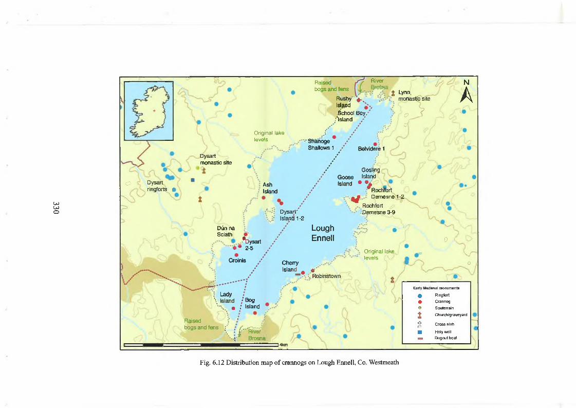
330
Raisedbogs and fens
R ushy' V . Island.School Boy,1
.’“island /
River 0?| Lynn,
monastic site
NA
C>of
3
Original lake levels ■" Sfiahoge
Shallows 1 Belvidere 1Dysart monastic site
Ö ~ Oysartringforts •
AshIsland
Island • • »® I
Dysart* Island 1 -2
Gosling Goose Island
Atochfort Of- Demesne 1-2
Rochfort Demesne 3-9
Dim naSciath
■*Dysart• • 2-5
Croinis
LoughEn n e ll
CherryIsland # e '
Robinstown
0 (
Original lake levels s /
o
: Lady\ Island / Bog
m ; Island
Raisedbogs and fens \ j /"''River
' - 4* Brosna] 4km
Early Mod io vai monuments
• Ringfort
• Crannog® Souterrain
1 Church/graveyard
S Cross slab
■ Holy well
— Dugout boat
Fig. 6.12 Distribution map of crannogs on Lough Ennell, Co. Westmeath

There is a low, stone kerb on 4 (15 per cent) sites. One crannog (Croinis) is enclosed
within an inner and an outer wooden palisade, while one crannog (Goose Island) is partly
enclosed on its outer side by an outer palisade. Interestingly th en , most (20 sites, 74 per
cent) o f the crannogs have no visible enclosing feature, perhaps suggesting that the
water line was the real boundary. On the other hand, its is likely that excavation would
reveal a much higher proportion o f palisades.
The distance o f the crannogs from the original shoreline can be difficult to assess, due to
m odem drainage projects and consequent alteration o f lake levels. During my surveys,
these distances were measured to the apparent original lake level marked by a scarp on
the shoreline. The crannogs were located at a range o f distances from the shore, ranging
from 10m to 250m. In terms o f a statistical analysis, there is a small cluster o f 6 (22 per
cent) sites located at 50-60m distance from the shore. Interestingly, there are 7
crannogs built at a substantial distance out into the water, between 200-260m. All o f
these crannogs are highly visible from large distances across the lake, so it seems likely
that they were constructed there to maximise the site’s visibility from a longer stretch
o f shoreline. Although the crannogs are found in a fairly wide range o f water depths, 17
sites (62 per cent) were in ‘very shallow’ (i.e. 0-50cm) or ‘shallow’ (50cm-1.0m) water.
Crannogs found in deeper water include Goose Island (2.2m), Nure (2.5m), Ash Island
(2.5m) and Dysart Island 2 (2.5m), Dysart Island 1 (5m). The early medieval royal
crannog at Croinis was built in water depths o f at least 3m.
It is worth looking in more detail at the forms and morphology o f some o f these
crannogs. There are 7 (26 per cent) high cairns (Croinis, Dysart Island 1, Ash Island,
School Boy Island, Goose Island, Nure, Cherry Island). These are typically large circular
or oval mounds o f boulders, stones and timber, 18-50m in diameter, 2-5m in height. At
least two o f these cairns (Croinis, Goose Island) are enclosed within a wooden palisade.
Most o f these are probably early medieval in date, as several have produced early
medieval objects. For example, Croinis has produced early medieval bronze pins, Ash
Island has produced an early medieval iron sword, pommel, spearhead, two ringed-pins, a
bronze ring, and a stone lamp, while School Boy Island has produced two early medieval
(i.e. ninth to tenth century) bronze handbells.
The best-known early medieval crannog is Croinis, as already stated, the historically
attested royal site o f Mael Sechnaill maic Domnaill o f the Clann Cholmain o f the
southern Ui Neill, who died on the island in AD 1022. Croinis exhibits all the features
331

that might be expected on an early medieval high-status crannog. It is a massive, oval
cairn (50m diameter, 3-4m in height) o f stone, built in deep water, at some distance
from the shoreline. It is enclosed within a roundwood palisade, 10m from the cairn,
dated to c.AD 850. It is also enclosed at the water line by an inner plank palisade,
dendrochronologically dated to AD 1107 ± 9 years or later. Early medieval finds,
including eleventh to twelfth-century bronze pins were found on the crannog’s surface.
The crannog is also situated within an early medieval settlement complex. There is a
low-caim crannog nearby (Dysart 2), while there are also several low-caim crannogs and
platforms further to the north along the shoreline (Dysart 3-5). There is also an
impressive raised ringfort on the neighbouring dryland, defined by a high level platform,
surrounded on its north side by a deep ditch and low external bank. Situated on a local
prominence, this ringfort provides excellent views in all directions, but particularly
towards the crannog in the lake below it. This ringfort is probably the site o f Dun na
Sciath (‘fort o f the shields’), also historically attested as a royal residence o f the Clann
Cholmain kings o f the southern Ui Neill.128 Both ringfort and crannog probably
operated as a pair (similar to the ringfort and crannog at Coolure, on Lough
Derravarragh), probably used for royal dwelling, public assemblies and other gatherings.
Other islands and crannogs were probably also used as socially high-status sites. Directly
across the lake from Croinis and Dun na Sciath, there is a natural island known today as
Cherry Island (Robinstown townland), about 60m from the original shoreline. On the
highest part o f the island, there is a substantial stone cashel, circular in plan (36m diam,
2m in height), with a stepped stone-built rampart. At the north side o f the island is an
unusual boat dock, defined by a large rectangular pool that cuts into the island. There are
also early medieval finds from this site, including Viking hack silver, while a Viking
hoard o f ingots was also found on the dryland at Carrick. This may be the site known as
Inis na Cairrge, mentioned in the twelfth-century Life o f Colmain Maic Luachain and
apparently used as a stronghold and residence o f the kings o f Fir Tulach.129
128 By the early nineteenth century, the early medieval role of the crannog of Croinis had been ‘forgotten’ locally, and the site was merely named ‘Cormorant Island’ on a lake that was now known as ‘Belvidere Lake’. John O’Donovan’s placename research re-established its significance and it is locally known today as ‘Malachy’s Island’. The site was briefly ‘explored’ by Macalister, who, discouraged by his discovery of a ‘folly’ (in reality, the base of a late medieval towerhouse), abandoned his excavations. It was also recorded by the Crannog Archaeological Project (CAP) in the 1980s; James Woods, Annals o f Westmeath: Ancient and modem (Dublin, 1907), pp 66-7; MacAlister, ‘On an excavation conducted on Cro-Inis, LochEnnelP, pp 248-51; Farrell, ‘The Crannog Archaeological Project (CAP): Archaeological field research in the lakes of the west midlands’; Kelly ‘Observations on Irish lake dwellings’, p. 89.129 Meyer, Betha Colmain maic Luachain § 50.
332
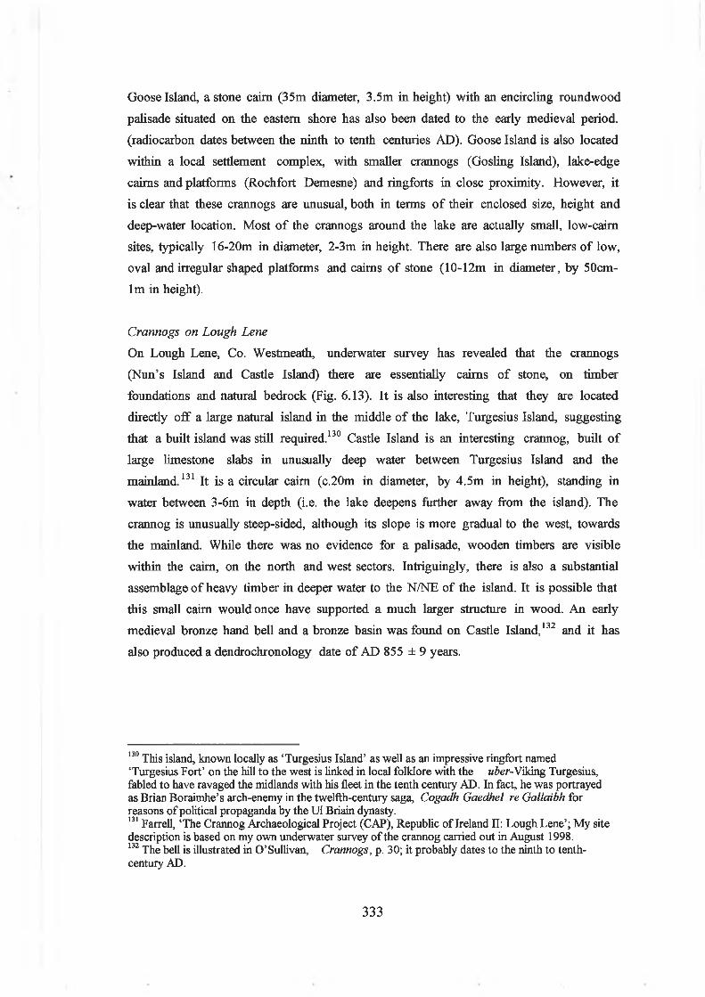
Goose Island, a stone cairn (35m diameter, 3.5m in height) with an encircling roundwood
palisade situated on the eastern shore has also been dated to the early medieval period,
(radiocarbon dates between the ninth to tenth centuries AD). Goose Island is also located
within a local settlement complex, with smaller crannogs (Gosling Island), lake-edge
cairns and platforms (Rochfort Demesne) and ringforts in close proximity. However, it
is clear that these crannogs are unusual, both in terms o f their enclosed size, height and
deep-water location. Most o f the crannogs around the lake are actually small, low-caim
sites, typically 16-20m in diameter, 2-3m in height. There are also large numbers o f low,
oval and irregular shaped platforms and cairns o f stone (10-12m in diameter, by 50cm-
lm in height).
Crannogs on Lough Lene
On Lough Lene, Co. Westmeath, underwater survey has revealed that the crannogs
(Nun’s Island and Castle Island) there are essentially cairns o f stone, on timber
foundations and natural bedrock (Fig. 6.13). It is also interesting that they are located
directly o ff a large natural island in the middle o f the lake, Turgesius Island, suggesting
that a built island was still required.130 Castle Island is an interesting crannog, built o f
large limestone slabs in unusually deep water between Turgesius Island and the
mainland.131 It is a circular cairn (c.20m in diameter, by 4.5m in height), standing in
water between 3-6m in depth (i.e. the lake deepens further away from the island). The
crannog is unusually steep-sided, although its slope is more gradual to the west, towards
the mainland. While there was no evidence for a palisade, wooden timbers are visible
within the caim, on the north and west sectors. Intriguingly, there is also a substantial
assemblage o f heavy timber in deeper water to the N/NE o f the island. It is possible that
this small caim would once have supported a much larger structure in wood. An early
medieval bronze hand bell and a bronze basin was found on Castle Island,132 and it has
also produced a dendrochronology date o f AD 855 ± 9 years.
130 This island, known locally as ‘Turgesius Island’ as well as an impressive ringfort named ‘Turgesius Fort’ on the hill to the west is linked in local folklore with the uber-Viking Turgesius, fabled to have ravaged the midlands with his fleet in the tenth century AD. In fact, he was portrayed as Brian Boraimhe’s arch-enemy in the twelfth-century saga, Cogadh Gaedhel re Gallaibh for reasons of political propaganda by the Ui Briain dynasty.131 Farrell, ‘The Crannog Archaeological Project (CAP), Republic of Ireland II: Lough Lene’; My site description is based on my own underwater survey of the crannog carried out in August 1998.132 The bell is illustrated in O’Sullivan, Crannogs, p. 30; it probably dates to the ninth to tenth- century AD.
333

Fig. 6.13 View of Lough Lene, Co. Westmeath from north. There are two natural islands, Turgesius Island and Nun’s Island. The small islet to the west (towards distant shore) is Castle Island, a rocky cairn crannog dendrochronologically dated to the ninth century AD that has produced ecclesiastical metalwork (a bronze basin and hand-bell) and may have been a ‘church crannog’.
Comparing Westmeath’s crannogs with sites in other regions, Ulster and Connacht
It is possible to briefly compare the morphology, size and architectural features o f the
Westmeath crannogs with other regions. In Ulster, archaeological surveys in Monaghan,
Down, Fermanagh, Donegal and Cavan provide some useful comparative information on
cairn composition, size and form. In Monaghan, crannogs are also predominantly
circular or oval cairns or platforms. 133 Most (i.e. 49 sites, 66 per cent) crannogs were
built as cairns o f boulders, stones and pebbles, although there were also several mounds o f
ash, charcoal, earth and wood (15 sites, 20 per cent). They range widely in size, with
diameter/lengths o f 5-46m. However, despite this variation, 43 (58 per cent) o f the sites
measure between 10-20m in diameter. There is some archaeological evidence that these
small to medium-sized cairns date to the Late Bronze Age and the early medieval period.
For example, a small, circular cairn (14m diameter) at Drummond Otra (Loughnaglack)
and a slightly larger circular cairn (25m diameter) at Monaltydufif (Monaltyduff Lough)
have both produced a Late Bronze Age hoard, as well as classic early medieval pins and
too ls.134 Monaghan also has the larger crannogs, with 15 (20 per cent) sites measuring
133 Brindley, Monaghan, has little information on crannog dimensions, making if difficult to quantify the percentages of low platforms, low-caims and high-caims.14 Lucas, ‘National Museum of Ireland: Archaeological acquisitions in the year 1965’ in R.S.A.I. Jn,
334

20-40m in diameter, these probably being early medieval or late medieval in date. They
includes the large, circular crannog (46m NS, 41m EW in diameter) on Lough Ooney,
situated close to the shore, a probable early medieval royal site.135
In Cavan, crannogs are either mounds o f timber, stone and earth (34 per cent), or cairns
o f stone (26 per cen t).136 The mounds were constructed o f layers o f ash, sand, gravel,
deposited on foundations o f twigs, small branches, and larger beams and logs
(occasionally arranged in criss-cross or radial patterns, with the gaps infilled with sands
and clay). The cairns o f stone were usually placed on similar basal deposits o f organic
materials. They tend to be circular (64 sites, 45 per cent), oval (20 sites, 14 per cent) or
sub-circular (5 sites, 3 per cent), although irregular (10 sites, 7 per cent), rectangular (13
sites, 9 per cent) or even triangular (4 sites, 3 per cent) islands are known. They ranged
widely in size, with diameter/lengths between 5-45m ,137 although as many as 90 (81 per
cent) o f the sites measured were between 10-30m in diameter, by 1-1.5m in height. In
general, the Cavan crannogs tend to be small to medium-sized cairns and platforms.
However, there are also a smaller number o f much larger sites, with 9 (8 per cent) sites
(measuring between 30-40m diameter, by 1.5-3m in height. In Donegal, crannogs are
also predominantly small, low cairns and islets o f stone.138 They tend to be constructed
on natural shoals, bedrock reefs and o ff peninsulas. They range in size between 9-29m in
diameter, by l-2m in height. In plan, they are either circular (23 per cent), or oval (23
per cent), although irregular or elongated islets are also known. The largest is a crannog
at Carrickrory, on Lough Ultan, a large oval cairn (29 x 15m), enclosed by a stone kerb
on its NNW side.
Palisades, revetments, kerbs and walls in Westmeath: enclosing and excludingIntroduction
In the early medieval settlement landscape, the enclosing elements o f dwelling sites (e.g.
the ditches and banks o f ringforts, the walls o f upland enclosures, or the vallum o f
pp 93-159.Lough Oony is referred to on three occasions in the Annals o f Ulster (i.e A.U. 719.8,851.6,
1025.5). In A. U. 851.6, the entry reads ‘Cairell son ofRuaidri, king of Loch Uaithne was deceitfully killed by the Conaille of Femmag before the oratory of Tigemach in Cluain Eois’; Charles-Edwards, Early Christian Ireland, p. 151, suggests that the seat of kingship of the Ui Nad Sluaig kings of Femmag in the ninth century was on Loch Uaithne (Lough Oony) although he was unable to identify the site. In fact, it is highly likely that the early medieval royal seat was the larger of the two crannogs identified on this lake, see Brindley, Monaghan, p. 16, site no. 129.136 O’Donovan, Cavan, pp 175-90; This survey, unfortunately, didn’t involve many site visits, so assessing morphological features of crannogs is difficult.137 O’Donovan, Cavan, pp 175-90, also includes six narrow islands on Lough Ramor measuring 70- 100m in length. These are most probably natural islands, albeit some are obviously enhanced.
335

monastic enclosures) were structural features o f unusual social and symbolic
significance.139 These banks and ditches, palisades or walls physically demarcated a
private space or an internal area to which access could be controlled or denied. They also
served to exclude outsiders and often seemed to have been a means o f defining social
groups, both in terms o f social status (nobles and wealthy households), kinship (defining
family homesteads) or social role (i.e. clerics within monastic enclosures).
Recent archaeological surveys o f crannogs in Westmeath indicate the use o f various
different enclosing features. In fact, a detailed analysis also reveals a surprising diversity
in the form o f enclosing elements constructed on crannogs used in the early medieval
period elsewhere, in the north midlands, south Ulster, east (i.e. Meath) and Connacht.
On some sites, there is little visible sign o f a built enclosing feature and it is possible that
the physical boundary between land and water, the waterline, sufficed to demarcate and
define the island’s edge. Otherwise, a common enclosing element is the inner wooden
palisade (o f planks, stakes or roundwood posts) situated immediately around the cairn’s
edge. This palisade may have served as a simple low revetment (if driven to only
shallow depths o f 50cm to lm into the deposits so that they could not have stood high
above the cairn edge) or as a high enclosing fence o f post-and-wattle or planks (if set
deeply in the ground up to 2-3m down, thus potentially standing to a potential height
6m). The posts in these palisades can be closely spaced or widely spaced, presenting quite
different views to the observer. Another form o f inner retaining feature can also be a
low stone kerb o f heavy boulders laid around the cairn edge at the water-line. There are
also enclosing features that present a more substantial image to the outside viewer. They
can include a large stone-built wall or cashel around the edge o f the site, often standing
several metres in height. Other enclosing features appear to have no structural role, but
were intended to present a ‘wall’ out in the water. Outer wooden palisades, usually o f
roundwood posts, can be constructed out in the water surrounding the island, often at a
distance o f 10-15 metres from the edge o f the cairn. On some crannogs, a similar stone
‘breakwater’ can be identified in the shallows around the island.
Westmeath
138 Brian Lacey, Archaeological survey o f County Donegal (Lifford, 1983), pp 104-7.139 Charles Doherty, ‘The monastic town in early medieval Ireland’ in H.B. Clarke and A. Simms (eds.), The comparative history o f uban origins in non-Roman Europe (Oxford, 1985), pp 45-75; Michael Herity, ‘The building and layout of early Irish monasteries before the year 1000’ in Monastic Studies, 14 (1983), pp 274-84; Cathy Swift, ‘Forts and fields: a study o f ‘monastic towns’ in seventh and eighth century Ireland’ in J. Ir. Archaeol, 9 (1998), pp 105-26.
336

In the north midlands, in Westmeath, o f the 64 sites recorded in this study, 31 (48.4 per
cent) crannogs are enclosed within some type o f bounding feature, including stone kerbs,
inner wooden palisades, and occasionally by outer wooden palisades (see above). On
Lough Derravarragh, Co. Westmeath, o f the 18 crannogs recorded by this author (see
Appendix 2), 5 (28 per cent) have a visible enclosing feature.
Wooden palisades, typically taking the form o f a circle o f vertical wooden posts situated
at the cairn’s edge, are fairly common and have been found at the early medieval
crannogs o f Croinis, Coolure Demesne 1, Johnstown, Dryderstown, Clonickilvant,
Twyford, Ballindeny No. 1, Knockaville and Newtownlow. On these sites, there are 2-3
rows o f these posts, planks and piles, suggesting either a multiple palisade or (more
probably) multi-period activity. It is likely that some palisades are evidence for the
reconstruction o f a earlier, rotting wooden fence. These vertical posts served both to
retain the cairn, and perhaps as a high fence around its edge. It is also true that these
palisades are not always continuous or uniform in appearance around a site, but
frequently change in character depending what sector o f the site they are on. At
Newtownlow, the wooden palisade on the east side o f the site is a double row o f planks
with horizontal timbers lying beside them, while on the west side there is an irregular
post and plank palisade dated to the tenth century AD. On Lough Derravarragh, there
are only two crannogs with a visible wooden palisade. At Coolure Demesne 1, this is a
double (or inner and outer) post and plank revetment around the edge o f the cairn.
Although some o f these planks have collapsed outwards with the weight o f the stone,
many are still upright, presenting their flat sides to the lake. Viewed from the lake (the
planks are not present on the shore-side o f the crannog), they would have given the
island an impressive wooden-walled facade.
It has been already been noted that some early medieval crannogs in the north midlands
have an enigmatic ‘outer palisade’, situated 10-15m out into the water.140 These outer
palisades are usually constructed o f closely spaced, roundwood posts, driven into the
lakebed offshore o f the island, but separated from it by distances o f between 10-20m.
They create an enclosing, horseshoe shaped arc, curving contiguously around the island.
They are always situated on the lakeward side o f the crannog, with the open gap o f the
‘horse-shoe’ facing towards the shoreline and the land. Intriguingly, they enclose only
water (rather than land), and they often stand in 2-3m o f water today.
140 This type of outer palisade on early medieval crannogs was first identified and discussed by E.
337

In Westmeath, these outer palisades have been recorded on early medieval crannogs at
Croinis and Goose Island (on Lough Ennell), where they have been dated to the mid
ninth century AD. An outer palisade was also found on the crannog at Toneymore
North, Lough Kinale, Co. Longford.141 This early medieval crannog (it has
dendrochronological dates o f AD 818 and 1183) was a pear-shaped cairn (c.36m x 26m)
o f stone (sandstone and silt stones) and timber built on the end o f shoal in the lake. The
crannog had probably been first occupied in the sixth century, while there was clearly
also activity in the eighth century, and in the ninth to twelfth century.
Dendrochronological dating indicated that there was some building activity on the island
at AD 1107 ± 9 years or later.142 Its uppermost occupation layer was constructed o f
small angular stones and larger stones laid on a framework o f large timbers, retained
within an inner oak plank palisade (in the eastern sector, there were indications o f an
earlier palisade phase deep in the mud). There was evidence for repair in the southern
sector, where brushwood had been laid down at a place where the palisade had buckled
outwards. There was also extensive deposits o f brushwood and wattle on the lakebed
(which was soft and mucky) at the southwestern sector. The crannog also had an outer
roundwood palisade (10m offshore) enclosing it, though again this had a gap towards the
shore. Interestingly, it is possible that the early medieval Ballinderry crannog No. 2. Co.
Offaly also had an outer palisade.143
These outer palisades could be interpreted in several ways. They may have been practical
in intent, wooden breakwaters designed to prevent stormy waves from crashing against
the sides o f the crannog (although the inner revetment and stones would already achieve
some protection). It is also possible that they are a militarily defensive fortification,
preventing attackers from landing on the island by boat, and forcing them to come
around from the landward side. However, as well as achieving these aims, they also do
something else. On early medieval ringforts, multivallation (i.e the use o f several
concentric banks and ditches) appears to have been socially significant. However, it was
Kelly ‘Observations on Irish crannogs’.141 The early medieval crannog at Tonymore North, Co. Longford has produced such finds as a sixth- century bronze metal frame, as well as six pins of ninth to twelfth century date. This collection included a ringed pin, a crutch-headed pin, a globular-headed stick pin, as well as the shafts of two further pins. Other early medieval finds included a leaf-shaped iron spearhead, a perforated L shaped piece of bronze, and a tinned bronze binding strip. The most notable find was an eighth-century bookshrine. Finds during the CAP survey included a wooden cask head, an iron plough coulter and a iron plough share and a twelfth century disc-headed stick pin.142 Farrell, et al ‘The Crannog Archaeological project (CAP), Republic of Ireland I’, pp. 129-135;Kelly ‘Observations on Irish lake dwellings’, p. 89; Dave Brown, pers. comm.143 Hencken, ‘Ballinderry crannrig no. 2’; Eamonn Kelly pers. comm. It is interesting that the massive dug-out boat found at the south edge of the crannog could more easily have floated there, and
338

the scale and size o f their ramparts that signified status, as multivallate ringforts rarely
have a larger internal enclosed space than the average ringfort.
Thence, for example, a king was expected in early Irish law to produce a sufficient
labour force to build impressive concentric banks and ditches on his rath or d u n . The
eighth-century law text, Crith Gablach states that ‘it is then that he is a king, when
labour-dues o f base clients surround him ’ and goes on to define this labour due as a
measured portion o f the rampart and ditch. Thence, it is clear that it was the labour
expended and the significance o f the building event itself that signified status.144 On
early medieval crannogs, the inner and outer palisades, and the narrow (but deep)
stretches o f water they enclosed, may also have fulfilled a social and ideological role,
marking noble status through a multiplicity o f boundaries.
Other enclosing features on Westmeath crannogs include stone walls or kerbs (often
found along with other palisades and revetments). On Lough Derravarragh, Co.
Westmeath, o f the eighteen crannogs recorded by this author (see Appendix 2), 5 (28
per cent) have a visible enclosing feature. On 3 o f these crannogs (Kiltoom 5-7), this is
a low, kerb ( lm width, 50cm in height) running around the edge o f the cairn, constructed
o f large, heavy boulders. These large stones used in the kerb contrast greatly with the
small size o f the stone and cobbles found elsewhere in these cairns, confirming that these
are deliberate constructions. Stone kerbs are also found on two small early medieval
crannogs at Cullenhugh (Lough Iron), and also along parts o f the islands o f N un’s Island,
Derrynagarragh and Kilrush Lower.
These stone kerbs are intriguing. Although the heavy stones at the water’s edge could
have protected the crannog’s inhabitants from storms and waves, they also achieve by
sleight o f hand an interesting architectural trick o f the eye. When these small crannogs
are viewed from further inland, they appear to be low-lying, stony platforms defined at
their edges by small stones. In total contrast, when viewed from a boat out on the lake,
their stone kerbs give them the appearance o f massively built rocky islets. They may
therefore be deliberate architectural features designed to enhance the perception o f these
islands, depending on the location o f the viewer. People moving down the lake by boat
from the early medieval crannog at Coolure would have seen these islets and may have
been misled as to their actual size.
thence may be ‘inside’ a wooden dock created by the outer palisade.144 Binchy (ed), Crith Gablach, 45,1. 566-72; MacNeill, ‘Ancient Irish law’, p. 305; Stout, The Irish ringfort p. 113; Charles-Edwards, Early Christian Ireland, p. 150.
339

Ulster
In Ulster, archaeological surveys in Monaghan, Down, Fermanagh, Donegal and Cavan
reveal the use o f stone kerbs, wooden revetments, palisades and stone walls. In
Monaghan, 18 sites (24 per cent) had some visible enclosing feature.145 A stone kerb was
identified on 8 (11 per cent) sites. Wooden piles around the cairn edges were identified
on 14 (19 per cent) sites. A definite wooden palisade o f oak planks was seen on only 3
(4 per cent) sites. Interestingly, some crannogs (e.g. Coaghen, Corloughroe, Kilcorran)
had both a stone kerb and wooden piles at the cairn’s edge, and these were often only
visible on part o f the site. There were also a small number o f crannogs that had both the
inner and outer wooden palisade. At Mullatishaughlin, on Hollywood Lake, Co.
Monaghan, a circular mound o f clay, brushwood and stone was enclosed within a double
ring o f upright piles.146 In Cavan, 30 sites (21 per cent) had a visible enclosing
feature.147 Stone kerbs are identifiable on 8 (6 per cent) sites and a stone wall on 1 site.
Wooden piles at the cairn edge were identified on 18 (13 per cent) sites. A plank
palisade was recorded on only 3 (2 per cent) crannogs. At one o f these, at Killyvally, on
Lough Oughter, Co. Cavan, a substantial cairn (27.4m diam., 2.4m ht.) constructed at
the end o f a granite outcrop was enclosed within a double ring o f close-set piles. The
outer palisade was between 14-18 m from the cairn.148 In Donegal, 6 (35 per cent)
crannogs had a visible enclosing feature.149 Reflecting the common construction o f
cashels on islands and rock-outcrops across the west, 2 (12 per cent) were stone kerbs,
while on 4 (24 per cent) sites it was a low stone wall, occasionally confined to one part
o f the island.
Connacht
In Connacht, archaeological surveys in Galway, Mayo and Sligo also seem to indicate
that the use o f stone in crannog building strongly influenced the choice o f enclosing
feature. There are at least 266 crannogs in Mayo, but few regional surveys have been
published.150 In south Mayo, (on Carrownacon Lough, Lough Carra, Lough Corrib and
Lough Mask) crannogs were retained within stone revetments (3 sites), wooden piles (4
sites) and breakwaters (3 sites). At Carrownacon, a crannog had all three features - a
145 Brindley, Monaghan, pp 13-17.1,6 Brindley, Monaghan, p. 16.147 O’Donovan, Cavan, pp 175-90.148 O’Donovan, Cavern, p. 187.149 Lacey, Donegal, pp 104-7.150 M. Gibbons, O. Alcock, T. Condit and M. Tunney, ‘Some observations on the sites and monuments record of County Mayo’ in Cathair naMart, 11, no. 1 (1991), pp 1-19.
340

stone revetment, piles at the east and southwest sides as well as three timber planks.
Some crannogs also had a stone breakwater further out in the water, usually on the
lakeward side o f the island.151 Also in south Mayo, recent surveys o f six crannogs on
Levallinree Lough indicate that 3 (50 per cent) are enclosed by a wooden pile palisade. A
particularly impressive early medieval crannog (dendrochronologically dated to AD 609-
610) was enclosed within a double palisade o f split oak posts driven into the silty
lakebed.152 In west Galway, o f the 23 crannogs or lake dwellings surveyed,153 17 (74 per
cent) have a recognisable enclosing feature. 11 (48 per cent) sites are essentially island
cashels, with an enclosing dry-stone wall such as at Lough na Scannive, where there are
at least three forts on small islets.154 Similar island cashels are also found on Lough
Carra, Co. M ayo155 and on Lough Cullen, Co. M ayo.156 On 5 (22 per cent) sites the
enclosing feature was a low kerb o f boulders, occasionally serving as a stone revetment at
the edge o f the island. Only on one crannog, at Gortacamaun, on Lough Naneevin, was a
wooden palisade definitely identified.157 In north Galway, stone walls, kerbs and wooden
palisades also appear to be rare if non-existant. 158 In south Galway, archaeological
excavations and surveys o f 13 crannogs on Loughrea also indicate a diversity o f
enclosing elem ents.159
Interpreting palisades and walls
Traditionally, it has been thought that the defining characteristic o f the crannog is the
vertical wooden palisade, built to retain the body o f the cairn or to serve as a defensive
stockade. Certainly, on some o f the well-known early medieval sites, wooden palisades
were amongst the most striking features uncovered in excavations (Fig. 6.14). At
Ballinderry crannog No. 1, an impressive post palisade enclosed the site, and was
replaced by an oak pile palisade (up to 30cm in diameter). At Lagore, there was certainly
a sequence o f palisades o f piles, posts and planks constructed across time.
151 Lavelle, Ballinrobe and district, pp. 47-8.152 This crannog was possibly an early medieval royal or high-status crannog, and has also produced iron tools and four dug-out boats; C. Lawless, R. O’Floinn, M. Baillie and D. Brown, ‘Levallinree crannog’ in Cathair na Mart, 9 (1989), pp 21-5.153 Gosling, West Galway, pp 32-36.154 Layard, ‘Fortified stone lake-dwellings on islands in Lough Skannive’, pp 373-8.155 Lavelle, Ballinrobe and district. pp. 47-8.156 Layard ‘On a fortified stone lake-dwelling on an island in Lough Cullen’, pp 32-4.157 In the 1860s, Kinahan excavated this oval shaped cairn of brushwood, earth and stone and showed that it was retained within a roundwood palisade; Kinahan, ‘Notes on a crannoge in Lough Naneevin’,PI-31'3-
Alcock, et al, North Galway, pp. 29-32; relatively little information is included in this survey on cairn edges.159 Kinahan, ‘On crannoges in Lough Rea’, pp 412-27 ; Kevin McDonald, The lake dwellings of Ireland with specific reference to Loughrea, Co. Galway. Unpublished BA dissertation, NUI Galway. (Galway, n.d.).
341

Fig. 6.14 Early medieval palisade on Ballinderry crannogNo. 2, Co. Offaly. In Westmeath, crannogs have a range of enclosing features and boundaries, including inner and outer palisades, kerbs and stone walls. It is probable that all of these were socially significant, physically and symbolically demarcating it and defining the island space occupied by the social group.
At Moynagh Lough, there is also a sequence of at least two post and plank palisades in the seventh and eighth century. On occasion, the palisade may have been intended to convey an ability to use high-status timber, particularly oak timber. At the early medieval crannog of Rathtinaun, Co. Sligo, the Period IV crannog mound (probably
dated to the seventh century AD) was enclosed by a stout revetment o f horizontal logs, held in position by two rows of squared oak posts running along the eastern side o f the crannog (facing the land). Interestingly, this solid revetment was not used on the western
side, where only oak roundwood piles were driven into the marls. In other words, the strongest defences faced towards the land, presenting a visually impressive palisade
towards the shoreline.
It is even possible that such palisades were coloured or stained (with lime-wash or white clay) to enhance their visibility. In the early medieval tale, Echtra Thaidg mheic Chein, there is a description of a probable ecclesiastical crannog on a lake in a fantastic island, where the crannog’s palisade itself was a key distinguishing feature that also prevented
people from observing the interior.
‘This island’s name, what is it?’ ‘Thou askest that thou knowest already’. ‘But’, said Teigue, ‘I know not whether it be the same tale with thee and with her whom previously we have addressed.’ ‘The same verily,’ she said: ‘inis derglocha or ‘red loch island’ is this one’s name; because of a red loch that is in it, containing an island surrounded by a palisade of gold, its name being Inis Patmos, in which all saints and righteous that have served God. These latter, men’s eyes never have beheld, for between radiance of the divinity and the constant discourse which God
342

and the Angels hold with them, our vision may not dwell or impinge uponthem’.160
However, the archaeological surveys discussed above also reveal that such wooden
palisades may be quite unusual, perhaps even fairly rare. This does not always signify
social status, as both high-status and low-status sites have these palisades. While it is
likely that the use o f heavy oak planks or trunks in a palisade (the piles in Ballinderry
no. 2 were up to 30cm diameter) appears to be limited to early medieval high-status or
even ‘royal’ crannogs, wooden palisades are also known from small sites such as
Craigywarren, Bofeenaun and Sroove.
The use o f stone kerbs and even walls also indicates that other boundary features were
used on early medieval crannogs, occasionally in an ingenious way to manipulate how an
island was perceived and experienced by outsiders. The small early medieval crannogs at
Kiltoom were bounded by a ‘chain’ or kerbed revetment o f stone, with only small stones
on the landward side and a heavy boulder kerb on the watery side. The discovery that
stone kerbs vary in appearance around the edge o f an island also recalls the fact that
many wooden palisades on crannogs are also discontinuous around their perimeter in
size, construction and raw materials, presenting different views and images depending
from what angle they are viewed. The use o f stone walls also raises the question o f the
academic distinction in classification between crannogs and island cashels. There is at
least one early medieval island cashel in Westmeath, the fortification on Cherry Island,
in Lough Ennell, known in early medieval sources as Inis na Cairrge and associated with
the kings o f Fir Tulach. This is not generally thought o f as a crannog, but to the early
medieval Irish, it was a fortress on an island in a lake.
It is now also clear that from these archaeological surveys that many crannogs may have
been bounded by other, less tangible or invisible features, such as the water itself. It has
already been suggested that islands were seen in the early medieval imagination as
distinct bounded spaces, defined at their edges by a physical or mental edge or boundary.
This edge was often crucially important in protecting the island’s inhabitants from
physical or spiritual danger, or retaining within the island, those monsters or
communities that it would be preferable to avoid. However, it in interesting that in the
early medieval literature, the physical character o f the this boundary could be quite
variable, at its most elemental level including the natural edge provided by a cliff, beach
160 Standish O’Grady, Silva Gadelica (I-XXXI) (2 vols. London, 1892), vol. 1, p. 391
343

Fig. 6.15 This small, low-caim crannog at Derrya 1, Lough Derravarragh is accessed by a narrow causeway of stones. This pathway does not come out from the closest shoreline, but instead appears to deliberately lead a person to it from a more distant part of the shoreline, thus providing him with a constant view of the nearby early medieval royal crannog at Coolure Demesne 1 across the water.
or even the water-line itself. On those crannogs where a palisade or wall is not evident,
customary practice and an awareness o f space may have sufficed to ‘edge the island’.
Causeways and pathways in Westmeath: journeying and arrivingWestmeath
Causeways, landing stages, jetties and harbours, are all features on crannogs that
essentially facilitated, while they simultaneously regulated, access to the site. In
Westmeath, causeways are occasional although not frequent on its crannogs (although
many undoubtedly have them submerged underwater). At Cullenhugh, on Lough Iron,
two small, low-caim crannogs are attached together by a stone causeway. At N un’s
Island, on Lough Lene, a substantial stone causeway runs southwards from the island
towards the large natural island o f Turgesius Island, although this may be a natural shoal.
A small, low-mound crannog at Culleenbeg is attached to the shoreline by an apparent
causeway, 18m in length.
On Lough Derravarragh, Co. Westmeath, causeways can be identified on eight (44 per
cent) sites, mostly in Kiltoom townland at the northeast shore o f the lake. At Kiltoom
6, 7, 8, these were all short, narrow pathways (8-12m in length, by 50cm -lm in width),
344

constructed in quite shallow water (50cm -lm ), usually built o f a double row o f flat,
limestone slabs. Although they tend to approach crannogs more or less directly, a few
tend to come at a particular angle, not necessarily taking the shortest route out from the
shoreline. At Derrya 1, a small low-caim crannog is not attached to the nearest part o f
the shoreline (9m to north), as the stone causeway runs o ff to the northwest, altering
direction as it goes, before it hits the shoreline at 18m distance (Fig. 6.15). A t Donore 1,
a small high-caim crannog was apparently (and strangely) connected to the distant,
northwest shore o f the lake by a wooden ‘causeway’ o f posts. This may well have been a
barrier to river traffic on the River Inny, in the manner o f an early medieval ship barrier
(Fig. 6.16). There are other natural islets around this shoreline that are also attached to
the drylands by small stone causeways, effectively making them crannogs. At Kiltoom
10, there is a large, wide causeway o f stones tha t may well be based over a natural,
bedrock ridge. A Late Bronze Age sword was found beside this causeway, raising the
possibility that the feature is prehistoric. Interestingly, causeways are rare on the
crannogs o f Lough Ennell, where only two (7 per cent) crannogs appear to be linked to
the shore by broad, possibly even natural ridges. It is possible that this is due to the fact
that most o f the lake’s crannogs are well out in the water.
Fig. 6.16 Donore 1 crannog, a high-caim site in shallow water at the boggy northwest end of Lough Derravarragh.The site appears to have been connected to the Clonava Island shoreline by a wooden ‘causeway’ of rows of posts, running for 600m to the northwest. (Source: National Museum of Ireland Top. Files, Derrya, 1968:197).
345

Ulster
In Ulster, a few causeways have been clearly identified. In Donegal, a crannog in
Brockagh Lough had a causeway at the north end o f the islet, leading out towards the
mainland.161 In Cavan, only 2 crannogs had a causeway. This included a small crannog at
Drumheel (Lough Oughter), that was reached from the shoreline by a long (23m in
length), narrow causeway o f small to medium sized stones.152 In Monaghan, they are
also infrequent. However at Annagose, a circular stone cairn was certainly joined directly
to the shoreline by a clearly built causeway 15m in length.163
Connacht
In Connacht, causeways are typically associated with stone-built islets and island cashels.
In north Galway, stone causeways are found on 6 (33 per cent) sites. They occasionally
run out from the shoreline indirectly, or alter direction along their length, before they
connect with the crannog.164 In west Galway, causeways are found on 6 (26 per cent)
sites. At one site, an island cashel at Beaghcauneen on Loch Fada, a 'well-preserved
stone causeway (w. 1.15m) running SW from the island for 21.3m before turning S for
3.7m, connects to the shore’. 165 In south Galway, on Loughrea, causeways were found
on only 2 (15 per cent) sites. In south Mayo, crannogs with causeways are similarly rare.
There are apparently almost none on either Lough Carra166 or on Levallinree Lough,
Co. M ayo.167
Interpreting causeways
These stone and wooden causeways provide an intriguing insight into what people were
attempting to do in regulating access to their islands. A traditional view o f them would
be that they were built to provided a measure o f physical security and defensiveness, by
means o f the way that they enforce a stranger to move by an uncertain and tricky route
to the islet. However, they are also interesting in social and ideological terms. They
reveal how people controlled and regulated access to a site, protecting its inaccessibility
and the ‘social distance’ that they were trying to achieve. At a day to day level, they
161 Lacey, Donegal, p. 104.162 O’Donovan, Cavan p. 184.163 Brindley, Monaghan p. 13, pi. 2163 Alcock, el al North Galway, pp 29-32.165 Gosling, West Galway, p. 33.166 Lavelie, Ballinrobe and district, pp 47-8.167 Lawless et al, ‘Levallinree crannog’, pp 21-5; C. Lawless, ‘Levallinree townland and Lough, an ancient citadel, fulachta fiadh, crannogs, dugout canoes, ringforts, hutsites, St. Patrick’s stone, mill and mill-race and famine gardens’ in Cathair naMart, 16 (1996), pp 17-44; C. Lawless, ‘Turlough,Co. Mayo - a landscape study’ in Kevin Barton and Karen Molloy (eds.), South Central Mayo Field Guide No. 22, Irish Association for Quaternary Studies (Dublin, 1998), pp 20-9.
346

also worked to provide their own inhabitants with access to the crannog, but even here it
is worth thinking about how people’s habitual movements probably lead to these
causeways being built. For example, on Lough Derravarragh, it is possible to show that
they occasionally enforce movem ent towards the crannog from a particular direction
and provide a person with a particular perspective o f the island (and the lake behind).
They may have been oriented to run directly to a gate or even the door o f a house.
Interestingly, however, at Sroove phase 2, the doorway was not opposite the causeway,
but o ff to one side o f the island.168
Inevitably, causeways are most commonly identified beside crannogs constructed in
shallow water or close to the shoreline. Most are quite short, narrow, stone pathways
that simply move across shallow, knee-deep water up to the islet. Some were constructed
o f rows o f wooden posts, perhaps supporting a plank or wattle walkway.169 There are
hints that some causeways were designed to limit access or protect against surprise visits.
They are often slightly lower (i.e. 10cm) than the cairn they approach, so they could
have been submerged under 10-20cm o f water when in use, and thus only partly visible.
Some approach their crannog at a slight tangential angle (i.e. not moving out to it
directly from the most obvious point on the nearest shoreline). Others bend or change
direction slightly somewhere along their length, turning at angles o f up to 45 degrees. A
few are even constructed in a strikingly zigzag fashion, perhaps to baffle and slow the
approach o f a person unfamiliar with its course.170
In deeper water, it can be difficult to distinguish between natural linear shoals (often
marked by reed beds) and deliberately built causeways, particularly if they are submerged
(and crannogs are often constructed on such shoals). However, some crannogs in deep
water are occasionally approached by relatively substantial causeways. At a possible
medieval crannog on Templehouse Lough, Co. Sligo, a massive stone and earthen
causeway twists violently in its approach to the island, while in its size it probably
incorporates more material than the crannog itself.171 Some are evidently early
medieval in date. At the ninth-century crannog at Lough More, Co. Mayo, a causeway
o f vertical stakes, horizontal oak beams and stone flags (pinned into position with
sharpened stakes) crossed a wet, marshy area to the islet. It may even have been
168 Fredengren Crannogs, pp 28-32.169 Wood-Martin, Traces o f the elder faiths, p. 223.170 Raftery, ‘Lake-dwellings in Ireland’, pp. 5-15171 O’Sullivan, The archaeology o f lake settlement, p 161.
347

originally submerged and invisible to view.172 At Sroove, Co. Sligo, an early medieval
crannog was constructed on top o f an earlier stone causeway and this was then used to
provide access to the site.173 The early medieval crannog at Ballynahinch (Lough
Nahinch), Co. Tipperary also had a stone causeway leading to the shore, although this
may have been enhanced in the nineteenth century.174 On other hand, on some
crannogs in Connemara and Donegal, causeways are likely to be late medieval in origins,
while the incidence o f modem duck-hides on many crannogs might indicate that the
causeways were only constructed in the nineteenth or twentieth centuries. However
there is plenty o f evidence to suggest that they are contemporary with the early
medieval use o f these islets.
Landing stages, harbours and jetties in WestmeathIntroduction
It appears that people intended other crannogs to be rather more remote and
inaccessible, as can be seen by their distance from the shoreline, the depth o f water
surrounding them and the lake bottom conditions (i.e. soft muds are more difficult to
walk across than a stony lakebed). In other words, most sites located at a reasonable
distance from the shore, or in deep water that cannot be easily waded through, would
have to been travelled to by boat. The archaeological evidence for boat travel to
crannogs includes the boats themselves, as well as the landing stages, jetties and places
for securing dug-out boats, coracles or plank boats that have also occasionally been
found on crannogs. These landing places are typically simple structures, usually built o f
low stone walls or o f rows o f wooden posts. However, it is possible that more complex
wooden docks and jetties existed, as can be seen on some excavated early medieval
crannogs.
Westmeath
In Westmeath, stone-built and wooden landing places have been identified on several
crannogs. On Goose Island, (Lough Ennell) and Coolure Demesne 1 (Lough
Derravarragh), see Appendix 2), there are small boat ‘nausts’ constructed by creating a
narrow, shallow depression (3-4m in length, 2m in width) on the stony surface. These
‘nausts’ face out into the lake and could have held narrow boats above and back from
damage by the waves at the water’s edge. On a few sites, rather more complex landing
172 Keane, ‘LoughMore, Co. Mayo’, pp 167-82.173 Fredegren, Crannog, pp 223-5; A potentially interesting alternative explanation of this causeway is that it is the remnants of an abandoned early medieval crannog building project.174 Trench and Kinahan, ‘a crannoge in Lough Nahinch’ p. 177; Cahalan and Hyland, ‘Lough Nahinch
348

places were constructed. On Croinis, on Lough Ennell, there is a distinctive, rectangular
stonewalled harbour on the east (lakeward) side o f the island. This is possibly an early
medieval structure, as there are eleventh century timbers and metalwork in the vicinity
and it has been suggested that the surface o f the crannog dates to this period.175 On the
other hand, there is also a strong possibility that it is a late medieval feature related to
the fifteenth century towerhouse on the island, or it may even be a modem fisheries
boat harbour. On Cherry Island, on the opposite side o f the Lough Ennell, Co.
Westmeath, there is a spectacular harbour on the north side o f the island cashel. This
was a rectangular, stone-lined pool (c.lOm length, 6m in width) that could have held
substantial, ocean-going wooden ships rather than small dugouts. At Ballinderry crannog
No. 1, Co. Westmeath, a substantial slipway o f oak planks overlaid by peat and
brushwood was found in the pile palisade at the northwest side o f the site. There was also
a possible boat jetty on the west side o f Moynagh Lough crannog, Co. Meath.
In south Ulster, landing places have been identified on a few sites. In Donegal, 3 (18 per
cent) stone-built crannog cairns have produced landing stages, including two small stone
piers on a crannog at Lackagh (Lough Pound), two stone-built projections on a crannog
at Port (Port Lough) and a ‘stone landing-stage’ (2.5m x 1.9m) at W oodhill (Sessiagh
Lake). In Monaghan, a crannog at Cladowen, on Bishop’s Lough, had a possible jetty o f
wooden piles.176 In Cavan, at Drumkeery Lough, a oval-shaped crannog (40m NS, c.25m
EW) was enclosed within a ‘stockade’ o f birch and oak piles. Its entrance (lined by
vertical oak planks) was apparently to the south, while there was a landing place at the
northeast (a double row o f oak piles), while a dugout lay in the muds beside a second
possible landing place (a narrow ‘dock’ defined by a double post row inside the crannog’s
interior). 177 In Down, a landing stage was identified on a single crannog at
Loughaghery.178
In south Connacht, landing places have been identified on significantly more crannogs
and island cashels. In west Galway, 9 (39 per cent) sites have produced jetties, piers and
crannog’; Farrelly and O’Brien, North Tipperary, p. 53.175 This harbour may be even earlier in date, as it is situated directly opposite a distinct gap in the ninth-century outer palisade. However, its potential twelfth-century date is suggested by the fact the plank palisade at the water’s edge has been dated to c. AD 1100-1125, while eleventh to twelfth- century bronze pins have been recovered from the crannog’s surface; Farrell and Buckley, ‘Loughs Ennell and Analla’, pp 281-285; Kelly, ‘Observations on Irish lake-dwellings’, p. 89, fig. 4.176 Brindley, Monaghan, p. 83.177 Harkness, ‘On a crannoge found in Drumkeery Lough’, pp 483-490; Wood-Martin, lake dwellings, pp 200-1; O’Donovan, Cavan, p. 185.178 Anon. Down, p. 184
349

slipways.179 These are usually built o f stone flags and project outwards from the island,
providing a place for a boat to moor beside. Only at Tully More was there an internal
feature, ‘an artificial creek or port’ opening through the wall o f the stone enclosure on
the island.180 In north Galway, only one site, the late medieval ‘crannog’ o f Lough Park
has yet produced a landing place, a stone-lined jetty (3m in length) on its north side.181
In south Galway, Kinahan’s original, and M cDonald’s more recent, investigations on
Loughrea indicate the presence o f a ‘small harbour or docking area’ (18.5m x 5m)
defined by wooden posts on an early medieval crannog at Shore Island.182 In south
Mayo, ther e seem not to have been any clearly defined landing places on the crannogs
on Lough Carra or Levallinree.183
Dugout boatsWestmeath
In the north midlands, few dugouts have been actually found on crannogs, although they
are well known from lakes in the region (Fig. 6 .17).184 For example, there are at least
four dugout boats on Lough Derravarragh, most o f which probably date to the Middle
Ages. On Lough Derravarragh, they are not particularly close to the lake’s crannogs, but
this is hardly surprising or significant (boats move around). However, archaeological
excavations have also occasionally uncovered dugout boats on early medieval crannogs
in Meath, Westmeath and Offaly, occasionally built into the foundations, such as at
Lagore, Co. M eath185 and Ballinderry crannog No. 2, Co. O ffaly.186 A small piece o f a
dug-out boat was also found in later deposits at Ballinderry crannog No. 1, Co.
Westmeath. 187
Ulster
In Ulster, dugout boats have occasionally been identified on some crannogs during the
county archaeological surveys. In Cavan, four (3 per cent) crannogs (i.e. at Comagall,
Derryvackny, Drumkeery, Tomassan) have produced dug-out boats. At Drumkeery, Co.
Gosling, West Galway, p. 32-5.180 E.W. Lynam, ‘Prehistoric monuments at Rinvyle, Co. Galway’ in R.S.A.I. Jn, 52 (1922), pp 164- 8; Gosling West Galway, p.35.181 Alcock et al, North Galway, p. 31; Lyttleton, ‘Loughpark ‘crannog’ re-visited’, pp 151-83.182 Kinahan, ‘On crannoges in Lough Rea’, pp 412-27 ; McDonald, Loughrea, p. 17.183 Lavelle Ballinrobe and district ; C. Lawless et al, ‘Levallinree crannog’.184 N.T.N. Gregory, ‘A comparative study of Irish and Scottish logboats’. Unpublished PhD thesis. (University of Edinburgh, 1997).185 Hencken, ‘Lagore’, pp 51-2, Fig. 1186 Hencken, ‘Ballinderry crannog No. 2’, pp. 33, 60.187 Hencken, ‘Ballinderry crannog No. 1’, p. 152.
350

Cavan one was found lying beside a landing place at the north-east end o f the island.188
In Down, at least three (10 per cent) crannogs (i.e. Ballylough, Creevylough,
Loughadian) have produced dugout boats.189 An unusually large boat was also found on
the shores o f Loughbrickland, Co. Down southwest o f the large early medieval crannog
on that lake. It was o f a shape and size that suggests it could have carried heavy loads.190
Connacht
In Connacht, dugouts have also been recorded on a few crannog sites. On the shores o f
Lough Gara, in Sligo and Roscommon, at least 17 dugouts were recorded when the lake
was drained. A fine example was excavated on the edge o f the early medieval crannog at
Rathtinaun, Co. Sligo.191 In south Mayo, the early medieval crannog on Levallinree
Lough has four dugout boats lying around its cairn edge, one loaded with stone to keep it
submerged.192 On Lough Carra, only one crannog, potentially abandoned dining
construction, also produced a dugout canoe.193 Although no dugout boats are mentioned
in the north or west Galway county surveys, at least four dugout boats were discovered in
Loughrea, south Galway, particularly during Kinahan’s excavations o f a crannog at
Island McHugo.194
Interpreting the role and usage o f dugout boats
While it is undeniable that most crannogs would have been reached by boat, this is not
always directly reflected in the surviving or visible archaeological evidence. Firstly, just
because people use a boat to travel to an island does not necessarily mean that they will
leave it there. Early Irish saints’ lives and narrative literature also hints that boats were
often left at the m ainland until they were needed.195
O’Donovan, Cavan, p. 189189 Anon., An archaeological survey o f County Down (Belfast, 1966), pp 182-185.190 H.W. Lett, ‘Ancient canoe found near Loughbrickland, Co. Down’, U.J.A., 1 (1895), pp 153-4; Malcolm Fry, Coiti: Logboats from Northern Ireland (Belfast, 2000), p. 71; In A.F.M 832, the crannog of Loughbrickland is mentioned in the entry ‘The plundering of Loch-Bricrenn ( Orgain Locha Bricrenn), against Conghalach, son ofEochaidh [by the foreigners]; and he was taken prisoner and afterwards killed at their ships.’ There is good archaeological and historical evidence that this site was occupied in the early medieval period and again in the sixteenth and seventeenth century.191 O’Sullivan, The archaeology o f lake settlement, pi. 34.192 Lawless etal, ‘Levallinree crannog’, pp 22-3; Fry, Coiti, p. 16, suggests that some dugouts were deliberately submerged to keep them permanently damp and thus prevent their cracking and destruction.193 Lavelle, ‘Ballinrobe and district’, p. 47.194 Wood-Martin, Lake dwellings, p. 228; Kinahan, ‘On crannoges in Lough Rea’, p. 412-27; Early medieval finds from this multi-period site include a sixth-century bucket handle with escutcheon; McDonald, Loughrea, p. 14.195 A dugout boat found on the shoreline opposite a crannog on Dullaghan Lough, Co. Tyrone was apparently moored to timbers and stakes and placed in a prepared anchorage within a dug channel in the lake muds; Fry, Coiti, p. 59; The saints’ lives and narrative literature frequently describe the saint
351

Fig. 6.17 An early medieval dugout boat lying between the inner and outer palisade on the ninth century crannog of Ballinderry No. 2, Co. Offaly. In Westmeath, dugouts have been found around various lakeshores, particularly on Lough Derravarragh, providing both a means of access to crannogs and a way of controlling who could approach them.
Indeed, dugout boats have often been found on shorelines overlooking crannogs in lakes, although clear chronological or functional relation ships between the two can rarely be established. There is also the problem that when dugout boats are lying on the shores of the crannog itself; they may not be identified during a conventional archaeological survey, as they will only be really revealed by underwater inspection or a site excavation. For example, there is a large, probable early medieval crannog on Lough O’Flynn, Co. Roscommon, with an impressive oak plank palisade enclosing a high stone cairn (finds including early medieval tools, pins and whetstones). There is no visible sign o f any water craft, but there are actually as many as five dug-out boats lying at a water depth of about 1.5m on the lakebed around the site.196
Dugout boats in Ireland vary in size and design, and range widely in date from prehistory to the post-medieval period (morphology alone can not be used to date them). Numerous examples have also been dated to the early medieval period.197 In terms of their distribution, most are found on smaller lakes and rivers, generally avoiding stormy lakes and the coast.198 In Northern Ireland, they are also found on some of the larger lakes, such as Lough Eme and Lough Neagh, although they tend to be sunk within small,
or hero as waiting on the shoreline at a ‘port’ or the ‘jetty of the island’ until a boat becomes available.196 Donal Boland, pers. comm.197 Lanting and Brindley, ‘Irish logboats and their European context’, pp 85-95; Fry, Coiti198 Una MacDowell’s study of 275 well-provenanced dugouts from Ireland indicated that 116 (42 per cent) came from small lakes; Una MacDowell, ‘Irish logboats’. Unpublished MA thesis, N.U.I.(Dept, of Archaeology, University College, Dublin, 1983).
352

sheltered bays and inlets. Interestingly, there seems to be little correlat ion between the
size o f the lake and the size o f the boat, as quite complex and impressively large craft
have been found on tiny lakes that have produced crannogs.199 This might hint again
that boats sometimes served as a symbol o f wealth or status.
The use o f boats to gain access on to at least some o f these islands would have been
another means o f manipulating how people perceived them, as well as providing their
inhabitants with a enhanced degree o f ‘social distance’. The use o f a boat also enables
the owner o f a crannog to control the speed, direction and timing o f a stranger’s visit to
an island, much more than on any other habitation site. It is worth remembering that
while we today might have a mental image o f everybody moving about these watery
landscapes by dugoutboat, it is unlikely that everybody in the community had access to
such craft. Irish dugout boats are virtually always carved o f massive oak trunks (o f a
diameter o f at least 1.5m), the most legally valued and protected tree in the early
medieval woodlands, to which access was clearly restricted. Early Irish laws describe
various fines and penalties for felling oak trees, for removing branches or for stripping
off their bark.200 Experimental archaeology has also revealed that carving dugout boats
requires a heavy labour commitment as well as access to the suitable raw materials, and
they may have been out o f the reach o f m ost people.201 In other words, living on an
island almost immediately puts one out o f the reach o f ordinary or poor people. On the
other hand, it is clear that low-status crannogs, typically those in shallow water, were
also intended to provide their inhabitants with a measure o f social distance.
ConclusionsThis chapter has described and interpreted the physical architecture o f early medieval
crannogs, and the social and ideological role o f their cairns, palisades, causeways. It has
also traced how they were built, altered and changed across time, and how people may
have understood the, even after they were abandoned. The next chapter will cross the
boundary o f land and water, go into these sites and investigate the social organisation o f
space within early medieval crannogs.
199 Fry, Coiti, pp. 59, 64, 71, 83, 86, 87, 107, 112, 115200 O’Sullivan, ‘The use of trees and woodland in early medieval Ireland’, pp 674-81.201 A reasonably sized dugout boat (4m in length) hewn from a large oak trunk requires about 2 weeks continuous work by 2-3 skilled people. This labour estimate does not include the time for felling the tree, hauling it out of the woodlands, etc; Damian Goodbum and Mark Redknap, ‘Replicas and wrecks from the Thames area’ in The London Archaeologist, 6, no. 1 (1988), pp 7-22.
353

Chapter 7
Island life: interpreting the social organisation
of space on early medieval crannogs
IntroductionHaving arrived on a crannog in the early Middle Ages, a person would have then gone in
the entrance and seen for the first time, what was going on within. After walking into
the interior o f the island, a man or woman could have seen the various physical features
that its inhabitants used; their houses and dwellings, fences, pathways, fireplaces and
spreads o f charcoal, ash and wood, middens o f bone, dung and rotting materials. These
houses, pathways and fireplaces all helped to define and structure human activity within
the site. They both constrained and enabled what people could and couldn’t do there. But
they were also themselves created by that same human activity, a few days o f
metalworking would leave behind all kinds o f debris (e.g. slags, reddened clay, broken
crucibles), while a few horns o f feasting and carousing would leave a small mound o f
bones and waste. All o f these traces testified to the past use o f the site, its history, as
well as the future needs and intentions o f the people living there.
Obviously, a person walking into the crannog in the early Middle Ages brought with him
or her an understanding and awareness o f what was going on that it is utterly impossible
for us to reconstruct today. In interpreting the archaeological traces o f those activities,
we simply do not have the inherited knowledge that would enable is to fully ‘read’ the
history o f the site. However, it is possible to use archaeology and history to propose
some interpretations o f how space was organised within early medieval crannogs. It is
also possible to suggest what the social affects such structuring o f space may have had.
Why is this important? In general, it is accepted that past settlements and dwelling
places were often key places for the various social, economic, ceremonial and informal
political activities that helped to create and reproduce society. For example, Johnson
has recently suggested that late medieval castles be regarded as a type o f theatre o f
performance, where various social encounters were managed and controlled by its walls,
gateways and hallways, thereby fulfilling the various social and ideological intentions o f
late medieval society. Similarly, in early medieval Ireland, enclosures were often
organised in certain ways so that their boundaries, entrances and internal structures
354

perpetuated and sustained particular conceptions o f society. It is clear, for example, that
early medieval houses were used as an expression o f identity, status, prestige and cultural
values. In attempting to understand how these places worked then, we are essentially
trying to understand how that society thought about itself and how it attempted to
achieve this on day-to-day basis.
Reconstructing the social organisation of space within early
medieval crannogsIn this section, I will attempt to explore the ordering o f space within early medieval
crannogs. There are admittedly some serious obstacles to this. Despite over a hundred
years o f research, there are very few crannog sites that have been excavated to a high
scientific standard or have produced detailed site plans, cross-sections or descriptions o f
individual features. Having said that, I suggest that it is possible to glean useful
information from a careful perusal o f 10 published and unpublished site excavation
reports, some o f which have also been the subject o f substantive stratigraphical and
structural re-interpretations. It is also worth noting that some o f the sites had several
phases o f activity, which significantly increases the number o f occupation levels that
can actually be assessed (e.g. Moynagh Lough is not a ‘single’ crannog, but a site that
was re-occupied on at least six phases, each providing different evidence o f occupation
activity). Similar patterns can be seen on most sites.
The crannogs assessed for the purposes o f this study were Moynagh Lough, Co. Meath,
Sroove, Co. Sligo, Lough More (Bofeenaun), Co. Mayo, Lough Faughan, Co. Down, Clea
lakes, Co. Down, Craigywarren, Co. Antrim, Ballinderry no. 1, Co. Westmeath,
Ballinderry no. 2, Co. Offaly, Lagore, Co. Meath, Rathtinaun, Co. Sligo (unpublished site
report and archive) and Newtownlow, Co. Westmeath (unpublished report). For more
detailed information on each site the reader may examine the site descriptions in
Appendix 3 (see below), or turn to the original site reports as footnoted. It is useful that
even this small sample o f Irish early medieval crannogs probably includes royal sites (e.g.
Lagore), high status or noble dwellings (probably Moynagh Lough, Rathtinaun,
Ballinderry No. 2), ‘middle class’ dwellings o f strong farmers and craftsmen (e.g. Lough
Faughan, Craigywarren), low status sites o f the merely ordinary or even poor (e.g.
Sroove phase 3).
This analysis will focus on establishing what architectural/structural features, fixture and
fittings could be recognised as being present on a site, as well as their location, form,
355

composition and appearance. The ‘elements’ to be assessed included palisades, quays, site
entrances, pathways, timber and wattle screens, houses and other structures, hearths,
fireplaces, ‘floors’ (either within or outside houses), pits, furnaces and burnt spreads,
cess-pits, middens, dumps o f material, as well as th e locations o f individual finds such as
querns, implements, items o f personal adornment, along with indicators o f economic and
craft activity. This will be interpreted in terms o f social relationships, concepts o f status
and gender, and ideas about the past.
One o f the striking things to emerge from this analysis is that there is actually a much
wider range o f information available than might have been thought. For example,
although there would previously have been a general view amongst Irish archaeologists
that very few crannogs have produced evidence for houses, I suggest that there are 14
definite or possible houses that can at least be discussed. Some crannogs have good
archaeological evidence for a sequence o f houses (e.g. on Moynagh Lough phases Y, X,
W, and Sroove phases 2, 3), while others clearly do not (e.g. Lough More has no
evidence at all o f any house structure). Another striking feature is the significant
diversity in terms o f site size and activity and the range o f artefact assemblages found on
them. There may also be significant differences across time, even within the lifecycles
o f each site. It might be suggested that some began as relatively modest lake dwellings,
and become slowly transformed into politically significant settlements in their latter
stages. On other sites, they actually change over from dwelling to entirely industrial
functions (Lough More was an iron-working site, Moynagh Lough phase X was largely
devoted to copper-alloy metalworking, while between phase 3 and phase 4 on Sroove,
that site shifted from being a dwelling to an iron-working mound). This confirms
perhaps that there is no such thing as a ‘typical Irish crannog’. Each site was a product
o f particular local historical events and the changing needs and perceptions o f local
communities. On the other hand, there is also a sense o f a general underlying structure,
reflecting the perception o f island life amongst early medieval communities.
Entering the island: entrances and pathwaysIntroductionHaving arrived at the crannog, a person had to cross the boundary, to move through the
palisade, to enter into the site. This was a crucial moment, for it placed a person within,
rather than outside, the dwelling enclosure, so that site entrances should be regarded as
socially and symbolically important. On early medieval settlement sites, the gate was the
ultimate means o f orienting the site’s lifeways, controlling access to the outer and inner
worlds, and were often guarded and maintained as other parts o f an enclosing feature
356

slumped or collapsed. In general, entrances on early medieval ringforts typically face
towards the east or southeast, being usually simple gaps in banks and ditches. On some
sites, entrances can be more complex, with cobbled pathways, substantial wooden gates,
towers, and so on .1 For example, at the early medieval ringfort at Deer Park Farms, Co.
Antrim, there was a quite complex entrance, with a causeway leading up to a narrow
entrance, and side walls either side o f the ramp forcing the visitor further in to the site.
In this case, the entrance served to control and manipulate the visitor right up the
entrance door o f the main roundhouse on the site.2 Unfortunately, there are actually few
early medieval crannogs sites where it is possible to examine the character o f their
entrances, largely because so few sites have been totally excavated and renewal and
rebuilding o f palisades may often have altered them on many.
Entrances, gates and pathwaysHowever, it is apparent that closely defined and even defended entrances with pathways
leading in to the settlement are known, particularly at Moynagh Lough, at Ballinderry
No. 1 (Fig. 7.1) and perhaps at Ballinderry No. 2 and Sroove. There are too few
entrances known to assess whether they face particular directions as even the few
examples that have entrances face variously towards the eastern side, the northeast and
the north. It is more important to assess what particular entrances were achieving on
particular lakes, and whether they were facing the land or water.
There are some entrances that appear to be quite defensive in character. An interesting
entrance feature was identified at crannog no. 2, Cuilmore Lough, Co. Mayo, where a
natural promontory or low islet in a lake was fortified by erecting a double wooden
palisade across the neck o f the promontory. It has been suggested that a possible gate or
tower may have been situated in the middle o f the palisade and the inner, enclosed area
had a possible circular structure within it.3 On smaller sites, such as the Phase 2
occupation at Sroove, Co. Sligo, the entrance was more difficult to trace, perhaps being
merely marked by a line o f stones across the causeway that led into the site from the
land.4
1 Mytum, Origins o f Early Christian Ireland, pp 123-4.2 C.J. Lynn, ‘Deer Park Farms’, pp 193-8; C.J. Lynn, ‘Early medieval houses’, pp 126-31.3 Etienne Rynne and Gear6id Mac Eoin, ‘The Craggaunowen crannog: gangway and gatetower’ in N.M.A.J. , 20 (1978), pp 47-56; This site strongly influenced the construction of the crannog in the Folk Park at Craggaunowen, Co. Clare, with its controversial tower over the gate, but it is still an image of a crannog that continues to shape the popular image of Irish crannogs.4 Fredengren Crannogs, pp 28-32.
357

# C u v r> a »j c t #
B A U . I N D E R R Y C R A N N O G N O . I
Fig. 7.1. The entrance gap and causeway into the Phase 3 (early to mid-eleventh century AD) ‘primary crannog’ at Ballinderry No. 1, where a carefully constructed passageway ‘encourages’ people to move directly towards the middle of the enclosure. This ‘entrance’ was closed in the Phase 4 reconditioned crannog, when it is blocked by an oak plank palisade and the quay on the opposite side becomes the main entrance. (Source: Hencken, ‘Ballinderry No. 1’, PI. IV).
The entrance on the ninth-century crannog at Ballinderry No. 2, Co. Offaly was also
quite simple, despite the obvious wealth and power o f its inhabitents. It appears to have
been defined by two posts and a few smaller ones, driven down to a depth o f 1.5m. This
was much deeper than any other posts in the palisade suggesting that this was the
entrance, facing ENE towards the land. A brushwood pathway to the southeast probably
led into the site.5
There was good, i f somewhat puzzling, evidence for an entrance on the early eighth-
century Phase X levels at Moynagh Lough (the phase with extensive metalworking
areas).
5 Hencken, ‘Ballinderry crannog No. 2’, p. 31.
358

MOYNAGH LOUGH 1984 PAUSADE AREA
Charcoal Spread E53 Charcoal Flecked EarthE22I RcdeposJted Lake Mud
Fig. 7.2 The palisade and entrance gap at the early eighth-century Phase X levels at Moynagh Lough crannog. Co. Meath. (Source: J. Bradley, Excavations at Moynagh Lough. 1980-84, pp 29-30.)
The Moynagh Lough entrance was situated on the north side o f the crannog, and it faced
out into the waters o f the lake, looking across it to a possible early medieval raised
ringfort at Nobber, on the far side. It was defined by a simple gap in the palisade, inside
o f which a timber pathway ran into the internal dwelling area. The entrance gap was
only about 1 metre wide and may have been defined by a cluster o f posts. It is interesting
that the palisade (2) from the subsequent phase o f occupation appeared to cut across it,
and in a sense ‘closed’ it (Fig. 7 .2).6
There is certainly good evidence for a quite complex entrance at Ballinderry No. 1, Co.
Westmeath and intriguingly, there is also evidence here for the subsequent ‘closing’ o f
the entrance. In the Phase 3 ‘primary crannog’ (dated to the early to mid-eleventh
century AD), there was a defended entrance on the southeast side o f the palisade, 2m in
width. It was quite elaborate, flanked by especially heavy oak piles, with an ‘outer’
passageway defined by two rows o f posts that guidedpeople towards a gap in the palisade,
with a brushwood spread as a pathway. Just inside the gap, a second ‘inner’ passageway of
posts was added at a later stage and further guided people into the site. There was
probably also a gate hanging on the posts defining the gap as one squared, heavy oak
post had a bar-hole cut into its side. At Ballinderry no. 1 then, a person approaching the
site was manipulated and guided into the site by these wooden passageways, gaps and
gates. The site also had a quay on the opposite side o f the islet, which led into a broad
6 Bradley, Excavations at Moynagh Lough, 1984’, p. 83, Fig. 2; Bradley, Excavations at Moynagh Lough. 1980-84, pp 29-30.

gap across the palisade at its north side. In Phase 4 (mid to late eleventh century AD),
the crannog was reconditioned. The old entrance was abandoned and blocked o ff by a
heavy oak plank palisade. Thereafter, the quay and its entrance appeared to be the main
way into the site.7
Living on an island: observing work and daily life on early
medieval crannogsIntroduction
In early medieval Ireland, people would have spent most o f their time out o f doors,
engaged in various practical or public activities. How people moved and worked around a
site like a iingfort or crannog would have been bound up with various social and cultural
ideas o f normal behaviour. In early Irish law, there is a striking sense that movement
around a dwelling was highly orchestrated and controlled by the owner. Even to look
into a m an’s house unbidden entailed a fine o f one cow and to cross a m an’s courtyard
without permission or to open the door o f his house renders the culprit liable to pay 5
séts.&
This movement would have been enabled and controlled by various outdoor fixtures or
settings, such as pathways, fences, fireplaces, middens, pits and working areas paved in
brushwood or stone. A person’s perception and movement around that space would also
have worked with other items, such as agricultural equipment, tools and various objects
lying around on the ground. It is a striking feature o f many ringforts (e.g. Deer Park
Farms, Co. Antrim, Leacanabuile, Co. Kerry and Ballypalady 2, Co. A ntrim 9), that upon
entering the site, a person was often persuaded by laid pathways to move directly and
immediately to the house doorway. On crannogs, it is occasionally possible to observe
such patterns o f ‘encouraged’ daily movement. At M oynagh Lough, a wooden pathway
leads from the entrance into the enclosure, past a metalworking area and on in to the
central space o f the site, which is overlooked by the house off to the right. At Sroove,
on enter ing, one had to walk to the right inside the palisade, before turning to the left to
the doorway of the house. A person in the early Middle Ages, having the inherited,
taken-for-granted understanding o f social life (i.e. habitus as proposed by Bourdieu),
7 Hencken, ‘Ballinderry No. 1’, pp 120-1, Fig. 2, Plates XIII, XIV, XV.8 Kelly, Early Irish law, p. 110,9 Lynn, ‘Deer Park Farms’, pp 193-8; S.P. O’ Riordain and J.B. Foy, ‘The excavation of Leacanabuile stone fort, near Caherciveen, Co. Kerry’ in Cork Hist. Soc. Jn. , 46, (1941), pp 85-91; Dudley Waterman, ‘A group of raths at Ballypalady, Co. Antrim’ in LJ.JA. 35 (1972), pp 29-36.
360

wouldhave learned from these patterns and objects, various aspects o f how social status,
kinship and gender relationships were ordered within the organisation o f the enclosure.
Understanding social hierarchy and status by observing labour on crannogsMoving around a crannog would also have allowed a person to see various things that
reflected the daily life and work o f the site’s inhabitants. In particular, he or she could
have seen abundant evidence for various types o f labour and crafts, some definitely
indicative o f social status. It is true that most crannogs (like contemporary ringforts and
other dwellings) have produced a wide range o f evidence for various crafts, such as bone
working, wood working, textile production, occasional glass working and particularly
metal working (both iron working and non-ferrous metal working).10 It is undoubtedly
also true that a wide range o f these craft skills were probably available to everybody in
the community, in particular, wood working, leather working and some typ es o f bone
working. These crafts wouldhave been carried out in the home or around the farmstead,
as part o f the self-sufficient lifestyle o f most families and households.
However, other crafts, such as copper-alloy working, glass production and intricate
artefact production were probably specialist crafts. It is likely that such specialist and
skilled craftsmen and women were occasionally resident on crannogs. As skilled
itinerants, they may have moved around the tuath , working for patrons, who wouldhave
supplied them with raw materials, food and protection in return for prestige goods.11 At
Moynagh Lough, it is likely that copper-alloy production was closely linked to the social
status o f the site’s owners, with guests and visitors understanding the wealth and status of
this social group from the abundance o f metalworking debris lying around the site (see
below). It should be remembered that craft production in early medieval Ireland would
always have been understood by people in social terms - being bound up with ideas about
social rank, status and gender. Early Irish laws and hagiographies indicate that wrights,
copper-workers and smiths were all high-status individuals themselves, occasionally
having a similar honour-price to that o f lower grade o f nobility. It is also clear that
manual labour was to be avoided by people above a certain social rank (so that being
discovered cutting wood was a mark o f shame for a lord, for example). Similarly, comb-
10 O’Sullivan, The archaeology o f lake settlement, pp 141-5; Edwards, The archaeology o f early medieval Ireland[ pp 68-98; Mytum, Origins o f early Christian Ireland, pp 210-52.11 Bradley, ‘Moynagh Lough: An insular workshop’, Fig. 8.4; Susan Youngs (ed), ‘The work o f angels Masterpieces o f Celtic metalwork, 6 ,h-Sfh centuries AD (London, 1989), pp 178-8; Michael Ryan, ‘Fine metalworking and early Irish monasteries: the archaeological evidence’ in John Bradley, Settlement and society/ in medieval Ireland (Kilkenny, 1988), pp 33-48, at pp 38-9.
361

makers were portrayed as being o f low social status by the jurists who compiled the laws,
where they scoffed that comb makers were to be associated with dogs and dunghills.12
Understanding gender by observing labour on crannogsI f craft production was to be understood in terms o f social status, it was also to be
organised on the basis o f gender relations.13 Both the early Irish historical sources and
anthropological studies indicate that textile production, involving the spinning o f yam,
its dyeing, weaving, and the actual manufacture o f clothing were all tasks carried out by
women.14 In an ordinary household, such tasks were probably carried out by mothers and
daughters, on lordly sites, it was more likely to have been done by slave-women
(although the early Irish sources claim that elaborate embroidery was carried out by
noble women). I f weaving was primarily a female task, then it is possible that the
procurement and preparation o f weaving equipment (spindle whorls, distaffs, weaving
tablets, needles and looms) was also a woman’s task. The preparation o f food, such as
the grinding o f grain in rotary quems and the preparation o f milk, cheeses, whey, curds,
and so on tend to be broadly portrayed as women’s work in the literature. 15
Other crafts, in particular metal working, stone working, house-building and carpentry
are portrayed as broadly m en’s activities. Blacksmiths, personages o f extraordinary
symbolic resonance, for example, are virtually always portrayed as men in the saint’s
lives and narrative literature. On the other hand, it is also true that there were many
domestic tasks, such as cattle herding, tending o f pigs, sheep and goats, managing o f
chickens, that were carried out by both men and women, working in co-operation
together. Similarly, children were probably involved in a whole range o f tasks around the
household.16
Wood workingSome specialist crafts required particular equipment and learned skills. The production o f
stave-built buckets and the carving o f lathe-turned bowls were probably done by those
trained at the craft. In particular, those ‘wet-coopered’ buckets required to contain
liquids (water, milk, beer) would have had to have been cleft from oak planks and
carefully carved to produce a tight fit. So specialist woodworkers may occasionally have
been present on some sites. There is abundant evidence from the waterlogged deposits o f
12 Kelly, Early Irish law, p. 63,13 Bitel, Ixmd o f women, pp 111-37.14 Kelly, Early Irish farming, pp 448-51.15 Kelly, Early Irish farming, pp 450; Bitel, Land o f women, pp 123-5.
362

crannogs for the on-site manufacturing, use and discard o f such wooden artefacts, such as
lathe-turned bowls, carved tubs, stave-built buckets.17 Bucket stave blanks found at
Moynagh Lough suggested that some element o f coopering was being carried out on the
site.18 A few crannogs (e.g. Lagore and Moynagh Lough) have also produced some
evidence for lathe-turning wasters (the wooden ‘cores’ left after the bowls are complete)
suggesting that they were manufactured on-site using pole-lathes. 19
Bone, antler and leather workingBone working and antler working was also apparently commonly practiced on early
medieval crannogs, with raw materials, semi-worked pieces and complete plain and
decorated pins, toilet implements, combs and other objects are relatively common finds
on both high-status and low-status sites. The large bone assemblages in crannog middens
(o f pig bone in particular, as pins were commonly carved from pig fibulae) probably
served as a ready supply o f raw mate rial for pins, and recent studies are beginning to
reveal the various stages o f production and discard involved.20 It might even be suggested
that the production o f bone pins to be worn in the hair or clothing was closely linked to
the ‘quality’ o f a site’s food waste, both being a means o f social display.
There is also good evidence for textile production on crannogs, a task typically done by
women, involving the processing o f wool and hair using distaffs, spindles or simple
looms (loom weights are occasional finds), while tablet weaving implements and textile
fragments have been found at sites like Lagore. Leather working may have been
practiced on some sites as discarded shoes, worked scraps o f leather and a wooden shoe-
last were found at Lagore, while iron leather-scoring tools are known from Lagore and
Ballinderry No. 1.
Iron working and non-ferrous metalworkingThe archaeological evidence for iron slag from many early medieval settlement sites,
including crannogs, seems to indicates that small-scale iron-working must have been
relatively common and that an individual farmer may have had sufficient knowledge o f
iron-working to repair his own equipment or make simple tools. On the other hand,
16 Kelly, Early Irish farming, pp 451-2.17 Caroline Earwood, Domestic wooden artefacts in Britain and Irelandfrom Neolithic to Viking times (Exeter, 1993).Ih Bradley, ‘A separate-bladed shovel from Moynagh Lough, County Meath’, pp 117-22.19 Caroline Earwood, ‘Turned wooden vessels of the early medieval period from Ireland and western Scotland’ in U.J.A., 54-55 (1991-1992), pp 154-159.20 Jim Boyle, pers. comm.
363

there is clear evidence from the archaeological record, and in the early Irish literature,
for particular specialist metal working. The processing o f iron ore, and the forging o f
complex objects (e.g. swords, spearheads, axes) would have been carried out by
blacksmiths. Similarly, other specialist crafts could have included non-ferrous metal
working (including the working o f copper alloys, silver, tin, gold and glass-working), as
well as sophisticated coopering and lathe-turning.
It is occasionally possible to trace the social and spatial organisation o f such crafts and
industry within the enclosed spaces o f crannogs. This is particularly the case o f
metalworking, where the use o f furnaces, pits, fires and dumps o f material often leave
significant archaeological traces. It has to be admitted that places where other activities,
such as bone working, are more difficult to pin down, as both raw materials were thrown
about and objects carried off for use. However, in metalworking there are various actual
features that can be used to discuss this topic. Particularly interest ing are those fixtures
or fittings that had to be constructed, used and maintained across time (i.e. pits and
furnaces for heating metals, cobbled surfaces for pouring molten metal into moulds and
then laying to cool, pits for waste, etc). Such features can be firstly understood in terms
o f how people used a particular feature in the past. They also allow some comment on
how often such activities might have taken place there. They can also be used to trace
people’s intentions to use them again in the future. This is particularly true o f iron
working and copper-alloy working where individual furnaces were filled with clean sand,
implying that a metalworker had the intention to return to a site and to re-use it.
Finally, they also signal the moment o f abandonment, when metalworking areas simply
stopped being used, occasionally in mid-use.
Early medieval metalworking and Moynagh Lough crannogOne of the most significant metalworking industries to occur on some early medieval
crannogs (and o f course on many other sites) was non-ferrous metalworking, particularly
o f copper alloys.21 There is archaeological evidence from several crannogs for the waste
from the primary production o f copper ores, for the purifying o f copper in baked clay
crucibles, which were also used for adding tin to make the bronze. There is also the
evidence for on-site casting o f objects, using two-piece clay moulds, within which copper
alloy rings, pins and decorated brooches were produced. Crucibles and moulds have been
found at Lagore, Ballinderry No. 2, Moynagh Lough, Craigywarren and Lough Faughan
crannogs.
21 Mytum, Origins o f early Christian Ireland, pp 213-9; Edwards, The archaeology o f early
364

M OYNAGH IO U C H : PH A St X
Fig. 7,3 Plan of early medieval Phase X (c.AD 720-748) at Moynagh Lough, outlining metalworking areas I and 2. The pits and furnaces were occasionally filled with clean sand, probably so that they could be returned to and re-used on the next visit to the island by the smith (source: J. Bradley, ‘Excavations at Moynagh Lough, Co. Meath’ in R.S.A.I. Jn., 121(1991), pp 5-26, Fig. 8).
Another early medieval crannog, Moylarg crannog, Co. Antrim has also produced
evidence for copper alloy working, as the site produced a lead model o f a decorated ring
for a brooch and a copper ingot with its ingot mould. The site also produced a decorated
bronze sieve o f eighth to ninth century AD date, although this was probably made on a
monastic site.22 However, one o f the interesting things about this is the question o f scale
o f activity and the presence o f craftsmen on such sites. For example, in reality, the
single crucible found at Craigywarren hardly argues for an extensive ‘industry’, it could
easily have been left on the site by a passing, itinerant smith. On the other hand, there is
clear evidence that on-site copper alloy production was ongoing and regular on at least
two sites, Lagore and Moynagh Lough.23
medieval Ireland, pp 90-1; O’Sullivan, The archaeology o f lake settlement, p. 14122 Buick, ‘The crannog of Moylarg’, pp. 27-43 ; Buick, ‘The crannog of Moylarg’, pp. 316-331.23 Michelle Comber, ‘Lagore crannog and non-ferrous metalworking in early historic Ireland’ in Jn. Ir. Archaeol., 8 (1997), pp 101-14.
365

At Moynagh Lough, phase X (dated to the early eighth century), there was evidence for
several episodes o f copper production, including both melting and casting.24 This
occurred episodically, in places that may have been deliberately located towards the edge
o f the site. Two metalworking areas were found towards the northern side o f the
crannog, both o f them close to the palisades (Fig. 7.3). Metalworking area 1 (possibly
dated to c.AD 720) appears to have been between a house and the entrance to the site,
just beside its timber pathway. It was a spread o f charcoal, earth and ash and the presence
o f pieces o f baked clay, crucible sherds, mould fragments, an iron stake used for sheet
metal working and m otif pieces, probably indicates the manufacture o f objects at that
place.
Metalworking area 2 was also located in an outdoor location, at the back o f the
roundhouse, between it and a possible jetty area at the palisade. In metalworking area 2,
several features were used, including a furnace, a stone-edged area o f burnt clay, a
compacted spread o f pebbles and a dump o f metalwork debris. These were permanent
fixtures, used for on-site manufacturing and production. Interestingly, the furnace,
constructed in a prepared scoop in the peat, had been filled with clean sand and tiny
pebbles. This, and the nearby presence o f charcoal spreads, suggested that it was used
concurrently (on at least eight occasions) and may perhaps have been actually left with
an intention to come back to it again. Near the furnace was a possible wind-break and a
pebbled area upon which people could have stood and worked. In a dump of
metalworking debris (e.g. slag, amber chips, worked horn and antler, as well as animal
bones, seeds and coprolites) just to the south o f the furnace, most o f the residues from
this work were found. They included 5 clay-nozzle fragments, 67 crucible fragments, 3
heating-tray fragments and over 600 mould fragments. It was possible to discern the
different types o f bronze brooches, pins, mounts and studs that were being produced
from the decoration and indentations in these mould fragments (Fig. 7.4).25
At Moynagh Lough, ingots were brought onto the site (one being found inside a
roundhouse), placed in crucibles and put into the furnace, When the metal had melted,
the crucible were removed, the dross and impurities removed, and the molten metal
poured into the moulds. These were then allow to cool (probably on the cobbled area
beside the furnace), before they were broken to take out the cast object.
24 Bradley, ‘Moynagh Lough: An insular workshop’, pp 178-84; Bradley ‘Excavations at Moynagh Lough (1991), pp 5-26; Ryan, ‘Fine metalworking and early Irish monasteries’, pp 38-9.25 Bradley, ‘Moynagh Lough: An insular workshop’, pp 178-84.
366

z SpCTA ILft Z 1
209
Fig. 7.4 Clay mould fragments used for casting copper-alloy rings and brooches from the early medieval Phase X levels at Moynagh Lough, along with a pennanular brooch with bird’s head terminals from Phase W (source: J. Bradley, ‘Excavations at Moynagh Lough, Co. Meath’ in R.S.A.I. Jn„ 121(1991), pp 5-26, Fig. 8).
This was then worked with whetstones, filed and soldered and enamel and amber was
added. The object was then taken away.
It is difficult to escape the conclusion while there was a range o f metalworking evidence
across all levels at Moynagh Lough, that the manufacture o f objects was not a regular,
but a periodic event. It is tempting to also suggest that such events occurred at the same
time as other significant moments on the site (i.e. local political assemblies, feasts, other
social occasions) and that all were used to project ideas o f power and status around the
367

community. Indeed, newly made and finished objects may well have been presented as
gifts and tribute during the same occasions, perhaps even being cracked open from their
moulds and finished in front o f a client.
Early medieval iron working islands: Bofeenaun and Sroove crannogsIron working was also practiced on many sites, with the evidence for furnaces, iron
bloom and other waste an occasional find. However, however significant iron working
was within some sites, it appears that some crannogs were entirely devoted to iron
working. At Sroove Phase 4, the site was turned into an open-air iron working platform
by laying down a rocky paving o f stone, with some quantities o f slag and a possible
furnace at one side o f the island. There was also a lot o f fragmentary animal bone spread
across the site (bone is often used in the iron working process). There was no evidence
for any structure on the site, this was simply an uninhabited rocky islet devoted to iron
working. At Lough More, the crannog (dated to c.AD 804) also had a single, rocky layer
o f flagstones spread across its peaty surface. Significantly again, there was no evidence
for any internal house structures or domestic equipment and the few meagre scraps o f
cattle and pig bone hardly suggested long-term occupation. 26
Although this region o f south Mayo has extensive evidence for early medieval
settlement (with numerous ringforts found to the north-west), the crannog itself was
located in a bleak, sparsely populated, isolated mountain valley. W hat the crannog did
produce was very large quantities o f iron working debris, including slag from the iron
working process. This included unique evidence for all the stages o f iron working,
including the processing o f iron ore in a furnace (rarely i f ever found on early medieval
sites), the smithing o f the iron bloom and the secondary forging o f iron objects. Other
finds on the site also reflect these exclusively industrial activities, such as the stone
mortars probably used for pounding and grinding the freshly quarried iron ore (Fig. 7.5;
Fig. 7.6).
W hy were islands on a lake chosen for this activity? A functional explanation would
propose that iron working was being carried out near to water, to enable the washing o f
the ores and to remove a dangerous, sparking fire from a domestic household (in reality,
experimental archaeology has shown that iron working can be carried out inside houses
without danger). But this still does not explain why an island was required (i.e. a site on
the lakeshore wouldhave sufficed).
26 Keane ‘Lough More’, pp 167-182.
368

Fig. 7.5 View of early medieval iron-working crannog at Bofeenaun (Lough More) crannog, Co. Mayo. The islet was situated in an isolated mountain valley location and was seemingly devoted (at least in its early ninth-century occupation) to the processing of iron ore, the smithing of bloom and the forging of iron objects. An island location may have enabled the smith to preserve the arcane secrets of his trade (Photo: Christy Lawless, 1991).
The answer may lie both in beliefs about islands and the social and symbolic role o f the
blacksmith in early medieval Ireland. Although people may have been able to forge
simple tools or repaid equipment, the intricate and difficult process o f transforming iron
ore to bloom and the final forging o f a finished implement or weapon seems to have
been the task only o f specialist blacksmiths. These blacksmiths were highly esteemed
and had a semi-mythical status in early medieval Ireland.27 The blacksmith was also
occasionally feared, as he was believed to have spell-casting powers, probably because he
was involved in the dangerous transformation o f raw iron to such culturally crucially
important tools as plough-irons, sickles and swords. In early Irish law, the blacksmith’s
tools, his cooking pit and his anvil were associated backwards in time with the pagan
goddess o f war, (the Morigan) and the pagan Celtic ‘good god’ (the ‘Dagda’), signifying
that the smith was a supernatural, powerful figure.28
27B.G. Scott, Early Irish ironworking (Belfast, 1990); Kelly, Early Irish law, p. 62.28 B.G. Scott, ‘An early Irish law tract on the blacksmith’s forge’, in Jn. Ir. Archaeol., 1 (1983), pp 59-62; Kelly, Early Irish law , p. 63; Mytum, Origins o f Early Christian Ireland, pp 229-35.
369

Figure 15. Pim ofCranndg showing distributions of slag and furnace fragments.
Fig. 7.6 Plan of early medieval iron-working crannog at Bofeenaun, Co. Mayo. The distribution of slag, stone mortars and other waste indicates that the main industrial activities took place against the palisade, to the right as one entered the site. This is similar to the copper-alloy working activities on Moynagh Lough (to the right, inside the entrance and beside the palisade), while at Lagorg metalworking activity was also concentrated at the edge of the site. (Source: M. Keane, ‘The crannog’ in Irish Archaeological Wetland Unit Transactions, 4 (1995), pp 167-82, Fig. 15).
It is possible that both Bofeenaun and Sroove Phase 4 were the island, and indeed
deliberately insular, forges o f early medieval blacksmiths and their ‘apprentices’, chosen
so as to preserve secret the arcane knowledge o f the blacksmith’s craft. Certainly, the
only other known early medieval blacksmith’s forge in Ireland, a re-used roundhouse at
Ballyvoumey, Co. Cork, was also in an isolated location.29 This is something that is
29 M.J. O’Kelly, ‘St Gobnet’s house, Ballyvoumey, Co. Cork’ in Cork Hist. Soc. Jn., 57 (1952), pp 18-40.
370

commonly found in ethnographic studies, where the work o f the blacksmith is often seen
in magical and symbolic terms (often being a metaphor for human sexuality and
reproduction), and is conducted outside the gaze o f other individuals or groups that are
not affiliated with the iron-working social group. Various taboos and rituals about
supernatural phenomena are constructed to exclude outsiders and both a social and
spatial distance is maintained from the rest o f the community. These symbolic, ritual
and magical aspects o f a complex technology have various functions. They relieve the
stress o f a complex process, they control and channel the handing down o f knowledge
and they legitimate the smith’s status.30
It has already been shown that islands were occasionally seen in the early medieval
imagination as places where both significant transformations could take place and where
powerful figures resided. There is an interesting incident in th e eighth-century Nauigatio
Sancti Brendani abbatis (‘Voyage o f St Brendan the abbot’), the tale that describes the
travels o f the sixth-century Brendan and some o f his monks on a seven-year journey on
the wide ocean, where they meet with marvellous islands, sea creatures and other
wonders. One day, the monks encounter the ‘island o f smiths’, where some otherworldly
blacksmiths were working, with the billowing smoke and noxious smells all conveying
the danger o f the place. Indeed, the monks barely escape with their lives, as the smiths
cast steaming lumps o f slag after them as they fled. Although it is probably metaphorical
o f hell (and perhaps descriptive o f a volcanic eruption) and should not to be taken as a
literal description, the island is uncannily similar to what an outsider could have seen at
Lough More and Sroove, so is worth quoting in full.
After eight days they caught sight of an island not far away, very rough, rocky and full of slag, without trees or grass, full of smiths’ forges. The venerable father said to his brothers:‘I am troubled about this island. I do not want to go on it or even come near it. But the wind is bringing us directly there’.As they were sailing for a moment beside it, a stone’s throw away, they heard the sound of bellows blowing, as if it were thunder, and the blows of hammers on irons and anvils. When he heard this the venerable father armed himself, making the sign of the Lord in all four directions, saying:‘Lord, Jesus Christ, deliver us from the island.’When the man of God had finished speaking, one of the inhabitants of the island was seen to come out of doors apparently to do something or other. He was very shaggy and full at once of fire and darkness. When he saw the servants of Christ pass near the island, he went back into his forge. The man of God blessed himself again and said to his brothers:‘My sons, raise the sail higher still and row as fast as you can and let us flee from this island.’
30 Nicholas David and Carol Kramer, Ethnoarchaeology in action (Cambridge 2001), pp 328-55, at pp 346-7.
371

Even before he had finished speaking, the same savage came to the shore near where they were carrying a tongs in his hands that held a lump of burning slag of immense size and hear. He immediately threw the lump on top of the servants of Christ, but it did no hurt to them. It passed more than two hundred yards above them. Then the sea, where it fell, began to boil, as if a volcano were erupting there.The smoke rose from the sea as from a fiery furnace.But when the man of God had got about a mile away from the spot where the lump fell, all the islanders came to the shore, each of them carrying a lump of his own.Some of them began to throw the lumps after the servant of Christ into the sea, the one throwing his lump over the other, all the while going back to the forges and setting the lumps on fire. It looked as if the whole island was ablaze, like one big furnace, and the sea boiled, just as a cooking pot frill of meat boils when it is well plied with fire. All day long they could hear a great howling from the island. Even when they could no longer see it, the howling of the denizens still reached their ears, and the stench of the fire assailed their nostrils. The holy father comforted his monks, saying: ‘Soldiers of Christ, be strengthened in faith unfeigned and in spiritual weapons, for we are in the confines of Hell. So, be on the watch and be brave.’31
Typically, the smith is seen as someone who works under the patronage o f his lord.
More rarely has it been considered how such individuals themselves acted to promote
their own social and economic interests. It might be suggested that both Lough More and
Sroove crannogs indicate that the blacksmith on his island was both excluding the rest o f
the community, at the same time as he was slightly feared and misunderstood by them,
Although the community may have participated in the quarrying o f ores, and certainly
in the use o f the products, this island stage was literally off-limits. An outside observer
standing on the lake-shore at either Lough More or Sroove crannog would witness only
billowing smoke, smell noxious fumes and hear the din o f the smiths hammer, but would
see little o f the intricacies and skills o f the iron working process. In a sense, crannogs
were being used as places for the negotiation o f knowledge and power, deliberately
isolated places intended to maintain a social distance and to preserve the secrets o f a
specialist craft.
Feasting space: food, dirt and the social role of middens on early
medieval crannogsIntroductionAnother thing that a modem person would observe on a putative visit to an early
medieval crannog would be the dirt, smell and general noisome atmosphere. On the
floors o f houses and scattered around the site would be an abundant mess o f food scraps,
rotting vegetation and broken objects. On most early medieval crannogs, there is
abundant evidence for animal bone, human and animal dung, as well as an array o f
31 Selmer (ed.), Navigatio Sancti Brendani Abbatis; the translation used here is taken from O’Meara The voyage o f Saint Brendan, pp. 52-4.
372

industrial and domestic waste and debris scattered in a general way across the site. It will
be shown below that house floors typically produce scatters o f tiny and broken animal
bone fragments, presumably the remains o f either meals or craft activity (i.e. textile
production, antler and bone working) within the dwelling. Rubbish would have been
literally underfoot, although there may have been some areas that were kept clean (such
as around beds, or places where intricate and complex craftwork was ongoing).
There is also evidence that rubbish was periodically gathered up and dumped in a specific
place on the site. On a few crannogs (e.g. Ballinderry 1, Moynagh Lough, Lough
Faughan), there are pits and depressions that appear to have been used as cess-pits,
places where people might have put their own bodily wastes (as well as other rubbish).
On the same and other sites, rubbish is also placed in a specific zone or location, a
midden, mound or dung-heap stretching across a small area. It is a striking feature o f
these middens (striking to modem eyes at least) that they are typically placed in
locations that would have easily been to view to visitors. They were not hidden behind
houses or wooden screens. In fact, they are often just outside house doorways or were
placed close to the entrance o f the site itself. On some sites, it is clear that rubbish was
cast up against the wooden palisade, or tossed across it out into the lake-water and
swamps surrounding the site. This was the case at Moynagh Lough, where bones were
gathered up from the floors o f houses, carried to the palisade and flung across it.32
Middens are interesting features on early medieval crannogs and ringforts, and not only
for the abundant information that they provide on early medieval diet, animal
management and economy. They also provide information on how people may have
perceived dirt in early Irish society, and how occasionally they used dirt to signal all
kinds o f interesting messages about social status, kinship, gender and community. The
placing o f rubbish at the site boundary, the palisade, supports the idea discussed above
that early medieval communities placed a particular importance on boundaries, and
understood them as significant edges. In many societies, dirt and rubbish is perceived as
‘polluting’ and dangerous, so is often placed at the edge o f the dwelling because that is a
spatially and mentally liminal location.33 Indeed, this deposition is an action that often
actually creates and sustains that boundary, separating the ‘dwelling’ from the ‘outside’.
It also reflects the fact that rubbish itself is a liminal substance, being an accumulation o f
32 McCormick, Stockrearing in Early Christian Ireland, section 3.233 Richard Hingley, ‘Boundaries surrounding Iron Age and Romano-British settlements’ in Scott.Arch. Review, 7 (1990), pp 96-104, at p. 100; Parker Pearson, ‘Food, fertility and front doors in the first millennium BC’, pp 117-32; Jo Briick, ‘The Early-Middle Bronze Age transition in Wessex,
373

materials that is undergoing a state o f transformation (i.e. rotting) and change.
Rubbish also has the potential to convey something to outsiders. Amongst some
societies, waste is a powerful medium o f communication, something that is deliberately
displayed. Certainly, one o f the first things that a visitor to a crannog would have seen
(and smelled) would have been a midden slumped just outside the palisade, with dirt,
bones, human waste and other rotting materials hanging from and lying beside the
palisade posts. Upon entering the site, more middens could have been seen to left or
right o f the entrance, or in a pit beside a pathway. Although this has not previously been
suggested in early medieval settlement studies, it is proposed here that these midden
deposits were being actively used by early medieval people to show others what had been
eaten in the house.
For example, a visitor to a high-status crannog might have seen the remains o f prime
joints o f expensive meat, o f cattle, pig, or horse skulls sitting on the midden rotting into
the ground. On other low status sites, bones were similarly displayed to view outside the
door o f the house, to show what food people ate on the dwelling. It is also worth noting
that in many small-scale societies, the bones from different animals are perceived and
treated differently. Ethnographic studies indicate that skulls and jaw bones in particular,
can often be prominently displayed to protect a site. In other words, the location o f
horse stallion skulls beside the house at Craigy warren and at Lagore may not have been
entirely accidental.34
Nagy has also pointed out that skulls (particularly o f cats, dogs and pigs) were used in
poetic divination. The poet, a sacred figure in early Irish literature, would eat taboo
meats (e.g. dog), handle bones from the extremity o f the body (i.e. lower limbs, skulls),
in liminal places (behind the door, at the edge o f the dwelling enclosure, out in the
wilderness) to seek visions and seek super-normal knowledge ( imbas). He also suggests
that this imbas could be found in water, and that the poet would wait by a riverbank (a
liminal zone between land and water) to gain it. Obviously, the palisade and the midden
situated in this liminal zone may have been a potentially powerful place.35 So, it is
possible that some o f these bones at the edge o f the crannogs were used in quite
interesting ways.
Sussex and the Thames Valley’. Unpublished PhD thesis (Cambridge, 1997), p. 159. ’4 Coffey, ‘Craigywarren’, pi. X.35 Nagy, ‘Liminality and knowledge in Irish tradition’, pp 136-9.
374

The occasional gender and symbolic associations between different animals and either
men or women also indicates that complex gender relations can also be bound up with
patterns o f bone discard and disposal.36 Early Irish literature indicates that there is a
strong numinous association between cattle and women in early medieval Ireland.37
They were considered to be responsible for dairying and production o f foods. It is
possible that this link continued to an association with cattle and calf bone abundant in
virtually all early medieval middens.
However, as is clear from crannog excavations, the midden is not only made up o f food,
it can also contains a wide range o f other materials, such as broken or discarded artefacts
or the copper-alloy, iron waste and moulds from metalworking, the bone and antler off-
cuts from making o f combs and pins, or the fragments o f leather left over from the
making o f shoes, belts and cloaks. In fact, some objects found in middens such as pins,
brooches and other items would have been o f considerably high social status. So in
addition, the daily work and material wealth o f the crannog’s dwellers would similarly be
exposed for unconscious approval and recognition.
Interpreting patterns of ‘rubbish’ and discard on crannogsMost crannogs, excavated or not, produce middens o f animal bone. Indeed, one o f the
main reasons why local communities dug into Irish crannogs in the nineteenth century
(apart from the ragmen’s and antiquarian’s hunt for ‘antiquities’) was because they were
perceived locally as ‘bone-heaps’. In the late 1830s, men digging out the tumulus on the
edge o f a bog at Lagore Co. Meath were uncovering huge amounts o f animal bones and it
was suggested that about 150 cartloads o f bones were rem oved and exported to Scotland
for fertiliser before the site came to the notice o f collectors. Similarly, in the 1840s
drainage operations at Strokestown, Finlough and Ardakillen, Co. Roscommon local
people removed tons o f bone, while the largest crannog at Ardakillen, Co. Roscommon
reputedly produced up to fifty tons o f animal bone.
Recent archaeological surveys also commonly reveal the presence o f bone middens on
crannogs. In Westmeath, a similar pattern can be discerned. For example, on two o f the
crannogs on Lough Derravarragh that have produced early medieval finds (i.e. Coolure
Demesne 1 and Ballynakill, see Appendix 2), large deposits o f cattle, pig and sheep bone
can be lying on the surfaces (Fig. 7.7; Fig. 7.8).
36 Ian Hodder, Symbols in action: Ethnoarchaeological studies o f material culture (Cambridge,1982), p. 127, pp 155-61; David and Kramer Ethnoarchaeology in action, pp 126-7.37 Bitel, Land o f women, pp 123-25.
375

Fig. 7.7 Most excavated early medieval crannogs have produced deep and rich middens of animal bone, rubbish and broken and discarded artefacts. These middens were often located outside the palisades, close to the entrances of the sites. In Westmeath, middens of deposits of animal bone can be identified on many sites (e.g. Newtownlow, Ballinderry No. 1, Ballynakill, Dryderstown). At the early medieval crannog at Coolure Demesne 1, on Lough Derravarragh, there is an extensive spread of animal bone in the water beside the oak plank palisade.
Fig. 7.8 Detail of broken and animal bone (cattle, pig, sheep/goat and some horse)on early medieval crannog at Coolure Demesne 1, Lough Derravarragh.
376

Obviously, the major crannog excavations have also produced huge amounts o f bone.
Intriguingly, on some sites it appears that bone midden deposits were actually taken
from another settlement site and brought out onto a lake to be used to build the crannog.
It is possible that this essentially practical use o f midden as building material also served
to symbolically link the ancestral or ‘parent’ dwelling with the newly created crannog.
At Lough Faughan, Co. Down domestic refuse was found in the structural levels o f the
site, suggesting that it came from elsewhere during building operations.
At Clea Lakes, Co. Down the crannog was built o f a layer o f freshly quarried rock, sealed
under a layer o f peat, which was then covered by a lm thick deposit o f imported midden
material. Most o f the site’s finds (e.g. souterrain pottery, crucibles, quem fragments,
beads and bracelets, spindle whorls, whetstones) actually came from this re-used midden,
presumably taken from a ringfort or other dwelling on the dryland.38 At Moynagh
Lough, bone may have been used as a flooring deposit, used in the same way as gravel to
‘consolidate the soft and often wet crannog surface’.39 On the other hand, this is not a
constant, as some excavated early medieval crannogs have produced actually very few
bones. At Lough More, Co. Mayo, there were only a few scraps o f animal bone lying on
the surface o f this iron working site, perhaps indicating that it was not used as a dwelling
place (in fact, bone may have been used as part o f the industrial process o f o f iron
working).40
Human bones in middensHuman remains have also been found as deposits outside palisades, as well as within the
floor levels o f some houses. Human bones, some with evidence for hacking or wounding,
have been found in early medieval occupation levels at Lagore, Co. M eath,41
Cloonfinlough and Ardakillen, Co. Roscommon42 and at Killyvilla Lake, Co.
M onaghan.43 The Lagore early medieval crannog excavations produced two hundred
human bones. These included two skulls from the base o f the crannog (Pre-crannog and
Period la phases). There were also fourteen pieces o f cut occiputs (back and top o f
skulls) from Period la, Period lb and Period 1 phases, as well as nine from outside the
palisades, mostly from the northeast edge o f the site. Other groups o f bones, probably
38 Collins and Proudfoot, ‘Clea Lakes crannog’, pp 92-10139 McCormick, ‘Interim report on the animal bones from Moynagh Lough’, p. 87.40 An early medieval iron working surface at Mooghaun hillfort, Co. Clare produced extensive deposits of burnt and shattered bone. Eoin Grogan, pers. comm.41 Hencken, ‘Lagore’, pp 198-20342 Wood-Martin, Lake-dwellings, pp 237-238.43 D’Arcy, ‘A crannog near Clones’, p397
377

representing men, women and children were found below and in the brushwood layers o f
the crannog itself.44 It is clear that some were there as a result o f some type o f extreme
violence, as many were from headless bodies. The human skulls with cut occiputs
indicated the beheading o f victims, while other human remains had been thrown outside
the palisade. At Cloonfinlough, Co. Roscommon, a human skull and two dugout boats
were recovered from the edge o f the site, along with early medieval bronze, iron and
stone artefacts. 45 At Ardakillen, Co. Roscommon, a dug-out canoe was found outside the
largest crannog, with a human skull, bronze spearhead and bronze pin with a twenty foot
long iron chain and collar (a hostage or slave collar) beside it.46
O Floinn has suggested that those human bones from crannogs that show evidence for
pre-mortem violence could be interpreted as the ritual killing o f slaves or hostages with
the subsequent deposition o f partial human remains into the lake.47 It is certainly known
from historical sources that early medieval crannogs were frequently venues for extreme
violence, probably leading to the deaths o f both combatants and inhabitants during
battles and raids, while the annals reveal that on occasion prisoners, hostages and even
guests were treacherously murdered.
There is certainly also a strong theme in the annals whereby powerful individuals were
drowned in lakes. Obviously, this may occasionally have been accidental, occurring when
a boat was upset or a party was routed during a raid, but it is also clear that it could be
done deliberately, in a symbolic or ritual fashion. In the Annals o f the Four Masters, for
AD 849, there is the following entry,
Cinaeth, son of Conaing, lord of Cianachta Breagh, was drowned in the Ainge by the people of the king, Maelseachlainn, and Tigheamach, lord of Loch Gabhor, to revenge upon him the evils he had committed against the laity and the Church.48
In the Annals o f Ulster for AD 845, it is stated that ‘Tuirgeis was taken prisoner by Mael
44 Hencken, ‘Lagore’, pp 198-203. It should be pointed out however that these human bones could be the remains of Bronze Age or Iron Age burials, although the deposition of whole human skeletons does not seem to be an aspect of Late Bronze Age burial traditions. On the other hand, at the early medieval royal site of Knowth was located on a prehistoric passage tomb, around which there were also Iron Age inhumations, some of which were mutilated.45 Kelly, ‘On certain antiquities recently discovered in the lake ofCloonfree’, pp 208-214; Wood- Martin, lake-dwellings, pp 233-239.46 Wood-Martin, lake-dwellings, p. 236.47 Ragnaill Ö Floinn, ‘Recent research into Irish bog bodies’ in R.C. Turner and R.G. Scaife (eds.), Bog bodies: new discoveries and new perspectives (London, 1995), pp 137-145, at p. 14448 A.F.M. 849.8. This was clearly in revenge for a raid that he had carried out through Brega, as described in the previous year’s entry for A.F.M. 848.10.
378
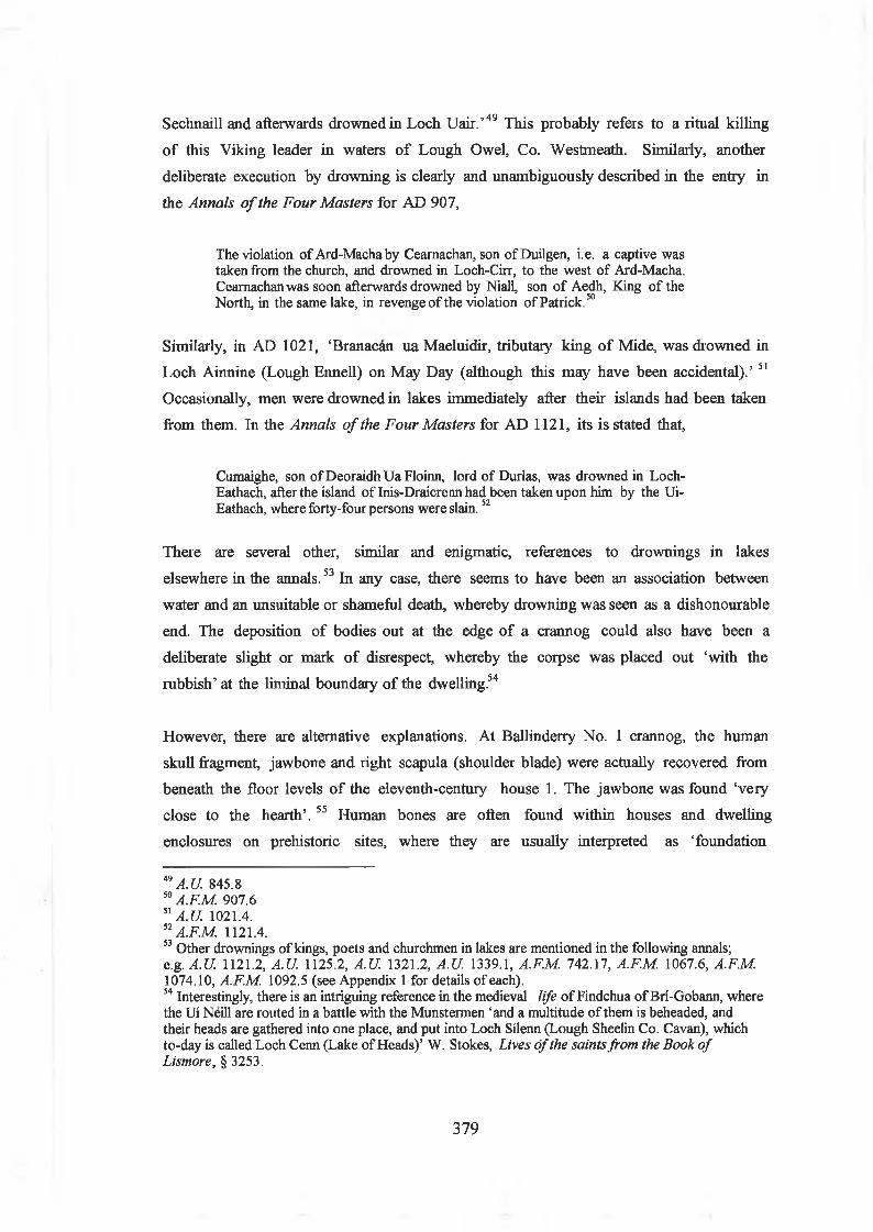
Sechnaill and afterwards drowned in Loch Uair.’49 This probably refers to a ritual killing
o f this Viking leader in waters o f Lough Owel, Co. Westmeath. Similarly, another
deliberate execution by drowning is clearly and unambiguously described in the entry in
the Annals o f the Four Masters for AD 907,
The violation of Ard-Machaby Ceamachan, son of Duilgen, i.e. a captive was taken from the church, and drowned in Loch-Cirr, to the west of Ard-Macha.Ceamachan was soon afterwards drowned by Niall, son of Aedh, King of the North, in the same lake, in revenge of the violation of Patrick.50
Similarly, in AD 1021, ‘Branacan ua Maeluidir, tributary king o f Mide, was drowned in
Loch Ainnine (Lough Ennell) on May Day (although this may have been accidental).’ 51
Occasionally, men were drowned in lakes immediately after their islands had been taken
from them. In the Annals o f the Four Masters for AD 1121, its is stated that,
Cumaighe, son ofDeoraidhUaFloinn, lord of Durlas, was drowned in Loch- Eathach, after the island of Inis-Draicrennhad been taken upon him by the Ui- Eathach, where forty-four persons were slain.52
There are several other, similar and enigmatic, references to drownings in lakes
elsewhere in the annals.53 In any case, there seems to have been an association between
water and an unsuitable or shameful death, whereby drowning was seen as a dishonourable
end. The deposition o f bodies out at the edge o f a crannog could also have been a
deliberate slight or mark o f disrespect, whereby the corpse was placed out ‘with the
rubbish’ at the liminal boundary o f the dwelling.54
However, there are alternative explanations. At Ballinderry No. 1 crannog, the human
skull fragment, jawbone and right scapula (shoulder blade) were actually recovered from
beneath the floor levels o f the eleventh-century house 1. The jawbone was found ‘very
close to the hearth’. 55 Human bones are often found within houses and dwelling
enclosures on prehistoric sites, where they are usually interpreted as ‘foundation
49 A. U. 845.850 AF.M. 907.651 A.U. 1021.4.52AF.M. 1121.4.53 Other drownings of kings, poets and churchmen in lakes are mentioned in the following annals; e.g. A.U. 1121.2, A.U. 1125.2, A.U 1321.2, A.U. 1339.1, A.F.M. 742.17, A.F.M. 1067.6, A.F.M. 1074.10, A.F.M. 1092.5 (see Appendix 1 for details of each).54 Interestingly, there is an intriguing reference in the medieval life of Findchua of Bri-Gobann, where the Ui Neill are routed in a battle with the Munstermen ‘and a multitude of them is beheaded, and their heads are gathered into one place, and put into Loch Silenn (Lough Sheelin Co. Cavan), which to-day is called Loch Cenn (Lake of Heads)’ W. Stokes, Lives o f the saints from the Book o f Lismore, § 3253.
379

deposits’, being human remains (often o f children) placed within the floor o f the house
and designed to protect the dwelling’s inhabitants. These may have been household
members who continued to exist with the family after their deaths. It is possible that
similar pagan ideas co-existed with Christian beliefs in early medieval Ireland. It is also
worth remembering the associations the early medieval Irish had between death and
islands (see Chapter 4 above), so that human burial within a house on an island may have
had some magical or ritual function.
Middens outside housesIt is evident that substantial amounts o f animal bone and rubbish accumulated in and
around houses, often buried underneath the floors or scattered around the outside o f the
house walls. At Craigywarren, M oynagh Lough, Ballinderry no. 1 and Lough Faughan,
there were large quantities o f animal bone generally strewn around the occupation
deposits or within the house floors. However, bone was also found immediately outside
the houses, lying around the walls or just outside the doorways. This depositing o f animal
bone immediately outside the door o f a house can be seen most clearly at Sroove. In the
Phase 3 levels, the bone lay on the surface o f the crannog, just in front o f the door, as
well as off to the right towards the lake. In this case, a person entering the house would
have literally walked across the meals o f the people. By Phase 4, the bone was found all
over the site. Indeed, it almost made a floor level on the east side o f the island, close to
the water. This perhaps signifies an increased tendency to place the bone at the ‘edge’ o f
the site.
Middens at the palisadesMiddens can be found both inside and outside crannog palisades. Unfortunately, it can be
frequently impossible to phase these deposits, as they simply accumulated across time in
watery shallows and were then not excavated with any close stratigraphy recorded. At
Craigywarren, the midden was at the northeast at the crannog palisade, comprising
cattle, sheep/goat and pig bone, as well as three ‘very fíne’ horse skulls. Other finds from
this midden included an iron pan and fragments o f leather shoes.56 At Ballinderry no. 2,
Hencken states that,
immediately outside the palisade (of the ninth-century crannog) upon the level ofthe old swamp or shallow lake was an enormous accumulation of food bones, chips
55 H.L. Movius, ‘The human remains’, in Hencken, ‘Ballinderry No. 1’, pp 227-230.56 Coffey, ‘Craigywarren’,
380
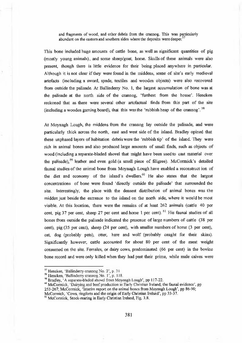
and fragments of wood, and other debris from the crannog. This was particularly abundant on the eastern and southern sides where the deposits were deeper57
This bone included huge amounts o f cattle bone, as well as significant quantities o f pig
(mostly young animals), and some sheep/goat, horse. Skulls o f these animals were also
present, though there is little evidence for their being placed anywhere in particular.
Although it is not clear i f they were found in the middens, some o f site’s early medieval
artefacts (including a sword, spade, textiles and wooden objects) were also recovered
from outside the palisade. At Ballinderry No. 1, the largest accumulation o f bone was at
the palisade at the north side o f the crannog, ‘furthest from the house’. Hencken
reckoned that as there were several other artefactual finds from this part o f the site
(including a wooden gaming board), that this was the ‘rubbish heap o f the crannog’. 58
At Moynagh Lough, the middens from the crannog lay outside the palisade, and were
particularly thick across the north, east and west side o f the island. Bradley opined that
these unphased layers o f habitation debris were the ‘rubbish tip’ o f the island. They were
rich in animal bones and also produced large amounts o f small finds, such as objects o f
wood (including a separate-bladed shovel that might have been used to cast material over
the palisade),59 leather and even gold (a small piece o f filigree). McCormick’s detailed
faunal studies o f the animal bone from Moynagh Lough have enabled a reconstruct ion o f
the diet and economy o f the island’s dwellers.60 He also states that the largest
concentrations o f bone were found ‘directly outside the palisade’ that surrounded the
site. Interestingly, the place with the densest distribution o f animal bones was the
midden just beside the entrance to the island on the north side, where it would be most
visible. At this location, there were the remains o f at least 262 animals (cattle 40 per
cent, pig 37 per cent, sheep 27 per cent and horse 1 per cent).61 His faunal studies o f all
bones from outside the palisade indicated the presence o f large numbers o f cattle (38 per
cent), pig (35 per cent), sheep (24 per cent), with smaller numbers o f horse (3 per cent),
cat, dog (probably pets), otter, hare and w olf (probably caught for their skins).
Significantly however, cattle accounted for about 80 per cent o f the meat weight
consumed on the site. Females, or dairy cows, predominated (66 per cent) in the bovine
bone record and were only killed when they had past their prime, while male calves were
57 Hencken, 'Ballinderry crannog No. 2’, p. 3158 Hencken, ‘Ballinderry crannog No. 1’, p. 118.59 Bradley, ‘A separate-bladed shovel from Moynagh Lough’, pp 117-22.60 McCormick, ‘Dairying and beef production in Early Christian Ireland, the faunal evidence’, pp 253-267; McCormick, ‘Interim report on the animal bones from Moynagh Lough’, pp 86-90; McCormick, ‘Cows, ringforts and the origin of Early Christian Ireland’, pp 33-37.61 McCormick, Stock-rearing in Early Christian Ireland, Fig. 3.8.
381

slaughtered at a young age. This fits with what might be expected from an intensive
dairying regime. Most o f the cattle were slaughtered off-site and only meat joints were
taken on to the island. Pigs were usually mature on slaughtering, and perforations in
their shoulder blades indicated that they may have been cured and hung (perhaps inside a
storage shed on the island). Sheep (being immature) were probably kept more for their
meat than for wool.
McCormick has also recently suggested an interesting social context to the consumption
o f food on Moynagh Lough.62 In early medieval Ireland, providing hospitality was an
enforced legal obligation on some social classes, and a noble and his retinue (between
forty to sixty persons) would expect to be fed and billeted at the home o f one o f his
significant vassals. During the season o f feasting, between New Year’s Day and
Shrovetide (when excess animals would be slaughtered at time o f fodder shortage), the
noble would thereby arrive at his vassal’s dwelling and would be provided with food and
bedding for a period o f two days and two nights. It was also possible for a feast to take
place at the royal residence o f a king, but others would still provide the food as food
rent. Food is ordered in early Irish law, like so much else, according to grades o f social
status. It was understood that different qualities o f cuts o f beef, as well as different grains
(i.e. wheat, barley and oats) were considered as appropriate foods for kings, nobles or
commoners.
One o f the interesting aspects o f the cattle bone from Moynagh Lough is that the bones
from all types o f cuts o f beef are present, from the tenderloin and fillet (high-status
meats, for kings, lords and other significant personages) down to the ankles (given to
lower status craftsmen). McCormick suggests that this indicates that because this is a
high-status site (as evident by the roundhouses and finds), inhabited by not a large group
o f people (i.e. there were only two houses in the eighth-century levels), it is significant
that more than just the high-status cuts that were being brought out to the island. In fact,
he suggests that the presence in the middens o f virtually all o f the cattle carcass indicates
that feasts being held on the crannog at certain times o f the year, when a larger than
normal social group would gather there.
It is interesting then that the Moynagh Lough middens were distributed across what
might be called the ‘front’ or north side o f the island. This is because in Phase X, this
62 Finbar McCormick, ‘The distribution of meat in a hierarchical society: the Irish evidence’ in Preston Miracle and Nicky Milner (eds.), Consuming passions and patterns o f consumption , (Cambridge, 2001), pp 25-32.
382

north side was the location for a possible entrance and pathway into the crannog. It
might be suggested then that a person approaching the island by boat from the north
(the location o f a possible early medieval raised rath or motte and church at Nobber) or
the west (where there are a number o f early medieval ringforts on the hill overlooking
the lake) would have first seen the midden deposits slumped against the palisade. The
midden and its visible evidence for high-status feasting may have served to signal to this
observer that this was a socially and culturally significant location for the wider
community.
However, the occupants o f low status crannogs seem to have consumed essentially the
same meats, at least in terms o f range o f animal species i f not in sheer volume.
Lofqvist’s faunal studies on the small early medieval crannog occupation levels at
Sroove, Co. Sligo indicate that the bone assemblage was generally typical o f other early
medieval sites, with a preponderance o f dairy cattle, with some pig, sheep, and lesser
amounts o f horse.63 Wild animals and fish were present in insignificant amounts. On the
phase 3 level, the crannog’s inhabitants may have eaten (or used their bones for crafts)
at least sixteen cattle, twelve pigs, eight sheep, six horses, one deer, as well as one wild
duck and one hare across that level’s lifespan. Moreover, much the same range o f classes
o f meat were provisioned onto the crannog, perhaps challenging McCormick’s ideas.
Yet, there were some interesting differences between Sroove, and the higher-status sites
at Lagore and Moynagh Lough. At Sroove, the bone was virtually all crushed and
fragmentary and skulls or even whole bones were rare or non-existent. This might
reflect the fact that the bone was exposed to fires and was crushed underfoot as people
walked back and forth. It might also indicate the practice o f smashing the bones to
extract all the bone marrow (and less waste). On Sroove, there was also a significantly
higher percentage o f phalanges and metapodials, these being the low meat-bearing parts
o f the animal (i.e. ankles, etc). It suggests that cattle were driven onto the islet itself and
slaughtered and butchered right beside the house. These types o f bones were absent from
Lagore and Moynagh Lough, suggesting that on those sites, the cattle had been
slaughtered somewhere else, cut up and the meat then brought to the island. There was
also a slightly higher percentage o f horse eaten or used at Sroove, suggesting that this
meat, although its consumption was frowned upon on by the early Irish church, was
being eaten on the crannog. These animal bones were also scattered abundantly across
the site, in front o f doorways and down towards the edges o f the palisade.
63 Camilla Lofqvist, ‘The animal bones’, in Fredengren, Crannogs, (CD-ROM Vol. 2, Appendices),
383

CesspitsThere is also some evidence for particular concento ations o f waste in pits within
crannogs (such refuse pits being actually quite rare on early medieval settlement sites in
Ireland). A cesspit was investigated at Moynagh Lough phase X (dated to the early
eighth century). This was a sub-rectangular dug feature (1.7m x 1.3m), filled with lenses
o f dung, alternating with narrow fibrous lenses composed o f straw and leaves (presumably
the ‘wiping’ material used in the toilet). It had been re-cut on two occasions, presumably
meaning that it had been cleaned out at least once. The cesspit was located in full view
on the north side o f the roundhouse, between it and the palisade. It was situated just
inside the entrance to the crannog, o ff to the right o f the end o f a timber pathway that
led into the site. It was also dug into the west edge o f metalworking area 1, suggesting
that the when that ceased to be a dump for metalworking debris, it became a dump for
human waste.64
Similar dug pits have been noted on other crannog sites, although their function is less
clear. At Ballinderry no. 1, a double pit was located to the east o f House III, between its
walls and the palisade, towards the end o f the eleventh century use o f the site. Similarly,
at Ballinderry no. 2, a pit was located at the north edge o f the site, just inside the pile
palisade o f the ninth-century crannog. Hencken regarded it as a well (for no better
reason than it filled with water when cleared out), and it was found to be filled with bone
and gravel, with a blue-glass bead suggesting its early medieval date. A patch o f gravel
beside it provided a stable place to stand. This was probably also a cesspit, again visible
from the site entrance.65 I f these are all cesspits, they establish an interesting link
between human waste and the site boundary.
A prosaic event is described in a story entitled ‘The death o f the three sons o f Diarmait
son o f CerbalT, purporting to have taken place in AD 651. In the story, the king
Diarmait Ruanaid (obit A. U. 664) collects an army at his crannog at Lagore to avenge
the death o f his nephews at the hands o f the Leinstermen. He demands that the killer,
one Maelodran, is given up to him. The Leinstermen refuse, but Maelodran offers to
give himself up. He goes alone to the brink o f the island (for bru indsi Gabar) and waits
pp 142-184.Bradley, ‘Moynagh Lough: an insular workshop’, p. 76.
65 Hencken, ‘Ballinderry crannog no. 2’, p. 31; Newman, Ballinderry Lough, p. 123 agrees that this was a refuse pit, although associated it with the sixth-century pre-crannog occupation, In this writer’s opinion, the lack of wicker surround (as found on the earlier site), and the fact that it is directly inside the ninth-century crannog’s palisade suggests that it is indeed a cess pit from that crannog occupation.
384

until night at the island’s ‘port’. When his enemies had ceased rowing back and forth
from the island, he takes a boat and goes out and waits by the royal house (rightheac) In
the middle o f the night, the king comes out to ‘bend his knees’ (i.e. to defecate). In
front o f the house he meets with an enemy, Maelodran. Not recognising him, the king
instructs him to ‘bring me a w isp’, whereupon Maelodran mischievously brings him a
handful o f nettles, and kindly holds Diarmait’s sword while he goes about his business. It
is only when the king painfully wipes his bottom with the nettles that he realises that he
has been tricked. Threatened with death, he negotiates with Maelodran, to the latter’s
benefit.66
Houses and dwellings on early medieval crannogs: theatres for
social encountersIntroductionMoving on into the interior space o f the crannog, a person could then have walked up to
the door o f the house, before going in. In early medieval Ireland, houses were hugely
significant places in people’s daily lives. This was where the family or extended
household slept, ate food, gathered for social occasions and extended hospitality to their
wider kin and neighbours. The house was the venue for the enactment o f various social
relationships, it was a storehouse o f traditional knowledge and values and was also an
artefact o f both practical and symbolic action. The size, shape, form, location, function
and internal spatial variations o f houses are seen by anthropologists as amongst the best
means o f reconstructing the social organisation, way o f life and culture o f past peoples.
The house can also often be seen as a metaphor for society. People living or growing up
in a house would have learned from its lay-out and social and symbolic space, their own
place in society and how social relationships worked.
Early Irish laws, narrative literature and hagiographies provide a range o f anecdotal
detail about activities within houses, as well as vivid descriptions o f fantastic houses that
are perhaps metaphorical and clearly owe more to the imagination than to any real-life
dwelling. The eighth-century law text Crith Gablach , also provides an amazingly detailed
discussion o f the size o f houses, construction details and the types o f domestic
equipment used within them. A significant theme in these various sources is the
importance o f the ordering and use o f social space within dwellings, with a predictable
66 Kuno Meyer (ed.), ‘The death of the three sons of Diarmait mac Cerrbeoil’, in Anecdata Oxoniensia (Oxford, 1894), p. 70; cited in Price, ‘The history of Lagore, from the annals and other sources’ in Hencken, Lagore, pp 18-34, at p. 32.
385

emphasis on social status, gender and age as organising principles. It was expected that
people knew where to sit, move and work, using such fixtures and features as doorways,
hearths and seating arrangements, to orientate their movements around the house.
There is also very good archaeological evidence for early medieval houses in Ireland
(particularly between the seventh and the tenth century AD). Archaeologists have
developed a good understanding o f their architectural development in terms o f their
location, shape, size, building materials and internal features.67 The earliest structures in
the early medieval period (between AD 500-800) were usually roundhouses, constructed
o f post-and-wattle walls, with wooden poles for joists and roofs o f thatch o f reed, tu rf or
straw. Most were fairly small, typically 4-5m in diameter. Some were slightly larger, 6-
10m in diameter. The enclosed house space was typically about 45m2, comprising a
single small room. It is probable that these sizes were closely related to social rank, so
that both custom and law restricted an individual from building larger than a certain size.
However, even the largest houses in early medieval Ireland were relatively small by
contemporary European standards. There is no evidence for use o f rings o f internal roof
supports to make significantly larger houses (as is common on Iron Age British sites). In
early medieval Ireland, people chose instead to build a second structure and attach it to
the larger house, to create a figure-of-eight shape. This backhouse or cuile may have
been used as a kitchen, sleeping area or private or exclusive space. Roundhouses tend to
be located in the centre o f enclosures.
There is a significant change from the use o f roundhouses to rectilinear houses after
about AD 800. Towards the end o f the early medieval period (tenth to eleventh
centuries), rectangular houses built in stone or turf were norm al, and roundhouses became
rare. On most sites where there is clear dating evidence, roundhouses are actually
replaced by rectangular structures. These rectangular houses were typically built in stone,
earth, tu rf shape, with an average measurement o f 6-8m in length. They were simply
constructed, o f low stone walls, lines o f boulders, with internal wooden poles to support
roof o f reed, tu rf or straw. Rectangular houses, although they have the same floor space
as round houses, are often paved. They also tend to be found closer to entrances and
towards the sides o f enclosures. The reasons for this transition in architectural styles
from round houses to rectangular houses remains unclear. However, it could be suggested
that it relates to significant changes in early Irish society. At the time o f this
67 C J. Lynn, ‘Early Christian period domestic structures: a change from round to rectangular plans?’ in Ir. Archaeol Research Forum 5, (1978), pp 29-45; Lynn, ‘Houses in rural Ireland, A.D. 500- 1000’, pp 81-94; Lynn, ‘Deer Park Farms’; Lynn, ‘Early medieval houses’.
386

architectural transition (the eighth and ninth century), social changes included an
increasing centralisation o f power, an increased focus on smaller familial groups, more
restrictive or individualistic land ownership practices. The ownership and use o f a
rectangular house, which could more easily be divided up into compartments and sections
may have went hand-in-hand with changes in ideas about personal status, wealth and
concepts o f private and public space.
Lifecycles of early medieval housesIt is possible that many early medieval roundhouses could have been quite short-lived
structures (lasting not more than 15-20 years). On the other hand, a well-built
roundhouse, i f carefully maintained and protected, could pote ntially last as long as 60-70
years, or about the lifetime o f an individual. It is interesting then that within the
archaeological evidence from early medieval Ireland, it is possible to identify some ways
in which the beginning, and end, o f houses seem to have been marked by particular
actions. Many early medieval houses show evidence for having been rebuilt or replaced
at precisely the same location, such as at Leacanabuile, Co. Cork,68 Dressogagh, Co.
Armagh69 and Deer Park Farms, Co. Antrim. This replacem ent could be interpreted as a
re-building cycle that was establishing a historical continuity and symbolic link with the
earlier dwelling.
There is also intriguing archaeological evidence from early medieval houses in Ireland
for activity involving the placing o f artefacts in the ground which seem to mark the end
o f the life o f one house and perhaps the beginning o f the next. Interestingly, these
deliberate deposits seem to be mostly objects such as quemstones, wooden troughs and
plough parts - all items associated with agricultural labour and the domestic production o f
food. At an early medieval unenclosed dwelling at ‘The Spectacles’, Co. Limerick, a
broken quemstone was left right in front o f the door o f a roundhouse, on top o f the
paving just where it would have been awkward to step across.70 Similarly, at Drumaroad
ringfort, Co. Down, two broken quemstones were deposited just south o f the house
doorway, alongside the paving.71 It is possible that these were actions marking the death
o f the house, whereby the house’s quern was deliberately broken just before the house
was abandoned. Briick has recently suggested from similar evidence that Bronze Age
roundhouses in southern Britain had lifecycles that were related in a practical and
68 O Riordain and Foy, ‘The excavation of Leacanabuile stone fort’, pp 85-91.69 A.E.P. Collins, ‘Excavations at Dressogagh Rath, Co. Armagh’ in U.J.A. 29, (1966), pp 117-129.70 S.P. O’Riordain, ‘Lough Gur excavations...and the Spectacles’, pp 39-111.71 Dudley Waterman, ‘The excavation of a house and souterrain at White Fort, Drumaroad, Co.
387

metaphorical sense to those o f their inhabitants. This can hardly be surprising, as the
main events o f a person’s life, his birth, transition from childhood to adulthood,
marriage, and ultimate death - could all potentially occur within a house. It is possible
the early medieval houses in Ireland were also linked in people’s minds to the life and
death o f the household’s primary owner.
Interpreting houses on early medieval crannogsThere is a range o f interesting questions then to be asked o f houses on crannogs. Their
physical scale, form, construction and internal arrangements provides information on
the size, social status and make-up o f the family group, household or social group that
used them. The use o f the internal space o f the house and how this may change across
time is also worth examining. Such evidence could be used to explore how houses were
re-used, re-ordered and their internal spaces re-negotiated across their life-span. There is
evidence o f the re-laying o f house floors, with the periodic introduction o f gravels, clays
and brushwood into the house suggesting either long-term re-use or a periodic returning
to the site. The presence o f artefacts and rubbish within the house floors can also reveal
interesting aspects o f the use o f these houses. It is possible to show on several sites that
hearths were re-built and changed, again signifying rhythms o f continuity and change.
In recent years, archaeologists have suggested various ways o f interpreting the social
organisation o f space within early houses, although this has rarely been attempted in
Ireland. These studies tend to focus on questions o f how space was organised, how
movement was physically and symbolically guided around the dwelling, and which
locations were used for different types o f activities.72 Even within a simple circular
structure, people could have used key structural features and subtle differences in light,
warmth and customary practice to organise the house. Thus, a circular house can have a
front (typically the well-lit area towards the doorway) and a back (in darkness against the
back wall). Standing at the door, it can have a left and a right side. The central roof
supporting post and the hearth can serve as the focus for the centre, while the walls can
be seen as peripheral. There is possibly also a vertical spacing to be considered, moving
from the muds o f the floor level, up into the joists and thatch o f the roo f
Down’ in UJ.A. 19 (1956), pp 73-86.72 Social and symbolic interpretations of Iron Age houses are provided by, Fitzpatrick, ‘Outside in: the structure of an early Iron Age house’, pp 68-72; Hingley, ‘Public and private space: domestic organisation and gender relations amongst Iron Age and Romano-British households’, pp 125-48; Oswald, ‘A doorway on the past: practical and mystic concerns in the orientation of roundhouse doorways’, pp 87-95; Parker-Pearson, ‘Food, fertility and front doors in the first millennium BC’, pp 117-32; Giles and Parker-Pearson, ‘Learning to live in the Iron Age: dwelling and praxis’, pp 217- 31.
388

Some archaeologists have argued that this organisation o f space was culturally encoded,
based on structural, cosmological beliefs about the world. Particularly influential have
been recent studies o f Iron Age roundhouses in Britain that argue the house was
essentially a microcosm o f the cosmos, with daily activity and movement closely related
to the daily and seasonal movement o f the sun. It is argued that the hearth was a hub
around which people moved in a ‘sunwise’ (i.e. clockwise) direction and that the spatial
organisation o f activities within the house reflected this. On east facing houses, food
preparation, weaving or other work associated with the brightness o f day seem to have
been carried out on the left hand or south side o f the house, while nightly activities such
as sleeping were in the right hand or north o f the house. Deliberate deposits o f animal
bone placed in pits in the floor (often near doors) served to signify social, temporal and
spatial distinctions around the dwelling.73 It is not at all clear that similar patterns can be
seen in early medieval houses in Ireland. However, it may be useful to start thinking
about early medieval houses as places that both structured and enabled people to think
about the world in certain ways.
House form, size and locationHouses, or possible ones, have been found on most o f the early medieval crannogs that
have been excavated (e.g. M oynagh Lough, Rathtinaun, Sroove, Lough Faughan,
Craigywarren, Ballinderry no. 1, Ballinderry no. 2), and they range significantly in form,
size, location and internal features. Briefly stated, it is evident that most are roundhouses
(e.g. all five o f the sixth to eighth-century Moynagh Lough houses, the small tenth-
century circular house on the primary crannog at Ballinderry no. 1, as well as the
undated early medieval houses at Lough Faughan (i.e. ‘hearth 4 ’) and Rathtinaun. These
range in size, with some significantly large structures (e.g. Moynagh Lough phase Y
house at 11.2m diam., Rathtinaun house at 10.5m diam.), although most typically
measure 4-6m in diameter. A striking aspect o f the use o f houses on crannogs is the
extent to which they were often re-built on the same spot, such as at Sroove, Moynagh
Lough, Ballinderry no. 1. On the other hand, they also shift in location across time,
drifting slightly across the site (as between the various phases at Moynagh Lough) or
moving from the centre towards the palisade or periphery (e.g. as at Ballinderry no. 1).
73 Discussions of the cosmology of Iron Age house spaces include, Fitzpatrick, ‘Outside in: the structure of an early Iron Age house’, pp 68-72; Giles and Parker-Pearson, ‘Learning to live in the Iron Age: dwelling and praxis’, pp 217-31; Michael Parker Pearson and Niall Sharpies, Between land and sea: Excavations at Dun Vulan, South Uist (Sheffield, 1999), pp 350-53.
389

Fig. 7.9 The Phase 2 ‘Primary Crannog’ house at the early medieval crannog of Ballinderry No. 1, Co. Westmeath. This house (dated to the mid eleventh century AD) was 5m in diameter, with a floor of brushwood and clay. It was surrounded by a horseshoe shaped timber walkway, and was located inside a modestly-sized, palisaded (15m diameter) crannog (Source: Hencken, ‘Ballinderry No. 1’, PI. X IB ).
Admittedly on some o f the crannogs it can be difficult to identify the precise floor plan
o f the house. At Craigywarren, there was certainly a timber platform at the north edge
o f the site. On top o f these jointed planks was a small hearth, while a midden was
situated close by. However, it is impossible to confirm that this was a house.74 At
Ballinderry No. 2, a house was probably located in the southeast quadrant o f the ninth-
century crannog. Unfortuna tely again, the floor plan o f this house was largely destroyed
by nineteenth-century digging. The house was probably constructed on a foundation o f
horizontal oak and ash posts, which formed an extensive timber platform. Blocks o f
peat and brushwood had been laid in the spaces between the timbers. There was a hearth
on the north side o f the platform and there was a floor o f ashes, clay and charcoal, 7m
across, 45cm in depth.75
At Ballinderry no. 1, a rectangular house (c.6m x 6m) built o f horizontal logs probably
preceded the construction o f the primary crannog. It may have been enclosed within a
74 Coffey, ‘Craigywarren’, p 112.75 Hencken, ‘Ballinderry No. 2’.
390

ring o f posts.76 Intriguingly, this structure could have been similar in design to
contemporary Hibemo-Norse houses excavated from mid to late tenth-century Dublin.77
Artefacts from this occupation level also suggest strong links between this midlands site
and Dublin in the tenth and eleventh centuries AD. In the early to mid eleventh century
AD, a modestly sized crannog (15m diameter) on the same site was the location for a
circular house (Fig. 7.9). This house (5m in diameter), was constructed on top o f a
foundation built o f a redeposited layer o f black, sterile peat and timber. The house had a
floor o f brushwood and clay. Surrounding it was a timber walkway, arranged around it in a
horse-shoe shaped fashion, with a gap to the south suggesting an entrance in that area.
Towards the end o f the use o f Ballinderry no. 1, there were also at least two rectilinear
houses (or perhaps one large rectangular house) at the northe ast side o f the site.
Similarly, at Lough Faughan, there is no clearly discernible house plan. However, in the
early medieval occupation levels, there was a large (4.6m in diameter, 60cm in
thickness) circular ‘hearth’ (the excavator’s ‘Hearth 4 ’). This was centrally located
within the crannog, and consisted o f a spread o f clay laid on the damp peat that had been
reddened by burning. It consisted o f at least seven layers o f grey ash, yellow clay and
charcoal, and produced a bone pin and a fragment o f Samian ware (both items that could
easily be found within a house).
At Rathtinaun, there was a definite single roundhouse in the early medieval phase IV
occupation. 78 The crannog had been rebuilt using sods cut from the foreshore, with grass,
plants, rushes, wood and stones. This material was reveted around by two rows o f squared
oak posts on the crannog’s east side, presenting a wooden palisade to the shoreline 30m
away. A single roundhouse was placed on this surface (10.5m diam.), constructed o f large
oak post s spaced at 20-30cm intervals. It only clearly survived on its southern side, and
was probably demolished towards the end o f its life (with posts pulled up from northern
side). It probably had an entrance on the east facing the shoreline. The hearth was
unenclosed, and had been built upon the traces o f earlier Period III hearths used on the
site.
Probably the best sequence o f houses has been found on the early medieval crannog at
Moynagh Lough, Co. Meath, including at least five houses dating to between the late
76Hencken, ‘Ballinderry No. 1’, pp 107-8 ; Johnson, ‘Ballinderry crannog No. 1: a reinterpretation’,pp 32-8.
P.F. Wallace, ‘The archaeological identity of the Hibemo-Norse town' in R.S.A.I. Jn, 122, (1992) 35-65.
391

sixth and the early eighth century.79 In the earliest phases, there were at least two
houses. In Phase U (probably dated to the late sixth-century), there was a possible small
hut (3m diam.) with a spudstone at the entrance and charcoal-rich floor. Finds from its
vicinity included E-ware, an iron shield boss and a rectangular bronze mount. In Phase W
(dated to about AD 690-720), there was a circular house with an east facing entrance, a
possible rectangular stone-lined hearth, with finds including a bronze pennanular brooch.
In Phase X (dated to early eighth century), a medium-sized roundhouse (7.5m diam) was
situated towards the north o f the site, between two metalworking areas and to the right
o f the entrance as a person walked in. In Phase Y (probably dated to about AD 748),
there were two roundhouses. One was spectacularly large (11.2m external diameter),
constructed o f a double row o f poles. It had a central hearth complex and a laid floor. It
also had a series o f internal partitions now evident by stake holes. These may have been
benches and beds, as they were arranged around the house against the walls. This house
appears to have been built on the site o f the earlier phase X house. Slightly to the north,
there was also a smaller roundhouse (5.2m diam.), also with an internal stone-lined
hearth (Fig. 7.10; Fig. 7.11a; Fig. 7.11b).
*** * -•! T ‘ v ^
*
1 4t' A\-> * ■ » -
■ %. . ’> • * ! 4 p .« * i. >» m*' 1* T' @
J
1
•■ ' * ’ -îdfe*.'» r** *, • •
* -«mti 1 * V• ) » «- . > - « •>*. « '
^ • '■ * * , '' . m * ,* *
_ • m * ■ • f t* r * • - . . *
* • __i w ‘ ‘ -S •Fig. 7.10 View of Phase Y mid eighth-century) house at Moynagh Lough crannog, Co. Meath. (Photo: John Bradley).
78 Rathtinaun Crannog 61 site archive, Dept, of Archaeology, UCD.79 Bradley, ‘Excavations at Moynagh Lough, Co. Meath’ (1991), pp 5-26 ; Bradley, Excavations at Moynagh Lough, Co. Meath 1980-1984, Unpublished site archive report (Dublin, 1984).
392
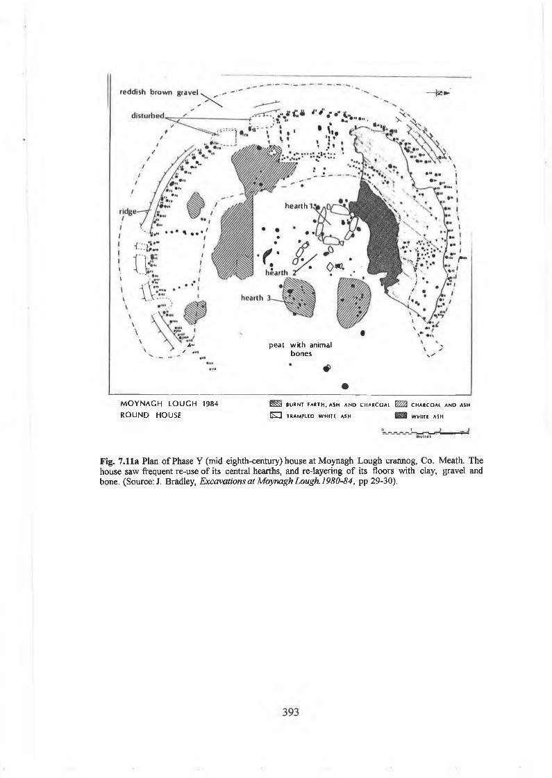
*«✓ «I»
peat with animal bones
MOYNAGH LOUGH 1984 ROUND HOUSE
t S S a BU RN T E A R T H ,A S H A N D C H A R C O A L
E D TRA M PLED W H ITE ASH
C H A R C O A L AND ASH
W H ITE ASH
Fig. 7.11a Plan of Phase Y (mid eighth-century) house atMoynagh Lough crannog, Co. Meath. The house saw frequent re-use of its central hearths, and re-layering of its floors with clay, gravel and bone. (Source: J. Bradley, Excavations at Moynagh Lough. 1980-84, pp 29-30).

Fig.7.11b Reconstruction of Phase Y (mid eighth-century) house at Moynagh Lough crannog, Co. Meath. Internally, there were beds and benches, and the distribution of food debris, metalworking waste and personal objects and equipment hints at the social organisation of its internal spaces (Source:! Bradley, Excavations at Moynagh Lough. 1980-84, pp 29-30).
At Sroove, there were at least two phases o f house construction and inhabitation on that
small, shoreline crannog.80 These were small rectangular or oval structures, centrally
placed within the island, and enclosed with a palisade, c. 17m across. In Phase 2, a
wooden house (6.5m x 8m internally) was represented by an oval or rectangular
arrangement o f closely spaced posts, protected by stone on the lakeward side. It had a
central post, a hearth, a floor o f brushwood and a possible entrance to the southwest.
This was succeeded in Phase 3 by a similar structure that was more difficult to trace, but
it did have a floor o f flagstones and a hearth. The Sroove house is radically different in
scale to the structures at Moynagh Lough, probably representing the dwelling o f a small
social unit, probably a nuclear family.
However, it is now also clear that some crannogs occupation levels definitely did not
have houses or any formal dwelling structures. On some sites, this may be due to the
inadequate scale o f excavation (e.g. Clea Lakes, Lough Faughan), poor standards o f
394

recording or the destruction o f occupation levels by m odem diggings. However, it is
particularly evident that there is a real absence o f crannogs on some small crannogs.
This is particularly the case at Lough More and at Sroove phase 4. On both these sites,
the surface o f the crannog consisted only o f a large spread o f flagstones spread across
the site. Although there were furnaces, mortars and spreads o f iron slag, there were no
defined or domestic hearths, no post-holes or any stone walls suggesting the use o f any
formal house structure.
The lack o f such houses should be seen in a positive way, signifying that houses were not
always the significant locus for activity on crannogs. It also raises the question whether
these sites were places used for events/activities not associated with daily domestic life.
People may have travelled to and from these places, but not have resided there. This
question will be raised again below in relation to metalworking on crannogs.
Doorways and entrancesDoorways can be clearly identified on only two crannog houses, largely because o f their
destruction by later habitation deposits on other sites. At Moynagh Lough, in the
eighth-century roundhouse in Phase Y, the door was probably at the northeastern side
(its southern jam b defined by two posts), facing the centre o f the site and the crannog
entrance. A t Sroove, in the rectangular house in Phase 2, there was a narrow door facing
the southwest, mostly defined by a gap in the house wall and some brushwood paving.
The door looked back towards the shore, but unlike Moynagh Lough, it was not clearly
visible from the entrance to the crannog. This is an interesting feature, seemingly
indicating that access and visibility o f the door was being controlled in some way.
Frequently, doorways in houses within early medieval ringforts face directly towards the
site entrance, and this enabled a person sitting in the house to watch visitors entering the
enclosure. A stranger would therefore be under the gaze o f the house. In fact, in most
early medieval roundhouses in Ireland, doorways are typically oriented to the east or
southeast. This is typically interpreted as pract ical in intent, aimed at providing shelter
from any prevailing wet, southwesterly winds. However, it could also have been a cultural
norm, with the dooiway facing the rising sun in the morning.
It could also be suggested that doorways were occasionally oriented in different directions
as a signifier o f social status or the role o f the house (Moynagh Lough, clearly a high-
80 Fredengren, Crannogs, pp 226-32.
395
status house, faces northeast, while Sroove with its southwest facing door is probably a
‘poor’ person’s crannog). At Ballyutoag, Co. Antrim, on an early medieval upland
enclosure (with radiocarbon dates indicating use in the seventh to eighth century AD)
perhaps associated with summer cattle herding, the doors o f the houses do not face the
‘normal’ direction to the southeast, but towards the southwest, perhaps signifying the
fact that these are not ‘normal’ dwellings, but temporary, seasonal habitations.81 On
balance however, it is most likely that doorway orientation is something that is
essentially local, with views o f the surrounding shoreline and activity within the crannog
the most significant factor.
Floor surfaces: palimpsests of human historyFloor surfaces are obviously present on most o f the identified houses in early medieval
crannogs. Interestingly, these vary significantly in their texture and form. It is clear that
people actually made floor surfaces by introducing layers o f various raw materials, such
as brushwood, wattle screens, layers o f peats, clays and gravels, and occasionally stone
paving. It is also evident that these floor levels are built up over time in sequences, being
gradually raised both by the natural detritus o f daily living and as part o f the deliberate
renewal o f house spaces. These floors are not always continuous, vary in their depth
across a house (from the centre to the edges), and were also subject to constant human
and perhaps animal trampling.
On some crannogs, particularly some o f the earlier excavations, it can be difficult to
distinguish between such multiple and intercalated layers o f peat, clay and ash that would
also have shifted as the crannog slumped. Nevertheless, it seems likely that at
Ballinderry no. 1, the centrally placed, circular house in the phase 2 (Hencken’s
‘primary crannog’) occupation levels, an internal thin floor o f clay was laid over a
wattle screen on top o f a brushwood layer.
At Ballinderry no. 2, the ninth-century crannog had been badly disturbed by nineteenth
century diggings. But it appeared that a house in the southeast quadrant had a foundation
deposit o f oak and ash posts laid in a criss-cross fashion. Between these timbers were
blocks o f cut peat and brushwood, while the actual living surface or floor itself was a
layer o f ash, clay and charcoal, 7m across, 45cm in depth. Animal bones were profusely
distributed through this ‘floor’. At Lough Faughan, the possible circular house at ‘Hearth
81 B.B. Williams, ‘Excavations at Ballyutoag, County Antrim’ in U.J.A., 47, (1984), pp 37-49.
396
4 ’ may have had multiple floor surfaces o f at least seven layers o f grey ash, yellow clay
and charcoal.
More recent site excavations allow a more subtle interpretation o f how house floors
were laid and accumulated. At Sroove, the house floor o f the phase 2 was composed o f a
thick (20cm) layer o f brushwood, intermixed with clay. There were few animal bones on
this floor, but the presence o f grain, blackberries and raspberries suggest food preparation
and consumption within the house, probably during the summer and autumn. There were
a few finds from this floor level, including a flint thumb scraper and chert arrowhead
found near the hearth. The floor o f the next phase o f occupation, phase 3, was entirely
different. This was a floor o f flagstones laid over a base o f smaller stones, 2-3 layers
thick. Finds from this floor level included a lignite bracelet, comb fragment (near the
fireplace), and bone beads. Towards the back o f the house there were iron nails, a small
bone needle, a bone pin and a knife. Fredengren suggests that the presence o f such
objects argue that the house w a s ‘alive’ and not ‘cleaned out’.
However, most early medieval dwelling surfaces would actually have been ‘cleaned-out’
periodically. It is apparent for example, from palaeoecological studies o f house floors in
Hibemo-Norse Dublin that the central house aisles were actually regularly swept out
(leaving little for scientific analysis). In contrast, the benches and the spaces at the wall
edges produced plenty o f rotting vegetation, household debris, personal objects, and
industrial waste (e.g. amber fragments, metal, etc) suggesting that they had fallen down
into the interstices in the bedding at either side o f the house.82
Similarly, a mid-eighth century house within an early medieval ringfort at Deer Park
Farms, Co. Antrim had a bed made o f wooden beams, branches and twigs. This bed was
the location o f most o f the small artefacts (including a glass bead and a fine bronze pin)
found within the house, as they had been lost down between the interstices o f the bed
structure. Object scatters around a house floor can be used to reveal then the differential
use o f space within the darkness o f the dwelling. It might be suggested instead that the
finds from Sroove indicate the location o f the bedding against the back o f the house
walls, and thence usefully the organisation o f daily and nightly activity within the
structure.
82 Siobhan Geraghty, Viking Dublin: botanical evidence from Fishamble Street (Dublin, 1996).
397

Fig. 7.12 Distribution of ‘domestic finds’ (e.g. pottery, whetstones, knives) within the Moynagh Lough house, indicating that such activity was predominantly carried out in the southern half of the house, a zone seemingly associated amongst many societies with daily, ‘bright’ or domestic life (Source:! Bradley, Excavations at Moynagh Lough. 1980-84, Fig. 22).
398

Fig 7.13 Distribution of ‘personal objects’ (e.g. bronze pins, bone pins, glass beads, comb, drinking horn terminal) with the Moynagh Lough house, indicating a slightly wider dispersal of objects, but still with a trend to the south. It is possible that the use of beds and benches there may have led to the occasional loss of personal items of adornment. (Source: J. Bradley, Excavations at Moynagh Lough. 1980-84, Fig. 25).
399

Fig. 7.14 Distribution of ‘ironworking finds’ (e.g. iron blobs, ingots, furnace bottoms, slag) within the Moynagh Lough house, indicating a striking emphasis on the northern half of the house. Amongst many societies, this is the dark half, associated with cold, night and wintertime. It is possible that ironworking waste, associated with danger and otherworldly forces, was consigned to this zone when the house floors were being relaid. (Source: J. Bradley, Excavations at Moynagh Lough. 1980-84, Fig. 24).
400

MISCELLANEOUS FINDS a **o n p i i c j - © i o n i
FROM ROUND HOUSE * »u n i o h o n h
□ I TONI ■ D O N i M A ; H I A P0_______! « in
p T ] S Q U A W « O N L Y •
Fig. 7.15 Distribution of ‘miscellaneous finds’ (e.g. iron pieces, flint, stone and bone objects) within the Moynagh Lough house. The iron finds are again found in the north, while flint objects were typically found around the central hearth or fireplace. Being used to light fires, it would be natural for such objects to fall there. Perhaps, thereafter when people were re-lighting the fire they could search the floor around them for ‘strike-a-lights. Some flint objects (especially prehistoric arrowheads) may also have been considered as magical items, used for preserving food and protecting the house. (Source: J. Bradley, Excavations at Moynagh Lough.1980-84, Fig. 23).
401

At Moynagh Lough, the large eighth-century roundhouse was constructed on a base o f
compacted reddish-brown gravel that had been dumped in a pennanular shape around the
central hearth .83 This gravel was laid directly on a platform o f re-deposited peat and
served as the foundation layers for the circles o f posts that made up the walls o f the
house. The internal habitation floor itself was a silty clay-loam with ash and charcoal
flecking. Although it was on average up to 12cm in thickness, it was thickest on the
south side o f the house and around the hearths and it was thinnest on the north side,
where it had been trampled into the reddish-brown gravel floor.
This might suggest that it was the south side o f the house that saw most daily activity
and renewal, while the north side may have been largely covered by beddkig, hides for
the night. The floor surface at Moynagh Lough was rich in animal bones particularly
around the hearth, and was also rich in finds around the edges o f the house. This in itself
would appear to indicate that most daily activity occurred at the house’s centre and to
the south towards the benches.
Most remarkably, the house floor and habitation layers at Moynagh Lough were
remarkably rich in finds. The included many items associated with personal adornment
(bronze pseudo-pennanular brooch, bronze pins, bone pins and iron pins, bronze finger
rings, glass beads and bracelets), as well as objects associated with feasting and gaming (a
bronze drinking horn terminal and a bone gaming piece). There were also iron knives,
spindle whorls, stone hones and iron nails, perhaps all to be associated with daily crafts
and industry within the dwelling, as well as some items o f weaponry, including an iron
spearhead and a bone point. Perhaps most remarkably, there were also fragments o f
moulds in the floor deposits. These various objects should be regarded as deliberate
deposits. It might be suggested that a visitor to the house at Moynagh Lough could have
seen the floor and drawn his own conclusions about the social status o f the site’s
inhabitants.
The evidence from the distribution o f finds across the house floor at M oynagh Lough is
revealing. Bradley’s excavations have revealed that at the Moynagh Lough roundhouse,
the distribution o f ‘domestic finds’ (e.g. pottery, whetstones, knives) and ‘personal
objects’ (e.g. bronze pins, bone pins, glass beads, combs) suggest that day-to-day food
preparation and basic domestic crafts typically occurred in the southern half o f the
house (Fig. 7.12; Fig. 7.13). In the Iron Age British household studies described above,
83 Bradley, ‘Excavations at Moynagh Lough, Co. Meath’ (1991), pp 5-26 ; Bradley, Excavations at
402

similar patterns have been used to argue that the sunward (i.e. southern), ‘bright’ or
‘warm’ side o f the roundhouse was conceptually the space for daily life and the domestic
world. At Moynagh Lough, the iron working debris is located to the northern, ‘dark’ or
‘moonlit’ half, suggesting a symbolic and conceptual association with darkness, the
‘night’, the ‘other’ (Fig. 7.14). The smith being particularly an otherworldly o f darkness
and danger might tally with this. The northern half o f the house may also have been the
location for such ‘night-time’ activities as feasting, sleeping and so on.
In the M oynagh Lough house, the distribution o f ‘miscellaneous finds’ (e.g. iron pieces,
flint, stone objects) is again largely to the north, but the flint objects cluster around the
hearth (Fig. 7.15). Some may have been strike-a-lights, but it is also possible that some
were apotropaic objects (i.e. objects that turn away evil), designed to magically protect
the household from fire, to protect milk products and to establish the ‘antiqueness’ o f
the house floor by use o f mythical objects, such as blades, arrowheads and so on.84 It
should be admitted that these are quite structuralist interpretations, inspired by Iron Age
studies in Britain that are now questioned by many scholars. Ironically, those same
studies were actually themselves originally inspired by ‘Celtic’ mythology (i.e. actually
early Irish literature), and early medieval Irish concepts o f ‘sunwise’ movement in the
pilgrimage turns. So either the above is a circular argument, or it properly makes use o f
early medieval Irish beliefs within an early medieval Irish roundhouse. In any case, it
hints that the spatial organisation o f early medieval roundhouses was understood in both
social and ideological terms.
Although the Moynagh Lough house was not physically divided into rooms, it could be
argued that its space would have been bounded by both seen features (i.e. the door,
hearth, benches and bedding, as well as objects such as looms and cooking equipment) and
unseen features (i.e. a person’s inherited, and undiscussed awareness o f customary and
proper behaviour). Inside the large round house, a visitor would have immediately been
in a public display space, between the hearth and the door, with choice o f seating and
beds to left and right. The most eminent members o f the household may have sat
beyond the hearth, probably at the west side. I f invited, the visitor could then move in
and sit on beds or seating areas. It is possible that the socially significant beds were those
on the north side (or the right hand side), probably used by the man o f the house, his
wife and favoured guests or family. The southern (or left hand) beds or benches may
Moynagh Lough, Co. Meath 1980-1984, Unpublished site archive report (Dublin, 1984).84 Carelli, ‘Thunder and lightning, magical miracles. On the popular myth of thunderbolts and the presence of Stone Age artefacts in Medieval deposits’, pp 393-417; Evans, Irish folkways, pp 303-3.
403

have been used by strangers or lesser members o f the household, those responsible for
labour, domestic tasks and cooking.
It is possible to compare the structural details o f the eighth-century Moynagh Lough
roundhouse with the eighth-century law tract Crith G ablach. In this text, the houses o f
various individuals are described, from farmers, to lords and kings. It claims that the
king’s house (ritheach) must be thirty-seven feet (11.2m) in diameter, and that it must
have seventeen bed-cubicles. It also suggests that there were significant links between
spatial location and social identity, implying that status and rank were negotiated and
expressed by the places where different people sat within a house.
How is a king’s house arranged?. His house is thirty-seven feet (11.2m diameter).There are seventeen beds in a royal house.. .King’s guards on the south side... a man for pledge for vassals next to these...next to him inwards, envoys. Next to these guest-companies. Poets next to these, harpers next. Flute-players, hom-players, jugglers in the south-east... a man of arms to guard the door. Next to these the free- clients of the lord. Hostages next to these. The judge next to these. His wife next to him. The king next. Forfeited hostages in fetters in the north-east.85
Archaeologists and historians have occasionally attempted to map out the details in
these descriptions and match them to archaeological sites, but it is worth remembering
that these are probably imaginative works o f literature, not descriptions o f houses that
existed in reality .86 In fact, Bhreathnach has suggested that such literary descriptions are
based not on Irish houses, but on rumours and traveller’s tales o f houses that had been
seen in Anglo-Saxon England or Carolingian Europe.87 However, they do signify that
the organisation o f house space in early medieval Ireland was something that was
understood very much in terms o f social identity. In the Old Irish text, Ldnellach tigi
rich 7 ruirech ( ‘the full complement o f the house o f a king and overking’), there is an
interesting description o f the organisation o f such space within a royal household.
Conchobar sat in the chief seat.Goibne sat by his knee (i.e. the smiths seat is ..below the kings knee).Forinde sat beside him (druids and seers between two compartments).Tot mac Eogain Orbrechtsat in front (i.e. the judges were beside the king’s throne). Augune sat behind the king’s (?) compartment.The spearman (?) sat beside the houseposts.The sureties (hostages) sat before the king (i.e. for the binding of every rightful claim).Buanond sat in the level rush-strewn place (i.e. the ruling queen (?)...).
85 MacNeill, ‘Ancient Irish law’, pp 265-316.86 Hilary Murray, ‘Documentary evidence for domestic buildings in Ireland, c400-1200 in the light of archaeology’ 'mMed. Arch. 23 (1979), pp 81-97.87 Edel Bhreathnach, ‘The tech midchuarta, ‘the house of the mead circuit’: feasting, royal circuits and the king’s court in early Ireland’ in Arch. Ire. 46, (1998), pp 20-22.
404
The hospitallers sat by the bounteous king’s forearms (i.e. under the king’s control to minister before him (?).The [ ] and the leeches (?) sat with the drink-measure beside the cupbearers.The leather-bottle makers [and] the brewers sat on the great threshing floor (i.e. on the floor of the house where is the din of distribution).The jesters and the [ ] sat between the two candlesticks on the front floor of thehouse.Other daernemedpersons sat by the door-posts (i.e. (those) with special powers and with satire and buffooning tricks).The hom-blowers, charioteers and flute-players sat in the front part (of the house).The attendants took up position before the pillars, (i.e. on the pillars of the dais) sitting and standing.The hunters, fishermen, trappers and fence-makers sat in a cubicle apart (i.e. amongst the vessels, in the company of the attendants and the cooks, etc)8
From the archaeological and historical evidence, one could interpret the Moynagh
Lough house at least as a feasting house (lech midchuarta , ‘house o f the mead circuit’)
in which the texts tell is there was bouts o f feasting and mead drinking, all o f which was
presided over by a noble. The Moynagh Lough house was certainly a high-status dwelling
o f a significant individual or social group, and it may well have been a king’s house (ri
theach). Bhreathnach’s historical research suggests that Moynagh Lough can be
identified as a place known as Loch De Mundech so that its crannog may well have been
a ‘royal site’ o f the Mugdorne ,89
So, it is worth remembering then that early medieval house floors effectively mapped
out what people did within dwellings and then revealed this to others. The floor would
have tended to be amongst the more visible o f a house’s various structural features,
particularly when the sunlight shone in the door or when a fire was burning on the
hearth. The floor’s textures and contours could have been both seen and felt underfoot.
Pathways wouldhave been beaten into its surface by constant passage around the hearth
and to the door, signifying the ‘proper’ way to move around the dwelling. The house
floor also presented to view those objects left from previous events or activities carried
out within the house. For example, broken moulds could have reminded the visitor o f a
previous night when gifts o f brooches had been given by a lord to his clients, while
animal bones and pieces o f discarded food on the floor testified to the fineness o f the
meats that had been eaten there.
At Moynagh Lough, although there were large numbers o f finds from within the house
floor, most o f the bones were congregated around the hearth. Similarly, at Ballinderry
no. 1, around the hearth o f the eleventh century roundhouse ‘were found the bones o f
88 Mairin O’Daly, ‘Lanellach tigi rich 7 ruirech’ in Eriu 19 (1962), pp 81-6.89 Bhreathnach, ‘Topographical note: Moynagh Lough’, pp 16-19.
405

many animals, mostly domestic, and though there were found in great profusion in
nearly every part o f the site, they were especially plentiful there’. 90 Even these simple
deposits o f bone may have served as simple relics o f the past. In modem society, the
remnants o f parties are cleaned up and all traces removed. In early medieval houses,
animal bones may actually have been deliberately left around hearths to remind people
o f past events, feasts, meals and successful carousing.
Hearths and fireplaces: symbols of the householdHearths and fireplaces can be clearly identified within many o f the crannog houses (e.g.
Moynagh Lough, Sroove, Craigywarren, Ballinderry no. 2, Ballinderry no. 1). Some are
only defined by a roughly circular area o f ash, burnt clay and charcoal, often apparently
at the centre o f the house. However, even these simple hearths often have multiple
layers o f ash and clay, indicating long-term use and build-up. Occasionally, these
undefined hearths are placed across a single level stone. At Sroove, in Phase 2 the
central hearth within the house was on a single fire-reddened stone. The same place in
the house was re-used as a hearth in Phase 3.
At Ballinderry no. 2, a remarkable, massive cracked circular millstone (probably re-used
from an abandoned horizontal mill that had been used somewhere in the surrounding
landscape) was onto the site and laid down as a hearth-stone on a foundation o f small
stones within a possible house floor o f timber and ash. The stone was left within the fire
so that it was gradually buried layers o f ash. At Ballinderry no. 1, the various possible
houses from the tenth to the eleventh century AD produced several hearths. In the pre-
crannog occupation levels, two superimposed hearths were found on the floor o f a
rectangular building. In the late eleventh century levels, both House II and House III
produced hearths that seemed to have developed across time.
On other crannog houses, hearths are more formally defined, being rectangular boxes
edged and lined with stones. At Craigywarren, a stone-lined hearth beside the hut and
midden was defined by a single flat stone, but was surrounded by smaller stones, covered
with ashes. These built or defined hearths were also frequently re-built on top o f each
other, perhaps over significantly long periods o f time. At Moynagh Lough, in the two
roundhouses in Phase Y, the hearths were built o f stones set on edge to create a rectangle
or square. The same hearths were clearly re-used, but shifted slightly in location within
the house and changed slightly in shape. In the large eighth-century roundhouse, the first
90 Hencken, ‘Ballinderry no. 1’, p. 117.
406

fireplace was an open hearth into which a second rectangular, stone-lined pit was place.
Subsequently, a third fireplace was added to the east. There was also evidence for periodic
rake-outs from th is main hearth, with twenty discrete spreads o f ash taken out from the
fire and spread across the house floor.
Hearths wouldhave been o f huge symbolic and social importance to the household on a
crannog, being literally the centre o f the dwelling and th e focus o f most domestic and
social activity within it. They served as the hub for various events, both cooking, crafts
and social interaction, and their existence confirms, i f it were needed, that these
crannogs were indeed habitations, places where people lived. Hearths are also interesting
in that they become permanent fixtures or settings, in that they hearken back to the
past, while their re-building signals an intention that they be used again in the future.
The evidence from crannogs suggests that they became historical settings, acting as
symbols o f the household’s genealogical past and a link to earlier and future generations.
ConclusionsThis chapter, after previous studies o f landscapes and the architecture o f crannogs,
finally moved into them. It explored how social relationships o f power, gender and
kinship were negotiated within the boundaries o f these islands. It also suggested that
powerfully liminal features, such as middens, might have been used in socially and
ideologically interesting w ^ s . It also discussed the role o f houses, and how people may
have understood and used them in the daily fives, both for the practicalities o f crafts and
food preparation, but also to build an understanding o f the world. In the next chapter,
the thesis is concluded.
I
407

Chapter 8
Conclusions
The aims and objectives o f this thesis, as described in the introduction chapter, were to
a) review previous research on the history and archaeology o f early medieval crannogs
in Ireland, to b) explore and reconstruct the social and ideological role o f crannogs in
early Middle Ages and to c) investigate this through a series o f original landscape, local
and site-oriented studies in Westmeath, along with interpretations o f early medieval
crannogs from other regions and localities.
In the past, scholars have built up a storehouse o f knowledge about crannogs in Ireland,
usually interpreting them according to the social, political and cultural agendas o f their
times. In the early nineteenth century, they were forgotten places in the Irish landscape,
although some memories o f them remained in the northwest to be collected by the
surveyors with the Ordnance Survey in the 1830s. In the early nineteenth century, as
lakes and wetlands were drained during landscape improvement projects, they began to be
recognised as distinct, i f enigmatic places. Initially, local labourers dug into these mounds
to collect bones for fertiliser, discarding other finds, but they were soon followed by
antiquities traders and gentleman scholars.
The indefatigable work o f scholars like Wood-Martin, Wakeman and Wilde led to them
becoming romantic symbols o f a bygone age, from an era when people inhabited
wetlands rather than avoided them. Between the 1930s and the 1950s, crannogs were
used by the Free State and the Northern Ireland government as symbols o f the past. In
the republic, they were used to hearken back to a pure, Christian and Gaelic past, while in
the north, archaeologists primarily aimed to establish their role in the late medieval
landscape (i.e. after the Anglo-Norman invasion). In the 1980s, local people again began
to dig into crannogs, as metal detectors and sub-aqua equipment became easily available.
The state responded with legislation and by establishing their own archaeological
surveys, particularly those o f the Crannog Archaeological Project. In recent decades, the
development o f wetland archaeology worldwide and the investigation o f multi-period
sites like Moynagh Lough have greatly influenced the interpretation o f these places.
This thesis also sits within its own tradition o f scholarship, influenced by postprocessual
archaeology and a growing interest in the interpretation o f past landscapes in social,
ideological, symbolic and economic terms. It argues that that such landscapes were not
408

merely sources o f economic benefit, but were also storehouses o f cultural values and
traditions, being used to shape and order society. The thesis is also arguably shaped by
modem debates about social identity, the role o f boundaries and marginality and the
endeavour to restore the voices o f people outside history.
Early Irish saints’ lives, annals and sagas project an image o f islands as places apart,
distant and enigmatic, located in liminal spaces, between land and water, between this
world and the otherworld. By travelling to these islands, by living upon them, the
community’s heroes, whether they were clerics, kings, nobles or other people, had the
ability to confront and negotiate phenomena, monsters and women, usually to the
benefit o f the community. While these stories are literary in style, often works o f the
imagination, they were rooted in contemporary society, bom o f it and seeking to shape
it. In other words, these early medieval documents were themselves artefacts with their
own ideological agendas and intentions. They sought (and their authors sought) to
construct and order society according to the beliefs o f contemporary social elites.
Indeed, archaeological studies reveal the social and ideological role o f early medieval
crannogs. This study has shown how some were used as places where social hierarchies
and power relationships could be established, maintained and supported. Both kings (such
as the southern Ui Neill kings o f the Clann Cholmdin at Croinis, or the Ui Fiachrach
Cuile Fobair on Lough Derravarragh) and saints (on their monastic islands and island
hermitages in the midland lakes and the Atlantic maritime provinces) resided on islands.
They used these distant islands as places to control social encounters, manipulate social
identities and to demand and receive loyalty from the surrounding population. Other
social classes also had their own social and ideological uses o f crannogs too. The lower
nobility used them as places to defend territories and land, to control movement and
travel. The ‘middle classes’ o f farmers and skilled craftsmen (particularly smiths), the
landless tenants o f both lordly and ecclesiastical estates, the poor and the socially
marginalised all built, lived on and used islands as well, placing themselves apart and
inhabiting places they could control.
Landscape archaeological studies in the north midland lakelands o f Westmeath have
enabled a reconstruction o f the social and ideological role o f crannogs in the early
Middle Ages. In the early medieval kingdom o f Mide, it is possible to show that crannogs
were often located on the boundaries o f the tuath. For instance, this is the case at Lough
Derravarragh, where both the crannogs o f the wealthy and the powerful and the landless
poor were located on the probable territoria 1 boundary between the early medieval
409
population groups o f Ui Maccu Uais Mide, the Corco Roide and the Ui Fiachrach Cuile
Fobair. It is also true o f crannogs on Lough Ennell, where the crannogs lie on the
territorial boundaries between the Clann Cholmain and the Fir Tulach (albeit that the
former were the most powerful dynasty in the region). It is also notable that significant
early medieval crannogs such as Clonickilvant, Lough-a-Trim, Newtownlow and
Ballinderry No. 1 are all located on or close to probable early medieval tuath boundaries.
However, instead o f interpreting early medieval crannogs as places located in peripheral
or marginal landscapes, it should be recognised that territorial (and other) boundaries
were o f symbolic and social importance in early medieval Ireland. These were locations
where early medieval population groups could interact peacefully, such as at fairs and
public assemblies, or where they could exchange goods, political tribute, marriage
partners, or negotiate political and strategic agreements. On the other hand, they were
also places where communities could interact less peacefully, with hostings and raids
across ‘tribal’ boundaries. This is clear in the early medieval annals that describe raids
between Tethbae, Mide, Brega and Connacht, when there was often a deliberate strategy
o f going out onto lakes to destroy islands and crannogs. It is evident that some crannogs
were defensive and aggressive, placed on boundaries o f water to monitor activity and to
project power across territorial borders.
It is also true that early medieval crannogs were located on significant routeways,
whether they were close to esker roadways or watery, navigable routeways such as the
River Inny, the River Brosna and the River Adeel. It is also evident that crannogs were
not in marginal or ‘peripheral’ areas in terms o f agriculture and economy. Landscape
archaeological analyses in Westmeath reveal that most crannogs were located next to,
or as close as possible to, good agricultural land (in terms o f soils, slopes, aspect and
drainage). Although they were situated in wetlands, it was not fish and fowl that people
were interested in, but cattle pasture and soils suitable for ploughing and sowing crops, as
might be expected from an agricultural, rural society. Indeed, this emphasises the
importance o f exploring early medieval crannogs in relation to their surrounding
landscapes. This study’s regional and local investigations also reveal the significant role
that crannogs played in relation to local settlem ent. Although they are often separated
from the densest distribution o f early medieval ringforts in the region, they do establish
a presence in places o f social and ideological importance (particularly in terms o f
political territories). In fact, there is an interesting correlation between some early
medieval crannogs, churches and holy wells, arguing a potential use o f these islands by
the church. This could have been partly symbolic and ideological, as the hagiographies
410

and voyage tales suggest that the saint often triumphed over pagan monsters in water,
emerging therefore as the protector o f the community. It is also known that early
medieval churches were often granted lands at the ‘edge’ o f the territory, so crannogs
may well have been granted to the church in a similar way and some early medieval
crannogs might even have been used as island hermitages and shrine islands.
In this thesis, some ‘scenarios’ were sketched out to explore these patterns in local
contexts. For instance, at the early medieval crannogs o f Croinis (Lough Ennell) and
Coolure Demesne 1 (Lough Derravarragh), it is possible to show that these islands while
seeming remote, distant and enigmatic, are in fact highly visible, imposing and dramatic.
In the early Middle Ages, the king was at the centre o f society, so his crannog was
central as well. Around him on his island was his household, his stewards, poets and
retainers, his metalworkers and warriors. Around them on the lakeshore were his nobles,
tenants and labourers, all able to view the king out on his island and to express loyalty to
him, to identify with this place and this community. The early medieval crannogs was a
‘stage’ for the performance o f ‘social identities’ in the theatre o f the social and
ideological landscape. On the other hand, some early medieval crannogs were used by
lower social classes, such as the poor and the labouring tenants o f both secular and
ecclesiastical estates. Occasionally, these small, low crannogs are situated in shallow
water and are distributed together around a small bay or along a stretch o f lakeshore,
suggesting that particular social groups were actually living together at isolated lake
edges. This may be unique evidence for the nucleated settlements o f poor and landless in
the early Middle Ages.
The physical architecture o f early medieval crannogs was also used in social and
ideological relationships. This is evident from the results o f my archaeological surveys in
Westmeath, interpreted with reference to surveys and excavations in other regions and
localities. Historical sources and archaeological evidence offer new interpretations o f the
practicalities o f building a crannog and what it might have meant to the community.
The thesis also explains how crannogs may have been re-occupied, altered, re-built and
abandoned across time. Indeed, dynamism and change was normal on an early medieval
crannog, with all its slumping, waterlogging and exposure to the effects o f wind, waves
and time. Re-building crannogs, erecting new palisades, returning to them over time, all
reflects an interest in the re-activation o f places that had been damaged in storms or
abandoned for years. There is much that is lost to us here. We can never know about the
actual historical events (raids, storm destruction, accidental burnings, and deaths) or the
political history that shaped the biography o f an island. But it is possible to trace the
411

potential social and ideological role o f that site’s biography. This study suggested some
social explanations for the siting, remoteness, depth o f water, size, shape and
appearance o f crannogs, for the practical and visual impact o f their edges, for the use o f
causeways and boats to control and enable movement o f people to them.
The social organisation o f space within early medieval crannogs can be explained in
terms o f social hierarchy, role and status, gender and household relations, as well as the
social role o f labour and work within the community. Islands were intensely bounded and
enclosed spaces, the stages for community and kin-based life. These crannogs were
actually created by people’s daily lives, practices and habitual activities, reflecting how
they understood these islands in social and cultural terms. However, crannogs themselves
also structured and ordered how people used domestic space, worked and lived with each
other in close proximity, interacting in various social ways. This can be traced
archaeologically by the study o f entrances, floors, pits, hearths and open-air
metalworking surfaces, by the liminal location, physical appearance and symbolic
contents o f middens, with their bones, food debris and discarded artefacts. Within the
boundaries o f the island, there was also the social and ideological understanding o f the
house itself. Houses were significant locations for social activities, from the rhythms of
domestic work and crafts to the ceremonial performance o f hospitality and feasts.
People used doorways, floors, hearths and internal spaces to establish a link with the
past, to identify with the social group and to build an understanding o f the world.
Time, tradition, memory and the past were clearly o f significance to people in the early
Middle Ages. Interestingly, although there is evidence for Late Bronze Age activity on
many crannogs around Ireland, this is not at all clear in Westmeath. Despite the fact
that Late Bronze Age lake dwellings are known in the midlands, such as at Clonfinlough
and Ballinderry No. 2, Co. Offaly, there is little palaeoecological, scientific dating or
artefactual evidence for activity on W estmeath’s crannogs in later prehistory (although
further studies may alter this picture). Instead, the archaeological evidence suggests that
crannogs really begin to be built, occupied and used there at the beginning o f the early
medieval period, probably in the sixth to seventh centuries AD. Indeed, it is possible that
significant political developments in the region in the fifth to sixth century were the
originator o f this, as earlier tribal groups were being dominated and moved on by the
emerging dynasties o f the southern Ui Neill. Although political explanations are
currently unfashionable in archaeological interpretation, it is difficult to ignore the
historical evidence for dynastic struggles, conflict between population groups and the
endemic violence and warfare o f these years. It is also difficult to avoid the conclusion
412

that there may have been actual movement o f Irish population groups across the north
midlands, contemporary with ‘barbarian migrations’ in early medieval Europe. It is even
possible to speculate that landscapes that had been abandoned during the Iron Age,
particularly lakelands, woodlands, and the wetland edges o f bogs and fens, were being
settled by marginalised population groups (descended from earlier, displaced ‘tribal
groups’) that were now moving into them. Were they using early medieval crannogs to
establish roots in an empty landscape? At the same time, other more powerful
population groups may have been using islands to place themselves in landscapes o f
particular social and ideological power (boundary waters, lakes with monsters in them,
and so on).
Thereafter, while there is evidence for activity through the early Middle Ages, it is in
the ninth and tenth century (interestingly, at a time when the saints lives, voyage tales
and adventure tales emphasise the role o f islands as significant places) that there is most
archaeological evidence for the use and occupation o f crannogs in Westmeath. Bronze
ringed pins, silver ingots, hack silver and coins from Hibemo-Norse Dublin have been
found on crannogs across Westmeath, probably representing the distribution through
Mide o f objects collected as political tribute, loot or plunder by the Clann Cholmain and
others. This is the also the period o f significant social and ideological change in Ireland
(i.e. the emergence o f lordships and a ‘semi-feudal’ society) and the consolidation o f the
power o f the population groups o f the kingdom o f Mide. It is possible that some early
medieval ringforts and crannogs on Westmeath’s lakeshores developed as nucleated
settlements, with populations gathering around lordly dwellings (such as raised ringforts
and massive, high-caim crannogs). This could be an explanation for the concentrations
o f numerous small low-caim crannogs and platforms around the ninth and tenth century
crannogs at Coolure Demesne, Croinis, Goose Island, Cherry Island, amongst others. I f it
is, then here is archaeological evidence for the significant social and ideological changes
in the settlement landscape that have been proposed by historians and not yet found by
archaeologists.
Finally, perhaps nothing reveals the ideological and cultural significance o f crannogs to
the early medieval Irish, as the leaving o f them. In Westmeath, after the Anglo-Norman
invasion, the colonisation o f the region and the profound ethnic and political changes of
the period, its crannogs are abandoned. While they continued to be built, re-activated
and used in Gaelic lordships o f the northwest, in the midlands they were abandoned,
overgrown and slowly forgotten through the late Middle Ages. On occasion, some places
redolent o f the past, such as Newtownlow crannog were appropriated by new Anglo-
413

Norman colonists, while Croinis may have been re-occupied after the resurgence o f the
midlands Gaelic lordships, but generally they were no longer considered as appropriate
dwelling places. Political and ethnic changes had removed the social, cultural and
ideological contexts o f their use. Thereafter, they slipped out o f the local consciousness
(as indicated by the general lack o f local folklore about these crannogs in Westmeath),
until nineteenth-century antiquarians like William Wilde visited Lough Derravarragh, or
until Bardan and Falkiner collected finds from Lough-a-Trim and Clonickilvant
crannogs, thus beginning to recreate memories o f them.
This thesis has shown that multidisciplinary studies (using archaeology, history,
palaeoenvironmental studies) o f early medieval crannogs, particularly when informed by
recent thinking in anthropology and sociology, bears exciting and fruitful results. It has
also demonstrated that the study o f early medieval crannogs provides interesting
commentary on the nature o f social identity, on the role o f ideology, cultural values and
symbolic beliefs in society and on how economic practices were embedded in social
relationships in early medieval Ireland. Such work enables new insights into society in
the early Middle Ages, both in Ireland and abroad. What is the potential then for future
research? Obviously, there is the potential for exploring the archaeology o f
Westmeath’s crannogs in more detail. It would be desirable for the Lough Derravarragh
sites to be scientifically dated and perhaps excavated, to test ideas about their
chronology, history and use. Future landscape studies can explore the social and
ideological role o f early medieval crannogs in other regions, such as the drumlin
lakelands, the northwest and the west (see Table 6.2 for the range o f dated, but
unexplored early medieval crannogs). In addition, some long-familiar crannogs, such as
the classic, well-known early medieval sites o f Lagore, Craigywarren and Lough Faughan,
could be returned to, to explore further how they were understood and used within their
regions and localities. Although Irish crannogs have been explored by antiquarians,
archaeologists and local people for almost two hundred years, they remain an enigmatic
and fascinating aspect o f Ireland’s past. Scholars have not written the last word.
414