
The Slettnes type: - Munin
89
The Slettnes type: Proto-Sámi dwellings in Northern Norway 0-1050 AD ARK-3900 Anders Christian Nilsen Master’s Thesis in Archaeology Department of Social Anthropology and Archaeology University of Tromsø Fall 2015
-
Upload
khangminh22 -
Category
Documents
-
view
0 -
download
0
Transcript of The Slettnes type: - Munin

The Slettnes type:
Proto-Sámi dwellings in Northern Norway 0-1050 AD
ARK-3900
Anders Christian Nilsen
Master’s Thesis in Archaeology
Department of Social Anthropology and Archaeology
University of Tromsø
Fall 2015

Front page: plan drawing of a tent ring on Kola Peninsula excavated by Itkonen, T.I. After Olsen 1993.
1. Introduction
1.1 The Slettnes type ……………………………………………………………………….....1
1.2 Research goals……………………………………………………………………………..2
1.3 The Northern void………………………………………………………………………...3
2. Background
2.1 Theoretical perspectives……………………………………………………………….....5
2.1.1 The conical lodge: a binding together of forces and materials……………….6
2.1.2 Critical considerations………………………………………………………….7
2.2 Floor plan, materials and mobility……………………………………………………….9
2.3 Sámi vernacular architecture…………………………………………………………….12
2.3.1 Vernacular forms as carriers of memory…………………………………….15
3. Sámi ethnography
3.1 Sámi social space…………………………………………………………………………16
3.1.1 Conceptual practices related to floor plan…………………………………….18
3.2 Structuralist approach to Sámi domestic space………………………………………….21
4. The Iron Age: outline of setting
4.1 The Lyngen border………………………………………………………………………..25
4.1.1 Slab-Lined Pits………………………………………………………………….25
4.2 Categories of the Northern interior………………………………………………………26
5. Slettnes type sites
5.1 Hammerfest municipality: Excavations at Slettnes, Sørøya…………………………...29
5.2 The excavated structures at Slettnes…………………………………………………….30
5.3 Summary………………………………………………………………………………….38
5.4 Berlevåg municipality: Excavations at Kongshavn and Mellaneset, 2001…………....40
5.5 Hammerfest municipality: Skjærvika/Fjellvika 2009-2010……………………………45
5.6 Tromsø municipality: excavations at Tønsnes, 2014………………………………….48
6. Surveyed and registered sites
6.1 Surveys and registrations – the multi-room project……………………………………50
6.2 Other surveys…………………………………………………………………………….52
6.3 Discussion on house forms and survey reliability……………………………………55
7. Understanding the mid-passage
7.1 The Paleo-Eskimo mid-passage………………………………………………………..58
7.1.1 Early Paleo-Eskimo: Independence I, Saqqaq and Pre-Dorset…………….59
7.1.2 Independence II and Mid-to-Late Dorset……………………………………60
7.2 Pyrotechnology………………………………………………………………………….61
7.3 Conceptual aspects of the mid-passage………………………………………………..63
7.4 Variations on a theme? …………………………………………………………………65
7.5 Understanding the mid-passage redux…………………………………………………69


Figure index
Figure 1: changes in Finnmark‟s house types ranging from the Early Metal Period to the beginning of the 1st
millennium. After Olsen 1993.
Figure 2: The sleeping arrangement of a two-family Sea Sámi goahti. After Leem 1767.
Figure 3: Floor plan of a hexagonal hut from the forests of northern Sweden. After Schefferus (1674).
Figure 4: Seating arrangement in a two-family sea Sámi goahti from coastal Finnmark. After Leem 1767.
Figure 5: Sea Sámi female headdresses. After Leem 1767.
Figure 6: The binary oppositions underlying Sámi social space. After Yates 1989.
Figure 7: Excavation areas at Slettnes. Iron Age sites in fields I through III. After Hesjedal et. al. 1996.
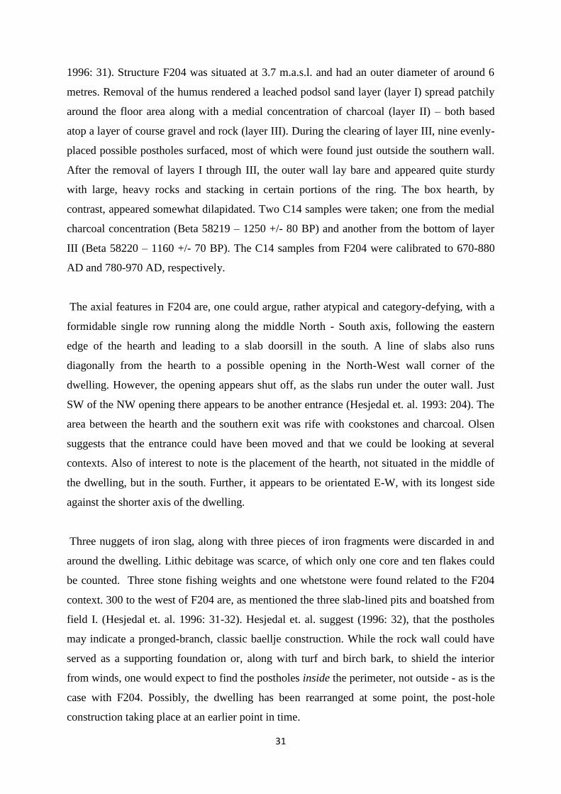
Figure 8: Layer 3 F204 plan. After Hesjedal et. al. 1996
Figure 9: F204 (East) with features (anlegg) 1 to 4 (East to West). After Hesjedal et. al. 1996
Figure 10: F7 plan, layer 4 (fin). After Hesjedal et. al. 1996.
Figure 11: F205, Layer 2 (fin).
Figure 12: The Iron Age sites selected for excavation. After Myrvoll 2011: 84.
Figure 15: The excavated tent ring at Mellaneset II.
Figure 16: structures returning Iron Age dates at Skjærvika. After Henriksen & Valen 2013.
Figure 17: Iron Age structures and features in lower Skjærvika. After Henriksen & Valen 2013.
Figure 18: Surveyed and excavated sites in Finnmark.
Figure 19: Surveyed and excavated sites in Troms.
Figure 20: Map of indigenous peoples across Siberia. Dallmann, W. K., Norwegian Polar Institute
Figure 21: Spatial restrictions in Navajo hogan. After Kent 1990.
Figure 22: the cluttered interior of a 20th century Sámi goahti. After Elgström 1922

Abstract:
This thesis centers around the so-called Slettnes type houses appearing around 0 AD in coastal areas of Troms
and Finnmark. These dwellings usually feature stone rows leading from the hearth, resembling Sámi practices of
floor partitioning known from extant historal sources. Similar features are known from the Paleo-Eskimo
cultures of Greenland and North-Eastern canada. The paper loosely employs theorical perspectives of the 'new
materialist' school to better understand this cross-cultural phenomenon. In the initial literature following the
excavations at Slettnes in the early 1990s, the inconspicuous remains of the small, circular turf houses or tent
ring from the first millennium ADs were championed as a 'type'. On an aggregate level, the paper aims to
elucidate the foundations of this definition. Survey data has also been compiled and presented. A discussion on
problems relating to relative dating of these remains is also included

1

1
1. Introduction
1.1 The Slettnes type
In the initial literature following the excavations at Slettnes, the namesake „Slettnestuft‟ (tuft -
Engl. ‘house foundation or remains appearing as depressions or raised masses in the
terrain’) was coined for the remains of the small, circular Iron Age turf house/hut (Olsen
1993). Tuft is essentially interchangeable with „house remains‟ or simply ‟house‟ in English,
although the Norwegian term illustratively lends itself better to things survey-related and the
like. The term Slettnestuft still appears in the Norwegian language literature (e.g. Nilsen 2004;
Sommerseth 2009) but is in other cases disregarded (e.g. Bratrein 1996). In the English
literature, however, (Sámi)/Iron Age turf house/tent is used exclusively in its stead (e.g. Olsen
et. al. 2011; Myrvoll 2011).
At the onset of the 1990s, the Iron Age archaeology of North Troms and Finnmark was in
dire need of a lead house type; indeed, concrete traces of any house structures were hard to
come by (Hesjedal et. al. 1996: 34). Perhaps this goes some way in explaining the hasty
establishment (and namesake) of the Slettnes house as a „type‟ in its own right. While
chronological and morphological demarcations are fairly adoptable with regard to the
preceding late Neolithic semi-subterranean Gressbakken and Early Metal Age Mortensnes
houses (though not without controversy, see Wasmuth 2005), we shall see that the basic form
of the Slettnes type persists in later dwellings into the Middle Ages, and even the Early
Modern Period; in which case the Slettnes designation quickly falls out of use. In the broadest
terms, we are dealing here with what appears simply as a tent ring, a structure template that in
some shape or form makes appearances throughout the entirety of the archaeological record of
the sub-arctic (and beyond). However, I will argue that the distribution pattern, the temporal
and geographical proximity of the Slettnes sites to other contemporaneous categories, as well
as some minutiae pertaining to the excavated structures and their inventory, make the Slettnes
type – or at least the archaeological and cultural context it represents – a discernable category.
The Slettnes house is likely to be a precursor to the historically recorded Sámi goahti and
lávvu traditions of turf/earthen houses/tents. As such, ethnographic and experimental sources
may provide insight into the nitty-gritty of how the Slettnes houses were built and used.
Both turf house and tent are used when referring to the Iron Age dwellings, and Myrvoll
(2011: 83) clarifies that the house type was in continuous use up until the 20th
century. More
recent instances of this type are more easily observable and therefore recorded in greater
2
numbers. Diminished with time, the older versions of these houses, Myrvoll (2011: 83)
clarifies, are much harder to find. The diagnostic traits of the Slettnes house is the central
hearth with stone rows – occasionally, slightly diverging - running from the entrance and to
the hearth, and sometimes from the back wall (possibly back exit) and to the hearth.
Furthermore, they are located in close proximity to slab-lined pits and small
boathouses/boatsheds. (Myrvoll 2011: 83). The boathouses found in relation to the slab-lined
pits and/or Iron Age round houses are typically narrow and shallow in morphology and mirror
the distribution of the aforementioned categories closely (e.g. Olsen 2011: 57, Myrvoll 2001:
18).
1.2 Research goals
At the start of this project, my intentions were to form a chronological comparison using site
configuration and inventories in order to place the sites in the background of societal changes
throughout the Iron Age (0-1050 AD). Other points of interest included the familiar
archaeological tropes of seasonality and settlement patterns. However, the number of
excavated sites is still very low, and my findings did not differ from observations made after
the first excavations at Slettnes in 1992 and 1993 (Hesjedal et. al. 1996). A synopsis of the
broader conclusions made as well as inquiries raised by these contributions will be provided
While I will present these findings in a more limited form, my focus has shifted towards the
mysterious stone rows leading from the Slettnes house hearths. As an undergraduate student,
connections between architectural form and social space sparked my interest. The idea that
architectural features or forms could facilitate and maintain ideologies was intriguing.
The main allure of the mid-passage features lies in that they have parallels in the Paleo-
Eskimo of Greenland and North-Eastern Canada, preceding the Slettnes houses by almost
3000 years. Ulla Odgaard (2001) has referenced the Slettnes houses in her argument for the
existence of a Pan-Arctic shamanistic idea-complex reflected in the mid-passage ruins of
these cultures. The Slettnes houses, then, are an epiphenomenon of this conceptual complex.
While an exotic idea, it serves as a seminal springboard into attempting to understand why the
mid-passage phenomenon has occurred. One of goals of this paper is to contrast Odgaard‟s
claims with the Slettnes house material and through this, attempt to understand what caused
this great cross-cultural similarity.

3
The presence of mid-passage rows in the Slettnes houses has led Norwegian archaeologists to
emphasize its proto-Sámi qualities. In doing so, I believe the similarities to Sámi ethnography
have been exaggerated and simplified. I shall make an attempt at bringing nuance to this
comparison.
As it stands, structural remains from the period in question have been treated individually in
rather broad intervals in terms of time of publication, and have yet to be subject to systematic
comparative and classificatory methods. Another goal of this paper is to collect and review
the data at hand for posterity, and to determine problems with data reliability and definitions.
These inconspicuous Iron Age dwelling remains of the high north were initially championed
as the Slettnes type‟. I also aim to elucidate what – exactly – is said to constitute a Slettnes
type house. A great deal of these have recently been registered through surface surveys. The
paper aims to examine problems relating to relative dating of these structures. For the sake of
brevity, I will be using „Slettnes type‟ to denote the the faint traces of round turf houses/tents
appearing alongside particular boatsheds/houses and slab-lined pits in the Iron Age and into
the Medieval period of Northern Norway. To avoid any contention, I should clarify that this
designation is in a purely provisional.
What is clear from the above is that the Iron Age period in Finnmark probably has seen a
certain degree of neglect in Norwegian archaeology. Next, I will provide a short background
regarding the historical circumstances behind this oversight.
First, however, an aggregated look at the history of Norwegian archaeology‟s relation to Sámi
material is required to explain the significance of the historical dimension regarding the
development and current state of Sámi archaeology.
1.3 The Northern void
In its pre-formalised 19th century state, the discipline of archaeology concerned itself with
finding the origin and character of “peoples”. In the first half of the 1800s, the Sámi were
considered the indigenous and “first” population of Northern Scandinavia. They were even
romanticised by some for being free of the unnatural corruption brought on by the rise of
industrialisation and urbanity. Other characterisations were less commendable, viewing the
Sámi as degenerate or lacking in character. Towards the end of 1800s, however, the new-
found discovery of human evolution resonated with nationalist ideology and was made to

4
adhere to the zeitgeist of social darwinism. (Hansen & Olsen 2004) Until the onset of the
1970s, Northern Scandinavia was considered a passive, distant periphery ripe for exploitation
at the hands of traders, pillagers and tax collectors closer to the power centres in the South
and to the East. The natural resources of the North were regarded as the contested spoils of
powerful and wealthy outside agents (Mulk 1996: 48-49).
As briefly touched here, the Iron Age of North Troms and Finnmark has been neglected in
large part due to the rise of nationalism in the 20th and 21th centuries. Through the 1970s, a
number of political and intellectual movements cascaded and resulted in an increased interest
in historical Sámi archaeology. From the outset of this renewed interest into the Sámi-Norse
relations in the Iron Age, economy was the main template from which to extrapolate inquiries
into ethnicity and social organisation. This is in large part due to the pioneering work of
anthropologist Knut Odner (1983) having great influence on researchers at the University of
Tromsø. A prime example of one such work is Jørn Henriksen‟s (1995) thesis on the slab-
lined pits found mainly in the first millennium AD. The archaeology milieu at the University
of Tromsø has been instrumental in the increased interest and growing knowledge
surrounding the period (Schanche 1992, Hansen & Olsen 2004).
While we in recent years have been successful in piecing together especially the latter part of
the Late Iron Age, the Roman and Migration periods remain rather barren. This perceived
“void” may naturally, in part, be attributed to happenstance and the logistics of cultural
heritage management. By the same token, the period yields traces of activity and habitation
that are hard to spot in the terrain or that are difficult to date. Nonetheless, Norwegian
archaeology‟s inherent relation to the interests of the state may have facilitated a disregard for
archaeology with little utility in the nation-building narrative (Østigård 2000). Given that Iron
Age finds in the northernmost regions of Norway are predominantly Sámi, we can appreciate
this point. Despite increased interest in Sámi archaeology from the 1970s, some latency is to
be expected when piecing together the Iron Age puzzle. One possibility is that a significant
quantity of surveyed turf houses could have been dated to later or earlier periods in error, as
postulated by Schanche (1992). We can consider the possibility that the problem is twofold:
on one hand there has been a lack of research interest in the period; on the other, the
archaeology from the first millennium may simply not yield many finds – or that we haven‟t
found them.
In the next chapter, I will present some of the theoretical perspectives informing this paper.
5
2. Background
2.1 Theoretical perspectives
The notion that our corporeal, wordly existence is a mere veil is seemingly nigh-primordial.
We can cite, for example, the gnostic tradition, or Plato‟s allegory of the cave. Decartes
divided the makeup of reality into res extensa – of the physical world, and res cogitans – of
the mind. Kant distinguished between noumena – things in themselves – and phenomena –
objects accessible via sensory input. The noumena, the ding-an-sich, was outside the grasp of
comprehension, a „border concept‟. The phenomena will always be distortions of the
inaccessible, albeit ontologically present, reality (Olsen 2010: 64-67, 83).
In recent years, an „ontological turn‟ of sorts towards materiality and things has taken place
across several disciplines (Olsen 2010: 22). These eclectic approaches are loosely associated
with post-structuralism in that they attempt to dismantle dualisms, at the same time
challenging the ancient philosophical problem of identity and difference. Actor-network
theory (hereafter ANT) is based on the premise that material objects have (non-intentional)
agency, and that the relationship – envisioned as a nodal network – between human and non-
human agents, as well as semiotic concepts, must be accounted for to understand various
constituents of society (Latour 1999, 2005). Proponents of phenomenology have shown that
first-person conscious experience is always directed at something; always situated within
physical embodiment (Merleau-Ponty 1962) and in a field of material objects (Heidegger
1962). In the 20th century, phenomenology challenged the subject-object/ideal-material
dichotomy and anthropocentric ontology prevalent in the various branches of analytic
philosophy. Here, the experience and appearance of an object comes before its attributes and
qualities. Espousing a form of ontological „realism‟ suited for an historical-interpretive
framework, along with the prominence of material objects, these perspectives have
predictably come to be appropriated by archaeologists interested in these matters.
The philosophical underpinnings are infinitely complex, but a common thread is an antipathy
to reductionism or demarcations of compound objects of different kinds, whether they be
social or physical.
To Latour, all different actors should be viewed as being of the same kind and level of
importance – all that matters is the relation, the network. But can objects be reduced to their
phenomenological presentation, their properties, effects or relations?
My intention is not to slavishly follow any single theory, but rather to draw from a wealth of
perspectives in different contexts. The primacy of human movers, ideological superstructure,
6
as well as adaptive-functionalist are a given, and serve as running themes in a majority of
anthropological and archaeological research, including models and interpretations of
Norway‟s Iron Age society. I suspect these parameters will be adequately accounted for
throughout the text. However, it is in between these conventional explanations that I wish to
embed the „turn towards things‟ and their capacity to extract a certain nuance. Based on the
material at hand – the coastal Iron Age settlements of northern Norway - I wish to stress the
mutual constitution of materiality, society and ideology.
2.1.1 The conical lodge – a binding together of forces and materials
Anthropologist and theoretician Tim Ingold has been influential in „new materialism‟. Over
the years he has attempted to revitalize the artisan, doing away with the legacy of mechanized
industrialization. In a 2013 essay, Ingold (2013) writes about the processes of building – seen
here as the binding of material forces and fluxes – that go into a vernacular tent, such as those
traditional Sámi lavvu. He contends that the building of such a structure was not in instance of
architecture according to prior specifications, but a continual process of binding together
forces and materials. Ingold draws from Deleuze & Guattari‟s concept of the „rhizome‟, a
labyrinthine mind map without beginning or end and in constant flux. Instead of oscillating
between idealist or materialist monisms, culture/nature, or imposed static states, we should
here attempt to „explore‟ the ontological totality without assigning causal primacy to any
single part of the chain. According to Deleuze & Guattari (1987: 5-12), western intellectual
traditions have a proclivity towards what can be characterized as arbolic, hierarchical and
linear models of knowledge and being; an image of thought fashioned as a tree with its roots.
From ethnography, we‟ve gathered that our abstractions – dualisms between, for example,
what we call culture and what we call nature - are not a priori universals in the minds of all
humans. Rather, ontologies, belief systems, hierarchies and categorizations according to
identity and difference etc., it is argued, are historically situated, sometimes related to
particular practices and uses of the environment (Ingold 1992).
Vernacular architecture is widely recognized, Ingold holds, as being different from modern
architecture in that uses local materials, is habitual and not very self-aware. The forms – the
specifications – are nonetheless presumed to be carried through the generations by means of
cultural tradition, unbeknownst to the builders themselves (Ingold 2013: 15). The orthodox
way of thinking about art and architecture in the western world is illustrated by Aristotle‟s
notions of form (morphe) and matter (hyle). According to the hylomorphic model, the forms
7
(implying design) inhabiting the world were the result of projected ideal form in the mind of
the maker onto the inanimate material (Ingold 2013: 14). Creation thus begins with a finished
product, implying an inversal of the actual chain of events. The hylomorphic model is also
related to a wider view of the world - from the submicroscopic, molecular level to brick
buildings – as constituted by building blocks. Building with such materials is based in
structural mechanics, requiring withstanding the force of gravity. A tent, on the other hand, is
more akin to a sail or glider, in that it should deflect or channel the wind so as to not be
carried away (Ingold 2013: 18-19). This contrasts with the geostatic „house‟ consisting of
building blocks.
The conical lodge, Ingold argues, is a meshwork gathering of materials, experience and
people in flux - all dispersing and combining again in a different configuration. In this sense
sense, a lávvu or tipi-like tent variant as a form has certain inherent qualities, but it is in the
convergence of its habitants and its physicality that it actualizes its thingness (Ingold 2013:
20-21, 28) – specifically the holistic potential of its intrinstic socio-technic properties and
qualities. At core, it is a combination of three crafts: the tactile frame of carpentry - the textile
canvas of weaving, and the hearth of masonry. On the microscale, the transfer of building and
textile techniques requires hands-on engagement, rather than passive osmosis through means
verbal or conceptual. A human agent can also leave an imprint of his or her social biography
in the process of creation of fashioned materials (Ingold 2000: 253-254). Affordances –
inherent potential properties – in both substance and craftsperson, are first actualized and
activated in this synergistic coming-together (Gibson 1986: 137-140). Ingold suggests,
drawing from Gibson, that the tent is both of the earth and the sky, its roots in the earth and its
frame in the sky. In contrast is the striated space of the farmer, where the earth presents itself
as a resistance to be overcome in discord with the sky, Ingold likens the earth of the nomad to
the smooth space of a seafarer riding the waves (Ingold 2013: 26-27). From the vantage
within the lodge, what is perceived and felt is the ever-changing earth underneath, and the
sky, with its winds, at the roof apex – forming an earth-sky. This is in stark contrast to the
notion of landscape, through which the earth and the static flooring is perceived from
detached distance as separate from the sky.
2.1.2 Critical considerations
Ingold‟s „nomad‟-description seems like a bit of a non-sequitor in the context of the Sámi.
Deleuze & Guattari‟s (1987) nomad is a mode of thought; a post-modern subject transgressing
8
institutional boundaries. In a way, it‟s not dissimilar to the simple-complex classification of
hunter-gatherers, shown to be far more problematic than assumed at the onset. The seafaring
analogy may fit well with some pastoral herders, but the coastal environment of northern
Norway is rife with navigable landmarks and features. Furthermore, circumpolar hunter-
gatherers enculturate the landscape, assigning and leaving signatures that serve as waypoints
(Jordan 2011: 28-29). Also, as we shall see in chapter 2., the internal organization of the Sámi
tent seems to conform more to the idea of striated space. Despite these problems, Ingold is
touching on some key concerns in the perception of the environment – which was surely, in
many ways, different from our own.
A tent will not build itself. Ingold‟s point, I presume, is that it will not materialize itself from
an ethereal mental plane either. The locus of form and transformation, in Ingold‟s view, is
found in the creative interaction between the builder/craftsman and the materials brought
together and combined in various ways. Here, the frame and canvas materials, not to mention
the surrounding microtopography, the local ecosystem and even the current weather, actively
inform and affect the intentional, human actors. To Ingold, form-giving is life: the processes
of formation usurp the „finished‟ product; materials in flux, flow and transformation
supersede static states of matter as viewed from the detached and dualistic „ontic‟ perspective.
Form itself is death. But what about the function and value of material form as a form of
memory and source of identity? As (foremostly) an anthropologist, Ingold arguments, I think,
are informed by a synchronic frame of inference. Through the „longue durée‟ wavelengths of
archaeological time frames, forms of tools and housing structures display a temporal and
geographic family resemblance, a formality and regularity often so pervasive that taxonomic
methodologies (typology) can be effective for relative dating even within very small time
margins. To Assmann (2006: 69), this is indicative of a transmitted cultural and material „will
to form‟. From the archaeological perspective, Ingold‟s reduction of „cultural tradition‟ is
problematic. But what if „cultural tradition‟ is seen more as embedded within an ensemble of
people, materials and forms? However, we must concede that variation in form is actively
subdued in our generalized models, emphasizing idealized patterns against outliers producing
„noise‟.
Like Deleuze & Guattari (1987), Ingold is attempting to overcome the anthropocentric and
dualistic way of thinking so deeply ingrained in our worldview. Following the cascading,
metaphor-laden abstractions and alien rhetoric employed, it sometimes becomes difficult

9
remain grounded in concrete matters. Ingold (2010: 98) likens the artisanal process with
incremental improvisation; always fluid and creative. But what about habitual performance?
Consider the perspective of a touring musician. Performance is here second nature; notation
appearing in the mind‟s eye as carts on a track, spider-fingered arpeggios effortlessly
channeled through muscle memory and so forth. Ingold‟s transference of very different
processes of production, such as the sawing of planks, to preparing and working pieces for a
tent is ill-fitting for a number of reasons. Trying to construct and pitch a tent without a plan is
a bad idea. We must also consider one of the characteristic features of the Iron Age: the mass-
production and commodification of prized artefacts. So, it can be argued, the perceived
abduction of form onto matter has real implications. In the minds of people, this can readily
occur, and does so without the need to invoke some genealogical link to Aristotelian
metaphysics. Still, any instance of manual production is, by definition, at most itinerative;
similar but variable.
Whilst keeping in mind Ingold‟s points as well as their shortcomings, we will turn or focus to
more functional modes of mundane explanation.
2.2 Floor plan, materials and mobility
In his 1993 article on newly-discovered Slettnes houses, Olsen touches on the relationship
between round floor plans and high seasonal mobility, as well as the phenomenological and
mythological link connecting the floor plan with seasonal movement of the group and the
Sámi cosmos. In the following, I will attempt to detail the first point brought up by Olsen.
From 2000 BC to 0 AD, we can observe the following changes: from large, rectangular dug-
down houses with two hearths and large wall foundations to medium-sized, oval, single hearth
(usually) huts with floors only slightly lower than the surrounding terrain, and finally to the
small, circular, single hearth domicile known as the Slettnes type. As Olsen (1993) touches on
in his article, it may behoove us to step back and make a simple comparison between the basic
properties of rectangular and circular house shapes, and to better understand why this change
took place and what it entails in practical terms.
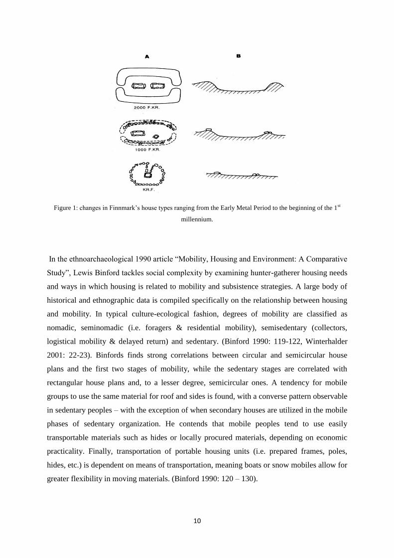
10
Figure 1: changes in Finnmark‟s house types ranging from the Early Metal Period to the beginning of the 1st
millennium.
In the ethnoarchaeological 1990 article “Mobility, Housing and Environment: A Comparative
Study”, Lewis Binford tackles social complexity by examining hunter-gatherer housing needs
and ways in which housing is related to mobility and subsistence strategies. A large body of
historical and ethnographic data is compiled specifically on the relationship between housing
and mobility. In typical culture-ecological fashion, degrees of mobility are classified as
nomadic, seminomadic (i.e. foragers & residential mobility), semisedentary (collectors,
logistical mobility & delayed return) and sedentary. (Binford 1990: 119-122, Winterhalder
2001: 22-23). Binfords finds strong correlations between circular and semicircular house
plans and the first two stages of mobility, while the sedentary stages are correlated with
rectangular house plans and, to a lesser degree, semicircular ones. A tendency for mobile
groups to use the same material for roof and sides is found, with a converse pattern observable
in sedentary peoples – with the exception of when secondary houses are utilized in the mobile
phases of sedentary organization. He contends that mobile peoples tend to use easily
transportable materials such as hides or locally procured materials, depending on economic
practicality. Finally, transportation of portable housing units (i.e. prepared frames, poles,
hides, etc.) is dependent on means of transportation, meaning boats or snow mobiles allow for
greater flexibility in moving materials. (Binford 1990: 120 – 130).
11
Ethnographic examples of fully nomadic peoples from higher latitudes or temperate-arctic
area are fairly scarce, while Binford‟s „seminomadics‟ are the most common category of
hunter-gatherers world-wide, as well as in higher latitudes. On a global scale, Binford‟s data
clearly demonstrates a correlation between winter sedentism and harsh winters. He goes on to
suggest that storage investment and mobility during the warmer parts of the annual cycle is
key to survival in higher latitudes. What‟s more, conditions in gradually higher latitudes force
hunter-gatherers to focus on animals rather than plant foods due to availability. Aquatic
biomes are especially advantageous to northern hunter-gatherers, as these require smaller
ranges, less annual residential movements and offer higher predictability. With subsistence
security and decrease in mobility, increased population densities could in turn set the stage for
different stages of social complexity. (Binford 1990: 130-149). Among others, the
comparatively „complex‟ Nunamiut Eskimo are known to transport cover materials as well as
structural wooden poles. Binford postulates transporting housing materials is mostly
beneficial (energy effective) in the case of mid-to-low mobility lifeways. In sub-arctic areas
with less readily available material for use in the construction of dwellings, there may be
more of an incentive to transport materials (Binford 1990: 128). What Binford seems to
suggest is that the technology of housing is a result of the strategies employed by the given
hunter-gatherer group – strategies that are environmentally determined (Binford 1990: 124).
Another study by Arwen Feather, this time using a different data set, also correlates circular
floor plans with mobility - and rectangular plans with residential permanence (Feather 1996).
We should be familiar with the explanation offered: choice of floor plan is part of minimizing
energy investment and risk in a subsistence strategy (Feather 1996: 57). Feather argues for
several inherent advantages to circular dwellings: they retain heat more efficiently, are more
stable and resistant to physical stressors like wind and rain; their shape is highly compact,
enclosing a large volume with minimal structure and building materials; and finally, structural
integrity can be accomplished using portable materials (Feather 1996: 61). However, such
structures lend themselves poorly to elaborate structural expansions to the base form and are
not very compatible with heavy, durable roofing materials (Feather 1996: 57-61). Rectangular
houses have larger interior volumes, are easily partitioned or added to, both in plane and
vertically without destabilizing, and the roof distributes weight evenly. The construction of
sturdy rectangular houses is a high investment ordeal, requiring high weight material for use
in structural elements like posts and bracings. (Feather 1996: 61). Feather holds that
communities mainly incorporating circular dwellings tend to have communal qualities, and
have limited potential for social inequality (Feather 1996: 64).
12
In Feather‟s study, circular housing solutions were said to negatively correlate with structural
expansions. The expansion of the arch-beamed goahti frame should in this respect provide a
clear counterexample (see 2.3). Beyond that, it has become increasingly clear that „modern‟
hunter-gatherers cannot be understood as synchronic entities, but rather as active agents
interacting with surrounding groups, shaped integrally by relations to the wider world (Olsen
1994: 22). Crudely put, modern hunter-gatherers can no longer provide „authentic‟ insight.
Nonetheless, there are (arguably) only so many housing solutions within possibility whilst
simultaneously upholding a mobile settlement pattern and nomadic way of life. The crux of
the matter lies not in floor plan per se, but in the flexibility offered by the given housing
solution – and it is this flexibility that is associated with circular and oval structural templates.
Let‟s look at some concrete examples of Ingold‟s „converging flows of materials‟ illustrated
by the data accounted for above.
2.3 Sámi vernacular architecture
The Sámi residential unit, the goahti, is said to have seen use in the form of various iterations
from the Middle Ages up into the 1900s. The goahti term encompasses a wide variety of
housing solutions, from large, multi-room earthen houses to lighter, tent-like constructions –
even including the post or rafter based „Norwegian huts‟, known from 16th century fishing
villages in Northern Norway (Vorren 1982: 63). Swedish ethnologist Ernst Manker
distinguishes between the pronged branch and the buestangkonstruksjon/baelljegoahti – arch-
bowed construction, deeming the latter as the oldest form seen through an evolutionist
scheme; from a simple, smaller construction to one a larger and of higher complexity. The
two different wooden skeletons of the goahti can provide bases for both a turf/peat/bark-
covered „house‟ – darfegoahti - and a canvas-covered tent - lávvu. The pronged branch frame
utilizes three forked poles interlocking at the top, giving a conical appearance. The floor space
is decidedly circular with a diameter of around 350-450 cm.
The inner framework of the baeljegoahti consisted of two sets of arched birch rafters
(bealjek). Manker notes that these arched birch pieces used for the bealljek were procured
from trees growing on sloped surfaces. Subalpine environs would yield less eligible straight
birch stems, but more of these arched tree trunks. (Manker 1944: 221-230). The arch-beamed
frame allows for a larger diameter without the use of larger and heavier components in
addition to making the canvas walls more vertical. The four curved pieces are cut at the
13
contact points. With the increasing importance of animal husbandry, the beam arches were
incorporated into a longer form, the „communal‟ goahti, housing both animals and people in
separate compartments. This was done by simply connecting more beamed birch piece pairs
in a series (Vorren 1982: 62-63). However, this method can be traced back at least to the
1600s (Vorren 1982: 64, 67).
The arch-beamed frame leaves an oval impression, shortest along the face of the entrances.
Sometimes the goahti was erected on top of a previously used hearth, then using the same
stones for holding down the canvas. However, there are countless examples to the contrary as
well. (Odgaard 1995: 21). Manker documented the process of decay of a select few Sámi turf
huts. Firstly, the outer layer of birch bark and turf slide down at the hands of gravity and
wind, forming a raised circular formation around a slightly depressed surface. The birch logs
resting on the inner skeleton are last to decompose. Placing stone slabs under the outer birch
beams could significantly slow the decay, allowing a robust turf house to last up to 70 years.
(Manker 1960: 380, 386)
2.3.1 Vernacular forms as carriers of memory
If we (momentarily) disregard the usual objections to the myopic adaptive functionalism at
display, Binford‟s findings, while unlikely to raise any eyebrows, give insight into type of
engagement nomadic peoples have with their environment and the materials in it. If - as ANT
suggests - all societies are socio-technic assemblages, then this Binfordian characterization
certainly emphasises the technic end of the equation. Since there‟s arguably no real
disconnect between these two spheres, we consider the implications of Binford‟s results. With
the large number of Slettnes sites located on Finnmark‟s outer coast islands, eligible wood
pieces for frameworks would have had to be gathered from the inner fjords and transported by
boat to the locales (Vorren 1982: 59-60; on the utility of boats, see Ames 2002: 29-31). Given
this scarcity, it could also be posited that tents were quickly dismantled, transported to other
locales and then reassembled. Provided continual re-use, made especially likely on account of
the earthen boat shelter and slab pit „installations‟ (see chapter 4), on-site caching and the like
is another possibility. The niche specialization hinted at by these sites was surely part of their
„lifeline‟. Starting from the 1700s, the Sea Sámi obtained construction materials and iron
through the Pomor trade (Vorren 1982: 67). We should consider the possibility that a similar
pattern, then involving a different configuration, was in place in earlier periods. First, let‟s
consider the mobile framework.

14
The nomadic process itself is sure to have thoroughly shaped people, as well as materials and
house forms. Both house forms and materials are required to be congruent with the abided
settlement pattern, as well as the group size, and in that sense they are in ways constrained.
Preparing and collecting materials for the canvas, for example, could be integrated into
different parts of seasonal movement, depending on the resources needed at different stages of
settlement. This could even have affected the mediums of transportation; the design of the
boats or sleds used (and perhaps, even more so vice-versa). The process of material
transportation, the (possibly/occasional) ritual, at least ritualistic, foundation, assembling and
furnishing of the tents can be said to be an intrinsic quality of the entangled socio-technic
collective in question. The structural components of both the pronged-branch lávvu as well as
the baelljegoahti (and other tent types) can be subject to different rates of wear and tear,
requiring continued maintenance and changing of parts. Some key components could be very
old indeed, prized, and perhaps even associated with mystical power. But beyond that, the
dynamic of maintenance and interchangeable parts involves a very hands-on approach, at the
same time continually reifying and carrying the base forms. And so one could argue that the
very momentum of the nomadic (living) assemblage involves an emergent mnemonic effect
through habitual repetition and continuity in form.
In Heideggerian (1962: 105) terms, a constant haptic engagement with one‟s materials and
tools can be characterized as ready-to-hand, a consciousness towards objects that is
unreflective and non-intrusive. Usually, the overt failure or malfunction of objects bring about
a directed questioning – present-at-hand – in which the rationale behind the given tool or
solution is contemplated. Maintenance and mobility are interrelated functions of a tent‟s
qualities, and many of the activities surrounding its use are related to these functions.
Immanent in the tent is therefore a constant presence of minor interruptions, potentially
inviting „criticism‟ (Olsen 2010: 163-165). However, one could argue that these deficiencies
are of a different quality than those of, say, a boat or a sword, here negated by the
interchangeability of superstructure components and the entangled, spatially and socially
distributed ensemble. Norwegian sociologist Tom Johansen (1992: 30) holds that the
longevity of material objects constitute a latent potential for change and improvement, in part
due to their capacity as carriers of memory; revealing the deficiencies of past designs. In that
regard, these flexible and mobile domiciles, due to their transient quality – made durable only
through constant preservative efforts – could possibly be missing such a self-reflective

15
mechanism. As a nomad, in this wholly different mode of being, one would not be not
allowed to linger in the contemplative, present-at-hand mode for long.
Of course, all of this is highly tenuous. For example, the Iron Age Sámi would have been
quite familiar with their agrarian neighbors, their building techniques and culture, and would
probably have seen a fair share of derelict goahti. Tenuousness notwithstanding, this sort of
nomadic movement, gathering and reifying cross-fitting components and vehicles of
transportation, must factor into the overall state of affairs, along with the usual processual-
systemic influences, intentional agents (that are never only human) and ideological factors
(that are never purely ideological). The Slettnes sites, with their special utilitarian makeup,
seem to stress the constituting role of materials and resources in the entangled interethnic
contact and trade network along the landscapes of Norway‟s northern coast.

16
3. Sámi ethography
3.1 Sámi social space
Ränk (1949) devised a thorough examination of floor partitioning among Sámi groups as
depicted in historical extant sources, as well as practices recorded by ethnographers in recent
times. Compiling the evidence, Ränk finds an underlying pattern behind all the various
recorded forms.
Among the older forms is a ninefold, grid-like sectioning, delineated by wood logs of varying
dimension, flattened planks and/or twigs (Figure 1). Eight lines project outwards following
the edges of elongated and rectangular árran, the hearth itself constituting the final „section‟.
This scheme seems to have seen some use across large parts of Lapland region, from
Finnmark to Finnish Lapland, though it less common in the forests of Northern Sweden. With
regards to living space, it is interesting to note the relationship between the shape of the árran
and the oval shape provided by the arch-beamed frame.
Figure 2: The sleeping arrangement of a two-family Sea Sámi goahti from coastal Finnmark showing the floor
plan sections. After Leem 1767.
The etymological continuity from Leems time is key in Ränk‟s argument; usva-kiæzhie
designating the front door lateral (viewed from bird‟s eye, relative to entrance) sections, gask-
loido for the middle, and bosshio-kiæhzie for the back door sections, corresponding to the
north Sámi uksa, loaido and boassu (and other derivatives). These terms also served as
etymological roots for various other features, such as doorsteps or the logs, twigs and planks
seperating the different sections. I.e., the three laterally corresponding sections on each side of

17
the hearth and mid-section bore the same name. (Ränk 1949: 87-90). Etymologically, the root
of “boaššu” (påssjo/poásso etc) is rooted in ground/bottom or north, with loaido being related
to the Finnish laita, meaning side/ width/edge. Even though the Sámi used different terms for
cardinal directions, the back (boassu) usually faced the north. As such, the three lateral rows if
the back can be effectively understood as the boaššu (Ränk 1949: 93-94).
A similar scheme was even used in rectangular huts at Inari at the turn of the 20th century,
with flexible solutions to accomodate the sleeping area for a higher number of inhabitants,
such as the lateral expansion of the back area – now designated „luóps‟, and doing away with
the „uksa-loaido‟ (Ränk 1949: 91). Ränk then draws forth hexagonal huts, one of which was
documented by Schefferus [1673], thus making it the oldest source on Sámi domestic space.
While there were some differences here – the logs marking the “uksa” (upper) mid-section
were missing, instead only placed on each side of the hearth; a log was placed perpendicular
to the door axis at the back of the hearth, with another small log, also perpendicular, placed at
the very back end where the angles met – Schefferus nonetheless marked these areas in the
same manner as the aforementioned nine-part floor plan. Ränk concedes that, from a purely
visual perspective (c.f. Sirelius in Ränk 1949), the arrangement might conflict with the nine-
part scheme. However, citing Schefferus‟ designations, Ränk dismisses that the physical
boundaries were of any significance; what is of importance is the etymological categories as
evidence of a conception circulating in the collective consciousness (Ränk 1949: 92-93).
Figure 3: Floor plan of a hexagonal hut from the forests of northern Sweden. After Schefferus (1674).
A – posse, B & C – lops, D & E – loide, F & G – kitta, H – hearth, I – ox (entrance).
According to Schefferus (1973: 225), one „abnormal‟ arrangement was particularly
widespread. Here, wood slabs were to be placed solely around the boaššu, with firewood kept
to the right of the entrance. This practice was also been recorded in more recent times in
18
Russian Lapland (Sirelius in Ränk 1949: 94). However, these are exceptions to the rule.
Instead, the physical lineation of either the entire uksa-boaššu mid-section, or alternatively,
the path from the front entrance to the hearth (uksa), features most prominently in Sámi
ethnography. This lineation could run as straight lines from the door to the hearth, but also as
diverging outwards from the hearth. On occasion, the boaššu was marked with the presence of
a sacred boaššu-stone behind the hearth. Ränk holds thus, recalling the early extant historical
sources, that the basic ordering principle can be seen as uksa-árran-boaššu with two
trapezoidal loaido on each side. In addition, the sectioning of the arch-beamed frame can be
said to correspond with the basic categories of the floor plan, with the space between the two
bealjek forming the lateral mid-section (Ränk 1949: 95 - 98). Interestingly, Ränk posits that
room sectioning according to the arch-beamed frame could be much older than floor
demarcation on account of the incidence of lateral partioning in dwellings of North Eurasian
ethnography (Ränk 1949: 99). Given that the arch-beamed superstructure seems to be a Sámi
innovation, along with the prevalence of diffusionist thinking in Ränk‟s time - not to mention
the eastern-origin theory – we have good reasons to be hesitant in wholly accepting this
argument.
3.1.1 Conceptual practices related to floor plan
As mentioned, the most common scheme practiced (originating from the nine-part scheme)
was a five-part sectioning of the floor plan with the hearth (árran) in the middle. The narrow
compartment from the front entrance to the hearth (uksa) served as a fuel depot, critical in
times of rainfall or snow. Small animals, such as dogs, lambs or calfs could be kept on either
side of the uksa. It also stored clothing and footwear. On the other side of the hearth was the
boaššu, essentially serving as a kitchen, complete with cooking utensils, crockery and the like.
In the older sources this area was considered sacred, a ritual/ceremonial area subject to
behavioral rules and restrictions. Most sources seem to converge around the keeping of
hunting weapons in the boaššu. The one exception, placing hunting gear in the uksa (Jessen in
Leem 1767), is disregarded on the grounds of a specific taboo logic. Solidifying the notion of
the boaššu being reserved for men, Ränk cites examples of taboo conceptions against women
coming into contact with the shaman‟s drum, and specifically grazing blood stained on
hunting weapons.
Thus, the boaššu with its housing of wild game, hunting weapons, as well as the shaman‟s
ceremonial drum, was the men‟s sphere. Activities associated with these domains were, along
with preparation and cooking of game animals, also conducted in the boaššu end of the lodge.
19
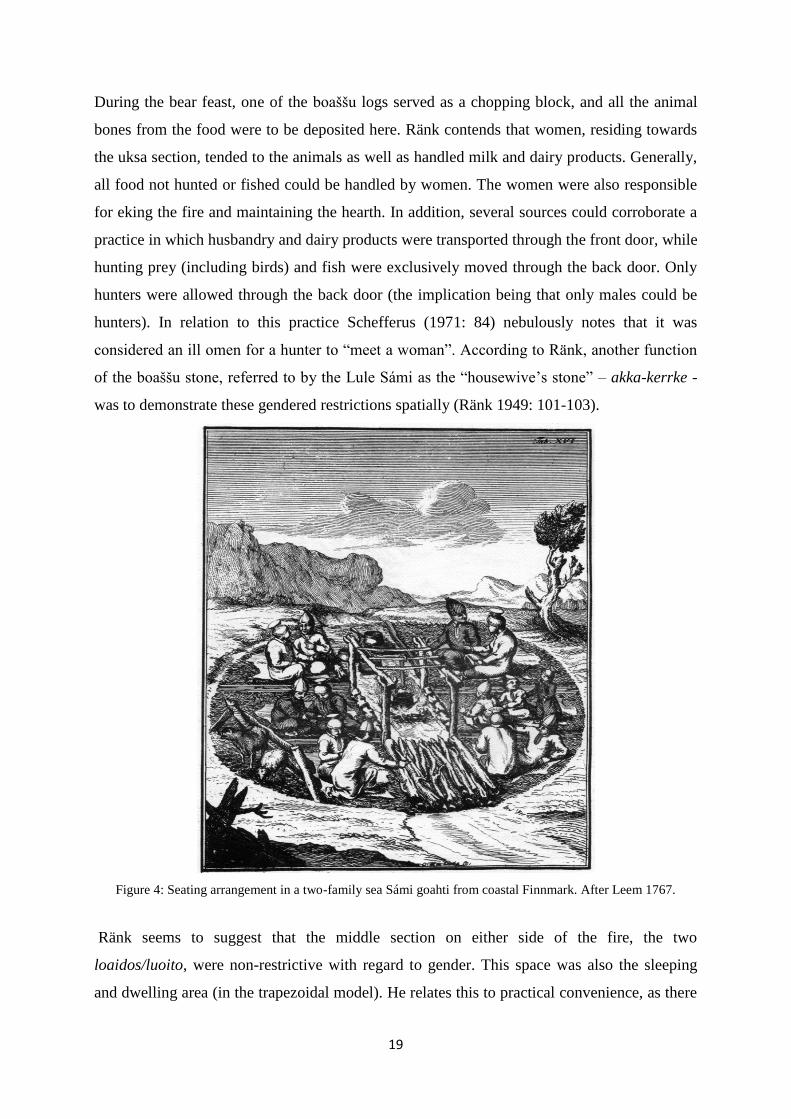
During the bear feast, one of the boaššu logs served as a chopping block, and all the animal
bones from the food were to be deposited here. Ränk contends that women, residing towards
the uksa section, tended to the animals as well as handled milk and dairy products. Generally,
all food not hunted or fished could be handled by women. The women were also responsible
for eking the fire and maintaining the hearth. In addition, several sources could corroborate a
practice in which husbandry and dairy products were transported through the front door, while
hunting prey (including birds) and fish were exclusively moved through the back door. Only
hunters were allowed through the back door (the implication being that only males could be
hunters). In relation to this practice Schefferus (1971: 84) nebulously notes that it was
considered an ill omen for a hunter to “meet a woman”. According to Ränk, another function
of the boaššu stone, referred to by the Lule Sámi as the “housewive‟s stone” – akka-kerrke -
was to demonstrate these gendered restrictions spatially (Ränk 1949: 101-103).
Figure 4: Seating arrangement in a two-family sea Sámi goahti from coastal Finnmark. After Leem 1767.
Ränk seems to suggest that the middle section on either side of the fire, the two
loaidos/luoito, were non-restrictive with regard to gender. This space was also the sleeping
and dwelling area (in the trapezoidal model). He relates this to practical convenience, as there

20
would be less draft here. Laterally, the three sections closest to the front door and the three
back sections were still reserved for women and men, respectively. Ränk sees this division as
pertaining to different economic or labor-related daily activities. He also notes that a
generational divide along the entrance-boaššu axis was the „original‟ ordering principle,
known more broadly from North Eurasian ethnography. In the case of two-family households,
the central uksa-boaššu axis served to seperate the two families, though the vertical gender
divide remained. Regardless of numerous variations, a pattern emerges: farthest towards the
door slept servants, and in inward succession came guests, children, the unmarried, the adults
of the family, and lastly the elders (Ränk 1949: 100 - 111).
Figure 5: Sea Sámi female headdresses. After Leem 1767.
Despite Ränk‟s (and others) insistence on a pervasive and ancient root of Sámi domestic
space, it is interesting to note all the variations in form. When permutations of floor ordering
occurred, subtle changes in terminology often followed alongside. Returning to Leem‟s
illustrations, we can see the women sitting on each side of the boaššu, presumably alongside
their husbands (figure 1 & 3 c.f. figure 4). The two-family configuration generally seems to
bring about variations in these patterns. Ränk (1949: 103) acknowledges the variation, but
considers the single-family arrangement more widespread, authentic and ancient. It begs the
question: if these rules were inscribed so strictly into people‟s mentalities, what facilitated a
breach? And what is this archaic and authentic cultural essence Ränk speaks of? We shall
return to these questions shortly. To be sure, the gender division - particularly in the older
sources – was very real and seemingly quite pervasive, though less uniform than depicted.

21
3.2 Structuralist approach to Sámi domestic space
An oft-cited piece in literature dealing with social space in traditional Sámi dwellings is
Timothy Yates‟ 1989 article „Habitus and social space: some suggestions about meaning in
the Saami (Lapp) tent, ca. 1700-1900‟. Yates attempts to link the Sámi arrangement of
domestic space to cosmological and symbolic conceptions using Bourdieu‟s theory of habitus
and Levi-Strauss‟ anthropological structuralism. Although a full account of Bourdieu‟s
concept of habitus is too comprehensive, a condensed version can be presented: habitus in the
internalization of the collective way of thinking, rules and norms of conduct and tradition; the
imprint of the cultural collective, by means of socialization, onto the individual in an interplay
of free will and of structures providing dispositions. These dispositions are created and
maintained mainly within the home and in relation to commonplace activities. Habitus implies
a slowness or inertia, only overthrown after sudden situational changes or long periods of
time. (Bourdieu 1984: 169-171). Thus, Bourdieu‟s interest in the material world is mainly in
the ways it can be related to power, capital and production.
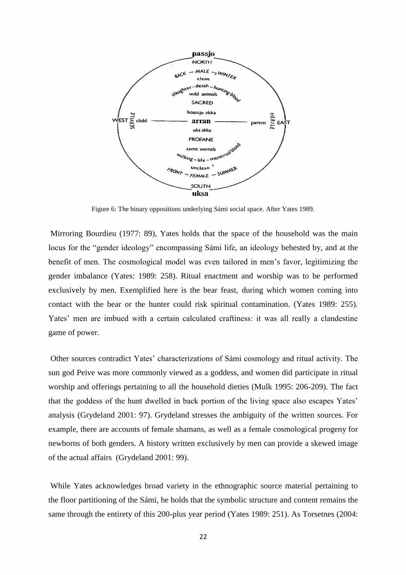
The axis mundi of the Sámi consisted of five levels: the higher, the lower, the terrestial, the
subterranean and the bowels of the earth. At top, the thunder god Tiermes and sun god Peive
reigned. The level beneath was the domain of the ruling father, Radien-Attje and the ruling
mother, Radien-Akka. Yates contends that the cosmological order is reflected in the outlines
of the floor plan. Layering the cosmological, vertical axis atop the house space itself even
reflects the following patterns in the floor plan (Yates 1989: 256). The hearth itself was the
domain of a daughter of the Máttaráhkká (mother earth) diety, Sáráhkká. Two other daughers
of this diety were bound to the uksa – Uksáhkká – and the boaššu – Juksáhkkáh/Boaššoáhkká,
goddess of the hunt, respectively. Certain associations can thus be grouped in the male area:
wild animals, hunt, hunting blood, slaughter, death, north, winter and back. These form the
category of the sacred. In the opposite female area, the unclean and profane, were
corresponding binary oppositions: tame animals, milk, menstruation blood, life, summer and
front.
22
Figure 6: The binary oppositions underlying Sámi social space. After Yates 1989.
Mirroring Bourdieu (1977: 89), Yates holds that the space of the household was the main
locus for the “gender ideology” encompassing Sámi life, an ideology behested by, and at the
benefit of men. The cosmological model was even tailored in men‟s favor, legitimizing the
gender imbalance (Yates: 1989: 258). Ritual enactment and worship was to be performed
exclusively by men. Exemplified here is the bear feast, during which women coming into
contact with the bear or the hunter could risk spiritual contamination. (Yates 1989: 255).
Yates‟ men are imbued with a certain calculated craftiness: it was all really a clandestine
game of power.
Other sources contradict Yates‟ characterizations of Sámi cosmology and ritual activity. The
sun god Peive was more commonly viewed as a goddess, and women did participate in ritual
worship and offerings pertaining to all the household dieties (Mulk 1995: 206-209). The fact
that the goddess of the hunt dwelled in back portion of the living space also escapes Yates‟
analysis (Grydeland 2001: 97). Grydeland stresses the ambiguity of the written sources. For
example, there are accounts of female shamans, as well as a female cosmological progeny for
newborns of both genders. A history written exclusively by men can provide a skewed image
of the actual affairs (Grydeland 2001: 99).
While Yates acknowledges broad variety in the ethnographic source material pertaining to
the floor partitioning of the Sámi, he holds that the symbolic structure and content remains the
same through the entirety of this 200-plus year period (Yates 1989: 251). As Torsetnes (2004:
23
98) points out, this statement may be particularly puzzling to archaeologists. In archaeology,
constructs of meaning are often inferred, namely, through physical forms – in that they
sometimes can be read as symbols or texts. Furthermore, changes in form are interpreted as
reflective – traditionally in a passive sense - of changes in meaning, etc., and a stable form
can even be subversive, stifling social turbulence (see for example Glassie 1975 for a
converse dynamic). The latter entails, of course, that stable form (architectural or feature-
wise) isn‟t necessarily an indication of stability in the social/cognitive sphere. We must also
concede that Yates‟ analysis fails to account for variations in time and space. After all, Sámi
society was quite heterogeneous, consisting of many autonomous groups and spread across
vast areas. Many have argued for a affinity towards male dominance resulting from historical
developments related to reindeer pastoralism and missionary influence (Grydeland 2001: 99).
In his analysis of the Kabyle Berber tent, Bourdieu (1977) demonstrates a set of oppositions
categorically and conceptually reversed compared to Yates‟. In the Kabyle tent, fire, light and
boiling is associated with men, while water, darkness and raw meat is associated with women.
Death, too, is now connected to the feminine. Some interesting patterns appear: boiled – raw
can can be understood as analogous to the Sámi opposition of tame – wild, whilst light –
shadow can be said to mirror the Sámi summer – winter (Grydeland 2001: 97). In spite of
these conceptual reversals, Yates argues that both cases demonstrate the presence of
ubiquitous – though historically contingent (Yates 1989: 250) - male dominance. In a later
work, Bourdieu (2002) holds that the gender dynamics of the North African Kabyle
household represent a continuity in the entire European cultural tradition – that they are the
„canonical‟ opposition of western and mediterranean culture.
While Yates‟ work is based strictly on ethnographic records of the period 1700-1900 AD, the
article is also interesting in that it is very demonstrative of the focal theoretical themes in the
archaelogical research of that particular time. Hodder (1982), along with Wobst (1978) and
others, had previously revitalized the symbolic aspects of material culture, demonstrating that
it was used actively (in itself, inert and passive) and could communicate symbolism. In the
development of the early post-processual critique of the 1980s, the binary oppositions of
structuralism and the symbolic-communicative qualities of artefacts were key in legitimizing
interpretive and (human) actor-centered approaches (Olsen 1997) – which is ironic, given the
espoused aversion towards determinism. Through the symbolic-semiotic paradigm, things
became epiphenomenal representations of the non-material. In material culture resided very
24
real ideal abstractions such as status, power, or ethnicity. These categories were even more
real - of higher importance - than the things themselves, and they made their presence known
as symbols, metaphors or „texts‟. Material culture was thus a tool to be fashioned and
subjugated by human agents, and things could only be said to exist by virtue of their
contextualization through the sensory and reasoning faculties of the human mind and
subsequent ascription of meaning. (Olsen 2010: 25-26).
To Yates, the physicality of the Sámi tent is epiphenomenal. Since the household is the locus
of the production of habitus and doxa, it becomes a mirror image of society. In other words
„society‟, with its cognitive traditions and adhering practices as units of transference, is what
gives shape to the Sámi household (Yates 1989: 260). But, in a sense, Yates has given the
different constituents of the Sámi house, including non-physical (though spatially delimited)
as well as physical structures, a form of agency and hybrid thingness. Despite the rigidity and
instrumentalism in Yates‟ analysis, I think there‟s much to be read between the lines (literally;
the house is the principal locus of generative schemes) about the significance of the material
and corporeal space in the Sámi tent.
Before delving into the presentation of the Slettnes house material itself, an understanding of
the historical setting of the Iron Age in the north is required.
25
4. The Iron Age: Outline of Setting
4.1 The Lyngen border
The Lyngen Fjord constituted an ethnic border in the Iron Age and early medieval period as
witnessed archaeologically by the distribution of predominantly Norse cultural idioms south
of here and the predominantly Sámi signatures in the north. That is not to say there weren‟t
any liminal or hybridized expressions, such as mixed graves. It is fair to assume that there
were enclaves belonging to either group beyond their respective bounds, as suggested by
Audhild Schanche (1986). Historically, this picture fits fairly well with chieftain Othere‟s 9th
century account to King Alfred of Wessex. Othere claimed to be the northernmost chieftain of
all, and that the land north of him was wilderness, only sparsely populated by Finn hunters
and fishers (the Sámi). It is believed that Othere‟s homestead was located in the vicinity of
today‟s city of Tromsø, just west of the Lyngen fjord. Othere describes traveling into the
Northern lands, collecting Sámi products as tribute – a tribute that was of utmost importance
to the chieftains of the far North. Although not explicitly stated by Othere, the Norse likely
reciprocated in some form, perhaps through military protection or supply of iron (Odner 1983;
Hansen & Olsen 2004).
Furthermore, it is on Skjervøy and Arnøy, located in the midst of this border zone, that the
greatest concentration of slab-lined pits – the most prominent of Northern Iron Age remains -
is found. According to Myrvoll (2011: 83), the national register cites 664 slab-lined pits along
the coast, though a greater number still is likely yet to be entered into the registry or have
simply eluded surveys. However, unlike the faint dwelling remains of the Iron Age, the
impressions made by the slab-lined pits are far from inconspicuous.
4.1.1 Slab-Lined Pits
The slab-lined pits are an important and substantial category for the North Norwegian Iron
Age. Previously believed to be graves, in part due to local folklore, or even houses, the slab-
lined pits are now widely recognized as implements used to siphon oil from marine mammals.
Slab-lined pits feature abundantly across coastal swaths between Ringvassøy in North Troms
and Vadsø in East Varanger. The greatest concentration is found just north of the Lyngen
fjord inlet, which corresponds well with extant historical sources‟ placement of the Sámi-
Norse border. At core, the process likely involved heating the rock-packed pits by burning
wood and removing the charcoal before placing the blubber in. The blubber would then,
perhaps helped by added heated rocks, rise to the surface (Schanche 1992: 33).
26
Though not unprecedented, the whalebone in the excavated slab-lined pit at Slettnes house
site Mellaneset - accompanied by another piece of whalebone protruding from the
neighboring pit - serve to further bolster this hypothesis (Myrvoll 2011: 91). In some cases,
the slab-lined pits also feature drains (Bratrein 1996). In addition, lipid analyses have
confirmed that the charred fatty material often found in the bottom of these pits stem from
marine mammals (Henriksen 1995: 63-65; Hesjedal et. al. 1996: 231).
Kjersti Schanche (1992) examined a field of 25 slab-lined pits, 11 of which were partially or
fully excavated, with the expressed goal of elucidating the scanty 1st millennium in Northern
Norway. The dates ranged from around 200 AD to 900 AD. No household remains could be
located in the near vicinity, which Schanche interpreted as an indication that the activities
surrounding this field of slab-lined pits required short, provisional stays. She further suggests
that the field served as a type of trade hub, gathering different groups of people – both Sámi
and Norse. Although found from 200 – 1200 AD, the slab-lined pits feature most prominently
in the period 600 – 900 AD. The number of slab-lined pits decidedly indicate a volume of
production far beyond own consumption. The slab-lined pits point to a booming trade
developing through the first millennium, peaking at around 600-900 AD. It has been
suggested that the Sámi traded oil, furs and other specialized products for Norse textiles and
iron goods (Olsen 2003, Henriksen 1995).
4.2 Categories of the Northern interior
The emergence of Sámi ethnicity has been linked to increased trade and interaction between
the hunter-gatherers of Northern Fennoscandia and Eastern metal-producing groups in the tail
end of the last millenium BC (Olsen 1984; Jørgensen & Olsen 1988; Hansen & Olsen 2004).
In Barthian terms, a complex process of ethnic differentiation was set in motion when
Northern hunter-gatherers began specialising in (presumably) niche resources like furs and
tusks to procure raw metals from the East through inland networks and trade routes. The
emphasis the instrumental explanation places on the inland is somewhat problematic in lieu of
the empirical situation. In Norway, the archaeology of the Northern interior has long suffered
from a lack of systematic surveying and registration, although recent efforts have been made
to redeem this situation (e.g. the LARM project). The abundant pitfall systems of Finnmark
see considerable lull in activity with interior clusters concentrated around 3000 BC – 1800 BC
and pits in the Varanger region relavitely estimated to 1200 – 1600 AD (Myrvoll, Thuestad &
Holm-Olsen 2011).

27
Another Sámi category from the Iron Age is the talus or scree graves, ranging from single
graves to burial fields holding hundreds. Located in scree slopes or areas of rocky debris, this
burial tradition utilized crevices or chambers in-between boulders and enveloped the deceased
in a birch bark shroud and less commonly in pulka (sleds). Frequently, a great deal of work
had been put in to make room for a sizable burial chamber. On occasion caves have also been
used for scree graves. Though usually appearing as pits or slab-covered chambers, cairn
burials can also found in the same areas and share categorization. The Mortensnes site on the
North coast of the Varanger Fjord is the largest scree grave burial field (or perhaps fields?)
holding housing more than 300 graves. The use of this tradition is said to range from 900 BC
to 1700/1800 AD. (Hansen & Olsen 2004: 116-122; Schanche K 1992; Schanche, A 2000:
315-317) Interestingly, aside from the assumed continuation of the scree grave tradition at
Mortensnes, the first arguably idiomatic expression of Sámi ethnicity appears with the Iron
Age turf houses of the outer coast and with the Stallo sites appearing from the Viking Age
onwards.
During the Viking Age and Early Medieval Period we observe a significant shift in Sámi
habitation patterning along with changes in dwelling types and spatial features. This shift is
exemplified by the extensively distrubuted hearth row sites: linearly placed, large rectangular
hearths, usually numbering 3-8, found in vast regions of the Fennoscandinavian deep interior.
Settlement patterning prior to this transition seems to have been concentrated alongside the
outer coast and interior waterways and lakes. By contrast, hearth row sites appear further
inland on moraine ridges, forested areas or near heathland areas. Alongside these apparent
changes in economy, settlement pattern and social organisation, evidence suggests increasing
ritual and religious expression, as well as increased ritualistic conformity and formalisation
throughout the entirety of the Sámi region. Grave goods are richer and display more variety,
possibly indicative of increasing social differentiation within Sámi society. (Broadbent 2010:
41) In Northern Sweden and Lappland, the Stalo sites range from 400 – 1600 AD. The vast
majority of dates, however, fall within the 640-1180 date range (Broadbent 2010: 145). A
significant shift in Sámi lifeways appears to have occurred in the Viking period, with Sámi
hearth sites moving from river valleys to reindeer grazing areas – indicating the rise of
reindeer pastoralism. These factors suggest a change from a hunting/gathering-based economy
to semi-nomadic herding featuring territoriality and individual ownership.

28
The Slettnes type houses somehow fit into this picture. In the following chapter, I shall
present the excavated sites.
29
5. Slettnes type sites
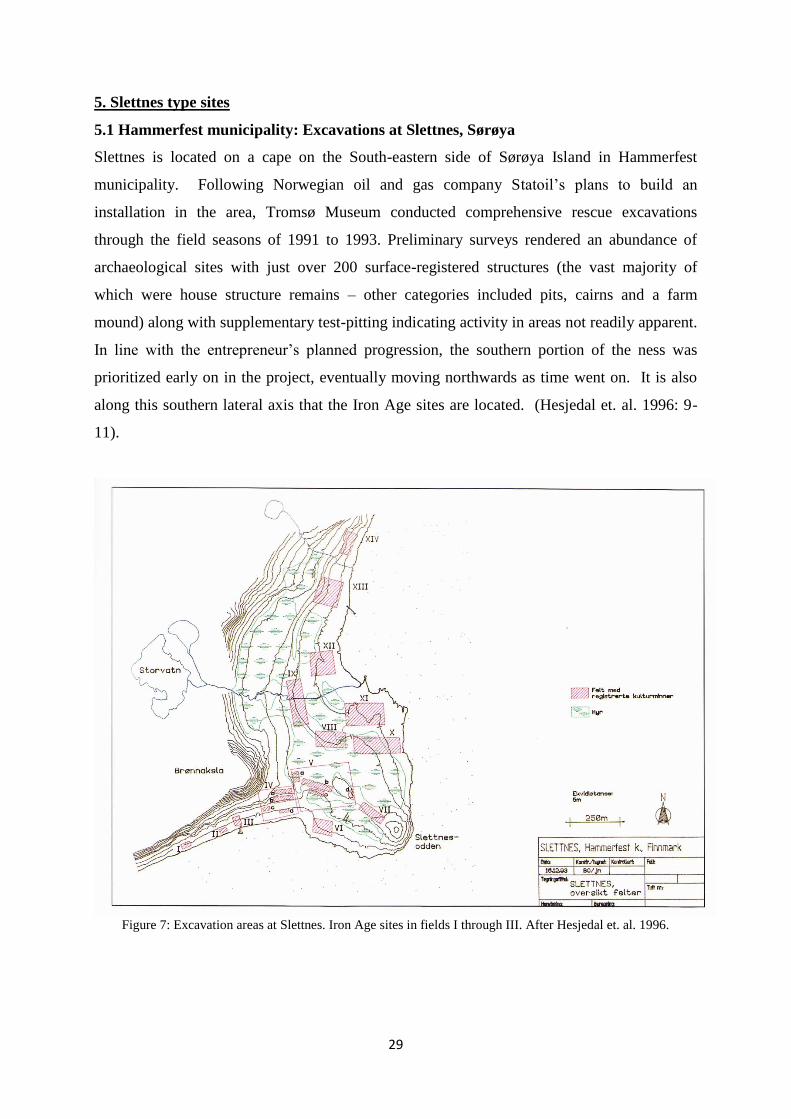
5.1 Hammerfest municipality: Excavations at Slettnes, Sørøya
Slettnes is located on a cape on the South-eastern side of Sørøya Island in Hammerfest
municipality. Following Norwegian oil and gas company Statoil‟s plans to build an
installation in the area, Tromsø Museum conducted comprehensive rescue excavations
through the field seasons of 1991 to 1993. Preliminary surveys rendered an abundance of
archaeological sites with just over 200 surface-registered structures (the vast majority of
which were house structure remains – other categories included pits, cairns and a farm
mound) along with supplementary test-pitting indicating activity in areas not readily apparent.
In line with the entrepreneur‟s planned progression, the southern portion of the ness was
prioritized early on in the project, eventually moving northwards as time went on. It is also
along this southern lateral axis that the Iron Age sites are located. (Hesjedal et. al. 1996: 9-
11).
Figure 7: Excavation areas at Slettnes. Iron Age sites in fields I through III. After Hesjedal et. al. 1996.
30
5.2 The excavated structures at Slettnes
Iron Age structures west of F204
Field I (see figure x) was comprised solely of three slab-lined pits and boathouse/shed. Two
of the slab-lined pits (F207 and F209, see Hesjedal et. al. 1996: 27-28) were excavated, along
with digging a test pit in the boatshed. Appearing as an oval depression in the terrain
dimensioned 1.9 x 0.8 m and orientated slanted slightly vis-à-vis the shoreline, F207 is the
lowest-placed of the slab-lined pits in field I. Prior to excavation, the bottom of the pit was
measured to 3,75 masl. Excavation revealed a rectangular pit, measuring at 2.3 x 1.1 m, with
walls consisting of beach gravel, charcoal and fire-cracked rocks. A charcoal sample (Beta
52378) from the wall produced a date of 1300 +/- 80 BP (650-790 cal. AD). Bottoming out 50
cm below the surface pit level measurement, the nethermost layer of the structure was
comprised of fire-cracked rocks, charcoal and pieces of charred and fatty organic material.
This material is residue from the process of extracting blubber oil from seal and/or whale in
implements of this type (Hansen & Olsen 2013: 57, Henriksen 1995). Two samples (Beta
52379, Beta 67190) from the bottom layer indicated 1520 +/- 70 BP (cal. 430-610 AD) and
1250 +/- 60 BP (cal. 680-880 AD), respectively. The younger date places this structure in the
usage vicinity of dates from dwelling structures in fields II and III (F204 & F205). Nearly
identically aligned, another slab-lined pit (F209) was found 5 meters NW of F207, with a
surface bottom measurement of 4.2 masl. However, the structure could not produce any C14
samples as it was devoid of charcoal. Another slab-lined pit - F208 - lying parallel to F208,
and roughly between the two excavated structures, was not examined. Due to the uniform and
organised appearance of the pits, a conjoint interpretation is fair.
The boathouse - F206 - appeared as a rectangular 5.2 x 2.2 m depression orientated towards
the sea, framed by raised lines of stone. Slightly inclined, the lowest point of the surface level
prior to excavation was at 2 masl, with the highest at 2.5 masl. Hesjedal et. al. (1996: 30)
holds that while this structure might have been a boathouse, we could also be looking at a
shed burrowed into the beach gravel. The authors also posit that the relatively high masl
indicates considerable age and could possibly be seen in connection to the slab-lined pits in
fields I and/or III. (Hesjedal et. al. 1996: 25-30).
F204
In field II, a stone ring formation topped with moss and heather sat in plain sight. This was to
be the first known, recorded and excavated Iron Age dwelling in Finnmark (Hesjedal et. al.
31
1996: 31). Structure F204 was situated at 3.7 m.a.s.l. and had an outer diameter of around 6
metres. Removal of the humus rendered a leached podsol sand layer (layer I) spread patchily
around the floor area along with a medial concentration of charcoal (layer II) – both based
atop a layer of course gravel and rock (layer III). During the clearing of layer III, nine evenly-
placed possible postholes surfaced, most of which were found just outside the southern wall.
After the removal of layers I through III, the outer wall lay bare and appeared quite sturdy
with large, heavy rocks and stacking in certain portions of the ring. The box hearth, by
contrast, appeared somewhat dilapidated. Two C14 samples were taken; one from the medial
charcoal concentration (Beta 58219 – 1250 +/- 80 BP) and another from the bottom of layer
III (Beta 58220 – 1160 +/- 70 BP). The C14 samples from F204 were calibrated to 670-880
AD and 780-970 AD, respectively.
The axial features in F204 are, one could argue, rather atypical and category-defying, with a
formidable single row running along the middle North - South axis, following the eastern
edge of the hearth and leading to a slab doorsill in the south. A line of slabs also runs
diagonally from the hearth to a possible opening in the North-West wall corner of the
dwelling. However, the opening appears shut off, as the slabs run under the outer wall. Just
SW of the NW opening there appears to be another entrance (Hesjedal et. al. 1993: 204). The
area between the hearth and the southern exit was rife with cookstones and charcoal. Olsen
suggests that the entrance could have been moved and that we could be looking at several
contexts. Also of interest to note is the placement of the hearth, not situated in the middle of
the dwelling, but in the south. Further, it appears to be orientated E-W, with its longest side
against the shorter axis of the dwelling.
Three nuggets of iron slag, along with three pieces of iron fragments were discarded in and
around the dwelling. Lithic debitage was scarce, of which only one core and ten flakes could
be counted. Three stone fishing weights and one whetstone were found related to the F204
context. 300 to the west of F204 are, as mentioned the three slab-lined pits and boatshed from
field I. (Hesjedal et. al. 1996: 31-32). Hesjedal et. al. suggest (1996: 32), that the postholes
may indicate a pronged-branch, classic baellje construction. While the rock wall could have
served as a supporting foundation or, along with turf and birch bark, to shield the interior
from winds, one would expect to find the postholes inside the perimeter, not outside - as is the
case with F204. Possibly, the dwelling has been rearranged at some point, the post-hole
construction taking place at an earlier point in time.
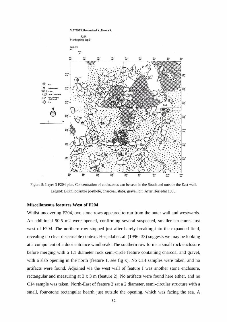
32
Figure 8: Layer 3 F204 plan. Concentration of cookstones can be seen in the South and outside the East wall.
Legend: Birch, possible posthole, charcoal, slabs, gravel, pit. After Hesjedal 1996.
Miscellaneous features West of F204
Whilst uncovering F204, two stone rows appeared to run from the outer wall and westwards.
An additional 90.5 m2 were opened, confirming several suspected, smaller structures just
west of F204. The northern row stopped just after barely breaking into the expanded field,
revealing no clear discernable context. Hesjedal et. al. (1996: 33) suggests we may be looking
at a component of a door entrance windbreak. The southern row forms a small rock enclosure
before merging with a 1.1 diameter rock semi-circle feature containing charcoal and gravel,
with a slab opening in the north (feature 1, see fig x). No C14 samples were taken, and no
artifacts were found. Adjoined via the west wall of feature I was another stone enclosure,
rectangular and measuring at 3 x 3 m (feature 2). No artifacts were found here either, and no
C14 sample was taken. North-East of feature 2 sat a 2 diameter, semi-circular structure with a
small, four-stone rectangular hearth just outside the opening, which was facing the sea. A

33
layer of charcoal was spread across a large surface between the northern wall of feature 2 and
all the way to feature 3. A C14 sample from the hearth (Beta 58673) gave the result 870 +/-
90 BP (cal. 1030-1260 AD). Hesjedal et. al. (1996: 33) interprets the feature as a tent ring or
temporary windbreak, possibly to be seen in relation to excursionary fishing or marine
mammal hunting. No artefacts were found. In the west end of the field another circular,
central hearth feature could be discerned with an inner diameter of around 3 metres (feature
4). The outer wall, in places diffuse, was placed against the bedrock in the West. A C14
sample (Beta 58674) was taken from the rectangular hearth, providing the result 830 +/- 70
BP (1160-1270 cal. AD) – thus matching with the date from feature 3. In terms of artifacts,
the two finds – two flakes and one whetstone – could not be linked to any of the presented
features. (Hesjedal et. al. 1996: 33-34)
It is puzzling that the dates from the two features are considerably younger than F204, given
that the structures seemingly connect. While an unlikely stretch – it is conceivable that the
F204 tent ring and the hearth (with postholes) are separate contexts, the former being
connected to the various features to the west. More likely, the closest non-dated structures –
feature 1 and 2 - are linked to F204, the remaining two being unrelated.
Figure 9: F204 (East) with features (anlegg) 1 to 4 (East to West). Legend: charcoal, slab. After Hesjedal et. al.
1996.

34
There were several traces of secondary contexts in the older houses in field III. A secondary
context hearth sample (Beta 58679) from house structure F13 (approx. 4000 years old) was
dated to 1330 +/- 90 BP, but no artifacts could be linked to it. East of F13‟s outer wall was a
1.05 diameter, 5-8 cm deep pit filled with fire-cracked stone, charcoal and what appeared to
be charred clay. A C14 sample (Beta 58677) from the pit returned the date 1830 +/- BP (110-
250 cal. AD), indicating that the pit was secondary to the house itself (Hesjedal et. al. 1996:
40-42). Hesjedal et. al. (1993: 27-28) posit that this could have been a calcination oven,
separating impurities iron-rich sand or iron ore. In Early Metal Period house F12 an evidently
secondary lone hearth - judging by its place in the stratigraphic sequence, and given a 1590
+/- 70 BP (400-550 cal. AD) sample (Beta 58687) date - was found in the western side of the
dwelling. (Hesjedal et. al. 1996: 49).
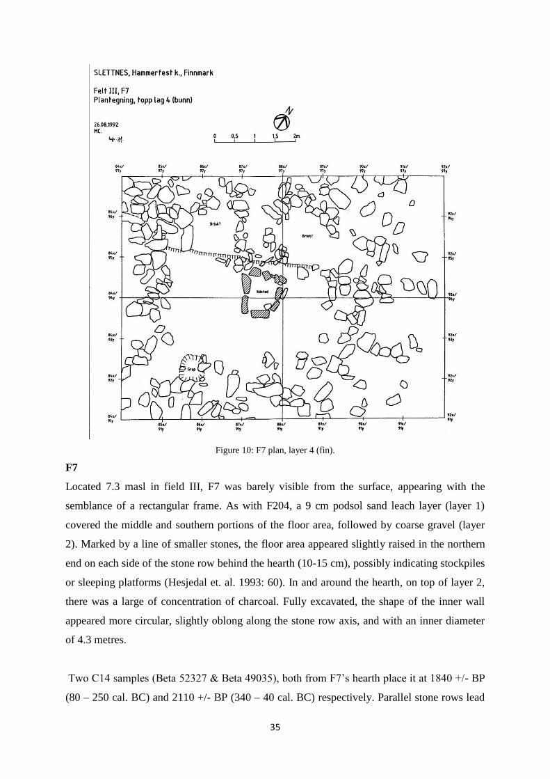
35
Figure 10: F7 plan, layer 4 (fin).
F7
Located 7.3 masl in field III, F7 was barely visible from the surface, appearing with the
semblance of a rectangular frame. As with F204, a 9 cm podsol sand leach layer (layer 1)
covered the middle and southern portions of the floor area, followed by coarse gravel (layer
2). Marked by a line of smaller stones, the floor area appeared slightly raised in the northern
end on each side of the stone row behind the hearth (10-15 cm), possibly indicating stockpiles
or sleeping platforms (Hesjedal et. al. 1993: 60). In and around the hearth, on top of layer 2,
there was a large of concentration of charcoal. Fully excavated, the shape of the inner wall
appeared more circular, slightly oblong along the stone row axis, and with an inner diameter
of 4.3 metres.
Two C14 samples (Beta 52327 & Beta 49035), both from F7‟s hearth place it at 1840 +/- BP
(80 – 250 cal. BC) and 2110 +/- BP (340 – 40 cal. BC) respectively. Parallel stone rows lead

36
from the northern side of the hearth and to a NW opening in the outer wall. Another exit is
seen in the South-Western end of the wall, along with a 20 cm deep, charcoal-filled pit with a
top diameter of 0.6. The charcoal appeared, according to Hesjedal et. al. (1996: 52), as if may
have served as lining in the pit. This pit was dated (Beta 58672) to 1610 +/- 70 BP (380-540
AD cal.), indicating it was of secondary nature (Hesjedal et. al. 1993: 60). Just outside the east
wall is a small stone enclosure with a large concentration of asbestos-tempered ceramic of the
Kjelmøy variant. Overall 57 artifacts were found in F7: 28 sherds of Kjelmøy ceramics (in the
annex); 19 flakes; two slag clumps and finally; one whetstone. (Hesjedal et. al. 1996: 51-52)
F205
F205 was outlined by a slight raised circular shape. At 3.7 masl – identical to F204 - it was
the lowest situated house structure in field III. Its excavated inner diameter was 4.2 metres.
The stratigraphy presented a mere two layers below the humus: a 1-4 cm layer of grey/brown
gravelly sand (layer 1) covering the floor, thicker in the southern portions followed by beach
gravel (layer 2). Several potential postholes were found within or alongside the outer wall –
again possibly indicating an arch-beamed frame (Hesjedal et. al. 1996: 53). In terms of axial
features, a broad row of flat slabs were lined from to south end of the hearth to the southern
wall. Hesjedal et. al. (1996: 52-53) suggests that elongated stones lying north of the fireplace
may have been arranged in two rows of stones originally, as seen in F7 (figure x cf figure). It
is difficult to discern doorways
A sample (Beta 67188) from the bottom of the hearth provided a 1370 +/- 110 BP (700-900
AD cal.) period of use. Another sample (Beta 67189) from layer I provided a 580 +/- BP
(1310-1420 AD cal.) result unlikely to be representative. There was an opening in the eastern
outer wall, with two concentrations of charcoal in layer 1. A sample (Beta 67187) was taken
from the southern concentration, yielding a date of 1150 +/- 80 BP (790-990 AD cal.). North
of this opening was a large concentration of cookstones. Another smaller opening was found
in the western wall joined to a small hearth. Flint strike-a-lights, charcoal and charred bones
were spread in and around this hearth. A sample (Beta 67186) from this hearth was dated to
960 +/- 120 BP (980-1220 AD cal.). Hesjedal 1996 et. al. (1996: 53) views this as hearth as
secondary, formed by stones removed from the western wall. The sample from the bottom of
the central hearth corresponds relatively well with the eastern wall date, likely placing F205 in
the 1100-1200 BP/700-900 AD bracket.
37
Figure 11: F205, Layer 2 (fin). Legend: rock, cookstone, cracked slab, slab, hearthstone.
In total, 172 artifacts - mostly flakes and iron fragments - were found in F5. The entire floor
area was littered with 109 highly corroded iron fragments likely to be boat nails. Mainly
concentrated around the central hearth, 47 flakes were found, 70% of which were flint. Most
of the other flakes were found in and around the outer wall, likely brought in from
surrounding peat (Hesjedal et. al. 1996: 53). A fishing stone and iron slag were also found,
along with some asbestos-ceramic potsherds in the northern wall, perhaps from an older
context. Other finds include fragments of cold-hammered copper and four potsherds from the
rim of a casted bronze pot. (Hesjedal et. al. 1996: 52-54).
While Hesjedal et. al. (1996: 53) suggests a similar mid-passage arrangement as north of the
hearth as seen in F7, the western row does appear to tangent towards the west, with the
eastern row running straight north. This could, of course, be due to various disturbing forces,
but it is difficult to see any reason to assume that this newer dwelling was ascribed the exact
same ritualistic principles as one 1000 years before it – especially considering that all of these
domiciles have idiosyncratic features. Given the large number and spread of boatnails in
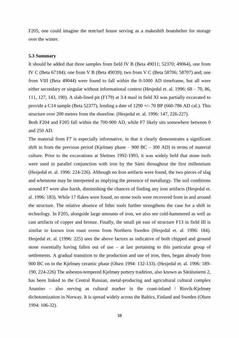
38
F205, one could imagine the tent/turf house serving as a makeshift boatshelter for storage
over the winter.
5.3 Summary
It should be added that three samples from field IV B (Beta 49011; 52370; 49064), one from
IV C (Beta 67184); one from V B (Beta 49039); two from V C (Beta 58706; 58707) and; one
from VIII (Beta 49044) were found to fall within the 0-1000 AD timeframe, but all were
either secondary or singular without informational context (Hesjedal et. al. 1996: 68 – 70, 86,
111, 127, 143, 190). A slab-lined pit (F179) at 3.4 masl in field XI was partially excavated to
provide a C14 sample (Beta 52377), lending a date of 1290 +/- 70 BP (660-786 AD cal.). This
structure over 200 metres from the shoreline. (Hesjedal et. al. 1996: 147, 226-227).
Both F204 and F205 fall within the 700-900 AD, while F7 likely sits somewhere between 0
and 250 AD.
The material from F7 is especially informative, in that it clearly demonstrates a significant
shift in from the previous period (Kjelmøy phase – 900 BC – 300 AD) in terms of material
culture. Prior to the excavations at Slettnes 1992-1993, it was widely held that stone tools
were used in parallel conjunction with iron by the Sámi throughout the first millennium
(Hesjedal et. al. 1996: 224-226). Although no Iron artifacts were found, the two pieces of slag
and whetstone may be interpreted as implying the presence of metallurgy. The soil conditions
around F7 were also harsh, diminishing the chances of finding any iron artifacts (Hesjedal et.
al. 1996: 183). While 17 flakes were found, no stone tools were recovered from in and around
the structure. The relative absence of lithic tools further strengthens the case for a shift in
technology. In F205, alongside large amounts of iron, we also see cold-hammered as well as
cast artifacts of copper and bronze. Finally, the small pit east of structure F13 in field III is
similar to known iron roast ovens from Northern Sweden (Hesjedal et. al. 1996: 184).
Hesjedal et. al. (1996: 225) sees the above factors as indicative of both chipped and ground
stone essentially having fallen out of use – at last pertaining to this particular group of
settlements. A gradual transition to the production and use of iron, then, began already from
900 BC on in the Kjelmøy ceramic phase (Olsen 1994: 132-133). (Hesjedal et. al. 1996: 189-
190, 224-226) The asbestos-tempered Kjelmøy pottery tradition, also known as Säräisniemi 2,
has been linked to the Central Russian, metal-producing and agricultural cultural complex
Ananino – also serving as cultural marker in the coast-inland / Risvik-Kjelmøy
dichotomization in Norway. It is spread widely across the Baltics, Finland and Sweden (Olsen
1994: 106-32).

39
The configuration of slab-lined pits and boathouse at Slettnes appear to have seen most
activity from around 700-900 AD, concurrent with the two dwelling structures – F204 and
F205 - to the east. It would appear that the two categories – the slab-lined pit and the Slettnes
house – might be seen in a kind of symbiotic feedback loop relationship, one part contributing
to the proliferation of the other. Quite possibly, the boathouse should also be included into
this constellation. Indeed, as we shall see, all three categories are almost invariably
intertwined.

40
5.4 Berlevåg municipality: Excavations at Kongshavn and Mellaneset, 2001
Figure 12: The Iron Age sites selected for excavation. After Myrvoll 2011: 84.
The three Iron Age excavations made under the heading of the the multi-room house project
were limited to several localities a small 1 km radius on the Northeastern end of Varanger
peninsula. The sites were located on a narrow NW-SE strip of land just east of fishing village
Berlevåg.
Kongshavn II
At Kongshavn II, an exposed ridge at 5 metres asl, was a group of four round structure
remains; two classified as turf houses and the remaining two as probable tent rings, all
oriented NW-SE. (Myrvoll 2011: 85). Upon initial surface survey in 2001, several of the
structures were plainly visible. Most of the area was covered in tundra vegetation barring the
northernmost turf house, which was nearly laid bare. The turf house, around 3 metres in
diameter and 4.9 masl, was easily noticeable from the surface with the inner floor area leaving
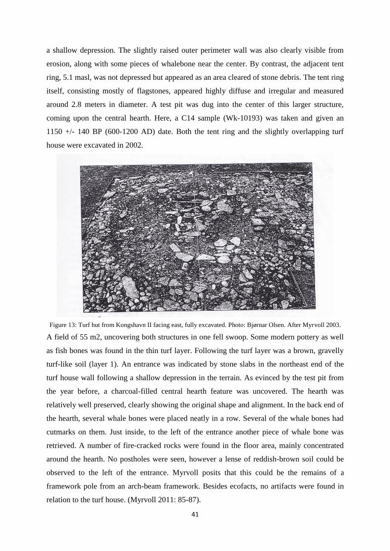
41
a shallow depression. The slightly raised outer perimeter wall was also clearly visible from
erosion, along with some pieces of whalebone near the center. By contrast, the adjacent tent
ring, 5.1 masl, was not depressed but appeared as an area cleared of stone debris. The tent ring
itself, consisting mostly of flagstones, appeared highly diffuse and irregular and measured
around 2.8 meters in diameter. A test pit was dug into the center of this larger structure,
coming upon the central hearth. Here, a C14 sample (Wk-10193) was taken and given an
1150 +/- 140 BP (600-1200 AD) date. Both the tent ring and the slightly overlapping turf
house were excavated in 2002.
Figure 13: Turf hut from Kongshavn II facing east, fully excavated. Photo: Bjørnar Olsen. After Myrvoll 2003.
A field of 55 m2, uncovering both structures in one fell swoop. Some modern pottery as well
as fish bones was found in the thin turf layer. Following the turf layer was a brown, gravelly
turf-like soil (layer 1). An entrance was indicated by stone slabs in the northeast end of the
turf house wall following a shallow depression in the terrain. As evinced by the test pit from
the year before, a charcoal-filled central hearth feature was uncovered. The hearth was
relatively well preserved, clearly showing the original shape and alignment. In the back end of
the hearth, several whale bones were placed neatly in a row. Several of the whale bones had
cutmarks on them. Just inside, to the left of the entrance another piece of whale bone was
retrieved. A number of fire-cracked rocks were found in the floor area, mainly concentrated
around the hearth. No postholes were seen, however a lense of reddish-brown soil could be
observed to the left of the entrance. Myrvoll posits that this could be the remains of a
framework pole from an arch-beam framework. Besides ecofacts, no artifacts were found in
relation to the turf house. (Myrvoll 2011: 85-87).
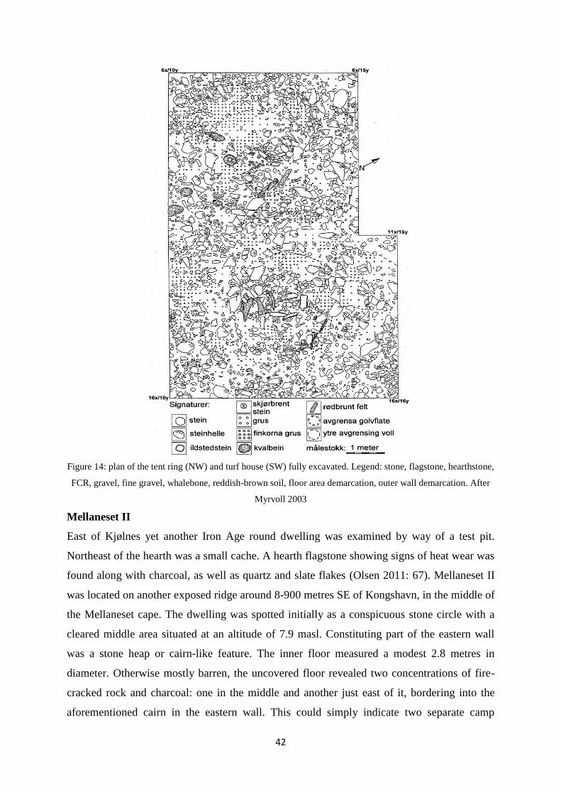
42
Figure 14: plan of the tent ring (NW) and turf house (SW) fully excavated. Legend: stone, flagstone, hearthstone,
FCR, gravel, fine gravel, whalebone, reddish-brown soil, floor area demarcation, outer wall demarcation. After
Myrvoll 2003
Mellaneset II
East of Kjølnes yet another Iron Age round dwelling was examined by way of a test pit.
Northeast of the hearth was a small cache. A hearth flagstone showing signs of heat wear was
found along with charcoal, as well as quartz and slate flakes (Olsen 2011: 67). Mellaneset II
was located on another exposed ridge around 8-900 metres SE of Kongshavn, in the middle of
the Mellaneset cape. The dwelling was spotted initially as a conspicuous stone circle with a
cleared middle area situated at an altitude of 7.9 masl. Constituting part of the eastern wall
was a stone heap or cairn-like feature. The inner floor measured a modest 2.8 metres in
diameter. Otherwise mostly barren, the uncovered floor revealed two concentrations of fire-
cracked rock and charcoal: one in the middle and another just east of it, bordering into the
aforementioned cairn in the eastern wall. This could simply indicate two separate camp
43
pitches. Beneath the cairn was a layer of dark brown turf and soil. Myrvoll (2011: 87-88)
suggests this may have been some kind of cache, perhaps representing a secondary phase.
The inventory of the Mellaneset tent ring revealed a scraper, quartzite flakes and sherds of
Kjelmøy ceramics along with a piece of raw asbestos. All these items were found in a thin
layer of soil resting on the floor. The test pit sample (Wk-10321) from 2001 returned the
result 1875 +/- 74 BP (50 BC – 340 AD cal.). However, the sample – taken from charred non-
local spruce and larch driftwood – was not reliable. Another sample (Wk-12187) from the
medial fire activity area was dated to 1979 +/- 43 BP (90 BC – 30 AD cal.) (Myrvoll 2011:
87-88).
East of the tent ring at Mellaneset I was a field of exceptionally large slab-lined pits, one of
which was excavated. Measuring 4 x 2 m, it presented as a rectangular hollow surrounded by
a low and wide earthen wall around the top edge. Prior to excavation, the bottom of the pit
was situated 4.9 masl. Unlike the pit at Slettnes field I, this structure appeared very sturdy,
with vertically lined, well-fitted slabs packed around the entire chamber wall. Carbonized
blubber spots, presumably, were sprinkled across the floor flagstones. Henriksen posits that
chambered pits such as this one were likely to be used repeatedly due to ease of maintenance
(Henriksen 1995: 70). It would also follow that the builders of the pit had reasons to make it
durable. Lying in situ above a layer of charcoal-mixed layer of fire-cracked rocks was a whale
vertebra. A sample (Wk-12189) was taken from one of the floor slabs, presenting a date of
1417 +/- 42 BP (540-690 AD cal.). The Mellaneset II tent ring, then, is older – the turf house
at Kongshavn II slightly less so – than the slab-lined pit. However, there are other groupings
of slab-lined pits in the area which may suggest use of the area – by means of these Slettnes
house/slab-lined pit (and possibly boathouse) constellations - throughout the first millennium.
While whaling could have occurred at Kongshavn II or Mellaneset I, obtaining pieces of
stranded whales may well have been the order of the day. The group of slab-lined pits here
does not seem to hint at any large–scale intensive whaling.
Myrvoll stresses the similarities in floor spatial features between the Kongshavn II turf house
and Sámi ethnographic sources, as well as patterns found in Sámi archaeology. Indeed, this
continuity is characterized by Myrvoll as both astounding and impressive (Myrvoll 2011: 88-
89). However, noting the absence of any floor portioning features in the tent rings at
Kongshavn II and Mellaneset, Myrvoll draws on other equivalent example - for instance
Grydeland‟s (2001) excavation of a medieval Slettnes house at Vapsgedden on Spildra,
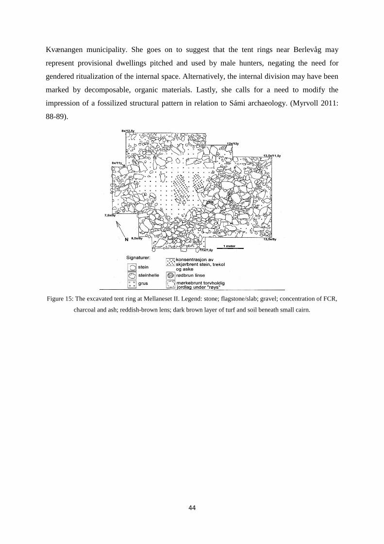
44
Kvænangen municipality. She goes on to suggest that the tent rings near Berlevåg may
represent provisional dwellings pitched and used by male hunters, negating the need for
gendered ritualization of the internal space. Alternatively, the internal division may have been
marked by decomposable, organic materials. Lastly, she calls for a need to modify the
impression of a fossilized structural pattern in relation to Sámi archaeology. (Myrvoll 2011:
88-89).
Figure 15: The excavated tent ring at Mellaneset II. Legend: stone; flagstone/slab; gravel; concentration of FCR,
charcoal and ash; reddish-brown lens; dark brown layer of turf and soil beneath small cairn.
45
5.5 Hammerfest municipality: Skjærvika/Fjellvika 2009-2010
In the field seasons of 2009 and 2010, laborious excavations were undertaken at two separate
bays around 4 kilometres North of Hammerfest, across the strait from Melkøya. The
background for the project – a rescue excavation - was an expansion of the oil and gas facility
on Melkøya impinging on the archaeologically extensive bays of Skjærvika and Fjellvika. As
the crow flies, the distance between the northern site of Skjærvika and the southern site
Fjellvika was about 400 metres. Both bays provide ample shelter from both sides thanks to
cliff walls. The shoreline at Skjærvika was armored with large pebbles – a so-called shingle
beach. Fjellvika had a smaller plane habitable zone due to inclining terrain inlands.
(Henriksen & Valen 2013: 29-41).
Preliminary surveys at Skjærvika in 2005 had already established a number of probable Iron
Age structures, making these a priority objective in the planning stages. The excavation
presented a rather complex picture, with many overlapping or huddled structures yielding a
large chronological spread. Good spots were likely reused, resulting with trace remains of
secondary activities in older structures. Nine houses returned Iron Age dates. Four of these,
however, have been dismissed as representative of secondary activity. In the following, I will
give a short presentation of some the more pertinent and informative excavated structures.
Slab-lined pits at Skjærvika/Fjellvika
A total of six slab-lined pits were found: five at Skjærvika and one at Fjellvika. Henriksen &
Valen observe a change from oval pits without wall slabs, to sharply rectangular, more
elaborate slab-lined pits with flagstone-packed walls. They see the development giving the
impression, in its own right, of an established industry around these implements – with
cemented rules around their construction and use. (Henriksen & Valen 2013: 386-387). The
C14 dates from the pits point out a pause in activity between 400 and 550 AD. The slab-lined
pits saw use from 150-400 AD, again resuming from 550-900/1000 AD. Palynological
analyses strongly support this dating. Charred birch bark was found in the dump zone of one
of the slab-lined pits, perhaps having been used to line the floors or walls. As with the two
sites at Kongshavn and Mellaneset in Berlevåg, whale bones featured prominently in relation
to the slab-lined pits at Skjærvika and Fjellvika. (Henriksen & Valen 2013: 382-383).
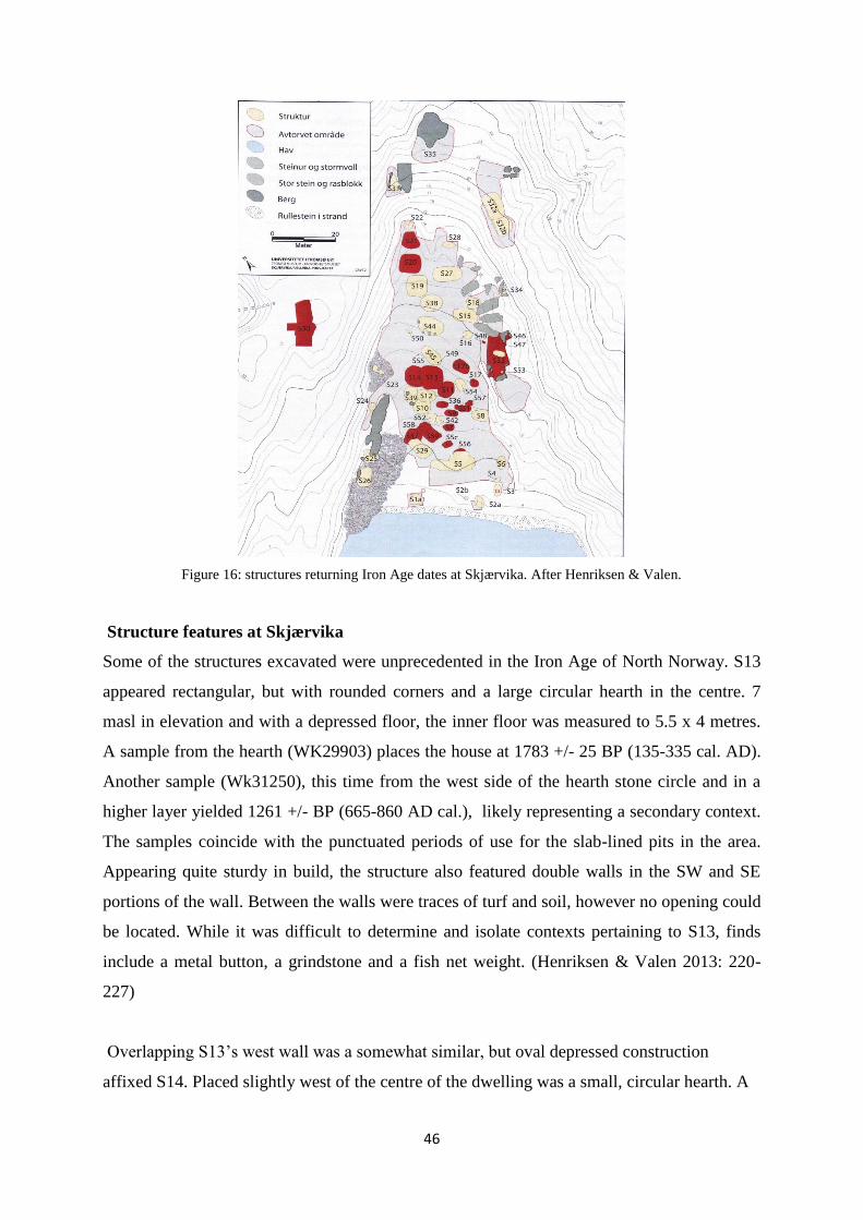
46
Figure 16: structures returning Iron Age dates at Skjærvika. After Henriksen & Valen.
Structure features at Skjærvika
Some of the structures excavated were unprecedented in the Iron Age of North Norway. S13
appeared rectangular, but with rounded corners and a large circular hearth in the centre. 7
masl in elevation and with a depressed floor, the inner floor was measured to 5.5 x 4 metres.
A sample from the hearth (WK29903) places the house at 1783 +/- 25 BP (135-335 cal. AD).
Another sample (Wk31250), this time from the west side of the hearth stone circle and in a
higher layer yielded 1261 +/- BP (665-860 AD cal.), likely representing a secondary context.
The samples coincide with the punctuated periods of use for the slab-lined pits in the area.
Appearing quite sturdy in build, the structure also featured double walls in the SW and SE
portions of the wall. Between the walls were traces of turf and soil, however no opening could
be located. While it was difficult to determine and isolate contexts pertaining to S13, finds
include a metal button, a grindstone and a fish net weight. (Henriksen & Valen 2013: 220-
227)
Overlapping S13‟s west wall was a somewhat similar, but oval depressed construction
affixed S14. Placed slightly west of the centre of the dwelling was a small, circular hearth. A
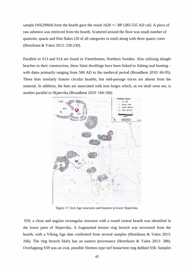
47
sample (Wk29904) from the hearth gave the result 1620 +/- BP (385-535 AD cal). A piece of
raw asbestos was retrieved from the hearth. Scattered around the floor was small number of
quartzite, quartz and flint flakes (20 of all categories in total) along with three quartz cores
(Henriksen & Valen 2013: 228-230).
Parallels to S13 and S14 are found in Västerbotten, Northern Sweden. Also utilizing shingle
beaches in their construction, these Sámi dwellings have been linked to fishing seal hunting –
with dates primarily ranging from 500 AD to the medieval period (Broadbent 2010: 66-95).
These huts similarly feature circular hearths, but mid-passage traces are absent from the
material. In addition, the huts are associated with iron forges which, as we shall soon see, is
another parallel to Skjærvika (Broadbent 2010: 166-168)
Figure 17: Iron Age structures and features in lower Skjærvika.
S59, a clean and angular rectangular structure with a round central hearth was identified in
the lower parts of Skjærvika. A fragmented bronze ring brooch was recovered from the
hearth, with a Viking Age date confirmed from several samples (Henriksen & Valen 2013:
166). The ring brooch likely has an eastern provenance (Henriksen & Valen 2013: 388).
Overlapping S59 was an oval, possible Slettnes type turf house/tent ring dubbed S58. Samples

48
gathered from the seemingly displaced hearth rendered an approximate date of 425-600 AD
cal. However, no finds could be linked to the S59 context. Connected to S59 in the east
through a poorly-defined wall was a cleared rectangular floor, S37. A date from the round
central hearth places S37 at approximately 700-900 AD. (Henriksen & Valen 2013: 172 –
174; 388-399).
An iron fire striker, not related to any structure, was also recovered from lower Skjærvika
informing a latter half of the 1st millennium dating. In hearth of S57 – with dates spanning the
range of 420-645 AD - a steatite spindle whorl was recovered. Lastly some indications of
metallurgy in the context of a hearth dated to 355-535 AD cal. was found secondary to a
Neolithic pithouse (S20). A cone-shaped mass of charcoal and fine sand along with pieces of
glazed clay and some iron slag led Henriksen & Valen (2013: 293-295) to suspect a smithy
once stood here.
The most pertinent takeaway from the Iron Age sites at Skjærvika and Fjellvika is that none
of these show rectangular hearths or any signs of a mid-passage or axial feature. Furthermore,
far from being defined by a monolithic blueprint matching restrictive locus requirements, the
structures at Skjærvika and Fjellvika seem to display great variety, or perhaps an
improvisatory quality. This can perhaps be explained by the properties of the shingle beach,
and the nature of building structures in such a location. Alternatively, as suggested by
Myrvoll (2011) in relation to the sites at Berlevåg, some of these may have been special-
purpose sites without the need to enforce rules required in other situations. The
inventorieswith established contexts also fall in line with what‟s been observed at Slettnes and
Berlevåg.
5.6 Tromsø municipality: excavations at Tønsnes, 2014
At the rich locality Tønsnes, a cape just Northeast of Tromsø, excavations in 2014 uncovered
a field of several hearths with twin stone row mid-passage features mixed with fire-cracked
rocks. There was little indication of tent rings or walls in the field. Some of these mid-
passages extended in both directions from what would be the short hearth wall axis. (Cerbing,
M, personal comment, 2015). Two of the hearths rendered dates from around 0 AD, while
several others surprisingly returned dates ranging through the entire Early Metal period.
(Kjellman, E, personal comment, 2014) I was present in the early weeks of the excavation at

49
this very field, but was not able to see any of the structures fully excavated. The excavation
report is under progress, and is not to be released until completed.
Olsen has informed me (Olsen, B., personal comment, 2013) that the Itkonen house on the
Kola peninsula referenced by himself (1993) and Odgaard (2001) must be dated post-Iron
Age based on an inspection of the ceramic material found here.

50
6. Surveyed and registered sites
At the starting point of this project, the Slettnes sites had yet to be entered into the Norwegian
National Sites and Monuments Record (Askeladden). Having taken a more recent glance at
the database, I was presented with alleged Iron Age dwelling sites survey-registered in the 70s
and 80s. To avoid any false entries, I have exclusively gathered data from reports, published
literature and simply asking around. Although some sites may have been missed, a
representative selection is presented. I will begin by presenting the findings from the multi-
room project. Other entries are provided mainly by Nilsen (2014) along with single entries
from Myrvoll (2009) and Grydeland (2001), and will be presented by municipality West to
East.
6.1 Surveys and registrations – the multi-room project
As part of the international collaborative project Cultural landscapes from the Iron Age and
early historical times in Coastal Finnmark focusing on the medieval multi-room houses
distributed along the coastlines of Northern Norway and the Kola Peninsula (see Olsen 2011),
19 Iron Age sites were also recorded in conjunction with fieldwork conducted between 2001
and 2004. Two or more of either the Slettnes type, slab-lined pits or small boathouses were
present at 11 of these sites. As Myrvoll concedes, only a few of these can be definitively
affixed an Iron Age date. However, the main periods of use for the slab-lined pits as well as
the small boat landings strongly indicate an Iron Age date. (Myrvoll 2011: 84). The survey
reports mentions Sámi round houses found in locations with one or more of the
aforementioned diagnostic categories that nonetheless receive medieval-modern dates (see for
example Myrvoll 2002). The methods used to determine relative age are not made explicit.
North of the Ryggefjord inlet and on the north side of Værbukta bay is a field containing
(amongst other remains) numerous house structures of various forms, six slab-lined pits and
two boathouses. Some of these have been listed as Iron Age remains (Myrvoll 2002: 10-11)
Hearth charcoal samples from a test pit provided dates of 937 ± 102 BP and 943 ± 62 BP. The
test pit also revealed a typical rectangular hearth along with iron fragment pieces (Olsen 2011:
61).
Along the eastern side of the Skonsvika bay towards Berlevåg airport one Iron Age round
impression was registered along with nine slab-lined pits and two boathouses. The bay opens
to the Northeast Barents Sea (Olsen 2011: 61, Myrvoll 2011: 12f).
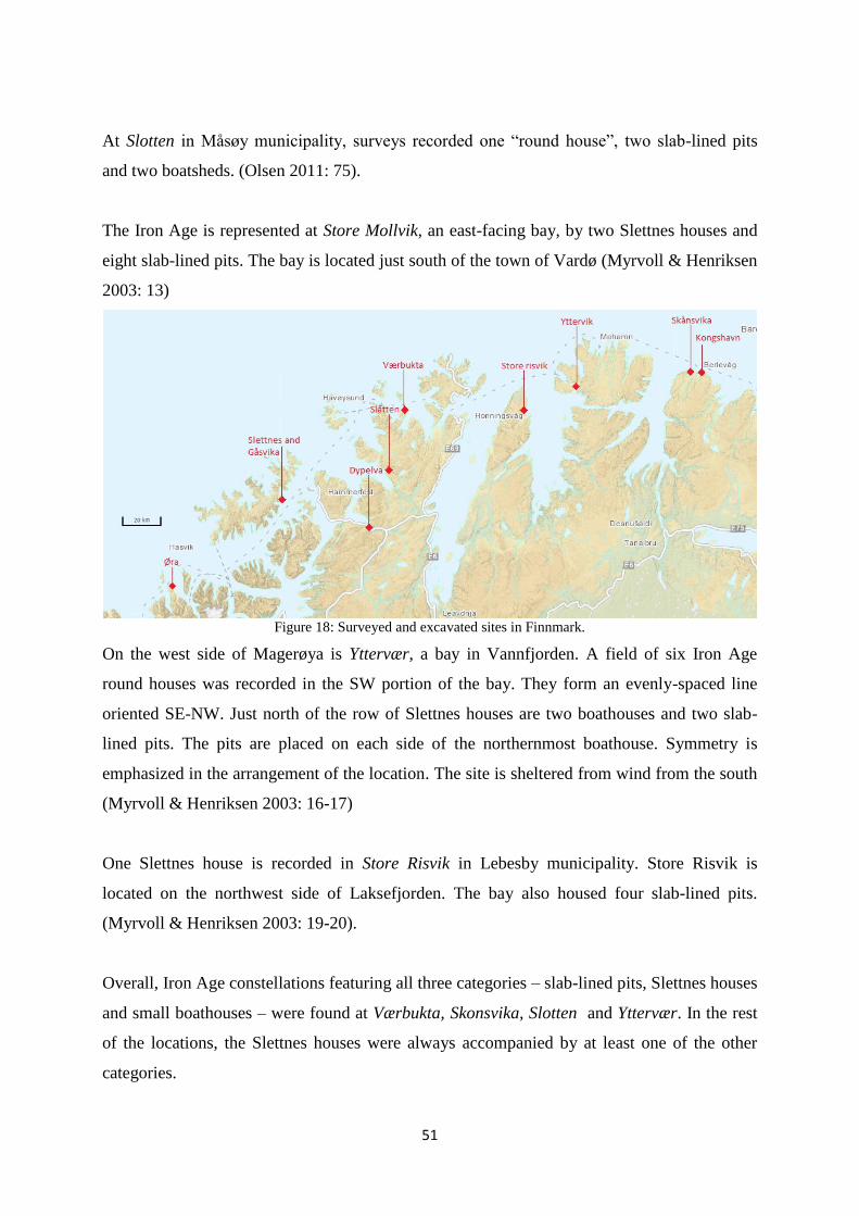
51
At Slotten in Måsøy municipality, surveys recorded one “round house”, two slab-lined pits
and two boatsheds. (Olsen 2011: 75).
The Iron Age is represented at Store Mollvik, an east-facing bay, by two Slettnes houses and
eight slab-lined pits. The bay is located just south of the town of Vardø (Myrvoll & Henriksen
2003: 13)
Figure 18: Surveyed and excavated sites in Finnmark.
On the west side of Magerøya is Yttervær, a bay in Vannfjorden. A field of six Iron Age
round houses was recorded in the SW portion of the bay. They form an evenly-spaced line
oriented SE-NW. Just north of the row of Slettnes houses are two boathouses and two slab-
lined pits. The pits are placed on each side of the northernmost boathouse. Symmetry is
emphasized in the arrangement of the location. The site is sheltered from wind from the south
(Myrvoll & Henriksen 2003: 16-17)
One Slettnes house is recorded in Store Risvik in Lebesby municipality. Store Risvik is
located on the northwest side of Laksefjorden. The bay also housed four slab-lined pits.
(Myrvoll & Henriksen 2003: 19-20).
Overall, Iron Age constellations featuring all three categories – slab-lined pits, Slettnes houses
and small boathouses – were found at Værbukta, Skonsvika, Slotten and Yttervær. In the rest
of the locations, the Slettnes houses were always accompanied by at least one of the other
categories.
52
6.2 Other surveys
Karlsøy municipality
On the east side of Grunnfjorden, a field of presumed Sámi roundhouses and boathouse was
found at Sandbakken. The boathouse was dated to the Viking period (Nilsen 2014: 83).
Lyngen municipality
On the east side of Ullsfjorden, at Futvik in Nord-Lenangen, a field of 20 round wall features
was registrered, along with 3 possible boathouses. Nilsen (2014) suggests a possible Iron Age
dating for the field. Around 8 km north of this field were five slab-lined pits. (Nilsen 2014:
82).
Skjervøy municipality
The North-facing Nord-Rekvik on Arnøya contains upwards 30 tent or turf house remains.
These houses are spread widely across the elevation curve, the highest situated of which may
well be ascribed a first millenium date (Bratrein 1995: 22, Holberg 2002: 80-82). Slab-lined
pits are also heavily present, with several sizable fields sometimes paired with overgrown
piles of whalebone. Between Nordrekvikelva and Stormyra we find the only indication of
boats in the area in the form of a Sámi boathouse/shelter 300 metres from the shore (meters
above sea-level not proportionate – the area is long and flat). Just south of the boathouse, a
few metres inland, five tent circles can be seen. The distance from the sea indicates that this
locality is quite old.
In an area rife with slab-lined pits, at Nessøra on Arnøya, Nilsen has pegged a lone
roundhouse as belonging to the Iron Age. The cape is located on the western inlet of Akkarvik
and Langfjorden (Nilsen 2014: 115). Across the fjord, on eastern inlet is Haugnesodden, a
locality holding five slab-lined pits, a boathouse and one Sámi roundhouse, registered in
2001. One of the roundhouses proved to be a very large slab-lined pit following a research
excavation (Nilsen 2014: 118, 195-196).

53
Figure 19: surveyed and excavated sites in Troms.
Nordreisa municipality
In Lillevika, South-West of Stornes in Nordreisa municipality there are two circular features
with low walls, previously registered as Iron Age houses. Nilsen indicates these are markedly
different from medieval Sámi roundhouses and may well be ascribed Iron Age dating. Around
a kilometer North-East of the Lillevika site is a boathouse. (Nilsen 2014: 102).
On the southwest side of Vorterøya, at Leirbakkneset, a collapsed cairn was found along with
two stone circles and the remains of a round house. A single slab-lined pit is found on the
southeast side of the small island with another two in Krøkebærvika, just north of it. A small
boatshed is found on the same ridge as the slab-lined pits at Krøkebærvika.
Kvænangen municipality
Sven-Erik Grydeland conducted a series of research excavations aimed at elucidating the Sea
Sámi siida from the high medieval period onwards in the Kvænangen region of North Troms.
On the eastern side Jøkelfjorden, 50 metres NE of the river outlet Indre Vikselva, Grydeland
came across a field of structures sat on a beach terrace. Four of these were circular, one being
more pronounced – structure I. The field also contained more recent rectangular huts that
were hybrids of Kven and Sámi building traditions. Surrounding structure I at 4.5 masl was a
tall wall, around 40 cm thick and with a gap marking an entrance. A 1 x 3 metre field drawn
from the centre and through the back wall was opened. The test returned a fish vertebrae and a
modern fish hook from the top turf layer. As the full excavation commenced, Grydeland was
adamant that he was dealing with a turf hut - a darfegoahti. A concentration of fire-cracked
54
rocks and charcoal was found in the centre of the structure, though no samples were retrieved.
Another similar concentration was found in the wall, with a bottom sample dated to 2065 +/
65 BP (160 BC – 5 AD). This was also the only Iron Age date from Grydeland‟s project.
Grydeland believes the field could be linked to sealing and reindeer trapping, as the inner
fjord has been known to house both seals and migrating caribou in the spring and fall months.
Parallels are drawn to Grythaugen on the Varanger peninsula, a sacrificial site consisting of a
cairn surrounded by six pits. These walls of these pits contained fire-cracked rocks and a
bottom layer of charcoal. However, these were dated to 1000-1200 AD. Grydeland also points
to structures around the Lule River in Northern Sweden interpreted as implements for smoke-
drying meat. The earliest dates can be traced back to around 100 AD. (Grydeland 1996: 26-
28).
Aside from not resembling the Slettnes type, the structure has no diagnostic finds. Slab-lined
pits or Iron Age boat houses are also absent. I have therefore decided not to include it among
the excavated structures. It is, however, included in the survey-registered sites for posterity.
Loppa municipality
Near the outlet of Sandlandsfjorden, at Øra, three cairns and three roundhouse remains were
found on a ridge overlooking a field of slab-lined pits (Nilsen 2014: 131).
Hammerfest municipality
As mentioned by Hesjedal et. al. (1996: 190), the cove Gåsvika just north of Slettnes has an
Iron Age locality featuring boathouses, Sámi house structures and a slab-lined pit.
Kvalsund municipality
A 2009 NIKU survey registered two 3.5-4 metres in diameter round houses near Dypelv in
Kvalsund municipality. They are located deep on the western side of Repparfjord. (Myrvoll
2009).
From these surveys, we can see that presumed Iron Age houses can appear in locations
immediately free of slab-lined pits or boathouses (Lillevika & Leirbakkneset). However, one
of the other two categories can be found within 1 km or less.

55
6.3 Discussion on house forms and survey reliability
While the ethnographic material on the flexible goahti forms is extensive (see 2.2,
Sommerseth 2009) there are some critical aspects to consider with retrospective use. I think
we can deduce from this particular body of ethnographic research that the shift towards a
more robust form of goahti isn‟t tantamount to some kind of technological development.
Given the vague impressions left by the Slettnes structures, we could postulate that the
inhabitants of the Iron Age Slettnes houses didn‟t find it necessary to use copious amounts of
insulation material, perhaps only using hides weighed down by stone slabs. Ad-hoc
modifications could presumably be made to the base arch-beamed frame at any point.
However, form isn‟t always determined by function, and „function‟ comes in many forms.
The pertinent question then becomes finding reasons for the choice and long tradition of light
construction. Continuing our functional line of reasoning, we may bring house form to bear
on matters relating to relating to seasonal use and economy. Lighter constructions may fit well
with the established and developing models of intergroup interaction related to the slab-lined
pits as well as with suggestions on the outline of the period derived from ethnographic models
of Sámi settlement and seasonal patterns (Henriksen 1995, Myrvoll 2011). Judging from the
light construction of the Slettnes houses, both Hesjedal et. al. (1996: 228) and Olsen (1993:
45) suggest they represent shorter, seasonal stays in the summer – similar to the Sámi four-
location pattern known from a 16th
century source. In the warmer parts of the year, the sea
Sámi ventured out to islands and fjords. Nothing in the Slettnes material conflicts with this
assessment. However, many lighter forms could conceivably fit the criteria for practical
survivability. Even modest amounts of insulation could have gone a long way in providing
sufficient protection from the elements, even during Finnmark‟s long winter. The suggestion
provided by (Olsen 1993) and (Hesjedal 1996 et. al) remains the strongest assumption.
Fields with numerous slab-lined pits indicate a level of production exceeding local needs.
However, in the case of the Iron Age settlements at Slettnes and Berlevåg, we can safely
assume that the chief concern was production for own use.
Assessing the informational potential in distribution as well as in site inventory of future
Slettnes sites, may go some way in making inferences about the degree of sedentism or
sustained re-use.
56
One could posit, as many have, that a large number of the region‟s inland sites from the
period 0-700 AD remain undiscovered; perhaps in part due to natural formation processes.
However, this gives cause for some concern. The relative dating of Sámi house sites as either
from the Iron Age or Medieval Ages is based on place, context, sea level and appearance; the
vague structures, often near slab-lined pits, are deemed Iron Age, while more pronounced
imprints are assumed to be from later periods. Furthermore, the relative obscurity of the
means by which to identify a tent remain as belonging to the Iron Age, may result in field
surveyers seeing different things (field archaeology is learned by doing). So there‟s a certain
self-fulfilling dynamic of mistaken identities at play here. As mentioned in chapter 1,
Schanche (1990) recognized this as a potential cause for the Iron Age „void‟, but was unable
to find corresponding date samples. I should add that identifying the modest walls of the
Slettnes houses will be near-impossible in grassy vegetation.
A number of problems come to mind: if the Iron Age Slettnes house is no different in
construction from a continual tradition of Sámi dwellings, how can one reliably determine
chronology with regards to surface survey registrations? Proximity to slab-lined pits and/or
boathouses may be good indicators, but both can be found some time into the medieval
period. Further, the former category is very common and widely distributed across the entire
coast. In addition, this method is very imprecise as the accompanying categories have large
chronological spans. In other words, the problem lies not only in the difficulty of separating
medieval from Iron Age structures, but also in gaining any precise knowledge from survey
data. For instance, differences in chosen locations between early Iron Age locations and later
ones could be very telling in terms of societal changes or practices taking place around the
slab-lined pits. Alternatively, the introduction of the slab-lined pits may have restricted
summer settlement activity to the same locations throughout the period and up until around
1200 AD.
If I understand him correctly, Olsen seems to suggest that a turf layer or ring visible from the
surface may be indicative of a turf house – something along the lines of a darfegoahti. When
tent stones are exposed, a tent ring interpretation seems apt (see Olsen 2011: 65). However, it
is also possible that the turf ring is a result of peat-packing along the bottom edge of the tent
to provide insulation. If local conditions permit it, vegetation growing on top of an outer stone
wall can naturally also make the structure more pronounced. At Kongshavn II, however, the
differences in vegetation coverage on structures in such close proximity may well be

57
explained by the observation above. A strict dichotomization between a turf hut goahti and a
lighter tent can be problematic, going back to Ingold‟s (2013) characterization of the creative
process of craftsmanship. It recalls the hylomorphic way of thinking; completed forms being
projected from the mind of the architect and onto the world. There could be an infinite
number of permutations between a light tent and something like a darfegoahti, highly
dependent on the locally available affordances and practical circumstances. Determining
archaeologically with a great level of certainty which type of construction we could be
looking at is, of course, almost impossible. The presence of a mid-passage feature does,
however, provide indications of longer periods of habitation, and perhaps a single/two-family
household composition.
While the upper limit of occurring slab-lined pits is set to 1200 AD, Slettnes-type dwelling
features found in their proximity may well be younger than the 1200 AD limit. The Løvik site
proves illustrative of this problem. On the east side of Løkvik cove in Sandfjorden, some 7
km east of Kjølnes, four round houses and two slab-lined pits were recorded. The round
houses had erroneously been affixed Iron Age status. (Myrvoll 2002: 14-15 cf. Myrvoll 2003:
24-26). A test pit from the northeastern structure hearth revealed a fire-cracked flagstone and
charcoal layer yielding a 602 ± BP date. The southwesternmost structure was also test-pitted,
revealing a group of fire-cracked rocks and a fire flint. The birch charcoal sample was dated
to 490 ± 116 BP. (Olsen 2011: 70). At Forsøl, Kirkegårdsbrukt in Hammerfest municipality, a
test pit was dug in one of the “Slettnes” house and a sample of charcoal and charred whale
bone was dated to 825 ± 75 BP. The location also houses slab-lined pits and shallow
boatsheds (Bratrein 1996, Olsen 2011: 55).
From the distribution of the Slettnes sites, one noteworthy observation is that they appear in
mostly the same environments – around bays and inlets, occasionally inner fjords, on the
outer coast of Northern Norway. They figure exclusively in Iron Age beach zones, from
around 4-7 masl.

58
7. Understanding the mid-passage
7.1 The Paleo-Eskimo mid-passage
the different Paleo-Eskimo cultures – Pre-Dorset, Independence I & II as well as Saqqaq, are
regarded as migrational and cultural offshoots of the Arctic Small Tool tradition (4200 – 2800
BP) brought over from Eastern Siberia, the first people to occupy the northernmost regions of
Canada and Greenland (Odgaard 2001: 52). Research into various the cultures of Greenland‟s
and North-Eastern Canada‟s prehistory is of comparatively high resolution, incorporating both
elaborate culture history methodology as well as DNA studies. The mid-passage house is here
seen as part of the fuzzy “common ancestry”.
Danish archaeologist and explorer Eigil Knuth was instrumental in the mapping of Paleo-
Eskimo archaeology in the late 1960s (Odgaard 2001: 55). Documenting and excavating a
large number of sites in high arctic Greenland, he identified and laid the culture-historical
groundwork for the archaeology of Greenland and North-Eastern Canada, demonstrating
separate migration waves originating from the Bering Strait. To Knuth, the oldest finds – age-
indicated by sea level elevation as well as musk-ox bones C14-dated at around 2400 cal. BC -
coalesced into a demarcated cultural unit: Independence I, named after Independence fjord in
Greenland‟s northeast. Independence I would appear to gradually disappear from North
Greenland and Pearyland around 2000-1600 cal. BC, while a Northeastern bastion remains
until approx. 1600 cal. BC.
Only one third of the Independence I dwellings surveyed by Eigil Knuth displayed mid-
passages. Knuth posited that the mid-passage might have been a territorial marker, and that
other residential configurations may have represented other clans (Knuth 1967: 47).
Commenting on room arrangement in Independence I & II sites featuring mid-passages along
the fjords of Northeastern Greenland, Eigil Knuth (1967: 47) notes that a five-part sectioning
of these dwellings “comes about quite naturally...” with “...numerous examples...all over the
earth, both within earlier culture periods and from the ethnographical world.” Knuth is here
referring to the mid-passage hearth as placed in a front-to-back, straight axis, forming three
seperate compartments, along with the two sections on each side of the passage. He cites
numerous examples of similar occurances, among them in Japan‟s Jomon period, China‟s Yan
Shao neolithic, dwellings from the paleo-Aleut Bering Strait village Chaluka, as well as early
(poorly documented) North American Indian tents. In the case of the Amerindian tents,
accounts tell of platform skins securing an uncluttered mid-passage, with one end given

59
religious significance. (Knuth 1967: 47) Gjessing (Gjessing 1947 in Knuth 1967) argued that
the Sámi baelljegoahti could be traced back to structures of the Komsa Mesolithic (note: the
Komsa term is generally considered outdated), and although neither he, nor anyone else,
pursued this proto-goahti thread further, one could consider the possibility of traceless mid-
passages in light, round dwellings of earlier periods.
The sprawl-like nature of the mid-passage as a cross-cultural phenomenon seems to hint at a
complex, multi-causal explanation, whilst also lending credence to Knuth‟s gist - that the
arrangement “comes about quite naturally”. We can speculate as to the significance of an
open room, single-family households and the mid-passage in the aforementioned causal
equation.
As we shall see in the following section, the mid-passage structures of the Paleo-Eskimo are a
multi-faceted beast, encompassing both practicality and spirituality.
7.1.1 Early Paleo-Eskimo: Independence I, Saqqaq and Pre-Dorset
The most prominent Independence I dwelling comes in the form of an elliptical tent ring
featuring a mid-passage and a box hearth, sometimes with five or more dwellings in one site,
indicating flexible and situational social organization. It is suggested that compound sites,
usually found in the inland, saw use during fall/winter, dispersing coastward into single
tent/smaller groups come spring/summer time (Mikalsen 2001). In the northern, high-arctic
tundra occupied by the Paleo-Eskimo, structural remains are often readily seen from the
surface, and much information has been gleaned non-invasively. Interestingly, this has
resulted in an abundance of knowledge about subsistence and resources in southern and
western Greenland from fully excavated middens and structures (Odgaard 2001: 54).
The signature of the Independence I dwelling is a square hearth. These “box hearths” are
constructed placing flagstones vertically to form a box shape. Usually dimensioned around 40
x 40 cm, these hearths can be found in tent rings or with an axial feature also consisting of
thin, vertically-placed flagstones. The inner surface of the box hearth may hold a layer of
round fire-cracked cookstones or irregular flagstones along with charcoal, char bone and sand
saturated with fat (Odgaard 2001: 55-57). Although no kettles have been found in
Independence I dwellings, they may have placed cook-stones in leather, plant or wood
containers (Odgaard 2001: 131, 140).
60
Dissimilarities of note in Saqqaq dwellings of western Greenland are cookstone-filled hearths
that span the entire mid-passage without any clear section demarcations, as well as diffuse
open fireplaces with axial flagstone placement. Olsen (1998: 62) argues that the former are
more likely to be base camps, with the latter being special purpose expeditionary camps and
the like. The mid-passages of the Saqqaq differ from the northern Independence I structures
with the use of thicker stones laid flat. (Odgaard 2001: 61, 63). Despite large amounts of rock,
some mid-passages display very little evidence of indoor fire activity, instead suggesting that
rocks have been warmed outside for use as convective heating elements. In other cases, long
driftwood trunks could have burned across the entire length of the mid-passage. (Odgaard
2001: 180-181 c.f. 194). Nearing the transition to the Dorset period, the quantity of cook-
stones used dwindles slightly. This is explained by the introduction and availability of
soapstone lamps and kettles, development continues in this inverse direction. However, cook-
stone depots are still common. (Odgaard 2001: 145, 189).
7.1.2 Independence II and Mid-to-Late Dorset
Towards the Southwest, spread out all directions from Baffin Island we find most of the
foundation of the Pre-Dorset tradition. The main distinction stems from the marine mammal-
oriented specialization. In Pre-Dorset, the Paleo-Eskimo began using seal blubber as a
supplemental source of fuel leaving blackened spots atop hearthstones (Odgaard 2001: 73,
181). This shift may well be attributable to driftwood shortage (Odgaard 2001: 146).
As the name suggests, the later structures of Independence II first appear at around 800 cal.
BC, ebbing out at around 400 cal. BC with bastions further south remaining until 200 – 0 cal.
BC. Similar to Independence I, Independence II dwellings chiefly come in the form of tent
rings with sectioned mid-passages marked with vertical flagstones. The mid-passage vertical
flagstones tend to be thinner while the hearth itself appears less encapsulated (Knuth 1967:
203, Odgaard 2001: 79). Independence II mid-passage features are often accompanied by an
adjacent cache-like flagstone box outside the tent ring, perhaps serving some culinary purpose
(Odgaard 2001: 80, 89, 182). A tendency towards working and traveling in larger groups is
seen, with most sites harboring 4-6 tents as well as gathering places featuring hundreds of
dwellings. In the north, most dwellings are situated around inland lakes, while a costal
dispersion is seen in the east.

61
The Mid-Dorset period (Greenland Dorset I) sees colder temperatures, along with continued
use of soapstone lamps and kettles. With increased focus on marine mammals, hunting bows
fall out of use. Previously scant hearth row sites are now fully introduced in addition to hearth
burials. The staple mid-passage hearth sees a slight change with the placement of only two
upright flagstones, each on opposite sides of the hearth along the mid-passage axis with a
single slab in the bottom. (Odgaard 2001: 87-89). The upright stones may have been used to
rest a kettle or plate, or to protect a central lamp against entrance and exit drafts. (Odgaard
2001: 149, 156).
The mid-passage persists through the first millennium AD to the end of the Paleo-Eskimo
culture in the Late Dorset period. Here, mid-passages often feature two fireplaces along with
implements like lampstones and pot rests. The auxiliary open fireplace may have been
reserved as a light source and for quick roasting of food. Late Dorset is characterized by a
great deal of uniformity in material culture in the entirety of the Paleo-Eskimo arctic. It was
also a time of contact with the Thule and the Norse (Odgaard 2001: 167-168). A new addition
to the record is the megalithic longhouse, with its 60-100 cm tall flagstone walls and varying
between 6-45 metres in length. On David Site in North-Western Greenland, hearth rows are
situated in a parallel arrangement between adjacent longhouses, though they were not likely to
be in contemporaneous use. Lacking traces of household activities, along with finds of
figurines within the structures suggest a cultic fuction. Although the function of the
longhouses is unclear, most house an axial feature. Lastly, heath row sites become
commonplace. (Odgaard 2001: 94-105, 159-163, 183).
A confounding aspect of the hearth is that it has different household functions and can be
rearranged and dismantled through use – thus being crystallized in situ at different points in a
dynamic process. We must be cautious about establishing a typology of hearths based solely
on static morphological features (Coudret et. al. 1989 in Odgaard 2001: 17, 22, 28)
7.2 Pyrotechnology
In the Disco Bay Saqqaq site Niivertussanguaq, fire-cracked rocks in between the flagstone
pavement may indicate rocks used as heating elements under the seating/sleeping space –
which again may point towards fall or winter habitation. (Olsen 1998). The quantity of
cookstones in a hearth can be related to length of occupation or seasonality, in that longer
stays will produce more debitage, while colder temperatures will require a more frequent

62
supply of cookstones (Odgaard 2001: 61). However, this is confounded by a number of
factors. Additionally, the volume of ash and charcoal in a fireplace may provide information
about seasonality when comparing hearths inside dwellings with those outside. In the warmer
months, the outside hearth will tend to see more use than the inside one and vice versa come
winter (Odgaard 2001: 140-141).
The various elaborate ways of using stones in the Paleo-Eskimo hearths are characterized by
Odgaard (2003) as a pyro-technology. The shortage of firewood, along with harsh weather
conditions made the Paleo-Eskimo masters of this technology.
Sedimentary rocks, such as coarse sandstone or chalk, crack easily and can even pose danger
to anyone inside the radius of a tent ring. They will also produce more debitage. Metamorphic
(e.g. gneiss) and igneous (e.g. granite) rock can be reheated a higher number of times without
cracking. However, the properties of local materials may vary a great deal. Through heat
retention, heated rocks allow some heat to remain whilst not having to tend the fire too often.
Jackson (1998: 34-35) postulates rock types with suitable properties will see greater use. Fine
granite, for example, endures heating well, but the heat dissipates too quickly. When rock is
subject to intense heat, it loses its ability to retain heat due to the forming of microscopic
fissures (Odgaard 2003). Coarser materials retain heat more effectively than fine materials.
Regardless - if a rock becomes frail and fire-cracked its ability to retain heat is reduced.
(Odgaard 2001: 133-134). Materials that crack easily are more cumbersome to work with
given that new rocks have to be acquired and brought in at a higher rate than with more
durable materials (Odgaard 2001: 139-140). In some instances, rocks used as cookstones or
fire stones were procured by the Paleo-Eskimo from non-local sources (Odgaard 2001: 67).
Smaller stones are more suitable for the purpose of boiling water, as they quickly and
effectively absorb and transfer heat. Once a small cook-stone has been depleted, it can be
swiftly removed from the container and onto the fire. Larger stones are slow to absorb and
give off heat and make for good room-heating elements or for roasting (Odgaard 2001: 130-
131). It may stand to reason that smaller rocks are generally more practical in most scenarios
due to the speed with which heat is absorbed.
The use of heated rocks as dispersed head sources in dwellings is supported from Indian
ethnography. They could be placed near the fire, or moved out into the periphery to keep

63
people seated in different places warm. (Michael 1998: 19-20). Among North-American
Indians, rocks would be heated in the hearth and moved to a platform. Food could be prepared
on the remaining heat left in these stones (Jackson 1998: 10). Heated rocks were also used in
sweatlodge ceremonies where water was thrown on the rocks to produce steam (Michael
1998: 18).
Interesting in this regard is the presence of cookstones outside F204 and F205 at Slettnes.
Here, as documented among the Indians, people may have chucked rocks that have outlived
their use and become ineffective (Jackson 1998: 12). Some of the structures and pits at
Slettnes could be remnants of this type of activity. For instance, some kind of non-fire proof
material could be packed into a pit. Heated rocks would then be submerged into the container
with the items that are to be cooked. When the heat from the stones dissipates, they are
replaced by warmer rocks until reaching optimal results (Jackson 1998: 10-12). Another
possible explanation for these implements is they were used in activities that produce large
amounts of smoke. Preparing larger rocks for use as heating elements may have happened
outside the tent, as smoke holes have been closed to prevent heat from dissipating. (Odgaard
2001: 140-145).
7.3 Conceptual aspects of the mid-passage
Odgaard (2001: 163-164, 199-200) views the mid-passage feature of Paleo-Eskimo hearths as
a part of a cross-cultural shamanistic idea complex. Seeing as the makeup and structure of the
mid-passage changes through time and according to location, various practical functions may
have been of merely transient importance. As a portal to other planes, the hearth fulfilled a
role that the new oil lamps could not. Over time, due in part to the very mild natural formation
processes of the region, the tent rings and mid-passages would serve as reminders of the past
and of their own cultic significance Odgaard contends that, because the basic elements persist
through 4500 years, we should assume that the explanation for the mid-passage must lie in the
symbolic and meaningful aspects. Drawing from Evenki cosmology, the mid-passage is an
expression of a specific shamanist idea, the clan river – a horizontal axis mundi embodied by
the mid-passage. The mid-passage unites the Paleo-Eskimos with a durable, historical cross-
cultural complex and the specific idea of the clan river. (Odgaard 2001: 164-165, 200)

64
Figure 20: Map of indigenous peoples across Siberia. Dallmann, W. K., Norwegian Polar Institute.
Odgaard takes special interest in an account by Russian ethnographer Anisimov A.F. (1968a
& 1968b in Odgaard 2001: 40-41) of a séance in an Evenki tent. Here, the space between the
entrance and the hearth symbolized the celestial tier of Gods as well as reincarnated souls,
while the hearth itself represented the earth plane. The area rear of the hearth pertained to the
underworld and realm of the dead. While similar to a classical axis mundi, this cosmology is
horizontal, rather than vertical. Upon death of the body, one soul travels to the underworld,
while the other (both being of the same individual) is reincarnated into the clan. The fire in
the hearth served as a buffer between the underworld and the mortal realm, allowing the
shaman passage into the underworld spirit realm. (Anisomov 1968a in Odgaard 2001: 41, 49).
Childbirth was facilitated by the protective female hearth-diety, Togo Mushun, who received
souls from the clan river and transferred them to the wombs of females. (Anisimov 1968b:
204 in Odgaard 2001).
Similarly, the Nganasan of the Siberian Nenets‟ female diety Tu-njami (the fire mother) is
protector of the domicile, warding off disease and aided in childbirth. Some form of
protective female diety is present in the religious conceptions of numerous Siberian peoples,
and commonly symbolic of claimed land (Odgaard 2001: 40).
In Tunguska, fire was associated with cleanliness, and the living flame could be either male or
female. Maintaining the fire went beyond mere practicality, requiring appeasing offerings in
65
the form of blubber or alcohol in return for divine favors. Among the Nenets and Enets, the
living fire of the hearth was connected to clan-kinship. When leaving home (for long travels
or when establishing a new home following wedlock), the eldest son would bring ashes and
embers from the family hearth. Further, kindling the hearth of a neighboring tent was only
allowed if a member of the family resided there. (Odgaard 2001: 41-42). Another broadly
applicable conception is the ritualized quenching of fire being associated with death, and the
rekindling of fire being associated with new life, or contact with the spirit world (Odgaard
2001: 49.)
After a broad cross-cultural ethnographic and historical comparison of conceptions
surrounding the hearth, Odgaard identifies three ideas; the female diety – a fire mother; fire
symbolizing life with the hearth serving as a bridge to the spirit world, and lastly; the spirit of
the hunt. Because these ideas are so pervasive across geography and through time, their use
as analogies, Odgaard holds, is less problematic than formal analogies. (Odgaard 2001: 49, 51
cf. Wylie 1993).
7.4 Variations on a theme?
Among the Yamal peninsula Tundra-Nenets, division of social space is negotiated through the
use a cognitive line – the Siyangi line. Sven David Haakanson has conducted a study of this
traditio (Haakanson 2001). The practice is highly ritualized: the men‟s reindeer driving pole
(tyr) is struck into the ground, marking the middle point and fire pit of the soon-to-be erected
choom (or chum, similar to the Sámi lavvu. The plunging of the tyr establishes the symbolic
siyangi line, stretching out infinitely in the direction opposite of the entrance. ). Pitching of
the choom, around 3 metres in diameter, is to be done by the women of each respective
family. (Haakanson 2001: 82). The entrance is placed in an East-West with a sled – the ngoto
– placed in the west end, behind the tent. Women are not to cross the line until the camp has
been fully set, lest they bring bad luck to their husband and the entire camp. It should here be
mentioned that the men leave the vicinity of the camp site to retrieve water in preparation of
an obligatory meal. Haakanson was told from several interviewees that the siyangi tradition
was 100 years old, which he ascribes to the nature of oral history.
The household itself is divided into two parts along the symbolic line. The two families
residing in the tent are assigned to a specific side. As one enters the nenets‟ tent, either side
of entrance is storage area for the respective families‟ women‟s tools and resources and work
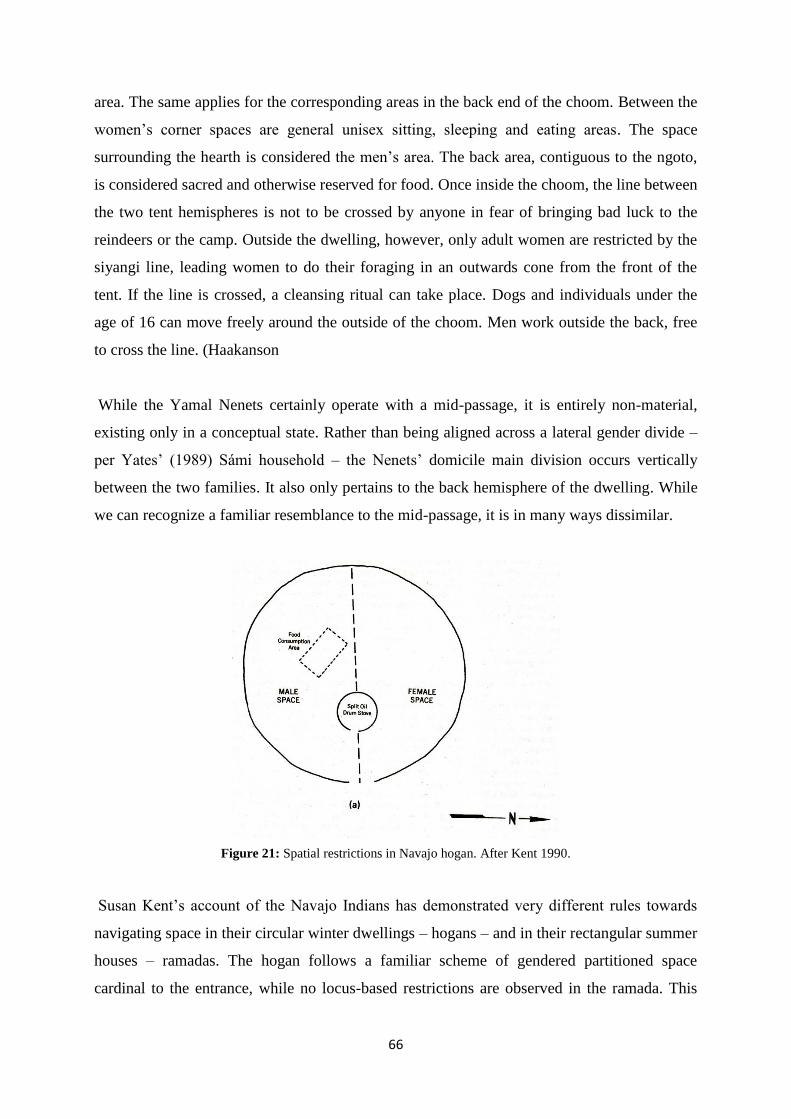
66
area. The same applies for the corresponding areas in the back end of the choom. Between the
women‟s corner spaces are general unisex sitting, sleeping and eating areas. The space
surrounding the hearth is considered the men‟s area. The back area, contiguous to the ngoto,
is considered sacred and otherwise reserved for food. Once inside the choom, the line between
the two tent hemispheres is not to be crossed by anyone in fear of bringing bad luck to the
reindeers or the camp. Outside the dwelling, however, only adult women are restricted by the
siyangi line, leading women to do their foraging in an outwards cone from the front of the
tent. If the line is crossed, a cleansing ritual can take place. Dogs and individuals under the
age of 16 can move freely around the outside of the choom. Men work outside the back, free
to cross the line. (Haakanson
While the Yamal Nenets certainly operate with a mid-passage, it is entirely non-material,
existing only in a conceptual state. Rather than being aligned across a lateral gender divide –
per Yates‟ (1989) Sámi household – the Nenets‟ domicile main division occurs vertically
between the two families. It also only pertains to the back hemisphere of the dwelling. While
we can recognize a familiar resemblance to the mid-passage, it is in many ways dissimilar.
Figure 21: Spatial restrictions in Navajo hogan. After Kent 1990.
Susan Kent‟s account of the Navajo Indians has demonstrated very different rules towards
navigating space in their circular winter dwellings – hogans – and in their rectangular summer
houses – ramadas. The hogan follows a familiar scheme of gendered partitioned space
cardinal to the entrance, while no locus-based restrictions are observed in the ramada. This

67
line is purely conceptual. Kent relates this to the sacred nature of the hogan reflecting the
cosmos and its circular shape. The ramada, on the other hand, is considered profane.
Examples of conceptual divides like that of the Navajo hogan are not limited to Siberia and
North-America: similar examples are found among Kenya‟s Maasi and Ilchamus (Kent
1990c: 136).
The governing structural principle of the round vernacular dwellings – and the Slettnes
houses - may not derive from a specific idea of a specific divide across a specified line.
Instead, such principles may be seen as dynamically emerging in social practice and tradition
as a result of the tent‟s spatial properties interfacing with human (animistic) predispositions -
that is to say the tent itself is influencing and prompting – triggering – some modular-esque
configuration of internal division. This also means, of course, that the human actors‟
experience of practical inhabitation may be instrumental in understanding how and why the
mid-passage phenomenon occurs. That is not to say that a circular dwelling necessarily results
in a segmented internal arrangement; there are many cross-cultural examples of the opposite
(Kent 1990c: 135). However, given the frequent and ubiquitous examples of restrictive space
in circular dwellings, synchronic snapshots of socio-spatial practice may not be very
informative to the task at hand. The assertion that built environments influence behavior
cross-culturally is not novel (see Kent 1990). It has been recognized that architecture is
suggestive to new behavior and that it can serve a mnemonic function, reminding users of
certain behaviors (Kent 1990b: 2). In previous works on the relationship between architecture
and social use of space, the onus of primacy and focus has been placed on human actors with
culture as a structuring force (Kent 1990b: 2-3). My suggestion is that the ways which
different types of architectural environs and dwellings influence culture may have different
causal relationships depending on the qualities of the built environment, and must be analyzed
in a particularistic manner.
Coincidentally, the global distribution of the stone-paved mid-passage is limited to the far
North. In the case of the North Greenland Paleo-Eskimo, driftwood, though plentiful, only
amassed in certain natural current traps. (Odgaard 2001: 145). As a limited resource, it stands
to reason that it would be used as fuel or equipment rather than as mid-passage markers. If the
lack of firewood were to explain the distribution of the mid-passage, one would expect to find
it in the Norwegian Mesolithic, for instance. Nonetheless, this stands as a possible
contributing factor. My suspicion is that mid-passages have existed in many cultures through

68
the ages, and that most were either made of perishable materials or were purely
symbolic/conceptual lines.
As a side note, I should mention that a modern informant has said that the partitioning of
inner space in the goahti was simply to keep things tidy (Sommerseth 2009).
69
7.5 Understanding the mid-passage redux
As it stands, approaches to interpreting domestic space in the Slettnes houses have relied
primarily on Sámi ethnography. Olsen (1993) and Myrvoll (2011) both suggest an
interpretation of daily life and social space strongly analogous with historic and ethnographic
accounts – accounts mostly recorded post 18th century. The general temporal and historical
proximity is of implicit importance, but the Iron Age mid-passage becomes key by means of
being indicative of floor partitioning, the specifics of which are to be understood as largely
mirroring the later written sources. These strict rules of conduct in Sámi domestic space
undoubtedly seem indicative of pervasive conceptual structures in the collective conciousness.
Whether we shall understand the gender-specific norms as mere difference; fluid, possibly
functional, or as a struggle for dominance, they must have been permeated through some
means outside of “the mind”. Upholding the entire “collective consciousness” is, perhaps, too
much for the mind to handle. The material and the spatial itself must have informed and
assisted in making the performance norms and traditions habitual (c.f. Connerton 1989).
The modern, linear perception of time entails a forward movement between segmented points
in time, leaving the past not only behind, but makes it irretrievable. In the spirit of progress
fashion trends and technological gadgets, this way of thinking comes quite natural to many. In
archaeology, we‟re presented with schematic visualizations of different periods accompanied
by tool typologies and dwelling forms - a conceptual synchronization of materials, things and
cultures into neat temporal segments. Inside these discrete segments, the given lapse of time
can be said to be represented as occuring all-at-once, or with a certain specificity. With our
terminology - Iron Age society, Iron Age tools, Iron Age houses - we encapsulate all these
domains, isolating them in a temporal vacuum. (Olivier 2001: 63-64). Of course, we can say
the same about the “Sáminess” in the models of domestic space. Through these ethnographic
snapshots, the dynamic and chaotic life of daily activities has all but disappeared completely,
and we‟re left with what appears as a static, monolithic segment. It all ties into an a priori
understanding of material remains as being products of a specific culture and its idiosyncratic
way of approprioating the material world.
With the more (or less) recent theoretical developments around materiality, some have argued
for a rehabilitation of time. Instead of viewing time as linear or cyclical, we‟re better served
understanding the passage of time as “duration(s)”, particularly with things of a physical
70
nature projecting across temporalities in different degrees. Thus, the things of the past are
visibly accumulated into the present. Most culturescapes are a patchwork of “bygone” eras
and rhythmic wavelengths (Ingold 1993). Of course, this accompanies a similar effect on our
perception in that we see and feel the presence of the distant and near past all around us. The
duration and permanence of the corporeal world, it a sense, projects it into the future.
Intuitively, we know that the physicality of the world with all its things is unlikely to
disappear the next day. (Olivier 2001). The multiplicity of temporality is arguably another
aspect factoring into upholding Sámi society through the years.
Through the course of the last millenium BC, the pit houses of the region seemingly become
sparser, the end result being that these flexible arrangements fully take their place - at least on
the outer coast. In what could, in terms of linear cultural evolution, be characterized as a
„retardation‟ of sorts, the pithouses become smaller from around the onset of the Early Metal
Age (1500 – 0 BC) compared to dwellings in the 1000 years preceding it, with signs of lower
degrees of sedentism and dwindling social complexity (although the evidence for said social
complexity is disputed, see Hood 1995). Along with a suspected general decrease in the
number of houses on the coast, there are indications of increased activity in the inland,
exemplified by open air sites (Hood & Olsen 1988: 120, Olsen 1994: 104-124). Concerning
the emerging Iron Age settlement, some pertinent questions relate to the causes for this
development in the grand scheme, but also why these round houses now become continually
reproduced in place of these previous forms. The mid-passage is already present – albeit
(physically) only from one entrance and to the hearth - in this earliest-known iteration of the
Slettnes house, thereby making it the first appearance of such a feature in the whole
Fennoscandian region. Tentatively, then, it seems the axial feature isn‟t gradually introduced
(or in memetic terms - „selected‟) after some long period, but rather nearly - if not wholly -
coinciding with the change in housing. Herein clearly lies a potential inductive fallacy, which
we will defer for later discoveries.
As detailed previously, Myrvoll interprets the whale bone found in a Kongshavn II house as a
symbolic feature, and in turn classifies this portion of the mid-passage as the boassu, citing
that males were traditionally in charge of handling meat procured from hunting and trapping.
If we return to the Forsøl site on Kvaløya, however, we recall that the sample from the hearth
revealed a concentration of charred bone, believed to be of whale. The use of animal bones as
fuel is known from arctic ethnography, and is frequently observed in Paleo-Eskimo mid-

71
passage houses, usually from sources high in blubber like musk oxen or seals. Scarcity of
viable kindling material is a common demominator in both cases. But in the ethnographic
material from the Sámi pastoralist era, firewood was kept in the uksa. So, which category
does the whale bone fall into?
The critique directed at the use of analogy becomes relevant in this context. Martin Wobst
(1978) writes about the “tyrrany of the ethnographic record”: in anthropological fieldwork,
the researcher is limited in terms of time, space and in the interpretation of meaning. There
are aspects of behavior that are intentionally hidden from the observer, as well as the problem
of the inescapable distortion, the platonic doxa – the figurative veil between “true”
comprehension and belief - for both observer and informant source. Crucial in Wobst‟s
critique is the impossibility of observation across large units of time. Ethnographic accounts
are snapshots; parochial and synchronic. Moreover, there is so much variability in the
worldwide record of different behavioral patterns and practices, belief systems and so forth,
that one basically always can find something, somewhere to support (or bend) the narrative in
the desired direction. Failing to recognize this dynamic risks a continual reproduction –
careless transference - of (imperfect) ethnographic snapshots in models of archaeological
explanation. (Wobst 1978: 303). Wobst argues that archaeology has the potential of providing
a unique diachronic vantage of the structures underlying historical contingency. Which
sounds appealing, of course, but is admittedly easier said than done. We may also question the
notion that archaeology is necessarily diachronic, or that diachronic generalizations are
inherently better. Surely, that would depend on the context at hand.
Going about their daily lives, the inhabitants of the Sámi lodge needn‟t have consulted their
“ideological canon” to enact the proper way of doing things (Merleau-Ponty 1962: 146-153).
Instead, it was all around them – in the various furnishings and draperies of the tent, in
personal objects and their interconnected embodied practices, in the attire and so forth, the
workstations and their objects – as a resource of sorts (c.f. Belk 1988). Indeed, according to
Merleau-Ponty (1994), space and spatial orientation forms the fundamental quality of hybrid
embodied existence. The external world requires of us to be cognizant of the space around us;
the distance to the other side of the room, the distance to the person sitting beside us, the
distance to other side of the fjord etc. The affordance offered by space is not something
mediated through distant contemplation, but is rather informed in a blunt and immediate
manner. As we can see plainly, the space inside the tent was limited, and could thus only
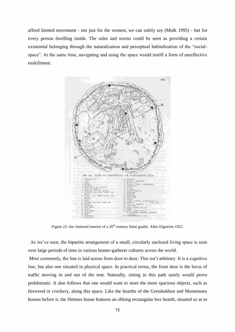
72
afford limited movement - not just for the women, we can safely say (Mulk 1995) - but for
every person dwelling inside. The rules and norms could be seen as providing a certain
existential belonging through the naturalization and perceptual habitalization of the “social-
space”. At the same time, navigating and using the space would instill a form of unreflective
enskillment.
Figure 22: the cluttered interior of a 20th
century Sámi goahti. After Elgström 1922.
As we‟ve seen, the bipartite arrangement of a small, circularly enclosed living space is seen
over large periods of time in various hunter-gatherer cultures across the world.
Most commonly, the line is laid across from door to door. This isn‟t arbitrary. It is a cognitive
line, but also one situated in physical space. In practical terms, the front door is the locus of
traffic moving in and out of the tent. Naturally, sitting in this path surely would prove
problematic. It also follows that one would want to store the more spacious objects, such as
firewood or crockery, along this space. Like the hearths of the Gressbakken and Mortensnes
houses before it, the Slettnes house features an oblong rectangular box hearth, situated so as to

73
accommodate the bipartite arrangement described above. Like Ränk (1949) suggests, wind
drafts could play into this. But as seen in the Sámi tents – as well as cross-culturally, a
transverse partitioning is also common, and in such cases the back of the tent is usually a
special place, situationally reserved for the shaman.
How many different ways are there of organizing space inside a tent? This question is what‟s
known as “the principle of limited possibility”. Ocham‟s razor holds that the explanation
involving the least amount of complex steps, the lowest number of extraneous or convoluted
circumstances, be the explanation opted for. When seperate aspects of an phenomenon
(recalling the famous parable of the mysterious elephant) begin to form the outlines of a
totality, we can talk of parsimonious conscilience (Ariew 1976). The mechanism of cultural
transference – Odgaard‟s shamanistic complex - requires an “idea” to survive a long series of
obstacles in its path. Odgaard posits that the vast tundras of Siberia, shrouded behind the veil
of the Iron Curtain, might further illuminate the traces of the clan-river mid-passage. Here, I
must concede that my explanation bares the hallmarks of what‟s known in analytic philosophy
as an ad-hoc hypothesis. Even if we were to find more of these mid-passages (which, to my
knowledge, has yet to occur), the explanations I‟ve offered would still apply. So, my
explanation-through-conscilience is poorly testable. Odgaard‟s suggestion is more testable,
provided that this spread suggested by Odgaard was shown to follow a linear temporal and
geographic sequence. However, the mid-passages of the Slettnes tents precede those of the
structure excavated by Itkonen in 1918.
If we return to the non-authentic variations of form that Ränk struggled to overcome, we can
conject that these variations represent, perhaps, actual displacements and reorientations of the
social order in the body-space interaction – in part caused by higher or lower numbers of
occupants. That‟s not to say the overarching influence of collective culture wasn‟t there, just
that the physical form of the tent played a constituting role in its stability and change (Olsen
2010: 145-147). It thus follows that the “collective” is more entangled and engaged in the
physical than we‟re led to believe. If we view the codes of behavior described by Ränk (1949)
as expressions of ephemeral figments of collective and individual (the smallest unit scale)
conciousness, the house and its mid-passage become the stage set for ever-changing
manifestations of these figments. Whether we call these transient ideas myths, world views or
„spritual resources‟, they do not provide directives in and of themselves; there is no central
authority; no limited set of affordances; no force of nature informing realms of possibility.
74
It shouldn‟t be surprising in the least to see patterns breaking up and changing through time.
The opposite - that systems of meaning and rules behavior remain largely unchanged through
vast periods of time – is the extraordinary claim. And that is even disregarding the situational,
mundane reality; the impracticality of incessantly watching one‟s step trying to eke out a fire
or prepare a meal in a (relatively) small tent when cold, wet and tired - there‟s a certain
autonomy at play here, and we see the exaggerated primacy of meaning and symbolism. But
perhaps this particular mid-passage stage and social, historical context would favor certain
expressions, bring forth “archetypes”, or alternatively; facilitate an ideological and
cosmological “principle of limited possibilities”. There‟s no blank slate here, but an ebb and
flow, a degree of disorder. In this sense, we ought to approach any potential cross-cultural
principal staple with skepticism. “Shamanism” cannot be viewed – barring considerable
reductionism - as some static disembodied idea, but rather as an evolving bricolage of the
environment, of physicality and materiality, of being, learning and interaction, of history and
time – all woven together in various ways.
One might argue that, in the bigger picture, some asymmetrically placed hearth and line of
slabs, or the mundane paradox demonstrated by the whale bone in hearth at Forsøl are of little
consequence, not seeing the forest for the trees. In the aggregated sense, that is true. The
historical argument - that the patterns observed by historical sources have earlier roots -
certainly bears weight. However, adjusting historical situatedness to the level of the
individual, cf. Heidegger‟s (1962: 425-7) concepts of Dasein and historicality, urges a more
grounded perspective. Both the “cultured” landscape of coastal Finnmark and North-Troms –
the mid-passage ruins left those who came before – as well as the socialization (or
thrownness) into a mobile household with this mid-passage as a central, anchoring feature -
was integral in the reproduction, but also the permutation of the stage set.
Consequential to the material at hand, the content of meaning and symbolism of the mid-
passage in the house from around the start of the first millenium (F7) wasn‟t necessarily the
same as that of the mid-passage from 700 years later (and so forth). Certain schools of thought
dealing with different types of memory and ways of remembering delineate between social
and cultural memory. Social memory is the type of collective memory content transferred
through communication, oral traditions and the like, and has an unpredictable but usually
short life span (in the area of 80-100 years). But this type of memory is supplemented and
75
strongly affected by cultural memory, the type of memory given longevity and solidity
through shared texts, iconography, images and rituals. (Assmann 2006). The latter conserves
and stabilizes a society whilst at the same relaying that cultural content to other, seperate
collectives (cf. Barth 1969). Aleida Assmann holds that cultural memory trancends the human
lifespans and projects into all three temporalities: past, present and future. We see through
consumption and production of text how an earlier text is influenced by the memories
preceding, textual and otherwise, as well as by the anticipation of the future, in turn
influencing subsequent texts – this forms an important basis for cultural memory. (Assmann
2011). Relating this concept to archaeology means expanding the effective horizon of
archaeological ruins, seeing the ways in which the mid-passage remains, for example, could
have formed landspace memories akin to cultural memories, and been part of an evolving
temporal narrative. One could object that this way of rememberance is a product of
modernity, but there‟s arguably a permanent, forceful quality to things. The mid-passage ruins
left by ancestors were reminders of the river clan and the spritual resources afforded by this
idea. Moving into unknown areas, the presence and familiarity of these ruins provide a sense
of belonging to the Paleo-Eskimos.
In her introductory remarks, Odgaard states that the material world is perceived, created and
structured by the world of ideas – i.e. mankind makes itself (Odgaard 2001: 7). I believe
instead that we ought to consider the possibility that the mid-passage(s), on occasion, have
eluded human imbuement and done things, meant things, not intended for them by their
originators.
76
Bibliography
Assman, A. 2011. Cultural Memory and Western Civilization. Functions, Media, Archives.
Assman, J. 2006. Form as a Mnemonic Device: Cultural Texts and Cultural Memory. In:
Horsley, R.A, Draper, J.A. & Foley J.M. Performing the Gospel. Orality, Memory and Mark.
Essays Dedicated to Werner Kelber. Fortress, Minneapolis. (http://archiv.ub.uni-
heidelberg.de/propylaeumdok/1829/1/Assmann_Form_as_a_mnemonic_device_2006.pdf)
Ariew, R. (1976). Ockham's Razor: A Historical and Philosophical Analysis of Ockham's
Principle of Parsimony. Champaign-Urbana, University of Illinois.
Baudou, E. 1992. Norrlands forntid: ett historiskt perspektiv. Förlags AB Wiken.
Binford, L. 1990. Mobility, Housing and Environment: A Comparative Study. Journal of
Anthropological Research, Vol. 46. No. 2 (Summer, 1990).
Belk, R.W. 1988. Possessions and the Extended Self. Journal of Consumer Research 15 (2).
Oxford University Press, Oxford
Bourdieu, P. 1977. Outline of a Theory of Practice. Cambridge University Press, Cambridge.
Bourdieu, P. 1984. Distinction: A Social Critique of the Judgement of Taste. London,
Routledge.
Bourdieu, P. 2002. Masculine Domination. Stanford University Press, Stanford.
Bratrein, H. D. 1995. Bjarkøy og Finnmork. Ottar no. 5, Tromsø Museum.
Bratrein, H. D. 1996. Gåtefulle Forsøl. Kulturminnene i Kirkegårdsbrukt. In: Fotefar mot
Nord.Finnmark fylkeskommune.
Broadbent, N. D. 2010. Lapps and Labyrinths: Saami prehistory, colonization and cultural
resilience. Arctic Studies Center, Washington D.C.
Connerton, P. 1989. How Societies Remember. Cambridge, Cambridge University Press
Coudret, P., Larriere M & Valetin, B.. 1989: Comparer des foyers: une entreprise difficile.
Monique Olive & Yvette Taborin (eds.) Nature et function des foyers préhistoriques.
Mémoires du Musée de Préhistorie d’Ile de France n. 2. Nemours. Pp. 37-46.
Deleuze, G. & Guattari, F. 1987. A Thousand Plateaus: Capitalism and Schizophrenia.
University of Minnesota, Minneapolis.
Eigil, K. 1967. Archaeology of the Musk-Ox Way. Contributions du Centre d´Études
Arctiques et Finno-Scandinaves no. 5. Paris.
Feather, L. A. Circular or Rectangular Ground Plans: Some Costs and Benefits. Nebraska
Anthropologist. Paper 92.

77
Elgström, O. 1922. Karesuando-Lapparna. Etnografiska skisser från Köngämä och
Lainiovuoma 1916-1919. Åhlen & Åkerlund.
Gibson, J. J. 1986. The Ecological Approach to Visual Perception. Houghton Mifflin, Boston.
Grydeland, S. E. 1996. Den sjøsamiske bosetting i Kvænangen fra seinmiddelalder til ny tid:
en arkeologisk studie i kontraster. Master‟s thesis, University of Tromsø.
Grydeland, S. E. 2001. De sjøsamiske siida-samfunn: en studie med utgangspunkt i
Kvænangen, Nord-Troms. Nord-Troms Museums skrifter I/2001. Sørkjosen.
Grønnow, B. & Jemsen, J. F. 2003. The Northernmost Ruins of the Globe. Eigil Knuth’s
Archaeological Investigations in Peary Land and Adjacent Areas of High Arctic Greenland.
Danish Polar Center, Copenhagen.
Guttormsen, H. 1998: Jernalderen – en folketom periode i Nord-Troms? På spor etter de
gamle boplassene. Menneske og miljø i Nord-Troms.
Haakansan, S. D. 2000. Ethnoarchaeology of the Yamal Nenets: Utilizing emic and etic
evidence in the interpretation of archaeological residues. PhD thesis. Harvard University,
Cambridge.
Hansen, L. I. og Olsen, B. 2004. Samenes historie fram til 1750. Oslo: Cappelen Akademisk
Forlag.
Hansen, L. I. & Olsen, B. 2014. Hunters in Transition An Outline of Early Sámi History.
Brill, Leiden.
Heidegger, M. 1962. Being and Time. (Macquarie, J. & Robinson, E., Trans.) Blackwell,
London.
Henriksen, J. E. 1995: Hellegropene. Fornminner fra en funntom periode. Master‟s thesis in
archaeology, Universitetet i Tromsø.
Henriksen, J.E. 2002. Delrapport II: Prøvegravinger 2001. Kulturmiljøer fra jernalder og
eldre historisk tid i Kyst-Finnmark. En undersøkelse med utgangspunkt i fenomenet
mangeromstuter. University of Tromsø.
Henriksen, S. & Valen, R. V. 2013. Rapport fra de arkeologiske undersøkelsene 2009 og
2010, Hammerfest kommune. Tromura No. 43.
Hesjedal, A., Olsen, B., Storli, I. & Damm, C. 1993. Arkeologiske undersøkelser på Slettnes,
Sørøy 1992. Tromura kulturhistorie, 25.
Hesjedal, A., Damm, C., Olsen, B. & Storli, I. 1996. Arkeologi på Slettnes. Dokumentasjon
av 11.000 års bosetting. Tromsø Museums skrifter, XXVI.
Hood, B. & Olsen, B. 1988. Virdnejavri 112: A Late Stone Age/Early Metal Period Site from
Interior Finnmark, North Norway. Acta Archaeologica 58: 105-125
78
Hood, B. 1995. Circumpolar comparison revisited: hunter-gatherer complexity in the north
Norwegian Stone Age and the Labrador Maritime Archaic. Arctic Anthropology 32(2): 75-
105.
Holberg, E. 2002. Kulturminner på Arnøy og Laukøy i Nord-Troms. Ei vandring gjennom tid,
landskap og historie. Nord-Troms Museums Skrifter II, 2002, Sørkjosen.
Hodder, I. 1982. Symbols in Action. Cambridge University Press, Cambridge.
Ingold, T. 1992. Culture and the perception of the environment. In E. Croll and D. Parkin
(eds.). Bush Base: Forest Farm. Culture, Environment and Development, 39-56. Routledge,
London & New York.
Ingold, Tim. 1993. The Temporality of the Landscape. World Archaeology 25, no. 2: 24-174.
Ingold, T. 2000. Perception of the environment: Essays in livelihood, dwelling and skill.
Routledge, London.
Ingold, T. 2010. The textility of making. Cambridge Journal of Economics 2010, 34, 91 -102.
Ingold, T. 2013. The Conical Lodge at the Centre of the Earth-Sky World. In Anderson, D.,
Wishart, R. & Vaté, V (eds.). About the Hearth. Perspectives on the Home, Hearth and
Household in the Circumpolar North. Berghahn, New York.
Jackson, M. A. 1998. The Nature of Fire-Cracked Rock: New Insights from
Ethnoarchaeological and Laboratory Experiments. Master‟s thesis, A&M University, Texas.
(http://anthropology.tamu.edu/papers/Jackson-MA1998.pdf)
Kent, S. (ed.) 1990. Domestic Architecture and the Use of Space: An interdisciplinary cross-
cultural study. Cambridge University Press, Cambridge.
Kent, S. 1990b. Activity areas and Architecture: An interdisciplinary view of the relationshop
between the use of space and domestic built environments. In Domestic Architecture and the
Use of Space: An interdisciplinary cross-cultural study. Edited by Kent, S. Cambridge
University Press, Cambridge.
Kent, S. 1990c. A cross-cultural study of segmentation, architecture, and the use of space. In
Domestic Architecture and the Use of Space: An interdisciplinary cross-cultural study. Edited
by Kent, S. Cambridge University Press, Cambridge.
Jørgensen, R. & Olsen, B. 1998: Asbestkeramiske grupper i Nord-Norge 2100 f. Kr. – 100 E.
Kr. Tromura, Kulturhistorie nr. 13, Tromsø.
Leem, K. 1767 [1975]. Beskrivelse over Finmarkens Lapper. Efterord af Asbjørn Nesheim.
Rosenkilde og Bagger, København
Manker, E. 1944. Läpsk kultur vid stora Lule älvs källstöar. En etnografisk inventering inom
uppdämningsområdet vid Suorva. Acta Lapponica IV. Nordiska Museet, Stockholm
.

79
Manker, E. 1960. Fångstgropar och stalotomter. Kulturlämningar från lapsk forntid. Acta
Lapponica XV. Uppsala.
Merleau-Ponty, M. 1962. Phenomenology of Perception. C. Smith (translator). Routledge &
Kegan Paul.
Merleau–Ponty, M. 1994. Kroppens fenomenologi. Pax forlag A/S Oslo.
McGhee, R. 1977. Ivory for the Sea Woman: The Symbolic Attributes of a Prehistoric
Technology. Canadian Journal of Archaeology 1: 141-149.
Myrvoll, E. R. 2002. Delrapport I: Kulturminneregistreringer 2001. Kulturmiljøer fra
jernalder og eldre historisk tid i Kyst-Finnmark. En undersøkelse med utgangspunkt i
fenomenet mangeromstuter. University of Tromsø
Myrvoll, E. R. & Henriksen, J.E. 2003. Delrapport III: Kulturminneregistreringer 2002.
Kulturmiljøer fra jernalder og eldre historisk tid i Kyst-Finnmark. En undersøkelse med
utgangspunkt i fenomenet mangeromstuter. University of Tromsø
Myrvoll, E. R. 2003. Delrapport V: Arkeologiske undersøkelser av hellegrop, gammetufter og
teltringer i Berlevåg kommune 2002. Kulturmiljøer fra jernalder og eldre historisk tid i Kyst-
Finnmark. En undersøkelse med utgangspunkt i fenomenet mangeromstuter. University of
Tromsø
Myrvoll, E.R. 2009. Kulturminnefaglig rapport. Kopperutvinning i Riehpovutna/Repparfjord,
Kvalsund kommune. NIKU, landsskapsavdelingen.
Myrvoll, E. R. 2011. Excavation of Iron Age Sites. In :Olsen, B., Urbanczyk, P. &
Amundsen, C.. Hybrid Spaces. Medieval Finnmark and the Archaeology of Multi-Room
Houses. Oslo: Novus Press.
Nilsen, R. A. 1996: Nausttufter i Nord-Norge. Distribusjon og kronologi relatert til samtidige
båttyper og havnivå. Stensilserie B nr. 40, Universitetet i Tromsø.
Nilsen, R.A. 2004. Spor etter samisk og norrøn jernalderbosetting langs ytterkysten. I:
Kulturmøter i Nord-Troms. Jubileumsbok for Nord-Troms Museum 1978-2003. Nord-Troms
Museum, Sørkjosen.
Nilsen, R.A. 2014. Den nordlige jernalder: kulturminner og funn fra Malangen til Loppa.
Nord-Troms Museum.
Odgaard, U. 2003. Hearth and home of the Paleo-Eskimos. Études/Inuit/Studies, vol. 27. #1-2.
s. 349-374. (http://www.erudit.org/revue/etudinuit/2003/v27/n1/010808ar.html)
Odner, K. 1983. Finner og terfinner: etniske prosesser i det nordlige Fenno-Skandinavia.
Department of Social Anthropology, Oslo.
Oliver, L. C. 2001. Duration, memory and the nature of the archaeological record. In
Karlsson, H. (ed.). It’s about time. The concept of time in archaeology. Bricoleur press, s. 61-
70.
80
Olsen, B. 1993: Hus mellom steinalder og historisk tid. Ottar nr. 1, Tromsø Museum.
Olsen, B. 1994: Bosetning og samfunn i Finnmarks forhistorie. Oslo: Universitetsforlaget.
Olsen, B. 1997. Fra ting til tekst. Teoretiske perspektiv i arkeologisk forskning. Oslo,
Universitetsforlaget.
Olsen, B. 1998. Saqqaq housing and settlement in southern Disko Bay, West Greenland. Acta
Borealia, Volume 15 pp. 81-128. Oslo.
Olsen, B. 2003. Beliggerent chieftains and oppressed hunters? Changing conceptions of inter-
ethnic relationships in northern Norway during the Iron Age and Early Medieval Period. In:
Barett, J. (red.), Contacts, Continuity and Collapse. The Norse Colonization of the North
Atlantic. Studies in the Early Middle Ages SEM 5. Turnhout: Brepols Publishers.
Olsen, B. 2010. In Defense of Things. Archaeology and the ontology of objects. Lanham: Alta
Mira Press
Olsen, B., Henriksen, J.E. & Myrvoll, E.R. 2011. The Multi-Room House Sites: Surveys and
Test Excavations. In: Olsen, B., Urbanczyk, P. & Amundsen, C.. Hybrid Spaces. Medieval
Finnmark and the Archaeology of Multi-Room Houses. Oslo: Novus Press.
Ränk, G. 1948-49. Grundprinciper för disponeringen av utsymmet i de lapske kåtorna och
gammerna. In Erixon, S. (ed.). Folk – Lov. Acta Ethnologica, Et Folkloristica Europaea TOM
XII – XIII. Stockholm.
Schefferus, J. 1956 [1973]. Lappland. In Manker E. (ed.). Acta Lapponica. VIII. Almqvist &
Wiksell, Uppsala.
Schanche, A. 1989. Jernalderens bosettingsmønster i et fleretnisk perspektiv. In: Bertelsen, R.
et. al. (ed.): Fremskritt for forntida i nord – i Povl Simonsens fotefar. Tromsø Museums
skrifter 22, 1989:171-180.
Schanche, K. 1992. Den funntomme perioden. Nord-Troms og Finnmark i det første årtusen
e. Kr. FOK-programmets skriftserie, 2.
Sommerseth, I. 2009. Fra villreinfangst til tamreindrift i Indre Troms. Belyst ved samiske
boplasser mellom 650 og 1923. Doktogradsavhandling i arkeologi, IAS, Universitetet i
Tromsø / Munin. 372 s.
Yates, T. 1989. Habitus and social space: some suggestions about meaning in the Saami
(Lapp) tent ca. 1700 – 1900. In Hodder. I. (ed.) The Meaning of Things. Material Culture and
Symbolic Expression. London. 249 – 262.
Vorren, Ø. 1982. Kystsamenes husformer. Ottar, no. 4. Tromsø Museum.
Wasmuth, R. 2005. Regionale likheter og lokale variasjoner. En analyse av overgangen fra
yngre steinalder/tidlig metalltid i det vestlige Finnmark. Master‟s thesis. University of
Tromsø.

81
Westerdahl, C. 2006. Kosmologi og sjamanens mikro- og makroverden. In: Spor nr 1, 2006.
Winterhalder, B. 2001. The behavioral ecology of hunter-gatherers. In: Hunter-Gatherers: An
Interdisciplinary Perspective. Panter-Brick C, Layton R.H & Rowley-Conwy, eds. Cambridge
University Press, Cambridge
Wobst, M. H.. 1978 The Archaeo-Ethnology of Hunter-Gatherers or the Tyranny of the
Ethnographic Record in Archaeology. American Antiquity, Vol. 43, No. 2.
Claus Andreasen "Palaeoeskimo dwellings in Greenland: A survey" Études/Inuit/Studies, vol.
27, n° 1-2, 2003, p. 283-306.

![[Type the document title]](https://static.fdokumen.com/doc/165x107/6333508cb91d35198e0b9f67/type-the-document-title.jpg)


![Type the document title] [Year](https://static.fdokumen.com/doc/165x107/6323c87a03238a9ff60a97b9/type-the-document-title-year.jpg)