The role of western white pine in forest succession in northern ...
15
This file was created by scanning the printed publication. Errors identified by the software have been corrected; however, some errors may remain. THE ROLE OF WESTERN WHITE PINE IN FOREST SL'CCESSION IN NORTHERN IDAHO M. A. HUBERMAN Yale University 1 INTRODUCTION The importance of vegetational studies in virgin forests has become more and more obvious during the past few years as a result of the increasing scarcity of primeval areas. The work of Cooper ('13) on Isle Royale, Michi- gan; of Nichols ('13) at Colebrook, Connecticut; of Lutz ('30) at Heart's Content, Pennsylvania; of Gates and Nichols ('30) studying an area near Pellston, Michigan; and of Hough ('32) in Pennsylvania, may be said to compose the greatest portion of the meagre literature on this subject. vVith a view, therefore, to obtaining knowledge of the character of the vegetation of the sub-climax and near-climax forest of the " western white pine type," these studies were undertaken. in three virgin communities. Al- though there have been several general surveys and observational studies made on this subject in the Korthern Rocky Mountain region, there is no published work available on the vegetation of specific areas. It is the purpose of this paper, therefore, to present such data. In his more or less extensive observations in the Bitterroot Mountains of northern Idaho, Larsen ('29) notes that after fires, the succession is some- what as follows: The intolerant and drought-resistant western larch and lodgepole pine represent the first stage. These trees, with an initial stage of subordinate vegetation, prepare the site for the advent of Douglas fir and western white pine, and a second layer of lesser vegetation. This stage in turn paves the way for the climax forest association of western red cedar, western hemlock, and lowland white fir with a typical sparse shrubby and herbaceous vegetation (fig. 1). Accepting these general relationships, the areas investigated in this study may be placed in the second stage in the case of areas 1 and 2, while area 3 probably belongs to the climax or ncar-climax stage. In a general way the three areas belong to the white pine type, so termed because of the volume and economic value of Pinus nwnticola, rather than be- cause of the number of trees per acre or its importance in the climax forest. Briefly, this type consists most commonly of western white pine, Pinus 1nonticola, as the dominant species with other trees subordinate. vVith age, 1 This work was done during the summer of 1932, while with the Northern Rocky J\{ountain Forest and Range Experiment Station, U. S. Forest Service. 137
-
Upload
khangminh22 -
Category
Documents
-
view
0 -
download
0
Transcript of The role of western white pine in forest succession in northern ...
This file was created by scanning the printed publication.Errors identified by the software have been corrected;
however, some errors may remain.
THE ROLE OF WESTERN WHITE PINE IN FOREST SL'CCESSION IN NORTHERN IDAHO
M. A. HUBERMAN
Yale University 1
INTRODUCTION
The importance of vegetational studies in virgin forests has become more and more obvious during the past few years as a result of the increasing scarcity of primeval areas. The work of Cooper ('13) on Isle Royale, Michigan; of Nichols ('13) at Colebrook, Connecticut; of Lutz ('30) at Heart's Content, Pennsylvania; of Gates and Nichols ('30) studying an area near Pellston, Michigan; and of Hough ('32) in Pennsylvania, may be said to compose the greatest portion of the meagre literature on this subject.
vVith a view, therefore, to obtaining knowledge of the character of the vegetation of the sub-climax and near-climax forest of the " western white pine type," these studies were undertaken. in three virgin communities. Although there have been several general surveys and observational studies made on this subject in the Korthern Rocky Mountain region, there is no published work available on the vegetation of specific areas. It is the purpose of this paper, therefore, to present such data.
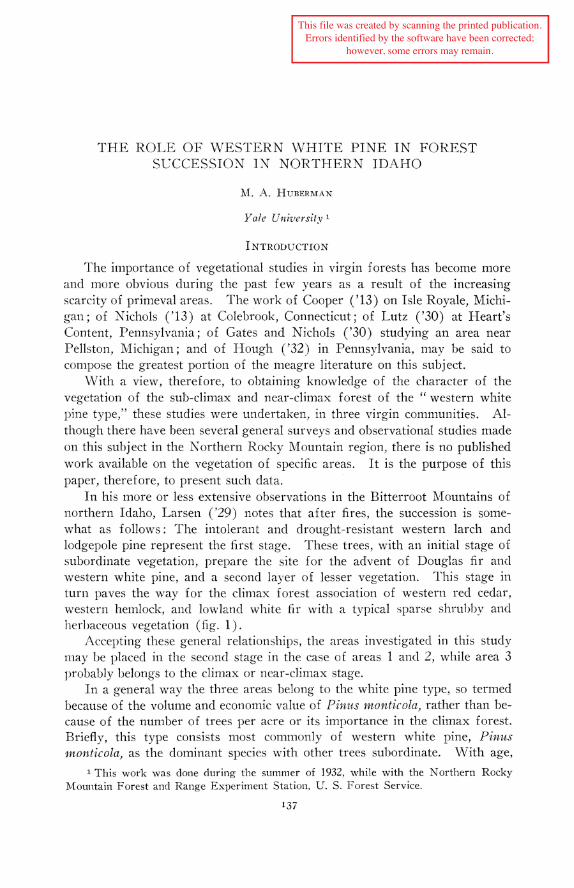
In his more or less extensive observations in the Bitterroot Mountains of northern Idaho, Larsen ('29) notes that after fires, the succession is somewhat as follows: The intolerant and drought-resistant western larch and lodgepole pine represent the first stage. These trees, with an initial stage of subordinate vegetation, prepare the site for the advent of Douglas fir and western white pine, and a second layer of lesser vegetation. This stage in turn paves the way for the climax forest association of western red cedar, western hemlock, and lowland white fir with a typical sparse shrubby and herbaceous vegetation (fig. 1).
Accepting these general relationships, the areas investigated in this study may be placed in the second stage in the case of areas 1 and 2, while area 3 probably belongs to the climax or ncar-climax stage.
In a general way the three areas belong to the white pine type, so termed because of the volume and economic value of Pinus nwnticola, rather than because of the number of trees per acre or its importance in the climax forest. Briefly, this type consists most commonly of western white pine, Pinus 1nonticola, as the dominant species with other trees subordinate. vVith age,
1 This work was done during the summer of 1932, while with the Northern Rocky J\{ountain Forest and Range Experiment Station, U. S. Forest Service.
137
M. A. HUBERMAN Ecology, Vol. 16, No. 2
FIG. 1. Near-climax forest, showing absence of white pine. general lack of shrubby and herbaceous vegetation, and abundance of cedar and hemlock reproduction. Veteran larch at the right.-Photo by K. D. Swan. Courtesy of U. S. Forest Service.
April, 1935 WESTERN WHITE PINE IN NORTHERN IDAHO 139
however, the stand changes and consists chiefly of western red cedar, Thuja plicata; western hemlock, Tsuga heterophylla; and lowland white fir, Abies yrandis; with occasional veterans of Douglas fir, Pseudotsuqa taxi.folia, and western larch, Larix occidentalis. The subordinate vegetation is very sparse, but quite uniform on the three areas.
To study the composition of this association, therefore, strips were laid out through each of the areas for a tally of the overwood, and quadrats laid along· these strips to study the shrubby and herbaceous vegetation, and reproduction of the tree species. Site conditions vvere also studied.
THE AREA
The Priest River Branch of the Northern Rocky J\lountain Forest ancl Range Experiment Station occupies about seven square miles of the Kaniksu Kational Forest in T. 58 N., R. 3 and 4 \V., in Bonner County, Idaho, fifteen miles northeast of the town of Priest River.
This area is made up of three topographic types: "the first, rugged mountainous provinces, composed of tilted, faulted, metamorphosed sediment, massive basic igneous sills, and a batholithic acid igneous intrusion with its attending stocks and cupolas; second, plateau-like areas, lower than the mountain masses, planed off by continental-glacier erosion; and third. stream-valley plains." 2
The Experimental Forest is drained by the East River, Benton Creek, and Fox Creek, all of which flow west into the Priest River, a glaciated, faultformed valley.
Areas 1 and 3 are on stream-valley plains. Area 2 is in the rugged-mountain province.
Elevations range from below 2240 feet on the river flats to 5700 feet at the Experimental Lookout Station, giving a relief of almost 3500 feet.
GEOLOGY AND SoiLS
Igneous and metamorphic rocks of the Pre-cambrian, sedimentary materials of the Pleistocene, and Cretaceous intrusions are all represented here.
The underlying rocks in the Experimental Forest consist chiefly of granites overlaid by schist and quartzite, very near the surface in some places and outcropping in others.
Horizontal (profile) development resulting from weathering is notably absent in the majority of the soils, except in a few instances. The subsoils are generally friable and free from marked compaction.
The organic debris on area 1 consists of an F horizon (Hesselman, '26) of 1-2 inches made up of 2 or 3 years' fall of needles, light brown in color, merging into a half-inch partially decomposed H horizon, dark brown in color, which is only very slightly if at all mixed with the mineral soil. Below this,
2 Kirkham, V. R. D., and E. W. Ellis. 1926. Ore Deposits of Boundary County, Idaho. Bur. Mines and Ceo/. Univ. Idaho Bull. 10, p. 10.
140 M. A. HUBERMAN Ecology, Vol. 16, No. 2
to 40 inches, is a gray-to-brown sand with coarse gravel. All layers are distinctly micaceous. This is called the Springdale sandy loam by Lapham and Young ('25), who are not certain as to whether the material is glacial outwash or alluvial in origin. The substratum (which was not reached in the present examination) to a considerable depth consists of old lake clays, and occurs on old stream terraces lying above the level of the present water courses. The surface drainage is good and the subclrainage is generally excessive. The water holding capacity is low, thus minimizing the upward movement of the capillary moisture.
Area 2 lies on the Huckleberry fine sanely loam. Below the organic debris made up of a 2-inch F layer of light brown needles, chiefly pine and hemlock, and a dark brown half-inch H layer, is a 12-inch stratum of yellow brown fine sanely loam, with small amounts of angular stones. For 6 inches below this there is a gray-brown sand with more angular rock material. Below this is found broken, decomposed schist and quartzite which merges into the bedrock. As is to be expected, soils of steeper slopes, as here, are shallower than the average of the same soil type. The steepness of the slopes results in excessive surface drainage. The water holding capacity of the soil is good except in shallow spots. The south slopes tend to dry out quickly.
On area 3 the Mission fine silt loam is the prevailing soil type. The organic debris consists of a dense F layer of 1.5 inches of light brown to darker material, without any well defined H layer. Below this. to a depth of 18 inches, is a yellow-brown very fine silt loam, containing much mica. Below 18 inches is a compact, rusty-spotted gray clay, which appears to be an oldlake deposit resulting from the extension of the arms of the lake up the various creeks which now drain the forest. The deposit is many feet in thickness. The soil has a smooth to slightly rolling surface, good drainage generally, and good moisture-holding capacity. A mechanical analysis showed S0-55 per cent silt, 30-35 per cent sand, and 10-15 per cent day.
For the most part, the soils of these three plots are acid in reaction with a pH ranging from 6.2 to 6.5.
CLIMATE
\Veather records have been kept for 22 years at the Priest River Experiment Station on the Experimental Forest. A 20-year summary (Jemison, '32) makes available the following data.
The mean annual precipitation is 28.29 inches, and its distribution by months is shown in table I. The average annual snowfall is 81.8 inches. The greatest snow depth on the ground was 46.2 inches in the winter of 1931-32; the least was 7 inches in 1920-21. The prevailing wind direction is S\V, all the year around. The wind velocity at the 150-foot level has a highest average of 20 miles per hour, with a highest recorded maximum of 38 miles per hour (based on sudden gusts of a few minutes' duration). The average wind velocity at the 8-foot level is 1.6 miles per hour. Monthly
April, 1935 WESTERN WHITE PINE IN NORTHERN IDAHO I4I
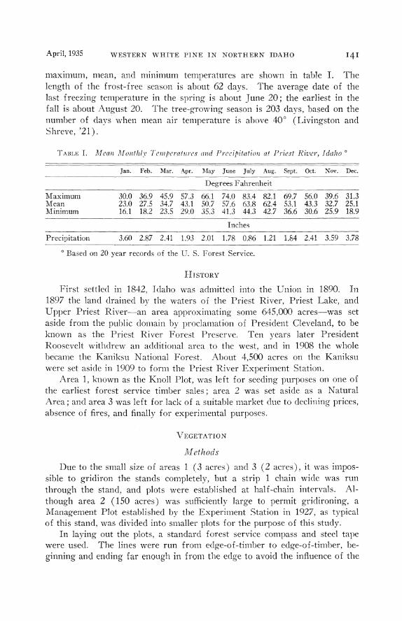
maximum, mean, and minimum temperatures are shown in table I. The length of the frost-free season is about 62 days. The average date of the last freezing temperature in the spring is about June 20; the earliest in the fall is about August 20. The tree-growing season is 203 days, based on the number of days when mean air temperature is above 40° (Livingston and Shreve, '21).
TABLE I. J1fean Month/_,, Temperatures and Precipitation at Priest River, Idaho o
Maximum Mean Minimum
Precipitation
Jan. Feb. Mar. Apr. May June July Aug. Sept. Oct. Nov. Dec.
Degrees Fahrenheit
30.0 36.9 45.9 57.3 66.1 74.0 83.4 82.1 69.7 56.0 39.6 31.3 23.0 27.5 34.7 43.1 50.7 57.6 63.8 62.4 53.1 43.3 32.7 25.1 16.1 18.2 23.5 29.0 35.3 41.3 44.3 42.7 36.6 30.6 25.9 18.9
Inches
3.60 2.87 2.41 1.93 2.01 1.78 0.86 1.21 1.84 2.41 3.59 3.78
o Based on 20 year records of the U. S. Forest Service.
HISTORY
First settled in 1842, Idaho was admitted into the Union in 1890. In 1897 the land drained by the waters of the Priest River, Priest Lake, and Upper Priest River-an area approximating some 645,000 acres-was set aside from the public domain by proclamation of President Cleveland, to be known as the Priest River Forest Preserve. Ten years later President Roosevelt withdrew an additional area to the west, and in 1908 the whole became the Kaniksu National Forest. About 4,500 acres on the Kaniksu were set aside in 1909 to form the Priest River Experiment Station.
Area 1, known as the Knoll Plot, was left for seeding purposes on one of the earliest forest service timber sales; area 2 was set aside as a Natural Area; and area 3 was left for lack of a suitable market clue to declining prices, absence of fires, and finally for experimental purposes.
VEGETATION
Methods
Due to the small size of areas 1 ( 3 acres) and 3 ( 2 acres), it was impossible to gridiron the stands completely, but a strip 1 chain wide was run through the stand, and plots were established at half-chain intervals. Although area 2 ( 150 acres) was sufficiently large to permit gridironing, a Management Plot established by the Experiment Station in 1927, as typical of this stand, was divided into smaller plots for the purpose of this study.
In laying out the plots, a standard forest service compass and steel tape were used. The lines were run from edge-of-timber to edge-of-timber, beginning and ending far enough in from the edge to avoid the influence of the
142 M. A. HUBERMAN Ecology, Vol. 16, No.2
surrounding or adjacent cut stands. Tree diameters on the plots were measured with a steel diameter tape.
All trees above 1 inch at breast heig·ht ( 4.5 feet above the ground) were measured. All below 1 inch D.RH. were counted on the entire plot. Ten milacre quadrats were established on each area. marked hy cedar stakes (as was the center line through the plots, at half-chain intervals). The identification of the plants was checked against the herbarium specimens of the Experiment Station.
The tree nomenclature is that of Sudworth ('27) ; nomenclature of shrubs and herbs is that of Piper and Beattie ('14).
Phytographs (Lutz, '30), as shown in figure 4 are used to show the ecological position of the various species of the association. The criteria used to determine the relative importance of the species are: Abundance percentage, frequency percentage, number of size-classes present, and basal area in square feet per acre. In a standard chart, constructed to aid in the comparison, the following values are assumed: Abundance 100 per cent, frequency 100 per cent, four size-classes present,4 and a basal area value of 300 square feet per acre.5
Communities
Apparently because of the high market value and wide occurrence of white pine in the region, foresters have applied the name white pine type to this association which ought, more appropriately, to be called the cedar-hemlockwhite fir association. Larsen ('30) classified this type as the "Mesophytic transition forest," and as the cedar-hemlock-white fir type. Occasionally there occur in this region small areas of a white pine consociation, but for the most part this species plays a minor part in the climax forest. It is, however, important, because in the presence of a seed source, openings due to windfall or other agencies are readily taken over hy white pine.
AREA 1. GENERAL CHARACTER
Despite the heavy density of this high coniferous forest with an almost complete canopy, some light docs penetrate to the forest floor. On the average, however, this light does not amount to more than 3--5 per cent of full sunlight. The diameters of the larger white pines are noteworthy; occasional trees attain diameters of 37 or 38 inches. Rarely a cedar reaches 40 inches. The presence of 364 stems per acre is less than on the other two areas. There is little difference, impossible to measure by methods now available, in the density of the three areas. \Vindfalls are very common on this as well as on the other two areas, but no data on age or species of clown trees were ob-
4 The size classes used are: 1. Small reproduction; up to 0.9 in D.B.H. 2. Large reproduction; 1.0-3.5 in. D.B.H. 3. Small trees; 3.6-11.5 in. D.B.H. 4. Large trees; 11.6 in. D.B.H. and up.
5 This value of 300 square feet is used because it represents approximately the aver-age maximum per acre in this vicinity.
.\pril, 1935 WESTERN WHITE PINE IN NORTHERN IDAHO I43
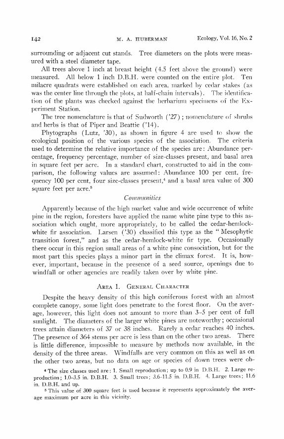
tained. The forest floor has a very sparse covering of shrubby and herbaceous vegetation. This, in conjunction with the general lack of reproduction, gives a single-storied aspect to the forest (fig. 2).
FrG. 2. Typical view through area 1, showing predominance of white pine. Note lack of herbaceous and shrubby vegetation and abundance of down timber.
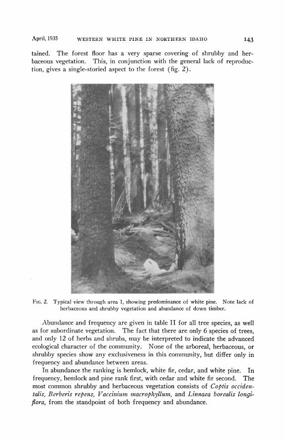
Abundance and frequency are given in table II for all tree species, as well as for subordinate vegetation. The fact that there are only 6 species of trees, and only 12 of herbs and shrubs, may be interpreted to indicate the advanced ecological character of the community. None of the arboreal, herbaceous, or shrubby species show any exclusiveness in this community, but differ only in frequency and abundance between areas.
In abundance the ranking is hemlock, white fir, cedar, and white pine. In frequency, hemlock and pine rank first, with cedar and white fir second. The most common shrubby and herbaceous vegetation consists of C optis occidentalis, Berberis rep ens, V acciniu1t1. macrophyllum: and Linnaea borealis longiflora, from the standpoint of both frequency and abundance.
TAB
LE
II.
Ab
un
da
nce
and
Frc
quen
c)'
of
Sp
ecie
s F
ou
nd
at
Pri
est
Riv
er,
Ida
ho
>-
< -f
'. -f
'.
*TR
EE
S A
REA
1
AR
EA
2 A
REA
3
Ab
un
dan
ce
Fre
qu
ency
A
bu
nd
ance
F
req
uen
cy
Ab
un
dan
ce
Fre
qu
ency
S
cien
tifi
c N
ame
per
cen
tag
e p
erce
nta
ge
per
cen
tag
e p
erce
nta
ge
per
cen
tag
e p
erce
nta
ge
Tsu
ga
hct
erop
h:;•
lla
43.9
10
0 58
.4
100
67.2
10
0 P
inu
s m
onti
cola
15
.4
100
3.2
40
1.5
10
Th
uja
p/i
cata
16
.4
90
32.3
10
0 24
.2
100
Ab
ies
gran
dis
20.9
90
3.
5 50
4.
4 70
L
ari
x oc
cide
ntal
is
1.7
30
0.4
10
2.7
70
P s
eudo
tsug
a ta
.rif
olia
1.
7 30
A
bie
s /a
sioc
arpa
2.
2 40
tSH
RU
BB
Y A
ND
HER
BA
CEO
US
VEG
ETA
TIO
N
Ace
r gl
abru
m
7.0
20
"' ;" L1
ctac
a ru
bra
1.2
20
0.5
10
?'" A
mel
an
chic
r al
nifo
lia
0.3
10
Arn
ica
cor
difo
lia
8.5
50
~
Ber
ber
is r
epen
s 3.
7 60
1.
0 10
~
Chi
map
hila
um
bel/
ala
0.5
10
to ~
Cli
nton
ia u
nifi
ora
1.4
30
29.5
10
0 ::<0
Cop
tis
occi
dcnt
alis
72
.0
90
78.5
10
0 ~
Dis
po
rum
tra
chj•
carp
um
1.0
10
>-L
inna
ea b
orea
lis
2.3
50
10.5
70
5.
0 40
:.?.
Lon
icer
a ut
ahen
sis
0.2
10
7.5
40
M c
n:::
icsi
a fe
rruq
inia
3.
0 10
P
achi
stim
a m
yrsi
nit
cs
5.0
60
Pyr
ola
bra
cfca
ta
2.0
30
Ro
sa s
p.
0.7
20
4.0
30
So
rbu
s sa
mlm
cifo
lia
2.0
10
tT]
n T
axu
s br
evif
olia
0.
8 10
0
Tia
rell
a un
ifol
iata
3.
0 40
2.
5 10
0 aq
T
rill
ium
obm
•atu
m
2.0
20
~<
Vac
cini
um
ma
cro
ph
yllu
m
3.5
so 21
.0
70
<
Vaq
nera
scs
sili
foli
a 1.
5 20
1.
0 10
7.
0 30
~
Vio
la s
p.
1.4
30
5.5
60
2.0
20
,_.
.a-.
* B
ased
on
a to
tal
of
10-.0
5 ac
re p
lots
on
eac
h a
rea.
z
t B
ased
on
a to
tal
of 1
0 m
ilac
re q
uad
rats
on
eac
h a
rea.
!='
tv
April, 1935 WESTERN WHITE PINE IN NORTHERN IDAHO
Human Influence and Fire
There has been no cutting on the actual area studied, but on all sides of the area it has been quite extensive. The difference in conditions between the cut-over and the virgin stands is very marked.
Although there is no evidence of recent fires on this area (a very fortunate and unusual fact in a region of such high fire hazard), there is ample evidence of early fires on the area as a whole. The even-aged character of the white pine points strongly toward early fires on the Kaniksu and elsewhere in northern Idaho. Marshall ('29) found, by examinations of annual rings, evidences of fires on nearby white pine stands in 1610, 1641, 1687, 1742, and 1843.
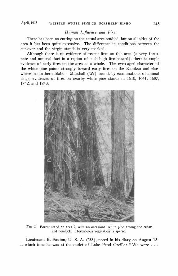
FrG. 3. Forest stand on area 2, with an occasional white pine among the cedar and hemlock. Herbaceous vegetation is sparse.
Lieutenant R. Saxton, U. S. A. ('53), noted in his diary on August 13, at which time he was at the outlet of Lake Pend Oreille: " We were . . .

M. A. HUBER:MAN Ecology, Vol. 16, No. 2
discouraged by accounts of the route from this place to St. Mary's village given by a Scotchman who has recently passed over it. He says that for five days' journey there is no grass, it having been burned over by the Indians." (There is a possibility that ' St. Mary's village' referred to Hamilton, Montana.)
"August 16. The woods are on fire in many places-evidently for the purpose of retarding our progress."
" August 18. The route has been through dense forest, either burning or just burned, the ground being very hot for the animals' feet."
There is ample evidence that fires have occurred and reoccurred in many parts of this region. These are important from the standpoint of white pine mvaswn. Lutz ('30) found similar results with Pinus strobus in Pennsylvama.
AREA 2. GENERAL CHARACTER
In general this area is similar to area 1, differing somewhat in being steeper in slope, at 1000 feet higher elevation. White pine is less prevalent than on area 1 (fig. 3).
As in the case of area 1, the stand is of a one-storied character, although a more or less definite understory of cedar and hemlock is evident. The vegetation consists of 6 arboreal and 17 herbaceous and shrubby species. Of this vegetation no species shows any exclusiveness ; they differ only in frequency and abundance, the trees ranking as follows: hemlock, cedar, white fir, white pine, alpine fir, and western larch. The herbaceous and shrubby plants in order of importance are: Clintonia 1mijlora, Vacciniu1n macrophyllum, Linnaea borealis longiftora, Viola sp., Pachistima myrsinites, and Arnica cordifolia.
Human Influence and Fire
There has been no cutting on this area, and no evidence of recent fire could be found on the area itself.
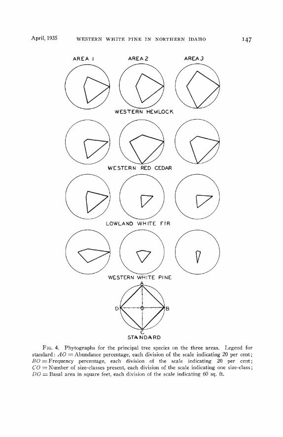
The point to be noted here is that the hemlock and cedar both increase in importance, but the white pine is less important than on area 1 (fig. 4).
AREA 3. GENERAL CHARACTER
The only general difference between this area and the others is the ex· treme sparseness of the lesser vegetation, and the almost complete absence of white pine, except on one edge of the stand where a small brush-disposal fire from an adjacent cutting temporarily escaped control and made a slight opening.
The windfall on this area is somewhat heavier, and just two years ago the last white pine snag fell, after having stood in a dead condition for many years. The absolute lack of white pine except at the borders of the stand and where the small fire occurred is noteworthy (fig. 1).
April, 1935 WESTERN WHITE PINE IN NORTHERN IDAHO
AREA I AREA2
WESTERN HEMLOCK
WESTERN RED CEDAR
LOWLAND WHITE FIR
WESTERN WHITE PINE
c STANDARD
AREAJ
147
FrG. 4. Phytographs for the principal tree species on the three areas. Legend for standard: AO =Abundance percentage, each division of the scale indicating 20 per cent; BO =Frequency percentage, each division of the scale indicating 20 per cent; CO= Number of size-classes present, each division of the scale indicating one size-class; DO = Basal area in square feet, each division of the scale indicating 60 sq. ft.
M. A. HUBER:\'!AN Ecology, Vol. 16, No. 2
The one-storied character is practically absent here due to the many-aged character of the stand. The number of herbaceous and shrubby species is 7, while there are only 5 trees. On the basis of frequency and abundance the ranking is: hemlock cedar, white fir, western larch, and finally white pine. ln the case of the subordinate vegetation the ranking is: Coptis occidentalis, Linnaea borealis longifiora, Vagnera scssili.folia, Rosa sp., and Viola sp.
I!uman Influence and Fire
There has been no cutting on the area itself, but some of the timber immediately surrounding the area has been felled. This, and the presence of a county road along one side of the stand, alters the light, moisture, and temperature relationships along the border. \Vhere the small brush fire escaped temporarily on one side of the stand, a few white pines have been able to gain a foothold.
The phytographs show how the hemlock, cedar, and white fir increase in importance, while the white pine is reduced almost to naught (fig. 4).
SuccESSIONAL l<ELATIONS
Cooper (' 13) in his studies on Isle Royale used as proof of the climax condition of the forest: mesophytism, uniformity of development, formation of such a forest from all successions, and maintenance of equilibrium within the forest.
In attempting to apply these criteria to area 3, the cedar-hemlock-lowland white fir association, we find that although the present studies supply no actual data on this point, general observations elsewhere in the region show that this association tends to be more mesophytic, or less xerophytic, than earlier successional stages. Larsen ('30) classified this association as a mesophytic transition forest; and he ('29) also pointed out that the cedar and hemlock required moister conditions than associated sub-climax species. As to uniformity of development. the few places where this association can yet be observed show the presence of the same tree species and lesser vegetation, hearing the same relationship to each other. Although the scope of this study is too limited to permit of the conclusion that all successions lead to this association, we can say that examples of the " western white pine type " observed almost always lead to such an association. This is confirmed by Larsen ('29) and by Miller, et al. ('27) in their studies in other parts of this region. That the stand is in equilibrium is shown by the prevalence of reproduction of the climax species on area 3. and by the lack of reproduction of sub-climax species. Studies of the individual species making up the association, by :.VIiller. et al. ('27), confirm this. The present study shows that only as a result of certain disturbing influences are sub-climax species able to gain a foothold.
Whereas this case is not absolutely proved, there is definite evidence that the western reel cedar-western hemlock-lowland white fir association is the dimax forest.
April, 1935 WESTERN WHITE PINE IN NORTHERN IDAHO 149
To examine the steps leading to this climax is the next objective. The phytographs, as mentioned above, give a more or less complete picture of the successional relationships of the three areas (fig. 4). Age counts and ranking in abundance by size classes are significant in this respect.
This latter point is, perhaps, of greater significance. It is axiomatic, of course, that to appear in the climax forest a species must be able to reproduce and become established under itself and associated species. Unless a species can do this, it can appear only in the earlier stages of the succession. From this point of view, hemlock, cedar, and white fir may be expected to form the climax stand; and for this reason, white pine must appear only in the earlier stages, except where openings occur in the climax stand. For the same reason western larch and Douglas fir are unable to play an active part in the climax.
The evidence presented in the tables appears to point to the following succession: After some major disturbance, usually fire, and depending on the severity of the catastrophe, the comparatively drought resistant western larch and Douglas fir are the first tree invaders. White pine germination is usually abundant on burned seedbed conditions, so that this species is often a first invader. Western red cedar and western hemlock may appear at this point if the site has not been affected too severely or the burned area is not too large in extent. Generally, however, the first association is white pine, Douglas fir, and western larch.
As a result of abundant seed crop and the effect of these trees and subordinate vegetation on the soil, the pine and Douglas fir tend to become dominant. As these species approach maturity and form a complete canopy, the tolerant hemlock, cedar, and white fir are able to become well established. As the site factors are changed, therefore, by the temporarily dominant larch, and intolerant Douglas fir and white pine, these latter species are unable to become established under their own canopy. The overmature veterans become decadent and weak, too weak to withstand windthrow, insects, and decay, and soon begin to drop out. On the other hand, the hemlock, cedar, and white fir thrive, reach maturity, reproduce, and become established and stabilized as the climax association. As stated earlier, the white pine undoubtedly will remain a factor, though an unimportant one, in the climax, coming into openings resulting from windfall or other causes, if seed is available.
To attempt to set clown the exact number of years required for each step of the succession is practically impossible. The length of the successional periods will vary with the site conditions involved. A rough approximation of the length of time required before climax conditions are reached, under Priest River conditions, would be about 300-350 years; white pine would reach its peak at 120-180 years, dropping out over an interval of 40-80 years or more; and stabilization of the climax species in 40-60 years after this. It must be borne in mind that this is only a rough approximation, based on what is too meagre data.
M. A. HUBERMAN Ecology, Vol. 16, No. 2
It would be of interest to confirm this by examinations of as many untouched "white pine" stands as possible (and there are not many left in this region) before they are all cut or burned.
Of interest is the increase in basal area, and consequently in volume, as the succession progresses to the climax. Area 3 has the highest basal area. Lutz ('28, '30) found similar results in K ew England and Pennsylvania. This greater basal area may be attributed to a more complete utilization of the soil and the air in the climax forest than is true in the earlier successional stages.
SuMMARY AND CoNcLusroNs
On three virgin areas of so-called " white pine type " in northern Idaho at the Priest River Experiment Station. plots and quadrats were established to study the arboreal, herbaceous, and shrubby vegetation. Soil we11s were dug, and increment borings taken on all three areas. The first two areas were found to be in sub-climax stages, the third very near to climax.
From the data of size-class distribution, basal area, abundance and frequency percentage, were constructed phytographs for purposes of comparison. The evidence presented clearly shows that white pine plays a very minor part in the climax forest. For the most part it appears in the early stages of succession, giving way to the climax association of western reel cedar, western hemlock, and lowland white fir, shortly after passing maturity.
The climax stand is characterized by a marked sparseness of shrubby and herbaceous vegetation. The most common species present are Arnira cordifolia, Berberis repens, Clintonia unifiora. Coptis occide11talis, Linnaea borealis longi flora, Pachistima m;wsinites, Rosa sp., V accillium macrophyllum, Vagnera sessilifolia, and Viola sp.
At the present time the high susceptibility of white pine to the white pine blister rust, Cronartium ribicola Fischer, and to the mountain pine beetle, Dendroctonous monticolae Hopk., might also be considered as a temporary factor in accelerating the successional development towards the climax.
As a result of these successional relationships of western white pine, it can readily be seen that there is a problem in developing a method of managing this type in such a way as to prevent the replacement of the highly valuable white pine by the less valuable climax species. The solution undoubtedly lies in an early cutting age, as now recommended and practiced by the Forest Service.
LITERATURE CITED
Cooper, W. S. 1913. The climax forest of Isle Royale, Lake Superior, and its development. Bot. Ga::. 55: 1-44; 115-140; 189-235.
Gates, F. C., and G. E. Nichols. 1930. Relation between age and diameter in trees of the primeval northern hardwood forest. Jour. Forest. 28: 395-398.
Hesselman, H. 1926. Studier over harrskogens humustacke, des egenskaper och beroende av skogsvarden. (Resume in German, pp. 508-522.) Jv[ eddelanden fdm Statens Skogsforsoksanstalt 22: 169-552, Stockholm. Humus layers of coniferous forests. Tr. from the German by P. R. Cast.
April, 1935 WESTERN WHITE PINE IN NORTHERN IDAHO ISI
Hough, A. F. 1932. Some diameter distributions in forest stands of northwestern Pennsylvania. Jour. Forest. 30: 933-943.
(Idaho) 1899. Illustrated history of the state of Idaho. Lewis Pub. Co., Chicago. 726 pp.
(Idaho) 1903. Illustrated history of north Idaho, embracing Nez Perce, Idaho, Latah, Kootenai, and Shoshone Counties. rVestern Historical Pub. Co. 1238 pp.
Jemison, G. M. 1932. Climatological summary for the Priest River Forest Experiment Station, 1912 to 1931, inclusive. Northern Rocky 1\II ountain Forest and Range Experiment Station, Missoula, lvf ontana, 1-27.
Kirkham, V. R. D., and E. W. Ellis. 1926. Ore deposits of Boundary County, Idaho. Rureau of 1\!Iines and Geol. Univ. Idaho Bull. 10.
Koch, E., and R. N. Cunningham. 1927. Timber growing and logging practice in the western white pine and larch-fir forests of the Northern Rocky Mountains. U. S. Dept. A.cn·ic. Bull. 1494.
Lapham, M. H., and F. C. Young. 1925. Report of soil survey of Priest River Experiment Station. U. S. Bureau af Soils. Manuscript report.
Larsen, J. A. 1929. Fires and forest succession in the Bitterroot Mountains of northern Idaho. Ecology 10: 67-76. 1930. Forest types of the Northern Rocky Ivfonntains and their climatic
controls. Ecology 11: 631-672. Livingston, B. E., and F. Shreve. 1921. Distribution of vegetation in the United
States as related to climatic conditions. Carn. lnst. rVash. Pub!. 284. Lutz, H. ]. 1928. Trends and silvicultural significance of upland forest succes
sions in southern New England. Yale Univ. Sch. Forest. Bull. 22. 68 pp. 1930. Vegetation of Heart's Content-a virgin forest in northwest Pennsyl
vania. Ecology 11: 1-29. Marshall, R. 1929. Life history of some western white pine stands on the Kaniksu
National Forest. Northwest Science, January, 1929. 47-53. Miller, F. G., et at. 1927. The Idaho forest and timber handbook. Univ. Idaho
Bull. 22. 155 pp. Nichols, G. E. 1913. The vegetation of Connecticut. II. Virgin forests. Torre:ya
13: 199-215. Piper, C. V., and R. K. Beattie. 1914. Flora of southeastern V/ashington and
adjacent Idaho. Romell, L. G., and S. 0. Heiberg. 1931. Types of humus layer in the forests of
northeastern United States. Ecology 12: 567-608. Saxton, R. 1855. Reports of exploration and surveys to ascertaiu the most practi
cable and economical route for a railroad from the Mississippi River to the Pacific Ocean. E.r. Doc. 78-33rd Congress. 2nd session. vVash. 1: 258-259.
Sudworth, G. B. 1927. Checklist of the forest trees of the United States, their names and ranges. U. S. Dept. Agric. 1\llisc. Circ. 92. 295 pp.


![Pine Burr [2018] - Internet Archive](https://static.fdokumen.com/doc/165x107/632797d16d480576770d59ea/pine-burr-2018-internet-archive.jpg)