RARE AND PROBLEMATICAL TAXA FROM THE MUCH WENLOCK LIMESTONE FORMATION
Upload
independentCategory
view
7download
0
The paradoxical occurrence of oolitic limestone on the eastern islands of
Great Bahama Bank : where do the ooids come from ?
PASCAL KINDLER1 and ALBERT C. HINE2
1Section of Earth Sciences, University of Geneva, Maraîchers 13, 1205 Geneva, Switzerland
2College of Marine Science, University of South Florida, St. Petersburg, FL 33701, USA
ABSTRACT
The origin of the ooids forming the bulk of many large Pleistocene and Holocene ridges on
the windward islands of Great Bahama Bank is not well understood. A formation locus
situated to the east of these islands would be consistent with present-day sediment fluxes, but
outer platforms in these areas are extremely narrow today and appear unsuitable for large-
scale ooid production. The four models presented hereafter suggest that ooids could originate
(1) from these narrow outer platforms, (2) from wider outer platforms that no longer exist, (3)
from the bank interior via tidal channels, and (4) directly from the bank interior by means of a
westerly sediment flux. With the exception of option #3, all models are validated by field
observations in Eleuthera and in the Exumas. Corroboration of models #2 (outer platform
erosion) and # 4 (westerly flux) further indicates that past depositional environments and
sedimentary processes on Great Bahama Bank could have been significantly different from
those operating today.
Keywords Great Bahama Bank, Eleuthera, Exumas, Quaternary, ooids, oolites, eolianites

2
INTRODUCTION
The main thing the first author learned from R.N. Ginsburg during his tenure at the University
of Miami in the early 1990’s was that the fundamental duty of a scientist is to constantly ask
pertinent questions to himself and to others. One of the questions raised by Ginsburg, at that
time, was about the paradoxical occurrence of extensive Pleistocene oolites on the windward
islands of Great Bahama Bank (GBB; Fig. 1). The petrographic composition of these ridges
is, indeed, peculiar because there is no obvious source of ooids, unless sediment fluxes were
opposite to those operating today. This paradox is addressed in the following chapters after a
brief review of the formation of ooids on GBB, of the sediment transport vectors in the
Bahamas, and of the surficial geology of the windward islands.
SETTING
Ooid production on Great Bahama Bank
Nearly all authors (Newell et al. 1960; Richter, 1983; Scholle & Ulmer-Scholle, 2003) agree
that conditions required for the optimal production of Bahamian ooids (i.e. aragonitic ooids
with a tangential crystal structure) are: (1) the presence of sedimentary particles that can serve
as nuclei; (2) a flat topography where these particles can remain for a substantial amount of
time; (3) an environment affected by strong bottom currents where grains can be repeatedly
rotated; (4) conditions suitable to inorganic and/or microbial precipitation, for example areas
where cool oceanic water mixes with warm bank water supersaturated with respect to
aragonite. Modern tangential ooids are preferentially generated in intertidal and shallow
subtidal environments along platform edges, such as tidal deltas, lagoons, beaches or tidal
flats (Siewers, 2003).
On GBB, ooid sands are forming in platform margin shoals that are parallel to the
slope break (Ball, 1967; Harris, 1979; Ginsburg 2005). Most significant modern examples

3
include the region south of Bimini (70 x 2 km), the southwest end (or Cul-de-Sac) of the
Tongue of the Ocean (100 x 20-25 km), the Schooners Cays (45 x 15 km), the Berry Islands
(12 x 6 km) and the Joulters Cays (25 x 1-2 km) (Fig. 1). In most of these areas, the ooid
factory covers a significant portion of the platform, but in the Joulters Cays, ooids are
produced in a 1-2 km-wide mobile fringe juxtaposed to the island and situated only 5 km
bankwards from the slope break (Harris, 1979). Modern ooid accumulations are located in or
near the environment where ooids are produced, but the common occurrence of these grains in
eolianites (Kindler & Hearty, 1996) and in deep-water turbidites (Haak & Schlager, 1989)
indicates that significant transportation may take place.
Sediment transport vectors on Great Bahama Bank
The main physical parameters controlling sediment distribution on the GBB are the wind,
wind-induced waves and currents, and tidal currents. In the Bahamas, prevailing winds are
from northeast to southeast during most of the year (Sealey, 1994), with strong northwesterly
winds, related to cold fronts, further affecting the area in the winter. In addition, gusts
associated with thunderstorms can blow in any direction. Winds transport marine sand
concentrated in bars and beaches onto or off the islands (Ball, 1967; McKee & Ward, 1983).
In the first case, grains build up coastal dunes that are preserved as eolianites, and increase the
island volume. In the second case, sand is washed back into the sea and may possibly be
exported to a deeper depositional setting. Winds further generate waves and currents that
determine the subaqueous transport of sediment and the distribution of sedimentary bedforms
on GBB (Purdy, 1963; Swart et al., this volume; Reijmer et al., this volume). Predominant
water movement and sediment transport is thus towards the west, but residual southward and
eastward motion takes place during northwesterly gales in the winter (Bathurst, 1975). The
influence of tropical storms and hurricanes is less well constrained. Harris (1979) noted that
4
most storms affecting the northern Bahamas produce a dominant bankward wind on
northeast-facing shorelines, and that associated water movement and sediment transport is
also towards the platform interior. In contrast, Boss & Neumann (1993) observed that
Hurricane Andrew had a minimal impact on both subaqueous sand bodies and islands. With
the exception of channels between islands, shoals or reefs, tidal currents on and off GBB are
sluggish and their influence on the net lateral transport of sand-sized sediments appears to be
complex (Gonzalez & Eberli, 1997). The usual greater velocity of the flood current (Bathurst,
1975) suggests that net sediment transport must be bankward. In summary, due to the
predominance of easterly winds, the main sediment transport vector on GBB, today, is from
east to west.
The windward islands
According to Ball (1967), the prevailing easterly winds are responsible for the
existence of islands along the eastern edge of GBB (Fig. 1), because they generate sustained
wave action that provides “building material” for the constituent dunes. These islands
(Eleuthera, Cat, Long, Exumas; Fig. 1) are narrow (<1 km to 12 km wide), elongated (up to
140 km) rock bodies, lying near (<1 km to 7 km) the bank margin and oriented parallel to it.
They consist of vertically stacked or laterally juxtaposed carbonate units and paleosols (Fig.
2). The former accumulated during interglacial highstands of sea level, whereas the latter
developed mostly during glacial lowstands (Carew & Mylroie, 2001). Details on the
stratigraphy of the Bahamian islands can be found in Kindler & Hearty (1997) and Hearty &
Kaufman (2000). Carbonate units are essentially composed of eolian sediments, but marine
deposits, recording ancient sea stands, occur up to 18 m above modern sea level (Hearty et al.,
1999; Kindler & Hearty, 2000). Eolianite foresets dip always towards the interior of islands,

5
emphasizing further that the source material for these dunes originates from the shore and that
only onshore winds are effective in dune build up (MacKenzie, 1964; Ball, 1967).
The eastern coasts of the windward islands display locally high (> 20 m) cliffs
composed of vertically stacked eolianites showing a consistent landward dip (e.g., northern
and central Eleuthera; Fig. 2). These cliffs, which may stand less than 1 km from the bank
edge (e.g., Glass Window area in northern Eleuthera), have long been thought to be primarily
composed of oolite. No ooids are presently forming on these narrow outer platforms, which
raises the question of the origin of the dune constituent grains. This problem was partly
tackled by Kindler & Hearty (1995, 1996) who demonstrated that a significant fraction of
these eolianites actually consists of skeletal particles that were likely derived from marginal
reefs. Nonetheless, there are elevated oolitic ridges on the windward islands, the highest being
Mount Alvernia (63 m) on Cat, and the origin of the constituent ooids is still a puzzle. This
enigma is addressed in the following sections.
METHODS
The geometry, the stratigraphy and the sedimentology of Bahamian carbonate units were
essentially studied in the field. Particular attention was given to physical sedimentary
structures that provide indications on sediment transport vectors and past depositional
environments. Qualitative and quantitative (point counting) petrographic analyses were
performed at the University of Geneva to characterize the composition of each studied unit.
Samples were sent to various laboratories for relative (amino-acid racemization method) and
absolute (14C and U-series techniques) dating. Details on the utilized methods can be found in
Kindler & Hearty (1996) and Hearty & Kaufman (2000).
MODELS OF OOLITE DEPOSITION ON THE WINDWARD ISLANDS OF GBB

6
Four models could explain the peculiar occurrence of Pleistocene and Holocene oolites on the
windward islands of GBB. They are presented and discussed in the next chapters.
Ooid production on a narrow outer platform
In the first model, derived from the modern example along the eastern shoreline of Joulters
Cays (Harris, 1979), ooids were produced just offshore, on the narrow (2-5 km) outer shelf,
and transported westward onto the islands by the prevailing easterly winds. An example is the
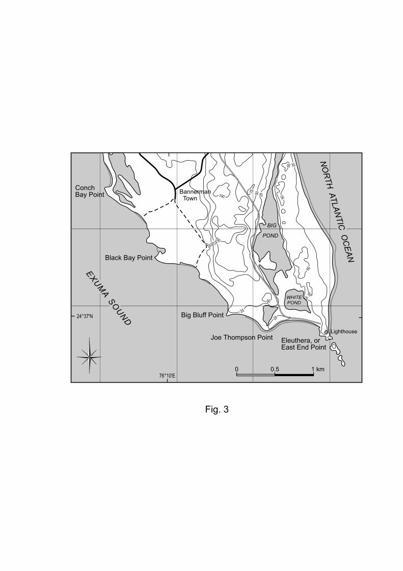
eolian ridge exposed at East End Point, on the southernmost tip of Eleuthera (Fig. 3). Already
pictured by Ball (1967) and McKee & Ward (1983), this partly eroded, SSE trending, 15-m
high ridge consists of several coalesced haystack dunes showing meter-scale eolian foresets
with a predominant westward dip (Fig. 4). The ridge stands less than 4 km away from the
edge of the bank which supports numerous patch reefs. It consists of moderately lithified
oolitic-peloidal grainstone (Fig. 5), in striking contrast to modern beach sand which
essentially includes bioclastic particles derived from the offshore reefs. These dunes have not
been dated, but the absence of an overlying terra-rossa paleosol and their lithological
resemblance with similar, 14C-dated eolianites from San Salvador (Carew & Mylroie, 1987)
and Lee Stocking Island (Kindler, 1992) strongly suggest that they are of middle Holocene
age.
The westward dip of the ridge foresets (Fig. 4) leaves no doubts on the provenance of
the constituent sediments. In addition, the probably young age (~4 ka) of this eolianite implies
that the geometry of the bank edge was much the same during the production of the dune
particles as today. Thus, the ooids forming the bulk of the East End Point ridge were probably
directly generated on the adjacent beach or on a mobile fringe just offshore, as is the case near
the Joulters Cays today. Ooid production stalled during the late Holocene, probably because
of increasing water depth on the outer platform due to the ongoing transgression. Nonetheless,

7
this depositional system was able to build up a 15-m high oolitic ridge in about 1700 years,
i.e. between the onset of open marine conditions on the bank about 4.7 kyr ago (Hine, 1983)
and the end of ooid production about 3 kyr ago (Kindler, 1992, 1995). This oolitic ridge was
then preserved due to the rapidity and efficiency of fresh-water cementation processes (Halley
& Harris, 1979; Kindler & Mazzolini, 2001).
To determine if it was at all possible to generate sufficient oolitic sand on a narrow
shelf during a high-frequency sea-level event, we present the following simple assumptions
and calculations. Based upon field observations, we assume that each Pleistocene cycle would
produce a 6 m thick eolian deposit that would extend 1 km across an island such as Eleuthera.
This produces a volume of 6,000 m3 if we make our cross section to be 1 m wide. Now let’s
assume that the adjacent shelf was 1 km wide and oolitic sediments were generated over a
6,000 yr time frame before production shuts down. Sea-level curves indicate that the narrow
(1 km wide) shelves fronting much of Eleuthera Island, for example, were flooded since 6 kyr
or earlier. Thus, 6,000 m3 of sediment would have to be produced across a strip on the shelf
that is 1 km by 1 m or 1,000 m2 over 6,000 years, or 1,000 m3/1000 yr over this same strip of
shelf. This converts to 1 m3/yr over 1,000 m2 and further converts to 0.001 m3/yr/m2. So, how
thick is 0.001m3 when spread over 1 m2? By converting to cm, it is 0.1 cm. So, we need a
production rate of 0.1 cm/yr over a 1 km wide shelf for 6,000 years. Can oolitic sediments be
generated this fast? According to Schlager (1981), such sediments can be produced at rates
ranging from ~40 to ~110 cm/1000 yr. To make the calculations simpler, let’s choose 100
cm/1000 yr or 0.1 cm/yr—the same number we just calculated. So, based upon this exercise,
it is possible for a 1 km wide shelf to produce sufficient oolitic sediment to generate a
realistically sized dune deposit on the adjacent island, assuming efficient transport
mechanisms are in place. However, if the oolitic generation phase were significantly
condensed temporally and spatially to only 1,000 years and 100 m wide, then a thickness of 6

8
cm/yr needs to be generated. This is about 60 times faster than the fastest rate reported by
Schlager (1981). Perhaps, this scenario is unrealistic? Perhaps, Schlager’s (1981) numbers are
incorrect? Perhaps, there is another model that needs to be considered? Nevertheless, it does
appear possible to create the sediment from the immediately adjacent shelf.
Ooid production on a wider platform that has since collapsed
In the second model, based on the present-day example along the Berry Islands where the
outer platform is over 15 km wide (Fig. 1), ooids were formed on a wide outer shelf, which no
longer exists, and carried onto the islands by the easterly trade winds. Such a carbonate
factory could have been more efficient than the one of the first model because of a more
extensive production area. It would thus better explain the occurrence of the large oolitic
ridges forming the backbone of the windward islands. One good example is the Gregory
Town ridge in the northern/central part of Eleuthera (Fig. 6). This massive, NW-SE trending
crest is 8 km long, 1.5 km wide and culminates at about 55 m. It is parallel to the Eleuthera
shoreline and its top stands less than 2 km away from the present-day platform margin, which
shows a scalloped (i.e. convex bankward) morphology in this area (Fig. 7; Mullins & Hine,
1989; Mullins et al., 1991). On the ocean side of the island, the ridge comprises well-exposed
subtidal and beach deposits up to 4 m above mean sea level. In contrast, only eolian
sediments, which locally display rainfall-induced fenestral porosity (Bain & Kindler, 1994;
Kindler & Strasser, 2000), can be seen at higher elevations and on the bank side. The Gregory
Town ridge consists of fine-grained, well-lithified oolitic grainstone characterized by the
predominance of “normal” (i.e. thickly coated) ooids (Fig. 8). Amino-acid ratios obtained
from ridges of identical lithology and stratigraphic position on Eleuthera (Hearty, 1998) and
San Salvador (Hearty & Kindler, 1993), the occurrence of an overlying terra-rossa paleosol,
and the presence of associated marine deposits at about 4 m all indicate that this ridge was

9
deposited during the last interglacial period, i.e. Marine Isotope Stage (MIS) 5e. The primary
morphology of the dune is well preserved, with a lee side facing towards the bank interior and
large eolian foresets dipping towards the southwest (Fig. 6).
The orientation of the lee face of the dune and the dip of the foresets clearly show that the
constituent particles originated from the outer platform to the northeast. Today, this outer
platform is extremely narrow (Fig. 7), and does not seem extensive enough to support an ooid
factory, even of the Joulters Cays type. However, the scalloped shape of the bank margin,
which could be related to platform collapse (Mullins & Hine, 1989; Mullins et al., 1991), and
the truncation of middle Pleistocene deposits in the Boiling Hole area, just north of Gregory
Town (Fig. 9), both suggest that the North Eleuthera bank has experienced a significant
amount of recessive erosion since the late Pleistocene. Similar bank-margin retreats have been
documented from the Cat Island platform (Freeman-Lynde & Ryan, 1985) and from Silver,
Navidad and Mouchoir Banks in the SE Bahamas (Mullins et al., 1992) for older geological
periods. Furthermore, seismic data from the Bahamas/Blake Escarpment north of Little
Bahama Bank (LBB) indicate about a 5 km retreat since the Early Cretaceous. It is not clear
whether the recess of these bank margins results from a few major mass-wasting events or
from a constant process of chipping away. In the former case, large-scale collapse of platform
margins, well away from a plate boundary, would appear as a recent (i.e. late Pleistocene), if
not an on-going phenomenon that could represent serious tsunami hazards for the low-lying
coastal zones in the Caribbean and southeastern United States (H.T. Mullins, personal
communication). Regardless, part of the large ooid accumulations exposed on the windward
islands could be derived from shoals that covered an outer portion of the platform that no
longer exists due to recessive erosion processes (Fig. 7).
Ooid production on the bank side and exportation to the outer platform

10
According to a third model, suggested to the first author by R.N. Ginsburg some years ago,
ooids were formed on the bank side of the islands, transported eastward by tidal currents to
the ocean side, and then back onto the islands by the trade-wind action. An illustration of this
model can perhaps be observed near Lee Stocking Island (LSI, Exumas, Fig. 1). In this area,
km-sized ooid shoals formed by flood-tidal delta bars and levees occur at the bankward end of
inter-island channels (Fig. 10; Kendall et al., 1990; Gonzalez & Eberli, 1997). Indeed, one
might expect that ooids could be carried seaward by ebb currents, deposited on ocean-facing
beaches by waves, and finally blown onto dunes by the prevailing easterly winds. However,
the modern, ocean-facing beaches on LSI are composed of bioclastic sand likely derived from
offshore reefs. In addition, ebb-tidal deltas do not occur at the seaward end of the channels
(Fig. 10), indicating that sediments are either swept off to deeper depositional environments
(Dill et al., 1989) or were confined to the tidal channel by a circular hydrodynamic pattern
(Reeder & Rankey, 2005). Trade winds further provide a persistent set-up by which water is
piled up against the bank margin and flows through the inter-island gaps, preferentially
augmenting the daily flood-tidal currents over the ebb-tidal currents. For example, Lily Bank
on the northern edge of LBB (Hine, 1977) clearly shows a flood or bankward dominance of
bedforms, and sand-body geometric features like bankward-oriented spillover lobes. Given an
appropriate track, a hurricane could produce much stronger easterly flows that would
transport lagoonal sediments eastward through the inter-island gaps and place these sediments
in the windward environment for dune development. However, such an event is probably rare
and highly unusual. Hurricanes pass by quickly, and there is simply not enough time to
transport significant quantities of sand over long distances (at least several km, but probably
tens of km) in a 3-4 hour time frame. This model does not appear to be the solution to explain
the presence of extensive Pleistocene oolites on the windward islands.

11
Bank-side production and eastward transport of ooids
In the fourth and last model, ooids were formed on the bank interior and transported directly
onto the islands by a westerly energy flux. The Boiling Hole section in northern Eleuthera
(Fig. 11) represents a good illustration of such a case. At this location, oolitic limestones
dating from the last interglacial (Kindler & Hearty, 1995; Hearty, 1998) partly fill a large
depression between two ~20 m-high eolianites of middle Pleistocene age, and are capped by
MIS 5a dunal deposits (Fig. 3B in Kindler & Hearty, 1997). New observations at the SE end
of this swale reveal that (1) the MIS 5e oolites consist of two shallowing-upward sequences
including subtidal, beach and eolian deposits, separated by an erosional surface (Figs. 12 and
13), and (2) both beach and eolian bed sets dip towards the SW, i.e. the bank interior. Further,
as already noted by Kindler & Hearty (1995), the MIS 5e deposits include some peculiar
ooids with a radial cortex (Fig. 14).
The dip of the beach beds clearly shows that the constituent grains of these sediments
originated from the interior of the bank, to the southwest. The eolian strata dip in the same
direction. However they are not foresets, as figured by earlier authors (Kindler & Hearty,
1995; Hearty, 1998), but backsets draped over the pre-existing middle Pleistocene
topography. Thus, their component particles were also brought up from the bank interior by a
westerly flux, and not from the open ocean by the prevailing easterly winds, as previously
interpreted. Further, the unusual occurrence of radial ooids (Fig. 14) in these deposits suggests
a relatively low-energy production locus (Land et al., 1979; Flügel, 2004), thus strengthening
a bank-side source for these deposits. The case is even clearer at Cotton Hole, 1 km to the
northwest (Fig. 11), where bankward-dipping beach sediments exposed on the ocean-facing
cliffs can be walked on all the way to the bank-facing shoreline of the island. The Boiling
Hole outcrop thus validates the fourth model. Moreover, ooids were not carried eastward
during a single and catastrophic depositional event, such as a storm or a northwesterly gale,

12
but by a sustained westerly flux that lasted long enough for the shoreline to prograde
significantly towards the southwest.
CONCLUSIONS
The response to Ginsburg’s question about the curious occurrence of large oolite
accumulations on the windward islands of GBB is the following. Most likely, ooids have been
produced on a very narrow outer platform between the bank edge and the islands, as is the
case today along the Yucatan Peninsula (Ward & Brady, 1979), and were brought onto the
islands by transport vectors (i.e. wind and waves) similar in orientation to those operating
today. This model is supported by theoretical calculations. In addition, ooids may have been
generated on a wide outer platform that has since disappeared due to recessive erosion. In
some cases, e.g. the Boiling Hole area in Eleuthera, ooids have been formed on the bank side
and transported by energy fluxes that were opposite to modern ones. The important point to
keep in mind from this “ooid story”, in particular from the fourth model, is that past
sedimentary features may not necessarily be explained by the observation of modern
processes, or in other words, that the present is not always a key to the past.
ACKNOWLEGMENTS
PK would like to thank again R.N. Ginsburg for accepting him as a post-doctoral student in
his laboratory some 15 years ago, and for asking good questions. Many thanks also to F.
Gischig and J. Metzger (University of Geneva) for their technical help, and to the Swiss
National Science Foundation for supporting PK’s travel expenses to Salt Lake City (grant n°
200020-107436). We further thank A. Strasser, H.T. Mullins and the editors for reviewing
and revising our manuscript.

13
REFERENCES
Bain, R.J. and Kindler, P. (1994) Irregular fenestrae in Bahamian eolianites: a rainstorm
induced origin. J. Sed. Res., A64, 140-146.
Ball, M.M. (1967) Carbonate sand bodies of Florida and the Bahamas. J. Sed. Petrol., 37,
556-591.
Bathurst, R.B.G. (1975) Carbonate sedimentology and diagenesis, Elsevier, Amsterdam.
Boss, S.K. and Neumann, A.C. (1993) Impacts of Hurricane Andrew on carbonate platform
environments, northern Great Bahama Bank. Geology, 21, 897-900.
Carew, J.L and Mylroie, J.E. (1987) A refined geochronology for San Salvador Island,
Bahamas. In: Proceedings of the 3rd Symposium on the Geology of the Bahamas, (Ed.
H.A. Curran) pp. 35-44, Bahamian Field Station, San Salvador.
Carew, J.L. and Mylroie, J.E. (2001) Quaternary carbonate eolianites of the Bahamas:
useful analogs for the interpretation of ancient rocks? In: Modern and Ancient
Carbonate Eolianites: Sedimentology, Sequence Stratigraphy, and Diagenesis (Eds.
F.E. Abegg, D.B. Loope and P.M. Harris), SEPM Spec. Publ., 71, 33-45.
Dill, R.F., Kendall, C.G.St.C. and Shinn, E. (1989) Giant subtidal stromatolites and related
sedimentary features. Field Trip Guidebook T373, 28th International Geological
Congress, 33 pp.., American Geophysical Union, Washington.
Flügel, E. (2004) Microfacies of carbonate rocks, Springer Verlag, Berlin.
Freeman-Lynde, R.P. and Ryan, W.B.F. (1985) Erosional modification of Bahama
escarpment. Geol. Soc. Am. Bull., 96, 481-494.
Ginsburg, R.N. (2005) Disobedient sediments can feedback on their transportation,
deposition and geomorphology. Sed. Geol., 175, 9-18.
Gonzalez, R. and Eberli, G.P. (1997) Sediment transport and bedforms in a carbonate tidal
inlet; Lee Stocking Island, Exumas, Bahamas. Sedimentology, 44, 1015-1030.

14
Haak, A.B. and Schlager, W. (1989) Compositional variations in calciturbidites due to sea-
level fluctuations, late Quaternary, Bahamas. Geol. Rundsch., 78, 477-486.
Halley, R.B. and Harris, P.M. (1979) Fresh-water cementation of a 1,000-year-old oolite. J.
Sed. Petrol., 49, 969-988.
Harris, P.M. (1979) Facies anatomy and diagenesis of a Bahamian ooid shoal. Sedimenta
VII, University of Miami, Florida.
Hearty, P.J. (1998) The geology of Eleuthera Island, Bahamas: a rosetta stone of Quaternary
stratigraphy and sea-level history. Quatern. Sci. Rev., 17, 333-355.
Hearty, P.J. and Kaufman, D.S. (2000) Whole-rock aminostratigraphy and Quaternary sea-
level history of the Bahamas. Quatern. Res., 54, 163-173.
Hearty, P.J. and Kindler, P. (1993) New perspectives on Bahamian geology: San Salvador
Island, Bahamas. J. Coastal Res., 9, 577-594.
Hearty, P.J., Kindler, P., Cheng, H. and Edwards, L. (1999) A +20 m middle Pleistocene
sea-level highstand (Bermuda and The Bahamas) due to partial collapse of Antarctic
ice. Geology, 27, 375-378.
Hine, A.C. (1977) Lily Bank, Bahamas: history of an active oolite sand shoal. J. Sed. Petrol.,
47, 1554-1581.
Hine, A.C. (1983) Relict sand bodies and bedforms of the Northern Bahamas: evidence of
extensive early Holocene sand transport. In: Coated Grains (Ed. T.M. Peryt), pp. 116-
131, Springer Verlag, Berlin.
Kendall, C.G.St.C., Dill, R.F. and Shinn, E. (1990) Guidebook to the marine geology and
tropical environments of Lee Stocking Island, The southern Exumas, Bahamas. KenDill
Publishers, San Diego.
Kindler, P. (1992) Coastal response to the Holocene transgression in the Bahamas: episodic
sedimentation versus continuous sea-level rise. Sed. Geol., 80, 319-329.

15
Kindler, P. (1995) New data on the Holocene stratigraphy of Lee Stocking Island (Bahamas)
and its relation to sea-level history. In: Terrestrial and Shallow Marine Geology of the
Bahamas and Bermuda (Eds. H.A. Curran and B. White), Geol. Soc. Am. Spec. Pap.,
300, p. 105-116
Kindler, P. and Hearty, P.J. (1995) Pre-Sangamonian eolianites in the Bahamas? New
evidence from Eleuthera Island. Mar. Geol., 127, 73-86.
Kindler, P. and Hearty, P.J. (1996) Carbonate petrography as an indicator of climate and
sea-level changes: new data from Bahamian Quaternary units. Sedimentology, 43, 381-
399.
Kindler, P. and Hearty, P.J. (1997) Geology of The Bahamas: architecture of Bahamian
Islands. In: Geology and hydrogeology of carbonate islands (Eds. H.L. Vacher and
T.M. Quinn), Dev. Sedimentol., 54, 141-160.
Kindler P. and Hearty. P.J. (2000) Elevated marine terraces from Eleuthera (Bahamas) and
Bermuda: sedimentological, petrographic and geochronological evidence for important
deglaciation events during the middle Pleistocene. Global Planet. Change, 24, 41-58.
Kindler, P. and Mazzolini, D. (2001) Sedimentology and petrography of dredged carbonate
sands from Stocking Island (Bahamas). Implications for meteoric diagenesis and
aeolianite formation. Palaeogeogr. Palaeoclimatol. Palaeoecol., 175, 369-379.
Kindler, P. and Strasser, A. (2000) Palaeoclimatic significance of co-occurring wind- and
water-induced sedimentary structures in the last-interglacial coastal deposits from
Bermuda and the Bahamas. Sed. Geol., 131, 1-7.
Land, L.S., Behrens, E.W. and Frishman, S.A. (1979) The ooids of Baffin Bay, Texas. J.
Sed. Petrol., 49, 1269-1278.
Mackenzie, F.T. (1964) Bermuda Pleistocene eolianites and paleowinds. Sedimentology, 3,
52-64.

16
McKee, E.D. and Ward, W.C. (1983) Eolian environment. In: Carbonate depositional
environments (Eds. P.A. Scholle, D.G. Bebout and C.H. Moore), AAPG Mem., 33, 132-
170.
Mullins, H.T., Breen, N., Dolan, J., Wellner, R.W., Petruccione, J.L., Gaylord, M.,
Andersen, B., Melillo, A.J., Jurgens, A.D. and Orange, D. (1992) Carbonate
platforms along the southeast Bahamas-Hispaniola collision zones. Mar. Geol., 105,
169-209.
Mullins, H.,T., Dolan, J., Breen, N., Andersen, B., Gaylord, M., Petruccione, J.L.,
Wellner, R.W., Melillo, A.J. and Jurgens, A.D. (1991) Retreat of carbonate platforms:
response to tectonic processes. Geology, 19, 1089-1092.
Mullins, H.T. and Hine, A.C. (1989) Scalloped bank margins: beginning of the end for
carbonate platforms? Geology, 17, 30-33.
Newell, N.D., Purdy, E.G. and Imbrie, J. (1960) Bahamian oolitic sand. J. Geol., 68, 481-
496.
Purdy, E.G. (1963) Recent calcium carbonate facies of the Great Bahama Bank. 2.
Sedimentary Facies. J. Geol., 71, 472-497.
Reeder, S.L. and Rankey, E. (2005) Stuck on a spin cycle: interactions between tidal flows
and ooid shoals, Bahamas. Abstracts with Programs, 37, 401.
Reijmer, J.J., Swart, P.K., Bauch, T., Otto, R., Reuning, L. Roth, S.,and Zechel, S. 2007.
A reevaluation of facies variations on Great Bahama Bank 1: New Facies Maps of
Western Great Bahama Bank. In: Perspectives in Sedimentary Geology: A Tribute to the
Career of Robert Nathan Ginsburg, IAS Special Publication (Eds P.K. Swart, G.P.
Eberli and J.A. McKenzie), In Press. Blackwell, Oxford.
Richter, D.K. (1983) Calcareous ooids: a synopsis. In: Coated Grains (Ed. T.M. Peryt), pp.
71-99, Springer Verlag, Berlin .

17
Schlager, W. (1981) The paradox of drowned reefs and carbonate platforms. Geol. Soc. Am.
Bull., 92, 197-211.
Scholle, P. A. and Ulmer-Scholle, D.S. (2003) A color guide to the petrography of carbonate
rocks: grains, textures, porosity, diagenesis. AAPG Mem., 77, 474 pp.
Sealey, N.E. (1994) Bahamian landscapes. An introduction to the geography of the Bahamas,
Media Publishing, Nassau, Bahamas.
Siewers, F.D. (2003) Oolite and coated grains. In: Encyclopedia of sediments and
sedimentary rocks (Ed. G.V. Middleton), pp. 502-506, Kluiver Academic Press,
Dordrecht.
Swart, P.K. , Reijmer, J.J. and Otto, R. (this volume) A Reevaluation of facies on Great
Bahama Bank II: Variations in the δ13C, δ18O and mineralogy of surface sediments. In:
Perspectives in Sedimentary Geology: A Tribute to the Career of Robert Nathan
Ginsburg, IAS Special Publication (Eds P.K. Swart, G.P. Eberli and J.A. McKenzie), In
Press. Blackwell, Oxford.
Ward, W.C. and Brady, M.J. (1979) Strandline sedimentation of carbonate grainstones,
Upper Pleistocene, Yucatan Peninsula, Mexico. Amer. Assoc. Petrol. Geol. Bull., 63,
362 – 369.

18
FIGURE CAPTIONS
Fig. 1: Geographical situation of the Great Bahama Bank (GBB). The occurrence of islands
(Eleuthera, Cat, Exumas, Long) on the eastern margin of GBB is likely related to the
prevailing easterly winds. JC = Joulters Cays, NPI = New Providence Island, TOTO =
Tongue of the Ocean, SC = Schooners Cays.
Fig. 2: Vertically stacked eolianites (A, B and C) and paleosols (1 and 2) of middle
Pleistocene age at The Cliffs, central Eleuthera. Eolianites form during interglacial
highstands, whereas paleosols predominantly develop during glacial lowstands. Note
large-scale eolian foresets in lower unit (white arrow) indicating that constituent
particles were derived from the northeast. All carbonate units include mainly skeletal
particles derived from offshore reefs. Cliff is 15 m high (people on the left-hand side for
scale).
Fig. 3: Topographic map of East End Point, southern Eleuthera showing the NNW-SSE
trending, middle Holocene ridge between Big Pond and the North Atlantic shoreline.
The ridge crest is located at about 4 km to the west of the bank margin.
Fig. 4: Partial view of the East End Point oolitic ridge looking towards the south. The large,
westward-dipping, eolian foresets disappear beneath modern, bioclastic, beach sands,
indicating that (1) the dune was deposited when sea level was slightly lower than
present, and that (2) there was an ooid factory to the east of the island.

19
Fig. 5: Oolitic grainstone collected from the East End Point ridge (sample EL 201). Abundant
superficial ooids, good particle preservation, and minor low-Mg calcite meteoric cement
characterize this middle Holocene unit.
Fig. 6: View from the top (45 m at this particular location) of the Gregory Town ridge
towards the west. This ridge consists of oolitic limestone of late Pleistocene age. Note
preserved dune morphology, with the lee side facing the bank interior. Large westward-
dipping foresets (arrow) further indicate that the constituent sedimentary particles
originated from the east. Road cut is 4 m high.
Fig. 7: Satellite view of northern Eleuthera showing scalloped (i.e. convex bankward) margin.
The extreme narrowness of the outer platform in this area is probably related to bank-
edge erosion or collapse. The missing part of the platform was probably the site of ooid
production during MIS 5e. Image from: https://zulu.ssc.nasa.gov.
Fig. 8: Oolitic-peloidal grainstone collected from the Gregory Town ridge (sample EL 159).
Note the greater abundance of normal ooids and meteoric sparry calcite cement
compared to the younger East End Point oolite.
Fig. 9: Topographic map of the Boiling Hole – Glass Window area. The modern windward
shoreline truncates a NW-SE trending eolian ridge of middle Pleistocene age, indicating
that a substantial amount of regressive erosion occurred since that time (modified from
the topographic map Eleuthera #4 published by the Department of Lands and Surveys,
Nassau; contour lines are in feet).

20
Fig. 10: Oblique air photo of the southern Exumas showing Norman Ponds Cay (NPC) and
Lee Stocking Island (LSI). Note extensive ooid shoal on the bankward side of the tidal
channel between the two islands. Despite the presence of this ooid factory, beaches on
the windward side of LSI are characterized by bioclastic sand. Photo courtesy Paul J.
Hearty.
Fig. 11: Geologic map of the Boiling Hole area (modified from Kindler & Hearty, 1997).
Fig. 12: View of the southeastern end of the Boiling Hole outcrop showing two stacked late
Pleistocene oolites (units 2 and 3) onlapping a skeletal eolianite of middle Pleistocene
age (unit 1). Unit 3 beach deposits (upper right-hand side) show low-angle cross beds
that dip towards the southwest indicating that constituent particles were formed on and
transported from the bank interior.
Fig. 13: Stratigraphic/sedimentological section logged on the southeastern end of the Boiling
Hole site. In the setting column, s = subtidal, b = beach, e = eolian. Dots indicate sample
location. 204 marks the location of sample EL 204 illustrated in Fig. 14.
Fig. 14: Radially coated ooid from late Pleistocene oolite at Boiling Hole (sample EL 204).
Radial cortex suggests ooid formation occurred in a relatively low-energy setting.


Copyright © 2022 FDOKUMEN