The Origin and Evolution of the Mesa Projectile Point
108
1 THE ORIGIN AND EVOLUTION OF THE MESA PROJECTILE POINT BY: MARJOLEIN ADMIRAAL S1716794 V2.0 AUGUST 14, 2013
Transcript of The Origin and Evolution of the Mesa Projectile Point

1
THE OR IG IN AND EVOLUT ION
OF THE
MESA PROJECT ILE PO INT
B Y : MAR JOLE IN ADMIRAAL
S 1716794
V 2 . 0 AUGUST 14 , 2 013

2
University of Groningen, the Netherlands
“The Origin and Evolution of the Mesa Projectile Point”
A thesis submitted in partial fulfilment of the requirements for the degree of Master of Arts in
Archaeology
By
Marjolein Admiraal
Supervisors: Prof. Dr. Louwrens Hacquebord
Dr. Dennis Stanford Dr. Hans Peeters

3
ACKNOWLEDGEMENTS
I owe thanks to many people for supporting and guiding me during the process of writing this thesis. First of all, many thanks to my three supervisors: prof.dr. Louwrens Hacquebord, Dr. Dennis Stanford and Dr. Hans Peeters. Louwrens, as my professor at the University of Groningen has been my mentor for four years and has inspired me to choose an Arctic specialization during my study Archaeology. He has been a great support and a source of motivation. Many thanks to Dr. Dennis Stanford of the Smithsonian National Museum of Natural History where I did my internship during the summer of 2012. Dennis inspired me with his inexhaustible enthusiasm and has been a great help in discussing the thesis subject, which he handed to me in the first place. And thanks to Dr. Hans Peeters for spiking my interest in the subject of the Peopling of the Americas and stone tool technology as well as guiding me through the process of writing my thesis. I owe an amazing experience of great educational value to Mike Kunz, now retired from the Bureau of Land Management in Fairbanks, Alaska who has also reviewed this thesis. Mike took me along for a five-‐day trip along the Northern Brooks Range where I learned first hand about the Mesa projectile point complex. I want to thank the Western Cultural Resource Management Inc. in Reno for inviting me to come to the Great Basin area and letting me study the Fire Creek assemblage of Cougar Mountain points. Many thanks to Tom Lennon, Chuck Wheeler, Ed Stoner, Geoff Cunnar and Mark Estes for taking me along on a survey and trip to the Nevada State Museum in Carson City as well as sharing ideas and knowledge. Thanks to Eugene Hattori for allowing us access to the museum collection. I want to thank Bill Fitzhugh of the Smithsonian Arctic Center for introducing me at the Smithsonian as an intern. Thanks to the late amateur archaeologist Tony Baker who showed great interest in my thesis subject which we discussed multiple times on the phone. Sadly I did not get the chance to meet him in person before he passed away in spring, 2012. Many thanks to Frances Seay for believing in me and supporting me. Thanks to Marcia Bakry of the Smithsonian for providing me with the map used in this thesis and offering assistance in putting in site locations. Thanks to Jeff Rasic for discussing my thesis subject with me during my stay in Fairbanks.

INDEX
Acknowledgements ........................................................................................................... 3
List of figures and tables ................................................................................................. 6
Abstract ................................................................................................................................. 8
1. Introduction .................................................................................................................... 8
2. Theory, Material and Methods .............................................................................. 10 2.1. Problem definition ........................................................................................................... 10 2.2 Working Hypothesis and Research Questions ......................................................... 15 2.3. Material and approach ........................................................................................................ 18
3. Thick-‐bodied Lanceolate Projectile Point Types ............................................ 21 3.1. Mesa and Sluiceway ......................................................................................................... 21 3.1.1. Distribution .................................................................................................................................. 22 3.1.2. Environment ................................................................................................................................ 24 3.1.3. Dating .............................................................................................................................................. 27 3.1.4. Lithic Technology ....................................................................................................................... 29 3.1.5. Associated Lithic Assemblages ............................................................................................ 34 3.1.6. Site Characteristics and inferred activities ..................................................................... 35 3.1.7. Mesa and Sluiceway: the differences ................................................................................. 36
3.2. Agate Basin ......................................................................................................................... 38 3.2.1. Distribution .................................................................................................................................. 39 3.2.2. Environment ................................................................................................................................ 41 3.2.3. Dating .............................................................................................................................................. 43 3.2.4. Lithic technology ........................................................................................................................ 44 3.2.5. Associated lithic assemblages .............................................................................................. 47 3.2.6. Site characteristics and inferred activities ..................................................................... 48 3.2.7. Developed out of Agate Basin: Hell Gap ........................................................................... 49
3.3 Haskett .................................................................................................................................. 51 3.3.1. Distribution .................................................................................................................................. 52 3.3.2. Environment ................................................................................................................................ 55 3.3.3. Dating .............................................................................................................................................. 57 3.3.4. Lithic technology ........................................................................................................................ 58 3.3.5. Associated lithic assemblages .............................................................................................. 62 3.3.6. Site characteristics and inferred activities ..................................................................... 63 3.3.7. Cougar Mountain ........................................................................................................................ 64
3.4. El Jobo ................................................................................................................................... 65 3.4.1. Distribution .................................................................................................................................. 66 3.4.2. Environment ................................................................................................................................ 67 3.4.3. Dating .............................................................................................................................................. 69 3.4.4. Lithic technology ........................................................................................................................ 71 3.4.5. Associated lithic assemblages .............................................................................................. 73 3.4.6. Site characteristics and inferred activities ..................................................................... 74 3.4.7. Monte Verde: an El Jobo site? ............................................................................................... 75

5
4. Comparison .................................................................................................................. 76 4.1 Distribution ............................................................................................................................................ 77 4.2 Environment .......................................................................................................................................... 81 4.3 Dating ........................................................................................................................................................ 82 4.4 Lithic technology ................................................................................................................................. 84 4.5 Associated lithic assemblages ........................................................................................................ 87 4.6 Site characteristisc and inferred activities ............................................................................... 87
5. Discussion and Conclusions ................................................................................... 89 5.1 Aspects of technology ................................................................................................................... 89 5.2 Chronology and Succession ........................................................................................................ 92 5.3 Tracking the movement of a technological tradition ...................................................... 93 5.4 Conclusions ....................................................................................................................................... 97
References ...................................................................................................................... 102

LIST OF FIGURES AND TABLES
FIGURE 1: FLAKING PATTERNS (WCRM, 2012: MODIFIED FROM BECK AND JONES, 2009) ...................................... 13 FIGURE 2: THE FOUR STUDIED PROJECTILE POINT TYPES AS PROPOSED BY KUNZ AND BAKER (2011) .................... 14 FIGURE 3: VARIATIONS IN RADIOCARBON CALIBRATION (INTCAL09) DURING THE YOUNGER DRYAS (BRONK
RAMSEY, 2009). ........................................................................................................................................................... 16 FIGURE 4: THE MESA RIGHT OF ITERIAK CREEK (VIEW FROM THE SOUTH) (PHOTO: M. ADMIRAAL) ........................ 21 FIGURE 5: DISTRIBUTION OF SIGNIFICANT MESA-‐ AND SLUICEWAY ARCHAEOLOGICAL SITES (NUMBERS
CORRESPOND TO TABLE 1) .......................................................................................................................................... 22 FIGURE 6: ARCTIC FOOTHILLS (PHOTO: M. ADMIRAAL) .................................................................................................... 24 FIGURE 7: COASTAL PLAIN (PHOTO: M. ADMIRAAL) .......................................................................................................... 25 FIGURE 8: CALIBRATION CURVE FOR THE AMS DATES OF THE MESA TYPE-‐SITE. AS THE CALIBRATED DATA IS NOT
USED IN THIS THESIS PLEASE PAY ATTENTION TO THE RADIOCARBON DETERMINATIONS ON THE Y-‐AXIS OF THE GRAPH (BRONK RAMSAY, 2009) ....................................................................................................................... 27
FIGURE 10: MESA TYPE-‐SITE POINTS (KUNZ ET AL, 2003: P. 28) ................................................................................. 30 FIGURE 11: DAMAGED MESA BASE FROM THE TUPIK SITE (PHOTO: M. ADMIRAAL) ................................................... 31 FIGURE 12: MESA WIDTH/THICKNESS RATIO'S (DATA WAS COLLECTED BY THE AUTHOR FROM A SELECTION OF
MESA PROJECTILE POINTS FROM VARIOUS SITES, ALL SPECIMENS WERE COMPLETE AND MEASURED AT THE WIDEST PART OF THE POINT) ...................................................................................................................................... 32
FIGURE 13: GRAVERS FROM THE MESA TYPE-‐SITE (PHOTO: WWW.LITHICCASTINGLAB.COM) ................................... 34 FIGURE 14: MESA (22 SPECIMENS) AND SLUICEWAY (17 SPECIMENS) WIDTH/THICKNESS RATIO'S (DATA WAS
COLLECTED FROM A SELECTION OF POINTS FROM THE COLLECTION OF THE BLM, SOME SLUICEWAY SPECIMENS WERE DAMAGED) ...................................................................................................................................... 36
FIGURE 15: THE AGATE BASIN SITE AREA (ARROW INDICATES SITE LOCATION) (FRISON, 1978 P.151) ......................................................................................................................................................................................... 38
FIGURE 16: DISTRIBUTION OF AGATE BASIN AND HELL GAP ARCHAEOLOGICAL SITES USED IN THIS STUDY (NUMBERS CORRESPOND TO TABLE 2) ................................................................................................. 39
FIGURE 17: BISON HERD ON THE GREAT PLAINS (PHOTO: MARK THIESSEN FOR NATIONAL GEOGRAPHIC MAGAZINE D.O.A. 24-‐02-‐2013) ............................................................................................... 42
FIGURE 18: CALIBRATION CURVE OF VARIOUS DATES OF SITES YIELDING AGATE BASIN PROJECTILE POINTS. AS THE CALIBRATED DATA IS NOT USED IN THIS THESIS PLEASE PAY ATTENTION TO THE RADIOCARBON DETERMINATIONS ON THE Y-‐AXIS OF THE GRAPH (BRONK RAMSAY, 2009). ........ 43
FIGURE 19: AGATE BASIN POINTS FROM THE TYPE SITE (TAYLOR, 2006). .................................................. 44 FIGURE 20: AGATE BASIN WIDTH/THICKNESS RATIOS (DATA WAS COLLECTED FROM BAKER, 2009) ................... 45 FIGURE 21: FLAKE TOOLS OF THE AGATE BASIN SITE (FRISON, 1978, P. 163) ........................................... 47 FIGURE 22: AGATE BASIN TYPE-‐SITE BONE BED (FRISON, 1978 P.155) ...................................................... 48 FIGURE 23: HELL GAP PROJECTILE POINT FROM THE CASPER SITE (FRISON, 1978: P. 175) ................................... 50 FIGURE 24: HASKETT TYPE-‐SITE LOCATION (BUTLER, 1978) P.16 ................................................................ 51 FIGURE 25: HASKETT (AND SOME COUGAR MOUNTAIN (WCRM)) ESTIMATED SITE LOCATIONS ........... 52 FIGURE 26: PROPOSED HASKETT POINTS FROM THE COOPERS FERRY SITE (BUTLER, 1969) ................. 53 FIGURE 27: HASKETT POINT FROM THE TYPE-‐SITE (BUTLER, 1964) .............................................................. 53 FIGURE 28: STEMMED POINTS FROM THE PAISLEY CAVES SITE (BRON) .......................................................... 55 FIGURE 29: PYRAMID LAKE (NEVADA) IN THE GREAT BASIN (PHOTO: M. ADMIRAAL) ............................... 55 FIGURE 30: FALCON HILL/COLEMAN LOCALITY NEXT TO DRAINED WINNEMUCCA LAKE IN THE GREAT
BASIN (PHOTO: M. ADMIRAAL) ............................................................................................................................. 56 FIGURE 31: CALIBRATION CURVE OF THE VARIOUS HASKETT COMPLEX DATES. AS THE CALIBRATED
DATA IS NOT USED IN THIS THESIS PLEASE PAY ATTENTION TO THE RADIOCARBON DETERMINATIONS ON THE Y-‐AXIS OF THE GRAPH (BRONK RAMSEY, 2009) ....................................... 57
FIGURE 32: HASKETT POINTS FROM THE TYPE-‐SITE (BUTLER, 1965 P.19). THE HASKETT POINT ON THE LEFT (H) PROBABLY HAS BEEN ERRONEOUSLY REFITTED (JEFF RASIC PERSONAL COMMUNICATION, 2012) ....................................................................................................................................... 59
FIGURE 33: HASKETT WIDTH/THICKNESS RATIO'S. DATA WAS COLLECTED FROM: (BUTLER, 1965; BUTLER, 1967) AND ORIGINATES FROM THE HASKETT TYPE-‐SITE. ..................................................................................... 60

7
FIGURE 34: SCRAPERS (A-‐C), FLAKE KNIFE (D) AND UTILIZED FLAKE (E) FROM THE RUNNING ANTELOPE SITE (RUSSELL, 1993) ...................................................................................................................... 62
FIGURE 35: COUGAR MOUNTAIN POINTS FROM COUGAR MOUNTAIN CAVE (LAFAYETTE, 2006: P.51) ......................................................................................................................................................................................... 64
FIGURE 36: TAIMA-‐TAIMA SITE (OLIVER, 2013) ............................................................................................................. 65 FIGURE 37: DISTRIBUTION OF EL JOBO ARCHAEOLOGICAL SITES (NUMBERS CORRESPOND TO TABLE 4) ................. 66 FIGURE 38: TAIMA-‐TAIMA SITE SETTING (KUNZ AND BAKER, 2011) ........................................................................... 68 FIGURE 39: CALIBRATION CURVE FOR THE RADIOCARBON DATES OF THE EL JOBO COMPLEX. AS THE CALIBRATED
DATA IS NOT USED IN THIS THESIS PLEASE PAY ATTENTION TO THE RADIOCARBON DETERMINATION ON THE Y-‐AXIS OF THE GRAPH. DATA COMES FROM THE MUACO, TAIMA-‐TAIMA AND EL VANO SITES (BRONK RAMSAY, 2009). ............................................................................................................................................................................ 70
FIGURE 40: EL JOBO WIDTH/THICKNESS RATIOS. DATA WAS COLLECTED FROM THE EL JOBO TYPE-‐SITE (NAMI, 1994) AND FROM THE TAIMA-‐TAIMA SITE (CRUXENT, 1979) ........................................................................... 71
FIGURE 41: EL JOBO PROJECTILE POINTS (KUNZ AND BAKER, 2011) ............................................................................. 72 FIGURE 42: EL JOBO MIDSECTION WITH SERRATED EDGES (PHOTO: MOJAVE, WWW.ARROWHEADOLOGY.COM) ... 73 FIGURE 43: TOOLS ASSOCIATED WITH EL JOBO POINTS (PERFORATING TOOL, PLANO-‐CONVEX SCRAPER, BLADE,
HAND AXE) (OLIVER, 2013) ....................................................................................................................................... 74 FIGURE 44: POINTED TOOL FROM THE MONTE VERDE SITE, CHILE (WWW.ELE.NET) .................................................. 75 FIGURE 45: DISTRIBUTION OF SITES CONTAINING THE FOUR PROJECTILE POINT TYPES ........................... 77 FIGURE 46: SANTA ISABEL IZTAPAN BIFACES (AVELEYRA A. DE ANDA, 1956) .......................................................... 78 FIGURE 47: BIFACE FROM UNIT E, HUEYATLACO SITE IN PUABLA, MEXICO (PHOTO: JOE GINGERICH) ................... 78 FIGURE 48: SITE DISTRIBUTION AND MOVEMENT FROM RAW MATERIAL SOURCES. RED ARROWS SHOW
THE MOVEMENT OF THE RAW MATERIAL SOURCE LOCATION TO THE SITE WHERE THE MATERIAL WAS EXCAVATED. (LOCATIONS ARE ESTIMATED WITH LITTLE CONSEQUENCE FOR SCALE). .......... 80
FIGURE 49: RADIOCARBON DATES OF THE FOUR PROJECTILE POINT COMPLEXES COMBINED (MESA: RED; AGATE BASIN: GREEN; HASKETT: YELLOW; EL JOBO: BLUE) .......................................................... 82
FIGURE 50: OLDEST TWO DATES OF EACH PROJECTILE POINT COMPLEX COMBINED (MESA: RED; AGATE BASIN: GREEN; HASKETT: YELLOW; EL JOBO: BLUE) .................................................................................... 83
FIGURE 51: WIDTH/THICKNESS RATIOS OF ALL FOUR PROJECTILE POINT COMPLEXES .............................................. 85 FIGURE 52: SOCKETED SHAFT HAFTING (DIXON, 1999) .................................................................................................. 90 FIGURE 53: PROPOSED ROUTES OF THE THICK-‐BODIED LANCEOLATE PROJECTILE POINT TECHNOLOGY .................. 94
T A B L E S
TABLE 1: MESA AND SLUICEWAY SITES, LOCATIONS AND 14C DATES ............................................................................ 23 TABLE 2: BASAL CONDITIONS FOR 66 EXAMINED MESA PROJECTILE POINTS ................................................................ 31 TABLE 3: AGATE BASIN (AND HELL GAP) SITES, LOCATIONS AND 14C DATES ............................................. 40 TABLE 4: HASKETT (AND SOME COUGAR MOUNTAIN) SITES, LOCATIONS AND 14C DATES ....................... 54 TABLE 5: EL JOBO SITES, LOCATIONS AND 14C DATES ...................................................................................................... 67 TABLE 6: TAIMA-‐TAIMA RADIOCARBON DATES (BRYAN, ET AL., 1978) ........................................................................ 69 TABLE 7: CALIBRATED AGES OF THE FOUR COMPLEXES .................................................................................................... 84 TABLE 8: MANUFACTURING TRAITS OF THE FOUR PROJECTILE POINT TYPES ................................................. 85 TABLE 9: AVERAGE WIDTH/THICKNESS RATIOS FOR ALL FOUR PROJECTILE POINT COMPLEXES ............................... 86 TABLE 10: FINAL STAGES OF PROJECTILE POINT MANUFACTURE ...................................................................... 86 TABLE 11: PRESENCE OF TOOL TYPES OF THE FOUR PROJECTILE POINT TYPE COMPLEXES ...................... 87 TABLE 12: PROJECTILE POINT COMPLEX CHARACTERISTICS ............................................................................................ 97

8
ABSTRACT
Approximately 10.500 14C years ago a people lived in Arctic Alaska that made a typical kind of projectile points. These points were tipped on atlatl darts and used to hunt animals such as horse and bison. We refer to these points as Mesa points. These bifacial projectile points represent the Paleoindian type that is found south of the continental ice-‐sheets covering North America during the last ice age. No other bifacial technologies are known north of the ice-‐sheets. So the question is: where lies the origin of this technological tradition? Three projectile point complexes in the Americas show close similarities to the Mesa type: Agate Basin from the Great Plains, Haskett from the Great Basin and El Jobo from Venezuela. The points are lanceolate in shape, relatively thick with respect to their width and have many technological traits in common. Could these complexes be connected to the Mesa complex? The dating of these four complexes has shown a succession in time. From old to young: El Jobo -‐> Haskett -‐> Agate Basin -‐> Mesa. This is an indication for a possible migration or transmission of technological knowledge through contact from Venezuela all the way to the Arctic. Or could this similarity be the result of independent innovation? The reason why these projectile points are so similar is most probably found in the employment of socketed shaft hafting. This technique required a specific kind of projectile point shape. However, flaking patterns are also generally the same with the exception of Agate Basin, which has more parallel flake scars opposed to the collateral flaking of the other three types. El Jobo (13.000 – 11.000 14C BP) might have migrated towards the north because megafauna was becoming extinct in Venezuela and they were looking for new hunting grounds. However, there is little evidence for such a migration. The area between El Jobo and Haskett encompasses some 6000 km without any sites similar to El Jobo and thus this idea has been rejected. Haskett (10.800 – 9.800 14C BP) might very well have been in contact with Agate Basin (10.500 -‐9.700 14C BP) as the Great Basin and Great Plains areas are bordering. Both hunting traditions probably hunted bison. At 10.500 14C BP Bison antiquus from the Great Plains migrated northward and is found in the ice-‐free corridor. Agate Basin is known to have moved northward during this period. They may have followed their prey species and ended up in the Arctic where they adapted their way of projectile point manufacture due to environmental differences, and become what we refer to as Mesa (10.300 – 9.700 14C BP).
1. INTRODUCTION
10.500 (14C) years ago a people lived on the Northern slope of the Brooks Range in the Arctic part of Alaska. It was a period of climatic change. Summers began to get warmer as the last ice age came to an end. These people left behind traces of their existence on hilltops and other localities on higher ground. On these high spots they were able to see far and wide in most directions. They were scouting for migrating herds of big-‐game animals on which they depended as a means of subsistence. In 1978 Michael Kunz, archaeologist at the Bureau of Land Management in Alaska started excavations on a mesa (a flat-‐topped elevation with steep sides) situated at the foothills of the Northern Brooks Range. In the preserved deposits of the site he found projectile points made in a certain, to American archaeologists, recognizable fashion. The points were thick-‐bodied, lanceolate shaped and bifacial (worked on both sides). They bear the name of their type-‐site: Mesa (Kunz et al, 2003).

9
When and from where humans first migrated to the American continent has been a topic of extensive research for decades. The general belief is that the Arctic functioned as a gateway to the New World. During the last ice age sea-‐levels were lowered due to the storage of water in land ice and the Bering Land Bridge was exposed for an extensive period of time (Goebel et al, 2008; Stanford, 2006; Waguespack, 2007; Yesner, 2001). People may have crossed the Bering Land Bridge and ended up in Alaska where they met two great continental ice-‐sheets blocking their way. The earliest possible terrestrial migration into the Americas is through the ice-‐free corridor and not before 11.500 14C BP. Because there are various sites south of the ice-‐sheets that are dated beyond 11.500 14C BP another possible migration route has been suggested: the Coastal Route. This route, along the western coast of the American continent, was passable already by 14.000 14C BP (Dixon, 2011; Mandryk et al, 2001). As organic material is often poorly preserved, even in the Arctic, the evidence consists of lithic artefacts. Studies of stone tools of the period of the proposed entry into America have shown a significant difference between the stone tool industries of Northeastern Asia and those of the Americas south of the ice-‐sheets (Dumond, 2001; Slobodin, 2001). In Asia and north of the North American ice-‐sheets microblade technologies prevail while in the Americas biface technologies with large projectile points of the Paleoindian type, such as the famous Clovis and Folsom traditions, predominate. The discovery of the Mesa site and associated projectile points that closely resemble those of the Paleoindian type of the mid-‐latitudes was big news among New World archaeologists. It was reason for the renewal of old discussions about the origin and timing of the first migration. Some believe that the origin of the Mesa points is to be found in Asia among the microblade industries. Others look to the south for ancestral traces of this northern archaeological complex. In 2011, Kunz and Tony Baker compared the Mesa points to other thick-‐bodied lanceolate shaped projectile points of the continent (Agate Basin, Haskett and El Jobo) and suggested a possible technological and chronological connection between these point types (Kunz and Baker, 2011). A Paleoindian complex north of the ice-‐sheets could indicate many things. The Mesa complex could be the link between the Paleoindian complexes of the south and their, up to this day still undiscovered, Asian counterpart. Then there is also the possibility of a migration from the south to the north. This is an interesting notion that deserves further investigation. In this thesis the ideas of Kunz and Baker will be further examined and the four projectile point complexes will be discussed in detail. The background to this research as well as methods and material will be discussed in chapter two. Chapter three is a descriptive chapter of the four point complexes. The comparison between the four complexes will be made in chapter four. In the discussion the relevant data will be discussed with a focus on the meaning of similarities and differences between the projectile points. A possible scenario will be drawn on the basis of the comparison of the point types in hopes of answering the main research question: “What can be said about the origin and migration patterns of the Palaeolithic people of the Mesa archaeological site by examining the various thick-‐bodied lanceolate projectile points of the Americas?”

10
2. THEORY, MATERIAL AND METHODS
2.1. PROBLEM DEFINITION
In this thesis four different projectile point types from different regions in the Americas are studied by looking at several characteristics. The main aspect that is studied is the lithic technology that was employed to manufacture these projectile points. The four projectile point types occur during a period between approximately 12.000 and 10.000 14C BP (uncalibrated radiocarbon years before present). It seems that these four projectile point complexes are occurring more or less as successors through time in the following order: El Jobo –> Haskett –> Agate Basin –> Mesa (Kunz and Baker, 2011). Based on similar technological traits Kunz and Baker (2011) suggested that a relationship between these projectile point complexes might exist. If these lithics complexes are related then the question is what may be the mechanism behind the spread of this technology. Three possible explanations are given: 1) Diffusion of technological knowledge through social contact 2) Dispersal of material culture through migration 3) Convergence of the technological trait through independent innovation In this context it should be kept in mind that a certain projectile type (such as Mesa, Agate Basin, Haskett and El Jobo but also, for example, Clovis and Folsom) differs from a technological tradition. Usually certain projectile point types are confined to a specific area and time frame. It is assumed that this pattern reflects the use of a point type by a specific group of people. A technological tradition can reach further in both time and space than a specific tool type. Multiple groups of hunters may have used different types of projectile points made with the same manufacturing techniques during the same time (Bryan, 1980). Terminology and background It is important to distinguish between cultural, stylistic and technological traditions. One cannot be sure that one cultural group did not use multiple types of projectile points with different styles and/or technologies for different purposes. Moreover, often a ‘cultural group’ cannot be distinguished in the archaeological record (even though many have attempted to do so anyway). Often it cannot be determined whether different kinds of sites (kill-‐ vs. base camps, ect.) are the product of the same group of people because these different activity sites often yield different kinds of archaeological remains. Binford and Bordes discussed this topic extensively with reference to explaining the variability in Mousterian assemblages (Binford, 1972; Binford and Binford, 1966; Bordes and deSonneville-‐Bordes, 1970). Similar stylistic assemblages can be defined as cultural groups (Bordes and deSonneville-‐Bordes, 1970) while functional similarities represent different activity areas (Binford, 1972; Binford and Binford, 1966). However, distinguishing a cultural group in the archaeological record remains problematic. It can be stated that the artefacts central to this study (projectile points) represent a specific activity: hunting. I will refer to the proposed group of people as hunters that use the specific projectile point (e.g. Agate Basin hunters, Mesa hunters, etc). But can you define a hunting culture by looking at the lithic technology? This question will be discussed in chapter 5. The Haskett (Butler, 1965)

11
and Mesa (Kunz et al, 2003) complexes lack evidence of the proposed hunted animals. If there are no bones the function of the projectile points becomes less evident. The lithic technology of different projectile point types is an interesting subject to study, assuming that one can link these different types as one technological tradition. However, a question arises here: the question of independent innovation. Can two completely unrelated people invent something without having any contact? This is possible to a certain degree as is seen in the use of various tool types (for example: projectile points, microblade technologies, the innovation of bow and arrow, and atlatl) all around the world. For example: spear-‐throwers (atlatls) were used by the Solutrean in France but also by the Australian Aborigines as well as Americas Paleoindians (Butler, 1975; McClellan III and Dorn, 2006). Microblade technology was employed from China to Europe, as well as in Siberia and later on also in North America. Some of the spread of these technologies can be explained by dispersal or diffusion. However, the widespread occurrence of these technologies indicates that it was innovated separately in different areas (Owen, 1988). Independent innovation becomes less likely when stylistic and technological traits are strikingly similar. For example the connection between the Solutrean and Clovis traditions based on lithic technology as was argued by Stanford and Bradley (2012). When stylistic and technological traits are very similar it is interesting to explore possible explanations for contact or migration. Care should be practiced when talking about a cultural complex. Material culture does not necessarily define a culture, as a culture encompasses behaviour, beliefs, and other practices of a specific group of people in a specific period in time. Similarities in material culture are no substantial evidence for an actual cultural connection. Many different cultures could have made use of the same projectile point technology. For example: many people in the world nowadays use knives and forks, that does not mean that everybody belongs to the same culture. The studied areas are much too big and geographically distant from each other to be compared without keeping in mind the environment and its impact on human adaptations. Swanson (Swanson, 1962) argues for the importance of environmental studies in the archaeological discipline. He describes the occurrence of clear cultural continuums in the centre of an environmentally distinct area. The further one approaches the border of an environment the more cultural overlap and adaptations one observes while in the centre of a specific environmental area the culture is less subject to other influences and does not need to adapt to different kinds of environments (Bryan, 1980). The environment has great influence on many different things for a people dependent on hunting and gathering as a means of subsistence. First of all, the animal and plant species as well as other resources occurring in a region are the means of subsistence for human groups but certain species only thrive in certain environments and climatic zones. This is seen for example in the Great Basin region. When compared to the Great Plains region, big game was much less abundant in the Great Basin at the end of the Pleistocene. As a result smaller game was a more important means of subsistence here than it was on the Great Plains (Jenkins et al, 2004). If the hunted species differ, so will the hunters toolkit. Meltzer, (1981) states that style is independent of its environment while function is more closely related to environmental aspects. However, Buchanan and Hamilton, (2009) tested the origin of variability in projectile point shape and found no correlation to environment in this context. Seasonality is of importance here too. In Venezuela the season are much less pronounced while in the north seasonal differences are much more noticeable (mainly in temperature). As a result northern big-‐game hunting might have been seasonal and larger in scale, in order to secure enough food for the winter period, while in the south the hunted animals were

12
present throughout the year. Technological traits are subject to the environment to the degree that certain materials needed to be available for certain technologies to be useful (for example hafting using wood or hollow reed cane). Lithic technology is adapted to specific prey-‐species as well as hunting strategies, both largely dependent on the environment. For example: in order to pierce the thick hide of a mastodon a projectile point needs to be considerably resistant to breakage; in open terrain it is expected to pay if a projectile design has good aerodynamic properties (Buchanan and Hamilton, 2009). Binford, (1980) states that hunter-‐gatherer variation is the result of strategies of organization around environmental resources. The diversity among hunter-‐gatherers has been extensively discussed by Kelly, (1995) He states that hunter-‐gatherers are much more diverse and complicated than was previously believed. This diversity can often be explained by environmental circumstances. In my view environments can be distinguished by looking at climate, fauna, flora and physiographical features. The four discussed environments differ in some of these aspects, this will further be discussed in the subsequent chapters. The use of the term ‘migration’ as an explanation for variability in the archaeological record has been widely employed by archaeologists but often without providing a clear definition of what is meant by that term and what invokes the process. Clark, (1994) has discussed the matter thoroughly and approaches the concept of migration from the view of various disciplines (biology, genetics, anthropology, archaeology). In recent times ‘migration’ is mainly a density-‐dependent phenomenon. It is questionable if this played a major role in hunter-‐gatherer societies of the late Pleistocene (Clark, 1994). I assign the following meaning to the term ‘migration’: “a movement of people from a familiar region to another ‘unknown’ region, carrying with them genes, beliefs, material culture and other specific cultural traits”. (Clark, 1994) states that “Migration does not ‘just happen’” (p.335), migration is an adaptive strategy and it needs a trigger described as ‘push’ and ‘pull’ factors. Push factors might include: population growth, resource depletion but also social stress. A pull factor depends on the attractiveness of the recipient region, for example: desirable prey species, no hostile inhabitants, etc. The process of the spread of people in prehistory is usually gradual unless replacement is forced by these push and pull factors (Clark, 1994). The different kinds of sites discussed in this thesis are determined by the excavated content. Kill-‐sites are characterized by the presence of animal remains with marks of butchering in combination with the presence of weapons such as projectile points. These kinds of sites often lack the presence of tools that were used for other purposes such as scrapers, gravers, etc. Sites containing these kinds of artefacts and lacking the chaotic deposition of animal bones are often described as camp-‐sites. In many cases the remains of hunted animals were brought back to the camp and were further processed there. This results in a combination of a camp-‐site and a processing site yielding the butchered remains of hunted animals, in this case these are regarded as separate use-‐areas in one site. A bias can occur when the time of excavation, and the excavation techniques that were employed at the time, differs. Additionally, the sampling of radiocarbon datable material at sites can have a large impact on the results. Contamination can happen easily and produce radiocarbon dates that are unreliable in their context. Therefore sites that have been extensively dated (such as the Mesa site) with many radiocarbon dates are much more reliable than sites that have been dated with only a few radiocarbon dates. Outliers are much more visible in a big group of dates. Moreover, the difference between the standard radiocarbon dating and Accelerator Mass Spectometry AMS dating can make it difficult to compare results of dates produced by both two methods.

13
Lithic Technology Some focus should be on the technique of hafting, as this mostly determines the shape of the projectile point. With hafting the placement of the projectile point into the foreshaft of an atlatl dart or spear is meant. While the main focus in this thesis is on lithic technology, morphology is also of importance because of the above mentioned. The morphology of a point type also indicates something about technology in this case. Shape is the product of function but also stylistic tradition. Bryan (1980) argues that if the two are often found together a hypothesis that they are part of one cultural tradition is easier defendable. In Wiessner’s (1983) article about style and social information in Kalahari San projectile points she emphasizes the earlier statement of (Binford, 1965) that when looking for stylistic aspects the analyst is often looking for characteristics that are non-‐functional. She also stresses a statement of (Sackett, 1972) that in fact social information might be contained in attributes that are not recognized by the analyst. These attributes might be shape, flaking methods, etc beside obvious decorations of the shaft (when preserved). In exploring the stylistic traits of San projectile points Wiessner, (1983) showed that most stylistic features, containing social information or not, were incorporated on the shaft of the arrows that were studied. Of the materials studied in this thesis no shafts have been preserved and thus this information is lost to us. It is interesting how the San people recognize different shapes of projectile points as belonging to either their own people or unknown, and thus unpredictable, people. Discovering an unknown projectile point on their territory is seen as a threat from unknown people. In this sense the shape of a projectile point can hold another purpose: recognition of information about groups and boundaries. The options for stylistic features other than general shape on the here-‐discussed projectile points are limited. A possible stylistic feature on lithic projectile points can be various types of flaking as is displayed on figure 1. Projectile point morphology is however mainly functional. Shape and function was probably determined by experiment and successful designs were kept in use (Meltzer, 1981; Mesoudi and O'Brien, 2008). The four projectile point types have a similar morphology, including thickness/width ratio and flaking patterns. This is the main reason that they stood out and were linked together by Kunz and Baker (2011), that and their thickness. They are all made by a bifacial thickening technology which leaves the point narrow and thick in opposition to wide and thin as with thinning strategies applied by Clovis and Folsom toolmakers (Stanford, 2006).
FIGURE 1: FLAKING PATTERNS (WCRM, 2012: MODIFIED FROM BECK AND JONES, 2009)
What stands out most about the lithic technology of these projectile point types is the collateral flaking technique (fig.1) that is nicely visible on all the projectile points with exception of most Agate Basin points. Collateral flaking is defined as the removal of flakes that meet on the midline of the core (in this case the projectile point). As a result a

14
symmetric pattern dominates the projectile points. The flake scars are regular, relatively wide and feather out to the midline.
FIGURE 2: THE FOUR STUDIED PROJECTILE POINT TYPES AS PROPOSED BY KUNZ AND BAKER (2011)
Flaking can be done in different ways: direct, hard percussion; direct, soft percussion; indirect percussion; and pressure flaking. Direct percussion flaking can be done in a hard or soft manner, with a hard hammer stone or a softer piece of bone, wood or antler. The bases of antlers are known to have been used as hammers for percussion flaking. Hard hammer percussion leaves a clearly visible bulb on point of impact on the flake and the impression of that bulb on the negative of that flake in the core. Soft, direct percussion leaves less of a distinctive bulb and shows a small lip on the proximal side of the flake (Beuker, 2010). The quality of the raw material has great influence on the control over the outcome of flaking as is skill of the flint knapper. However, the different kinds of flint knapping have some influence over the outcome and are, in this case, used for different stages of projectile point manufacture. Direct, hard percussion can be very effective in reducing the volume of a piece of flint. It provides less control on how the flakes and scars will turn out, as would soft direct percussion or indirect percussion. Most control over the outcome of flake removal can be gained by using pressure flaking. Instead of using the force of impact to remove flakes pressure can be applied on the sides of the point in order to remove small flakes in a controllable fashion. Pressure flaking provides the most control over the outcome of ones actions, more than direct percussion or even indirect percussion (Beuker, 2010) although the toolmakers’ skill and the quality of the raw material remain the greatest influencing factors of outcome (Peeters, personal communication, 2013).

15
Another important part of projectile point manufacture is the base shape and basal grinding of the lateral margins. Grinding is presumably done by rubbing a stone along the edges of the projectile point. Edge grinding is the last stage of the process of manufacturing a projectile point, after which it is hafted onto a spear. These characteristics probably also have a lot to do with hafting. It is argued by various authors that these thick-‐bodied stemmed points were hafted in socketed shafts (Beck and Jones, 1997; Bryan, 1980; Frison, 1978). Three hafting techniques were employed during the late-‐Pleistocene/early-‐Holocene period in the Americas: hafting of basally thinned points on a spit stick or bevelled shaft (Clovis, Folsom), socketed shaft hafting (as with stemmed points) and hafting with the use of side notched points using wraparound ties (during the later Archaic period) (Bryan, 1980). Many studies of projectile point types, especially in the Great Basin and Plains regions (Haskett and Agate Basin) have been based on morphological traits. Projectile points were grouped based on their shape and typologies were formed. This focus on morphology and typology has somewhat shifted during the last 20 years towards a focus on technology (Beck and Jones, 1997). However, few comparative technological studies have been conducted. Especially the Great Basin / Desert West area is in need of a review of previously assembled typologies of projectile points, e.g. The Western Stemmed Tradition, Great Basin Stemmed Points, etc.).
2.2 WORKING HYPOTHESIS AND RESEARCH QUESTIONS
The similarities between the Mesa, Agate Basin, Haskett and El Jobo complexes are the product of cultural transmission of technological knowledge either by dispersal or diffusion. The complexes are dated: 1) Mesa (Alaska): 10.300 – 9.70014C BP 2) Agate Basin (Great Plains): 10.500 – 10.250 14C BP 3) Haskett (Northern Great Basin): 11.200 – 7.240 14C BP 4) El Jobo (Venezuela): 13.000 – 9.600 14C BP This pattern of dates suggests a succession of the different projectile point types. El Jobo was first, followed by Haskett, Agate Basin and finally Mesa. This suggests a movement of a technological tradition from south to north. Some of the projectile point types persisted longer than others and coexisted in time. Could this be the result of a migration? Does the origin of the Mesa projectile points in the High North of Alaska lie in Venezuela with the El Jobo projectile points? An aspect that needs consideration is the Younger Dryas climatic event. This period ranges from 11.000 to 10.000 14C BP (12.900 – 11.600 cal BP) and is described as a period of climatic cooling. Full glacial conditions terminated after the Last Glacial Maximum (LGM) and were succeeded by a period of climatic warming. The Younger Dryas period characterized by a general cooling lasted approximately one thousand years and was triggered by the discharge of enormous amounts of fresh water, melted from the continental ice-‐sheets of North America, into the North Atlantic Ocean. As a result the North Atlantic thermohaline circulation, that transfers heat to the north, was disrupted and the climate thus became cooler as well as dryer (Kokorowski et al, 2008). There has been much discussion on the global scale of the Younger Dryas climatic cooling. The data differs geographically and will be discussed in the different subchapters on environment for the four projectile point types. The end of the Younger Dryas (10.000 – 9.700 14C BP) initiated a global warming.

16
The Younger Dryas is a period of uncertainty on the radiocarbon timescale. 14C levels in the atmosphere fluctuated during the period of 11.000 to 10.000 14C years BP. The implication of these fluctuations for the calibration of radiocarbon dates becomes apparent in figure 3. When attempting to calibrate dates from this period uncertainties of 500 years are no exception. This is called the Younger Dryas effect. For these reasons it has been decided not to use calibrated radiocarbon dates in this thesis. However, this might have consequences on the outcomes of this research because the actual calendar dates might vary and succession might not be as evident when using calibrated dates.
FIGURE 3: VARIATIONS IN RADIOCARBON CALIBRATION (INTCAL09) DURING THE YOUNGER DRYAS (BRONK RAMSEY, 2009).
As mentioned in the introduction, the research question of this thesis is as follows: “What can be said about the origin and migration patterns of the Palaeolithic people of the Mesa archaeological site by examining the various thick-‐bodied lanceolate projectile points of the Americas?” This question is a broad one and should be divided in smaller sections in order to define the aspects that will be investigated such as environment and dating. The following sub questions will be covered in the descriptive chapters of the four type complexes. Sub Questions 1) In what kind of geomorphologicall setting are the archaeological sites located? By answering this question I hope to be able to tell whether there are similarities between the four type complexes in site locations. For example: on top of hills, on flat terrain, in

17
gully’s, near water, etc. What does the location of the site say about the on-‐site activities? And, if these site activities differ, to what extent can a comparison be made between type complexes? 2) What was the environment like in the different regions during the late Pleistocene? The environment is of great importance when trying to understand a prehistoric people and their way of life. The environment has a great influence on adaptations and possibly shows in the material record of these four different hunting peoples. Of importance are factors such as: temperature, precipitation, topography, glaciations, water availability, vegetation and fauna. 3) To which specific period were the four type complexes dated? In order to investigate the possibility of a cultural transmission of technological knowledge it is of great importance to know the timeframe in which this phenomenon occurred. All the four complexes are dated by radiocarbon, however, Agate Basin and Mesa were more thoroughly dated than Haskett and El Jobo. The method of dating is important here, as is the period of time when the dating was done. During the early years of radiocarbon dating large uncertainties were common. With the advent of AMS dating dates became more reliable. This is for example seen in dating the Mesa complex where the standard radiocarbon dates were discarded because they were too divergent from the AMS dates (Kunz et al, 2003). When clear periods of projectile point manufacture and use can be established one can suggest a possible order of succession. 4) How were the four projectile point types manufactured? This question refers to the lithic technology of the type complexes. Could it be that these four type complexes can be put together in one technological tradition? Manufacturing methods are passed on to new generations and will change due to contact with new people or environmental change. Contact between groups can lead to the exchange of technological knowledge, which makes the distinction between point types less visible. 5) Where are raw material sources located and what does this say about the mobility of the people who made the various projectile points? If these people were getting their raw materials from extra-‐local sources this could indicate a high mobility, travel, trade network or migration. 6) What associated lithic assemblages were found in connection to the different projectile point types? Lithic artefacts other than projectile points, or the lack of specific tool types, might tell us about site activities beyond hunting activities. This is an interesting aspect to compare between the type complexes. These people were most probably not solely hunters and the other aspects of their lives are important when one wants to make a complete and thorough comparison. 7) Is a proposed regional predecessor or successor of the projectile point types present? In order to understand the process of projectile point type evolution it is interesting to investigate the possible regional variants of the studied complexes. This may shed more light on the process of change in typology and technology and can possibly be applied to the comparison of the four projectile point types that are discussed in this thesis. hard evidence.

18
2.3. MATERIAL AND APPROACH
Because of the large geographical area that is of interest to this study it has not been possible to study all the point types and associated environments directly. Therefore a substantial part of the information originates from the abundant literature that is available on the four point types and associated environments. During a 10-‐week internship at the Smithsonian National Museum of Natural History in Washington DC, USA I had access to the extensive library of this grand institution. The supply of literature is endless. More than a hundred literary sources have been incorporated in this thesis. For the descriptive Mesa – Sluiceway chapter (3.1) literature was studied that was mainly written by Mike Kunz. Environmental studies of the area were used to describe the climate and environment. Beuker (2010) was used to understand more about lithic technology in general. Beside literature a lot of information came from personal communication with Kunz and Connie Adkins whom I visited in Alaska during the summer of 2012. I visited the Mesa site and various surface sites (Tupik, Lisburne, Spike Creek, and several other surface sites) in the Northern Brooks Range area. Trips were made by helicopter and provided a good understanding of the environment. It also made me aware of the abundance of sites in this area, most of which have not been excavated. In Alaska I studied a selection of Mesa and Sluiceway points of the various visited sites. In Fairbanks I also spoke with Dr. Jeff Rasic of the University of Alaska Museum of the North, an expert in Sluiceway projectile points. The Agate Basin complex has been extensively studied since its discovery in the late 1950s. George C. Frison who excavated the site in the early 1970s wrote much of the literature. Dr. Stanford was also involved in these excavations and is co-‐author of the book covering these excavations (Frison and Stanford, 1982). Discussions with Stanford at the Smithsonian lead to a greater understanding of the subject. The Haskett complex has not been well studied and some literature is hard, or impossible to come by. Most of the literature was written by Butler (1965) who excavated the site and studied the projectile points. In later years a few masters thesis were written about the subject (Lafayette, 2006) of which some proved difficult to come by (Sargeant, 1973). Because the Haskett complex has been integrated into concepts such as the Great Basin Stemmed Points I have also studied general literature about the archaeology of the Great Basin area. Sometimes it is problematic to extract the desired information from these general articles because the point types are often not distinguished from one another while they are, in my opinion, quite different in some aspects. In the summer of 2012 I visited the Western Cultural Resource Management Inc. (WCRM) in Reno, Nevada. I learned first hand about the environment and research methods of the WCRM. I discussed my research with the WCRM employees, among others Mark Estes and Geoff Cunnar. I discussed the subject with Dr. Eugene Hattori at the Nevada State Museum in Carson City. At the WCRM I studied projectile points similar to the Haskett type (presumably Cougar Mountain) from the Fire Creek site in Nevada. The Smithsonian had a very small sample of El Jobo points that I could study (two bases). I discussed the El Jobo type with Dr. Hugo Nami from Argentina and Dr. Jeff Wilkerson, Director for the Institute for Cultural Ecology of the Tropics in Mexico. Beside the literary sources there is a useful website on the Taima-‐Taima site published by the Bradshaw Foundation (Oliver, 2013). For all the four projectile point types graphs of the radiocarbon dates were made using the computer program OxCal (Bronk Ramsay, 2009).
19
I made an Excel file in which I included all the sites that I came across in the literature. A simplified version (only showing dates, lab.nr. and literature of the discussed sites) of this database is attached (appendix 1). I described the various sites according to the following characteristics
1. Site name 2. Coordinates (if available) 3. State (within the United States) 4. Radiocarbon date 5. Sigma (uncertainty of the
radiocarbon date) 6. Lab.no. (of the radiocarbon date) 7. Projectile point type name
8. Faunal remains 9. Inferred site activities 10. Raw material 11. Lithic technology 12. Time of discovery 13. References 14. Reminiscent of… 15. Comments
In total I described 308 sites in this database. These sites are not just sites containing the projectile point types discussed in this thesis but also other types of the different regions. As to keep an overview of potential connections between all these point types. Because of my projects extensive nature I decided that I would not analyse the individual projectile points in detail because I did not have access to all projectile point types in the same quantity. I got a general idea of the projectile point types by looking at flaking technology and comparing this to the available literature. The main information comes from the literature. I have learned about lithic technology in general from Dr. Peeters and Dr. Stanford in person. Study trips and Fieldwork During my stay at the WCRM in Reno, Mark Estes introduced me to the analysis guidelines of the WCRM (Estes, 2012) (appendix no. 5). I studied the projectile point fragments of their recently excavated site Fire Creek using these guidelines. The data was stored in an Excel data sheet and the following characteristics were described:
1. Point type 2. Flaking pattern 3. Flaking
technology 4. Cross-‐section 5. Base 6. Base condition 7. Edge ground
8. Edge retouch 9. Material 10. Colour 11. Thermal alteration 12. Condition 13. Fragment 14. Measurements of the width, length and thickness of the
entire point, the blade and the stem
Fieldtrips were undertaken in order to gain a better understanding of the Great Basin environment. During the fieldtrip the Coleman Locality site was visited in the area of the old Winnemucca Lake and a survey was done in the surrounding area. Pyramid Lake in the Washoe Indian Reservation was visited. Ancient shorelines are still visible on the mountainsides and assist the imagination. I spent a week at a BLM camp in the Northern Brooks Range in Alaska (Inigok). The Mesa type-‐site was visited along with many surface sites (a.o. the Kuna Bluff, Lisburne and Tupik sites). At the BLM camp all the available Mesa and Sluiceway points were analysed using WCRM guidelines. Dr. Kunz was there to teach me about his understanding of the sites and lithic technology.

20
Reporting In the process of writing my thesis I tried to answer different sub questions for the four projectile point types in order to compare the results. I used Google Maps to gather site locations, which I could later insert into a map (http://goo.gl/maps/EdWif). I was allowed to use one of Dr. Stanford’s (made by Marcia Bakry) images of the American continent during the end of the last ice age. I adjusted this map working with Adobe Illustrator and Photoshop CS5. A general knowledge of the environments of Alaska and the Great Basin in present times was gained through my travels. My stay on Spitsbergen in 2011 has also contributed to my understanding of arctic environments. Other information comes from the literature. I gathered as many radiocarbon dates as possible for all the discussed sites. This data was then put into the computer program OxCal (Bronk Ramsay, 2009), which is mainly used to calibrate dates. I do not intend to use calibrated radiocarbon dates, however, the program also provides nice graphs to insert your data in. I did this for all four point types and later I made a graph including the four types together so a succession can become more visible. In order to substantiate the relationship of the width and thickness of the different complexes I calculated ratios of the width/thickness after the idea of Baker (2009). The data I used for this came partly from my own observations (Mesa/Sluiceway) and partly from the literature (Agate Basin, Haskett, El Jobo). The number of available measured specimens differs and therefore the reliability of the sample varies (Mesa: 22, Sluiceway: 17, Agate Basin: 56, Haskett: 11, El Jobo: 15). I analysed some of the projectile points myself. However, I was not able to analyse all the different projectile point types, I did not have access to El Jobo and Haskett points in quantities that would have provided ground for statistical comparisons. Therefore the analysis I conducted functioned more as a method of becoming aware of differences between point types and recognizing these differences. Most information about lithic technology of the four types is available in the literature. Where there was mention of raw material sources in the literature I picked up on it and inserted the information in a map that could ultimately show me a movement pattern from source to site location.
3. THICK-‐BODIED LANCEOLATE PROJECTILE POINT TYPES
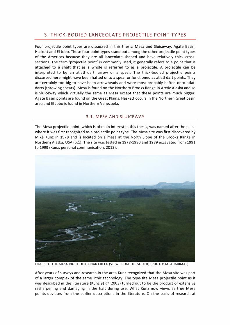
Four projectile point types are discussed in this thesis: Mesa and Sluiceway, Agate Basin, Haskett and El Jobo. These four point types stand out among the other projectile point types of the Americas because they are all lanceolate shaped and have relatively thick cross-‐sections. The term ‘projectile point’ is commonly used, it generally refers to a point that is attached to a shaft that as a whole is referred to as a projectile. A projectile can be interpreted to be an atlatl dart, arrow or a spear. The thick-‐bodied projectile points discussed here might have been hafted onto a spear or functioned as atlatl dart points. They are certainly too big to have been arrowheads and were most probably hafted onto atlatl darts (throwing spears). Mesa is found on the Northern Brooks Range in Arctic Alaska and so is Sluiceway which virtually the same as Mesa except that these points are much bigger. Agate Basin points are found on the Great Plains. Haskett occurs in the Northern Great basin area and El Jobo is found in Northern Venezuela.
3.1. MESA AND SLUICEWAY
The Mesa projectile point, which is of main interest in this thesis, was named after the place where it was first recognized as a projectile point type. The Mesa site was first discovered by Mike Kunz in 1978 and is located on a mesa at the North Slope of the Brooks Range in Northern Alaska, USA (5.1). The site was tested in 1978-‐1980 and 1989 excavated from 1991 to 1999 (Kunz, personal communication, 2013).
FIGURE 4: THE MESA RIGHT OF ITERIAK CREEK (VIEW FROM THE SOUTH) (PHOTO: M. ADMIRAAL)
After years of surveys and research in the area Kunz recognized that the Mesa site was part of a larger complex of the same lithic technology. The type-‐site Mesa projectile point as it was described in the literature (Kunz et al, 2003) turned out to be the product of extensive resharpening and damaging in the haft during use. What Kunz now views as true Mesa points deviates from the earlier descriptions in the literature. On the basis of research at

22
various Northern Brooks Range sites is has become apparent that true Mesa projectile points are relatively long and thick with initially straight to convex bases (Kunz, personal communication, 2012). In order to avoid any ambiguities: the above mentioned “true Mesa points” are the Mesa points discussed in this thesis, they are described in further detail in chapter 3.1.4. Sluiceway points are remarkably similar to Mesa points. They are however bigger, wider and as a result they seem to be thinner, while in fact they are as thick as Mesa points, the width/thickness ratio just differs slightly. The points carry the name of the site where they were first recognized as a type, the Irwin Sluiceway site, investigated by Bob Gal and Dennis Stanford in 1992, 1994 and 1998 (Kunz et al, 2003).
3.1.1. DISTRIBUTION
Mesa and Sluiceway points are almost exclusively found along the northern slope of the east-‐west oriented Brooks Range. Figure 5 shows the location of the main sites in Arctic Alaska. The Mesa type-‐site (fig.5: 1) is located in the upper Colville River drainage system on top of a small plateau with steep sides, also known as a Mesa. Almost all the identified Mesa and Sluiceway sites are located on higher ground: hilltops, bluffs, mesas, etc. These high places probably functioned as observation posts to spot migratory herds of animals. The tool assemblages found on these high locations also indicate that they were indeed small observation sites (chapter 3.1.5). Both Mesa and Sluiceway sites are generally associated with the nearby presence of water such as streams (Kunz, 2013; Kunz et al, 2003; Kunz and Reanier, 1995).
FIGURE 5: DISTRIBUTION OF SIGNIFICANT MESA-‐ AND SLUICEWAY ARCHAEOLOGICAL SITES (NUMBERS CORRESPOND TO TABLE 1)
Many surface sites containing Mesa or Sluiceway points are present in the Northern Brooks Range area. It is striking that Mesa and Sluiceway, although very similar types, are hardly ever found in the same context. The Tupik site was excavated in 2004-‐2006 and 2012 by Kunz. The two point types were found in the same context there. However, Kunz did not find

23
any datable materials at the site but he is convinced that the radiocarbon dates available from other sites (table 1) provide a reliable time frame for both the Mesa and the Sluiceway complexes and thus also for the Tupik site though the use of typological cross-‐dating (Kunz, personal communication, 2012). In the East of the Brooks Range the density of Mesa sites is higher while Sluiceway is more confined to the West (Kunz, 2013; Kunz and Baker, 2011; Rasic, 2008) (see also appendix 2-‐3). Up to now at least 20 Mesa and 20 Sluiceway sites have been discovered in the area with probably more still undiscovered. Teshekpuk Lake (6) is an exception that is located near the coast of the Beaufort Sea, and Spein Mountain (10) is located in Southwestern Alaska, far away from the other Mesa sites. The occurrence of the Mesa and Sluiceway sites confined to the Northern Brooks Range does not necessarily mean that these people did not explore other parts of the available surrounding landscape. The occurrence of a few pieces of obsidian from the Batza Tena source that is located some 320 km to the south suggests otherwise but could also indicate contact with other, more southern, groups (Kunz et al, 2003). TABLE 1: MESA AND SLUICEWAY SITES, LOCATIONS AND 14C DATES

3.1.2. ENVIRONMENT
The Mesa and Sluiceway complexes are confined to the Arctic area of Alaska (fig.5), an area that was uninhabited before the arrival of people manufacturing Mesa and Sluiceway points. The sites occur mostly between the latitudes of 68-‐70°N. At these latitudes the climate is characteristically Arctic: winters are cold and dark while summers are wet and cloudy with 24 hours of sunshine. Nowadays temperatures in February can drop to -‐38 °C. Average precipitation is 31,8 cm, half of which comes down in the form of snow that remains on the ground for eight months a year. For the length of two months the sun does not rise above the horizon and twilight and darkness prevail the windy and cold tundra. July is the warmest month in summer with a mean temperature of 10-‐12°C though it can get much warmer on some days. The area can get quite moist during summer, a great environment for mosquitoes to thrive in. Strong winds prevail the areas of scarce topography (Kunz et al, 2003).
FIGURE 6: ARCTIC FOOTHILLS (PHOTO: M. ADMIRAAL)
During the Late Pleistocene there was less precipitation, this was the main reason why Alaska was not glaciated during the last ice age. As a result of this dry climate the surface was firmer and thus fit for dryland, grazing species such as bison, horse and mammoth but also for human travel (Mann et al, 2013). Because of the decreased presence of clouds, more sun could reach the sparsely vegetated surface and this thickened the seasonally thawed layer (active layer) on top of the permanently frozen ground (permafrost) (Kunz et al, 2003). In order to study the environment of the Mesa territory one must be aware of the presence of two major distinctive physiographic regions. Most important for this study are the Arctic Foothills (fig.6): the North Slope of the Brook Range. North of the Brooks Range permafrost is continuous (>95% of the area contains permafrost) and can reach depths up to hundreds of meters. The area was last glaciated during the early Pleistocene and remained ice-‐free during the LGM. Glaciers terminated at the northern boundary of the Brooks Range, some

25
11 km south of the Mesa type-‐site. Active layer thickness varies from only 25 cm in poorly drained areas to one meter in well drained areas (Mann et al, 2013; Mann et al, 2001).
FIGURE 7: COASTAL PLAIN (PHOTO: M. ADMIRAAL)
The Mesa area in the foothills can nowadays be described as a ‘moist acidic tundra’ environment. This tundra covers the entire North Slope and is underlain by a thick organic layer that was formed after the LGM. In summer the area becomes waterlogged, among other reasons due to the presence of permafrost that prevents drainage. Thick organic layers and absorbing vegetation such as sphagnum species also contributes to the waterlogging. The vegetation is nowadays dominated by dwarf shrubs (Betula nana, Ledum palustre, Salix planifoila pluchra), Tussock sedges (Eriophorum vaginatum), and Acidophilous mosses (Sphagnum) (Mann et al, 2001) (p.120-‐121) and is difficult to walk on. The Coastal Plain (fig.7) reaches from the Chukchi and Bering seas to the Arctic Foothills. The region is very different from the Arctic Foothills. At first sight the change in, or lack of, topography stands out. The Coastal Plain is a large flat area nowadays covered by thousands of thermokarst lakes, sandy river channels and deltas. During the LGM the Ikpikpuk sand dunes formed a 12.000 km2 sand sea. Nowadays, the vegetation is a moist, non-‐acidic tundra and is dominated by non-‐tussock sedge, prostrate shrubs and minerothrophic mosses characteristic of a circumpolar vegetation (Mann et al, 2001). An event that had a tremendous influence on changes in climate during the end of the Pleistocene is the flooding of the Bering Land Bridge. With the Bering Land Bridge in existence the entity of Beringia (the landmass that ranged from the Yenisei in Siberia to the Mackenzie river in Canada) experienced a continental climate. Winters were a bit colder than at present but summers were sunny and warm. The inundation of the land bridge introduced more maritime influences to the area and had significant impacts on climate and vegetation (Kunz et al, 2003; Mann et al, 2013). During the Younger Dryas glacial conditions returned after a brief period of post-‐glacial warming. The vegetation was dominated by grasses and forbs and the dry environment

26
provided a more stable surface (Mann et al, 2013). Kokorowski et al (2008) have reviewed published pollen data from Beringia. In Northern Alaska there are two records that indicate a climatic cooling and dryer period during the Younger Dryas. In the Arctic Foothills this cooling is recorded between 10.900 and 10.200 14C BP. As a result Populus and Poplar pollen disappear from the record for a while. After 10.000 14C BP the climate warms again and precipitation increases. Cooling is also recorded in the northwestern part of the Arctic Foothills. Further inland the climate seems to be warmer and moister (Kokorowski et al, 2008; Yesner, 2001). The end of the Younger Dryas (10.000 – 9.700 14C BP) initiated a global warming. As a result the area was subject to extensive solifluction. Thickening active layers probably caused landslides and increased thermokarst activity. With the end of the Younger Dryas tussock-‐tundra replaced the grass-‐rich Mammoth-‐steppe and species such as horse and bison vanished from the archaeological record and with them disappears the presence of humans in this part of the Alaskan Arctic (Kunz et al, 2003; Mann et al, 2010). Wildlife reacted to these climatic changes. The Mesa and Sluiceway complexes have yielded little to no animal remains, just a few bison and sheep teeth as well as a caribou association (Hedman and Rasic, unpublished data mentioned in: (Mann et al, 2013)). Therefore we can only make an educated guess which animal species these people hunted. Mann et al (2013) have shown the distribution of megafauna species during the late Pleistocene in the Northern Brooks Range. Most numerous was horse with 6.7 individuals per km2, next to horse came bison with 3.7 individuals/km2. Caribou was at least as numerous as the species is today (2.6 individuals/km2). Muskox was less numerous as was mammoth before it vanished from the archaeological record at approximately 11.800 14C BP. Horse and bison seem to be the most likely prey for the Mesa Paleoindians because of their abundance. Bison priscus was the bison species present in Alaska during the LGM. At the end of the Pleistocene Bison antiquus from the Great Plains is found to have migrated northward as the presence of both species at the Charlie Lake Cave site in the ice-‐free corridor shows (Driver and Vallières, 2008) (Kunz, personal communication, 2013). A proposed difference between the bison from the Plains and the bison in Alaska is their manner of foraging and migration. On the Great Plains bison migrate along with the green wave of spring. In Alaska this green wave is influenced by topography and not so much by a south to north ‘green up’. Bison could have foraged in small geographical areas benefiting from the fresh greens on the south side of hills and later on in the season the green would spread (Kunz et al, 2003). During the last ice age the overall biomass was much greater than at present. Carnivores such as lions, short-‐faced bears, wolves and grizzly bears were present along with the above-‐mentioned herbivores. Many of these species became extinct during the end of the Pleistocene. Life became more difficult for the species that depend on a dry environment with short grass vegetation during the end of the ice age. As conditions became wetter their habitat shifted and they disappear from the scene (Mann et al, 2013).

3.1.3. DATING
The Mesa type-‐site was extensively dated by AMS as well as standard radiometric assays. The first standard date contained a laboratory error and later standard dates were run on the same material that was AMS dated. These standard dates were inconsistent with the AMS dates and thus it was decided to discard the standard dates. The site yielded 44 AMS dates from 28 of the 40 hearth features.
FIGURE 8: CALIBRATION CURVE FOR THE AMS DATES OF THE MESA TYPE-‐SITE. AS THE CALIBRATED DATA IS NOT USED IN THIS THESIS PLEASE PAY ATTENTION TO THE RADIOCARBON DETERMINATIONS ON THE Y-‐AXIS OF THE GRAPH (BRONK RAMSAY, 2009)
The dates show two clusters, the major cluster ranges from 10.300 to 9.700 14C BP. Figure 8 shows the Mesa type-‐site radiocarbon dates in a calibration curve made in the OxCal program v4 (Bronk Ramsay, 2012). The major cluster of dates is clearly visible in the lower part of the curve. It also becomes very apparent that there are two obvious outliers among the dates. These two dates, 11.660 ± 80 14C BP and 11.190 ± 70 14C BP are much older than the other Mesa dates. According to Kunz (2003); (personal communication, 2013) these dates cannot be rejected. Explanations given for the old dates are contamination by old carbon. Freeze/thaw movements of the active layer could have induced the introduction of older

28
carbon to the surface. Kunz et al (2003) reports that there was a frost crack near the hearth where these dates came from, this enhances the chances of contamination. It has been suggested that the inhabitants of the region used old wood to burn. However, as Kunz and Reanier (1995) have argued, it seems unlikely that old wood would have survived on the surface for a thousand years. Old wood can be preserved in Arctic climates because of a lack of bacterial activity. However, the degree of moisture in the area during the time might have made preservation less likely, especially when considering the warmer period preceding the Younger Dryas (Kunz et al, 2003). Additionally, permafrost is not present at the Mesa. Just the active layer freezes and thaws seasonally. This greatly decreases the chances of the preservation of old wood at the site (Kunz, 2013). Aditionally, sites in this part of Alaska are located close to the surface, which also prevents preservation. The Sluiceway site ‘Tuluaq Hill’ has also been dated to 11.200 14C BP (Rasic, 2008). The dates come from Stratum II, in this stratum three Sluiceway projectile points were found while the majority of cultural material (including Sluiceway points) comes from Stratum IV, much closer to the surface and above a 7950±40 14C BP date. Rasic, (2008) argues that the artefacts were redistributed due to the process of frost-‐heaving. However, freeze-‐thaw movements might redistribute artefacts in various directions (French, 2007). The Tuluaq Hill date remains an exception to a clear timeframe of around 10.500 14C BP of both Mesa and Sluiceway. It is clear that the major cluster of Mesa dates falls within the timeframe of 10.300 – 9.700 14C BP.

3.1.4. LITHIC TECHNOLOGY
Projectile points dominate the lithic assemblages of the Mesa and Sluiceway complex (fig.9). Projectile points were manufactured through bifacial reduction, that is, worked on both sides to shape a projectile point. Kunz et al (2003, p.27) defined bifacial tools as following: “pieces which are wider than they are thick and have two readily recognizable flaked surfaces”. Mesa points were probably hafted onto atlatl darts while the much bigger Sluiceway points were probably hafted on thrusting spears (Kunz, personal communication, 2012).
The Mesa site yielded 154 complete and broken Mesa projectile points. As was mentioned before, these points were slightly different from what later was characterized as ‘true’ Mesa points by Kunz. Figure 10 shows the Mesa type-‐site points. Points are characterized as finished when there is evidence of collateral flaking, base shaping, tip shaping, edge grinding
FIGURE 9: MESA PROJECTILE POINT (LEFT) AND SLUICEWAY BASE FRAGMENT (PHOTO: M. ADMIRAAL)

30
and edge retouch. Edge retouch is visible on most of the Mesa points and can be described as small pressure flakes all around the point to straighten and even the outline (Kunz et al, 2003). Final shaping is done using pressure flaking.
FIGURE 10: MESA TYPE-‐SITE POINTS (KUNZ ET AL, 2003: P. 28)
After more Mesa complex sites had been discovered in the area it became apparent that the Mesa type-‐site points were the product of extensive resharpening and damaging. True Mesa points are larger (Kunz, personal communication, 2012). True Mesa points are lanceolate in form. The cross-‐section is usually diamond shaped as is shown in figure 10, sometimes the cross-‐section can also be lenticular (more rounded). Sluiceway points are lenticular in cross-‐section. The points shown in figure 10 show concave bases, these bases have been regarded as typical for the Mesa complex. However, upon further investigation other kinds of bases were discovered to be common (convex to straight). Upon further investigation of the concave Mesa bases it was found that many showed signs of damaging. Kunz suggest the bases might have been damaged during use and got their concave form as a result of that

31
damage (Kunz, 2013). After examining the bases of a selection of 140 Mesa and Sluiceway points more closely I also concluded that many bases are indeed damaged: of the 66 examined Mesa specimens that were basally complete, 41 specimens were clearly basally damaged (see table 2). I examined only seven Sluiceway points with complete bases. Of these seven bases one was damaged but remained convex as were the intact bases. This lack of damage may be the result of the more robust character of the Sluiceway points. Another possibility is that Sluiceway points were hafted in a different manner than Mesa points. This suggestion is strengthened by the idea that Sluiceway and Mesa points were used for different purposes (spears and atlatl darts). On the Mesa points there is hardly any evidence of intentional flaking scars. Most of the bases show numerous tiny step-‐fractures, these scars that end abruptly might have been the result of pressure within the haft (fig.11). Could it be possible that damaging within the haft transformed a straight or convex base into a concave base? Not all concave bases are the result of damaging although the majority (61%) is. This indicates that Mesa has a wide variety of bases, from concave to convex. Most of the convex bases that show damage are not as extensively damaged as the concave specimens are. Experimental studies shed more light on the origin of the damage to the Mesa bases. Stanford (personal communication, 2013) believes that it is not possible for a convex base to transform into a concave shape as clearly as is displayed on figure 10. TABLE 2: BASAL CONDITIONS FOR 66 EXAMINED MESA PROJECTILE POINTS
Base condition nr. % of which Convex of which Concave of which Straight
Damaged 41 62% 8 (19,5%) 25 (61%) 8 (19,5%) Intact 15 23% 9 (60%) 4 (27%) 2 (13%) Indet 10 15% 3 (30%) 4 (40%) 3 (30%) Total: 66 100
FIGURE 11: DAMAGED MESA BASE FROM THE TUPIK SITE (PHOTO: M. ADMIRAAL)

32
Most of the Mesa and Sluiceway points are made of grey or black chert from local sources. Although scarce, obsidian has been found at the Mesa site that can be traced back to the Batza Tena source some 320 km further south, the only obsidian source in Alaska (Houlette et al). Colourful chert is rare but a few specimens are present: orange, red, yellow and white. The quality of the local chert is reasonable while it shows some inclusions. Grain size varies from relatively fine to coarse.
FIGURE 12: MESA WIDTH/THICKNESS RATIO'S (DATA WAS COLLECTED BY THE AUTHOR FROM A SELECTION OF MESA PROJECTILE POINTS FROM VARIOUS SITES, ALL SPECIMENS WERE COMPLETE AND MEASURED AT THE WIDEST PART OF THE POINT)
Mesa projectile points are relatively thick in comparison to their width. The average ratio of the 22 complete Mesa projectile points that were measured is 2.7. Baker, (2009) made a division between thick-‐bodied and thin-‐bodied points. He suggests that thick-‐bodied points have a width/thickness ratio between 1 and 3 and thin-‐bodied points have a ratio of at least 4 and greater. The Mesa type falls mostly in the thick-‐bodied category, however there are some specimens that have greater ratios than 3, although I did not find any specimens that were greater than 3.8. Baker (2009) describes ratios between 3 and 4 as a grey area. Average measurements of Mesa points are: 63x25x9 (length x width x thickness in millimetres). The first stage of projectile point manufacture was the reduction of a cobble, core or large flake using direct, hard percussion flaking to obtain a biface that could then be shaped into a projectile point. The next flaking sequence was done by soft hammer percussion. The shaping of the projectile point was done by a very robust kind of pressure flaking that in some cases can be mistaken for percussion flaking. Large flakes are removed by pressure flaking leaving a defined ridge in the middle of the point where the flake scars meet (Kunz, 2013). These flake scars are usually collateral but sometimes approach a parallel pattern (fig.1). Because of the multiple reduction sequences evidence of the earlier reduction stages is often hard to find. However, sometimes remnants of the flaking scars of earlier reduction sequences are still visible. This indicates only one or perhaps two finishing sequences of

33
pressure flaking (Rasic, 2008; Rasic, 2011). This problem can also be solved by employment of the lengthy process of refitting. The stem (the lower half of the point) edges are heavily ground, which leaves them smooth and fit for hafting. Some points of the Mesa type-‐site lacked edge grinding but showed use wear. This indicates that these specimens were used even though they were not edge ground, or it might indicate that these points were used for another purpose, perhaps as a unhafted knife since edge grinding seems to be related to the hafting of tools (Kunz, personal communication, 2012). This complicates things when it comes to the question of the bases. Most of the specimens show edge grinding which could indicate that they are finished. The damage to the bases has likely occurred after the points were finished, perhaps during use (Kunz, personal communication, 2012). When we accept that the Mesa bases were damaged in some manner during use we might say that the majority of Mesa bases were not concave but straight or even convex in form. There are a few examples of straight or convex bases in the Mesa material. These bases show little, or no damage at all. Another interesting aspect is that 75% of the Mesa type-‐site projectile points were reworked while in the haft, leaving a small but distinct shoulder that formed due to this process (Kunz et al, 2003). These points would not have been reworked if they had not been finished, hafted, used and damaged during those processes. The points were probably hafted in a foreshaft made out of antler, bone, ivory or (most unlikely) wood. The wood that was available for use was willow and to a lesser extent poplar (cottonwood). These woods would not have been strong enough to be used as a foreshaft, they would however function fine as atlatl dart shafts (Kunz, personal communication, 2013). The foreshaft would then have been attached to a atlatl dart-‐ or spear shaft. The hardness of the foreshaft could have damaged the bases of the points. There is abundant evidence for hafting on the projectile points. Analyses were done looking for use-‐wear and residues and these were identified. Possible traces of mastic (a binding material such as resin) were found that might have functioned to fix the projectile point into the foreshaft. Edge grinding aided in hafting because it removed sharp extensions that might cause breakage of either the sinew, the point or the haft and moreover it made the point fit better into the foreshaft. At least one third to half of the proximal part of the point was hafted. This is the area where residues and use wear typical of hafting were discovered (Kunz et al, 2003).

3.1.5. ASSOCIATED LITHIC ASSEMBLAGES
Besides finished projectile points the Mesa complex sites also yield large bifaces, unifacial tools such as scrapers and gravers as well as a few flake burins and many retouched flakes. Especially the gravers seem to have been an important implement of Mesa sites. It has become apparent that Mesa projectile points are often found together with gravers (Kunz, personal communication, 2012). The gravers (fig.13) are flakes with a delicate, retouched spur used for incising, scribing, drilling/boring and/or perforating. There were 70 specimens found at the Mesa type-‐site, some of which might have been hafted. These must have been important tools to the Mesa people. It has been suggested that the gravers were used for the repair of hunting equipment but also for making grooves in shafts, which was necessary to insert feathers into the atlatl darts. Another use of gravers could be the untying of knots, the tools were possibly used for repairing hafted projectile points (Kunz, 2013; Kunz et al, 2003).
FIGURE 13: GRAVERS FROM THE MESA TYPE-‐SITE (PHOTO: WWW.LITHICCASTINGLAB.COM)
Another tool type that was found at the Mesa type-‐site were scrapers. These scrapers were quite large. Scrapers are used for the cleaning of hides but also to scrape bone or wood (Beuker, 2010). It seems that the blanks used to transform into scrapers were purposefully produced and well made. Most scrapers were symmetrical and ovate, some were even bifacially worked. Other than scrapers and gravers a few flake burins were found and many retouched flakes useful for various purposes (Kunz et al, 2003).

3.1.6. SITE CHARACTERISTICS AND INFERRED ACTIVITIES
The typical location of the Mesa complex sites is an indicator of the function of these sites. The sites occur on high places with wide views, that is: hilltops, mesa’s, bluffs or ridges. It is proposed that these places functioned as observation spots to scout for migratory herds of animals. The Mesa type-‐site offers a 360° view that allows one to see up to 65 km in the distance, the same widespread view is experienced at the Spein Mountain site and others. While the hunters were game-‐spotting they probably passed the time repairing their tools while sitting around a fire to keep warm. The areas of activity at the Mesa type-‐site were relatively small and usually included a hearth as a central point. These small activity areas together form larger use areas. 40 hearths were discovered on the mesa. The mesa itself yielded four of these larger use areas of which one provided a little more shelter from the wind but less wide views of the surroundings (locality Saddle) (Kunz et al, 2003). The same goes for the Spein Mountain site where there are presumably three observation areas and one temporary campsite. The number of bases at the Spein Mountain site clearly outnumbers the point tips, indicating that the hunters returned to this spot to repair their hunting kit after a hunt (Ackerman, 2001). The analysis of the lithic materials of the site clearly shows that the main activity was that of the manufacture and repair of bifaces and/or projectile points. Many flakes were found at the Mesa type-‐site and most of these have been determined to be the by-‐product of bifacial reduction processes. Moreover the presence of other types of tools was scarce, with the exclusion of the 70 gravers that were found at the Mesa site. These tools might have been necessary for the manufacture and repair of hunting equipment (Kunz et al, 2003). The low number of scrapers at the Mesa type-‐site indicates that the working of hides and bones occurred elsewhere. Scrapers are usually found in large numbers in prehistoric camp sites. No base camp of the Mesa complex has been found yet. It does seem plausible to assume that there might have been a camp close to the mesa at lower elevation near Iteriak Creek. The area around the creek would have provided fuel and construction materials as well as fresh water and shelter from the harsh winds. Sites that were located near water might very well have been destroyed by the changing path of the creeks and rivers (fig. 4).

36
3.1.7. MESA AND SLUICEWAY: THE DIFFERENCES
The Mesa and Sluiceway projectile points are essentially the same. The major difference is that Sluiceway points are larger than Mesa points. A Sluiceway point from the Utukok 35 sites measures: 110x37x11 mm while the average measurements for Mesa points are 63x25x9 mm. As a result the cross section also differs. While both point types have largely the same thickness, Sluiceway points are broader than Mesa points. Because of this the shape of the cross section in Sluiceway points is more lenticular (more stretched) than diamond shaped, as is the case with Mesa points (Kunz, personal communication, 2012). The width/thickness ratios of Mesa and Sluiceway differs slightly. Sluiceway is tending to the right of the graph (fig.14) while Mesa tends more to the left. This means that Sluiceway is slightly thinner in comparison to its width than Mesa. The average width/thickness ratio of Mesa is 2.7 while the average of Sluiceway is 3.5. The lithic technology differs slightly too. Mesa points are finished by only one or perhaps two sequences of pressure flaking, often leaving behind the remnant scars of percussion flaking of the shaping sequences. Sluiceway points on the other hand do not show any remnant scars of this shaping stage. This indicates that Sluiceway points were finished with multiple sequences of pressure flaking. This also accounts for the regularity that these points show and might have further reduced the thickness (Rasic, 2008; 2011).
FIGURE 14: MESA (22 SPECIMENS) AND SLUICEWAY (17 SPECIMENS) WIDTH/THICKNESS RATIO'S (DATA WAS COLLECTED FROM A SELECTION OF POINTS FROM THE COLLECTION OF THE BLM, SOME SLUICEWAY SPECIMENS WERE DAMAGED)
It has been suggested that Mesa points might have been reshaped Sluiceway points (Rasic, personal communication, 2012). However, Rasic (personal communication, 2012) argues that this is not a possibility. Reshaping of a Sluiceway point would not leave remnant percussion scars. I would like to argue that it still might be a possibility if reshaping was done with percussion flaking. However, I acknowledge that the difference in thickness between Mesa and Sluiceway is so small that it seems unlikely that the thickness of the points hardly

37
changed after a sequence of percussion flaking and a sequence of pressure flaking. Additionally, remnant scars of the pressure flaking would remain visible if the point was not extensively reworked with multiple sequences of percussion flaking, reducing the thickness of the point dramatically. Additionally, the occurrence of Sluiceway and Mesa at the same site is rare. If one can attribute a function to a point type by looking at the size and sturdiness then it can be concluded that Mesa and Sluiceway points were used for different purposes. Perhaps Mesa points were used on atlatl darts (throwing spears) and Sluiceway points were used on thrusting spears (Kunz et al, 2003). This is mainly based on the difference in size. However, Ackerman (2001) argues that the Mesa points of Spein Mountain with their “…narrow, lanceolate form and sturdy diamond-‐shaped cross sections…” indicate the use on heavy thrusting spears and not light throwing spears. Use of thrusting spears would however only have been efficient for finishing off an already wounded animal. Otherwise the hunter would have had to approach the animals closely and chances of failure would be bigger then when using an atlatl dart. Both point types show hafting damage, though Mesa more than Sluiceway. The difference in size also suggests a different hafting method. It seems that Sluiceway points are too big and have too wide cross-‐sections of the base (35x11) to have been hafted in a socketed shaft. Possibly Sluiceway was hafted in split-‐shaft hafts. This might also explain the lack of gravers in the Sluiceway complex. If gravers were used to make grooves for the insertion of feathers and to untie knots these actions might have been restricted to Mesa projectile manufacture (Kunz, 2013). It is interesting that Mesa and Sluiceway points have rarely ever been found together. This also indicates a difference in use of the points, possibly a different prey species. However, when looking at the site distribution map (fig.5) it is evident that Mesa complex is more confined to the east while the Sluiceway complex clusters in the Western Brooks Range. In the western third of the Brooks Range the geomorphology permits easier travel on foot than elsewhere in the Brooks Range. Kunz (2013) suggests that the Western Brooks Range might have been a different zone of exploitation than the east and that it required a different toolkit.

3.2. AGATE BASIN
The Agate Basin projectile point was named after its type-‐site, the Agate Basin site (fig.15, nr. 1 on figure 16) in Moss Agate Arroyo in Eastern Wyoming, USA. Agate Basin points are found on the northern part of Americas Great Plains. The Agate Basin site was discovered by William Spencer and was first excavated by Frank H.H. Roberts in 1959 and later years. During the end of the 1970s the site was more thoroughly studied by George C. Frison (Frison, 1978; Frison and Stanford, 1982; Shelley, 1983).
FIGURE 15: THE AGATE BASIN SITE AREA (ARROW INDICATES SITE LOCATION) (FRISON, 1978 P.151)
Another important Agate Basin site is the Hell Gap site that has been of great importance to the development of a projectile point chronology on the High Plains. The site showed a clear and undisturbed stratigraphy and contained several types of projectile points in chronological order. Before the era of radiocarbon dating the main method of establishing the age of an archaeological cultural level was Geoarchaeology, based on stratigraphic evidence. The best example of this is the Folsom site where it was first demonstrated that humans had been in the Americas since the late Pleistocene by linking the archaeological artefacts to the remains of extinct bison (Holliday, 2000).

3.2.1. DISTRIBUTION
Agate Basin points as defined by Roberts (Roberts, 1943) are largely confined to the North-‐western Great Plains. The main Agate Basin sites are found in the state of Wyoming. However, Agate Basin points have been reported found from New Mexico in the south all the way to the Grant Lake region in Canadian Artic. The occurrence of Agate Basin has also been reported in the Eastern states of Ontario, Minnesota, Wisconsin, Illinois, Indiana, Missouri and Ohio (Justice, 1987). Overall surface finds are rare. The main Agate Basin sites are the Agate Basin type-‐site (including the Brewster site, which was later acknowledged to be part of the Agate Basin site), the Hell Gap site, the Carter/Kerr-‐McGee site, all in Wyoming, the Frazier site in Colorado, the Blackwater Draw site (the Clovis type-‐site) and the Kendall site in New Mexico (Stanford, 1999). The Agate Basin type-‐site is located on a, usually dry, tributary of the Cheyenne River in Eastern Wyoming. Close to the Black Hills (Frison, 1978). The geomorphological setting of Agate Basin sites in the landscape indicate the use of topographical features for the hunt of large animals. Most of the Agate Basin sites are kill/butchering sites that are located at the head of topographic depressions such as an arroyo (a deep but dry gully). These types of landform can function as a trap to chase a herd of animals into (Frison, 1984; Frison and Stanford, 1982). The Agate Basin type-‐site consists of a kill site and a close by camp/processing site.
FIGURE 16: DISTRIBUTION OF AGATE BASIN AND HELL GAP ARCHAEOLOGICAL SITES USED IN THIS STUDY (NUMBERS CORRESPOND TO TABLE 2)
There are several projectile points that resemble Agate Basin points and have sometimes been falsely called Agate Basin. Stanford (1999) recognizes three complexes of similar points. The first are the Agate Basin-‐like points in the Rocky Mountains and foothills that date to approximately 9000 14C BP. Second is the Packard complex on the Eastern Great Plains. This complex dates to 9400 14C BP. In Canada there is a projectile point complex that is referred to as Northern Plano. The points are very similar to Agate Basin but much

40
younger: 8500 – 7500 14C BP (Stanford, 1999). The main difference between these complexes is the age. It might very well be that these complexes all are descendant from the original Agate Basin from the Great Plains as the lithic technology is very similar, however, by the time the Agate Basin-‐like complexes occur in the Rocky Mountains and Canada, Agate Basin was no longer present at the Great Plains. Although the lithic technology and morphology is similar, it is not identical to the Agate Basin of the Great Plains.
TABLE 3: AGATE BASIN (AND HELL GAP) SITES, LOCATIONS AND 14C DATES
Nr. Site name Point type Coordinates 14C Date 1 Agate Basin Agate Basin 43.413029,-‐104.07074 10.430 -‐ 9350
1 Brewster Agate Basin 43.413029,-‐104.07074 9990 -‐ 9440
2 Hell Gap Agate Basin 42.244785,-‐104.298706 10.850 3 Frazier Agate Basin 40.241799,-‐104.578857 9650 -‐ 9000
4 Allen Agate Basin 41.05036,-‐106.24054 10600 -‐ 10260
5 Mangus Agate Basin 45.151053,-‐108.182373 8690 6 Kendall Agate Basin 34.741612,-‐106.391602 not dated
7 Pine Spring Agate Basin 41.302571,-‐109.846802 11830
8 Carter/Kerr-‐McGee
Agate Basin 44.52001,-‐105.732422 not dated
9 Blackwater Draw Agate Basin 34.283319,-‐103.318176 not dated
10 Jim Pitts Agate Basin 43.77506,-‐104.002075 11100-‐ 10160
11 Milnesand Agate Basin 33.83392,-‐103.710937 not dated?
12 Park Hill ± Agate Basin 50.255766,-‐105.527458 not dated?
13 Grant Lake ± Agate Basin 63⁰43'20 100⁰26'10 7222±850
2 Hell Gap Hell Gap 42.244785,-‐104.298706 10240
1 Agate Basin Hell Gap 43.413029,-‐104.07074 10445
14 Sister’s Hill Hell Gap 44.331707,-‐106.798096 9620
15 Casper Hell Gap -‐ 10060 – 9830
16 Jones-‐Miller Hell Gap -‐ 10020

3.2.2. ENVIRONMENT
The Northern Great Plains is the northwestern part of the North American Interior Plains. It is an area of flat, broad prairie, steppe and grasslands. In the northwest the plains extent as far as the foot of the Rocky Mountains. Nowadays the environment of the plains differs significantly over short distances. Although the prehistoric environment differs greatly from that of today it is likely that these differences observed over small distances were also present in the period that is discussed in this thesis whereas the topography of the area has not changed much. The continental divide runs through the Great Plains and as a result rivers flow both to the Pacific Ocean as well as to the Gulf of Mexico (Frison, 1999). During the Last Glacial Maximum (LGM) (20.000 -‐ 18.000 14C BP) two ice-‐sheets covered large parts of North America. The Laurentide Ice Sheet was the largest of the two, covering over 8 million square kilometres to the east. To the west the smaller Cordilleran Ice Sheet closed of the southern part of the continent from the north during the height of the ice age. Both ice-‐sheets had an enormous impact on the environment and climate of the bordering regions (Booth et al, 2003). During the LGM megafauna roamed the Northern Great Plains. The biggest land animal was the mammoth, the biggest of its kind: the Columbian mammoth. Other species were bison (B. antiquus), muskox, camel, horse, pronghorn, mountain sheep, shortfaced bear, grizzly bear, wolverine, dire wolf, grey wolf, cheetah and lion. Of these species only pronghorn, mountain sheep, grizzly bear and the grey wolf survived the climatic changes of the Younger Dryas. By 11.000 14C BP many species had disappeared from the area (Frison, 1993). From 13,500 14C BP the environment shifted from a steppe-‐tundra, similar to the Alaskan Pleistocene, to a steppe community with tundra elements. Around 10.500 14C BP the climate shifted again. Summers were not as hot as they are today, however, the winters were not as cold either. The seasons were less pronounced (Frison, 1993; Frison, 1999). At the time of the occurrence of Agate Basin sites the ice-‐sheets had already started thawing. The LGM ice-‐sheets never covered the Great Plains, the area however was affected by the presence of these giant masses of ice. For example, in Wyoming ancient casts of Ice Wedges have been found (Frison, 1999). This indicates the presence of permafrost and a periglacial environment. Ice wedges form when the ground cracks due to frost action. Water in the crack expands as it freezes and thus the crack grows into a wedge form. Ice wedges and permafrost conditions are nowadays mostly confined to high northern periglacial environments (French, 2007). The Agate Basin site yielded some environmental information, especially for the Folsom (older) and Hell Gap (younger) levels. There is a big difference between the two. The Folsom level shows evidence of coniferous forest vegetation while the Hell Gap level contained traces of an environment that compares more to southern areas with coniferous forest stands, sagebrush and grassland (Frison, 1999). The Agate Basin level is located in between these two levels and this period must have been heavily subject to climatic change. Precipitation determines the differences in vegetation. To the east of the mountains there is more precipitation than to the west. The mountains operate as a barrier and thus differences in environment can occur over short geographical distances. Precipitation rates in the Great Plains make the difference between desert and short-‐grass ecosystems. The amount of precipitation can make a big difference over very short periods of time and thus control the numbers and species of animals that can thrive in the area (Frison, 1999).

42
FIGURE 17: BISON HERD ON THE GREAT PLAINS (PHOTO: MARK THIESSEN FOR NATIONAL GEOGRAPHIC MAGAZINE D.O.A. 24-‐02-‐2013)
One would say that the difference between the physiographic regions of the Rocky Mountains and the Northern Great Plains is easy to determine. This is however not always the case. Along the rivers that flow out of the Rocky Mountains environments are present that are very much like the Great Plains (Frison, 1999). However, I can imagine that at higher altitudes the influence of the ice age was more present. During the Agate Basin period valley glaciers were still present in the northern region, especially in the mountains and this must have had its impact on the vegetation and thus the presence of animal species.

3.2.3. DATING
Various sites containing an Agate Basin level have been dated by radiocarbon dating. However, most of these dates have large standard deviations. The dates that are shown below in the OxCal graph are taken from the sites that are mentioned in table 3 (Agate Basin, Brewster, Hell Gap, Frazier, Mangus, Allen, Pine Spring, Carter/Kerr-‐McGee) and most of these dates have standard deviations ranging from ±130 to ±620 years. In figure 18 these deviations are visible. Much of the conclusions about Agate Basins place in Plains chronology have been determined by looking at the stratigraphy of sites. At multicomponent sites such as Hell Gap the stratigraphy showed a clear sequence of projectile point types through time. This has shown us that Agate Basin is positioned above or slightly contemporary with Folsom. The Agate Basin level is followed by the younger Hell Gap complex. Folsom has been extensively dated and this provides the means to date Agate Basin at the Hell Gap site to 10.500 – 10.000 14C BP. The date has been confirmed by a radiocarbon date from the Agate Basin level of 10.850±550 and dates of other sites (Holliday, 2000). The primary time of Agate Basin point production seems to occur between 10.500 and 10.250 14C BP (Stanford, 1999).
FIGURE 18: CALIBRATION CURVE OF VARIOUS DATES OF SITES YIELDING AGATE BASIN PROJECTILE POINTS. AS THE CALIBRATED DATA IS NOT USED IN THIS THESIS PLEASE PAY ATTENTION TO THE RADIOCARBON DETERMINATIONS ON THE Y-‐AXIS OF THE GRAPH (BRONK RAMSAY, 2009).

44
Hell Gap is usually found just above Agate Basin. Estimations of the age of these projectile points were 10.000 – 9.500 14C BP. These dates were confirmed by radiocarbon dates of 9.600 14C BP at the Sister’s Hill site. Overall Agate Basin is not particularly well dated (Holliday, 2000). However, the combination of stratigraphic information and radiocarbon dates provides a reasonably reliable timeframe for the projectile point technology.
3.2.4. LITHIC TECHNOLOGY
Agate Basin points are generally described as long, narrow and neatly flaked lanceolate projectile points. The points usually show no tapering stem. Although Agate Basin points are relatively thick they are still lenticular in cross section. The points have very straight and even margins and are highly symmetrical. These features result in easy penetration and a deadly weapon for the Agate Basin hunters. 169 complete and broken points were found at the Agate Basin type-‐site (Frison, 1978; Frison, 1993; Frison and Stanford, 1982).
FIGURE 19: AGATE BASIN POINTS FROM THE TYPE SITE (TAYLOR, 2006).
Agate Basin points have a wide variation in thickness and overall size. There seems to have been a wide range of acceptance regarding the projectile points. Some points are very large. It might be that these points were made this large in order to be able to reuse the point after breakage (Frison, 1978). Frison (1999) describes Agate Basin points as “…the most lethal weaponry seen in any of the Paleoindian complexes” (p.276).

45
The average width/thickness ratio of Agate Basin projectile points is 3.3 (fig.20). The data used in this graph comes from (Baker, 2009) who collected the measurements of 56 Agate Basin points from the type-‐site. As is seen in the graph (fig. 20) the majority of Agate Basin points have a ratio between 3 and 4. This suggests that Agate Basin points are in between thick-‐bodied and thin-‐bodied projectile point types as described by Baker (2009).
FIGURE 20: AGATE BASIN WIDTH/THICKNESS RATIOS (DATA WAS COLLECTED FROM BAKER, 2009)
The process of manufacture started with a percussion flaked biface. Agate Basin points were most probably first roughly shaped and regularized. After these initial shaping stages the point was thinned. There are few Agate Basin points that still show evidence of these early stages of manufacture because of the many sequences of finishing pressure flaking. However, some points show remnant flake scars from the thinning process that might indicate the use of overshot flaking. Preforms at the Agate Basin site have also indicated the use of overshot flaking (Bradley, 1993; Bradley, 2009). Overshot flaking is a method where flakes are removed that extent over the entire face of the point, removing a small portion of the opposite edge. It is a difficult technique, one small mistake can ruin the entire project. However, when correctly practiced, overshot flaking can be a very useful technique to extensively thin bifaces. The best known example of overshot flaking in the Americas is the Clovis projectile point complex (Stanford and Bradley, 2012). The regularity of Agate Basin points was seemingly of great importance. This highly regular longitudinal section was probably already established during the thinning stage. The thickness of Agate Basin points was maintained by regularly reducing the width with percussion flaking. Finishing was done by pressure retouch. With the pressure retouch the desired forms and regularity was established. The distance between pressure flakes is highly variable and can vary between moderate and wide spacing. As a result some Agate Basin points show parallel flaking and some collateral flaking. The margins were retouched where needed. When ridges stood out between flake scars these would be removed by retouch.

46
This is what gave the Agate Basin points such straight margins (Bradley, 1993; Bradley, 2009). The points seem to have been designed to sustain extensive damage. Fragments of broken points were easily reworked into new but smaller points. It is striking, in comparison to the effort that was put into the initial point manufacture, that reworking almost never happens with the precision and regularity of the initial point manufacture. It seems as though the reshaping was done without any concern for the beauty of the initial point. The focus of reworking a point was just on the functionality of the point (Bradley, 2009; Frison, 1993). Basal grinding extends to two-‐thirds of the point. This indicates that the points were hafted for two-‐thirds. The bases are convex, though in some cases straight or concave bases do occur on Agate Basin points. This is possibly the result of the reworking of damaged points (Stanford, 1999). Frison (1978) experimented with the hafting of Agate Basin points. He tried both a socketed haft as well as a split end. Both techniques were quite functional. A socket into which the projectile point was inserted was a bit harder to make. Frison argues however that this approach to hafting has better results when the spear is thrusted at an angle. However, split end hafting might as well have been employed as the results are nearly as good as with a socketed haft and is easier to achieve. Most of the lithic material found at Agate Basin sites is of extra local origin. There is hardly any evidence of the use of local raw material. Many of the lithics found at the Agate Basin type-‐site originate in North Dakota (Knife River flint), several hundred kilometres away, and the Hartville uplift, some 80 km southwest of the site (Frison, 1978; Frison and Stanford, 1982). At the Frazier site, Alibates dolomite from Texas dominates the lithic material. Here no local chert was used (Stanford, 1999). At the Carter/Kerr-‐McGee site local porcellanites and silicified wood were used. However, quartzites and cherts originating in the Southern Black Hills and the Hartville Uplift were also among the material (Frison, 1984). This is an indication that the Agate Basin hunters were possibly not home in the Great Plains region but organized occasional hunting expeditions because of the abundance of bison.

47
3.2.5. ASSOCIATED LITHIC ASSEMBLAGES
The Agate Basin toolkit is very similar to other Paleoindian lithic assemblages (Stanford, 1999). The Agate Basin site yielded a variety of large cutting and scraping tools: end scrapers, side scrapers, denticulates, gravers, an a-‐symmetric leaf shaped biface and some retouched flake and knives. Possibly tools were also made of bone. One bone artefact was found at the Agate Basin site. It is possible that the working edges of these proposed bone tools were eroded and are now difficult to recognize (Ebell, 1980; Frison, 1978).
FIGURE 21: FLAKE TOOLS OF THE AGATE BASIN SITE (FRISON, 1978, P. 163)
Flake and blade tools are quite simple in design and manufacture in contrast to the perfectly shaped Agate Basin points. Large percussion flakes are common. These flakes have only undergone edge preparation. Most flake tools were made on biface thinning flakes (Bradley, 1993; Frison and Stanford, 1982).

48
3.2.6. SITE CHARACTERISTICS AND INFERRED ACTIVITIES
Both the Agate Basin and the Hell Gap complexes have been of great importance to the archaeological knowledge of late Pleistocene bison hunting in the Great Plains region (Frison, 1978). The Agate Basin site is a bison kill site with an associated campsite where the bison remains were processed. At least 75 individual bison were killed here (fig.22). Most of the butchering and dismembering of the animals happened at the kill site. Stanford (1999) describes the site as a ‘knickpoint arroyo trap’ (p.312) (see fig.15). This topographical feature would have been an excellent trap into which the bison were driven. Once they were trapped in the dry gully the hunters could get close enough to kill the animals. The bison were dismembered on site and later transported to the campsite where the butchering process continued. Depositional levels indicate that the Agate Basin hunters remained at the campsite throughout the winter. There have not been found any hearths. However, there is evidence of the use of fire in fire fractured stones present at the site (Frison, 1978; Stanford, 1999). The Hell Gap site is located in a sheltered valley. The area is rich in chert and so quarrying activities might have been carried out here. Faunal remains were dominated by bison (at least 350 individual bison) but also deer, felid and various undefined small mammals were found (Stanford, 1999). The Frazier site was also a butchering and processing site of a bison kill. Even though the site was badly eroded, the remains of at least 43 bison were found here (Stanford, 1999).
FIGURE 22: AGATE BASIN TYPE-‐SITE BONE BED (FRISON, 1978 P.155)
The Carter/Kerr-‐McGee site location is also at the head of a ‘knickpoint arroyo’ and most probably also functioned as a trap for hunters to drive bison into. This multicomponent site yielded scattered bison bone at the Agate Basin and Hell Gap levels. Here there is no stratigraphic separation between the two point types. The site was probably only a

49
kill/butchering site as no evidence of a campsite was found. The campsite might have been located on higher ground where it was not preserved. Almost 1300 flakes were found at the Carter/Kerr-‐McGee site. Only a few result from biface reduction, the rest results from pressure flaking of tool and projectile point manufacture. It seems thus that the early stages of projectile point manufacture are not as much represented at the site (Frison, 1984). That could indicate that the flakes are mostly originating from projectile point reworking and finishing. The large number of killed animals indicates a large group of hunters. It is possible that these sites are the product of collective hunting parties of multiple groups of Agate Basin hunters joining their forces to ensure a successful hunt (Stanford, 1999). Frison (1984) suggests a number of 75 to 100 people to be involved in a hunt the size of the Carter/Kerr-‐McGee site. He also states that it should be possible for 15 to 20 grown males to carry out the hunt itself. The other individuals would assist in the butchering process. It seems that these practices of communal bison hunting were a seasonal affair in order to stack enough resources to survive the scarcity of winter (Frison, 1984). Analysis of the butchered animals at the Agate Basin site show that the kill probably occurred during the cold period in February or March. The meat was probably stacked in frozen meat caches. Although there is not much evidence for this at the site location it seems logical. Drying the meat would not have been possible during the cold season and to prevent the meat from spoiling and attracting scavengers it was probably buried or covered with stones. If the meat was stacked in a cache that would mean that the meat was not as portable as it would have been when dried. Agate Basin hunters might have remained in the area of the kill site for a longer period of time (Frison, 1993). Frison (1993) argues for a better understanding of hunting strategies among archaeologists. All animal species vary in behaviour. This behaviour must have been known to the prehistoric hunter in order to ensure a successful hunt. Behaviour can also vary with age, sex and condition of the animal. The season, weather conditions, time of day, vegetation cover and terrain can also be important factors that influence the behaviour of an animal (Frison, 1993). Impact breaks on the projectile points indicate use of throwing and thrusting spears (Frison and Stanford, 1982). Ritual and religion might very well have been a part of the hunt at sites such as Agate Basin, Hell Gap en Carter/Kerr-‐McGee. There have been however little clues to prove this idea. At the Hell Gap Jones Miller site a structure was discovered on the kill site. It has been argued that this structure might have been of shamanistic nature (Frison, 1993).
3.2.7. DEVELOPED OUT OF AGATE BASIN: HELL GAP
Hell Gap points are sometimes found at the same sites as Agate Basin points. Usually Hell Gap is situated just above Agate Basin in the stratigraphy. The Hell Gap complex has been dated to approximately 10.250 – 9.600 14C BP. Hell Gap technology is very similar to Agate Basin but differs in a few aspects. Hell Gap points are shouldered. The strange thing about this change in design is that the Hell Gap point proves to be less deadly weaponry than the Agate Basin point after experimental studies (Frison, 1993). Stanford believes that there is a better connection between the Windust (Great Basin) and Hell Gap types. And that Hell Gap is actually Windust people hunting on the Great Plains during bison population peaks (personal communication, 2013). Hell Gap site distribution is more confined to the Western

50
Plains bordering the Great Basin area. Sites on the Plains are usually connected to bison procurement.
FIGURE 23: HELL GAP PROJECTILE POINT FROM THE CASPER SITE (FRISON, 1978: P. 175)
Hell Gap was thinned and shaped by percussion flaking. Pressure flakes of the finishing stage occur over the entire face of the Hell Gap point but in some cases it is only visible on the tip and stem. Finishing of the points was done with great care as with Agate Basin points. Hall Gap points are more often finished by collateral flaking than with parallel flaking, as is often the case with Agate basin. The points are edge ground on the stem and basal margins. The flake tools associated with Hell Gap points are essentially the same as with Agate Basin points and most of the other Paleoindian complexes (Bradley, 1993). The Jones-‐Miller site lacks a geomorphic feature that could have functioned as a trap. Several hundred bison were killed at the site, probably in multiple events during one winter. It might be possible that these hunters had made an artificial trap to drive the animals into. At the Caspar site the kill location was in a parabolic sand dune (Frison, 1978). It is obvious that Hell Gap hunters used the same kind of natural features to hunt bison as the Agate Basin hunters did. Possibly we should not separate these two complexes too much. At the Carter/Kerr-‐McGee site there was no stratigraphic differentiation between the Agate Basin and Hell Gap levels. This suggests a very small time window in between the two complexes and possibly even simultaneity. Bradley (2009) views the occurrence of Agate Basin and Hell Gap as a continuum.

51
3.3 HASKETT
Haskett points were first described by Butler (1964; 1965) after the discovery of the type-‐site in Idaho by an amateur archaeologist by the name of Mr. Haskett. Excavations followed at the Haskett site in Idaho, USA (fig.24). Excavations were carried out during a couple of weekends and days with volunteers, students and a museum crew. Even though the site did not yield many archaeological features and remains several Haskett points were unearthed (Butler, 1965). Ever since the discovery of the Haskett type-‐site, Haskett points have turned up either in-‐situ or in collections of amateur archaeologists. The beautiful points are favourite among collectors (www.arrowheadology.com). Haskett points are mostly found in Idaho and Oregon. A few have been found in Washington State and on the border of Nevada and Utah.
FIGURE 24: HASKETT TYPE-‐SITE LOCATION (BUTLER, 1978) P.16
Something that is often unclear in the literature about the stemmed points of the Great Basin and adjacent areas is the classification of projectile point types. Beside the apparent lack of a clear set of characteristics for point types, over the years names have changed. For example: before a meeting in Santa Fe in 1951 all non-‐fluted points were called Yuma (Stanford, personal communication, 2013). This complicates things when using older literature. Additionally, many point types were put together under the term Plano. This makes it very confusing and difficult to collect the necessary information about a specific projectile point type from the region. Haskett points are often included in the broader term Western Stemmed Points. This term includes most of the stemmed point types of the Western United States during the late Palaeolithic. For the sake of this study the term Western Stemmed Points will not be actively used. A distinction is made between the Haskett points and the other point types included in the Western Stemmed Point tradition (Beck and Jones, 1997). This distinction is made on the basis of the typical stem of the Haskett type. This stem without shoulders, notches or other hafting attributes makes it comparable to the other types described in this thesis. While most other types do show attributes such as shoulders, others that do not, also do not show the lanceolate form that is another typical trait of the point types central to this thesis.

52
3.3.1. DISTRIBUTION
Most Haskett points are found in Idaho and Oregon in the Northern Great Basin region and Columbia Plateau of the Western United States. A region with many Haskett finds (among which the Haskett type-‐site) is the Snake River Plain, part of the Columbia Plateau. The Haskett site was located in a dune field that accumulated during the late Pleistocene (Beck and Jones, 1997; Butler, 1965).
FIGURE 25: HASKETT (AND SOME COUGAR MOUNTAIN (WCRM)) ESTIMATED SITE LOCATIONS
For the sake of clarity I will shortly discuss the different sites and the Haskett points that were discovered at these sites. Often the name Haskett was assigned to projectile points that in my opinion actually not clearly belong to the Haskett type (fig. 27). In a cache at the Cooper’s Ferry site (Davis and Schweger, 2004) various points were found among which Lind Coulee points and according to (Butler, 1969) one complete and one midsection of a Haskett point (fig.26). Even though Butler, who first discovered Haskett points, assigned the name to these points, I have my doubts about this determination. The one similarity with Haskett is the flaking pattern on the midsection (m) and possibly the width/thickness ratio, this is difficult to say from a picture. The shape of the small fragment could also fit a Haskett point. However, the complete point does not look like a Haskett point. The thickness/width ratio does not seem to fit, although this is not well seen from a picture it seems that there is no well-‐defined mid-‐ridge. The flaking pattern seems to be diagonally instead of horizontal and the shape does not fit the Haskett type-‐site points (fig.27). In my opinion it is premature to call these specimens Haskett points. Ames et al (1981) mentions the presence of Haskett points at the Hatwai site ! component. Strangely in his publication from 2010 (Ames et al, 2010) he describes the component I assemblage to be of the Windust type and he does not mention Haskett as found at the site. This is just one example of the confusing literary sources for the American West. The same goes for Danger Cave. In my opinion the points found at Danger Cave more closely resemble the Cougar Mountain type than Haskett in morphology (Fry and Adovasio, 1970). The

53
Haskett-‐like points from Owl Cave/Wasden site also do not entirely fit the general description of a Haskett point. The bases of these points are almost concave and the shape often does not fit Haskett. The points are wider and too short. There is one midsection that might represent a Haskett point (specimen 76305) (ISU.edu, 2013?). It is, however, always difficult to determine a type from just a midsection and taking into account that most of the Owl Cave/Wasden assemblage does not look like Haskett I have my doubts about treating this site as a Haskett site. The Sentinal Gap site is also mentioned in the literature to contain ‘Haskett-‐like’ points (Galm et al, 2011; Litzkow, 2011). These points are definitely very similar to Haskett except that they lack the finesse with which ‘true’ Haskett points were made (fig.27, 32). The characteristics of ‘true’ Haskett points will be given in chapter 3.3.4.
FIGURE 26: PROPOSED HASKETT POINTS FROM THE COOPERS FERRY SITE (BUTLER, 1969)
FIGURE 27: HASKETT POINT FROM THE TYPE-‐SITE (BUTLER, 1964)
Unfortunately, I have not been able to find pictures or drawings of all the Haskett points found at the different sites mentioned in the literature. At a high altitude site (the Helen Lookingbill site) in the Rocky Mountains this is the case. 10.405 14C year old projectile points were uncovered that could be either Haskett or Hell Gap (Kornfeld et al, 2001). However, there are some sites that seem to be generally accepted as Haskett. These sites are the Redfish Overhang site (Sargeant, 1973) and Bison and Veratic Rockshelters (Swanson, 1972). Of the following sites I am quite sure they contain Haskett: Connley Cave 5B (Bryan, 1980), Running Antelope (Russell, 1993), Cougar Mountain Cave (Bedwell and Cressman, 1971; Butler, 1961) and of course the Haskett type-‐site (Butler, 1964; 1965; 1967).

54
TABLE 4: HASKETT (AND SOME COUGAR MOUNTAIN) SITES, LOCATIONS AND 14C DATES
Nr. Site name Point type Coordinates 14C Date 1 Haskett Haskett 42.688997-‐113.061676 not dated 2 Redfish Overhang Haskett 44.119142-‐114.938965 9860/10100 3 Bison & Veratic
Rockshelters Haskett 44.138856-‐112.846069 8800/10340
4 Hatwai I Windust 46.431232-‐117.03392 10675±95 5 Connley Cave (5B) Haskett 43.278205-‐121.032085 9670/10600 6 Sentinal Gap Haskett-‐like 46.745507-‐119.988556 10160 7 Owl Cave (Wasden) Haskett-‐like 43.602273-‐112.447815 10470 8 Cougar Mountain
Cave Haskett-‐like 43.376107-‐120.80987 8510±250
9 Danger Cave Haskett 39.320952-‐111.09375 9789-‐8960 10 Coopers Ferry Haskett 45.868019-‐116.295776 11.370/12.020 11 Yamhill River Haskett 45.202724-‐123.041725 not dated? 12 Bonneville Estates
Rockshelter Haskett 40.333983-‐114.061432 11000
13 Wilson Butte Cave Haskett 42.793889-‐114.211807 not dated? 14 Fire Creek Cougar
Mountain 40.45792-‐116.630559 not dated
15 Locus 158 Cougar Mountain
39.551045-‐116.933842 not dated
16 Locus 39 & 154 Cougar Mountain
39.578769,-‐116.900282 not dated
Helen Lookingbill Haskett/ Hell Gap
-‐ 10.405
From 2002 to 2010 the Paisley Caves, first tested by Luther Cressman in 1938, were re-‐excavated by the University of Oregon. The results of the fieldwork were very interesting. The caves contained human coprolites that yielded DNA and Western Stemmed Points were found in association with dated material of 11.070 – 11.340 14C BP (Gilbert et al, 2008; Jenkins et al, 2012). Stanford brought these Western Stemmed Points to my attention as possibly being of the Haskett type (fig.28). The location of the Paisley Caves is near Cougar Mountain Cave and Connley Caves and thus falls within Haskett and Cougar Mountain territory. The problem with determining types on the basis of a fragment is the large uncertainty. In my opinion these fragments could belong both to Haskett and Cougar Mountain and perhaps to other stemmed point types that I have not studied as well. The collateral flaking pattern seems similar to Haskett and Cougar Mountain points and the shape of both the left and right points fit the typology. However, the shape of the middle fragment does not seem to fit Haskett but possibly Cougar Mountain. If this is a base it is too wide to be either Haskett or Cougar Mountain, which have tapering bases as is seen in fig. 27. Another possibility is that this specimen has not been finished. Regarding the age of the site it is more likely that the points do represent the Haskett type and not the, younger, Cougar Mountain type. However, because of the large uncertainties in determining the point type I will not draw conclusions from the data of the Paisley Caves site.

55
FIGURE 28: STEMMED POINTS FROM THE PAISLEY CAVES SITE (BRON)
3.3.2. ENVIRONMENT
The Great Basin is not so much one great basin, as the name implies, but an area with multiple smaller basins (fig.29). During the late Pleistocene many of these basins held lakes that in some cases overflowed and connected with other lakes. Two famous examples of this phenomenon are the great prehistoric Lake Lahontan and Lake Bonneville. Around 15.000 14C BP the lakes reached a high stand and Lake Lahontan covered a surface area of 22.000 km2. Nowadays great aridity and high topographic relief characterize the region (Beck and Jones, 1997; Cressman, 1986). Haskett points are confined to the Northern part of the Great Basin. There are no large basins here but multiple small ones. The area is made up of highlands and valleys. To the north the Northern Great Basin borders the Columbia Plateau (Cressman, 1986).
FIGURE 29: PYRAMID LAKE (NEVADA) IN THE GREAT BASIN (PHOTO: M. ADMIRAAL)
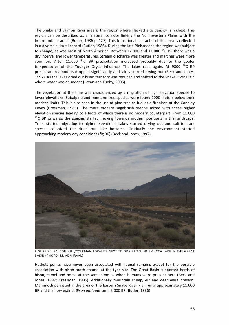
56
The Snake and Salmon River area is the region where Haskett site density is highest. This region can be described as a “natural corridor linking the Northwestern Plains with the Intermontane area” (Butler, 1986 p. 127). This transitional character of the area is reflected in a diverse cultural record (Butler, 1986). During the late Pleistocene the region was subject to change, as was most of North America. Between 12.000 and 11.000 14C BP there was a dry interval and lower temperatures. Stream discharge was greater and marches were more common. After 11.000 14C BP precipitation increased probably due to the cooler temperatures of the Younger Dryas influence. The lakes rose again. At 9800 14C BP precipitation amounts dropped significantly and lakes started drying out (Beck and Jones, 1997). As the lakes dried out bison territory was reduced and shifted to the Snake River Plain where water was abundant (Bryan and Tuohy, 2005). The vegetation at the time was characterized by a migration of high elevation species to lower elevations. Subalpine and montane tree species were found 1000 meters below their modern limits. This is also seen in the use of pine tree as fuel at a fireplace at the Connley Caves (Cressman, 1986). The more modern sagebrush steppe mixed with these higher elevation species leading to a biota of which there is no modern counterpart. From 11.000 14C BP onwards the species started moving towards modern positions in the landscape. Trees started migrating to higher elevations. Lakes started drying out and salt-‐tolerant species colonized the dried out lake bottoms. Gradually the environment started approaching modern-‐day conditions (fig.30) (Beck and Jones, 1997).
FIGURE 30: FALCON HILL/COLEMAN LOCALITY NEXT TO DRAINED WINNEMUCCA LAKE IN THE GREAT BASIN (PHOTO: M. ADMIRAAL)
Haskett points have never been associated with faunal remains except for the possible association with bison tooth enamel at the type-‐site. The Great Basin supported herds of bison, camel and horse at the same time as when humans were present here (Beck and Jones, 1997; Cressman, 1986). Additionally mountain sheep, elk and deer were present. Mammoth persisted in the area of the Eastern Snake River Plain until approximately 11.000 BP and the now extinct Bison antiquus until 8.000 BP (Butler, 1986).

57
3.3.3. DATING
The Haskett type-‐site was never dated as no datable material was found at the site. Butler (1965) initially estimated the age of the Haskett complex to 6500-‐5000 B.C. (Butler, 1978). Later this estimation turned out to be wrong after other Haskett sites were dated. On the basis of typological cross dating and stratigraphy the undated Haskett sites have been assigned the proposed timeframe based on the dated sites. Beck and Jones (1997) have suggested a time frame based on radiocarbon dates from various sites for Haskett spanning from 7.240 to 11.200 14C BP. This time frame corresponds well to the dates collected in this thesis (fig.31). A clear cluster is visible between approximately 10.800 and 9.800 14C BP. Most dates come from hearth contexts in association with Haskett points. In some cases it is not entirely clear whether there is an evident association with the projectile points or there might be discussion on whether the proposed Haskett points actually belong to the complex.
FIGURE 31: CALIBRATION CURVE OF THE VARIOUS HASKETT COMPLEX DATES. AS THE CALIBRATED DATA IS NOT USED IN THIS THESIS PLEASE PAY ATTENTION TO THE RADIOCARBON DETERMINATIONS ON THE Y-‐AXIS OF THE GRAPH (BRONK RAMSEY, 2009)
The dates used in the above graph come from the following sites: Bison and Veratic Rockshelters, Redfish Overhang, Connley Cave no.5B and Cougar Mountain Cave. The available dates from Owl Cave, Hatwai I, Sentinal Gap, Danger Cave and Coopers Ferry have been omitted from the graph because of doubtful projectile point determinations. These dates are available in table 4.

58
3.3.4. LITHIC TECHNOLOGY
ln his report about the Haskett site in Tebiwa (8-‐2), Butler (1965) distinguishes between two different Haskett type projectile points that were found at the site: type 1 and type 2 (fig.32). The Haskett type 1 point (e) is described as widest and thickest at the top end with a long tapering basal section that is usually edge ground. The Haskett type 2 point (h) is longer and heavier that the Haskett type 1. The widest point is located in the middle of the projectile point (Butler, 1978). The distinction of the two Haskett types has to be revised in my opinion. The distinctive design of the Haskett type 1 points seems to be the product of extensive resharpening of Haskett type 2 points (Stanford; Baker; Estes; Rasic, personal communication, 2012). The Haskett type 2 points are very long and therefore, more than a shorter point, subject to breakage. It seems logical that these type 2 points were resharpened after breakage as there was probably more than enough blade of the projectile point left after breakage. This process is also seen in Agate Basin points, which are also initially made very long in some cases and later resharpened after breakage. Because of this I will not distinguish between type 1 and type 2, unless to illustrate specific features that can only be seen in one of the two stages of use. However, most of the determined Haskett points are heavily resharpened specimens such as the one in figure 27. Paleoindians are perceived to have been highly mobile big game hunters and gatherers of plant resources. This view has also been applied in the Great Basin region, although there is not much evidence for either the connection of humans and megafauna or the use of plant resources in the area. If these people were highly mobile, a portable and flexible toolkit would have been essential to their existence. The tools must have had multiple uses, e.g. as projectile points but also knives etc. The choice in raw material must have been important because the tools might have been used for a long time having to undergo reworking multiple times. The use of bifaces would have been a good way to transport good quality stone. From these bifaces various tools could be manufactured such as projectile points. The raw material might have been pre-‐worked on a quarry site and then transported and finished when tools were needed. These were bifacial preforms rather than the larger and more heavy bifacial cores (Beck and Jones, 1997). There is not much evidence of earlier flaking sequences on Haskett points. At the Running Antelope site in Northern Utah over 200 obsidian flakes were recovered that might tell us something about the production stages of Haskett point manufacture. It seems however that this has not been studied or published yet (Russell, 1993). A refitting study of this material could yield interesting results. The final flaking sequence destroyed most of the evidence of earlier flaking sequences. Butler (1964) describes the points to be manufactured by pressure flaking. In the final stages the edges of the point were retouched by pressure flaking. These pressure flaking scars are very tiny. Finally the basal edges were ground to facilitate hafting. The flakes of the Haskett type-‐site are mostly derived from the process of point manufacturing. A few larger flakes might have been utilized as cutting tools. There also seems to be evidence for the use of heat treatment of the raw material. This is however based on only one large flake that has been struck from a heat-‐treated core (Butler, 1965).

59
FIGURE 32: HASKETT POINTS FROM THE TYPE-‐SITE (BUTLER, 1965 P.19). THE HASKETT POINT ON THE LEFT (H) PROBABLY HAS BEEN ERRONEOUSLY REFITTED (JEFF RASIC PERSONAL COMMUNICATION, 2012) At the Bonneville Estates Rockshelter site the obsidian and basalt used to manufacture Haskett or similar looking points came from sources ranging from 30 to 125 miles away (Repansbek, 2007). The raw material of the obsidian Haskett points of the Running Antelope site in Northern Utah have been traced back to Southern Utah’s Mineral Mountain. Some of the material of the site comes from Southern Idaho, to the north of the Running Antelope site and closer to the Haskett site (Dairy Creek, Wright Creek, Malad and Wildcat Hills). Russell (2003) concludes from these raw material source locations that the Haskett hunters most probably moved in a north-‐south/south-‐north line.

60
FIGURE 33: HASKETT WIDTH/THICKNESS RATIO'S. DATA WAS COLLECTED FROM: (BUTLER, 1965; BUTLER, 1967) AND ORIGINATES FROM THE HASKETT TYPE-‐SITE.
Haskett points are typically lenticular in cross-‐section. However, they can sometimes be diamond shaped in cross-‐section depending on thickness, width and presence of a clearly defined midridge. The average width/thickness ratio of the 11 Haskett projectile points of which measurements were available is 2.9. According to Stanford (personal communication, 2013) the projectile points probably started out diamond shaped in cross-‐section. As the points were reworked the ridges in between the former flake scars might have functioned as platforms for new flaking. As the point is reworked it becomes thinner and thus more lenticular in cross-‐section. At the Haskett site only 22 specimens of Haskett points were found of which 8 were complete. The points have a well-‐defined and recognizable basal section that tapers into a convex base. Most of the bases are edge ground from the widest part of the point down to the base (Butler, 1978). An important question was asked in the thesis of Lafayette (2006). What was the function of Haskett points? We are assuming that these points were used as projectile points on either spears or atlatl darts, while they are too big to have been used as arrow points. Lafayette (2006) conducted an experimental study in which she employed use-‐wear analysis on freshly made points that were used as projectile points to stab a deer carcass. The results of her research showed that Haskett points are quite inefficient projectiles. They bounce of as they hit the target and many of the prehistoric samples she examined did not show the expected use-‐wear after use as a projectile point. However, Lafayette acknowledges that the points were perhaps differently hafted from her split-‐shaft technique. A socketed shaft haft might have changed the results. Haskett points were probably better hafted in a socketed shaft. The shape of the basal section of the point is essential here. Haskett is too thick and narrow to be hafted in a split-‐shaft. Additionally the experimental specimens were much wider than the Haskett type-‐site specimens. This might also have influenced the efficiency of use as a projectile. Lafayette also concluded that Haskett points were inefficient as knives because of

61
the short blade. Perhaps this is true for the heavily resharpened Haskett points (type 1), the longer, less extensively resharpened specimens do have long enough blades and were perhaps also more efficient as projectile points. Beck and Jones (1997) cite Musil’s (1988) four criteria for an efficient projectile points: 1) a sharp point, 2) sharp blade edges, 3) a haft element that will absorb the force caused by impact while doing minimal damage to the shaft, and 4) an overall haft design that minimizes point damage that allows for the reworking of the point after breakage. (Beck and Jones, 1997 p.202; Musil, 1988 p.374). This emphasizes the importance of hafting, this is a subject that is not well analysed. Haskett points do have sharp tips, although the extensively resharpened specimens might be a little more blunt, and the points have sharp blades, again with the exclusion of the resharpened ones which have very short, but still relatively sharp blade edges. Stanford (personal communication, 2013) also disagrees with Lafayette’s conclusions and states that Haskett projectile points will go right through a live deer when thrusted appropriately. Beck and Jones (1997) acknowledge that Haskett is the only type of the Great Basin stemmed series that meets the criteria of an efficient projectile point. They also argue that the Haskett technology might be quite distinct from the other Great Basin stemmed points (e.g. Cougar Mountain, Parman, Lake Mohave, Silver Lake types, etc). Hafting in the case of Haskett points would be most efficient in a socketed shaft. The shape of the stem is more appropriate for this kind of hafting. This technique would have given most stability and resist breakage on impact. Because of the large portion that is hafted into the socketed shaft this entire section can absorb force while protecting the haft (Beck and Jones, 1997; Mussil, 1988). I adopt the notion of socketed hafting for Haskett points, especially because of Lafayette’s (2006) unsuccessful experiments with hafting Haskett in a split-‐shaft. It should however be kept in mind that there is no available evidence for the hafting of Haskett points and so conclusions are drawn from the projectile point morphology.

62
3.3.5. ASSOCIATED LITHIC ASSEMBLAGES
At the Running Antelope site in Northern Utah scrapers, utilized flakes and a flake knife were found in association with Haskett points (Russell, 1993) (fig. 34).
FIGURE 34: SCRAPERS (A-‐C), FLAKE KNIFE (D) AND UTILIZED FLAKE (E) FROM THE RUNNING ANTELOPE SITE (RUSSELL, 1993)
There is not much published about the associated toolkit of Haskett points. Beck and Jones (1997) discuss the general toolkit of Great Basin stemmed points and name various tools such as: knives, gravers, scrapers and spokeshaves but also crescents, manos and matates. It is unclear however whether these tools were found associated with Haskett points or if they are referring to other types. Especially crescents, manos and matates seem to have been tools of archaic age, e.g. after 9.000 14C BP, and are thus of less interest to this thesis. Basketry has been recovered from various sites in the Great Basin area. Even though basketry was never associated with Haskett points in context the first appearance of woven material was dated to 11.25014C BP at the Winnemucca Lake basin (fig.30).

63
3.3.6. SITE CHARACTERISTICS AND INFERRED ACTIVITIES
Most of the sites containing Haskett points are located in caves or rockshelters. The type-‐site seems to be an exception to this ‘rule’ as it was located in a Pleistocene dune field. Most of the sites seem to be campsites. At the Haskett type-‐site very few faunal remains were discovered. A few pieces of tooth enamel that Butler (1965) believed might have belonged to bison were found. There were also no cultural features preserved at the type-‐site. Luckily some of these other sites have provided some clues about the life of Haskett hunters. Russell, (1993) states that the Running Antelope site in Northern Utah was a prehistoric camp site on a low beach terrace of ancient Lake Bonneville. The amount of broken Haskett bases, flakes, scrapers and utilized flakes might also indicate that this was a processing camp with a kill site nearby. No mention was made of faunal remains at the site though. At Redfish Overhang a cache was found with Haskett points associated with hearths that were radiocarbon dated. Here too, faunal remains were lacking (Russell, 1993; Troll and Hackenberger, 1998). At the Bonneville Estates Rockshelter various hearths and associated remains were discovered. It is possible that a couple of the recovered projectile point fragments represent Haskett. This cannot be said for sure however as no complete points were found. This site provides a nice peek into Paleoindian subsistence strategies. In stead of the large extinct megafauna, that is usually expected at Paleoindian sites, at this site a variety of smaller mammal remains was found amongst which: bighorn sheep, pronghorn, mule, deer and sage grouse. It has even been suggested that the prehistoric inhabitants of this site ate grasshoppers. Surprisingly no waterfowl remains were found, which is very common in the Great Basin area (Repansbek, 2007). There is not much evidence for big game hunting in the Great Basin area but because projectile points were found here the connection to big game hunting was assumed from the Great Plains where these two go hand in hand (Bryan and Tuohy, 2005). At the Running Antelope site studies have been done on the fractures on the Haskett points. Many of the observed fractures were due to impact of hafted points. Some of the fractures were also caused by faulty percussion flaking (Russell, 2004). These results emphasize the use of these tools as projectile points.

64
3.3.7. COUGAR MOUNTAIN
Haskett and Cougar Mountain points have strong similarities and are sometimes found together, as at the Cougar Mountain Cave site. Both point types are lanceolate in form and have contracting stems. Flaking is the same (Beck, 1988). The biggest difference between the two types is that Cougar Mountain has shoulders and Haskett does not. As a result the stem of both points is very similar (though Cougar Mountain bases are more rounded than the usually more straight Haskett bases. The blade of Cougar Mountain points is much wider than Haskett blades (fig.35).
FIGURE 35: COUGAR MOUNTAIN POINTS FROM COUGAR MOUNTAIN CAVE (LAFAYETTE, 2006: P.51)
While Haskett points seem to be confined to the Northern Great Basin and Columbia Plateau region, Cougar Mountain points also occur in the Western and central Great Basin area as well as in the north where the density is highest (Beck and Jones, 1997). In other words, Cougar Mountain points were more widespread and numerous than Haskett points. Cougar Mountain points were dated to 9.920 – 7.080 14C BP (Beck and Jones, 1997). This indicates that Haskett and Cougar Mountain were contemporary for at least 1500 years but Haskett is older than Cougar Mountain. However, this contemporaneity may reflect “…the beginning of a new technology and the waning of an old one” (Beck and Jones, 1997) (p.197).
Cougar Mountain points are younger than Haskett and persisted longer in time. The stem of these points is sometimes hard to separate from Haskett bases, especially when the shoulders of the Cougar Mountain point are lacking. This can lead to faulty determinations. I have experienced this during my analysis of the Fire Creek site projectile points at the WCRM Inc. in Reno, NV. The differences between the two types are small in the stems but the adding of a shoulder gives the projectile point a distinctive appearance. Perhaps even a bit similar to Hell Gap points of the Great Plains.

65
3.4. EL JOBO
The El Jobo projectile point type was named after the village in which vicinity the points were first discovered by Dr. José M. Cruxent of the Universidad Central de Venezuela in 1956 (Cruxent, 1956). What is referred to as the El Jobo type-‐site is actually a number of seven sites in the area of the village of El Jobo in Northern Venezuela. These sites yielded surface finds and have not been extensively excavated.
FIGURE 36: TAIMA-‐TAIMA SITE (OLIVER, 2013)
The El Jobo projectile point discovery was important because it was the first find in South America that could be compared to the Paleoindian complexes of North America and it was suggested that the El Jobo complex descended from the north (1962a; Cruxent, 1956; Rouse and Cruxent, 1957). In the very first publication where the find of the points was announced (Cruxent, 1956) comments were made on the find by Irving Rouse, H. Marie Wormington, E. Mott Davis and Alex D. Krieger. These respected archaeologists immediately compared the El Jobo points to projectile point types of North America. E. Mott Davis even compared the El Jobo points to Agate Basin points and compared the associated tool kit to that of the Basin and Plateau area where Haskett occurs. In 1962 Jose Cruxent presented the find of a complex of crude tools, the Manzanillo complex. Though lacking any projectile points he linked the find to the El Jobo complex because the crude tools were similar (Cruxent, 1962b). In 1963 Cruxent announced the discovery of the Muaco site some 80 km from El Jobo. An El Jobo point was found in situ associated with mastodon bones that dated 16.000 to 14.000 14C BP. However, the association of the point and the bone of the extinct animal was questioned because of the nature of the site, a water-‐hole and the might have been disturbed by spring action (Rouse and Cruxent, 1963a).

66
In 1962 excavations started at Taima-‐Taima (fig.36). The critics were very skeptical about the results of the previous mentioned sites and this continued with the Taima-‐Taima site (Gruhn and Bryan, 1991; Lynch, 1974). The presence of humans in association with a Mastodon kill seemed evident to the excavators but it was not until 1976 that the undisputable evidence was unearthed. A fragment of an El Jobo projectile point was discovered within the cavity of the right pubis of a juvenile mastodon that was evidently butchered there (Bryan et al, 1978). This made the Taima-‐Taima site one of the most important discoveries of the mid-‐twentieth century. Cruxent called the results conclusive, a mastodon was butchered at Taima-‐Taima by humans some 13.000 14C BP. The Taima-‐Taima site was of major importance because at the time it was the first definite mastodon kill-‐site as well as the earliest and most securely dated proboscidean kill-‐site in the Americas (Bryan, 1979). In later years a few other sites containing El Jobo points were discovered.
3.4.1. DISTRIBUTION
El Jobo points are found exclusively in Northern Venezuela in the vicinity of the coast or major waterways, an area that is believed to have been uninhabited before the arrival of El Jobo. Figure 37 shows the location of the few sites that yielded this point type. The El Jobo type-‐site (1) is located in the State of Falcón and consists of 7 small find locations on different topographic levels. Many sites (45) were located on the uppermost, upper middle, lower middle, and lower terraces of the Rio Pedregal river (Cruxent, 1956; Rouse and Cruxent, 1963b). The Manzanillo site (6), that yielded no projectile points, was located on the west side of Lake Maracaibo and Cruxent believed that the El Jobo hunters must have passed this way while they were moving eastward (Cruxent, 1962b).
FIGURE 37: DISTRIBUTION OF EL JOBO ARCHAEOLOGICAL SITES (NUMBERS CORRESPOND TO TABLE 4)
The Muaco site (2) is located some 80 km from the El Jobo type-‐site. The site is situated at a spring that attracted both animals and humans. The Taima-‐Taima site (2) is located 3 km north of the Muaco site and is similar to Muaco in that it is also a water hole site (Bryan et

67
al, 1978; Cruxent, 1979). The El Vano site (5) is located at the feet of the Andes mountain range in Western Venezuela (Quero, 2005) and is set in a aquatic depositional setting (Quero, 1998). The Cucuruchu site (4) is located in a side canyon, in an arroyo like feature near the sea and close to Taima-‐Taima. Beside these sites there are several surface sites on the terraces along the Rio Pedregal. The Taima-‐Taima, Muaco and Cucuruchu sites are all located in hilly terrain (Gruhn and Bryan). A total of 7 sites (not counting any unpublished surface sites) is not a lot. Luckily the Taima-‐Taima site has yielded information about the El Jobo hunters and so do later studies of the projectile point technology. The question whether the projectile points of the Monte Verde site in Chile belong to the El Jobo complex is difficult to answer and will be discussed in chapter 3.4.7. TABLE 5: EL JOBO SITES, LOCATIONS AND 14C DATES
Nr. Site name Point type Coordinates 14C Date 1 El Jobo El Jobo 9.698905,-‐69.86721 not dated 2 Taima-‐Taima El Jobo 11.499249,-‐69.522219 13.000 2 Muaco El Jobo 11.481749,-‐69.544959 16.000-‐14.000 3 Sanjon Malo El Jobo 11.057125,-‐70.094147 not dated 4 Cucuruchu El Jobo 10.359502,-‐69.257812 not dated 5 El Vano El Jobo 9.62783,-‐67.044067 10710-‐7400 6 Manzanillo Crude tools estimated location not dated
3.4.2. ENVIRONMENT
Information about the late Pleistocene environment and climate of Venezuela is not abundant. At present Venezuela has a tropical climate with a mean annual temperature of 24.7 °C. The temperature remains more or less constant throughout the year with variations no larger than 2°C. Daily temperature variations are 10°C (Rull et al, 2009). Precipitation varies as Venezuela has a typical biseasonal climate; general precipitation in a year is 1046 mm. The rainy season occurs from approximately April to October, during the other months it can get very arid with precipitation levels of approximately 10mm a month. Precipitation can also vary on an interannual scale due to the influence of El Niño and La Niña events. The vegetation varies but for the area of interest here it can best be described as an herbaceous savannah with different species of cacti and shrubs (Rull, 1996). The northern part of the Andes extends into Venezuela and this causes the country to have different climate regions and vegetation zones. At lower levels savannahs are found with semi-‐deciduous forests. At higher elevation a fringe of transitional forest is present. Even higher the famous Cloud Forests are found with many species of plants and animals. At the highest elevation shrubs dominate the vegetation. Along the Northern coast mangroves are present with an evergreen forest fringe along the coastline. In the west thorn woodlands dominate the environment with xerophytic communities such as cacti species (Rull et al, 2009). The area of interest here is located north of the Andes and close to the coastline and has many low elevation ridges and gorges (Oliver, 2013).

68
FIGURE 38: TAIMA-‐TAIMA SITE SETTING (KUNZ AND BAKER, 2011)
The LGM in Venezuela occurred from approximately 21.000 to 18.000 14C BP, temperatures dropped 7°C compared to the present. During the Last Glacial, glaciation was present in the Andes of Venezuela until approximately 13.000 14C BP. This period is referred to as the Mérida Glaciation and is characterized in Venezuela by high aridity. This aridity lasted until 10.500 14C BP at Lake Valencia where studies of the environment and climate were conducted. Lake Valencia lies approximately 200 km east of the Taima-‐Taima site, however the present environment seems similar (Rull, 1996). In the direct proximity of the lake tree pollen are low and it is indicated that sparse grasslands and saline marsh vegetation covered the area. In the area of El Jobo occurrence there is evidence of a more humid climate than at present with expanses of forests separated by grasslands. Ideal conditions for large grazers such as mastodon (Rouse and Cruxent, 1963b). The existence of a Younger Dryas event in Venezuela remains under discussion although evidence of such an event has been found at the Cariaco Basin with temperatures 3-‐4 °C lower than at present and much dryer conditions (Rull et al, 2009). The Late Glacial started at 13.000 14C BP and shows a general deglaciation trend with small stadial and interstadial oscillations. From 12.600 to 12.200 14C BP there was a cold interval with a decrease of 3°C in temperature. Then the temperature increased with 5°C until circa 11.900 14C BP after which temperatures dropped again with 2/3 °C until 11.100 14C BP. From 10.000 14C BP onwards the dry climate became wetter and started resembling the present climate and environment (Rull, 1996). During the early Holocene (10.000 – 8.200 14C BP) precipitation increased and as a result tree and grass pollen become more abundant. Whereas the fauna of Venezuela nowadays mainly consists of goats introduced by the Spaniards, during the late Pleistocene various extinct species roamed the area such as: mastodon, megathere, glyptodont, horse, tortoise and macrauchenia (Gruhn and Bryan). There is mention of the presence of bison as southern as the Valsequillo region in Mexico but not in Venezuela (Gonzalez et al, 2006). In contrast to North America there is not much known about the extinction of megafauna in Northern South America. Overall there are few

69
young dates for mastodon in South America. Possibly the youngest is the one related to the El Jobo projectile points at Taima-‐Taima. Barnosky and Lindsey (2010) discard the Taima-‐Taima dates and suggest that mastodon was already extinct before the arrival of humans to the continent. However, the association of the El Jobo tools at the Taima-‐Taima site, together with the radiocarbon dates and marks of butchering on the bones proves that this was not the case. The megafauna extinction in South America coincides with climatic change but it took much longer than in North America. Only at the beginning of the Holocene much of the megafauna had died out. Some species lasted longer than others among which the megathere, (Barnosky and Lindsey, 2010) which was also found in association with El Jobo points at the Muaco and El Vano site (Quero, 1998; Rouse and Cruxent, 1963a). It is likely that megafauna such as mastodon were already at the verge of extinction during the El Jobo occupation. Mastodon did not thrive well in arid environments (Ficcarelli et al, 1997) and perhaps during the El Jobo occupation they became extinct in the region due to the high aridity in combination with predation by the El Jobo hunters.
3.4.3. DATING
The first dated El Jobo site was the waterhole of Muaco where burned bone was dated to 16.375±400 and 14.300±500 14C BP. These dates were dismissed by critics as being way too old. The site was also questioned because of contextual and stratigraphic issues (Rouse and Cruxent, 1963a) but also because such an early South American date was highly unexpected. As a result, more proof was needed of the antiquity of El Jobo projectile points. The radiocarbon dates of the earlier excavations at Taima-‐Taima were fiercely debated by New World archaeologists. It was said that there might have been old carbon in the ground water, however this would have yielded several dates of approximately the same age, which was not the case (Bryan, 1975; Haynes, 1974). After the 1976 excavations of the site, Taima-‐Taima site was described by Bryan and Gruhn (1979) as “the best dated kill-‐site in America” (p.53). The association of the mastodon and the projectile points was dated on wooden twigs that were probably from the content of the animals’ stomach. The layer in which the mastodon remains were found has been continuously waterlogged since deposition and therefore preservation was good. These twigs yielded 4 radiocarbon dates (table 2) ranging from 12,980±85 to 14.200±300 14C BP (Bryan et al, 1978; Gruhn and Bryan). These dates are not the only dates from the site but they are the dates that are closely associated with the butchered mastodon remains. Additionally eleven dates were obtained from the various stratigraphic layers that showed a consistent range of dates. The layer overlying the mastodon carcass was securely dated to 10.200 – 9.800 14C BP and thus provided a minimum age for the kill site (Bryan and Gruhn, 1979; Dillehay, 2000). In total 27 radiocarbon dates were obtained from the Taima-‐Taima site of which only three were inconsistent (Bryan and Gruhn, 1979). It was not just the radiocarbon dates that proved the antiquity of the site. The association of the El Jobo projectile point with the skeleton of an extinct animal, which additionally showed signs of butchering, was an important indicator of the age of the site. TABLE 6: TAIMA-‐TAIMA RADIOCARBON DATES (BRYAN, ET AL., 1978)
Lab. number Radiocarbon date SI-‐3316 12.980±85 Birm-‐802 13.000±200 USGS-‐247 13.880±120 UCLA-‐2133 14.200±300

70
FIGURE 39: CALIBRATION CURVE FOR THE RADIOCARBON DATES OF THE EL JOBO COMPLEX. AS THE CALIBRATED DATA IS NOT USED IN THIS THESIS PLEASE PAY ATTENTION TO THE RADIOCARBON DETERMINATION ON THE Y-‐AXIS OF THE GRAPH. DATA COMES FROM THE MUACO, TAIMA-‐TAIMA AND EL VANO SITES (BRONK RAMSAY, 2009).
The only other radiocarbon dated El Jobo site is the El Vano site. Here also, the butchered bones of an extinct animal (megathere: giant ground sloth) were found in association with tools. The bones were dated by AMS but the results were dismissed as not trustworthy because of the low collagen levels left in the bones. The most reliable date was the oldest: 10.710±60 14C BP but it was considered a minimum age because all other signs pointed to a greater antiquity. Results correspond well with other El Jobo sites and so the age of this site has been assumed to be similar to that of Taima-‐Taima (Quero, 1998).

71
3.4.4. LITHIC TECHNOLOGY
During the period of discovery of the El Jobo complex it was compared to other Paleoindian bifacial projectile point technologies amongst which Clovis. The main thing that was strikingly different between the two technologies was that Clovis was made to be as thin as possible while El Jobo seemed to have been desired as thick as possible. Sometimes the points are almost as thick as they are wide (fig.40). This feature, together with the lanceolate/leaf-‐like shape of the projectile points makes them comparable to Mesa/ Sluiceway, Agate Basin and Haskett points. El Jobo is relatively the thickest of the points discussed in this thesis (Bryan, 1979). The average width/thickness ratio of the 15 El Jobo points that were measured is 2.4. Only a few of the measured specimens have ratios greater than 3. Bryan (1979) suggests that the thickness of the points makes them much stronger but he indicates that the main reason of the great thickness is because the points were hafted in a socketed shaft.
FIGURE 40: EL JOBO WIDTH/THICKNESS RATIOS. DATA WAS COLLECTED FROM THE EL JOBO TYPE-‐SITE (NAMI, 1994) AND FROM THE TAIMA-‐TAIMA SITE (CRUXENT, 1979)
Ethnographic studies in South America show that most indigenous peoples do not use stone for their projectile points. Most projectile points are made out of wood and/or bone. These points are generally hafted in socketed shafts and it is possible that El Jobo hunters maintained the same strategy when working with stone (Bryan, 1979). Four phases of El Jobo point manufacture are described by Cruxent (1979). First a long flake is struck by percussion to be used as a preform. The preform is then roughly trimmed by percussion flaking. Shaping of the point is done by percussion retouch and finally the edges are shaped by a more delicate edge retouch.

72
FIGURE 41: EL JOBO PROJECTILE POINTS (KUNZ AND BAKER, 2011)
Cruxent (1979) describes El Jobo as made on long, narrow flakes. The points are generally made of quartzite sandstone. A material that is difficult to flake. The medium size of an El Jobo point is: 105 mm length, 20 mm width and 10 mm thick. Depending on the thickness of the point the cross-‐section is lenticular (with thinner points) or diamond shaped (with thicker points). A moderate midridge is often visible (Cruxent, 1979). The tip of the projectile point is sharp and pointed while the base is relatively blunt. This differs among points; some have straight and sometimes even concave bases while others are nearly bipointed. The blunt bases of the projectile points are explained by Cruxent as the result of a striking platform of the flake that was used as a preform for the point, the base of the point is this platform (Cruxent, 1979; Cruxent, 1956). Flaking of the point was done by percussion flaking, probably direct with a hammerstone. Surfaces are chipped coarsely. The edges are straightened by fine percussion retouch and even finer micro retouch that was done by pressure flaking. While this technique can lead to very straight and neat edges with El Jobo points the edges are sometimes slightly serrated (Rouse and Cruxent, 1963b). This fine retouch of the edges does not necessarily make the edges sharper but it is necessary to obtain good symmetry in the tool which gives the projectile a more direct flight and easier penetration (Cruxent, 1979). Beside these functional aspects I also believe that symmetry adds to the beauty of the point, which I believe is an aspect that also prehistoric people were not indifferent about. The variety seen in El Jobo projectile points is, according to Cruxent (1979), due to the individuality of the different flint knappers.

73
FIGURE 42: EL JOBO MIDSECTION WITH SERRATED EDGES (PHOTO: MOJAVE, WWW.ARROWHEADOLOGY.COM)
3.4.5. ASSOCIATED LITHIC ASSEMBLAGES
The flake tools at the Taima-‐Taima site, primarily cutting tools and scrapers, were made on chert flakes. According to Cruxent (1979) the tools look like they were meant for wood working or the manufacture of basketry, not cutting meat. These tools could however have been used for the cutting of nerve cords or tendons as well as skinning and other butchering tasks. The knife found at the Taima-‐Taima site might very well have been hafted which the proximal end facilitated (Cruxent, 1979). Beside these tools there were tools that Cruxent (1979) refers to as ‘tools of expediency’. These tools were probably manufactured on-‐site. They were probably improvised in the moment because of a lack of tools. These tools are slightly modified rocks and are mainly primitive and crude. One might not expect to find these kinds of tools associated with bifacial projectile points however, according to Cruxtent (1979) they are connected. Most of these tools were probably used as axes. There were also two possibly hafted implements that might have been used for cutting meat, as weapons or as bone cleavers. These tools show light to heavy retouching and the use of notches to tie the rope to the haft (Cruxent, 1979). The use of side notches is very interesting because this shows that the El Jobo hunters knew the advantages of a hafting technique using side notches, by many referred to as a superior hafting technique. However, they chose not to use this technique on their projectile points.

74
FIGURE 43: TOOLS ASSOCIATED WITH EL JOBO POINTS (PERFORATING TOOL, PLANO-‐CONVEX SCRAPER, BLADE, HAND AXE) (OLIVER, 2013)
The Taima-‐Taima site also yielded bone artefacts. A long bone fragment was worked on two edges and might have functioned to skin the animal and cut meat. Two pointed bones were found, possibly used for butchering as well as a bone knife suitable for cutting meat. Another interesting find at the Taima-‐Taima site was an anvil (Cruxent, 1979). At the El Vano site two utilized flakes were found together with a chopper, rounded pebble and a scraper. Interestingly ‘bone retouchers’ were found made out of long dental roots (Quero, 1998). At the Manzanillo site at the Western coast of Lake Maracaibo crude tools were discovered that resemble the tools that are found associated with El Jobo projectile points. These tools are mainly choppers and scrapers made of silicified wood. The tools are so crude that they are hard to distinguish. There were unifacial ‘turtle back scrapers’ and side scrapers as well as bifacial choppers, hand axes, knives and handplanes. Additionally there are indications for the use of anvils because of the presence of a opposed percussion bulb on some flakes (Cruxent, 1962a).
3.4.6. SITE CHARACTERISTICS AND INFERRED ACTIVITIES
It is notable that at least two El Jobo sites are waterholes or spring localities that probably attracted both animals and humans. It might be that these were the localities where the animals were ambushed. It could however also mean that the animal was wounded elsewhere and then tracked as it lost strength. A wounded animal can be expected to look for water (Gruhn and Bryan, 1989). Either way, El Jobo sites seem to be associated with aquatic settings. El Jobo projectile points are actually quite rare at the Taima-‐Taima site, as they are at the other excavated sites. Most El Jobo points come from the surface sites of the Rio Pedregal terraces (Oliver, 2013). In some cases one edge of the projectile point has been worked with more detail than the other edge. This has led Cruxent (1979) to believe that these specimens might have also, or exclusively, been used as knives.

75
El Jobo sites can generally be described as kill-‐sites. At the kill-‐site some butchering also occurred before the chosen remains of the animal were transported to a base or camp site nearby. This is proven by the presence of animal remains with cut marks and other butchering traits (Rouse and Cruxent, 1963a). At the El Vano site different areas were used to butcher the different parts of the carcass of the giant ground sloth (Quero, 1998).
3.4.7. MONTE VERDE: AN EL JOBO SITE?
The Monte Verde site was discovered in 1976 and excavations were started by Tom D. Dillehay in 1977. The site was special because of the astoundingly good preservation of organic remains. The site yielded various interesting finds that had not been preserved as well anywhere in the Americas. Among the finds were stakes and poles of a tent structure, hearths, mortars and grinding stones, meat and mastodon bones, footprints in the clay, crude stone tools and bifacial projectile points. The site was firmly dated to 12.800 – 11.800 14C BP (Dillehay, 1997; Dillehay et al, 2008).
FIGURE 44: POINTED TOOL FROM THE MONTE VERDE SITE, CHILE (WWW.ELE.NET)
Monte Verde’s projectile points have been connected to El Jobo with caution (Dillehay, 1999; Kunz and Baker, 2011). Projectile points were very rare at the Monte Verde site, only two fragments were found. Dillehay has not paid much attention to them because they seemed of lesser importance when compared to the other finds at the site (Dillehay et al, 1999). In the first volume of Dillehay’s book about the site: Monte Verde, a Late Pleistocene Settlement in Chile (Dillehay, 1989) he only mentions the proposed projectile points shortly and defines them as: “… large bifaces made of exotic basalt and quartzite” (p.15). Dillehay (1989) describes the lithic technology with which these points were made as “pecked-‐ground stone technology” (p.15) and in another publication (Dillehay, 1999) he describes this as: “The piece has been pecked and ground into a perforating-‐type tool” (p.212). With only these descriptions to work with I will draw my own conclusions from the available data. The shape of the Monte Verde projectile point could fit the El Jobo type although it is more pointed than El Jobo (fig. 44). Conclusions about the width/thickness ratio are impossible to draw from this photograph. Because of the nature of the raw material it is hard to see flaking on this picture. Because Dillehay (1989) describes the point as being worked with a pecked-‐ground technology I believe there are very few characteristics that these point types have in common. On top of that the distance between the El Jobo region and the Monte Verde site location is very large (approximately 6000 km) and has yielded no similar stone tool technologies. Additionally the El Jobo complex dates to approximately the same age as Monte Verde, which makes the chances of a connection through migration even less likely. Therefore I reject the connection between Monte Verde and El Jobo based on the limited evidence presented here.

76
4. COMPARISON
When comparing the four projectile point complexes it is important to keep possible biases in mind. Biases can occur because of different methods of excavation and research, different times of excavation and differences in paradigmatic background of the different scientists. The Mesa site was tested in the years following its discovery in 1978, major excavations were conducted from 1991 to 1999 (Kunz and Reanier, 1994). The Agate Basin site was first discovered and excavated in 1959 but was more thoroughly studied in the end of the 1970s (Frison and Stanford, 1982). The Haskett site was excavated in the 1960s. Descriptions of the Haskett points were first published in 1964 (Butler, 1964). The El Jobo assemblage was first described in 1956 (Cruxent, 1956). Excavations at the Taima-‐Taima site started in 1962 and were under discussion until the mastodon find in 1976 (Bryan et al, 1978). After these initial discoveries of the different complexes several other sites containing these projectile point types were discovered and studied. Does a bias exist in research intensity between the four complexes? The Haskett site was excavated in the 1960s and no further research was done in later years. All other type-‐sites have undergone research during the late 1970s, the Mesa site was thoroughly studied in the 1990s. During the 1970s a lot of focus was on the typology of projectile point complexes and stratigraphy (Beck and Jones, 1997; Bryan, 1980; Bryan and Gruhn, 2003). Later studies have yielded more information about lithic technology, environment and site functions. New sites were discovered during the years and new information became available, this also goes for Haskett, where initially relatively little information was obtained from the type-‐site. Generally all these complexes have been studied continuously during different periods of time. The Mesa and Agate Basin complexes have been extensively studied and much information is available on the lithic technology, environment and other aspects that are discussed in this study. Haskett as a single type has not been studied as well. As mentioned before, the point type was categorized under the name Great Basin Stemmed Points, together with other point types. Although there is quite a lot of literature available on the subject this literature is often very general in orientation and lacks detailed studies of lithic technology. The El Jobo point type has not been as extensively studied as Mesa and Agate Basin. This is mainly because of the scarcity of sites and relatively small amount of projectile points that were found at these sites. So when comparing the four complexes it is important to keep in mind the reliability of the sample, which in this case is biased to some degree. The Mesa and Agate Basin complexes have yielded hundreds of projectile points while there are only tens of Haskett and the El Jobo type. This creates a bias especially with respect to El Jobo of which the lithic technology was not well studied. Additionally not all the El Jobo literature is available to non-‐Spanish readers. General remarks are available concerning the lithic technology but because the sample is relatively small these characteristics might vary and are thus not as reliable as with Mesa and Agate Basin.

77
4.1 DISTRIBUTION
The four projectile point complexes that were described in the previous chapter have a wide distribution across the Americas. Mesa is found on the Northern Brooks Range of Alaska. Agate Basin is distributed on the Northern Great Plains, Haskett is found in the Northern Great Basin area and El Jobo is found in Northern Venezuela. All these complexes are found over relatively large areas that have distinguishable environmental traits.
FIGURE 45: DISTRIBUTION OF SITES CONTAINING THE FOUR PROJECTILE POINT TYPES

78
When looking at the distribution map (fig. 45) two large geographical gaps stand out. The first area where no comparable projectile points were found is the land that was covered by the Cordilleran and Laurentide ice-‐sheets during the last Glacial. The presence of the ice-‐sheets easily explains the lack of sites in this region. Sites could be expected in the area of the ice-‐free corridor. However, sites dating to our period of interest (13.000 – 10.000 14C BP) are hardly ever found in the ice-‐free corridor. An obvious explanation for this lack of sites is the extensive erosion and deposition of sediments that the melting of the ice-‐sheets induced. Sites may have been lost entirely or are buried under extensive layers of sediment and are thus almost impossible to locate (Dixon, 2011). The other area that lacks sites is Mesoamerica. When envisioning a migration of people or a diffusion of technological knowledge, one would expect to find comparable sites in Mexico and the Isthmus of Panama. When the El Jobo complex of Venezuela was just discovered, the El Jobo projectile points were compared by Marie Wormington (Cruxent, 1956) to points found at the Santa Isabel Iztapan site in the Valley of Mexico (Aveleyra A. de Anda, 1956). However, judging from the photograph displayed in figure 46 the width/thickness ratio deviates considerably from the thick-‐bodied lanceolate projectile points discussed here. According to Dr. Jeff Wilkerson, director of the Institute for Cultural Ecology of the Tropics in Mexico, no similar projectile point types of this age exist in Mexico to his knowledge (personal communication, 2012). Stanford (2006) mentions the Hueyatlaco site in Puebla, Mexico containing 11.000 14C BP dated artefacts with similar flaking (fig.47) (Irwin-‐Williams, 1967). The biface displayed here does show collateral flaking but judging from the photograph it shows no clear similarity in shape to El Jobo, Haskett or Agate Basin.
FIGURE 46: SANTA ISABEL IZTAPAN BIFACES (AVELEYRA A. DE ANDA, 1956)
FIGURE 47: BIFACE FROM UNIT E, HUEYATLACO SITE IN PUABLA, MEXICO (PHOTO: JOE GINGERICH)

79
In shape it is most comparable to Sluiceway although it still lacks a finished projectile point shape. It is possible that this biface is a preform for a projectile point but it is hard to say what kind of projectile point it might have become when finished. Without finished projectile point finds I cannot use this site as a connection between El Jobo and Haskett. Both Bryan (1979) and Barton (2004) suggest the presence of projectile points similar to the Paleoindian type and El Jobo on the Isthmus of Panama. Pearson and Cooke (2002) describe two fragments of typical El Jobo points from the La Yeguada Lake site in Panama. I have however not been able to find photographs or drawings of these proposed El Jobo points. Further research is necessary in this area.
The regional geographical type of sites of the four discussed complexes differs but has similar purposes. Mesa sites are found on high places. These sites were probably observation spots where hunters could scan the environment for migratory herds of animals. Agate Basin sites are generally located in geographical trap features where bison would be enclosed and killed, another part of the process of hunting. Haskett points are found in several different settings but mostly in rockshelters and caves. El Jobo points are found in water-‐rich environments such as springs and are generally associated with extinct faunal remains that show butchering marks. Mesa, Agate Basin and El Jobo have in common that all their sites are somehow associated with the act of hunting. For Haskett this has not been proven. Site functions will be discussed in chapter 4.6. The question whether this pattern of site distribution provides a reliable insight into the activities of these prehistoric people is of interest here. I suggest that for all four complexes this is not the case. For the Mesa complex we are missing basecamp sites as well as kill sites (Kunz et al, 2003). Of Agate Basin short term camping and processing sites have been discovered close to the actual kill site. However, no basecamp sites or observatory sites have been discovered (Frison and Stanford, 1982). For Haskett we are missing kill-‐ and processing sites that are to be expected considering the use of large projectile points. There are no campsites of El Jobo described in the literature. The animals seem to have been butchered and processed on the kill site at different use areas (Bryan et al, 1978; Cruxent, 1979). The density of sites as well as the location of raw material sources is also of importance. The highest density of Mesa sites is in the Northeastern Brooks Range. The presence of sites seems to feather out from there to the east, north and south. At the Mesa site a scarce amount of raw material from the Batza Tena source some 320 km further to the south was found indicating that these people were either traveling as far south or were in contact with other people from the south. Agate Basin sites are concentrated in the Northern Great Plains region, also referred to as the High Plains. Agate Basin is also found further south and in lower numbers in the Rocky Mountains and the Canadian Arctic. Raw material is generally extra-‐local. Sources are mostly found further to the south with the exception of material from North Dakota at the Agate Basin type-‐site. Haskett is mostly found in the Northern Great Basin and Columbia Plateau area. Raw material from the Running Antelope site was traced back to both southern and northern locations. The occurrence of sites seems to feather out towards the Northwest. El Jobo sites are evenly distributed throughout Northern Venezuela. There does not seem to be a pattern here as there is with the other complexes where one can see a high and lower density of sites in a specific region. El Jobo points are made of local raw material and seem to be confined to Northwestern Venezuela. It has been proposed that this area was where El Jobo developed and remained independent from other contemporary populations producing different archaeological assemblages such as fishtail points (Oliver, 2013).

80
FIGURE 48: SITE DISTRIBUTION AND MOVEMENT FROM RAW MATERIAL SOURCES. RED ARROWS SHOW THE MOVEMENT OF THE RAW MATERIAL SOURCE LOCATION TO THE SITE WHERE THE MATERIAL WAS EXCAVATED. (LOCATIONS ARE ESTIMATED WITH LITTLE CONSEQUENCE FOR SCALE).
Of all the complexes the El Jobo complex has yielded the lowest number of sites and thus the least comparable information. Information collected on the different complexes becomes more reliable if patterns are repeated at several different sites. This is not as much the case with El Jobo. There are only a few published sites. Therefore I will be more cautious when drawing conclusions on the basis of this sparse information about El Jobo.

81
4.2 ENVIRONMENT
One thing all these complexes have in common is that they exist during a period of climatic change. The Younger Dryas event (11.000 – 10.000 14C BP) was generally a cooler and drier period. This is however not the same for all areas. On the Great Plains summers got colder but winter got warmer (Frison, 1999). In the Great Basin the interval of lower temperatures and drier conditions occurred between 12.000 and 11.000 14C BP. After this conditions changed and precipitation rates go up (Beck and Jones, 1997).
In Venezuela overall conditions were different from North America. The North American point complexes were subject to the influence of the continental ice-‐sheets. This influence was not present in Venezuela. During the LGM glaciers in the Andes Mountains existed and influenced the surrounding environment. However, during the period of El Jobo occupation glaciers were already retreating. Additionally, the climate of Venezuela is generally different from that of the previously discussed northern latitudes. Temperatures stay more or less the same during the entire year and seasons are mostly defined by higher or lower precipitation (Rull, 1996; Rull et al, 2009). Overall mean annual temperatures are higher in Venezuela than in the other discussed areas in North America. Beside climate the four areas have similarities in environment. The three complexes in the north are located in areas where bison was abundant during the late Pleistocene. Both Agate Basin and Haskett are found in plains-‐like environments. Although the area where Haskett is found is generally described as the northern section of the Great Basin, the area of highest occurrence of sites is the Snake River Plain. This area has often been described as an extension of the Great Plains. During the period of climatic change bison migrated away from the true Great Basin area and into the Snake River Plain (Butler, 1986; Frison, 1999; Mann et al, 2013). Mesa sites are found in the Northern foothills of the Brooks Range. The area borders the coastal plain of Northern Alaska. In this transitional area bison was abundant. Plains-‐like conditions were present with short grass ecosystems. After the Younger Dryas the area became moister and as a result the surface became less firm and less suitable for grazers such as bison, horse and mammoth (Mann et al, 2010). The environment of Venezuela, though very different in climate can also be compared to some level to a plains-‐like environment. It can be described as an herbaceous savannah with cacti and shrubs. Sparse grasslands, separated by patches of forest were present and provided a good habitat for megafauna such as mastodon (Rull, 1996). Mesa steppe-‐prairie, mainly grasslands Agate Basin steppe community with tundra elements Haskett high altitude vegetation mixed with sagebrush steppe El Jobo herbaceous savannah, grassland Of interest here is the opening of the ice-‐free corridor. The opening of the corridor between the two ice-‐sheets could have facilitated a migration between Alaska and the Great plains. Bison species (B. antiquus and B. priscus) from the Great Plains and Alaska were present at Charlie Lake Cave at 10.500 14C BP (Driver, 1996; Driver and Vallières, 2008; Fladmark et al, 1988; Kunz et al, 2003; Wilson et al, 2008). As the ice-‐sheets started retreating the ice-‐free corridor came into existence in between the Cordilleran and Laurentide ice-‐sheets. This initial opening might have occurred as early as 18.000 14C BP. However, palaeoecological
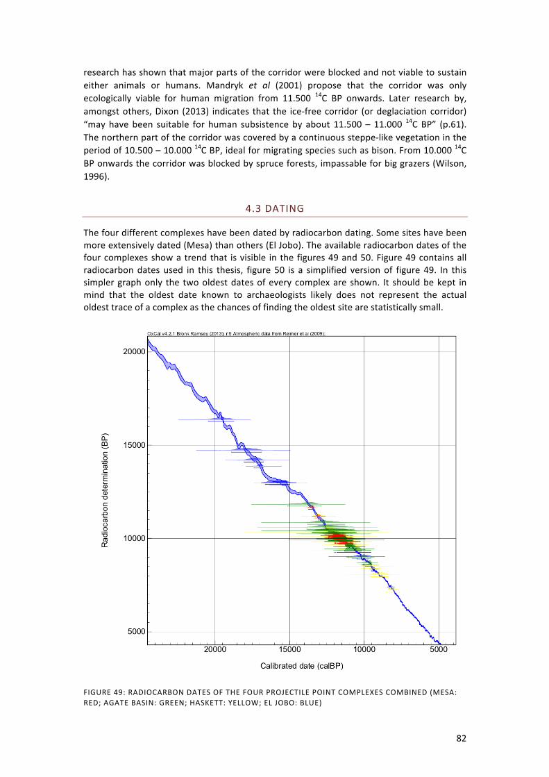
82
research has shown that major parts of the corridor were blocked and not viable to sustain either animals or humans. Mandryk et al (2001) propose that the corridor was only ecologically viable for human migration from 11.500 14C BP onwards. Later research by, amongst others, Dixon (2013) indicates that the ice-‐free corridor (or deglaciation corridor) “may have been suitable for human subsistence by about 11.500 – 11.000 14C BP” (p.61). The northern part of the corridor was covered by a continuous steppe-‐like vegetation in the period of 10.500 – 10.000 14C BP, ideal for migrating species such as bison. From 10.000 14C BP onwards the corridor was blocked by spruce forests, impassable for big grazers (Wilson, 1996).
4.3 DATING
The four different complexes have been dated by radiocarbon dating. Some sites have been more extensively dated (Mesa) than others (El Jobo). The available radiocarbon dates of the four complexes show a trend that is visible in the figures 49 and 50. Figure 49 contains all radiocarbon dates used in this thesis, figure 50 is a simplified version of figure 49. In this simpler graph only the two oldest dates of every complex are shown. It should be kept in mind that the oldest date known to archaeologists likely does not represent the actual oldest trace of a complex as the chances of finding the oldest site are statistically small.
FIGURE 49: RADIOCARBON DATES OF THE FOUR PROJECTILE POINT COMPLEXES COMBINED (MESA: RED; AGATE BASIN: GREEN; HASKETT: YELLOW; EL JOBO: BLUE)

83
It becomes very apparent that El Jobo is the oldest of the four complexes. The most reliable El Jobo dates are within the timeframe of 13.000 – 11.000 14C BP. The oldest date for El Jobo that is reasonably reliable is 14.440 14C BP. Following El Jobo is Haskett with maximum dates of 11.200 14C BP. Most dates are within the timeframe of 10.800 – 9.800 14C BP. Agate Basin falls in between Haskett and Mesa. The oldest reliable date for Agate Basin is 10.850 14C BP from the Hell Gap site. Overall the Agate Basin dates cluster within the 10.500 – 9.700 14C BP timeframe. Mesa has been extensively dated and most of the dates fall within the 10.300 – 9.700 14C BP. As was discussed previously there are two older dates that are viewed as outliers in this thesis.
FIGURE 50: OLDEST TWO DATES OF EACH PROJECTILE POINT COMPLEX COMBINED (MESA: RED; AGATE BASIN: GREEN; HASKETT: YELLOW; EL JOBO: BLUE)
Projectile point complex Radiocarbon dates cluster Oldest dates Mesa 10.300 – 9.700 11.660±80 Agate Basin 10.500 – 9.700 10.850±500 Haskett 10.800 – 9.800 11.200±200 El Jobo 13.000 – 11.000 14.440±435 Whether we are looking at the general clusters of dates or the oldest dates of the four complexes the results are generally the same. The succession of complexes in time is: El Jobo -‐> Haskett -‐> Agate Basin -‐> Mesa. However, everything hinges on the reliability of the

84
two outlying dates of the Mesa complex. If these dates cannot be rejected the hypothesis of succession of these complexes cannot be supported, at least when including Mesa. The projectile point complexes persist in time for varying periods and thus also overlap in most cases. Mesa, Agate Basin and Haskett all existed at the same time at some point. El Jobo has been dated as young as 10.710 – 7.400 14C BP at El Vano (Quero, 1998). Whether these dates are reliable remains under discussion as with most El Jobo dates. However, it is probable that also El Jobo existed for a longer period in time. The trend with the northern point complexes seems to be that the occurrence of points ends around 9.750 14C BP, this coincides with the end of the Younger Dryas period, after which the climate became warmer. It is interesting to see what happens to the chronological order when the radiocarbon dates are calibrated. The 14C dates were calibrated using OxCal (Bronk Ramsay, 2009) and the calibration curve IntCal09. TABLE 7: CALIBRATED AGES OF THE FOUR COMPLEXES
Projectile point complex Calibrated dates Oldest cal. dates (ranges) Mesa ~ 12.400 – 11.200 13.728 -‐ 13.326 Agate Basin ~ 13.800 – 9.600 13.770 -‐ 11.275 Haskett ~ 13.000 – 10.250 13.426 -‐ 12.661 El Jobo ~ 18.500 – 15.000 18.576 -‐ 16.815 The Younger Dryas effect is present in larger uncertainties, extending the ranges of the projectile point types. Calibrating El Jobo poses problems because this complex is located in the Southern hemisphere. The IntCal09 curve is used for the Northern hemisphere while SHCal04 is used for the Southern hemisphere. SHCal04 unfortunately does not extent beyond 10.000 radiocarbon years and so El Jobo cannot be calibrated using this curve (Bronk Ramsay, 2009). The use of IntCal09 for El Jobo might produce erroneous calibrated dates. Differences in chronological order are not as pronounced when the dates are calibrated. It becomes more visible however that the northern three complexes exist simultaneously.
4.4 LITHIC TECHNOLOGY
What are the actual typological and technological traits that these projectile points have in common? When we focus on morphology the projectile point types are very similar. All types are lanceolate (or leaf-‐shaped) in outline. They are all thick in comparison to their width (fig.51). Why was this shape desired by these different toolmakers? This is probably related to the technology of hafting. As was explained in chapter 2, different kinds of hafting require different kinds of projectile point shapes. The Mesa, Haskett and El Jobo types have tapering stems and were most probably hafted in a socketed shaft. Agate Basin however is thinner and lacks a tapering stem, this is a suggestion that the point type might have been hafted in a split-‐shaft (Dixon, 1999; Musil, 1988). The technology with which these point types were manufactured is important. These specific projectile point appearances could have been acquired by different techniques. Therefore it is interesting to see if there are similarities in the production stages of the various points. In the table (8) below, the main characteristics of the production sequences are summed up.

85
TABLE 8: MANUFACTURING TRAITS OF THE FOUR PROJECTILE POINT TYPES
Point type
Cross-‐section Flaking pattern
Shaping #1 Shaping #2 Finishing
Mesa diamond to lenticular
collateral hard, direct percussion
soft, direct percussion
pressure flaking
Agate Basin
lenticular to diamond
parallel to collateral
hard, direct percussion
possibly overshot flaking
pressure flaking
Haskett lenticular to diamond
collateral hard, direct percussion
direct percussion / pressure
pressure flaking
El Jobo diamond to lenticular
collateral hard, direct percussion
unknown
pressure flaking
Evidently the desired projectile point shape was very similar with all four types. But how was this result achieved? What were the methods and techniques applied during the manufacture? All the types have in common that they were first shaped by direct, hard percussion flaking. A biface was created which was then further shaped to become the desired point type during multiple flaking sequences. The cross-‐section that all the types have in common varies from diamond shaped to lenticular. This is a result of the width/thickness ratio (fig.51), which in turn is controlled by the method of flaking.
FIGURE 51: WIDTH/THICKNESS RATIOS OF ALL FOUR PROJECTILE POINT COMPLEXES
In order to substantiate the width/thickness relations of the four projectile point complexes I collected measurements. The sample of available measurements differs. While for Agate Basin there were 56 specimen measurements available (Baker, 2009) for El Jobo (Cruxent, 1979; Nami, 1994) were only 15 specimen measurements available and only 11 for Haskett (Butler, 1965; Butler, 1967). During my visit to the Northern Brooks Range I was able to take measurements of the available Mesa and Sluiceway points. For the Mesa ratios I used 22 complete specimens. The ratios show that all complexes conform to the definition of thick-‐bodied points as suggested by Baker (2009), the majority of ratios are lower than 3.0. The exception to this is the Agate Basin type of which a considerable amount (37 of the 56 specimens) has a ratio of 3.2 or greater. This means that Agate Basin is thinner with respect to its width than the other types. El Jobo is the thickest with respect to width of the complexes, followed by Haskett and Mesa with the exception of outliers. For the sake of comparison it is interesting to note here that Clovis for example has a width/thickness ratio

86
ranging from 3.0 to 5.4 (Baker, 2009). This shows that these point types are generally thinner with respect to width than the point types described in this study. TABLE 9: AVERAGE WIDTH/THICKNESS RATIOS FOR ALL FOUR PROJECTILE POINT COMPLEXES
Mesa Agate Basin Haskett El Jobo Average w/t ratio 2.7 3.3 2.9 2.4 Measured specimens 22 56 11 15 Mesa, Haskett and El Jobo have collateral flaking in common. Collateral flakes end in the middle of the point creating a defined midridge. With Agate Basin, in contrast to the other three types, the flakes can sometimes better be described as parallel than collateral (see chapter 2, fig.1). These smaller, more evenly arranged flakes also meet in the middle but do not create a midridge as distinctive as collateral flaking does. Therefore Agate Basin points are often lenticular in cross-‐section instead of diamond shaped and thinner with respect to width. Beside the different method of flaking the reworking of points might result in a more lenticular cross-‐section as more layers of flaked are removed. Evidence of the initial stage of production is often lacking. Only when unfinished specimens are found, or when refit studies have been conducted, this information becomes available. The second sequence of shaping differs somewhat between the point types. Mesa points were worked with soft, direct percussion. On Agate Basin points there is evidence of possible overshot flaking. This is not seen in any of the other complexes and might also explain that Agate Basin points are relatively thinner than the other types and lenticular in cross-‐section. This difference might be related to a possible contact of Agate Basin with biface thinning technologies such as Folsom which were present in the same area and during a short simultaneous period of time. Haskett was further shaped by pressure flaking. For El Jobo this information is unfortunately absent in the literature. The finishing flaking sequence was done by pressure flaking. The final stages (table.10) of the projectile point manufacture were base and tip shaping and finally edge retouch and grinding of the basal lateral margins. All point types have straight to convex bases. Agate Basin has more straight bases and El Jobo more convex to even bipointed bases. All types underwent micro-‐retouch to straighten the margins. After this the basal section (from the base up to the widest part of the point) of the points was ground with a corse-‐grained stone.
TABLE 10: FINAL STAGES OF PROJECTILE POINT MANUFACTURE
Point type Base shape Edge retouch Edge ground Mesa concave to convex pressure basal, to widest part Agate Basin straight to convex pressure basal, to widest part Haskett convex pressure basal, to widest part El Jobo bipointed to straight pressure unknown These final stages were of importance to the process of hafting the projectile points, which must have happened after this stage. The shape of the tapering/contracting base was made to fit the socketed foreshaft. The edges were retouched to eliminate irregularities that might cause breakage within the haft but also contributed to the symmetry and sharpness of the blades. Finally the last irregularities were removed by edge grinding. The exact amount of flaking sequences remains largely unclear because this is hard to trace on finished points. Refitting studies are desirable in order to obtain more information on this subject.

87
4.5 ASSOCIATED LITHIC ASSEMBLAGES
Tool types other than projectile points can provide an insight into site function. Overall many different cultural groups used similar types of tools over vast periods of time. Differences are seen among groups using (or not using) specific technologies. Absent technologies among the here discussed projectile point complexes are macro-‐ and microblades. Macro-‐blade technology is known to be associated with thinning biface technological traditions such as Clovis (Stanford, 2006) Microblade technology has not been associated with Paleoindian traditions but microblades were found at the Mesa site. However, these were most definitely not related to the Mesa occupation as they were found in a different site area and were probably much younger than Mesa (Kunz et al, 2003). Flake burins were also found at the Mesa site. However, they were rare and not well made. Therefore these tools were not considered by Kunz et al (2003) as formal tool types but as tools of opportunity. The most abundant tool at Mesa sites other than projectile points are gravers. A few gravers were also found at the Agate Basin site and possibly in association with Haskett. Gravers were however never associated with Paleoindian complexes in the quantity as they were present at the Mesa site (Stanford, personal communication, 2013).
TABLE 11: PRESENCE OF TOOL TYPES OF THE FOUR PROJECTILE POINT TYPE COMPLEXES
Bifaces Scrapers Gravers Utilized flakes Knife Mesa X X XX X Agate Basin X X X X X Haskett X ~X X X El Jobo X X X X (bone) Scrapers were found in association with all the complexes. These tools were used for multiple purposes such as cleaning hides and scraping wood or bone. Utilized flakes were used at all sites. These flakes would be worked on one or more edges to function for multiple purposes such as cutting. Knives were present at the Agate Basin and Haskett complexes. At Taima-‐Taima a bone cutting-‐tool was found in association with El Jobo points. A macro/microblade technology is absent from any of the thick-‐bodied lanceolate technological complexes.
4.6 SITE CHARACTERISTISC AND INFERRED ACTIVITIES
The main thing that Mesa, Agate Basin and El Jobo sites have in common is that they are all connected to hunting. Mesa sites are characterized as observation spots where hunters were scanning the environment for migratory herds of animals. Agate Basin sites are located in geographical trap features. Bison were driven into these steep walled geographical locations where they were enclosed and could be killed more easily. El Jobo sites are generally kill sites where the butchered remains of extinct megafauna have been found associated with projectile points. El Jobo sites are often associated with aquatic settings (spring features, river terraces). Haskett sites are different. These are mostly found in caves and rockshelters, these sites were camps. At some sites hearth features are found. An interesting feature is a projectile point cache at the Redfish Overhang site (and possibly Cooper’s Ferry). The points were buried probably with the idea of coming back later. The burying of projectile points in several stages of manufacture is well known to have been practiced by people using Clovis

88
technology (Stanford and Bradley, 2012). The presence of several Haskett bases at the Running Antelope site has lead the author to believe that this was a processing site (Russell, 1993). However, no animal remains were found at the site and therefore this conclusion is a bit premature.
Mesa observation spots Agate Basin geographical trap features (kill sites) Haskett camp localities El Jobo kill-‐ and butchering sites
The only site where Haskett was found and that contains animal remains is the Bonneville Estates Rockshelter where smaller mammals such as sheep and pronghorn were found (Goebel et al). The relation between these animal remains and the Haskett points remains unclear. At the Haskett type-‐site a piece of teeth was found possibly belonging to bison. Overall the preferred prey species of Haskett hunters remains unknown. However, bison was an abundantly available prey to Haskett hunters in the Snake River Plain region. At the Mesa site no bone material was found either. Kunz (2003) suggested that horse or bison was the most likely prey as these species were abundant during the Mesa occupation. Another possible species is caribou. However, caribou was not as abundant at the time as today (Kunz et al, 2003). There is no question about the preferred prey species of Agate Basin hunters. Numerous bison remains have been found at Agate Basin sites. El Jobo hunters preyed on now extinct megafauna. Of the few sites that are presently known most are associated with megafauna such as mastodon, glyptodont and megathere. Secondary activities that are generally observed at all sites of Mesa, Agate Basin and Haskett is the manufacture or reworking of projectile points. This has been observed at the Mesa site, Agate Basin site and Haskett site by the presence of flaking debris. Gravers might have been used for untying knots on hafted points. There is no mention of bifacial flaking debris at El Jobo sites.

89
5. DISCUSSION AND CONCLUSIONS
The Mesa projectile point has many traits in common with the Agate Basin, Haskett and El Jobo projectile point types. These similarities are to be found in lithic technology and morphology but also in environment and in the other tool types associated with the projectile points. There are also differences between the four point complexes. The specific site function differs, especially with Haskett. Haskett sites are mostly camp sites while Mesa, Agate Basin and El Jobo sites are all related to hunting. So what can be said about the dispersal and migration of a group of people by looking at material culture? The problem with this kind of research is that you often cannot draw conclusions with certainty. Without direct evidence, for example DNA, proposed ideas remain suggestions. What can be said is that one explanation is more likely than another. A hypothesis can be constructed and tested. It is important to use a multidisciplinary approach. For example, just looking at lithic technology is not sufficient. Including environmental information as well as information about the radiocarbon dating and other finds at a site can help to reconstruct a more complete picture of the past and in this case can help compare the different archaeological complexes, previously distinguished by archaeologists on the basis of projectile point typology. This thesis shows to some extent what can be reconstructed about the past by looking at these aspects of archaeological traditions. Differences and similarities should not plainly be viewed as such. Even though the site function of the four projectile point types differs, this cannot be regarded as a reflection of a cultural difference. One culture can produce different kinds of sites for different functions. Only one, or sometimes two, kinds of sites are found for every projectile point type. This might be the result of many things, among which erosion or reduced site visibility. Whereas observation spots in the Arctic were preserved, the base camps that were probably located at lower elevation near streams were destroyed long ago. The same principle can be applied to the other complexes. Observation spots of Agate Basin hunters might have been eroded by wind action in this dry environment and kill-‐sites in the Haskett territory were possibly not preserved due to the wet conditions of the Late Pleistocene Snake River Plain, projectile points may have been washed away by the Snake River.
5.1 ASPECTS OF TECHNOLOGY
The most striking similarity between the point types is their morphology and the technology with which they were manufactured. Both are of importance. Technology is a tool with which a certain morphology is achieved. Why was this lanceolate, thick-‐bodied type of projectile point desired? Likely this has a lot to do with the hafting of the projectile point. Hafting is in many instances the reason for a specific appearance of a projectile point. It was the reason why Clovis and Folsom fluted their projectile points, in order to fit them into a split-‐shaft. Later, side-‐notches were made in projectile points in order to bind them to the shaft. These thick-‐bodied projectile points with their diamond-‐ and lenticular shaped cross-‐sections and contracting stems were most probably made to be hafted in socketed shafts (fig.52).

90
After experimenting with different hafting methods Stanford is not a proponent of socketed hafting in areas that lack the proper material (hollow reed shafts) (personal communication, 2013). Frison (1978) also pointed out the difficulty of hafting a projectile point in a socketed shaft, although he did mention that the results were better than when using a split-‐shaft, especially when thrusting from an angle. Split-‐shaft hafting requires a thin basal cross-‐section, which these point types lack with the possible exception of Agate Basin. Interestingly, at the Taima-‐Taima site tools were found with side-‐notches. How strong the association with the El Jobo kill is, is not entirely clear. However, if there is a connection this is remarkable. Side-‐notching has been regarded by many authors as the superior of all hafting techniques (Darwent and O'Brien, 2006; Dixon, 1999; Flenniken and Raymond, 1986; Justice, 1987; Musil, 1988). If El Jobo hunters already possessed this technological knowledge then why did they not employ it on their projectile points? If the association between these side notched tools and the El Jobo projectile points is correct that provides proof for the employment of two different hafting techniques by the same people.
FIGURE 52: SOCKETED SHAFT HAFTING (DIXON, 1999)
Kunz et al (2003) suggested that the Mesa points were most probably hafted in bone or ivory foreshafts. The hardness of this material can possibly also account for some of the damage to the Mesa bases. Stanford (personal communication, 2013) argues that not all the concave Mesa bases can be accounted for by haft damage. In many instances damage is present but not as substantial that it could have transformed a straight base into a concave base. If some of the Mesa points were made to have concave bases then this poses questions about hafting technology. In an ethnographic study Wiessner, (1983) asked a San hunter from the Kalahari why there was a variety in the base shape of his arrow sets. He replied that he had simply forgotten what the bases of his previous set were like (p. 265). This example illustrates that it should be kept in mind that archaeologists might ascribe too much meaning to traits such as base-‐shape. Agate Basin bases also vary from concave to convex although the majority has straight to convex bases. There is no use for a concave base in a socketed shaft haft. Concave bases are generally a trait of split-‐shaft and side notch hafting. It is possible that both techniques were used by Mesa and Agate Basin. These two complexes exist at the period where split-‐shaft hafting was still employed by Folsom, and because Agate Basin and Folsom possibly occurred simultaneous for a little while it might be possible that this is the result of an influence of Folsom. Generally the differences seen in Agate Basin points when compared to the other three types might be explained by a joined influence of the thickening technology of Haskett and the thinning technology of Folsom. Seeing that both these types occurred in the immediate vicinity of Agate Basin territory it is plausible to suggest a connection here that might have lead to influence on projectile point technological traits. There is no suggestion of concave bases in Haskett. El Jobo has a range of concave to bipointed bases. In lithic technology Agate Basin is probably the biggest outlier of the four. The cross-‐section is more lenticular than diamond shaped and the width/thickness ratio indicates that Agate Basin is the thinnest with respect to its width of all the four complexes. There is also evidence of the use of overshot flaking, a thinning technology. The finishing pressure flaking sequence is also different in that it is more parallel than collateral. Overall the appearance of the point type is more symmetrical and neater because of these traits.

91
One interesting trait that Agate Basin has in common with Haskett is that both point types were made quite long, longer than necessary for the projectile point to be functional, possibly with the idea of reuse and resharpening in mind. The appearance of a projectile point changes when it is heavily resharpened. I suggested that the so-‐called Haskett type 1 point is the product of heavy resharpening within the haft, as was discussed in chapter 3.3. The blade length that is left is less than one third of the entire point. It might even be that these points were purposefully discarded because they were no longer efficient because of this heavily resharpening. Associated with all the projectile point complexes discussed here are general tools often found in association with Paleoindian complexes. These tools are scrapers, utilized flakes, knives and in the case of the Mesa complex also gravers. The abundant presence of gravers was explained by Kunz as a necessity for the repairing of projectile points. They were probably used for untying the sinew used to haft the points but also for incising, grooving and boring, for example to insert feathers into atlatl darts. Interesting to mention here is what these complexes are all lacking: micro-‐blades and macro-‐blades. Blade technology is very different from the bifacial technology that we are discussing. In short: blades are struck from a core, the blades are used as insets for composite tools. With blade technology the flakes that are struck from a core are to become the tools while with bifacial technology the core is shaped to become the tool (Beuker, 2010). Blade technology is the main technology present in Siberia during the period of initial peopling of the Americas. But it is largely absent from the Americas where a bifacial technology persisted for a long period of time. An ancestral bifacial technology to account for the American stone tool traditions has yet to be discovered in Siberia. Blade technologies are known to accompany Clovis and Folsom projectile points. They are however absent from the thick-‐bodied point type traditions. Perhaps this indicates a different origin for the two traditions, which are also spatially distinct. Stanford (personal communication, 2013) suggested that socketed shaft hafting works best on hollow reed shafts such as bamboo or river cane. This material would have been available to El Jobo projectile point makers. Bryan (1979) argued that South American projectile points were probably generally made out of wood and bone as is done in more recent times by native tribes. Perhaps El Jobo hunters changed the material they worked with but stuck to the method they used for manufacture. Mastodon skin was probably easier pierced with a stone projectile point than a bone or wooden point. They maintained the already known technologies of manufacturing and hafting projectile points and adapted their strategies to stone. Musil (1988) names the various hafting techniques and treats them in a successive order which was later described by Dixon (1999). It is described that two kinds of split-‐shaft hafting existed in the Americas, one the successor of the other. Socketed shaft hafting, as it occurs in North America, is described here as an independent innovation, not related to the split-‐shaft hafting technique. It is possible that this technique finds its origins in South America where bamboo and river cane were abundant and made socketed shaft hafting an obvious solution. It is a probable explanation for the occurrence of this technique. The innovation of a tool or technique is best explained by the presence of a trigger, such as the lack of an effective technology or an abundance of a certain material (hollow reed cane). The material was not present in North America and neither was there a lack of working technologies. So possibly the technique was introduced to North America by a people who were already successfully employing it, such as the El Jobo hunters.

92
Whether the socketed shaft hafting technique was more efficient than split-‐shaft hafting remains debatable. The technique eliminated the need to use bindings around the edges of the projectile point. There was also more surface area between the point and the shaft that could absorb the energy of impact.
5.2 CHRONOLOGY AND SUCCESSION
When looking at the radiocarbon dates of the four complexes it becomes clear that there is a succession in time of these complexes: El Jobo -‐> Haskett -‐> Agate Basin -‐> Mesa. Projectile point complex Radiocarbon dates cluster Oldest dates Mesa 10.300 – 9.700 11.660±80 Agate Basin 10.500 – 9.700 10.850±500 Haskett 10.800 – 9.800 11.200±200 El Jobo 13.000 – 11.000 14.440±435 But does this succession also show in the lithic technology? I discussed this subject with the late-‐amateur archaeologist Tony Baker (2012). He believed that Agate Basin developed out of Haskett and during my research I found that Mesa, Haskett and El Jobo have many similarities, while Agate Basin is a little different. Mesa might have derived from Agate Basin but I also see similarities between Haskett and Mesa. It is possible that Mesa was derived from Haskett. But that would suggest that Agate Basin has no direct connection to Mesa, or possibly a common ancestor (Haskett). This seems strange because there are various indications of Agate Basin moving north. However, when examining the dates this theory gains a little more ground. Mesa and Agate Basin are almost of equal age, Agate Basin possibly a little older than Mesa. Haskett is older than both, facilitating more time for migration or a transmission of lithic knowledge through contact. Again the question of the older Mesa and Sluiceway dates arises. This is a critical aspect. As I explained before, I am not very confident about the older Mesa-‐site dates. The Sluiceway site, Tuluaq Hill was also dated to 11.200 14C BP but again there are some uncertainties about the context. However, even if these dates are reliable there still is a window for migration from the south. The earliest occurrence of Haskett points in the Great Basin has been dated to 11.200 14C BP. Mandryk et al (2001) as well as (Dixon, 2013) have stated that the earliest possible migration through the ice-‐free corridor could have occurred at 11.500 14C BP. It is a narrow timespan but in the advent of an earlier Mesa occupation it could in theory still be possible that Haskett and Mesa/Sluiceway came into contact somehow. Additionally, a route along the west coast could have been possible from at least 14.000 14C BP (fig.53). In such an event Haskett would have ended up relatively close to the Spein Mountain site and still would have to migrate a long way to the Northern Brooks Range. There is however no evidence for such a migration event. Even though the four projectile point types are very similar, they are not the same. They are all thick-‐bodied lanceolate projectile points but distinct regional types of this technology. The type is not as widespread as for example the Clovis culture and it shows variation, but so does Clovis. The pattern that is visible is one of similar point types but with an own ‘touch’. This is what might be expected to see as a result of a transmission of knowledge through contact. As a new technology is adopted it will be employed with a personal touch of the recipient people. Of a migration of people carrying with them a projectile point technology I would expect to find more homogeneous projectile points all over the route of migration.

93
This however, depends on the speed of the migration. A fast migration will show in a homogeneous record while a slow migration would produce more regional differences (Buchanan and Hamilton, 2009). Mesa/Sluiceway, Agate Basin, Haskett and El Jobo are all similar projectile point types but with slight differences in morphology and technology. There are at least three distinct areas of projectile point occurrence: Alaska, Western North America and Venezuela. The Northern Great Basin area where Haskett occurs can be described as a transitional zone to the Great Plains. These two areas can to some extent be connected in the framework of this thesis. If these four complexes were connected through migration one would not expect to see geographical gaps such as we see here (fig.53) in Mesoamerica. The absence of sites in the ice-‐free corridor can be explained by significant erosion and sedimentation due to the melting of the ice-‐sheets. That these three areas are not connected by sites yielding similar technology makes the connection between types problematic.
5.3 TRACKING THE MOVEMENT OF A TECHNOLOGICAL TRADITION
The mechanism behind the spread of this projectile point technology can probably not be found in either a single migration of people or a transmission of knowledge though contact. Events such as these, on a geographical scale this large, do not occur that straightforward. It is probably a combination of the two. A migration of people might have occurred very slowly, encompassing many generations. A migration like this should show clearly in the archaeological record as a widespread occurrence of sites along the path of migration. On the other hand, it is possible that the thick-‐bodied lanceolate projectile point technology was innovated independently in different regions. Archaeologists are often inclined to diminish distances in the continent of North and South America because it was populated relative late on the archaeological time scale and especially in this early phase it is proposed to have been thinly populated. This however does not mean that connections between the groups that were present at the time are more obvious. The socketed shaft hafting technique has been described by, among others, Musil (1988) and Dixon (1999) as superior to the split-‐shaft hafting technique that was already in use before the socketed shaft technique was introduced. There are some doubts about its superiority however. Both Stanford (personal communication, 2013) and Frison (1978) have expressed doubts about the functionality of this technique. Therefore I suggest the superiority of the socketed shaft hafting technique is questionable in an area where the proper materials are lacking. It seems reasonable to state that socketed shaft hafting might have had its origins in South America where materials such as hollow reed cane and bamboo were abundant. El Jobo is the oldest of the four projectile point complexes discussed here and so, when we are assuming that these four complexes are connected, El Jobo must be the origin, the starting point of the spread of a lithic technology. So how did the thick-‐bodied lanceolate projectile point technology end up in North America? The two possible El Jobo sites in Panama and the one in Mexico may be a clue of small proportion, but if these are truly El Jobo points this indicates that a diffusion of the El Jobo technology occurred north of Venezuela. Sadly these finds have not been dated and so no migration direction can be appointed here, additionally the determination of the projectile point type remains questionable. An explanation for the lack of sites in Mesoamerica could be that a quick migration of a relatively small group of people occurred at approximately 11.200 14C BP, when Haskett first appears in the Great Basin, or slightly before that. Perhaps these people moved along the coastal lines of Eastern Mesoamerica and as a result the sites

94
have been inundated by the sea level rise at the start of the Holocene (fig.53). If so, they would have arrived in Texas and from there moved north. There are some Agate Basin sites located in Northern Texas. These sites have however not been dated. Moreover, this theory does not fit the chronological order of dates as Haskett is older than Agate Basin and also shows more similarities to El Jobo in lithic technology.
FIGURE 53: PROPOSED ROUTES OF THE THICK-‐BODIED LANCEOLATE PROJECTILE POINT TECHNOLOGY
But why would El Jobo hunters have moved to the north in the first place? In order to account for the earliest presence of Haskett in the Great Basin at 11.200±200 14C BP a time window for migration should be found at approximately 11.600 -‐11.200 14C BP. Depending

95
on how long such a migration took this timespan can be extended further to the past. The distance between Northern Venezuela and the Great Basin and Great Plains region is great: approximately 6000 km. This is a large area encompassing many different environments. Something that has often been described as a trigger for migration is climatic change and the migration or extinction of prey species. The last climatic change in Venezuela before the climate started representing modern day conditions (from 10.000 14C BP onwards) was recorded between 11.900 and 11.100 14C BP when temperatures dropped slightly. The low number of sites yielding megafauna, especially mastodon indicates that this species was low in number in the area. During the latter period of the LGM the area was subject to high aridity, which is not ideal for mastodons. Mastodon might very well have been on the verge of extinction in the region when El Jobo first appears in this previously uninhabited area. Possibly the El Jobo predation on this species in combination with climatic changes caused the species to disappear from the region. Perhaps the animals migrated away or just simply died out. This could have left El Jobo hunters without a reliable means of subsistence even though some species, such as megathere, persisted longer in time and were also hunted. This could have been a reason for El Jobo hunters to go look for another region with a higher abundance of big-‐game species. They might have migrated north where they finally ended up in Northwest America. At the time the technological tradition arrived in North America megafauna here was already mainly extinct. The abundant big-‐game species found in the Northern Great Basin and Great Plains area was bison. It is not difficult to imagine that a megafauna hunting people such as El Jobo would be attracted to a prey species such as bison. The absence of sites in Mesoamerica and Southern North America however, remains problematic in this construction and does not add to support the hypothesis of a northward migration. After El Jobo, Haskett is the oldest point type discussed here. Haskett lithic technology is very similar, if not identical, to El Jobo. One should not be cheated by the different appearance of the two types, this is mainly due to the use of two very distinct raw materials (obsidian and quartzite sandstone). The occurrence of sites is highest in the Snake River Plain of the Northern Great Basin area with some outliers in the middle Great Basin further to the south. Among these outliers is the Bonneville Estates Rockshelter that has been dated to 11.000 14C BP, an early date for Haskett. There are also some sites in the Northwest that are younger than the dates in the centre. This pattern, though barely visible, can suggest an early arrival in the Great Basin with a preferred central area in the Snake River Plain and further migration or expansion to the Northwest. Raw material from the Running Antelope site was sourced to Southern Utah’s Mineral Mountains. Russell (2004) has traced raw material sources and suggested that Haskett hunters moved in a north-‐south/south-‐north direction. Because the Snake River Plain is actually an environment-‐connecting corridor between the Great Plains and the more mountainous area of the Rocky Mountains and to the south the Great Basin, the connection to the Great Plains is not difficult to make. The people living in these neighbouring areas might have been in contact. Whether Haskett was ancestral to Agate Basin, like Tony Baker suggested, is not that clear to me. The lithic technology and typology of Agate Basin is the biggest outlier of the four discussed types. It seems however very well possible that there was contact between these two groups and that with this contact these two complexes influenced one another. Agate Basin is centred in the Northern Great Plains but has some sites in the south. Whether this reflects a southward migration from the centre during a later period, an early northward

96
migration or perhaps occasional hunting expeditions is unclear because these sites were not dated. The pattern of Agate Basin raw material sources differs among sites. Most are extra-‐local but some are also found closer to the site. Large distances between sites and sources occur often. The most striking of these is the raw material at the Frazier site that finds its origin in Texas, some 750 km to the south. The Frazier site is not particularly old (9.650 – 9.000 14C BP) so this is no indication for an initial contact with El Jobo manufacturing people. It does however show that Agate Basin hunters were a highly mobile people over large distances. Agate Basin is known to have moved north along with the degradation of the ice-‐sheet. Ebell (1980) mentions that many Agate Basin sites are often located approximately 950 km from the ice front. Additionally, bison (B. antiquus) from the Great Plains migrated northward and is present in the ice-‐free corridor at 10.500 14C BP at the Charlie Lake Cave site. It is evident that Agate Basin moved north, sites of younger age have been found in the Grant Lake region in Canada. These sites are often referred to as part of the Northern Plano culture but the projectile points are strikingly similar to Agate Basin. Mesa sites are centred in the Northeastern Brooks Range with a few occurrences in the west. Of great interest is the presence of the obsidian at the Mesa site from the Batza Tena source 320 km to the south. Kunz (personal communication, 2013) emphasizes that at least 99% of the material at the Mesa site was local chert. But still the presence of Batza Tena obsidian proves that there was either contact and exchange with people from the south, or it might indicate that the Mesa people were also highly mobile. There are many factors suggesting a connection between Mesa and Agate Basin but why then is there a difference between Agate Basin and Mesa projectile points? If Agate Basin people moved to the north why would they change the shape and flaking patterns of their projectile points? Could it be that they were forced to do so because of a lack of material? If Agate Basin points originally were hafted in a wooden, socketed or split-‐shaft, perhaps they had to change their hafting method to work with bone or ivory because wood was scarce in Arctic Alaska. This might have resulted in the employment of socketed hafting which required a more diamond shaped cross-‐section and a more tapering stem. Mesa projectile points mostly show collateral flaking but in some cases the flaking scars can be a little narrower, almost approaching a parallel flaking pattern as with Agate Basin. However, here a problem presents itself. Mesa points could have been hafted in a socketed shaft but for Sluiceway I am not sure whether this was a possibility. Most Sluiceway points have wide basal sections that are difficult to haft in a socketed shaft. Perhaps there was more suitable wood available in the western part of the Northern Brooks range to facilitate split-‐shaft hafting.

97
5.4 CONCLUSIONS
This study has focused on four different projectile point types in the Americas in hopes of finding a connection that could suggest an origin or ancestral technology for the youngest of the four: the Mesa projectile point. The main question asked in this thesis is: “What can be said about the origin and migration patterns of the Palaeolithic people of the Mesa archaeological site by examining the various thick-‐bodied lanceolate projectile points of the Americas?” Various sub questions have been asked concerning: geomorphological setting, environment, dating, lithic technology, raw material sources, associated lithic assemblages and regional similar point types. It was proposed that the four complexes (El Jobo -‐> Haskett -‐> Agate Basin -‐> Mesa) are connected and successive of each other in the above chronological order. The similarities between these point types can be the result of three different mechanisms:
1. Diffusion of technological knowledge through social contact 2. Dispersal of material culture through migration 3. Convergence of the technological trait through independent innovation
Similarities and differences as discussed in the previous chapters are summed up in table 12. TABLE 12: PROJECTILE POINT COMPLEX CHARACTERISTICS
Mesa Agate Basin Haskett El Jobo Site type Observation
spots Kill-‐sites Camp-‐sites
Kill-‐sites
Geomorphological setting
high locations (hilltops, bluffs)
geographical trap features (gully’s; drained riverbeds)
caves and rockshelters
aquatic settings
Environment Mammoth-‐steppe, grass-‐lands
Steppe with tundra elements
sagebrush steppe mixed with high altitude vegetation
herbaceous savannah
Hunted animals unknown (possibly horse and Bison priscus)
Bison antiquus unknown (possibly bison)
mastodon, megathere
Width/Thickness av. ratio
2.7 3.3 2.9 2.4
Dating 10.300 – 9.700 10.500 – 9.700 10.800 – 9.800 13.000 – 11.000
Oldest dates 11.660±80 10.850±500 11.200±200 14.440±435

98
Connecting these four projectile point complexes is complicated in some ways. The reason that these four types stood out against the larger archaeological record of the Americas is because they are all thick-‐bodied, lanceolate shaped projectile points. This shape is probably the result of the employment of a hafting technique known as socketed shaft hafting where the projectile point was inserted into a hollow foreshaft made of wood, bone or hollow reed. However, the projectile points are not just similar in morphology but also in technology. Flaking methods are similar and so are other aspects such as: base shape, edge grinding and marginal retouch. Of the four projectile point types Agate Basin is the biggest outlier. It is thinnest with respect to its width and flaking is mostly parallel instead of collateral. Large differences between the projectile point complexes are seen in climate even though the vegetation type is generally similar (plains-‐like grasslands bordered by mountains). The climate of Venezuela is the biggest outlier here, especially because of higher temperatures. The northern area where the ice-‐sheets influenced the climate is certainly a contrast to this. The difference in climate between the mid-‐continental complexes and Arctic Alaska was also pronounced. Even though Agate Basin and Haskett were influenced by the presence of the ice-‐sheets, these complexes were not subject to characteristic Arctic circumstances. The Mesa hunters had to deal with 24 hours of darkness in wintertime and low temperatures. The differences seen in the projectile point morphology and technology might represent the observed differences in site function and perhaps differences in environment. A different prey species might result in adjustments to the projectile point type. Thrusting spears (as with Sluiceway) require much sturdier and heavy tips than atlatl darts (Mesa). The four discussed projectile points were most probably all hafted on atlatl darts. The morphology of the points seems to be connected to the hafting technique, which required a certain shape of the projectile point stem. The socketed shaft hafting technique was possibly used by all four complexes and was possibly invented in South America. El Jobo’s northward migration If we assume that people using El Jobo projectile points actually migrated from Venezuela to the Great Basin and Great Plains area, many questions arise. First of all: why would these people leave their familiar territory behind to move 6000 km to the north? A proposed explanation for the ‘why’ question refers to the extinction of megafauna in Venezuela. There are indications that mastodon, the primary prey-‐species of the El Jobo hunters was becoming extinct in the region. Perhaps the El Jobo hunters were looking for new hunting grounds or followed migrating mastodon to the north. Secondly, what would such a migration look like? How large a group would be involved and at what pace would the migration have occurred? It seems that a group of people using El Jobo projectile points stayed behind so it was not a migration of an entire population but a smaller group of people. Here another question occurs: was a small group of people enough to spread the thick-‐bodied projectile point technology all the way to North America? A distance of 6000 km should not be underestimated and the proposed migration might have taken generations. The current evidence of the El Jobo projectile point complex shows no evidence for large-‐distance mobility. They seem confined to Northern Venezuela and they exclusively use local raw materials. A lengthy migration, encompassing several generations in time, and with a relatively large group of people over a large distance should be visible in the archaeological record. What would be expected to show from such an event? I would expect to see the presence of

99
characteristic El Jobo projectile points along the migration path. Perhaps technology and morphology changed slightly along the way but it would still be recognizable. El Jobo would probably be found alongside to aquatic sources such as rivers and springs. Kill sites should occur in areas where big game was present. So why is there virtually no presence of El Jobo-‐like projectile points in Mesoamerica and Southern North America? This can be the result of different things. It could be that the El Jobo people migrated along the eastern coastline of Mesoamerica. This coastline is now inundated by the rising sea levels of the Holocene and so the evidence might be under water. A marine adaptation of El Jobo people has however never been suggested. Additionally this route does not explain the lack of sites in Southern North America. It is possible that El Jobo projectile points have not been found in Panama, Guatamala, Honduras, Nicaragua and Mexico because of a lower research intensity or bad site visibility. Or it could be that such a migration never actually happened. Judging from the present evidence it can be concluded that there are few indications for a northward migration of El Jobo hunters. The proposed working hypothesis was based on typological and technological similarities between El Jobo and the other three types. This research has not been able to add to this idea and so the only connection between El Jobo and the northern complexes remains the projectile point characteristics. Therefore I reject the connection of El Jobo to the other three complexes until further research suggests otherwise. A connection of three northern thick-‐bodied lanceolate projectile point complexes The connection between Haskett, Agate Basin and Mesa can be made more plausible. Not only are these complexes located closer to one another but they are also dated more securely to a less extensive period in time. Haskett is the oldest of the three. It should however be kept in mind that the oldest dated site is probably not representing the actual oldest appearance of a tradition. Statistically the chances of finding the ‘oldest’ site are low. Haskett is also largely simultaneous with both Agate Basin and Mesa. There is a probability that Haskett and Agate Basin hunters were aware of each other’s presence and possibly had contact. Relative to the area of Agate Basin and Haskett occurrence the two complexes are not spatially located far from each other (approximately 300 km). It is also possible that the two complexes as defined in this thesis actually belonged to the same tradition with separate groups. The different morphology of the projectile points could be due to different functions: possibly different prey species. A difference in function is insinuated by the difference in site function (camp-‐ vs. kill sites). Haskett and Agate Basin have a lot in common: projectile point morphology, technology, environment, and other lithic assemblages. It can be said that it is likely that there was contact between these two complexes. Let us now assume that Mesa was derived from a northward migration of Agate Basin hunters. This migration must have occurred before 10.500 14C BP in order to account for the presence of Mesa in the Northern Brooks Range, but also after 11.500 14C BP because the ice-‐free corridor was not viable for human sustainment before that time. Because Agate Basin also remains present on the Great Plains after 10.500 14C BP this migration would encompass only a group of Agate Basin people, not an entire population. The distribution of Agate Basin sites indicates that these people were mostly present at the Northern Great Plains. However, the occasional occurrence of Agate Basin sites as far away as New Mexico that might represent small hunting expeditions indicates that these people were highly

100
mobile over large distances. Additionally, the distribution of raw material sources further emphasizes high mobility. The following scenario can be postulated. As the large bison species (Bison antiquus) migrated to the north, a group of Agate Basin hunters followed. It is possible that the bison migrated further north through the ice-‐free corridor, which at the time was vegetated by grasses in a prairie-‐like fashion. The distance between the Northern Brooks Range and the Northern Great Plains is considerable (approximately 4000 km). The lack of Agate Basin sites in the area in between the two regions can be explained by extensive erosion and sedimentation due to the melting of the ice sheets as well as bad site visibility in highly vegetated regions of Alaska. Hardly any archaeological sites of this period have been recovered in this region. Once the Agate Basin hunters arrived in the Northern Brooks Range area they would have found an abundance of big game such as horse and bison. But why would they have changed the design of their projectile points? The lack of wood in the region would have made it difficult to haft their points in a split-‐shaft. With only ivory and bone available for a foreshaft they had to change their hafting technology. The projectile point had to become thicker and the stem became more tapering in order to fit the socketed foreshaft made out of ivory or bone. These technological adjustments can transform an Agate Basin point into a Mesa point. The presence of Batza Tena obsidian at the Mesa site proves that these people were either highly mobile or had contact with other people from the south. It could also have been that Agate Basin people brought the obsidian with them during their migration that ended at the Northern Brooks Range. Or, once they arrived, they maintained their large-‐distance mobility. After 9.700 14C BP Mesa disappears from the archaeological record in Arctic Alaska as bison and horse become extinct here. Somewhat later a projectile point type emerges in the Grant Lake region in Canada that is very similar to Agate Basin. Coincidence? Or are we dealing with a highly mobile hunter-‐gatherer group very capable of adapting to new circumstances and environments? Connecting El Jobo to the other three projectile point complexes has proven to be problematic because of a lack of evidence supporting the working hypothesis. The connection between Haskett and Agate Basin can be suggested because of the many similarities the two complexes share, differences might be the result of a variety in site function. Agate Basin and Mesa seem to be connected through a migration from Agate Basin people into the Arctic. Another scenario was proposed in the first chapters of this thesis and that is that the thick-‐bodied lanceolate projectile point technology arrived in Arctic Alaska through the diffusion of technological knowledge; in other words: through contact. This scenario seems less likely because the area between the Northern Brooks Range and the Great Plains was thinly populated at the time or even empty. It is not likely that the people manufacturing Mesa projectile points learned about this technology from neighbouring groups. Additionally, it seems that the Northern Brooks Range was not inhabited before the arrival of Mesa and Sluiceway. Bifacial technologies are rare in Siberia while they are abundant in the Americas and so an origin in Siberia seems unlikely. Therefore I propose that the thick-‐bodied lanceolate projectile point technology arrived in the Northern Brooks Range around 10.500 14C BP, carried by a people from the south, most likely Agate Basin.

101
Possibilities for further research and accompanying expectations All the four projectile point complexes are in need of further research. When more Mesa and Sluiceway sites are radiocarbon dated it will become clearer whether or not the 11.200 14C BP dates of the Mesa and Tuluaq Hill sites are out of context or not. This is essential when trying to locate an origin for the Mesa and Sluiceway projectile point technology. I am expecting that more sites yield dates of around 10.500 14C BP. If another separate site yields a date of 11.200 14C BP the chances that the two existing dates of this age are erroneous become much smaller, especially because the outlying dates are of the same age. In order to understand the relationship between Mesa and Sluiceway it would be very valuable to date a site that contains both point types, such as the Tupik site. Perhaps additional excavations at this site will yield the hearth feature that Kunz has been looking for. The ice-‐free corridor area has been subject to extensive archaeological survey in hopes of finding sites that could demonstrate a migration into the Americas. With the use of new technologies in archaeological survey and fieldwork, such as ground radar, it could be interesting to reinvestigate this area with new techniques. If the connection between the three northern thick-‐bodied lanceolate projectile point types (Mesa, Agate Basin and Haskett) is assumed then the question remains where the lithic technology found its origin. Were the El Jobo and Haskett projectile point complexes innovated independently or is there another predecessor to be found elsewhere? Further research might show the presence of sites in the now empty area of Mesoamerica. Investigation of the inundated continental shelves of both eastern Mesoamerica and the Pacific Northwest coast of the United States might provide new insights. The connection between Haskett and Agate Basin remains suggestive. Even though there are many similarities, there is not much known about the subsistence strategies of Haskett. It is significant to re-‐evaluate the projectile point finds at various Great Basin sites dating to the Late Pleistocene to see if Haskett determinations are correct and whether there are more unidentified Haskett points. More knowledge about the Haskett type will eventually lead to a better understanding of the connection of this type to other projectile point types. The typologies of the American West should be inventoried more clearly. There is a strong need for a clear overview of the archaeology of this region. The distribution of Agate Basin should be mapped more clearly but first it should be inventoried what is, and what is not, Agate Basin. The projectile point type has been reported from Texas to Canada and from the Great Plains all the way to the Eastern United States. A study of the relationship between these regions would enhance our understanding of the transmission of knowledge in America. Seeing that it is often very difficult to obtain information about projectile point types, it would be very useful to assemble a database of archaeological sites of the different regions of the Americas. In such a database categories can be described such as: site location, age, projectile point type, faunal remains, raw material sources and lithic technology. This database should be easily accessible and would provide an ideal overview of the archaeological complexes of Late Pleistocene and Early Holocene America. My research has shown that it is not always easy to gain specific information from the literature therefore such a project would include artefact studies in order to determine types. This thesis has provided the hypothesis that Mesa was derived from Agate Basin. All the above mentioned issues could be used to test this hypothesis. Although the El Jobo type was not included in the final scenario this connection remains interesting. More research, and access to present research in Mesoamerica is essential for further investigation of this connection.
102
REFERENCES
Ackerman, R. E. 2001. Spein Mountain: A Mesa Complex Site in Southwestern Alaska. Arctic
Anthropology 38:16. Ames, K. M., K. A. Fuld, and S. Davis. 2010. Dart and Arrow Points on the Columbia Plateau
of Western North America. American Antiquity 75:287-‐325. Ames, K. M., J. P. Green, and M. Pfoertner. 1981. Hatwai (10NP143): Interim Report. Boise
State University. Aveleyra A. de Anda, L. 1956. The Second Mammoth and Associated Artifacts at Santa Isabel
Iztapan, Mexico. American Antiquity 22:12-‐28. Baker, T. 2009. "I forgot to remember to forget: 1st peoples in the New World." Edited by T.
Baker. Barnosky, A. D., and E. L. Lindsey. 2010. Timing of Quaternary megafaunal extinction in
South America in relation to human arrival and climate change. Quaternary International 217:10-‐29.
Barton, C. M., G. A. Clark, and D. R. Yesner. 2004. The settlement of the American continents: a multidisciplinary approach to human biogeography. Tucson: University of Arizona Press.
Beck, C., and G. T. Jones. 1997. The Terminal Pleistocene/Early Holocene Archaeology of the Great Basin. Journal of World Prehistory 11:76.
Beck, C. a. J., G.T. 1988. "Western Pluvial Lakes Tradition Occupation in Butte Valley, Eastern Nevada," in Early Human Occupation in Far Western North America: the Clovis-‐Archaic Interface, vol. 21. Edited by J. A. Willig, Aikens, C.M. and Fagan, J.L., pp. 273-‐303. Carson City: the Nevada State Museum.
Bedwell, S. F., and L. S. Cressman. 1971. "Fort Rock Report: Prehistory and Environment of the Pluvial Fort Rock Lake Area of South-‐Central Oregon," in Great Basin Anthropological Conference 1970. Edited by C. M. Aikens, pp. 1-‐25: University of Oregon.
Beuker, J. 2010. Vuurstenen Werktuigen. Technologie op het scherp van de snede. Leiden: Sidestone Press.
Binford, L. R. 1965. Archaeological Systematics and the Study of Culture Process. American Antiquity 31:203-‐210.
Binford, L. R. 1972. "Model Building-‐Paradigms, and the Current State of Paleolithic Research," in An Archaeological Perspective. Edited by L. R. Binford, pp. 244-‐294. New York: Seminar Press.
Binford, L. R. 1980. Willow Smoke and Dogs' Tails: Hunter-‐gatherer Settlement Systems and Archaeological Site Formation. American Antiquity 45:4-‐20.
Binford, L. R., and S. R. Binford. 1966. A preliminary analysis of functional variability in the Mousterian of Levallois Facies. American Anthropologist 68:238-‐295.
Booth, D. B., K. G. Troost, J. J. Clague, and R. B. Waitt. 2003. The Cordilleran Ice Sheet. 1:17-‐43.
Bordes, F., and D. deSonneville-‐Bordes. 1970. The significance of variability in Paleolithic assemblages. World Archaeology 2:61-‐73.
Bradley, B. A. 1993. "Paleo-‐Indian Flaked Stone Technology in the North American High Plains," in From Kostenki to Clovis, Upper Paleolithic Paleo-‐Indian Adaptations. Edited by O. Soffer and N. D. Praslov, pp. 251-‐262. New York: Plenum Press.
Bradley, B. A. 2009. "Bifacial Technology and Paleoindian Projectile Points," in Hell Gap. A Stratified Paleoindian Campsite at the Edge of the Rockies. Edited by M. L. Larson, Kornfeld, M. and Frison, G.C. Salt Lake City: The University of Utah Press.
Bronk Ramsay, C. 2009. Bayesian analysis of radiocarbon dates. Radiocarbon 51:337-‐360.

103
Bronk Ramsay, C. 2012. "OxCal ", v4.2beta edition. https://c14.arch.ox.ac.uk/beta/oxcal/OxCal.html.
Bryan, A. L. 1975. Paleoenvironments and cultural diversity in Late Pleistocene South America: A Rejoinder to Vance Haynes and a Reply to Thomas Lynch. Quaternary Research 5:151-‐159.
Bryan, A. L. 1979. "The Significance of Taima-‐Taima Site from the Persepctive of America as a Whole," in Taima-‐Taima. A Late Pleistocene Paleo-‐Indian Kill Site in Northernmost South America. Edited by C. a. G. Ochsenius, R., pp. 111-‐121: South American Quaternary Documentation Progrma.
Bryan, A. L. 1980. "The Stemmed Point Tradition: An Early Technological Tradition in Western North America," in Anthropological Papers in Memory of Earl H. Swanson, Jr. Edited by L. B. Harten, Warren, C.N. and Tuohy, D.R., pp. 77-‐108. Pocatello: The Idaho Museum of Natural History.
Bryan, A. L., R. M. Casamiquela, J. M. Cruxent, R. Gruhn, and C. Ochsenius. 1978. An El Jobo Mastodon Kill at Taima-‐taima, Venezuela. Science 200:3.
Bryan, A. L., and R. Gruhn. 1979. "The Radiocarbon Dates of Taima-‐Taima," in Taima-‐Taima. A Late Pleistocene Paleo-‐Indian Kill Site in Northernmost South America. Edited by C. a. G. Ochsenius, R., pp. 53-‐59: South American Quaternary Documentation Program.
Bryan, A. L., and R. Gruhn. 2003. Some difficulties in modeling the original peopling of the Americas. Quaternary International 109-‐110:175-‐179.
Bryan, A. L., and D. R. Tuohy. 2005. "Prehistory of the Great Basin/Snake River Plain to About 8,500 Years Ago," in Ice Age Peoples of North America, Environments, Origins and Adaptations. Edited by R. Bonnichsen and K. L. Turnmire, pp. 249-‐263: Texas A&M University Press.
Buchanan, B., and M. J. Hamilton. 2009. A Formal Test of the Origin of Variation in North American Early Paleoindian Projectile Points. American Antiquity 74:279-‐298.
Butler, B. R. 1961. The Old Cordilleran Culture in the Pacific Northwest. Vol. 5. Occasional Papers of the Idaho State College Museum. Pocatello: Idaho State College Museum.
Butler, B. R. 1964. A Recent Early Man Point Find in Southeastern Idaho. Tebiwa 7:39-‐40. Butler, B. R. 1965. A Report on Investigations of an Early Man Site Near Lake Channel,
Southern Idaho. Tebiwa 8:1-‐20. Butler, B. R. 1967. More Haskett Point Finds from the Type Locality. Tebiwa 10:25-‐26. Butler, B. R. 1969. The Earlier Cultural Remains at Cooper's Ferry. Tebiwa 12:35-‐50. Butler, B. R. 1975. The atlatl: the physics of function and performance. Plains Anthropologist
20:105-‐110. Butler, B. R. 1978. A Guide to Understanding Idaho Archaeology (third edition): The Upper
Snake and Salmon River Country. Boise: Idaho State Historic Preservation Office. Butler, B. R. 1986. "Prehistory of the Snake and Salmon River Area," in Great Basin, vol. 11,
Handbook of North American Indians. Edited by W. L. d'Azevedo, pp. 127-‐134. Washington D.C.: U.S. Government Printing Office.
Clark, G. A. 1994. Migration as an Explanatory Concept in Paleolithic Archaeology. Journal of Archaeological Method and Theory 1:305-‐343.
Cressman, L. S. 1986. "Prehistory of the Northern Area," in Great Basin, vol. 11, Handbook of North American Indians. Edited by W. L. d'Azevedo, pp. 120-‐126. Washington D.C.: U.S. Government Printing Office.
Cruxent, J. M. 1962a. Artifacts of Paleo-‐Indian Type, Maracaibo, Zulia, Venezuela. American Antiquity 27:576-‐579.
Cruxent, J. M. 1962b. Artifacts of Paleo-‐Indian Type, Maracaibo, Zulia, Venezuela. American Antiquity 27:4.

104
Cruxent, J. M. 1979. "Stone and Bone Artifacts from Taima-‐Taima," in Taima-‐Taima. A Late Pleistocene Paleo-‐Indian Kill Site in Northernmost South America. Edited by C. a. G. Ochsenius, R., pp. 77-‐91: South American Quaternary Documentation Program.
Cruxent, J. M., Rouse, I. 1956. A Lithic Industry of the Paleo-‐Indian Type in Venezuela. American Antiquity 22:172-‐179.
Darwent, J., and M. J. O'Brien. 2006. "Using Cladistics to Construct Lineages of Projectile Points from Northeastern Missouri," in Mapping Our Ancestors: Phylogenetic Approaches in Anthropology and prehistory. Edited by J. Darwent and M. J. O'Brien, pp. 185-‐208. New York: Aldine.
Davis, L. G., and C. E. Schweger. 2004. Geoarchaeological context of late Pleistocene and early Holocene occupation at the Cooper's Ferry site, western Idaho, USA. Geoarchaeology 19:685-‐704.
Dillehay, T. D. 1989. Monte Verde, a Late Pleistocene Settlement in Chile. Vol. 1. Washington D.C.: Smithsonian Institution Press.
Dillehay, T. D. 1997. The Battle of Monte Verde. The Sciences jan/feb:28-‐33. Dillehay, T. D. 1999. The Late Pleistocene Cultures of South America. Evolutionary
Anthropology 7:206-‐216. Dillehay, T. D. 2000. The Settlement of the Americas: a new prehistory. New York: NY: Basic
Books. Dillehay, T. D., M. B. Collins, M. Pino, J. Rossen, J. M. Adovasio, C. Ocampo, X. Navarro, P.
Rivas, D. Pollack, A. G. Henderson, J. Saavedra, P. Sanzana, P. Shipman, M. Kay, G. Munoz, A. Karathanasis, D. Ugent, M. Cibull, and R. Geissler. 1999. "On Monte Verde: Fiedel's Confusions and Misrepresentations."
Dillehay, T. D., C. Ramirez, M. Pino, M. B. Collins, J. Rossen, and J. D. Pino-‐Navarro. 2008. Monte Verde: seaweed, food, medicine, and the peopling of South America. Science 320:784-‐6.
Dixon, E. J. 1999. Bones, Boats, and Bison: Archaeology and the First Colonization of Western North America: UNM Press.
Dixon, E. J. 2011. Late Pleistocene colonization of North America from Northeast Asia: New insights from large-‐scale paleogeographic reconstructions. Quaternary International in press:11.
Dixon, E. J. 2013. Late Pleistocene colonization of North America from Northeast Asia: New insights from large-‐scale paleogeographic reconstructions. Quaternary International 285:57-‐67.
Driver, J. C., Handly, M., Fladmark, K.R., Nelson, D.E., Sullivan, G.M. and Preston, R. 1996. Stratigraphy, Radiocarbon Dating, and Culture History of Charlie Lake Cave, British Columbia. Arctic 49:265-‐277.
Driver, J. C., and C. Vallières. 2008. The Palaeoindian Bison Assemblage from Charlie Lake Cave, British Columbia. Canadian Journal of Archaeology 32:239-‐257.
Dumond, D. E. 2001. The Archaeology of Eastern Beringia: Some Contrasts and Connections. Arctic Anthropology 38:9.
Ebell, S. B. 1980. The Parkhill Site: An Agate Basin Surface Collection in South Central Saskatchewan, University of Manitoba.
Estes, M. B. 2012. "WCRM lithics laboratory manual, Projectile point analysis," Western Cultural Resource Management Inc.
Ficcarelli, G., A. Azzaroli, A. Bertini, M. Coltorti, P. Mazza, C. Mezzabotta, M. M. Espinosa, L. Rook, and D. Torre. 1997. Hypothesis on the cause of extinction of the South American mastodonts. Journal of South American Earth Sciences 10:29-‐38.
Fladmark, K. R., J. C. Driver, and D. Alexander. 1988. The Paleoindian Component at Charlie Lake Cave (HbRf 39), British Columbia. American Antiquity 53:371-‐384.

105
Flenniken, J. J., and A. W. Raymond. 1986. Morphological Projectile Point Typology: Replication Experimentation and Technological Analysis. American Antiquity 51:603-‐614.
French, H. M. 2007. The Periglacial Environment. Chichester: John Wiley & Sons Ltd. Frison, G. C. 1978. Prehistoric Hunters of the High Plains. New York: Academic Press. Frison, G. C. 1984. The Carter/Kerr-‐Mcgee Paleoindian Site: Cultural Resource Management
and Archaeological Research. American Antiquity 49:288-‐314. Frison, G. C. 1993. "Paleo-‐Indian Hunting Strategies and Weaponry," in From Kostenki to
Clovis, upper Paleolithic Paleo-‐Indian adaptations, Interdisciplinary Contributions to Archaeology. Edited by O. Soffer and N. D. Praslov, pp. 237-‐249. New York: Plenum Press.
Frison, G. C. 1999. "The Late Pleistocene Prehistory of the Northwestern Plains, the Adjecent Mountains, and Intermontane Basins," in Ice Age Peoples of North America. Environment, Origins and Adaptations of the First Americans. Edited by R. a. T. Bonnichsen, K.L., pp. 264-‐280. Corvallis: Oregon State University Press.
Frison, G. C., and D. J. Stanford. 1982. The Agate Basin Site, a Record of the Paleoindian Occupation of the Northwestern High Plains. Studies in Archaeology. New York: Academic Press, Inc.
Fry, G. F., and J. M. Adovasio. 1970. "Population Differentiation in Hogup and Danger Caves, two Archaic sites in the Eastern Great Basin," in Five Papers on the Archaeology of the Desert West, vol. 15, Anthropological Papers. Edited by D. R. Tuohy, Rendall, D.L. and Crowell, P.A., pp. 207-‐215. Carson City: The Nevada State Museum.
Galm, J. R., T. Fulkerson, and S. Gough. 2011. "Revisiting the Haskett Complex in the Pacific Northwest: New Perspectives from the Sentinel Gap Site," in Northwest Anthropological Conference. Moscow, Idaho.
Gilbert, M. T., D. L. Jenkins, A. Gotherstrom, N. Naveran, J. J. Sanchez, M. Hofreiter, P. F. Thomsen, J. Binladen, T. F. Higham, R. M. Yohe, 2nd, R. Parr, L. S. Cummings, and E. Willerslev. 2008. DNA from pre-‐Clovis human coprolites in Oregon, North America. Science 320:786-‐9.
Goebel, T., K. Graf, B. Hockett, and D. Rhode. the paleoindian occupations at bonneville estates rockshelter, danger cave, and smith creek cave (eastern great basin, u.s.a): interpreting their radiocarbon chronologies
Goebel, T., M. R. Waters, and D. H. O'Rourke. 2008. The late Pleistocene dispersal of modern humans in the Americas. Science 319:1497-‐502.
Gonzalez, S., D. Huddart, and M. Bennett. 2006. Valsequillo Pleistocene Archaeology and Dating: Ongoing Controversy in Central Mexico. World Archaeology 38:611-‐627.
Gruhn, R., and A. L. Bryan. 1989. "The Record of Pleistocene Megafaunal Extinction at Taima-‐Taima, Northern Venezuela," in Quaternary Extinctions: a Prehistoric Revolution. Edited by P. Schultz Martin and R. G. Klein: University of Arizona press.
Gruhn, R., and A. L. Bryan. 1991. A Review of Lynch's Descriptions of South American Pleistocene Sites. American Antiquity 56:7.
Haynes, C. V. 1974. Paleoenvironments and Cultural Diversity in Late Pleistocene South America: A reply to A.L. Bryan. Quaternary Research 4.
Holliday, V. T. 2000. The Evolution of Paleoindian Geochronology and Typology on the Great Plains. Geoarchaeology 15:227-‐290.
Houlette, C., J. Rasic, and J. Speakman. Prehistoric Obsidian Procurement and Transport in Gates of the Arctic National Park and Preserve. Alaska Park Science 10:3.
Irwin-‐Williams, C. 1967. "Associations of Early Man with Horse, Camel and Mastodon at Hueyatlaco, Valsequillo," in Pleistocene Extinctions: the search for a cause. Edited by P. S. Martin and H. E. Wright Jr. New Haven, NY: Yale University Press.
ISU.edu. 2013? "The Wasden Site," vol. 2013.

106
Jenkins, D. L., T. J. Connolly, and C. M. Aikens. 2004. Early and Middle Holocene Archaeology in the Northern Great Basin: Dynamic Natural and Cultural Ecologies. University of Oregon Anthropological Papers 62:1-‐20.
Jenkins, D. L., L. G. Davis, T. W. Stafford, Jr., P. F. Campos, B. Hockett, G. T. Jones, L. S. Cummings, C. Yost, T. J. Connolly, R. M. Yohe, 2nd, S. C. Gibbons, M. Raghavan, M. Rasmussen, J. L. Paijmans, M. Hofreiter, B. M. Kemp, J. L. Barta, C. Monroe, M. T. Gilbert, and E. Willerslev. 2012. Clovis age Western Stemmed projectile points and human coprolites at the Paisley Caves. Science 337:223-‐8.
Justice, N. D. 1987. Stone Age Spear and Arrowpoints of the Midcontinental and Eastern United States, a modern survey and reference. Bloomington: Indiana University Press.
Kelly, R. L. 1995. The Foraging Spectrum: Diversity in Hunter-‐Gatherer Lifestyles. Washington DC: Smithsonian Institution Press.
Kokorowski, H. D., P. M. Anderson, C. J. Mock, and A. V. Lozhkin. 2008. A re-‐evaluation and spatial analysis of evidence for a Younger Dryas climatic reversal in Beringia. Quaternary Science Reviews 27:1710-‐1722.
Kornfeld, M., M. L. Larson, D. J. Rapson, and G. C. Frison. 2001. 10,000 Years in the Rocky Mountains: The Helen Lookingbill Site. Journal of Field Archaeology 28:307-‐324.
Kunz, M. L. 2013. "Mesa and Sluiceway: Simmilarities and Dissimmilarities," in Alaska Anthropological Association 40th Annual Meeting. Anchorage.
Kunz, M. L., and T. Baker. 2011. "From Mesa to Monte Verde." 38th Annual Meeting of the Alaska Anthropological Association, 2011.
Kunz, M. L., M. Bever, and C. Adkins. 2003. The Mesa Site: Paleoindians above the Arctic Circle. U.S. Department of the Interior Bureau of Land Management.
Kunz, M. L., and R. E. Reanier. 1994. Paleoindians in Beringia: Evidence from Arctic Alaska. Science 263:3.
Kunz, M. L., and R. E. Reanier. 1995. The Mesa Site: A Paleoindian Hunting Lookout in Arctic Alaska. Arctic Anthropology 32:25.
Lafayette, L. M. 2006. Use-‐Wear Analysis of Great Basin Stemmed Points, University of Nevada.
Litzkow, J. M. 2011. Late Paleoindian Subsistence and Settlement at Sentinal Gap (45KT1362), Eastern Washington University.
Lynch, T. F. 1974. The antiquity of man in South America. Quaternary Research 4:356-‐377. Mandryk, C. A. S., H. Josenhans, D. W. Fedje, and R. W. Mathewes. 2001. Late Quaternary
paleoenvironments of Northwestern North America: implications for inland versus coastal migration routes. Quaternary Science Reviews 20:301-‐314.
Mann, D. H., P. Groves, M. L. Kunz, R. E. Reanier, and B. V. Gaglioti. 2013. Ice-‐age megafauna in Arctic Alaska: extinction, invasion, survival. Quaternary Science Reviews 70:91-‐108.
Mann, D. H., P. Groves, R. E. Reanier, and M. L. Kunz. 2010. Floodplains, permafrost, cottonwood trees, and peat: What happened the last time climate warmed suddenly in arctic Alaska? Quaternary Science Reviews 29:3812-‐3830.
Mann, D. H., R. E. Reanier, D. M. Peteet, M. L. Kunz, T. Baker, and M. Johnson. 2001. Environmental Change and Arctic Paleoindians. Arctic Anthropology 38:19.
McClellan III, J. E., and H. Dorn. 2006. Science and Technology in World History: An Introduction. Baltimore: The John Hopkins University Press.
Meltzer, D. J. 1981. A Study of Style and Function in a Class of Tools. Journal of Field Archaeology 8:313-‐326.
Mesoudi, A., and M. J. O'Brien. 2008. The Cultural Transmission of Great Basin Projectile-‐Point Technology I: An Experimental Simulation. American Antiquity 73:3-‐28.

107
Musil, R. R. 1988. "Functional Efficiency and Technological Change: A Hafting Tradition Model for Prehistoric America," in Early Human Occupation in Far Western North America: The Clovis-‐Archaic Interface, vol. 21, Nevada State Museum Anthropological Papers. Edited by J. Wilkins, C. M. Aikens, and J. L. Fagan, pp. 373-‐387. Carson City: Nevada State Museum press.
Mussil, R. R. 1988. "Functional efficiency and technological change: A hafting tradition model for prehistoric North America," in Early Human Occupation in Far Western North America: The Clovis-‐Archaic Interface, vol. 21. Edited by J. A. Willig, C. M. Aikens, and J. L. Fagan, pp. 373-‐387. Carson City: Nevada State Museum Anthropological Papers.
Nami, H. G. 1994. Aportes para el conocimiento de technicas liticas des Pleistoceno final. Analisis de artefactos bifaciales del norte de Venezuela (Coleccion Edmonton, Canada). Relaciones de la Sociedad Argentina de Antropología XIX.
Oliver, J. R. 2013. "Taima Taima, a 13,000 years old Mastodon Kill Site in Western Venezuela," in Bradshaw Foundation, vol. 2013.
Owen, L. R. 1988. Blade and microblade technology: selected assemblages from the North American Arctic and the Upper Paleolithic of Southwest Germany. Vol. 441. BAR International Series. Oxford: B.A.R. .
Pearson, G. A., and R. G. Cooke. 2002. The role of the Panamanian land bridge during the initial colonization of the Americas. Antiquity 76:931-‐932.
Quero, A. J. 1998. El Vano, Venezuela: El Jobo Traditions in a Megathere Kill Site. Current Research in the Pleistocene 15:25-‐27.
Quero, A. J. 2005. condiciones tafonómicas, huesos modificados y comportamiento humano en los sitios de matanza de el vano (tradición el jobo) y lange/ferguson (tradición clovis). Boletin de Antropologia Americana 41.
Rasic, J. 2008. Paleoalaskan Adaptive Strategies Viewed From Northwestern Alaska, Washinton State University.
Rasic, J. 2011. "Functional Variability in the Late Pleistocene Archaeological Record of Eastern Beringia," in From the Yenisei to the Yukon: Interpreting Lithic Assemblage Variability in Late Pleistocene/Early Holocene Beringia: Peopling of the Americas publications.
Repansbek, K. 2007. Shelter from the Prehistoric Storm. American Archaeology 11:5. Roberts, F. H. H. 1943. A New Site. American Antiquity 8:300-‐301. Rouse, I., and J. M. Cruxent. 1957. Further Comment on the Finds at El Jobo, Venezuela.
American Antiquity 22:412. Rouse, I., and J. M. Cruxent. 1963a. Some Recent Radiocarbon Dates for Western Venezuela.
American Antiquity 28:3. Rouse, I., and J. M. Cruxent. 1963b. Venezuelan Archaeology. Vol. 6. Caribbean Series.
London: Yale University Press. Rull, V. 1996. Late Pleistocene and Holocene Climates of Venezuela. Quaternary
International 31:85-‐94. Rull, V., M. B. Abbott, T. Vegas-‐Vilarrubia, M. Bezada, E. Montoya, S. Nogue, and C. Gonzalez.
2009. "Paleoenvironmental trends in Venezuela during the last glacial cycle," in Urumaco and Venezuelan Paleontology. Edited by M. R. Sanchez-‐Villagra, O. A. Aguilera, and A. A. Carlini, pp. 52-‐83: Indiana University Press.
Russell, D. J. 1993. Running Antelope: a Paleoindian site in Northern Utah. Utah Archaeology 1993:79-‐86.
Russell, D. J. 2004. Running Antelope Revisited. Utah Archaeology 17:47-‐53. Sackett, J. R. 1972. "Style, Function and Artifact Variability in Paleolithic Assemblages," in
The Explanation of Culture Change. Edited by C. Renfrew, pp. 317-‐328. London: Duckworth.
Sargeant. 1973. The Haskett Tradition, a view from Redfish Overhang, ISU.

108
Shelley, P. H. a. A., G. 1983. Agate Basin Technology: an Insight. The Plains Anthropologist 28:4.
Slobodin, S. 2001. Western Beringia at the End of the Ice Age. Arctic Anthropology 38:17. Stanford, D. J. 1999. "Paleoindian Archaeology and Late Pleistocene Environments in the
Plains and Southwestern United States," in Ice Age Peoples of North America. Environment, Origins and Adaptations of the First Americans. Edited by R. a. T. Bonnichsen, K.L., pp. 281-‐339. Corvallis: Oregon State University Press.
Stanford, D. J. 2006. "Paleo-‐Indian: Introduction," in Environment, Origins, and Population, vol. 3, Handbook of North American Indians. Edited by D. H. Ubelaker, pp. 1-‐18. Washington D.C.: U.S. Government Printing Office.
Stanford, D. J., and B. A. Bradley. 2012. Across Atlantic Ice, the origin of America's Clovis culture. Los Angeles: University of California Press.
Swanson, E. H. J. 1962. Early Cultures in Northwestern America. American Antiquity 28:151-‐158.
Swanson, E. H. J. 1972. Birch Creek. Human Ecology in the Cool Desert of the Northern Rocky Mountains 9,000 B.C. -‐ A.D. 1850. Pocatello: The Idaho State University Press.
Taylor, J. 2006. Projectile points of the High Plains: Jeb Taylor Artifacts Inc. Troll, T. E., and S. Hackenberger. 1998. "Prehistory of the Eastern Plateau," in Plateau, vol.
12, Handbook of North American Indians. Edited by D. E. Walker Jr., pp. 120-‐137. Washington D.C.: U.S. Government Printing Office.
Waguespack, N. M. 2007. Why we're still arguing about the Pleistocene occupation of the Americas. Evolutionary Anthropology: Issues, News, and Reviews 16:63-‐74.
Wiessner, P. 1983. Style and Social Information in Kalahari San Projectile Points. American Antiquity 48:253-‐276.
Wilson, M. C. 1996. Late quaternary vertebrates and the opening of the ice-‐free corridor, with special reference to the genusbison. Quaternary International 32:97-‐105.
Wilson, M. C., L. V. Hills, and B. Shapiro. 2008. Late Pleistocene northward-‐dispersing Bison antiquus from the Bighill Creek Formation, Gallelli Gravel Pit, Alberta, Canada, and the fate of Bison occidentalis. Canadian Journal of Earth Sciences 45:827-‐859.
Yesner, D. R. 2001. Human dispersal into interior Alaska: antecedent conditions, mode of colonization, and adaptations. Quaternary Science Reviews 20:315-‐327.
137 references