The Ölandic ring-forts and the Iron Age and Medieval agricultural landscapes
29
Ringwälle und verwandte Strukturen des ersten Jahrtausends n. Chr. an Nord- und Ostsee
-
Upload
independent -
Category
Documents
-
view
6 -
download
0
Transcript of The Ölandic ring-forts and the Iron Age and Medieval agricultural landscapes

Ringwälle und verwandte Strukturen
des ersten Jahrtausends n. Chr.
an Nord- und Ostsee

SCHRIFTEN DES ARCHÄOLOGISCHEN LANDESMUSEUMS
Ergänzungsreihe
Herausgegeben vom Archäologischen Landesmuseumund dem Zentrum für Baltische und Skandinavische Archäologie
in der Stiftung Schleswig-Holsteinische Landesmuseendurch Claus von Carnap-Bornheim
Band 5

Wachholtz Verlag
Ringwälle und verwandte Strukturen
des ersten Jahrtausends n. Chr.
an Nord- und Ostsee
Herausgegeben vonMartin Segschneider
Internationales Symposium
Utersum auf Föhr 29. September – 1. Oktober 2005

ISBN 978 3 529 01875 6
Redaktion: Angelika Abegg-Wigg, Uta Maria Meier, Martin Segschneider und Astrid Tummuscheit
Bildbearbeitung und Layout: Jana Nier
Alle Rechte, auch die des auszugsweisen Nachdrucks, insbesondere für Vervielfältigungen, der Einspeisung und Verarbeitung in elektronischen Systemen sowie der photomechanischen Wiedergabe und Übersetzung vorbehalten.
Wachholtz Verlag, Neumünster 2009
Das Symposium „Ringwallburgen und verwandte Strukturen des ersten Jahrtausends n. Chr. rund um Nord- und Ostsee“ in Utersum auf Föhr (29. September – 1. Oktober 2005) und die Drucklegung wurden durch die Ferring Stiftung, Alkersum, finanziert.

Inhalt
Vorwort .........................................................................................................................
Oliver GrimmThe Roman Period Court-Sites in South-Western Norwegian Jæren: Reconstructing a Socio-Political Organisation .........................................................................................
Jan-Henrik FallgrenThe Ölandic ring-forts and the Iron Age and Medieval agricultural landscapes ...................
Andres Siegfried DobatDie südskandinavischen Burgen vom Typ Trelleborg .......................................................
Claus FeveileThe fortifications of Viking Age Ribe ............................................................................
Albert PantenHistorische Quellen zu den Burgen auf den Nordfriesischen Inseln und dem westlichen Eiderstedt.....................................................................................................................
Martin SegschneiderDie Ringwälle auf den nordfriesischen Inseln .................................................................
Harald Stümpel und Ercan ErkulGeophysikalische Prospektion auf der Borgsumburg ......................................................
Ulrich SchmölckeNeue Bemerkungen zu alten Funden – Die Tierknochen aus der Borgsumburg („Lembecksburg“) auf Föhr .........................................................................................
Andres Siegfried DobatDanevirke – a linear earthwork in the province of Schleswig and its socio-political background ................................................................................................................
Thorsten Lemm und Frank WilschewskiDie Ringwälle im westlichen Holstein ...........................................................................
Jonathan ScheschkewitzDie Ringwallanlagen in Nordwestniedersachsen .............................................................
Menno Dijkstra and Tim de RidderCircular fortresses in the provinces of North and South Holland (West Frisia) ......................
Michiel H. Bartels und Bart VermeulenDie frühmittelalterlich umwallten Siedlungen Deventer und Zutphen in den östlichen Niederlanden ..............................................................................................................
7
9
27
51
71
87
99
113
123
137
159
185
201
219

6
Robert M. van DierendonckThe Early Medieval Circular Fortresses in the Province of Zeeland, The Netherlands: Ten Years After .................................................................................
Johan VeeckmanThe semi-circular fortified medieval settlement of Antwerp, Belgium .................................
Teilnehmerverzeichnis ......................................................................................................
249
275
285

27
The Ölandic ring-forts and the Iron Age and Medieval agricultural landscapes
By Jan-Henrik Fallgren
Keywords: ring-forts, Agricultural landscape, spatial location, outfields/commons, settlement districts, magnate farms, central placesSchlagwörter: Ringburgen, Agrarlandschaft, räumliche Verteilung, Außenbereiche/Almende, Sied-lungsbereiche, Häuptlingshöfe, Zentralplätze
Since the extensive excavations of the famous Eketorp-settlement (Näsman 1976), the ölandic ring-forts became famous in Northern Europe. In this article the spatial location of the ring-forts on the island of Öland will be discussed. The primary focus will be placed on the ring-forts relationship to the contemporary prehistoric and historic agricultural landscape. The article will, however, begin with a discussion of the number of extant Ölandic ring-forts, how many forts of this type might have existed in the past, as well as their chronology.
It is usually estimated that there are 15 extant prehistoric ring-forts on Öland, of which one – Svarte-berga – has been almost totally demolished. In the secondary literature, another two sites are some-times also interpreted as ring-forts. The first one is the “platform” in Brostorp in Glömminge parish, which was excavated by Mårten Stenberger in 1928. The other is the fortification (RAÄ 16) that was found during the first inventory of ancient sites and monuments, carried out in 1941. This fort is located on Högkullbacken in the northeastern part of the village of Ullevis infields (Gårdby parish).
The platform in Brostorp has a maximum diameter of 50 metres. The excavations revealed that it was built of clay, which was two metres thick in the middle. Today the platform is surrounded by a 1.5 metres wide dry-stone wall. Along the inside of this wall, a 3 metres wide and 0.25 metres deep occupation layer was discovered. No such layer was found in the central parts of the platform (Sten-berger 1933, 111). The monument must thus have looked like a vaguely conical platform surrounded by a low stone wall, rather than a fort delimited by defensive walls. The characteristics of this site are thus crucially different from those of the other Ölandic ring-forts, and it is therefore argued that Brostorp should not be included amongst these. Mårten Stenberger, who also was very careful in his interpretation of this site, argued that if a wooden palisade had once surrounded the platform, it might have served as a kind of meeting place/cult site, or possibly as some sort of fortification. It is also important to point out that Stenberger did not include Brostorp in his analysis of Öland’s ring-forts neither in his doctoral thesis (Stenberger 1933), nor in any of his later works.
As late as 1987, a second platform, similar to the one discussed above, was found only 600 metres to the east (see RAÄ 112) in the grounds of the village Kvigerälla (also in Glömminge parish). This

28
platform once constituted an island in the middle of a bog, Gärdesmossen, which was drained during the 19th century. Prior to this event, the platform/island was used as ängshorva by one or more of the village farmers and was named Stockedansk horvan on a map of Kvigerälla dated 1836 (LMV G25.9.5). (In the regional dialects of Småland and Öland a horva denoted a separate holding, a field or meadow, which was located outside the communal fields.)
From time to time, there have been reports of yet another ring-fort in Glömminge parish. This site is registered as no. 101 in the Swedish Sites and Monuments Record (SMR; the National Board of Anti-quities). These reports have been caused by a misinterpretation of a 19th-century survey map of Bro-storps land holdings (LMV G25.2.3). On this map, there is an irregular circle, circa 100 x 100 metres, described as an “old quarry” (gammalt stenbrott). This description has at some point been misread as “old stone fort” (gammal stenborg), and it is for this reason only that the site has been registered in the Sites and Monuments Record.
Similarly, the features at Högkullbacken in Ullevi do not bear any resemblance to the other prehis-toric ring-forts on Öland. These features may, however, unlike those discussed above, be seen as the remains of a fortification, albeit of medieval date. This fortification consisted of two parts: a mound (circa 1.5–2 metres high with a diameter of circa 10 metres) encircled by a rampart and an almost square enclosure, 40 x 40 metres, surrounded by ramparts built of soil and stones. These ramparts were between four and seven metres wide and up to a metre high, but were unfortunately completely demolished by a bulldozer in the mid-1990s. These remains were most likely the vestiges of a medieval fortified farm, most similar to a so-called castrum curia, also referred to as a “moated site”. Fortified manors of this type appeared in Scandinavia from the end of the 13th century and became widespread particularly during the 14th century. This type of farm was usually surrounded by a lighter fortifica-tion (ramparts and/or a moat) and a tower of wood or stone erected on a man-made or natural mound, castrum – motte (see for example Reisnert 1989, 67 et seq.)1. The spatial location and relationship to the agricultural settlement of this presumably medieval site are totally different from those of the prehistoric ring-forts. The same circumstances also apply to the two rather strange sites in Glömmin-ge parish. These issues will be discussed in more detail below.
It does, however, seem clear that more than the 15 known ring-forts must have existed in prehistoric times. N. Vallinus mentioned in his doctoral thesis De Oelandia (1703, 14) that a ring-fort existed near/at Sörby in Gärdslösa parish (Hagberg 1967, 91). S. Göransson (1955) has moreover drawn the attention to a number of place-names with the prefix borg, such as borgtegarna, which appear on 18th- and 19th-century maps of Nyby village in Källa parish on northern Öland. Studies of old maps in general have shown that place-names of this kind are found in the vicinity of several extant forts, something which strongly suggests that a ring-fort once stood close to borgtegarna in Källa parish. Several pieces of evidence indicate that this fort may have been located on a hill named Åkersberg, circa 500 metres eastnortheast of the village Vi (Göransson 1955, 15 et seqq.). In Östra Vässby in Föra parish, there are similar place-names and circumstances. Here the name Borgängarna is registered in the document belonging to the cadastral map (enskiftesakten), at a site located circa 400 metres southeast of the village farms. Borgängen was situated at the edge of the bog Gärdesmossen, which is now called Ormkärr (cf. Göransson 1985, 101). On two locations, 100 and 250 metres north of the drained bog respectively, are two sturdy ramparts (bröttlar), both of which could be the remains of demolished walls belonging to a ring-fort.
1 Olof Klasson in Ullevi was mentioned in 1448. This year he donated land to Rockneby in Ryssby parish (Möre) to the nunnery in Kalmar, of which his father Olof Blakke was the owner (DMS 1996, 209; DMS 1996, 240).

29
At least another three ring-forts may thus have existed. These three possible sites could to a large extent explain the lack of known ring-forts in relation to the substantial Iron Age settlements on the northern parts of Öland and in the area around Skedemosse (cf. Näsman 1997, 152 et seq.). The complete removal of ring-forts in older times, for agricultural or other purposes, can be illustrated through the example of the now lost ring-fort by Svarteberga village in Räpplinge parish. Already by the beginning of the 19th century, all but parts of the northern wall had been removed (Ahlqvist 1822–1827, 199), and this was more or less what was left when Stenberger (1933, 248) surveyed the site in the beginning of the 20th century. A map of the village land holdings dating from the end of the 18th century, makes it clear that the ring-fort was oval, and most similar to Sandby borg, which had the external measurements of circa 100 x 70 metres. At the time when the map was drawn, only the eastern part of the ring-fort had been damaged (LMV G 84 102).
The sizes of the extant ring-forts vary, from the smallest which measures only 53 x 39 metres, to the largest of 210 x 162 metres. The ring-forts on Öland can thus, on the basis of size, be roughly divided into three different categories. Those with a maximum diameter of less than 60 metres belong to the first class. These are Eketorp I, Vannborga as well as the smallest of Treby’s fortifications.
Medium sized ring-forts, with a maximum diameter of 60 to 100 metres, have been assigned to the next category. These are in increasing size: Triberga, Hässleby, Lenstad, Norra Möckleby, Eketorp II, Sandby and Svarteberga. The two larger fortifications of Treby’s three conjoined ring-forts should also be included here. Treby is difficult to place in any one category, precisely because it consists of three different sets of fortifications. Perhaps this ring-fort with its 76 house foundations should be placed somewhere between the medium-sized and the large ring-forts.
The next category consists of the large ring-forts with diameters in excess of 100 metres. These are Mossberga, Löt, Ismantorp and Vedby, which are all of more or less the same size. Gråborg, by far the largest of the ring-forts, naturally also belongs to this category. However, with its maximum diameter of 210 metres this fort could even be placed on its own in a fourth category. The ring-fort at Bårby should also be included among the large ring-forts, despite being slightly smaller that the other four. For the uncertain ring-forts near/at Sörby, Åkerberg and Vässby, there are naturally no measurements available.
Prehistoric agrarian settlements contemporary to the majority of the ring-forts are the well-known house foundations with dry-stone walls, which in older times were called “giant graves” (jättegravar)(Fig. 1). Since many of these are still visible above ground, it is possible to relate their spatial distri-bution to the ring-forts. House foundations of this type have moreover been found inside most of the ring-forts. Investigations have shown that they were in use during a long period of time, circa 200–700 AD. Next to such foundations, often rather extensive systems of stone fences (stensträngar), which enclosed the contemporary fields and meadows, are found (Fig. 2). These stone fences moreo-ver frequently formed cattle paths that connected the different farms within the villages to each other, as well as to the pastures located outside the enclosed land (Fig. 3). The individual graves and burial grounds were situated outside the enclosures. In most cases several burial grounds are found in con-nection to each village (see Fallgren 1998, 63 et seqq.; 2006, 117 et seqq.).
Ten of the fifteen extant ring-forts have previously, through artefacts, occupation layers, remains of house foundations or older reports of house foundations inside the fortified walls, with certainty been dated to the period when the visible agrarian settlement remains were in use (Wegraeus 1976, 43; Näsman 1997, 149). Another ring-fort must be added to these ten: Vedby in Högby parish, asVallinus (1703, 13) referred to a number of house foundations inside the walls of this fort. The Vedby ring-fort is usually included among the forts with house foundations, despite the fact that

30
previous scholars have overlooked this piece of information. Above all, the size of the fort and its loca-tion in relation to the visible extensive Iron Age agrarian settlements on this part of Öland, have been seen to indicate that house foundations must have existed inside its walls (see e. g. Näsman 1997, 149). Similar arguments can be put forward for the ring-fort in Svarteberga, where intense farming in and around the fortification, at an early stage, seems to have wiped out all traces of its house foundations. If this supposition is correct, house foundations have existed inside 12 of the 15 extant ring-forts. These 12 forts appear to have been in use some time during the Roman Iron Age, Migration Period and the beginning of the Merovingian period. As mentioned above, it is reasonable to assume that the long gone ring-forts at Sörby, Åkersberg and Östra Vässby were also in use during the same period. This means that there may well have been 15 contemporary ring-forts from the Roman Iron Age through to the Merovingian Period.
Archaeological excavations have shown that the small ring-fort at Hässleby in Köping parish is older than the forts mentioned above, as finds and dates point to the pre-Roman Iron Age and the Early Roman Iron Age (Edgren 1978). The even smaller ring-fort at Vannborga in the same parish, which is situated some kilometres northwest of Hässleby, may also be older than the ring-forts with house foundations. Both forts are located amongst visible house foundations of later date within prehistoric and historic agricultural areas, in the same way as the small ring-forts on Gotland dating from the centuries around the birth of Christ. As will be shown below, this type of location is different from that of the larger ring-forts with house foundations. Norra Möckleby, yet another of the extant ring-
Fig. 1. One of the excavated house foundations (House 1) in Skäftekärr, Böda parish, Öland. The house foundation were prima-rily constructed of boulders (Photo J.-H. Fallgren).

31
Fig. 2. The Iron Age village at Rosendal, Böda parish, Northern Öland. The house foundations is marked in red. The stone fences are represented by blue lines and the arable fields is marked as yellow surfaces. The graves are marked with black colour (from FALLGREN 2006).
forts that lacks visible house foundations, may be of a similar date to Hässleby and Vannborga. This fort has not been subject to agricultural activities in historic times, and the absence of house found-ations is presumably not due to cultivation. It can instead be argued that this ring-fort was not used during the Roman Iron Age and the early Merovingian period. As opposed to the two ring-forts at Hässleby and Vannborga, Norra Möckleby does, however, have the same spatial relationship to the visible prehistoric settlements and the historic agricultural landscape as the ring-forts with house foundations. There are a number of smaller cairns/burials both inside and outside the fort (see Stenberger 1933, 228).
The total number of house foundations inside the ring-forts that were used in the Roman Iron Age and the early Merovingian period is likely to have been substantial. The ring-fort with the largest number of house foundations is Ismantorp, where the total is usually estimated to 88. New surveys and aerial photography of this ring-fort have, however, shown that the number of house foundations is more likely to be 94 (A. Andrén, personal comment). If one accepts that the other three large ring-forts, of similar sizes as Ismantorp, once contained the same number of house foundations, these four forts are together likely to have had a total of circa 360 houses. The largest fort Gråborg is, as long as its houses were organised in the same manner as in Ismantorp, likely to have held at least 100 houses. In total, the largest ring-forts may thus have contained 460 house foundations.

32
As for the medium sized ring-forts, the number of houses is known for two of these. The first is the completely excavated Eketorp II (this phase has been dated to circa 400–700; Fig. 4) with its 53 house foundations. The other is Sandby, where the number of houses can be clearly seen on aerial photographs, and thus estimated to circa 54 (Näsman 1976, 51 et seqq.; Wegraeus 1976, 37). If one accepts that the other medium sized ring-forts also contained approximately 50 house foundations, the total number of hou-ses in these forts should add up to at least 250. If these are added to the 76 house foundations in the ring-forts at Treby, and it is estimated that Bårby ring-fort had at least as many, the total number easily exceeds 800, and is most like-ly even above 900. If one moreover assumes that the lost ring-forts at Sörby, Östra Vässby and Åkersberg were in use at the same time as the forts mentioned above, the total number of house foundations inside the ring-forts that were used during the Roman Iron Age, Migrati-on Period and the beginning of the Merovingian period, must have been at least 1000.
Only three of the ring-forts contain single finds that show that these were visited or used tempo-rarily during the Viking Age. These are Eketorp, Gråborg and Ismantorp (see Stenberger 1933,
Fig. 4. The ring-fort of Eketorp II (after NÄSMAN/WEG-RAEUS 1976).
Fig. 3. Cattle path at Rosendal, Böda parish, Öland (photo J.-H. Fallgren).
233; 239; Borg 1998, 61 et seq.; Malm 2005, 30). During the early Middle Ages, at the end of the 12th and the beginning of the 13th century, many ring-forts were reused and thus a whole new type of internal settlement, which presumably had a totally different function in terms of military strategy. The ring-forts that with certainty were reused in this manner are Eketorp, Triberga, Bårby, Gråborg and presumably also Vedby (Borg 1998, 12). South of Vedby, on the same isthmus where the ring-fort was once erected, remains of moats and ruins of one or two buildings have been recorded. These are presumably the vestiges of a medieval fortified manor. A chapel or a private church may also have existed here, as was the case at Gråborg (see Fallgren 2001, 76).
These Ölandic ring-forts are in many ways much more advanced and complex structures than the contemporary ring-forts on the mainland and on the island of Gotland. This can to a large extent be explained by Öland’s exposed position and the open character of its landscape, where the lack of mountains and forests, both forced and stimulated the population to erect ring-forts that were unusu-ally well-constructed for their time (Näsman 1997, 150). Participation in wars on the continent is also likely to have been an important source of inspiration for the construction and layout of the ring-forts (Herschend 1983–1985, 165 et seqq.).
The focus will now be shifted to the main purpose of this article: the spatial location of Gråborg and the other ring-forts in relation to the contemporary settlements and agrarian landscape. This is most easily demonstrated through a map of all the ring-forts, together with all the old Ölandic stone fences,

33
since the latter demonstrate where the contemporary fields and meadows were situated. The majority of the visible house foundations are moreover located by the stone fences (Fig. 5). As will be shown below, it does furthermore seem most likely that also the Viking Age and the early medieval settle-ments were located in connection to these fencing systems. The map shows all stone fences registered in the SMR, as well as those now destroyed by cultivation but found on old maps of the Ölandic vil-lages. Despite this, the map shows only a fragment of the original number of structures of this type. As shown in Fig. 1, the damage caused by cultivation has been most significant in Mörbylångadalen west of Stora alvaret and in the parishes of Gärdslösa and Bredsättra, on the eastern side of the island. The ring-forts that with certainty were used, and those that can be assumed to have been used, during the period 200–600 AD have been marked in bold typescript.
This map makes it clear that most of the ring-forts were situated outside and between the old agrar-ian grounds. Two exceptions are the oldest ring-forts at Hässleby and Vannborga, which are located in the middle of the preserved settlement and agricultural remains. The same applies to the medieval fort at Högkullbacken in Ullevi. The forts that seem to have been in use between circa 200 and 600 AD are, on the other hand, all located between villages or larger settlement districts. Similar observa-tions have previously been made by U. Näsman (1997, 151), through a comparison of the location of the ring-forts and the Iron Age agrarian settlements in general, made on the basis of registered ancient sites and finds of solidi. When these relationships are studied more closely it becomes evident that most of the medium sized ring-forts are located in outfields between the villages belonging to the same settlement district, while the largest ring-forts are situated within outfields – commons – located between different settlement districts. The specifics of these spatial relationships will be illus-trated below for Gråborg and two other Ölandic ring-forts through more detailed maps. On these maps the ring-forts are presented together with extant ancient sites, house foundations, stone fences, burials and burial grounds, as well as those ancient sites that can be identified through old maps of the select areas. The plots and boundaries (fences) of the extant villages, as represented on maps from the 17th and 18th centuries, have also been marked. In addition, all wetlands are represented according to their extent previous to the many draining projects carried out in the 19th and the beginning of the 20th century.
Let us begin with the relationship of the medium sized ring-forts to the contemporary agrarian land-scape: Triberga ring-fort can be seen as a good example of this (Fig. 6). The excavations carried out in the last few years have confirmed that this ring-fort was in use at the same time as Eketorp II (200–600 AD) and that also this site was reused at the end of the 12th and the beginning of the 13th century (Stein/Öhr 2002, 25 et seqq.). The map (see Fig. 6) makes it clear that the ring-fort is located in the outfields that lie between the villages of Gösslunda, Alby, Triberga and Hulterstad. These outfields mostly consist of alvarmark, an almost tree-less area, where the bedrock is totally or almost totally free of soil cover, represented on the map as the light brown shaded areas. Iron Age house founda-tions have been marked in red, burials and burial grounds in black, while preserved stone fences are represented by blue lines. The plots of the historic and present villages have been marked by full black lines and their fences by black dotted lines. Finally, the wetlands are represented by the areas shaded in black.
In the field of Gösslunda there are today eight Iron Age house foundations, and it seems likely that several other house foundations have previously been destroyed by cultivation. All the settlement remains, house foundations and stone fences located within Triberga’s and Hulterstad’s fields that are marked on the map are long gone. They are, however, represented on old maps of these villages. The only extant house foundations are the two located outside Hulterstad’s field in the south, to the west of the village plot, and the other two situated on the coastal meadows east of the village.

34
Fig. 5. Map of Öland with existing ring-forts and ancient stone fences (by Y. Bäckström).

35
On Alby’s land holdings there are no extant settlement remains, either in today’s landscape or on old maps. There is, however, no doubt that such remains must have existed. In the documentation belong-ing to historic maps, the western-most field of the village is represented as “black earth”. Judging from previous experience the areas marked in this way most likely contain older occupation layers. Over the years, both soot and lime stone slabs have been found in this area during ploughing.
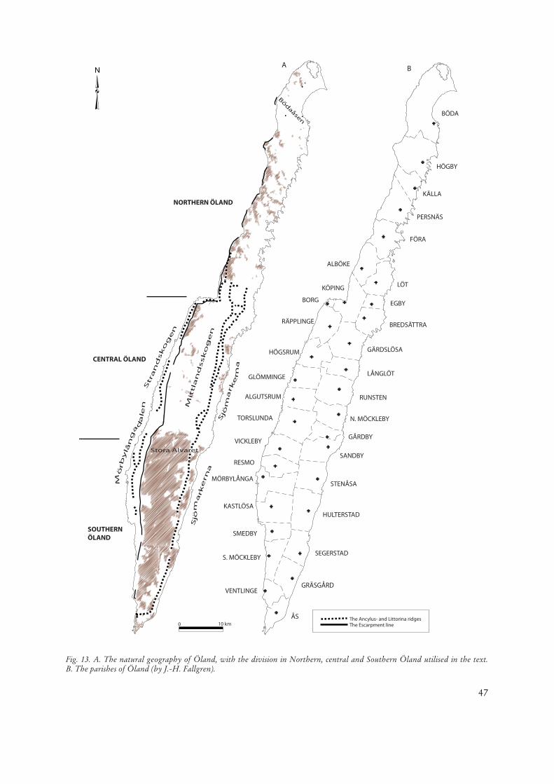
As shown on the map, the burials and burial grounds are situated in several places outside the older infields, as well as by the sea in the coastal meadows, the so-called sjömarkerna. The burial grounds that are located alongside the old shore ridge (dating from the Ancylus stage), have undoubtedly been larger and more continuous. On this ridge, the village plots of Alby, Triberga and Hulterstad were staked out some time during the High Middle Ages, which means that the older burial grounds of the villages were badly damaged (regarding the natural geography of Öland and the parish division on the island see Fig. 13).
There are no burials, or any natural boundaries, between the Iron Age settlements in Triberga’s and Hulterstad’s fields. This could suggest that the Iron Age settlements in this area were originally con-nected and thus formed one, larger, village. If this assumption is correct, the Triberga fort was original-ly located in the outfields between three villages. In this case, the ring-fort seems to have functioned as a central place in a smaller settlement district. The village of Skärlöv in the south (outside the limits of the map) was presumably also part of this settlement district and possibly also one/some of the
Fig. 6. The ring-fort of Triberga and its relation to the agricultural landscape (by Y. Bäckström).

36
villages in the southern part of the area, which was to become Stenåsa parish (north of the ring-fort). Altogether, the settlement district might thus have consisted of circa 5–7 villages. This numeric rela-tionship is valid also for the settlement districts of the other medium sized ring-forts.
The discussion will now turn to the next category of ring-forts. The fort in Löt (“Trindborgen”) has been chosen to illustrate the nature of the numeric relationships relating to the large ring-forts on the island (Fig. 7). As shown on the map, this ring-fort is located in the middle of a sizeable outfield (pas-ture ground), which is considerably larger than the one at the Triberga ring-fort. On the map, there are four large villages that lie in direct relation to the common, in which the ring-fort is the focal point. There are even more villages outside the limits of this map. The map with the ring-fort forms the centre of a long and narrow area consisting of outfields, starting from the northern part of Bredsättra parish in the south, continuing northwards along the coastal meadows in Egby parish and further on inland to Löt parish, up through Alböke parish to the southern parts of Föra parish in the north (Fig. 13B; see also Göransson 1958, Fig. 1; 2). The majority of the villages in these parishes lie in connec-tion to this elongated area of communal pastures. All villages located to the west seen in Fig. 7 should
Fig. 7. The ring-fort of Löt and its relation to the agricultural landscape (by Y. Bäckström).

37
presumably also be included, in example those that lie within the parish of Köping, in the settlement district that used Löt ring-fort during the Iron Age. The plausibility of this hypothesis is strengthened by the location of the ring-forts situated closest to Löt. If this theory is correct, the settlement district that used the ring-fort presumably consisted of circa 20 villages. It should be noted that the Viking Age and medieval villages with place-names containing torp have not been included in this calculation.
The corresponding numerical relationships for the other large ring-forts will not be discussed here, but it is worth pointing out that approximately the same numbers of villages seem to have made use of the ring-forts at Vedby, Ismantorp and Mossberga, if one considers how these forts relate to their own settlement districts.
The location of Bårby ring-fort on top of the old shore ridge above the Mörbylånga valley as well as the lack of other ring-forts on the coastal plain west of Stora Alvaret, strongly suggest that this ring-fort was used by all the villages in this settlement district. This would mean that approximately 15–17 villages made use of this fortification, which in turn signifies that, despite its slightly smaller size in comparison to the four ring-forts mentioned above, it should be included among the large ring-forts.
The remarkable construction at Treby with its three conjoined ring forts seems, according to its loca-tion in relation to the ring-forts at Eketorp and Triberga as well as to the agrarian settlements in the area, to have served three different settlement districts. If this theory is correct, the villages in the south closest to the fort, which were located in the southern part of Segerstad parish and the northern part of Gräsgård parish, constituted one of these settlement districts. The villages in the northern parts of Segerstad parish would in that case have made up the second, north-eastern, settlement district and the third, western, settlement district may have been constituted by the villages within the parishes of Södra Möckleby and Smedby, altogether circa 15 villages.
Returning to the ring-fort at Löt and the map seen in Fig. 7, it is clear that there are house founda-tions and stone fences in all the villages, although in varying quantities. The greatest frequency of such features are found on Valsnäs field, where one of the most well-preserved Ölandic Iron Age villages, with 23 house foundations, is located. Further house foundations may have existed in the area lead-ing down towards the village plot in the south-western part of the field, where the main part of the village’s agricultural land was located. This idea is strengthened by the two gold artefacts that have been found within the village. In Arbelunda the settlement remains are mainly located northeast of the village, close to Petgärde träsk and Kårehamn (outside the limits of the map). In the villages of Lilla and Stora Istad no such remains are extant, although a few can be identified on old maps. In Tjurlösa village, today’s Norrby, five house foundations have been marked on the map. Most of these can be found on old maps. House foundations are also found on old maps of the villages of Hagelstad and Unnestad, west of Tjurlösa. In Mörby, rather substantial settlement remains have been found in the western part of the village’s field, close to the boundary with Hjärpestad. Studies of old maps have furthermore revealed house foundations and stone fences in the northern part of the infields. Also these remains have been marked on the map (Fig. 7). This map moreover makes it clear, as did the map of the area around Triberga ring-fort (Fig. 6), that the Iron Age settlements are mainly found centrally within the infields of the historic villages, while the historic farms and village plots are most often located in the outskirts of their fields. The shift to the latter location took place some time during the High Middle Ages, while the early medieval farms seem to have been situated on the same locations as the Iron Age settlements. This is made clear through studies of old maps where a number of place-names with the prefix tomt- (plot) are found in

38
the middle of the village fields (Göransson 1991, 80 et seqq.). The same circumstances most likely also applied to the Viking Age settlements (Fallgren 2006, 157). Large silver hoards have been found in the fields of Valsnäs and Arbelunda, as well as in Petgärde north of Arbelunda. It should also be noted that the church of Löt, with its vicarage and land holdings, has the same spatial relationship to the rest of the settlement and the agricultural land as the ring-fort. The church is in this sense different from the majority of Ölandic churches, which are usually located next to a village and most often on or in close proximity to an iron-age burial ground. The name Löt, which is primarily the name of an ecclesiastical site, is best translated as “pasture” (Göransson 1991, 80). The ring-fort itself has been subject to a small scale excavation, which revealed occupation layers in those few parts the fort that had not been subject to agricultural activity (Schultze 1991).
Finally, the spatial relationship of the very largest of the ring-forts, Gråborg, to the prehistoric and historic agricultural landscape, will be studied. In order to do so, the perspective must be widened considerably. A map showing larger parts of mid-Öland is moreover required in order to include those settlements and settlement districts that can be associated with this ring-fort (Fig. 8). The com-mon, in the middle of which Gråborg ring-fort is situated, is considerably larger than those commons in which the other ring-forts are located. Apart from Stora Alvaret, this is the largest unenclosed outfield on Öland. This observation is based on studies of both the visible prehistoric settlements and the historic settlement as represented on old maps. The ring-fort, which is located more or less in the middle of the island, circa 8 kilometres from the west coast and circa 7 kilometres from the east coast, lies between the western and the eastern settlement districts on mid-Öland. This demonstrates that the ring-fort was erected and used by the inhabitants in the many, often very large, villages in the two different settlement districts. Studies of the map moreover make it clear that circa 25 historic villages had direct access to the large outfield in which the ring-fort was located. The inhabitants of the villages directly to the east of the Ancylus ridge, on the eastern side, have most certainly also used Gråborg. Judging from the ancient sites and the place-names in the area, the Iron Age settlements around the ring-fort seem to have amounted to circa 20 villages. The boundaries of 17 of these adjoin to the large common. Moreover, 3 kilometres directly south of Gråborg, Norra Möckleby ring-fort can be seen (Fig. 8). Several of the Iron Age villages in the area were very large and some were among the largest on the island during this time. The remains of one of these have been found northwest of Vanserum. As seen on the map, the early historic settlement remains were located on pasture. Over time, this area has been included in the village’s infields, which today is mostly agricultural land. Here 32 house foundations have been registered, although further remains most likely existed before the central parts were converted into fields. On old maps of Vanserum there are another five house foundations within the limits of the old field. The locations of the house foundations in relation to each other suggest that the Iron Age village consisted of circa 20 farms. The remains of yet another very large Iron Age village, consisting of 24 houses, have been identified to the west, between Gillsättra and Övetorp (see Fallgren 2006, 60). The inhabitants of the village of Tävelsrum, seen in the southern part of the map, may also have used Gråborg. Another, perhaps more plausible suggestion, is, however, that this village was connected to the ring-fort at Lenstad, as were the villages located in the southern set-tlement district of Torslunda parish. The Lenstad ring-fort is located circa 1.5 kilometres directly to the south of Tävelsrum’s village plot. Yet another village that presumably belonged to the settlement district around Gråborg, but which is outside the limits of the map, is Ullevi in Gårdby parish, just south of Bostorp.
The villages with names containing the prefix Torp were most likely established during the Viking and Middle Ages. In this case there are a total of nine such villages (see Fig. 8). All of these are situated close to the older villages, and most of these along the outer limits of the outfields. This meant that the extent of the unenclosed pasture was reduced over time. The example of the village of Arontorp

39
(see the lower left-hand corner of the map) clearly demonstrates that stone fences were used and constructed also during the Viking and Middle Ages. As shown on the map, Arontorp’s field contains a large number of ancient stone fences, of which only a few, located in the most eastern part of the field, are still extant. The remainder have been identified through an 18th-century map, where also the name Old Arontorp (gamla Arontorp) can be found amongst the remains in the middle of the field. There are, however, no house foundations visible among these fences, either today or on old maps. A Viking Age burial has been found next to the village plot that was staked out in the south-western part of the field, presumably during the 12th century. A Viking Age hoard, dated to the 10th century, which consisted of Arabic silver coins, has moreover been found somewhere within the land holdings (SHM 611), possibly in the fields by Old Arontorp. This suggests that the village of Arontorp was established some time during the Viking Age and that the settlement was originally located centrally within the infields. These settlements were, just as the older visible settlements from the Roman Iron Age to the early Merovingian period, delimited by a number of different stone fences. Some of the other villages with names containing Torp may also have been established during the Viking Age or in the beginning of the Middle Ages. There are, however, a number of circumstances, which will not be accounted for here, that suggest that several of these Ölandic villages appeared after the 14th century.At some point during the Middle Ages yet another settlement – a farm – was established in the mid-dle of the large common by Gråborg ring-fort. In the land registers (jordeböcker) of the nunnery at Vadstena, this farm went under the name Borgh or Bakkaborgh. The earliest reference to this farm is found in a letter from 1371 (DS X 42), in which Botild Bänesdotter of Broxvik in Småland, donated all her belongings from Borgh, Bröttorp, Dörby and Bettorp to the nunnery at Vadstena. Botild had inherited Borgh and the land holdings in Bettorp from her son Lars (Göransson 1985, 70; DMS 4:3 1996, 216). It is not known how or when this Lars had become the owner of the farm, or when this settlement had been established. It does, however, seem plausible that this had taken place after the phasing out of the early medieval “military garrison” inside the ring-fort (in example the medieval settlement) in the beginning or middle of the 13th century (for dates and functions of this phase, see Blohmé 1999; Malm 2005). The farm is still located on the same site as marked on the oldest maps, in example 100 metres westnorthwest of the ring-fort, and its land holdings were located close to the
Fig. 8. The ring-fort of Gråborg and its relation to the agricultural landscape (by Y. Bäckström).

40
northern part of the fort. Neither these landholdings nor the nearby chapel have been marked on the map (Fig. 8), as the purpose is to illustrate primarily the total absence of fences and fields on the large common.
In the 1477 entry in the land register of the Vadstena nunnery it is stated that example given Bakkaborgh “ligger utan hå och hampn”. This means that the farm was neither levied nor divided into attungar (mansi), and it was thus also exempt from the ledung. This confirms the idea, clearly indicated by the map discussed above (Fig. 8), that the farm was established in an area of outfields where certain judicial privileges applied, in example a common belonging to the härad (hundred). In the 1477 entry it is moreover mentioned that the nunnery had another ‘asset’, the so-called Aasgudhzrwma skoge, in example Aasgudhzrwma forest. It thus seems clear that an otherwise unknown hundredal forest exist-ed in Algutsrum (Göransson 1985, 69 et seq.). This forest seems to have been similar to Böda forest,with its regal characteristics, in the most northern part of Öland. The existence of Aasgudhzrwma forest is furthermore interesting since the western part of mid-Öland, which Algutsrum hundred to a large extent covered, is the area apart from the royal forest of Böda, which has the best preserved and the most continuous Iron Age settlement remains on all of Öland. It is possible that medieval kings had strong claims over this area, and thus restricted and impaired the liberty of action of the local farmers, as was the case in Böda parish. If this idea is correct, the origin of such claims and restric-tions must be connected to the military characteristics of the material culture from the early medieval settlement in Gråborg, and also to the reuse of the ring-fort at the end of the 12th century2. It is well-known that medieval kings usurped farms, villages and whole settlement districts, in order to use the land for their own purposes. The idea of royal influence over the common/forest is strengthened by medieval and later documentation in which royal hunting grounds are recorded within the boundaries of Algutsrum hundred, albeit closer to its western coast line (see Göransson 1985, 71; Palm 1985b, 115 et seq.; DMS 1996, 196).
As shown in the above examples, there is a clear proportional relationship between the sizes of the ring-forts, the number of villages that surrounded them, and also the acreage of the outfields/commons in which they were erected. These examples also demonstrate that the ring-forts were located far away from other contemporary sites, such as burials, separate house foundations, stone fences and ancient fields. The absence of burials and fields in the areas near the ring-forts, strongly suggests that the ring-forts in general were not permanently occupied. One exception is Eketorp II, as this ring-fort was clearly permanently settled over a long period of time. The reason for this was most likely a number of specific circumstances, which forced the population in the surrounding villages to move into the fort for a longer time period. Eketorp is moreover the ring-fort that has been shown to contain the thickest occupation layers so far, which was the reason why Mårten Stenberger chose this particular fort for total excavation. Most of the other excavated ring-forts did, on the other hand, have very thin occupation layers.
The prehistoric ring-forts should not presumably be seen as settlements for an elite who lived in and exploited their respective settlement districts, and should thus not be compared to the medieval forti-fied manors, or royal castles, which to a great extent were supported by the farmers in the surrounding areas. The early medieval settlements inside the ring-forts do, however, seem to have functioned in this way, in example as military garrisons who could demand the necessities of life from the farmers in the settlement districts in the vicinity of the forts. The prehistoric settlements used up more or less all free space inside the ring-forts (see Fig. 4). If these forts had functioned as dwellings for the elite, remains of only one larger farm would have been found inside each ring-fort. In general the house foundations
2 The function of the medieval settlement in Gråborg can presumably be linked and compared to medieval Eketorp, which has been interpreted as a military garrison erected by early Swedish kings (Göransson 1975, 79; Borg 1998, 64 et seqq.).

41
inside the ring-forts are, moreover, significantly smaller than those found in the villages within the agricultural districts. It is exactly in these agricultural areas that the remains of the very large farms of the period have been found. Despite the impressive appearance of the ring-forts, with their high walls and relatively large dimensions, the biggest of the Iron Age farms in the agricultural areas would only just fit inside one of the very largest forts (see Fig. 9)3.
Even if some of the ring-forts, such as Gråborg, were reused in the beginning of the Middle Ages, it is the relationship of the forts to the older prehistoric settlements (in example from the end of the Early Iron Age and the beginning of the Later Iron Age) which is the most significant, as it was during the Iron Age that the ring-forts were erected. It is thus appropriate to present some further details regar-ding these settlements.
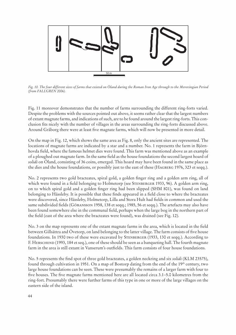
In the current Ölandic landscape there are many preserved and thus visible prehistoric house foun-dations. At the latest inventory of ancient sites and monuments, a total of 1040 house foundations were registered outside the ring-forts. Inside the ring-forts 252 house foundations were registered. Since this time, yet more houses have been identified. A study of all older survey maps of Öland’s villages carried out by the author (Fallgren 2006) has revealed a very large number of lost house foundations, demolished by cultivation, above all at the end of the 19th century. If the removed house foundations, those previously known and those newly found are all added together, the total number of house foundations outside the ring-forts comes to 1302. The original number must have been even greater. The relation of the house foundations to each other within the villages or separately, together with the knowledge of the functions of the different house types, make it possible to divide the house foundations into three or four different categories relating to size (see Fallgren 1998, 66 et seqq.; 2006, 25 et seqq.; 143 et seqq.).
The large majority of the farms, roughly circa 1000, consisted of one or two houses (see Fig. 10). Single farm houses were divided into two spheres: one for living and another for the keeping of cattle. On farms consisting of two houses, one house was usually used for dwelling and the other for cattle. The length of the houses on such farms varied, in most cases between 15 and 25 metres.
The next category contains farms consisting of three houses. On such farms there was usually a dwel-ling house, a byre and a small oval/square building. The length of the last-mentioned was usually bet-ween circa 7 and 10 metres. The dwelling house was usually circa 20–25 metres, in example somewhat longer than the single houses found on the smallest farms. There seems to have been a few hundred farms of this type on Öland.
The next category contains the really large farms, those which consist of four or five houses. Only 18 farms of this type are still extant. They are, however, relatively evenly spread across the island (see below). The houses on these farms are in general significantly larger than those found on the smaller farms. Often, several of the house foundations are more than 30 metres long, and the largest houses can be more than 55 metres in length. On sites where the fencing systems are relatively well preserved, it is clear that this type of farm had more than twice the acreage of enclosed fields and meadows than the smaller ones (Fallgren 1993, 62 et seqq.; 1998, 72; 2006, 28). If we calculate the floor area, the farms varied in size from 120 m2 to over 800 m2. The smallest farms with only one house had normally a total floor area of between 110 and 168 m2. On the farms with two houses, this area varied between 198 and 252 m2, while the farms with three houses had between circa 250 and 300 m2. For the largest farms,
3 Regarding the appearance and size of the Iron Age magnate farms on Öland see Fallgren (1993, 67 et seqq.; 2006, 28 et seqq.; 143 et seqq.).

42
in example those with four or five houses, the total floor area added up to between 558 and 834 m2. A clear social stratification thus seems to be mirrored in the different sized farms of the Iron Age settlements, in which the really large farms most likely belonged to the top strata in the contemporary Ölandic society.
Two further magnate farms can be traced through old maps of the village of Greby in Räpplinge parish and the village of Åby in Sandby parish. Some of the farms from the ploughed out settlements, a few of which have been partly investigated, should also be included in this category. The house founda-tions in Björnhovda, which were so rich in material culture, should certainly be amongst these. The remains were discovered when U. E. Hagberg (1976, 323 et seqq.) investigated the site where the well-known Torslunda dies were found.
The three ploughed out settlements excavated by Margareta Beskow-Sjöberg in Bredsättra parish should furthermore be classified as remains of magnate farms, example given on the basis of the rich material culture. In Skedstad, where unusually thick occupation layers were discovered a number of most interesting finds appeared, such as a stone-lined pit containing 560 iron ingots, a gold hoard as well as the remains of at least three different houses. At the settlement by Bo, east of Skedemosse, crucibles and moulds were found, which demonstrate that ornamented buckles were produced on the site. A larger hoard consisting of amber beads was moreover unearthed in a stone-paved road close to one of the houses. To the west of the village Ormöga, on the ridge formed during the Litorina stage, excavations of a ploughed out house revealed 13 dinars together with artefacts dating from the Migration and Merovingian Periods (Beskow-Sjöberg 1977, 25 et seqq.; 70 et seqq.; 131 et seqq.). Metal detectors moreover exposed further high-status artefacts, including several finds dating from the Merovingian and Viking periods as well as the early Middle Ages (Blohmé 1991). This example
Fig. 9. The ring-forts of Eketorp and Ismantorp, and in the middle, the magnate farm in Fagerum with its infields (after NÄSMAN/WEGRAEUS 1976; STENBERGER 1933; FALLGREN 2006).

43
clearly demonstrates that the settlements during the Viking and Early Middle Ages were mostly located at the same sites as earlier settlements. On a map that shows Ormögas land holdings in 1734 (LMV G.7.9.1), there are three impediments that proportionally and size-wise correspond to house foundations at the site of the investigations. The smallest of the three was indeed located on the same spot where the ploughed out house foundation had been identified. The longest impediment was circa 50 metres in length. Altogether, this clearly shows that a magnate farm existed at the site between the Roman Iron Age and the Merovingian Period, as well as during Viking and Early Middle Ages.
The final example of a ploughed out prehistoric magnate farm that will be discussed here is the settle-ment in Solberga, Gräsgård parish, excavated by Monika Rasch in the beginning of the 1990s. At this site, two statues depicting bulls had previously been found, and these were the reason for the excava-tion. The investigation revealed several artefacts, which together with the excavated house remains, demonstrate that it was a indeed a magnate farm (see Rasch 1993; Persson/Rasch 2001, 373).
If the extant number of magnate farms is added to the ploughed out (and partly excavated) farms, one arrives at a total of 26. Evidence, however, suggests that once a greater number than this existed. As demonstrated above, several farms were demolished when the village fields were extended from the mid 19th century and onwards. It was also in connection to these activities that most of the more famous and exclusive Ölandic prehistoric artefacts were found. Through some of these finds, unk-nown, demolished magnate farms can be traced. Artefacts that can be seen to represent magnate farms from the Roman Iron age through to the Migration Period include gold bracteates, golden arm rings and larger hoards of Roman gold coins – solidi (see e. g. Fabech/Ringtved 1995, 13 et seqq.).
On the map (Fig. 11) the location of these finds and the artefact types have been marked (on the occa-sions when their find spots are known), together with the extant magnate farms, the partly excavated ploughed out farms, as well as the ring-forts that were in use during the same period4. Altogether, this survey gives a total of at least 42 magnate farms. As stated above, many more must have existed. This issue will not be discussed in detail here, although it should be noted that extant magnate farms, as well as indications of such, are almost completely absent on the coastal plain west of stora Alva-ret (the so-called Mörbylångadalen), west and north-west of Bårby ring-fort, and in the Gärdslösa area south of Skedemosse, in the area south and south east of Sörby ring-fort, as well as in the area east of Köpingsvik, southwest of Löt ring-fort. This picture can hardly be correct, considering that Mörbylångadalen and Gärdslösa parish belong to the most fertile regions on Öland. There are moreo-ver further indications that magnates/chieftains existed in these three regions during the same period (see e. g. Hagberg 1967, 12; 105 et seqq.).
Despite this, Fig. 11 provides a good overview of what is usually termed “the power in the landscape” for the Roman Iron Age and the early Merovingian period on Öland. The relatively evenly distribu-ted magnate farms illustrate in a very concrete way how geographically dispersed power was during prehistory. It can be argued on good grounds that it was the people on these particular farms who formed and organised society during the time when the ring-forts were erected and used. It is thus also plausible that it was, above all, the owners of these farms who decided where in the landscape the ring-forts were to be erected.
4 The gold artefacts found through draining and cultivation of wetlands have not been marked on the map (Fig. 11), since these, in the same way as other sacrificed artefacts, may have been deposited by people from several different farms in the villages in the settlement district/s that were located in the vicinity of the wetlands. The sacrificial bogs are likely to have been used by many different people and can thus not be tied to a specific site/farm or village within these settlement districts.
44
Fig. 11 moreover demonstrates that the number of farms surrounding the different ring-forts varied. Despite the problems with the sources pointed out above, it seems rather clear that the largest numbers of extant magnate farms, and indications of such, are to be found around the largest ring-forts. This con-clusion fits nicely with the number of villages in the areas surrounding the ring-forts discussed above. Around Gråborg there were at least five magnate farms, which will now be presented in more detail.
On the map in Fig. 12, which shows the same area as Fig. 8, only the ancient sites are represented. The locations of magnate farms are indicated by a star and a number. No. 1 represents the farm in Björn-hovda field, where the famous helmet dies were found. This farm was mentioned above as an example of a ploughed out magnate farm. In the same field as the house foundations the second largest hoard of solidi on Öland, consisting of 36 coins, emerged. This hoard may have been found in the same place as the dies and the house foundations, or possibly just to the east of these (Hagberg 1976, 323 et seqq.).
No. 2 represents two gold bracteates, spiral gold, a golden finger ring and a golden arm ring, all of which were found in a field belonging to Holmetorp (see Stenberger 1933, 96). A golden arm ring, on to which spiral gold and a golden finger ring had been slipped (SHM 801), was found on land belonging to Hässleby. It is possible that these finds appeared in a field close to where the bracteates were discovered, since Hässleby, Holmetorp, Lilla and Stora Hult had fields in common and used the same subdivided fields (Göransson 1958, 138 et seqq.; 1985, 56 et seqq.). The artefacts may also have been found somewhere else in the communal field, perhaps when the large bog in the northern part of the field (east of the area where the bracteates were found), was drained (see Fig. 12).
No. 3 on the map represents one of the extant magnate farms in the area, which is located in the field between Gillsättra and Övetorp, on land belonging to the latter village. The farm consists of five house foundations. In 1930 two of these were excavated by Stenberger (1933, 130 et seqq.). According toF. Herschend (1993, 184 et seq.), one of these should be seen as a banqueting hall. The fourth magnate farm in the area is still extant in Vanserum’s outfields. This farm consists of four house foundations.
No. 5 represents the find spot of three gold bracteates, a golden neckring and six solidi (KLM 23575), found through cultivation in 1951. On a map of Bostorp dating from the end of the 19th century, two large house foundations can be seen. These were presumably the remains of a larger farm with four to five houses. The five magnate farms mentioned here are all located circa 3.1–5.0 kilometres from the ring-fort. Presumably there were further farms of this type in one or more of the large villages on the eastern side of the island.
Fig. 10. The four different sizes of farms that existed on Öland during the Roman Iron Age through to the Merovingian Period (from FALLGREN 2006).

45
Fig. 11. Magnate farms, ploughed out magnate farms, substantial gold finds and ring-forts on Öland (by Y. Bäckström).

46
The well-known golden collar from Färjestaden has not been included amongst the indicators of ploughed out magnate farms, despite having been found in the area. The golden collar was found on Färjestaden farm, which was located in the middle of Färjestaden’s fortifications (in the south-western corner of the map, south of Snäckstaviken) (see Hagberg 1976). These fortifications were erected in the beginning of the 15th century or during the 17th century (Blomkvist 1979, 81), which means that the goldcollar may have been found and buried during the Middle Ages or even later. It is therefore not certain whether it was found in the vicinity of the fortifications, or somewhere else on the island.
Traces of lost magnate farms can also be seen in the vicinity of the two ring-forts seen in Fig. 6 and 7. In Gösslunda field, near Triberga ring-fort a so-called Kolbenarmring was found (see Fig. 6).A smaller gold hoard (SHM 7517) was moreover discovered in Triberga, in the same location as one of the removed house foundations. This find could be an indication of a magnate farm, if the registered hoard once formed part of a larger one. In the vicinity of Löt ring-fort, a number of particular finds, such as a bracteate from Istad (SHM 3714), and one, or possibly two, larger gold hoards from Valsnäs consisting of spiral gold and solidi (SHM 3255; 2843; 2872; 4098; respectively SHM 2894; 5029; 6981; 17971; 21931), indicate that two magnates farms once stood there (see Fig. 7).
As shown above, the ring-forts on Öland that were in use between circa 200 and 600/700 AD were erected in outfields, in example commons located between villages or settlement districts. It has also been demonstrated that a stong proportional relationship existed between the sizes of the ring-forts and the number of villages and magnate farms that surrounded them, as was also the case with the acreage of the outfields in which the ring-forts were erected. The ring-forts can thus be seen as joint projects as well as manifestations of mobilisation and defence of one or more settlement districts. The ring-forts therefore came to be used as communal and connecting elements in the landscape between villages or settlement districts. There are, however, also a number of circumstances that suggest that the ring-forts on Öland, in the same way as ring-forts generally, functioned as sites for different types of joint meetings and activities (see e. g. Andersson 1931; Stenberger 1933, 242 et seq.; Näsman 1976, 51; Hegardt 1990–1991, 63 et seqq.; Olausson 1995, 42 et seq.; Cassel 1998, 145 et seqq.; Edgren 2000, 21 et seqq.). The ring-forts constituted thus in many respects important sites and struc-tures for several villages or even settlement districts, and they should therefore doubtless be seen as
Fig. 12. Gråborg, ancient monuments and the surrounding magnate farms (marked with red stars) (by Y. Bäckström).
47
Fig. 13. A. The natural geography of Öland, with the division in Northern, central and Southern Öland utilised in the text. B. The parishes of Öland (by J.-H. Fallgren).

48
some of the most important central places in the contemporary Ölandic society. The reuse of the ring-forts by the emerging Swedish central power in the beginning of the Middle Ages is a completely different story, which will not be discussed here, but will instead be examined in a different context.
Translated by Alexandra Sanmark.
!""#$%&!'&()*+
DMS Det Medeltida SverigeDS Diplomatarium Suecanum – Svenskt diplomatariumKLM Kalmar läns museum – Kalmar County MuseumLMV Lantmäteriverket, Gävle – National Land Survey of SwedenRAÄ Riksantikvarieämbetet – The National Board of AntiquitiesSHM Statens Historiska Museum – The Museum of National Antiquities
References
Ahlqvist 1822–1827: A. Ahlqvist, Ölands Historia och Beskrifning 1–2 (Kalmar 1822–27). [Reprint with an intro-duction byS. Göransson] (Uppsala).
Andersson 1931: W. Andersson, Stenkors och kapellruiner på Öland. In: E. E. Areen (ed.), Öländska kulturbilder från skilda tider. Acta Oelandica 4 (Stockholm).
Beskow Sjöberg 1977: M. Beskow Sjöberg, The Archaeology of Skedemosse, IV (Stockholm).Blohmé 1991: M. Blohmé, Skattfyndsprojektet på Öland. 1990 års fältarbete [unpublished report Kalmar Läns
Museum]. Blohmé 1999: M. Blohmé, Undersökningar med metalldetektor på Gråborg [unpublished report Kalmar Läns Muse-
um]. Blomkvist 1979: N. Blomkvist, Medieval Eketorp and Contemporary Turn-over Places on Öland. In: U. Näsman/E.
Wegraeus (eds.), Eketorp. Fortification and Settlement on Öland/Sweden. The Setting (Stockholm). Borg 1998: K. Borg, Eketorp-III. Den medeltida befästningen på Öland. Artefakterna (Stockholm).Cassel 1998: K. Cassel, Från grav till gård. Romersk järnålder på Gotland. Stockholm Studies in Archaeology 16
(Stockholm).DMS 1996: R. Axelsson/K. Janzon/S. Rahmqvist, Det medeltida Sverige, 3 Öland, 4 Småland (Stockholm).Edgren 1978: B. Edgren, Hässleby Borg. Meddelanden från Kalmar läns fornminnes- och hembygdsförbund och
Stiftelsen Kalmar läns museum 63, 1978, 82–84. Edgren 2000: B. Edgren, Eketorp – offer- och tingsplats. Borgbrevet 2, 2000. Fabech/Ringtved 1995: Ch. Fabech/J. Ringtved, Magtens geografi i Sydskandinavien. Om kulturlandskab, produk-
tion og bebyggelsemønster. In: H. G. Resi (red.), Produksjon og samfunn. Om erverv, spesialisering og bosetning i Norden i 1. årtusen e. Kr. Beretning fra 2. nordiske jernaldersymposium på Granavolden Gjæstgiveri 7–10 mai 1992. Varia/Universitetets Oldsaksamling 30 (Oslo) 11–37.
Fallgren 1993: J.-H. Fallgren, The Concept of the Village in Swedish Archaeology. Current Swedish Arch. 1, 1993, 59–86.
Fallgren 1998: J.-H. Fallgren, Hus och gård på Öland. Bebyggelsehistorisk Tidskr. 33, 1997, 63–76.Fallgren 2001: J.-H. Fallgren, Högby socken. In: M. Rasch (red.), Ölands järnåldersgravfält 4 (Kalmar) 63–75. Fallgren 2006: J.-H. Fallgren, Kontinuitet och förändring. Bebyggelse och samhälle på Öland 200–1300 e Kr. Aun 35
(Stockholm).Göransson 1955: S. Göransson, En okänd borg i Källa socken. Åkerbo hembygdsförenings årsbok 1955, 15–27.Göransson 1958: S. Göransson, Field and Village on the Island of Öland. A Study of the Genetic Compound of an
East Swedish Rural Landscape. Geografiska Annaler 40, 2, 1958, 101–158.

49
Göransson 1975: S. Göransson, Bebyggelsen i Ås under äldre historisk tid. In: B. Engström (ed.), Ås, Socken på Ölands sydspets (Ås) 71–88.
Göransson 1985: S. Göransson, By, gård och jord i Algutsrum under äldre historisk tid. In: Palm 1985a, 44–77.Göransson 1991: S. Göransson, Bygd och bebyggelse i Löts socken under äldre historisk tid. In: K. Lundh (ed.), Löt.
En ölandssocken och dess människor (Borgholm) 80–140.Hagberg 1967: U. E. Hagberg, The Archaeology of Skedemosse II. The votive deposits in the Skedemosse fen and
their relation to the Iron-Age settlement on Öland, Sweden. Royal Academy of Letters, History and Antiquities 46 (Stockholm).
Hagberg 1976: U. E. Hagberg, Fundort und Fundgebiet der Modeln von Torslunda. Frühmittelalterliche Stud. 10, 1976,323–349.
Hegardt 1990–1991: J. Hegardt, Det patrilaterala samhället, hemliga sällskap och monumentala byggnader. En analys av en gotländsk fornborg. Tor 23, 1990–1991, 55–84.
Herschend 1983–1985: F. Herschend, Fällgallerporten i Eketorp-II, Öland. Tor 20, 1983–1985, 165–216. Herschend 1993: F. Herschend, The origin of the hall in southern Scandinavia. Tor 25, 1993, 175–199. Malm 2005: G. Malm, Rapport över arkeologiska undersökningar vid Gråborg, Öland, utförda under två höstmånader
varje år mellan åren 1999 och 2002 [unpublished report].Näsman 1976: U. Näsman, Introduction to the Descriptions of Eketorp-I, -II & -III. In: K. Borg/U. Näsman/
E. Wegræus, Eketorp. Fortification and Settlement on Öland/Sweden. The Monument (Stockholm) 45–60.Näsman 1997: U. Näsman, Strategies and tactics in Migration period defence. On the art of defence on the basis of the
settlement forts of Öland. In: A. Nørgård Jørgensen/B. L. Clausen (eds.), Military Aspects of Scandinavian society in a European Perspective AD 1–1300 [Int. Research Seminar Copenhagen 2–4. May 1996]. Publications from The National Museum. Studies in Archaeology and History 2 (Copenhagen) 146–155.
Olausson 1995: M. Olausson, Det inneslutna rummet – om kultiska hägnader, fornborgar och befästa gårdar i Upp-land från 1300 f Kr till Kristi födelse. Studier från UV Stockholm. Riksantikvarieämbetet Ark. Undersökningar Skr. 9 (Stockholm).
Palm 1985a: B. Palm (ed.), Algutsrum, en sockenbeskrivning (Emmaboda).Palm 1985b: B. Palm, Byar och gårdar under de senaste 250 åren. In: B. Palm 1985a, 78–133. Persson/Rasch 2001: I. Persson/M. Rasch, Gräsgård socken. In: M. Rasch (red.), Ölands järnåldersgravfält. Vol. IV
(Kalmar).Rasch 1993: M. Rasch, Fornlämningar och fornfynd i Gräsgård. Gräsgård mellan hav och hed, Gräsgårds hembygds-
förening (Degerhamn).Reisnert 1989: A. Reisnert, Borgar och huvudgårdar i Danmark och Skåne. By, huvudgård och kyrka. Studier i
Ystadsområdets medeltid (Stockholm). Schultze 1991: H. Schultze, Löts forntid. Löt en ölandssocken och dess människor (Löt).Stein/Öhr 2002: M. Stein/A. Öhr, Triberga fornborg på sydöstra Öland. Tidskrift. Arkeologi sydöstra Sverige.
2002/2 (Kalmar). Stenberger 1933: M. Stenberger, Öland under äldre järnaldern. Kungl. Vitterhets Hist. och Antikvitets Akad. Ark.
Monogr. 19 (Stockholm). Vallinus 1703: N. O. Vallinus, De Oelandia dissertatio gradualis. Upsaliae (Uppsala).Wegraeus 1976: E. Wegraeus, The Öland Ring-forts. In: K. Borg/U. Näsman/E. Wegraeus (eds.), Eketorp. Fortifica-
tion and Settlement on Öland/Sweden. The Monument (Stockholm).
Jan-Henrik Fallgren Centre for Svandinavian StudiesCrombie AnnexeKing’s CollegeUniversity of Aberdeen UK – AB24 [email protected]