The medieval territory of Brussels: A dynamic landscape of urbanisation
16
223 2.5 The medieval territory of Brussels: A dynamic landscape of urbanisation Authors Bram Vannieuwenhuyze 1 , Paulo Charruadas 2 , Yannick Devos 2 and Luc Vrydaghs 2, 3 1. Medieval History Research Unit, Katholieke Universiteit Leuven, Leuven, Belgium 2. Centre de Recherches en Archéologie et Patrimoine, Université libre de Bruxelles, Brussels, Belgium. 3. Research Team in Archaeo- and Palaeosciences, Brussels, Belgium Contact: [email protected] abstract The urbanisation process has a huge impact on both the urban and rural landscape. Not only does it thor- oughly modify the urban area, it also has a tremendous impact on the rural hinterland. We propose to take medieval Brussels (Duchy of Brabant) as an example to illustrate this complex issue. According to our different fields of research, a multidisciplinary point of view will be adopted, combining urban histo- ry (the study of human urban society), rural history (agricultural developments and rural socio-economic change), historical geography (interaction between medieval people and their spatial environment) and natural sciences (through the archaeopedological and phytolith study of Dark Earth). Firstly, we briefly discuss the essential concepts ‘medieval city’ and ‘medieval urban landscape’ and try to apply them to the case of medieval Brussels. Secondly, we address some essential characteristics of landscape transforma- tion, by tackling the major stages of the emergence and development of medieval Brussels and its chang- ing impact on the regional landscape. We argue that the urbanisation process, generally allocated solely to the urban area, is key to understanding landscape transformation of the medieval territory of Brussels. keywords landscape history, urbanisation, urban morphology, archaeopedology, archaeobotany, agriculture
Transcript of The medieval territory of Brussels: A dynamic landscape of urbanisation
2 2 3
2.5 The medieval territory of Brussels: A dynamic landscape of urbanisation
AuthorsBram Vannieuwenhuyze1, Paulo Charruadas2, Yannick Devos2 and Luc Vrydaghs2, 3
1. Medieval History Research Unit, Katholieke Universiteit Leuven, Leuven, Belgium2. Centre de Recherches en Archéologie et Patrimoine, Université libre de Bruxelles, Brussels, Belgium. 3. Research Team in Archaeo- and Palaeosciences, Brussels, BelgiumContact: [email protected]
abstract
The urbanisation process has a huge impact on both the urban and rural landscape. Not only does it thor-
oughly modify the urban area, it also has a tremendous impact on the rural hinterland. We propose to
take medieval Brussels (Duchy of Brabant) as an example to illustrate this complex issue. According to
our different fields of research, a multidisciplinary point of view will be adopted, combining urban histo-
ry (the study of human urban society), rural history (agricultural developments and rural socio-economic
change), historical geography (interaction between medieval people and their spatial environment) and
natural sciences (through the archaeopedological and phytolith study of Dark Earth). Firstly, we briefly
discuss the essential concepts ‘medieval city’ and ‘medieval urban landscape’ and try to apply them to the
case of medieval Brussels. Secondly, we address some essential characteristics of landscape transforma-
tion, by tackling the major stages of the emergence and development of medieval Brussels and its chang-
ing impact on the regional landscape. We argue that the urbanisation process, generally allocated solely
to the urban area, is key to understanding landscape transformation of the medieval territory of Brussels.
keywords
landscape history, urbanisation, urban morphology, archaeopedology, archaeobotany, agriculture
Kluiving DEF2.indd 223 16-04-12 16:48
224 · landscape archaeology between art and science
introduction
The study of ancient rural landscapes has quite a long tradition of interdisciplinarity, involving archae-
ologists, historians, geo-archaeologists, archaeobotanists and archaeozoologists (Rapp & Hill 1998;
Wilkinson & Stevens 2003). The study of the medieval urban landscape, however, has mainly been the
playground of urban historians, geographers and archaeologists (Heers 1990; Whitehand & Larkham
1992; Verhulst 1999; Lilley 2002; Schofield & Vince 2003). Nevertheless, since the late 1970s and the be-
ginning of the 1980s, we have witnessed a growing interest in urban soil. Natural scientists became in-
creasingly involved in the study of urban contexts (Macphail 1981; Barles et al. 1999). Nowadays, urban
archaeology has also become a truly interdisciplinary research field, incorporating specialists from di-
verse research fields. However, most studies are limited to historical city centres and their development,
and seldom consider the interplay of the urban environment with its hinterland (Hall & Kenward 1994).
Of course, this issue cannot be tackled without demarcating and clearly defining the topic. How
can we define a medieval city and a medieval urban landscape? What does medieval urbanisation en-
compass? Many scholars, including historians, archaeologists, soil scientists and ecologists, have already
tackled these issues, in either local or general studies (see for instance Lavedan & Hugueney 1974; Heers
1990; Dutour 2003; Heimdahl 2005; Fondrillon 2007). Generally speaking, the parameters of urbanisa-
tion, be they medieval or not, are often defined in terms of demography, centrality, density (or concen-
tration) and identity. For instance, Clark’s historical overview on European urbanisation starts with the
following words:
Since the Middle Ages, Europe has been one of the most urbanised continents on the planet and its
cities have stamped their imprint on the European economy, as well as on European social, political,
and cultural life. Rarely sprawling mega-cities such as those of present-day Latin America or Asia,
mostly compact and coherent, they have been communities characterised by heavy mortality (un-
til the twentieth century) and high immigration. Often endowed with administrative functions and
political privileges, they have always functioned as commercial and business centres, while religion
(up to recent times), education, leisure activity, and a distinctive townscape have helped define ur-
ban cultural identity. (Clark 2009).
From a demographic point of view, a city is seen as a concentration of people (Bairoch et al. 1988), regu-
larly fed by new immigrants, because of its central and economic functions. Nevertheless, the population
structures in a medieval city were very complex. Social, economic and political urban institutions and
frameworks were created to organise society and to centralise various functions: trade, industry, cultural
manifestations, administration, power, etc. This evolution gave birth to a specific urban mentality. Ac-
cording to Reynolds, ‘the inhabitants of towns regard themselves, and are regarded by the inhabitants of
rural settlements as a different sort of people. However deeply divided they may be among themselves,
they tend to be united at least in regarding themselves as different from the rustic simpletons outside.’
(Reynolds 1992). Urban identity and the feeling of superiority/otherness were maintained or even defend-
ed by administrative, architectural and juridical creations such as city walls, town rights and territorial
jurisdictions. Finally, if we consider the built environment, we notice that the built form of a city is often
considered as a concentration of buildings of different types (houses, churches, hospitals, castles, walls,
Kluiving DEF2.indd 224 16-04-12 16:48
2.5 the medieVal territory oF brussels: a dynamic landscape oF urbanisation · 225
etc.) built in different materials (wood, stone, loam, clay, straw, bricks, etc.). Of course, building density
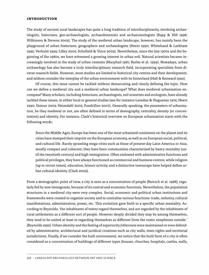
is an essential factor which distinguishes the city from the countryside. Medieval citizens themselves
portrayed their city in this way, as is clearly shown by the illuminated manuscript initial representing the
15th-century townscape of Brussels (fig. 1). Nearly 84% of the entire image is urbanised, clearly represent-
ing a concentration or compilation of buildings (nearly 87% of the urban space, some 72% of the entire
image).
Together with the features mentioned above, this kind of image gave birth to a traditionalist vision
of the medieval city and urban landscape, namely that of an isolated island, well protected by its walls, in-
habited and ruled by a distinct sort of men (citizens). Within these walls a strictly urban landscape would
exist, where specific urban functions and activities took place. For a long time historians and archaeolo-
gists adopted this paradigm in their studies. However, due to the implementation of other disciplines
into the field of urban history, a remarkable change of mindset has been seen over the last few decades. Of
course, Despy (1968), Nicholas (1971) and Jourdan-Lombard (1972) have already stressed the importance
of considering medieval towns and the countryside as a whole in their pioneering works, but these analy-
ses were often restricted to social, economic or political interaction. In landscape research, this mindset
came much later. Today, researchers increasingly consider the hinterland to be an essential part of the
urban landscape (see for instance Thoen 1993; Hall & Kenward 1994; Clark & Lepetit 1996; Giles & Dyer
2007; Limberger 2008; Bijsterveld et al. in press). The medieval city can no longer be separated from its
surrounding countryside. As a result, the definition of the medieval urban landscape also needs to be re-
assessed. Was it really that dense, specific and centripetal? In other words, was it really all that urban? In
addition, did urbanisation only mean a strengthening of these features?
We want to tackle some of these questions by presenting some results of ongoing research on me-
dieval Brussels. However, it is necessary to stress that this contribution must be considered as one of the
first steps within broader research aiming to reconstruct the medieval landscape evolution of the town
and its surrounding hinterland. Here we shall try to combine the results of individual research work,
bearing in mind that other results will need to be integrated in the future. In particular, we refer to the
very recent synthetic view on the Brussels landscape before 1200, published by the archaeological cell of
Figure 1. Figured initial dating from the middle of the 15th century, representing the city of brussels (© archives of the state, brussels). From the left to right are shown respectively the entire figured initial, the city view, urban space and finally urban buildings.
Kluiving DEF2.indd 225 16-04-12 16:48
226 · landscape archaeology between art and science
the Ministry of the Brussels Capital Region. It merges the results of successive archaeological campaigns
undertaken over the last twenty years with historical data (Degraeve et al. 2010). We have made use of
some archaeological findings, but we also look forward to stimulating cross-fertilisation between the var-
ious scientific disciplines involved in this research. In this respect, the opinions stated here should be re-
garded as work in progress.
interdisciplinary research on medieval brussels
Brussels is what is called a second generation city (Billen 2000). Unlike for example London or Paris, it
does not have Roman origins. The city emerged at the beginning of the 11th century. Following the tra-
ditional vision, the nucleus of the latter town lay alongside the river Senne, where a castrum and small
port were constructed (Henne & Wauters 1845; Des Marez 1935; Bonenfant 1949; Martens 1976). More re-
cent scholars have agreed that the late medieval town evolved from the merging of scattered settlements
(Despy 1979 & 1997; Dierkens 1989; Billen 2000; Deligne 2003), although they experienced serious dif-
ficulty in locating them precisely and providing a clear chronology for their spatial evolution. From the
13th century onwards, Brussels became an important political, industrial and ecclesiastical centre (Des
Marez 1901; Favresse 1932; Lefèvre 1942; Vannieuwenhuyze 2008; de Waha & Charruadas 2009). In the
centuries that followed, the town was considered one of the ‘capital cities’ of the Duchy of Brabant (Mar-
tens 1973; Smolar-Meynart 1985). This major role was confirmed in the 15th and 16th centuries with, ul-
timately, the creation of central political and administrative institutions within the city (Charruadas &
Dessouroux 2005).
Reconstructing and understanding the dynamics of medieval urbanisation and the process of land-
scape change in Brussels presents a challenge. Except for some well-known ‘monuments’, surviving me-
dieval remains within the former town and its surrounding hinterland are quite scarce. In 1695, Brussels
was subjected to an important bombardment which destroyed a large part of the city (Culot et al. 1992).
During the 19th and 20th centuries, the urban territory and its environment were affected by massive
town planning and (re)construction campaigns that drastically altered the landscape of the former pre-in-
dustrial town (Verniers 1934; Apers et al. 1982; Demey 1990, 1992). Nevertheless, the medieval landscape
did not entirely disappear, although its relicts have been extensively transformed and are often well con-
cealed. As a result, there is a huge need for appropriate search strategies to discover, analyse and preserve
both written and material records. Moreover, new scientific methods to unravel the dynamics of medieval
urbanisation are required. To understand the ‘landscape of medieval urbanisation’, it is not sufficient to
compare the viewpoints of various disciplines, but rather to broaden our horizons by integrating different
approaches, methods, scales and results.
We have all studied and are currently studying Brussels’ medieval landscape from different view-
points and at different scales. The historical analysis relates to the study of human urban society, with
particular emphasis on the interactions between people and space, enabling the medieval town devel-
opment of Brussels to be understood. This multidisciplinary research is based on an in-depth study of
morphological relicts of the medieval urban landscape within the town (e.g. the few remaining medieval
monuments, cartographical representations, street patterns, archaeological data) and on medieval texts
(e.g. toponyms, laws, property transactions, urban myths), considered to be relicts of human perception
Kluiving DEF2.indd 226 16-04-12 16:48
2.5 the medieVal territory oF brussels: a dynamic landscape oF urbanisation · 227
of spatial phenomena or evolution (Vannieuwenhuyze 2008). The archaeopedological research focuses
on the study of urban soil, in particular the Dark Earth units discovered throughout the actual city cen-
tre. These Dark Earth units are dark, humus-rich, non-peaty, strongly melanised and apparently homo-
geneous layers which have been sealed in the soil. Although they are an important part of the medieval
stratigraphy, their significance cannot easily be understood using a traditional archaeological approach
(Devos et al. submitted). Archaeopedology (including field study, micromorphology and physico-chem-
ical analysis), combined with archaeobotany and, more specifically, phytolith analysis have been shown
to be powerful tools in the identification of agents and in understanding the processes and activities re-
sponsible for their formation (Macphail 1981; Devos et al. 2009; Devos et al. 2010; Devos et al. submitted).
The integrated study of Brussels’ Dark Earth demonstrates its potential to identify ancient activity zones
(Devos et al. 2009; Degraeve et al. 2010) and to reconstruct the medieval landscape through the evalua-
tion of the role and interaction of natural and human factors (Devos et al., submitted). Finally, rural histo-
ry makes it possible to observe the broader landscape of Brussels and study the relationship between the
medieval town and countryside. Particular attention has been paid to agricultural change and its recipro-
cal links with urban development. This approach is not dominated by the paradigm of urban imperialism,
but rather by the idea of a social, economic and political continuum between town and countryside (Char-
ruadas 2008).
These different points of view also have repercussions on the use of different scales. For historical
analysis, various morphological levels have been selected, going from plots of land in neighbourhoods to
the entire city. Human action is studied at each level. To unravel the story hidden within the enigmatic
and homogeneous Dark Earth, it is necessary to go from macroscopic field study down to microscopic
scale (Macphail 1981; Devos et al. 2009). Archaeobotany combines the analysis of macro-remains (char-
coal and seeds) and micro-remains (phytoliths and pollen) originating from several sites within the actual
city. Unfortunately, the conservation of pollen and non-carbonised seeds on the higher parts of Brussels,
where most excavations have taken place, is not good. More recently, there have been some incursions
into the lower parts of Brussels, but we still have to wait for the results. And last but not least, by studying
rural history, phenomena in both the town and the countryside have been observed. This broad viewpoint
enables us to understand the connections (or the lack thereof), contrasts and adequacy of the gap between
what happened in town and in the countryside. These phenomena deal in particular with the economic
issue, namely urban demand for rural products, and with the elites who settled both in the city and sur-
rounding area. This approach shows the way in which urban society shaped the rural environment and,
conversely, how urban structures influenced rural society.
the dynamic landscape of medieval urbanisation
By studying how humans changed the medieval urban landscape, some general trends have been dis-
cerned. Man clearly had a marked effect on the management of the landscape, especially by organising
public works (the creation of the road network, hydrographical infrastructure, city walls, etc.), by con-
structing buildings, mainly for housing and industrial purposes, and through the establishment of ad-
ministrative, political and juridical frameworks. Up to now, scholars have taken a particular interest in
the evolution of these features. Building campaigns were reconstructed thoroughly by archaeologists and
Kluiving DEF2.indd 227 16-04-12 16:48
228 · landscape archaeology between art and science
building historians, especially major medieval buildings and infrastructures (Des Marez 1918; De Jonge
1991; Dickstein-Bernard 1995-1996; Bonenfant et al. 1998; Blanquart et al. 2001; Maesschalck & Viaene
s.d.), while historians studied in detail the medieval political, administrative and juridical institutions
both within and outside the town (Godding 1960; Favresse 1932; Martens 1939; Dickstein-Bernard 1977;
Smolar-Meynart 1991).
However important they may be, these and other studies barely reveal the spatial complexity of
the medieval urbanisation process. Firstly, it is now commonly accepted that this process cannot be out-
lined by simply listing the main historical ‘events’ or reconstructing the evolution of the main sites and
buildings. Secondly, although some scholars claim the spatial pattern of medieval Brussels evolved in an
organic way (Lavedan & Hugueney 1974), ever more scholars now agree that organic town development
did or does not exist (Pinol 2003; Boerefijn 2005). The townscape was constantly changing as a result of
top-down actions as well as bottom-up reactions and with successive ups and downs, both at local or re-
gional scale. The construction of two successive stone city walls during late medieval times serves as a
good illustrative example. Up to now, a very clear distinction has always been drawn between Brussels’
so-called first city wall, built in the 13th century (Demeter 2001), and Brussels’ so-called second city wall,
built in the second half of the 14th century (Dickstein-Bernard 1995-1996). Both constructions were im-
pressive works, so it is clear that their construction was ordered and financed by the authorities, the Duke
of Brabant and the Brussels town council respectively. However, these two building projects should not be
considered as isolated and chronologically-defined spatial phenomena, as historians have usually done
(and still do). In fact, recent research shows that the Brussels people continuously and systematically ex-
panded and transformed these walls, adapting them in accordance with changing demographic, politi-
cal, economic and spatial evolutions within the town and the entire territory (Vannieuwenhuyze 2008).
In this respect, the distinction between both late medieval city walls seems to originate from a teleologi-
cal interpretation post factum. In summary, these city walls did not suddenly appear nor did they develop
organically.
As a result, the already mentioned keywords used to define cities and urban landscapes must be
adopted with caution. Urban centrality, density and identity were constantly changing. This was also true
for the urban landscape. Recent historical analysis shows that the sole medieval urban landscape was
indeed not always that ‘urban’. Here, we are restricting ourselves to two concrete examples to illustrate
this point. In-depth analysis of the road network and street names has made it clear that different kinds
of streets existed during medieval times. Within the town, long and continuous streets juxtaposed nar-
row alleys. Other streets were created to reach infrastructural works (city walls, canals) or rural estates.
From a morphological point of view, these streets were constantly changing. Little alleys (straatjes) were
created to access the areas within the blocks and thus played an important role in communication at
micro-level. They were systematically heightened and paved each time new houses were built. Some still
exist, although most have been enclosed by private houses. At a macro-level, Brussels’ old artery net-
work came into being in close harmony with the economic potential of the hinterland (Vannieuwenhuyze
2009). Firstly, smaller roads linked the town to the surrounding villages and countryside. At a later stage,
a whole new network of artificial arteries was created by the town government, facilitating direct access
to the town. In addition, the creation of this artery network clearly reflected urban economic and political
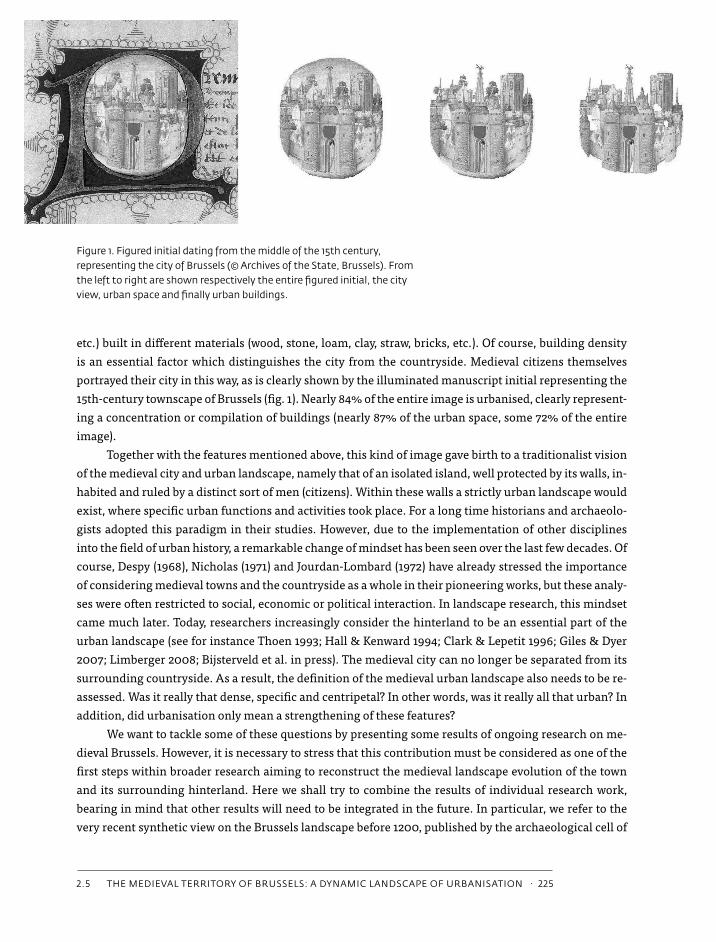
imperialism towards the surrounding countryside. To take a second example, digital analysis of the oldest (but geometrically very reliable) town plan,
Kluiving DEF2.indd 228 16-04-12 16:48
2.5 the medieVal territory oF brussels: a dynamic landscape oF urbanisation · 229
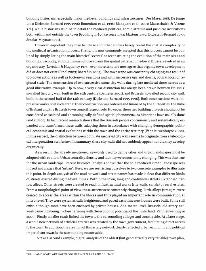
drawn up by Jacob van Deventer in the middle of the 16th century, shows that the largest part (36%) of ur-
ban territory within the city walls consisted of open space. In addition, 17%, 12% and 5% of the territory
were respectively allocated to the road network, the watercourses and green elements (trees, bushes and
parks), while ‘only’ 30% consisted of buildings (Vannieuwenhuyze 2008, see also fig. 2). This means that
at least until the middle of the 16th century, the urbanisation process did not only imply the creation of
different kinds of buildings, as often pointed out by historians. On the contrary, in previous decades and
centuries the evolution in open spaces, improvements to the road network and hydrographical changes
– whether or not these were natural – were if anything more important. It is not surprising that the latest
generation of historians consider the landscape of medieval Brussels to be a collection of expanding and/
or diminishing settlements, separated by open spaces and connected over time by public works such as
roads, canals and walls.
Figure 2. cartographic analysis of the 16th-century town plan of brussels by Jacob of deventer, realized in a scale of approximately 1:8600 (© royal library of belgium, brussels). From left to right are shown respectively the open spaces (36%), the road network, watercourses and green spaces (34%) and buildings (30%). See also full colour section in this book
Kluiving DEF2.indd 229 16-04-12 16:48

The original ‘broek-sele’ (i.e. Brussels) seems to be one of these settlements, probably of secondary impor-
tance and devoted to cattle husbandry. Another small settlement expanded on a nearby hill, the Couden-
berg, and became the seat of ducal power, perhaps by the 11th century, but certainly from the beginning
of the 12th century onwards (Vannieuwenhuyze 2008). Ducal power clearly stimulated the urbanisation
process with the foundation of churches, the draining of wetlands, the creation of a port and markets, etc.
Meanwhile, other settlements emerged between the Zenne River and the Coudenberg. These were often
devoted to small-scale trade and/or agriculture, as was the case with the Oud Korenhuis (Degraeve et al.
2010). From the 13th century onwards, Brussels town council took over the big public work projects, for
instance, by constructing the so-called second city wall, whose perimeter fixed the urban territory strictu
sensu until the beginning of the 19th century, when it was demolished (Lelarge 2001). During late medi-
eval times and the modern era the urbanisation process was limited to small-scale operations, such as the
densification and petrifaction of the urban fabric. Both phenomena have been documented in recently
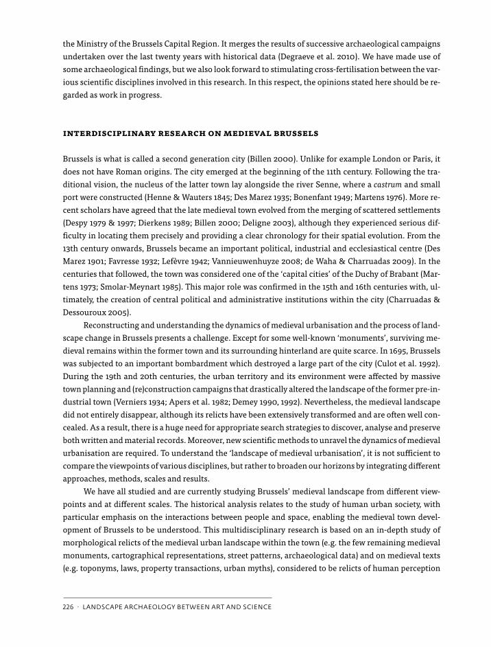
Figure 3: a) soil profile of dark earth on the site of hôtel de Lalaing-hoogstraeten; b) graph showing enhanced phosphorus levels for the dark earth units (us 7338 and us 7321); c) granulometric data showing the high similarity between the units us 7338 and us 7321 and the natural soil (us 7340), suggesting they share the same matrix; d) thin section micrograph showing phosphorus-rich excrement proving the addition of manure (plain polarised light); e) thin section micrograph showing a textural pedofeature enabling its identification as former at least temporary unprotected topsoil (plain polarised light); f) thin section micrograph showing dendritic phytoliths (plain polarised light). See also full colour section in this book
Kluiving DEF2.indd 230 16-04-12 16:48

2.5 the medieVal territory oF brussels: a dynamic landscape oF urbanisation · 231
conducted research in urban archaeology, showing for instance that private stone or brick buildings only
emerged from the 14th century onwards (see for instance Cabuy & Degré 1992; Degré 1995; Diekmann
1997; Nachtergael 1997; Claes 2008).
Of course, these statements give rise to new questions on the evolution of land use within this so-
called ‘urban’ territory. As has already been argued sole analysis of historical records will never be suf-
ficient in tackling this complex issue. Dark Earth constitutes a significant part of Brussels’ medieval
stratigraphy and has been shown to provide a valuable source of information on this topic. This archae-
opedological study reveals that it originates from a complex interplay between human activities and nat-
ural factors. Its formation and transformation can be understood as site-specific, involving an ongoing
process of accumulation, erosion, decomposition, homogenisation and other types of soil development,
which stop once the Dark Earth is sealed. As such, sequences of activities can often be revealed. Among
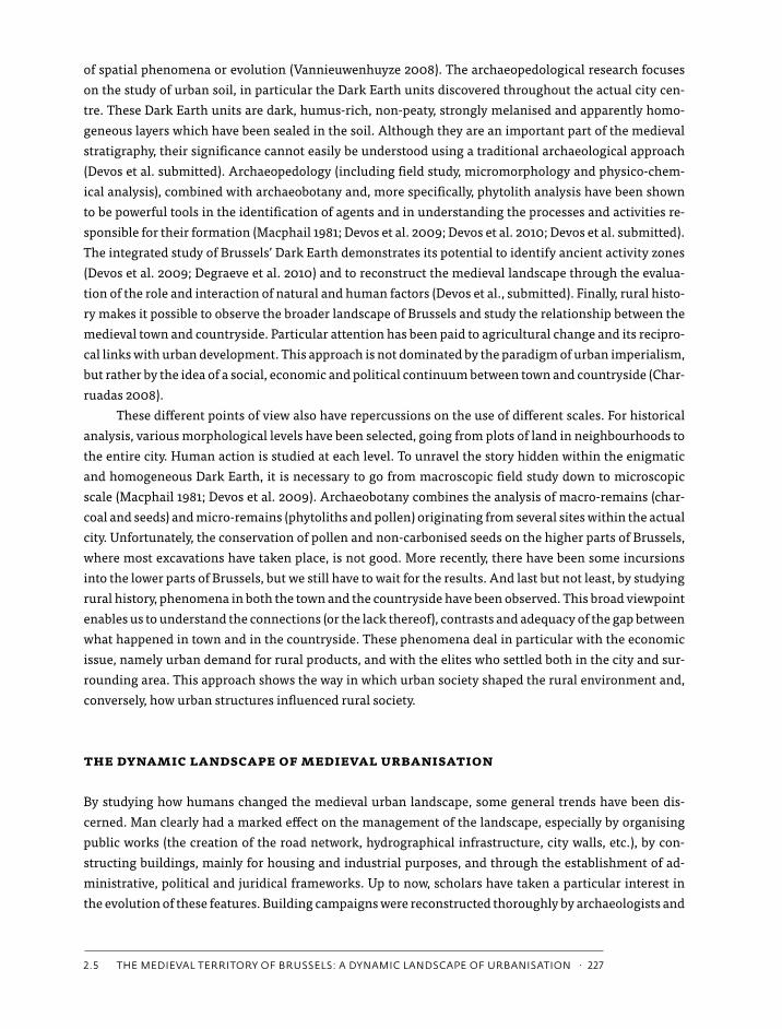
the human activities dating back to the 11th-13th centuries digging, ploughing (fig. 3), manuring (fig. 3)
and waste disposal have been identified. The main natural factors are bioturbation (fig. 4), erosion and
colluviation (Devos et al. submitted).
The botanical study of the identified agricultural plots is quite difficult. Conservation of pollen and
non-carbonised seeds and fruits is very poor. Nonetheless, the few surviving pollen and microfossils con-
firm the presence of pasture land and crop fields (Court-Picon 2008). Phytolith and charcoal preservation
however, is excellent. As phytoliths tend to provide very local information, they are a useful tool confirm-
ing the presence of crop fields (Vrydaghs et al. 2007; Devos et al. 2009). Phytolith markers for cultivated
crops have been recorded for all the Dark Earth identified as former plough lands (Table 1), demonstrating
the cultivation of wheat, oats and barley. Charcoal tends to provide information on the wood people have
used. Current data do not contradict pressure on relict forests throughout the 11th-13th centuries, possi-
bly bearing witness to the need for new space (Devos et al. 2007a).
Figure 4. thin micrograph section of a calcitic bio-spheroid (e). its presence proves enhanced earthworm bioturbation due to the addition of soil amendments, site of rue de Dinant (crossed polarisers).
Kluiving DEF2.indd 231 16-04-12 16:48
232 · landscape archaeology between art and science
It is clear that due to its complex formation process, Dark Earth should be analysed on an individual basis,
meaning that the data only relate to the collection site. Nevertheless, thanks to research frequency, a gen-
eral pattern has emerged. On most sites, we have noticed that patterns of activity seem to have undergone
frequent changes over time. This confirms the hypothesis that Brussels had a dynamic medieval land-
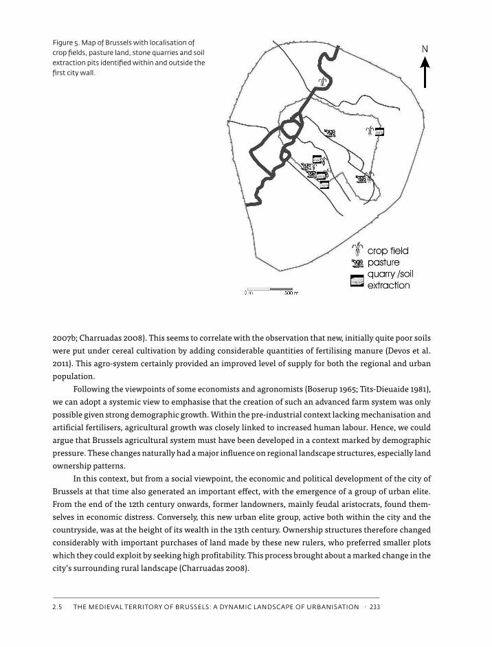
scape. Taking the Treurenberg site as an example, proof of a former stone quarry was discovered. At some
point this was filled in and transformed into a crop field, which in turn was sealed off by the construction
of the first city wall during the 13th century (Devos et al. 2007b). As far as activities recorded within the
medieval urban centre are concerned – namely the space enclosed by this first city wall – archaeologists
have noticed a heavy dominance of primary sector activities. Between the 10th and the 13th centuries,
traces of crop fields, pasture land, stone quarries and soil extraction pits have been identified (Devos et
al. 2007a; Degraeve et al. 2010, see also fig. 5). Apparently, artisan activities only appeared at a later stage,
when these areas were transformed into building plots, with a combination of different kinds of buildings
and infrastructures (Devos et al. 2007a).
The study of economic and agricultural changes makes it possible to indicate some factors that con-
siderably influenced and altered this dynamic Brussels landscape. As regards the supply of food and cere-
als, the medieval Brussels region seemed to have been self-sufficient. Unlike, for instance, Flemish cities
(Tits-Dieuaide 1975), Brussels did not require massive imports of wheat before the end of the Middle Ages.
Between 1100 and 1300, Brussels became a centre for the countryside. At that time the city functioned as
the main market attracting rural production surplus (Charruadas 2007a). This is fundamental in under-
standing the scope of agricultural expansion in the Brussels area.
Regional agricultural growth can be divided roughly into two main phases. From the 11th to the 13th
century onwards, the region was characterised by an important clearing process and the emergence of
a series of rural settlements in a context of demographic and urban expansion (Verhulst 1990). The ag-
ricultural system consisted of cereal growing, associated with intensive, stable-fed cattle breeding. This
clearing process appears to have declined sharply around 1250, while demographic growth continued.
New farming techniques appeared and clearly took the place of extensive farming. We noticed the regu-
lar introduction on fallow land of leguminous plants (peas and beans) and fodder plants such as turnips
in particular. These new crops were mainly intended for livestock. Indeed, they enabled their numbers to
increase. Thanks to improved and greater transfers of fertility from stall to field (also observed by archae-
ologists, see above), they resulted in increased production yields on cereal-producing land (Charruadas
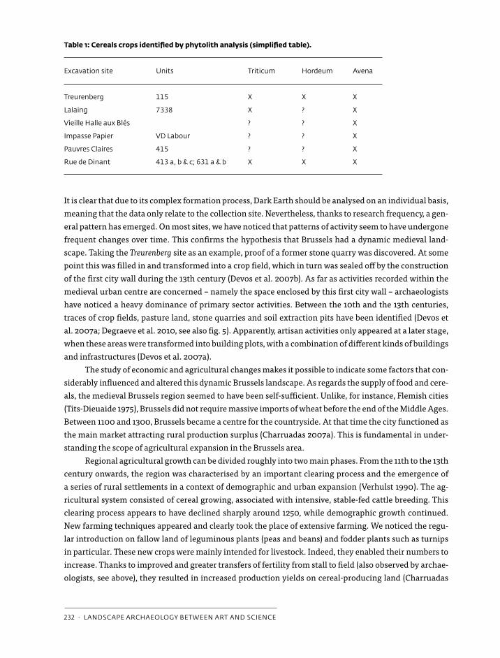
Table 1: Cereals crops identified by phytolith analysis (simplified table).
excavation site units triticum hordeum avena
treurenberg 115 X X X
lalaing 7338 X ? X
Vieille halle aux blés ? ? X
impasse papier Vd labour ? ? X
pauvres claires 415 ? ? X
rue de dinant 413 a, b & c; 631 a & b X X X
Kluiving DEF2.indd 232 16-04-12 16:48
2.5 the medieVal territory oF brussels: a dynamic landscape oF urbanisation · 233
2007b; Charruadas 2008). This seems to correlate with the observation that new, initially quite poor soils
were put under cereal cultivation by adding considerable quantities of fertilising manure (Devos et al.
2011). This agro-system certainly provided an improved level of supply for both the regional and urban
population.
Following the viewpoints of some economists and agronomists (Boserup 1965; Tits-Dieuaide 1981),
we can adopt a systemic view to emphasise that the creation of such an advanced farm system was only
possible given strong demographic growth. Within the pre-industrial context lacking mechanisation and
artificial fertilisers, agricultural growth was closely linked to increased human labour. Hence, we could
argue that Brussels agricultural system must have been developed in a context marked by demographic
pressure. These changes naturally had a major influence on regional landscape structures, especially land
ownership patterns.
In this context, but from a social viewpoint, the economic and political development of the city of
Brussels at that time also generated an important effect, with the emergence of a group of urban elite.
From the end of the 12th century onwards, former landowners, mainly feudal aristocrats, found them-
selves in economic distress. Conversely, this new urban elite group, active both within the city and the
countryside, was at the height of its wealth in the 13th century. Ownership structures therefore changed
considerably with important purchases of land made by these new rulers, who preferred smaller plots
which they could exploit by seeking high profitability. This process brought about a marked change in the
city’s surrounding rural landscape (Charruadas 2008).
Figure 5. map of brussels with localisation of crop fields, pasture land, stone quarries and soil extraction pits identified within and outside the first city wall.
Kluiving DEF2.indd 233 16-04-12 16:48
234 · landscape archaeology between art and science
some preliminary conclusions
In medieval times, the Brussels landscape presented a more important rural component than previously
assumed. The digital analysis of 16th-century maps suggested the persistence of open spaces within the
‘urban area’ strictu sensu and integrated archaeopedological and archaeobotanical studies provide direct
evidence for open areas such as crop or pasture lands. This open urban landscape appears to have been
quite diverse and the result of complex and dynamic processes closely connected to regional develop-
ment. Written records show that the 12th and 13th centuries were an important turning point. However,
our analysis also indicates that the forces driving medieval urbanisation were not only ‘urban’ (i.e. from
the city itself), but also emanated from the countryside. Urban policy and planning also contributed to the
urbanisation process. Nevertheless, we can state that this often depended on rural exodus. Data emanat-
ing from rural analysis are in fact crucial to understanding the general process.
The combination and comparison of the various approaches show the urbanisation process to be
complex and interactive. It can be divided into two phases. The first is a ‘light’ version of urbanisation
dominated by a strong rural component. Strictly-speaking prior to the 13th-century demographic growth
affected the rural as much, if not more than, the urban area. This urbanisation phase took place in the Brus-
sels hinterland. Medieval Brussels itself was no more than a fusion of scattered rural settlements. All the
signs indicate that the majority of people during this period were scattered throughout the region and took
part in the land reclamation movement. Demographic concentration within the city would follow, with the
stabilisation of agricultural growth after the 13th century. At this time population increase could no longer
find an outlet in the countryside. Consequently, rural exodus on a much wider scale occurred. It generated
a greater urbanisation process during the 14th and 15th centuries. Streets and plots became more densely
occupied and stone and brick materials gradually started to replace former wooden buildings.
This chronological reconstruction provides a negative answer to the questions addressed at the be-
ginning of this paper. As seems also to have been the case in French towns (Leguay 2009), the medieval
urban landscape of Brussels was not that dense, certainly not during the first stages of town development.
It is only from the late medieval and early modern era onwards that the urban territory slowly intensified.
This means that the concepts of density and centrality paradigmatically used to define cities should be re-
fined. These urban qualities were possibly more imagined or invented than real. In this respect, we could
link them to the genesis of an urban identity during late medieval times. According to Howell, ‘this was a
history of ideology, a history of how cities were imagined, represented, and conceptualized and of how the
rights and capacities of urban citizens were defined and legitimated.’ (Howell 2000). We hope we have
made it clear that interdisciplinary research on landscape evolution and urbanisation can play an essen-
tial role in debunking such widespread and often persistent assumptions.
acknowledgements
The Direction of Monuments and Sites of the Brussels Capital Region; The Université libre de Bruxelles
and Ghent University; Britt Claes (Musées Royaux d’Art et d’Histoire, Brussels); The Institute for the en-
couragement of Scientific Research and Innovation of Brussels; The Royal Belgian Institute for Natural
Sciences, Brussels; Hugues Doutrelepont and Mona Court-Picon (ROOTS).
Kluiving DEF2.indd 234 16-04-12 16:48
2.5 the medieVal territory oF brussels: a dynamic landscape oF urbanisation · 235
references
Apers, J., J. Vandenbreeden & L. Van Santvoort. 1982. Chronologisch overzicht van de belangrijkste stedebouwkun-dige feiten in en rond Brussel, 1780-1982. In Straten en stenen. Brussel: stadsgroei 1780-1980. Tentoonstelling ingericht door de Generale Bankmaatschappij in samenwerking met het Sint-Lukasarchief en G. Abeels. 18 November 1982 - 21 January 1983: 10-122. Generale Bankmaatschappij – Sint-Lukasarchief, Brussels.
Bairoch, P., J. Batou & P. Chèvre. 1983. The population of European cities: data bank and short summary of results: 800-1850. Droz, Genève.
Barles, S., D. Breysse, A. Guillerme, C. Leyval. 1999. Le sol urbain. Anthropos, Paris.Bijsterveld, A.J., J. Naylor, A. Wilkin & D. Keene. In press. Dynamic Interactions. Town and Countryside Relations in
Northwestern Europe in the Middle Ages., Brepols, Turnhout.Billen, C. 2000. Espace et société. In Billen, C. & Duvosquel, J.M. (eds.), Bruxelles: 36-139. Mercatorfonds, Antwerp.Blanquart, P., S. Demeter, A. De Poorter, C. Massart, S. Modrie, I. Nachtergael & M. Siebrand. 2001. Autour de la
première enceinte. Rond de eerste stadsomwalling. Ministère de la Région de Bruxelles-Capitale – Musées Royaux d’Art et d’Histoire, Brussels.
Boerefijn, W. 2005. De totstandkoming van de stedelijke vorm. In R. Rutte & H. van Engen, Stadswording in de Neder-landen. Op zoek naar overzicht: 123-142.Verloren, Hilversum.
Bonenfant, P. 1949. Une capitale au berceau: Bruxelles. Annales, Economies, Sociétés, Civilisations 4, 298-310.Bonenfant, P.-P., M. Fourny & M. Le Bon. 1998. Fouilles archéologiques à la cathédrale de Bruxelles 1987-1998. Un
premier bilan d’ensemble. Annales de la Société Royale d’Archéologie de Bruxelles 62, 223-257.Boserup, E. 1965. The conditions of Agricultural Growth. The Economics of Agrarian Change under Population Pressure.
Allen & Unwin, London/New York. Cabuy, Y. & S. Degré. 1992. Intervention place Saint-Géry. Structures médiévales et post-médiévales. Bulletin du Crédit
Communal de Belgique 182, 13-17.Charruadas, P. 2007a. Croissance rurale et action seigneuriale aux origines de Bruxelles (Haut Moyen Âge-XIIIe
siècle). In Deligne, C. & Billen, C. (eds.), Voisinages, coexistences, appropriations. Groupes sociaux et territoires urbains. Actes du Colloque international de Bruxelles (4-6 December 2004): 175-201. Brepols, Turnhout.
Charruadas, P. 2007b. Champs de légumes et jardins de blés. Intensification agricole et innovations culturales autour de Bruxelles au XIIIe siècle. Histoire et Sociétés Rurales 28, 11-32.
Charruadas, P. 2008. Bruxelles et ses campagnes. Croissance économique et actions aristocratiques (haut Moyen Âge-XIIIe siècle), unpublished Ph D. thesis, Université libre de Bruxelles, Brussels.
Charruadas, P. & Dessouroux, C. 2005. Histoire d’une capitale: Bruxelles des origines à 1958. In (eds.) Braeken J, Char-ruadas P., De Kuyper E., Dumont P. & Vander Brugghen, Région de Bruxelles-Capitale. Bruxelles, 175 ans d’une capitale, 11-27. Mardaga, Liège.
Charruadas, P. & M. de Waha. 2009. Centralité religieuse et développement urbain: notes sur la fixation du doyenné de Bruxelles aux XIe-XIIe siècles. Cahiers Bruxellois 41, 43-72.
Claes, B. 2008. Archeologisch onderzoek van het Brusselse Arme Klarenklooster, unpublished report, Ministère de la Région de Bruxelles-Capitale – Musées Royaux d’Art et d’Histoire, Brussels.
Clark, P. 2009. European Cities and Towns 400-2000. Oxford University Press, New York.Clark, P. & B. Lepetit (eds.) 1996. Capital Cities and their Hinterlands in Early Modern Europe. Scholar press, Aldershot.Court-Picon, M. 2008. Résultats d’analyses polliniques des sediments archéologiques des sites de Treurenberg et Hôtel de
Lalaing-Hoogstraeten (Région de Bruxelles-Capitale, Belgique), unpublished report, ROOTS, Brussels.Culot, M., E. Hennaut, M. Demanet & C. Mierop. 1992. Le bombardement de Bruxelles par Louis XIV et la reconstruction
qui s’ensuivit. Archives d’Architecture Moderne, Brussels.Degraeve, A., S. Demeter, Y. Devos, S. Modrie & S. Van Bellingen. 2010. Brussel vóór 1200: een archeologische
bijdrage. In Dewilde, M., Ervynck, A. & Becuwe, F. (eds.), Cenulae recens factae. Een huldeboek voor John De Meule-meester, 141-157. Academia Press, Ghent.
Kluiving DEF2.indd 235 16-04-12 16:48
236 · landscape archaeology between art and science
Degré, S. 1995. Brasserie au quartier Sainte-Catherine. Ministère de la Région de Bruxelles-Capitale – Musées Royaux d’Art et d’Histoire, Brussels.
De Jonge, K. 1991. Het paleis op de Coudenberg te Brussel in de vijftiende eeuw: de verdwenen hertogelijke residenties in de Zuidelijke Nederlanden in een nieuw licht geplaatst. Revue Belge d’Archéologie et d’Histoire de l’Art 60, 5-38.
Deligne, C. 2003. Bruxelles et sa rivière. Genèse d’un territoire urbain (12e-18e siècle), Brepols, Turnhout.Deligne, F. 2002. Bruxelles-Treurenberg : résultats anthracologiques, unpublished report, GIeP, Brussels. Demeter, S. 2001. La première enceinte, un patrimoine majeur pour Bruxelles. In Blanquart, P., Demeter, S., De
Poorter, A., Massart, C., Modrie, S., Nachtergael, I. & Siebrand, M., Autour de la première enceinte. Rond de eerste stadsomwalling, 12-28. Ministère de la Région de Bruxelles-Capitale – Musées royaux d’Art et d’Histoire, Brussels.
Demey, T. 1990. Bruxelles: chronique d’une capitale en chantier. 1: Du voûtement de la Senne à la jonction Nord-Midi. Legrain, Brussels.
Demey, T. 1992. Bruxelles: chronique d’une capitale en chantier. 2: De l’Expo ‘58 au siège de la CEE. Legrain, Brussels.Des Marez, G. 1901. L’organisation du travail à Bruxelles au XVe siècle. Académie Royale de Belgique, Brussels.Des Marez, G. 1918. Guide illustré de Bruxelles. Touring Club de Belgique-Société Royale, Brussels.Des Marez, G. 1935. Le développement territorial de Bruxelles au Moyen-Age. Etude de géographie historique
urbaine. Premier Congrès International de Géographie Historique, 1-90. Brussels.Despy, G. 1968. Villes et campagnes aux IXe et Xe siècles: l’exemple du pays mosan. Revue du Nord 50, 145-168.Despy, G. 1979. La genèse de la ville. In Stengers, J. (ed.), Bruxelles. Croissance d’une capital, 28-39. Mercatorfonds,
Antwerp.Despy, G. 1997. Un dossier mystérieux: les origines de Bruxelles. Bulletin de l’Académie royale de Belgique (Classe des
Lettres) 8, 241-303.Devos, Y., L. Vrydaghs, C. Laurent, A. Degraeve & S. Modrie. 2007a. L’anthropisation du paysage bruxellois au 10e-13e
siècle. Résultats d’une approche interdisciplinaire. In On the road again. L’Europe en mouvement. Medieval Europe Paris 2007. 4e Congrès international d’Archéologie Médiévale et Moderne, Session 7, Archéologies environne-mentales. 3-8 September. Institut National d’Histoire de l’Art, Paris (http://medieval-europe-paris-2007.univ-paris1.fr/Y.Devos%20et%20al..pdf).
Devos, Y., K. Fechner, L. Vrydaghs, A. Degraeve & F. Deligne. 2007b. Contribution of archaeopedology to the palaeoenvironmental reconstruction of (pre-) urban sites at Brussels (Belgium). The example of the Treuren-berg site. In Boschian, G. (ed.), Proceedings of the Second International Conference on Soils and Archaeology, Pisa, 12-15 May 2003, 145-151. Società Toscana di Scienze Naturali, Pisa.
Devos, Y., L. Vrydaghs, A. Degraeve & K. Fechner. 2009. An archaeopedological and phytolitarian study of the ‘Dark Earth’ on the site of Rue de Dinant (Brussels, Belgium). Catena 78, 270-284 (http://dx.doi.org/10.1016/j.catena.2009.02.013).
Devos, Y., L. Vrydaghs & S. Modrie. 2010. L’étude des Terres Noires bruxelloises: l’exemple du site de l’hôtel d’Hoogs-traeten (Région Br.). Archaeologia Mediaevalis 33, 63-65.
Devos, Y., L. Vrydaghs, K. Fechner, C. Laurent, A. Degraeve & S. Modrie. 2011. Buried Anthropic Soils in the Centre of Brussels (Belgium): Looking for Fields in a (Proto-) urban Context. In Fechner, K., Y. Devos, M. Leopold & J. Völkel (eds.), Enclosed and buried surfaces as key sources in Archaeology and Pedology. Proceedings of the Session ‘From microprobe to spatial analysis – Enclosed and buried surfaces as key sources in Archaeology and Pedology’ organised at the European Association of Archaeologists, 12th Annual Meeting, Krakow-Poland. 19-24 September 2006, Oxford (British Archaeological Reports. International Series).
Devos, Y., L. Vrydaghs, A. Degraeve & S. Modrie. Submitted. Unravelling urban stratigraphy. The study of Brussels’ (Belgium) Dark Earth. An archaeopedological perspective, Medieval and Modern Matters.
Dickstein-Bernard, C. 1977. La gestion financière d’une capitale à ses débuts: Bruxelles, 1334-1467. Société Royale d’Archéologie de Bruxelles, Brussels.
Dickstein-Bernard, C. 1995-1996. La construction de l’enceinte bruxelloise de 1357. Essai de chronologie des travaux. Cahiers bruxellois 35, 91-128.
Kluiving DEF2.indd 236 16-04-12 16:48
2.5 the medieVal territory oF brussels: a dynamic landscape oF urbanisation · 237
Diekmann, A. 1997. Artisanat médiéval et habitat urbain. Rue d’Une Personne et Place de la Vieille-Halle-aux-Blés. Ministère de la Région de Bruxelles-Capitale – Musées royaux d’Art et d’Histoire, Brussels.
Dierkens, A. 1989. Le haut Moyen Âge. In Smolar-Meynart, A. & Stengers, J. (eds.), La région de Bruxelles. Des villages d’autres à la ville d’aujourd’hui, 36-41. Crédit communal de Belgique, Brussels.
Doutrelepont, H. 2009. Site des Pauvres Claires (Br 100). Déterminations taxonomiques des « micro »s charbons de bois provenant de l’horizon de ‘terre noires’ US415, unpublished report, ROOTS, Brussels.
Dutour, T. 2003. La ville médiévale: origine et triomphe de l’Europe urbaine. Paris, Odile Jacob. Favresse, F. 1932. L’avènement du régime démocratique à Bruxelles pendant le Moyen Age (1306-1423). Maurice Lamertin,
Brussels.Fondrillon, M. 2007. La formation du sol urbain: étude archéologique des terres noires à Tours (4e-12e siècle), unpublished
PhD-thesis, Université François Rabelais, Tours.Giles, K. & Ch. Dyer (ed.) 2007. Town and country in the Middle Ages. Contrasts, Contacts and Interconnections, 1100-1500.
Society for Medieval Archaeology-Maney, Leeds.Godding, Ph. 1960. Le droit foncier à Bruxelles au Moyen Age. Publications de l’Institut de Sociologie Solvay, Brussels.Hall, A.R. & H.K. Kenward. 1994. Urban-rural connexions: perspectives from environmental archaeology. Symposia of
the Association for Environmental Archaeology 12, Oxbow, Oxford.Heers, J. 1990. La Ville au Moyen Age en Occident: paysages, pouvoirs et conflits. Fayard, Paris.Heimdahl, J. 2005. Urbanised Nature in the Past. Site formation and environmental development in two Swedish towns,
AD 1200-1800, unpublished PhD-thesis, University Stockholm, Stockholm (http://su.diva-portal.org/smash/record.jsf ?pid=diva2:197550).
Henne, A. & A. Wauters. 1845. Histoire de Bruxelles. Librairie encyclopédique de Perichon, Brussels.Howell, M.C. 2000. The Spaces of Late Medieval Urbanity. In M. Boone & P. Stabel (eds.), Shaping Urban Identity in
Late Medieval Europe, 3-23. Garant, Leuven/Apeldoorn.Jourdan-Lombard, A. 1972. Oppidum et banlieue: sur l’origine et les dimensions du territoire urbain. Annales.
Economies, Sociétés, Civilisations 27, 373-395.Lavedan, P. & J. Hugueney. 1974. L’urbanisme au Moyen Age. Droz, Genève.Lefèvre, P. 1942. L’organisation ecclésiastique de la Ville de Bruxelles au Moyen Age. Bibliothèque de l’Université
catholique de Louvain, Leuven.Leguay, J.-P. 2009. Terres urbaines: places, jardins et terres incultes dans la ville au Moyen Age. Rennes, Presses Universi-
taires.Lelarge, A. 2001. Bruxelles, l’émergence de la ville contemporaine: la démolition du rempart et des fortifications aux XVIIIe
et XIXe siècles. CIVA, Brussels.Lilley, K.D. 2002. Urban life in the Middle Ages: 1000-1450. Palgrave, New York.Limberger, M. 2008. Sixteenth-century Antwerp and its Rural Surroundings. Social and Economic Changes in the Hinter-
land of a Commercial Metropolis (ca. 1450 - ca. 1570). Brepols, Turnhout.Macphail, R. 1981. Soil and botanical studies of the ‘Dark Earth’. In M. Jones & G.W. Dimbleby (ed.), The Environment of
Man: the Iron Age to the Anglo-Saxon Period, 309-331. BAR Ltd., Oxford.Maesschalck, A. & Viaene, J. s.d.: Het stadhuis van Brussel, s.n., Kessel-Lo.Martens, M. 1953. L’administration du domaine ducal en Brabant au moyen âge (1250-1406). Académie Royale de
Belgique (Classe des Lettres), Brussels.Martens, M. 1973. Bruxelles, capitale de fait sous les Bourguignons. Westfälische Forschungen 15, 180-187.Martens, M. 1976. Histoire de Bruxelles. Privat, Toulouse.Nachtergael, I. 1997. Sauvetage archéologique dans le quartier des Marolles à Bruxelles, rue des Chandeliers, n° 12-16.
Vie Archéologique, supplément 47, 7-72. Nicholas, D.M. 1971. Town and Countryside: Social, Economic and Political Tensions in Fourteenth-Century Flanders. De
Tempel, Bruges.Pinol, J. (ed.) 2003. Histoire de l’Europe Urbaine. I. De l’Antiquité au XVIIIe siècle. Genèse des villes européennes. Seuil,
Paris.
Kluiving DEF2.indd 237 16-04-12 16:48
238 · landscape archaeology between art and science
Rapp, G. Jr. & C.L. Hill. 1998. Geoarchaeology, The Earth-Science Approach to Archaeological Interpretation. Yale Univer-sity Press, New Haven/London.
Reynolds, S. 1992. The writing of medieval urban history in England. Theoretische Geschiedenis 19, 49-50. Schofield, J. & A. Vince. 2003. Medieval Towns. The Archaeology of British Towns in their European Setting. Equinox,
London-Oakville.Smolar-Meynart, A. 1985. Bruxelles : l’élaboration de son image de capitale en politique et en droit au moyen âge.
Bijdragen tot de Geschiedenis 68, 25-45.Smolar-Meynart, A. 1991. La justice ducale du plat pays, des fôrets et des chasses en Brabant (XIIe-XVIe siècle): sénéchal,
maître des bois, gruyer, grand veneur. Société Royale d’Archéologie de Bruxelles, Brussels.Thoen, E. 1993. The count, the countryside and the economic development of the towns in Flanders from the eleventh
to the thirteenth centuries. Some provisional remarks and hypothesis. In E. Aerts, B. Henau, P. Janssens & R. Van Uytven, Studia Historica Oeconimica. Liber amicorum Herman Van der Wee, 259-278. Universitaire Pers, Leuven.
Tits-Dieuaide, M.J. 1975. La formation des prix céréaliers en Brabant et en Flandre au XVe siècle. Editions de l’Université de Bruxelles – Centre d’Histoire économique et sociale, Brussels.
Tits-Dieuaide, M.J. 1981. L’évolution des techniques agricoles en Flandre et en Brabant du XIVe au XVIe siècle. Annales. Economies-Sociétés-Civilisations 36, 362-381.
Vannieuwenhuyze, B. 2007. Le pavage des rues à Bruxelles au Moyen Âge. In Actes des VIIe Congrès de l’Association des Cercles francophones d’Histoire et d’Archéologie de Belgique (AFCHAB) et LIVe Congrès de la Fédération des Cercles d’Archéologie et d’Histoire de Belgique. Congrès d’Ottignies – Louvain-la-Neuve (26-28 August 2004), 299-307. Editions Safran, Brussels.
Vannieuwenhuyze, B. 2008. Brussel, de ontwikkeling van een middeleeuwse stedelijke ruimte, unpublished Ph.D thesis, Ghent University, Ghent.
Vannieuwenhuyze, B. 2009. Wegen in beweging. De in- en uitvalswegen van middeleeuws Brussel vóór de 13de eeuw. Cahiers bruxellois 41, 7-29.
Vannieuwenhuyze, B. 2010. Wegen in beweging. De in- en uitvalswegen van middeleeuws Brussel van de 13de tot 15de eeuw. Cahiers bruxellois 42, 3-32.
Verhulst, A. 1990. Précis d’histoire rurale de la Belgique. Editions de l’Université de Bruxelles, Brussels.Verhulst, A. 1999. The Rise of Cities in North-West Europe. Maison des Sciences de l’Homme – Cambridge University
Press, s.l.Verniers, L. 1934. Les Transformations de Bruxelles et l’Urbanisation de sa Banlieue depuis 1795. Annales de la Société
Royale d’Archéologie de Bruxelles 37, 84-220.Vrydaghs, L., Devos, Y., Fechner, K. & A. Degraeve.. 2007. Phytolith analysis of ploughed land thin sections. Contribu-
tion to the early medieval town development of Brussels (Treurenberg site, Belgium). In Madella, M. & D. Zucol (eds.), Plants, people and places. Recent studies in phytolith analysis, 13-27. Oxbow Books, Oxford.
Whitehand, J.W.R. & P.J. Larkham. 1992 (eds.). Urban landscapes: international perspectives. Routledge, London.Wilkinson, K. & C. Stevens. 2003. Environmental Archaeology. Approaches, techniques and applications. Tempus
Publishing Ltd., Stroud, Gloucestershire.
Kluiving DEF2.indd 238 16-04-12 16:48