The Dispute of Maritime Boundary between Bangladesh, India and Myanmar
27
1 The Dispute of Maritime Boundary between Bangladesh, India and Myanmar Introduction One of the concepts that underpin the UNCLOS is that the maritime area beyond the national jurisdiction is a "common heritage of mankind." Maltese Ambassador Avid Pardo first articulated this concept in 1967. Malta is a small country in the Mediterranean, and the country felt that the sea-bed and ocean floor under the high seas should be considered "the common heritage of mankind," meaning that no country could own or utilize for its benefit the maritime area beyond its national jurisdiction. By declaring this concept, Malta has emphasized that small countries without great technical expertise for exploration will derive benefits from the exploration and utilization of the sea-bed of international areas. The concept caught the imagination of most member countries of the UN. And when the UN Conference on the Law of the Sea began, almost all delegates of developing countries incorporated this concept in their policy statements. Bangladesh faces the Bay of Bengal, and the importance of its access to the open ocean can be appreciated if one considers the handicaps of landlocked countries, such as Nepal and Afghanistan. Accordingly, from the early years of its birth, it took great initiative and interest to participate in the UN Sea Law Conference. Bangladesh has unfortunately failed to stop India and Myanmar encroaching upon its maritime territory. The seismic survey of Bangladesh’s territorial sea line has now become crucial as a UN set deadline for lodging maritime claims is to expire in next one year exposing Bangladesh to risks of losing a vast territory in the Bay of Bengal. Bangladesh signed by the UN Convention on the Law of the Sea called in 2001 and under the law we are obligated to lodge our claim on the maritime boundary by 2011 .But Bangladesh could not make any major headway in lodging its claims through seismic and other studies despite the fact the country could lose an area
Transcript of The Dispute of Maritime Boundary between Bangladesh, India and Myanmar
1
The Dispute of Maritime Boundary between Bangladesh, India and Myanmar
Introduction One of the concepts that underpin the UNCLOS is that the maritimearea beyond the national jurisdiction is a "common heritage ofmankind." Maltese Ambassador Avid Pardo first articulated thisconcept in 1967. Malta is a small country in the Mediterranean, andthe country felt that the sea-bed and ocean floor under the highseas should be considered "the common heritage of mankind," meaningthat no country could own or utilize for its benefit the maritimearea beyond its national jurisdiction. By declaring this concept,Malta has emphasized that small countries without great technicalexpertise for exploration will derive benefits from the explorationand utilization of the sea-bed of international areas.The concept caught the imagination of most member countries of theUN. And when the UN Conference on the Law of the Sea began, almostall delegates of developing countries incorporated this concept intheir policy statements. Bangladesh faces the Bay of Bengal, and the importance ofits access to the open ocean can be appreciated if one considersthe handicaps of landlocked countries, such as Nepal andAfghanistan. Accordingly, from the early years of its birth, ittook great initiative and interest to participate in the UN Sea LawConference. Bangladesh has unfortunately failed to stop India andMyanmar encroaching upon its maritime territory. The seismic surveyof Bangladesh’s territorial sea line has now become crucial as a UNset deadline for lodging maritime claims is to expire in next oneyear exposing Bangladesh to risks of losing a vast territory in theBay of Bengal. Bangladesh signed by the UN Convention on the Law ofthe Sea called in 2001 and under the law we are obligated to lodgeour claim on the maritime boundary by 2011 .But Bangladesh couldnot make any major headway in lodging its claims through seismicand other studies despite the fact the country could lose an area
2
in the sea which is larger than the mainland Bangladesh. Expertssaid, Bangladesh needs to start the seismic survey immediately toclaim its legitimate sea territory. Under the convention Bangladeshwas required to submit necessary documents to the UN to validateits claim of territorial water, Exclusive Economic Zone up to 200nautical miles and continental shelf up to 350 nm from thebaseline. All together, the sea area is approximately 1.1 percent more thanthat of the mainland and UNCLOS III is the latest instrument thatworks as the basis of establishing the claim. Bangladesh cruciallyneed to establish the claim in the sea for the huge resources thegas, oil, fish and all other aquatic resources. It is alsoimportant from national security point of view. The neighboringIndia and Myanmar already proceeded a long way in crisscrossingBangladesh’s legitimate territorial shoreline. While Bangladesh islagging behind in preparing the required document to claim themaritime boundary near both the adjacent neighbors, India andMyanmar, floated tender for seismic survey. According to reports,India tended to encroach an area of 19,000 square kilometers andMyanmar 18,000 square kilometers of the territorial sea line ofBangladesh in the Bay of Bengal. But, it is the slow pace lack ofcoordination and urgency among concerned agencies and perception onthe magnitude of the loss that could lead neighbors to encroachBangladesh’s territorial sea. Hence Bangladesh should pursuevigorously with objectivity of protecting national sovereignty overthe maritime boundary. An initiative has been taken under this dissertation todiscuss about the law of the sea and its practical importance forBangladesh.
IMPORTANCE OF SEA: COMMON HERITAGE OF MANKIND
In this modern stage all the countries or every state have been concern about their sovereignty is not limited into its territorialjurisdiction only, it has enlarged its power into air, space or
3
over sea also. Now its well know, that a state has its complete jurisdiction or exclusive sovereignty over its “airspace” above itsterritory and its “territorial sea” also.
Here it is need to clarity; the doctrine of “territorial sea” hastraditionally been regarded as founded upon the principle laid downby patch juristBynkershoek in his the dominion Maries dissertationin 1702, that ‘a states sovereignty extended as for out to sea as acommon shot could reach’. The sea historically been performed twoimportant functions: first, as a medium of communication andsecondly as a vast reservoir of resources, both living and non-living. Both of those functions have stimulated the development ofto gal rotes. The seas were one time thought capable of subjectionto national sovereignties. The Portuguese in particular in theseventeenth century proclaimed huge tracts of high seas as part oftheir territorial domain but these claims stimulated a response byGrotius who elaborated the occurs as re communis were to beaccessible to all nations But incapable of appropriation. This viewprevailed, partly because it accorded with interests of the northEuropean states, which demanded freedom of the seas for thepurposes of exploration and expanding commercial intercourse withEast.
It is also true that, now the purposes of sea is not limited as amedium of communication, the commercial and strategic significanceof the sea in the world merits adequate elaboration. The sea is amajor source of food and the sea lines are the life times of allthe economies which are heavily dependent on unimpeded access toraw materials, markets and investment opportunities throughout theworld. Many international straits continue to be regarded asstrategically vital by the global powers because of the link theyprovide between different regional or sub-regional seas in thecontext of naval development. The medium of trade is by shippingwhich carries over 98 percent of all goods traded. It was generallyacknowledged that, the treats to the security of the sea lanesnever erased to exist. Moreover, naval developments have also ledto the rather paradoxical situation where more navies of regionalpowers have begun to exert themselves in the regional watersapparently to fill the power vacuum. Earlier, attempts at extension

4
of coastal state powers beyond a narrow territorial sea belt wereminor and posed no serious threat to the sanctity of the high seasregime. The majority of states realized that they were benefitingfrom the free movement of commerce allowed by the freedom of theseas. The underlying cause has been the increased demand for marineresources.
Acquisitive impulses to exploit fishery resources, offshorepetroleum and natural gas, and later mineral deposits on the deepseabed, have been given impetus by technological developments inocean resource exploitation coastal states have also responded toincreased dangers to the marine environment from human activitieson land or at sea by enclosing ocean space. Dominant naval powertook a big step in the direction of coastal state expansion when itclaimed the mineral resources of the continental in fisheriesconservation beyond its territorial sea other states moved morefirmly in the same direction claiming ever-wider zones that variedin their nature, sometimes claiming exclusive fishing rights,sometimes larger zones of exclusive economic rights or even 200-mile territorial seas. Even the maritime powers took part in thisexpansionist trend, limiting some freedoms off their coasts as itsuited their interests. It then became extremely difficult for themaritime states to explain why any other coastal state could notrestrict high seas freedoms that were of interest to the maritimepowers. Thus the necessity to develop a uniform, coherent maritimeregime was more felt mainly because practice on the importantaspect of ocean uses substantially diverged among the littoralstates. In the past, the principal objective of all states andmaritime powers with interests in the ocean was to endeavor tobuild a state and secure maritime regime. Such maritime regime wasa fundamental prerequisite not only for enhancing the security ofthe sea lanes, but also further maritime cooperation betweenregional states. Thus, ocean regime can be defined as a set ofnorms and patterns of behavior that help to regulate maritimerelations with in a system of states. The global ocean regime, aretherefore, sets of international law for the jurisdictions and usesof the ocean, received its expression in the United Nationsconvention on the Law of Sea.
5
Here for exercise rights over these mentioned interest orPower Ocean we need to create scopes through which we can exercise.These powers over the belt of the sea. Different sectors of sea and relevant laws of those sectors: International law particularly the law of sea is derivedincreasingly from express international agreements, often termed“treaties”, “conventions’, or “protocols”- agreements which areonly binding on states which have accepted them either by signingor ratifying them. These all rotes or regulations have been made toensure the security of interest or benefit of sea, to create abinding force for which abuse can not be made over that interest.The majority of such agreements are bilateral, although there is agrowing number of a multilateral agreement in many fields ofinternational law. Customary law is the body of general rotes whichhave gradually crystallized by regular state practices. Many of thetraditional areas of the law of sea-such as the law in relation tothe rights of a coastal state over its maritime belt are customaryorigin. Much of the law in relation to self-defense also has itsbasis in state practice of this kind. However there is nocompulsory machinery for the enforcement of international law,other than insofar as the United Nations charter confers witanpowers on the Security Council for the maintains or restoration ofpeace in matters of aggression or breaches of or threats to,international peace and security.
The present article aim to provide an overview of the law of thesea, including definitions and descriptions of the jurisdiction andsovereignty exercised by nations over various parts of the worldsoceans. The international legal status, self defense andnavigational rights of worships and military aircraft are alsocovered. The law of the sea is perhaps the classic example of aregime once almost entirely based on customary law, as evidenced bystate practice over several centuries. Naval control of the sea wasa dominant feature of medieval international relations. Sovereigntywas expressed in a Variety of ways; form the proclamation of zonesof neutrality to the assertion of the right of exclusive fishing onthe part of a particular state.
6
Now, if formally speaking, the law of sea is that law bywhich states, coastal and land locked and internationalorganizations regulate their relation in respect of those areassubject to coastal state jurisdiction and of sea and sea-bed beyondnational jurisdiction. The rotes governing the sea are drawn fromboth custom and treaty. The law of sea was not uniform. The different states havedifferent view, opinions or matters and issues. But more or less,the law was stetted after the 1958. Geneva conventions on
a) The territorial sea and contiguous zone.b) The continental shelf.c) The High Seas andd) The fishing and conservation of Living Resources of the High
Seas. All these conventions are enforce, although the first threeare of great political importance. Consequently the relations ofstates which are parties to these conventions are governed by theirterms.
As interpreted in the light of subsequent developments. The needto preserve the seas as the common heritage of all man kind and thedanger of a “Scramble for the Seas” precipitated the calling of thethird United Nations conference on the law of the sea. Theconvention of 1982 was adopted and it was treated as completepackage with limited reservation. The convention was subject ofconsideration opposition primarily from western nations also wereconcerned about the provisions regarding the exploitation of thedeep sea bed. In this case it can not be said, the 1958 conventionof Law of sea was lost its value, because most of the countries wasnot as reed about 1982 convention and they did not signed there butthey signed 1958 convention. That’s why, they were followed orstill following this 1958 convention. Many of the provisions in the1982 convention repeat prescripts mortised in the earlierinstrument, and have since because customary rotes, but many newrotes were proposed. All states are prima-facie bound by the acceptedcustomary rotes, while only the parties to the five treatiesinvolved will be bound by the new rotes contained there in, and onemust envisage some states not adhering to the 1982 conventions. The
7
1958 convention rotes will continue to be of importance. During thetwelve year period between the signing of the convention and itscoming into force, the influence of its provisions was clear in theprocess of law creation by state practice.
UNCLOS III AND DIFFERENT DIVISION OF SEA
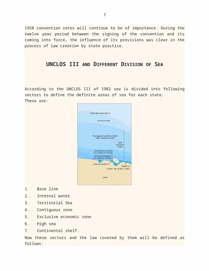
According to the UNCLOS III of 1982 sea is divided into followingsectors to define the definite areas of sea for each state.These are:
1. Base line2. Internal water3. Territorial Sea4. Contiguous zone5. Exclusive economic zone6. High sea7. Continental shelf. Now these sectors and the law covered by them will be defined asfollows:
8
3.1 Base lineThe width of the territorial sea is defined from the low water markaround the coasts of the state. This is the traditional principleunder customary international law and was reiterated in article 3of the Geneva Convention on the territorial sea and the contiguouszone in 1958 and article 5 of the 1982 Convention, and the lowwater line along the coast is defined, as marked on large scalecharts officially recognized by the coastal state.
In majority of cases, it will not be very difficult to locate thelow water line which is to act as the base line for measuring thewidth of the territorial sea. Sometimes however, the geography ofthe states coasts will be such as to cause certain problems, forinstance, where the coastline is deeply indented or there arenumerous islands running parallel to the coasts, or where existboys cutting into the coastlines. Special rotes have evolved todeal with this issue, which is of importance to coastal states,particularly where foreign vessels regularly fish close to thelimits of the territorial sea. A more national methods of drawingbase lines might have the effect of enclosing larger areas of thesea with in the states internal waters, and thus extend theboundaries of the territorial sea further than the traditionalmethod might envisage.
This point was raised in the Anglo-Norwegian Fisheries case before theInternational court of justice. The case concerned a Norwegiandecree delimiting its territorial sea along some 1000 miles of itscoastline. However, instead of measuring the territorial sea formthe low water line the Norwegians constructed a series of straightbase lines linking the outer-most parts of the land running alongthe fringe of islands and rocks which parallels the Norwegiancoastline. This had the effect of enclosing with in its territoriallimits parts of what would normally have been the high seas if thetraditional method had been utilized. As a result certain disputesinvolving British fishing boasts arose, and the United Kingdomchallenged the regality of the Norwegian method of baselines underthe international law. The court held that it was the outer line ofthe Skjaergoard that was relevant in establishing the baselines,
9
and not the low-water line of the mainland. This was dictated bygeographic realities.
The court noted that the normal method of drawing baselines thatare parallel to the coast was not applicable in this case becauseit would necessitate complex geometrical construction in the few ofextreme indentations of the coastline and the existence of theseries of islands fringing the coasts. These principles emergingfrom the fisheries case core accepted by states as part ofinternational law with in comparatively short period.
To definite the baseline, Bangladesh also has its geographicalarea like other changed for sea tide. But the particular baselineof Bangladesh is drawn on 10Fm or 60Ft of water probablyconsidering the peculiar deltaic and deeply intended coastline ofBangladesh.
3.2 Internal WaterAs far as the general provisions noted above regarding themeasurement of the territorial sea apply. Inlands are defined inthe 1958 convention on the territorial sea as consisting of anaturally formed area of land, surrounded by coater, which is abovecoater at high tide, and they can have maritime belt. Where onlylow tide elevations are involved, that is areas of land visible atlow tide but submerged at high tide, they can not have aterritorial sea of their own. But they may b used as baselines ifwith in the territorial sea of a coastal state and they may beutilized as a point on a straight baseline if installationpermanently above sea level (for example lighthouse) have beenconstructed upon them.
In this internal waters the coastal state has its absolute orcomplete sovereignty but on the basis of 1982 convention ships ofall States shall enjoy the rights of innocent passage through thesewaters. In this internal water the coastal state has its universalsovereignty, not only this coastal state also contains both civiland criminal jurisdiction. But generally the coastal state does notexercise its civil power unless the captain of flag ship request toapply, incase of avoid unpleasant incidents. In criminaljurisdiction, if any offence arises in the area of coastal state
10
which disturbs the peace, security or happiness of that state, inthis case, the coastal state may apply its criminal jurisdiction.In this matter, an international case is, Wildenbus case.
In Rex v. Anderson case, the question of criminal jurisdiction alsoarised. A person who is a U.S.A. citizen named Anderson, killed another foreign person in a ship. When the offence occurred that shipwas into, internal water of France. When the case feted intoBritish court, Anderson put an objection, that Britain has not anyjurisdiction to try the case. But Appellate court said on judgmentthat, all these 3 countries has the jurisdiction to try the case,here Britain also can do the same, to save their ship. (As offenceoccurred on their ship).
In State v. Yannopulous case the same question also aroused, whethercoastal state has the criminal jurisdiction to try the case or not.Yannopulous an Greece citizen was acting as captain of flag stateship of srypras. When the ship stopped into Italian port, Italianpolice got 5kig drugs from that ship, which was serious offenceaccording to the law of Italy. When case file into Italy court,after examine the case, the court declared to be ret easedYannopulous. Because it not proved, that drugs brought into Italyto destroy peace and harmony of Italian or the intention ofYannopulous was bad. So, that be can not be tried according to thelaw of Italy.
3.3 Territorial Sea
The convention of 1982 establishes the breadth of the territorialsea at a limit not exceeding 12 nautical miles. Previously,agreement on the breadth of the territorial sea had eludeddefinition. State practice had been uncertain and varied. Somecountries, for example; the United Kingdom and United Statesrigidly maintained the territorial sea traditionally three-mile,while certain Latin American countries made extensive claims to amaximum of 200 miles.
Article 1 and 2 of the convention on the territorial sea 1958provide that the coastal states sovereignty extends over its
11
territorial sea and to the airspace and seabed and subsoil thereof, subject to the provisions of the convention and ofinternational law. The territorial sea forms an undeniable part ofthe land territory to which it is bound, so that a union of landwill automatically include any band of territorial waters. Thecoastal state may, if it so desires, exclude foreign national andvessels from fishing within its territorial sea and form coastaltrading and reserve these activities for its own citizens.
Similarly the coastal state has extensive powers of controlrelating to amongst others, security and custom matters. It shouldbe noted, however, that how far a state chooses to exercise thejurisdiction and sovereignty to which it may lay claim under theprinciples of international law will depend upon the terms of itsown municipal legislation, and some states will not wish to takeadvantage of the full extent of the powers permitted them with inthe international legal system.
3.3.The Right Of Innocent Passage:The right of foreign merchant ships (as distinct from warships) topass unhindered through the territorial sea of a coast has longbeen an accepted principle in customary international law, thesovereignty of coast state not with standing. However, the preciseextend of the doctrine is blurred and open to contrary.Interpretation, particularly with respect to the requirement thatthe passage must be ‘innocent’. The doctrine was elaborated inarticle of the convention on the territorial sea 1958, whichemphasized that the coastal state must not hamper innocent passageand must publicize any dangers to navigation in the territorial seaof which it is award.
Passage ceases to be innocent under article 14(4) of the 1958convention where it is ‘prejudicial to the peace, good order orsecurity of the coastal state and in the case of foreign fishingvessels when they do not observe such laws and regulations as thecoastal state may make and publish to prevent these ships fromfishing in the territorial sea. In addition, submarines mustnavigate on the surface and they need to show the flag. Regardinginnocent passage it is the responsibility of the coastal state to
12
make the way of passage ‘innocent’. About this, one of the mostimportant case, ‘Corfu channel case, where the passage is not innocent,the coastal state may take steps to prevent it in its territorialsea and where ships are proceeding to internal waters; it may actto fore stall any branch of the conditions to which admission ofsuch ships to internal water is subject.
Article 19(2) of the 1982 convention, has developed the notion ofinnocent passage contained in article 14(4) of the 1958 conventionby provision of examples of prejudicial passage such as the threator use of force; weapons, practice; spying; breach of custom;fiscal; immigration or sanitary regulations; willful or seriouspollution etc. In addition ‘any activity not having direct bearingon passage’. By virtue of article 24 of 1982 convention, coastalstates must not hamper the innocent passage of foreign ships,either by imposing requirements upon them which would have thepractical effect of denying or impairing the right or bydiscrimination.
3.4 Contiguous ZoneContiguous zone is that part of the sea which is beyond andadjacent to the territorial sea of the coastal state. Under article33 of 1982 Convention, however a coastal state may claim acontiguous zone (for the same purpose as the 1958 provisions) up to24 nautical miles form the baselines. A coastal state, under GenevaConvention, may claim a zone of the territorial sea base lines,contiguous to its territorial sea. A contiguous zone need not beclaimed, as in the case of the United Kingdom, but if it is, itmust be done so specifically. Although the status of the contiguouszone remains that of high seas, but the coastal state does havesome exclusive sovereign rights over contiguous zone.
The idea of a contiguous zone (i.e. zone bordering upon theterritorial sea) was virtually formulated as an authoritative andconsistent doctrine in the 1930s by the French writer Gidel, and itappeared in the convention on the territorial sea. Article 24declared that:
In a zone of the high seas contiguous to its territorial sea, thecoastal state may exercise the control necessary to:
13
a) Prevent infringement of its custom, fiscal, immigration or sanitary regulations with in its territory or territorial sea.
b) Punish infringement of above regulations committed with in its territory or territorial sea.
Thus such ambiguous zone were clearly differentiated from claimsto full sovereignty as parts of the territorial sea, by beingreferred to as part of the high seas over which the coastal statemay exercise particular rights. Unlike the territorial sea, whichis automatically attached to the land territory of the state,contiguous zones have to be specifically claimed. While sanitaryand immigration laws are relatively recent additions to the rightsenforceable over zones of the rights enforceable over zones of thehigh seas and may be regarded as steaming by analogy form customsregulations, in practice they are really only justifiable since the1958 convention. On the other hand, customs zone have a longhistory and are recognized in customary international law as well.Many states, including the UK and The USA, have enacted regulationto enforce customs regulations over may many years, outside theirterritorial waters and with in certain areas, in order to suppresssmuggling which appeared to thrive when faced only with territoriallimits of 3 or 4 miles. Contiguous zone however, were limited to amaximum of 12 miles from the baselines from which the territorialsea is measured. So, if the coastal state already claimed aterritorial sea is measured. So, if the coastal state alreadyclaimed a territorial sea of 12 miles. The question of contiguouszones would not arise.
In this case, the coastal state has its full jurisdiction overits contiguous zone, whether its civil or criminal. Regarding thisone of the most important case is Re Martinez Case. In Italian Law ofsea, under section 2 of Maritime code, form baseline to 6 nauticalmiles is custom zone, form this to other 6 nautical miles isvigilance zone. The person named, Martinez ‘form baseline to 9nautical miles’ in this areas involved in doing the offence ofsmuggling. When Italian police force trying to arrest him andstarted fairing be ran away and escaped into 54 nautical miles deephigh seas. But at last he caught by Italian police force and whencase feted he claimed the court has not any jurisdiction to try the

14
case, as he did smuggling beyond contiguous zone of Italy and hewas arrested illegally form high seas. But at last court declaredthat, the Italian court has complete or absolute jurisdiction totry the case, and his reasons proved as ground less.
3.5 Exclusive Economic ZoneThis zone has developed out of earlier, more tentative claims,particularly relating to fishing zones and as a result ofdevelopments. In the negotiating processes raiding to the 1982convention. It makes a compromise between those states-seeking a200 mile territorial sea and those wishing a more restricted systemof coastal state power. One of the major reasons for the call for a200 mile exclusive economic zone has been the controversy overfishing zones. The 1958 Geneva Convention on the Territorial seadid not reach agreement on the creation of fishing zones andarticle 24 of the convention does not give exclusive fishing rightsin the contiguous zone. However, increasing numbers of states haveclaimed fishing zones of widely varying widths. The EuropeanFisheries convention, 1964, which was implemented in the UK by theFishing Limits Act, 1964, provided that the coastal state has theexclusive right to fish and exclusive jurisdiction in matters offisheries in a 6 mile belt form the baseline of the territorialsea.
Article 55 of the 1982 convention provides that the exclusiveeconomic zone in an area beyond and adjacent to the territorialsea, subject to the specific legal regime established under theconvention. Under article 56 the coastal state in economic zone hasinter alia:
a) sovereign rights for the purpose of exploring and exploiting,conserving and managing the natural resources, whether living ornon-living of the water superjacent to the seabed and of the seabedand its subsoil and with regard to other activities for theeconomic exploitation and exploration of the zone, such as theproduction of energy from the water, currents and winds;
b) jurisdiction with regard to1) The architecture and the use of artificial islands,
installations and structures.
15
2) Marine scientific research.3) The protection and preservation of the marine environment.
Article 57 provides that the zone shall not extend beyond 200nautical miles from the baselines from which the breath ofterritorial sea is measured.
Article 58 lays down the rights and duties of other states in theexclusive economic zone. These are basically the high seas freedomof navigation, over flight and laying of submarine cables andpipelines. It is also provided, that in exercising their rights andperforming their duties, states should have due regard to therights, duties and laws of the coastal state. In cases of conflictover the attribution of rights and jurisdiction in the zone theresolution is to be on the basis of equity and in the light of allthe relevant circumstances. Regarding this, one of the most important case is FisheriesJurisdiction case Iceland declared his exclusive economic zone about 50nautical miles. Where U.S.A. and Germany put objection because,they have their fisheries jurisdiction into that areas. Because oftheir objection the case brought ICJ. In this case, the court declared that, any coastal statesexclusive economic zone about fishing will not be more than 24nautical miles. But here it is considerable that, 90% of economiczone of Iceland is depend on fisheries. Therefore Iceland gotpreferential rights, and judgment was in favour of Iceland.
3.6 High SeaThe freedom of the high seas is that no state may acquiresovereignty over parts of it. The area of high seas normallyindicates the zone beyond exclusive economic zone that means, arearemains after 200 nautical miles. This is the general rule, but itis subject to the operation of the doctrines of recognition,acquiescence and prescription, where, by long usage accepted byother nations, certain areas of the high seas bounding on theterritorial waters of coastal states may be rendered subject tothat states sovereignty. This was emphasized in the Anglo NorwegianFisheries Case.
16
The high seas were defined in Article 1 of the Geneva conventionon the high seas 1958 as all parts of the sea that were notincluded in the territorial seas or in the internal waters of astate. The reflected customary international law, althoughdefinition in article 86 of 1982 convention includes: “all parts ofthe sea that are not included in the exclusive economic zone, inthe territorial sea or in the internal water of a state, or in thearchipelagic coaters of an archipelagic state. Article 87 of the 1982 convention (developing article 2 of1958 Geneva Convention of the high sea) provides that, the highseas are open to all states and that the freedom of the high seasis exercised under the conditional provisions laid down in theconvention and by other alia the freedom of navigation, overflight, the laying of submarine cables and pipelines, theconstruction of artificial islands and other installationspermitted under international law, fishing and the conduct ofscientific research. Such freedoms are to be exercised with dueregard for the interest of other states in their exercise of thefreedom of the high seas and also with due regard for the rightsunder the convention regarding activities in the InternationalSeabed Area. The foundation of maintenance of order on the high seas hasrested upon the concept of the nationality of the ship, and thesubsequent jurisdiction of the flag state over the ship. It isbasically, the flag state that will enforce the rules andregulations not only its own municipal law but of international lawas well. A ship without a flag will be deprived many of itsbenefits or rights those available under the legal regime of highseas. Each state is required to elaborate the conditions necessaryfor the grant of its nationality to ships, for the registrationships in its territory and for the rights to fly its flag. Thenationality of the ship will depend upon the flag it flies, butarticle 5 of the high seas convention also stipulates that, theremust be a “genuine link” between the state and the ship, and ‘inparticular the state must effectively exercise its jurisdiction andcontrol in administrative, technical and social matters over shipflying its flag. This provisions was intended to check the use of
17
flags of convenience operated by states such as Liberia and panamawhich would grant their nationality to ships requesting suchbecause of law taxation and the lack of application of most wageand social security agreements. This enabled the ships to operateat very low costs indeed. The basic principle relating tojurisdiction on the high seas is that the flag state alone mayexercise such rights over ship. This was elaborated in the Lotuscase (PCIJ, 1927) where, it is held that, “vessels on the high seasare subject to no authority except that of the state whose flagfly.
3.7 Continental ShelfArticle 1 of UNCLOS I on the continental shelf defined the shelf interms of its exploitability rather than relying upon the acceptedgeological definition. Nothing that the expression referred to theseabed and subsoil of the submarine areas adjacent to the coast butoutside the territorial sea to a depth of 200 metres or ‘beyondthat limit to where the depth of the superjacent waters admits ofthe exploitation of the natural resources of the said areas.’
This provision caused problems, since developing technologyrapidly reached a position to extract resources to a much greaterdepth than 200 metres, and this means that, the outer limits of theshelf, subject to the jurisdiction of the coastal state, wereconsequently very unclear. Article 1 was, however, regarded asreflecting customary law by the court in the North Sea continentalshelf case. It is also important to note that the basis of title tocontinental shelf is now accepted as the geographical criterion,and not reliance upon, for example: occupation of effectivecontrol.
The coastal state may exercise sovereign rights over thecontinental shelf for the purpose of exploring it and exploitingits natural resources under article 77 of the 1982 Convention andsuch rights are exclusive in that no other state may undertake suchactivities without the express consent of the coastal state. Thesesovereign rights do not depend upon occupation or expressprocrastination. The Truman concept of resources which referredonly to mineral resources, has been extended to include organizers
18
belonging to the sedentary species. Where the continental shelf ofa state extends beyond 200 miles, article 82 of 1982 conventionprovides that the coastal state must make payments or contributesin kind in respect of the exploitation of the nonliving resourcesof continental shelf beyond the 200 miles limit. The payments areto be made annually after the first five years of production at theside of question on a sliding scale up to the twelfth year, afterwhich it is to remain 7 percent.
Regarding continental shelf, different times collusion had madeby opposite states. For their different opinion, 2 principles hadbeen made in International Law:
1. Equidistance principle or2. Principle of Equity.
Through these 2 principles different cases will be discussed asfollows:In North Sea Continental Shelf cases Germany had two contracts about
continental shelf with Denmark and Netherlands, those were signedby them in 1964 or 1965. though contracts were made but no areaindicating line there had. As a result dispute was made and tosolve it they were went into ICJ. As, the subject matter ofcontracts was same, so that, the court solved problem easily. Insuch a case, recourse may be had to equitable principles provided areasonable result was reached.
In Anglo-France continental shelf case about 10 years (1964 to 1975) UKand France failed to decide their continental shelf area. At lastthey decided, that, problem will be solved through Arbitration. In1977 of June Arbitration decide their area on the basis ofprinciple of equity.
In Tunsia-Libya Continental Shelf case on 10th June of 1977 Libya orTunisia made a contract to solve problem by the decision of ICJ todecide their continental shelf area. The request ICJ to provide aacceptable judgment. When judgment given by ICJ Tunisia was notsatisfied by that decision of ICJ, and Tunisia made revision. Butwhen revision made the ICJ made active again the previous judgment.This judgment also provide through the principle of equity.
In Libya-Malta Continental Shelf case both the states have signed 1982convention but because of certain natural cause’s dispute arise for
19
continental shelf. Both the states demand extra areas oncontinental shelf, and after that to solving problems they wentinto ICJ. At last the pronounced its judgment on the basis ofprinciple of “Equidistance”. For these reasons it can be said, fordeciding the area of continental shelf the court can follow any oneof these two principles.
It has already been mentioned that, form baseline to 12 nauticalmiles is territorial sea. (Article: 3 of 1982 convention). Formbase line to 24 nautical miles is contiguous zone; on in otherwords, form territorial sea to 12 nautical miles is contiguouszone. (Article 33(2) of 1982 convention). And finally form baselineto 200 nautical miles is exclusive economic zone. (Article 57 of1982). Now let’s come to the point, according to article 33(2) ithas been clearly mentioned that, form baseline to 24 nautical milesis contiguous zone. And any coastal state has its exclusivesovereignty or absolute power into these areas. The coastal statecan use these areas for his own necessities not other. It is thezone not open for any other state. The coastal state may exercisethe control necessary to:
a) Prevent infringement of its custom, fiscal, immigration orsanitary regulations within its territory.
b) Punish infringement of the above regulations committed with inits area.Like this it has also been ensured by article 57 of 1982convention, form baseline to 200 nautical miles is exclusiveeconomic zone for any state. And article 56 says that, coastalstate has its absolute sovereignty into zone. As coastal state alsocon exercise:
a) Sovereignty rights for the purpose of exploring and exploiting,con serving and managing the natural resources, whether living ornon living of the water superjacent to the seabed and of the seabedand its subsoil and with regard to other activities for theeconomic exploitation and exploration of the zone, such as theproduction of energy from the water, currents and winds.
b) Jurisdiction with regard to1) The architecture and use of artificial islands, installations
and structures,
20
2) Marine scientific research,3) The protection and preservation of the marine environment.
These all purposes to which the coastal state con use its ournecessities. Now, in this case, it is a matter of regret is that,being a poses country we have not our full and absolute controlinto this zone.
MARITIME ZONES OF BANGLADESH AND THE DISPUTES WITH INDIAAND MYANMAR
4.1 Maritime Zones of BangladeshThrough the rivers of Bangladesh, about 2.4 tons of silt flowsannually into the Bay of Bengal. The country's 720-kilometrecoastline is heavily indented and dotted with small islands/islets.The water of the coastline is very unstable and non-navigable,except by country boats.
For Bangladesh, a normal baseline is not appropriate, andstraight baseline is the one that suits it. The delineation ofstraight baseline is recognised in the UN Law of the Convention.
Bangladesh's baseline was notified through a gazette notificationof April 16, 1974 issued by the Ministry of Foreign Affairs.
Under the law of 1974, Bangladesh claims 12 miles territorial seaand 200 miles economic exclusive zone from the baseline, and claimsthe continental shelf to the outer limits of the continental marginbordering on the ocean floor or abyssal floor.
It is noted that the definition of continental shelf has beengiven both in legal and geological terms. In geology, thecontinental margin includes continental slope and continental rise,but in legal terms the continental shelf includes both thesegeological structures.
The continental shelf of Bangladesh constitutes a gradual slopefrom the coast because of inflow of the billion tons of silt fromits rivers and, accordingly, many experts claim the continental
21
shelf of Bangladesh may easily extend to 350 miles, subject to theconditions of the UN Convention.
4.2 Disputes with India and MyanmarThough theoretically or legally it has been ensured in UNCLOS IIIthat, in these zones we have our absolute power, but practicalsituations is completely different, in this areas now, India orMyanmar are interfering and using the zones for fulfilling theirown necessities.
According to Law of sea, it is clearly mentioned, form baselineto 200 nautical miles Bangladesh contains its own exclusiveeconomic zone, that means, in this area Bangladesh has its absoluteownership, but practically, Bangladesh sharing this areas withMyanmar and India. And this sharing is illegal because howBangladesh sharing this, Bangladesh itself does not know. Besidesthis, some cases, contiguous zone or they enters into the areas ofcontiguous zone without permission of Bangladesh. For these typesof problems, Bangladesh can not makes the proper use of this zones.Besides this being a poor country Bangladesh also can not go intocollusion with them. But, after that, it is also true. That,Bangladesh many times tried to solve problems through negotiation.
If frankly speaking, it is the problems which had been continuingform 35 years. Its exactly started during the ruling time ofBangabandhu Sheikh Mujibur Rahaman. In 1974, Mujib Govt. took anattempt to find out the resources of oil and gas into sea, butMyanar had an objection on that. As a result Mujib Govt. solvedthose problems through mutual understanding and after that, missionagain started. But after the murder of Bangabandhu Sheikh MujiburRahaman. the mission could not be continued and ultimately thatinquiry stopped there. This was the time of starting problem. Whichstill contusing. But recently, Bangladesh has gone to SecurityCouncil to solve the problem through proper legal proceedings.
Both Myanmar, India and Bangladesh has their disputed areas intoseas among them, except Bangladesh at first Myanmar or Indiabrought their objection to security council Because unlikeBangladesh, they were too much concerned about their rights orpower exists on sea though Bangladesh had an opportunity to go
22
there, but Bangladesh has gone there after passing time. Butoppurtunity is not happens always, according to the Law of Sea,1982,if Bangladesh do not demand their areas (those are alsodisputed except exclusive economic zone) before 2011 withreasonable laws or evidence, in that case, Bangladesh will losethose rights or zones also.
Last year, for solving the dispute a melting was held betweenBangladesh, India and Myanmar but no result has brought out.Besides it from 1978 to 1986, 8 times different discussion had beenmade but not solution has sun. In 1980 discussion also made withIndia and Bangladesh but the result was same.
Regarding this, one thing was ensured by them, until and unlessdisputes are solved no inquiry will be made by any of them. Butthey have broken their promises. For this reasons, Bangladeshdecided to go to Security Council. Primarily Bangladesh wants toestablish their rights on contiguous zone and exclusive economiczone. After it, to establish rights on continental shelf like otherstates Bangladesh again need to go to Security Council before 2011.Because after 2011, legally Bangladesh will lose their rights overcontinental shelf as dispute continuing form 35 years. And there iswell known maxim “delay defects equity”.
RECOMMENDATIONS FOR PROTECTING THE MARITIME INTEREST
The people of Bangladesh have historically been a sea-faringpeople. The limited land resources available to us and thedisparity between those resources and subsistence need of the 120million population of Bangladesh makes it imperative to recognizethe potential of the occurs as a tangible promise for the future.Sea is the only link of Bangladesh with the countries of the outside world with the exception of India and Myanmar 98% of our totalexports and imports travel by sea. Some ships including Bangladeshflag vessels arrive monthly in the parts of Chittagonj and Mongla.Bangladesh has to depend on imports of fuel, raw material, sparesand military hardware through the sea. We can not afford to
23
stockpile large quantities of these items due financial constraintand as such critical supplies will have to come through the sea.Stoppage of impact of food again and POL will be at the sake ofnations survival. So undisturbed flow of shipping in and out of ourparts is vital to the economic survival and defence of the countrykeeping the above in purview, the Govt. of Bangladesh through anact of parliament enacted the territorial waters and parliamentenacted the Territorial Waters and Maritime Zones Act 1974 (Act no XXVI of1974) almost simultaneously when the discussion of Law of sea wasgoing on and much before the Law of the sea was placed forsignature of the 1982. the act, provides for declaration of thefollowing maritime zones and matters ancillary there to. Byenforcing these declaration ancillary of this act with someamendments primarily problems can also be solved.
5.1 Recommendation on Territorial watersThe government may declare the limits of the sea beyond the landterritory and internal waters of Bangladesh which shall be theterritorial waters of Bangladesh specifying the notification thebaseline.
1) form which such limits shall be measured; and2) the waters on the land ward side of which shall form part of the
internal waters of Bangladesh.Where a single island rock or a composite group there of
constituting the part of the territory of Bangladesh is situatedseawards from the main coast or baseline, territorial waters shallwetend to the limits declare by notification measured from the lowwaterline along the coast of such island, rock or composite group.The sovereignty of the republic extends to the territorial watersas well as to the air space over and the bad and of such waters. Noforeign ship shall unless it enjoys the right of innocent passage,pass through the territorial waters.
5.2 Recommendation on Contiguous ZoneThe zone of the high seas contiguous to the territorial waters andextending seawards to a line 06 nautical miles measured from the
24
outer limits of the territorial water is hereby declared to be thecontiguous zone of Bangladesh. (according to the Act of 1974). Andnow Bangladesh may claim 24 nautical miles of contiguous zone asagainst 6 nautical miles which declared under the Act of 1974. theGovernment may exercise such powers and take such measures in orrespect of the contiguous zone. As it may consider necessary toprevent and punish the contravention of and attempt to contraveneany law or regulations in force in Bangladesh relating to thesecurity of the republic, the immigration and sanitation, andcustom and other fiscal matters.
5.3 Recommendation on Economic Zone The Government may, by notification in the official Gazette,declare any zone of the high seas adjacent to the territorialcoater to be the economic zone of Bangladesh specifying there inthe limit of the zone form base line to 200 nautical miles(according to 1982 convention). All natural resources with in theeconomic zone, both living and non living on or under the seabedand subsoil or on the water surface or with in the water columnshall vest exclusively in the republic. Nothing shall be dressed tobe the affect fishing with in the economic zone by a citizen ofBangladesh or any other state.
5.4 Recommendation on Continental ShelfA continental shelf is that zone, where every states con use it fortheir own purposes. It is the area beyond high seas. Therefore, itis the place is not under control of any state. But to avoidcertain difficulties government may, by notification in theofficial Gazette, specific the limits there of, No person shallexcept person in accordance with the terms of a license orpermission granted by the Government explore or exploit anyresources of the continental shelf or carry out any search orexcavation or conduct any research with in the limits of thecontinental shelf.
The government may with a view preventing and controlling marinepollution and preserving the quality and geological balance in themarine environment in the high seas adjacent in the marine
25
environment in the high seas adjacent to the territorial coasters,take such measures as it may dress appropriate for the purpose. TheGovernment may make rotes for carrying out the purpose of this Act.In particular and without prejudice to the generality of theforegoing power, such rotes may provide.
1) For the regulation of the conduct of any person in of upon theterritorial coaters, contiguous zone, conservation, and continentalshelf.
2) For measures to protect, use and exploit the resources of theeconomic zone.
3) For conservation measures to protect the living resources in thesea.
4) For measures regulating the exploration and exploitation ofresources within the continental shelf.
5) For measures designed to prevent and control of marine pollutionof the high sea.
CONCLUSION
A universal regime for governance of the occurs is needed to safeguard security and economic interest, as well as to defuse thosesituations in which competing uses of the seas are likely to resultin conflict. In addition to strongly supporting freedom ofnavigation, the convention provides on effective framework forserious efforts to address pressures upon the occurs resulting fromland and sea-based sources of pollution and over fishing. Manyagreements relating with law of sea provides with all that with anear term opportunity to join with other industrialized nations ina widely accepted international order to regulate and safe guardthe many diverse activities, interests and resources in the wholeoceans. The principle accomplishment of the UNLOS convention in theestablishment of a clear set of maritime zones, the territorialsea, contiguous zone, EEZ and continental shelf, which uphold thesecurity and resource interests of coastal states, parlance againstthe interest of maritime nations to have relatively open access tothe oceans for navigation, over flight and telecommunications. Thiscareful balanced of maritime zone reverses a disturbing purposes in
26
jurisdiction creep in which some states claimed territorial seas ofup to 200 nautical miles in order to create a mono poly overcoastal resources or for purposes of security. The yearlyproduction of marine resources are over US $50 billion in thedeveloping countries. The Bay of Bengal has much potentials in fishand sea food. The annual catch of fish is about 7.5 thunderedthousand tons. Besides providing nutrition to our people theearning of foreign exchange from fish exports alone more than 500crore. Exports are of the opinion that oil, gas, metals cobalt andmagnetite, nickel, soda, ash, chorine hydrochloride are abundantlylying in the seabed which can be used for industrial purposes iftapped properly. Effective and scientific extraction andpreservation of sea resources could change our lot. But we capableto do so? To accept this challenge we have to delimit maritimeboundary and consolidate our position in the Bay of Bengal moreeffectively to derive maximum benefit out of it. We must haveeffective and modern maritime instruments to master over the wholearea of our economic zone in the line with the Law of sea. It isalso important that the sea-boundaries of territorial sea, economiczone and continental shelf with our neighbours -- India and Myanmar-- need to be settled for exploration and exploitation of marineresources (living and non-living).
Finally, in October 2009, Bangladesh declared going to theinternational tribunal to settle the maritime boundary disputeswith India and Myanmar as the three countries failed to resolve thedifferences through bilateral talks. Earlier, Bangladesh appointedBritish lawyer Vaughan Lowe (QC) while India nominated SrinivasanRao as its lawyer to the tribunal. Bangladesh, Myanmar and Indiaappear to be inflexible in their respective positions on the issue.Experts say the three countries could not even agree on decidingthe starting point for demarcating sea boundary.
Besides, they have differences in methods for maritime boundarydelimitation. Dhaka demands for "equity" method, which, it insists,will ensure win-win conditions for Bangladesh, Myanmar and India.On the other hand, India and Myanmar press for "equi-distance"principle, which, Dhaka says, will deprive Bangladesh of 17 out of28 sea blocks. India makes claim on 10 and Myanmar demands 7 sea

27
blocks. India and Myanmar claim the Bay of Bengal in such a way,which would block Bangladesh's access to sea routes.
In November 2008, Bangladesh and Myanmar was on the verge ofgetting into an armed conflict over oil and gas exploration in thedisputed sea blocks. Tension also rose high in December 2008 as anIndian survey vessel intruded into the disputed waters.
The problems, however, were resolved through diplomaticinitiatives. Recently, Bangladesh and Myanmar achieved progress inbilateral talks and decided to stay away from ITLOS.
But the problem is still hanging with Bangladesh and India. On 28February 2010, the International Tribunal for the Law of the Sea(ITLOS) has appointed three arbitrators to settle the maritimedisputes between Bangladesh and India. With the appointment ofthree arbitrators—Rudiger Wolfrum of Germany, Tullio Treves ofItaly and Ivan Shearer of Australia—the tribunal gets the requiredfive-member panel, which will finalise the maritime boundary in theBay of Bengal.
We hope the tribunal would bring an end to the long-standingdisputes between Dhaka and New Delhi over the claim of 10 oil andgas blocks in the Bay of Bengal.