The colours of the memory. An architectural route for sentimental travellers.
250
THE COLOURS OF THE MEMORY An Architectural Route for Sentimental Travellers
Transcript of The colours of the memory. An architectural route for sentimental travellers.

THE COLOURSOF THE MEMORYAn Architectural Routefor Sentimental Travellers

Asilah

THE COLOURS OF THE MEMORYAn Architectural Route for Sentimental Travellers
Malaga
Tangier
Asilah
Larache
Tetouan
Chaouen
Nador
Al Hoceima

EDITED BY: Malaga City Council. European Programmes Service.Urban Environment Observatory, OMAU. www.omau-malaga.comwww.malagamarruecos.com
IDEA: Pedro Marín Cots. Director of the OMAU.
AUTHOR (Design of the routes and texts): Mónica López Soler
PHOTOGRAPHY: Pepe Zapata
CURRENT PHOTOGRAPHS: Kumiko Masame (Tangier) Roger Martorell Ardura (Malaga)
OTHER IMAGES:Mariano Bertuchi’s Family (Successors of Mariano Bertu-chi) • Luis Ruiz Padrón (Drawings of Malaga) • Mohamed Raiss El Fenni (Drawings of Tangier) • F. Félix Jiménez Zurita (Tetouan) • Domingo Outón Leiva (Chaouen) • Rachel Muyal (Tangier) • Laureano García Fuentes (Boats) • Sergio Barce Gallardo (Larache) • Mónica López Soler (various) • La Trashtería (various) • La Odisea (Malaga) • Imprenta Cremades (Larache) • Melilla General Archive. Emilio Blanco Izaga Fund • Díaz Escovar Archive (Malaga) • Al Hoceima Regional Government (Al Hoceima) • Tan-gier City Council (Tangier) • Malaga City Archive (Malaga) • Malaga Diputation (various) • OMAU (various).
DESIGN: Mónica López Soler
DESIGN OF THE TITLE PAGES, BASIC LAYOUT: Combo Producciones
MAPS: VREC Soluciones Multimedia
LAYOUT: Mónica López Soler VREC Soluciones Multimedia
HISTORICAL CONSULTANT: Virgilio Martínez Enamorado
COLLABORATORS: Alejandro Pérez-Malumbres Landa (Official Tourist Guide, Arqueoguía, Malaga) • Mariano Bertuchi Alcaide (M. Bertuchi’s Grandson) • Mourad El Jaouhari (Larache City Council) • Sergio Barce Gallardo (Writer, founding member of the Association “Larache in the World”) • Almudena Quintana Arranz and Abdelkrim Bentato (Cervantes Institute’s Library, Tetouan) • Moham-med Benaboud (“Tetouan Asmir” Association) • Ahmed
Khalifa (Regional Delegation of Tourism in Tetouan) • Abdeslam Moudden (Association of Guides in Chaouen )• Mohamed Hakoun (Photographer, Chaouen) • Vicente Moreno (Resident in Chaouen) • Manuel Pérez Salvador (Resident in Uixán, Spanish Company “Minas de Rif” in Uixán) • Rifat Ballot (Al Hoceima City Council) • Omar Taibi (Taza-Al hoceima-Taounate Regional Government)• Mohamed Daoud (Taza-Al hoceima-Taounate Regional Government) • Omar Lemallam (“Memories of the Rif”, Al Hoceima) • Miguel Lacalle Alfaro (Writer and documen-talist in Al Hoceima) • Santiago Lacalle Alfaro (Photogra-pher, Al Hoceima).
• The Author is exclusively responsible for the texts in the current edition. • Texts: © of the author and the European Programmes Ser-vice, Malaga City Council, OMAU
• Current photographs of Morocco – Malaga: © of the au-thors and the European Programmes Service, Malaga City Council, OMAU. • Images of Mariano Bertuchi: © Mariano Bertuchi`s Family.• Images of E. Blanco Izaga: © Melilla General Archive.
Background: Emilio Blanco Izaga.
The rest of the photos (current and old), documents and artistic reproductions are accompanied by ownership ri-ghts. The ownership rights are exclusive of their authors. Permission was granted for their use in this book (The ima-ges which do not have any references are property of M. López Soler). This guide can be downloaded on the website of the Coope-ration Programme Malaga-Morocco:
www.malagamarruecos.com
Malaga at the end of 2013(1435 of the Hegira / 2963 of the Amazigh calendar).
The Colours of the Memory3

Collaborating partners in the Arrabales project, carried out in the context of the Programme POCTEFEX:
TANGIER CITY COUNCILC/ Marrakech, Tánger C.P: 90.000Tel.: +212 (0) 660 747 836 Fax: +212 (0) 539 341 442
LARACHE CITY COUNCILAvenue Mohamed V, Larache BP:605 CP: 92000Tel.: +212 (0) 661 492 57 Fax: +212 (0) 539 910 796Mail: [email protected]
TETOUAN CITY COUNCILAvenida 9 Abril s/n, zona administrativa, Tetuán CP: 93000 Tel.: +212 (0) 53999191 Fax:+ 212 (0) 539 999 494 Mail: [email protected]
CHEFCHAOUEN CITY COUNCILPlace Mohamed V, Chefchauen CP 91000 Tel.: +212 (0) 539986362 Fax:: +212 (0) 539 986 642 www.chaouen.ma
NADOR CITY COUNCILDelegation of Tourism in NadorRoute Segagan N° 57 – NadorTel.+212 (0) 536330348 Fax: +212 (0) 536335452Mail: [email protected] : culture_cunador@yahoo.
AL HOCEIMA CITY COUNCILCalle Hassan II BP 64 CP: 32000, AlhucemasTel.: +212 (0) 539983273 Fax:+212 (0) 539 840 311Mail: [email protected]; [email protected]/www.rodpal.org/
TANGIER-TETOUAN REGIONCalle des Amoureux, Tánger BP 1292, CP 90000Tel.: +212 (0) 539372468 Fax: +212 (0) 539 372 814Mail: [email protected]
TAZA- AL HOCEIMA- TAOUNATEBarrio Calabonita, Caja Postal 270, Alhucemas CP 32000Tel.: +212 (0) 539 840 301 Fax: +212 (0) 539 840 959Mail: [email protected]
An Architectural Route for Sentimental Travellers 4

The Arrabales Project is being carried out in the context of the Operative Programme for Cross-border Cooperation (Spain-Exterior) POCTEFEX. This programme promotes collaboration between Spain and Morocco. This guide has been promoted by Malaga City council within the Arrabales pro-ject. This publication presents an architectural guide to the northern cities of Morocco and Malaga. It offers touristic and cultural routes which take the rea-
der around the historic centres of the partner cities participating in the Arrabales project. The route starts in Malaga and continues on to Tangier, Larache, Asilah, Tetouan, Chefchaouen, Al Hoceima and Nador. This route aims to connect the old cities in the promotion of cultural tourism in an attempt to assist in the rehabilitation and protection of architectural heritage through knowledge, diffusion and value creation. It also highlights the shared history between the two sides of the Mediterranean.
5 The Colours of the Memory

Index
Advice on how to use the guide
The Colours of the Memory: route designs
ITINERARYMalaga The Medina Malaga by the Sea Seaside MalagaTangier The Medina The Modern City The Surrounding Areas: Towards Cape EspartelLarache The Medina The Ensanche LixusAsilahTetouan The Medina The Ensanche The Surrounding Areas: Tamuda and MartilChaouen The Medina The Ensanche The Surrounding Areas: Chaouen Road - Wad Lau: Talasamtan Park The Surrounding Areas: Wad Lau Road - Al-Yahba: Gomara CoastAl Hoceima The Historic City Centre The Surrounding Areas: Al Hoceima National park: Los Bocoyas The Surrounding Areas: Towards the East: Through the land of Abdelkrim Nador The Grid The Surrounding Areas: Cape of Three Forks, Cazaza, Gurugú, Segangan, Uixán Mines
Bibliography
An Architectural Route for Sentimental Travellers 6
7
9
15 2151 62657593
110111 117129140142147151165183185189203208209211217225228233238243
247

Mosque
Church
Zaouia (Headquarters of a Religious Brotherhood)
Domestic Architecture (house, palace,...)
Advice on how to use this guide
This guide will provide the reader with architectural routes that are recommen-ded for sentimental travelers. Of course, you will not find everything you need in it, as it would be impossible to fit every last detail into a guide that is meant to be used whilst on the go. Due to this, and in line with the original idea behind the guide, the highlighted places of interest, the accompanying comments and the routes that have been marked out are merely an invitation for you to start a journey that will take you beyond written words. We advise you to really “live” the places that you visit and lose yourself in the depth of each city and area. We aim to make the history of each city come alive through a collection of pho-tographs, images and descriptions that, when put together, construct a collective memory of this corner of the world.
Let yourself be accompanied by the expe-riences of the travellers that have contri-buted to this guide and by the bite–size information. They are meant to serve as notes for your trip, like a quick drawing or a Polaroid photo that attempt to reflect the soul of the cities. We invite you to add your personal expe-rience and to point out, like any good re-searcher or adventurer, the information that the guide has missed out. As Borges once said, to discover the unknown is not only a special skill that can be done by Simbad, Erik the Red or Copernicus. Every person is an adventurer. These written pa-ges, together with your impressions, will be witness to this long journey, continuing the never-ending story of each place through the eyes of the traveler.
Key
C
6
Highlighted sites:
Practical Information:
The icons change according to the city.
Identity number in the itinerary (urban space or monument)
Point of interest
Museum
Pathway – Access on foot
Bus lines
Possible route by car
Timetable
7 The Colours of the Memory

Text with a coloured background: gen-eral theme or information about a culture or a city that is fundamental to under-stand the route.
Number: indicates the loca-tion on the map of the sights included in the itinerary (ur-ban spaces and monuments).
Coloured point: indicates the points of interest from the itinerary in the urban spaces
Coloured line at the side of the page: to help you find each city in the guide. Every city has its own colour, the col-our that character-ises the city.
Information with a paper-clip: indicates practical information about distanc-es and types of roads.
Text in a coloured outline: a specific theme that highlights the architecture of the city.
Text in a coloured outline at the end of a section: tourist information.
Photos in a black and white back-ground: architecture from the Spanish Protectorate period in Morocco. The featured element is left in colour provid-ing a contrast to its surroundings (in black and white).
This route contains 7 itineraries. Each one will take you around the historic centre of each city and the surrounding areas that are histori-cally related.
The itineraries for each city can be done on foot.
The surrounding areas can be visited by car. Some parts of the routes are along unpaved roads which are passable, however,
we recommend the use of a good car. These parts can also be done on motorbikes and bicycles. Hiking is also possible.
The journey between cities can be done on paved roads. We haven’t indicated any rough times for these journeys and the distances are approximate.
The route has been designed in order to facilitate travel between the cities. However, you can also change your route without it affecting your understanding or enjoyment.
An Architectural Route for Sentimental Travellers 8

Colours live in our memory, we recognise them without realising it. We associate them with places and sensations without noticing. These colours paint and shade all the corners of the world. Such is the case of the territory which our route passes through, where certain colours unite geography and history. As well as the intangible colours of the Mediterranean light and climate and those of the Atlantic, the cities come alive with tangible colours that are offered to us by nature and elements that have been created by man. Green is born from nature, the colour tone of the flowers and the earthy shades of the ground which climb natural and man-made walls. These same colours, which also season food and dye fabric, are reproduced by man in the pigments that stain the white of the limestone, in the decoration that can be seen throughout the city and in the arts and crafts that are used in daily life. They are the colours of history, colours that create a common aesthetic on both sides of the Mediterranean and which are evidence of a joint journey and legacy. Through them, and together with the colour of the architecture of each city, we will visit and get to know the cities that form part of the route.
The Colours of the Memory. Design of the RoutesThe light, the limestone, the colour, the sea. The colour isn’t an adjective, it a noun that is the sign of the diversity of the world.
J. A. Valente
The itinerary is like the storyline of a book, as you follow it, you can string together different parts of its history and understand the book as a whole. The route itself, similar to the Le Corbusier’s prom-enade architecturale, forms an important and es-sential part of the itinerary. It doesn’t only point out the important things to be seen, but provides us with a spatial and temporal view of the city.
Historic City Centres: Urban Spaces
The historic city centre is a portrait of the person-ality of a city and tells us the story of its origins. The itineraries of the route take us through the historic city centres, escaping every now and then in search of clarifications and expla-nations that help us to understand them better.
Cities are a mixture of many things: memories, desires, signs of a language; they are places where bartering takes place, not only over goods or merchandise, but also bartering over words, desires and memories. I. Calvino
The ItineraryA look that runs through the streets like the written pages of a book. I. Calvino
9 The Colours of the Memory

Historic Architecture and Live-in Architecture
The city isn’t only a physical space. It is a human landscape of formal and existential qualities, a cultural space, a habitable and symbolic space full of pulsating elements that are constantly changing; a place for expression, learning and co-habitation. Due to this, in this guide we talk about (through architecture and urban spaces) the con-structed city and the lived-in city. The constructed city can be seen in the architec-ture when its shows off its historic side. Archi-tecture becomes nostalgic material which the
memory recognises, associating shapes with memories and knowledge and tak-
ing us back to the period in which
From the first pages of this book, we delve into the territory in question, looking at elements that are combined, erected, con-stituted, constructed and that take shape. Architecture of course, but also history, the profile of a man, poetry. J. A. Valente
The routes that the itineraries follow are designed to take us through the urban spaces (streets and square) places where the city shows itself to its full extent, where continent and contents are in-tertwined as an axiom of the reality of a city. The streets and the squares are places where peo-ple get together and express themselves. They are also a sign of the temperament and customs of the people living in a city. They are containers which are full of echoes of colours (historic archi-tecture) and vital flashes (lived-in architecture).
Sensitive Glances.Travel Companions.
Hidden behind the first impression, there is an invisible city that is waiting to be discovered. It is what makes the city beautiful. This guide collects impressions of travellers that have discovered the invisible city. The texts and images accompany the route in each city. Through their eyes they demonstrate that, beyond the physical and temporal distance, human beings share a certain kind of sensitivity, a sensitivity with which places are built. With every new glance, the traveller and the city reaffirm their identities. This way, the city never gets any older and the travel-ler gets younger. Beyond the spatial and tempo-ral areas, you will find the travellers who have a pre-disposition to embark on this sentimental journey: the invisible cities of Ítalo Calvino, the at-las of Jorge Luis Borges, the architecture of Paul Valery or the Mediterranean of José Ángel Valente and Fernand Braudel, which invite us to recall the imagination of the journey and the magic of discovery.
they were created, showing the idiosyncrasy of their historical reality.
This same architecture becomes lived-in archi-tecture when it transcends its material quality to offer a symbolic universe, stripped down to show the spiritual and poetry territory associated with daily life. It talks to us about the society that has created it, of the human beings that live there, of the customs that furnish it and of the aspirations that make it more beautiful.
An Architectural Route for Sentimental Travellers 10

Mariano Bertuchi Nieto (1884-1955)
The Andalusian Culture
Morocco forms part of my soul.
A painter of landscapes, customs and scenes from daily life. His work is a historic, human and urban report of Morocco during the Spanish Protec-torate Period, an anthropologic and ethnographic source, as stated by
the historian J. L. Gómez Barceló. However, it is also the re-flection of the Andalusian soul, of the colours of history and the Mediterranean light. His paintings tell the story of the area and describe the inherited memory. He was born in Granada and grew up immersed in Andalusian culture and aesthetics. His life continued in Malaga where he discovered the Mediterranean light and the colours of the sea. He lived in San Roque and in Ceuta, from where he tra-velled as a graphic journalist of Spanish events in the region, getting to know cities such as Asilah, Larache, Chaouen and Al Hoceima. In 1930, he moved to Tetouan, a city which be-came his life and his work. He was the inspector of Fine Arts in Morocco (1928), Director of the School of Arts and Crafts (1930), Director of the Carpet School in Chaouen and of the Indigenous Arts School in Tagsut. He founded the Fine Arts Preparatory School (1945) and the Museum of Moroccan Arts (1948). During this period, his main aim was to preserve the Andalusian legacy. He restored the Medina in Tetouan and he protected it by giving it the title of Monument of Cultural Heritage. His pictorial legacy can be seen in many formats: oil paintings, water colours, drawings, post cards, illustrations for magazines, promotional posters for the Tourism Board, stamps,… To look at his work is like travelling through Mo-rocco, understanding its culture and being submerged in the Andalusian legacy on both sides of the Mediterranean.
Emilio Blanco Izaga (1892-1949)
The Riffian Soul
He had both military training and a military spirit. He graduated from the Academy in 1913 and his first contact with Morocco was in the Yebala area. In 1927 he landed in the current al-Yahba where he was inspector for various different
areas of the Rif region until 1944. He reached the pinnacle of his military career between 1944 and 1945 when he was named Delegate for Indigenous Affairs in Tetouan. The Rif became his reason to be. It was here that he disco-vered a mythical and real world, and he discovered him-self. The love that he had for the Rif and the admiration that he had for the Berber culture can be seen through his anthropologic, ethnographic, artistic and architectural interests. His field work and studies are reflected in a collection of notebooks where he analyses every element of the Rif cul-ture. He studies it in great detail, constantly insisting on the difference between Arabic and Riffian elements. His drawings capture the Riffian essence and document the reality, which on some occasions is seduced by a world of powerful attraction whose constant and obliged observa-tion increases the appreciation that I have for it.His architectural work responds to his functions as Inspec-tor, covering the multiple needs of the areas in which he was located. However, at the same time they are spaces of personal creation through which he wanted to build an aesthetic identity that gave a feeling of unity to the Riffian people. Discovering Blanco Izaga’s work is a good way to start understanding the Rif, see its colours and fall in love with it.
Other travellers know the cities on the route. Travellers from long ago such as Strabo and Pliny the Elder, Ibn Battuta and al-Idrisi, or more re-cently such as Focauld, Matisse, Bowles or Trina Mercader, or even from nowadays including Mo-hamed Raiss El Fenni, Tahar Ben Jelloun or Juan Goytisolo.Amongst these travellers there are two key fig-
ures that stand out from the rest: Mariano Ber-tuchi and Emilio Blanco Izaga, who discovered the constructed city and the lived-in city. The impressions and the colours that were engraved in their souls and that they conveyed in brush strokes and notes mark-out the itinerary of the route, drawing a map of the cultural reality of the cities for the new travelers to enjoy.
11 The Colours of the Memory

Space
A dialogue has been established between the Atlantic and the Mediterranean, an adjusted double respiration that, although it can some-times be violent due to its nature, is a fusion of the beauty and unity of the Alborán Sea that bathes the coasts of the Gibraltar Strait. This region, a natural link between the Mediterra-nean and the Atlantic as well as between Africa and Europe, was declared as an Intercontinen-tal Mediterranean Biosphere Reserve, Andalu-cia (Spain) – Morocco in October 2006. Around the Alborán Sea, the Baetic-Riffian Mountain range can be found. The sea acts as a mirror for both shores. The mirror reflects the coast of Cádiz with the coast of Tangier and
In the Garden of Eden of the Alboran Sea and the Baetic-Riffian Mountains, the main stars are the villages that have passed through them over the course of history, that constantly cross the wa-ter as if it were an extension of land or of their country. The villages have constructed a history of common links between the two shores. When visiting the cities, the imprint of this shared cul-ture can be seen on both sides of the Gibraltar Strait: the ancient mythical times of Hispania and Mauritania, the medieval Al-Andalus and Magrib al-Asqa and the modernity of the 20th century between Morocco and Spain, with his-tory once again joined together during the Spa-nish Protectorate in Morocco (1912-1956).
E u r o p E
A f r i c A
GeopositioningIt isn’t the water that unites the regions of the Mediterranean but the villages next to the sea.
F. Braudel
Ceuta, the mountains of the Talasamtan Park in Chaouen with the Sierra de las Nieves in Mal-aga, or the Al Hoceima Natural Park with the Cabo de Gata Natural Park in Almeria.
Time
An Architectural Route for Sentimental Travellers 12

The White wall and that narrow bay have influenced me: The same White walls and small mysterious Windows can be found on both sides of the Gibraltar Strait. Azorín
The Cities
Malaga, Tangier, Larache, Asilah, Tetouan, Chaouen, Al Hoceima and Nador.

TANGIER
ASILAH
LARACHE
TETOUAN
CHAOUENNADORAL HOCEIMA
The Route: from Malaga to NadorMalaga • Tangier • Larache • Asilah • Tetouan • Chaouen • Al Hoceima • Nador
The Colours of the MemoryArchitectural Route for the Sentimental Traveller
MALAGA
SPAIN
MOROCCO


City of Paradise,‹‹Martini del Mar››

in constant change in search of modernity. In its architecture of varying different colours, nature is a common element, an element around which the city has been designed and which dresses and decorates the buildings. Bougainvillea, jacaranda, jasmine, carnations, plumeria, ficus, palm trees, orange trees,…Mediterranean and tropical tones that climb the walls and cover the floors. Various others accompany the city in its customs such as the fig tree, the prickly pear or the biznaga.
Without losing its fame as the city of a thousand bars, Malaga has become a cultural focal point. This can be seen through its various museums, street art and weekly programme of cultural activities. It is as international as it is local, with a wide range of events taking place in small shops and businesses. Its history is full of legends where the main charac-ters are not only people from Malaga, but foreign-ers who have fallen in love with the city and who have come to form part of the city’s development. Because in Malaga, the traveller who thinks that they are here only for a short period of time, will eventually want to stay and live.
MalagaMalaga is located on the southern coast of Spain and is bathed in the Mediterranean sea and light. It has a privileged spot between the blue sea and the green mountains which extend right up to the seafront. Behind the city, the Mountains of Malaga Natural Park stretches out its arms, almost to the point where the trees and the masts of the ships can be confused. Standing in front of Malaga, its smil-ing bay competes with the horizon. Malaga can be praised for its light, climate, scenery, the character of its people and its food. Malaga is a seaside city, a legacy that was left by the Phoenicians. It represents the Andalusian smile and is as local as it is cosmopolitan.
Malaga has a special character, it is both lively and hospitable and can be compared to a singer-songwriter, as Manuel Machado once said. They say it is a place that has a vocation for luxury, that it is a place where people live well, indulging in pleasures such as going for walks, getting together with friends and living a calm life whilst spending a lot of time outdoors. It is a city with beautiful scenery that would be worthy of appearing in any film. It is full of lovely little corners and areas that are covered by the patina of history but that are
Not in any other city have I ever felt as happy and as at home as I did in Malaga.It has a special way of life that combines nature and the open sea. Everything which is vital and important to
me, I have found in Malaga; and the most impor-tant feature are the pleasant people who live here.
Hans Christian Andersen, 1862.
Malaga is English and Moorish, and at the same time it is Andalusian.
Salvador Rueda.
Malaga, the city of happiness, of 1000 bars and only one bookshop
... the people from Malaga have resolved the problem of continuous movement and
that of eternal fun.Bishop Manuel González García, 1920.
17

The first settlement in the area was Phoenician: Malaka. It was a colony of the city of Tiro and served as a trade port which was dedicated primarily to the salt industry and the Tyrian purple dye that was extracted from the mollusc murex brandaris. The name Malaka could refer to the act of seasoning food with salt (mellah), a salt-cellar or salt factory.
A possible date in which the city of Malaga was founded was in the 8th century BC. The site of the original city was the Mountain on which the Alca-zaba (name given to the Moorish fortifications in Spain and Portugal) now stands. At this time it was a piece of land between the sea (on its southern side) and the river (on its northern side). After the Phoenicians left the city, the Carthagin-ians and Romans arrived. Many different groups
passed through Malaga on their way to Africa. The Byzantines occupied the city for a period until it fi-nally fell into the hands of the Visigoths. It has been an Andalusian city since 713 and was governed by the Caliphate of Cordoba, with the exception of the Hafhaf-Sunni period at the end of the 9th and beginning of the 10th centuries. When the Andalusian territory was divided into Taifas (independently Muslim-ruled kingdoms), Malaga fell into the hands of the Hammudid Dynasty. It re-mained under their rule from 1031 until 1057 when it was taken over by the Emir Badis ibn Habus from the Zirid Dynasty in Granada. Later, the Al-moravids arrived and finally in 1143, the Almohads. This was a period which saw an increase in urban developement.
History
That Phoenician Goddess who appeared on coins together with the word malaka, is what is thought to have given rise to the use of the
name Malaka or Malaga. She was a Tiro-Phoenician Goddess who they used to call
Malachs or Malache, the same one that was once known as Onka, Siga and Saosis.
She was worshipped in Asia, Africa and Eu-rope and she gave way to the ancient Greek Goddess Minerva and to a Gate in the City of Teba. People believed that she was made
from the light of the sun, something that the Phoenicians also adored.Narciso Díaz de Escovar.
A simulation of Malaga during the Phoenician period.In green you can see the Gibralfaro Mountain.
Land of paradise •Open bottle of musk •
Northern star • Crown of the moon •Observation tower of the arrogant eagles •
Rival to the stars in the sky due to its brightness •Throne of an old kingdom •
A sale in which a loss just simply isn’t allowed •City of health • Hidden treasure •A friendly and comforting visit •
Resolution of setbacks •Place of refuge in a conflict •
Forehead of a seductive woman that isn’t covered by a veil ...
Ibn al-Jatib, the Andalusian city of Malaga.
18

The last government belonged to Nasrid Sultans from Granada in 1296. It was at this time when Malaga experienced its most glorious period in his-tory. The Port had a large amount of International commercial activity. Products that were from Ma-laga or Maliqa, such as pottery covered in metallic paint and dried figs, made the city famous. In 1487 Malaga came under the rule of the Catholic Monarchs. Life in Malaga, including local customs, architecture and urban planning, became Chris-tian. During the 16th and 17th centuries, it turned into a conventional city. Outside of the Medina, the convents were spread out, something which caused the city to grow in the shape of a star. The Trinitarians Convent and that of the barefooted Car-melites gave way to the creation of the Tri-nidad and Perchel Dis-trict that is located to the west of the River Gudalmedina. Meanwhile, the Minims witnessed the birth of the Victoria and Capuchinos districts. In contrast to the 17th century, the 18th century gave way to a strong economy based on agricul-tural exports and the viticulture industry. Due to the fact that the city no longer faced attacks from Berber pirates, they started to demolish the city wall at the beginning of the century. The city began to grow towards the sea with the creation of new spaces such as the Alameda Principal (Main Boulevard). Malaga took off in the 19th century as an indus-trial city. Surnames such as Larios, Heredia and Loring changed the city both economically and with regards to city planning. The confiscation of churches and convents provided the city with land in the Medina which could be developed. The historic centre became nineteenth-century and middle class. The city planning and architecture were representative of the cosmopolitan, modern and rich period that the city was experiencing. This resulted in the creation of wide streets, squares, leisure areas, elegant buildings and entertainment
infrastructure such as theatres, circuses, gardens and bullrings. On the other side of the river (to the west) the old suburbs were transformed into industrial areas with residential areas for the workers. The east became the residential area for people with money and many villas and small palaces were built.
The Malaga arts sector experienced a boom dur-ing this period. The Malaga School of Fine Arts, from the 19th century, and the Academy of Fine Arts became important references in the arts world. J. Moreno Carbonero, E. Ocón, A. Muñoz Degrain and Carlos de Haes were important fig-ures who heavily influenced painters such as Picasso and Bertuchi. It was a fashionable city in Europe primarily because of its climate, sun, wine and water (which in some places is said to have healing capabilities). It became a holiday destina-tion and was known as the City of Spas. Unfortunately the luck soon ran out as the phyl-loxera plague caused a downturn in the econo-my. It was at this point that the touristic features
Etching from the second half of the 19th century.
He told me that in Spain there is an island that I think they call Madeira – anyway, it has the name as a wine -, and that on this island
they cure people who have chest problems and even those who have tuberculosis. Many
people go there to cure themselves in the mild climate. It is true that the majority of them are rich, including Princes and Tradesmen.
(The Aristocrat María Aleksándrovna refers to Malaga in this conversation)
F. Dovstoyevski, 1849.
19

of Malaga were heaviliy promoted and the Propa-ganda Society for the Climate and Improvement of Malaga was created in 1897. Despite the tourism industry, Malaga started the 20th century relatively poor. It was a century in which Spain would experience many different episodes such as changes in the government, military coups, a civil war and a post-war period that brought with it a great deal of hunger. During this time, the cafés, wine cellars and bars were creative places where people would get together to escape from it all. Arts, such as Flamenco, flourished in the city along with critical thinking. They formed vital tools for relaxation and for the development of the city. Various bars and cafés have seen generations of Malagueños (people from Malaga) live and construct the city since the 19th century such as La Marina, el Duque, La Loba, Suizo, Central, Español, La Castaña, Madrid and later on Cosmopolita and La Buena Sombra. A few wine cellars can also be included such as Casa del Guardia, La Campana and Quitapenas.
The 20th century was witness to various impor-tant literary figures in Malaga such as María Zambrano and Manuel Altolaguirre. It served as a place of refuge for writers such as Rafael Alberti and Vicente Aleixandre, and is also linked to the poets from the Generation of ’27 along with a va-riety of others that bring us up to present day.
The century began with the painter Mariano Ber-tuchi. Different groups were formed which devel-oped his modern pieces of art, completing the creative scene in the city. In parallel to this Malaga, there is another side of Malaga that is heavily linked to tradition and to religion through the Easter Processions: the Malaga of Religious Brotherhoods, an inseper-able sign of this culture. Celebrities such as Grace Kelly, Ava Gardner, Mar-lon Brando, Orson Welles, Brigitte Bardot and Frank Sinatra would frequent places on the coast such as Torremolinos. An architectural style de-fined this period of glamour and fun: Relax style architecture. Meanwhile, the City of Malaga was forgotten. It wouldn’t be until the last decade of the 20th century when Malaga once again be-came an important capital of tourism and culture.
Taberna La Buena Sombra. Óleo de L. Cabrolie, 1979. (Archivo La Trashtería).
View
of t
he C
athe
dral
from
Con
stitu
ción
Squ
are.
Oil
pain
ting
by M
. Ber
tuch
i fr
om th
e be
ginn
ing
of th
e 20
th c
entu
ry. (
Bert
uchi
Fam
ily A
rchi
ve).
20

20
21
22
23
2524
25
Constitucion Square
Wine Museum
Museum of Popular Arts
Dockyards Market
San Juan Church
Sagrado Corazón Church
Thyssen Museum
Salamanca Market
Antequera Gate
Sea Gate
FUNTANALLA SUBURB
Cisneros
Ateneo
San Juan
Martínez
Alarcón Luján
Arriola
Atarazanas
Félix Sáenz Square
Liborio García
Már
tires
Iglesia de los Mártires
Nosquera
Marín García
Fajardo
Santos
Horno
Salvago
Calderón de la Barca
ORIGINS OF THE CITY: THE GIBRALFARO MOUNTAIN1. AL-ACABA GATE Customs Palace • 19 Císter Street2. ALCAZABA3. GIBRALFARO CASTLE4. ALCAZABILLA STREET Estudiantes Museum and Brotherhood House • Roman Theatre and Interpretation Centre • Albéniz CinemaARTISTIC AND MONUMENTAL MALAGA5. JEWISH QUARTER (AREA AROUNd THE PICASSO MUSEUM)6. CÍSTER STREET Revello de Toro Museum • Santa Ana Church • Sagrario Church Area around the Cathedral • Santo Tomás Hospital7. ENCARNACIÓN HOLY CHURCH-CATHEdRAL8. OBISPO SQUARE Cathedral Façade • Obispo Palace9. LARIOS STREET10. CONSTITUCIÓN SQUARE Santo Cristo de la Salud Church• Ateneo • Montepío de Viñeros Façade of the old Agustinas Convent and Chinitas Passageway11. ALCAICERÍA Santa María Street • Siglo and Carbón Squares12. UNCIBAY SQUARE13. ECHEGARAY STREET Echegaray Theatre • Domestic Architecture from the 19th and 20ths 14. SAN AGUSTÍN STREET San Agustín Church • Picasso Museum15. GRANAdA STREET Ibn Gabirol Tourism Office • El Pimpi Wine Cellar16. IGLESIA dE SANTIAGO SQUARE (GRANAdA GATE) Santiago Church• Félix Solecio Palace • Domestic Architecture from the 18th and 20th centuries MALAGA SUBURBS17. MERCEd SQUARE Picasso’s Birthplace and Foundation • General Torrijo Obelisk (VICTORIA DISTRICT: Victoria Sanctuary)18. JERÓNIMO CUERVO SQUARE Álamos Street • Cervantes Theatre19. OLd FUNTANALLA SUBURB San Felipe Neri Church • Glass Museum • Salamanca Market • (Buenaventura Gate and Walls)MERCHANT MALAGA20. LOS MÁRTIRES SQUARE (LOS MÁRTIRES CHURCH)21. COMPAÑÍA STREET Carmen Thyssen Museum • Sagrado Corazón Church22. MUSEUM OF POPULAR ARTS23. SAN JUAN CHURCH SQUARE 24. SEA GATE (PUERTA dEL MAR) Félix Sáenz Department Store25. CORN EXCHANGE ANd dOCKYARdS Building from 1925 • Atarazana Market • Domestic Architecture from the 18th and 20th centuries
Bridge Gate

Itinerario: La medina
12
3
3
45
8
6
9
1410
11
12
13
15
16
17
18
19
20
7
Alcazaba
Roman Theatre
Interpretation Centre
Gibralfaro
Gibralfaro
AlcazabaHISTORIC CENTRE: WALLEd MEdINA
Funtanalla Suburb
al-Tabannin Suburb
Perimeter of the Wall
River Gudalmedina
Victoria District – Victoria Sanctuary
MuslimFunerary Mosques
Merced Square
Constitucion Square
Teatro Cervantes
San Felipe Church
Glass Museum
Picasso Museum
CathedralCathedral
Chinitas Passageway
Thyssen Museum
Easter Museum
Cuesta Gate
Granada Gate
Buenaventura Gate
FUNTANALLA SUBURB
Approximate outline of the old Andalusian
Medina
Approximate outline of the Andalusian Funtanalla Suburb.
Ateneo
Martínez
Alarcón Luján
Liborio García Strachan
Molina Lario
Bolsa
Santa María
Iglesia de los Mártires
Sánc
hez P
asto
r
Granada
Granada
San Agustí
n
Méndez Núñez
Beatas
Madre de Dios
Montaño
Mari Blanca
Peña
Dos Aceras
Nosquera
Santa Lucía
San Juan de Letrán
Gómez Pallete
Marín GarcíaBolsa
Fresca
Itinerary: The Medina
PORT

The Medina
1. Al-Aqaba Gate
The Origins of the City: The Gibralfaro Mountain
The story of the historic centre of Malaga begins with the Phoenicians. The Muslim city was built on top of the Roman city that was there previously. Finally, the Christian city extended beyond the limits of its Muslim predecessor. The Andalusian influence on the city is evident in the urban distribution and in the powerful city landmarks. At this time, the city had a political centre located in the Alcazaba (al-Qasba) and a walled city (Medina) which extended from the Alcazaba up to the River Guadalmedina.There were two main suburbs (rabad) that have also been walled-in since the 12th century: Funtanalla in the north and al-Tabbanin on the western side of the river. The Gates in the wall gave way to main roads and paths: Granada Gate (Bab Funtanalla), Buenaventura Gate (Bab al-Jawja), Antequera Gate (Bab al-Malab), Puente Gate (Bab al-Qantara or Bridge Gate), Mar Gate (Bab al-Bahr or Sea Gate), Cuesta Gate (Bab al-Aqaba or Hill Gate). Architecturally speaking, the image of a Bourgeoi-sie nineteenth-century Malaga is very predominat due to its conversion from conventional to mod-ern and industrial city. Another image of the city can be seen after the Civil War, between the 40s and the 60s. The reality of the 21st century is that of a historic city centre that has been custom made for its inhabitants. It has many pedestri-anised streets, allowing residents and visitors alike to enjoy daily life and the city’s architecture, in a peaceful and pleasurable environment. One of the qualities of city planning in Malaga is the custom of prolonging the execution of pro-
jects, if possible, over centuries. It is unknown if this quality is due to the relaxed nature of the in-habitants or the search for unrealistic perfection. On your journey, you will also be accompanied by a variety of smells and sounds. Once inside the historic centre and away from the sea, we are re-minded that Malaga is a seaside city by the light, the call of the seagulls and the sound of the horns of the boats that are leaving the Port. The other side of Malaga’s character is distinctive for the smell of wax and incense, for the sound of the cor-net and the ringing of the church bells. The latter of which are often slightly out of time, creating an uncoordinated orchestra that keeps track of the time in the city.
The Mountain where the Alcazaba and the Gi-bralfaro Castle stand today used to be a piece of land that stuck out into the sea. The northern side of the mountain formed the banks of the mouth of the river ; the southern side was bathed in the Mediterranean Sea and was the location where the Phoenicians founded the city of Malaka. It is here where we find the origins of the city.
Watercolour of the Gibralfaro Mountain by Bertuchi, as seen from the roof terrace of his house in Cárcer Street. (Bertuchi Family Archive).
View of Malaga Historic City Centre by A. Montero.
The itinerary starts with the Phoenician Gate, later becomming Roman and finally Andalusian. It is the place where the Al-Aqaba Gate was once located (for the Christians it was called the City Gate). The filling-in of the land and the removal
23

of the gate have erased the marks that were left by the sea waves. You can reach Aduana Square (Customs Square) by taking Pintor Nogales Street. It is an open area where three main streets converge: Alcazabilla to the north, Císter to the west and Cortina del Muelle to the southeast.
The boom in trade that was experienced in the city in the 18th century prompted the construction of the Customs Palace. It was built in the location where Andalusian Port infrastructure already existed.The building was designed by Manuel Martín Rodríguez in 1788, the date on which they began to tear down the city wall. For various different reasons, the project was not finished until 1829. Despite being built as the city’s Customs House, it was used as a tabacco factory until 1839. Its visually perfect square-shape should be high-lighted along with the bossage on the base of the building. The Neo-Classical style and hints from the Renaissance movement give us the impression of importance and strength. However, it went up in flames in 1922. A very recent refurbishment in the 21st century reconstructed the roof, a design that was carried out by the architect Fernando Pardo Cal-vo. In the near future, it will become the Museum of Fine Arts and Archaeology. Inside, the patio stands out as the focal centre of the building. The thin and lanky palm trees that have been bent by the wind, provide a visual paradox that is inseperable from the noble and sturdy appearance of the Palace.
Nº 19 Císter Street, built in 1927. The distin-guished architect from Madrid, Antonio Palacios
Ramilo, used fash-ionable styles in a number of different projects that he car-ried out in the Span-ish Capital Madrid (Madrid City Council, Casa de las Cariátides (Headquarters of the Cervantes Institute) and the Círculo de Bellas Artes). However, in the provintial cities he used a more Regionalist style, giving each project personal touches that were appropriate for each location. In the case of Malaga, his visual referenc-es included the Customs Palace and the Alcazaba. This is evident from the rock-hard base (Customs Palace), the sheer size of the towers that are com-bined with flat surfaces (Alcazaba), the horseshoe arches and the use of ceramic glaze. We can also talk about his use of contemporary architectural styles as can be seen from the Art Decó references in the hallway. He was one of the people behind the restoration of the Alcazaba in 1933.
Model of the Alcazaba and the Gibralfaro Mountain and Castle. You can also see the Cathedral and the Customs Palace.
2. The Alcazaba
Malaga’s Alcazaba (Qasba Malaqa) is the most outstanding example of an urban fortress of all of those that existed in Al-Andalus. The scholar Ibn al-Jatib claimed that it was safe, unbreaka-ble and located in a very advantageous loca-tion on a beautiful mountain.
You could only find such complexity and such attention to defensive elements, in the castles
that were built by the Crusaders in Siria. Leopoldo Torres Balbás
24

with five-lobed arches, similar to those used in the Aljafería Palace in Zaragoza. These two palaces are currently called the Patio de los Surtidores (Water Fountain Patio). Finally, in the 13th and 14th centu-ries, the Nasrid Sultans from Granada built the so-called Cuartos de Granada (Granada Rooms) also known as Patio de los Naranjos (Orange Tree Patio) and Patio de la Alberca (Pond Patio). They immi-tated the models used in the Alhambra: a pond in the middle with two rooms (riwaq) at either end. However, the current palaces are reconstructions. The Tower that is located in the highest corner of the fortification (southeast) also dates back to the Nasrid period. It is called Torre del Homenaje (Homage Tower) and hides an earlier Zirid tower. The building methods of each period are clearly visible: the Calcarenite blocks (a type of lime-stone) used by the Zirids and the mixture of brick and stone used by the Nasrids. On the way to the Palaces, you will pass through various gates: Las Columnas Gate (Gate of Col-umns) where Roman columns are used ; Cor-ral de los Cautivos Gate (Gate of the Captives) which connected the upper and lower parts of the Alcazaba ; Cristo Gate (Christ Gate) in reference to an image that once was here, although the original symbol was in fact a
The way in which it has been adapted to the side of the mountain makes the Alcazaba beautiful and gives it an organic appearance, something which is magnified by its natural setting. Blocks of stone and brick are combined creating a dual-colour effect, making the structure look like it could be alive and breathing beneath the Mediterranean sun. Its pow-erful wall gives it a defensive appearance, how-ever, it can also be considered as being romantic, a place where history and nature live side by side. Over the years it has been a military fortification, residential palace and headquarters for the local political powers (dar al-Imara). At the same time, it was considered as an independent city from the Medina, with a small neighbourhood of houses that was built in the 12th century. Inside, three palaces from different periods can be found. The first of the three was built at the beginning of the 11th century, from the period of the independant Hammudid Caliphate. It was built following the Cordobese constructive methods using Caliphal arches. Later on, the Zirids built another palace
Acceso a la alcazaba
Punto de partida de itinerario
AduanaPintor N
ogales
25

3. Gibralfaro Castle
You can acess the Alcazaba on Alcazaba Street or by lift in the upper area (palaces) on Guillén Sotelo Street on the southern side of the fotification (next to the place where the itinerary begins).
Timetable: From April to Octubre : 9,30 – 20 hrs
From November to March : 8,30 – 19 hrs
Yabal Faruh or Montaña del Faro (Lighthouse Mountain). It was given this name by the Geog-rapher Al-Idrisi in reference to the Roman Light-house that could be found on the highest point of the mountain. It is possible that at this time, there was already a Castle or a Phoenician Light-house in its place, as well as a Necropolis, that became Roman and then Muslim. The first for-tification dates back to the 6th century and was called Airós Castle. It was here that the captive members of the Hammudid Dynasty were impris-oned. It was reconstructed by the Nasrids who gave it its current appearance. The Sultan Yusuf I finished the fortress in the middle of the 14th century and connected it to the Alcazaba via a
View of Malaga from the sea : the Cathedral can be seen on the left, the Lighthouse on the right and the Gibralfaro Mountain in the middle.
key, something that was very common in Nasrid symbology; Los Arcos Gate (Gate of the Arches) which has now been reconstructed. The Alcazaba lost its military identity in the 18th century. It became a residence for the Royal Fam-ily and was then turned into a residential area. The houses were built onto the Alcazaba utilising every nook and cranny and making the monu-ment dissapear from sight. The rehabilitation and recuperation of the Alcazaba began in 1933.
Coracha, a protected zigzagged pathway.The Arabs claimed that the fortress was so high that the rain fell beneath it and that they could barely reach it even in their thoughts due to its promi-nent nature and the height at which it was built. The double wall was built as a result of the Bar-bican that was constructed after the Christian conquest and which slopes down the hill until it reaches the Coracha. In the fortress you can find 8 towers. The tower that stands out the most is called the Torre Albarra-na (White Tower). Inside the tower it contained rooms, warehouses and a water tank (aljibe) which collected rain wa-ter. It served as a place of refuge if there was an attack on the castle. The Torre Mayor (Big Tower) is located in the southeast of the castle and is 17 metres high. It was a lookout post in case the enemy attacked. A walk along the out-side of the fortress will give you a full view of the historic centre of Malaga, helping you to under-stand the layout of the city. You can also enjoy some spectacular sea views and, on a clear day, even the coast of Africa. The Castle’s Interpretation Centre explains its military history, from the period of the Christian occupation, a role that it carried out up until 1925.
Access to the Castle: On foot: along the Coracha pathway or via Mundo Nuevo. By car: 1. Head towards the east of Malaga via the Paseo Salvador Rue-da, better known as Camino Nuevo. 2. Travelling along Victoria Street, take Camino Paseo Ferrándiz. There is also a bus service (nº 35 or you can catch the touristic bus in the Paseo del Parque).
Timetable: From April to October: 9 - 20 hrs.
From November to March : 9 - 18 hrs.
26
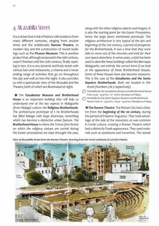
4. Alcazabilla Street
It is a street that is full of history with evidence from many different centuries, ranging from ancient times and the emblematic Roman Theatre, to modern day and the construction of recent build-ings such as the Picasso Museum. This is another project that, although proposed in the 19th century, wasn’t finished until the 20th century, finally open-ing in 1922. It is a very dynamic and lively street with various bars and restaurants, a cinema and a never ending range of activities that go on throughout the day and well on into the night. It also provides us with a spectacular view of the Alcazaba and the Theatre, both of which are illuminated at night.
The Estudiantes Museum and Brotherhood House is an important building that will help us understand one of the key aspects in Malagueño (from Malaga) cutlure: the Religious Brotherhoods. The architectural prototype of t he Brotherhoods has filled Malaga with large doorways, something which has become a distinctive urban feature. The Brotherhood House is where the Tronos (the throne on which the religious statues are carried during the Easter processions) are kept throught the year,
View of Alcazabilla Street from the Roman Theatre. Drawing from the travel notebook of Luis Ruiz Padrón.
The Roman Theatre. The Roman City had a thea-tre from the beginning of the 1st century, during the period of Emperor Augustus. They took advan-tage of the side of the mountain, as was common in Greek culture, creating a Roman Theatre which had a distinctly Greek appearance. They used mate-rials such as sandstone and travertine. The stands
Timetable for the Estudiantes Museum and Brotherhood House: From 10,30 - 13,30 hrs. / 17 - 19 hrs. Mondays to Fridays.Timetable for the Santo Sepulcro Museum and Brotherhood House: From 10 - 13,30 hrs. / 16,30 - 19,30 hrs. Mondays to Fridays.
along with the other religious objects and imagery. It is also the starting point for the Easter Processions, hence the large doors mentioned previously. This religious architecture is very typical of the 90s and beginning of the 21st century, a period of prosperity for the Brotherhoods. It was a time that they were able to move out of the churches and look for their own space elsewhere. In some cases, a style has been used to describe these buildings called Neo-Barroque Malagueño, not entirely the correct term if we look at the appearance of these Brotherhood Houses. Some of these Houses have also become museums. This is the case of the Estudiantes and the Santo Sepulcro Brotherhoods. Both are located in this
street (Numbers 3 & 5 respectively).
27

Timetable for the Theatre and Interpretation Centre: From 10 - 14 hrs. Wednesdays to Sundays.
The Albéniz Cinema was built in 1945 by José Joaquín González Edo in a personal design that was inspired by the Californian Cinemas at that time. It is a valuable example of architecture from this period and one of the few cinemas that remains standing in the city. Those that have dissapeared
Next to the theatre you can find the Interpreta-tion Centre, a rectagular box which has the Lex Flavia Malacitana written on it. The Lex Flavia Malacitana was a set of legal statues which, in 74 AD, converted Malaga from a federated city to a municipality gov-erned by Roman law. In Alcazabilla Street, various Phoenician and Roman remains have been found thus indicating the importance of this area. During the Roman period, in addition to the theatre, there were baths, a temple and a square in the port.
where people used to sit were covered in marble plates. The important people would sit on marble seats that were placed on the colourful floor made out of small pieces of marble, located between the stage and the stands. One of these chairs still remains today and has arms that are sculptured in the shape of dolphins. There is an inscription on the proscenium (front of the stage) that reminds these dignitaries that they invested in the refurbishment of the theatre, something that was carried out at the end of the 1st century during the Flavian Dy-nasty.The site was abandoned at the end of the 2nd century. An industrial district was built on top of the theatre during the late Roman period that was dedicated to the production of Garum You can still see the pits that were used to produce and store this type of fermented fish sauce. The theatre remained forgotten for centuries until it was redis-covered in 1951 after various landslides in the area. Today, it is once again being used as a theatre.
include the Moderno Cinema from 1913 and Goya Cinema that was refurbished in 1922 and given an Art Deco appearance. Finally, there was Malaga Cinema which was Rationalist in design. Opposite the cinema a couple of buildings from the same pe-riod help to recreate a historical moment from the middle of the 20th century.
Artistic and Monumental Malaga
5. The Jewish QuarterFrom the gardens located in front of the Roman Theatre (dedicated to Ibn Gabirol, a Jewish phi-losopher and Poet from Malaga from the 11th century), you can reach the area surrounding the Picasso Museum via a small alleyway. The Muse-um is modern in design, including simplified units with white Façades that blend in perfectly with the historical architecture that surrounds them, creating an extremely attractive space. This is the study area for the mu-seum which includes a bookshop, library, classrooms, multi-purpose rooms, res-toration workshops and auditorium, all of which surround a one hundred-year-old fig tree that looks as if it has jumped out of one of Tolkien’s books.
The Squinch of the San Agustin Chapel, as seen
from Pedro de Toledo Street.
28

Revello de Toro Museum. When leaving the Jewish quarter, a strangely shaped door stands out at the end of an al-leyway. This is where the sculptor Pedro de Mena lived in the 17th century, whose house/workshop is a beautiful example of Do-mestic architecture. It is currently a Museum of an-other distinguished artist from Malaga: Félix Revel-lo de Toro. In this Museum you can enjoy pieces by de Toro and have a first con-tact with de Mena, whose pieces are distributed throughout the city.
6. Císter Street
It receives its name from the Convent Recoletas Bernardas del Císter. The Façade of the Church from the 17th century still remains and is located at the end of an alleyway. It is here that you will also find the children’s bookshop Libritos which has been filling the minds of the young Malagueños with colour and adventure for years. Along this street you will find examples of architec-ture from different periods including the elegant circular corner of Cañon Street that was built in 1888 by the architect Jerónimo Cuervo. You will also find the Zea Salvatierra Palace from the 18th cen-tury that is located on the corner with San Agustín Street and which flaunts the family coat of arms on its Façade. Opposite, you will find the Gálvez Hos-pital which dates back to 1876 and was designed by Jerónimo Cuervo and Diego Clavero Zafra. It was built on a section of land that was confiscated from the Santa Clara Convent. Despite its stately
Pedro de Mena’s House, current Revello de Toro Museum.
Timetable: From 10 - 14 hrs. / 17 - 20 hrs. Tuesdays to Saturdays.From 10 - 14 hrs. Sundays and Public Holidays
The walk around the exterior perimeter of the Ca-thedral is a visual delight where the blocks of stone appear to emerge from the greeness of the gardens, as if they were suspended in the air. At the head of the Cathedral, its solid shape, polygonal structure, use of buttresses and lack of decoration make it look like a fort. The original Gothic design was created by Diego de Siloé in the 16th century. One century later, the general contractor Pedro Díaz de Palacios finished the transept and the choir which, from the outside of the building, can be seen in the circular towers or in the cubes that shape the side entrance. These new additions gave the building a strangely proud appearance that leaves the Gothic Fortress
The construction was designed by R. Glukman, R. Martín Delgado and Isabel Cámara at the begin-ning of the 21st century. It manages to maintain the secretism of the mute walls of the old Jewish Quarter. When crossing this area towards Pedro de Toledo Street, you will pass the Chapel of the San Agustín Convent which sticks out from the base of the building like a turret on a squinch. A few examples of popular Domestic architecture conclude our brief walk around this area where the medieval Jewish Quarter could once be found. Even though it no longer exists today, its memory remains exactly how Borges states, like a ficticious past which occupies something else’s place, some-thing about which we know nothing for sure, not even if it is true.
architecture, this street connected the centre of the city with the sea, thus giving it a very commer-cial and humble character. It was a street used for the transportation of goods and was where many people got together. Street vendors and musicians would group here creating a daily hustle and bustle, counteracting the silence inspired by the Cathedral. Today it is a great place to go for a walk and is the most monumental part of Malaga.
29

style behind in the search for a more refined look that is closer to the Classical style. It was here that construction work stopped, the wall was bricked in and the remaining empty space was used as a tem-ple. In the 18th century work began again, starting with the main Façade and advancing towards the part that had already been constructed previously. The sections (the previously used temple, the tran-sept and the choir) were joined in 1768. It was during this period that José de Bada and Antonio Ramos participated, immersed in the Barroque style.
The Sagrario Church was built at the beginning of the 18th century and can be found protected by the shadow of the Ca-thedral within direct earshot of the ringing of its bells. The outside of the church is particularly distinctive and stands out much more than its Bar-roque interior. The simplicity of its design can be seen with the clean shapes and lack of decoration that had been replaced by blue, white and red sgraffiti. These sgraffiti simulate brickwork, geomteric motif and the symbollic iconography of Saint Pedro (to whom this church is dedicated) such as the tiara and keys. Another of its emblems is the Marian Devo-tion to the Morning Star or Sea Star, in reference to the owner of the Parish, Saint María. However the part that stands out the most is with-out a doubt the Perdón Gate (Gate of Pardon) or Sagrario Gate (Sanctuary Gate). It is built out of
Head of the Cathedral, small cubes and tower of the northern façade. Above, symbollic sgraffiti on the wall of the Sagrario Church.
stone and is Isabelline Gothic in style, some-thing that is unusual in Malaga. The Gate is actu-ally from a Church that existed previously and was finished in 1542. The victory of the Catholic Monarchs over the Mus-lim city is evident both in its appearance and iconography. The altar-piece also confirms this message. In addition to the Christ Pantocrator, there was a sculpture of the Virgen de la Esperanza (Virgin of Hope) to whom the consecrated mosque is offered, due to the fact that the church occupies part of the land where the Great Mosque (Yama’a al-Kabir) once stood in the Medina. The Gate was most probably made to coincide with the northern ac-cess to the mosque, whose east-west layout would have corresponded to that of the main part of the church. In fact, in the left-hand corner of the church you can find some remains of the mosque. The mina-ret would have been located here on this side of the building. The patio of ablutions or Sahn, would have been located in the current gardens of the Cathedral. All that remains is an arch beneath the stairs that grant access to the Cathedral’s museum. The rest of the naves had a north-south layout. Despite its size, it was a lot smaller than the current Cathedral, one of the motives that lead to its destruction along with
the fact that it was initially consecrated as a Christian temple. It was possibly founded in the 9th century and extended in the 12th century by the Almohads.
Perdón Gate, Sagrario Church.
The Mosque is big due to its size and famous for its veneration. No rival can match the beauty of the
patio which has lovely orange trees planted there. Ibn Battuta
30
Opposite the church, the Santo Tomás Hospital stands out for its Mudéjar Gothic façade. This can be seen from the colour scheme of the stonework, the use of ceramic glaze, the cresting that on the upper part and on the capitals and the wooden shutters on the large win-dows. An endless list of architectural details can be found on this façade such as the variety of motifs on the shallow foundations, coat of arms and in-scriptions. All in all it is extremely interesting.It is an architectural retake on a primitve building from the 16th century that was demolished after being ruined by various earthquakes. The current building was constructed in 1891 and designed by Juan Nepomuceno and Bermúdez de Castro. It was here that the Santo Tomás Hospital was founded in order to attend to 14 poor people, excluding wom-en and terminal cases. It is currently in disuse.
7. Encarnación Cathedral
This is a must see on our itinerary, as the gran-deur that it shows on the outside is magnified in its interior. This is something that is not only due to its size, but also to the fact that it was built over various centuries. The result of which, is a temple which is Gothic in its shape, height and altar. It is impressive when it is made to the scale
and proportions of Renaissance archi-tecture (the latter with regards to hu-man standards, in contrast to the divine and ascending sense of the previous). It is also finished off with some Barroque decoration. It houses many artistic treasures: from the simple flooring in the Encarnación Chapel (the oldest in the temple, located in the central part of the ambulatory) to the organ and the choir. The organ was designed by Julián de la Orden and dates back to 1779. It is in a box that was designed by José Martín Aldehuela. The Choir is located in the centre of the Cathedral, very typical of Castillian temples. The structure of the Choir was built by Luis Ortiz Vargas in 1660 (together with the Bishop’s chair which includes the crowned virgin, Saint Peter and Saint Paul in high-relief). It also contains some magnificant sculptures by José Micael and Pedro de Mena.
The sheer size of the cruciform pillars, the never ending entablature that runs around the perimeter, the so-called brunelleschianos cubes located between the extremely tall pillars, the second part on which the arches rest and the profuse decoration on the vaulted ceiling in Horror Vacui, gave travellers a lot to talk about.
Relief of the Prophet Elias on the Choir chairs. A piece of work by Pedro de Mena who sculpted 40 reliefs on the backs of the seats of honour in the sec-ond half of the 17th century (except the figure of San Miguel, as the Bishop didn’t want him to appear). According to the his-torians Palomino and Velazco, this work by Mena makes the Choir the eighth wonder of the world.
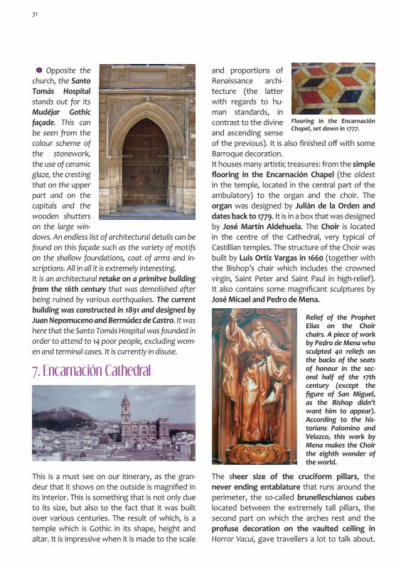
Flooring in the Encarnación Chapel, set down in 1777.
31

There were extremely different opinions such as that of Francois Minot in 1858 who stated that it has an elegance and a lightness that seduce you and make things bigger, whilst Pascual Madoz stated in 1850 that it is far from good taste. The historian Torres Balbás wrote in 1960 that the designer is not any less famous if people don’t know his name. The work in the Main Chapel is exceptional. Its outline is a inexistent wall that has been converted into an arcade which connects the chapel to the ambulatory. The paintings that decorate it are from the 17th century, iconography that is completed with busts of personalities from the Old Testament including church figures and martyrs. The altar’s Tabernacle dates back to 1861 and was built following the theme of the Ark of the Convenant. The Cathedral Museum completes our visit with a Mudéjar coffered ceiling from the 16th century.
Timetable: From 10 - 18 hrs. Mondays to Fridays. From 10 - 17 hrs. Saturdays. / Closed on Sundays.
8. Obispo Square
Passing through the garden, you eventually come out on Molina Lario Street and if you con-tinue to head towards the sea, you will come across Obispo Square. This space was once both a Phoenician and Roman Port, where the boats were protected from the easterly wind. It gained its current appearance and size in the 18th cen-tury as it was blocked in by the Cathedral and the Obispo Palace. The sacred Façades of these build-ings provide a contrast to daily life in the square, whilst examples of Domestic architecture can be found on the other side of the square.
At the foot of the Cathedral you will find the Barroque façade from the 18th century. It is un-finished, something which can be seen from the inexistent frontispiece where the sculptures of Christ, the apostles and other biblical characters should have beeen placed. Its Barroque style is enhanced with medallions that are dedicated to the Incarnation and to the Martyrs Ciriaco and Paula, Patron Saints of the City. In 1776, the north
Detail of the Cathedral’s facade. (La Trashtería Archive).
32

Tower was finished. It was the only tower that was built due to lack of finances. The money was sent to the Americans to help them in the War of Independence. Part of the money was also spent on mending the roads to Antequera, Granada and Veléz-Malaga. The Cathedral remains unfinished: without a tow-er, without the roof, the unfinished façade and without important rooms such as the Sacristy. There are some etchings by Francisco Muntaner in 1785 in which you an see a finished version of the Cathedral. They were sold by the Church Council in order to raise money. This ficticious future of the Cathedral was similar to that which Francis Cárter wrote about in his book Viaje de Gibraltar a Málaga (Journey from Gibraltar to Malaga). In this book, he completely forgets to point out that the Cathe-dral is in fact not finished. The fact that the tower still remains unfinished has become a feature of the Cathedral that makes it unique: la manquita (the one-armed lady) as it is better known locally. It serves as an example of the infinite city that is Malaga: unfinished buildings, centuries where nothing is done and urban projects that are pro-posed in one century, start in the next and which no one knows when they will be finished.
The Obispo Palace is a mixture of buildings from various different periods. The Barroque façade fac-es the square, the last phase of this construction which is used as an exhibition space. The oldest part of the Palace is constructed in Mudéjar style that was very common at the time. It was built in 1558 and opens up onto Santa María Street.
9. Larios Street
From the square and walking towards the sea, any route in the easterly direction will lead you to the main street of the city: Marqués de Larios Street, more commonly known as Larios Street. It is the heart of the city, the emblematic street through which Malaga presents itself to the rest of the world. Today, it is where people go for a walk and is the fashion epicentre of the city. It is also used as a catwalk, open air museum and thoroughfare for the Easter Processions. During special events and festivities, including the Carnival Celebrations in February, the City Festival in August and the Film Festival, it becomes the symbollic gateway to the city. It was opened between 1887 and 1891 in a pro-ject that was financed by the company Hijos de M. de Larios, with the idea of connecting the central square to the port area of the city. It was also an opportunity to improve the sanitary infrastructure in the Medieval narrow streets which contained
Modernist building from 1922 by F.
Guerrero Strachan that was built
near Larios Street.
33

old buildings in poor condition (the name Calle Siete Revueltas -Street of Seven Bends- tells us everything). This project is a clear example of the transforma-tion of Malaga from convent-city to middle-class city. This was in line with other projects such as that of Barón Haussmann in Paris during the Sec-ond French Empire in which he modernised the medieval city, creating elements such as wide straight boulevards and adapting public space so that citizens could use and enjoy it. It repre-sents the aspirations of Malaga during this period and has always stood as a symbol of modernity. Joaquín Rucoba designed the project and Eduar-do Strachan Viana-Cárdenas designed the outline of the building façades. They are defined by their decorative sobriety and curved corners which express the city’s desire to be comspolitan. They are not monumental, but are elegant and far from Tradicionalism and Historicism. The ground floor level of the buildings were designed with a Pa-risian commercial character. Amongst the first shops that moved in, was the first French-style Ba-zaar which sold clothes, basic tools, kitchenware, watches, weapons, perfumes, presents and new items from abroad. The original pavement was made out of wooden strips that floated away dur-ing the floods in 1907. Today, the floor is made out of marble and care should be taken on rainy days, unless you are a fan of ice skating of course!
10. Constitución Square
It is the heart of the historic city centre. It is possible that both a Phoenician and Roman Gate were lo-cated here and that it was used for commercial and administrative purposes. Since the Nasrid period, it has been a meeting place and a market. At this time it was an open area with various streets leading into it. These streets connected the city in all different di-rections, hence why it was once called Four Streets Square. It finally became the Main Square in the city when the Christians located their Public Au-thorities here including the City Council, the Prison and Housing for the Civil Servants. It was a public and political area. It was both the seating area and the stage for parties and other public celebrations. It was also used as a bull ring, and there was even a pillory where the Renaissance fountain from the 16th century is now located (called Génova or Carlos V). They say that during the reign of Isabel II, a guard was set up which would arrest drunk people, bring them to the square and make them drink 8 litres of water. Since the 19th century it has been home to various cafés such as La Loba, which is located on the northen side of the square and was known for renowned social gatherings and benders. On the eastern side, in the location of what today is known as Café Central, there were originally three cafés: Suizo, Central and Munich. They were famous for their shows and energetic debates about flamenco and bull fighting. Currently, the square is a place where people go for a walk and to meet up with others. On the city’s important days, it is dressed-up to the nines. It is the centre of the citizen’s revolution and has been called Plaza de la Libertad (Freedom Square) in the past. Plaza de la Constitución con el café Suizo y café Central.
34

From the square, you can appreciate the urban evolution of the city, something which gives you an insight to the thinking behind each phase. The old-est part is the area near Santa María Street, the main artery that dates back to Roman times and runs from east-west. It also used to connect the city to the port. Granada Street is Muslim, although its origins are Ro-man. The layout of the street follows the course of a river which goes up to the Gate that connected Mala-ga to the Road that led to Granada in the north. The Compañia Street part of the square is Nasrid and pro-longs the east-west connection up to the city wall. Es-pecerías Street and Nueva Street are both Castillian and date back to the Renaissance period. Especerías was built on a Muslim Street where the Spice Souk was once held. The organic nature of the street gave way to wide and straight streets with lots of light. It used to connect the west of Malaga and Nueva Street to the Sea Gate in the south. Finally, Larios Street gave the city a nineteenth-century urban model that connected the city with the new port.
The Santo Cristo Church, as seen from the square. Oil painting by M. Bertuchi (Bertuchi Family Archive).
The oldest building in the square is located at the beginning of Compañia Street and is called Santo Cristo de la Salud Church. It dates back to 1630 and can be identified by the cone-shaped octagonal roof which dominates the square’s horizon. It is cir-cular-shaped and the dome shows an iconographic pictorial about martyrdom. It uses pictorial tricks
When the Jesuitas were expelled from the Novi-tiate building, it was occupied by various different institutions. One of these was the San Telmo Royal Academy of Fine Arts which is where Picasso used to accompany his father at the end of the 19th cen-tury whilst he gave classes. A few years later in 1892, Mariano Bertuchi joined the Academy. At only 8 years of age he attended classes on land and sea-scape painting with Emilio Ocón. Currently it is oc-
which simulate architectural elements. The church is dedicated to an sculpture that was created by the sculptor José Micael Alfaro. They say this sculp-ture is responsible for stopping a plague epidemic in 1649. It is the church of the Compañia de Jesus School, a religious community who were given the San Sebastián Chapel at the end of the 16th century, upon which they built this Church and Novitiate.
35
ConstitutionSquare

Timetable: from 18 - 21 hrs. Mondays to Fridays.
During the second half of the 18th century, an-other part of the school was modified with the addition of the adjoining building. The grey mar-ble entrance and row of balconies particularly stand out, showing the theatrical character of the square. The Montepío de Viñeros (Winemak-ers Society) installed itself here. The Society was founded in 1776 and was the institution that pro-tected and regulated the Harvester’s Trade Union, whose emblem appears on the medallion that can be found in the entrance. The creation of this So-ciety is evidence of the historical importance of Malaga as a producer of wine, liqueurs, raisins, figs, almonds and olive oil. All of which are products that reinforce Malaga’s social and lively character. The Economic Society of Friends of the Country was also located here.
Headquarters of the Montepío de Viñeros (Winemakers Society).
cupied by a school and the Ateneo, a cultural space which promotes critical thinking and that hosts a programme of interesting cultural activities and high quality exhibitions.
On the eastern side of the square, the Cathe-dral’s only tower stands in the distance. A Bar-roque façade, that dates back to 1745 and is full of paintings, forms part of the marble entrance of the Agustinas Convent that has been located here since 1628. Behind the entrance and passing under an arch, you will find the Chinitas Passageway from the 19th century and immortilised by the port Fed-erico García Lorca.
Chinitas Passageway. Diego Clavero Zafra designed the passageway in 1855. It was an austere and even rough area that was tucked up in the centre and hidden away from the rest of the world. What remains of the Chinitas Passageway are its history and legends. It was never renowned for its beauty, but for its flamenco scene, parties and for its passion. The voice of Piyayo was often present and there were bars where people would drink and listen to flamenco and cante jondo (a special style of flamenco). This was especially the case of the Café-Theatre Chinitas which was host to a variety of celebrities including Juan Breva, La Parrala, Chacón, la Niña de los Peines, Diego el Perote, Pepe de la Isla, el Niño de las Moras, La Rempompilla, … Other popular spots included Café Munich and Café Express. Currently, there are various restaurants that specialise in local food. The oldest business that still exists today is that of the knife-grinder, Manuel Ocón. Also, there is a wax-chandler’s shop on the corner with Santa María Street, a business that is inseperable withe popular culture in Malaga.
In the Chinitas café, Paquiro said to his brother:“I am braver than you, more of a bull fighter,
more of a Roma”.F. García Lorca - Popular petenera (type of flamenco) from Malaga
36

Siglo and Carbón Squares. This public space is extremely busy throughout the day with many other streets branching off from here. The 20th century architecture from the 40s and 50s (con-structed after the Civil War bombings) differs aesthetically from the architecture from the end of the 19th century. One of the buildings that sur-vived the bombings houses one of the oldest Cafés in Malaga, Cafe Madrid, which opened in 1892 as a tea room and cake shop. Another famous Café
that was located in this square was the Castaña Café. It was run by Anita Delgado’s family. Anita Delgado was a dancer from Malaga, who later be-came Maharaní de Ka-purtala in 1908, a story in which various peo-ple played a part, such as the painter Julio Romero de Torres and the writer Valle-Inclán.
11. The Alcaicería (al-Qaysariya)
The Muslim Alcaicería was located between San-ta María Street and Granada Street. The layout of the street could still be seen until the 19th cen-tury. Santa María Street maintains its Andalusian layout and was once called Mercaderes Street, a name that indicates its commercial and bustling character, a character that still remains today.
Café Madrid Building.
Building from 1943 by Joaquín González Edo which has a dynamic composition with a Rationalist slant. This building was originally conceived as a cinema and as housing. This explains the curved access through a circular hallway. Apartment building from 1872 by Cirilo Salinas. It has a for-mal Historicist appearance with some Classical elements.
12. Uncibay Square
In Caldería Street and Uncibay Square there are interesting samples of architecture from the first part of the 20th century, with both Histori-cist and Modernist buildings. The two buildings that stand out the most (nº 9 Caldería and nº 4 Uncibay) are both by Fernando Strachan who mixes diverse and polychrome elements. Oppo-site these delicate buildings, the 80s gave way to some constructions that were quite unfortunate,
37

by Fernando Guer-rero Strachan and convert this street into a visual model of the Malagueño middle-class from the nineteenth-century.
The most distin-guished building on the street is also named after him, Echegaray Theatre. It was opened as a cinema in 1932 with the projection of the film El favorito de la Guardia (The Guard’s Favourite). It was designed by Manuel Rivera Vera who also designed the building located at nº 3 on the same street. Its style is between Modernist and Historicist. Vera took care of every little detail in the design of the cine-ma, giving importance to the decorative elements such as the ironwork, glass windows, lighting, door handles and the railings, etc.
13. Echegaray Street 14. San Agustin Street
The elegant Echegaray Street owes its name to José de Echegaray Eizaguirre who, amongst many other things, won the Nobel Prize for Liter-ature in 1904. The street opened in 1876 after the confiscation of the Capuchinas Convent. Some of the buildings from the period were designed
such as the construction that was built on the land that used to belong to the Goya Cinema. In 1989, a final intervention recuperated this space, an area where you could find some legendary cafés such as Doña Mariquita that is still open today. Various streets from the 16th century run into this open space which has been converted into a beautiful recreational area that is full of cafés, bars and res-taurants. From this square and Calderia Square, you can reach the only shopping centre that can be found in the centre of Malaga, Galerías Goya. It contains businesses that sell products which combine contemporary design with the ingenuity of the people from Malaga.
When you arrive at San Agustin Street, it gives you the impression that you have found a corner of Malaga that is full of legends and romanti-cism. It seems as though history has abandoned the cobblestone streets to climb the walls of the buildings that can be found there. It used to be called Caballeros Street until the Augustinians came here in the 16th century founding a school, convent and church. Arquitectonically speaking, they are the result of projects, constructions and
38

interventions of various pe-riods. Despite the fact that the church was already in
construction in 1579, various different interven-tions are visible up until the 21st century. 15. Granada Street
A sturdy Tower stands out, in reference to the nobility that lived there. It is caught between the Renaissance and Mudéjar styles and has a defensive character. This fortress has more of a Castillian appearance than a southern one. It is the Palace of the Count of Buenavista and dates back to the middle of the 16th century. The Count of Mollina, Diego de Cazalla ordered it to be built. As well as a Palace, it was a furniture factory, headquarters of the Red Cross, Museum of Fine Arts and today, the Picasso Museum. A correct intervention in the 21st century converted this old building into a contemporary exhibition space where, along with the permanent collection of Picasso’s work, many interesting temporary exhibitions are now shown. The visit is enriched with the other architectural and historic sites, along with other beautiful Mudéjar craft. In the basement there are archaeological remains of the Phoenician wall and Roman mud pits.
Conde de Buenavista Palace. Oil painting by M. Bertuchi. (Bertuchi Family Archive).
Timetable for the Picasso Museum: From 10 - 20 hrs. Tuesdays to Thursdays, Sundays
and Public Holidays. From 10 - 21 hrs. Fridays and Saturdays.
Granada Street is one of the most picturesque streets in the city. The Catholic Monarchs en-tered through this street after their conquest in 1487 and due to this, it received the name Real Street (Royal Street). It received its current name from the Gate that connected the walled city with the road to Granada. It follows the route of a river and leads to Constitución Square, Merced Square and Victoria Street in the north. During the Nasrid period, it became a street full of noble Palaces. Following the arrival of the Christians, various religious institutions were located here. Along this street you will find varied architecture which takes us from the 17th century to the 20th century. It is the location of the Ibn Gabirol Tour-ism Office which can be found in a Tower from the 17th century that formed part of the old Jew-ish Quarter.
The location of the El Pimpi Wine Cellars was where the stables of the Buenavista Palaca and Con-vent used to be located. In the 20th century it be-came a party place and was Malaga’s first cabaret after the Civil War. It changed owners and names on various occasions and the activities carried out there increased. It became a place where people
39

The Santiago Church dates back to the end of the 16th century and was built on the location of an old mosque. It was built in Mudéjar style of which only the coffered ceiling of the main nave remains.
16. Santiago Church Square
went to meet and a place that was frequented by flamenco artists, bull fighters, writers and artists. The Malagueño Montmatre Group celebrated their first exhibition here in 1954, after which they decided to travel to France to meet with Picasso. This meeting led to a joint exhibition between Pi-casso and the Malagueño artists in Villa California in 1957. At this point, this group of artists adopted the name the Picasso Group. Since 1971 it has been open under the name El Pimpi. It has typical Andalusian interior design which has been enriched with photographs and dedications on barrels from the celebrities that have passed through the bar. Its name makes reference to the Pimpis, young people who used to run errands in the port, work as porters and help unloading the luggage of the recently arrived visitors. According to the other version of the story, the name pimpi derives from the English term pimp, in reference to the person who used to take the foreign sailors to find prostitutes.
The Santiago Church was previously a mosque…..of that construction, the
bricked tower still survives today. Richard Ford,
1844.
It is now hidden by the vaulted ceiling and other elements. The part that stands out the most is the tower. Although it is a bell tower, it still looks like an old minaret of a mosque. It has curved brickwork which is highlighted by the diamond or sebka pat-tern. It is finished off with a dome that is made out of ceramic glaze, crowned by a bulbous body, like an eastern Yamur. Its colourful design can be en-joyed from Merced Square. Another of its Mudéjar elements is the central entrance which dates back to the 18th century. It is simple but its detail make it special. The bricked arch accentuates its pointed form, pinching the key of the exterior curve. It di-vides the spandrel in two parts, showing off two different motiffs in the tiling : the ten-pointed and eight-pointed stars. The dedication of the church can be seen by the Barroque circular decoration with conch shells and the Santiago cross which has been transformed into a sword belonging to the military order that was founded in 1170. The side entrances were constructed in 1705 and were part of the refurbishment that turned the building into the Barroque Church which is known today. The painter Pablo Ruiz Picasso was baptised in this church along with many other Malagueños. Juan de Sanmartín was also buried here. He was the father of the General San Martín who was known as the Liberator of Argentina, a military man who also participated in the independence of Chile and Peru.
Opposite the Santiago Church there is an open-ing in the shape of a compass. Here you will find the Palace of the Marquis of Sonara (or Gálvez) that dates back to 1789. Curiously, the Sun emblem of Félix Solecio, the supplier working for the Royal
40

Factory of playing cards from Macharavieja who was responsible for the construction of the build-ing, still shines on the corner of the street. The street itself was made bigger in order to al-low for the carriages to pass through. The way in which its façade is set back, seems to respect the area of servitude that is the temple. However, it was designed this way by order of Don Félix, who wanted it like this so that he could manouver his carriage to park it in the coach-house.
17. Merced Square One of the most suggestive buildings of the ar-chitecture from the first half of the 20th century, is the building that stands opposite the church. It has a strong structure, especially due to the versa-tile nature of its perspectives. It is very Expression-ist in its appearance and could form part of the set of a film by Robert Wiene or Fritz Lang. The corner of the building which has an accentuated edge, seems to raise up above the line of the façade. The wave in the design, the broken curves and the straight vertical line are counteracted by the hori-zontal spaces, something very common in Ration-alist style buildings. The use of a balustrade for the upper parapet is particularly strange, something which makes the building even more unique.
Two buildings conclude the street that date back to the 18th century (nº 65 and nº 73). This was the location of the Granada Gate which had a bent entrance that can still be seen in the Medina Conde Alleyway. The Gate was monumental and had a small opening that was locked in by two towers. It was demolished in 1821. The Muslim Gate was called Bab Funtanalla, in reference to the northen suburb that was located outside of the Medina.
The Malaga Suburbs
This is the square for the Malagueños. It is both a quiet (in the morning) and lively (at night) place that is sunny in the winter and smells of chestnuts. It has some nice views of the Alcazaba wall and the small dome of the bell tower of the Santiago Church. Its final design was implemented in 1842, the date from which it received its nineteenth-cen-tury appearance and became a place where peo-ple went to have fun. Previously, it was a suburb of the city, located outside of the city walls. It ori-gins can be found in the Flavian city of Malacitano which had an amphitheatre. It was in this area that you could find the Paz Convent and the Merced Square. It was a residential area where artists used to live such as the painter Bernardo Ferrándiz, the sculptor Fernando Ortiz and the architect Jerónimo Cuervo. The birthplaces of Picasso and the poet Manuel Alcántara are also located in this square. Picasso used to play with the pigeons here
After passing under the inexistent Granada Gate, our itinerary takes us out of the Medina. We will now visit the Funtanalla district to the north of the Medina.
Plaza de la Merced.
41
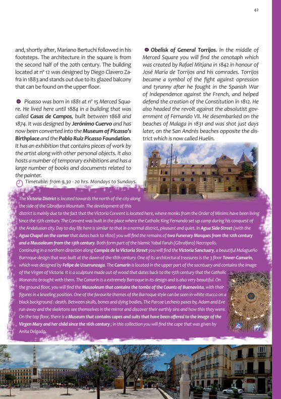
and, shortly after, Mariano Bertuchi followed in his footsteps. The architecture in the square is from the second half of the 20th century. The building located at nº 12 was designed by Diego Clavero Za-fra in 1883 and stands out due to its glazed balcony that can be found on the upper floor.
Obelisk of General Torrijos. In the middle of Merced Square you will find the cenotaph which was created by Rafael Mitjana in 1842 in honour of José María de Torrijos and his comrades. Torrijos became a symbol of the fight against opression and tyranny after he fought in the Spanish War of Independence against the French, and helped defend the creation of the Constitution in 1812. He also headed the revolt against the absolutist gov-ernment of Fernando VII. He desembarked on the beaches of Malaga in 1831 and was shot just days later, on the San Andrés beaches opposite the dis-trict which is now called Huelin.
Picasso was born in 1881 at nº 15 Merced Squa-re. He lived here until 1884 in a building that was called Casas de Campos, built between 1868 and 1874. It was designed by Jerónimo Cuervo and has now been converted into the Museum of Picasso’s Birthplace and the Pablo Ruiz Picasso Foundation. It has an exhibition that contains pieces of work by the artist along with other personal objects. It also hosts a number of temporary exhibitions and has a large number of books and documents related to the painter.
Horario: De 10 a 14 h. / 17 a 20 h. de martes a sábado.De 10 a 14 h. Domingos y festivos.
Timetable: from 9,30 - 20 hrs. Mondays to Sundays.
The Victoria District is located towards the north of the city along the side of the Gibralfaro Mountain. The development of this district is mainly due to the fact that the Victoria Convent is located here, where monks from the Order of Minims have been living since the 15th century. The Convent was built in the place where the Catholic King Fernando set up camp during his conquest of the Andalusian city. Day to day life here is similar to that in a normal district, pleasant and quiet. In Agua Side-Street (with the Agua Chapel on the corner that dates back to 1800) you will find the remains of two Funerary Mosques from the 12th century and a Mausoleum from the 13th century. Both form part of the Islamic Yabal Faruh (Gibralfaro) Necropolis. Continuing in a northern direction along Compás de la Victoria Street you will find the Victoria Sanctuary, a beautiful Malagueño Barroque design that was built at the dawn of the 18th century. One of its architectural treasures is the 3 floor Tower-Camarín, which was designed by Felipe de Uzurrunzaga. The Camarín is located in the upper part of the sacntuary and contains the image of the Virgen of Victoria. It is a sculpture made out of wood that dates back to the 15th century that the Catholic Monarchs brought with them. The Camarín is a extremely Barroque in its design and is also very beautiful. On the ground floor, you will find the Mausoleum that contains the tombs of the Counts of Buenavista, with their figures in a kneeling position. One of the favourite themes of the Barroque style can be seen in white stucco on a black background : death. Between skulls, bones and dying bodies, The Parcae Lechesis pases by, Adam and Eve run away and the skeletons see themselves in the mirror and discover their earthly sins and how thin they were. On the top floor, there is a Museum that contains capes and suits that have been offered to the image of the Virgen Mary and her child since the 16th century ; in this collection you will find the cape that was given by Anita Delgado.
42

18. Jerónimo Cuervo Square
If you leave Merced Square and head in a wester-ly direction, you will walk in parallel to the course of the old city wall. Although it no longer exists, it lives on in Álamos Street. This Street is difficult and complicated to walk down due to the small pavements and the abundace of traffic that passes through it. From Álamos Street, you can access various museums. It also has some inter-esting architecture such as the Headquarters of the Andalusian Centre of Arts (nº 24), which was built in 1905 and designed by Fernando Guerrero Strachan. Its dominitaing corner is reminiscent of a boat, due to the use of ox-eye windows on the front of the building. There are numerous ex-amples of the strong Rationalist influence, typi-cal of the self-governed period of the middle of the 20th century. The other option is to go along the parallel street Madre de Dios, which takes us
Cervantes Theatre. It is located in a Square that was named after the Theatre, Jerónimo Cuervo Square. It dates back to 1870 and was built on the land that used to belong to the Merced Convent. The Libertad Theatre used to be located here, previously called Príncipe Alfonso, and it was destroyed by a fire. The painter Bernado Ferrándiz, with some help from Muñoz Degrain, was in charge of the painting and decoration in the Theatre. On the main curtain there is a self-portrait of him as Mephistopheles. On the ceiling, an allegory of the city was also painted. The Theatre opened with the Overture from the Opera William Tell. From the middle of the 20th cen-tury, the theatre was abandoned. A refurbishment in the 80s recuperated its old appearance with the addition of some contemporary elements.
doll’s House Museum. Álamos Street, 32 From 11 - 13 hrs. Closed on Mondays. Peña Juan Breva. Flamenco Museum. Ramón Frasquelo Side-Street, 4. From 10 - 13 hrs. Tuesdays to Sundays. Interactive Museum of Music (MIMMA). Beatas Street with Cárcer Street. From 10 - 14 h. / 16 - 20 h. Mondays to Sundays.
Álamos Street.
Andalusian Centre of Arts.
Jerónimo Cuervo Square. Drawing by Luis Ruiz Padrón.
through Teatro Cervantes Square and then on to the end of Montaño Street. From here, you can make out the San Felipe Church (Gaona Street).
43

The Barroque San Felipe Neri Church has an origi-nal ellipsoid shape with an octagonal main Chapel, a result of a combination of spaces from different periods. The Main Chapel, along with another un-derground Chapel (both from 1730), formed part of the Palace of one of the Counts of Buenavista, until it was given to the Philippians in 1739. The el-lipsoid main part of the church was joined onto the Chapel. During this process, various architects par-ticipated including José de Bada, Antonio Ramos and Ventura Rodríguez. The intervention finished in 1995 along with the construction of the Sacristy (designed by José Martín Aldehuela). Next to this building, a convent and study house were built. There is pictorial and sgraffiti decoration that can be seen on the outside of the temple and of the convent. It became an educational institute from 1846 and is cur-rently the Gaona Sec-ondary School.
Timetable: from 11 - 21 hrs. Tuesdays to Sundays.
19. Old Funtanalla SuburbThe Medina in Malaga had two main suburbs which were also surrounded by a wall. One of them was called the Funtanalla Suburb, also known as the Antequera Suburb. It was located to the northeast of the Medina and spanned between the Goleta district, the Molinillo district and the river. The wall of the district joined onto the Medina wall. This suburb was extremely large and had all of the basic services: ovens, fountains, baths, funduqs, corn exchange and mosques. It also stood out for its local craft industry, especially pottery. In malaga, the district was famous for a certain type of pottery called Maliqa. It was popular due to its golden tones, with production in this area possibly dating back to the 11th century.
Street in the Funtanalla Suburb with the
San Felipe Church in the background.
In Malaga the marvellous golden pottery is made, which is transported to even the remotest of countries. Ibn Battuta
In this area, you will find the San Felipe Neri Church and the Glass Museum in a small square. They are surrounded by historic Domestic archi-tecture which, in some cases, has pictorial deco-ration on the exterior walls.
The Glass Museum, as well as being extremely interesting from an architectural point of view, also contains an exquisite collection for the lovers of decorative arts : trousseau of glass and porce-lain, pottery, furniture, fabrics, stained glass win-dows, paintings etc. A collection of unique pieces that take us on a journey from ancient times to modern day.
44

Once again the itinerary takes us back into the Medina. Here we will discover a Malaga that has its own identity and that can be found on the western coast. The urban fabric is medieval in design, where the sunny open space is bursting with hustle and bustle. Then, without notice, it falls into silence and is lost in the shadow of the irregular narrow streets. It is a commercial area which has been popular since the Muslim period.
20. Mártires Square
Along the route of the old wall of the Funtanalla Suburb, in Cruz del Molinillo Street, you will find the Salamanca Market that was built in 1925 by Daniel Rubio Sánchez. The iron structure provides good ven-tilation and light. This is combined with the Historicist appearance in its construction. The entrances are of eastern design and are extremely colourful. They again look like they could be from the set of a theatre, giving the market a lively character that invites the passerby
to enter. The bars on the structure of the market are original, using the trencadís technique (mixing pieces of ceramic glaze). Further along you will find the Casa de Socorro de F. Guerrero Strachan, a jewel from 1918.
Buenaventura Gate and the western perimiter of the Andalusian wall. From the Funtanalla Suburb you used to be able to access the Medina through the Bue-naventura Gate (Bab al-Jawja or Side Door Gate). It does precisely as its name says and connects the Medina to the Casabermeja road (in the north) and to the Ante-quera road (in the east). It was built in the 11th century. Even though the Gate no longer exists, you can see part of it in the area known as the San Julián Wall, next to Theatre Square. Two buildings share the canvas of the wall : the Proteo Bookshop, located in a building from the 19th century (Puerta de Buenaventure Gate), and the Spanish-Moroccan Study Centre, located in a building from the 18th century. The wall has been integrated into these buildings but can still be visited. The remains include a turret, a barbican, a moat and a bridge that granted access to the wall. The wall continues parallel to the River Guadalmedina on its western edge. Its course coincides with the current Álamos Street (to the north) and Carretería Street (to
the west). There are a few stretches of the wall and foundations that are still around today, such as the remains that can be found and visited in the Hotel Vincci Posada del Patio. On this stretch, the Antequera Gate (Bab al-Malaq) and the Bridge Gate (Bab al-Qantara) can be found. In Carreterías Street you will find the Wine Museum (nº 1 Viñeros Square) and on the other side of the street, the Easter Museum.
The stretch of wall between the Proteo Bookshop and the Spanish-Moroccan Study Centre.
Wall of the Proteo Bookshop, next to the section of the shop that is dedicated to books related to Malaga.
Merchant Malaga It inspires a certain way of life that is marked his-torically by the Corn Exchange and the Dockyards (Later a market) in the southern part. It is also known for the Parishes that are located there and its closeness to the old wall which, for centuries, gave it the suburb status.
The Mártires Church was one of the founding Parishes of the city and is dedicated to the Pa-
45

tron Saints: Saint Paula and Saint Ciriaco. The first church was finished by the middle of the 16th cen-tury however, destiny had its way and its Mudéjar image was eventually transformed. The current church came about after the refurbishment in the last third of the 18th century, along with some later interventions. It is Barroque in style and has a ro-coco appearance, where no wall has been left with-out anything on it. This style has become the mani-festation by antonomasia of Christian religious art which, as defined by Antonio Machado “looks like it has been painted with splashes of fire which ex-pand and complicate the decoration….an ember in this fire of a church”.
In the only open space in the Mártires Alleyway, you will find the old Parador Del General. The archi-tect was Felipe Unzurrúnzaga and although it dates back to 1709, the design is more appropriate of the 17th century. It has a little side tower, a gallery on the upper part and it surrounds an interior patio.Continuing along the alleyway, there are various houses from the 18th century which have paintings on them, though they are difficult to see due to the narrowness of the street. A Renaissance style algor-fa crosses the street with a renewed and contem-porary appearance.
21. Compañía StreetThe cute Compañia Street has a nineteenth-cen-tury appearance, although its origins are from the medieval period. It receives its name due to the Society of Jesus that was located here. It is a street where monuments are alternated with museums, Domestic architecture and interesting businesses.
The Carmen Thyssen Museum is located in the Villalón Palace (previously Mosquera Palace). It is an ancestral home from the 16th century which has been rennovated, recuperating the Renaissance patio and other elements such as the coffered ceil-ing. The underground level also participates in the Malacitana history. It was here that Roman mud pits were found that date back to the 3rd century AD and which were used for the production of gar-um and salt. They also found a Roman Nymphae-um along with some paintings, and Andalusian Tanneries. The Palace welcomes visitors with the Villalón family coat of arms from the 18th century. The museum’s collection has more than 300 paint-ings, almost all of which are Andalusian from the 19th century and are mainly landscapes from the Costumbrismo movement. The Museum often has temporary exhibitions as well.
Timetable: from 10 - 20 hrs. Tuesdays to Sundays.
Sagrado Corazón Church.
46

22. Museum of Popular Arts
23. San Juan Church Square
In the area located next to the wall, a certain mar-ginalized way of life was developed in the Christian period which has lasted for centuries, even after the wall was demolished. It was here that various inns, lodgings, taverns and brothels could be found. You can find an example of Hostelry architecture in Me-son de la Victoria (Santa Isabel Passageway nº 10), which dates back to 1632 and which was run by the Franciscans from the Victoria Convent. Afterwards, it became housing and is the current location of the Museum of Popular Arts and Customs. It is well worth a visit, not only for its architecture but to get to know about the daily life and customs in 19th cen-tury Malaga. It also houses the Narciso díaz Escovar Archive. The original entrance was through Camas Street, within the perimiter of the wall. This en-trance, located on a busier street, was constructed when the building was opened as a museum.
Timetable: Winter: from 10 - 13,30 hrs. / 16 - 19 hrs.
Summer : from 17 - 20 hrs. Closed Saturday afternoons, Sundays and
Public Holidays.
Old entrance, today closed.
The church Square, known historically as Bread Square, has had a strong commercial tradition since the Muslim period. During the Christian pe-riod, the purchase and sale of traditional arts and crafts was concentrated around the founding San Juan Parish (in the south) and Mártires Parish (in the north). These churches used to share the street with the Parishoners, and the days were filled with the cries of the salesmen, the sound of the workshops and the ringing of the bells which marked the public celebra-tions that were held there. Table wine was confused with the wine from the al-tar (both wines always from Malaga), and the smell of incense was confused with that of aniseed and other essences that were used to give an aroma to the wine and liquors in the stills.
The Sagrado Corazón Church appears unexpectedly in part of the street which is set
back. It dates back to 1920 and was designed by F. Guerrero Strachan. It has a strong Neo-Gothic appearance, similar to the French and
Castillian Gothic Cathedrals, examples of which can be found in León and Burgos. However, when ob-serving the façade in more detail, you can see that there are elements that belong to other styles such as the staggered windows that were very typical of the Modernist movement. Inside, the Neo-Gothic style is interrupted with Modernist, Byzantine and Eastern elements. Entering into this church is like travelling back to a medieval daydream which lacks any negativity and which is full of attractive details such as the imagery, the pulpit, trick paintings and the star-shaped dome of the transept which is full of stained glass. Our itinerary can continue on to the river along Com-pañia Street or along the parallel Cisneros Street.
House of the birds, Cisneros nº 6. Rationalist building with Art Deco detail from the begin-ning of the 20th century.
47

A witness of this spirit is the local law from the 18th century that prohibited bakers and middlemen to sell products next to the church. It still hasn’t lost its trading character which creeps up to the street through the warehouses and businesses with their open window displays selling all types of things from everyday goods to specific products such as the hoods of the penitents. Here you can find a strange mix of shops which range from La Recova, dedicated to local and national pottery, or others such as weavers, basketweavers and nee-dleworkers. You can also find the Gravura Work-shop which has been located on the first floor of a building in this square since 1979. It is run by Paco Aguilar and is a meeting, learning and exhibition space which is dedicated to etching.
The San Juan Church was consecrated as a founding Parish in 1487 by the Catholic Monarchs. This temple was built on top of a mosque and was modified between the 16th and 17th centuries. Over time, its Mudéjar origins were hidden and the space was renovated and decorated in Barroque style. Outside, a powerful tower stands out with its base that is made out of sandstone and the curved brickwork on the upper part. The decorative mural on the façade dates back to 1732 and has a geo-
metric pattern and colours which are reminiscent of the drawings of the Roman villas, very similar to the flooring in the Encarnación Chapel in Malaga´s Cathedral (from 1777). Ths significance of the five balls that decorate the façade of the church is un-known. They say that they are the cannonballs used during the conquest of the Catholic Mon-archs. The colour could be as-sociated with an easter candle, where each ball corresponds to a Christian value. At one time, word on the street said that the balls represented the presence of a brothel in the adjoining house, a “house of repentants” dating back to 1597.
The presence of the tower has a powerful effect when looking at it from San Juan Street. It used to be called Mar Street, as it was the thoroughfare used to transport the merchandise from the city to the dockyards. It has always been a street that was full of commercial character and whose history has been written by the businesses that were located here, such as the Bonifacio Gómez Pharmacy. The decora-tion of the Pharmacy dates back to the end of the 19th century and recalls the famous social gatherings that used to take place in the back room.
24. Sea Gate (Puerta del Mar)As we approach the sea, the trade and popular aspects of the area are evident. The merchants used to group together between the Dockyards, the Corn Exchange and the Sea Gate. They used to transport their products to the north of the city through the narrow Mar Street and, from the 16th century onwards, through the wider Nueva Street which was opened up precisely with this obje-tive. The Dockyards became a market in the 19th century, and the gated Corn Exchange and Cus-toms House disappeared. In 1800 the Sea Gate was demolished and, shortly after, a second Gate located in the entrance to Mar Street was also knocked down. The surrounding area became very nineteenth-century in style.
48

For the Féliz Sáenz Department Store, the ar-chitect Manuel Rivera Vera designed a Modernist building in 1914 which mixes Gaudí style with Bar-roque elements. In its time, it was an unequalled building as it was designed as a department store. Strangely enough, it was built on an area of land
The area which used to be oocupied by the Sea Gate (Bab al-Bahr) is now an emblematic space for the citizens in which they can enjoy a good break-fast before or after going to the market, grocery store or other food shops. You can also enjoy a quick snack here whilst running your afternoon er-rands. There are places that have been enjoyed by different generations of grandparents, parents and children, such as the Churrería Casa Aranda. It is an area that is full of hustle and bustle and is where the sea breeze enters into the city. Beyond the tops of the palm trees there are a series of buildings that decorate this corner of Malaga and that stand out for their finishings. An example of this can be seen with the building that was financed by the La Cam-pana Wine Cellar in 1957 and is crowned by an iron bell; or the hotel on the corner of Alarcón Luján Street which was built in 1908 and was designed by Manuel Rivera Vera. It has a circular tower on the corner which is finished off with a dome.
The building that stands out the most was de-signed by Daniel Rubio Sánchez in 1925. It is located where the old Dockyards connected with the south-
Félix
Sáe
nz B
uild
ing.
25. Corn Exchange and Dockyards
Various elegant buildings, that date back to the end of the 19th and beginning of the 20th centu-ries, were constructed in the location of the Corn Exchange and Muslim Dockyards. Some of them are extremely peculiar. However, the Mercado de Atarazanas (Dockyards Market) is without a doubt the star.
that used to be the Royal Corn Exchange during the Muslim period.
The southern side of the old Dockyards.
49

The Atarazana Market (Dockyards Market) is one of the most emblematic places of life in Malaga. When you walk through it, you will discover cus-toms, colours, smells and tastes of the Mediterrane-an. It is a sample of the richness of this part of Spain, both in the products sold there as in the character of the people.
It occupies an area that was once a Muslim Dockyard from the Almohad period, which suggests that it could date back to the 12th century. From the origi-nal dockyard, only the Nasrid entrance remains. It is the main access to the market and dates back to the 14th century. It is decorated with Nasrid coats of arms and the phrase “There is no victor, just Allah”. The dockyards were about 5000 m2 in size. The southern part next to the sea was where the ships came to be repaired, whilst the northern side was oc-
cupied by the administrative offices. It comes in towards the shore like a dyke, joining the wall on its northern side. On the southeastern corner, next to the main gate, there was a square-shaped tower. The wall started here and incorporat-ed a tower al-Hayt, known as Clamor Tower. They say that the Muezzin used it for the call to prayer. The Christians called it the Gorda Tower. During the Christian period, the building was used as an arsenal and warehouse. As it became even further from the coast, and therefore not able to carry out its original functions, it was converted into a hospi-tal, surgery school and artillery barracks, until it was finally demolished to make way for the construction of the market in 1868 (finished in 1879). The archi-tect, Joaquín Rucoba, designed an iron structure in which he reused the Nasrid entrance, moving it 25 metres to the east. The other façade has a stained glass window that dates back to 1973 and which de-picts different monuments from the city. Leaving the market through the main gate, you will reach Atarazana Street, which was the area where the ships docked. On this side, next to the gate, there were seven big arches through which the ships would come into the shipyard.
Two impressive examples of architecture tell us of very different periods in history. Opposite the market there is a house from the 17th century with a beautiful marble entrance. On its right, on the corner of a neighbouring block, there is a Rationalist building that was designed by Juán Jaúregui in 1950. It has a tower in the corner which shows the characteristic style of the period.
It is full of products and fruit.In the Souk – and I am witness- grapes that were worth eight arreldes were sold for a dirham, the hyacinth coloured pomegranates from Murcia cannot be
found anywhere else in the world and the figs and the almonds are transported from the city to countries in the Maghreb and
eastern Arabic area. Ibn Battuta.
It had a dockyard where ships were built, reducing the open expanse of the sea. Ibn al-Jatib.
ern side of the wall, which used to continue along to the Sea Gate. It features an imaginative melting-pot of decorative and func-tional elements which are intergrated in per-fect harmony : Mitra archesm Sebka deco-ration, ceramic glaze, exposed brick, scrolls with sgraffiti,…. The Tower be-comes wider after the first floor, solving the problem of the re-duced space on this plot of land.
50

Watercolour by M. Bertuchi.(Bertuchi Family Archive)
1
2
Tetouan Bridge
Marina
Square
Alameda District
Muelle HerediaMan
uel A
gustí
n Her
edia
Ave.Alam
eda de Colon
Córdoba
Tomás de Heredia
Trinidad Grund
Com
anda
nte
Bení
tez
CAC
Park Promenade
Avd. Cervantes
Main Access to the Port
Poeta Alfonso
Canales Square
Vendeja
Casas de Campo
Martínez Campos
Duque
sa de
Parce
nt
Pinzón
Marina Pavement
3
8
Port Construction
BoardEstación marítima
Equitativa
Casa de Guardia
Misericordia
Bridge
CustomsCatedral
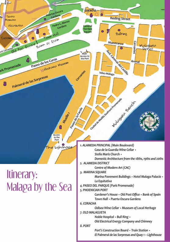
Itinerary: Malaga by the Sea
1. ALAMEDA PRINCIPAL (Main Boulevard) Casa de la Guardia Wine Cellar • Stella Maris Church • Domestic Architecture from the 18ths, 19ths and 20ths2. ALAMEDA DISTRICT Centre of Modern Art (CAC)3. MARINA SQUARE Marina Pavement Buildings • Hotel Malaga Palacio • La Equitativa4. PASEO DEL PARQUE (Park Promenade)5. PHOENICIAN PORT Gardener’s House • Old Post Office • Bank of Spain Town Hall • Puerta Oscura Gardens6. CORACHA Odisea Wine Cellar • Museum of Local Heritage7. OLD MALAGUETA Noble Hospital • Bull Ring • Old Electrical Energy Company and Chimney8. PORT Port’s Construction Board • Train Station • El Palmeral de las Sorpresas and Quay 1 • Lighthouse
Palmeral de las Sorpresas
Mue
lle 1
Pase
o de
la Fa
rola
Park Promenade
Puertas Oscura
Gardens
Ciudad de Melill
a Seafront P
romenade
Malagueta District
Bullring
Paseo de los Curas
Maestranza
Reding Street
Coracha
CervantesAvd. Cánovas del Castillo
Avd. Cervantes
Vélez-MálagaCer
vante
s
Malagueta Beach
The Lighthouse
General Torrijos Square
Alborania M
useum
Main Access to the Port
Access to the Port
4
5
6
7
8
8
Customs
Alcazaba
Old Post O
ffice Bank of S
painTown
Hall
Teatro Romano
Pedro L. Alonso
Gardens
Arenal

1. Alameda Principal (Main Boulevard)
The Alameda Principal is a boulevard that is cur-rently impassable by foot. It has become an in-tense thoroughfare of traffic and of pavements filled with obstacles. However, it was originally conceived as an area full of trees where people could go to enjoy a pleasant walk. It was a result of the eighteenth-century urban planning, char-acterised by the generalisation of the layouts of the main boulevards, gardens and promenades in Spanish cities. It was designed on a sandy area that formed the mouth of the River Guadalmedi-na (called Arenillo, al-Rumayala, during the An-dalusian period). It was opened outside the city walls in 1783 under the name Salón de Bilbao (Bil-bao Garden). When the wall was demolished, the wealthier people started to construct houses. The construction of Palaces with sea views was what everybody wanted, hence why many houses are finished off with towers that serve as viewpoints. It has many examples of architecture from the 18th, 19th and 20th centuries.
This itinerary starts where the other part left us. Oppo-site the Atarazanas Market, you should take the pedes-trian street Pastora.
View of the Alameda from the Tetouan Bridge in 1880. (Malaga City Archive).
The coastal front of the historic city centre of Malaga has been built on land which has been gained from the sea. Emblematic areas such as the Alameda, the Park and the Marina Square are the result of a modern Malaga that has been restless since the 18th century until present day.
During the 19th century, the seeds of the Ficus microcarpa, an exotic member from the family of the fig tree, arrived in Malaga by boat. The far east end of the boulevard finishes with the sculp-ture of the Marquis of Larios, whilst the west end finishes with the Tetouan Bridge.
Malaga Headquarters of the Junta de Andalu-cía (Andalusian Region-al Government), nº 32. It was built at the end of the 18th century and was refurbished in 1918 by F. Guerrero Strachan (right).
Alameda nº 24, from the beginning of the 20th century, it was built on the land where the San Lorenzo Castle once stood. A refurbishment was carried out in 1918 (above).
Alameda nº 12, built in the second half of the 20th century. A refurbishment was carried out in the 20th century by Antonio Palacios in which he added a third floor and tower, very in line with his other projects in Madrid.
Taillefer Office building nº 6, built in 1955. It was one of the first office buildings to be constructed in the city.
53

At number 18 on the Alameda Princi-pal, you will find a palace-building from the end of the 18th century which houses the Wine Cellar Casa de la Guardia. It can be found between monolithic stone cor-ners with strange dec-oration. This living wine museum has been quench-ing thirst and satisfying palates since 1840. You can go in, have a wine and join in the debates and con-versations that often can be heard there. It has a simple concept of wine cellar / bar and the place is impregnated with the smell of tradition. It receives its name from its founder, José de Guardia. He used to produce wines and liqueurs with names such as the bride’s kiss, perfect love and Marrasquín, some of which were tasted by the writer Hans Christian Andersen. It became the supplier of Queen Isabel II, with who he became friends in a lucky encounter. The result of this encounter resulted in the production of one his best wines: Moscatel Isabel II, whose label shows the image and the coat of arms of the Queen. It has been in its current location since 1899 and used to have a strong connection to the sea, as its clients included sailors and travellers. There was a sign that advertised the sale of wine in small recepticles, ideal for people to take with them on their journeys. One of the regular clients was the writer Salvador Rueda, who loved Malaga and its wines. In this bar, he found a place where he could have a relaxing moment and enjoy a glass of wine before having lunch.
One of the best examples of modern architec-ture in Malaga is the Stella Maris Church which was designed by the architect José María García Paredes, fullfilling various architectural achieve-ments. At first sight, it may not seem much, it may not even look like a church due to its rough appear-ance. However, it’s not only a church but it is also a convent of the barefooted Carmelites which has been inserted, almost “miraculously”, in the urban fabric. It has exposed brickwork, a coarse cement base and painted steel structures which are fin-ished off with modern Gothic flying buttresses. The building was constructed in 1965. The lack of deco-ration is substituted by the use of light in its inte-rior, a beauty which is simple and severe and which responds to the demands of humility and austerity of the Carmelite Order and of the directives from the recently celebrated 2nd Vatican Council.
2. Alameda DistrictThe triangle of blocks that occupy the Alameda district is outlined by the Alameda Principal in the north, the pier in the south (Muelle Heredia Av-enue) and the mouth of the River Guadalmedina in the west. Its eastern corner joins onto Marina Square. This district came about as a port and seaside area. It was a working area very focussed on sea-related activities. It was built on top of the old fish markets, the wooden huts that used to sell food and groceries and the beaches of the ports.
It has a wine and a copla which makes you sing and dream. The copla
is from Malaga and the wine is divine.
Salvador Rueda
54

Construction work began in the 18th century and continued on into the 19th and 20th centuries, one of the reasons why it has such a variety of architecture. Its main streets connect the Port with the city (south-north axis): the Alameda de Colón (old Alameda de los Tristes) and Córdoba Street (old Alameda Hermosa). Despite being a middle-class residential area, its proximity to the Port marked its destiny. The 20th century con-verted the district into a scene from a detective novel, with a crazy immoral nightlife. Establish-ments included theatres such as Vital Aza and cinemas such as Gran Olympia, Novedades and the calle Roja de Berlin. It filled up with nightclubs, brothels and sex shops. In the 21st century, a new identity was developed for the district : Soho, the District of the Arts. Various art galleries, theatres, multicultural spaces, street art etc. are gradually changing the area.
The old Wholesalers Market can be found next to the river, in the western part of the Alameda dis-trict. The building dates back to 1939 and was de-signed by Luis Gutiérrez Soto and is a magnificent example of Rationalist architecture of the Machine Aesthetic movement. It is complete and precise in its volumetric conception. It was proposed as a tri-
angle, therefore solving the problem of its location. The symbollism of the monumentalist entrance on the narrow side of the building is reinforced with the coat of arms of the new Francoist government which had just won the war. On the sides of the building there are indented loading docks which were built in order to take advantage of the space. On the main floor was the market area, where the auxiliar services were concetrated along with the bar on the narrow side. The tower at the top of the building looks like the bridge of a ship and gives the building the ap-pearance of a merchant or warship. Since 2003 the building has housed the Centre of Modern Art (CAC) after a refurbishment that was carried out by Miguel Ángel Díaz Romero.
3. Marina Square Marina Square, located in the south of the city, is a meeting place and a place where local cele-brations and events are held. It also has a tourist information point and connects the port to the centre. Both the Alameda Principal and Larios Street end in this square. On the land which the city gained from the sea, this urban space was planned at the beginning of the 19th century.
Timetable for the Centre of Contemporary Arts:Winter: from 10 - 20 hrs. Tuesdays to Sundays.Summer: from 10 - 14 hrs. / 17 - 21 hrs. Tuesdays to Sundays. (from the 26th of June until the 10th of September).
In the 60s, various monumental buildings were constructed along its northern side, the Marina
In the beautiful Alameda, Course of a meridian which is cut off by the
smoke from the old ships, the sleeping fishing tackle, the drawn-back sailcloth, the large casks of oil or wine, ... Alfonso Canales.
55

Underneath the square (in the car park) there are still some remains of the Andalusian Wall from the 14th century, of the Port Wall from the 17th century, and the Genoese Castle which was possibly built in the 14th century. The Nasrid kingdom allowed Geno-ese traders to construct fortified warehouses which could be used as commercial consulates. Between this defensive complex, which stands out from the wall like a buttress, and the dockyard in the west, you can find the main Muslim Port. The so-called Torre del Obispo (Bishop’s Tower) was built on top of the castle at the beginning of the 17th century.
The emblem of Rationalist architecture is the Equitativa building which received its name as it is the headquarters of the company of the same name. It was built on land that belonged to the Larios family in 1956. It is the main building which you can see at the end of Larios Street (when standing in
The other big building which can be seen from the square is the Hotel Malaga Palacio which was also designed by the architect J. Jáuregui in 1968. Its unfortunate location, blocking the view of the Cathedral from the sea, means that it isn’t wor-thy of any praise. Historically the Cathedral could always be seen from the sea and it has been a char-acteristic symbol of the city.
Pavement. The three buildings were designed by the architect Juan Jáuregui Briales. The building in the centre was acquired by the Caja de Ahorros de Ronda (Savings Bank from the Spanish city of Ron-da). The symbology used on the building is there-fore associated with the company. The entrance is a retake of the entrance to the Bullring in Ronda, the city where the company started. The sculpture on the upper part of the buildings is of the Holy Family, representing the family as an institution and saving money, both were slogans of the company.
Marina Square with buildings by Juan Jáuregui (Malaga Pala-cio can be seen in the background). The photo is from the 60s. (La Trashtería Archive).
4. Paseo del Parque (Park Promenade)This represents the tropical and international side of Malaga. The construction of the Paseo del Parque was proposed on the land that was gained from the sea. In 1896 Cánovas del Castillo, who was from Malaga and was President of the Council of Ministers, managed to get the Junta de Obras del Puerto (Port Construction Board) to hand over the land that had been created when the part of the port area had been filled in, in exchange for a subvention. Using the original proposal by Ed-uardo Strachan Viana-Cárdenas, Manuel Rivera Valentín, Joaquín Rucoba and Tomás Brioso also worked on the project.
Constitución Square). It stands out due to the top of the building in the shape of a Yamur and the stone leaf-shaped decoration on the corners. It copies the style of the North American skyscrapers. On the entrance of the building you will find allegorical relief of the company. It was designed by Manuel Cabanyes and Mata and the direction of the project was carried out by J. Jáuregui.
56
The Equitativa building.

Construction work finished 30 years later. Three streets were mixed together with a gardened area. Tropical seeds were brought in on the boats of the important families from Malaga. These seeds are now the trees and plants that form the Park, as well as the gardens at José Heredia’s house and the Concepción Botanical Gardens which is located on the road that leaves Malaga towards the north. It was decorated with foun-tains, benches, aviaries, kiosks, bandstands and monuments that were dedicated to important figures in the city’s history and which continue to live on in the garden today. It is a beautiful area of great botanical interest. It is mainly a place where people go for a walk but also where families get together, children play and live music concerts and parties are held. The Eduardo Ocón open air auditorium is also located here which was built in the 50s, an example of the Relax Style from the Costa del Sol. On Sundays, groups play verdiales, typical music and dancing from the villages in the mountains that surround Malaga.
5. The Phoenician PortIt is possible that the first Phoenician settlements were set up around the port, located on a 300 metre natural area that existed between the jetty, current location of the Customs House, and the coracha on the Gibralfaro Mountain. This port and surrounding area where it is thought that the Phoenicians once lived, is now the called the Puer-ta Oscura Gardens and forms part of the gardens of the Paseo del Parque including some elegant buildings.
The Bank of Spain dates back to 1936 and was designed by José Yarnoz de la Rosa. The solid and unbreakable effect of its design is reminiscent of a
Old Post Office and Telegraph Building, it is known as the Old Post Office and is currently the Chancellor’s Office of the University of Malaga. It was designed by Teodoro Anasagasti and Algán in 1916, and was built later on in 1923. Its appearance is very close to the Neo-Mudéjar and it complies with the demands that were established in the lici-tations to build the Spanish Post Offices during the rule of Alfonso XIII. The architect breaks the Mudéjar theme, escaping the Historicist tone and revindicating its modernity through the lack of brickwork and the use of cubes with flat surfaces. Inside the building you can also see some archaeological remains.
The Gardener’s House is known as the Gar-dener’s little house, due to its small size. It seems even smaller as it is submerged in vegetation and stands next to the enormous Customs building. It dates back to 1927 and was designed by Manuel Rivera Valentín. It is currently used as a Tourism Office.
57

Fernando Guerrero Strachan and Manuel Rivera Vera built the Park Mansion in 1919 with a mixture of modernist style and Barroque affectation. It is currently the Town Hall. Shortly afterwards, Guer-rero Strachan designed the Puerta Oscura Gar-dens as a romantic garden that was arranged in a series of terraces. In the gardens, the remains of a luxurious Roman Villa from the 3rd century were found. It had mosaic decoration which shows the myth of the God Bellerofonte and hunting scenes from North Africa.
safe, in representation of the security and protection of the country’s economy. Classicism is associated to stability and progress. The combination of the Corinthian hexastyle arcade with the 20th century typography is particularly interesting.
The
fron
t of t
he B
ank
of S
pain
.
Views of the Town hall and the Puerta Oscura Gardens from the Alcazaba. In the 90s and today.
6. The CorachaThe Coracha is the forti-fied pathway that con-nects the Alcazaba with the Gobralfaro Castle. When the Alcazaba was abandoned in the 18th century, houses were built amongst the walls of the fortification which became popular areas of the city in which to live. The Coracha district was built on the southern side of the mountain look-ing out to the sea, between the Coracha path-way and the esplanade. The houses that were built here were constructed in the style of ver-nacular Andalusian architecture. The district was full of extremely steep and irregular streets and stairs. In 1990, the City Council decided to demol-
ish the district. Currently, the mountain is unin-habited, hidden behind a retaining wall made out of stone, where you will still find a pathway that is called the Subida a la Coracha (ascent towards to the Coracha).
Some houses still remain standing, the last evi-dence of the old district which dates back to the 19th century. In one of these houses, you can find the Odisea Wine Cellar, whose name reminds us of the difficult period that the owner had to go through for more than a decade to try to impede the demolition of her house. Today, it can be seen as an architectural and historical asset to the city which is well worth a visit both for its architecture as for its wines. You can try different wines from Malaga in a very traditional atmosphere. The staff will also offer you advice and information on the the selection of wines that are available.
58

Malaga has a strong tradition in viticulture, something that was imported by the Phoenicians from the city of Tiro, along with the consumption of wine. The production and consumption of wine was constant during the Roman and Andalusian periods. The wine from Malaga (Sharab al-Malaqui), as described by the Andalusian journalist al-Maqqari, was legendary. Over the centuries, it has been exported all over the world and has become the favourite wine for famous people such as Isabel II of Spain, Catherine the Great of Russia and Eugénie de Montijo of France. Since 1933, Malaga has had the Denominación de Origen Málaga (Designation of Origen for Malaga) for strong and naturally sweet wines together with the Denominación de Origen Sierras de Málaga (Designation of Origen for the Mountains of Malaga) for white, rosé and
The Coracha district, at present and in a postcard from the 70s. (La Odisea Archive).
…laugh at the jokes when you get toge-ther with friends and toast the respective
adventures with Malaga wine,…Salvador González Anaya.
One day I received a bottle of Malaga wine as a present. Whilst drinking it, I
understood that comparing this wine to the concoctions that I used to drink in
the bars, was like comparing the smell of a rose to the smell of industrial perfume. It sums up the taste of Malaga without
any chemicals and is one of the pleasures of nature. It is perhaps the wine with the
biggest personality that I have tried.Wenceslao Fernández Flórez, 1947.
red wines. Two inseperable qualities of culture in Malaga : getting together with friends and Malaga wine.
Next to the old Coracha district you can find the Museum of Local Heritage (MUPAM). It is located in a building from 1999 that was designed by Fed-erico Orellana Ortega. At the museum, you will find a collection of art and history from Malaga. In an annex that was built in 2003, there are often tem-porary exhibitions.
Timetable: Tuesdays to Sundays. Winter: from 10 - 14 hrs. / 17 - 20 hrs.
Summer: from 10 - 14 hrs. / 18 - 21 hrs.
7. The old Malagueta
The area to the north of the Malagueta District was a military area that was linked to the Alca-zaba. It was also a beach and fishing district that was not populated until the middle of the 19th century when construction work started.
Hidden amongst the vegetation is the Noble Hospital. It was founded to Provide as-sistance to sailors (of different nationalities) that arrived in Mala-ga. The initiative was started by nuns in an attempt to try to pro-
59

The current building of the old Electrical Ener-gy Factory and Chimney (nº 8 Maestranza Street) dates back to 1922. The bricked chimney is from a building that was constructed in 1896 and has now dissapeared, both were designed by Eduardo Strachan Viana-Cárdenas. It is a good example of In-dustrial architecture and is also very close to the Neo-Mudéjar style.
The Bullring was built in 1874 by Joaquín Rucoba and Octavio de Toledo. It was opened two years later with a bull fight in which the Matadors Rafael Molina el lagartijo, Antonio Carmona, Luqe el gor-dito and Manuel Rodríguez Desperdicios partici-pated. The use of brick is very in line with the Neo-Mudéjar style, something that was widely used at this time in the construction of public buildings. It also has a Bull Fighting Museum.
The new Bullring in Malaga was finished. They were going to open it with an event that would live up to the events from the
best years in bull fighting history ; the great Montes from Chiclana, was going to appear with his team and he would be on for three
days in a row…The representatives of the City Council were received with rupturous ap-plause, and as soon as they arrived at their
box seats, the music started with the national anthem: The Himno de Riego.
Other songs were also played such as I am a smuggler….At five o’clock on the dot, the doors were opened and the bull fighter’s team did a
lap of the ring ceremoniously... Teófilo Gautier, 1840.
vide help and assistance to the people of Malaga. It was designed by the architects Cirilo Salinas Pérez and José Frapoli Pelli in 1870 and was extended in 1960. The architecture used is similar to the style used in England.
Timetable: from Mondays to Fridays. From 10 - 13 hrs. / 17 - 20 hrs.
8. Malaga Port
The land that was gained from the sea meant that the port became gradually further away from the Gibralfaro Mountain untill finally reach-ing its current location. The first proposal for a modern port was from the Genoese engineer Fabio Bursoto, who also worked at the Port in Palermo. Building work started in 1588 and con-tinued until 1887, the year in which the structure of the current port was finished. The last big in-tervention was at the beginning of the 21st cen-tury. In addition to the entension of the Port (so that it would be able to receive ships and sea traf-fic), it was converted into a lovely place where people can go to relax and spend time, including a variety of restaurants and shops. The leisure areas include Muelle 1 (Quay 1) and the Palmeral de las Sorpresas, where you can find the Alboran Sea Museum, a space where you can submerge yourself in the depths of the Alboran Sea.
Reina Victoria Boat in Malaga Port. It began to cover the Mala-ga-Melilla route from 1917. (Laureano García Fuentes Archive).
Timetable: Tuesdays to Sundays. Winter: from 10 - 14 hrs. / 17 - 20 hrs.
Summer: from 10 - 14 hrs. / 18 - 21 hrs.
60

Malaga’s Lighthouse is the symbol of Malaga’s seaside image. Although the idea of building a lighthouse in the Port had been discussed since 1717, it wasn’t actually carried out until the follow-ing century. It was built by the engineer Joaquín María Pery and Guzmán. The house that is located on the square base was doubled in size in 1915. The panoramic view of the city from the lighthouse cannot be missed as it is one of the best in Malaga. This is the view from which Malaga is identified. The sunsets from this spot a re also unmissable.
An elegant white tower stands out against the blue sky ; it was Malaga’s lighthouse,
we had arrived. Teófilo Gautier.
Headquarters of the Port’s Construction Board (above).The Silo building, which no longer exists (below).
In the western part of the Port, there are still some buildings from the first half of the 20th cen-tury. The Headquarters of the Port’s Construction Board was built in 1932. It was built in a Classical style that responds to the administrative and rep-resentative functions of the Port Authority. You can also find the Port’s Train Station that was built
in 1911. It is a beautiful building which has a slight curve. The building of 1949 was demolished in or-der to create the Palmeral de las Sorpresas. It was a very monumental building which was aesthetically very effective, using classical and modern elements in perfect harmony.
They always see you in my eyes, city of my seafa-ring days. Hanging from the imposing mountain, in the midst of your fall into the blue waves, you
seem to reign below the sky and above the water, suspended in mid air, as if a divine hand had sto-pped your fall, a moment of glory before forever
sinking into the loving waves. But you live on, you never fall down, and the sea
breathes and roars for you,…
Vicente Aleixandre.
61

Seaside Malaga
The coast of Malaga extends from the historic city centre towards the east and west. Towards the west, after the mouth of the River Guadal-medina, a modern promenade takes you through the traditional fishing districts El Perchel, El Bul-to and Huelin. In this area you can find some cul-tural spaces such as the Automobile Museum and the exhibition space La Térmica, whose buildings are magnificent examples of Regionalist architec-ture, both from the first third of the 20th century.
Towards the east, along the old Almeria road, Malaga extends along the coastline, splashing the mountain with very peculiar architecture.
where the ground loses its basic value, where the sea water descends becoming a slave, converting its liquid amplitude into a shiny mirror that reflects the only thing
that is real: the light. Leaving Malaga, following the rolling coastline, you enter
the empire of light.J. Ortega y Gasset, 1910.
The eastern Seafront Promenade, called Pablo Ruiz Picasso, is a great place from which you can enjoy the Malaga Bay. This area, traditionally inhabited by fishermen, was chosen at the end of the 19th century by the powerful classes in Malaga as a residential and touristic area, given that the east coast was where the factories were located. Luxurious hotels were built including Miramar, Caleta Palace and spas such as Apolo, Estrella and the Baños del Carmen. An equestri-an centre and tennis club were also set up along with a tramline that connected Malaga to the pe-ripheral areas.
El Palo beaches. Watercolour by M. Bertuchi. (Bertuchi Family Archive).
The waves always carry with them a biznaga. They are rustled up by the sea and know that they will soon
dissapear. The jasmine plants on the beach are left on the seashore, to be
picked up the next day.
Manuel Alcántara.
There is nothing as picturesque and as original as the surrounding areas of Mala-ga. It gives the impression that you are in Africa. The houses that shine in the light, the deep blue tones of the sea, the vibrant intensity of the light, everything trans-
ports you until the unique illusion is completed.
Teófilo Gautier
Seafront Promenade and the East Coast
62

The anchovies are from Malaga. The anchovies and the wines are a tasteful
delight. If you go to Malaga, you know, I’ll take you to the la caleta beaches
to eat the skewered sardines.Salvador González Anaya.
A tramline full of sun with gardens and a great race between mermaids and dolphins in the
Baños del Carmen.
Manuel Alcántara.
Along the seafront promenade you will find a small cove. Here you will find the building of the old Baños del Carmen Spa which was opened in 1919. It had a Ballroom on the ground floor and the rest of the building was made up of terraces, porches and pergolas. It was surrounded by a garden which had benches, tiled fixed tables and cages full of birds …It was a beach area and a place where dif-ferent events were held such as parties, dances and open air activities. During these events, the wine from Jerez flowed for the men and for the women there were cakes and liqueurs. The building still re-mains today but it is in a poor condition. However, its historical presence is so powerful that its decline has not taken away its beauty. It may possibly have been designed by Guerrero Strachan. You can still access the building through the old bricked en-trance. The beach was divided by string into three sections : men, women and families (in the mid-dle). Currently it is a bar-restaurant but the area is open to everyone. Here you can enjoy the Bay of Malaga and its sunsets.
In parallel to the seafront promenade, an interior road will show you the middle-class Malaga which was located in the eastern part of the coast. From Reding Street (next to the Malagueta, starting from the Bullring towards the east) and its con-tinuation Pries, Sancha and Pintor Sorolla, there are a wide range of buildings, villas and small pal-aces that provide us with an example of Residen-tial architecture from the end of the 19th and be-ginning of the 20th centuries. It is an area that is varied, beautiful and of great architectural value.
The beginning of Reding Street presents us with outstanding architecture with buildings such as Desfile del Amor (nº 16), built in 1956 and designed
Malaga was the city of spa tourism and a clear favourite for winter tourism. One spa still stands today, it dates back to 1919 and provides us with evidence from this period.
The Architecture on the Interior Road
Further along from the Baños del Carmen, the Pedregalejo and el Palo promenade starts. Archi-tecture is swapped for fishing nets and sardine skewers. This area has a relaxed way of life. It is located directly on the seashore where you can enjoy morning walks, swims, seafood lunches and sunny afternoons which go on for as long as you want.
63

TOURISM INFORMATIONMarina Square.70 Granada [email protected].: (+34) 951926020
...city of my happy days.
The proposed routes for “Sea-side Malaga”. They are long walks that are pleasant both on foot and by bike. It is also possi-ble to do them by car or by bus. The touristic bus go along the interior road.
Félix Sáenz Houses.
by José González Edo; La Tinta Palace (nº 20), built in 1908 and designed by Julio O´Brien, it received its name as it was the headquarters of the Andalusian Railway Offices where a large number of administra-tive personal used to work; the Félix Sáenz Houses (nº 37 to 43), built in 1922 and designed by Fernando Guerrero Strachan, a display of imagination which plays with Historicist, Neo-Renaissance and Neo-Mu-déjar elements. You will also find the old Miramar Hotel, currently a court, which was initially called Príncipe de Asturias. It was designed in 1926 by Guer-rero Strachan. It is a magnificent composition that shows off a first floor that is full of windows looking out to sea (corresponding to the old Ballroom).
A simple Neo-Gothic Gate which dates back to 1856 marks the entrance to the English Cemetery, an initiative carried out by the British Consul Wil-liam Mark who, in 1830, claimed this corner for the burial of the large community of foreign prot-estants that existed in the city. It was extended, and the old guard’s house was used as a temple.
From the original tombs that are covered in shells, to the most deli-cate Mausoleums, where you can find legendary characters such as Robert Boyd, colleague of the liberal General Torrijos, both of whom were shot. Other people that were buried here include the doctor Joseph Noble, the specialist researcher on Spanish history Gerald Brenan and the poet Jorge Guillén. Andersen, Leopoldo Alas Clarín and Anto-nio Gala have written about their visits to the cem-etery, a place which for them has been a source of inspiration and pleasure.
After the Reding Foun-tain, which has formed part of the landscape in Malaga since 1675, many small palaces were built. There are a wide range of architectural styles. The journey through the interior eventually takes you to the seafront prom-enade, near the Baños del Carmen.
Historic Centre
Port
AlcazabaRoad up to the
GibralfaroBullring
Gibralfaro
Coracha Reding Pries Sorolla
Towards the Baños del Carmen, Peddregalejo.
Towards the west coast
Sancha
Pablo Ruiz Picasso Seafront Promenade
Malagueta
64


TangierWorldly Wisdom and
Architecture of Feelings

Tangier
Tangier is located in the most northeasterly point of Morocco, on the southern coast of the Strait of Gibraltar. If you look to the west you can see the Atlantic, and if you look towards the east you can see the Mediterranean. Directly opposite, almost face to face, is the coast of Spain, an exchange of glances between two continents: Africa and Eu-rope. Tangier is a synonym for brightness. Two seas can be found here, two suns set and two different types of light are present which create an explosion of yellows that dye the city every morning. This colour remains in the character of the people, in the light, in the streets and in the architecture throughout the rest of the day. The story of Tangier lies between history and myth, between reality and fiction and between a past which lives on in the present, and a present which is reflected in its past. It’s a city which is made up of different feelings that have given it its identity. These feelings write its story and give the city a mysterious and exaggerated appeal which makes many visitors stay on to become residents. Tangier is a snake charmer, it seduces and traps you, putting you under some sort of hypnotic spell. This makes it diverse and multicul-tural, a mixture of worlds, a paradox of antago-nistic terms which become synonyms under its influence. It is a place where people live together, where connections are made between people, cultures, realities and visions; meaning that some-times the city is like a mirror, and sometimes like
“Every act (every thought) is the echo of others that preceded it in the past, with no visible beginning, and the faithful presage of others
that in the future will repeat it to a vertiginous degree. There is nothing that is not as though lost between indefatigable mirrors. Nothing can occur but once, nothing is preciously in
peril of being lost. The elegiac, the somber, the ceremonial are not modes the Immortals hold in reverence. Homer and I went our separate
ways at the portals of Tangier”J. L. Borges (The Immortal)
The Portuguese call Tangia “Tangiara”. This great city was built before the advent of Islam. Some historians falsely believe that it was built by a ruler named Sedded, son of Had, who was ruler of the world and wanted to build a city that would resemble Paradise on Earth. He had the walls made of bronze and the houses made of gold and silver. Leo Africanus
an illusion, as every person has a different vision of Tangier, a vision that is more of a sensation or a mood than a practical reality. This makes it the city of illusion, a place where the eye does not see things, but images of things that mean other things (Ítalo Calvino). This is why, in Tangier everything is possible. It is the gateway to other dimensions, the hole which Alice fell into. You have to experience Tangier to fully discover and understand it, as there are many things that are not obvious at first glance. You don’t come to Tangier in search of the eighth architectural wonder of the world, but to enjoy its personal-ity and the unexpected surprises that live in its streets. In this city, it isn’t unusual to see a cow being sacrificed for a wedding in the Medina or to walk passed Rita Hayworth. It is an inexhaust-ible source of experiences housed within archi-tecture that has been constructed from desires, feelings and worldly wisdom. You have to forget about time and let yourself be guided only by the things you want to do. Things happen, people ap-pear, sensations emerge and from this point on-wards, they form part of the essence of the city.Tangier is a never ending spiral that is mysterious, receptive, unexpected, dissolute, seductive, un-real, worldly and immortal.
67

The giant Antaeus, son of the earth (Gaia) and Po-seidon (God of the sea), founded a city at the end of the world which he named after his wife Tinge, the daughter of Atlas. Then Hercules arrived and separated Calpe (Gibraltar) and Abyla (Ceuta), cre-ating the Strait of the Pillars of Hercules, the limit of the known world for sailors in the past. After this work, he rested in a cave where there was a small opening in the shape of the African continent. This opening let light in and gave him a view of the At-lantic Ocean, the sound of which sent the hero to sleep.
Tangier is located between two seas and two pieces of land. It is a place from which you could control all of those leaving the Mediterranean, passing through the Strait of Gibraltar on their way to the rest of the world. This has determined its destiny as it has been a very much sought after location.
History
The description of Anasta-sia awakens desires one at a time only to force you to stifle them, when you are in the heart of Anastasia one
morning your desires waken all at once and surround you. The city appears to you as a whole, where no desire is lost and of which you form part, and since it enjoys everything
you do not enjoy, you can do nothing but inhabit this
desire and be content. Ítalo Calvino (The Invisible Cities).
The story of Tangier can be told in a thousand different ways. Emilio Sanz de Soto
With the same discretion that it instantaneously and cheerfully presented itself:
it leaves you with the doubt as to whether it really exis-ted or if it was product of your imagination: abando-
ning you again in the middle of the chaos.
Juan Goytisolo.
What impressed me the most on my first visit to Tangier was that it was a city where things were happening all of the time, where sorcery was bu-
rrowing its invisible tunnels in every direction.
Paul Bowles.
Often I think that Tangier was a mood that would
hang around forever in that ghostly part of the memory, in which some people could not distinguish what was true and what was false
Eduardo Haro Tecglen
The days run through you wi-thout you noticing, more than the raindrops in a waterfall.
Truman Capote.
A vision of Tangier by Mohamed Raiss El Fenni.
The good historians say that Tangia was built by the Romans on the coast, next to the Ocean Sea. Leo Africanus
The city was first founded back in 8th century BC by the Phoenicians. By the time the Carthaginians arrived in the 4th century BC, Tingis was already famous for its trade in Garum (fermented fish sauce) and fish salts. It was also famous for being the route to the Guadalquivir in the Iberian Peninsula, an area that was rich in valuable metals. At this time, it was then a very prosperous city. In the 1st century BC Tingis was taken over by the Romans and became the administrative capital of Mauretania Tingitana. The people living there were given the category of Roman citizens and they enjoyed the benefits of the most important commercial port of the western Mediterranean. This Tingis currently lives below the surface of the Medina. Today, you can still see the Punic-Phoenician tombs in the Marshan district, archeological remains in the
68

Kasbah Museum and the last remaining parts of the Roman roads Decumanos Maximus and Cardo Maximus. During the 5th century, various different people passed through the settlement such as the Vandals, Byzantines and the Visigoths. Finally, it fell under Muslim rule in the 8th century. The first fortification of the city was carried out under the Caliphate of Cordoba in the year 929. Various centuries later in 1471, the Portuguese King Alfonso V conquered the city and it was once again fortified, almost reaching the size that the historical centre has today.
During the period between 1580 and 1640, both Portugal and Tangier were under Spanish rule. The latter was even governed by the English for some years as it formed part of the dowry of the wedding held in 1662 between Catherine of Braganza and Carlos II. During this period a lot of building work was carried out including the construction of vari-ous towers and castles, the reinforcement of the city wall and the construction of a 500 metre dock that was added to improve the Port. Everything was destroyed in 1684 when the English were forced to leave the city due to the high maintenance costs and the continual sieges that the city faced. Under the Alaouite Dynasty, Tangier once again became Muslim. The Sultan Muhammad ibn Abdel-lah invited foreign leaders to set up their consulates here with the intention of having them all together in one city. It became a diplomatic capital, encour-aging Europeans to start to move to the city. These
new arrivals would become an important and ac-tive part of the development of the city during the 18th century. Nineteenth-century Tangier grew outside of the city walls. The modern city was born which was heavily influenced by western ideas. However, it lacked a defined urban planning strategy to give a Rationalist structure, making it different from other urban models that were in use in many European cities at the time. The modernity of the new city also reached other aspects of daily life: the first printing house was opened in 1880, the first telephone in the whole of Morocco was installed in 1883 and the lamp posts in the Petit Souk (Little Square) were provided with electricity in 1892.
From 1879 onwards, the foreign Consulates took charge of the sanitary and hygiene issues in the city. One year later, they debated what was called the Moroccan question in the Madrid Conference. In 1904, the Sultan was asked to pay the debt he had accumulated with other countries, especially the debt that he had with Germany. In 1905, the Kaiser Wilhelm II landed in Tangier and paraded through its streets, revealing the conflict of interests to other foreign powers. The Sultan asked for an inter-national conference to be held in which they could solve the problems that the country was currently facing. The Algeciras Conference was held in 1906, bringing together the twelve countries that had connections with Morocco. The minutes of the meeting were signed by Germany, France, Spain and the United Kingdom. The independence of the Sultan of Morocco was recognised, however, he had to accept an International Protectorate that would oversee all administrative and political is-sues. Morocco was left to France, whilst Germany was given other African territories. England did not
It was always very ahead of its times, noble and well popu-lated, full of beautiful Palaces both old and modern in style. The people from Tangier lived in abundance until Asilah was taken in 1471. Tangier was then occupied in the name of the King of Portugal. Leo Africanus. 1900
69

want France to be able to control the Strait of Gi-braltar or the Mediterranean, and so the northern area of Morocco was given to Spain. Tangier be-came a neutral territory that would be governed by a combination of powers, thus ensuring the free-dom of movement in the area. At the Fes Convention in 1912, the Sultan recognised the French and Spanish Protectorates and signed the Tangier Protocol in 1923. This is where the Inter-national Tangier started. Although it was not under the direct control of anybody, many countries were present in the city. There were anti-militarisation pacts and economic and commercial freedom. The administrative, legislative and judicial powers were distributed between the different countries. The legislative assembly had a total of 27 members, 18 of which were European, leaving only 9 native Mo-roccan members. This model of joint government worked. The po-litical neutrality and freedom of trade meant that Tangier became a centre of espionage, a fiscal paradise and a place of general freedom. These fac-tors attracted a variety of people ranging from rich businessmen to Bohemian intellectuals, converting Tangier into a cosmopolitan and multicultural city. For some segments of the population it was a mis-erable period, whilst for others it was like living in a film. This period also witnessed various historical events such as the occupation of Tangier by Span-ish troops during the Second World War.
In 1956 Morocco gained its independence under the rule of Mohamed V. Tangier continued as an area of free trade until 1960. Under the govern-
ments of the Kings Hassan II and Moham-ed VI, Tangier has be-come a big metropolis in which its interna-tional character lives on.
Tangier…a myth?....a lost paradise? The irresistible charm of Tangier…..but for who? Mohamed Choukri.
Post
er e
dite
d by
the
Juan
Goy
tisol
o Li
brar
y, C
erva
ntes
Inst
itute
in T
angi
er (2
nd e
ditio
n, 2
012)
. Since the middle of the 18th century when the gates of the city were opened up to foreigners, Tangier has become international. This interna-tional quality makes it unique and fatally attrac-tive. Once you visit, you run the risk of becoming trapped. Its personality, history and architecture are the result of various different and diverse opinions, needs and ambitions. Heir to a mytho-logical past in which it was Olympus for Gods and Heroes, it has become human and worldly, a Garden of Eden that is full of dreams, failures and success. We should not forget the legends and fictional characters that become real and live on in Tangier such as Juanita Narboni. Tangier is built from novels, legends, cinema, experiences and narrative accounts. This describes both the urban planning and the architecture in Tangier.
Tangier is an aquarium full of strange fish.Ira Cohen
Architecture of Feelings
Suriyine Mosque.

The visit of the first diplomats to Tangier during the 18th century helped make the city known to the rest of the world, attracting foreigners who finally ended up becoming residents. During the 19th century the ar-rival of foreigners in-creased a great deal creating a mixture of traditional lifestyles and foreign customs. The Medina started to undergo a western transformation in its ar-chitecture, something which helped open up the buildings onto the
streets. The local people from Tangier lived side by side with the foreigners in a natural mix of ethnic groups and religious beliefs and cultures. This is something which continues to this day, al-though in some cases segregation does occur ac-cording to social categories.
The Petit Souk (Small Square) became a shared public space. The first church was built in 1881 inside the Medina and, shortly after, the St. Andrews Church was built outside the city walls. The Post Office and Lega-tions of various different countries were set up in old houses until the end of the
century and beginning of the 20th century, when they finally built their own offices.
Different personalities started to stand out as part of life in Tangier, something that helped to shape the history of the city and its architecture. They included the Correspondent for The Times, Wal-ter Burton Harris, the Sharif of Ouezzane or the rich businessman Ion Perdicaris. Other celebrities who came to the city included Giuseppe Garibaldi and the architect Antonio Gaudí who made a pro-posal for the design of the city’s cathedral. Writ-
ers such as Mark Twain, Thomas Roscoe, Pio Baro-ja, Emilio Castelar, Pierre Loti, Benito Pérez Galdós and Alejandro Dumas also left their mark on the city.It was also the cen-tury of the roman-tic travelers who were on a search for the eastern myth, for a medieval past, for the fantasy of a thousand and one nights immersed in a richness and sensuality that didn’t exist in the puritan Europe which still marched to the beat of a Victorian England. Scenes were painted that never existed: in Tangier there weren’t any Harems with nude odalisques, or stories of Sche-herazade between silk veils. The reality of Tangier
The city consist of this, of relationships between the measurements of its space and the events of its past. As this wave of memories flows in, the city soaks it
up like a sponge and expands.Ítalo Calvino (Invisible Cities).
What fascinated me about this city was the mix of different people…In Tangier, there
wasn’t a district populated by any one spe-cific community. Tahar ben Jelloun, 1987.
On top of the rocky mountain, the Kasbah stood tall. You could see the different buildings
and the flags of different nations flapping above their Consulates, welcoming the visitors.
Baron Ferdinand d’Agustín, 1830.
A street in Tangier, 1901. Oil painting by M. Bertuchi.(Bertuchi Family Archive).
The old Spanish Consulate in a house in the Medina. It is now private property.
Interior of the Continental Hotel, open since 1865. The streets of Tangier in 1908, by M. Bertuchi. (Bertuchi Family Archive).

During the first dec-ades of the 20th century, we can talk about the existence of a new city that was located outside of the old city walls and which had a com-pletely western feel. Here the influence of its cosmopolitan past is reflected in the ar-chitecture, although it wasn’t officially given the title of Interna-tional Tangier until 1923. The architecture that was dedicated to leisure activities
should be highlighted as it attracted important in-ternational figures. These included buildings such as nightclubs, casinos, spas and theatres. The cin-emas also played films from different countries in different languages without any censorship. During the interwar period and especially during the Second World War, the city was full of spies, secret agents, politicians, outlaws, people who were being persecuted and members of the re-sistance. It was a combination of elements that made Tangier a city of intrigue.
was much like any other city, however it was dif-ferent and attractive for these visitors. The light and colour of the city formed a powerful com-bination that seduced many an artist and made them come back and stay. From David Roberts to E. Delacroix, Mariano Fortuny and Marsal, the fathers of Orientalism. They were followed by Enrique Simonet, A. Mu-ñoz Degrain, George Clarín, Jacques Majorelle, Federico Madrazo, Josep Tapiró and an endless list of names that were discovered in the first decades of the 20th century by new groups that distanced themselves from Orientalism, and be-came closer to Costumbrismo and the search for new ways to express themselves. These included Julio Romero de Torres, Mariano Bertuchi, Raoul Dufy, H. Matisse, Kees Van Dongen, O. Kokotshka,
F. Iturrino, James Mcbey and George J. W. Apper-ley, amongst others, together with Moroccan painters such as Antonio Fuentes or Mohamed ibn Ali R’Bati (The first Moroccan painter to aban-don decorative art and start with figurative paint-ing, he lived in Tangier from 1886 onwards).
With each step you will find beautiful scenery. It is a painters paradise with enough mate-rial for many a generation. A painting could
be made of every corner of every street. E. Delacroix, 1832.
I knew of nothing that could happen here without the intervention of this Legation or that spy, not even the flutter of a leaf on a tree or the movement of the fish in the sea.
Alberto España, 1954.
Advert in the “Estafeta Literaria”, August 1944. Illustration by M. Bertuchi for the Magazine “Blanco y Negro”.(Bertuchi Family Archive).
Right: A street in the Medina, 1935. Below: A night in Tangier during the International Period.(Source: Tangier City Council).

The nights were lost in bars and dives such as Dean´s Bar, Tángerinn, Parade, the Blue Parrot, Mar Chica or the Uncle Tom Spa (which they say belonged to a Puritan Afro-American from Mississippi, who at night would go after couples who were being intimate with each other in the sand and threaten them with a fluorescent cross). Parties were also thrown in the villas of the rich people such as the ones held by Barbara Woolworth Hutton.
In Tangier, you could do what you couldn’t do anywhere else. The best example of this is that of the Beat Generation, a group of American writers who were trying to escape the McCarthyism and the witch hunt that was occurring in their own country. They saw Tangier as a symbol of free-dom, where drugs and sexuality were high on the agenda, a city of experimentation and lack of inhi-bitions. It was at this time when important literary works were produced such as The Naked Lunch by William S. Burroughs.
The writers and artists from the Beat Generation included Jack Kerouak, Allen Ginsberg, William S. Burroughs, Alan Ansen, Gregory Corso, Peter Or-lovskyor and their heirs such as Ira Cohen. How-ever, others arrived in the city looking for the ec-stasy of the drugs and the Berber music of groups such as the Master Musicians of Joujouka and Gnagua. They also sought the sexual freedom or simply the bohemian lifestyle and included names such as Tenesse Williams, Truman Capote, Jean
Whilst the African sun licks your eyelids and the smell of the drinks blends together with that of the pipes: in a delightful, productive
drowsiness. Juan Goytisolo, 1970.
Furthermore, the free trade status converted Tangier into a fiscal para-dise which attracted a large amount of money and big businesses along with the mafia, swindlers and smug-glers that this brought with
it. It was at this time when Tangier becames a Cinema Capital and in some cases even makes the big screen itself, appearing in films such as Tangier (1946) and Man from Tangier (1953). The film Casablanca, which for political reasons had to be called Casablanca, gives us an idea of what Tangier was like during this period.Cinema also filled the streets of Tangier. Actors and film direc-tors would often be seen walking through the city’s streets including Errol Flynn, Vivien Leigh, Orson Welles, Ava Gardner, Rita Hayworth.Along with cinema, another type of fiction was lived out and told by various writers who saw in Tangier a place where they could be free and search for their dreams, particularly during the 50s, 60s and 70s.Tangier experienced a mass arrival of eccentric millionaires, parasites, artists, writers and intellec-tuals. The places where they used to go became legendary. The inhabited city and its worldly ar-chitecture became famous: Petit Souk, Grand Souk, bars, cafés, casinos, hotels. Hotels such as the Villa de Francia, Rembrandt, Minzah and the Continental were hubs of creativity during this pe-riod. Café Central, Gran Café de Paris, Hafa, Colón or the Bakalitos (small shops selling different prod-ucts) were places where hours were spent in dis-cussions and debates. They were the places that inspired great ideas and also places where people simply went to have a night out on the town.
One day I will find Mr. Burroughs dead in his room as he hardly eats anything, he takes drugs and spends the whole night writing.
Madame Claude (Owner of the Villa Muniria Hotel where Burroughs used to stay together with the painter Brion Gysin, Room Nº 9).

Paul Sartre, Samuel Becket, Jean Genet, Carmen Laforet, Brion Gysin, Gore Vidal, Djuna Barnes, John Hopkins, Robin Maugham, Emilio Sanz de Soto, Paul Morand and Ian Fleming. For many of these celebrities, the writer couple, Jane and Paul Bowles, were the hosts of Tangier, as were previ-ously the writer Gertrude Stein and her partner. The Bowles turned Tangier into a place of pilgrim-age for westerners, the majority of whom where tormented nomads in search of inspiration. Paul Bowles has become one of the important figures of the city, the icon of the International Tangier where he lived from 1952 until his death in 1999. In his books Let it come down (1952) and the Spider’s House (1955), he gives us an insight into the life of the artists and his wife Jane in Tangier at that time: out of their context, lost in new sur-roundings and immersed into a completely differ-ent culture, in the midst of personal crisis, soul searching and a whirlwind of drugs and emotions.
Various painters also formed part of this scene including Francis Bacon and Brian Gisyn, along with photographers such as Cecil Beaton, film di-rectors such as Pier Paolo Pasolini, Carlos Saura, Luchino Visconti and musicians such as Jimmy Hendrix, the Beatles, the Rolling Stones and Patti Smith. It is a period in which outstanding local artists from Tangier were given the recogni-tion they deserved including Ángel Vázquez, Mo-hamed Choukri, Ahmed Yacoubi and Mohamed Mrabet.However, this legendary Tangier was different from the social reality that the writer Mohamed Chukri reported on in his book For Bread Alone (1973). Other views of Tangier are expressed in books such as La vida perra de Juanita Narboni (1976) by Ángel Vázquez and Count Julian (1970) by Juan Goytisolo.
You walk along drawing hieroglyphics: immersed in the multitude but without inte-grating yourself in it: on a different frequency: subtly capturing the presence of signals that interfere with the apparent order of things: brisk movements, unpleasant sounds, abrupt
gestures: small explosions of violence: an equation which you are unable to resolve, a
passage of writing which you try to decipher to no avail. Juan Goytisolo, 1970.
The end of the 20th century and the beginning of the current 21st century have continued the myth about Tangier, encouraging the arrival of new celebrities. Although the period of novels is now part of its history, Tangier continues to enchant and entrap. Little by Little as you live in Tangier, you get to know the personalities of another period
who, like prehistoric animals or part of a bes-tiary, come down from the mountain to collect their post from a PO Box in the central office or from the post office in the Grand Souk, or they come down to buy a book from the “de las Columnas” bookshop, a sort of Cathedral
for the foreigners. Isaac Chocrón, 1975.
Tangier was like an ambiguous encounter, a clandestine affair hiding other affairs, a confes-sion that doesn’t reveal the full truth. It was like a family that
poisoned your existence as soon as you got away from it. You knew you need it, without
being able to say why. Tahar Ben Jelloun, 2004.
Des Colonnes Bookshop, 1970s. (Rachel Muyal Archive).

Itinerary: The Medina
THE HEART OF THE MEDINA1. SIAGHINS STREET Market Hall · Santa Catalina Tower · Siaghins (seqaya) Fountain · Siaghins Funduq · Catholic Church · Dar Niaba2. PETIT SOUK Colonial Architecture · Cafés in the Petit Souk3. YAMAÀ AL-KEBIR MOSQUE
THE DISTRICTS OF THE MEDINA4. WAD AJARDAN (OUED AHERDANE) Aisawas Square · Almohades Street · Fuente Nueva Square 5. DAR BARUD: AREA AROUND BAB AL-ASSA Sidi Ibn Raisul Mausoleum · BABA Café · Sidi Hosni Mausoleum and Barbara Hutton’s Mansion · Carmina Maceín (Macien) Museum of Modern Art · (YENAN CAPTAN DISTRICT: IBN BATTUTA’S TOMB)6. THE KASBAH: MECHUAR SQUARE Bab al-Assa · Mechuar Square · Bab Bhar · Sidi Bouqnadel District · Old Courthouse · Sultan’s Palace7. THE KASBAH: IBN ABU STREET Kasbah Mosque · Sidi Ahmed Buquja (Bouqouja) Marabout8. THE KASBAH: THE DISTRICT Ghazal Street and Guma Square9. THE KASBAH: TABOR SQUARE Borj (fort) Ben Amar · Bab Qasba Gate · Borj Na’am10. DAR BARUD DISTRICT (DAR BAROUD) Zaituna Street · Cheik Mohamed ibn Seddik Street · Zaouia Kadiriya Street · Amrah Square · Sidi Ali ibn Daud Square · Dar Barud Street11. THE DEFENSIVE SYSTEM: BORJ DAR BARUD Borj es-Salam and Borj Charrat · Continental Hotel · Customs Gate · Borj al-Hajui · Bab Marsa · Bab Dar Dbagh12. BENI IDDER DISTRICT Takadum Square · American Legation · Tuahine and Cheik al-Harrak Streets (Street of the Sy- nagogues) · Lorín Foundation · Massaat Nahon Synagogue
IBN BATTUTA’S TOMB
89
- TABOR SQUARE Kasbah

1
2
3
4
Continental Hotel
Market Hall
Petit Souk
Wad AjardarnSquare
Ben DqoudSquare
- MECHUAR SQUARE
- Takadoum Square
5
7
6
10
12
Sidi Hosni
American Legation
Lorín Foundation
Synagogue Mahon
Kasbah

The Medina
The ground in the Medina of Tangier tells us of a long history which goes back to Phoenician and Roman times. The current structure of the Medi-na is largely due to the period during which it was Portuguese territory, between 1464 and 1661. During this time, a large part of the city wall was built, crowned on its northeasterly side by the Kasbah which looks over the Strait of Gibraltar. This was the highest point of the Medina and the most privileged area. Due to this, military forts were also built here along with palace houses. Despite the fact that part of the city wall was de-molished at the end of the 19th century, there are still a number of important stretches and various defensive forts that exist today and allow us to have an idea of what it was once like. In nearly all of the Medina, the architecture is Co-lonial in style and dates back to the 19th and 20th centuries. In other Medinas which have a strong-er Muslim presence, the privacy of the houses is of the upmost importance in the construction of buildings. However, the houses in the Medina in Tangier are built in a western style with big win-dows and balconies that open up onto the street.
The design of the streets meanwhile, is the result of urban planning that was used in medieval cit-ies. Some districts, such as Yenan Kaptan and Dar Barud, still maintain their original appearance, although the foreign influence is clearly evident. In these residential districts, life is quiet and the dead-end alleyways double up as private areas for the residents, who usually have strong fam-ily ties. This is evident in the architecture and the urban area itself, which is constantly adapting to the ever expanding buildings which need to ac-commodate the growing families. Here the build-ings stand directly in front of one another, almost touching, covering the streets which in turn be-come passageways.
Narrow and covered, with the facades al-most touching: asym-metry developed by the strong and witty builder: surfaces and plans which would escape even Descartes and Haussmann: lines and segments piled on top of one another as if to create an indemonstrable geo-metric shape.
Juan Goytisolo.
The bread oven, the fountain, the mosque, the Arabic baths and the zaouia are all elements around which daily life is carried out and which highlight the Muslim culture and customs. It is normal to find them in each district. The districts of the Medina include: Beni Idder in the south, Dar al-Baroud in the north and east, Wad Ajardan and Yenan Kaptan in the west and the Kasbah district in the north. Walking through the Medina you travel through various different centuries, through a variety of customs, through reality and fiction, through east and west, in conclusion, through the heart of Tangier.
77

lish rule it was named Catherine Street in honour of Catherine of Braganza. From the 19th century, the street started to become more westernised. The Bakalitos and the traditional handcraft workshops were replaced by domestic architecture and build-ings with more than one floor, with businesses oc-cupying some of the ground floor spaces. Walking from the Grand Souk (western end of the street) and Senmarine Street, the first thing that you come across is the entrance to the Market hall on your right, which is also connected to the Grand Souk. You will also find the Santa Catalina Tower which was built during the English occu-pation. There are some stairs which will take you up to a viewpoint which looks out over the Grand Souk. Next to the tower is the Siaghins (seqaya) fountain, the oldest in the Medina. This fountain was painted by Josep Tapiró in his watercolour Fi-esta en Tánger (party in Tangier). Behind the foun-tain, Synagogue Street begins, leading you into the Beni Idder district.
At number 58, between the shops and the ba-zaars, you can find the old Siaghins Funduq or Yebala. It dates back to before the 19th century and is no longer used as an inn but as traditional craft shops. Strangely enough, the first shopping centre in Tangier, Magasins Modernes, used to be located right next to the Funduq, adding to the mixture of different cultures and customs. All sorts of different imported products were sold here and today it still continues to be used as a
Fortuny, Delacroix and many other artists have painted Siaghins Street. It is one of the main thor-oughfares between the Grand Souk and the Petit Souk, between the new city and the Port. Like the Roman Street Decumanus Maximus, it runs from east to west. It is a very busy street that is full of life. Originally, it was a Souk run by silversmiths as the name indicates. During the period under Eng-
Losing yourself in the maze of small streets in the Medina: drawing as you walk…
a confusing picture that nobody (not even you) could understand: splitting into two in
the end in order to follow yourself more eas-ily, as if you were another person, conscious that the labyrinth is in you: that you are the
labyrinth. Juan Goytisolo.
1. Siaghins Street
The Heart of the MedinaThere are streets and corners of the Medina in Tangier which are a must see for visitors. For ex-ample, this is the case of Siaghins Street and the Petit Souk (Small Square) which are the heart of the Medina and perhaps, the soul of Tangier.
Stre
et in
the
Med
ina.
(Sou
rce:
Tan
gier
City
Cou
ncil)
.
Siaghins Street with the church tower. (Source: Tangier City Council).
78

market. Further on down the street, you can find the old Catholic church and a house called Dar Niaba which was a government office during the 15th century.
The Inmaculada de la Concepción Catholic Church was built in 1881 by the architect Manuel Aníbal Álvarez on the old site of the Swedish Lega-tion. Today it is slightly different from its original design, with a new roof on the tower. Inside, it has one nave and mass is no longer held here. It is cur-rently occupied by the Missionaries of Charity (a Roman Catholic religious congregation that was founded by Mother Teresa of Calcutta). The idea to build the church came from José Lerchundi, a member of the Franciscan Movement who arrived in Morocco around 1860 as a Prefect of the Catholic Mission. He carried out important missionary work for cities such as Larache, Rabat and Tangier. He was a distinguished character and had the spirit of a mediator. He managed to win over the Muslims, Jewish and Christians and was good friends with the Sultan Mulay Hassan.
Next to the church is the distinguished entrance to the Dar Niaba house which dates back to the period of the Portuguese occupation. It was the location of the French Consulate between 1820 and 1860. It received its current name as it belonged to Niab, a civil servant who acted as an intermedi-ary between the Sultan and foreign powers, a role similar to that of a Minister of Foreign Affairs. It is currently being used as City Council Offices.
2. Petit Souk (Small Square)
Tangier contains the whole world and the Petit Souk is living proof of that. It is the soul of the old Tangier and the International Tangier. This space started off as a Forum in Roman Tingis. Some-how, this legacy has continued up until today as it is still used as a meeting place and as a place where people can express themselves.
In Tangier you have to see and experience the Petit Souk. This small square doesn’t seem much at first, but it is one of the most important urban spaces in Tangier and is where the city exposes it-self in all of its glory. It is a place where you might have a coffee or a tea mimicking the ironic con-versations of Choukri or Baroja, or wait to be in-spired by a Dance of Death like the one composed by Camille Saint-Saëns; perhaps it is where you might look for an answer like Ginsberg or plan a pig hunt for the weekend like Walter B. Harris; you also might like to let time pass you by reading the paper or simply by watching the daily activity in the square. Whatever the reason, understand-ing the Petit Souk is in some way equivalent to understanding the City of Tangier. The Petit Souk used to be called the Souk inside the City walls, Suq Dakel. It was a market located next to the Great Mosque and a thoroughfare between the Port and the Grand Souk. Although there were a few Consular Offices and foreign business here since the end of the 18th century, it wasn’t until the 20th century when the crafts-man and the small bakalitos were moved to make way for administrative and consular headquar-ters. This brought about a physical change in the square with the introduction of European archi-tecture. A few Consulates were set up along with the headquarters of the Bank of Morocco and the Spanish, French, German and English Post Offices.
At the Acropolis, some find themselves in a state of wisdom. At St. Peter’s in the Vatican, some find themselves in a state of grace. However, at the Petit Souk,
everybody finds themselves in a state of absolute freedom. Truman Capote.
The Petit Souk. Drawing by Mohamed Raiss El Fenni.
79
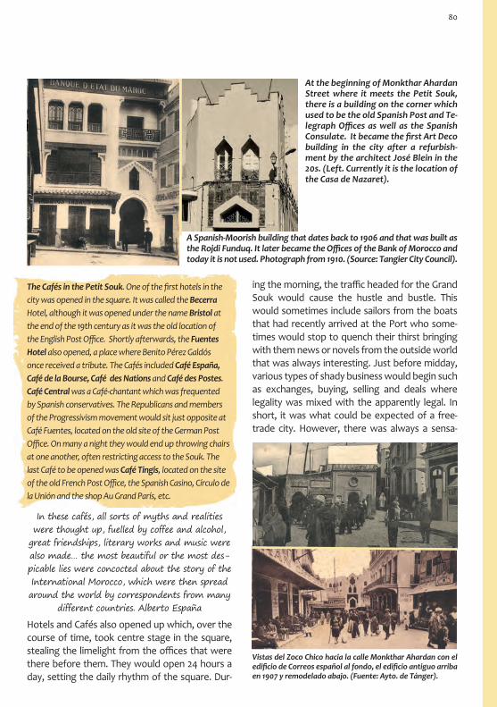
At the beginning of Monkthar Ahardan Street where it meets the Petit Souk, there is a building on the corner which used to be the old Spanish Post and Te-legraph Offices as well as the Spanish Consulate. It became the first Art Deco building in the city after a refurbish-ment by the architect José Blein in the 20s. (Left. Currently it is the location of the Casa de Nazaret).
A Spanish-Moorish building that dates back to 1906 and that was built as the Rojdi Funduq. It later became the Offices of the Bank of Morocco and today it is not used. Photograph from 1910. (Source: Tangier City Council).
Hotels and Cafés also opened up which, over the course of time, took centre stage in the square, stealing the limelight from the offices that were there before them. They would open 24 hours a day, setting the daily rhythm of the square. Dur-
ing the morning, the traffic headed for the Grand Souk would cause the hustle and bustle. This would sometimes include sailors from the boats that had recently arrived at the Port who some-times would stop to quench their thirst bringing with them news or novels from the outside world that was always interesting. Just before midday, various types of shady business would begin such as exchanges, buying, selling and deals where legality was mixed with the apparently legal. In short, it was what could be expected of a free-trade city. However, there was always a sensa-
The Cafés in the Petit Souk. One of the first hotels in the city was opened in the square. It was called the Becerra Hotel, although it was opened under the name Bristol at the end of the 19th century as it was the old location of the English Post Office. Shortly afterwards, the Fuentes Hotel also opened, a place where Benito Pérez Galdós once received a tribute. The Cafés included Café España, Café de la Bourse, Café des Nations and Café des Postes. Café Central was a Café-chantant which was frequented by Spanish conservatives. The Republicans and members of the Progressivism movement would sit just opposite at Café Fuentes, located on the old site of the German Post Office. On many a night they would end up throwing chairs at one another, often restricting access to the Souk. The last Café to be opened was Café Tingis, located on the site of the old French Post Office, the Spanish Casino, Círculo de la Unión and the shop Au Grand París, etc.
Vistas del Zoco Chico hacia la calle Monkthar Ahardan con el edificio de Correos español al fondo, el edificio antiguo arriba en 1907 y remodelado abajo. (Fuente: Ayto. de Tánger).
In these cafés, all sorts of myths and realities were thought up, fuelled by coffee and alcohol,
great friendships, literary works and music were also made… the most beautiful or the most des-picable lies were concocted about the story of the International Morocco, which were then spread around the world by correspondents from many
different countries. Alberto España
80

It was also at this time that the show would start in Café Central. There would be a band that would play or there would be a dance which would go on until late and that would attract all sorts of different people. At night, the Petit Souk would empty out as people would go elsewhere to have fun. However, when the other places closed, it was quite normal to have the last drink in one of the Cafés before heading to bed. In Café Central there is a band made up of women and they have made a thing called the «Lambeth Walk» popular. All of the Spanish and Jewish girls dance to it on
Nueva Street. «Two plus two is four, four plus two is six...». Ángel Vázquez.
View of Siaghins Street from Petit Souk from 1884 to 2013. (Source: Tangier City Council).
The Petit Souk is Tangier’s Puerta del Sol; people smoke, they have coffee and above all they tell lies, just like in the famous square in
Madrid. Pío Baroja.
Afternoons in the Petit Souk were dedicated to fam-ily walks, love birds having an afternoon snack and the latecomers to the aperitif who would join the conversations that had been going on all day. They would wait for the paperboy to distribute the news-papers or simply continue to put the world to rights. It was also the time at which the donkeys that were for hire in the square would be taken for a walk by their owners. Meanwhile the women and the wom-anizers would head to the Hafa Café, to the Boule-vard to do some shopping or to run some errands. To wear a new hat, suit or a new pair of shoes for the first time was a waste of time if you didn’t walk through the Petit Souk. Alberto España.
tion that it was a kind of black market as it was clear that outside of Tangier things did not work this way. At midday, people would have an aperi-tif and conversations would start that would con-tinue until after lunch. The civil servants left work and the journalists and the correspondents would arrive already scheming. Businessmen and every-one that wanted to be up to date with the news and discuss an event would come to the aperitif.
81

3. Yamaà al-Kebir Mosque
The continuation of the Decumanus Maximus is de la Marina Street. Here you can find the Great Mosque in the place where the Roman Temple dedicated to Hercules once stood. It dates back to 1684, the period of the Alaouite Sultan Mu-lay Ismail. Its current design is thanks to various refurbishments and extensions, the last of which was carried out in 1818 (1233 in the Hegira) under the rule of Mulay Suliman, as can be seen on the inscription in the entrance. Before the construction of the Great Mosque, there was a Marinid Mosque in Tangier which was built in the 14th century. The Portuguese Cathedral now stands on this site. Op-posite the Great Mosque you will find the first Ma-drasa (Koran school) that was built in Tangier and that dates back to the 14th century. The Madrasa, which was rebuilt during the second half of the 18th century, is now a primary school. The Fountain (Se-qaya Yamaá al-Kabir) is from 1889. The Mosque al-ways has diverse social functions including religious teaching, dispute settlement and the appointment of authorities.
4. Wad Ajardan (Oued Aherdane)
The districts in the Medina
Up until the middle of the 19th century nobody had built on this part of the Medina. It was uncul-tivated land that was full of undergrowth which was spread over an area that included a small stream. In 1855 the Ajardan family bought the land and lived here, hence the name Wad Ajardan
(River Ajardan). The urban revitalization of the area lead to the drainage of the stream and at-tracted new, mainly Spanish and Jewish, settlers. It became the commercial area of the city, a char-acter which still lives on today in the streets and squares which are always busy, full of life and hus-tle and bustle. There are bazaars and street trader stalls and to get by here, it is essential to know how to barter. This traditional life in the Medina is encompassed in a style of architecture that is primarily Spanish, something which can be seen from the windows and balconies. The streets of the Medina maintain their medieval character with an organic layout of irregular streets and mischievous dead-end alleys that force you to go back on yourself to find an alternative route.
Aisawas Square. This small square is located between commercial streets and has a unique charm. It serves as a brief respite from the chaos going on around you. You can reach the square from Palmera Street which connects two of the main streets in the district: Nasiria and Almohades. The New Mosque (Yamaá Yedida) was founded by Muley Suliman around 1815 and was restored in 1860 (1276 in the Hegira) as can be seen from the date inscribed on the entrance. The decorative style of its minaret, with its exposed red brick combined with zellig or coloured mosaic, has become characteristic of the minarets that can be found in Tangier. In the square, there was a palm tree that competed with the Mosque’s minaret to see who was tallest, hence why people call it the Palm Tree Mosque. Aisawas Zaouia. The zaouia are sanctuaries that become areas of
82

On your way from the Petit Souk to Wad Ajardan Square you can take de los Almohades Street, which runs in the same direction as the Roman Cardo Maximus and used to be known as Christian Street. It was here that the first nightclub was opened in 1904 called the Imperial Musical Café. In the Café you could enjoy shows where cuplés would be sung. Both the Square and the street itself are hubs of commercial activity, full of shops selling all sorts of Moroccan merchandise. Some of the bazaars are well worth a visit, especially if you are interested in antiques, art, precious metals, pottery, perfumes, Berber Pharmacies and fabrics such as rugs and tap-estries made from beautiful material etc.
Fuente Nueva Square (New fountain or Seqaya Jdida), a name which it received from a fountain that no longer exists. It is a market area that became an important food Souk in the Medina when they stopped selling food in the Petit Souk. The Square and its surroundings make up the old Fuente Nueva district, which became an aristocratic district in the Medina after many distinguished families moved there: Benaisuli, Laredos, Toledano, Larry, Bens-sayag… It was an area full of Synagogues such as the Moussa Synagogue and the Benattar Synagogue. There was also a Rab-binical School located in Nasiria Street. In the Square you can find the house of the paint-er Josép Tapiró, which has now been trans-formed into a Museum about the painter by his godson Mesod Benitah. The first printing house in Tangier was also opened in this district and was where the paper Al Mohgreb Al Aksa was edited, founded by Gregorio Trinidad Abrines. Other newspapers came to use this printing house in-cluding Times of Moroko and Reveil du Maroc. In 1924 the Alhambra club was opened. It was a Cabaret club with brazen dancers that attracted the masculine clientele who would usually be in the Petit Souk hav-ing a nightcap. This district was the location for the Jewish wedding which Eugene Delacroix captured in his oil painting Noce juive dans le Maroc (Jewish Wed-ding in Tangier). Over time, the aristocratic families moved out of the district and into the new city. This caused a renewal of the population living here and this area became even more picturesque. In this dis-trict you will also find the Nasaría Zaouia-Mosque and the Hamdouchia Zaouia.
Fuente Nueva District.(Source: Tangier City Council).
5. Dar Barud: area around Bab al-AssaContinuing on from Wad Ajardan Square, you will reach Ibn Raisul Street and the area that sur-rounds the Bab al-Assa Gate, the border between
coexistence. They are run by religious brother-hoods, in this case the Aisawas that were founded at the beginning of the 16th century. It is a brother-hood that is only open to the descendants of the disciples of its founder Mohamed Ibn Aisa. The Ai-sawas look after snakes as a sign of strength and tranquility. They do not fear the snake’s venom, as according to tradition they are born immune to it. They are involved in dark activities and rumour has it that they embark on session of self-mutilation.
83

The Yenan Captan district (Captain’s district) can be found in the northeastern part of the Medina and its streets are perched on the steep slopes of the Kasbah. It was a garden up until the 18th century when, little by little, various humble families moved here. It has a residential character but still maintains a taste of the Medina in the layout of its streets and in the architecture. Here you can find the Tijania Zaouia, the oldest brotherhood in Tangier and which dates back to the Pre-Islamic period, and the tomb of the famous traveler from the 14th century, Shams ad-Dim Abu Allah Muhammad ibn Ibrahim al-Luwati at-Tanyi, better known as Ibn Battuta. He spent more than twenty years on a long journey that started in 1325 and took him to places as far away as India, China, Sumatra and Vietnam. The first stretch of his journey was from Tangier to Mecca, and from there he travelled into the depths of the east. In other trips he travelled through the north, centre and western coast of Africa. He even travelled to Al-Andalus. He documented his trips in the Rihla (an Arabic term for a type of travel journal, the word literally means “Journey”) when he was in Tangier with the help of person from Granada who had emigrated by order of the Marinid Sultan of Fes. You can visit the inside of the tomb by asking anyone in the district. You have to take your shoes off before entering.
the districts Yenan Kaptán and Dar Barud. It is a very attractive and curious area as it possesses a great variety of cultural and historic elements. The Muslim culture is reflected in the Sidi Ibn Raisul Mausoleum which stands out in the midst of the street for its beauty and for its quba. Next door you will find the Carmina Maceín Museum and not very far away, the Sidi Hosni Marabout which is located in Barbara Hutton’s mansion.
The Carmina Maceín (Macien) Museum of Mod-ern Art. It would be strange to come across this museum in the middle of the Medina if it wasn’t for the fact that Tangier is precisely a box of surprises. The museum has works of art from various different artists from the 20th century, many in poor condi-tion. A visit to the museum will give you an insight into life in Tangier including frivolous, decadent and interesting anecdotes.
Visiting hours: Daily 10.30 – 17.00 h.
Adjoining the Museum you will find the BABA Café. This legendary Café which has been visited by many famous people since the 40s such as the Rolling Stones, who would come here to have a coffee or tea and smoke marijuana pipes. It was a popular spot for the hippies in the 70s and has lots of photos on the walls in which you can see the dif-ferent people that have been to the famous café, from Keith Richards to Kofi Annan. The views of the Medina are spectacular from the large window.
In the Sidi Hosni alleyway you will find the Mau-soleum of the Holy man Sidi Hosni, which was built on top of his houses and is located inside a mansion of the same name. This was the residence of some of Tangier’s famous characters such as the journal-ist Walter B. Harris or the Blake family. It is known under the name of its last owner, Barbara Hutton, who lived in Tangier between 1948 and 1975. She was the rich heiress of the shopping centre Wool-worth. The house is the accumulation of 20 or so properties that were reformed and made into one
84

You can reach the Kasbah from the Medina through two gates: Bab Haha to the northeast, connecting it to the Dar Barud district, and Bab al-Assa to the south, connecting it to the Yenan Captán and Dar Barud districts.
Before going through Bab al-Assa, you can enjoy beautiful views of the city including the minaret of the Mo-hamed VI Mosque and the bell tower
of the Cathedral. This gate has been an inspiration to various artists. It has been called different names including Justice Gate, Surveillance Gate and Flog-ging Gate as it was here that the prisoners used to be flogged on their way to the prison that was lo-cated in the Kasbah. Just inside the gate, you can find the fountain which has the same name. It is not in use today but is still well worth seeing.
View of Barbara Hutton’s house which includes the Sidi Hosni Marabout. In the background you can see the Bay of Tangier.
big palace. Inside it was designed in Arabic style.“If paradise existed on earth, that Paradise would be here, here, here”. This is what the plaque says in Arabic at the entrance to her mansion. Barbara Hutton’s life was perhaps anything but paradise, or at the very least, an artificial paradise. She used to spend huge amounts of money on entertaining and her luxurious parties at the mansion were famous. You cannot visit the house, but you can see it from the terraces of the Museum and the Baba Café.
6. The Kasbah: Mechuar Square
On the way up to Bab al-Assa.
The Kasbah’s fortress is located in the northeast of the Medina, on the cliffs that overlook the Strait of Gibraltar. It stands tall watching over the Bay of Tangier, the Strait of Gibraltar and the Medina. There are various gates in the for-tress. The oldest gates include Bab al-Assa and Bab Haha and they connect the fortress to the Medina. Bab Kasbah or Marshan connects it to the new city. The Kasbah contains a wealth of history and numerous artistic monuments, all of which make it a very special place. Its origins date back to the Roman period and the city of Tingis. The construction work carried out by the Caliphate of Cordoba Abderraman III is of particular interest. He ordered a surveil-lance post to be built in the 10th century in or-der to control the ships that used to cross the Strait of Gibraltar, a period during which the old-est parts of the city wall were also built. During the Almohad period (7th and 8th centuries) this location was chosen for the construction of the Governor’s residence. Don Mello, Count of Ol-ivenza and Governor, built a Palace here during
85

The wide esplanade called Mechuar Square, the old parade ground, can be found to the east of the Kasbah. There are various important buildings here that formed part of the Palace complex from the Mulay Ismail period, such as the entrance to the Governor’s Palace, the Courthouse, the Treasury and old Prison. The beauty of the Square and its his-toric appearance caught the attention of various painters such as Delacroix, Fortuny, Tapiró, Dufy and Matisse. They fell in love with the Kasbah and included its different areas in their paintings.
Map of the Kasbah and Bab al-Assa Fountain. Previous page: Poster by Mariano Bertuchi which shows the Bab al-Assa Gate. This poster confirms the inclusion of Tangier in the Spanish Protectorate area at the time when the city was occupied by Spanish troops during the Second World War (Bertuchi Family Archive).
the Portuguese period (15th to the 17th century). Important building work carried out here during the English period includes the Peterborough Tower, York Castle and Upper Castle, which were demolished in part by the English when they left the city in 1662. The Dar al Majzen Palace was built and the walls were rebuilt during the period of the Pasha (Governor) Alí ibn Abdellah, during the Mulay Ismail Sultanate (18th century).
In the northern area of the Square, the Sea Gate opens up onto the sea, Bab Bhar or Bab er-Raha. It dates back to 1920 and connects the Square to the Sidi Bouqnadel district, an area of the city that has grown between the wall and the cliffs. The views of the Port and of the Strait of Gibraltar are simply
6
7
9
8
spectacular. It is a busy area, but also an area where you can rest, accompanied by the sound of the sea and an array of different colours that are projected by the sun from dawn till dusk. From here you can see part of the Tower of Tangier’s Pasha, Alí ibn Abdellah er-Rifi. It was built on top of the remains of York Castle and is currently a private residence. The part of the tower which you can see is in a state of ruin.
The Old Courthouse or small Mechuar for the Caliphs can be found on the southern side of the square, next to Bab al-Assa. It has three semicircu-lar arches which are supported by marble columns with Corinthian capitals. It is currently occupied by the shop of the designer Laure Welfling, which is reminiscent of the cosmopolitan and eccentric character of the International Tangier. Next to the Courthouse there is a small place where you can hear live Andalusian music. It is also common to find Gnawa musicians in the square, descendants from African slaves from countries such as Senegal,
86
KASBAHMECHUAR
SQUARE

In the narrow Ibn Abu Street (Ibn Abbou), run-ning parallel to the wall, you can find the Kasbah Mosque. Although the Mosque is connected to the Palace, the current entrance is found on this street. It was built in the same period as the Palace and
colonnades, with small offices on each side used by the treasurers or umanas. Hidden below the floor of the building there is an arched basement where they used to keep the treasure chests, a scene reminiscent of Ali Baba’s cave. The tour of the Palace takes you around the different expositions in the museum. The central patio of the dar al-kabira is surrounded by columns that are pos-sibly of Roman origin. The arches are decorated with mosaics and the flooring is from Tetouan. The cof-fered ceiling that covers the side galleries and other rooms is of particular interest, along with the delicate and varied decoration of the interior walls. In these rooms, you can discover the history of Tangier from prehistoric times up until the 19th century through archaeological pieces, antiques, furniture, fabric and
old books with magnificent bind-ings and legendary calligraphy. They also include miniatures, dinner sets, weapons, rugs, jew-ellery and pottery. The visit ends in the Riad es-Sultan Garden. It is garden which is Andalusian in design with Mediterranean colours and scents that can be recognised on both sides of the shore: orange trees, lemon trees, pomegranate trees, fig trees and jasmine.
Visiting hours: Wednesday to Friday 9 – 16 hrs.
Mechuar Square at the beginning of the century. To the left, the old Courthouse. In the background in the centre, the entrance to the Palace, currently a museum. To the right, the old Treasury. (Source: Tangier City Council).
Sudan and Ghana. The singing and the music pro-vide us with a mixture of African, Arabic and Ber-ber cultures. The dances are acrobatic and the main instruments used are the guembri (string instru-ment) and the crakeb (metallic castanets).
The Sultan’s Palace, Dar Al-Majzen, was ordered to be built by the Pasha Alí ibn Abdellah er-Rifi in 1738 and was finished by his son in the middle of the same cen-tury although it was abandoned shortly afterwards. Various refurbishments were carried out later during the period of the Sultans Mulay Sulimán (1815) and Mulay Hassan (1899). The Palace was built in a Spanish-Moorish style with a traditional Andalusian influence. It is made up of a main house (dar al-kabira) which surrounds a central patio and another smaller house (duirat Qubbat Sidi al-Bojari) which housed the kitch-ens and other rooms. From 1912 it was no longer used as a Palace residence and ten years later it was bought by the archaeologist Michaux Bellaire who turned it into a museum including his own personal collection. This was the beginning of the Kasbah’s Regional Eth-nographic and Archaeological Museum. Upon arriving at the entrance hall you will find the entrance to the old Treasury and the treasure room (Bit al-Mal), whose outside wall can be seen from the square. The inside is divided into three sections by
7. The Kasbah: ibn Abu Street
Bab Bhar and Mechuar Square
87

possibly even earlier. Footnote: Bab Bhar and Mechuar SquareIts construction could date back to just after the English left the city in 1684, making it the old-est in the Medina. The minaret was built later on. Its octagonal shape is evidence of the Otto-man influence in this area from the 18th century onwards,
although we should not dismiss the possible use of these shapes by the Almohads beforehand. The date that appears on the entrance (1282 in the He-gira and 1886 in the Gregorian calendar) is when the mosque was restored by the Sultan Mulay Hassan. The street gets its name from the old Pasha of Casa-blanca who had a Palace here in the 19th century.
8. The Kasbah: the district
The Kasbah district invites you to go for a pleasant and quiet walk through its narrow streets. From the Marabout, a narrow street heads off towards the north leading us to a labyrinth which is full of examples of reformed architecture that has been witness to some important names from the Bohe-mian movement from the 50s onwards. Towards the south of the Marabout you will find Ghazal Street where you will see a bread oven (ferran) Hadj Taher next to a Portuguese Tower which is now used as a house. The street leads us to a small Guma Square (Gouma-Gorna), an area that was built around a fountain (seqaya) which is still in use today and is one of the main reasons why the square is visited so frequently by the locals. Along the Ahmed Buquja Street you can reach the Kasbah stairs which connect the Medina with the other areas of the city. Continuing along this street, you will arrive at Tabor Español Square.
Guma Square.
Sidi Ahmed Buquja (Bouqouja) Marabout. Sidi Ahmed Buquja was a rich man who dedicated his life to teaching the Quran. Such was his generosity that he died in poverty. This Marabout captivates the visitor with its simple harmonic combination of architectural elements, something which Henri Matisse depicts in his painting.
88

Open area next to Tabor Square.
10. Dar Barud district (Dar Baroud)
Riad Sultán Street.
Through the Bab Haha Gate (in the Mechuar Square) you enter the biggest district of the Medina, Dar Barud, which is located in the n o r t h e a s t e r n area of this his-toric part of the city. The name lit-erally means Gun-powder House, receiving this name due to the large number of defensive bas-tions with gun-powder warehouses that were located there. It is a residential district that has a number of wide but winding streets which invite you to go for a quiet walk. A good example of these streets in-clude: Zaituna Street which can be found in the north of the district and runs from east to west
Bab Qasba.
Here you will find the Bab Qasba Gate or Marshan (name of the district outside the city walls which can be found on the other side of the Gate). The Gate is protected by defensive bastions which make up the Borj (fort) Ben Amar, built in the 18th cen-tury on the remains of the English Peterborough Tower from the 17th century. To the north of the square there is another defensive fort from the 18th century, Borj Na’am
9. The Kasbah: Tabor Square
Before you arrive at the other main square in the Kasbah, there is a small area where you can find the art gallery Volúbilis that is located in an old Bread Oven. Once again, the earthly powers of the city attract foreigners that are soon trapped by the myth and decide to stay to fulfill their dreams.
Tabor Español Square in the western part of the Medina receives its name from the old Spanish Police Station which, during the International pe-riod (1923-1956), took care of the security in the area.
or Ostrich Fort. Next to it you can find the Sidi Bu-chta al-Khammar Zaouia.
At the beginning of Riad Sultán Street you can find the Sidi Mohamed ibn Tayed Zaouia. This street connects the two squares in the Kasbah area: Tabor and Mechuar. The Café Galería de Artistas is located in this street, a business that belongs to the local artist Mohamed Chaara. Further along the street there is a bath house which was refurbished and currently forms part of a hotel.
Los Darkaua Zaouia in Cheik Mohamed ibn Seddik Street.
89

taking you up to the Borj Dar al-Barud; Cheik Mo-hamed ibn Seddik Street, next to Zaouia Kadiriya Street that is full of beautiful areas with fountains (seqaya), bread ovens (ferran), Arabic baths and various zaouias. In fact, it is the district with the most Zaouias in all of the Medina with eight in total. These include the Mulay Abdelkader Jilali, Kadiriya, Wargha and Darkau zaouias. The fol-lowers of the Darkau Zaouia can be identified be-cause they have orange beards. A couple of squares form the central points from which all of the streets start in this district: Amrah Square in the northwest, next to Bab Haha, where the Bowles had their first house that was located on the corner of Cheik M. ibn Seddik Street (for-merly Maimuní). The other square is Sidi Ali ibn Daud in the northeast, previously called Arsenal Square. Here you can find the Zaouia-Mosque Ali ibn Daud and the Harraquía Zaouia, dedicated to the lawyer from Chaouen al-Harrak who has
his main Zaouia in Tetouan next to the Cemetery Gate. Dar Barud Street starts just to the south of
A spot in the Dar Barud district.
11. The Defensive SystemDue to the position of the district, running along-side the sea on its northern and eastern sides, the wall is equipped with various defensive bastions. From inside the district you can reach the Dar Ba-rud Fort in the north. You can see the defensive front of this area perfectly from outside the dis-trict, along the path that leads to the Port and the Marshan cornice. The oldest part of the walls date back to the Portuguese period, from the end of the 15th century.
Borj Dar Barud.
the square and runs down in parallel to the wall’s de-fensive bastions. You will pass under an arch which we can assume is from Ro-man times. Also along this route are the Arabic baths (Dar al-Barud), an oven (Ferran Hadj Chaib) and the Kettanía Zaouia.
Archway which grants access to Sidi Ali ibn Daud Square (suppos-edly built in Roman times) and the door of the Dar al-Barud Oven.
The Gate of the old warehouses of Fort (borj) Al-Hay-ui in Dar Barud Street. The Fort is now a place where various cultural
events are carried out and it is also the Headquar-ters of the Association of Musical Convergence.
90

Bab Dar Dbagh Gate and Square. Bab Dar Dbagh means Gate of the Tanneries as both the Gate and the square receive their name from the various tanneries that were located in this area. It was in this square that the first lighthouse in Tangier was located, a time when the sea used to come right up to the edge of the Medina reaching the foot of the city walls. In the square there are some stairs that take you to Mokhtar Ahardan Street and the Beni Idder district where you could previously find the entrance to the American Cinema. It was a small cinema that, despite its name, played almost only films in Spanish. Next to the Gate, there is a robust tower from the old Portuguese wall.
Borj al-Hajui. It was built by the Por-tuguese and is located between the Dar Barud and Ben Idder districts. Today, it is a place that is dedicated to cultural activities. Here you can see the remains of the wall that were built at the same time as the fort. As in other forts in the Medina, Borj al-Hajui has an Armstrong Gun which was brought here from Gibraltar in 1880.
Bab Marsa. This was the Port Gate and is where the old Roman Gate used to be located, in the far east of Decumanus Maximus.
Customs Gate. It was built in 1882 and was where taxes were charged on the merchan-dise that arrived at the Port. It was located underneath the Continental Hotel.
Borj es-Salam and Borj Charrat. They are currently occupied by the Continental Hotel and a car park. Beneath the houses, you can see parts of the wall which date back to the 15th and 17th centuries.
Continental Hotel. It opened in 1865 and was frequented by a range of distinguished and famous people including Emilio Castelar, Pío Baroja, Antonio Gaudí, Mary Pickford, Greta Garbo and Winston Churchill. The inside of the hotel still maintains the aura of those glorious days with a mixture of eastern and international styles.
Borj (fort) Dar al-Barud. It can be found to the northeast of the wall and was built in the 15th and 18th centuries. It is the biggest fort in the Medina.

12. Beni Idder districtThe Beni Idder district is located in the south of the Medina and its architecture is mainly Europe-an, from the middle of the 19th and the first half of the 20th centuries. It was known as the Wall district. Its gets its current name from a family from the Beni Idder cabila (tribe) based near Asi-lah who bought land in the area to build on. It was here that the first Synagogue in Tangier was built at the end of the 18th century, with many more being built later on. It was also the district were many Legations were located, with the major-ity being set up in Mokhtar Ahardan Street next to the Post Office, casinos, luxurious hotels and nightclubs. At the beginning of the street, just by the Dar Dbagh stairs, you will find the Hauari Al-lure. It was here that the painter Josep Tapiró had his second studio which later became the Swed-ish Consulate and is now private property. The writer Alejandro Dumas (father) also lived in the district following his arrival in Tangier in 1846. His first saw the city from the sea.
Walking from the Petit Souk along Curro las Once Street, you eventually arrive at Takadum Square, an area called the Progreso (progress) district. It received its name due to the Spanish liberals that lived here, along with members of the upper class and liberal professions such as doctors, writers, etc…The fountain in the square also received the same name. Here you can find the Wazzania (Dar Dmana) Zaouia. It belonged to Sidi Abdeslam, the Sharif of Ouezzane and direct descendant of the prophet (Chorfa). It was his old house and it has be-
As we move along, the city, which seemed to be a big clayey mass, starts to divide
itself into sections, showing us its different features. There is the consulate district, with all the consulates close to one another. They can be identified by their flags. The Eng-lish, Spanish, Portuguese, Dutch, Sardin-
ian, American, Danish, Austrian and French colours fly at the top of the tall flagpoles.
Alexandre Dumas, 1846.
come a place of pilgrimage. The doors of the zaouias are usually their claim to fame. The rest of the build-ing usually goes by unnoticed, although sometimes a minaret is added, almost always at a later date. The zaouias are usually quadrangular in shape built with gorfas, with different rooms, or sometimes with just one room and a Kobba (entrance hall). The story of the Sharif of Ouezzane became a very interesting when he married Emily Keene in 1873, the Governess of the children of the Perdicaris fam-ily. It was a marriage that surprised many people and offended his followers, even more so when he agreed to accept her conditions which included her maintaining her Christian faith and that he would not marry any other women. It is a story that is typi-cal in a place like Tangier.
You can reach the American Legation along Temsamani Street, the place where Alexandre Dumas used to live. The American Legation is the government headquarters that has witnessed all sorts of episodes from the International period including secrets, betrayal and spies. These were the first diplomatic headquarters to be set up by the Americans in a foreign country, as Morocco was the first country to recognise American independence. In 1821, the Sultan Mulay Suliman gave a small Palace to James Monroe. In 1926, it was extended, occupying the old Theatre La Zarzuela, the first Theatre in Tangier which opened in 1897. The palace was converted into a museum and university research centre in 1976. Inside you can be witness to both American and Moroccan history. The library has nearly a thousand books,
Sharif of Ouezzane in Tangier. Oil painting by Mariano Bertuchi. End of the 19th century. (Bertuchi Family Archive).
92

cartographic material (it has a map showing the route followed by Leo Africanus), prints, photographs, art collections from the 18th and 20th century, furniture, traditional crafts and models of historical events. It is a valuable collection that is a must see for any visitor. At the end of the street you can find Bab American or American Gate. On the other side of the gate is Portugal Street which goes down to the promenade by the beach.
The Lorín Foundation or the International Museum of Tangier can be found at number 44 Tuahine Street. Since 1994 it has occupied one of the oldest Synagogues in the city. On the ground
Massaat Nahon Synagogue. It is located at num-ber 61 Cheik al-Harrak Street (the original Street of the Synagogues). It dates back to 1878 and main-tains its original Andalusian style decoration that covers the walls of the long rooms. In the detail of the plasterwork you can read Berber and Jewish inscriptions. More than 40 silver lamps hang from its ceiling. It has been a museum since 1994 and in-cludes a collection religious objects that have been rescued from other Synagogues.
Visiting hours: 10 to 13 hrs. / 15 to 17 hrs. Closed on Saturdays, Sundays and public holidays.
The area which includes Tuahine and Cheik al-Harrak Streets is known as the Street of the Synagogues. This is due to the significant amount of Jewish temples that can be found here. The first to be built here was the Kenesset Haguedola Synagogue or the Great Synagogue, at the end of the 18th century. Others include the Estudio Syna-gogue where they used to teach the Talmud, the Suiri Synagogue, the Rabbi Mordejay Bengui Syna-gogue, the Karracin Synagogue and the Assayag Synagogue. Despite being an area where you can find seven temples and the fact that it was the place of residence for the majority of the Jewish population, the Jewish people in Tangier did not create ghettos (mellah). They mixed with the rest of the population and were split into different so-cial strata just like the rest of the city’s inhabitants. The first Synagogue to be built in Tangier dates back to the English period during the second half of the 17th century. It was the Synagogue for the Flemish people.
floor and first floor (area of the Synagogue tra-ditionally reserved for the women) there is an exhibition of photographs and posters from the International period.
Visiting hours: 11 to 13 hrs. / 15.30 to 19.30 hrs.
Closed on Saturdays.
In order to visit the Museum you need to speak with the manager of Lorín Foundation or call the following telephone: +212 (0) 539 93 16 33/ 60 24.
The Modern City
The 19th century changed the urban history of Tangier. The walled city was no longer big enough and building work finally commenced outside of the city walls. One of the first areas to be built included the area around the Grand Souk including Italia Street which runs parallel to the west wall and Pasteur Boulevard. España Avenue was built to connect the city with the sea, and the budding Marshan district was built little by little as an area for the aristocratic villas and bourgeois
1914
93

rich. Along with their houses, came their eco-nomic, administrative and leisure activities.
The urban explosion came about due to loosely controlled construction laws and the sale of land as speculative investments. The result of which was a new city, western in design and appear-ance and a direct consequence of the cosmo-politan Tangier. Tangier had already been in the hands of European powers since the end of the 19th century and began to announce itself as an International City, something which was con-firmed in 1906 in the Algeciras Conference. The modern city is a reflection of the international Tangier from the first half of the 20th century. Since 1909, the city’s engineer and architect was appointed by the Spanish Consulate, hence why a lot of the architecture of the new city has a Span-ish influence. The French interventions should also be highlighted along with the British, Italian and German, although on a smaller scale. Some of the areas of the new city were even defined by the influence of specific countries. In the middle of a modern city with a western way of life, the donkey taxis would pass by and park at the gates of the church and the theatre. Over the decades, these have been taken over by cars. It was a city that was addicted to culture, to fun and, later on, to bad habits. It was a city with a thirst for international news in a variety of differ-ent languages in newspapers such as Eco Mauri-
The Modern City
In Tangier, I unconsciously, but receptively, experienced a great variety of influences that I mentioned previously. At school, I had friends from different nationalities and backgrounds, although the majority were Spanish. In the street, three religions coexisted together; the Christian, Muslim and Jewish, along with
various languages and different customs. My brothers and I used to ask for toys for the Three
Kings Celebrations, but we chose them from the Printemps catalogs which we bought from
Magasins Modernes, the biggest local shop. Some shops closed on Fridays, others on Saturdays and the rest on Sundays…..and it was in this way that I received a vision of a diverse world
that was respectful of foreign customs. José Luis Sampedro
tano, Journal du Maroc, Magreb, Morokko Zeitung, Tangier Gazette and international press from various other European countries. There were theatres, cinemas, night-clubs, casinos, even bullrings; and for shopping, there were shopping centres, tailors, grocery stores, international cake shops and delicates-sen all next to the traditional souks and bakalitos. The Ensanche (city extension) provides us with examples of architecture that reflect the west-ern trends of the period. The historic districts of the mod-ern city include: San Francisco, to the southeast of the Medina and next to the Grand Souk; Bukhachkhach, to the southeast look-ing over the bay; Emsallah, Aïn Ktiuet, Parc Brooks, Draded and Marshan, in the north looking out over the Strait of Gi-braltar.
94

10. SAN FRANCISCO DISTRICT: AREA SURROUNDING KUWAIT SQUARE Nuestra Señora de Lurdes Spanish • Cathedral • Mohamed V Mosque • Schools • Cervantes Institute • Spanish Consulate • (SAN FRANCISCO DISTRICT: Saint Francis of Assisi • Italian Church • Sidi Boukarría Zaouia • Mulay Hadif Palace)
Businesses from the International period.
1. GRAND SOUK SQUARE Mendubía building • Bab al-Fahs • Sidi Bu Abid Mosque • Riffian Film Archive2. AREA SURROUNDING INGLATERRA STREET Slipper Souk • Yutía • Coal Souk • Saint Andrews Anglican Church • English Cemetery • Mohamed Drissi Modern Art Gallery3. LIBERTAD STREET Dean´s Bar • Ibn Khaldoune Cultural Centre • Walili Funduq • Walili Funduq • Architecture by Diego Jiménez Armstrong • Minzah Hotel4. FRANCIA SQUARE French Consulate • Gran Café de París 5. PASTEUR BOULEVARD Architecture by Diego Jiménez Armstrong • Charr Raphaël Synagogue • Tourism Office • Des Colonnes book shop • Goicoechea Building • Casino Español • Sagrado Corazón Church (BOUKHACHKHACH DISTRICT: Regnault Liceu • Nuestra Señora de la Asunción Catholic • Church • Mauritania Cinema • Roíz Cinema • Goya Cinema)6. CERVANTES THEATRE7. ESPAÑA AVENUE - PORT – BAY OF TANGIER8. ITALIA STREET AND QASBA STREET Architecture from the beginning of the 20th century Old Popular Bank and Colón Café • Alcázar Cinema • Tetuán Street • Qasba Street: British Telegraph building • Bab Qasba9. MARSHAN DISTRICT Palaces, Villas and Consulates • Punic-Roman Necropolis • Hafa Café
Vers Monte Viejo par la route de la corniche on
peut arriver jusqu’à Cap Spartel

10. SAN FRANCISCO DISTRICT: AREA SURROUNDING KUWAIT SQUARE Nuestra Señora de Lurdes Spanish • Cathedral • Mohamed V Mosque • Schools • Cervantes Institute • Spanish Consulate • (SAN FRANCISCO DISTRICT: Saint Francis of Assisi • Italian Church • Sidi Boukarría Zaouia • Mulay Hadif Palace)
Businesses from the International period.
Itinerary: The Modern City

1. Grand Souk Square
You can reach Grand Souk Square by taking Semmarine Street (Black-smith Street) which joins onto to Siaghins Street. The Grand Souk used to be known as the Souk outside the walls, Suq al-Barra. This was due to the market that used to be held here on Thurs-days and Sundays. On these days, it would be filled with people from the mountain (yeblis), who would come down with their mer-chandise, brightening up the square with the col-ourful fotas (striped fabric) and the pompoms on their hats. They would sell earth products: spices, medicines, henna, butters, cheeses, flowers, kitchenware and other hardware tools as well as transistor radios, electrical appliances, clothes, etc. The entertainment in the souk was provided by snake charmers, story tellers, healers, people selling good luck charms, musicians, water sell-ers, acrobats and all sorts of other people who would liven up the atmosphere. Donkeys and camels were also present. It was the centre of at-tention for tourists and local people, spectators of all kinds who would go there to spend some time. Artists such as Francisco Iturrino in 1912, also wrote about life in the square. The square was also host to various festivals both religious and civil. Although it doesn’t have the busy at-mosphere of the old souks, it is still a lively place
A day at the Grand Souk in 1910. In the background to the left, the Mendubía Gate. To the right, Bab al-Fahs.(Source: Tangier City Council).
To the northeast of the square you can find the Mendubía building. It dates back to the 19th cen-tury and is currently a Trade Court. It has been the Swedish Consulate, the German Legation and, during the International period, the international headquarters of the Mendub (the Sultan’s repre-sentative with the foreign leaders). The gardens that surround the building particularly stand out. They have been converted into an open park which
and market. It is a thoroughfare, but also a place where people meet up and socialise. The urban regeneration transformed the espla-nade into the square that exists today and which is open to traffic. It has become a place where the Medina and modern Tangier come together. It is also the place where the streets of the new city begin. In 1947, it was named 9 de Abril de 1947 Square, in honour of the speech given by the Sultan Mo-hamed ibn Yussef (later Mohamed V) in which he requested Moroccan independence.
The Grand Souk or Souk outside the walls with the Sidi Bu Abid Mosque in the background. Oil painting by Mariano Bertuchi. (Bertuchi Family Archive).
Their slow walk through Tangier, from café to café, from the souk to the library. J. Goytisolo, 1970.
97

Bab al-Fahs, or Gate of the surrounding area, is the southern Medina Gate and is located in the northeast of the square. A pointed horseshoe arch connects the Grand Souk with Italia Street. It dates back to the end of the 18th century.
At the beginning of Bu Abid Street, previously called San Francisco Street, you will find the Sidi Bu Abid Mosque. It covers the southeastern side of the Grand Souk and has a minaret that stands out when looking at the square. Construction work started in 1913 and it took almost ten years to finish. It was built on the tomb of a saint, a de-scendant from Sidi Ahmed ibn Musa Essemlali, Patron Saint of the residents of the Sus-Masa-Draa Region (southern side of the central part of the High Atlas mountain range). The entrance was decorated
The building which currently houses the Riffian Film Archive occupies the plot of land where one of the first hotels in Tangier once stood. It was called the Cavilla Hotel and it opened in 1888. In 1948 the building opened its doors as the Rex Cinema, play-ing Spanish films in Spanish. After the Moroccan in-dependence, the exodus of Spanish people left the cinema without any clientele. It closed for a short period, later opening as the Rif Cinema. In 2006, a formal and functional refurbishment has convert-ed it into a meeting spot for lovers of the 7th art. In some ways, it has transported the myth to pre-sent day. It provides a space where modern creativ-ity is wrapped up in walls which talk of legendary times. It has become a hub of different activities where imagination and reality come together on the big screen. Various events are held here from important festivals to daily film clubs. It is a place where you can chat with friends and it has a coffee shop and a library with an impor-tant film archive.
with tiles that were imported from Spain at the beginning of the century. The decoration on the minaret doesn’t correspond to typical Andalusian design. The mosaic, in fish-scale pattern with dia-monds, is more likely to have been inspired by the Wawezguita rugs from the High Atlas Mountains.
connects it with the old Muslim and Catholic Ceme-teries. The enormous one hundred year old Ficus Benghalensis is legendary, known locally as the In-dian Fig Tree or Banyan. Its roots grow downwards like vines.
Bab al-Fahs, 1910.(Source: Tangier City Council).
98

Walking along from Inglaterra Street, there is an area of intense commercial activity where you can find the Slipper Souk, a market which sells slippers in all different shapes and sizes. In this area you can also find the Yutía, where mountain crafts and oth-er merchandise were sold. Nearby is the old Coal Souk, where wood and coal are still sold today.
2. The area surrounding Inglaterra Street (England Street)
Saint Andrews Anglican Church. It was built on land that was given to Queen Victoria of England by the Sultan Mulay Hassan I at the end of the 19th century. It was dedicated to Saint Andrew, Patron Saint of Scotland, due to the high number of Scottish people that formed part of the British community in Tangier. The building is rectangular and has three naves. It mixes English sobriety with Andalusian and Arabic decoration. The Sultan sent craftsmen from Fes who were in charge of the dec-oration of the church. As a matter of fact, the capi-tals of the interior columns are reminiscent of the pavilions of the Saadien Qarawiyin Mosque in Fes.
The coffered ceiling was also brought from Fes (the ceiling in the central nave was replaced in 1996). Some of the decorative detail is reminiscent of the Andalusian style, such as the Nasrid motto from the Alhambra “there is no greater victor than God” which is engraved into the alcove behind the altar. Other engravings speak of cohabitation such as the Lord’s Prayer which is written in Ottoman calligra-phy on the transverse arch. Further decorative ele-ments include the symbol of the eight pointed star, the cross on the door of the sacristy and the curious layout of the altar which looks towards the Mecca whilst bearing the gold Anglican cross.
A replica of the work of art that was painted by H. Matisse from Room 35 of the Villa de Francia Hotel in 1913. (Pushkin Museum in Moscow. Source: Saint Andrews Church). Photograph taken from the same room in 2013.
99
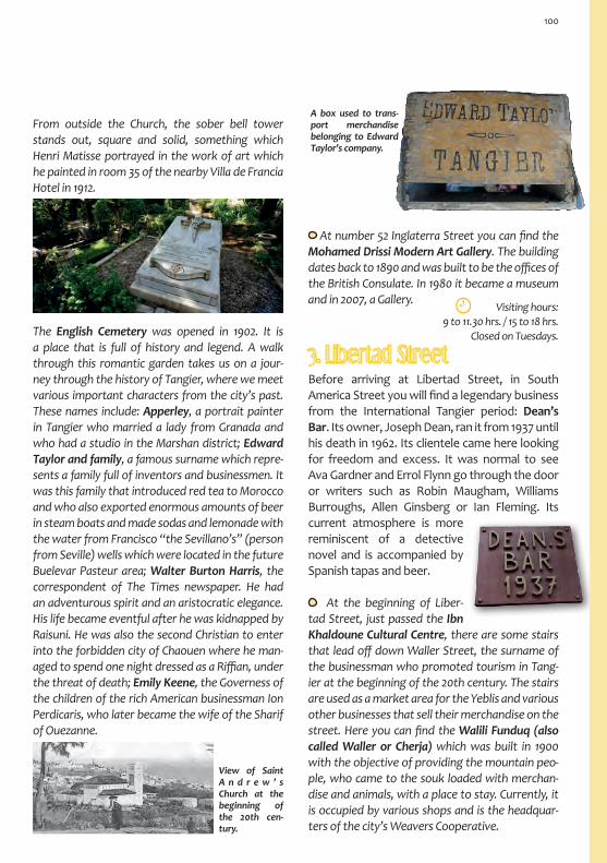
From outside the Church, the sober bell tower stands out, square and solid, something which Henri Matisse portrayed in the work of art which he painted in room 35 of the nearby Villa de Francia Hotel in 1912.
The English Cemetery was opened in 1902. It is a place that is full of history and legend. A walk through this romantic garden takes us on a jour-ney through the history of Tangier, where we meet various important characters from the city’s past. These names include: Apperley, a portrait painter in Tangier who married a lady from Granada and who had a studio in the Marshan district; Edward Taylor and family, a famous surname which repre-sents a family full of inventors and businessmen. It was this family that introduced red tea to Morocco and who also exported enormous amounts of beer in steam boats and made sodas and lemonade with the water from Francisco “the Sevillano’s” (person from Seville) wells which were located in the future Buelevar Pasteur area; Walter Burton Harris, the correspondent of The Times newspaper. He had an adventurous spirit and an aristocratic elegance. His life became eventful after he was kidnapped by Raisuni. He was also the second Christian to enter into the forbidden city of Chaouen where he man-aged to spend one night dressed as a Riffian, under the threat of death; Emily Keene, the Governess of the children of the rich American businessman Ion Perdicaris, who later became the wife of the Sharif of Ouezanne.
A box used to trans-port merchandise belonging to Edward Taylor’s company.
At number 52 Inglaterra Street you can find the Mohamed Drissi Modern Art Gallery. The building dates back to 1890 and was built to be the offices of the British Consulate. In 1980 it became a museum and in 2007, a Gallery.
Visiting hours:9 to 11.30 hrs. / 15 to 18 hrs.
Closed on Tuesdays.
3. Libertad StreetBefore arriving at Libertad Street, in South America Street you will find a legendary business from the International Tangier period: Dean’s Bar. Its owner, Joseph Dean, ran it from 1937 until his death in 1962. Its clientele came here looking for freedom and excess. It was normal to see Ava Gardner and Errol Flynn go through the door or writers such as Robin Maugham, Williams Burroughs, Allen Ginsberg or Ian Fleming. Its current atmosphere is more reminiscent of a detective novel and is accompanied by Spanish tapas and beer.
View of Saint A n d r e w ’ s Church at the beginning of the 20th cen-tury.
At the beginning of Liber-tad Street, just passed the Ibn Khaldoune Cultural Centre, there are some stairs that lead off down Waller Street, the surname of the businessman who promoted tourism in Tang-ier at the beginning of the 20th century. The stairs are used as a market area for the Yeblis and various other businesses that sell their merchandise on the street. Here you can find the Walili Funduq (also called Waller or Cherja) which was built in 1900 with the objective of providing the mountain peo-ple, who came to the souk loaded with merchan-dise and animals, with a place to stay. Currently, it is occupied by various shops and is the headquar-ters of the city’s Weavers Cooperative.
100

As night drew in, I found out that you could stay at the Cherja Funduq. It only cost one peseta.
You slept where you could.Mohamed Chukri (El pan desnudo).
Libertad Street received its name after Moroc-can independence in 1956. Its original name was Estatuto Street. It is the street that connects the Grand Souk to Francia Square, another emblem-atic space in the new part of the city. It is full of bazaars, antique shops and art galleries such as the modern Delacroix Gallery which is run by the French Cultural Institute. Libertad Street is also home to a number of busi-nesses that started out during the International
Tangier period. Although most of them have now been refurbished, they still maintain their original personality. An example of one of these businesses is the Minzah Hotel, whose story begins back in 1930 when it was built on top of the remains of the Palmarium Casino which had previously burnt down in a fire. The order to construct the building which housed the Casino came from the business-man Perdicaris in 1880. Originally it was a private house, the first in the area. The architect who de-signed the Minzah was Diego Jiménez Armstrong. He also designed a number of other buildings in this street such as the Menebhi House, located just op-posite the Minzah. The meticulousness of the Anda-lusian decorative design on the inside of the Minzah more than makes up for the building’s laconic exte-rior. Inside there are various rooms which surround an internal patio. These rooms have been converted into bars and restaurants and have been decorated in an elegant manner. The Hotel was frequented by various famous people such as Douglas Fairbanks,
Mary Pickford, Rita Hayworth, Alan Delon and Cantinflas. In 1947, the painter Mariano Bertuchi organised an exhibition in one of the rooms in the Hotel and Paul Bowles lived there f or some time and was a regular at the piano bar.
Inside the Delacroix Gallery with paintings by Brion Gysin, an artist that lived in Tangier. He was friends with the Bowles, the Beat Generation and extremely close to W. Burroughs.
4. Francia Square
The Gran Café de París also stands in the Square. It is a tribute to the past as it was built at roughly the same time, possibly even before this space was designed as a square. In the 20s, it already had a fixed clientele, mostly the regulars from the Cafés in Petit Souk. In those days it was called only Café de París. The purchase of the adjacent building in the 30s was the cause of the addition of the adjec-tive “Gran” (big) to the name.
Francia Square was the first area to be devel-oped in the new city, outside of the Grand Souk. It connects the Souk with the main Avenue in the city: Pasteur Boulevard. Streets lead off from the Square in all different directions and traffic has in-tensified over recent years. It received its name from the French Consulate that has been located in the square since 1929. Not very far away, in Bélgica Street, you can find the Art Gallery of the Cervantes Institute.
Francia Square in 1929. (Source: Tangier City Council).
101

The boulevard was an area that was full of veg-etable gardens known as Frasquito “the Sevil-lano’s” Vegetable Garden. This so called Frasquito had bought the land for 125 pesetas and the Paris et Pays-Bas Bank bought it off of him for 400.000 pesetas. What remained of his land was inherited by Esperanza Orellana who, with her husband, paid for the construction of the Cervantes Insti-tute and the houses that surround it.
During the first two decades of the 20th century, various building developers from Tangier’s mid-dle class started to construct villas and buildings. The developers included the Toledano broth-ers. Their favourite architect was Diego Jiménez Armstrong, who worked between 1910 and 1956, updating the construction style of the building facades and interiors. The first buildings have a French style, which is more classical than mod-ernist. They can be found in the area surround-ing Francia Square. Later on, the Boulevard was paved, electricity was installed and various palm trees were planted. The Boulevard was seen as a symbol of elegance, with rich families moving there, leaving their old homes in the Medina. It became the epicentre of the city, much like Petit Souk. Along with the café, various restaurants, hotels and businesses opened here, converting it into an area of the city where you could go for a walk and go shopping. In the 40s and 50s, it underwent a transforma-tion, with the construction of tall Rationalist buildings such as the Goicoechea building or the Rembrandt Hotel, which still maintains its origi-nal interior decoration. The transformation of the Boulevard was a reflection of the changes
I remember the conversations between Emilio Sanz and Truman Capote. One would be talking about Miguel Hernández, Lorca, Panero, Rosales… and the other about John
Donne, Hopkins, James Joyce… Late on in the morning,
Tenesse Williams would have a coffee here. M. Pancorbo.
5. Pasteur Boulevard
If the Petit Souk is the soul of Tangier and the Medina, the Pasteur Boulevard is the soul of In-ternational Tangier and of the modern city. It starts in Francia Square and continues down until it reaches Mohamed V Avenue, well into the Bukhachkhach district.
In the 50s, there was an endless list of artists and bohemians that passed through the Café on a daily basis. It continued to be popular for a further dec-ade, despite losing some of its vices such as alcohol consumption. Its regulars included: Saint-Exupéry, Cecil Beaton, the Bowles, Gregory Corso, Gore Vidal, John Hopkins, David Herbert, Paul Morand, Samuel Beckett, Jean Genet, François Sagan, Joe Orton, William Burroughs, Allen Ginsberg, Jack Kerouac, Mohammed Choukri, Emilio Sanz de Soto, E. Haro Tecglén and Tahar ben Jelloun. It still has its original decoration and remains popular with those who love getting together for a chat.
102

that were occurring in the west and the histori-cal upheaval that they were experiencing. It was inevitable that the changes would reach this in-ternational stronghold. The western politics and art invaded life in Tangier. It was in this environ-ment that the Gerofi family founded the DesCol-onnes book shop, the oldest in the city and that still remains open today. This area was and still is a place to meet up with friends, a place where art exhibitions would take place and where wisdom was expressed both orally and in writing. There are now new book shops that have joined the ad-venture. The Avenue encourages you to go for a walk, observe the architecture, go for something to eat, go shopping, have a long coffee or go win-dow shopping.
Muro de los Perezosos as it is known locally (wall of the lazy people), received its name as it’s a place where people sit and eat sunflower seeds, watch-ing life go by in the Boulevard and soaking up the magnificent views of the bay. Its real name is Plaza de Faro (lighthouse Square), in honour of the Por-tuguese city that Tangier is twinned with. This view-point was the first urban construction that was car-ried out in the Boulevard, built in 1909.
Buildings from the 20s and the Toledano family villas, designed by the architect Diego Jiménez Armstrong. They bare resemblance to the German style architecture that was being constructed in España Avenue. They are buildings that visually look quite plastic, with the use of more classic elements such as corbels, stone wreaths, balustrades and arches with predominant keystones.
Regional Tourism Office and Abdellah Guennoun Library. The debt house, Dar es Salaf, dates back to 1910 and was the first building to be constructed in the Boulevard. It was the administrative office that used to control the tax paid at customs in the Port, money that went directly to pay off the loans that Morocco had with France, hence the French term.
Old Residence of the To-ledano family in the 20s, de-signed by the architect Diego Jiménez.
Charr Raphaël Synagogue, 1919. It used to be Raphaël Bendri-hem’s house which he donated in 1951 to be converted into a Synagogue. It is still open today.
Buildings from the 20s built by the Toledano family and designed by the architect Diego Jiménez.
103

It stands out for the being the only Neo-Arabic style building in the boulevard.
The Avenue ends in two tall buildings with a curved corner: The Goicoechea building (surname of the devel-oper that financed its construction) or the accor-
dion. It is expression-ist in style giving off a sense of plasticity. The accordion shape is broken by a curved corner upon which has three more floors on top that rise up like a tower-chimney. It was designed by the architect Manuel Martínez Chumillas.
The old Casino Español, currently Casa de España. It was designed by D. Jimenez and is an example of an aerodynamic Rationalist building. Evidence of this style can be found in the banister used on the upper row of balconies and the curved corner. It stands out due to its narrow shape which cor-responds to the layout of the block on which it is located. In the shadow of the Casino Español in al-Uatania Street, you can find the modest Sagrado Corazón Church that was built in 1907. The initiative behind the church came from the Franciscan movement.
It was designed by the monk Francisco Serra, an architect who designed vari-ous churches in the Spanish Protector-ate cities such as Asilah and Nador. Currently it is a school.
Old Spanish Casino.
Boukhachkhach district. After the 40s, the extension of Pas-teur Boulevard led to the growth of a district which made the Boulevard itself look small. It is located at the end of the Anteo Avenue, today Mohamed V. It was a district that had a notably French influence where various schools, cultural centres, medical dispensaries and a church were built. The number of cinemas that were opened in the area between the 30s and the 50s is particularly significant: Roxy, Goya, Mauritania and París, the latter has been in Fez Street since 1937. You can also find the old offices of the newspaper Diario España, a Neo-Herrerian Officialist building.
The Regnault Liceu (French school) is lo-cated in Allal Ben Abdellah Street and still functions as a school. It is Neo-Arabic in style and is the oldest in the area, dating back to 1913. It was extended in 1952 and was dedicated to the then Consul Eugene Regnault, who represented his country in the Algeciras Conference and in the signing of the Treaty of Fes.
Nuestra Señora de la Asunción Catholic Church, located in Omar ibn Khattab Street. It was opened at the beginning of the 50s and is dedicated to Santa María and Santa Juana.
Roxy Cinema, located in Alman-sur Dahbi Street. A Rationalist building that has been function-ing as a cinema since the 50s showing American and European cinema. Currently it shows Egyp-tian, Moroccan and American cinema.
Goya Cinema, located in Prince Mulay Abdel-lah Street. A Rational-ist building that was used as a cinema until 2007. They used to show Spanish cinema.
Mauritania Cinema, located in Prince Heritier Street. It has been open since the 50s.

You can find the Cer-vantes Theatre on Anual Street, formerly known as Esperanza Orellana Street. It opened in 1913 and was designed by the architect Diego Jimenez Armstrong. During its construction, materials and architects were brought from Spain, including names such as Cándido Mata, the man who de-signed the frieze on the façade. The paintings on the ceiling were done by Federico Ribera and the decoration by Bussato. Its interior and exterior beauty provides us with a magnificent example of Modernist architecture that manages to rescue some classical elements.
The idea to build the theatre came from Manuel Peña who wanted to give it to his wife, Esperanza Orellana, as a present. They were also responsible for the construction of various other houses in the area. Before its official opening, the Theatre was used for the screening of the film, Quo Vadis. In the theatre, various different activities are car-ried out such as opera, zarzuela, theatre and co-pla. It is also used as a cinema and a place where special events are held such as dances and local celebrations. It has a capacity of 1400 people and was a cultural space that has been host to an ar-
6. Cervantes Theatre
ray of celebrities such as Sarah Bernard, Caruso, Comédie Française and the theatre companies that belonged to Margarita Xirgu and María Guer-rero. The best of the Spanish copla and flamenco scene also passed through the theatre: Raquel Meyer, Concha Piquer, Imperio Argentina, Pepe Marchena, Lola Flores or Manolo Caracól, Estrel-lita Castro, Juanita Reina, Carmen Sevilla, Juanito Valderrama and Antonio Machín, amongst many others. In 1929 the Spanish government took over the management of the theatre and it wasn’t until 1974 that it was back under Moroccan manage-ment. Currently it is in a state of ruin.
7. España AvenueThe sea front in the bay used to be an unpopulated area. Building work started in the area closest to the Port and the Medina at around 1890. At the be-ginning of the 20th century, the westerners started to speak about a Boulevard next to the sea. For the Moroccans, this area was still know as the Barrel district (brâmil), as it was here where the guerrabas (water sellers) used to get water from the wells that were located in this area. The boulevard starts by the Tannery stairs, located next to Bab Dar Dbagh (the place where the lighthouse was built in 1883). Building work started with the construction of housing, shops, hotels and the first two theatres,
105

There were bars, restaurants, casinos and theatres. Local celebrations were also held here including the carnival parade (until the 30s) and horse races, with horses that had been brought over from Gibraltar
and Jerez de la Frontera. The finishing line for the races would often be at Villa Harris. The façades of the buildings provide a loose connection in the ar-chitecture that you will find on the Avenue. Yellow is used on the mouldings and decorations that are very typical of the styles used during the first few decades of the 20th century.
Romea and Tívoli, which were made out of wood. During the second decade of the 20th century, the Germans also started to build here with construc-tions such as the famous Renschhausen Terrace. Shortly after, the Spanish Government also started construction work. The palm trees in the Avenue were a present from the Marquis of Casa-Tiera who got them from the Spanish city of Elche in 1924, hence why the street was called España Avenue. The Avenue was designed by the engineer José Ochoa Benjumea. It acquired a good reputation and opened up the city to the sea. On the Ren-schhausen Terrace (surname of the builder devel-oper in charge of its construction), you could find the French Kursaal, a building that had various func-tion rooms and a casino that was opened in the 20s. The Spanish Consulate was also located here, something which can be seen by a remaining tile which bares the Francoist Spanish coat of arms. The offices of the different shipping companies that operated in the Port could be found on the ground floor of the terrace. The worldwide destina-tions where these companies used to travel to can still be seen, hanging on the panels on the building façade.
In the 30s, the train line was extended, reaching the Avenue. It was during this period that the Rational-ist style train station was built. The avenue was also a place where people used to go in their free time.
España Avenue at the end of the 20s and present day. (Source: Tangier City Council).
Old building of the Majestic Hotel, 1913. Neo-Barroque Ger-man appearance. Two imperial crowns were placed on top of the building. (Source: Tangier City Council).
Tangier has had a Port since ancient times, al-though the first engineering work was carried out by the English during their occupation in the 17th cen-tury. It was also the English that destroyed the pier and the jetty before they abandoned the city, leaving Tangier without a port for centuries.
I was taken to the boat by the most ridicu-lous and funny boarding process ever seen by human eyes. A strapping Moroccan man picked me up and took me into the wa-
ter where the boat was waiting. During the whole process I didn’t get wet at all.
Benito Pérez Galdós, 1904.
1914
106

Finally, in 1905 a German company undertook the re-construction of the port. They took advantage of this project to extend the land around the port, the place where España Avenue would be located some years later. Unfortunately, some problems stopped the project which wasn’t started again until the signing of the International Statute in 1923. Tangier is currently one of the most important ports in Morocco.
8. Italia Street and Qasbah Street
Tangier Bay. The continuation of España Avenue, currently Mohamed VI Avenue, is a buzzing area where various beach and leisure activities are carried out. Here, you used to be able to find luxurious hotels along with a number of spas such as the Apolo, Española, Rialto, Miramar Club and the Asociados Hotels. The latter was built in the 50s and was the most luxurious. It was also the furthest from España Avenue. The buildings were originally made out of wood, although their quality was improved over time. The Bay was known for its party atmosphere, a reputation that it maintained for decades. In the 70s, the beaches became public and the spas lost a lot of business, having to revive themselves as bars, restaurants and nightclubs. These establishments covered all 6 kms of the beach up to Cape Malabata, converting into a hotspot for leisure activities both during the day and night.
Tangier Bay in 1912. (Source: Tangier City Council).
To head back to the Great Souk, you can take Por-tugal Street, which runs parallel to the southern stretch of the Portuguese wall. Along this wall you can find the (Bab) American Gate which joins onto the Beni Idder district. You could also take Salah Idin Ayubi Street, formerly known as Cues-ta de la Playa (Beach hill). At the intersection be-tween both streets, you will find the Irish Tower which dates back to the second half of the 17th century. Shortly after, you will come across the building that was constructed to house the Alfon-so XIII Spanish Schools and that was designed by the architect Francisco Ferreras.
Italia Street starts behind Bab al-Fahs Gate, which is located in Great Souk Square. The Yeblis (mountain women) can now be found in this area with the products that they used to sell in the Great Souk. This gives the street a distinctive feel of an open air market, where you are surrounded by Eu-ropean architecture from the end of the 19th and beginning of the 20th centuries. The large gardens of the old Mendubía and the Muslim and Catholic Cemeteries can also be found in this area.
Alfonso XIII Spanish Schools.
Tangier Port and Bay.
107

There are two gates which connect the Was Ajardan district to the Medina: Bab Rahbat Zraa and Bab Gzenaya.The old Popular Bank stands out amongst the architecture in this area. On the ground floor level of the building you will find the legendary Colón Café, one of Paul Bowles’ favour-ites and later used by the director B. Bertolucci in a scene for the film version of his book “The Shel-tering Sky”. Opposite this building, you will find the old Alcazar Cinema which is now not being used. It has been a cinema from 1945 onwards, showing films exclusively in Spanish. Previously, it was used as a theatre. In Tetuán Street you can find buildings that were constructed in 1905 and that were inhab-ited by aristocrats. It was a private area that was closed at night with a wrought iron gate.
The Colonial architecture con-tinues through-out Qasbah Street where you can find the British Tel-egraph building that dates back to 1880. You will also come across a stretch of the western part of the Medina wall. The hill ends with the Qasbah Gate, flanked by the Ben Anmar Fort. This area is where the Marshan district begins.
Italia Street.
Qasbah Street in 1924 and the British Telegraph building. (Source: Tangier City Council).
9. Marshan District
Bab Qasbah and the Ben Amar Fort (borj).
The Marshan district is located in the north east of the Medina in the northern part of the city. It stands on a raised part of land which has beautiful views of the sea. It is a residential district which came about in the middle of the 19th century with the construction of some villas. Little by little the important people in Tangier began building their small palaces here. These included the Sultan Mulay Abdelazziz after his abdication, his Minis-ter of Defense Mhedi Me-nebhi, his Vizier Mohamed Mohkri, the Sharif of Ouez-zane and various foreigners who were living in the city such as the artist Georges Owen Wynne Apperley or the North American millionaire Malcom Forbes. Many of the palaces and villas are currently used for cultural events.
108

Next to the Menhebi Palace, the artist and writer Brion Gysin opened the 1001 Nights restaurant in 1954. It was a place to be seen and was frequented by various Tangier celebrities. At the restaurant the meal was accompanied by music from the Ja-jouka Musicians which fascinated westerns such as the Rolling Stones. Evidence from this period can be seen at the Hafa Café which has been serving mint tea since 1921. Various important figures from the music world passed through the Café such as the Beatles, the Rolling Stones, Jimmi Hendrix and Patty Smith, along with writers from the Beat generation such as Williams Borroughs. Other art-ists and writers also could be seen here including
I will return to the Hafa Café. I constantly dream about its terrace. Paul Bowles.
Punic-Roman Necropolis. A collection of 98 tombs, the majority of which have been dug out of stone, the most recent date back to the 4th cen-tury BC. In these tombs, various lead sarcophagi have been found along with other valuable objects which are on display in the Qasbah Museum. The Necropolis can be found between the northern side of the city, with views of the Atlantic up until Ibn Al Abbar Street.
Windows of the old Sardinian-Piedmontese Consulate, the first build-ing in the district. Next to the Consulate you can find the large house where Giuseppe Garibal-di stayed between 1849 and 1850. The original building fell down.
Punic-Phoenician Tombs. In the background you can see Cape Malabata.
10. Area Surrounding Kuwait SquareThe San Francisco District receives its name from the Franciscan community because it was land that was acquired by the Franciscan Lerchundi. It was here that he built houses, charitable institu-tions, a hospital, a school, a community centre, a church, a cathedral and the San Francisco neigh-bourhood for the Spanish workers. Currently it is a very dynamic district that has been taken over by homes and businesses of the middle-class. Various schools were built in the area surround-ing Kuwait Square including the Spanish School Group (currently called Ramón and Cajal) in 1935 and the Spanish Polytechnic Secondary School (currently called Severo Ochoa) in 1949. The lat-ter of the two was refurbished in 1971, the year in which the Cervantes Institute was built in Tangier. The Spanish Consulate can also be found in this area (number 85 President Habib Bourghiba Street) in a Neo-Classical building from 1941, de-signed by the architect Luis Martínez-Feduchi. A little further along you can find the Spanish Hos-pital. It was moved to Mahatma Ghandi Street in 1941, the same year in which the building was com-pleted by the architect José Ochoa Benjumea.
The Nuestra Señora de Lurdes Spanish Cathe-dral provides us with a modern version of a Roman Temple. Its layout is in the shape of a Latin cross, complete with three naves and an ambulatory. Its
Other buildings were also constructed in this dis-trict including the French Hospital Al-Kortobi in 1893, the Pasteur Institute in 1913 (designed by the architect Henri Saladin), and a mosque in 1916. A football stadium was also built in the farthest corner of the district in the 30s.
Ángel Vázquez, Eduardo Haro Tecglen, Ramón Buenaventura, Emilio Sanz de Soto, José Hernán-dez and Pepe Cárleton. There are beautiful views of the Strait of Gibraltar from the terraced garden.
109

10. Area Surrounding Kuwait Square
They say that the construction of the beautiful Mohamed V Mosque was financed by a Kuwaiti Sheik when he saw that the highest minaret in Tangier was the bell tower of the cathedral.
View of the Mohamed V Mosque and the bell tower of the Church-Cathedral as seen from Bab Assa in the Medina.
TOURIST INFORMATIONRegional Tourism Office29, Pasteur BoulevardTel. +212 (0) 539 94 80 50
Just north of the San Francisco district in the Muslim cemetery in Hassan II Avenue, you will find the Zaouia-Mosque of Sidi Mohamed al-Hadj Buarrakia, the Patron Saint of the city. You will also find the Saint Francis of Assisi Italian Church at number 3 Mulay Idriss Street. It dates back to the 40s although mass is currently not held there. In Mohamed ibn Abdelwa-had Street you can find the Headquarters of Italian Institutions or the Mulay Hadif Palace as it is also known. It was built in 1914 by the architect D. Jiménez Armstrong. It has an arcaded interior patio and can be visited during the cultural events that are held there. If you want to arrange a visit at another time, you should send an email to the following address:[email protected].
Our journey finishes in the surrounding areas of Tangier, in the west. It is a path towards the end of the world that takes us through woods and the Ion Perdicaris Mansion which dates back to 1872 and looks out over the Atlantic next to the lighthouse that has been located at Cape Espartel since 1864. They are located next to Hercules’ Caves, the Cotta Ruins and a salt and garum factory which was occupied between the 3rd century BC and the 3rd century AD. They are located in the same road. One of the ways in which you can reach these places is by walking along the edge of the Marshan district in the northern part of the Medina and then by following the edge of the sea and continuing along the Monte Viejo path. This path provides us with evidence of the International Period through its architecture which includes lavish mansions such as Villa Josephine. Due to the distance, you will have to go by taxi or by private car. This area of great natural beauty is also recommended for cyclists and for hikers.
architect was Luis Martínez-Feduchi Ruiz and work was carried out between 1953 and 1961. A range of proposals were put forward for the Project includ-ing one from Antoni Gaudí in 1891 which included Berber influences, a prelude to his Sagrada Familia in Barcelona.
Lighthouse at Cape Espartel.
110


A Warm Welcome Full of Colour
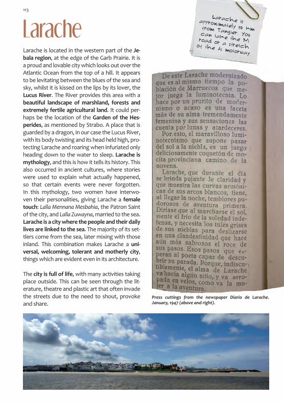
LaracheLarache is located in the western part of the Je-bala region, at the edge of the Garb Prairie. It is a proud and lovable city which looks out over the Atlantic Ocean from the top of a hill. It appears to be levitating between the blues of the sea and sky, whilst it is kissed on the lips by its lover, the Lucus River. The River provides this area with a beautiful landscape of marshland, forests and extremely fertile agricultural land. It could per-haps be the location of the Garden of the Hes-perides, as mentioned by Strabo. A place that is guarded by a dragon, in our case the Lucus River, with its body twisting and its head held high, pro-tecting Larache and roaring when infuriated only heading down to the water to sleep. Larache is mythology, and this is how it tells its history. This also occurred in ancient cultures, where stories were used to explain what actually happened, so that certain events were never forgotten. In this mythology, two women have interwo-ven their personalities, giving Larache a female touch: Lalla Mennana Mesbahia, the Patron Saint of the city, and Lalla Zuwayna, married to the sea. Larache is a city where the people and their daily lives are linked to the sea. The majority of its set-tlers come from the sea, later mixing with those inland. This combination makes Larache a uni-versal, welcoming, tolerant and motherly city, things which are evident even in its architecture.
The city is full of life, with many activities taking place outside. This can be seen through the lit-erature, theatre and plastic art that often invade the streets due to the need to shout, provoke and share.
Press cuttings from the newspaper Diario de Larache. January, 1947 (above and right).
Larache is approximately 90 km from Tangier. You can take the N1 road or a stretch of the A1 motorway
113

The bends of the River Lucus as seen from Lixus. In the back-ground, the City of Larache.
HistoryThe history of Larache begins with the ancient city of Lixus. Between legend and history, the Phoenicians, Carthaginians, Mauritanians and Romans all passed through the city, helping to convert Lixus into an important commercial river port. Over time, the navigable access to the city became more complicated, causing the inhabi-tants to move to the river mouth, meaning that the original site gradually became deserted. On a hill next to the estuary, not very far from Lixus and on the other side of the River Lucus, the future city of Larache was born.
Covered in a patina caused by the Atlantic cli-mate, Larache is the limestone walls with navy blue patches and the warm welcome that is given to all who visit: the colour of the ground, the brick and the stone, which invite you to cross mythological, historical and real dimensions.
A proud connoisseur of its heritage, the city can become a little arrogant, showing itself to the visitor with modest vanity. It shares its wonders with passion, just as the inhabitants do, and it is
these same people who make the city what it is. In the words of the writer Sergio Barce, native of the city, Larache is an old lady who is waiting for a miracle to happen. She is so tired that her walls ooze desperation, but she remains on her feet, arrogant and timeless. Larache is a lady with a big personality who hopes to regain her noble appearance in order to continue captivat-ing her visitors.
114

In order to talk about the beginning of the city and of a fortified Kasbah, we have to wait until the arrival of the Wattasid Emir Mulay al-Nasir. In the 15th century, he conquered Larache in or-der to have a defensive stronghold against the Portuguese attacks. It was the first urban cen-tre on which we have information and included the following constructions: a Kasbah with its surrounding wall, a Mosque and Arabic baths.
At the end of the 16th century, the Sultan Mulay al-Mansur al-Dahabi ordered the construction of two large defensive fortresses, curiously in the
The ancient Africans (Berbers) built the city above the Ocean, at the mouth of the River Lucus.
Leo Africanus
Italian Renaissance style: Hisn al-Nasr or Eagle Castle (known today as Stork’s Castle and locat-ed in the southeast, next to the old Kasbah), and Hisn al-Fath or Conquest Castle (known today as Fort of Small Domes and located in the north, looking out over the Atlantic).
As well as consolidating itself as a distinguished commercial Port, Larache had also become a refuge for pirates and warriors who fought against the Christians who were destroying the coastal cities of the Maghreb. This was the rea-son why it was continually attacked and sought after by European countries. The Spanish King Felipe III is known to have once said Larache on its own is worth the whole of Africa. His desire was met in 1610 when he received Larache as a reward for supporting the Saadi Sultan Muham-mad al-Sayyid in a fight against his brother. It was then when the city wall was finished and the Medina was given its characteristic triangular shape, a job that was carried out by the military engineer Bautista Antonelli. The three points of the triangle marked the ancient castles al-Nasr and al-Fath and a new fortress known as the Ge-noese Castle, located next to the Port. The de-sire to possess this settlement was short-lived as it proved to be difficult and costly to maintain. It fell into abandonment and the negative news did not encourage other people to come and settle. Convicts were transferred here, convert-ing the city into a prison where hunger was the cause of continuous internal conflicts.
Larache was very populated, but when it fell into the hands of the Christians, it was abandoned for twenty years. At the end of this period, the son of the King of Fes repopulated the city. Due to the constant threat of attack from Portuguese, he strengthened the wall and sent supplies and troops.
Leo Africanus
The arrival of Moulay Ismail to power changed the destiny of the Maghreb, consolidating the power of the Alaouite Dynasty. With his Abid army (sol-diers that were recruited in the south) he managed to expel the Europeans from the Maghreb.
The Kasbah Gate from the 15th century (Source: Sergio Barce).
During the Roman period, the area was popula-ted by Mauritanian settlements which grew crea-ting a mainly agricultural centre. The origins of its name come from Al-'Arais, meaning flower gar-den, or al-Ara is bani Arus, the vineyards of the tribe from Arós. It is an Arabic phrase, sugges-ting that it may have been founded by Muslims.
115

In 1689 he stole Larache from the Spanish. He converted this decadent and deserted place into a thriving city, ordering people from the moun-tain to go and live there. He used the Port as a military base and built the Governor’s Palace, two Mosques and some Arabic Baths. It was given the status of Makhzen city, whereby all of the citizens had to carry out military service for the Sultan. In the 18th century, the Zocco Chico or Small Souk was designed and equipped with a Great Mosque, Madrasa, Baths, Fountain and Funduq.
Its commercial importance was so great that the Spanish Consulate set up office here in 1767. The good relations between the Alaouites and the Spanish led to the signing of a treaty in 1799. In this Treaty, it was agreed that both parties would tolerate the right to practice the Christian reli-gion in Morocco and the Muslim religion in Spain. Furthermore, they agreed to set free any prison-ers of war. Shortly after, the Sultan Mulay Sulay-man released all of the prisoners in his kingdom. For the coastal areas of Morocco, the 19th cen-
A view of the Small Souk (Above). The Fountain located in the Small Souk, within the walls of the Kasbah, 15th century (below).
tury brought with it the power and influence of their European neighbours and for Larache it was no different. Following the Spanish-Moroc-can war in 1860, the Peace Treaty allowed Spain to set up Consulates in the Port, a stop for vari-ous European shipping companies. In the 20th century, it found itself in the territory under the Spanish Protectorate and was occupied in 1911. It was at this time when a new period of growth started in the city, with Larache becoming Capi-tal of the western region of Morocco. Next to the Medina, the Ensanche (City Extension) was built: a European city with a western lifestyle, which managed to obtain a perfect symbiosis with the historic centre both from the physical and spiritual points of view.
Since the independence of Morocco in 1956 until present day, Larache lives with pleasant memo-ries. Without forgetting about its past next to the Lucus River, it is steadily growing towards the south, walking optimistically into the future.
116

Itinerary: The Medina
ENSANCHE
Liberación Square
Small Zouk
7
Fort Santiago
Fort of Small Domes
Qubaybat Street
1. MAJZEN SQUARE Jewish Tower • Laqaliq Castle • Governor’s Palace2. ANWAR SQUARE Anwar Mosque • Sidi Abd al-Karim Hayquri al-Sajrawi Mausoleum3. MULAY AL-MAHDI SQUARE Dar al-Sikka (Dar Sekka) • Kasbah Gate4. REAL STREET: SLOPE DOWN TO THE PORT Kasbah Wall and the Jbiel Allure • San José Church 5. PORT Port Gate • Customs Gate • Genoese Castle• Port 6. PROMENADE Nasariya Zaouia • Sea Gate • al-Qubaybat Castle7. STREETS IN THE MEDINA ZaouiaMesbahia• Qubaybat Street8. SMALL SOUK Great Mosque • Funduq • DiwanFawqiandDiwanSufli

River Lucus
Port
Garden of the Hesperides
Tower Garden
Small Zouk
1
2
3
4
54
6
7
8
7
Stork’s Castle
Customs Gate
Dockyards
Dockyards
. REAL STRE
ET
Spanish Wall
PRomENADE
Qubaybat Street
ZauiaNasariya

been given. This constant change provokes a continuous sense of confusion amongst visitors, who lose track of how many Castles and Palaces are being talked about. The disparity can also be seen in the streets of the Medina which are presented like a hand of cards, with the visitor having to choose which one to take. In these streets, you will go through Gates and walk into the city’s history. Although some of the Gates cannot be seen today, they can still be imagined. These include: Bab Jamis or Thursday Gate, Bab Riwah or Wind Gate, Bab Qubaybat or Small Domes Gate, Bab Qasba or Kasbah Gate, Bab Bahr or Sea Gate, Bab Girsa or Vegetable Garden Gate and Bab al-Diwana or Customs Gate.
The Medina in Larache is a melting-pot of unique elements that come together making it com-pletely original. It is the Medina of surprise and bewilderment. To the North, you will find the Lucus, to the west the Atlantic, and to the south and east the mod-ern part of the city. It is triangular in shape with castles in each of the three points. In addition to the Watasid Fort from the 15th century, you can also find the Saadien Forts from the 16th century that were built in the Italian Renaissance style. Furthermore, there is a mixture of other differ-ent styles including a Spanish defensive system from the 17th century, Muslim urban planning from the 18th century with some French influ-ence, various German and Portuguese interven-tions in the 19th and 20th centuries and finally, the Spanish constructions with both Gothic and Nasrid elements. It’s fascinating how Larache maintains its own definitive and unique personality, despite rep-resenting a mixture of cultures and aspirations, with buildings that could belong to any period and location in Europe or Maghreb. This architec-tural eclecticism can also be seen in the various different uses that have been given to the build-ings, and the different names that they have
Watercolour by Mariano Bertuchi. (Bertuchi Family Archive).
The Medina
Map of the Medina which is marked by the first fortified Kas-bah that was built inside the city walls. These walls, built in the 17th century, would later determinethedefinitiveshapeofthe Medina. The two castles from the 16th century are highlighted in blue.
1. Majzen SquareMajzen Square is a place that is full of history and legend and that has magnificent views of the Port and of the Lucas Estuary. By starting here,
you will discover the his-tory of Larache at the original urban centre of the city, the area that
119

Review in the newspaper Diario de Larache, 1947.
corresponds to the Kasbah from the 15th cen-tury. The Square used to be the Bailey. It was located within the city walls, next to the Kasbah’s southeasterly Gate Bab Riwah or al-Barrani (the one on the outside, the exterior). It was used to access the stables and was connected to the Road to Fes. This Gate was protected by the Jewish Tower.
The Jewish Tower is a symbol of Larache, it has a sober but renowned presence and is now not in use. It was a watchtower that defended the Kasbah Gate. It is the only square shaped Tower within the walls from the 15th century, as all the others were semi-circular. This leads us to believe that it was built before the Kasbah and was later incorporated into its design. Possibly dating back to the middle of the 8th century, it was built by the Marinid Sultan Yusuf Abd al-Haqq as a defen-sive Palace, very popular in Granada during the Nasrid dynasty. It has a medieval appearance due to the use of stone machicolations in the corners. It still has a stone coat of arms from the Habsburg Dynasty in Spain, a period in which it was refur-bished. The name comes from a legend that tells us the story of a Jewish person that was found hanging from the battlements.
Laqaliq Castle (Stork’s Castle), al-Nasr (Eagle Castle) or Nuestra Señora de Europa Castle as it was known during Spanish rule in the 17th cen-tury. It was built in the 16th century to defend the road to Fes and the Kasbah. It is a magnificent example of a Europeanrenaissancefortification, which leads us to believe that it was built by cap-tive Italian or Portuguese military engineers. It is
built in the shape of an equilateral triangle. The bastions which are located in each of its three corners represent sharpened arrow points, in an attempt to threaten potential enemies. Unfortu-nately, the one on the north side was removed during the Spanish Protectorate period.
Governor’s Palace, Command Headquarters or Music School. In the past, this building, which has an eclectic appearance, has always been linked to the government. Currently however, this is not the case, as it is the home of the Music School and the Larache Cultural Centre. It is the result of va-rious changes and refurbishments that begin with the Fortress in the 15th century, later adapted in the 17th century to be the Spanish Governor’s house. Finally, it was refurbished again during the Spanish Protectorate period to become the Command Headquarters. It is here when the Neo-Nasrid style was used, something which can be seen in the extravagant decoration. The building iso-lates itself aesthetically from its immediate environment and has a unique character for which Larache is famous, something that can be seen in the clock tower.
Spanish Governor’s House.
120

2. Anwar Square
We continue inside the walls of the Kasbah. Al-though nothing remains of the building itself, an estimation of where the wall once stood is known. Going through the Gate from Majzen Square, we are welcomed by Anwar Square, a small tradi-tional area that is presided by a covered court-yard and the Anwar Mosque. This urban area has always been linked to religion. It used to be the location of the Kasbah Mosque during the 15th and 16th centuries. In the 17th century, a convent and church were built and the square was used as the San Francisco Christian Cemetery. The new Mosque was built in the 18th century, with the main part and minaret being refurbished in the 20th century. The old minaret was first replaced by an elevated quadrangular minaret and finally with the current octagonal shaped one.
In a quiet square, you can find the Mausoleum of Sidi Abd al-Karim Hayquri al-Sajrawi, who lived in Larache from 1852 until his death. His tomb was built next to the Mosque, as ordered by the Pasha Ali ibn Muhammad Aztut. Its original appearance has changed, with an extension of the main part
and the addition of the minaret in the 40s. How-ever, it is still beautiful in a special way, both on the inside and outside.
3. Mulay al-Mahdi SquareIt was in this square where the Spanish adminis-trative powers were located during the first years of the Spanish Protectorate in Morocco. This spa-ce precedes the Kasbah Gate, Bab al-Qasba.
Dar al-Sikka (Dar Sekka), old Mint. The Sultan Sidi Muhammad ibn Abd Allah built the Mint in the 18th century in order to facilitate business in the Port, something that was of great importance both from military and economic perspectives. The front of the building stands out due to its triangular shape and the use of the Santiago de Compostela shell, a common decorative element in the Medina.
Anwar Mosque.
Sidi Abd al-Karim Hayquri al-Sajrawi Mausoleum.
121

Bab al-Qasba or Kasbah Gate used to form part of the perimeter wall and is remaining proof of the fortificationfromthe15thcentury. The bent entrance was removed during the Spanish Protec-torate, leaving only the Gate now standing. It is made of brick and has a simple design with a hor-seshoe arch and an Alfiz with Sebka decoration. Outside of the Kasbah and next to the Gate, you will find a building that has been refurbished and is now used as a butcher shop.
4. Real Street: Slope down to the Port
Of all of the streets that lead down to the Port, Real Street is without a doubt the busiest. Its current name is 2 de Marzo Street and it was also called 8 de Junio Street. It is extremely narrow and stretches out between houses and small
businesses, with alleyways on each side. In one of these alleys, you will find the only remains of the Kasbah wall and the Jbiel Allure, with its two remaining semicircular towers of the eleven that it once had.
The architecture in this street encompasses a mixture of traditional Muslim architecture and numerous examples of European styles from the 19th century, including some from the 20th century. The San José Church can also be found in this street, along with a Synagogue and a Mosque. Due to this, it is considered as a good example of the tolerance and coexistence that exists in Larache. Furthermore, it was also the Jewish Quarter.
A drawing by M.Bertuchi which demonstrates the religious coexistence .(Bertuchi Family Archive).
A stunning Neo-Gothic style façade appears out of nowhere in the corner of al-Harti Street. It is now in ruins and covered by vegetation. This was the San José Church, built in 1901 and designed by the monk architect Francisco Sierra. In addition to the main church building and bell tower, there were rooms that were distributed over two floors including galleries, all of which surrounded an in-terior patio. This area was occupied by Franciscan monks, an Order that was present in Morocco from
122

5. PortReal Street ends at one of the gates of the Medi-na wall called Port Gate, Dock Gate or Marina Gate. It connected the city to the Port and is mentioned in François Voarte de Acosta’s plans in 1616. It appears to have been built in the same century, under Spanish rule.
Customs Gate, Bab al-Diwana. This Gate is proof of the commercial importance of the Port in Larache at the end of the 19th century and be-ginning of the 20th century. It was built in 1889 in order to control Port activity. Nearby, you can find the old Dockyards which are still in use today and date back to the 18th century. Both the Dockyards and the Port are located along the old course of the river, the part nearest the Medina. In this area you can find the old Red Cross building with its church, today called the Media Luna Roja.
Port Gate in 1913. (Source: Sergio Barce).
Customs (HouseandGate) and theAfricanPostOffice, 1928.(Source: Sergio Barce).
In the place where the Genovese Castle once stood, you will find only a small part of a slo-ping fortification next to the wall. There is also a marble plaque from Philip III which refers to the construction of the wall in 1618. On the cast-le itself, we have information that dates back to the beginning of the 16th century, however, little is known about its history. The most likely story is that as in many Mediterranean coastal cities, such as Malaga, Genoese traders set up a colony in the city, financing the construction of a Fun-duq or Tower from which they could warn of any possible dangers arriving by sea. In the original plans, we can see a big lighthouse type tower. This Castle is one of the points of the triangular shaped Medina.
very early on, and that was responsible for paying the ransom for the Christians that were being held captive. They arrived in Larache in the 17th century.
Customs Gate.
123

The Port of Larache is located at the mouth of the River Lucus. Behind the Port, the other side of the river can be seen in the distance, crowned by Lixus. Today, it is an activefishingPort. It has had many glorious moments as an internationally renowned trade and commercial Port and Shipyard, particu-larly during the Spanish Protectorate, when the train line connected the Port with Ksar el-Kebir and Tangier, directly linking the Atlantic to the Mediterranean. In 1914, the northern dock was built in order to protect the Port not only from the wind but also from sedimentation. Further interventions have attempted to resolve this pro-blem, but without any success. This is one of the reasons why traffic has reduced in the Port, along with the fact that other new ports have appea-red, such as Tangier.
6. PromenadeThe Promenade forms the northern perimeter of the city and runs in parallel with the estuary of the river. It is here where you can find the al-Qubaybat Castle and a defensive artillery battery from the 17th century known as Fort Santiago. It is the steepest part of the city and was devel-oped by the Germans in 1910, who built a new Port which today forms part of the current one. Very close by, you can also find the German Con-sulate. Previously it had been the Desembarca-dero beach, where the small boats came ashore to repair their fishing nets and to dry out the fish that they had caught. From the Promenade you can see a stretch of wall from the 17th century together with some ter-raced housing. Both the bell tower of the San José Church and the minaret of the Nasariya Zaouia stand out. Here, you can also find the Sea District and the Gate of the same name, Bab al-Bahr.
Promenade next to the river.Area known as the Veranda. On the right, the Nasariya Zaouia.
In the outline of the riverbank, the minaret of the Nasariya Zaouia stands out which dates back to the 18th century. Its proximity to the Lu-cus in some ways relates it to the industrial and traditional activities of the Port. This Brotherhood is one of the most widespread in Morocco and was founded by Sidi Ahmad Nasr Dari.
124

7. Streets in the Medina
The al-Qubaybat Castle (of small domes), Hisn al-Fath (Conquest) or San Antonio Castle is the other big defensive Fort that the Sultan Ahmad al-Mansur al-Dahabi had built after the battle of the Three Kings against the Portuguese in 1578. It is located at the mouth of the river, looking out over the ocean to the north east of the Medina. It is a further example of an exceptional Italian renais-sance defensive system. It is square in shape, with a central bailey and bastions in each of the four corners. You can reach the Fort from inside the Medina by taking Qubaybat Street. This walk will provide you with some amazing views. We also recommend that you head over to the southern side which is known as the Atlantic Balcony.
It is impossible to get lost wandering through the streets in the Medina. The slope down will lead you to the promenade next to the riverbank. If you head up to the Medina, you will most likely end up in the Small Souk or in Qubaybat Street. It is very normal to come across a variety of streets that can be covered, wide or very narrow. This is due to the houses that have been built on top of one another, some connecting together above the street forming a passageway. This is a prime example of how private use of space is maxim-ised to its full potential in detriment to the provi-sion of public space.Between the al-Haira and Qbibat districts, next to Mesbahia Street, you can find the Zaouia of the Patron Saint of Larache, Lalla Menana al-Mesbahia, which dates back to the 18th century. It is also the Zaouia of her father, a holy man who was a descendant of a prophet and who fought in the war against the Portuguese. Next to the Zaouia, you can also find the remains of a gunpowder warehouse which the Spanish built in the 17th century. It is this building, which appears to be impenetrable, that gave the name to this area al-Hayra meaning the stone. Once you have reached the top of your ascent, you will arrive at a long street which connects the
Review in the newspaper Diario de Larache, 1947.
Streets in the Medina.
125

Laqbibat Castle with the Small Souk. This is al-Sadr al Aazam Street (Essadr al-Aadam), also known as Qubaybat Street or Artil-leryman Street and painted by Bertuchi on the posters used to promote tourism in the area. Here, the historic past and the reli-gious propaganda are mixed together with contemporary plastic art in various galleries such as the one that belongs to the artist Muhammad Kabbud.
Streets in the Medina and artistic detail of the tiles that can be found along the walk. On the left, the front of the Mesbahia Zaouia.
Famous poster of Larache by M- Bertuchi which shows the Gate that connects Qubaybat Street with the Small Souk. It belongs to a series of post-ers that he designed for the National Tourism Board and the Official Tourism Committee of Tetouan during the II Spanish Republic. During the Franco regime things changed once again, the Committee disappeared but the initials were kept on the post-ers. The Spanish government continued to change whilst Bertuchi carried on painting posters for the Spanish Protectorate. (Bertuchi Family Archive).
126
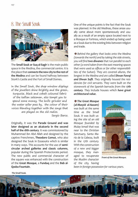
The Great Mosque (al-Masyid al-Aazam) was built at the same time as the Small Souk. It was built us-ing the site of an old Mosque founded by Mulay Ismail that was near to the Christian Sanctuary, Santa Ma-ría de la Cabeza, built in the 17th century. With the construction of a new and bigger mosque, they man-aged to recuperate the Muslim character of the city, having been in foreign possession for various years.
Originally, it was the Parade Ground and was later designed as an alcaiceria in the second half of the 18th century. It was commissioned by Muhammad ibn Abd Allah and designed by the captive Frenchmen, Theodore Comut, who also designed the Souk in Essaouira which is similar in many ways. This accounts for the use of semi-circular arched galleries and classic columns, popular during the Spanish Protectorate period. The new public and commercial character of the square was enhanced with the construction of the Great Mosque, a Funduq and the Bab al-Qasba Fountain.
The Small Souk.
8. The Small Souk
The Small Souk or Suq al-Sagir is the main public space in the Medina, the commercial centre. It is the place that connects the new city to the rest of the Medina and can be found halfway between Stork’s Castle and the Fort of Small Domes.
In the Small Souk, the shop window displays of the jewellers shine brightly and the green, turquoise, black and cobalt coloured fabric of the kaftan salesman, also tempt you to spend some money. The knife-grinder and the water seller pass by, the colour of their voices blending together with the songs that
are played on the old radios. Sergio Barce.
One of the unique points is the fact that the Souk was planned. In the old Medinas, these areas usu-ally came about more spontaneously and usu-ally as a result of an empty space located next to a Mosque or Fortress, which ended up being used as a Souk due to the existing links between religion and trade.
Behind the gallery that looks onto the Medina (towards the north) and by taking the side streets, you will find two diwanes that run parallel to each other (a word taken from the east meaning spaces that were used as offices or for other responsibili-ties of the Sultan). They are covered allures, the longest in the Medina and are called Diwan Fawqi andDiwanSufli. They originally housed the resi-dencies for civil servants. They were built on the stonework of the Spanish barracks from the 17th century. They include houses which have great architectural value.
Front of the Great Mosque.
127

The funduqs are inns (corn Exchange or tavern) for traders who travel to the souks, and are pre-pared to store both the goods and the animals that they bring with them. In many cases, the com-mercial transactions and the exchange of goods were carried out within the funduq itself. The con-struction of the Zalyu Funduq, in the square of the same name, greatly benefited the Small Souk. It has the typical elements expected in a funduq: gal-leries, including bedrooms spread over two floors which open up onto a central patio. The front of the building goes by pretty much unnoticed, with a semicircular arch with sober archivolts and an eave under which you will find various small win-dows. At the end of the 19th century it was used as a Madrasa. Currently it is not being used.
Poster of the Small Souk by M. Bertuchi as seen from the Bab al-Jemis Gate. (Bertuchi Family Archive).
In the Small Souk, you can find the Bab al-Jamis Gate which forms part of the city wall. It dates back to the 17th century and opens up onto the Alcazarquivir Road, connecting the Medina with the new city: the Spanish Ensanche (City Exten-sion).
The decoration on the front of the mosque, origi-nally more discreet, was renovated during the Spanish Protectorate. It has a square minaret, fin-ished with a Yamur that is prepared to receive the heavenly light.
You still remain here, you are still hereMaintaining the grass
A diminutive of the arch;The thick Buganvilla on the walls,
The darkness of the closed eye.
Trina Mercader
Fron
t of t
he F
undu
q.
Bottom left: You can reach the Small Souk through the Gate of the old Kasbah. Watercolour by M. Bertuchi. “Trenes” Magazinenº51,1952.(BertuchiFamilyArchive).
128

muslim Cemetery
mohamed VI mosque
Christian Cemetery
Slaughterhouse
Towards theLighthouse
Imán malek School
34
4
1. LIBERACIÓN SQUARE Medina Gate • Building with a porch • TarrafineandHaddadinAllures• Cafe Lixus • Koutoubia Building • España Hotel2. ATLANTIC BALCONY Spanish Consulate 3. CENTRAL MARKET Modernist Architecture • Old Palace of the Duchess of Guisa 4. MULAY ISMAIL AVENUE Imán Malek School • Mohamed VI Mosque • Muslim Cemetery • Slaughterhouse • Christian Cemetery • Lighthouse5. MOHAMED V AVENUE Nuestra Señora del Pilar Church • PostOffice• Garden of the Hesperides• Old Israelite School • Old Wood Warehouse • Chaletsfromthe20s• Lalla Menana Cemetery
Itinerary: The Ensanche (City Extension)

LucusAtlantic
MEDINA
Atlantic Balcony
old Palace of the Duchess of
Guisa Lalla menana Cemetery
Towards Alcazarquivir
Garden of the Hesperides
Towards Tangier
1
2
3
5
5

The Governor of the Lucus Region, Mulay Ahmad al-Raisuni, peacefully gave the city to the Spanish along with Asilah and Ksar el Kebir. From 1911 onwards, the Spanish Protec-torate Period started for these cities. Larache became the capital with great economic and cultural wealth, mainly due to the richness of the territory and the Port which had acquired an international repu-tation and had become a commer-cial hub, thanks to the train line that connected it to Tangier.
A new city was built, the Ensanche, which was well designed including beautiful ex-amples of European architecture.
Whilst the Ensanche was being built, new services and infrastructure were given to the old part of the city: a sewage system, electricity, pavements
The Ensanche (City Extension)
and water. The General Command Headquarters and the Offices of the General Staff were set up in the Old Bajá Palace, located in Majzen Square. Some buildings were demolished in order to recuperate the space that was the old Parade Ground. The hospital was located in the Fort of Small Domes and the artillery depot was located in Stork’s Castle. In the Medina, work was carried out in Mulay al-Mahdi Square with the creation of the Lala Menara School Group, the Spanish-Israelite School and the Spanish-Arabic School. The latter of the three was located in an old baroque Palace from the 18th century that was built by the Span-ish. It had previously been the Spanish Consulate, a building which is currently occupied by the Mu-lay Abdesalam Mechich School Group.
The military barracks were built in the outskirts, outside of the Medina and distributed along the old communication routes. Today, they have been absorbed into the urban area of the city. The plans of the Ensanche were designed by mili-tary and highway engineers in 1913. For this new part of the city, they chose the land that bordered the southern part of the Medina, taking into ac-count that, to the north was the river and to the west was the ocean. They maintained the roads that previously existed, with them later becom-ing the Avenues in this new part of the city. These avenues branched out from a central point which connected the traditional part of the city with the Ensanche: an elliptical square which fitted in well with the wall from the 17th century and which was centered on the Medina Gate. From this square,
Map of the Western area of the territory under the Spanish Protectorate.
In Brown: a rough silhoue-tte of the Medina. In Grey: the approximate size of the Ensanche.
131
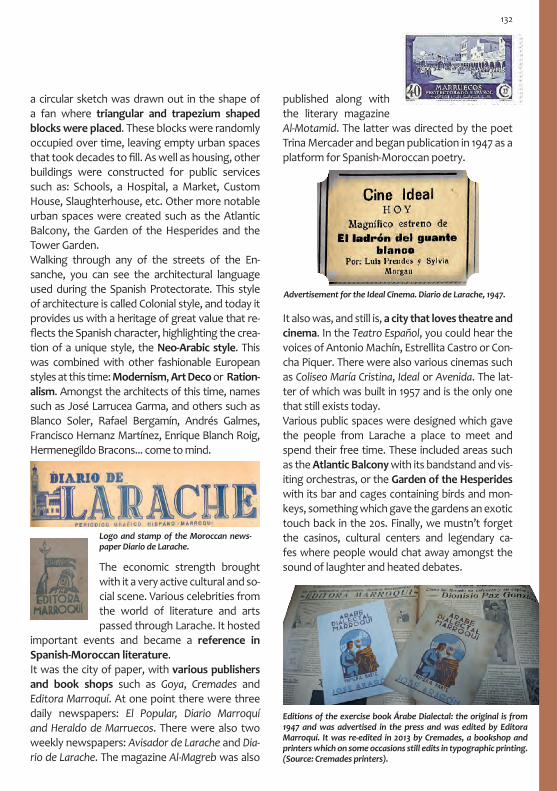
a circular sketch was drawn out in the shape of a fan where triangular and trapezium shaped blocks were placed. These blocks were randomly occupied over time, leaving empty urban spaces that took decades to fill. As well as housing, other buildings were constructed for public services such as: Schools, a Hospital, a Market, Custom House, Slaughterhouse, etc. Other more notable urban spaces were created such as the Atlantic Balcony, the Garden of the Hesperides and the Tower Garden. Walking through any of the streets of the En-sanche, you can see the architectural language used during the Spanish Protectorate. This style of architecture is called Colonial style, and today it provides us with a heritage of great value that re-flects the Spanish character, highlighting the crea-tion of a unique style, the Neo-Arabic style. This was combined with other fashionable European styles at this time: Modernism, Art Deco or Ration-alism. Amongst the architects of this time, names such as José Larrucea Garma, and others such as Blanco Soler, Rafael Bergamín, Andrés Galmes, Francisco Hernanz Martínez, Enrique Blanch Roig, Hermenegildo Bracons... come to mind.
The economic strength brought with it a very active cultural and so-cial scene. Various celebrities from the world of literature and arts passed through Larache. It hosted
important events and became a reference in Spanish-Moroccan literature. It was the city of paper, with various publishers and book shops such as Goya, Cremades and Editora Marroquí. At one point there were three daily newspapers: El Popular, Diario Marroquí and Heraldo de Marruecos. There were also two weekly newspapers: Avisador de Larache and Dia-rio de Larache. The magazine Al-Magreb was also
published along with the literary magazine Al-Motamid. The latter was directed by the poet Trina Mercader and began publication in 1947 as a platform for Spanish-Moroccan poetry.
It also was, and still is, a city that loves theatre and cinema. In the Teatro Español, you could hear the voices of Antonio Machín, Estrellita Castro or Con-cha Piquer. There were also various cinemas such as Coliseo María Cristina, Ideal or Avenida. The lat-ter of which was built in 1957 and is the only one that still exists today. Various public spaces were designed which gave the people from Larache a place to meet and spend their free time. These included areas such as the Atlantic Balcony with its bandstand and vis-iting orchestras, or the Garden of the Hesperides with its bar and cages containing birds and mon-keys, something which gave the gardens an exotic touch back in the 20s. Finally, we mustn’t forget the casinos, cultural centers and legendary ca-fes where people would chat away amongst the sound of laughter and heated debates.
Logo and stamp of the Moroccan news-paper Diario de Larache.
Advertisement for the Ideal Cinema. Diario de Larache, 1947.
Editions of the exercise book Árabe Dialectal: the original is from 1947 and was advertised in the press and was edited by Editora Marroquí. Itwasre-editedin2013byCremades,abookshopandprinters which on some occasions still edits in typographic printing. (Source: Cremades printers).
132

It is an urban space where various different roads converge along with different cultures, periods, styles and ways of life. It is the result of one of the most powerful interventions in the Ensanche and one of the biggest milestones in urban planning in all of the territory under Spanish control. It rep-resents a perfect combination of the old and new cities. From here you can reach the Small Souk and the heart of the Medina, something which is sym-bolically represented on one side of the Square by a building with a porch (reminding us of the galler-ies in the Souk) and the Medina Gate in the cen-tre. The other half of the square represents more modern European styles.
Under the direction of the city architect León Ur-záiz, the construction of España Square was fin-ished in 1927. There was a landscaped ellipse in the centre of the square with yellow and blue mosa-ics from Seville. The square was built in the ellipse shape in an attempt to adapt it to the outline of the city wall from the 17th century. The buildings were constructed between 1922 and 1926. In these buildings, various emblematic hotels and cafés were located such as the Oriente Hotel, later Cervantes Hotel, or Sol Cafe, later Cen-tral Café. The Spanish Casino was also located here and was the meeting point for the key military, bourgeois and diplomatic figures of the time.
1. Liberación Square
The Medina Gate is the central focus point of the Square and of the building with the porch that surrounds it. It was designed by José Larrucea at theendofthe20s. The size of the gate makes it the main attraction in the square, something which represents the connection between the Medina and the Ensanche. He made it look like the old gates in the Medina by using open brick work and decorating it in the Mudéjar style.
Hidden behind the current Medina Gate is the old Gate which once formed part of the city wall from the 17th century. It was designed by the engineer Bautista Antonelli for the Spanish King Phillipe III. It used to connect the bailey, which
Seven main streets start in the Square, some with very local names such as Mohamed ben Abdellah, known as Duquesa de Guisa, or Hassan II, previously Canalejas and known colloquially as Chinguiti, a place where young people would gather in the 50s and 60s and where traffic was cut off at weekends. Today it is a pedestrian street.
Decorative detail of the Medina Gate.
An aerial view of the Square. (Source: Sergio Barce).
Medina Gate and building with a porch.
133

would later become the Small Souk, to the Ksar el Kebir road. It opened up onto an esplanade where the Souk was held every Thursday, hence why it received one of its names, Bab al-Jamis. It is also known as Villa Gate or Land Gate. In order to build the Square a ravelin and two bastions, protecting the entrance to the gate and forming part of the fortified system desig-ned by Antonelli, were demolished. The building with a porch was also designed by Larruceaattheendofthe20s, with the addition of the secondfloor in the40s. Behind the buil-ding you will find the TarrafineandHaddadinAl-lures, remnants of the old wall-walk.
Lixus Cafe. In this building both the cafe bar La Vinícola and the Hispano-Maroquí Cafe could be found. The building is an excellent example of the Neo-Arabic style which, strictly speaking, became a Spanish style as it was used on the peninsular and in Morocco. It was a style that represented the understanding between local traditional and modern architecture, thus showing respect for vernacular styles. This style is a revision of the elements of Andalu-sian architecture using tiles, jagged battlements and horseshoe arches which are placed in the more modern setting of dominant European trends such as Art Deco.
Attic of the España Hotel with the emblem HE. Legendary establishment which has been located in this building since itsconstructioninthe20s.
Andrés Galmes designed the building which today houses the Koutoubia Café. This building is a successful fusion of reinvented Neo-Arabic elements and Art Deco. The side balconies are particularly interesting along with the use of lat-ticework, the design of the grilles on the windows
2. Atlantic Balcony
From Liberación Square you can feel the sea breeze. The ocean appears, warning us of its presence, deciding the path of the visitor through an earthly attraction. You can reach the Atlantic Balcony from the streets that look towards the north.
Lixus Cafe.
Koutoubia café building.
and the relief which is covered in mocárabe, bor-ders and big flowers. All of these elements merge together perfectly.
134

You can reach the Central Market by taking Zerktuni Avenue which boasts an array of build-ings that have important architectural value, despite being in need of urgent refurbishment. A straight line joins Liberación Square with the market, which sits as a backdrop at the end of the street.
This is an urban area located on top of the Ain Chaka cliff, the fountain that flows from the hole. It was designed in the 40s as a place where people could meet, go for a walk and spend their free time. It is the side of the city that stands by the sea, a place from which you can see the Atlantic Ocean, just another neighbour in Larache. We share this corner with one of the women from Larache’s history, Lalla Zuwayna and with the three Hesperid nymphs, Egle, Eritia and Hesperaretusa. Their names represent the different stages of the sunset: Blazing, Red and Setting. Here, the sunset and its different colours are the main attraction. You can also enjoy views of the al-Qubaybat Castle and one of the defensive batteries, Sidi Bu Qanadil, the oil lamp battery, which was commissioned by Muhammad Abd Allah during the second half of the 18th century. Its name refers to the person who was in charge of guiding the boats with an oil lamp as a type of lighthouse-keeper.
The Spanish Consulate or House of Arrows was built at the beginning of the 30s. It is an outstand-ing example of Rationalist architecture and con-tains elements that can be related to the Machine Aesthetic movement, aerodynamic Rationalism, which converts the building into a sculptural ob-ject with a very visual treatment of its different spaces. This style of architecture is associated with the image of industrial progress which, in turn, brings about a sense of movement. When it was built, it was the only tall building in its immediate surroundings. If you looked at it from Liberación Square, it could be compared with the chimney stack of a steam liner. On its façade, there were various bull’s-eyes which have now been removed.
3. Central Market
Atlantic Balcony.
The Spanish Consulate today and in the 30s.(Source: Sergio Barce).
ViewfromZerkthuniStreetandthefirstplansforthemarket.(Source: Sergio Barce).
135

The Central Market is known by the people that live in Larache as the Square. It was finished in 1925 and is one of the biggest buildings in the city where we can appreciate the use of the Neo-Nas-rid style in perfect harmony with its surroundings.
Modernistbuildingfromthe20s. In the streets that surround the market, there are various ex-amples of Spanish architecture from different periods.
In Muhammad ibnn Abd Allah Street, not far from the market, you can find the Riad Hotel. This hotel is a small Palace with a garden which belonged to the Dukes of Orleans-Guisa who, in 1909, set up residence in Larache. The Duchess of Guisa dedicated most of her time to charity work until she died in 1961. In the Medina she had various houses which were used by charitable organisa-tions such as the House of the Child that was located at the entrance to the Kasbah. In the past, the streets received their name in tribute to a person.
4. Mulay Ismail Avenue
This long avenue starts at Liberación Square and carries on along the western perimeter of the city, next to the Atlantic. As the Avenue ad-vances away from the city centre, it turns into a pathway. The Atlantic Balcony also leads into this avenue. Of the architecture that can be found along this route, you can find the Imán Malek School, the old Spanish school group which was built in 1918 by the architect José Monasterio, and also the new Muhammad VI Mosque. How-ever, more than the architecture, it is the public spaces that take precedence in this pseudo ur-ban area, whose left side balances on the edge of the cliffs. The first of these spaces doesn’t seem much when you see it. It is located next to the Muslim Cemetery and is where the Coal Souk used to be held. Coal was one of the city’s riches for centuries and was produced locally and exported to other cities. The next space is the aforementioned Muslim Sidi Alal ibn Ahmad Cemetery. Sidi Alal ibn Ahmad was a holy man who possibly defended the battery which can be found in front of the cemetery, located on a small peninsular. Our journey continues with the mu-nicipal Slaughterhouse, the Christian Cemetery and finally, the Lighthouse.
136

The Slaughterhouse is a very original space. In addition to the beautiful surrounding landscape, the building is simple and boasts a perfect and attractive Modernist style. Given its functional character, the decoration is minimal yet very effective, both in the design of the letters as in that of its ceramic tiles. It dates back to 1917 and is one of the first public buildings from the Spanish Protectorate in Larache.
The Spanish Cemetery dates back to the first years of the Spanish Protectorate. It is a beautiful place, located on a cliff by the sea. The French poet, novelist and playwright Jean Genet is buried here. He lived in Larache from 1974 in a house not so far from where he now lies. Saint Genet, as Sartre used to call him, was friends with Picasso, Cocteau and of the French bohemian movement. He was a cursed writer who had a conflictive life which is reflected in his work, evidence of a rebellion against society at that time. He asked to be buried in Larache.
In the distance, a lighthouse can be made out which could also be confused with a minaret. You can reach it by following the path that takes you to the top of a hill called Punta Nador. It has the honour of being the firstconcretelighthouse and was built in Spain in 1914 by the Engineer J. Eugenio Ribera, measuring 33 metres high. In the first 20 metres of the tower, the stairwell goes around the outer ring leaving the central part empty. However, in the upper part of the tower, the stairs have been moved inside. A visit to the differ-ent lighthouses that were built in the territories under the Spanish Protectorate is a route that is well worth doing, with lots of great ar-chitecture and beautiful landscape.
5. Mohamed V AvenueThrough the different names that this avenue has had we can see the history of Spain, with the name changing according to different political stances. Today it is called Mohamed V Avenue and is the old road that used to connect Alcázar to Tangier. It has also been called Reina Victoria, Palm Tree, Repub-lic and Generalísimo. It was commissioned by the Consul Zapico as a modern European avenue which would become the heart of the city. But these plans went against reality, as part of its course occupied land that belonged to the Muslim Cemetery where you can find the Mausoleum of the Patron Saint of Larache. Work was carried out overnight and one morning the city awoke to find the stretch com-pleted. The Consul had his way and it became one of the most beautiful and elegant avenues in all of Morocco at that time. The bourgeois moved here, living in cottages and houses with gardens. Fur-thermore, various administrative headquarters were located here along with public services, com-mercial buildings and leisure areas such as the Gar-den of the Hesperides and of course, the church.
137

ThePostandTelegraphOffice building dates back to 1928 and was possible designed by An-drés Galmes. TheArtDecoinfluence can be seen through the turret in the corner, which is designed in a very Modern Arabic style.
The Nuestra Señora del Pilar Church is the result of a project by Rafael Bergamín and Luis Blanco Soler, later modified by José Larrucea. It was inaugurated in 1931 and is an example of Ra-tionalism in its use of space. It also has a cubist appearance and is shaped like a Latin cross with a dome in the transept and a peculiar use of Arabic design such as the Sebka decoration.
Garden of the Hesperides. In line with the styles ofthe20s and with a need to create green areas in cities, this garden was developed in an attempt to fill inthetrenchthatsurroundedStork’sCastle. Its name refers to the origins of the city of Lixus, one of the places where perhaps, the Garden of the Hesperides was located. It was the place where Hera kept the present that Gaia, the earth, had given her for her wedding with Zeus: the golden apples, which she gave to the three nymphs who
Old Israelite School. There are various examples of Modernist architecture in the avenue. This building is from the end of the firstdecadeofthe20thcentury. It has complex and distinctive grilles on the windows along with other interesting elements such as the door handle and door knocker. The decoration on the upper part of the building and the detail on the grilles on the win-dows are similar to those of the Vienna Secession.
were helped by a dragon, pursued by Hercules on one of his twelve labours. The Lions that guard the entrance were brought from Italy during the period of Sultan Mulay Abd al-Aziz in 1908, the year of his dismissal.
138

The20ssaw the introduction of the Garden City concept. The area south of Reina Victoria Avenue was completed with chalets with gardens, de-signed in their majority by A. Galmes and J. Lar-rucea with styles that move between Neo-Arabic andothermoderninfluencesfromEurope.
Old wood warehouses, Art Deco building from the second half ofthe20s.(Source:SergioBarce).
Lalla Menana al-Mesbahia Cemetery, she was the Patron Saint of the city and daughter of Sidi Jilali ibn Abdellah al-Mesbahi. Various miracles have been attributed to this Saint and she is loved for her work with t he Mujahideen, defenders of faith, as were her father and brother. Each year on the fourth day after the Mawlid (birthday of the Prophet) a pilgrimage is carried out to her tomb which leaves from the house of the Sharif al-Mes-bahi. On the fifth night, songs are sung in front of her tomb and the Hadra, a mystical ritual, is car-ried out. Her Mausoleum is simple and stands out from between the headstones. It is a nice place to go for a walk.
Continuing along the road towards Ksar el Kebir (still in the urban area of the city) you will find build-ings from the Spanish Protectorate period as well as military constructions that, in their time, were built in the outskirts of Larache. Different buildings stand out along this road such as the old Flour Factorywithitssilo,andthefaçadesoftheOfficialsResidence and the Radiotelegraphy Station. You can find the building that housed the Flora Hostal located in the park where Larache ends. It was here, together with the equestrian sports centre, where people went to have fun at the weekends.
Example of a chalet with a garden.
139

Arriving at Larache along the Tangier Road, you can see the Alfonso XIII Bridge which was opened in 1929 and which crosses the River Lucus. At the entrance to the city is the old train station, a building that was constructed by engineers in Neo-Arabic style. The introduction of train lines and roads in the territories that were under the Spanish Protectorate proved to be crucial for the development of the cities. It was also a symbol of modernity. The connections Ceuta-Tetouan and Tangier-Ksar el Kebir (also passing through Asilah and Larache) were built during this time. The collection of stamps that Mariano Bertuchi designed for the Spanish Protectorate between 1928 and 1955 also covered this topic. (Bertuchi Family Archive).
The city of Lixus is only 4 km from Larache heading towards Tangier. The archeological remains that still exist today give us a feeling of the beauty of this ancient city. It is without a doubt an idyllic place and one that deserves to have a mythological past. Strabo located the Garden of the Hesperides here loaded with golden apples and a dragon, the River Lucus. Nearby, Antaeus’ Palace could have also been located, the site where the fight with Hercules took place and the apples were stolen.
Lixus was mentioned in some stories under the name Gemes, as well as Tishmish or Tashmash later in the middle ages. The River Lucus was also mentioned as Safadad. All these names were to-ponyms of Berber origin. The legend tells us that the city was founded at the end of the 12th century BC, but the oldest findings date back to the 7th century BC. Then the Carthaginians arrived, followed by the Mau-ritanians and finally the Romans in 40 AD.It was part of Mauretania Tingitana in the Roman Empire. A period which witnessed a great deal of urban development: temples, forums, thea-tres, roman baths (including a mosaic that would represent the God of the ocean) and houses that
The Surrounding Areas of LaracheLixus
Lixos is 35 miles from Tingis, the last city to be colonised by the Emperor Claudio, and which has been celebrated in many old and fabulous stories. It was the location of the Gardens of the Hesperides and Antaeus’ Palace, where he fought with Hercules. It leaks a sinuous lake into the sea which they now say is the dragon that protects it……the Greeks say that Lixos is a very powerful city, more so than the great Carthage. Plinio el Viejo.
You still remain here, you are still hereHere with me, standing, defeated
Victor over transition.You still remain standing, breathing
Your wall of exhaustion. Trina Mercader
Views of Lixus from the River Lucus.
140

were beautifully decorated with mosaics, frescos and marble sculptures. Its Port was very impor-tant due to the fact that olive oil, garum and salt were exported from there. When the Empire was converted to Christianity in the 4th century, the first signs of secularisation appeared: a Christian Basilica from the 4th cen-tury, a date that coincides with the construction of the last wall. After the fall of the Empire, Lixus was left half deserted, although never complete-ly. This was due to the fact that in the 7th cen-tury Visigoths and Vandals often passed through here. They had a Bishopric that was mentioned in Thronos Alejandrino (a piece of work from the Arabic period) and there are also remains of
TOURIST INFORMATIONSyndicat d’Initiative et du TourismeMohammed V Avenue, LaracheTel.: +212 (0) 3 9913532
a Mosque that possibly built by the Almohads. The city managed to drag itself through to the 12th century, always as a small settlement in con-stant decline, until it eventually disappeared. In 1945, the German traveller Barth, found the site. The company of a guide is recommended dur-ing your trip. In order to complete your visit, you should go to the Tetouan Archeological Museum.
To Larache
To the beach
LIXUS
To Tangier
River Lucus

Asilah Asilah is a quiet but cheerful city, with beauti-ful long idyllic beaches that are caressed by the Atlantic waves, a sound which is reminiscent of the quiet and enveloping rhythm that the city lives to. This small Medina peers over the view-point from its old strong walls, contemplating the immense Atlantic and the eternal horizon. It lives suspended in the kingdom of light, from dawn till dusk, caressed by the silver waters of the ocean and enjoying the twilights which are painted with different shades of pleasure. It’s delicious and delicate, a small bite of which will make you forget about the rest of the world.
It was founded a long time ago, possibly by the Punics, although more likely by the Arabs, due to its name Azayla which is a derivative from the toponym of the nearby Roman city of Zilis. It was given its current name Asilah by the Portu-guese and Spanish.
It was occupied in 1471 by the Portuguese and conquered in 1589 by the Saadien King al-Mansu. It then fell into the hands of the Spanish until they were expelled by the Alaouite Sultan Mulay Ismail. The Africans called it Azella and it was a great city that the
Romans built above the ocean.Leo el Africanus. The Muslims took the city, controlling it for 225 years, at
the end of which the English (Normans) besieged it, leaving it in ruins for 30 years. The Lords and Pontiffs rebuil tand improved the city, making it stronger and of better quality than before. This brought with it wealth for the settlers, along with an abundance of famous people from the world of literature and war.
Leo Africanus
Asilah is approxi-mately 45 km from Larache on the A1 motorway or on the N1 road. From Tangier it is approximately 50 km on the N1 road or on theA1 motorway.

Throughout the history of Asilah, one character particularly stands out; Mulay Ahmad al-Raisuni, Governor of the city from 1905 and owner of the Region of Lucus. He was often thought of as a Saint, as a bandit or as a warrior, always giving people a lot to talk about. When the Spanish ar-rived in 1911, he peacefully gave them Larache, Asilah and Ksar el Kebir. In 1925 he was captured by Abdelkrim, who was then the leader of the Riffian resistance and head of the Rif Republic. He died that same year in captivity. During the Spanish Protectorate, the city was expanded outside of the Medina, where schools, hospitals, a church and various other government and administrative buildings were constructed. The growth of the city was slow, something which has also been the case in the modern 20th and 21st centuries. To this day it still remains a small city.
In the last few decades, it has established itself as an artistic and cultural centre. It is the city of the arts. In the summer the Asilah Cultural
Moussem is held, a plastic arts festival that was founded in 1978 and linked to the beginning of the rehabilitation of the Medina which in a state of disrepair was at that time. The original propos-al, still around today, was to convert the historic walls into big canvasses which would fill the street with colour. This would be in some way in remembrance of the success of the paintings by Mariano Bertuchi, who managed to represent the soul of Morocco through colour, something that was mentioned in the opening speech of the festival. The fact that the word Moussem was chosen, was not a random decision. They wanted to connect the local tradition with the modern nature of the event. The word is of Ara-bic origin and means season or seasonal, and is used to designate the season and the religious or agricultural festivals. In your walk through the Medina, you can enjoy the beautiful canvasses on the walls, the work-shops and expositions. However, there are also various historical architectural landmarks to be seen.
Great
mosq
ue
Hassa
n II
Cultur
al Ce
ntre

The main access to the Medina is through the Bab al-Qasba Gate which was opened during the Spanish Protectorate in order to facilitate the connection between the new city and the Medina.
To the right of the Bab al-Qasba Gate, you will find some houses from the Spanish Protector-ate period, some of which are occupied by the Hassan II Cultural Centre. To the right of these houses, you can find the Great Mosque. Another access to the Medina is the Bab al-Bahr Gate or Sea Gate which was opened in 1516 and connects the beach to the Port. One of the busiest spaces in the Medina is the Sidi Abd Allah Guennun Square where you can find the Lalla Saida Mosque, once a Portuguese church, and the imposing Qamra Tower.
The latter of which was an old Palace that the Portuguese King Manuel I had built in 1509. The third gate in the Medina is Bab al-Homar, also called Villa or Earth Gate which was opened next to a semi-circular tower built in 1480 that is decorated with the coat of arms of Alfonso V, King of Portugal.
Bab al-Kasbah Gate in the background, view from inside the Medina.
Al-Qamra Tower, Bab Bhar Gate and walls, view from the beach.

Poster designed by M. Bertuchi which shows the Sidi Ahmed al-Mansur Cemetery by the sea. The viewpoint can be seen in the back-ground. (Bertuchi Family Archive).
Al-Homar Gate and Tower.
Another interesting place that is located in the western corner of the Medina is the Kirikiya Tower Viewpoint, a place that is often used by locals to meet with friends, spend free time and enjoy evenings looking out over the Atlantic. It is also the location of the Sidi Ahmad al-Mansur Mausoleum and the ceramic tombs of his war-
Cemetery by the sea and Kirikiya Viewpoint.
145
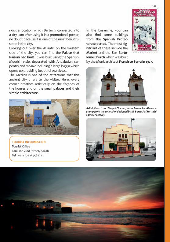
Asilah Church and Magali Cinema, in the Ensanche. Above, a stamp from the collection designed by M. Bertuchi (Bertuchi Family Archive).
In the Ensanche, you can also find some buildings from the Spanish Protec-torate period. The most sig-nificant of these include the Market and the San Barto-lomé Church which was built by the Monk architect Francisco Serra in 1927.
TOURIST INFORMATIONTourist Office Tarik ibn Ziad Street, AsilahTel.: +212 (0) 23458722
riors, a location which Bertuchi converted into a city icon after using it in a promotional poster, no doubt because it is one of the most beautiful spots in the city.Looking out over the Atlantic on the western side of the city, you can find the Palace that Raisuni had built. It was built using the Spanish-Moorish style, decorated with Andalusian car-pentry and mosaic including a large loggia which opens up providing beautiful sea views. The Medina is one of the attractions that this ancient city offers to the visitor. Here, every corner breathes artistically on the façades of the houses and on the small palaces and their simple architecture.
146


TetouanThe Shape of History:
a Journey in Time

TetouanTetouan is called the White Dove by poets and the Daughter of Granada by those who are nostalgic. It is a city with an eloquent history in which it has received lots of privileges. It is located in a beauti-ful setting in the Yebel Dersa mountainside in the western part of the Rif territory. It has views of the Gorgues Mountains and is just 11 km from the sea, located next to the River Martil which served as a communication route for centuries due to its navigable waters, something which brought the city as much fortune as misfortune. In this city, history takes form and speaks through architec-ture, telling us that there was an Andalusian past of legendary value which can be heard, tasted, seen, lived in and lived. It also talks of the Otto-man influence, which casts its spell of one thou-sand and one nights. It tells us about the presence of a modern western world that today is historic, which left a new city with refined examples of fashion from the first half of the 20th century.
The sum of these different historical influences makes Tetouan a seductive city, a city which has the power to bewitch the visitor and make them fall in love. It has had this effect on many people over the course of time, including the artist Mariano Bertuchi, to who it owes the safeguarding and recuperation of most part of its historical identity.
When the Muslims took the city, they gave it to a one-eyed Countess who came to the city every week to collect taxes; due this fact, the city was called Tetteguin, which in African (Tamazight) means eye, as she only had one of them.
Leo Africanus.
Travelling to Tetouan is like travelling back in time. You can relive each and every one of its different periods in history by walking through the Medina and the Ensanche. However, the mo-dernity and love for art, music and culture is also evident, as it is now an art and cultural epicenter that is continually developing.
HistoryThe first signs of the history of Tetouan can be found in the Roman city of Tamuda, 2 km from the current city. Until the 11th century there was no mention of the current location. At this time, the Andalusian geographer Abu Ubayd al-Bakri talked about a Berber settlement called Tittawin, an Amazigh term which means the fountains, in refer-ral to the groundwater that runs beneath the city.
You can reach
Tetouan from Larache
on the A1 motorway – R417 road
– N2 road, it’s approximately 110
km or by following directions
to Tangier on the A1 motorway
and A4 – N2 road, approximately
137 km.
149

At this location, halfway through the 12th century, the Sufi Andalusian Sidi Abd al-Qadir Tabbin found-ed a first fortified Tetouan whose Kasbah was built by the Marinid Sultan Abu Yussuf Ya’qub in 1286. It was converted into a defensive stronghold against the Portuguese who regularly attacked the coast. The river port, located at the mouth of the River Martil, became a refuge for pirates. This was one of the reasons why it was continually attacked, be-ing completely destroyed and abandoned after the Portuguese offensive in 1437.
It was in 1484 when a new period started in the city at the hands of Abu al-Hassan al-Mandari, an Official in Boabdil’s army, the last Nasrid Sultan from Granada. Al-Mandari founded the city of Tetouan for the second time. It became heir to Granada, receiving a large section of the Andalusian population in exile after the fall of Al-Andalus. After the al-Mandari period, the legendary Sayyida al-Hurra period soon followed. Aisha was the daughter of the founder of Chaouen and married
to al-Mandari’s grandson. She governed the cities of Chaouen and Tetouan as a free woman between 1537 and 1542. One of the stories during her reign includes her alliance to the Berber pirate Jayr al-Din, known as Red Beard, in the fight against the Portuguese and Spanish. From the 17th century on-wards and under the gov-ernance of the Andalusian family al-Naqsis (1597-1672), Tetouan gained importance in Europe as a commercial Port. It also became the diplomatic capital after various European Consu-lates were set up here. During this period of splen-dor and openness, the city became very much influ-enced by Ottoman decoration. In the 17th century, the city found itself under western influence, under the rule of families such as al-Rifi and Luqash. The city became too small and the city wall was extend-ed with the addition of new districts, palaces and mosques. However, following this glorious phase came a bitter 19th century full of plagues and hun-ger, coming to a close with the Spanish-Moroccan war in 1859 and the Spanish occupation of the city for two years (1860-1862). The 20th century gave way to modernity. Tetouan became capital of the Spanish Protectorate be-tween 1913 and 1956. A new Tetouan was added to the old: the Ensanche was built outside the walls of the Medina and with it came new ways of life. It became a fashionable city, a cultural, diplomatic and political centre, whilst at the same time the Medina walls preserved an unchanged, buzzing and wise old historic centre. After independence in 1956, the mass exodus from the countryside to the city resulted in rapid growth, with the creation of many new districts around the historic centre. Tetouan combines historic and architectural richness with a cultural, educational, touristic and commercial reality.
The Medina in Tetouan, al-Fuqui Souk. In the background, the minaret of the Sidi al-Hach Ali Baraca Zaouia. Watercolour by M. Bertuchi. (Bertuchi Family Archive).
In the background, the Harraquía Zaouia, taken from the Bab Maqabar Gate. (Source: Domingo Outón).
150

Post
er d
esig
ned
by M
. Ber
tuch
i. (B
ertu
chi F
amily
Arc
hive
).
Medina and Ensanche are two ways of under-standing the city which in turn leads to two ways of reflecting on them. They are completely different, complete contrasts of one another. This difference can be seen in their shape, sprit, body and soul. They are two parallel worlds that over the course of history have connected together perfectly.
The Medina, Andalusian and Islamic in its concep-tion, is a crowded space where the importance of private property and land is prioritised over that of public property. The evolution and creation of the public spaces depends on the relocation of the private land. It starts with the house, and then comes the block and then the labyrinth that is the rest of the Medina. Public spaces crop up between the different constructions which are then used as the focus of public life, the Souks It is architecture without an architect, functional and organic in con-ception and with an unexpected design.
The Ensanche is of European or western con-ception. It is created in an empty space, prior-itising public space but always seeking to improve private areas as well. The streets and the squares determine its outline and it is the result of a pre-vious planning process. Its architecture has a name and style from a period in history.
The Ensanche and the Medina in Tetouan are fused together in certain places sharing communal areas where people live together. However, as in some sort of architectural paradox, we are transported from one century to another by simply passing through a Gate.
Medina versus Ensanche
The founder of Tetouan Abu al-Hassan Ali al-Mandari al-Andalusi al-Garnati was from the Al-bencerrage family. He was born in Granada and was a member of Boabdil’s Court. He arrived with a group of nobles who were running from the im-minent fall of the Nasrid Dynasty. They promptly created a city giving it an appearance similar to that of his birthplace, Granada and of the Palace in which they lived, the Alhambra. Such is the Medina in Tetouan, an Andalusian Medina with a Nasrid Kasbah and Moorish districts such as al-Ayún and Tranqat. The inherited customs are reflected in the architecture with its courtyard
Itinerary: The Medina
Medina in green, Ensanche in brown.
151

houses, mosques, ovens, baths, and fountains; in the local crafts which are distributed accord-ing to profession in different streets and souks; in the culture and art, and in the surnames such as Lucas, Torres, García, Sordo, Medina, Aragón. However, in front of the squared Andalusian minarets and blind arches, the octagonal shaped minarets rise high representing the welcomed Ottoman influence from the 18th century, cov-ering the buildings with profuse ornamentation and new decorative motifs.
Main veins and arteries run through the city, starting at the heart of the Medina (the Kas-bah). They generate different spaces which are used as meeting points, randomly branching out into smaller streets, all of which hide a different rhythm of life: the rhythm of privacy, with streets that often end in allures that are used as private hallways. It gives off the impression of a shape that has been completely carved out, a shape which surprisingly leaves some open spaces creating an architectural sculpture that does not have an author or owner. In this sculpture, the rhythm of life beats from dawn till dusk, with its population multiplying during the day with numerous foreign visitors. From the moment that these visitors come through the gates, they become a vital part of the Medina.
A door with Andalusian ironwork and zelligh (al-zulayj or tile).
All of this is contained within the walls of the Medina. Standing in front of these walls, you may ask yourself: What is on the other side? What mysteries is it hiding? What treasures is it protect-ing? Who do they belong to? It is then when the invisible city calls us and begins to tell us its his-tory through its architecture, urban planning and decoration which, without a doubt, is al-ways full of colour.
Tetouan is the whiteness of the limestone, the silver and black of the ironwork and the green and brown of the wood. Tetouan is the colour of the Andalusian zelligh and of the Ottoman decoration. Tetouan is also the colours of the Souk, the Jebala hat, the silk and slippers, the woodwork and of Bertuchi’s paintings.
Wat
erco
lour
by
M. B
ertu
chi. (
Bert
uchi
Fam
ily A
rchi
ve).
152

Itinerary: The MedinaDeclared a UNESCO World Heritage Site in 1997.
1 Suq aL-Hut aL-qadim Sidi al-Mandari Kasbah · Mexuar Gate · Kasbah, Mosque and Baths2 USAA SQUARE Casino · Sidi Abbás Sabtí Zaouia3 GaRSa KebiRa (GueRSa KebiRa) Luqash Mosque and Madrasa4 aL-Fuqui SouK Sidi Ali Baraqa Mosque and Zaouia5 bab aL-maqabaR Harrakía Zaouia · Bab al-Maqabar · Muslim Cemetery · Jewish Cemetery · Tanneries6 bLad diStRict Sidi Ibn Raisuni Zaouia · al-Rabta and Ibn Salaha Mosques7 bLad diStRict: Next to tHe GReat moSque Great Mosque · Museum of Nationalism and Resistance8 Sidi Saida Sidi Saidi Zaouia · Bab Saida · Hamsaidi9 bab oKLa Bab Okla · al-Maamura Mosque · School of Arts and Crafts · Ethnographic Museum · Bab al-Okla Mesdaa and Saqiya Fawqiya Streets10 meLLaH Luneta Street
The Squndo water is a drinking water supply system which comes from the underwater springs that can be found between Bab al-Maqabar and Bab Nauder. This sys-tem was set up in Tetouan during its founding years and was steadily extended in accordance to the growth of the city. The etymology of the word squndo is unknown. It doesn’t seem to come from the Arabic language. It could be a derivative of the surname Segundo, a family that were in charge of the system for many years. It could also come from the word Escondidas (hidden), as the system was hidden below the ground or from the word Segunda (second) due to the fact that after the installation of the new system in the 20th century, the old system was no longer used (e.g. second-rate). (Bab Okla Fountain. Oil painting by M. Bertuchi. Bertuchi Family Archive).
C
Bab Nauder
Bab Tut
AL-AYUN
TRANQAT

C
CC
C
C
C
C
C
C
C
C
C
CC
C
C CC
C
1
23
4
5
5
6
7
8
9
10
10
Bab Remuz
Bab Okla
Ethnographic M
useum
School of Arts and Crafts
MELLAH
Tarrafin
Saidi Artistic Centre
Bab Sidi Saida
Bab JiafMuslim Cemetery
Jewish Cemetery
Tombs
TRANQAT
Bab al-Maqabar
Tanneries
Kasbah
Feddan Square
BLAD
SUIQA
ROYAL
PALACE
Luneta
Bab Riwah

1. Suq al-Hut al-Qadim
From Feddan Square, we head into the Medina through the Bab Riwah or Gate of the Winds, located in the southeastern corner of the square. Our journey starts on Hayy Ahmed Torres Street or Tarrafín, a name that refers to the shoemak-er’s trade union. The Shoemakers used to line this street and were in their vast majority of Jew-ish origin. It is a very busy thoroughfare because it connects the new city (Ensanche) with the Medina, hence its commercial character. Turning left, you will find Kasdarin Street, the old boiler works, which opens up into an area called Suq al-Hut al-Qadi which used to be an old Souk which sold fish.
Al-Mandari’s Kasbah gives this area a medieval feeling with the Kasbah itself dating back to 1484, when the city was founded for the second time. Both the stretch of wall and the polygonal tower are beautiful, perhaps inspired by late Gothic-Mu-déjar shapes. The tower is finished off with jagged battlements, a decorative detail that will become recurrent in subsequent Maghreb architecture.
Passing underneath the city wall through the at-tractive pointed horseshoe arches of the Mexuar Gate, you arrive at the old part of the Medina and
One of the most attractive things about Suq al-Hut are the colours of the street vendors and small businesses: the clay colour of the pottery, the mosaic of colours of the pharmacy and the fotas, a typical fabric used by the mountain women that was usually red and white.
...Al-Mandari is responsible for having rebuilt Tetouan and for loving this area, rebuilding walls and ordering the construc-tion of an extremely strong castle enclosed by moats.
Leo Africanus.
what was the original city centre. Its name refers to the courtroom where al-Mandari served justice. Here you Hill find the Yamáa al-Qasba Mosque which belonged to the Kasbah. It is the oldest mosque in the city, although it was rebuilt in the 17th and 18th centuries. Next to the gate of the Mosque you can find what used to be the house of the founder of the city. It is connected to the mosque inside the house and still contains the family bath which used to use groundwater and, like most baths in the city, was placed on top of a furnace for heating.
Near the area surrounding the Kasbah you can find a beautiful and quiet space known as Bugan-villa Square or Usaa Square, a place for which Mariano Bertuchi had a soft spot. He painted
2. Usaa Square
155

it on various occasions and in his paintings you can appreciate the interventions of the students from the School of Arts and Crafts. The fountain with its tiles is one of the improvements that has been made in the Square. Next to the fountain you will find the Sidi Abbás Sabtí Zaouia. The square appears out of nowhere when you head from the Garsa Kebira Souk to the Great Mosque. Not very far from this square are two other squares: Nogal Square (tarbiat al-Yawza) and Jazmin Square (tarbiat al-Yasmina). Traditiona-lly, the wide streets and these small urban spaces used to have plants and trees and were covered by vines to provide shade in the summer months.
In this oil painting, Mariano Bertuchi reflects the in-tense daily activity in Usaá Square. As well as being used as a passageway to reach other parts of the city, Bertuchi shows in the painting that the cafe in the square managed to retain some of the passersby (to the right). On the left, the first Casino in Tetouan is portrayed, a casino understood as a place where peo-ple would meet to have coffee or tea. It was also the place used to resolve neighbourly disputes. It was in this Casino that the idea to build an orphanage came about in 1931, which was located in the police station on the opposite side of the square. The Casino is still open. (Bertuchi Family Archive).
3. Garsa Kebira (Guersa Kebira)
You can reach Guersa Kebira from Kasdarin Street or by wandering through smaller streets from Uxaa Square. The Mexuar Gate connects Guersa Kebira with the kaus es-Sfaniya (an arch named after the people who made fried dough balls). It is one of the Gates from the original Kasbah. The name Garsa Kebira makes reference to the large vegetable garden that once occupied this space, property of the Awlas Dulayman (Ulad Sliman) family. It became a meeting point in the city where diverse economic activities took place. The oil and meat Souks used to be held here and there were various shops that sold and still sell musical instru-
ments, art, decorative objects, antiques, furniture and other odds and ends. The square was also used for auctions, in fact, you can still see the odd auctioneer (dallal) attempting to get people to bid.
It’s a very picturesque square with tradi-tional small Tetuani cafés, the Rahba al-Zayat Funduq and the Luqash mosque on its western side, all of which are watched over by the Sidi al-Mandari Kas-bah.
View of the Sidi al-Mandari Kasbah from Garsa Kebira.Oil painting by M. Bertuchi (Bertuchi Family Archive).
156

Luqash is the surname of the family that founded the Mosque, governors of the city during the 18th century, originally from Andalusia. It dates back to the middle of the 18th century and was designed as a religious space, Madrasa and residence for stu-dents. The patio in the madrasa is interesting as it has the shape of a cruciform. In the mosque, the minaret is reminiscent of the aesthetical style of the Moorish minarets, far from the Ottoman influence that was al-ready present during this century. Currently, it is not in use. You can access the mosque from Muqaddam Street (M’Kadem) which is behind Garsa Kebira.
The Garsa Kebira Souk with the Madrasa and Luqash Mosque in the background. At first thing in the mor-ning, whilst the Souk is still asleep, you can see the typical businesses that are closed at this time. They are workspaces that are raised off of the ground with green doors. When they open, they join together with other stalls, displaying their merchandise, completely covering the walls behind. Bertuchi portrays the squa-re during a busy period. Along with the regular busi-nesses you can also see the street vendor stalls.
You can reach the al-Fuqui Souk by going up muqaddam Street (m’Kadem). This street was opened in the 17th century and was given the name of a Tetuani Military Chief who was a member of the governing family, the Naqsis. Here you can find the entrance to the Lucas mosque and, in the first two alleys on the left, the Kataniya Zaouia and the Tiyaníya Zaouia. In the third alley on the left, called Chorfa Uazán, you will find some typical Andalu-sian style houses with a central patio. In the final stretch of the street you can find the Spice Souk, Suq al-Atariya, which opens up into the large space know as Suq al-Fuqui or Souk from Above, also known by the Spanish at that time as the Bread Souk. Although this part of the Medina is originally from the 16th century, it was re-habilitated in the middle of the 19th century. Here you can find all different types of materials, food and arts and crafts. From the square you can see the minarets of the Mosque, and the Zaouia of the writer Sidi al-Hayy Ali Baraca. We mustn’t forget the Arabic baths which date back to 1591 and the fountain which can be found next to the temples, representing the ablution that accompanies the act of prayer. It is a very busy square because it is the centre of the three main parts of the Medina: east-west-south. If you head towards the north, you will find the cemetery.
4. Al-Fuqui Souk
The brown and green doors stand out on the white-washed façades of the houses. The iron fittings tell us where their inhabitants come from. A Granada is displayed for those people from Granada. Another popular symbol used is the Hamsa or Hand of Fatima (yad Fatima). It is a pre-Islamic symbol whose origins could come from Carthage. It is used as a good luck charm against the evil eye and over time it has become a universal symbol that is used by many different religions. It was used by the Moors as a symbol for contraception.
Oil painting by M. Bertuchi (Bertuchi Family Archive).
157

Zaouia which was founded in 1835 by the Chauni Sheik Muhammad al-Harrak, a Sufism teacher, poet and expert in religious science. The original front of the gate was substituted at the beginning of the 20th century, giving it an unusual appearance.
On the other side of the gate, outside of the Medina, you can find the oldest Muslim Cemetery in the city. Here you can find the old tombs of the Moors and the al-Mandari Mausoleum. A bit fur-ther away, towards the northeast, you can find the tombs of the Mujahideen people from Granada who arrived with al-Mandari.
Sidi al-Hacyy Ali Baraka Mosque and Zaouia which date back to the 17th and 18th centuries respective-ly. These temples can be found close to one another and can be identified by their minarets. The mina-ret of the Zaouia is white, square in shape and has battlements. The minaret of the mosque has exposed
brickwork and tiling that was the result of the res-toration work carried out by the School of Arts and Crafts and Bertuchi. He used to walk through the Medina early in the morning, covering every stretch and identifying and repairing any defects that he could see. He would also add Andalusian decora-tion where he thought it was necessary.
Drawing by M. Bertuchi, Passage of the Baths or qaus al-Hammam. (Bertuchi Family Archive).
To the left of the al-Fuqui Souk there is an arch known as Passage of the Baths, which invites the visitor to pass through it and discover the western part of the Medina: the districts al-Ayun and Tranqat. It is the Moorish part of the city, an area that was created after the expulsion of the Moors and Sephardi Jews from Spain in 1609. Al-Ayun Street is the backbone of the district and connects the Passage of the Baths with the Nauder or Fes Gate. Ayun means from the spring, referring to the water from the River Squndo which ran underground from Bab Maqabar. The district has various Zaouias along with other buildings such as the M´Sendi and Sidi ibn Mas’ud al-Yuaidi Mosques, both dating back to the first half of the 17th century. This can be seen from the typical Moorish square-shaped minaret and the decoration on the blind arches. It is very common to see the doors of these temples being used as a backboard for the merchandise being sold by the street vendors. The Tranqat District also has a main street by the same name. It ends at Bab Tut or Mulberry Gate which forms part of the city wall.
Towards the northeast of the al-Fuqui Souk, the street is filled with local craftsmen, carpenters and leather workers, all the way up until you reach the northern Gate, Bab al-Maqabar.
Next to the gate, you will find the Harrakía
5. Bab al-Maqabar
Bab Maqabar or Cem-etery Gate. It belonged to the first walled area of Tet-ouan from the 16th centu-ry. It is the oldest Gate that is still around today and is a regular witness to the fu-neral ceremonies that pass through it on their way to the cemetery. Since 186o it has been known as Ceuta Gate or Bab Sabta. It no longer has the original bent entrance and its decoration has also changed.
Al-Mandari arrived with 300 cavalrymen, the best of Granada.
Leo Africanus.
158

Personified tombs in the Jewish Cemetery. (Malaga Provincial Ar-chive)
Next to the Muslim Cemetery, towards the east, you will find the Jewish Cemetery. It is particularly interesting due to its personified tombs which, together with those that can be found in the Cem-etery in Chaouen, are the only ones in this area of the Mediterranean. You can access the cemetery from the city’s other northern gate, Bab Jiaf, a name which refers to the Jewish, as it was only opened for funerals.
Muslim Cemetery next to Bab Maqabar. In the centre, the Sidi al-Mandari Mausoleum.
Next to the Bab Maqabar Gate, you can find the tanneries which have been here since the 16th century. Here the tanners or leather workers (dabaguin) and dyers (sabbaguin) worked on an elaborate process which is done outdoors in cir-cular pits made out of brick, and other square pits dug directly into the ground. All of the pits are con-nected by a system of channels which carry water from the Squndo. The raw material used is mainly
goat’s skin. The “L” shaped layout of the tanneries means that they can be accessed from the Maqabar Gate, making life easier for the people who supply the raw materials. It also allows for another access from inside the Medina, in Jarracín Street, the place where the leather Souk is held, thus helping them to distribute and sell their products. You can visit the tanneries during work hours, 08.00-19.00h.
6. Blad DistrictYou can reach the Blad district from Jarracín Street. It is the oldest district in the Medina and it grew next to the al-Mandari Kasbah within the first walled part of the city. Its name means the village and was the home of the Andalusian Muslims and the Sephardi Jews, occupying a large part of the Jewish quar-ter. At the beginning of the 19th century, the Jew-ish quarter was moved to the southern part of the Medina so that the Sultan Muley Sliman could build the Great Mosque. Many powerful families bought land in the area surrounding the Great Mosque and built their Palace Houses, maintaining the same structure and symbology as used in the Andalusian Courtyard Houses. However, the Ottoman and Eu-ropean influence was now clear and can be seen in the structural and decorative differences between the early Moorish constructions of the 16th, 17th and 18th centuries (such as M´Kadem Street), and those from the 19th and 20th centuries. Families with surnames such as Lebbady, Aragón, Ben Mufti, Lucas, Medina, Erzini, García and Bricha had houses in this area. Even to this day, some can be visited be-cause they are used as hotels, restaurants or spaces for special events. We can also find religious build-ings in this district such as the Sidi ibn Raisuni Zaouia and the al-Rabta and ibn Salah Mosques.
Animal skins that have been hung out to dry in the Tanneries.
159

In Siaguin Street, next to the Leb-bado Palace House, you can find the Sidi ibn Raisuni Zaouia which was built in 1837. It has a striking Octago-nal shaped mina-ret, influenced by the Hanfi Turkish which can also be seen in the decora-tion on the doors and interior areas.
Al-Rabta Mosque, next to the Seven Riots Alleyway, the narrowest in the Medina.
7. Blad District: next to the Great Mosque
The Great Mosque was founded in 1808 by the Sultan Muley Sulayman, a descendant of the Alaouite family that governed in Morocco between 1792 and 1822. It is the biggest mosque in the Medi-na and its square shaped minaret is also the tall-est. It is a study centre for religion, linguistics and law. All of its doors are decorated with an eastern influence.
On Metamar Street, just passed the Great Mosque, you can find the Benabud Family Palace House, from the end of the 19th and beginning of the 20th century. Today it houses the Museum of Nationalism and Resistance.
In Metamar Street (plural of matmura which means dungeon) you can find the entrance to the underground dungeons which al-Mandari had built, taking advantage of the natural net-work of underground cavities and galleries which formed beneath the city. It was here that the captive Christians were locked up. The prisoners were used to help build the city, to be sold into the slave trade or to claim money through ransoms. The dungeons also served as a place where people could leave their slaves for the night, a public service that was offered at the time. Unfortunately the dungeons cannot be visited. They were discovered through documentation
that belonged to the Franciscans who used to come down from the peninsular to pay ransoms. It was rediscovered in the 20th century through the studies of Gómez Moreno and the architectural plans made by Carlos Óvilo and Alfonso de Sierra Ochoa. They stopped being used during the Sultanate of Muley Sulayman in the 18th century.
Dungeons.(Malaga Provincial Archive).
Metamar Street.
160

The patio is the central part of the Andalusian house. It is around the patio that the galleries are divided into rooms. Due to the two different levels of the house, it is important to identify how many supports are being used in order to define its typology. The patio is the source of light, a fundamental element in these beautiful spaces. Furthermore, the light from the patio means that the rest of the building can be closed in, protecting the intimacy of the family life within. This stronghold of intimacy is at the same time a connection to the heavenly world, in the words of Antonio Muñoz Molina, the patio is a viewpoint and a shelter. From within the Andalusian Tetuani pa-tios, the residents looked at the same sky and shared the same moon as they did in the lost land, Al-Andalus. It served as an infinite connection ensuring the conti-nuity of one joint belief.
In the design of the new Palace House of the 19th and 20th centuries, these ideas are respected. However, modernity brings about some changes. New materials and structural solutions are introduced such as the use of metal beams, thus converting the arches into mere deco-rative elements. The patio is covered by a steel and glass structure which provides better comfort in the winter, without losing natural light. This addition also converts the patio into a living room, a new meeting point in the house and an extra area in which more decorative elements could be included, such as plastering, paintings and wood. As a matter of fact, the space is overloaded with decora-tion, drawing similarities with eastern styles.
Afailal House, end of the 19th century. Metamar Street.(Malaga Provincial Archive).
Continuing along Slokia de Sidi Saida Street in the northeastern part of the Medina, you will reach an area which is full of streets that are wider than normal. It is a relatively quiet area with few people and a more residential feel. If you head down the slope, you will reach the Sidi Saida Zaouia, name of the Patron Saint of the city in the 13th century.
8. Sidi Saida
In the background to the left, Bab Saida, in the background to the right, the minaret of the Sidi Saida Zaouia
Sidi Saida Zaouia. It is one of the most beautiful Zaouias in the city. Bertuchi painted it on numer-ous occasions and he even restored it. The Zaouia is not blocked by any other buildings and can be seen in its full splendor, including the Qubbas and the attractive varnished tiles on the minaret.
161

From Sidi Said to Bab Okla, the most direct route is along the lonely and quiet Chrichar Street
Next to the Zaouia is the Saida Gate (Bab). It was temporarily blocked off when the Spanish left in 1862. This was due to the superstition that the Spanish had brought the city bad luck during their occupation of Tetouan, a period in which it was called the San Fernando Gate. Today it connects the eastern part of the Medina with the new city.
Just in front of Bab Saida, outside of the Medina and in Darb Wazir Muhammad Saffar Street, you can find Hamsaida, an artistic and cultural centre which seeks to promote modern art from Morocco and the rest of the Arabic world. This centre, to-gether with the School of Arts and Crafts, the Eth-nographic Museum and the Museum of Modern Art, make the eastern perimeter of the Medina an exceptional route for art lovers.
Tiles on the minaret of the Sidi Saida Zaouia.
which runs parallel to the wall and is surrounded by in-accessible gardens. The other option is to go back to the Great Mosque and wander through the smaller streets towards the south, starting from Neki-ba Street.
Chrichar Street. Water-colour by M. Bertuchi
(Bertuchi FamilyArchive).
9. Bab Okla
Bab Okla. Oil painting by M. Bertuchi (Bertuchi Family Archive).
The area surrounding the Bab Okla Gate is a privi-leged one to say the least. Here, you can find the School of Arts and Crafts and the Ethnographic Museum. However, the street itself is also a sam-ple of Tetuani traditions and customs. It is one of the most entertaining areas of the Medina, with people constantly passing by and various differ-ent activities going on around you. On top of the crowds from the Souk you have to add the hoards of people crossing the Medina from the Ensanche to the eastern part of the new city, including stu-dents on their way to school, religious devotees
162

Interior detail of the Tetouan School of Arts and Crafts with woodwork and mosaic that were produced in the school itself. The school is located in front of Bab Okla Gate and was founded in 1919 with the in-tention of recuperating, main-taining and disseminating Tet-ouani artistic tradition as well as restoring the Medina along with its monuments, whilst respecting the purist style of the traditional shapes. From 1930 onwards, Mariano Ber-
tuchi was in charge of the School, taking over from José Gutiérrez Lescura. It has occupied the building since 1928 and was designed by the architect Carlos Óvilo. Inside the building you can find a villa with a pastoral garden-patio which is similar to those which can be found in Granada. It is worth visit-ing Tetouan just for its local craftsmanship which in-cludes carpentry, mosaics, fabrics, goldsmiths and a colourful variety of other local products which are all designed in the distinctive Andalusian-Tetuani style. The School is one of the biggest assets to the city.
Next to Bab Okla you can find the Ethnographic Museum which has been located at the old Fort Sqala since 1948. The Fort was built by the Sultan Mulay Abd al-Rahman ibn Hisham in 1830 and was rehabilitated by Bertuchi in order to convert it into a museum. The artifacts on show complete the vision on Tetuani craftsmanship that we began with the visit to the School of Arts and Crafts.
One of the most attractive, vibrant and colourful walks that you can go on in the city is along the following streets: bab al-okla - masdaa - Saqiya Fawquiya. This is a route that will take you from east to west in the southern part of the Medi-na, connecting the Bab Okla Gate with Tarrafín Street. Anything can happen in these streets that are full of food stalls selling meats, fish, fruit, vegetables, bread, dairy products, spices and legumes. All of these products are sold in bulk, pieces, crates, stacks or other types of contain-ers and measurements. You will also find Zaouias and Mosques on this route, along with the en-trance to the main street of the Suwaiqa District (Suika) or Street market.
Mornings: 09:00 h-12:00 hAfternoons: 14:30 h-18:00 h
Tardes: 14.30 h –18 :00 h.Closed: Saturdays and
Sundays.
The Bab Okla Gate is quite possibly the most painted corner of Tetouan. This could be due to the fact that Bertuchi’s school was located just op-posite. It was the location of his studio and where he spent a lot of his time. The Gate is from the 19th century and has a very robust and military appearance. It is built on a slope and has an upper masriya, the place where the guard would stand. The exterior façade is staggered, imitating the Al-mohad and Marinid Gates. It is known as the Gate of the Wise and Sea Gate (as it provided access to the road that led to Martil). However, it is usually called Queen’s Gate, a name that it received from the surveillance carried out by the soldiers of Isabel II during the Spanish occupation in 1860.
that have been going to the Al-Maamura Mosque since the 18th century and tourists on their way to the Medina through the Bab Okla Gate.
163

The main street that accesses the Jewish Quarter is the one that runs parallel to Bab Ruah leading into Feddan Square, a street where dry fruit was traditionally sold. They started to build the Mellah or Jewish Quarter back in 1807, following the destruction of the old Jewish Quarter in the Blad district (mellah el-Bali) in 1790 by Muley Yazid. They moved it to this area in order to avoid confrontation and because it was ordered by the Sultan Mulay Sulayman. It was built on land that was previously occupied by a few vegetable gardens and the Musallah, an area that was used as a place of worship by many. The streets in this area are very strange as they form a maze like pattern. This was intentional
Suika is a district located in the southeast of the Medina and to the east of the old Jewish Quarter. The streets in this district lead you down to the perimeter wall and to the (Bab) Remuz Gate which faces the Gorgues Mountains. The gate is also known as Bannana Gate or Luneta Gate. This is due to the construction of a Luneta (Spanish for a small Fort including bastion) next to the Gate in 1862. The street that heads up from Bab Remuz to Feddan (located in the west of the Mellah) is also called Luneta Street. These are the only two streets that lead to the Jewish quarter.(M. Bertuchi Watercolour. Family Bertuchi Archive).
10. Mellah
The street that heads from north to south in the Mellah. It is full of businesses that deal with the preparation of silk garments.
In 1889 the Jewish began the construction of Luneta Street, adapting it to the perimeter of the Jewish quarter inside the city walls. It was given a distinct European touch. They were interrupted by the military interventions of the first decade of the 20th century. It is the last place you pass through before leaving the Medina and forms the entrance to the modern city. A change in lifestyles is even evident in the street, from the Reina Victoria Theatre to various typically Islamic institutions such as the Lebbadi (al-Abbadi) Funduq, where the traders visiting the Souk were offered accommodation and a place to keep their merchandise and animals.
and was done in order to protect the Jewish from possible raids that they suffered at this time. All of the streets are straight including three main streets that head in the direction north-south. Various per-pendicular streets branch out of these streets form-ing a kind of grid pattern which, in theory, should be easy to navigate. However, not all of the streets join together, meaning that many lead to dead end alleyways and allures. Of the many Synagogues that were located in this district (called the Small Jerusalem due to the large Jewish population) was the Rabbi Isaac Bengualid Synagogue. It still exists today and from the out-side looks just like any other house in the Mellah. However, it has a courtroom, a library, an oven to bake the biscuits that were used during religious ceremonies, a space to produce wine and a bath to purify the women. Although very few Jewish people remain in the
area, the textile activity is still quite active and is now carried out by Mus-lims who prepare the silk, spin it, sow it, and prepare the embroidery and garments. They can be found in work-shops, haberdasheries and tailors, a symphony of colours and movement that brightens up these dark streets.
164

6
Itinerary: Ensanche
6
11
Varela Apartment Block
Old Delegation of Local Affairs
Hassan II Mosque
9 Avril SquAre
Al-ADAlA SquAre
ENSANCHE MEDINA DIALOGUE1. FeDÁN SquAre Northern Atrium • Sidi Abd Allah al-Hayy Mosque • Sidi ibn Aissa Zaouia 2. Al-YAlAA SquAre ARCHEOLOGICAL MUSEUM • Unión y el Fénix Building • Building at the entrance of Mohamed V Ave. THE HEART OF THE ENSANCHE3. MOHAMeD v Ave. OldOfficialsCasino• Benarroch Passage • Mariano Bertuchi’s House • Old Jewish Casino • OldOfficesoftheSpanishNationalRadio•4. MulAY Al-MAHDi SquAre PostOfficeHeadquarters• ApartmentBlockaboveCaféParís• SalomónBenadalApartmentBlock• BuildingofSmallDomes• Ntra. Sra. de las Victorias Church5. SiDi Al-MANDri - AlJAZAer - YuSeF iBN TACHFiNe Building on the corner of Mohamed V with Sidi al-Mandri• OfficeoftheBankofMorocco• MedicalDispensary• PostOffice6. AL-ADALA SQUARE Avenida Cinema • WesternpartofMohamedVAve.7. MOHAMeD BeN ArBi TOrreS STreeT Tiled building8. MOHAMeD Al-KHATiB Ave. OldSpanish-ArabicSchool• OfficesoftheCervantesInstitute• EspañolTheatre• La Equitativa9. r´KAiNA BArrACKS AND CeNTrAl MArKeT10. PeriMiTer AreA: HASSAN i Ave. Train Station • Sewage Plant • Housing for Civil Servants • Cagigas Gardens • SidiAbdelkaderTibbinMarabout• Borj al-Hafa and Walls11. CHurCH AND MiliTArY HOSPiTAl
Tine Av.
Oil painting byM. Bertuchi from 1950. Fantasy (Bullfight on the sand)fromaBedouintent.(TetouanCentreofModernArt).

10
7
1
234
5
5
8
9
Archeological Museum
Central Market
R’KainaBarracks
Paseo hacia los Jardines Ca-gigas, Estación de ferrocarril, torre depuradora, viviendas, murallas, morabito, etc.
10
Bab remuz
Cagigas Gardens
Train Station
Sewage PlantHousing
Marabout
Borj al-Hafa
Bab Okla
School of Arts and Crafts
R’KainaBarracks
Central Market
eNSANCHe MeDiNA
BAB riWAH
MellAH
MulAY Al-MAHDi SquAre
FeDÁN SquAre
10
7
Español Theatre
Oil painting byM. Bertuchi from 1950. Fantasy (Bullfight on the sand)fromaBedouintent.(TetouanCentreofModernArt).

The Ensanche (City Extension)After the Treaty between France and Spain in 1912, the Spanish Protectorate territory was established. One year later, Tetouan was named military and administrative capital of the area and remained so until Moroccan independence in 1956. During this period, a new part of the city was devel-oped called the ensanche español (Spanish City Extension). It is located right next to the Medina and is a modern urban area which has architecture typical of any European capital. Various administra-tive, military and political buildings were also built here. In this part of the city, the western way of life was combined with traditional Tetouani cus-toms. Life in Tetouan became cosmopolitan and fashionable. It was a place to go shopping and discover the latest European trends. It also had a variety of cultural and artistic attractions including various theatres and cinemas. An array of institu-
tions were created such as the Fine Arts Prepara-tory School, the School of Music, the School of indigenous Art, Museums, Cultural Centres and the Tetouan Archive. Tetouan also had a variety of daily newspapers and a football team, Tetouan Athletic, which reached the Spanish first Division. Getting together with friends for a chat and spend-ing time out and about is a fundamental element in both the Spanish and Moroccan cultures. The En-sanche catered for this need with a variety of casi-nos, cafés and open areas such as españa Square, the Cagigas Gardens or Alfonso Xiii Square.
NacionalHotel,aplacewheremanyartisticeventswereheld.In1953,aneventwasheldasatributetotheNobelPrizewinnerforLiterature at the time, Vicente Aleixandre. It was attended by dif-ferentwritersandpoets.
The logo of the newspaper Diario deÁfrica,1948,editedinTetouan for the terri-tories that were under the Spanish Protec-torate (Above). TheCremades bookshopin Tetouan, located in Mohamed Torres Street,1947.(Right).
By 1913, the Urban Plan for the Ensanche had al-ready been approved. The project was designed by the military engineer rafael Fernández and by the architect Carlos Óvilo. They occupied 30 hectares with almost all of the land belonging to the Jewish middle class. The location of the Ensanche was decided by taking into account the military barracks that had been built a few years beforehand and possible future access routes to the Medina. Finally, the western perim-eter was chosen. It was designed based on the Grid Plan, a series of rectangular and trapezium shaped blocks that were joined together to form a grid. Mohamed V Avenue is the main street that passes through the Ensanche from east to west,
Market. A buildingwas constructed in 1916 close to EspañaSquare which would be the location for the Market and asquare with a garden called Alfonso XIII. At the beginning of the 40s, the architect Casto Fernández Shaw demolishedthe building, removed the gardens and built a new block.(CollectionofPostcardseditedbyCremades).
167

connecting the Medina (in the east) to the main square, and continuing towards the west. In the Ensanche, various buildings were constructed for the Spanish and Tetouani middle class. From the 30s onwards, chalets were built for the upper middle class along las Palmeras Avenue, today called Hassan ii. Meanwhile, in 1936, José Miguel de la Quadra Salcedo was preparing a new ex-tension of the Ensanche towards the southeast, which would be called the Sefaha ensanche. In the 40s, a lack of space and means led to the con-struction of apartment buildings for the working class, such as the varela blocks, on the edge of the Ensanche. In parallel to this planned growth, other areas were growing in an uncontrolled and anarchic way. People who were not so well off, including Christians and Muslims, started to set-tle here. An example of one of these areas can be seen in the Malaga district, in the north of the Ensanche.
it took approximately 40 years to build this new and beautiful city, a beauty which is even more evident as the years go by. it is an example of the Spanish period in Morocco which has been fossilised in time, like a stage set or a photograph,
Architecture with a nameThe architecture of the Ensanche is a synthesis of traditional and modern styles which offer mixed solutions that are sometimes eclectic or histori-cist. Modern European tendencies, such as Art Deco and rationalism, are mixed with others such as Spanish regionalism and Officialist style architecture. As a distinctive mark, the Neo-Ara-bic style is also applied, the best example of the adaptation to the new environment.
Tetouan became a paradise for architects: great-er freedom of expression and experimentation, and a new challenge: the formal adaptation of a territory whose future was undecided and a city that was growing out of nowhere.
Neo-Arabic style. The new arrivals could see a re-semblance between the culture and shapes that they found in the Medina, with the Andalusian art from the peninsular. They understood that these models could be applied in the new build-ings, thus respecting the aesthetic of the Medi-na. The architectural heritage in Tetouan was a source of inspiration, as was Caliphal Andalusian, Almohad and Nasrid architecture. At the begin-ning of the 30s, these styles were used less and less, although they can still be found in the archi-tecture from the Spanish Protectorate period. As far as the european tendencies were con-
BarracksoftheRegulares,locatednexttotheAdivesKas-bahinthenorthwestoftheMedina.ThemilitarybarrackswereoneofthefirstconstructionsoutsideofthecitywallsandwerebuiltnexttotheGatesoftheMedina,respectingthehistoricpathwaysandroadswhichlaterbecamethemain avenues in the Ensanche. Although there were urban planninglawswhichprotectedtheMedinasandtheirbuil-dings,thefirstmilitaryconstructionsextendedoverthecitywalls,knockingsomestretchesofitdown.
displaying the architectural possibilities of the first half of the 20th century. It is a place which reflects the spirit of the Protectorate and the trends of the period.
Mohamed Torres Street. (CollectionofPostcardseditedbyCremades,40s).
168

Ensanche - Medina Dialoguecerned, Modernism became popular from 1910 to 1920 with its sinuous lines and decoration in the form of flowers and wreaths. In the 20s, Art Deco arrived and continued into the 30s with its geometric lines that play with form and decora-tion. Rationalism, although present since the 20s, imposed itself with its pure shapes, curved corners and the removal of any decoration that wasn’t structural. A rationalism that sometimes was Art Deco, sometimes Arabic and which in the 50s became the expression of modernity.
During the 40s, Officialist style architecture was used in the Ensanche, a style that was promoted during the Franco Regime in Spain. With the Mu-guruza Plan in 1943, the Neo-Baroque and Neo-Herrerian styles were used. These styles includ-ed the use of Classical architecture with a solid appearance. This involved the use of bossage, contrasting dark and white stone and, as a dis-tinctive element, the use of commercial galler-ies in the lower parts of the buildings. In contrast to the architecture in the Medina, this is architecture with a name: in the 20s both Carlos Óvilo Castelo and José Gutiérrez Lescura stand out; in the 30s, Manuel Latorre and José Larruce; between the 30s and 40s, Miguel de La Quadra Salcedo, Francisco Herranz; in the 40s, Pedro Muguruza, Juan Arrete or the unique Cas-to Fernández Shaw who had a very personal way of designing; and between the 40s and 50s, Julio de Castro, José María Bustinduy and Alfonso de Sierra Ochoa.
1. Feddan Square
The Machouar, Fedán Square, Palacio Square, españa Square and currently, Hassan ii Square. This urban space has had many different names as well as many different appearances. It was origi-nally agricultural land that belonged to the Lucas family from Andalusia. Later, it was used as an area where animals were slaughtered, a Souk (for three days a week) and a place where religious celebra-tions were held. During the Spanish Protectorate period it became a square, and some gardens were added which resembled those of the Alhambra in Granada. The High Commission and the Caliph Mu-ley al-Mahdi Palace were also built on top of what used to be the old Bajás Palace. After the independ-ence of Morocco, it became the Spanish Consulate and finally the Royal Palace. It was at this moment that it acquired its current appearance and was pri-vatised. Access was restricted for security reasons and limited to the perimeter area, allowing local residents to access the Medina or other parts of the city. On the southern side of square, you can find the Gate of the Winds or Bab ruahm, which connects the Ensanche to the Medina and Tarrafin Street. Here, the Mellah or Jewish Quarter begins, an area that is full of street vendor stalls and that witnesses a constant flow of people going in and out of the Medina.
This square allows a dialogue to take place be-tween the Medina and the Ensanche: symbolically,
In contrast to cement rendering, plaster, sgraffito, exposed bricks and tiling that was used during the first few decades of the 20th century, the local law from 1930 ordered more sim-plicity in the exterior walls of the buildings and for them to be painted white. Building designed by Carlos Óvilo in 1927, Yusef Ibn Tachfine Street.
169

Ensanche - Medina Dialoguebecause it has always been an extension of the Medina, and functionally, because it was adjoined to the city walls and represented the beginning of the Ensanche’s new road network, leading onto the main Avenue. In order to improve the connec-tion between the two parts of the city, a stretch of the city wall between Bab Tut and Bab Remuz was demolished. As a consequence, districts such as al-Ayun, Tranqat, Mellah and Tarrafín Street were directly connected to the Square.
OldEspañaSquare,todayHassanIISquare. In 1929, the architectJoséGutiérrezLescuraandtheartist Mariano Bertuchi transformed this space into a gardened square with a Neo-Nasrid pavilion. The pavilion was covered in a distinctive green fab-ric and had Tetouan style tiling on the pillars, dif-ferent from the Fes style tiling that was used on the banks. The square was decorated with artistic lampposts and the floor was designed in a tapes-try style using stones and tiles. Both personalities were extremely sensitive and took on the role of Director at the School of Arts and Crafts. They overfilled the square with colour and converted it into an attractive space. Tactics were used on a dai-ly basis to bring the people to the square. People used to go here to simply spend the day, however, at weekends different orchestras played music and there were also kiosks that sold drinks. It was the place used to celebrate local and religious festivals.
SmallCaféoppositetheSidiAbdelllahal-HachMosque, on the northern side of the FeddánSquare. The northern side of the square still re-tains the local charm and the love of socialising, a ritual which often takes place in one of the many small cafés that can be found here. These small cafés, portrayed by Mariano Bertuchi, are an ex-
In the dense atmosphere of dark cafésthe men watch the morning pass by
with a sense of boredom and sweet indifference.
Ricardo J. Barceló. (Medina of dreams)
ample of an intermediate pace of life between the Medina and the Ensanche. Bertuchi supported the protection and declaration of buildings as monuments whilst at the same time promoting the creation of cafés in the Medina that would attract tourists. He understood that tourism was another way of further increasing the value of the architectural and cultural heritage of the city.Behind the façades of the northern part of the square, you can find the Mexuar and Tranqat Districts of the Medina. Here, the Sidi Ben Abdellah al-Hach Zaouia from the 18th century is a highlight. It stands out from the white surroundings with its minaret made of exposed brick, and is locked in a constant struggle with nearby Palm trees to see who is tallest. During the Spanish occupation in 1860 and the first years of the Protectorate, this Mosque was used as a Catholic temple. The Sidi ibn Aissa Zaouia, located on the western side, was used as a post and telegraph office. The floor of the northern side is elevated as a kind of atrium to the rest of the square, allowing you to sit at one of the cafés and contemplate the big open sun-filled space that separates you from the hustle and bustle of the southern side of the square. This side of the square goes by unnoticed, almost hidden from the rest of the city. (Oil painting by M. Bertuchi from 1947. The young and short Palm Trees. Bertuchi Family Archive).
170

2. Al-Yalaa Square
This square can be found between Fedán Square and Mohamed V Avenue. It is yet another exam-ple of a public space that connects two worlds. Whilst it does have more of a taste of the En-sanche, we can still find a narrow covered street that takes us into the hearts of the Tranqat dis-trict and to the Muley Abdelkader Zaouia. The minaret of the Zaouia and the tiles that decorate it, were a result of the work carried out by Ber-tuchi and his school. Furthermore, this square gives us a journey in time through the Archeo-logical Museum, an essential visit for history lov-ers with treasures from all of the ancient cities in northern Morocco, covering prehistoric times up until the 16th century. The 20th century provides us with exemplary architecture with the unión y el Fénix building and the beginning stretch of
Tetouan Archeological Museum Visiting times: 9h –12h. / 14.30h –18h.
Closed: Saturdays and Sundays.
Mohamed v Avenue, where the architect Car-los Carlos Óvilo designed two circular building façades.
Unión y El Fénix Building. This building was designed in 1945 by the architect F. CánovasdelCastillo and is located in the same block as the gar-den designed by Bertuchi and Lescura. It is both a sober and eclectic building. Its appearance and architectural features, such as the arcade which runs along the ground floor, are in line with the Of-ficialist architecture from Francoist Spain. Within its monumental character, we can highlight the central tower, an element which has been clearly influenced by the architect C. Fernández Shaw, and that contains the sculptured emblem of the insurance company La Unión y El Fénix Español (Union and the Spanish Phoenix). The emblem was sculpted by Saint-Marceau and dates back to 1911. It is a very common feature in Spanish cities and is always perched on top of a building.
Buildingfrom1916byCarlosÓvilo. The glazed balcony stands out on this building which includes a wealth of modernist touches. Its circular shape
FeddánSquare.CelebrationoftheFeastoftheSacrifice(Aidal-Kebir).ParadeoftheGuards infrontoftheCaliph,pro-tectedwithasunshade,oppositetheSidiibnAissaZaouia.OilpaintingbyM.Bertuchi(BertuchiFamilyArchive).
171
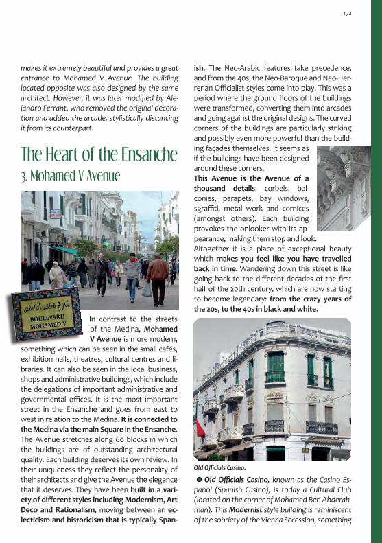
3. Mohamed V Avenue
makes it extremely beautiful and provides a great entrance to Mohamed V Avenue. The building located opposite was also designed by the same architect. However, it was later modified by Ale-jandro Ferrant, who removed the original decora-tion and added the arcade, stylistically distancing it from its counterpart.
The Heart of the Ensanche
In contrast to the streets of the Medina, Mohamed v Avenue is more modern,
something which can be seen in the small cafés, exhibition halls, theatres, cultural centres and li-braries. It can also be seen in the local business, shops and administrative buildings, which include the delegations of important administrative and governmental offices. It is the most important street in the Ensanche and goes from east to west in relation to the Medina. it is connected to the Medina via the main Square in the ensanche. The Avenue stretches along 60 blocks in which the buildings are of outstanding architectural quality. Each building deserves its own review. In their uniqueness they reflect the personality of their architects and give the Avenue the elegance that it deserves. They have been built in a vari-ety of different styles including Modernism, Art Deco and rationalism, moving between an ec-lecticism and historicism that is typically Span-
ish. The Neo-Arabic features take precedence, and from the 40s, the Neo-Baroque and Neo-Her-rerian Officialist styles come into play. This was a period where the ground floors of the buildings were transformed, converting them into arcades and going against the original designs. The curved corners of the buildings are particularly striking and possibly even more powerful than the build-ing façades themselves. It seems as if the buildings have been designed around these corners. This Avenue is the Avenue of a thousand details: corbels, bal-conies, parapets, bay windows, sgraffiti, metal work and cornices (amongst others). Each building provokes the onlooker with its ap-pearance, making them stop and look. Altogether it is a place of exceptional beauty which makes you feel like you have travelled back in time. Wandering down this street is like going back to the different decades of the first half of the 20th century, which are now starting to become legendary: from the crazy years of the 20s, to the 40s in black and white.
OldOfficialsCasino.
OldOfficials Casino, known as the Casino Es-pañol (Spanish Casino), is today a Cultural Club (located on the corner of Mohamed Ben Abderah-man). This Modernist style building is reminiscent of the sobriety of the Vienna Secession, something
172

ApartmentbuildingknownasthePasajeBenar-roch(BenarrochPassage), as can be seen from the writing on the entrance. It serves as a ground floor premise and was designed by JoséGutiérrezLes-cura in the 20s. In addition to the Modernist deco-rative elements, such as the windows and metal work, the appearance of the building is refreshed with new Art Deco style touches. These include the decorative design on the upper part of the building and the use of compartmentalised arches on the tops of the doors and windows on the second floor.
Apartment building, esquina Pasaje Baeza(corner of the Baeza Passage). The most inter-esting feature of this building is the corner part, which acts as a circular viewpoint. Relief has been used on this part of the building, a feature which
Old Jewish Casino which, since 1960, has been the Tetouan General library and Archive. This organisation is a descendant of the institution that was created in 1926 with the objective of promoting research on the area under the Spanish Protectorate, and more specifically, Tetouan. It
Apartmentbuilding,corneroftheBaezaPassage. M. Bertuchi House.
which can be seen in the abstract, but not over the top, decoration. It is even more evident in the parapet and in the design of the sgraffito. It was here, in 1919, that the first exhibition of Mariano Bertuchi’s paintings was held.
Benarroch Passage Building.
makes it stand out from the rest. The design of the balcony rails is a clear example of the ArtDeco style. Mariano Bertuchi lived in this building with his family from 1930, the same year he was given the position of Director at the School of Arts and Crafts. His first visit to the city was in 1913, from this time onwards and with Bertuchi still liv-ing near Ceuta, his visits to Tetouan were continu-ous. (Bertuchi Family Archive).
173

OfficesoftheSpanishNationalRadio. It was designed with horizontal and vertical structures and is a perfect example of the Art Deco style of the 30s. The tower is the element that is most representative of this style, including each and every one of its decorative elements. The original design was altered with the addition of the second floor on the horizontal part of the building, which was designed in Rationalist style. It was normal to add floors in the 30s and especially in the 40s. The ground floor of the building was also modified by removing a door with a hexagonal lintel in order to open up the characteristic arcade of the 40s. Originally it was the old Offices of the Spanish Na-tional Radio, but it currently has multiple uses.
4. Mulay al-Mehdi Square
It is commonly known as Primo Square due to its original name Primo de Rivera Square and was built in 1932. It was designed as a rounda-bout where six roads join together. However, it is much more than just a space dedicated to traffic management. In addition to housing, various public buildings were also constructed here. These included the Post Office, Church and Maristas School. The latter is the oldest building in the square, dating back to 1919 and designed by Carlos Óvilo. Although they differ in style, they each have a monumental character thus giving this square a big architectural personality.
Two architectural opposing languages mark the entrance to Mohamed V Avenue from the square. On the left-hand side of the Avenue is the build-ing whichhousesthePostOfficeandtheSpanishConsulate, with its concave façade that has been adapted to the shape of the Square. It dates back to 1949 and was designed by the architect Juan Ar-rate Celaya and again makes use of an arcade. It is designed in the style of a Neo-Herrerian Court, in keeping with the Officialist architecture of the Fran-coist Regime in Spain. This is evident in the use of stone with bossage, providing a stark contrast to the white walls. It combines these features with two Neo-Barroque façades. On the other side of the street, you will find an apartmentbuildingwhich also houses the veteran Café París on its ground floor. It was designed by ManuelLatorrePastorin1931, an assignment that
OldOfficesoftheSpanishNationalRadio.
has an extraordinary collection of documents on the history of Tetouan. The building dates back to the 30sand is an example of Rationalism. It was designed by the architect José Miguel de la Quadra Salcedo. Its most interesting feature is the set of pretend partitions in the oblong openings, using false lintels with a modern retake on the Solomonic Column (0-1-2), from the first to the third floor. The arcade was redesigned by Juan Arrete in the 40s, as can be seen from its current appearance.
174

was given to him by Isaac Israel. It has a formal appearance that re-sponds to the Art Deco style, pri-marily due to the beveled edges which break the horizontal structure of the building by accentuat-ing the vertical lines. Furthermore, the Art Deco style is present in other decorative elements, such as the fretwork design that has been converted into Arabic arrowslits. Regarding the decoration on the upper part of the building, you can also find Neo-Arabic style fretwork design on the balconies and cornice.
Apartmentbuilding,constructedbythehous-ing developer Salomón Benadal in 1932. CarlosÓvilouses some Neo-Arabic style features on this building, however, it stands out more for its sobri-ety and the concave façade. The use of red brick in the keystone in the arches was also very common during this period.
ApartmentbuildingbythedeveloperSalomónBenadal.
Apartmentbuildingfromthe20s.Itisknownas the building of the small domes, with these being it’s most distinctive and unique feature. The cylindrical lateral towers are reminiscent of a medieval tower. The slightly concaved central part of the building façade that looks onto the Square also stands out. Here, the architect JoséGutiérrezLescura uses lintels to divide the arches. On this occasion, the decoration used is similar to that of the Vienna Secession, both in the façade and in the metal work. It is curious how the oval shape of the attic is repeated on the handrail of the small domes. It is without a doubt a unique building in the Ensanche.
Ntra.Sra.delasVictoriasChurchandofficesoftheCatholicMission,builtin1926.CarlosÓvilo de-signed a building that was clearly historicist where he combined the Romanesque and Mudéjar styles.
ApartmentbuildingbythedeveloperSalomónBenadal.
175

5. Sidi al-Mandri - Algerie - Yousef ibn TachfineIn the maze of the streets that can be found be-tween the city wall (next to the Bab Tut Gate) and Mohamed V Avenue, there are various ex-amples from the Neo-Arabic style, such as the Office of the Bank of Morocco in Sidi al-Mandri Street or the building that houses the Rachmou-ni cake shop in Ibn Tachfine Street. You can also find some surprises, such as the first Post and Telegraph Office building in Prince Sidi Mohamed
Building on the corner of Mohamed V with Sidi al-Mandri,byCarlosÓviloCastelo,1928. It is eclec-tic and “arabized”, very academic in the resolution of the façades. The middle section and the corners are made to stand out by cornices that open up like a fan, highlighting the importance of the building. He plays with colour, designing the keystone of the arches in exposed brick and geometric tiles. How-ever, the most interesting decorative features of the building are the corbels and the frieze, which run along the top of the cornice and are decorated with Nasrid lobed arch relief and mocárabe.
The most distinctive building on Sidi al-Mandri Street is the OfficeoftheBankofMoroccowhich was built in 1927. The architect, José Larrucea Garma, offers a very modern vision of different elements from the Medina, such as a slight reinter-pretation of the façades of the Zaouias, where he places the emphasis on the vertical appearance of the entrance with Art Deco style arches. He applies a melting pot of different solutions in this preten-tious but beautiful building, such as the colours of the sgraffito on the third floor or the woodwork on the row of balconies. Inside the building there is a central patio with various columns. The three sides of the building back onto this patio that also acts as a skylight.
The building at the corner of Mohamed V with Sidi al-Mandri.
He also added extra little details that have nothing to do with these styles, but which fit perfectly. It stands out in the square due to the division of the masonry work, the colour of the stone and the use of tiles. The interior of the church is distributed into three sections including a transept. The use of horseshoe arches and capitals with leaf deco-ration is inspired by the Santa María de la Blanca Synagogue in Toledo.
Street. It was built in 1927, with the front of the building being renovated in the 40s. This build-ing repeats the Neo-Hererrian style of the Post Office building in Mulay Square.
176

BankofMoroccoand Sidi al-Man-dri Street in the 40s.
In Aljazaer Street, both the Medina and En-sanche connect and live together in harmony. The wall encloses the life of the Medina, but it can’t do anything to stop it from spilling through the Bab Tut Gate. Although it isn’t the original Gate, which was moved in order to let the trolleybus pass through, it is a smaller version that used to be lo-cated next to the original. It was known as the Mul-berry Gate or Strawberry Gate. During the Spanish occupation in 1860, it was known as Cid Gate. It used to open up onto the road to Tangier, welcom-ing the visitors along with the fountain that stands next to it. It connects the al-Ayun and Tranqat dis-tricts of the Medina. Opposite the Gate, you can find the Medical Dispensary, a Neo-Arabic building that dates back to 1919, designed by José Gutiérrez Lescura. It is one of the places where you can enjoy the union between the Ensanche and the Medina, and where the differences are obvious.
In the area surrounding Sidi al-Mandri Street and along Ouahda Street, there are various examples of Rational-ist architecture from the 30s. These include the apart-ment building that was designed by José Larrucea GamaforIsaacBenarrochin1936,locatedinOuahdaStreet where it joins with Salah El Din Ayubi. It uses its own language of international Rationalism: spaces that are split with balconies and a pronounced curved corner giving the building a plastic appearance. It was designed in light and dark Sienna tones and had lines of black tiles, a characteristic use of colour from the Rationalist style. Colour was used to substitute decoration, in an attempt to achieve pure and clean shapes.
MedicalDispensaryinAljazaerStreet.
6. Al-Adala Square
This is a small square which is the location of various administrative offices such as the old Tax Office, a building that was designed by Carlos Óvilo in 1929. Today, it is very different from its original design. Other buildings include the Courtroom, designed by José larrucea in 1932, and the Avenida Cinema, a building which contradicts the function of the other buildings in the square . The building dates back to 1948 and combines both cinema and housing. It was designed by different architects including Julio Castro, M. de la quadra Salcedo and A. Sierra Ochoa. There is an interesting walk along Mohamed v Avenue to the west of Mulay Square. It is a route that will take you past samples of architecture from all periods and styles, starting with the con-temporary Hassan ii Mosque that was built at the end of the 70s. At the end of the street you can
177

find the twin buildings of the Pasaje Feliu (Felui Passage) that were designed by José Gutíerrez Lescura in 1929, the visual modernity of Rational-ism. You can also see the Neo-Hererrian style of the Delegation of economy and Public infrastruc-ture that was designed by Juan Arrete and dates back to 1947.
Avenida Cinema in Al-Adala Square.
At the intersection of 9 de abril Square with 10 de mayo Avenue and Aljazaer Street, you can find a Neo-Arabic style building which is of particular interest due to its different sections. Originally, it was a military building however, since 1924 it has been the Delegation of Local Affairs. It is currently the administrative headquarters of the Tetouan Asmir Association.
Buildings in the western stretch of Mohamed V Avenue- Neo-Arabic andArtDecostyle(above).OfficialistNeo-Hererrianstyle(below).
7. Mohamed Ben Arbi Torres StreetIn this street one building stands out due its use of green and white tiles on the façade, some-thing which is not usually found in the Ensanche. This building was designed by Carlos Óvilo and was built in 1915 for the Lords Cohen and Sananes. From a structural point of view, the corner polygo-nal bay window and the varying height of the build-ing are elements that are particularly striking. The use of the colour green on iron and wood work of the buildings in the Ensanche is quite common. It is a decorative detail that is used in an attempt to reflect the styles that can be found in the Medina. Nearby, you can find the Monumental Cinema and the Nacional Hotel.
178

Opposite the Cervantes Institute, there is a po-lygonal tower which stands out in the corner of the building known as the Equitativa, built in 1946. It is built in the style of a lighthouse or viewpoint, with a polygonal dome decorated with different coloured tiles. On the top part of the tower, there are little alcoves which contain images. All of the elements are different to the styles used on the buildings in the surrounding area. This was the personal stamp of CastoFernándezShaw, the ar-chitect who de-signed the build-ing. Only the ground floor is in keeping with the aesthetic and functional-ity of the period with an arcade that was used for commercial purposes.
8. Mohammed El Khatib Ave.
At the intersection of Ben Arbi Torres with El Khatib, you can find a series of buildings that, al-though they do not stand out for their architec-ture, are important cultural buildings in Tetouan. These include the old Spanish-Arabic School, the unión Casino, the current Cervantes institute and the español Theatre.
Old Spanish-Arabic School, currently the Sidi Saedi School. It is a building that dates back to 1920 and was designed by JoséGutíerrezLescura. It includes Neo-Arabic historicist elements such as large horseshoe arches on the ground floor, provid-ing a stark contrast to the small openings on the upper floor.
CurrentOfficesoftheCervantesInstitute. This building was originally constructed to be the Post Office and Delegation of Public Infrastructure in 1914, one of the first in the Ensanche. The archi-tect, CarlosÓvilo, uses baroque coving along with other modernist and secessionist examples ofdecoration. The refined vertical bay windows are particularly striking. Originally, stucco was used on the building façade, simulating bits of stone that were completed with green tile detail.
OfficesoftheCervantesInstitute.
Sidi
Sae
di S
choo
l.
One of the most renowned theatres in Tetouan during the Spanish Protectorate period was the EspañolTheatre. It was built in 1923 by the archi-tect JoséGutíerrezLescura. The Neo-Arabic style façade was designed by Mariano Bertuchi using lobed mixtilinear and horseshoe arches. The cur-rent appearance of the building is due to the reha-bilitationthatwascarriedoutinthe40sbyDelaQuadra Salcedo. He completely changed the origi-nal design, succeeding in making the building fit in with the styles at that time.
179

9. R´Kaina Barracks and Central Market
One of the most popular images of the En-sanche in Tetouan is the view of the R´kaina In-fantryBarracks from Mohamed El Khatib Street, also known also as the Borbono or the Gómez Jordana Barracks. They were built in 1917 and con-struction was started under the direction of Emilio Navasqües Sáez, although the majority of it was carried out by FedericoMartíndelaEscalera. As in many military constructions, brick and exposed stone are used as decorative elements, in contrast to the general theme of the Ensanche. It has an ec-lectic appearance, meaning that there are numer-ous stylistic observations to be pointed out, from hints of Neo-Mudéjar style, to similarities with Brit-ish architecture from the end of the 19th century. Currently, it is being used as a social centre for the Royal Military, as well as private offices. NorthernfaçadeoftheR´KainaBarracksandanoldphotographofthe front of the building.(Source:OMAU).
A building that creates a big visual impact is the Central Market. It is the perfect combination of Rationalist modernity and Arabism, helping the building to fit in easily in its surroundings. The Ra-tionalism can be seen through the use of geomet-ric volumes, which are arranged in steps and form a hexagonal shape. These powerful spaces are combined with more traditional elements includ-ing pointed horseshoe arches decorated with tiles, such as the one that can be seen on the front of the building. The dome is perhaps the biggest con-trast between the modern and traditional styles. There are another two domes which disguise water tanks and mark two other entrances. The building was designed by Casto Fernández Shawtogether with J. M. de la QuadraSalcedoin1943.
180

Next to the Museum of Modern Art, there is a tower. It is a sewage treatment plant and is decorated in a unique way, forming part of a series of public infrastructure from the 20s that is related to railway architecture.
Next door, a building stands out due to the di-viders which it uses to separate the terraces. It is a state of the art solution from the architect Miguel de la Quadra Salcedo, who built this housing for civil servants in 1942.
Train Station. In the first years of the Spanish Protectorate, the Ceuta-Tetouan and Tetouan – Martil train lines were built with the intention of extending the line to Chaouen, although it was never completed. In 1917, the engineer Julio Rod-ríguez Roda built the station maintaining the same Arabic style as the rest of the train stations in the cities under Spanish control. The train at the time was the biggest indicator of how cosmopoli-tan a city was, as well as being a necessary means of communication and control between the cit-ies of the newly occupied territory. The train line between Tetouan and Martil was the first to be built in Morocco and was completed in 1859 dur-ing the Spanish-Moroccan War. These lines fell into disuse and the station in Tetouan was refurbished and currently houses the Museum of Modern Art. This reinforced Bertuchi’s work with the creation
10. Perimeter Area: Hassan I Avenue
In the perimeter area of the Ensanche which cor-responds to Hassan I Avenue, there are various noticeable examples of urban planning and archi-tecture. In Bir Anzarán Square, you can find two examples of modern architecture. The building that housed the City Council Offices was built in 1948, initially as an apartment block, and was designed by the architect J. M. Bustinduy. Next to this building you can find the old Bus Station that was designed by C. Fernández Shaw and dates back to the mid-dle of the 40s, although it wasn’t opened until 1955. Continuing our walk in the westerly direction to-wards the School of Arts and Crafts, there are dif-ferent examples of architecture from the Medina and the Ensanche. With the city wall as a backdrop, there is a gardened area where you can find various old marabouts.
of the Fine Arts School, an institution founded in 1945 by the artist as a preparatory school and that was given the status of National Institute of Fine Arts in 1993. The museum dedicates its differ-ent rooms to the 20th century, including pieces of art by Bertuchi and many other artists that were trained at the school, the group known as the Tet-ouan Pictorial School.
Just in front of the train station you can find the Mulay Rachid Garden, also known as Lov-ers Gardens or Cagigas Gardens, the surname of the Inspector in Tetouan. He was responsible for promoting the development of the garden and the construction of España Square. He also made various other interventions to improve the city during his stay here between 1929 and 1931. Again, it was the architect José Gutíerrez Lescura and
181

Borj or al-Hafa Tower, southern stretch of the Medina wall,fromwhereyoucanenjoyamagnificentviewofthe Gorgues Mountains. Located in the Cagigas Gardens.
The city wall was built between the 15th and 18th centu-ries, with some work also done in the 19th century. Some parts disappeared in the 20th century. The oldest stretch of the wall can be identified due to the polygonal shape of the defensive bastion (borj) and the finishing of the staggered battlements. The first part of the wall starts at the Kasbah and continues towards the Blad district and the northern area of the Medina. The wall has seven gatesintotal:BabTut,BabNauder,BabMaqabar,BabJiaf,BabSaida,BabOklayBabRemuz. Bab Maqabar is the only original gate that still remains today.
The Medina Wall in Tetouan
BorjorLucasTower,inthenortheastpartoftheMedina.Itwasbuiltin1750bytheQaidMohammadLucas(aboveMalagaRegionalArchive).Southernstretchofthewall,nexttoBabTut.InAljazaerStreetintheEnsanche(right).
WatercolourbyM.BertuchiwiththeSidiAbdelkaderTibbinMarabout.(BertuchiFamilyArchive).
the artist Mariano Bertuchi who took it upon themselves to convert this rubbish tip into a Nasrid garden complete with flower beds, pavilion, benches, fountains and irrigation ca-nals. As was the custom in the 20s, the garden was filled with exotic ani-mals: monkeys, roe deer, songbirds, fish and ducks. It also had bars with tables and barrels. From the garden, which covers part of the southern perimeter of the Medina, you can enjoy the views of the city wall and the Remuz Gate(Bab). Continuing our walk towards the east, you will find the Sidi Ab-delqadir Tibbin Zaouia and the de-fensive bastion borj al-Hafa.
182

The Surrounding Areas of TetouanTamudaAbout 5 km from Tetouan in the direction of Chaouen, you will find the City of Tamuda. It is located next to the old river of the same name (flumen tamudae), today called the River Martil. Tamuda is one of the main roman settlements in Morocco. There is also evidence of the exist-ence of a Phoenician settlement that dates back to the 3rd century BC, the date in which the city was founded as a Port settlement as the river was still navigable. The Roman occupation be-gan in the 1st century AD and was strengthened one century later with the construction of a quadrangular camp (urbs quadrata). Later on, two circular towers were built in the corners, with a curtain wall being added in the 3rd centu-ry. The city maintained its military function until the fall of the Roman Empire in the first half of the 5th Century, bringing an end to the history of the settlement.
Today it stands, old and deserted, admiring the greatness of its heir, Tetouan. However, it tells us about its history through its remains, a story which can be completed with a visit to the Ar-cheological Museum in Tetouan. Its name comes from the Tamazight word for swamp.
Far from the historic centre, you can find the Spanish Military Hospital and the Ntra. Sra. del Perpetuo Socorro Church, located in Musa ibn Nusair Street. Originally, it was built outside of the Ensanche, however today it forms part of the city. The Hospital was built in 1916 by emilio Navasqües Sáez. As is usual in military buildings, exposed brick is used, providing a contrast to the white façade and the stonework used on the base of the walls.
The Church and Convent are located next to the hospital and date back to 1930. They were built by military engineers and repeat the use of ex-posed brick and stone. They also include Roman-esque elements on their façades such as semicir-cular arches, archivolts on the entrance and bell towers. The church has three naves.
11. Church and Military Hospital
183

Located at the mouth of the River Martil, you can find the settlement of the same name. Whilst the River was still navigable, Martil was the Port area of the city of Tamuda. Later on, it carried out the same function for Tetouan, approximately only 11 km away. The port meant that Tetouan became a Pirate city with a strong commercial character. An important construction from this time is Fort Martil, a strange fortified building, without any doors, that has become the symbol of the city. The only way to enter the Fort is through a win-dow with the help of a ladder.
The modern city was designed in 1914. Due to its connection by train to Tetouan, it became the place where people from the Tetouanis would spend the summer months. There are still a number of buildings from this period such as the Church, with its peculiar Neo-Baroque style, remi-niscent of the Colonial Spanish-American style. Currently, it houses the Offices for the Padre Ler-chundi Cultural Centre and also the university library.Today, Martil is still a place where people come to spend their holidays and to rest in the summer.
Martil
It is also a university city and the location of the Abdemalek Esadi university of Arts and Human Sciences. This makes Martil a very active place all throughout the year. It is a relaxed Mediterranean village that is great to walk around. it is full of blues and whites and has architecture that dates back to the 20s, cov-ering a large variety of different styles. It is very well communicated with Tetouan , only 20 minutes by taxi.
TuriST iNFOrMATiON· Regional Tourism Office30 Mohamed V Avenue. BP 62 - 93000Tel : +212 539 96 19 15· Syndicat d’Initiative du TourismeHassan II Bd. Résidence Nakhil. BP.Tel : +212 539 96 65 44· Tetouan Tourism OfficeMohammed V AvenueTel: +212 539 96 70 09 / Fax: +212 53996 44 07
AnoldMapshowingthecitynexttotheRiverMartil.(Source:F.FélixJiménenzZurita).
The
Rive
r M
artil
Val
ley
with
the
Gor
gues
Mountainsinthebackground.Oilpainting
byM. Bertuchi.(BertuchiFam
ilyArchive).
184


ChaouenA Holy and Mysterious City
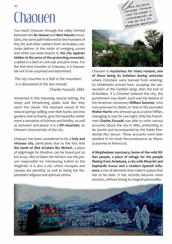
Chaouen You reach Chaouen through the valley formed between the Bu Hassan and Beni Hassan moun-tains, the same path followed by the founders of the city and other settlers from Al-Andalus cen-turies before. In the midst of swinging curves and when you least expect it, the city appears hidden in the arms of the protecting mountain, cradled in a skirt of cork oak and pine trees. For the first time traveller to Chaouen, it is impossi-ble not to be surprised and astonished.
Immersed in this imposing natural setting, the steep and threatening peaks look like they reach the clouds. The resonant sound of the natural springs spilling over their banks and into gardens and orchards, give this beautiful settle-ment a sensation of richness and fertility, as well as seclusion and peace. It is a Rif mountain, an inherent characteristic of the city.
Chaouen has been considered to be a holy and virtuous city, particularly due to the fact that the tomb of Abd al-Salam ibn Mchich, a place of pilgrimage for Muslims, can be found just 50 km away. Abd al-Salam ibn Mchich was the per-son responsible for introducing Sufism to the Maghreb. It is also a city where mosques and zaouias are plentiful, as well as being the Mu-jahedeen religious and spiritual centre.
Chaouen is mysterious for many reasons, one of these being its isolation during centuries where Christians were banned from entering. Its inhabitants arrived here, escaping the per-secution of the Castilian kings after the end of Al-Andalus. If a Christian entered the city, the punishment was death. Such was the destiny of the American missionary William Summer, who was poisoned to death, or that of the journalist Walter Harris who dressed up as a native Riffian, managing to stay for one night. Only the French-men Charles Focauld was able to write various accounts about the city in 1883, pretending to be Jewish and accompanied by the Rabbi Mor-dechai Aby Serour. These accounts were later detailed in his book Reconnaissance au Maroc (a journey to Morocco).
A Mujahedeen sanctuary, home of the wild Rif-fian people, a place of refuge for the people fleeing from Andalusia, a city with Moorish and Sephardic traces and a modern Spanish influ-ence: a mix of elements that make it a place that has to be seen. It has recently become more touristic, without losing its magical personality.
The city crouches in a fold in the mountain; it is discovered at the last minute.
Charles Focauld, 1883.
the distance
between Tetouan
and Chaouen is
approximately 65
km on the N2
Mountain motorway
187

HistoryWhen Abu Yumaa (Hassan ibn Muhammad al-Alami) chose this place to build a city, he found a Berber farmhouse, which perhaps is where the Tamazight name for the city comes from: Chef-chaouen or Shifshawen. In the Riffian language Aççawen means the horns in allusion to the At-las Mountains that surround the city: Tissuka and Meggu. Why the city was built here, is due to strategic reasons. The area is so hidden away that it could be used as a base to launch offensives against the Portuguese who used to attack the cities on the coast of the Maghreb. The history of the city begins in 1471 with this Mujahidin. However, following the death of Abu Yumaa, it was his cousin, Ali ibn Rachid, who re-launched the city changing its location to besides the Ras al-Ma natural spring. He started by building a Kasbah and a walled settlement where the Andalusian families who came with him could live. The area today is called the Suiga district.
Uta al-Hammam Square. View of the Kasbah and the Mosque. Watercolour by M. Bertuchi in 1920. (Bertuchi Family Archive).
Between the fall of the Kingdom of Granada in 1492 and the expulsion of the Moors in the 17th century, the Andalusian people began to arrive, provoking the creation of new areas of the city and the construction of a larger perimeter wall. Chaouen became home to the exiled Andalusian people. This, coupled with the isolation of the city, meant that it has been greatly influenced
by Andalusian culture, something which is evi-dent in the architecture, industry, craftsmanship and lifestyles of its inhabitants. This influence can still be perceived to this day.
This is the most pleasant mountain in Africa. It has a villa full of craftsmen and merchants in which the master of these moun-tains also lives. It was him who helped this place progress. He rebelled against the King of Fes and he is called Ali Ben Rachid. He also fought against the Portuguese. The people from the city and the mountain don’t pay him any taxes, because the majority of them are his soldiers who fight on horseback or on foot.
Leo Africanus
As a city set apart from the rest of the world, Chaouen has experienced many legendary moments which have contribut-ed to the aura of mys-ticism that surrounds it. One of its most powerful charac-ters was Sayyida al-Hurra, meaning Free Lady, who ruled the region along with the cities of Tetouan and Chaouen between 1518 and 1542, until she was dethroned by her stepbrother. She was the daughter of the founder of Chaouen and wife of Sidi al-Mandari, the per-son who rebuilt Tetouan. Later, she would be-come the wife of the Watasid King of Fes, Mu-lay Ahmad. He continued the Jihad that his father had started against the Portuguese and Spanish. They called her the Noble and Pure Queen, despite her aggressive temper and her intelligence, a combination which proved to be a lethal weapon against the enemy.
The spell on Chaouen was broken at the begin-ning of the 20th century, when the Spaniard Juan Lasquetti obtained precise information on the
188

city in 1918 with the help of the military aviation. Using this information, he produced an exhaus-tive report in the area and the first cartographic document. Two years later, the Spanish entered the Medina under the command of General Berenguer along with the painter Mariano Bertuchi, the person chosen to report on the event. They found a Medi-na and a way of life that in their eyes resembled medieval Andalusia. This was such the case, that the local Sephardic community still used the Jew-ish-Sephardic language or Jaquetía.
Four years later, the Spanish were driven out by the native Rif resistance, lead by Muhammad ibn Abd al-Karim al-Jattabi. However, in 1926 they settled for good, starting the construction of the new Chaouen, a small Ensanche (city ex-tension) just outside of the western perimeter wall of the Medina. They also intervened in the old part of the city in orchards and areas with
trees, occupying the land and developing spac-es such as the Uta al-Hammam Square.As described in Focauld’s visit, there was har-monious cohabitation between the Jewish and Muslims. The Christians were also added to this mix for 30 years, continuing from after the inde-pendence of Morocco until present day. There
...the Moorish soul of the 15th cen-tury was hidden and silent in a sma-ll corner of the Alpujarras, and in those kind and distinguished Moors, that proudly boast Spanish surnames.
Juan de Lasquetti, 1918.
Ensanche (above) and the Medina (right).
was also a notable increase in the Jewish popu-lation at the beginning of the 30s, something which can be seen in the aesthetics of the city to-day due to their custom of painting the exterior walls of their houses blue. There are barely any Jewish people left in Chaouen today as nearly all of them emigrated. However, these buildings are still wonderful testimonies that remind us of their presence in the city, such as the Mellah in the Suiga district and the Cemetery that exists en route to Wazzán, of special interest due to its ancient personified tombs. Today, the Medina in Chaouen is a first class tourist destination. Meanwhile, the small Span-ish Ensanche and the areas that have sprung up around it, continue their peaceful life, unaware of what goes on within the city walls.
Itinerary: The Medina
The Medina is a labyrinth of alleyways that meet in openings, converge in small squares and branch off in pathways like hallways in the street. They get wider and narrower, they bend and slope, creating an urban landscape that is as organic as the city outline itself. In this deformed mass, the houses pile up on top of one another, finding room in whichever way they can. How-ever they do not seem to bother each other. The exterior walls have varying silhouettes, some pretty, some expressionist; some walls even looked unbalanced, they twist, they lean and they bulge like they have bellies. Some even have big rocky verrucas, whilst the long benches also found here invite you to sit down and rest.
189

Like her, the Medina is purely Andalusian, from the guts to the dress, whilst the architecture tells us about the local customs: fountains, ovens, baths, textile mills, zaouias, mosques, and the
contained silence of the various windows which appear to be bricked in or false. Some elements have become symbols of the city without wanting to, such as the minarets of the mosques, the mullioned windows and the doors which, on their own, are messages that need to be deciphered.
Walking through the Medina, the mountain is always present. It makes you want to shout out loud and wait for the eco in the infinite silence that surrounds the valley. A silence that is bro-ken only by the murmuring of the Chauni people and the visitors passing through, a murmur that scarcely leaves the walls of the city. It is calm and jovial and passes slowly by, like time in this city. In Chaouen, time seems to be at a standstill. Every part of the city appears to be the same as it once was many years ago.
The walls lost their corners and straight lines centuries ago due to the many coats of whitewash that have been applied by the women of the city over the years. This has helped record the history of generations and has determined the aesthetic evolution of the city. It is the art of lime scale, which is com-bined with the art of colour: nila or indigo, in a wide range of tones that have been climbing the walls until they have almost covered the entire city. Even though this custom has been around for only about a century, it has become a dis-tinctive feature of Chaouen. According to some historians, the custom comes from Al-Andalus, however, the oldest people from the Medina say that previously Chaouen was white and that it was only the Jewish people that painted their skirting boards, window frames and doors. But even though the colour blue dominates the city, the earth tones have put up a power-ful struggle, and can be seen in various places throughout the Medina: on the walls of the Kasbah, on the walls without any whitewash, on the minarets of the Mosques or on the red tiled roofs of the buildings.
The streets resemble those of the Albai-cín in Granada or of the mountain villag-es in Malaga or Cadiz such as Véjer de la Frontera, which is said to be where the wife of the founder of the city, Lalla al-Zahra, came from.
190

Itinerary: The Medina
2
3
4
5
Uta al
-Hamm
am
Squar
e
1
Bab al-Ain
ENSANCHE (City Extension)

Bo Zeafar Mosque
1. UTA AL-HAMMAM SQUARE (OUTA AL-HAMMAM) Kasbah • Great Mosque • Qadiriya Zaouia2. SUIQA DISTRICT (SOUIKA) Sidi ibn al-Hassan Zaouia • Jewish Quarter • Bab al-Himmar • ibn Yelum Mosque3. JARRACÍN DISTRICT (KHARRACIN) Jarracín Square • Sidi Bu Hamza Mosque • Hauta Square • Old Carpet School4. BAB SUQ DISTRICT (BAB SOUK) Bab Suq Mosque • Bab Suq Gate 5. RIF AL-ANDALUS DISTRICT (ANDALOUS) Hassan Awal Street • Granada Street • Rif al-Andalus Mosque • Qenitra Square • Funduq on Targi Street6. AL-ONSAR DISTRICT Laqael Mosque • al-Onsar Mosque • Zaitun Square • Bab Onsar7. RAS AL-MA AND RIVER WALK Ras al-Ma River • Laundry District • Windmills • Bo Zeafar Mosque8. SEBANIN DISTRICT Sebanin Square • Sebanin Mosque
6
7
7
8
Ras Al-Ma
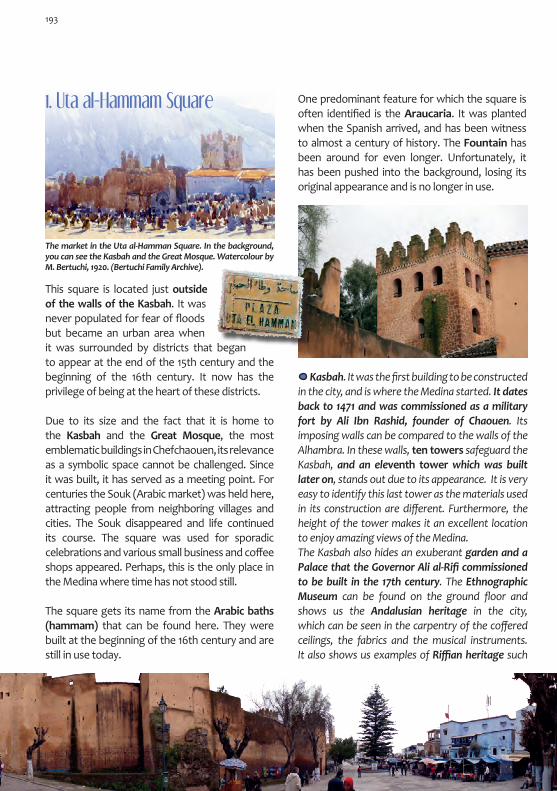
1. Uta al-Hammam Square
This square is located just outside of the walls of the Kasbah. It was never populated for fear of floods but became an urban area when it was surrounded by districts that began to appear at the end of the 15th century and the beginning of the 16th century. It now has the privilege of being at the heart of these districts.
Due to its size and the fact that it is home to the Kasbah and the Great Mosque, the most emblematic buildings in Chefchaouen, its relevance as a symbolic space cannot be challenged. Since it was built, it has served as a meeting point. For centuries the Souk (Arabic market) was held here, attracting people from neighboring villages and cities. The Souk disappeared and life continued its course. The square was used for sporadic celebrations and various small business and coffee shops appeared. Perhaps, this is the only place in the Medina where time has not stood still.
The square gets its name from the Arabic baths (hammam) that can be found here. They were built at the beginning of the 16th century and are still in use today.
The market in the Uta al-Hamman Square. In the background, you can see the Kasbah and the Great Mosque. Watercolour by M. Bertuchi, 1920. (Bertuchi Family Archive).
One predominant feature for which the square is often identified is the Araucaria. It was planted when the Spanish arrived, and has been witness to almost a century of history. The Fountain has been around for even longer. Unfortunately, it has been pushed into the background, losing its original appearance and is no longer in use.
Kasbah. It was the first building to be constructed in the city, and is where the Medina started. It dates back to 1471 and was commissioned as a military fort by Ali Ibn Rashid, founder of Chaouen. Its imposing walls can be compared to the walls of the Alhambra. In these walls, ten towers safeguard the Kasbah, and an eleventh tower which was built later on, stands out due to its appearance. It is very easy to identify this last tower as the materials used in its construction are different. Furthermore, the height of the tower makes it an excellent location to enjoy amazing views of the Medina. The Kasbah also hides an exuberant garden and a Palace that the Governor Ali al-Rifi commissioned to be built in the 17th century. The Ethnographic Museum can be found on the ground floor and shows us the Andalusian heritage in the city, which can be seen in the carpentry of the coffered ceilings, the fabrics and the musical instruments. It also shows us examples of Riffian heritage such
193

as jewellery, weaponry and pottery. The Kasbah is used as an open air theatre and is the home of the Andalusian Study and Research Centre. The walkway that joins it to the Great Mosque is used as a space for temporary exhibitions. The entrance that is used to go into the Kasbah is not the original, as it was opened in the 1930s.
Ethnographic Museum 9.00 – 13.00h.
15.00-18.00h. Closed on Tuesdays
Gran Mezquita or Yamaa al-Kabir was built in the 16th century, although various changes over time and the addition of the Madrasah (mosque school) have erased its original identity, leaving it with an entrance porch from the 20th century. The octagonal minaret gives the mosque a distinctive appearance. It dates back to the end of the 17th century and invites you to spend time observing its elaborate decoration.
Qadiriya Zaouia. It is located next to the Great Mosque and is from the 17th and 18th centuries. The outside was reformed with extravagant tiling and plastering which give it an Eastern appearance, possibly due to the con-nection that the Saint Mu-lay Abd al-Qadir al-Yilany had with the east.
2. Suiqa DistrictIt is located in the south east of the city and was the original city of Chaouen. Today it is the old-est part of the Medina. It was built after 1471 by the Mujahedeen people that arrived in Chaouen with the founder Ali ibn Rashid. In this district, you can find the oldest houses in the Medina, such as the house of the founder Ali ibn Rashid himself, located in Sidi ibn al-Hassan Square (Sidi benLahcen). This district was surrounded by the walls of the Kasbah, the first wall of the Medina, of which little remains nowadays. In the wall there were various gates, some of which still exist today such as Bab al-Himmar to the south east, Bab al-Harmun to the south and Bab al-Mawqaf to the north east.
Starting from Uta al-Hammam Square, you reach this district from the gardens that are located behind the Kasbah (Sidi ben Lahcen Street). It is also accessible from the Qadiriya Zaouia, down the lively Qadi al-Alami street, whose commercial character can be seen on many of the main streets in the district, reminiscent of its past as an alcaicería (old street market). Its name means small market, referring to the stretch of the street that is protected by gates and that used to be open during trading hours. This was where the valuable merchandise could be found. Today, the small shops can be found on both sides of the street eclipsing the building walls. Typical merchandise sold here included djellabas made from wool and in general linen fabrics and cotton. These were traditional crafts that were predominant in this district, hence the fact that many textile mills were located here.
Next to the main streets, be careful not to get lost in a multi-tude of dead end alleys (adarves). The only warning is from the benches that are fixed onto the front of the buildings.
194

In the Suiqa district, some of the most Medina’s most beautiful zaouias can be found. These include Sayyida al-Hurra, located next to the Kasbah gardens, Mulay Ali Shaqur, which is hid-den in an alleyway or Sidi al-Hayy al-Sharif, lo-cated next to the alcaicería and which is also a Mosque. In the narrowness of the streets, the minaret of the ibn Yelum Mosque cannot be seen. However, the spirit of the 15th century is not lost as very nearby you will find the (Bab) al-Himmar Gate from the same period. Its gets its name from the colloquial word for donkey, as it was the place where merchants would arrive from other cities with their goods being carried on carts pulled by donkeys.
Djellabas and hoods are typical parts of Chauni fashion. Those that are made out of wool in natural colours are the most characteristic.
Sometimes the streets are covered (Rabat-s) which means that the size of the houses can be increased.
Sidi ibn al-Hassan Zaouia or Raisu¬niya (Sidi ben Lahcen Square). It is a Zaouia, Mosque, Sanctuary and Quran School. They were founded by Sayyida al-Hurra, a character who adds both legend and mys-ticism to the city. Little is known about what came of him. However, legend would have us believe that he came back to Chaouen, his birthplace, and that his remains can be found in this Zaouia.
Linen and cotton (here with red and white stripes), the typical fabric worn by mountain women (Je-bala) around the shoulders and the waist. In the Suiga, Rif al-Andalus and Sebanin districts, textile mills can be found, some of which are still active today. The architecture reflects the distinctive style used in Chaouen: sloping tiled roof, two floors, independent entrances on the same side of the building, exterior stairwell to the second floor and arrow slits for ventilation.
In southern part of the district we find what used to be the Mellah or Jewish quarter. The Se-phardic Jews moved here around 1760, forced to leave their homes located outside of the city walls due to attacks from neighbouring tribes.
195

You can reach the Jarrazín district through the alleyways of the neighbouring Suiga district. They even share the old gate in the city wall, Bab al-Mawqaf. The translation of the name means unemployed, as it was here where people used to gather to look for casual work. It is a very busy district as it connects the Uta al-Hamman Square and the (Bab) al-Ayn Gate which opens up into the city. It gets its name from the market held by shoemak-ers and tanners who traditionally could be found in this area. It is said that this district was created as a result of the expansion of the Suiga district which began at the end of the 15th century. As is common in all of the districts of the Medina, there is a Mosque. It is located in Sayyida al-Hurra Street and is dedicated to Sidi Bu Hamza, a Saint from the period when the city was founded. The Mosque itself dates back to the 17th century.
3. Jarrazin District
Street between the Jarrazín and Suiga district with a commer-cial character, as shown in this oil painting by M. Bertuchi (Bertuchi Family Archive).
Amongst the various different nooks and crannies that can be found in its long streets, the small Jar-racín Square is particularly pleasant. The over-elab-orate Hauta Square is also very unique with the northern side belonging to the Bab Suq district. This square combines its Andalusian origins with various interventions that were carried out during the Spanish Protectorate period. This is evident not only in the architecture, but also in the use given to the square over time. The square is triangular in shape and has been this way since it was built. The collection of gates, the Isawiya Zaouia, the central fountain and the nearby al-Harras Arabic Baths are unique elements of this Chauni Medina. However, the more stern looking architecture, the arcade and the coffee shops are a clear sign of the Spanish influence on the city and of the customs that they have left behind, such as their love for getting to-gether with friends. Another emblematic example of the fusion between Spanish and Moroccan cul-tural heritage is the building that used to house the Carpet School. It was built by the Spanish in order to preserve traditional Chauni craftsmanship and is located at Zunayqa (Znica) Street.
Hauta Square.
Fountains are a vital part of daily Moroccan life. They are used as a water source by those families who do not have running water in their homes. It is an element that is essentially feminine. In general, they are decorated in an ornate way. They tend to have a basin and be attached to the wall; it is very rare to find one that is stand-alone. They were located according to the system of community-operated canals, wells and water tanks that distribute the water in the Medina. A feat of engineering that the Andalusians brought with them and that was set up during the years when the city was founded.
196

Doors give us a lot of information without needing to be opened. They are elements that contain a wealth of symbolism that can tell us which family lives behind them through their size, form, decoration, the type of frame used as well as the ornateness of the surrounding walls.
The Interior of the building that was construct-ed to house the Chaouen Carpet School, an or-ganisation that was run by the School of Arts and Crafts in Tetouan, of which Mariano Bertuchi was once Director. It was built in 1943 in an area full of vegetable gardens. It was built in typical Andalu-sian style with a patio and balconies on two levels. The School was opened in 1928 and was originally located in an area within the Kasbah. In 1934 it was moved to the Funduq in Uta al-Hammam Square. Similar to the school located in Tetouan, its main purpose was to preserve the local Crafts. However, in the school in Chaouen, there was a fo-cus on fabrics, especially carpets, dejellabas and aprons. Currently it is being used as a cultural cen-tre and library.
The most elaborate doors leave a small opening which is called tinfisa meaning breath. The doors that are small and low reflect the Riffian style.
To say that this district was created as a conse-quence of the Spanish expulsion of the Moors in 1609, is to enter into a historical and cultural debate that is often held by the people who live there. It is yet another piece that we have to fit into this never ending jigsaw puzzle.
4. Bab Suq District
A house outside the city walls in the Bab Suq district from the Spanish Protectorate period. The view from outside the city walls at the beginning of the Spanish Protectorate. The Espla-nade where the Souk was held on Mondays (Suq al-Ithnin).
197
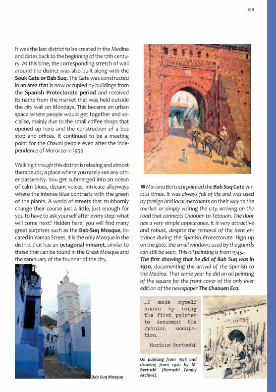
It was the last district to be created in the Medina and dates back to the beginning of the 17th centu-ry. At this time, the corresponding stretch of wall around the district was also built along with the Souk Gate or Bab Suq. The Gate was constructed in an area that is now occupied by buildings from the Spanish Protectorate period and received its name from the market that was held outside the city wall on Mondays. This became an urban space where people would get together and so-cialise, mainly due to the small coffee shops that opened up here and the construction of a bus stop and offices. It continued to be a meeting point for the Chauni people even after the inde-pendence of Morocco in 1956.
Walking through this district is relaxing and almost therapeutic, a place where you rarely see any oth-er passers-by. You get submerged into an ocean of calm blues, distant voices, intricate alleyways where the intense blue contrasts with the green of the plants. A world of streets that stubbornly change their course just a little, just enough for you to have to ask yourself after every step: what will come next? Hidden here, you will find many great surprises such as the Bab-Suq Mosque, lo-cated in Yamaa Street. It is the only Mosque in the district that has an octagonal minaret, similar to those that can be found in the Great Mosque and the sanctuary of the founder of the city.
Mariano Bertuchi painted the Bab Suq Gate var-ious times. It was always full of life and was used by foreign and local merchants on their way to the market or simply visiting the city, arriving on the road that connects Chaouen to Tetouan. The door has a very simple appearance. It is very attractive and robust, despite the removal of the bent en-trance during the Spanish Protectorate. High up on the gate, the small windows used by the guards can still be seen. This oil painting is from 1945. The first drawing that he did of Bab Suq was in 1920, documenting the arrival of the Spanish to the Medina. That same year he did an oil painting of the square for the front cover of the only ever edition of the newspaper The Chaouen Eco.
Oil painting from 1945 and drawing from 1920 by M. Bertuchi. (Bertuchi Family Archive). Bab Suq Mosque
...I made myself known by being the first painter to document the Spanish occupa-tion.
Mariano Bertuchi.
198

Leaving Bab Suq, any street is a good choice to continue your journey onto the Rif Al-Andalus district. The busiest and most touristic route is along Hassan Awal, which passes through the Medina connecting Bab al-Ain in the West and Bab al Onsar in the East. The name of the district is evidence of its histori-cal background. It was founded by the Nasrids that fled after the fall of the Sultanate of Grana-da in 1492, and who formed part of the second shipment of settlers to arrive in Chaouen.
They settled in front of the Kasbah, on the other side of the esplanade that would later be the Uta al-Hammam Square. They built a wall which included a gate, Bab al-Nuqba. It was located in the southern part of the district, next to Damnat Majzen Square, where Granada Street ends. The name of the street refers to the homeland of the emigrants. A clear distinction was made be-tween those who came from outside, the gar-nata, and those who were native Riffian people from the Chauni area, the hadara. In this street you can find the Rif al-Andalus Mosque.
A horseshoe arch just before a hallway tells us where the Funduq in the Uta El-Hammam Square can be found, an essential element in any Moroccan Medina. It was a necessity when the market began in the square, as it was a place where traders from neighbouring villages, bringing goods and livestock, could stay the night. The architecture of the Funduq is very similar to other Funduqs: bedrooms on the upper floors and warehouses and stables on the ground floor, separated in three rooms that surround a central patio.
Detail of the roof of the Sabat which can be found in the entrance to the Al-Andalus Mosque. Carved woodwork with typical Andalusian tracery.
Between the different urban areas in this district, the Qenitra (Kenitra) Square particularly stands out. Various busy streets lead into the square such as Targi Street, the location of the oldest Funduq in the city.
5. Rif Al-Andalus District
199

The Qenitra Square (Qunaytara, the small bridge) is one of those places that you always come across, but never know exactly where it is. It was built here due to the water canal that ran through the area. A fountain was built and the area around the fountain was preserved, creat-ing the square. It is an area that receives a lot of visitors. In the past it was more of a meeting place thanks to the fountain, craft workshops, bakali-tos and small businesses that attracted and enter-tained the local population.
This district came about as a result of the perse-cution of the Moors in Spain between 1540 and 1560. They occupied the Al-Onsar and Sebanin districts, located in the east of the Medina, cov-ering the area up to the banks of the river.
6. Al-Onsar District
Today it is a quiet residential district, something which is only disturbed by the noise coming from Hassan Awal Street. Hassan Awal Street ignores the slopes of this area, continuing its cross-cut-ting course towards Bab El-Onsar. It is charac-terised by its blue walls with splashes of typical Chauni colours. Here you can find some beauti-ful Mosques such as the Laqael Mosque, located on the border of the Rif al-Andalus district, and the Al-Onsar Mosque, located at the end of the street. Halfway down Hassan Awal, you will find Zaitun Square, an urban space which is full of history and mysticism. The Square has an olive tree that has been a witness to the evolution of the city over the last century, a sole survivor of the old cultivation plots that used to exist inside the city walls. An oven and a tannery occupy this area. There is always something happening here. It is an area that encourages you to relax and is often frequented by children playing games.
The street ends at the Bab al-Onsar Gate. Noth-ing remains of the original design with a bent en-trance from the 17th century. However, passing through the gate is still a bewitching experience as it opens up onto the side of the mountain, the mountain on which we have been walking on throughout our journey through the Medina. Passing through this gate signifies the discovery of the origins of the city: the Ras al-Ma River.
The Lakael Mosque (left) and the al-Onsar Mosque (right).
Oil
pain
ting
by M
. Ber
tuch
i. Be
rtuc
hi F
amily
Arc
hive
.
200
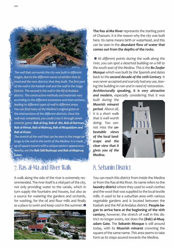
The wall that surrounds the city was built in different stages, due to the different waves of settlers that ar-rived and the new districts that they built. The first part of the wall is the Kasbah wall and the wall in the Suiga District. The second is the wall in the Rif al-Andalus district. The constructive methods and materials vary according to the different extensions and interventions, leading to different types of wall in different areas. You can find many of the Medina’s original gates at the intersections of the different districts. Once the wall was completed, you could cross it through seven exterior gates: Bab al-Suq, Bab al- Ain, Bab al-Harmun, Bab al-Himar, Bab al-Mahruq, Bab al-Muqaddam and Bab al-Onsar.The stretch of the wall that can be seen in the image be-longs to the wall in the north of the Medina. It is made up of square towers with a unique eastern appearance. Nearby, are the Bab Sidi Bushuqa and Bab al-Majaruq Gates.
7. Ras al-Ma and River Walk
A walk along the side of the river is extremely rec-ommended. The river itself is a vital part of the city, not only providing water to the canals, which in turn supply the fountains and houses, but also as a source for watering the gardens and orchards, for washing, for the oil and flour mills and finally as a place to swim and keep cool in the summer.
At different points during the walk along the river, you can spot a deserted building on a hill to the south east of the Medina. This is the Bo Zeafar Mosque which was built by the Spanish and dates back to the second decade of the 20th Century. It was never accepted and scarcely had any use, leav-ing the building in ruin and in need of restoration.Architecturally speaking, it is very attractive and modern, especially considering that it was built during the Moorish minaret period. Above all, it is a short walk that is well worth doing. You can-not miss the un-beatable views of the local land-scape and the clear view that it gives you of the Medina.
The Ras al-Ma River represents the starting point of Chaouen. It is the reason why the city was built here. Its name means birth or waterhead, and this can be seen in the abundant flow of water that comes out from the depths of the rocks.
You can reach this district from inside the Medina or from the Ras al-Ma River. Its name refers to the laundry district where they used to wash clothes and the wool that was supplied to the local textile mills. It used to be a suburban area with various vegetable gardens and is located between the Kasbah and the Rif al-Andalus district. People be-gan to arrive here at the beginning of the 16th century, however, the stretch of wall in this dis-trict no longer exists, nor does the (Bab) al-Muq-adam Gate. The Sebanin Mosque is still around today, with its Moorish minaret crowning the square of the same name. This area seems to take form as its steps ascend towards the Medina.
8. Sebanin District
201

The appearance of the southern side of the dis-trict differs from the traditional look. Here, the old city has faded away, invaded by the moderni-ty of the new millennium. The Sidi Ahmad al-Wafi Street runs along the southern perimeter of the district, taking us to the gardens of the Kasbah.
The Oven in Sebanin Square. The bread ovens are an essential element of any Medina. The fire is started in the morning and neighbours come by to drop off bread, biscuits and dried fruit which are placed in the oven. After a few hours, they are ready to be collected and to eat. The design of the bread ovens is simple: small houses with only one floor, sloping tiled roof, some skylights for ventilation and a fire that is usually at ground level. They are easily identifiable due to their chimneys, the piles of wood and their blackened façades. There are also some ovens next to the baths that are used to heat the water.
Sebanin Square with the Sebanin Mosque in the background.
Entr
ance
to th
e Se
bani
n M
osqu
e.
202
...and once again, we lose ourselves in the streets of the Medina.

Itinerary: Ensanche (City Extension)
1
1. BAB AL-AIN2. HASSAN II AVENUE Mulay Ali ibn Rashid Mausoleum• Post Office • Market Square • Old Headquarters of the Local Inspection Department • Old Inspector’s House3. MOHAMED V SQUARE Old Officials Club • San Antonio Church • Old offices of La Valenciana • Old Mehala de Gomara
2
3
1
Bab al-Ain
Mohamed V Square
Hassan II Avenue
MarketSquare
Mulay Ali ibn Rashid Mausoleum
203

The Spanish army arrived in Chaouen in 1920. Six years later, civilians started to arrive, initially liv-ing in the Medina. The construction of a modern city began next to the Medina. This Ensanche was different to the old city in terms of urban planning, architecture and functionality. A new way of life and new customs became part of this district.
This modern city was small in size. The first city plans were developed by the military engineer Miguel García Herrán in 1928. It was the architect Manuel Latorre Pastor who developed a second proposal which he based on the original plans, and on the military buildings that already existed around what would be the future main square, such as the Mehala de Gomara or the Military Intervention Office. It was this second proposal, developed in the 30s, that defined the current
Ensanche (City Extension)city. The Square was designed as the centre of the new urban design, and it was here that im-portant military and civil headquarters were set up. A main street was built which connected the main square with the Medina through the Bab al-Ain Gate. This fusion of the old and new cit-ies was not based on experiences in Larache or Tetouan, where the two cities converge in a symbolic com-mon urban space. In Chaouen, the model used was similar to that put into practice by French urban plan-ners, where the cities grew as inde-pendent entities.In an attempt to promote the co-existence of the two cities, M. La-torre prioritised the urbanization of this area, bringing daily life closer to the Port. In the 30s he constructed buildings such as the Municipal Medical Dispensary, schools including the Spanish Children’s School and the Spanish-Arabic School, and entertainment establishments such as the Cinema-Theatre, bars and the Casino. As for the urban design, he opted for the Garden City model, with houses with gardens lining the streets. Many of these buildings still exist today and are beautiful examples of Colonial architec-ture, an invaluable reminder of the Caliphate Morocco. In 1944, under the new plan defined by the ar-chitect Pedro Muguruza Otaño, new styles were used that were extremely common during the dictatorship of General Francisco Franco in Spain: Herrerian and Neo-Plateresque. Examples of this can be seen in the building that currently houses the Post Office in Hassan II Avenue. Also,
The Spanish camp, shortly after their arrival in 1920. It is located to the west of Mohamed V Square and is now the location of the Provincial Hospital. In those days, the square was a training area. A Church opposite Es-paña Square, at the end of the 30s (Domingo Outón Archive).
Bab al-Ain Gate, connection be-tween the Ensanche and the Medi-na. (Domingo Outón Archive).
204
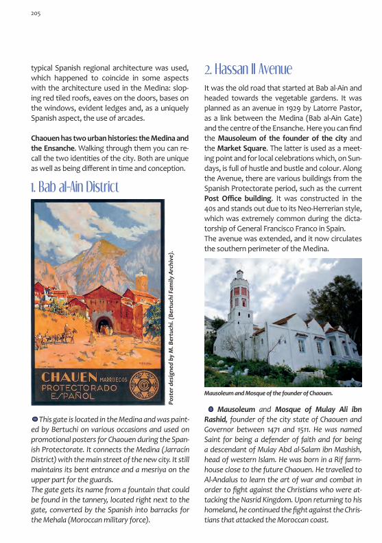
1. Bab al-Ain District
This gate is located in the Medina and was paint-ed by Bertuchi on various occasions and used on promotional posters for Chaouen during the Span-ish Protectorate. It connects the Medina (Jarracín District) with the main street of the new city. It still maintains its bent entrance and a mesriya on the upper part for the guards. The gate gets its name from a fountain that could be found in the tannery, located right next to the gate, converted by the Spanish into barracks for the Mehala (Moroccan military force).
2. Hassan II AvenueIt was the old road that started at Bab al-Ain and headed towards the vegetable gardens. It was planned as an avenue in 1929 by Latorre Pastor, as a link between the Medina (Bab al-Ain Gate) and the centre of the Ensanche. Here you can find the Mausoleum of the founder of the city and the Market Square. The latter is used as a meet-ing point and for local celebrations which, on Sun-days, is full of hustle and bustle and colour. Along the Avenue, there are various buildings from the Spanish Protectorate period, such as the current Post Office building. It was constructed in the 40s and stands out due to its Neo-Herrerian style, which was extremely common during the dicta-torship of General Francisco Franco in Spain. The avenue was extended, and it now circulates the southern perimeter of the Medina.
Mausoleum and Mosque of Mulay Ali ibn Rashid, founder of the city state of Chaouen and Governor between 1471 and 1511. He was named Saint for being a defender of faith and for being a descendant of Mulay Abd al-Salam ibn Mashish, head of western Islam. He was born in a Rif farm-house close to the future Chaouen. He travelled to Al-Andalus to learn the art of war and combat in order to fight against the Christians who were at-tacking the Nasrid Kingdom. Upon returning to his homeland, he continued the fight against the Chris-tians that attacked the Moroccan coast.
Post
er d
esig
ned
by M
. Ber
tuch
i. (B
ertu
chi F
amily
Arc
hive
).
Mausoleum and Mosque of the founder of Chaouen.
typical Spanish regional architecture was used, which happened to coincide in some aspects with the architecture used in the Medina: slop-ing red tiled roofs, eaves on the doors, bases on the windows, evident ledges and, as a uniquely Spanish aspect, the use of arcades.
Chaouen has two urban histories: the Medina and the Ensanche. Walking through them you can re-call the two identities of the city. Both are unique as well as being different in time and conception.
205

It was originally called Es-paña Square in the 30s. Although planned before this time, it was defined as the central artic-ulation of the Ensanche. The choice of this area to build the Square was due to the pre-existing mili-tary buildings that were located next to an espla-nade which was being used as a training ground. It was originally designed as a circular space with gardens, around which various important buildings were constructed. Using the square as a starting point, the rest of the city was built, highlighting the main street that joined it to the Medina. The first buildings that were constructed here were military. The last building constructed during the Spanish Protectorate was the La Va-lenciana Bus Station, located to the left of the church and just in front of Hassan II Avenue.
Urban Planning Office, from 1944. It was the General Inspec-tor´s house and follows the model of a Garden City house.
The offices of the Town Council or La Territorial, was built in 1933 with the intention of being used as the Local Inspection Office, Pashaluk and the High Commission, the highest authority of the Spanish Administration during the Spanish Protectorate in Morocco. It was built in two phases; the first was managed by the Engineer Tomás Valiente García, and the second by the architect José Larrucea. It was at this time when the building overcame its aesthetic functionality and was beautifully deco-rated with features that were very typical of the architectural styles of the period. Another beauti-ful example of the colonial architectural style: the Garden House.
3. Mohamed V Square
Mohamed V Square.
Advert for the La Valenciana Transport Company. It cove-red routes throughout the entire area under the Spanish Protectorate.
Old location of the Town Hall.
206

The Gomara Mehala (Mahalla) was built by military engineers as the Military Intervention Office, hence the austerity in its design. It was built in 1927 and follows the Garden City model.
The most striking building in the Square was home to the Officials Club and the extreme right wing Spanish party, La Falange. It was built in the 30s and stands out for its Neo-Arabic style. It has many eastern details, providing a stark contrast to the other buildings that can be found in Square, which are of a more functional nature.
Further along from the avenue and the square, you can find a diverse range of buildings from the Spanish Protectorate period: public facilities such as the Spanish Children’s School, named after Ramón and Cajal, still in use today as al-Hayy Abi Yamaa, and housed in a building designed by the archi-tect M. Latorre which dates back to 1931; military buildings (mainly in the northern area), such as the Infantry and auxiliary force barracks; urban areas with arcades including the building with a unique curved façade that housed the Cosmopolita bar, located on the corner Zerktuni Avenue with Hassan II, close to the Bab al-Ain Gate. Furthermore, you can also find a number of residential buildings, such as La Fotografía, going down from the Square towards Abdelkrim El Kathabi Avenue. It is an example of a garden city house, a more modern architectural concept, and proof of the Rationalism movement of the 30s.
The San Antonio Abad Church. A project de-veloped by Manuel Latorre Pastor. It was altered during construction and was finalised in 1940. Without any stylistic pretentions and with a re-gionalist and romantic look, it demands atten-tion through its extremely high bell tower, con-firming the new religious presence in the city. Today, it is both a cultural and training centre.
This building lacks the sloping tiled roof and has a flat roof with a parapet instead.
The Mehala de Gomara building.
207

The province of Chaouen, located in the Gho-mara region, contains both mountains and coast. On this journey you will travel on the road that leads to Oued Laou, crossing the Talas-semtan National Park, an area of natural beauty and immense ecological value. It is similar to the Sierra de las Nieves in Malaga in that both possess fir trees. In order to reach Oued Laou, you have to take the turn off to Daraqouba (Dar Aquba). You have to travel approximately 60 km. on a mountain road in good condition, passing through some beauti-ful natural scenery. Once you have gone passed the Talambot cross-roads, about 37 km. from Chaouen, you will find some buildings from the Spanish Protector-ate period and, shortly after, the hydroelectric power station and the Wad Law River Gorge.
Chaouen – Wad Lau (Oued Laou) Road
The Surrounding Areas
Wad Lau (Oued Laou)
It is a small coastal town located approximately 40 km from Tetouan, at the mouth of the river that gives it its name. Its history is linked to Al-Andalus as it was ruled by the Hammudid dy-nasty and it was also here that the Caliphs, who lived in the Alcazaba in Malaga, produced coins. Very little of its medieval past has been con-served, not even its current location is the same as during the medieval period. It lives from fishing and tourism. People come to the town to enjoy its beaches and the great food. If you happen to visit on a Saturday, you will find one of the most colourful and attractive markets in the area, the Saturday Souk (Suq al-Sabt). It is located in the Beni Said settlement, approximately 5 km along the Chaouen road.
Talassemtan Park
It is approxi-mately 40 km from Wad Lau to Tetouan, approximately 100 km to Tangier, approximately 177 km to Al Hoceima
It is approxi-mately 50 km from Chaouen to Wad Lau, along a moun-tain road that is in good condition.

Wad Law – el-Jabha Road: The Gomara CoastHere, you start your journey along the 120 km of the Gomara Coast in the province of Chaouen, connecting Wad Law to el Jebha (El Jehba). It is a journey with outstanding scenery, full of wind-ing coastline, with cliffs, idyllic coves and small bays which are formed by the end of the Riff mountain range and different river mouths. The road travels along the coastline, enjoying a land-scape that is reminiscent of the southern coast of Spain from Malaga to Almeria. Both shores are immersed in the Alboran Sea, a unique treas-ure that converts this part of the Mediterranean in a paradise for biodiversity. The landscape is still wild and has remained untouched by man, allowing us to fully appreciate the terrain.
During this journey there are various bays and beaches (Azenti, Targa, Zaouia, Stehat…), small fishing ports (Kaa Asras, Chamalaa,...), religious buildings such as the Sidi Husayn Marabout or the unique Tagassa minaret, which can be con-fused with a lighthouse, and historical places such as Targa and Tigisas.
A visit to this village is highly recommended. It is a historic village where beautiful remains can still be seen today, such as the Portuguese Tower which dates back to the 15th century and is locat-ed on a rock on the beach. Other sites include the remains of the Almohad Kasbah, Dar al-Sultán, which is located on one of the highest hills in the surrounding areas, and the 13th Century Mosque which still has its old minaret. The continuous at-tacks from the Portuguese meant that both the city and the Kasbah were abandoned.
Targa
Remains of the Portuguese Tower on the beach in Targa.
Terga is a small city that was, according to some authors, built by the Goths. It can be found on the Mediterranean shore, approximately 80 miles from the Strait of Gibraltar. Its walls are quite weak. It is inhabited by fishermen, who usually add salt to the fish they catch in order to sell it to the merchants in the mountains. Leo Africanus
Overlooking the Mediterranean, you will find this small historic fisherman’s village. Your visit could start with a trip to the Sidi Yahya al-Wardani Marabout which looks down on the village from the highest point of the surrounding area. This village has various attractions but it is the coast that takes centre stage. It is full of wild bays with natural caves, the majority of which can only be reached by boat, and the Alboran Sea which has amazing flora and fauna for divers.
El-Jebha (El Jehba)
Travelling along the coast, El-Jebha is approximately 133 km from Chefchaouen, 135 km from Tetouan and 110 km from Al Hoceima. From here, there is a road that leads to Ketama.
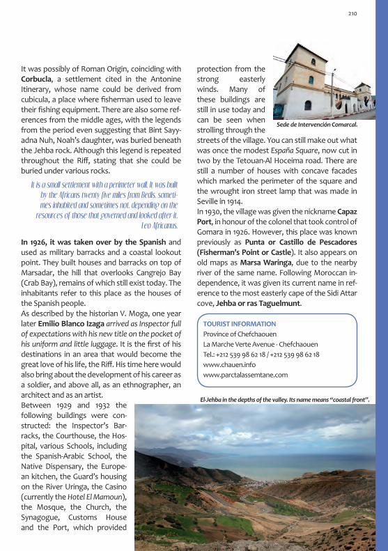
protection from the strong easterly winds. Many of these buildings are still in use today and can be seen when strolling through the streets of the village. You can still make out what was once the modest España Square, now cut in two by the Tetouan-Al Hoceima road. There are still a number of houses with concave facades which marked the perimeter of the square and the wrought iron street lamp that was made in Seville in 1914.In 1930, the village was given the nickname Capaz Port, in honour of the colonel that took control of Gomara in 1926. However, this place was known previously as Punta or Castillo de Pescadores (Fisherman’s Point or Castle). It also appears on old maps as Marsa Waringa, due to the nearby river of the same name. Following Moroccan in-dependence, it was given its current name in ref-erence to the most easterly cape of the Sidi Attar cove, Jehba or ras Taguelmunt.
Sede de Intervención Comarcal.
It was possibly of Roman Origin, coinciding with Corbucla, a settlement cited in the Antonine Itinerary, whose name could be derived from cubicula, a place where fisherman used to leave their fishing equipment. There are also some ref-erences from the middle ages, with the legends from the period even suggesting that Bint Sayy-adna Nuh, Noah’s daughter, was buried beneath the Jehba rock. Although this legend is repeated throughout the Riff, stating that she could be buried under various rocks.
In 1926, it was taken over by the Spanish and used as military barracks and a coastal lookout point. They built houses and barracks on top of Marsadar, the hill that overlooks Cangrejo Bay (Crab Bay), remains of which still exist today. The inhabitants refer to this place as the houses of the Spanish people. As described by the historian V. Moga, one year later Emilio Blanco Izaga arrived as Inspector full of expectations with his new title on the pocket of his uniform and little luggage. It is the first of his destinations in an area that would become the great love of his life, the Riff. His time here would also bring about the development of his career as a soldier, and above all, as an ethnographer, an architect and as an artist. Between 1929 and 1932 the following buildings were con-structed: the Inspector’s Bar-racks, the Courthouse, the Hos-pital, various Schools, including the Spanish-Arabic School, the Native Dispensary, the Europe-an kitchen, the Guard’s housing on the River Uringa, the Casino (currently the Hotel El Mamoun), the Mosque, the Church, the Synagogue, Customs House and the Port, which provided
It is a small settlement with a perimeter wall. It was built by the Africans twenty five miles from Bedis, someti-mes inhabited and sometimes not, depending on the
resources of those that governed and looked after it. Leo Africanus.
TOURIST INFORMATIONProvince of ChefchaouenLa Marche Verte Avenue - ChefchaouenTel.: +212 539 98 62 18 / +212 539 98 62 18www.chauen.infowww.parctalassemtane.com
El-Jehba in the depths of the valley. Its name means “coastal front”.
210


Al HoceimaArchitecture of the Sea

Al HoceimaThe city of Al Hoceima is approximately 245 km along the coast from Tetouan, in north east Mo-rocco. It looks out onto a spectacular bay that is immersed in the Mediterranean or more pre-cisely, the Alboran Sea, dazzling us with its natu-ral scenic beauty. The poetess Trina Mercader dedicated a poem to the city which reads the sea is sculpting your architecture, this is precisely true about the Al Hoceima bay and its province: a landscape full of natural architecture. Al Ho-ceima is coast; it can be seen as being both arro-gant and broken through its cliffs, and calm and lively through its beaches. It is the bay of the six rocks, and in each of its landforms, there are fan-tastic panoramic views and a historic tale to be told. Al Hoceima is mountain; the Rif mountain range, where you can find the Tafensa Natural Reserve and the Al Hoceima National Park. In this landscape of natural architecture, the manmade architecture still exists, immersed, conscious of its surroundings, searching for synergies with its natural counterpart.
To this outline of beauty we can add the charac-ter of its inhabitants, warm like the climate and welcoming like the bay. Al Hoceima is fusion and cohabitation, it is Riffian and Spanish, it is both a seaside and a mountain city. Life here changes from the quiet and tranquility during the winter months, to a valued tourist destination in the summer. It is a city of satisfaction and wellbeing.
HistoryThe bay of Al Hoceima has traces of the Phoeni-cians, Carthaginians, Romans and, later on, Ara-bic, Turkish and Spanish. It was inhabited by the Berbers who founded kingdoms such as Banu Salah and Nakur, the latter of which, had a port about 4 km from the city called al-Mazamma. Af-ter the destruction of Nakur, al-Mazamma was converted into an important city, providing us with evidence of a medieval settlement close to the city of Al Hoceima. Up until the end of the Marinid Berber dynasty, during the second half of the 15th century, this area of the Rif had two thriving coastal settle-ments. This area had a strong influence on some parts of Al-Andalus, establishing important com-mercial, cultural and political links which, over
You can rea
ch Al
Hoceima from Tetouan
by the interior mountain
road, via Ketama or
along coastal road
via
El Jehba. Our journey
takes us along the coast.
213

time, encouraged many Andalusians to move here. The cities were abandoned due to piracy and other coastal conflicts. Today, all that remains are archeological memories and written ac-counts of a historic past that seems more like a legend. There were no urban centres in this territory, with the exception of various Berber hamlets.
After the concession of the Northern territory of Morocco to Spain in the Algeciras Conference in 1906, the Spanish occupation took place. Ber-bers from the Ibbaqquyen Tribe used to live in the current location where we can now find Al Hoceima. They jointly owned the land with the Aít Urriaguel Tribe, who were located in Ajdir. They called a part of this territory Tagzut, which in Tamazight means fertile agricultural land.
In the Eastern part of the Rif, various bloody bat-tles took place between the Spanish and the Rif-fian resistance. The resistance was lead by Mo-hamed ibn Abd al-Krim al-Jattabi (Abdelkrim), who had proclaimed the Rif Republic in 1923. It was in 1925 when the Spanish arrived at the coast of Al Hoceima, landing on Sebadilla beach.
Cala del Quemado is a bay that represents the origins of the city. Following the arrival of civilians, mainly from Malaga and Almeria, the place was transformed into an area that was fit to live in: Cala Bonita, the Port, Rif Square, the districts and the buildings necessary to create the new city. Obvi-ously, we cannot miss out those buildings that were used for leisure activities such as the Great Florido Cinema, the Spanish Theatre-Cinema, the Andalusian Theatre and also the bullring. Since the independen-ce of Morocco in 1956, many languages have been
spoken including Spanish, Tamazight (Tarifit in its Riffian dialect), Maghrebi Arabic (Darija in dialect) and French. The city continues to grow and impro-ve services for tourists. The historic city centre main-tains its main streets and squares, constantly impro-ving with the addition of new public spaces. Despite the serious earthquake in 2004, examples of historic architecture are still conserved. This transports us back to the years when the city was founded, a me-mory that must be protected.
Here, the Lord of the mountain is the Berber, not the Arab from the Prairie,
or the Moor settler from the city. Almanzor,
“Villa Alhucemas y el Rif”, 1934.
Cala del Quemado. Watercolour by M. Bertuchi. África Magazine. Colonial Troops Magazine. October, 1926.
The Port of Al Hoceima with Cala del Quemado in the background (above). Rif Square, 1952 (below). (Source: Al Hoceima Regional Council).
214

The Berber triangle decorates houses and people’s bodies, it dignifies the un-dignifiable, it is included on weapons and jewels, and makes tools and clothes more beautiful. E. Blanco Izaga.
The different names of the cityIn barely one hundred years, the city’s name has been changed various times: 1925 CALA DEL QUEMADO (burnt bay), named after the dark rocks on the beach where the city began in 1925. 1926 MONTE MALMUSÍ, in honour of the Spanish military Commander who participated in the land-ing in 1925. 1927 VILLA SANJURJO, following the visit of Alfonso XIII, in recognition of the General José Sanjurjo.1932 VILLA ALHUCEMAS, taking the name that the Spanish had given the rock in 1673 due to the abun-dance of alhucema (commonly known as lavender) on the land opposite the rock, or the derivative of the name of the old Port and City located on the same stretch of coast called al-Mazamma. 1936 VILLA SANJURJO 1956 AL HOCEIMA, since the independence of Morocco. Alhoceima (French transcription meaning lavender) from the Spanish-Arabic alhuzáma and from the classic Arabic huzāmà. The variety of laven-der (commonly known as French Lavender) grows abundantly in the Al Hoceima National Park and can be found from sea level up to approximately 1000 meters.
A po
ster
des
igne
d by
M. B
ertu
chi. (
Bert
uchi
Fam
ily A
rchi
ve).
The unmistakable footprint of Blanco Izaga can be seen in the architecture in Al Hoceima. He was assigned here as a military Inspector for al-most two decades from 1927 to 1942. It was here that he developed his military and political ca-reer and also his talent as an ethnographer, ar-chitect and artist. He was an inspector in various areas of the region such as the territories that belonged to the Beni Seddat, Beni Aammart, Beni Urriaguel or Bocoya cabilas (or tribes). This provided him with a wealth of knowledge which he expressed in his ethnographic, anthropo-logic, social, cultural, artistic, linguistic studies (amongst others), never missing out any of the information that he had gathered.
He wrote books on Berber Art and Architecture, which later helped him develop his work as an ar-chitect. In these books, he speaks about the im-portance of the geometric patterns, which would be one of the constant aspects of his architecture. He emphasises the im-portance of going back to the beginning of this culture, which should be separated from its Islamic influence.
The Rif and Emilio Blanco Izaga
Rif territory, political division during the Spanish Protectorate. On the left, the Gomara territory, today called the province of Chaouen, where he started his career in Al-Jehba (Puerto Capaz).
Riffian Pottery.
215

In these documental studies, his drawings cap-ture the reality of a world that he idolised and re-spected. He greatly admired Mariano Bertuchi’s paintings, who proved to be a role model for the more artistic side of Emilio Blanco Izaga.
Many times, having contemplated his lands-capes and Moroccan figures, I would go and see them in real life. My senses helped me capture light, attitudes and other sensa-tions that I didn’t used to perceive.
On many occasions I have bumped into people in alleyways who I thought had es-caped from one of his pictures. I would see people with palm leaf baskets, who looked like they had jumped out of the picture to buy a handful of mint, to later return to the painting where they would live on for far longer than in their short existence in the real world. E. Blanco Izaga’s notebook in which he makes a com-ment on an image by M. Bertuchi. (Melilla General Archive. E. Blanco Izaga Fund).
He built roads, basic infrastructure and build-ings for political, administrative, religious and legal offices. He also constructed buildings for more social purposes (souks, dis-pensaries, slaughter houses, schools, markets, orphanages,
etc.). Through his architecture, he aimed to give the Riffian society a new structure by using for-mal designs in an attempt to demonstrate social and political unity. He looked for inspiration in the thousand Riffian heartbeats which he found in the Rif itself, in the architecture of other Ber-ber Tribes from the Atlas Mountains and in the old Pre-Columbian and Egyptian cultures. He was also influenced by European trends from the time such as Art Deco. Through his architectural legacy that is scattered across the province, he has ensured that sub-sequent stylistic concepts continue creating an aesthetic identity for this place that has recently come to life in the eastern Rif territory.
The Rif and Emilio Blanco Izaga
Left: a drawing by Mariano Bertuchi with comments by E. Blanco. Right: a drawing of a Riffian house by E. Blanco (General Archive of Melilla. E. Blanco Izaga Fund).
He painted with mastery, perceiving the different colors and the landscape. He enjoyed more than anyone else to play
with different perspectives, light, clouds and mountains. He managed to express the
shades of ochre, violet, oranges, yellow and grey; the sky blue, the greyish clouds, the cobalt blue of the sea, the shy green stains of the oasis of prickly pair trees
in the Riffian settlement, and in one word, colour, the only gift from this rough but
attractive Rif territory.
A. de Sierra Ochoa, 1951. City Architect in Tetouan
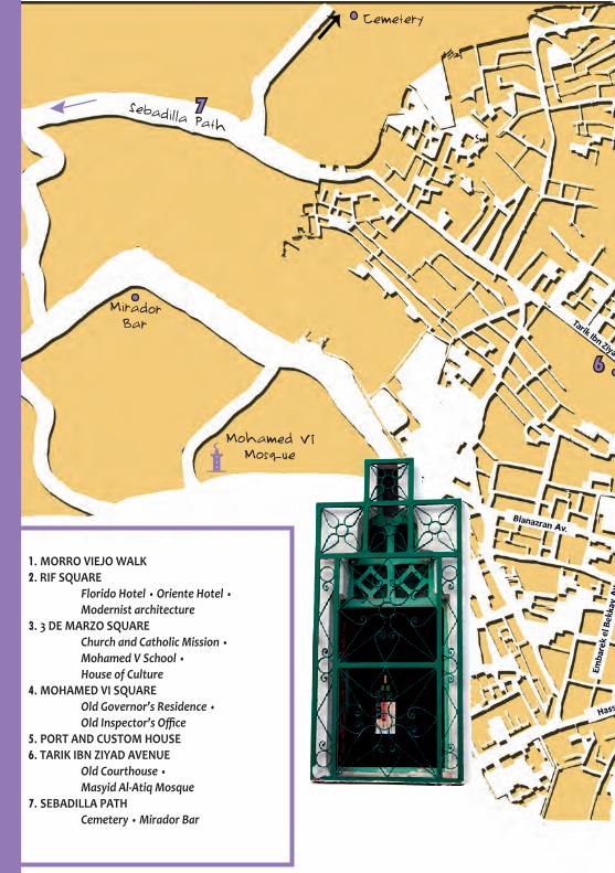
6
7
Mirador Bar
Cemetery
Sebadilla Path
1. MORRO VIEJO WALK2. RIF SQUARE Florido Hotel • Oriente Hotel • Modernist architecture3. 3 DE MARZO SQUARE Church and Catholic Mission • Mohamed V School • House of Culture4. MOHAMED VI SQUARE Old Governor’s Residence • Old Inspector’s Office5. PORT AND CUSTOM HOUSE6. TARIK IBN ZIYAD AVENUE Old Courthouse • Masyid Al-Atiq Mosque 7. SEBADILLA PATH Cemetery • Mirador Bar
Mohamed VIMosque

Morro ViejoWalk
12
3
4
5CUSTOM HOUSE
Old offices of the Torres Quevedo Radio StationOld Estado
Mayor Building
Itinerary: The Historic City Centre
Port

From the Morro Viejo (Dha Na Tzamourth, Old Muslim in English) viewpoint, you can see the bay and city of Al Hoceima. It is from here where you can appreciate how the architecture cre-ated by the sea magnifies and makes this city unique. It is a privileged spot from where you can fully understand the surrounding area. The panoramic view is like a history book, where every small bay, every bit of land that sticks out into the sea and every rock come together to create a novel: from its historic past and the city of Nakur, located opposite the Al Hoceima Rock, to the Sebadilla beach, location for the landings in 1925 and which hides behind the Morro Nuevo ravine. At its feet, you can find the Port and the city, which open up to the sea in Cala del Quemado, the urban origins of the city. Anytime is good to go for a walk along this route, however, we recommend the evening when the fishing nets are being put out, as it is at this time when it really comes to life: people walking, talking and deep in thought. You really get a feel for the unmistakable seaside charac-ter of the place.
1. Morro Viejo Walk
The Morro Viejo Walk and its views.
Está tallando el mar tu arquitecturadesde la tierna orilla bien ganadaal alto Morro Viejo, en esa airada
penetración del mar contra la altura...
The sea is calling you in the wakethat the passing boat leaves behind
and in the loyal seagull as it flies.
Trina Mercader, 1951. “A Villa Sanjurjo:
ciudad con vocación marinera”.Views from Morro Viejo in the evening.
2. Rif Square
This triangular shaped square was the first urban space to be built in the city and dates back to the 1920s. This square seems to attract people like a magnet and, over time, it has been used for vari-ous different activities including the Military pa-rades that used to wake the city up every morn-ing, religious and local celebrations and cultural events. Various hotels, bus offices, restaurants, cafes and banks have chosen this place to set up their offices.
Oriente Hotel, Rif Square.
219

Rif Square, Florida Hotel to the right (Above).Rif Square, 1928. (Right.Source: Al Hoceima Regional Council).
Amongst the different historic buildings in Al Hoceima, the Florido Hotel stands out as the in-disputable star of the city with its curved design. The Oriente Hotel is also of interest with its mod-ernist façade which currently is home to a hotel, restaurant and apartments. Behind the Florido, you can find the old Tejera Hostel (currently the Popular Hotel) and the Foto España building. Walking through the outskirts of the city, you can find more examples of modernist architec-ture, such as the unique facades of the buildings which look out onto the daily Souk that is held in the streets surrounding the square.
The first Photo Studio in Al Hoceima, it be-longed to José Lacalle Quijano, 1927 to 1968.
The old offices of the Torres Quevedo Radio Station, located in Mohamed V Avenue. Leaving Rif Square from the exit behind the Florido Ho-tel, you will arrive at the southern part of Mo-hamed V Avenue, old Melilla Street, which ends at the military building called the Estado Mayor and the offices of the Torres Quevedo Radio Station. The main streets that pass through this area are Hassan II and Mohamed V. Along these streets, you will find various buildings from the period, some of which have been reconstructed after the earthquake in 2004.
On the way to 3 de Marzo Square, you will come across Ifriquia Square. It has a circular design and was included in the original city plans as the central hub for the different streets. Today, it is still beauti-ful due to the blue tiles on the entrance of the Ghinia Mosque. The Mosque was built at the beginning of the 70s and houses a small Souk underneath an arcade that looks onto Abd al-Krim al-Jattabi Street.
220

4. Mohamed VI SquareThis Square, also known as the Port Viewpoint or Massira al-Jadra (from the Green March) is lo-cated in the final stretch of Mohamed V Avenue. It rises above the Quemado beach and, together with Morro Viejo, is the other great viewpoint from which you can see the city. Nearby, you can also find the Royal Palace. From the Square you can see two emblematic buildings from the Spanish period: the old Inspector’s Office and the Governor’s Residence, which today houses the Spanish School Melchor de Jovellanos.
Old Governor’s Official Residence, a function which was carried out here until 1956. After this time, it became the offices of the Spanish Cultural Mission and, later on, the Spanish School Melchor de Jovellanos. It was built in 1928 in a regional style, reminiscent of Spanish architecture due to the use of tiling, clay balls and other elements such as the finishing on the balconies, the lower arcade and the use of Exposed brick, very fashion-able in Spain during this period. The central balcony helps us to imagine the public nature of the Governor’s role at that time.
Inspection Office: La Regional. It was built in 1930 following the typical model used for military and government offices in the territories under the Spanish Protectorate: a central area, with towers on each side. The most interesting feature on the front of the building is the variety of dif-ferent windows and the closed gallery on the up-per level that rests upon thin columns, creating a porch area underneath. The detail of this building
3. 3 de Marzo Square
The old España or Chita Square, referring to the monkeys that could once be found here, can be quickly identified by the façade of the building that the square was built around at the end of the 20s. In this building you can find the San José Church, the Catholic Mission and the Mohamed V School. The latter of which, was first called the Dolla Public School and then later the Spanish School Group. The Square is a good place to take a break. It is usually busy during the day and has various ki-osks that sell snacks to passersby.
In the Square, there is a building that particularly stands out due to its archi-tecture from the modern movement of the 70s. Here you can find the headquar-ters for various associations, the House of Culture and a small and interesting Eth-nographic Museum on Rif-fian Culture, founded by the artist Hossain el-Kalai, also creator of the Heritage and Documentation Association. The building was first con-ceived as a library.
España Square, 1953. In the background you can see the San José Church, the Catholic Mission and the Spanish School Group. (Source: OMAU).
Current Jovellanos School.
221

is varied and where the main theme is undoubt-edly the sea. You can still find architecture from the Spanish period such as the Custom House, located out-side the Port area, and the Fisherman’s House, which maintains its welcoming curved corner with arches, despite having been refurbished.
5. The Port
¿How is the sea today? ¿Are there fish today? The fishing Port in Al Hoceima wakes up to this phrase every morning. Sheltered between the cliffs of Morro Nuevo, it looks up towards Morro Viejo and leaves the city behind to its right. It is a beautiful space where nature and man blend together harmoniously. The extension of the docks connects 3 rocks. This, along with the sur-rounding cliff walls, creates an architecture that
is particularly interesting, such as the capitals and the tiles that stick out like a sunshade underneath the parapet. Some of the elements used on the exterior parts of the building can be related to the first paintings by Emilio Blanco Izaga, howev-er, the interior decoration completely contradicts this image. Following the independence of Mo-rocco, it became the offices of the Government Delegation for the Province of Al Hoceima, and later Bachawiya (Town hall), until the earthquake in 2004.
6. Tarik Ibn Ziyad Avenue: Blanco Izaga’s Architecture
In Tarik Ibn Ziyad Avenue, near Mohamed VI Square, you can find two buildings that were designed by Emilio Blanco Izaga: The old Court-house and the Masyid al-Atiq Mosque.
Decorative detail on the balcony on the façade and the insi-de of the old Inspection Office.
Old Courthouse (mahacama). It was built at the end of the 20s. Blanco Izaga uses various cha-racteristic elements such as the fusion of asym-metric spaces, sloped walls, staggered window
222

Masyid al-Atiq Mosque, meaning the old Mosque, was the first to be built in Al Hoceima at the end of the 1930s. From the original design by Blanco Izaga, only the main part with its jagged battlements, the façade and the staggered win-dows remain. The minaret was replaced in the 80s, the original used to be in the opposite corner of the building. Far from the current style, Blanco developed a sloped space where the aesthetic elements “Berberised” the most representative symbol of Islamic culture. It is similar to his other Mosque designs such as those found in Axdir, Imzuren and Sneda. This minaret is the aesthetic summary of what, according to Blanco, the Riffian world could represent.
Decorative detail of the front of the Mosque. One of the sources that Blanco Izaga used to create the Riffian style were Pre-Columbian cultures.
7. Sebadilla PathThe Tarik Ibn Ziyad Avenue continues in a west-erly direction towards the outskirts of the city along a coastal road and long path from where you can witness some magnificent sunsets. This is the Sebadilla Path which takes us to the Aydayn beach, known as Sebadilla after the Spanish landings here in 1925. The name was giv-en to the beach due to the quantity of wild barely that grew here. The word Sebadilla came about due to the Andalusian pronunciation of the word. Original minaret from the Masyid al-Atiq Mosque (Above)
(Source: Al Hoceima Regional Council). The Mosque and its cu-rrent minaret (Below).
and arrow slits finished with polygonal mocá-rabe, squared gaps underneath the cornice and a flat roof with an overhang inspired by Riffian houses, decorative primitive moldings such as Riffian tiles or setback walls in the entrances and windows, used as decorative elements.
223

Cemetery. Before we start the walk, a detour to the right takes us to the maqbara or cemetery. It is a very interesting visit which is full of history. It was the place that was chosen to bury the military men who had died in battle following the land-ings, later becoming the city’s official cemetery. In this graveyard, three cultures shake hands: Mus-lim, Jewish and Christian, a coexistence that will last for eternity, a sign of tolerance and respect.
Mirador Bar. This is a curious place that was built during the Spanish Protectorate period and is located in Bir Anzarán Avenue, in the district of the same name. It is located on top of a hill and visually dominates the coastal area from Sebadilla beach to the Sidi Abi military lighthouse to the west. It is a great place to escape and there is a cafe and bar where you can spend the evenings or stay up all night. The style of the building is reminiscent of the
The architecture of the sea in the Sebadilla bay. End of the journey.
Old Al Hoceima Cemetery
Rationalist approach from the end of the 20s. The design is simple but very dynamic. It is rectan-gular with a powerful curved wall that overlooks the sea, closed in by windows which emulate the prow of a boat. Finally, there is an exterior railing which marks the end of the roof. The cantilevered part of the jagged cornice makes up for the lack of decoration. The surrounding area adds to the sense of movement that the building gives off. It crowns the hill of a pine forest where you can also find other elements such as terraces, pathways and balustrades, along with a set of decorative ir-rigation canals.
224

The Surrounding Areas of Al Hoceima
Al Hoceima National Park:Los Bocoyas As son as you leave Al Hoceima en route to Tetouan, you come across the Al Hoceima National Park. It is particularly attractive and very similar to its counterpart, Cabo de Gata, in Almeria. The park is located in the Bokoya moun-tain range, the name of the Berber tribe that lives in this area which means those of the hills.From the coast to the mountains there are vari-ous settlements, some whose history goes way back and some that are more modern, although they remain stuck in the past. The rest are Riffian hamlets scattered throughout the park.
It can be found right by the road. It is the main paved entrance to the park. In Ruadi, there is a Souk every Sunday (suq al-ahad). It is the most important market in the area and sells local products and typical Riffian craftsmanship. The products made from palm hearts and straw are usually made by men whilst the fabrics and pottery are made by women.
Aduz
Just 8 km to the north of Ruadi we come across Aduz, a village that is located near to the cliffs that look over the Mediterra-nean. Its history goes back to the middle of the 14th century, which can be seen by its Mosque, built by the Sultan Abu al-Hassan al-Marini. The village’s history is full of stories about different things that have happened there. These include stories about the arrival of the Moors who were trying to escape from Spain, about pirates who settled here as they considered it to be a stra-tegic location from which they could guard the coast, and about Aduz as a reference for spiritu-ality and study. At the end of the 19th century, the Sultan Abd al-Aziz Alawi destroyed the vil-lage. Walking through the streets of Aduz today, you can still see evidence of its past. You will find vernicular Riffian architecture and al-Havy `Ali Hassun’s Marabout, the old Sheikh of the village.
Ruadi
Drawing of the Aduz Mosque by Emi-lio Blanco Izaga (Source: Melilla Gene-ral Archive. E. Blanco Izaga Fund).
225

In the park there are a lot of Marabouts (tombs, sanctuaries) where various medieval Sheikhs are buried, stars of the important hagiograph-ic literature. There are also Marabouts of holy men who stood out for some special quality or miracle. Covered in revitalizing Baraka (bless-ings), these tombs are usually found in places that are out of the way, in order to promote the Sufi spiritualism. T hey are usually visited by people who are looking for a miracle that only a saint can make happen. They usually have simple and rustic architecture. At the same time, the architecture is very effective, as it gives off the impression that the marabouts are encompassed in a halo of mysticism, with an abundance of vegetation growing in the nearby areas.
Badis and the Vélez de la Gomera RockTo reach the rock, you have to cross a wide area of the park until you reach the sea. Dur-ing this journey, you will enjoy the natural set-ting and discover the daily life of its inhabitants. The things that make this area special include the tombs, the Riffian houses and the azmun, the way in which the bales of animal food are packed. En route, you will find the Tourist Infor-mation Office where they will inform you about the park including the possibilities of staying the night in traditional housing or other information about the local area.
In the Wadi al-Ansar River valley, which marks the limit between Gomara and Bocoya, you can find Badis. Today, it is a small fishing town locat-ed opposite the Vélez de Gomara Rock.
The city of Badis was an important Port during medieval times, as mentioned by al-Bakri and al-Idrisi, who situated the town just opposite Malaqa, a city with which it maintained contact by regular sea routes. Leo Africanus states that it was similar to the Port in the city of Fez. Nowa-days, there are only literary references and some archeological ruins that represent the medieval splendor of the city. These include the remains of the city wall on one of the hills and, a few kilo-meters away, the tomb of Abu Ya’qub al-Badis.
This story of the beginning of this city takes us back to the start of the 8th century. However, before this, it is thought that a Roman settle-ment was located here. It is possible that the location of Parienta, which appears in the Anto-nine Itinerary, may coincide with that of Badis.
You can find the Vélez de la Gomara Rock an-chored in the crystalline turquoise sea. It was conquered by Spain in 1564, however, the con-stant raids and attacks on Badis by the new owners led to the city being abandoned by its residents. The rock became a neck of land during the harsh winter of 1934.
Badis has a good Kasbah. It has an alcázar outside of the city with a beautiful garden. Furthermore, outside the city walls a dockyard can be seen.. Leo Africanus
In the city there is a long street which is inhabited by the Jewish. Here, they sell wine, which everyone thinks is divine liquor. Almost every night, when the weather is good, they go out into the sea in small boats, far from the land, and enjoy themselves drinking and singing the night away. Leo Africanus
In the background, the Vélez de la Gomara Rock.
226
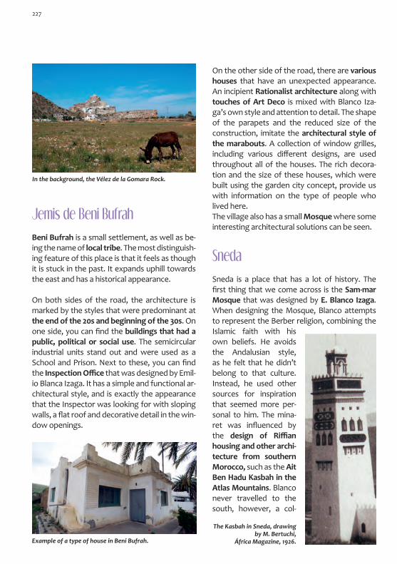
In the background, the Vélez de la Gomara Rock.
Beni Bufrah is a small settlement, as well as be-ing the name of local tribe. The most distinguish-ing feature of this place is that it feels as though it is stuck in the past. It expands uphill towards the east and has a historical appearance.
On both sides of the road, the architecture is marked by the styles that were predominant at the end of the 20s and beginning of the 30s. On one side, you can find the buildings that had a public, political or social use. The semicircular industrial units stand out and were used as a School and Prison. Next to these, you can find the Inspection Office that was designed by Emil-io Blanca Izaga. It has a simple and functional ar-chitectural style, and is exactly the appearance that the Inspector was looking for with sloping walls, a flat roof and decorative detail in the win-dow openings.
Jemis de Beni Bufrah
Example of a type of house in Beni Bufrah.
Sneda is a place that has a lot of history. The first thing that we come across is the Sam-mar Mosque that was designed by E. Blanco Izaga. When designing the Mosque, Blanco attempts to represent the Berber religion, combining the Islamic faith with his own beliefs. He avoids the Andalusian style, as he felt that he didn’t belong to that culture. Instead, he used other sources for inspiration that seemed more per-sonal to him. The mina-ret was influenced by the design of Riffian housing and other archi-tecture from southern Morocco, such as the Ait Ben Hadu Kasbah in the Atlas Mountains. Blanco never travelled to the south, however, a col-
Sneda
On the other side of the road, there are various houses that have an unexpected appearance. An incipient Rationalist architecture along with touches of Art Deco is mixed with Blanco Iza-ga’s own style and attention to detail. The shape of the parapets and the reduced size of the construction, imitate the architectural style of the marabouts. A collection of window grilles, including various different designs, are used throughout all of the houses. The rich decora-tion and the size of these houses, which were built using the garden city concept, provide us with information on the type of people who lived here. The village also has a small Mosque where some interesting architectural solutions can be seen.
The Kasbah in Sneda, drawing by M. Bertuchi,
África Magazine, 1926.
227

To the more daring visitor, we encourage you to head to the Kasbah in Sneda. Following our route towards the village, we go along a dirt track which takes us back to medieval times. The Kasbah can be found in the old village Thara ´n Bades, named after the Fountain which sup-plied the city of Badis with drinking water. It was built during the Saadien dynasty (1511-1659) and for centuries was the authoritative centre for the central Rif territory. During the Spanish Pro-tectorate, the Army Barracks and Military Ad-ministration Office were built here. In fact, today you can still see the remains of various buildings that were constructed by the Spanish. Nearby, you can find the Wazanga Zaouia, a place where Abdelkrim sought refuge before giving up and handing himself over to the French Army.
The Kasbah in Sneda, drawing by M. Bertuchi, África Magazine, 1926.
Towards the East: Throu-gh the Land of Abdelkrim
Sfiha beach: The Rock of Al Hoceima
About 500 metres off the coast of the Sfiha beach, you can find the Rock of Al Hoceima, a name which it received from the Spanish when they conquered it in 1673. Since then it has been inhabited by and belongs to the Spanish State, and is run like a little city. It is perfectly equipped and has buildings from various different periods. Regarding its name, there are different theories. One of these theories suggests that the name derives from al-Mazamma (The Renamed), the name of an important Port settlement in me-dieval times that maintained frequent connec-
The Rock of Al Hoceima opposite the Sfiha beach.
lection of postcards and a book by Henri Terrase were enough for him to get to know this territo-ry and for him to forge his own idea on the styles used there, styles which he would later combine with others.
228

The best views of the Sfiha beach are from the Se-dum (Adrar) Mountain, the place that Emilio Blanco Izaga chose for the water supply system. In this piece of work, the influence of European styles from that time, such as Art Deco, is clearly evident. Influences from Berber tribal architecture from the Atlas Mountains and Pre-Columbian references are also visible. This combination perfectly suited the taste of the Inspector. (Source: V. Moga Romero)
Axdir
Approximately 8 km from Al Hoceima and tak-ing the Azgar turn off, you will find Axdir, a Rif-fian name meaning the vineyard. The breeze reaches inland to this area from the Bay of Al Hoceima which can be seen in the distance from the hills. It is the capital of the Beni Urriaguel Cabila, the most widespread tribe in the Rif territory. It is also the homeland of Abdelkrim, a Commander who managed to bring together Riffian Tribes and proclaim the Rif Republic (Yumhurhiyya Rifiya) in 1923. This, in turn, converted the place into the epicentre of the Riffian fight against the Spanish. When Abdelkrim’s properties
tions with the southern coast of Al-Andalus. It was a Salihí Port from the Emirate of Nakur, and was built at the end of the 8th century. After the destruction of Nakur by the Almoravid Com-mander Yusuf ben Tachfin in 1081, al-Mazamma became an important Almohad city.
were confiscated after his arrest, his old Military Headquarters in Axdir were used as the Spanish Inspector’s Office. Blanco Izaga would also in-tervene in the settlement with various buildings such as the territorial Children’s Preventorium, the Primary School, the Army Barracks, the In-spection Office and the Mosque.
As in Sneda and in the capital, the Mosque in Axdir focuses your attention on the minaret, an obligatory element of all Muslim temples. It is here where the decorative force is used in an attempt to create architecture and a style that, in some way, symbolically unifies the Riffian people through what he calls survival of habit (which some historians call optical language). In other words, they were lacking a personal style of architecture and therefore a visual identity.
The remains of the Inspection Office in Axdir tell us that it was a building that was construct-ed in harmony with its surroundings. It is with-out a doubt a unique construction which can be related to the archaism of the Greek Doric Order, due to the constraint and the monu-mental conception of the structural elements. Although it doesn’t have columns, the pillars and their quadrangular capitals remind us of a mixture of ancient styles mixed with Art Deco, whilst the colour pallet transports us to the island of Crete.
Remains of the Inspection Office in Axdir.
229

On the road to Nador, you will find the Cape Qui-lates Lighthouse, one of many that the Spanish built along the Sharifian coast. Some aesthetic details confirm that this building belongs to this area, such as the staggered battlements or the raised corners. The design of the tower-lighthou-se is reminiscent of the minaret of a Mosque.
Cape Quilates Lighthouse Cape Quilates Lighthouse.
Arbaá Taurirt
Emilio Blanco Izaga finished his work in this area with the Regional Inspection Office. It is located in the Beni Urriaguel territory, in a setting that is very typical of the depths of the Rif. It was built in 1941 and was a fortress that was equipped with everything that could possibly be necessary. The building is located on top of a hill which provides us with breath-taking panoramic views which reinforce the sense of isolation and loneliness brought about by the harsh cli-mate. It is the castle of the area, the Tigermint around which the Rif-fians organised them-
Blanco knew that when the Berbers, both anarchistic and individualistic, need to unify in defense, they group together their houses or taddats around the ti-germint, which is also a feudal castle, collective granary, a pen in which to round up the cattle in difficult times of war and strength.
Alfonso de Sierra Ochoa.
selves. It is the building which would bring po-litical unity to the hamlets, providing them with a much sought after visual identity.
A drawing by M. Bertuchi of the carved beams that were used in Riffian housing and Marabouts (Zaouias). Above, decorative detail of the Arbaá Taurirt Walls which are similar to these carved beams. They are a recognisa-ble sign of traditional Riffian architecture.
230

The Architect Inspector unraveled his conceived and elaborate imagination and incorporated it into every detail. The recuperation of the primitive architec-tural styles is translated into simplicity, spontaneity, basic and pure geometry, the apparent chaos of asymmetry in the combination of spaces, the typological diversity of the openings; and, as unques-tionable features of his work, the sloping walls which give the sensation that he wanted to reach the sky, the flat roof with an overhanging cornice, the pyramid-base shaped spaces and the primitive and tribal geometric decoration.
Detail of the main tower.
To finish his creation, he added a big tower, emulating those used in the Mosques that he had designed previously. He also included a chimney, a place where he could read stories of Edgar Allan Poe during those long cold nights in the Rif.
231

(In the lintels of the Riffian houses they never forget to include a small triangular hole which, to a superficial onlooker, would appear to be merely decorative. However, it is in fact the accommodation that each rural family prepares for their insepara-ble companions, the Swallows.
E. Blanco Izaga.
He wanted to represent a system of thinking, a unique universe that revolves around mystery and the nostalgia of a utopian horizon. V. Moga Romero
TOURIST INFORMATIONProvincial Tourism Delegation (+ 212 539 98 11 85). www.rifturisme.com www.parquenacionalalhucemas.com
...not only were they project designs, but true artistic designs. On the most inhospi-table, erect and dif-ficult peak to build on, he constructed the main tower of the Kas-bah, in his aspiration to reach the sky…..Lat-er, in a logical but asymmetrical fashion, which seemed quite absurd, he managed to distribute the other parts of the construc-tion…
A. de Sierra Ochoa.
...the artistic dream of an self-educated inspector in a breath of inspiration.E. Maldonado Vázquez.
Drawing of the door of a Riffian house and details of the walls of Arbaá Taurit by Blanco. (Drawings from the Melilla Gen-eral Archive. E. Blanco Fund).
232


NadorMachine Aesthetic
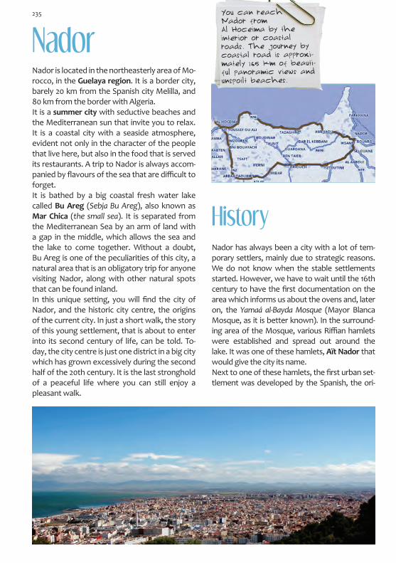
NadorNador is located in the northeasterly area of Mo-rocco, in the Guelaya region. It is a border city, barely 20 km from the Spanish city Melilla, and 80 km from the border with Algeria. It is a summer city with seductive beaches and the Mediterranean sun that invite you to relax. It is a coastal city with a seaside atmosphere, evident not only in the character of the people that live here, but also in the food that is served its restaurants. A trip to Nador is always accom-panied by flavours of the sea that are difficult to forget. It is bathed by a big coastal fresh water lake called Bu Areg (Sebja Bu Areg), also known as Mar Chica (the small sea). It is separated from the Mediterranean Sea by an arm of land with a gap in the middle, which allows the sea and the lake to come together. Without a doubt, Bu Areg is one of the peculiarities of this city, a natural area that is an obligatory trip for anyone visiting Nador, along with other natural spots that can be found inland. In this unique setting, you will find the city of Nador, and the historic city centre, the origins of the current city. In just a short walk, the story of this young settlement, that is about to enter into its second century of life, can be told. To-day, the city centre is just one district in a big city which has grown excessively during the second half of the 20th century. It is the last stronghold of a peaceful life where you can still enjoy a pleasant walk.
HistoryNador has always been a city with a lot of tem-porary settlers, mainly due to strategic reasons. We do not know when the stable settlements started. However, we have to wait until the 16th century to have the first documentation on the area which informs us about the ovens and, later on, the Yamaá al-Bayda Mosque (Mayor Blanca Mosque, as it is better known). In the surround-ing area of the Mosque, various Riffian hamlets were established and spread out around the lake. It was one of these hamlets, Aït Nador that would give the city its name. Next to one of these hamlets, the first urban set-tlement was developed by the Spanish, the ori-
You can reach Nador from Al Hoceima by the interior or coastal roads. The journey by coastal road is approxi-mately 165 km of beauti-ful panoramic views and unspoilt beaches.
235

It is at this time when the city’s architecture is completed: administrative and military buildings, public buildings such as schools, hospitals, the sl-aughter house, the Souk, etc., and in the outskirts, the army barracks as a symbol of its military character.
There are various bars, coffee shops and other places where you can meet with friends to have a chat and play a game of dominos. Wide streets invite you to go for a walk and enjoy the city itself; there was a summer cinema, the imposing Rif Ci-nema, which is Rationalist in design with Art Deco style decoration, and the Theatre-Cinema Victo-ria in the old Pilar Square. Pilar Square was an ur-ban space where you could relax and enjoy life. It had a garden and a bandstand in the middle, and was also the location of the hunting and fishing club, which had a modernist appearance. Just like this square, there were three others around the city that over time have changed their names or disappeared. They were originally known as San-tiago Square, Alfonso XIII Square and Príncipe de Asturias Square. The city of Nador and its small grid, continues to be a place that is very habitable.
gins of the current city which dates back to 1909 with the construction of a military camp. From this date onwards, the city was designed in a grid network. The first thing that was built was the train station, for the train line that connected Melilla and Nador with the iron mines. This is an essential element in understanding the develop-ment of the city, as well as those small settle-ments that were built in the outskirts.
Nador grid, 1945. (OMAU Archive)
The Spanish Administration referred to this Shari-fian area of Morocco as the Eastern Region, and later on as Quert. Nador became capital of the region in 1934, under the name Villa Nador.
Amazigue, colloquially called Riffian in the north of Morocco, is the Berber language which has its origins in the Hamitic languages. Tifinagh is the alphabet that is used to transcribe the said language. The Amazigue culture (term which means free man), has its own calendar starting in 935 a.c. This was when the Berber Sheshong I was made Pharaoh of Egypt, found-ing the 22nd dynasty.
Emblem of the hunting and fishing society that decorated the front of the building located in the old Pi-lar Square.
The Official’s Room in the Headquarters of the Regulares. It can be found leaving Nador, outside of the grid.
236

Machine Aesthetic
Rationalist building, first half of the 30s. Char-acteristic elements such as the horizontal alignment of the building façade or the rup-ture of the interior spaces.
The grid lives immersed in its history with its ori-gins evident in the architecture and the city plan-ning. It was developed in the first half of the 20th century by architects such as Manuel Latorre Pas-tor and his predecessor Francisco Herranz.The grid doesn’t have an architectural ego, but does have a distinct style which is being mirrored in current architecture. It is a style which is form-ing the aesthetic identity of the city. Originally, it was Modernism that was predomi-nant in the design of the city’s buildings. Today, this style has almost disappeared, with the excep-tion of the detail of some moldings, doors and windows which can be found in buildings scat-tered around the city. Since then we have seen various different styles such as Art Deco, Ration-alism and Neo-Arabic. Art Deco is one of the predominant tendencies in the city’s architecture. It ruled in the city from the beginning of the 30s until the beginning of the 40s. Rationalism was also present in the city’s ar-chitecture in the 30s, later being associated with the Machine Aesthetic movement, as it is called by some historians. This movement involves the use aerodynamic lines and elements such as railings, bull’s eye, chamfers, etc., all giving a sculptural concept to the building and a sense of movement.
Modernist moldings.Old Headquarters of the Hunting and Fishing Society, 20s.
The façade of the sail-ing club in the shape of the keel of a boat, an example of the Machine Aesthetic movement in Nador.
Art Deco style window.
Rationalism became more popular from the 30s onwards. The city witnessed an increase in the use of curved corners, horizontal elements in the building façades such as oblong windows, frames and horizontal bands, broken spaces with the ad-dition of drawers and the generation of openings in the corners of the building with the use of over-hanging balconies, etc.Neo-Arabic, Regionalist and Classical styles were also a distinct part of the Spanish architecture which Latorre put into practice during the change of decades between the 30s and 40s. This type of architecture was extremely popular both in Spain and in the Spanish Protectorate territories, espe-cially after the 40s with the Officialist style.
Neo-Arabic tower in the shape of a minaret. Old wa-ter deposit next to the Head-quarters of the Regulares, 1950s.
Rationalist curved and set-back façade. The first floor was added at a later date.
Façade of a building located in Mohamed V Avenue. Rationalism with Classical ele-ments.

1. NORTH-SOUTH AXIS: SEAFRONT (ZERKTHUNI AVENUE): Sailing Club • Post Office2. NORTH-SOUTH AXIS (ZERKTHUNI AVENUE): Fishing Port • Sidi Ali Marabout3. EAST-WEST AXIS: MOHAMED V BOULEVARD 4. LIBERACIÓN SQUARE: Quert Regional Inspection • Art Deco Architecture 5. AREA AROUND THE CHURCH (M. HASSAN BEN MEHDI STREET): City Council Office • Santiago el Mayor Church • Rationalist Architecture6. AL-QISSARIYA PEDESTRIAN STREET: Kert Hotel · Assalam Hotel
Itinerary: The Grid
El Jemis
Haj Mustfa Mosque
Courthouse
Mohamed V Mosque
1
2
3
4
5
6
238
PORT
LIBERACIÓNSQUARE
ZERKTOUNI BOULEVARD
MOHAMED V BOULEVARD

Flechas Navales (a branch of the Spanish Navy), and was later converted into the Sailing Club. Old Post Office Building. It can be found in front of the Saling Club. Despite being built af-ter its neighbor, it differs a great deal from the modern appearance of the club. It was designed with Regionalist features such as the façade with towers on each side, the semicircular arcade and the detail of the cornice, such as the pentice or the tiled roof. However, the clear and defined structure of its space and the lack of decorative elements and moldings are counteracted by the abundance of window openings which represent the Rationalist style.
The idea to create a seafront promenade came about in the 30s. The north-south axis of the city was built looking out over the sea, creating a pri-vileged urban space with views of the Mar Chica (Bu Areg). It is a place for rest and relaxation with the Sailing Club located in the centre, a symbol of the city. You can also still see buildings from the Spanish period here. On the promenade you can appreciate a wide range of different colour tones from sunrise to sunset which dye the white buildings and the Mar Chica.
Sailing Club. It is without a doubt the most emblematic building in the city, both for its appearance, as for being the centre of social activity in Nador. Its design follows the Machi-ne Aesthetic movement and the aerodynamic models of the Art Deco style which treat buil-dings as if they were plastic objects. Although the building itself is simple in terms of space and size, the impression it gives is very effecti-ve, posing like a boat anchored in the sea. If you look at it from the front, it even appears to be moving. It was designed at the beginning of the 40s by M. Latorre as a place of refuge for the
1. North-South Axis: Seafront (Zerkthuni Avenue)
2. The Fishing PortThe fishing Port can be found at the end of the northern stretch of the promenade. It was the first fishing port in Nador, which today has been converted into a small pier. It is one of the most beautiful corners of the grid where you can find a wealth of sea blue tones. The snow-white tomb of Sidi Ali stands out next to the Port, near the old Muslim Cemetery.
239

Mohamed Avenue comes to an end on its western side at Liberación Square, the location of the old Headquarters of the Quert Regional Inspection.
Old Headquarters of the Quert Regional Ins-pection. It was designed by M. Latorre Pastor at the beginning of the 40s and formed part of the urban design of the grid. The central part of the building is flanked by two modeles which stretch out as lateral wings. The building and its hori-zontal design represent a beautiful end to the Mohammed Avenue. From the original design, only the central part of the building and the façade remain, although altered by the addition of a new balcony. The original design has been changed in order to improve the city’s mobility, in an attempt to connect the historic city centre with the modern city from the 21st century that grows behind it. Without wanting to distance itself from the Art Deco style of the 20s, the building has evidently been influenced by Arabic tendencies. The ori-ginal idea for the building was to treat it as a plastic object, very much related to the Machine Aesthetic movement.
3. East-West Axis: Mohamed V Boulevard
The consolidation of the grid du-ring the 30s and 40s means that Nador now has two main and very well known axis: the promenade (north-south) and España Avenue, today called Mohamed V Avenue, a central street which crosses the historical centre (east to west). Mohamed V Avenue crosses the promenade on its eastern side, near the Sailing Club. On the opposite side of the Avenue, you can find the Head-quarters of the Quert Regional Inspection office. It has an oval-shaped gardened area lo-cated just in front of it, making the building’s presence known to everyone. The Avenue was designed as a place where people could go for a walk and get together for local public celebrations. It has a central boulevard with trees and palm trees and is also the home to various small businesses and coffee shops.
Convergence of the main boulevard (east-west) and the promenade (north-south).
4. Liberación Square
Sidi Ali Marabout.
240

On the right hand side of Liberación Square, there is an apartment building that stands out for its aerodyna-mic Art Deco appearance, although it has been chan-ged slightly over time. This style is evident by the use of railings, the bull’s eye and the circular spaces at di-fferent levels, as well as its asymmetric composition. It was built towards the end of the 30s and could possibly be a design by M. Latorre
5. Area around the Church
Catholic Church and the Santiago el Mayor Mission. It is the oldest building that still remains today and was finished in 1921 by the monk ar-chitect Francisco Serra, the person who was also responsible for the design of other temples in Tangier and Ksar el-Kebir. It is both simple and monumental at the same time, standing out in its surroundings due to its size. The most interesting
This was a very busy area, mainly due to the fact that the church was located here. It is a gardened area in front of the temple that is close to the lively Pilar Square. For decades, this was an urban space that was full of life.
feature of its design is the fact that from the front of the building, the church appears to have three interior rooms, when in fact there is only one. It has an eclectic design with romantic influences where geometric decoration rules.
Opposite the church and almost falling off of the grid, there is an apartment building that stands
Board of Social Services. It was built at the be-ginning of the 40s and has a beautiful design. The most interesting feature is the central part of the building which was constructed in the style of a tower-viewpoint which stands out from the façade, creating a counteracting effect to the horizontal sides of the building. This effect is even greater due to the wooden gallery balcony which is reminiscent of colonial American architecture. The tower is the highlight of the building and it is here where you can find the decorative detail. It stands out due to its concave chamfers which are broken by a balcony which is decorated with mouldings that accentuate its vertical form.
An apartment building opposite the church, built in a Rationalist design.
241

6. al-Qaysariyya Pedestrian Street
This street ends in Youssef Ben Tachfin Avenue, exactly in the esplanade of the modern Lala Ami-na Mosque, known also as the Haj Mustfa Mos-que. It stands out as much for the height of its tower as for the beauty of its architecture, filling the surrounding area at the time of prayer. Con-tinuing along this avenue, you reach the Souk that is held on Thursdays (Suq al-Jemis). It now has a renewed and modern image, but it originally started out at the end of the 30s/beginning of the 40s, and is a place that is always fun to visit.
Outside of the grid, arriving at Nador from Al Hoceima on the national road 19, you will find a Neo-Arabic style building. Once again, a design by M. Latorre leaves an architec-tural example of great formal beauty. He mixes Nasrid and Almohad elements with Arabic decoration. It was in this building that the Sidi Ali School was located. Today, it is a Courthouse.
Crossing the main avenue, you will find the pedes-trian street al-Qaysariyya (al-Qissariya o El Kissar-iat). As its name suggests, it is the alcaicería, the place where textile products were sold and one of the liveliest places on the grid. Along with various businesses, there are daily stalls selling fruit, food, and other types of things which brighten up the street and make it a place to socialise. It also contains various historic buildings, such as the Kert and Assalam Hotels. The latter of the two has a distinctive façade that would be worthy of any cinema. It was built in Art Deco style with a stark contrast between the decorative central vertical bands and the horizontal part of the fa-çade. It is a building from the 40s by M. Latorre. The Kert hotel is a building from the 30s and is of a sober composition. Each exterior is unique with different Art Deco style decorative elements such as broken balconies, horizontal moldings and a
al-Qaysariyya Street, Alcaicería Street, with the front of the As-salam Hotel to the left.
circular window on the side of the building that backs on to the pedestrian street.
out for its curved corners which take us back to the aerodynamic Art Deco era of the 30s. Once again, the building is understood as a plastic visual object that gives us the impression of movement. This is mainly due to the upper pentice which is set back, the exaggerated cornice and the balcony which breaks up the different spaces. It is in line with many of the Rationalist ideas of the late 20s. Even the colours used were very common in Tradition-alist architecture. Furthermore, due to the lack of extra decoration on the front of the building, it has flat walls.
Detail of the Kert Hotel.
242

The city’s history is completed outside the perime-ter of the grid and outside of the city itself. Nador is located in the Guelaya province, known not only for its natural richness, but also for its historic past which is linked in certain periods to the other side of the Mediterranean. Various cities that are now destroyed, such as Tazuda and Cazaza or the Kas-bah in Seluán, show us evidence of their medieval past. However, directly related to the history of the city of Nador, you can find the historic route of the Uixan mines or the Barracks of the Regulares from Segangán, both obligatory stops in order to complete your visit.
The city of Cazaza was known to the sailors from Catalonia and Aragon as the Alcudia de Bervería, a name which comes from the Arabic phrase al-Kud-yat al-Bayda, meaning the white hill. It was a very important Port and was the main commercial base in Morocco for the Kingdom of Aragon. It reached the height of its splendor in the Marinid period. In 1505 it fell into the hands of the Medina Sido-nia house, until it was destroyed and abandoned in 1532. Nothing remains of its medieval past, but you can enjoy the journey to the hill where this flourishing city once stood, where Boabdil landed when he lost the Kingdom of Granada in 1492 and where he began his journey to Fez.
From the hill, you can make out the Sidi Mas’ud Marabout, whose history can also be linked to Al-Andalus. It is said that it served as a reference point to sailors due to its white colour. It seems that this holy man was from Granada, and that he fled the city together with his family.
Cazaza and the Sidi Mas´ud Marabout
Cazaza was very strong, held in by strong walls. It has a big Port where the Venetian boats used to come and do a lot of business with the people from Fez, leaving behind lots of money. Leo Africanus.
Cape Three Forks (Ras Tileta Madari) is one of the most astounding geographical sites in Guelaya. The lighthouse is the perfect excuse to include information on a place that is so wild and that may seem out of place in an architectural guide of Morocco. It is located in the north of the region at a spot where both the Cape and lighthouse share views of the Mediterranean Sea. The road that leads you to the lighthouse is hair-raising to say the least. It runs along the side cliff, coming to an abrupt halt. From the lighthouse, you can see unspoilt scenery and panoramic views that seem to never end. The lighthouse has been fully func-tional and doing its job for more than a century, since 1909.
Lighthouse at Cape Three Forks
Some of the roads and pathways are dirt tracks or quite difficult to
access. Due to this, we recommend that you have an adventurous spirit, a good car and a map of the area. It is a great route for
bikers and for cyclist’s legs.
The Surrounding Areas of Nador

Despite being in very poor condition, a visit to the Barracks of the Regulares is still very interesting. They were built during the first decades of the Spanish Protectorate. The powerful façade still re-mains today and is reminiscent of legendary medi-eval times. It takes us back to the period of the Ca-liphate of Cordoba and to Maghreb constructions such as the necropolis de Chellah, built in the 14th century in Rabat. Inside, ceramic plaques reveal how each room was used.
Barracks of the Regulares of Se-
gangan and the Sidi Yusuf Marabout.
Gurugú: Tazuda Castle
Not very far from the Barracks and along a dirt track that starts at the Tarka Arrabal or sub-urb, you can find a Marabout that is shared and adored by two religions. This is the Sidi Yusuf Ma-rabout for the Muslims and the Rabbi Sadia Edaty Marabout for the Jewish. According to tradition, this Sephardic Saint from Seville fled the city in 1239 after a massacre of the Jews. He set off by boat and headed towards the east together with seven other men. Unfortunately, bad weather made their boat sink. However, they were lucky enough to reach these shores alive.
The Gurugú mountain range can be found at the end of the eastern part of the Rif territory. You can reach it via a two way road which is both nar-row and very dangerous, although most definitely worth the effort. It is here that you can find the re-mains (although very little) of the Tazuda Castle.
Tezzota (Tazuda) was built on a hill …the founders belon-ged to the Beni Marin family. It was here that they kept their grain and other riches, so that they could wander the desert without worrying. ………the city was demolished by order of the Sultan of Fez and was left in ruins……..A captain under the King of Fez, who was from Granada and was extremely brave, asked permission to reconstruct Tezzota. He was granted permission by the king and the city was rebuilt. Leo Africanus.
Uixán Mines (Iksane)
Views towards the mountains of the Uixán mines, taken from Gurugú.
The exploitation of the Uixán Mines was started by the Spanish trade union Sindicato Español de Minas del Rif, with another Spanish company, Compañía Española de Minas del Rif (CEMR), taking over after a short period of time and con-tinuing from 1907 until the nationalisation of the mines in 1967. From 1968 onwards, the Moroccan company, Societé d´Explotation des Mines du Rif (SEFERIF), continued the exploitation until finally closing in 1980. Nador is located halfway between Melilla and the
244

Plaque at the entrance of Fort Ntra. Sra. del Carmen, in Uixán.
The timetable of the train that ran between Melilla and the mining settlements.
By 1908 they had already settled in the future loca-tion of Uixán, building Fort Ntra. Sra. del Carmen in 1912, designed by the engineer Guillermo Preus Dietrichson as a defensive stronghold. In parallel, they also built the Headquarters of the CEMR and some housing. Shortly afterwards, the following buildings were constructed: Fort San Jerónimo, the Buenavista Church-School, Sleeping Quarters for the single people, Amit Tahar’s house (the interpreter), the Funduq for the Muslim popu-lation, the Cooperative and the Cafeteria, which over time would become the Uixan Club. During the 30s and 40s, chalets were built for the mine’s management team and then, little by little, the Uixán village was formed around the path that led up to the San Daniel Treatment Plant. Today, we no longer can see the red cloud and dust that for decades dyed the streets and architecture of this settlement. However, the image of Uixán as a mining town can still be seen through the remain-ing architecture on both sides of the path, as if it were sleeping, waiting for the mines to wake up.
The minerals were transported by aerial trolleys and by train. There is still some evidence that this infrastructure existed which helps us to piece to-gether this historical puzzle. You can also find the remains of other things such as loading bays, the tracks on which the minerals used to be transport-ed, entrances to the mines and sulphuration fur-naces which were fuelled by anthracite that was brought here from the Yerada mines near Uxda, located in French Protectorate territory. All of these elements can be found along the different dirt tracks which lead us to the mines and the Min-eral deposits such Saint Daniel and Saint Tomás.
Mines, and it was here where the urban settle-ments started to form.
San Juan de las Minas was the first settlement, followed by others such as Setolazar, Afra, La Alicantina, Atalayón or Uixán, which was the big-gest of them all and was created by the CEMR in the territory that belonged to the Beni Bu Ifrur Tribe.
Remains of the infrastructure used by the trains.
Housing for the manage-ment of the Uixán mines.
245

Fort Nta Sra del Carmen in Uixán, it consists of two floors around a central rectangular patio, with two cabins for the guards. Opposite, they built the Chivani living quarters, meaning old in amazigh, and on the other side they built the sleeping quarters for the single people. A little bit further up, you can find Fort San Jerónimo.Three more forts were built between 1908 and 1918 at different locations in the mining area: Fort San José in the Axara Mountain, Fort San Clemen-te in San Juan de las Minas and Fort San Enrique.
The Mineral Treatment Plant in San Daniel, as seen from Mount Axara. You can see a waste disposal unit. The setting is as spectacular as the views of the Mar Chica, Nador and the Gurugú Mountains.
If you choose to visit, we recommend the Mines of Uixán and the Lighthouse at Cape Three Forks. If you want to do it all in a day, we recommend: Segan-gan, Uixan (Iksane), Gurugú, Cazaza and Three Forks. All of the roads are interesting, although differ in their condition.
The turn off for Uixan (Iksane) is on the N16 (to-wards Al Hoceima), after the entrance to Segangan. At a crossroads, you will find the turn off for Beni Sideluta – Dar Kebdani on the left, this is the route you have to take to reach Iksane. If you turn right, you will be headed towards Gurugú.
Gurugú: a two-way mountain road that is danger-ously narrow and in bad condition. Tazuda is about 19 km from here. You can continue along the road pass-ing through the mountains until you reach Farjana in the north. (If you turn back, you can reach Nador from Segangan, following signs to Beni Enzar – Farhana).
You can reach Cazaza from Farjana on the P6200 road. You can reach Cape Three Forks, in the north on
the P6209 road from Beni Enzar or on the P6200 road from Cazaza.
TOURIST INFORMATION Nador Tourist Office - 80 Bd Ibd Rochd Tel.: +212 (0) 56 33 54 52
246

BibliographyABAD, F., Málaga y su provincia “Ayer y hoy”. Edicio-nes Ilustres, Córdoba, 2002. AA.VV., Aproximación a los edificios históricos y pa-trimoniales de Málaga, Tetuán, Nador, Tánger, Alhu-cemas. Servicio de Programas del Ayuntamiento de Málaga, OMAU, Málaga, 2011. AA.VV., Arquitectura, ciudad y territorio en Málaga (1900-2011). Méndez Baiges, M. (ed.), Edición de Geo-metría Asociación Cultural, Monografías de arquitec-tura y urbanismo. Málaga, 2012.AA.VV., Arquitectura española en el norte de Marrue-cos. La cuadrícula de Nador. Instituto de Cultura Me-diterránea, Melilla, 2006. AA.VV., El Marruecos Andalusí. El descubrimiento de un arte de vivir. Ministerio de Asuntos Culturales del Reino de Marruecos - ONG Museo sin Fronteras (Vie-na, Austria). Eds. Electra, Madrid/ EDDIF, Casablanca, 2000. AA.VV., El Relax expandido. Ayuntamiento de Málaga - OMAU - Colegio de Arquitectos de Málaga, Málaga, 2010. AA.VV., Guía histórico-artística de Málaga, Colegio de Aparejadores y Arquitectos Técnicos de Málaga - Ed. Arguval, Málaga, 1992.AA.VV., Guía del Parque Nacional de Alhucemas. Fun-dación Biodiversidad, MPDL, GEODE, ASVT Alhuce-ma, 2º edición, Rabat, 2008. AA.VV., Jane Bowles, últimos años. Ed. Instituto Muni-cipal del Libro, Málaga, 2010. AA.VV., La medina de Tetuán. Guía de Arquitectura. Consejo Municipal de Tetuán y Consejería de Obras Públicas y Vivienda de la Junta de Andalucía, Te-tuán-Sevilla, 2011. AA.VV., Málaga Plano-guía de arquitectura. Consejería de Obras Públicas y Transportes, Junta de Andalucía, 2005. AA.VV., Mariano Bertuchi pintor de Marruecos. Ed. Lunwerg Editores, Barcelona, 2000.BRAVO NIETO, A., “Europeismo y africanismo: dos ejemplos de arquitectura española del siglo XX en Marruecos”, Boletín de Arte, nº 12. Universidad de Málaga, 1991. (pp. 255-277).BRAVO NIETO, A., La arquitectura y el urbanismo es-pañol en el norte de Marruecos. Consejería de Obras
Públicas y Vivienda de la Junta de Andalucía, 2000. BRAVO NIETO, A., “La mirada africana: entre el art decó y el clasicismo. Aproximación al arquitecto Ma-nuel Latorre Pastor, Boletín de Arte nº 17. Universidad de Málaga, 1996, (pp. 327-347). BRAVO NIETO, A., “Tetuán y Larache, dos modelos de ensanche en el norte de Marruecos”, VI Jornadas de Historia de Ceuta. Instituto de Estudios Ceutíes, Ceuta, 2006, (pp. 83-109). BRAVO NIETO, A., “Tetuán, un modelo ecléctico de ciudad (1912-1942): entre la tradición neoárabe y la modernidad art decó”, Arquitecturas y ciudades his-pánicas de los siglos XIX y XX en torno al Mediterráneo Occidental. Melilla: UNED, 2005. (pp. 169-216).CALDERÓN Y RUIZ, L. y PONCE GÓMEZ, A., “Itinera-rio místico mágico por Ikelaia: moravos, leyendas y tradiciones populares”, Revista Aldaba, nº 16. UNED, Melilla, 1991. CALERO SECALL, Mª. I. y MARTÍNEZ ENAMORADO, V., Málaga, ciudad de Al-Andalus. Ed. Ágora, 1995. DUCLOS BAUTISTA, G. y CAMPOS JARA, P., Chauen. Evolución urbana de la ciudad. Consejería de Obras Públicas y Vivienda de la Junta de Andalucía, 2001. DUCLOS BAUTISTA, G. y CAMPOS JARA, P., Larache. Evolución Urbana. Consejería de Obras Públicas y Vi-vienda de la Junta de Andalucía, Sevilla 2001. DUCLOS BAUTISTA, G. y CAMPOS JARA, P., Tetuán. Evolución urbana de la Medina. II Plan Regional de Centros Históricos. Consejería de Obras Públicas y Vivienda de la Junta de Andalucía, 2003.ESPAÑA, A., La pequeña historia de Tánger. Distribu-ciones Ibéricas, Tánger, 1954. GUASTAVINO GALLENT, G., Apuntes de geografía de Marruecos. Editora marroquí, Tetuán, 1955. LACALLE, M., “Navegar desde Málaga a Alhucemas”, Revista Heraldo de Alhucemas nº36 (Asociación de an-tiguos residentes), 09/2007, (pp. 49-54). LÓPEZ CEBALLOS, L., Historia de Tánger. Memoria de la ciudad internacional. Ed. Almuzara, Córdoba, 2009. LÓPEZ SOLER, M., Iglesias de Málaga, Almuzara, Cór-doba, 2011. MALO DE MOLINA, J. y DOMÍNGUEZ, F., Tetuán. El Ensan-che, guía de arquitectura, 1913-1956. Consejería de Obras Públicas y Transportes de la Junta de Andalucía, 1996.
247 The Colours of the Memory

An Architectural Route for Sentimental Travellers
MOGA ROMERO, V., El Rif de Emilio Blanco Izaga. Ed. Bellaterra – UNED Melilla, Melilla, 2009.MOGA ROMERO, V., Un siglo de hierro en las minas del Rif. Crónica social y económica (1907-1985). Ciudad Au-tónoma de Melilla, Consejería de Cultura y UNED-Me-lilla, 2010. PLEGUEZUELOS SÁNCHEZ, J. A., Mariano Bertuchi y San Roque. Fundación Municipal de Cultura Ortega Brú, Cádiz, 2008.PLEGUEZUELOS SÁNCHEZ, J. A., Mariano Bertuchi los colores de la luz. Ed. Ciudad Autónoma de Ceuta – Ins-tituto Estudios Ceutíes – Ciudad autónoma de Melilla – UNED Melilla – UNED Ceuta – Instituto Cervantes y Fundación Premio Convivencia, Ceuta, 2013. ROCA, J. R., Tánger y sus alrededores Arcila y Chauen. Ed. Roca Vicente-Franqueira, 2011. RUBIO ALFARO, P. y LACALLE, S., Alhucemas en mi recuerdo. Málaga, 1996. SIMONET y BACA, F. J., Descripción del Reino de Gra-nada: bajo la dominación de los Naseritas, sacada de los autores árabes y seguida del texto inédito de Mo-hammed Ibn Aljathib (Facsímil de 1860, Imprenta Na-cional, Madrid). Ed. Maxtor, Valladolid, 2005.TAFERSSITI, R., Tánger. Réalités d’un mythe. Ed. Za-rouila, Tánger, 2013.
WEBS:www.eljebha.comwww.sergiobarce.wordpress.comwww.larache-historia.blogspot.com.eswww.tingisaecid.comwww.tangerexpress.comwww.abravo.es
Bibliography. Sentimental Travellers
Alberto España: La pequeña historia de Tánger, 1954.Ángel Vázquez: La vida perra de Juanita Narboni, 1976.Benito Pérez Galdós: O’Donell y Aïta Tettuaen (en Episodios Nacionales), 1904-1905.Charles Focauld: Viaje a Marruecos, 1883.Eugene Delacroix: Viaje a Marruecos y Andalucía, 1832.
Fernand Braudel: El mediterráneo y el mundo medite-rráneo en la época de Felipe II, 1997.Fiodor Dostoyevski: El sueño del tío, 1859.Gastón Bachelard: La poética del espacio, 1958. Gonzalo del Cerro Calderón: La mitología grecolatina en la ciudad de Málaga, 1997. Hans Christian Andersen: Viaje por España, 1862.Ibn Battuta: Rihla (A través del Islam), hacia 1360.Isaac Chocrón: Rómpase en caso de incendio, 1975.Ítalo Calvino: Las Ciudades Invisibles, 1972. Jorge Luis Borges: El inmortal (en El Aleph), 1949; Atlas, 1984.José Luis Sampedro: Postales de mi vida (en Taller de literatura Imagen / Acción. Encuentros en la Bibliote-ca), 2005.José Ángel Valente: El encendido color del mundo y Mediterráneo: la oscura luz del engendramiento (en Elogio del Calígrafo, 1972-99); Meditación del vacío en Xemaá el-Fna (en La piedra y el centro, 1977-83.)José Ortega y Gasset: El Imparcial, 1910.Juan Goytisolo: La reivindicación de don Julián, 1970.Juan León El Africano: Descripción general del África y de las cosas peregrinas que allí hay,1526.Mohamed Choukri: El pan desnudo, 1973.Paul Válery: Eupalinos o el arquitecto, 1924. Rachel Muyal: Mis años en la Libraire des Colonnes, 2010.Rachid Taffersiti: Réalités d’un mythe, 2013.Richard Ford: Manual para viajeros por España y lectores en casa, 1844.Salvador González Anaya: Las vestiduras recamadas, 1932; El camino invisible, 1945.Sergio Barce: La luz de Larache (en Catálogo de la exposición Álbum de la memoria compartida), 2013.Tahar ben Jelloun: La noche sagrada, 1987; El último amigo, 2004.Teófilo Gautier: Viaje por España (Tra los montes), 1840.Vicente Moga Romero: El Rif de Emilio Blanco Izaga, 2009.Poems of Alfonso Canales, Manuel Alcántara, Salva-dor Rueda, Trina Mercader y Vicente Aleixandre.
248

Programme POCTEFEX Arrabales Project