SEA, MY LIFE - The GEF Small Grants Programme
57
SEA, MY LIFE Protecting Oceans, Sustaining our Future
-
Upload
khangminh22 -
Category
Documents
-
view
2 -
download
0
Transcript of SEA, MY LIFE - The GEF Small Grants Programme

SEA, MY LIFE
Protecting Oceans, Sustaining our Future

Legend1. Chile: Juan Fernández Archipelago2. Peru: Guano Islands and Capes National Park3. Galápagos Marine Reserve4. Colombia: Marine Protected Areas5. Belize Barrier Reef World Heritage Site6. Namibia: Namibia Islands7. Comoros Islands: Coelacanth National Park8. Seychelles: Aldabra Atoll World Heritage Site
9. Jordan: Aqaba Marine Park10. Turkey: Special Environment Protected Areas11. India: Malvan and Coringa Sanctuaries12. Maldives: Baa Atoll Biosphere Reserve, Hanifaru Marine Protected Area13. Malaysia: Seribuat Archipelago14. Philippines: Verde Island Passage15. Tonga: Fanga’uta Lagoon Marine Reserve16. Russia: Commander Islands Biosphere Reserve
South America
Africa
AsiaEuropeNorth America
Australia1
2
34
5
7
6
8
10
9
11
12
13
15
14
16
SEA, MY LIFEOur Voyage to Marine Protected Areas

SEA, MY LIFE
Protecting Oceans, Sustaining our Future

UNDP partners with people at all levels of society to help build nations that can withstand crisis, and drive and sustain the kind of growth that improves the quality of life for everyone. On the ground in more than 170 countries and territories, we offer global perspective and local insight to help empower lives and build resilient nations. www.undp.org
The Global Environment Facility (GEF), established on the eve of the 1992 Rio Earth Summit, is a catalyst for action on the environment – and much more. Through its strategic investments, the GEF works with partners to tackle the planet’s biggest environmental issues. www.thegef.org
Published by:UNDP-Global Environmental Finance Unit Sustainable Development Cluster Bureau for Policy and Programme Support United Nations Development Programme 304 East 45th Street, FF928, New York, NY 10017, USA
Disclaimer: The personal views reflected in the stories in this book are those of the contributors and do not necessarily represent those of the GEF or the United Nations, including UNDP, or their Member States.
Executive Producer: Adriana DinuManaging Producer: Midori PaxtonProject Co-ordinator: Penny StockManaging Editor: Mandy CadmanLead authors: Mandy Cadman, Penny Stock, Inela WeeksReview and Technical Advice: Midori Paxton and Andrew HudsonDesign: Inkdesign Publishing Solutions, Cape Town, South Africa. www.inkdesign.co.zaPrinting: Eastern Printing Company Ltd., Bangkok, ThailandCover photo: Ake1150sb/iStock (Thai fisher at sunrise)This page: Brian Skerry/National Geographic Creative (Baby lemon shark in mangrove roots)Other photographs: See page 99 for a full list of photographer credits
We would like to thank the many people in UNDP country offices around the world, and in partner institutions, who have assisted with collating information, drafting sections of text, assisting with sourcing or supply of photographs, and reviewing draft material. A full list of acknowledgements is provided on page 99, at the back of the book.

Message of SupportThe Ocean is the critical life force of our planet, giving us water, oxygen and food generated by complex ecosystems. The diversity of its contributions range from providing shipping lanes to being the planet’s main carbon store. As well as being a massive source of livelihoods, the Ocean is a reservoir of cultural values, and more than ever before, the global community has begun to realize the enormous value of Ocean’s remarkable ecosystem, seeing it as perhaps our single greatest natural asset.
Despite this realization, and the efforts of civil society, science, business and governments around the globe, the Ocean is beset by a plethora of woes which have caught it in a cycle of decline. Marine pollution is cluttering the Ocean and choking marine life, with immense gyres of garbage circulating out in the high seas. Hypoxic dead zones are growing along our coasts. Overfishing and illegal fisheries activities are threatening the sustainability of fish stocks, along with the livelihoods of people who depend on them. Poorly-planned coastal developments are driving loss of critical habitats such as mangroves and life-sustaining estuaries, while the escalating impacts of climate change are causing multiple problems, including increased coral bleaching, coastal erosion and rising water temperatures, leading in turn to rising sea levels.
H.E. Mr Peter Thomson,President of the 71st Session of the UN General Assembly
Adriana DinuExecutive Coordinator, Global Environmental Finance Unit
Gustavo FonsecaDirector of Programmes, Global Environment Facility
ForewordAbout half of the world’s population – some 3 billion people – live within 200 kilometres of a coastline, and by 2025, that figure is likely to double. The high concentration of people in coastal regions has produced many economic benefits, but the combined impacts of rapid population growth, coastal development, local and global demand for resources, increased pollution, and climate change, are threatening the marine and coastal ecosystems that provide these development benefits.
Recognizing the critical need for global action to ensure the sustainability of our oceans, the Global Environment Facility (GEF) invests heavily in efforts to strengthen ocean governance and protection. As a principal implementing agency of the GEF, UNDP is working through strategic partnerships to support the implementation in developing countries of a variety of interdisciplinary and cross-sectoral tools and approaches to manage activities in oceans, seas and coasts in a more sustainable way, and to integrate improved governance and protection of marine and coastal ecosystems with sustainable economic development, climate change risk management and poverty reduction.
This publication, ‘Sea, my Life: Protecting Oceans, Sustaining our Future’ highlights the results of a selection of projects centred on marine protected areas in different parts of the developing world. It showcases a variety of ecosystem- and area-based approaches – such as marine spatial planning, large marine ecosystems, marine protected areas, sustainable resource-use, and community stewardship – and presents lessons and insights that provide valuable guidance for scaling-up efforts to establish and strengthen marine protected areas as a key part of the 2030 Sustainable Development Agenda, and especially SDG 14.
Over the past two decades, the number and size of marine protected areas world-wide has increased significantly as a result of global efforts involving many organizations and governments. Currently, there are approximately 14,700 marine protected areas around the world, covering an area of almost 15 million km2 and representing a little over five percent of the oceans. Whilst this is a commendable achievement, we know it is not yet enough.
Unless governments and users of marine and coastal resources take urgent action, many critical habitats could be irreparably degraded within our lifetimes. Stronger and scaled-up conservation actions – and investments in effective protection and management – need to be triggered now to avoid diminishing crucial ocean and coastal assets. These are daunting challenges, but they also provide many opportunities for placing integrated protection, management and use of ocean and coastal resources at the core of the sustainable development agenda.
Our ambitious global goal is to go beyond the 10 percent for marine protected areas set by SDG 14 (Target 5), to protect at least 30 percent of the ocean by 2030. Achieving this will require co-ordinated and collective effort involving many organizations, sectors and disciplines. UNDP’s partnership with the GEF – the single largest source of finance for biodiversity and ecosystem management globally – is central to our strategy for sustaining ocean ecosystems. We are committed to working in collaboration with the international community to catalyze greater public and private sector investment and engagement in expanding and strengthening marine protected areas, to secure the future we want for our ‘ocean planet’ and its people.
Adriana Dinu Gustavo Fonseca
But mine is a message of hope – it has to be, for I am a grandfather. I believe that every human-induced problem has a human-led solution. This is one of the reasons I place so much hope in the Sustainable Development Goals as they provide humanity with a universal masterplan for a sustainable future. Sustainable Development Goal (SDG) 14 provides a roadmap to conserve and sustainably use the Ocean and its resources, and, if successfully implemented, SDG 14 will inevitably help deliver on many of the other SDGs.
This publication, Sea, my Life: Protecting Oceans, Sustaining our Future, showcases a selection of case studies that highlight such proven approaches, with a focus on strategies for establishing, expanding and enhancing the effectiveness of marine protected areas. Drawing on the significant body of work financed by the Global Environment Facility (GEF), and supported by the United Nations Development Programme (UNDP) and its many partners, this publication demonstrates how marine protected areas play a critical role in protecting fragile marine and coastal habitats. Marine protected areas are vital to boosting biodiversity and thereby the people who depend on them, thus improving ecosystem health, securing sources of food, making shorelines more resilient, and providing income, jobs and a sustainable future for our grandchildren. SDG 14 is one of the most ambitious of the Sustainable Development Goals, but is also eminently achievable.
A stand-out message emerging from this publication is that we can achieve much when people and institutions from all sectors of society commit to working in partnership to implement integrated and innovative solutions. It is through progressive partnerships that we will turn the tide to secure a healthy Ocean and reverse that cycle of decline towards a time of conservation and sustainable utilisation of our planet’s precious resources.
H.E. Mr Peter Thomson
SEA, MY L IFE ForE word viivi

Contents
Message of SupportH.E. Mr Peter Thomson . . . . . . . . . . . . . . . . . . . . . . . . . . . . . . . . . . . . . . . . . . . . . . . . . . . . . . . . . . . . . . . . . . . vi
ForewordGustavo Fonseca (GEF)and Adriana Dinu (UNDP) . . . . . . . . . . . . . . . . . . . . . . . . . . . . vii
1: SETTING SAILA journey to marine protected areas around the world . . . . . . . . . . . . . . . 1
2: CONNECTING THE CURRENTEcosystem-based management of the Humboldt Current Large Marine Ecosystem . . . . . . . . . . . . . . . . . . . . . . . . . . . . . . . . . . . . . . . . . . . . . . . 7
3: SPANNING TWO SHORESDesigning a representative system of marine protected areas in Colombia . . . . . . . . . . . . . . . . . . . . . . . . . . . . . . . . . . . . . . . . . . . . . . . . . . . . . . . . . . . . . . . . . . 15
QUICK STOP: GALÁPAGOS ISLANDSKeeping it Clean . . . . . . . . . . . . . . . . . . . . . . . . . . . . . . . . . . . . . . . . . . . . . . . . . . . . . . . . . . . . . . . . . . . . . . . . . . . 21
4: THE PEOPLE’S REEFCommunity stewardship of marine heritage in Belize . . . . . . . . . . . . . . 23
5: GOING WITH THE FLOWEcosystem-based governance of the Benguela Current Large Marine Ecosystem . . . . . . . . . . . . . . . . . . . . . . . . . . . . . . . . . . . . . . . . . . . . . 29
6: ISLANDS OF THE MOONBuilding a network of marine and coastal protected areas in Comoros . . . . . . . . . . . . . . . . . . . . . . . . . . . . . . . . . . . . . . . . . . . . . . . . . . . . . . . . . . . . . . . . . . . 35
7: LARGE OCEAN STATEFuelling the blue economy of the Seychelles . . . . . . . . . . . . . . . . . . . . . . . . . . . 41
QUICK STOP: JORDANSaving coral reefs in a shipping lane . . . . . . . . . . . . . . . . . . . . . . . . . . . . . . . . . . . . . . . . . . . . . . 49
8: THE RIPPLE EFFECTPartnerships for marine conservation in Turkey. . . . . . . . . . . . . . . . . . . . . . . . 51
9: PEOPLE AND THE SEAMainstreaming marine conservation into production sectors in India . . . . . . . . . . . . . . . . . . . . . . . . . . . . . . . . . . . . . . . . . . . . . . . . . . . . . . . . . . . . . . . . . . . . . . 57
10: TIDES OF CHANGEBuilding resilience through atoll-based conservation in the Maldives . . . . . . . . . . . . . . . . . . . . . . . . . . . . . . . . . . . . . . . . . . . . . . . . . . . . . . . . . . . . . . . . . . . . . . 65
QUICK STOP: MALAYSIASeribuat’s Ocean Futures . . . . . . . . . . . . . . . . . . . . . . . . . . . . . . . . . . . . . . . . . . . . . . . . . . . . . . . . . . . . . . . 71
11: NETWORKING IN THE PHILIPPINESEnhancing capacity for effective protection of marine key biodiversity areas . . . . . . . . . . . . . . . . . . . . . . . . . . . . . . . . . . . . . . . . . . . . . . . . . 73
12: TONGA RIDGE-TO-REEFConnecting land, people and the sea . . . . . . . . . . . . . . . . . . . . . . . . . . . . . . . . . . . . . . 79
13: BERING NORTHStrengthening management effectiveness of marine protected areas in Russia . . . . . . . . . . . . . . . . . . . . . . . . . . . . . . . . . . . . . . . . . . . . 85
14: SAILING ONInto the blue future . . . . . . . . . . . . . . . . . . . . . . . . . . . . . . . . . . . . . . . . . . . . . . . . . . . . . . . . . . . . . . . . 91
Project Information Table . . . . . . . . . . . . . . . . . . . . . . . . . . . . . . . . . . . . . . . . . .97Acknowledgements and Credits . . . . . . . . . . . . . . . . . . . . . . . . . . . . . . . .99

A journey to marine protected areas around the world
SETTING SAIL

In the azure seas of the western Indian Ocean, a coelacanth drifts slowly and deliberately through underwater caves hidden deep beneath the volcanic islands of the Comoros archipelago. These enigmatic pre-
historic fishes – once thought to be extinct – have survived for over 70 million years in the warm, temperate waters off the coasts of Africa and
Asia. What does the future hold for these animals? This depends on the measures we take to protect ocean ecosystems, the tens of thousands of species to
which they are home, and the people who depend on them.
One Planet, One OceanAll life on Earth is affected by the ocean, either directly or indirectly. Covering over three quarters of the surface of the planet, the ocean represents the world’s largest connected ecosystem, providing essential functions and services without which humans cannot survive. It supplies freshwater (most rain being derived from the sea) and oxygen, moderates the Earth’s climate, and influences weather patterns. Marine and coastal ecosystems provide food, medicines, minerals and energy resources, and they support national economies and the livelihoods and well-being of billions of people. The ocean is also a source of inspiration, rejuvenation and discovery, and forms an integral component in the heritage of many cultures.
Tragedy of the ocean commonsHuman activities are placing the future of marine and coastal ecosystems at immense risk through weak governance and resource management, pollution, changes to ocean chemistry, over-harvesting, and physical modifications to beaches, the sea floor, coasts, and the rivers that feed into the ocean. The sheer number of people who use and depend on the ocean, and the unsustainable practices that are being adopted, are leading to biodiversity loss and degradation of vital ocean ecosystems.
Today, over five percent of the world’s oceans are protected, but, many marine protected areas are poorly governed. Properly managed, these marine protected areas can play a critical role in protecting fragile marine and coastal habitats – and the biodiversity and people that they support – by improving ecosystem health, securing sources of food, making shorelines more resilient, providing income and jobs, and building sustainable communities.
Protecting oceans, sustaining the futureThe 2030 Agenda for Sustainable Development recognizes that the way in which vital ocean resources are managed is essential for building resilient nations and sustaining the kind of growth that improves the quality of life of all people. Sustainable Development Goal 14, Life under water, aims to ‘conserve and sustainably use the oceans, seas and marine resources for sustainable development’. It includes ten targets for addressing the urgent challenges facing the oceans, including pollution, overfishing and destructive fishing methods, perverse fisheries subsidies, loss of coastal habitats, and ocean acidification. Target 14.5, which aims to have at least ten per cent of coastal and marine areas included in protected areas by 2020, is vital for protecting biodiversity, restoring fish stocks and supporting ocean-based economies and livelihoods.
In recent decades, there has been a major effort to establish marine protected areas in support of achieving global commitments to restoring and preserving ocean health. These protected areas are also evolving to play a valuable role in meeting the twin challenges of economic growth and poverty reduction through marine spatial planning, integrated ocean management, and building the ‘blue economy’, which promotes the creation of a low-carbon, resource-efficient, socially-inclusive society through the conservation and sustainable use of ocean resources.
Marine Protected Areas (MPAs)Marine protected areas are defined by the Convention on Biological Diversity as: any defined area within or adjacent to the marine environment, together with its overlying water and associated flora, fauna, historical and cultural features, which has been reserved by legislation or other effective means, including custom, with the effect that its marine and/or coastal biodiversity enjoys a higher level of protection than its surroundings. They are created and managed in many forms, most typically:• Marine Reserves: Areas in which some or all
extractive activities are prohibited.• Multiple-Use Marine Protected Areas:
Multiple-use areas, often extending over large areas, that allow for integrated management of entire marine (and coastal) ecosystems, usually through a zonation process.
• National Marine Protected Area Systems: A network of marine protected areas established and managed by federal, state, tribal or local governments that work together at the regional and national level to achieve common objectives for conserving a nation’s significant natural and cultural resources.
Ocean values at a glance • More than 3 billion people depend on fish
as their principal source of protein, while fisheries, aquaculture and marine tourism provide much-needed jobs for people living in coastal areas.
• Coral reefs and coastal ecosystems such as mangrove forests and estuaries serve as nurseries for fish and other marine life, and protect shorelines from storm damage and tidal surges.
• The estimated global market value of marine and coastal resources and industries is US$3 to 6 trillion annually, or 5 percent of global Gross Domestic Product.
(UNDP Oceans Action Hub: www.oceanctionhub.org)
SEA, MY L IFE SE T TIng SAIL 43

Marine Protected Areas as catalysts for sustainable development UNDP supports a significant body of work in developing countries to promote conservation of coastal and marine biodiversity and ecosystems, and facilitate the establishment of effectively managed marine protected areas that deliver multiple global and local development benefits, in line with SDG 14 and global biodiversity targets under the Convention on Biological Diversity (CBD). A selection of this work is showcased in this publication: Sea, my Life: Protecting Oceans, Sustaining our Future.
The book makes a strong case for the multiple environmental and development dividends of the marine and coastal work that is supported by UNDP and its partners to achieve the Sustainable Development Goals, and especially SDG Target 14.5. It presents proven approaches for increasing the extent and effectiveness of marine protected areas, managing multiple-use land- and seascapes through ecosystem-based approaches at both local and multi-country scales, and engaging production sectors and communities in sustainable use and management of marine and coastal resources.
Over the past decade, UNDP has supported the management, creation and expansion of a wide variety of marine protected areas, over an area of more than 177.6 million hectares (ha), in 48 countries. As an implementing agency of the Global Environment Facility (GEF), UNDP has helped countries access more than US$207.5 million in cumulative GEF grants* supporting marine protected areas through its Ecosystems and Biodiversity and Water and Ocean Governance portfolios, as well as small grants accessed through the GEF-Small Grants Fund (GEF-SGP). This investment has been complemented by almost US$750 million in co-financing from governments and other partners, including bilateral and multilateral donors, the private sector and civil society organizations. *Note: These figures represent the sum of investments in projects that are wholly or partially dedicated to marine protected areas.
Sea, my Life: the journeyEach chapter of this volume profiles a particular approach for supporting the establishment, expansion and strengthening of marine protected areas, as part of the global sustainable development agenda.
The reader is taken on a journey around the world, stopping in different countries and regions to: visit marine protected areas (‘Destination MPAs’); discover fascinating aspects of the marine life they protect (‘Deep Sea Secrets’); meet the people (‘Eyewitnesses’) whose lives are inextricably linked with these areas, and, through their ‘Eyewitness Statements,’ learn about the transformational impacts that the featured marine protected area projects have catalyzed. The ‘In Fine Focus’ column provides insight into the environmental and development issues that each situation presents and the ways in which these have been addressed through UNDP-supported, GEF-funded interventions, and the key achievements are summarized as ‘Cardinal Points.’ Finally, insights on implementation challenges (and how they were overcome), and key lessons learnt, are given in a ‘Message from the Crew’ by people who have been closely involved in supporting the implementation or management of the featured work.
Information is presented under a wide variety of themes, ranging from: ecosystem-based management of large marine ecosystems, and the governance of transboundary waters; to the design and implementation of an ecologically representative network of marine protected areas that explicitly considers climate change adaptation, and accommodates different resource-use needs and management models; building capacity and institutional partnerships for effective management of marine protected areas and fisheries resources; empowering local communities as the custodians and co-managers of unique marine heritage, with benefits for livelihood security and building sustainable communities; placing well-managed marine protected areas at the heart of the ‘blue economy’ in Small Island Developing States, with multiple environmental, social and economic benefits; mainstreaming marine and coastal biodiversity into production sectors; and Ridge-to-Reef approaches for conserving marine ecosystems and building resilience.
From the cold, nutrient-rich waters of the Humboldt Current Large Marine Ecosystem off the coasts of Chile and Peru, to the coastal fishing grounds of Turkey and India, the spectacular coral reefs of the tropical seas of East Asia, and the mangrove swamps of Tonga in the South Pacific, the case studies presented here demonstrate how investments in marine protected areas can boost the health of oceanic and coastal ecosystems, strengthen resilience in the face of climate change, sustain fisheries and other economic activities, and improve the lives of the world’s poorest communities.
CBD Aichi Biodiversity Target 11: ‘By 2020, at least 17 percent of terrestrial
and inland water areas and 10 percent of coastal and marine areas, especially
areas for particular importance for biodiversity and ecosystem services,
are conserved through effectively and equitably managed, ecologically
representative and well-connected systems of protected areas and other
effective area-based conservation measures, and integrated into the
wider landscape and seascape.’
SEA, MY L IFE SE T TIng SAIL 65

Ecosystem-based management of the Humboldt Current Large Marine Ecosystem
CONNECTING THE CURRENT

IN FINE FOCUSEcosystem-based management and marine protected areas
Ecosystem-based management is a proactive and holistic approach to managing ecosystems in a way that balances conservation with sustainable use of marine resources and ecosystem services. It addresses multiple issues to manage ecosystems within the limits of their ecological functioning, whilst considering the economic and social context of management actions. Importantly, it recognizes that people are an integral part of natural ecosystems and that effective management solutions must involve all relevant sectors of society. The role of marine protected areas within ecosystem-based management approaches varies depending on the spatial scale and the extent and nature of the stressors in the system.
Peru has implemented a system of land-based ‘Natural Protected Areas,’ with a marine protection component comprising an area of two nautical miles around a cape or island. These protected areas are closely associated with centres of human settlement and activity, and play an important role in reducing the cumulative impacts of overfishing and other stressors, in addition to maintaining connectivity between protected areas along the entire length of the Peruvian coastline. An important intervention of the Humboldt Current project was to facilitate the participatory processes necessary to secure the zoning of the 22 islands and 11 capes making up the Guano Islands and Capes National Park, and to negotiate inclusive co-management schemes with local communities to manage local fisheries and protect biodiversity.
In Chile, the majority of coastal and marine protected areas are not situated close to fishing villages. While some protected areas are close to the mainland, the majority encompass extensive areas of ocean some distance offshore. In the Juan Fernández Multiple Use Marine Protected Area, which centres on Robinson Crusoe and Alejandro Selkirk Islands, the main income for the 285 households living in the islands comes from the endemic rock lobster fishery and tourism. A priority of the project was participatory development of tourism and lobster management plans within the protected area. The lobster fishery became the first artisanal fishery to be certified by the Marine Stewardship Council (MSC) in the south-east Pacific. The success with which ecosystem-based management has been applied by the local authorities and island communities is demonstrated by the fact that it was the islanders who initiated the requests for certification of the fishery, and the establishment of the Juan Fernández Multiple Use Marine Protected Area (and its five associated Marine Parks).
Current trendsCold, slow, and bursting with life – this is the Humboldt Current, a stream of sub-Antarctic water that flows in a northerly direction along the coasts of Chile and Peru, before veering westward across the Pacific to bathe the Galapágos Islands. These nutrient-rich waters support some of the densest populations of fish found anywhere in the world – millions of anchovies, sardines and jack mackerel provide food for an extraordinary abundance of other marine fauna both at sea and on the shore.
The high productivity of this ecosystem is caused by upwelling – a process in which wind-displaced surface waters are replaced by cool, nutrient-rich water that ‘wells up’ from beneath. The Humboldt Current is the largest upwelling system in the world, supporting one of the most productive of the large marine ecosystems. It provides six percent of the global fish catch (down from 20 percent in 2010), generates goods and services valued at about US$20 billion annually, and hosts globally significant biodiversity.
This unique ecosystem is being placed at risk by over-fishing and rapid coastal development which results in habitat destruction and pollution. It is also particularly vulnerable to the impacts of climate change. During El Niňo events, shifting wind patterns and increased sea temperatures result in the layer of warm surface water extending to greater depths and this prevents upwelling. Lower productivity causes fish stocks to collapse, which, in turn, triggers a cascade of negative environmental, social and economic impacts.
Between 2011 and 2016, UNDP provided support to the Governments of Chile and Peru to implement ecosystem-based management as a strategy for restoring and sustaining the health, productivity, resilience and biological diversity of the Humboldt Current Large Marine Ecosystem, and the quality of life of the people who depend on its bounty. This project, which was funded as part of the GEF International Waters programme, set out to establish and strengthen priority marine protected areas and fisheries management tools as part of a bi-national strategic action programme to implement ecosystem-based management. It also put in place measures to address policy and capacity gaps that presented barriers to the design and implementation of the strategic action programme.
ConneC ting the Current 10SeA, MY L iFe9

SEA, MY L IFE11
Mr Mariano Valverde is the Director of the Guano Islands and Capes National Park, Peru.
“Managing the Guano Islands National Park is a daunting task, because it comprises so many sites over such a large area (about 104,000 ha). The Humboldt Current project provided critically important support through the development of a Master Plan for the national park, strengthening the capacity of the management agency, and involving stakeholders in management of marine resources. It also contributed to the creation of inter-institutional coordination spaces and facilitated bi-national cooperation – an important breakthrough, as our conservation efforts had previously been hampered by a lack of coordination.
The adoption of the ecosystem-based approach was effective in bringing about a significant change of attitudes amongst local communities towards marine protection. Generally, artisanal fishers understood that the sea could not supply them with fish endlessly and they were interested in knowing how to overcome this problem. The training provided through the project helped build a better understanding of sustainability and provided practical guidelines and management strategies for reducing over-fishing. The role of marine protected areas in safeguarding the fishery also became clearer.
Our staff received training in many subjects and took part in learning exchanges with protected area managers in other countries. Personally, I found that sharing experiences with my counterparts in other countries helped re-shape my vision and approach to protected area management and binational co-operation.
Above all, the lasting impact of this work has been that it involved and secured the commitment of people from all levels in society for conservation of our large marine ecosystem.”
Mr Pablo Manríquez Angulo is a fisherman with a Master’s degree in fisheries. He is a member of the local council, where he is employed in the planning department, and has played a pivotal role in promoting the certification of the rock lobster fishery in the Juan Fernández Islands.
“The sea is part of our soul in these islands. For the past 150 years, the artisanal fishers of Juan Fernández have adopted local practices to protect fishery resources. But, economic and social changes have meant that new approaches were necessary to ensure the health of the ecosystem on which the fishery depends. For us, one of the most significant outcomes of the Humboldt Current project, is that it helped establish the Juan Fernández Islands Multiple Use Protected Area. This brings to these waters the protection that the community had always dreamed of, and involves them in their management.
The intensive training and awareness-raising carried out in the community gave impetus to the idea to have the rock lobster fishery certified by the Marine Stewardship Council – an achievement of which we are extremely proud, as ours is the only artisanal fishery in the south-east Pacific with this accreditation. This has resulted in invitations to
participate in international events to share best practices and gives our products a competitive edge in the marketplace.
The Humboldt project invested heavily in developing the capacity of the Fisheries Unit in our local municipality, bringing our management and planning in line with international standards. It also facilitated research that has enabled us to conduct the annual audit, which we have to perform in terms of the MSC certification.
In short, the Humboldt project has enabled us to achieve two great milestones in the history of these islands. This protects the ocean we love, secures our fishing livelihoods and has lasting impacts that enable us to uphold the legacy of our forebears.”
EYEWITNESS STATEMENT EYEWITNESS STATEMENT
ConneC ting the Current 12SeA, MY L iFe11

DESTINATION MARINE PROTECTED AREA
The Juan Fernández Archipelago Multiple Use Marine Protected Area (Chile)The remote and sparsely-populated Juan Fernández Islands archipelago is situated 670 km west of the mainland port of Valparaiso. The protected area centres on Robinson Crusoe and Alejandro Selkirk Islands, as well as some smaller islands and islets. The rugged, volcanic landscapes are rich in plants and wildlife, including Juan Fernández fur seals, sea lions and firecrown hummingbirds. Surrounded by the cold waters of the Humboldt Current, these islands represent one of 11 irreplaceable priority areas for marine conservation worldwide. The 11,000 km2 Multiple Use Marine Protected Area, which was declared in 2016, protects two seamounts and important sea lion breeding areas. It is located on the migratory route of many species of global importance, such as green and black sea turtles, and protected marine mammals such as southern right, humpback, blue and sperm whales. The management plan for this protected area was designed in a participatory manner involving local and central government authorities and the resource users.
The Guano Islands and Capes National Park (Peru)Since pre-Incan times, the Guano Islands, off the coast of Peru, have been used as a source of guano (accumulated bird droppings) for organic fertilizer. These uninhabited islands support large populations of nesting sea birds, as well as large marine mammals such as fur seals and sea lions. In January 2010, the islands and their associated capes were established as the third protected area in Peru including an area of coastal sea.
The Guano Islands and Capes National Park is unique, as there is no other 33-site land-sea protected area covering the entire length of a country’s seaboard – about 3,300 km in this case. The park creates connectivity between the 22 Islands and 11 cape sites, which include some of the most important upwelling areas in the Humboldt Current ecosystem. These are associated with high primary productivity and support a great abundance of pelagic fish, which are a rich food source for a wide range of endemic and migratory seabirds and marine mammals and form the basis of globally significant fisheries. The Humboldt Current project facilitated the design of the park’s management plan, which was approved by Presidential Decree in April 2016.
Fish and birds a-plentyVoyagers travelling along the western coast of South America have always marvelled at the indescribable abundance of seabirds, which are attracted by the immense biomass of fish found in these waters. the islands and rocky capes along the Chilean and Peruvian coastline provide breeding sites for a large number of endemic bird species, including the humboldt penguin. Many others nest elsewhere but use the humboldt Current as an important feeding ground.
The Humboldt Penguin is one of the most threatened penguin species in the world. it subsists mostly on small fish such as anchovies and sardines, and its breeding success is closely tied to the state of the fish population. this makes them highly vulnerable to overfishing and climate-induced changes in the productivity of the marine ecosystem. humboldt penguins nest by burrowing into holes in the accumulated guano, or using scrapes or caves. in the past, populations of these penguins were devastated by over-exploitation of guano. early indications are that since the establishment of marine protected areas off the coasts of Chile and Peru, the population of humboldt penguins is starting to show signs of recovery.
DEEP
SEA SECRETS
CARDINAL POINTS
MESSAGE FROM THE CREWMichael Akester, is the former National Co-ordinator,
Humboldt Current Large Marine Ecosystem Project
“Ecosystem-based management requires that the creation and management of protected areas takes place alongside sustainable use of resources. In Chile and Peru, this involved engaging all stakeholders in the establishment, zonation and management of protected areas to allow for co-managed fisheries, tourism and other economic activities such as guano collection. This engagement process takes time, and moving ahead too quickly leads to a series of backtracks. Our experience was that marine protected areas should ideally be contemplated under Integrated Coastal Management and Marine Spatial Planning initiatives. This went hand-in-hand with legal reforms to interpret existing laws differently, or establish new laws to generate multifocal benefits from protected areas via multiple-use objectives. This was informed by applied research to calculate and update the value derived from ecosystem goods and services generated from the Humboldt Current Large Marine Ecosystem as a whole, with co-managed protected areas as a focal point for biodiversity protection.”
The Humboldt Current Large Marine Ecosystem project has demonstrated how ecosystem-based management, incorporating the expansion and strengthening of marine protected areas, can contribute to maintaining the ecological integrity of a large marine ecosystem in the context of changing climatic, economic and social pressures. Some of its key outcomes include:
� An ecosystem-wide Strategic Action Programme developed and approved at ministerial level, to guide and co-ordinate governance arrangements, planning, policy development, and priority actions for sustainable management and conservation of marine and coastal ecosystems in Chile and Peru.
� The extent and management effectiveness of protected areas enhanced through expansion of the protected area estate (the 11,000km2 Juan Fernández Multiple Use Marine Protected Area), and participatory development and implementation of protected area management plans that engage communities in resource management, with livelihood benefits.
� The sustainability of fisheries strengthened through the development and implementation of science-based fisheries management plans, improved monitoring (using the Ocean Health Index in Peru); and, measures to improve access to fishery resources and markets (such as MSC certification of the rock lobster fishery in Chile, and adoption of Direct Human Consumption of anchovies in Peru).
SeA, MY L iFe ConneC ting the Current 1413

Coast to coast When it comes to diversity, Colombia punches far above its weight. It is the only South American country with coastlines straddling both the Pacific Ocean and Caribbean Sea. It is also one of the world’s five most biodiverse countries, has one of the highest marine biodiversity indices in South America, and the highest marine endemism in the world. Because more than half of the country’s biodiversity is found in its marine and coastal ecosystems, losing these and their unique habitats and species, would impact not only on Colombia, but on global efforts to conserve the world’s oceans and coasts and the services they provide to society.
Colombia’s coastal and marine ecosystems are subject to direct and indirect pressures from over-exploitation of fishery resources (with most fish stocks seriously depleted); habitat modification (due to coastal development, aquaculture, construction of ports and oil palm plantations); pollution (from effluents, microplastics, exploration for hydrocarbons and ships’ ballast water); invasive alien species (especially lionfish); and, environmental disturbances caused by climate change. Despite the relatively low population pressures along the Colombian coastline (where only 14 percent of the total population lives), the extraction, commercialization, and use of marine resources and services, which is essential for driving the economy, is having serious impacts on biodiversity and ecosystem functioning.
Tourism is the main economic driver, especially along the Caribbean coast where most coastal communities live, and where rapid coastal development is taking place. Marine fisheries are important for subsistence, the provision of jobs, and the role fishing plays in creating social cohesion in a context where there are few alternative income generation opportunities. Over the past decade, exploration for oil and gas along the Colombian coastline has increased, bringing new employment opportunities, but also the increased risks of pollution and damage to deep-water coral reefs.
Inclusive protectionSince 1996, Colombia has been working to conserve important biodiversity and maintain ecosystem services through consolidation of a National System of Protected Areas (SINAP) that is managed in a participatory, decentralized, and coordinated manner. As part of this process, the Colombian Institute for Marine and Coastal Research (INVEMAR) conducted a study to identify ecosystems that were priorities for biodiversity conservation, and found that marine and coastal ecosystems were significantly under-represented in the national protected area system. This provided the rationale for a project to promote the conservation and sustainable use of coastal and marine biodiversity in Colombia through the design and implementation of a financially sustainable and well-managed Sub-system of National Marine Protected Areas (SMPA). The project was implemented between 2011 and 2016 by the Colombian Government with financial support from the GEF, in partnership with UNDP and other international, national, and local partners in government, business, and civil society.
Spanning t wo ShoreS 16
SPANNING TWO
SHORESDesigning a representative system of marine protected
areas in Colombia

EYEWITNESS STATEMENTCaptain Francisco A. Arias-Isaza is the General Director of INVEMAR (the Colombian Marine and Coastal Research Institute), which was the lead implementing agency for this project.
“Back in the year 2000, we compiled an inventory of the biodiversity along Colombia’s coasts and in our jurisdictional marine waters. One of our findings – which came as no surprise to us – was that ocean ecosystems were under-represented in the National System of Protected Areas. And so we embarked on the project to design an expanded and strengthened protected area system that was fully representative of all key marine and coastal ecosystems. This project was not only about the science – we also had to: develop a legal framework for establishment and management of the expanded protected area system; build the technical and management capacity of government agencies, NGOs and community groups to manage the protected areas; and, raise public awareness about the importance of marine protected areas for Colombian society.
IN FINE FOCUSDesigning an ecologically representative and climate resilient protected area system
Colombia’s Pacific and the Caribbean coasts present a wide diversity of ecological and social issues to consider in designing and managing a system of protected areas that is ecologically representative, specifically incorporates climate change adaptation criteria, and accommodates different resource-user needs and management models.
The 3,000 km long Colombian coastline is split nearly evenly between the Pacific and Caribbean shores. The Pacific coast is one of the most rugged and precipitous in the world, with high habitat biodiversity including sea cliffs, tropical rainforest, river deltas, sandy and gravelly beaches, offshore islands, and some of the most extensive expanses of mangrove forest in the Americas. The Caribbean coast is flatter and drier, and incorporates wide sandy beaches, coastal dune systems, and shallow waters distributed in a mosaic of lagoons and estuaries along the coast and deep-water coral reefs. It also includes extensive seagrass beds and some of the most extensive coral reef systems in the Caribbean.
These ecosystems are vulnerable to the impacts of climate change. The upwelling systems in both the Pacific and Caribbean are sensitive to changes in sea temperature and prevailing winds. El Niño Southern Oscillation events
disrupt upwelling, leading to lower productivity, which impacts on biodiversity and fisheries. Coastal erosion and changes in seal level and sea temperature place the breeding grounds of humpback whales, sea turtles and cliff-nesting seabirds at risk, and coral reefs are damaged by ocean acidification and warming.
Building on an existing body of scientific data, and new research carried out as part of the project, scientists designed an expanded system of marine protected areas that explicitly addressed these issues by: (i) setting quantitative targets for the total area to be brought under protection for key coastal and marine ecosystems, including deep-water coral reefs, seagrass beds, mangroves, sandy beaches, and estuaries; (ii) incorporating migration corridors and breeding grounds for humpback whales, sea turtles, and cliff-nesting sea birds into the protected area system; and, (iii) preventing or reducing conversion of mangrove forests and seagrass beds, which are important for storage of oceanic carbon, in addition to their roles in shoreline protection and as feeding grounds and nurseries for other species, including commercially important fish and shrimp.
The Sub-System of Marine Protected Areas in Colombia now includes an ecologically representative and well-managed system of 34 marine protected areas that provide for sustainable management, protection and restoration of key biodiversity and ecosystems, to safeguard the services and economic values they supply. This makes an important contribution to building the resilience of the Colombian people and its economy to the impacts of climate change.
The project led to the declaration of 11 new protected areas, which exceeded the targets set for the total area under protection by some 200,000 ha. At the level of ecosystems, all of the representation targets, except one, were met and several were even exceeded. The Sub-system of Marine Protected Areas is now integrated as a thematic subsystem within the national protected area system of Colombia, and the financial gaps for effective management have been reduced. Today, a little under 9 percent of Colombia’s coastal and marine ecosystems are under protection, which means that this country stands a real chance of meeting the targets under SDG14 and Aichi Biodiversity Target 11. The future of these marine protected areas is assured by legal agreements and projects to ensure their sustainability are currently being approved for regional environmental entities.”
Spanning t wo ShoreS 18Sea, MY L iFe17

CARDINAL POINTS
DESTINATION MARINE PROTECTED AREA
The Sub-system of Marine Protected Areas includes multiple categories, ranging from National Parks that provide full protection, through to multiple-use districts that simultaneously provide for sustainable use, conservation, and restoration of ecosystem resources. The SMPA project facilitated the establishment of 11 new protected areas, bringing the total number of marine and coastal protected areas in Colombia to 34. The marine protected areas featured here are both National Natural Parks that bring marine areas under protection though co-management arrangements.
Bahía Portete – Kaurrele National Natural Park (Caribbean coast)Visitors to this protected area located on the La Guajira Peninsula in the extreme north of Colombia, are greeted by hot weather, arid coastal landscapes, wide sweeps of sandy beach, and the warm, turquoise waters of the Caribbean Sea. Covering an area of 14,080 ha, the Park was established in 2014 to protect important ecosystems including sedimentary bottoms, seagrass meadows, coral formations, mangroves, sandy and rocky beaches. These habitats provide feeding and breeding grounds for many species including migratory shorebirds, sea turtles, marine invertebrates, and fish. This protected area also contributes to sustaining the natural resource base on which local indigenous communities depend, including the Wayuu peoples, who contributed to planning and establishment of the Bahía Portete National Natural Park.
Uramba Bahía Malága National Park (Pacific Coast)This is one of Colombia’s newest national natural parks, established in 2010 to conserve 47,000 ha of a global biodiversity hotspot and important marine conservation corridor. Located in the middle portion of the Colombian Coast, in the municipality of Buenaventura and incorporating the Bay of Malága, it is characterised by remarkable habitat diversity, including estuaries, mudflats, mangroves, forested islands and islets, coastal cliffs, and a variety of offshore ocean habitats. This national natural park was established with the active participation of five community councils, and its co-management agreement includes a resource use plan that details responsible fisheries practices. The park is accessible only by air or sea, but it is a popular tourist destination, offering largely unspoilt, wild scenery, and excellent opportunities for whale-watching.
MESSAGE FROM THE CREWSantiago Carrizosa, Senior Technical Advisor for Ecosystems
and Biodiversity, UNDP Regional Hub, Panama
“The key to the success of this project was that it applied a sound combination of bottom-up and top-down approaches that delivered economic, social, and environmental benefits to local community members. This included a wide range of interventions to improve the livelihoods of local communities; apply scientific, social and policy-based criteria for the declaration of new marine protected areas; and clarify the legal framework for the sub-system of marine protected areas.
The project faced multiple challenges – which it overcame – and has since become a model in the Latin American-Caribbean region for reconciling the sometimes-conflicting economic and social goals of public and private sector stakeholders with those of the environmental community. Notably, INVEMAR and other organizations convinced the Colombian National Hydrocarbon Agency not to advance oil exploration activities in the deep-sea coral ecosystem of the Colombian Caribbean region, which was subsequently declared a National Park and integrated into the national Sub-system of Marine Protected Areas. Similarly, the project facilitated negotiations between the fishing industry and artisanal fishers in the Tribuga-Cabo Corrientes protected area in the Pacific region of Colombia to establish ‘no-take’ zones, ensure the sustainable use of the resource, and protect the livelihoods of local communities. In the words of Ms Ignacia de la Rosa Perez, a community leader and head of a mangrove association of the San Antero Municipality: ‘The SMPA project was important not only because it was science-based, but also because it worked with local communities from the protected areas and listened to their needs and concerns’. ”
One of the over-riding achievements of this project was that it increased the coverage of marine and coastal ecosystems within the protected area system of Colombia from one to 8.9 percent. This brings the total area under protection within the Sub-system of Marine Protected Areas to a staggering 8.6 million hectares. The only target for ecological representation that was not met, was for deep-water corals – the target attained (64 percent) is still an important achievement that has no precedent in Latin America. In addition to the clear contribution this project makes to meeting global targets for protection of marine and coastal ecosystems, it also contributed to the development of strong institutions, sustainable and empowered communities, and adaptation to climate change, as follows:
� Institutions strengthened through the development of capacity for marine research and monitoring, training in protected area management, and improved business and financial planning.
� Local livelihoods enhanced through the development of four business plans for: tourism in the Tribugá Gulf area; fisheries (cultivation of mangrove oysters in the Cispata-San Antero Integrated Management Area and Old Point Natural Reserve); the negotiation of recreational rates for scuba-divers, tour operators and transit vessels; and, a REDD+ pilot project for the mangrove ecosystem.
� Climate change resilience features incorporated explicitly into the design of the expanded protected area system to buffer against the impacts of ocean acidification, increased coastal erosion, and rise in sea levels.
Creatures big and smallthe waters off the coasts of Colombia harbour a great variety of emblematic, endemic, and threatened species, both large and small. the most obvious of these are the humpback whales which gather in their hundreds off the pacific coast to give birth and raise their calves. Far less obvious, but equally important, are several species of threatened fish, including cryptic seahorses. these unusual animals live in sheltered seagrass, mangrove, and coral habitats. their populations in Colombia’s pacific and Caribbean waters are threatened by habitat loss, pollution, and the high demand placed on them in the wildlife trade market, both legal and illegal.
the expanded Sub-system of Marine protected areas makes an important contribution to conserving the habitats of these species.
DEEP
SEA SECRETS
Sea, MY L iFe Spanning t wo ShoreS 2019

22
The Galápagos Islands sprang to biological fame in the 1800s as a “living museum and showcase of evolution.” Located about 1,000 km off the coast of Ecuador, at the confluence of three major ocean currents, the marine environment of the Galápagos is one of the most spectacular and diverse in the world. The entire archipelago is surrounded by the Galápagos Marine Reserve and most of the land surface of the islands is included within a national park. These islands are of special interest, not only because of their unusual and emblematic fauna – such as marine iguanas, giant tortoises and Galápagos penguins – but, also because they are so isolated, unique and fragile. Over the years, the ecological integrity of these protected areas has been severely compromised by the combined impacts of invasive alien species and marine pollution (especially oil spills), with devastating effects on populations of iguanas, shorebirds, sea lions and many other rare marine and terrestrial species. Between 2001 and 2011, a series of three UNDP-supported, GEF-funded projects have provided diverse support to build capacity for controlling invasive alien species (through eradication, quarantine, and inspection services); reduce the risk posed to wildlife by oil spills, and strengthen capacity for dealing with potential oil spills; and to reduce reliance on oil by developing low-emissions, renewable energy options for electricity generation. The combined impacts of these investments have been to strengthen the protection of the unique marine heritage of the Galápagos, safeguarding the natural capital that is the lifeblood of the economy and communities living on these islands.
GALAPAGOS ISLANDS
Keeping it Clean
QUICK STOP: GaLaPaGOS ISLaNDS
QUICK STOP GALÁPAGOS ISLANDS
Keeping it Clean

The Belize Barrier ReefThe coastal communities of Central America have depended on the Belize Barrier Reef for food and trade since the time of the Mayans. Described by Charles Darwin as “the most remarkable reef in the West Indies”, this coral reef system is the second largest barrier reef in the world, and the largest reef complex in the Atlantic-Caribbean. It extends for 300 kms along the entire length of the Belizean coastline, lying between 300 m and 40 km offshore (north to south). This barrier reef system includes three geographically important atolls, over 400 cayes, numerous fringing reefs, patch reefs and faros (mini-atolls). The coastal zone of Belize includes lagoons, seagrass beds, mangrove swamps and littoral forests, the health of which is essential for maintaining the ecological integrity of the whole system. Together, these ecosystems provide important habitats for diverse communities of marine and terrestrial life and vital ecosystem services that support the livelihoods of many Belizeans.
Fishing has been the foundation of the economy for centuries, especially in the northern coastal communities, where, traditionally, there have been limited livelihood options. Most fishing activity happens in the shallow waters between the coast and the barrier reef, and around the three offshore atolls – Lighthouse Reef, Glover’s Reef and Turneffe Islands. More than 3,000 fishermen are directly dependent on capture fisheries, a further 1,000 people are involved indirectly in processing and export activities, and more than 15,000 Belizeans rely on fish for their daily subsistence. The success of the fishery depends entirely on the health of the reef ecosystem, which is facing multiple threats, and fish stocks have been in decline for some years.
Nature-based tourism has become the foremost earner of foreign exchange for Belize. Tourists are attracted by the scenic beauty of the beaches, cayes and reefs; the rich cultural heritage; and opportunities for recreation such as diving, snorkelling and kayaking. This expanding industry has resulted in rapid coastal development, with once-sleepy fishing villages turning into bustling tourism centres. With this have come the risks of accelerated loss of coastal habitat, increased pollution and shipping traffic, and disturbance to fragile coral reefs.
The Belize Barrier Reef is one of the best-protected reef ecosystems in the world with 12 percent of its extent conserved within marine protected areas. In 1996, seven of these were designated collectively as a UNESCO World Heritage Site. Despite these protective measures, the reef complex has come under mounting pressures from pollution, unregulated tourism, increased shipping traffic, unsustainable and illegal fishing, and the impacts of climate change. A massive coral bleaching event that took place in 1998, and smaller events since, have damaged over 40 percent of the coral reefs of Belize, placing staghorn and elkhorn corals (the two main reef-building species) at high risk of extinction in the Caribbean.
The PeoPle’s Reef 24
Community stewardship of marine heritage in Belize
THE PEOPLE’S REEF

People and parksTo strengthen its capacity for effective management of its marine heritage, the Government of Belize has engaged non-governmental organizations (NGOs) as co-management partners of many of its protected areas. These NGOs have attracted significant funding to invest in the protection and sustainable use of the country’s marine resources. They have also facilitated active participation of local communities and other stakeholders (such as commercial tourism operators) as custodians and co-managers of the marine protected areas within the World Heritage Site.
These initiatives have been greatly facilitated through a series of community-based projects supported by the GEF Small Grants Programme (GEF-SGP) working in partnership with other donors. These projects formed part of the broader COMPACT programme (Community Management of Protected Areas for Conservation), which has been implemented in eight World Heritage Sites around the world between 2000 and 2013. In Belize, the projects supported by GEF-SGP set out to: expand sustainable livelihood options for community groups and reduce stressors on the reefs; promote the conservation and sustainable use of reef resources through outreach and education; and, develop or enhance the management capacity of community groups who participate in co-management of marine protected areas within the World Heritage Site.
IN FINE FOCUSGrowing opportunities to save the reef
Creating alternative livelihoods for fishers is a key strategy for reducing pressure on strained fishery resources while building sustainable communities.
Marine tourism, focused on the barrier reef, has become one of Belize’s most important industries, providing employment for more than 25 % of the population. Many of the caye, central and southern coastal communities now rely mainly on tourism for their livelihoods, especially around san Pedro, Caye Caulker and Placencia.
Two of the projects initiated under the CoMPACT programme provided support to the Placencia Tour Guide Association (PTGA), to enhance appreciation, awareness and stewardship of the southern barrier reef ecosystems. These projects provided advanced education and training to marine tour guides to: promote responsible tourism practices; minimize damage to coral reefs; increase compliance with regulations within protected areas; and, enable community members to become licensed scuba-diving guides. These projects were also the first ever to promote community monitoring of whale sharks at the Gladden spit and silk Cayes Marine Reserves using photo-identification. As a result of these activities, the global database for whale sightings (housed at www.whaleshark.org), now has 273 encounters reported from Belize alone. The project also promoted regional co-operation by facilitating learning exchanges between marine tour guides and whale shark researchers in Belize, Mexico and honduras. Involving tour guides as custodians of reef resources and citizen scientists has also contributed to enhanced communication, collaboration and partnerships with park managers and concerned groups at the local, national and international levels.
The work with marine tour guides was complemented by other projects to promote alternative livelihoods, including the cultivation of indigenous seaweeds by the Placencia Producers Cooperative society limited. seaweed farming provides a viable alternative to fishing. It builds on the existing skills and knowledge of fishers, and their understanding of the sea, whilst providing opportunities for income diversification and reducing pressures on fish stocks. With the support of the Gef-sGP and their partners, sustainable seaweed cultivation is now being scaled-up in other coastal areas of Belize, and south-south learning exchanges have been facilitated with Colombia and Cuba.
“When I first arrived in southern Belize in 1995, there were no marine protected areas near Placencia. I worked principally as a marine biologist, and earned my PADI Dive Master certification with what was then the only locally-owned dive shop, Seahorse. The marine tour-guiding industry was growing and Belize was in the process of implementing their Tour Guide licensing program. In 1996, Laughing Bird Caye was designated as part of the World Heritage Site and, in 2002, Gladden Spit and the Silk Cayes Marine Reserves were established, primarily to protect the many species of snapper that aggregate there each year to spawn, in turn attracting whale sharks.
This coming-together of events presented a wonderful opportunity. I knew that photographs could be used effectively as a non-invasive alternative to tagging the whale sharks, and a perfect vehicle for developing excellence in citizen science. Marine tour guides were trained not only in tourism best practices and skills such as scuba diving, but also in the use of underwater photography, GPS and computer-based technology for monitoring whale sharks. This contributed to the dual ‘wins’ of expanding sustainable livelihood options for communities and expanding the capacity available for monitoring of key marine species.
There has been significant investment in education about Belize’s marine ecosystems, and capacity building within coastal communities to contribute to effective management of marine resources. This has improved livelihood opportunities for Belizeans, and provides learning opportunities for people of all ages, including those that may not have access to tertiary education. It is especially gratifying to see that at least ten women are currently working as marine tour guides here, and many more have been motivated to work in this sector, or pursue degrees in marine conservation. The funding provided by the GEF-SGP projects has also boosted related biodiversity conservation initiatives, such as coral and mangrove restoration efforts by ‘Fragments of Hope’, and many others, that involve a growing number of individuals, community groups, fishing and tour guide associations in improving the management and sustainable use of marine and coastal protected areas in Belize.
Lisa Carne, has served as the Manager of the Glover’s Reef Marine Reserve, and as a marine biologist for the Southern Environmental Association (the NGO serving as co-management partner at Gladden Spit and Silk Cayes Marine Reserves and Laughing Bird Caye National Park). She has also supported the development and implementation of alternative livelihood projects in Placencia, and now directs the community-based, non-profit organisation ‘Fragments of Hope,’ which focuses on coral restoration.
EYEWITNESS STATEMENT
The PeoPle’s Reef 26seA, MY l Ife25

CARDINAL POINTS
DESTINATION MARINE PROTECTED AREA
The Belize Barrier Reef Reserve System-World Heritage SiteThis World Heritage Site is made up of seven protected areas with a total coverage of 96, 300 ha. It conserves a unique array of reef types, atolls and faros, representing some of the most pristine parts of the larger Meso-American Reef.
At its northern most point, is the Bacalar Chico National Park and Marine Reserve. A unique, exposed, rocky formation situated where the reef meets the mainland, this reserve provides protection for several critically endangered species. Its sandy beaches are important nesting sites for all three of Belize’s threatened sea turtles. This protected area has provided opportunities for traditional fishing communities to diversify their incomes through eco-tourism-based enterprises.
Glover’s Reef Marine Reserve, the southernmost of the three off-reef atolls, is located in an important fishing ground for lobster and conch. It serves as a model for science-supported management through the Managed Access, rights-based approach to ensure long-term sustainability of fisheries.
The Blue Hole Natural Monument, which is Belize’s most famous natural monument, visible from outer space, is a collapsed cave system rimmed by reefs. It is famed for its deep, blue waters and multitude of sharks, and is a ‘must’ on every diver’s ‘bucket list.’
Half Moon Caye Natural Monument, the first protected area to be declared in Belize, is a key tourism destination. It provides protection not only for important marine habitats, but also highly threatened littoral forests that support breeding colonies of red-footed boobies.
Laughing Bird Caye National Park, a ‘no-take’ zone, provides nursery and feeding areas for at least 23 marine species of global concern. Declared at the request of the local community, this reserve is an easily accessible tourism destination, supporting the livelihoods of coastal communities, especially around Placencia.
South Water Caye Marine Reserve, is a series of unique faro formations harbouring numerous endemic species. It is critical for supporting fishing and tourism livelihoods.
Sapodilla Cayes Marine Reserve, at the southernmost end of the barrier reef, is an important spawning ground for fish and is a popular destination for sport fishing. Its sandy beaches provide important nesting habitats for sea turtles.
MESSAGE FROM THE CREWLeonel Requena, National Coordinator of the GEF Small
Grants Programme in Belize, and Glen Eiley, Chairperson,
National Steering Committee
“Amongst the key challenges we had to overcome to engage communities as stewards of Belize’s marine heritage was a lack of awareness about the importance of marine protected areas and the role these play in building greater livelihood security. Many fishing communities were openly opposed to marine protected areas and would not comply with regulations governing their management. This led to many misunderstandings and conflicts between communities and the protected area management authorities.
By conducting intensive public awareness and education campaigns, and involving community members in decision-making roles (for example on the boards of directors of co-management entities and on advisory bodies of protected areas), the projects were able to shift this dynamic. Building the capacity of local community leaders through mentorship and peer-to-peer knowledge transfer was crucial for bringing about positive change at the community level, and for ensuring long-term sustainability. The Local Consultative Body and the National Steering Committee also played a critical role in reviewing and shaping project proposals and in building the strategic support that enabled us to leverage co-finance and ongoing investment for replication and scaling-up of demonstration activities.”
Since its launch, COMPACT in Belize has funded over 73 individual projects, supporting a range of activities that demonstrate how community-based interventions can strengthen biodiversity management and conservation in World Heritage Sites, while building sustainable communities. Key outcomes of this work have been to:
� Reduce unsustainable pressure on fisheries and eliminate destructive fishing practices by supporting the integration of fishers into a Managed Access fisheries management system; involving fishing associations in management of fishery resources; and, building their knowledge of best practices for sustainable fishing.
� Increase scientific knowledge, develop research and monitoring capacity and transfer of marine technology by developing a community researcher and citizen science programme. Support from the GEF-SGP/Oak Foundation portfolio of activities provides opportunities for knowledge transfer through exchange visits among communities (such as between the Chunox Fishermen and Ca’calenel Car Sa Nima-San Miguel Riverkeepers), and through mentorship by individuals and non-government organizations.
� Build sustainable communities and reduce inequalities by creating opportunities for alternative livelihoods such as sustainable cultivation of indigenous seaweeds and responsible marine tourism.
� Ensure replication and scaling-up of demonstration projects, through a re-granting facility supported by GEF-SGP and the Oak Foundation.
Whale Sharks – gentle giants of the deepDivers on the Belize barrier reef are treated to spectacular underwater scenes, with thousands of reef fish darting through forests of vivid corals; sea turtles and manta rays gliding through azure waters, and enigmatic West Indian manatees feeding in seagrass meadows. But the star attraction of this spectacular show is the whale shark – the largest fish in the world. every year, large numbers of these gentle giants congregate in the waters off Gladden spit to feed where thousands of snappers spawn en masse. People come from all over the world to witness these gatherings, and whale shark tourism has become a major contributor to the economy of Placencia, and Belize.
Whale sharks are long-lived, slow to mature and produce few young at a time. This makes them vulnerable to disturbances caused by irresponsible tourism practices, increased shipping traffic, illegal trade in fish body parts, and degradation of coral reefs. The community-led whale shark monitoring programme in Placencia plays an important role in monitoring populations of this threatened species.
DEEP
SEA SECRETS
seA, MY l Ife The PeoPle’s Reef 2827

Current of plentyThe icy Benguela Current flows northwards from its origins east of the Cape of Good Hope, along the west coast of South Africa and Namibia’s entire coastline, to Cabinda Province in the north of Angola. As the current passes each country, the width of the continental shelf varies, influencing sea temperature and the local climate. Distinct zones of deeper, cold water replace the warmer surface water, which is driven offshore by prevailing winds. These nutrient-rich, upwelling waters are exploited by single-celled phytoplankton, which proliferate exponentially to create dense, seasonal blooms that form the basis of the current’s food chain and sustain its abundant biodiversity.
The Benguela Current Large Marine Ecosystem (BCLME) is one of the richest ecosystems on Earth, providing goods and services worth an estimated US$269 billion annually. It harbours some of the highest concentrations of marine life in the world, including invertebrates, bivalves, gastropods, cephalopods, fish, reptiles, seabirds and marine mammals, and provides shelter for important migratory bird populations in coastal lagoons and bays.
The ocean’s riches – diamonds, oil and biodiversity The riches of this large marine ecosystem include living and non-living resources that are essential for driving the local and national economies of South Africa, Namibia, and Angola – fisheries, oil, gas, and minerals.
Alluvial diamonds washed into the sea by rivers are mined in both South Africa and Namibia, with increasing pressure being placed on offshore reserves (the value of which in Namibia is estimated to run into billions of US dollars). The crude oil sector – by far the largest economic sector in the region – is dominated by Angola, where oil accounts for over 90 percent of export revenues and over 80 percent of Gross Domestic Product, with plans to increase production in the short term. Industrial fishing makes an important contribution to the economy of the region. In Namibia alone, more than 20 species are fished commercially and approximately 90 percent of the catch is exported, and small-scale, artisanal fisheries support the livelihoods of many thousands of people living in coastal areas of South Africa and Angola.
Managing trade-offsThe Benguela Current ecosystem is vulnerable to the impacts of overfishing, pollution, and other disturbances caused by land-based land uses, mining and offshore exploration for gas, oil, and other minerals. Central to each country’s economic strategy is the reality that these industries must be managed to balance the trade-offs between the short-term gains derived from resource extraction, and the long-term economic growth and prosperity that comes from conservation, protection, rehabilitation, and sustainable use of precious marine resources.
A series of three UNDP-supported, GEF-funded projects make up the Benguela Current Large Marine Ecosystem Programme which helps the governments of South Africa, Namibia and Angola to move towards inclusive, sustainable development in the Benguela Current region, through improved ocean governance and the integrated management, use and conservation of ocean resources at the ecosystem scale.
GoinG with the flow 30
Ecosystem-based governance of the Benguela Current Large Marine Ecosystem
GOING WITH THE FLOW

IN FINE FOCUSThe Benguela Current Convention and Commission
In the past, inadequate regional planning and uncoordinated exploitation of marine and coastal resources has had detrimental effects on the functioning and sustainability of the Benguela Current Large Marine Ecosystem. A key outcome of the Benguela Current Large Marine Ecosystem Programme has been the establishment of a multisectoral, intergovernmental body to drive an ecosystem approach to governance of this valuable, shared ecosystem – this is the Benguela Current Commission.
First established in 2007 through an Interim Agreement, the Commission came into full force in 2013 when the Governments of Angola, Namibia, and South Africa signed the Benguela Current Convention, a ground-breaking environmental treaty that entrenches the Benguela Current Commission as a permanent intergovernmental organization. This is the world’s first legal framework and commission centred on transboundary management of a large marine ecosystem.
The Secretariat of the Benguela Current Convention coordinates the efforts of its three member countries to resolve the most pressing of the environmental problems that threaten the integrity of the Benguela Current ecosystem, and the economic values it supplies. Sound ocean governance, training and capacity building are at the top of the Convention’s agenda.
Actions have focused on three critical areas of intervention: preventing marine pollution (from ships, land-based sources, marine mining, and oil extraction); strategic alignment of policies, laws, and regulations across multiple sectors (to ensure that industrial activities in one country do not impact on the coastal or marine environment of the others); and, transboundary management of fisheries (including monitoring and regulation of fishing activity).
With continuing support from UNDP and GEF, the Convention’s three member states are working together to safeguard ecosystem sustainability across multiple marine sectors, and multiple countries, in ways that generate benefits for economies and societies without damaging the environment. At the heart of the Convention is a long-term perspective that prioritizes the sustainable use of ecosystem goods and services, while recognising that human livelihoods are an integral consideration in ecosystem-based management.
Newly-enacted policies and regulations include measures to ensure sustainable fisheries (such as suspending fishing to allow stocks to replenish), protective measures (such as establishing marine protected areas for threatened species and habitats), and contingency plans (for managing oil spills, invasive alien species and other forms of pollution).
By working across borders and across sectors, the Benguela Current Convention countries are taking critical steps to protect their shared marine ecosystem together, ensuring the long-term future of their ocean-based economies and societies.
EYEWITNESS STATEMENTDr. Hashali Hamukuaya, Executive Secretary of the Benguela Current Convention Secretariat.
“The Benguela Current Convention is committed to supporting Angola, Namibia, and South Africa to establish an ecosystem approach to managing the Benguela Current Large Marine Ecosystem. This is a holistic approach to marine and coastal management that strives to balance the many activities that take place in this shared ecosystem. Ecosystem-based management is a long-term approach that aims to optimise the use of the Benguela Current ecosystem without damaging it, in line with the objectives of SDG14: Life Under Water.
The selection of the city of Benguela as the location for the signing of the Benguela Current Convention is significant. This city, which is located 700 km south of the Angolan capital of Luanda, shares its name with the Benguela Current and is built around a natural bay that reflects the stark beauty that is typical of the Benguela region.
The fact that Benguela was once a centre for slave traders, who transported people from Africa to particularly Brazil and Cuba, is also significant. This city symbolises the fact that these three southern African countries have overcome serious obstacles, including colonialism, occupation, and bitter wars, and are now working together constructively and peacefully to ensure that their shared natural resources are managed in a sustainable and integrated way.
Together, Namibia, Angola, and South Africa are responsible for both the marine industries and the marine environment in their respective countries and agree that the Benguela Current Large Marine Ecosystem should be protected and promoted as an asset.”
GoinG with the flow 32SeA, MY l ife31

DESTINATION MARINE PROTECTED AREA
The largest marine protected area in AfricaThe unique Namibia Islands, which lie between Meob Bay in the north and Chamai Bay in the south, are the site of Namibia’s first multi-zoned marine protected area. Covering nearly one million hectares – an area 400 km long and 30 km wide – the islands form one of the largest marine protected areas in the world, and the largest in Africa.
Proclaimed in 2009 by the Namibian government, this protected area sits adjacent to two spectacular terrestrial National Parks: the Sperrgebiet and Namib-Naukluft National Parks. It incorporates 11 specified offshore islands and islets, as well as a number of rocks – all of which are key biodiversity hotspots – and surrounding oceanic areas up to the high-water mark along the length of Namibia’s coast.
The Islands – principally Mercury, Ichaboe, Halifax, and Possession Islands – support the entire Namibian breeding population of Cape gannets, 96 percent of the Namibian population of endangered African penguins, nearly 25 percent of the global breeding population of crowned cormorants, and approximately 80 percent of the global population of the endangered bank cormorant. Marine mammals include whales, the Heaviside’s dolphin, and almost 70 percent of the global population of Cape fur seals. In addition to providing sanctuary for these endangered species, the protected area includes important spawning and nursery grounds for fish and other marine resources, such as rock lobster.
The Benguela Current Projects have helped to shape the ecosystem-based management model that has been adopted for the Namibia Islands marine protected area, and they have contributed to a strengthened knowledge base and policy environment to facilitate effective management.
Cape fur sealsAlmost 70 percent of the global population of Cape fur seals occurs in colonies near lüderitz and Cape Cross in namibia, and at Cape frio on the namibia-Angola border. Vast colonies of seals share the water with the endemic heaviside’s dolphins, and Southern right whales are regularly encountered at sea. where they venture into southern Angola, the seals encounter sea turtles and manatees in the tropical waters at ilha dos tigres, near the mouth of the Cunene River.
Cape fur seals are clumsy on land, but are consummate swimmers and underwater hunters. they can hold their breath for over 10 minutes, diving to depths of around 400 meters, and spending up to 30 percent of their time out at sea. they feed on shoaling fish, squid, octopus, small sharks, and rays as well as species harvested by commercial fisheries – hake, pilchard, Cape horse mackerel, and sardine are all on the menu. they also feast on crustaceans and the occasional African penguin is known to make a tasty snack.
DEEP
SEA SECRETS
CARDINAL POINTS
The knowledge generated by the Benguela Current Large Marine Ecosystem Programme has led to improvements in policy, legislation, and management practices that are required to guarantee the future sustainability of fisheries and other marine resources in the Benguela Current Large Marine Ecosystem. Key outcomes have included:
� Scientific knowledge and technical information enhanced through Transboundary Diagnostic Analysis, leading to the negotiation of transboundary policy priorities and the development of a Strategic Action Programme for the large marine ecosystem.
� Establishment and ratification of the Benguela Current Convention and the Benguela Current Commission, as legally-constituted mechanisms for ensuring integrated, ecosystem-based, multi-sectoral governance of the Benguela Current Large Marine Ecosystem.
� Capacity building and enabling measures put in place for effective implementation of the Strategic Action Programme and to strengthen the structures and efficiencies of the Benguela Current Convention (including the Commission, Management Board and Secretariat), with involvement of stakeholders from the public and private sectors and civil society.
� Funding secured through the Commission to facilitate Marine Spatial Management and Governance, develop capacity to describe the region’s Ecologically or Biologically Significant Marine Areas and implement management measures to ensure their conservation and sustainable use.
MESSAGE FROM THE CREWMs. Martha Talamondjila Naanda, Environmental
Focal Point, UNDP Namibia
“In 1994, I went as a first-year university student to view the Benguela Current in action – I recall the stunning views of the sunset-coloured sand dunes in the Namib-Naukluft Park on one side and the deep blue of the ocean on the other. When I described this scene to my peers back in my home village, I knew that I wanted to work to protect this remarkable ecosystem.
My chance came when I became involved in the Benguela Current Large Marine Ecosystem project. Through a process of diagnosis, design, and development, the project brought together key stakeholders and sectors – a move that was risky – to protect the Benguela Current ecosystem. Conservation and development priorities are notoriously difficult to reconcile. But, faced with the rapid depletion of resources, destruction of habitats, pollution from oil spills, high levels of poverty, and young democracies, the GEF transboundary approach provided a neutral platform to negotiate objectively, particularly when tough trade-offs and decisions between industries, governments, and civil society were needed.
Today, I am truly inspired to have supported this process as a local Namibian. The Benguela Current projects have made it possible to create jobs, build skills, and knowledge, and empower national and regional institutions and individuals to improve their management of the fragile Benguela Current Large Marine Ecosystem. We are combining ocean governance, ‘blue economy’, and extractive industries to find synergies for sustainable development.”
SeA, MY l ife GoinG with the flow 3433

Community action, global impactThe mysterious Comoros Islands enchant the weary traveller with warm tropical weather, an extraordinary flora and fauna, and dazzling, white sandy beaches. Named after the Arabic word “qamar”, meaning “moon”, the archipelago is scattered haphazardly across the Southern Indian Ocean, along an oceanic ridge at the northern end of the Mozambique Channel between Mozambique and Madagascar.
The islands are volcanic in origin, and the biggest among them, Ngazidja, hosts an active volcano, Mt Karthala, which is the highest point in the archipelago. Deeply furrowed slopes, craggy plateaus, hills, and a narrow coastal strip characterize the terrestrial landscape, while the coastline is rocky and fringed with pristine coral reefs.
Comoros provides safe refuge for many globally significant and endangered species in its pristine seas and forests. Treasures include the hawksbill and green sea turtles, and the coelacanth – a recently rediscovered, endangered “living fossil” fish once thought to be extinct. Another wonder of the islands, found nowhere else in the world, is Livingstone’s flying fox, a fruit bat with a wingspan of more than one metre.
Until now, the protected area estate of Comoros has included only a single gazetted site – the Mohéli Marine National Park, which was established in 2001 in an effort to counter the social, economic, and environmental threats posed to biodiversity by rapid population growth, over-exploitation of resources, and poverty. The park, which includes 10 community-managed marine reserves covering 404 km2 of ocean, was established with the support of UNDP and GEF by adapting a collaborative and community-based approach to management of the marine resources on which the lives and livelihoods of the islanders depend.
The Mohéli conservation area was chosen for its rich biodiversity, including important coral and mangrove habitats, endangered marine species such as Humpback whales and dugongs, and the presence of globally important nesting sites for threatened sea turtles.
Despite efforts in Mohéli, the ecosystems of other islands have fared less well. Damage from unsustainable land-use practices is widespread. Deforestation, increased agriculture on hillsides due to land shortages, and over-grazing have collectively resulted in severe soil erosion and runoff that has damaged the island’s coral reefs. Overfishing has depleted fish stocks, while collection of building materials has destroyed mangrove forests and beaches that are essential breeding grounds for turtles. Coral reefs have also suffered bleaching as a result of the warming seas.
In recognition of these challenges, the Comorian Government turned to UNDP and GEF, and the Government of France, for support to develop a new project to establish an expanded national network of terrestrial and marine protected areas that is representative of the unique natural heritage of the Comoros and co-managed with local village communities.
Islands of the Moon 36
Building a network of marine and coastal protected areas in Comoros
ISLANDS OF THE MOON

IN FINE FOCUSBuilding a network of new marine protected areas
Implementation of this project began in 2015, to expand and strengthen the national protected area system through the addition of five new sites, affording protection to diverse terrestrial, coastal and marine ecosystems, and bringing a significant proportion of the land- and seascape of three of the islands under protection.
Three of the protected areas to be declared under the project include marine and coastal habitats, as follows: (i) North Ngazidja National Park, on Ngazidja island, covering 2,500 ha of marine and coastal habitat, including a large area of sea grass beds and vibrant coral reefs; (ii) Coelacanth National Park, also Ngazidja island, covering 9,300 hectares of seascape frequented by coelacanths along a thriving coral reef also visited by high concentrations of dolphins and whales; and, (iii) Shisiwani National Park, on Ndzuani island, incorporating 6,500 hectares of coastal marsh and mangrove forests, fringed by sea grass beds and coral reefs.
Important first steps in the process have included the promulgation of new enabling legislation and securing new and sustainable sources of finance to ensure effective management by a well-capacitated national protected areas agency – to be known as Comoros National Parks – and protected area management units on each of the islands.
To support the establishment of the protected area network, the government has prepared a new Protected Areas law, which includes regulations for management of the expanded protected area system, institutional arrangements for management of the protected areas, the creation of three new marine protected areas, and the establishment of an Environment Trust Fund (to which funds have already been contributed) to support the long-term management of the National Protected Area system. This ‘package’ was recently validated in a stakeholder workshop, and has now been submitted to government for enactment by the end of 2017.
Two park wardens (or ‘Conservateurs’) have been appointed. One of these wardens is a woman, and she also has overall responsibility for management of three new protected areas – two marine and one terrestrial (Karthala volcano) – on Ngazidja island. She is supported by a team of technical staff and will soon be joined by 25 ecoguards, over half of whom are expected to be women, who will be recruited from local communities. Ensuring direct benefits to local communities, with tangible incentives provided to them for supporting conservation efforts, is a critical element of the protected area expansion project. Benefits will include opportunities for employment in conservation activities, sustainable agriculture, fisheries, and park-related infrastructure development.
Rahamata Ahamada is the newly-recruited Conservateur (or Park Warden) for Ngazidja Island.
EYEWITNESS STATEMENT
“I am the first woman Park Warden to be responsible for day-to-day management of the three national parks on my island, Ngazidja – also known as Grande Comore. I am supported by a wonderful team who are dedicated to improving the health of our seas and forests, with many benefits for our small nation. The gazettement of two new marine protected areas and one terrestrial one on Ngazidja will make a major difference in terms of food security, jobs, and resilience in the face of climate change.
Normally, on this island, the poorest women work as farmers or fishers to make a living. Unfortunately, many use destructive methods such as net-fishing, which means that they catch adult and juvenile fish, a practice that is leading to depletion of critical fish stocks. As a native of Ngazidja Island, I am well placed to educate the islanders and change their practices for managing our fragile marine and coastal resources. Fishing on coral reefs with
a net will soon be replaced by sea fishing, which will ensure that we only catch larger, targeted species – this will reduce pressure on the small reef fish that are disappearing. We hope that this will ultimately mean a more sustainable income for fishers and for the women who process and sell the fish.
I plan to work with my team to restore mangrove forests and protect sandy beaches around the island – without healthy mangroves, we are vulnerable to storms and weather hazards. Women also harvest sand from our beaches and cut firewood in the mangroves, which degrades the shoreline and results in coastal erosion. It is my ambition to restore these marine and coastal ecosystems, and, with the support of this project and designation of the new protected areas, we will be able to protect and manage our natural resources more effectively in years to come.”
Islands of the Moon 38sea, MY l Ife37

Living historythe coelacanth is, deservedly, a biological sensation! thought to have died out 60 million years ago, this ‘living fossil’ was discovered very much alive in deep waters off the coast of Comoros in 1952. a system of underwater caves and crevices provides the perfect habitat for this denizen of the deep – cool, deep waters reduce metabolic costs, caves provide shelter from predators during daylight hours, and a large benthic fish and cephalopod population provides sustenance. Coelacanths are passive drift feeders with an extremely slow metabolism; they allow themselves to drift through the reefs with minimal self-propulsion, consuming whatever prey they encounter.
the coelacanth does not inhabit these depths alone. the marine and coastal environment of the Comoros is home to rich biodiversity of global importance, including over 800 species of coastal and pelagic fish; an abundance of marine mammals including dugongs, whales and dolphins; and migratory species that breed on Comorian shores, such as critically endangered hawksbill sea turtles. these species are threatened by industrial fishing activities (and by illegal, foreign fishers and poachers looking for sharks, sea turtles, and tuna); exploration for natural gas (which produces significant ‘ocean noise’); and the unregulated development of whale-watching for tourists.
CARDINAL POINTS
DESTINATION MARINE PROTECTED AREA
Coelacanth National ParkCoelacanth National Park covers 9,300 hectares of seascape along the south-western coast of Ngazidja island, which has long been identified as a priority site for establishment of a new protected area. It is often frequented by endangered whales and dolphins protected under the CITES Convention.
The global importance of the area is related firstly to the volcanic caves located near the coast that are home to the famous Comorian coelacanth, and, secondly, to the presence of an important and well-protected coral reef near Chindini Beach. In the aptly-named Dolphin Bay, spotted, long-nose and common bottlenose dolphins abound; data also indicate the presence of at least 12 species of whale, including orcas; humpback, beaked, sperm, Bryde’s and Southern Right whales; and pygmy killer whales in pods of up to 500 individuals.
DEEP
SEA SECRETS
MESSAGE FROM THE CREWMr. Fouad Abdou Rabi, National Project Manager
for the Comoros Protected Area System project,
and General Director of ‘Comoros National Parks’
“In 2001, I began work as the Executive Director of Mohéli Marine Park, which was the first protected area to be gazetted in Comoros. Supported by the UNDP and GEF, we worked with local communities to manage the Park and it was so successful in protecting the fragile marine and coastal habitat, and improving local livelihoods through ecotourism initiatives, that we won the Equator Initiative Prize in 2002! Mohéli is now a vital sanctuary for endangered Comorian marine species including precious sea turtles and rare Dugongs. We are now working to establish three more marine protected areas based on the Mohéli model.
I am now working as National Project Manager for the new project supported by UNDP and GEF to expand the protected area system in Comoros, building on the Mohéli model. I manage a newly-recruited team of wardens and technical experts to establish a suite of new marine and terrestrial protected areas, which will bring environmental and development benefits to local populations – with special efforts to recruit women as wardens and ecoguards to implement the project.
In 1989, I was lucky enough to participate in a ‘Coelacanth Expedition,’ supported by the Max Plank Institute, to estimate the number of coelacanths in the waters around Comoros. Our small submarine, known as ‘Jago’, sank down to 200 metres in the pitch black of night. I was so excited when I looked through the big spherical window of our craft and saw a prehistoric fish, almost two metres long, drifting along as slowly as a snail. It was simultaneously amazing and shocking to see this ‘lost’ species living as if time had never existed. The team counted more than 500 individuals in that one site.
This experience still gives me the motivation and courage to work hard for the protection of this important species and all ecosystems of Comoros. I want to help young Comorians to discover the wealth of our natural heritage in these beautiful islands.”
The ‘National Protected Area Network’ project set out to develop a fully representative and effectively managed network of protected areas in Comoros, including the establishment of three new Marine Protected Areas. Although in the early stages of implementation, it has made considerable advances, including:
� A new legal framework for the management of the protected area system is in the process of being approved. It includes the establishment of a new national parks agency (‘Comoros National Parks’) and five new protected areas (three of which are marine).
� The project has been implemented with the full participation of local communities through co-management. Seascape rights have been clarified to ensure ecological integrity and effective mechanisms for conflict resolution and mediation.
� The national protected areas financing gap has been assessed and an Environment Trust Fund has been established with support of government and a first donor.
sea, MY l Ife Islands of the Moon 4039

Fuelling the blue economy of the Seychelles
LARGE OCEAN STATE

Paradise foundLocated at 7 degrees south of the equator, midway between Madagascar and the Horn of Africa, lies a group of reef-fringed, lush islands that are bathed in a turquoise sea. The first nautical records of these islands were made by Vasco da Gama in 1502, though he was not particularly impressed by them, noting simply ‘islands seen for the second time’ (he had passed them on a previous voyage in 1498). This dismissive record belies the timeless beauty, tranquillity and rich biological wealth of the place now known as the Seychelles – the so-called Paradise Islands.
This archipelago is made up of about 115 islands with a total land area of just 445 km2, spread across more than one million square kilometres of the Western Indian Ocean. The boulder-strewn, mountainous, granitic inner islands are the oldest mid-oceanic islands on Earth, and are home to almost all of the country’s 92,000 inhabitants. The principal inner islands of Mahé, Praslin and La Digue also form the cultural and economic hub of the country, and the epicenter of its tourism industry. In contrast, the far-flung outer islands – comprising the Aldabra, Amirantes, Southern Coral, Alphonse and Farquhar groups – are visited less due to their relative remoteness. These atoll-derived islands, some of which are little more than sand spits or isolated rocky outcrops, are mostly untouched and provide sanctuary for many globally significant species.
It’s all about the fishTo the Seychellois people, the idyllic waters surrounding the inner islands mean one thing: fish. These used to be abundant, but the fishery has been over-exploited since the 1980s, with populations of the local favourite – Emperor snapper – down by 80 percent, and sharks by over 90 percent. Given that many local communities rely on fishing for their livelihoods, the decline in fish stocks prompted the Government of the Seychelles to initiate a series of mutually-reinforcing responses to restore the sustainability of the fishery and the health of marine and coastal ecosystems.
With funding from the GEF and the support of UNDP, the Government of Seychelles has implemented a series of projects across different thematic areas to manage marine and coastal resources more sustainably. This is being achieved through mainstreaming of biodiversity conservation into production sectors (mainly fisheries and tourism), improved development planning (including marine spatial planning), and strengthened legal frameworks and financing mechanisms for the establishment and management of protected areas as part of a holistic approach to building a ‘blue economy.’
Placing marine protection at the heart of the blue economyOn small islands, the inextricable connection between people’s well-being, economic prosperity and the state of the environment is more obvious than elsewhere. Between 2007 and 2015, the so-called ‘Mainstreaming Biodiversity Project’ catalysed engagement with the tourism and fisheries sectors to place sustainable use and management of biodiversity assets at the heart of their operational plans. This project supported the development of Fishers’ Associations and the preparation of fisheries co-management plans for the heavily-fished Mahé plateau – an area of about 41,000 km2. Despite being sceptical of this initiative at first, the Fishers’ Associations came on board and now lead national discussions on the importance of sustainable fishing (achieved through regulation of catch sizes, access and fishing gear), product labelling, and value-addition in the fisheries sector.
A second approach to restoring sustainability to the fishery has been to create marine refuges to protect spawning areas and sensitive habitats such as coral reefs, which also protect the islands from the impacts of storms and tidal surges. Commencing in 2013, a protected areas’ strengthening project assessed priorities for conservation and protection of the terrestrial and ocean space of Seychelles, resulting, amongst other outcomes, in the identification of priorities for expansion of the protected area system – which has since evolved into the Seychelles Marine Spatial Plan. This Plan assigns conservation values to ocean space and identifies areas to be set aside at various levels of protection.
Informed by this, a suite of temporal marine protected areas is being established to protect seven turtle-nesting beaches and two whale shark aggregation areas around Mahé Island. In addition, the private owners of North and Denis Islands have been engaged to establish new marine protected areas in consultation with lobster and octopus fisheries.
Most of the ocean around outer island groups is already classified as an exclusion zone for industrial fishing fleets, and is now being zoned for heightened protection. Through the ‘Outer Islands Project’, support is being provided to the Seychelles Island Development Corporation and tourism stakeholders to declare new marine protected areas (accounting for 72,000 ha) in four of the outer island groups: Desroches, Poivre, Alphonse and Farquhar. The coastal components of these protected areas will protect turtle-nesting beaches and globally important seabird colonies, while the lagoons and marine areas will protect fish, manta rays and sharks, and provide breeding refuges for commercially-exploited fish such as groupers, which have been over-fished elsewhere.
As part of the Marine Spatial Plan, the Seychelles has set a target of bringing 30 percent of its marine territory (an area of 400,000 km2) under protection. This is a key element of the government’s strategy to use marine, coastal and terrestrial resources in a responsible, sustainable and connected way as the mainstay for long-term development.
SEA, MY L IFE LArgE ocEAn StAtE 4443

IN FINE FOCUSInnovating protected area finance
Biodiversity is a key driver of economic development in the Seychelles. In 2016 alone, the country hosted 327,000 international tourists and the number of visitors has been increasing by 10 percent each year. over 40 percent of these tourists visit the spectacular terrestrial and marine protected areas that the Seychelles has as key tourism attractions.
Meeting the ambitious targets that the country has set for marine protection will come at a high financial cost, and, although the Seychelles hosts some of the world’s most high-end tourism destinations, it is a developing country. A new Protected Areas Financing Project, supported by UnDP and gEF, has taken up the challenge of addressing sustainable financing for protected areas, and is examining how financial flows and mechanisms can be applied system-wide. Private sector engagement is critical in this process: remote island resorts have the resources to contribute considerable sums to Island trust Funds, and, thus, to conservation action. other innovative mechanisms are also being developed, such
as the cross-financing scheme through which revenue generated by the heavily-visited Vallée de Mai site in the inner islands, is used to meet the costs of managing the remote Aldabra Word Heritage Site.
through the Protected Areas Financing Project, the Seychelles national Parks Authority, in partnership with local businesses and island owners, is systematically revitalising its tourism products, enhancing what is already a world-class experience, and encouraging visitors to spend more time (and money!) in the parks. reorganization of the governance structure is also underway to ensure that increased funding streams are re-invested in the management of protected areas.
these approaches to financing protected areas, which are the engine that drives the ‘blue economy’ of the Seychelles, are being bolstered by other innovative approaches such as building up the conservation and climate Adaptation trust Fund (initiated through the 2015 Debt-for-Adaptation Swap), systematic management planning, engagement of fishing fleets, and satellite-based surveillance, amongst other issues. Financing the expansion of the protected area system to accommodate 400,000 km2 of land and ocean territory is a journey of discovery for the Seychelles – one that relies on strong partnerships and active engagement among government, the private sector and communities.
EYEWITNESS STATEMENTThrough the eyes of a child
It is the dream of almost all Seychellois to visit Aldabra. Because of its remoteness, few people manage to do so, but a few lucky school children do get the chance to make the 1,125 km round trip to this island each year as part of a school field outing. Here are some of their impressions:
Students talk enthusiastically about the importance of Aldabra, of protecting the globally significant turtles, sharks and other biodiversity – a goal to which UNDP and the GEF has contributed since 2012 through management and monitoring activities.
“For me, Aldabra is like a priceless jewel. Its breath-taking, beautiful and rare creatures capture your heart forever. Not enough words can describe the priceless beauty of Aldabra - I think it must be described as heaven on earth.”
Kelly Isnard, Plaisance Secondary School, visitor in 2015
“I was struck by the vividness of colours, the myriad of wildlife, the pureness of the air. The near-mythical aura of the atoll is etched within my memory. During my days on Aldabra I dived with the green turtles, slept out under the stars as the giant robber crabs scuttled by, and stared up at a clear bright sky. My experiences there cemented my core values and propelled me into my current career as a conservationist.”
Helena Simms, visitor in 2002 (as a school child), former Protected Area Project Manager (2013–2015) and current
employee of The Nature Conservancy in Seychelles
“Aldabra is being well cared for and is proudly in the capable hands of young Seychellois.’
Sonam Tsultrim, Anse Boileau Secondary School, visitor in 2015
LArgE ocEAn StAtE 46SEA, MY L IFE45

CARDINAL POINTS
DESTINATION MARINE PROTECTED AREA
Aldabra: the jewel in the Seychelles’ crown Aldabra is big! It is the world’s largest raised coral atoll, an ellipse some 34 kilometres long and 14 kilometres wide – Mahé, the largest of the inner islands, would fit comfortably into Aldabra’s inner lagoon. The islands that fringe the lagoon are long and flat, which is why in the 1960s they were nearly developed as a military air base. Fortunately, Aldabra became a World Heritage Site instead, and it remains the most pristine biodiversity refuge in the Western Indian Ocean.
Aldabra’s untouched marine ecosystem includes about 90 species of hard corals, forests of giant sea fans, soft corals and sponges. It hosts 300 species of fish, ranging from 3-metre long giant groupers to tiny gobies, and seagrass meadows in the lagoon support the only breeding colony of manatees remaining in the country. Since 2012, projects supported by the UNDP and GEF have facilitated the management, mapping and monitoring work required to justify extension of the Aldabra World Heritage Site to protect the entire reef area. Through partnership with the Seychelles Island Foundation, which has managed a research station on Aldabra since 1979, research teams examine all aspects of island biology, focusing in particular on land tortoises, sea turtles and seabirds. They have also developed innovative methods for marine monitoring, using techniques such as baited, remote, underwater video cameras.
MESSAGE FROM THE CREWJoanna Prosper, Outer Islands Project Manager:
The Outer Islands Project was the first to focus on these remote, atoll-based islands. Logistically, it is a difficult project to deliver as it covers four island groups situated some 500 km apart. In early 2016, we first faced a major coral bleaching event, then Cyclone Fantala knocked Farquhar Island flat – the team certainly learnt the importance of adaptive management! Nonetheless, we are moving ahead quickly with the development of land-use plans for the island groups. These identify areas for the establishment of new protected areas and vegetation restoration (on Farquhar), and put island management plans and monitoring protocols into place. I am looking forward to working with our partners over the next years to achieve the target for establishing new protected areas and developing an approach that can be replicated in other outer Islands.
Daig Romain, Protected Areas Financing Project Manager:
After two years as a Field Research Assistant on Aldabra, and a lot of close encounters with giant groupers, managing the Protected Areas Finance project has been quite a learning curve for me. This is also a new kind of project for Seychelles: protected area financing is an area of management that has been largely neglected until now. Nationally, we did not know how much revenue was generated by the protected area system, or what opportunities existed to meet future financing needs. Within the first six months of this project, we have developed the first national-level financing plan for protected areas and have a clear road map for closing the financing gap. Achieving this, of course, will not be simple – we are a project with a lot to do and not much time in which to do it, but, I believe that we have a real chance of making a difference.”
Through this work, the Seychelles has made significant progress towards achieving multiple conservation and sustainable development goals. Key outcomes of the featured projects have included:
� The sustainability of the fishery has been strengthened through engagement with the fishing industry to develop integrated fisheries management plans (to regulate access, catch sizes and fishing gear), and protection of nursery and other sensitive habitats. This has multiple benefits of restoring ecosystem health whilst enhancing food security, and supporting job creation and economic growth.
� The development of a Marine Spatial Plan, which identifies priority areas for expansion of protected areas, with the ultimate goal of placing over 400,000 km2 of ocean territory under formal protection, under a variety of management models (ranging from full protection in strict nature reserves, to multiple-use areas).
� Completion of the first Seychelles Protected Areas Financing Plan, with a target of 50 percent increase in revenue capture by 2020, though targets for individual protected areas do vary. A new Strategic Plan for the marine and terrestrial protected area estate under the management of the Seychelles National Park Authority has been drawn up and will be implemented from 2018, and will secure appropriate tourism sector contributions to treble the Authority’s revenue collection by 2020.
With support from a new project under development, the recently-established Blue Economy Research Institute hosted by the University of Seychelles, will lead cutting edge research into integrated ecosystem management and monitoring to ensure the future health and sustainability of the precious coastal and marine ecosystems of the Paradise Islands.
Giant Groupersgroupers are a favourite fish for grilling. these imposing fish, which seem naturally curious, can reach up to three metres in length and weigh 400 kg! they take many years to reach sexual maturity, so have slow rates of replacement and are vulnerable to heavy fishing pressure. giant groupers feed by sucking in fish or crustaceans and swallowing them whole.
giant groupers once used to maintain territories all along the fringing reefs of the Seychelles islands, but, due to heavy fishing pressure, they are now hard to find, except in remote areas such as Aldabra where they and other apex predators such as sharks are well protected.
DEEP
SEA SECRETS
SEA, MY L IFE LArgE ocEAn StAtE 4847

50
The Gulf of Aqaba, at the northern tip of the Red Sea, is one of the most popular scuba-diving destinations in the world. Located east of the Sinai Peninsula, with a coastline spanning four countries (Jordan, Saudi Arabia, Egypt and Israel), the Gulf shelters a unique and spectacular coral reef ecosystem that provides habitats for diverse species, including rare soft and hard corals, sting and manta rays, turtles, eels, dugongs and dolphins. The Gulf is also strategically important as it includes a number of commercially important ports and is a busy shipping lane, which presents serious challenges for the conservation of fragile coral reefs. To ensure that the development plans for the Aqaba Special Economic Zone included biodiversity protection, the government of Jordan implemented a GEF-funded, UNDP-supported project titled “Mainstreaming marine biodiversity into coastal zone management in the Aqaba Special Economic Zone.” During the construction of the new port at Aqaba, the project demonstrated how the impacts of coastal infrastructure development can be mitigated by translocating about 7,000 coral reef colonies from the new port site to the Aqaba Marine Park. Coral nurseries were established to assist with future restoration needs, and the provision of permanent anchoring spots for ships has dramatically reduced the damage caused to coral formations. The project built local capacity and raised awareness and support for coral conservation by demonstrating that infrastructure development, economic growth and protection of fragile ecosystems can be achieved simultaneously.
QUICK STOP: JORDAN
QUICK STOP JORDANSaving coral reefs in a shipping lane

A rich marine heritageThe crystal-clear waters of the Aegean and Eastern Mediterranean Seas harbour the remnants of many civilisations that have shaped our world – shipwrecks, dating from the time of the Romans, rest quietly along what is now the Turkish coast, as silent memorials to the endeavours of ancient seafaring peoples. This rich historical heritage is matched by Turkey’s great marine biodiversity, with some 5,000 plant and animal species present in its seas. Among these are endangered marine reptiles such as loggerhead and green sea turtles, and 15 species of marine mammals, including the Mediterranean monk seal – one of Europe’s most endangered species. These waters are also home to hundreds of species of fish, including species such as anchovy, sardines, horse mackerel, and bonito, which provide the basis for local food security and livelihoods.
Aspects of this heritage are protected through a national system that includes marine and coastal protected areas. Special Environmental Protected Areas (SEPAs) are an important sub-category within this system that protects areas with distinct cultural, aesthetic or ecological value. Many of these are multiple-use areas where management responsibility is shared among several institutions, sometimes with overlapping or even competing mandates.
Despite the existence of protected areas, intensive and illegal fishing has taken its toll on marine biodiversity, and coastal development, population pressures, invasive species, and climate change have caused widespread degradation of key habitats. Turkey’s marine protected areas hold great potential to provide effective, long-term solutions to reducing pressures on marine ecosystems, but, for this to be realised, the protected area system had to be strengthened, in ways that addressed community needs and aspirations.
Catalysing sustainable protection and use The Turkish Government made a commitment to expand its system of marine and coastal protected areas, and to improve the way they are managed, through the GEF-financed, UNDP-supported project: ‘Strengthening the Protected Area Network of Turkey: Catalysing Sustainability of Marine and Coastal Protected Areas.’ This project focused on six sites, including five Special Environmental Protected Areas (Datça-Bozburun, Fethiye-Göcek, Foça, Gökova and Köyceğiz-Dalyan), and one Nature Park (the Ayvalık Islands).
The project worked on building the capacity of key stakeholders to optimize ecosystem services and integrate economic values into the planning and management of marine protected areas. An important goal was to ensure that the future expansion of protected areas would include under-represented ecosystems and species. The project also sought to promote effective cooperation mechanisms to pool the expertise available for addressing marine conservation challenges.
Local communities play a critically important role in achieving sustainable use of marine and coastal resources. Recognizing this, the project partnered with the GEF Small Grants Program (GEF SGP) and the Satoyama Initiative for Community Development and Knowledge Management (COMDEKS), to support community-based demonstration and outreach activities. These included capacity building for the establishment of a marine ranger system, introduction of responsible fishery practices with artisanal fishers and fish restaurants, empowering local fisherwomen, and removal of discarded (ghost) fishing nets.
The Ripple effec T 52
Partnerships for marine conservation in Turkey
THE RIPPLE EFFECT

EYEWITNESS STATEMENTMr Zafer Kizilkaya is President of the Mediterranean Conservation Society (MCS), an environmental NGO that works with support of donors, such as UNDP and the GEF-SGP, to support conservation efforts in and around the Gökova Bay protected area. In 2014, the Marine Conservation Society won the Equator Prize in recognition of its outstanding efforts to meet climate and development challenges through the conservation and sustainable use of nature, in particular through its support to community-managed marine conservation and sustainable fisheries.
IN FINE FOCUSFishing communities embrace ‘no-take’ fishing zones
The marine protected areas of Turkey do not only protect marine biodiversity, but also provide secure sources of food and income for coastal communities through activities such as tourism and fishing. In some areas, income from fishing is a significant part of household income, which makes the introduction of ‘no-take’ fishing zones (NFZ) through restriction or banning of fishing, a challenging task. But, this is exactly what the members of fishing cooperatives in the Gökova and Datça-Bozburun SEPAs have agreed to do.
Fishing communities on these coasts were faced with a decline in key fishery species and a consequent loss of income, due to over-extraction and illegal fishing. This prompted community leaders to reach a voluntary agreement to introduce 10 no-take zones over 3,538 ha within the Gökova and Datça-Bozburun protected areas. Turkish fisheries experts engaged with fisherfolk to develop a fisheries management plan and collect socio-economic data that demonstrated how ‘no-take’ zones can benefit communities directly, by providing breeding sanctuaries and nursery grounds to give previously over-exploited species a chance to recover. The Turkish government, national environmental organizations and international donors, including the GEF-SGP and UNDP, supported research, advocacy and education efforts as part of the process.
Initially, fishing co-operatives resisted the establishment of ‘no-take’ zones, but, after years of cumulative effort to build trust, and the experience gained along the way, the attitudes of the fishing cooperatives towards this intervention changed. The first six ‘no-take’ zones, covering an area of 2,038 ha were established in Gökova Bay, initiated by the GEF SGP and supported by UNDP. Monitoring in Gökova Bay later showed an improvement in fish stocks, including juvenile and adult populations of golden grouper, as well as an increase in the income earned by fishing communities. Encouraged by these results, the communities of Datça-Bozburun, with support from UNDP, then worked to establish four more ‘no-take’ zones, over an area of 1,500 ha in Hisarönu Bay.
This experience shows that with proper planning and participation of the affected communities, and meaningful dialogue, ‘no-take’ zones can be effective fisheries management tools that contribute both to marine conservation and sustainable livelihoods.
“With support from our partners, we have implemented many socio-economic and ecosystem monitoring and restoration projects in Gökova Bay. Since the establishment of the ‘no-take’ zones and the marine ranger enforcement system, our monitoring data show that the ecosystem has been recovering rapidly. One of the key indicators, average fish biomass, is now four times higher within the Gökova Bay protected area, than it is in surrounding areas. For example, Mediterranean monk seals are now present in all cave habitats in the area and are seen feeding in the ‘no-take’ zones, and sandbar sharks are sighted regularly. These are all signs that our work has brought the ecosystem of this bay closer to a healthy state.
Another indicator of recovery is that fish catch sizes and fisheries-related income have increased sharply and steadily in the six years since the establishment of ‘no-take’ zones. The Akyaka Fisheries Cooperative reported a four-fold increase in their revenues between 2010 and 2016, from 1,422 Turkish liras per boat per month to 6,277. Nowhere else in Turkey do small-scale fishers earn this level of income!
The attitudes of the community to the use and protection of marine resources have changed in ways we never expected. The positive changes in their livelihoods are apparent and they clearly see the benefits that biodiversity
conservation brings. Through participating in our surveillance network, they support the local rangers and maintain excellent cooperation with the relevant government institutions. Personally, I think that enforcement has proven to be the centrepiece of marine conservation in our bay. Our marine rangers are using advanced smartphone-linked technology that has been specially designed for marine patrolling in Gökova Bay, and this allows us as managers to monitor all activities and get live data from the field. We can now act and respond quickly, while previously this would have taken us months to do.
We are still concerned about the impact of climate change, as our monitoring clearly shows an increase in the water temperature, and invasive species are increasing each year. But, our work continues! Due to our previous successes, the government accepted our request to extend ‘no-take’ fishing zones further and in September of 2016 it declared a big part of the inner bay free from trawling and purse-seining. We now have the largest marine protected area closed for purse-seines and trawlers in the Mediterranean.”
The Ripple effec T 54SeA, MY l ife53

CARDINAL POINTS
DESTINATION MARINE PROTECTED AREA
Datça-Bozburun Special Environment Protected Area
Situated between the Aegean and Mediterranean Seas, a mosaic of coves, bays and islets surrounds the Datça and Bozburun Peninsulas – together, these form the Datça-Bozburun Special Environmental Protected
Area, which was declared in 1990 for its archaeological and historical significance and natural beauty. This is the largest special environmental protected area in the Turkish Mediterranean basin, covering an area of about 1,400 km2, of which just over half is marine.
Inland, the rocky slopes and soils are peppered with historical remains and archaeological sites – some dating back to 2,000 BC. The terrestrial ecosystems include red pine, sandalwood and cypress forests, and sand dunes. The marine domain hosts some 807 species, including a high diversity of molluscs, fish and algae, and large mammals including Mediterranean monk seals, sea turtles and common dolphins.
Due to its low population and tourism pressures, the Datça-Bozburun area is one of the cleanest parts of the Mediterranean, yet, this area is facing threats from an increase in recreational use of the coasts, overfishing, and invasive alien species. Within the protected area, the project worked with local communities to prepare a Fisheries Management Strategy and Action Plan. Through the partnership with the GEF-SGP and other partners, the project worked with the Mediterranean Conservation Society and Underwater Research Society, to deliver training on marine ecosystems and fishing, provide fishing equipment to 70 fisherwomen, and erect information boards about no-take zones and responsible fisheries practices.
MESSAGE FROM THE CREWDr. Harun Güçlüsoy (former Project Manager), and
Prof. Vahdet Ünal, (Ege University, Faculty of Fisheries,
and fisheries and socio economic advisor to the project)
“Effective communication and cooperation between the project’s many stakeholders was the key to its success. At the request of the fisherfolk themselves, we supported the exchange of information and experiences between fishing cooperatives from different protected areas. This peer-group learning was a critical factor in the eventual establishment of the four ‘no-take’ zones in the Datça-Bozburun SEPA. The effort to establish Local Working Groups, important new inter-agency co-ordination structures, was another example of how strong collaboration allowed the project to overcome challenging circumstances. We faced a significant delay in the establishment of the Local Working Groups, as a result of organizational restructuring within government. Despite this, due to strong cooperation between key actors, two Local Working Groups were established in Izmir and Mugla Provinces, and these are still operational today. Building on this work, Local Management Units were established in 2016 in the Foça and Fethiye-Göcek SEPAs. These Units bring together all of the main stakeholders who work in the protected areas, enabling them to jointly address both land- and marine-based threats to marine biodiversity.”
One of the standout achievements of this work was the successful establishment of ‘no-take’ fishing zones, with full support form fishing communities. Other key outcomes include:
� Turkey’s marine and coastal protected area system expanded by 105,000 ha, increasing the extent of marine areas under protection from 2.8 to 4 percent. As part of this process, Gökova SEPA was expanded and Saros Gulf declared as a SEPA – the first new protected area with a marine area to be established since 1990.
� Understanding and scientific knowledge of Turkey’s marine protected areas and ecosystems improved through scientific contributions, including marine biodiversity monitoring and inventory studies.
� The relationship between marine protected areas and sustainable development demonstrated through an economic valuation which placed the annual value of environmental goods and services of Turkey’s marine protected areas at 800 million Turkish Liras.
� Stronger institutions and effective partnerships built through the establishment of Local Working Groups, which serve as inter-agency co-ordination structures for joint planning and management of marine and coastal resources.
� Capacity for sustainable management of marine protected areas built through a series of trainings and workshops; and by facilitating the production of a series of science-based policy guidelines, draft protected area management plans, and technical reports.
Flowers of the seaSeagrasses are flowering plants that have adapted to a life in the ocean. The Mediterranean Sea is home to nine species of seagrasses, which form dense meadows or beds that provide habitats for many fish, crabs and other invertebrates, and marine mammals. Seagrass meadows have high ecological importance as a source of food for marine organisms and humans, and provide critical ecosystem services including coastal protection, water purification (through trapping and fixing sediment), and carbon storage.
Despite their global significance, seagrasses are rapidly deteriorating due to marine pollution, invasive species, coastal development and disturbances created by fishing, mooring, dredging and trawling. The project worked on protecting seagrass beds by prohibiting anchoring in sensitive areas above sea grass beds, and by demonstrating alternative mooring systems for yachts and boats around the Gocek-Dalaman coves. This work contributed to preventing further degradation of these important ecosystems and their services, which, if lost, may take hundreds of years to recover.
DEEP
SEA SECRETS
SeA, MY l ife The Ripple effec T 5655

Finding the BalanceAs dawn breaks, Suhas Torasker makes his way along the beach, searching for new sea turtle hatchlings; he carefully lifts them from the sand and carries them to the water’s edge, where he releases them to start their life’s journey in the open sea. Suhas is a fisherman, and one of a growing group of villagers in the district of Sindhudurg on the south-west coast of India, who are taking care to preserve these endangered turtles, and other marine species that frequent these shores.
For fishermen like Suhas, and the 63 million people who live along India’s 7,500 km coastline, conserving marine biodiversity is a matter of survival. Most of these communities depend entirely on productive marine and coastal ecosystems for their food and income, mainly in fisheries and, more recently, in tourism. This makes it vitally important to protect the biodiversity and ecological processes that keep these ecosystems in balance.
Over time, coastal and marine ecosystems in India have been placed at increasing risk by a combination of: unsustainable fishing pressure; destructive fishing practices; over-harvesting of mangrove resources and loss of mangrove habitat; pollution from fishing vessels and other maritime traffic; and, the impacts of large-scale industrial activities on coastal wetlands and estuaries. Add to this the growing risk presented by the impacts of climate change, and the picture becomes deeply concerning.
To turn these trends around, the Government of India has partnered with UNDP to implement two complementary, GEF-financed interventions on the country’s west and east coasts. These projects seek to engage with subsistence and commercial production sectors to find a sustainable balance between protection and use of marine and coastal resources on which the economic and social health of the country depends.
Innovating livelihoods The Sindhudurg coast (State of Maharasthra), boasts a remarkable diversity of habitats, including gulf waters, seaweed and seagrass beds, coral reefs, coastal dunes, sandy beaches, tidal and mud flats, mangrove swamps, estuaries, lagoons, and deltaic plains. These habitats abound with species, provide sanctuary for breeding sea turtles and congregating sites for charismatic marine animals such as whales, whale sharks, and humpback dolphins. The Sindhudurg coast also has enormous economic significance as a major fish landing centre and a rapidly emerging tourist destination.
Declining fish stocks and catches, and other signs of environmental degradation, such as damage to coral reefs, rang alarm bells for the Government of India, prompting them to initiate a mainstreaming project to restore the ecological balance of the Sindhudurg Coastal and Marine Ecosystem. With the support of UNDP and GEF, the national and state governments are working with communities and sector institutions to implement biodiversity-sensitive fisheries and ecotourism practices, rehabilitate degraded sites such as coral reefs, protect endangered species, and mobilise people and to manage and reduce pollution.
PeoPle and the Sea 58
Mainstreaming marine conservation into production sectors in India
PEOPLE AND THE SEA

IN FINE FOCUSWaves of change: innovating fishing and tourism practices
India is the second largest producer of fish in the world, and, for most of the country’s coastal communities, the sea has always provided their food and income. In recent decades, greater demand for fish, driven by a growing population, changing market forces, and increased commercial fishing activity (including illegal fishing) to meet global fish demands, has resulted in serious supply shortfalls.
The Sindhudurg mainstreaming project has invested heavily in a multi-pronged approach to improve the sustainability of the fishery, protect the rights of access of artisanal fishers, act against illegal fishing activities, and build sectoral partnerships to diversify and improve the livelihoods of coastal communities. As part of this initiative, the Maharasthra Departments of Forestry and Fisheries are working with fishing communities to adopt more sustainable practices and fishing gear that reduce bycatch, keep off-takes within safe ecological limits, and protect sensitive habitats that are crucial for breeding success of threatened species.
The project is also working to reduce fishing pressure by creating new opportunities for sustainable livelihoods, especially for women and youth. These include value-addition to fisheries operations, production activities such as small-scale farming of mangrove crabs and oysters, and a range of activities linked to responsible eco-tourism.
The coast of Sindhudurg has become increasingly popular as a tourist destination and, whilst this has been good for stimulating the economy, it has resulted in greater pressure being placed on fragile marine ecosystems, especially coral reefs. To address this, the mainstreaming project has supported awareness-raising and skills development to promote biodiversity-sensitive practices and increase capacity for managing potential negative impacts.
Youth have been trained as certified scuba divers, well-versed in responsible marine tourism best practices. These young people can now earn reliable incomes as marine tour guides and serve as agents of change in their communities, spreading their knowledge of marine conservation and its importance. The trainee divers contribute to the restoration of degraded habitats by removing discarded fishing nets from the sea bottom, and performing rescue and release of animals that have become trapped in these ghost nets.
Engaging with heavy industry The Sindhudurg mainstreaming project is matched by a parallel initiative on the east coast of India in the East Godavari River Estuarine Ecosystem (EGREE). At the core of this ecosystem are extensive mangrove forests, surrounded by a variety of coastal, shoreline, and marine habitats. These are all rich in species and also generate significant ecological and economic benefits that are critical for the food security, climate resilience, and livelihoods of the 4.2 million people who live in the immediate vicinity.
The mainstay of the local economy in East Godavari is fishing, and this presents similar challenges to those prevailing in Sindhudurg. But the East Godavari River Estuarine Ecosystem presents the State Government of Andhra Pradesh with another challenge: how to maintain the ecological integrity of this vital and delicately-balanced ecosystem in the presence of large-scale industrial development.
The deltaic plain of the East Godavari River includes the intermediate port of Kakinada, which handles a high volume of marine traffic and is an important hub of economic activity. The last few decades have witnessed the emergence
of large-scale production activities such as commercial fisheries, aquaculture, and salt mining, and the establishment of manufacturing industries for oil, gas, fertilizers, and cement. This growth, whilst good for the economy, has come at the cost of rapid environmental degradation – habitat loss, pollution of estuarine and marine waters, and bioaccumulation of heavy metals in wetlands – leading to biodiversity losses and placing the livelihoods of local communities at peril.
These challenges are being addressed through a project to mainstream coastal and marine biodiversity into production sectors in the East Godavari River Estuarine Ecosystem, with special focus on the Coringa Wildlife Sanctuary. The aim of the project is to promote cross- sectoral planning and improve access by industry role-players to information on biodiversity, and to assist them with the development and implementation of biodiversity-sensitive sector plans. In parallel, it seeks to involve big industry in efforts to restore and protect the habitats of globally significant species, and contribute to socio-economic development by reducing pollution and conserving the mangrove and estuarine resources that underpin community livelihoods.
PeoPle and the Sea 60Sea, MY l IFe59

Mr. Govind Madhukar Dhuri is a Master Scuba Diver and Instructor from Malvan, Sindhudurg district, Maharashtra. He was one of the youth beneficiaries of the scuba-diving training programme initiated under the Sindhudurg mainstreaming project.
“I come from a fisher family and have been helping support my family’s fishing business since I completed my studies. Despite our efforts, our fish landings were declining. I had noticed that Malvan was slowly rising on the tourism map because of the 16th century fort and the coral reefs that surround it. In 2012, I learned that I could be trained as a snorkelling guide, so I jumped at the opportunity.
This turned out to be a real game changer for me, helping me to shape a profitable and secure career. I now work as a diving instructor – the first one for my region – at the Indian Institute for Scuba Diving and Aquatic Sports which has been set up at Malvan. Through this work, I have also been able to contribute to various projects on conservation and effective management of the marine ecosystem in Sindhudurg.
There is a lot of traditional and mechanized fishing in the Malvan region, leading to the problem of ghost nets – discarded fishing nets that entangle animals like turtles and dolphins. With conservation of marine life being the mantra for the local communities, we came up with a proposal to combine the diving training programme with removal of these nets. We now educate trainee guides about the negative impacts of ghost nets and show them how to remove them – it is even a requirement of their training.
This project has succeeded in building a strong sense of ownership and custodianship of the seas. I have seen how the attitudes of fishermen in my own community have changed – fishers who operate in the same space as dive operators now keep track of their nets and avoid dropping them. I have a stable income and a profession that is not destructive to the marine environment, and I am able to serve as a role model in my community.”
DESTINATION MARINE PROTECTED AREA
India boasts 25 peninsular marine and coastal protected areas, and 106 on its islands. The mainstreaming projects have focused on improving the health of marine and coastal ecosystems and unleashing the development benefits of the Malvan Marine Sanctuary (Sindhudurg) and the Coringa Wildlife Sanctuary (East Godavari).
Malvan Marine Sanctuary Lapped by the waters of the Arabian Sea, the Malvan Marine Sanctuary lies about 50 metres from the mainland shore near Malvan Port, north of Goa. This protected area occupies a relatively small area of some 29 km2, but protects valuable natural and cultural heritage. At its core is Padamged Island and the Sindhudurg Fort, which was built by the Indian Warrior King, Shivaji, in the 1600s. The marine attractions of the sanctuary include corals, pearl oysters, polychaetes, sea anemones, reef fish, whales, and dolphins. The surrounding buffer zone includes mangroves, sandy beaches, coastal forests, and lagoons, which support a rich diversity and abundance of wetland birds that use the area as a stop-off point on their annual migrations to and from Siberia.
To minimise the impact of the heavy tourist traffic to the Fort, the Sindhudurg Mainstreaming Project is contributing to improved management of biodiversity-sensitive eco-tourism activities in and around the protected area, with benefits for local communities.
Coringa Wildlife Sanctuary The Coringa Wildlife Sanctuary, declared in 1987, makes an important contribution to global efforts to conserve mangroves, which are now considered to be amongst the most threatened habitats in the world. Situated only 20 km away from the busy city and port of Kakinada, this protected area provides a safe haven for over 120 species of wetland birds, 35 species of mangroves, and an array of other fascinating species including saltwater crocodiles, otters, and India’s largest population of enigmatic and threatened Asian fishing cats. Sandy beaches within the sanctuary are used as nesting sites by Olive Ridley sea turtles, and the estuaries serve as spawning grounds for the young of numerous fin and shellfish.
An active community-based eco-tourism programme has been established, with benefits for biodiversity and local communities. The project supported construction of a 4 km long raised wooden walkway, which enables visitors to enjoy guided walks through the mangrove forests, with a portion of the fees paid into a Community Fund. There has been a threefold increase in the community based eco-tourism revenue as compared to 2015 and a 20-fold increase when compared to the pre-project scenario.
EYEWITNESS STATEMENT
PeoPle and the Sea 62Sea, MY l IFe61

CARDINAL POINTS
MESSAGE FROM THE CREWMs Lianchawii Chhakchhuak;
UNDP Programme Specialist, UNDP India
“When the project began in Sindhudurg, it ran into strong resistance from the fishing communities and local leaders, who thought that the interventions would lead to loss of livelihoods and the right to fish. Through sensitive and sustained engagement, working with individual champions and backed by a solid body of relevant biodiversity data, we were able to introduce activities that demonstrate how conserving marine and coastal ecosystems enhances livelihoods and the well-being of communities. Once this had been achieved, there was a complete change of attitudes and the fishermen are now great supporters of using more biodiversity-sensitive fishing gear. It was through their lobbying that the State of Maharashtra introduced a ruling requiring all commercial trawlers to use square-mesh nets that reduce bycatch. Many of the interventions related to conservation, livelihoods, capacity building, and institutional strengthening have now also been scaled up by the Maharashtra government.
In East Godavari, the creation of the EGREE Foundation has played a critical role in building a relationship of trust and co-operation with our industry partners. We now have some of our biggest industries directly engaged in activities to limit pollution, conserve biodiversity, restore degraded wetland habitats and implement biodiversity-sensitive sector plans. A major fertilizer factory has converted 687 ha of its estate into a bird sanctuary, and one of the energy companies assists with implementation of the fisheries sector plan by supporting vessel monitoring.
One of the most important messages we can convey through this programme is that conserving our coastal and marine heritage is not the business of government alone. Everyone can contribute, and when we all take responsibility for the activities within our control, and work in partnership, we can achieve great things.”
One of the standout achievements of mainstreaming in India has been to build strong institutions and partnerships for marine and coastal conservation across multiple levels in society. These include: (i) the two Foundations established in Sindhudurg and East Godavari to conduct biodiversity research, disseminate information, provide a collaborative platform, and ensure sustainability of the gains made during the GEF-funded project interventions; (ii) a partnership for joint enforcement of fisheries regulations by the Forestry and Fishery Departments in Sindhudurg; and, (iii) over 40 community-led biodiversity management committees (Maharasthra) and better-capacitated Self Help Groups (East Godavari).
Other key outcomes of these projects include:
� Destructive and unsustainable fishing reduced through the development and implementation of an Integrated Fisheries Plan that secures access for small-scale fishers, and facilitates training in sustainable fishing practices and the use of improved fishing gear, and a notification by the Government of Maharashtra that mandates the use of the more sustainable square mesh nets throughout the state.
� Livelihood security improved through the promotion of biodiversity-based livelihoods such as crab, mussel and oyster-farming (with a focus on women); marine eco-tourism (with a focus on youth), and rice intensification systems, resulting in over 700 people being shifted to alternative livelihood options.
� Sustainable consumption and production promoted in East Godavari, through the development and adoption of biodiversity-sensitive sector plans for key production sectors including fisheries, aquaculture, tourism, oil, and gas; the introduction of corporate sustainability reporting and the involvement of business partners in rehabilitation of degraded habitats and monitoring and compliance with regulations.
� The enabling legal framework for sustainable management and protection of marine and coastal ecosystems in India has been strengthened by the inclusion of a dedicated chapter on marine conservation in the Wild Life Action Plan of India (2017–2031) – a first for this country.
olive Ridley sea turtles are the smallest of the sea turtles, reaching a maximum length of about 70 cms when mature. they occur throughout the tropics and are the most abundant of the sea turtles, but, the global population has declined significantly over the last decade, and they are now listed by the IUCn as an endangered species. they nest on sandy dunes and beaches on both the west and east coasts of India. they are known for their habit of mass nesting (or arribadas), in which literally hundreds of females will come ashore to nest in the same area over the span of a few days. olive Ridley females are also known for their habit of returning to nest each year at the site where they hatched. this means that any loss of nesting beaches represents a threat to the global population of these sea turtles.
DEEP
SEA SECRETS
Sea, MY l IFe PeoPle and the Sea 6463

Land of waterThe Maldives is home to some of the most beautiful small islands on Earth, with dazzling-white sandy beaches, crystal-clear turquoise lagoons and a technicolour underwater world. But, within 100 years, Asia’s smallest country could be uninhabitable. Made up of 26 coral atolls, which incorporate 1,200 islands spread across 298 km2 of ocean, this Small Island Developing State is critically vulnerable to the impacts of climate change. The highest point in the country is only 2.4 metres above sea level, and some of the islands barely protrude above the water.
Rising sea levels and an increased frequency of natural disasters due to tropical cyclones and tidal surges, place the people, physical infrastructure, and livelihood assets of this nation at high risk. Global sea levels have risen by 20 cm since recording began in 1880, and, already, communities on Garaidhoo Island report that land they once farmed only a few years ago now lies under water, and beaches are being lost to the creeping sea. The worst predictions are for a further rise in sea levels of just under two metres by the end of this century – this would mean it is ‘game over’ for the Maldives.
Atoll conservation – the futureAtoll ecosystems provide vital ecosystem services for more than 345,000 Maldivians, many of whom rely on mangrove or reef-based fisheries and tourism for food security and livelihoods. Intact atoll ecosystems also provide life-supporting services, such as shoreline protection, provision of fresh water and land for agriculture. This means that all life and development initiatives are closely dependent on maintaining atoll ecosystems in a healthy, natural state.
Despite significant efforts led by the Government of Maldives to alleviate the worst effects of climate change and ecosystem degradation, conventional approaches were not being effective – apex predators such as sharks were disappearing, fisheries were in decline and the land and seas were becoming increasingly polluted. This situation was worsened by the ever-increasing threats posed by coastal erosion, storms and sea-level rise.
In response, the Government of Maldives sought new ways to manage natural resources in a more integrated and conservation-oriented manner that is appropriate to the country’s unique geography and ecology, socio-economic development and patterns of resource use – and its extreme vulnerability to climate change. Their first response was to launch the UNDP-supported, GEF-financed ‘Atoll Ecosystem Conservation Project,’ (sometimes called the ‘Baa Atoll Project’), with the purpose of designing and demonstrating an effective management system for atoll ecosystems and sustainable use of the resources they provide. These new approaches were piloted on Baa Atoll, with a view to replication throughout the Maldives.
Tides of Change 66
Building resilience through atoll-based conservation in the Maldives
TIDES OF CHANGE

IN FINE FOCUSBuilding resilience through atoll-based conservation
All ecosystems can absorb a certain amount of change, yet still remain functional. However, beyond a certain threshold, loss of biodiversity and disruption of ecosystem functioning has negative impacts on biodiversity and the flow of ecosystem services, with serious consequences for human well-being and livelihoods. Disrupted ecosystems, and the people who depend on them, are more vulnerable to shocks and disturbances, such as those caused by climate change.
The aim of the Atoll Ecosystem Conservation project was to strengthen atoll-based conservation by mainstreaming biodiversity priorities into the policies and practices of production sectors, with emphasis on supporting sustainable alternative livelihoods. Baa Atoll (also called South Maalhosmadulu Atoll), which is located within a marine protected area, was selected as the pilot site for this work.
The integrated approach to development planning, resource-use management and biodiversity conservation introduced through the project, represented an important change from earlier practices in which important policy decisions affecting the management and use of biodiversity were taken at the level of individual sectors, without much coordination and integration.
As a result of the project’s work, eight new protected areas were declared in Baa Atoll and the boundaries of the two existing ones were extended. Built on baseline ecological assessments, economic valuation of natural resources,
and effective public-private partnerships, Baa Atoll was declared as a UNESCO Biosphere Reserve in 2011. This provided the impetus for placing well-managed, protected atoll ecosystems at the heart of efforts to build a resilient Blue Economy, both in the Maldives and the south-east Asian region.
Through the facilitation of the project, national and local authorities partnered with the tourism sector, which is the economic driving force in Baa Atoll (employing 61 percent of the working population), to pilot environmental conservation at atoll and island level. Environmentally sustainable practices were adopted throughout the tourism industry, fuelled by healthy competition – good practices in one dive centre or resort were quickly followed by others! The designation of Baa Atoll as a biosphere reserve ensured that the tourism industry continues to grow with biodiversity and sustainable use objectives at the forefront of the development agenda.
To meet future challenges, improved understanding of the possible impacts of climate variability is critical, for the country as a whole and for target industries. Towards these ends, the Maldives is now using drones to map areas threatened by immersion or degradation. With the use of these new technologies, the Maldives can improve coastal zone management and build resilience, ensuring that oceans continue to deliver immediate benefits to their communities and provide for the well-being of future generations.
EYEWITNESS STATEMENTThe Honourable Mr. Thoriq Ibrahim is the Minister of Environment and Energy, Republic of Maldives
“In June 2011, the whole of Baa Atoll was declared a UNESCO Biosphere Reserve, following an extensive process of stakeholder consultations, and thorough assessment and valuation of the natural resources of the Maldives. The Baa Atoll project laid the foundations for the declaration by ensuring that significant efforts were made to manage the environment and conserve the country’s exceptional marine and coastal biodiversity.
This has resulted in the revision of a large number of policies and plans to integrate biodiversity principles and ecosystem-based management into multiple sectors, and put the ‘blue economy’ at the centre of the Maldives’ plan to meet the sustainable development goals.
Using the outcomes of the Baa Atoll Project as a blueprint, we hope that the Maldives will be the first nation – in its entirety – to become a UNESCO Biosphere Reserve. Our national implementation plan, ‘Maldives as a Biosphere Reserve: An Implementation Plan 2013-2017’, sets out a roadmap for implementation of the ‘biosphere approach’ for different atolls, one at a time. Today, already more than half of the country’s atolls are implementing the new approach, and the country is ready to submit an application to UNESCO to become the first nation designated as a biosphere reserve.
Ours is an extraordinary pledge in both size and potential impact. We hope that it will inspire other countries, including Small Island Developing States and donor countries, to work harder toward the achievement of global biodiversity and sustainable development goals.”
Tides of Change 68sea, MY L ife67

CARDINAL POINTS
DESTINATION MARINE PROTECTED AREA
Hanifaru Marine Protected AreaBaa Atoll harbours globally significant biodiversity among its stunning reefs. Covering approximately 139,700 ha of coastal and marine areas, this atoll is representative of the high diversity of reef animals found in the seas of the Maldives, with stony and soft corals, reef fish, marine turtles, manta rays and whale sharks in abundance. A little over 12,000 islanders inhabit Baa Atoll, but more than 350,000 tourists visit the biosphere reserve annually.
No bigger than a football pitch, Hanifaru Bay – known locally as Vandhumaafaru Adi – is one of ten marine protected areas located within Baa Atoll. It is a strict protected area, and home to one of the world’s most important feeding spots for manta rays and whale sharks. Lured by the prospect of seeing these magnificent creatures, a seasonal tourism industry based on interaction with this megafauna has grown quickly, with safari boats and resort-operated tour boats visiting the protected area.
The first national protected area management plan was completed for the Hanifaru Protected Area by the Environmental Protection Agency in 2011, facilitated through the Baa Atoll project. The plan takes into consideration issues such as boat operations in the bay, diving methods, diver-to-shark separation distances, the appropriate number of divers and operators, and the use of regulation, self-regulation, and economic instruments.
By 2012, strict rules were put in place to manage the massive influx of tourists and a diving ban was finally implemented. Anecdotally, resorts and dive centers are now reporting that the number of visible animals (mainly rays and occasionally sharks) has increased since the management plan was initiated. To ensure that this trend continues, rangers from the Environmental Protection Agency are working closely with the atoll council to enforce the protection of this fragile paradise.
MESSAGE FROM THE CREWMs Shoko Noda, UNDP Resident Coordinator and
Resident Representative for the Maldives
“Many factors contributed to the success of the Baa Atoll project, but the cornerstone was the effective public-private partnership established to manage the Biosphere Reserve. National and local authorities partnered with the tourism sector, which is the economic driving force in Baa Atoll, to pilot environmental conservation at atoll and island level.
In order to build support for the project, a participatory process brought together national and local stakeholders to discuss the conservation and sustainable use of the atoll environment. At the national level, government and non-government representatives were engaged, and partnerships were established among all relevant government Ministries and departments, the Environmental Protection Agency and Marine Research Centre.
At the local level, the Atoll Council, Island Development Councils and Women’s Development Committees were the main stakeholders. Private stakeholders included the Maldives Association of Tourism Industry, the Liveaboard Association and safari boats managed by other operators, dive centres, resorts, fishermen, farmers, the community in general, and national and local civil society organisations. This collaboration continues today, even though the project has closed.
As a result of the project, stakeholders now recognize the dependence of the Maldivian economy on fragile biological resources and natural ecosystems, and the need to integrate them into economic policies, strategies, and budgets to ensure sustained and equitable national economic growth.
The Maldives is truly a special country, not only in its beauty, but also its development trajectory. Despite being prone to the effects of climate change, global economic crises and a fluid political environment, Maldivians are strong, resilient and forward-thinking. This country was one of the first to ratify the Paris Climate Agreement, and became the first Millennium Development Goals-Plus country in South Asia. It is now poised to be the first nation declared in its entirety as a Biosphere Reserve – a significant contribution to the achievement of SDG14.”
The Atoll Ecosystem Conservation Project is regarded as the first large environmental project in the Maldives and the most successful, having achieved concrete results and international recognition, including:
� The declaration of the UNESCO Baa Atoll Biosphere Reserve in June 2011, with the plan to declare the entire nation as a biosphere reserve. The number of protected areas making up the Baa Atoll Biosphere reserve was increased from two to ten.
� At the local level, support provided to both the previous and the current administration resulted in the elaboration of a marine protected area zonation system for Baa Atoll, a Baa Atoll Sustainable Development Plan, land-use plans and Island Development Plans.
� The ‘Valuing Biodiversity Report’ (2009) provided decision-makers with an invaluable instrument to justify investing in biodiversity conservation due to its demonstrated contribution to the economy of Baa Atoll and the Maldives. This Report revealed that the biodiversity of atoll ecosystems underpins at least 71 percent of national employment, 89 percent of Gross Domestic Product, and 98 percent of all exports in the Maldives. Direct, indirect and existence values demonstrate how coastal ecosystems provide products and services that are fundamental to people’s well-being ensuring food security, livelihoods and health.
� The Baa Atoll Conservation Fund, a financial mechanism to sustain livelihoods and benefit local communities, is regarded as a major achievement and the first of its kind in the country’s history.
Manta rays – mysterious gliders of the oceanfrom June to november, the lunar tide pushes against the indian ocean’s south-western monsoon current, creating a suction effect that pulls plankton from deep water up to the surface. in a few short hours, a massive concentration of plankton builds up in hanifaru Bay, and oceanic manta rays take advantage of the feeding opportunity. if the tides and winds are right, these harmless filter feeders enter a shallow cul-de-sac in the reef to hunt for food. on certain days, usually around the full moon, the bay can attract more than 100 individuals.
The word is out that hanifaru is a top ‘manta spot’, and, although the government has declared the bay a strict protected area, there is still a lack of regulation to limit the number of divers and snorkelers swimming with the mantas at any one time. This is a priority concern for the hanifaru Management authority, which has the challenge of balancing what tourists want to see with what Maldivians need to do to conserve the marine environment.
DEEP
SEA SECRETS
sea, MY L ife Tides of Change 7069

72
The Seribuat Archipelago, located off the east coast of peninsular Malaysia, has everything a traveller would expect to find in a tropical paradise – palm-fringed beaches, crystal waters, exquisite marine life, and mountains swathed in verdant rainforest. Although 42 of the 69 islands are protected by Malaysia’s marine park network, illegal fishing and damaging tourism practices posed grave threats to this biodiversity-rich environment. A GEF-financed, UNDP-supported project, “Conserving Marine Biodiversity through Enhanced Marine Park Management and Inclusive Island Development,” helped the Government of Malaysia to address these problems through activities to expand the marine park system, strengthen capacity for law enforcement, protect vulnerable coral reefs, and support island communities by creating opportunities for alternative livelihoods. In an effort to restore exhausted fishery resources, management plans (which included a fishing ban within two nautical miles of the coast) were developed for three of the islands – Redang, Sibu-Tinggi, and Tioman. To help communities make the transition from fishing, the project created awareness of and built capacity for new, sustainable sources of income – such as working as tourist guides, scuba divers and boat handlers. In turn, communities worked with the Department of Marine Parks to enforce the fishing ban within the protected waters, and reduce the supply of endangered species to the ornamental fish trade. This collaborative and inclusive approach to marine park management is the cornerstone of efforts to conserve these precious islands and their unique marine environment.
QUICK STOP: MAlAySIA
QUICK STOP MALAYSIASeribuat’s Ocean Futures

In the Coral TriangleImagine finding in one area of ocean 77 percent of all known coral species; over 2,000 species of reef fish; six of the world’s seven species of sea turtle; 90 percent of all known mangrove species; ancient coelacanths; and at least 27 species of dolphins and whales, including the largest animal ever known to inhabit the earth – the blue whale. These creatures represent only a fraction of the astonishing diversity of marine life to be found in the Coral Triangle – a vast expanse of tropical marine water surrounding the nations of Indonesia, Malaysia, Papua New Guinea, the Solomon Islands, Timor-Leste, and the Philippines.
The Coral Triangle is the global centre of marine biodiversity – the so-called ‘Amazon of the Seas.’ Covering an area of 6 million km2, it harbours large populations of commercially important pelagic fish, and supports a multi-billion dollar, mixed-fish fishery that supplies one fifth of the world’s seafood. The region is also home to 120 million people, many of whom (including 2.25 million fishermen and women) live in coastal areas and are dependent on healthy coastal and reef ecosystems for their subsistence and livelihoods.
Seas of the PhilippinesAt the apex of the Coral Triangle lies the Philippines, comprising over 7,500 islands, with a coastline of some 36,285 km, and surrounded by six different seas. These waters are ranked third in the world in terms of marine biodiversity, hosting more than 460 reef-building coral species, the global epicentre of shorefish diversity, and a wide range of habitats that include 123 marine key biodiversity areas, which are recognized as being of international importance for biodiversity conservation. These ecosystems drive the economy of the country through tourism and fishing – the Philippines is the twelfth largest fishing nation in the world, with 40 to 60 percent of the total catch accounted for by municipal and subsistence fishers who operate small boats in shallow, coastal waters.
The health of these fragile ecosystems is in a state of decline due to: overfishing; destructive and illegal fishing; increasing pollution from coastal development and extractive industries; habitat conversion (especially of mangroves); high market demand for rare and threatened species and illegal trade; and, other unsustainable practices. This situation is aggravated by increasing population pressures, poverty, and the impacts of climate change, including extensive coral bleaching.
Ne t workiNg iN the Phil iPPiNes 74
NETWORKING IN THE
PHILIPPINESEnhancing capacity for effective protection
of marine key biodiversity areas

The primary government response to these challenges has been the establishment of marine protected areas. There are 33 government-managed marine protected areas within the National Integrated Protected Area System, and a further 1,620 under the Fisheries Code, which are managed by local government units (LGUs). Despite the large number of protected areas in the country, the effectiveness and sustainability of the protected area system has been compromised by: inadequate bio-geographic representation and spatial coverage; insufficient and unpredictable funding; weak enabling policy; and, inadequate technical and management capacity, particularly in local government units.
Getting SMART The Government of the Philippines is addressing this situation through a UNDP-supported, GEF-funded initiative which was launched in 2015. This five-year project, called ‘Strengthening Marine Protected Areas to Conserve Marine Key Biodiversity Areas in the Philippines’ (or SMARTSeas for short), focuses on establishing a coordinated approach to conservation efforts at five sites: Verde Island Passage, Lanuza Bay, Davao Gulf, Tañon Strait, and Southern Palawan. The project is developing partnerships among key national government agencies, national and local conservation NGOs, local government units and people’s organizations, for strengthening individual marine protected areas and creating an effective network of ecologically representative marine protected areas that also serves community needs.
“I am a fisherman who has previously used destructive measures for catching fish – by blasting using a compressor. When the Davao Gulf Local Government Unit started speaking about establishing a marine protected area and tourist activities here, I was the person who led the community resistance to the plan. But then the SMARTSeas Project initiated a series of dialogues with the community, and this gave us a better understanding of what marine protected areas are about, and we started working with the local government to support this initiative. Since the project started in Davao Gulf, I have participated actively in the project’s capacity building activities, and now I am the Chairperson of the marine protected area!
The training provided through the project has given us a much better understanding of the science behind what we do. This has enabled us to identify threats, issues, and challenges and build solutions into our management plan for the Bato Marine Protected Area. As community leaders,
we now have the capacity to conduct awareness-raising campaigns, and share and exchange our learnings with other local government units and protected area managers in Davao Gulf. We have appointed voluntary marine guards who understand fishery laws, and are empowered to enforce them during patrols. In addition to capacitating us as better managers of our marine protected area, the project has empowered the community more broadly, by building our capacity for business and financial planning and adaptation to climate change, in ways that consider gender equality and the rights and knowledge of our indigenous peoples.”
EYEWITNESS STATEMENTMr Quirsito Cajegas is the chairperson of the Bato Marine Protected Area in the municipality of Santa Cruz, Davao del Sur. He earns his livelihood as a fisherman.
Ne t workiNg iN the Phil iPPiNes 76seA, MY l iFe75
IN FINE FOCUSBuilding capacity for marine protection in local government units
in the Philippines, sustainable management of coastal resources at the local level is under the mandate of local government units, from the level of provinces down to barangays (villages). As part of their natural resource management mandate, these units have been instrumental in establishing local-level marine reserves and no-take zones (under the Fisheries Code of 1998) that account for more than half of all marine protected areas in the county.
Many of these small protected areas have been established to address the immediate resource needs of local communities, and not to meet specific biodiversity conservation targets – for example, only 53 of the 123 identified marine key Biodiversity Areas in the Philippines are represented in existing marine protected areas. they do not form part of the national protected area system, and receive little technical or financial support from national government agencies. this means that, considered in isolation, the ecological and financial viability of these individual marine protected areas is limited.
one approach for improving the effectiveness of multiple protected areas is to incorporate them into well planned ‘Marine Protected Area Networks’, where threats are identified and properly addressed. within these networks, protected areas of variable spatial scale and levels of protection operate collectively and synergistically, giving them far greater potential to contribute to local biodiversity conservation and fisheries targets, and wider objectives such as connectivity and resilience to climate change. these networks are not simply any collection of sites, but ones that have been explicitly selected to achieve ecological representation and to support processes that are essential for maintaining livelihoods. A marine protected area network takes ecological, economic and social factors into consideration, and incorporates a full spectrum of management options – from full protection through to multiple-use areas with varying degrees of restriction on allowable activities.
the weight of responsibility for implementing the Marine Protected Area Network model in the Philippines lies with local government units, but, these institutions generally have had limited capacity for protected area planning and management, and a lack of scientific data to inform their management decisions. to overcome these barriers, the sMArtseas Project has invested heavily in building the capacity of local government units and people’s organisations, and in demonstrating strong linkages between marine protected areas, people, and livelihoods. the capacity building programme includes advocacy campaigns, training (in fisheries laws, habitat and resource monitoring and assessment, business and financial planning), assessment of protected area management effectiveness, and the provision of information and tools for improved planning and management of marine protected area networks.
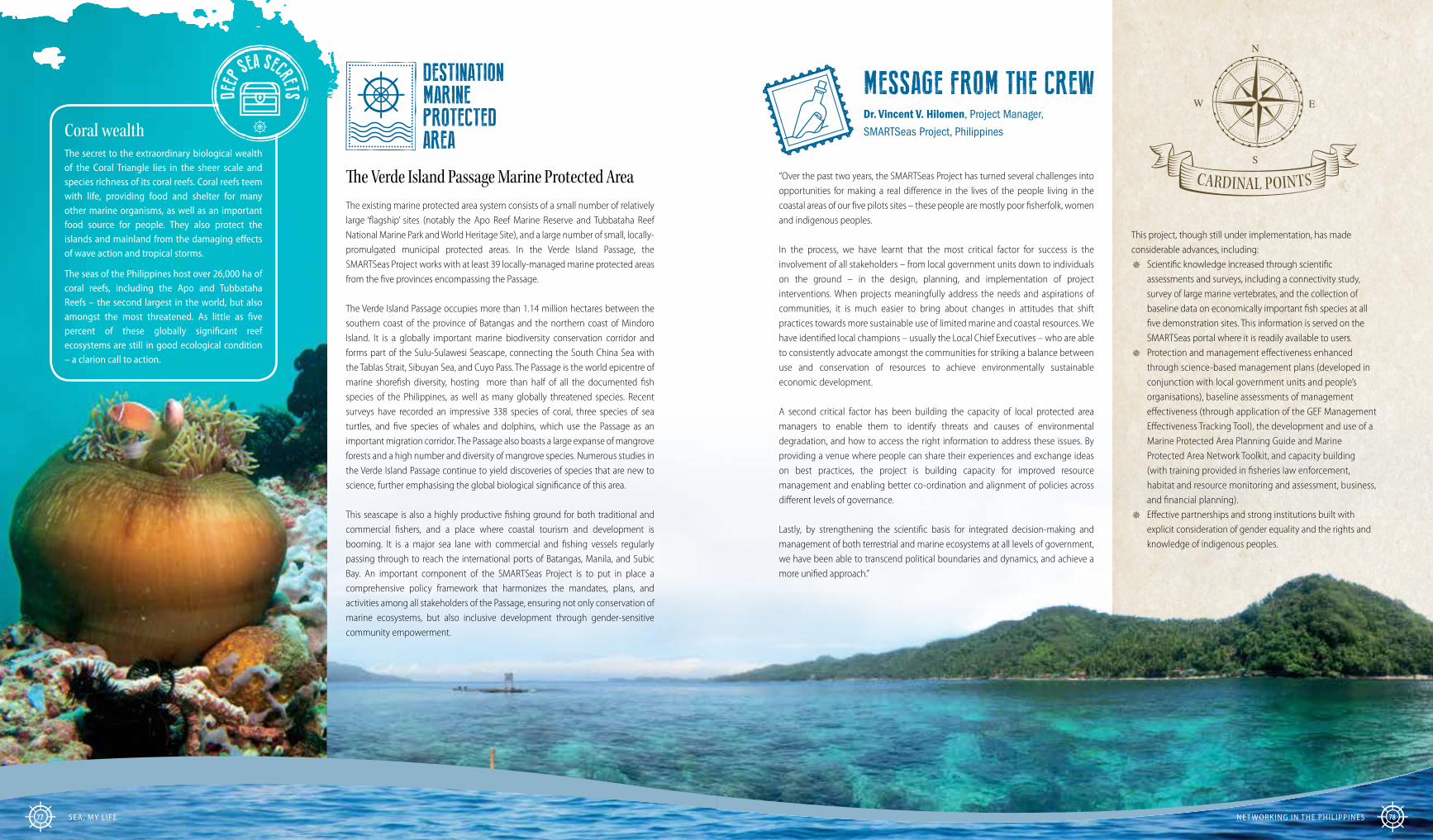
CARDINAL POINTS
This project, though still under implementation, has made considerable advances, including:
� Scientific knowledge increased through scientific assessments and surveys, including a connectivity study, survey of large marine vertebrates, and the collection of baseline data on economically important fish species at all five demonstration sites. This information is served on the SMARTSeas portal where it is readily available to users.
� Protection and management effectiveness enhanced through science-based management plans (developed in conjunction with local government units and people’s organisations), baseline assessments of management effectiveness (through application of the GEF Management Effectiveness Tracking Tool), the development and use of a Marine Protected Area Planning Guide and Marine Protected Area Network Toolkit, and capacity building (with training provided in fisheries law enforcement, habitat and resource monitoring and assessment, business, and financial planning).
� Effective partnerships and strong institutions built with explicit consideration of gender equality and the rights and knowledge of indigenous peoples.
Coral wealththe secret to the extraordinary biological wealth of the Coral triangle lies in the sheer scale and species richness of its coral reefs. Coral reefs teem with life, providing food and shelter for many other marine organisms, as well as an important food source for people. they also protect the islands and mainland from the damaging effects of wave action and tropical storms.
the seas of the Philippines host over 26,000 ha of coral reefs, including the Apo and tubbataha reefs – the second largest in the world, but also amongst the most threatened. As little as five percent of these globally significant reef ecosystems are still in good ecological condition – a clarion call to action.
DEEP
SEA SECRETS
DESTINATION MARINE PROTECTED AREA
The Verde Island Passage Marine Protected AreaThe existing marine protected area system consists of a small number of relatively large ‘flagship’ sites (notably the Apo Reef Marine Reserve and Tubbataha Reef National Marine Park and World Heritage Site), and a large number of small, locally-promulgated municipal protected areas. In the Verde Island Passage, the SMARTSeas Project works with at least 39 locally-managed marine protected areas from the five provinces encompassing the Passage.
The Verde Island Passage occupies more than 1.14 million hectares between the southern coast of the province of Batangas and the northern coast of Mindoro Island. It is a globally important marine biodiversity conservation corridor and forms part of the Sulu-Sulawesi Seascape, connecting the South China Sea with the Tablas Strait, Sibuyan Sea, and Cuyo Pass. The Passage is the world epicentre of marine shorefish diversity, hosting more than half of all the documented fish species of the Philippines, as well as many globally threatened species. Recent surveys have recorded an impressive 338 species of coral, three species of sea turtles, and five species of whales and dolphins, which use the Passage as an important migration corridor. The Passage also boasts a large expanse of mangrove forests and a high number and diversity of mangrove species. Numerous studies in the Verde Island Passage continue to yield discoveries of species that are new to science, further emphasising the global biological significance of this area.
This seascape is also a highly productive fishing ground for both traditional and commercial fishers, and a place where coastal tourism and development is booming. It is a major sea lane with commercial and fishing vessels regularly passing through to reach the international ports of Batangas, Manila, and Subic Bay. An important component of the SMARTSeas Project is to put in place a comprehensive policy framework that harmonizes the mandates, plans, and activities among all stakeholders of the Passage, ensuring not only conservation of marine ecosystems, but also inclusive development through gender-sensitive community empowerment.
MESSAGE FROM THE CREWDr. Vincent V. Hilomen, Project Manager,
SMARTSeas Project, Philippines
“Over the past two years, the SMARTSeas Project has turned several challenges into opportunities for making a real difference in the lives of the people living in the coastal areas of our five pilots sites – these people are mostly poor fisherfolk, women and indigenous peoples.
In the process, we have learnt that the most critical factor for success is the involvement of all stakeholders – from local government units down to individuals on the ground – in the design, planning, and implementation of project interventions. When projects meaningfully address the needs and aspirations of communities, it is much easier to bring about changes in attitudes that shift practices towards more sustainable use of limited marine and coastal resources. We have identified local champions – usually the Local Chief Executives – who are able to consistently advocate amongst the communities for striking a balance between use and conservation of resources to achieve environmentally sustainable economic development.
A second critical factor has been building the capacity of local protected area managers to enable them to identify threats and causes of environmental degradation, and how to access the right information to address these issues. By providing a venue where people can share their experiences and exchange ideas on best practices, the project is building capacity for improved resource management and enabling better co-ordination and alignment of policies across different levels of governance.
Lastly, by strengthening the scientific basis for integrated decision-making and management of both terrestrial and marine ecosystems at all levels of government, we have been able to transcend political boundaries and dynamics, and achieve a more unified approach.”
seA, MY l iFe Ne t workiNg iN the Phil iPPiNes 7877

The heart of the South PacificEvery day, the sun awakens Tonga before any other country in the world. Situated directly west of the international dateline, the Kingdom of Tonga lies at the heart of the South Pacific, about one third of the distance between New Zealand and Hawai’i. The Tongan archipelago is made up of 172 named islands distributed along an 800 km long north-south line. These islands are of two main geological types: those with a limestone base formed by uplifted coral formations, and others which are overlaid by volcanic material. Only 48 of the Tongan islands are inhabited, and about 70 percent of the entire population of the country (which stands at 106,000 residents) lives on the main island of Tongatapu – mostly in the only urban and commercial centre of Nuku’alofa.
Lagoon of lifeTongatapu is an uplifted coral reef lying on a geologically active zone. The relief of the island is relatively flat, with minor rolling slopes on the southern and eastern coasts. The island is 40 km long, has an area of about 257 km2 and is shaped roughly like a pair of cupped hands ‘cradling’ an extensive double lagoon system – the Fanga’uta and Fanga-kakau lagoons (referred to collectively as the Fanga’uta Lagoon). The catchment area of the lagoon is home to more than 40,000 people and includes some of the most important agricultural areas in Tonga, and the last remaining rainforest, Taloa.
The Fanga’uta Lagoon system, with its sheltered waters, mangroves, seagrass beds and patch reefs, is an important nursery area for both fin and shellfish, supporting fisheries both within the lagoon and in the surrounding sea. This means that the welfare of all people who live in the area is directly connected to the health and productivity of the lagoon ecosystem and its catchment. The area is also important culturally as a place of beauty and enjoyment, and it has a rich archaeological history which stands as evidence of Tonga’s proud 3,000 year history of settlement.
Life at riskThe Fanga’uta Lagoon was declared as a marine reserve in 1974. Despite this, the health of the lagoon and its catchment, and the Tongans who depend on it, has been in a state of decline for some years, due to a combination of natural and human-induced environmental changes. These include changes in tidal flows and water circulation; fragmented land-use decision-making; increased competition between competing land-use practices; increased fishing pressure; and unsustainable urban and agricultural practices that cause habitat loss and degradation. In particular, the lagoon ecosystem has become seriously impacted by land-based sources of pollution caused by poorly-managed sewage, run-off of agricultural pesticides and fertilisers, and waste dumped in or near the water. Local communities, and especially
Tonga Ridge-To-Reef 80
TONGA RIDGE-TO-REEF
Connecting land, people and the sea

elders who have observed changes over a long period of time, report that there are less fish, shellfish and sea cucumbers in the lagoon, fishery-based livelihoods are declining, and the colour of the water is turning from clear blue to murky green as algae bloom due to nutrient enrichment (eutrophication) – this is smothering habitats and suffocating the lagoon ecosystem. Die-off and reclamation of mangroves for the establishment of settlements and tax allotments has led to intrusion by seawater, making the shoreline more vulnerable to coastal erosion and other impacts of storms and tidal surges. These changes have, in turn, caused greater offshore sedimentation, with negative impacts on coral formations and the marine life that they support.
A ridge-to-reef solutionTo address these issues, UNDP is working with the Kingdom of Tonga to implement a GEF-financed ‘ridge-to-reef’ project that seeks to conserve the ecosystem services of the Fanga’uta Lagoon through an integrated land, water and coastal management approach that sustains livelihoods, strengthens food security, protects biodiversity, and enhances climate resilience. This project forms part of the broader GEF-funded ‘Pacific Islands Ridge-to-Reef (R2R) National Priorities Programme’ which is being implemented in 14 Pacific Island States to promote the implementation of holistic, integrated management of water, land, forest and coastal resources at the catchment level. The Tonga Ridge-to-Reef project includes interventions at national and local levels to establish effective natural resource governance systems, implement integrated management of the lagoon and its associated ecosystems, and
strengthen knowledge and awareness of the links between a healthy lagoon and sustained
socio-economic well-being.
IN FINE FOCUSIntegrated stewardship of the Fanga’uta Lagoon
Before the initiation of the ridge-to-reef project, the government of Tonga undertook a series of studies to establish the causes of the poor ecological state of the fanga’uta Lagoon, and the results were used to develop an environmental management plan for the lagoon system in 2001. implementation of this plan did not take place due to budgetary and administrative constraints in government, and other issues such as a weak local capacity for monitoring of key ecological and socio-economic factors, the lack of an inclusive institutional mechanism for co-ordinating stakeholder interests and activities, and low levels of awareness amongst the community.
To help the people of Tongatapu overcome these barriers, the Tonga Ridge-to-Reef project, which started in 2014, has facilitated the development of the fanga’uta Stewardship Plan, to replace the older fanga’uta Lagoon Management Plan. as part of the highly participatory process through which the Stewardship Plan was developed, the project has also helped to establish a management and decision-making framework and process involving three committees, through which all stakeholders play a role in implementation of the plan. The Stewardship Plan is a legal document gazetted under the environment act, but it does not only focus on environmental conservation – it is an integrated, local area management plan that provides a framework to guide decision-makers in achieving sustainable development of the catchment area, in ways that minimise negative environmental impacts and strengthen resilience.
The fanga’uta Stewardship Plan serves as the mechanism through which Tonga can improve compliance with existing national laws related to fisheries, waste management, environmental management and impact assessment, spatial planning, and the management of water resources. But, beyond this, it is a consensus-based framework in which all partners recognise their role as guardians and stewards of natural resources in the lagoon and its catchment, and through which they commit to sustainable management of the resources within their care. The plan makes provision for areas that are set aside for protection, sustainable use and rehabilitation, and gives all stakeholders access to information they need for knowledge-based, adaptive management of the ecosystem upon which they depend. implementation of the plan encompasses a variety of activities to rehabilitate degraded mangrove and other coastal habitats, restore productivity to agricultural land, monitor water quality, manage waste, and stimulate alternative livelihood opportunities with a focus on marine-based eco-tourism.
The participatory process through which the plan was developed has increased awareness, commitment and capacity for community stewardship of the lagoon and the surrounding area. as a result, and following a learning exchange facilitated by the project with communities in fiji, four communities living within the fanga’uta Lagoon catchment have committed to the establishment of Special Marine Protected areas (a type of locally managed marine area, or LMMa) within the fanga’uta Lagoon Marine Reserve.
“I live next to the sea and have always depended on shallow-water fishing for food and my livelihood. Since 2015, I have expressed my concerns about the state of the lagoon – mussels, fish and jellyfish have been declining and there is increased coastal erosion around my home. The situation became so bad that we had to seek alternative sites to find seafood, and this brought us into conflict with other villages. When our village was included in one of the Special Marine Protected Areas within the Fanga’ uta Lagoon Marine Reserve, and as a site for implementation of a mangrove replanting project, I was overjoyed – this was the kind of response I wanted
from the government! Since we have been replanting mangroves, I have noticed that the mud is not as thick at the lagoon edge, and fish and mussels seem to be returning to the shallow waters. When I wake up every morning, I first visit the fenced mangrove areas to check that no animals have got in to destroy the young mangrove plants, before I go out fishing. I feel good about this, because, as I walk along the shore, I know that my fishing ground is protected and cared for, and my livelihood is secure. It was always my hope that Tonga would stand up and restore the health of this lagoon, for the sake of our survival and our children and grandchildren.”
EYEWITNESS STATEMENTMrs ‘Amelia Hunga’ tau, an elder in the community of Holonga, is a fisherwoman and the leader of a community-led mangrove rehabilitation project in the Fanga’ uta Lagoon catchment.
Tonga Ridge-To-Reef 82Sea, MY L ife81

CARDINAL POINTS
DESTINATION MARINE PROTECTED AREA
The Fanga’uta Lagoon Marine ReserveTonga was the first South Pacific country to put a conservation programme in place, including a series of national marine reserves. The Fanga’uta Marine Reserve was established to protect the tidal lagoon system on Tongatapu’s northern coast. The lagoon, which covers about 28.5 km2, is a semi-enclosed, shallow, soft-bottomed tropical ecosystem which includes mangrove forests, salt marshes, seagrass meadows, mudflats and patch reefs. These habitats provide sanctuary for many species of fish, invertebrates, and a large variety and abundance of wading birds such as the Pacific reef heron, the Pacific black duck, the great crested tern and Pacific golden plover. The two branches of the lagoon are separated from each other and the open ocean by a number of small reefs and channels. The movement of water over this shallow entrance area is important for the health of ecosystems within the lagoon, because the water becomes aerated as it flows over the reef flats.
Implementation of the Tonga Ridge-to-Reef Project began in 2014 and since then has made significant contributions to strengthening natural resource governance systems for integrated management of the lagoon and its associated ecosystems, improving knowledge and awareness, and stimulating opportunities for sustainable fishery and tourism-based livelihoods with a focus on gender and youth empowerment. Key outcomes include:
� Sustainable management and protection of marine and coastal ecosystems strengthened through development of the nationally endorsed Fanga’uta Stewardship Plan, incorporating a management and decision-making framework involving three multi-stakeholder committees, representing all stakeholder groups including the 26 communities in the Fanga’uta Lagoon catchment area.
� Reduction of marine pollution from land-based activities addressed through the sensitization of communities to the sources and impacts of pollution; the implementation of regular waste clean-up operations led by communities living along the lagoon’s edge, with the support of the Waste Authority; and increased capacity and facilities for monitoring pollution.
� Economic benefits from sustainable use of marine resources increased through setting aside 20 percent of the lagoon for sustainable fisheries management (guided by locally-led community management plans), revitalisation of agricultural activities, and the development of small eco-tourism projects led by women.
MESSAGE FROM THE CREWShoko Takemoto, former Water and Oceans Regional Technical Advisor,
UNDP Pacific Region; and Ta’hirih Hokafonu, Ridge-to-Reef National Project
Co-ordinator, Tonga.
“From a project management perspective, one of the most interesting aspects of this project is the way it has brought together so many stakeholders around the Fanga’uta Lagoon through the update and formalization of its Stewardship Plan. The development of the plan followed a bottom-up approach, which we started by asking stakeholders from all sectors why it is important to them to protect and manage the lagoon. Through this process we were able to integrate traditional knowledge with modern scientific information to reconcile a wide variety of previously-conflicting economic, social and environmental interests. The extent and richness of the inputs we received from all stakeholders was remarkable, but the engagement of sector stakeholders at the national level was something quite unique to this project. This level of engagement has been made possible by the highly active Technical Committee. This group not only facilitates high-level information exchange, but the representatives from the various Ministries take part actively in the implementation of the project, even beyond their respective sectoral areas. It has been so interesting to see representatives from the Ministry of Health or Education taking part in biodiversity monitoring, and officials from the Statistics Department taking part in making a drone video for the project! Having a Technical Committee that is not only a forum for strategic advice, but also provides a space for active learning and doing – especially beyond one’s normal mandate – has developed a real community of practice that seeks to learn and innovate.”
Mangroves: living on the edgeMangroves are the only woody plants that are adapted to living at the interface of the land and sea. With one ‘foot’ on land, and the other in the sea, they are the so-called ‘plant amphibians’ of the coastal zone, and are tough survivors, with many adaptations that enable them to live in saline, water-logged tidal areas. But, they are sensitive to human-induced impacts including pollution, deteriorating water quality, over-harvesting, and habitat loss caused by coastal development, with the result that, globally, mangroves are now ranked as one of the most threatened of all habitats. in the fanga’uta Lagoon catchment, as much as 50 percent of mangrove coverage has been lost since 2004 in some areas.
Like coral reefs, mangrove forests are highly productive ecosystems that provide numerous goods and services both to the marine environment and people. The dense masses of roots in a mangrove forest play an important role in binding sediments, which helps stabilize the coastline and prevents erosion by large waves and storms. By filtering out sediments, the forests also protect coral reefs and seagrass meadows from being smothered in sediment. Mangrove forests play a central role in transferring organic matter and energy from the land to marine ecosystems, and they provide shelter for fish, crabs, shrimps, molluscs and nesting shorebirds. in Tonga, mangroves support important fisheries, are used for weaving tapa mats, and provide timber for fuel and construction of boats and houses. given the ecological and social importance of mangroves in the fanga’uta Lagoon catchment, the Tonga Ridge-to-Reef Project has initiated a number of mangrove rehabilitation projects, led by women and youth.
DEEP
SEA SECRETS
Sea, MY L ife Tonga Ridge-To-Reef 8483

Strengthening management effectiveness of marine protected areas in Russia
BERING NORTH
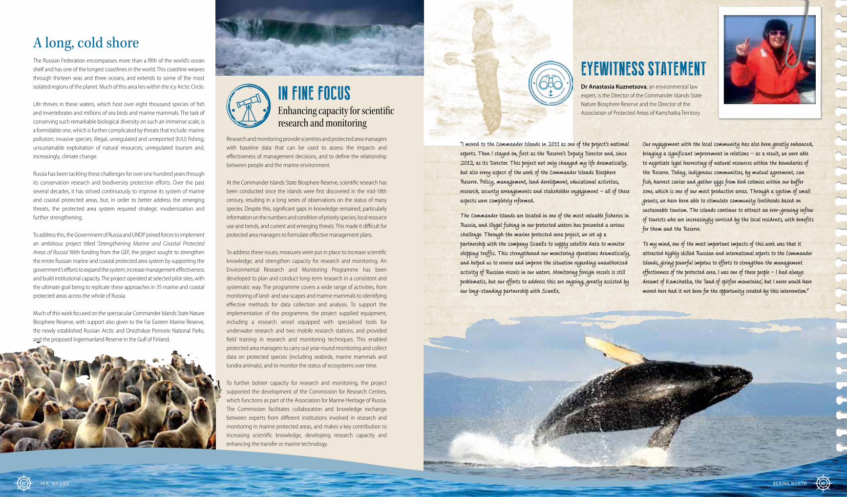
EYEWITNESS STATEMENTDr Anastasia Kuznetsova, an environmental law expert, is the Director of the Commander Islands State Nature Biosphere Reserve and the Director of the Association of Protected Areas of Kamchatka Territory.
“I moved to the Commander Islands in 2011 as one of the project’s national experts. Then I stayed on, first as the Reserve’s Deputy Director and, since 2012, as its Director. This project not only changed my life dramatically, but also every aspect of the work of the Commander Islands Biosphere Reserve. Policy, management, land development, educational activities, research, security arrangements and stakeholder engagement – all of these aspects were completely reformed.
The Commander Islands are located in one of the most valuable fisheries in Russia, and illegal fishing in our protected waters has presented a serious challenge. Through the marine protected area project, we set up a partnership with the company ScanEx to supply satellite data to monitor shipping traffic. This strengthened our monitoring operations dramatically, and helped us to reverse and improve the situation regarding unauthorized activity of Russian vessels in our waters. Monitoring foreign vessels is still problematic, but our efforts to address this are ongoing, greatly assisted by our long-standing partnership with ScanEx.
Our engagement with the local community has also been greatly enhanced, bringing a significant improvement in relations – as a result, we were able to negotiate legal harvesting of natural resources within the boundaries of the Reserve. Today, indigenous communities, by mutual agreement, can fish, harvest caviar and gather eggs from bird colonies within our buffer zone, which is one of our most productive areas. Through a system of small grants, we have been able to stimulate community livelihoods based on sustainable tourism. The islands continue to attract an ever-growing inflow of tourists who are increasingly serviced by the local residents, with benefits for them and the Reserve.
To my mind, one of the most important impacts of this work was that it attracted highly skilled Russian and international experts to the Commander Islands, giving powerful impetus to efforts to strengthen the management effectiveness of the protected area. I was one of these people – I had always dreamt of Kamchatka, the ‘land of spitfire mountains’, but I never would have moved here had it not been for the opportunity created by this intervention.”
A long, cold shoreThe Russian Federation encompasses more than a fifth of the world’s ocean shelf and has one of the longest coastlines in the world. This coastline weaves through thirteen seas and three oceans, and extends to some of the most isolated regions of the planet. Much of this area lies within the icy Arctic Circle.
Life thrives in these waters, which host over eight thousand species of fish and invertebrates and millions of sea birds and marine mammals. The task of conserving such remarkable biological diversity on such an immense scale, is a formidable one, which is further complicated by threats that include: marine pollution; invasive species; illegal, unregulated and unreported (IUU) fishing; unsustainable exploitation of natural resources; unregulated tourism and, increasingly, climate change.
Russia has been tackling these challenges for over one hundred years through its conservation research and biodiversity protection efforts. Over the past several decades, it has strived continuously to improve its system of marine and coastal protected areas, but, in order to better address the emerging threats, the protected area system required strategic modernization and further strengthening.
To address this, the Government of Russia and UNDP joined forces to implement an ambitious project titled ‘Strengthening Marine and Coastal Protected Areas of Russia.’ With funding from the GEF, the project sought to strengthen the entire Russian marine and coastal protected area system by supporting the government’s efforts to expand the system, increase management effectiveness and build institutional capacity. The project operated at selected pilot sites, with the ultimate goal being to replicate these approaches in 35 marine and coastal protected areas across the whole of Russia.
Much of this work focused on the spectacular Commander Islands State Nature Biosphere Reserve, with support also given to the Far Eastern Marine Reserve, the newly established Russian Arctic and Onezhskoe Pomorie National Parks, and the proposed Ingermanland Reserve in the Gulf of Finland.
IN FINE FOCUSEnhancing capacity for scientific research and monitoring
Research and monitoring provide scientists and protected area managers with baseline data that can be used to assess the impacts and effectiveness of management decisions, and to define the relationship between people and the marine environment.
At the Commander Islands State Biosphere Reserve, scientific research has been conducted since the islands were first discovered in the mid-18th century, resulting in a long series of observations on the status of many species. Despite this, significant gaps in knowledge remained, particularly information on the numbers and condition of priority species, local resource use and trends, and current and emerging threats. This made it difficult for protected area managers to formulate effective management plans.
To address these issues, measures were put in place to increase scientific knowledge, and strengthen capacity for research and monitoring. An Environmental Research and Monitoring Programme has been developed to plan and conduct long-term research in a consistent and systematic way. The programme covers a wide range of activities, from monitoring of land- and sea-scapes and marine mammals to identifying effective methods for data collection and analysis. To support the implementation of the programme, the project supplied equipment, including a research vessel equipped with specialised tools for underwater research and two mobile research stations, and provided field training in research and monitoring techniques. This enabled protected area managers to carry out year-round monitoring and collect data on protected species (including seabirds, marine mammals and tundra animals), and to monitor the status of ecosystems over time.
To further bolster capacity for research and monitoring, the project supported the development of the Commission for Research Centres, which functions as part of the Association for Marine Heritage of Russia. The Commission facilitates collaboration and knowledge exchange between experts from different institutions involved in research and monitoring in marine protected areas, and makes a key contribution to increasing scientific knowledge, developing research capacity and enhancing the transfer or marine technology.
Bering north 88SeA, MY L iFe87

CARDINAL POINTS
DESTINATION MARINE PROTECTED AREA
The Commander Islands State Nature Biosphere Reserve
The Commander Islands are located 170 km east of the Kamchatka Peninsula, deep in the stormy North Pacific Ocean. Part of the Aleutian Islands chain, the Commander Islands and their surrounding waters are home to the Commander Islands State Nature Biosphere Reserve. This is the largest marine reserve in Russia encompassing the Commander, Bering and Medny Islands, several smaller islands and their surrounding waters, extending 50 km into the Bering Sea and the North Pacific Ocean. Established in 1993, the protected area spans over 3.6 million hectares of spectacular panoramas both on land and at sea.
These volcanic islands are famous for their high humidity and eerie fog. But, when the fog lifts, it reveals a place of outstanding beauty: steep cliffs tower over the frigid sea; waterfalls cascade off treeless mountains into the ocean; and mountain tundra and emerald-coloured mosses blanket the rolling hills. Beneath the surface of the water lies equally stunning scenery, a mysterious world of deep-sea canyons and underwater volcanoes.
The craggy shores of these islands are rookeries for over 200,000 northern fur seals, Steller sea lions, Insular seals and the Pacific walrus. The extensive intertidal kelp forests support a healthy population of sea otters (an iconic species of the Reserve), and large pods of whales, dolphins and porpoises regularly grace these waters.
The most visible, noisy and numerous inhabitants of the area are seabirds. In this Important Bird Area, millions of shrieking birds gather on the remote beaches and cliffs to nest, feed and shelter from the winter. Species such as fulmars, guillemots, puffins, the Pacific golden tern, black-legged kittiwake, Aleutian terns and Steller’s sea eagles can all be found on these shores. Perhaps the most renowned avian inhabitants of the islands are the red-legged kittiwakes, which are known from only four island groups in the world.
Since 2002, attention has been given to working with the local Russian and Aleut indigenous communities to use natural resources in a way that is sustainable and consistent with biodiversity protection. In support of this, the
Reserve has been included in the UNESCO World Network of Biosphere Reserves, under the Man and Biosphere Programme.
MESSAGE FROM THE CREWMs Irina Bredneva (Programme Analyst) and
Nataly Olofinskaya (Regional Technical Specialist),
UNDP Russia
“For many years, the Commander Islands Reserve had faced substantial development and management challenges that hindered its effectiveness. Despite this, in the five years since the project began, the Reserve has undergone an amazing transformation, with all aspects of its management significantly strengthened.
The project provided an essential stimulus to modify traditional practices for assessing the performance of individual protected areas. It also introduced new management tools and enabled an intensive exchange of knowledge at the system level. This would have been impossible without the individual efforts and commitment of the many professionals working with the project – the strategic decision-makers, conservation scientists and protected area managers – and the remarkable impact of this can be seen at the Commander Islands Reserve.
Possibly one of the most critical things the project succeeded in doing was to highlight the need for government investment in marine and coastal protected areas, and to demonstrate that this investment is justified. As a result, the Russian government increased its allocation of funding to the Reserve by 58 percent, and the Reserve has seen an influx of dedicated professionals and enthusiasts eager to conserve and promote the outstanding natural values of the Commander Islands.
The Ministry also adopted a programme for monitoring and research specifically for marine and coastal protected areas, and established a dedicated Marine Protected Area Working Group (under the Expert Council on Protected Areas), to plan and coordinate activities and management approaches. The main stakeholders are now increasingly recognising that marine and coastal ecosystems need to be managed, not only as individual sites, but also as a coherent system of protected areas.”
Key outcomes of this work have included:
� Strengthened management effectiveness of the Commander Island Reserve, the Far Eastern Marine Reserve and the Russian Arctic National Park, through the development of protected area management plans, improved technical capacity, enhanced capacity for marine research and monitoring, and the provision of training and equipment. The project tested approaches that could eventually be used for a system-wide assessment of protected area management effectiveness.
� Support provided for expansion of marine and coastal protected areas by 4.4 million hectares, through carrying out critical technical assessments and preparing documentation for the establishment of two new National Parks: the ‘Novosibirskie Islands’ in the Arctic Ocean and the ‘Shantarskie Islands’ in the Sea of Okhotsk. Support was also provided for the future establishment of the Ingermanland Reserve in the Gulf of Finland and the nature refuge on the Solovetskie islands.
� Capacity enhanced for the prevention of marine pollution, contingency planning and response in the Gulf of Finland, through the development of measures to prevent and mitigate the impact of possible spills of oil and other hazardous materials – an important achievement in a region through which vast quantities of the petroleum products are transported every year.
� Stimulation of sustainable tourism initiatives at the Commander Reserve, Far Eastern Marine Reserve and sites within Franz-Josef Land federal refuge within the Russian Arctic National Park, and support provided for the development of alternative nature-based livelihoods for local communities through a small grants program.
Whales of the Bering Seathe Bering Sea is a highly dynamic and productive ecosystem due to its unique oceanographic characteristics and prevailing climatic conditions. it is a biological ‘treasure chest’ of nutrients that attracts and sustains large populations of seabirds, seals, walruses, fish and cetaceans (whales, dolphins and porpoises). the waters of the Commander islands host 21 species of cetaceans, including pods of endangered Bowhead, Sei and Sperm whales, Dall’s porpoise, orcas, humpback and Baird’s Beaked Whales, which spend their summer feeding seasons here. humpback whales are the most dominant species, coming from virtually all of their northern Pacific breeding locations to feed in the protected waters of the Commander islands reserve. Sightings have also been made of rare Pacific right Whales – one of the most critically endangered whales on earth.
DEEP
SEA SECRETS
SeA, MY L iFe Bering north 9089

On a Colombian beach, a leatherback turtle emerges silently from the sea under the silvery light of a full moon. She heaves herself across the sand to lay and bury her eggs, before returning to the water, having played her part in the creation of the next generation. Like this turtle, countless other creatures depend on the ocean for most, if not all, of their life cycle – from microscopic phytoplankton, to soaring albatrosses, and the immense blue whale. And, amongst the creatures who rely on the ocean are humans. The ocean is a complex natural web that we have yet to fully understand and adequately protect. But, we must protect it to safeguard the living systems that maintain ocean biodiversity and yield the basic life support services that provide stability and resilience to the global community.
Blue actionAs little as one hundred years ago, the ocean was considered unfathomable in its depth and diversity. The seabed was a lost world, unexplored and poorly understood, and only a fraction of the species now known to live in the ocean had been described by scientists. Today, people have found ways to reach into the depths, both to discover the mysteries to be found there and understand them better – and to exploit them for economic gain. Over the last few decades, consumption and use of the ocean’s riches has known no bounds. Threats such as overfishing, habitat destruction, pollution and acidification have intensified, driving dramatic changes in marine and coastal ecosystems, with far-reaching impacts for ocean biodiversity and people.
This publication has taken the reader on a voyage around the world to observe the wide-ranging results and benefits emerging from UNDP-implemented, GEF-financed projects that seek to expand and strengthen marine protected areas, as an integral part of the global sustainable development agenda. Across oceans, seas and coasts, these projects have demonstrated a diversity of approaches to the design and management of marine protected areas with different objectives, at a variety of scales, in distinct habitats, and framed by contrasting regional, national and local development contexts. These projects, which are a sample of UNDP’s broader portfolio of marine and coastal work, serve as beacons of hope for what can be achieved to restore and preserve ocean ecosystems, and address the interlinked challenges faced by ocean biodiversity and human society in an integrated way.
Sail ing On 92
Into the blue future
SAILING ON “We are all the solemn voice and caretakers of one mother-Earth, including the 70 percent of it that is blue
– our Oceans.”H.E., Mr Aunese Makoi Simate; Tuvalu’s Permanent
Representative, Tuvalu Mission to the United Nations, and Ambassador to the United States of America

IN FINE FOCUSBlue Solutions: Ten lessons learned
Healthy, diverse and accessible marine ecosystems provide multiple opportunities for promoting sustainable development. They do this through the provision of ecosystem services and values that contribute to the alleviation of poverty and hunger, build resilience to the impacts of climate change, provide opportunities for decent work and economic growth, and build sustainable communities. The projects showcased in this publication demonstrate clearly that marine protected areas are effective catalysts for achieving the Sustainable Development Goals.
Ten key lessons have emerged from this work:• Ecosystem-based approaches facilitate effective and inclusive
ocean governance, especially in large marine ecosystems: Ocean governance has evolved over the decades from species-specific and sector-based management efforts, to more holistic, ecosystem-based approaches and integrated management. Through an ecosystem-based approach to ocean governance, it is possible to promote: transboundary co-operation for integrated management, use and conservation of ocean resources, and to address shared objectives, such as the prevention of marine pollution; strategic alignment of policies, laws and regulations across multiple sectors; and, transboundary management of fisheries.
• Marine spatial planning facilitates integrated management of resource use by multiple sectors: Marine spatial planning is a process that brings together multiple users of the ocean to make informed and coordinated decisions about how to use marine resources sustainably. Marine protected areas are identified during the planning process and serve as the backbone of a final Marine Spatial Plan that facilitates access to marine resources, but within safe ecological limits, to ensure that biodiversity is conserved and ecological processes continue to function. Environmental, economic and social goals can be reconciled through a mixture of top-down and bottom-up approaches that deliver multiple benefits and accommodate the needs of communities.
• For marine protected area systems to be effective in conserving biodiversity and ecosystem processes, they must be ecologically representative and give explicit consideration to climate change criteria: In the past, protected areas have not necessarily been designed to meet specific biodiversity conservation goals or to address climate resilience. In the developing world in particular, local governments have often established marine reserves to address immediate resource needs or other social or economic objectives. To be fully representative, protected area systems should be designed to include key marine biodiversity areas, protect breeding sites, provide safe haven for critically endangered and
migratory species, and specifically include features that address rising sea levels and ocean acidification.
• Well-planned networks of marine protected areas maximize protection of marine ecosystems, promote connectivity and enhance livelihood security: Within a marine protected area network, protected areas of variable spatial scale and levels of protection – and incorporating a full spectrum of management models – operate collectively and synergistically, giving them far greater potential to address local needs, and wider objectives such as connectivity and resilience to climate change. The sites making up the network should be explicitly selected to achieve ecological representation, address key threats, and support processes vital for maintaining livelihoods. Building the capacity of governments and other stakeholders to manage these networks effectively is a key intervention to ensure their effectiveness.
• Community stewardship is essential for effective protection and management of marine heritage and resources: When marine conservation measures meaningfully address the needs and aspirations of communities, it is much easier to nurture a sense of stewardship, and shift practices towards more sustainable use of marine and coastal resources. Engaging communities as co-managers of marine protected areas empowers local actors to manage resources in ways that lower conflict levels around resource use, and build support for marine conservation among diverse groups, including women, youth and indigenous peoples. This can be achieved through intensive awareness-raising, mentorship and education programmes, involving communities meaningfully in decision-making bodies, engaging community members as citizen scientists, and building capacity for co-management. These activities should be complemented by creating opportunities and building capacity for alternative, ocean-based livelihoods, to reduce pressures on marine resources and demonstrate the important role that marine protected areas play in building vibrant, sustainable communities.
• Modern science and traditional knowledge should be integrated to identify priority sites for protection, develop effective management plans and inform production sector practices: Designing and implementing an effective system of marine protected areas requires a solid foundation of knowledge. By expanding knowledge, developing research capacity and facilitating transfer of marine technology, governments can assess the effectiveness of management decisions and track how marine ecosystems are faring. Industry can use science-based recommendations to re-tune their operations, boost competitive practices, and chart a path in which long term sustainability wins out over short term gains. By engaging with
indigenous stakeholders to understand traditional social and ecological norms, traditional knowledge can also help to guide future management.
• Marine protected areas are the heart of sustainable, ocean-based economies, especially in small island developing states: Most small island developing states have a restricted economic base due to their small land area and populations, limited natural resources, relative isolation from markets, and vulnerability to the impacts of climate change. Small islands, however, are endowed with large ocean resources and sustainable development in these and other coastal nations relies on the health and vitality of the marine environment. Marine protected areas are a central element of the ‘blue economy’ approach, which promotes the creation of a low-carbon, resource efficient, socially inclusive society through the conservation and sustainable use of ocean resources.
• Marine protected areas are a key strategy for building social and ecological resilience to the impacts of climate change: Marine protected areas are an essential part of the global response to climate change. They provide multiple benefits that increase the resilience of the marine environment to diverse stressors such as the impacts of extractive industries, localized pollution, ocean acidification and rising sea temperatures. Well-designed and managed marine protected areas can help mitigate and adapt to the impacts of climate change by protecting coral reefs, sea grass beds and mangrove forests, which, in turn, protect low-lying communities from storms, tidal surges and sea level rise. They also help to sustain and restore fisheries on which millions of jobs and livelihoods depend, thus building resilience to economic and social shocks.
• Building strong institutions and capacitating people across all sectors of society is key to improving
management effectiveness of marine protected areas: Some of the key challenges faced by developing countries in managing marine protected areas sustainably include weak financial, administrative and technical capacity, and limited access to relevant information and marine technology. Strengthening the effectiveness of marine protected areas requires capacity-building interventions that reach all stakeholders to: increase scientific knowledge and research capacity, and improve the accessibility of information to guide informed decision-making; build the capacity of local practitioners to identify threats and causes of environmental degradation and implement appropriate management actions (including both ecological and financial management measures); facilitate knowledge-exchange and lesson-sharing on management best practices; and, enable better co-ordination and alignment of policies across different levels of governance.
• Long-term sustainability is best achieved by forging strong global, regional and local partnerships: Partnerships provide a unifying context for individual projects and help to generate the critical mass of collective action that enables effective management of large, complex ecosystems over the longer term. This is achieved by building alliances that bring together diverse stakeholders around a common purpose and plan of action, provide for strategic co-ordination across sectors and institutions, maintain strong links between science and implementation, and engage people across all levels of society as guardians of shared ocean resources.
SEa, MY l iFE Sail ing On 9493

MESSAGE FROM THE CREWOur blue visionMidori Paxton, Head of Ecosystems and Biodiversity, and Andrew Hudson, Head of Water and Ocean Governance,
Bureau for Policy and Programme Support, UNDP
The depth and extent of our oceans is hard to imagine. The Pacific Ocean alone covers nearly half the surface of our planet, and below the surface of the water lie canyons as deep as Mount Everest is high. In recent times, we have come to know more about the oceans than we did before, but, we have only scratched the surface beneath which lie myriad creatures that are yet to be discovered, and ecological processes we barely understand. What we do know, without doubt, is that the ocean – the world’s largest connected ecosystem – is the ‘blue heart’ that sustains ‘Planet Sea’, and this heart is in a state of distress.
Well-managed, strategically-located marine protected areas that provide secure, long-term protection for marine biodiversity are the cornerstone of our strategy for restoring and sustaining the health of ocean ecosystems. To be effective, these protected areas need to be managed as part of a broader ecosystem-approach to ocean governance, in which ecosystem processes are conserved across seascapes, and people – who live and work in these seascapes – play an active part in managing them sustainably, and share the benefits of doing so. These are the principles that have underpinned UNDP’s approach to supporting the expansion and strengthening of marine protected areas in 48 developing countries around the world since the year 2000.
These interventions span a broad spectrum, ranging from multi-country initiatives that promote transboundary governance of large marine ecosystems, to local site-based projects that support the effective management of marine resources at the grassroots level. These initiatives have generated multiple environmental and development dividends, including: securing areas for safe passage of migratory species; establishment
of ‘no-take’ fishing zones in nursery areas to ensure seasonal protection for spawning populations of commercially-important species; application and scaling-up of integrated coastal management to balance competing demands on ocean resources; reduction of land-based nutrient pollution; application of ecosystem approaches to the management of large marine areas shared by several countries; and, building sustainable communities through the creation of alternative, ocean-based livelihoods.
To achieve the targets of Sustainable Development Goal 14 and Aichi Biodiversity Target 11 within the set timeframes, it will be vital to adapt, replicate, and scale-up proven solutions like these. Looking ahead, our strategic priorities will be to:• Identify, gazette and establish a representative system of new marine
protected areas, with particular focus on globally significant areas, as defined by the Key Biodiversity Area (KBA) Standard, and to fill the marine ecosystem coverage gap at the country level, with robust governance systems in place.
• Strengthen management effectiveness and governance of marine protected areas, by addressing the multiple challenges arising from lack of awareness, overlapping areas of jurisdiction, fragmented decision-making, inadequate governance, and conflict between different ocean-based activities and users.
• Promote more effective near-shore management of marine and coastal ecosystems, including coral reefs, mangroves, salt marshes and sea grass beds, to relieve intense resource-use pressures and impacts from land-based activities.
• Improve socio-economic benefits derived from marine protected areas, by engaging indigenous and local communities meaningfully in the design, management and monitoring of marine protected areas, and creating opportunities and capacity for sustainable alternative livelihoods.
• Promote access to the best available science to support the design and implementation of innovative marine protected area networks, through new and existing partnerships with academic and research institutions, non-government organizations, the private sector, and other UN agencies – and integrate this with traditional knowledge systems.
• Place special emphasis on protection and restoration of coral reefs, which are currently in a state of world-wide decline, and are critically under-protected.
• Facilitate ecosystem-based adaptation to climate change, through the establishment and management of marine protected areas that strengthen social and ecological resilience.
• Build and support a community of best-practice for management of oceans, seas and coastal ecosystems to promote learning and knowledge-sharing around key issues including science, governance and policy, enforcement, financing, capacity development and gender empowerment.
• Work closely with major ocean donors to channel increased levels of financing to marine protected areas to ensure achievement of SDG14, and in particular Target 14.5.
• Advocate for strong governance and management of areas beyond national jurisdiction (or ABNJs) to safeguard the ocean commons – currently marine protected areas only cover one percent of the total area beyond national jurisdiction.
Seas of life: protecting our future
Marine protected areas are vital for reversing biodiversity loss, restoring ocean ecosystems, and preserving threatened species and their habitats. They also enhance the value of marine and coastal ecosystems to humanity, in terms of providing secure livelihoods, food, water and health, enhanced resilience, and increased carbon storage and sequestration.
The ocean is a common treasure with no physical boundaries. Treasure always attracts pirates. But, what we need is more guardians – ‘Planet Sea’ needs to be well-protected and cared for to sustain our future.
SEa, MY l iFE Sail ing On 9695

Summary of project information relevant to each chapter
CHAP. NO. SHORT TITLE PROJECTS DATES GEF $
CO-FINANCE $
(CASH AND IN-KIND)
MOST RELEVANT SDGs
(IN ADDITION TO SDG14)
RELEVANT SDG 14 TARGETS
2 Connecting the Current (Chile and Peru)
Ecosystem Based Management of the Humboldt Current Large Marine Ecosystem 2011-2016 6,930,000 24,620,000 1, 5, 8, 12, 17 14.2, 14.4, 14.5,
14.a, 14.b
3 Spanning two Shores (Colombia)
Design and Implementation of a Subsystem of Marine Protected Areas (SMPA) in Colombia 2010-2016 4,850,000 5,460,063 1, 6, 8, 10, 13 14.2, 14.3, 14.5,
14.a
4 The People’s Reef (Belize)
Promoting the Protection, Conservation and Sustainable Use of the Marine Resources of the Belize Barrier Reef System through Advanced Training and Education for Marine Tour Guides on the Placencia Peninsula
2008-2009 41,288 (GEF-SGP) 53,453 1, 8, 11, 16, 17 14.2
Building Capacity for Key Stakeholder Communities of the Belize Barrier Reef Reserve System-World Heritage Site to Promote Sustainable Marine Tourism on the Placencia Peninsula
2012-2014 50,000 (GEF-SGP) 19,195 1, 8, 11, 16, 17 14.2
Sustainable and Environmentally Responsible Production of Seaweed (Euchuma isoforme and Gracilaria spp) in the marine areas adjacent to Placencia Village
2012-2014 45,000 (GEF-SGP) 82,095 1, 8, 12 14.2
Expanding Sustainable and Environmentally Responsible Production of Seaweed (Euchuma isoforme and Gracilaria spp) into the Gladden Spit and Silk Cayes Marine Reserve
2013-2014 50,000 (GEF-SGP) 69,810 1, 8, 12 14.2
All Belize Barrier Reef projects (collective) 39 projects 2001-2017 1,200,522 (GEF-SGP) 1,987,214 1, 8, 11,12, 17 14.2, 14.b
5Going with the Flow (South Africa, Namibia, Angola)
BCLME 1: Implementation of the Strategic Action Plan: Towards achievement of Integrated Management of the Benguela Current Large Marine Ecosystem
2002-2008 15,110,000 23,500,000 12, 16, 17 14.2, 14.4, 14.a, 14.c
BCLME 2: Implementation of the Benguela Current Large Marine Ecosystem for Restoring Depleted Fisheries and Reducing Coastal Resources Degradation
2009-2013 5,017,242 328,460,822 1, 2, 8, 12, 16 14.2, 14.4, 14.b
BCLME 3: Realizing the Inclusive and Sustainable Development of the BCLME Region through Improved Ocean Governance and Integrated Management of Ocean Use and Marine Resources
2017-2022 10,900,00 163,915,000 1, 2, 8, 9, 16 14.1, 14.2, 14.4
6 Big Ocean State: (Seychelles)
Strengthening Seychelles’ National Protected Areas System through NGO Management Modalities 2011-2015 2,154,545 5,452,238 2, 8, 13, 15, 16 14.2, 14.4, 14.5
Mainstreaming Biodiversity into Production Sector Activities 2007-2015 3,600,000 7,626,950 1, 2, 8, 15, 16 14.2, 14.4, 14.7, 14.b
Expansion and Strengthening of the Protected Area Sub-System of the Outer Islands of Seychelles and its Integration into the Broader Land- and Seascape
2014-2019 1,785,500 10,284,049 1, 8, 13 14.1, 14.2, 14.4, 14.5, 14.7
Seychelles Protected Areas Finance 2016-2020 2,776,900 15,013,654 1, 8, 9, 15, 16 14.2, 14.5, 14.7
7 Islands of the Moon (Comoros)
Development of a National Network of Terrestrial and Marine Protected Areas Representative of the Comoros’ Unique Natural Heritage and Co-managed with Local Village Communities
2015-2019 4,246,000 10,385,000 1, 2, 5, 13 14.2, 14.5, 14.7, 14.b
8 The Ripple Effect (Turkey)
Strengthening the Protected Area Network of Turkey: Catalyzing Sustainability of Marine and Coastal Protected Areas 2009- 2014 2,200,000 4,148,221 1, 8, 15, 16 14.1, 14.2, 14.4,
14.5
9 People and the Sea (India)
Mainstreaming Coastal and Marine Biodiversity Conservation into Production Sectors in Sindhudurg Coast in Maharashtra 2011-2016 3,483,294 12,000,000 1, 2, 5, 8, 11 14.2, 14.4, 14.a,
14.b
Mainstreaming Coastal and Marine Biodiversity Conservation into Production Sectors in the East Godavari River Estuarine Ecosystem (EGREE), Andhra Pradesh
2011-2017 6,023,636 18,000,000 1, 9, 10, 12, 17 14.1, 14.2, 14.4, 14.a, 14.b
CHAP. NO. SHORT TITLE PROJECTS DATES GEF $
CO-FINANCE $
(CASH AND IN-KIND)
MOST RELEVANT SDGs
(IN ADDITION TO SDG14)
RELEVANT SDG 14 TARGETS
10 Tides of Change (Maldives)
Atoll Ecosystem-based Conservation of Globally Significant Biological Diversity in the Maldives’ Baa Atoll 2003-2012 2,730,100 1,183,657 1, 2, 11, 12, 13 14.2, 14.4, 14.5,
14.7
11 Networking in the Philippines
Strengthening Marine Protected Areas to Conserve Marine Key Biodiversity Areas in the Philippines (SMARTSeas PH) 2014-2018 8,160,600 25,833,490 1, 11, 13, 16 14.2, 14.4, 14.5,
14.a
12 Ridge to Reef (Tonga) Integrated Environmental Management of the Fanga’uta Lagoon Catchment 2014-2017 1,756,880 8,000,000 2, 6, 10, 11, 13 14.2, 14.7, 14.b
13 Bering North (Russia) Strengthening the Marine and Coastal Protected Areas of Russia (MCPA) 2009-2015 4,000,000 11,500,000 1, 8, 15, 16, 17 14.1, 14.2, 14.4,
14.5, 14.a
Quick Stop Galapagos
Control of Invasive Species in the Galapagos Archipelago 2002-2011 18,650,000 32,500,000 8, 15 14.2, 14.7
Galapagos Oil Spill: Environmental Rehabilitation and Conservation 2001-2006 530,000 845,000 6, 7, 14, 15 14.1, 14.2
Quick Stop Jordan Mainstreaming Marine Biodiversity into Coastal Zone Management in
the Aqaba Special Economic Zone 2011-2015 950,000 7,305,000 8, 9 14.2
Quick Stop Malaysia Conserving Marine Biodiversity through Enhanced Marine Park
Management and Inclusive Island Development 2007-2013 1,952,400 3,318,853 1, 8, 10, 11, 17 14.2, 14.4
SDG 14: Targets14.1 By 2025, prevent and significantly reduce marine pollution of all kinds, in particular from land-based activities, including marine debris and nutrient pollution
14.2 By 2020, sustainably manage and protect marine and coastal ecosystems to avoid significant adverse impacts, including by strengthening their resilience, and take action for their restoration in order to achieve healthy and productive oceans
14.3 Minimize and address the impacts of ocean acidification, including through enhanced scientific cooperation at all levels
14.4 By 2020, effectively regulate harvesting and end overfishing, illegal, unreported and unregulated fishing and destructive fishing practices and implement science-based management plans, in order to restore fish stocks in the shortest time feasible, at least to levels that can produce maximum sustainable yield as determined by their biological characteristics
14.5 By 2020, conserve at least 10 per cent of coastal and marine areas, consistent with national and international law and based on the best available scientific information
14.6 By 2020, prohibit certain forms of fisheries subsidies which contribute to overcapacity and overfishing, eliminate subsidies that contribute to illegal, unreported and unregulated fishing and refrain from
introducing new such subsidies, recognizing that appropriate and effective special and differential treatment for developing and least developed countries should be an integral part of the World Trade Organization fisheries subsidies negotiation
14.7 By 2030, increase the economic benefits to Small Island developing States and least developed countries from the sustainable use of marine resources, including through sustainable management of fisheries, aquaculture and tourism
14.a Increase scientific knowledge, develop research capacity and transfer marine technology, taking into account the Intergovernmental Oceanographic Commission Criteria and Guidelines on the Transfer of Marine Technology, in order to improve ocean health and to enhance the contribution of marine biodiversity to the development of developing countries, in particular small island developing States and least developed countries
14.b Provide access for small-scale artisanal fishers to marine resources and markets
14.c Enhance the conservation and sustainable use of oceans and their resources by implementing international law as reflected in UNCLOS, which provides the legal framework for the conservation and sustainable use of oceans and their resources, as recalled in paragraph 158 of The Future We Want
SEA, MY L IFE SUMMARY OF PROJEC T INFORMATION 9897

AcknowledgementsMany people have assisted with the production of this book and all are thanked for their contributions. In particular, we wish to thank:
Fouad Abdou Rabi; Karim Ali Ahmed; Michael Akester; Gökmen Argun; Lindsay Balkwill; Ider Batbayar; Santiago Carrizosa; Lianchawii Chakkchhuak; Ana Maria Currea; Bruce Dell; Tashi Dorji; Andrea Egan; Harun Güçlüsoy; Andrew Grieser-Johns; Victor Hilomen; Ta’hirih Hokafonu; Zukile Hutu; Aminath Sanu Ibrahim; Katharina Kandt; Sasi Kumar; Eric LaCroix; Cathy Maize; Line Mancienne; Lupe Matoto; Michael McManus; Jessie Mee; Carmen Morales; Freya Morales; Martha Talamondjila Naanda; Shoko Noda; Nuri Ozbagdatli; Joe Padilla; Pakamon Pinprayoon; Maria Gabriela Pinto; Renata Rubian; Andrew Rylance; Leonel Requena; Rizza Sacra; Ahmed Shifaz; Paula Sierra; Loraini Sivo; Francella Strickland; Shoko Takemoto; Grace Tena; Pisca Tias; Iliesa Tora; Doley Tshering; Sophie van der Meeren; Maxim Vergeichik; Anne Virnig; Akiko Yamamoto
Eyewitnesses: Rahamata Ahamada (Comoros); Pablo Manríquez Angulo (Chile); Capt. Francisco Arias-Isaza (Colombia); Quirsito Cajegas (Philippines); Lisa Carne (Belize); Govind Madhukar Dhuri (India); Hashali Hamukuaya (Benguela Current Large Marine Ecosystem); ‘Amelia Hung’tau (Tonga); Thoriq Ibrahim (Maldives); Kelly Isnard (Seychelles); Zafer Kizilkaya (Turkey); Anastasia Kuznetsova (Russia); Helena Simms (Seychelles); Sonam Tsultrim (Seychelles); Mariano Valverde (Peru)
Crew members (in order of chapters): Michael Akester; Santiago Carrizosa; Glen Eiley; Leonel Requena; Martha Talamondjila Naanda; Joanna Prosper; Daig Romain; Fouad Abdou Rabi; Harun Güçlüsoy and Vahdet Ünal; Lianchawii Chhakchhuak; Shoko Noda; Vincent Hilomen; Shoko Takemoto; Ta’hirih Hokafonu; Nataly Olofinskaya; Irina Bredneva; Midori Paxton and Andrew Hudson
Photographers:Key to locations: t=top; m=middle; b=bottom; l = left; r=right (for example: tr = top right; bl = bottom left; mr=middle right)
Michael Akester: pp7 + 8; 9, 10, 11, 12, 13, 14; Edith Apicable/Hardwright Alright: p77(l); Andrey Armyagov/Shutterstock: pp65 + 66; Aqaba Marine Park/UNDP: p50 (tr,br); Laurent Balesta: p39; Francisco Blaha: p94; Peter Chadwick: pp3,6,29 + 30, 31, 32; Ryan Daly: p47(b); Torsten Dickman/Seychelles Tourism Board: p45; Adriana Dinu: p22 (tr, br); divedog/Shutterstock: p69(tl); DNY59/iStock: p27; Vitaly Edush/iStock: pp49 + 50 (main image); Umar Fikry/UNDP Maldives: pp69 + 70(b); Eran Gissis/Wildtracks: p26; Catalina Gómez; Diego Grajales: pp17, 19; Zafer Kizilkaya/Equator Initiative: pp51 + 52, 53, 54, 55, 56; Vicky Lakshmanan: pp59, 62 (all images); Andy Luck: p33 (t+b); Ennio Maffei/Seychelles Tourism Board: p44; Evgeny Mamaev: pp85-90 (all images); Adam Mitchell: pp41 + 42, 43, 47 (tl); Ahmed Yaamin Mohamed/UNDP Maldives: p67; Mohamed Naahee/UNDP Maldives: p68; narvikk/iStock: p50 (mr); Midori Paxton: p34; Carlos Peňa: p18; Placencia Producers Cooperative Society: p25; Dooungruang Roongruang/One Moon Photography: pp5, 71 + 72 (all images); Rizza Sacra/UNDP Philippines: pp1 + 2, 75, 76, 77 + 78(b); seaturtleexploration.com: p46(br); Sean3810/iStock: pp73 + 74; Seychelles Fishing Authority: p48; Brian Skerry/National Geographic Creative: title page, imprints page, contents page, pp22 + 23, 96(b); Sohadizno/iStock: p99; UNDP Comoros: p38, 40; UNDP Ecuador: p22 (mr); UNDP Tonga: pp79 + 80, 81, 82, 83, 84; Alejandra Vargas-Fonseca: pp.91 + 92; John Walker/iStock: p4; Prashanth Vishwanathan/UNDP India: pp57 + 58, 60, 61, 63, 64; pJoe West/iStock: pp15 + 16; Nadia Westby: p28; Julien Wickel: pp35 + 36, 37
SEA, MY L IFE99

UNITED NATIONS DEVELOPMENT PROGRAMME304 East 45th Street, 9th Floor
New York, NY 10017, USAFor more information: www.undp.org
Copyright 2017, UNDP