Predicting Potential Occurrence and Spread of Invasive Plant Species along the North Platte River,...
9
Predicting Potential Occurrence and Spread of Invasive Plant Species along the North Platte River, Nebraska Justin D. Hoffman, Sunil Narumalani, Deepak R. Mishra, Paul Merani, and Robert G. Wilson* Riparian habitats are important components of an ecosystem; however, their hydrology combined with anthropogenic effects facilitates the establishment and spread of invasive plant species. We used a maximum-entropy predictive habitat model, MAXENT, to predict the distributions of five invasive plant species (Canada thistle, musk thistle, Russian olive, phragmites, and saltcedar) along the North Platte River in Nebraska. Projections for each species were highly accurate. Elevation and distance from river were most important variables for each species. Saltcedar and phragmites appear to have restricted distributions in the study area, whereas Russian olive and thistle species were broadly distributed. Results from this study hold promise for the development of proactive management approaches to identify and control areas of high abundance and prevent further spread of invasive plants along the North Platte River. Nomenclature: Canada thistle, Cirsium arvense (L.) Scop.; common reed, Phragmites australis (Cav.) Trin. ex Steud.; musk thistle, Carduus nutans L.; saltcedar, Tamarix sp. L.; Russian olive, Elaeagnus angustifolia L. Key words: Invasive species, predictive habitat modeling, North Platte River, MAXENT, riparian habitat. Riparian zones are significant components of ecosystems that can have profound effects on adjacent areas (Naiman et al. 1993; Richardson et al. 2007), such as facilitating the establishment and spread of invasive species (Hood and Naiman 2000). Changes in river currents and water levels result in the disturbance of soil, which can provide opportunities for invasive plants to establish and spread (Pys ˇek and Prach 1994). Anthropogenic activities such as dams and flow regulation ( Jansson et al. 2000; Nilsson and Svedmark 2002; Shafroth et al. 2002;), land use (Hancock et al. 1996; Patten 1998), and water extraction for irrigation (Stromberg 1996) intensify the level of distur- bance on river ecosystems, facilitating the colonization of invasive plants (Planty-Tabacchi et al. 1996). The spread of invasive plants is aided by the rapid transportation of propagules to uninvaded areas (Pys ˇek and Prach 1993; The ´baud and Debussche 1991). The Platte River in Nebraska stretches the entire length of the state, with the main branch separating into the North and South Platte rivers at approximately North Platte, NE. The North Platte River (NPR) represents the major avenue of drainage for all of western Nebraska and eastern Wyoming ( Johnson 1994). The hydrologic history of the NPR typifies it as a high-level disturbance ecosystem making it susceptible to the establishment and spread of nonindigenous plants. The NPR is the most altered portion of the Platte River with a total of 18 reservoirs whose primary function is water storage for irrigation purposes (U.S. Bureau of Reclamation 1982). As a result, the NPR has lost approximately 65% of its active channel, causing an increase in bare ground habitat (McDonald and Sidle 1992) that is an optimal environment for seedling establishment (Richardson et al. 2007). Studies have noted the changes in native vegetation along the NPR ( Johnson 1994; McDonald and Sidle 1992; Sidle et al. 1989); however, few have investigated the distribution of invasive plants in this area. Some invasive plants of concern along the NPR include saltcedar (Tamarix sp. L.), Russian olive (Elaeagnus angustifolia L.), common reed [Phragmites australis (Cav.) Trin. ex Steud.; hereafter referred to as phragmites], Canada thistle DOI: 10.1614/IPSM-07-048.1 * First and second authors: Graduate Student and Professor, School of Natural Resources, University of Nebraska–Lincoln, Lincoln, NE 68583; third author: Assistant Professor, Pontchartrain Institute for Environmental Sciences, Earth and Environmental Sciences, University of New Orleans, New Orleans, LA 70148; fourth author: Graduate Student, Department of Anthropology and Geography, University of Nebraska–Lincoln, Lincoln, NE 68588; fifth author: Professor, University of Nebraska–Lincoln Panhandle Research and Extension Center, University of Nebraska–Lincoln, Scottsbluff, NE 69361. Current address of first author: Assistant Professor, Department of Biological Sciences, McNeese State University, Lake Charles, LA 70609. Corresponding author’s E-mail: [email protected] Invasive Plant Science and Management 2008 1:359–367 Hoffman et al.: Predicting distributions of invasive plants N 359
-
Upload
independent -
Category
Documents
-
view
2 -
download
0
Transcript of Predicting Potential Occurrence and Spread of Invasive Plant Species along the North Platte River,...
Predicting Potential Occurrence and Spreadof Invasive Plant Species along the North
Platte River, NebraskaJustin D. Hoffman, Sunil Narumalani, Deepak R. Mishra, Paul Merani, and Robert G. Wilson*
Riparian habitats are important components of an ecosystem; however, their hydrology combined with anthropogenic
effects facilitates the establishment and spread of invasive plant species. We used a maximum-entropy predictive habitat
model, MAXENT, to predict the distributions of five invasive plant species (Canada thistle, musk thistle, Russian olive,
phragmites, and saltcedar) along the North Platte River in Nebraska. Projections for each species were highly accurate.
Elevation and distance from river were most important variables for each species. Saltcedar and phragmites appear to
have restricted distributions in the study area, whereas Russian olive and thistle species were broadly distributed. Results
from this study hold promise for the development of proactive management approaches to identify and control areas of
high abundance and prevent further spread of invasive plants along the North Platte River.
Nomenclature: Canada thistle, Cirsium arvense (L.) Scop.; common reed, Phragmites australis (Cav.) Trin. ex
Steud.; musk thistle, Carduus nutans L.; saltcedar, Tamarix sp. L.; Russian olive, Elaeagnus angustifolia L.
Key words: Invasive species, predictive habitat modeling, North Platte River, MAXENT, riparian habitat.
Riparian zones are significant components of ecosystemsthat can have profound effects on adjacent areas (Naimanet al. 1993; Richardson et al. 2007), such as facilitating theestablishment and spread of invasive species (Hood andNaiman 2000). Changes in river currents and water levelsresult in the disturbance of soil, which can provideopportunities for invasive plants to establish and spread(Pysek and Prach 1994). Anthropogenic activities such asdams and flow regulation ( Jansson et al. 2000; Nilsson andSvedmark 2002; Shafroth et al. 2002;), land use (Hancocket al. 1996; Patten 1998), and water extraction forirrigation (Stromberg 1996) intensify the level of distur-bance on river ecosystems, facilitating the colonization of
invasive plants (Planty-Tabacchi et al. 1996). The spread ofinvasive plants is aided by the rapid transportation ofpropagules to uninvaded areas (Pysek and Prach 1993;Thebaud and Debussche 1991).
The Platte River in Nebraska stretches the entire lengthof the state, with the main branch separating into theNorth and South Platte rivers at approximately NorthPlatte, NE. The North Platte River (NPR) represents themajor avenue of drainage for all of western Nebraska andeastern Wyoming ( Johnson 1994). The hydrologic historyof the NPR typifies it as a high-level disturbance ecosystemmaking it susceptible to the establishment and spread ofnonindigenous plants. The NPR is the most alteredportion of the Platte River with a total of 18 reservoirswhose primary function is water storage for irrigationpurposes (U.S. Bureau of Reclamation 1982). As a result,the NPR has lost approximately 65% of its active channel,causing an increase in bare ground habitat (McDonald andSidle 1992) that is an optimal environment for seedlingestablishment (Richardson et al. 2007).
Studies have noted the changes in native vegetationalong the NPR ( Johnson 1994; McDonald and Sidle1992; Sidle et al. 1989); however, few have investigated thedistribution of invasive plants in this area. Some invasiveplants of concern along the NPR include saltcedar(Tamarix sp. L.), Russian olive (Elaeagnus angustifolia L.),common reed [Phragmites australis (Cav.) Trin. ex Steud.;hereafter referred to as phragmites], Canada thistle
DOI: 10.1614/IPSM-07-048.1
* First and second authors: Graduate Student and Professor,
School of Natural Resources, University of Nebraska–Lincoln,
Lincoln, NE 68583; third author: Assistant Professor, Pontchartrain
Institute for Environmental Sciences, Earth and Environmental
Sciences, University of New Orleans, New Orleans, LA 70148;
fourth author: Graduate Student, Department of Anthropology and
Geography, University of Nebraska–Lincoln, Lincoln, NE 68588;
fifth author: Professor, University of Nebraska–Lincoln PanhandleResearch and Extension Center, University of Nebraska–Lincoln,
Scottsbluff, NE 69361. Current address of first author: Assistant
Professor, Department of Biological Sciences, McNeese State
University, Lake Charles, LA 70609. Corresponding author’s E-mail:
Invasive Plant Science and Management 2008 1:359–367
Hoffman et al.: Predicting distributions of invasive plants N 359
[Cirsium arvense (L.) Scop], and musk thistle (Carduusnutans L.).
Saltcedar is a major concern along several river systemsin western North America. Recent large-scale predictivemapping shows suitable saltcedar habitat in western andsouthwestern portions of Nebraska (Morisette et al. 2006).Saltcedar has been reported in the western panhandle alongthe NPR as well as in southwestern Nebraska along theSouth Platte and Republican rivers (Kaul et al. 2006).Populations of the plant along the NPR have most likelydispersed from infested areas in Wyoming (Pearce andSmith 2003).
Russian olive was introduced to Nebraska in the 1880s foruse as windbreaks and roadside trees (Kaul et al. 2006).Populations primarily occur in riparian areas and other moisthabitats, but can tolerate a wide range of soil and moistureconditions (Borell 1971; Campbell and Dick-Peddie 1964;Zhang 1981). Russian olive is most successful when plantednear water sources and it has become naturalized on riverfloodplains, lakeshores, and irrigation ditches (Christensen1963; Katz et al. 2003; Olson and Knopf 1986).
Phragmites is a native species in many parts of NorthAmerica, including Nebraska (Kaul et al. 2006). In itsnative form, it is a natural component of wetlands, riversystems, and other wet habitats. However, a nonnativehaplotype of this species has been introduced to NorthAmerica, although it is uncertain when this introductionoccurred (Saltonstall 2002). This type is more aggressivethan the native strain and can readily replace nativevegetation. Most research on the ecology and control ofphragmites has taken place along the Atlantic coast of theUnited States (Marks et al. 1994) with little conducted inthe Great Plains.
Canada thistle was designated as a noxious weed inNebraska in 1873 (Wilson 2002), and musk thistle wasdesignated in 1959 (Roeth 2003). Both species have ageneralist lifestyle whereby they are found in a variety ofhabitats, occurring in pastures, rangeland, waterways,roadside ditches, and other disturbed areas; however,Canada thistle will commonly occur in crop grounds andhas a broader distribution compared to musk thistle (Kaulet al. 2006).
Three of these species, including saltcedar, Canadathistle, and musk thistle, are listed as noxious weeds inNebraska; phragmites has recently been placed on theNebraska watch list of invasive species (Nebraska WeedControl Association 2007). These species can negativelyimpact rivers by altering the river channel, consuming largeamounts of ground water, and decreasing biodiversity(Brock 1994; DiTomaso 1998; Howe and Knopf 1991;Knopf and Olson 1984; Roman et al. 1984; Shafroth et al.2005; Zavaleta 2000). The NPR is a major source of waterfor irrigation and provides critical habitat for many wildlifespecies. Any changes to water levels and habitat will haveprofound affects on the surrounding ecosystem.
Studying invasive species at large spatial scales tradition-ally has been difficult; however, the recent rise in predictivehabitat modeling has made the process more feasible.Predictive habitat modeling examines relationships betweenspecies occurrence and the environment (Austin 2007;Segurado and Araujo 2004). Results of these analyses canbe used to produce habitat suitability maps, which can inferthe potential distribution of a species. This makes themeffective tools for investigating several aspects of invasivespecies (Iguchi et al. 2004; Peterson and Vieglais 2001;Peterson et al. 2003). The results of such analyses can beused to optimize invasive species management programs bydetermining areas that are susceptible to establishment ofinvasive species and identifying the environmental variablesimportant to species presence, thus allowing land managersto develop proactive management approaches.
The objective of this research is to use field-collecteddata on the presence of Canada thistle, musk thistle,phragmites, Russian olive, and saltcedar to predict areasthat these species currently occupy as well as areas wherethey may potentially occur along the NPR, Nebraska.
Materials and Methods
The study area consisted of a 1.6-km (1-mi)-wide buffer,0.8 km on either side of the river channel, along the NPRextending from the Wyoming–Nebraska state line toapproximately 3.2 km west of North Platte, NE. Prelim-inary surveys of the river suggested that the ripariancorridor did not extend far from the river channel beforecoming into contact with cultivated land or native prairie.Based on these observations a 1.6-km-wide buffer was
Interpretative SummaryOur results show that MAXENT was accurate in predicting the
distributions of four invasive species along the North Platte River,Nebraska. The variables that contributed most to the predictionsincluded distance from river and elevation. In this case, invasiveplants were most likely to occur in close proximity to the rivercorridor. The importance of elevation was most likely a product ofour surveying design; however, more research is needed todetermine the role elevation plays in limiting the distributions ofinvasive plants. Russian olive and the thistle species have a broaddistribution of suitable habitat occurring in the study area.Saltcedar and phragmites have more restricted potentialdistributions; however, it is possible that these species arecurrently expanding their range along the river. These results areespecially pertinent to resource managers because they identifyareas that are most susceptible to colonization, allowing them tofocus their control efforts. This may be most useful for species suchas saltcedar and phragmites that don’t appear to have reached theirdistribution limits. The ability to identify uncolonized areas withhigh susceptibility is valuable in halting the spread of invasivespecies.
360 N Invasive Plant Science and Management 1, October–December 2008
adequate to capture the variation in the river ecosystem, aswell as the fundamental niche of the invasive plant species.We conducted field work in September 2005, March 2006,and May 2007. We surveyed approximately 5.7 km of riverin Scotts Bluff County and approximately 34.5 km of riverin Keith and Lincoln counties. These totals do notrepresent continuous lengths because access to private landwas limited, resulting in surveys of small segmentsconducted in areas where access was feasible. An effortwas made to collect up to 15 unique differentially correctedglobal positioning system (GPS) locations for each speciesper parcel of land surveyed, however due to variation inparcel size and location this was not possible in allinstances. A Trimble Pro-XRS1 Differential GPS (DGPS)was used for recording the spatial location of each species.
To determine potential areas of occurrence and spread,we predicted the distributions of each species. Severalmethods have been used to build predictive models ofspecies distributions. A relatively novel method, producedby the machine-learning community, is the maximumentropy model (MAXENT; Phillips et al. 2006). This is a‘‘general-purpose’’ presence-only modeling method thatestimates the probability distribution by predicting themaximum entropy based on a set of constraints. MAXENTis referred to as a presence-only method because onlyinformation on species presences is required to run themodel. In addition to MAXENT, other models thatpredict species distributions using presence-only datainclude BIOCLIM (Busby 1986), DOMAIN (Carpenteret al. 1993); ecological-niche factor analysis (Hirzel et al.2002); and the genetic algorithum for rule-set prediction(GARP, Stockwell and Peters 1999). Of these, MAXENTand GARP have seen the most use, and several studies havemade comparisons between the two models. For example,Phillips et al. (2006) compared MAXENT to GARP anddetermined that MAXENT almost always possessed higherarea under the receiver operating characteristic curve(AUC). MAXENT also performed better than severalother models when presented with small sample sizes(Hernandez et al. 2006; Pearson et al. 2007). Guisan et al.(2007) determined that MAXENT was more robust tochanges in grain size of predictor variables than mostmodels. Finally, in the most comprehensive modelcomparison study to date, Elith et al. (2006) found thatof 16 models tested, MAXENT was one of the mosteffective models for predicting species distributions.
It was necessary to combine the location data of boththistle species for use in the predictive model for tworeasons. First, surveying took place while the plants werejust emerging and before flowering occurred, makingidentification difficult. Second, surveys were conducted bymultiple researchers with different levels of expertise inplant identification. Although it was necessary for us tocombine locations of the thistle species it is important to
note that they do differ in their biology and, ultimately,their management. For instance, Canada thistle is arhizomatous perennial, allowing it to spread vegetativelyor by seed, whereas musk thistle is a tap-rooted biennialthat can spread only by seed.
The decision to use presence-only data was the result ofvariability in the survey areas. Logistically it was impossibleto conduct field surveys of all parts of the NPR andconsequently two survey areas were chosen based onpriority of local wildlife managers. These includedproximity to major urban areas (North Platte, Scottsbluff)along the NPR and proximity to major recreational areas(Lake McConaughy). Because most areas along the NPRare privately owned, permission was required to conductfield surveys, resulting in fragmented, nonrandomly chosensurvey sites. This prevented us from constructing a robustsampling design throughout the survey area, which isneeded to collect high-quality presence–absence data.Many studies suggest that presence–absence modelsproduce more robust predictions compared to presence-only models when provided with high-quality presence–absence data (Brotons et al. 2004; Zaniewski et al. 2002)collected systematically using a robust sampling design.Because this type of data collection was not possible for ourstudy, our data set more closely resembled herbariumrecords, which are commonly biased toward certain areas.Presence-only models, such as MAXENT, were specificallydesigned to use this type of data. Also, MAXENT hasshown superior performance to other presence-onlymodels. Finally, some of the target species (phragmitesand saltcedar) potentially have been expanding their rangesalong the NPR. One of the objectives of this study was topredict areas where these species would most likely establishoutside their current distribution. If in fact these species arein the process of expanding, using absence data fromuncolonized areas may be misleading.
We combined location data for each species along withnine data layers in MAXENT 3.0 (Phillips et al. 2006) tomodel each species’ potential distribution within the studyarea. The data layers included elevation, slope, aspect, landcover, distance from river, distance from roads, andpercentage of sand, silt, and clay with a spatial resolutionof 30 m. Elevation represents height above sea level, whichranged from a high of 1,253 m to a low of 860 m withinour study area. Slope and aspect were derived from a 30-mresolution digital elevation model for Nebraska using theSpatial Analyst tool in ArcMap 9.2.2 This tool was alsoused to create the distance-from-river and distance-from-roads layers. We calculated percentage of sand, silt, andclay layers from the Soil Survey Geographic (SSURGO)soil data layer for each county using the soil data viewer(U.S. Department of Agriculture Natural ResourcesConservation Service 2007). Distance from river was thestraight-line distance from the middle of the river channel;
Hoffman et al.: Predicting distributions of invasive plants N 361
similarly, distance from roads was the straight-line distancefrom all major roads in the study area. Major roadsincluded both paved and gravel-topped roads that wereopen to public transportation.
Land cover data were gathered from the gap analysisprogram (GAP) data layer. GAP represents the highestspatial resolution, 30-m, land cover data for Nebraska. Itconsists of 20 different vegetation and land cover types. Forthis research, we condensed the GAP data into six majorcategories including native woodland, native grassland,wetland, cropland, water, and human inhabitance (i.e.,towns and cities). Including a land cover variable into theanalysis that contains native vegetation data and areas ofhuman-mediated disturbances (i.e., cropland, residentialareas) will capture the variation in invasive presence as itrelates to competition with native species and landscapedisturbances.
For each species, MAXENT was run using the defaultparameters, including 500 iterations, a threshold value of0.00001, regularization multiplier of 1, and employment ofthe auto features. The available features in MAXENTinclude linear, product, quadratic, hinge, and thresholdfeatures. The use of auto features allows MAXENT tochoose the set of features based on the size of the trainingdata set to build the prediction. When more than 80 samplesare available for training, all features are employed. This wasthe case for Russian olive and thistle species. For phragmitesand saltcedar, training sample sizes were 68 and 63,respectively. Under these sample sizes only linear, quadratic,and hinge features were used. Cumulative probabilitydistributions ranging from 0 to 100 were generated for eachspecies. This represented the probability of occurrence foreach species within each data cell. We programmedMAXENT to use 70% of locality data for training and30% for testing the model’s accuracy. From this, we receivedtraining and testing area under the receiver operatingcharacteristic curve (ROC) values, also known as AUC(Elith 2000). The ROC curve is a plot of the sensitivity vs. 1-specificity (commission error) at all possible thresholdprobabilities for a positive prediction (Hanley and McNeil1982, Elith 2000) that ranges from 0 to 1, with values closeto unity indicating better predictive power. AUC values areinterpreted as the probability that a randomly chosen pair ofoccupied and unoccupied sites is correctly predicted. This isa widely used measure of model performance and accuracy(Elith et al. 2006); models possessing AUC values greaterthan 0.70 are considered useful for management purposes(Pearce and Ferrier 2000). A binomial probability test wasused on the testing data to determine the accuracy of eachpredicted distribution (Phillips et al. 2006). Finally,MAXENT provides an analysis of the percentage ofcontribution each variable has on the model buildingprocess, which can be interpreted as how much influenceeach variable has on the model output.
Results and Discussion
Based on field-collected location data for saltcedar,Russian olive, phragmites, and thistle species (Canada andmusk), we generated distribution maps indicating potentialareas where each species may occur along an importantwater source in western Nebraska. A total of 498 collectionpoints were obtained for this study with 87 points from thewestern portion of the study area and 417 points collectedin the eastern portion.
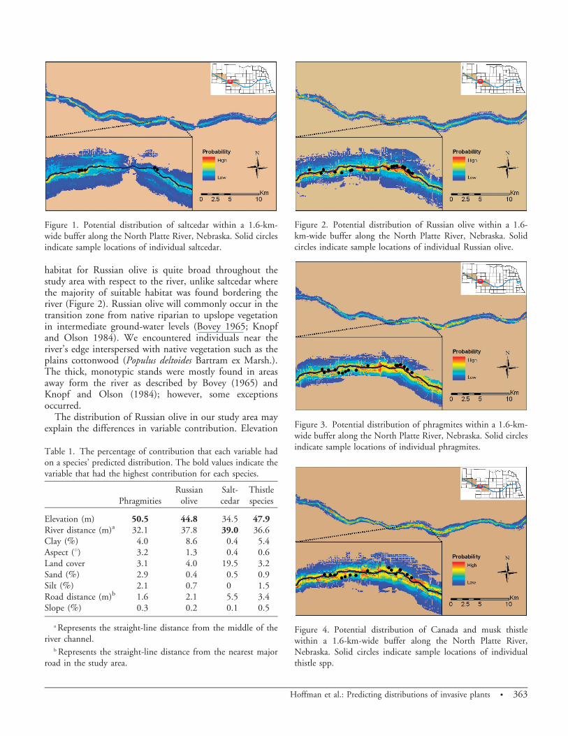
Saltcedar. Our results show that areas of high probabilityof occurrence were located mostly along the river corridor(Figure 1). Saltcedar frequently was found in the westernportion of the study area, but decreased in abundance inthe east. A total of 89 points were collected for saltcedarduring the study. Predictions of saltcedar distribution werehighly accurate (training AUC 5 0.988; testing AUC 50.983; binomial test, P , 0.0001). Areas of high-probability occurrence were found mostly in the extremewest and parts of the eastern portions of the study areawhere most of the locality data were collected; howeverpredicted probability decreased farther east toward NorthPlatte, NE (Figure 1). Outside of these areas, saltcedar hashigh probability of occurrences only along the rivercorridor. Analysis of variable contribution indicates thatdistance to river was the most important variable in themodel building process, followed by elevation, land cover,and distance from roads (Table 1). All other variables hadlow (, 5%) contributions.
The analysis of variable importance shows the mostimportant variable in predicting saltcedar occurrence isdistance from river. Elevation and land cover also hadrelatively large contributions. The land cover type thatmost affected saltcedar distribution was the presence ofcropland (coefficient 5 21.748). The negative relationshipsuggests that saltcedar was not found in areas of highcultivation. A possible explanation for this is that croplandis frequently visited and treated with various kinds ofpesticides. Thus, in these areas, the chances of populationsof saltcedar being identified and treated will increase.
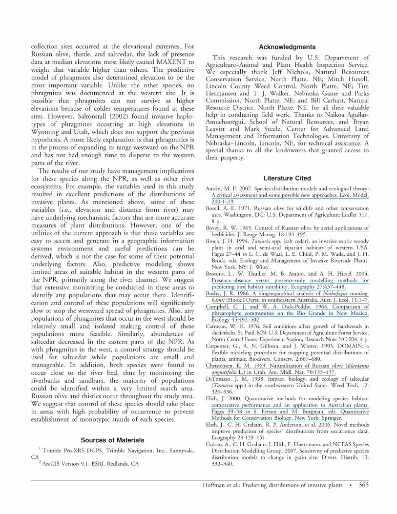
Russian olive. Russian olive was found at both datacollection sites (Figure 2), with a total of 162 locationscollected. MAXENT performed well in predicting thepotential distribution of Russian olive (training AUC 50.976; testing AUC 5 0.945; binomial tests, P , 0.0001).Areas of high probability of occurrence were found atgreater distances from the river when compared to theother species in this study (Figure 2). Elevation contributedthe most to the model, followed closely by distance fromriver and percentage of clay, with all other variables having, 5% contribution (Table 1).
Our results support the assertion that Russian oliveoccurs in a variety of habitats. The predicted suitable
362 N Invasive Plant Science and Management 1, October–December 2008
habitat for Russian olive is quite broad throughout thestudy area with respect to the river, unlike saltcedar wherethe majority of suitable habitat was found bordering theriver (Figure 2). Russian olive will commonly occur in thetransition zone from native riparian to upslope vegetationin intermediate ground-water levels (Bovey 1965; Knopfand Olson 1984). We encountered individuals near theriver’s edge interspersed with native vegetation such as theplains cottonwood (Populus deltoides Bartram ex Marsh.).The thick, monotypic stands were mostly found in areasaway form the river as described by Bovey (1965) andKnopf and Olson (1984); however, some exceptionsoccurred.
The distribution of Russian olive in our study area mayexplain the differences in variable contribution. Elevation
Table 1. The percentage of contribution that each variable hadon a species’ predicted distribution. The bold values indicate thevariable that had the highest contribution for each species.
PhragmitiesRussian
oliveSalt-cedar
Thistlespecies
Elevation (m) 50.5 44.8 34.5 47.9River distance (m)a 32.1 37.8 39.0 36.6Clay (%) 4.0 8.6 0.4 5.4Aspect (u) 3.2 1.3 0.4 0.6Land cover 3.1 4.0 19.5 3.2Sand (%) 2.9 0.4 0.5 0.9Silt (%) 2.1 0.7 0 1.5Road distance (m)b 1.6 2.1 5.5 3.4Slope (%) 0.3 0.2 0.1 0.5
a Represents the straight-line distance from the middle of theriver channel.
b Represents the straight-line distance from the nearest majorroad in the study area.
Figure 2. Potential distribution of Russian olive within a 1.6-km-wide buffer along the North Platte River, Nebraska. Solidcircles indicate sample locations of individual Russian olive.
Figure 1. Potential distribution of saltcedar within a 1.6-km-wide buffer along the North Platte River, Nebraska. Solid circlesindicate sample locations of individual saltcedar.
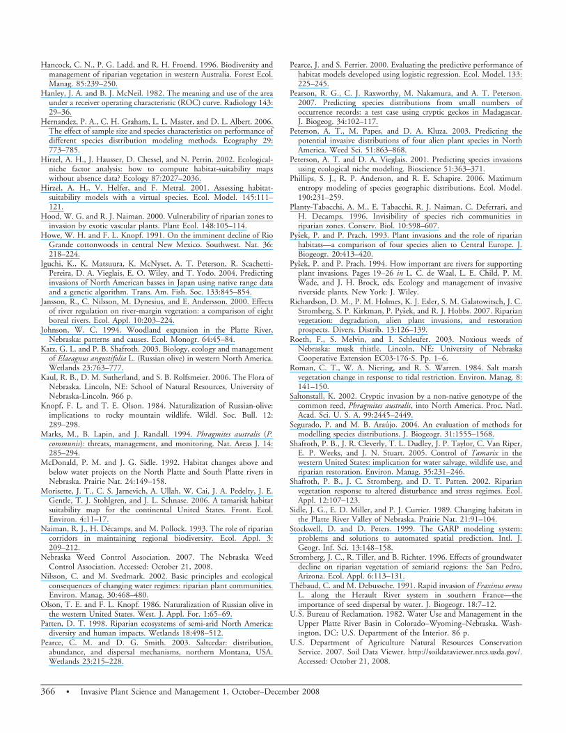
Figure 3. Potential distribution of phragmites within a 1.6-km-wide buffer along the North Platte River, Nebraska. Solid circlesindicate sample locations of individual phragmites.
Figure 4. Potential distribution of Canada and musk thistlewithin a 1.6-km-wide buffer along the North Platte River,Nebraska. Solid circles indicate sample locations of individualthistle spp.
Hoffman et al.: Predicting distributions of invasive plants N 363

contributed the most to the model followed by distancefrom river. Russian olive was found at varying distancesfrom the river, which likely decreased the contribution ofdistance from river. Also, percentage of clay was the thirdmost important variable. As distance from the riverincreased, so did the clay content of the soil. In Minnesota,Carmean (1976) found that Russian olive growth wasgreatest on moderately drained silt clay loam soils.
Phragmites. Our results indicate that phragmites is foundonly in the eastern part of the study area. The occurrence ofphragmites was variable, with populations being recordedon exposed sandbars in the middle of the river to low-lyingwet areas approximately 1 km from the river. These areasinclude backwater wetlands, roadside ditches, and railroadright-a-ways. Any area that can hold water or has moist soilis potential habitat for phragmites (Marks et. al. 1994).
The highest probability of occurrence for phragmites wasfound in the eastern part of the study area (Figure 3), withdecreasing probability in the west. The farthest west wenoted this species was at the east end of Lake McConaughy.Ninety-six locations of phragmities were collected, andmodel performance was high (training AUC 5 0.982;testing AUC 5 0.973; binomial tests, P , 0.0001). Mosthabitats along the NPR had low to zero probability ofoccurrence for phragmites except in the extreme easternportions (Figure 3). Elevation provided the most contri-bution when building the model, followed by distancefrom river with all other variables having , 5% contribu-tion (Table 1).
Elevation contributed the most to predicting suitablehabitat of phragmites. This was most likely becausephragmites was collected only in the eastern parts of theNPR, which is lower in elevation than the western part ofthe river. The absence in phragmites from the areas ofhigh elevation caused MAXENT to weight elevationhigher than other variables. Although elevation may affectphragmites occurrence, we suggest that in Nebraska,phragmites is in the process of expanding along the NPR.In these cases the lack of occurrence does not necessarilymean that the habitat is unsuitable (Brotons et al. 2004;Hirzel et al. 2001) but rather that phragmites has not hadample time to disperse to those areas. Further monitoring,especially in western parts of the NPR, needs to beconducted in the upcoming years to document the spreadof this invasive.
Thistle. Thistle species were found throughout the datacollection sites, with 151 locations being collected.MAXENT predicted high probabilities of occurrence inboth the eastern and western portions of the study area(Figure 4). As with Russian olive, the potential distributionwas broad, suggesting that presence of thistles could befound away from the riverbanks. Overall model perfor-mance was high with a training AUC 5 0.978 and testing
AUC 5 0.965. Also, binomial tests of accuracy weresignificant (P , 0.0001). Variable contribution was similarto the other invasive species, with elevation contributingthe most, followed by distance to river and percentage ofclay (Table 1). All other variables had low (, 5%)contributions.
The predictive model of thistle habitat closely resemblesthat of Russian olive. Thistles were found at each datacollection site and have potentially suitable habitatthroughout the entire study area. Further, the areas ofpredicted habitat outside the collection sites are ratherbroad and not confined to the riverbanks (Figure 4).
The percentage of contribution of each variable in thethistle model was similar to Russian olive, with elevationcontributing the most to the model, and distance fromriver being second. Again, the broad distribution ofthistles could explain why distance from river did notcontribute more. Percentage of clay contributed morethan other soil variables because thistles were found inareas away from the river, where soils are higher in claycontent. Also, thistles likely occur in these areas becausethe larger amount of clay particles that are found in thesoil increases the soil’s water-holding capacity, thusenhancing thistle growth.
Overall, we found different distribution patterns amongthe species. Russian olive and thistles closely resembledeach other in extent and variable contribution. Whileconducting field work, we repeatedly documented thistlesbelow Russian olives or in close proximity. In addition,both species were commonly documented at varyingdistances from the river. Conversely, we found phragmitesand saltcedar to have a more restricted potential distribu-tion. Saltcedar was common throughout most of the studyarea except in the extreme eastern parts. The eastern edge ofour study area approaches the distribution limit of salt-cedar in Nebraska (Kaul et al. 2006; Wilson and Knezevic2006). Phragmites was common in the eastern parts of ourstudy area; however, there was low to no probability ofphragmites occurrence in the west. Potential suitablehabitat diminished just west of Lake MaConaughy,suggesting we have identified the western distributionallimit of phragmites on the NPR and in Nebraska.
Variable contribution among all species was similar, withelevation and distance from river as the two mostimportant variables for all species. The most probableunderlying variable explaining the significance of distancefrom river is soil moisture. In most cases soil moisture willdecrease as distance from river increases. Although soilmoisture may be more directly responsible for the observedplant distributions, this variable is not easily estimated overlarge areas, unlike distance from river. There was a largedisparity of elevation in our study area. The importance ofelevation may be the result of the locations of our surveysites, underlying mechanistic variables, or both. Our
364 N Invasive Plant Science and Management 1, October–December 2008
collection sites occurred at the elevational extremes. ForRussian olive, thistle, and saltcedar, the lack of presencedata at median elevations most likely caused MAXENT toweight that variable higher than others. The predictivemodel of phragmites also determined elevation to be themost important variable. Unlike the other species, nophragmites was documented at the western site. It ispossible that phragmites can not survive at higherelevations because of colder temperatures found at thesesites. However, Saltonstall (2002) found invasive haplo-types of phragmites occurring at high elevations inWyoming and Utah, which does not support the previoushypothesis. A more likely explanation is that phragmities isin the process of expanding its range westward on the NPRand has not had enough time to disperse to the westernparts of the river.
The results of our study have management implicationsfor these species along the NPR, as well as other riverecosystems. For example, the variables used in this studyresulted in excellent predictions of the distributions ofinvasive plants. As mentioned above, some of thesevariables (i.e., elevation and distance from river) mayhave underlying mechanistic factors that are more accuratemeasures of plant distributions. However, one of theutilities of the current approach is that these variables areeasy to access and generate in a geographic informationsystems environment and useful predictions can bederived, which is not the case for some of their potentialunderlying factors. Also, predictive modeling showslimited areas of suitable habitat in the western parts ofthe NPR, primarily along the river channel. We suggestthat extensive monitoring be conducted in these areas toidentify any populations that may occur there. Identifi-cation and control of these populations will significantlyslow or stop the westward spread of phragmites. Also, anypopulations of phragmites that occur in the west should berelatively small and isolated making control of thesepopulations more feasible. Similarly, abundances ofsaltcedar decreased in the eastern parts of the NPR. Aswith phragmites in the west, a control strategy should beused for saltcedar while populations are small andmanageable. In addition, both species were found tooccur close to the river bed, thus by monitoring theriverbanks and sandbars, the majority of populationscould be identified within a very limited search area.Russian olive and thistles occur throughout the study area.We suggest that control of these species should take placein areas with high probability of occurrence to preventestablishment of monotypic stands of each species.
Sources of Materials1 Trimble Pro-XRS DGPS, Trimble Navigation, Inc., Sunnyvale,
CA2 ArcGIS Version 9.1, ESRI, Redlands, CA
Acknowledgments
This research was funded by U.S. Department ofAgriculture–Animal and Plant Health Inspection Service.We especially thank Jeff Nichols, Natural ResourcesConservation Service, North Platte, NE; Mitch Huxoll,Lincoln County Weed Control, North Platte, NE; TimHermansen and T. J. Walker, Nebraska Game and ParksCommission, North Platte, NE; and Bill Carhart, NaturalResource District, North Platte, NE, for all their valuablehelp in conducting field work. Thanks to Naikoa Aguilar-Amuchastegui, School of Natural Resources, and BryanLeavitt and Mark Steele, Center for Advanced LandManagement and Information Technologies, University ofNebraska–Lincoln, Lincoln, NE, for technical assistance. Aspecial thanks to all the landowners that granted access totheir property.
Literature Cited
Austin, M. P. 2007. Species distribution models and ecological theory:A critical assessment and some possible new approaches. Ecol. Model.200:1–19.
Borell, A. E. 1971. Russian olive for wildlife and other conservationuses. Washington, DC: U.S. Department of Agriculture Leaflet 517.8 p.
Bovey, R. W. 1965. Control of Russian olive by aerial applications ofherbicides. J. Range Manag. 18:194–195.
Brock, J. H. 1994. Tamarix spp. (salt cedar), an invasive exotic woodyplant in arid and semi-arid riparian habitats of western USA.Pages 27–44 in L. C. de Waal, L. E. Child, P. M. Wade, and J. H.Brock, eds. Ecology and Management of Invasive Riverside Plants.New York, NY: J. Wiley.
Brotons, L., W. Thuiller, M. B. Araujo, and A. H. Hirzel. 2004.Presence–absence versus presence-only modelling methods forpredicting bird habitat suitability. Ecography 27:437–448.
Busby, J. R. 1986. A biogeographical analysis of Nothofagus cunning-hamii (Hook.) Oerst. in southeastern Australia. Aust. J. Ecol. 11:1–7.
Campbell, C. J. and W. A. Dick-Peddie. 1964. Comparison ofphreatophyte communities on the Rio Grande in New Mexico.Ecology 45:492–502.
Carmean, W. H. 1976. Soil conditions affect growth of hardwoods inshelterbelts. St. Paul, MN: U.S. Department of Agriculture Forest Service,North Central Forest Experiment Station, Research Note NC-204. 4 p.
Carpenter, G., A. N. Gillison, and J. Winter. 1993. DOMAIN: aflexible modeling procedure for mapping potential distributions ofplants, animals. Biodivers. Conserv. 2:667–680.
Christensen, E. M. 1963. Naturalization of Russian olive (Elaeagnusangustifolia L.) in Utah. Am. Midl. Nat. 70:133–137.
DiTomaso, J. M. 1998. Impact, biology, and ecology of saltcedar(Tamarix spp.) in the southwestern United States. Weed Tech. 12:326–336.
Elith, J. 2000. Quantitative methods for modeling species habitat:comparative performance and an application to Australian plants.Pages 39–58 in S. Ferson and M. Burgman, eds. QuantitativeMethods for Conservation Biology. New York: Springer.
Elith, J., C. H. Graham, R. P. Anderson, et al. 2006. Novel methodsimprove prediction of species’ distributions from occurrence data.Ecography 29:129–151.
Guisan, A., C. H. Graham, J. Elith, F. Huettmann, and NCEAS SpeciesDistribution Modelling Group. 2007. Sensitivity of predictive speciesdistribution models to change in grain size. Divers. Distrib. 13:332–340.
Hoffman et al.: Predicting distributions of invasive plants N 365
Hancock, C. N., P. G. Ladd, and R. H. Froend. 1996. Biodiversity andmanagement of riparian vegetation in western Australia. Forest Ecol.Manag. 85:239–250.
Hanley, J. A. and B. J. McNeil. 1982. The meaning and use of the areaunder a receiver operating characteristic (ROC) curve. Radiology 143:29–36.
Hernandez, P. A., C. H. Graham, L. L. Master, and D. L. Albert. 2006.The effect of sample size and species characteristics on performance ofdifferent species distribution modeling methods. Ecography 29:773–785.
Hirzel, A. H., J. Hausser, D. Chessel, and N. Perrin. 2002. Ecological-niche factor analysis: how to compute habitat-suitability mapswithout absence data? Ecology 87:2027–2036.
Hirzel, A. H., V. Helfer, and F. Metral. 2001. Assessing habitat-suitability models with a virtual species. Ecol. Model. 145:111–121.
Hood, W. G. and R. J. Naiman. 2000. Vulnerability of riparian zones toinvasion by exotic vascular plants. Plant Ecol. 148:105–114.
Howe, W. H. and F. L. Knopf. 1991. On the imminent decline of RioGrande cottonwoods in central New Mexico. Southwest. Nat. 36:218–224.
Iguchi, K., K. Matsuura, K. McNyset, A. T. Peterson, R. Scachetti-Pereira, D. A. Vieglais, E. O. Wiley, and T. Yodo. 2004. Predictinginvasions of North American basses in Japan using native range dataand a genetic algorithm. Trans. Am. Fish. Soc. 133:845–854.
Jansson, R., C. Nilsson, M. Dynesius, and E. Andersson. 2000. Effectsof river regulation on river-margin vegetation: a comparison of eightboreal rivers. Ecol. Appl. 10:203–224.
Johnson, W. C. 1994. Woodland expansion in the Platte River,Nebraska: patterns and causes. Ecol. Monogr. 64:45–84.
Katz, G. L. and P. B. Shafroth. 2003. Biology, ecology and managementof Elaeagnus angustifolia L. (Russian olive) in western North America.Wetlands 23:763–777.
Kaul, R. B., D. M. Sutherland, and S. B. Rolfsmeier. 2006. The Flora ofNebraska. Lincoln, NE: School of Natural Resources, University ofNebraska-Lincoln. 966 p.
Knopf, F. L. and T. E. Olson. 1984. Naturalization of Russian-olive:implications to rocky mountain wildlife. Wildl. Soc. Bull. 12:289–298.
Marks, M., B. Lapin, and J. Randall. 1994. Phragmites australis (P.communis): threats, management, and monitoring. Nat. Areas J. 14:285–294.
McDonald, P. M. and J. G. Sidle. 1992. Habitat changes above andbelow water projects on the North Platte and South Platte rivers inNebraska. Prairie Nat. 24:149–158.
Morisette, J. T., C. S. Jarnevich, A. Ullah, W. Cai, J. A. Pedelty, J. E.Gentle, T. J. Stohlgren, and J. L. Schnase. 2006. A tamarisk habitatsuitability map for the continental United States. Front. Ecol.Environ. 4:11–17.
Naiman, R. J., H. Decamps, and M. Pollock. 1993. The role of ripariancorridors in maintaining regional biodiversity. Ecol. Appl. 3:209–212.
Nebraska Weed Control Association. 2007. The Nebraska WeedControl Association. Accessed: October 21, 2008.
Nilsson, C. and M. Svedmark. 2002. Basic principles and ecologicalconsequences of changing water regimes: riparian plant communities.Environ. Manag. 30:468–480.
Olson, T. E. and F. L. Knopf. 1986. Naturalization of Russian olive inthe western United States. West. J. Appl. For. 1:65–69.
Patten, D. T. 1998. Riparian ecosystems of semi-arid North America:diversity and human impacts. Wetlands 18:498–512.
Pearce, C. M. and D. G. Smith. 2003. Saltcedar: distribution,abundance, and dispersal mechanisms, northern Montana, USA.Wetlands 23:215–228.
Pearce, J. and S. Ferrier. 2000. Evaluating the predictive performance ofhabitat models developed using logistic regression. Ecol. Model. 133:225–245.
Pearson, R. G., C. J. Raxworthy, M. Nakamura, and A. T. Peterson.2007. Predicting species distributions from small numbers ofoccurrence records: a test case using cryptic geckos in Madagascar.J. Biogeog. 34:102–117.
Peterson, A. T., M. Papes, and D. A. Kluza. 2003. Predicting thepotential invasive distributions of four alien plant species in NorthAmerica. Weed Sci. 51:863–868.
Peterson, A. T. and D. A. Vieglais. 2001. Predicting species invasionsusing ecological niche modeling. Bioscience 51:363–371.
Phillips, S. J., R. P. Anderson, and R. E. Schapire. 2006. Maximumentropy modeling of species geographic distributions. Ecol. Model.190:231–259.
Planty-Tabacchi, A. M., E. Tabacchi, R. J. Naiman, C. Deferrari, andH. Decamps. 1996. Invisibility of species rich communities inriparian zones. Conserv. Biol. 10:598–607.
Pysek, P. and P. Prach. 1993. Plant invasions and the role of riparianhabitats—a comparison of four species alien to Central Europe. J.Biogeogr. 20:413–420.
Pysek, P. and P. Prach. 1994. How important are rivers for supportingplant invasions. Pages 19–26 in L. C. de Waal, L. E. Child, P. M.Wade, and J. H. Brock, eds. Ecology and management of invasiveriverside plants. New York: J. Wiley.
Richardson, D. M., P. M. Holmes, K. J. Esler, S. M. Galatowitsch, J. C.Stromberg, S. P. Kirkman, P. Pysek, and R. J. Hobbs. 2007. Riparianvegetation: degradation, alien plant invasions, and restorationprospects. Divers. Distrib. 13:126–139.
Roeth, F., S. Melvin, and I. Schleufer. 2003. Noxious weeds ofNebraska: musk thistle. Lincoln, NE: University of NebraskaCooperative Extension EC03-176-S. Pp. 1–6.
Roman, C. T., W. A. Niering, and R. S. Warren. 1984. Salt marshvegetation change in response to tidal restriction. Environ. Manag. 8:141–150.
Saltonstall, K. 2002. Cryptic invasion by a non-native genotype of thecommon reed, Phragmites australis, into North America. Proc. Natl.Acad. Sci. U. S. A. 99:2445–2449.
Segurado, P. and M. B. Araujo. 2004. An evaluation of methods formodelling species distributions. J. Biogeogr. 31:1555–1568.
Shafroth, P. B., J. R. Cleverly, T. L. Dudley, J. P. Taylor, C. Van Riper,E. P. Weeks, and J. N. Stuart. 2005. Control of Tamarix in thewestern United States: implication for water salvage, wildlife use, andriparian restoration. Environ. Manag. 35:231–246.
Shafroth, P. B., J. C. Stromberg, and D. T. Patten. 2002. Riparianvegetation response to altered disturbance and stress regimes. Ecol.Appl. 12:107–123.
Sidle, J. G., E. D. Miller, and P. J. Currier. 1989. Changing habitats inthe Platte River Valley of Nebraska. Prairie Nat. 21:91–104.
Stockwell, D. and D. Peters. 1999. The GARP modeling system:problems and solutions to automated spatial prediction. Intl. J.Geogr. Inf. Sci. 13:148–158.
Stromberg, J. C., R. Tiller, and B. Richter. 1996. Effects of groundwaterdecline on riparian vegetation of semiarid regions: the San Pedro,Arizona. Ecol. Appl. 6:113–131.
Thebaud, C. and M. Debussche. 1991. Rapid invasion of Fraxinus ornusL. along the Herault River system in southern France—theimportance of seed dispersal by water. J. Biogeogr. 18:7–12.
U.S. Bureau of Reclamation. 1982. Water Use and Management in theUpper Platte River Basin in Colorado–Wyoming–Nebraska. Wash-ington, DC: U.S. Department of the Interior. 86 p.
U.S. Department of Agriculture Natural Resources ConservationService. 2007. Soil Data Viewer. http://soildataviewer.nrcs.usda.gov/.Accessed: October 21, 2008.
366 N Invasive Plant Science and Management 1, October–December 2008

Wilson, R. 2003. Noxious Weeds of Nebraska: Musk Thistle. Lincoln,NE: University of Nebraska Cooperative Extention, EC02-171-S.Pp. 1–6.
Wilson, R. and S. Knezevic. 2006. Noxious Weeds of Nebraska:Saltcedar. University of Nebraska Cooperative Extention, EC164.Pp. 1–6.
Zaniewski, A. E., A. Lehmann, and J. M. Overton. 2002. Predictingspecies spatial distributions using presence-only data: a case study ofnative New Zealand ferns. Ecol. Model. 157:261–280.
Zavaleta, E. 2000. The economic value of controlling an invasive shrub.Ambio 29:462–467.
Zhang, Y. 1981. A preliminary study on the eco-physiologicalcharacteristics of Elaeagnus angustifolia L. in Min-Qin region ofGansu Province. Acta Bot. Sin. 23:393–400.
Received October 29, 2007, and approved August 22, 2008.
Hoffman et al.: Predicting distributions of invasive plants N 367